BYRON SHIRE COUNCIL
13.7 - Attachment 4

PLANNING PROPOSAL
RECLASSIFICATION OF LAND FROM COMMUNITY TO OPERATIONAL – INTERESTS CHANGED
LOT 1 DP 952598 VALLANCES ROAD, MULLUMBIMBY
Original: 30 May 2014 Revision:
18 July 201418 March 2015
(E2014/47567)
TABLE OF CONTENTS
Introduction .............................................................................................................................................. 3
Background .............................................................................................................................................. 3
Details of the Land and Locality ............................................................................................................... 4
Part 1...... Objectives and Intended Outcomes of the Proposed Instrument ........................................... 5
Part 2...... Explanation
of Provisions to be included in the Proposed Instrument .................................... 66
Part 3...... Justification for Objectives, Outcomes and Implementation Process .................................... 6
Section A – Need for the Planning Proposal ........................................................................... 6
Section B – Relationship to strategic planning framework ..................................................... 6
Section C – Environmental, social and economic impact ...................................................... 11
Section D – State and Commonwealth interests .................................................................... 11
Part 4...... Mapping ................................................................................................................................... 11
Part 5...... Community Consultation ......................................................................................................... 11
Part 6...... Project Timelines ..................................................................................................................... 12
Conclusion ............................................................................................................................................... 12
Indicative Project Timeline ....................................................................................................................... 13
Attachment A – Photographs of the Land ............................................................................................... 14
Attachment B – Byron LEP 1988 and 2014 Amendment Maps.............................................................. 15
INTRODUCTION
The intended outcome of the instrument proposed by this Planning Proposal is that the public land owned by Council and known as Lot 1 DP 952598, Vallances Road Mullumbimby (the “Land”):
(a) is classified as “operational” in accordance with Part 2 of Chapter 6 of the Local Government Act 1993 (“LG Act”); and
(b) ceases to be a public reserve (if it is a public reserve); and
(c) is
discharged from any any trust for a public
purpose.trusts, estates, interests,
dedications, conditions, restrictions and covenants affecting the Land or any
part of the Land, except for:
(i) any reservations that except the Land out of a
Crown grant relating to the Land, and
(i) reservations of minerals (within the meaning of the
Crown Lands Act 1989).
The Planning Proposal has been prepared with reference to the provisions of the LG Act, the Environmental Planning and Assessment Act 1979, and the Department of Planning and Environment’s Guidelines “A guide to preparing planning proposals” and “A guide to preparing local environmental plans”.
BACKGROUND
The Land was purchased by Byron
Shire Council and more specifically, Council’s Sewer Fund, in 2008, and is
associated adjoinswith the
Brunswick Valley Sewage Treatment Plant (STP) situated immediately to the east
of the Land. The reasons advised for the purchase of the Land were:
(1) to facilitate improved access to the Brunswick Valley STP site; and
(2) to increase Council’s landholding to 108 hectares to support future options for the management of the land surrounding the STP.
Council did
not, within 3 months after it acquired the Land, resolve that the Land be
classified as either community land or operational land. Accordingly the Land
is taken to have been classified under a local environmental plan (by default)
as community land in accordance with section 31 of the LG Act. Council is exploring options for a possible
sale and
/ or development (depending
on the outcome of the rural settlement strategy review) of the of the Land and at
its meeting on 10 April 2014 resolved (Part 3 (and relevantly part (a)) of
the resolution relates to the Land and is the subject of this Planning Proposal):
1. That Council note that this report being a late report will not compromise the community’s knowledge of or ability to participate in the decision-making on this matter because, if it proceeds, there will need to be extensive community consultation and many opportunities to make submissions to Council and at Council meetings.
2. That a planning proposal be prepared and submitted to the NSW Minister for Planning & Infrastructure in accordance with Division 4 of Part 3 of the Environmental Planning and Assessment Act 1979 and Sections 27(1) and 30 of the Local Government Act 1993 for the making of a local environmental plan to classify or reclassify the said land as operational land and to make provision to the effect that, on commencement of the plan, the land, if it is a public reserve, ceases to be a public reserve, and that the land is by operation of the plan discharged from any trusts, estates, interests, dedications, conditions, restrictions and covenants affecting the land or any part of the land, except for:
(i) any reservations that except land out of a Crown grant relating to the land, and
(ii) reservations of minerals (within the meaning of the Crown Lands Act 1989).
3. That the same process as set out in 2. be pursued as required, in the same planning proposal or in concurrent planning proposal/s, for the following land:
(a) Lot 1, DP952598, Vallances Road Mullumbimby
(b) Lots 15 & 16, DP1178892 , Dingo Lane Myocum
(c) Lot 10, DP850902, Station St, Mullumbimby (Administration Centre)
(d) Lot 1, DP435267, Station St, Mullumbimby (Old Telstra site)
(e) Lot 4, DP841856, Mill St, Mullumbimby
(f) Lot 12, DP267109, Bayshore Drive, Byron Bay
(g) Lot B, DP 372589, Corner Lawson & Fletcher Sts, Byron Bay
4. That it be noted that as a result of delay to the Roundhouse project, infrastructure projects, including Ocean Shores infrastructure projects, that were proposed to be funded from the proceeds of sale of the Roundhouse land, will now be delayed, or may not be able to be delivered depending on the outcome of the LEP amendment process.
Council’s Financial Sustainability Project Plan (FSPP) adopted 9 May 2013 advises as follows:
The Sewer Fund has a high debt servicing ratio (now trending downward) as a result of loans used for the completion of the major program of sewerage system augmentations. As a result service pricing charges are comparatively high and reserves have been depleted. The sale of properties could assist with the objective of bring service pricing charges progressively back to a median value.
Section 5.8 Actions for Land Holdings of the FSPP further advises in this regard as follows:
Sewer Fund
3. In cases where there is no longer any strategic operational and service delivery issues pertaining to sewer fund land, it is desirable to divest this land and use the proceeds to pay down the significant existing loans and thereby reduce pressure on service pricing. In turn, any reduction in sewer service pricing helps to create scope for potential increases in the General Fund rates and levies.
The Action Implementation Plan of the FSPP indicates the following in relation to the Land:
11. Brunswick Valley STP, Vallances Rd Mullumbimby (including two houses) - Complete an options assessment for the Brunswick Valley STP site.
The FSPP
adopts an assumed option of selling the Landand / or
development of the Land. The
Land needs to be reclassified from community land to operational land in order
for the Land to be sold or developed in accordance with the
FSPP.
The Planning Proposal was
forwarded to NSW Planning & Environment on 2 June 2014, and the Gateway determination
Determination was issued by NSW
Planning & Environment on 16 June 2014 subject to conditions. This version
of the Planning Proposal incorporates amendments required by conditions
1 and
5 of the Gateway determinationDetermination.
DETAILS OF THE LAND AND LOCALITY
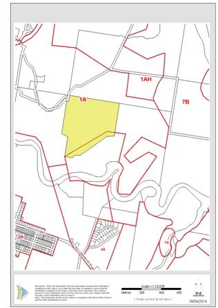
The Land is situated within a rural area to the north of the Brunswick River, and approximately 1km to the north east of the Mullumbimby CBD. The Land is owned by Council, is classified “community land”, has a total area of approximately 25.37 hectares and appears to have been created in the early 1900’s.
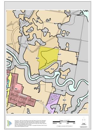
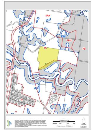
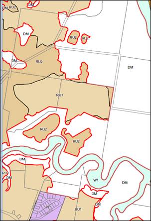
The Land is partly zoned RU1 – Primary Production, RU2 – Rural Landscape and partly identified as Deferred Matter under the provisions of LEP 2014. The provisions of LEP 1988 continue to apply to that part of Lot 1 identified under LEP 2014 as Deferred Matter. This part of Lot 1 is zoned part 1(a) (General Rural Zone) and part 7(b) (Coastal Habitat Zone) under LEP 1988. Refer to the LEP 2014 and LEP 1988 Zone map extracts below.
The Land accommodates two dwellings (one circa 1980’s, the other circa 1920’s) with other structures and features associated with an old plant nursery, all towards the south eastern corner. The remainder of the Land is predominantly grazing land. Refer to the photograph and aerial photograph provided in Attachment A to this Planning Proposal. Vallances Road is sealed to the Land, and a sealed extension of Vallances Road (not indicated on the title) crossing the Land parallel to the northern boundary provides access to the STP.
The Land is predominantly within Zone No. 1(a)
(General Rural Zone) however there is a strip of low lying topography (which
appears to have been the historical course of the Brunswick River) along the
south eastern boundary of the Land that is within Zone No. 7(b) (Coastal
Habitat Zone) under Byron Local Environmental Plan 1988 (LEP 1988) – refer to the
LEP 1988 zone map extract below.
The Land is
within proposed Zone RU1 Primary Production, Zone RU2 Rural Landscape and an
area identified as “Deferred Matter” (previously indicated as Zone E2
Environmental Conservation) under Byron Local Environmental Plan 2014 (LEP 2014),
which commences on 21 July 2014 – refer to the LEP 2014 zone map extract below.
There is no public land listed as
reclassified in Schedule 4 of the LEP 2014.


![]()
The Land
|
LEP |
LEP 1988 Zone Map extract |
The Land accommodates two
dwellings (one circa 1980’s, the other circa 1920’s) with other structures and
features associated with an old plant nursery, all towards the south eastern
corner. The remainder of the Land is predominantly grazing land. Refer to the photograph and aerial photograph provided in
Attachment A to this Planning Proposal. Vallances Road is sealed to the
Land, and a sealed extension of Vallances Road (not indicated on the title)
crossing the Land parallel to the northern boundary provides access to the STP.
PART 1 OBJECTIVES AND INTENDED OUTCOMES OF THE PROPOSED INSTRUMENT
The intended outcome of the instrument proposed by this Planning Proposal is that the Land:
(a) is classified as “operational” in accordance with Part 2 of Chapter 6 of the LG Act; and
(b) ceases to be a public reserve (if it is a public reserve); and
(c) is
discharged
from any trust for a public
purpose, but is not discharged from:discharged
from any trusts, estates, interests, dedications, conditions, restrictions and
covenants affecting the Land or any part of the Land, except for:
(i) any
reservations that except the Land out of a Crown grant relating to the Land, and
(ii) reservations
of minerals (within the meaning of the Crown Lands Act 1989), and.
(iii) A234199 Right of Way affecting the part of the land shown so burdened in Vol 2738 Fol 198.
Intended outcomes (b) and (c) require the Governor’s approval under section 30 of the Local Government Act 1993, which is sought by the Department before the Minister makes the proposed instrument.
PART 2 EXPLANATION OF PROVISIONS TO BE INCLUDED IN THE PROPOSED INSTRUMENT
LEP 2014 was made on 30 May 2014 and comes came into
effect on 21 July 2014. LEP 2014 will apply applies to part
of the Land however the other part of the Land was deferred by the Minister’s
delegate due to its proposed environmental zoning. This has resulted in part of
the Land being governed affected by LEP
1988 and the remaining part of the Land being governed affected by
LEP 2014. Consequently, amendments to both LEPs will be required to reclassify
the land. Specific provisions will include:
The Land needs to be
reclassified from community land to operational land in order for the Land to
be used
sold and / or developed sold in
accordance with the FSPP.
It may be possible for the proposed instruments
relating to the Land to be combined with the proposed instrument relating to
Lots 15 and 16 DP 1178892 Dingo Lane, Myocum. The relevant Planning
Proposals may be able to be processed concurrently by NSW Planning &
Environment.
PART 3 JUSTIFICATION FOR OBJECTIVES, OUTCOMES AND IMPLEMENTATION PROCESS
Section A – Need for the Planning Proposal
Q1. Is the planning proposal a result of any strategic study or report?
The Planning Proposal reflects
Council’s potential intention to sell the Land and / or develop the
Land (unencumbered except for the reservations mentioned
above) in accordance with the FSPP. The sale, if it proceeds, is
intended to assist with generating reserves to fund future infrastructure
projects.
Q2. Is the planning proposal the best means of achieving the objectives or intended outcomes, or is there a better way?
Amending the LEP 1988 and
LEP 2014 in the manner proposed is the best, most efficient and most time
effective approach to delivering the objective and intended outcomes of the Planning
Proposal. The proposed LEP amendment provides certainty that
the Land:
(a) is reclassified from community land to operational land;
(b) ceases to be a public reserve to the extent (if any) that it is a public reserve; and
(c) is discharged from any trust for a public purpose, but is not discharged from any of the above mentioned reservations or right of way.
(a)
any trusts, estates, interests, dedications,
conditions, restrictions and covenants affecting the Land or any part of the Land
to the allowable extent except for the above mentioned reservations.
Section B – Relationship to strategic planning framework
Q3. Is the planning proposal consistent with the objectives and actions of the applicable regional or sub-regional strategy?
The Planning Proposal is consistent with the objectives and actions of the Far North Coast Regional Strategy insofar as they relate to this Land within the rural area surrounding Mullumbimby, because the proposed instrument will:
(a) not
change the zoning of the land, but changes the classification of the land to
operational so that options for the land can be explored including possible use / sale /
development;
(b) not have a significant effect in terms of environmental, agricultural, farmland, vegetation, habitat, areas of high biodiversity value, waterway, wetland, coastline, heritage, water and energy resources, landscape values (including scenic and cultural landscapes) or natural hazards;
(c) not change the location of planned development;
(d) not have a significant effect in terms of extractive resources;
(e) allow
the sale and / or use development of the
land in a manner which reflects the objectives of the relevant zones; and
(f) fit into the rural character of this part of the locality.
Q4. Is the planning proposal consistent with Council’s local strategy or other local strategic plan?
The Planning Proposal is consistent with the key community outcomes and strategies of Council’s Draft Community Strategic Plan 2022.
Q5. Is the planning proposal consistent with applicable State Environmental Planning Policies?
The Planning Proposal is consistent with applicable State Environmental Planning Policies (SEPP) which include:
SEPP 14 – Coastal Wetlands
The Land does not contain nor does it adjoin any SEPP 14 wetlands.
SEPP 19 – Bushland in Urban Areas
The Land does not contain nor does it adjoin, and the Planning Proposal does not propose to disturb, any bushland zoned or reserved for public open space purposes.
SEPP 26 – Littoral Rainforest
The Land does not contain nor does it adjoin any SEPP 26 littoral rainforest.
SEPP 44 – Koala Habitat Protection
The Planning Proposal will not impact on the koala habitat indicated on Council’s GIS, located adjacent to the south eastern boundary of the Land. The Planning Proposal will not result in any disturbance to the Land.
SEPP 55 – Remediation of Land
Council’s Records are not conclusive as to whether the Land is contaminated. This issue would have to be appropriately addressed pursuant to the provisions of SEPP 55 at such time as a development application, proposing the carrying out of development potentially affected by contamination on the Land, is submitted for consideration.
SEPP 71 – Coastal Protection
The Planning Proposal is consistent with the provisions of SEPP 71 relating to LEP preparation.
SEPP (Infrastructure) 2007
The Planning Proposal is not contrary to the provisions of SEPP (Infrastructure) 2007.
North Coast Regional Environmental Plan
The Planning Proposal is consistent with the provisions of the North Coast Regional Environmental Plan. In particular, the Planning Proposal will not have a significant impact upon the prime crop and pasture land that is on the Land and will not have a significant impact with respect to rural dwellings. The Planning Proposal will not have a significant impact in terms of strategic planning or environmental hazard considerations.
Q6. Is the planning proposal consistent with applicable Ministerial Directions (s.117 directions)?
The Planning Proposal is consistent with applicable Ministerial Directions as follows:
|
1. Employment and Resources 1.2... Rural Zones; and 1.5... Rural Lands No
change is proposed which would affect the existing or proposed rural zoning
of the Land. The Planning Proposal allows the sale and / or development of
the Land
|
|
The Planning Proposal is consistent with the relevant principles outlined in the NSW Coastal Policy.
2.3 Heritage Conservation The Land is not identified as
having heritage significance with reference to LEP 1988
|
|
........ The Land includes a
large area of Class 3 Acid Sulfate Soils, with a small area of Class 2 Acid
Sulfate Soils in the vicinity of the south eastern boundary ........ The Land is flood liable land in the vicinity of the south eastern boundary. However the Planning Proposal does not require any ameliorative measures to address the flood liable hazard characteristics of the Land. 4.4... Planning for Bushfire Protection ........ The northern edge of
the Land is bush fire prone land, however the Planning Proposal has no
significant implications with respect to this environmental hazard. This
Planning Proposal does not need to comply with
|
|
5.1... Implementation of Regional Strategies ........ The Planning Proposal is consistent with the Far North Coast Regional Strategy’s relevant aims, outcomes and actions.
|
|
6.1... Approval and Referral Requirements The Planning Proposal 6.2... Reserving Land for Public Purposes In relation to Section 117
Direction 6.2 Reserving Land for Public Purposes, this Planning Proposal does
not propose to create, alter or reduce existing zonings or reservations of
land for public purposes
|
The purpose of NSW Planning & Environment’s Practice Note 09-003 Classification and reclassification of public land through a local environmental plan dated 12 June 2009 is to provide updated guidance on the process to classify or reclassify public land through a local environmental plan. A written statement is to be provided addressing the following:
· The reasons why the draft LEP or planning proposal is being prepared including the planning merits of the proposal, e.g. the findings of a centres’ strategy, council’s intention to dispose of the land, provision of open space in a town centre
The Planning Proposal is prepared to facilitate Council’s potential
intention to sell and / or develop this the Land.
The proposed instrument is necessary to provide the required degree of
certainty in relation to proceeding with options like selling and / or developing the
Land under the FSPP.
· The current and proposed classification of the land
The Land is currently community land. The Land is proposed to be reclassified to: (i) operational Land classified, or reclassified, under amended section 30 of Local Government Act 1993—interests changed under Part 3 of Schedule 11 of LEP 1988; and (ii) operational Land classified, or reclassified, as operational land—interests changed under Part 2 of Schedule 4 of the LEP 2014. The Land is to be discharged from any trust for a public purpose, but is not discharged from the above mentioned Right of Way or:
(i) any reservations that except the Land out of a Crown grant relating to the Land, and
(ii) reservations
of minerals (within the meaning of the Crown Lands Act 1989).2014.
· The reasons for the reclassification including how this relates to council’s strategic framework, council’s proposed future use of the land, proposed zones, site specific requirements, e.g. heritage controls, anticipated physical or operational changes resulting from the reclassification
The reclassification accords with the existing and proposed
zones. The reclassification results in no physical change to the Land.
The reclassification provides certainty to the community and potential
purchasers as to Council’s ability to sell and / or
develop the status of the Land,
facilitates the potential sale of the Land and through
these initiatives may assist with providing funding for the
infrastructure projects referred to in part 3 of the Council’s resolution dated
10 April 2014.
· Council’s ownership of the land, if this applies
The Land is currently in Council’s ownership. Council may
decide to sell and / or develop the Land to fund
future infrastructure projects.
· The nature of council’s interest in the land, e.g. council has a 50 year lease over the site
Council has owned the Land since 2008 and may decide to sell the Land.
· How and when the interest was first acquired, e.g. the land was purchased in 20XX through section 94
Council purchased the Land in 2008.
· The reasons council acquired an interest in the land, e.g. for the extension of an existing park; council was given responsibility for the land by a State agency
Council purchased the Land in 2008 through Council’s Sewer Fund:
(1) to facilitate improved access to the Brunswick Valley STP site; and
(2) to increase Council’s landholding to 108 hectares to support future options for the management of the land surrounding the STP.
· Any agreements over the land together with their duration, terms, controls, agreement to dispose of the land, e.g. whether any aspect of the draft LEP or planning proposal formed part of the agreement to dispose of the land and any terms of any such agreement
The Land may be subject to rental agreements relating to the dwellings or agistment agreements in relation to animal grazing. However the proposed instrument will provide clarity and certainty that the Land:
(a) is classified as “operational” in accordance with Part 2 of Chapter 6 of the LG Act; and
(b) ceases to be a public reserve (if it is a public reserve); and
(c) is discharged from any trusts, estates, interests, dedications, conditions, restrictions and covenants affecting the Land or any part of the Land, except for those indicated above and:
(i) any reservations that except the Land out of a Crown grant relating to the Land, and
(ii) reservations of minerals (within the meaning of the Crown Lands Act 1989).
· An indication, as a minimum, of the magnitude of any financial gain or loss from the reclassification and of the type(s) of benefit that could arise e.g. council could indicate the magnitude of value added to the land based on comparable sites such as the land is currently valued at $1500 per square metre, nearby land zoned for business development is valued at between $2000 and $5000 per square metre.
Council purchased the Land in
relation to the adjoining Brunswick Valley STP, however Council may decide to
sell or
develop (depending on the outcome of the rural settlement strategy
review) the Land. The purpose of the Planning
Proposal is to facilitate a process of confirming that the Land is not a public
reserve and expunging any trusts, estates, interests, dedications, conditions,
restrictions and covenants affecting the Land or any part of the Land. The
reclassification of the Land provides certainty for the community in relation
to the:
(a) operational
land classification of the Land;
(b) cessation
of any public reserve applying to the Land or any part of the Land; and
(c) discharging
of any trusts, estates, interests, dedications, conditions, restrictions or
covenants affecting the Land or any part of the Land, except for:
(i)
any
reservations that except the Land out of a Crown grant relating to the Land,
and
(ii)
reservations
of minerals (within the meaning of the Crown Lands Act 1989).
The interests which affect the land include:
(i) A potential trust for the public purpose; and
(ii) A Right of Way affecting the land.
This Planning Proposal proposes the extinguishment of any trust for a public purpose, however it does not propose the extinguishment of the Right of Way.
· The asset management objectives being pursued, the manner in which they will be achieved and the type of benefits the council wants, i.e. without necessarily providing details of any possible financial arrangements, how the council may or will benefit financially.
The Land was not constrained by a community classification when it was purchased by Council from the previous private owner. The reclassification of the Land would allow Council to consider future options in accordance with the FSPP. Funds from any sale of the Land are able to be reinvested to increase Council’s infrastructure management capacity.
· Whether there has been an agreement for the sale or lease of the land; the basic details of any such agreement and, if relevant, when council intends to realise its asset, either immediately after rezoning/reclassification or at a later time.
There is presently no agreement entered into to sell or lease the Land, except possibly in relation to renting of the dwellings and / or agistment for grazing purposes. However the reclassification of the Land provides certainty for the community in relation to the:
(a) operational land classification of the Land;
(b) cessation of any public reserve applying to the Land or any part of the Land; and
(c) discharging of any trust for a public
purpose, but the Land is not discharged from the
Right of Carriageway orany trusts,
estates, interests, dedications, conditions, restrictions or covenants
affecting the Land or any part of the Land, except for:
(i) any reservations that except the Land out of a Crown grant relating to the Land, and
(ii) reservations of minerals (within the meaning of the Crown Lands Act 1989).
· Relevant matters required in plan making under the EP&A Act.
This Planning Proposal addresses the relevant matters required in plan making under the Environmental Planning and Assessment Act 1979.
· A copy of this practice note must be included in the exhibition material to assist the community in identifying information requirements. Council staff may wish to identify the column in Attachment 1 that applies.
A copy of the relevant Practice Note will be was included, if
required at the relevant time, in the public exhibition
material.
Section C – Environmental, social and economic impact
Q7. Is there any likelihood that critical habitat or threatened species, populations or ecological communities, or their habitats, will be adversely affected as a result of the proposal?
Council’s GIS mapping indicates that the Land contains high conservation value vegetation and koala habitat in the vicinity of the south eastern boundary. The GIS mapping does not indicate that the Land contains SEPP 14 wetland, SEPP 26 littoral rainforest or mapped threatened fauna habitat. Parts of the Land have been disturbed by past activities associated with the use of the Land for residential, plant nursery, agricultural and associated activities. The proposed reclassification is unlikely to have a significant effect on any critical habitat or threatened species, populations or ecological communities, or their habitats.
Q8. Are there any other likely environmental effects as a result of the planning proposal and how are they proposed to be managed?
There are no known significant likely environmental effects as a result of the Planning Proposal.
Q9. Has the planning proposal adequately addressed any social and economic impacts?
The Planning Proposal is unlikely to cause any significant social or economic impacts.
Section D – State and Commonwealth interests
Q10. Is there adequate public infrastructure for the planning proposal?
No further services are required as a result of the proposed reclassification.
Q11. What are the views of State and Commonwealth public authorities consulted in accordance with the Gateway determination?
The views of State and Commonwealth public authorities would be
considered (where required) after the public exhibition process is
completed.The NSW Rural Fire Service made a written
submission advising that no concerns or issues are raised in relation to bush
fire.
NSW Trade & Investment Crown Lands made a written submission:
· Noting that there is a number of Crown public roads adjoining the site and adjoining land owned by Council; and
· Requesting that any Crown roads that may need to be utilised for access / constructed due to any future proposal over these lots be transferred to administration of Council.
PART 4 MAPPING
The Planning Proposal includes the above LEP 1988 and
LEP 2014 zoning map extracts to identify the Land. LEP amendment
maps will
arebe included in Attachment B to the this Planning
Proposal as required by condition 5 of the gateway Gateway determination
Determinationprior to submitting the plan
to the Department to be made.
PART 5 COMMUNITY CONSULTATION
Council has not undertaken, and is not required to
undertake, any pre-planning proposal consultation.
Community consultation on the Planning Proposal has
been undertaken in accordance with The the Gateway
Ddetermination has specified the
community consultation that must be
undertaken on the Planning Proposal. The exhibition period complied
with the minimum is required to be 28 day periods in length
and the relevant material will be was made
available for public inspection during the exhibition period as specified in NSW
Planning & Infrastructure’s A guide to preparing local environmental
plans.
A The public
hearing has
been conducted and the report on the public hearing has been received by
Councilmust be arranged in respect of this Planning
Proposal in accordance with section 29 of the LG Act because the proposal is to
reclassify community land as operational land. Council will has considered
any the submissions
made concerning the Planning Proposal and the report of the public hearing into
the proposed LEPs.
PART 6 PROJECT TIMELINES
An indicative project timeline is provided
below., noting
that:
The timeframes for each stage in the project are
approximate only;
The timeframes are not necessarily concurrent; and
There may be substantial intervening periods
between each stage in the project.
CONCLUSION
The proposed reclassification of the Land
to “operational land – interests changed” is satisfactory having regard to
relevant legislative and environmental planning requirements. The Planning Proposal
has been amended prior to exhibition in accordance with
conditions 1 and 5 of the
Gateway determination
Determination and is consistent with
the objectives of the relevant zones. The reclassification is intended to allow
the investigation of options for the Land including potential sale and / or development,
providing certainty to the community, and may result in the realising of funds for future
infrastructure projects. The reclassification contributes towards
facilitating the proper planning and use of the Land.
INDICATIVE PROJECT TIMELINE
|
Indicative Stages |
Indicative Timeframe |
|
|
|
|
|
|
Council forwards the Planning Proposal to the Department.
The Department carries out the Gateway assessment and returns the Planning Proposal with the Gateway determination to Council (section 56 of EP Act). |
COMPLETE
COMPLETE |
|
|
|
|
|
|
Completion of required technical information after receipt of Gateway determination, including preparation for community consultation. [The stages after the Gateway determination may be varied by the Gateway determination]. |
COMPLETE |
|
|
|
|
|
|
Community consultation (including public exhibition) for Planning Proposal (section 57 of EP Act). |
COMPLETE |
|
|
|
|
|
|
Preparation for and conducting of public hearing (section 29 of LG Act), by a person other than a Councillor or employee (section 47G of LG Act). Preparation of report on public hearing by the person presiding at the public hearing (section 57(7) of EP Act). The report is to be made available by Council for inspection no later than 4 days after Council has received the report (section 47G of LG Act). |
COMPLETE
COMPLETE |
|
|
|
|
|
|
Report to Council on
outcome of community consultation and public hearing |
COMPLETE |
|
|
|
|
|
|
Department makes
arrangements for the proposed instrument to be prepared by |
|
|
|
|
|
|
|
Approval of the Governor
obtained by the Department / |
|
|
|
|
|
|
|
The proposed instrument is published on the legislation website and becomes effective. |
|
|
Note: ‘EP Act’ means
Environmental Planning and Assessment Act 1979, ‘LG Act’ means Local Government
Act 1993 and ‘PCOPC’ means the
Office of Parliamentary Counsel.
ATTACHMENT A – PHOTOGRAPHS OF THE LAND
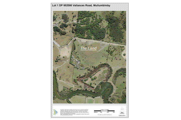 |
Aerial photograph of the Land
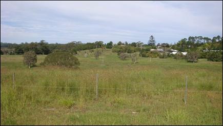
View south across the Land
(Photograph taken: 28 April 2014)
ATTACHMENT B – BYRON LOCAL ENVIRONMENTAL PLAN 1988 AND BYRON LOCAL ENVIRONMENTAL PLAN 2014 AMENDMENT MAPS
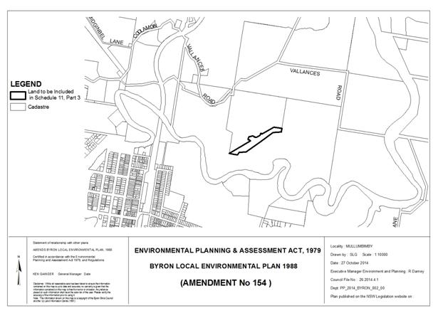
Byron Local Environmental Plan 1988 (Amendment No 154) – Map (Vallances Road)
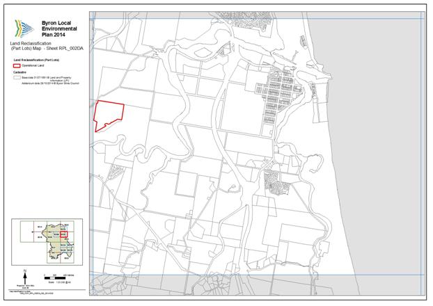
Byron Local Environmental Plan 2014 – Map (Vallances Road – Sheet RPL_002DA)