Ordinary Meeting
Public ATTACHMENTS
EXCLUDED FROM THE
Ordinary
Meeting
AGENDA
OF 30 April 2015
13. Staff Reports
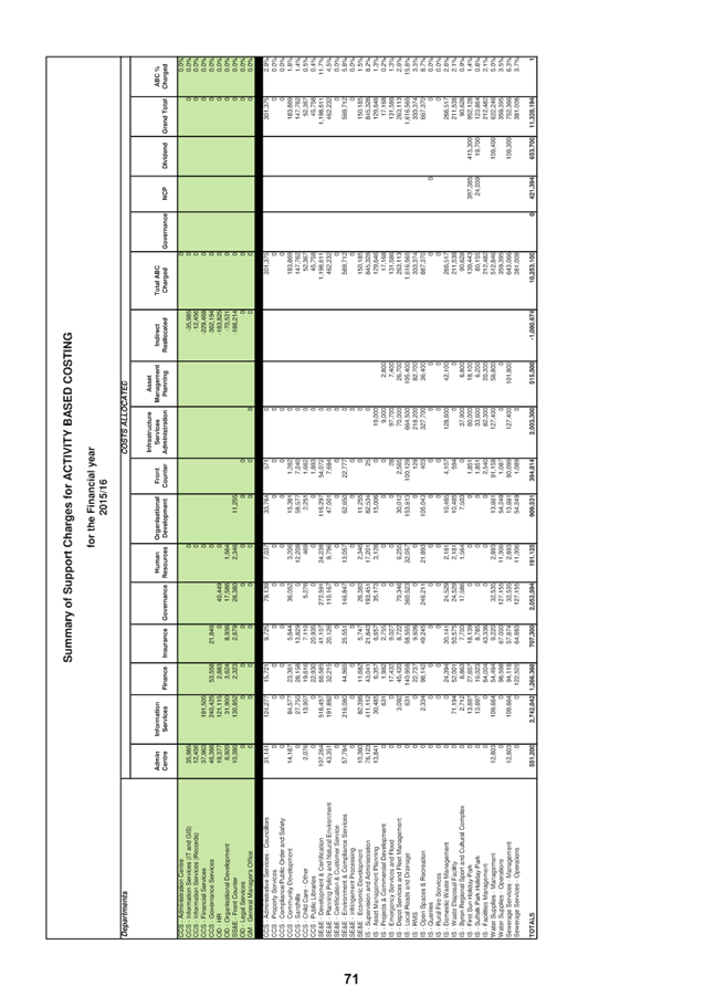
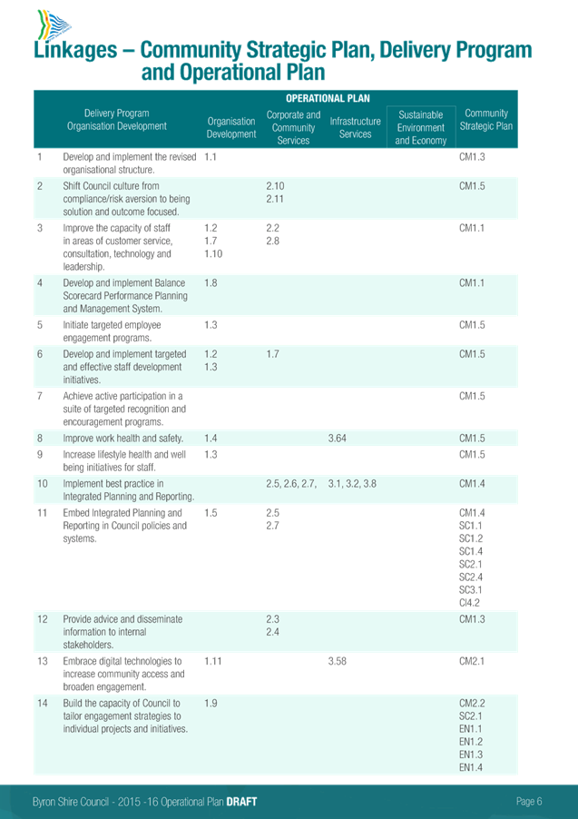
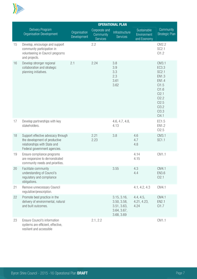
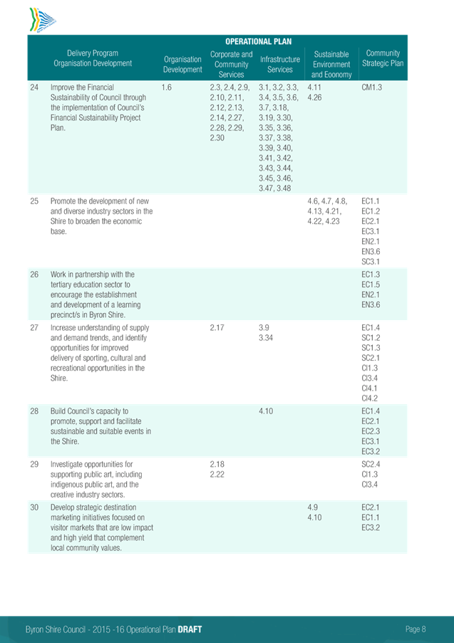
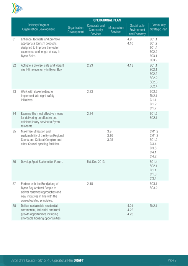
13.3 Draft 2015/16
Operational Plan and Statement of Revenue Policy - Public Exhibition
Attachment
1... Draft 2015/16 Budget Estimates................................................................ 2
Attachment
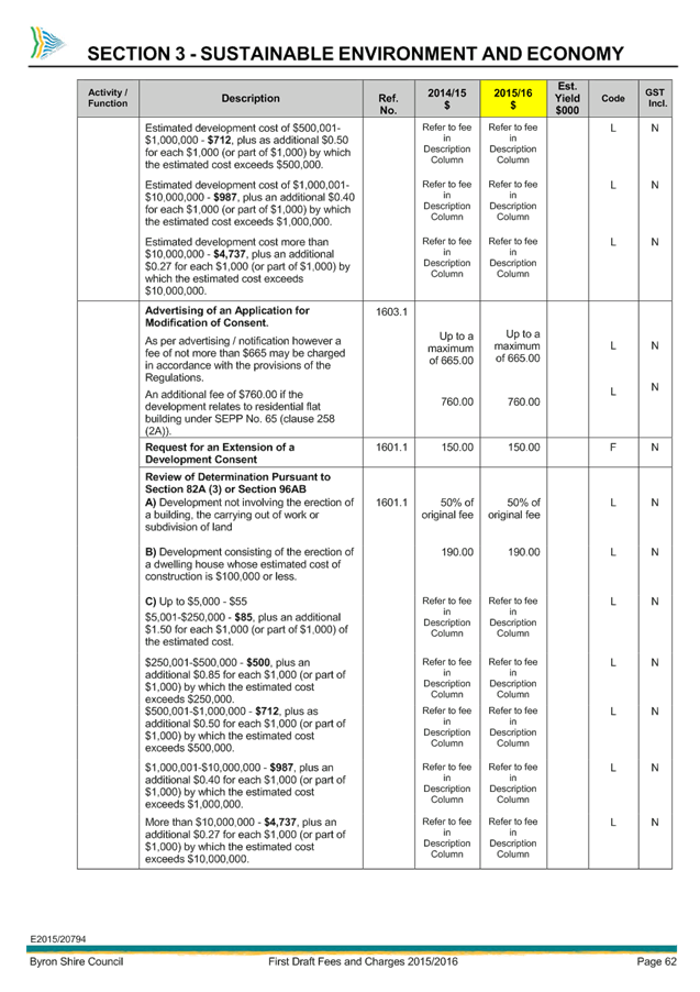
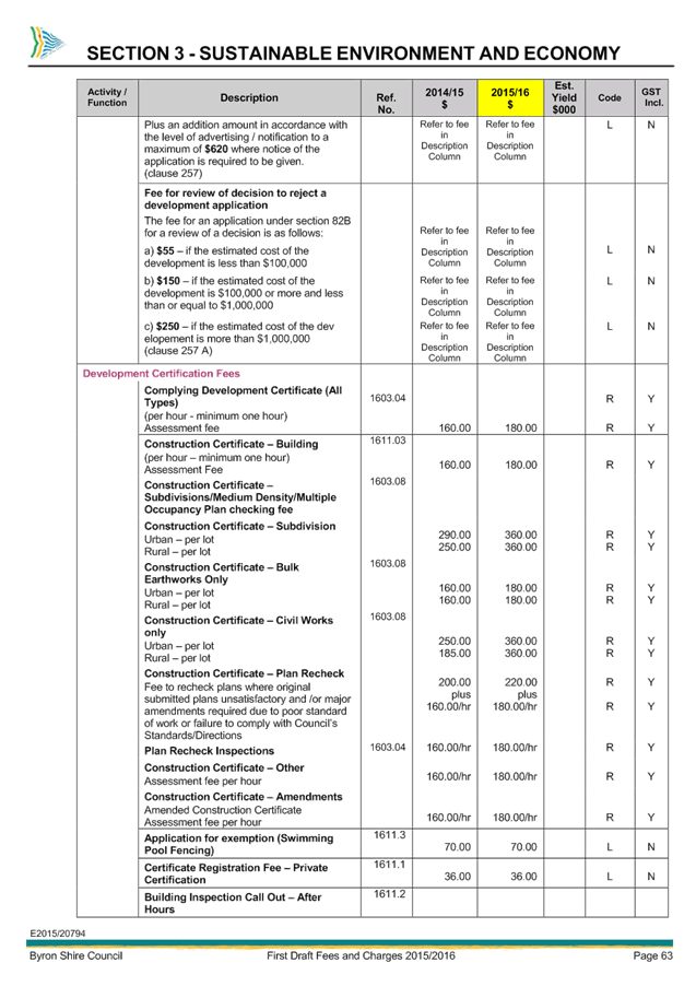
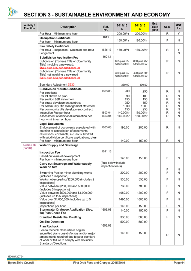
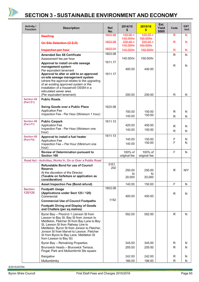
2... Draft 2015/16 Fees and Charges............................................................ 85
Attachment
3... Draft 2015/16 Operational Plan............................................................. 192
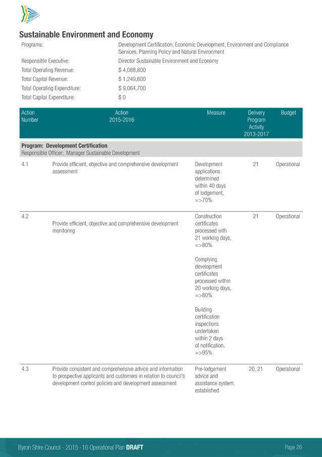
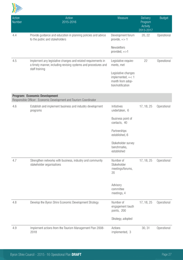
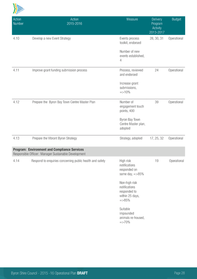
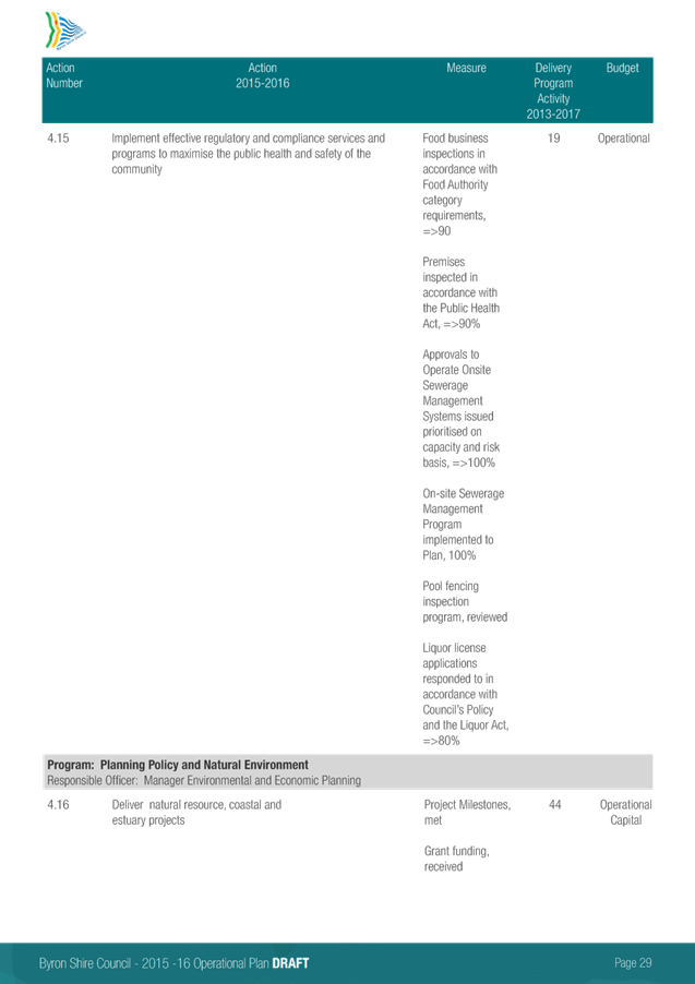
Sustainable Environment and Economy
13.5 Submissions
Report - Draft Short Term Holiday Accommodation Strategy
Attachment
1... Byron Shire Short Term Holiday Accommodation Action Plan............ 224
Attachment
2... Submissions Analysis............................................................................ 247
13.7 PLANNING -
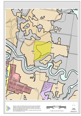
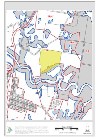
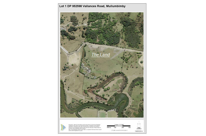
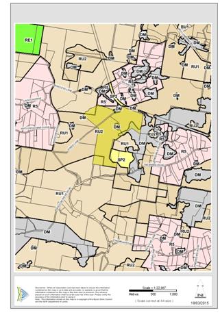
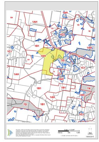
Planning Proposals - For finalisation of reclassification of Lot 1 DP 952598
Vallances Road Mullumbimby and Lots 15 and 16 DP 1178892 Dingo Lane Myocum
Attachment
1... Title Documents Lot 1 DP 952598 Vallances Road Mullumbimby and Lots 15 and
16 DP 1178892 Dingo Lane Myocum................................................... 289
Attachment
3... Public Hearing Report Lot 1 DP 952598 Vallances Road Mullumbimby and Lots
15 and 16 DP 1178892 Dingo Lane Myocum............................................ 297
Attachment
4... Planning Proposal Lot 1 DP 952598 Vallances Road Mullumbimby.... 310
Attachment
5... Planning Proposal Lot 15 and Lot 16 DP 1178892 Dingo Lane Myocum 327
14. Reports of Committees
Infrastructure Services
14.2 Report of the
Local Traffic Committee Meeting held on 1 April 2015
Attachment
1... Minutes Local Traffic Committee Meeting 01/04/15............................. 345
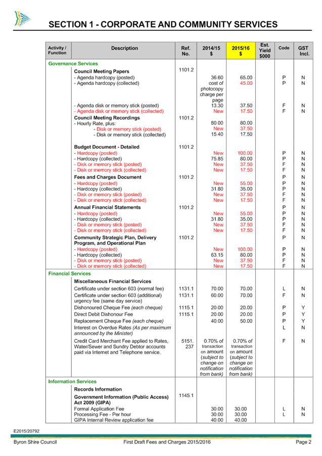
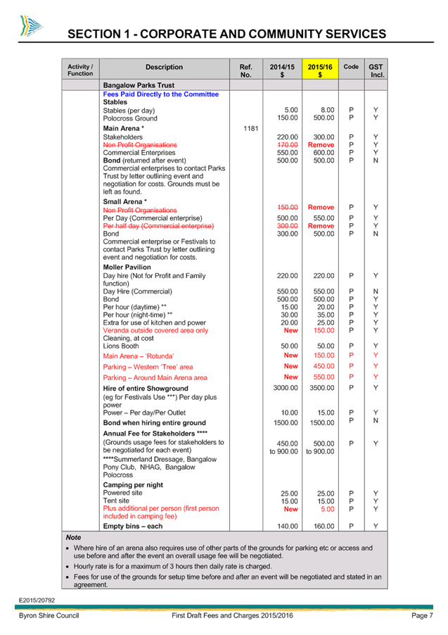
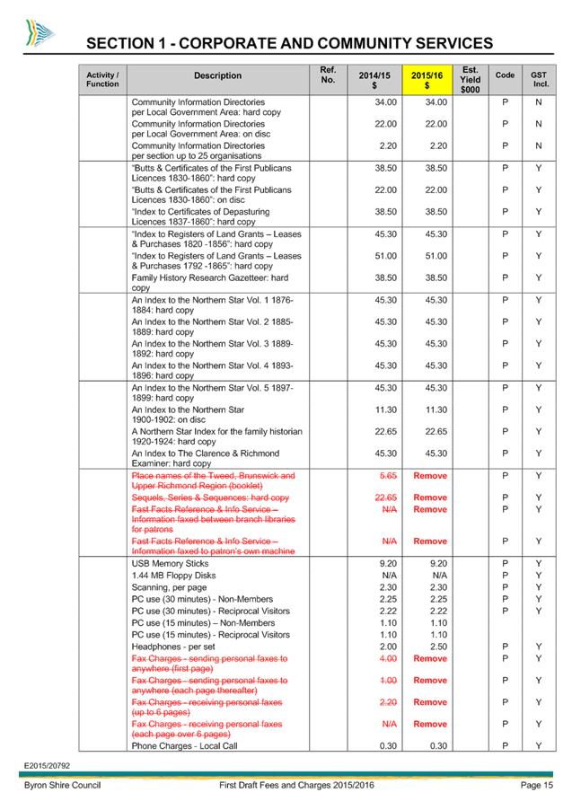
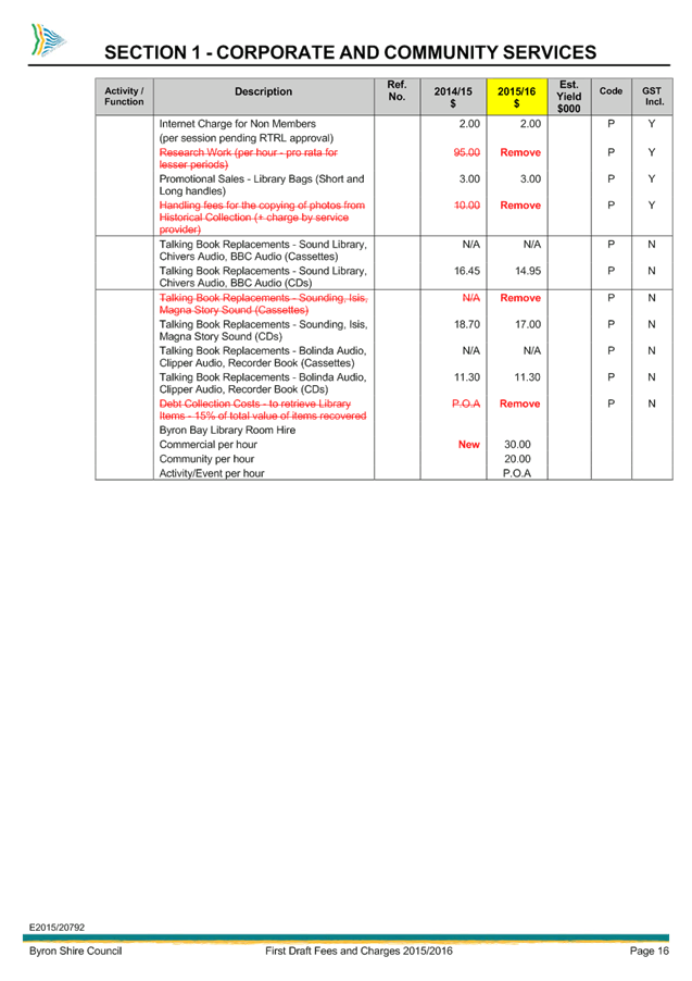
Staff Reports - Corporate and Community Services 13.3 - Attachment 1


Staff Reports - Corporate and Community Services 13.3 - Attachment 1
Staff Reports - Corporate and Community Services 13.3 - Attachment 2


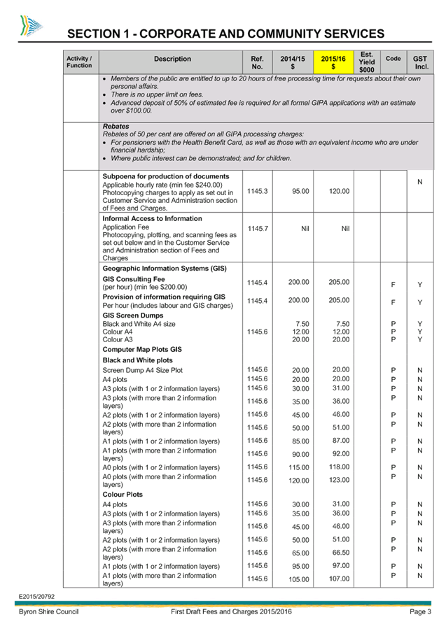

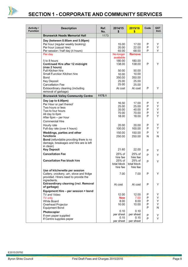

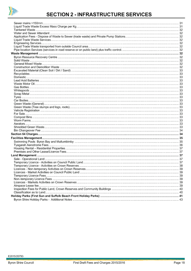


Staff Reports - Corporate and Community Services 13.3 - Attachment 2
Staff Reports - Corporate and Community Services 13.3 - Attachment 2


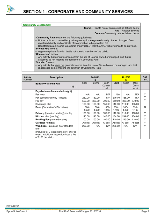
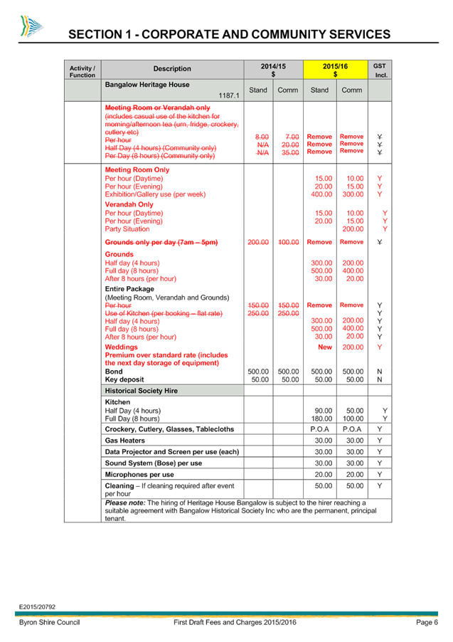
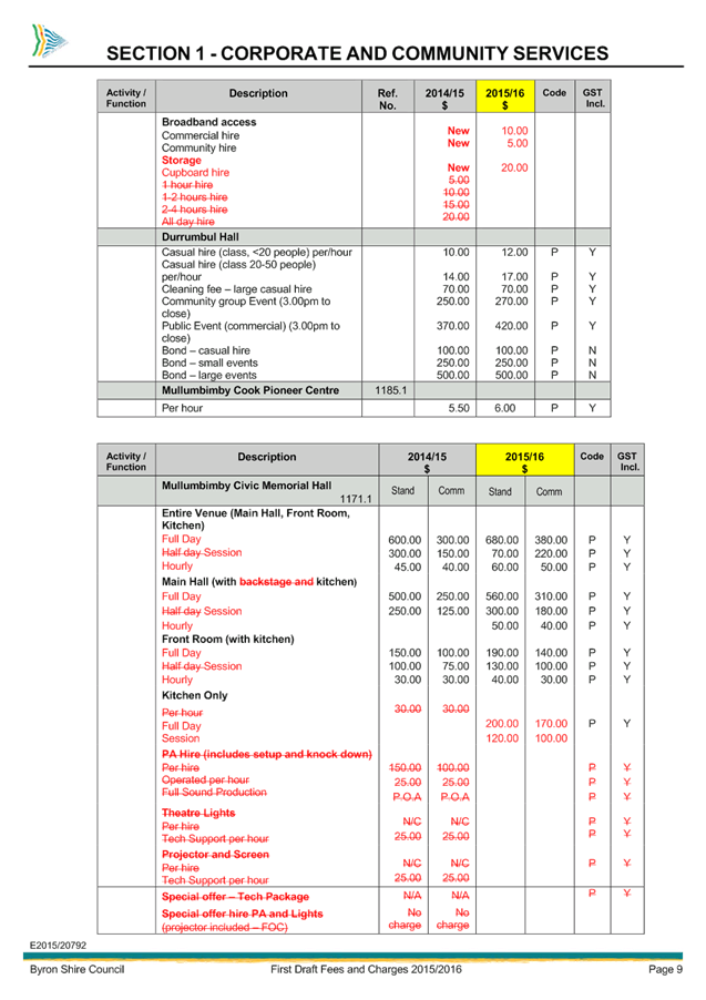
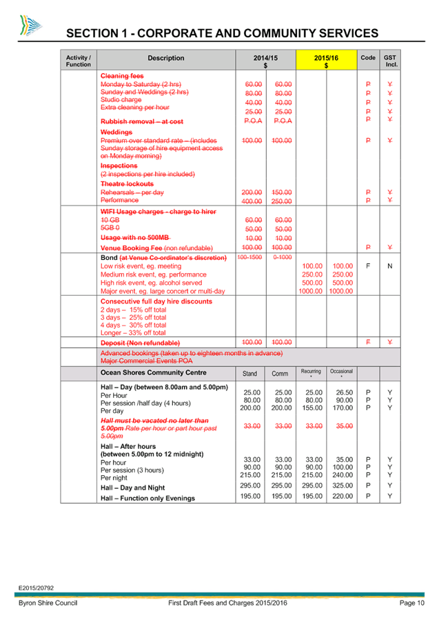
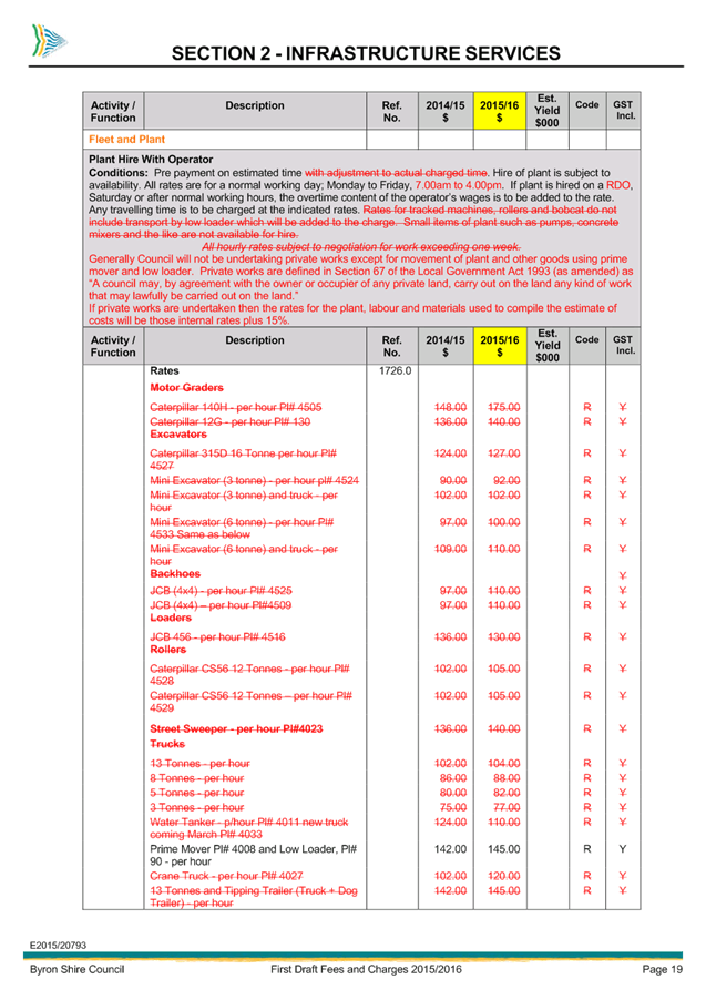
Staff Reports - Corporate and Community Services 13.3 - Attachment 3


Staff Reports - Sustainable Environment and Economy 13.5 - Attachment 1
Staff Reports - Sustainable Environment and Economy 13.5 - Attachment 1
This page has been intentionally left blank
Staff Reports - Sustainable Environment and Economy 13.5 - Attachment 1
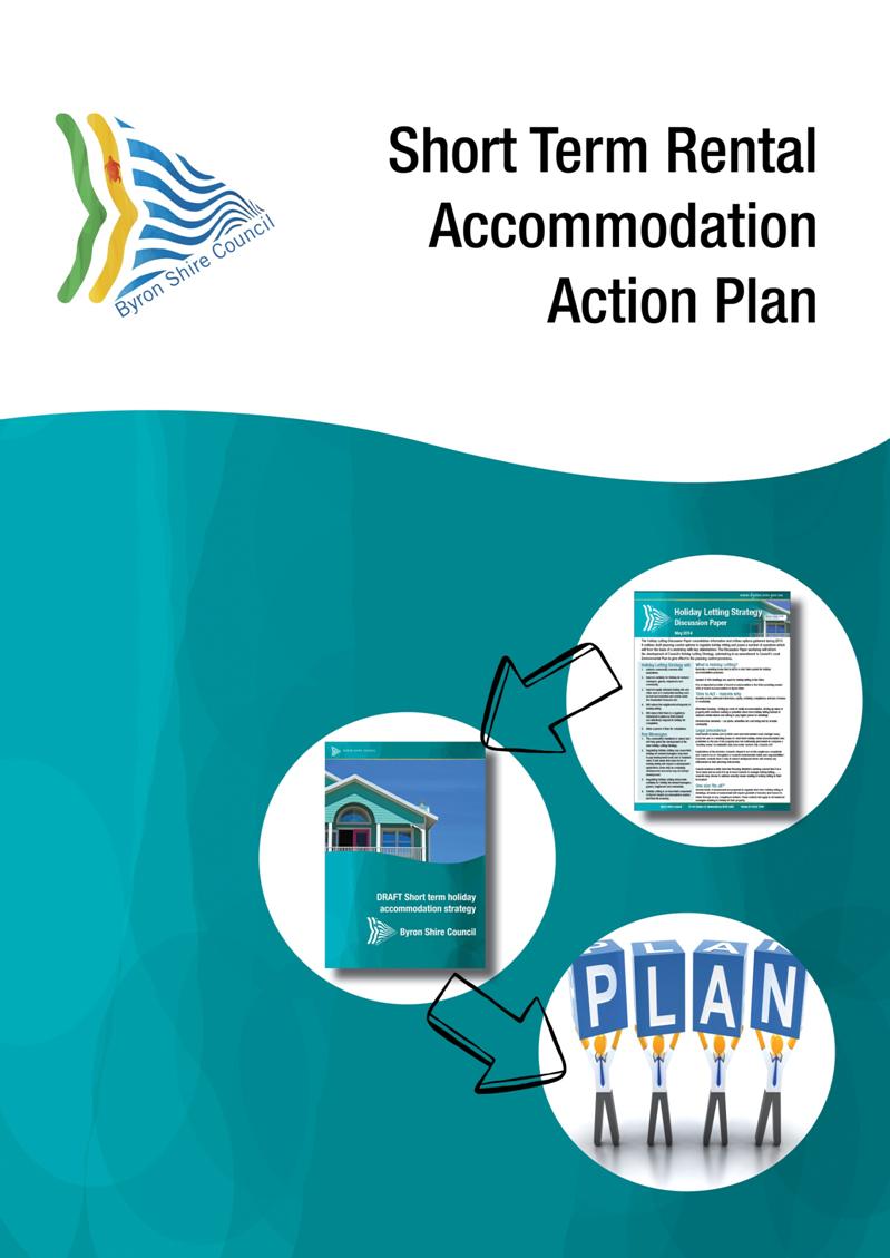
Introduction
The Byron Shire Short Term Rental Accommodation Action Plan
is the culmination of a process to develop structure and planning controls
around the long practiced use of holiday letting dwellings in Byron Shire. The
process commenced in 2013 with key stakeholder workshops that continued into
2014. From these workshops a Discussion Paper was prepared for key
stakeholder’s consideration. Comments on the Discussion Paper then
led to the development of a Draft Short Term Holiday Accommodation Strategy
that was publicly exhibited from 11 November to 22 December 2014. Over
150 submissions were received including two from state government
agencies. As a result of the issues raised in submissions, the draft
planning controls and actions have been revised. The Byron Shire Short Term
Rental Accommodation Action Plan details the revised actions and planning
controls.
Overall the planning controls have been simplified;
duplication with the Holiday Rental Code of Conduct has been removed but only
so far as to ensure those elements that are important to
maintaining neighbourhood amenity are clearly
addressed.
Key changes include:
· Renaming
to ‘Short Term Rental Accommodation’ (STRA) consistent with other
councils
· Broadening
definition of STRA from ‘dwelling house’ to ‘dwelling’
· Including
a new exempt development clause to ensure development, if part of a community
or strata scheme, has prior written approval of the owners’ corporation
of that scheme. This is already a requirement for any development
application. This clause is modelled on the Wyong Council’s exempt
provision.
· Removing
occupant type ie. adult to avoid discrimination and numbers simplified to
‘2 occupants per bedroom’, with a maximum of 10 occupants for 5 or
more bedrooms
· Consolidating
exempt and complying planning controls as all exempt and retaining development
application:
1. Exempt:
will allow property owners of dwellings with 3 bedrooms or less, who want to
rent their property out for short periods any time throughout the year and live
there for the remainder of the year, or make the dwelling available for
short term renting on a permanent basis; caps number of occupants to 2
per bedroom.
2. Development Application:
provides for dwellings greater than 3 bedrooms; caps number of occupants as 2
occupants per bedroom to a maximum of 10 occupants for 5 or more bedrooms; it
is also for dwellings up to 3 bedrooms that cannot comply with the exempt
provisions.
Byron Shire Short Term Rental
Accommodation (STRA) Action Plan
|
Action
|
What
|
Who / When / Cost
|
|
1. Amend
Byron LEP 2014
|
1a. Insert exempt provisions
in Schedule 2 for Short Term Rental Accommodation (STRA), as detailed in
Table 1 below.
|
Council prepares a
Planning Proposal to amend the Byron LEP 2014, refer to the Department of
Planning and Environment for gateway determination, and publicly exhibit and
report to Council as required under the EPA Act 1979 and Regulation 2000.
Time frame: May to
December 2015.
Cost: existing budget
|
|
1b. Insert new clause 6.10
Short Term Rental Accommodation, as detailed in Table 2 below to enable
development applications.
|
|
1c. Insert Serviced
Apartments in Zone B4 Mixed Use as permissible with development consent.
Serviced
apartments are already permitted in the B3 Medium Density, B2 Local Business
and the SP3 Tourist zones. The B4 Mixed Use zone permits a range of
commercial and residential uses including shop top housing, residential flat
buildings and hotel and motel accommodation. Given the range of uses that are
already permitted in the B4 zone it is appropriate to permit serviced
apartments.
|
|
1d. Insert Tourist and
Visitor Accommodation in the RU2 and RU1 Zones as permissible with consent,
and list motel and hotel accommodation, Backpackers and Serviced Apartments
as prohibited.
This
will enable rural cabin type proposals which don’t fall into the
category of ‘farmstay accommodation’, which means a building
or use that provides temporary or short term accommodation to paying guests
on a working farm as a secondary business to primary production.
|
|
1e. Amend clause 5.4
(1) Bed and Breakfast Accommodation to increase the number of bedrooms
from no more than 3 to no more than 5 bedrooms.
|
|
1f. Insert exempt
provisions in Schedule 2 for 1 bedroom bed and breakfast establishments, as
detailed below, to enable development such as Air B&Bs.
|
|
1g. Prepare draft conditions
of development consent, as detailed below.
|
|
2. Amend
Byron DCP 2014
|
2a. In Chapter B4 Traffic
Planning, Vehicle Parking, Circulation and Access, Table B4.1, include car
parking rates for STRA and include reference to stacked parking for bed and
breakfast, as detailed in Table 3 below.
|
Council prepares the
relevant DCP amendments, publicly exhibit and report to Council as required
under the EPA Act 1979 and Regulation 2000
Time frame: May to
December 2015.
Cost: existing budget
|
|
2b. Chapter D3 Tourist
Accommodation:
i. include new
clause D3.3.8 Short Term Rental Accommodation, as detailed below,
ii. amend clause
D3.3.7 Serviced Apartments to include prescriptive measures, as detailed
below,
iii. amend clause D3.3.2
Bed and Breakfast Accommodation to enable 5 bedrooms and 10 guests.
|
|
2c. Amend Part A,
Appendix A.1, to include new definition for STRA.
|
|
2d. Amend
the Byron Shire Development Control Plan 2014 – Part A
– Preliminary, Table A3 – Level 1 Notification to include STRA requiring notification to
adjoining property owners and 14 days exhibition period.
|
|
3. Develop
a register
|
3a. Investigate whether a
nominal fee can be charged for registration and to cover the cost of
establishing and maintaining the register in accordance with appropriate
legislation.
A
requirement for all exempt development and development approvals is that the
dwelling be registered on Council’s register prior to the initial
period used.
|
Council’s
Development Assessment and Compliance Section with IT.
Timeframe: May to
September 2015.
Cost: development of
the register may require additional funding. If required this will be
reported to Council post the scoping analysis.
|
|
3b. Undertake a scoping
analysis to determine register design and what’s feasible within
Council’s IT systems.
|
|
3c. Develop web based
register for STRA.
|
|
4. Investigate
rating of properties
|
4a. Councils Finance
Section to be kept up to date on changes to Councils planning controls and
advised of any applications approved for STRA including properties
registered.
|
Council’s
Environment and Economic Planning Section and Development Assessment and
Compliance Section within the Sustainable Environment and Economic
Directorate
Timeframe: Ongoing
Cost: existing budgets
|
|
5. Compliance
|
5a. With adoption and
implementation of Controls, Council will need to ensure compliance with
planning provisions. Additional Council resources may be required during peak
holiday periods to respond to after hour complaints and to collect evidence.
|
Council’s
Development Assessment and Compliance Section within the Sustainable
Environment and Economic Directorate
Timeframe: Ongoing
Cost: funds may be
required to provide additional resources
|
|
5b. Land owner or
appointed property manager must be contactable 24 hours 7 days a week and to
be able to respond within 30minutes to complaints regarding the action of
tenants and in particular issues pertaining to noise and residential amenity
|
Land Owner or appointed
property manager
Timeframe: Ongoing
|
|
5c. Neighbours of
separate dwellings located within 40m of the subject dwelling can contact the
land owner or appointed property manager in the first instance to report any
complaints.
In
the event that the land owner or appointed property manager does not respond
to the complaint, neighbours should call the police or Council.
|
STRA neighbours
Timeframe: Ongoing
|
|
6. Holiday
Rental Code of Conduct
|
6a. Council acknowledges that
the Holiday Rental Code of Conduct was developed by a consortium of
stakeholders.
|
Council
Timeframe: April 2015
Cost: existing budget
|
1.
6b. Council accept the
invitation from Holiday Rental Industry Association (HRIA) to become a
supporting organisation and to enter a MOU with HIRA in accordance with
Section 1.5 of the Holiday and Short Term Rental Code of Conduct |
|
6c. Council reference the
Holiday Rental Code of Conduct endorsed by NSW Department of Planning and
Environment (DoPE) in the planning controls.
Council
write to the DoPE requesting to be consulted on any future reviews of their
endorsed Holiday Rental Code of Conduct and that further wording be included
in section 3.4 Security Deposits or Bonds as follows: ‘Make
effective and fair use of security deposits and bonds to produce
compliance. Bonds should not be less than $250/adult per letting’
|
|
7. Moratorium
|
7a. Council allow a one year
moratorium upon the LEP amendment being made for land owners/managers of
existing STRA to comply with exempt or development consent provisions.
The
moratorium is for applying to use the dwelling for STRA. Complaints
relating to noise or amenity issues are not covered by this moratorium.
A
Council resolution will be required to direct Council’s Compliance
Staff to take no action at the point of council resolving to make the LEP
amendment for the first 12mths.
|
Council
Timeframe: one year
post gazettal of the LEP amendment
Cost: existing budgets
|
|
8. Develop
information sheets and website content
|
8a. Develop information sheets
to assist land owners, property managers and neighbours understanding of the
planning controls
|
Council
Timeframe: prior to LEP
amendments being gazetted
Cost: existing budgets
|
|
8b. Update information on
Council’s website in relation to STRA
|
|
8c. Provide information
to various holiday rental organisations eg. HLO, STAYZ, WOTIF, real estate
agents etc on Councils STRA Action Plan and Planning Controls.
|
|
9. Review
Action Plan and effectiveness of planning controls
|
9a. Twelve months from
adoption of the Action Plan prepare a status report to Council on the
progress of implementing the actions.
|
Council
Timeframe: April 2016
Cost: existing budgets
|
|
9b. Review the
effectiveness of planning controls within 18months of their gazettal.
|
Council
Timeframe: 18mths post
gazettal of planning controls
Cost: existing budgets
|
|
9c. Develop an Authority
Data Report on key indicators such as number of registered properties; number
of exempt and DAs; number of complaints and action taken etc for reporting to
Council in line with the 18mth review of the Action plan
|
Council
Timeframe: prior to LEP
amendments being gazetted
Cost: existing budgets
|
Amend Byron LEP 2014
Action Plan 1a: Insert
exempt provisions in Schedule 2 for Short Term Rental Accommodation (STRA), as
detailed in Table 1
Table 1: Exempt Planning Controls
|
Exhibited Exempt
Controls
|
Revised Exempt Controls
post exhibition
|
|
(1) In this clause
short term holiday accommodation is tourist and visitor accommodation in a
dwelling that provides short term accommodation on a commercial basis, but
excludes backpackers accommodation, bed and breakfast accommodation, farm
stay accommodation, hotel or motel accommodation, and serviced apartments.
|
Definition simplified and broadened
(1) In this clause short
term rental accommodation is an existing dwelling that provides short term
accommodation on a commercial basis,
|
|
(2) The subject
dwelling house must be located in a zone where dwelling houses are permitted
under Byron LEP 2014,
|
Minor change
(2) The subject
dwelling must be located in a zone where dwellings are permitted under Byron
LEP 2014,
|
|
(3) Only during
Australian public school holiday periods and for less than 90 days in any one
calendar year,
|
Deleted
|
|
|
New
(3) The dwelling must not
contain more than 3 bedrooms,
Note – where dwellings are designed with studies/
offices and other areas capable of being utilised as separate sleeping
quarters these may be counted as bedrooms
|
|
(4) To facilitate
family holidays:
I. The
maximum number of occupants is 10
II. The
number of occupants 16 years or over is restricted to 2 per bedroom up to a
maximum of 8 occupants for 4 or more bedrooms
|
Changed
(4) The maximum number of
occupants is 2 per bedroom,
|
|
(5) Garbage and
recycling bins to be provided, serviced and managed on a regular basis,
|
No change
(5) Garbage and
recycling bins to be provided, serviced and managed on a regular basis,
|
|
|
New (as per Wyong’s LEP 2013)
(6) If the development is
part of a community or strata scheme, the development must have the prior
written approval of the owners’ corporation for that scheme,
|
|
(6) If the dwelling is
located in a bush fire prone area, a bush fire evacuation plan must be
attached to the dwelling in a prominent location,
|
(7) Prior to commencement a
Bushfire Safety Authority under S.100B of the RFS Act 1997 is required on
land identified as bush fire prone,
Comment: Any
approval from the RFS under this section of the act would require
investigation of the need for an evacuation plan
|
|
(7) The dwelling house
must have hard wired smoke alarms, evacuation lighting, fire blanket and
extinguisher in kitchen.
|
No change
(8) The dwelling must
have hard wired smoke alarms, evacuation lighting, fire blanket and
extinguisher in kitchen,
|
|
No change
(8) Carparking to comply
with Part B4 Byron Shire DCP 2014
Provisions would need to be
included in DCP Chapter B4 Table B.41 as follows:
|
No. of bedrooms
|
Parking
|
|
1-2
|
1
space
|
|
3-4
|
2
spaces
|
|
>5
|
3
spaces
|
Stacked parking, one
vehicle behind the other, can be used to achieve the parking requirements.
|
No change
(9) Carparking to comply
with Part B4 Byron Shire DCP 2014,
|
|
No change
(9) There must be no more
than 2 substantiated complaints to the Council concerning the holiday letting
activities taking place on the property from the occupiers of separate
dwellings located within the proximity of the subject dwelling within the
preceding 12 months
|
Minor change
(10) There must be no more than 2
substantiated complaints to the Council concerning the short term rental
activities taking place on the property from the occupiers of separate
dwellings located within 40m of the subject dwelling within the preceding 12
months,
|
|
No change
(10) Only where use does
not interfere with the amenity of the neighbourhood to the extent that
Council could issue a Notice, Order or Direction.
|
Change
(11) The use of the dwelling for
short term rental is to not impact on the residential amenity expected to be
enjoyed by surrounding residents. Use to comply with the Protection of the
Environment Operations Act 1997 and associated Noise Regulations,
Comment: consistent with controls that may be applied to
STRA that requires a development application.
|
|
(11) The owner/manager must
register the use of the dwelling house for short term holiday accommodation
on Council’s register prior to the initial period used and then updated
for each subsequent period used.
|
Minor change
(12) The owner/manager must register
the use of the dwelling for short term rental accommodation on
Council’s register prior to the initial period used,
|
|
(12) The use of the dwelling house
for short term holiday accommodation must abide by the REINSW Holiday Rental
Code of Conduct
|
Minor change
(13) The use of the dwelling for
short term rental accommodation must comply with the Holiday Rental Code of
Conduct endorsed by the Department of Planning,
|
|
(13) The land owner or appointed
property manager (eg Real Estate Agent) must be contactable 24 hours 7 days a
week and to be able to respond within 30minutes in person to complaints
regarding the action of tenants and in particular issues pertaining to noise
and residential amenity.
|
Minor change
(14) The land owner or appointed
property manager (eg Real Estate Agent) must be contactable 24 hours 7 days a
week and to be able to respond within 30minutes to complaints regarding the
action of tenants and in particular issues pertaining to noise and
residential amenity,
|
|
(14) A sign with an area of 0.5 m2
to be placed on the front gate, letterbox or some other location which can
clearly be seen from the public domain (eg footpath) advising the public of
the land owners or property managers details including telephone number to
enable complaints to be readily made and wording to advise that the property
is ‘Registered with Byron Shire Council’.
|
Minor changes
(15) A sign with an area of
min 0.1m2 to max 0.2m2 be placed where it can clearly
be seen from the public domain (eg footpath) advising the public of the land
owners or property managers details including telephone number to enable
complaints to be readily made and wording to advise that the property is
‘Registered with Byron Shire Council’,
|
|
(15) The land owner or appointed
property manager must maintain a logbook to record the number of quests and
their dates of stay.
|
Delete
Comment: Required by Holiday Rental
Code of Conduct
|
|
Additional clauses from 26
March 2015 Councillor workshop to ensure consistency with controls that may
be applied to STRA that requires a development application.
|
(16) Additional accommodation is
not to be provided on site by way of tents, (including tee pees) caravans,
campervans or the like,
(17) Outdoor areas including
swimming pools, spas, outdoor decking and balconies are not to be used
between the hours of 10pm and 8am,
(18) Visitors permitted at a
property are not to exceed 6 persons between 8am and 10pm and no visitors are
permitted after 10pm.
|
Staff Reports - Sustainable Environment and Economy 13.5 - Attachment 1
Action Plan
1b: Insert new clause 6.10 Short Term
Rental Accommodation, as detailed in Table 2 to enable development applications
Table 2:
Byron LEP 2014 Clause 6.10 Short Term Rental Accommodation
|
Exhibited Development
Consent Controls
|
Revised controls post
exhibition
|
|
(1) The objective of this
clause is to require development consent for the temporary use of a dwelling
house as short term holiday accommodation.
|
Minor change
(1)The objective of this clause is
to require development consent for the temporary use of a dwelling as short
term rental accommodation,
|
|
(2) The subject dwelling
must be located in a zone where dwelling houses are permitted under Byron LEP
2014.
|
Minor change
(2) The subject dwelling
must be located in a zone where dwellings are permitted under Byron LEP 2014,
|
|
(3) In this clause short
term holiday accommodation is tourist and visitor accommodation in a dwelling
house that provides short term accommodation on a commercial basis, but
excludes backpackers accommodation, bed and breakfast accommodation, farm
stay accommodation, hotel or motel accommodation, and serviced apartments
|
Definition simplified and broadened
(3) In this clause short term
rental accommodation is an existing dwelling that provides short term
accommodation on a commercial basis,
|
|
(4) Despite any other
provision of this Plan, development consent may be granted for the use of a
dwelling house as short term holiday accommodation.
|
Minor change
(4) Despite any other provision of
this Plan, development consent may be granted for the use of a dwelling as
short term rental accommodation,
|
|
(5) The maximum number of
occupants is 2 per bedroom with no more than 8 occupants 16 years or older
for 4 or more bedrooms and with no more than 10 occupants in total.
|
Change
(5) The maximum number of
occupants is 2 per bedroom with no more than 10 occupants in total for five
or more bedrooms.
Comment: Five or more bedroom
homes will be capped at a maximum of 10 occupants.
|
Action Plan 1f: Insert
exempt provisions in Schedule 2 for 1 bedroom bed and breakfast establishments,
as detailed below
Bed and
Breakfast Accommodation
1. No more than one guest
bedroom;
2. A maximum of two guests;
3. Offer at least breakfast to
guests;
4. Owner or operator to be a
permanent resident of the dwelling;
5. Register the use of the
dwelling on Council’s register prior to commencement and maintain
registration;
6. The accommodation to be
provided within the dwelling; no guest accommodation to be provided within
secondary dwellings, sheds, tents, caravans or other structures or vehicles on
the site;
7. Guest parking to be provided
on site (stacked parking within the driveway permitted); and
8. Prior
to commencement a Bushfire Safety Authority under S.100B of
the RFS Act 1997 is required on land identified as bush fire prone
Action Plan 1g:
Prepare draft conditions of consent, as detailed
below
Conditions
of consent which may be imposed include:
a) Under Clause 80(1) (d)
of the EP&A Act 1979 Council may impose time limited development consent.
Approval may be initially granted for a period of 1 year to ensure the property
is managed effectively and there are minimal impacts on neighbours. At the end
of the period, consent may be sought for a longer timeframe. Where two
substantiated complaints of a serious nature that impacted on neighbouring
properties have been received, an extension of the consent may not be granted.
b) The use of the dwelling
for short term rental accommodation must abide by the Holiday Rental Code of
Conduct endorsed by the Department of Planning. Details are to be provided to
the tenant of their rights and responsibilities.
c) Outdoor areas including
swimming pools, spas, outdoor decking and balconies are not to be used between
the hours of 10pm and 8am.
d) The use of the dwelling
for short term rental is to not impact on the residential amenity expected to
be enjoyed by surrounding residents. Use to comply with the Protection of the
Environment Operations Act 1997 and associated Noise Regulations.
e) The maximum number of
occupants is 2 per bedroom with no more than 10 occupants in total for five or
more bedrooms.
f) Visitors permitted
at a property not to exceed 6 persons between 8am and 10pm. No visitors
permitted after 10pm.
g) The maximum number of
vehicles that can be parked on the premises at any time.
h) Measures to ensure
effective communication to occupants of the conditions of registration and
emergency management procedures
i) The land owner or
appointed property manager (eg Real Estate Agent) must be contactable 24 hours
7 days a week and to be able to respond within 30minutes to complaints
regarding the action of tenants and in particular issues pertaining to noise
and residential amenity.
j) A sign with an
area of min 0.1m2 to max 0.2m2 is placed where it
can clearly be seen from the public domain (eg footpath) advising the public of
the land owners or property managers details including telephone number to
enable complaints to be readily made and wording to advise that the property is
‘Registered with Byron Shire Council’.
k) Appropriate tenancy
agreement between occupants and the land owner specifying the obligations of
both parties in relation to the conditions of operation for the property as a
holiday home.
l) Additional
accommodation not to be provided on site by way of tents, (including tee pees)
caravans, campervans or the like.
m) The dwelling must not be used
as a ‘party house’.
n) Any gatherings or
celebrations at the dwelling must comply with the Holiday Rental Code of
Conduct as endorsed by Department of Planning and any other relevant planning
approvals.
Amend Byron DCP 2014
Action Plan 2a. Chapter
B4 Traffic Planning, Vehicle Parking, Circulation and Access, Table B4.1
– include car parking rates for STRA and include reference to stacked
parking for bed and breakfast, as detailed below
Table 3: Car
Parking Rates
|
Land Use
|
Car parking
|
Bicycle Spaces
|
|
Short Term Rental Accommodation
|
|
No. of bedrooms
|
Parking
|
|
1-2
|
1
space
|
|
3-4
|
2
spaces
|
|
>5
|
3
spaces
|
Stacked parking permitted for 1 vehicle.
|
No specific rates
|
Action Plan 2b. Chapter
D3 Tourist Accommodation
i. include DCP provisions
for STRA, as detailed below
D3.3.8 Short Term Rental
Accommodation
Objectives
1. To
ensure that the design and operation of Short
term rental accommodation is compatible with the amenity and
character of the locality and considers potential impacts of the use on the
adjoining and nearby residents’ enjoyment of their residences.
Performance Criteria
1. The
design and operation of short term rental
accommodation must not adversely affect the amenity of the precinct in
which it is located.
Prescriptive Measures
Short term rental accommodation must:
a) not be for any
tenancy greater than 90 consecutive days;
b) provide car
parking in accordance with Chapter B4 Traffic Planning, Vehicle Parking,
Circulation and Access;
c) have no more than
2 substantiated complaints to the Council concerning the short term rental
activities taking place on the property from the occupiers of separate
dwellings located within 40m of the subject dwelling within the preceding 12
months;
d) provide garbage
and recycling bins that are serviced and managed on a regular basis;
e) ensure that
on-site effluent treatment systems are adequate for short term rental
accommodation of dwellings;
f) provide a
bush fire evacuation plan, if the dwelling is located in a bush fire prone area
and the plan must be attached to the dwelling in a prominent location; (NB. An
approval may also be required under Section 100B of the Rural Fires Act 1997.
This can be sought concurrently with the development application.)
g) register the use
of the dwelling for STRA on Council’s register prior to commencement and
maintain registration;
h) provide details
on a sign with an area of min 0.1m2 to max 0.2m2 to be
placed where it can clearly be seen from the public domain (eg footpath)
advising the public of the land owners or property managers details including
telephone number to enable complaints to be readily made and wording to advise
that the property is ‘Registered with Byron Shire Council’.
i) ensure
use of the dwelling for short term rental accommodation complies with the
Holiday Rental Code of Conduct endorsed by Department of Planning.
j) submit
a copy of the Complaints Handling Policy, House Rules and contact details of
the land owner or appointed property manager (eg Real Estate Agent) who
must be contactable 24 hours 7 days a week and to be able to respond within 30
minutes to complaints regarding the action of tenants and in particular issues
pertaining to noise and residential amenity with the development application
k) provide
management measures for dogs and other pets in pet friendly accommodation;
l) ensure
additional accommodation is not provided on site by way of tents, (including
tee pees) caravans, campervans or the like;
m) ensure outdoor areas
including swimming pools, spas, outdoor decking and balconies are not used
between the hours of 10pm and 8am;
n) where dwellings
include existing outdoor entertainment areas, swimming pools and spas bath
areas and other features that have the potential to impact on neighbourhood
amenity from excessive use, they may need to be retrofitted with sound fencing,
privacy screening and the like.
o) ensure visitors
permitted at a property don’t exceed 6 persons between 8am and 10pm and
that no visitors are permitted after 10pm.
Action Plan 2b Chapter
D3 Tourist Accommodation
ii. amend clause D3.3.7 Serviced Apartments to include prescriptive
measures, as detailed below
Prescriptive Measures
a) not be for any
tenancy greater than 90 consecutive days;
b) provide car
parking in accordance with Chapter B4 Traffic Planning, Vehicle Parking, Circulation
and Access;
c) provide garbage
and recycling bins that are serviced and managed on a regular basis;
d) register the use
of the dwelling for STRA on Council’s register prior to commencement and
maintain registration;
e) Provide details
on a sign, with an area of min 0.1m2 to max 0.2m2, to
be placed where it can clearly be seen from the public domain (eg footpath)
advising the public of the land owners or property managers details including
telephone number to enable complaints to be readily made and wording to advise
that the property is ‘Registered with Byron Shire Council’.
f) The use of
the dwelling for short term rental accommodation to comply with the Holiday
Rental Code of Conduct as endorsed by Department of Planning.
g) Submit a copy of
the Complaints Handling Policy, House Rules and contact details of the land
owner or appointed property manager (eg Real Estate Agent) who must be
contactable 24 hours 7 days a week and to be able to respond within 30minutes
to complaints regarding the action of tenants and in particular issues
pertaining to noise and residential amenity with the development application
Action Plan 2c: Amend
Part A, Appendix A.1, to include new definition of STRA
Short
Term Rental Accommodation is an existing
dwelling that provides short term accommodation on a commercial basis.
Action Plan 8.1: Develop
information sheets to assist land owners, property managers and neighbours
understanding of the planning controls
Short term
Rental Accommodation - Clarifications
Short term rental accommodation (STRA) is the letting of a
dwelling for any tenancy less than 90 consecutive days.
Only those dwellings that charge rent need to comply with
Council’s planning controls.
Dwellings let long term under the Residential Tenancies Act
2010, are not short term rental accommodation.
If you want to operate a STRA, for any tenancy up to 90
consecutive days you will need to be registered with Council and registration
is to be kept up to date.
If you operate a STRA that is three bedrooms or less it will
generally be exempt from requiring development approval, however you will still
need to comply with the exempt provisions including registering the property
with Council.
Existing STRA have one year from the start of the new
planning controls to comply.
It will be an offence to operate a STRA without registration
and or approval. Fines may apply.
There are two forms of development holiday homes can operate
under:
1. Exempt: will allow
property owners of dwellings with 3 bedrooms or less, who want to rent their
property out for short periods any time throughout the year and live there for
the remainder of the year, or make the dwelling available for short term
renting on a permanent basis; caps number of occupants to 2 per bedroom.
2. Development Application:
provides for dwellings greater than 3 bedrooms; caps number of occupants as 2
occupants per bedroom to a maximum of 10 occupants for five or more bedrooms;
it is also for dwellings up to 3 bedrooms that cannot comply with the exempt
provisions;
Owners of holiday homes will be required to nominate a
manager who will be responsible for the dwellings day to day management.
Owners can nominate themselves as the manager or a real estate agent or other
person, but any manager must be locally available when the holiday home is
operating.
A sign is to be placed on the front gate, letterbox or some
other location which can clearly be seen from the public domain (eg footpath)
advising the public of the land owners or property managers details including
telephone number to enable complaints to be readily made and wording to advise
that the property is ‘Registered with Byron Shire Council’.
More than two substantiated complaints of a serious nature
impacting on neighbouring properties could result in registration and or
development consent not being approved.
Frequently
asked questions (FAQs)
Council fees and charges
What will a development application
(DA) cost me?
The use of a home for STRA would be a
‘change of use’ and charged in accordance with Council’s fees
and charges. Current fees are $285 for the DA plus $95 advertising fee to
notify neighbours. In addition, an occupation
certificate would be required which can be issued either by Council or a
private certifier. Council currently charges $160/hr, minimum 1 hour. The
certificate must be registered with Council; the fee to register is $36.
How long will Council take to process
the development application?
Council will generally process the development application
within 6 weeks however the time taken to process the application will depend on
the information provided by the applicant and the requirement to consult with
State Government Agencies.
Will my Council rates change?
Where the home is available to tourists and visitors all
year round then business rates may be charged.
Where the use of the home by tourists and visitors is
ancillary to its dominant use as a family home then it may retain a residential
rate.
If a holiday home changes back to a family home then the
rates would change back to a residential rate upon the owner/manager notifying
Council.
What do business and residential
rates cost?
Council rates include an ordinary rate and annual charges
for sewer supply, water supply, stormwater and waste services.
The ordinary rate is calculated using the unimproved capital
value of the property, issued by the NSW Valuer General’s Office for
rating purposes, multiplied by either the business or residential rate in the
dollar as follows:
|
Type of rate
|
Rate in the dollar
|
|
Business
|
0.004245
|
|
Residential
|
0.002830
|
To calculate the ordinary rate for your property go to
Council’s on line rate calculator:
http://www.byron.nsw.gov.au/forms/rates-calculator-for-2014-15
These rates in the dollar refer to Rates levied for
2014/2015. These rates are made by Council each financial year.
Noisy Neighbors
What times are residential noise
restrictions in place?
There are time restrictions on when noise
from a residential premise should not be heard inside a neighbour's residence. The state government’s Department of
Environment and Heritage website outlines these times:
http://www.environment.nsw.gov.au/askenvironmentlineapp/question.aspx?qaId=ael-197
For example:
|
Noise source
|
Time restrictions
|
|
Swimming pool and spa pumps
|
8 pm to 8 am on Sundays and public holidays
8 pm to 7 am on weekdays and Saturdays
|
|
Music
|
Midnight to 8 am on Friday, Saturday or any day preceding
a public holiday
10 pm to 8 am on any other day
|
|
Air conditioner or water heater
|
10 pm to 8 am on weekends and public holidays
10 pm to 7 am on weekdays
|
|
Motor vehicles (except when entering or leaving
residential premises)
|
8 pm to 8 am on weekends and public holidays
8 pm to 7 am on weekdays
|
If someone is making noise during
restricted times, what can I do?
Call the owner/manager of the holiday home.
All holiday homes will be required to have a sign clearly visible to the public
with the contact number of the owner/manager who is to respond to all
complaints within 30minutes.
One of the main objectives of the Strategy
is for owners/managers to responsibly manage the use of their holiday home and
to put measures in place to ensure that their guests respect the amenity of the
neighbourhood environment and understand it’s a
residential area they are residing in not a tourist resort.
What happens if the manager/owner
does not respond to my complaint?
In the event that the manager/owner does
not respond to the complaint, neighbours can call the
police or Council. Where more than two substantiated complaints have been made
to Council the owner of the property may loose the right to use the house for
short term rental accommodation
General questions
Can’t I already holiday let my
home?
A recent court case found that where the
use of a home is not sufficiently permanent to comprise a family home, that is
it is primarily available to tourist and visitors, the dwelling becomes tourist
and visitor accommodation. Tourist and visitor accommodation, other than bed
and breakfast establishments, is currently prohibited in the R2 Low Density
Residential zone. There is a risk that should Council not address this matter
in its planning controls, then operators of holiday homes could be taken to
court by either Council or third parties (eg community group, neighbour) for
operating contrary to Council’s planning controls.
Need help?
If you have any enquires please talk to a Council planner on
02 6626 7126
Staff Reports - Sustainable Environment and Economy 13.5 - Attachment 2
Table
1: Draft Short Term Holiday Accommodation Strategy – public exhibition
submission comments from State Agencies
|
State Government
Agencies
|
Staff comments
|
|
NSW Rural Fire Service
Considers short term holiday accommodation
as tourist development for the purposes of Section 100B of the Rural Fires
Act 1997
Cannot support exempt and
complying development on bushfire prone land as it would negate the need for
an approval from the Rural Fires Service
|
Staff have liaised further with
NSW RFS and they have advised for exempt of complying development in bushfire
prone land they would require an approval (Bushfire Safety Authority) under
S.100B of the RFS Act 1997 before proceeding and would be a pre-requisite to
being exempt.
The exempt planning controls have
been amended to include this as a requirement
|
|
NSW Planning and the Environment
General Comments
a) Remove
the words tourist and visitor accommodation from the definition (p23 Table 3)
b) The
wording under Subclause 5 (p23 table 3) regarding number of occupants is
complex and difficult to enforce and may exclude family orientated
accommodation
c) Need
to consider resourcing and financial implications in enforcing exempt and
complying development including officers for afterhours and during peak
holiday periods
d) Short
term letting contributes significantly to the state and local tourist
economy. We support Councils wishing to clarify this use although any
approach should not be overly restrictive. Examples of other Councils
controls adopted are provided which have approached the matter in a more
simplified manner
|
a) Agree,
as this will simplify the definition. Additionally, broaden the definition to
‘rental accommodation’ not ‘holiday accommodation’ to
reflect potential wider use of the dwelling including short term workers, and
replace ‘dwelling house’ with ‘dwelling’ to clarify
use of multi dwelling housing and residential flat buildings for short term
rental accommodation.
Definition amended to: Short
term rental accommodation means an existing dwelling that provides short term
accommodation on a commercial basis.
b) The
number of occupants stipulated in the Holiday Rental Code of Conduct is
‘a maximum of 2 adults per bedroom ’.
The wording regarding number of
occupants has been simplified.
c) Whilst
intent is for self management, Council will still need to consider how this
will be resourced especially during holiday periods when compliance staff are
attending to other matters such as parking and illegal camping.
Compliance resources especially
during holiday periods will need to be reviewed. Examine whether fines
derived from compliance matters can be used to support additional resources.
d) Noted.
Controls have been simplified.
|
|
Exempt controls
Inequity of exempt provisions for
landowners who let outside of these periods
Wording of facilitating family
holidays should be removed – may be discriminatory
|
Planning controls have been
simplified and equity improved by consolidating the exempt and complying provisions
as follows:
· Allow short term rental
accommodation throughout the year, at any time, with a maximum of 90
consecutive days for any one tenancy
· Cap number of bedrooms
at 3. Around 67% of all dwellings in the Shire are 3 bedrooms or less.
HRIA, (Holiday Rental Industry
Association – formed in 2013 as Australia’s national peak
industry body for holiday rental industry), supplied data from Stayz
indicting that approximately 57% of all enquiries sought 3 bedroom or less
accommodation in Byron Shire.
· Define proximity of
complainers to 40m
· Complaints should be
substantiated. Other councils require ‘written complaints’
however it is important to differentiate between substantiated and vexatious
complaints. Substantiating a complaint requires that an investigation into
the complaint is conducted by Council or the police to ensure due process and
procedural fairness.
· Provide examples of
what a substantiated complaint is in the fact sheet eg. generally, complaints
that the owner/manager have acted on within 30mins and have resolved are not
substantiated complaints. Repetitive complaints, on the same night or
consecutive nights, maybe considered to be substantiated upon investigation
by Council compliance staff or police.[s1]
· Include information on
POEO Act in the fact sheet relating to amenity and noise
· Retain requirement to
register dwelling with Council prior to use with minor amendment
· Amend Holiday Rental
Code of Conduct to the one endorsed by the Department of Planning.[s2]
· Retain response time of
30mins for complaints to be attended to by the owner or manager.
· Amend Sign Size (min
0.1m2 to max 0.2m2) Sign to include state
it’s a short term rental accommodation property, provide managers/
owners contact number and ‘Registered with Byron Shire Council’
· Delete requirement to
maintain a Log Book as this is a requirement under the Holiday Rental Code of
Conduct for dealing with complaints
The exempt controls will allow for
property owners of 3 bedrooms or less, who want to rent their property out
for short periods any time throughout the year and live there for the
remainder of the year, or make available for short term renting on a
permanent basis.
|
|
Complying controls
Complying more restrictive then
exempt in terms of numbers of occupants and bedrooms – this should be
reconsidered
Substantial complaints –
onerous and Council needs to consider how far proximity extends from a
dwelling house (Subclause 9)
Subclause 10 – Council needs
to clearly define circumstances when amenity of the neighbourhood is reduced
Subclause 14 – signage
requirements with owners details for making complaints may breach privacy
|
See comments against
‘Exempt’ above
Delete Complying controls
|
|
Development control plan
a) Performance
Criteria regarding compatibility with streetscape may not be relevant for
change of use proposals to an existing dwelling house
b) 90
days needs to be clarified as its intended that houses will be let throughout
the year and will potentially exceed 90 days
c) Many
of the conditions for a management plan will be difficult to measure –
inequitable unreasonable.
d) Prohibiting
bucks and hens nights, weddings and functions – is this is a reasonable
and balanced approach for governing this land use?
|
Heading amended to - Short Term
Rental Accommodation
a) Agree,
delete streetscape performance criteria
b) Agree,
clarify 90 day provision in DCP controls
c) Many
of the management plan provisions are similar to the Holiday Rental Code of
Conduct requirements. However some of the Code of Conduct provisions
are broad in nature and don’t specify exact requirements that council
and community expect in terms of good management. Whilst there needs to be
some flexibility to customise specific property
management measures, certainty is required on some matters.
d) The
management measures have been refined and applicants will be required to
submit the Complaints
Handling Policy, House Rules and contact details for the land owner or
appointed property manager to Council.
e) The
use of Short Term Rental Accommodation for
‘party houses’ is prohibited by the Code of Conduct (cl 3.7(b)).
Planning approval can be sought for function centre in some locations.
Where approved the property could be used for weddings etc. Other gatherings
or celebrations will need to comply with the Code of Conduct and other
relevant planning provisions.
|
Table
2: Draft Short Term Holiday Accommodation Strategy – public exhibition
submission comments (includes issues
raised at 24 November 2014 workshop)
|
Issues
|
Staff comments
|
|
Strategy
Like after 9 years we do have a
strategy, step in right direction (but not there yet)
It is good that there is a
structure
Like Council & industry are
going to have legislated responsibilities on this issue
Needs to be simplified
Strategy is a waste of Councils
(ratepayers) resources and only put forward to appear that Council is doing
something
Strategy must have widespread
support from owners and operators of holiday let properties and not affect
the capacity of Byron Shire to provide short term
accommodation.
|
Noted.
|
|
Definition
Replace the word dwelling house
with dwellings so it includes houses through to units
Defining units that are used for
tourist accommodation is not a serviced apartment due to limited services
provided
Some of the definitions are
unclear. E.g. Dwelling and dwelling house. Where do units fit, serviced
apartments, commercial basis, inequitable with permanent rental
Need additional definitions for
– guest, visitor, noise, party/ parties, function/ functions and
offensive noise
Change definition to read:
Short Term Residential
Accommodation
self-contained residential
accommodation provided for the exclusive use of an individual, family or
household group for a temporary period of time usually not exceeding three
consecutive months where the owner or manager does not reside or have an
office or reception desk in the building during the occupancy.
And insert definition into the
Land Use Tables as permissible without consent
|
Definition has been simplified and
now refers to ‘dwellings’
New Exempt provision included to
ensure that if the development is
part of a community or strata scheme, the development must have the prior
written approval of the owners corporation for that scheme.
|
|
Exempt
Exempt provisions will restrict
holiday rentals to school holiday periods creating a peak period of
congestion and low periods of activity – resulting in ghost communities
as opposed to sustainable levels of business and employment activity year
round.
Dislike exempt should be all
dwellings up to 4 bedrooms & more than 90 days per year
Dislike exempt restricting to
Australia Public Hols, let them (owners) choose when it (property) can be let
Development rules are far too
onerous. ie. exempt development applies to a group who historically cause
more problems
School holiday period needs to
reference relevant state government Board of studies websites
Why should 10 occupants be allowed
as exempt when complying and DA provisions will limit you to less
Exempt should be a max of 8
occupants but children under 2 not included
Max number over 16 should be 6 for
3 or more bedrooms
Max of two families
Max of 6 unrelated people
Open to abuse by landlords who
permanently rent then evict tenants for school holiday periods – should
be clarity that its only the owners who lives in the property can holiday let
the house while they are away
Number of occupants too many
– should be 6
Is the garage included as a
bedroom
90 day exempt period encompasses
every holiday period and potential disturbance on working population is
significant
School holiday period too
restrictive
Will restrict number of houses
available for holiday letting and be counter productive to goal of increasing
tourism numbers for various organizations (eg Destination Byron)
No to Exempt due to greater amount
of work and compliance for Council
School holiday period is 134 days
which exceed 90 days - how will this be managed – Log book
required – if exceeds 90 days it should be deregistered.
Amend exempt requirement (f) page
14 to read “land, the nearest boundary of which, is within 100
metres…..”
Must reference dwelling houses
– not dwellings.
Change complaint regime to read
(9) There must be no more than 2 written
complaints to the Council concerning the holiday letting activities taking
place on the property from one or more occupiers of separate dwellings
located within the proximity of the subject dwelling within the preceding 12
months. – And adopt the Same wording for complying development
Change (13)
The land owner or appointed property manager (eg Real Estate Agent) must be
contactable 24 hours 7 days a week and to be able to respond within 30
minutes in person to complaints regarding the action of tenants and in
particular issues pertaining to noise and residential amenity and resolve
problems to satisfaction of neighbours. – And adopt the Same
wording for complying development
|
Exempt provisions have been
refined and consolidated with complying – see above comments
|
|
Complying
Complying Certificate –
inequitable for all year round for a difference of one bedroom
Larger houses shouldn’t be
penalized
should be changed to – not
more than 3 bedrooms are to be used for holiday rental – rooms to be
nominated on approved plans
Change complying to 4 bedroom
dwellings
Complying provisions are onerous
and wont catch the majority of houses currently used for STHA – will
force them to use there dwellings under exempt provisions and take them out
of the market during the remainder of the year.
Controls limit dwellings to 90
days a year – prevent year round use
Change Complying for more than 6
bedrooms, Exempt for up to 6 bedrooms and remove the need for DA provisions
Time frames unclear in terms of 90
days/year
|
Complying provisions have been
deleted.
|
|
DA Provisions
Precincts preferred/not preferred
(debatable) (uncertainty for residents)
Council should introduce the R1
Zone and zone more land R3 Medium Density where holiday letting and purpose
built accommodation could be sited leaving the R2 Zone for general housing
purposes – Keep it prohibited in R2 Zone
Look at models used in WA
including Denmark Shire of preferred holiday let areas
DA should be required for
bigger houses
DA 4 bedroom – Conditions =
requirements same as guesthouses
Will DA’s be advertised and
will residents be able to object? Issues and objections raised by neighbours
must be considered and addressed.
Number of occupants should be
lessened
How long is period of consent?
Does the consent go with the land
or the owner?
Four bedrooms too small –
should be 5 or more for DA
DA’s will provide income
stream to Council
Should only be a DA for all
holiday lets – no exempt or complying
No open model – use
precincts/zones to discourage opportunistic buyers trying to holiday let
across entire residential area
Open model will only work if
manager is responsible for guest behavior so that it doesn’t impact on
neighbourhood amenity
Use of the word open model and
open development consent has created fear amongst community – please
change to “additional” or find other word
|
Department of Planning don’t
support a precinct model.
Under Clause 80(1) (d) of the EP&A Act 1979
Council may impose time limited development consent. Approval may be
initially granted for a period of 1 year to ensure the property is managed
effectively and there are minimal impacts on neighbours. At the end of the
period, consent may be sought for a longer timeframe.
Consent is attached to the land.
Amend the Byron Shire Development Control
Plan 2014 – Part A – Preliminary, Table A3 – Level 1
Notification to
include short term rental accommodation requiring notification to adjoining
property owners and 14 days exhibition period.
|
|
Number of bedrooms
70% houses 3 bedroom in Byron
Shire = explosion holiday lets
3 bedroom verses 4 bedroom
arbitrary & not fair
|
Exempt development is for up to 3
bedroom dwellings which constitute around 67% of all dwellings in the Shire.
Three bedroom dwellings unable to comply with the exempt provisions would
need to lodge a development application.
Demand for tourist accommodation
is driven by market forces and their location to beaches and services.
|
|
Number of People
Numbers need to be monitored to
stop subletting to additional guests and use of back and front yards for
camping, caravans and campervans
Emergency and health services
already overstressed with the influx of illegal dwellers
Numbers to be restricted at all
times
Maximum of 8 people for all types
of accommodation.
Age restrictions difficult to
enforce
Guest numbers should correspond
with any effluent disposal system (eg rural housing)
Children under 2 should be exempt
Planning controls that restrict
occupancy based on age is discriminatory
Bedroom numbers shouldn’t be
used, but occupant numbers should be
4-5 bedroom houses can swell to 20-30
people
Live next door to holiday let
property that accommodates 14 people – fines issued by HLO are not a
deterrent when split up between 14 guests – Owners should take
responsibility for guests and duty of care so permanent residents can live in
relative peace.
6-8-10 bedrooms houses become
party houses – shouldn’t be allowed
Maximum of 10 people is too many
Reduce numbers for DA’s to 2
per bedroom to no more than 6 occupants 16 years or older for 4 or more
bedrooms with no more than 8 occupants
|
Number of occupants has been
simplified and capped at 2 per bedroom to a maximum of 10 occupants for 5 or
more bedrooms. Exempt will be limited to a maximum of 6 occupants.
|
|
Other
forms of tourist and visitor accommodation
Don’t like that it confuses
other forms of holiday let. i.e. Air B&B
Need clarification, needs to be
split
Make B&B less requirements.
E.g. Fire requirements. Rather then holiday lets
“Air B&B” should
not be DA unless all are DA’s
Advent of Air BnB has led to an
increase in Bed and Breakfast Establishments – but with no Council
Approvals
One bedroom B and B’s
shouldn’t be exempted from paying some sort of fees or license costs
B and B’s should be limited
to 8 people and 4 bedroom
One bed B and B’s
shouldn’t be exempt – reduces share housing availability
Breakfast should be provided
Rural accommodation –
shouldn’t be used for weddings and functions
More research needed on air bnb
before changing LEP
Serviced Apartments
Serviced apartments should not be
used to categorize dual occupancy, units and flats. Definition for short term
holiday accommodation should be changed to reference dwellings instead
of dwelling house.
Council has no understanding of
what a serviced apartment is and is confusing this with holiday units. If
Serviced apartment rules introduced – could affect 30% of current
holiday rental stock
Exemption should be provided for
Units that are holiday let, abide by code of conduct and have an onsite
manager. Properties that have been properly managed already abide by the
various conditions and restrictions proposed.
Section 49(1) of the Strata
Schemes Management Act 1996 may remove any restriction or prohibition that an
Owner Corporation (“Body Corp”) seeks to impose on an individual
unit owner as to its use for short term holiday letting.
If dwelling is in community title
or strata arrangement then it should have written approval of owners
corporation or body corporate.
Ability for Strata units to
holiday let unclear and may exclude units?
Not suited for units and strata
title/community title development – Should be for single detached
dwelling houses only.
|
It is
proposed to increase the number
of bedrooms to 5 and insert exempt provisions in Schedule 2 for 1 bedroom bed
and breakfast establishments
The
definition of short term rental accommodation now refers to
‘dwellings’.
The
provisions under s49(1) of the Strata Schemes Management Act 1996 relate to
the creation of bylaws affecting mortgages and the like. Council will require
that the
development have the prior written approval of the owners corporation prior
to its use for short term rental accommodation. This provision is similar to
Wyong Council’s LEP.
|
|
General planning
Strategy should note previous
historical attempts to control, manage and regulate holiday letting by
Council
Like there are 3 levels of
compliance
Adopt planning models like Kiama,
Eurobadalla Councils etc where no DA is required and voluntary code of conduct
introduced
Dislike one size fits all
approval. Brunswick Heads collateral damage has it’s own
characteristics
Secondary dwellings and granny
flats should be excluded from holiday letting as they are provided as
affordable housing and have been given exemptions for S94 and Headworks
contributions
Use of Secondary dwellings for
holiday letting – can this be banned – needs to be discussed with
Dept of Planning
Our property containing a dual
occupancy is already approved for use as holiday letting by Council.
We bought our property on the
understanding we could legally holiday let
Council should have a referendum
on the issue
Strategy wont restore residential
amenity and could lead to depopulation of permanent residents, and is at
expense of the amenity, community adhesion and lifestyle of permanent
residents. Strategy biased against residents who want to live in a
residential area and not a tourist zone.
Key Strategies(p8) need to
reference the wellbeing of permanent residents as being important
Small time operators who live on
property with guests never cause problems and helps supplement income to keep
living in Byron Shire
Large houses are like up-market
back packers and should have onsite manager/ care taker
Planning controls should not
result in reduced capacity for Byron Shire to provide Short term overnight
accommodation and needs widespread support from owners and managers
Use of outdoor areas too draconian
and hard to police
Consider controls for positioning
of outdoor areas/ bbq’s centrally to the property and away from
boundaries, noise fencing, walls or screens, additional onsite parking,
provision for outdoor noise monitoring stations – there are affordable
domestic monitors available
Strategy is too broad brushed
– better tools would be well documented rental agreements, significant
bonds and use of security guards and police if required.
Serviced Apartments with more than
10 units should have onsite manager or living in adjacent premises
Should not be permitted in Gated
Communities
B and B’s are a better model
with onsite manager – car parking should be the same for holiday
letting to encourage this type of accommodation
Operators should be given 6 months
to get approvals in place once controls adopted
Houses run as holiday lets should
be subject to same scrutiny as B and B’s and rural tourist facilities
etc
Proposal will create subzone which
wont be supported by state authorities. State government will only support
unfettered holiday letting
Controls are too onerous on small
3 bedroom houses used on a casual basis through the year. Dual Use of
properties by owner and family – would they need to abide by strategy
Tourist operators in B2 zone and
tourist zone have had to pay appropriate costs for land and contributions
whilst holiday letting have not had to pay or abide by planning and building
laws
If HLO Code of Conduct used then
it needs to be considered carefully and any amendments reviewed. Noise
controls were more appropriate under 2012 version and these should be
reinstated.
VOHL does not agree with statement
on page 13 – Summary Discussion Paper Workshops Outcomes –
disagrees with STHA open to all zone and did not agree with STHA in rural and
village zones
Party Houses are a problem that
exists broadly across the community – Should be a separate strategy to
deal with this matter.
Lack of planning controls and an
approval process has resulted in no quality control which impacts on the
reputation of local tourism industry and area. Planning controls and
regulation will protect integrity of local tourism sector by not legitimizing
poorly managed properties
Festivals – will see growth
of holiday letting in Brunswick and Ocean Shores – planning mechanism
or controls needed
Exempt and complying applications
to notify neighbours – surrounding 50
metres and in local papers and request neighbours to provide detail on any
problems
Size of land – 600m2
or greater for all properties being holiday Let
Holiday letting should be exempt
for all dwellings. If Development approval is required then it should only be
for large houses of 7 bedrooms or more and fall into complying category.
|
Noted
|
|
Holiday letting already regulated
by LEP and should remain prohibited
Holiday letting is a form of
tourist and visitor accommodation which is prohibited in residential zones
and is incompatible in residential areas
Council should enforce current
laws and is negligent/ corrupt in failing to do so.
Legalizing holiday letting unfair
on existing legal tourist operators
Support current prohibition by LEP
Holiday letting of a dwelling
house is not an illegal activity, Council has not taken action in the past to
stop it and the strategy does not provide any planning certainty to enable
land owners to continue letting and using their properties as they wish.
|
The aim of the draft strategy was
to discuss planning controls that could permit and regulate holiday letting.
|
|
Is regulating holiday letting and
anti social behavior through town planning mechanisms the right approach
Strategy is a blanket solution to
address minor anti social behavioural issues – support greater policing
through existing regulations. Strategy to complicated and is an issue that
should be resolved by self management
Planning controls and regulation
should only apply to those not managed by professional organizations such as
HLO, real estate agents etc. Where small 3 bed properties abide by Code of
Conduct and managed by RE Agents they achieve good management results as per
objectives of the strategy.
Many of the proposed controls are
in place through REINSW Code of Conduct.
Anti social behavior are subject
to regulatory and criminal law and existing agencies reluctant or unable to
police.
Police should regulate noise and
party issues
Liquor outlets and nightclubs
which promote party culture should take responsibility for intoxicated and
rowdy patrons
Responsible management needed
rather than regulations.
Regulation will result in loss of
tourist visitors, loss of employment, a shortage of beds and inflated prices
Self regulation and adoption and
use of the Code of Conduct which is supported by Industry and state
government will deliver behavior management outcomes sought by the strategy
Short term rental occupancy
agreements between the landlord and holiday maker is a powerful tool which
enables immediate eviction
The HLO Byron Noisy Neighbour
Hotline is an effective tool in managing poor behavior and provide an
immediate response for unacceptable and non compliant
behavior
|
Options to regulate holiday
letting through the Local Government Act 1993 have been investigated by
Council previously. The Act would need to be amended by the State Government
to create a licensing regime. The State government is not proposing to amend the
Act.
|
|
Rates
Under Local Government Act Section
122 cant rate holiday properties as business. No to increase rates –
may be illegal and lead to a legal challenge, complaints to ombudsman.
Object to rate increase to fund
bureaucratic process that wont improve anything.
My rates in Byron are 4x as much
as North Sydney – I see no justification in increasing rates and
see little benefit from the rates I pay eg potholes, poor infrastructure etc
Holiday letting is not considered
a business by ATO and an ABN is not required.
No details as to what will trigger
rate increase
There is no legal basis to rate
holiday let properties as business – its relevance in the strategy is
questioned.
Byron rates are high enough and
increased commercial rates are inappropriate.
Singling out holiday letting for
commercial rates is hypocritical and all forms of letting are defacto
commercial activities
Properties that are holiday let
regardless of time frame should incur higher rates
Business rates should also apply
to long term renters as well
Three year grace period
should be provided before changing to business rates
Rates should be levied for
complying and DA categories
Levy could be used for paying
extra compliance officers
|
Rates are levied in accordance
with the Local Government Act 1993. Prior to any change in rating of
properties, Council will need to investigate further to ensure compliance
with the Act.
|
|
Fees and Charges
Like that fees are being applied
Fees to be charged commensurate
with earning capacity of house
Fees should be charged for yearly
registration to cover cost of inspections, to ensure standards are met and
administration costs.
There should be a contribution
from holiday lets for community infrastructure – unfair for local
community and permanent residents to subsidize tourism sector
S94’s should be levied on
STHA – having regard to average occupancy rates and numbers in STHA
Additional revenue needs to be
generated to cover costs of compliance
Council needs to find extra
revenue – such as license fee which could be a defacto “bed
tax”
Levy all Byron Bay rentals over
xmas, easter, schoolies etc to assist with clean up of debris left on beaches
|
Fees are regulated under both the
Environmental Planning and Assessment Act 1979 and the Local Government Act
1993.
Ensure any fees to be charged
comply with the relevant legislation.
|
|
Bonds
Bond to be paid to Council each
year to pay for after hour rangers
Bond should be paid to owner with
each booking, if Police are called then the owner could be fined.
Income from fines could be used
for street
landscaping.
|
Council can not and is not in a
position to manage bonds paid by guests.
Land owners and property managers
can collect and take bonds from guests. It is understood these are used to
pay for damage to property and attendance to property by security guards.
Request DoPE to amend Code of
Conduct to include wording in relation to Clause 3.4 that a minimum bond of
$250/ adult per dwelling be paid.
|
|
Increased costs
Regulation will result in
increased costs for land owners
Cost for letting and managing
agents will go up which will be passed onto landowners
Does Council have the financial
capacity to enforce compliance? Council should have a business plan to show
how the strategy is self funding
Planning regulation will penalize
and disadvantage property owners and rate payers who provide family
accommodation and contribute to local economy
Increased costs will make STHL
un-commercial
Increase in insurance premiums for
residents due to theft and property damage
Over regulation – too
draconian, too costly and penalizes owners who are already doing the right
thing.
|
Any planning controls which
finally get adopted will provide a balanced response to ensuring properties
and guests are properly managed and ensuring compliance costs are kept at a
reasonable level.
|
|
Behavioral
management
Like introduction of behavioral
management between Council, residence and owners & agents and
registration of property
Like the detail – Addresses
two issues: Planning controls & behavioral management
Addresses behavioral issues but
can be strengthened
Contacts (owner/manager) –
practical allows neighbours to know who to contact
Like onus on managers to manage
and ownership accountability
Like that it reduces Police call
outs
Rules
are not too heavy handed
Rules still don’t reflect
serious working knowledge of industry. E.g. One size fits all approach. Too
heavy handed
|
The
draft management controls seek to put the onus back onto owners and operators
to manage their guests and ensure the neighbourhood amenity is maintained.
This is reinforced through the industry’s Code of Conduct. Where
properties are effectively managed, it is unlikely they will generate
complaints to Council or the police, and the need for follow up compliance
action.
|
|
Guest Rules/ code of Conduct
Like adoption of ‘code of
conduct’
Code of Conduct to be displayed
inside dwelling and given to guests as well
Support HLO Code of Conduct and
self regulation,
State Govt supports self
regulation and code of conduct
NSWREI code of conduct to apply
– only. Any additional regulation should be minimal in accordance with
best practice.
Should be clear and concise
outlining the rules for holiday letters and potential for letters to loose
there bonds for ignoring rules
Information poster put up in a
prominent position in house for guests to read in relation to keeping noise
down and to respect residential amenity after dark (example of poster
provided – S2014/14318)
Our property is already well
managed with stringent terms and conditions for guests and zero tolerance to
breaches including eviction and loss of bonds for security call outs and
fines – don’t need further regulation
Code or licensing agreement should
be signed by guests as a contract which enable eviction for anti social
behavior and use of security guards, and forfeiture of bonds
House rules to be specifically
designed for the property
House Rules to be provided to
Neighbours
Houses that permit dogs – on
the proviso that howling distressed lonely dogs will result in complaint to
HLO/ Manager/ owner and require 30 minute response – Guests often leave
dog locked up for hours while they are out
|
Code of Conduct requires the land
owner/manager to prepare House Rules and prominently display them in the
property. Failure to comply with the House Rules can result in the occupant/s
being evicted.
Complaints relating to pets should
be dealt with as they would for any dwelling and should be directed to the
land owner/manager in the first instance.
|
|
Complaints
Supports that complaints to
be substantiated
Define substantiated complaint
Substantiated Complaint to include
contact person (managing agent or owner) unable to be reached after numerous
ph calls
Substantiated complaint to include
manager not responding within 30 minutes on 3 occasions as one complaint, or
failing to respond within 24 hours as one complaint
A fine by Council or Noise
abatement order by Police should count as a substantiated complaint
Night security guard in Byron Bay
to attend to noise complaints after 10pm and before 7am
How will Council determine what is
a vexatious complaint
Likelihood of vexatious complaints
not dealt with fairly
30 minutes response time
unreasonable (unrealistic). Should be 1 hour.
24 hour contact person given to
neighbouring property owners
How will residents be protected
where loud noise wakes them but stops before the manager can arrive within 30
minutes. This can repeat several times a night. Monitoring of noise issues or
other problems is after the disruptive event – Shouldn’t be
responsibility of neighbours.
What happens after manager has
been contacted and they respond to complaint – how will they ensure
noise wont restart after they leave?
How does a resident prove their
complaint – onus seems to be on the neighbor to prove noise is
unreasonable. Can video recordings be used as proof of noise?
Holiday letters have ignored
existing LEP – who will ensure they abide by new policy
Council cant force land owners to
use HLO to control behavioral problems
Disagree with two strikes and
you’re out – unfair on land owner and an attack on our freedoms
After two valid complaints
deregister not three
Agree with two strikes in 12
months and you’re out – will weed out bad operators and cowboys
for non action who give the good operators a bad name.
Inadequate provisions for how
breaches will be managed, including consequences & accountability
Current self regulation
doesn’t work - manager of adjacent holiday let property doesn’t
manage noisy guests properly.
Draft strategy wont change
behavior of guests who believe they have an entitlement to party and are
oblivious to impact of their noise generation
Should be a grading for complaints
– 2 for DA’s, 4 for complying and 6 for Exempt
|
Other Councils had used the words
“after two written complaint” the use would stop. It was
considered that this was neither fair, reasonable or equitable if written
complaints could be submitted to Council without verification,
justification or investigation as to their accuracy. The use of the term
“Substantiated compliant” will ensure such complaints are valid
before a property is deregistered and prevented from being used for short
term rental accommodation.
Thirty Minute response time is
considered reasonable, especially late in the evening or early morning.
Well managed properties will not generate complaints or need for a response.
Land owners will have options as
to how complaints will be managed from self management, to real estate agents
to specific professional managers to organisations such as the HLO.
|
|
Compliance
Council must be committed to
compliance monitoring and take action promptly when complaints are made and
deregister properties accordingly
LEP and DCP provisions will need
to be tightly structured to provide “compliance muscle”
Change 12 months to 6 months for
compliance with LEP provisions
Council has been inactive in the
past in stopping holiday letting at considerable cost to local residents.
Ranger need to be on-call 24/7
throughout the year to provide effective enforcement, deterrence and fines
Like the fact there is going to be
some compliance
There has to be a master plan on
compliance from Council. Set of rules governing Council compliance. How and
who are going to inspect properties. Compliance strategy.
Council does not have the
resources to police and or even administer the strategy if holiday letting
permitted throughout the shire. Police are too busy to deal with noise
issues at night as they are dealing with serious crime and cant attend
straight away
Not enough protection for existing
residents
Holiday letting should only be
permitted during the school holiday periods and those operating outside
school holidays be given a period of up to two years to convert to this
arrangement.
How long for Council to issue
notices, orders or directions take
HLO is a good vehicle for
compliance and Council should work with them, enhance hotline, effectiveness
of current controls and assist existing operators and managers to improve
self regulation
Examine option of security
personnel issuing fines
Council should use existing
legislative tools and laws instead of creating new ones to manage holiday letting
issues
How is a serious breach defined
and who does this?
Clause should be worded so that a
breach will result in suspension not may.
How will Council ensure that
parking is contained on site? Is regular monitoring of Building Code of
Australia, Fire and OHS Issues and street car parking to occur?
Change required on page 35 –
Additional resources may be required during peak holiday periods and at
other appropriate times to respond to after hour complaints and to
collect evidence
|
Council needs to consider
resources to ensure rangers on duty during school holidays and other peak
periods outside of normal work hours.
|
|
Registration
Amnesty for existing operators to
come forward and register
Supported so premises can be
inspected in relation to health, safety and fire requirements
After three valid complaints
property should be deregistered
Registration should be a condition
for exempt, complying and DA consents and undertaken annually and if more
than 2 substantiated complaints, registration refused
Cost of registration unknown?
Will register be accessible online
to everyone
Should be an offence not to
register
What is the legal basis for
deregistration for non compliance and more than 2 substantiated complaints
Guests and cars should be
registered
Registration could be managed by
Council or by an industry group such as HLO, destination Byron etc and
properties once registered could be officially recognised etc and required to
adopt code of conduct
Change dot point 7 to read
For exempt development, advise when the property
will be let for short term holiday accommodation throughout the year having
regards to the less than 90 day maximum and school holiday period, and
specify start and end dates for every booking period with the number of days
that make up the 90 day total.
Add following bullet points
· STHA must bear all
Councils costs for registration, enforcement and compliance
· Existing STHA must
demonstrate that there has been a history of operation with no or minimal
impacts on the amenity of the neighbouring properties
· Councils issues a
registration certificate- copy of which must be displayed on the property
· Web site must be
accessible by the public relating to register.
|
Develop internet register
with IT for Council and operator use and investigate fees for registration
|
|
Log Book
Owners /managers should record
names, addresses and ph numbers of all guests, Car registration start
and end dates of booking
Owner/ manager/HLO to keep a log
book on complaints, time, date, type of complaint, action taken and details
provided to Council when required
Owner/ Manager to forward any
complaints to Council within two days and advise how it was resolved and any
follow up action required from Council
|
The keeping of a log book by the
owner or manager of guests details is generally a good management tool for
any sort of tourist or residential accommodation. Code of Conduct
requires the keeping of such information in the event of complaints, and it
is also in the interest of owners and managers that such detail is kept and
provided to Council in the event of a compliance issue arising.
|
|
Signage
Like
sign on front fence
Concern about the sign being used
by people making vexatious & unsubstantiated complaints.
0.5m2 sign on front of
property is very large. Should be about 0.2m2 in areas and have ID
number
Signage should be standardized
across shire to avoid visual pollution and be size of a postcard, be in a
visible, printed locally, sold by Council to raise money and contain
reflective ph # of contact person, registration # and bar code for monitoring
by Council
Sign to also have council after
hour number for complaints
Signage may advise property is
holiday let and therefore empty during the week and subject to increased
potential for break-in and or use by homeless etc
Alternative to signs be considered
such as notifying surrounding neighbours who to contact if there is a problem
Signage on houses with owners
details could be intrusive, intimidating and affect safety and security
Large signs are just free
advertising and will impact on aesthetics and appearance of house
Should be no bigger than 0.25m2
Signage may devalue neighbouring
properties as potential residents would not buy a house next to a holiday let
Sign to be .5m x .4m in area
– shouldn’t be for advertising purposes and display registration
# and expiry date
Non Approved signage to be removed
|
Agree – min dimensions
should be 0.1m2 up to a max of 0.2m2
Action: Amend signage size to a
minimum of 0.1 m2 and a maximum of 0.2 m2.
|
|
Other Signage
Need signage in streets –
alcohol free areas
Signage advising it’s a
residential area and for people to keep noise down (like near the Arts
Factory)
|
Noted
|
|
Management Plans
Must be a statutory document
signed by owner and manager
Where change in owner or manager,
plan to be signed again and Council advised
If managed by HLO or real estate
agent shouldn’t need a management plan
Manger should meet and greet
guests on arrival of the following day to check numbers and cars and
personally advice house rules, code of conduct
Contingency Plans for the eviction
of guests who refuse to leave once agreement has been terminated
Plan of management required for
each holiday let
Change j(i) land owner to property
owner, Change j(ii) including those opposite the property within
a 50 metres radius.
Add further provisions under j for
a contingency plan of security being used to evict tenants after holiday
agreement has been terminated
Management plan should be provided
to surrounding neighbbours
Outdoor heater and wood fires not
permitted in category 1 bushfire prone land
Copy of insurance to be provided
to council demonstrating property insured for STHA.
|
Management Plan requirements have
been simplified and align with Code of Conduct requirements for the land
owner/manager to prepare House Rules and a Complaints Policy.
|
|
Conditions of Consent
Change heading to read
Conditions of Consent Must be imposed
Where two complaints received
and validated – an extension will not be granted
Replace longer time frame with
2 years
Code of Conduct to be
prominently displayed in the house and provided to tenant on arrival
Swimming pools, spas and outdoor
areas etc to comply with 2012 Code of Conduct and POEO Act 1997 and
associated noise regulations
Additional visitors limited to
2 person
|
With the introduction of planning
controls, conditions of consent for any application for short term rental
accommodation will need to be refined and drafted, in some cases,
specifically to the application.
|
|
Rubbish
Need appropriate number of bins to
serve guests
Littering from broken bottles and
cigarette butts
Bonfires on the beach not policed
properly
Bins should be put out no sooner
than the day before collection and brought in no later than the day after.
Operators should be encouraged to
use one of the bin placement and cleaning services – then there is no
rubbish issues
Private rubbish bins are being
hijacked
Like Garbage management
requirements
|
Provisions for garbage considered
a reasonable response to the issue. Where bins are causing a nuisance,
neighbours will have the ability to contact managers and or Council to
complain. It is anticipated that good operators will wish to avoid such
complaints and ensure bins are regularly cleaned and emptied as required.
|
|
Parking
Inadequate parking puts stress on
street parking
Street vegetation damaged by cars
parking on nature strips
2 cars for small homes (up to 3
beds) and 3 cars larger homes
No to more parking - Additional
parking is against current DCP provisions
Advertising of holiday lets should
stipulate available car parking onsite and guests to nominate number of
vehicles
Taxi drop offs late night, early
morning result in noise from door slamming etc – disturbed sleep from
neighbours
Car parking for DA’s should
apply equally to exempt and complying with all parking (though stacked)
provided onsite
Parking rates should be based on
area in a house which may be converted to bedrooms similar to medium controls
Stacked parking can lead to
excessive vehicle movements and car noise
Parking should be on hard stand
areas
|
Parking rates proposed are
considered appropriate
|
|
Traffic
Increased traffic in the whole
shire a major problem
Ewingsdale Rd often banked up to
Industrial estate. Lawson street gridlocked
|
Traffic issues over Christmas,
easter and at other times of the year, caused not so much by holiday letters,
but by day trippers
|
|
Fire Safety, Electricity,
lighting, pools, Building Code of Australia
Safety devices should be installed
for lighting and power circuits to avoid potential electrocution
Battery operated smoke alarms
should be permitted in older houses where they can not have hard wired smoke
detectors
Nothing in strategy requires
compliance with Building Code, fire construction, disabled access
Will pools be inspected like
commercial pools
Emergency lighting in stairwells
on buildings which provide egress
For exempt development hard wired
smoke alarms etc should be changed to be consistent with what applies to
normal housing
Fire alarms in all bedrooms, fire
extinguisher in house, alternative egress from upper levels, fire resistant
doors and curtains, emergency lighting and fire drill evacuation
procedures posted in all rooms
Major disaster avoided by luck to
date – inspections and insurance requirements needs to be greatly
enhanced
Timers should be fitted to all
outdoor garden lighting so its not left on all night by guests –
lighting should be shielded to prevent spill onto neighbours
Evacuation lighting for small 3
bedroom houses not required – No justification for it to be installed
What about disabled access as per
BCA and Disability Discrimination Act 1992
Fire safety needs to be enforced
to avoid major injury or death,
Decks and balconies should be
assessed by engineers for structural safety, and balustrades should comply
with the BCA height requirements
|
Retain requirement for dwellings
to have hard wired smoke alarms, evacuation lighting, fire blanket and
extinguisher.
All domestic and commercial pools
and spas are required to be registered. Council is inspecting pools for
compliance with relevant pool fencing requirements. Where fencing is non
compliant they have to be upgraded accordingly.
|
|
Infrastructure
STP is being overloaded, Peak
loads – can they be accommodated
Is there capacity in existing
STP’s at Vallances Rd and Byron Bay to accommodate additional load as
occupancy of holiday houses will be far greater than 2.4 persons per dwelling
When properties aren’t being
holiday let there is no impact on services or demand on water, sewer, rubbish
etc
Registration and DA approval will
provide Council with a record of number of Holiday let properties and future
proof infrastructure.
|
There is existing capacity in the
Shires existing Sewage Treatment Plants, and current properties being used
for Short Term Rental Accommodation are being catered for.
|
|
Sanitation
With increased numbers staying in
holiday lets potential for an outbreak of a contagious disease eg Ebola
|
Council is unaware of any
contagion such as ebola affecting Australia or the local population
|
|
Housing
Restricting holiday letting will
free up housing stock for long term rental for local workers. Locals wont
need to live in the industrial estate
Holiday letting devalues existing
properties
Holiday letting has driven up the
value of housing and strategy has failed to identify impact on the community
in terms of affordable housing
Restricting holiday letting will
result in distressed property prices and downward pressure on property prices
Secondary dwellings/ granny flats
should not be able to be used as the principle place of residence and then
the main house then holiday let.
Holiday letting affects the supply
requirements for housing and has resulted in part the State Govt support and
approval for West Byron
Incorrect to assume holiday
letting has resulted in less affordable housing – this has been caused
by Council restricting supply and obvious demand drivers of the desirable
location of Byron
Strategy fails to mention the
positives that maintained and renovated housing has on general streetscape
appearance.
Strategy doesn’t mention
problems of long term tenants such as noise and rubbish. Holiday guests are
managed by HLO and the owners, issues with permanent tenants will become a
problem for Council and the Police
Town will be more vibrant with
more permanent residents especially in quieter months of the year
|
Property values and affordability
are affected by a number of factors, including demand and supply, peoples
perceptions, location, views, infrastructure, services and amenities, growth
potential and rental returns.
Council has placed a restriction
on secondary dwellings not to be used for holiday let purposes or as tourist
and visitor accommodation, as the secondary dwelling is to be used as
“affordable housing” and approved as such. It is noted there is
no restriction placed on the primary dwelling house on the property, and it
could be used for short term rental accommodation. In such instances a
permanent resident would be residing in the secondary dwelling on the
property and would become a ‘defacto’ land manager.
|
|
House swapping
Locals who house swap don’t
cause the problems
|
Noted
|
|
Alternatives to Holiday letting
Large national and international
companies will come to Byron and build resorts and high rise developments and
take their profits elsewhere if holiday letting restricted
Alternatives to planning controls
could include HLO working through Destination Byron and establishing an
accommodation committee representing all forms of accommodation
providers to address visitor needs
|
Noted
|
|
Legal Precedence
Council should not rely on Terrigal
Case (Dobrohotoff v Bennic) as it wasn’t appealed and there is a
high degree of it being overturned in Supreme Court etc
Council should consider the Salter
Case in the Victorian Supreme Court of Appeal which found that a beach house
even sporadically used during holidays by short term occupants was a
dwelling.
|
In the absence of any appeal
to the Terrigal Case, and similar to other Councils in NSW, it is
recommended that to clarify legality of short term rental
accommodation, Council continue to pursue the drafting and
implementation of planning controls for Byron Shire.
|
|
Consultation process
There has been a lack of
consultation
Needs to be in depth consultation
with industry, property owners and NSW Govt
Strategy seems to be forgone
conclusion with little consultation with residents and that the matter will be
reported back to Council for adoption in early 2015
Exhibitions of strategy not
meaningful but an exercise in justifying whatever actions are taken and being
able to say we consulted with community
Lack of industry consultation with
preparation of strategy
Proper and appropriate community
consultation needed
A referendum on options
needed
In depth review of the concerns
and proposals of owners and managers
Council undertake study of
financial and social benefits of holiday letting and discuss findings with
property owners
|
The draft strategy was developed
in consultation with various stakeholders prior to it being placed on
exhibition for public comment.
The draft strategy was exhibited
for an extended period of 42 days from the 11 November 2014 to 22 December
2014. Staff also manned stalls at the Byron Bay and New Brighton Farmers
Markets and the Mullumbimby and Bangalow Shows to discuss the strategy with
residents and visitors alike.
|
|
Residential Amenity
No certainty for residents who
want to live in an established permanent residential areas without holiday
letting, only certainty for STHA owners
Amenity of many residential areas
of town being destroyed
Troublesome holiday let properties
can impact on neighbours health, mental wellbeing – neighbours
shouldn’t have to deal with drunk, noisey and violent guests –
very stressful
Have had my electricity meter box
vandalized by holiday letters after we complained about there bucks party
We are considering moving out of
Byron to get away from holiday letting
Owners live out of town and
don’t suffer from negative impacts
A total ban on houses being used
for bucks parties, hens nights, weddings etc like in QLD in all categories of
development
We are loosing our communities to
holiday makers
Don’t know who my neighbours
are anymore as all surrounding houses are holiday let
Residents have a right to peace
and quiet
Every potential holiday let should
be evaluated for its suitability eg proximity to next door house
Strategy does not protect amenity
as it creates a tourist free for all
Where can residents live without
holiday letting surrounding them?
Noise from holiday letting
affecting residents who have to work go to school etc
Should be a requirement that an
acoustic engineer is to certify that noise emitted from the dwelling
including amplified music will not exceed 5dBA above background noise
Responsible owners and agents who
liaise and talk with neighbours about their property, how its holiday let and
lay down the rules to guests do not cause problems
Don’t let Byron become the
Gold Coast
Council has in effect sanction 900
existing holiday let operations with no regard to existing residential
amenity or duty of care to ratepayers
Council should not be focused on
assisting tourist sector but look at its basic responsibilities in relation
to roads, potholes, car parking, rubbish, clean toilets and amenities etc
Tourist numbers shouldn’t be
increased until Council can demonstrate existing residential amenity and
welfare can be maintained
Maintenance activities should be
spread over the week and not left to Sundays and Public Holidays –
level of activity is excessive as it often occurs in a short period with many
staff so not to disturb guests as opposed to more slow paced maintenance by a
resident.
Holiday letting has resulted in a
loss of community – Population figures for 2006 show a reduction in
permanent residents
|
The planning controls include
provisions to ensure noise and amenity issues can be addressed.
|
|
Location of holiday Letting
Should be confined to Byron CBD
and surrounding areas
Should be located only at
beachfront Byron, Suffolk and Wategoes
Should not extend further south of
Byron Bay Sports fields/ Carlyle Street
Should be confined to R3 zone and
prohibited in R2 low density zones
Should use models used in
Busselton and Denmark in WA with preferred areas for holiday letting and
preferred areas for residential. Holiday letting in residential areas would
require a DA with more stringent controls (E2014/84599)
Holiday letting should be in
precincts – following areas should be excluded – Any coastal
areas zoned 7F1 or 7F2, Suffolk Park, South Golden Beach New Brighton,
Western Side of Brunswick Heads or rural and village zones
Rural areas should treated
differently from residential areas and not have to go through the same
approval and regulation process as rural areas don’t have the same
amenity constraints and issues.
Should be permitted only in
freestanding houses
Houses to close to side boundaries
and to be used for holiday letting not suitable
Holiday letting and residential
living cannot co-exist without problems
Should be separate areas for
residents and tourists to maintain community cohesion and amenity
Not appropriate near aged car
facilities/ retirement village in Cooper St, Byron Bay having to put up with
noise and late night music.
Holiday letting is a business
which will be permissible in residential areas across the entire shire
– no where in Byron will be strictly residential
Should not be permitted in Strata
Units where permanents live
Should be a separate precinct for
schoolies
|
Department of Planning and
Environment have indicated they will not support a precinct type model as
suggested by many of the comments.
|
|
Holiday accommodation should be
provided in registered places only
Should only be permitted in
hostels, backpackers, hotels, B and Bs, holiday apartments, caravan parks etc
There is plenty of legitimate
accommodation in town and more planned – shouldn’t be afraid to
turn tourist away when the town is full. Norfolk Is limit there accommodation
to make experience enjoyable for everyone
Council should facilitate an
increase in tourist accommodation in existing tourist zones and remove
holiday letting from Residential zones
|
Noted
|
|
Brunswick Heads
Brunswick Hds doesn’t suffer
from the party house issues like Byron Bay does
Councils records will indicate
there are no compliance issues like Byron Bay as Brunswick Heads is a family
destination
Brunswick will be collateral
damage to solve problems of Byron Bay
Holiday letting has been
co-existing in Brunswick Heads for decades without problem
Proposal will result in many units
in Brunswick Heads classified as Serviced Apartments which are prohibited in
R2 zone
Other than cleaning no other
services are provided that you would normally find in serviced apartments
Local stores/ shops and
businesses need support from visitors and visitors need a place to stay
Holiday letting creates local
employment eg cleaners and gardeners
Strategy is a restriction of trade
Increased costs associated with
compliance with council requirements could lead to properties being removed
from holiday stock and just used from time to time by owners having a
devastating impact on local economy
Festivals in the north of the
shire, easier access to Brunswick Heads from Hwy upgrades for Qlders,
increased costs for camping and caravanning will change holiday demographic
for Brunswick Heads
New controls will affect visitor
numbers and towns economy
Proposal is at odds with BLEP 88
which sought to foster this cottage industry to replace closing meatworks and
Norco – Co-op and Council didn’t prohibit holiday letting then.
|
See comments below for
Brunswick Heads Chamber of Commerce
|
|
New Brighton and other areas
New Brighton doesn’t have
the same issues as Byron Bay
Problems caused by the high rents
in Byron Bay resulting families or large groups combining together to afford
to stay
Potential for New Brighton
properties to be pulled from holiday rental market and just used exclusively
by owners resulting in less employment and business in the north of the shire
New Brighton, South Golden Beach,
Ocean Shores, Bangalow, Mullumbimby and Rural areas don’t have issues
of Byron/ Suffolk Park with Party Houses and should be treated differently
|
Controls have been simplified
|
|
Suffolk Park
Strategy unacceptable to SP
Progress Association due to amenity and community impacts, Council
should prosecute illegal holiday letters and protect residential zones
Local flora and fauna adversely
impacted by holiday letting
Supports holiday letting only east
of Armstrong St
|
Noted
|
|
Brunswick Heads
Defining units as serviced
apartments would mean continued holiday use of these units would be
prohibited due to R2 zoning
Limited services are provided and
they aren’t serviced apartments
Definition should be amended
changing dwelling house to dwellings
Building has been used for holiday
accommodation for more than 50 years
|
Recommended that definition
be amended from dwelling house to dwellings – See above
|
|
Brunswick Heads Chamber of
Commerce/ Brunswick Tourism
Concern that:
planning controls will result in
loss of some 30 Holiday let properties from existing holiday stock
– which would be replaced by permanent cabins in holiday parks
would have an adverse impact on
jobs, local economy
unlikely to have any impact on
housing in Brunswick Heads
Lack of research for Brunswick
Heads
Controls will exclude many of the
best located properties east of Tweed Street
definitions are problematic
Simplify Short term accommodation
definition
Make it apply to dwellings not
just dwelling houses – this will then cover town houses, duplexes and
flats
Serviced apartment definition is
vague in terms of what regular means – don’t categorise flats,
duplexes etc as serviced apartments etc
Prohibit use of secondary
dwellings and granny flats from holiday letting
Registration
How will it be resourced, will
fees apply upfront only or annually, How much?
Recommended that:
All properties including Air BNB
have to register, fees be on a sliding scale based on number of bedrooms and
money raised be used to cover costs of admin and management.
Rates
Disagree with rates being levied
– no difference with land owner renting permanently and deriving
income, how will this impact on part time operators who also use there
dwellings, Any income should come from registration fees, not increased rates
Room, Studio or Unit
A downstairs studio with self
contained facilities could be holiday let as exempt, but a ground floor unit,
duplex or garden flat could not. Recommend that Council utilise the Gosford
Exempt provisions
Air BnB
Difficult to clarify from website
whether listed rooms are in a house or are separate unit, flat or studio.
More work required to understand this type of holiday accommodation
Bedrooms Numbers
Bedroom numbers are difficult to
enforce especially where you may have sleeping nooks etc. recommend that
Council base restrictions on numbers of people to simplify.
90 Day exempt provisions
Can result in unqualified/
inexperienced landlords managing holiday lets, how will they be policed, how
will they be managed if absentee landlords more than 30 minutes drive away.
Recommended that:
all accommodation providers
be treated the same;
that owners, managers or their
representatives have to respond within the set time
Occasional rentals be managed by
experienced party with necessary skills
Complaints
What is a substantial complaint,
who decides if its vexatious, does council have the resources to deal fairly
with complaints.
Recommended that complaints be
investigated by approved security personnel and ensure unambiguous process
established for dealing with complaints fairly.
Code of Conduct - Supported
Exempt Complying and DA provisions
Three levels too confusing, Most
properties in Brunswick are 2 and 3 bedroom holiday rentals, fear many land
owners will pull properties from holiday market if have to go through
complying and development approval regime
Recommended that only two
categories:
Exempt development – 4
bedrooms/ 8 occupants
DA provisions – 5 bedrooms
and 10 occupants
General Comments
Fire Safety provisions too onerous
– where is the research that backs up exit lighting etc
Submission of a management plan
will be costly and onerous
What constitutes a response to a
complaint – response time should be one hour
Rules and regulations should be
practical and simple to understand, and consequences for failing to comply
are clearly articulated and unambiguous
Simplify registration process, do
away with complying development and maintain requirement for compliance with
code of conduct.
Strategy needs further work, too
complex and an amended version should be re-exhibited again next year
|
Controls and definitions simplified,
likely that most properties in Brunswick Heads will fall into exempt category
based on submission that only three properties contain four plus bedrooms.
|
Table 3: Draft Short Term Holiday Accommodation
Strategy – comments on specific holiday let properties in Byron Bay,
Suffolk Park and Brunswick Heads
|
Specific properties submission
comments
|
|
Byron Bay
Not a party house we focus on
families
Guests must abide by house rules
displayed in dining room
Council has inspected fire alarms,
fire blanket and extinguisher in the past
If unable to rent holiday houses
in Byron area my guests have said they would go to Noosa / Sunshine Coast
– this would be devastating to local economy, and would result in more
single style accommodation being built
Property advertised as
accommodating 6 couples and children and groups
Large outdoor pool area impacts on
neighbours due to use by tenants
Property leased year round
No guidelines to prevent large
groups of men or their behavior (eg swearing, drunkenness, loud yahooing)
House used for bucks parties and
strippers
Owner never monitors tenants
behavior
Lack of parking
Families with children exposed to
lewd behavior
Owner been contacted, but is yet
to evict holiday letters who are behaving poorly or fine them.
Established written code be upheld
and displayed in every premise by the owner
Noise limit be set eg decibel
level
Number of tenants be limited to 8
persons
Exempt be deleted and incorporated
into complying
Owner and managers take ultimate
responsibility for he code of conduct of the tenants. Penalties apply for
breach – could come out of bonds.
All properties are registered and
a visible but discreet sign erected for surrounding residents and with
registration number.
Registration fees apply to pay for
infrastructure and be based on number of bedrooms
Owners cant evict long term
tenants at Christmas
The term substantiated be defined.
Advertising on dwelling not
allowed.
Predominantly housing is used for
holiday letting
Made 60-70 complaints to Council,
Police, agents, owners or guests
Mainly about noise at night and
sometimes parking, antisocial behavior and rubbish.
Holiday makers want value for
money and are here to party.
Exempt doesn’t include
schoolies or festivals – thanks
Do parking areas include front
lawns
Business rates supported
Smoke alarms, evacuation lighting,
fire extinguishers are sensible
More accountability to owners
Restrictions on hours for outdoor
areas sensible.
Adjoining property is holiday let
– putting up with it for 15 years
Had to put up with 11 schoolies
renting 2 bed unit and one camping on the front yard on common land
Disturbed by late night music, 3am
party after bars closed, been threatened verbally and abused
Renters parking in front of our
garage blocking access
Using the wrong bins and
contaminating recycling
Smashed bottles on driveway thrown
from balcony
Complained to owner who advised
“ you cant stop me from making money”
Disconnect between holiday makers
and residents and what their expectations of Byron should be –
incompatible in residential areas
Loss of amenity and community
Current self regulation
doesn’t work
Strategy wont have any positive
impacts
Holiday letting should be
restricted to Shirley St, Lawson St and CBD areas of Byron Bay
Should use existing powers to stop
holiday letting in residential areas of Byron Bay
Suffolk Park
Request gated estate be taken out
of holiday let precinct as majority of dwellings in estate are owner occupied
Holiday lets in Estate create
noise, rubbish and parking problems
Aarea is high bush prone area and
bounded by sensitive Crown land & National Park with an Aboriginal Sacred
Site
Adjoining neighbor affected by
holiday letting from yahooing, screaming and swimming in pool at 2am in
morning
Rang the noisy neighbor hotline
many times and sometimes the police
Owner compensated neighbor with
carton of beer and asked that he not ring noisy neighbor hotline and would
pay him compensation money
House used for bucks parties and
schoolies
Guests should be evicted the next
morning for unruly behavior
Fines issued to guests and owners
Pools not allowed to be used after
a certain hour
Number of guests to be limited and
stipulated at time of booking
Property current holiday let
– have adopted Code of Conduct and are member of HLO
Any problems reported to HLO
hotline and manager and responded to and resolved quickly
Compliment Council on strategy but
should be non discriminatory in terms of house size and based more on self
regulation and management of behavior then needless bureaucracy
Support registration
Support code of Conduct bedroom
and house numbers
Support implementation of
immediate response to non compliant behavior
Object to business rates on
residential property – don’t believe it’s a business
Strategy doesn’t deal with
deferred areas under BLEP 2014
Agree to sanctions for poorly
managed properties, but substantiated complaints needs to be defined as does
what constitutes bad behavior
Issuing of fines on land owners
and recovering costs from guest via holding bonds may be unrealistic
considering length of time for issuing of fines
Brunswick Heads
Building contains 4 units above
shops built in 1970’s
Units have been holiday let and
permanently rented
If rates and costs increased would
not consider permanent letting
House is holiday let, well managed
and agent sign out the front
No to increased rates
Strategy is anti tourism anti
social and anti progress
Discriminates against land owners
who holiday let and who assist economy in employment of trades, services,
gardeners, cleaners etc
We don’t add to Councils
costs when house not in use in terms of water, sewer and rubbish collection
Two complaints and your out is
unfair
Landlords may start a class action
|
Staff Reports - Sustainable Environment and Economy 13.7 - Attachment 1
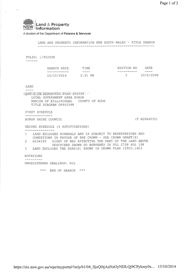


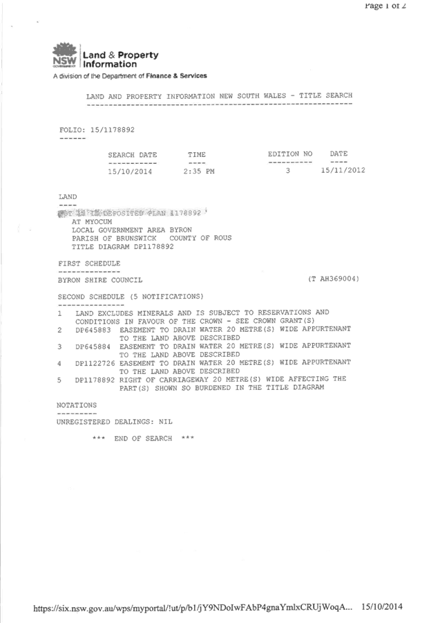

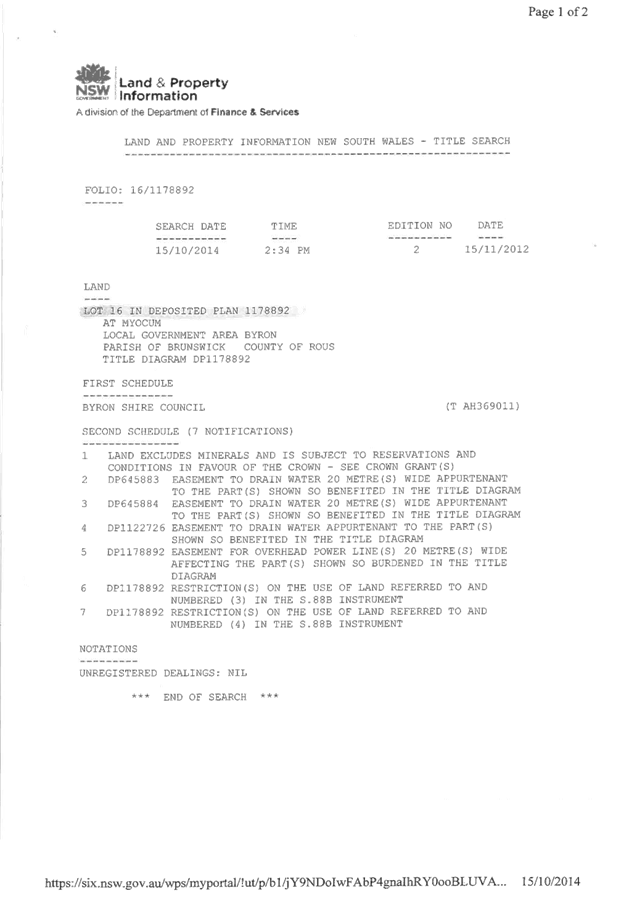

Staff Reports - Sustainable Environment and Economy 13.7 - Attachment 1
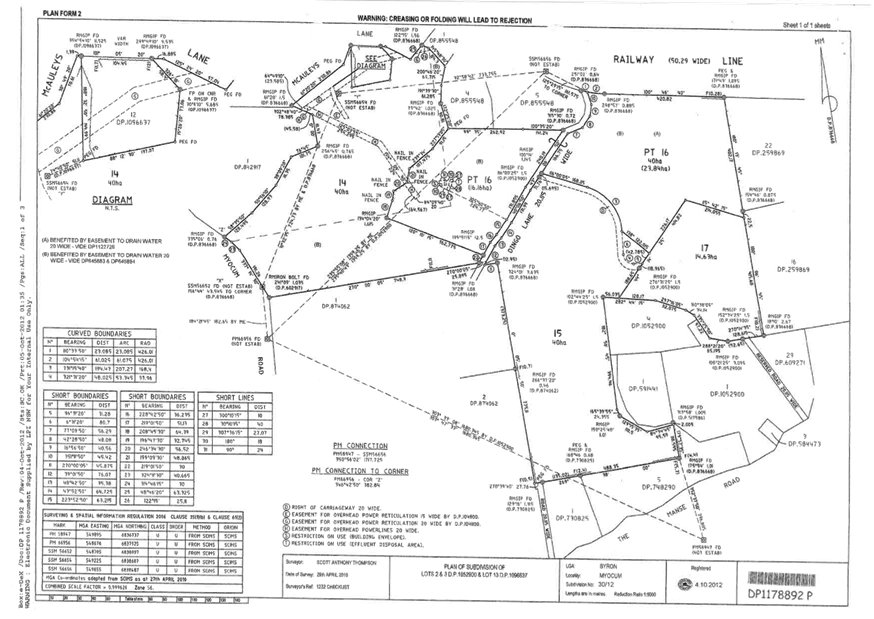
Staff Reports - Sustainable Environment and Economy 13.7 - Attachment 3


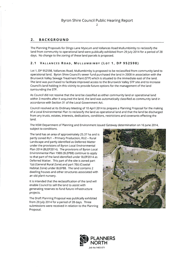
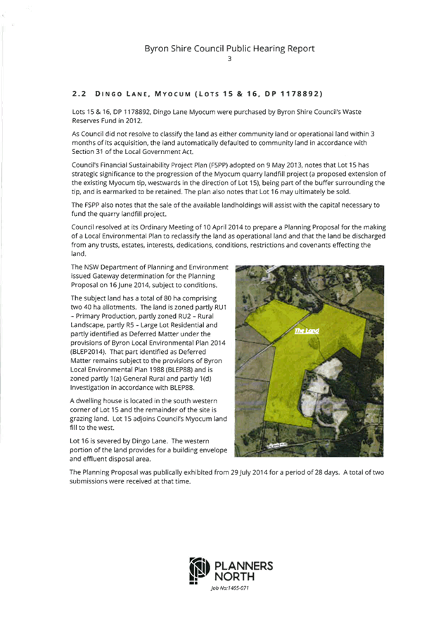
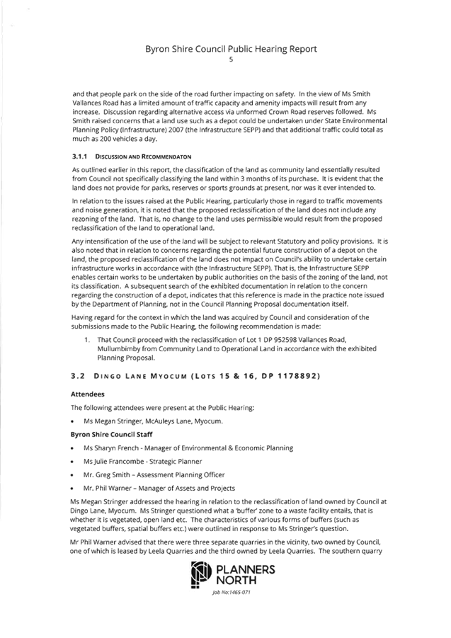


Staff Reports - Sustainable Environment and Economy 13.7 - Attachment 4

PLANNING PROPOSAL
RECLASSIFICATION OF LAND
FROM COMMUNITY TO OPERATIONAL – INTERESTS CHANGED
LOT
1 DP 952598 VALLANCES ROAD, MULLUMBIMBY
18 March 2015
(E2014/47567)
TABLE OF CONTENTS
Introduction .............................................................................................................................................. 3
Background .............................................................................................................................................. 3
Details of the Land and Locality ............................................................................................................... 4
Part 1...... Objectives
and Intended Outcomes of the Proposed Instrument ........................................... 5
Part 2...... Explanation
of Provisions to be included in the Proposed Instrument .................................... 6
Part 3...... Justification
for Objectives, Outcomes and Implementation Process .................................... 6
Section A – Need for the
Planning Proposal ........................................................................... 6
Section B – Relationship to
strategic planning framework ..................................................... 6
Section C – Environmental,
social and economic impact ...................................................... 11
Section D – State and
Commonwealth interests .................................................................... 11
Part 4...... Mapping
................................................................................................................................... 11
Part 5...... Community
Consultation ......................................................................................................... 11
Part 6...... Project
Timelines ..................................................................................................................... 12
Conclusion ............................................................................................................................................... 12
Indicative Project Timeline ....................................................................................................................... 13
Attachment A – Photographs of the Land ............................................................................................... 14
Attachment B – Byron LEP 1988 and 2014 Amendment Maps.............................................................. 15
INTRODUCTION
The intended outcome of the instrument
proposed by this Planning Proposal is that the public land owned by Council and
known as Lot 1 DP 952598, Vallances Road Mullumbimby (the “Land”):
(a) is
classified as “operational” in accordance with Part 2 of Chapter 6
of the Local Government Act 1993 (“LG Act”); and
(b) ceases
to be a public reserve (if it is a public reserve); and
(c) is
discharged from any trust for a public purpose.
The Planning Proposal has been
prepared with reference to the provisions of the LG Act, the Environmental
Planning and Assessment Act 1979, and the Department of Planning and
Environment’s Guidelines “A guide to preparing planning
proposals” and “A guide to preparing local environmental
plans”.
BACKGROUND
The Land was purchased by Byron
Shire Council and more specifically, Council’s Sewer Fund, in 2008, and
adjoins the Brunswick Valley Sewage Treatment Plant (STP) situated immediately
to the east of the Land. The reasons advised for the purchase of the Land were:
(1) to
facilitate improved access to the Brunswick Valley STP site; and
(2) to
increase Council’s landholding to 108 hectares to support future options
for the management of the land surrounding the STP.
Council did
not, within 3 months after it acquired the Land, resolve that the Land be
classified as either community land or operational land. Accordingly the Land
is taken to have been classified under a local environmental plan as community
land in accordance with section 31 of the LG Act. Council is exploring options for a possible sale and / or
development (depending on the outcome of the rural settlement strategy review) of the Land and at its meeting on 10 April
2014 resolved (Part 3 (and relevantly part (a)) of the resolution relates
to the Land and is the subject of this Planning Proposal):
1. That Council note that this report
being a late report will not compromise the community’s knowledge of or
ability to participate in the decision-making on this matter because, if it
proceeds, there will need to be extensive community consultation and many
opportunities to make submissions to Council and at Council meetings.
2. That a planning proposal be prepared
and submitted to the NSW Minister for Planning & Infrastructure in accordance
with Division 4 of Part 3 of the Environmental Planning and Assessment Act 1979
and Sections 27(1) and 30 of the Local Government Act 1993 for the making of a
local environmental plan to classify or reclassify the said land as operational
land and to make provision to the effect that, on commencement of the plan, the
land, if it is a public reserve, ceases to be a public reserve, and that the
land is by operation of the plan discharged from any trusts, estates,
interests, dedications, conditions, restrictions and covenants affecting the
land or any part of the land, except for:
(i) any reservations that except land
out of a Crown grant relating to the land, and
(ii) reservations of minerals (within the
meaning of the Crown Lands Act 1989).
3. That the same process as set out in
2. be pursued as required, in the same planning proposal or in concurrent
planning proposal/s, for the following land:
(a) Lot 1, DP952598, Vallances Road
Mullumbimby
(b) Lots 15 & 16, DP1178892 , Dingo Lane Myocum
(c) Lot 10, DP850902, Station St, Mullumbimby
(Administration Centre)
(d) Lot 1, DP435267, Station St, Mullumbimby
(Old Telstra site)
(e) Lot 4, DP841856, Mill St, Mullumbimby
(f) Lot 12, DP267109, Bayshore Drive, Byron Bay
(g) Lot B, DP 372589, Corner Lawson & Fletcher
Sts, Byron Bay
4. That it be noted that as a result of
delay to the Roundhouse project, infrastructure projects, including Ocean
Shores infrastructure projects, that were proposed to be funded from the
proceeds of sale of the Roundhouse land, will now be delayed, or may not be
able to be delivered depending on the outcome of the LEP amendment process.
Council’s Financial Sustainability
Project Plan (FSPP) adopted 9 May 2013 advises as follows:
The Sewer Fund has a high debt
servicing ratio (now trending downward) as a result of loans used for the
completion of the major program of sewerage system augmentations. As a result
service pricing charges are comparatively high and reserves have been depleted.
The sale of properties could assist with the objective of bring service pricing
charges progressively back to a median value.
Section 5.8 Actions for Land Holdings
of the FSPP further advises in this regard as follows:
Sewer Fund
3. In cases where there is no longer any
strategic operational and service delivery issues pertaining to sewer fund
land, it is desirable to divest this land and use the proceeds to pay down the
significant existing loans and thereby reduce pressure on service pricing. In
turn, any reduction in sewer service pricing helps to create scope for
potential increases in the General Fund rates and levies.
The Action Implementation Plan of the
FSPP indicates the following in relation to the Land:
11. Brunswick Valley STP, Vallances Rd Mullumbimby
(including two houses) - Complete an options assessment for the Brunswick Valley STP site.
The FSPP
adopts an assumed option of selling and / or development of the Land. The Land
needs to be reclassified from community land to operational land in order for
the Land to be sold or developed in accordance with the FSPP.
The Planning Proposal was
forwarded to NSW Planning & Environment on 2 June 2014, and the Gateway
Determination was issued by NSW Planning & Environment on 16 June 2014
subject to conditions. This version of the Planning Proposal incorporates
amendments required by conditions 1 and 5 of the Gateway Determination.
DETAILS OF THE LAND AND LOCALITY
The Land is
situated within a rural area to the north of the Brunswick River, and approximately 1km to the north east of the Mullumbimby CBD. The Land is owned by
Council, is classified “community land”, has a total area of
approximately 25.37 hectares and appears to have been created in the early
1900’s.
The Land is partly zoned RU1 – Primary Production, RU2
– Rural Landscape and partly identified as Deferred Matter under the
provisions of LEP 2014. The provisions of LEP 1988 continue to apply to that
part of Lot 1 identified under LEP 2014 as Deferred Matter. This part of Lot 1
is zoned part 1(a) (General Rural Zone) and part 7(b) (Coastal Habitat Zone)
under LEP 1988. Refer to the LEP 2014 and LEP 1988 Zone map extracts below.
The Land
accommodates two dwellings (one circa 1980’s, the other circa
1920’s) with other structures and features associated with an old plant
nursery, all towards the south eastern corner. The remainder of the Land is
predominantly grazing land. Refer to
the photograph and aerial photograph provided in Attachment A to this
Planning Proposal. Vallances Road is sealed to the Land, and a sealed extension
of Vallances Road (not indicated on the title) crossing the Land parallel to
the northern boundary provides access to the STP.
|
LEP 2014 Zone Map extract
|
LEP 1988 Zone Map extract
|
PART 1 OBJECTIVES AND INTENDED OUTCOMES OF
THE PROPOSED INSTRUMENT
The intended outcome of the
instrument proposed by this Planning Proposal is that the Land:
(a) is
classified as “operational” in accordance with Part 2 of Chapter 6
of the LG Act; and
(b) ceases
to be a public reserve (if it is a public reserve); and
(c) is
discharged from any trust for a public purpose, but is not discharged from:
(i) any
reservations that except the Land out of a Crown grant relating to the Land,
(ii) reservations
of minerals (within the meaning of the Crown Lands Act 1989), and
(iii) A234199
Right of Way affecting the part of the land shown so burdened in Vol 2738 Fol
198.
Intended outcomes (b) and (c) require the Governor’s
approval under section 30 of the Local Government Act 1993, which is sought by
the Department before the Minister makes the proposed instrument.
PART 2 EXPLANATION OF PROVISIONS TO BE
INCLUDED IN THE PROPOSED INSTRUMENT
LEP 2014 came into effect on 21 July 2014. LEP 2014 applies
to part of the Land however the other part of the Land was deferred by the
Minister’s delegate due to its proposed environmental zoning. This has
resulted in part of the Land being affected by LEP 1988 and the remaining part
of the Land being affected by LEP 2014. Consequently, amendments to both LEPs
will be required to reclassify the land.
The Land needs to be
reclassified from community land to operational land in order for the Land to
be sold and / or developed in accordance with the FSPP.
It may be possible for the proposed instruments relating to
the Land to be combined with the proposed instrument relating to Lots 15 and 16
DP 1178892 Dingo Lane, Myocum.
PART 3 JUSTIFICATION FOR OBJECTIVES,
OUTCOMES AND IMPLEMENTATION PROCESS
Section A – Need for the Planning Proposal
Q1. Is
the planning proposal a result of any strategic study or report?
The Planning Proposal reflects
Council’s potential intention to sell and / or develop the Land in
accordance with the FSPP.
Q2. Is
the planning proposal the best means of achieving the objectives or intended
outcomes, or is there a better way?
Amending LEP 1988 and LEP 2014 in
the manner proposed is the best, most efficient and most time effective
approach to delivering the objective and intended outcomes of the Planning
Proposal. The proposed LEP amendment provides certainty that the Land:
(a) is
reclassified from community land to operational land;
(b) ceases
to be a public reserve to the extent (if any) that it is a public reserve; and
(c) is discharged from any trust for a public purpose, but is not
discharged from any of the above mentioned reservations or right of way.
Section B – Relationship to strategic planning
framework
Q3. Is
the planning proposal consistent with the objectives and actions of the
applicable regional or sub-regional strategy?
The Planning Proposal is
consistent with the objectives and actions of the Far North Coast Regional
Strategy insofar as they relate to this Land within the rural area surrounding
Mullumbimby, because the proposed instrument will:
(a) not
change the zoning of the land, but changes the classification of the land to
operational so that options for the land can be explored including possible
sale / development;
(b) not
have a significant effect in terms of environmental, agricultural, farmland,
vegetation, habitat, areas of high biodiversity value, waterway, wetland,
coastline, heritage, water and energy resources, landscape values (including
scenic and cultural landscapes) or natural hazards;
(c) not
change the location of planned development;
(d) not
have a significant effect in terms of extractive resources;
(e) allow
the sale and / or development of the land in a manner which reflects the
objectives of the relevant zones; and
(f) fit
into the rural character of this part of the locality.
Q4. Is
the planning proposal consistent with Council’s local strategy or other
local strategic plan?
The Planning Proposal is
consistent with the key community outcomes and strategies of Council’s
Draft Community Strategic Plan 2022.
Q5. Is
the planning proposal consistent with applicable State Environmental Planning
Policies?
The Planning Proposal is
consistent with applicable State Environmental Planning Policies (SEPP) which
include:
SEPP 14 – Coastal
Wetlands
The Land does not contain nor
does it adjoin any SEPP 14 wetlands.
SEPP 19 – Bushland in
Urban Areas
The Land does not contain nor
does it adjoin, and the Planning Proposal does not propose to disturb, any
bushland zoned or reserved for public open space purposes.
SEPP 26 – Littoral
Rainforest
The Land does not contain nor
does it adjoin any SEPP 26 littoral rainforest.
SEPP 44 – Koala Habitat
Protection
The Planning Proposal will not
impact on the koala habitat indicated on Council’s GIS, located adjacent
to the south eastern boundary of the Land. The Planning Proposal will not
result in any disturbance to the Land.
SEPP 55 – Remediation of
Land
Council’s Records are not
conclusive as to whether the Land is contaminated. This issue would have to be
appropriately addressed pursuant to the provisions of SEPP 55 at such time as a
development application, proposing the carrying out of development potentially
affected by contamination on the Land, is submitted for consideration.
SEPP 71 – Coastal
Protection
The Planning Proposal is
consistent with the provisions of SEPP 71 relating to LEP preparation.
SEPP (Infrastructure) 2007
The Planning Proposal is not
contrary to the provisions of SEPP (Infrastructure) 2007.
North Coast Regional Environmental Plan
The Planning Proposal is
consistent with the provisions of the North Coast Regional Environmental Plan.
In particular, the Planning Proposal will not have a significant impact upon
the prime crop and pasture land that is on the Land and will not have a
significant impact with respect to rural dwellings. The Planning Proposal will
not have a significant impact in terms of strategic planning or environmental
hazard considerations.
Q6. Is
the planning proposal consistent with applicable Ministerial Directions (s.117
directions)?
The Planning Proposal is
consistent with applicable Ministerial Directions as follows:
|
1.
Employment
and Resources
1.2... Rural Zones; and
1.5... Rural Lands
No change
is proposed which would affect the existing or proposed rural zoning of the
Land. The Planning Proposal allows the sale and / or development of the Land
in accordance with the objectives of the applicable land use zones.
|
|
2.
Environment and Heritage
2.2... Coastal Protection
The
Planning Proposal is consistent with the relevant principles outlined in the
NSW Coastal Policy.
2.3
Heritage Conservation
The Land is not identified as
having heritage significance with reference to LEP 1988 or LEP 2014.
|
|
4. Hazard
and Risk
4.1... Acid Sulfate Soils
........ The Land includes a large area of
Class 3 Acid Sulfate Soils, with a small area of Class 2 Acid Sulfate Soils
in the vicinity of the south eastern boundary, under the LEP 1988 and LEP
2014. However the Planning Proposal will not result in or require any works
that may have an impact on acid sulfate soils.
4.3... Flood Prone Land
........ The
Land is flood liable land in the vicinity of the south eastern boundary.
However the Planning Proposal does not require any ameliorative measures to
address the flood liable hazard characteristics of the Land.
4.4... Planning for Bushfire
Protection
........ The
northern edge of the Land is bush fire prone land, however the Planning
Proposal has no significant implications with respect to this environmental
hazard. This Planning Proposal does not need to comply with Section 117
Direction 4.4 Planning for Bushfire Protection, subject to the satisfaction
of the Director-General of the Department of Planning & Environment,
because Council has obtained written advice from the NSW Rural Fire Service
which advises that no concerns or issues are raised in relation to bush fire
(essentially not objecting to the progression of the Planning Proposal).
|
|
5. Regional
Planning
5.1... Implementation of Regional
Strategies
........ The Planning Proposal is consistent
with the Far North Coast Regional Strategy’s relevant aims, outcomes
and actions.
|
|
6. Local
Plan Making
6.1... Approval and Referral
Requirements
The Planning Proposal confirms
that relevant community consultation requirements have been complied with,
but does not introduce any additional concurrence or referral requirements
and does not relate to designated development.
6.2... Reserving Land for Public
Purposes
In relation to Section 117
Direction 6.2 Reserving Land for Public Purposes, this Planning Proposal does
not propose to create, alter or reduce existing zonings or reservations of
land for public purposes.
|
The purpose of NSW Planning &
Environment’s Practice Note 09-003 Classification and reclassification
of public land through a local environmental plan dated 12 June 2009 is to
provide updated guidance on the process to classify or reclassify public land
through a local environmental plan. A written statement is to be provided
addressing the following:
· The reasons why the draft LEP or planning proposal is being
prepared including the planning merits of the proposal, e.g. the findings of a
centres’ strategy, council’s intention to dispose of the land,
provision of open space in a town centre
The Planning Proposal is prepared to facilitate
Council’s potential intention to sell and / or develop the Land. The
proposed instrument is necessary to provide the required degree of certainty in
relation to proceeding with options like selling and / or developing the Land
under the FSPP.
· The current and proposed classification of the land
The Land is currently community land.
The Land is proposed to be reclassified to: (i) operational Land classified,
or reclassified, under amended section 30 of Local Government Act
1993—interests changed under Part 3 of Schedule 11 of LEP 1988; and
(ii) operational Land classified, or reclassified, as operational
land—interests changed under Part 2 of Schedule 4 of the LEP 2014.
The Land is to be discharged from any
trust for a public purpose, but is not discharged from the above mentioned
Right of Way or:
(i) any
reservations that except the Land out of a Crown grant relating to the Land,
and
(ii) reservations
of minerals (within the meaning of the Crown Lands Act 1989).
· The reasons for the reclassification including how this
relates to council’s strategic framework, council’s proposed future
use of the land, proposed zones, site specific requirements, e.g. heritage
controls, anticipated physical or operational changes resulting from the
reclassification
The reclassification accords with the existing zones. The
reclassification results in no physical change to the Land. The
reclassification provides certainty to the community and potential purchasers
as to Council’s ability to sell and / or develop the Land and
through these initiatives may assist with providing funding for the
infrastructure projects referred to in part 3 of the Council’s resolution
dated 10 April 2014.
· Council’s ownership of the land, if this applies
The Land is currently in Council’s ownership. Council
may decide to sell and / or develop the Land.
· The nature of council’s interest in the land, e.g.
council has a 50 year lease over the site
Council has owned the Land since 2008 and may decide to
sell the Land.
· How and when the interest was first acquired, e.g. the land
was purchased in 20XX through section 94
Council purchased the Land in 2008.
· The reasons council acquired an interest in the land, e.g.
for the extension of an existing park; council was given responsibility for the
land by a State agency
Council purchased the Land in 2008 through Council’s
Sewer Fund:
(1) to
facilitate improved access to the Brunswick Valley STP site; and
(2) to
increase Council’s landholding to 108 hectares to support future options
for the management of the land surrounding the STP.
· Any agreements over the land together with their duration,
terms, controls, agreement to dispose of the land, e.g. whether any aspect of
the draft LEP or planning proposal formed part of the agreement to dispose of
the land and any terms of any such agreement
The Land may be subject to rental agreements relating to
the dwellings or agistment agreements in relation to animal grazing. However
the proposed instrument will provide clarity and certainty that the Land:
(a) is
classified as “operational” in accordance with Part 2 of Chapter 6
of the LG Act; and
(b) ceases
to be a public reserve (if it is a public reserve); and
(c) is
discharged from any trusts, estates, interests, dedications, conditions,
restrictions and covenants affecting the Land or any part of the Land, except for
those indicated above and:
(i) any
reservations that except the Land out of a Crown grant relating to the Land,
and
(ii) reservations
of minerals (within the meaning of the Crown Lands Act 1989).
· An indication, as a minimum, of the magnitude of any
financial gain or loss from the reclassification and of the type(s) of benefit
that could arise e.g. council could indicate the magnitude of value added to
the land based on comparable sites such as the land is currently valued at
$1500 per square metre, nearby land zoned for business development is valued at
between $2000 and $5000 per square metre.
Council purchased the Land in relation to the adjoining
Brunswick Valley STP, however Council may decide to sell or develop (depending
on the outcome of the rural settlement strategy review) the Land. The interests
which affect the land include:
(i) A potential
trust for the public purpose; and
(ii) A Right of Way
affecting the land.
This Planning Proposal proposes the extinguishment of any
trust for a public purpose, however it does not propose the extinguishment of
the Right of Way.
· The asset management objectives being pursued, the manner
in which they will be achieved and the type of benefits the council wants, i.e.
without necessarily providing details of any possible financial arrangements,
how the council may or will benefit financially.
The Land was not constrained by a community classification
when it was purchased by Council from the previous private owner. The
reclassification of the Land would allow Council to consider future options in
accordance with the FSPP. Funds from any sale of the Land are able to be
reinvested to increase Council’s infrastructure management capacity.
· Whether there has been an agreement for the sale or lease
of the land; the basic details of any such agreement and, if relevant, when
council intends to realise its asset, either immediately after
rezoning/reclassification or at a later time.
There is presently no agreement entered into to sell or
lease the Land, except possibly in relation to renting of the dwellings and /
or agistment for grazing purposes. However the reclassification of the Land
provides certainty for the community in relation to the:
(a) operational land
classification of the Land;
(b) cessation of any
public reserve applying to the Land or any part of the Land; and
(c) discharging of any trust for a public purpose, but the Land
is not discharged from the Right of Carriageway or:
(i) any
reservations that except the Land out of a Crown grant relating to the Land,
and
(ii) reservations
of minerals (within the meaning of the Crown Lands Act 1989).
· Relevant matters required in plan making under the EP&A
Act.
This Planning Proposal addresses the relevant matters
required in plan making under the Environmental Planning and Assessment Act
1979.
· A copy of this practice note must be included in the
exhibition material to assist the community in identifying information
requirements. Council staff may wish to identify the column in Attachment 1 that
applies.
A copy of the relevant Practice Note was included in the
public exhibition material.
Section C – Environmental, social and economic
impact
Q7. Is
there any likelihood that critical habitat or threatened species, populations
or ecological communities, or their habitats, will be adversely affected as a
result of the proposal?
Council’s GIS mapping
indicates that the Land contains high conservation value vegetation and koala
habitat in the vicinity of the south eastern boundary. The GIS mapping does not
indicate that the Land contains SEPP 14 wetland, SEPP 26 littoral rainforest or
mapped threatened fauna habitat. Parts of the Land have been disturbed by past
activities associated with the use of the Land for residential, plant nursery,
agricultural and associated activities. The proposed reclassification is
unlikely to have a significant effect on any critical habitat or threatened
species, populations or ecological communities, or their habitats.
Q8. Are
there any other likely environmental effects as a result of the planning
proposal and how are they proposed to be managed?
There are no known significant
likely environmental effects as a result of the Planning Proposal.
Q9. Has
the planning proposal adequately addressed any social and economic impacts?
The Planning Proposal is unlikely
to cause any significant social or economic impacts.
Section D – State and Commonwealth interests
Q10. Is
there adequate public infrastructure for the planning proposal?
No further services are required
as a result of the proposed reclassification.
Q11. What
are the views of State and Commonwealth public authorities consulted in
accordance with the Gateway determination?
The NSW Rural Fire Service made a
written submission advising that no concerns or issues are raised in relation
to bush fire.
NSW Trade & Investment Crown
Lands made a written submission:
· Noting
that there is a number of Crown public roads adjoining the site and adjoining
land owned by Council; and
· Requesting
that any Crown roads that may need to be utilised for access / constructed due
to any future proposal over these lots be transferred to administration of
Council.
PART 4 MAPPING
LEP amendment maps are included in Attachment
B to this Planning Proposal as required by condition 5 of the Gateway
Determination.
PART 5 COMMUNITY CONSULTATION
Community consultation on the Planning
Proposal has been undertaken in accordance with the Gateway Determination. The
exhibition period complied with the minimum required 28 day period and the
relevant material was made available for public inspection during the
exhibition period as specified in NSW Planning & Infrastructure’s A
guide to preparing local environmental plans.
The public hearing has been conducted and
the report on the public hearing has been received by Council. Council has
considered the submissions made concerning the Planning Proposal and the report
of the public hearing into the proposed LEPs.
PART 6 PROJECT TIMELINES
An indicative project timeline is provided
below.
CONCLUSION
The proposed reclassification of the Land to “operational
land – interests changed” is satisfactory having regard to relevant
legislative and environmental planning requirements. The Planning Proposal has
been amended in accordance with conditions 1 and 5 of the Gateway Determination
and is consistent with the objectives of the relevant zones. The
reclassification is intended to allow the investigation of options for the Land
including potential sale and / or development, providing certainty to the
community. The reclassification contributes towards facilitating the proper
planning and use of the Land.
INDICATIVE PROJECT TIMELINE
|
Indicative Stages
|
Indicative Timeframe
|
|
|
|
|
Council forwards the
Planning Proposal to the Department.
The Department carries out
the Gateway assessment and returns the Planning Proposal with the Gateway
determination to Council (section 56 of EP Act).
|
COMPLETE
COMPLETE
|
|
|
|
|
|
Completion of required
technical information after receipt of Gateway determination, including
preparation for community consultation. [The stages after the Gateway
determination may be varied by the Gateway determination].
|
COMPLETE
|
|
|
|
|
|
Community consultation
(including public exhibition) for Planning Proposal (section 57 of EP Act).
|
COMPLETE
|
|
|
|
|
|
Preparation for and
conducting of public hearing (section 29 of LG Act), by a person other than a
Councillor or employee (section 47G of LG Act).
Preparation of report on
public hearing by the person presiding at the public hearing (section 57(7)
of EP Act). The report is to be made available by Council for inspection no
later than 4 days after Council has received the report (section 47G of LG
Act).
|
COMPLETE
COMPLETE
|
|
|
|
|
|
Report to Council on
outcome of community consultation and public hearing and to seek a resolution to forward the Planning Proposal to the NSW
Department of Planning and Environment with a request to draft and finalise
LEP amendments relating to LEP 1988 and LEP 2014.
|
COMPLETE
|
|
|
|
|
|
Department makes
arrangements for the proposed instrument to be prepared by PC.
|
|
|
|
|
|
|
Approval of the Governor
obtained by the Department / PC (section 30 of LG Act), content of proposed
instrument finalised by PC, an opinion issued by PC that the proposed
instrument can be made and Council advised by the Department accordingly.
|
|
|
|
|
|
|
The proposed instrument is
published on the legislation website and becomes effective.
|
|
Note: ‘EP Act’
means Environmental Planning and Assessment Act 1979, ‘LG Act’
means Local Government Act 1993 and ‘PC’ means the Office of Parliamentary
Counsel.
ATTACHMENT A – PHOTOGRAPHS OF THE LAND
Aerial photograph of
the Land
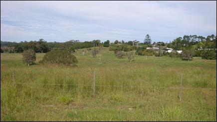
View south across the
Land
(Photograph taken: 28
April 2014)
ATTACHMENT B – BYRON
LOCAL ENVIRONMENTAL PLAN 1988 AND BYRON LOCAL ENVIRONMENTAL PLAN 2014 AMENDMENT
MAPS
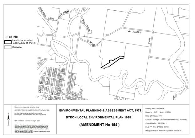
Byron Local Environmental Plan 1988 (Amendment No 154)
– Map (Vallances Road)
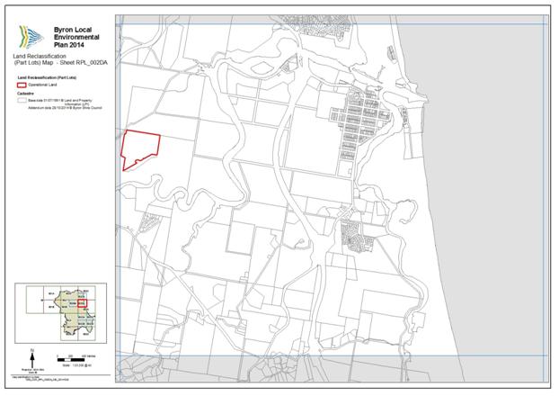
Byron
Local Environmental Plan 2014 – Map (Vallances Road – Sheet
RPL_002DA)
Staff Reports - Sustainable Environment and Economy 13.7 - Attachment 5
PLANNING PROPOSAL
RECLASSIFICATION OF LAND
FROM COMMUNITY TO OPERATIONAL – INTERESTS CHANGED
LOTS
15 AND 16 DP 1178892 DINGO LANE, MYOCUM
18 March 2015
(E2014/47571)
TABLE OF CONTENTS
Introduction .............................................................................................................................................. 3
Background .............................................................................................................................................. 3
Details of the Land and Locality ............................................................................................................... 4
Part 1...... Objectives
and Intended Outcomes of the Proposed Instrument ........................................... 6
Part 2...... Explanation
of Provisions to be included in the Proposed Instrument .................................... 6
Part 3...... Justification
for Objectives, Outcomes and Implementation Process .................................... 6
Section A – Need for the
Planning Proposal ........................................................................... 6
Section B – Relationship to
strategic planning framework ..................................................... 7
Section C – Environmental,
social and economic impact ...................................................... 12
Section D – State and
Commonwealth interests .................................................................... 12
Part 4...... Mapping
................................................................................................................................... 12
Part 5...... Community
Consultation ......................................................................................................... 12
Part 6...... Project
Timelines ..................................................................................................................... 12
Conclusion ............................................................................................................................................... 12
Indicative Project Timeline ....................................................................................................................... 13
Attachment A
–. Photographs of the Land .............................................................................................. 14
Attachment B – Byron LEP 1988 and 2014 Amendment Maps.............................................................. 15
INTRODUCTION
The intended outcome of the instrument
proposed by this Planning Proposal is that the public land owned by Council and
known as Lot 15 and Lot 16 DP 1178892, Dingo Lane Myocum (the
“Land”):
(a) is
classified as “operational” in accordance with Part 2 of Chapter 6
of the Local Government Act 1993 (“LG Act”); and
(b) ceases
to be a public reserve (if it is a public reserve); and
(c) is
discharged from any trust for a public purpose.
The Planning Proposal has been
prepared with reference to the provisions of the LG Act, the Environmental
Planning and Assessment Act 1979, and the Department of Planning and
Environment’s Guidelines “A guide to preparing planning
proposals” and “A guide to preparing local environmental
plans”.
BACKGROUND
The Land was purchased by Byron
Shire Council and more specifically, Council’s Waste Reserves Fund, in
2012. With reference to Council’s Financial Sustainability Project Plan
(FSPP) adopted 9 May 2013:
· Lot
15 is understood to have strategic significance to the progression of the
Myocum Quarry Landfill project (a proposed extension of the existing Myocum
Tip, westwards in the direction of Lot 15), being part of the buffer
surrounding the Tip, and is earmarked to be retained; and
· Lot
16 may ultimately be sold.
Council did
not, within 3 months after it acquired the Land, resolve that the Land be
classified as either community land or operational land. Accordingly the Land
is taken to have been classified under a local environmental plan as community
land in accordance with section 31 of the LG Act. Council is exploring options for future use / sale of the Land and at
its meeting on 10 April 2014 resolved (Part 3 (and relevantly part (b))
of the resolution relates to the Land and is the subject of this Planning Proposal):
1. That Council note that this report
being a late report will not compromise the community’s knowledge of or
ability to participate in the decision-making on this matter because, if it
proceeds, there will need to be extensive community consultation and many
opportunities to make submissions to Council and at Council meetings.
2. That a planning proposal be prepared
and submitted to the NSW Minister for Planning & Infrastructure in
accordance with Division 4 of Part 3 of the Environmental Planning and
Assessment Act 1979 and Sections 27(1) and 30 of the Local Government Act 1993
for the making of a local environmental plan to classify or reclassify the said
land as operational land and to make provision to the effect that, on
commencement of the plan, the land, if it is a public reserve, ceases to be a
public reserve, and that the land is by operation of the plan discharged from
any trusts, estates, interests, dedications, conditions, restrictions and
covenants affecting the land or any part of the land, except for:
(i) any reservations that except land
out of a Crown grant relating to the land, and
(ii) reservations of minerals (within the
meaning of the Crown Lands Act 1989).
3. That the same process as set out in
2. be pursued as required, in the same planning proposal or in concurrent
planning proposal/s, for the following land:
(a) Lot 1, DP952598, Vallances Road
Mullumbimby
(b) Lots 15 & 16, DP1178892 , Dingo Lane Myocum
(c) Lot 10, DP850902, Station St, Mullumbimby
(Administration Centre)
(d) Lot 1, DP435267, Station St, Mullumbimby
(Old Telstra site)
(e) Lot 4, DP841856, Mill St, Mullumbimby
(f) Lot 12, DP267109, Bayshore Drive, Byron Bay
(g) Lot B, DP 372589, Corner Lawson &
Fletcher Sts, Byron Bay
4. That it be noted that as a result of
delay to the Roundhouse project, infrastructure projects, including Ocean
Shores infrastructure projects, that were proposed to be funded from the
proceeds of sale of the Roundhouse land, will now be delayed, or may not be
able to be delivered depending on the outcome of the LEP amendment process.
The FSPP advises as follows:
The Waste Reserves will be under
pressure due to the Quarry Landfill project which is potentially the largest
capital project that will be progressed during this term of Council. In
addition, the waste haulage and disposal contract and the introduction of programs
like the kerbside organics collection service are placing upward pressure on
service pricing. Sale of the available land holdings at a prudent time will
assist with the capital necessary to fund this major program of work.
Section 5.8 Actions
for Land Holdings of the FSPP further advises in this regard as follows:
Waste
Reserves
4. Following approval of the Quarry
Landfill, utilize the Manse Road properties and Dingo Lane property to fund in
part the construction of this major project.
The Action Implementation
Plan of the FSPP indicates the following in relation to the Land:
15. Lot 15 (included the 'Bower Cottage') Dingo Lane
Myocum - Council has resolved to progress the Quarry landfill project and the
EIS, DA and assessment process will proceed throughout 2013 with project
approval achievable in 2014. If the Quarry landfill is implemented it is
unlikely this property will ever be sold.
16. Lot 16 Dingo Lane Myocum - If Council achieves
project approval for the Quarry landfill, the future retention of this property
should be carefully considered with a view to potential sale.
The Land needs to be
reclassified from community land to operational land in order for the Land to
be used and / or sold in accordance with the FSPP.
The Planning Proposal was
forwarded to NSW Planning & Environment on 2 June 2014, and the Gateway
Determination was issued by NSW Planning & Environment on 16 June 2014
subject to conditions. This version of the Planning Proposal incorporates
amendments required by conditions 1 and 5 of the Gateway Determination.
DETAILS OF THE LAND AND LOCALITY
The Land is situated within an
area of rural land approximately 3km to the south of the Mullumbimby CBD. The
Land has a total area of 80 hectares with 40 hectares in each lot. The Land is
owned by Council and is classified “community land”.
Lot 15 is partly zoned RU1 – Primary Production, RU2
– Rural Landscape and partly identified as Deferred Matter under the
provisions of LEP 2014. The provisions of LEP 1988 continue to apply to that
part of Lot 15 identified under LEP 2014 as Deferred Matter. This part of Lot
15 is zoned part 1(a) (General Rural Zone) and part 1(d) (Investigation Zone)
under LEP 1988.
Lot 16 is partly zoned RU1 – Primary Production, RU2
– Rural Landscape, R5 – Large Lot Residential and partly identified
as Deferred Matter under the provisions of LEP 2014. The provisions of LEP 1988
continue to apply to that part of Lot 16 identified under LEP 2014 as Deferred
Matter. This part of Lot 16 is zoned part 1(a) (General Rural Zone) and part
1(d) (Investigation Zone) under LEP 1988.
Refer to the LEP 2014 and LEP 1988 Zone map extracts below.
Lots 15 and 16 were created
(along with 2 other approved lots) by the subdivision of 3 existing lots into 4
lots approved under the consent to Development Application No. 10.2006.578.1
dated 5 February 2007. The report on
DA 10.2006.578.1 indicated that Lots 15 and 16 each have a dwelling
entitlement. Lot 15 is allocated street number 1 Dingo Lane whereas Lot 16 has not been allocated a street number. Dingo
Lane is unsealed adjacent to the Land.
Lot 15 accommodates a
dwelling-house in the south western corner and the remainder is grazing land. Lot 15 adjoins the south eastern side of Dingo Lane and is to the
western side of Council’s Myocum Tip. A right of carriageway runs
approximately parallel to the north eastern boundary of Lot 15 providing access
to Lot 17 DP 1178892 to the east.
Lot 16 is split into two parts by Dingo Lane, one part being to the north west and the other part being to the south east of the Lane. Restrictions on use
applying to the western part of Lot 16 provide for a building envelope and an
effluent disposal area, and there is a short 20m wide easement for overhead
powerlines near the north western side of Lot 16. The northern boundary of the
eastern part of Lot 16 adjoins the corridor of the former Casino –
Murwillumbah Rail Line.
Refer to the aerial photograph and site photographs provided in Attachment
A to this Planning Proposal.


 Lot 15 Lot
16
Lot 15 Lot
16
|
LEP 2014 Zone Map extract
|
LEP 1988 Zone Map extract
|
PART 1 OBJECTIVES AND INTENDED OUTCOMES OF
THE PROPOSED INSTRUMENT
The intended outcome of the
instrument proposed by this Planning Proposal is that the Land:
(a) is
classified as “operational” in accordance with Part 2 of Chapter 6
of the Local Government Act 1993 (“LG Act”); and
(b) ceases
to be a public reserve (if it is a public reserve); and
(c) is
discharged from any trust for a public purpose, but is not discharged from
(i) any
reservations that except the Land out of a Crown grant relating to the Land,
and
(ii) reservations
of minerals (within the meaning of the Crown Lands Act 1989).
(iii) Easement
to Drain Water registered with DP 645883,
(iv) Easement
to Drain Water registered with DP 645884,
(v) Easement
to Drain Water registered with DP 1122726,
(vi) Right
of Carriageway registered with DP 1178892 affecting Lot 15 DP 1178892,
(vii) Easement
for Overhead Power Line(s) registered with DP 1178892 affecting Lot 16 DP
1178892,
(viii) Restriction(s)
on the Use of Land referred to and numbered (3) in the applicable Section 88B
Instrument registered with DP 1178892 affecting Lot 16 DP 1178892, and
(ix) Restriction(s)
on the Use of Land referred to and numbered (4) in the applicable Section 88B
Instrument registered with DP 1178892 affecting Lot 16 DP 1178892.
Intended outcomes (b) and (c) require the Governor’s
approval under section 30 of the Local Government Act 1993, which is sought by
the Department before the Minister makes the proposed instrument.
PART 2 EXPLANATION OF PROVISIONS TO BE
INCLUDED IN THE PROPOSED INSTRUMENT
LEP 2014 came into effect on 21 July 2014. LEP 2014 applies
to part of the Land however the other part of the Land was deferred by the
Minister’s delegate due to its proposed environmental zoning. This has
resulted in part of the Land being affected by LEP 1988 and the remaining part of
the Land being affected by LEP 2014. Consequently, amendments to both LEPs will
be required to reclassify the land.
The Land needs to be
reclassified from community land to operational land in order for the Land to
be used and / or sold in accordance with the FSPP.
It may be possible for the proposed instrument relating to
the Land to be combined with the proposed instrument relating to Lot 1 DP
952598 Vallances Road, Mullumbimby.
PART 3 JUSTIFICATION FOR OBJECTIVES,
OUTCOMES AND IMPLEMENTATION PROCESS
Section A – Need for the Planning Proposal
Q1. Is
the planning proposal a result of any strategic study or report?
The Planning Proposal reflects
Council’s potential intention to sell Lot 16 and use Lot 15 in accordance
with the FSPP.
Q2. Is
the planning proposal the best means of achieving the objectives or intended
outcomes, or is there a better way?
Amending LEP 1988 and LEP 2014 in
the manner proposed is the best, most efficient and most time effective
approach to delivering the objective and intended outcomes of the Planning
Proposal. The proposed LEP amendment provides certainty that the Land:
(a) is
reclassified from community land to operational land;
(b) ceases
to be a public reserve to the extent (if any) that it is a public reserve; and
(c) is
discharged from any trust for a public purpose, but is not discharged from any
of the above mentioned reservations, easements, right of carriageway or
restrictions on the use of land.
Section B – Relationship to strategic planning
framework
Q3. Is
the planning proposal consistent with the objectives and actions of the
applicable regional or sub-regional strategy?
The Planning Proposal is
consistent with the objectives and actions of the Far North Coast Regional
Strategy insofar as they relate to this Land within the rural area surrounding
Mullumbimby, because the proposed instrument will:
(a) not
change the zoning of the Land, but changes the classification of the Land to
operational so that options for the Land can be explored including possible use
/ sale;
(b) not
have a significant effect in terms of environmental, agricultural, farmland,
vegetation, habitat, areas of high biodiversity value, waterway, wetland,
coastline, heritage, water and energy resources, landscape values (including
scenic and cultural landscapes) or natural hazards;
(c) not
change the location of planned development;
(d) not
have a significant effect in terms of extractive resources;
(e) allow
the sale and / or use of the Land in a manner which reflects the objectives of
the relevant zones; and
(f) fit
into the rural character of this part of the locality.
Q4. Is
the planning proposal consistent with Council’s local strategy or other
local strategic plan?
The Planning Proposal is
consistent with the key community outcomes and strategies of Council’s
Draft Community Strategic Plan 2022.
Q5. Is
the planning proposal consistent with applicable State Environmental Planning
Policies?
The Planning Proposal is
consistent with applicable State Environmental Planning Policies (SEPP) which
include:
SEPP 14 – Coastal
Wetlands
The Land does not contain nor
does it adjoin any SEPP 14 wetlands.
SEPP 19 – Bushland in
Urban Areas
The Land does not contain nor
does it adjoin, and the Planning Proposal does not propose to disturb, any
bushland zoned or reserved for public open space purposes.
SEPP 26 – Littoral
Rainforest
The Land does not contain nor
does it adjoin any SEPP 26 littoral rainforest.
SEPP 44 – Koala Habitat
Protection
The Planning Proposal will not
impact on the koala habitat indicated on Council’s GIS located towards
the eastern and northern parts of the Land. The Planning Proposal will not
result in any disturbance to the Land.
SEPP 55 – Remediation of
Land
Council’s Environmental
Health Officer advised in relation to DA 10.2006.578.1 with respect to
contamination as follows:
“Information submitted by
the applicant satisfies Clause 7 of SEPP 55, and therefore the proposed
development site is considered to be suitable for the intended use.”
This issue may need to be further
addressed pursuant to the provisions of SEPP 55 at such time as a development
application, proposing the carrying out of development potentially affected by
contamination on the Land, is submitted for consideration.
SEPP 71 – Coastal
Protection
The Planning Proposal is
consistent with the provisions of SEPP 71 relating to LEP preparation.
SEPP (Infrastructure) 2007
The Planning Proposal is not
contrary to the provisions of SEPP (Infrastructure) 2007.
North Coast Regional Environmental Plan
The Planning Proposal is
consistent with the provisions of the North Coast Regional Environmental Plan.
In particular, the Planning Proposal will not have a significant impact upon
the prime crop and pasture land that is on the Land and will not have a
significant impact with respect to rural dwellings. The Planning Proposal will
not have a significant impact in terms of strategic planning or environmental
hazard considerations.
Q6. Is
the planning proposal consistent with applicable Ministerial Directions (s.117 directions)?
The Planning Proposal is
consistent with applicable Ministerial Directions as follows:
|
1.
Employment
and Resources
1.2... Rural Zones; and
1.5... Rural Lands
No change
is proposed which would affect the existing or proposed rural zoning of the
Land. The Planning Proposal allows the use and / or sale of the Land so that
it may be developed in accordance with the objectives of the applicable land
use zones.
|
|
2.
Environment and Heritage
2.2... Coastal Protection
The
Planning Proposal is consistent with the relevant principles outlined in the
NSW Coastal Policy.
2.3
Heritage Conservation
The Land is not identified as
having heritage significance with reference to LEP 1988 or LEP 2014.
|
|
4. Hazard
and Risk
4.1... Acid Sulfate Soils
........ The Land includes a large area of
Class 3 / 4 Acid Sulfate Soils in the central low lying areas, under LEP 1988
and LEP 2014. However the Planning Proposal will not result in or require any
works that may have an impact on acid sulfate soils.
4.3... Flood Prone Land
........ The
Land is predominantly flood liable land. However the Planning Proposal does
not require any ameliorative measures to address the flood liable hazard
characteristics of the Land.
4.4... Planning for Bushfire
Protection
........ Parts
of the Land are bush fire prone land, however the Planning Proposal has no
significant implications with respect to this environmental hazard. This
Planning Proposal does not need to comply with Section 117 Direction 4.4
Planning for Bushfire Protection, subject to the satisfaction of the
Director-General of the Department of Planning & Environment, because
Council has obtained written advice from the NSW Rural Fire Service which
advises that no concerns or issues are raised in relation to bush fire
(essentially not objecting to the progression of the Planning Proposal).
|
|
5. Regional
Planning
5.1... Implementation of Regional
Strategies
........ The Planning Proposal is consistent
with the Far North Coast Regional Strategy’s relevant aims, outcomes
and actions.
|
|
6. Local
Plan Making
6.1... Approval and Referral
Requirements
The Planning Proposal confirms
that relevant community consultation requirements have been complied with,
but does not introduce any additional concurrence or referral requirements
and does not relate to designated development.
6.2... Reserving Land for Public
Purposes
........ In
relation to Section 117 Direction 6.2 Reserving Land for Public Purposes,
this Planning Proposal does not propose to create, alter or reduce existing
zonings or reservations of land for public purposes.
|
The purpose of NSW Planning &
Infrastructure’s Practice Note 09-003 Classification and
reclassification of public land through a local environmental plan dated 12
June 2009 is to provide updated guidance on the process to classify or reclassify
public land through a local environmental plan. A written statement is to be
provided addressing the following:
· The reasons why the draft LEP or planning proposal is being
prepared including the planning merits of the proposal, e.g. the findings of a
centres’ strategy, council’s intention to dispose of the land,
provision of open space in a town centre
The Planning Proposal is prepared to facilitate
Council’s potential intention to use / sell the Land. The proposed
instrument is necessary to provide the required degree of certainty in relation
to proceeding with options like selling and / or using the Land under the FSPP.
· The current and proposed classification of the land
The Land is currently community land.
The Land is proposed to be reclassified to: (i) operational Land classified,
or reclassified, under amended section 30 of Local Government Act
1993—interests changed under Part 3 of Schedule 11 of LEP 1988; and
(ii) operational Land classified, or reclassified, as operational
land—interests changed under Part 2 of Schedule 4 of LEP 2014. The
Land is to be discharged from any
trust for a public purpose, but is not discharged from any of the above
mentioned reservations, easements, right of carriageway and restrictions or:
(i) any
reservations that except the Land out of a Crown grant relating to the Land,
and
(ii) reservations
of minerals (within the meaning of the Crown Lands Act 1989).
· The reasons for the reclassification including how this
relates to council’s strategic framework, council’s proposed future
use of the land, proposed zones, site specific requirements, e.g. heritage
controls, anticipated physical or operational changes resulting from the
reclassification
The reclassification accords with the existing zones. The
reclassification results in no physical change to the Land. The
reclassification provides certainty to the community and potential purchasers
as to Council’s ability to sell and / or use the Land and through
these initiatives may assist with providing funding for the infrastructure
projects referred to in part 3 of the Council’s resolution dated 10 April
2014.
· Council’s ownership of the land, if this applies
The Land is currently in Council’s ownership. Council
may decide to sell all or (more likely) part of the Land.
· The nature of council’s interest in the land, e.g.
council has a 50 year lease over the site
Council has owned the Land since 2012 and may decide to use
/ sell the Land.
· How and when the interest was first acquired, e.g. the land
was purchased in 20XX through section 94
Council purchased the Land in 2012.
· The reasons council acquired an interest in the land, e.g.
for the extension of an existing park; council was given responsibility for the
land by a State agency
Council purchased the Land in 2012 through Council’s
Waste Fund, in relation to the Myocum Tip.
· Any agreements over the land together with their duration,
terms, controls, agreement to dispose of the land, e.g. whether any aspect of
the draft LEP or planning proposal formed part of the agreement to dispose of
the land and any terms of any such agreement
The Land may be subject to rental agreements relating to
the dwelling or agistment agreements in relation to animal grazing. However the
proposed instrument will provide clarity and certainty that the Land:
(a) is
classified as “operational” in accordance with Part 2 of Chapter 6
of the LG Act; and
(b) ceases
to be a public reserve (if it is a public reserve); and
(c) is
discharged from any trusts, estates, interests, dedications, conditions,
restrictions and covenants affecting the Land or any part of the Land, except
for those indicated above and:
(i) any
reservations that except the Land out of a Crown grant relating to the Land,
and
(ii) reservations
of minerals (within the meaning of the Crown Lands Act 1989).
· An indication, as a minimum, of the magnitude of any
financial gain or loss from the reclassification and of the type(s) of benefit
that could arise e.g. council could indicate the magnitude of value added to
the land based on comparable sites such as the land is currently valued at
$1500 per square metre, nearby land zoned for business development is valued at
between $2000 and $5000 per square metre.
Council purchased the Land in relation to the adjoining
Myocum Tip, however Council may decide to use or sell the Land.
The interests which affect the land include:
(i) A potential
trust for the public purpose;
(ii) Easement
to Drain Water registered with DP 645883;
(iii) Easement
to Drain Water registered with DP 645884;
(iv) Easement
to Drain Water registered with DP 1122726;
(v) Right
of Carriageway registered with DP 1178892 affecting Lot 15 DP 1178892;
(vi) Easement
for Overhead Power Line(s) registered with DP 1178892 affecting Lot 16 DP
1178892;
(vii) Restriction(s)
on the Use of Land referred to and numbered (3) in the applicable Section 88B
Instrument registered with DP 1178892 affecting Lot 16 DP 1178892; and
(viii) Restriction(s)
on the Use of Land referred to and numbered (4) in the applicable Section 88B
Instrument registered with DP 1178892 affecting Lot 16 DP 1178892.
This Planning Proposal proposes the extinguishment of any
trust for a public purpose, however it does not propose the extinguishment of
the Easements to Drain Water, Right of Carriageway, Easement for Overhead Power
Lines or Restrictions on the Use of Land.
· The asset management objectives being pursued, the manner
in which they will be achieved and the type of benefits the council wants, i.e.
without necessarily providing details of any possible financial arrangements,
how the council may or will benefit financially.
The Land was not constrained by a community classification
when it was purchased by Council from the previous private owner. The
reclassification of the Land would allow Council to consider future options in
accordance with the FSPP. Funds from any sale of any part of the Land are able
to be reinvested to increase Council’s infrastructure management
capacity.
· Whether there has been an agreement for the sale or lease
of the land; the basic details of any such agreement and, if relevant, when
council intends to realise its asset, either immediately after
rezoning/reclassification or at a later time.
There is presently no agreement entered into to sell or
lease all or part of the Land, except possibly in relation to renting of the
dwelling and / or agistment for grazing purposes. However the reclassification
of the Land provides certainty for the community in relation to the:
(a) operational land
classification of the Land;
(b) cessation of any
public reserve applying to the Land or any part of the Land; and
(c) discharging of any
trust for a public purpose, but the Land is not discharged from the Easements
to Drain Water, Right of Carriageway, Easement for Overhead Power Lines or
Restrictions on the Use of Land or:
(i) any
reservations that except the Land out of a Crown grant relating to the Land,
and
(ii) reservations
of minerals (within the meaning of the Crown Lands Act 1989).
· Relevant matters required in plan making under the EP&A
Act.
This Planning Proposal addresses the relevant matters
required in plan making under the Environmental Planning and Assessment Act
1979.
· A copy of this practice note must be included in the
exhibition material to assist the community in identifying information
requirements. Council staff may wish to identify the column in Attachment 1
that applies.
A copy of the relevant Practice Note was included in the
public exhibition material.
Section C – Environmental, social and economic
impact
Q7. Is
there any likelihood that critical habitat or threatened species, populations
or ecological communities, or their habitats, will be adversely affected as a
result of the proposal?
Council’s GIS mapping
indicates that the Land contains high conservation value vegetation, threatened
fauna habitat and koala habitat in the vicinity of the allotment boundaries
mainly to the north eastern corner. The GIS mapping does not indicate that the
Land contains SEPP 14 wetland or SEPP 26 littoral rainforest. Parts of the Land
have been disturbed by past activities associated with the use of the Land for
residential, agricultural and associated activities. The proposed reclassification
is unlikely to have a significant effect on any critical habitat or threatened
species, populations or ecological communities, or their habitats.
Q8. Are
there any other likely environmental effects as a result of the planning
proposal and how are they proposed to be managed?
There are no known significant
likely environmental effects as a result of the Planning Proposal.
Q9. Has
the planning proposal adequately addressed any social and economic impacts?
The Planning Proposal is unlikely
to cause any significant social or economic impacts.
Section D – State and Commonwealth interests
Q10. Is
there adequate public infrastructure for the planning proposal?
No further services are required
as a result of the proposed reclassification.
Q11. What
are the views of State and Commonwealth public authorities consulted in
accordance with the Gateway determination?
The NSW Rural Fire Service made a
written submission advising that no concerns or issues are raised in relation
to bush fire.
PART 4 MAPPING
LEP amendment maps are included in
Attachment B to this Planning Proposal as required by condition 5 of the
Gateway Determination.
PART 5 COMMUNITY CONSULTATION
Community consultation on the Planning
Proposal has been undertaken in accordance with the Gateway Determination. The
exhibition period complied with the minimum required 28 day period and the
relevant material was made available for public inspection during the
exhibition period as specified in NSW Planning & Infrastructure’s A
guide to preparing local environmental plans.
The public hearing has been conducted and
the report on the public hearing has been received by Council. Council has
considered the submissions made concerning the Planning Proposal and the report
of the public hearing into the proposed LEPs.
PART 6 PROJECT TIMELINES
An indicative project timeline is provided
below.
CONCLUSION
The proposed reclassification of the Land to “operational
land – interests changed” is satisfactory having regard to relevant
legislative and environmental planning requirements. The Planning Proposal has
been amended in accordance with conditions 1 and 5 of the Gateway Determination
and is consistent with the objectives of the relevant zones. The
reclassification is intended to allow the investigation of options for the Land
including potential use and / or sale, providing certainty to the community.
The reclassification contributes towards facilitating the proper planning and
use of the Land.
INDICATIVE PROJECT TIMELINE
|
Indicative Stages
|
Indicative Timeframe
|
|
|
|
|
Council forwards the
Planning Proposal to the Department.
The Department carries out
the Gateway assessment and returns the Planning Proposal with the Gateway
determination to Council (section 56 of EP Act).
|
COMPLETE
COMPLETE
|
|
|
|
|
|
Completion of required
technical information after receipt of Gateway determination, including
preparation for community consultation. [The stages after the Gateway
determination may be varied by the Gateway determination].
|
COMPLETE
|
|
|
|
|
|
Community consultation
(including public exhibition) for Planning Proposal (section 57 of EP Act).
|
COMPLETE
|
|
|
|
|
|
Preparation for and
conducting of public hearing (section 29 of LG Act), by a person other than a
Councillor or employee (section 47G of LG Act).
Preparation of report on
public hearing by the person presiding at the public hearing (section 57(7)
of EP Act). The report is to be made available by Council for inspection no
later than 4 days after Council has received the report (section 47G of LG
Act).
|
COMPLETE
COMPLETE
|
|
|
|
|
|
Report to Council on
outcome of community consultation and public hearing and to seek a resolution to forward the Planning Proposal to the NSW
Department of Planning and Environment with a request to draft and finalise
LEP amendments relating to LEP 1988 and LEP 2014.
|
COMPLETE
|
|
|
|
|
|
Department makes
arrangements for the proposed instrument to be prepared by PC.
|
|
|
|
|
|
|
Approval of the Governor
obtained by the Department / PC (section 30 of LG Act), content of proposed
instrument finalised by PC, an opinion issued by PC that the proposed
instrument can be made and Council advised by the Department accordingly.
|
|
|
|
|
|
|
The proposed instrument is
published on the legislation website and becomes effective.
|
|
Note: ‘EP Act’
means Environmental Planning and Assessment Act 1979, ‘LG Act’
means Local Government Act 1993 and ‘PC’ means the Office of Parliamentary
Counsel.
ATTACHMENT A – PHOTOGRAPHS OF THE LAND
Aerial photograph of
the Land
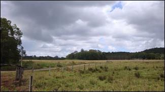
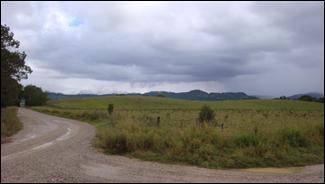
Typical views across
the Land – Lot 15 (left) and Lot 16 (right)
(Photograph taken: 16 May 2014)
ATTACHMENT B – BYRON LOCAL
ENVIRONMENTAL PLAN 1988 AND BYRON LOCAL ENVIRONMENTAL PLAN 2014 AMENDMENT MAPS
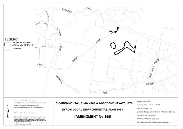
Byron Local Environmental Plan 1988 (Amendment No 155)
– Map (Dingo Lane)

Byron Local Environmental Plan 2014 – Map
(Dingo Lane – Sheet RPL_002B)
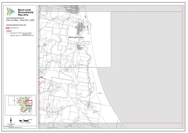
Byron Local Environmental Plan 2014 – Map
(Dingo Lane – Sheet RPL_002D)
Reports of Committees - Infrastructure Services 14.2 - Attachment 1

Local Traffic Committee Meeting
|
Venue
|
Conference Room, Station Street, Mullumbimby
|
|
Date
|
Wednesday, 1 April 2015
|
|
Time
|
10.30am
|
|
Committee
Members
|
Greg Sciffer – Roads and
Maritime Services
Snr Constable Anthony Darby – Police
Cr Duncan Dey
|
Reports of Committees - Infrastructure Services 14.2 - Attachment 1
Report of the Local Traffic Committee Meeting held on Wednesday,
1 April 2015
File No: Error! Unknown document
property name.
Meeting Commenced: 10.45am
PRESENT:
Councillor: Cr Duncan Dey
Roads and Maritime Services Representative:
Greg Sciffer
Police: Snr Constable Anthony Darby
Greg Alderson (Greg Alderson and
Associates) (Item 8.1)
Michiel Kamphorst (Greg Alderson and Associates ) (Item 8.1)
Staff: John Samuels (Item 8.1)
Staff: Simon Bennett
Apologies:
There were no apologies.
Adoption of
Minutes from Previous Meetings
|
Recommendation:
That the minutes of the Local Traffic Committee Meeting
held on 6 February 2015 be confirmed.
|
Matters Arising
Nil tabled
Outstanding Issues/Resolutions
Nil tabled
Regulatory Matters
|
Report No. 6.1 No
Right-turn, Woolworths egress, Station Street, Mullumbimby
File No: I2015/277
|
|
Senior Constable Hunter of Mullumbimby Police has
submitted the following:
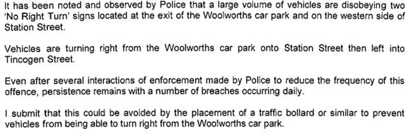
|
The subject site plus the offending and recurring
right-turn is shown. The Committee have considered this matter before, with
Council resolving as follows on 25 October 2012:
12-815
Resolved:
1.
That a No Right Turn (R2-6A (R)) replace the existing Left Turn arrow sign
(R2-14A (L)) on Station Street, Mullumbimby opposite the Woolworths exit.
2.
That the existing Give Way sign at the corner of the exit driveway from the
car park be replaced with the No Right Turn (R2-6A (R)).
|
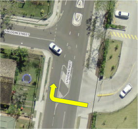
|
To reinforce the condition of No Right Turn via physical
measures are limited due to road width, which is approximately 11m at the
subject site. It is noted the Police suggestion is for bollards. This is
considered inappropriate unless no other structure can fit, such as a median
(usually at least 1m wide) or potentially a built kerb of 100mm in width.
While Committee advice on such options is however sought,
a recommendation is made that a physical measure of some type is
endorsed. The design will need to consider movement between Station and
Tincogan Streets and consultation with Council’s Development Engineers
and Woolworths will occur including why such a facility was not originally
provided given that the restriction (first a ‘Left Turn Only’,
then a ‘No Right Turn’) has existed since the supermarket
opened.
|
|
Committee Comments
Advice was noted that the omission of a physical
restriction to the right-turn movements was likely due to the subject site,
as part of an adjacent development, which along with other conditions upon
that development, was determined by the court and not Council; therefore
opportunity was lost for Council to apply such a condition upon the
development
Management Comments
While the recommendation is supported, Council funds are
unlikely to be able to extend to undertaking unplanned works such as being
recommended prior to 30 June 2015 and therefore will be done when and as
resources and funds permit.
|
|
RECOMMENDATION:
That subject to RMS guidelines being met, a
physical centre median be installed on Station Street, Mullumbimby at the
Woolworths driveway immediately south of Tincogan Street.
|
|
Report No. 6.2 Proposed
No Stopping, Sunrise Boulevard, Byron Bay
File No: I2015/268
|
|
Council Rangers have provided the following for Committee
consideration:
|
Attached is a photo of
Sunrise Blvd outside the Byron Tourist Van Village. A complainant was
indicating vehicles parked within the left hand lane of Sunrise Blvd.
The photo indicates that
patrons that either are at the caravan van park or attend the café,
park within the designated left lane.
The photo shows two lanes:
the left solely for straight ahead traffic and the right lane for either
straight ahead traffic or right turning traffic into the caravan
park.
My suggestion would be to
erect NO STOPPPING signage.
If these signs are erected
to alleviate this problem then you may have to consider where this traffic
will then park (you may need more signage on either side of the
road)…
|

Figure 1: Sunrise Blvd, opposite caravan
park/camping entry, parking in left lane
|
Figure 2 is below and shows the
view from Ewingsdale Road looking north. As shown, the west side is vegetated
and the east side provides a shared path. Both sides however provide a narrow
verge not suitable for car parking, nor suggests any obvious reason to park,
noting that as per Figure 3 off-street parking exists at the sole
traffic/parking generator; i.e. the ‘Tourist Village’ camp site.
Figure 2: view of subject site, from Ewingsdale Road
looking north

Figure 3 also depicts the
measures recommended, namely a 350m length of No Stopping on the west side
(inside curve) and 390m on the eastern side (outside curve). Such
lengths will cover the problem identified by the Rangers plus assist in
reducing the likelihood of shifting the same problem elsewhere within the
vicinity. As the recommendation does not impact any adjacent land holders
(including the van park which has off-street parking) it is believed
consultation is not required. Council however may wish to decide
otherwise. As matter of course however the van park and closest resident (at
#96) will be notified of the changes if they proceed.
Figure 3: recommended No Stopping
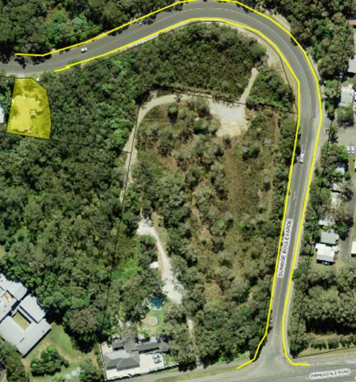
|
|
Committee Comments
· Given the
concern is the legality and safety of the parking that occurs, the Committee
suggest an alternative option, that being the removal of the two lanes
northbound and that one be provided instead.
· This will
require removal of existing pavement markings and if needed new line marking
to demarcate travel lane and road edge. Consideration for on-street
parking and width to accommodate passing of right-turning (entry)
traffic to the tourist village can also be considered and implemented as
appropriate/needed.
Management Comments
While the recommendation is supported, Council funds are
unlikely to be able to extend to undertaking unplanned works such as being
recommended prior to 30 June 2015 and therefore will be done when and as
resources and funds permit.
|
|
RECOMMENDATION
That the two northbound
traffic lanes as marked on Sunrise Boulevard, Byron Bay at and adjacent to
the entry of the Byron Bay Tourist Village be removed and if required line
marking be undertaken to reconfigure and provide one northbound travel lane
only, with implementation to include passing space subject to standards being
met.
|
|
Report No. 6.3 Entry-exit
treatments, Mullumbimbi Lane, Brunswick Heads
File No: I2015/269
|
|
Members of the Visitor Centre along with local and
adjacent business, including Siwicki Real Estate and the Park Street pasta
bar and Big Fish second hand furniture, attended an onsite meeting held 25
March 2015.
Various concerns and ideas were raised regarding the
subject site which is shown in Figure 1 and mainly concentrated on
the west and east end of the two-way laneway which are shown by the yellow
and purple circles respectively.
Based on the onsite meeting it was agreed the two points
of access/egress require different treatments as follows, despite the same
concerns being that motorists are unaware or unconcerned for pedestrian
movement.
|
Figure 1:
subject sites
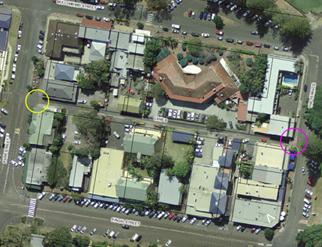
|
|
The west end at Park Street (near the pasta bar) is
depicted further in Figure 2 and shows the recommended actions to
‘square up’ (i.e. tighten) the intersection and turning path
for vehicles making a left-turn entrance and moving the Give Way hold line
out to meet the new arrangement.
This was agreed by those present as the most immediate
action that attempts to reduce approach speed into the laneway, which was
viewed as the most pressing matter.
It was also agreed that a raised crossing for pedestrian
crossover be considered should the treatment depicted not
suffice.
|
Figure 2: west
end, at Park Street

|
|
The east end at The Terrace (between Big Fish and the
Dolphin Café) is depicted in Figure 3 and shows the recommended and
accepted action by those present, namely a single road hump (as pictured in
Figure 4) to assist with reducing vehicle exit speed from the laneway which
was viewed as the most pressing matter.
A lesser priority but also agreed action was for a small
kerb blister to extend the kerb line out to meet the existing Give Way hold
line and a Give Way sign be installed in the new blister.
Other options discussed but less preferred included
pedestrian barrier, a convex mirror or raised
crossing.
|
Figure 3: east
end, at The Terrace
|
|
Those present at the onsite meeting also raised other
options including making the laneway one-way (but no consensus on direction
reached) and considering a 10kph shared zone. It was agreed however
such options which would require consultation be reserved for further
consideration should the recommended treatments not work.
|
Figure 4: road
hump example

|
|
|
Committee Comments
· noted
the proposed road hump should be set back at least one vehicle length from
the end of the laneway, or two humps be considered, and either option be
signed accordingly
· a
‘watts’ profile for the hump is preferable but the depicted
option is acceptable subject to meeting applicable requirements and on the
basis of low speed and low volume laneway which primarily carries destination
traffic as opposed to through traffic
Management Comments
· Committee
preference is noted however incurs greater costs whereas what is recommended
seeks to address the issue and believed appropriate in this low speed and low
volume environment
· Nevertheless,
any of the options represent unplanned works and therefore unlikely to be
delivered prior to 30 June 2015 and therefore will be done when and as
resources and funds permit, noting s94 funds may be one funding option
available
|
|
RECOMMENDATION:
1. That
where Lane 6 (aka Mullumbimbi Lane) Brunswick Heads intersects with Park
Street the following be implemented:
a) the
Give Way hold line be extended west to align with existing edge lines
on
Park Street;
b) white
edge line marking be installed through the intersection; and
c) a
physical kerb blister be installed on the north-west corner.
2. That
where Lane 6 (aka Mullumbimbi Lane) Brunswick Heads intersects with The
Terrace the following be implemented:
a) at
least one physical road hump, and no more than two, be installed in the
laneway, which is west of the building line and at least one vehicle length
from the intersection, and appropriate advisory signage be provided; and
b) on
the north-east corner, a physical kerb blister be installed plus a Give Way sign
be provided at the intersection.
|
|
Report No. 6.4 Cul-de-sac,
St Finbarr's Primary and Byron Bay High Schools
File No: I2015/281
|
|
An onsite meeting with the
schools was held 24 March 2015. This was convened as a follow up to a
previous onsite meeting held June 2012 with Police, schools and Council/LTC,
after which Council resolved as follows:
12-505 Resolved:
1. That
Council note the Committee held the on-site meeting with stakeholders of both
the Byron Bay High School and St Finbarr’s Primary School on Tuesday 5
June 2012 as per Council resolution 12-294.
2. That
the comments from the on-site meeting be noted and progressed where possible
with a report back to the Committee and Council provided in due course.
The comments will be provided at
the Committee meeting as taken from the April and June 2012 LTC reports
(Council report files numbered 1214453 & 123981 respectively).
Many of the same issues raised in
June 2012 exist and were raised on 24 March 2015 meeting.
One includes the primary school
DA condition in which they are to provide a roundabout once they reach 230
students or more. This is considered in some quarters as onerous and
discussion is to be had with relevant parties as to potential modifications.
One option could a
‘seagull’ type treatment as used on Ewingsdale Road at Bayshore
Drive for example which provides turning traffic a merge lane before entering
the travel lane. The school site however is restricted and a non-standard
(non-conforming) ‘seagull’ is considered a likely outcome, and
therefore questionable in terms of safety and improved efficiencies, i.e. a
truncated merge lane may end up only providing further ‘storage’
and not the length required to gain speed to join through traffic. This can
also lead to vehicles in travel lane being unexpectedly stopped to allow
merging to occur.
More immediately however is
changes to the bus zone signage in the cul-de-sac (as per recommendation made
and purple lines in map below) and the need to review several matters,
including as numbered on the map:
1) a separate and longer outbound lane for left-turning
traffic, who are often held up and congesting the cul-de-sac due to the
delayed (and dominant) right turn movement out;
2) modification to the bike/walk path at the frontage of
the schools, including consideration of making the road crossover safer as
cyclists often cross the road/traffic at speed;
3) providing car parking on the street frontage, so as to
reduce numbers entering the cul-de-sac;
4) a pedestrian crossover that is distinguished from the
road/cul-de-sac.
Committee advice on such
suggestions is sought, noting the schools have been advised the warrant for a
marked pedestrian crossing can be checked but considered unlikely to meet
warrants either within the cul-de-sac or on the main road itself, for example
to replace the existing refuge north. Within the cul-de-sac however a
combined raised crossover/platform could be considered.
Discussion also included providing
a kerb side bus zone at the school frontage however advice suggests this
would benefit the only south bound bus with the rest required to run right
and head north, a movement which would be assisted by a roundabout more than
a ‘seagull’.
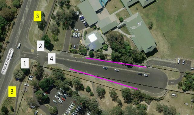
|
|
Committee Comments
The Committee noted the information provided and had no
comments in relation to this item.
Management Comments
It is noted many of the concerns raised are not new and
ongoing for some years. Resolution however is expected to require funding and
preferably with school contribution. This matter however can be further
addressed at the time it is reported back as recommended.
|
|
RECOMMENDATION:
1. That
the bus zones except one at frontage of both Schools be signed as operational
school days only 8am – 9.30am and 2.30pm – 4pm.
2. That
Council note the onsite meeting as held 24 March 2014 with the Schools and
the options to be explored further with consultation to occur with
stakeholders and a report to be provided back to Council.
|
|
Report No. 6.5 School
bus route approval, Mullumbimby-Wilson's Creek-Huonbrook
File No: I2015/282
|
|
Gary Hughes has operated for many years the same school
bus route and service which travels from Mullumbimby to Huonbrook via
Wilson’s Creek Road and public school.
In an e-mail dated 27 March 2015, the operator however has
advised that his contract (N1060, which is for 12.5m long vehicles) with
Transport for NSW requires Council approval of the route. The e-mail included
two attachments, one being a map and the other a list of roads included on
the route as below for the two AM and one PM services.
As the route is existing and operated for years, and the
operator wishes to continue such operation and other than concern for the
school bus zone at Wilson’s Creek Public School (see separate report)
has raised no concern regarding the route to Council attention, it is
recommended approval be granted.
AM Route [i]
Depart Depot along Smith Street, turn left into
Manse Road, right into Argyle Street, right onto Burringbar Street, left into
Dalley Street onto Jubilee Avenue onto Coolamon Scenic Drive, right into
Wilson’s Creek Road continue along Wilsons Creek Road turn left onto
Huonbrook Road until Quarry. Turnaround for First pick-up
continue back along Huonbrook Road , right onto Wilsons Creek Road , left
onto Coolamon Scenic Road onto Jubilee Avenue until Mullumbimby High
School , turnaround Jubilee Avenue , right into Azalea Street left
onto Left Bank Road travel until Shearwater Steiner School , turn
right onto Left Bank Road right into Azalea Street left onto Jubilee Avenue
onto Dalley Street , turn right into Burringbar Street , right onto Argyle
Street , left into Prince Street , right into Poinciana Street , right into
Morrison Avenue to Mullumbimby Public School , right into Argyle
Street , onto Burringbar Street , right onto Burringbar Street , left onto
Coolamon Scenic Drive turn right into Casaurina Street travel until St
Johns Primary School
AM ROUTE [ii]
Turnaround back along Casaurina Street , turn
left onto Coolamon Scenic Drive onto Tincogan Street , right into Dalley
Street , onto Jubilee Avenue onto Coolamon Scenic Drive , right
into Wilson’s Creek Road continue along Wilsons Creek Road turn left
onto Huonbrook Road until Quarry . Turnaround for First pick-up
continue back along Huonbrook Road , right onto Wilsons Creek Road , travel
until Wilsons Creek School , depart School continue back along Wilsons
creek Road , turn left onto Coolamon Scenic Road onto Jubilee Avenue, onto
Dalley Street , right into Burringbar Street onto Argyle Street , left into
Manse Road , right into Smith Street until Depot.
PM Route
Depart
depot along Smith Street , turn left into Manse Road , right into Argyle
Street , right onto Burringbar Street , right into Dalley Street , left onto
Coolamon Scenic Drive , turn right into Casaurina Street until St Johns
Primary School. Turnaround travel back along Casaurina Street , turn left
into Coolamon Scenic Drive onto Tincogan Street , right into Station Street ,
left into Argyle Street , left into Prince Street , right into Poinciana
Street , right into Morrison Avenue until Mullumbimby public School ,
right into Argyle Street , onto Burringbar Street , left into Stuart Street ,
right into Whian Street , left onto Coolamon Scenic Drive , right into Azalea
Street left onto Left Bank Road travel until Shearwater Steiner School
, turn right onto Left Bank Road right into Azalea Street left onto Jubilee
Avenueto front of Mullumbimby High School . Turnaround continue along
Coolamon Scenic Drive , turn right into Wilsons Creek Road , travel until Wilsons
Creek Public School , continue along Wilsons Creek Road , turn left onto
Huonbrook Road until Quarry. Turnaround For Last stop continue back
along Huonbrook Road , turn right into Wilsons Creek Road ,. turn left
onto Coolamon Scenic , onto Jubilee Avenue, right into Burringbar Street onto
Argyle Street , Left into Manse Road , left into Manse Road , right into Smith Street until Depot.
Wilsons
Creek service currently in operation as follows services west of the Wilsons
Creek School and is affected by the lack of bus bay infrastructure ,
with children having to cross the road on the PM service .
|
|
Committee Comments
· the
contract is a matter between the Operator and Transport NSW, however this
Committee’s preference is for a vehicle small enough to be safely used
for the road conditions that exist
· That
at this time the Committee has a number of safety concerns which are in the
process of Council / Department of Education / Transport NSW working together
to resolve, these however mainly relate to the school bus zone and operations
at the Wilson’s Creek school
· due
to issues being currently worked through with Department of Education and
Transport NSW, those Departments need to be involved in considering the
issues, including if necessary, variations to Contract N10160
· The
wording of the recommendation needs to reflect the Committee’s concern
about safe operations at the Wilsons Creek Public School
Management Comments
· While
the committee recommendation is noted it is not supported given the
restriction it will apply on the school bus operator
(which is a matter of their contract with NSW Transport) plus
the fact the Committee concern for ‘safe operations at the Wilsons
Creek Public School’ is a matter
that can be captured in item 6.8 further below
· It
is also noted that the same operator is seeking Council approval for the
routes used in their second contract (N2903) which follows the same as
AM route [i] with exception of Huonbrook Road.
This and other variations will be detailed in the cover report to Council
(I2015/329)
|
|
RECOMMENDATION:
That Council recognises the need for the service under
Transport for NSW Contract N10160, however notes that there are a number of
safety concerns at Wilsons Creek Public School currently being examined and
that because of the site limitations a smaller vehicle is required.
|
|
Report No. 6.6 Proposed
No Parking, 310 Skinners Shoot Road, Byron Bay
File No: I2015/272
|
|
|
Residents of Skinners Shoot Road at the subject site
(Figure 1) paid for the sealing of the road as shown at Figure 2 which was
first undertaken by a private third party (base and first seal) and is to
be completed by Council (final seal).
The work completed thus far as shown in Figure 2 is the
subject of this request from long term resident (40+ years); i.e. Council
install No Parking signs on the east side only and guide posts on both
sides.
While the site is some 3.2km south-west of Byron Bay and
in a rural location, the resident claims:
a) vehicles
are often parked in the recently widened area (Fig 2) and when they do it
requires other vehicles such as bus, trucks, vehicles under tow, etc to use
their driveway to make a several point turn;
b)
the problem is ongoing and increasing in frequency and inconvenience; and
c) due
to increased traffic is becoming increasingly unsafe.
The resident has been advised that while signs can be
installed (subject to approval) enforcement will most likely only occur
when residents advise Rangers or Police directly as patrolling of the area
is not routine.
|
Figure 1:
subject site (red circle), Yagers Lane (yellow circle), end of 50 zone
(purple circle)
Figure 2: site
for No Parking and guideposts
|
|
|
Committee Comments
The Committee requested this item be brought back to the
June Local Traffic Committee Meeting, with further clarification provided.
Management Comments
Nil
|
|
RECOMMENDATION:
That the request for No Parking signs to be installed
on the east side of the widened sealed area south of the driveway at 310
Skinners Shoot Road, Skinners Shoot be further clarified and brought back to
the June 2015 meeting of the Local Traffic Committee.
|
|
Report No. 6.7 Proposed
No Stopping, Village Greens Grocer, Brunswick Heads
File No: I2015/274
|
|
Chair of the Committee has sought any further information
available in regard to the subject site and the proposal as tabled below
following a recent accident.
The subject site is addressed as 23 Old Pacific Highway
and is approximately 100m north-east of Bayside Way. The site is a combined
fuel station and green grocer and provides onsite parking.
At times this parking extends beyond the site, noting that
marked bays for two vehicles are within the road reserve. To this end,
Committee advice on such arrangement is sought including their potential
removal.
However should they remain (at least for now), the
recommended minimum lengths of marked No Stopping is depicted below and would
be implemented by a mixture of signs and line marking, noting line marking only
would be installed in the middle adjacent to the existing parking bays in
question.
The section north from the site extends to approximately
45m in length so as to incorporate the existing shared cycle/pedestrian
crossover.
Figure 1:
subject site and recommended length of No Stopping
|
|
Committee Comments
· noted
the business owner should participate in helping to resolve this issue
· a
barrier would provide better definition to the exit / entry points to the
site
· northern
side should be ingress only, with southern side egress only
Management Comments
The Committee comments are noted and to be considered when
undertaking the recommendation which puts onus on staff to resolve with the
tenant/owner of the site, noting that any regulatory approval that is
required will be tabled back to the Committee in due course.
|
|
RECOMMENDATION:
That staff liaise with the business owner of Village
Greens Grocer, Brunswick Heads about better definition of entry and exit
arrangements and about methods of preventing vehicles parking too close to
the carriageway.
|
|
Report No. 6.8 Bus
Zone Options and Design Plan, Wilson's Creek Public School
File No: I2015/283
|
|
Both the school and the bus operator hold concerns for the
safety of the existing school bus zone and current arrangements for pick up
and set down. This concern has led to a review of a previously endorsed
design plan:
08-614 Resolved:
1. That the interim measure
for a temporary bus bay on the northern side of the road, as proposed for
Wilsons Creek Primary School, be supported and conveyed to the School.
2. That funding options for
the more permanent measures proposed of a formal bus bay, footpath and
retaining wall be investigated.
The need for undertaking any changes had been lessened
during the years the landslip resulted in one-lane operating under traffic
control (temporary lights).
The design plan will be tabled to the Committee which is
plan no. 1906 for an indented bus zone on the school (north side) of
the road and plan no. 1907 for a turn around circle built at the Fire Station
west of the school and have been costed respectively as $171,014 and
$117,899.
Council do not have the funds to proceed with the project
and a submission to RMS under the Safety Around Schools is recommended.
More immediately is the problem raised by both school and
operator regarding the existing school bus zone opposite the school on the
south side. It requires children to cross the road and approach sightlines
are limited. The operator is seeking this removal as why it exists they must
use it and ask that the zone be implemented on the north side and contra-flow
arrangement be permitted as shown.
Committee advice is sought.
|
|
Committee Comments
· noted
the bus company’s contract could be modified so he is paid for the
extra kilometres he is travelling to turn
the bus around safely
· RMS
not prepared to support the contra-flow arrangement requested by the bus
operator
· RMS
representative prepared to lobby Transport NSW to allow a new contract to be approved
whereby the bus operator is re-imbursed for extra kms travelled as part of
safe turnaround requirement
· Department
of Education should be involved in assisting with resolution of issues
· noted
sight lines may be too poor to allow for a School Crossing, however this
option is worth of investigation
· the
use of traffic controller is not sustainable however the school or Dept of
Education could look to implement subject to approvals and
funding
Management Comments
· part
1 and 4 of the Committee recommendation is supported
· An
alternative Management recommendation however will tabled to council (as per
report I2015/329) in regard to Part 3,
as well as part 2 on the same grounds as cited in related item above (no.
6.5)
|
|
RECOMMENDATION:
1. That the request
for a contra-flow movement at Wilsons Creek Public School, requested
by the bus operator, not be supported.
2. That
the vehicle used for carrying students be small enough so that it can turn
around safely at the Fire Station (west of the School), plus somewhere east
of theSchool (eg Koonyum Range Road intersection) and will set down and pick
up only on the northern side of Wilsons Creek Road.
3. That turn around
provisions be provided both east and west of the School.
4. That the information
be forwarded to the Department of Education and Transport NSW,
with a view to them being involved in seeking a resolution to the issues
raised.
|
|
Report No. 6.9 No
Parking - Authorised Vehicles Excepted, 52-54 Jonson Street, Byron Bay
File No: I2015/275
|
|
Both the Police and Council maintenance/works staff have
lodged requests for the creation of dedicated parking space in Byron Bay to
assist with their operations. Both (and independently of each other)
nominated the same site which was used previously prior to the ambulance
station closing and relocating at the subject site which is shown below.
Also shown (yellow lines) is the two most recent bays
created as part of the development that replaced the ambulance station and
the approximate 17m length (purple line) to which this No Parking with
exemption would apply.
It is noted a similar arrangement has been established at
the Police station frontage on Shirley Street, Byron Bay and that Council
‘authorised’ vehicles does not extend beyond workplace branded
operational vehicles engaged at the time of parking for work related duties.
|
|
Committee Comments
The Committee had no comments to make in relation to this
item.
Management Comments
Nil
|
|
RECOMMENDATION:
1. That
RMS standard signs for No Parking (R5-40) with supplementary plates
(R9-229), which are to state ‘Byron Shire Council Authorised Vehicles
Excepted’, be installed on the west side of Jonson Street, Byron Bay
between 7m south of the Byron Street laneway entry to Lawson Street south car
park and the angle car parking to its south.
2. That
Council note vehicles exempt from the No Parking are those clearly marked as
either Police or Byron Shire Council and are undertaking active, operational
duties at the time of use.
|
|
Report No. 6.10 Request
for No Parking, Grevillea Street, Byron Bay Arts & Industry Estate
File No: I2015/276
|
|
Council has received requests from three different sources
for parking restrictions on Grevillea Street which is within the Byron Bay
Arts and Industry Estate some 3km west of the town centre. Figure below
depicts all three requests and a fourth as proposed by staff.
All three requests look to address a similar problem, i.e.
current parking practice is for people to park close to (or encroach over)
driveways making large truck and vehicle access and egress difficult.
The request shown by the pink line is lodged by JH
Williams who trade at number 10 who along with the trader opposite (at number
15) support the No Stopping depicted, which is on the inside curve and covers
an approximate length of 34 metres. This will retain unmarked parallel
parking lengths of (approximately) 54 metres (9 cars) from 3m east of the
eastern driveway at 9-11 Grevillea Street and 6 metres (1 car) immediately
west of number 15, therefore adequate on-street parking space will
remain.
Recommended No
Stopping lengths and source of request
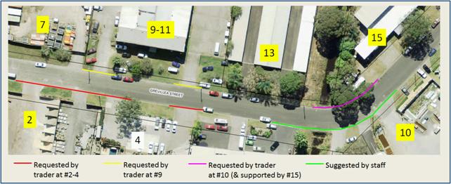
The request shown by the yellow line is from Byron Bay
Classic Paint and Panel who share the premises at 9-11 Grevillea Street with
another tenant (Byron EasyBus) who are reportedly supportive and would also
benefit of the proposal. As such it is recommended No Stopping be installed
as shown which is from the east side of the driveway at #7 through to 3m east
of the western driveway at 9-11 Grevillea Street plus a second section being
to 3m either side of the eastern driveway. This will result in real terms of
1 car length (or 9m) lost from on-street parking.
The third request (shown by the red line) is from
Leisurecape Gardens and Design Centre who have four driveways across two
properties at numbers 2 and 4 Grevillea Street. Given the short distance
between the three western driveways it is recommended if parking restrictions
are to apply then all three driveways be covered, while across the fourth
(and most eastern) driveway any restriction need not extend beyond 3m either
side.
The fourth section shown above (green line) is only
recommended by staff should the above three requests proceed to ensure
on-street parking does not simply shift the problem to the curve shown.
While it is not typical nor required to place restrictions
across driveways it should be noted that the proposal extends beyond just the
driveway crossovers, is based on line marking only and it is unusual in that
three traders (with others supporting) have come forward with these requests
seemingly independent of each other.
|
|
Committee Comments
The Committee noted number 6 Grevillea Street should be
included, subject to consultation with the land owner.
Management Comments
Nil
|
|
RECOMMENDATION:
1. That No Stopping
be line marked as described and depicted in report no. 6.10 (file I2015/276)
between numbers 2 and
15 Grevillea Street, Byron Bay Arts and Industry Estate.
2. That No Stopping
also be line marked 3 metres either side of the driveway at number
6 Grevillea Street, subject to concurrence of the land owner.
|
|
Report No. 6.11 Request
for No Stopping, Bayshore Drive, Byron Bay
File No: I2015/279
|
|
A roundabout has recently been completed and now
operational as part of an approved development (Bunnings) at the intersection
of Bayshore Drive and Grevillea Street in the Byron Bay Arts and Industry
Estate.
The subject site is shown, as is the request to extend the
No Stopping to a 20m length on the west side, north of the intersection, to
assist with bus movement who have advised they are impeded by on-street
parking in this location.
An alternative option however is to instead make much of
the same length a bus zone thereby ensuring no parking occurs and a dedicated
bus space is provided for pick up and set down of passengers. The bus company
need or support for a bus zone is being sought to help inform the Committee
recommendation further.
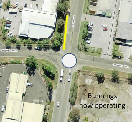
|
|
Committee Comments
· The
Committee support inclusion of a bus zone subject to bus operator
concurrence.
· The
Committee noted that demand for parking is increasing due to increased trade
(eg café, food suppliers) and that time limits be
considered noting that a 1P limitation as approved by Council
(14-641) has established a precedent
Management Comments
· Bus
operator concurrence has since been obtained
|
|
RECOMMENDATION:
1. That on the west
side of Bayshore Drive, Byron Bay commencing immediately north of Grevillea
Street, No Stopping applies for a 10m length, after which a dedicated area
for bus pick up and
set down is provided.
2. That
Council consider the continuity of parking time limits on Bayshore Drive
between
Grevillea
Street and Julian Rocks Drive, Byron Bay.
|
|
Report No. 6.12 Proposed
No Stopping, Council Depot, Bayshore Drive, Byron Bay
File No: I2015/280
|
|
Council operations are being impeded by increased car
parking at the frontage of Council depot on Bayshore Drive in the Byron Bay
Arts and Industry Estate. More specifically, parked vehicles are stopping
access to the water pump station at the depot street frontage.
While the request was made for No Stopping, an exemption
will be required to allow Council operational vehicles to utilise the
space, therefore as depicted two types of parking restrictions are
recommended. They are as per the:
- yellow
line, being No Stopping which covers the driveways and beyond (by about 3m
either side) to ensure parked vehicles do not limit the turning space
required for large vehicles; and
- purple
line, which is to be signed No Parking with a supplementary plate to
read ‘Byron Shire Council Vehicles Excepted’.
|
w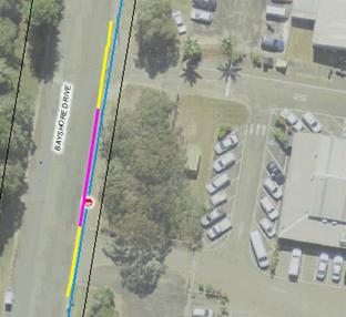
|
|
|
Committee Comments
· noted
‘Loading Zone’ allows any vehicle to park in that zone to load or
unload, which may hamper Council
plant needing to use the pumping station situated with the zone
· No
Parking has a two minute limit, which is not enough time for Council plant to
use the pumping station situated with the zone, hence need for signed
exemption
|
Management Comments
· Post-meeting,
council works staff advised there are 4 driveways, with the restrictions
depicted in the report as above covering the two most southern driveways,
whereas the restriction they seek is for the two northern driveways, yet
they support the same across all 4 driveways as depicted right
· They have also
advised on-street parking for water filling is not needed as the water fill
stations are onsite as access via the two most northern driveways
· This means the
No Parking with exemptions (as per purple line in above depiction) is not
required and that the approval to be sought from Council has been updated
and accordingly circulated to the Committee for endorsement of the
following recommendation
|
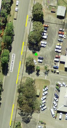
|
|
|
RECOMMENDATION:
That on the street frontage of the Council work depot,
located east side of Bayshore Drive (Lot s 101 and 102), Byron Bay, No
Stopping be signed from 3m south to 3m north of each driveway.
|
Matters for Traffic Engineering Advice
|
Report No. 7.1 Request
for physical demarcation, Mullumbimby Road at Gulgan Road intersection
File No: I2015/278
|
|
Senior Constable Hunter of Mullumbimby Police has
requested that a ‘silent cop’ be installed at the subject
site. Such traffic facilities are no longer used and if a physical
measure is supported then Committee advice is sought on an appropriate
measure.
Committee should however note
their recommendation for Council design plan 2148 as depicted was endorsed by
Council on 28 February 2013 as below, which will be delivered subject to
budget. This same design could change to incorporate the physical demarcation
sought, the location of which is shown by the red line.
13-70
Resolved that Council note the in-principle support of the Local
Traffic Committee for Council Design Plan 2148 as it relates to the Gulgan
Road and Mullumbimby Road intersection.
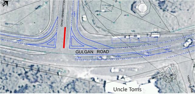
|
|
Committee Comments
· two
blisters and a median should be constructed
· a
bus drop off / pick up area should be considered
· noted
current priority arrangement is not reflective of the current use
· count
to inform a re-design should be conducted
· movements
from ‘Uncle Tom’s’ should be taken into consideration
Management Comments
Nil
|
|
RECOMMENDATION:
1. That Council
note the Police request for a median island at the Mullumbimby Road and Gulgan
Road intersection.
2. That along with
the Local Traffic Committee comments, a traffic count be undertaken to
inform a re-design of plan number 2148, which is to be reported back
to the Committee.
|
Development Applications
|
Report No. 8.1 Splendour
in the Grass 2014 traffic management plan
File No: I2015/290
|
|
No report on this matter was provided to the Local Traffic
Committee meeting of 1 April 2015 and the following was drafted post meeting
and circulated to the Committee for comment.
The consultants engaged to undertake the traffic
management planning and implementation (Greg Alderson and Associates)
attended the Committee meeting to table and discuss the series of Traffic
Control Plans (E2015/19755) as related to this year’s Splendour in the
Grass music festival, to be held as in previous years at the North Byron
Parklands site at Yelgun.
The Committee was advised that the same traffic management
changes as implemented for the recent Falls Festival (as also done by Greg
Alderson & Associates) was to be employed for this year’s Splendour
event, plus a new addition as follows:
1. the major change effects traffic from and returning
north and those arriving from the south
2. signage directing southbound arrival traffic to
leave the Pacific Highway will occur at the Cudgera Creek interchange and
direct them via the Tweed shire local roads of Cudgera Creek Road east to
Pottsville Rd which is then followed through to Mooball village whereby
traffic is then signed to follow Tweed Valley Way south to the festival site
3. further, the interchange at Yelgun will not be
signed as a festival exit for southbound traffic nor the southbound off-ramp
changed
4. this is being done with concurrence of the local
road authority (namely Tweed Shire), the highway authority (RMS) and Police
and is expected to encourage the majority (as occurred with the Falls
Festival) to follow the signed local road route (approx. 20km in length) as
opposed to the remaining on the highway (approx. 10km length)
5. however based on traffic modelling, and even if a
substantial amount of traffic ignores the signed local road route, Yelgun
interchange is found to operate sufficiently and will have traffic control
present to monitor and implement contingencies if and when needed
6. the objective of this change, as proven with Falls
Festival, is to lessen the traffic load on Yelgun interchange which will
benefit local traffic and still be used to manage northbound (arrival)
traffic
7. as for traffic departing the festival site, those
heading northbound will be directed to the north end of the site (Gate C) and
to ‘turn right’ onto Tweed Valley Way and return via the same
local road route they used on arrival
8. it
is expected this will result in a traffic load at Gate C on departure day
that will ‘self-regulate’ the onsite traffic queue, speed and
departure time that will be monitored and controlled at point of exit on
Tweed Valley Way to minimise delays on the road network
9. as
for the north bound arrival traffic, this will be the first time it is signed
to divert the highway at the Ocean Shores exit (which is north of Brunswick
Heads and south of the Yelgun interchanges) for the same reasons cited for
the early diversion at Cudgera interchange
10. monitoring
will be in place to assess and change the traffic diversion when and as
needed.
11. on
departure however those that are southbound will be (unlike northbound
traffic) directed to use the Yelgun interchange and not the local road
network
12. other changes include less hardware (eg barriers)
and signage on local roads, especially at the Yelgun interchange which will
have traffic controllers in place to act when required
In addition to the above,
and prior to the meeting, staff provided the consultants the following advice
in an e-mail dated 18 March 2015 in regard to a letter received from a local
resident (S2014/13115) regarding the 2014 Splendour event. These
matters are to be addressed as noted:
Item
1 – traffic control
resident
complaint is in regard to the standard of traffic controller. Concern noted.
We can discuss at LTC.
Item 2 – use and legality of permits to exempt
holders from signed No Stopping restrictions
resident
complaint is that last year permit holders seemed to park anywhere, and more
concerningly where it was signed as “No Stopping”. Exemptions are
not permitted when No Stopping applies:
http://www.rms.nsw.gov.au/cgi-bin/index.cgi?fuseaction=trafficsigns.show&id=r5/r5-400
If
permits are wanted by the event then the signage needs to reflect “permits
holders excepted”. Example of such sign on RMS website:
http://www.rms.nsw.gov.au/cgi-bin/index.cgi?fuseaction=trafficsigns.show&id=r9/r9-229 This
sign however is a supplement plate, typically used with No Entry:
http://www.rms.nsw.gov.au/cgi-bin/index.cgi?fuseaction=trafficsigns.show&id=r2/r2-4
However
not sure if ‘No Entry’ into Yelgun Road is desirable (?) when
attempting to simply stop parking, so simply ‘No Parking’ may be
best,
http://www.rms.nsw.gov.au/cgi-bin/index.cgi?fuseaction=trafficsigns.show&id=r5/r5-40 and
this is supplemented with R9-229?
I
am not sure but please consider how best to manage ‘permit
holders’.
Item
3 – request for No Camping sign at Yelgun Rd intersection
If
this sign is installed, it should remain as a permanent sign. Would Splendour
install such a sign?
|
|
Committee Comments
· the
Committee accept the proposed changes to previous Splendour events and note
that such changes are the same as implemented for the most recent Falls
Festival which is viewed as successful in the aims described above
· nevertheless
involvement in, or least advice from , post event debrief is requested
· resident
concerns are noted and are for the event to address in regard to Items 1 and
3
· Item
2 however can be incorporated into an amended TCP subject to Council
acceptance noting the recommendation is made is for No Parking (with no
exemptions) on Jones Road, Yelgun Road and Billinudgel Road
· noted
signs should be of a consistent size and colour to allow for quick
recognitition by patrons as they are driving
· cameras
for assistance in traffic control may be useful in the future
Consultant Comments
It is my intention that
Splendour traffic would be encouraged to use either Cudgera or Yelgun
interchanges if travel south.
and
Brunswick and Yelgun if
traveling north
This would allow less
interruption to the Yelgun interchange, that translates to less barriers and
less disruption to the locals.
In this period of the 5year
trials we propose that this option needs to be tested in a responsible way.
Management Comments
Nil
|
|
RECOMMENDATION:
That the temporary traffic management and regulatory
changes within the series of Traffic Control Plans related to the Splendour
in the Grass Music Festival to be held Friday 24th to Sunday 26th July 2015
inclusive be endorsed subject to:
a) their design and
implementation being undertaken on dates, times and locations as specified
on the plans (or any approved amendments) and by those with appropriate RMS
accreditation and the holding of current and appropriate levels of insurance
and liability cover
b) meeting of the advertising
requirements of the Roads Act 1993
c) event being notified on
Council's website
d) consideration of any
submissions received
e) a communications protocol
being developed in conjunction with RMS, Police and any other
identified stakeholder and explained to those involved in the implementation
of traffic management
f) the holding of an
event debrief within the month following the festival which includes but
not limited to Council, RMS and Police
g) written approval of both
the RMS and Police separate to Local Traffic Committee
h) No Parking be signed and
implemented on Jones Road, Yelgun Road and Billinudgel Road
|
There being no further business the meeting concluded at 1.50
pm