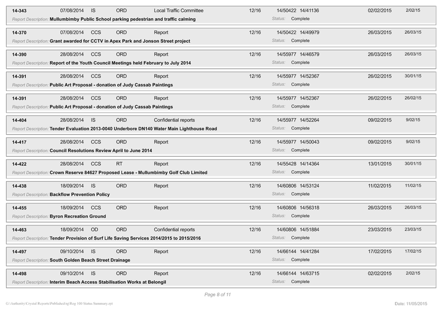
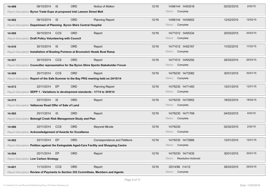
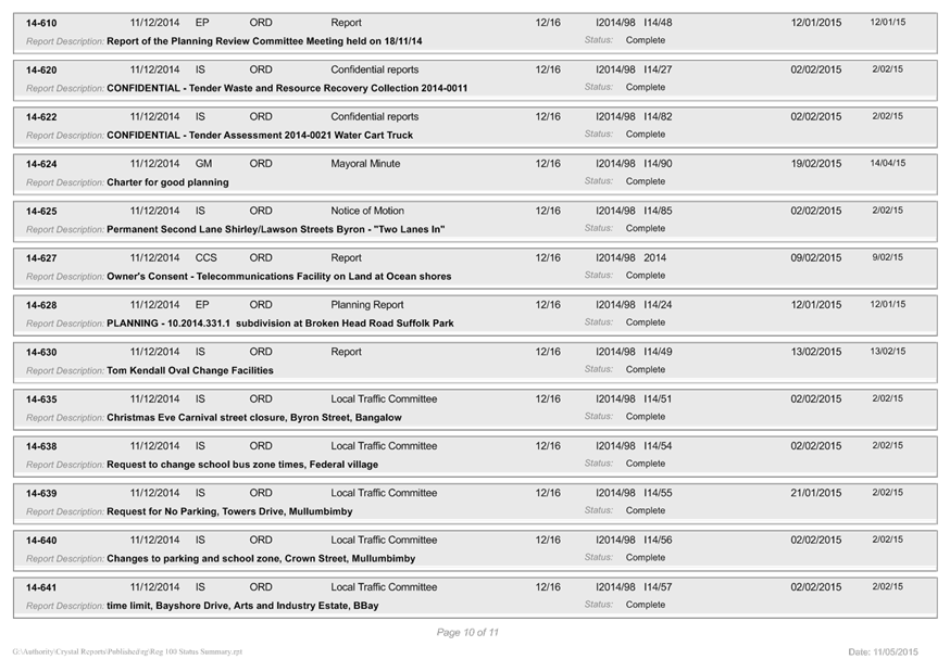
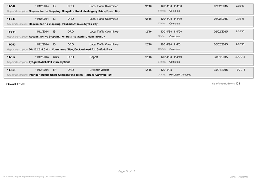
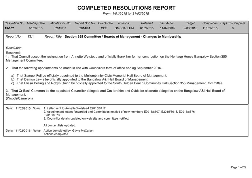
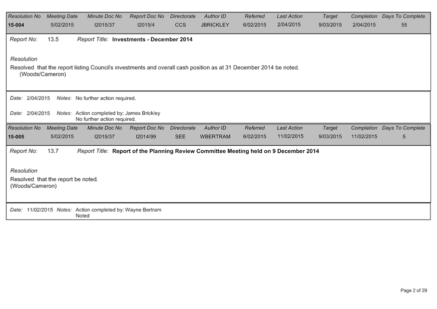
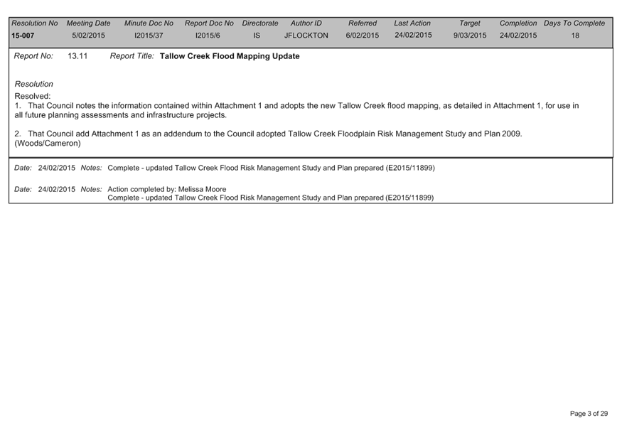
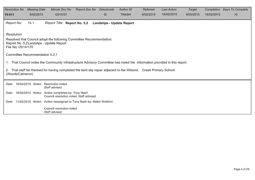
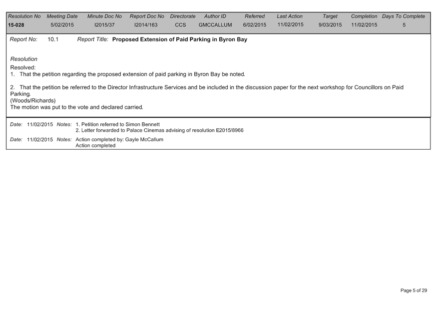
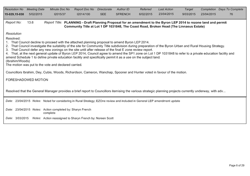
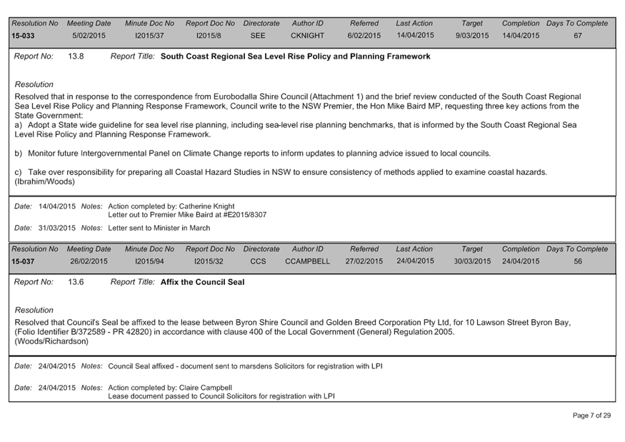
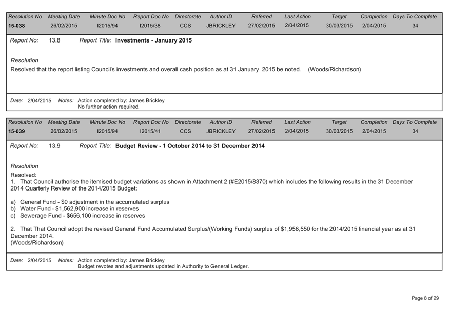
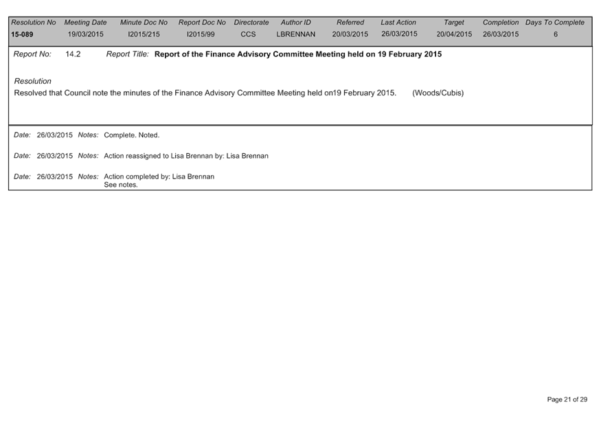
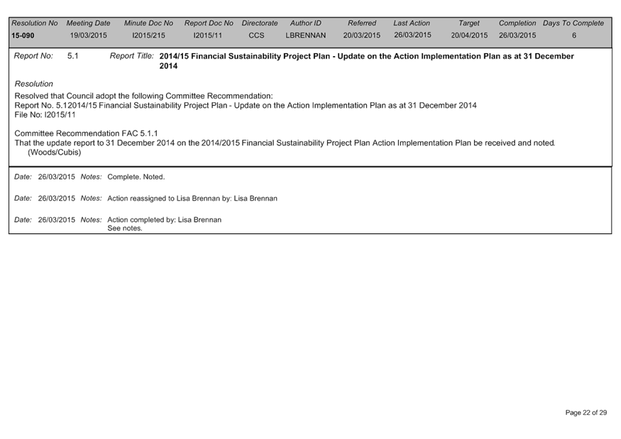
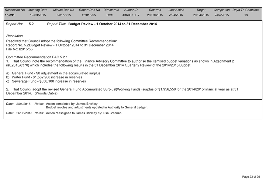
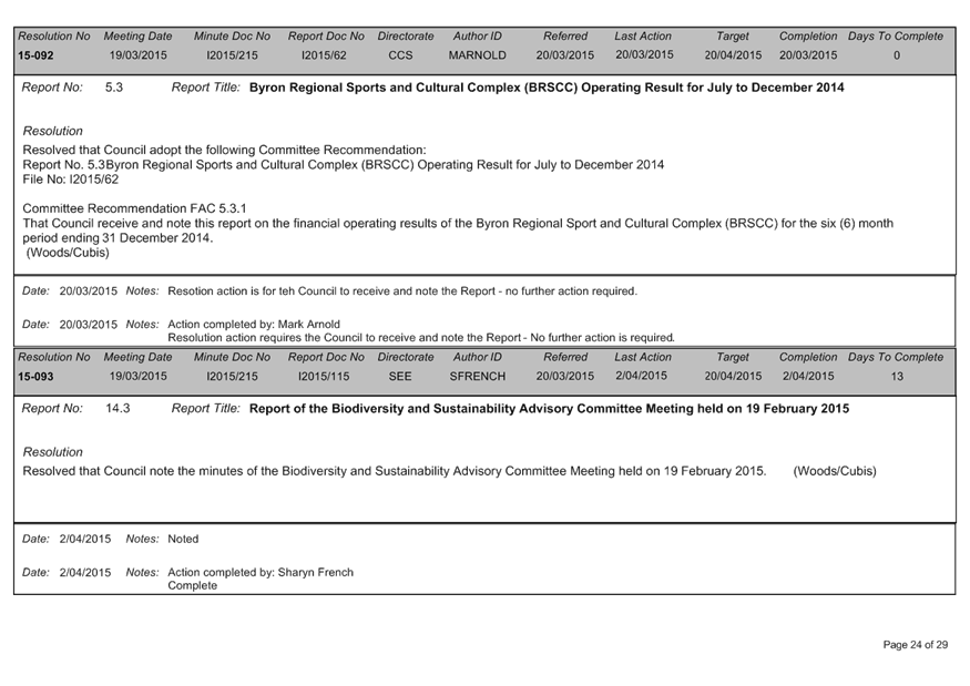
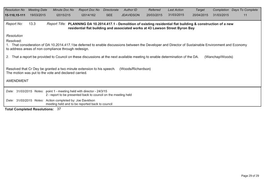
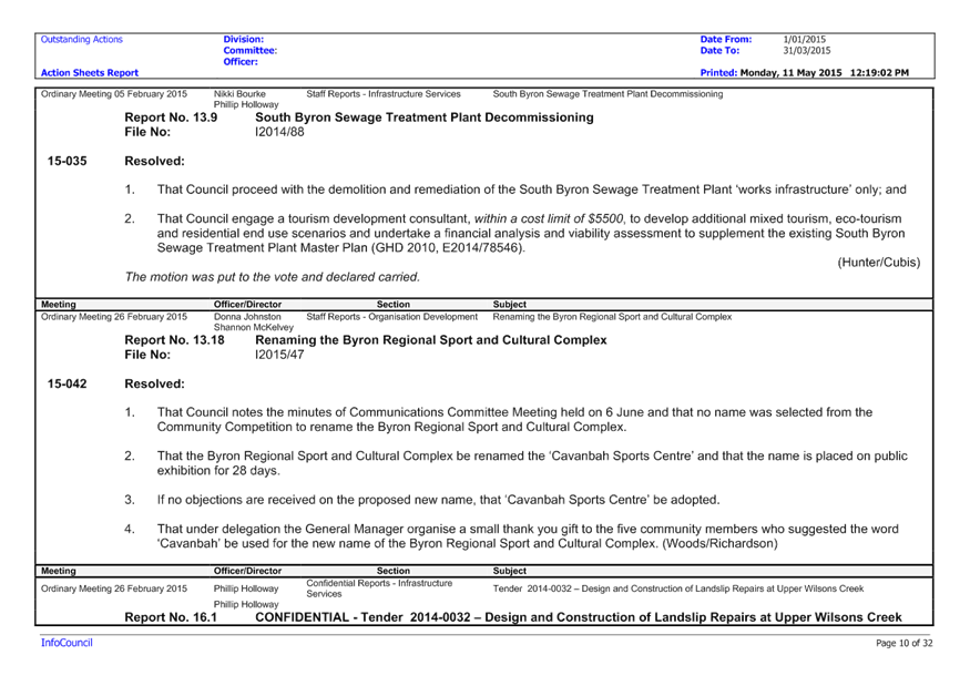
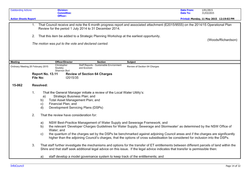
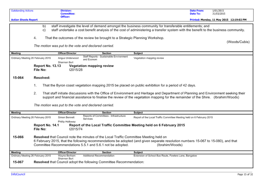
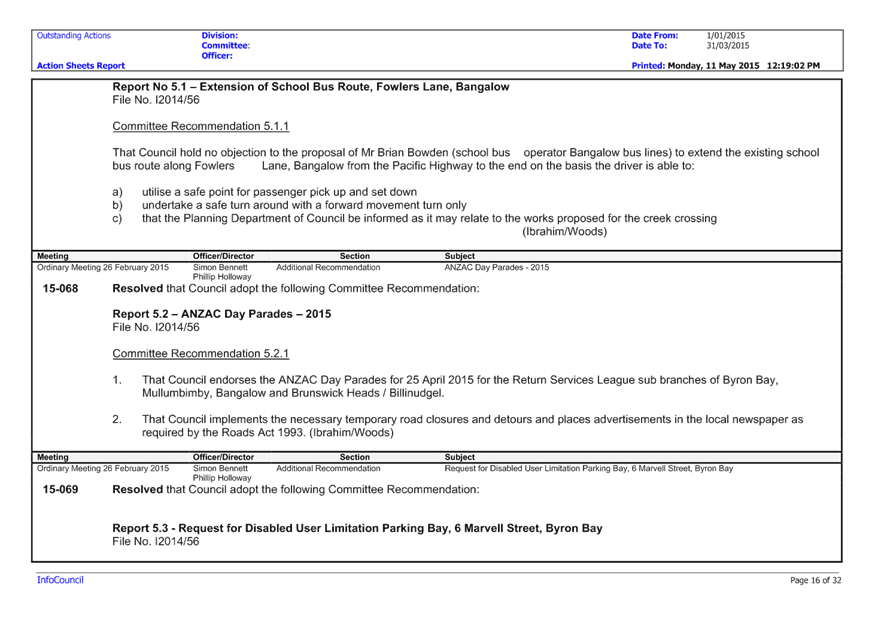
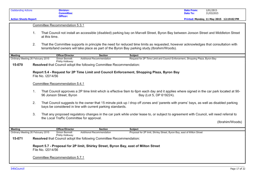
Ordinary Meeting
Public ATTACHMENTS
EXCLUDED FROM THE
Ordinary
Meeting
AGENDA
OF 21 May 2015
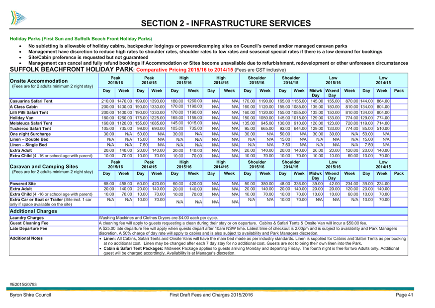
9.4 Caravan
Park Booking Rules
Attachment
1... Extract from Draft 2015/16 Revenue Policy............................................. 2
13. Staff Reports
Corporate and Community Services
13.1 Mayoral and
Councillor Fees 2015/2016
Attachment
1... 2015 Remuneration Tribunal Determination............................................ 16
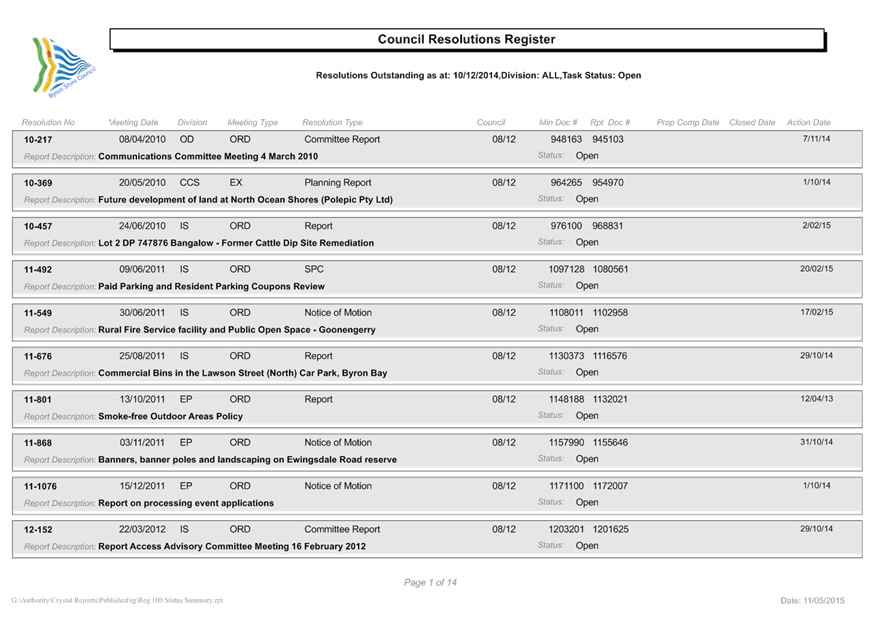
13.2 Council
Resolutions Review January to March 2015
Attachment
1... Council Resolutions (pre 2015) - complete 1 Jan to 31 Mar 2015.......... 35
Attachment
2... Completed Resolutions (2015) 1 Jan to 31 Mar 2015............................. 46
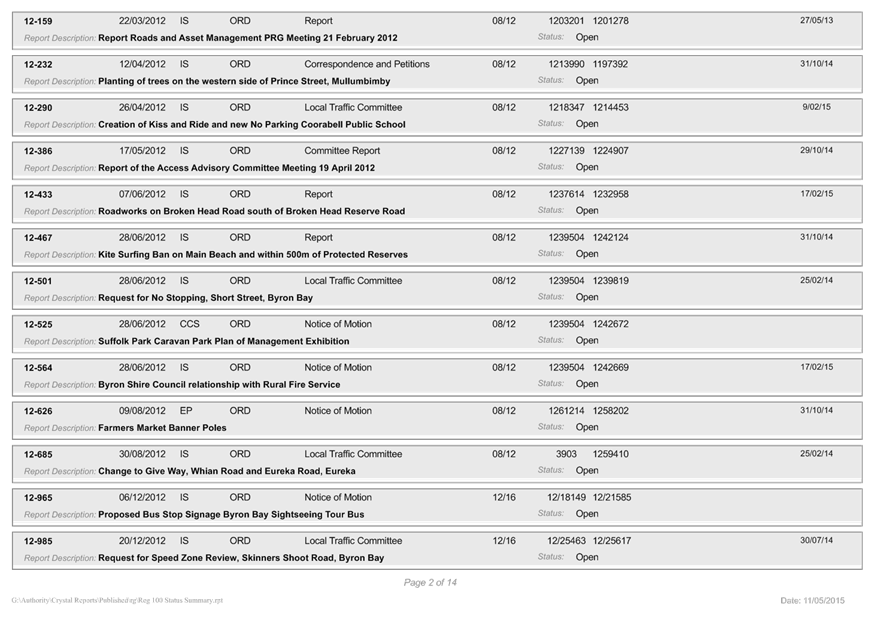
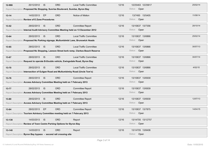
Attachment
3... Outstanding Council Resolutions - pre 2015........................................... 75
Attachment
4... Outstanding Council Resolutions 1 Jan to 31 March 2015..................... 89
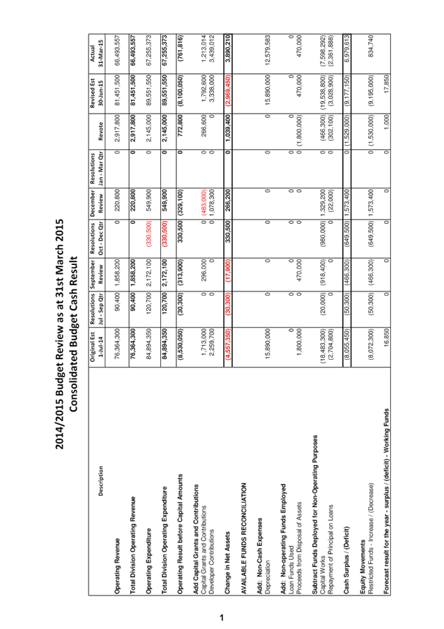
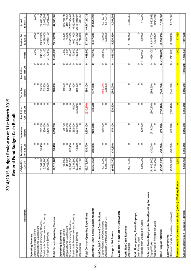
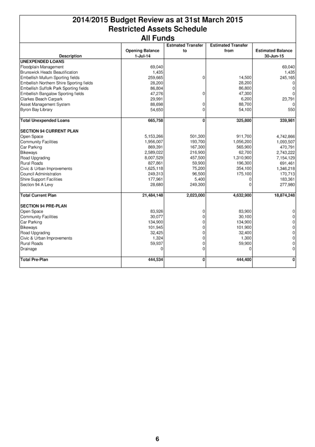
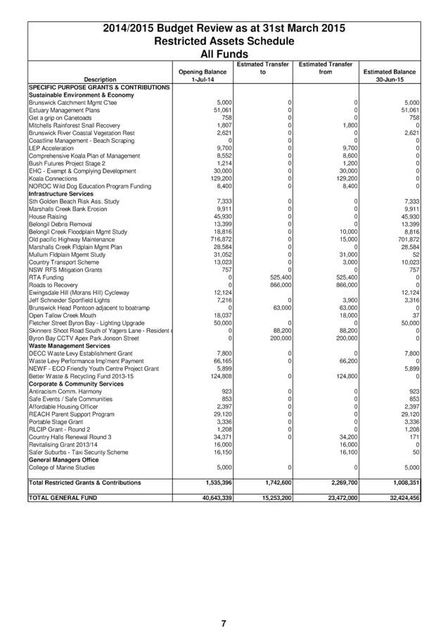
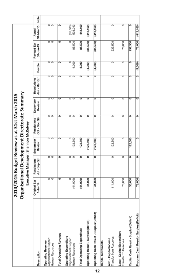
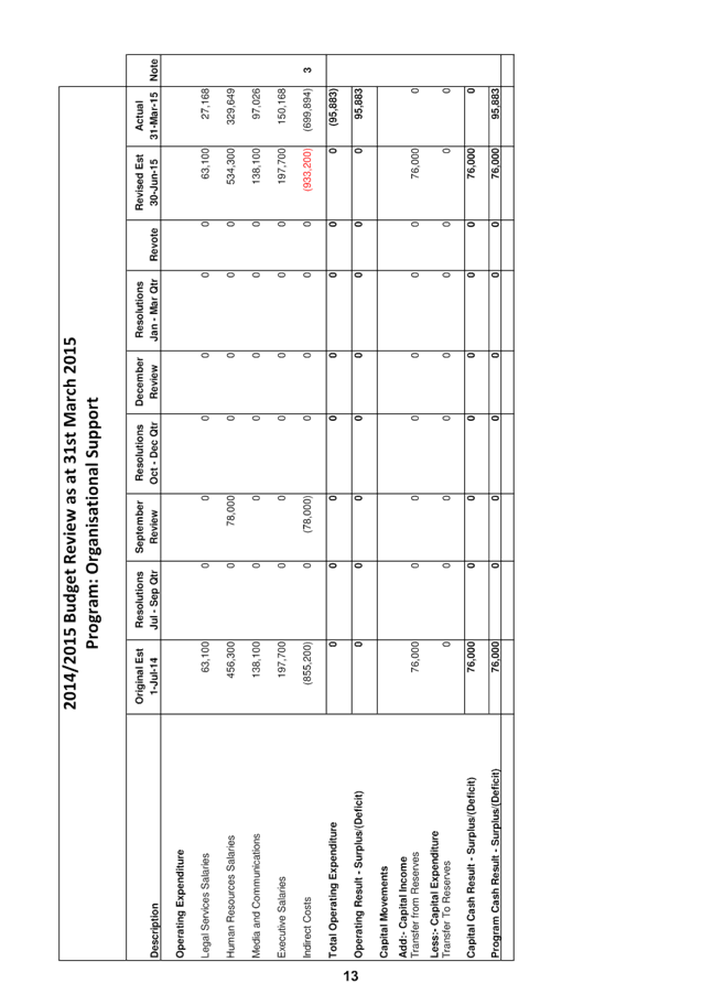
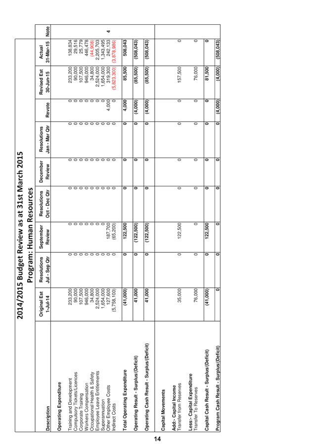
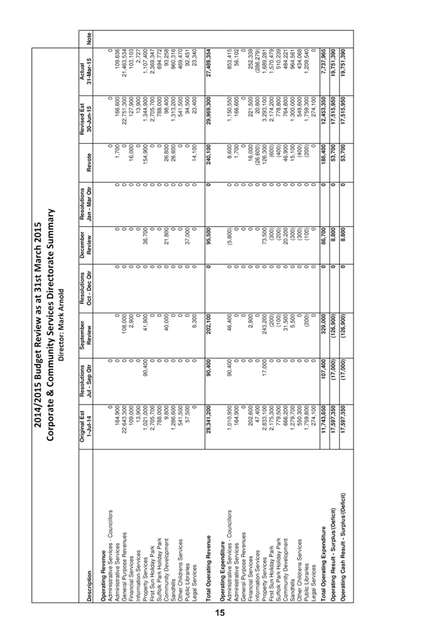
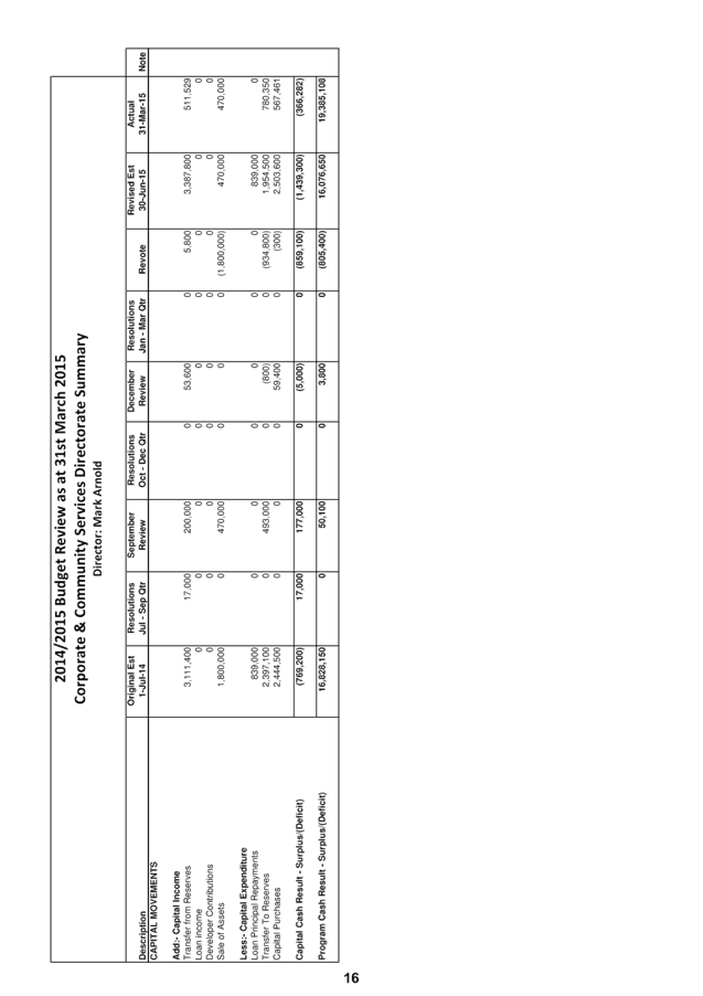
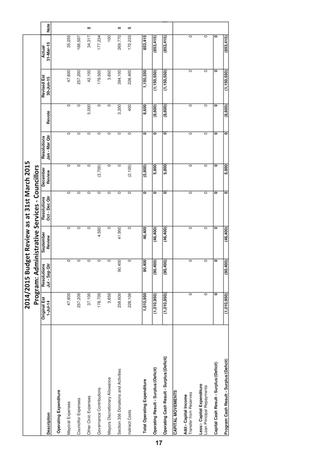
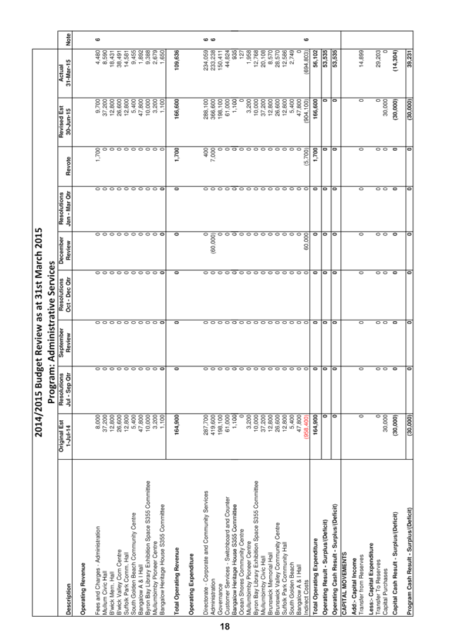
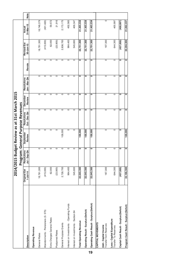
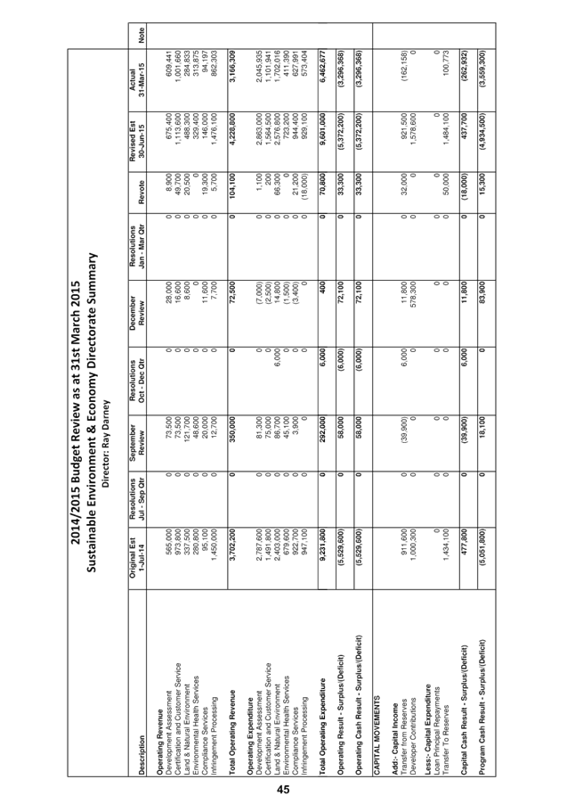
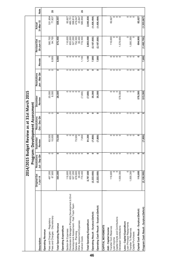
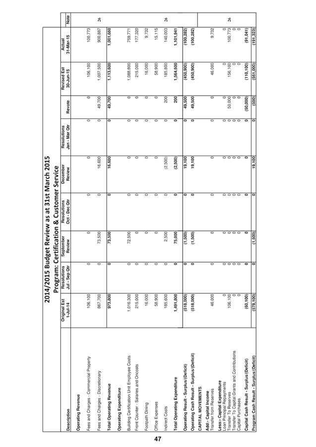
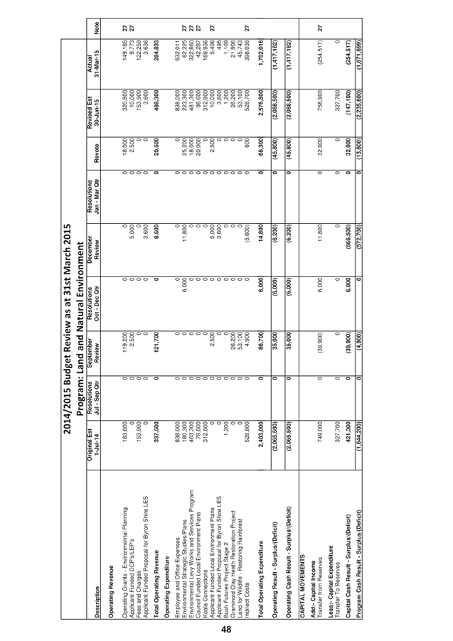
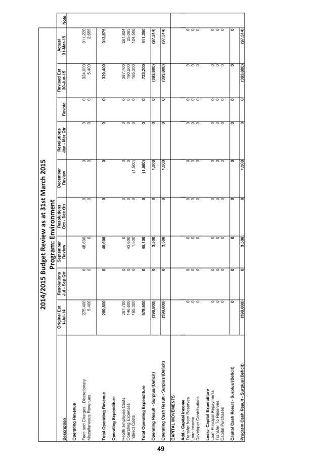
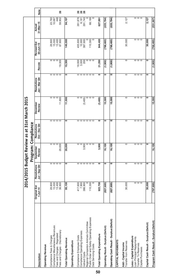
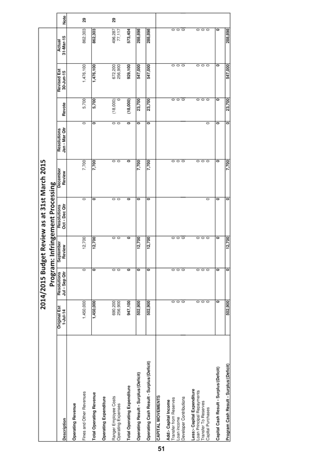
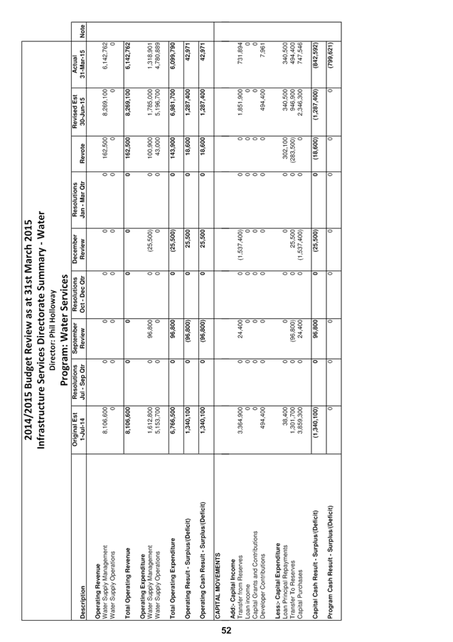
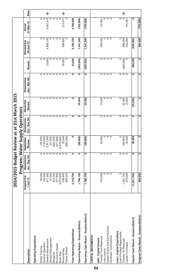
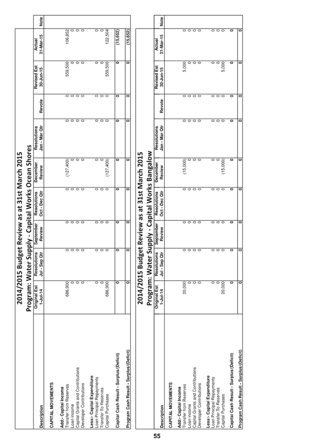
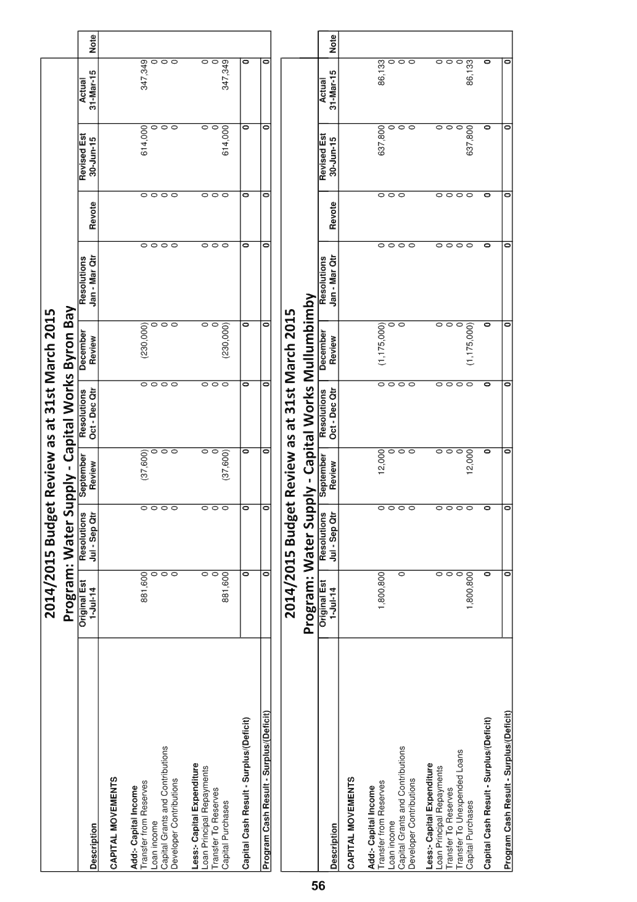
13.5 Budget
Review - 1 January 2015 to 31 March 2015
Attachment
1... Budget Variations for the General, Water and Sewerage Funds.......... 121
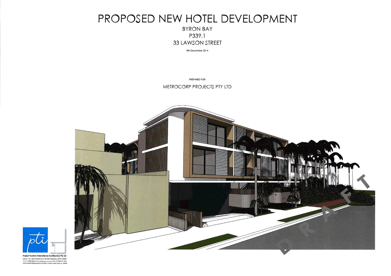
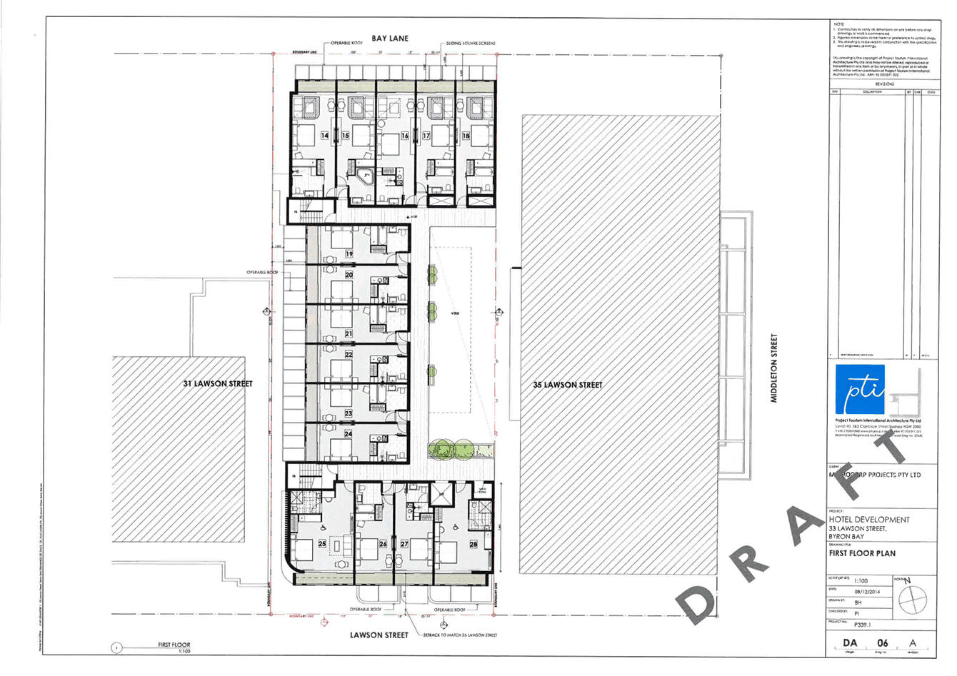
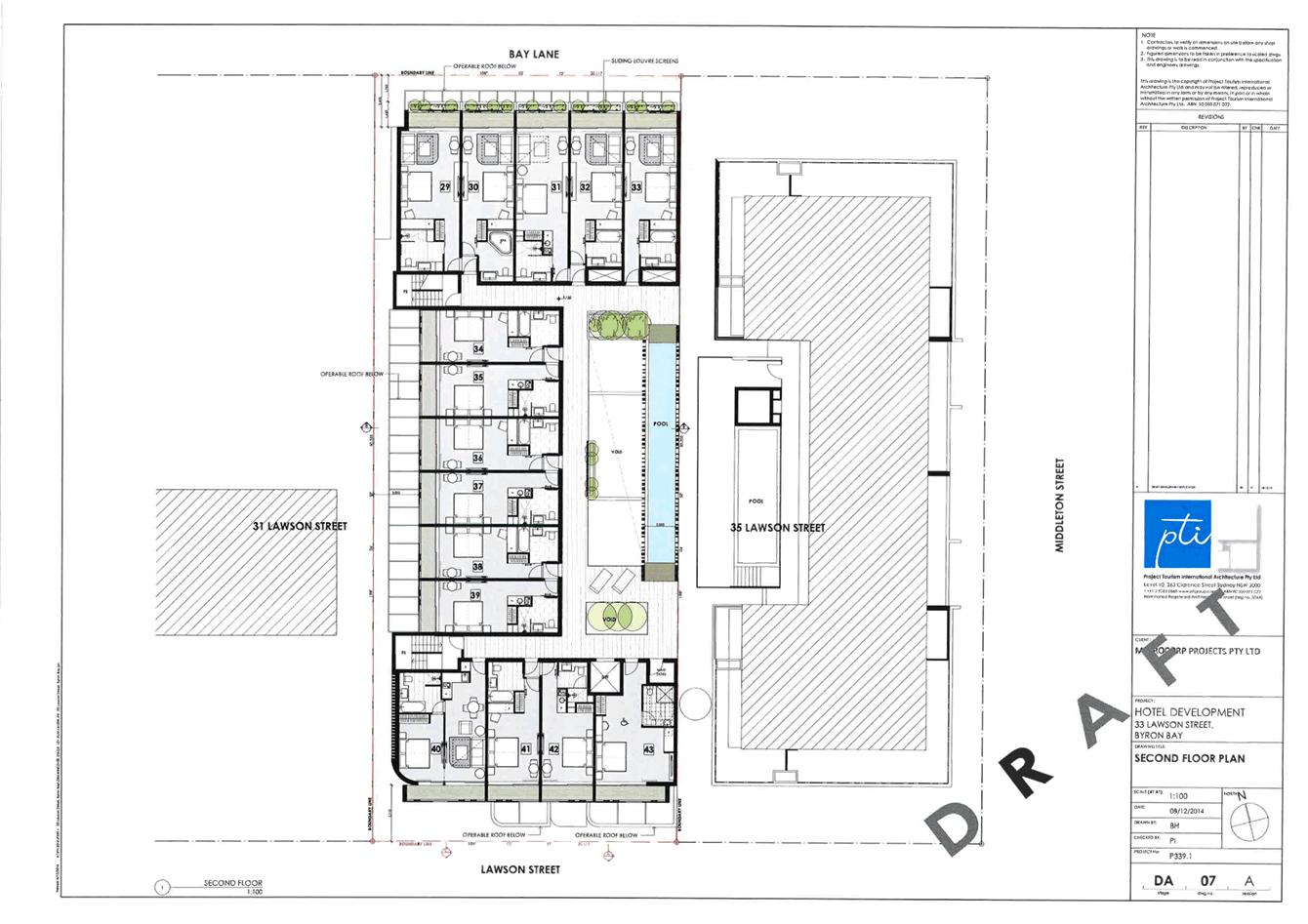
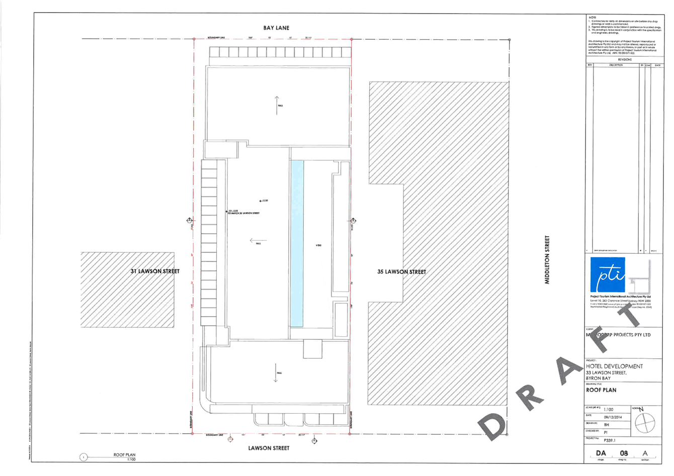
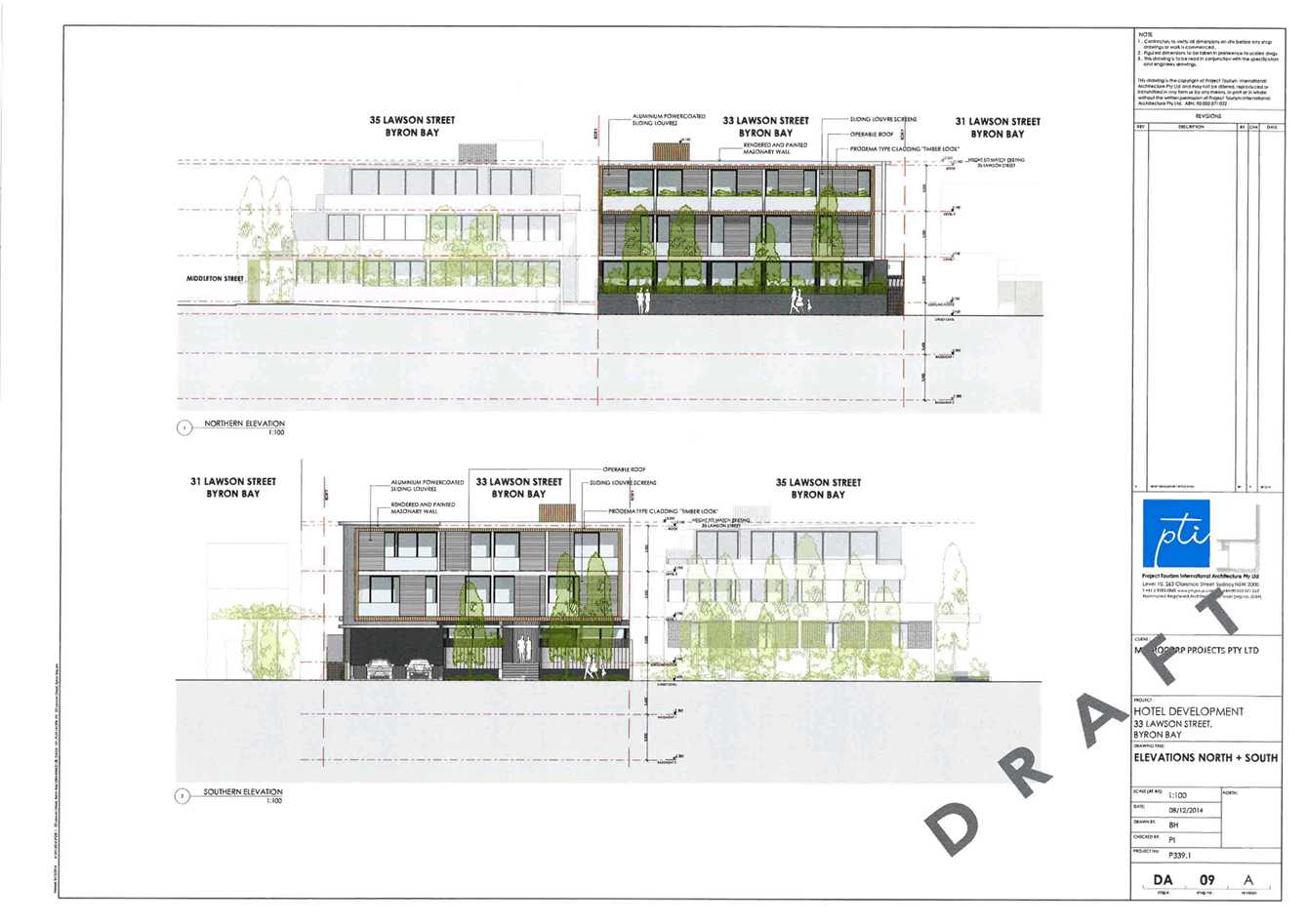
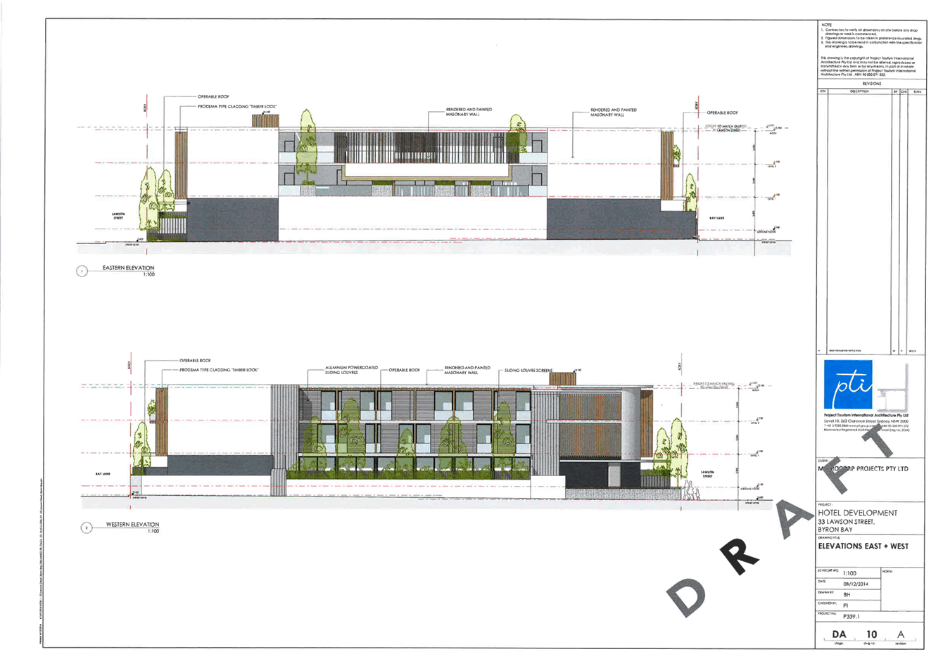
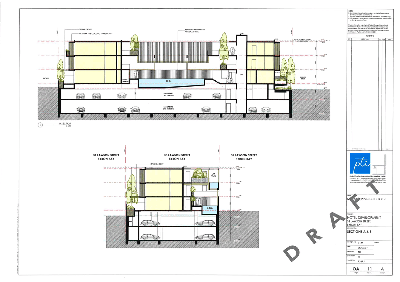
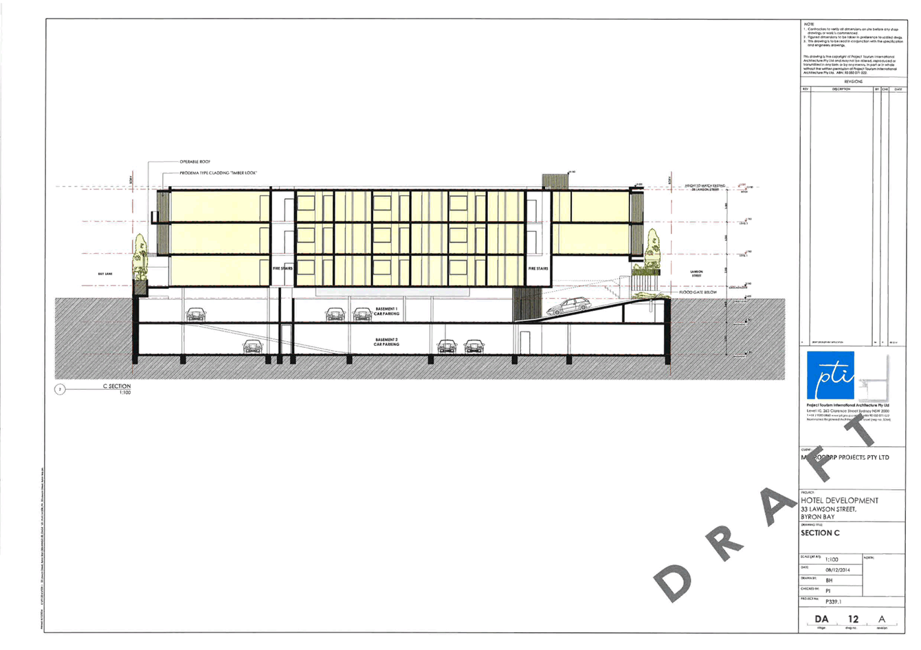
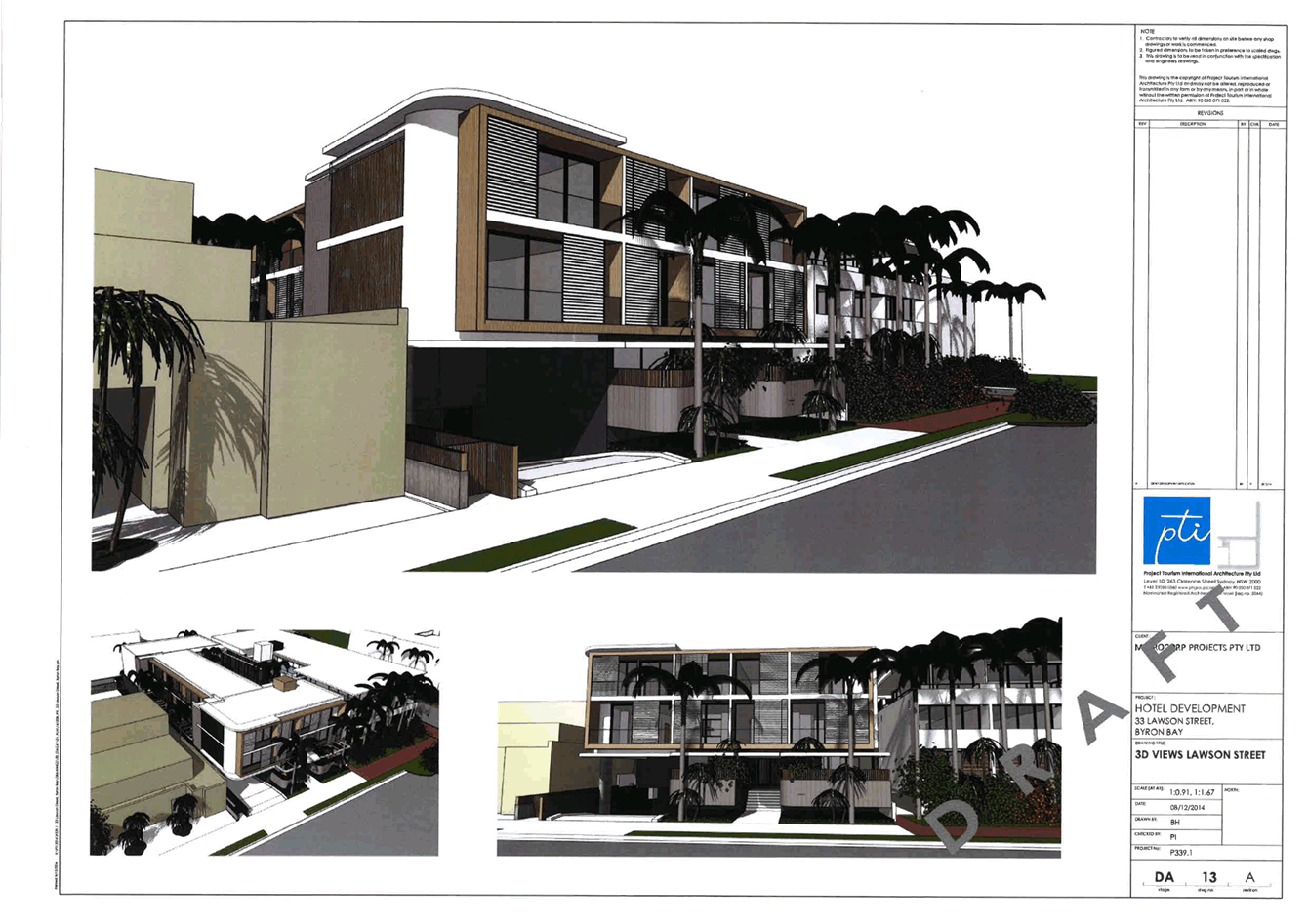
13.9 PLANNING -
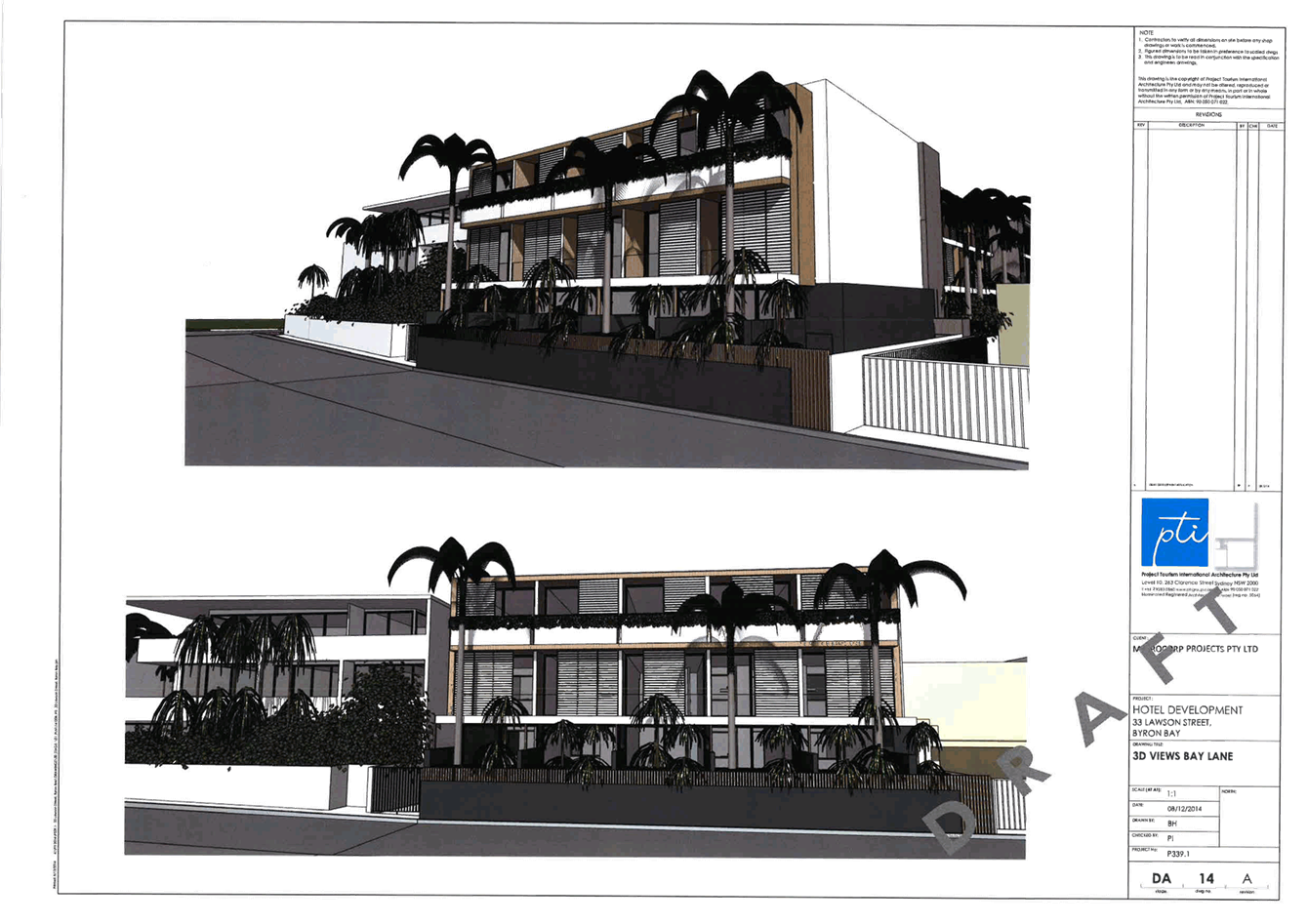
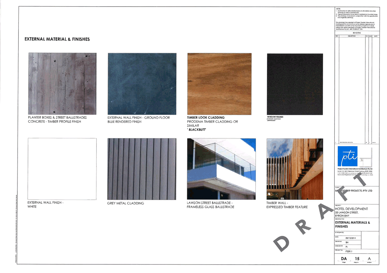
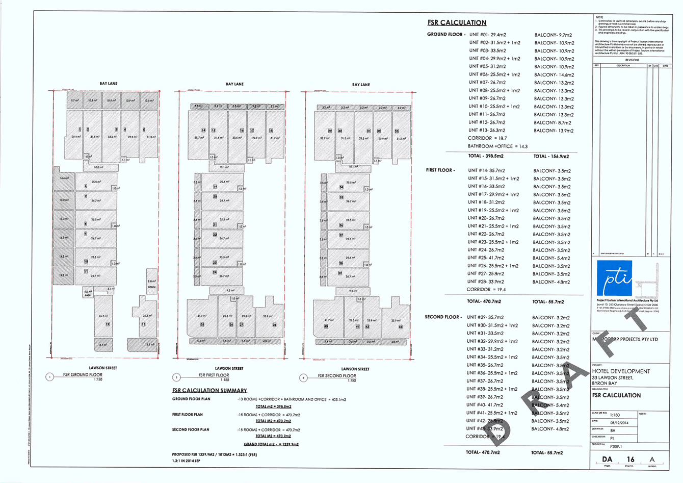
Development Application 10.2014.742.1 - Demolition of existing single-storey
motel building. Erection of a three (3) storey motel accommodation building
plus two (2) levels of basement parking - 33 Lawson Street, Byron Bay
Attachment
1... Proposed Plans Development Applicaton 10.2014.742.1 submitted by DP
Roberts Planning Solutions.................................................................................. 203
13.13 PLANNING - Planning Proposal
for finalisation of reclassification of Lot 530 DP 238451 Orana Road Ocean
Shores
Attachment
1... Planning Proposal.................................................................................. 219
Attachment
3... Responses to issues raised in public submissions................................. 239
Attachment
4... Public Hearing Report............................................................................ 254
Notices of Motion 9.4 - Attachment 1
Notices of Motion 9.4 - Attachment 1

Staff Reports - Corporate and Community Services 13.1 - Attachment 1


Staff Reports - Corporate and Community Services 13.2 - Attachment 1
Staff Reports - Corporate and Community Services 13.2 - Attachment 2
Staff Reports - Corporate and Community Services 13.2 - Attachment 3
Staff Reports - Corporate and Community Services 13.2 - Attachment 4
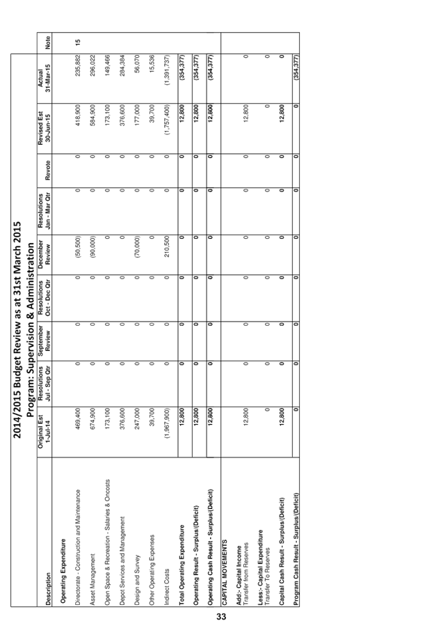
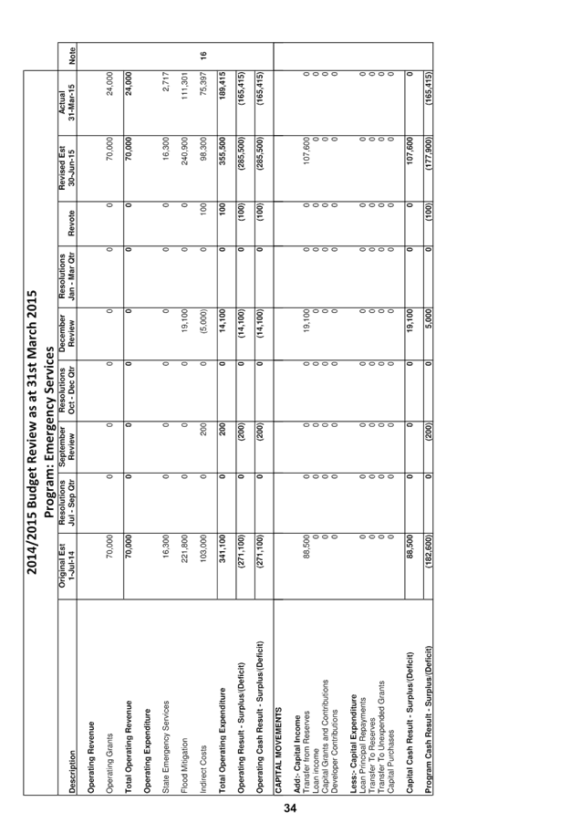
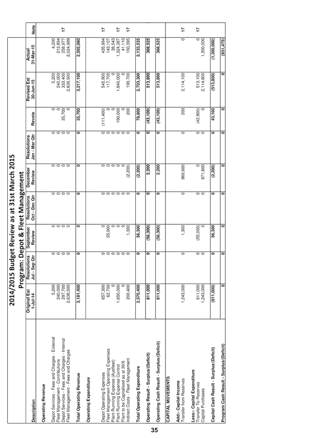
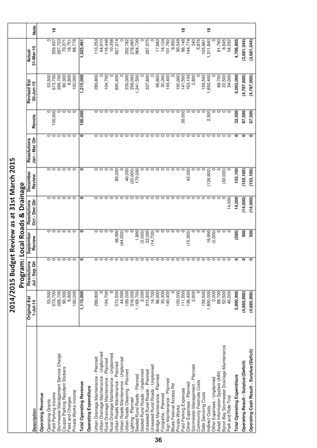
Staff Reports - Corporate and Community Services 13.5 - Attachment 1


Staff Reports - Sustainable Environment and Economy 13.9 - Attachment 1
Staff Reports - Sustainable Environment and Economy 13.13 - Attachment 1

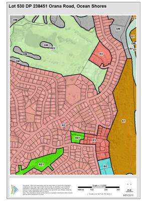
PLANNING PROPOSAL
RECLASSIFICATION OF LAND
TO OPERATIONAL – INTERESTS CHANGED
THE
‘ROUNDHOUSE SITE’
LOT 530 DP 238451 ORANA ROAD, OCEAN SHORES
Original Version 23 May 2014,
Revised Version 22 January 2015
TABLE OF CONTENTS
Introduction .............................................................................................................................................. 3
Background .............................................................................................................................................. 4
Part 1...... Objectives
and Intended Outcomes of the Proposed Instrument ........................................... 7
Part 2...... Explanation
of Provisions to be included in the Proposed Instrument .................................... 7
Part 3...... Justification
for Objectives, Outcomes and Implementation Process .................................... 8
Section A – Need for the
Planning Proposal ........................................................................... 8
Section B – Relationship to
strategic planning framework ..................................................... 8
Section C – Environmental,
social and economic impact ...................................................... 13
Section D – State and
Commonwealth interests .................................................................... 13
Part 4...... Mapping
................................................................................................................................... 14
Part 5...... Community
Consultation ......................................................................................................... 14
Part 6...... Project
Timeline ....................................................................................................................... 14
Conclusion ............................................................................................................................................... 16
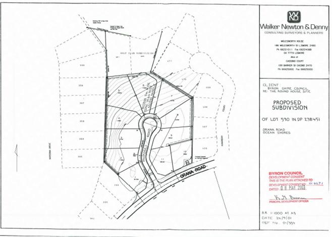
Attachment A – Photograph of the Site and Approved
Plan of Subdivision ........................................... 17
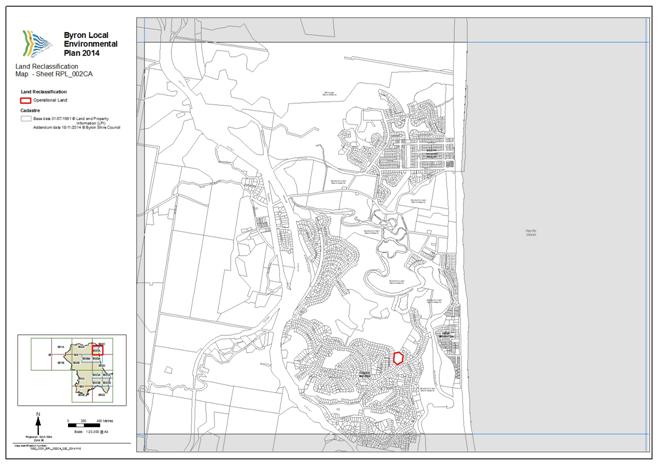
Attachment B – Draft LEP 2014 Amendment Map ................................................................................. 18
INTRODUCTION
This is a Planning Proposal by Byron Shire Council
(“Council”) to amend Byron Local Environmental Plan 2014
(“LEP 2014”) by way of a local environmental plan that reclassifies
the public land owned by the Council and known as Lot 530 DP 238451 Orana Road,
Ocean Shores (the “Land”), which is also known as the former
“Roundhouse” site, from “community” to
“operational” land under Part 2 of Chapter 6 of the Local
Government Act 1993 (“LG Act”) and makes provision to the effect
that, on commencement of the plan, the Land, if it is a public reserve, ceases
to be a public reserve, and that the Land is by operation of the plan discharged
from any trusts and interests except for:
(a) any
reservations that except land out of a Crown grant relating to the Land;
(b) reservations
of minerals (within the meaning of the Crown Lands Act 1989);
(c) Easement
for Electricity registered dealing number N765060;
(d) Easement
for Rising Main registered with DP 600678;
(e) Right
of Carriageway registered with DP 1062920; and
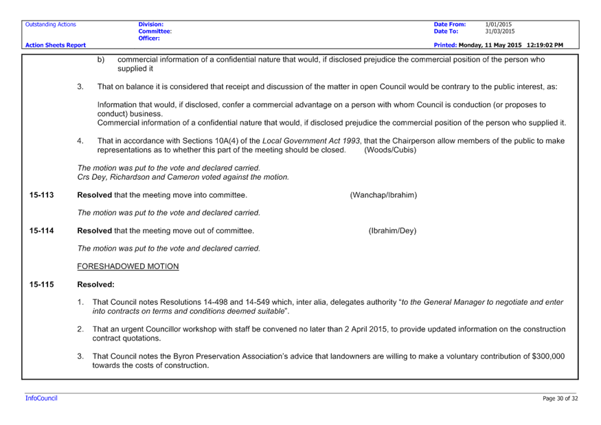
(d) Easement
for Services registered dealing number AD798519.
The Land was classified as
“operational” by Byron Local Environmental Plan 1988 (Amendment No
86) on 22 March 2002. However, Byron Local Environmental Plan 1988
(Amendment No 86) provided that the Land:
(a) to the extent (if any) that the Land was a
public reserve, did not cease to be a public reserve; and
(b) continued to be affected by any trusts,
estates, interests, dedications, conditions, restrictions or covenants by which
it was affected before its classification, or reclassification, as operational
land.
Development consent to subdivide
the Land into 11 residential lots was granted on 8 April 2003 and the
subdivision is nearing completion. The Land is presently within Zone R2 Low
Density Residential under the provisions of Byron Local Environmental Plan 2014
(LEP 2014). Council resolved to sell the lots by way of public auction in order
to fund future infrastructure projects in Ocean Shores and other parts of the
Byron Local Government Area.
A proposed auction of some of
the lots was cancelled in March 2014 to investigate certain assertions made
just prior to the auction including assertions to the effect that the Land is subject
to a trust for a public purpose that was not expunged by the reclassification
of the Land pursuant to Byron Local Environmental Plan 1988 (Amendment No. 86)
and therefore could not be sold.
Whilst the Council does not
admit or concede that the Land is subject to a trust for a public purpose it
proposes, for abundant caution and to provide certainty, to pass a resolution
to reclassify the Land from “operational” to
“community” under Part 2 of Chapter 6 of the LG Act so that the
Land may then be reclassified by way of a local environmental plan utilising
the power in section 30 of the LG Act to make provision in the local
environmental plan to the effect that, on commencement of the plan, the Land,
if it is a public reserve, ceases to be a public reserve, and that the Land is
by operation of the plan discharged from any trusts and interests except for
those set out above.
The power in section 30 of the
LG Act is only available where a local environmental plan reclassifies
“community” land as “operational” land. Given that the
Land is presently classified as “operational” it is necessary for
the Council to give public notice under section 34 of the LG Act of a proposed
resolution to reclassify the Land as “community” land and then
resolve pursuant to section 33 of the LG Act that the Land be reclassified as
“community” land before the instrument intended by this Planning
Proposal is then made to reclassify the Land from “community” land
to “operational” land.
This reclassification to
“community” land by resolution and then reclassification back to
“operational” land by way of local environmental plan is an
administrative step necessitated by the specific wording of section 30 of the
LG Act.
The objectives and intended
outcome of this Planning Proposal are that the Land is classified by a local
environmental plan as “operational” under Part 2 of Chapter 6 of
the LG Act and that it is made certain by the provisions incorporated in the
local environmental plan pursuant to section 30 of the LG Act that the Land is
not a public reserve and is not the subject of any trusts or interests which
may prevent the Council from selling the land.
This Planning Proposal has been
prepared with reference to the provisions of the LG Act, the Environmental
Planning and Assessment Act 1979 (“EP&A Act”), and the
Department of Planning and Environment’s Guidelines “A guide to
preparing planning proposals” and “A guide to preparing local
environmental plans”.
BACKGROUND
Byron Shire Council is the owner of the Land
which is locally known as the “Roundhouse Site”. The Land was
originally part of a dairy farm but from around 1969 was used as a sales office
for the Ocean Shores development and accommodated a sixteen sided circular
building – the “Roundhouse”. The Land was zoned Special Uses
5(a) – Community Purposes under Byron Local Environmental Plan 1988 (LEP
1988) and on 27 July 1990 the Land and Environment Court ordered Council to
compulsorily acquire the Land. The Land was acquired by Council on 26 July
1991. The Roundhouse building was demolished in 1993.
The Land was rezoned to Zone No. 2(a)
(Residential Zone) by way of LEP 1988 (Amendment No. 46) made on 2 July 1996. The lot was classified operational land –
interests not changed by way of LEP 1988 (Amendment No. 86) made on 22
March 2002. The LEP Amendment resulted in the Land being described in Part 2 of
Schedule 11 of the LEP. Under subclause 47(3) of the LEP, land described in
Part 2 of Schedule 11:
(a) to
the extent (if any) that the land is a public reserve, does not cease to be a
public reserve, and
(b) continues
to be affected by any trusts, estates, interests, dedications, conditions,
restrictions or covenants by which it was affected before its classification,
or reclassification, as operational land.
Development Application No. 10.2001.627.1
for subdivision to create eleven (11) lots and associated road works was
consented to on 8 April 2003. The subdivision works are nearing completion in
preparation for the lodgement of the subdivision certificate application, prior
to registration of the final plan of subdivision (refer to the recent
photograph of the site and the approved plan of subdivision provided in Attachment
A to this Planning Proposal). Four of the residential lots were to be
auctioned in March 2014, however, Council’s ability to sell the Land was
challenged and the auction did not proceed.
At its meeting on 10 April 2014 Council
resolved:
1. That Council note that this report
being a late report will not compromise the community’s knowledge of or
ability to participate in the decision-making on this matter because, if it
proceeds, there will need to be extensive community consultation and many
opportunities to make submissions to Council and at Council meetings.
2. That a planning proposal be prepared
and submitted to the NSW Minister for Planning & Infrastructure in
accordance with Division 4 of Part 3 of the Environmental Planning and
Assessment Act 1979 and Sections 27(1) and 30 of the Local Government Act 1993
for the making of a local environmental plan to classify or reclassify the said
land as operational land and to make provision to the effect that, on
commencement of the plan, the land, if it is a public reserve, ceases to be a
public reserve, and that the land is by operation of the plan discharged from
any trusts, estates, interests, dedications, conditions, restrictions and
covenants affecting the land or any part of the land, except for:
(i) any reservations that except land
out of a Crown grant relating to the land, and
(ii) reservations of minerals (within the
meaning of the Crown Lands Act 1989).
…
4. That it be noted that as a result of
delay to the Roundhouse project, infrastructure projects, including Ocean
Shores infrastructure projects, that were proposed to be funded from the
proceeds of sale of the Roundhouse land, will now be delayed, or may not be
able to be delivered depending on the outcome of the LEP amendment process.
The Land is
entirely within Zone R2 Low Density Residential under LEP 2014 – refer to
the LEP 2014 Zone map extract below. There
is presently no public land identified for reclassification in Schedule 4 of
LEP 2014.
Subject site
|
LEP 2014 Zone Map extract
|
In order for
the classification of the Land to be changed from operational land –
interests not changed to operational land – interests changed
to achieve the objectives and intended outcomes, the Land would first need to
be reclassified to ‘community land’ by way of a Council resolution
because the power in section 30 of the LG Act is only available where a local
environmental plan reclassifies ‘community land’ as
‘operational land’. As part of this resolution Council would note
that the intention is to subsequently reclassify the Land to ‘operational
land – interests changed’ by way of the amending local
environmental plan that is the subject of this Planning Proposal. The necessary
order of procedures to be followed includes:
1. Public
notice would need to be given in accordance with section 34 of the Local
Government Act 1993 of a proposed resolution to the effect that the Land, which
is public land presently classified as ‘operational’ land, is to be
reclassified as ‘community’ land pursuant to section 27(2) and
section 33 of the Local Government Act 1993. The notice must include the terms
of the proposed resolution and a description of the Land and specify a period
of not less than 28 days during which submissions may be made to the Council.
2. Council
would need to resolve to reclassify the Land as community land immediately
prior to the Land subsequently being reclassified as operational land by
way of the local environmental plan that is the subject of this Planning
Proposal pursuant to section 27(1) of the LG Act so that:
(a) the
local environmental plan may, pursuant to section 30 of the LG Act, make
provision to the effect that, on commencement of the plan, the Land, if it is a
public reserve, ceases to be a public reserve; and that
(b) the
Land is, by operation of the local environmental plan, discharged from any
trusts and interests, except for:
(i) any
reservations that except land out of a Crown grant relating to the L Land;
(ii) reservations
of minerals (within the meaning of the Crown Lands Act 1989);
(iii) Easement
for Electricity registered dealing number N765060;
(iv) Easement
for Rising Main registered with DP 600678;
(v) Right
of Carriageway registered with DP 1062920; and
(vi) Easement for
Services registered dealing number AD798519.
Provisions (a) and (b) require
the Governor’s approval under section 30 of the Local Government Act
1993. The Governor’s approval is sought by the Department before the
Minister makes the local environmental plan to amend LEP 2014.
3. The
Council resolution to reclassify the Land as community land would need to be
passed after completion of the community consultation and public hearing in
respect of the local environment plan to amend LEP 2014 and before the
Minister makes the plan. The Department of Planning & Environment has
advised that the Minister can be asked to publish the local environmental plan
to amend LEP 2014 on the NSW Legislation website on a specific date (which
becomes the date on which the local environmental plan commence). The
date that local environmental plan to amend LEP 2014 is published on the
legislation website should be the day after the Council resolution to
reclassify the Land to community land, to minimise the length of time that the
Land is classified as community land.
A more
detailed indicative timeline is provided in Part 6 of this Planning Proposal
below.
The delegate
of the Minister for Planning issued a Gateway Determination in respect of this
Planning Proposal on 7 November 2014. The Gateway Determination states that the
timeframe for completing the local environmental plan is to be 12 months from
the week following the Gateway Determination.
This Planning
Proposal has been amended to address Conditions 1 and 2 of the Gateway
Determination as follows:
Condition 1(a). Prior to commencing
public exhibition, Council is to amend the planning proposal by …
updating references to the Local Environmental Plan that is being amended
noting that the Byron Local Environmental Plan 2014 has been notified; and
Response: The Planning
Proposal was originally prepared when Byron LEP 1988 applied to the site and
LEP 2014 was a draft environmental planning instrument. Prior to the Gateway
Determination, LEP 2014 was gazetted and applies to the entirety of the site.
This Planning Proposal has been updated to refer only to LEP 2014 being the
subject of the proposed LEP amendments under this Planning Proposal.
Condition 1(b) Prior to commencing
public exhibition, Council is to amend the planning proposal by ….
amending Part 1 Objectives and Intended Outcomes to ensure the outcome that the
planning proposal seeks to achieve can be clearly understood by the general
community.
Response: Part 1 of the
Planning Proposal below and the introduction and background information above
have been amended to make clear to the general community the outcome that the
Planning Proposal is seeking to achieve.
Condition 2(a). Prior to
finalisation of the LEP, the planning proposal is to be amended to clarify
whether any interests applying to the land will be extinguished; and
Response: The Planning
Proposal has been amended to clarify that all interests in the Land will be
extinguished except for the identified mandatory interests arising from Crown
and mineral reservations and the registered easements and rights of way.
Condition 2(b). Prior to
finalisation of the LEP, the planning proposal is to be amended … to
include required mapping prepared in accordance with the Department's Standard
Technical Requirements for LEP Maps.
Response: A
draft LEP 2014 Amendment Map, prepared in accordance with the
Department’s Standard Technical requirements for LEP Maps dated November
2012, is contained in Attachment B of this Planning Proposal.
PART 1 OBJECTIVES AND INTENDED OUTCOMES OF
THE PROPOSED INSTRUMENT
The objectives and
intended outcome of this Planning Proposal are that the Land is classified by a
local environmental plan as “operational” under Part 2 of Chapter 6
of the LG Act and that it is made certain by the provisions incorporated in the
local environmental plan pursuant to section 30 of the LG Act that the Land is
not a public reserve and is not the subject of any trusts or interests which
may prevent the Council from selling the land (or any part of the Land).
If the proposed
local environmental plan was made it would amend LEP 2014 and result in the
Land being reclassified as “operational” and it would also provide
certainty that the Land:
(i) ceases
to be a public reserve (if it is a public reserve); and
(ii) is
discharged from all trusts and interests except:
(a) any
reservations that except land out of a Crown grant relating to the Land;
(b) reservations
of minerals (within the meaning of the Crown Lands Act 1989);
(c) Easement
for Electricity registered dealing number N765060;
(d) Easement
for Rising Main registered with DP 600678;
(e) Right
of Carriageway registered with DP 1062920; and
(d) Easement
for Services registered dealing number AD798519.
PART 2 EXPLANATION OF PROVISIONS TO BE
INCLUDED IN THE PROPOSED INSTRUMENT
If the
proposed instrument is made it will amend Part 2 of Schedule 4 of the LEP 2014
to include the following:
|
Part 2 Land classified, or reclassified, as
operational land – interests changed
|
|
Column 1
|
Column 2
|
Column 3
|
|
Locality
|
Description
|
Any trusts etc not discharged
|
|
Ocean Shores
|
Lot 530 DP 238451, Orana Road
|
All trusts and interests except for:
(a) any reservations that except land out of
a Crown grant relating to the Land;
(b) reservations of minerals (within the
meaning of the Crown Lands Act 1989);
(c) Easement for Electricity registered
dealing number N765060;
(d) Easement for Rising Main registered with
DP 600678;
(e) Right of Carriageway registered with DP
1062920; and
(d) Easement for Services registered dealing
number AD798519.
|
PART 3 JUSTIFICATION FOR OBJECTIVES,
OUTCOMES AND IMPLEMENTATION PROCESS
Section A – Need for the Planning Proposal
Q1. Is
the planning proposal a result of any strategic study or report?
The Planning Proposal reflects
Council’s intention to complete the subdivision and sale of the Land
(unencumbered except for the reservations mentioned above) in accordance with
the objectives of Zone R2 Low Density Residential, which are:
(a) To provide for the housing needs of the
community within a low density residential environment, and
(b) To enable other land uses that provide
facilities or services to meet the day to day needs of residents.
The Planning Proposal is a key
plank in Council’s Financial Sustainability Project Plan in terms of
generating sufficient reserves to fund future infrastructure projects within
Ocean Shores and other parts of the Council area.
Q2. Is
the planning proposal the best means of achieving the objectives or intended outcomes,
or is there a better way?
Amending LEP 2014 in the manner
proposed is the best, most efficient and most time effective approach to
delivering the objectives and intended outcomes of the Planning Proposal. The
Land is already classified as operational, and the proposed procedure would
confirm that the Land:
(a) remains
classified as operational;
(b) ceases
to be a public reserve to the extent (if any) that it is a public reserve; and
(c) is
discharged from any trusts or interests which may prevent the Council from
selling the land (or any part of the Land).
Section B – Relationship to strategic planning
framework
Q3. Is
the planning proposal consistent with the objectives and actions of the
applicable regional or sub-regional strategy?
The Planning Proposal is
consistent with the objectives and actions of the Far North Coast Regional
Strategy relating to this land which is within the Ocean Shores coastal
village, because the proposed instrument will:
(a) not
change the zoning of the Land;
(b) result
in the classification of the Land reflecting Council’s intention that the
Land be developed for residential purposes demonstrated by the R2 Low Density
Residential Zone;
(c) not
have a significant effect in terms of environmental, agricultural, farmland,
vegetation, habitat, areas of high biodiversity, waterway, wetland or coastline
or landscape values (including scenic and cultural landscapes);
(d) not
change the location of planned residential development and facilitate the
desired future character of the location;
(e) not
have a significant effect in terms of extractive resources; and
(f) reflect
the objectives of the Zone.
Q4. Is
the planning proposal consistent with Council’s local strategy or other
local strategic plan?
The Planning Proposal is
consistent with the key community outcomes and strategies of Council’s
Draft Community Strategic Plan 2022.
Q5. Is
the planning proposal consistent with applicable State Environmental Planning
Policies?
The Planning Proposal is consistent
with applicable State Environmental Planning Policies (SEPP) which include:
SEPP 14 – Coastal
Wetlands
The site does not contain nor
adjoin any SEPP 14 wetlands.
SEPP 19 – Bushland in
Urban Areas
The site does not contain nor
adjoin, and the Planning Proposal does not propose to disturb, any bushland
zoned or reserved for public open space purposes.
SEPP 26 – Littoral
Rainforest
The site does not contain nor
adjoin any SEPP 26 littoral rainforest.
SEPP 44 – Koala Habitat
Protection
The site does not contain nor
adjoin any koala habitat.
SEPP 55 – Remediation of
Land
The report on the above mentioned
Development Application No. 10.2001.627.1
advised in relation to contamination as follows: “A dip site
was identified in the estate and as a result Aztec Environmental Consultants
were engaged to undertake a comprehensive study of the whole estate. As a
result of the previous investigations Council is satisfied that there are no
outstanding issues in respect to the State Policy and no further investigation
is warranted”.
SEPP 71 – Coastal
Protection
The Planning Proposal is
consistent with the provisions of SEPP 71 in relation to preparing draft LEPs.
SEPP (Infrastructure) 2007
The Planning Proposal is not
contrary to the provisions of SEPP (Infrastructure) 2007.
North Coast Regional Environmental Plan
The Planning Proposal is
consistent with the provisions of the North Coast Regional Environmental Plan.
In particular, the Planning Proposal assists with achieving the objective to
promote the provision of a range of adequate, affordable and suitable housing
to meet the needs of the region’s population. The proposal will not have
a significant impact in terms of strategic planning or environmental hazard
considerations.
Q6. Is
the planning proposal consistent with applicable Ministerial Directions (s.117
directions)?
The Planning Proposal is
consistent with applicable Ministerial Directions as follows:
|
2.
Environment and Heritage
2.2... Coastal Protection
The
Planning Proposal is consistent with the relevant principles outlined in the
NSW Coastal Policy.
2.3
Heritage Conservation
The site is a local heritage
item under LEP 2014. However the Land was reclassified to operational in 2002
and the subdivision of the Land was approved in 2003, well before
Council’s Community-Based Heritage Study and LEP 2014 were prepared.
Whilst the Study’s heritage statement describes the site as containing
the original administration centre and sales office building for the Ocean
Shores development, this building was demolished in 1993 and approved
subdivision works have since been carried out on the Land. The proposed
reclassification of the Land has no implications with respect to the heritage
value of the site, because it merely results in the classification of the
Land changing to another type of operational land and will not cause or
require any further disturbance of any remnant heritage characteristics of
the site.
|
|
3. Housing,
Infrastructure and Urban Development
3.1... Residential Zones
........ The Planning Proposal will
facilitate the subdivision of the Land in accordance with the existing and
proposed residential zones which apply to the Land.
|
|
5. Regional
Planning
5.1... Implementation of Regional
Strategies
........ The Planning Proposal is consistent
with the Far North Coast Regional Strategy’s relevant aims, outcomes
and actions.
|
|
6. Local
Plan Making
6.1... Approval and Referral
Requirements
The Planning Proposal outlines
relevant community consultation requirements, however it does not introduce
any additional concurrence or referral requirements and does not relate to
designated development.
|
The purpose of NSW Planning &
Infrastructure’s Practice Note 09-003 Classification and
reclassification of public land through a local environmental plan dated 12
June 2009 is to provide updated guidance on the process to classify or
reclassify public land through a local environmental plan. A written statement
is to be provided addressing the following:
· The reasons why the draft LEP or planning proposal is being
prepared including the planning merits of the proposal, e.g. the findings of a
centres’ strategy, council’s intention to dispose of the land,
provision of open space in a town centre
The Planning Proposal is prepared to facilitate
Council’s intention to complete the subdivision and sale of the proposed
residential lots in accordance with the zone objectives and the valid
development consent. The Planning Proposal is a key plank in
Council’s Financial Sustainability Project Plan in terms of generating
sufficient reserves to fund future infrastructure projects in Ocean Shores and other parts of the Council area.
· The current and proposed classification of the land
The Land is currently ‘operational’
Land classified, or reclassified, under amended section 30 of Local Government
Act 1993—interests not changed under Part 2 of Schedule 11 of the
LEP. Following the procedure outlined in this Planning Proposal, the Land would
ultimately be classified to Operational land—interests changed
under Part 2 of Schedule 4 of LEP 2014.
· The reasons for the reclassification including how this
relates to council’s strategic framework, council’s proposed future
use of the land, proposed zones, site specific requirements, e.g. heritage
controls, anticipated physical or operational changes resulting from the
reclassification
The reclassification facilitates the intended development
and sale of the Land for residential purposes in accordance with the
development consent that has been granted to subdivide the Land and the work
that has been carried out on the site and Council’s long term financial
sustainability planning
The reclassification accords with the applicable
Residential zone that applies.. The reclassification results in no physical
change to the site. The reclassification provides certainty in relation to the
sale of the separate approved residential lots and will ultimately
assist with providing funding for the infrastructure projects.
· Council’s ownership of the land, if this applies
The Land is currently in Council’s ownership. Council
intends to obtain a subdivision certificate for the approved subdivision of the
Land and then register the approved subdivision with NSW Land and Property
Information.
· The nature of council’s interest in the land, e.g.
council has a 50 year lease over the site
Council is the owner of the Land.
· How and when the interest was first acquired, e.g. the land
was purchased in 20XX through section 94
On 27 July 1990 a declaration was made by the Land and
Environment Court in Cochrane v Byron Shire Council (1990) NSWLEC to the
effect that the Council was bound to acquire the Land from the then owners. A
consequential order was also made in the following terms:
“2. I order that the Council of the Shire of Byron
shall, after complying without delay with the provisions of the Local
Government Act 1919 (as amended) and Ordinances thereunder, thereupon make
application to his Excellency, the Governor, pursuant to the Act and those
Ordinances for approval to resume the land being Lot 530 DP 238451 comprising
certificate of title 11210 folio 241.”
At the time the order and declaration were made the Land
was zoned 5(a) (Special Uses Zone) under Byron Local Environmental Plan
1988. The map relating to LEP 1988 identified the Land with the words
“5(a) COMM. PURP.”
On 12 March 1991, the Council resolved to acquire the Land
pursuant to Section 532 of the Local Government Act 1919 and to affix its seal
to an application to the Minister for Local Government for approval to cause a
Notice of the Resumption to be published in the NSW Gazette.
On 3 July 1991, the NSW Governor approved the publication
by the Council of a Notice of Resumption of the Land “for the purpose of
giving effect to the provisions of Clause 43(3) of the Byron Local
Environmental Plan 1988.”
On 26 July 1991 the Notice of Resumption of the Land was
published in the NSW Government Gazette No. 110 (page 6237) a copy of which is
annexed and marked “G”.
Proceedings were subsequently commenced in the Land and
Environment Court in relation to the amount of compensation payable by the
Council to the former owners of the Land. Judgment in the compensation
proceedings was published by the Land and Environment Court on 1 April 1993
(see Cochrane & Ors v The Council of the Shire of Byron No. 30089 of 1992
Justice Bannon).
The Council was ordered by the Court in the compensation
proceedings to pay each of the three Applicants $330,693.33 (i.e. a total of
$992,079.99) for their interests in the Land.
· The reasons council acquired an interest in the land, e.g.
for the extension of an existing park; council was given responsibility for the
land by a State agency
See above.
· Any agreements over the land together with their duration,
terms, controls, agreement to dispose of the land, e.g. whether any aspect of
the draft LEP or planning proposal formed part of the agreement to dispose of
the land and any terms of any such agreement
No agreements have presently been entered into by the
Council to dispose of the Land. However, the Council has previously resolved to
sell the lots resulting from the subdivision of the Land by way of public
auction in order to fund future infrastructure projects in Ocean Shores and other parts of the Byron Local Government Area.
A proposed auction of some of the lots was cancelled to
investigate certain assertions made just prior to the auction, including to the
effect that the Land is subject to a trust for a public purpose that was not
expunged by the reclassification of the Land pursuant to LEP 1988 (Amendment
No. 86) and therefore could not be sold.
A report relating to the Land included in the business
papers for the Council meeting on 10 April 2014 stated that the Ocean Shores
Community Association (OSCA) is arguing that
“……the Roundhouse site has not been
properly classified as Operational Land, it is affected by a trust and/or that
Council has no legal power to sell the land. Council believes that OSCA is
wrong and that Council does have the power to sell the land as the land was
correctly classified as Operational Land by a valid LEP Amendment”.
The proposed instrument and process outlined in
this Planning Proposal will provide clarity and certainty that the Land:
(a) is
classified as “operational” in accordance with Part 2 of
Chapter 6 of the Local Government Act 1993 (“LG Act”); and
(b) ceases
to be a public reserve (if it is a public reserve); and
(c) is
discharged from any trusts or interests which may prevent the Council from
selling the land (or any part of the Land).
· An indication, as a minimum, of the magnitude of any
financial gain or loss from the reclassification and of the type(s) of benefit
that could arise e.g. council could indicate the magnitude of value added to
the land based on comparable sites such as the land is currently valued at
$1500 per square metre, nearby land zoned for business development is valued at
between $2000 and $5000 per square metre.
The Land is already classified operational, zoned
residential, approved for residential subdivision, and the subdivision works
are nearing completion. The purpose of the Planning Proposal is to facilitate a
process of confirming that the Land is not a public reserve expunging any trusts
and interests, affecting the Land or any part of the Land, except those
expressly identified, and to allow the sale and development of the approved
residential lots in accordance with the zone objectives, the development
consent and Council’s resolutions and long term financial planning.
· The asset management objectives being pursued, the manner
in which they will be achieved and the type of benefits the council wants, i.e.
without necessarily providing details of any possible financial arrangements, how
the council may or will benefit financially.
It is reported that the sale of the Land is a fundamental
component of Council’s Financial Sustainability Project Plan because
funds from it are earmarked as being the ‘seed money’ that could be
reinvested to increase Council’s infrastructure management capacity.
· Whether there has been an agreement for the sale or lease
of the land; the basic details of any such agreement and, if relevant, when
council intends to realise its asset, either immediately after
rezoning/reclassification or at a later time.
There is presently no agreement entered into to sell or
lease the Land. However, as stated above the Council has previously resolved to
sell the lots resulting from the subdivision of the Land by way of public
auction in order to fund future infrastructure projects in Ocean Shores and other parts of the Byron Local Government Area.
It is expected that the Council would proceed to sell some
or all of the lots resulting from the
subdivision of the Land by way of public auction as soon as possible.
· Relevant matters required in plan making under the EP&A
Act.
This Planning Proposal addresses the relevant matters
required in plan making under the EP&A Act.
· A copy of this practice note must be included in the
exhibition material to assist the community in identifying information
requirements. Council staff may wish to identify the column in Attachment 1
that applies.
A copy of the relevant Practice Note will be included, if
required at the relevant time, in the public exhibition material.
Section C – Environmental, social and economic
impact
Q7. Is
there any likelihood that critical habitat or threatened species, populations
or ecological communities, or their habitats, will be adversely affected as a
result of the proposal?
Council’s GIS mapping does
not indicate that the Land contains high conservation value vegetation, koala
habitat, SEPP 14 wetland, SEPP 26 littoral rainforest or threatened fauna
habitat. The Land has been significantly disturbed by past activities
associated with dairy farming, sales office and subdivision works. The proposed
reclassification is unlikely to have a significant effect on any critical
habitat or threatened species, populations or ecological communities, or their
habitats.
Q8. Are
there any other likely environmental effects as a result of the planning
proposal and how are they proposed to be managed?
The Planning Proposal assists
with facilitating the sale and subsequent use of the Land for low density
residential purposes in accordance with the objectives of the zone.
Q9. Has
the planning proposal adequately addressed any social and economic impacts?
The reclassification will
contribute towards the provision of additional housing opportunities to meet
the needs of the population and is unlikely to have to any adverse social or
economic impacts.
Section D – State and Commonwealth interests
Q10. Is
there adequate public infrastructure for the planning proposal?
The servicing of the proposed
residential lots would be completed prior to the issue of the subdivision
certificate in accordance with the development consent. No further services are
required as a result of the proposed reclassification.
Q11. What
are the views of State and Commonwealth public authorities consulted in
accordance with the Gateway determination?
The views of State and Commonwealth public authorities would be
considered (where required) after the public exhibition process is
completed.
PART 4 MAPPING
The Planning Proposal includes the LEP 2014
Zone map extract to identify the site above. A draft LEP 2014
Amendment Map is contained in Attachment B of this Planning Proposal.
PART 5 COMMUNITY CONSULTATION
Council has not undertaken, and is not
required to undertake, any pre-planning proposal consultation. The Gateway
Determination specifies, in conjunction with other Department of Planning &
Environment documents, that the following community consultation is required to
be undertaken on this Planning Proposal:
(a) The
exhibition period is to be a minimum of 28 days;
(b) The
relevant material will be made available for public inspection during the
exhibition period as specified in NSW Planning & Environment’s A
guide to preparing local environmental plans.
A public hearing must be arranged in respect
of this Planning Proposal in accordance with section 29 of the Local Government
Act 1993 because the Planning Proposal relates to the reclassification of
community land to operational land. Council will consider any submissions made
concerning the proposed local environmental plan and the report of the public
hearing into the proposed LEP.
PART 6 PROJECT TIMELINES
An indicative project timeline is provided
below, noting that:
1. The
timeframes for each stage in the project are approximate only
2. The
stages and timeframes will be carried out concurrently wherever possible;
3. There
may be intervening periods between each stage in the project but these
will be reduced wherever possible; and
4. Each
stage and timeframe relating to the reclassification from ‘operational to
community’ component of the project may but does not need to exactly
match the timeframe of an adjacent stage of the ‘community to
operational’ reclassification component.
INDICATIVE PROJECT TIMELINE
|
Reclassification Components and Stages
|
Timeframe
|
|
|
|
|
|
‘Operational to Community’ component stages
|
‘Community to Operational’ component stages
|
|
|
|
|
|
|
|
|
|
|
Council forwards the Planning Proposal to the Department
The Department carries out the Gateway and returns the Planning
Proposal with the Gateway determination to Council
(section 56 of EPA)
|
COMPLETED
COMPLETED
|
|
|
|
|
|
|
|
Report to Council seeking
a resolution to place a public notice of proposed reclassification from
operational land to community land.
|
35 days
|
|
|
|
|
|
Preparation for community
consultation and public notice processes.
|
35 days
|
|
|
|
|
|
|
|
Public notice of proposed
resolution to reclassify the land as community land (section 34 of LGA). The
public notice must include the name by which the land is generally known, and
should also include the Lot, DP, street and suburb particulars (section 54A
of LGA).
|
Community consultation
(including public exhibition) for Planning Proposal (section 57 of EPA).
|
Public notice period 28 days minimum
Public exhibition 28 days minimum
|
|
|
|
|
|
|
|
|
|
Preparation for and
conducting of public hearing (section 29 of LGA), by a person other than a
Councillor or employee (section 47G of LGA).
|
56 days
|
|
|
|
|
|
|
|
|
Preparation of report on
public hearing by the person presiding at the public hearing (section 57(7)
of EPA). The report is to be made available for inspection no later than 4
days after Council has received the report (section 47G of LGA).
|
|
|
|
|
|
|
|
|
|
Report to Council on
outcome of community consultation and public hearing, to recommend any
amendments to the Planning Proposal post-exhibition and to seek a resolution
to adopt the Planning Proposal, to be forwarded along with relevant
supporting information to the Department requesting that the Amending LEP be
prepared.
|
42 days
|
|
|
|
|
|
|
|
|
|
|
|
|
|
|
|
Department makes
arrangements for Amending LEP to be prepared by PCO.
|
21 days
|
|
|
|
|
|
|
|
|
|
Approval of the Governor
obtained by the Department / PCO (section 30 of LGA), content of Amending LEP
finalised by PCO, an opinion issued by PCO that the Amending LEP can be made
and Council advised by the Department accordingly.
|
28 days
|
|
|
|
|
|
|
|
Report to Council seeking
a resolution to reclassify the land as community land (section 33 of LGA).
|
|
|
42 days
|
|
|
|
|
|
|
|
|
|
Council advises the
Department that Council resolved to reclassify the land as community land.
|
1 day
|
|
|
|
|
|
|
|
|
|
The Amending LEP is
published on the legislation website the day after Council resolves to
reclassify the land from operational to community land.
|
|
Note: ‘EPA’
means Environmental Planning and Assessment Act 1979, ‘LGA’ means
Local Government Act 1993 and ‘PCO’ means the Office of
Parliamentary Counsel.
CONCLUSION
The proposed reclassification of the Land to
“operational land – interests changed” is satisfactory having
regard to relevant legislative and environmental planning requirements.
The Planning Proposal is consistent with the objectives of
the applicable Residential zone and the approved development of the Land.
The reclassification is intended to provide certainty to the
community and Council in the process of subdividing, and selling the Land, and
is to assist with providing funding for future infrastructure projects in Ocean
Shores and other parts of the Council area.
The reclassification reflects the existing and intended
future use, and facilitates the proper planning and development, of the Land.
ATTACHMENT A – PHOTOGRAPH OF THE SITE AND APPROVED PLAN OF
SUBDIVISION
(Photograph
taken: 28 April 2014)
Plan of
Subdivision, approved under the consent to DA 10.2001.627.1
ATTACHMENT B – DRAFT LEP 2014 AMENDMENT MAP
Staff Reports - Sustainable Environment and Economy 13.13 - Attachment 3
E2015/22102
Attachment 3
– Responses to Issues Raised in Public Submissions
Planning Proposal
– Reclassification of Lot 530 DP 238451 Orana Road, Ocean Shores
Submissions were received in relation to the public
exhibition for the Planning Proposal, and comments are provided in response to
each submission (as applicable), as follows:
1. 6
favourable submissions advising as follows:
The move by
Council to end the saga relating to the sale of the "Roundhouse"
blocks needs to be recognised and applauded. It is the most sensible thing the
Council can do. Ocean Shores residents are utterly sick to death of constant
delays and objections relating to this development.
Comment: It
is acknowledged that the subdivision and sale of the land is taking many years
to come to fruition.
I read today
in the letters to Byron Echo under the heading ''Roundhouse Trickery" a
letter which continues the preposterous claims that have emanated from one
particular group over many years. The survey which the author purports to show
that 75% favoured the land remaining in public hands was as she mentions a door
knock and as such lacks any scientific validity or rigor. How easy would it be
to grab a figure, lets say 75%, and attach that to a view which is strongly
held by the people conducting the survey when the data can't be checked and/or
scrutinized.
Comment: This
report has only considered submissions made during the public exhibition and
the public hearing report has considered submissions made to the public
hearing.
I could just
as legitimately claim that using a small sample I surveyed residents of Ocean
Shores {my friends, which I would point out is a slightly larger group than the
8 people who attended the last reported AGM of OSCA [2012 on their website]}
and found that 100% do not support the establishment of a white elephant
cultural centre come coffee shop, come motel, come art gallery, come drive-in
theatre etc etc. and would like Council to sell the said blocks. I would
encourage Council to resist the detractors and get on with the job of selling
the blocks.
Comment: The
community consultation process has demonstrated that there is a broad spectrum
of opinions in the community.
I am concerned
that press and Council statements consistently use phrases like "the
majority of the profit will be spent in the north of the shire" and
would question what this means exactly. The north of the shire includes lots of
places which are not Ocean Shores and one wonders why "ALL" of the
funds can't be used to repair our deplorable roads, provide basic non-existent
infrastructure items like footpaths, street lighting and sports fields.
There is a
feeling within our community that we are continually being short-changed by
Council at the expense of other population centres with more extensive business
establishments a point often espoused by the minority group mentioned
previously. Indeed the letter to Byron Echo under the heading ''Roundhouse
Trickery" states that: "I am appalled at Phil Holloway’s
comments (Echo Feb 25) suggesting that when Roundhouse blocks are sold,
Waterlily Park, roads, drainage and sportsfields can be funded. Smells like a
bribe, looks like a bribe…? Do other townships have to sell assets
to receive their road repair, toilet block maintenance, repair to parks?
Doesn’t Council fairly allocate rates and expenditure equally
Shire-wide?"
Putting aside the fact that the
letter selectively quoted Mr Holloway and left out the bit that where he
explained that the sale proceeds would make the things mentioned happen more
quickly, as opposed to never. It might be advantageous for Council to include
in one of its newsletters two simple pie charts showing rate revenue by
town/village and rate expenditure for the same places. This simple strategy
would demonstrate that expenditure is not biased in any way, wouldn't it?
Comment: Council’s
media release dated 18 March 2015 stated that “... the ratepayers of
Byron Shire have incurred millions of dollars in costs comprising substantial
historic legal costs, purchase, subdivision and holding costs” and that
“there is an opportunity to recoup these costs and invest sales revenue
into critical infrastructure that the Ocean Shores community has been
requesting for years”.
The ongoing battle between
Council & certain members of Ocean Shores Community has to end. I am if the
opinion that the Anti Roundhouse group does not represent the Ocean Shores
Community, indeed and speaking as a former executive member, OSCA has little
community support.
Comment: This is not
a matter of relevance to the Planning Proposal. Council is considering the
issues raised in submissions made by members of the public, irrespective of the
name of the submitter.
With regard to the question as
how best to spend the proceeds, I wish to make the following comments:
- Ocean
Shores & surrounding suburbs have largely been ignored by Council.
- Byron
Council has failed to prepare a management plan for Ocean Shores as it has done
for other areas in the shire
- Roads
& Infrastructure conditions are appalling
- Management
Plan must be prepared. This plan should take into account needs of the
community. I would suggest a survey be undertaken to assess priority needs.
State of roads, lack of public
toilets & lack of water bubblers are a priority. I would also like to see
repaint of Handrail of New Brighton bridge & upgrade of Water Lily Park. We
have no bicycle paths and only a few proper footpaths. It is hard especially
for the older community to walk on footpaths witch have 90% long grass on it.
Other projects include:
- The
new sporting fields.
- A
family park, BBQ and recreation area similar to the one between the beach and
the roadside at Pottsville Beach.
- Revamp
the very depressing Water Lilly Park area near the tennis court and the small
park area to make it more user and family friendly.
- More
footpaths to link the school and shopping centre to residential areas eg.,
Orana Road should have a footpath which links to Rajah Rd and continues to the
shopping centre. Balemo Rd should have a footpath that links it to the existing
path on the service road which leads to the Primary School and the Preschool.
The land belongs to the
ratepayers of the whole Shire, and money made on its sale should be used for the
benefit of the whole Shire.
Comment: Council’s
media releases have indicated the projects that sales revenue would be put
towards.
I am aware that some residents
believe that the Community Centre at Ocean Shores is no longer large enough and
adequate to accommodate the growing community and the functions required to be
held in the centre. I have noticed there is a block of land for sale
immediately next to the existing Community Centre. I am wondering if council
should consider purchasing this land to extend and improve the existing
Community Centre to benefit the residents of Ocean Shores. The shopping centre
car park could be utilised after hours for functions.
Comment: These
matters are not of relevance to the Planning Proposal.
2. 155
pro-forma objections providing the following grounds:
This land has historically been
intended for community/public use. Keep the Roundhouse for community use.
Comment: It is
understood that the land was initially within a 1(a) Non-Urban Zone and later
within various Sales Office, Art Gallery and Community Purposes zones. However
for almost 19 years the land has been in a Residential Zone. The land has been
classified operational land for over 13 years, and part of the outcome of the
proposed process is that the land would maintain an “operational
land” classification. Further, Council has a development consent in place
to subdivide the land into 11 lots and the subdivision works have been carried
out. Council intends to sell the approved residential lots and does not propose
to keep the land for a community / public use.
The original developers intended the Roundhouse building and land to be used
for a cultural centre. Aboriginal artefacts were collected for the start of a
cultural display.
Comment: The approved residential subdivision has been carried
out in accordance with the Residential zoning of the land. Council rezoned the
land to Residential almost 19 years ago indicating that any intention to
develop the site as a cultural centre had been superseded by a clear intention
to develop the site for residential purposes.
Retain the site in public/community ownership and develop it as a cultural
venue, including an art gallery, historical display, coffee shop, theatre and
native gardens. Council should not trade community land for repairs to the
north of the Shire. Waterlily Park is mentioned in Council notices as receiving
repair. Every part of the Shire should receive equal attention and funding for
maintenance to roads, parks, amenities and infrastructure as a matter of
course. Ocean Shores residents should not be required to forego the last piece
of public land in order to have parks maintained. Council has been selling
assets to pull it out of deficit. However this iconic piece of land once sold into
private ownership is lost forever.
Comment: Since at least 1996 Council has had a clear intention
to develop the land for residential purposes, through processes to rezone the
land, reclassify the land, issue consent to the subdivide the land, carry out
the approved subdivision, sell the approved lots and reclassify the land again
principally to discharge any trust for a public purpose. The land has been
costly to Council, and the sale of the approved residential lots will allow
Council to invest in local public assets.
There is no infrastructure such as retirement village, police station, fire
station, service station, high school, library, town hall/centre, hospital,
cultural centre or theatre, and this site could provide a space for any one of
these basic, essential services.
Comment: Neither the
State Government nor Council has identified the land as suitable for any of
these purposes. The approved subdivision is in keeping with the density and
style of residential cul-de-sac development that characterises this part of
Ocean Shores. The land has been deemed suitable for low density residential
development in accordance with the zone and the approved subdivision. A more
intense use of the land might be expected to have a more significant impact upon
the residential amenity of the area than the approved residential subdivision
in keeping with the residential context.
The hilltop 360° ocean-to-hinterland view is magnificent and should be
enjoyed by all the community.
Comment: Devines Hill
Lookout in Ocean Shores is an established lookout which enjoys more expansive
views being at an elevation that is approximately three times the height of the
subject land, and is appropriately within a Recreation zone reflecting the
nature of the appropriate use (compared to the subject land which is zoned Low
Density Residential reflecting the appropriate use of the land).
I object to any amendment to the LEP to reclassify the land from
“community land” to “operational land” and I object to
the removal of any trusts or other interests relating to the land.
Comment: Council is
carrying out the process outlined in the Planning Proposal for abundant caution
and to provide certainty to remove any impediment to the sale and subsequent
development of the approved residential lots.
I object to any subdivision of land or any part of the lot and to the
sale of the land or any part of the lot. I request that the land remain as
community land in trust for public use.
Comment: A
development consent is in place for the subdivision of the land and the
subdivision works have been carried out. The subdivision and sale of the
approved residential lots reflects the Residential zoning of the land. Council
has given a clear indication since rezoning the land from community purposes to
residential almost 19 years ago that the land would be used for residential
purposes and not for community purposes, a position which has strengthened
further through the reclassification to operational land and the issuing of
development consent for residential subdivision.
I request a public hearing.
Comment: Council
conducted a public hearing in accordance with the requirements of relevant
legislation and the Gateway Determination. The public hearing is discussed in
the public hearing report and the Council report.
Council has failed to take into account the context surrounding the
proposal, i.e. the history which includes the tireless efforts of members of
the community over twenty four years to ensure that the land is kept for the
purpose for which it was acquired i.e. a community asset to be used in
accordance with the provisions of a trust. Pecuniary gain from the sale
of public assets is finite and short term. Community assets held in trust are
priceless and timeless.
Comment: The context
immediately surrounding the land is dominated by existing and approved
residential allotments. The approved residential use of the land is
appropriately compatible within this context.
13 of the above pro-forma
letters provided additional comments as follows:
Council did
not honour the Deed of Agreement with the original developer. Council blocked
planned amenities and community facilities on this project including the
planned Art Gallery for the 4.5 acre community space at the Roundhouse site.
Comment: The planning
provisions relating to this site have progressed from the original Deed of
Agreement through a series of planning instruments including Interim
Development Order No. 1, Byron LEP 1988 and Byron LEP 2014. Since 1996 the land
has been zoned Residential under the latter two instruments, and Council seeks
to progress the approved residential subdivision development of the land.
Council was
ordered by the Court to acquire this land which cost all Byron Shire ratepayers
$4 million in court fees and subsequent purchase costs (Simpson Report 1994).
Soon after acquisition, Council rezoned the land 'residential' on the 2/7/96,
despite a declaration by the Court that "Having compulsorily acquired the
land for a public purpose it would be anomalous if a Council then next day, or
at any time, change it's mind and resell it in order to make a profit."
Comment: Council
carried out a series of processes over a number of years to (i) rezone the land
to Residential in 1996, (ii) reclassify the land to operational in 2002 and
(iii) obtain development consent for a residential subdivision of the land in
2003. Council determined over the years that the land is better suited to the
purpose of a residential subdivision, rather than any other development ranging
from an originally intended community purpose through to a medium density
development with capacity of around 46-50 units that appears to have been the
basis of the valuation supported by the judgment of the Land and Environment
Court relating to the compulsory acquisition of the land by Council. In light
of the figures mentioned above plus subdivision, holding and maintenance costs,
Council is not setting out to make a profit but has continually stated that it
is intending to invest into critical infrastructure in Ocean Shores.
Council did
not preserve or maintain the Roundhouse building, and made way for their
development plans, by demolishing this extraordinary building in 1993. Byron
Council has consistently ignored the fact that a community trust was created on
this land by the Court.
Comment: The
Roundhouse building was demolished in approximately 1993. The Planning Proposal
confirms that Council does not admit or concede that the Land is subject to a
trust for a public purpose.
Now Council
is trying to change the zoning to 'operational' to give title to their Lots for
sale.
Comment: No change to
the Residential zoning is proposed. The land is currently
“operational” land and the procedure outlined in the Planning
Proposal is intended, for abundant caution and to provide certainty, to ensure
that the land is “operational” land, is not a public reserve and is
discharged from any trusts and interests (except for those nominated in the
Planning Proposal) which may prevent Council from selling the land (or any part
of the land).
Council has many other
properties across the Shire being listed for reclassification and sale. Do not
waste this opportunity to work with the Ocean Shores community (at no cost to
Council) to provide profitable community facilities. Council has not considered
the needs of the majority of the community who can benefit from alternative
uses of the land, or the needs of successive generations. There are diverse
needs and interests in the community affecting all ages.
Comment: Council has
been investigating opportunities for a number of its properties as indicated in
the resolution of 10 April 2014 and as outlined in the Financial Sustainability
Project Plan 2015/16 (FSPP). The Planning Proposal states that it is a key
plank in Council’s FSPP in terms of generating sufficient reserves to
fund future infrastructure projects. Council has also stated that no viable
community development proposal has been put forward for the Roundhouse site
that has a source of funding identified.
The
need in more local public spaces is evident. Teenagers and primary age kids do
not have safe locations they can gather at in a walking or bike riding
distance. Having an option of a public space nearby will drive locals out
of their houses and will help us create this vital sense of community.
Comment: The land has
been zoned residential for over 18 years, not as public space, and Council has
subdivided the land in accordance with a development consent that has been in
place for approximately 12 years. Council intends to invest into critical
infrastructure projects in Ocean Shores including in the existing public space
at Water Lily Park.
An urgent environmental issue
is that condition of the water in Water Lily Park. This should not be
contingent upon sale of community land that is also required.
Comment: The site is
not “community” land. The site is “operational” land
within a Residential zone.
There is a
creative community in Ocean Shores and they haven’t had much space to
showcase and this creativity.
Ocean Shores has no central
gathering place for the community to come together and carry out the range of
activities, such as the Byron Community Centre or the Mullumbimby Neighbourhood
and Community Centre. Our community lacks any focal point except for the
Shopping Centre which is a commercial centre offering very little in the way of
community. The Ocean Shores Community Centre has been built right in the middle
of residential properties who are affected by the activities and noise
associated with them. Some people must travel to Mullumbimby to access
services, which is discriminatory by the limits of public transport and/or the
financial resources to travel.
Comment: Council has
decided over decades that the subject land is not suitable for community
purposes. The residential subdivision of the land reflects the residential
zoning of the land. The suitability of public transport and other community
facilities is not the subject of this Report, however Council can take on board
the concerns raised in this regard.
In 2010, a concept plan was submitted to Council
for use of the Roundhouse site for the benefit of the local people. It included
space for meetings, paid activities such as classes, an art gallery and holiday
units which would have raised income. The design of the building was such that
noise would have been at a minimum and neighbouring properties
would not have been affected. This plan was rejected by Council with the
comment.
Comment: Council has stated that no viable community
development proposal has been put forward for the Roundhouse site that has a
source of funding identified.
Council’s promise to
provide community amenities and use money from the sale of the Roundhouse site
for community purposes is met with doubt and scepticism due to the decisions
Council has made in the past. Eg. giving Lot 107 to the RTA effectively
ensuring there would be no Sportsfields in Ocean Shores that would adequately cater
for community needs.
Comment: Council has
continuously stated that it is intending to invest in critical infrastructure
in Ocean Shores.
Council is not legally entitled
to sell the land because the land is classified as “community land”
and the land is subject to a trust and other interests.
Comment: Council does
not admit or concede that the land is subject to a trust for a public purpose.
However Council proposes the process outlined in the Planning Proposal for
abundant caution and to provide certainty in relation to the subdivision and
sale of the approved residential lots.
Council zoned the Roundhouse
site Special Uses 5(a) Community Purposes under the 1988 Byron LEP. The court
in effect created a community trust on the land. There was no special condition
that the land would be released from its community zoning to be rezoned and
sold by the council. The council has not effectively removed the trust nor the
community classification since then. Under Amendment 46 of the LEP in 1996 and
Amendment 86 in 2002, the community trust remained unchanged and in place.
Subclause 47(3) states “the land..continues to be affected by any trusts
etc.” as described in Part Schedule 11 of the LEP.
Comment: The land
appears to have been the subject to a period of flux under different planning
regimes including a Deed of Agreement, Interim Development Order No.1 and Byron
LEP 1988 from the late 1960’s until mid 1990’s including zones such
as 1(a) Non-Urban, 5(a) Special Uses (Community Buildings) – Sales
Office, 5(a) Special Uses (Community Buildings) – Art Gallery and 5(a)
Special Uses – Community Purposes. However from July 1996 until the
present (close to 19 years) the zoning of the land has been stable, being
either 2(a) (Residential Zone) under LEP 1988 or R2 Low Density Residential
under LEP 2014. Council’s intended residential development of the land
was further established through the reclassification of the land to
“operational” land (the land is not classified
“community” land and is not within a Community Purposes zone),
approval of a development application for the residential subdivision of the
land and the carrying out of the approved residential subdivision development.
The Planning Proposal is clear in its intention to discharge any trust for a
public purpose.
Despite the fact that Council
was legally bound to classify the land “community” it dealt with
the land as though it was operational e.g. demolishing the Roundhouse building
although the building was in excellent condition. (The site is a local heritage
item in LEP 2014). The building was demolished in 1995 not 1993 as stated in
the Planning Proposal. The demolition of this important building was an immense
tragedy to the Ocean Shores community, to the shire and to the region. It was
in good condition and could have been used over the past twenty-five years as a
public gallery. This is a monumental loss to the people of the shire,
especially to local artists and artisans who would have benefitted artistically
and financially. It is our belief that the council acted illegally in
demolishing this iconic landmark building.
Comment: The land was
reclassified to “operational” land via an amendment to LEP 1988 and
this classification still applies. The condition of the Roundhouse building at
the time of demolition and the year that the building was demolished (which was
either 1993 as indicated in the Byron Shire Community Based Heritage Study,
1994 as indicated in the 1995 Council report on the rezoning of the land to
2(a) Residential, or 1995 as indicated in the public submission) are not
significantly important considerations. The relevant fact is that the building
was demolished, close to 20 years ago. The Roundhouse site is a heritage item
of local significance, and the Community Based Heritage Study places an
emphasis on the building (noting that it had been demolished by the time of the
Study). The demolition resulted in the removal of the building and the site now
resembles a normal low density cul-de-sac residential subdivision that is
common throughout Ocean Shores. The Planning Proposal does not, and is not
required to, challenge the validity of the demolition of the Roundhouse
building.
In 2000 Council received legal
advice concerning their administrative error i.e. incorrect classifications
Council later stated that the 1994 land register was void due to their
administrative error. Council then tried to remedy the error by making further
errors and failing to remove the trust provisions.
Comment: The Planning
Proposal confirms that Council does not admit or concede that the land is
subject to a trust for a public purpose. The process outlined in the Planning
Proposal is being carried out for abundant caution and to provide certainty in
relation to the status of the land with respect to classification, public
reserve, and trusts and interests.
In March 2014 Council attempted
to auction land on the Roundhouse site. No community input was sought. A few
days before the auction COUNCIL received a letter from a solicitor providing
notice to cancel the auction. Sufficient evidence was provided by the solicitor
to cause Council to comply with the notice. Council sought legal advice and
apparently determined that it would be quicker and cheaper to have yet a third
attempt to grab the land through reclassification rather than seeking a
declaration from the court as to the legal status of the land. Council infers
that the delay in sale of the land is the fault of the community rather than
the administrative errors of Council.
Comment: The Planning
Proposal states that a proposed auction of some of the lots was cancelled in
March 2014 to investigate certain assertions made just prior to the auction
including assertions to the effect that the Land is subject to a trust for a
public purpose that was not expunged by the reclassification of the Land
pursuant to Byron Local Environmental Plan 1988 (Amendment No. 86) and
therefore could not be sold. Council does not admit or concede that the Land is
subject to a trust for a public purpose it proposes, for abundant caution and
to provide certainty, pass a resolution to reclassify the land from
“operational” to “community” so that the land may then
be reclassified by way of a local environmental plan to make provision in the
local environmental plan to the effect that the land, if it is a public
reserve, ceases to be a public reserve, is by operation of the plan discharged
from any trusts and interests except for those set out above.
Council held a meeting on 10th
April 2014 to discuss its proposal to reclassify the land. This meeting was
held behind closed doors. Council resolved, “That Council note that this
report will not compromise the community’s knowledge of or ability to
participate in the decision-making on this matter because, if it proceeds,
there will need to be extensive community consultation and many opportunities
to make submissions to Council and Council meetings.”
Comment: The Planning
Proposal was publicly exhibited. This included letters to adjoining property
owners and a number of local organisations, newspaper advertisements and a
community information session at both the Ocean Shores Country Club and the
Ocean Village Shopping Centre.
Council intends to reclassify
the land from operational to community and then back to operational. This is
because Council doesn’t know what the classification actually is and is
therefore “having a bet” both ways”. Council describes this
procedure as “abundant caution to provide certainty”.
Comment: There is no
question that the land is classified “operational” land under LEP
1988. The Planning Proposal has been prepared to facilitate Council’s
intention to complete the subdivision and sale of the approved residential lots
in accordance with the zone objectives and the development consent.
Council suggests that the site
will provide affordable housing but the proposed cost is prohibitive for
average wage earners and the 11 to 22 extra houses which will cancel out each
others’ views, will have no significant impact on housing needs.
Comment: The Planning
Proposal states that it is consistent with the provisions of the North Coast
Regional Environmental Plan. In particular, the Planning Proposal assists with
achieving the objective to promote the provision of a range of adequate,
affordable and suitable housing to meet the needs of the region’s
population. However this is no longer a relevant matter for consideration
because the North Coast Regional Environmental Plan has been repealed in so far
as it relates to Byron Shire as at 20 July 2014.
Although the Roundhouse site is
a local heritage item in LEP 2014, Council states this is not significant
because the land was classified as “operational in 2002 and a subdivision
was approved in 2003 (i.e. before the heritage based study.)
Comment: The Planning
Proposal concludes in relation to heritage that the proposed reclassification
of the Land has no implications with respect to the heritage value of the site,
because it merely results in the classification of the land changing to another
type of “operational” land and will not cause or require any
further disturbance of any remnant heritage characteristics of the site.
In May 2013, Council wrote,
“The general fund has no capacity to borrow, a budget struggling to see a
surplus, no allocation of funds to reserve for depreciation and a significant
maintenance backlog for key assets”. Council is motivated to sell
the land purely to raise money for short term remedies arising from
Council’s administrative errors. Examples of overspending e.g. Byron
sports facility, is not the responsibility of the community.
Comment: Council has
stated that “Subdividing and reinvesting the Roundhouse proceeds back
into assets such as roads, drainage and sports fields will help deliver greatly
needed infrastructure for the north of Byron Shire” (refer to
Council’s media releases dated 4 and 18 February and 18 March, 2015 for
more information about the infrastructure investment options identified by
Council).
It is a scandal that no effective
attempt before now has been made by Council to divest itself of surplus
properties, including those listed [in the Council resolution of 10 April
2014]. The resources put into pursuing the Roundhouse subdivision works ($1
million +) would have been better spent. There are other properties that could
be sold that do not have long term consistent community opposition to their
removal as is the case with the Roundhouse.
Comment: Council has
been investigating and working through processes to develop and / or sell a
number of Council-owned parcels of land since the above mentioned resolution of
10 April 2014, so as to improve its financial position and allow re-investment
in infrastructure. This includes the subject land, the residential subdivision
of which is essentially completed, being for residential purposes in accordance
with the established residential zoning of the land and development consent.
Council has failed to inform
the community of the true facts surrounding the Roundhouse land. Council has
failed to consult with the community in this matter although Council exists to
serve the best interests of the community at large and to be transparent in its
dealings with the community. Council has failed to take into account the
context surrounding the proposal, i.e. the history which includes the tireless
efforts of members of the community over twenty five years to ensure that the
Roundhouse site is kept for the legal purpose for which it was acquired i.e. a
community asset to be used in accordance with the provisions of a trust.
Comment: The Planning
Proposal has been publicly exhibited in accordance with legislative
requirements. Council has gone further and conducted community information
sessions at the Ocean Shores Country Club and the Ocean Village Shopping Centre
during the period of exhibition. The context surrounding the site is dominated
by low density residential land uses, and the approved subdivision is
reflective of the cul-de-sac residential subdivisions that are prevalent
throughout Ocean Shores. The development of the highly prominent Roundhouse
site for the purposes of a community centre, an art gallery, tourist
accommodation, other commercial purposes or even a residential development at a
density that is higher than a low density residential development as per the
approved residential subdivision could have more significant impacts on the
amenity of, and be out of character within, the surrounding residential
neighbourhood.
Local people who would like to
have their say on the Roundhouse matter, do not know how to proceed. The
Council’s attempt once again to legitimise the reclassification of the
site has not been clearly explained. It is our understanding that the Council
has an obligation to explain their complex actions in terms that the community
can understand. It is bewildering for most to try to construct a
submission with the information provided by the Council.
Comment: The Planning
Proposal is required to meet specific legislative requirements, including for
example:
(a) stating
the objectives or intended outcomes of the proposed instrument;
(b) providing
an explanation of the provisions that are to be included in the proposed
instrument;
(c) providing
justification for the objectives, outcomes and provisions and the process for
their implementation;
(d) providing
a map containing sufficient detail to indicate the substantive effect of the
proposed instrument; and
(e) providing
details of the community consultation that is to be undertaken before
consideration is given to the making of the proposed instrument.
The objectives and intended
outcomes of the proposed instrument are clearly explained in Part 1 of the
Planning Proposal, part of which includes the following statement:
“If the proposed local environmental plan was made it would
amend LEP 2014 and result in the land being reclassified as
“operational” and it would also provide certainty that the land:
(i) ceases
to be a public reserve (if it is a public reserve); and
(ii) is
discharged from all trusts and interests except:
(a) any reservations that except land out of a
Crown grant relating to the land;
(b) reservations of minerals (within the meaning
of the Crown Lands Act 1989);
(c) Easement for Electricity registered dealing
number N765060;
(d) Easement for Rising Main registered with DP
600678;
(e) Right of Carriageway registered with DP
1062920; and
(d) Easement for Services registered dealing
number AD798519”.
It is acknowledged that legal
notice has to be given in a proscribed format. Most people missed the once off
public notices. However, to get an informed response from the community,
the Council’s attempts i.e. to so-called reclassify to community and then
reclassify again to operational and get the Minister for Planning to approve
this as an LEP amendment, is legally complex. How can residents respond by
detailed submission to this? The Council has not consulted with the
dissenting community, refusing requests to meet.
Comment: Council
publicly exhibited the Planning Proposal to the whole community, not just a
dissenting part of the community. This included:
(a) public
exhibition from 28 January until 4 March 2015;
(b) public
notices in the local newspaper on 28 January and 11 and 25 February 2015;
(c) letters
(or emails when appropriate) to adjoining property owners and the New Brighton
Village Association, North Byron Chamber and Ocean Shores Community
Association;
(d) copies
of the Planning Proposal and associated documents being placed on public
exhibition at the foyer of the Council Administration Building, the Brunswick
Heads Library and on Council’s website;
(e) a
community information session at the Ocean Shores Country Club on 25 February
2015 and a second community information session at the Ocean Village Shopping
Centre on 26 February 2015;
(f) a
media release dated 4 February 2015 regarding the public exhibition, and a
media release dated 18 February 2015 regarding the community information
sessions; and
(g) Council
staff being generally available to answer any questions from members of the
public, as explained by the above notifications.
Council was also required to
conduct a public hearing which occurred on 1 April 2015, allowing members of
the public to have their say about the Planning Proposal before an independent
consultant. This also included letters / emails to people who made submissions
to the public hearing and others who were notified of the public exhibition but
did not make a submission, further newspaper advertisements on 10 and 24 March
2015 and a media release on 18 March 2015. The public exhibition and public
hearing processes exceeded the minimum legislative requirements reflecting
Council’s commitment to ensuring that the Planning Proposal and community
consultation processes met relevant standards whilst at the same time informing
interested members of the community.
How was this matter allowed to
proceed to a Gateway determination. The public was not aware that this was
the pathway the Council embarked upon. Community members were not
consulted. The Council dealt with this in the closed session of April 2014, and
did not give notice that this would be on the agenda as a late item. There was
no opportunity for the public to address the council at that meeting. The published
outcome of that meeting did not mention Gateway determination. The Council
appears to be using secret sessions to legitimise its own commercial interests.
On the other hand, the Council has used its power to embark on a path of
apparent vilification of the dissenting community, blaming them for stopping
Council projects such as road resurfacing.
Comment: Council
followed the procedures initiated by the Council resolution of 10 April 2014.
Under the Environmental Planning and Assessment Act 1979, the legislated
procedure is that the Planning Proposal precedes the Gateway Determination and
both are followed by community consultation procedures. Council made it clear
in its resolution of 10 April 2014 that there would be extensive community
consultation and many opportunities to make submissions to Council and at
meetings.
The 10 April 2014 Council
resolution was not required to indicate that a Gateway determination would be
sought as this is a standard requirement under the Act in relation to reclassifications.
The report of that meeting was not a secret report, but did contain a
confidential attachment. Council has followed planning processes over a number
of years to rezone and reclassify the land, to obtain development consent and
carry out subdivision works, and now to further reclassify the land to ensure
that the land or any part of it is able to be sold. The Planning Proposal
factually explains the background as to why the auction of the approved
residential lots did not proceed which resulted in the preparation of the
Planning Proposal.
The land is classified as
community land; the Council’s retrospective attempts to alter this are
not legal. The Council has never before attempted to discuss this matter
with community groups, or the public. On February 25th and 26th,
Council held two “drop in” sessions to answer questions etc on this
matter. These were poorly advertised and most locals did not know about
them. The information handed out by Council, in our experience, added to the
confusion.
Comment: Council was
not required to conduct the community information sessions but these were
undertaken voluntarily by Council for staff to provide information to and be
available to answer questions raised by members of the public. In the event
that there was any uncertainty as to what was proposed, members of the public
could seek clarification during any of those community sessions or by
contacting Council staff at other times.
Community organisations worked
for six months in 2010 to provide Council with a community business plan
concept for the community use of the Roundhouse land. It was a concept
plan and well done within the limits of fundraising. It was stated the plan
needed to be reconstructed with professional expertise with funding similar to
that provided for the planning of the Ewingsdale Sports complex. The business
plan which included the eventual construction of a cultural centre on the site
was written following extensive community consultation about the Roundhouse
site and what the people wanted for this public land. All the community efforts
were rejected by the Council.
There was overwhelming support
for the property to remain as community. Only 3% voted against it. A
trust was proposed for the management of the site, in accordance with the
intention of the L&E court. The trust would raise the capital needed, and
it was the intention of the business plan for the project to be self funded.
Comment: Council has
stated that “there has been no viable community development proposal put
forward that has a source of funding”, that “while public debate
regarding the future of this site has continued over 20 years the ratepayers of
Byron Shire have incurred millions of dollars in costs comprising substantial
historic legal costs, purchase, subdivision and holding costs” and that
“Costs will continue to accumulate while this debate and indecision
continues”. Council has carried out the approved residential subdivision
development of the land, which reflects the residential zoning of the land and
not any historical community purposes zoning of the land.
How could Council as the
consent authority consent to its own subdivision works on its own property to
breach its own DCP’s. Outside the scope perhaps of this submission are
the errors the council has made and the leniency it has given to itself during
the subdivision works process. Huge amounts of soil and stormwater run off
inundated surrounding houses, native trees were illegally cut down, sewer
failures were experienced in Narooma Drive and Bulgoon Court, the driveway for
Lot 10 on to Orana Road has no line of sight for traffic.
Worst of all was the
encroachment on to Orana Road by up to 5m of the front three blocks and the
construction of retaining walls on the road reserve. This is on Orana Road
perhaps the busiest traffic road in the town, which is in need of widening to
two lanes for east bound traffic to turn right to the shopping centre. To do
this in the future would require the demolition of the retaining walls and
footpaths and kerb and guttering works. OSCA notified council of this when the
footings were being formed, but was rejected.
Comment: Concerns
regarding the subdivision have been referred to Council’s Development
Engineer and relate to the Subdivision Certificate application, not the
Planning Proposal. It is sufficient for the purposes of the Planning Proposal
that there is a development consent for the subdivision of the land.
As stated in the Planning
Proposal (p.4 of 18) the Council zoned the Roundhouse site Special Uses 5(a)
Community Purposes under the 1988 Byron LEP. This zoning gave rise to the
subsequent purchase of the Roundhouse site by the Council because the owners at
that time requested the Council to acquire the land under the provisions of the
LEP. The Council refused to acquire but was ordered to do so by the L&E
Court in 1990. Council’s conduct cost the Byron Shire ratepayers
$2.5 million for legal proceedings and $1.5 million dollars for the subsequent
purchase of the site i.e. Council paid $4 million dollars to protect its
“Community” zoning of the land.
In 1994 the author of a state
government report on the matter was scathing about Council’s conduct in
relation to the acquisition of the Roundhouse site. The author wrote,
“The community would be justified in being appalled and outraged that
those who have claimed to be protecting its interests have incurred such
enormous costs. The community has a right to participate in the process of
determining the ultimate use of the site.” Soon after acquisition Council
re zoned the land “residential” (2/7/96), despite a declaration by
the Court that, “Having compulsorily acquired the land for a public
purpose it would be anomalous if a Council then next day, or at any time,
change its mind and resell it in order to make a profit.”
Comment: The land was
zoned 5(a) Special Uses – Community Purposes under LEP 1988 from 1988
until when it was rezoned to the 2(a) Residential Zone in 1996. The land has
been within a Residential zone from 1996 onwards. Council has acknowledged that
millions of dollars have been incurred comprising substantial historic legal
costs, purchase, subdivision and holding costs, that costs will continue to
accumulate but that Byron (amongst other Councils) is facing financial
sustainability issues and that this is an opportunity to recoup these costs and
also to invest sales revenue into critical infrastructure. It has not been
presented by Council as an opportunity to make a profit out of the sale of the
approved residential lots.
There is nothing in Ocean
Shores for seniors and a great need for facilities. Council claims money from
land sale would be spent in Ocean Shores. Please clarify what percentage of the
sale money would be spent here.
Comment: There are a
number of recent Council media releases which discuss where sales revenue is
intended to be spent.
Please allow us to retain the
Roundhouse site as community land. We don’t want to lose a place of
significant value to residents of Ocean Shores, to cover Byron Shire’s
shortfall. If this land is reclassified as ‘operational’ it will
simply confirm the Council see Ocean Shores as its cash cow and residents
robbed of one of our few historical sites.
Comment: The land is
actually classified “operational” land. The land is not classified
as “community” land, having been reclassified to
“operational” more than 13 years ago.
3. 14
non pro-forma objections, note that any additional issues of relevance to
the Planning Proposal that are not considered above are considered as follows:
Council should establish a
marine biology school with a parks office and basic amenities facility at the
Roundhouse site. Parking can be in place on the rearward fall section of land
undercover. The size of the building can be the size of the Murwillumbah gallery
for example. This site will bring students, scientists and experts to Ocean
Shores.
Comment: Council
intends to complete the subdivision of the land and sell the approved lots.
This attempt at rezoning is
clearly in breach Section 31(3) of the Local Government Act regarding
the reclassification of Community Zoned land acquired by Byron Council on the
26th July 1991. Section 31(3)(a) of the LGA Act specifically precludes the reclassification
of any land zoned Community prior to acquisition.
Comment: Subsection
31(2) of the Local Government Act explains the circumstances in which a Council
may resolve that land is classified as community or operational land (ie.
before Council acquires the land or within 3 months after it acquires the
land). The period of 3 months in relation to the subject land has expired and
Council does not appear to be empowered to resolve to classify the land under
that subsection. However Council is not relying on section 31 of the Local
Government Act, but is instead relying on other provisions of the Act, to
reclassify the land from “operational” land to
“community” land and then reclassify the land from
“community” land to “operational” land. The provisions
of section 31 do not appear to apply to either the proposed resolution or the
Planning Proposal.
I specifically draw your
attention to a development noted in a previous Local Government Investigation
into Byron Shire Council for Lot 1368 DP 576361 for a shopping centre at Ocean
Shores. This Report states in part that: “Notwithstanding the above
advice from the Department, it is not possible to give a concurrence to a
development retrospectively. Consequently the approval given by Council is
invalid.” It follows that this proposed development apart from being
illegal on Community Zoned land, cannot be rezoned retrospectively. I
have requested the Premier and Planning Minister to not allow this
rezoning to happen because of these serious in breaches of planning legislation
and the LGA Act.
Comment: There is no
judgment of the Court invalidating the development consent for the subdivision.
The land is not community zoned land. Council is not proposing to rezone the
land.
The
reclassification of land of the “Roundhouse site” is not in line
with Council’s Strategic Objective SC3 Respect and understand wider
cultural diversity.
Comment: A 1993 Land
and Environment Court judgment (Cochrane and others v Byron Shire Council
(1993), Bannon J) noted in relation to the issue of retention of the Roundhouse
building that whilst the Roundhouse building was a prominent local landmark,
its principal use was for office space commencing as a sales office and that
the building was in need of substantial repairs and was not of a high standard
of construction. The Roundhouse building was subsequently demolished. The land
has since been subdivided for residential purposes in accordance with the
residential zoning and development consent applying to the land, and Council is
intending to complete the subdivision and sell the residential lots. Council
may or may not have taken into consideration whether there was any
cultural significance when the building was demolished, when the land was
rezoned to Residential and / or when the land was reclassified to operational
however the Report on the Planning Proposal does not need to be satisfied
either way.
The current
park reserves in South Ocean Shores are limited in their accessibility and are
constrained by slope or flood. There has been no preservation of park reserve
in the Roundhouse development by Council or further planning of parks in the
Ocean Shores catchment contributing to the issue of preservation of good
quality park reserve for recreation for current and future generations. The
reclassification of land of the “Roundhouse site” is not in line
with Council’s Strategic Objective CI3.4 Ensure all public parks and open
spaces are accessible, maintained and managed to meet the recreational needs of
current and future residents.
Comment: The land is
not zoned Public Recreation, it is zoned Low Density Residential. Council has
not identified the site as suitable for a public reserve but has instead
developed the land for the purpose of a residential cul-de-sac subdivision
development.
I was not informed of the
development which has already taken place on this resumed property.
Comment: The
development application for the approved subdivision was publicly exhibited.
The advertisements do not
indicate that the correct reason for the rezoning and as such do not comply
with the Act.
Comment: The
advertisement explains the objectives and intended outcomes of the Planning
Proposal and refers to the Planning Proposal should more information be
required.
Ocean Shores is classed by the
Planning Proposal as a coastal village which is of course is totally wrong and
I ask why?
Comment: It is the
Far North Coast Regional Strategy which identifies Ocean Shores as a coastal
village, not the Planning Proposal.
The Planning Proposal states
that the site does not contain nor adjoin any SEPP 26 littoral rainforest, but
native trees were cut down for the subdivision work
Comment: The land
does not contain nor adjoin any SEPP 26 littoral rainforest – SEPP 26
areas are mapped and do not include the site. Trees may have been removed in
relation to the approved subdivision however this is not of relevance to the
Planning Proposal.
Contamination was in the well
on the Roundhouse site but council's `softly softly' investigation said,
"No" and 2 weeks before Christmas 2013, protectively dressed
'workers' were seen to be working at the well.
Comment: Council was
satisfied in relation to the development application for subdivision that there
were no outstanding issues in respect of SEPP 55 considerations and that no
further investigation was warranted in this regard.
These homes will not be
adequate, affordable and suitable housing, they will be more 'upmarket' than
that.
Comment: This was a
consideration relating to the North Coast Regional Environmental Plan (REP),
however the REP has been repealed in so far as it previously related to Byron
Shire.
Massive drainage problems were
caused by the subdivision works to homes below, being in Narooma Drive and
Bulgoon Crescent, including to resident's gardens and surrounding land.
Comment: The Planning
Proposal will not have an impact on drainage problems associated with this
locality.
4. 1
submission advising of a natural spring on the land which could make this
site unstable for future development which could give rise to public safety and
liability issues. However the subdivision of the land has been approved and
carried out, and if applications are submitted for development on any of the
proposed lots (ie. development application, complying development certificate
application, construction certificate application) the relevant assessor can
seek further information in relation to soil stability in the event that they
have concerns in this regard.
Staff Reports - Sustainable Environment and Economy 13.13 - Attachment 4