Agenda
Ordinary
Meeting
Thursday,
17 September 2015
held
at Council Chambers, Station Street, Mullumbimby
commencing
at 9.00am
 Public Access relating to items
on this Agenda can be made between 9.00am and 10.30am on the day of the
Meeting. Requests for public access should be made to the General Manager
or Mayor no later than 12.00 midday on the day prior to the Meeting.
Public Access relating to items
on this Agenda can be made between 9.00am and 10.30am on the day of the
Meeting. Requests for public access should be made to the General Manager
or Mayor no later than 12.00 midday on the day prior to the Meeting.
Mark
Arnold
Acting
General Manager
What is a “Conflict of Interests” - A conflict of
interests can be of two types:
Pecuniary - an interest that a person has in a matter because of a reasonable
likelihood or expectation of appreciable financial gain or loss to the person
or another person with whom the person is associated.
Non-pecuniary – a private or personal interest that a Council
official has that does not amount to a pecuniary interest as defined in the
Local Government Act (eg. A friendship, membership of an association, society
or trade union or involvement or interest in an activity and may include an
interest of a financial nature).
Remoteness – a person does not have a pecuniary interest in a matter
if the interest is so remote or insignificant that it could not reasonably be
regarded as likely to influence any decision the person might make in relation
to a matter or if the interest is of a kind specified in Section 448 of the
Local Government Act.
Who has a Pecuniary Interest? - a person has a pecuniary interest in a
matter if the pecuniary interest is the interest of the person, or another
person with whom the person is associated (see below).
Relatives, Partners - a person is taken to have a pecuniary interest in a
matter if:
§ The person’s
spouse or de facto partner or a relative of the person has a pecuniary interest
in the matter, or
§ The person, or a
nominee, partners or employer of the person, is a member of a company or other
body that has a pecuniary interest in the matter.
N.B. “Relative”, in relation to a person means any of the
following:
(a) the
parent, grandparent, brother, sister, uncle, aunt, nephew, niece, lineal
descends or adopted child of the person or of the person’s spouse;
(b) the
spouse or de facto partners of the person or of a person referred to in
paragraph (a)
No Interest in the Matter - however, a person is not taken to have a
pecuniary interest in a matter:
§ If the person is
unaware of the relevant pecuniary interest of the spouse, de facto partner,
relative or company or other body, or
§ Just because the
person is a member of, or is employed by, the Council.
§ Just because the
person is a member of, or a delegate of the Council to, a company or other body
that has a pecuniary interest in the matter provided that the person has no
beneficial interest in any shares of the company or body.
Disclosure and participation in meetings
§ A Councillor or a member
of a Council Committee who has a pecuniary interest in any matter with which
the Council is concerned and who is present at a meeting of the Council or
Committee at which the matter is being considered must disclose the nature of
the interest to the meeting as soon as practicable.
§ The Councillor or
member must not be present at, or in sight of, the meeting of the Council or
Committee:
(a) at any
time during which the matter is being considered or discussed by the Council or
Committee, or
(b) at any
time during which the Council or Committee is voting on any question in
relation to the matter.
No Knowledge - a person does not breach this Clause if the person did
not know and could not reasonably be expected to have known that the matter
under consideration at the meeting was a matter in which he or she had a
pecuniary interest.
Participation in Meetings Despite Pecuniary Interest (S 452 Act)
A Councillor is not prevented from taking part in the consideration or
discussion of, or from voting on, any of the matters/questions detailed in
Section 452 of the Local Government Act.
Non-pecuniary Interests - Must be disclosed in meetings.
There are a broad range of options available for managing conflicts &
the option chosen will depend on an assessment of the circumstances of the
matter, the nature of the interest and the significance of the issue being
dealt with. Non-pecuniary conflicts of interests must be dealt with in at
least one of the following ways:
§ It may be appropriate
that no action be taken where the potential for conflict is minimal.
However, Councillors should consider providing an explanation of why they
consider a conflict does not exist.
§ Limit involvement if
practical (eg. Participate in discussion but not in decision making or
vice-versa). Care needs to be taken when exercising this option.
§ Remove the source of
the conflict (eg. Relinquishing or divesting the personal interest that creates
the conflict)
§ Have no involvement by
absenting yourself from and not taking part in any debate or voting on the
issue as if the provisions in S451 of the Local Government Act apply
(particularly if you have a significant non-pecuniary interest)
RECORDING OF VOTING ON PLANNING MATTERS
Clause 375A of the Local Government Act 1993
– Recording of voting on planning matters
(1) In this section, planning
decision means a decision made in the exercise of a function of a council
under the Environmental Planning and Assessment Act 1979:
(a) including a decision
relating to a development application, an environmental planning instrument, a
development control plan or a development contribution plan under that Act, but
(b) not including the making of
an order under Division 2A of Part 6 of that Act.
(2) The general manager is
required to keep a register containing, for each planning decision made at a
meeting of the council or a council committee, the names of the councillors who
supported the decision and the names of any councillors who opposed (or are
taken to have opposed) the decision.
(3) For the purpose of maintaining
the register, a division is required to be called whenever a motion for a
planning decision is put at a meeting of the council or a council committee.
(4) Each decision recorded in
the register is to be described in the register or identified in a manner that
enables the description to be obtained from another publicly available
document, and is to include the information required by the regulations.
(5) This section extends to a
meeting that is closed to the public.
Ordinary Meeting
BUSINESS OF Ordinary Meeting
1. Public Access
2. Apologies
3. Requests for Leave of
Absence
4. Declarations of Interest
– Pecuniary and Non-Pecuniary
5. Tabling of Pecuniary
Interest Returns (s450A Local Government Act 1993)
6. Adoption of Minutes from
Previous Meetings
6.1 Byron
Shire Reserve Trust Committee held on 27 August 2015
6.2 Ordinary
Meeting held on 27 August 2015
7. Reservation of Items for
Debate and Order of Business
8. Mayoral Minute
9. Notices of Motion
9.1 Council's
Policy on Dogs .................................................................................................. 5
9.2 Councillor
onto PRG for CZMP........................................................................................ 8
9.3 Ticket/Boom
Gate Access on Lawson Street North Car Park....................................... 10
9.4 Koala
and Wild Life Sanctuary at West Byron................................................................ 14
10. Petitions
11. Submissions and Grants
12. Delegates' Reports
13. Staff Reports
Corporate and Community Services
13.1 Election
of Deputy Mayor 2015-2016............................................................................. 16
13.2 Tyagarah
Aerodrome - Proposed Short-Term Lease Australia Skydive Pty Ltd........... 19
13.3 Sustainable
Community Markets Public Exhibition for Draft Policy/Fees and Charges 30
13.4 Report
of the Safe Summer in the Bay PRG meeting 20 August 2015......................... 34
13.5 Report
of the Public Art Assessment Panel meeting 6 August 2015.............................. 36
13.6 Byron
Visitor Centre - Request for Financial Assistance................................................ 39
13.7 Council
Investments August 2015................................................................................... 45
13.8 Byron
Bay Paid Parking Scheme - Proposed Fees and Charges.................................. 51
Sustainable Environment and Economy
13.9 PLANNING
- Report on rehabilitation works 10.2014.331.1 Community title subdivision at
Broken Head Road, Broken Head............................................................................................... 57
13.10 PLANNING
- West Byron Development Control Plan.................................................... 61
13.11 PLANNING
- 10.2015.196.1 - Alterations to dwelling and a new residential flat building
eight serviced apartments and a managers residence at 40 Mullumbimbi Street
Brunswick Heads.... 66
13.12 Park
and Ride / New Year's Eve Shuttle........................................................................ 94
13.13 North
Byron Beach Resort (Ganra Pty Ltd) seek consent to lodge development
application for coastal protection works on Council land........................................................................ 97
13.14 PLANNING
- 26.2015.3.1 General Policy and Housekeeping Changes - Byron Local
Environmental Plan (LEP) 2014 ........................................................................................................... 100
13.15 PLANNING
- 10.2015.214.1 - Railway infrastructure including a rail shed and two railway
platforms and tree removal at Bayshore Drive and Lawson Street, Byron Bay........................... 110
13.16 PLANNING
- 26.2013.2.1 - Public submissions report for second exhibition of Ewingsdale
Seniors Housing planning proposal............................................................................................ 135
13.17 Update
Coastal Zone Management Plan Byron Bay Embayment............................... 146
14. Reports of Committees
Corporate and Community Services
14.1 Report
of the Finance Advisory Committee Meeting held on 20 August 2015............ 152
14.2 Report
of the Internal Audit Advisory Committee Meeting held on 20 August 2015.... 155
Sustainable Environment and Economy
14.3 Report
of the Biodiversity and Sustainability Advisory Committee Meeting held on 6
August 2015....................................................................................................................................... 158
Infrastructure Services
14.4 Report
of the Local Traffic Committee Meeting held on 26 August 2015.................... 160
6.1 Request
for Heavy Vehicle restrictions, Granuaille Road, Bangalow.. 160
6.2 Road
closure, Mullumbimby Music Festival, 22 November 2015. 161
6.3 Road
closure, Twilight Markets, Brunswick Heads, 16 December 2015. 161
6.4 Endorsement
of one-way entry and exit, Mullumbimby High School car park. 162
6.5 Proposed
Loading Zone, Council Office, Station Street, Mullumbimby. 162
6.6 Request
for 2P time limit, Tincogan Street, Mullumbimby. 163
6.7 Request
for mobility permit parking space, Community Gardens, Mullumbimby. 163
6.8 Request
for 60kph speed limit, Myocum Downs Drive, Myocum.. 163
6.9 Request
for 60kph speed limit, Yelgun Road, Yelgun. 163
6.10 Proposed
trial, school bus contra-flow, Wilsons Creek PS bus bay. 163
6.11 Request
for bus stop, Byron Bay pool 164
6.12 Request
for No Parking limits, Market Street, Bangalow.. 164
7.1 Byron
Bay Bypass – DA 10.2015.384.1. 165
15. Questions
With Notice
Nil
Councillors are
encouraged to ask questions regarding any item on the business paper to the
appropriate Executive Manager prior to the meeting. Any suggested amendments to
the recommendations should be provided to the Administration section prior to
the meeting to allow the changes to be typed and presented on the overhead
projector at the meeting.
Notices of Motion 9.1
Notices of Motion
Notice of Motion No. 9.1 Council's
Policy on Dogs
File No: I2015/903
|
I move that:
1. Council receive a
report on Council's and the state’s options to better protect
residents, visitors and other animals from attacks and intimidation by
dogs;
2. The report
include consideration of local measures such as licenses or other
arrangements and / or reporting systems for owning or keeping
“menacing” dogs or those of large or intimidating breeds.
Such licences to be issued after the owner has received appropriate training
and renewed annually on confirmation of those skills being up to date;
3. The report
identify opportunities and shortfalls if any in the state's current
legislation such as the Companion Animals Act of 1998 and any associated
regulations;
4. The report go
beyond legislative matters and consider social and cultural changes that
could help protect;
5. The report
identify whether Council requires a new Policy or amendment of existing
Policies such as Policy 5.30 to better protect people and animals from
attacks or intimidation by dogs;
6. The report
consider Council’s current enforcement priorities and examine whether
dog related enforcement should be given higher priority, at what cost and
from what funding sources; and
7. Council receive a
further report that examines the mapping and signage issues raised in a
public submission to Council’s meeting of 27 August.
|
Councillor’s
Background Notes:
Councillors will have read reports in July of an attack on an
employee at a cafe where she worked, by the cafe owner's dog. The dog had
already been declared "menacing" after previous complaints. In
July, the owner appears to have failed to comply with requirements for
controlling the dog.
Although the owner is in court for the crime, this will not restore
the woman's face nor compensate her for the ordeal she suffered. It may
not even deter others from owning such animals. A public system is
required that prevents such events, rather than one that cleans up
afterwards. I understand that Councils are responsible for keeping the
public safe from dogs that are a restricted breed or have been declared
dangerous or menacing.
There is state legislation in place under the Companion Animals
Act. Council has the following Policies that may be relevant:
5.30
Local Orders for the Keeping of Animals (of July 2002) and
5.31
Companion Animal Exercise Areas (of October 2011).
The steps suggested by this Motion may fit within Policy 5.30 or may
require new Policy. The report should also identify whether these steps
or others could require changes to state legislation.
The latter Policy
was also highlighted in a verbal submission to Council’s Ordinary meeting
of 27 August. The speaker pointed out that signage under the Policy could
be misconstrued as including a dune area as part of a dog exercise area on the
beach at Suffolk Park.
Recommended
priority relative to other Delivery Plan tasks:
Reviewing Policy is a regular and important part of a
Council’s work. It is respectively 13 years and 4 years since the
Policies above were last reviewed. Review now would be timely.
Definition of
the project/task:
As defined above:
· to find ways of better protecting residents, visitors and other
animals from attacks and intimidation by dogs; and
· to correct mapping of at least one companion animal exercise
area.
Source of Funds
(if applicable):
· The reviews should be undertaken within existing budgets.
Signed: Cr
Duncan Dey
Management Comments:
(Management Comments must not include formatted
recommendations – resolution 11-979)
Clarification of project/task:
The report contemplated by
the Motion would be prepared within the Sustainable Environment and Economy
Division in consultation, on some aspects, with Legal Services.
The report will, in part,
canvass the limitations on Council’s powers in respect of companion
animals imposed by the status and structure of the Companion Animals Act (the
Act)
Legal services staff has considered the seven second
Reading/Committee speeches from May to July 1998 relating to the Act. The
purpose if this was to investigate whether Council had powers to deal with dogs
outside of the scope of the Act.
The only real description of the purpose of the Act is by
the then Minister for Local Government Ernie Page. When introducing the Bill on
6 May 1998 he said that its purpose was to provide “a framework for the
management of companion animals”.
A further Government speaker said on 21 May 1998: “The
Bill provides a better regime to deal with dangerous dogs…”
Absent any further information it is appropriate to treat
the Act as a Code set up, inter alia, to deal with restricted, dangerous dogs
and, more recently, menacing dogs, setting out exclusively what can and cannot
be done.
In other words, there are no powers to deal with companion
animals outside the Act.
The Act does not allow Council
to refuse applications by dog owners to register their pets, unless these are
restricted or prohibited breeds.
Director responsible for task implementation:
Director Sustainable Environment and Economy / Director
Corporate and Community Services
Relationship to, priority of, and impact on other
projects/tasks:
The Management of dangerous and/or menacing dogs is already
listed as a Very High Priority in Council’s 2015 Compliance Priorities
Program. This is the highest priority level given.
The provision of education or workshops and undertaking
compliance enforcement programs for Companion Animals also listed as a High
Priority and the uncontrolled dogs and/or cats including those kept on land
where Policy or Development consent prohibits it are identified as a Medium
Priority in Council’s 2015 Compliance Priorities Program.
The review of Policy No. 5.30 Local Orders for the Keeping
of Animals (July 2002) and Policy No.
5.31 Companion Animal Exercise Areas (October 2011) would
generally occur within 12 months of the commencement of the new term of a
Council however this does not prevent those policies being reviewed at any
time.
Financial and Resource Implications:
The preparation of a report reviewing Council's and the
state’s options to better protect residents, visitors and other animals
from attacks and intimidation by dogs could be prepared using existing
resources.
Legal and Policy Implications:
Nil
Notices of Motion 9.2
Notice of Motion No. 9.2 Councillor
onto PRG for CZMP
File No: I2015/989
|
I move that in addition
to the formation under Resolution 15-410 of the Project Reference Group for
the Coastal Zone Management Plan for the Byron Bay Embayment, Mayor
Richardson be appointed as a further Councillor to the PRG.
|
Councillor’s
Background Notes:
Councillor
appointments to this Project Reference Group were determined under Resolution
15-410 by Council on 27 August 2015 with two Councillors absent from the
meeting. It was assumed in his absence that Councillor Ibrahim would wish
to be on the PRG but the Mayor's preference was not considered. It may
also have been assumed that, as with Council’s Advisory Committees, the
Mayor can attend and participate without specific appointment. To clarify
this for this new PRG, the Mayor should be appointed.
Resolution
15-410 resolved:
1. That the draft
constitution at Attachment 1 (#E2015/45369) be amended at various sections to
include the following information:
a) Section 4.1 - 4
Councillor Members, and these Councillors are Crs Ibrahim, Cameron, Wanchap and
Dey
b) Section 4.1 - 2
Community Members, and these Community Members will be one from the Byron
Preservation Association and one from either BEACON or Byron Residents Group
c) Document
History – Relevant dates and resolution numbers pertaining to
Council’s consideration of this Report (#I2015/704).
d) Delete clauses
9 and 10 from the constitution for the PRG
e) Clause 18 -
delete point 18(b) (point 12(a) is identical to point 18(b))
f) Clause 18 -
delete first 5 words from 18(d).
2. That Council
adopt the amended draft constitution at Attachment 1 (#E2015/45369).
3. That the
process at Table 2 of this Report (#I2015/704) be implemented for establishing
the Coastal Zone Management Plan Byron Bay Embayment Project
Reference Group.
Recommended priority relative to other Delivery Plan
tasks:
This is a small step but should coincide with other PRG appointments
currently underway, i.e. in September 2015.
Definition of the project/task:
Add a fifth Councillor to the list which is currently Crs Ibrahim,
Cameron, Wanchap and Dey.
Source of Funds (if applicable):
No funds required.
Signed: Cr
Duncan Dey
Management Comments by Shannon
Burt, Director Sustainable Environment and Economy:
(Management Comments must not include formatted
recommendations – resolution 11-979)
Clarification of project/task:
That Section 4.1 of the constitution for the Coastal Zone
Management Plan Byron Bay Embayment Project Reference Group be amended as
follows:
Section 4.1 5
Councillor Members, and these Councillors are Crs Ibrahim, Cameron, Wanchap,
Dey and Richardson
Director responsible for task implementation:
Director Sustainable Environment and Economy.
Relationship to, priority of, and impact on other
projects/tasks:
No impact.
Financial and Resource Implications:
No implications.
Legal and Policy Implications:
No implications.
Notices of Motion 9.3
Notice of Motion No. 9.3 Ticket/Boom
Gate Access on Lawson Street North Car Park
File No: I2015/990
|
I move that the Lawson Street North Car Park be
made accessible from Lawson Street via the existing First Sun Caravan Park
driveway and controlled at entry and exit points by a ticket/boom gate
operation.
a) Staff
commence the approval process such as required with the LTC/RMS and State
Rail or their representative.
b) Directly
notify tenants and land owners adjacent of the proposed changes and provide
opportunity for feedback
c) Provide
funding from a source to be identified – to enable the above, plus
completion of necessary traffic assessment and analysis of impacts
d) the
project delivery remain subject to budget, consultation, approvals and
further reporting to Council
|
Councillor’s
Background Notes:
Council
control access/egress to/from the car park by ticketed boom-gate to allow more
direct access to car parking via a ticket/boom gate has several benefits
including
a) Most notably self-enforcement
and management and thereby reducing staff time in the car park freeing them up
for greater on-street surveillance.
b) Provide an opportunity for
vehicles to secure a parking place before entering the main streets of town
thereby relieving congestion by reducing the number of vehicles circling
looking for a park.
c) Provide secure all day parking
where overstaying will not incur a fine which will enhance businesses whose
income relies on shoppers staying longer in the precinct.
d) Sunday all day parking spaces
for the owners of market stalls
e) Reduced need for purchase or
lease of parking meters to service the 140 parking spaces which can be supplied
by one central machine.
f) Increased revenue from
longer stays from users who will not need to rush back to avoid a parking fine
or top up the metre.
g) This car park is wholly owned
by Council so all revenue is retained by Council
If
this project is supported it will relieve some of the problems that will be
experienced by businesses in the top end of town when paid parking is
introduced. Competition for custom will be intensified upon the
completion of the Mercarto shopping centre now approved to be built at the
present Woolworths site with its 360 underground parking spaces.
Signed: Cr
Rose Wanchap
Comments by Simon
Bennett, Traffic and Transport Planner:
(Management Comments must not include formatted
recommendations – resolution 11-979)
Clarification of project/task:
Provide direct access to the Lawson Street north car park
via the First Sun Holiday Park driveway as located on Lawson Street between
Butler Street and Jonson Street, Byron Bay.
It is noted the recommendation made and diagram used above
is from staff report of 5 February 2015 (I2015/10).
As based on advice from Council’s Manager Governance
Services at that time, the report stated:
…it is recommended
Council control access / egress to / from the car park by ticketed boom-gate,
which has several benefits including most notably self-enforcement and
management and thereby reduce staff time in the car park freeing them up for
greater on-street surveillance.
Council need not await the
outcome of the pay parking / Byron Bay parking study should they wish to pursue
such an option...
As for costs the February 2015 report stated:
As for the boom gate controls
at the car park, Council will need to consider how to fund, noting that the
Council Paid Parking reserve (which Lawson Street North income and expenditure
flows through) has approximately $6,500 available. This amount is not enough
for a boom gate system, which is estimated at $150,000 and includes pay parking
machines, boom gates and costs for constructed medians, conduits and associated
works.
In addition to these upfront
costs, the report also outlines the potential (and continuing) loss of revenue
due to losing …car spaces
The February report, by offering the design schematic as
reproduced above, also stated that it is:
…approximate in its
measurements and subject to confirmation by survey and design. However if
achievable, it would minimise loss of car spaces in the Lawson Street car park
(from the estimated 15) down to three (3) at minimum and up to eight (8) at
maximum, subject to confirmation of widths, turning paths and manoeuvring
space. More advantageous however is the separation of traffic, with those
car park bound provided approximate storage space of five (5) car lengths,
being three (3) next to new median and two (2) at the boom gate.
Notwithstanding the above, the proposal should now be
considered in context of larger projects currently underway, two of which are
listed below being two-lanes inbound project and the parking study, especially
the evolving exceptions to pay parking and that the subject site is likely
favoured by those with exemptions given the longer time limits of 4P and
potentially some all day parking (subject to Council approval to be sought in a
forthcoming report).
Director responsible for task implementation:
Director Infrastructure Services
Relationship to, priority of, and impact on other
projects/tasks:
Lawson Street two lanes inbound project, currently with John
Holland Rail for assessment and their approval regarding state rail infrastructure,
which once received the project can commence.
Byron Bay parking study, with pay parking now adopted and to
proceed (tender closes 17 September), the next focus is on time limits and
changes to car parking, noting the proposal contained within is not part of the
study or tender and while considered a separate matter is related and
influential on outcomes.
Financial and Resource Implications:
Boom gates and the associated equipment can be
expensive.
Costs include gate infrastructure, vehicle storage,
servicing, security and IT considerations.
Legal and Policy Implications:
As per staff report of 5 February 2015 (I2015/10):
Various, including Roads Act
approvals, State Rail and RMS concurrence and potentially land use (category /
title) changes.
Notices of Motion 9.4
Notice of Motion No. 9.4 Koala
and Wild Life Sanctuary at West Byron
File No: I2015/991
|
I move:
1. That
Council initiate discussions with the owner of the portion of land that is
part of the West Byron estate that is zoned E2 at 394 Ewingsdale Road Byron
Bay on the practicality, environmental benefits and financial considerations
of creating a Byron Shire Koala and Wildlife sanctuary.
2. Funding
be sourced from the Commonwealth Department of Tourism National Ecotourism
and Grants Program or any other potential grant opportunity.
|
Councillor’s
Background Notes:
This was a part of a resolution of council at the Ordinary
Meeting 22 May 2014 E2014/27418
14-230 put by Councillors Hunter and Woods aimed at
encouraging local species to breed by providing secure fenced area/s, to assist
in the management of the health and diet issues of koalas and to provide
tourist and education experiences.
Now the opportunity has arisen whereby land designated for
environmental restoration on the West Byron development site may become
available to establish a wild life sanctuary subject to negotiations and
funding
The significance of tourism to the Koala is far reaching in
that a centre established at this prominent position with close proximity to
town could well provide the urgently needed funding for researchers and
scientists who are studying the population structure, biodiversity and immune
systems of the koalas.
With 95% of koalas from mainland Australia testing positive
to the koala retrovirus KoRV, which is afflicting these iconic marsupials it is
urgent that we find a way to raise the funds needed to support this very
important work.
Byron Bay is a very popular tourist destination with tourism
injecting approximately $415 million into the local economy with employment
estimated to be around 2,500 jobs.
Tourism in this shire includes “nature-based
tourism” which is tourism that relies on the natural environment but
makes no provision for its long term management: whereas
“ecotourism” which also relies on the natural environment does
provide for its long-term management and ensures that it is ecologically sustainable.
It has been estimated that the koala contributes $1.1
billion per annum to the Australian tourist industry and accounts for 9000
industry jobs (Hundloe and Hamilton 1997).
This indicates the significance of the koala to the tourist
industry but if this project is successful the tourist industry will make a
significant boost to the future survival of the koala in this shire.
Here is a link to supporting information regarding the
proposed site at West Byron.
Information regarding KoRV the retrovirus, pictures of a
similar Wild Life Sanctuary at Currumbin, and the KPOM for Port Stephens LGA
who are leading the way in funding via tourism for Koala care and research.
https://www.dropbox.com/sh/4tx9v376oqdddr4/AAADCfGnRlD5LleX4zmCUixua?dl=0
Signed: Cr
Rose Wanchap
Management Comments by Shannon
Burt, Director Sustainable Environment and Economy:
(Management Comments must not include formatted
recommendations – resolution 11-979)
Clarification of project/task:
Prepare a report to review the feasibility of creating a
Byron Shire Koala and Wildlife sanctuary on the portion of land zoned E2 at 394
Ewingsdale Road, Byron Bay in terms of practicality, environmental benefits and
financial considerations.
Director responsible for task implementation:
Shannon Burt - Director Sustainable Environment and Economy
Relationship to, priority of, and impact on other
projects/tasks:
The draft Byron Coast Comprehensive Koala Plan of Management
(CKPOM) outlines Council strategies for managing koalas and this task would be
best included in the CKPOM and considered in the context of other related
activities.
A draft Development Control Plan has been prepared for West
Byron (Chapter E8 West Byron) by staff and is to be placed on public exhibition
in the coming month/s. Should Council resolve to pursue this matter further,
then it is unlikely that the Koala Sanctuary will affect the finalisation of
the DCP Chapter for West Byron which is predominantly aimed at guiding
development within the Urban Zones. However should a LEP amendment be pursued
(as discussed below) then the DCP would also need to be revised.
Financial and Resource Implications:
Funding sources would need to be investigated including any
grants that may be available to assist the project. Funding would be
needed for construction of the facility, ongoing operating costs including
staffing by trained professionals, and any costs associated with acquiring or
purchasing the land at West Byron. It is noted that S94 funding cannot be used
for an environmental purpose such as a Koala Sanctuary (see Hammersmith
Management Pty Limited v Lake Macquarie City Council [2003] NSWLEC 20 (13
February 2003).
Legal and Policy Implications:
The E2 Environmental Conservation Zone under Byron LEP 1988
for West Byron has a restricted number of permitted uses and the proposed
development would not be permitted. A LEP amendment would be required so that
the zoning table included as a permissible land use an “animal boarding
or training establishment” and possibly also a “recreation facility
(indoors and outdoors)” depending on the scale of the proposal and how it
is characterised under the definitions contained in the Local Environmental
Plan dictionary.
The feasibility report will also need to consider other
legislation and license requirements for the keeping and treating of native
animals, exhibition to the public and any handling if proposed as part of the
Byron Shire Koala and Wildlife Sanctuary experience.
Staff Reports - Corporate and Community Services 13.1
Staff Reports - Corporate and Community
Services
Report No. 13.1 Election
of Deputy Mayor 2015-2016
Directorate: Corporate
and Community Services
Report
Author: Joylene
McNamara, Senior Administration Officer
File No: I2015/261
Theme: Corporate Management
Councillor Services
Summary:
In accordance with Section 231 of the Local Government Act
1993:
(1) The
councillors may elect a person from among their number to be the deputy mayor.
(2) The
person may be elected for the mayoral term or a shorter term.
(3)
The deputy mayor may exercise any function of the mayor at the request of the
mayor or if the mayor is prevented by illness, absence or otherwise from
exercising the function or if there is a casual vacancy in the office of mayor.
(4)
The councillors may elect a person from among their number to act as deputy
mayor if the deputy mayor is prevented by illness, absence or otherwise from
exercising a function under this section, or if no deputy mayor has been
elected.
Normal practice for Byron Shire is to elect their Deputy
Mayor for a period of 12 months at the first Ordinary Meeting in September each
year.
|
RECOMMENDATION:
1. That
Council elect a Deputy Mayor for the period from 17 September 2015 until the
end of this term of Council in September 2016.
2. That
the method of election of the Deputy Mayor be by way of ordinary ballot.
|
Attachments:
1 Nomination
form for the position of Deputy Mayor September 2015, E2015/19599
Report
In
accordance with Section 231 of the Local Government Act 1993, a council may
elect a Deputy Mayor to assist the Mayor in the performance of their duties.
Section
231 (3) states that:
(3)
The deputy mayor may exercise any function of the mayor at the request of the
mayor or if the mayor is prevented by illness, absence or otherwise from
exercising the function or if there is a casual vacancy in the office of mayor.
Term
of the Deputy Mayor
Section
231 (2) of the Local Government Act states: “The person may be
elected for the mayoral term or a shorter term” such as:
1. For
a period of 12 months
2. For
the period of the Mayoral Term
3. For
a period determined by Council
Returning
Officer
Schedule
7(1) of the Local Government (General) Regulation 2005 states that the “General
Manager (or a person appointed by the General Manager) is the Returning
Officer.”
Nomination
Schedule 7(2) of the Local Government (General) Regulation
2005 states that:
(1) A
councillor may be nominated without notice for election as mayor or deputy
mayor.
(2) The
nomination is to be made in writing by 2 or more councillors (one of whom may
be the nominee). The nomination is not valid unless the nominee has
indicated consent to the nomination in writing.
(3) The
nomination is to be delivered or sent to the returning officer.
(4) The
returning officer is to announce the names of the nominees at the council
meeting at which the election is to be held.
Nomination
forms have been provided as an attachment to this business paper. Any
completed nomination forms should be handed to the General Manager prior to the
commencement of the Council meeting.
Election
Schedule
7(3) of the Local Government (General) Regulation 2005 states:
(1) If only one
councillor is nominated, that councillor is elected.
(2) If more than one
councillor is nominated, the council is to resolve whether the election is to
proceed by preferential ballot, by ordinary ballot; or by open voting.
(3) The election is
to be held at the Council meeting at which the Council resolves the method of
voting.
(4) In this clause:
“ballot” has its normal
meaning of secret ballot;
“open voting” means
voting by a show of hands or similar means.
Traditionally
this Council has determined that the election for Deputy Mayor should be by
ordinary ballot. The following additional information is provided in
respect to an election by preferential ballot and by ordinary ballot.
Preferential
ballot – as per its normal interpretation, the ballot papers are to
contain the names of all candidates and Councillors mark their votes 1, 2, 3
and so on against the various names, so as to indicate their order of
preference for all of the candidates.
Ordinary
ballot – this is the usual method adopted in New South Wales.
Ballots are secret with only one candidate’s name written on a ballot
paper.
Where
there are two candidates, the person with the most votes is elected. If
the ballots for the two candidates are tied, the one to be elected is to be
chosen by lots, with the first name out being declared elected.
Where
there are three or more candidates, the person with the lowest number of votes
is eliminated and the process started again until there are only two
candidates. The determination of the election would then proceed as if
the two were the only candidates. In the case of three or more candidates
where a tie occurs, the one to be excluded will be chosen by lot.
Choosing
by Lot – to choose a candidate by lot, the names of the candidates who
have equal numbers of votes are written on similar slips of paper by the
returning officer, the slips are folded by the returning officer so as to
prevent the names being seen, the slips are mixed and one is drawn at random by
the returning officer and the candidate whose name is on the drawn slip is
chosen, on the basis detailed above.
Financial Implications
On 12 June 2014, Council resolved (14-304) in part
3: "That Council in accordance with its current practice not
determine a fee payable to the Deputy Mayor."
Section 249(5) of the Local Government Act 1993
states:
(5) A council may pay the deputy mayor
(if there is one) a fee determined by the council for such time as the deputy
mayor acts in the office of the mayor. The amount of the fee so paid must
be deducted from the mayor’s annual fee.
Therefore the
Deputy Mayor when acting in the role of Mayor, in instances where the Mayor has
leave of absence endorsed by Council, would be paid a fee calculated on a
pro-rata basis of the annual Mayoral allowance, which would be deducted from
the amount of the monthly Mayoral allowance paid to the Mayor, in accordance
with Section 249 of the Local Government Act 1993.
Statutory and Policy
Compliance Implications
The
Deputy Mayor will undertake the Mayor’s role at the request of the Mayor
and in situations where the Mayor is prevented by illness, absence or other
reasons from exercising the functions of the position. The role of the
Mayor is defined by Section 226 of the Local Government Act 1993.
Section
226 states that:
The role of the mayor is:
• to
exercise, in cases of necessity, the policy-making functions of the governing
body of the council between meetings of the council
• to
exercise such other functions of the council as the council determines
• to
preside at meetings of the council
• to
carry out the civic and ceremonial functions of the mayoral office.
Staff Reports - Corporate and Community Services 13.2
Report No. 13.2 Tyagarah
Aerodrome - Proposed Short-Term Lease Australia Skydive Pty Ltd
Directorate: Corporate
and Community Services
Report
Author: Claire
Campbell, Leasing/Licensing Officer
Michael Matthews, Manager Open
Space and Resource Recovery
Trish Kirkland, Manager Governance
Services
File No: I2015/811
Theme: Community Infrastructure
Facilities Management
Summary:
This report provides an update on the Council resolution
14-654, and provides information about recent changes to the ownership and
structure of the corporate entity “Skydive Australia Group Pty
Ltd”, how these changes relate to tenancy arrangements for Part Lot 1 in
DP 713023 known as Skydive Byron Bay being “plan for lease
purposes” Lot 4 in DP 805678, and recommends that Council authorise the
General Manager to negotiate and grant a short-term lease agreement with the
new corporate entity that now owns the lease site building and infrastructure
assets.
|
RECOMMENDATION:
1. That
Council not call for competitive lease proposals for a new short-term
lease agreement for Part Lot 1 in DP 713023 known as Skydive Byron Bay
being “plan for lease purposes” Lot 4 in DP 805678 for the
following reasons:
a) All
site infrastructure (including buildings) is owned by Australia Skydive Pty
Ltd;
b) Australia
Skydive Pty Ltd currently occupy the premises and conduct commercial
operations from the site and formal tenure and access agreements with Council
are required to ratify the current circumstances;
c) A
competitive process is not considered to achieve best value for money
outcomes for a short-term lease arrangement because of the necessity to
attract capital investment (for required building infrastructure); and
d) Best
value for money is considered achievable with a short-term, market value
rental, with the incumbent business operating from the site.
e) A
competitive long-term lease proposal is already planned as part of
implementing the Tyagarah Aerodrome Future Options Project.
2. That
Council call for competitive long-term lease proposals for Part Lot 1
in DP 713023 known as Skydive Byron Bay being “plan for lease
purposes” Lot 4 in DP 805678 on expiry of the new short-term
lease agreement with Australia Skydive Pty Ltd, completion of the necessary
compliance and safety works, and finalisation of the subdivision required to
support long-term lease arrangements at the Aerodrome.
3. That
Council authorise the General Manager to negotiate and grant a short-term
lease with Australia Skydive Pty Ltd subject to the following:
a) A
lease term that aligns with time frame required to complete compliance,
safety and subdivision works at the Aerodrome, but not more than 24
months;
b) Rent
to be determined via market rental valuation in accordance with
Council’s adopted fees and charges;
c) Inclusion
of lease clauses that:
i. provide
for requirements for removal or otherwise of any onsite infrastructure fixtures
and fittings (including buildings) to achieve vacant possession of the site
at the end of the lease term.
ii. provide
for use of the airfield, taxiways, runway, and other Aerodrome infrastructure
in accordance Commercial Access Licence conditions that provide Council with
the legal ability to collect fees and charges levied in accordance with
Council’s adopted Fees and Charges.
iii. provide
the proposed lessee, Australia Skydive Pty Ltd, with a lease termination
clause for sufficient notice to vacate the premises, but not more than 6
months.
4. That
the Council seal be affixed to the short-term lease agreement between Council
and Australia Skydive Pty Ltd for Part Lot 1 in DP 713023 known as
Skydive Byron Bay being “plan for lease purposes” Lot 4 in DP
805678 in accordance with Regulation 400 of the Local Government
(General) Regulations 2005.
5. That
this resolution closes and replaces the previous resolution of Council
14-654.
|
Attachments:
1 Information
Memorandum to Byron Shire Council from Skydive the Beach, E2015/51868
2 Copy of
SMH online article dated 28 March 2015 about skydive-the-beach-share float to
raise capital to acquire Australia Skydive, E2015/20083
3 Skydive_The_Beach_Prospectus
- acquisition of Australia Skydive, E2015/56418
Report
Land Information
Tyagarah Aerodrome
Part Lot 1 in DP 713023 known as Skydive Byron Bay being
“plan for lease purposes” Lot 4 in DP 805678.
Owner – Byron Shire Council
Classification – Operational Land
Lease Site Background
From 30 January 1996 to 29
January 2003, Raymond J Palmer and William G Jamieson leased Lot 4 from Council
as the owners of the Byron Skydiving Centre. Whilst there was an option to
renew for a further 7 years in that lease, and the option was exercised in
accordance with the lease provisions, the documentation was not finalised by 29
January 2003. As a result, as the lessees continued to occupy the premises as
monthly tenants holding over.
During the holding over period,
the Byron Bay Skydiving Centre was dissolved as a business.
Skydive Byron Bay was formed as
a company.
A new lease was executed on 14
May 2004 between Council and Raymond John Palmer (a director of Skydive Byron
Bay) to end on 29 January 2010.
At its Ordinary Meeting on 17 December 2009, Council
considered Report 11.11 Tyagarah Airfield - Lease L9 Lot 4 DP 805678)
and resolved:
09-1059
“1. That Council
authorise the General Manager and Mayor of Council to sign all necessary
documents with Raymond Palmer under which:
a) the term of the current
lease over Lot 4 DP 805678 is extended to 31 December 2010; and
b) an extended period of 3
months is provided for the termination and vacation of the Land to the current
lease over Lot 4 DP 805678.
2. That Council authorise the
General Manager and Mayor of Council to affix the seal to the variation of
lease with Raymond Palmer over Lot 4 DP 805678.”
A Deed of Variation was subsequently executed on 20 August
2010 with the lease to end on 31 December 2010. The lessee continued to
occupy the premises upon expiry. The lessee is considered a tenant
holding over, with the tenancy determinable by 3 months notice in writing by
either party.
Use of the Airstrip
Raymond J Palmer’s lease not only allows occupancy of
the premises for skydiving and associated activities carried out by Byron Bay
Skydiving Centre, but includes provisions for access and use of the airstrip at
Clause 33 “Use of Airstrip”, as stated below:
“33.1 The Lessee shall have the right to utilise
the airstrip and airstrip aprons for the purpose of taxiing, take-off and
landing of aircraft utilised by the Lessee for hire, flight training and flight
testing from time to time provided that the Lessee shall comply with all
requirements of any local body or authority and comply with the local
regulations and procedures for operation of aircraft using Tyagarah Airstrip as
set out from time to time by Byron Shire Council.”
The issue with this lease clause is that it provides
unfettered access to, and use of, the aerodrome (outside the premises lease
boundary) without the legal agreement in place to enforce the collection of
Council levied landing and registration fees and charges.
At the Ordinary Meeting held 21 October 2010, Council
considered a report titled “14.3 CONFIDENTIAL Tyagarah Airfield”,
refer http://www.byron.nsw.gov.au/meetings/2010-10-21-ordinary.
The following section was included under the Financial Sustainability:
In addition to lease income,
Council generates revenue, based on the adopted fees and charges, by charging
lessees and casual users landing fees, registration fees, and aircraft parking
fees. Whilst there are provisions in Council’s adopted fees and
charges to levy these fees, Council has struggled to maximise revenue in these
area for two reasons:
1. lack
of Council representation at the Airfield to record landing and registration
data in support of the fees levied; and to collect casual user fees.
2. lack
of legal documentation to support the collection of data and payment of
commercial landing fees and third party registration fees (for aircraft
hangered on Council premises)
Historically, these issues have prevented the appropriate
levying of fees and charges, the ability to collect fees and charges that are
levied, and resulted in a sustain loss of income and the writing off of bad
debts in relation to the Aerodrome’s operation, as previously considered
by Council at the Ordinary Meeting held 30 June 2011, refer “15.2 CONFIDENTIAL
– Resident and Landing Fees Debt Write-off’ at http://www.byron.nsw.gov.au/meetings/2011-06-30-ordinary.
At the Ordinary Meeting held 11 December 2014, Council
considered report titled “13.7 Tyagarah Airfield Future Options”,
refer
http://byron.infocouncil.biz/Open/2014/12/OC_11122014_AGN_375_AT.PDF,which
contained the following information.
Automated
Aircraft Monitoring System
The TAG
options report noted that under the current tenant agreements there is
no current legal agreement or mechanism for BSC to enforce landing fees and
charges. The report stated:
“Non-collection
of landing fees is a major loss of revenue for BSC and measures should be taken
to ensure these are enforceable.
We
recommend BSC undertake the following steps:
1. Replace
or Repair existing sign for fees and charges at the airfield;
2. Include a clause for landing and related fees as a
required payment in any future lease agreements; and
3. Implement
an accurate reliable airfield activity monitoring system”
Appendix 18 of the
options report provided a fee proposal for the installation of an on-site
automated monitoring and billing system to track the movements of aircraft
landings and takeoffs. Staff requested this initial proposal be further refined
with a view to accurately reflect the on-site requirements of the system and
gain a firm quotation for the entire installation and commissioning of the
entire works. The final quotation allowing for 4 strategically placed cameras
and infrastructure to service the cameras and associated equipment was
$50,560.00 ex GST.
Council has progressed recommendation number 3 from the TAG
Group’s Future Directions Report for the Aerodrome to install an
automated monitoring system. This system will provide the factual records
required to evidence the fees and charges levied to all resident and
leaseholder operators. The estimated cost for implementing the new
monitoring system has been adopted in the 2015/16 budget, and the on-going
operational benefits and costs are being established via the required
competitive tender process, which is in the final stages of preparation by
staff.
In relation to the TAG Groups recommendation number 2,
Council had previously sought legal advice and draft template lease and
commercial access license agreements to ensure the appropriate legal agreements
are in place to enforce the payment of Council levied fees and charges that are
above those levied for premises rental, as considered by Council at its
Ordinary Meeting held 30 June 2011, refer “15.2 CONFIDENTIAL –
Resident and Landing Fees Debt Write-off’ at http://www.byron.nsw.gov.au/meetings/2011-06-30-ordinary.
These new template agreements will be used for the proposed new
lease with Australia Skydive Pty Ltd and for all future Aerodrome agreements as
part of the Tyagarah Airfield Future Directions Project implementation.
Together the new agreements and monitoring system, will
ensure that all aircraft movements are captured (evidenced), invoiced, and
payments enforced via appropriate legal agreements for all tenants and resident
aircraft operators.
Current
Staff met with Skydive Byron
Bay, at their request, on 10 June 2014, and discussed their concerns regarding
their tenure arrangements and provided them with an update regarding the future
options process that Council is progressing for the Airfield.
Subsequent to the meeting, on 12
June 2014, Council received an email proposal from Skydive
Byron Bay requesting the following:
1. Assign the existing lease from RJ Palmer to their preferred
corporate entity;
2. Deed of Variation to alter their lease termination period from
the current 3 months to 12 Months;
3. An offer to pay more rent;
4. An offer to contribute to upgrades and maintenance to the
runway.
Staff provided a written
response on 22 July 2014 consistent with the discussions of the earlier
meeting, including the following:
1. Requested confirmation of preferred corporate entity. Advised
that any assignment will be subject to existing lease terms and conditions
continuing, including current holding over provisions established by the Deed
of Variation executed 20 August 2010; and requested undertaking that the
assignee meet all the fees and charges.
2. That the request to extend their termination period from 3
months to 12 months would be considered as part of Council’s future
options considerations for the Aerodrome so that those options are not fettered
for Council by the 12 month termination proposal.
3. That the offer of more rent and capital investment should be
considered as part of any future competitive process once the final strategic
direction of Aerodrome has been determined by Council.
A reply was received from
Skydive Byron Bay on 3 November 2014 that confirmed:
1. Assign the current lease from RJ Palmer to Skydive Australia
Group Pty Ltd (ACN 602 608 864) including an undertaking that all expenses,
fees and charges will be paid on receipt of Council’s tax invoice.
2. Another request to alter their lease termination period from the
current 3 months to 12 months.
Council considered Report No. 13.6 Lease Assignment – RJ Palmer to
Skydive Australia Group Pty Ltd at it’s Ordinary Meeting
of 11 December 2014, which recommended that:
1. Council
authorise the General Manager to negotiate and grant a Deed of Assignment of
the Lease between Council and Raymond John Palmer to a corporate entity named
Skydive Australia Group Pty Ltd, subject to existing lease terms and conditions
continuing as amended by the Deed of Variation executed on 20 August 2010.
2. That
Council authorise the General Manager to affix the Council Seal to the Deed of
Assignment of Lease from Raymond John Palmer to Skydive Australia Group Pty Ltd
in accordance with Regulation 400 of the Local Government (General) Regulations
2005.
3. That
Council decline to vary the terms and conditions of the current lease with
Raymond John Palmer to extend the termination term from 3 months to 12 months
and instead authorise the General Manager to explore the option of a new
short-term lease agreement with Skydive Australia Group Pty Ltd subject to:
a) Market
Valuation; and
b) A
lease term clearly aligned with the timeframe required by council to complete
the compliance and safety works at the Airfield necessary to enable the
offering of future and longer-term tenancy agreements via a competitive
process; and
c) A
lease termination clause that does not fetter Council’s ability to fully
consider, determine and implement the future strategic direction of the
Airfield.
4. That
Council decline the offer of capital investment in the Airfield as it raises
significant probity and value for money issues, and instead authorise the
General Manager to consider capital investments from proponents as part of the
future competitive process to offer future and longer-term tenancy agreements
once Council has determined the future strategic direction of the Airfield and
completed the necessary compliance and safety works required to enable that
competitive process.
Council resolved:
14-654
1. That
Council authorise the General Manager to negotiate and grant a Deed of
Assignment of the Lease between Council and Raymond John Palmer to a corporate
entity named Skydive Australia Group Pty Ltd, subject to existing lease terms
and conditions continuing as amended by the Deed of Variation executed on 20
August 2010.
2. That
Council authorise the General Manager to affix the Council Seal to the Deed of
Assignment
of Lease from Raymond John Palmer to Skydive Australia Group Pty Ltd in
accordance
with Regulation 400 of the Local Government (General) Regulations 2005.
3. That
Council decline to vary the terms and conditions of the current lease with
Raymond
John Palmer
to extend the termination term from 3 months to 12 months and instead
authorise
the General Manager to execute a short term lease to the existing Skydive
Australia
Group Pty Ltd lease with the following amendments;
a)
Lease term to be extended for a period of 12 months, plus an additional 12
month option to be exercised by Skydive
Australia Group.
b)
The termination notice period to be increased from 3 months to 6 months.
c)
Rent to be increased to $30,000 per annum for the first year.
d)
Rent for the second year option will be determined on a market valuation
completed by Council prior to the conclusion of the first year
term.
4. That
Council decline the offer of capital investment in the Airfield as it raises significant
probity and value for money issues, and instead authorise the General Manager
to consider capital investments from proponents as part of the future
competitive process to offer future and longer-term tenancy agreements once
Council has determined the future strategic direction of the Airfield and
completed the necessary compliance and safety works required to enable that
competitive process
5. That it
is intended that the extension to the existing lease term is aligned with the
time frame required by Council to complete the compliance and safety works at
the Airfield which are necessary to enable the offering of future and
longer-term tenancy agreements via an open competitive selection process such
as tender or expression of interest.
Staff progressed resolution 14-654 and provided a new draft
lease agreement to the corporate entity Skydive Australia Group Pty Ltd, and
continued to negotiate with Skydive Australia Group Pty Ltd around their
requests that the new lease agreement provide them with the unfettered ability
to assign the new lease without Council’s prior consent.
The negotiations were not finalised to the satisfaction of
either party, when Council became aware, via a series of press releases, that
Skydive Australia Group Pty Ltd’s parent company, Australia Skydive Pty
Ltd, was proposed for acquisition by Skydive The Beach Group Limited (ACN 167
320 470), in December 2014, as part of Skydive The Beach Group Limited’s
public listing on the Australian Stock Exchange, refer a sample press statement
at Attachment 2 and clauses 6.12 and 6.13 of the Australian Stock Exchange
prospectus at Attachment 3.
After finalisation of the acquisition by Skydive The Beach
Group Limited, Council staff where contacted directly by their Chief Financial Officer
about formalising their tenure at the lease site and their commercial
operations at the Aerodrome.
Council staff met with representatives from Skydive
Australia Group Pty Ltd, Australia Skydive Pty Ltd and Skydive the Beach
Group Limited on 23 June 2015. At this meeting and in subsequent
correspondence, Council were advised as follows:
· Skydive
Australia Group Pty Ltd (the entity named in Council’s resolution
14-654) is a shell company – all assets have been transferred to
Australia Skydive Pty Ltd and it, therefore, no longer owns any assets.
Its Office Holders and Shareholders remain Messrs Cheers, Kennedy and Palmer.
· Australia
Skydive Pty Ltd is the parent company of Skydive Australia Group Pty Ltd
and now owns all the assets relating to the premises at Tyagarah (all
improvements including the building, hanger and refuelling
infrastructure). Its Office Holders are Messrs. Ritter, Radford and
Boucaut and Skydive the Beach and Beyond Sydney Wollongong Pty Ltd (ACN 169 433
363) is the shareholder (and is 100% fully owned by subsidiary of Skydive the
Beach Group Limited).
· Skydive the
Beach Group Limited (ACN 167 320 470), thus fully owns Australia Skydive
Pty Ltd. Its Office Holders are Messrs. Ritter, Radford and Boucaut and
it is a publically listed company on the Australian Stock Exchange.
Given the office holder/shareholder structure of Australia
Skydive Pty Ltd and Skydive the Beach Limited, both companies should
be considered as third parties when interpreting and effecting the terms of
resolution 14-654.
Hence the 23 June 2015 meeting proceeded on the basis that:
· Council’s
Resolution 14-654 only endorsed a lease between Council and Skydive
Australia Group Pty Ltd. A lease with another corporate entity,
especially one not involving Messrs. Cheers, Kennedy, and Palmer, would have to
be considered by the elected Council.
· The elected
Council would need to receive a report from Council staff before it could
endorse a change in the lessee (currently Raymond John Palmer), to another
corporate entity.
· This report would
depend on staff receiving information as to why a new lease is now sought in
the name of Australia Skydive Pty Ltd.
Council requested full details of Australia Skydive Pty
Ltd including:
· its structure
(office bearers and shareholders),
· the scope and
nature of its operations,
· its relevant
industry experience, and
· its financial
capacity.
On the 31 July 2015 Australia Skydive Pty Ltd and Skydive
the Beach Group Limited provided Council with an information memorandum
document providing details of structure, industry experience and financial
capacity of both Australia Skydive Pty Ltd and Skydive the Beach
Group Limited. This document is contained at Attachment 1.
Due to the changes in both the name and structure of the
corporate entity requesting a new lease, it would be prudent for Council to
take the opportunity as part of any new lease negotiations to consider the
ownership of any infrastructure, assets, fixtures and fittings located on the
Tyagarah lease site. It would also be prudent to ensure any new lease term
aligns with the period required for Council to undertake compliance and safety
works at the site. Such works, once completed will ultimately prepare the site
to be offered via a competitive selection process, and present it in a manner
that will obtain the best value for money outcome for this important community
asset.
Consequently, this report recommends that Council:
1. Not
call for competitive lease proposals for the proposed new short term lease
agreement for this site because:
a) all
site infrastructure (including buildings) is owned by Australia Skydive Pty
Ltd;
b) Australia
Skydive Pty Ltd currently occupy the premises and conduct commercial operations
from the site without any formal tenure or access agreements with Council, and
this “illegal” occupation and use of Council land needs to be
rectified;
c) it
will be difficult to attract the necessary capital investment (building
infrastructure) to the lease site and/or Aerodrome for a short-term occupancy
only; and
d) best
value for money will be achieved with a short term, market value rental, with
the incumbent business operating from the site.
e) Council
is planning a long-term competitive lease offering as part of implementing the
Aerodrome Future options project.
2. Will
call for a competitive lease proposal for this lease site on expiry of the
proposed new lease agreement, completion of the necessary compliance,
safety and subdivision works planned at the Aerodrome.
3. Authorise
the General Manager to negotiate and grant a short-term lease with Australia
Skydive Pty Ltd subject to the following:
a) for
a term no longer than 24 months, to align with time frame required to complete compliance
and safety works at the Aerodrome, in preparation for offering the site
via an open, competitive process.
b) Rent
to be set via market rental valuation in accordance with Council’s
adopted fees and charges.
c) lease
to clauses that clearly outline requirements for removal or otherwise of any
onsite infrastructure fixtures and fittings (including buildings), at the end
of the lease term.
Lease clauses that
clearly outline use of the airfield, taxiways, runway, and other Aerodrome
infrastructure in accordance with legally enforceable Commercial Access Licence
conditions and ability for Council to collect fees and charges levied in
accordance with Council’s adopted Fees and Charges.
d) lease
termination clauses that provide sufficient notice to the proposed lessee to
vacate the premises, for not more than 6 months.
4. Affix
the Council seal to the lease agreement between Council and Australia Skydive
Pty Ltd for Part Lot 1 in DP 713023 known as Skydive Byron Bay being
“plan for lease purposes” Lot 4 in DP 805678.
5. This
resolution closes and replaces the previous resolution of Council 14-654.
Financial Implications
The new Lessee will be invoiced for all expenses,
valuations, fees and charges associated with a new Lease, in accordance with
Council’s published Fees and Charges.
The current lease agreement with Raymond John Palmer has not
been market tested since 2003, and it is anticipated a significant rental
increase will result from a Market Rental Valuation.
Statutory and Policy
Compliance Implications
An open competitive selection process such as a tender or
expression of interest process enables Council to demonstrate accountability
and transparency and makes it difficult for private interests to influence, or
be seen as influencing the outcome of a contract.
ICAC Guidelines for managing risks in direct
negotiations May 2006 states:
“Doing business with government is a key driver of
economic activity and many private firms and not-for-profit organisations rely
on access to government contracts in order to stay in business. Direct
negotiations can unfairly exclude capable firms and employ staff, pay taxes and
contribute to the economy.”
“Obtaining best value for public money is a
fundamental principle of public sector work. When it is known that
there are other proponents who could feasibly compete for a contract, agreeing
to direct negotiations with a single proponent increases the risk that the
agency may not obtain best value for money. When a proponent does not
have to compete for contracts there is a higher risk that the proponent may
unjustifiably increase profit margins, exaggerate expenses or otherwise boost
returns on the contract.
Furthermore, when an agency
restricts the number of parties with which it does business, it also limits the
number of potentially useful ideas, solutions and options that it has access
to.”
“Direct negotiations
(or the possibility of direct negotiations) can create an environment where
private interests could influence or be seen to influence the outcome of the
contract. In contrast, an open, competitive selection process, with a
predetermined business plan and selection criteria and an accompanying audit
trail, make it difficult for private interests to influence, or be seen to
influence, the outcome of a contract.”
Local Government Tendering Guidelines
Section 23A of the Local
Government Act 1993 provides that the Director-General may prepare, adopt or
vary guidelines relating to the exercise by a council of any of its functions.
A council must take any relevant guidelines issued under section 23A into
consideration before exercising any of its functions.
“Councils must use the tendering method set out in the
Regulation before entering into any of the types of contracts specified in
section 55(1) of the Act. In addition to the types of contracts outlined in
this section, councils are encouraged to use the tendering process in the
following circumstances:
· Where
the sale or purchase of land may be considered controversial, contentious or
political. Acknowledging that the sale or purchase of land is specifically
exempt under 55(3) of the Act, council should still consider using the tender
process in such circumstances.
· Where
there is a risk that ‘would be’ tenders could claim that council
has ‘preferential’ arrangements with a single supplier
By using the tendering
process in circumstances other than those prescribed by section 55 of the Act,
councils will be able to provide assurance of openness and accountability,
build anti-corruption capacity and achieve the best value for money.”
LOCAL GOVERNMENT ACT 1993
Section 8 The
council’s charter
(1) A council has the following
charter:
• to provide directly or on
behalf of other levels of government, after due consultation, adequate,
equitable and appropriate services and facilities for the community and to
ensure that those services and facilities are managed efficiently and
effectively
• to exercise community
leadership
• to have regard to the
long term and cumulative effects of its decisions
• to bear in mind that it
is the custodian and trustee of public assets and to effectively plan for,
account for and manage the assets for which it is responsible
• to engage in long-term
strategic planning on behalf of the local community
• to facilitate the
involvement of councillors, members of the public, users of facilities and
services and council staff in the development, improvement and co-ordination of
local government
Local Government (General) Regulations 2005
400 Council seal
(1) The seal of a council must be kept by the mayor or the
general manager, as the council determines.
(2) The seal of a council may be affixed to a document only
in the presence of:
(a) the mayor and the general
manager, or
(b) at least one councillor (other
than the mayor) and the general manager, or
(c) the mayor and at least one
other councillor, or
(d) at least 2 councillors other
than the mayor.
(3) The affixing of a council seal to a document has no
effect unless the persons who were present when the seal was affixed (being
persons referred to in subclause (2)) attest by their signatures that the seal
was affixed in their presence.
(4) The seal of a council must not be affixed to a document
unless the document relates to the business of the council and the council has
resolved (by resolution specifically referring to the document) that the seal
be so affixed.
Staff Reports - Corporate and Community Services 13.3
Report No. 13.3 Sustainable
Community Markets Public Exhibition for Draft Policy/Fees and Charges
Directorate: Corporate
and Community Services
Report
Author: Claire
Campbell, Leasing/Licensing Officer
Trish Kirkland, Manager Governance
Services
File No: I2015/868
Theme: Economy
Economic Development
Summary:
This report provides the outcomes for the public exhibition
process of the new Draft Sustainable community Markets Policy and the new
Market Licence Fees, and recommends that both the Policy and the Market Licence
Fees are adopted by Council.
|
RECOMMENDATION:
1. That
Council adopt the Sustainable Community Markets Policy, contained at
Attachment 2 (E2015/33306), to replace the Markets within Byron Shire Policy
No. 5.51 and incorporate these changes into Council’s Policy Register.
2. That
Council adopt the Market Licence Fees, shown at Table 1, and incorporate
these changes into Council’s adopted Fees and Charges for 2015/16.
|
Attachments:
1 Confidential
- Submission - Fees and Charges - market pricing, E2015/54581
2 Sustainable
Community Markets Policy for adoption, E2015/33306
3 Confidential
- Summary table and submissions - Sustainable Community Markets Draft Policy, E2015/57172
Report
Draft Sustainable
Community Markets Policy
At the Ordinary Council meeting of 21 May 2015, Council
resolved [15-228], to place the Byron Shire Council’s draft policy
Sustainable Community Markets on public exhibition for a period of 28 days,
refer Report No. 13.3 Draft Sustainable Community Market Policy – Public
Exhibition at http://byron.infocouncil.biz/Open/2015/05/OC_21052015_AGN_381_AT.PDF.
The policy was placed on exhibition from 4 June 2015 to 2
July 2015, and submissions were invited in relation to the draft policy.
At the close of the submission period, a total of four submissions were
received. A table summarising the content of these submissions, as well
as full copies of the submissions are available at Confidential Attachment 3.
In summary, there are two submissions in support of the
draft Policy, one objection to the draft Policy, and one submission that
requests further information.
In support of the policy, submissions commented that the
policy was “fair to all markets”, and showed “the value of
markets”. The supporting submissions also flagged the Policy’s
potential to enable the issuing of temporary market licences as a positive
change for those wishing to test out a new market concept, or trial a new
market style on council-owned or managed land. These submissions did not
suggest changes to the draft Policy.
Objecting to the policy, the submission flagged concerns of
an operational nature, such as the location and timing of the markets and fall outside
the scope of the draft Policy. Of relevance to the draft Policy, the
submission states the draft Policy is discriminatory to “out of area tax
payers”. As the Policy was developed with social and economic benefit
objectives for the Shire, it provides for Licensed Market Manager’s to
allocate a substantial % of stalls using a scaled criteria that does include
consideration of stallholders outside the Shire municipal
boundaries. There are no recommended changes to the Policy as a result
of this submission.
The final submission received requested additional
information in relation to some aspects of the draft Policy. In
particular the submission requests a copy of the “Sustainable Community
Markets Regulating Code” referred to in the Policy. This is
publically available document and a copy is available on Council’s
website. Council staff will respond to this submission with guidance as to how
to view the “Sustainable Community Markets Regulating Code”, which
was available as part of the meeting record of 31 May 2015 (13.3 Sustainable Community Markets Regulating Code).
Council staff will also provide advice to the respondent that the
“Sustainable Community Markets Regulating Code” is a procedural
document that will change over time in response to legislation, best practice,
and industry guidelines, and that the Code document is intended as a supporting
and procedural adjunct to the Policy.
This submission also requested clarification in relation to
the allocation of market stall spaces. Specifically the submission asked
Council to clarify whether the allocation of 75% of stall spaces to produce and
products from the Local Area would apply to the number of permanent stalls in
any given market, or would apply to the total number of available stalls at any
given market. The draft Policy does not distinguish between permanent and
non-permanent stall holders, and thus staff will advise that this figure
applies to the total available market spaces.
Finally this last submission suggested changes to the policy
wording in relation the Section 3.6 “Market Licence Assessment
Criteria”. The submission recommends changes to the qualitative
selection criteria wording so that it is “more encouraging of entrants to
the competitive tender process”. The recommended change
involves changing the term “Demonstrated” to
“Demonstrate” for each of the qualitative criteria to open up the
meaning of a “successful response” to provide for applicants who
can illustrate how they may have the ability to meet the criterion, rather than
requiring that they already have “demonstrated” experience meeting
the criterion. This change would mean a successful applicant may give examples
of experience that could be relevant or transferable to managing a successful
market in the Byron Shire area, rather than limiting a successful response
under the criteria to only include those who have already gained
“demonstrated” experience as market managers within the Byron
Shire. Council staff support this change, and the proposed amendments
have been included in the attached version of the “Sustainable
Community Markets” policy at Attachment 2.
Market Manager Licence
Fees
At its Extraordinary Meeting of 25 June 2015 Council
resolved [15-298] to exhibit amendments to the Market Manager Licence
Fees in the adopted Fees and Charges 2015/2016, refer Report No. 4.3 Community
Market Policy – Market License Fees Public Exhibition at http://byron.infocouncil.biz/Open/2015/06/OC_25062015_AGN_448_EXTRA.PDF.
The proposed fees and charges, shown at Table 1 below, were
placed on public exhibition and submissions invited between 16 July 2015 to 12
August 2015. During this period only one submission was received,
and is included at Confidential Attachment 1.
Table 1 – Market Licence Fee
0 to 50 stalls x number of market days $120.00
51 to
100 stalls x number of market days $180.00
101 to 150
stalls x number 5 of market days $240.00
151 to 200
stalls x number of market days $300.00
201 to 250
stalls x number of market days $360.00
251 to 300
stalls x number of market days $420.00
301+ stalls x
number of market days $480.00
The submission raises concerns regarding the
comparatively higher costs per stall for the smaller Community Market held in
Mullumbimby versus the costs per stall for larger Community Market held in
Byron Bay. The Project Reference Group agreed a scaled Market Manager
Licence Fee framework as an acknowledgement that running larger markets
attracts greater operating costs and the need for expansion investment.
Thus, the Project Reference Group members agreed a scaled Market Manager
Licence Fee framework as a measure to encourage market stall holder growth and
expansion, and to ensure Market Manager Licence Fees set by Council did not
factor as a market growth inhibitor.
The remainder of this submission was not related
to the exhibited Market Licence Fees but rather went to other matters in
relation to the management of markets within the Shire. These
non-related issues raised will be responded to by staff. There
are no recommended changes to the Market Manager Licence Fees as a result of
this submission.
Financial Implications
Benchmarking undertaken based on current licensed market
ventures conducted on Council owned or managed land, indicates that the
proposed new market licence fees will generate an addition 16% market licence
fee revenue, with an annual increase estimated from $27,410 to $31,680.
Of this estimated market licence revenue, $21,840 is for Council Managed Crown
Reserves and $9,840 is for Council’s general fund from Council owned
community land. Ultimately the future revenue generated will be
influenced by the number, size, and frequency of markets held on Council owned
or managed land.
These figures do not include non-licensed market ventures
conducted by Council. This revenue is generated from Section 355
Committee fees and charges such as Bangalow Park Trust who generate $4,000 for
each market day, plus market parking fee income.
Statutory and Policy
Compliance Implications
In accordance with Council’s operational procedure,
new or substantially amended Policies are endorsed by Council for public
exhibition
Local Government Act 1993
610F Public
notice of fees
(1) A
council must not determine the amount of a fee until it has given public notice
of the fee in accordance with this section and has considered any submissions
duly made to it during the period of public notice.
(2) Public
notice of the amount of a proposed fee must be given (in accordance with
section 405) in the draft operational plan for the year in which the fee is to
be made.
(3) However,
if, after the date on which the operational plan commences:
(a) a
new service is provided, or the nature or extent of an existing service is
changed, or
(b) the
regulations in accordance with which the fee is determined are amended,
the council must give public notice (in
accordance with section 705) for at least 28 days of the fee proposed for the
new or changed service or the fee determined in accordance with the amended
regulations.
(4) This
section does not apply to a fee determined by a council for an application made
in a filming proposal, if that fee is consistent with a scale or structure of
fees set out in an applicable filming protocol.
Staff Reports - Corporate and Community Services 13.4
Report No. 13.4 Report
of the Safe Summer in the Bay PRG meeting 20 August 2015
Directorate: Corporate
and Community Services
Report
Author: Joanne
McMurtry, Community Policy Officer
File No: I2015/870
Theme: Society and Culture
Community Development
Summary:
A Safe Summer in the Bay PRG meeting was held on 20 August
2015 and this report provides the minutes of that meeting.
|
RECOMMENDATION:
1. That
Council implement a Special Events Parking Area (SEPA), consistent with the
same area as the 2014/15 SEPA, for the event ‘Safe Summer in the
Bay’ from the 26th December 2015 through to 4th
January 2016 inclusive and a 2P time limit apply between the hours of
midnight and 7am.
2. That
in order to meet the current shortfall in funding of Soul St NYE and First
Sun NYD (as experienced for the previous two years also), that Council
reallocate savings made from the cancelled Park and Ride project budget, up
to $20,000, to Soul St NYE and First Sun NYD, noting that the Safe Summer in
the Bay PRG are pursuing other sponsorship opportunities.
|
Attachments:
1 Minutes of
the Safe Summer in the Bay PRG meeting 20 August 2015, E2015/54243
Report
A Safe Summer in the Bay PRG meeting was held on 20 August
2015. The minutes of the meeting are provided in attachment 1.
The main points of discussion were:
· SEPA as a street
camping control
· Street closure
times, parking, transport issues and Butler Street Reserve
· Changes to the law
re alcohol prohibition and how this may impact on alcohol confiscation on the
night
· Making Things
Happen update and how we can work with the program to raise revenue
The committee made two recommendations to Council as
provided in the recommendations on this report.
Financial Implications
SEPA cost approximately $17,000 in 2014/15 financial year.
It is expected the costs will be less for SEPA implementation for 2015/16 as
the poles are now installed permanently (installed 2014/15) and the signs are
owned by Council (bought 2013/14).
If Council adopts recommendation 2, up to $20,000 that is
currently allocated to ‘Park and Ride’ will be reallocated to New
Year’s Eve to assist with management of Soul St NYE and First Sun NYD
events. Any sponsorship funds raised by the committee towards these events will
offset this budget allocation, thereby reducing it by the amount of sponsorship
raised.
Management Comment
Recommendation 2. is in conflict to a recommendation made in
the separate Report – Park and Ride / New Years Eve to this meeting. In
that Report the following recommendation has been made:-
1. That
the original budget allocation (Res 14-293) for the Park and Ride initiative,
less the cost of the 2015 New Year’s Eve shuttle, be maintained for a
review in 2016 post the introduction of paid parking and implementation of the
Byron Bay Town Centre Masterplan.
The cost of operating the Shuttle is estimated at $10,000,
with the current budget allocation for the Park and Ride initiative being
$40,000. The savings to be reallocated is estimated at $30,000, which means
that should Council adopt Recommendation 2., in this Report, and also
resolve to preserve the balance of the Park and Ride budget for a Review in
2016 , that the amount preserved would be $10,000 and not $30,000.
The Recommendations when considered by Council will need to
determined on the basis of ensuring that Council is not reallocating the same
funds for two separate purposes
Statutory and Policy
Compliance Implications
Plan for New Year in Byron Bay 2015
Staff Reports - Corporate and Community Services 13.5
Report No. 13.5 Report
of the Public Art Assessment Panel meeting 6 August 2015
Directorate: Corporate
and Community Services
Report
Author: Joanne
McMurtry, Community Policy Officer
File No: I2015/871
Theme: Society and Culture
Community Development
Summary:
A Public Art Assessment Panel meeting was held on 6 August
2015 and this report provides the minutes of the meeting to Council.
|
RECOMMENDATION:
1.
That Council note the minutes of the Public
Art Assessment Panel meeting held on 6 August 2015.
2.
That further to resolution 14-602, that
Council note that the Public Art Assessment Panel reiterates its support for
the Memorial Seat in Brunswick Heads.
3.
That Council accept the donation of
‘Simpson’s Sofa’ as a permanent sculpture installation in
South Beach Park, Brunswick Heads.
4.
That Council accept the donation of a public
artwork on the Jonson Street bus shelter to deter graffiti.
5.
That whilst the value and creative worth of
the Inside Out Project is recognised, Council decline the request for funding
and advise that the Public Art Assessment Panel supports the proponents
working with the Bangalow community to raise the funds.
6.
That Council commission public artwork on the
following water infrastructure in the Byron Shire, to be funded from water
and sewer budgets:
a) Paterson’s Hill
Water Tank
b) Wategos Water Tank
c) Warrumbool Road
Reservoir
d) Several sewerage pump
stations (locations listed in the report, limited by budget allocation for
the 2015/16 financial year)
7.
That with regard to the Brunswick Nature Sculpture Walk, the Public Art
Assessment Panel recommend:
a) That
Council note that the Public Art Assessment Panel has considered each artwork
submission for the Brunswick Nature Sculpture Walk, for consistency with the
Council’s Public Art Policy.
b) That
Council note that the event organisers have engaged structural engineers
(Ardill Payne and Partners) to assess the installation of the artworks on
Friday 2 October, prior to the event opening and access by the general
public.
8.
That Council:
a)
accept the donation of ‘Minyon Falls with Wesley
Stacey’ to hang in the Byron Bay Library, and
b)
thank Rose McKinley for the generous donation and request her to
help select a suitable location in the library.
|
Attachments:
1 Minutes of
the Public Art Assessment Panel meeting 6 August 2015, E2015/52311
Report
A Public Art Assessment Panel meeting was held on 6 August
2015. The minutes of the meeting are provided in attachment one.
A number of public art items were discussed and the
recommendations presented in this report are supported by staff.
Financial Implications
Most recommendations are donations to Council, with the
exception of recommendation 6 for public art to be installed on Council water
and sewer infrastructure. Funds have been identified within water and sewer
budgets for 2015/16 as follows:
Paterson Street
Reservoir $75,000
Wategos
Reservoir
$25,000
Warrumbool Rd Reservoir $25,000
Pump
Stations $20,000
Statutory and Policy
Compliance Implications
Public Art Policy
Public Art Guidelines and Criteria
Staff Reports - Corporate and Community Services 13.6
Report No. 13.6 Byron
Visitor Centre - Request for Financial Assistance
Directorate: Corporate
and Community Services
Report
Author: Mark
Arnold, Director Corporate and Community Services
File No: I2015/872
Theme: Corporate Management
Financial Services
Summary:
Council has received correspondence from the Byron Visitors
Centre requesting financial assistance with the payment of 2015/16 rates and
charges for the Byron Visitors Centre.
This report is presented to Council for determination.
|
RECOMMENDATION:
1. That
Council not provide financial assistance to the Byron Visitor Centre in
relation to rates and charges for the 2015/2016 financial year.
2. That
negotiations with the Byron Visitor Centre Incorporated Association be held
with a view to developing a payment plan for the outstanding rates and
charges.
|
Report
Land Information
Lot 1 DP 827049 known as “Old Station Master’s
Cottage, Jonson Street, Byron Bay
Council owned Community Land - Plan of Management
The Byron Visitors Centre has written to Council seeking
consideration and support to waive the rates and charges applicable for the
2015/2016 financial year.
Comments from the Leasing and Licensing Coordinator
The Old Station Master’s Cottage premises is leased to
the Byron Visitor’s Centre Inc. under the following historical lease
agreements:
1. 01/04/2012
to 31/03/2014
Rent under this lease commenced at $67,000 plus GST per
annum (offset by a S356 Donation).
Section 11 of this document states:
“The Lessee is to pay for
all maintenance and running expenses associated with the leased premises
including but not necessarily limited to Council general rates, water,
sewerage, garbage removal, telephone, electricity charges, cleaning, grounds
maintenance, telephone, and security.”
2. 01/04/2014
to 31/03/2015
Rent under this lease commenced at $70,323 plus GST per
annum (offset by a S356 Donation).
Section 11 of this document states:
“The Lessee is to pay for
all maintenance and running expenses and services associated with the leased
premises including, but not necessarily limited to Council general rates, water
rates and usage, sewerage, garbage removal, telephone, electricity charges,
cleaning, grounds maintenance, security and cost of work.”
The Byron Visitors Centre are currently tenants holding over
on a monthly basis under the holding over provisions of this lease agreement.
3. Proposed
new lease
A new one year lease has been offered to the Byron
Visitor’s Centre Inc. on the same terms and conditions, and Council is
awaiting a response from the Byron Visitor’s Centre in relation to the
execution of this lease document.
The request for financial assistance is the third request in
four years from this organisation seeking financial relief from rates and
charges. The current request is put forward to Council on the following basis:
‘We would formally request the elected Council to
consider our application for a section 356 donation for the rates levied for
the 2015/2016 rate year. We make this request on the basis that the BVC:
1. Is a not for profit incorporated association run by 3
full time equivalent paid staff, 15 volunteers and 7 volunteer board members
for the benefit of local tourism organisations (215 of whom are members)
2. Is a community touch point for the community, local
tourism organisations and tourists of all kinds
3. Provides community services that can best be described
as public goods such as visitor information free of charge.
4. Is collaborating with Council to provide volunteers
for greeters programs and opening up platforms to allow Council to further
develop its trails programs to engage with tourists
5. Council has seen fit to provide a section 356 donation
for the rates levied in the past.
6. Absorbing the rates would result in a 50% reduction in
surplus (currently $30-$40K in FY 2015) which is needed to reduce legacy debts
the current Board inherited from their predecessors.
The existing Board is very grateful for the ongoing
support Council provides.
We thank you for your consideration of this matter.
Yours faithfully
Adrian Kennedy
Treasurer BVC’
Comments from the Finance Manager
The background of Council’s two previous resolutions
on the matter are:
For the 2010/2011 financial year, Council considered a request
at its Ordinary Meeting held on 24 February 2011. Council resolved as per
resolution 11-171 the following:
That Council makes a s356
donation to the Byron Visitor Centre of $4,294 from the Economic Development
Budget and that this financial assistance be advertised as a donation in
accordance with s356 of the Local Government Act.
For the 2011/2012 financial year, Council considered a
request at its Ordinary Meeting held on 26 April 2012. Council resolved
as per resolution 12-330 the following:
That Council
not provide financial assistance to the Byron Visitors Centre in relation to
the remaining outstanding rates and charges instalments for the 2011/2012
financial year.
The request received in the 2011/2012 financial year was in
consideration of the last two rates and charges instalments outstanding at that
time amounting to $2,800.
The rates and annual charges payable by the Byron Visitors
Centre for the 2015/2016 financial year are as follows:
|
Description
|
Amount $
|
|
General Rate – Business Byron CBD
|
4,431.65
|
|
Water Fixed Charge
|
175.00
|
|
Sewerage Fixed Charge
|
802.00
|
|
Stormwater Management Charge
|
75.00
|
|
Commercial Waste Charge
|
1,421.00
|
|
Total Rates and Annual Charges
|
6,904.00
|
The above amounts do not include additional charges from
water and sewerage consumption that are levied quarterly in arrears separately.
There has not been any request to consider waiving these charges.
As at 31 August 2015, total arrears excluding the 2015/2016
rates and charges levied in the table above equate to $16,316.18 plus an
additional $958.73 in water and sewerage usage charges or $17.274.91. The
last payments Council received from the Byron Visitors Centre for rates and
charges was on 19 December 2012 and for water/sewerage usage charges on 2 April
2013.
The rates and annual charges for the Byron Visitors Centre
has increased aside from Council adopted increases to rates and charges,
through an increased use of Council services. The Byron Visitors Centre
in January 2015 requested an additional two commercial waste services from
Council which has had the impact of adding for 2015/2016 an additional $916.00
to the overall rate and charges levy.
In terms of this request overall, Council is unable to waive
the rates and annual charges given the restrictions imposed by Regulation 131
of the Local Government (General) Regulation 2005. An option for Council,
if it determined to do so, would be to address this request by the same method
employed for the 2010/2011 financial year, where Council provided a donation to
cover the rates and annual charges, under the provision of Section 356 of the
Local Government Act 1993.
Council’s existing policy for Section 356 donations
for rates, water and sewerage charges (Policy 3.40) outlines the criteria for
Section 356 donations for public halls and community centres. The
criteria under clause 3 states:
“In order to be eligible for inclusion in this
policy, the facility must:
(a) be
operated by a not for profit organisation
(b) must
relate to a community centre or public hall that is available for use by the
general community.”
Council Policy 3.40 does not provide the ability for the
Byron Visitors Centre to access Section 356 donations for rates, water and
sewerage charges, however Council is able to grant a donation to cover the
remaining rates and annual charges, as a separate resolution outside of Policy
3.40, if it so determined. If this course of action is Council’s
view then the financial implications are outlined in the financial implications
of this report.
Comments from Economic Development & Tourism
(“ED&T”) Unit
Byron Shire Council is one of the few Local Government
Authorities in NSW that do not directly fund Visitor Information Centres to
provide visitor information services within their Shire boundaries. While
Council provides support through subsidised rental (S356 Contribution) at the
Old Stationmaster’s Cottage, the Byron Visitors Centre operates
independently of Council, funded through membership fees and other external
funding, and via the direction of an industry-led board. Staff are appointed
directly by the visitors centre, and many are volunteers. The visitors centre
has an important role in informing visitors about local activities and
opportunities, and communicating community values.
Council has actively worked with the two visitor centres in
the Shire, including Byron Visitor Centre, to develop the Byron Shire Visitor
Services Strategy and implementation of the same, which is an outcome of the
Byron Shire Tourism Management Plan.
Regular meetings have been held with the Byron Visitor
Centre board, the General Manager and staff of the ED&T unit to work
towards a future for the Centre that serves the town, particularly in the
context of the Byron Bay Town Centre Masterplan.
The ED&T unit of Council have been working closely with
both visitor centres to improve their financial sustainability. As stated by
the Treasurer in his request (above), the inherited financial situation of the
Byron Visitor Centre by the current board was dire and the new board have
worked hard to turn around the financial sustainability of the Centre.
The Byron Visitor Centre are now close to becoming financial
sustainable through the hard work and dedication of the volunteer board, and to
insist on a lump sum payment for the outstanding charges may jeopardise the
future of the Centre.
The tourism budget allocation for implementation of the
Tourism Management Plan is small, intended for Shire-wide projects and already
allocated to projects in the Operational Plan for 2015/16. If the funds carried
forward in the tourism reserve are used to pay these outstanding debts, the
tourism projects outlined in the Operational Plan will not go ahead as planned.
Financial Implications
If Council allocates funds to the Byron Visitor Centre
(“BVC”) via a donation under Section 356 of the Local Government
Act 1993, this would have to be allocated from the Tourism Reserve but would
also need to consider priorities in the Tourism Budget Program.
As at 30 June 2015, there was $31,000 available in the
Tourism Reserve which has been carried forward in its entirety and added to the
Tourism budget fro 2015/2016 financial year as part of the ‘Carryovers
for Inclusion in the 2015/2016 Budget’ Report adopted by Council at
its Ordinary Meeting held on 27 August 2015 (Resolution 15-386).
Whilst the current request subject of this report is related
solely to the total rates and charges levy for 2015/2016 of $6,904.00, there is
still the issue of total debt outstanding. As indicated earlier in the
report there are current arrears of $17,274.91 at 31 August 2015.
BVC have been issued with final reminders for all
outstanding arrears by Council. A final letter of demand was sent on 22
June 2015 which may have been the catalyst for the request, being the subject
of this report. Debt recovery activities have currently been put on hold
pending Council’s consideration of this report and subsequent
determination.
If Council were to support the request by BVC through a
Section 356 donation it would need to reallocate $6,900 from the Tourism Budget
and if it were also to consider the current arrears (although not requested),
it would need to allocate a total amount of $24,628.91 for the debt outstanding
as at 31 August 2015.
If Council does not support this request then the lease
conditions where BVC are responsible for outgoings such as rates and annual
charges will be adhered to and in that respect debt recovery process for
arrears would be recommenced. It is recommended that this process in the first
instance include negotiations with the Byron Visitor Centre Incorporated
Association, with a view to developing a payment plan for the outstanding rates
and charges.
Statutory and Policy Compliance Implications
Regulation 131 of the Local Government (General) Regulation
2005 outlines the procedure for writing off rates and charges as follows:
(1) The council must, from time to time, by resolution,
fix the amount of rates and charges above which any individual rate or charge
may be written off only by resolution of the council.
(2) An amount of rates or charges of or below that amount
can be written off either by resolution of the council or by order in writing
of the council’s general manager. In the absence of a resolution under
subclause (1), rates and charges can be written off only by resolution of the
council.
(3) A resolution or order writing off an amount of rates
or charges must:
(a) specify the name of the person whose debt is being
written off, and
(b) identify the account concerned, and
(c) specify the amount written off,
or must refer to a record kept by the council in which
those particulars are recorded.
(4) An amount of rates or charges can be written off
under this clause only:
(a) if there is an error in the assessment, or
(b) if the amount is not lawfully recoverable, or
(c) as a result of a decision of a court, or
(d) if the council or the general manager believes on
reasonable grounds that an attempt to recover the amount would not be cost
effective.
(5) The fact that an amount of rates or charges is
written off under this clause does not prevent the council concerned from
taking legal proceedings to recover the amount.
(6) The general manager must advise the council of rates and
charges written off by written order of the general manager.
Section 356 of the Local Government Act 1993 outlines below
provides guidance on how Councils can financially assist others:
(1) A council may, in accordance with a resolution
of the council, contribute money or otherwise grant financial assistance to
persons for the purpose of exercising its functions.
(2) A proposed recipient who acts for private gain
is not ineligible to be granted financial assistance but must not receive any
benefit under this section until at least 28 days’ public notice of the
council’s proposal to pass the necessary resolution has been given.
(3) However, public notice is not required if:
(a) the financial
assistance is part of a specific program, and
(b) the
program’s details have been included in the council’s draft
operational plan for the year in which the financial assistance is proposed to
be given, and
(c) the
program’s proposed budget for that year does not exceed 5 per cent of the
council’s proposed income from the ordinary rates levied for that year,
and
(d) the program
applies uniformly to all persons within the council’s area or to a
significant group of persons
Staff Reports - Corporate and Community Services 13.7
Report No. 13.7 Council
Investments August 2015
Directorate: Corporate
and Community Services
Report
Author: James
Brickley, Manager Finance
File No: I2015/895
Theme: Corporate Management
Financial Services
Summary:
This report includes a list of investments and identifies
Council’s overall cash position as at 31 August 2015 for Council’s
information.
This report is prepared to comply with Regulation 212 of the
Local Government (General) Regulation 2005.
|
RECOMMENDATION:
That the report listing Council’s
investments and overall cash position as at 31 August 2015 be noted.
|
Report
In relation to the investment portfolio for August 2015,
Council has continued to maintain a diversified portfolio of investments. At
the time of writing this report, the average 90 day bank bill rate (BBSW) for
the month of August had not been received. Based on previous months and
commentary received throughout August, the 90 day average BBSW is estimated to
be around 2.10%. Council’s performance for the month of August is a
weighted average of 2.87%. This performance is again higher than the benchmark.
This is largely due to the active ongoing management of the investment
portfolio, maximising investment returns through secure term deposits.
Council’s investment portfolio should continue to out-perform the
benchmark as the capital protected investment earning 0% interest nears
maturity.
There is now only one capital protected investment held by
Council which is fully allocated to an underlying zero coupon bond. This
investment is the Emu Note which will mature in October 2015.
The table below identifies the investments held by Council
as at 31 August 2015:
Schedule of
Investments held as at 31 August 2015
|
Purch Date
|
Principal ($)
|
Description
|
CP*
|
Rating
|
Maturity Date
|
Type
|
Interest Rate Per
Annum
|
Current Value
|
|
26/09/05
|
1,500,000
|
EMU NOTES
|
CP
|
AAA-
|
25/10/15
|
MFD
|
0.00%*
|
1,490,850.00
|
|
20/06/12
|
500,000
|
HERITAGE BANK LTD BONDS
|
N
|
BBB+
|
20/06/17
|
B
|
7.25%
|
536,250.00
|
|
08/07/15
|
2,200,000
|
POLICE CREDIT UNION
|
P
|
NR
|
30/11/15
|
TD
|
2.95%
|
2,200,000.00
|
|
13/07/15
|
2,000,000
|
ME BANK
|
P
|
BBB
|
12/10/15
|
TD
|
2.95%
|
2,000,000.00
|
|
07/07/15
|
1,000,000
|
AUSWIDE BANK LTD (Previously Wide Bay)
|
P
|
BBB
|
05/10/15
|
TD
|
2.97%
|
1,000,000.00
|
|
11/06/15
|
2,000,000
|
NAB
|
P
|
AA-
|
09/09/15
|
TD
|
2.94%
|
2,000,000.00
|
|
05/06/15
|
2,000,000
|
NAB
|
N
|
AA-
|
03/09/15
|
TD
|
2.93%
|
2,000,000.00
|
|
03/03/15
|
2,000,000
|
NAB
|
N
|
AA-
|
03/09/15
|
TD
|
3.15%
|
2,000,000.00
|
|
09/06/15
|
2,000,000
|
BANKWEST
|
P
|
A1+
|
08/10/15
|
TD
|
2.90%
|
2,000,000.00
|
|
07/07/15
|
1,000,000
|
BANKWEST
|
N
|
A1+
|
04/11/15
|
TD
|
2.90%
|
1,000,000.00
|
|
14/08/15
|
2,000,000
|
NAB
|
N
|
AA-
|
12/11/15
|
TD
|
2.91%
|
2,000,000.00
|
|
25/05/15
|
2,000,000
|
NAB
|
N
|
AA-
|
23/11/15
|
TD
|
2.97%
|
2,000,000.00
|
|
03/06/15
|
2,000,000
|
PEOPLES CHOICE CREDIT UNION
|
P
|
BBB+
|
03/09/15
|
TD
|
2.85%
|
2,000,000.00
|
|
08/04/15
|
2,000,000
|
SUNCORP
|
P
|
A+
|
08/09/15
|
TD
|
3.00%
|
2,000,000.00
|
|
04/06/15
|
2,000,000
|
BANKWEST
|
N
|
A1+
|
02/10/15
|
TD
|
2.90%
|
2,000,000.00
|
|
07/07/15
|
2,000,000
|
AUSWIDE BANK LTD (Previously Wide Bay)
|
N
|
BBB
|
05/10/15
|
TD
|
2.97%
|
2,000,000.00
|
|
29/05/15
|
2,000,000
|
BANK OF QUEENSLAND
|
P
|
A2
|
29/09/15
|
TD
|
2.80%
|
2,000,000.00
|
|
12/08/15
|
2,000,000
|
AMP BANK
|
P
|
A
|
12/11/15
|
TD
|
2.75%
|
2,000,000.00
|
|
03/07/15
|
2,000,000
|
NAB
|
N
|
AA-
|
02/10/15
|
TD
|
2.98%
|
2,000,000.00
|
|
04/08/15
|
2,000,000
|
NAB
|
N
|
AA-
|
02/11/15
|
TD
|
2.92%
|
2,000,000.00
|
|
16/07/15
|
1,000,000
|
NAB
|
N
|
AA-
|
16/10/15
|
TD
|
2.95%
|
1,000,000.00
|
|
28/04/15
|
2,000,000
|
PEOPLES CHOICE CREDIT UNION
|
N
|
BBB+
|
28/09/15
|
TD
|
2.94%
|
2,000,000.00
|
|
06/08/15
|
2,000,000
|
NAB
|
N
|
AA-
|
06/11/15
|
TD
|
2.92%
|
2,000,000.00
|
|
06/05/15
|
1,000,000
|
NAB
|
N
|
AA-
|
07/09/15
|
TD
|
2.95%
|
1,000,000.00
|
|
11/08/15
|
2,000,000
|
BANKWEST
|
N
|
A1+
|
09/12/15
|
TD
|
2.80%
|
2,000,000.00
|
|
11/08/15
|
1,000,000
|
NAB
|
N
|
AA-
|
09/11/15
|
TD
|
2.91%
|
1,000,000.00
|
|
13/05/15
|
1,000,000
|
MACQUARIE BANK
|
P
|
A1
|
08/02/16
|
TD
|
3.00%
|
1,000,000.00
|
|
14/05/15
|
3,000,000
|
BANKWEST
|
N
|
A1+
|
14/09/15
|
TD
|
3.00%
|
3,000,000.00
|
|
27/05/15
|
2,000,000
|
NAB
|
N
|
AA-
|
24/09/15
|
TD
|
2.94%
|
2,000,000.00
|
|
02/06/15
|
2,000,000
|
ME BANK
|
N
|
BBB
|
02/09/15
|
TD
|
2.85%
|
2,000,000.00
|
|
03/06/15
|
2,000,000
|
ME BANK
|
N
|
BBB
|
03/09/15
|
TD
|
2.85%
|
2,000,000.00
|
|
09/06/15
|
1,000,000
|
BENDIGO & ADELAIDE BANK
|
P
|
A2
|
07/09/15
|
TD
|
2.90%
|
1,000,000.00
|
|
09/06/15
|
2,000,000
|
NAB
|
N
|
AA-
|
09/11/15
|
TD
|
2.95%
|
2,000,000.00
|
|
03/07/15
|
3,000,000
|
ME BANK
|
N
|
BBB
|
04/11/15
|
TD
|
2.95%
|
3,000,000.00
|
|
05/08/15
|
2,000,000
|
NAB
|
N
|
AA-
|
05/11/15
|
TD
|
2.92%
|
2,000,000.00
|
|
14/08/15
|
2,000,000
|
ME BANK
|
N
|
BBB
|
14/12/15
|
TD
|
2.80%
|
2,000,000.00
|
|
20/08/15
|
2,000,000
|
NAB
|
N
|
AA-
|
20/11/15
|
TD
|
2.90%
|
2,000,000.00
|
|
28/08/15
|
3,000,000
|
NAB
|
N
|
AA-
|
26/11/15
|
TD
|
2.87%
|
3,000,000.00
|
|
31/08/15
|
2,000,000
|
AMP BANK
|
N
|
A
|
29/02/16
|
TD
|
2.90%
|
2,000,000.00
|
|
N/A
|
2,728,214
|
CBA BUSINESS ONLINE SAVER
|
N
|
A
|
N/A
|
CALL
|
1.80%
|
2,728,213.91
|
|
Total
|
74,928,214
|
|
|
|
|
AVG
|
2.87%
|
74,955,313.91
|
|
Note 1.
|
CP = Capital protection on maturity
|
|
|
N = No Capital Protection
|
|
|
Y = Fully covered by Government Guarantee
|
|
|
P = Partial Government Guarantee of $250,000 (Financial
Claims Scheme)
|
|
Note 2.
|
Type
|
Description
|
|
|
|
|
|
|
|
|
MFD
|
Managed Fund
|
Principal varies based on fund unit.
Price valuation, interest payable varies depending upon
fund performance.
|
|
|
TD
|
Term Deposit
|
Principal does not vary during investment term. Interest
payable is fixed at the rate invested for the investment term.
|
|
|
CALL
|
Call Account
|
Principal varies due to cash flow demands from deposits/withdrawals,
interest is payable on the daily balance.
|
Note 3. Floating
rate notes and Term Deposits can be traded on a day-to-day basis, and therefore
Council is not obliged to hold the investments to the maturity dates.
Managed funds operate in a similar manner to a normal bank account with amounts
deposited or withdrawn on a daily basis. There is no maturity date for this
type of investment.
*Note 4. The
coupon on these investments is zero due to the Capital Protection mechanism
working. This occurs when the investment falls below a certain
level. This coupon may be paid again in the future as the market
recovers.
For the month of August 2015, as indicated in the table
below, there is a dissection of the investment portfolio by investment type. It
illustrates the current value of investments has increased by $3,000.00 since
July, demonstrating a cumulative unrealised gain of $27,100.00.
Dissection of
Council Investment Portfolio as at 31 August 2015
|
Principal Value
($)
|
Investment Linked
to:-
|
Current Market
Value ($)
|
Cumulative
Unrealised Gain/(Loss) ($)
|
|
70,200,000.00
|
Term Deposits
|
70,200,000.00
|
0.00
|
|
2,728,213.91
|
Business On-Line
Saver (At Call)
|
2,728,213.91
|
0.00
|
|
1,500,000.00
|
Managed Funds
|
1,490,850.00
|
(9,150.00)
|
|
500,000.00
|
Bonds
|
536,250.00
|
36,250.00
|
|
74,928,213.91
|
|
74,955,313.91
|
27,100.00
|
The current value of an investment compared to the principal
value (face value or original purchase price) provides an indication of the
performance of the investment without reference to the coupon (interest) rate. The
current value represents the value received if an investment was sold or traded
in the current market, in addition to the interest received.
The table below provides a reconciliation of investment
purchases and maturities for the period 31 July 2015 to 31 August 2015 on a
current market value basis.
Movement in
Investment Portfolio – 31 July 2015 to 31 August 2015
|
Item
|
Current
Market Value (at end of month) $
|
|
Closing Balance at
31 July 2015
|
69,947,918.49
|
|
Add: New
Investments Purchased
|
22,000,000.00
|
|
Add: Call Account
Additions
|
0.00
|
|
Add: Interest from
Call Account
|
4,395.42
|
|
Less: Investments
Matured
|
17,000,000.00
|
|
Less: Call Account
Redemption
|
0.00
|
|
Add: Fair Value
Movement for period
|
3,000.00
|
|
Closing Balance at
31 August 2015
|
74,955,313.91
|
Investments
Maturities and Returns – 31 July 2015 to 31 August 2015
|
Principal Value ($)
|
Description
|
Type
|
Maturity Date
|
Number of Days Invested
|
Interest Rate Per
Annum
|
Interest Paid on
Maturity $
|
|
2,000,000.00
|
NAB
|
TD
|
03/08/15
|
90
|
2.85%
|
14,054.80
|
|
2,000,000.00
|
NAB
|
TD
|
04/08/15
|
154
|
3.15%
|
26,580.83
|
|
2,000,000.00
|
NAB
|
TD
|
06/08/15
|
92
|
2.94%
|
14,820.83
|
|
2,000,000.00
|
Bankwest
|
TD
|
11/08/15
|
91
|
2.80%
|
13,961.64
|
|
1,000,000.00
|
NAB
|
TD
|
11/08/15
|
90
|
2.94%
|
7,249.32
|
|
2,000,000.00
|
AMP Bank
|
TD
|
12/08/15
|
182
|
3.30%
|
32,909.59
|
|
2,000,000.00
|
NAB
|
TD
|
14/08/15
|
92
|
2.94%
|
14,820.82
|
|
2,000,000.00
|
ING Australia
|
TD
|
24/08/15
|
182
|
3.11%
|
31,014.79
|
|
2,000,000.00
|
Credit Union Australia
|
TD
|
31/08/15
|
272
|
3.55%
|
52,909.59
|
|
17,000,000.00
|
|
|
|
|
|
208,322.21
|
The overall ‘cash position’ of Council is not
only measured by what funds Council has invested but also by what funds Council
has retained in its consolidated fund or bank account as well for operational
purposes. In this regard, for the month of August 2015 the table below
identifies the overall cash position of Council as follows:
Dissection of
Council Cash Position as at 31 August 2015
|
Item
|
Principal Value
($)
|
Current Market
Value ($)
|
Cumulative
Unrealised Gain/(Loss) ($)
|
|
Investments
Portfolio
|
|
|
|
|
Term Deposits
|
70,200,000.00
|
70,200,000.00
|
0.00
|
|
Business On-Line
Saver (At Call)
|
2,728,213.91
|
2,728,213.91
|
0.00
|
|
Managed Funds
|
1,500,000.00
|
1,490,850.00
|
(9,150.00)
|
|
Bonds
|
500,000.00
|
536,250.00
|
36,250.00
|
|
Total Investment
Portfolio
|
74,928,213.91
|
74,955,313.91
|
27,100.00
|
|
|
|
|
|
|
Cash at Bank
|
|
|
|
|
Consolidated Fund
|
3,176,661.12
|
3,176,661.12
|
0.00
|
|
Total Cash at Bank
|
3,176,661.12
|
3,176,661.12
|
0.00
|
|
|
|
|
|
|
Total Cash
Position
|
78,104,875.03
|
78,131,975.03
|
27,100.00
|
Financial Implications
Council uses a diversified mix of investments to achieve
short, medium and long-term results. Council’s historical strategy is to
use credit/equity markets for exposure to long term growth. It should be noted
that Council’s exposure to credit/equity products is capital protected
when held to maturity, which ensures no matter what the market value of the
product is at maturity, Council is insured against any capital loss. The
investment strategy associated with long term growth is now prohibited under
the current Ministerial Investment Order utilising credit/equity markets to
seek investment products. However, the ‘grandfathering’
provisions of the Ministerial Investment Order provides Council can retain
investments now prohibited until they mature. It should be noted that Council
currently holds only one of these investments, the EMU notes. This
investment will trend towards it’s full principal value as it approaches
maturity.
Council’s investment strategy is currently to invest
for the short term (generally 90 days on new investments) to take advantage of
investment opportunities often offered in the market over and above the 90day
bank bill rate whilst ensuring sufficient liquidity to meet cash flow
requirements. This provides the ability to take advantage of interest rate
movements in the market as short term rates are currently not dissimilar to
longer term rates (2 to 5 years).
Statutory and Policy
Compliance Implications
In accordance with Regulation 212 of the Local Government
(General) Regulation 2005, the Responsible Accounting Officer of Council must
provide Council with a monthly report detailing all monies Council has invested
under section 625 of the Local Government Act 1993.
The Report must be presented at the next Ordinary Meeting of
Council after the end of the month being reported. In this regard, the
current Council Meeting cycle does not always allow this to occur, especially
when investment valuations required for the preparation of the report, are
often received after the deadline for the submission of reports for the
meeting. Endeavours will be made to ensure the required report will be
provided to Council and this will for some months require reporting for one or
more months.
Council’s investments are carried out in accordance with
section 625(2) of the Local Government Act 1993 and Council’s Investment
Policy. The Local Government Act 1993 allows Council to invest money as per the
Ministers Order – Forms of Investment, last published in the Government
Gazette on 11 February 2011.
Council’s Investment Policy includes the objective of
maximising earnings from authorised investments and ensuring the security of
Council Funds.
Staff Reports - Corporate and Community Services 13.8
Report No. 13.8 Byron
Bay Paid Parking Scheme - Proposed Fees and Charges
Directorate: Corporate
and Community Services
Report Author: James
Brickley, Manager Finance
Simon Bennett, Traffic and
Transport Planner
File No: I2015/897
Theme: Corporate Management
Financial Services
Summary:
At an Extraordinary Meeting on 13 August 2015, Council
adopted proposed changes to the Byron Bay Paid Parking Scheme in terms of fees
and charges to progress implementation of the Scheme through resolution 15-378.
The purpose of this report is to seek Council approval to
advertise the proposed fees and charges following resolution 15-378 to
comply with the requirements of Section 610F of the Local Government Act 1993.
The report also recommends a process for Council to manage
the transition of existing coupon holders the new exemption scheme.
|
RECOMMENDATION:
1. That
Council advertise the fees and charges applicable to the Byron Bay Paid
Parking Scheme as resolved by Council in Resolution 15-378 for a period of
twenty eight days allowing for public submissions.
2. That
should there be no public submissions received by the close of the
public exhibition period then Council adopt the proposed fees and charges for
the Byron Bay Paid Parking Scheme as indicated in resolution 15-378 and
implement those fees and charges upon commencement of the Byron Bay Parking
Scheme, except for the implementation of the Shire Resident or Ratepayer exemption fee and non Shire resident worker/volunteer exemption fee.
3. That
in regard to the introduction of, implementation and transition to the new
pay parking scheme exemptions Council endorse that:
a) the
sale of the existing off-street parking coupons (as currently charged at $15
for 6 months, $25 for 12 months) cease after Friday 30 October
2015;
b) the
new $50 per annum and $100 per annum exemptions as endorsed by Resolution
15-378 be offered as soon as possible, and no later than Monday 2 November
2015, in preparation for the new paid parking scheme;
c) any
purchase of the new annual exemption prior to pay parking commencing on-street
be effective immediately upon purchase and apply where Council paid parking
exists and that its expiry be 12-months after on-street pay parking
commences;
d) all
residents with active and valid coupons at the time of writing be advised of
the above plus details of Council’s new Byron Bay pay parking scheme
and that:
i) the
coupon benefit as held, and which exempts them from paying the meter at
Council’s off-street car parks only, will be honoured, no more to pay,
through to the date of expiry as stated upon their coupon;
ii) the
upgrade charges as detailed at Table 1 in this report (#I2015/897) apply
prior to the coupon expiring and upon payment provide access to the full pay
parking exemption to which they are entitled;
iii) if
so desired, the full exemption cost can also be paid at time of and in
addition to the upgrade purchase price;
iv) upon
activation of the new ‘pay by plate’ meters in Council off-street
car parks coupon holders will be required to enter their licence details at
the meter to access the coupon entitlement;
v) to
assist in this new requirement, and unless Council is notified to the
contrary by the coupon holder prior to their activation, all new ‘pay
by plate’ meters to be installed in Council off-street car parks will
upon activation contain and recognise the licence plate details only as
stated on a valid coupon;
vi) despite
part (iv) above, the physical coupon if valid and displayed correctly will be
honoured through to its expiry subject to the conditions it contains.
|
Report
At its Extraordinary Meeting
on 13 August 2015 Council resolved as follows in relation to paid parking.
15-378 Resolved:
1. That
Council confirm its intention to introduce a system of paid parking to the
Byron Town Centre during the 2015/16 financial year as outlined in resolution
15-235 and that this system is based upon a pay by number plate approach.
2. That Council
set a yearly Shire Resident or Ratepayer exemption fee of $50 per
annum for fee paying coupon recipients, a non Shire resident worker/volunteer exemption
fee of $100 per annum and receive a report on
establishing the costs, benefits and other criteria of pay parking exemptions
including that:
a) for an annual
fee an exemption is provided for two categories of end user, one being a shire
resident/ratepayer and the second being for a business operator, or an employee
of one, located within the pay parking area and appropriate form of proof of residence/employment
status requirements.
b) the
exemption benefit is for 12-months from date of purchase, can be transferred to
another vehicle if needed and not based on date or jurisdiction of
registration;
c) investigate
implications of payment options for both residents and non Shire workers/volunteers, including an annual fee as a single fixed amount, or
providing an option of periodic payments;
d) no
refunds be provided for or towards cost of exemptions except that those wishing
to upgrade their fully paid exemption be provided credit of their unused
amount, calculated at a daily pro-rate rate, toward such upgrade;
e) considering
businesses with multiple vehicles.
3. That Butler
Street Reserve:
a) Be made
available as an all day car park, operating 6am to 6pm daily with an hourly
rate of $3.00 per hour, up to a maximum of $20 all day, with the Shire Resident
or Ratepayer and non
Shire resident worker/volunteer exemption applying
b) Be considered for continued use as a markets site.
4. That, to
provide incentive to park outside the town centre, Clarkes Beach carpark,
Jonson Street (south of Kingsley Street) and on-street, east of Middleton,
operate as all day carparks with an hourly rate of $3.00 per
hour, up to a maximum of $20 all day, with the Shire Resident or
Ratepayer and non Shire worker/volunteer exemption applying, and operating hours of 9am to 6pm.
5. That 4P
areas have an hourly rate of $3.00 per hour with a maximum of $10 and 1P and 2P areas have an
hourly rate at $3.00.
6. That after 6 months an evaluation
report be brought to Council including impacts on residents and businesses
including Butler Street Markets.
The purpose of this report is to seek Council approval to
advertise the proposed fees and charges following resolution 15-378 to
comply with the requirements of Section 610F of the Local Government Act 1993.
Section 610F of the Local Government Act 1993 requires Council to publicly
advertise for a period of twenty eight days any amended or proposed fees or
charges and invite submissions from the public.
Before Council adopts any amended or proposed fees or
charges it should consider any submissions received from the public. If
Council receives submissions from the public then a further report will be provided
to Council following the close of the public exhibition period to allow Council
to consider any public submissions received.
The next section of the report has been prepared to
recommend a process to Council, to manage the transition of existing coupon
holders, to the new exemption scheme.
Transition of coupon holders to the new Pay Parking
Exemption system
Council currently operate a coupon parking scheme in Council
off-street car parks. Those who are eligible and have paid either $15pa or
$25pa receive (respectively) 6 or 12 months exemption from paying the meter but
must adhere to the posted time limits. The new pay parking scheme will
supersede this system and offer the same across all on and off-street metered
areas at either $50pa for shire residents/ratepayers or $100pa for those with a
business located, or those employed or volunteer, within the pay parking area
which will cover both on and off street locations.
The coupon system contains about 6,500 individual records,
while around 5,000 are currently valid and active. Each record contains the
detail of a Byron shire resident in regard to name, address, licence plate,
with each already proving their eligibility for the new pay parking exemptions
that Council will offer.
Therefore to increase convenience for them, and reduce the
administrative burden of manual data entry or the need for this
‘cohort’ to register for the new exemptions, it is recommended that
their licence plate details only, as held by Council, be automatically
pre-loaded into the new pay parking management system prior to pay parking
commencing.
Then via mail out, to also be undertaken prior to pay
parking commencing, two choices will be offered to the existing coupon holders,
either:
1) “do
nothing, pay no more”, and therefore retain the coupon benefit only,
i.e. their coupon exemption will be honoured however limited to the meters
within Council’s off-street parking at the sites as per their current
coupon and expire as per their coupon; or
2) “upgrade”,
via either an online or front counter activation process, whereby they pay the
‘balance owing’ (i.e. the cost of upgrade as per Table 1) upon
which they access the full exemption and it will be valid through to the end of
the month their current coupon expires.
Table 1: coupon to
exemption upgrade costs - based on month coupon and upgrade is purchased
na = no upgrade available by that time and full purchase of new exemption
required
|
Coupon
|
Cost of Upgrade to $50 pa exemption - if upgrade
purchased in month shown
|
|
Month
Purchased
|
Amt
Paid
|
Nov
2015
|
Dec
2015
|
Jan
2016
|
Feb
2016
|
Mar
2016
|
Apr
2016
|
May
2016
|
Jun
2016
|
Jul
2016
|
Aug
2016
|
Sept
2016
|
Oct
2016
|
|
Dec 2014
|
$25
|
$4.20
|
$2.10
|
na
|
na
|
na
|
na
|
na
|
na
|
na
|
na
|
na
|
na
|
|
Jan 2015
|
$25
|
$6.30
|
$4.20
|
$2.10
|
na
|
na
|
na
|
na
|
na
|
na
|
na
|
na
|
na
|
|
Feb 2015
|
$25
|
$8.30
|
$6.30
|
$4.20
|
$2.10
|
na
|
na
|
na
|
na
|
na
|
na
|
na
|
na
|
|
Mar 2015
|
$25
|
$10.40
|
$8.30
|
$6.30
|
$4.20
|
$2.10
|
na
|
na
|
na
|
na
|
na
|
na
|
na
|
|
April
2015
|
$25
|
$12.50
|
$10.40
|
$8.30
|
$6.30
|
$4.20
|
$2.10
|
na
|
na
|
na
|
na
|
na
|
na
|
|
$15
|
na
|
na
|
na
|
na
|
na
|
na
|
na
|
na
|
na
|
na
|
na
|
na
|
|
May
2015
|
$25
|
$14.60
|
$12.50
|
$10.40
|
$8.30
|
$6.30
|
$4.20
|
$2.10
|
na
|
na
|
na
|
na
|
na
|
|
$15
|
$25.00
|
na
|
na
|
na
|
na
|
na
|
na
|
na
|
na
|
na
|
na
|
na
|
|
June
2015
|
$25
|
$16.70
|
$14.60
|
$12.50
|
$10.40
|
$8.30
|
$6.30
|
$4.20
|
$2.10
|
na
|
na
|
na
|
na
|
|
$15
|
$27.50
|
$25.00
|
na
|
na
|
na
|
na
|
na
|
na
|
na
|
na
|
na
|
na
|
|
July
2015
|
$25
|
$18.80
|
$16.70
|
$14.60
|
$12.50
|
$10.40
|
$8.30
|
$6.30
|
$4.20
|
$2.10
|
na
|
na
|
na
|
|
$15
|
$30.00
|
$27.50
|
$25.00
|
na
|
na
|
na
|
na
|
na
|
na
|
na
|
na
|
na
|
|
August
2015
|
$25
|
$20.80
|
$18.80
|
$16.70
|
$14.60
|
$12.50
|
$10.40
|
$8.30
|
$6.30
|
$4.20
|
$2.10
|
na
|
na
|
|
$15
|
$32.50
|
$30.00
|
$27.50
|
$25.00
|
na
|
na
|
na
|
na
|
na
|
na
|
na
|
na
|
|
Sept.
2015
|
$25
|
$22.90
|
$20.80
|
$18.80
|
$16.70
|
$14.60
|
$12.50
|
$10.40
|
$8.30
|
$6.30
|
$4.20
|
$2.10
|
na
|
|
$15
|
$32.50
|
$30.00
|
$27.50
|
$25.00
|
$22.50
|
na
|
na
|
na
|
na
|
na
|
na
|
na
|
|
October
2015
|
$25
|
$25.00
|
$22.90
|
$20.80
|
$18.80
|
$16.70
|
$14.60
|
$12.50
|
$10.40
|
$8.30
|
$6.30
|
$4.20
|
$2.10
|
|
$15
|
$35.00
|
$32.50
|
$30.00
|
$27.50
|
$25.00
|
$22.50
|
na
|
na
|
na
|
na
|
na
|
na
|
As the above table shows the amount to ‘upgrade’
will be dependent upon the month the coupon had been purchased and the amount
paid at that time, either $15 or $25. The above table is also based on the
following, as also recommended:
That the new $50 and $100 exemptions be offered as soon as
possible in preparation for the new scheme and that the current $15/$25pa
coupon not be sold after Friday 30 October 2015, after which the new pay
parking exemptions and rates only are available, apply and take effect.
By adopting the above ‘upgrade table’ it
is also recommended the purchase can be the upgrade cost plus the full
exemption cost should the coupon holder so desire. This is conceivable for
those wishing to make a single payment, as opposed to paying a small upgrade
amount (such as for those coupons purchased Dec 2014 – Feb 2015 for
example) and then the full exemption amount only some one or three months later.
Providing such flexibility is possible by making the new exemption rate
available as soon as practicable, and it will offer several benefits.
First it will provide opportunity to phase people into the
new system, such as the existing coupon holders, and secondly provide those
wishing to be prepared for its commencement the opportunity to “pre-purchase”,
either by paying the full amount or for existing coupon holders the ‘upgrade’
price as per Table 1.
Thirdly, for those that do pre-purchase their exemption,
they will gain more than 12-months of benefits as it is recommended the
pre-purchased exemptions only expire 12-months after pay parking commences. For
example, if the new $50 per annum exemption is pre-purchased on 1 November 2015
but the new parking scheme does not commence until 1 December the purchaser has
in effect paid for 12-months but will receive 13-months as the pre-purchased
exemption will apply to off-street metered parking immediately (i.e. the first
month) and then extend to all off-street and on-street once it commences (i.e.
the 12-month exemption commences day one the new meters are activated).
A fourth advantage of this pre-purchase is that it will
align many exemption holders (other than existing coupon holders who chose to
upgrade) with the same annual date and renewal, i.e. the anniversary day the
new pay parking scheme commenced.
In adopting the above described approach, it is believed it
will assist the streamlining and automating the transition from paper coupons
to the new electronic (license based) exemptions and most importantly ensure
Council uphold the existing arrangement and agreement of the purchased $15/$25
coupons through to their expiry (for off-street) and extended expiry (if
upgraded selected), meaning no need to consider or provide refunds to coupon
holders.
Also simplifying the coupon transition even further, and
ensuring Council do honour any existing coupon through to their expiry, is the
also recommended approach that the first choice as described above is
established as the default position if the coupon holder does indeed opt to
“do nothing, pay no more”; i.e. all existing coupons that are
active and valid at the time the new meter scheme commences will automatically
retain their existing off-street benefits and coupon holders (unless if and
when they pay for the upgrade) continue as normal (i.e. park in off-street car
parks) until their coupon expires, which based on a 30 October 2015 cut-off
will mean the coupon system will be completely replaced by 30 October 2016 at
the latest.
Financial Implications
There are no financial implications associated with this
report as the report is following the legislative steps required to adopt
proposed fees and charges allowing for a public exhibition period of twenty
eight days. It is expected the advertising cost of the proposed fees and
charges will be met from existing budgets.
Statutory and Policy
Compliance Implications
Section 610F of the Local Government Act 1993 stipulates the
requirements of Council in regard to the adoption of new or amended fees and
charges as follows:
610F Public
notice of fees
(1) A council must not determine the amount of a
fee until it has given public notice of the fee in accordance with this section
and has considered any submissions duly made to it during the period of public
notice.
(2) Public notice of the amount of a proposed fee
must be given (in accordance with section 405) in the draft operational plan
for the year in which the fee is to be made.
(3) However, if, after the date on which the
operational plan commences:
(a) a new service is provided, or the nature
or extent of an existing service is changed, or
(b) the regulations in accordance with which
the fee is determined are amended,
the council must give public notice (in accordance with
section 705) for at least 28 days of the fee proposed for the new or changed
service or the fee determined in accordance with the amended regulations.
(4) This section does not apply to a fee determined
by a council for an application made in a filming proposal, if that fee is
consistent with a scale or structure of fees set out in an applicable filming
protocol.
Staff Reports - Sustainable Environment and Economy 13.9
Staff Reports - Sustainable Environment and
Economy
Report No. 13.9 PLANNING
- Report on rehabilitation works 10.2014.331.1 Community title subdivision at Broken
Head Road, Broken Head
Directorate: Sustainable
Environment and Economy
Report
Author: Wayne
Bertram, Manager Sustainable Development
Sandra Pimm, Ecological Planner
File No: I2015/643
Theme: Ecology
Development and Approvals
Summary:
Broken Head Quarry extension was approved by way of a
Commission of Inquiry in 1998 under Development Consent 5.1997.465.1. In
response to a loss of some 12.1 hectares of native vegetation, the development
consent for the expansion and continuation of the quarry required
rehabilitation to be undertaken over most of the site.
On 11 December 2014, Council resolved (14-629) that
Council receive a report on rehabilitation works as required within the
original consent conditions.
This report demonstrates that the quarry development consent
required rehabilitation over the entire quarried area and that this
rehabilitation was to be undertaken in sequence once extraction for particular
areas was either temporarily or permanently completed. Further, the disturbed
quarry areas were to be rehabilitated by establishing the final land form, deep
ripping of contours, spreading topsoil from stockpiles, scarifying the surface,
spreading brush, litter and logs over areas and sowing the area with native
seed and supplementary plantings.
Two monitoring reports have been received by Council since
the quarry development consent was issued. Both reports illustrated small areas
of the site stated as being under temporary or permanent rehabilitation. No
further reports have been received by Council since 2007.
NOTE TO COUNCILLORS:
In accordance with the
provisions of S375A of the Local Government Act 1993, a Division is to be
called whenever a motion for a planning decision is put to the meeting, for the
purpose of recording voting on planning matters. Pursuant to clause 2(a)
under the heading Matters to be Included in Minutes of Council Meetings of
Council's adopted Code of Meeting Practice (as amended) a Division will be
deemed to have been called by the mover and seconder of all motions relating to
this report.
|
RECOMMENDATION:
That Council note the report on rehabilitation works as
required within the original consent conditions.
|
Report
Council, at its Ordinary Meeting of the 11 December 2014,
resolved (14-629):
That Council receive a report on rehabilitation works as
required within the original consent conditions.
This report has been prepared to provide this information.
Background
Broken Head Quarry was approved by way of a Commission of
Inquiry in 1998 under Development Consent 5.1997.465.1. The whole site has an
area of 52.32 ha, being 24.61 ha on the eastern side of Broken Head Road and
27.71 ha on the western side of Broken Head. Approximately 22 hectares has been
developed and disturbed from existing and past quarrying activities, whilst the
remainder of the site comprises vegetation (Attachment 1).
In response to a loss of some 10.8 hectares of native
vegetation, the development consent for the expansion and continuation of the
quarry required rehabilitation to be undertaken. Rehabilitation was required to
be undertaken in sections (following the sequence of extraction), once
quarrying activity in each section was completed. Rehabilitation involved
earthworks to achieve an amenable landform and restoration of native
vegetation. Methods (including the flora species to be used) for both
‘temporary’ and ‘final’ rehabilitation methods are
detailed within the application and made valid through consent conditions.
The sand and gravel stocks within the approved quarry area
are now nearly exhausted. Seeking an alternative use for the site, in 2014 the
quarry owners sought development consent for a Community Title development
comprising 41 residential lots, as well as common property and service areas.
Council resolved in November 2014 (14-645) to refuse
the development application for reasons including permissibility under current
and proposed land use zones and the ‘sterilisation’ of areas
understood as required to be restored and protected.
Development Consent Rehabilitation requirements
To define the areas required to be restored, the quarry
development consent requires the development to be carried out in accordance
with the ‘Environmental Impact Statement’ and ‘Species Impact
Statement’ submitted with the development application. The consent also
required:
- the
development of a ‘Flora and Fauna Management Plan’ to
“address..measures / strategies to …re-vegetate/rehabilitate
cleared areas”; and
- provision
of a $50,000 bond in favour of Council “being the sum necessary to ensure
due completion of the rehabilitation and landscaping works as described in the
EIS and/or to the satisfaction of Council” and
- annual
or biennial monitoring to be submitted as an Environmental Management Report
“which…includes a review of the performance of…the progressive
rehabilitation of the eastern and western quarry sites”.
Environmental Impact Statement (EIS)
The EIS makes reference to the disturbed quarry areas to be
rehabilitated by establishing the final land form, deep ripping of contours,
spreading topsoil from stockpiles, scarifying the surface, spreading brush,
litter and logs over areas and sowing the area with seed and supplementary
plantings (Section 2.13.5 Final rehabilitation). The EIS states (Section 4.5.5)
“in the long term, the cumulative effect of the quarry in conjunction
with other developments would be compensated for by the enhancement of existing
habitat and rehabilitation of currently disturbed areas within the Project Site”.
Further, it stated that “the company’s long
term objective is to leave all land which has been disturbed by quarrying and
related activities as a safe, stable, vegetated and well drained landform”
and “based on the projected growth rate in produce sales,
rehabilitation of the majority of the quarry area east of Broken Head Road
would be completed in about Year 18 of quarry life, and of all areas of
disturbance west of Broken Head road, within 2 to 3 years following the
completion of extraction in that area, i.e. about Year 30.” Using
1998 (the date of development approval) as the starting year, 2015 would
represent Year 17 since commencement.
The EIS includes Figure 2.6 Final Landform (Figure 1
below) indicating that earthworks (to achieve a reasonable level landform with
sloped batters) were to occur over the entire quarried area of the site. Figure
2.6 also illustrates the “area of rehabilitation” as covering the
entire quarried areas apart from “wetlands” marked with text
indicating “former …settling pond” or “former silt
trap”. It is considered that Figure 2.6 of the EIS represents the extent
of rehabilitation envisaged by the quarry extension development consent. The
rehabilitation of the “wetland” areas was also envisaged and
detailed within the SIS, as was the bund wall treatments.
Figure 1: Area of rehabilitation
as illustrated in the EIS.
Therefore, the EIS required rehabilitation of all disturbed
and quarried areas of the project site.
Species Impact Statement (SIS)
The SIS stated that final rehabilitation would be directed
to the re-establishment of three main vegetation communities which occur
naturally on the project site. East of Broken Head Road, most areas would be
rehabilitated to a Blackbutt Open-forest, with Scribbly Gum Woodland
(Heathland) proposed for the northern half of Area C (note that Area C is in
north-eastern corner of the eastern quarry) and that “some Brush Box
may also be established in appropriate areas.”
West of Broken Head Road, “final rehabilitation
would comprise a mixture of Blackbutt Open-forest and Regenerating rainforest,
the later being appropriate wherever the final landform conditions are suitable
in terms of shelter and moisture availability. A fourth vegetation type, namely
a Wetland Community, would be developed in association with the Eastern and
Western Settling Ponds, the final silt traps and the Process Water Pond”.
Specific rehabilitation and monitoring procedures were described within the SIS
for each of these areas.
Therefore, the SIS aligns with the EIS and provides further
rehabilitation details in terms of methodology.
Flora and Fauna Management Plan
The Flora and Fauna Management Plan, as required by the
quarry development consent, was divided into two plans – one for the
eastern side and one for the western side. The documents provide little additional
detail for the rehabilitation with regard to species and methodology, largely
repeating the SIS provisions. The plans do provide more specific timeframes for
rehabilitation however, with final rehabilitation within the western quarry
sector expected to commence approximately 2015, “rehabilitation of the
quarry area east of Broken Head Road will be completed in Year 18 of quarry
life” (i.e. 2016), “and of all areas of disturbance within
one year following the completion of extraction in that area, i.e. Year
28” (Year 28 equates to 2026).
Monitoring Reports
Two monitoring reports are listed on Council’s record
system. The first was dated May 2000 and did not indicate an author. It
described some temporary rehabilitation that had been undertaken and was being
monitored. These areas were referred to as “trial plots” only (two
small plots in the west and the wall of the eastern settling pond). No maps
were provided, despite a mention that Department of Urban Affairs and Planning
(DUAP) as the then approval authority had requested additional maps to be
inserted within the Flora and Fauna Management Plans. A second report by
Blackwood Ecological Services dated April 2007 discusses natural regeneration
in an area south of the haul road in the western quarry sector and north of the
holding pond in the north-east corner of the eastern quarry sector, along with
areas along the bund wall in this sector. Whilst some planting had been
undertaken, much had failed and natural regeneration predominated for all these
areas. No further reports have been received by Council since 2007 and
the aim of progressive rehabilitation of the quarried areas has not been met.
Conclusion
The development consent for the Broken Head Quarry extension
required rehabilitation to be undertaken in accordance with the documents
listed above. Examination of relevant documents indicates that rehabilitation
including establishing the final land form, deep ripping of contours, spreading
topsoil from stockpiles, scarifying the surface, spreading brush, litter and
logs over areas and sowing the area with seed and supplementary plantings to
establish Blackbutt Open-forest, Scribbly Gum Woodland (Heathland), Moist
Forest/Rainforest / Brushbox and Wetland vegetation communities, was intended
to be undertaken over the entire cleared and quarried areas of both the eastern
and western quarry sectors.
Financial Implications
Nil.
Statutory and Policy
Compliance Implications
Nil.
Staff Reports - Sustainable Environment and Economy 13.10
Report No. 13.10 PLANNING
- West Byron Development Control Plan
Directorate: Sustainable
Environment and Economy
Report
Author: Chris
Larkin, Senior Planner
File No: I2015/851
Theme: Ecology
Planning Policy and Natural Environment
Summary:
With the amendments to Byron LEP 1988 for the West Byron
Urban Release Area, a Development Control Plan (DCP) is required as per Clause
101. The DCP is required to address a range of planning matters including
staging of development, an overall transport hierarchy, an overall landscaping
strategy, a network of active and passive open space, stormwater and water
quality controls, measures to address hazards, urban design controls for
significant sites and provisions for higher density living.
The Department of Planning and Environment (DPE) previously
prepared a draft DCP for the West Byron Site which was exhibited on two
occasions in 2011 and in 2013/14. Delegation has since been returned to Council
to complete the DCP. The document has been reviewed and largely
re-written to ensure consistency with the Environmental Planning and Assessment
Act 1979, Clause 101 of Byron LEP 1988 and to remove any repetition of
provisions in other chapters of Byron DCP 2014.
Since March of this year, staff have provided updates and
briefings to Councillors on the DCP; held a workshop with Councillors and the
landowners on the 28 May 2015; and a further workshop on 2 July 2015 with
community members with a range of expertise in the areas of planning, building,
ecological and engineering, Councillors and the land owners planning
consultant.
It is recommended that the DCP be exhibited for a period of
6 weeks to enable formal consultation with the public. As part of the
exhibition, in addition to the draft DCP being publicly available at Council
and the Community Access Points, Council staff will attend the Byron Bay
Farmers Markets and have an afternoon drop in session in Byron Bay to explain
the DCP, answer questions and provide advice for local residents. At the
completion of the exhibition period, submissions will be reviewed and reported back
to Council with any amendments to the DCP that may be required, prior to the
DCP being formally adopted. This is likely to occur in early
2016.
NOTE TO COUNCILLORS:
In accordance with the
provisions of S375A of the Local Government Act 1993, a Division is to be
called whenever a motion for a planning decision is put to the meeting, for the
purpose of recording voting on planning matters. Pursuant to clause 2(a)
under the heading Matters to be Included in Minutes of Council Meetings of
Council's adopted Code of Meeting Practice (as amended) a Division will be
deemed to have been called by the mover and seconder of all motions relating to
this report.
|
RECOMMENDATION:
That Council publicly exhibit for a minimum
period of 6 weeks:
a) the
draft Byron Shire Development Control Plan 2014 – Chapter E8 West Byron
Urban Release Area;
b) the
draft amendments to Part A of Byron Shire DCP 2014 Section A5 ‘Where
this DCP Applies’ and Appendix A1 Dictionary and any other changes to
Part A to reference the West Byron Bay Site.
|
Attachments:
1 Draft
Byron DCP 2014 - Chapter E8 West Byron Urban Release Area, E2015/14159
2 Draft
amendments to Part A - Preliminary of Byron Shire DCP 2014, E2015/54974
3 West Byron
DCP Workshop notes 2 July 2015, E2015/42679
4 Form of
Special Disclosure of Pecuniary Interest, E2012/2815
Report
The Department of Planning and Environment (DPE) prepared a
draft Development Control Plan (DCP) for West Byron, which was exhibited with
the rezoning proposals as part of the Part 3A Major Project Application on two
occasions (12/10/11 to 14/12/11 and 28/11/13 to 31/1/14). Council made
submission to the DCP on both occasions raising concerns about flooding,
zoning, residential density, traffic and the environment. The draft DCP however
was not made when the Major Project Application was approved and the Byron
Local Environmental Plan 1988 was amended on 7 November 2014.
Council formally requested on 2 December 2014 that the
Department return the DCP to Council to be completed, which the Department
agreed to on the 27 February 2015. The Department has delegated all power and
authority to Council to prepare and complete the DCP to guide future
development within the West Byron Urban Release area. The DCP cannot alter
zonings, lots sizes or building heights as these controls are prescribed under
Byron LEP 1988.
The draft DCP (Attachment 1) will provide guidance to
development in the West Byron Urban Release Area and it addresses the various matters
to be considered under Clause 101 of Byron LEP 1988. These are:
a) a
staging plan for the timely and efficient release of urban land, making
provision for necessary infrastructure and sequencing
b) an
overall transport movement hierarchy showing the major circulation routes and
connections to achieve a simple and safe movement system for private vehicles,
public transport, pedestrians and cyclists
c) an
overall landscaping strategy for the protection and enhancement of riparian
areas and remnant vegetation, including visually prominent locations, and
detailed landscaping requirements for both the public and private domain
d) a
network of active and passive recreation areas
e) stormwater
and water quality management controls
f) amelioration
of natural and environmental hazards, including bush fire, flooding and site
contamination and, in relation to natural hazards, the safe occupation of, and
the evacuation from, any land so affected
g) detailed
urban design controls for significant development sites
h) measures
to encourage higher density living around transport, open space and service
nodes
i) measures
to accommodate and control appropriate neighbourhood commercial and retail uses
j) suitably
located public facilities and services, including provision for appropriate
traffic management facilities and parking.
The draft DCP also addresses other matters such as traffic
noise attenuation along Ewingsdale Road and Aboriginal Cultural Heritage. It
includes links back to other planning controls for Byron Shire under Byron DCP
2014 to avoid unnecessary repetition and to ensure consistency with Section 74C
of the EPA Act 1979.
The draft DCP includes provisions on rainwater tanks for
housing to manage stormwater, provisions for an area of roof to be available
for solar collectors, car reduction strategies, energy efficient street
lighting, dual water reticulation for the commercial and industrial zones,
koala protection measures and a revegetation/rehabilitation plan for the E
Zones and to strengthen key habitat corridors. The stormwater strategy is based
on the principles of Water Sensitive Urban Design with swales to be incorporated
into the street network, and any street vegetation such as trees and planted
areas to be passively watered from run-off.
Residential controls have been drafted reflecting the small
lot housing that is permitted under Byron LEP 1988. In particular site coverage
controls at the ground and first floor level have been proposed to ensure
housing is commensurate in size to the parcel of land it sits on and adequate
private open space and landscape area is provided for residents. Being a
greenfield site opportunities exist for Mews Style Housing in the R3 Medium
Density Zone and the controls also provide for dual key living to facilitate a
diverse range of housing. Further, as an alternative to standard housing on
individual lots, co-operative housing has been investigated and controls are
proposed to facilitate this form of housing. Such housing will enable resources
to be shared between residents living within an intentional housing community
and to provide for a more affordable form of living. The draft DCP also
includes provisions to give guidance to the limited range of tourist and
visitor accommodation uses that are permitted in the West Byron Urban Release
Area. The draft provisions reinforce that holiday letting of dwelling houses
and dwellings is prohibited under the LEP.
The inclusion of this draft DCP as a Chapter within the
broader Byron DCP 2014 will require a minor amendment to Part A –
Preliminary provisions Section A5 - Where this DCP Applies to reference
the West Byron Site. The draft amendment (Attachment 2) also seeks to add in
three new definitions for Dual Key Housing, Integrated Housing and Small Lots
to facilitate and guide residential development permissible under the Byron LEP
1988 provisions for West Byron.
Workshops
A workshop was held with landowners, Councillors and staff
on the 28 May 2015 as a Question and Answer session with the landowners project
manager presenting to Councillors. A further workshop was held on the 2 July
2014 in accordance with Council Resolution 15-233. The workshop was
attended by a range of local people with planning, building, engineering and
ecological expertise plus councillors and a planning consultant representing
the land owners. A variety of issues and solutions were raised which have
assisted with the drafting of the DCP. A copy of the workshop notes are
attached for information purposes (Attachment 3).
Exhibition Activities
The draft DCP will be placed on public exhibition for a
period of 6 weeks. The document will be available at Council and the normal
Community Access Points throughout the Shire. In addition to this it is
proposed that staff attend the Byron Bay Farmers Market on two occasions and
also hold an afternoon drop in session in Byron Bay to answer questions, provide
advice and to explain the planning controls applying to the West Byron Urban
Release Area.
The exhibition period will occur during October and November
2015 with a review of submissions likely to result in the DCP being finalised
in early 2016.
Conclusion
It is recommended that Council resolve to exhibit the draft
DCP. A significant body of work has been completed in compiling the DCP to date
and the exhibition of the DCP will allow the broader community to formally
review the document and provide comment and submissions to Council for further
consideration.
Financial Implications
All costs associated with the exhibition of the DCP will be
borne by Council.
Statutory and Policy
Compliance Implications
The DCP is required to be exhibited for a minimum period of
28 days pursuant to Clause 18 of the Environmental Planning and Assessment
Regulations 2000. It is proposed to exhibit the DCP for 6 weeks having regards
to the public interest in the West Byron Urban Release Area. Following
exhibition, Council will need to consider any submissions it may receive and it
is intended the DCP will be reported back to Council in 2016 for it to be made
pursuant to Clause 21 of the EPA Regulations 2000.
It is also noted that, despite Clause 101 of Byron LEP 1988,
the applicant can lodge a staged development application to take the place of a
DCP under Section 83C of the Environmental Planning and Assessment Act 1979.
Staff Reports - Sustainable Environment and Economy 13.11
Report No. 13.11 PLANNING
- 10.2015.196.1 - Alterations to dwelling and a new residential flat building
eight serviced apartments and a managers residence at 40 Mullumbimbi Street
Brunswick Heads
Directorate: Sustainable
Environment and Economy
Report
Author: Ian
McIntosh, Assessment Officer
File No: I2015/812
Theme: Ecology
Development and Approvals
Proposal:
Development Application
10.2015.196.1 seeks consent to undertake alteration and additions to the
existing heritage building, known as “Barnes House” which is
currently divided into three residential flats, and change of use for tourist
accommodation in the form of serviced apartments. Additionally a separate three
storey building at the rear of the site is proposed building which will contain
an additional four serviced apartments, a swimming pool, open deck areas and
car parking for eleven cars.
|
Applicant:
|
Frank Stewart Architect
|
|
Owner:
|
Ms M J Rosee
|
|
Zoning:
|
Zone No. B2 Local Centre
|
|
Date received:
|
10 April 2015
|
|
Integrated Development:
|
No
|
|
Public notification or exhibition:
|
- Level
2 advertising under DCP 2014 Part A14 – Public Notification and
Exhibition of Development Applications
- Exhibition
period: 22/4/15 to 5/5/15
- Submissions: For =
1 Against = 9
|
|
Other approvals (S68/138):
|
(60) Water & Sewer (51) Roads Act
|
|
Planning Review Committee:
|
Yes
|
|
Delegation to determination:
|
|
|
Issues:
|
· Heritage
· Public Interest
|
Summary:
|
The proposal seeks consent to undertake alteration and
additions to the existing heritage building, known as “Barnes
House” which is currently divided into three residential flats and change
of use to tourist accommodation in the form of serviced apartments. The
proposed works are mostly to the internal floor layout and to raise the
building, by approximately 0.9m to allow the proposed downstairs living areas
to comply with Building Code of Australia specifications.
The external works proposed are similar to those approved
via DA 10.2008.719.1, however this application proposes to change the
internal layout of the three existing flats so that the building will contain
four serviced apartments and a Manager’s Unit. The Manager’s Unit
will be at ground level along with Unit 4 which will provide adaptable
housing.
Also proposed is a separate three storey building at the
rear of the site, this differs from 10.2008.719.1 which granted consent to a
detached double storey Manager’s Residence in the same location.
The proposed building will contain an additional four serviced apartments, a
swimming pool and open deck area and underfloor & external car parking
for eleven cars.
The proposal is consistent with Council’s planning
controls and generally with the guidelines for Brunswick Heads, whilst
providing a means for the embellishment and protection of the existing
heritage building, “Barnes House” on the site. The proposal
will generally maintain the visual appearance of the existing building whilst
its use as a place to provide low key tourist accommodation is consistent
with the village character of Brunswick Heads as a seaside destination for
tourists and residents.
The additional freestanding building is at the rear of
‘Barnes House’ and will not detract from its visual appearance.
The proposal is consistent with the relevant state
planning instruments and with BLEP2014. The proposal is generally consistent
with BDCP2014 except for a variation to a portion of the side boundary fence
that is 2.4 metres high to act as a privacy screen between the swimming pool
and deck area and the adjoining neighbour. The variation is supported by this
report. The proposed variation to the front fence height and the change from
a picket type fence to masonry and timber front fence with gatehouse is
considered to detract from the heritage character and is not supported;
subsequently the plans are to be marked in red to delete this part of the
proposal.
|
NOTE TO COUNCILLORS:
In accordance with the
provisions of S375A of the Local Government Act 1993, a Division is to be
called whenever a motion for a planning decision is put to the meeting, for the
purpose of recording voting on planning matters. Pursuant to clause 2(a)
under the heading Matters to be Included in Minutes of Council Meetings of
Council's adopted Code of Meeting Practice (as amended) a Division will be
deemed to have been called by the mover and seconder of all motions relating to
this report.
|
RECOMMENDATION:
That pursuant to
Section 80 of the Environmental Planning & Assessment Act 1979,
development application 10.2015.196.1 for alterations to a dwelling and a new residential flat
building to be eight serviced apartments and manager’s residence, be granted consent subject to the conditions
listed in Attachment 2 #E2015/49495.
|
Attachments:
1 Proposed
Plans 10.2015.196.1 - 40 Mullumbimbi Street Brunswick Heads, E2015/50662
2 Draft
conditions 10.2015.196.1 - 40 Mullumbimbi Street Brunswick Heads, E2015/49495
3 Letter
from Frank Stewart, Architect - 10.2015.196.1 - Additional Information, S2015/9642
4 Statement
of Heritage Impact 10.2015.196.1 40 Mullumbimbi Street Brunswick Heads, E2015/50756
5 Confidential
- submissions 10.2015.196.1 40 Mullumbimbi Street Brunswick Heads, E2015/50875
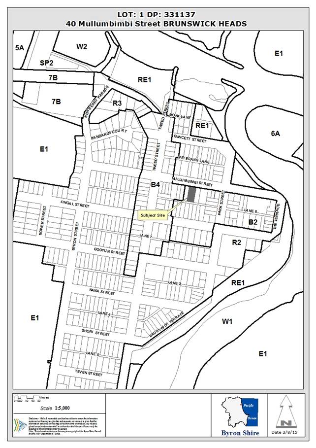
Report
Assessment:
1. INTRODUCTION
1.1 History/Background
BA 63/69 to convert the existing dwelling into three flats
10.2000.180.1 Tree Removal
Approved 18/04/2000
10.2008.719.1 Change
of use - residential flats to a tourist facility and construction of a new 2
storey caretakers residence - Approved 05/05/2009
10.2012.96.1 Tree
Removal – 3 trees - Approved 17/04/2012
1.2 Description
of the site
The subject property is zoned B2 – Local Centre
pursuant to Byron LEP 2014 and has an area of 1179 m2. The property
is within close walking distance to shops, restaurants, bars, amenities and the
beach.
The property contains a two storey weatherboard building
which has been divided into residential flats. It is believed the
building known as the Barnes House was constructed prior to the start of the 20th
Century with timber sourced from various landholdings held by pastoralist Henry
Barnes in the Casino region. “Verbal records” indicate that the
area under the building may have been used as an interim school room on the
closure of the school in 1896 and the reopening of a new school in 1898 in
Brunswick Heads. The property is identified under the BLEP 2014 as a Heritage
Item (Schedule 5).
Consent was granted in 1969 under BA 63/69 to convert the
dwelling into three flats.
The front setback contains vegetation including a stately
Poinciana tree that is considered to be a component of the heritage streetscape
character.
The land is generally level with the yard landscaped with
lawn and garden trees and shrubs. An old garage has been constructed at the
rear of the property which is accessible from Lane No. 3. The land is elevated
with a level in excess of 4.25 m AHD.
1.3 Description
of the proposed development
The proposal seeks consent to undertake alteration and
additions to the existing heritage building (‘Pearl’), mostly to
the internal floor layout and to raise the building, by approximately 0.9m to
allow the downstairs living areas to comply with Building Code of Australia
specifications.
The external works proposed are almost identical to those
approved via DA 10.2008.719.1, however this application proposes to change the
internal layout of the three existing flats so that the building will contain
four serviced apartments (Units 1, 2, 3 & 4), and a Manager’s unit.
The Manager’s unit will be at ground level along with Unit 4 which will
provide adaptable housing. One car parking space is provided for the Manager
and this can also be used as a disabled access space should it be required.
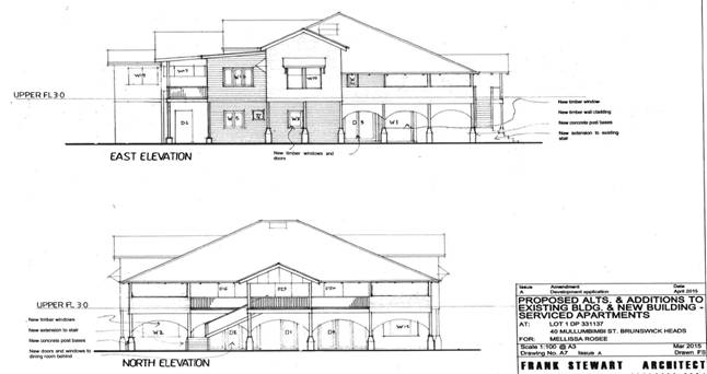
Proposed external works to ‘Barnes House’ almost
identical to previous approval.
Existing approval for raising and alterations to
‘Barnes House’
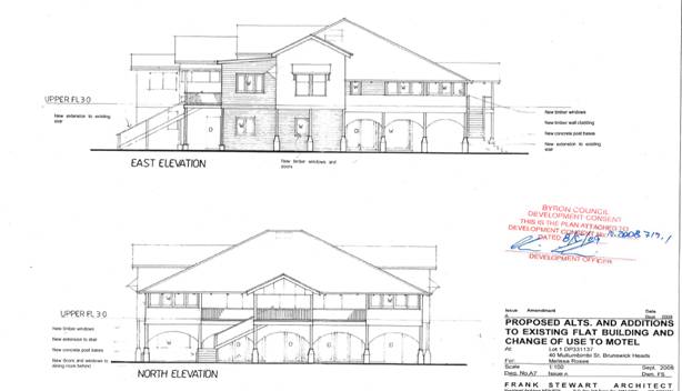
Also proposed is a separate three storey building
(‘Oyster’), at the rear of the site which, under consent
10.2008.719.1, contained a separate double storey Manager’s Residence.
The proposed building will contain an additional four
serviced apartments, a swimming pool and open deck area and underfloor &
external car parking for eleven cars. The existing garage/ shed located on the
rear boundary with Mullumbimbi Lane is to be demolished as previously consented
to in 10.2008.719.1.
The proposed new building comprises:
Ground
floor
· car parking for 9
guests and 2 visitors (including 1 x disabled access and 1 x multi use).
· 1.8 metre high
rear fence of timber panels between masonry piers with 1.15 metre high rear
gates between car parking area and Mullumbimbi Lane
· Deck with disabled
access and swimming pool with landscape gardens and masonry and planted privacy
screens to neighbours private open spaces.
First
Floor
· Units 5, 6 & 7
each containing one bedroom with ensuite bathroom, and a kitchen area within a
living area with north facing balcony,
First
floor
· Unit 8 two
bedrooms with ensuite bathrooms, a sitting room separated from the living room
by a kitchen and western and northern balconies.
The proposal is consistent with Council’s planning
controls for the zone and guidelines for Brunswick Heads, whilst providing a
means for the embellishment and protection of the existing heritage building
known as “Barnes House” on the site. The proposal will
generally maintain the visual appearance of the existing building whilst its
use as a place to provide tourist accommodation is consistent with the village
character of Brunswick Heads as a seaside destination for tourists.
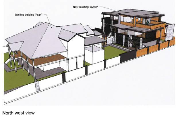
Proposed seven serviced apartment development
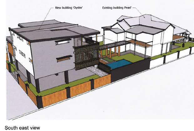
Proposed seven serviced apartment development
2. SUMMARY
OF GOVERNMENT/EXTERNAL REFERRALS
|
|
Summary of Issues
|
|
Development Engineer
|
Supported conditionally (see detailed comments below)
|
|
Environmental Health Officer
|
Not required
|
|
Water & Waste Services
|
Supported conditionally
|
|
Systems Engineer
|
ETs apply supported conditionally
|
Car Parking Satisfactory (07/7/15) Unsatisfactory(20/5/15)
20/5/2015.
The Application is for 9
Serviced Apartments, (2 x 2B/R, 7 x 1 B/R) plus 1 Manager’s Residence. (a
total of 12 bedrooms).
Council’s
DCP 2014, Chapter B4, states that ‘Serviced Apartments’ is to refer
to ‘Medium Density Housing’ for on site car parking rates. Such a
development requires 10 car spaces plus 3 visitor spaces. The DCP also states
that, for this type of development, stacked parking is not appropriate.
The
application proposes only 10 car spaces in total, 2 of which are stacked. There
are no visitor spaces being provided, claiming that it is a tourist development
and does not comprise permanent dwellings and thus requests a relaxation of the
provision of visitor car parking.
The parking
rate required is 1 space per 1 or 2B/R units plus 1 space per 4 units for
visitors. The current proposal requires 13 car spaces and only 10 are proposed.
No stacked car parking is allowed, but this proposal requires 2 stacked spaces.
The car
parking distribution and layout, as presented, does NOT comply with the current
DCP 2014.
NOTE:
An
alternative layout of the development could provide the site with the car
parking required per the DCP. A development comprising 1 Manager’s Unit,
4 x 2 B/R units, and, 3 x 1 B/R units would require 8 car spaces plus 2 visitor
spaces. This equates to 10 car spaces, no requirement for stacked car parking
and retains the capacity of 12 bedrooms.
07/7/2015.
Subsequent to meeting with the
Applicant on 15/6/15, the following parking arrangements are agreed to.
The number of units was
reduced by one.
The car spaces in the front
yard could either be used by the Manager or for Disabled.
As the Manager is on site at all times, especially to
book people in, the disabled space was decided to be placed in the rear
adjacent to the disabled unit. The space is larger than a standard one and also
has shared use bay adjacent which could also be used as one of the 3 visitor
spaces. It was also presented, that the visitor spaces get limited use in
tourist developments and villages. It was considered that in this case that the
shared use could be functional, particularly as there is a resident manager on
the site to organise/assist in the parking arrangements for the disabled and
visitors and the overall efficient functioning of the parking arrangements on
the site. The proposal now provides 8 car spaces plus 2 visitor spaces. This
equates to 10 car spaces plus one for the manager.
The consent can be conditioned
to address these issues.
Traffic/Roadworks
Satisfactory Unsatisfactory Not applicable
The existing development,
comprising of 1 x 3B/R unit, 1 x 2b/r unit, and, 1 x 1 B/R unit would generate
17 vehicles/day along the rear Lane.
The proposed development,
comprising of 3 x 2B/R units, and, 5 x 1B/R units would generate 40
vehicles/day along the rear Lane. The Manager’s unit would generate 5
vehicles/day accessing onto the front street.
The proposed development
doubles the traffic generation from the site onto the rear Lane. The additional
23 vehicle trips per day can be catered for along the Lane. The alignment is
straight with good sight distance. The formation is flat with bitumen seal and
grassed verges, being satisfactory to facilitate 2 vehicles to pass each other.
The Lane exhibits a relatively low speed, shared use environment.
Notwithstanding this, there is
concern expressed (submissions on the DA) regarding the perceived speed and
volume of vehicles using the Lane, in particular using the Lane as a through
‘short cut’ route. (This occurs irrespective of this development occurring).
This has been discussed (now
and previously) with Council’s Traffic Engineer. This matter and proposed
development will be an Agenda Item for the next Local Traffic Committee meeting
(24 June 2015, which in part, one way traffic flows will be considered.
The development was not
rejected by the committee, although that not being the charter of the
committee.
Irrespective of the above, it
is prudent and consistent to provide a two way bitumen seal pavement in the
Lane for the ‘frontage’ of the site and east through to join up
with the existing two way pavement at the Park Street end of the Lane. The
profile and formation of the Lane should be comparable to the existing two way
section of the Lane.
The consent can be conditioned accordingly.
The Application also seeks
concurrent approval for roadworks (a new driveway in Mullumbimbi Street. A
new concrete driveway and layback is required from the existing kerb line
through to the property boundary. The driveway from the gutter line to the edge
of road pavement seal is to be bitumen sealed. Approval for this driveway
can be granted with this consent and the consent can be conditioned
accordingly.
Heritage Officer
This application was not referred to a Heritage Advisor as
the works proposed to ‘Barnes House’ are almost identical to those
approved by 10.2008.719.1. That development Application was forwarded to
Council’s consultant Heritage Advisor for comment who advised that the
proposed development would have minimal impact on the heritage and urban values
of the building and the proposed changes respect the heritage values of the
building and would provide a viable use into the future. Recommendations were
made which were added as conditions of consent in relation to the following:
- Details of demolition works including demolition plans
- Photographic recording prior to the commencement of works
- Photographic recording of the works in progress
- Lodgement with the Brunswick Valley Historical Society of copies of
the demolition plans and photographic recordings
- Regular inspections by the Heritage Adviser during the works and
prior to handover
Those recommendations, in addition to the two points below,
will be included as consent conditions should consent be granted to this
application.
- Reuse and labeling of important features such as the under floor
timber stumps, particularly one with the words ‘Gins Only’ written
on it.
- Details of two ‘Open Days’ per year where Barnes House
and the historic item display will be open to the public.
The construction of the 4 unit building in the rear of the
yard will not detract from the heritage character of the streetscape of
Mullumbimbi Street.
3. SECTION
79C – MATTERS FOR CONSIDERATION – DISCUSSION OF ISSUES
Having regard for the matters for consideration detailed in
Section 79C(1) of the Environmental Planning & Assessment Act 1979, the
following is a summary of the evaluation of the issues.
State/Regional Planning
Policies and instruments - Issues
3.1. STATE/REGIONAL
PLANNING POLICIES AND INSTRUMENTS
|
Requirement
|
Requirement
|
Proposed
|
Complies
|
|
SEPP 55 – Contaminated Lands
|
Council must:
(a) considered whether the land is
contaminated, and
(b) if the land is contaminated,
if the land is suitable in its contaminated state or after remediation, and
(c) be satisfied the land will be
remediated before the land is used.
|
The property has been used for residential purposes for
more than 100 years. It is considered the property is suitable for
residential use.
Conditions of consent recommended in relation to
demolition concerning asbestos and lead paint
|
Yes
|
|
SEPP No. 71 - Coastal Protection
|
Matters for consideration for development within the
coastal zone:
- retention of existing
public access to the coastal foreshore
- impact of effluent
disposal on water quality
- development must
not discharge untreated stormwater into a coastal water body
|
- No public access to the
coastal foreshore will be impeded or diminished as part of the proposal
- The proposed manager’s
residence is to be connected to an on-site disposal system which has been
assessed as satisfactory in term of impact upon the environment.
- Stormwater is to be
disposed to Council’s Stormwater System
- No overshadowing
of the foreshore reserve or the beach is proposed
- The development is
landward of the defined erosion zones
- The development is
within the existing urban area of Brunswick Heads and is unlikely to
adversely impact upon the scenic or visual amenity of the coastline.
|
Yes
|
|
SEPP BASIX
|
Certificate required for manager’s residence/unit
|
Certificate No 622567S, dated 8 April 2015
|
Yes
|
|
NSW Coastal Policy 1997
|
Protection of coastal access,
environment and amenity
|
The proposal raises no issues in terms of the Coastal
Policy.
|
Yes
|
|
Building Code of Australia
|
Buildings to comply with the BCA
|
All building work to comply with the BCA. Appropriate
condition of consent recommended
|
Yes
|
|
Demolition
|
Demolition to be carried out in accordance AS2601
|
All demolition work to comply with the AS2601. Appropriate
condition of consent recommended
|
Yes
|
|
Disability Access (DDA)
|
Access for persons with
disabilities and integration into surrounding streetscapes without creating
barriers. (Council Res.10-1118)
|
Disability access proposed.
|
Yes
|
*
Non-complying issues discussed below
3.2. BYRON
LOCAL ENVIRONMENTAL PLAN 2014
Zone: Zone No. B2 Local Centre
Definition: Serviced apartments
|
LEP Requirement
|
Summary of Requirement
|
Proposed
|
Complies
|
|
Meets zone objectives B2 – Local Centre
|
•
To provide a range of retail, business, entertainment and community uses that
serve the needs of people who live in, work in and visit the local area.
• To
encourage employment opportunities in accessible locations.
• To
maximise public transport patronage and encourage walking and cycling.
• To
encourage vibrant centres by allowing residential and tourist and visitor
accommodation above commercial premises.
|
Serviced apartments will allow tourist accommodation
within walking/cycling distance of town centre, beaches and boat harbour
foreshore.
Tourist accommodation will provide additional income
within the town through visitor spending and tourist industry services.
|
Yes
|
|
Permissible use
|
Note. Serviced apartments are a type of tourist
and visitor accommodation
Serviced apartment means:
a building (or part of a building) providing self-contained accommodation to
tourists or visitors on a commercial basis and that is regularly serviced or
cleaned by the owner or manager of the building or part of the building or
the owner’s or manager’s agents.
|
Serviced apartments with owner/ manager to live on
site
|
Yes
|
|
3.1 Exempt & Complying development
|
3) To be exempt development, the development:
(d) must not be carried out on
land that comprises, or on which there is, an item that is listed on the
State Heritage Register under the Heritage Act 1977 or that is subject to an interim heritage order under the Heritage Act 1977.
|
The application includes signage for which detail has
not been provided. Subsequently the signage is not approved should the
application be approved.
As signage can not be exempt a consent condition is
to be included stating that any signage requires consent.
|
Yes
|
|
4.3 Height of Buildings
|
The height of a building on any land is not to exceed the
maximum height shown for the land on the Height of Buildings Map = 9.0m
|
Maximum height = 9.0m
|
Yes
|
|
4.4 Floor space ratio
|
The maximum floor space ratio for a building on any land
is not to exceed the floor space ratio shown for the land on the Floor Space Ratio Map = 0.75:1
|
Proposed floor space ratio is 0.749:1
Total Gross Floor area = 884m2
Site Area = 1179m2
|
Yes
|
|
5.6: Architectural roof features
|
Check: Does the roof comply with the height limits
of Clause 4.3
|
Maximum roof height 9.0m
|
Yes
|
|
5.9: Preservation of trees or vegetation
|
Must not remove or otherwise injure any vegetation
prescribed by Chapter 2 of BDCP2014, without development consent.
|
Consent sought for removal of 8 trees of which 5 are
prescribed natives, 3 x tuckeroos & 1 x eucalypt, the eucalypt being an
unsuitable species for the location and a grevillea.
A compensatory planting is proposed and will be
conditioned via a Landscape Plan to be submitted prior to CC..
|
Yes
|
|
5.10: Heritage conservation
|
Check: Is it a:
· Heritage
item = Yes
· Aboriginal
object = No
· Building in a
heritage conservation area. = No
|
The existing dwelling is a heritage item ‘Barnes
House’
|
Yes
|
|
|
2(a) - Consent is required to:
(i) Alter
the exterior of a heritage item
(b) making structural changes
to the interior of a heritage item.
(e) Erecting a building on land
on which a heritage item is located.
|
Consent sought
|
Yes
|
|
|
5 Heritage Assessment
Before granting consent to land on which a heritage item
is located a Council may request a heritage assessment.
|
‘Statement of Heritage Significance and Conservation
Policy’ & ‘Statement of Heritage Impact’ provided.
|
Yes
|
|
|
6 Heritage conservation management plans
After considering the heritage significance Council may
require the submission of a heritage management plan.
|
‘Statement of Heritage Significance and Conservation
Policy’ & ‘Statement of Heritage Impact’ provided are
considered to adequately address heritage issues.
|
Yes
|
|
|
10 Conservation Incentives
The consent authority may grant
consent to development for any purpose of a building that is a heritage item
or of the land on which such a building is erected, even though development
for that purpose would otherwise not be allowed by this Plan, if the consent
authority is satisfied that:
(a) the
conservation of the heritage item is facilitated by the granting of consent,
and
(b) the
proposed development is in accordance with a heritage management document
that has been approved by the consent authority, and
(c) the
consent to the proposed development would require that all necessary
conservation work identified in the heritage management document is carried
out, and
(d) the
proposed development would not adversely affect the heritage significance of
the heritage item, including its setting, and
(e) the
proposed development would not have any significant adverse effect on the
amenity of the surrounding area.
|
a) change of use from residential flats to tourist
accommodation will enable a wider population to be informed of the history of
‘Barnes House’ from staying within the heritage item and viewing
a proposed display of historical items.
b).The ‘Statement of Heritage Significance and
Conservation Policy’ & ‘Statement of Heritage Impact’
are to be stamped as part of the consent.
c).The ‘Statement of Heritage Significance and
Conservation Policy’ & ‘Statement of Heritage Impact’
are to be stamped as part of the consent.
d).It is considered that the proposed alterations will not
adversely affect the heritage significance but will ensure management and
protection of the heritage item.
e). It is unlikely that the alterations to ‘Barnes
House’ will result in any significant adverse effects on the amenity of
the surrounding area, neither adjoining dwelling is a heritage item.
|
Yes
|
|
6.1: Acid sulphate soils
|
Class 4 PASS
Works > 2.0m below ground level may impact ASS
|
No excavation > 1.5m below ground level proposed.
|
Yes
|
|
6.2: Earthworks
|
Check: Matters under Clause 6.2(3)
Maximum earthworks = 2.0m
|
No earthworks >1.5m proposed (swimming pool).
|
Yes
|
|
6.6: Essential Services
|
Check: See B3 & B4 DCP
· water,
· sewer,
· electricity
· stormwater
· vehicle access
|
Site is fully serviced
|
Yes
|
* Non-complying issues
discussed below
Byron Local Environmental Plan
2014- Issues
No issues
Draft EPI that is or has been
placed on public exhibition and details of which have been notified to the
consent authority - Issues
Nil
3.3 DEVELOPMENT
CONTROL PLANS
Development Control Plan 2014
|
Byron
Development Control Plan 2014
|
|
Control
|
Assessment
|
Compliance
|
|
Chapter B10 - Signage
|
|
B10.1.3
|
The Statement of Heritage Significance & Conservation
Policy states that “there will be new timber signs approx. 0.5m2 identifying
the establishment at the front & rear. However as no detail has been
provided and as signage is not exempt within a heritage item site, should
consent be granted a consent condition is to be included stating signage
requires separate development consent.
|
Yes
|
|
Chapter B11 Planning for Crime Prevention
|
|
B11.2.1
Development that Requires a Formal Crime Risk Assessment
1. Council will expect a formal Crime
Risk Assessment for the following types of development:
new
or refurbished shopping centres or transport interchanges; or
residential
developments or subdivisions comprising more than 20 dwellings or 20 lots;
any
subdivision that creates pedestrian egress from the end of a cul-de-sac to
another public road, public reserve or the like; or
car
parks with more than 20 spaces; or
any commercial
premises involving the construction or alteration of basement car parking; or
development
or redevelopment of a mall or other public place;
health
services facilities, nightclubs, pubs, registered
clubs, restricted premises, sex services premises, small bars; and
other developments that, in the Council’s opinion,
is likely to create a risk of crime.
|
The proposed tourist accommodation with live in on-site
manager is not considered to be a development that is likely to create a risk
of crime.
|
Yes
|
|
Chapter D3 – Tourist Accommodation
|
|
D3.2.1
Location and Siting
The
siting, design and operation of tourist accommodation and associated
development must not conflict with important ecological characteristics of
the site or the Shire, and respects the natural systems and values of its
location and surrounds.
|
The existing and proposed
development is located within a B2 - Local Centre Zone and is therefore
unlikely to adversely impact important ecological characteristics of the site
or the Shire.
|
Yes
|
|
D3.2.4 Character &
Design in Business and Mixed Use Zones
Tourist
accommodation in Zone B2 must be compatible in character and amenity with
development in the locality. The provisions of the following Sections in
Chapter D4 Commercial and Retail Development apply to all tourist
accommodation development in Zone B2 in the same way they apply to commercial
and retail development in Business and Mixed Use zones:
a)Section
D4.2.1 – Design Character of Retail and Business Areas.
b)Section
D4.2.2 – Design Detail and Appearance.
|
See detailed discussion below.
|
Yes
|
D4.2.1
– Design Character of Retail and Business Areas.
To promote pedestrian and cycle usage, together with
reduced vehicle dependency in the Shire’s business, commercial and retail
areas.
To encourage safety, accessibility and human scale in the
Shire’s business, commercial and retail areas.
To encourage diverse, multi-functional business, commercial
and retail centres that provide a compatible range of commercial, recreational
and community activities appropriate to the Shire’s climate, environment,
social fabric and scenic character.
To ensure that development reinforces the role of centres
within the Shire’s commercial centres hierarchy.
To ensure
that establishment and operation of new development contributes to and does not
detract from the social and economic robustness, diversity and vitality of
retail, business and community areas and precincts.
The existing development on the site comprises a building
approved as three residential units. The proposed development involves a change
of use to serviced apartments to cater for visitors to the coastal village of
Brunswick Heads. The proposal will increase the accommodation within the
existing building from six bedrooms (within three apartments), to seven
bedrooms within five apartments including an owner/ manager’s unit. The
proposed detached dwelling at the rear will add a further three serviced
apartments (3 x 1 bed & 1 x 2 bed).
The proximity of the development to the businesses of the
town centre, the beach and Brunswick River foreshores enables easy pedestrian
and cycle access which will encourage visitors to leave their vehicles parked
at the development.
The scale of the development is
appropriate to the heritage character of the existing building and the
surrounding neighbourhood. The owner/operator has collected historical items,
and information associated with the original property owners, and is proposing
to create a historical display within the common areas for guests, a condition
will ensure this. It is also proposed, & conditioned, to hold two public
‘Open Days’ for people to observe ‘Barnes House’ and
the historical artefacts displayed within.
Previously Byron Shire
Council’s Heritage consultant confirmed that
the historical and cultural memory of
"Barnes house" was a key contributing factor in its listing as a
heritage item (10.2008.719.1). The opening up to guests of the heritage listed
"Barnes house" and presentation of these items will contribute to
visitors developing an understanding of part of the cultural history of Byron
Shire.
A screened waste bin storage
area for 6 x 240L bins is to be provided, out of public view, at the rear of
‘Barnes House’.
D4.2.2 – Design Detail and Appearance.
Objectives
1. To ensure that development is
compatible with the design and amenity of development in the locality.
Performance
Criteria
1. The design of new
buildings must reflect and enhance the existing character of the precinct. The
design, scale, bulk, design and operation of business, commercial and retail
development must be compatible with the streetscape and with the aesthetics,
function and amenity of development in the locality.
2. Building design, roof
profile, detailing, colours, materials and the like that are visible from the
street and from adjoining properties must be compatible with any dominant
design themes in the surrounding locality.
3. The pattern of windows
in retail areas must provide visual interest and variation and must relate to
those of adjacent buildings. Building materials must relate to the context of
buildings within the area to achieve continuity and harmony. Contrasting
materials may be used to provide diversity, however materials and colour must
not be used so that they dominate the streetscape.
The proposed development is not
directly in the retail area of Brunswick Heads. The streetscape of the front of
the property is part of the heritage character of the heritage item and
provides visual interest. The existing shade trees within the Mullumbimbi
Street setback which are to remain also form part of the local character
streetscape appeal of ‘Barnes House’.
The adjoining development to the
south comprises a 5 unit residential flat building with ground floor shops with
zero setback facing Mullumbimbi Street.
Existing development along
Mullumbimbi Street & within the B2 zone comprises mixed use shop top
housing & residential units. There is a single storey dwelling adjoining to
the west. The proposed conversion of Barnes House is within character of the
locale.
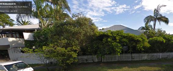
‘Barnes House’ 40
Mullumbimbi Street (trees in front setback to be retained).
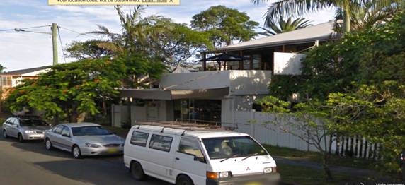
38
Mullumbimbi Street (shop top housing five apartments) (east)

34
(shop-top housing), 32 (residential flats) & 30 (Raised dwelling),
Mullumbimbi St (east)
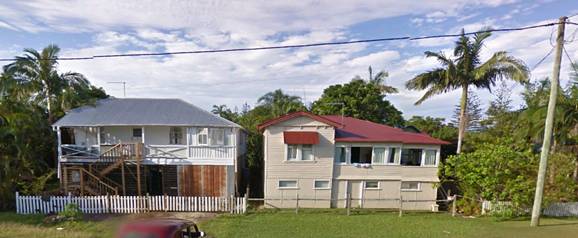
6
& 7 Mullumbimbi St (opposite 40)
Single
storey dwelling 42 Mullumbimbi St (west)
The proposed use as tourist
accommodation is compatible with the town centre location. The proposed
development is considered a low rise, low key development to be managed by the
owners living on the property and catering to the needs of the guests. The
development is close by the town, beach and river at Brunswick Heads which are
popular local attractions for visitors. The scale of the development is appropriate
to the heritage character of the existing building and the surrounding
neighbourhood and reflects the low-scale, tourist coastal village image of
Brunswick Heads.
The proposed building (Oyster)
has been designed in contrast to the existing heritage building (Pearl). The
building has contemporary lines and forms to avoid mimicking the character of
the existing heritage building. The colours are generally black, white and
tones of grey. The building utilises natural stone cladding and natural timber
screen elements and hard landscaping as design features.
The SEE claims “these
elements, and the deliberate contrast in building forms between the existing
and new buildings, express the conceptual theme of the Pearl and Oyster, which
is a reference to the Oyster industry of Brunswick Heads. This is intended to
be seen as a harmony of opposites and the relationship between Brunswick Heads
industrial history and the present day focus on tourism"
D 3.3.7 Serviced Apartments
Objectives
1. To ensure that serviced apartment
development is compatible with the character and amenity of development in the
locality.
2. To ensure that establishment of
serviced apartment development does not adversely affect the social and
economic robustness, diversity and vitality of retail, business and community
areas and precincts.
Performance Criteria
1. The design and operation of serviced
apartments must be compatible with the streetscape and character of development
in the locality.
2. Development applications must
demonstrate that the proposed development is designed and landscaped consistent
with the requirements of Chapters B11 Planning for Crime Prevention and B9
Landscaping.
3. Serviced apartments must not adversely affect the amenity of
the precinct in which it is located.
4. Serviced apartments must comply with the requirements of
Chapter D1 Residential Development in Urban and Special Purpose Zones, Section
D1.6.
As detailed in D4.2.1 &
D4.2.2 the proposed serviced apartments, tourist accommodation is compatible
with the town centre location.
The proposed development is a
low rise, low key development, to be managed by the owner’s family living
on the property and thereby catering to the needs of the guests and ensuring
the preservation of amenity to neighbours.
The development is close by the
town, beach and river at Brunswick Heads which are popular local attractions
for visitors. The scale of the development is appropriate to the heritage
character of the existing building and the surrounding neighbourhood and
reflects the low-scale, tourist-beach image of Brunswick Heads.
The proposed serviced apartment
development is compatible with the character and amenity of existing
development in the locality. The area around the existing and proposed
buildings is vegetated and is not visually prominent.
The proposed new building
complies with all other BLEP2014 and BDCP2014 requirements, including density,
height, setback, car parking, landscaping and open space requirements, and will
be compatible with the existing and planned scenic quality and character of the
locality.
The proposed development will
have social and economic benefits for the village of Brunswick Heads. The
development is located within an area identified as suitable for tourism and
will help provide for a growing economy in this area. The construction of the
building and associated works will provide employment within the construction
and allied industries.
The proposed serviced apartment
development will add to the existing social & economic robustness and the
diversity and vitality of retail, business and community areas and precincts.
|
Byron
Development Control Plan 2014
|
|
Control
|
Assessment
|
Compliance
|
|
D1.6 – Multi Dwelling Housing,
Residential Flat Buildings & Attached Dwellings
|
|
D1.6.1 - Private Open Space Courtyards
|
The proposed development is
for tourism i.e. short stay accommodation and not for permanent residents.
Notwithstanding each unit has a private open space balcony or access to a landscaped
private outdoor area.
|
Yes
|
|
D1.6.2 – Open Space Balcony
|
All above ground units have
direct access to a private open space balcony with an area of 15m2
and at minimum length & width of 2.4m.
All units are oriented
towards the north except for 3 & 4, which have a south-west orientation.
|
Yes
|
|
D1.6.3 - Landscaping
|
Landscaping has been
conditioned to be in accordance with BDCP2014.
|
Yes
|
|
|
|
|
E4.1.2 Aims of this Chapter
The primary purpose of this Chapter of the DCP is to
provide relevant criteria and standards for the future development of the Brunswick
Heads Urban Area. The aims of this Chapter are:
1. To facilitate and provide
guidelines for the development of the Brunswick Heads Urban Area consistent
with the provisions of the Byron LEP 2014, the Brunswick Heads Settlement
Strategy 2004 and other relevant strategies and Chapters of this DCP.
2. To maintain and enhance the
appearance and atmosphere of Brunswick Heads as a low-key, family-friendly
coastal village.
3. To encourage new development to
complement, support and strengthen the character, living amenity and tourist
potential of the town and to maintain and enhance pedestrian and cycle access.
4. To foster and reinforce the
restoration and protection of the riverside environment of Brunswick Heads.
5. To continue to implement
environmentally sustainable development principles in the town’s business
area; and to further enhance its role as a dynamic local business sector
offering a range of employment opportunities.
6. To reinforce the town’s
historical linkages and to protect identified heritage items.
The proposal is generally consistent
with the aims of Chapter E.
It is considered that the proposed alterations will not
adversely affect the heritage significance but will ensure management and
protection of the heritage item. It is unlikely that the alterations to
‘Barnes House’ will result in any significant adverse effects on
the amenity of the surrounding area neither adjoining dwelling is a heritage
item. Notwithstanding the proposed stone and timber front fence and gatehouse
have not been sufficiently addressed and those two components are not supported
by this report. Subsequently the proposed front fence and gatehouse will be
crossed out in red on the plans should the application be approved.
E4.2.1 Brunswick Heads -
Character. Bulk and Scale of Development
Performance Criteria
The existing and desired future
character of Brunswick Heads is defined by the following characteristics:
Business and Mixed Use Areas
Land zoned
B2 provides a safe, low traffic speed, pedestrian/cycle friendly environment
that encourages outdoor dining and community activity in the street.
Development
in this area uses setbacks, planting and design elements to contribute
positively to village amenity and create a pedestrian/cycle friendly
streetscape.
New
commercial and retail development is consistent with the requirements of
Chapter D4 Commercial and Retail Development. Development is designed to
enhance the low key, family-friendly, coastal village character, streetscape
and scale of Brunswick Heads.
New
development respects the north coast climatic conditions and adopts sustainable
design principles. lt incorporates footpath awnings and sun and rain protection
for pedestrians. Landscaping is provided in accordance with the requirements of
Chapter B9 Landscaping. Development respects heritage items.
The proposed development has an
outdoor dining area for guests and is compatible with a safe, low traffic
speed, pedestrian/cycle friendly environment.
The existing building on
Mullumbimbi St. (Pearl) has an existing set back approx. 7 metres from the
front boundary and incorporates existing established landscaping. The design
elements of the heritage listed building such as pitched roof, sub floor
screen, timber posts, wide verandahs, domestic scale, timber stair &
balustrade detail are to be retained, as they forms part of the heritage
character of the building.
The rear laneway is
predominantly a service road and provides access for car parking and services.
This frontage will have a 1.8m high timber and masonry fence and 1.15 metre
high gate to comply with safe sightlines for pedestrians & traffic using
the lane, and landscaping to reduce the apparent scale of the building on this
frontage.
The design elements of the
heritage listed building combined with the complimentary new rear yard building
will contribute to the low key, family-friendly, coastal village character,
streetscape and scale of Brunswick Heads.
Development Control Plan 2014
- Issues
No issues
3.4 The likely impacts of that
development, including environmental impacts on both the natural and built
environments, and social and economic impacts in the locality
Site Waste Minimisation and Management: Standard
condition applies
|
Impact on:
|
Likely significant impact/s?
|
|
Natural environment
|
No significant impacts.
|
|
Built environment
|
The proposed development is in keeping with the objectives
of the B2 Local Centre zone, and is compliant with the planned maximum site
density ratio of (0.75:1) while maintaining the heritage values and character
of ‘Barnes House’. The heritage character of the streetscape is
maintained by new building being sited, with maximum separation, in the rear
yard and accessed via the rear lane. The proposed development is not
out of character with the area which is dominated with two storey buildings,
holiday flats up to 9.0 metres in height, and large and/or elevated dwelling
houses.
|
|
Social Environment
|
The development caters directly to the high demand for
tourist accommodation in the locality. The proposed units within the
refurbished ‘Barnes House’ will include an accessible unit and
historical display to add to guest’s awareness of the history of the
heritage dwelling and Brunswick Heads coastal village. The new 3 unit
building will have a high level of amenity and the location is within easy
walking and cycling distance to the town centre, river & beaches.
|
|
Economic impact
|
The construction will have short term benefits to the
local economy.
The tourist accommodation will have long term financial benefit
to the local economy and will ensure the maintenance of the heritage item.
|
3.5 The
suitability of the site for the development
The site is located within Zone B2 – Local Centre,
with high connectivity to local services and amenities. All planning and
environmental constraints affecting the site are considered to have been
satisfactorily addressed by the application and/or the conditions of consent
recommended at the end of this report. The subject property is not
affected by flooding, bushfire or geotechnical constraints, and the application
is supported on Engineering grounds (#A2015/10764).
The site is suitable for the proposed development.
3.6 Submissions
made in accordance with this Act or the regulations
There were eleven submissions made against the development
application and one in support.
It is noted that another two of the submissions generally
supported the application but with some reservations.
|
Issue
|
Comment
|
|
The proposal is an overdevelopment of the site.
|
The proposal complies with the maximum 0.75:1 Site Density
Ratio for the B2 zone & maximum height restriction.
|
|
Doesn’t comply with car parking requirements
|
The number of Units has been reduced (Unit 9 deleted) car
parking now complies.
|
|
We weren’t consulted prior to lodgement.
|
Not required but Noted.
|
|
Traffic issues in the laneway not addressed.
|
Council has considered the number of additional traffic
movements in the lane and have applied consent conditions for an upgrade to
the lane. Local Traffic committee is also looking into the potential for
making the lane one way.
|
|
Garbage bins should be relocated.
|
The bins have been relocated to behind building
‘Pearl’.
|
|
Height should be reduced to 7.5 metres.
|
The height limit for the site and surrounding land is
9.0m. The residential flat building adjacent to the east is 9.0m high.
|
|
We object to the length and height of the masonry fence
next to the swimming pool, & the swimming pool location right next to our
western boundary and the impact on our amenity.
|
The applicant met with adjoining owners and the height of
the masonry wall, which is to screen the pool and to protect the amenity of
neighbours, has been reduced 0.5m from 2.8m to 2.3m and the length reduced
from by 1.4m from 10.5m to 9.1m.
The pool is separated from the masonry wall on the side
boundary by a 1.7m wide disabled access ramp.
The swimming pool deck has been lowered by more than 0.5m.
|
|
The application requests stacked parking which is not
consistent with the DCP
|
Stacked parking is limited to the on-site manager only if
& when the disabled parking is required in the Mullumbimbi Street
setback. Otherwise the disabled space is provided at the rear of the disabled
access unit.
|
|
There should be a laneway policy in Brunswick Heads to
protect the character of the rear lanes.
|
The character of rear lanes are regulated within
residential zones, the subject land is within a business zone where
development is allowed
|
|
Landscaping as proposed is inadequate
|
Landscaping has been conditioned to be in accordance with
BDCP2014.
|
|
The importance of the site’s main
house to Brunswick Heads’ heritage is acknowledged and also the need
for the owner to undertake improvements to the site so as to make their
investment in the property sustainable. We also support, in principle, the
property being used for serviced apartments.
|
Noted.
|
|
There is a mango tree on the fenceline
that is proposed to be removed. We were not consulted.
|
Removal for a mango tree does not form part of this
consent. However, fruit trees are exempt for removal under Byron LEP2014
& BDCP2014. Removal of a mango tree on the boundary is a matter between
the adjoining neighbours.
|
|
No Heritage Impact Statement.
|
A ‘Statement of Heritage Significance and
Conservation Policy’ & a ‘Statement of Heritage Impact’
were provided and are considered to adequately address heritage issues.
The proposed external works to ‘Barnes House’
are virtually identical to what was previously supported by Council’s
Heritage Advisor and subsequently approved by Council via DA 10.2008.719.1.
|
|
Is there going to be commercial signage
in the front?
|
Signage not approved as part of this consent, if granted.
A consent condition stating that is to be included in any consent.
|
|
The opening of the front fence for a
driveway will decrease the street parking by at least one space
|
‘Barnes House’ has street frontage to
Mullumbimbi Street and therefore has the right to vehicle access.
|
|
The state of the gutters footpaths and
verges in Mullumbimbi Street are hazardous and it is impossible to place the
waste bins for collection.
|
Roads Act Approval has been granted for a concrete
driveway and concrete layback from the property boundary through to the edge
of gutter. A bitumen sealed driveway from the edge of gutter/layback through
to the existing road pavement seal.
|
|
Noise impact on residences.
I am already impacted by the Brunswick
Heads Hotel.
|
The proposed development is for short term tourist
accommodation comprising 8 serviced apartments and a manager’s
residence.
There is no nexus between noise generated elsewhere and
the proposed development. A condition re noise generation is to be included
should consent be granted. On-site manager will have ability to ensure
neighbourhood noise amenity is maintained.
|
|
Impact on solar access from 3 storey
dwelling
|
The proposed development complies with maximum 9.0m height
controls.
|
|
Lifting of the dwelling and excavation
may effect the water table there are bores in the area.
|
Highly unlikely
|
|
The DA doesn’t mention any changes
to the power pole that we share in the road reserve.
|
Council is not the electricity provider however there
would not appear to be any reason for the pole, which is not on the subject
land to be impacted.
|
|
The maximum height in the area should be
7.5m not 9m, as stated in the Brunswick Heads Settlement Strategy
|
The BLEP2014 controls the maximum building heights across
the shire. The Height Map in the under BLEP2014. Allows 9.0m.
Note the adjoining commercial/residential development to
the east is 9.0m high.
|
|
The stone & timber front fence is not
in keeping with the picket fence and should not be supported.
|
While it is not clear that the existing front picket fence
was part of the Heritage item listing, it does however, form part of the
heritage character in the streetscape. No detail of the proposed fence other
than it is 1.35 metres high and made from stone and timber; the front fence
is not supported.
|
|
There are no shadow diagrams.
|
Development in the B2 – Local Centre zone is not
subject to the same Building Height Plane and setback controls that apply in
residential zones. The buildings comply with the height controls.
|
|
Any argument that tries to enforce a 7.5
metre height limit is nonsense as 9.0m is consistent with what the BHSS
wanted as voted in 2004.
|
Noted
|
|
It is also wrong to argue that the site
is an overdevelopment as the unit entitlement is permissible.
|
Noted
|
|
Any argument from adjoining and nearby
owners in the residential zone that special consideration should be given to
the southern side of Mullumbimbi Street is wrong as it has historically been
zoned for commercial and people chose to live there.
|
Noted
|
|
The applicant lives within the B2 zone
and is entitled to undertake the maximum development permissible to
ensure financial viability.
|
Noted
|
|
The laneway problems could be solved by
placing no parking signs and enforcing the parking requirements of commercial
buildings on the corner of Park St & Mullumbimbi Lane.
|
Noted
|
|
Exemption for stacked parking for the
manager’s site in the Mullumbimbi St frontage should be supported as
such ‘valet’ parking is not uncommon other tourist accommodation
developments.
|
Proposed and supported.
|
|
Compensatory planting of a tuckeroo
should be conditioned.
|
Landscaping with local rainforest species, including a 3 x
tuckeroo trees is to be conditioned.
|
|
The raising of the building should not
destroy the historical significance of the fact that aboriginal staff were
‘housed under the house and one of the stumps has ‘Gins
Only’ written on it and this should be preserved.
|
The owner has indicated that the stump mentioned, and
other useable stumps that need to be removed, will be featured in other areas
of the proposed development i.e. the walkway between the buildings and will
be labelled to highlight their heritage significance.
It should also be noted that the owner has indicated a
willingness to educate the interested public about the heritage of
‘Barnes House’ and Brunswick Heads via two ‘Open
Days’ per year. This can be conditioned.
|
|
The rear yards along Mullumbimbi Lane
have become home to water dragons and other reptiles.
|
The reptiles will still be able to inhabit the garden
areas which will no doubt be enjoyed by the guests.
|
|
The height of the buildings will increase
the concentration of fruit bats flying over my property.
|
It is not understood why this would be expected, fruit
bats are very capable flyers and can easily fly higher than 9.0m.
|
NOTE: The applicant provided Council with responses
to submissions, plus additional information regarding the proposed heritage
item display to be exhibited within Barnes House that will be open to the
public two open days. Attachment 3.
3.7 Public
interest
The development as proposed development is not contrary to
the public interest.
4. DEVELOPER
CONTRIBUTIONS
4.1 Water
& Sewer Levies
Referral Report #A2015/10770; Assessed
by Jason Stanley
Current Situation
Existing entitlements have been sourced from the DA
10.2008.719.1 ET assessment (#DM850667).
Using the current day ET Policy 13/005, the existing sewer,
water and bulk water entitlements are as follows:
Table 1 - Calculation of Existing Water & Sewer ETs
|
Ref
|
Development Type
|
Standard
Unit
|
Quantity
|
ET Rate (ET/unit)
|
ET Load
|
|
Water
|
Sewer
|
Water
|
Sewer
|
|
3.7
|
1 bedroom unit
(Unit 2)
|
Dwelling
|
1
|
0.40
|
0.50
|
0.40
|
0.50
|
|
3.8
|
2 bedroom unit
(Unit 3)
|
Dwelling
|
1
|
0.60
|
0.75
|
0.60
|
0.75
|
|
3.9
|
3 bedroom unit
(Unit 1)
|
Dwelling
|
1
|
0.80
|
1.00
|
0.80
|
1.00
|
|
TOTAL
|
1.80
|
2.25
|
Therefore, the existing ET entitlement for this property is:
· 1.80 ET for
Water & Bulk Water; and
· 2.25 ET for
Sewer.
Proposed Development
The application seeks development consent constructing 9
serviced apartments, managers unit and pool. The proposed development will
generate the following load:
Table 2 - Calculation of
Proposed Development Water & Sewer ETs
|
Ref
|
Development Type
|
Standard
Unit
|
Quantity
|
ET Rate (ET/unit)
|
ET Load
|
|
Water
|
Sewer
|
Water
|
Sewer
|
|
3.11
|
1 bedroom Managers Unit
|
Dwelling
|
1
|
0.40
|
0.50
|
0.40
|
0.50
|
|
6.6
|
Unit 1 & 2
2 bedroom serviced apartment
|
Dwelling
|
2
|
0.50
|
0.75
|
1.00
|
1.50
|
|
6.6
|
Unit 3, 4, 5, 6, 7, 8, 9
1 bedroom serviced apartment
|
Dwelling
|
7
|
0.33
|
0.50
|
2.31
|
3.50
|
|
11.7
|
Swimming Pool
Commercial premises
|
Assume 3m
(W) x 5.6m (L) x 1.5m (D)
Using #E2015/9848
|
0.42
|
0.31
|
|
TOTAL
|
4.13
|
5.81
|
Table 3 - Calculation of
Additional Water & Sewer ET Load
|
|
Water
|
Sewer
|
|
Existing ET Entitlements
(Table 1)
|
1.80
|
2.25
|
|
Proposed Development ET
loading (Table 2)
|
4.13
|
5.81
|
|
Additional ET loading
|
2.33
|
3.56
|
Therefore, this development generates an additional load
onto Councils Water, Bulk Water and Sewer System
Council requires Payment of Developer Servicing Charges
(prior to issue of a construction certificate) of:
· 2.33 ET for
Water & Bulk Water; and
· 3.56 ET for
Sewer.
4.2 Section
94 Contributions
Section 94A Levy to be paid
Prior to the issue of a construction certificate the section
94A levy required by the Byron Developer Contributions Plan2012 shall be paid
to Council.
The levy will be calculated as follows:
Levy payable = %C x $C
Where: %C is
the levy rate applicable as set out in the latest Ministerial Direction issued
under section 94E.
$C is the proposed cost of carrying out the
development.
The rate of %C is:
|
Proposed
cost of the development
|
Maximum
percentage of the levy
|
|
Up to
$100,000
|
Nil
|
|
$100,001–$200,000
|
0.5 percent
|
|
More than $200,000
|
1.0 percent
|
The cost of development shall be
shall be calculated in accordance with clause 25J of the regulation. The
Cost Summary Report (copy attached) as set out in schedule 2 of the Section 94A
contributions plan shall be submitted to Council with the with the
payment. Copies of Cost Summary Report are available at Council’s
main office or may be downloaded from http://www.byron.nsw.gov.au/
5. CONCLUSION
The proposal seeks consent to undertake alteration and
additions to the existing heritage building, known as “Barnes
House” which is currently divided into three residential flats and change
of use to tourist accommodation in the form of serviced apartments. The
proposed works are mostly to the internal floor layout and to raise the
building, by approximately 0.9m to allow the proposed downstairs living areas
to comply with Building Code of Australia specifications.
The external works proposed are similar to those approved
via DA 10.2008.719.1, however this application proposes to change the internal
layout of the three existing flats so that the building will contain four
serviced apartments and a Manager’s Unit. The Manager’s unit will
be at ground level along with Unit 4 which will provide adaptable housing. One
car parking space is provided for the on-site manager.
Also proposed is a separate three storey building at the
rear of the site, this differs from 10.2008.719.1 which granted consent to a
detached double storey Manager’s Residence in the same location.
The proposed building will contain an additional four serviced apartments, a
swimming pool and open deck area and underfloor & external car parking for
eleven cars.
The proposal is consistent with Council’s planning
controls and generally with the guidelines for Brunswick Heads, whilst
providing a means for the embellishment and protection of the existing heritage
building, “Barnes House” on the site. The proposal will
generally maintain the visual appearance of the existing building whilst its
use as a place to provide low key tourist accommodation is consistent with the
village character of Brunswick Heads as a seaside destination for tourists and
residents.
The additional freestanding building is at the rear of and
well separated from, ‘Barnes House’ and will not detract from its
visual appearance.
The proposal is consistent with the relevant state planning
instruments and with BLEP2014. The proposal is generally consistent with
BDCP2014 save for a variation to sections of side boundary fence that are 2.4
metres high to act as a privacy screen between the swimming pool and deck area
and the adjoining neighbour. The variation is supported by this report.
The proposed variation to the front fence height and the
change from a picket type fence to masonry and timber front fence with
gatehouse, is considered to detract from the heritage character and is not
supported. Subsequently the plans are to be marked in red to delete this part
of the proposal.
The application is supported subject to consent conditions.
6. RECOMMENDATION
That pursuant to Section
80 of the Environmental Planning & Assessment Act 1979, development
application 10.2015.196.1 for alterations
to a dwelling and a new residential flat building to be eight serviced
apartments and manager’s residence,
be granted consent subject to the conditions listed in Attachment 2
#E2015/49495.
7. DISCLOSURE
OF POLITICAL DONATIONS AND GIFTS
|
Has a Disclosure Statement been received in relation to
this application
|
No
|
|
Have staff received a ‘gift’ from anyone
involved in this application that needs to be disclosed. Where the answer is
yes, the application is to be determined by the Director or Manager of the
Planning, Development and Environment Division.
|
No
|
Provide Disclosure Statement register details here: Nil
Staff Reports - Sustainable Environment and Economy 13.12
Report No. 13.12 Park
and Ride / New Year's Eve Shuttle
Directorate: Sustainable
Environment and Economy
Report
Author: Claire
McGarry, Events and Grants Officer
File No: I2015/857
Theme: Economy
Economic Development
Summary:
In 2013, Council piloted a Park and Ride initiative over the
Christmas / New Year holiday period. In 2014, Council resolved to fund a three
year Park and Ride trial. Year 1 of the 3 year trial was undertaken with mixed
results and reported in March 2015.
As a result of further workshops on the matter and given the
absence of the critical success factors required for widespread uptake of a
Park and Ride service in the short term, Council requested a report outlining
the cost and logistical implications of replacing the Park and Ride service
with a New Year’s Eve shuttle.
This report outlines these costs and implications.
|
RECOMMENDATION:
1. That
for 2015, Council run a New Year’s Eve shuttle in place of the
Park and Ride service.
2. That
the original budget allocation (Res 14-293) for the Park and Ride initiative,
less the cost of the 2015 New Year’s Eve shuttle, be maintained for a
review in 2016 post the introduction of paid parking and implementation of
the Byron Bay Town Centre Masterplan.
|
Report
Background
In 2013, Council piloted a 12 day ‘Park and
Ride’ initiative in the Byron Bay town centre over the busy Christmas /
New Year period – unprecedented in regional NSW at that time. An
independent contractor supported by a large number of council staff was engaged
to run the pilot, and while feedback was positive, it highlighted that a
greater lead time was required for promotion, coordination and partnership
development. In its pilot year, Park and Ride was delivered for $114,077.
Following on from this pilot, Council resolved:

As such, in 2014/15 Council staff managed the first year of
the three year Park and Ride trial, working to a budget of $40,000. In order to
deliver the project with a significantly reduced budget, the service period was
reduced from 12 days to 7 days and a number of ancillary activities were
removed from programming. While the project was delivered to budget, usage
numbers did not increase and Council identified that a number of the critical
success factors for a Park and Ride service to fully succeed were not yet in
place in Byron Bay – namely:
· Cost benefit (e.g.
to avoid paid parking in town centre)
· Time saved (e.g.
an extended bus lane) or where you could see the bus overtaking cars
Based on the 2014/15 Park and Ride results, Council
resolved:
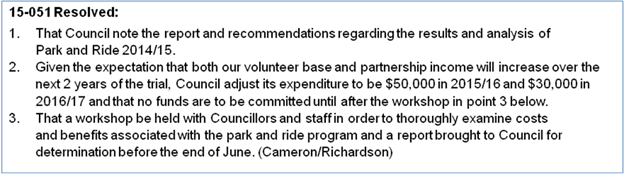
Councillors considered the future of Park and Ride at two
strategic planning workshops (16 April 2015 and 18 June 2015). The outcome of
the second workshop was a request from Councillors for a report outlining the
logistics and costs for a New Year’s Eve Shuttle in place of the broader
Park and Ride program.
The Magic Bus were approached to
partner with Council on a New Year’s Eve shuttle but declined, indicating
that:
a) They
were concerned about security during the proposed operational hours; and
b) Their brand was more
aligned with the ‘family friendly’ daytime Park and Ride service
Blanch’s Buslines
currently run a late night New Year’s Eve Shuttle between Sunrise, Byron
town centre and Suffolk Park. Blanch’s were approached with a proposed
partnership opportunity if they were able to extend their route to include the
Cavanbah and the Surf Club, but Blanch’s declined and recommended that
Council go ‘to the market’ to charter a bus for the project.
New Year’s Eve Shuttle
Proposal
On New Year’s Eve in Byron
Bay a family friendly event, Soul Street, will commence from 4pm to
Midnight. Street closures will be in effect and Lawson Street South
carpark will be reserved for stall holders, limiting the amount of available
parking.
Aim: to provide
parking outside of the town centre, minimising traffic congestion and numbers
of cars in the town centre enhancing the pedestrian nature of the New
Year’s Eve event. The shuttle provides a free transport service for
locals and visitors travelling into the Byron Bay Town Centre on New
Year’s Eve.
Logistics:
· Free shuttle to
run continually between The Cavanbah Sports Centre and the Surf Club on New
Year’s Eve
· Commencing at 3pm
on 31 December 2015 through to 1am on 1 January 2016
· Promotion to be
via signage along Ewingsdale Rd, and throughout the Soul Street promotional
campaign (online, newspapers, radio)
· Each bus trip has
a capacity of 37 passengers
· Bus drivers would
keep count of number of passengers per trip
· Two staff would be
positioned at The Cavanbah from 3pm – 9pm to greet and guide users
· One security guard
would be stationed on the bus from 6pm – 1am to ensure the safety of the
driver and passengers
Costs:
|
Bus Charter
|
Two trips per hour for 10 hours
|
$2,500
|
|
Signage
|
· Corflutes
along Ewingsdale Rd
· VMS board
on Ewingsdale Rd 1 week prior
· Enlarged
timetable x 4
· Installation
of all signage
|
$5,000
|
|
Social Media Promotion
|
· Facebook
advertising
|
$1,000
|
|
Security
|
1 guard on the bus from 6pm – 1am
|
$500
|
|
Staffing
|
2 staff at The Cavanbah 3pm – 9pm
|
$600
|
|
|
TOTAL
|
$9,600
|
The shuttle would essentially be
a transport option for the Soul Street event, so the delivery and promotional
campaign would be integrated with New Year’s Eve Action Plan being
implemented by the staff working group and Safe Summer in the Bay committee.
Staff recommend that Council
provide a New Year’s Eve shuttle in 2015, and reassess in 2016 to
determine whether the critical success factors of a Park and Ride service are
in place in Byron Bay, or whether Council is in a position to create an
environment to encourage use of the service.
Financial
Implications
$40,000 is currently allocated
to run Park and Ride over 2015/16. If Council decides to run a New Year’s
Eve Shuttle instead of Park and Ride, $10,000 of this allocated fund could go
towards covering the cost of the New Year’s Eve Shuttle. Staff
resourcing would be rolled in to the ‘Soul Street New Year’s
Eve’ event planning.
It is proposed that the original
budget allocation (Res 14-293) for the Park and Ride initiative be maintained,
less the cost of the 2015 New Year’s Eve shuttle, for a review in 2016
post the introduction of paid parking and implementation of the Byron Bay Town
Centre Masterplan.
Statutory and Policy
Compliance Implications
Nil.
Staff Reports - Sustainable Environment and Economy 13.13
Report No. 13.13 North
Byron Beach Resort (Ganra Pty Ltd) seek consent to lodge development
application for coastal protection works on Council land
Directorate: Sustainable
Environment and Economy
Report
Author: Catherine
Knight, Coastal Officer
File No: I2015/860
Theme: Ecology
Planning Policy and Natural Environment
Summary:
Council has received a letter from Planners North, acting on
behalf of Ganra Pty Ltd, the owners of the North Byron Beach Resort. The letter
requests Council’s consent to lodge a development application (DA) for
the placement of proposed coastal protection works on Council owned
‘community land’ located at the entrance to the Belongil Estuary.
The works would also be located on private land (Ganra Pty Ltd) and an unused
road reserve.
An
assessment of the request has been undertaken with reference to the Generic
Plan of Management for Community Land Categorised as a Natural Area as
well as the Local Government Act 1993 (LG Act). The proposed works are
not considered permissible under the current management and statutory framework
for the community land parcels.
|
RECOMMENDATION:
That Council write to Planners North advising that
their request for landowner’s consent to lodge a development
application for coastal protection works over Council community land has been
declined, noting that Council is willing to receive further information on an
alternate proposal that limits the works footprint to the Road Reserve only.
|
Attachments:
1 Letter of
request from Planners North for protection works to be undertaken on Council
owned land behalf Ganra Pty Ltd, E2015/39725
2 proposed
works in relation to the Belongil Estuary and Council land, E2015/53479
Report
Council has received a letter from Planners North, acting on
behalf of Ganra Pty Ltd, the owners of the North Byron Beach Resort, Attachment
1. The letter requests Council’s consent to lodge a development
application (DA) for the placement of proposed coastal protection works on
Council owned land located at the entrance to the Belongil Estuary. The
letter requests that the matter be reported to a Council Meeting.
The proposed works in relation to the Belongil Estuary and
Council land are shown at Attachment 2.
From Attachment 2, a portion of the proposed estuary
/ coastal protection is on Council owned ‘community’ land. These
parcels and their classification are as follows:
a) PN
162390 – Council owned ‘community land’, categorised as
natural area, bushland, wetland, watercourse
b) PN
162380 – Council owned ‘community land’, categorised as
natural area, bushland, wetland, watercourse
c) PN
162370 – Council owned ‘community land’, categorised as
natural area, bushland, wetland
The proposed works are also partially located
within an unused Road Reserve (Juan and Haidee Street from Attachment 1).
Council’s records do not provide conclusive information on the management
arrangements for this road reserve, however it is likely that this is a Council
managed Road Reserve.
The Council owned parcels are subject
to Generic Plan of Management for Community Land Categorised as a Natural
Area (Plan of Management), which sets out a framework for the management
and development of the land. This includes classifying and setting out
‘core objectives’ for the parcels in accordance with Division 2 of
the Local Government Act 1993 (LG Act).
Division
2 of the LG Act sets out a statutory framework for managing community
land including matters such as categorisation of community land, the
occupation, licensing / lease or development of community land.
An
assessment of the request has been undertaken with reference to the Plan
of Management, as well as the LG Act. The proposed works are not considered
permissible under the current management and statutory framework for the
community land parcels. The reasons for this include but are not limited to the
points summarised below:
a) The proposed works
are likely to require a lease or licence as they are likely to involve the
exclusive use or exclusive occupation of community land.
b) The proposed works
and the granting of a lease or licence for the proposed works is not authorised
under the Plan of Management.
c) The works and the purpose to which a lease or licence is
granted with respect to activities on community land must be consistent with
the core objectives as provided in the LG Act. On the limited information available, the purpose of the licence is unlikely to be consistent with
the core objectives for the natural area category. The core objectives for a natural
area include minimising and mitigating disturbance caused by human intrusion.
d) The LG Act does not allow for the
erection of buildings or structures or the issuing of licence for that purpose
on lots classified as ‘natural area’ unless the works fit into a
prescribed category and the coastal protection works are unlikely to fit into
this prescribed category.
An examination of statutory constraints relevant to the land
designated as road reserve has not been undertaken. Further, it is unknown if
the proposed works may be modified to an extent that is limited to the road
reserve (Juan and Haidee Street) i.e. that does not extend to the community
land parcels.
An investigation has not been conducted concerning potential
aboriginal cultural heritage values associated with the Council owned land
parcels, nor has any formal consultation been undertaken with the local aboriginal
community. This may be required if the proposal is taken any further.
It is recommended that Council write to Planners North
advising that their request for landowner’s consent to lodge a
development application for coastal protection works over Council community
land has been declined, noting that Council is willing to receive further
information on an alternate proposal that limits the works footprint to just
the Road Reserve, should this option be deemed viable.
Financial Implications
There are no financial implications.
Statutory and Policy
Compliance Implications
The Council owned parcels are subject
to Generic Plan of Management for Community Land Categorised as a Natural
Area (Plan of Management), which sets out a framework for the management
and development of the land. The Plan of Management has been made in accordance
with the LG Act.
Division
2 of the LG Act sets out a statutory framework for managing
community land including matters such as management objectives, the occupation,
licensing / lease or development of community land.
Staff Reports - Sustainable Environment and Economy 13.14
Report No. 13.14 PLANNING
- 26.2015.3.1 General Policy and Housekeeping Changes - Byron Local
Environmental Plan (LEP) 2014
Directorate: Sustainable
Environment and Economy
Report
Author: Julie
Francombe, Strategic Planner
File No: I2015/874
Theme: Ecology
Planning Policy and Natural Environment
Summary:
This report presents a Council initiated Planning Proposal
that amends Byron LEP 2014 in relation to 18 matters as follows:
· Minor amendments
to the land use table that will affect all land within zones R2 Low Density
Residential and R5 Large Lot Residential, RU1 Primary Production, IN1 General
Industrial, IN2 Light Industrial, B1 Neighbourhood Centre, B2 Local Centre, B4
Mixed Use, B7 Business Park, W1 Natural Waterways, and W2 Recreational
Waterways.
· Inclusion of a new
clause that will permit a “special purpose subdivision” in
all RU1 Primary Production and RU2 Rural Landscape zones.
· Alterations to the
heading to clause 4.1B to properly reflect the content of the clause and alter
a term used throughout the clause to better reflect its intent.
· Remove “R5
Large Lot Residential” from one part of Clause 4.1D relating to
subdivision of split zone lots and insert it into other parts of the same clause.
For site specific matters, the planning proposal will:
· Permit registered
clubs as an additional use on the Cavanbah Sports Centre site at West Byron
(Lot 3 DP 706286).
· Alter schedule 5
(Environmental Heritage) to delete item I173 (Roundhouse site) as the
Roundhouse building has been demolished and the land subdivided for residential
purposes.
· Permit a dwelling
on Lot 1 DP 394451, Jones Road consistent with previous advice to the landowner
based on the history of the site.
· Alter the SP1 zone
that applies to Lot 1 DP 1031848, Broken Head to describe the SP1 zone as
“private education facility”. Alter schedule 1 to define
“private education facility” as it applies to the subject land.
· Rezone three
irregular shaped lots adjacent to Kulgan Court, Ocean Shores from RU2 Rural
Landscape to R2 Low Density Residential to be consistent with surrounding land
use and approved residential development. Amend the corresponding Floor
Space Ratio (FSR) and Minimum Lot Size (MLS) maps for the same lots to make
them consistent with the surrounding R2 Low Density Residential zone.
· Amend the Minimum
Lot Size map for a Bangalow urban release area (Lot 12 DP1189289) to better
align location of the existing 300m2 MLS with a recent subdivision
approval.
This report recommends that the LEP amendments in this
Planning Proposal be supported and sent to the Department of Planning and
Environment for Gateway Approval.
NOTE TO COUNCILLORS:
In accordance with the
provisions of S375A of the Local Government Act 1993, a Division is to be
called whenever a motion for a planning decision is put to the meeting, for the
purpose of recording voting on planning matters. Pursuant to clause 2(a)
under the heading Matters to be Included in Minutes of Council Meetings of Council's
adopted Code of Meeting Practice (as amended) a Division will be deemed to have
been called by the mover and seconder of all motions relating to this report.
|
RECOMMENDATION:
That Council proceed with the planning
proposal contained in Attachment 1 and send it to the NSW Department of
Planning and Environment requesting a Gateway Approval.
|
Attachments:
1 Planning
Proposal for LEP 2014 General Amendment No.2 - General Policy and Housekeeping
Changes In Byron Shire, E2015/54624
2 Form of
Special Disclosure of Pecuniary Interest, E2012/2815
Report
The purpose
of the planning proposal is to amend various parts of Byron LEP 2014 as part of
an annual review of the planning instrument. The amendments are
unrelated. Some are general and some site specific. Some have come
from Council resolutions and some have come from staff observations,
consultants or landowners. They are discussed below.
A. Insert
recreation facility (indoor) in the B1 Neighbourhood Centre land use
table as permissible with consent
At its Meeting on 26 February 2015 Council resolved
15-050 Resolved:
1. That
Council reviews permitted land uses in B1 Neighbourhood Centre zones (including
Suffolk Park) in the Byron LEP 2014 to include 'recreational facilities
(indoor)', and any other additional uses considered appropriate.
2. That
any proposed amendments be included in the next 'housekeeping' Planning
Proposal adjustments to the Byron 2014 LEP.
The B1 Neighbourhood Centre zone affects land at Bayside
Brunswick, Bayshore Drive West Byron and Suffolk Park shopping centre.
The amendment will permit uses such as gyms and health studios (for example).
The land use table is otherwise similar to neighbouring Council’s and no
other changes are warranted. The Planning Proposal in Attachment 1 includes an
amendment to the land use table for zone B1 Neighbourhood Centre.
B. Insert
secondary dwelling in the R2 Low Density Residential and R5 Large Lot
Residential land use tables as permissible with consent
Council staff noted that in LEP 2014 secondary dwellings
are prohibited in the R2 and R5 zones while in the R3 zone they are permitted
with consent. They are permitted under the Affordable Housing SEPP in all
these zones and should be in the LEP as well. The Planning Proposal in
Attachment 1 includes an amendment to the land use table for zone R2 Low
Density Residential and R5 Large Lot Residential to permit secondary
dwellings as permitted with consent.
C. Insert
dual occupancy (detached) in the R5 Large Lot Residential land use table
as permissible with consent
During the recent exhibition of the detached rural dual
occupancy planning proposal it was noted by staff that the Council resolution
did not include dual occupancy (detached) as permitted with consent in
the R5 Large Lot Residential Zone. Given that the R5 areas are better
serviced than RU1 and RU2 areas this appears to be an oversight and it should
have been included. The Planning Proposal in Attachment 1 includes an
amendment to the land use table for the R5 Large Lot Residential zone to permit
dual occupancy (detached) as permitted with consent.
D. Insert
agriculture in the RU1 Primary Production land use table as permissible
with consent. Insert aquaculture as a prohibited use. Delete intensive
animal agriculture and intensive plant agriculture from permissible
with consent (they will be covered by agriculture).
Consistent with the RU2 Rural Landscape land use table,
Council staff noted that agriculture should be “permissible with
consent” in zone RU1 Primary Production given the objectives of the
zone. Similarly, Intensive livestock agriculture and intensive
plant agriculture can then be removed from permissible with consent
(because they are covered by agriculture) while Aquaculture needs
to be added to prohibited development. The Planning Proposal in Attachment 1
includes an amendment to the land use table for the RU1 Primary Production zone
to effect these changes.
E. Insert
waste or resource management facilities as a prohibited use in the B2
Local Centre, B4 Mixed Use and B7 Business park zone land use tables.
Delete any references to its “child” definitions in these land use
tables wherever they occur.
It was not Council’s intent to allow waste or
resource management facilities (or any of its “child”
definitions) in any of the business zones in LEP 2014. The draft LEP was
amended to permit waste or resource management facilities with consent
in the B2, B4 and B7 zones by DPE without consultation with Council. Waste
or resource management facilities should be prohibited in the B2 Local
Centre, B4 mixed Use and B7 Business Park zones. Waste disposal facility
and resource recovery facility should be removed from all three zones.
The Planning Proposal in Attachment 1 includes an amendment to the land use
table for the B2 Local Centre, B4 mixed Use and B7 Business Park zones zone to
effect these changes.
F. Delete
environmental facilities as a prohibited use in the B4 Mixed Use
zone land use table.
In its draft LEP Council inadvertently listed environmental
facilities as both permitted and prohibited in the B4 Mixed Use
zone. It was meant to be permitted with consent. It was incorrectly changed by
DPE without consultation. Environmental facilities will be added to the
permitted with consent section of the B4 Mixed use zone. The Planning Proposal
in Attachment 1 includes an amendment to the land use table for the B4 Mixed
Use zone to permit environmental facilities with consent.
G. Delete
biosolids treatment facilities, sewage treatment plants and water
recycling facilities from the prohibited section of the land use table in
the IN1 General Industrial zone.
SEPP (Infrastructure) permits with consent biosolids
treatment facilities, sewage reticulation systems, sewage treatment plants and
water recycling facilities in the IN1 General Industrial zone. Any person
can lodge a development application for these uses under the SEPP. LEP
2014 permits the parent definition of sewerage systems but prohibits all
of the “child” definitions except sewage reticulation systems. Although
the SEPP over rides the LEP, it does not make sense to have an LEP that
appears to be intentionally at odds with the SEPP. This was not Councils intent
with its draft LEP. Biosolids treatment facilities, sewage treatment plants and
water recycling facilities should all be deleted from the prohibited
section, making them permitted with consent in the IN1 zone. The Planning
Proposal in Attachment 1 includes an amendment to the land use table for the
IN1 General Industrial zone to effect these changes.
H. Insert
electricity generating works as a prohibited use in the IN2 Light
Industrial zone land use table.
It was not Council’s intent to allow electricity
generating works in the IN2 Light Industrial zone. It was advertised in the
draft LEP as a prohibited use and changed by DPE without consultation.
Electricity generating works should be added to the
prohibited section of the IN2 Light Industrial zone. The Planning Proposal in
Attachment 1 includes an amendment to the land use table for the IN2 Light
Industrial zone to add electricity generating works as a prohibited use.
I. Insert
roads in the W1 Natural Waterways and W2 Recreational Waterways zone
land use tables as permissible with consent.
It was not Council’s intent to prohibit roads
in the W1 Natural Waterways and W2 Recreational Waterways zones. In the case of
waterways zoned W1 and W2 it’s important that roads can be
permitted with consent on merit if they are required to cross a waterway (ie
bridges are roads).
Therefore the Planning Proposal in Attachment 1 includes an
amendment to the land use table for the W1 Natural Waterways and W2
Recreational Waterways zones to add roads as permitted with consent.
J. Insert
a new clause in Part 4 Principal Development Standards to enable certain
subdivision (sometimes referred to as a special purpose subdivision) to be
approved on land zoned RU1 and RU2 where the lot will be less than the minimum
lot size shown on the minimum lot size map.
A consultant suggested that Council include a “special
purpose subdivision” provision in Byron LEP 2014. This is because
under LEP 1988, Council had the ability to grant consent to a rural zoned lot
of any size as long as it was not for the purposes of “agriculture,
forestry or a dwelling house”. The provision was abandoned with the
gazettal of the Byron LEP 2014 as a result of the standardisation of LEP
provisions. Other north coast LEPs (eg. Clarence Valley Council and Richmond
Valley Council) have included a “special purpose subdivision”
provision that would enable an approved use to be lawfully subdivided from a
parent lot. The Planning Proposal in Attachment 1 includes a clause based on
the Clarence Valley Council provision.
K. Amend
the heading to clause 4.1B “Minimum subdivision lot size for
multiple occupancy or rural landsharing community developments” to
better reflect the content of the clause. The revised heading would be “Minimum
subdivision lot size for multiple occupancy or rural community title
developments”.
Amend clause 4.1B to replace “rural landsharing
developments” with “rural community title development” wherever
it occurs.
Council staff noted that this clause uses terminology (rural
landsharing) that does not fit the type of development that it was intended
to deal with (namely multiple occupancy or rural community title
developments). It is a minor amendment that will make the clause more
accurate. The Planning Proposal in Attachment 1 includes a variation to this
clause to effect these changes.
L. Amend
clause 4.1D relating to subdivision of split zone lots.
Clause 4.1D applies to land that is affected by more than
one zone. The intention of a split lot clause is to allow land that is zoned for
a more intensive use — such as residential, rural residential, business
or industrial — to be subdivided off from a rural or other less intensive
zone where the latter zoned land is less than the Minimum Lot Size (often 40
hecatres). In Council’s existing clause the rural residential zone
appears on both sides of the list of zones to be separated. This does not make
sense and has created confusion. To fix the clause, reference to “large
lot residential” needs to be located with the intensive land uses [subclause
(3)(a)(i)] and deleted from the list of less intensive land uses
[subclause (3)(a)(ii)]. The Planning Proposal in Attachment 1 includes a
variation to this clause to effect these changes.
M. Allow
registered clubs as an additional permitted use on the Cavanbah Sports
Centre site at West Byron (Lot 3 DP 706286) by amending Schedule 1.
Council staff noted that in order to facilitate future
commercial opportunities on Council land zoned RE1 Public Recreation,
LEP 2014 should allow registered football club training facilities to be
developed on sports grounds such as the Cavanbah Sport Centre, in West Byron.
Registered clubs were not a permitted use in the 1988 LEP on land zoned 6(a)
Public Open Space. Realising this use on sites such as the Cavanbah Sports
Centre would require Council to review its plan of management as a separate
process. To create this commercial potential, the Planning Proposal
in Attachment 1 includes an amendment to Schedule 1 that specifically permits
registered clubs with consent on this site.
Note: The RE1 zone
is used extensively in Byron Shire including New Brighton Oval, Water Lilly
Park, open space throughout Ocean Shores, all three Brunswick Heads Caravan
Parks, Brunswick River foreshore, Stan Thompson Oval, Cavanbah Sports Centre,
Butler Street Reserve, First Sun Caravan Park, part of Sandhills Estate,
Tennyson Street playing fields, and Suffolk Park Caravan Park. It would
be difficult to justify also permitting registered clubs in many of
these locations in the absence of an adopted policy framework for land in this
zone.
N. Amend
Schedule 5 Environmental Heritage by deleting item I173 (Roundhouse site).
In implementing Council’s decision to reclassify the
Roundhouse site at Ocean Shores staff noted that it was still listed in LEP
2014 as a heritage item. The building has been demolished for some time
and the land on which it stood is zoned for residential purposes and has been
approved for subdivision. Retaining the listing serves no purpose. The Planning
Proposal in Attachment 1 includes an amendment to Schedule 5 that deletes
heritage item I173 (Roundhouse Site).
O. Permit
a dwelling house on Lot 1 DP 394451, Jones Road.
This lot is one of four small lots at the end of Jones Road
created in the 1950’s. Three have dwellings on them and this one
does not have a dwelling entitlement. It is approximately 5 hectares and is
part RU2 Rural Landscape and part deferred matter (7k habitat under LEP 1988).
It has Billinudgel Nature Reserve on two sides. In July 2014 the (then)
Director of Planning advised the owner “The inability for consent to be
granted for a dwelling house on the subject lot under Byron LEP 2014 (despite
Council supporting such an outcome) has resulted from re-drafting of Clause
4.2A since the time that the draft LEP was first prepared (as guided by the
LES). Given these circumstances an amendment to allow consent to be granted for
a dwelling house on the subject lot will be included in one of the first
amendments to Byron LEP 2014.”
The applicant has not undertaken a SEPP 55 preliminary
contaminated land assessment and has not supplied any information on bushfire
hazard. The State government Aboriginal Heritage Information Management
System (AHIMS) lists the subject land as containing a registered Aboriginal
site. Subject to the Gateway Determination issued by Department of Planning
& Environment, Council may require submission of this information (i) prior
to finalising the planning proposal or (ii) at the development
application stage once the dwelling curtilage and accompanying land uses are
known.
The Planning Proposal in Attachment 1 includes an amendment
to Schedule 1 that specifically permits a dwelling house on the subject land
(as shown in Map 1 below).
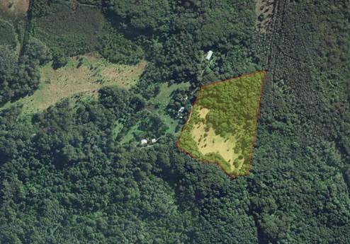
Map 1 - Lot 1 DP 394451, Jones Road.
P. Amend
map sheet LZN 003D to correct an error with the zone label for Lot 1 DP 1031848
to change the label from “ educational establishment” to
“private education facility”.
At its Meeting on 5 February 2015 Council resolved:
15-029 Resolved:
4. That at
the next general update of Byron LEP 2014 Council will amend the SP1 zone on
Lot 1 DP 1031848 to refer to a private education facility, and amend Schedule 1
to define private education facility and specifically permit it as a use on the
subject land.
The Planning Proposal in Attachment 1 includes an amendment
to Schedule 1 that defines private education facility and permits it with
consent on this site. An amendment to the zoning map will also be made to
describe the subject land as “private education facility”.
Q. Amend
map sheet LZN 002CA to change the land use zone for Lot 12 DP 1128095, Lot 11
DP 1128095 and Lot 606 DP 240398 , Ocean Shores, from RU2 Rural Landscape to R2
Low Density Residential. Amend map sheet LSZ 002CA to change the MLS for
the same lots from 40 ha to 600 m2. Amend map sheet FSR 002CA
to include a 0.5 FSR for the same lots.
Council approved a large senior’s housing development
on land near Kulgan Court in Ocean Shores. Part of that land is in the RU2
Rural Landscape zone because it was previously in a rural investigation zone.
It encompasses three irregular shaped lots with a combined area of
approximately 8600 m2. Two extremely narrow strips are owned by
Council and the slightly larger lot is privately owned. The two very narrow
strips (approximately 600mm wide) were created at the rear of private land that
backs onto a proposed road corridor at Ocean Shores near Kulgan Court.
The proposed road has been abandoned and sold for private
development and the strips are no longer required. It makes sense that the
narrow strips be included in the R2 Low Density Residential zone the same as
most of the land in the vicinity. With residential land on two sides and a
residential (seniors) approval in place this serviced urban land should be
included in an urban zone. It is not used for agriculture and contains no
significant habitat. It has been subject to a preliminary contamination
assessment under SEPP 55 and is not likely to be contaminated from past land use.
It is not known to contain Aboriginal sites. In combination with it
changing to an R2 Low Density Residential zone it also should have a minimum
lot size (MLS) of 600 m2 and a floor space ratio (FSR) of 0.5.
These are the same as surrounding residential land.
The Planning Proposal in Attachment 1 includes an amendment
to Byron LEP 2014 map sheets LZN 002CA, LSZ 002CA, and FSR 002CA to apply the
above changes to the subject land. Please refer to Map 3 of the Planning
Proposal at Attachment 1.
R. Amend
map sheet LSZ 003CB to modify the existing 300 m2 MLS for certain
land at Bangalow (Lot 12 DP1189289, Parrot Tree Place) to align with a recent
subdivision on the same parent lot further to the west.
In amending Byron DCP Council received a submission in
relation to the Bangalow urban release area shown in Map 2 below. Staff
commented that “the relevant 300m2 areas on the LEP 2014
Lot Size Map are inconsistent with the indicative medium density residential
areas illustrated on the suggested Structure Plan and inconsistent with the
plan of subdivision approved under the consent to DA 10.2012.6.1. It is
recommended that options be explored at a later date to amend the relevant LEP
2014 Lot Size Map such that the 300m2 Lot Size areas more closely
reflect the Medium density residential areas in the submission.”
To this end the Planning Proposal in Attachment 1 includes
an amendment to Byron LEP 2014 map sheet LSZ 003CB that applies the above
changes to the subject land.
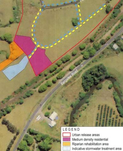
Map 2 – Land shown as “medium density
residential” represents the preferred location for the 300m2
Minimum Lot Size on Lot 12 DP1189289, Bangalow
Matters that have been omitted from this Planning
Proposal
Building Heights in Lawson Street
At its meeting on 21 May 2015 Council resolved:
15-216 Resolved:
That the height limits be reviewed for Zone B2 in Lawson
Street on the eastern side of the road as part of the housekeeping amendment
report of the Byron LEP 2014.
Building heights are one influence on the urban form of
Byron CBD, but they should not be reviewed in isolation of floor space ratio,
car parking, landscaping, etc. The Byron Bay Town Centre Masterplan is
addressing the issue of built form in the CBD which includes the B2 zone along
Lawson Street. Once the final master plan has been delivered and considered by
Council it is appropriate that issues such as height, FSR, car parking, etc be
revisited. The LEP (and DCP) can be used to achieve the urban form that Council
has agreed through the master plan process. No changes to the building
heights in the B2 zone at Lawson Street are proposed at this time.
Council Landholdings
The following land affected by this planning proposal is
owned by Council:
§ Item Q includes Lot 11 DP1128095
and Lot 606 DP 240398. These are two very narrow lots (approximately 600mm
wide) that were created at the rear of private land that backs onto a proposed
road corridor at Ocean Shores near Kulgan Court. These narrow strips will be
included in the R2 Low Density Residential zone which is the same as most of
the land in the vicinity.
§ Item M applies to the Cavanbah
Sports Centre at Ewingsdale Road, West Byron (Lot 3 DP 706286). This land
was acquired by Council partly for a sports facility and partly for disposal of
treated recycled water from the nearby STP. It is part Community land and part
Operational land under the Local Government Act, 1993. It is subject to a
plan of management. This land will be included in Schedule 1 (Additional
permitted uses) so that “registered clubs” can be permitted
with consent, which in turn will enable future commercial opportunities on
Council land.
State Policy and Planning Controls
The planning proposal is generally consistent or justifiably
inconsistent with the applicable State Environmental Planning Policies. The key
SEPP’s that require particular consideration are SEPP 55 Remediation
of Land and SEPP (Rural Lands) 2008.
SEPP 55 Remediation of Land
Clause 6(1) of SEPP 55 requires
that a Council cannot approve a rezoning application (especially from rural to
residential) unless it has duly considered whether such land is contaminated.
Two items are affected directly by this
SEPP. Item Q (land near Kulgan Court, Ocean Shores) is changing from a rural to
a residential zone. In this case the previous landowners undertook a
preliminary analysis pursuant to SEPP 55 and found there was no evidence of
past contamination. It is consistent with the SEPP.
Item O (Jones Road) is a single 5 hectare rural lot at the
end of Jones Road that has currently does not have a “dwelling
entitlement”. The land is not being rezoned, but the amendment will allow
a dwelling to be erected on it for the first time. No preliminary analysis of
the land has been supplied to Council and it is not yet
possible for Council to be satisfied that the draft LEP is consistent with
Clause 6 of SEPP 55. Subject to the Gateway Determination issued
by Department of Planning & Environment, Council may require submission of
this information (i) prior to finalising the planning proposal or (ii) at the development application stage once the dwelling curtilage and
accompanying land uses are known.
Although this part of the planning proposal is not
consistent with SEPP 55 Remediation of Land, it should proceed to Gateway
Determination.
SEPP (Rural Lands) 2008
The focus of this SEPP is on
unnecessary fragmentation of rural land and in particular state and regionally
significant farm land. The principles in the SEPP are required to be
considered as part of the S.117 directions when rezoning land. In this case the
land affected by changes to the land use tables for RU1 and R5 will not impact
significantly (if at all) on agriculture. The loss of less than 1 hectare of
RU2 land at Ocean Shores that is not currently used for agriculture is also not
significant. Neither the land at Ocean Shores (Item Q) nor the land at Jones
Road (Item O) is mapped as state and regional agricultural land.
On this basis the planning proposal is consistent with SEPP
(Rural Lands) 2008.
Section 117 Directions
The planning proposal is not consistent with S. 117
Direction 1.2 Rural Zones because of Item Q and Item O. It is generally
compliant with the other S.117 Directions.
The inconsistency is justifiable in the circumstances
because the land near Kulgan Court Ocean Shores (Item Q) is surrounded by zoned
residential land on two sides, is not used for agriculture or mapped as state
or regional agricultural land, is fully serviced and has no significant
environmental values. It is very small (8600 m2) and is
subject to an existing approval for seniors development. The inconsistency is
justifiable as a minor matter pursuant to sub clause 5(d) of the Direction.
The inconsistency relating to land on Jones Road (Item O) is
justifiable because it will remain in an RU2 zone, but with a dwelling
permitted. This alters the dwelling density in this location. However, the site
is not currently used for agriculture, is not mapped as state or regional
agricultural land and is very small. The inconsistency is justifiable as a
minor matter pursuant to sub clause 5(d) of the Direction.
Options to Move Forward
There are a number of options open to Council on this
matter:
1. Proceed
with the planning proposal as included as Attachment 1 to this report.
2. Amend the planning
proposal as required.
Conclusion
This planning proposal is a culmination of matters accumulated
over the last 12 months arising from Council resolutions, staff observations or
submitted by consultants or the community. There is sufficient merit for it to
proceed.
Council should proceed with a planning proposal to amend
Byron LEP 2014 in accordance with the planning proposal at Attachment 1.
In relation to Item O (Jones Road) the landowner will need
to supply a preliminary land contamination assessment pursuant to SEPP55, an
Aboriginal archaeological site assessment and a bushfire assessment to
establish that the site has a location within the area zoned RU2 Rural
Landscape that is suitable for a dwelling. The timing of when this
information is required will be determined in the Gateway Determination issued
by Department of Planning & Environment.
Financial Implications
As a Council initiated this planning proposal, the
processing costs will be borne by Council.
If Council chooses not to proceed then the matter does not
incur any additional costs.
Statutory and Policy
Compliance Implications
The relevant policy considerations are addressed above and
in the attached planning proposal.
Staff Reports - Sustainable Environment and Economy 13.15
Report No. 13.15 PLANNING
- 10.2015.214.1 - Railway infrastructure including a rail shed and two railway
platforms and tree removal at Bayshore Drive and Lawson Street, Byron Bay
Directorate: Sustainable
Environment and Economy
Report
Author: Joe
Davidson, Planning Team Leader
File No: I2015/875
Theme: Ecology
Development and Approvals
Proposal:
This development application seeks consent for the
construction of two train platforms and train storage shed to support the
operation of a train within the existing railway corridor.
It is proposed to construct a train storage/maintenance shed
with an attached train platform on the eastern side of the Bayshore Drive
railway crossing (on the northern side of the railway line), to allow
passengers to embark and disembark a train on the main line. This platform will
form the western limit of the proposed train operation.
The construction of a second stand alone platform is proposed
on the northern side of the Lawson Street railway crossing (on the eastern side
of the railway line), also to allow passengers to embark and disembark a train
on the main line. This platform will form the eastern limit of the proposed
train operation.
Details have been submitted of a ‘Licence for Heritage
Operations’ issued to Byron Bay Railroad Company Limited by Transport for
NSW, and a Certificate of Accreditation issued to Byron Bay Railroad Company
Limited by the Office of the National Rail Safety Regulator, to enable the
construction, maintenance and operation of a railway service between the
proposed train platforms. The Certificate of Accreditation specifies the
rolling stock to be used as a ‘600 and 700 series Diesel Multiple
Units’. The proponents have indicated that they are currently restoring a
two car 660 series 100 seat diesel railmotor in heritage colours for use on the
line.
The train service is intended to be operated by the
‘Elements of Byron’ resort, which is currently under construction
at the northern end of Bayshore Drive, adjacent to the western platform. A
pedestrian access path is proposed from this platform to Bayshore Drive, where
a pathway leads to the new resort. An access driveway is also proposed from
Bayshore Drive to the proposed train storage shed.
The Applicant has indicated that the primary function of the
proposed storage shed is for the secure storage of the heritage train that is
to operate on the line. The shed includes an inspection pit to allow safety
inspections and minor maintenance works such as checking oil, water and brakes.
The shed will also allow for the cleaning of the train at the completion of
each days service.
The location of the proposed shed will require the removal of
21 small trees to provide a bush fire asset protection zone.
|
Applicant:
|
Planners North
|
|
Owner:
|
Ganra Pty Ltd
|
|
Zoning:
|
Zone No. SP3 Tourist
|
|
Date received:
|
15 April 2015
|
|
Integrated Development:
|
No
|
|
Public notification or exhibition:
|
- Level
2 advertising under DCP 2014 Part A14 – Public Notification and
Exhibition of Development Applications
- Exhibition
period: 6/5/15 to 19/5/15
- Submissions: For 40 Against
69
|
|
Other approvals (S68/138):
|
Not applicable
|
|
Planning Review Committee:
|
6 August 2015
|
|
Delegation to determination:
|
Council
|
|
Issues:
|
· Neighbourhood
amenity impacts
· Public
submissions
|
Summary:
This development application seeks consent for the
construction of two train platforms and a train storage shed to support the
operation of a train within the existing railway corridor.
Licensing and accreditation for the railway operation has been
granted by the relevant authorities. As such, the proposal relates only to the
provision of infrastructure, and not the railway operation itself.
It is proposed to construct a train storage/maintenance shed
with an attached train platform on the eastern side of the Bayshore Drive
railway crossing.
The construction of a second stand alone platform is proposed
on the northern side of the Lawson Street railway crossing.
The proposal is permitted with the consent of Council within
the respective zones under Byron Local Environmental Plans 2014 and 1988. No
specific provisions of Council’s Development Control Plans relate to
railway infrastructure.
The site is a railway corridor and as such is suitable for
railway infrastructure. The key issues with regards to the proposal relate to
the positioning of the proposed infrastructure within the railway corridor. The
proposed locations have been chosen by the proponent to reduce impacts on the
road network. The proposal is assessed as being satisfactory in terms of
impacts on the natural and built environments, subject to the imposition of
conditions on the consent. These include limiting the hours of operation of the
train platforms and limiting noise generation in accordance with the NSW
Industrial Noise Policy (2000).
The development application is supported subject to
conditions of consent.
NOTE TO COUNCILLORS:
In accordance with the
provisions of S375A of the Local Government Act 1993, a Division is to be
called whenever a motion for a planning decision is put to the meeting, for the
purpose of recording voting on planning matters. Pursuant to clause 2(a)
under the heading Matters to be Included in Minutes of Council Meetings of
Council's adopted Code of Meeting Practice (as amended) a Division will be
deemed to have been called by the mover and seconder of all motions relating to
this report.
|
RECOMMENDATION:
That pursuant to
Section 80 of the Environmental Planning & Assessment Act 1979,
Development Application No. 10.2015.214.1, for railway infrastructure, be granted consent subject to conditions
listed in Attachment 2 #E2015/56877.
|
Attachments:
1 10.2015.214.1
- Plans of proposed development - Proposed Railway infrastructure - Bayshore
Drive and Lawson Street, Byron Bay, E2015/54749
2 Conditions
of consent 10.2015.214.1, E2015/56877
3 Confidential
- submission 10.2015.214.1, E2015/57021
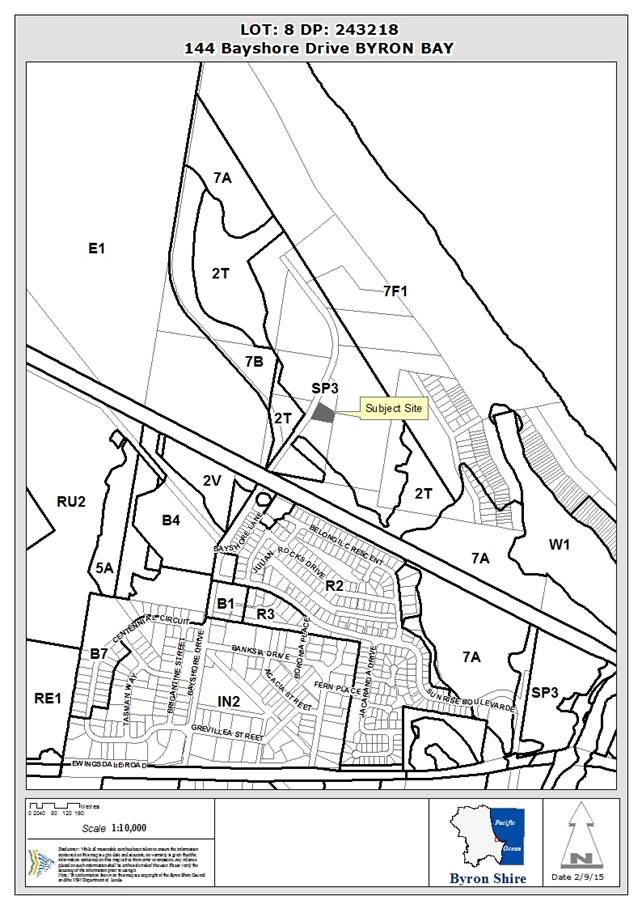
Assessment:
1. INTRODUCTION
1.1 History/Background
The proposed development relates to a closed section of the
Casino to Murwillumbah Railway line. The Lismore to Mullumbimby section of the
line was opened on 15 May 1894 and closed on 16 May 2004. The line has only
been partially maintained since its closure and has become overgrown in some
sections.
1.2 Description
of the proposed development
This development application seeks consent for the
construction of two train platforms and a train storage shed to support the
operation of a train within the existing railway corridor.
It is proposed to construct a train storage/maintenance shed
with an attached train platform on the eastern side of the Bayshore Drive
railway crossing (on the northern side of the railway line), to allow
passengers to embark and disembark a train on the main line. This platform will
form the western limit of the proposed train operation.
The construction of a second stand alone platform is proposed
on the northern side of the Lawson Street railway crossing (on the eastern side
of the railway line), also to allow passengers to embark and disembark a train
on the main line. This platform will form the eastern limit of the proposed
train operation.
Details have been submitted of a ‘Licence for Heritage
Operations’ issued to Byron Bay Railroad Company Limited by Transport for
NSW, and a Certificate of Accreditation issued to Byron Bay Railroad Company
Limited by the Office of the National Rail Safety Regulator, to enable the construction,
maintenance and operation of a railway service between the proposed train
platforms. The Certificate of Accreditation specifies the rolling stock to be
used as a ‘600 and 700 series Diesel Multiple Units’. The
proponents have indicated that they are currently restoring a two car 660
series 100 seat diesel railmotor in heritage colours for use on the line.
The train service is intended to be operated by the
‘Elements of Byron’ resort, which is currently under construction
at the northern end of Bayshore Drive, adjacent to the western platform. A
pedestrian access path is proposed from this platform to Bayshore Drive, where
a pathway leads to the new resort. An access driveway is also proposed from
Bayshore Drive to the proposed train storage shed.
The Applicant has indicated that the primary function of the
proposed storage shed is for the secure storage of the heritage train that is
to operate on the line. The shed includes an inspection pit to allow safety
inspections and minor maintenance works such as checking oil, water and brakes.
The shed will also allow for the cleaning of the train at the completion of
each days service.
The location of the proposed shed will require the removal of
21 small trees to provide a bush fire asset protection zone.
1.3 Description
of the site
The subject site comprises two small sections of the Casino to
Murwillumbah railway corridor, one adjacent to the Bayshore Drive crossing, and
the other adjacent to the Lawson Street crossing. Both sites are predominantly
clear of significant vegetation as they have been maintained since the opening
of the railway line in 1894.
A small area of shrubland is located on the northern side of
the proposed train storage shed near the Bayshore Drive crossing. The nearest
residential dwellings to the Bayshore Drive platform are located approximately
40 metres to the south. Accommodation units are located approximately 20 metres
to the north. A tavern is located approximately 100 metres to the south-west.
The land uses surrounding the Lawson Street platform include a
tourist park to the east, a service station with manager’s residence and
an office to the west, apartments to the north-west and a motel to the south.
2. SUMMARY
OF REFERRALS
|
|
Issue
|
|
ET Engineer
|
Water & Sewer Levies.
|
|
Development Engineer
|
Car parking.
|
2.1 Comments
from NSW Rural Fire Service
The proposal was referred to the NSW Rural Fire Service for
comment. In correspondence dated 19 May 2015, the following comments were
received:
I refer
to your letter dated 30 April 2015 seeking advice regarding bush fire protection for the above Land Use Application in accordance with Section 79BA of the 'Environmental Planning and Assessment Act 1979'.
The Service provides
the following recommended conditions:
1. The recommendations are based on the plan prepared by Harley Graham Architects, titled 'Proposed New Train Platform'. The recommendations relate to the proposed platform
and shed located
at the site described as "Bayshore
Drive". No specific
recommendations are included
for the site described as "Byron Town" .
Asset Protection
Zones
The intent of measures is to provide
sufficient space and maintain reduced
fuel loads so as to ensure radiant heat levels of buildings a re below critical
limits and to prevent direct flame contact
with a building. To achieve
this, the following
conditions shall apply:
2. At the commencement of building works and in perpetuity the property around the building as indicated
below, shall be maintained as an inner protection
area (IPA) as outlined within section 4.1.3 and Appendix
5 of 'Planning for Bush Fire Protection 2006' and the NSW Rural Fire Service's
document 'Standards for asset
protection zones':
· north and northeast for a distance
of 8 metres;
· south for a distance of 9 metres;
and
· northwest, west and southwest for a distance
of 21 metres.


 Water and Utilities
The intent of measures is to provide
adequate services of water for the protection of buildings during and after the passage of a bush fire, and to locate
gas and electricity so as not to contribute to the risk of fire to a building. To achieve this, the following conditions shall apply:
3. Water,
electricity and gas are to comply with section 4.1.3 of 'Planning for Bush Fire Protection 2006'.
Evacuation and Emergency
Management
The intent of measures is to provide
suitable emergency and evacuation (and relocation) arrangements for occupants
of special fire protection purpose developments. To achieve this, the following
conditions shall apply:
4. An emergency/evacuation
plan is to be prepared for the proposed development consistent with the NSW Rural Fire Service document 'Guidelines for the Preparation of Emergency/Evacuation plan'
.
Landscaping
5. Landscaping within
the Inner Protection Areas is to comply with Appendix
5 of 'Planning for Bushfire Protection 2006'.
For any queries
regarding this correspondence please contact Neil Pengilly on 1300
NSWRFS.
2.2 Comments
from Transport for NSW and John Holland Rail Pty Ltd
The written
consent from Transport for NSW was provided by the Applicant providing land
owner authority for the lodgement of the Development Application. The proposal
was also referred to John Holland Rail for comment, who is the company
responsible for managing/maintaining the railway corridor. Council sought
clarification as to whether future repair and maintenance works throughout the
railway corridor between the two proposed stations would be carried out
‘by or on behalf of a public authority’ [i.e. Transport for NSW].
If this was the case, certain works could proceed as exempt development under
State Environmental Planning Policy (Infrastructure) 2007.
Correspondence
received from the Property Agreements Manager at John Holland Rail, dated 8
July 2015, advised as follows:
TfNSW wrote to the General Manager of Byron Bay
Railroad Company on 18 May 2015 and stated the following:
“Please note that any works to rail
infrastructure or the land, in relation to the approved purpose, are on behalf
of the Licensee and not TfNSW”.
The consequence of this advice is that future works within
the railway corridor will require development consent. The Applicant was
consulted with regards to the comments above. The Applicant’s responded
in correspondence dated 9 July 2015 as below:
“While we acknowledge the
email from John Holland Rail, we maintain that those elements of the proposal
not addressed via our development application are able to be undertaken in
accordance with the Infrastructure SEPP. We are pursuing this
issue with Transport for NSW. In the event that we are not able
to establish this procedural pathway we will lodge a separate development
application for these works, if and as required.”
3. SECTION
79C – MATTERS FOR CONSIDERATION – DISCUSSION OF ISSUES
Having regard for the matters for consideration detailed in
Section 79C(1) of the Environmental Planning & Assessment Act 1979, the
following is a summary of the evaluation of the issues.
3.1. STATE/REGIONAL PLANNING POLICIES
AND INSTRUMENTS
|
Requirement
|
Requirement
|
Proposed
|
Complies
|
|
State Environmental Planning Policy No. 71 –
Coastal Protection
|
Matters for consideration for development within the
coastal zone:
- retention of existing
public access to the coastal foreshore
- impact of effluent
disposal on water quality
- development must
not discharge untreated stormwater into a coastal water body
|
- The proposed platforms
and shed will not diminish access to the coastal foreshore
- No effluent is proposed
to be disposed other than to Council’s sewerage system.
- Stormwater is to be
conveyed to an appropriate point of discharge.
|
Yes
Yes
Yes
|
|
NSW Coastal Policy 1997
|
Development within the Coastal Zone must be consistent
with the Aims, Objectives and Strategic Actions of the Coastal Policy.
|
The development is proposed within an established railway
corridor.
|
N/A
|
|
Building Code of Australia
|
The proposal must be capable of compliance with the
structural and safety requirements of the Building Code of Australia.
|
A condition is to be recommended for inclusion in the
consent to ensure the BCA requirements are met.
|
Yes
|
|
Demolition
|
Demolition works involving asbestos must be carried out in
accordance with the requirements of Workcover and Australian Standards.
|
N/A
|
|
Disability Access (DDA)
|
Access for persons with disabilities
and integration into surrounding streetscapes without creating barriers. (Council Res.10-1118)
|
A condition is to be included within the consent requiring
access to be provided in accordance with the Building Code of Australia.
|
Yes
|
|
State Environmental
Planning Policy N. 33 – Hazardous and Offensive
|
To ensure that in determining
whether a development is a hazardous or offensive industry, any measures
proposed to be employed to reduce the impact of the development are taken
into account.
|
It is proposed that the train will be refuelled via
tanker. The proposed development does not constitute hazardous
development – it is understood from information provided by the
applicant (E2015/52793) that there will be no dangerous materials stored on
the subject site. Consent conditions have been imposed to this effect.
|
Yes
|
|
State Environmental
Planning Policy No 55 – Remediation of Land
|
The Council must:
(a) consider
whether the land is contaminated; and
(b) if
the land is contaminated, if the land is suitable in its contaminated state
or after remediation; and
(c) be
satisfied before the land is used.
Where a change of use is
proposed the Council must consider a report provided by the applicant
specifying the findings of a preliminary investigation (and detailed
investigation if necessary) of the land in accordance with the contaminated
land planning guidelines.
|
The proposed development comprises the construction of a
rail shed, two rail platforms and tree removal. The land on which the
development will be located is within an existing railway corridor. It
considered that the proposal will not result in an increased sensitivity of
use. The subject railway corridor land is considered to be suitable for
the intended development.
|
Yes
|
* Issues discussed below
State/Regional Planning
Policies and instruments – Issues
No significant issues of concern in relation to these
matters.
3.2. BYRON
LOCAL ENVIRONMENTAL PLAN 2014
Zone: SP2 Infrastructure
(Railway Corridor)
Definition: Railway Infrastructure
Part of the Lawson Street
platform falls into the SP2 Zone under Byron Local Environmental Plan 2014. The
key requirements of this LEP are discussed in the table below:
|
LEP Requirement
|
Summary of Requirement
|
Complies?
|
|
Permissible use
|
The purpose shown on the
land zoning map for this site is “Railway Corridor”. The
proposed train platform is ancillary to this land use and is permissible
within the SP2 Zone.
|
Yes
|
|
Meets objectives of SP2 Infrastructure Zone
|
· To provide for
infrastructure and related uses.
· To prevent
development that is not compatible with or that may detract from the
provision of infrastructure.
|
Yes
Yes
|
|
4.3: Height of buildings
|
Maximum Height of buildings map 9.0m
|
Yes
|
|
5.5: Development within the coastal zone
|
· Check: 5.5
· Check: NSW
Coastal Policy
|
Yes
|
|
5.9: Preservation of trees or vegetation
|
The proposed tree removal is supported as per with the
Environmental Assessment prepared by Peter Parker Environmental Consultants,
dated 13 April 2015. Development consent has been sought as part of this
application for the proposed tree removal.
|
Yes
|
|
6.1: Acid sulfate soils
|
Council’s records indicate that the subject site is
affected by “Class 3” Potential Acid Sulfate Soils (PASS).
|
Condition to limit earthworks to no greater then 1.0
metre.
|
|
6.2: Earthworks
|
Maximum excavation & fill: 1m
|
Yes
|
|
6.3: Flood planning
|
Refer to comments within issues Section below.
|
Yes
|
|
6.6: Essential Services
|
· water,
· sewer,
· electricity
· stormwater
· vehicle access
|
Yes
Yes
Yes
Yes
Yes
|
* Issues
discussed below
Byron Local
Environmental Plan 2014 – Issues
Clause 6.3 – Flood Planning
Parts of the railway corridor are flood liable, but where the
two railway stations are to be constructed, that area is not flood liable.
The SEE states, in part, “…..the proposed works
are not likely to restrict the flow characteristics of flood waters or increase
the level of flooding on other land in the vicinity and that the building will
be adequately flood proofed…..”, and also, “…..the
proposed railway station…..will not result in significant adverse impacts
on flood behaviour or the environment …..the proposed structures are non
habitable…..”
Accordingly, the proposed railway station structures and
access paths are satisfactory in respect to flooding issues.
Byron Local
Environmental Plan 1988
Zone: 5(a) Special Uses Zone
(Railway) and 7(f2) Urban Coastal Lands Zone
Definition: Railway Infrastructure
Part of the Lawson Street
platform falls into the 5(a) Special Uses Zone and the 7(f2) Urban Coastal
Lands Zone under Byron Local Environmental Plan 1988. The Bayshore Drive
Platform falls within the 5(a) Special Uses Zone. The key requirements of this
LEP are discussed in the table below:
|
LEP Requirement
|
Summary of Requirement
|
Proposed
|
Complies
|
|
Meets zone objectives
|
(a) to
protect and enhance the long term potential of the Shire of Byron through the
preservation of the higher quality agricultural land within the zone and to
restrict all forms of development within the zone which, in the opinion of the
council, might prejudice such potential,
(b) to
prevent fragmentation of rural holdings and to encourage consolidation of lot
sizes for the purposes of agricultural and horticultural production,
(c) to
enable agricultural support facilities to be carried out on land within the
zone in a manner which does not significantly reduce the agricultural and
horticultural production potential of land in the locality,
(d) to
permit subdivision only where it is considered by the council to be necessary
to maintain or increase agricultural production or to allow the conduct of
any use permitted in this zone other than residential buildings, or where
proven demand for legitimate agricultural or horticultural holdings of a
smaller size is established,
(e) to
restrict the establishment of inappropriate traffic generating uses along
main road frontages, and
(f) to
establish appropriate buffer zones between high quality agricultural land and
other uses, particularly near the perimeter of such lands.
|
The proposed road transport terminal and shed do not
compromise the objectives of the zone.
|
Yes
|
|
Permissible use
|
The particular purpose indicated by black lettering on
the map for the 5(a) Special Uses Zone for this site is
“Railway”. The proposed railway infrastructure is ancillary to a
railway and is permitted with the consent of Council in this zone.
|
Yes
|
|
The proposed railway infrastructure is permitted with the
consent of Council in the 7(f2) Urban Coastal Lands Zone.
|
Yes
|
|
Meets objectives of 5(a) Special Uses Zone
|
The objectives of this zone are to designate land for
certain community facilities and services including areas for off-street
parking in private ownership.
|
The proposed railway infrastructure will support a railway
operation which will serve the community.
|
Yes
|
|
Meets objectives of 7(f2) Urban Coastal Lands Uses Zone
|
(a) to identify urban land likely to be influenced
by coastal processes,
(b) to permit urban development within the zone
subject to the council having due consideration to the intensity of that
development and the likelihood of such development being adversely affected
by, or adversely affecting, coastal processes,
(c) to permit urban development within the zone subject
to the council having due consideration to:
(i) the need to relocate buildings in the long
term,
(ii) the need for development consent to be
limited to a particular period,
(iii) the form, bulk, intensity and nature of the
development, and
(iv) continued safe public access to the site, and
(d) to allow detailed provisions to be made, by
means of a development control plan, to set aside specific areas within the
zone for different land uses and intensities of development.
|
The proposed train platform adjacent to the Lawson Street
crossing is located over 140 metres from the coastal erosion escarpment. The
proposed structure is light weight and could be removed without significant
demolitions works. The proposal does not compromise the objectives of the
zone.
|
Yes
|
|
Clause 24 – Development of Flood Liable Land
|
Council must be satisfied that:
- flow characteristics of
flood waters are not restricted;
- the level of flooding
is not increased;
- any building or work is
capable of withstanding flooding;
- the building is
adequately flood proofed; and
- adequate arrangements
are made for access to the building or work during a flood
|
Parts of the railway corridor are flood liable, but
where the two railway stations are to be constructed, that area is not flood
liable.
The SEE states, in part, “…..the proposed
works are not likely to restrict the flow characteristics of flood waters or
increase the level of flooding on other land in the vicinity and that the
building will be adequately flood proofed…..”, and also,
“…..the proposed railway station…..will not result in
significant adverse impacts on flood behaviour or the environment
…..the proposed structures are non habitable…..”
Accordingly, the proposed railway station structures and
access paths are satisfactory in respect to flooding issues.
|
Yes
|
|
Clause 32 – Development within the 7(f2) Zone
|
Consider:
- adversely affecting, or
being adversely affected by, coastal processes;
- the need to relocate buildings
in the long term;
- the need for the
development consent to be limited to a particular period;
- the form, bulk,
intensity and nature of the development; and
- continued safe public
access to the site.
|
Refer to comments in relation to the objectives of the
zone.
|
Yes
|
|
Clause 40 - Height
|
Maxim height
9.0 metres
|
The proposed shed has a maximum height of 7.2 metres.
|
Yes
|
|
Clause 45 – Provision of services.
|
Prior adequate arrangements required for the provision of
sewerage, drainage and water services to the land.
|
The proposed development can connect to reticulated
infrastructure services. The proposal was referred to Council’s ET
Engineers who provided water and sewer levies for the connection of the
storage shed to the reticulated network.
|
Yes
|
|
Clause 52 – Tree Preservation
|
A person must not ringbark, cut down, top, lop, remove,
injure or wilfully destroy any tree or other vegetation covered by the tree
preservation order without the consent of Council.
|
Development consent has been sought for tree removal as
discussed under Section 3.4 of this report below.
|
Yes
|
|
Clause 55 – Railway Sidings
|
Nothing in this plan shall operate to prohibit the
construction and use of any railway siding designed to serve lands in an
industrial zone.
|
The proposal does not relate to any industrial uses.
|
Yes
|
|
Clause 63 – Potential Acid Sulfate Soils
|
Council’s records indicate that the subject site is
affected by “Class 3” Potential Acid Sulfate Soils (PASS).
|
Council’s GIS Mapping indicates that the proposed
development is on land classifies as Class 3 Acid Sulfate Soils. The
applicant confirms via email correspondence (E2015/42996) that works for the
proposed development including construction of an inspection pit will not
extent below 1 metre of the natural aground surface. A condition has
been imposed to this effect.
|
Yes
|
* Non-complying issues
discussed below
Byron
Local Environmental Plan 1988 - Issues
N/A
Draft EPI that is or has been
placed on public exhibition and details of which have been notified to the
consent authority – Issues
There are no draft environmental planning instruments
applicable to this site.
3.3 DEVELOPMENT
CONTROL PLANS
There are no specific development
control plan provisions that relate to railway infrastructure. However, the
following general issues are relevant to the proposal:
Vehicle parking and circulation
In excess of 100 formal car spaces are being provided along
the reconstructed Bayshore Drive north of the railway line. Public parking is
also available throughout the Byron Bay town centre. This is deemed to be
satisfactory for persons accessing the proposed railway platforms given that a
large percentage of passengers will walk to the train platforms from their
homes or their accommodations.
Bicycle parking
The proposal does not include any bicycle parking spaces.
The proponents have indicated that the train they intend to operate on the line
will have on board storage provision for surfboards, bikes and luggage.
However, potential passengers may not want to travel with their bicycle. It is
therefore recommended that a condition be included within the development
consent requiring Class 3 bicycle facilities (bicycle rails) to be provided
adjacent to each platform.
Coastal Erosion
The proposed station within the town centre is within
Coastal Erosion Precinct No. 2. A restriction on title in accordance with DCP
2014 will be required as a condition of consent.
3.4 The likely impacts of that
development, including environmental impacts on both the natural and built
environments, and social and economic impacts in the locality
Site Waste Minimisation and Management:
The train will be maintained and
stored in the proposed rail shed. The shed includes an inspection
pit. Information provided by the application (E2015/52793) a grease trap
will be used to manage greases and oils that may be mobilised when the train
body and bogies are being washed. Other oils and by products will be
drained and captured in contained and removed for disposal via an authorised
contractor. Consent conditions have been recommended.
Standard conditions apply to management of construction
wastes.
Noise impacts:
Noise from the construction of the proposed rail shed, and
two platforms can be managed via standard noise conditions for construction
activities. An existing railway track will be utilised to operate the
train and therefore operation noise is not a matter for consideration under the
subject application.
Neighbourhood amenity impacts:
A number of public submissions were received raising
concerns with regards to the impacts of the proposed development on the amenity
of the neighbourhood. Many of these submissions raised issue with the movement
of a train between the two proposed stations. As stated previously, the
operation of a vehicle along the train line has licencing and accreditation
processes that are independent of the Development Application. Council’s
assessment is limited to the infrastructure that is proposed within the
Development Application, that is the two platforms and a train storage shed.
It is acknowledged that the positioning of the two stations
ultimately determines where passengers will embark and disembark a train
operation, thus the impacts of this activity should be considered as part of
the assessment. The proposed stations have been sited to minimise disruption to
the road network. The placement of the town station is on the northern side of
the Lawson Street crossing. As such, the train operation will not need to cross
Lawson Street. Similarly, the proposed Bayshore Drive station is located on the
eastern side of Bayshore Drive to ensure the train operation does not cross the
roadway.
The proposed town station is located between a privately
owned service station and a Council owned tourist park. The Byron Bay town
centre currently experiences high pedestrian and vehicle traffic in the
vicinity of the site. In particular, Lawson Street carried high traffic
movements as the single entry point to the town centre from the north. In this
context, it is unlikely that the proposed station location will result in a
significant increase in neighbourhood amenity impacts from train passengers.
The lightweight design of the station is such that passengers waiting for a
train service are visible from the public domain. Passive surveillance from
surrounding lands is likely to discourage antisocial behaviour that would
impact on the locality.
The proposed Bayshore Drive station is located within the
railway corridor that adjoins privately owned tourist accommodation to the
north and residential units to the south. In each case, a vegetated buffer
separates the railway corridor from the existing development. A Council owned
buffer that is approximately 10 metres in width separates the residential
development in Belongil Crescent from the railway corridor [It is noted that a
number of these residential properties have encroached into this Council land].
Private land containing vegetation separates the tourist accommodation from the
railway corridor.
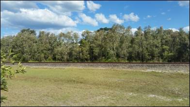
Photograph of Bayshore
Drive station site looking south towards the vegetated buffer between
the railway corridor
and residential development within Belongil Crescent – 10 August 2015.
Details submitted by the proponent indicate that the train
they intend to operate has a capacity of 100 passengers. Whilst in the past
trains have passed through the locality in the vicinity of Bayshore Drive,
there has never been a station at this locality. Potential impacts arise with
regards to passengers congregating, embarking and disembarking at the Bayshore
Drive Station. Impacts will be influenced by the separation distance between
the proposed platform and the closest residential dwelling (approximately 40
metres away). The proposal includes a footpath that leads pedestrians to a connecting
path that is under construction on the eastern side of Bayshore Drive.
Disembarking passengers are therefore directed away from the railway corridor
to disperse into the surrounding area.
It is recommended that a condition be included within the
consent which limits the hours of operation of the train platforms to reduce
impacts on the amenity of the neighbourhood. Daily operating hours of between
7.30am and 7.30pm are recommended.
Social impacts:
The proposed development will facilitate a new public
transport option for residents and tourists within Byron Bay. Although the
proposal has potential amenity impacts on nearby private properties (discussed
above), the proposal has broader social benefits that are worthy of support.
Ecological impacts:
The proposed development includes the removal of vegetation
adjacent to the proposed Bayshore Drive station and train shed to establish an
asset protection zone around the development. This includes the removal of 21
trees that are up to 6 metres in height. The Development Application was
accompanied by a report by Peter Parker Environmental Consultants Pty Ltd,
dated 13 April 2015. The report provides the following image of the proposed
vegetation removal:
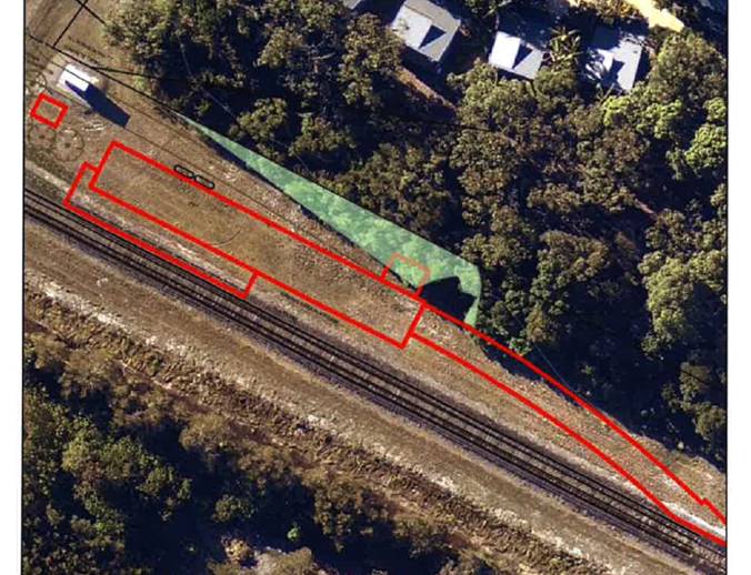

The ecological report includes an assessment under Section
5A of the Environmental Planning and Assessment Act 1979, which concludes that
no threatened flor or fauna species are likely to be affected by the proposal
given the small amount of area required to be cleared. The report states that no
habitat [of a threatened species, population or ecological community] of
particular significance will be removed. An assessment was also included with
regards to State Environmental Planning Policy No. 44 – Koala Habitat.
The report acknowledges that although the proposal requires the removal of
native vegetation, the shrub land to be removed is insignificant in the context
of this assessment.
It is satisfied that the ecological impacts of the proposed
development are not detrimental to the proposal. It is noted that vegetation
clearing along the railway corridor between the two proposed train stations is
not proposed nor considered as part of this Development Application.
3.5 The
suitability of the site for the development
The proposed train platforms and shed are suitably located
within the railway corridor. The proponents have been issued accreditation from
the National Rail Safety Regulator, and have a licence in place with Transport
for NSW for the operation of a railway service within this corridor. The key
consideration relates to the positioning of the platforms within this corridor.
The proposed town platform is located on the northern side
of Lawson Street to ensure road traffic is not impacted. Similarly, the
proposed Bayshore Drive platform is located on the eastern side of the road to
prevent traffic conflicts. Both have the ability to connect to the pedestrian
network and both are visible from public places. It is satisfied that the
proposed sites are the most suitable locations within the licensed area for the
development to be located.
3.6 Submissions
made in accordance with this Act or the regulations
The development application was placed on public exhibition
from 6 to 19 May 2015. Over 100 public submissions were received. The key issues
raised within the submissions are summarised within the table below:
|
Submissions of Objection - 69
|
|
Issues
|
|
No community consultation.
|
|
No letter from Council provided directly to adjoining
landowners along the entire railway line.
|
|
The proposed vehicle is a heavy diesel locomotive using
old engine technology.
|
|
The proposal will result in toxic diesel particulate
contamination close to residential houses and tourist accommodation.
|
|
The proposal flies in the face of Council’s
‘zero emission community’ policy.
|
|
The proposed platforms do not offer adequate toilet
facilities.
|
|
The proposal will result in issues with alcohol use.
|
|
Safety issues relating to Border Street / Kendall Street
railway crossing – no lights or boom gates proposed.
|
|
No proposal for a stopping barrier to mitigate the
possibility of a runaway train.
|
|
Noise pollution from steel wheels on steel tracks,
braking, diesel engine noise, horn warning etc.
|
|
Noise issues relating to people accessing the train,
particularly travelling past residential areas.
|
|
Vibration issues associated with the train operation.
|
|
Air pollution.
|
|
Light pollution from the use of bright lights on the train
at night. Obtrusive for residents along the line.
|
|
Asbestos from brake shoes along the railway corridor
during train operations.
|
|
Privacy issues from the elevated train looking into
neighbouring properties.
|
|
The proposal will have an adverse economic impact on
tourists and residents.
|
|
The application has far wider implications than the
construction of two railway platforms and a rail shed. It is clear from the
application that the intention is to run a rail service.
|
|
The proposal does not provide train operating hours nor
frequency of service.
|
|
The train operation and associated fencing will impact on
native fauna adjacent to the track.
|
|
Access across the railway line will be affected by the
proposal.
|
|
The application does not demonstrate substantial public
benefit.
|
|
The proposal will be unsightly and will rely on retrograde
technology.
|
|
The proposal constitutes either Designated Development of
Advertised Development as set out under the EP&A Act 1979. No notice was
placed in the local paper of such.
|
|
The proposal is within an ecologically sensitive area.
|
|
Lighting of platforms and CCTV should be considered.
|
|
Public exhibition period is not long enough.
|
|
Safety issues relating to numerous paths crossing the
railway line.
|
|
The proposal will conflict with a rail trail concept. Will
adequate area be available and will fencing and/or an additional bridge across
Belongil Creek be required.
|
|
Car, bike and pedestrian safety at the intersection of
Kendall Street/Border Street will be compromised.
|
|
The proposal is not for light rail as promoted elsewhere.
|
|
On-site storage of diesel and other chemicals is a concern.
|
|
Are the developers proposing to pay for the removal of the
platforms/sheds if the proposal is not viable?
|
|
Potential impacts from spilling diesel.
|
|
The proposal will only benefit patrons of the Elements
Resort and not local residents.
|
|
Claims the train will reduce traffic on the main road to
Byron are unfounded.
|
|
The proposal will result in adverse amenity impacts.
|
|
Hours of operation are not specified. Late night
operations are not supported.
|
|
No acoustic analysis no amenity impact analysis undertaken
by proponent.
|
|
The proponent has been able to progress through the State
Government Rail Corridor passages avoiding public submissions and local
development standards.
|
|
The proposed train operation will result in lower tourist
occupancy rates in accommodation adjacent to the railway line.
|
|
The platform adjacent to the cabins within the first sun
caravan park will cause noise issues and lack of toilet facilities will
create public nuisance, particularly at night.
|
|
Koalas reside near and along the railway corridor.
|
|
The exhibition period should have been 30 days not 14
days. A sign should have been placed on the site of the proposed platforms
and a notice provided in the local paper.
|
|
The proposed platforms/shed are within 20 metres from a
number of residential properties.
|
|
The DA does not contain an analysis of feasible
alternatives to carrying out the construction of the platform and the railway
sheds at the Bayshore Drive site.
|
|
If the proposal is approved and the train operation
commenced local people will need to relocate due to the impacts.
|
|
The proposal will result in a devaluation of properties by
up to 15%. Rental prices will also be impacted negatively.
|
|
The proposal will have adverse odour impacts (diesel
fumes).
|
|
EPA rail infrastructure guidelines must be followed.
|
|
The estimated number of users of the train is unclear.
|
|
Parking is inadequate.
|
|
The removal of trees and the construction of a fence will
ruin the outlook of many properties and destroy a wildlife corridor.
|
|
The proposal is inconsistent with Council’s LEPs and
DCPs.
|
|
Allowing this DA to proceed will eliminate the development
of more appropriate uses for the rail line and will impact on the broader
transport network.
|
|
There is no disclosure from the applicant of any or no
political donations and gifts made. Transparency is required with regards to
gifts and donations involving DA’s, councillors and developers.
|
|
The DA does not support acceptable, positive, balanced
change in the area for residents or wildlife.
|
|
Council should open this DA proposal to a public
discussion and a panel of experts so submissions and complaints can be heard
with the developer present.
|
|
The proposal is narrow minded, selfish and unfair.
|
|
The submission from Byron Bay Railroad Co. focuses on
physical buildings of the platforms and does not give any detail on the rail
service and its impacts.
|
|
The proposal will disturb koala, echidna, iguana,
kangaroos and scores of other animals and fauna.
|
|
Refuelling will impact on neighbouring properties.
|
|
The proposal will result in crime and safety issues.
|
|
There is no evidence that the train horn
‘whistle’ approaching Kendall Street crossing does not exceed
LAFmax 85Db. No evidence has been provided that the proposed train meets any
criteria for EPA redevelopment guidelines for air-borne noise, ground-borne
noise, vibration or diesel particulate emissions.
|
|
It is not known who the governing body is that is
responsible for procedures and concerns.
|
|
No Environmental Impact Statement nor Social Impact
Statement has been supplied.
|
|
The proposal will result in light pollution.
|
|
Precautionary principles are required based on the on-site
storage of diesel fuel.
|
|
The proposed operating hours to 10pm is inappropriate in a
residential area.
|
|
The evidence available demonstrates that the proposal is
not in the public interest given the large opposition.
|
|
The main purpose of the proposal is to serve a private
resort and not the community.
|
|
No bicycle parking.
|
|
No other approvals were applied for concurrently (e.g.
Roads Act, Local Government Act approvals). No BASIX Certificate.
|
|
The DA concludes that there is a strong demand for public
transport in the Shire, this is not justified.
|
|
The proposal will impact on tourist accommodation
providers.
|
|
Litter will be an issue at the stations and along the
train line.
|
|
The whole train track will need to be renewed.
|
|
Sunrise Beach is currently serviced by Blanches Buses.
This is not very well patronised.
|
|
Level crossing safety concerns.
|
|
The station should be built on the other side of the
Bayshore Drive intersection, away from residents.
|
|
Insufficient details on assessment of contamination at the
development sites.
|
|
The DA determination should be put off until the NSW
Planning and Environment confirm the status of the land nominated as
‘deferred matter’ in the LEP 2014.
|
|
No details provided in relation to crime prevention.
|
|
No assessment is made as to the anticipated patronage.
Such may trigger car parking and other infrastructure.
|
|
No detail has been provided as to whether the train line
is structurally safe enabling the use of the intended facilities.
|
|
Submissions of Support - 42
|
|
Issues
|
|
It’s great that this organisation is getting the
train back up and running. There’s been a lot of talk and its great to
see some action. I like the look of the platforms.
|
|
This application for platforms, some minor clearing and a
shed in which to store the train is a worthwhile application and I hope it
gets approved.
|
|
I feel we are ready to take the final step toward securing
the resurrection of the train service.
|
|
Our town needs extra transport. It’s finally time to
get the train back on the tracks.
|
|
The application is solid and appropriate.
|
|
I think it’s great that these people have done so
much work to bring us a rail shuttle.
|
|
I am more than happy to express my support. How long have
we been thinking about this train. Everyone began to doubt it would ever
happen.
|
|
The platforms and shed outlined in the above DA are good,
safe and well suited.
|
|
My daughter works in Byron Bay and has told me of the
horrendous traffic trying to get into Byron Centre. I feel the train will be
a great support in easing traffic congestion and not to mention a Byron
Bay Icon.
|
|
The plans for the train platforms and shed are a great fit.
|
|
Anything which will help alleviate the ridiculous load on
Ewingsdale Rod should be supported, especially if privately funded. I reject
suggestions that noise or use are an issue. This is a rail car using a
railway line. Any person who lives or operates near the rail line knew of the
rail line well before they bought/moved there. We have to make progress on
public transport, and I would encourage Council to support this step.
|
|
We live in an era when governments need to be looking at
the most environmentally sustainable forms of public transport and for this
purpose there is nothing more suitable than rail. Byron Bay prides itself on
being progressive and environmentally friendly and should therefore support
this development application. It will provide many positive benefits for a
very large number of people in Byron Bay – both locals and tourists.
And it is bound to become a major tourist attraction in its own right.
Byron Bay was built around the railway. The railway is as
much a part of Byron as the beaches and the surf. It must protect this
important part of its heritage and there is no better way to do this than
putting the railway to the proper use that it was intended for.
I can imagine that the proposal is bound to attract some
criticism from a very small minority – probably from people who
speculatively bought property next to the railway after it was closed in
2004, gambling on it never re-opening and hoping to acquire the adjacent land
for their own use and profit. I urge the Council not to allow the shrill
voices of a few to prevent the enjoyment of this important corridor by the
many who will benefit from it.
For many years I used to stay in a hotel in Cairns that
was located next to the railway. Every night the train would come through at
about 10pm – loudly and with a whistle. But it was accepted as part of
the character of the area and never stopped regular guests from going to stay
there again and again. The Elements train will be causing far less
disturbance to anyone than the Cairns train, and is destined to become as
natural a sound in Byron as the sound of the surf or the low rumble of the
traffic on the main road – neither of which anyone in Byron Bay objects
to.
Although I am resident of Lismore, I visit Byron Bay nearly every weekend, and
I am looking forward to being able to use the train to travel from town to
North Byron from time to time as something else I can do to get me out of my
car and get around without driving.
|
|
I feel we need to preserve the rail network as a greener
and more cost effective form of transport in the shire. This proposal has
proven that it can be cost effective. Far less indeed than the politicians
would have us believe or the silly rail trail advocates.
I look forward to further expansion of the rail network for
Byron and the surrounding district in the future and feel that this is a step
in the right direction.
|
|
I am convinced that with this rail operating it will
demonstrate the greater capacity to carry commuter, heritage and tourist
traffic than either private vehicles and buses together. It will be more
acceptable on both economic and environmental grounds.
For the number of passengers carried in a two carriage set
will have a greater passenger capacity than [as mentioned] the private
vehicle and buses combined.
And when you add the extra vehicular traffic on the local
roads, this rail operation will significantly reduce the cost to council
regards future costs of road repairs.
I implore you to do more than give this lip service, and
support totally and without reservation this development application.
|
|
The train will run on the same standard diesel fuel as all
trucks, school buses and 4WDs. I believe the possibility of adding
solar panels the train is being investigated. The noise generated by the
train will be comparable to a truck with rubber tyres running on a bitumen
road at the same speed.
The train service will allow visitors to the resort to
travel into town without adding further traffic to the congested Ewingsdale
Road and Shirley Street. Many Sunrise Beach residents, tourists
and day trippers may also use the train to travel into Byron town centre,
rather than sit in traffic gridlock for hours breathing toxic fumes from
trucks and other diesel vehicles. The train service has the potential
to reduce traffic congestion on Ewingsdale Rd and Shirley St at no cost to
ratepayers.
Not only will this train service reduce traffic
congestion, it will also help reduce carbon emissions and the cost of road
repairs for ratepayers.
This train service could be the start of a much needed
extended train service to connect the Byron Shire community and tourists to
other towns in the region, which the community has been calling for many
years.
|
|
The platforms are vital to the operation of the new Byron
train. The broader community has campaigned long and hard for a train to be
operating again on our lines.
I have the privilege to be working with North Byron Beach
Resort. We are all very excited to be a part of bringing the train back. I
caught the train from Byron many years ago and kind of took it for granted. I
don't think people will do that so much any more.
|
|
I think it will help to lighten the traffic on Ewingsdale
Road into town.
|
|
I used the train that used to run for many years. It
enabled me to get around until I had a licence. Not only did it provide me
freedom but it was a really fun experience.
The loss of the XPT was tragic for all the people who
weren't independently mobile. Which is a lot of people. The young, the old,
those without the means to buy a car.
I grew up in Lismore and the train meant I could go to the
beach.
Any region attempting to operate sustainably relies on
public transport.
The platforms and shed are needed to facilitate this train
which is being so generously provided by a local business.
|
|
I think there should be a train because there used to be
one and it was good. And there’s more people in Byron now and that
would probably mean the train would be used more and make more money and
I’m pretty sure that’s why they closed it down. And also people
thought there should be a train but then they said there shouldn’t so
if they say there should again and there’s no train well it would be
pretty annoying. And I think there should be one because it would be fun to
ride in and people could get from one place to another a different way so
that’s why I think there should be a train.
I think that the design of the stations/platforms are
practical and aesthetically in line with the design of the resort.
The platforms are at no cost to the community, but it will
provide a community rail service. The Platforms are necessary for the rail
operations, as well as making it accessible and wheelchair and bicycle
friendly. The station and platform behind First Sun Caravan Park will also
mean that the railcar will not cross Lawson St and disrupt traffic.
|
|
The train is a positive initiative and I take my hat off
to the people behind it.
|
|
I work in the Byron Bay industrial estate and love the
idea of the train route into Byron town centre. I'm tired of sitting in
traffic when I have to drive into town (on a daily basis). I also love
that it is an old school train that fits within the image of Byron Bay.
|
|
I would like to completely 100% support the efforts to
have this DA fully approved.
I feel the best interest for our region can be better meet
with a rail system.
Thank you for giving me the opportunity to support a
better future for us all.
|
|
I believe that the majority of local residents would like
to see the return of our train, the creation of a by-pass and other measures
to ensure better transport and infrastructure for our community eg Park and
Ride at Nth Byron and catch the train into Byron and not have to find parking
in town.
So I think this new train from Byron Resort to town will
be very beneficial for Byron Bay and the whole area. It will provide safe and
regular transport for young people, elderly, disabled and disadvantaged
residents from Sunrise Beach area as well as a fun family activity for
visitors on rainy days. Young people can carry surf boards and bikes to town
and the $3 ticket is very affordable – cheaper than catching the bus.
In fact this train is being established as a non profit making train so that
is really wonderful for our community. This is the first improvement in public
transport services that I have ever seen in Byron Bay during the past 23
years. On top of that Governments need to understand that with the threat of
climate change we have to start going back to rail after decades of moving
all transport and freight onto the roads due of vested interests.
|
|
I think it would be a great move to bring the train back
to the Byron shire. The train would hopefully limit the endless traffic
rolling into Byron everyday, which would be great for someone like me coming
from Ewingsdale into town regularly.
|
|
Returning a rail shuttle to even a small section of the
local railway line is a step forward in providing alternatives to road based
transports which are currently the only form of transport in this shire. The
individuals and company funding this initiative, at no cost to ratepayers,
deserve the full support of our elected representatives. I urge you to
support this application.
|
|
I think this is a great thing for Byron and the whole
area. Governments need to understand that with the threat of climate change
we have to start going back to rail after decades of moving everything on to
the road because of vested interests. If people are complaining about the
noise they should try living in Bexley in Sydney where I grew up where
especially in the evening you have planes going over every 5 mins. You get
used to it and learn to live with it but my memory of the train going past up
here was that everyone would stop and wave and it was an exciting moment in
the day.
The amount of diesel particles in the air from all the 4
wheel drives barely gets a mention most of the time but all of a sudden just
because there’s a train a few times a day it’s a big deal.
I’m tired of the rich and powerful minority winning out over the rest of
us. Please approve this development application.
|
|
A lot of people have been campaigning for a long time to
bring back the trains and here we have a company that is doing just that. I
am amazed that some people have the negativity to oppose such an idea. Are
these the same folk who complain long and loud about no trains and too much
traffic? I expect so. Elements of Byron are hoping for members of the public
to utilise this facility and this will take traffic off the roads. From my
understanding, it will be low speed, low noise and low impact so what’s
the problem? I hope the Council give it the consideration it deserves.
|
|
I would like to express my support for the new rail
shuttle service as it will benefit so many people, both locals and tourists,
lessening the traffic congestion going into Byron Bay.
As a past resident of Byron and now living in Rosebank I
would certainly love to support this initiative by travelling myself and
taking visitors on the train trip into Byron.
The objections do not stand up as the train will not be
noisy, nor polluting, nor have asbestos linings. It is a worthwhile
initiative and I believe it will bring great benefit to our region.
|
|
I can see the train being a traffic asset to Byron.
|
|
The platform application looks good. The train looks
amazing.
|
|
The planned platforms as outlined in this DA look suitable
and functional.
|
|
In my opinion, it will be of value to the town, and it
won’t cause anyone any harm.
|
|
Everything looks great, and I am confident the train will
be an asset to our town.
|
|
There's nothing about their plans (running their railcar),
that expresses concerns for me, and I not only welcome their arrival in the
town but look forward to their on-going participation in the sensitive and
appropriate future development of the area.
|
|
|
|
The platforms and shed are vital to the success of the
entire rail shuttle project. I believe the plans are to a high standard, and
I personally look forward to riding the train.
|
|
Getting the train up and running again will greatly
benefit Byron Bay in the long term.
|
3.7 Public
interest
The public exhibition of the Development Application has
generated significant interest from members of the public. Section 3.6 of this
report provides a summary of the key issues raised within the public
submissions received. It is noted that many of the concerns raised by those
objecting to the proposal relate to the actual operation of a train along the
railway line. However, the Development Application before Council is for the
provision of infrastructure within the railway line, and not the railway
operation itself. The Applicant has submitted the following details which
provide external arrangements for the operation of the railway line:
· Licence for Heritage
Operations between Transport for NSW and Byron Bay Railroad Company Limited,
dated 31 October 2014.
· Certificate of
Accreditation to the Byron Bay Railroad Company Limited by the National Rail
Safety Regulator dated 5 June 2015.
· Land Owner Authority
from Transport for NSW to “Byron Bay Railroad Company or its agents to
lodge a Development Application with Byron Shire Council with respect to its
proposed Tourist Rail Shuttle proposal”, dated 19 March 2015.
It is acknowledged that the infrastructure proposed as part
of the Development Application is vital for the proposed railway operation.
Subsequently, if Council does not support the proposed railway platforms and
storage shed, the operation of a train on the line would not proceed. Although
the proposal has the potential to impact the amenity of residents and tourists
residing near the proposed development sites, such impacts can be minimised
with mitigation measures. The proposal has benefits to the broader community
that, on balance, result in a proposal that is considered to be in the public
interest.
It is possible that Council will receive a further
Development Application for works within the railway corridor to repair the
existing line should such works not fall within the exempt development category
under State Environmental Planning Policy (Infrastructure) 2007. However, the
principal of placing railway infrastructure within a railway corridor is deemed
to be in the public interest.
4. DEVELOPER
CONTRIBUTIONS
4.1 Water &
Sewer Levies
Current Situation
The proposed train stations are to located within the
existing rail corridor and as such have no existing water, bulk water or sewer
entitlements.
Proposed Development
This DA proposes to construct two train stations to allow
travellers to be transported between Byron Bay and the Industrial estate.
The Byron Bay train station will be located near Lawson
Street and will not have any water or sewer facilities and as such does not
incur developer contributions for water or sewer.
The Industrial Estate train station is located near Bayshore
Drive and will have a public disabled toilet.
Table 2 - Calculation of
Proposed Development Water & Sewer ETs
|
Ref
|
Development Type
|
Standard
Unit
|
Quantity
|
ET Rate (ET/unit)
|
ET Load
|
|
Water
|
Sewer
|
Water
|
Sewer
|
|
12.9
|
Public Amenities
|
WC
|
1
|
0.40
|
0.63
|
0.40
|
0.63
|
|
TOTAL
|
0.40
|
0.63
|
Table 3 - Calculation of
Additional Water & Sewer ET Load
|
|
Water
|
Sewer
|
|
Existing ET Entitlements
(Table 1)
|
0
|
0
|
|
Proposed Development ET
loading (Table 2)
|
0.40
|
0.63
|
|
Additional ET loading
|
0.40
|
0.63
|
Therefore, this development generates an additional load
onto Councils Water, Bulk Water and Sewer System
Council requires Payment of Developer Servicing Charges
(prior to issue of a construction certificate) of:
· 0.40 ET for
Water & Bulk Water; and
· 0.63 ET for
Sewer.
4.2 Section 94
Contributions
The proposed development has an estimated cost of over
$100,000. Therefore, the Section 94A levy is activated for this Development
Application.
5. CONCLUSION
This development application seeks consent for the
construction of two train platforms and a train storage shed to support the
operation of a train within the existing railway corridor.
Licensing and accreditation for the railway operation has been
granted by the relevant authorities. As such, the proposal relates only to the
provision of infrastructure, and not the railway operation itself.
It is proposed to construct a train storage/maintenance shed
with an attached train platform on the eastern side of the Bayshore Drive
railway crossing.
The construction of a second stand alone platform is proposed
on the northern side of the Lawson Street railway crossing.
The proposal is permitted with the consent of Council within
the respective zones under Byron Local Environmental Plans 2014 and 1988. No
specific provisions of Council’s Development Control Plans relate to
railway infrastructure.
The site is a railway corridor, and inherently is suitable for
railway infrastructure. The key issues with regards to the proposal relate to
the positioning of the proposed infrastructure within the railway corridor.
The proposed locations have been chosen by the proponent to
reduce impacts on the road network. The proposal is assessed as being
satisfactory in terms of impacts on the natural and built environments, subject
to the imposition of conditions on the consent. These include limiting the
hours of operation of the train platforms and limiting noise generating in
accordance with the NSW Industrial Noise Policy (2000).
The development application is supported subject to
conditions of consent.
6. RECOMMENDATION
That pursuant to
Section 80 of the Environmental Planning & Assessment Act 1979, Development
Application No. 10.2015.214.1, for
railway infrastructure, be granted consent subject to the following conditions
listed in Attachment 2 #E2015/56877.
7. DISCLOSURE
OF POLITICAL DONATIONS AND GIFTS
|
Has a Disclosure Statement been received in relation to
this application
|
No
|
|
Have staff received a ‘gift’ from anyone involved
in this application that needs to be disclosed. Where the answer is yes, the
application is to be determined by the Director or Manager of the Planning,
Development and Environment Division.
|
No
|
Provide Disclosure Statement register details here: Nil
Staff Reports - Sustainable Environment and Economy 13.16
Report No. 13.16 PLANNING
- 26.2013.2.1 - Public submissions report for second exhibition of Ewingsdale
Seniors Housing planning proposal
Directorate: Sustainable
Environment and Economy
Report
Author: Sharyn
French, Manager Environmental and Economic Planning
Christopher Soulsby, Development
Contributions Officer
Shannon Burt, Director Sustainable
Environment and Economy
File No: I2015/878
Theme: Ecology
Planning Policy and Natural Environment
Summary:
This report provides Council with details of the second
round of public exhibition and community meetings for the Ewingsdale Seniors
Housing planning proposal and analysis of submissions received on the proposed
amendment to Byron LEP 2014. It updates Council on key issues raised by
the planning proposal and the lack of progress on further traffic assessments
for Ewingsdale Road. It details an offer by the applicants to enter into
a planning agreement to provide a contribution towards the preparation of the
additional traffic study and to prepare and provide to Council a draft
Development Control Plan (DCP).
NOTE TO COUNCILLORS:
In accordance with the
provisions of S375A of the Local Government Act 1993, a Division is to be
called whenever a motion for a planning decision is put to the meeting, for the
purpose of recording voting on planning matters. Pursuant to clause 2(a)
under the heading Matters to be Included in Minutes of Council Meetings of
Council's adopted Code of Meeting Practice (as amended) a Division will be
deemed to have been called by the mover and seconder of all motions relating to
this report.
|
RECOMMENDATION:
1. That
Council note the offer from Belbeck Investments Pty Ltd to enter into
a draft planning agreement.
2. That
Council liaise with Belbeck Investments Pty Ltd and their
representatives on the draft planning agreement (Attachment 7) to discuss the
following amendments to the draft agreement:
a) amend
Clause 5 of the planning agreement as follows:
“5 Development
Contribution to be made under this Agreement
(a) Subject
to this Agreement the Developer is to make the part payment of the
Development Contribution for the agreed cost of item (iv) of the traffic
study within 28 days after the making of the agreement.
(b) Subject
to this Agreement the Developer is to make the payment for the remainder of
the Developer Contribution within 28 Days of the date on which the Amending
LEP is published on the NSW Legislation website.
(b) If
the Developer fails to make the Development Contribution in accordance with
clause 5(a), then the Developer acknowledges and agrees that, unless
otherwise agreed in writing by the Planning Authority, it will ensure that
the Planning Proposal will not be further considered by Byron Shire Council.
(c) Following
the payment of the Development Contribution required by Clause 5(a), the
Developer shall prepare a draft development control plan in consultation with
Byron Shire Council and provide that to the Byron Shire Council as soon as
reasonably practicable and no later than 6 months after the Development
Contribution is paid. The draft development control plan shall be
provided to Byron Shire Council prior to the lodgement of a development
application for development associated with the planning proposal.”;
and
b) define the scope of
works for the traffic study as:
“Traffic Study means:
(i) a
supplemental report to the OPUS MR545 study to determine the priority order
for the construction of intersection upgrades on MR545; and
(ii) a
study to model the impacts of construction of more than one roundabout at a
time on Ewingsdale Road; and
(iii) Investigate
the need for a roundabout at the intersection of Kendall Street and
Ewingsdale Road; and
(iv) a demand transport model for
the planning proposal as referred to in the Roads and Maritime Services
letter to Council dated 1 August 2014.” and;
c) delete the definition of
“authority” and replace all references to “Planning
Authority” in the operative clauses with “Byron Shire
Council”; and
d) include
the funding of a DCP to be prepared in consultation with Council, and that
the draft is submitted to Council, exhibited and adopted by Council prior to
lodgement of a development application; and
e) amend
clause 13 such that the developer pays the reasonable costs of Council
seeking legal advice on the planning agreement with the cost being agreed to
by Council and the developer prior to the seeking of the advice; and
f) any
other modifications or amendments as recommend by Council’s legal
advisers.
3. That
the amended draft planning agreement be placed on public exhibition in
accordance with the Environmental Planning and Assessment Act 1979 and
Regulation 2000.
4. That
upon completion of the “demand transport model as referred
to in the Roads and Maritime Services letter to Council dated 1 August
2014” the planning proposal to amend the Byron LEP 2014 to
permit development for the purposes of seniors housing, medical centre and
commercial premises on Lot 101 DP 1140936, Ewingsdale Rd be reported to
Council at the same meeting as the draft planning agreement for Council to
make a determination on the planning proposal.
5. That
Council inform the Department of Planning and Environment on the status of
the planning proposal for Lot 101 DP 1140936.
6. In
the event that staff and the developer cannot agree on the draft planning
agreement the matter be reported back to Council on completion of the demand
transport model.
|
Attachments:
1 Notes from
Public Information Sessions, E2014/78029
2 Summary of
issues and comments from second public exhibition, E2015/52131
3 Summary of
issues and comments from initial public exhibition, E2014/62120
4 Letter
from Roads and Maritime Sevices dated 1 August 2014, E2015/55348
5 Letter to
applicant requesting additional traffic study, A2014/31287
6 Applicant's
response to request for additional traffic study, E2015/6023
7 Letter
from Henry Davis York enclosing draft Planning Agreement , E2015/55353
8 Letter
from Tall Trees Care Communities , E2015/55361
9 Form of
Special Disclosure of Pecuniary Interest, E2012/2815
10 Letter from Traffix
to Department Planning dated 23 June 2015, E2015/57077
11 Draft Amended
Planning Agreement prepared by Henry Davis York dated 31 August 2015, E2015/57068
Report
A report and summary of public submissions for the initial
public exhibition of the planning proposal was submitted to Council at the 9
October 2014 meeting. Council resolved to proceed with an amended
planning proposal and for the applicant to prepare a Development Control Plan
(DCP) and updated demand model traffic study prior to lodgement of a
development application (DA) (Resolution 14-492).
At the 30 October 2014 Council meeting a rescission motion
was put forward in relation to resolution 14-492. Notice of Rescission
Motion No.10.1 was successful and Council resolved:
14-542 Resolved:
1. That
the planning proposal for the Land being Lot 101 DP 1140936 Ewingsdale Road at
Ewingsdale be exhibited for a period of 28 days by Council staff subject to the
Dept of Environment and Planning granting an extension of 6 months to the LEP
amendment.
2. That
if extension is not granted, the matter be reported to council as soon as
possible.
3. That
at least two community information sessions be held during the first half of
the exhibition period, convened by Council Planners with information presented
by them.
4. That
Council then consider previous and new submissions on the matter.
5. That
the matter then be reported again to Council, for determination of the Planning
Proposal.
The Department of Planning and Environment has granted an
extension to the Gateway Determination giving Council until 28 November 2015 to
finalise the planning proposal. Council has kept the Department informed on the
progress of the planning proposal.
Second Community Consultation
The planning proposal was publicly exhibited again for 28
days from 11 November to 8 December 2014 and written notifications were again
sent to landowners in Ewingsdale. Two separate community information sessions
were held during the exhibition period at the Ewingsdale Church on Monday 17
November and Tuesday 25 November. The information sessions were run by Council
staff with the then Executive Manager of Environment and Planning chairing the
meetings. Both meetings were attended by various members from the community
with approximately 90 people attending over the two sessions. A summary
of the issues raised during the information sessions is included in Attachment
1.
In response to the second public exhibition period, Council
received a total of 334 submissions which have been divided into the following
categories:
- 116 individual submissions in
opposition;
- 130 submissions in four (4)
different ‘form letters’ in opposition;
- 77 submissions with no reason
listed as to why they were against the proposal; and
- 11 submissions in support.
The key issues and analysis from the second public
exhibition process have been detailed in Attachment 2. They have been
categorised the same way as the initial submissions report in hierarchal order
of number of submissions raising a particular theme. The report of
submissions from the first public exhibition has been included in Attachment 3
for comparison and for cross reference. Given the similar nature
and content of the submissions received during the second public exhibition,
the analysis does not expand on each issue to the same level of detail as
previously provided. It relies on the previous assessment
where relevant for some issues and provides additional comments for any new
issues.
The main difference with the second public exhibition is the
increase in individual submissions opposing the planning proposal from 62 to
116. There were also four different ‘form letters’ which are
summarised at the end of Attachment 2.
There were 11 submissions in favour of the planning proposal
with the main reasons being: there is an increasing need for aged housing and
services in the Shire; the development complements the new hospital;
‘Seniors’ do not drive as much as younger residents and are
generally much quieter; and the proposed medical centre will provide
complementary services adjacent to the hospital.
Main Issues:
The top three issues from Attachment 2 are:
1. Traffic
and congestion - Approx 65% of all objections to this planning proposal
raised the issue of additional traffic and congestion that will flow from the
future development of this site and how it will impact on both residents of
Ewingsdale and the users of Ewingsdale Road, William Flick Drive and
McGettigans Lane.
2. Impacts
on character of Ewingsdale and quality of life – Approximately
47% of objectors who raised the issue of impacts on the lifestyle and amenity
of the area also raised the issue of impacts on the rural character of
Ewingsdale if this proposal were to proceed.
3. Density,
height of buildings and number of dwellings is excessive - A large number of
submissions (approx 30%) raised the issue of density, height of buildings and
number of dwellings being too excessive for the locality, especially on the
eastern portion of the site given the visibility from Ewingsdale Road and
McGettigans Lane.
General Comments:
This site is not in an approved Local Growth Management
Strategy (LGMS) and not in the Far North Coast Regional Strategy (FNCRS).
Council decided to review this unsolicited planning proposal on its merits
because, at the time, there was no clear time frame for reviewing either the
FNCRS or preparing a LGMS. The planning proposal is an opportunistic response
to the decision by the State government to locate the new Byron hospital on
rural land adjacent to the subject site at Ewingsdale. It has been publicly
exhibited twice and the community feedback on both occasions has been mostly
opposed to the planning proposal.
The seniors housing option with a medical centre and
commercial uses is the preferred use put forward by the current landowners but
it may not be the highest and best use of the land. There has been no holistic
review of the Ewingsdale locality, how this site will influence the future of
Ewingsdale or how it will interact with the new urban area at West Byron.
Approving this planning proposal is pre-empting the outcome of a future
strategy. Council now has a program to prepare a new urban/residential
strategy. An issues paper is currently in preparation and a draft
urban/residential strategy is anticipated by June 2016. This site could
be considered for urban use as part of that broader process.
The key issue that remains unresolved is traffic.
Roads and Maritime Services (RMS) advised Council by letter of 1 August 2014
(Attachment 4) that the work undertaken by the applicant was inadequate and a
demand transport model is required:
‘The traffic report
supporting the planning proposal is based on traffic counts undertaken on 27-28
February 2013. Traffic volumes at this time of year represent average or
slightly less than average flows. Ewingsdale is subject to significant seasonal
fluctuations in traffic volumes. Basing the traffic assessment on average flows
is not likely to represent the full extent of traffic impacts on Ewingsdale
Road.
Due to the significant traffic
volumes on Ewingsdale Road and the proximity of the seniors living proposal to
the Pacific Highway interchange Roads and Maritime recommends a demand
transport model be prepared. That model should not only examine average flows
but consider seasonal fluctuations. The model should be extended to examine
impacts on the Pacific Highway interchange’
In the 9 October 2014 report, staff recommended:
‘that Council request the
applicant to undertake traffic assessment work satisfactory to RMS and Council
requirements (‘Demand Model’) which is to be prepared prior to the
lodgement of a Development Application (DA) and commits to traffic solutions in
the best interest of Byron Shire and future road users’.
Following on from the community meeting in November, as part
of the second public exhibition, the applicant was asked (Attachment 5) to
bring forward the production of the traffic demand model in conjunction with
the planning proposal. The applicant declined as they believed that the
traffic assessment provided with the planning proposal was adequate for the
purposes of the gateway plan making process and that they would undertake further
traffic modelling as requested by the RMS prior to the lodgement of a
development application (Attachment 6).
In response to staff concerns about traffic issues on
Ewingsdale Road Council resolved on 9 April 2015:
15-151 Resolved:
1. That
Council allocate a budget of $50,000 to engage a traffic consultant to:
a) Determine
the priority order for the construction of intersection upgrades on MR545; and
b) Model the
impacts of construction of more than one roundabout at a time on Ewingsdale
Road; and
c) Investigate
the need for a roundabout at the intersection of Kendall Street and Ewingsdale
Road; and
d) Model the
impact of the rezoning proposal for seniors living and commercial development
at Ewingsdale on the intersections of William Flick Lane/Ewingsdale Road and
McGettigans Lane/Ewingsdale Road and determine the timing of construction for
the infrastructure to service this development. Model the impact of this
development on the function of MR545.
2. That
budget be made up of section 94 funds with $30,000 taken from the Byron Bay
Urban Roads account and $20,000 from the Plan Administration Fund.
Council has not yet been able to engage a consultant to do
this work because of other priority Infrastructure Services projects.
Staff now propose to separate out item d and undertake this modelling
independently of items a–c. This work is critical to understanding
if the traffic movements generated by the proposed development on Lot 101 DP 1140936,
particularly the medical centre and commercial premises, can be accommodated
without adversely impacting on the function of Ewingsdale Road and the Highway
interchange. Undertaking item d) separately from the other parts of the
resolution will enable this planning proposal to be assessed without further
delay caused by the implementation of items a-c. The advice from RMS in
their letter dated 1 August 2014 (Attachment 4) will be used to inform this
modelling. Staff have commenced work on developing a brief and intend to
appoint a consultant to undertake the work by the end of September.
The main concern with the traffic generated by the planning
proposal relates to the commercial component on the western portion of the site
that will direct traffic onto the intersection of William Flick Lane and Ewingsdale
Road. The seniors living component of the development that will access
McGettigan’s Lane will be serviced by the roundabout at the intersection
of McGettigans Lane and Ewingsdale Road. The applicants have engaged a
second traffic and transport planning firm (Traffix) to review the
documentation provided to date. The Traffix report is provided as
(Attachment 10). Traffix assert that there is sufficient information on
traffic to make a determination on the planning proposal. Staff
fundamentally disagree with this position and are of the opinion that the
traffic impacts are integral to the decision making process to determine if
this planning proposal can be approved. Staff sought a further opinion
from the RMS about the necessity of having the traffic study prior to making a
determination on the planning proposal. In an email of 31 August 2015
(E2015/56570) the RMS stated:
“Given the number of
intersections in close proximity, and the proximity to the Ewingsdale Road
interchange with the Pacific Highway. It would be necessary to have a more
complete understanding of the traffic implications of the Seniors Living,
retail and Medical Centre before deciding to rezone for these purposes. I would
recommend demand modelling be carried out prior to finalising the planning
proposal. Roads and Maritime Services would be happy to comment on the
modelling prior to Council completing the planning proposal process.”
Based on the advice from the RMS the impacts of the planning
proposal on Ewingsdale Road and the Highway interchange should not be left for
determination at the development application stage. These impacts need to
be considered prior to Council resolving to seek the Ministers approval to make
the amendment to the LEP. The results of the traffic study will be
reported to Council along with the planning proposal to enable Council to make
a fully informed decision about the appropriateness of the development uses
proposed for the site.
Proposed Planning Agreement
The applicant’s representatives advised Council, by
letter dated 17 August 2015, that the applicants were prepared to enter into a
planning agreement with Council to provide:
a) a contribution towards
the preparation of the additional traffic study, and
b) to prepare and provide
to Council a draft Development Control Plan for the site on the same day any
development application is lodged.
Council staff met with the applicant’s representatives
on 20 August 2015 to discuss this offer and the status of the planning
proposal.
Subsequent to this meeting the applicant’s
representatives have provide a copy of a draft planning agreement, Attachment 7
and a letter of support and clarification from aged care provider, Tall Trees
with whom the applicants are working with to provide a private aged care
community at Ewingsdale Attachment 8.
The draft planning agreement now only provides for a
contribution to the traffic study. The draft planning agreement defines
the traffic study as:
“Traffic
Study means the Ewingsdale Road Traffic Demand Modelling Study referred to in the Planning Authority's letter to the DP&I dated 30 July 2015.”
This
traffic study is the supplementary study to the MR545 study from Council
resolution 15-151 as set out above.
This study contains elements directly relating to this planning proposal and
elements of a broader strategic nature. A planning agreement must meet
the requirements of section 93F of the Environmental Planning and Assessment
Act 1979. Section 93F is set out as follows:
93F Planning
agreements
(1) A planning
agreement is a voluntary agreement or other arrangement under this Division
between a planning authority (or 2 or more planning authorities) and a person
(the developer):
(a) who has sought a change to an
environmental planning instrument, or
(b) who has made, or proposes to
make, a development application, or
(c) who has
entered into an agreement with, or is otherwise associated with, a person to
whom paragraph (a) or (b) applies,
under which the developer is required to dedicate land
free of cost, pay a monetary contribution, or provide any other material public
benefit, or any combination of them, to be used for or applied towards a public
purpose.
(2) A public purpose includes
(without limitation) any of the following:
(a) the provision
of (or the recoupment of the cost of providing) public amenities or public
services,
(b) the provision
of (or the recoupment of the cost of providing) affordable housing,
(c) the provision
of (or the recoupment of the cost of providing) transport or other
infrastructure relating to land,
(d) the funding of
recurrent expenditure relating to the provision of public amenities or public
services, affordable housing or transport or other infrastructure,
(e) the monitoring
of the planning impacts of development,
(f) the
conservation or enhancement of the natural environment.
The
draft planning agreement meets the requirements of s93F (1) (a) as it is made
by a person who has sought a change to an environmental planning
instrument. The planning agreement proposes to make a monetary
contribution toward a public purpose. The public purpose being a study
into the timing and sequencing of transport infrastructure relating to the land
to satisfy s93 (2) (c) of the act. The traffic study should not be
limited to the impacts of this planning proposal as then the purpose will no
longer be public rather it will be to facilitate private development. The
Department of Planning Development contributions Practice notes 2005 state
that: “Planning agreements can be used to secure the provision of
planning benefits from development. That is, through a planning agreement,
development may provide an overall net benefit to the wider community rather
than merely address the more direct impacts of the development on surrounding
land or the wider community.” The broad strategic component of
the traffic study forms the public purpose of the planning agreement.
Part of the payment of the monetary contribution will be toward the recoupment
of the cost of the study that Council has already budgeted for in resolution
15-151. Planning agreements must provide for a public benefit but they
should not be so narrowly constructed so as to prevent the Council from
recouping the cost of undertaking work that facilities the private development
in addition to the broader public purpose.
The initial discussions proposed
the preparation of a DCP for the site to be part of the planning
agreement. The draft planning agreement does not currently make provision
for payment for the DCP. The DCP is important as it will address some of
the key concerns raised by the community in the consultation process, thereby
giving greater certainty to the design of the development.
Staff discussed the draft planning agreement with the
applicant’s representative on 26 August 2015. The representative
advised that the applicant is more than happy to prepare a draft DCP and had
excluded it from the agreement to ensure that it was not viewed as a developer
driven plan. To overcome this perception staff proposed that the DCP be
prepared in consultation with Council, and that the draft is submitted to
Council, exhibited and adopted by Council prior to lodgement of a development
application; the representative agreed to consult with their client on this
matter.
There are some issues with timing, costs and definitions in
the draft planning agreement that require amendment.
Timing: The draft VPA proposes to make a payment
towards a traffic study 28 days after the date on which the Amending LEP is
published on the NSW Legislation website. Earlier in this report staff
and the RMS contend that the traffic study is fundamental to the decision
making process. If the traffic study shows that the planning proposal
should not proceed or should only partially proceed then the developer would
not have to pay. The timing of payment needs to be revised as does the
scope of works that the contribution is to pay for. The developer should
fund part of the cost of the traffic study required to service their
development, part iv as outlined below, prior to the determination on the
planning proposal with the remainder of the payment to fund parts i – iii
being made after the Amending LEP is published on the NSW Legislation
website.
Costs: Clause 13 of the draft planning agreement
relates to costs and proposes that each party bear their own costs of
preparing, negotiating, executing and stamping this Agreement and any document
related to the agreement. Council should not have to bear the cost of
seeking advice on the planning agreement. This clause will require amending
such that the developer pays the reasonable costs of Council seeking legal
advice on the planning agreement. In the past these costs have been
generally less than $3000 where Council has sought advice on planning
agreements.
Definitions: The definition of the traffic study in the draft
agreement requires amendment. The scope of the traffic study, the cost of
which is being partially recouped by this agreement, needs to be specifically
defined such that it meets the requirements of the Act i.e. that the study is
for a public purpose. The definition provided in Council’s letter
of 30 July 2015 needs to be broadened such that it captures the strategic
elements that for the public purpose and satisfies the needs of the RMS.
The definition of traffic study in the planning agreement should be amended to
the following:
Traffic Study means:
(i) a
supplemental report to the OPUS MR545 study to determine the priority order for
the construction of intersection upgrades on MR545; and
(ii) a
study to model the impacts of construction of more than one roundabout at a
time on Ewingsdale Road; and
(iii) Investigate
the need for a roundabout at the intersection of Kendall Street and Ewingsdale
Road; and
(iv) a demand transport model for the planning
proposal as referred to in the Roads and Maritime Services letter to Council
dated 1 August 2014.
The draft agreement repeated
refers to Planning Authority and defines Authority as:
“Authority means, in respect of a particular context or circumstance,
each Federal, State or Local Government, semi-Government, quasi-Government or
other body or authority, statutory or otherwise, including but not limited to
any court or tribunal, having jurisdiction and responsibility in respect of
that context or circumstance.”
This definition does not appear
in the Department of Planning’s template for planning agreements. A
consequence of this definition is that Council may not be the authority to
undertake certain actions to release the developer from their obligations under
the agreement. This definition should be removed from the
agreement. The term planning authority should be removed from all the
operative clauses of the agreement and replaced with the words “Byron
Shire Council”.
The planning agreement requires
further negotiated amendments that include but are not limited to:
a) amend
Clause 5 of the planning agreement as follows:
“5 Development
Contribution to be made under this Agreement
(a) Subject
to this Agreement the Developer is to make the part payment of the Development
Contribution for the agreed cost of item (iv) of the traffic study within 28
days after the making of the agreement.
(b) Subject
to this Agreement the Developer is to make the payment for the remainder of the
Developer Contribution within 28 Days of the date on which the Amending LEP is
published on the NSW Legislation website.
(b) If
the Developer fails to make the Development Contribution in accordance with
clause 5(a), then the Developer acknowledges and agrees that, unless otherwise
agreed in writing by the Planning Authority, it will ensure that the Planning
Proposal will not be further considered by Byron Shire Council.
(c) Following
the payment of the Development Contribution required by Clause 5(a), the
Developer shall prepare a draft development control plan in consultation with
Byron Shire Council and provide that to the Byron Shire Council as soon as
reasonably practicable and no later than 6 months after the Development
Contribution is paid. The draft development control plan shall be
provided to Byron Shire Council prior to the lodgement of a development
application for development associated with the planning proposal.”;
and
b) define
the scope of works for the traffic study as:
“Traffic Study means:
(i) a
supplemental report to the OPUS MR545 study to determine the priority order for
the construction of intersection upgrades on MR545; and
(ii) a
study to model the impacts of construction of more than one roundabout at a
time on Ewingsdale Road; and
(iii) Investigate
the need for a roundabout at the intersection of Kendall Street and Ewingsdale
Road; and
(iv) a demand transport model for the planning
proposal as referred to in the Roads and Maritime Services letter to Council
dated 1 August 2014.” and;
c) delete the definition of “authority”
and replace all references to “Planning Authority” in the operative
clauses with “Byron Shire Council”; and
d) include
the funding of a DCP to be prepared in consultation with Council, and that the
draft is submitted to Council, exhibited and adopted by Council prior to
lodgement of a development application; and
e) amend
clause 13 such that the developer pays the reasonable costs of Council seeking
legal advice on the planning agreement with the cost being agreed to by Council
and the developer prior to the seeking of the advice; and
f) any
other modifications or amendments as recommend by Council’s legal
advisers.
The above list may not be exhaustive as the final copy of
the draft planning agreement was only received on 1 September 2015 (Attachment
11). Staff have had limited time to review the document as reports for
the business paper had to be with the Directors by 26 August 2015 and to the
General Manager by 1 September 2015. Further amendments may be required to
protect Council’s interests.
Council’s own legal advice should be sought on the
draft planning agreement. It is recommended that Council further liaise
with the applicant’s representatives on these proposed amendments to the
draft planning agreement and then obtain Council’s own legal advice on
the draft agreement. Subject to satisfactory negotiations with the
applicant and the outcome of the legal advice staff would place the planning
agreement on public exhibition as for 28 days as required by the Act and
Regulation. Public notice of a draft planning agreement is to be given as
soon as possible after the public exhibition of the planning proposal, if not
practical to exhibit together. As the planning proposal was last exhibited late
2014 it is important that the public notice on the draft planning agreement is
given as soon as possible, but before the planning proposal is finalised. This
is consistent with the requirements of the EP&A Act and Regulation.
It is recommended that the planning proposal be reported to
council at the same time as the draft planning agreement in order for council
to make a final determination on the proposal.
Conclusion
A number of residents have concerns about the proposed
seniors living and commercial precinct as detailed in this planning
proposal. Some of these concerns can be mitigated through amendments to
the LEP or through a DCP prepared specifically for the site.
Traffic remains a major concern of the objectors, staff and
the RMS. A demand transport model is required to further understand the
impacts this planning proposal has on the road network.
The applicant is offering to enter into a planning agreement
to contribute towards the cost of the additional traffic study. The
applicant’s representative is agreeable to consulting with their client
on amendments to the draft planning agreement to provide for a DCP.
It is recommended that Council continue discussions with the
applicant and their representatives to amend the draft planning agreement;
obtain Council’s own legal advice on the draft agreement and then report
the draft to Council for consideration and release for public inspection at the
same meeting to which the planning proposal is reported for Council’s
determination.
Financial Implications
The cost of the traffic study has already been budgeted for
and with the developer bearing the costs of preparation of the planning
agreement and the legal advice required by Council there are no additional
financial implications.
Statutory and Policy Compliance
Implications
The Environmental Planning and Assessment Act and
Regulation provides for planning agreements to be entered into between
Council and the applicant.
A proposed planning agreement must be available for public
inspection for a minimum period of 28 days. Public notice of the proposed
agreement is to be given as soon as possible after the public exhibition of the
planning proposal, if not practical to exhibit together. Council must prepare
an explanatory note that summarises the objectives, nature and effect of the
proposed agreement and an assessment of the merits including both positive and
negative impacts on the public. This explanatory note must be prepared
jointly with the applicant and be exhibited with the proposed agreement.
A planning agreement is entered into when signed by all
parties to the agreement. The agreement can come into effect the day it
is signed or the date the proposed amendment to the LEP is made.
Within 14 days of entering into an agreement a copy must be
sent to the Minister.
Staff Reports - Sustainable Environment and Economy 13.17
Report No. 13.17 Update
Coastal Zone Management Plan Byron Bay Embayment
Directorate: Sustainable
Environment and Economy
Report
Author: Catherine
Knight, Coastal Officer
File No: I2015/944
Theme: Ecology
Planning Policy and Natural Environment
Summary:
The draft Coastal Hazard Management Study Byron Bay
Embayment Version 5 (management study) has been received and is currently under
review by the Office of Environment and Heritage (OEH). The OEH have completed
their review of the main management study report however comments on the draft
cost benefit analysis (CBA) are outstanding. Following receipt of the OEH
comments on the cost benefit analysis, a further report will be tabled for
Council’s consideration on the impacted Coastal Zone Management Plan
Byron Bay Embayment timeframes.
In considering the feedback provided by the OEH to date,
staff have sought clarification on a number of issues / concerns, including
seeking a meeting with the Minister for Planning and meeting with OEH staff on
31 August 2015.
At the OEH meeting it was reiterated that further
information is required on the feasibility of the potential ‘small scale
sand nourishment’ scheme at Stage 3 of the consultant’s draft
management recommendation for Belongil Beach. This further information may best
be obtained through a meeting with key government agencies /stakeholders, who
may be approval authorities for a potential small scale sand nourishment scheme
at Tallow Beach, including representatives of National Parks, Cape Byron Marine
Park, Crown Lands and the Bundjalung of Byron Bay Aboriginal Corporation
(Arakwal).
|
RECOMMENDATION:
1. That
Council note that delays to finalising the draft Coastal Hazard Management
Study Byron Bay Embayment are likely to impact on the draft Coastal Zone
Management Plan Byron Bay Embayment (CZMP BBE) timeframes; and that following
receipt of the Office of Environment and Heritage comments on the cost
benefit analysis, a further report will be tabled for Council’s
consideration on the impacted CZMP BBE timeframes.
2. That
Council staff arrange a sand nourishment meeting with the key agencies
/ stakeholders who may be approval authorities for a potential small scale
sand nourishment scheme at Tallow Beach, including representatives of
National Parks, Cape Byron Marine Park, Crown Lands and the Bundjalung of
Byron Bay Aboriginal Corporation (Arakwal), providing an opportunity to
understand the feasibility, or otherwise, from an approvals, legislative and
governance perspective, of the potential sand nourishment scheme at Stage 3
of the draft ‘Adaptive Management Protection Scheme for Belongil
Beach’.
3. That
the sand nourishment meeting be funded through a transfer of funds from
account 1501.64 to account 2605.083 and that co-funding be also sought
through the state government’s Coastal Management Program.
|
Attachments:
1 Letter in
from Office Environment and Heritage Draft Coastal Hazard Management Study
Version 5 Review Comments 17 08 15, E2015/53385
Report
The draft Coastal Hazard Management Study Byron Bay
Embayment Version 5 (management study) has been received and is currently under
review by the Office of Environment and Heritage (OEH). A summary of the report
was provided to Councillors at a workshop on 13 August 2015. Details of the
workshop, including the consultant’s presentation, can be accessed at:
www.byron.nsw.gov.au/coastal-hazard-management-study-for-the-byron-bay-embayment
In summary, the consultant’s draft management study
recommendation for Belongil Beach is:
Option
6, a three stage adaptive management protection scheme is recommended. This has
components of:
§ Stage 1: Seawall with walkway
§ Stage 2a: An initial self-filling
trial groyne
§ Stage 2b: Additional groynes; and
§ Stage 3: Small scale sand
nourishment.
The OEH have completed their review of the main management
study report however comments on the draft cost benefit analysis (CBA) are
outstanding. The CBA comments were not available at the time of writing this
report and are, tentatively, expected during the week ending 11 September 2015.
The OEH comments received to date are at Attachment 1.
As a result of OEH review timeframe delays to date, it is
unlikely that the draft management study will be tabled until the 29 October
2015 as previously indicated; noting that this timeframe is dependent on the
nature of the OEH comments on the CBA.
It is recommended that Council note that delays to
finalising the draft Coastal Hazard Management Study Byron Bay are likely to
impact on the draft Coastal Zone Management Plan Byron Bay Embayment (CZMP BBE)
timeframes; and that following receipt of the Office of Environment and
Heritage comments on the cost benefit analysis, a further report will be tabled
for Council’s consideration on the impacted CZMP BBE timeframes.
In considering the feedback provided from OEH to date, staff
have sought clarification on a number of issues / concerns, summarised as
follows:
1. Lack
of a timeframe for the provision of comments on the CBA.
2. The
implication that several, more detailed investigations will need to be
undertaken as part of preparing, and prior to finalisation of, the Coastal Zone
Management Plan Byron Bay Embayment (CZMP). From the comments, these
investigations include, but may not necessarily be limited to:
· The form,
scale, specification and location of protection works along Belongil Spit;
· Adaptive
management of sand nourishment to improve amenity and offset adverse down-drift
impacts from protection works;
· Appropriate
monitoring to facilitate (thresholds/triggers) adaptive management;
· Dedication
of appropriate long-term sand nourishment source;
· Committed
funding model to give effect to the aforementioned.
3. An
ongoing shift in the OEH advice concerning the level of detail required for
informing the CZMP and an apparent disconnect between OEH expectations and the
timeframe imposed by the Minister’s Direction for submitting the
draft CZMP (being 30 June 2015).
4. A
failure of the OEH to contextualise their expectations in terms of Council’s
financial and resource constraints and to acknowledge the significant work
completed to date.
In addition, Council has written to the OEH requesting a
meeting with the Minister for Planning, Rob Stokes MP, who retains oversight of
the Coastal Protection Act (copy to the Minister for the Environment).
Although a response from the Minister has not yet been
received, staff met with the OEH on 31 August 2015 to discuss the issues /
concerns raised in their advice. The key messages received from this meeting
are provided below:
1. The
OEH advice is for Council’s consideration only and has been provided on
the grounds that there is a risk that if certain information is not included in
the draft CZMP BBE then the CZMP BBE may not be considered ‘fit for
certification’.
2. The
OEH will review the draft CZMP BBE and provide comments to the Minister for
consideration; the Minister may also refer the draft CZMP BBE to the NSW
Coastal Panel.
3. The
OEH view an ‘impact management strategy’ as fundamental to the
‘Adaptive Management Protection Scheme for Belongil Beach’
currently recommended by the consultant. An impact management scheme is
fundamental to satisfying the provisions of the Coastal Protection Act 1979,
notably 55C1(g) (reproduced under the ‘Statutory and Policy Compliance
Implications’ section of this report).
4. As
per the draft management study, the impact management strategy for the
‘Adaptive Management Protection Scheme for Belongil Beach’ is
currently represented by the ‘small scale sand nourishment’ at
Stage 3. The importance of the sand transfer nourishment component to the
Adaptive Scheme was reflected in the Minister’s advice as per OEH letter,
dated 20 January 2015.
5. The
management study does not provide sufficient detail or evidence that the
currently proposed Stage 3 sand nourishment scheme is ‘feasible’ in
terms of being permissible at the Tallow Beach location, which is located in
Arakwal National Park and the Cape Byron Marine Park: noting that there may be
several legislative impediments to the potential scheme including the NSW
Coastal Policy 1999 and the National Parks and Wildlife Act 1974.
6. The
management study does not provide sufficient detail on other elements of the
‘Adaptive Management Protection Scheme for Belongil Beach’, for
example the form, scale, specification and location of protection works along
Belongil Spit, monitoring to facilitate (thresholds/triggers) adaptive
management, and a committed funding model. It would be preferable if this
information was included in the draft CZMP BBE.
Given the OEH advice, it would seem timely and prudent to
conduct a meeting with the key government agencies /stakeholders, who may be
approval authorities for a potential small scale sand nourishment scheme at
Tallow Beach, including representatives of National Parks, Cape Byron Marine
Park, Crown Lands and the Bundjalung of Byron Bay Aboriginal Corporation
(Arakwal). The meeting would seek to gain an understanding of the
feasibility, or otherwise, of the potential sand nourishment scheme from an
approvals, legislative and governance perspective. This information will be an
important component of Council’s deliberations when they determine the
management strategy to be included in the draft CZMP BBE.
It is not considered that the sand nourishment meeting would
be incorporated into the management study project or report. Rather, the
meeting would be coordinated and facilitated by staff. The consultant, WRL,
will be asked to provide an overview of and technical support to discussions concerning
the potential sand nourishment scheme and a pre meeting may also be required.
The agencies / stakeholders present at the meeting would be asked to make
formal, written submissions on the potential scheme from their perspective. The
information gleaned from this exercise would be collated into a separate
document for Council’s consideration alongside the finalised management
study report.
It is proposed that responding to the other issues canvassed
during the OEH meeting, particularly the further investigations detailed at
point (6) above, remain on hold at this time. It is noteworthy that the form of
these further investigations is likely to depend on the outcome of the sand
nourishment meeting being proposed and Council’s formal consideration of
the management study. A workshop with Councillors on 10 September 2015
will discuss these matters.
As such it is recommended that Council staff arrange a sand
nourishment meeting with the key agencies / stakeholders who may be approval
authorities for a potential small scale sand nourishment scheme at Tallow
Beach, including representatives of National Parks, Cape Byron Marine Park,
Crown Lands and the Bundjalung of Byron Bay Aboriginal Corporation (Arakwal),
providing an opportunity to understand the feasibility, or otherwise, from an
approvals, legislative and governance perspective, of the potential sand
nourishment scheme at Stage 3 of the draft ‘Adaptive Management
Protection Scheme for Belongil Beach’.
Financial Implications
The consultant, WRL, will be asked to present to the sand
nourishment meeting, and a pre meeting with the consultant may also be
required. Additional costs associated with room hire and catering may be
incurred. It is expected that the expenses associated with the sand nourishment
meeting will extend to approximately $7,000. Accordingly, it is recommended
that the sand nourishment meeting be funded using the funds made available
through the NCCARF Partnership Agreement (account 1501.64), i.e. through a
transfer of funds from account 1501.64 to the CZMP account 2605.083, and that
co-funding also be sought through the state government’s Coastal
Management Program.
Statutory and Policy
Compliance Implications
The CZMP BBE is made and certified under the Coastal
Protection Act 1979 (CP Act). The OEH have specific concerns regarding
section 55C1(g) of the CP Act. Section 55C is reproduced below:
55C Matters to be dealt with
in coastal zone management plans
(1) A coastal zone management
plan must make provision for:
(a) protecting and preserving
beach environments and beach amenity, and
(b) emergency actions carried
out during periods of beach erosion, including the carrying out of related
works, such as works for the protection of property affected or likely to be
affected by beach erosion, where beach erosion occurs through storm activity or
an extreme or irregular event, and
(c) ensuring continuing and
undiminished public access to beaches, headlands and waterways, particularly
where public access is threatened or affected by accretion, and
(d) where the plan relates to a
part of the coastline, the management of risks arising from coastal hazards,
and
(e) where the plan relates to
an estuary, the management of estuary health and any risks to the estuary
arising from coastal hazards, and
(f) the impacts from climate
change on risks arising from coastal hazards and on estuary health, as
appropriate, and
(g) where the plan proposes the
construction of coastal protection works (other than emergency coastal
protection works) that are to be funded by the council or a private landowner
or both, the proposed arrangements for the adequate maintenance of the works
and for managing associated impacts of such works (such as changed or increased
beach erosion elsewhere or a restriction of public access to beaches or
headlands).
(2) A coastal zone management
plan must not include the following:
(a) matters dealt with in any
plan made under the State Emergency and Rescue Management Act 1989 in relation
to the response to emergencies,
(b) proposed actions or
activities to be carried out by any public authority or relating to any land or
other assets owned or managed by a public authority, unless the public
authority has agreed to the inclusion of those proposed actions or activities
in the plan.
(3) Despite subsection (1), the
Minister may give a direction under section 55B that a council make a coastal
zone management plan that makes provision for only one or more of the matters
referred to in that subsection as specified in the direction.
Reports of Committees - Corporate and Community Services 14.1
Reports of Committees - Corporate and Community
Services
Report No. 14.1 Report of the Finance Advisory Committee Meeting held on 20 August 2015
Directorate: Corporate and Community Services
Report
Author: Mark
Arnold, Director Corporate and Community Services
File No: I2015/899
Theme: Corporate Management
Financial Services
Summary:
This report provides the minutes and recommendations of the
Finance Advisory Committee Meeting held on 20 August 2015 for determination by
Council.
|
RECOMMENDATION:
1. That
Council note the minutes of the Finance Advisory Committee Meeting held on 20
August 2015.
|
|
2. That Council
adopt the following Committee Recommendation:
Report No. 5.1 2014/15 Financial
Sustainability Project Plan - Update on the Action Implementation Plan as at
30 June 2015
File No:
I2015/792
Committee Recommendation 5.1.1
That the update report to 30
June 2015 on the 2014/2015 Financial Sustainability Project Plan Action
Implementation Plan be received and noted.
|
|
3. That Council
adopt the following Committee Recommendation:
Report No. 5.2 Budget Review - 1 April 2015
to 30 June 2015
File No:
I2015/793
Committee Recommendation 5.2.1
1. That
Council note it authorised the itemised budget variations as shown in
Attachment 2 (#E2015/52657) which includes the following results in the 30
June 2015 Quarterly Review of the 2014/2015 Budget:
a) General
Fund - $0 increase in accumulated surplus/working funds
b) General
Fund - $11,502,900 increase in reserves
c) Water
Fund - $2,601,000 increase in reserves
d) Sewerage
Fund - $2,807,700 increase in reserves.
at
its Ordinary meeting held on 27 August 2015.
2. That
Council note that it adopted the revised estimated General Fund Accumulated
Surplus/ (Working Funds) surplus of $1,957,550 for the 2014/2015 financial
year as at 30 June 2015 at its Ordinary meeting held on 27 August 2015.
|
|
4. That Council
adopt the following Committee Recommendation:
Report No. 5.3 Carryovers for inclusion in
2015/2016 Budget
File No:
I2015/853
Committee Recommendation 5.3.1
That Council note it authorised the following:
1. That
the works and services, and the respective funding shown in attachment 1
(#E2015/50268), attachment 2 (#E2015/50270) and attachment 3
(#E2014/50271)to be carried over from the 2014/2015 Financial Year and
that the carryover budget allocations be adopted as budget allocation revotes
for inclusion in the 2015/2016 Budget Estimates.
2. That
Council reallocate the adopted 2015/2016 Special Rate Community Building
Maintenance outlined in Table 3 of this report to the program outlined in
Table 4 of this report.
at
its Ordinary meeting held on 27 August 2015.
|
|
5. That Council
adopt the following Committee Recommendation:
Report No. 5.4 Draft Updated Long Term
Financial Plan 2015-2025
File No:
I2015/854
Committee Recommendation 5.4.1
That Council adopt the
updated Draft Long Term Financial Plan 2015-2025 for the General Fund and
that the overall Long Term Financial Plan be further updated upon completion
of the Water and Sewerage Business Plans.
|
Attachments:
1 Minutes of
the Finance Advisory Committee Meeting held on 20 August 2015, I2015/865
Report
The attachment to this report provides the minutes of the
Finance Advisory Committee Meeting of 20 August 2015 for determination by
Council. The agenda for the meeting is available via the following link
http://byron.infocouncil.biz/Open/2015/08/FAC_20082015_AGN_403_AT.PDF
Councillors were advised in Memorandum (#E2015/54195) dated
21 August 2015 of the Committee’s Recommendation in relation to “Report
13.1 – Budget Review – 1 April 2015 to 30 June 2015” and
“Report 13.9 – Carryovers for inclusion in 2015/16 Budget”
to Ordinary meeting held on 27 August 2015.
Council at its Ordinary meeting held on 27 August 2015
considered “Report 13.1 – Budget Review – 1 April 2015 to
30 June 2015” and “Report 13.9 – Carryovers for
inclusion in 2015/16 Budget” and the related Committee
Recommendations 3 and 4 has been amended to have Council note its authorisation
of the Recommendations via Resolution 15-381 (Report 13.1 – Budget
Review – 1 April 2015 to 30 June 2015) and Resolution15-386
“Report 13.9 – Carryovers for inclusion in 2015/16 Budget”.
Committee Recommendation
The committee recommendations are supported by management
and are provided in the attachment to this report.
Financial Implications
As per the Reports listed within the Finance Advisory
Committee Meeting of 20 August 2015.
Statutory and Policy
Compliance Implications
As per the Reports listed within the Finance Advisory
Committee Meeting of 20 August 2015.
Reports of Committees - Corporate and Community Services 14.2
Report No. 14.2 Report of the Internal Audit Advisory Committee Meeting held on 20 August 2015
Directorate: Corporate and Community Services
Report
Author: Mark
Arnold, Director Corporate and Community Services
File No: I2015/902
Theme: Corporate Management
Governance Services
Summary:
This report provides the minutes and recommendations of the
Internal Audit Advisory Committee Meeting held on 20 August 2015 for
determination by Council.
|
RECOMMENDATION:
1. That
Council note the minutes of the Internal Audit Advisory Committee Meeting
held on 20 August 2015.
|
|
2. That Council
adopt the following Committee Recommendation:
Report No. 5.1 Internal Audit Report August
2015
File No:
I2015/790
Committee Recommendation 5.1.1
1. That
Council receive and note the Internal Audit Report – Audit Committee
(August 2015) (#E2015/52756) prepared by the Internal Auditor, Grant
Thornton.
2. That
the next Internal Audit Report – Audit Committee (12 November 2015) to
the Internal Audit Committee, include an update on the target dates and
explanation on the implementation of the Audit Recommendations, with regard
to resources required and / or available.
|
|
3. That Council
adopt the following Committee Recommendation:
Report No. 5.2 Internal Audit Report - 2015
Independent Compliance Audit Report - Compliance with the Roads and Maritime
Services of NSW DRIVES Terms of Access Agreement
File No:
I2015/798
Committee Recommendation 5.2.1
1. That
the Independent Compliance Audit Report – Compliance with the Roads and
Maritime Services of NSW DRIVES Terms of Access Agreement be
noted by Council, including the responses and actions detailed by Management.
2. That
Management implement the recommendations detailed in the report and also
identified at Attachment 1 (E2015/48196).
|
|
4. That Council
adopt the following Committee Recommendation:
Report No. 5.3 WHS Review
File No:
I2015/716
Committee Recommendation 5.3.1
1. That
the Internal Audit Report – Work, Health and safety Review - May 2015
be noted by Council along with responses and actions detailed by Management.
2. That
Council adopt recommendations and management implement the
recommendations suggested in the report identified at Attachment 1
(E2015/45948), except for Recommendation 2 under the heading
‘WHS Framework’ and recommendation under the heading ‘Fire
Safety Equipment Inspections’ and adopt instead the alternative actions
in relation to each of those items.
3. That
Council investigate the merging of all three WHS Committees into one
Committee to provide an organisation wide approach to WHS.
|
|
5. That Council
adopt the following Committee Recommendation:
Report No. 6.1 2015/16 Internal Audit Plan
File No:
I2015/832
Committee Recommendation 6.1.1
1. That
the Internal Audit Committee recommend that Council adopt the
“2015/16 Internal Audit Plan” at Attachment 1 (#E2015/50502)
prepared by Grant Thornton.
2. That
the Report and Attachment 1 remain confidential.
|
Attachments:
1 Minutes of
the Internal Audit Advisory Committee Meeting held on 20 August 2015, I2015/859
Report
The attachment to this report provides the minutes of the
Internal Audit Advisory Committee Meeting of 20 August 2015 for determination
by Council. The agenda for the meeting is available via the following
link:
http://byron.infocouncil.biz/Open/2015/08/IAAC_20082015_AGN_398.PDF
The committee recommendations are supported by management
and are provided in the attachment to this report.
The Committee Recommendations have been amended for this
report to read as a recommendation to Council.
Financial Implications
As per the Reports listed within the Internal Audit Advisory
Committee Meeting of 20 August 2015.
Statutory and Policy
Compliance Implications
As per the Reports listed within the Internal Audit Advisory
Committee Meeting of 20 August 2015.
Reports of Committees - Sustainable Environment and Economy 14.3
Reports of Committees - Sustainable Environment
and Economy
Report No. 14.3 Report of the Biodiversity and Sustainability Advisory Committee
Meeting held on 6 August 2015
Directorate: Sustainable Environment and Economy
Report
Author: Sharyn
French, Manager Environmental and Economic Planning
File No: I2015/844
Theme: Ecology
Planning Policy and Natural Environment
Summary:
This report provides the minutes and recommendations of the
Biodiversity & Sustainability Advisory Committee meeting held on 6 August
2015 for determination by Council.
|
RECOMMENDATION:
1. That
Council note the minutes of the Biodiversity and Sustainability Advisory
Committee Meeting held on 6 August 2015.
|
|
2. That Council
adopt the following Committee Recommendations:
Report No. 5.1 Integrated Weed Management
Strategy update
File No:
I2015/503
Committee Recommendations 5.1.1
1. That
the Biodiversity and Sustainability Advisory Committee note the report.
2 That
the definition of integrated weed management and the objectives within
the strategy be reviewed with further input from Committee members and
suggested experts / others.
|
|
3. That Council
adopt the following Committee Recommendation:
Report No. 5.2 Update report on Sustainable
House Day, World Environment Day and Byron Zero Emissions Community Forum
File No:
I2015/644
Committee Recommendation 5.2.1
That the Biodiversity
and Sustainability Committee note this report, provide feedback or
suggestions in relation to funding options for BZE and/or volunteers to help
project manage the process, and to share the Sustainable House Day event with
networks.
|
Attachments:
1 Minutes of
the Biodiversity and Sustainability Advisory Committee held on 6 August 2015, I2015/821
Report
The attachment to this report provides the minutes of the
Biodiversity and Sustainability Advisory Committee Meeting of 6 August 2015 for
determination by Council. The agenda for the meeting can be found via the
following link:
http://byron.infocouncil.biz/RedirectToDoc.aspx?URL=Open/2015/08/BSAC_06082015_AGN_392.PDF
Committee Recommendation
Report No. 5.3 Review of
Committee's sub-working groups
File No:
I2015/785
Committee Recommendation 5.3.1
That the Biodiversity and
Sustainability Committee recommends that:
a) members
of the Commercial Organic Waste, the Renewable Energy and the Carbon
sub-working groups be informed that these sub groups will cease to be formed
and members be invited to the Zero Emissions Byron (ZEB) working groups.
b) the
Biodiversity & Conservation Strategy Review sub-working group remain and be
activated as required.
c) members
of the Sustainable Events sub-working group be informed that this sub group
will cease to be formed and members be invited to attend Council’s
Festivals Round Tables meetings.
d) the
topic of sustainable events be an agenda item for the next Committee meeting
and that Council’s Events/Grants Officer be invited to speak.
Management Comments
The above recommendations are committee administrative
actions and do not require a formal resolution of Council.
The remainder of the committee
recommendations are supported by management and are provided in the attachment
to this report.
Financial Implications
As per the Reports listed within the Biodiversity and
Sustainability Advisory Committee Meeting of 6 August 2015.
Statutory and Policy
Compliance Implications
As per the Reports listed within the Biodiversity and
Sustainability Advisory Committee Meeting of 6 August 2015.
Reports of Committees - Infrastructure Services 14.4
Reports of Committees - Infrastructure Services
Report No. 14.4 Report of the Local Traffic Committee Meeting held on 26 August 2015
Directorate: Infrastructure Services
Report
Author: Simon
Bennett, Traffic and Transport Planner
File No: I2015/992
Theme: Community Infrastructure
Local Roads and Drainage
Summary:
The attachment to this report
provides the minutes and recommendations of the Local Traffic
Committee Meeting of 26 August 2015 for determination by
Council.
|
RECOMMENDATION:
1. That
Council note the minutes of the Local Traffic Committee Meeting held on 26
August 2015.
|
|
2. That Council
adopt the following Committee and Management Recommendation(s):
Report
No. 6.1 Request for Heavy Vehicle restrictions, Granuaille
Road, Bangalow
File No: I2015/879
RECOMMENDATION:
1. That
Council note the concerns raised by Bangalow Progress Association (BPA)
regarding heavy vehicle use, noise and speed, and traffic volumes in general,
including concerns held regarding amenity and safety.
2. That
the Local Traffic Committee, in noting Council’s previous opposition to
sign posting Lismore on the Pacific Highway prior to the Ewingsdale
interchange, recommend that if the RMS are to proceed with their intended
assessment of such signage it be carried out only after completion of the T2E
upgrade on the basis that:
a) the
highway is fully operational, i.e. no road works or temporary speed limits
apply south of Ewingsdale Road and associated road works are completed
b) it
start with no signage for a period of at least three months
c) if
necessary, followed by the same time period with signage for comparison
3. That
Council notes that load limiting, or restriction of general access vehicles
(including heavy vehicles such as trucks up to 19 metres, buses, etc) is not
possible on a road, unless there is a road hazard or asset management concern
present.
4. That
Council notes the RMS Corridor Strategy will address speed, traffic volumes,
heavy vehicle use, signage etc, however, RMS advice and approval for signage
in regard to heavy vehicle use and noise reduction on Granuaille Road (eg
compression braking) be sought.
|
|
3. That Council
adopt the following Committee and Management Recommendation(s):
Report
No. 6.2 Road closure, Mullumbimby Music Festival, 22
November 2015
File No: I2015/880
RECOMMENDATION:
1. That
the Mullumbimby Music Festival Street Parade scheduled for Sunday, 22
November 2015 be endorsed, including the temporary road closure of:
a) Dalley
Street, Mullumbimby between Tincogan Street and Burringbar Street which is
effective between 11am and 12noon
b) Burringbar
Street, Mullumbimby between Station Street and Dalley Street which
is effective between 10.45am and 11.15am
c) Lane 7,
between Dalley Street and east of the Fire Station driveway, and Lane
2, from Lane 7 to Tincogan Street, with both in effect from 4pm Thursday
19 November 2015 through to 8am Monday 23 November 2015.
2. That
the temporary road closure be subject to the following conditions, each to be
met prior to the event being held:
a) that the
organisers be responsible for implementing a Traffic Control Plan, including
the use of signed detours, as designed and implemented by those
with appropriate accreditation;
b) payment of
Council’s relevant on-road event fee ($350 inc GST);
c) that each
temporary bus stop as required by the event be established in accordance
with an accredited Traffic Control Plan;
d) that
public liability insurance be in place for the sum of at least $20 million;
e) that the
written concurrence of local Police and from the Fire Stations on both
Gordon Street and Dalley Street, be obtained by the organisers and provided
to Council;
f) that
Council advertise the event in accordance with the Roads Act;
g) that
Council provide prior notification of the event on Council's website.
3. That
the organisers note Council no longer provides traffic control services or
equipment for such events.
|
|
4. That Council
adopt the following Committee and Management Recommendation(s):
Report
No. 6.3 Road closure, Twilight Markets, Brunswick Heads, 16
December 2015
File No: I2015/881
RECOMMENDATION:
1. That the
temporary road closure of Mullumbimbi Street between Park Street and The
Terrace, Brunswick Heads from 12 noon to 12 midnight on Wednesday, 16
December 2015 be approved for the holding of the annual Twilight Markets.
2. That the
temporary road closure be subject to the following conditions:
a) that the
temporary traffic arrangements and road closure be undertaken as per a
Traffic Control Plan as designed and implemented by those with appropriate
accreditation and includes the provision of two temporary accessible
(disabled) parking bays outside the Brunswick Heads Hotel from 7am to 12noon
b) that public
liability insurance be in place for the sum of at least $20 million
c) that the
concurrence of local Police be obtained by the organisers,independent of the
Local Traffic Committee endorsement
d) that the event
be advertised in accordance with the Roads Act
e) that the
written concurrence of local Police be obtained by the organisers and
provided to Council
f) that
Council advertises the event in accordance with the Roads Act
g) that prior
notification of the event be provided on Council's website
h) that the
applicable Council fee for lodgement of a road event application apply ($350
inc GST) and be paid prior to the event
3. That
the organisers note Council no longer provides traffic control services or
equipment for such events.
|
|
5. That Council
adopt the following Committee and Management Recommendation(s):
Report
No. 6.4 Endorsement of one-way entry and exit, Mullumbimby
High School car park
File No: I2015/882
RECOMMENDATION:
That the car park on Jubilee
Avenue, Mullumbimby, as located north-east of the intersection with Azalea
Street, be endorsed and signed with the appropriate regulatory signage for No
Entry (R2-4) so that the northern driveway be effectively an ‘Entry
Only’ site and the southern driveway be an ‘Exit Only’.
|
|
6. That Council
adopt the following Committee and Management Recommendation(s):
Report
No. 6.5 Proposed Loading Zone, Council Office, Station
Street, Mullumbimby
File No: I2015/883
RECOMMENDATION:
That the three angled spaces
on the east side of Station Street, Mullumbimby, south of the two mobility
permit (disabled) spaces located south of Burringbar Street, be endorsed and
signed as a Loading Zone Monday-Friday 8am-4pm.
|
|
7. That Council adopt the
following Committee and Management Recommendation(s):
Report
No. 6.6 Request for 2P time limit, Tincogan
Street, Mullumbimby
File No: I2015/884
RECOMMENDATION:
1. That
consultation with properties adjacent to Tincogan Street, Mullumbimby,
between Dalley Street and Stuart Street, be undertaken in regard to both
parking and traffic needs and demands and the use of a time limit to assist
with turn over.
2. That
the results of the consultation be referred to and help inform
Council’s parking study of Mullumbimby town centre, which will be
reported to Council in due course.
|
|
8. That Council
adopt the following Committee and Management Recommendation(s):
Report
No. 6.7 Request for mobility permit parking space,
Community Gardens, Mullumbimby
File No: I2015/886
RECOMMENDATION:
That a single car park space
within the sealed car park at the frontage of the Mullumbimby Community
Gardens be marked and signed as a mobility permit (disabled) parking space
only.
|
|
9. That Council
adopt the following Committee and Management Recommendation(s):
Report
No. 6.8 Request for 60kph speed limit, Myocum Downs Drive,
Myocum
File No: I2015/887
RECOMMENDATION:
That Council request the RMS,
as the sole NSW authority for authorising speed zone changes, undertake such
review of Myocum Downs Drive, Myocum if they believe it warranted and, if
such review proceeds, provide results back in due course.
|
|
10. That Council adopt the
following Committee and Management Recommendation(s):
Report
No. 6.9 Request for 60kph speed limit, Yelgun Road, Yelgun
File No: I2015/888
RECOMMENDATION:
That Council request the RMS,
as the sole NSW authority for authorising speed zone changes, undertake such
review of Yelgun Road, Yelgun if they believe it warranted and, if such
review proceeds, provide results back in due course.
|
|
11. That Council adopt the
following Committee and Management Recommendation(s):
Report No. 6.10 Proposed Trial, School Bus Contra-Flow,
Wilsons Creek Public School Bus Bay
File No:
I2015/889
RECOMMENDATION:
1. That
in regard to the constructed bus bay at the frontage of Wilson’s Creek
Public School, Council support a trial of the contra-flow arrangements as
described at Report No. 6.10 within the Local Traffic Committee Minutes
(I2015/894) and that it:
a) cease
immediately if either Council, RMS, NSW Transport, Police, the bus operator,
or the School or any authority with such power request as such, on the
proviso such request is in writing and lodged with Council prior to the end
of Term 4 2015; or
b) in
event of no such request, be adopted as a permanent measure commencing
with the start of the 2016 school year; and
c) a
report be provided to Council in due course on either of the above outcomes
once known
2. That
on the basis Part 1 is adopted, both sides of the entry to the eastern end of
the bus bay as provided between the fenced median
and retaining wall and the mid-point of the bus bay be signed as No Entry
(R2-4) Buses Excepted (R9-2) and that such signage
be removed in the event the contra-flow arrangements cease to operate.
3. That
Council note and accept the RMS advice as contained in above cited minutes, namely
that:
a) RMS
reserve the right to appeal this decision in accordance with the delegations
of the Local Traffic Committee;
b) a
report be provided prior to end of Term 4 2015 regarding the arrangements
operation and that the details of the report are reviewed at that time as
required, eg by the Local Traffic Committee, Council and RMS;
c) school
zone/warning sign-posting as previously recommended and provided by the RMS
be installed prior to the contra-flow trail commencing.
|
|
12. That Council adopt the
following Committee and Management Recommendation(s):
Report
No. 6.11 Request for Bus Stop, Byron Bay Pool
File No: I2015/890
RECOMMENDATION:
That the applicant be
informed that under NSW Road Rules 2014, a bus can legally use any loading
zone whilst engaged in loading or unloading passengers.
|
|
13. That Council adopt the
following Committee and Management Recommendation(s):
Report
No. 6.12 Request for No Parking limits, Market Street, Bangalow
File No: I2015/891
RECOMMENDATION:
1. That
in accordance with Australian Standard 2890.5, No Parking be signed and apply
on the western side of Market Street, Bangalow.
2. That
‘Kiss and Ride’ supplementary signage be attached to the No
Parking signs, subject to the School’s concurrence, which if not
forthcoming an alternative site be investigated for such purpose.
|
|
14. That
Council adopt the following Committee and Management Recommendation(s):
Report No. 7.1 Byron
Bay Bypass – DA 10.2015.384.1
File No: I2015/892
RECOMMENDATION:
That in regard to the GHD
preliminary designs as included at Appendix E of DA Application
10.2015.384.1 (as per Council file E2015/41826) for the Byron Bay town centre
bypass, Council notes that the Local Traffic Committee:
a) provide
in-principle support for the traffic facilities and provisions proposed
b) recommend
the turning and exit lines shown to demarcate roundabout travel lanes be
removed from the design; and
c) require
regulatory traffic matters be referred back to the Local Traffic Committee as
and when required.
|
Attachments:
1 Minutes of
the Local Traffic Committee Meeting 26/08/15, I2015/894
Report
The attachment to this report provides the minutes of the
Local Traffic Committee Meeting of 26 August 2015 for determination by Council.
Committee Recommendation
The Committee recommendations,
along with Committee and Management comments, are
contained within the minutes.
Financial Implications
As per the Reports listed within the Local Traffic Committee
Meeting of 26 August 2015.
Items that cannot be funded from available budget will be
reported back to Council for further consideration.
Statutory and Policy
Compliance Implications
As per the Reports listed within the Local Traffic Committee
Meeting of 26 August 2015.