BYRON SHIRE COUNCIL
13.10 - Attachment 1

Draft Byron Shire
Development Control Plan 2014
Chapter E8
West Byron Urban Release Area
BYRON SHIRE COUNCIL
13.10 - Attachment 1
Draft Byron Shire
Development Control Plan 2014
Chapter E8
West Byron Urban Release Area
BYRON SHIRE COUNCIL
13.10 - Attachment 1
This page has been intentionally left blank
BYRON SHIRE COUNCIL
13.10 - Attachment 1
Contents
E8.1 Introduction
E8.2 Name and Application of this Chapter
E8.3 Land to which this Chapter applies
E8.4 Purpose of this Chapter
E8.5 Relationship to other Plans and Policies
E8.6 Background Information
E8.7 Interpretation
E8.8 Compliance with Objectives and Controls in this Chapter
E8.9 Notification of Development Applications
E8.10 Design Principles
E8.10.1 Staging Plan
E8.10.2 Housing Subdivision Layout, Orientation and Diversity
E8.10.3 Transport Movement and Street Hierarchy
E8.10.4 Stormwater Water Management
E8.10.5 Biodiversity, Vegetation Management and Landscaping
E8.10.5.1 Biodiversity and Vegetation Management
E8.10.5.2 Landscaping
E8.10.6 Public Facilities, Services and Infrastructure
E8.10.7 Recreational Areas
E8.10.8 Hazards and Constraints
E8.10.8.1 Flooding
E8.10.8.2 Acid Sulfate Soils
E8.10.8.3 Groundwater
E8.10.8.4 Bushfire
E8.10.8.5 Odour
E8.10.8.6 Contamination
E8.10.8.7 Mosquitoes
E8.10.8.8 Buffer to Ewingsdale Road
E8.10.9 Aboriginal Cultural Heritage
E8.10.10 Urban Design of Significant Sites and Higher Densities
E8.10.10.1 West Byron Village Centre Precinct
E8.10.10.2 Neighbourhood Business Area
E8.10.10.3 Residential Areas
E8.10.10.4 Industrial Area
E8.10.11 Development in the E3 Zone
E8.10.12
Tourist and Visitor
Accommodation in the Residential R2 and R3 Zones and the
B1 Zone
Appendices
Appendix A – Staging Plan
Appendix B – Concept Plan
Appendix C – WSUD Street Tree with Pit
Appendix D – Typical Road Cross Sections (Not to scale)
Appendix E – Typical Driveway Access across Swales (Not to Scale)
Appendix E – Typical Driveway Access across Swales (Not to Scale)
Appendix F – Typical Stormwater House Connection (Not to Scale)
Figures
Figure E8.1 - Land to which this Chapter applies. 7
Figure E8.2 Alignment of Subdivision Lots
Figure E8.3 Street Parking for Small Lots
Figure E8.4 Typical Road Verge with Swale and Footpath
Figure E8.5 Road and parking design combined with vacant small lot subdivision
Figure E8.6 General Habitat Corridors to be Strengthened
Figure E8.7 Street Tree Landscaping
Figure E8.8 Example of exercise equipment on soft fall material
Figure E8.9 Examples of playground equipment
Figure E8.10 Predicted 2 Odour Unit Contour for Poultry Processing Plant
Figure E8.11 Landscape Buffer and Acoustic Barrier to Ewingsdale Road
Figure E8.12 Planning Principles for the West Byron Village Centre Precinct
Figure E8.13 Example of a green wall
Figure E8.14 Example of Cafe opening onto a park area
Figure E8.15 Examples of Various Building Elements against Planning Controls 2, 3, 4 and 8
Figure E8.16 Examples of Various Building Elements against Planning Controls 11
Figure
E8.17 Photo Plates – Examples of Various Building Elements
against Planning Controls
Tables
Table E8.1 Relevant Provisions of the Byron Shire DCP 2014
Table E8.2 State Significant Site Study – Technical Studies
BYRON SHIRE COUNCIL
13.10 - Attachment 1
Document History
|
Doc No. |
Date Amended |
Details Comments eg Resolution No. |
|
#E2015/14159 |
|
Draft |
|
|
|
|
This plan is called Chapter E8 West Byron Bay Urban Release Area and will amend Byron Shire DCP 2014. It has been prepared pursuant to the provisions of Section 74C of the Environmental Planning and Assessment Act 1979 (the Act).
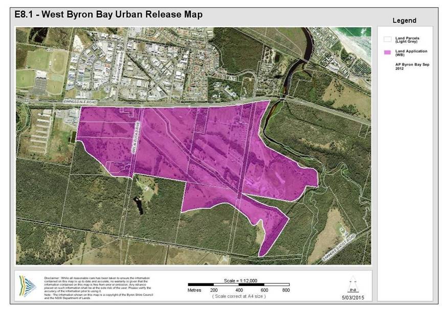
This Chapter applies to land identified under Part 4 West Byron Bay Site of Byron Local Environmental Plan 1988. The site location is shown below in Map E8.1 – West Byron Urban Release Area Map
The purpose of this chapter is:
1. To establish the planning, design and environmental objectives and guidelines against which the consent authority will assess future development applications.
2. To communicate site specific controls for the site relating to urban design, mitigation of environmental impacts, protection of biodiversity and management of environmental hazards.
3. To promote high quality urban design outcomes for the site within the context of environmental, social and economic sustainability.
BYRON SHIRE COUNCIL
13.10 - Attachment 1
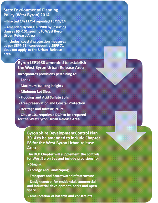
Relevant State Environmental Planning Policies (SEPP) and Byron Local Environmental Plan (LEP) 1988 are the statutory environmental planning instruments applicable to the site and will prevail over any inconsistencies with provisions contained in the Chapter.
State Environmental Planning Policy (West Byron Bay) 2014 amended the Byron LEP 1988 by inserting Clauses 65 – 101 and identified the site as an urban release area on the 14 November 2014. Clause 101 requires the preparation of a DCP for the West Byron Urban Release Area. The West Byron SEPP after amending the Byron LEP 1988 was subsequently repealed the following day.
The flow chart below provides a summary of the relationship between the now repealed SEPP and the DCP Chapter.
Development within West Byron Bay will need to comply with this chapter, as well as other relevant chapters in the Byron Shire DCP 2014 set out in Table E8.1. In the event of any inconsistency between this DCP Chapter and other Chapters within Byron Shire DCP 2014 or any other plan or policy of Council, this chapter will prevail to the extent of the inconsistency.[c3]
Table E8.1 Relevant Provisions of the Byron Shire DCP 2014
|
Section and Provisions of Byron Shire DCP 2014 |
|
Part A Preliminary
|
|
Part B Controls Applying Generally to Development Applications
Chapter B2 Preservation of Trees and Other Vegetation Chapter B3 Services Chapter B4 Traffic Planning, Vehicle Parking, Circulation and Access Chapter B5 Providing for Cycling Chapter B6 Buffers and Minimising Land Use Conflict Chapter B7 Mosquitoes and Biting Midges Chapter B8 Waste Minimisation and Management Chapter B9 Landscaping Chapter B10 Signage Chapter B11 Planning for Crime Prevention Chapter B12 Social Impact Assessment Chapter B13 Access and Mobility Chapter B14 Excavation and Fill |
|
Part C Further Controls Applying to Land with Specific Constraints and Environmental Characteristics
Chapter C1 Non-Indigenous Heritage Chapter C2 Areas Affected by Flood Chapter C3 Visually Prominent Sites, Visually Prominent Development and View Sharing Chapter C4 Development in a Drinking Water Catchment
|
|
Part D Further Controls Applying to Specific Land Uses
Chapter D1 Residential Accommodation in Urban, Village & Special Purpose Zones Chapter D2 Residential Accommodation and Ancillary Development in Rural Zones Chapter D3 Tourist Accommodation Chapter D4 Commercial and Retail Development Chapter D5 Industrial Development Chapter D6 Subdivision Chapter D7 Sex Services Premises Chapter D8 Public Art |
This chapter is based on information obtained from the State Significant Site (SSS) Study for the West Byron Bay Urban Release Area. The technical studies completed as part of the SSS Study are set out in Table E8.2. These are available from the NSW Department of Planning and Infrastructure’s website www.planning.nsw.gov.au.
Table E8.2 State Significant Site Study – Technical Studies
|
Issue |
Technical Study |
Author |
Date |
|
Acid Sulfate Soils |
Preliminary Acid Sulfate Soils Assessment |
Southern Cross University Environmental Analysis Laboratory |
December 2010 |
|
Air Quality |
Odour & Air Quality Constraints West Byron |
PAE Holmes |
December 2010 |
|
Options for Future Development on West Byron SSS Site: Odour Constraints |
PAE Holmes |
May 2012 |
|
|
Aquatic Ecology |
Aquatic Assessment of West Byron Urban Land Release Program |
Peter Parker Environmental Consultants Pty Ltd |
August 2010 |
|
Bushfire |
Bushfire Assessment |
LandPartners |
December 2010 |
|
Civil Engineering |
Byron West Engineering Advice |
Cardno |
April 2011 |
|
Contamination |
Preliminary Contamination Land Assessment |
EAL Consulting Service |
December 2010 |
|
Cultural Heritage |
Proposed West Byron Urban Release Area Cultural Heritage Assessment |
Jacqueline Collins (Consultant Archaeologist) |
December 2010 |
|
Ecology |
Preliminary Ecological Assessment |
LandPartners |
August 2010 |
|
Ecological Assessment West Byron Project |
Australian Wetlands Consulting Pty Ltd |
December 2010 |
|
|
West Byron Urban Land Release Area: Response to Submissions Received during Public Exhibition Period – Ecological Matters |
Australian Wetlands Consulting Pty Ltd |
April 2012 |
|
|
Flooding |
West Byron Flood Impact Assessment |
BMT WBM |
December 2010 |
|
West Byron Flood Impact Assessment – Assessment Revision - Correspondence |
BMT WBM |
22 November 2011 |
|
|
West Byron Flood Impact Assessment – Response to Submissions - Correspondence |
BMT WBM |
22 March 2012 |
|
|
West Byron Bay Development Proposal – Flooding – Final Report |
WMA Water |
21 June 2012 |
|
|
Geotechnical |
Geotechnical Assessment for Development of West Byron/Belongil Fields |
Shaw Urquhart |
June 2010 |
|
Koala Management |
West Byron Urban Release Area Response to Submissions by Byron Shire Council and Office of Environment and Heritage – Koala Management |
Austeco Environmental Consultants for Setscan Pty Ltd |
6 November 2012 |
|
Koala Management in the West Byron Urban Release Area – Memorandum to Byron Bay West Landholders Association |
Austeco Environmental Consultants for Setscan Pty Ltd |
16 November 2012 |
|
|
Land Use Conflicts |
Land Use Conflict Risk Assessment |
LandPartners |
December 2010 |
|
Mosquitoes |
Mosquito Risk Assessment |
Sydney West Area Health Service |
December 2010 |
|
Noise |
Revised Preliminary Acoustic Advice |
TTM Acoustics |
June 2010 |
|
Retail and Commercial Demand |
West Byron Urban Release Area Retail and Commercial Demand Study |
Hill PDA |
July 2010 |
|
Social Impact |
West Byron Urban Release Area Housing and Human Services Study Social Impact Assessment |
BBC Consulting Planners |
February 2011 |
|
Traffic |
West Byron Development Transport Study |
Veitch Lister Consulting |
March 2011 |
|
West Byron Development Transport Study – Supplementary Report on Changes in Level of Service |
Veitch Lister Consulting |
March 2011 |
|
|
Urban Design |
West Byron Urban Release Area Enquiry-by-Design Workshop Outcomes Report |
Deicke Richards Architects |
September 2010 |
|
Summary of Issues and Proposed Resolution of Traffic Noise, Visual Impact and Urban Design along Ewingsdale Road |
TTM Acoustics, Ennismore Field P/L & Deicke Richards P/L |
May 2011 |
|
|
Visual Impact |
West Byron Urban Release Area Visual Assessment |
Ennismore Field Pty Ltd |
Undated |
|
Water Management |
West Byron Urban Land Release Project Report |
The Water & Carbon Group |
October 2010 |
In this chapter Urban release area is the West Byron Bay site identified under Part 4 of the Byron Local Environmental Plan 1988.
Any other word or expression used in this Chapter has the same meaning as it has in the standard instrument (as prescribed by the Standard Instrument (Local Environmental Plans) Order 2006) unless it is otherwise defined in this Chapter. Where the word or expression is not defined in the standard instrument, it will have the same meaning as defined in the Byron Shire DCP 2014. Wherever any discrepancy arises, the provisions used in the standard instrument prevail.
Where not otherwise defined, the meaning is to be taken as the meaning most commonly understood. A reference in this Chapter to any Australian Standard or legislation includes a reference to any amendment or replacement as made.
Notes: are included in this document to provide additional guidance and explanation of the provisions. These notes are not part of the formal provisions of the Chapter
Clauses in this plan contain Objectives, performance criteria and prescriptive measures. The prescriptive measures are requirements that Council considers likely to meet the objectives and performance criteria. In certain circumstances applicants can propose alternate solutions to the prescriptive measures, however they will need to demonstrate that the alternative design satisfies the objectives and performance criteria for that clause. Further information is provided in Part A of DCP 2014 (see Clause A12) where an explanation is provided on dual path assessment.
Notification of development applications will be undertaken in accordance with Part A of the Byron Shire DCP 2014.
The development of the site is underpinned by the following key design principles:
Legible and connected
a) A vibrant mixed use village centre to provide a community meeting place and to provide retail and commercial opportunities
b) a street pattern that connects the new residential areas with the mixed use village centre, the light industrial area and local parks
c) neighbourhoods where residents can safely walk or cycle to the local shops and open space
d) public transport, cycle and pedestrian ways that links with existing networks.
e) high speed broadband to the entire estate
Reinforcing the natural environment
a) high quality streetscapes with generous green verges, street trees and footpaths with access to safe open space areas
b) Appreciation of areas of high quality habitat for conservation
c) Residential open space areas which link with the natural environment
Innovative and integrated
a) mixture of dwellings types to improve housing choice for a variety of residents and budgets and create diversity in the built form
b) housing arrangements different to the existing model in Byron Shire including small lot housing and co-operative housing
c) Clearly defined entry statements at the access points from Ewingsdale Road
Amenity
a) Residents and properties are protected from hazards including flooding and bushfire
b) Coherent buffers provided to Ewingsdale Road and other environmental constraints.
Concept and Staging Plan[c4]
A Staging and Concept Plan has been developed for the site as shown in Appendix A and B. The plans form the basis for urban development by setting out:
a) access points from Ewingsdale Road and associated intersection treatments
b) a key circulation route through and around the development area including cycleways
c) the location of future land uses including low and medium density residential development, the neighbourhood centre, the light industrial area, and open space
d) buffers to Ewingsdale Road
e) the identification of environmental conservation and management areas for revegetation
f) landscaping and street trees
Both plans are indicative and further changes to the layout and or staging may occur through the development of West Byron and further assessment. Where major variations are proposed the applicant will be required to demonstrate the development remains consistent with the Design Principles in this section.
Objectives
1. Enable the orderly development of the site.
2. Enable land to be developed in a co-ordinated fashion.
Performance Criteria
1. Land use development will be integrated, coordinated and planned in line with the provision of infrastructure
2. All infrastructure will be designed to provide a high standard of living for residents and a vibrant, well serviced village centre and industrial estate.
3. Rehabilitation and re-vegetation works are to be delivered in a timely manner and in accordance with management plans.
Prescriptive Measures
1. West Byron is to be developed in two main stages generally as shown in Appendix A Staging Plan.
2. Stage 1 to comprise the following minimum infrastructure and works to enable the site to be subsequently developed for commercial, residential and industrial land uses.
a) The two roundabouts on Ewingsdale Road – Details to be submitted and approved as to the timing of construction of the roundabouts to minimise disruption to traffic flows on Ewingsdale Road. The roundabout at the intersection of Bayshore Drive and Ewingsdale Road to be designed and constructed with a concrete pavement to facilitate heavy vehicle movements into West Byron.
b) The start of the two ends of the Main Spine Road for a length of approximately 250 metres to the first major internal intersections;
c) Legal access to roads and services for any allotments (including Lot 1 DP780242) not having land frontage to the constructed Main Spine Road;
d) Closing of Melaleuca Drive from Ewingsdale road and measures to ensure access to other properties on this road.
e) Noise attenuation measure to Ewingsdale Road including earth bunds, noise fencing and landscaping to satisfy the Australian Standard;
f) Trunk water services (including Dual Reticulation mains to service the IN2 Light Industrial Zone and B1 Neighbourhood Centre Zone) for the length of the constructed roads;
g) Main Trunk Sewer infrastructure, pump stations and other necessary sewage infrastructure for the length of the constructed roads;
h) Bulk Earthworks to satisfy the flooding and stormwater requirement for the site including the reconstruction of the main stormwater drain through to the point of discharge;
i) Any necessary stormwater infrastructure to service this Stage including embellishment and landscaping of the main drain in this Stage. Where appropriate drainage work in Stage 2 can commence with Stage 1 including works on the main drain.
j) Bulk Earthworks for Central Park on Ewingsdale Road (not embellishment) zoned RE1;
k) Acid Sulfate Soils Management Plan for the entire site, Water Management Plan for Belongil Creek including baseline data, monitoring and hold points in the event that water quality is adversely affected by the development, and Biodiversity Conservation Management Plan including a program for environmental management and staged rehabilitation for the E2 and E3 Zones;
l) Identification and protection of any special cultural or heritage places for the entire site;
m) Construction of the pedestrian/ cycleway for the full frontage of Ewingsdale Road and other pedestrian/ cycleways through Stage 1 as required;
n) General landscaping, street trees and the like where relevant to Stage 1 for the sections of roads being constructed;
o) Subdivision for the purpose of creating super or master lots and smaller site specific residential, commercial and industrial lots where appropriate;
p) Address the provisions for the West Byron Village Centre Precinct under Clause E8.10.10.1
q) Design for the construction and embellishment of the Park adjacent to the B1 Zone. The timing for the dedication of the park to be linked with the development of the B1 Zoned Land and the adjacent R3 Zone Land.
r) Any landscaping or buffer treatments as required under Clause E8.10.5.1.
s) General timing and sequencing of work within this stage.
t) Applicants to demonstrate that Infrastructure to be constructed at Stage 1 is designed to accommodate the expected population yield for West Byron.
Subsequent development applications for residential, business and industrial development including subdivision to demonstrate how they will be co-ordinated with infrastructure being provided with the Stage 1 approval.
3. Stage 2 - Stage 2 to comprise the following works and infrastructure:
a) Completion of the Spine Road link;
b) Completion of trunk water supply and sewer links;
c) Any other necessary stormwater infrastructure to service this Stage;
d) Compliance with any plans of management or Cultural Heritage recommendations approved in Stage 1:
e) General landscaping, street trees and the like where relevant to Stage 2 for the sections of roads being constructed;
f) Subdivision for the purpose of creating super or master lots or smaller site specific residential lots where appropriate;
g) Any landscaping or buffer treatments as required under Clause E8.10.5.1;
h) Embellishment of the Central Park on Ewingsdale Road; and
i) General timing and sequencing of work within this stage.
Subsequent development applications for residential, including subdivision to demonstrate how they will be co-ordinated with the infrastructure being provided within Stage 2.
4. Where road reserves are to be dedicated to Council they are to terminate at the property boundary to ensure access to adjoining properties.
5. Where drain crossings over Crown Land or other public property are deferred from Stage 1 to Stage 2, details to be submitted to Council outlining how the construction of the crossing will be financed including the agreement of land owners where nominated.
The subdivision layout needs to consider not only orientation, vegetation and constraints but also provide for suitably located and shaped lots for a diverse range of housing types in addition to standard single dwelling lots. In addition to the minimum lot size provisions under Byron LEP 1988 the following controls apply.
1. To facilitate the provision of a diversity of dwelling types and land tenure to service the needs of residents at different stages of life.
2. Street layout and the configuration and sizing of residential lots is responsive to site characteristics and achieves the following outcomes wherever possible:
a) potential for solar access to the main living areas and private open space of future dwellings on each lot, is maximised;
b) lots are oriented so that future buildings can make best use of the site’s characteristics (e.g. desirable views/ outlook, most suitable access) in order to maximise amenity and privacy and keep building and running costs to a minimum;
c) potential for overshadowing and overlooking of neighbouring dwellings and their private open space, is minimised.
3. Consideration to be given to the residential controls when planning lots sizes and dimensions in relation to car parking, open space and landscaping areas and building footprint.
1. A diversity of lot sizes and dwelling types, to suit different household structures.
2. Higher density development lots sited in proximity to walkways, cycleways, parkland, and public transport. Corner lots and lots with rear lane access to facilitate alternate access arrangements that reduce the number of driveways across the primary street frontage are preferred.
3. Subdivision design addresses existing vegetation (to be retained), bushfire and other environmental constraints in terms of the location and sizing of lots.
4. The configuration, shape and size of lots maximises solar access to each lot and are of appropriate shape and width to accommodate dwelling designs where the main indoor and outdoor living spaces can be orientated to the north, north east or north west.
5. Consideration to be given to the siting of dwellings in the design of subdivision for small lots.
1. Applications for subdivision to be generally in accordance with the Concept Plan for West Byron. Details to be submitted with the relevant application demonstrating how access to properties on Melaleuca Drive will be provided and maintained.
2. A minimum building envelope of 12m x 15m to apply in R2 zone and 12m x 10m in the R3 Zone for vacant residential allotments.
3. Subdivision layouts provide rectangular shaped lots with the long side of the lot aligned on a general east-west or north-south axis wherever possible, in order to maximise the potential for solar access to future dwellings. (see note below and figure E8.2)
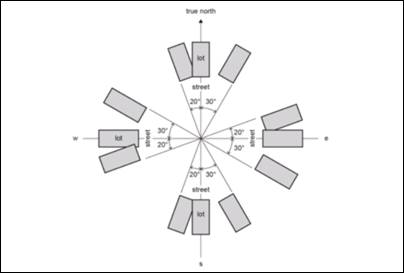
Figure E8.2 Alignment of Subdivision Lots[j5]
4. The use of battle-axe lots is to be kept to an absolute minimum. To ensure a suitable residential area to build upon, the access handle to not be include in the lot size calculations. Access handle widths to comply with Chapter D6 of Byron DCP 2014.
5. Dual Occupancy, Multi Dwelling Housing, residential flat buildings and Integrated Housing lots in the R2 Zone are to be designed as follows:
a) The plan of subdivision to clearly nominate lots for dual occupancy, multi dwelling housing, residential flat buildings and integrated housing as per Clause 83 of Byron LEP 1988.
b) Lots nominated for higher densities than single dwelling housing should be carefully chosen having regards to vehicle access, solar orientation, location of pedestrian paths and cycleways and public opens pace areas and the residential controls contained within this Chapter.
c) Dual occupancy, multi dwelling housing, residential flat building or integrated housing lots to have a minimum dimensions of 25 metres on a general north -south axis with secondary street or rear lane access.
d) Such lots are not to be clustered in one location but generally dispersed throughout the R2 Zone.
6. Subdivision with the R3 Zone to
have careful consideration to the final built form in terms of vehicle access
and car parking, solar orientation, private open space, and the public domain.
Accordingly it is preferable that master or super lots be created with an area
greater than 1000m2, which can be subsequently developed and
purposely planned for medium density residential development. Such lots should
have dual frontage as a minimum in terms of either a corner lot, rear lane
access or extend through from one street to the next street.
Where vacant small lots are
proposed pursuant to Clause 81 of Byron LEP 1988, the following controls are to
apply in the R3 Zone:
a) Access to be provide by way of a rear lane, secondary street or reciprocal right of carriageway to be incorporated into the subdivision design to provide access to the rear of these properties. In circumstances where access is provided via a battleaxe handle, the area of the handle to be excluded from the lot size calculation. Access to be designed and constructed in accordance with Chapter D6 of Byron DCP 2014.
b) To include an appropriate Section 88B instrument for the subject lot and the adjoining lot(s) that will enable zero lot line development on each property boundary.
c) Where 4 or more small lots are proposed in a street section, the street to be of a suitable width to accommodate nose in, or 45 degree angle parking across the frontage of those lots. The parking to be integrated with footpaths, cycleways and landscaping including street tree blisters every five parking spaces to break up the parking areas and to provide shade.
d) Lots to be clearly orientated between the north east to the north west to ensure good solar access. .
Nose in car parking in
front of small lots with street tree blisters
Figure E8.3 Street Parking for Small Lots
7. Where lots incorporate vegetation to be retained details to be submitted with the subdivision application demonstrating that the vegetation will be managed and not removed for bushfire protection purposes or for residential buildings with subsequent applications for residential development. In certain circumstance Council may require a Section 88B instrument on the title to aid in the protection of the vegetation and to override the 10/50 Vegetation Clearing Scheme exemptions for vegetation removal.
Notes:
· Applicants are encouraged to consider the residential provisions when designing the subdivision layout, and in particular for multi dwelling housing and integrated housing lots. Lots with potential private open space within the front setback may need to be longer/ wider to enable a suitable, useable, private area with solar access to be provided.
· Corner lots provide good opportunities for dual occupancy and multi dwelling housing/ integrated housing options with vehicle access provided from both streets for a dual occupancy, or a single shared access point provided from the secondary street for three or more dwellings.
· Lots that run from one street through to a second street also provide good design solutions for vehicle and pedestrian access and egress.
1. To provide a hierarchy of interconnected streets that gives safe, convenient and legible access through West Byron.
2. To minimise through traffic in residential neighbourhoods.
3. To ensure that the hierarchy of the streets is clearly legible through variations in carriageway width, on-street parking, threshold parking, incorporation of water sensitive urban design measures (where possible), street tree planting, and pedestrian amenities.
4. To provide a safe and convenient public transport, pedestrian and cycleway network.
5. To ensure a high quality, functional, safe, legible and visually attractive public domain.
6. To design streets within each neighbourhood primarily for people, not for cars, by providing a level of access, safety and convenience to residents in each neighbourhood.
Performance Criteria
There are no performance criteria
Prescriptive Measures
1. The road layout is based generally on the Concept Plan. The road hierarchy is based on the following:
a) a main Spine Road which intersects with Ewingsdale Road in two places at roundabouts (Distributor road)
b) Collector roads;
c) Local roads;
d) Access Roads;
e) Laneways; and
f) Pedestrian and cycleway routes.
Typical Road Cross Sections are provided at Appendix D incorporating swales. Figure E8.4 shows typical road verge with swale and footpath. The final road layout is subject to detailed design and assessment having regards to topography, drainage, environmental factors and lot layout.

Figure E8.4 Typical Road Verge with Swale and Footpath
2. Street design to provide generally no more than three (3) intersection turns to be traversed from the furthermost lot to the Ewingsdale Road entrances. Local roads in a residential zone shall be designed to discourage through traffic via traffic calming measures, such as landscaped street blisters, chicanes and on-street parking.
3. Cul-de-sacs to be a maximum of 200m in length and for a maximum of 25 dwellings. Cul-de-sacs are to provide for pedestrian and cycle permeability.
4. Formal entry statement to be provided at both entrances from Ewingsdale Road through fencing and landscaping and changes in road pavement. Each neighbourhood area (including the Village centre and Industrial precinct) to provide a distinctive entry statement by way of changes to the road pavement material at the entrance.
5. Formal pedestrian crossings to be clearly delineated through changes in road pavement material and or raised, plus appropriate signage and line marking as required.
6. The street network is to be designed to achieve the following principles:
a) Access to Ewingsdale Road restricted to the two main entrances as indicated on the concept plan. All properties with frontage to Ewingsdale Road to gain access from an internal local road. Existing properties on Ewingsdale road to re-site driveways to the internal road network.
b) Establish a permeable pedestrian and cycleway network that is based on AMCORD principles that will encourage walking and cycling and reduce travel distances involving those activities,
c) Provide for a safe pedestrian cycleway crossing point across Ewingsale Road to facilitate access to Sunrise Estate, the Byron Arts an Industrial Estate and the Cavanbah Sports Centre.
d) maximise neighbourhood connectivity between residential neighbourhoods, recreational areas and the Village Centre;
e) accommodate significant vegetation to avoid its removal;
f) optimise solar access opportunities for dwellings having regards to the controls relating to dual occupancy, multi dwelling housing and integrated housing;
g) maximise surveillance of open space and environmental protection corridors; and
h) maximise the use of water sensitive urban design measures.
7. Except where otherwise provided for in this Chapter, all roads, streets and roundabouts are to be designed and constructed in accordance with the minimum requirements set out in the Northern Rivers Local Government Development Design and Construction Manual.
8. For all local roads and access roads, traffic management, (i.e. road layout and/or speed reducing devices), to be used to produce a low speed traffic environment. Such traffic management devices are to be identified at the time of the subdivision application.
9. Laneways that are solely designed for back of house access and egress in the residential and business zones to be contained within a minimum 6 metre wide road reserve with a 6 metre wide pavement based on vehicle design speeds of 15kmh The laneway to generally service no more than 300 vehicles per day. The road reserve may need to be widened to accommodate services, intersections and other constraints.
10. The road through the IN2 Zone Land to terminate in a culdesac at the boundary with Lot 181 DP755695. Alternatives to extend the road through this parcel and back to Ewingsdale Road will be considered where it can be demonstrated with a traffic study a positive outcome for traffic management on Ewingsdale Road and to enable the free flow and movement of heavy vehicles, delivery trucks and other traffic entering the IN2 Zone.
11. Four bus stops to be sited either side of the Spine Road in a minimum of two locations to facilitate public transport within the eastern and western halves of the Urban Release Area.
12. The road to incorporate nose in / 45 degree angle on-street car parking in the R3 Zone for overflow parking as required under Clause E8.10.2. The parking areas to be integrated with street landscaping including street tree blisters passively watered by WSUD, cycleways and footpath areas.
For Small Lot Subdivisions in the R3 Zone
(<350m2) comprising four or more lots nose in or angle
parking as per Clause E8.10.2 is required with rear access
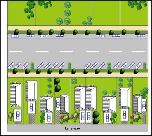
Figure E8.5 Road and parking design combined with vacant small lot subdivision
Objectives
1. To facilitate the disposal of stormwater in a sustainable manner
2. To maintain and improve the quality of water entering Belongil Creek
Performance Criteria
1. To enable stormwater to be managed in accordance with the concept of Water Sensitive Urban Design.
2. To enable stormwater infrastructure in the main drain to also become environmental features for native flora and fauna, habitat corridors and to facilitate pedestrian and cycling access.
3. To ensure a co-ordinated response to the design of stormwater infrastructure combined with landscaping and the built form in the public and private realm.
4. To provide stormwater infrastructure that can be readily maintained at minimum cost to Council and the public.
Prescriptive measures
1. A detailed Stormwater Management Plan to be submitted with the Stage 1 Development Application for approval by Council based on the concept of Water Sensitive Urban Design. The plan is to be for the entire urban release area of West Byron and include the following:
a) Outline stormwater treatment facilities, infrastructure and landscaping associated with water sensitive urban design measures.
b) Be consistent with the stormwater requirements of Chapter D6 Subdivision of Byron DCP 2014 and the Northern Rivers Development and Design Manual unless otherwise agreed to by Council;
c) Demonstrate through stormwater modelling that the proposed development will not adversely impact the coastal wetlands, Belongil Creek or Cape Byron Marine Park;
d) Demonstrate a lawful point of discharge for all stormwater outlets. Where Union Drains and other private infrastructure is to be accessed, details to be provided on lawful access and ability for such drains to be maintained legally by Council.
e) Works within the main drain including excavation and widening, environmental embellishment and access arrangements for pedestrians, cyclist and maintenance vehicles to be generally consistent with the Concept Plan for West Byron;
f) Any stormwater detention/ treatment basins are to be limited in number for ease of maintenance. (N.B. preference will be given to the design and construction of larger basin(s) rather than multiple smaller basins/ponds);
g) Landscaping as part of the WSUD Strategy for West Byron to provide details on:
i) Soils, mulch and sub-grade treatment. The plans should reference relevant engineering drawings for filter media requirements;
ii) Contours and spot levels;
iii) Proposed plant species (only native species to be used – except where turf is utilised in swales), including the plant’s botanical name, planting height, quantities and densities;
iv) existing vegetation proposed to be retained and details of proposed protection measures;
v) Planting specification notes are required to include details on plant procurement, timing, maturity, preparing filter media, mulching, planting procedures, watering and the acceptable measures of successfully established plants; and
vi) Any targeted habitat improvement for threatened or endangered species.
h) Outline any requirements for ongoing monitoring of water quality impacts and measures for managing Acid Sulfate Soils;
i) Outline mitigation measures to minimise mosquitoes;
j) Be consistent with other stormwater measures included in this DCP Chapter;
k) Staging and timing of works and financial responsibility for construction.
l) Identify any additional stormwater detention requirements for subdivision and subsequent development in the residential, business and industrial zones;
m) Outline long term management, ownership and maintenance arrangements for all stormwater infrastructure. An extended maintenance period to be provided for WSUD measures. Typically this will require that 90% of dwellings are substantially commenced within the development sub-catchment associated with the relevant treatment measure;
2. Stormwater works in the environmental zones including in the main drain to be carefully designed to minimise the removal of native vegetation. Where vegetation is proposed to be removed, details to be provided under Section E8.10.5.1.
3. Any subsequent development application is to be consistent with the Stormwater Management Plan.
4. Construction water quality impacts are to be mitigated through appropriate erosion and sediment controls in accordance with Managing Urban Stormwater - Soils and Construction ('The Blue Book').
The subject site provides important habitat for a range of species and ecological communities including koalas, wallum froglet, blossom bat and remnant coastal cypress pine communities. A voluntary planning agreement has been signed between the Minister for Planning and the landowners requiring a vegetation management plan to be prepared addressing matters such as a program and implementation strategy of environmental management works for the land zoned E2 Environmental Conservation. Vegetation management however will need to apply to the entire site, and any native vegetation that is proposed to be removed from within the urban footprint will need to be appropriately compensated. Landscaping will play an important role as part of the overall environmental management of the site, and will enhance habitat attributes, whilst also playing a part in the management of stormwater. The following controls apply: [j7]
Objectives
1. Maintain and improve habitat and ecosystem connectivity;
2. Protect biodiversity values of the site particularly
within E2 Environmental Conservation and E3 Environmental
Management zoned land including flora, fauna, habitat, wetlands, and the
riparian areas of Belongil Creek.
3. Maintain or improve the ecological and hydrological functions and values of Belongil Creek
4. Environmental buffers to sensitive ecological areas
5. Improve koala ecological values on the site.
Performance Criteria
1. Ensure that a comprehensive Biodiversityvegetation
Conservation Management Plan, including
identified sub- plans,
is prepared and approved to minimiseminimize and offset,
the impact of development on the site with the Stage 1 Development Application.
2. Environmental buffers to sensitive ecological areas to be revegetated or restored, with development located outside environmental buffers.
3. Protect core koala habitat areas from development that would compromise habitat quality and integrity and enhance koala habitat to provide connectivity links to facilitate the natural movement of koalas.
4. Protect, maintain and enhance key habitat corridors to improve linkages between habitats.
5. Improve biodiversity on the site by rehabilitating and re-vegetating areas identified for conservation within an established timeframe for delivery.
6. Mitigation of direct and indirect impacts of development on drainage lines and riparian areas
Prescriptive Measures
1. A comprehensive vegetation Biodiversity Conservation
Management Plan is required to be
prepared for the Stage 1 Development Application. The plan is to be for the
entire Urban Release Area and to include the following:
a) identification of existing vegetation to be retained;
b) the types of vegetation management works required and how those works will be implemented, including allocation of responsibility for funding works;
c) an initial five-year implementation program setting out habitat restoration and management works including strategies for planting, weed control and maintenance based on strengthening general key habitat corridors along the eastern and southern periphery of the Urban Release Area (See Figure E8.6 below). Such works are to be incorporated into the first Construction Certificate for the site to ensure any compensatory planting that may be required is established as West Byron is gradually developed;
d) details of responsibility for the ongoing management of habitat areas in the E2 and E3 Zones following the initial five year implementation program;
e) methods to prevent the introduction of exotic pest species or to manage and reduce pest species already present;
f) methods to reduce potential for bird strikes into windows of buildings;
g) details of ongoing monitoring, reporting to Council and processes for adaptive management where necessary;
h) The Vegetation Management Plan for the E2 Zone as required under the Voluntary Planning Agreement (VPA) dated 21/10/14 to be incorporated into the comprehensive Biodiversity Conservation Management Plan. The plan to address threatened species, SEPP 44 Koala Habitat Protection, measures to manage Belongil Creek and the requirements of the VPA. The plan can be detailed in the following sub plans:
i) Threatened species management plan providing details on any expected impacts on threatened species or their habitat, how such impacts will be avoided as far as practical or mitigated if necessary, and how any impacts will be compensated through rehabilitation and revegetation work. Council records indicate the site provides habitat for wallum sedgefrog and the wallum tree frog. The management plan is to address the National Recovery Plan for Wallum Sedgefrogs and other wallum dependant frog species.
ii) A Belongil Creek Plan of Management to be prepared in consultation with the relevant land owner and provide for bushland restoration on land adjacent to the creek and within riparian buffers provided by the E2 conservation zones, weed control and habitat restoration along drainage lines. Any new culverts over existing water crossings to provide improvements in water quality and fish passage
iii) A Koala Plan of Management (KPOM) is to be prepared in accordance with the requirements of State Environmental Planning Policy No. 44 – Koala Habitat Protection. Should Council have an adopted KPOM for the area, Applicants have the choice to use this plan or prepare their own plan. An Individual KPOM as a minimum to address the following:
· SEPP 44 Guidelines for Individual KPOMs
· Core Koala Habitat on and surrounding the site
· Rehabilitation of habitat in the E Zones to focus on Koala Habitat restoration to address any compensation requirement and to provide or embellish linkages between Core Koala habitat areas
· measures to protect existing koalas whilst new habitat is being established.
· details of koala friendly crossings under/ over Ewingsdale Road, and timing and responsibility for their delivery[c8] .
· other
measures to protect koalas including reduced vehicle speeds and traffic calming
measures, development fencing, dog prohibition or control, pool safety
through design measures such as ramps or “beaches”, control on construction
activities, signage, appropriate building envelopes having regards to bushfire
requirements for asset protection zones.
11.2. Revegetation
and rehabilitation works are to be delivered in accordance with the Biodiversity Conservation
Management Plan and the
sub plans, and is to be based on the Concept Plan in Appendix B. All
plantings should use species locally sourced with local genetics, and include
the aim of achieving a 90% survival rate.
3. Development applications for subdivision (excluding subdivision for the consolidation of lots that does not create additional lots or the opportunity for additional dwellings, boundary adjustments or to dedicate land for a public purpose) are to:
a) Address the relevant statutory considerations under the Environmental Planning and Assessment Act 1979 (specifically Section 5A, 5C and Section 79C) consider potential impacts to:
i) threatened species, populations and endangered ecological communities under the Threatened Species Conservation Act 1995 and the Environmental Protection and Biodiversity Conservation Act 1999
ii) SEPP 14 Wetlands and SEPP 44 Koala Habitat Protection
iii) Relevant provisions of the Water Management Act 2000, Fisheries Management Act 1994, Marine Parks Act 1997 [t9] and the Native Vegetation Act 2003
iv) Be accompanied by a detailed ecological assessment including habitat values, location and extent of any habitat proposed for removal and offset location, extent and timing.
b) Identify buffers between development (in zones R2 Low Density Residential, R3 Medium Density Residential, IN2 Light Industrial, B1 Neighbourhood Centre) and any land zoned E2 or E3 and provide a plan of management for the buffers and the zone interface. Buffers or buffer zones are not required between E2 and E3 zones. Buffer management plans must:
i) aim to mitigate direct and indirect impacts from development in order to protect the integrity and health of the natural environment
ii) aim to avoid negative impacts on the natural environment and ensure retention and enhancement of those functions and characteristics that are important to biodiversity conservation, landform stability, erosion management, hydraulic function and other important natural, geophysical and biophysical processes
iii) aim to provide a minimum width buffer of 20 metres. The buffer can include a perimeter road/ bushfire trail for bushfire protection purposes provided that road is located outside of the E2 and E3 zone and comprises a minimum vegetated edge adjacent to the E2 and E3 zone of 7 metres. Cycleways and pedestrian paths are also acceptable within buffer areas
iv) incorporate existing native vegetation into the buffer
v) provide details on long term management and responsibility.
4. Landscaping of drainage lines, parks, reserves, road buffers and other large areas within the urban footprint of the Urban Release Area to be designed to enhance biodiversity values and habitat linkages. Concept landscaping plan to be submitted with development applications for subdivision which form one or more stages of the proposal for West Byron.
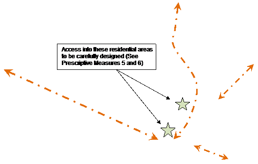 |
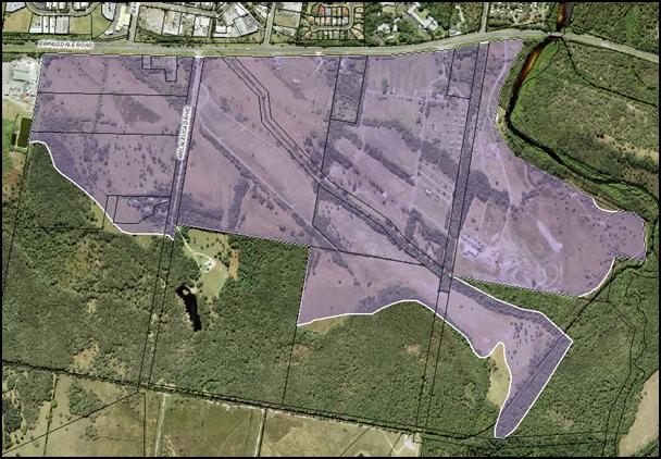
Figure E8.6 General Habitat Corridors to be Strengthened
(as denoted by orange arrows)
5. The road network within the south eastern perimeter of the Urban Release Area including vehicle access from the main residential areas to include traffic calming measures such as narrower road widths including chicanes and or one way traffic flows to facilitate the movement of fauna through this area from the E3 Zones to the E2 Zones. Other options to regulate and limit through traffic in this area is to develop Lot 1 DP 780242 and Lot 229 DP 755695 as community title/ strata title residential estates with an “Environmental Living Theme” and incorporate surrounding E2 and E3 Zoned land into the common/ neighbourhood property for ongoing management.
6. Any roads, cycleways, pedestrian footpaths, bushfire trails and other necessary infrastructure that traverses into or across the E2 and E3 Zone to be sited to minimise impacts on the environmental qualities of native vegetation and habitat in those zones by utilising existing breaks in the native vegetation and or siting and designing such works to have minimal disturbance (eg narrow road width/ locate where weeds and exotics are to be removed, signage for wildlife crossings etc). Details to be submitted with the development application.
7. For ongoing removal of trees and vegetation after West Byron is developed, land owners to comply with Chapter B2 Preservation of Trees and Other Vegetation, and any requirements of the Biodiversity Conservation Management Plan approved under this Chapter.
8. Despite the provisions of Clause E8.3, residual areas outside of the Urban Release Area in Lots 227 and 229 DP 755695, Lot 9 DP 111821, and Lot 2 DP818403 to be incorporated into the Biodiversity Conservation Management Plan as required.
1. Landscaping to provide for the enhancement of the biodiversity values of the Urban release area.
2. To be an integral part of the development of the site to provide attractive and aesthetically pleasing environments.
1. Native vegetation to be retained where possible and incorporated into landscaping.
2. Landscaping to reflect the subtropical character of Byron Bay.
3. Landscaping to be an integrated into street and park designs and stormwater management through Water Sensitive Urban Design (WSUD) with street trees provided throughout the subdivision.
1. Landscape plans to be submitted with all development applications for:
a) Subdivision
b) Multi dwelling housing
c) Residential flat buildings
d) Dual occupancies
e) Development in the B1 and IN2 Zones and
f) As specified for any other development in DCP 2014
The Landscape Plan to be prepared in accordance with Chapter B9 of DCP 2014.
2. Applications for subdivision to identify street tree planting every 15 metres of road frontage, landscaping and plantings for drainage lines, car parks and recreational reserves to be dedicated to Council. The Landscape Plan to indicate how planting will be maintained, identify existing native vegetation to be retained, nominate species to be planted and describe any passive watering arrangements through WSUD.
3. Street trees in the B1 Zone to be incorporated into the footpath as per Appendix C – WSUD Street Tree Pit with Grate. Other treatments within West Byron include landscaping of any footpath blisters and roundabouts, and road side rain-gardens. Such landscaping to be passively watered through WSUD.
 Figure E8.7 Street Tree
Landscaping [j10]
Figure E8.7 Street Tree
Landscaping [j10]
4. For minimum requirements for planting size, density and species please refer to Chapter B9 of DCP 2014. Locally indigenous species are to be predominantly used in landscaping. Street trees are to have a general maturity height of 10 metres and a canopy diameter of 8 meters to provide shade and assist with managing the micro climate. No species listed as undesirable in Chapter B2 of DCP 2014 are to be used in landscaping on any site.
5. Where feasible, edible landscapes (bush tucker and other fruit trees and vegetation) can be used in selected areas throughout the Urban Release Area including sections of the public reserve and as landscaping for development on private property. Details to be submitted with the development application where such vegetation is being proposed for assessment.
1. To provide guidance for public facilities, services and general infrastructure.
1. To establish controls for infrastructure, public car parking areas, cycleways and footpaths that services the needs of residents, workers and visitors.
1. General Infrastructure
a) The subdivision shall be fully serviced with water, sewer, roads, drainage and underground electricity and telecommunication services. The telecommunication service to be designed to connect to the National Broadband Network. This service infrastructure may be constructed on a staged basis to accommodate the staged release of land.
b) Street lighting to be provided in accordance with Chapter D6 of DCP 2014. Where agreed to by the electricity provider, LED street lighting or solar power lighting will be considered.
c) All service infrastructure is to be designed and constructed in accordance with the Northern Rivers Local Government Development and Design Manual.
d) Service infrastructure internal to the development site shall be provided by the developer at no cost to Council.
2. Dual Reticulation Water
a) A dual-reticulation water supply for non-potable water is to be provided to all lots in the IN2 Light Industrial Zone and the B1 Neighbourhood Centre Zone as a minimum.
b) The developer shall incorporate on the Certificate of Title for all allotments Restrictions as to User which require all dwellings and buildings with plumbing (including commercial, industrial buildings and the like) to make provision for non-potable water service plumbing and facilities to the satisfaction of Council
3. Public car parking
a)  Public car parking areas to be designed and constructed to meet the
minimum standards within the Northern Rivers Local Government Development
Design Manual and the relevant Australian Standards.
Public car parking areas to be designed and constructed to meet the
minimum standards within the Northern Rivers Local Government Development
Design Manual and the relevant Australian Standards.
b) Such areas to be dedicated at no cost to Council after construction and at the end of the relevant maintenance periods.
c) Car parks to be appropriately landscaped with shade trees in accordance with Chapters B4 and B9 of DCP 2014 and passively watered through WSUD.
d) Applicants are to consider the installation of an electric vehicle charging station for major car parking areas around the B1 Zone. (Note: Opportunities may exist to partner with Council and other organisations with the design and installation of such infrastructure as per the Byron Shire Low Carbon Strategy)
4. Cycleways and Footpaths
a) To be suitably sited and designed to provide for the effective movement of people throughout the West Byron Site linking residential precincts with one another, the village centre, and the open space recreational areas. As a minimum 1.2 metre wide concrete footpaths to be provided on one side of all access roads and both sides of local, collector and distributor roads. Laneways to be shared with pedestrians and cyclists.
b) To connect with existing cycling pedestrian infrastructure in Ewingsdale Road and beyond.
c) Cycleways, bike parking and storage facilities to comply with Chapter B5 of DCP 2014.
d) Cycleway footpath along the main drain to be designed and constructed as an exercise/ fitness trail with designated training stops with appropriate equipment in three places approximately 400 - 500 metres apart.

Figure E8.8 Example of exercise equipment on soft fall material[j11]
5. Bus Stops
The road network is to be designed to provide for designated bus routes and bus stops in locations which provide safe and convenient access for residents.
6. Public access to Belongil Creek
Any public access to Belongil Creek, if proposed, is to be limited to one location only. No clearing of vegetation is permitted to provide this access. Owners consent from the Department of Primary Industries (Crown Lands) be obtained and submitted with the Development Application for this access point. Details to be submitted with the application addressing:
a) Long term management of the access point, including any facilities and amenities (eg boardwalk, fencing etc);
b) Consistency with the Belongil Creek Plan of Management;
c) Educational signage about the creeks environmental values; and
d) General legal access arrangements to the creek access point
1. To help engender a sense of community.
2. To help to promote social interaction, community health and wellbeing.
3. To provide a network of active and passive open recreational areas
Performance Criteria
1. Lots are to be within walking and cycling distance to a neighbourhood park
2. Parks are to include a range of recreational facilities
3. Neighbourhood parks need to be designed to meet the Crime Prevention through Environmental Design (CPTED) principles and Active Living criteria.
Prescriptive Measures
1. Residential lots are to be approximately 500 metres from the nearest neighbourhood park.
2. Outside of the two areas zoned RE1 any other neighbourhood park provided within the development site to have a usable area of approx. 0.2 hectares.
3. Neighbourhood parks are to be provided with the following facilities:
a) A hard stand play area (e.g. half court basketball/ skate area) to be provided in one of the RE1 Zoned Parks as a minimum;
b) Be designed and sited such that adjoining development can provide casual surveillance of the park. Be designed and located so as to maximise street frontage and encourage natural surveillance from surrounding residents;
c) Be situated on land that is readily accessible to the surrounding dwellings and physically connected to the cycleway/ pedestrian network;
d) Be equipped with play equipment, park furniture including seating for adults and toilet amenities;
e) Include soft-fall under all play equipment in accordance with the relevant Australian Standards;
f) Appropriate shade cover over play equipment;
g) Provide an electric BBQ, two roofed picnic tables, rubbish bins on stands to be provided in one of the areas zoned RE1;
h) Be landscaped with appropriate plantings of local native trees (no exotics) and weeds to be removed. Trees must have non-invasive root systems and be suitable for under-pruning as they develop to allow mower egress and undisturbed lines of sight. Vacant areas to be turfed with a suitable lawn species for mowing and incorporate earth mounds to provide visual interest and general play areas.
i) Adequate lighting be provided for crime prevention purposes.
j) The RE1 zoned land adjacent to the B1 Zone to provide for a village square or piazza as a community focal point and a casual meeting place for social interaction.
k) Other features such as a chess tables, bocce courts, ground level garden labyrinth or concrete table tennis facilities will also be considered on merit having regards to ongoing maintenance costs and the anticipated demographics of residents.
l) A footbridge for pedestrians and cyclist over the Main Drain in the Central Park on Ewingsdale Road.
4. Developer contributions credits will be provided for the provision and embellishment of new neighbourhood parks in accordance with Council’s Development Contribution Plan.
5. Other community uses for the parks such as community gardens and as a site for public art will be considered on merit. Where this is proposed, car parking, water and toilet amenities will be required for the community gardeners as a minimum. Any public art proposed will need to be consistent with the Byron Shire Cultural Plan and the Public Art Policy.
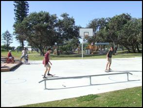

Park with play equipment and
park furniture within a landscaped setting. Multipurpose concrete
basketball half court and skate rail.
Figure E8.9 Examples of playground equipment [j12]
Note: – for further information on Community Gardens please see the Byron Shire Community Gardens Policy (10/012)
Flooding, acid, sulfate soils, ground water, bushfire, mosquitoes, contamination and potential odour from the adjacent chicken processing plant on Ewingsdale Road have been identified as hazards and constraints affecting the site. The following specific controls apply.
Objectives
1. Minimise the flood risk to life and property associated with the use of land.
2. Allow development on land that is compatible with the land’s flood hazard, taking into account potential changes as a result of climate change.
3. Avoid significant adverse impacts on flood behaviour and the environment.
4. Ensure that development does not have a significant impact on pre-development flood levels and flows.
Performance Criteria
1. Development shall be generally designed so that it is not affected by flooding.
2. Ensure that safe evacuation can be provided during flood events for land up to the probable maximum flood level.
3. Enable limited filling on flood prone land to facilitate the design and construction of stormwater infrastructure and to ensure residential development can meet the habitable floor level.
4. Demonstrate that the filling of flood prone lands and other earthworks do not result in any significant adverse flooding or environmental issues for adjoining land including stormwater overland flow paths.
5. Building design and levels are to consider climate change impacts including sea level rises. [c13]
Prescriptive Measures
1. The provisions of Byron DCP 2014: Chapter C2 – Areas Affected by Flooding apply to the site.
Objectives
1. To ensure that acid sulfate soils do not result in water quality or other environmental impacts.
Performance Criteria
Where acid sulfate soils may be exposed such as from earthworks, installation of infrastructure, reshaping stormwater drains, construction of footings for buildings and swimming pools, details to be submitted with the development application how such soils will be managed to ensure no adverse impacts on the environment.
Prescriptive Measures
1. An Acid Sulfate Soil Management Plan is required to be submitted with any development application for Stages 1 and 2 which would result in interception of the local groundwater or acid sulphate soils to suitably mitigate the potential impacts arising from the disturbance.
2. The Acid Sulfate Soils Management Plan is required to be prepared in accordance with the Acid Sulphate Soils Manual and include the following:
a) Identification of activities that are expected to intersect and disturb acid sulphate soils
b) Identification of the acid sulphate soils risks and identified acid sulphate soils layers on site
c) Estimation of volumes of acid sulphate soils requiring treatment and proposed treatment measures;
d) Estimated liming rates and treatment procedures
e) Validation procedures and target criteria of treated soils
f) Monitoring protocols and target criteria as per the ASSMAC guidelines for surface and groundwaters within the site.
g) Monitoring protocols for Belongil Creek including baseline data and target criteria for water quality and ph levels as per ANZECC/NHMRC Guidelines.
h) Include a generic management plan for the use of landowners and developers of vacant residential lots after Stage 1 and 2 has been completed. The Plan to address standard development issues such as footing for a dwelling and earthworks for services to the house.
Note: The Preliminary Acid Sulfate Soils Assessment by Southern Cross University Environmental Analysis Laboratory dated December 2010 provides background information on acid sulfate soils for West Byron.
Objectives
1. Mitigate impacts on groundwater having regard to the high water table present on the site.
Performance Criteria
Groundwater to be managed in accordance with best practice guidelines including the Acid Sulfate Soils Manual.
Prescriptive Measures
1. Any development application involving excavation works is to identify:
a) The depth of the excavation works
b) Any potential interaction with the water table
c) Associated impacts on groundwater
d) Any potential risk associated with acid sulfate soils
and as necessary include appropriate measures to mitigate any impacts.
2. Any development application involving stormwater detention infrastructure such as bio-retention basins, constructed ponds, wetlands and vegetated swales is to demonstrate how any potential groundwater impacts will be mitigated. This may require the base of associated excavations to be at least 1 metre above the water table or where this is not possible, the use of impermeable liners.
Note: Where dewatering is proposed, additional approvals may be required under the Water Management Act 2000. Applicants are encouraged to contact the NSW Office of Water to avail themselves of the Offices requirements
Note: Acid sulfate soil provisions in Byron LEP 1988 apply to the urban release area.
Objectives
1. Reduce the risk to human life and property from bushfires.
2. Encourage sound management of bushfire prone areas.
Performance Criteria
1. Ensure development is appropriately sited and designed on bushfire prone land.
2. Appropriate access and services are provided to developments to facilitate the safe access and egress of residents and emergency personnel in the event of a bushfire, and water supply is provided for firefighting purposes.
Prescriptive Measures
1. Subdivision and development applications are to comply with Planning for Bushfire Protection 2006 (NSW Rural Fire Service), including measures for perimeter roads, fire trails and reticulated water for fire fighting purposes.
2. Development applications are to be accompanied by accurately mapped plans and details for each affected lot setting out the location and widths of asset protection zones (APZs) and building envelopes for constrained lots.
3. Asset protection zones:
a) Are to be located wholly within the urban release area and wholly located outside of the E2 Environmental Conservation and E3 Environmental Management Zone (unless specifically required for development within those zones);
b) May incorporate roads and flood prone land;
c) May be used for open space and recreation subject to appropriate fuel management;
d) May incorporate the building setback on private residential land;
e) Are not to increase the maintenance burden on public lands; and
4. Water supply is to be via a ring main system, engineered to the requirements of Australian Standard 2419.1-1994 Fire Hydrant Installations.
5. Buildings adjacent to APZs are to be constructed in accordance with the requirements of Appendix 3 of Planning for Bushfire Protection 2006 and Australian Standard 3959-1999 - Construction of Building in Bushfire Prone Areas.
6. Where a lot fronts and partially incorporates an APZ it is to have sufficient depth to accommodate a dwelling with private open space and the minimum required APZ. The APZ and building envelope is to be identified through a Section 88B instrument.
7. Temporary APZs, identified through a Section 88B instrument, will be required where development is proposed on lots next to undeveloped land. Once the adjacent stage of development is undertaken, the temporary APZ will no longer be required and shall cease.
Note: Technical Study Bushfire Assessment S.100B Rural Fires Act 1997 (Proposed Rezoning of Land at West Byron on behalf of Byron Bay West Landowners Association) prepared by LandPartners (December 2010) is relevant to this section.
Note: Certain proposals on bushfire prone land, including subdivision of land for residential purposes, child care centres, seniors housing and retirement villages will require an approval (Bushfire Safety Authority) under Section 100B of the Rural Fires Act 1997. Applicants should avail themselves of the requirements of the NSW Rural Fire Service (RFS) and include a detailed Bushfire report from a suitably qualified professional with the development application to enable assessment by the RFS and issue approval as appropriate.
Objective
1. Mitigate the impacts on future development of odour generated by the poultry processing plant located outside and to the west of the site on Ewingsdale Road.
Performance Criteria
There are no performance criteria.
Prescriptive Measures
1. The first development application within the 2 Odour Unit (OU) contour as shown in Figure E8.10 is to be accompanied by details of a dense vegetation buffer to be planted along the western boundary within the site. The extent and requirements for the buffer are to be informed by odour modelling.
2. Sensitive land uses (e.g. child care facilities) are not to be located within the 2 odour unit contour identified in Figure E8.10.
Figure E8.10 Predicted 2 Odour Unit Contour for Poultry Processing Plant
3. Development applications within the 2 odour unit contour identified in Figure E8.10 are to be accompanied by a land use conflict risk assessment in accordance with the Land Use Conflict Risk Assessment Guide (Department of Primary Industries 2011), and outline odour mitigation strategies that may include (but is not limited to):
a) Additional vegetation
b) Appropriate land use siting
c) Site layout and building orientation
d) Design of natural air flow and ventilation
e) Use of mechanical heating/cooling/ventilation.
4. The extent of the 2 odour unit (ou) contour is based on Figure E8.10, unless it can be demonstrated through appropriate modelling that the contour has been reduced, for example through the provision of the vegetation buffer required along the western boundary, or as a result of odour reduction at the source.
5. Where it can be demonstrated that the Poultry Processing Plant has been closed and will not be re-opened and or redeveloped for a similar offensive use utilising existing use or existing consent rights, the above requirements may not apply. Details to be submitted with the development application.
Note: Technical study Odour and Air Quality Constraints prepared by PAEHolmes (20 December 2010) is relevant to this section and includes recommendations in relation to the dense vegetation buffer.
Objective
1. Ensure the site is suitable for development in terms of past land uses
2. Any contaminated land is appropriately remediated.
Performance Criteria
There are no performance criteria
Prescriptive Measures
1. Development applications are to address the matters for consideration under Clause 7 of SEPP 55 Remediation of Contaminated Lands.
2. Where sites are found to be contaminated, details to be provided to Council by a suitably qualified professional demonstrating how the site will be remediated having regards to the proposed use.
Note: Preliminary Contaminated Land Assessment as Part of a State Significant Site Study At West Byron Urban release Area, Byron Bay NSW (EAL, 14 December 2010) is relevant to this section.
Objectives
1. Minimise mosquito hazard to residents.
2. To remove the need for co-ordinated management of mosquitoes from Council or other public bodies in the medium to long term post development.
Performance Criteria
There are no performance criteria.
Prescriptive Measures
1. Subdivision development to incorporate design measures to limit the habitat for mosquitoes within the Urban Release Area. Such measures to be incorporated into the design of development to include (but are not limited to).
a) Stormwater ponds and artificial wetlands to be located in open areas to enable wind action to create surface waves that will disrupt mosquito breeding and reduce habitat refuges for immature mosquitoes
b) Stormwater swales to be designed to ensure ponding or standing water does not occur after rainfall events.
c) Asset Protection Zones for Bushfire Protection Purposes around residential development to be suitable designed and sited to reduce habitat for mosquitoes, and harbourage sites which can act as “stepping stones” that facilitate the movement of mosquitoes from denser vegetated areas into residential neighbourhoods.
2. Residential development to incorporate measures to minimise mosquito impacts, to include (but are not limited to):
a) Cross flow ventilation for dwellings;
b) Fitting of insect screens to dwelling openings including door and windows;
c) Appropriate plant selection and management of garden vegetation to reduce habitat opportunities for mosquitoes;
d) Location, design and management of any individual stormwater treatment systems;
e) Leaf guard on roof guttering to reduce potential for water to pond in gutters; and
f) The inlet and outlet (overflow) of rainwater tanks to be effectively screened with stainless steel or other durable materials to prevent entry to the tank by mosquitoes. Inlet filters must be readily removable for cleaning.
Note: The Mosquito Risk Assessment: West Byron Bay NSW (Sydney West Area Health Service, December 2010) is relevant to this section.
Objectives
1. To ensure the development is appropriately screened from Ewingsdale Road with landscaping.
2. To provide suitable buffers and amelioration measures for vehicle noise which may impact on future residents.
Performance Criteria
There are no performance criteria.
Prescriptive Measures
1. A landscaped buffer including both physical barriers and earth mounds adjacent to Ewingsdale Road to be incorporated into the subdivision design generally in accordance with Figure E8.11 for the full length of the West Byron Site zoned IN2, R2 and R3.
2. The final height and design of the barrier to be supported by an acoustic noise assessment report prepared in accordance with the NSW Road Noise Policy 2011 demonstrating that future residential dwellings will not be adversely affected by traffic noise on Ewingsale Road.
3. The buffer to be landscaped with native trees and vegetation to conceal the mounds and barriers, and to provide a general visual screen to the development in West Byron. A concept landscape plan to be submitted with the development application in accordance with B9 of DCP 2014.
4. The buffer can be erected in stages. Details to be submitted with the Development Application as to any staging arrangements.
BYRON SHIRE COUNCIL
13.10 - Attachment 1
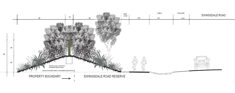 Figure E8.11
Landscape Buffer and Acoustic Barrier to Ewingsdale Road
Figure E8.11
Landscape Buffer and Acoustic Barrier to Ewingsdale Road
13.10 - Attachment 1
Objectives
1. Traditional Owners are recognised and respectfully consulted to identify ways to protect culture and features of Indigenous cultural significance.
2. Culturally significant features are to be protected and incorporated in accordance with the recommendations and findings of such consultation.
3. Opportunities for Traditional Owners to look after country both physically and spiritually will be encouraged.
Performance Criteria
There are no performance criteria for this element
Prescriptive Measures
1. An Aboriginal Cultural Heritage Assessment to be carried out by a suitably qualified professional for the West Byron Site with the Stage 1 Development Application. The assessment to be carried out in accordance with the relevant Office of Environment and Heritage (OEH) Guidelines for Aboriginal cultural heritage matters.
2. Any sites, items, objects, relics or places of significance that are located within the development site are to be appropriately identified and management measures for their ongoing protection are to be recommended as required under the OEH Guidelines.
3. The assessment is to demonstrate consultation with the Byron Bay Bundjalung People, and other Key Stakeholders pursuant to Clause 80C of the NPW Regulation 2009, in accordance with the OEH Aboriginal Cultural Heritage Consultation Requirements for Proponents 2010.
Note: The provisions of the National Parks and Wildlife Act 1974 apply to protecting Aboriginal objects and places.
Note: Heritage provisions in Byron LEP 1988 apply to West Byron.
The following sections sets out controls for the West Byron Village Centre Precinct, the Neighbourhood Business Zone, Residential Zoned Land and the Industrial area.
The heart of West Byron will be centred around the neighbourhood Business Zone, the adjacent RE1 Zone parkland and surrounding residential areas. It is important that the village centre is designed in an integrated manner.
Element Objectives
1. To create a village centre precinct area that is integrated with surrounding development and is pedestrian and cycle friendly.
2. To provide a functional village centre area that is attractive for residents to use on a day to day basis for shopping and recreational needs.
Performance Criteria
1. To provide for village centre precinct with an integrated pedestrian/ cycleway/ road network through shared “mews style” laneways and designated pedestrian – cycleways to take traffic away from the main spine road.
2. To design for the car parking needs of retail and commercial operators on the periphery of the neighbourhood business zone.
3. To promote different forms of residential and commercial development providing passive surveillance of parkland, surrounding businesses and the public domain.
4. To provide planning principles for the West Byron Village Centre Precinct based on Figure E8.11.
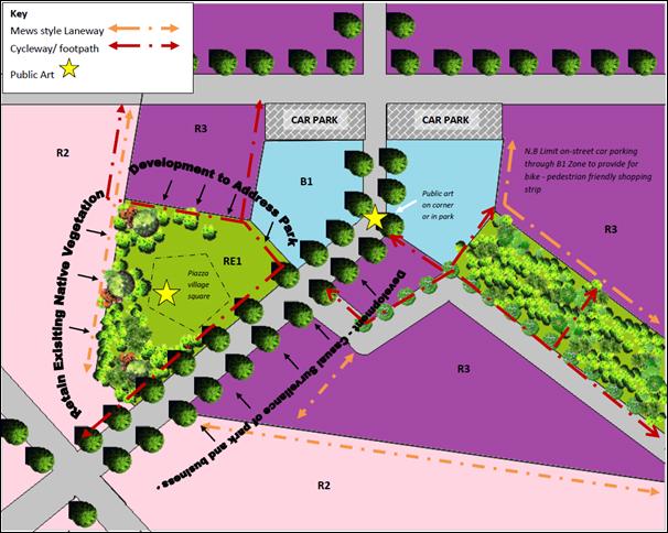
Figure E8.12 Planning Principles for the West Byron Village Centre Precinct
Planning Principles for the West Byron Village Centre Precinct
1. Mews Style Laneways - Opportunities exist for “Mews style development” in this area providing narrow streets that balance the access and service functions of a lane with active building frontages which provide for surveillance of surrounding parkland, home office workshop uses, and a roadway shared by cars, cyclist and pedestrians. Such lanes where part of the road network will provide access to the public, however where retained in private property they will be designed to facilitate the needs of residents of that particular estate. In certain circumstances the lane may not provide through traffic for vehicles and may be blocked by bollards, but allow for connectivity for pedestrians and cyclist.
2. Address the Park - Adjoining residential and commercial development to the RE1 Zone parkland also to address the park through design and function. Vegetation of high conservation value is to be retained.
3. Public Domain – Plan for an area that provides interest as a meeting place for residents through public art, activity and function.
Prescriptive Measures
An initial development application is to be submitted for this location at the subdivision stage demonstrating how the planning principles in Figure E8.11 will be generally achieved. This includes formalising the layout for roads, lanes and cycleways, details on embellishment of the RE1 Zone parkland including tree and weed removal and retention of existing native vegetation, identification of master lots for medium density housing forms, and conceptual designs for commercial and residential development in this location. Where appropriate Council will consider staged development application where the final built form is known. Subsequent development applications for residential and commercial development are also to address the Planning Principles for the West Byron Village Centre Precinct.
1. To create a village centre for local residents that provides general shopping needs in the B1 Neighborhood Business Zone
2. To provide a pedestrian and cycle friendly neighbourhood business centre.
3. To enable creative solutions for car parking.
1. Business, commercial and retail development within the B1 Zone must be designed to promote and encourage safe, convenient pedestrian and cycle access to and from the development itself and the surrounding precinct. The neighbourhood business area is the key hub for the locality's pedestrian and cycle network. Development must be designed to integrate well with this pedestrian and cycle network and to contribute to the aesthetics, landscape design and usage of adjoining streets.
2. The design of development must be compatible with the diversity and multi-functional character of its locality.
3. A Main Street frontage is to be provided along the designated collector road so as to achieve an active street frontage to animate the street Apart from the collector road, the design should utilise shared streets to accommodate pedestrians, cycle lanes and limited on-street parking.
4. Shops and commercial premises to be designed to promote visual interest, to maximise shopfront window access, and to minimise blank walls along street frontages.
5. Development on the spine road corner to address and wrap around the corner splay to create visual interest.
6. Development to address the adjacent RE1 Land as indicated in Figure E8.12.
In addition to the relevant measures contained within DCP 2014, the following specific controls apply:
1. Development at the ground level to incorporate display windows which consume a minimum of 50% of the street frontage and incorporate awnings over the footpath for weather protection. Awnings and structures on the road reserve must be setback a minimum distance of 1000mm from the kerb alignment. The underside of any awning or verandah is to be not less than 3200mm above the footpath.
2. Development on the corner splay to:
a) addresses neighbouring and surrounding development, with its turning of the corner.
b) Creating a splayed or recessed treatment of the corner in a way that gives form to the corner and provides more circulation space for pedestrians.
c) Stepping up at the corner and creating a perceived height greater than neighbouring buildings through the incorporation of distinctive architectural features such as stepped parapet, turret or tower, clocks, flag pole, roof elements, vertical green walls or the like.
d) Both street frontages to provide active street elevations through windows, awnings and shop entrances as required. Blank walls will not be accepted.
e) Public art as required under Chapter D8 to be installed in this corner locale to provide a focal point for the Neighbourhood Centre Zone or alternatively in the adjacent RE1 Zone.
3. Setbacks in the B1 Zone are as follows:
a) Generally to the boundary as per the Building Code of Australia.
b) Upper levels are to incorporate steps in the elevation to provide articulation in the street facade. This can be achieved by utilising verandahs, loggias and balconies which can also be utilised for private open space purposes for shop top housing, or staff or office breakout space. Other architectural features which may be appropriate include recessed windows, vertical fins and other climate appropriate measures consistent with the bulk and scale of the area.
c) Where it is proposed to extend upper level verandas over the footpath awning for commercial purposes, appropriate leasing arrangements to be entered into with Council. Where the verandah is to be used as part of a restaurant the area to be included in the car parking calculations. The verandah is not to be enclosed.
d) Where buildings adjoin residential development or the adjacent land zoned RE1, a setback of 3 metres to apply.
4. The built form to utilise contemporary materials, design elements and energy efficient architecture to facilitate natural lighting, cooling from air flow, and appropriate roof orientation for solar hot water and photovoltaic electricity generation. The treatment of facades, corner elements and blank elevation with green walls or vertical gardens to be considered as a means of providing visual interest and aesthetics to the building, regulating the building temperature, improving air quality, and reducing the developments carbon footprint.
5. The footpath through the B1 Zone to adopt a single uniform pattern (eg wave pattern per Chapter D4 of DCP 2014). The footpath is to be of a suitable width to accommodate bike parking, pedestrian traffic, footpath dining with allowances for street trees and other general landscaping. Street trees to incorporate water sensitive urban design. (See Appendix C for details).

Figure E8.13 Example of a green wall [j14]
6. In addition to the requirements of Chapter B4 and B5 of DCP 2014, bike parking to be provided at a general rate of 1 space per 25m2 of gross floor area with customer parking provided in the public domain to enable casual surveillance from the business premises.
7. Car parking to be provided:
a) In accordance with Chapter B4 of DCP 2014.
b) To facilitate the free flow of traffic through the business area, and to provide for larger footpath areas for activations and landscaping, consideration to be given to the construction of a general shared car parking of 50 spaces or more for business and commercial needs. Limited on street parking to be provided other than accessible parking and suitably located loading zones. Should a general shared car park be provided, the park can be dedicated to Council (with council agreement) after construction and the appropriate maintenance period. Car parking in such a shared arrangement will be allocated to the development based on the rates in Chapter B4 of DCP 2014 at the time of approval. Any additional development not catered for in this approval will need to provide parking onsite.
c) Resident parking and loading bays to be provided onsite at the rear of the premises. Loading bays to be designed to facilitate the storage and collection of waste and the loading and unloading of goods.
8. Where vehicular access is proposed across pedestrian areas or footpaths, the design must give priority to pedestrian amenity, accessibility and safety whilst ensuring that contemporary vehicle and traffic safety criteria are achieved.
9. The public domain to:
a) Incorporate the principles of Crime Prevention Through Environmental Design (CPTED) and Safer by Design (NSW Police) into all development within the neighbourhood centres.
b) Provide a high quality landscape design including a co-ordinated package of street furniture and lighting that enhances the character of the neighbourhood centres.
c) Street trees and other landscaping to be provided through the neighbourhood centre to provide shade, manage stormwater by WSUD and to assist with managing the micro climate. On average one tree to be provided every 15 metres and can be sited in roadside blisters to delineate parking and loading zones.
d) Site servicing and loading facilities, waste storage and other infrastructure is to be designed to minimise visual impact on the public domain and impacts on neighbours.
e) Bus stops to be provide on both sides of the road within or on the immediate periphery of the Neighbourhood Centre Zone.
f) Commercial development adjacent to the RE1 Zone to address the Park by shops, businesses and cafes or other food and drink premises opening onto the reserve area at the ground level through outdoor dining areas, display areas and large doors and windows fronting the park. Landscaping along the frontage to provide a shady environment with a footpath and cycleway providing access along the boundary of the two zones.
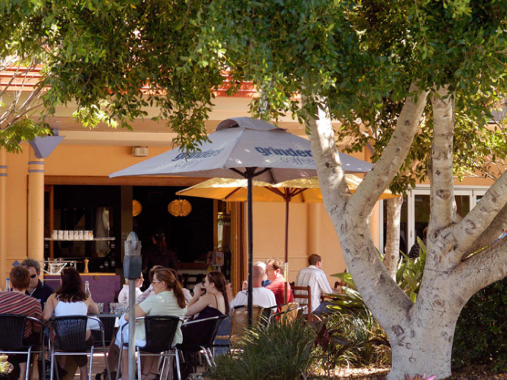
Figure E8.14 Example of Cafe opening onto a park area
g) Footpath dining permissible in accordance with Chapter D4 of Byron DCP 2014
h) Public Art to be provided in accordance with Chapter D8 of Byron DCP 2014.
10. Plumbing of development within the Neighbourhood Zone to consider the potential need for liquid trade waste treatment systems as per D4.2.6 of Byron DCP 2014.
11. Any shop top housing to be provided in accordance with Chapter D1 of Byron DCP 2014.
The following controls apply to various forms of residential development including dwelling houses, attached dwellings, dual occupancy, multi-dwelling housing and integrated housing development under 83 of Byron LEP 1988.
1. Ensure development is at a bulk and scale that reflects the residential character of Byron Shire.
2. Provide housing with a suitable degree of amenity to cater for the needs of the residents.
3. To facilitate diverse housing outcomes in the R2 Zone and R3 Zone,
4. To encourage sustainable housing through energy and water efficient design measures.
Performance Criteria and Prescriptive Measures see Table E8.3
Note: Photo plates and diagrams following Table E8.3 are provided as examples of some of the planning controls to assist in explaining those provisions.
13.10 - Attachment 1
Table E8.3 - Key Controls for Dwelling Houses, Dual Occupancy (attached and detached), multi-dwelling housing and integrated development permissible under Clause 83 of Byron LEP 1988 in the R2 and R3 Zones
|
Performance Criteria |
Prescriptive Measures – R2 Zone |
Prescriptive Measures – R3 Zone |
||
|
1. Location of Development |
||||
|
To ensure residential land has been suitably designed and orientated to accommodate residential development comprising more than 1 dwelling. |
For Dual occupancy, multi dwelling housing, residential flat buildings and integrated housing, the land has been identified at the subdivision stage for this type of development. |
Not applicable in the R3 Zone |
||
|
2. Minimum Frontage |
||||
|
Properties are to be of a suitable width to ensure garages, car port and car parking do not dominate the front facade. Safe vehicle access and egress is provided to the development.
|
· Garages, car ports and car parking areas consume no more than 40% of the main street frontage width. · Where development is located on splayed and battleaxe handle arrangements the development to demonstrate that vehicles can enter and leave in a forward direction. Driveways to comply with AS 2890 and Chapter B3 of Byron DCP 2014. For three or more dwellings passing bays with two way access/ egress will be required at the street frontage. · For development comprising three or more dwellings, corner lots with a shared access on the narrower secondary street frontage is preferable to individual access from the main frontage. |
See R2 Controls |
||
|
3. Setbacks - Streets - Corner Lots - Lanes |
||||
|
Residential development to be designed with suitable setbacks to the street: a. To delineate a clear transition between the public and private domain; b. as an extension to residents landscaped open space area; and c. to ensure safe vehicle access into and out of the property. |
a. Front setback to be 4.5 metres from front boundary to building b. Garage line to be 5.5.67 c. metres from front boundary d. Corner lots – 3 metres setback from secondary street boundary to building. e. Rear Lanes – 0.9 metres to the dwelling, 2.5 metres to any garage or car port
|
a. Same as R2 Zone except front setback is 3.5 metres from front boundary to building
|
||
|
4. Side and rear setback |
||||
|
Side and rear setbacks: a. To provide spatial separation between dwellings in relation to privacy and amenity. b. To enable climate control devices over windows and doors to encroach into the setback. c. To allow zero line setbacks for certain types of residential development |
In addition to any setback requirements under the Building Code of Australia the following minimums will apply a. for single storey dwellings - 0.9 metres setback. b. For two storey buildings - 2.5 metres setback for the second storey or any part of the building higher than 4.5 metres. c. Eaves and gutters, canopies and other climate control devices over windows and doors permitted to encroach into the setback. d. Reduced setbacks down to zero line are permitted for attached dual occupancy, multi dwelling housing and integrated development for shared boundaries between the proposed dwellings. |
In addition to any setback requirements under the Building Code of Australia the following minimums will apply a. for single storey dwellings - 0.9 metres setback. b. For two storey buildings – 1.5 metres setback for the second storey or any part of the building higher than 4.5 metres. c. Eaves and gutters, canopies and other climate control devices over windows and doors permitted to encroach into the setback. d. Reduced setbacks down to zero line are permitted for attached dual occupancy, multi dwelling housing and integrated development for shared boundaries between the proposed dwellings. |
||
|
5. Building height |
||||
|
To ensure development maintains the general low rise - two storey nature of residential development in Byron Shire |
· 9 metres as per Byron LEP 1988 · Shadow plans required for any two storey proposal for mid winter at 9am, 12 midday and 3pm. Such plans to be provided in plan view as a minimum. · Any third storey elements to be integrated into the roof/ attic space or as a mezzanine level. |
Same for R2 Zone |
||
|
6. Upper level development |
||||
|
Upper level development: a. To maintain neighbourhood privacy and amenity. b. To limit the potential for overlooking into neighbouring properties from upper levels through design. c. To minimize overshadowing of neighbouring properties private open space areas during the winter months
|
a. Upper level development to be primarily utilised for bedrooms, bathrooms and study areas. b. Main living and kitchen areas to be situated on the ground floor, except where orientated to overlook public open space/ land zoned environmental protection, or where required for solar access provided it can be demonstrated that there is no direct overlooking into adjacent properties with spatial separation of 6 metres or more between dwellings. c. Upper level windows to be sited so that there is no direct looking into upper level windows of adjoining dwellings. Where this cant be achieved windows are sited a minimum 1.7 metres above the upper level floor. d. Any upper level deck/ to be orientated to ensure no direct overlooking of adjoining properties. e. Where required screening with lattice, battens, fixed louvres to be provided over upper level windows and decks/ balconies. The screening to have a maximum of 25% opening with dimension no greater than 50mm. f. No upper levels to overshadow the principle private open space of neighbouring dwellings for more than 3 hours between 9am and 3pm at the winter solstice (21 June). (Note: In certain circumstances applicants may submit 3D or perspective shadow plans as well as in plan view to demonstrate the level of overshadowing on neighbouring dwellings) |
Same for R2 Zone |
||
|
7. Upper wall length |
||||
|
a. To ensure development is at a bulk and scale that is not overbearing for adjoining dwellings. b. To ensure buildings are not dominated by long straight elevations. |
a. Maximum allowable continuous upper storey wall length is 12 metres. b. For facades longer than 12 metres, the upper wall must be broken up with a step of 600mm deep for a length of at least 1.8m. The roof line and eaves must follow the line of the step. The stepped area must remain within the building envelope as defined by minimum setbacks. |
Same for R2 |
||
|
8. Building design and material in relation to streetscape |
||||
|
a. To provide articulated building designs that present well to the street. b. To provide for casual surveillance of the street. c. To reflect the coastal environment of Byron Bay and traditional coastal architecture through the use of lightweight materials |
a. Front façades to be articulated with one or more of the following: · an entry feature or portico; · a balcony, deck, patio, pergola, terrace or verandah; · an upper level overhang or cantilever; · a window box treatment; · a bay window or similar feature; · an awning or other feature over a window; and · a sun shading feature. b. The articulated feature or element may intrude into the front setback by up to 1 metre (averaged) provided the feature does not exceed 25% of the articulation zone. (eg a property with a frontage width of 12 metres, can have an articulate feature 3 metres wide and intrude into the setback by 1 metre, or the intrusion can be averaged and intrude for example by 0.5 metres but for a width of 6 metres) c. Buildings to utilise a mix of materials and colours to provide interest and variation to the streetscape and to delineate a change in storeys, to embellish an architectural feature or to reflect different elements of the building. d. Dwellings to incorporate windows and doors within the frontage to enable casual surveillance of the public domain and the street. e. Building materials and designs which are heavily urbanised through the use of brick, concrete and tiles or attempt to replicate tuscan, tudor or federation styles will not be supported.
|
Same for R2
|
||
|
9. Site coverage (includes garages, car ports, decks, balconies and verandas) and size of dwellings to lot size |
||||
|
a. To ensure site coverage for residential development is consistent with the residential character of the area. b. To ensure the size of residential dwellings are proportional to the size of the land. c. To provide for a diversity of dwelling sizes across West Byron. |
a. Ground Floor Level – maximum 60% b. Upper Level – maximum 35% c. The maximum number of bedrooms in a dwelling to be sized to the Site (or allotment) area as follows: |
a. Ground Floor Level – maximum 70% b. Upper Level – maximum 40% c. The maximum number of bedrooms in a dwellings to be sized to the Site (or allotment) area as follows
|
||
|
Number of Bedrooms |
Site (or allotment) area required per dwelling |
Number of Bedrooms |
Site (or allotment) area required per dwelling |
|
|
1-2 Bedrooms |
>150m2 |
1-2 Bedrooms
|
>150m2 |
|
|
3 Bedrooms |
>250m2 |
3 Bedrooms
|
>200m2 |
|
|
4 Bedrooms |
> 300m2 |
4 Bedrooms |
> 250m2 |
|
|
10. Private open space (POS) and Landscaped area |
||||
|
a. To provide an even distribution of open space, landscaping and building footprint, to facilitate a balance of indoor and outdoor recreation within a garden setting. b. To provide an attractive landscaped area to facilitate the planting of trees, shrubs, lawn and vegetable gardens.
|
Landscape area to comprise: a. Minimum 30% of the area of an allotment to be landscaping. b. Minimum 50% of the landscaped area must consist of deep soil areas with minimum dimensions of 5 metres. Landscape Plan to be submitted with development application in accordance with E8.10.5.2.
Private Open Space per dwelling to comprise a. Minimum 24 m2 at ground level with minimum dimension of 4 metres to be provided for Private Open Space b. Must be directly accessible from the living area. c. The principal open space area to receive at least 3 hours of sunlight between 9am and 3pm at the winter solstice (21 June). d. Where the private open space area due to orientation of a property is provided in the front of a property, dwellings to be setback a further metre from the street boundary to accommodate suitable landscaping (eg lilly pilly hedge) for privacy. e. For secondary dwellings a minimum of 15 m2 with minimum dimensions of 2.5 metres to be provided in a private courtyard setting. The secondary dwelling not to compromise the overall landscaping and private open space required for the principal dwelling. f. Private Open Space at ground level is a component of the overall landscaped area. |
Landscape area to comprise: a. Minimum 25% of the area of an allotment to be landscaping. b. Minimum 50% of the landscaped area must consist of deep soil areas with minimum dimensions of 4 metres. Landscape Plan to be submitted with development application in accordance with E8.10.5.2
Private Open Space to comprise a. Same as R2 Zone except a minimum 20 m2 at ground level with minimum dimension of 4 metres to be provided for Private Open Space.
|
||
|
11. Car Parking and Vehicle Access |
|
|||
|
Development to ensure that a. vehicle access and parking is accommodated on site with an appropriate number of car parking spaces for the dwelling house and the normal activities of the household. b. Safe vehicle access and egress is provided. c. To provide incentives to reduce the dominance of the motor vehicle. |
Car parking for residential development to comprise the following: a. 1 – 2 bedroom dwellings - 1 Space b. 3 or more bedroom dwelling – 2 spaces c. Visitor Parking required for multi dwelling housing/ integrated housing comprising 4 or more dwellings at a rate of 1 space/ 4 dwellings d. As a minimum at least one vehicle space/ dwelling to be covered either in a garage or car port. e. Where two spaces are required these can be provided in a tandem arrangement provided the tandem space complies with the minimum setback provisions. f. Access, driveways, maneuvering and turning areas, and structures adjacent to driveways to comply with Chapter B3 and B4 of Byron DCP 2014. g. Driveways where crossing swales to be designed in accordance with Appendix E. h. Where 3 or more dwellings are proposed on a property, mews style development and or common/ central car parking areas are permissible to reduce the amount of land required for the motor vehicle. i. Secondary dwellings are not to be sited to so as to remove car parking servicing the principle dwelling. j. To encourage car pooling and to reduce car dependency for three or more dwellings, a reduction in car parking of 33% will be agreed to for residential development in a community title or strata title arrangement, if a vehicle is provided as part of the common or neighbourhood property and for the use of the residents. The following will be required: · 3 - 8 dwellings – 1 community vehicle · 8 -12 dwellings – 2 community vehicles · More than 12 – 3 community vehicles
Details to be provided with the application on the type of vehicle, where it will be garaged on the property under cover, and how it will be maintained, managed, shared and replaced by the residential community. The car(s) is to be no older than 5 years at the time of the issue of the occupation certificate and be able to seat four adults. |
Same for R2
|
||
|
12. Energy Conservation |
||||
|
a. To reduce total energy use in residential buildings by reducing heat loss and energy consumption for heating and cooling. b. To utilise design features to passively control the climate within residential dwellings
|
a. A clothes drying area to be provided in an outdoor area that receives a minimum of 2 hours sunlight midwinter. The area to accommodate a minimum of 25 metres of line. b. Dwellings to be designed to facilitate cross ventilation of air to assist with cooling with operable windows on opposite sides of the house. c. Dwellings to be designed with a roof orientated between the north east to the north west to facilitate the installation of photovoltaic cells for electricity generation or solar hot water systems with a minimum area of 15m2. d. The western elevation of dwellings to incorporate a range of climate control features including canopy and shading devices over windows and doors, pergolas and verandahs, and eaves with a minimum width of 450mm for increased shading and weather protection. |
Same for R2
|
||
|
13. Fencing |
||||
|
To enable fencing to be erected for privacy, territorial reinforcement between the public domain and private property and security |
Any fencing to comply with Chapter D1 of Byron DCP 2014. |
Same as R2 |
||
|
14. Adaptable Housing |
||||
|
Development ensures that housing is able to be readily adapted to a resident's changing life-cycle needs. |
To comply with Chapter B13 of Byron DCP 2014. |
Same as R2 |
||
|
15. Subdivision |
||||
|
To facilitate separate ownership of dwellings in a co-ordinated manner |
Where land is to be further subdivided as part of the proposal details to be included with the application including: · a plan of subdivision; · type of titling proposed (eg Torrens, Strata or Community title) and · Management/ Neighbourhood Plan (if required). |
Same as R2 |
||
|
16. Waste Disposal |
|
|||
|
a. Waste to be adequately stored and separated on site prior to being collected by the waste contractor. b. Bin storage area is adequately screened from the public domain. c. Common or shared storage areas permissible for medium density housing forms |
In addition to the measures contained in Chapter B8 of DCP 2014 the following to apply: a. Sufficient storage area is available behind the front building line for the location of garbage, recycling and green bins (The three bin system), and the area is not to be visible from the street. b. For three or more dwellings within a strata or community title arrangement, shared waste disposal facilities can be provided on the common or neighbourhood property. c. Details to be provided as to how the three bin system can be accommodated onsite.
|
Same as R2 |
||
|
17. Stormwater Management And Water Consumption |
||||
|
a. To minimise water consumption from potable water supplies b. To assist with the management of stormwater |
a. In addition to any water storage requirements for BASIX a further 3000 litres of storage capacity per dwelling to be provided for stormwater management. b. Rainwater tanks to be connected to the stormwater down pipes from the roof of the dwelling and be plumbed back into the house as a minimum for the flushing of toilet(s) and for external gardening purposes. c. Overflow from the water tank and house to be connected to the street stormwater system generally in accordance with the drawing shown at Appendix F - Typical Stormwater House Connection
|
|
||
|
18. Co-operative Housing Explanatory Note: This is a type of shared housing in which people come together to live in an intentional community. The housing from the outside may look similar to other residential development in the neighbourhood, but the co-operative can arrange for the sharing of resources, land and other components of the development to provide for a more inclusive type of housing between residents, to have a smaller environmental footprint, and to make housing more affordable. Co-operative housing could be suitable for extended family groups, couples and singles, retirees, students, families, a group of friends, or a community organisation (eg a charity providing housing), provided the residents have the same goals and objectives to live in an intentional housing community. Making housing more affordable is one benefit of Co-operative Housing, but this is partly achieved through a restriction on further subdivision. Potential applicants who wish to pursue this type of residential housing are encouraged to research the topic thoroughly before making application to establish rules of ownership, voting rights, dispute resolution, cost sharing, collective use of resources and exit/ entrance strategies for people who want to move out/ buy in. Other issues for consideration and research include financial and legal implications for the residents living and investing in such housing. The following controls apply: |
||||
|
a. To enable intentional housing communities to develop residential land in a co-operative manner. b. To enable the efficient and shared uses of resources between households on a single property. |
a. Should a co-operative housing project be proposed on a lot consisting of three or more dwellings the above residential controls will generally still apply. b. If the property is in the R2 Zone, then the lot will need to be identified for either multi dwelling housing or integrated housing at the subdivision stage. c. Variation will be given to the following in terms of achieving a shared outcome: i. private open space per dwelling down to 15m2 provided landscaping minimums are satisfied; ii. Garbage bin and storage areas; iii. Clothes drying areas; iv. Common water tanks; v. Common roof area for solar collectors; vi. Common car parking area for residents and visitors – covered or uncovered; vii. A car parking reduction of 33% will be given, as per Strata and Community Title Development, where a shared car is provided; (See Control 10) viii. Common vehicle access point; and ix. Front setbacks down to 3 metres. d. Such variations are provided on the basis that the land won’t be further subdivided under Torrens, Strata or Community title and a condition of consent will apply. e. Other shared infrastructure may be provided including a vegetable garden, storage shed, bicycles, laundry area, children’s play area, barbeque and outdoor setting. f. Details to be submitted with the development application on measures for the management of the land, ownership model, rights and responsibilities, dispute resolution, collective use of resources and cost sharing.
Note: Where a co-operative housing project seeks consent at a latter stage to be further subdivided, applicants will need to demonstrate how the development complies with the normal provisions applicable to housing. |
Same as R2 Zone except the land does not need to be identified for multi dwelling housing or integrated housing at the subdivision stage. |
||
|
19. Secondary Dwellings Secondary Dwellings provide opportunities for applicants to create a range of housing types that will suit family, lifestyle and financial needs. Secondary dwellings can be attached or detached from the main house. They could also be attached with a dual key arrangement to facilitate housing for a growing family or to provide accommodation for an older family member, enabling residents of both dwellings to live together. Alternatively the secondary dwelling could be locked of from the main house, and tenanted to a third party as a stand alone dwelling. |
||||
|
To provide for small affordable housing opportunities |
Other than planning controls 1, 11, 14, 15 and 18, Secondary dwellings to comply with the above controls, and the requirements of SEPP Affordable Rental Housing 2009.
Dual key arrangements are permissible for secondary dwellings. |
Same as R2 |
||
|
20. Seniors Housing or housing for people with a disability Opportunities exist across the residential areas in both the R2 and R3 Zones of West Byron to provide housing for Seniors and people with a disability. No specific prescriptive measures are referenced in this Chapter and applicants are directed to the controls under SEPP (Housing for Seniors or People with a Disability) 2004. |
||||
BYRON SHIRE COUNCIL
13.10 - Attachment 1
Controls 2, 3, 4 and 8 – Compliant housing in terms of setbacks to primary
and secondary streets, lanes, garage frontage and articulation zones. Control 2 - Example of Battleaxe housing showing manoeuvring
area for vehicles 1 metre max Control 8 - Example of articulation zone for a dwelling house
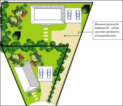
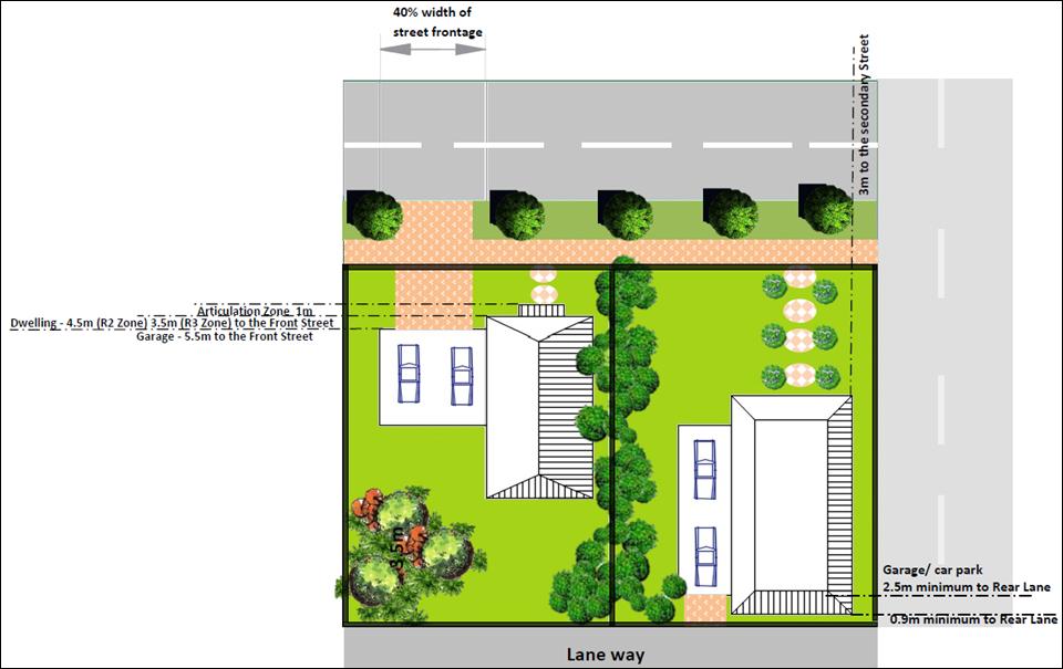
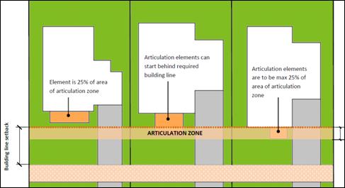
Figure E8.15 Examples of Various Building Elements against Planning Controls 2, 3, 4 and 8 in Table E8.3
BYRON SHIRE COUNCIL
13.10 - Attachment 1
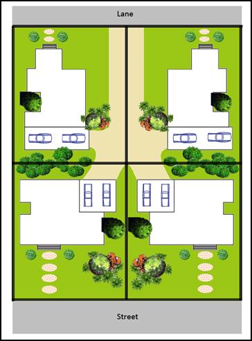
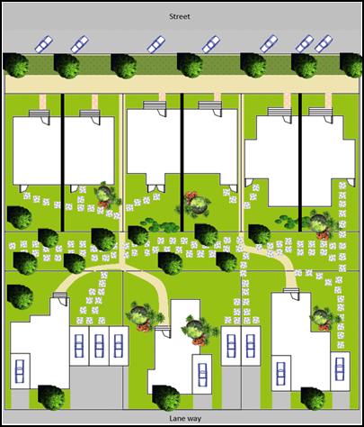
|
|||
|
|||
Figure E8.16 Examples of Various Building Elements against Planning Control 11 in Table E8.3
![]()
 Figure E8.17 Photo Plates – Examples
of Various Building Elements against Planning Controls in Table E8.3
Figure E8.17 Photo Plates – Examples
of Various Building Elements against Planning Controls in Table E8.3
13.10 - Attachment 1
Approximately 7.5 hectares of the West Byron Site is zoned IN2 Light Industrial. The IN2 Zoned land sits opposite the Byron Bay Industrial Estate to the north and residential land to the east. For specific development guidelines for construction of factory units in this area, applicants are directed to Chapter D5 Industrial Development within DCP 2014. The following controls though apply to the subdivision design and development of the land Zoned IN2.
1. To ensure the subdivision layout and design facilitates a wide range of light industrial and warehouse uses and employment opportunities.
2. To provide industrial land that is of a size, shape and area to cater for a range of light industrial and other permissible uses that are suitably serviced with necessary infrastructure.
3. To ensure development presents to the main spine road and is sympathetic to surrounding residential area.
1. Access roads are designed to facilitate the movement of large vehicles.
2. Lot sizes meet minimum requirements to facilitate safe manoeuvring onsite for delivery trucks.
3. Lots are serviced with all necessary infrastructure.
4. Suitable setbacks, built form and landscaping are provided within the design of industrial development to make a positive contribution to the streetscape including Ewingsale Road.
5. Development be designed and sited to minimise land use conflicts with surrounding residential development.
1. A single DA be submitted to Council for the initial subdivision of the IN2 Zoned Land presenting an integrated proposal for the road and allotment layout, based on potential industries seeking industrial land in Byron Bay. Details to be provided with the development application.
2. Access roads through the IN2 Zoned land to be of a suitable width to accommodate articulated vehicles plus on street parking.
3. A minimum of twenty five (25%) percent of lots are to be designed with an appropriate area and width to enable Articulated Vehicles to enter and leave in a forward direction.
4. In addition to normal infrastructure required by Council, lots to be provided with telecommunication infrastructure to facilitate connection to the National Broadband Network.
5. Development fronting the main spine road to include the following design features
a) Industrial development fronting the main spine road to be designed to address the street with a mixture of facade treatments, landscaping and pedestrian access. Two storey frontages are to be appropriately articulated through the use of different building materials including glass, masonry steel and timber elements and changes in setbacks. Large blank walls facing the main spine road will not be supported and screening of poorly designed buildings with vegetation is not an acceptable streetscape treatment.
b) A minimum setback of 5 metres to apply to the Spine Road which is to be suitably landscaped in accordance with B9 of DCP 2014. For corner lots on the spine road this can be reduced to 3 metres.
c) Private Access from the Spine Road to be generally limited and consideration to be given to the creation of large lots along this frontage with shared access points, rear lane/ secondary street access, or a slip lane combined with car parking and landscaping to the Spine Road.
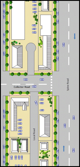
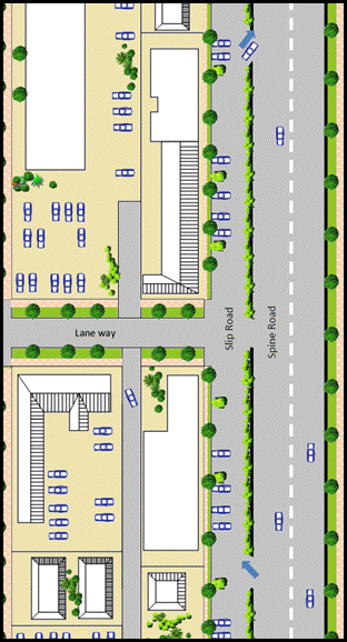
Figure E8.13 Examples of access from the Spine Road fronting the IN2 Zone.
6. Industrial development adjacent to Ewingsale Road to be setback a minimum of 10 metres from this boundary and appropriately screened with native trees and vegetation. This setback can be varied down to 3 metres where other alternatives are utilised in the facades of buildings along this boundary including use of green walls, mix of building materials including glass wall and upper level windows, and articulation or variation in building alignment.
7. A minimum 10 metre wide vegetated buffer to be provided between the IN2 and R2 Zones unless separated by a public road. The buffer to be suitably landscaped with native species in accordance with Chapter B9 of DCP 2014. A Landscape plan to be submitted with the development application for subdivision.
8. Development within the Industrial Zone to be designed and sited to minimise potential land use conflicts with surrounding adjoining residential uses. Where required noise attenuation to be provided within industrial units or on the boundary to ensure compliance with the relevant EPA guidelines for industrial noise.
9. Any retail uses to be in accordance with Byron LEP 1988 and Clause 87(4) as required. Such uses to be subservient to retail uses within the B1 Zone so as not to undermine the function and hierarchy of this zone. Consideration be given to the installation of a takeaway food shop and drink premises in a central location within the IN2 Zone to serve the needs of workers in the industrial estate. (N.B Restaurants and cafes are prohibited in the IN2 Zone)
10. Large car parking areas of 20 spaces or more to consider the installation of an electric vehicle charging station. (Note: Opportunities may exist to partner with Council and other organisations with the design and installation of such infrastructure as per the Byron Shire Low Carbon Strategy)
11. All development to be connected to the dual reticulation water supply for non potable water. From this supply a minimum of one external tap to be provided for the watering of landscaping and a minimum of one internal tap provided for the flushing of toilets with each industrial unit.
12. Development in the IN2 Zone not covered by the above provisions, is to comply with Chapter D5 of Byron DCP 2014.
Note: For design specification please refer to the Northern Rivers Local Government Development and Design Manual and Chapters B3 and B4 of DCP 2014.
A small part of the West Byron site has been zoned E3 in the South west corner and along two drainage lines in the eastern half of the site. A minimum lot size of 40ha applies to subdivision and it is not envisaged any additional dwelling entitlements will be created in the E3 Zone.
Development opportunities in the E3 Environmental Management Zone are restricted by the permitted uses listed in the zoning table under Byron LEP 1988. Many of these uses are covered in part in other sections of DCP 2014, whereby specific controls apply to development’s such as bed and breakfast establishments, eco-tourist facilities, dual occupancies, dwelling houses, farm stay accommodation and camping grounds. Accordingly no specific controls are drafted for the E3 Zone and applicants are directed to other relevant chapters within the DCP 2014.
Bed and Breakfast Establishments are permissible with consent in the R2 and R3 Zone and Serviced Apartments are permissible with consent in the R3 Zones only, whilst only Hotel and Motel Accommodation is permitted in the B1 Zone. Applicants are directed to the planning controls under Byron DCP 2014 including Chapter D3 Tourist Accommodation.
Note: Other forms of tourist and visitor accommodation, including holiday letting of a dwelling or a dwelling house are prohibited in the R2, R3 and B1Zones.
13.10 - Attachment 1
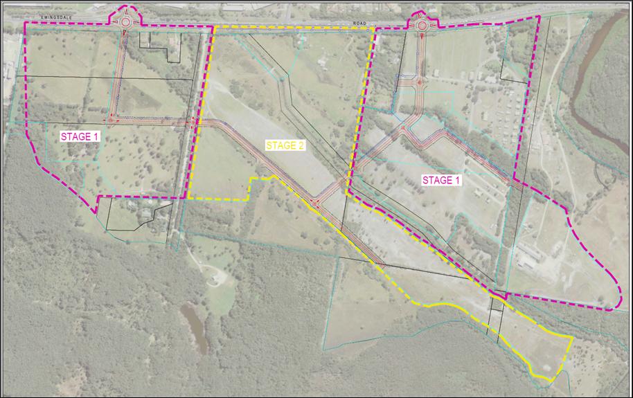
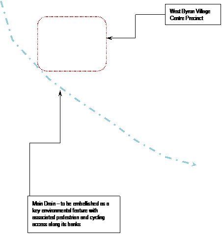 |
|||||||||
 |
|||||||||
|
|||||||||
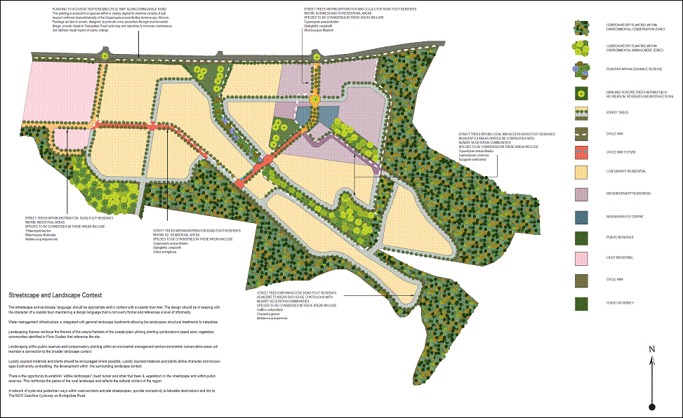
 |
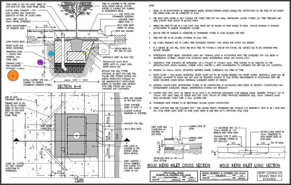
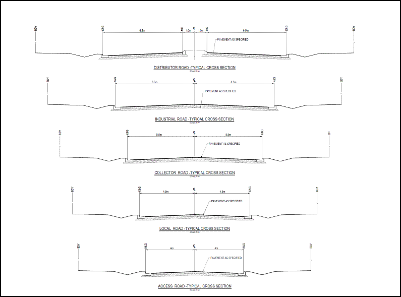
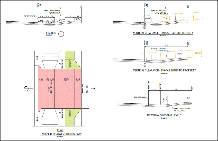

[j1]In the other sections we refer to them as "Chapters" - do you want to change this?
[j2]Other sections this is called "Aims of this Chapter" - do you want this changed?
[c3]DCP 2010 has been replaced and updated by DCP 2014 to reflect not only new LEP terms and conditions but has also reviewed many of the controls to bring them into line with best practice and Council resolutions. We would like to retire DCP 2010 at some time in the future once the deferred matters in DCP 2014 are resolved not continue to keep alive a set of controls which were originally drafted back in 1990’s.
[c4]Access from Ewingsdale Rd – to come from roundabout with Sunrise.
Plan should include more details on general location of internal road network, pedestrian/ cycleways, pocket parks and other infrastructure, staging, buffers and veg management etc to reflect future character statement.
[j5]Please confirm the title of this figure.
[j6]Do you want the word "Element" in there, or just "Objectives"?
[j7]Does this apply to all below? Or is there something missing?
[t9]Added as a result of MPA submission E2014/32928
[j10]Please confirm title of this figure
[j11]Please confirm title of this figure
[j12]Please confirm title of this figure
[c13]This should be an objective - with specifics in terms of – flood compatible materials, adaptability et c
[j14]Please confirm title of this figure