BYRON SHIRE COUNCIL

                                                                                                                              13.14 - Attachment 1

bsc_logo_150dpi_rgb


Planning Proposal

General Policy and Housekeeping Changes In Byron Shire

(Byron Shire Council)

Authority ref:  26.2015.3.1

V1 Gateway Version (#E2015/54624)

24 August 2015


Part 1      Introduction.. 2

Purpose. 2

Property details and existing zones. 2

Background.. 2

Part 2       Explanation of provisions. 4

Part 3       Justification.. 7

Section A        Need for the planning proposal 7

1      Is the planning proposal a result of any strategic study or report?. 7

2      Is the planning proposal the best means of achieving the objectives or intended outcomes, or is there a better way?. 7

3      Is there a net community benefit?. 7

Section B       Relationship to strategic planning framework. 7

1      Is the planning proposal consistent with the objectives and actions contained within the applicable regional or sub-regional strategy (in this case the Far North Coast Regional Strategy)?. 7

2      Is the planning proposal consistent with the local Council’s Community Strategic Plan, or other local strategic plan?. 7

3      Is the planning proposal consistent with the applicable State Environmental Planning Policies (SEPPs)?. 8

4      Is the planning proposal consistent with applicable Ministerial Directions (s117 Directions)?  9

Section C       Environmental, social and economic impact 28

1      Is there any likelihood that critical habitat or threatened species, populations or ecological communities, or their habitats will be adversely affected as a result of the proposal?. 28

2      Are there any other likely environmental effects as a result of the planning proposal and how are they proposed to be managed?. 28

3      How has the planning proposal adequately addressed any social and economic effects?  28

Section D       State and Commonwealth interests. 28

1      Is there adequate public infrastructure for the planning proposal?. 28

2      What are the views of State and Commonwealth public authorities consulted in accordance with the gateway determination?. 28

Part 4       Mapping.. 29

Part 5       Community consultation.. 29

Part 6       Project timeline. 29

Summary and conclusions. 30

Appendix 1: Maps............................................................................................................................ 31

Part 1     Introduction

Purpose

The purpose of this planning proposal is to amend various parts of Byron LEP 2014 as part of an annual review of the planning instrument.  The amendments are unrelated.  Some are general and some site specific.  Some have come from Council resolutions and some have come from staff observations, consultants or landowners.

Property details and existing zones

This planning proposal involves minor amendments to the land use table that will affect all land within zones R2 Low Density Residential and R5 Large Lot Residential, RU1 Primary Production, IN1 General Industrial, IN2 Light Industrial, B1 Neighbourhood Centre, B2 Local Centre, B4 Mixed Use, B7 Business Park, W1 Natural Waterways, and W2 Recreational Waterways.

It will create the ability to undertake a “special purpose subdivision” in all RU1 Primary Production and RU2 Rural Landscape land.

It will alter the heading to clause 4.1B to properly reflect the content of the clause and alter a term used throughout the clause to better reflect its intent. 

It will remove R5 Large Lot Residential from part of Clause 4.1D relating to subdivision of split zone lots and insert it into other parts of the same clause.

On site specific matters the planning proposal will:

Permit registered clubs as an additional use on the Cavanbah Sports Centre site at West Byron (Lot 3 DP 706286).

Alter schedule 5 (Environmental Heritage) to delete item I173 (Roundhouse site) as the Roundhouse building has been demolished and the land subdivided for residential purposes.

Permit a dwelling on Lot 1 DP 394451, Jones Road consistent with previous advice to the landowner based on the history of the site.

Alter the SP1 zone that applies to Lot 1 DP 1031848, Broken Head to describe the SP1 zone as “private education facility”.  Alter schedule 1 to define “private education facility” as it applies to the subject land.

Rezone three irregular shaped lots adjacent to Kulgan Court, Ocean Shores from RU2 Rural Landscape to R2 Low Density Residential to be consistent with surrounding land use and approved residential development.  Amend the relevant LEP maps for FSR and MLS for the same lots to make them consistent with the surrounding R2 Low Density Residential zone.

Amend the Minimum Lot Size map for a Bangalow urban release area to better align an existing 300m2 MLS with a recent subdivision approval.

Background

It is important that LEP 2014 be kept up to date and contains the planning controls desired by Council and the Byron Shire community.  Major changes would normally be dealt with in stand-alone planning proposals. Minor policy changes and simple amendments (often unrelated) are clustered together in a single planning proposal such as this one.

With a diverse group of proposed changes to Byron LEP 2014 the assessment against State and regional planning controls can be confusing.  Certain controls will be relevant to some of the proposed changes and not to others, and vice a versa.  Proposed changes to Byron LEP 2014 in this planning proposal will only be discussed in relation to those controls that are specifically relevant to that particular change.

Council Owned Land

Some of the land affected by this planning proposal is owned by Council as follows:

Item ‘Q’ includes Lot 11 DP1128095 and Lot 606 DP 240398. These are two very narrow lots (approximately 600mm wide and too small for any type of development) that were created at the rear of private land that backs onto a proposed road corridor at Ocean Shores near Kulgan Court. The proposed road has been abandoned and sold for private development and the strips are no longer required. It makes sense that the narrow strips be included in the R2 Low Density Residential zone the same as most of the land in the vicinity.

Item ‘M’ applies to the Cavanbah Sports Centre at Ewingsdale Road, West Byron (Lot 3 DP 706286).  This land was acquired by Council partly for a sports facility and partly for disposal of treated recycled water from the nearby STP. It is part Community land and part Operational land under the Local Government Act, 1993.  It is subject to a plan of management.


Part 2   Explanation of provisions

The intended outcomes are to be achieved by an amendment to Byron Shire Council LEP 2014 as follows:

A.  Insert recreation facility (indoor) in the B1 Neighbourhood Centre land use table as permissible with consent


B.  Insert secondary dwelling in the R2 Low Density Residential and R5 Large Lot Residential land use tables as permissible with consent


C.  Insert dual occupancy (detached) in the R5 Large Lot Residential land use table as permissible with consent


D.  Insert agriculture in the RU1 Primary Production land use table as permissible with consent. Insert aquaculture as a prohibited use.  Delete intensive animal agriculture and intensive plant agriculture from permissible with consent (they will be covered by agriculture).


E.   Insert waste or resource management facilities as a prohibited use in the B2 Local Centre, B4 Mixed Use and B7 Business park zones land use tables.  Delete any references to its “child” definitions in these land use tables wherever they occur.


F.   Delete environmental facilities as a prohibited use in the B4 Mixed Use zone land use table.


G.  Delete biosolids treatment facilities, sewage treatment plants and water recycling facilities from the prohibited section of the land use table in the IN1 General Industrial zone.


H.  Insert electricity generating works as a prohibited use in the IN2 Light Industrial zone land use table.


I.    Insert roads in the W1 Natural Waterways and W2 Recreational Waterways zones land use tables as permissible with consent.


J.   Insert a new clause in Part 4 Principal Development Standards to enable certain subdivision (sometimes referred to as a special purpose subdivision) to be approved on land zoned RU1 and RU2 where the lot will be less than the minimum lot size shown on the minimum lot size map. The following provision is proposed:

 Exceptions to minimum lot sizes for certain rural subdivisions

(1)  The objective of this clause is to enable the subdivision of land in rural areas to create lots of an appropriate size to meet the needs of current permissible uses other than for the purpose of dwelling houses, dual occupancies or secondary dwellings.

(2)  This clause applies to the following rural zones:

(a)  Zone RU1 Primary Production,

(b)  Zone RU2 Rural Landscape.

(3)  Land to which this clause applies may, with development consent, be subdivided to create a lot of a size that is less than the minimum size shown on the Lot Size Map in relation to that land, where the consent authority is satisfied that the use of the land after the subdivision will be the same use (other than a dwelling house or a dual occupancy or secondary dwelling) permitted under the existing development consent for the land.

(4)  Development consent must not be granted for the subdivision of land to which this clause applies unless the consent authority is satisfied that:

(a)  the subdivision will not adversely affect the use of the surrounding land for agriculture, and

(b)  the subdivision is necessary for the ongoing operation of the permissible use, and

(c)  the subdivision will not increase rural land uses conflict in the locality, and

(d)  the subdivision is appropriate having regard to the natural and physical constraints affecting the land.


K.  Amend the heading to clause 4.1B “Minimum subdivision lot size for multiple occupancy or rural landsharing community developments” to better reflect the content of the clause. The revised heading would be “Minimum subdivision lot size for multiple occupancy or rural community title developments”.  Amend clause 4.1B to replace “rural landsharing developments” with “rural community title development/s” wherever it occurs.


L.   Amend clause 4.1D relating to subdivision of split zone lots and insert it into other parts as follows:

4.1D   Exceptions to minimum subdivision lot sizes for certain split zones

(1)  The objectives of this clause are as follows:

(a)  to provide for the subdivision of lots that are within more than one zone but cannot be subdivided under clause 4.1,

(b)  to ensure that the subdivision occurs in a manner that promotes suitable land use and development.

(2)  This clause applies to each lot (an original lot) that contains:

(a)  land in a residential, large lot residential, business or industrial zone, and

(b)  land in Zone RU1 Primary Production, Zone RU2 Rural Landscape, Zone R5 Large Lot Residential or Zone SP3 Tourist.

(3)  Despite clause 4.1, development consent may be granted to subdivide an original lot to create other lots (the resulting lots) if:

(a)  one of the resulting lots will contain:

(i)  land in a residential, large lot residential, business or industrial zone that has an area that is not less than the minimum size shown on the Lot Size Map in relation to that land, and

(ii)  all of the land in Zone RU1 Primary Production, Zone RU2 Rural Landscape, Zone R5 Large Lot Residential or Zone SP3 Tourist that was in the original lot, and

(b)  all other resulting lots will contain land that has an area that is not less than the minimum size shown on the Lot Size Map in relation to that land.


M.  Permit registered clubs as an additional use on the Cavanbah Sports Centre site at West Byron (Lot 3 DP 706286) by amending Schedule 1 as follows:

6   Use of certain lands at Ewingsdale Road, West Byron

(1)  This clause applies to land at Ewingsdale Road, West Byron being part of Lot 3 DP 706286.

(2)  Development for the purposes of a registered club is permitted with development consent.


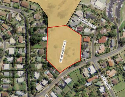
N.  Amend map sheet ‘HER 002’ and Schedule 5 Environmental Heritage by deleting Heritage item I173 located atLot 530 DP238451, Orana Road, Ocean Shores (Roundhouse site), as indicated in Map 1 of Appendix 1.


O.  Permit a dwelling house on Lot 1 DP 394451, Jones Road by inserting a new item in schedule1 as follows:


7.    Use of certain land at the Jones Road, Wooyung

(1) Lot 1 DP 394451, Jones Road, Wooyung. 

(2) Development for the purposes of a dwelling house is permitted with development consent.


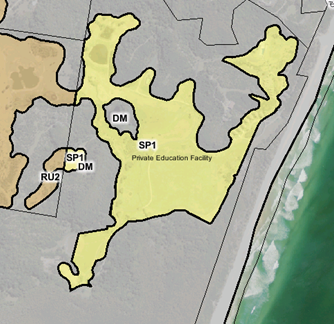
P.   Amend map sheet ‘LZN 003D’ to correct an error with the zone label for Lot 1 DP 1031848 by changing the label from “educational establishment” to “private education facility”, as indicated in Map 2 of Appendix 1.  Insert a new item in schedule 1 as follows:


8.    Use of certain land at the Coast Road, Broken Head

Lot 1 DP 1031848, The Coast Road, Broken Head (The Linnaeus Estate).  A Private Education Facility with ancillary facilities is permitted on this land.  A Private Education Facility is defined as a facility that provides for professional and personal development through a variety of academic, cultural, and vocational programmes and includes communal buildings and facilities and accommodation units.


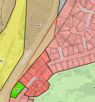
Q.  Amend map sheet ‘LZN 002CA’ to change the land use zone for Lot 12 DP 1128095, Lot 11 DP 1128095 and Lot 606 DP 240398 , Ocean Shores,  from RU2 Rural Landscape to R2 Low Density Residential, as indicated in Map 3 of Appendix 1.  Amend map sheet ‘LSZ 002CA’ to change the MLS for the same lots from 40 ha to 600 m2.  Amend map sheet ‘FSR 002CA’ to include a FSR of 0.5 for the above lots.


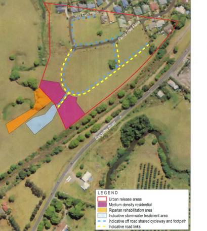
R.  Amend map sheet ‘LSZ 003CB’ to  better align location of the existing 300 m2 MLS for certain land at Bangalow (Lot 12 DP1189289) with a recent subdivision on the same parent lot further to the west, as indicated in Map 4 of Appendix 1.    


Part 3   Justification

Section A           Need for the planning proposal

1        Is the planning proposal a result of any strategic study or report?

No.  The amendments contained in this planning proposal have arisen from Council resolutions as well as issues raised by Council staff, consultants and community members.

2        Is the planning proposal the best means of achieving the objectives or intended outcomes, or is there a better way?

A planning proposal is considered to be the only way to amend land use tables for various zones, clauses and / or schedules to LEP 2014.

3        Is there a net community benefit?

The main focus of the NCB test is to ensure that centres remain compact and viable and linked to existing and proposed transport networks (particularly public transport).

Assessment against the Net Community Benefit Assessment Criteria is not appropriate for a planning proposal that deals with collection of unrelated issues in a range of zones and circumstances (urban and rural).


Section B           Relationship to strategic planning framework

1        Is the planning proposal consistent with the objectives and actions contained within the applicable regional or sub-regional strategy (in this case the Far North Coast Regional Strategy)?

The planning proposal is not relevant to most of the objectives and actions of the Far North Coast Regional Strategy (FNCRS) because they are administrative matters rather than policy.  However, some do raise policy issues and these are largely consistent with the outcomes and actions contained within the FNCRS.  In particular, these actions relate to Cultural Heritage, Settlement and Housing, and Economic Development and Employment Growth.  The proposal specifically responds to the following FNCRS actions:

·    Councils …will review the scope and quality of the existing lists of heritage items and ensure that all places of significance are included in the heritage schedules of local environmental plans (page 20). (This is relevant to item N).

·    Councils will plan for a range of housing types of appropriate densities, location and suitability that are capable of adapting and responding to the ageing population (page 29). (This is relevant to item B and C).

·    Future rural residential land will only be released in accordance with a Local Growth Management Strategy. (This is relevant to Item O).

·    Local environmental plans will facilitate employment growth…..and local jobs in towns, villages and neighbourhood centres (page37). (This is relevant to items A, J and M).


2        Is the planning proposal consistent with the local Council’s Community Strategic Plan, or other local strategic plan?

In 2012 Council adopted a 10 year + Community Strategic Plan 2022 (CSP).  The plan is based on five key themes being Corporate Management, Economy, Environment, Community Infrastructure, Society and Culture.  The planning proposal is generally consistent with the following relevant goals:


CM4.1 Promote community compliance with Acts, Regulations, Instruments and Council policies and standards

Ensuring Council’s planning controls remain up to date increases the likelihood of community compliance.

EC1.2 Support and strengthen local businesses and local business networks

Items A, J and M will all support existing or future business opportunities in parts of the Shire.

SC2.1 Provide a range of recreational, cultural and community opportunities

Item M will enable part of the Cavanbah Sports Centre site to be used for a registered club if the opportunity arises.

On this basis the planning proposal is generally consistent with Council’s CSP.

3        Is the planning proposal consistent with the applicable State Environmental Planning Policies (SEPPs)?

State Environmental Planning Policies (SEPP) relevant to this planning proposal are as follows:


State Environmental Planning Policy (SEPP)

Compliance of Planning Proposal

SEPP 71 – Coastal Protection


Most of the changes in this planning proposal could result in applications in the coastal zone of Byron Shire. The aim of the SEPP and the matters for consideration in clause 8 of the SEPP are matters that Council will consider on a site specific basis in future development applications.  In most cases the development will either be in existing urban areas or relatively small scale. If larger scale development is proposed it will need to be carefully considered. The planning proposal is compliant with the aims of the SEPP.

SEPP 55 – Remediation of Land


Two items are affected directly by this SEPP. Item Q (Kulgan Court Ocean Shores) is changing from a rural to an urban zone. In this case the previous landowners undertook a preliminary analysis pursuant to SEPP 55 and found there was no evidence of past contamination.  It is consistent with the SEPP.


Item O (Jones Road) is a single 5 hectare rural lot at the end of Jones Road that has currently does not have a “dwelling entitlement”. The land is not being rezoned, but the amendment will allow a dwelling to be erected on it. No preliminary analysis of the land has been supplied to Council and it is not yet possible for Council to be satisfied that the draft LEP is consistent with Clause 6 of SEPP 55.

Although the planning proposal is not consistent with SEPP 55 there is sufficient time while it is on exhibition to obtain this information and supply it to Council for consideration before it makes a final decision.  Or alternatively, a contamination assessment can be undertaken at the development application stage once the dwelling curtilage and accompanying land uses are known.

SEPP- Rural Lands

This SEPP identifies rural planning principles (clause 7) that must be taken into account when a Council prepares a planning proposal.  These are brought into effect through a s117 Direction and are dealt with in more detail in the following section.

It also identifies matters to be considered in determining development applications for rural subdivision and rural dwellings (clause 10).  The planning proposal is consistent with the rural planning principles and any application arising from this planning proposal will only be approved if it is consistent with the matters in clause 10.  On balance it is consistent with the SEPP.


4        Is the planning proposal consistent with applicable Ministerial Directions (s117 Directions)?

Consistency with s117 Directions is assessed in the following table:


BYRON SHIRE COUNCIL

                                                                                                                              13.14 - Attachment 1

Consistency with S117(2) Directions

S117 Direction

Application

Relevance to this planning proposal

Consistency with direction

1.       Employment and Resources

1.1     Business and Industrial Zones

Applies when a relevant planning authority prepares a planning proposal that will affect land within an existing or proposed business or industrial zone (including the alteration of any existing business or industrial zone boundary).

This planning proposal will not affect the boundaries or extent of business or industrial zones. However it will make minor alterations to the land use tables for the B1, B2, B4, B7, IN1 and IN2 zones. This will not reduce the area available for employment and will not significantly alter any locations for business or industry. 

Consistent

1.2     Rural Zones

Applies when a relevant planning authority prepares a planning proposal that will affect land within an existing or proposed rural zone (including the alteration of any existing rural zone boundary).

Under this direction a planning proposal must:

(a)  not rezone land from a rural zone to a residential, business, industrial, village or tourist zone.

(b)  not contain provisions that will increase the permissible density of land within a rural zone (other than land within an existing town or village).

This planning proposal will apply to rural zoned land.

Item Q will rezone land at Ocean Shores from a rural zone (RU2) to a residential zone (R2). It will also lower the minimum lot size from 40 hectares to 600 square metres.

The inconsistency with the planning proposal is justified in this case because the subject land is surrounded by zoned residential land on two sides, is not used for agriculture or identified as state/regionally significant farmland, is fully serviced and has no significant environmental values.  It is very small and is subject to an existing approval for seniors development. The inconsistency is justifiable as a minor matter pursuant to sub clause 5(d) of the Direction.

Item O will not alter the zone of the rural land but will permit a dwelling on this small lot at Jones Road which alters the dwelling density in this location.  The inconsistency is justifiable as a minor matter pursuant to sub clause 5(d) of the Direction.

Justifiably inconsistent

1.3     Mining, Petroleum Production and Extractive Industries

Applies when a relevant planning authority prepares a planning proposal that would have the effect of:

(a)  prohibiting the mining of coal or other minerals, production of petroleum, or winning or obtaining of extractive materials, or

(b)  restricting the potential development of resources of coal, other minerals, petroleum or extractive materials which are of State or regional significance by permitting a land use that is likely to be incompatible with such development.

Nothing in this planning proposal will prohibit or restrict exploration or mining.

N/A

1.4     Oyster Aquaculture

Applies when a relevant planning authority prepares any planning proposal that proposes a change in land use which could result in:

(a)  adverse impacts on a Priority Oyster Aquaculture Area or a “current oyster aquaculture lease in the national parks estate”, or

(b)  incompatible use of land between oyster aquaculture in a Priority Oyster Aquaculture Area or a “current oyster aquaculture lease in the national parks estate” and other land uses.

Priority Oyster Aquaculture Areas (POAA) exist in the Brunswick River however most land in the vicinity of the POAA is already zoned for environmental protection or within the National Parks estate.

There is minimal likelihood the planning proposal will have adverse impacts on POAA as the matters in it are either minor or will be subject to an environmental assessment on a case by case basis through the development application process. 


Consistent.

1.5     Rural Lands

Applies when:

(a)  a relevant planning authority prepares a planning proposal that will affect land within an existing or proposed rural or environment protection zone (including the alteration of any existing rural or environment protection zone boundary), or

(b)  a relevant planning authority prepares a planning proposal that changes the existing minimum lot size on land within a rural or environment protection zone.

A planning proposal to which clauses (a) and (b) apply must be consistent with the Rural Planning Principles listed in State Environmental Planning Policy (Rural Lands) 2008.

A planning proposal to which clause (b) applies must be consistent with the Rural Subdivision Principles listed in State Environmental Planning Policy (Rural Lands) 2008.

This planning proposal will affect land zoned RU1 and RU2.  It will also alter the minimum lot size on some rural land.

It is consistent with the Rural Planning Principles listed in State Environmental Planning Policy (Rural Lands) 2008 as follows:

(a)     the promotion and protection of opportunities for current and potential productive and sustainable economic activities in rural areas – the proposed amendment does not undermine or create conflict with agriculture or other rural land uses.  The land at Ocean Shores (Item Q) already has an approval for seniors housing and is in a fully serviced urban area. The land at Jones Road (Item O) borders onto Billinudgel Nature Reserve, other small rural residential lots and is near to a major music festival site (North Byron Parklands). Any development application for a dwelling will need to address these neighbouring land uses.  

The opportunity to create rural lots for “special purposes” will be sparingly used, with the ability  to create a lot less than the prevailing MLS being available only for existing approved uses (other a dwelling, dual occupancy or secondary dwelling).

(b)     recognition of the importance of rural lands and agriculture and the changing nature of agriculture and of trends, demands and issues in agriculture in the area, region or State – the future use of land resulting from this planning proposal will not have an impact on high value agricultural land.

(c)     recognition of the significance of rural land uses to the State and rural communities, including the social and economic benefits of rural land use and development – Byron Shire has a Sustainable Agriculture Strategy that recognises the importance of agriculture in the Shire along with the benefits of protecting rural land uses. This planning proposal is generally consistent with the Strategy’s vision, goals and guiding principles.

(d)     in planning for rural lands, to balance the social, economic and environmental interests of the community – both Item O and Item Q are unusual circumstances and will not change the nature of rural land use generally.  A dwelling at Jones Road (Item O) may increase the agricultural output of this small lot. The proposed changes are consistent with the socio-economic interests of the Byron Shire community.

(e)     the identification and protection of natural resources, having regard to maintaining biodiversity, the protection of native vegetation, the importance of water resources and avoiding constrained land

Item Q is a small area with no significant environmental values and/or i other development constraints. It has been subject to a preliminary contamination analysis which showed it is not likely to be contaminated.

 Item O is not as well documented. It is partly cleared and partly vegetated with coastal swamp forest, rainforest and wet sclerophyll forest.  It is listed as containing a registered Aboriginal site.  It is unknown at this stage whether  any past landuses may have left it contaminated.

(f)      the provision of opportunities for rural lifestyle, settlement and housing that contribute to the social and economic welfare of rural communities – a dwelling at Jones Road (Item O) will make a minor contribution to rural lifestyle opportunities in Byron Shire.

(g)     the consideration of impacts on services and infrastructure and appropriate location when providing for rural housing –services and infrastructure will be addressed in any future dwelling application at Jones Road (item O).

(h)     ensuring consistency with any applicable regional strategy of the Department of Planning or any applicable local strategy endorsed by the Director-General –this planning proposal is largely consistent with the outcomes and actions contained within the Far North Coast Regional Strategy . Item O (Jones Road) is generally consistent with Byron Rural Settlement Strategy (section 6.5 – Dwelling Entitlements). The lot was created before 1 January 1998 and appears to be large enough to accommodate a dwelling site on areas not affected by significant vegetation. However, more information is required on site ecology, past land use and bushfire hazard.

Consistent.

2        Environment and Heritage

2.1     Environment Protection Zones

A planning proposal must include provisions that facilitate the protection and conservation of environmentally sensitive areas.

A planning proposal that applies to land within an environment protection zone or land otherwise identified for environment protection purposes in a LEP must not reduce the environmental protection standards that apply to the land (including by modifying development standards that apply to the land).  This requirement does not apply to a change to a development standard for minimum lot size for a dwelling in accordance with clause (5) of Direction 1.5 “Rural Lands.

The planning proposal does not alter or remove any environment protection zone.  No environmental standards will be reduced by the proposed LEP changes.

Consistent

2.2     Coastal Protection

Direction applies when a relevant planning authority prepares a planning proposal that applies to land in the coastal zone.

A planning proposal must include provisions that give effect to and are consistent with:

(a)  the NSW Coastal Policy: A Sustainable Future for the New South Wales Coast 1997,

(b)  the Coastal Design Guidelines 2003,

(c)  the manual relating to the management of the coastline for the purposes of section 733 of the Local Government Act 1993 (the NSW Coastline Management Manual 1990).

Some land affected by this planning proposal is located within the coastal zone, which affects the eastern half of Byron Shire.

It is consistent with the NSW Coastal Policy as there is minimal likelihood of physical impact on the environment and where a development is not minor, it will require a development application.  Council will consider (where applicable) the management of the coastline and response to emergencies as part of any application it receives for land affected by coastal erosion in Byron Shire.

Consistent.

2.3     Heritage Conservation

A planning proposal must contain provisions that facilitate the conservation of:

(a) Items, places, buildings, works, relics, moveable objects or precincts of environmental heritage significance to an area, in relation to the historical, scientific, cultural, social, archaeological, architectural, natural or aesthetic value of the item, area, object or place, identified in a study of the environmental heritage of the area,

(b) Aboriginal objects or Aboriginal places that are protected under the National Parks and Wildlife Act 1974, and

(c) Aboriginal areas, Aboriginal objects, Aboriginal places or landscapes identified by an Aboriginal heritage survey prepared by or on behalf of an Aboriginal Land Council, Aboriginal body or public authority and provided to the relevant planning authority, which identifies the area, object, place or landscape as being of heritage significance to Aboriginal culture and people.

Byron LEP 2014 currently contains provisions that are consistent with this Direction.

Removing the Roundhouse from Schedule 5 (Item N) will not contradict this S.117 Direction as the building no longer exists and the land on which it once stood has been subdivided for residential development.

Before the planning proposal is finalised it is important that an Aboriginal heritage ‘due diligence’ assessment is undertaken by a qualified person in relation to Item O (Jones Road).

Consistent

2.4     Recreation Vehicle Areas

A planning proposal must not enable land to be developed for the purpose of a recreation vehicle area (within the meaning of the Recreation Vehicles Act 1983):

(a) where the land is within an environment protection zone,

(b) where the land comprises a beach or a dune adjacent to or adjoining a beach,

(c) where the land is not within an area or zone referred to in paragraphs (4)(a) or (4)(b) unless the relevant planning authority has taken into consideration:

(i)   the provisions of the guidelines entitled Guidelines for Selection, Establishment and Maintenance of Recreation Vehicle Areas, Soil Conservation Service of New South Wales, September 1985, and

(ii)  the provisions of the guidelines entitled Recreation Vehicles Act, 1983, Guidelines for Selection, Design, and Operation of Recreation Vehicle Areas, State Pollution Control Commission, September 1985.

The proposal does not enable land to be developed for the purpose of a recreation vehicle area.

N/A

3.       Housing, Infrastructure and Urban Development

3.1     Residential Zones

This direction applies when a relevant planning authority prepares a planning proposal that will affect land within:

(a)  an existing or proposed residential zone (including the alteration of any existing residential zone boundary),

(b)  any other zone in which significant residential development is permitted or proposed to be permitted.

A planning proposal must include provisions that encourage the provision of housing that will:

(a)  broaden the choice of building types and locations available in the housing market, and

(b)  make more efficient use of existing infrastructure and services, and

(c)  reduce the consumption of land for housing and associated urban development on the urban fringe, and

(d)  be of good design.

A planning proposal must, in relation to land to which this direction applies:

(a)  contain a requirement that residential development is not permitted until land is adequately serviced (or arrangements satisfactory to the council, or other appropriate authority, have been made to service it), and

(b)  not contain provisions which will reduce the permissible residential density of land.

The planning proposal will affect residential zoned land.

The purpose of the LEP amendment (partly) is to permit secondary dwellings in the R2 and R5 zone (Item B) consistent with the Affordable Housing SEPP. And to permit detached dual occupancy development in the R5 zone (Item C).  These changes will broaden the choice of housing types in these zones and make more efficient use of infrastructure.

No reduction of residential density is proposed. Moving the existing 300 m2 MLS on land at Bangalow will align it with a recent subdivision approval. This will facilitate smaller lots in this location which will make better use of infrastructure and maintain the density of the release area.

Item Q (Ocean Shores) will also facilitate better use of serviced land in an urban area.

Clause 6.6 of Byron LEP 2014 already requires adequate essential services to be available to the land at the time at which consent is granted.

Consistent

3.2     Caravan Parks and Manufactured Home Estates

Applies when a relevant planning authority prepares a planning proposal.

In identifying suitable zones, locations and provisions for caravan parks in a planning proposal, the relevant planning authority must:

(a)  retain provisions that permit development for the purposes of a caravan park to be carried out on land, and

(b)  retain the zonings of existing caravan parks, or in the case of a new principal LEP, zone the land in accordance with an appropriate zone under the Standard Instrument (Local Environmental Plans) Order 2006 that would facilitate the retention of the existing caravan park.

In identifying suitable zones, locations and provisions for manufactured home estates (MHEs) in a planning proposal, the relevant planning authority must:

(a)  take into account the categories of land set out in Schedule 2 of SEPP 36 as to where MHEs should not be located,

(b)  take into account the principles listed in clause 9 of SEPP 36 (which relevant planning authorities are required to consider when assessing and determining the development and subdivision proposals), and

(c)  include provisions that the subdivision of MHEs by long term lease of up to 20 years or under the Community Land Development Act 1989 be permissible with consent.

This proposal does not seek development for the purposes of a caravan park or manufactured homes estate, nor does it impact upon any land that does permit development for the purposes of a caravan park or manufactured homes estate.

N/A

3.3     Home Occupations

Planning proposals must permit home occupations to be carried out in dwelling-houses without the need for development consent.

This proposal does not alter home occupation provisions in Byron LEP 2014.

N/A

3.4     Integrating Land Use and Transport

Applies when a relevant planning authority prepares a planning proposal that will create, alter or remove a zone or a provision relating to urban land, including land zoned for residential, business, industrial, village or tourist purposes.

A planning proposal must locate zones for urban purposes and include provisions that give effect to and are consistent with the aims, objectives and principles of:

(a)  Improving Transport Choice – Guidelines for planning and development (DUAP 2001), and

(b)  The Right Place for Business and Services – Planning Policy (DUAP 2001).

The planning proposal will alter the permitted uses on land zoned for residential, business and industrial purposes. It will also alter zone boundaries however it will not result in any significant new rezoned areas. There is unlikely to be any impact on public transport as a result of this planning proposal.

Consistent.

3.5     Development Near Licensed Aerodrome

Applies when a relevant planning authority prepares a planning proposal that will create, alter or remove a zone or a provision relating to land in the vicinity of a licensed aerodrome.

The main requirements of the Direction are that Council considers the Obstacle Limitation Surface (OLS) as defined by that Department of the Commonwealth for residential purposes, and does not increase residential densities in areas where the ANEF, as from time to time advised by that Department of the Commonwealth, exceeds 25.

The planning proposal will alter provisions that may affect rural zoned land located in the vicinity of the Tyagarah aerodrome.

Any application in the vicinity of the aerodrome would need to address the relevantissues that relate to this location.

Consistent

4.       Hazard and Risk

4.1     Acid Sulfate Soils

Applies when a relevant planning authority prepares a planning proposal that will apply to land having a probability of containing acid sulfate soils as shown on the Acid Sulfate Soils Planning Maps.

A council shall not prepare a draft LEP that proposes an intensification of land uses on land identified as having a probability of containing acid sulfate soils on the Acid Sulfate Soils Planning Maps unless the council has considered an acid sulfate soils study assessing the appropriateness of the change of land use given the presence of acid sulfate soils.

Some land to which this planning proposal will apply may be affected by acid sulfate soils. The planning proposal will not necessarily lead to intensification of land uses proposed on land identified on the Acid Sulfate Soils Planning Maps.  Where applicable, Council will consider any acid sulfate soil matters in accordance with cl. 6.1 of Byron LEP 2014.

Consistent.

4.2     Mine Subsidence and Unstable Land

Applies when a relevant planning authority prepares a planning proposal that permits development on land that:

(a)  is within a mine subsidence district, or

(b)  has been identified as unstable in a study, strategy or other assessment undertaken:

(i)   by or on behalf of the relevant planning authority, or

(ii)  by or on behalf of a public authority and provided to the relevant planning authority.

This proposal does not impact on any mine subsidence area.

N/A

4.3     Flood Prone Land

Applies when a relevant planning authority prepares a planning proposal that creates, removes or alters a zone or a provision that affects flood prone land.

A planning proposal must include provisions that give effect to and are consistent with the NSW Flood Prone Land Policy and the principles of the Floodplain Development Manual 2005 (including the Guideline on Development Controls on Low Flood Risk Areas).

A planning proposal must not rezone land within the flood planning areas from Special Use, Special Purpose, Recreation, Rural or Environment Protection Zones to a Residential, Business, Industrial, Special Use or Special Purpose Zone.

A planning proposal must not contain provisions that apply to the flood planning areas which:

(a)  permit development in floodway areas,

(b)  permit development that will result in significant flood impacts to other properties,

(c)  permit a significant increase in the development of that land,

(d)  are likely to result in a substantially increased requirement for government spending on flood mitigation measures, infrastructure or services, or

(e)  permit development to be carried out without development consent except for the purposes of agriculture (not including dams, drainage canals, levees, buildings or structures in floodways or high hazard areas), roads or exempt development.

A planning proposal must not impose flood related development controls above the residential flood planning level for residential development on land, unless a relevant planning authority provides adequate justification for those controls to the satisfaction of the Director-General (or an officer of the Department nominated by the Director-General).

For the purposes of a planning proposal, a relevant planning authority must not determine a flood planning level that is inconsistent with the Floodplain Development Manual 2005 (including the Guideline on Development Controls on Low Flood Risk Areas) unless a relevant planning authority provides adequate justification for the proposed departure from that Manual to the satisfaction of the Director-General (or an officer of the Department nominated by the Director-General).

The planning proposal will affect some land that is known to be flood prone. Byron LEP 2014 already contains a flood planning clause (Cl 6.3) and a floodplain risk management clause (Cl 6.4) that would apply to all development proposed on flood prone land.

Within the residential, business and tourist zones, the planning proposal will not permit significant development on flood prone land beyond that which is already permitted.

There is unlikely to be a net increase in flooding impacts or demand for flood rescue services as a result of this planning proposal.

Consistent.

4.4     Planning for Bushfire Protection

Applies when a relevant planning authority prepares a planning proposal that will affect, or is in proximity to land mapped as bushfire prone land.

In the preparation of a planning proposal the relevant planning authority must consult with the Commissioner of the NSW Rural Fire Service following receipt of a gateway determination under section 56 of the Act, and prior to undertaking community consultation in satisfaction of section 57 of the Act, and take into account any comments so made.

A planning proposal must:

(a)  have regard to Planning for Bushfire Protection 2006,

(b)  introduce controls that avoid placing inappropriate developments in hazardous areas, and

(c)  ensure that bushfire hazard reduction is not prohibited within the APZ.

A planning proposal must, where development is proposed, comply with the following provisions, as appropriate:

(a)  provide an Asset Protection Zone (APZ) incorporating at a minimum:

(i)   an Inner Protection Area bounded by a perimeter road or reserve which circumscribes the hazard side of the land intended for development and has a building line consistent with the incorporation of an APZ, within the property, and

(ii)  an Outer Protection Area managed for hazard reduction and located on the bushland side of the perimeter road,

(b)  for infill development (that is development within an already subdivided area), where an appropriate APZ cannot be achieved, provide for an appropriate performance standard, in consultation with the NSW Rural Fire Service.  If the provisions of the planning proposal permit Special Fire Protection Purposes (as defined under section 100B of the Rural Fires Act 1997), the APZ provisions must be complied with,

(c)  contain provisions for two-way access roads which link to perimeter roads and/or to fire trail networks,

(d)  contain provisions for adequate water supply for firefighting purposes,

(e)  minimise the perimeter of the area of land interfacing the hazard which may be developed,

(f)  introduce controls on the placement of combustible materials in the Inner Protection Area.

Some parts of the land to which this planning proposal applies in Byron Shire may be identified as bushfire prone land.  This will be a consideration in any application for development.

Consultation with the Commissioner of the NSW Rural Fire Service following receipt of a gateway determination under section 56 of the Act will take place.  It is assumed that any concerns that RFS may still have can be addressed as the planning proposal proceeds.

Additional information on bushfire hazard is required for Item O (Jones Road).

Consistent.

5.       Regional Planning

5.1     Implementation of Regional Strategies

Planning proposals must be consistent with a regional strategy released by the Minister for Planning.

The planning proposal is largely consistent with the outcomes and actions contained within the Far North Coast Regional Strategy (FNCRS).  In particular, the actions that relate to Cultural Heritage, Settlement and Housing, and Economic Development and Employment Growth.  The proposal specifically responds to the following actions:

Councils …will review the scope and quality of the existing lists of heritage items and ensure that all places of significance are included in the heritage schedules of local environmental plans (page 20). (This is relevant to item N).

Future rural residential land will only be released in accordance with a Local Growth Management Strategy. (This is relevant to Item O).


Councils will plan for a range of housing types of appropriate densities, location and suitability that are capable of adapting and responding to the ageing population (page 29). (This is relevant to item B and C).

Local environmental plans will facilitate employment growth…..and local jobs in towns, villages and neighbourhood centres (page37). (This is relevant to items A, J and M).

Consistent.

5.2     Sydney Drinking Water Catchments

Applies when a relevant planning authority prepares a planning proposal that applies to the hydrological catchment.

The proposal is not within this catchment.

N/A

5.3     Farmland of State and Regional Significance on the NSW Far North Coast

The planning proposal must not rezone land mapped as State or regionally significant farmland under the Northern Rivers Farmland Protection Project for an urban use.

Neither Item Q nor Item O is mapped as State or regionally significant farmland under the Northern Rivers Farmland Protection Project. 

Consistent

5.4     Commercial and Retail Development along the Pacific Highway, North Coast

A planning proposal that applies to land located on “within town” segments of the Pacific Highway must provide that:

(a)  new commercial or retail development must be concentrated within distinct centres rather than spread along the highway,

(b)  development with frontage to the Pacific Highway must consider the impact the development has on the safety and efficiency of the highway.

(c)  For the purposes of this paragraph, “within town” means areas which, prior to the draft local environmental plan, have an urban zone (eg “village”, “residential”, “tourist”, “commercial”, “industrial”, etc) and where the Pacific Highway speed limit is less than 80 km/hour.

A planning proposal that applies to land located on “out-of-town” segments of the Pacific Highway must provide that:

(a)  new commercial or retail development must not be established near the Pacific Highway if this proximity would be inconsistent with the objectives of this Direction,

(b)  development with frontage to the Pacific Highway must consider the impact the development has on the safety and efficiency of the highway.

(c)  For the purposes of this paragraph, “out-of-town” means areas which, prior to the draft local environmental plan, do not have an urban zone (eg “village”, “residential”, “tourist”, “commercial”, “industrial”, etc) or are in areas where the Pacific Highway speed limit is 80 km/hour or greater.

This planning proposal does not affect commercial or retail uses in proximity to the Pacific Highway.

N/A

6.       Local Plan Making

6.1     Approval and Referral Requirements

A planning proposal must:

(a)  minimise the inclusion of provisions that require the concurrence, consultation or referral of development applications to a Minister or public authority, and

(b)  not contain provisions requiring concurrence, consultation or referral of a Minister or public authority unless the relevant planning authority has obtained the approval of:

(i)   the appropriate Minister or public authority, and

(ii)  the Director-General of the Department of Planning and Environment (or an officer of the Department nominated by the Director-General),

prior to undertaking community consultation in satisfaction of section 57 of the Act, and

(c)  not identify development as designated development unless the relevant planning authority:

(i)   can satisfy the Director-General of the Department of Planning and Environment (or an officer of the Department nominated by the Director-General) that the class of development is likely to have a significant impact on the environment, and

(ii)  has obtained the approval of the Director-General of the Department of Planning and Environment (or an officer of the Department nominated by the Director-General) prior to undertaking community consultation in satisfaction of section 57 of the Act.

The planning proposal will not include provisions that require the concurrence, consultation or referral of development applications to a Minister or public authority. It does not identify development as designated development.

N/A

6.2     Reserving Land for Public Purposes

A planning proposal must not create, alter or reduce existing zonings or reservations of land for public purposes without the approval of the relevant public authority and the Director-General of the Department of Planning and Environment (or an officer of the Department nominated by the Director-General).

The planning proposal does not create, alter or reduce the area of land reserved for a public purpose.  Item M adds a new use to land at West Byron that is already owned by Council.  The zoning of this land will not change.

N/A

6.3     Site Specific Provisions

Applies when a relevant planning authority prepares a planning proposal that will allow a particular development to be carried out.

A planning proposal that will amend another environmental planning instrument in order to allow a particular development proposal to be carried out must either:

(a)  allow that land use to be carried out in the zone the land is situated on, or

(b)  rezone the site to an existing zone already applying in the environmental planning instrument that allows that land use without imposing any development standards or requirements in addition to those already contained in that zone, or

(c)  allow that land use on the relevant land without imposing any development standards or requirements in addition to those already contained in the principal environmental planning instrument being amended.

A planning proposal must not contain or refer to drawings that show details of the development proposal.

The planning proposal does seek to allow a particular development to be carried out. In this regard, Item M would allow a registered club on Council land at West Byron. Item O will allow a dwelling to be erected on land at Jones Road, Wooyung.

The planning proposal does not impose any development standards or requirements in addition to those already contained in the principal environmental planning instrument.

The planning proposal does not contain schematic drawings.

Consistent.


BYRON SHIRE COUNCIL

                                                                                                                              13.14 - Attachment 1

Section C          Environmental, social and economic impact

1        Is there any likelihood that critical habitat or threatened species, populations or ecological communities, or their habitats will be adversely affected as a result of the proposal?

No.  Although Byron Shire is a biodiversity hot spot with large numbers of threatened species and endangered ecological communities, this planning proposal does not prevent the proper assessment and management of these attributes when future development applications are lodged . In many cases such as in existing urban areas there will be little likelihood of adverse effects. Where a development application is required then Council can (if appropriate) require a thorough ecological assessment to accompany any application consistent with its “Guidelines for Ecological Assessment in Byron Shire”.

2        Are there any other likely environmental effects as a result of the planning proposal and how are they proposed to be managed?

Environmental impacts will be minimal for development in existing urban zones. Environmental effects in rural zones (such as managing on-site effluent disposal) will be addressed at the development application stage.

3        How has the planning proposal adequately addressed any social and economic effects?

The planning proposal covers a broad range of zones and land uses, any one of which may result in an impact on Byron society and economy over time.  This will depend on the extent of take up of development or response to the proposed changes. Council will consider any relevant social and economic impacts at the development application stage.


Section D           State and Commonwealth interests

1        Is there adequate public infrastructure for the planning proposal?

In existing urban areas it is likely there will be adequate water and sewerage services as well as roads, power and communications. In rural areas the ability to provide infrastructure will be a key consideration in any development application. Section 94 contributions may be applicable to some development applications and this money is used to provide public infrastructure.

2        What are the views of State and Commonwealth public authorities consulted in accordance with the gateway determination?

Commonwealth public authorities have not been formally involved in this particular planning proposal as it is yet to receive Gateway Approval.  At this early stage it appears unlikely that there will be any issues of interest to Commonwealth authorities.

State government authorities will be consulted during the public exhibition period.


The following table provides a summary of the relevant public authorities, which in the opinion of Council, should be consulted in accordance with the Gateway Approval:


Public authority/stakeholder

Issue requiring comment

NSW Rural Fire Service

Section 117 of the Environmental Planning and Assessment Act 1979, Ministerial Direction 4.4 to consult with the Commissioner of the NSW Rural Fire Service.

Part 4   Mapping

The planning proposal will amend the following maps:

–    Amend map sheet HER 002 by deleting Heritage item I173 located at Lot 530 DP238451, Orana Road, Ocean Shores (Roundhouse site).

–    Amend map sheet LZN 003D to correct an error with the zone label for Lot 1 DP 1031848 to change the label from “educational establishment” to “private education facility”.

–    Amend map sheet LZN 002CA to change the land use zone for Lot 12 DP 1128095, Lot 11 DP 1128095 and Lot 606 DP 240398 , Ocean Shores,  from RU2 Rural Landscape to R2 Low Density Residential. 

–    Amend map sheet LSZ 002CA to change the MLS for Lot 12 DP 1128095, Lot 11 DP 1128095 and Lot 606 DP 240398 , Ocean Shores,  from 40 ha to 600 m2. 

–    Amend map sheet FSR 002CA to change the FSR for Lot 12 DP 1128095, Lot 11 DP 1128095 and Lot 606 DP 240398, Ocean Shores, to 0.5.

–    Amend map sheet ‘LSZ 003CB’ to  better align location of the existing 300 m2 MLS for certain land at Bangalow (Lot 12 DP1189289) with a recent subdivision on the same parent lot further to the west.    

Part 5   Community consultation

Council will commence community consultation in accordance with the Gateway Determination.  For the purposes of public notification, the planning proposal is not considered to be low impact as outlined in the Department of Planning and Infrastructure’s, A guide to preparing local environmental plans, and a 28 day public exhibition period is recommended.

Notification of the exhibited planning proposal will include:

·    a newspaper advertisement that circulates in the Byron LGA, which is the area affected by the planning proposal

·    the website of Byron Shire Council and the Department of Planning and Environment.

Part 6   Project timeline

The proposed timeline for the completion of the planning proposal is as follows:

Estimated completion

Plan making step

October 2015

Gateway determination issued by Department of Planning and Environment.

October / November 2015

Public exhibition of planning proposal.

Government agency consultation.

November 2015

Analysis of public submissions.

Preparation of Council report.

December 2015

Public submissions report to Council.

January 2016

Endorsed planning proposal submitted to Department of Planning and Environment for finalisation or dealt with by Council under delegation.


Summary and conclusions

Byron Shire Council has initiated a planning proposal to modify Byron LEP 2014 to amend the land use tables for the R2 Low Density Residential, R5 Large Lot Residential, RU1 Primary Production,B1 Neighbourhood Centre, B2 Local Centre, B4 Mixed Use, B7 Business Park, IN1 General Industrial, IN2 Light Industrial, W1 Natural Waterways and W2 Recreational Waterways.

It will also

·    Insert a new provision in Part 4 for subdivision in RU1 Primary Production and RU2 Rural Landscape zones

·    Amend clause 4.1D relating to subdivision of split zone lots

·    Add two items to schedule 1 (additional permitted uses)

·    Amend schedule 5 to delete one item (environmental heritage)

·    Amend map sheets in relation to land at Ocean Shores, Broken Head and Bangalow

The planning proposal is consistent with the Far North Coast Regional Strategy and SEPPs (other than SEPP 55).  It is also consistent with most of the relevant section 117 Directions.  Where there is an inconsistency it is justifiable.

With exception of Item O (Jones Road), it is considered that this planning proposal does not require further studies.

In relation to Item O (Jones Road) the landowner will need to supply a preliminary land contamination assessment pursuant to SEPP55, an Aboriginal archaeological site assessment and a bushfire assessment to establish that the site has a location within the area zoned RU2 Rural Landscape that is suitable for a dwelling.  Subject to the Gateway Determination issued by Department of Planning & Environment,  Council may require this information (i) prior to finalising the planning proposal or
(ii)
at the development application stage once the dwelling curtilage and accompanying land uses are known


BYRON SHIRE COUNCIL

                                                                                                                              13.14 - Attachment 1

Appendix 1 - Maps

1.   Amend map sheet ‘HER 002’ and Schedule 5 Environmental Heritage by deleting Heritage item I173 (Roundhouse site) located atLot 530 DP238451, Orana Road, Ocean Shores (outlined in red in Map 1).

Map 1


2.   Amend map sheet LZN 003D to change the label from “educational establishment” to  “private education facility” as shown in Map 2.

Map 2


3.   Amend map sheet LZN 002CA to rezone Lots 11 & 12 DP1128095 & Lot 606 DP240398, Ocean Shores, from RU2 to R2. The land to be rezoned is outlined in red in Map 3.

Map 3


4.   Amend map sheet LSZ 003CB to display a 300m2 MLS in areas shown as “Medium density residential” in Map 4.


Map 4