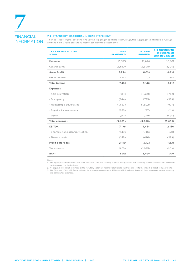
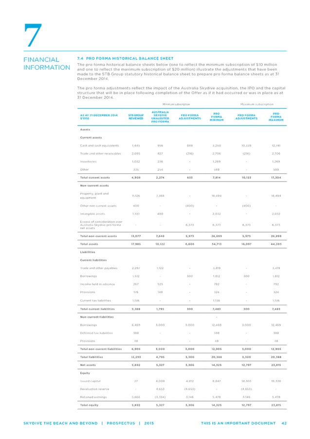
Ordinary Meeting
Public ATTACHMENTS
EXCLUDED FROM THE
Ordinary
Meeting
AGENDA
OF 17 September 2015
13. Staff Reports
Corporate and Community Services
13.1 Election of
Deputy Mayor 2015-2016
Attachment
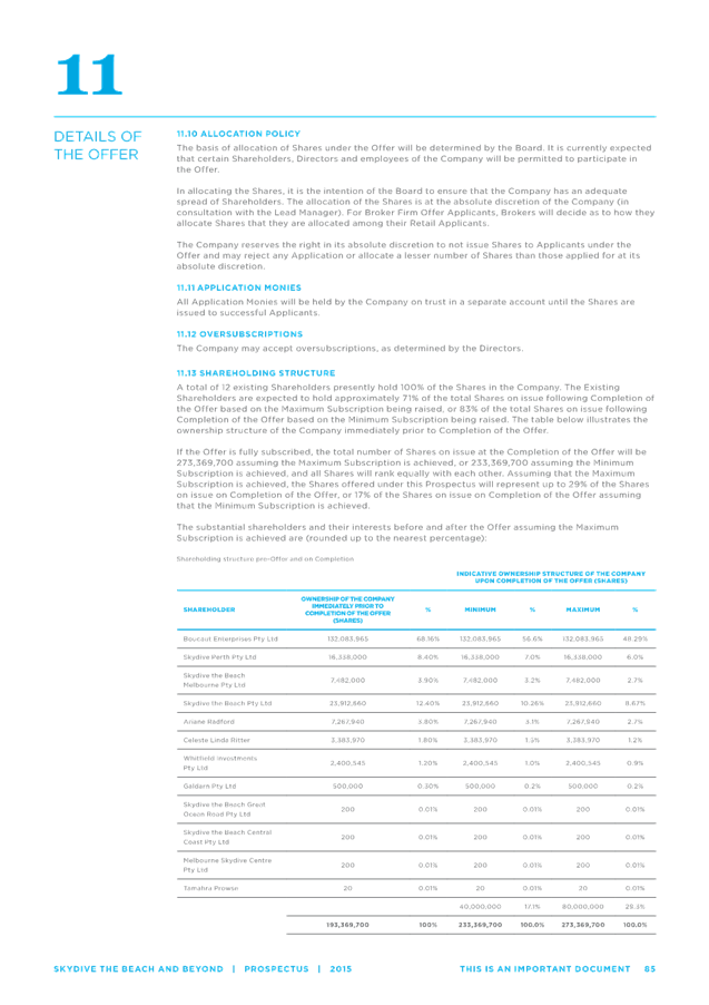
1.... Nomination form for the position of Deputy Mayor September 2015...................................................................................... 4
13.2 Tyagarah
Aerodrome - Proposed Short-Term Lease Australia Skydive Pty Ltd
Attachment
1.... Information Memorandum to Byron Shire Council from Skydive the Beach................................................................. 5
Attachment
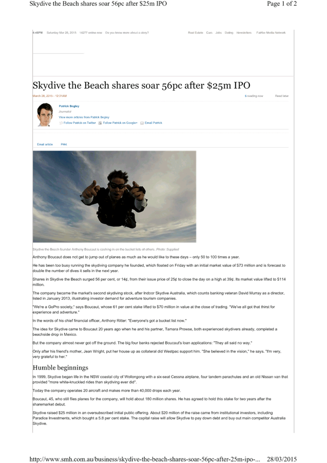
2.... Copy of SMH online article dated 28 March 2015 about
skydive-the-beach-share float to raise capital to acquire Australia Skydive................................................................. 59
Attachment
3.... Skydive_The_Beach_Prospectus - acquisition of Australia Skydive................................................................................ 61
13.3 Sustainable
Community Markets Public Exhibition for Draft Policy/Fees and Charges
Attachment
2.... Sustainable Community Markets Policy for adoption........ 174
13.4 Report of the
Safe Summer in the Bay PRG meeting 20 August 2015
Attachment
1.... Minutes of the Safe Summer in the Bay PRG meeting 20 August 2015...................................................................... 182
13.5 Report of the
Public Art Assessment Panel meeting 6 August 2015
Attachment
1.... Minutes of the Public Art Assessment Panel meeting 6 August 2015...................................................................... 186
Sustainable Environment and Economy
13.10 PLANNING - West Byron
Development Control Plan
Attachment
1.... Draft Byron DCP 2014 - Chapter E8 West Byron Urban Release Area..................................................................... 192
Attachment
2.... Draft amendments to Part A - Preliminary of Byron Shire DCP 2014.......................................................................... 266
Attachment
3.... West Byron DCP Workshop notes 2 July 2015................. 267
Attachment
4.... Form of Special Disclosure of Pecuniary Interest............. 277
13.11 PLANNING - 10.2015.196.1 -
Alterations to dwelling and a new residential flat building eight serviced
apartments and a managers residence at 40 Mullumbimbi Street Brunswick Heads
Attachment
1.... Proposed Plans 10.2015.196.1 - 40 Mullumbimbi Street Brunswick Heads............................................................... 279
Attachment
2.... Draft conditions 10.2015.196.1 - 40 Mullumbimbi Street Brunswick Heads............................................................... 285
Attachment
3.... Letter from Frank Stewart, Architect - 10.2015.196.1 - Additional
Information........................................................ 300
Attachment
4.... Statement of Heritage Impact 10.2015.196.1 40 Mullumbimbi Street
Brunswick Heads.................................................... 327
13.13 North Byron Beach Resort
(Ganra Pty Ltd) seek consent to lodge development application for coastal
protection works on Council land
Attachment
1.... Letter of request from Planners North for protection works to be
undertaken on Council owned land behalf Ganra Pty Ltd.......................................................................................... 345
Attachment
2.... proposed works in relation to the Belongil Estuary and Council land....................................................................... 347
13.14 PLANNING - 26.2015.3.1
General Policy and Housekeeping Changes - Byron Local Environmental Plan (LEP)
2014
Attachment
1.... Planning Proposal for LEP 2014 General Amendment No.2 - General Policy
and Housekeeping Changes In Byron Shire.......................................................................................... 348
Attachment
2.... Form of Special Disclosure of Pecuniary Interest............. 381
13.15 PLANNING - 10.2015.214.1 -
Railway infrastructure including a rail shed and two railway platforms and tree
removal at Bayshore Drive and Lawson Street, Byron Bay
Attachment
1.... 10.2015.214.1 - Plans of proposed development - Proposed Railway
infrastructure - Bayshore Drive and Lawson Street, Byron Bay.......................................................................... 383
Attachment
2.... Conditions of consent 10.2015.214.1................................ 387
13.16 PLANNING - 26.2013.2.1 -
Public submissions report for second exhibition of Ewingsdale Seniors Housing
planning proposal
Attachment
1.... Notes from Public Information Sessions........................... 396
Attachment
2.... Summary of issues and comments from second public exhibition........................................................................... 399
Attachment
3.... Summary of issues and comments from initial public exhibition........................................................................... 405
Attachment
4.... Letter from Roads and Maritime Sevices dated 1 August 2014.................................................................................. 423
Attachment
5.... Letter to applicant requesting additional traffic study........ 425
Attachment
6.... Applicant's response to request for additional traffic study 427
Attachment
7.... Letter from Henry Davis York enclosing draft Planning Agreement ........................................................................ 432
Attachment
8.... Letter from Tall Trees Care Communities ........................ 455
Attachment
9.... Form of Special Disclosure of Pecuniary Interest............. 457
Attachment
10.. Letter from Traffix to Department Planning dated 23 June 2015.................................................................................. 459
Attachment
11.. Draft Amended Planning Agreement prepared by Henry Davis York dated 31
August 2015..................................... 470
13.17 Update Coastal Zone
Management Plan Byron Bay Embayment
Attachment
1.... Letter in from Office Environment and Heritage Draft Coastal Hazard
Management Study Version 5 Review Comments 17 08 15................................................................................. 491
14. Reports of Committees
Corporate and Community Services
14.1 Report of the
Finance Advisory Committee Meeting held on 20 August 2015
Attachment
1.... Minutes of the Finance Advisory Committee Meeting held on 20 August 2015................................................................. 497
14.2 Report of the
Internal Audit Advisory Committee Meeting held on 20 August 2015
Attachment
1.... Minutes of the Internal Audit Advisory Committee Meeting held on 20
August 2015.................................................... 500
Sustainable Environment and Economy
14.3 Report of the
Biodiversity and Sustainability Advisory Committee Meeting held on 6 August
2015
Attachment
1.... Minutes of the Biodiversity and Sustainability Advisory Committee held on
6 August 2015.................................... 505
Infrastructure Services
14.4 Report of the
Local Traffic Committee Meeting held on 26 August 2015
Attachment
1.... Minutes of the Local Traffic Committee Meeting 26/08/15 508
Staff Reports - Corporate and Community Services 13.1 - Attachment 1
BYRON
SHIRE COUNCIL
NOMINATION FORM FOR POSITION OF
DEPUTY MAYOR
(To be delivered to the General Manager prior to the commencement
of the Ordinary Council meeting to be held on 17 September 2015)
NOMINEE: _____________________________
NOMINATORS : 1._____________________________
2._____________________________
Note: The
nomination is to be made by two or more councillors, one of whom may be the
nominee.
I
hereby consent to this nomination.
Signed:
____________________________ Date__________________
Nominee
Staff Reports - Corporate and Community Services 13.2 - Attachment 1


Staff Reports - Corporate and Community Services 13.2 - Attachment 1

Staff Reports - Corporate and Community Services 13.2 - Attachment 1
Staff Reports - Corporate and Community Services 13.2 - Attachment 2
Staff Reports - Corporate and Community Services 13.2 - Attachment 3


Staff Reports - Corporate and Community Services 13.3 - Attachment 2

BYRON SHIRE COUNCIL
POLICY
SUSTAINABLE COMMUNITY MARKETS
Staff Reports - Corporate and Community Services 13.3 - Attachment 2
INFORMATION ABOUT THIS DOCUMENT
|
Date Adopted by
Council
|
|
Resolution No.
|
|
|
Policy Responsibility
|
|
|
Review Timeframe
|
Minimum of every 5 years
|
|
Last Review Date:
|
|
Next Scheduled Review
Date
|
|
Document History
|
Doc No.
|
Date Amended
|
Details Comments eg Resolution
No.
|
|
E2013/51669
|
|
As presented to the
Markets Policy Review PRG Meeting on 30/1/14.
|
|
E2014/5260
|
30/01/14
|
Created to include
revisions from the Markets Policy Review PRG Meeting on 30/1/14.
|
|
E2014/15483
|
06/03/14
|
Created to include
revisions from the Markets Policy Review PRG Meeting on 6/3/14.
|
|
E2014/30327
|
08/05/14
|
Created to include
revisions from the Markets Policy Review PRG Meeting on 8/5/14.
|
|
E2014/55208
|
03/07/14
|
Created to include
revisions from the Markets Policy Review PRG Meeting on 3/7/14.
|
|
E2015/11857
|
25/11/14
|
Created to include
revisions from the Markets Policy Review PRG Meeting on 25/11/14. Reported to
Council I2015/331
|
|
E2015/33306
|
22/5/2015
|
Res 15-228 place on
exhibition. Advertisement E2015/33298 from 4/6/2015 to 2/7/2015
|
|
E2015/33306
|
02/09/2015
|
Proposed changes to
Section 3.6 as a result of public submission feedback
|
Further Document
Information and Relationships
|
Related Legislation
|
Local Government Act
1993
Crown Lands Act 1989
Environmental Planning and Assessment Act 1979
State Environmental Planning Policy (Temporary Structures) 2007
Food Act 2003
|
|
Related Policies
|
Business Ethics Policy
Council’s Code of Conduct
|
|
Related Procedures/
Protocols, Statements, documents
|
Sustainable Community
Market Regulating Code
|
Note: Any reference to
Legislation will be updated in the Policy as required. See website http://www.legislation.nsw.gov.au/ for current Acts, Regulations and Environmental
Planning Instruments.
TABLE OF CONTENTS
1. OBJECTIVES................................................................................................................... 1
2. DEFINITIONS.................................................................................................................. 1
3. POLICY
STATEMENT..................................................................................................... 2
3.1 Scope
of this Policy................................................................................................ 2
3.2 Market
Licence....................................................................................................... 3
3.3 Temporary
Market Licence..................................................................................... 3
3.4 Market
Frequency.................................................................................................. 3
3.5 Development
Consent............................................................................................ 4
3.6 Market
Licence Assessment Criteria...................................................................... 4
3.7 Allocating
Market Stall Spaces............................................................................... 4
1. OBJECTIVES
1.1. To
provide vibrant markets to the community and to make markets attractive for
both the community and tourists.
1.2. To
incubate local small businesses and artisans by providing them an accessible
avenue to sell their goods and/or services.
1.3. To
encourage production of local agriculture and to provide an accessible avenue
for the sale and purchase of locally grown produce to promote local food
security.
1.4. To
use the crown reserves in a way which supports local community, businesses and
attracts tourism, and whose management and consumer access is both equitable
and transparent.
1.5. To
clarify how approval to manage a market can be obtained, ensuring that market
organisers are aware of Council requirements so as to assist and encourage the
efficient organisation of markets whilst receiving requisite approvals in a
timely and orderly manner.
1.6. To
ensure the proper and effective maintenance and enhancement of reserves.
1.7. To
support local charities and not for profit organisations.
1.8. To
provide Council with recurrent income from markets on Council land to support
its Community Strategic Plan.
1.9. To
acknowledge the community service provided by Markets and to promote the social
benefit to community members.
1.10. To
enhance consumer choice and fair prices and enable stallholders to make a
reasonable living.
2. DEFINITIONS
Artisan
Market A
Market that primarily features artisans, contemporary art, handicraft and
designers, along with wellbeing practitioners and food producers.
Community
Market A Market that has a primary purpose to benefit
the Local Area.
Farmers
Market A regular Market
that primarily features fresh food, at which Northern Rivers regional farmers
and producers sell their own local farm-origin produce, and associated
value-added products directly to consumers.
Local Area The
Local Area is the area contained within the municipal boundary of Byron Shire
Council.
Local
Person A
Local Person is:
a) a
resident of the Local Area, or
b) not
a resident of the Local Area but is an owner of rateable land in the Local
Area, or
c) is
an occupier or rate paying lessee of rateable land in the Local Area.
Market The
licensed activity of selling, exposing or offering of goods, merchandise or
materials, or services for sale by Stall Holders.
Market
Manager A person or
organisation who holds a licence to use Council owned or managed land for the
purpose of operating a Market.
Northern
Rivers Region The Northern Rivers Region is the area comprised by the
municipal boundaries of Ballina, Lismore, Tweed, Byron, Clarence Valley,
Richmond Valley, and Kyogle Shire Councils.
Other
Market A
Market, other than a Community, Farmers, Artisan Market which meets the
objectives of this policy.
Stall Holder A
person to whom a stall site is issued by the Market Manager.
Adjoining
Shires Adjoining Shires are
those areas comprised by the municipal boundaries of Lismore, Tweed, and
Ballina Shires.
Temporary
Market A Market conducted for less than three
consecutive days and licensed for less than a 12 month period.
3. POLICY STATEMENT
3.1 Scope
of this Policy
a) This
Policy applies to Markets held on Council owned and managed land.
b) This
Policy does not prevent or constrain Council or Council as Crown Reserve Trust
Manager from operating a Market or Temporary Market on Council owned or managed
land.
c) This
Policy facilitates opportunities for prospective parties to compete for the use
of council owned and managed land for the purposes of operating a Market.
d) This
Policy will generate revenue via Market licence fees to assist Council deliver
its Community Strategic Plan objectives.
e) Council
will licence and regulate Markets on Council owned and managed land with
reference to all relevant legislation, this Policy, Market licence agreements,
development consent conditions, and the Sustainable Community Markets
Regulating Code in force from time-to-time.
f) Where
this Policy and/or Market licence agreements conflict with relevant
legislation, the legislation will prevail.
g) Council
is committed to the creation of social value and social benefit to the Local
Area through the operation of Markets on Council owned and managed land.
3.2 Market
Licence
a) A
licence to conduct a Market shall only be granted through a transparent and
competitive process, in accordance with all legislative requirements and
providing not less than a 6-months transition period for existing Market
Managers.
a) The
Market licence will stipulate the Market rental, which will be established and
determined by Council and included in Council’s adopted fees and charges.
b) All
Market rental income, generated by Markets operated on Council owned land will
be used to fund delivery of the Community Strategic Plan objectives.
c) All
Market rental income, generated by Markets operated on Council managed Crown
Reserves will be used to fund asset renewals, upgrades and improvements in
accordance with land management legislation.
d) The
term of the Market licence shall be for a maximum term of five consecutive
years and shall contain terms and conditions, not limited to, but consistent
with the development consent and/or Sustainable Community Markets Regulating
Code in force from time-to-time.
e) A
Market licence will only be granted in accordance with the relevant land
management legislation.
f) A
Market licence shall not be granted prior to development consent, where
development consent is required.
3.3 Temporary
Market Licence
a) A
licence to conduct a Temporary Market may be issued, under delegated authority
by the General Manager, on receipt of a Temporary Market application and after
assessment and consideration in relation to this Policy, any relevant land
management requirements and/or legislation.
b) A
Temporary Market licence shall not be issued for more than three consecutive
terms to the same applicant.
c) A
Temporary Market licence shall contain terms and conditions, not limited to,
but consistent development consent conditions and/or Sustainable Community
Markets Regulating Code in force from time-to-time.
d) All
Temporary Market licence fees shall be determined by Council and included in
Council’s adopted fees and charges.
e) A
Temporary Market licence shall not be granted prior to development consent,
where development consent is required.
3.4 Market
Frequency
a) Markets
and Temporary Markets shall only be held on a stipulated day and at a
stipulated location as defined in the Market licence.
3.5 Development
Consent
a) Development
consent and other legislative approvals may be required to conduct a Market on
Council owned or managed land.
b) Obtaining
development consent and any other legislative approvals will be the
responsibility of the Market Manager.
3.6 Market
Licence Assessment Criteria
a) All
competitive processes used to establish Market licences will include mandatory
and qualitative assessment criteria, with qualitative assessment criteria being
consistent with the Objectives of this Policy.
b) The
minimum qualitative assessment criteria, as set out below, will be included in
all competitive processes used to establish Market licences.
Demonstrate the following:
i. Ability
to develop, implement and monitor a Market Management Plan in accordance with Council’s
Sustainable markets Regulatory Code.
ii. Experience
in Market Management and meeting market licence conditions.
iii. Knowledge
of Byron Shire’s Market culture.
iv. Experience
with, and commitment to, environmental and sustainable operations and initiatives.
v. The
benefits to the local community, for example enabling social interactions,
promoting food security and healthy diets, preserving cultural heritage.
vi. The
benefits to the local economy for:
a. Local
employment and small business,
b. Local
Industries, for example sustainable agriculture, arts, crafts, and tourism, and
c. Local
charities and not-for-profit organisations.
3.7 Allocating
Market Stall Spaces
a) The
Market Manager shall allocate stall spaces giving priority to persons selling
produce and products from the Local Area for 75% of the total available Market
stall spaces, with the remainder of the Market stall spaces being allocated
using a priority system based on the following:
i. Local
Person
ii. Not
a Local Person but a resident of the Northern Rivers Region
iii. Others.
Staff Reports - Corporate and Community Services 13.4 - Attachment 1
UNCONFIRMED
REPORT OF THE SAFE SUMMER IN THE BAY PROJECT REFERENCE GROUP MEETING
|
Date of Meeting:
|
Thursday 20 August 2015
|
|
Time Commenced:
|
9.14am
|
|
PRESENT:
|
Councillors:
|
Cr Simon Richardson, Cr Rose Wanchap
|
|
|
Community Representatives:
|
There are no community representatives.
|
|
|
Invited Representatives:
Guests
|
Paul Spooner (Byron Community Centre), Tess Cullen
(Byron Community Centre), Michael O’Grady (Byron United/ Destination
Byron/ Backpacker Group), Peter Wood (Arts Northern Rivers), Greg Jago
(Police) Mouche Phillips (Byron Community Centre)
Brandon Saul (Falls Festival),
|
|
|
Staff:
|
Greg Ironfield (Manager Community Development), Joanne
McMurtry (Community Policy Officer), Simon Bennett (Traffic & Transport
Officer), Wayne Bertram (Manager Sustainable Development), Scott Brodie (Team
Leader Compliance)
|
|
|
|
|
|
1. APOLOGIES:
|
Hannah Spalding (Byron Bay Liquor Accord)
|
|
|
|
2. DECLARATIONS OF INTERESTS:
|
Paul Spooner (Byron Community Centre) reinforced a
previous declaration, in that he was in attendance as the Community Centre
Manager and not a Councillor, and that the Byron Community Centre conduct the
operations of Soul Street NYE and First Sun NYD events.
|
|
3. CONFIRMATION OF A QUORUM:
|
There are 9 members appointed to this group
(not including staff). Quorum was met.
|
|
4. CONFIRMATION OF PREVIOUS MINUTES
|
The previous minutes from the 23 April 2015 meeting
were adopted. (Spooner/ Wanchap)
|
|
5. BUSINESS ARISING FROM PREVIOUS
MEETING
|
|
|
|
1. SEPA
as a street camping control
· Paid parking will
be introduced throughout the Byron Bay CBD in time for Christmas/ New Year.
Discussion about whether SEPA would be needed/ effective. Decided it would be
effective between midnight and morning outside paid parking times.
· SEPA needs to
attach to an event – the ‘event’ will be Safe Summer in the
Bay.
Simon Richardson and Mouche
Phillips arrived at 9.24am.
Brandon Saul arrived at
9.30am.
Michael O’Grady arrived
at 9.35am.
RECOMMENDATION 5.1
The Safe Summer in the Bay
Project Reference Group recommend to Council that a Special Events Parking Area
(SEPA) be implemented, consistent with the same area as the 2014/15 SEPA, for
the event ‘Safe Summer in the Bay’ from the 26th
December 2015 through to 4th January 2016 inclusive and a 2P time
limit apply between the hours of midnight and 7am.
(Spooner/
Jago)
2. Street
closure times, parking, transport issues and Butler Street Reserve
The following changes were
discussed:
· Close parking in
front of the Byron Community Centre between Marvel and the pedestrian crossing
from 6am 31/12/15.
· Close Jonson
Street from Marvel through to Byron St from 12noon 31/12/15 to allow time for
stage set up.
· Close the rest
(Byron to Lawson Sts) from 1pm 31/12/15 to allow stallholders and other event
set up.
· As per last year,
close Lawson St South car park from 6am with stop/go control allowing only
stallholders and event personnel to park.
Action:
That a draft Traffic Control Plan
be brought back to the next meeting (16/9) that takes into consideration:
· Falls Festival
shuttle bus pick up from Butler St side of the railway line
· Falls Festival
shuttle drop off to consider assisting to carry passengers from Soul St home to
Suffolk Park area
· Consider the
traffic congestion experienced last year at Marvel/ Fletcher and Fletcher/
Lawson St intersections on NYE.
· Consider the New
Year’s Eve shuttle bus that is proposed to replace ‘Park and
Ride’
· Re Butler St
Reserve, note that there will be a Farmers’ Market during the SEPA period
(30 or 31/12) and a Community Market on 3rd January 2016. If paid
parking is in Butler St Reserve, need to extend time to 1am on NYE.
· Aim to have the
detail of the Traffic Control Plan ready for the Local Traffic Committee
meeting on 7th October.
3. Changes
to the law re alcohol prohibition and how this may impact on alcohol
confiscation on the night
The Manager Sustainable
Development outlined the changes to the law around Alcohol Free Zones (in place
for 4 years and applies to streets) and Alcohol Prohibition (which applies in
reserves and parks). We no longer apply for alcohol prohibition each year,
alcohol prohibition applies to reserves and parks all year round.
The law removed the fine
applicable to carrying alcohol in an Alcohol Free Zone, however Police can
still confiscate alcohol if they believe the person is drinking, has been
drinking or is about to drink.
Simon Bennett, Wayne Bertram
and Scott Brodie left the meeting.
4. Making
Things Happen update and how we can work with the program to raise revenue
Revenue and fundraising was
discussed. Council have allocated $25,000 towards the Soul Street NYE and First
Sun NYD events; Falls Festival’s contribution will be $15,000 this year.
This leaves approximately a $20,000 shortfall in the budget to provide
entertainment content between 5pm and 1am on NYE.
The aim of the ‘Making
Things Happen’ program is to provide a platform for attracting financial
and in-kind partnerships towards a range of Council initiatives to provide
community outcomes. This is a longer term strategic program and is
integrated across a range of initiatives including laneway activation projects,
youth employment creation, Byron Greeters and volunteer programs. If a partner
decides to contribute towards the ‘Soul St’ or ‘First
Sun’ events, the committee will certainly be notified.
Discussion points:
· There is potential
to sell exposure for businesses at these events.
· There appears to
be two types of audience – families and ‘fun lovers’.
· It was felt that
more success was likely be approaching high profile businesses for support (eg
The Farm, Elements, Bunnings, Flohive)
RECOMMENDATION 5.2
The Safe Summer in the Bay Project Reference Group
recommend to Council that in order to meet the current shortfall in funding of
Soul St NYE and First Sun NYD (as experienced for the previous two years also),
that savings made from the cancelled Park and Ride project budget be reallocated,
up to $20,000, to Soul St NYE and First Sun NYD, noting that the Safe Summer in
the Bay PRG are pursuing other sponsorship opportunities.
(Wanchap/ Richardson)
|
6. UPDATES
TO PLAN FOR NEW YEAR IN BYRON BAY 2015:
|
A general discussion was held around various aspects of the
plan. Falls Festival is being held on 31 December 2015, 1 & 2 January 2016.
Cr Wanchap mentioned she has been talking to high school
students about an under 18’s event at The Cavanbah on NYE. The committee
requested a detailed proposal be brought to the next meeting.
Action:
The committee requested a ‘progress report’
column be added to the Plan for New Year in Byron Bay 2015 for ease of
reporting progress.
|
ACTION LIST:
|
|
1. That
a draft Traffic Control Plan be brought back to the next meeting (16/9) that
takes into consideration:
· Falls Festival
shuttle bus pick up from Butler St side of the railway line
· Falls Festival
shuttle drop off to consider assisting to carry passengers from Soul St home
to Suffolk Park area
· Consider the
traffic congestion experienced last year at Marvel/ Fletcher and Fletcher/
Lawson St intersections on NYE.
· Consider the New
Year’s Eve shuttle bus that is proposed to replace ‘Park and
Ride’
· Re Butler St
Reserve, note that there will be a Farmers’ Market during the SEPA
period (30 or 31/12) and a Community Market on 3rd January 2016.
If paid parking is in Butler St Reserve, need to extend time to 1am on NYE.
· Aim to have the
detail of the Traffic Control Plan ready for the Local Traffic Committee
meeting on 7th October.
2. The committee
requested a detailed proposal about the Under 18’s event at The
Cavanbah be brought to the next meeting.
3. The committee
requested a ‘progress report’ column be added to the Plan for New
Year in Byron Bay 2015 for ease of reporting progress.
|
|
8. date and time of meetings for the year:
|
16
September to be confirmed
2
– 4pm, 22 October
11am
– 1pm, 12 November
9
– 11am, 3 December
|
|
Time Meeting Closed:
|
11:00am
|
|
|
|
Staff Reports - Corporate and Community Services 13.5 - Attachment 1
Minutes of the Byron
Shire Council Public Art Assessment Panel Meeting held on Thursday 6 August
2015
E2015/52311
PRESENT: Cr S Richardson
Staff: Joanne
McMurtry (Community Policy Officer)
Greg
Ironfield (Manager Community Development)
Andy
Erskine (Superintendent Parks)
Community: Peter Wood (Arts Northern Rivers) (By
teleconference)
Suvira
McDonald (Community Artist member)
Tracey
Whitaker (Community member)
Denise
Napier (Community member)
Simon
Richardson opened the meeting at 1.45pm and acknowledged that the meeting was
being held on Bundjalung Country.
APOLOGIES: Cr
P Spooner, Rick Molloy (Practising Artists Network), Paula Cordeiro (Community
Artist member), Michele Zarro (Community member)Gavin Brown (Bundjalung of
Byron Bay Aboriginal Corporation (Arakwal))
DECLARATIONS
OF INTEREST – PECUNIARY AND NON-PECUNIARY
Suvira McDonald
declared an interest in item 5.3 re Mullumbimby Sculpture Walk, being that he
is one of the main proponents in the project; and also in item 6.6 given that
he is one of the artists submitting work for the Brunswick Nature Sculpture
Walk.
CONFIRMATION OF A QUORUM:
There are ten people on the Panel. Quorum numbers were met.
CONFIRMATION
OF PREVIOUS MINUTES:
That the minutes
of the Public Art Assessment Panel meeting held on 7 May 2015 be adopted.
(McDonald/Richardson)
BUSINESS
ARISING FROM PREVIOUS MINUTES (Verbal updates)
5.1 Unity
Pole
As the pole is
starting to crack in a few places the owners of the pole have decided it would
be best not to use it for the beachfront area at this time. They may
create a new pole with more seasoned wood that would work better for that
specific area and will keep us up to date with progress.
5.2 Priority
public art locations in Ocean Shores and Suffolk Park
The Manager of
Sustainable Development provided information about land ownership and
constraints using Council’s mapping system and several specific locations
were discussed. The following areas were identified for further investigation:
Ocean Shores:
· Water
Lilly Park
· Ocean
Shores Community Centre
· The
following roundabouts: Rajah Rd (town entry area), Orana Rd and Shara Boulevard
near the new Sports Fields, Tweed St entry to Brunswick Heads.
· RMS
own the land within 55m of a roadway (Pacific Motorway) and the Roads Act will
have requirements that need to be met.
· The
local road bridge over the Brunswick River.
· There
was discussion about incorporating water into roundabout art however electrical
services tend to be not very deep in the ground at roundabouts so this will
need to be considered.
· The
entry/ exit to Ocean Shores shops – there is a grassed area that could be
used for public art.
Suffolk Park:
· Community
Centre
· Clifford
St intersection (there will be a roundabout included in an upgrade of this
intersection)
· Roundabouts
near the BP service station (Beech Drive) and at Baywood Chase entrance (Beech
Drive).
· Near
the Skate Park and around the Lake.
· Land
between the lake and the roundabout at Beech Drive (north).
· Even
the Green Garage roundabout.
Discussion about
devising a catchy name for Roundabout Art across the Shire.
Action:
· Add
to the next PAAP agenda – ideas for the first roundabout piece for
commissioning.
5.3 Mullumbimby
Sculpture Walk
Suvira
McDonald reported:
· The poles for the sculpture have been located
· A community member in Mullumbimby has offered his acreage to prepare
the poles
· Have been talking with SCU and Byron Bay Community College about
students to help with the project
· Will probably engage a contractor to build the sculpture
· The crowd funding campaign raised $11,000 which was matched by
Community Partnerships Australia, plus the $5,000 donated by Council.
5.4 Electricity
Padmount Substations
The contract has
been signed with both artists delivering the artwork on the Electricity
Padmount Substations. The Byron Bay project have had concept designs approved
by the small committee of the PAAP and also Essential Energy and is to commence
on Monday 10th August and will take a few days to do. The
Mullumbimby project is at the concept design stage.
5.5 Public
Art Small Grants
The 50% up front
payments for the four Public Art Small Grants awarded, have been paid and
acquittal forms provided to gather information about the project prior to the
final payment being made. Projects need to be finalised before the 30 June
2016.
5.6 Judy
Cassab Paintings
These
are now hanging on the Byron Bay Library in the Quiet Study Room. Below is a
photo.
Action:
· The
PAAP request that a didactic of Judy Cassab be displayed with the paintings.
Staff to draft and Peter Wood and Suvira McDonald will assist with editing.

PUBLIC ART PROPOSALS
Peter Wood
joined the meeting by telephone at 2.45pm.
6.1 Memorial Seat, Brunswick Heads
A Public Art
Small Grant was allocated to assisting with the professional designs for this
project. Following the submission of those designs, the Public Art Assessment
Panel were happy with the final concept designs.
Resolution 14
– 602, part 2 stated: “In relation to the Memorial Mosaic Seat
in Brunswick Heads, Council accepts the donation of a Memorial Mosaic Seat,
placed in a suitable location on Council land in Memorial Park, Brunswick
Heads, subject to the Public Art Assessment Panel (PAAP) members meeting with
the artist around some design questions and being satisfied with the final
concept designs.”
RECOMMENDATION
6.1:
That the
Public Art Assessment Panel recommend to Council that further to resolution
14-602, the PAAP reiterate their support for this project.
(Wood/ Richardson)
6.2 Public Art Proposal – Simpson’s
Sofa, Brunswick Heads
Simpson’s
Sofa has been presented to the Public Art Assessment Panel previously as a
request for a Public Art Small Grant. The piece is planned as part of the
Brunswick Nature Sculpture Walk and the organisers would like it installed as a
permanent sculpture which is the subject of this report.
RECOMMENDATION
6.2:
That the
Public Art Assessment Panel recommend to Council to accept the donation of
‘Simpson’s Sofa’ as a permanent sculpture installation in
South Beach Park, Brunswick Heads.
(Whittaker/ Napier)
6.3 Public Art Proposal – Bus Shelter Cnr
Jonson and Carlyle Streets, Byron Bay
A property owner on Jonson Street adjacent
to the existing bus stop has offered to pay for the bus stop to be
‘refreshed’ to deter graffiti. It has been suggested that the
artist Dave McElvenny be engaged to undertake a public artwork and examples of
his previous work is included in the report.
RECOMMENDATION
6.3:
That the
Public Art Assessment Panel recommend to Council to accept the donation of a
public artwork on the Jonson Street bus shelter to deter graffiti.
(Napier/ Richardson)
Action:
· Request that the artist to review the colour, size and location of
the logo on the artwork to be more sympathetic in the art piece
· Find out if the artwork will be mounted on the bus shelter or
painted straight onto it.
· Suggest replacing the bus timetable on the side of the bus shelter
or on the pole so as not to obstruct the artwork.
6.4 Public Art Request for Council support for
‘Inside Out’ Project
A request has been received to support the
‘Inside Out’ Project in Bangalow with a donation of $1300.
RECOMMENDATION
6.4:
That the
Public Art Assessment Panel recommend to Council that whilst the value and
creative worth of the project is recognised, the request for funding is
declined. The PAAP supports the proponents to work with the Bangalow community
to raise the funds.
(Richardson/McDonald)
6.5 Public Art Commissioning Proposal –
Water Infrastructure in Byron Shire
Following a recent ‘experiment’
on the Bangalow Water Tank to deter graffiti, it has been identified that
public art may alleviate some of the vandalism and graffiti on a range of water
infrastructure around the Byron Shire. The report outlines a public art
commissioning proposal.
RECOMMENDATION
6.5:
That the Public Art Assessment Panel
recommend to Council to commission public artwork on the following water
infrastructure in the Byron Shire, to be funded from water and sewer budgets:
1. Paterson’s
Hill Water Tank
2. Wategos
Water Tank
3. Warrumbool
Road Reservoir
4. Several
sewerage pump stations (locations listed in the report, limited by budget
allocation for the 2015/16 financial year)
(Wood/ Napier)
Action:
· Denise will advise possibilities of using banner-mesh for large
projects such as the Paterson’s Hill Water Tank. Can we find out if this
PVC is recyclable?
· Staff to create a brief for this project and email around to Panel
members. The idea of running a competition could be considered. Could also
consider tying with the new Byron brand.
6.6 Public Art Proposal – Individual Artwork
Submissions for temporary event – Brunswick Nature Sculpture Walk
Suvira McDonald did not participate in
the vote for this item.
The Public Art
Assessment Panel has previously supported the Brunswick Heads Nature Sculpture
Walk with a $5,000 donation in 2014 (14-602), and recently with two Public Art
Small Grants of $500 each (15-249). In addition, the event received $2,000 from
the Events and Festival Sponsorship Fund to make a documentary film of the event, for assistance with
promotional materials and the engagement of a structural engineer. The report outlines the individual artwork submissions for
consideration.
RECOMMENDATION
6.6:
That the Public Art Assessment Panel
recommend:
1. That Council note that the Public Art
Assessment Panel has considered each artwork submission for the Brunswick
Nature Sculpture Walk, for consistency with the Council’s Public Art
Policy.
2. That Council note that the event organisers
have engaged structural engineers (Ardill Payne and Partners) to assess the
installation of the artworks on Friday 2 October, prior to the event opening
and access by the general public.
(Napier/Whittaker)
6.7 Public Art in redevelopment of the Main Beach
Backpackers (old Council Chambers) in Byron Bay
As per the Byron Shire Development Control
Plan 2014 – Chapter D8 – Public Art, certain new developments are
to show how they incorporate public art within the project. The redevelopment
of the Main Beach Backpackers (old Council Chambers) in Byron Bay is such a
development. The report provided proposed plans to incorporate public art in
this new development and requested the Public Art Assessment Panel use their
art expertise to consider the proposal and provide advice to staff.
Action:
· That a meeting between the developer and PAAP members be set up to
facilitate a public art outcome.
6.8 Public Art Proposal – Donation of
painting by Rose McKinley
The artist, Rose McKinley, would like to
donate a painting to hang in the Byron Bay Library.
RECOMMENDATION
6.8:
That the Public Art Assessment Panel
recommend to Council:
1. To accept the donation of ‘Minyon
Falls with Wesley Stacey’ to hang in the Byron Bay Library, and
2. To thank Rose McKinley for the
generous donation and request her to help select a suitable location in the
library.
(Wood/ Whittaker)
GENERAL
BUSINESS
· The
Public Art Assessment Panel agreed that a letter of support can be provided to
the Tweed Street Ten Seat Project for a further two seats under development, to
support grant funding applications.
8. DATE
AND TIME OF NEXT MEETING
The next meeting
of the Public Art Assessment Panel will be 1.30 – 3.30pm 5 November 2015.
There
being no further business the meeting concluded at 4.05pm.
Staff Reports - Sustainable Environment and Economy 13.10 - Attachment 1

Draft Byron Shire
Development Control Plan 2014
Chapter E8
West Byron Urban Release Area
Staff Reports - Sustainable Environment and Economy 13.10 - Attachment 1
This page has been intentionally left blank
Staff Reports - Sustainable Environment and Economy 13.10 - Attachment 1
Contents
E8.1 Introduction. 6
E8.2 Name and Application of this Chapter 6
E8.3 Land to which this Chapter applies. 6
E8.4 Purpose of this Chapter 6
E8.5 Relationship to other Plans and Policies. 8
E8.6 Background Information. 10
E8.7 Interpretation. 12
E8.8 Compliance with Objectives and Controls in this Chapter 13
E8.9 Notification of Development Applications. 13
E8.10 Design Principles. 13
E8.10.1 Staging Plan. 14
E8.10.2 Housing Subdivision Layout, Orientation and Diversity. 16
E8.10.3 Transport Movement and Street Hierarchy. 19
E8.10.4 Stormwater Water Management 22
E8.10.5 Biodiversity, Vegetation Management and Landscaping. 24
E8.10.5.1
Biodiversity and Vegetation Management 24
E8.10.5.2
Landscaping. 28
E8.10.6 Public Facilities, Services and Infrastructure. 29
E8.10.7 Recreational Areas. 31
E8.10.8 Hazards and Constraints. 33
E8.10.8.1
Flooding. 33
E8.10.8.2
Acid Sulfate Soils. 34
E8.10.8.3
Groundwater 35
E8.10.8.4
Bushfire. 35
E8.10.8.5
Odour 37
E8.10.8.6
Contamination. 38
E8.10.8.7
Mosquitoes. 38
E8.10.8.8
Buffer to Ewingsdale Road. 39
E8.10.9 Aboriginal Cultural Heritage. 42
E8.10.10 Urban Design of Significant Sites and Higher Densities. 42
E8.10.10.1
West Byron Village Centre Precinct 42
E8.10.10.2
Neighbourhood Business Area. 44
E8.10.10.3
Residential Areas. 48
E8.10.10.4
Industrial Area. 65
E8.10.11 Development in the E3 Zone. 67
E8.10.12 Tourist and Visitor Accommodation in the Residential R2 and
R3 Zones and the
B1 Zone. 67
Appendices
Appendix A – Staging Plan. 68
Appendix B – Concept Plan. 69
Appendix C – WSUD Street
Tree with Pit 70
Appendix D – Typical Road
Cross Sections (Not to scale) 71
Appendix E – Typical
Driveway Access across Swales (Not to Scale) 72
Appendix E – Typical
Driveway Access across Swales (Not to Scale) 72
Appendix F – Typical
Stormwater House Connection (Not to Scale) 73
Figures
Figure E8.1 - Land to which this Chapter applies. 7
Figure E8.2 Alignment of Subdivision Lots. 17
Figure E8.3 Street Parking for Small Lots. 19
Figure E8.4 Typical Road Verge with Swale and Footpath. 20
Figure E8.5 Road and parking design combined with vacant
small lot subdivision. 22
Figure E8.6 General Habitat Corridors to be Strengthened. 27
Figure E8.7 Street Tree Landscaping 29
Figure E8.8 Example of exercise equipment on soft fall
material 31
Figure E8.9 Examples of playground equipment 33
Figure E8.10 Predicted 2 Odour Unit Contour for Poultry
Processing Plant 37
Figure E8.11 Landscape Buffer and Acoustic Barrier to
Ewingsdale Road. 41
Figure E8.12 Planning Principles for the West Byron Village
Centre Precinct 43
Figure E8.13 Example of a green wall 46
Figure E8.14 Example of Cafe opening onto a park area. 47
Figure E8.15 Examples of Various Building Elements against
Planning Controls 2, 3, 4 and 8. 62
Figure E8.16 Examples of Various Building Elements against
Planning Controls 11. 63
Figure E8.17 Photo Plates – Examples of Various
Building Elements
against Planning Controls. 64
Tables
Table
E8.1 Relevant Provisions of the Byron Shire DCP 2014. Error!
Bookmark not defined.
Table
E8.2 State Significant Site Study – Technical Studies. Error!
Bookmark not defined.
Table
E8.3 Key Controls for Dwelling Houses, Dual Occupancy (attached and detached),
multi-dwelling housing and integrated development permissible under Clause 83
of Byron LEP 1988 in the R2 and R3 Zones. Error!
Bookmark not defined.
Staff Reports - Sustainable Environment and Economy 13.10 - Attachment 1
Document History
|
Doc No.
|
Date Amended
|
Details
Comments eg Resolution No.
|
|
#E2015/14159
|
|
Draft
|
|
|
|
|
E8.1 Introduction
This development control plan (DCP) chapter provides a
framework to guide the future development of West Byron. The document specifies
subdivision, built form, environmental protection and other controls to achieve
the vision for West Byron Bay.
E8.2 Name and
Application of this Chapter
This plan is called Chapter E8 West Byron Bay Urban Release
Area and will amend Byron Shire DCP 2014. It has been prepared pursuant to the
provisions of Section 74C of the Environmental Planning and Assessment Act
1979 (the Act).
E8.3 Land to which
this Chapter[j1] applies
This Chapter applies to land identified
under Part 4 West Byron Bay Site of Byron Local Environmental Plan 1988. The
site location is shown below in Map E8.1 – West Byron
Urban Release Area Map
E8.4 Purpose [j2] of this Chapter
The purpose of this
chapter is:
1. To establish the
planning, design and environmental objectives and guidelines against which the
consent authority will assess future development applications.
2. To communicate
site specific controls for the site relating to urban design, mitigation of
environmental impacts, protection of biodiversity and management of
environmental hazards.
3. To promote high
quality urban design outcomes for the site within the context of environmental,
social and economic sustainability.
Staff Reports - Sustainable Environment and Economy 13.10 - Attachment 1
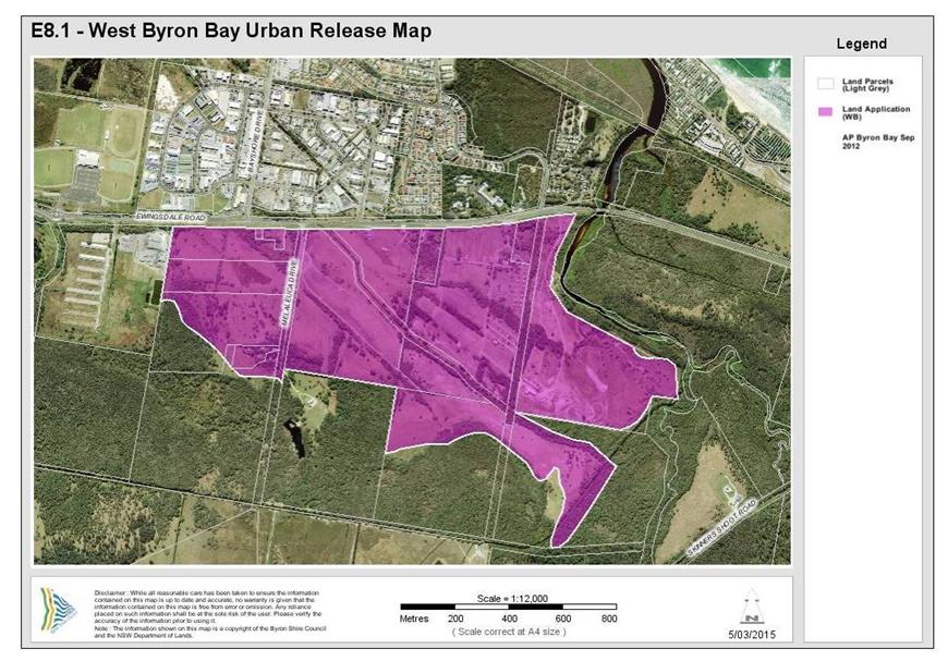
Figure E8.1 - Land to which this Chapter applies
Staff Reports - Sustainable Environment and Economy 13.10 - Attachment 1
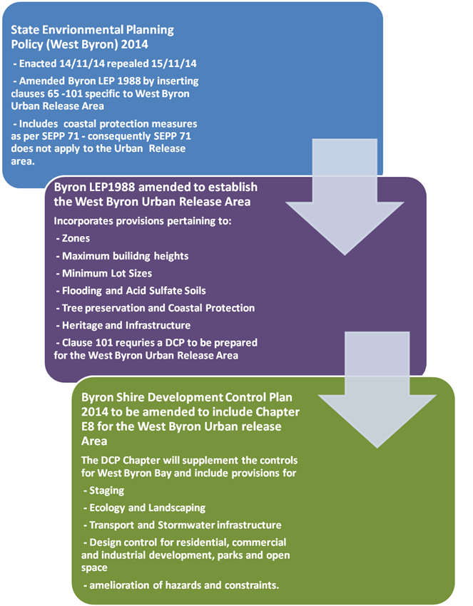
E8.5 Relationship to
other Plans and Policies
Relevant State Environmental Planning
Policies (SEPP) and Byron Local Environmental Plan (LEP) 1988 are the statutory
environmental planning instruments applicable to the site and will prevail over
any inconsistencies with provisions contained in the Chapter.
State Environmental Planning Policy
(West Byron Bay) 2014 amended the Byron LEP 1988 by inserting Clauses 65
– 101 and identified the site as an urban release area on the 14 November
2014. Clause 101 requires the preparation of a DCP for the West Byron
Urban Release Area. The West Byron SEPP after amending the Byron LEP 1988 was
subsequently repealed the following day.
The flow chart below provides a summary
of the relationship between the now repealed SEPP and the DCP Chapter.
Development within West Byron Bay
will need to comply with this chapter, as well as other relevant chapters in
the Byron Shire DCP 2014 set out in Table E8.1. In the event of any
inconsistency between this DCP Chapter and other Chapters within Byron Shire
DCP 2014 or any other plan or policy of Council, this chapter will prevail to
the extent of the inconsistency.[c3]
Table
E8.1 Relevant Provisions of the Byron Shire DCP 2014
|
Section and Provisions of Byron Shire DCP 2014
|
|
Part A Preliminary
|
|
Part B Controls
Applying Generally to Development Applications
Chapter B2 Preservation of
Trees and Other Vegetation
Chapter B3 Services
Chapter B4 Traffic
Planning, Vehicle Parking, Circulation and Access
Chapter B5 Providing for
Cycling
Chapter B6 Buffers and
Minimising Land Use Conflict
Chapter B7 Mosquitoes and
Biting Midges
Chapter B8 Waste
Minimisation and Management
Chapter B9 Landscaping
Chapter B10 Signage
Chapter B11 Planning for Crime
Prevention
Chapter B12 Social Impact Assessment
Chapter B13 Access and Mobility
Chapter B14 Excavation and Fill
|
|
Part C Further
Controls Applying to Land with Specific Constraints and Environmental
Characteristics
Chapter C1 Non-Indigenous
Heritage
Chapter C2 Areas Affected
by Flood
Chapter C3 Visually
Prominent Sites, Visually Prominent Development and View Sharing
Chapter C4 Development in
a Drinking Water Catchment
|
|
Part D Further
Controls Applying to Specific Land Uses
Chapter D1 Residential
Accommodation in Urban, Village & Special Purpose Zones
Chapter D2 Residential
Accommodation and Ancillary Development in Rural Zones
Chapter D3 Tourist
Accommodation
Chapter D4 Commercial and
Retail Development
Chapter D5 Industrial
Development
Chapter D6 Subdivision
Chapter D7 Sex Services
Premises
Chapter D8 Public Art
|
E8.6 Background
Information
This chapter is based on information
obtained from the State Significant Site (SSS) Study for the West Byron Bay
Urban Release Area. The technical studies completed as part of the SSS
Study are set out in Table E8.2. These are available from
the NSW Department of Planning and Infrastructure’s website www.planning.nsw.gov.au.
Table E8.2 State Significant Site Study –
Technical Studies
|
Issue
|
Technical Study
|
Author
|
Date
|
|
Acid Sulfate Soils
|
Preliminary Acid
Sulfate Soils Assessment
|
Southern Cross
University Environmental Analysis Laboratory
|
December 2010
|
|
Air Quality
|
Odour & Air
Quality Constraints West Byron
|
PAE Holmes
|
December 2010
|
|
Options for Future
Development on West Byron SSS Site: Odour Constraints
|
PAE Holmes
|
May 2012
|
|
Aquatic Ecology
|
Aquatic Assessment
of West Byron Urban Land Release Program
|
Peter Parker
Environmental Consultants Pty Ltd
|
August 2010
|
|
Bushfire
|
Bushfire Assessment
|
LandPartners
|
December 2010
|
|
Civil Engineering
|
Byron West
Engineering Advice
|
Cardno
|
April 2011
|
|
Contamination
|
Preliminary
Contamination Land Assessment
|
EAL Consulting Service
|
December 2010
|
|
Cultural Heritage
|
Proposed West Byron
Urban Release Area Cultural Heritage Assessment
|
Jacqueline Collins
(Consultant Archaeologist)
|
December 2010
|
|
Ecology
|
Preliminary
Ecological Assessment
|
LandPartners
|
August 2010
|
|
Ecological
Assessment West Byron Project
|
Australian Wetlands
Consulting Pty Ltd
|
December 2010
|
|
West Byron Urban
Land Release Area: Response to Submissions Received during Public Exhibition
Period – Ecological Matters
|
Australian Wetlands
Consulting Pty Ltd
|
April 2012
|
|
Flooding
|
West Byron Flood
Impact Assessment
|
BMT WBM
|
December 2010
|
|
West Byron Flood
Impact Assessment – Assessment Revision - Correspondence
|
BMT WBM
|
22 November 2011
|
|
West Byron Flood
Impact Assessment – Response to Submissions - Correspondence
|
BMT WBM
|
22 March 2012
|
|
West Byron Bay
Development Proposal – Flooding – Final Report
|
WMA Water
|
21 June 2012
|
|
Geotechnical
|
Geotechnical
Assessment for Development of West Byron/Belongil Fields
|
Shaw Urquhart
|
June 2010
|
|
Koala Management
|
West Byron Urban
Release Area Response to Submissions by Byron Shire Council and Office of
Environment and Heritage – Koala Management
|
Austeco
Environmental Consultants for Setscan Pty Ltd
|
6 November 2012
|
|
Koala Management in
the West Byron Urban Release Area
– Memorandum to Byron Bay West Landholders Association
|
Austeco
Environmental Consultants for Setscan Pty Ltd
|
16 November 2012
|
|
Land Use Conflicts
|
Land Use Conflict
Risk Assessment
|
LandPartners
|
December 2010
|
|
Mosquitoes
|
Mosquito Risk
Assessment
|
Sydney West Area Health
Service
|
December 2010
|
|
Noise
|
Revised Preliminary
Acoustic Advice
|
TTM Acoustics
|
June 2010
|
|
Retail and Commercial
Demand
|
West Byron Urban
Release Area Retail and Commercial Demand Study
|
Hill PDA
|
July 2010
|
|
Social Impact
|
West Byron Urban
Release Area Housing and Human Services Study Social Impact Assessment
|
BBC Consulting Planners
|
February 2011
|
|
Traffic
|
West Byron
Development Transport Study
|
Veitch Lister Consulting
|
March 2011
|
|
West Byron
Development Transport Study – Supplementary Report on Changes in Level
of Service
|
Veitch Lister
Consulting
|
March 2011
|
|
Urban Design
|
West Byron Urban
Release Area Enquiry-by-Design Workshop Outcomes Report
|
Deicke Richards
Architects
|
September 2010
|
|
Summary of Issues
and Proposed Resolution of Traffic Noise, Visual Impact and Urban Design
along Ewingsdale Road
|
TTM Acoustics, Ennismore
Field P/L & Deicke Richards P/L
|
May 2011
|
|
Visual Impact
|
West Byron Urban
Release Area Visual Assessment
|
Ennismore Field Pty Ltd
|
Undated
|
|
Water Management
|
West Byron Urban
Land Release Project Report
|
The Water &
Carbon Group
|
October 2010
|
E8.7 Interpretation
In this chapter Urban release area is the
West Byron Bay site identified under Part 4 of the Byron Local Environmental
Plan 1988.
Any other word or expression used in this Chapter has the
same meaning as it has in the standard instrument (as prescribed by the
Standard Instrument (Local Environmental Plans) Order 2006) unless it is
otherwise defined in this Chapter. Where the word or expression is not
defined in the standard instrument, it will have the same meaning as defined in
the Byron Shire DCP 2014. Wherever any discrepancy arises, the provisions used
in the standard instrument prevail.
Where not otherwise defined, the meaning is to be taken as
the meaning most commonly understood. A reference in this Chapter to any
Australian Standard or legislation includes a reference to any amendment or
replacement as made.
Notes: are
included in this document to provide additional guidance and explanation of the
provisions. These notes are not part of the formal provisions of the Chapter
E8.8 Compliance
with Objectives and Controls in this Chapter
Clauses in this plan contain Objectives, performance
criteria and prescriptive measures. The prescriptive measures are
requirements that Council considers likely to meet the objectives and
performance criteria. In certain circumstances applicants can propose
alternate solutions to the prescriptive measures, however they will need to
demonstrate that the alternative design satisfies the objectives and
performance criteria for that clause. Further information is provided in Part A
of DCP 2014 (see Clause A12) where an explanation is provided on dual path
assessment.
E8.9 Notification of
Development Applications
Notification of development applications will be undertaken
in accordance with Part A of the Byron Shire DCP 2014.
E8.10 Design Principles
The development of the site is
underpinned by the following key design principles:
Legible and connected
a) A vibrant mixed
use village centre to provide a community meeting place and to provide retail
and commercial opportunities
b) a street pattern
that connects the new residential areas with the mixed use village centre, the
light industrial area and local parks
c) neighbourhoods
where residents can safely walk or cycle to the local shops and open space
d) public transport,
cycle and pedestrian ways that links with existing networks.
e) high speed
broadband to the entire estate
Reinforcing the natural environment
a) high quality
streetscapes with generous green verges, street trees and footpaths with access
to safe open space areas
b) Appreciation of
areas of high quality habitat for conservation
c) Residential open
space areas which link with the natural environment
Innovative and integrated
a) mixture of
dwellings types to improve housing choice for a variety of residents and
budgets and create diversity in the built form
b) housing
arrangements different to the existing model in Byron Shire including small lot
housing and co-operative housing
c) Clearly defined
entry statements at the access points from Ewingsdale Road
Amenity
a) Residents and
properties are protected from hazards including flooding and bushfire
b) Coherent buffers
provided to Ewingsdale Road and other environmental constraints.
Concept and
Staging Plan[c4]
A Staging and Concept Plan has been
developed for the site as shown in Appendix A and B. The plans form the
basis for urban development by setting out:
a) access points from
Ewingsdale Road and associated intersection treatments
b) a key circulation
route through and around the development area including cycleways
c) the location of
future land uses including low and medium density residential development, the
neighbourhood centre, the light industrial area, and open space
d) buffers to
Ewingsdale Road
e) the identification
of environmental conservation and management areas for revegetation
f) landscaping
and street trees
Both plans are indicative and
further changes to the layout and or staging may occur through the development
of West Byron and further assessment. Where major variations are proposed the
applicant will be required to demonstrate the development remains consistent
with the Design Principles in this section.
E8.10.1 Staging Plan
Objectives
1. Enable
the orderly development of the site.
2. Enable
land to be developed in a co-ordinated fashion.
Performance Criteria
1. Land use
development will be integrated, coordinated and planned in line with the
provision of infrastructure
2. All infrastructure will be designed to provide a high
standard of living for residents and a vibrant, well serviced village centre
and industrial estate.
3. Rehabilitation
and re-vegetation works are to be delivered in a timely manner and in
accordance with management plans.
Prescriptive Measures
1. West
Byron is to be developed in two main stages generally as shown in Appendix A
Staging Plan.
2. Stage
1 to comprise the following minimum infrastructure and works to enable the
site to be subsequently developed for commercial, residential and industrial
land uses.
a) The two
roundabouts on Ewingsdale Road – Details to be submitted and approved as
to the timing of construction of the roundabouts to minimise disruption to
traffic flows on Ewingsdale Road. The roundabout at the intersection of
Bayshore Drive and Ewingsdale Road to be designed and constructed with a
concrete pavement to facilitate heavy vehicle movements into West
Byron.
b) The start of the
two ends of the Main Spine Road for a length of approximately 250 metres to the
first major internal intersections;
c) Legal
access to roads and services for any allotments (including Lot 1 DP780242) not
having land frontage to the constructed Main Spine Road;
d) Closing of
Melaleuca Drive from Ewingsdale road and measures to ensure access to other
properties on this road.
e) Noise attenuation
measure to Ewingsdale Road including earth bunds, noise fencing and landscaping
to satisfy the Australian Standard;
f) Trunk water
services (including Dual Reticulation mains to service the IN2 Light
Industrial Zone and B1 Neighbourhood Centre Zone) for the length of the
constructed roads;
g) Main Trunk Sewer
infrastructure, pump stations and other necessary sewage infrastructure for the
length of the constructed roads;
h) Bulk Earthworks
to satisfy the flooding and stormwater requirement for the site including the
reconstruction of the main stormwater drain through to the point of discharge;
i) Any
necessary stormwater infrastructure to service this Stage including
embellishment and landscaping of the main drain in this Stage. Where
appropriate drainage work in Stage 2 can commence with Stage 1 including works
on the main drain.
j) Bulk
Earthworks for Central Park on Ewingsdale Road (not embellishment) zoned RE1;
k) Acid
Sulfate Soils Management Plan for the entire site, Water Management Plan for
Belongil Creek including baseline data, monitoring and hold points in the event
that water quality is adversely affected by the development, and Biodiversity Conservation Management Plan
including a program for environmental management and staged rehabilitation for
the E2 and E3 Zones;
l) Identification
and protection of any special cultural or heritage places for the entire site;
m) Construction of the
pedestrian/ cycleway for the full frontage of Ewingsdale Road and other
pedestrian/ cycleways through Stage 1 as required;
n) General
landscaping, street trees and the like where relevant to Stage 1 for the
sections of roads being constructed;
o) Subdivision for
the purpose of creating super or master lots and smaller site specific
residential, commercial and industrial lots where appropriate;
p) Address the
provisions for the West Byron Village Centre Precinct under Clause E8.10.10.1
q) Design for the
construction and embellishment of the Park adjacent to the B1 Zone. The timing
for the dedication of the park to be linked with the development of the B1
Zoned Land and the adjacent R3 Zone Land.
r) Any
landscaping or buffer treatments as required under Clause E8.10.5.1.
s) General
timing and sequencing of work within this stage.
t) Applicants
to demonstrate that Infrastructure to be constructed at Stage 1 is designed to
accommodate the expected population yield for West Byron.
Subsequent development applications for residential,
business and industrial development including subdivision to demonstrate how
they will be co-ordinated with infrastructure being provided with the Stage 1
approval.
3. Stage
2 - Stage 2 to comprise the following works and infrastructure:
a) Completion of the
Spine Road link;
b) Completion of
trunk water supply and sewer links;
c) Any other
necessary stormwater infrastructure to service this Stage;
d) Compliance with
any plans of management or Cultural Heritage recommendations approved in
Stage 1:
e) General
landscaping, street trees and the like where relevant to Stage 2 for the
sections of roads being constructed;
f) Subdivision
for the purpose of creating super or master lots or smaller site specific
residential lots where appropriate;
g) Any landscaping
or buffer treatments as required under Clause E8.10.5.1;
h) Embellishment of
the Central Park on Ewingsdale Road; and
i) General
timing and sequencing of work within this stage.
Subsequent development applications for residential,
including subdivision to demonstrate how they will be co-ordinated with the
infrastructure being provided within Stage 2.
4. Where
road reserves are to be dedicated to Council they are to terminate at the
property boundary to ensure access to adjoining properties.
5. Where
drain crossings over Crown Land or other public property are deferred from
Stage 1 to Stage 2, details to be submitted to Council outlining how the
construction of the crossing will be financed including the agreement of land
owners where nominated.
E8.10.2 Housing
Subdivision Layout, Orientation and Diversity
The subdivision layout needs to consider not only orientation,
vegetation and constraints but also provide for suitably located and shaped
lots for a diverse range of housing types in addition to standard single
dwelling lots. In addition to the minimum lot size provisions under Byron LEP
1988 the following controls apply.
Element Objectives
1. To
facilitate the provision of a diversity of dwelling types and land tenure to
service the needs of residents at different stages of life.
2. Street layout and the configuration and
sizing of residential lots is responsive to site characteristics and achieves
the following outcomes wherever possible:
a) potential for
solar access to the main living areas and private open space of future
dwellings on each lot, is maximised;
b) lots are
oriented so that future buildings can make best use of the site’s
characteristics (e.g. desirable views/ outlook, most suitable access) in order
to maximise amenity and privacy and keep building and running costs to a minimum;
c) potential
for overshadowing and overlooking of neighbouring dwellings and their private
open space, is minimised.
3. Consideration to be given to the residential
controls when planning lots sizes and dimensions in relation to car parking,
open space and landscaping areas and building footprint.
Performance Criteria
1. A
diversity of lot sizes and dwelling types, to suit different household
structures.
2. Higher
density development lots sited in proximity to walkways, cycleways, parkland,
and public transport. Corner lots and lots with rear lane access to
facilitate alternate access arrangements that reduce the number of driveways
across the primary street frontage are preferred.
3. Subdivision
design addresses existing vegetation (to be retained), bushfire and other
environmental constraints in terms of the location and sizing of lots.
4. The
configuration, shape and size of lots maximises solar access to each lot and
are of appropriate shape and width to accommodate dwelling designs where the main
indoor and outdoor living spaces can be orientated to the north, north east or
north west.
5. Consideration
to be given to the siting of dwellings in the design of subdivision for small lots.
Prescriptive Measures
1. Applications
for subdivision to be generally in accordance with the Concept Plan for West
Byron. Details to be submitted with the relevant application demonstrating how
access to properties on Melaleuca Drive will be provided and maintained.
2. A
minimum building envelope of 12m x 15m to apply in R2 zone and 12m x 10m in the
R3 Zone for vacant residential allotments.
3. Subdivision
layouts provide rectangular shaped lots with the long side of the lot aligned
on a general east-west or north-south axis wherever possible, in order to
maximise the potential for solar access to future dwellings. (see note below
and figure E8.2)
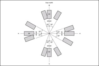
Figure E8.2 Alignment of
Subdivision Lots[j5]
4. The use
of battle-axe lots is to be kept to an absolute minimum. To ensure a suitable
residential area to build upon, the access handle to not be include in the lot
size calculations. Access handle widths to comply with Chapter D6 of
Byron DCP 2014.
5. Dual Occupancy, Multi Dwelling Housing, residential flat
buildings and Integrated
Housing lots in the R2 Zone are to be designed as follows:
a) The plan of
subdivision to clearly nominate lots for dual occupancy, multi dwelling
housing, residential flat buildings and integrated housing as per Clause 83 of
Byron LEP 1988.
b) Lots nominated
for higher densities than single dwelling housing should be carefully chosen
having regards to vehicle access, solar orientation, location of pedestrian
paths and cycleways and public opens pace areas and the residential controls
contained within this Chapter.
c) Dual
occupancy, multi dwelling housing, residential flat building or integrated
housing lots to have a minimum dimensions of 25 metres on a general north
-south axis with secondary street or rear lane access.
d) Such lots are not
to be clustered in one location but generally dispersed throughout the R2 Zone.
6. Subdivision
with the R3 Zone to have careful consideration to the final built form in terms
of vehicle access and car parking, solar orientation, private open space, and the
public domain. Accordingly it is preferable that master or super lots be
created with an area greater than 1000m2, which can be subsequently
developed and purposely planned for medium density residential development.
Such lots should have dual frontage as a minimum in terms of either a corner
lot, rear lane access or extend through from one street to the next
street.
Where vacant small lots are proposed pursuant to Clause 81
of Byron LEP 1988, the following controls are to apply in the R3 Zone:
a) Access to be
provide by way of a rear lane, secondary street or reciprocal right of
carriageway to be incorporated into the subdivision design to provide access to
the rear of these properties. In circumstances where access is provided via a
battleaxe handle, the area of the handle to be excluded from the lot size
calculation. Access to be designed and constructed in accordance with Chapter
D6 of Byron DCP 2014.
b) To include an
appropriate Section 88B instrument for the subject lot and the adjoining lot(s)
that will enable zero lot line development on each property boundary.
c) Where 4 or
more small lots are
proposed in a street section, the street to be of a suitable width to
accommodate nose in, or 45 degree angle parking across the frontage of those
lots. The parking to be integrated with footpaths, cycleways and landscaping
including street tree blisters every five parking spaces to break up the
parking areas and to provide shade.
d) Lots to be
clearly orientated between the north east to the north west to ensure good
solar access. .
Nose in car parking in
front of small lots with street tree blisters
|
|
Figure E8.3 Street Parking for Small Lots
7. Where
lots incorporate vegetation to be retained details to be submitted with the
subdivision application demonstrating that the vegetation will be managed and
not removed for bushfire protection purposes or for residential buildings with
subsequent applications for residential development. In certain circumstance
Council may require a Section 88B instrument on the title to aid in the
protection of the vegetation and to override the 10/50 Vegetation Clearing
Scheme exemptions for vegetation removal.
Notes:
· Applicants
are encouraged to consider the residential provisions when designing the
subdivision layout, and in particular for multi dwelling housing and integrated
housing lots. Lots with potential private open space within the front
setback may need to be longer/ wider to enable a suitable, useable, private
area with solar access to be provided.
· Corner
lots provide good opportunities for dual occupancy and multi dwelling housing/
integrated housing options with vehicle access provided from both streets for a
dual occupancy, or a single shared access point provided from the secondary
street for three or more dwellings.
· Lots
that run from one street through to a second street also provide good design
solutions for vehicle and pedestrian access and egress.
E8.10.3 Transport
Movement and Street Hierarchy
Element [j6] Objectives
1. To provide a hierarchy of interconnected
streets that gives safe, convenient and legible access through West Byron.
2. To minimise through traffic in residential
neighbourhoods.
3. To
ensure that the hierarchy of the streets is clearly legible through variations
in carriageway width, on-street parking, threshold parking, incorporation of
water sensitive urban design measures (where possible), street tree planting,
and pedestrian amenities.
4. To
provide a safe and convenient public transport, pedestrian and cycleway
network.
5. To
ensure a high quality, functional, safe, legible and visually attractive public
domain.
6. To
design streets within each neighbourhood primarily for people, not for cars, by
providing a level of access, safety and convenience to residents in each
neighbourhood.
Performance Criteria
There are no performance criteria
Prescriptive Measures
1. The road
layout is based generally on the Concept Plan. The road hierarchy is based on
the following:
a) a main Spine Road
which intersects with Ewingsdale Road in two places at roundabouts (Distributor
road)
b) Collector roads;
c) Local
roads;
d) Access Roads;
e) Laneways;
and
f) Pedestrian
and cycleway routes.
Typical Road
Cross Sections are provided at Appendix D incorporating swales. Figure E8.4
shows typical road verge with swale and footpath. The final road
layout is subject to detailed design and assessment having regards to
topography, drainage, environmental factors and lot layout.

Figure E8.4 Typical Road Verge with Swale and Footpath
2. Street
design to provide generally no more than three (3) intersection turns to be
traversed from the furthermost lot to the Ewingsdale Road entrances.
Local roads in a residential zone shall be designed to discourage through
traffic via traffic calming measures, such as landscaped street blisters,
chicanes and on-street parking.
3. Cul-de-sacs
to be a maximum of 200m in length and for a maximum of 25 dwellings.
Cul-de-sacs are to provide for pedestrian and cycle permeability.
4. Formal
entry statement to be provided at both entrances from Ewingsdale Road through
fencing and landscaping and changes in road pavement. Each neighbourhood area
(including the Village centre and Industrial precinct) to provide a distinctive
entry statement by way of changes to the road pavement material at the
entrance.
5. Formal
pedestrian crossings to be clearly delineated through changes in road pavement
material and or raised, plus appropriate signage and line marking as
required.
6. The
street network is to be designed to achieve the following principles:
a) Access to
Ewingsdale Road restricted to the two main entrances as indicated on the
concept plan. All properties with frontage to Ewingsdale Road to gain access
from an internal local road. Existing properties on Ewingsdale road to re-site
driveways to the internal road network.
b) Establish a
permeable pedestrian and cycleway network that is based on AMCORD principles
that will encourage walking and cycling and reduce travel distances involving
those activities,
c) Provide for
a safe pedestrian cycleway crossing point across Ewingsale Road to facilitate
access to Sunrise Estate, the Byron Arts an Industrial Estate and the Cavanbah
Sports Centre.
d) maximise
neighbourhood connectivity between residential neighbourhoods, recreational
areas and the Village Centre;
e) accommodate
significant vegetation to avoid its removal;
f) optimise
solar access opportunities for dwellings having regards to the controls
relating to dual occupancy, multi dwelling
housing and integrated housing;
g) maximise
surveillance of open space and environmental protection corridors; and
h) maximise the use
of water sensitive urban design measures.
7. Except
where otherwise provided for in this Chapter, all roads, streets and
roundabouts are to be designed and constructed in accordance with the minimum
requirements set out in the Northern Rivers Local Government Development Design
and Construction Manual.
8. For all
local roads and access roads, traffic management, (i.e. road layout and/or
speed reducing devices), to be used to produce a low speed traffic environment.
Such traffic management devices are to be identified at the time of the
subdivision application.
9. Laneways
that are solely designed for back of house access and egress in the residential
and business zones to be contained within a minimum 6 metre wide road reserve
with a 6 metre wide pavement based on vehicle design speeds of 15kmh The
laneway to generally service no more than 300 vehicles per day. The road
reserve may need to be widened to accommodate services, intersections and other
constraints.
10. The road through
the IN2 Zone Land to terminate in a culdesac at the boundary with Lot 181
DP755695. Alternatives to extend the road through this parcel and back to
Ewingsdale Road will be considered where it can be demonstrated with a traffic
study a positive outcome for traffic management on Ewingsdale Road and to
enable the free flow and movement of heavy vehicles, delivery trucks and other
traffic entering the IN2 Zone.
11. Four bus stops to
be sited either side of the Spine Road in a minimum of two locations to
facilitate public transport within the eastern and western halves of the Urban
Release Area.
12. The road to
incorporate nose in / 45 degree angle on-street car parking in the R3 Zone for
overflow parking as required under Clause E8.10.2. The parking areas to be
integrated with street landscaping including street tree blisters passively
watered by WSUD, cycleways and footpath areas.
For Small Lot Subdivisions in the R3 Zone
(<350m2) comprising four or more lots nose in or angle
parking as per Clause E8.10.2 is required with rear access
|
|
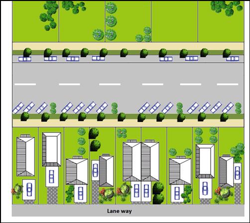
Figure E8.5 Road and parking design combined with vacant
small lot subdivision
E8.10.4 Stormwater
Water Management
Objectives
1. To
facilitate the disposal of stormwater in a sustainable manner
2. To
maintain and improve the quality of water entering Belongil Creek
Performance
Criteria
1. To
enable stormwater to be managed in accordance with the concept of Water Sensitive Urban Design.
2. To
enable stormwater infrastructure in the main drain to also become environmental
features for native flora and fauna, habitat corridors and to facilitate
pedestrian and cycling access.
3. To
ensure a co-ordinated response to the design of stormwater infrastructure
combined with landscaping and the built form in the public and private realm.
4. To
provide stormwater infrastructure that can be readily maintained at minimum
cost to Council and the public.
Prescriptive
measures
1. A
detailed Stormwater Management Plan to be submitted with the Stage 1
Development Application for approval by Council based on the concept of Water Sensitive Urban Design. The plan
is to be for the entire urban release area of West Byron and include the
following:
a) Outline
stormwater treatment facilities, infrastructure and landscaping associated with
water sensitive urban design measures.
b) Be consistent
with the stormwater requirements of Chapter D6 Subdivision of Byron DCP 2014
and the Northern Rivers Development and Design Manual unless otherwise agreed
to by Council;
c) Demonstrate
through stormwater modelling that the proposed development will not adversely
impact the coastal wetlands, Belongil Creek or Cape Byron Marine Park;
d) Demonstrate a
lawful point of discharge for all stormwater outlets. Where Union Drains and
other private infrastructure is to be accessed, details to be provided on
lawful access and ability for such drains to be maintained legally by
Council.
e) Works within the
main drain including excavation and widening, environmental embellishment and
access arrangements for pedestrians, cyclist and maintenance vehicles to be
generally consistent with the Concept Plan for West Byron;
f) Any
stormwater detention/ treatment basins are to be limited in number for ease of
maintenance. (N.B. preference will be given to the design and construction of
larger basin(s) rather than multiple smaller basins/ponds);
g) Landscaping as
part of the WSUD Strategy for West Byron to provide details on:
i) Soils,
mulch and sub-grade treatment. The plans should reference relevant engineering
drawings for filter media requirements;
ii) Contours
and spot levels;
iii) Proposed plant
species (only native species to be used – except where turf is utilised
in swales), including the plant’s botanical name, planting height,
quantities and densities;
iv) existing
vegetation proposed to be retained and details of proposed protection
measures;
v) Planting
specification notes are required to include details on plant procurement,
timing, maturity, preparing filter media, mulching, planting procedures,
watering and the acceptable measures of successfully established plants; and
vi) Any targeted
habitat improvement for threatened or endangered species.
h) Outline any
requirements for ongoing monitoring of water quality impacts and measures for
managing Acid Sulfate Soils;
i) Outline
mitigation measures to minimise mosquitoes;
j) Be
consistent with other stormwater measures included in this DCP Chapter;
k) Staging and timing
of works and financial responsibility for construction.
l) Identify any
additional stormwater detention requirements for subdivision and subsequent
development in the residential, business and industrial zones;
m) Outline long term
management, ownership and maintenance arrangements for all stormwater
infrastructure. An extended maintenance period to be provided for WSUD
measures. Typically this will require that 90% of dwellings are substantially
commenced within the development sub-catchment associated with the relevant
treatment measure;
2. Stormwater
works in the environmental zones including in the main drain to be carefully
designed to minimise the removal of native vegetation. Where vegetation is
proposed to be removed, details to be provided under Section
E8.10.5.1.
3. Any
subsequent development application is to be consistent with the Stormwater
Management Plan.
4. Construction
water quality impacts are to be mitigated through appropriate erosion and
sediment controls in accordance with Managing Urban Stormwater - Soils and
Construction ('The Blue Book').
E8.10.5 Biodiversity,
Vegetation Management and Landscaping
The subject site provides
important habitat for a range of species and ecological communities including
koalas, wallum froglet, blossom bat and remnant coastal cypress pine
communities. A voluntary planning agreement has been signed between the
Minister for Planning and the landowners requiring a vegetation management plan
to be prepared addressing matters such as a program and implementation strategy
of environmental management works for the land zoned E2 Environmental
Conservation. Vegetation management however will need to apply to the entire
site, and any native vegetation that is proposed to be removed from within the
urban footprint will need to be appropriately compensated. Landscaping
will play an important role as part of the overall environmental management of
the site, and will enhance habitat attributes, whilst also playing a part in
the management of stormwater. The following controls apply: [j7]
E8.10.5.1 Biodiversity and
Vegetation Management
Objectives
1. Maintain
and improve habitat and ecosystem connectivity;
2. Protect biodiversity values of the site particularly
within E2 Environmental Conservation and E3 Environmental
Management zoned land including flora, fauna, habitat, wetlands, and the
riparian areas of Belongil Creek.
3. Maintain or improve the ecological and
hydrological functions and values of Belongil Creek
4. Environmental
buffers to sensitive ecological areas
5. Improve koala ecological values on the site.
Performance
Criteria
1. Ensure
that a comprehensive Biodiversityvegetation
Conservation Management Plan, including
identified sub- plans,
is prepared and approved to minimiseminimize and offset,
the impact of development on the site with the Stage 1 Development Application.
2. Environmental buffers to sensitive ecological areas to be revegetated
or restored, with development located outside environmental
buffers.
3. Protect
core koala habitat areas from development that
would compromise habitat quality and integrity and enhance koala habitat to
provide connectivity links to facilitate the natural movement of koalas.
4. Protect, maintain and enhance key habitat corridors to improve linkages
between habitats.
5. Improve biodiversity on the site by rehabilitating and re-vegetating areas
identified for conservation within an established timeframe for delivery.
6. Mitigation
of direct and indirect impacts of development on
drainage lines and riparian areas
Prescriptive
Measures
1. A comprehensive
vegetation Biodiversity Conservation
Management Plan is required to
be prepared for the Stage 1 Development Application. The plan is to be
for the entire Urban Release Area and to include the following:
a) identification of
existing vegetation to be retained;
b) the types of vegetation
management works required and how those works will be implemented, including
allocation of responsibility for funding works;
c) an initial
five-year implementation program setting out habitat restoration and management
works including strategies for planting, weed control and maintenance based on
strengthening general key habitat corridors along the eastern and southern
periphery of the Urban Release Area (See Figure E8.6 below). Such works are to
be incorporated into the first Construction Certificate for the site to ensure
any compensatory planting that may be required is established as West Byron is
gradually developed;
d) details of
responsibility for the ongoing management of habitat areas in the E2 and E3
Zones following the initial five year implementation program;
e) methods to
prevent the introduction of exotic pest species or to manage and reduce pest
species already present;
f) methods to
reduce potential for bird strikes into windows of buildings;
g) details of
ongoing monitoring, reporting to Council and processes for adaptive management
where necessary;
h) The Vegetation
Management Plan for the E2 Zone as required under the Voluntary Planning
Agreement (VPA) dated 21/10/14 to be incorporated into the comprehensive Biodiversity Conservation Management Plan. The
plan to address threatened species, SEPP 44 Koala Habitat Protection, measures
to manage Belongil Creek and the requirements of the VPA. The plan can be
detailed in the following sub plans:
i) Threatened
species management plan providing details on any expected impacts on threatened
species or their habitat, how such impacts will be avoided as far as practical
or mitigated if necessary, and how any impacts will be compensated through
rehabilitation and revegetation work. Council records indicate the site
provides habitat for wallum sedgefrog and the wallum tree frog. The management
plan is to address the National Recovery Plan for Wallum Sedgefrogs and other
wallum dependant frog species.
ii) A Belongil
Creek Plan of Management to be prepared in consultation with the relevant land
owner and provide for bushland restoration on land adjacent to the creek and
within riparian buffers provided by the E2 conservation zones, weed control and
habitat restoration along drainage lines. Any new culverts over existing water
crossings to provide improvements in water quality and fish passage
iii) A Koala Plan of
Management (KPOM) is to be prepared in accordance with the requirements of
State Environmental Planning Policy No. 44 – Koala Habitat Protection.
Should Council have an adopted KPOM for the area, Applicants have the choice to
use this plan or prepare their own plan. An Individual KPOM as a minimum to
address the following:
· SEPP
44 Guidelines for Individual KPOMs
· Core Koala Habitat on and surrounding the site
· Rehabilitation
of habitat in the E Zones to focus on Koala Habitat restoration to address any
compensation requirement and to provide or embellish linkages between Core
Koala habitat areas
· measures
to protect existing koalas whilst new habitat is
being established.
· details
of koala friendly crossings under/ over Ewingsdale Road, and timing and
responsibility for their delivery[c8] .
· other
measures to protect koalas including reduced vehicle speeds and traffic calming
measures, development fencing, dog prohibition or control, pool
safety through design measures such as ramps or “beaches”, control
on construction activities, signage, appropriate building envelopes having
regards to bushfire requirements for asset protection zones.
11.2. Revegetation
and rehabilitation works are to be delivered in accordance with the Biodiversity Conservation Management Plan and the sub plans, and is to be based on the
Concept Plan in Appendix B. All plantings should use species
locally sourced with local genetics, and include the aim of achieving a 90%
survival rate.
3. Development
applications for subdivision (excluding subdivision for the consolidation of
lots that does not create additional lots or the opportunity for additional
dwellings, boundary adjustments or to dedicate land for a public purpose) are
to:
a) Address the
relevant statutory considerations under the Environmental Planning and
Assessment Act 1979 (specifically Section 5A, 5C and Section 79C) consider
potential impacts to:
i) threatened
species, populations and endangered ecological communities under the Threatened Species Conservation Act 1995 and the
Environmental Protection and Biodiversity Conservation Act 1999
ii) SEPP 14 Wetlands
and SEPP 44 Koala Habitat Protection
iii) Relevant
provisions of the Water Management Act 2000, Fisheries
Management Act 1994, Marine Parks Act 1997 [t9] and the Native Vegetation
Act 2003
iv) Be accompanied
by a detailed ecological assessment including habitat values, location and
extent of any habitat proposed for removal and offset location, extent and
timing.
b) Identify buffers
between development (in zones R2 Low Density Residential, R3 Medium Density Residential,
IN2 Light Industrial, B1 Neighbourhood Centre) and any land zoned E2 or E3 and
provide a plan of management for the buffers and the zone interface. Buffers or
buffer zones are not required between E2 and E3 zones. Buffer management
plans must:
i) aim
to mitigate direct and indirect impacts from development in order to protect
the integrity and health of the natural environment
ii) aim to
avoid negative impacts on the natural environment and ensure retention and
enhancement of those functions and characteristics that are important to
biodiversity conservation, landform stability, erosion management, hydraulic
function and other important natural, geophysical and biophysical processes
iii) aim to provide
a minimum width buffer of 20 metres. The buffer can include a perimeter
road/ bushfire trail for bushfire protection purposes provided that road is
located outside of the E2 and E3 zone and comprises a minimum vegetated edge
adjacent to the E2 and E3 zone of 7 metres. Cycleways and pedestrian paths
are also acceptable within buffer areas
iv) incorporate
existing native vegetation into the buffer
v) provide
details on long term management and responsibility.
4. Landscaping
of drainage lines, parks, reserves, road buffers and other large areas within
the urban footprint of the Urban Release Area to be designed to enhance
biodiversity values and habitat linkages. Concept landscaping plan to be
submitted with development applications for subdivision which form one or more stages of the
proposal for West Byron.

Figure E8.6 General Habitat Corridors to be Strengthened
(as denoted by orange arrows)
5. The road
network within the south eastern perimeter of the Urban Release Area including
vehicle access from the main residential areas to include traffic calming
measures such as narrower road widths including chicanes and or one way traffic
flows to facilitate the movement of fauna through this area from the E3 Zones
to the E2 Zones. Other options to regulate and limit through traffic in this
area is to develop Lot 1 DP 780242 and Lot 229 DP 755695 as community title/
strata title residential estates with an “Environmental Living Theme”
and incorporate surrounding E2 and E3 Zoned land into the common/ neighbourhood
property for ongoing management.
6. Any
roads, cycleways, pedestrian footpaths, bushfire trails and other necessary
infrastructure that traverses into or across the E2 and E3 Zone to be sited to
minimise impacts on the environmental qualities of native vegetation and
habitat in those zones by utilising existing breaks in the native vegetation
and or siting and designing such works to have minimal disturbance (eg narrow
road width/ locate where weeds and exotics are to be removed, signage for
wildlife crossings etc). Details to be submitted with the development
application.
7. For ongoing
removal of trees and vegetation after West Byron is developed, land owners to
comply with Chapter B2 Preservation of Trees and Other Vegetation, and any
requirements of the Biodiversity Conservation
Management Plan approved under this Chapter.
8. Despite
the provisions of Clause E8.3, residual areas outside of the Urban Release
Area in Lots 227 and 229 DP 755695, Lot 9 DP 111821, and Lot 2 DP818403
to be incorporated into the Biodiversity Conservation Management Plan as
required.
E8.10.5.2 Landscaping
Element Objectives
1. Landscaping
to provide for the enhancement of the biodiversity values of the Urban release
area.
2. To be an
integral part of the development of the site to provide attractive and
aesthetically pleasing environments.
Performance Criteria
1. Native
vegetation to be retained where possible and incorporated into landscaping.
2. Landscaping
to reflect the subtropical character of Byron Bay.
3. Landscaping
to be an integrated into street and park designs and stormwater management
through Water Sensitive Urban Design (WSUD) with street trees provided
throughout the subdivision.
Prescriptive Measures
1. Landscape
plans to be submitted with all development applications for:
a) Subdivision
b) Multi
dwelling housing
c) Residential
flat buildings
d) Dual
occupancies
e) Development
in the B1 and IN2 Zones and
f) As
specified for any other development in DCP 2014
The Landscape Plan to be prepared in accordance with Chapter
B9 of DCP 2014.
2. Applications
for subdivision to identify street tree planting every 15 metres of road
frontage, landscaping and plantings for drainage lines, car parks and
recreational reserves to be dedicated to Council. The Landscape Plan to
indicate how planting will be maintained, identify existing native vegetation
to be retained, nominate species to be planted and describe any passive
watering arrangements through WSUD.
3. Street
trees in the B1 Zone to be incorporated into the footpath as per Appendix C
– WSUD Street Tree Pit with Grate. Other treatments within West Byron
include landscaping of any footpath blisters and roundabouts, and road side
rain-gardens. Such landscaping to be passively watered through WSUD.
 Figure E8.7
Street Tree Landscaping [j10]
Figure E8.7
Street Tree Landscaping [j10]
4. For
minimum requirements for planting size, density and species please refer to
Chapter B9 of DCP 2014. Locally indigenous
species are to be predominantly used in landscaping. Street trees are to
have a general maturity height of 10 metres and a canopy diameter of 8 meters
to provide shade and assist with managing the micro climate. No species listed
as undesirable in Chapter B2 of DCP 2014 are to be used in landscaping on any
site.
5. Where
feasible, edible landscapes (bush tucker and other fruit trees and vegetation)
can be used in selected areas throughout the Urban Release Area including
sections of the public reserve and as landscaping for development on private
property. Details to be submitted with the development application where such
vegetation is being proposed for assessment.
E8.10.6 Public
Facilities, Services and Infrastructure
Element Objectives
1. To
provide guidance for public facilities, services and general infrastructure.
Performance Criteria
1. To
establish controls for infrastructure, public car parking areas, cycleways and
footpaths that services the needs of residents, workers and visitors.
Prescriptive Measures
1. General
Infrastructure
a) The
subdivision shall be fully serviced with water, sewer, roads, drainage and
underground electricity and telecommunication services. The telecommunication
service to be designed to connect to the National Broadband Network. This
service infrastructure may be constructed on a staged basis to accommodate the
staged release of land.
b) Street
lighting to be provided in accordance with Chapter D6 of DCP 2014. Where agreed
to by the electricity provider, LED street lighting or solar power lighting
will be considered.
c) All
service infrastructure is to be designed and constructed in accordance with the
Northern Rivers Local Government Development and Design Manual.
d) Service
infrastructure internal to the development site shall be provided by the
developer at no cost to Council.
2. Dual
Reticulation Water
a) A dual-reticulation
water supply for non-potable water is to be provided to all lots in the IN2
Light Industrial Zone and the B1 Neighbourhood Centre Zone as a minimum.
b) The
developer shall incorporate on the Certificate of Title for all allotments
Restrictions as to User which require all dwellings and buildings with plumbing
(including commercial, industrial buildings and the like) to make provision for
non-potable water service plumbing and facilities to the satisfaction of
Council
3. Public
car parking
a)  Public
car parking areas to be designed and constructed to meet the minimum standards
within the Northern Rivers Local Government Development Design Manual and the
relevant Australian Standards.
Public
car parking areas to be designed and constructed to meet the minimum standards
within the Northern Rivers Local Government Development Design Manual and the
relevant Australian Standards.
b) Such areas to be
dedicated at no cost to Council after construction and at the end of the
relevant maintenance periods.
c) Car parks
to be appropriately landscaped with shade trees in accordance with Chapters B4
and B9 of DCP 2014 and passively watered through WSUD.
d) Applicants are to
consider the installation of an electric vehicle charging station for major car
parking areas around the B1 Zone. (Note: Opportunities may exist to partner
with Council and other organisations with the design and installation of such
infrastructure as per the Byron Shire Low Carbon Strategy)
4. Cycleways
and Footpaths
a) To be suitably
sited and designed to provide for the effective movement of people throughout
the West Byron Site linking residential precincts with one another, the village
centre, and the open space recreational areas. As a minimum 1.2 metre wide
concrete footpaths to be provided on one side of all access roads and both
sides of local, collector and distributor roads. Laneways to be shared with
pedestrians and cyclists.
b) To connect with
existing cycling pedestrian infrastructure in Ewingsdale Road and beyond.
c) Cycleways,
bike parking and storage facilities to comply with Chapter B5 of DCP 2014.
d) Cycleway footpath
along the main drain to be designed and constructed as an exercise/ fitness
trail with designated training stops with appropriate equipment in three places
approximately 400 - 500 metres apart.

Figure E8.8 Example of
exercise equipment on soft fall material[j11]
5. Bus
Stops
The road network is to be
designed to provide for designated bus routes and bus stops in locations which
provide safe and convenient access for residents.
6. Public
access to Belongil Creek
Any public access to Belongil Creek, if
proposed, is to be limited to one location only. No clearing of vegetation is
permitted to provide this access. Owners consent from the Department of
Primary Industries (Crown Lands) be obtained and submitted with the Development
Application for this access point. Details to be submitted with the application
addressing:
a) Long term
management of the access point, including any facilities and amenities (eg
boardwalk, fencing etc);
b) Consistency with
the Belongil Creek Plan of Management;
c) Educational
signage about the creeks environmental values; and
d) General legal
access arrangements to the creek access point
E8.10.7 Recreational
Areas
Objectives
1. To
help engender a sense of community.
2. To
help to promote social interaction, community health and wellbeing.
3. To provide a network of
active and passive open recreational areas
Performance Criteria
1. Lots are to be within walking and cycling distance to a
neighbourhood park
2. Parks are to include a range of recreational facilities
3. Neighbourhood parks need to be designed to meet the Crime
Prevention through Environmental Design (CPTED) principles and Active Living
criteria.
Prescriptive Measures
1. Residential lots are to be approximately 500 metres from
the nearest neighbourhood park.
2. Outside of the two areas zoned RE1 any other neighbourhood
park provided within the development site to have a usable area of approx. 0.2
hectares.
3. Neighbourhood parks are to be provided with the following
facilities:
a) A hard stand play
area (e.g. half court basketball/ skate area) to be provided in one of the RE1
Zoned Parks as a minimum;
b) Be designed and sited such that
adjoining development can provide casual surveillance of the park. Be designed
and located so as to maximise street frontage and encourage natural
surveillance from surrounding residents;
c) Be situated on land that is readily
accessible to the surrounding dwellings and physically connected to the
cycleway/ pedestrian network;
d) Be equipped with play equipment, park
furniture including seating for adults and toilet amenities;
e) Include soft-fall
under all play equipment in accordance with the relevant Australian Standards;
f) Appropriate
shade cover over play equipment;
g) Provide an
electric BBQ, two roofed picnic tables, rubbish bins on stands to be provided
in one of the areas zoned RE1;
h) Be landscaped
with appropriate plantings of local native trees (no exotics) and weeds to be
removed. Trees must have non-invasive root systems and be suitable for
under-pruning as they develop to allow mower egress and undisturbed lines of
sight. Vacant areas to be turfed with a suitable lawn species for mowing and
incorporate earth mounds to provide visual interest and general play areas.
i) Adequate
lighting be provided for crime prevention purposes.
j) The
RE1 zoned land adjacent to the B1 Zone to provide for a village square or piazza
as a community focal point and a casual meeting place for social interaction.
k) Other
features such as a chess tables, bocce courts, ground level garden labyrinth or
concrete table tennis facilities will also be considered on merit having
regards to ongoing maintenance costs and the anticipated demographics of
residents.
l) A
footbridge for pedestrians and cyclist over the Main Drain in the Central Park
on Ewingsdale Road.
4. Developer contributions credits will be provided for
the provision and embellishment of new neighbourhood parks in accordance with
Council’s Development Contribution Plan.
5. Other
community uses for the parks such as community
gardens and as a site for public art will be considered on merit. Where this is
proposed, car parking, water and toilet amenities will be required for the
community gardeners as a minimum. Any public art proposed will need to be
consistent with the Byron Shire Cultural Plan and the Public Art
Policy.
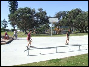
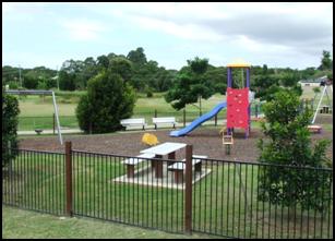
|
|
|
|
|
Park with play equipment and
park furniture within a landscaped setting.
|
|
|
Multipurpose concrete
basketball half court and skate rail.
|
|
Figure E8.9 Examples of playground equipment [j12]
Note:
– for further information on Community Gardens please see the Byron Shire
Community Gardens Policy (10/012)
E8.10.8 Hazards
and Constraints
Flooding, acid, sulfate soils,
ground water, bushfire, mosquitoes, contamination and potential odour from the
adjacent chicken processing plant on Ewingsdale Road have been identified as
hazards and constraints affecting the site. The following specific controls
apply.
E8.10.8.1 Flooding
Objectives
1. Minimise the flood risk to life and property
associated with the use of land.
2. Allow
development on land that is compatible with the land’s flood hazard,
taking into account potential changes as a result of climate change.
3. Avoid
significant adverse impacts on flood behaviour and the environment.
4. Ensure
that development does not have a significant impact on pre-development flood
levels and flows.
Performance
Criteria
1. Development
shall be generally designed so that it is not affected by flooding.
2. Ensure
that safe evacuation can be provided during flood events for land up to the
probable maximum flood level.
3. Enable
limited filling on flood prone land to facilitate the design and construction
of stormwater infrastructure and to ensure residential development can meet the
habitable floor level.
4. Demonstrate
that the filling of flood prone lands and other earthworks do not result in any
significant adverse flooding or environmental issues for adjoining land
including stormwater overland flow paths.
5. Building
design and levels are to consider climate change impacts including sea level
rises. [c13]
Prescriptive Measures
1. The
provisions of Byron DCP 2014: Chapter C2 – Areas Affected by Flooding
apply to the site.
E8.10.8.2 Acid Sulfate Soils
Objectives
1. To
ensure that acid sulfate soils do not result in water quality or other
environmental impacts.
Performance
Criteria
Where acid sulfate soils may be exposed such
as from earthworks, installation of infrastructure, reshaping stormwater
drains, construction of footings for buildings and swimming pools, details to
be submitted with the development application how such soils will be managed to
ensure no adverse impacts on the environment.
Prescriptive Measures
1. An Acid
Sulfate Soil Management Plan is required to be submitted with any development
application for Stages 1 and 2 which would result in interception of the local
groundwater or acid sulphate soils to suitably mitigate the potential impacts
arising from the disturbance.
2. The Acid
Sulfate Soils Management Plan is required to be prepared in accordance with the
Acid Sulphate Soils Manual and include the following:
a) Identification of
activities that are expected to intersect and disturb acid sulphate soils
b) Identification of
the acid sulphate soils risks and identified acid sulphate soils layers on site
c) Estimation
of volumes of acid sulphate soils requiring treatment and proposed treatment
measures;
d) Estimated liming
rates and treatment procedures
e) Validation
procedures and target criteria of treated soils
f) Monitoring
protocols and target criteria as per the ASSMAC guidelines for surface and
groundwaters within the site.
g) Monitoring
protocols for Belongil Creek including baseline data and target criteria for
water quality and ph levels as per ANZECC/NHMRC Guidelines.
h) Include a generic
management plan for the use of landowners and developers of vacant residential
lots after Stage 1 and 2 has been completed. The Plan to address standard
development issues such as footing for a dwelling and earthworks for services
to the house.
Note: The Preliminary
Acid Sulfate Soils Assessment by Southern Cross University Environmental
Analysis Laboratory dated December 2010 provides background information on acid
sulfate soils for West Byron.
E8.10.8.3 Groundwater
Objectives
1. Mitigate impacts on groundwater having regard to the high water
table present on the site.
Performance
Criteria
Groundwater to be
managed in accordance with best practice guidelines including the Acid Sulfate
Soils Manual.
Prescriptive
Measures
1. Any development application involving
excavation works is to identify:
a) The depth of the
excavation works
b) Any potential
interaction with the water table
c) Associated
impacts on groundwater
d) Any potential
risk associated with acid sulfate soils
and as
necessary include appropriate measures to mitigate any impacts.
2. Any
development application involving stormwater detention infrastructure such as
bio-retention basins, constructed ponds, wetlands and vegetated swales is to
demonstrate how any potential groundwater impacts will be mitigated. This
may require the base of associated excavations to be at least 1 metre above the
water table or where this is not possible, the use of impermeable liners.
Note: Where dewatering is
proposed, additional approvals may be required under the Water Management Act
2000. Applicants are encouraged to contact the NSW Office of Water to avail
themselves of the Offices requirements
Note: Acid
sulfate soil provisions in Byron LEP 1988 apply to the urban release area.
E8.10.8.4 Bushfire
Objectives
1. Reduce
the risk to human life and property from bushfires.
2. Encourage
sound management of bushfire prone areas.
Performance
Criteria
1. Ensure
development is appropriately sited and designed on bushfire prone land.
2. Appropriate
access and services are provided to developments to facilitate the safe access
and egress of residents and emergency personnel in the event of a bushfire, and
water supply is provided for firefighting purposes.
Prescriptive
Measures
1. Subdivision
and development applications are to comply with Planning for Bushfire
Protection 2006 (NSW Rural Fire Service), including measures for perimeter
roads, fire trails and reticulated water for fire fighting purposes.
2. Development
applications are to be accompanied by accurately mapped plans and details for
each affected lot setting out the location and widths of asset protection zones
(APZs) and building envelopes for constrained lots.
3. Asset
protection zones:
a) Are to be located
wholly within the urban release area and wholly located outside of the E2
Environmental Conservation and E3 Environmental Management Zone (unless
specifically required for development within those zones);
b) May incorporate
roads and flood prone land;
c) May be used
for open space and recreation subject to appropriate fuel management;
d) May incorporate
the building setback on private residential land;
e) Are not to
increase the maintenance burden on public lands; and
4. Water
supply is to be via a ring main system, engineered to the requirements of
Australian Standard 2419.1-1994 Fire Hydrant Installations.
5. Buildings
adjacent to APZs are to be constructed in accordance with the requirements of
Appendix 3 of Planning for Bushfire Protection 2006 and Australian Standard
3959-1999 - Construction of Building in Bushfire Prone Areas.
6. Where a
lot fronts and partially incorporates an APZ it is to have sufficient depth to
accommodate a dwelling with private open space and the minimum required APZ.
The APZ and building envelope is to be identified through a Section 88B
instrument.
7. Temporary
APZs, identified through a Section 88B instrument, will be required where
development is proposed on lots next to undeveloped land. Once the adjacent
stage of development is undertaken, the temporary APZ will no longer be
required and shall cease.
Note: Technical Study
Bushfire Assessment S.100B Rural Fires Act 1997 (Proposed Rezoning of Land at
West Byron on behalf of Byron Bay West Landowners Association) prepared by
LandPartners (December 2010) is relevant to this section.
Note: Certain
proposals on bushfire prone land, including subdivision of land for residential
purposes, child care centres, seniors housing and retirement villages will
require an approval (Bushfire Safety Authority) under Section 100B of the Rural
Fires Act 1997. Applicants should avail themselves of the requirements of the
NSW Rural Fire Service (RFS) and include a detailed Bushfire report from a
suitably qualified professional with the development application to enable
assessment by the RFS and issue approval as appropriate.
E8.10.8.5 Odour
Objective
1. Mitigate
the impacts on future development of odour generated by the poultry processing
plant located outside and to the west of the site on Ewingsdale Road.
Performance Criteria
There are no performance criteria.
Prescriptive Measures
1. The
first development application within the 2 Odour Unit (OU) contour as shown in
Figure E8.10 is to be accompanied by details of a dense vegetation
buffer to be planted along the western boundary within the site. The
extent and requirements for the buffer are to be informed by odour
modelling.
2. Sensitive
land uses (e.g. child care facilities) are not to be located within the 2 odour
unit contour identified in Figure E8.10.
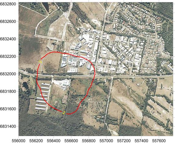
Figure E8.10 Predicted 2 Odour Unit Contour for
Poultry Processing Plant
3. Development
applications within the 2 odour unit contour identified in Figure E8.10 are to
be accompanied by a land use conflict risk assessment in accordance with the
Land Use Conflict Risk Assessment Guide (Department of Primary Industries
2011), and outline odour mitigation strategies that may include (but is not
limited to):
a) Additional vegetation
b) Appropriate land
use siting
c) Site layout
and building orientation
d) Design of natural
air flow and ventilation
e) Use of mechanical
heating/cooling/ventilation.
4. The
extent of the 2 odour unit (ou) contour is based on Figure E8.10, unless it can
be demonstrated through appropriate modelling that the contour has been
reduced, for example through the provision of the vegetation buffer required
along the western boundary, or as a result of odour reduction at the source.
5. Where it
can be demonstrated that the Poultry Processing Plant has been closed and will
not be re-opened and or redeveloped for a similar offensive use utilising
existing use or existing consent rights, the above requirements may not apply.
Details to be submitted with the development application.
Note: Technical study Odour and
Air Quality Constraints prepared by PAEHolmes (20 December 2010) is relevant to
this section and includes recommendations in relation to the dense vegetation
buffer.
E8.10.8.6 Contamination
Objective
1. Ensure
the site is suitable for development in terms of past land uses
2. Any
contaminated land is appropriately remediated.
Performance
Criteria
There are no
performance criteria
Prescriptive
Measures
1. Development
applications are to address the matters for consideration under Clause 7 of
SEPP 55 Remediation of Contaminated Lands.
2. Where
sites are found to be contaminated, details to be provided to Council by a
suitably qualified professional demonstrating how the site will be remediated
having regards to the proposed use.
Note:
Preliminary Contaminated Land Assessment as Part of a State Significant Site
Study At West Byron Urban release Area, Byron Bay NSW (EAL, 14 December 2010)
is relevant to this section.
E8.10.8.7 Mosquitoes
Objectives
1. Minimise
mosquito hazard to residents.
2. To
remove the need for co-ordinated management of mosquitoes from Council or other
public bodies in the medium to long term post development.
Performance
Criteria
There are no
performance criteria.
Prescriptive
Measures
1. Subdivision
development to incorporate design measures to limit the habitat for mosquitoes
within the Urban Release Area. Such measures to be incorporated into the design
of development to include (but are not limited to).
a) Stormwater ponds
and artificial wetlands to be located in open areas to enable wind action to
create surface waves that will disrupt mosquito breeding and reduce habitat
refuges for immature mosquitoes
b) Stormwater swales
to be designed to ensure ponding or standing water does not occur after
rainfall events.
c) Asset
Protection Zones for Bushfire Protection Purposes around residential
development to be suitable designed and sited to reduce habitat for mosquitoes,
and harbourage sites which can act as “stepping stones” that
facilitate the movement of mosquitoes from denser vegetated areas into
residential neighbourhoods.
2. Residential
development to incorporate measures to minimise mosquito impacts, to include
(but are not limited to):
a) Cross flow
ventilation for dwellings;
b) Fitting of insect
screens to dwelling openings including door and windows;
c) Appropriate
plant selection and management of garden vegetation to reduce habitat
opportunities for mosquitoes;
d) Location, design
and management of any individual stormwater treatment systems;
e) Leaf guard on
roof guttering to reduce potential for water to pond in gutters; and
f) The inlet
and outlet (overflow) of rainwater tanks to be effectively screened with stainless
steel or other durable materials to prevent entry to the tank by mosquitoes.
Inlet filters must be readily removable for cleaning.
Note: The Mosquito Risk
Assessment: West Byron Bay NSW (Sydney West Area Health Service, December 2010)
is relevant to this section.
E8.10.8.8 Buffer to
Ewingsdale Road
Objectives
1. To
ensure the development is appropriately screened from Ewingsdale Road with
landscaping.
2. To
provide suitable buffers and amelioration measures for vehicle noise which may
impact on future residents.
Performance
Criteria
There are no performance criteria.
Prescriptive
Measures
1. A
landscaped buffer including both physical barriers and earth mounds adjacent to
Ewingsdale Road to be incorporated into the subdivision design generally in
accordance with Figure E8.11 for the full length of the West Byron Site zoned
IN2, R2 and R3.
2. The
final height and design of the barrier to be supported by an acoustic noise
assessment report prepared in accordance with the NSW Road Noise Policy 2011
demonstrating that future residential dwellings will not be adversely affected
by traffic noise on Ewingsale Road.
3. The
buffer to be landscaped with native trees and vegetation to conceal the mounds
and barriers, and to provide a general visual screen to the development in West
Byron. A concept landscape plan to be submitted with the development application
in accordance with B9 of DCP 2014.
4. The
buffer can be erected in stages. Details to be submitted with the Development
Application as to any staging arrangements.
Staff Reports - Sustainable Environment and Economy 13.10 - Attachment 1
Figure E8.11
Landscape Buffer and Acoustic Barrier to Ewingsdale Road
Staff Reports - Sustainable Environment and Economy 13.10 - Attachment 1
E8.10.9
Aboriginal Cultural Heritage
Objectives
1. Traditional
Owners are recognised and respectfully
consulted to identify ways to protect culture and features of Indigenous
cultural significance.
2. Culturally
significant features are to be protected
and incorporated in accordance with the recommendations and findings of such
consultation.
3. Opportunities
for Traditional Owners to look after country both physically and spiritually
will be encouraged.
Performance
Criteria
There are no
performance criteria for this element
Prescriptive
Measures
1. An
Aboriginal Cultural Heritage Assessment to be carried out by a suitably
qualified professional for the West Byron Site with the Stage 1 Development
Application. The assessment to be carried out in accordance with the relevant
Office of Environment and Heritage (OEH) Guidelines for Aboriginal cultural
heritage matters.
2. Any
sites, items, objects, relics or places of significance that are located within
the development site are to be appropriately identified and management measures
for their ongoing protection are to be recommended as required under the OEH
Guidelines.
3. The
assessment is to demonstrate consultation with the Byron Bay Bundjalung People,
and other Key Stakeholders pursuant to Clause 80C of the NPW Regulation 2009,
in accordance with the OEH Aboriginal Cultural Heritage Consultation
Requirements for Proponents 2010.
Note: The provisions of the
National Parks and Wildlife Act 1974 apply to protecting Aboriginal objects and
places.
Note: Heritage provisions in
Byron LEP 1988 apply to West Byron.
E8.10.10 Urban
Design of Significant Sites and Higher Densities
The following sections sets out controls for the West Byron
Village Centre Precinct, the Neighbourhood Business Zone, Residential Zoned
Land and the Industrial area.
E8.10.10.1 West Byron Village
Centre Precinct
The heart of West Byron will be centred around the
neighbourhood Business Zone, the adjacent RE1 Zone parkland and surrounding
residential areas. It is important that the village centre is designed in an
integrated manner.
Element Objectives
1. To
create a village centre precinct area that is integrated with surrounding
development and is pedestrian and cycle friendly.
2. To
provide a functional village centre area that is attractive for residents to
use on a day to day basis for shopping and recreational needs.
Performance Criteria
1. To
provide for village centre precinct with an integrated pedestrian/ cycleway/
road network through shared “mews style” laneways and designated
pedestrian – cycleways to take traffic away from the main spine road.
2. To
design for the car parking needs of retail and commercial operators on the
periphery of the neighbourhood business zone.
3. To
promote different forms of residential and commercial development providing
passive surveillance of parkland, surrounding businesses and the public domain.
4. To
provide planning principles for the West Byron Village Centre Precinct based on
Figure E8.11.
Figure E8.12 Planning Principles for the West Byron
Village Centre Precinct
Planning Principles for the West Byron Village Centre
Precinct
1. Mews
Style Laneways - Opportunities exist for “Mews style
development” in this area providing narrow streets that balance the
access and service functions of a lane with active building frontages which
provide for surveillance of surrounding parkland, home office workshop uses,
and a roadway shared by cars, cyclist and pedestrians. Such lanes where part of
the road network will provide access to the public, however where retained in
private property they will be designed to facilitate the needs of residents of
that particular estate. In certain circumstances the lane may not provide
through traffic for vehicles and may be blocked by bollards, but allow for
connectivity for pedestrians and cyclist.
2. Address
the Park - Adjoining
residential and commercial development to the RE1 Zone parkland also to address
the park through design and function. Vegetation of high conservation
value is to be retained.
3. Public
Domain – Plan for an area that provides interest as a meeting place
for residents through public art, activity and function.
Prescriptive Measures
An initial development application is to be submitted for
this location at the subdivision stage demonstrating how the planning
principles in Figure E8.11 will be generally achieved. This includes
formalising the layout for roads, lanes and cycleways, details on embellishment
of the RE1 Zone parkland including tree and weed removal and retention of
existing native vegetation, identification of master lots for medium density
housing forms, and conceptual designs for commercial and residential
development in this location. Where appropriate Council will consider staged
development application where the final built form is known. Subsequent
development applications for residential and commercial development are also to
address the Planning Principles for the West Byron Village Centre
Precinct.
E8.10.10.2 Neighbourhood Business
Area
Element Objectives
1. To
create a village centre for local residents that provides general shopping
needs in the B1 Neighborhood Business Zone
2. To
provide a pedestrian and cycle friendly neighbourhood business centre.
3. To
enable creative solutions for car parking.
Performance Criteria
1. Business,
commercial and retail development within the B1 Zone must be designed to
promote and encourage safe, convenient pedestrian and cycle access to and from
the development itself and the surrounding precinct. The neighbourhood
business area is the key hub for the locality's pedestrian and cycle network.
Development must be designed to integrate well with this pedestrian and cycle
network and to contribute to the aesthetics, landscape design and usage of
adjoining streets.
2. The
design of development must be compatible with the diversity and
multi-functional character of its locality.
3. A Main
Street frontage is to be provided along the designated collector road so as to
achieve an active street frontage to animate the street Apart from
the collector road, the design should utilise shared streets to accommodate
pedestrians, cycle lanes and limited on-street parking.
4. Shops
and commercial premises to be designed to
promote visual interest, to maximise shopfront window access, and to minimise
blank walls along street frontages.
5. Development
on the spine road corner to address and wrap around the corner splay to create
visual interest.
6. Development
to address the adjacent RE1 Land as indicated in Figure E8.12.
Prescriptive Measures
In addition to the relevant measures contained within DCP
2014, the following specific controls apply:
1. Development
at the ground level to incorporate display windows which consume a minimum of
50% of the street frontage and incorporate awnings over the footpath for
weather protection. Awnings and structures on the road reserve must be setback
a minimum distance of 1000mm from the kerb alignment. The underside of any
awning or verandah is to be not less than 3200mm above the footpath.
2. Development
on the corner splay to:
a) addresses neighbouring
and surrounding development, with its turning of the corner.
b) Creating a splayed or
recessed treatment of the corner in a way that gives form to the corner and
provides more circulation space for pedestrians.
c) Stepping up at
the corner and creating a perceived height greater than neighbouring buildings
through the incorporation of distinctive architectural features such as stepped
parapet, turret or tower, clocks, flag pole, roof elements, vertical green
walls or the like.
d) Both street
frontages to provide active street elevations through windows, awnings and shop
entrances as required. Blank walls will not be accepted.
e) Public art as
required under Chapter D8 to be installed in this corner locale to provide a
focal point for the Neighbourhood Centre Zone or alternatively in the adjacent
RE1 Zone.
3. Setbacks
in the B1 Zone are as follows:
a) Generally to the
boundary as per the Building Code of Australia.
b) Upper levels are
to incorporate steps in the elevation to provide articulation in the street
facade. This can be achieved by utilising verandahs, loggias and balconies
which can also be utilised for private open space purposes for shop top
housing, or staff or office breakout space. Other architectural features which
may be appropriate include recessed windows, vertical fins and other climate
appropriate measures consistent with the bulk and scale of the area.
c) Where it is
proposed to extend upper level verandas over the footpath awning for commercial
purposes, appropriate leasing arrangements to be entered into with Council.
Where the verandah is to be used as part of a restaurant the area to be
included in the car parking calculations. The verandah is not to be
enclosed.
d) Where buildings
adjoin residential development or the adjacent land zoned RE1, a setback of 3
metres to apply.
4. The
built form to utilise contemporary materials, design elements and energy
efficient architecture to facilitate natural lighting, cooling from air flow,
and appropriate roof orientation for solar hot water and photovoltaic
electricity generation. The treatment of facades, corner elements and
blank elevation with green walls or vertical gardens to be considered as a
means of providing visual interest and aesthetics to the building, regulating
the building temperature, improving air quality, and reducing the developments
carbon footprint.
5. The
footpath through the B1 Zone to adopt a single uniform pattern (eg wave pattern
per Chapter D4 of DCP 2014). The footpath is to be of a suitable width to
accommodate bike parking, pedestrian traffic, footpath dining with allowances
for street trees and other general landscaping. Street trees to
incorporate water sensitive urban design. (See Appendix C for details).

Figure E8.13 Example of a green
wall [j14]
6. In
addition to the requirements of Chapter B4 and B5 of DCP 2014, bike parking to
be provided at a general rate of 1 space per 25m2 of gross floor
area with customer parking provided in the public domain to enable casual
surveillance from the business premises.
7. Car
parking to be provided:
a) In accordance
with Chapter B4 of DCP 2014.
b) To facilitate the
free flow of traffic through the business area, and to provide for larger
footpath areas for activations and landscaping, consideration to be given to
the construction of a general shared car parking of 50 spaces or more for
business and commercial needs. Limited on street parking to be provided other
than accessible parking and suitably located loading zones. Should a general
shared car park be provided, the park can be dedicated to Council (with council
agreement) after construction and the appropriate maintenance period. Car
parking in such a shared arrangement will be allocated to the development based
on the rates in Chapter B4 of DCP 2014 at the time of approval. Any additional
development not catered for in this approval will need to provide parking
onsite.
c) Resident
parking and loading bays to be provided onsite at the rear of the premises.
Loading bays to be designed to facilitate the storage and collection of waste
and the loading and unloading of goods.
8. Where vehicular
access is proposed across pedestrian areas or footpaths, the design must give
priority to pedestrian amenity, accessibility and safety whilst ensuring that
contemporary vehicle and traffic safety criteria are achieved.
9. The
public domain to:
a) Incorporate
the principles of Crime Prevention Through Environmental Design (CPTED) and Safer
by Design (NSW Police) into all development within the neighbourhood
centres.
b) Provide
a high quality landscape design including a co-ordinated package of street
furniture and lighting that enhances the character of the neighbourhood
centres.
c) Street
trees and other landscaping to be provided through the neighbourhood centre to
provide shade, manage stormwater by WSUD and to assist with managing the micro
climate. On average one tree to be provided every 15 metres and can be sited in
roadside blisters to delineate parking and loading zones.
d) Site
servicing and loading facilities, waste storage and other infrastructure is to
be designed to minimise visual impact on the public domain and impacts on
neighbours.
e) Bus
stops to be provide on both sides of the road within or on the immediate
periphery of the Neighbourhood Centre Zone.
f) Commercial
development adjacent to the RE1 Zone to address the Park by shops, businesses
and cafes or other food and drink premises opening onto the reserve area at the
ground level through outdoor dining areas, display areas and large doors and
windows fronting the park. Landscaping along the frontage to provide a shady
environment with a footpath and cycleway providing access along the boundary of
the two zones.

Figure E8.14 Example of Cafe
opening onto a park area
g) Footpath
dining permissible in accordance with Chapter D4 of Byron DCP 2014
h) Public
Art to be provided in accordance with Chapter D8 of Byron DCP 2014.
10. Plumbing of
development within the Neighbourhood Zone to consider the potential need for
liquid trade waste treatment systems as per D4.2.6 of Byron DCP 2014.
11. Any shop top housing to be provided in accordance
with Chapter D1 of Byron DCP 2014.
E8.10.10.3 Residential Areas
The following controls apply to various forms of residential
development including dwelling houses,
attached dwellings, dual occupancy, multi-dwelling housing and integrated housing development under 83 of
Byron LEP 1988.
Objectives
1. Ensure
development is at a bulk and scale that reflects the residential character of
Byron Shire.
2. Provide
housing with a suitable degree of amenity to cater for the needs of the
residents.
3. To
facilitate diverse housing outcomes in the R2 Zone and R3 Zone,
4. To
encourage sustainable housing through energy and water efficient design
measures.
Performance Criteria and Prescriptive Measures
see Table E8.3
Note: Photo plates
and diagrams following Table E8.3 are provided as examples of some of the
planning controls to assist in explaining those provisions.
Staff Reports - Sustainable Environment and Economy 13.10 - Attachment 1
Table E8.3 - Key
Controls for Dwelling Houses, Dual Occupancy (attached and detached),
multi-dwelling housing and integrated development permissible under Clause 83
of Byron LEP 1988 in the R2 and R3 Zones
|
Performance
Criteria
|
Prescriptive
Measures – R2 Zone
|
Prescriptive
Measures – R3 Zone
|
|
1. Location of
Development
|
|
To ensure residential land has been suitably designed
and orientated to accommodate residential development comprising more than 1
dwelling.
|
For Dual
occupancy, multi dwelling housing, residential flat buildings and integrated
housing, the land has been identified at the subdivision stage for this type
of development.
|
Not
applicable in the R3 Zone
|
|
2. Minimum
Frontage
|
|
Properties are to be of a suitable width to ensure
garages, car port and car parking do not dominate the front facade.
Safe vehicle access and egress is provided to the
development.
|
· Garages, car ports and car parking areas consume no more than 40%
of the main street frontage width.
· Where development is located on splayed and battleaxe handle
arrangements the development to demonstrate that vehicles can enter and leave
in a forward direction. Driveways to comply with AS 2890 and Chapter B3 of
Byron DCP 2014. For three or more dwellings passing bays with two way access/
egress will be required at the street frontage.
· For development comprising three or more dwellings, corner lots
with a shared access on the narrower secondary street frontage is preferable
to individual access from the main frontage.
|
See R2
Controls
|
|
3. Setbacks
- Streets
- Corner Lots
- Lanes
|
|
Residential development to be designed with suitable
setbacks to the street:
a. To delineate a
clear transition between the public and private domain;
b. as an extension
to residents landscaped open space area; and
c. to ensure safe
vehicle access into and out of the property.
|
a. Front setback to be 4.5 metres from front boundary to building
b. Garage line to be 5.5.67
c. metres from front boundary
d. Corner lots – 3 metres setback from secondary street
boundary to building.
e. Rear Lanes – 0.9 metres to the dwelling, 2.5 metres to any
garage or car port
|
a. Same as R2 Zone except front setback is
3.5 metres from front boundary to building
|
|
4. Side and
rear setback
|
|
Side and
rear setbacks:
a. To provide
spatial separation between dwellings in relation to privacy and amenity.
b. To enable
climate control devices over windows and doors to encroach into the setback.
c. To
allow zero line setbacks for certain types of residential development
|
In addition to any setback requirements under the Building Code of
Australia the following minimums will apply
a. for
single storey dwellings - 0.9 metres setback.
b. For
two storey buildings - 2.5 metres setback for the second storey or any part
of the building higher than 4.5 metres.
c. Eaves and gutters, canopies and other
climate control devices over windows and doors permitted to encroach into the
setback.
d. Reduced
setbacks down to zero line are permitted for attached dual occupancy, multi
dwelling housing and integrated development for shared boundaries between the
proposed dwellings.
|
In
addition to any setback requirements under the Building Code of Australia the
following minimums will apply
a. for
single storey dwellings - 0.9 metres setback.
b. For
two storey buildings – 1.5 metres setback for the second storey or any
part of the building higher than 4.5 metres.
c. Eaves
and gutters, canopies and other climate control devices over windows and
doors permitted to encroach into the setback.
d. Reduced
setbacks down to zero line are permitted for attached dual occupancy, multi
dwelling housing and integrated development for shared boundaries between the
proposed dwellings.
|
|
5. Building
height
|
|
To ensure development maintains the general low rise - two storey
nature of residential development in Byron Shire
|
· 9
metres as per Byron LEP 1988
· Shadow
plans required for any two storey proposal for mid winter at 9am, 12 midday
and 3pm. Such plans to be provided in plan view as a minimum.
· Any
third storey elements to be integrated into the roof/ attic space or as a
mezzanine level.
|
Same for
R2 Zone
|
|
6. Upper level
development
|
|
Upper level development:
a. To maintain neighbourhood privacy and
amenity.
b. To limit the potential for overlooking into neighbouring
properties from upper levels through design.
c. To minimize overshadowing of neighbouring properties private open
space areas during the winter months
|
a. Upper
level development to be primarily utilised for bedrooms, bathrooms and study
areas.
b. Main
living and kitchen areas to be situated on the ground floor, except where
orientated to overlook public open space/ land zoned environmental
protection, or where required for solar access provided it can be
demonstrated that there is no direct overlooking into adjacent properties
with spatial separation of 6 metres or more between dwellings.
c. Upper
level windows to be sited so that there is no direct looking into upper level
windows of adjoining dwellings. Where this cant be achieved windows are sited
a minimum 1.7 metres above the upper level floor.
d. Any
upper level deck/ to be orientated to ensure no direct overlooking of
adjoining properties.
e. Where required screening with lattice, battens, fixed louvres to
be provided over upper level windows and decks/ balconies. The screening to
have a maximum of 25% opening with dimension no greater than 50mm.
f. No
upper levels to overshadow the principle private open space of neighbouring
dwellings for more than 3 hours between 9am and 3pm at the
winter solstice (21 June).
(Note: In certain circumstances applicants
may submit 3D or perspective shadow plans as well as in plan view to
demonstrate the level of overshadowing on neighbouring dwellings)
|
Same for R2 Zone
|
|
7. Upper wall
length
|
|
a. To ensure
development is at a bulk and scale that is not overbearing for
adjoining dwellings.
b. To ensure
buildings are not dominated by long straight elevations.
|
a. Maximum
allowable continuous upper storey wall length is 12 metres.
b. For
facades longer than 12 metres, the upper wall must be broken up with a step
of 600mm deep for a length of at least 1.8m. The roof line and eaves must
follow the line of the step. The stepped area must remain within the building
envelope as defined by minimum setbacks.
|
Same for R2
|
|
8. Building
design and material in relation to streetscape
|
|
a. To
provide articulated building designs that present
well to the street.
b. To
provide for casual surveillance of the street.
c. To
reflect the coastal environment of Byron Bay and traditional coastal
architecture through the use of lightweight materials
|
a. Front
façades to be articulated with one or more of the following:
· an entry feature or
portico;
· a balcony, deck,
patio, pergola, terrace or verandah;
· an upper level
overhang or cantilever;
· a window box
treatment;
· a bay window or
similar feature;
· an awning or other
feature over a window; and
· a sun shading
feature.
b. The
articulated feature or element may intrude into the front setback by up to 1
metre (averaged) provided the feature does not exceed 25% of the articulation
zone. (eg a property with a frontage width of 12 metres, can have an
articulate feature 3 metres wide and intrude into the setback by 1 metre, or
the intrusion can be averaged and intrude for example by 0.5 metres but for a
width of 6 metres)
c. Buildings
to utilise a mix of materials and colours to provide interest and variation
to the streetscape and to delineate a change in storeys, to embellish an
architectural feature or to reflect different elements of the building.
d. Dwellings
to incorporate windows and doors within the frontage to enable casual
surveillance of the public domain and the street.
e. Building
materials and designs which are heavily urbanised through the use of brick,
concrete and tiles or attempt to replicate tuscan, tudor or federation styles
will not be supported.
|
Same for R2
|
|
9. Site
coverage (includes garages, car ports, decks, balconies and verandas) and
size of dwellings to lot size
|
|
a. To ensure site coverage for residential development is consistent
with the residential character of the area.
b. To
ensure the size of residential dwellings are
proportional to the size of the land.
c. To
provide for a diversity of dwelling sizes across West
Byron.
|
a. Ground
Floor Level – maximum 60%
b. Upper
Level – maximum 35%
c. The
maximum number of bedrooms in a dwelling to be sized to the Site (or allotment) area as follows:
|
a. Ground
Floor Level – maximum 70%
b. Upper
Level – maximum 40%
c. The
maximum number of bedrooms in a dwellings to be sized to the Site (or allotment) area as follows
|
|
Number of Bedrooms
|
Site (or allotment) area required per
dwelling
|
Number of Bedrooms
|
Site (or allotment) area required per
dwelling
|
|
1-2 Bedrooms
|
>150m2
|
1-2 Bedrooms
|
>150m2
|
|
3 Bedrooms
|
>250m2
|
3 Bedrooms
|
>200m2
|
|
4
Bedrooms
|
> 300m2
|
4
Bedrooms
|
> 250m2
|
|
10. Private
open space (POS) and Landscaped area
|
|
a. To
provide an even distribution of open space, landscaping and building
footprint, to facilitate a balance of indoor and outdoor recreation within a
garden setting.
b. To provide an attractive landscaped area to
facilitate the planting of trees, shrubs, lawn and vegetable gardens.
|
Landscape
area to comprise:
a. Minimum
30% of the area of an allotment to be landscaping.
b. Minimum 50% of the landscaped area must consist of deep soil areas with minimum dimensions of 5
metres.
Landscape Plan to be submitted with
development application in accordance with E8.10.5.2.
Private
Open Space per dwelling to comprise
a. Minimum 24 m2 at ground level with minimum dimension of
4 metres to be provided for Private Open Space
b. Must be directly accessible from the living area.
c. The principal open space area to receive at least 3 hours of
sunlight between 9am and 3pm at the winter solstice (21 June).
d. Where the private open space area due to orientation of a property
is provided in the front of a property, dwellings to be setback a further
metre from the street boundary to accommodate suitable landscaping (eg lilly
pilly hedge) for privacy.
e. For secondary dwellings a minimum of 15 m2 with minimum
dimensions of 2.5 metres to be provided in a private courtyard setting.
The secondary dwelling not to compromise the overall landscaping and private
open space required for the principal dwelling.
f. Private Open Space at ground level is a component of the overall
landscaped area.
|
Landscape
area to comprise:
a. Minimum
25% of the area of an allotment to be landscaping.
b. Minimum
50% of the landscaped area must consist of deep
soil areas with minimum dimensions of 4 metres. Landscape Plan to
be submitted with development application in accordance with E8.10.5.2
Private
Open Space to comprise
a. Same as R2 Zone
except a minimum 20 m2 at ground level with minimum dimension of 4
metres to be provided for Private Open Space.
|
|
11. Car
Parking and Vehicle Access
|
|
|
Development
to ensure that
a. vehicle
access and parking is accommodated on site with an appropriate number of car
parking spaces for the dwelling house and the normal activities of the
household.
b. Safe
vehicle access and egress is provided.
c. To provide incentives to reduce the dominance of the
motor vehicle.
|
Car parking for residential development to comprise the following:
a. 1
– 2 bedroom dwellings - 1 Space
b. 3
or more bedroom dwelling – 2 spaces
c. Visitor Parking required for multi dwelling housing/ integrated
housing comprising 4 or more dwellings at a rate of 1 space/ 4 dwellings
d. As a minimum at least one vehicle space/ dwelling to be covered
either in a garage or car port.
e. Where two spaces are required these can be provided in a tandem
arrangement provided the tandem space complies with the minimum setback
provisions.
f. Access, driveways, maneuvering and turning areas, and structures
adjacent to driveways to comply with Chapter B3 and B4 of Byron DCP 2014.
g. Driveways where crossing swales to be designed in accordance with
Appendix E.
h. Where 3 or more dwellings are proposed on a property, mews style
development and or common/ central car parking areas are permissible to
reduce the amount of land required for the motor vehicle.
i. Secondary dwellings are not to be sited to so as to remove car
parking servicing the principle dwelling.
j. To encourage car pooling and to reduce car dependency for three or
more dwellings, a reduction in car parking of 33% will be agreed to for
residential development in a community title or strata title arrangement, if
a vehicle is provided as part of the common or neighbourhood property and for
the use of the residents. The following will be required:
· 3 - 8 dwellings – 1 community vehicle
· 8 -12 dwellings – 2 community vehicles
· More than 12 – 3 community vehicles
Details to be
provided with the application on the type of vehicle, where it will be
garaged on the property under cover, and how it will be maintained, managed,
shared and replaced by the residential community. The car(s) is to be no
older than 5 years at the time of the issue of the occupation certificate and
be able to seat four adults.
|
Same for R2
|
|
12. Energy
Conservation
|
|
a. To
reduce total energy use in residential buildings by reducing heat loss and
energy consumption for heating and cooling.
b. To
utilise design features to passively control the climate within residential
dwellings
|
a. A clothes drying area to be provided in an
outdoor area that receives a minimum of 2 hours sunlight midwinter. The area
to accommodate a minimum of 25 metres of line.
b. Dwellings to be designed to facilitate cross
ventilation of air to assist with cooling with operable windows on opposite
sides of the house.
c. Dwellings to be designed with a roof
orientated between the north east to the north west to facilitate the
installation of photovoltaic cells for electricity generation or solar hot
water systems with a minimum area of 15m2.
d. The western elevation of dwellings to incorporate
a range of climate control features including canopy and shading devices over
windows and doors, pergolas and verandahs, and eaves with a minimum width of
450mm for increased shading and weather protection.
|
Same for R2
|
|
13. Fencing
|
|
To enable fencing to be erected for privacy, territorial
reinforcement between the public domain and private property and security
|
Any fencing
to comply with Chapter D1 of Byron DCP 2014.
|
Same as R2
|
|
14. Adaptable
Housing
|
|
Development
ensures that housing is able to be readily adapted to a resident's changing
life-cycle needs.
|
To comply
with Chapter B13 of Byron DCP 2014.
|
Same as R2
|
|
15.
Subdivision
|
|
To facilitate separate
ownership of dwellings in a co-ordinated manner
|
Where land is
to be further subdivided as part of the proposal details to be included with
the application including:
· a plan of subdivision;
· type of titling proposed (eg Torrens, Strata or Community title)
and
· Management/ Neighbourhood Plan (if required).
|
Same as R2
|
|
16. Waste
Disposal
|
|
|
a. Waste to be adequately
stored and separated on site prior to being collected by the waste
contractor.
b. Bin storage area is adequately screened from the
public domain.
c. Common or shared storage areas permissible for
medium density housing forms
|
In addition to the measures contained in Chapter B8 of DCP 2014
the following to apply:
a. Sufficient
storage area is available behind the front building line for the location of
garbage, recycling and green bins (The three bin system), and the area is not
to be visible from the street.
b. For
three or more dwellings within a strata or community title arrangement,
shared waste disposal facilities can be provided on the common or
neighbourhood property.
c. Details
to be provided as to how the three bin system can be accommodated
onsite.
|
Same as R2
|
|
17. Stormwater
Management And Water Consumption
|
|
a. To
minimise water consumption from potable water
supplies
b. To
assist with the management of stormwater
|
a. In
addition to any water storage requirements for BASIX a further 3000 litres of
storage capacity per dwelling to be provided for stormwater management.
b. Rainwater
tanks to be connected to the stormwater down pipes from the roof of the
dwelling and be plumbed back into the house as a minimum for the flushing of
toilet(s) and for external gardening purposes.
c. Overflow
from the water tank and house to be connected to the street stormwater system
generally in accordance with the drawing shown at Appendix F - Typical
Stormwater House Connection
|
|
|
18.
Co-operative Housing
Explanatory
Note: This is a type of shared housing in which
people come together to live in an intentional community. The housing from
the outside may look similar to other residential development in the
neighbourhood, but the co-operative can arrange for the sharing of resources,
land and other components of the development to provide for a more inclusive
type of housing between residents, to have a smaller environmental footprint,
and to make housing more affordable. Co-operative housing could be suitable
for extended family groups, couples and singles, retirees, students,
families, a group of friends, or a community organisation (eg a charity
providing housing), provided the residents have the same goals and objectives
to live in an intentional housing community. Making housing more affordable
is one benefit of Co-operative Housing, but this is partly achieved through a
restriction on further subdivision. Potential applicants who wish to
pursue this type of residential housing are encouraged to research the topic
thoroughly before making application to establish rules of ownership, voting
rights, dispute resolution, cost sharing, collective use of resources and
exit/ entrance strategies for people who want to move out/ buy in. Other
issues for consideration and research include financial and legal
implications for the residents living and investing in such housing.
The following controls apply:
|
|
a. To enable intentional housing communities to
develop residential land in a co-operative manner.
b. To enable the efficient and shared uses
of resources between households on a single property.
|
a. Should
a co-operative housing project be proposed on a lot
consisting of three or more dwellings the above residential controls will
generally still apply.
b. If
the property is in the R2 Zone, then the lot will need to be identified for
either multi dwelling housing or integrated housing at the subdivision
stage.
c. Variation
will be given to the following in terms of achieving a shared outcome:
i. private
open space per dwelling down to 15m2 provided landscaping minimums
are satisfied;
ii. Garbage
bin and storage areas;
iii. Clothes
drying areas;
iv. Common
water tanks;
v. Common
roof area for solar collectors;
vi. Common
car parking area for residents and visitors – covered or uncovered;
vii. A
car parking reduction of 33% will be given, as per Strata and Community Title
Development, where a shared car is provided; (See Control 10)
viii. Common
vehicle access point; and
ix. Front
setbacks down to 3 metres.
d. Such
variations are provided on the basis that the land won’t be further
subdivided under Torrens, Strata or Community title and a condition of
consent will apply.
e. Other shared infrastructure may be provided including a vegetable
garden, storage shed, bicycles, laundry area, children’s play area,
barbeque and outdoor setting.
f. Details
to be submitted with the development application on measures for the
management of the land, ownership model, rights and responsibilities, dispute
resolution, collective use of resources and cost sharing.
Note: Where a co-operative
housing project seeks consent at a latter stage to be further subdivided,
applicants will need to demonstrate how the development complies with the
normal provisions applicable to housing.
|
Same as R2
Zone except the land does not need to be identified for multi dwelling
housing or integrated housing at the subdivision stage.
|
|
19. Secondary
Dwellings
Secondary
Dwellings provide opportunities for applicants to create a range of housing
types that will suit family, lifestyle and financial needs. Secondary
dwellings can be attached or detached from the main house. They could also be
attached with a dual key
arrangement to facilitate housing for a growing family or to provide
accommodation for an older family member, enabling residents of both
dwellings to live together. Alternatively the secondary dwelling could be
locked of from the main house, and tenanted to a third party as a stand alone
dwelling.
|
|
To provide for small affordable housing opportunities
|
Other than
planning controls 1, 11, 14, 15 and 18, Secondary dwellings to comply with
the above controls, and the requirements of SEPP Affordable Rental Housing
2009.
Dual key
arrangements are permissible for secondary
dwellings.
|
Same as
R2
|
|
20. Seniors
Housing or housing for people with a disability
Opportunities
exist across the residential areas in both the R2 and R3 Zones of West Byron
to provide housing for Seniors and people with a disability. No specific
prescriptive measures are referenced in this Chapter and applicants are
directed to the controls under SEPP (Housing for Seniors or
People with a Disability) 2004.
|
Staff Reports - Sustainable Environment and Economy 13.10 - Attachment 1
|
|
|
|
|
|
|
Controls 2, 3, 4 and 8 – Compliant housing in terms of setbacks to primary
and secondary streets, lanes, garage frontage and articulation zones.
|
|
|
|
|
Control 2 - Example of Battleaxe housing showing manoeuvring
area for vehicles
|
|
|
|
|
|
|
|
|
Control 8 - Example of articulation zone for a dwelling house
|
|
Figure E8.15 Examples of Various Building Elements
against Planning Controls 2, 3, 4 and 8 in Table E8.3
Staff Reports - Sustainable Environment and Economy 13.10 - Attachment 1
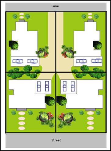
|
|
|
|
|
Control 11 - Example of Mews Style development with car parking
off rear public lane and all dwellings overlooking central courtyard area.
Removes need for individual driveways and providing more open space area/
common area for landscaping, gardens etc. Drawing Not to scale)
|
|
|
|
Control 11 - Example of Mews Style development with car parking
off shared central driveway with reciprocal rights of carriageway from rear
lane. Removes the need for individual driveways to each dwelling and house
frontages not dominated with garages.
|
|
|
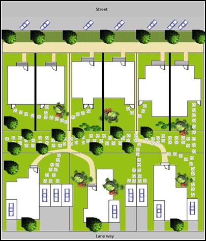
Figure E8.16 Examples of Various Building Elements
against Planning Control 11 in Table E8.3

 Figure
E8.17 Photo Plates – Examples of Various Building Elements against
Planning Controls in Table E8.3
Figure
E8.17 Photo Plates – Examples of Various Building Elements against
Planning Controls in Table E8.3
Staff Reports - Sustainable Environment and Economy 13.10 - Attachment 1
E8.10.10.4
Industrial Area
Approximately 7.5 hectares of the West Byron Site is zoned
IN2 Light Industrial. The IN2 Zoned land sits opposite the Byron Bay Industrial
Estate to the north and residential land to the east. For specific development
guidelines for construction of factory units in this area, applicants are
directed to Chapter D5 Industrial Development within DCP 2014. The following
controls though apply to the subdivision design and development of the land
Zoned IN2.
Objectives
1. To
ensure the subdivision layout and design facilitates a wide range of light
industrial and warehouse uses and employment opportunities.
2. To
provide industrial land that is of a size, shape and area to cater for a range
of light industrial and other permissible uses that are suitably serviced with
necessary infrastructure.
3. To
ensure development presents to the main spine road and is sympathetic to
surrounding residential area.
Performance Criteria
1. Access
roads are designed to facilitate the movement of large vehicles.
2. Lot
sizes meet minimum requirements to facilitate safe manoeuvring onsite for
delivery trucks.
3. Lots are
serviced with all necessary infrastructure.
4. Suitable
setbacks, built form and landscaping are provided within the design of
industrial development to make a positive contribution to the streetscape
including Ewingsale Road.
5. Development
be designed and sited to minimise land use conflicts with surrounding
residential development.
Prescriptive Measures
1. A single
DA be submitted to Council for the initial subdivision of the IN2 Zoned Land
presenting an integrated proposal for the road and allotment layout, based on
potential industries seeking industrial land in Byron Bay. Details to be
provided with the development application.
2. Access
roads through the IN2 Zoned land to be of a suitable width to accommodate
articulated vehicles plus on street parking.
3. A
minimum of twenty five (25%) percent of lots are to be designed with an
appropriate area and width to enable Articulated Vehicles to enter and leave in
a forward direction.
4. In
addition to normal infrastructure required by Council, lots to be provided with
telecommunication infrastructure to facilitate connection to the National
Broadband Network.
5. Development
fronting the main spine road to include the following design features
a) Industrial
development fronting the main spine road to be designed to address the street
with a mixture of facade treatments, landscaping and pedestrian access. Two
storey frontages are to be appropriately articulated through the use of
different building materials including glass, masonry steel and timber elements
and changes in setbacks. Large blank walls facing the main spine road will not
be supported and screening of poorly designed buildings with vegetation is not an
acceptable streetscape treatment.
b) A minimum setback
of 5 metres to apply to the Spine Road which is to be suitably landscaped in
accordance with B9 of DCP 2014. For corner lots on the spine road this can be
reduced to 3 metres.
c) Private
Access from the Spine Road to be generally limited and consideration to be
given to the creation of large lots along this frontage with shared access
points, rear lane/ secondary street access, or a slip lane combined with car
parking and landscaping to the Spine Road.
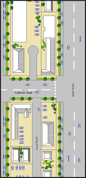
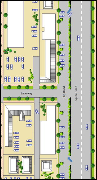
Figure E8.13 Examples of access from the Spine Road
fronting the IN2 Zone.
6. Industrial
development adjacent to Ewingsale Road to be setback a minimum of 10 metres
from this boundary and appropriately screened with native trees and vegetation.
This setback can be varied down to 3 metres where other alternatives are
utilised in the facades of buildings along this boundary including use of green
walls, mix of building materials including glass wall and upper level windows,
and articulation or variation in building alignment.
7. A
minimum 10 metre wide vegetated buffer to be provided between the IN2 and R2
Zones unless separated by a public road. The buffer to be suitably
landscaped with native species in accordance with Chapter B9 of DCP 2014. A
Landscape plan to be submitted with the development application for
subdivision.
8. Development
within the Industrial Zone to be designed and sited to minimise potential land
use conflicts with surrounding adjoining residential uses. Where required noise
attenuation to be provided within industrial units or on the boundary to ensure
compliance with the relevant EPA guidelines for industrial noise.
9. Any
retail uses to be in accordance with Byron LEP 1988 and Clause 87(4) as
required. Such uses to be subservient to retail uses within the B1 Zone so as
not to undermine the function and hierarchy of this zone. Consideration be
given to the installation of a takeaway food shop and drink premises in a
central location within the IN2 Zone to serve the needs of workers in the
industrial estate. (N.B Restaurants and cafes are prohibited in the IN2 Zone)
10. Large car parking
areas of 20 spaces or more to consider the installation of an electric vehicle
charging station. (Note: Opportunities may exist to partner with Council and
other organisations with the design and installation of such infrastructure as
per the Byron Shire Low Carbon Strategy)
11. All development to
be connected to the dual reticulation water supply for non
potable water. From this supply a minimum of one external tap to be provided
for the watering of landscaping and a minimum of one internal tap provided for
the flushing of toilets with each industrial unit.
12. Development in the
IN2 Zone not covered by the above provisions, is to comply with Chapter D5 of
Byron DCP 2014.
Note: For design
specification please refer to the Northern Rivers Local Government Development
and Design Manual and Chapters B3 and B4 of DCP 2014.
E8.10.11 Development
in the E3 Zone
A small part of the West Byron site has been zoned E3 in the
South west corner and along two drainage lines in the eastern half of the site.
A minimum lot size of 40ha applies to subdivision and it is not envisaged any
additional dwelling entitlements will be created in the E3 Zone.
Development opportunities in the E3 Environmental Management
Zone are restricted by the permitted uses listed in the zoning table under
Byron LEP 1988. Many of these uses are covered in part in other sections of DCP
2014, whereby specific controls apply to development’s such as bed and
breakfast establishments, eco-tourist facilities, dual occupancies, dwelling
houses, farm stay accommodation and camping grounds. Accordingly no specific
controls are drafted for the E3 Zone and applicants are directed to other
relevant chapters within the DCP 2014.
E8.10.12 Tourist
and Visitor Accommodation in the Residential R2 and R3 Zones and the B1 Zone
Bed and Breakfast Establishments
are permissible with consent in the R2 and R3 Zone and Serviced Apartments are
permissible with consent in the R3 Zones only, whilst only Hotel and Motel
Accommodation is permitted in the B1 Zone. Applicants are directed to the
planning controls under Byron DCP 2014 including Chapter D3 Tourist
Accommodation.
Note: Other forms of
tourist and visitor accommodation, including holiday letting of a dwelling or a
dwelling house are prohibited in the R2, R3 and B1Zones.
Staff Reports - Sustainable Environment and Economy 13.10 - Attachment 1
Appendix A -
Staging Plan
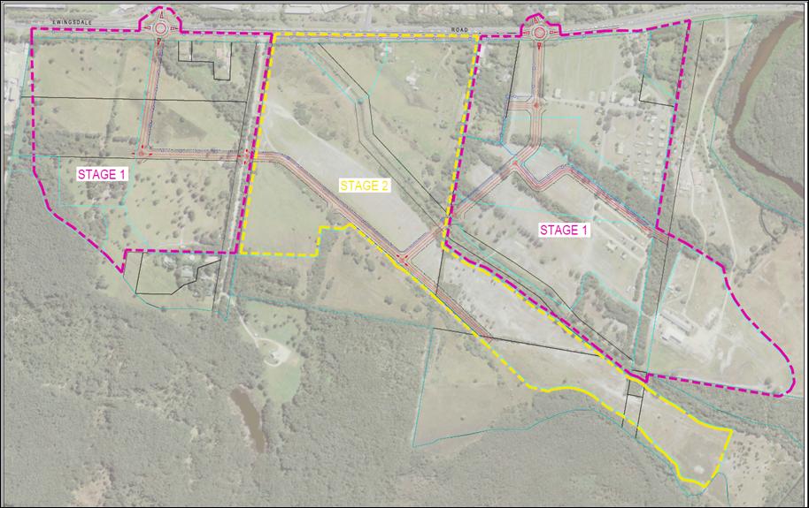
Appendix B – Concept Plan
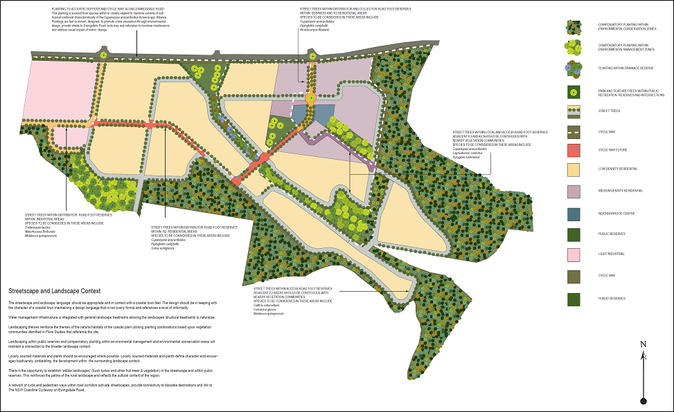
Appendix C – WSUD Street Tree with Pit
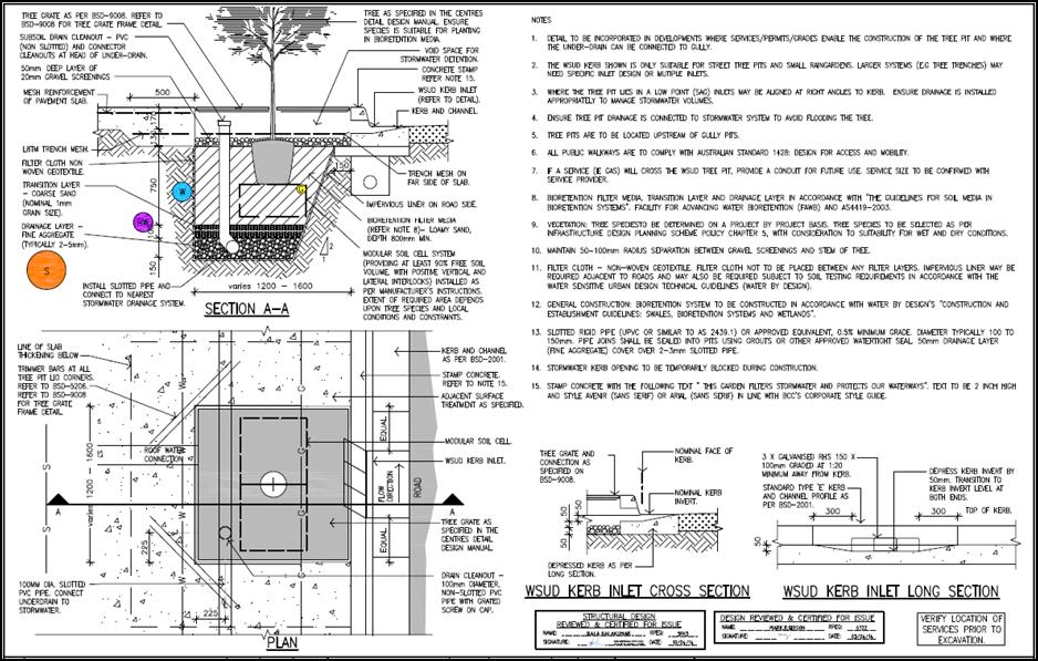
Appendix D – Typical Road Cross Sections (Not to scale)
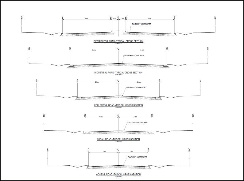
Appendix E – Typical Driveway Access across Swales (Not to Scale)
Appendix F – Typical Stormwater House Connection (Not to Scale)
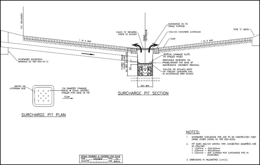

Staff Reports - Sustainable Environment and Economy 13.10 - Attachment 2
Draft Amendments to Part A –
Preliminary of Byron Shire Development Control Plan 2014
1. Amend
Section A5 to Read
A5 Where
This DCP Applies
This plan applies to the land to which Byron LEP 2014
applies and land identified under Part 4 - West Byron Bay Site of the Byron
Local Environmental Plan 1988. This Plan applies to all categories of ‘development’
as defined within the Environmental Planning and Assessment Act 1979 and as
addressed within the various Chapters of this Plan.
2. Amend
Appendix A1 – Dictionary by inserting the following additional
definitions
Dual key – Means an internal door linking two
attached dwellings together. The door needs to be a suitably designed and
constructed fire door as per the Building Code of Australia. Dual key
arrangements maybe considered suitable for dual occupancy, secondary dwelling
and attached dwelling housing arrangements where the housing is on one
lot.
Integrated
Housing
– Means the subdivision of land into three or more lots
and the erection of a dwelling (attached or semi attached) or dwelling house on
each lot as per clause 83 of Byron LEP 1988.
Small Lots – means vacant residential lots less than 350m2
in area
3. Make
any other adjustments to Part A where required to reference the West Byron Bay
Site under Part 4 of Byron Local Environmental Plan 1988.
Staff Reports - Sustainable Environment and Economy 13.10 - Attachment 3
West Byron DCP
- 2 July 2015 Workshop Notes
Council resolved (15-233):
That the
June pre-exhibition community consultation be in the form of a workshop with
Councillors, urban design planning and architecture practitioners and community
representatives and that the total attendance be limited to 12 (excluding
Councillors).
Meeting attendees:
Invited guests: Darryl Anderson (for Stuart Murray); Kate Singleton (Planners North);
Jason Trisley (Space Studio Pty Ltd ); Michel Kamphorst (Greg Alderson &
Associates); Harley Graham (Architect); Cate Coorey (Byron Residents Group);
David Milledge (ecologist); Dailan Pugh (BEACON); Dale Spence (Green Building
Centre)
Councillors: Simon Richardson, Alan Hunter, Di Woods, Basil Cameron, Duncan Dey,
Chris Cubis, Paul Spooner, Rose Wanchap (Sol Ibrahim -Apology)
Staff:
Sharyn French, Chris Larkin, Chris Soulsby, Natalie Hancock
NOTE:
· Whilst
the following comments were provided by attendees, no agreement or consensus
was reached on any of the points or matters raised.
· Staff
to review the following comments and issues and these will be further
considered in terms of the drafting of controls for West Byron.
Environment and Recreation areas
Koala and wildlife
habitat/corridors
· Focus
koalas and wildlife corridors outside of residential areas
· Strengthen
key corridors for koala movement. Two corridors identified:
1. North-south corridor
along the eastern boundary of the estate bordering Belongil Creek
2. South-easterly to
north-westerly corridor along the estates southern boundary
· The
two E3 zones towards the eastern side of the development contain Primary Koala
Habitat – this needs to be enhanced; concern that location of drains may
require removal of existing vegetation; prefer existing trees are retained
– consider realigning existing drain corridor to reduce koala impacts
· Existing
DCP controls require alternative habitat be provided. Need to
consolidate, strengthen and maintain existing HCV.
· Swamp
Mahogany (koala food tree) is limited to where it will grow
· Facilitate
koala movements across Ewingsdale Rd eg. underpass or overpass, and traffic
calming on key residential roads within the estate to enable safe crossing
· The
character and design of the roads adjoining the south-east residential areas
should integrate considerations from engineers, ecologists and urban designers;
they should include traffic calming, not have other roads feeding off from them
to reduce the amount of traffic using them, consider street tree selection and
placement etc
· Fencing
styles need to be considered to encourage or guide/hinder koala movement
( see Koala Beach Estate, Tweed Heads examples)
· Consider
swimming pools design (unsightly/deteriorating ropes have led to drop in use or
ensure ramp area incorporated into the pool design for ease of exiting), or
prohibit pools in some parts of the estate
· Consider
banning dogs and or cats from entire estate or sections such as the R2 portions
in the south east part of the estate through which one of the koala corridors
transect
· Design
R2 residential portions in the south east part of the estate to support
wildlife movement. Could look to market these residential areas with an
‘Environmental Living’ theme.
· Wildlife
corridor through southern most section of R2 residential land required to connect
the two wildlife corridors
· Understand
if koalas are crossing Ewingsdale Rd through death and sighting records to
inform location of wildlife crossing
· KPOM
being prepared for the site, more recent studies have been done, can consider
dog free zones
· Expertise
on designing developments for koalas required
· Possible
wildlife sanctuary opportunity east of the R3 Residential zone bordering
Ewingsdale rd in existing buildings - although located at key point for
possible wildlife crossing on Ewingsdale rd
· Linear
nature of residential zones bad design for biodiversity; residential land in
the south-east part of the estate is not supported
Wallum sedgefrog
· Location
of existing population appears to align with proposed road – exact
location of population in relation to the road needs to be confirmed and road
realigned if impacting
· Buffers,
water quality run-off need to be considered. Include appropriate actions from
National Recovery Plan for the wallum sedgefrog and other wallum-dependent frog
species in DCP http://www.environment.gov.au/resource/national-recovery-plan-wallum-sedgefrog-and-other-wallum-dependent-frog-species
· connectivity
to the potential sedgefrog habitat to the south-east required. As species
not currently present at site, need to understand whether it is suitable
habitat.
Water quality and Acid
Sulphate Soils
· developers
preliminary ASS mapping identified 70% of site as ASS – it’s
different to Councils ASS mapping
· a
comprehensive ASS study and water management plan for the whole site is
required upfront along with the infrastructure plan
· concern
that drain lowering across the site will increase runoff to Belongil
Estuary
· Water
Sensitive Urban Design (WSUD) principles being incorporated into the
development; permeable surfaces and grass swales should be used to encourage
infiltration and reduce run-off to Belongil Creek
· Large
quantity of imported sandy fill required to elevate sites from flooding
Recreation Areas
· High
density development therefore need for additional recreation spaces
· Enable
recreational facilities to be informed and developed in accordance with the
demographics buying into the estate
· Recreation
node near R3 high density residential: provide for a range of recreational
activities including community gardens and young children’s play
equipment; ensure commercial precinct adjoining the park activates its frontage
eg. cafes outdoor dining fronts the park;
· Provide
skate park and or older children recreational activities at Cavanbah Sports
Centre
· Provide
safe pedestrian crossings over Ewingsdale Rd to link to Cavanbah Sports Centre;
consider if pedestrian and koala/wildlife crossings can be collocated
· Examples
of recreational areas that work include: Salt, Kingscliff and Williams Reserve,
Lennox
· Provide
walking loops/circuits throughout the estate and consider placement of walking
tracks on the outer edge (eg on road reserve footpath) adjoining the southern
E2 land
· Recreation
node adjoining Ewingsdale rd: how much useable space if head of the drain system?
Commercial precinct
· ensure
safe pedestrian road crossing between split commercial areas or relocate
roundabout opposite SAE and entrance road to avoid fragmenting the commercial
precinct
Other
· identify
what zones have been applied to the remainder of the southern lots – can
this land further support wildlife movement?
· Bushfire
controls and constraints along the southern part of the estate may force
redesign
Industry and Neighbourhood Business Centre
Industry
Who are the target owners/tenants?
· Before
determining the layout – need to liaise with Council’s Economic
Development section on the types of industries seeking sites and then research
what their siting requirements may be.
Image
· Present
as an integrated estate with an overall layout concept
· Aim
for sustainability in design and image
· Best
practice in layout, individual site design and buildings
Interface with Ewingsdale Road
· It
was noted that the site is situated between the sports and cultural complex and
the town centre; that the level of pedestrian and cycle traffic between these
to points is likely to increase; hence design has to be cognitive of the impact
on a pedestrian or cyclist, not just the motorist. The approach of the existing
industrial estate to Ewingsdale Road was not viewed as the outcome to be a
sought.
· Optional
ideas:
o Screened behind a wide landscaped verge of endemic
vegetation with a walk and cycle way weaving through the space – the aim
being to:
§ Retain the small town feel entry to Byron where the
passerby is unaware of the industrial estate
§ Extend a ‘finger’ of green into the town
o Blend of built form and landscaping where the passer
by is aware of the estate but the appearance of the estate is not bulk
industrial, building facades have been designed for pedestrian appeal with a
mix of materials, green walls and variation in the alignment and inter
dispersed with landscaping – the aim being to:
§ make the space interesting pedestrian or the cyclist
§ Provide surveillance of the pathway from the
industrial building e.g. place office components to this frontage where workers
look out over the path and roadway space
· Linkage
to north side of Ewingsdale Road – options discussed included at level
crossings and an overpass for pedestrian and cyclists – viewed as an
important issue to be considered early in the design process to ensure land
need for the solution is set aside and pathways link up.
Interface to the residential area
· The site layout/buildings should be designed to
attract uses that buffer the more intensive industry within the estate and
desirably:
o Built form to be complementary in style providing an
integrated appearance with residential buildings and achieve an integrated and
inviting appearance to this road corridor.
o Incorporate landscaping that screens car parking and
complements the buildings
o there were mixed views to the use of a slip road or
access to the rear off a side street.
Internal elements to consider
· a
centrally located/ or easily accessed shared space for workers in the estate to
spend their down time perhaps a pocket park and cafe
· management
of runoff from hard areas and buildings – containment of pollutants
– sensitive habitats surround the site
· mix
of lot sizes – particularly providing larger lot sizes to those available
in the existing estate
· consideration
could be given to the establishment of a ‘green plan’ for the
estate addressing matters of energy efficiency, landscaping and water cycle
management.
· Scope
for the provision of a electrical vehicle charging station
Neighbourhood Business Centre
Focus
· uses
centred on meeting the day to day needs of the residents and industrial estate
workers e.g. child care/preschool centre, cafes, small convenience store,
evening restaurant /wine bar (Suffolk Park neighbourhood centre was seen as
having a good mix – excluding the hotel/motel and Pottsville central
street was identified as an attractive space)
· active
space both in the day and into the evening
· incorporate
a facility for the community to meet and hold meetings
Design points
· car
park areas situated to the north of the two sites, to the rear and possibly
accessing of a side road, not the main entry road- to be landscaped for shade,
heat reduction and visual amenity
· depth
of the lots seen as a potential challenge to the design
· the
road that dissects the site to be pedestrian in feel
o avoid on street car parking
o integrated and low maintenance landscaping- green
walls
o wide footpaths with integrated paving - skate
friendly
· furnish
the centre and park with attractors for social interaction including carefully
placed seating, artwork and recreational equipment – to create a casual
meeting place – public space like a piazza
· cafes
on edge interconnecting with the parkland – community or themed garden
· parkland
to incorporate uses/elements that are attractive to all age groups and
abilities
· surrounding
medium residential to also interconnect and integrate with the public spaces in
the neighbourhood centre – supporting a walkable community
Infrastructure Notes
· Roundabout
timing – The presentation should have been shown
· Roads
– swale integrates with open space
· Maintenance
of swales
· Roundabout
should be at Sunrise not SAE – very important
· Native
grass in swales and rocks – biodiversity and aesthetic
· Rain
garden in local street
· Swales
on spine road
· Minimal
road width
· One-way
for short lengths
· Timing
for planting on acoustic wall
Austroads vs Urban Design
· Drain
o pipe
option
o retention
· Lower
water table risk
· ASS
Management Plan needs to be done prior to design of draw
· Veg
buffers
· No
koala feed at northern part
·
· Boardwalk
in centre of swale – landscaped edges
· Paperbark
wetland for drain
· Sedges
and wetland treatment
· Fence
on drain?
· Veg
to inhibit access to drain
Hierarchy of landscaping to match road hierarchy
Fall roads one way no crown
Residential Controls
· Holiday
Let Controls/ prohibition needed to ensure housing estate provides for
residents not tourists.
· Orientation
of lots and housing
o Important to get it right at subdivision stage
o Need Diagrams
o Dual Occupancy should be on corner lots for separate
vehicle entrances – and give appearance of single dwellings
· Party
Walls for small lots
· Creating
housing with reasonable yard/ garden/private open space areas
· Cars
– Vehicle shouldn’t dominate
o Car sharing
o Check “Habitat” development in Bayshore
Drive
o Investigate common car park ideas
o Mews style lots
· Water
o Incentives for water harvesting
o Purple Pipe –dual reticulation through West
Byron (now mandatory in Ballina Shire for new Subdivisions)
o Larger common water tanks – in residential
precincts
· House
Sizes – Check SEPP 65 - has guidelines on house sizes
· Co-operative
Housing
o Possibility for Seniors housing
o MO model doesn’t work very well over time
– but Community Title does
· Who
is going to own and manage the E2 and E3 Zoned areas?
o Community title a possibility – adjacent
residential estates also have ownership and management of residual E2 and E3
Zone land
o Also providing buffers and habitat links/ corridors
· Sustainability
o Longevity of dwellings and building materials
o Site coverage – need for a deep soil zone
– check Tweeds controls – enable a tree to be planted in yards
o Privacy – dwellings should be orientated to the
street or the rear boundary not side boundary
o Solar orientation – not so critical north of
Coffs Harbour due to climate,
o roof orientation important for solar collectors (hot
water etc)
· Staging
– what infrastructure is needed for residents – DCP needs to
clarify
o Open space
o Road works eg bypass
o Are there hold points in lots to be released until
certain infrastructure has been constructed
o Link to Traffic Study(s) for Byron Bay?
o Upfront management plans for Stage 1 (Koala Plan of
Management, Acid Sulfate Soils Plan, Water Management Plan etc)
· Baseline
Data and Monitoring – Water Quality
o As development Proceeds monitoring required
o if decrease in water quality this becomes a hold point
for development until issue resolved.
· Look
to overseas examples
· Controls
need to be prescriptive and maybe broken into precincts
· Connectivity
across Ewingsdale Road
o Pedestrians
o Wildlife
· Amendment
to LEP/ New LEP Controls
o Lot size provisions in the R2 Zone too small - down to
150m2 lots
o DCP provisions cant override LEP controls
· Filling
o Need a fill plan
o Filling should be limited
· Innovative
use of materials
o Recycled
o New age materials
o longevity of materials
· Adaptable
Housing
o Build Up front in dual occupancy arrangements to
enable house to be used as 1 large or two smaller dwellings depending on
residents needs etc
o Dual Key idea for housing
Staff Reports - Sustainable Environment and Economy 13.10 - Attachment 4
Local
Government (General) Regulation 2005
Schedule 3A Form of special disclosure of
pecuniary interest
(Clause 195A)
Local
Government Act 1993
Form of Special Disclosure of Pecuniary Interest
1 The particulars of this form are to be written in
block letters or typed.
2 If any space is insufficient in this form for all
the particulars required to complete it, an appendix is to be attached for that
purpose which is properly identified and signed by you.
Important information
This information is being collected for the purpose of
making a special disclosure of pecuniary interests under sections 451 (4) and
(5) of the Local Government Act 1993. You must not make a special disclosure that you know
or ought reasonably to know is false or misleading in a material particular.
Complaints made about contraventions of these requirements may be referred by
the Director-General to the Local Government Pecuniary Interest and
Disciplinary Tribunal.
This form must be completed by you before the
commencement of the council or council committee meeting in respect of which
the special disclosure is being made. The completed form must be tabled at the
meeting. Everyone is entitled to inspect it. The special disclosure must be
recorded in the minutes of the meeting.
Special
disclosure of pecuniary interests
by
____________________________________________________________________________________
[full
name of councillor]
in the matter of
__________________________________________________________________________
[insert
name of environmental planning instrument]
which is to be considered at a meeting of the
______________________________________________________________________________________
[name of council or council committee (as the case
requires)]
to be held on the _________________ day of __________________________
201
|
Pecuniary
interest
|
|
Address of land
in which councillor or an associated person, company or body has a
proprietary interest (the identified land)
|
|
|
Relationship of identified land to councillor
[Tick or cross one box.]
|
Councillor
has interest in the land (e.g. is owner or has other interest arising out of
a mortgage, lease, trust, option or contract, or otherwise).
Associated
person of councillor has interest in the land.
Associated company
or body of councillor has interest in the land.
|
|
Matter giving rise to pecuniary interest
|
|
Nature of land that is subject to a
change
in zone/planning control by proposed
LEP (the subject land)
[Tick or cross one box]
|
The identified
land.
Land
that adjoins or is adjacent to or is in proximity to the identified land.
|
|
Current
zone/planning control
[Insert name
of current planning instrument and identify relevant zone/planning control
applying to the subject land]
|
|
|
Proposed
change of zone/planning control
[Insert name of proposed
LEP and identify proposed change of zone/planning control applying to the
subject land]
|
|
|
Effect
of proposed change of zone/planning control on councillor
[Insert
one of the following:
“Appreciable financial gain” or
“Appreciable
financial loss”]
|
|
[If
more than one pecuniary interest is to be declared, reprint the above box and
fill in for each additional interest.]
_____________________________
Councillor’s
signature
_____________________________
Date
[This
form is to be retained by the Council’s general manager and included in
full in the minutes of the meeting]
Staff Reports - Sustainable Environment and Economy 13.11 - Attachment 1
Staff Reports - Sustainable Environment and Economy 13.11 - Attachment 1
Staff Reports - Sustainable Environment and Economy 13.11 - Attachment 2
10.2015.196.1
CONDITIONS
OF CONSENT:
Parameters of this
Consent
1) Development is to be in
accordance with approved plans
The development is to be in accordance with plans listed
below:
|
Plan No.
|
Description
|
Prepared by
|
Dated:
|
|
A1
Issue B
|
Site Plan
|
Frank Stewart Architects
|
March 2015
|
|
A5
Issue A
|
Level 1 Floor Plan (Pearl)
|
Frank Stewart Architects
|
March 2015
|
|
A6
Issue A
|
Level 2 Floor Plan (Pearl)
|
Frank Stewart Architects
|
March 2015
|
|
A7
Issue A
|
East & North Elevation
|
Frank Stewart Architects
|
March 2015
|
|
A8
Issue A
|
West & South Elevation
|
Frank Stewart Architects
|
March 2015
|
|
A9
Issue B
|
Level 1 Floor Plan (Oyster)
|
Frank Stewart Architects
|
March 2015
|
|
A10
Issue B
|
Level 2 Floor Plan (Oyster)
|
Frank Stewart Architects
|
March 2015
|
|
A11
Issue B
|
Level 3 Floor Plan (Oyster)
|
Frank Stewart Architects
|
March 2015
|
|
A13
Issue B
|
North & South Elevation (Oyster)
|
Frank Stewart Architects
|
March 2015
|
|
A14
Issue B
|
East & West Elevation (Oyster)
|
Frank Stewart Architects
|
March 2015
|
|
|
Statement of Heritage Significance and Conservation Policy
|
Frank Stewart Architects
|
April 2015
|
|
|
|
|
|
The development is also to be in accordance with any changes
shown in red ink on the approved plans or conditions of consent.
The approved plans and related documents endorsed with the
Council stamp and authorised signature must be kept on site at all times while
work is being undertaken.
2) Compliance with Building
Code of Australia and insurance requirements under the Home Building Act 1989
(1) For the purposes of section 80A (11) of the Act, the following conditions are
prescribed in relation to a development consent for development that involves
any building work:
(a) that the work must be carried
out in accordance with the requirements of the Building Code of Australia ,
(b) in the case of residential
building work for which the Home Building Act 1989
requires there to be a contract of insurance in force in accordance with Part 6
of that Act, that such a contract of insurance is in force before any building
work authorised to be carried out by the consent commences.
(2) This clause does not apply:
(a) to the extent to which an
exemption is in force under clause 187 or 188, subject to the terms of any
condition or requirement referred to in clause 187 (6) or 188
(4), or
(b) to the erection of a temporary
building.
(3) In this clause, a reference to
the Building Code of Australia is a reference to that Code as in force on the
date the application for the relevant construction certificate is made.
3) Erection of signs
(1) For the purposes of section 80A (11) of the Act, the requirements of subclauses (2)
and (3) are prescribed as conditions of a development consent for development
that involves any building work, subdivision work or demolition work.
(2) A sign must be erected in a prominent
position on any site on which building work, subdivision work or demolition
work is being carried out:
(a) showing the name, address and
telephone number of the principal certifying authority for the work, and
(b) showing the name of the
principal contractor (if any) for any building work and a telephone number on
which that person may be contacted outside working hours, and
(c) stating that unauthorised entry
to the work site is prohibited.
(3) Any such sign is to be
maintained while the building work, subdivision work or demolition work is
being carried out, but must be removed when the work has been completed.
(4) This clause does not apply
in relation to building work, subdivision work or demolition work that is
carried out inside an existing building that does not affect the external walls
of the building.
(5) This clause does not apply
in relation to Crown building work that is certified, in accordance with section 116G of the Act, to comply with the technical
provisions of the State’s building laws.
(6) This clause applies to a
development consent granted before 1 July 2004 only if the building work,
subdivision work or demolition work involved had not been commenced by that
date.
Note: Principal certifying authorities and principal
contractors must also ensure that signs required by this clause are
erected and maintained (see clause 227A which currently imposes a
maximum penalty of $1,100).
4) Notification of Home
Building Act 1989 requirements
(1) For the purposes of section 80A (11) of the Act, the requirements of this clause
are prescribed as conditions of a development consent for development that
involves any residential building work within the meaning of the Home Building Act 1989 .
(2) Residential building work within
the meaning of the Home Building Act 1989
must not be carried out unless the principal certifying authority for the
development to which the work relates (not being the council) has given the
council written
notice of the following information:
(a) in the case of work for which a
principal contractor is required to be appointed:
(i) the name and licence
number of the principal contractor, and
(ii) the name of the insurer by
which the work is insured under Part 6 of that Act,
(b) in the case of work to be done by an owner-builder:
(i) the name of the
owner-builder, and
(ii) if the owner-builder is
required to hold an owner-builder permit under that Act, the number of the
owner-builder permit.
(3) If arrangements for doing the
residential building work are changed while the work is in progress so that the
information notified under subclause (2) becomes out of date, further work must
not be carried out unless the principal certifying authority for the
development to which the work relates (not being the council) has given the
council written
notice of the updated information.
(4) This clause does not apply
in relation to Crown building work that is certified, in accordance with section 116G of the Act, to comply with the technical
provisions of the State’s building laws.
5) Existing building/s to
be bought into compliance with fire safety provisions
In accordance with Clause 94 of Environmental Planning &
Assessment Regulation 2000, the existing building is to be brought into
compliance with the fire protection and structural provisions of the Building
Code of Australia.
6) Concurrent Approvals
The following approvals are provided under Section 78A of
Environmental Planning and Assessment Act:
Concurrent Approvals under Section 68 of the Local
Government Act 1993
Part B Water
supply, sewerage and stormwater drainage work
B1 Carrying out water supply work
B3 Installing, altering,
disconnecting or removing a meter connected to a service pipe
B4 Carrying out sewerage work
B6 Connecting a private drain or
sewer with a public drain or sewer under the control of a council or with a
drain or sewer which connects with such a public drain or sewer
These works must be carried out to the satisfaction of Byron
Shire Council and can not be assessed for the purpose of compliance, or otherwise
deemed acceptable by a private certifier.
The following conditions
are to be complied with prior to issue of a Construction Certificate
7) Heritage Management Plan
A Heritage Management Plan prepared by a suitably qualified
professional with experience in heritage buildings to be prepared and submitted
for approval prior to the issue of the Construction Certificate. The plan is to
include the following details and measures:
· Details of demolition works including demolition plans
· Photographic recording prior to the commencement of works
· Photographic recording of the works in progress
· Lodgment with the Brunswick Valley Historical Society of copies of
the demolition plans and photographic recordings
· Regular inspections by a recognized Heritage Consultant during the
works (Minimum of two) and prior to the issue of the Occupation Certificate.
· Reuse and labeling of important features such as the under floor
timber stumps, particularly one with the words ‘Gins Only’ written
on it.
· Details of two ‘Open Days’ per year where Barnes House
and the historic item display will be open to the public.
8) Section 94A Levy to be
paid
Prior to the issue of a construction certificate the section
94A levy required by the Byron Developer Contributions Plan2012 shall be paid
to Council.
The levy will be calculated as follows:
Levy payable = %C x $C
Where: %C is
the levy rate applicable as set out in the latest Ministerial Direction issued
under section 94E.
$C is
the proposed cost of carrying out the development.
The rate of %C is:
|
Proposed cost of the
development
|
Maximum percentage of the
levy
|
|
Up to $100,000
|
Nil
|
|
$100,001–$200,000
|
0.5 percent
|
|
More than $200,000
|
1.0 percent
|
The cost of development shall be
shall be calculated in accordance with clause 25J of the regulation. The
Cost Summary Report (copy attached) as set out in schedule 2 of the Section 94A
contributions plan shall be submitted to Council with the with the payment.
Copies of Cost Summary Report are available at Council’s main office or
may be downloaded from http://www.byron.nsw.gov.au/
9) On-site stormwater
detention - Section 68 approval required
An approval under Section 68 of the Local Government Act
1993 to carry out on-site detention drainage system and connection to a Council
approved drainage system.
Note: The plans must be in compliance with
Council’s Development Control Plan 2010, Part N and Council’s current
“Northern Rivers Local Government Development Design & Construction
Manuals and Standard Drawings”. Refer to Council’s website for
copies of these documents.
10) Consent required for works within
the road reserve – Rear Lane.
Consent from Council must be obtained for works within the
road reserve pursuant to Section 138 of the Roads Act 1993. Three (3) copies of
engineering construction plans must accompany the application for consent for
works within the road reserve.
Such plans are to be in accordance with Council’s
current Design & Construction Manuals and are to provide for the following
works:
|
|
|
|
Adjustment of Services
|
Road works are to include the adjustment and/or relocation
of services as necessary to the requirements of the appropriate service
authorities and to ensure that the services are constructed flush with the
finished surface levels.
|
|
Road pavement and drainage – Rear Lane
|
Pavement widening and construction of the existing bitumen
sealed rear Lane for the full width of the Lot and through to the existing
full width construction of the Lane east of the Lot at the Park Street end.
The new construction is to be of a comparable width, formation and profile as
that fully constructed section. The works are to provide for two way traffic
flows, bitumen seal pavement, drainage as required and concrete edge/kerb
and/or kerb & gutter.
|
11) Roads Act Approval – New
Driveway in Mullumbimbi Street.
Approval has been granted with this consent (Council
reference No: 51.2015.196.10 For the following works within the road reserve of
Mullumbimbi Street:
a) Driveway
– A concrete driveway and concrete layback from the property boundary
through to the edge of gutter. A bitumen sealed driveway from the edge of
gutter/layback through to the existing road pavement seal.
12) Traffic Management Plan Roadworks
in Mullumbimbi Street & Rear Lane.
Consent from Council must be obtained for a Traffic
Management Plan pursuant to Section 138 of the Roads Act 1993. The plans and
specifications are to include the measures to be employed to control traffic
(inclusive of construction vehicles) during construction of the development.
The traffic control plan is to be designed in accordance with the requirements
of the Roads and Traffic Authority’s Manual, Traffic Control at Work
Sites Version 2, and the current Australian Standards, Manual of Uniform
Traffic Control Devices Part 3, ‘Traffic Control Devices for Works on
Roads’.
“The plan shall incorporate measures to ensure that
motorists using road adjacent to the development, residents and pedestrians in
the vicinity of the development are subjected to minimal time delays due to
construction on the site or adjacent to the site”.
The traffic control plan must be prepared by a suitably
qualified and RTA accredited Work Site Traffic Controller.
13) Car parking layout, vehicle
circulation and access plans required.
The application for a Construction Certificate is to include
plans and specification that indicate access, parking and manoeuvring details
in accordance with the plans approved by this consent.
The access, parking and manoeuvring for the site is to
comply with the requirements of Council’s DCP 2014, AS 2890.1-2004:
Parking facilities, Part 1: Off-street car parking and AS 2890.2 – 2010 -
Parking facilities, Part 2: Off-street commercial vehicle facilities.
Plans are to include, but not be limited to, the following
items:
a) pavement
description;
b) a
minimum of 12 on site car spaces; inclusive of 1 space for Manager, 1 disabled
space, and 3 visitor spaces;
c) existing
and design levels;
d) Safety
Sight Line Triangle at rear Lane access (per AS 2890.1);
e) drainage
(pipes, pits, on-site detention, etc.);
f) turning
paths;
g) linemarking
and signage;
Such plans and specifications must be approved as part of the
Construction Certificate.
NOTE: The plans must be in compliance with
Council's current “Northern Rivers Local Government Development Design
& Construction Manuals and Standard Drawings”.
14) Bond required to guarantee against
damage to public land
A bond of $2000 is to be paid to Council as guarantee
against damage to surrounding public land and infrastructure during
construction of the proposed development. Evidence is to be provided to Council
indicating the pre development condition of the surrounding public land and
infrastructure. Such evidence must include photographs. The proponent will be
held responsible for the repair of any damage to roads, kerb and gutters,
footpaths, driveway crossovers or other assets.
Such bond will be held until Council is satisfied that the
infrastructure is maintained/repaired to pre development conditions and that no
further work is to be carried out that may result in damage to Council’s
roads, footpaths etc.
15) Certificate of Compliance –
Water Management Act 2000
A Certificate of Compliance will be issued upon payment of
developer charges for water and sewer as calculated in accordance with Byron
Shire Council and Rous Water Development Servicing Plans.
Byron Shire Council acts as Rous Water’s agent in this
matter and will issue a Certificate of Compliance on behalf of Rous Water upon
payment of the Rous Water Development Servicing Charge to this Council.
Note: Copies of the
application forms for Certificates of Compliance are available on
Council’s website http://www.byron.nsw.gov.au/files/Forms/Section_305_Certificate.pdf
or from Council’s Administration Office. Copies of Byron Shire
Council’s Development Servicing Plans are available at Council’s
Administration Office.
Developer charges will be calculated in
accordance with the Development Servicing Plan applicable at the date of
payment. A check must be made with Council to ascertain the current rates by
contacting Council’s Principal Engineer Systems Planning, Water on 02
6626 7081. Applicable charges can be found on Council’s website: http://www.byron.nsw.gov.au/development-contributions-plans-section-94-and-64
The contributions payable will be adjusted in accordance
with relevant plan and the amount payable will be calculated on the basis of
the contribution rates that are applicable at the time of payment.
Payment by
Personal or Company Cheque will not be Accepted
16) Commercial Swimming Pool Design
The swimming pool, including a spa, is subject to Public
Health Act 2010 & Regulation 2012 requirements.
Water and sewerage load demands from the pool will be
generated by top-up water requirements due to splash-out, evaporation, backwash
water demand and backwash water discharged to sewer.
A letter of receipt will be issued on completion of:
A letter of receipt will be issued on completion of:
· Provision
of detailed design plans, including pump size/capacity, filter
type/size/capacity, pipework diameters for the swimming pool and associated
water management processes;
· The
swimming pool is also subject to Trade Waste requirements.
17) Details of pool fence required
The application for a Construction Certificate is to include
plans and specifications that indicate the details of the fence around the
swimming pool in accordance with the Swimming Pools Act 1992 and AS1926.1.
Such plans and specifications must be approved as part of
the Construction Certificate.
18) BCA Report
A report from an appropriately qualified person detailing
how the existing building “Barnes House” will be upgraded in terms
of the Fire Safety and Structural provisions of Part B,C,D, and E of the BCA is
to be submitted to the PCA for approval prior to the issue of the Construction
Certificate.
19) Heritage Management
The Heritage Management Plan to be followed during
construction of the proposed development.
20) Geotechnical Report required
– Soil Classification
A soil report is to be provided to the Principal Certifying
Authority from a professional Engineer experienced in Geotechnical Science as
to the classification of the soil type on the site, consistent with the
requirements of AS2870.
21) Long Service Levy
A Long Service Levy must be paid to the Long Service
Payments Corporation. These payments may be made to Council’s
Administration Office, Station Street, Mullumbimby. Cheques are to be made
payable to Byron Shire Council. This is a State Government Levy and is subject
to change.
22) Public liability insurance cover
required
The developer and/or contractor must produce evidence to the
Principal Certifying Authority of public liability insurance cover for a
minimum of $10 million. Council is to be nominated as an interested party on
the policy.
1) Landscaping
plan required
The application for a Construction Certificate is to include
plans and specifications that indicate the landscaping of the site. Such
landscaping plan must incorporate adequate detail to demonstrate compliance
with the provisions of Chapter 9.2.4, 9.3 & 9.6, of Development Control
Plan 2014. It is preferred that locally occurring rainforest species including
at least 3 tuckeroo trees are planted. The landscaping plan must indicate:
a) proposed
location for planted shrubs and trees
b) botanical
name of shrubs and trees to be planted
c) mature
height of trees to be planted
d) location
of grassed and paved areas, and
e) location
of trees identified for retention in the development application plans.
f) The
plan is to be prepared by a suitably qualified landscape architect / architect
/ecologist who has appropriate experience and competence in landscaping.
*Note: eucalypt species are
unsuitable for this site.
Such plans and specifications must be approved as part of
the Construction Certificate.
23) Compliance with BASIX Certificate
requirements
The development is to comply with BASIX Certificate No.
622567S, dated 8 April 2015
The commitments indicated in the Certificate are to be
indicated on the plans submitted for approval of the Construction Certificate.
Note that the plans submitted must clearly indicate all
windows numbered or identified in a manner that is consistent with the
identification on the BASIX Certificate.
Minor changes to the energy efficiency measures may be
undertaken without the issue of any amendment under Section 96 of the Act,
provided that the changes do not affect the form, shape or size of the
building.
Proposed colours must be consistent with the provisions of
Section D2.2.3 of Council’s Development Control Plan 2014. Note that
white colours are not permissible.
Such plans and specifications must be approved as part of
the Construction Certificate.
The following conditions
are to be complied with prior to commencement of building works
24) Traffic Management Plan
The approved traffic management plan is to be implemented.
25) Erosion and Sediment measures
Erosion and sedimentation controls are to be in place in
accordance with the Guidelines for Erosion & Sediment Control on
Building Sites. A copy may be downloaded from Council’s web site at http://www.byron.nsw.gov.au/pdfs/stormwater/sediment_erosion.pdf.
Particular attention is to be given to the provision of the following sediment and erosion control measures:
a) Temporary
driveway from the edge of road to the building site;
b) Temporary
downpipes immediately installed after the roof has been erected;
c) Silt
fence or sediment barrier.
Sediment and erosion control measures must be maintained
at all times until the site has been stabilised by permanent vegetation cover
or hard surface.
Note: Council may impose on-the-spot fines for
non-compliance with this condition.
Any such measures that are deemed to be necessary because
of the local conditions must be maintained at all times until the site is made
stable (i.e. by permanent vegetation cover or hard surface).
26) Plumbing Standards and
requirements.
All Plumbing, Water Supply,
Sewerage and Stormwater Works shall be installed in accordance with the Local
Government Act 1993, Plumbers Code of Australia and AS/NZS 3500 Parts 0-5, the
approved plans (any notations on those plans) and the approved
specifications. The changes made are from Plumbers and Drainage
Regulation 2012 NSW Government.
a) The
licensee is to provide 24 hours notice and attend the site for the following INSPECTIONS,
prior to covering of work. Inspections will be carried out a mutually
convenient time:
i) Pre-start
and Sediment Control;
ii) Internal
Drainage;
iii) External
Drainage;
iv) Water
Rough In;
v) Fire
Services;
vi) Stackwork;
vii) Final
- all work completed. - * Note below.
b) A
licensee is required to provide to Council and owner of the property after
completion of the work and within 48 hours, a Compliance
Certificate and Sewer Services Diagram/ Works as Executed drawings.
Note: Council will send
each plumber proformas of these documents when the Notice of Work permit has
been issued by Council to allow the plumber to commence work.
27) Water service and meter to be
connected
A water service and water meter must be connected to the
property using an approved backflow prevention device. It is the
applicant’s responsibility to engage a licensed plumber who shall liaise
with council during this process.
Any new water service and meter will be at the applicants
cost.
28) Disconnection of existing water and
sewer prior to demolition
Existing water and sewer services
must located on site and be properly capped at the main by a licenced
plumber. All water and sewer disconnections must be inspected by
the Byron Shire Council inspectors prior to backfilling.
- If a property is
demolished and no longer needs water supply and/or a sewerage service, a
licensed plumber must disconnect the service at the main (also known as
'capping the service').. The plumber must also return the water meter to
Council’s inspector at the time of inspection.
- If your development involves consolidating lots and you
don’t need all the existing services, you
must correctly disconnect them. This ensures that you aren’t billed for
unused services and helps avoid future hidden leaks.
Your Plumber must obtain a Plumbing Permit at least
two (2) working days prior to commencing work. Please forward an
Application for a Plumbing Permit to your plumber to complete and to return to
Council prior to commencement of disconnection works. Refer to http://www.byron.nsw.gov.au/files/Forms/Plumbing_Drainage_Permit.pdf.
The following conditions
are to be complied with during construction
29) Construction times
Construction works must not unreasonably interfere with the
amenity of the neighbourhood. In particular construction noise, when audible
from adjoining residential premises, can only occur:
a) Monday
to Friday, from 7 am to 6 pm.
b) Saturday,
from 8 am to 1 pm.
No construction work to take place on Saturdays and Sundays
adjacent to Public Holidays and Public Holidays and the Construction Industry
Awarded Rostered Days Off (RDO) adjacent to Public Holidays.
Note: Council may impose on-the-spot fines for
non-compliance with this condition.
30) Construction Noise
Construction noise is to be limited as follows:
a) For
construction periods of four (4) weeks and under, the L10 noise level measured
over a period of not less than fifteen (15) minutes when the construction site
is in operation must not exceed the background level by more than 20 dB(A).
b) For
construction periods greater than four (4) weeks and not exceeding twenty‑six
(26) weeks, the L10 noise level measured over a period of not less than fifteen
(15) minutes when the construction site is in operation must not exceed the
background level by more than 10 dB(A)
Note: Council may impose on-the-spot fines for
non-compliance with this condition.
31) Builders rubbish to be contained on
site
All builders rubbish is to be contained on the site in a
‘Builders Skips’ or an enclosure. Footpaths, road reserves and
public reserves are to be maintained clear of rubbish, building materials and
all other items.
32) TV Antennae
TV Antennae and satellite dishes are to be limited where
possible and sited such that they are not readily visible from Mullumbimbi Street
33) Demolition of building
All asbestos wastes associated with removal of the existing
shed/garage to be disposed of in accordance with the requirements of the
Workcover Authority. The applicant/owner is to produce documentary
evidence that this condition has been met. Council requires 48 hours
notice prior to disposal at Council’s waste depot.
Any work involving the removal of lead paint must not cause
lead contamination of the air or the ground.
34) Prevention of water pollution
Only clean and unpolluted water is to be discharged to
Council’s stormwater drainage system or any watercourse to ensure
compliance with the Protection of Environment Operations Act.
The following conditions
are to be complied with prior to issue of a Final Occupation Certificate
35) Works to be completed prior to
issue of a Final Occupation Certificate
All of the works indicated on the plans and approved by this
consent, including any other consents that are necessary for the completion of
this development, are to be completed and approved by the relevant consent
authority/s prior to the issue of a Final Occupation Certificate.
Any Security bond paid for this application will be held
until Council is satisfied that no further works are to be carried out that may
result in damage to Councils road/footpath reserve.
36) Car parking areas to be completed and
signs to be provided.
The car parking areas are to be constructed in accordance
with the approved plans. Signs are to be erected clearly indicating the
availability of off-street parking and the location of entry/exit points,
visible from both the street and the subject site.
37) Driveways & Roadworks in
accordance approved plans
The driveways and roadworks are to be constructed in
accordance with the approved plans.
38) Stormwater disposal
Stormwater must be collected and disposed of in a controlled
manner such that stormwater flows are:
a) Clear
of buildings and infrastructure,
b) Not
concentrated so as to cause soil erosion,
c) Not
onto adjoining land.
39) Works As Executed drawings are
required.
The submission of Works As Executed drawings for the
Roadworks.
40) Access
and facilities for persons with disabilities are to be provided
Access and facilities for persons with disabilities are to
be provided in accordance with Part D3 of Building Code of Australia and AS
1428 - Design for Access and Mobility.
41) Swimming pool fencing
Swimming pool fencing is to comply with the requirements of
the Swimming Pool Act 192 and Regulations.
42) Final
Fire Safety Certificate (Form 15)
For all works other than domestic construction the Principal
Certifying Authority is to be furnished with a final fire safety certificate
signed by the owner(s) of the property. The certificate is to indicate that all
fire safety measures required to be installed in the building as indicated in
the fire safety schedule approved with the Construction Certificate/Complying
Development Certificate have been installed and meet relevant Australian
Standards for design & installation. Refer to http://www.byron.nsw.gov.au/forms/firesafetystatement
The following conditions
are to be complied with at all times
43) Car Parking spaces are to be
available for the approved use
A minimum of 12 car parking spaces; inclusive of 1
Manager’s car space, 1 disabled car space, 3 visitor car spaces, are to
be provided and maintained, together with all necessary access driveways and
turning areas, to the satisfaction of Council.
Tenants and customers of the development must have
unrestricted access to the car parking spaces on a daily basis during business
hours of the development.
No car parking spaces are to be reserved (generally or
specifically) for any tenant or customer. Only one carparking space required
for the manager’s/residential component of the development is to be
reserved and made available for particular residents.
44) Building not to be used for
residential occupation
Excluding the Manager’s Unit, the building must not be
used for any form of permanent residential occupation.
45) Vehicles to enter/leave in a
forward direction
Vehicles using the car parking off the rear Lane must enter
and leave in a forward direction. All driveways and turning areas must be kept
clear of obstructions that prevent compliance with this condition.
46) Operator/Manager must reside on the
premises
The Operator/Manager of the serviced apartment establishment
must be the permanent residents of the dwelling. The establishment must
not be used, in whole or part for the permanent or long-term accommodation of
any person other than the person or persons who operate and manage the
establishment and who normally reside in the dwelling.
47) Restriction on guest/tourist units
& bedrooms
A maximum number of 8 units and 11 bedrooms within
the serviced apartment tourist development are to be used as guest/tourist
serviced apartments.
48) Neighbourhood
Amenity
The
proposed tourist facility shall not interfere with the amenity of the
neighbourhood by reason of noise, vibration, smell, fumes, smoke, dust,
wastewater or otherwise.
In
particular:
a)
The noise level emanating from the use of the premises must comply with the New
South Wales Industrial Noise Policy so as not to cause offensive noise.
b)
Only clean and unpolluted water is permitted to be discharged to
Councils’ stormwater drainage system or any waters.
c)
All wastes shall be contained within appropriate containers fitted with a
tight-fitting vermin-proof lid.
d)
49) Fire extinguisher and fire blanket
to be located in every kitchen
An appropriate fire extinguisher and fire blanket must be
located and maintained in every kitchen. An effective evacuation plan
must be developed and displayed to ensure the safe escape of patrons from for all
areas of the building.
50) Pool Safety Sign
The occupier of the premises must ensure that there is at
all times a sign in the immediate vicinity of the swimming pool bearing the
words ‘Young children must be supervised when using this swimming
pool’. The sign is to be a prominent position and be otherwise in
accordance with clause 9 of the Swimming Pools Regulation.
A pool resuscitation sign is to be installed in a
conspicuous location within the pool area to the satisfaction of the Principle
Certifying Authority.
51) Swimming pool discharge
Swimming pool’s discharge for waste water is to be in
accordance with AS/NZS 3500.2.2, Section 10.9 & Figure 10.2.
52) Swimming pool pump location
The filter pump is to be located such that noise from its
operations does not cause a nuisance to adjoining residents. If necessary an
acoustic enclosure must be provided around the pump to achieve the required
noise attenuation.
53) Swimming pool health requirements
The swimming pool water is to be re-circulated, filtered and
disinfected in accordance with the requirements of Council’s Senior
Environmental Health Officer and the Health Department of New South
Wales. The swimming pool water is to be maintained at satisfactory levels
of purity for bathing at all times.
54) Swimming Pool Fencing
Swimming pool fencing is to comply with the requirements of
the Swimming Pool Act 1992 and Regulations at all times.
Consent granted under the Roads Act 1993
The following works in
the road reserve are granted consent pursuant to Section 138 of the Roads Act
1993.
o Driveway
– A concrete driveway and concrete layback from the property boundary
through to the edge of gutter. A bitumen sealed driveway from the edge of
gutter/layback through to the existing road pavement seal.
This consent is issued
by Byron Shire Council, being the road authority, for the above proposed works
and/or structures subject to the following conditions:
1) Gutter
crossing and driveway are to be constructed in accordance with Council's
current “Northern Rivers Local Government Development Design &
Construction Manuals and Standard Drawings”.
2) All
work is to be in accordance with Council’s adopted standards.
3) Twenty
four hours notice must be given for the following required inspections:
a) upon
placing of all formwork and reinforcement, prior to pouring concrete, prior to
placement of bitumen seal, and
b) upon
completion of all work.
4) All
care is to be taken to ensure the safety of the public in general, road users,
pedestrians and adjoining property. The developer and/or contractor must
produce evidence to Council of Public Liability Insurance cover for a minimum
of $10 Million prior to the commencement of any works. Council is to be
named as a Principal in the policy. Council is not be held responsible
for any negligence caused by the undertaking of the works.
Please contact
Council’s Local Approvals and Certification Officer for the booking of
inspections on (02) 6626 7050.
Construction Certificate required:
This development consent is issued under the Environmental
Planning and Assessment Act 1979 and does not relate to structural aspects or
specifications of the building under the Building Code of Australia. All
buildings and alterations require the issue of a Construction Certificate prior
to works commencing. Application forms are available from the customer services
counter or Council’s website www.byron.nsw.gov.au
Occupation Certificate required:
The building must not be occupied until the Principal
Certifying Authority has issued an Occupation Certificate.
Signs require consent:
Council’s Planning Instruments requires development
consent for most forms of advertising signs and structures. The Council has
adopted a policy relating to outdoor advertising that sets out standards for
various forms of advertising. Information is available from
Council’s Local Approvals Branch.
Disability Discrimination Act:
All development other than domestic construction must meet
the provisions of the Disability Discrimination Act 1992 under which civil
action may be taken if access for people with disabilities is denied or provide
in a discriminatory way.
Protection of the Environment
Operations Act 1997:
It is an offence under the
provisions of the Protection of the Environment Operations Act 1997 to act in a
manner causing, or likely to cause, harm to the environment. Anyone allowing
material to enter a waterway or leaving material where it can be washed
off-site may be subject to a penalty infringement notice (“on-the-spot
fine”) or prosecution.
Section 94A Levy to be paid
The levy will be calculated as follows:
Levy payable = %C x $C
Where: %C is
the levy rate applicable as set out in the latest Ministerial Direction issued
under section 94E.
$C is
the proposed cost of carrying out the development.
The rate of %C is:
|
Proposed cost of the
development
|
Maximum percentage of the
levy
|
|
Up to $100,000
|
Nil
|
|
$100,001–$200,000
|
0.5 percent
|
|
More than $200,000
|
1.0 percent
|
The cost of development shall be
shall be calculated in accordance with clause 25J of the regulation. The
Cost Summary Report (copy attached) as set out in schedule 2 of the Section 94A
contributions plan shall be submitted to Council with the with the payment.
Copies of Cost Summary Report are available at Council’s main office or
may be downloaded from http://www.byron.nsw.gov.au/
SCHEDULE
2
Cost
Summary Report
[Development
Cost greater than $500,000]
DA /CC/CDC No..........................................................................................................................
DATE:..........................................................................................................................................
APPLICANT’S NAME:.................................................................................................................
APPLICANT’S ADDRESS:..........................................................................................................
DEVELOPMENT DETAILS:........................................................................................................
DEVELOPMENT ADDRESS:......................................................................................................
ANALYSIS OF DEVELOPMENT COSTS:
|
Gross Floor Area –
Commercial
|
m2
|
Gross Floor Area –
Other
|
m2
|
|
Gross Floor Area –
Retail
|
m2
|
Total Gross Floor Area
|
m2
|
|
Gross Floor Area –
Car Parking
|
m2
|
Total Site Area
|
m2
|
|
Total Development Cost
|
$
|
Total Car Parking - Spaces
|
|
|
Total Construction Cost
|
$
|
|
|
|
Total GST
|
$
|
|
|
I certify that I have:
· inspected
the plans the subject of the application for development consent or
construction certificate.
· calculated
the development costs in accordance with the definition of development costs in
clause 25J of the Environmental Planning and Assessment Regulation 2000 at
current prices.
· included
GST in the calculation of development cost.
Signed:
.......................................................................................................................................
Date:
...........................................................................................................................................
Name:
.........................................................................................................................................
Phone:
........................................................................................................................................
Position
and Qualifications: ........................................................................................................
Address:
REASONS for imposition of
conditions
· To
ensure access for people with access disabilities.
· To
comply with the provisions of Byron L.E.P. 2014.
· To
provide adequate off street parking space for the anticipated traffic that will
be generated by the development.
· To
ensure the development is completed in accordance with conditions of consent
and approved plans.
· To
preserve the environment and existing or likely future amenity of the
neighbourhood.
· To
ensure adequate access to and from the development.
Staff Reports - Sustainable Environment and Economy 13.11 - Attachment 3
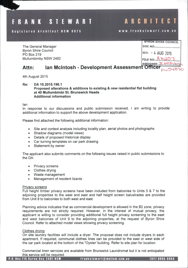
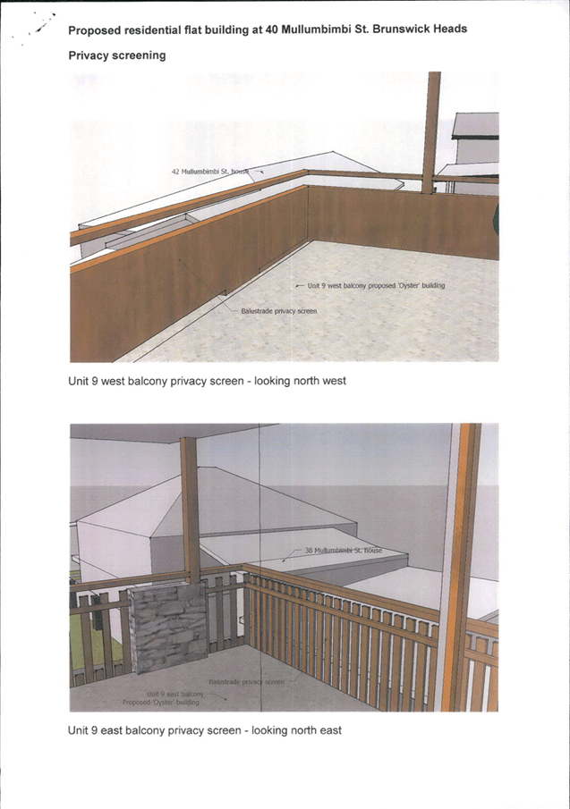
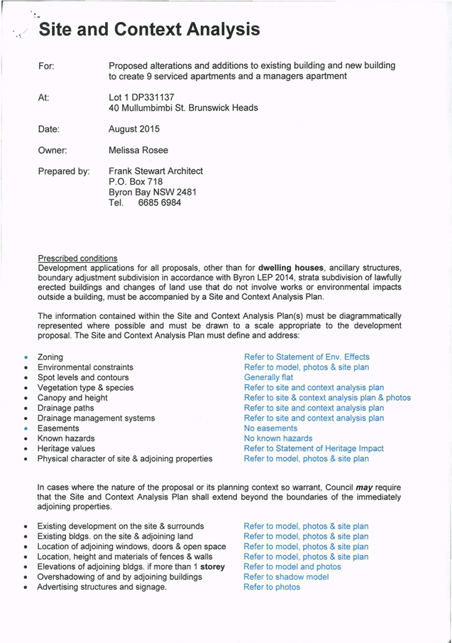
Staff Reports - Sustainable Environment and Economy 13.11 - Attachment 3
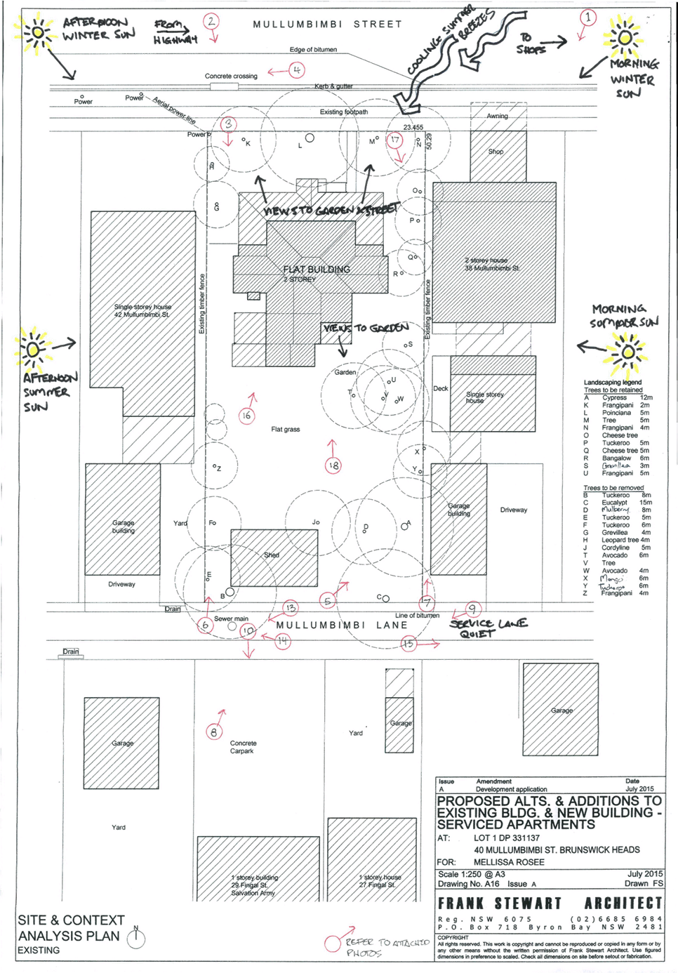
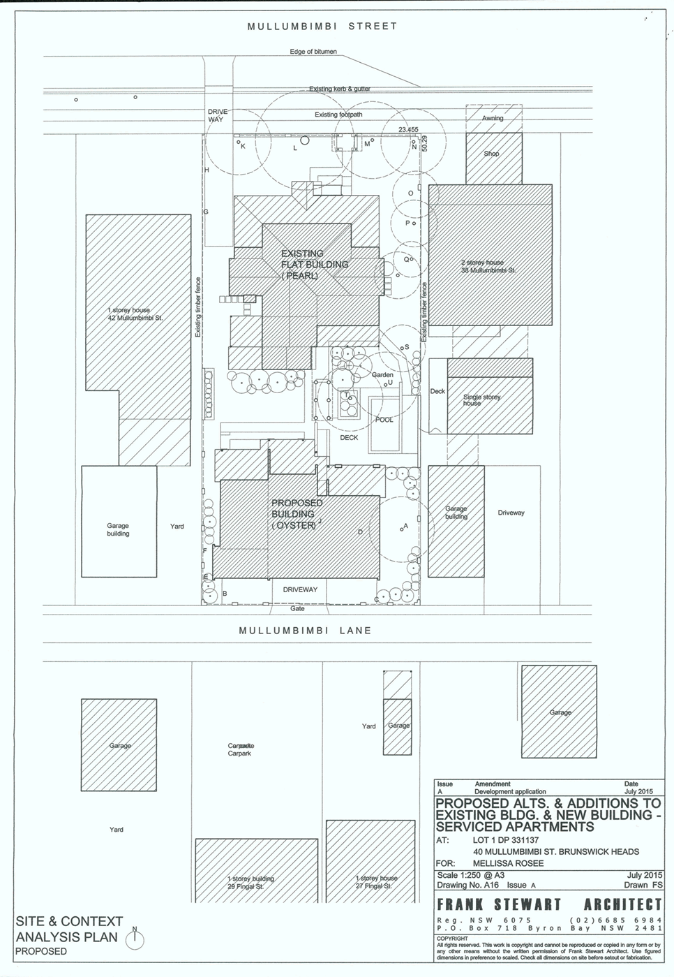
Staff Reports - Sustainable Environment and Economy 13.11 - Attachment 3
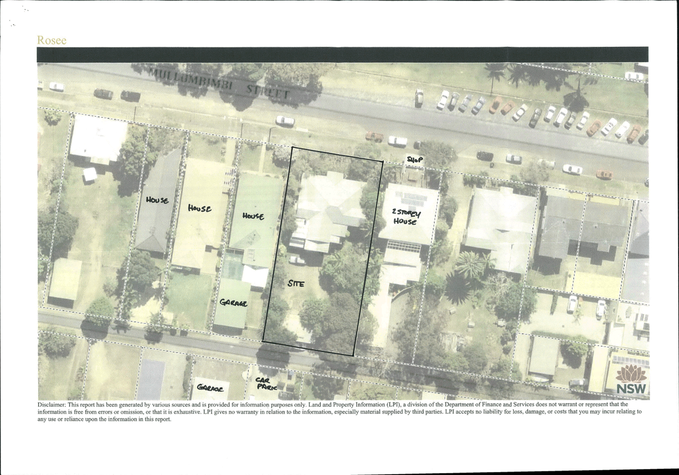
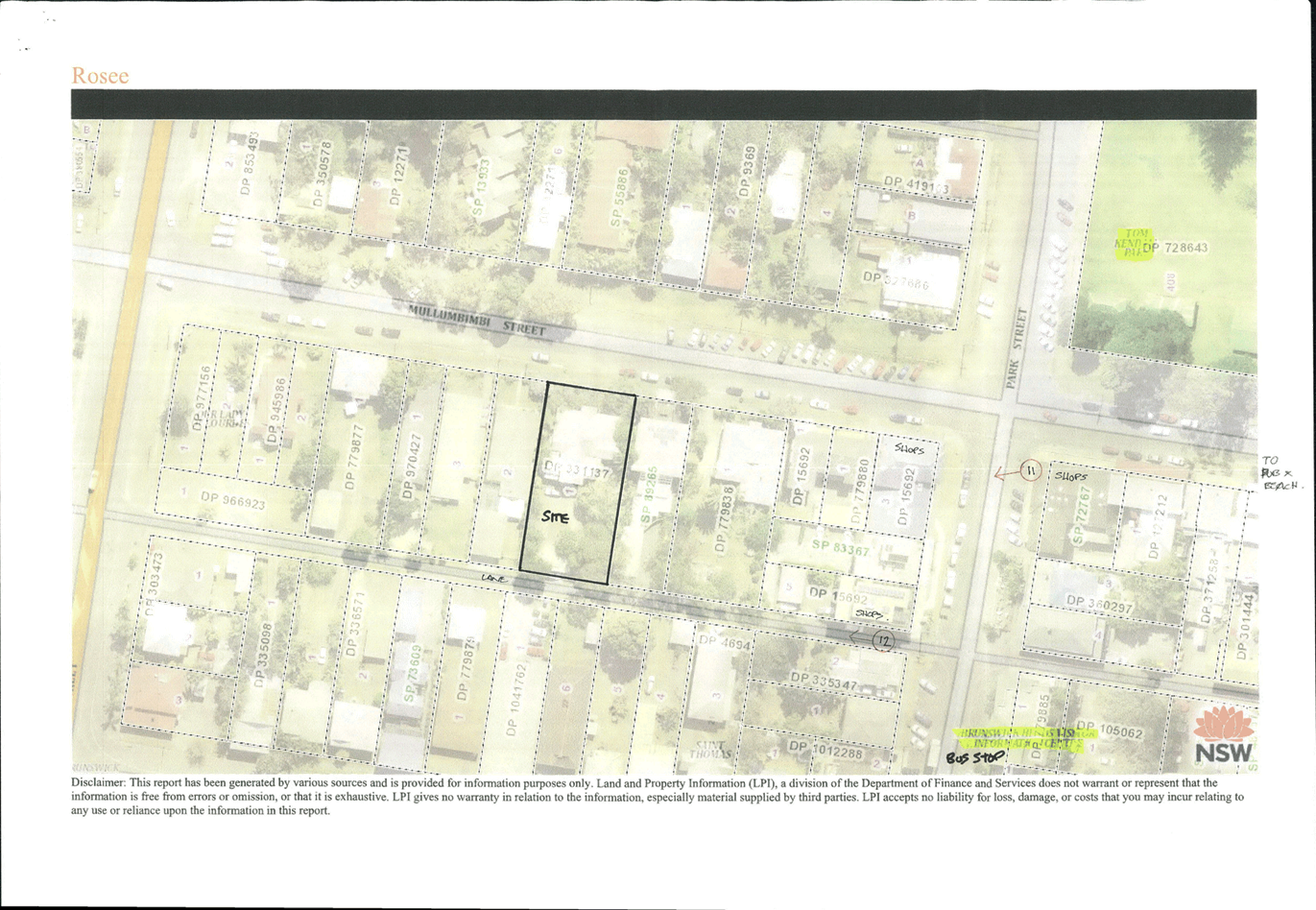
Staff Reports - Sustainable Environment and Economy 13.11 - Attachment 3
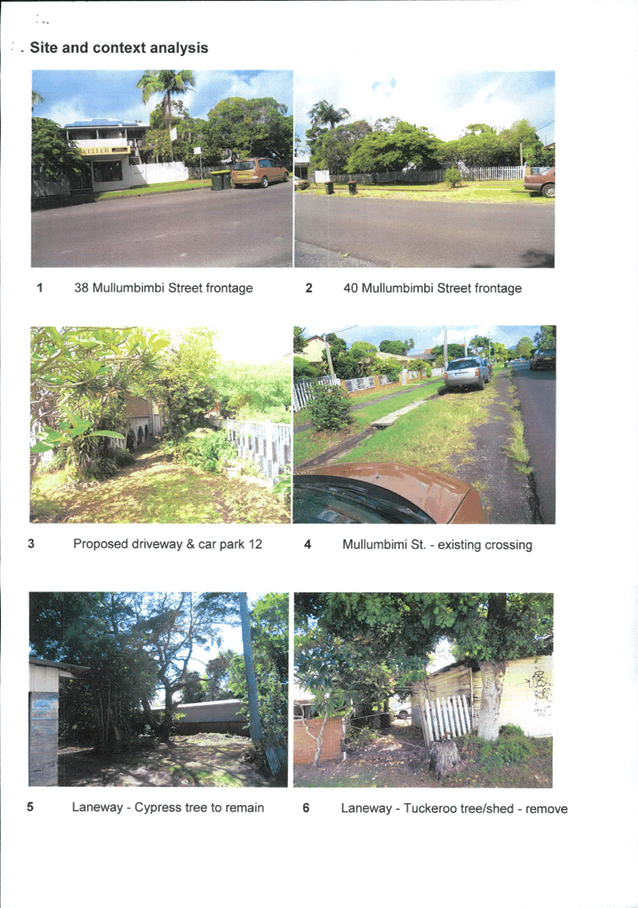
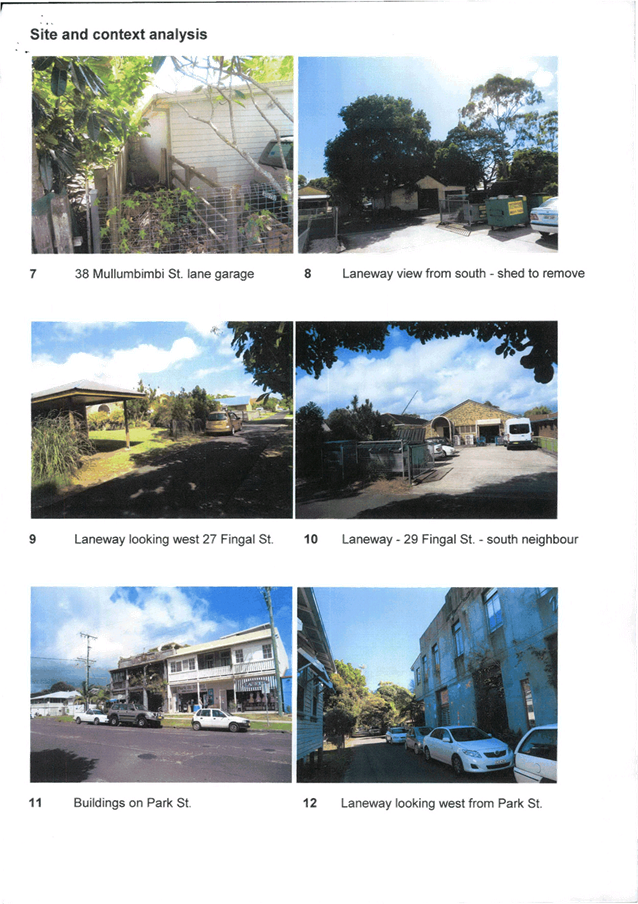
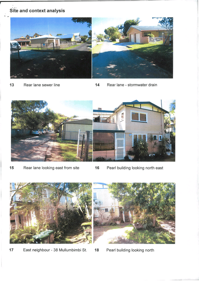
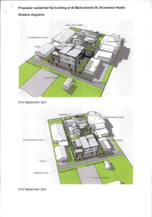
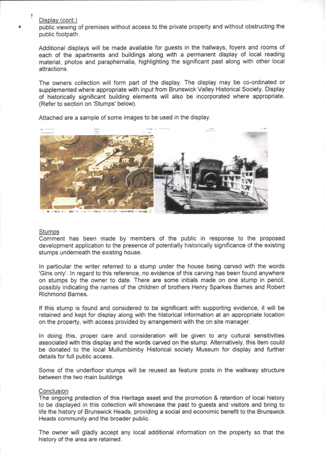
Staff Reports - Sustainable Environment and Economy 13.11 - Attachment 3
Staff Reports - Sustainable Environment and Economy 13.11 - Attachment 3
Staff Reports - Sustainable Environment and Economy 13.11 - Attachment 4
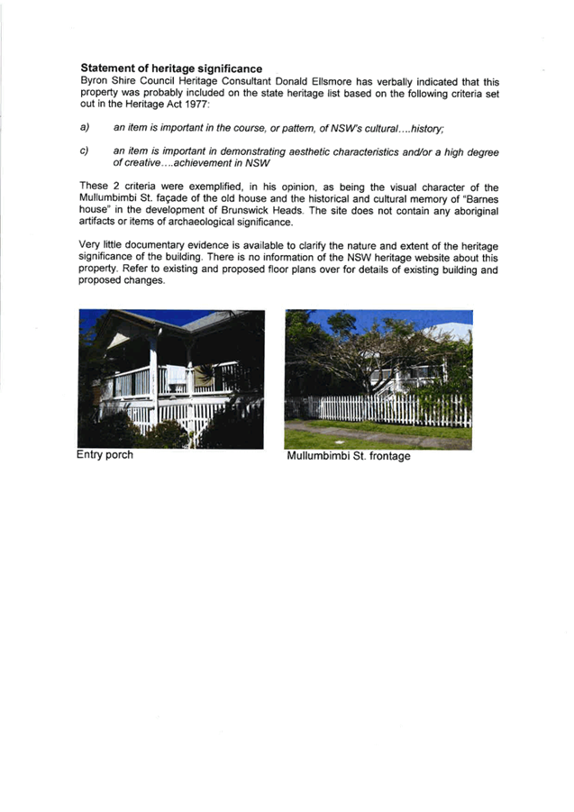
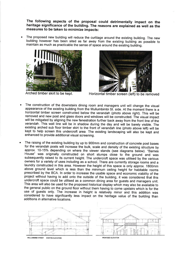
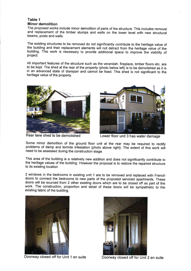
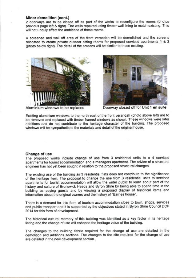
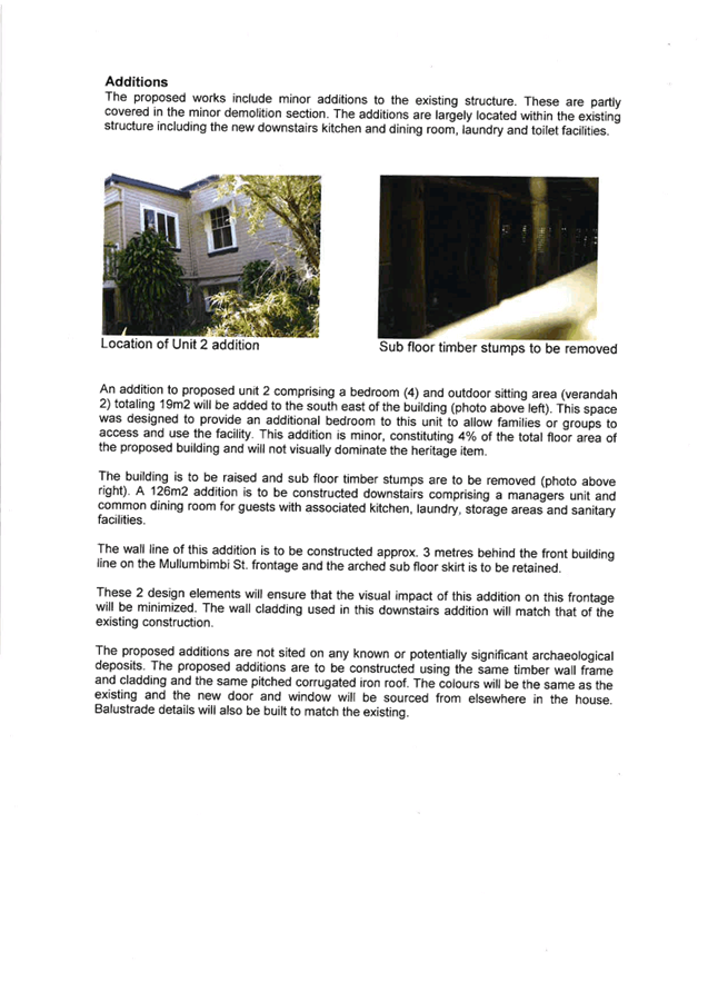
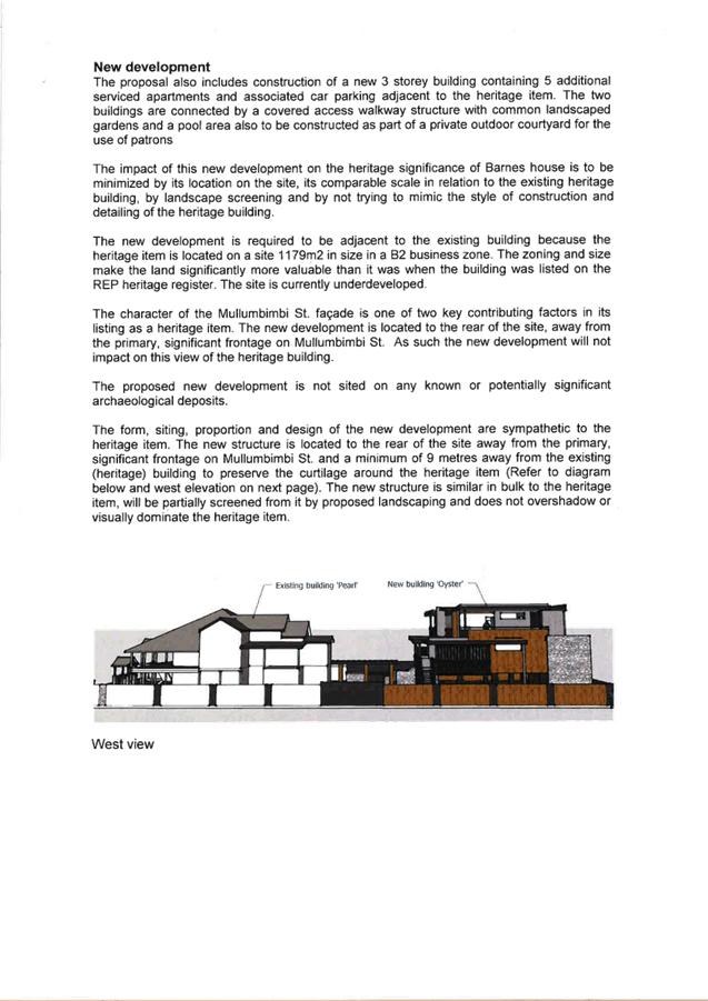
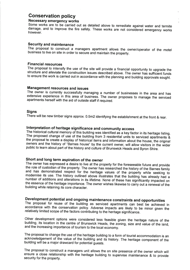
Staff Reports - Sustainable Environment and Economy 13.13 - Attachment 1
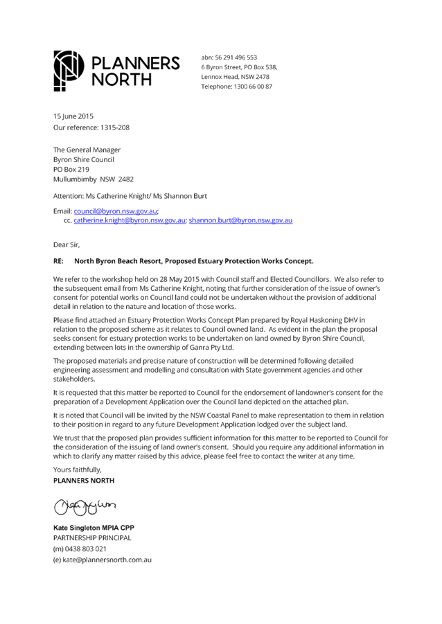
Staff Reports - Sustainable Environment and Economy 13.13 - Attachment 1
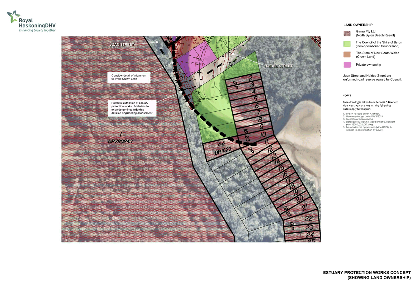
Staff Reports - Sustainable Environment and Economy 13.13 - Attachment 2
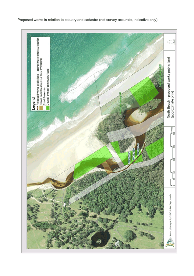
Staff Reports - Sustainable Environment and Economy 13.14 - Attachment 1

Planning
Proposal
General
Policy and Housekeeping Changes In Byron Shire
(Byron Shire Council)
Authority ref: 26.2015.3.1
V1
Gateway Version (#E2015/54624)
24 August 2015
Part
1 Introduction. 2
Purpose. 2
Property details and
existing zones. 2
Background. 2
Part
2 Explanation of provisions. 4
Part
3 Justification. 7
Section A Need for the planning proposal 7
1 Is the planning proposal a result of any strategic
study or report?. 7
2 Is the planning proposal the best means of achieving
the objectives or intended outcomes, or is there a better way?. 7
3 Is there a net community benefit?. 7
Section B Relationship to strategic planning framework. 7
1 Is the planning proposal consistent with the
objectives and actions contained within the applicable regional or sub-regional
strategy (in this case the Far North Coast Regional Strategy)?. 7
2 Is the planning proposal consistent with the local
Council’s Community Strategic Plan, or other local strategic plan?. 7
3 Is the planning proposal consistent with the
applicable State Environmental Planning Policies (SEPPs)?. 8
4 Is the planning proposal consistent with applicable
Ministerial Directions (s117 Directions)?. 9
Section C Environmental, social and economic impact 28
1 Is there any likelihood that critical habitat or
threatened species, populations or ecological communities, or their habitats
will be adversely affected as a result of the proposal?. 28
2 Are there any other likely environmental effects as a
result of the planning proposal and how are they proposed to be managed?. 28
3 How has the planning proposal adequately addressed any
social and economic effects?. 28
Section D State and Commonwealth interests. 28
1 Is there adequate public infrastructure for the
planning proposal?. 28
2 What are the views of State and Commonwealth public
authorities consulted in accordance with the gateway determination?. 28
Part
4 Mapping. 29
Part
5 Community consultation. 29
Part
6 Project timeline. 29
Summary
and conclusions. 30
Appendix
1: Maps........................................................................................... 31
Part 1 Introduction
Purpose
The purpose of this planning
proposal is to amend various parts of Byron LEP 2014 as part of an annual
review of the planning instrument. The amendments are unrelated.
Some are general and some site specific. Some have come from Council
resolutions and some have come from staff observations, consultants or
landowners.
Property details and existing zones
This planning proposal involves
minor amendments to the land use table that will affect all land within zones
R2 Low Density Residential and R5 Large Lot Residential, RU1 Primary
Production, IN1 General Industrial, IN2 Light Industrial, B1 Neighbourhood
Centre, B2 Local Centre, B4 Mixed Use, B7 Business Park, W1 Natural Waterways,
and W2 Recreational Waterways.
It will create the ability to
undertake a “special purpose subdivision” in all RU1 Primary
Production and RU2 Rural Landscape land.
It will alter the heading to
clause 4.1B to properly reflect the content of the clause and alter a term used
throughout the clause to better reflect its intent.
It will remove R5 Large Lot
Residential from part of Clause 4.1D relating to subdivision of split zone lots
and insert it into other parts of the same clause.
On site specific matters the
planning proposal will:
Permit registered clubs as an
additional use on the Cavanbah Sports Centre site at West Byron (Lot 3 DP
706286).
Alter schedule 5 (Environmental
Heritage) to delete item I173 (Roundhouse site) as the Roundhouse building has
been demolished and the land subdivided for residential purposes.
Permit a dwelling on Lot 1 DP
394451, Jones Road consistent with previous advice to the landowner based on
the history of the site.
Alter the SP1 zone that applies
to Lot 1 DP 1031848, Broken Head to describe the SP1 zone as “private
education facility”. Alter schedule 1 to define “private
education facility” as it applies to the subject land.
Rezone three irregular shaped
lots adjacent to Kulgan Court, Ocean Shores from RU2 Rural Landscape to R2 Low
Density Residential to be consistent with surrounding land use and approved
residential development. Amend the relevant LEP maps for FSR and MLS for
the same lots to make them consistent with the surrounding R2 Low Density
Residential zone.
Amend the Minimum Lot Size map
for a Bangalow urban release area to better align an existing 300m2 MLS
with a recent subdivision approval.
Background
It is important that LEP 2014 be
kept up to date and contains the planning controls desired by Council and the
Byron Shire community. Major changes would normally be dealt with in
stand-alone planning proposals. Minor policy changes and simple amendments
(often unrelated) are clustered together in a single planning proposal such as
this one.
With a diverse group of proposed
changes to Byron LEP 2014 the assessment against State and regional planning
controls can be confusing. Certain controls will be relevant to some of
the proposed changes and not to others, and vice a versa. Proposed
changes to Byron LEP 2014 in this planning proposal will only be discussed in
relation to those controls that are specifically relevant to that particular
change.
Council Owned Land
Some of the land affected by
this planning proposal is owned by Council as follows:
Item ‘Q’ includes
Lot 11 DP1128095 and Lot 606 DP 240398. These are two very narrow lots (approximately
600mm wide and too small for any type of development) that were created at the
rear of private land that backs onto a proposed road corridor at Ocean Shores
near Kulgan Court. The proposed road has been abandoned and sold for private
development and the strips are no longer required. It makes sense that the
narrow strips be included in the R2 Low Density Residential zone the same as
most of the land in the vicinity.
Item ‘M’ applies to
the Cavanbah Sports Centre at Ewingsdale Road, West Byron (Lot 3 DP
706286). This land was acquired by Council partly for a sports facility
and partly for disposal of treated recycled water from the nearby STP. It is
part Community land and part Operational land under the Local Government Act,
1993. It is subject to a plan of management.
Part 2 Explanation
of provisions
The intended
outcomes are to be achieved by an amendment to Byron Shire Council LEP 2014 as
follows:
A. Insert recreation
facility (indoor) in the B1 Neighbourhood Centre land use table as
permissible with consent
B. Insert secondary
dwelling in the R2 Low Density Residential and R5 Large Lot Residential
land use tables as permissible with consent
C. Insert dual
occupancy (detached) in the R5 Large Lot Residential land use table as
permissible with consent
D. Insert agriculture in
the RU1 Primary Production land use table as permissible with consent. Insert aquaculture
as a prohibited use. Delete intensive animal agriculture and intensive
plant agriculture from permissible with consent (they will be covered by agriculture).
E. Insert waste
or resource management facilities as a prohibited use in the B2 Local
Centre, B4 Mixed Use and B7 Business park zones land use tables. Delete
any references to its “child” definitions in these land use tables
wherever they occur.
F. Delete environmental
facilities as a prohibited use in the B4 Mixed Use zone land use
table.
G. Delete biosolids
treatment facilities, sewage treatment plants and water recycling
facilities from the prohibited section of the land use table in the IN1
General Industrial zone.
H. Insert electricity
generating works as a prohibited use in the IN2 Light Industrial zone land
use table.
I. Insert roads
in the W1 Natural Waterways and W2 Recreational Waterways zones land use tables
as permissible with consent.
J. Insert a new
clause in Part 4 Principal Development Standards to enable certain subdivision
(sometimes referred to as a special purpose subdivision) to be approved on land
zoned RU1 and RU2 where the lot will be less than the minimum lot size shown on
the minimum lot size map. The following provision is proposed:
Exceptions to minimum lot sizes for
certain rural subdivisions
(1) The objective of this clause is to enable the
subdivision of land in rural areas to create lots of an appropriate size to
meet the needs of current permissible uses other than for the purpose of
dwelling houses, dual occupancies or secondary dwellings.
(2) This clause applies to the following rural
zones:
(a) Zone RU1 Primary Production,
(b) Zone RU2 Rural Landscape.
(3) Land to which this clause applies may, with
development consent, be subdivided to create a lot of a size that is less than
the minimum size shown on the Lot
Size Map in relation to that land, where the consent authority is
satisfied that the use of the land after the subdivision will be the same use
(other than a dwelling house or a dual occupancy or secondary dwelling)
permitted under the existing development consent for the land.
(4) Development consent must not be granted for
the subdivision of land to which this clause applies unless the consent
authority is satisfied that:
(a) the subdivision will
not adversely affect the use of the surrounding land for agriculture, and
(b) the subdivision is
necessary for the ongoing operation of the permissible use, and
(c) the subdivision will
not increase rural land uses conflict in the locality, and
(d) the subdivision is
appropriate having regard to the natural and physical constraints affecting the
land.
K. Amend the heading to
clause 4.1B “Minimum subdivision lot size for multiple occupancy
or rural landsharing community developments” to better reflect the
content of the clause. The revised heading would be “Minimum subdivision
lot size for multiple occupancy or rural community title
developments”. Amend clause 4.1B to replace “rural
landsharing developments” with “rural community title
development/s” wherever it occurs.
L. Amend clause 4.1D
relating to subdivision of split zone lots and insert it into other parts as
follows:
4.1D Exceptions to
minimum subdivision lot sizes for certain split zones
(1) The objectives of this clause are as follows:
(a) to provide for the subdivision of lots
that are within more than one zone but cannot be subdivided under clause 4.1,
(b) to ensure that the subdivision occurs in a
manner that promotes suitable land use and development.
(2) This clause applies to each lot (an original
lot) that contains:
(a) land in a residential, large lot residential, business or industrial zone,
and
(b) land in Zone RU1 Primary Production, Zone
RU2 Rural Landscape, Zone R5 Large Lot Residential or Zone SP3 Tourist.
(3) Despite clause 4.1, development consent may
be granted to subdivide an original lot to create other lots (the resulting
lots) if:
(a) one of the resulting lots will contain:
(i) land in a residential, large lot residential, business or industrial zone
that has an area that is not less than the minimum size shown on the Lot
Size Map in relation to that land, and
(ii) all of the land in Zone RU1 Primary
Production, Zone RU2 Rural Landscape, Zone R5 Large Lot Residential or
Zone SP3 Tourist that was in the original lot, and
(b) all other resulting lots will contain land
that has an area that is not less than the minimum size shown on the Lot
Size Map in relation to that land.
M. Permit registered
clubs as an additional use on the Cavanbah Sports Centre site at West Byron
(Lot 3 DP 706286) by amending Schedule 1 as follows:
6 Use of
certain lands at Ewingsdale Road, West Byron
(1) This clause applies to land at Ewingsdale Road,
West Byron being part of Lot 3 DP 706286.
(2) Development for the purposes of a registered
club is permitted with development consent.
N. Amend map sheet
‘HER 002’ and Schedule 5 Environmental Heritage by deleting
Heritage item I173 located atLot 530 DP238451, Orana Road, Ocean Shores
(Roundhouse site), as indicated in Map 1 of Appendix 1.
O. Permit a dwelling
house on Lot 1 DP 394451, Jones Road by inserting a new item in schedule1
as follows:
7. Use of certain land at the
Jones Road, Wooyung
(1) Lot 1 DP 394451, Jones Road, Wooyung.
(2) Development for the purposes of a dwelling house is
permitted with development consent.
P. Amend map sheet
‘LZN 003D’ to correct an error with the zone label for Lot 1 DP
1031848 by changing the label from “educational establishment” to
“private education facility”, as indicated in Map 2 of Appendix
1. Insert a new item in schedule 1 as follows:
8. Use of certain land at the
Coast Road, Broken Head
Lot 1 DP 1031848, The Coast Road, Broken Head (The
Linnaeus Estate). A Private Education Facility with ancillary facilities
is permitted on this land. A Private Education Facility is defined as a
facility that provides for professional and personal development through a variety
of academic, cultural, and vocational programmes and includes communal
buildings and facilities and accommodation units.
Q. Amend map sheet
‘LZN 002CA’ to change the land use zone for Lot 12 DP 1128095, Lot
11 DP 1128095 and Lot 606 DP 240398 , Ocean Shores, from RU2 Rural
Landscape to R2 Low Density Residential, as indicated in Map 3 of Appendix
1. Amend map sheet ‘LSZ 002CA’ to change the MLS for the same
lots from 40 ha to 600 m2. Amend map sheet ‘FSR
002CA’ to include a FSR of 0.5 for the above lots.
R. Amend map sheet
‘LSZ 003CB’ to better align location of the existing 300 m2
MLS for certain land at Bangalow (Lot 12 DP1189289) with a recent subdivision
on the same parent lot further to the west, as indicated in Map 4 of Appendix
1.
Part 3 Justification
Section A Need for the
planning proposal
1 Is
the planning proposal a result of any strategic study or report?
No. The amendments contained in this
planning proposal have arisen from Council resolutions as well as issues raised
by Council staff, consultants and community members.
2 Is
the planning proposal the best means of achieving the objectives or intended
outcomes, or is there a better way?
A planning proposal is considered to be the
only way to amend land use tables for various zones, clauses and / or schedules
to LEP 2014.
3 Is
there a net community benefit?
The main focus of the NCB test is to ensure that centres
remain compact and viable and linked to existing and proposed transport
networks (particularly public transport).
Assessment against the Net Community Benefit Assessment
Criteria is not appropriate for a planning proposal that deals with collection
of unrelated issues in a range of zones and circumstances (urban and rural).
Section B Relationship
to strategic planning framework
1 Is
the planning proposal consistent with the objectives and actions contained
within the applicable regional or sub-regional strategy (in this case the Far
North Coast Regional Strategy)?
The planning proposal is not relevant to most of the
objectives and actions of the Far North Coast Regional Strategy (FNCRS) because
they are administrative matters rather than policy. However, some do
raise policy issues and these are largely consistent with the outcomes and
actions contained within the FNCRS. In particular, these actions relate
to Cultural Heritage, Settlement and Housing, and Economic Development and
Employment Growth. The proposal specifically responds to the following
FNCRS actions:
· Councils
…will review the scope and quality of the existing lists of heritage
items and ensure that all places of significance are included in the heritage
schedules of local environmental plans (page 20). (This is relevant to item
N).
· Councils
will plan for a range of housing types of appropriate densities, location and
suitability that are capable of adapting and responding to the ageing
population (page 29). (This is relevant to item B and C).
· Future
rural residential land will only be released in accordance with a Local Growth
Management Strategy. (This is relevant to Item O).
· Local
environmental plans will facilitate employment growth…..and local jobs in
towns, villages and neighbourhood centres (page37). (This is relevant to
items A, J and M).
2 Is
the planning proposal consistent with the local Council’s Community
Strategic Plan, or other local strategic plan?
In 2012 Council adopted a 10 year + Community
Strategic Plan 2022 (CSP). The plan is based on five key themes being Corporate
Management, Economy, Environment, Community Infrastructure, Society and
Culture. The planning proposal is generally consistent with the following
relevant goals:
|
CM4.1 Promote community compliance with Acts, Regulations,
Instruments and Council policies and standards
|
Ensuring Council’s planning controls remain up to
date increases the likelihood of community compliance.
|
|
EC1.2 Support and strengthen local businesses and local
business networks
|
Items A, J and M will all support existing or future
business opportunities in parts of the Shire.
|
|
SC2.1 Provide a range of recreational, cultural and
community opportunities
|
Item M will enable part of the Cavanbah Sports Centre site
to be used for a registered club if the opportunity arises.
|
On this basis the planning proposal is generally consistent
with Council’s CSP.
3 Is
the planning proposal consistent with the applicable State Environmental
Planning Policies (SEPPs)?
State Environmental Planning Policies (SEPP) relevant to
this planning proposal are as follows:
|
State Environmental Planning Policy (SEPP)
|
Compliance of Planning Proposal
|
|
SEPP 71 – Coastal
Protection
|
Most of the changes in this
planning proposal could result in applications in the coastal zone of Byron
Shire. The aim of the SEPP and the matters for consideration in clause 8 of
the SEPP are matters that Council will consider on a site specific basis in
future development applications. In most cases the development will
either be in existing urban areas or relatively small scale. If larger scale
development is proposed it will need to be carefully considered. The planning
proposal is compliant with the aims of the SEPP.
|
|
SEPP 55 – Remediation of
Land
|
Two items are affected
directly by this SEPP. Item Q (Kulgan Court Ocean Shores) is changing from a
rural to an urban zone. In this case the previous landowners undertook a
preliminary analysis pursuant to SEPP 55 and found there was no evidence of
past contamination. It is consistent with the SEPP.
Item O (Jones Road) is a
single 5 hectare rural lot at the end of Jones Road that has currently does
not have a “dwelling entitlement”. The land is not being rezoned,
but the amendment will allow a dwelling to be erected on it. No preliminary
analysis of the land has been supplied to Council and it is not yet possible
for Council to be satisfied that the draft LEP is consistent with Clause 6 of
SEPP 55.
Although the planning proposal
is not consistent with SEPP 55 there is sufficient time while it is on
exhibition to obtain this information and supply it to Council for
consideration before it makes a final decision. Or alternatively, a
contamination assessment can be undertaken at the development application
stage once the dwelling curtilage and accompanying land uses are known.
|
|
SEPP- Rural Lands
|
This SEPP identifies rural planning
principles (clause 7) that must be taken into account when a Council
prepares a planning proposal. These are brought into effect through a
s117 Direction and are dealt with in more detail in the following section.
It also
identifies matters to be considered in determining development applications
for rural subdivision and rural dwellings (clause 10). The
planning proposal is consistent with the rural planning principles and any
application arising from this planning proposal will only be approved if it
is consistent with the matters in clause 10. On balance it is
consistent with the SEPP.
|
4 Is
the planning proposal consistent with applicable Ministerial Directions (s117 Directions)?
Consistency with s117 Directions is
assessed in the following table:
Staff Reports - Sustainable Environment and Economy 13.14 - Attachment 1
Consistency
with S117(2) Directions
|
S117 Direction
|
Application
|
Relevance to this planning proposal
|
Consistency with direction
|
|
1. Employment and Resources
|
|
1.1 Business
and Industrial Zones
|
Applies when a relevant
planning authority prepares a planning proposal that will affect land within
an existing or proposed business or industrial zone (including the alteration
of any existing business or industrial zone boundary).
|
This planning proposal will
not affect the boundaries or extent of business or industrial zones. However
it will make minor alterations to the land use tables for the B1, B2, B4, B7,
IN1 and IN2 zones. This will not reduce the area available for employment and
will not significantly alter any locations for business or industry.
|
Consistent
|
|
1.2 Rural
Zones
|
Applies when a relevant
planning authority prepares a planning proposal that will affect land within
an existing or proposed rural zone (including the alteration of any existing
rural zone boundary).
Under this direction a planning
proposal must:
(a) not rezone land from a
rural zone to a residential, business, industrial, village or tourist zone.
(b) not contain provisions
that will increase the permissible density of land within a rural zone (other
than land within an existing town or village).
|
This planning proposal will
apply to rural zoned land.
Item Q will rezone land at
Ocean Shores from a rural zone (RU2) to a residential zone (R2). It will also
lower the minimum lot size from 40 hectares to 600 square metres.
The inconsistency with the
planning proposal is justified in this case because the subject land is
surrounded by zoned residential land on two sides, is not used for
agriculture or identified as state/regionally significant farmland, is fully
serviced and has no significant environmental values. It is very small
and is subject to an existing approval for seniors development. The
inconsistency is justifiable as a minor matter pursuant to sub clause 5(d) of
the Direction.
Item O will not alter the zone
of the rural land but will permit a dwelling on this small lot at Jones Road
which alters the dwelling density in this location. The inconsistency
is justifiable as a minor matter pursuant to sub clause 5(d) of the
Direction.
|
Justifiably
inconsistent
|
|
1.3 Mining,
Petroleum Production and Extractive Industries
|
Applies when a relevant
planning authority prepares a planning proposal that would have the effect
of:
(a) prohibiting the mining of
coal or other minerals, production of petroleum, or winning or obtaining of
extractive materials, or
(b) restricting the potential
development of resources of coal, other minerals, petroleum or extractive
materials which are of State or regional significance by permitting a land
use that is likely to be incompatible with such development.
|
Nothing in this planning
proposal will prohibit or restrict exploration or mining.
|
N/A
|
|
1.4 Oyster
Aquaculture
|
Applies when a relevant
planning authority prepares any planning proposal that proposes a change in
land use which could result in:
(a) adverse impacts on a
Priority Oyster Aquaculture Area or a “current oyster aquaculture lease
in the national parks estate”, or
(b) incompatible use of land
between oyster aquaculture in a Priority Oyster Aquaculture Area or a
“current oyster aquaculture lease in the national parks estate”
and other land uses.
|
Priority
Oyster Aquaculture Areas (POAA) exist in the Brunswick River however most
land in the vicinity of the POAA is already zoned for environmental
protection or within the National Parks estate.
There
is minimal likelihood the planning proposal will have adverse impacts on POAA
as the matters in it are either minor or will be subject to an environmental
assessment on a case by case basis through the development application
process.
|
Consistent.
|
|
1.5 Rural Lands
|
Applies when:
(a) a relevant planning
authority prepares a planning proposal that will affect land within an
existing or proposed rural or environment protection zone (including the
alteration of any existing rural or environment protection zone boundary), or
(b) a relevant planning
authority prepares a planning proposal that changes the existing minimum lot
size on land within a rural or environment protection zone.
A planning proposal to which clauses (a) and (b)
apply must be consistent with the Rural Planning Principles listed in State
Environmental Planning Policy (Rural Lands) 2008.
A planning proposal to which clause (b) applies must
be consistent with the Rural Subdivision Principles listed in State
Environmental Planning Policy (Rural Lands) 2008.
|
This planning proposal will
affect land zoned RU1 and RU2. It will also alter the minimum lot size
on some rural land.
It is consistent with the
Rural Planning Principles listed in State Environmental Planning Policy
(Rural Lands) 2008 as follows:
(a) the
promotion and protection of opportunities for current and potential
productive and sustainable economic activities in rural areas – the
proposed amendment does not undermine or create conflict with agriculture or
other rural land uses. The land at Ocean Shores (Item Q) already has an
approval for seniors housing and is in a fully serviced urban area. The land
at Jones Road (Item O) borders onto Billinudgel Nature Reserve, other small
rural residential lots and is near to a major music festival site (North
Byron Parklands). Any development application for a dwelling will need to
address these neighbouring land uses.
The opportunity to create
rural lots for “special purposes” will be sparingly used, with
the ability to create a lot less than the prevailing MLS being
available only for existing approved uses (other a dwelling, dual occupancy
or secondary dwelling).
(b) recognition
of the importance of rural lands and agriculture and the changing nature of
agriculture and of trends, demands and issues in agriculture in the area,
region or State – the future use of land resulting from this
planning proposal will not have an impact on high value agricultural land.
(c) recognition
of the significance of rural land uses to the State and rural communities,
including the social and economic benefits of rural land use and development
– Byron Shire has a Sustainable Agriculture Strategy that recognises
the importance of agriculture in the Shire along with the benefits of
protecting rural land uses. This planning proposal is generally consistent
with the Strategy’s vision, goals and guiding principles.
(d) in planning for rural
lands, to balance the social, economic and environmental interests of the
community – both Item O and Item Q are unusual circumstances and
will not change the nature of rural land use generally. A dwelling at
Jones Road (Item O) may increase the agricultural output of this small lot.
The proposed changes are consistent with the socio-economic interests of the
Byron Shire community.
(e) the
identification and protection of natural resources, having regard to
maintaining biodiversity, the protection of native vegetation, the importance
of water resources and avoiding constrained land –
Item Q is a small area with no
significant environmental values and/or i other development constraints. It
has been subject to a preliminary contamination analysis which showed it is
not likely to be contaminated.
Item O is not as well
documented. It is partly cleared and partly vegetated with coastal swamp
forest, rainforest and wet sclerophyll forest. It is listed as
containing a registered Aboriginal site. It is unknown at this stage
whether any past landuses may have left it contaminated.
(f) the
provision of opportunities for rural lifestyle, settlement and housing that
contribute to the social and economic welfare of rural communities
– a dwelling at Jones Road (Item O) will make a minor contribution to
rural lifestyle opportunities in Byron Shire.
(g) the
consideration of impacts on services and infrastructure and appropriate
location when providing for rural housing –services and
infrastructure will be addressed in any future dwelling application at Jones
Road (item O).
(h) ensuring
consistency with any applicable regional strategy of the Department of
Planning or any applicable local strategy endorsed by the Director-General
–this planning proposal is largely consistent with the outcomes and
actions contained within the Far North Coast Regional Strategy . Item O
(Jones Road) is generally consistent with Byron Rural Settlement Strategy
(section 6.5 – Dwelling Entitlements). The lot was created before 1
January 1998 and appears to be large enough to accommodate a dwelling site on
areas not affected by significant vegetation. However, more information is
required on site ecology, past land use and bushfire hazard.
|
Consistent.
|
|
2 Environment
and Heritage
|
|
2.1 Environment Protection Zones
|
A planning
proposal must include provisions that facilitate the protection and
conservation of environmentally sensitive areas.
A planning
proposal that applies to land within an environment protection zone or land
otherwise identified for environment protection purposes in a LEP must not
reduce the environmental protection standards that apply to the land
(including by modifying development standards that apply to the land).
This requirement does not apply to a change to a development standard for
minimum lot size for a dwelling in accordance with clause (5) of
Direction 1.5 “Rural Lands”.
|
The
planning proposal does not alter or remove any environment protection
zone. No environmental standards will be reduced by the proposed LEP
changes.
|
Consistent
|
|
2.2 Coastal
Protection
|
Direction
applies when a relevant planning authority prepares a planning proposal that
applies to land in the coastal zone.
A planning
proposal must include provisions that give effect to and are consistent with:
(a) the
NSW Coastal Policy: A Sustainable Future for the New South Wales Coast 1997,
(b) the
Coastal Design Guidelines 2003,
(c) the
manual relating to the management of the coastline for the purposes of
section 733 of the Local Government Act 1993 (the NSW Coastline
Management Manual 1990).
|
Some land
affected by this planning proposal is located within the coastal zone, which
affects the eastern half of Byron Shire.
It is
consistent with the NSW Coastal Policy as there is minimal likelihood of
physical impact on the environment and where a development is not minor, it
will require a development application. Council will consider (where
applicable) the management of the coastline and response to emergencies as
part of any application it receives for land affected by coastal erosion in
Byron Shire.
|
Consistent.
|
|
2.3 Heritage
Conservation
|
A planning
proposal must contain provisions that facilitate the conservation of:
(a) Items,
places, buildings, works, relics, moveable objects or precincts of
environmental heritage significance to an area, in relation to the
historical, scientific, cultural, social, archaeological, architectural,
natural or aesthetic value of the item, area, object or place, identified in
a study of the environmental heritage of the area,
(b) Aboriginal
objects or Aboriginal places that are protected under the National Parks
and Wildlife Act 1974, and
(c) Aboriginal
areas, Aboriginal objects, Aboriginal places or landscapes identified by an
Aboriginal heritage survey prepared by or on behalf of an Aboriginal Land
Council, Aboriginal body or public authority and provided to the relevant
planning authority, which identifies the area, object, place or landscape as
being of heritage significance to Aboriginal culture and people.
|
Byron LEP
2014 currently contains provisions that are consistent with this Direction.
Removing
the Roundhouse from Schedule 5 (Item N) will not contradict this S.117
Direction as the building no longer exists and the land on which it once
stood has been subdivided for residential development.
Before the planning proposal is
finalised it is important that an Aboriginal heritage ‘due
diligence’ assessment is undertaken by a qualified person in relation
to Item O (Jones Road).
|
Consistent
|
|
2.4 Recreation Vehicle Areas
|
A planning proposal must not enable land to be developed for the
purpose of a recreation vehicle area (within the meaning of the Recreation
Vehicles Act 1983):
(a) where the land is within an environment protection zone,
(b) where the land comprises a beach or a dune adjacent to or
adjoining a beach,
(c) where the land is not within an area or zone referred to in
paragraphs (4)(a) or (4)(b) unless the relevant planning authority has
taken into consideration:
(i) the provisions of the guidelines entitled Guidelines
for Selection, Establishment and Maintenance of Recreation Vehicle Areas,
Soil Conservation Service of New South Wales, September 1985, and
(ii) the provisions of the guidelines entitled Recreation
Vehicles Act, 1983, Guidelines for Selection, Design, and Operation of
Recreation Vehicle Areas, State Pollution Control Commission, September 1985.
|
The proposal does not enable land to be developed for the purpose of a
recreation vehicle area.
|
N/A
|
|
3. Housing, Infrastructure and Urban
Development
|
|
3.1 Residential
Zones
|
This direction applies when a
relevant planning authority prepares a planning proposal that will affect
land within:
(a) an
existing or proposed residential zone (including the alteration of any
existing residential zone boundary),
(b) any
other zone in which significant residential development is permitted or
proposed to be permitted.
A planning proposal must include
provisions that encourage the provision of housing that will:
(a) broaden
the choice of building types and locations available in the housing market,
and
(b) make
more efficient use of existing infrastructure and services, and
(c) reduce
the consumption of land for housing and associated urban development on the
urban fringe, and
(d) be
of good design.
A planning proposal must, in
relation to land to which this direction applies:
(a) contain
a requirement that residential development is not permitted until land is
adequately serviced (or arrangements satisfactory to the council, or other
appropriate authority, have been made to service it), and
(b) not
contain provisions which will reduce the permissible residential density of
land.
|
The
planning proposal will affect residential zoned land.
The purpose
of the LEP amendment (partly) is to permit secondary dwellings in the R2 and
R5 zone (Item B) consistent with the Affordable Housing SEPP. And to permit
detached dual occupancy development in the R5 zone (Item C). These
changes will broaden the choice of housing types in these zones and make more
efficient use of infrastructure.
No
reduction of residential density is proposed. Moving the existing 300 m2
MLS on land at Bangalow will align it with a recent subdivision
approval. This will facilitate smaller lots in this location which will make
better use of infrastructure and maintain the density of the release area.
Item Q
(Ocean Shores) will also facilitate better use of serviced land in an urban
area.
Clause 6.6
of Byron LEP 2014 already requires adequate essential services to be
available to the land at the time at which consent is granted.
|
Consistent
|
|
3.2 Caravan
Parks and Manufactured Home Estates
|
Applies
when a relevant planning authority prepares a planning proposal.
In
identifying suitable zones, locations and provisions for caravan parks in a
planning proposal, the relevant planning authority must:
(a) retain provisions
that permit development for the purposes of a caravan park to be carried out
on land, and
(b) retain
the zonings of existing caravan parks, or in the case of a new principal LEP,
zone the land in accordance with an appropriate zone under the Standard
Instrument (Local Environmental Plans) Order 2006 that would facilitate the
retention of the existing caravan park.
In
identifying suitable zones, locations and provisions for manufactured home
estates (MHEs) in a planning proposal, the relevant planning authority must:
(a) take
into account the categories of land set out in Schedule 2 of
SEPP 36 as to where MHEs should not be located,
(b) take into account the
principles listed in clause 9 of SEPP 36 (which relevant planning
authorities are required to consider when assessing and determining the
development and subdivision proposals), and
(c) include provisions that
the subdivision of MHEs by long term lease of up to 20 years or under
the Community Land Development Act 1989 be permissible with consent.
|
This
proposal does not seek development for the purposes of a caravan park or
manufactured homes estate, nor does it impact upon any land that does permit
development for the purposes of a caravan park or manufactured homes estate.
|
N/A
|
|
3.3 Home
Occupations
|
Planning proposals must permit
home occupations to be carried out in dwelling-houses without the need for
development consent.
|
This proposal does not alter
home occupation provisions in Byron LEP 2014.
|
N/A
|
|
3.4 Integrating
Land Use and Transport
|
Applies when a relevant
planning authority prepares a planning proposal that will create, alter or
remove a zone or a provision relating to urban land, including land zoned for
residential, business, industrial, village or tourist purposes.
A planning proposal must
locate zones for urban purposes and include provisions that give effect to
and are consistent with the aims, objectives and principles of:
(a) Improving Transport
Choice – Guidelines for planning and development (DUAP 2001), and
(b) The Right Place for
Business and Services – Planning Policy (DUAP 2001).
|
The planning
proposal will alter the permitted uses on land zoned for residential,
business and industrial purposes. It will also alter zone boundaries however
it will not result in any significant new rezoned areas. There is unlikely to
be any impact on public transport as a result of this planning proposal.
|
Consistent.
|
|
3.5 Development
Near Licensed Aerodrome
|
Applies when a relevant
planning authority prepares a planning proposal that will create, alter or
remove a zone or a provision relating to land in the vicinity of a licensed
aerodrome.
The main requirements of the
Direction are that Council considers the Obstacle Limitation Surface (OLS) as
defined by that Department of the Commonwealth for residential purposes, and
does not increase residential densities in areas where the ANEF, as from time
to time advised by that Department of the Commonwealth, exceeds 25.
|
The planning
proposal will alter provisions that may affect rural zoned land located in
the vicinity of the Tyagarah aerodrome.
Any
application in the vicinity of the aerodrome would need to address the
relevantissues that relate to this location.
|
Consistent
|
|
4. Hazard and Risk
|
|
4.1 Acid
Sulfate Soils
|
Applies when a relevant
planning authority prepares a planning proposal that will apply to land
having a probability of containing acid sulfate soils as shown on the Acid
Sulfate Soils Planning Maps.
A council shall not prepare a
draft LEP that proposes an intensification of land uses on land identified as
having a probability of containing acid sulfate soils on the Acid Sulfate
Soils Planning Maps unless the council has considered an acid sulfate soils
study assessing the appropriateness of the change of land use given the
presence of acid sulfate soils.
|
Some land to which this
planning proposal will apply may be affected by acid sulfate soils. The
planning proposal will not necessarily lead to intensification of land uses
proposed on land identified on the Acid Sulfate Soils Planning Maps.
Where applicable, Council will consider any acid sulfate soil matters in
accordance with cl. 6.1 of Byron LEP 2014.
|
Consistent.
|
|
4.2 Mine
Subsidence and Unstable Land
|
Applies when a relevant
planning authority prepares a planning proposal that permits development on
land that:
(a) is within a mine subsidence
district, or
(b) has been identified as
unstable in a study, strategy or other assessment undertaken:
(i) by or on behalf of
the relevant planning authority, or
(ii) by or on behalf of a
public authority and provided to the relevant planning authority.
|
This proposal does not impact
on any mine subsidence area.
|
N/A
|
|
4.3 Flood
Prone Land
|
Applies when a relevant
planning authority prepares a planning proposal that creates, removes or
alters a zone or a provision that affects flood prone land.
A planning proposal must
include provisions that give effect to and are consistent with the NSW Flood
Prone Land Policy and the principles of the Floodplain Development Manual
2005 (including the Guideline on Development Controls on Low Flood
Risk Areas).
A planning proposal must not
rezone land within the flood planning areas from Special Use, Special
Purpose, Recreation, Rural or Environment Protection Zones to a Residential,
Business, Industrial, Special Use or Special Purpose Zone.
A planning proposal must not
contain provisions that apply to the flood planning areas which:
(a) permit development in
floodway areas,
(b) permit development that
will result in significant flood impacts to other properties,
(c) permit a significant
increase in the development of that land,
(d) are likely to result in a
substantially increased requirement for government spending on flood
mitigation measures, infrastructure or services, or
(e) permit development to be
carried out without development consent except for the purposes of
agriculture (not including dams, drainage canals, levees, buildings or
structures in floodways or high hazard areas), roads or exempt development.
A planning proposal must not
impose flood related development controls above the residential flood planning
level for residential development on land, unless a relevant planning
authority provides adequate justification for those controls to the
satisfaction of the Director-General (or an officer of the Department
nominated by the Director-General).
For the purposes of a planning
proposal, a relevant planning authority must not determine a flood planning
level that is inconsistent with the Floodplain Development Manual 2005
(including the Guideline on Development Controls on Low Flood Risk Areas)
unless a relevant planning authority provides adequate justification for the
proposed departure from that Manual to the satisfaction of the
Director-General (or an officer of the Department nominated by the
Director-General).
|
The planning proposal will
affect some land that is known to be flood prone. Byron LEP 2014 already
contains a flood planning clause (Cl 6.3) and a floodplain risk management
clause (Cl 6.4) that would apply to all development proposed on flood prone
land.
Within the residential,
business and tourist zones, the planning proposal will not permit significant
development on flood prone land beyond that which is already permitted.
There is unlikely to be a net
increase in flooding impacts or demand for flood rescue services as a result
of this planning proposal.
|
Consistent.
|
|
4.4 Planning for Bushfire
Protection
|
Applies when a relevant
planning authority prepares a planning proposal that will affect, or is in
proximity to land mapped as bushfire prone land.
In the preparation of a
planning proposal the relevant planning authority must consult with the
Commissioner of the NSW Rural Fire Service following receipt of a gateway
determination under section 56 of the Act, and prior to undertaking
community consultation in satisfaction of section 57 of the Act, and
take into account any comments so made.
A planning proposal must:
(a) have regard to Planning
for Bushfire Protection 2006,
(b) introduce controls that
avoid placing inappropriate developments in hazardous areas, and
(c) ensure that bushfire hazard
reduction is not prohibited within the APZ.
A planning proposal must, where development is
proposed, comply with the following provisions, as appropriate:
(a) provide an Asset Protection
Zone (APZ) incorporating at a minimum:
(i) an Inner Protection
Area bounded by a perimeter road or reserve which circumscribes the hazard
side of the land intended for development and has a building line consistent
with the incorporation of an APZ, within the property, and
(ii) an Outer Protection Area
managed for hazard reduction and located on the bushland side of the
perimeter road,
(b) for infill development
(that is development within an already subdivided area), where an appropriate
APZ cannot be achieved, provide for an appropriate performance standard, in
consultation with the NSW Rural Fire Service. If the provisions of the
planning proposal permit Special Fire Protection Purposes (as defined under
section 100B of the Rural Fires Act 1997), the APZ provisions
must be complied with,
(c) contain provisions for
two-way access roads which link to perimeter roads and/or to fire trail
networks,
(d) contain provisions for
adequate water supply for firefighting purposes,
(e) minimise the perimeter of
the area of land interfacing the hazard which may be developed,
(f) introduce controls
on the placement of combustible materials in the Inner Protection Area.
|
Some parts of the land to
which this planning proposal applies in Byron Shire may be identified as
bushfire prone land. This will be a consideration in any application
for development.
Consultation with the
Commissioner of the NSW Rural Fire Service following receipt of a gateway
determination under section 56 of the Act will take place. It is
assumed that any concerns that RFS may still have can be addressed as the
planning proposal proceeds.
Additional information on
bushfire hazard is required for Item O (Jones Road).
|
Consistent.
|
|
5. Regional Planning
|
|
5.1 Implementation
of Regional Strategies
|
Planning proposals must be
consistent with a regional strategy released by the Minister for Planning.
|
The planning proposal is
largely consistent with the outcomes and actions contained within the Far
North Coast Regional Strategy (FNCRS). In particular, the actions that
relate to Cultural Heritage, Settlement and Housing, and Economic Development
and Employment Growth. The proposal specifically responds to the
following actions:
Councils …will review
the scope and quality of the existing lists of heritage items and ensure that
all places of significance are included in the heritage schedules of local
environmental plans (page 20). (This is relevant to item N).
Future rural residential
land will only be released in accordance with a Local Growth Management
Strategy. (This is relevant to Item O).
Councils will plan for a
range of housing types of appropriate densities, location and suitability
that are capable of adapting and responding to the ageing population (page
29). (This is relevant to item B and C).
Local environmental plans
will facilitate employment growth…..and local jobs in towns, villages
and neighbourhood centres (page37). (This is relevant to items A, J and M).
|
Consistent.
|
|
5.2 Sydney
Drinking Water Catchments
|
Applies when a relevant
planning authority prepares a planning proposal that applies to the
hydrological catchment.
|
The proposal is not within
this catchment.
|
N/A
|
|
5.3 Farmland
of State and Regional Significance on the NSW Far North Coast
|
The planning proposal must not
rezone land mapped as State or regionally significant farmland under the
Northern Rivers Farmland Protection Project for an urban use.
|
Neither Item Q nor Item O is
mapped as State or regionally significant farmland under the Northern Rivers
Farmland Protection Project.
|
Consistent
|
|
5.4 Commercial
and Retail Development along the Pacific Highway, North Coast
|
A planning proposal that
applies to land located on “within town” segments of the Pacific
Highway must provide that:
(a) new commercial or retail
development must be concentrated within distinct centres rather than spread
along the highway,
(b) development with frontage
to the Pacific Highway must consider the impact the development has on the
safety and efficiency of the highway.
(c) For the purposes of this
paragraph, “within town” means areas which, prior to the draft
local environmental plan, have an urban zone (eg “village”,
“residential”, “tourist”, “commercial”, “industrial”,
etc) and where the Pacific Highway speed limit is less than 80 km/hour.
A planning proposal that
applies to land located on “out-of-town” segments of the Pacific
Highway must provide that:
(a) new commercial or retail
development must not be established near the Pacific Highway if this proximity
would be inconsistent with the objectives of this Direction,
(b) development with frontage
to the Pacific Highway must consider the impact the development has on the
safety and efficiency of the highway.
(c) For the purposes of this
paragraph, “out-of-town” means areas which, prior to the draft
local environmental plan, do not have an urban zone (eg
“village”, “residential”, “tourist”,
“commercial”, “industrial”, etc) or are in areas
where the Pacific Highway speed limit is 80 km/hour or greater.
|
This planning proposal does
not affect commercial or retail uses in proximity to the Pacific Highway.
|
N/A
|
|
6. Local Plan Making
|
|
6.1 Approval
and Referral Requirements
|
A planning proposal must:
(a) minimise the inclusion of
provisions that require the concurrence, consultation or referral of
development applications to a Minister or public authority, and
(b) not contain provisions
requiring concurrence, consultation or referral of a Minister or public
authority unless the relevant planning authority has obtained the approval
of:
(i) the appropriate
Minister or public authority, and
(ii) the Director-General of
the Department of Planning and Environment (or an officer of the Department
nominated by the Director-General),
prior to undertaking community consultation in
satisfaction of section 57 of the Act, and
(c) not identify development
as designated development unless the relevant planning authority:
(i) can satisfy the
Director-General of the Department of Planning and Environment (or an officer
of the Department nominated by the Director-General) that the class of
development is likely to have a significant impact on the environment, and
(ii) has obtained the approval
of the Director-General of the Department of Planning and Environment (or an
officer of the Department nominated by the Director-General) prior to
undertaking community consultation in satisfaction of section 57 of the
Act.
|
The planning proposal will not
include provisions that require the concurrence, consultation or referral of
development applications to a Minister or public authority. It does not
identify development as designated development.
|
N/A
|
|
6.2 Reserving
Land for Public Purposes
|
A planning proposal must not
create, alter or reduce existing zonings or reservations of land for public
purposes without the approval of the relevant public authority and the
Director-General of the Department of Planning and Environment (or an officer
of the Department nominated by the Director-General).
|
The planning proposal does not
create, alter or reduce the area of land reserved for a public purpose.
Item M adds a new use to land at West Byron that is already owned by
Council. The zoning of this land will not change.
|
N/A
|
|
6.3 Site
Specific Provisions
|
Applies when a relevant
planning authority prepares a planning proposal that will allow a particular
development to be carried out.
A planning proposal that will
amend another environmental planning instrument in order to allow a
particular development proposal to be carried out must either:
(a) allow that land use to be
carried out in the zone the land is situated on, or
(b) rezone the site to an
existing zone already applying in the environmental planning instrument that
allows that land use without imposing any development standards or
requirements in addition to those already contained in that zone, or
(c) allow that land use on the
relevant land without imposing any development standards or requirements in
addition to those already contained in the principal environmental planning
instrument being amended.
A planning proposal must not
contain or refer to drawings that show details of the development proposal.
|
The planning proposal does
seek to allow a particular development to be carried out. In this regard,
Item M would allow a registered club on Council land at West Byron. Item O
will allow a dwelling to be erected on land at Jones Road, Wooyung.
The planning proposal does not
impose any development standards or requirements in addition to those already
contained in the principal environmental planning instrument.
The planning proposal does not
contain schematic drawings.
|
Consistent.
|
Staff Reports - Sustainable Environment and Economy 13.14 - Attachment 1
Section C Environmental,
social and economic impact
1 Is
there any likelihood that critical habitat or threatened species, populations
or ecological communities, or their habitats will be adversely affected as a
result of the proposal?
No. Although Byron Shire is a biodiversity hot spot
with large numbers of threatened species and endangered ecological communities,
this planning proposal does not prevent the proper assessment and management of
these attributes when future development applications are lodged . In many
cases such as in existing urban areas there will be little likelihood of
adverse effects. Where a development application is required then Council can
(if appropriate) require a thorough ecological assessment to accompany any
application consistent with its “Guidelines for Ecological Assessment in
Byron Shire”.
2 Are
there any other likely environmental effects as a result of the planning
proposal and how are they proposed to be managed?
Environmental impacts will be minimal for development in
existing urban zones. Environmental effects in rural zones (such as managing
on-site effluent disposal) will be addressed at the development application
stage.
3 How
has the planning proposal adequately addressed any social and economic effects?
The planning proposal covers a broad range of zones and land
uses, any one of which may result in an impact on Byron society and economy
over time. This will depend on the extent of take up of development or
response to the proposed changes. Council will consider any relevant social and
economic impacts at the development application stage.
Section D State and
Commonwealth interests
1 Is
there adequate public infrastructure for the planning proposal?
In existing urban areas it is likely there will be adequate
water and sewerage services as well as roads, power and communications. In
rural areas the ability to provide infrastructure will be a key consideration
in any development application. Section 94 contributions may be applicable
to some development applications and this money is used to provide public
infrastructure.
2 What
are the views of State and Commonwealth public authorities consulted in
accordance with the gateway determination?
Commonwealth public authorities have not been formally
involved in this particular planning proposal as it is yet to receive Gateway
Approval. At this early stage it appears unlikely that there will be any
issues of interest to Commonwealth authorities.
State government authorities will be consulted during the
public exhibition period.
The following table provides a
summary of the relevant public authorities, which in the opinion of Council,
should be consulted in accordance with the Gateway Approval:
|
Public authority/stakeholder
|
Issue requiring comment
|
|
NSW Rural Fire Service
|
Section 117 of the Environmental Planning and
Assessment Act 1979, Ministerial Direction 4.4 to consult with the
Commissioner of the NSW Rural Fire Service.
|
Part 4 Mapping
The planning proposal will amend
the following maps:
– Amend map
sheet HER 002 by deleting Heritage item I173 located at Lot 530 DP238451, Orana
Road, Ocean Shores (Roundhouse site).
– Amend map
sheet LZN 003D to correct an error with the zone label for Lot 1 DP 1031848 to
change the label from “educational establishment” to “private
education facility”.
– Amend map
sheet LZN 002CA to change the land use zone for Lot 12 DP 1128095, Lot 11 DP
1128095 and Lot 606 DP 240398 , Ocean Shores, from RU2 Rural Landscape to
R2 Low Density Residential.
– Amend map
sheet LSZ 002CA to change the MLS for Lot 12 DP 1128095, Lot 11 DP 1128095 and
Lot 606 DP 240398 , Ocean Shores, from 40 ha to 600 m2.
– Amend map
sheet FSR 002CA to change the FSR for Lot 12 DP 1128095, Lot 11 DP 1128095 and
Lot 606 DP 240398, Ocean Shores, to 0.5.
– Amend map
sheet ‘LSZ 003CB’ to better align location of the existing
300 m2 MLS for certain land at Bangalow (Lot 12 DP1189289) with a
recent subdivision on the same parent lot further to the west.
Part 5 Community
consultation
Council will commence community
consultation in accordance with the Gateway Determination. For the
purposes of public notification, the planning proposal is not considered
to be low impact as outlined in the Department of Planning and
Infrastructure’s, A guide to preparing local environmental plans,
and a 28 day public exhibition period is recommended.
Notification of the exhibited
planning proposal will include:
· a
newspaper advertisement that circulates in the Byron LGA, which is the area
affected by the planning proposal
· the
website of Byron Shire Council and the Department of Planning and Environment.
Part 6 Project
timeline
The proposed timeline for the completion
of the planning proposal is as follows:
|
Estimated completion
|
Plan making step
|
|
October 2015
|
Gateway determination issued by Department of Planning
and Environment.
|
|
October / November 2015
|
Public exhibition of planning proposal.
Government agency consultation.
|
|
November 2015
|
Analysis of public submissions.
Preparation of Council report.
|
|
December 2015
|
Public submissions report to Council.
|
|
January 2016
|
Endorsed planning proposal submitted to Department of
Planning and Environment for finalisation or dealt with by Council under
delegation.
|
Summary and conclusions
Byron Shire Council has
initiated a planning proposal to modify Byron LEP 2014 to amend the land use
tables for the R2 Low Density Residential, R5 Large Lot Residential, RU1
Primary Production,B1 Neighbourhood Centre, B2 Local Centre, B4 Mixed Use, B7
Business Park, IN1 General Industrial, IN2 Light Industrial, W1 Natural
Waterways and W2 Recreational Waterways.
It will also
· Insert
a new provision in Part 4 for subdivision in RU1 Primary Production and RU2
Rural Landscape zones
· Amend
clause 4.1D relating to subdivision of split zone lots
· Add
two items to schedule 1 (additional permitted uses)
· Amend
schedule 5 to delete one item (environmental heritage)
· Amend
map sheets in relation to land at Ocean Shores, Broken Head and Bangalow
The planning proposal is
consistent with the Far North Coast Regional Strategy and SEPPs (other than
SEPP 55). It is also consistent with most of the relevant
section 117 Directions. Where there is an inconsistency it is
justifiable.
With exception of Item O (Jones
Road), it is considered that this planning proposal does not require further
studies.
In relation to Item O (Jones
Road) the landowner will need to supply a preliminary land contamination
assessment pursuant to SEPP55, an Aboriginal archaeological site assessment and
a bushfire assessment to establish that the site has a location within the area
zoned RU2 Rural Landscape that is suitable for a dwelling. Subject to the
Gateway Determination issued by Department of Planning & Environment,
Council may require this information (i) prior to finalising the planning
proposal or
(ii) at the development application stage once the dwelling
curtilage and accompanying land uses are known.
Staff Reports - Sustainable Environment and Economy 13.14 - Attachment 1
Appendix 1 - Maps
1. Amend map sheet
‘HER 002’ and Schedule 5 Environmental Heritage by deleting
Heritage item I173 (Roundhouse site) located atLot 530 DP238451, Orana Road,
Ocean Shores (outlined in red in Map 1).
Map
1
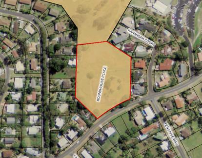
2. Amend map sheet LZN 003D
to change the label from “educational establishment” to
“private education facility” as shown in Map 2.
Map 2
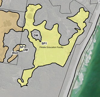
3. Amend
map sheet LZN 002CA to rezone Lots 11 & 12 DP1128095 & Lot 606
DP240398, Ocean Shores, from RU2 to R2. The land to be rezoned is outlined in
red in Map 3.
Map 3
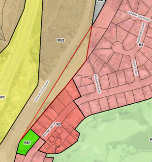
4. Amend
map sheet LSZ 003CB to display a 300m2 MLS in areas shown as “Medium density
residential” in Map 4.
Map 4
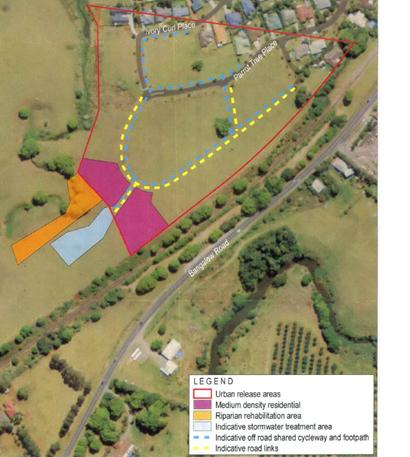
Staff Reports - Sustainable Environment and Economy 13.14 - Attachment 2
Local
Government (General) Regulation 2005
Schedule 3A Form of special disclosure of
pecuniary interest
(Clause 195A)
Local
Government Act 1993
Form of Special Disclosure of Pecuniary Interest
1 The particulars of this form are to be written in
block letters or typed.
2 If any space is insufficient in this form for all
the particulars required to complete it, an appendix is to be attached for that
purpose which is properly identified and signed by you.
Important information
This information is being collected for the purpose of
making a special disclosure of pecuniary interests under sections 451 (4) and
(5) of the Local Government Act 1993. You must not make a special disclosure that you know
or ought reasonably to know is false or misleading in a material particular.
Complaints made about contraventions of these requirements may be referred by
the Director-General to the Local Government Pecuniary Interest and
Disciplinary Tribunal.
This form must be completed by you before the
commencement of the council or council committee meeting in respect of which
the special disclosure is being made. The completed form must be tabled at the
meeting. Everyone is entitled to inspect it. The special disclosure must be
recorded in the minutes of the meeting.
Special
disclosure of pecuniary interests
by
____________________________________________________________________________________
[full
name of councillor]
in the matter of __________________________________________________________________________
[insert
name of environmental planning instrument]
which is to be considered at a meeting of the
______________________________________________________________________________________
[name of council or council committee (as the case
requires)]
to be held on the _________________ day of __________________________
201
|
Pecuniary
interest
|
|
Address of land
in which councillor or an associated person, company or body has a
proprietary interest (the identified land)
|
|
|
Relationship of identified land to councillor
[Tick or cross one box.]
|
Councillor
has interest in the land (e.g. is owner or has other interest arising out of
a mortgage, lease, trust, option or contract, or otherwise).
Associated
person of councillor has interest in the land.
Associated company
or body of councillor has interest in the land.
|
|
Matter giving rise to pecuniary interest
|
|
Nature of land that is subject to a
change
in zone/planning control by proposed
LEP (the subject land)
[Tick or cross one box]
|
The identified
land.
Land
that adjoins or is adjacent to or is in proximity to the identified land.
|
|
Current
zone/planning control
[Insert name
of current planning instrument and identify relevant zone/planning control
applying to the subject land]
|
|
|
Proposed
change of zone/planning control
[Insert name of proposed
LEP and identify proposed change of zone/planning control applying to the
subject land]
|
|
|
Effect
of proposed change of zone/planning control on councillor
[Insert
one of the following:
“Appreciable financial gain” or
“Appreciable
financial loss”]
|
|
[If
more than one pecuniary interest is to be declared, reprint the above box and
fill in for each additional interest.]
_____________________________
Councillor’s
signature
_____________________________
Date
[This
form is to be retained by the Council’s general manager and included in
full in the minutes of the meeting]
Staff Reports - Sustainable Environment and Economy 13.15 - Attachment 1
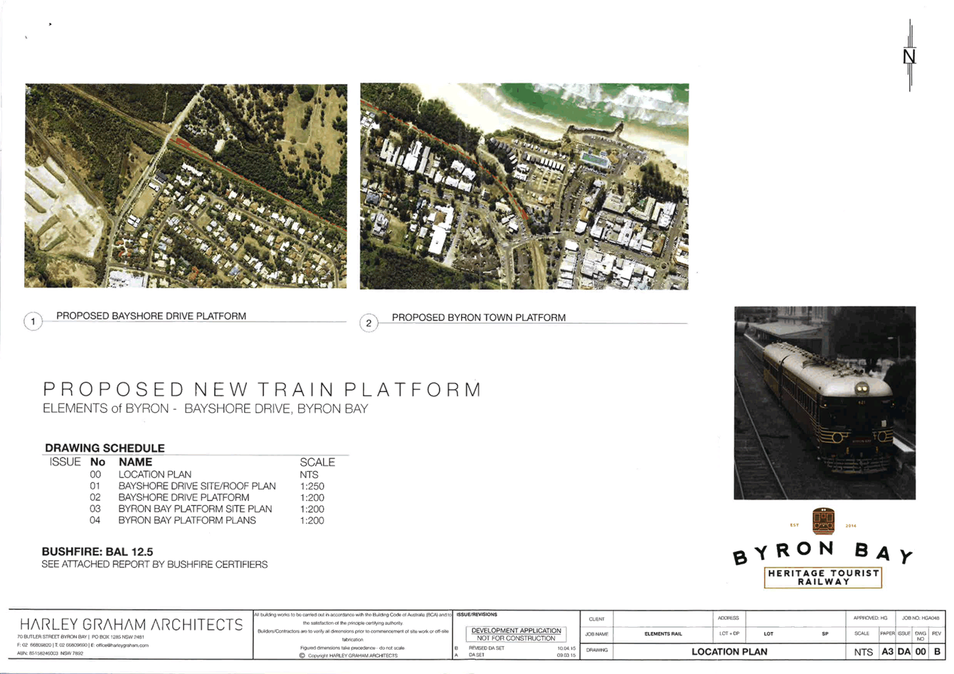
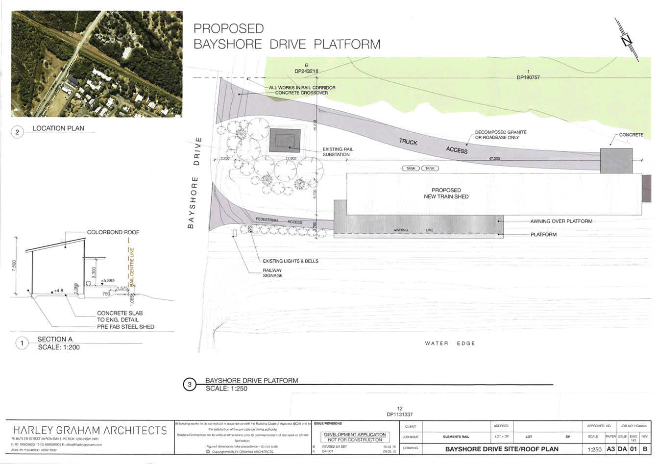
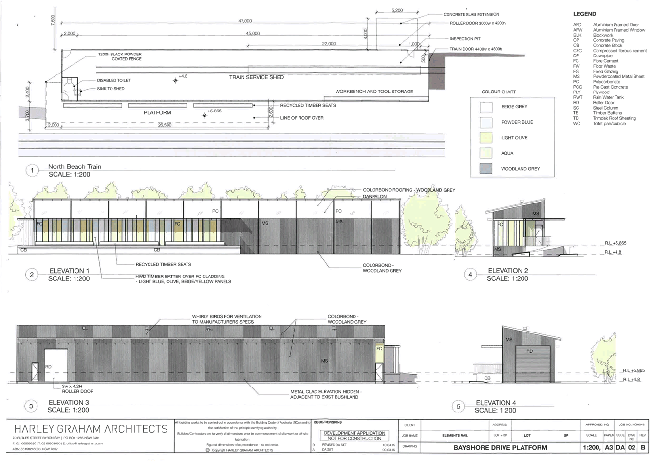
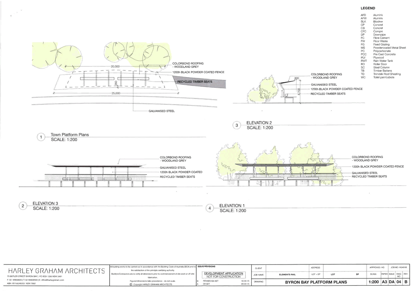
Staff Reports - Sustainable Environment and Economy 13.15 - Attachment 2
10.2015.214.1
CONDITIONS
OF CONSENT:
Parameters of this
Consent
1) Development
is to be in accordance with approved plans
The development is to be in
accordance with plans listed below:
|
Ref No:
|
Description:
|
Prepared by:
|
Dated:
|
|
Dwg 01 Rev B
|
Bayshore Drive Site/Roof Plan
|
Harley Graham
Architects
|
10/04/2015
|
|
Dwg 02 Rev B
|
Bayshore Drive Platform
|
|
Dwg 03 Rev B
|
Byron Bay Platform Site Plan
|
|
Dwg 04 Rev B
|
Byron Bay Platform Plans
|
The development is also to be in
accordance with any changes shown in red ink on the approved plans or
conditions of consent.
The approved plans and related
documents endorsed with the Council stamp and authorised signature must be kept
on site at all times while work is being undertaken.
2) Compliance
with Building Code of Australia and insurance requirements under the Home
Building Act 1989
(1) For
the purposes of section 80A (11) of the Act, the following conditions are
prescribed in relation to a development consent for development that involves
any building work:
(a) that
the work must be carried out in accordance with the requirements of the
Building Code of Australia ,
(b) in
the case of residential building work for which the Home Building Act 1989 requires there to be a
contract of insurance in force in accordance with Part 6 of that Act, that such
a contract of insurance is in force before any building work authorised to be
carried out by the consent commences.
(2) This
clause
does not apply:
(a) to
the extent to which an exemption is in force under clause 187 or 188,
subject to the terms of any condition or requirement referred to in clause
187 (6) or 188 (4), or
(b) to
the erection of a temporary building.
(3) In
this clause,
a reference to the Building Code of Australia is a reference to that Code as in
force on the date the application for the relevant construction
certificate is made.
3) Erection
of signs
(1) For
the purposes of section 80A (11) of the Act, the requirements of subclauses (2)
and (3) are prescribed as conditions of a development consent for development
that involves any building work, subdivision work or demolition work.
(2) A
sign must be erected in a prominent position on any site on which building
work, subdivision work or demolition work is being carried out:
(a) showing
the name, address and telephone number of the principal certifying authority
for the work, and
(b) showing
the name of the principal contractor (if any) for any building work and a
telephone number on which that person may be contacted outside working hours,
and
(c) stating
that unauthorised entry to the work site is prohibited.
(3) Any
such sign is to be maintained while the building work, subdivision work or
demolition work is being carried out, but must be removed when the work has
been completed.
(4) This
clause
does not apply in relation to building work, subdivision work or demolition
work that is carried out inside an existing building that does not affect the
external walls of the building.
(5) This
clause
does not apply in relation to Crown building work that is certified, in
accordance with section 116G of the Act, to comply with the technical
provisions of the State’s building laws.
(6) This
clause
applies to a development consent granted before 1 July 2004 only if the
building work, subdivision work or demolition work involved had not been
commenced by that date.
Note: Principal certifying
authorities and principal contractors must also ensure that signs required by
this clause
are erected and maintained (see clause 227A which currently imposes a maximum
penalty of $1,100).
4) Bush
Fire Protection requirements
The conditions listed at the end
of this development consent under the heading “Requirements of NSW Rural
Fire Service” must be completed as part of this consent.
5) Hours
of operation and lighting
The train platforms must not
operate prior to 7.30am and after 7.30pm on any day. To meet this condition,
the train operating on the line must be garaged within the storage shed between
the hours of 7.30pm and 7.30am nightly. Lighting must be provided to each
platform, located or shielded so that no light is cast on adjoining land and so
that motorists will not be distracted.
6) Coastal
Erosion
The development must cease if at
any time the coastal erosion escarpment comes within 50 metres of any building
associated with this development. The buildings and works used in
connection with the development must be removed immediately to an approved
location by the owner of the land. The owner must return the landform of the
subject land to the predevelopment state and suitably revegetate the land.
In this condition coastal erosion
escarpment means the landward limit of erosion in the dune system caused by
storm waves.
Note: at the end of a storm the
escarpment may be nearly vertical; as it dries out, the escarpment slumps to a
typical slope of 1 vertical to 1.5 horizontal.
The following conditions are to be complied with prior to issue of a
Construction Certificate for building works
7) Section
94A levy to be paid
Prior to the issue of a occupation certificate for the
first event authorised under this approval, a one-off section 94A levy required
by the Byron Developer Contributions Plan 2012 shall be paid to Council.
The levy will be calculated as follows:
Levy payable = %C x $C
Where:
%C is the levy rate
applicable as set out in the latest Ministerial Direction issued under section
94E.
$C is
the proposed cost of carrying out the development.
The rate of %C is:
|
Proposed
cost of the development
|
Maximum
percentage of the levy
|
|
Up to
$100,000
|
Nil
|
|
$100,001–$200,000
|
0.5 percent
|
|
More than $200,000
|
1.0 percent
|
The cost of development shall be shall be calculated in
accordance with clause 25J of the regulation and shall be set out in schedule
2. A copy of Schedule 2 shall be submitted with the payment to Council.
8) Water
and Sewerage - Section 68 approval required
An Approval under Section 68 of
the Local Government Act 1993 to carry out water supply work and sewerage work
must be obtained.
9) Certificate
of Compliance – Water Management Act 2000
A Certificate of Compliance will
be issued upon payment of developer charges for water and sewer as calculated
in accordance with Byron Shire Council and Rous Water Development Servicing
Plans.
Byron Shire Council acts as Rous
Water’s agent in this matter and will issue a Certificate of Compliance
on behalf of Rous Water upon payment of the Rous Water Development Servicing
Charge to this Council.
Note: Copies of the application
forms for Certificates of Compliance are available on Council’s website http://www.byron.nsw.gov.au/files/Forms/Section_305_Certificate.pdf
or from Council’s Administration Office. Copies of Byron Shire
Council’s Development Servicing Plans are available at Council’s
Administration Office.
Developer charges will be
calculated in accordance with the Development Servicing Plan applicable at the
date of payment. A check must be made with Council to ascertain the current
rates by contacting Council’s Principal Engineer Systems Planning, Water
on 02 6626 7081. Applicable charges can be found on Council’s
website: http://www.byron.nsw.gov.au/development-contributions-plans-section-94-and-64
The contributions payable will be
adjusted in accordance with relevant plan and the amount payable will be
calculated on the basis of the contribution rates that are applicable at the
time of payment.
Payment by Personal or Company
Cheque will not be Accepted
10) Trade
Waste - Section 68 approval required
An approval under Section 68 of
the Local Government Act 1993 to discharge trade waste into Council’s
sewer must be obtained.
11) Site
Waste Minimisation and Management Plan
Chapter B8 of Byron Shire Development Control Plan 2014 (DCP 2014) aims to facilitate
sustainable waste management in a manner consistent with the principles of
Ecologically Sustainable Development. Prior to the issue of a Construction
Certificate, a Site Waste Minimisation and Management Plan (SWMMP) must be
submitted outlining measures to minimise and manage waste generated during
demolition, construction and the ongoing operation of the development. The
SWMMP must specify the proposed method of recycling/disposal and provide
details of the waste management service provider.
Plans and
specifications must be provided as part of the Construction Certificate showing
details of both waste and recycling bin storage facilities at each platform,
consistent with the design of existing facilities within the Byron Bay town
centre. Such must be installed and serviced as part of the development.
12) Access
and facilities for disabled
The application for a Construction
Certificate is to include plans and specifications that indicate access and
facilities for persons with access disabilities to and within the development
in accordance with AS 1428.1 - Design for Access and Mobility and Part D3 of
the Building Code of Australia.
Such plans and specifications must
be approved as part of the Construction Certificate.
13) Stormwater
drainage – Section 68 approval required
An approval under Section 68 of
the Local Government Act 1993 to carry out stormwater drainage works must be
obtained.
14) Bond
required to guarantee against damage to public land
A bond of $4000 is to be paid to Council as guarantee against damage
to surrounding public land and infrastructure during construction of the
proposed development. Evidence is to be provided to Council indicating the pre
development condition of the surrounding public land and infrastructure. Such
evidence must include photographs. The proponent will be held responsible for
the repair of any damage to roads, kerb and gutters, footpaths, driveway
crossovers or other assets.
Such bond will be held until
Council is satisfied that the infrastructure is maintained/repaired to pre
development conditions and that no further work is to be carried out that may
result in damage to Council’s roads, footpaths etc.
15) S.88E
Restriction to be placed on title – Coastal erosion
Documentary evidence is to be
provided to the Principal Certifying Authority that a restriction-as-to-user,
pursuant to the provisions of S.88E of the Conveyancing Act, 1919, has been
placed on the title to the land, the subject of this consent, stating:‑
The development granted via
development consent number 10.2015.214 must cease if at any time the coastal
erosion escarpment comes within 50 metres of the building subject of the
consent. The development the subject of this consent must be demolished and
removed immediately. Further the landowner must suitably revegetate the land.
In this restriction coastal
erosion escarpment means the landward limit of erosion in the dune system
caused by storm waves.
Please note: Documents
requiring the endorsement of Council associated with the creation or
cancellation of easements, restrictions, covenants are subject to fees listed
within Council’s Fees & Charges.
16) Provision of
bicycle parking spaces
The application for a Construction Certificate is to include
plans and specifications for the provision of five (5) x Class 3 bicycle
parking spaces (bicycle rails) at each train platform. The layout, design and
security of the bicycle parking facilities must comply with Australian Standard
AS 2890.3-1993, Parking facilities - Bicycle parking facilities. The facilities
must be provided at ground level within the railway corridor adjacent to the
proposed platforms and must be accessible from the paths leading to the
platforms from the road reserve.
The following conditions are to be complied with prior to any building
or construction works commencing
17) Construction
times
Construction works must not
unreasonably interfere with the amenity of the neighbourhood. In particular
construction noise, when audible from adjoining residential premises, can only
occur:
a) Monday
to Friday, from 7 am to 6 pm.
b) Saturday,
from 8 am to 1 pm.
No construction work to take place
on Saturdays and Sundays adjacent to Public Holidays and Public Holidays and
the Construction Industry Awarded Rostered Days Off (RDO) adjacent to Public
Holidays.
Note: Council may impose
on-the-spot fines for non-compliance with this condition.
18) Construction
Noise
Construction noise is to be
limited as follows:
a) For
construction periods of four (4) weeks and under, the L10 noise level measured
over a period of not less than fifteen (15) minutes when the construction site
is in operation must not exceed the background level by more than 20 dB(A).
b) For
construction periods greater than four (4) weeks and not exceeding twenty‑six
(26) weeks, the L10 noise level measured over a period of not less than fifteen
(15) minutes when the construction site is in operation must not exceed the
background level by more than 10 dB(A)
Note: Council may impose
on-the-spot fines for non-compliance with this condition.
19) Builders
rubbish to be contained on site
All builders rubbish is to be
contained on the site in a ‘Builders Skips’ or an enclosure.
Footpaths, road reserves and public reserves are to be maintained clear of
rubbish, building materials and all other items.
20) Signs
to be erected on building and demolition sites
A sign must be erected in a
prominent position on the work site:
a) stating
that unauthorised entry to the work site is prohibited, and
b) showing
the name of the person in charge of the work site and a telephone number at
which that person may be contacted outside working hours.
Any such sign is to be removed
when the work has been completed.
21) Erosion
& sediment measures
Erosion and sedimentation controls
are to be in place in accordance with the Guidelines for Erosion &
Sediment Control on Building Sites. A summary of these guidelines is
attached. A full copy may be downloaded from Council’s web site at www.byron.nsw.gov.au.
22) Prevention
of water pollution
Only clean and unpolluted water is
to be discharged to Council’s stormwater drainage system or any
watercourse to ensure compliance with the Protection of Environment Operations
Act.
Note: Council may impose
on-the-spot fines for non-compliance with this condition.
The following conditions
are to be complied with during building and construction works
23) Plumbing
Standards and requirements
All Plumbing, Water Supply, Sewerage and Stormwater Works
shall be installed in accordance with the Local Government Act 1993, Plumbers
Code of Australia and AS/NZS 3500 Parts 0-5, the approved plans (any notations
on those plans) and the approved specifications. The changes made are
from Plumbers and Drainage Regulation 2012 NSW Government.
a) The licensee is
to provide 24 hours notice and attend the site for the following INSPECTIONS,
prior to covering of work. Inspections will be carried out a mutually
convenient time:
i) Pre-start
and Sediment Control;
ii) Internal
Drainage;
iii) External
Drainage;
iv) Water
Rough In;
v) Fire
Services;
vi) Stackwork;
vii) Final - all work
completed. - * Note below.
b) A licensee is
required to provide to Council and owner of the property after completion of
the work and within 48 hours, a Compliance Certificate and Sewer Services
Diagram/ Works as Executed drawings.
Note: Council will send each plumber proformas of these
documents when the Notice of Work permit has been issued by Council to allow
the plumber to commence work.
24) Water
service and meter to be connected
A water service and water meter
must be connected to the property using an approved backflow prevention device.
It is the applicant’s responsibility to engage a licensed plumber who
shall liaise with council during this process.
Any new water service and meter
will be at the applicants cost.
25) Management
of acid sulfate soils
Works for the development must not
extend beyond one metre of the natural ground surface without prior approval
from Council.
For the purposes of this
condition, works means:
(a) any
landform alteration that may result in the disturbance of more than one tonne
of soil;
(b) any
works that may lower ground water levels.
26) Construction
times
Construction works must not
unreasonably interfere with the amenity of the neighbourhood. In particular
construction noise, when audible on adjoining residential premises, can only
occur:
a) Monday
to Friday, from 7 am to 6 pm.
b) Saturday,
from 8 am to 1 pm.
c) No
construction work to take place on Sundays or Public Holidays.
27) Construction
noise
Construction noise is to be
limited as follows:
a) For
construction periods of four (4) weeks and under, the L10 noise level measured
over a period of not less than fifteen (15) minutes when the construction site
is in operation must not exceed the background level by more than 20 dB(A).
b) For
construction periods greater than four (4) weeks and not exceeding twenty six
(26) weeks, the L10 noise level measured over a period of not less than fifteen
(15) minutes when the construction site is in operation must not exceed the
background level by more than 10 dB(A).
28) Builders
rubbish to be contained on site
All builders rubbish is to be
contained on the site in a ‘Builders Skips’ or an enclosure.
Footpaths, road reserves and public reserves are to be maintained clear of
rubbish, building materials and all other items.
29) Maintenance
of sediment and erosion control measures
Sediment and erosion control
measures must be maintained at all times until the site has been stabilised by
permanent vegetation cover or hard surface.
30) Prevention
of water pollution
Only clean and unpolluted water is
to be discharged to Council’s stormwater drainage system or any
watercourse to ensure compliance with the Protection of Environment Operations
Act.
The following conditions
are to be complied with prior to the issue of a Final Occupation Certificate
31) Works
to be completed prior to issue of a Final Occupation Certificate
All of the works indicated on the
plans and approved by this consent, including any other consents that are
necessary for the completion of this development, is to be completed and
approved by the relevant consent authority/s prior to the issue of a Final
Occupation Certificate.
Any Security bond paid for this
application will be held until Council is satisfied that no further works are
to be carried out that may result in damage to Councils road/footpath reserve.
32) Stormwater
disposal
Stormwater must be collected and
disposed of in a controlled manner such that stormwater flows are:
a) Clear
of buildings and infrastructure,
b) Not
concentrated so as to cause soil erosion,
c) Not
onto adjoining land.
The following conditions
are to be complied with at all times
33) Restriction
on further work in Precincts 1 and 2 of the Coastal Erosion Zone
No works must be carried out at
the town centre platform site that might hinder the ready relocation of the
building. Such works might include the construction of walls, fences, screens,
enclosures, brick veneering, landscaping and the fixing of joints or structural
members by welding or other means, any of which might hinder the relocation.
34) Dangerous
goods storage
Storage of dangerous goods
including fuel is not permitted without prior approval of
Council.
35) No
unauthorised access
The rail storage shed must be
designed to restrict access by unauthorised persons. All toxic or
potentially hazardous products associated with maintenance must be securely
contained in a lockable enclosed area. Adequate clear signage must be
affixed to the building in a prominent position with words to the effect of “No
Unauthorised Access.”
36) Noise
management
Any noise generated as a result
of maintenance must be managed to comply with NSW Industrial Noise Policy
(2000).
37) Waste
management
Wastes including engine oils and
the like must be collected in containers and disposed off-site by an authorised
waste contractor.
Requirements of NSW Rural
Fire Service
1. The recommendations are based on the plan prepared by Harley Graham Architects, titled 'Proposed New Train Platform'. The recommendations relate to the proposed platform
and shed located
at the site described as "Bayshore
Drive". No specific
recommendations are included
for the site described as "Byron Town" .
Asset Protection
Zones
The intent of measures
is to provide sufficient space and maintain
reduced fuel loads so as to ensure radiant
heat levels of buildings a re below critical
limits and to prevent direct flame contact
with a building. To achieve
this, the following
conditions shall apply:
2. At the commencement of building works and in perpetuity the property around the building as indicated
below, shall be maintained as an inner protection
area (IPA) as outlined within section 4.1.3 and Appendix
5 of 'Planning for Bush Fire Protection 2006' and the NSW Rural Fire Service's
document 'Standards for asset
protection zones':
· north and northeast for a distance
of 8 metres;
· south for a distance of 9 metres;
and
· northwest , west and southwest
for a distance of 21 metres.


 Water
and Utilities
Water
and Utilities
The intent of measures
is to provide adequate services
of water for the protection of buildings during and after the passage of a bush fire, and to locate
gas and electricity so as not to contribute to the risk of fire to a building . To achieve this , the following conditions shall apply:
3. Water,
electricity and gas are to comply with section 4.1.3 of 'Planning for Bush Fire Protection 2006'.
Evacuation and Emergency Management
The intent of measures
is to provide suitable emergency
and evacuation (and relocation) arrangements for occupants
of special fire protection purpose developments. To achieve this, the following
conditions shall apply:
4. An emergency/evacuation
plan is to be prepared for the proposed development consistent with the NSW Rural Fire Service document 'Guidelines for the Preparation of Emergency/Evacuation plan'
.
Landscaping
5. Landscaping within
the Inner Protection Areas is to comply with Appendix
5 of ‘Planning for Bushfire Protection 2006'.
Protection
of the Environment Operations Act 1997:
It is an offence under the
provisions of the Protection of the Environment Operations Act 1997 to act in a
manner causing, or likely to cause, harm to the environment. Anyone allowing
material to enter a waterway or leaving material where it can be washed
off-site may be subject to a penalty infringement notice (“on-the-spot
fine”) or prosecution.
Water payments under the Water Management Act 2000
Charges will be calculated based on the
additional water and sewerage load that the proposed development generates,
shown in Equivalent Tenements (ET) by the following table:
ADDITIONAL
WATER & SEWER LOAD OF DEVELOPMENT
[ET Policy No:13/005]
|
Water
|
0.4 ET
|
|
Bulk Water
|
0.4 ET
|
|
Sewer
|
0.63 ET
|
Construction Certificate
required:
This development consent is
issued under the Environmental Planning and Assessment Act 1979 and does not
relate to structural aspects or specifications of the building under the
Building Code of Australia. All buildings and alterations require the issue of
a Construction Certificate prior to works commencing. Application forms are
available from the customer services counter or Council’s website www.byron.nsw.gov.au.
Principal Certifying Authority:
Work must not commence until the
applicant has:-
· appointed
a Principal Certifying Authority (if the Council is not the PCA); and
· given
the Council at least two days notice of the their intention to commence the
erection of the building. Notice must be given by using the prescribed
‘Form 7’.
· notified
the Principal Certifying Authority of the Compliance with Part 6 of the Home
Building Act 1989.
Occupation Certificate required:
The building must not be occupied until the Principal
Certifying Authority has issued an Occupation Certificate.
Penalties apply for failure to comply with development
consents
Failure to comply with conditions of development consent may
lead to an on the spot fine (generally $600) being issued pursuant to section
127A of the Environmental Planning & Assessment Act 1979 or prosecution
pursuant to section 125 of the Environmental Planning & Assessment Act
1979.
Signs require consent:
Council’s Planning Instruments requires development
consent for most forms of advertising signs and structures. The Council has
adopted a policy relating to outdoor advertising that sets out standards for
various forms of advertising. Information is available from
Council’s Local Approvals Branch.
Disability Discrimination Act:
All development other than domestic construction must meet
the provisions of the Disability Discrimination Act 1992 under which civil
action may be taken if access for people with disabilities is denied or provide
in a discriminatory way.
· To ensure the development is completed in accordance with conditions
of consent and approved plans.
· To
ensure access for people with access disabilities.
· To ensure public health and safety.
· To preserve the environment and existing or likely future amenity of
the neighbourhood.
· To protect the environment.
· To preserve the amenity of the area.
· To ensure adequacy of services to the development.
· To ensure public health and safety.
· To ensure compliance with Section 68 of the Local Government Act
1993.
Staff Reports - Sustainable Environment and Economy 13.16 - Attachment 1
Ewingsdale
Hall Monday 17 November 2014
|
PLANNING
|
NEIGHBOURHOOD
|
D.C.P
|
|
· Traffic Impacts
→ Ewingsdale Road
→ Town Centre
· No Overall Strategy / Need an
Integrated Plan in place before zoning for retail/Seniors Housing in
Ewingsdale
· Density & Population increase
· Sewerage treatment capacity
· Ageing demographic
· cycleway/pedestrian access off
Avocado Crescent (not supported)
· Access to Community Hall?
· Suggest locating shopping centre
on ‘Eastern’ lot
· West Byron = more suitable site
for S/H
· Need an integrated plan in place
before approving retail & Seniors Housing in Ewingsdale
· Impact of current STP on Belongil
Creek health
(eg Blue Green Algae)
· High level of flooding on Eastern
Creek (near McGettigans Ln)
· Reduce scale of Easternmost units
in order to have less visual impact
· Timing of commercial/ retail
development to occur after a certain % of Seniors Housing has
been developed
· Address/Resolve traffic issue
before any rezoning approval is given
· Need to re-evaluate this proposal
in light of West Byron rezoning decision re: densities
· Section 94 contributions
– → will there be any if this proposal proceeds?
· Completion of RMS study required
ahead of a decision being made
|
· Retain land for agriculture under
current zoning (RU2)
· Question of compliance with
‘NSW Retirement Villages Act’ & whether Seniors housing will
be genuinely for this purpose?
· Concern about over 55’s age
threshold for Seniors Housing (too low as most people retire after 60)
· Greater focus should be on
‘Care’ component in this proposal (rather than independent
living).
|
· Visual, ie Rural amenity &
location of 2 storey structures
· Buffer & landscaping
· Proposed access off McGettigan’s
Lane is very dangerous
· Investigate use of a single access
only to Seniors Housing development (eg the Hospital site only)
· William Flick Lane may not have
capacity for additional traffic generated by S/H proposal
· Flooding/Stormwater management needs
further attention.
|
Tuesday
– 25 November 2014
|
PLANNING
|
NEIGHBOURHOOD
|
D.C.P
|
|
· Ribbon/Strip development along
Ewingsdale Road
· No strategic plan
· “Rolling Green Hills”
– to be kept
· Rezoning will place pressure on
Ewingsdale
· Precedence on all RUZ land
· Land towards Mullum under pressure
· House surrounded by units –
need better set back – or remove units & use as rural residential
· Back zone Hospital to rural so
seniors living cannot occur (SEPP) – North of hospital
· Byron & Mullum hospital convert
to car facilities
· Not enough high care housing
· Traffic figures pre-highway
– need to review cumulative impact (West Byron Hospital) & highway
· Ensure ongoing use is only for
seniors housing
· Provide less dense seniors housing
· Call it a retirement village to
ensure long term certainty
· Sewerage Plant capacity?
· Need to maintain Heritage Precinct
inc. Ewingsdale Hall & Church, Fig Trees & Farm House
· Retail shops may not be effective
· Should be consistent with R5 zone
· Place controls on number of units
to be allowed on site
|
· Check land pad for helicopter
– no pad
· Silica dust concerns
· No access wanted through Avocado
Crescent
· Preferable to subdivide R5 into
seniors housing
· Roundabout proposed at McGettigans
Lane
· Parkway Drive condition disgrace
· Seniors housing should be
positioned closer to town. eg. Mitre 10, Shirley Street
· Seniors Living need footpaths to
connect/walk to town
· Seniors move to Mullum, Bruns
& Ballina not so many to Byron (Councils Ageing Strategy)
· Statistics on PP incorrect –
taken from Tweed & Ballina
· West Byron more appropriate for
seniors living
· Senior housing should not be in
Byron Shire – Lismore appropriate
· Pressure to sewer Ewingsdale &
then opens further subdivision
|
· Question shops on Western side
– Road access concerns – Shops better at Eastern end
· Limit unit size density &
sitting
· No access through trees into
William Flick Lane
· Access in Flick Lane dangerous
· Quarry Lane dangerous intersection
also Woodford Road and McGettigans Lane
· Sufficient setbacks required for
housing in Parkway Drive
· Concern DCP won’t be
complied with
· Question Council’s ability
to enforce compliance. e.g. Byron Industrial Estate
· Cycle track in front of hospital
– needs safe crossings & extend to shops
· Roundabout needs extending to two
lanes
· Access to McGettigans would be
issue if shops on Eastern side
· Shops could become ‘rest
stop’ for highway traffic
· 2 storeys inappropriate
· Single storey should be controlled
in LEP & Density
|
Staff Reports - Sustainable Environment and Economy 13.16 - Attachment 2
|
|
Issues – listed in order of times mentioned
|
Number of submissions raising issue
|
Percentage of submissions raising issue
|
|
1
|
Traffic and congestion
|
74
|
64%
|
|
2
|
Amenity of Ewingsdale and quality of life will be affected
|
54
|
47%
|
|
3
|
Density including plot ratio, height and number of dwellings is
excessive
|
34
|
30%
|
|
4
|
Precedent to circumvent LEP process
|
28
|
24%
|
|
5
|
Sewage treatment plant does not have the capacity
|
26
|
23%
|
|
6
|
Proximity to heritage listed items
|
25
|
22%
|
|
7
|
Alternative suitable sites can be found
|
24
|
21%
|
|
8
|
Issues associated with flooding
|
20
|
17%
|
|
9
|
Local Flora will be impacted
|
20
|
17%
|
|
10
|
Concern over future use of site
|
20
|
17%
|
|
11
|
Local Fauna habitats disrupted
|
19
|
17%
|
|
12
|
Zoned for Agriculture and should be retained
|
18
|
16%
|
|
13
|
Over-run by commercial development
|
17
|
15%
|
|
14
|
Isolated from services required by Seniors
|
16
|
14%
|
|
15
|
FNCRS - urban development to be contained within urban growth
boundary
|
13
|
11%
|
|
16
|
Limited public transport options
|
12
|
10%
|
|
17
|
Better buffer zone required along boundary to address noise,
lighting and aesthetics
|
11
|
10%
|
|
18
|
Hospital might need room to expand
|
10
|
9%
|
|
19
|
Byron Rural Settlement Strategy - site not suitable for urban
density
|
9
|
8%
|
|
20
|
Non compliance with SEPP 2004 – Housing for Seniors
|
9
|
8%
|
|
21
|
Adequate future housing and employment strategy not complete
|
7
|
6%
|
|
22
|
Not financially viable
|
5
|
4%
|
|
23
|
Number of other developments in Ewingsdale that will cause
traffic concerns
|
5
|
4%
|
|
24
|
Already enough aged care in the Shire
|
4
|
3%
|
|
25
|
Additional retail space not required and could affect financial
viability in town centre
|
4
|
3%
|
|
26
|
May lead to Ewingsdale being sewered
|
1
|
1%
|
|
27
|
Aboriginal heritage values incorporated into land use plan
|
1
|
1%
|
|
28
|
Parking on Avocado crescent and Parkway Drive will become an
issue
|
1
|
1%
|
|
29
|
Location adjacent to concrete plant and electricity substation
|
1
|
1%
|
|
|
Issue
|
Comments
|
|
1
|
Issues associated with additional traffic generated by proposal
and congestion along Ewingsdale road.
|
· Traffic is a key
issue. Following on from the community information sessions and concerns
raised about this issue, Council sent a letter to the proponents on 19
November 2014 requesting that additional traffic studies be conducted for the
site. The proponents have responded to Council’s request stating
that they believe the traffic studies included in the planning proposal are
sufficient for this stage of the process and that any additional studies
could be done prior to lodging a DA for the site. Council has resolved that
additional traffic assessment work satisfactory to RMS and Council
requirements (‘Demand Model’) be undertaken. Council has not yet
been able to commission the work due to other priority projects. The
applicant has now offered to enter into a planning agreement with Council to
provide a monetary contribution to this traffic study.
|
|
2
|
The impact of development on the amenity, character and quality
of life of Ewingsdale residents. People have bought into this locality due to
the rural nature and wish to preserve this character
|
· Same as original
submissions report which recommended a DCP be prepared for the site prior to
lodgement of a DA to ensure adequate buffers are provided between the
existing rural properties and the proposed development. See point 2 of
Attachment 4 for a detailed response.
|
|
3
|
Proposed density including plot ratio, height and number of
dwellings is considered excessive
|
· If the planning
proposal proceeds it is recommended that a Floor Space Ratio Map be prepared
for the site to limit any Seniors Housing to 0.3:1 under the LEP 2014.
This will not apply to the Commercial precinct (Area A) as it would be
limited by maximum floor area.
· If the planning
proposal proceeds it is recommended that a site specific DCP is developed
prior to the lodgement of a DA to ensure that building setbacks, landscaping
and streetscape amenity are appropriately addressed.
|
|
4
|
Precedent to circumvent LEP and allow for rezoning and development
of rural areas outside of any Strategies
|
· Same as original
submissions report which recommended no change. See point 11 of
Attachment 4 for a detailed response.
|
|
5
|
Sewage treatment plant capacity and may not have the ability to
cope with additional development
|
· Same as original
submissions report which recommended no change. See point 4 of
Attachment 4 for a detailed response.
|
|
6
|
Proximity to heritage listed items being Higgins House and St
Columbus Church group
|
· Same as original
submissions report which recommended no change. See point 17 of
Attachment 4 for a detailed response.
|
|
7
|
Alternative suitable sites within West Byron and other locations
|
· Same as original
submissions report which recommends no change. See point 10 of Attachment
4 for a detailed response.
|
|
8
|
Issues associated with flooding and drainage of the land
|
· Same as original
submissions report which recommended no change. See point 9 of
Attachment 4 for a detailed response.
|
|
9
|
Concerns relating to the impact on local Flora
|
· Same as original
submissions report which recommended no change. See point 5 of
Attachment 4 for a detailed response.
|
|
10
|
Concern over future use and how the seniors housing will be
monitored and enforced
|
· The proposed amendment
to the LEP is only for Seniors Housing which is defined within the LEP.
This is also linked to the Retirement Villages Act to ensure that only people
over the age of 55 can buy into the development.
|
|
11
|
Local Fauna habitats could be impacted
|
· Same as original submissions
report which recommended no change. See point 5 of Attachment 4 for a
detailed response.
|
|
12
|
Zoned for Agriculture and should be retained for this purpose
|
· Same as original
submissions report which recommended no change. See point 12 of Attachment
4 for a detailed response.
|
|
13
|
Too much commercial development, deemed un-necessary considering
the close proximity to the sunrise shopping centre
|
· Same as original
submissions report which recommended if the planning proposal proceeds, that
commercial development be limited to 1200 m2 and medical centre to
1800 m2. See point 6 of Attachment 4 for a detailed
response.
|
|
14
|
Isolated from services and therefore concern over location of
the development
|
· Same as original
submissions report which recommends no change. See point 10 of
Attachment 4 for a detailed response.
|
|
15
|
Far North Coast Regional Strategy - urban development should be
contained within urban growth boundary
|
· Same as original
submissions report which recommended no change. See point 22 of
Attachment 4 for a detailed response.
|
|
16
|
Limited public transport provided to the site and therefore
concerns over mobility of residents
|
· Same as original
submissions report which recommended no change. See point 10 of
Attachment 4 for a detailed response.
|
|
17
|
Better buffer zones required to address noise, lighting and
aesthetics between the development and existing residential areas
|
· Same as original
submissions report which recommended if the planning proposal proceeds, that
a site specific DCP is developed prior to the lodgement of a DA to ensure
that these issues are addressed. See point 18 of Attachment 4 for a
detailed response.
|
|
18
|
Expansion of hospital into the future should be considered
|
· There is still
available land within the hospital site to can cater for future expansion of
the Hospital if required.
|
|
19
|
Byron Rural Settlement Strategy 1998 - site not suitable for
urban density
|
· This BRSS 1988 was to
be reviewed many years ago however this did not occur due to staffing issues.
The BRSS is to be replaced with the Rural Land Strategy which is anticipated
to be completed within the next 18 months.
|
|
20
|
Non compliance with SEPP Housing for Seniors or People
with a Disability 2004 in relation to access to services
|
· Same as original
submissions report which recommended no change. See point 10 of
Attachment 4 for a detailed response.
|
|
21
|
Adequate future housing and employment strategy not complete
|
· A draft Urban Strategy
for Byron Shire is scheduled to be prepared for review by Council in June
2016.
|
|
22
|
Not financially viable due to amount of commercial space within
Byron Bay and alternative senior housing options
|
· If the planning
proposal proceeds, limits to the commercial floor space will provide shopping
opportunities for residents on a smaller scale than other shopping precincts.
The market will decide how much of that floor area is developed and viable.
· This is similar to the
original submissions report which recommended that the combined maximum
commercial / retail floor area be limited to 1200m2. See
point 21 of Attachment 4 for a detailed response.
|
|
23
|
Number of other developments in and around Ewingsdale that cause
traffic concerns including West Byron and the Hospital
|
· See comments above on
traffic and congestion.
|
|
24
|
Already a number of aged care facilities in the Shire
|
· Same as original
submissions report which recommended no change. See point 8 of
Attachment 4 for a detailed response.
|
|
25
|
Additional retail space not required and could effect financial
viability of existing businesses in town
|
· Same as original
submissions report which recommended no change. See point 6 of
Attachment 4 for a detailed response.
|
|
26
|
May lead to Ewingsdale being sewered
|
· This may be considered
a benefit to the wider community and has been discussed previously by Council
as the preferred option for the future.
· See point 4 in
original submissions report for a more detailed response relating to Sewage
Treatment Plant capacity.
|
|
27
|
Aboriginal heritage values should be incorporated into land use
plan
|
· Same as original
submissions report which recommended no change. See point 28 of
Attachment 4 for a detailed response.
|
|
28
|
Concern regarding potential parking of vehicles on Avocado
Crescent and Parkway Drive to access the commercial precinct
|
· Access for pedestrians
to the subject site from either of these streets has not yet been
determined. This will be assessed and determined at the DA stage and
could be included in the site specific DCP if the planning proposal proceeds.
|
|
29
|
Poor location adjacent to concrete plant and electricity
substation
|
· If the planning
proposal proceeds buffers can be provided between the concrete plant/
electricity substation and any future seniors development and incorporated
into a site specific DCP.
· This is similar to the
original submissions report. See point 18 of Attachment 4 for a
detailed response.
|
Council received 4
different form letters (130 submissions) raising various matters relating to
the Planning Proposal. The issues from the letters are listed below:
Form letter 1 raised the following points:
· Opposition to the
parkway drive house being removed
· Concerned about the
long term future of the parkway drive house
Form letter 2 raised the following points:
· Contrary to the
regional strategy, the Local Environmental Plan and all planning requirements.
· The proposal is
situated on agricultural land and in a heritage precinct and will cause
additional traffic issues along Ewingsdale Road.
· The seniors housing
is out of scale with our rural environment and unwanted by the local community.
· Suitable
alternative sites are located in the West Byron development.
Form letter 3 raised the following points:
· Not in keeping with
Ewingsdale.
· Compound traffic
and infrastructure issues.
· Hinder the entrance
to Byron and impact the amenity of Ewingsdale.
· Set a precedent for
development of farmlands.
Form letter 4 raised the following points:
· Threatens the
lifestyle and friendly community spirit of Ewingsdale.
· Concerned about the
gentrification of the area.
The Council
received 11 submissions of support for the proposal, the reasons being:
· Need for suitable
retirement facilities in the area
· Well thought out
and presented proposal
· The site is
appropriate
· Appropriate
location adjacent to hospital
· Minimal traffic
impacts due to its location
· Does not appear to
change the nature of the existing residential area
· Improve the
entrance to Byron Bay
· Quiet ambience
ideal for Seniors housing
· Desirable neighbours
· Properties are
usually maintained to a high standard
· No access from
Parkway Drive
· Opportunities for
different health professionals in proposed Medical Centre
Staff Reports - Sustainable Environment and Economy 13.16 - Attachment 3
Key
issues and analysis of submissions to Ewingsdale Planning Proposal
This document
expands on the key issues raised during the public exhibition process and
provides comments and recommendations for Council to consider. The issues
raised below have been organised in relation to the greatest numbers of
submissions received which raised common themes. This is not necessarily
a reflection of which issues are deemed to have the highest priority, merely a
qualitative way to format this document.
1. Traffic
and congestion
Approx 65% of all
objections to this planning proposal raised the issue of additional traffic and
congestion that will flow from the future development of this site and how it
will impact on both residents of Ewingsdale and the users of Ewingsdale Road,
William Flick Drive and McGettigans Lane. In particular, concern was
raised about the volume of traffic, overall safety issues, intersection
treatments, access points to the site, the current dysfunction of Ewingsdale
Road at peak times, the combination of future traffic from West Byron and other
mooted developments, the attraction of traffic that will use the shopping
centre, the timing of the traffic counts used and the proximity of the site to
the highway.
Planning comment
At the planning
proposal stage Council needs to be confident that traffic likely to be
generated by the site can be dealt with in a way that is plausible and
realistic in terms of engineering, costs and safety. Council cannot
require DA standard traffic assessment at the planning proposal because the
final DA has not been lodged. The current proponent of the planning proposal
may not be the future applicant at DA stage and this has been suggested at
public meetings.
The supporting
information provided by the proponent makes no commitment to intersection
upgrades from William Flick Lane or McGettigans Lane to Ewingsdale Road citing
insufficient traffic volumes arising from the two development sites to warrant
any upgrades.
Traffic engineers
response:
The hospital site
development needs to be considered in regard to this proposal, not least site
access arrangements, which for the western site is proposed to be via the
existing William Flick Lane and the eastern site directly to/from McGettigans
Lane.
Peak hour movement
at William Flick Lane is 45 vehicles. This will increase eight fold by
2024 with the development. This is significant and most pertinent to the
right-out movements expected to occur eleven (11) times more frequently than
the 11 such movements recorded in 2013 to 116 predicted per hour in 2024.
As the traffic
report expects over 1,700 vehicles on Ewingsdale Road as through traffic in the
same hour by 2024, this right-turn out is expected to be greatly delayed
despite the report’s SIDRA analysis concluding acceptable Levels of
Service (i.e. delays). There is also a safety element to consider as increased
risk taking will inevitably occur after people are significantly delayed.
Therefore it is
recommended this increase in right-turn out and dominance of through traffic on
Ewingsdale Road requires addressing, preferably via re-design of the
intersection that (via approved signage) bans right-turn out (eastbound)
movements from William Flick Lane and physically restricts vehicles to a
left-out (westbound) only option who can then proceed to the highway
interchange roundabout some 150m to the west and use that facility to make a
u-turn to head eastward. This is considered safer, more efficient
and considerably less delayed than waiting to make a right-turn out from
William Flick Lane, especially in the peak.
In considering the
proposed site access arrangements for the hospital development to the east of
the lane, i.e. a roundabout, there is also merit in modelling the impacts of a
full closure of the intersection and restricting William Flick Lane to only
left-out and left-in. This is possible given that Woodford Lane is being
diverted in to the aforementioned highway interchange roundabout currently
being upgraded and would result in all departing traffic heading west, with
those wishing to return east undertaking a u-turn at the highway roundabout and
those approaching William Flick Lane from the west able to u-turn at the
hospital roundabout. Modelling of this option is sought and needs to
consider the highway proposal and its expected traffic generation.
As for the eastern
site, the report concludes that SIDRA analysis indicates the McGettigans Lane
and Ewingsdale Road intersection will operate satisfactorily after the eastern
site is developed and operating. This is in contrast to Council’s
2008 MR545 Strategic Study which identified the need for a roundabout to
provide a controlled intersection that assists departing traffic and also
considered to help with road safety, noting intersection type accidents occur
at the site.
To this end, the
proponents should be required to model the benefits/impacts of a roundabout and
provide the report to Council for further consideration. This modelling
should be based upon the West Byron model and incorporate the traffic volumes
associated with that development plus the hospital. The same report
should also provide indicative concepts and cost of such a facility and how it
ties in with the existing road environment to the east and that proposed to the
west, noting Council is requesting the hospital development provide (or at
least cater) for a dual-lane roundabout and land for future dual lanes on
Ewingsdale Road. The report should also consider the realignment of
Quarry Lane so as to make any future roundabout at McGettigans Lane cater for
four legs being east and west Ewingsdale Rd, south McGettigans Lane and north
Quarry Lane.
Roads and Maritime
Services (RMS) response
The RMS has
commented on the proposal that it considers the traffic studies supporting the
planning proposal are inadequate because:
· The average flows
used in the assessment are not likely to represent the full extent of traffic
flows on Ewingsdale Road;
· A ‘Demand
transport model’ should be prepared to examine the impacts on the
Pacific Highway interchange;
· Revised traffic
generation rates should be used for the seniors living proposals (technical
circular cited);
· Passing trade
should be assumed to be 20 % not 25%;
· The trip
distributions should be based on a quantitative approach not an assumption
approach.
The issue of
traffic has not been dealt with to RMS satisfaction and it was a specific
concern of the Department of Planning and Environment (DPE) in its Gateway
Determination. The issue of traffic is a major concern of the community,
RMS and Council engineers. If Council proceeds with the planning proposal
without resolving these issues then it may find that it cannot be resolved at
DA stage or can only be resolved at significant expense to Council and the
State government. The traffic solutions suggested in supporting material
do not appear to be reliable and the outcomes are not plausible.
Recommendation
It is recommended
that Council request the applicant to undertake traffic assessment work
satisfactory to RMS and Council requirements (Demand Model) which is to be
prepared prior to the lodgement of a Development Application (DA) and commits
to traffic solutions in the best interest of Byron Shire and future road users.
2. Impacts
on the character of the Ewingsdale area
Most objectors who
raised the issue of impacts on the lifestyle and amenity of the area also
raised the issue of impacts on the rural character of Ewingsdale.
Planning Comment
The character of a
locality in planning and urban design terms is usually summarised in a
character statement that can be described as:
‘A statement and supporting
principles for development within an area or neighbourhood. The statement
is place-specific and draws on the unique qualities of a neighbourhood and
provides an important direction for development controls and built form
guidelines.’ (after City of Sydney DCP 2012.)
Understanding the
character of an area helps to understand the locality and how it works. In
identifying the character of an area one would undertake research and ask
residents questions such as ‘who lives here? Where do they shop, work or
go to school? How do people move around? What makes this place special? What
would you change if you could? Only those who live there can truly
understand it. Planners work closely with a community to establish the
character of a locality and then use that to formulate controls that enhance
that character or change it to make it a better place to live.
The current
planning proposal will potentially change the character of parts of Ewingsdale
by introducing approximately 400 new residents (predominantly seniors) as well
as an employment area (medical centres and a commercial and retail area).
This will follow on from the new hospital that will also affect the character
of the locality as a major employer and community service provider.
Recommendation
It is recommended
that a site specific Development Control Plan (DCP) be prepared for the site
prior to the lodgement of a DA to ensure adequate buffer areas of approx. 20m
are provided between the existing rural-residential areas and the proposed
development.
3. Lifestyle
and amenity issues
Many of the
objectors to the planning proposal raised lifestyle impacts on local Ewingsdale
residents. This included noise, light spill and construction related
impacts on the houses that back onto the site. It also includes the broader
impacts on visual amenity, traffic and general tranquillity that draws people
to live on large lots out of town. Many objectors suggested that they
would not have chosen to live in Ewingsdale if they knew that this development
and the urbanisation of this area was proposed.
Planning Comment
The initial major
change to the lifestyle of Ewingsdale residents has come about because of the
decision to place a new district hospital and ambulance station in an
‘out of town’ location. It could be suggested that the
urbanisation of the locality was inevitable and part of the way communities
change when infrastructure decisions are made on this scale.
However, it is fair to say that the Byron Bay and Suffolk Park Settlement
Strategy (2002) did not foreshadow these changes. It identified the
subject land as Area 3 and concluded as follows:
‘Area 3 is in the McGettigans Lane
area at Ewingsdale. Part of Area 3 has already been subdivided as a rural
residential area. The Local Environmental Study indicates that a range of
residential densities are possible in Area 3. However the traffic study shows
that higher density options are not appropriate in the short to medium term
given the current traffic problems along Ewingsdale Road and in entering Byron
Bay………..The remainder of Area 3 has some potential for rural
residential development, but this needs to be verified through a review of the
Byron Rural Settlement Strategy. In the interim these lands should be rezoned
to reflect their agricultural attributes.’
The opposition to
urban density development (albeit seniors housing) is evident in the
submissions to this planning proposal. In permitting this planning
proposal to proceed, Council is potentially affecting the lifestyle of adjacent
landowners to the subject land. That impact can be ameliorated by a site
specific DCP which will in turn guide future decisions at the DA stage in
relation to site design, buffers, screening, and traffic management. However,
the change to the lifestyle of current residents in varying degrees is
inevitable if this planning proposal proceeds.
Recommendation
It is recommended
that a site specific Development Control Plan (DCP) be prepared for the site
prior to the lodgement of a DA to ensure potential impacts on existing residents
are minimised to retain the existing character in the locality.
4. Capacity
of West Byron STP
There is no
commitment to connect the subject land to the West Byron STP. Concern is raised
about the concept of disposal of wastewater on site. Concern is also raised
about the capacity to take the additional wastewater from this site as well as
the hospital and the unrelated West Byron urban expansion area. Concern is also
raised about trade waste from any commercial or retail uses on the site.
Planning Comment
The report by Greg
Alderson and Associates confirms that there will need to be approximately 240
ET of capacity in the West Byron STP to cater for the development that will
likely arise from the planning proposal.
Council engineers
have confirmed that there is sufficient capacity to deal with the wastewater
from this site at the West Byron STP. They will be expected to pay the Sewer
s64 Contributions to Council (and the Water component to Rous Water) if the
wish to connect to either of these services. Assuming that they want to connect
to the sewer system they will also need to fund and construct a method of
discharging the sewage to Council's system. The main two options
available to them are:
1. They
build their own pump station and rising main through to the Byron STP to
service the development; or
2. They
deliver flow to the proposed hospital sewage pump station and contribute to the
cost of that.
At the planning
proposal stage Council needs to know that there are plausible options for
providing services to the subject land. In this case plausible options are
available for the subject land and its proposed future use. It is not
necessary that a commitment is made at this stage. However, with the
construction of the hospital likely in the foreseeable future some decisions
will have to be made by the landowners on a sewage pump station and rising
main.
Recommendation
No change is
recommended to the planning proposal.
5. Flora
and fauna issues
A number of
submissions suggested the flora and fauna report supporting the planning
proposal is inadequate and omits fauna species that occur on the site. One
resident quoted a recent Koala sighting at Bay Vista Lane as an example of the
inadequacy of the work. Other submissions raised the effect of the planning
proposal on the Cape Byron Marine Park, in terms of runoff from the site.
Planning Comment
The level of detail
required for information at the planning proposal stage is not meant to be at
the same level of detail as the DA stage. In considering this planning proposal
for additional permitted uses Council needs to be confident that this land is
suitable for these uses and they can be carried out subject to reasonable
conditions being imposed. In relation to flora and fauna the work has been
undertaken by a qualified and experienced ecologist. It includes a vegetation
map and a fauna study that includes assessment for threatened species. No
Koalas were found on the site and it does not contain Koala food
trees. Most of the site is cleared grazing land. The native
vegetation that does remain can be protected as part of the site layout and
design in a future DCP. There is no assumption at this stage that
permitting the additional uses through an LEP amendment will result in the
destruction of the site’s environmental values (albeit that they are
limited) at the DA stage. Preliminary sketches submitted with supporting
information demonstrate that items such as fig trees, a White Lace Flower, and
remnant waterway related vegetation can be accommodated in a future DA.
The marine park will receive drainage and run off from the site via Simpsons
Creek (a sanctuary zone) that eventually drains to the Brunswick River.
It is important that any development on this site be consistent with water
sensitive urban design principles to minimise the impact on receiving
waters. The presence of the marine park itself is not a reason to stop
this planning proposal.
Recommendation
No change is
recommended to the planning proposal.
6. Too
much retail proposed
The Schedule
amendment allows for commercial uses on the site limited to 3000m2 but
this is too big as it is actually bigger than the existing 2800m2
Bayshore Drive shopping centre that services all of Sunrise estate and future
west Byron.
Planning Comment
The proposed
schedule amendment currently limits ‘all commercial uses listed in
subclause (2) (business premises, restaurants or cafes and shops but does not
include medical centres) to a maximum floor area of 3000m2.
Subsequently, Medical Centres could be proposed in addition to the commercial
uses and is not limited in floor area as per the current wording of the
schedule. It is possible that the maximum floor area of retail
development on the subject land could be as big or bigger than that at Bayshore
Drive. If the 3000m² was solely used by a single supermarket, it
would be one of the larger supermarkets in the Shire. If the likely
population of the seniors housing is about 400 persons (320 in small
self-contained houses and 65 in a hostel) as well as hospital usage then 3000m2
will only be viable if it draws on a much wider catchment area for
business. Presumably this includes Ewingsdale rural residents and passing
traffic. The supporting information in the planning proposal indicates
that a LGA wide perspective on the trade area is anticipated.
Paul McFarland, a
lecturer from the University of New England has conducted a peer review
(contained in Annexure 8(d)) of the Retail Floorspace Analysis included
as Annexure 9 within the planning proposal. The review highlights a
number of unresolved issues with the retail analysis such as the limited
catchment area of the study, overly optimistic projections about unmet retail
demand in Byron, lack of justification for the scale of the commercial
development and lack of evidence that it is only designed to cater for the
proposed development, hospital visitors and adjoining residential population.
The hospital itself
would normally only generate demand for a ‘neighbourhood shop’ size
retail outlet (up to 200 m2) servicing staff, patients and
visitors. Presumably the retail is therefore needed to support the
seniors housing (only about 400 persons), the hospital and some of the existing
Ewingsdale residents. Taking the figure from Annexure 9 of the planning
proposal prepared by LOCATIQN (March 2013) of 2.2 m2 per person, the
seniors housing development would generate demand for 880m2.
Rounding these figures up suggests that 1200m2 should be more than
enough floor area for a future supermarket to support the projected
development, the future hospital and adjoining residents. This would
permit a small supermarket of about 1000m2 and 200m2 for
cafes and other shops or business premises. ‘Medical centre’
uses could take up the remaining 1800m² of floor area to bring the total
for all non-residential uses on the subject land to 3000m² as initially
intended.
Recommendation
It is recommended
that the combined maximum commercial floor area be limited to 1200m² and
the maximum floor area for medical centre uses be limited to 1800m². The
proposed schedule will need to be amended to reflect these new floor area
limits.
7. Community
expectation
The community
supported Councils earlier decision to deal with any such proposal as part of a
Local Growth Management Strategy (LGMS). It also noted that the Local
Environmental Study 2008 (LES) and Shire wide LEP that flowed from it did not
envisage the development as now proposed. To come back now supporting a
stand-alone planning proposal is not consistent with community expectation.
The project is being ‘sold’ to the community by a developer that
admits they may not be the one who does the development.
Planning Comment
The decision by the
State government to place the new ambulance station and Byron Hospital in an
‘out of town’ location is the reason that Council is now in this
situation. Council decided to review this planning proposal on its merit
because it is still considering a timetable for a LGMS and there is no clear
time frame for reviewing the Far North Coast Regional Strategy (FNCRS).
Without a strategic basis then it comes down to the merit of the location and
the detail of what is being proposed.
The proposal was
not recommended for an urban zone in the LES and therefore the Shire wide LEP
also did not rezone it. It was the subject of a submission to Council as
part of the LEP public exhibition and Council agreed that it could be dealt
with as a stand alone planning proposal once the Shire wide LEP was
completed.
Once the LEP is
amended and development opportunities have been scheduled for the subject land
then it can be bought or leased by another party (or more than one) who may
prepare and lodge the development application/s. The key at this stage is
to focus on what the planning proposal will permit and where it will be
permitted, rather than any draft concepts that may or may not end up as
development applications.
Recommendation
No change is
recommended to the planning proposal.
8. Supply
and demand information for seniors housing
In summary the
argument presented is that new housing (about 190 dwellings per year) has been
approved in Byron Shire faster than population growth (about 120 persons per
year) over the period 2006 to 2011. The dwelling approval rate exceeds the DPE
target in the FNCRS. There is sufficient zoned land for realistic development
in places such as Bayside Brunswick (160 dwellings), West Mullumbimby (240
dwellings), Bangalow (150 dwellings) and West Suffolk Park (42
dwellings). Development is now being forced on Byron Bay even though it
is exceeding its land release expectations as indicated in the FNCRS.
Planning comment
A typical measure
of demand for housing is the average annual approval rates for dwellings taken
over the last five years and then projected forward with an additional amount
(say 30%) added to avoid shortages in supply. Shortages in supply usually lead
to price increases due to scarcity. Using the figures in the submission
the projected five year demand for dwellings would be 950 plus 30%, which is
1235 dwellings. The supply areas suggested in the submission account for
592 dwellings which is less than half of the projected demand over the next
five years. If Byron Shire wants to meet demand expectations then it will
need additional land releases.
Seniors housing is
a specialist market and general dwelling approvals may not match the demand for
seniors housing. However, Byron Shire (as with many Northern NSW
locations) has a shortage of affordable housing. The BSC Affordable
Housing Options Paper recommended ‘The need to significantly diversify
housing opportunities and stock in order to meet changing demographic needs,
including a strong increase in demand for smaller, more manageable dwellings
for older households’.
It can’t be
guaranteed that any seniors housing built on the subject land will be
affordable. However, given a likely shortfall in general housing supply
(based on current demand) and a historic lack of affordable seniors housing it
is realistic to suggest there is a demand for them and they will be taken up by
the market if they are built.
Recommendation
No change is
recommended to the planning proposal.
9. Drainage
issues
The subject land
has drainage issues and this is likely to get worse if the development
proceeds.
Planning Comment
Drainage is an
issue that will have to be assessed on its merits at the development
application stage, should the proposed development proceed. It is a
normal consideration for Council in a high rainfall area and the submissions
concerns are noted.
Recommendation
No change is
recommended to the planning proposal.
10. Location
requirements for seniors housing
A number of
submissions questioned if the subject land is an appropriate location for
seniors housing given its distance from an existing urban centre (6km west of Byron
Bay and 3km west of Sunrise shopping centre) and lack of infrastructure.
Planning comment
State Environmental
Planning Policy (Housing for Seniors or People with a Disability) 2004 indicates that
land is potentially suitable for seniors housing if it:
‘ is land
zoned primarily for urban purposes or land that adjoins land zoned primarily
for urban purposes,’
The subject land is
currently zoned part RU2 Rural Landscape (mainly), part R5 Large Lot
Residential and part SP2 Infrastructure (Health Services Facility). The
SEPP states that land zoned R5 is not necessarily regarded as being zoned
primarily for urban purposes and that when applying the SEPP ‘most’
of the land that it adjoins should be land zoned for urban purposes. If ‘most’
is interpreted as more than half the length of the boundary then the subject
land does not entirely meet the SEPP requirements for seniors development
suitability as its boundaries are more than half R5, RU2 or RU1. That
piece of the subject land zoned SP2 could be eligible for application of the
SEPP.
However, the
purpose of the planning proposal is to create permissibility of seniors housing
across the site regardless of the SEPP and to permit other facilities such as a
medical centre and shops in close proximity. As a guide the SEPP suggests
that seniors housing should be within 400m walking distance (on flat ground) of
services such as:
(a) shops, bank service
providers and other retail and commercial services that residents may
reasonably require, and
(b) community
services and recreation facilities, and
(c) the practice of a
general medical practitioner.
If the planning
proposal were to proceed and all uses anticipated were constructed then the
facility that may still be missing is community and recreation facilities.
The proponents have recently sent Council draft plans showing a bowling green,
swimming pool and community gardens on the eastern portion of the site which
would provide some recreation facilities on site. A public bus service
that may travel between the new hospital and Byron Bay would also assist in
solving this issue.
DPE (in its Gateway
Determination) requested further information to determine if there is a better
location than the subject site for seniors housing. The proponents have
responded in Annexure 8 of the planning proposal which states that seniors
housing is only permitted in R3 Medium Density Residential and B4 Mixed Use
Zones and such available land is highly limited near Byron town centre.
There may be some infill opportunities which would be limited in scale with
other potentially larger sites being on environmentally sensitive land.
Market forces tend to drive land values too high for seniors developments near
urban centres hence the desired location out of town. The hospital is also
a major drawcard for the location of seniors housing given the affiliated land
uses such as medical facilities which will be sited nearby.
Recommendation
No change is
recommended to the planning proposal.
11. Precedent
for other sites
A number of objectors
are concerned the LEP amendment being made for this site is not a ‘one
off’ event, it is a precedent for other sites either nearby or elsewhere
in Byron Shire to try for the same or similar changes to the controls that
apply to development of their land.
Planning Comment
This issue was
raised by a number of submissions and relates to the fact that Council has not
got an approved LGMS that includes this site and that its not included in the
FNCRS. Council decided to review this planning proposal on its merits because
there was no clear time frame for reviewing either the FNCRS or preparing a
LGMS. It is being considered in response to the decision by the State
government to locate the new hospital on land adjacent to the subject site at
Ewingsdale.
It would have been
preferable for the LGMS to have been prepared prior to further residential
development in the Shire, however seniors housing in particular is an obvious
need and is appropriately located near the hospital site which is in the
process of being developed. Whilst Council acknowledges that a
housing strategy is needed, this site is appropriate for seniors housing and
associated medical facilities and shops adjacent to the hospital site.
Given the adjacent hospital land use, this proposal is not deemed to create a
precedent for similar developments throughout the Shire.
Recommendation
No change is
recommended to the planning proposal.
12. Agricultural
land values of the locality
The subject land is
good agricultural land and should be maintained for grazing or small crops.
Planning comment
The NSW DPI
acknowledge that the subject land is mapped as regionally significant farm land
under the Northern Rivers Farmland Protection Project. Allowing the site
to be used for urban purposes is inconsistent with the agricultural
values. However, the placement of the hospital on similar land and the
original rural residential subdivision immediately to the south of the subject
site have all contributed to the added pressure on this piece of land. It
is an area of good red soil and at approximately 15 hectares (in two pieces) it
is large enough to undertake a market garden (perhaps spray free or
organic). However, its loss from agriculture is likely at some time given
its proximity to the new hospital and its separation from other agricultural
areas. On balance the loss of this area is unlikely to impact
significantly on agriculture in the region or on nearby agricultural areas.
Setbacks from agricultural land to the north of Ewingsdale Road should be
applied to avoid future conflicts.
Recommendation
No change is
recommended to the planning proposal.
13. Local
Growth Management Strategy
A number of
submissions suggested that this site should (and was going to) be assessed as
part of a new LGMS. Council did not opt to rezone this land as part of
the recent Shire wide LEP and the LES that supported the LEP did not recommend
this land should go to an urban use.
Planning comment
Byron Shire intends
to prepare a Housing Strategy commencing in 2014. The previous Byron Bay
and Suffolk Park Settlement Strategy (2002) is out of date and there needs to
be a fresh look at a range of sites and options for urban development in Byron
Shire. It is agreed that a LGMS provides the opportunity to investigate
this site and the implications of a new urban area focussed around the hospital
site. The issues of servicing (water and sewerage) as well as traffic would be
dealt with in one document rather than a series of ‘one off’
applications. However the subject site is a logical location given that
the hospital redevelopment is proceeding at present and it is deemed
unnecessary to wait until a LGMS is prepared for the Shire.
Recommendation
No change is
recommended to the planning proposal.
14. Impacts
on the entrance to Byron Bay
Some submissions
commented that the ‘feel’ as you leave the highway roundabout to
enter Ewingsdale Road is an important entrance vista characterised by beautiful
green pastures and farmland leading in towards the lighthouse.
Planning
comment
The entrance to
Byron Bay does start with the Ewingsdale Road intersection. The batching
plant and electricity depot are not ideal, but it does open up beyond that to a
green farm land appearance. Preliminary sketches put forward by the
applicant suggest that they would agree to wide setbacks on Ewingsdale Road and
a large part of the development will be directly behind the batching plant and
electricity depot and therefore not visible at all. This will be an issue
to address at the DA stage and site layout and design can be used to ensure the
entrance statement is preserved or at least not unreasonably impacted by
development on the subject land.
Recommendation
No change is
recommended to the planning proposal.
15. Inconsistent
with Council’s ageing strategy and policy
A number of
submissions suggest that the site does not comply with the ageing in place
objective of the Byron Shire Positive Ageing Strategy. Also that without
easy access to services such as Centrelink or recreation facilities such as a
bowling club the seniors will be heavily reliant on their cars and the
overcrowded Ewingsdale Road.
Planning comment
Neither
Council’s policy (adopted in 2010) nor its strategy (adopted in 2012) are
primarily land use planning documents. They mostly focus on the wider
needs of an ageing community and how Council deals with this demographic in
Byron Shire. In relation to housing the strategy includes:
Objective: Advocate for suitable housing
development that meets the changing needs of seniors and consider ‘ageing
in place’
Strategic Action: Advocate and facilitate
the development of appropriately designed and located housing and residential
care facilities and services.
The planning
proposal will result in a purpose built housing development that is focussed on
the needs of seniors and if it proceeds as envisaged it would allow a resident
to begin in the self-contained section of the development and eventually end up
in the high care section. However, this depends on the actual DA that is
lodged and composition of the types of seniors housing and aged care facilities
proposed. Although it is not clear where future residents will come
from (perhaps from Ewingsdale rural residential when they can no longer
maintain a large lot) it is not possible to be certain that the planning
proposal is inconsistent with Council’s strategy and policy as suggested
by some submissions.
Recommendation
No change is
recommended to the planning proposal.
16. Need
more time to make a submission and inadequate consultation
Some submissions
questioned if they had enough time to make a submission and others also
suggested consultation with them was inadequate.
Planning comment
This planning proposal
was exhibited consistent with the DPE gateway determination for a period of not
less than 28 days (15th July until 12th August
2014). Letters were sent by Council to approx. 210 ratepayers of the
Ewingsdale area to ensure they were aware the exhibition had commenced.
The 28 day exhibition period complies with the statutory requirements and is
typical of the exhibition time for a planning proposal of this type and
size. Some submissions have been received by Council after the exhibition
period closed and are considered as part of this submissions review.
Three community
information briefings were held at the Ewingsdale hall on the 29th
July to explain what was proposed on the subject site by the proponents and
were attended by Council staff. These meetings were well attended by the
community and have been referred to in a range of submissions. It is not
reasonable to say that there has been insufficient time or inadequate
consultation in relation to this planning proposal.
Recommendation
No change is recommended
to the planning proposal.
17. Heritage
impacts
The Ewingsdale
Church, hall and associated avenue of fig trees plus the Higgins homestead are
important heritage items that together give a lot of character to the
Ewingsdale precinct. This planning proposal is inappropriate and
unsympathetic to the heritage character of the locality.
Planning Comment
The Higgins
homestead is located on the eastern part of the subject site and this part of
the land is mooted for seniors housing. Concept plans supplied by the
applicant indicate they would retain the homestead and associated trees and
keep new housing behind the frontage of this dwelling to Ewingsdale
Road. Council cannot be sure that this is the application that will
be lodged should the LEP amendment proceed. However, the homestead is
heritage listed under LEP 2014 and the listing includes the ‘detached
kitchen wing and mature Moreton Bay Fig trees’ with Clause 5.10 of LEP
2014 also applying. Council will expect that the homestead and associated
trees are retained in any application and the impact on the vista from
Ewingsdale Road will also be assessed.
The western part of
the subject site is mooted for a mix of commercial and retail development as
well as seniors housing. It is directly opposite the hall and church and
adjacent to the fig trees along William Flick Lane. In LEP 2014 the St
Columbus Church group is listed as a heritage item and includes the church,
hall and former school site as well as the trees. Design of the proposed
development on this site will have to carefully consider the visual impact on
the heritage buildings and trees. The trees will provide a visual buffer
to the buildings but the neighbourhood will be a lot busier than it currently
is and traffic may impact the currently quiet precinct.
Impacts on heritage
items in the locality will need careful consideration at the development
application stage but are matters that can be addressed through design, layout,
buffers and consideration of noise and light impacts.
Recommendation
No change is
recommended to the planning proposal.
18. No
buffer to neighbouring land
Submissions on this
included concern about the relatively high density seniors development being
located ‘on the fence line’ of rural residential lots along Avocado
Crescent and Parkway Drive. It was also raised by Essential Energy in
relation to its depot and substation. It was also raised by DPI in
relation to agricultural land north of Ewingsdale Road.
Planning comment
Buffers are
important to reduce conflict between incompatible land uses as well as general
friction between land uses. Council has raised this issue before with the
applicants in relation to the batching plant and electricity depot to the north
of the site.
Buffers in this
case are best dealt with at the site design and layout level and that is a
matter for a future DA. The concerns are valid, but this planning
proposal is listing additional uses that can take place on the site rather than
changing the zone of the land so it can’t address the buffer issue
specifically.
Recommendation
That a landscape
buffer approx 20m wide be provided on the site adjacent to the rural/
residential lots generally to the south of the site as was required with the
hospital. This should be incorporated in the site specific DCP prepared
for the site prior to any applications for development being lodged.
19. Negative
impact on other retail centres
The existing
Bayshore Drive shopping centre is just five minutes down the road and it will
be negatively impacted by this new shopping centre.
Planning Comment
Competition between
retail centres is considered by organisations such as IPART to be a good
outcome. The key factors as to whether this shopping centre will
impact in a negative way on any other shopping centre is its size, its
location, its key traders and where its customers come from. The only
factors that Council can influence through its LEP is the size and location of
a new retail centre.
Normally a
commercial strategy would address the issue of supply and demand for retail
space across the LGA and consider how demand can be met to the benefit of
residents as well as retail centre developers and owners. Ideally this
commercial strategy would be consistent with a LGMS for the LGA.
The FNCRS (page 36)
‘promotes a clear hierarchy of commercial centres consistent in scale and
centrally located within each community…. Other commercial development
which relates to the scale of the adjoining urban areas, will be located within
the boundaries of towns and villages, utilising existing commercial centres where
possible’. Typically, a new retail centre should not be located
outside of an existing urban area (as in this planning proposal) unless it is
small enough that its purpose is to service only the locality in which it is
proposed.
Recommendation
It is recommended
that the combined maximum commercial /retail uses floor area be limited to
1200m2 to ensure that its size reflects its purpose, which is to
service the Byron Hospital, proposed seniors living precinct (if it proceeds)
and existing residents within the immediate locality.
20. Profit
as a motivation for the development
Some submissions
expressed the view that the planning proposal was simply about maximising the
profit of the current owner and not of benefit to anyone else.
Planning comment
Most development is
undertaken by private operators as a business that is required to make a profit
to remain viable. Development companies that don’t make a profit
don’t last very long. It is likely that any future development of
this site will be undertaken by private development companies.
Recommendation
No change is
recommended to the planning proposal.
21. Location
requirements for retail development
Several submissions
questioned whether the location of the hospital itself should influence the
subsequent location of a new retail centre or whether the existence of
significant future population areas should be a greater influence. A
further comment is whether the planning proposal for retail now before either
the hospital or the seniors housing is built is appropriate.
Planning comment
The retail
development has been mooted as both an adjunct to the hospital as well as the
seniors housing. The FNCRS suggests (page 36) that new commercial
development should relate to the scale of adjoining urban areas and ‘will
be located within the boundaries of towns and villages utilising existing
commercial centres where possible and integrated with the initial planning of
new release areas.’
In this case the
site is not located within a FNCRS town and village boundary and is larger
(3000m2) than the nearest retail centre at the Sunrise shopping
centre. It does not meet the locational requirements of the FNCRS and is
not proportional to the estimated future seniors development with a projected
population of about 400 persons.
A planning proposal
that includes a new commercial centre of this size at an ‘out of
town’ location would normally be accompanied by a detailed net community
benefit test. In this case the net community benefit test is superficial
and does not justify the planning proposal in relation to its proposed retail
development.
Recommendation
It is recommended
that the combined maximum commercial /retail uses floor area be limited to
1200m2 to ensure that its size reflects its purpose, which is to
service the Byron Hospital and proposed seniors living precinct (if it
proceeds).
22. Inconsistent
with the Far North Coast Regional Strategy
A small number of
submissions state that the planning proposal is not consistent with the FNCRS
and therefore should not proceed.
Planning comment
One of the
functions of the FNCRS is to identify proposed future urban release areas on
town and village growth boundary maps. The map for Byron Shire does
not indicate that the subject land is within a future urban release area.
The FNCRS states ‘in the coastal area only land within a town and village
growth boundary may be released for urban purposes’. The
coastal area is defined in the FNCRS for Byron Shire as being that land that is
east of the 2006 Pacific Highway alignment. On this basis the FNCRS does
not identify the subject land for future urban use.
Although the site
is not within the FNCRS for future growth, the proposal was reviewed by the
Gateway Panel and granted approval to proceed to public exhibition phase given
its proximity to the future hospital site.
Recommendation
No change is
recommended to the planning proposal.
23. Conflict
with Ewingsdale hall events
A few submissions
nominated conflict between hall events (eg music related) and the nearby
seniors housing as a possible issue that will result in the hall losing income.
Planning Comment
Preliminary
sketches put forward by the applicant may not represent the DA that is
eventually submitted for this site. They show a 20 metre (approximately)
buffer between William Flick Drive and proposed seniors housing. If
the planning proposal proceeds the issue of a setback from the Ewingsdale hall
and related acoustic impacts on seniors dwellings is an issue that Council will
have to a consider as part of the DA assessment.
Recommendation
No change is
recommended to the planning proposal.
24. Not
enough high care beds
Detail supplied
with the planning proposal suggests that there will be 160 seniors dwellings
and a 65 bed aged care hostel (high care beds). This is not enough high
care beds and more should be provided.
Planning Comment
A few submissions
questioned the details of draft concepts provide by the applicant in support of
the planning proposal. However, no development application has been
lodged and the planning proposal will not restrict the current or any future
applicant to the concepts provided. Accordingly a future application may
include more or less high care beds or none at all. The planning proposal
(if approved) will permit ‘seniors housing’ which is defined in LEP
2014 as:
seniors
housing
means a building or place that is:
(a) a
residential care facility, or
(b) a hostel within the meaning
of clause 12 of State Environmental Planning Policy (Housing for Seniors or
People with a Disability) 2004, or
(c) a
group of self-contained dwellings, or
(d) a combination of any of the buildings
or places referred to in paragraphs (a)–(c), and that is, or is intended
to be, used permanently for:
(e) seniors
or people who have a disability, or
(f) people
who live in the same household with seniors or people who have a disability, or
(g) staff employed to assist in
the administration of the building or place or in the provision of services to
persons living in the building or place, but does not include a
hospital.”
Recommendation
No change is
recommended to the planning proposal.
25. Site
and design issues
A couple of
submissions raised site and design issues that reflect individuals’
response to the draft site plans put forward by the proponents of the planning
proposal. These included comments about shared paths and access points,
opposition to fast food outlets and service stations, etc.
Planning Comment
Preliminary
sketches put forward by the applicant may not represent the DA that is
eventually submitted for this site. The comments are useful for a future
applicant in terms of gauging public opinion but are not matters that can be
considered at the planning proposal stage.
Recommendation
No change is
recommended to the planning proposal.
26. Location
requirements for medical centres
A couple
submissions suggested that a full time doctor at a medical centre would need
about 1400 patients to be viable. Since the seniors development is only
likely to accommodate about 400 persons there is not going to be sufficient
patients for the medical centre to proceed. If it does not proceed then
the site is clearly not within 400m of an important seniors housing related
piece of infrastructure. It should not be assumed the hospital emergency
ward is a substitute for a medical centre.
Planning Comment
This is a difficult
issue to deal with at the planning proposal stage. On balance the new
hospital will proceed in its Ewingsdale location and this will generate an
opportunity for co-location of medical services which may include GP’s
and specialist services. Most hospitals (for example Lismore) generate
private medical facilities in the adjacent locality. However, market
forces will dictate what sort of services are provided and the timing for
them. It is logical that medical centres be a use permitted on land
immediately adjacent to a new hospital.
Recommendation
No change is
recommended to the planning proposal.
27. Support
for the Planning Proposal
Two submissions
indicated support for the planning proposal.
Planning Comment
Support is noted
Recommendation
No change is
recommended to the planning proposal.
28. Aboriginal
archaeology not adequately addressed
One submission
suggests there is an Aboriginal burial ground on the subject land.
Planning Comment
An Aboriginal
cultural heritage assessment was undertaken in February 2014 by a qualified
archaeologist in conjunction with Tweed Byron LALC and an Arakwal Corporation
representative. It included a desk top analysis and a field visit over
most of the site. No objects or artefacts ere found, no potential
subsurface deposit areas were located and no further investigation is
recommended. This work meets the requirements of the Due Diligence Code of
Practice for the Protection of Aboriginal objects in NSW. If during any
future site works an Aboriginal burial ground is located then work will be
required to stop immediately. All such sites are protected under
legislation.
Recommendation
No change is
recommended to the planning proposal.
29. Use
of schedule instead of a zone to amend the LEP
One submission
questioned the use of a schedule to add land uses to permit the proposed
development instead of a standard zone available under the new LEP.
Planning Comment
Council considered
using different zones to achieve the suggested outcome for this land but all
options would have permitted a suite of uses that are not likely to be
acceptable to the wider community. The schedule permits a limited
number of uses that can then be dealt with through a DA process. The
underlying zone remains as it currently is, but this could be reviewed in a
future general review of the LEP in the long term.
Recommendation
No change is
recommended to the planning proposal.
Staff Reports - Sustainable Environment and Economy 13.16 - Attachment 4
Staff Reports - Sustainable Environment and Economy 13.16 - Attachment 5
BSC
File No: 240779 x 26.2013.2.1 /#A2014/31287
19
November 2014
Bellbeck Investments Pty Ltd
C/-Design Collaborative Pty Ltd
Wilshire Webb
DX 13027
SYDNEY NSW 2000
Dear Sir
|
Planning Proposal Seniors Living
|
|
LEP Amendments Register:
|
26.2013.2.1
|
|
Description:
|
Planning Proposal - rezone for development
concept-seniors housing, retail premises & medical facilities
|
|
Parcel No.
|
240779, 240809
|
|
Property address::
|
PT: 101 DP: 1140936
Ewingsdale Road EWINGSDALE
|
As you are aware, Council staff met with the Ewingsdale
community last night, 17 November, to discuss the re-exhibition of the proposal
and any planning issues that the community may wish Council to take into consideration
before making a decision on the proposal.
The community raised many issues, but with respect to
traffic on Ewingsdale Road, there was concern that the recent rezoning of the
West Byron site, closer to Byron Bay, when added with your proposal, may
severely hamper access to Byron Bay due to the large volume of traffic
generated by these two proposals.
It is expected that the West Byron Urban Release could
eventually provide for approximately 1000 dwellings.
Would you please provide an updated Traffic Demand Model
that considers the implications of the West Byron traffic on Ewingsdale Road
and into Byron Bay, in conjunction with your Planning Proposal. The West
Byron Strategic traffic model should be extended to include the hospital and
your Planning Proposal so that the full extent of traffic impacts of
development in this location can be fully understood.
Yours sincerely
Ray Darney
Executive Manager, Environment and Planning
Staff Reports - Sustainable Environment and Economy 13.16 - Attachment 6

Staff Reports - Sustainable Environment and Economy 13.16 - Attachment 7
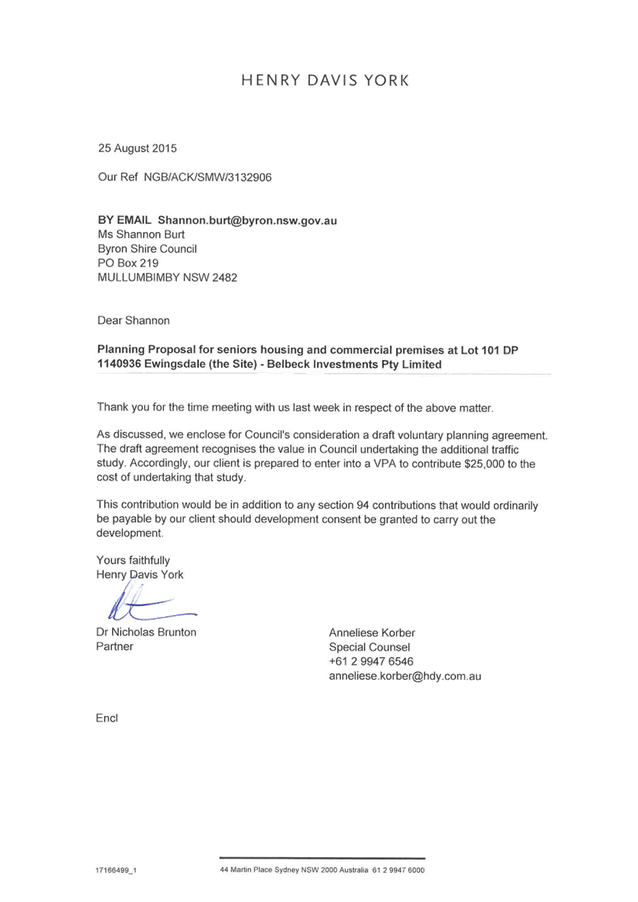


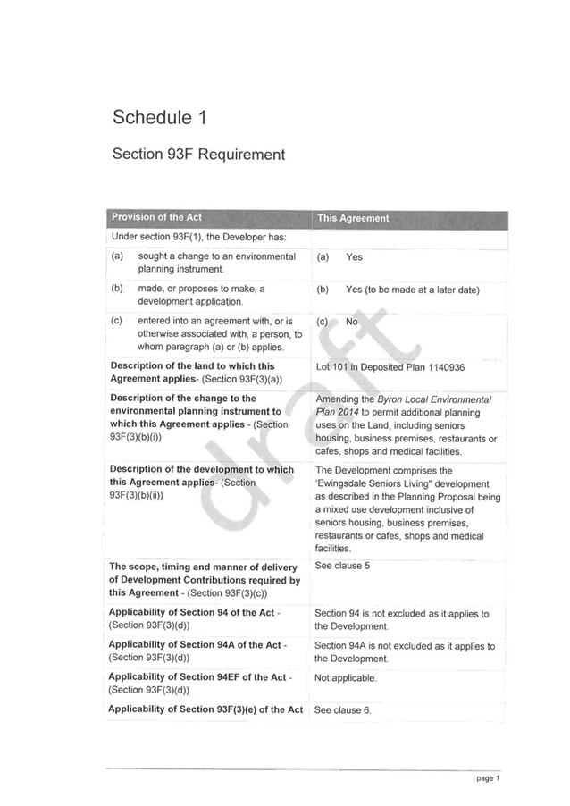
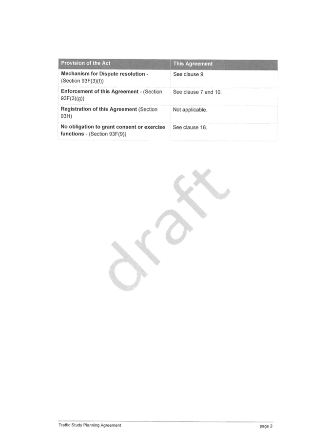
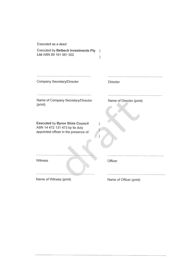
Staff Reports - Sustainable Environment and Economy 13.16 - Attachment 8
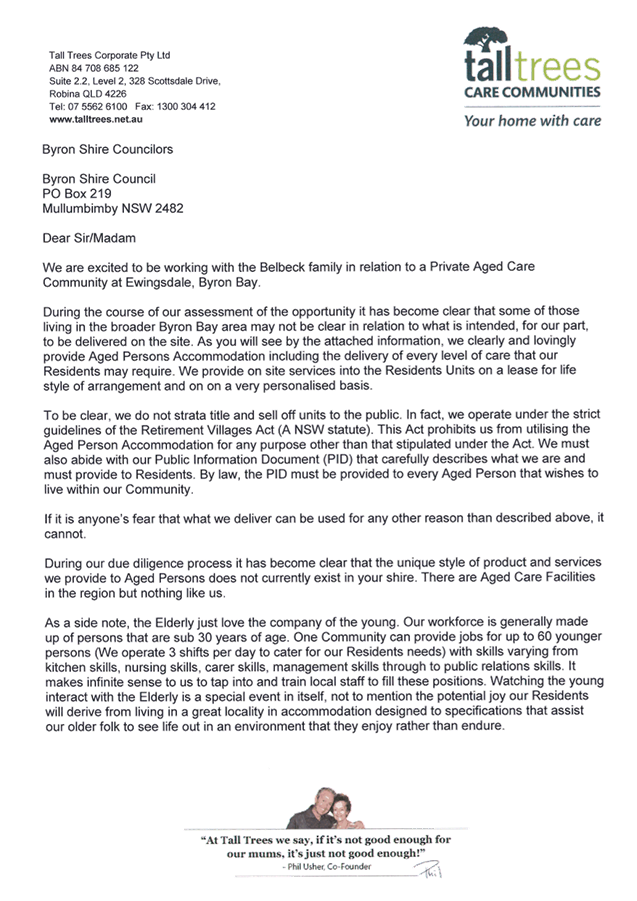
Staff Reports - Sustainable Environment and Economy 13.16 - Attachment 9
Local
Government (General) Regulation 2005
Schedule 3A Form of special disclosure of
pecuniary interest
(Clause 195A)
Local
Government Act 1993
Form of Special Disclosure of Pecuniary Interest
1 The particulars of this form are to be written in
block letters or typed.
2 If any space is insufficient in this form for all
the particulars required to complete it, an appendix is to be attached for that
purpose which is properly identified and signed by you.
Important information
This information is being collected for the purpose of
making a special disclosure of pecuniary interests under sections 451 (4) and
(5) of the Local Government Act 1993. You must not make a special disclosure that you know
or ought reasonably to know is false or misleading in a material particular.
Complaints made about contraventions of these requirements may be referred by
the Director-General to the Local Government Pecuniary Interest and
Disciplinary Tribunal.
This form must be completed by you before the
commencement of the council or council committee meeting in respect of which
the special disclosure is being made. The completed form must be tabled at the
meeting. Everyone is entitled to inspect it. The special disclosure must be
recorded in the minutes of the meeting.
Special
disclosure of pecuniary interests
by
____________________________________________________________________________________
[full
name of councillor]
in the matter of
__________________________________________________________________________
[insert
name of environmental planning instrument]
which is to be considered at a meeting of the
______________________________________________________________________________________
[name of council or council committee (as the case
requires)]
to be held on the _________________ day of __________________________
201
|
Pecuniary
interest
|
|
Address of land
in which councillor or an associated person, company or body has a
proprietary interest (the identified land)
|
|
|
Relationship of identified land to councillor
[Tick or cross one box.]
|
Councillor
has interest in the land (e.g. is owner or has other interest arising out of
a mortgage, lease, trust, option or contract, or otherwise).
Associated
person of councillor has interest in the land.
Associated company
or body of councillor has interest in the land.
|
|
Matter giving rise to pecuniary interest
|
|
Nature of land that is subject to a
change
in zone/planning control by proposed
LEP (the subject land)
[Tick or cross one box]
|
The identified
land.
Land
that adjoins or is adjacent to or is in proximity to the identified land.
|
|
Current
zone/planning control
[Insert name
of current planning instrument and identify relevant zone/planning control
applying to the subject land]
|
|
|
Proposed
change of zone/planning control
[Insert name of proposed
LEP and identify proposed change of zone/planning control applying to the
subject land]
|
|
|
Effect
of proposed change of zone/planning control on councillor
[Insert
one of the following:
“Appreciable financial gain” or
“Appreciable
financial loss”]
|
|
[If
more than one pecuniary interest is to be declared, reprint the above box and
fill in for each additional interest.]
_____________________________
Councillor’s
signature
_____________________________
Date
[This
form is to be retained by the Council’s general manager and included in
full in the minutes of the meeting]
Staff Reports - Sustainable Environment and Economy 13.16 - Attachment 10
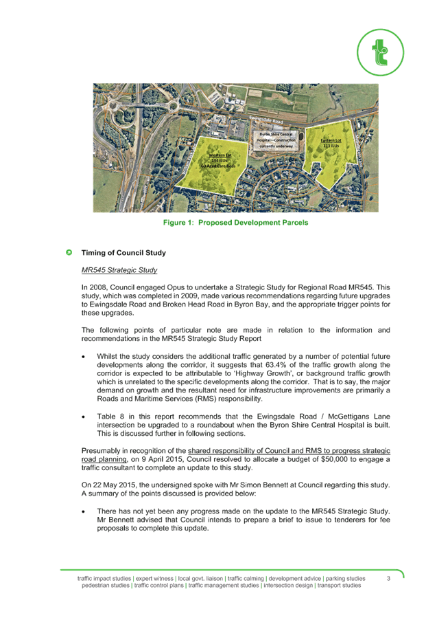
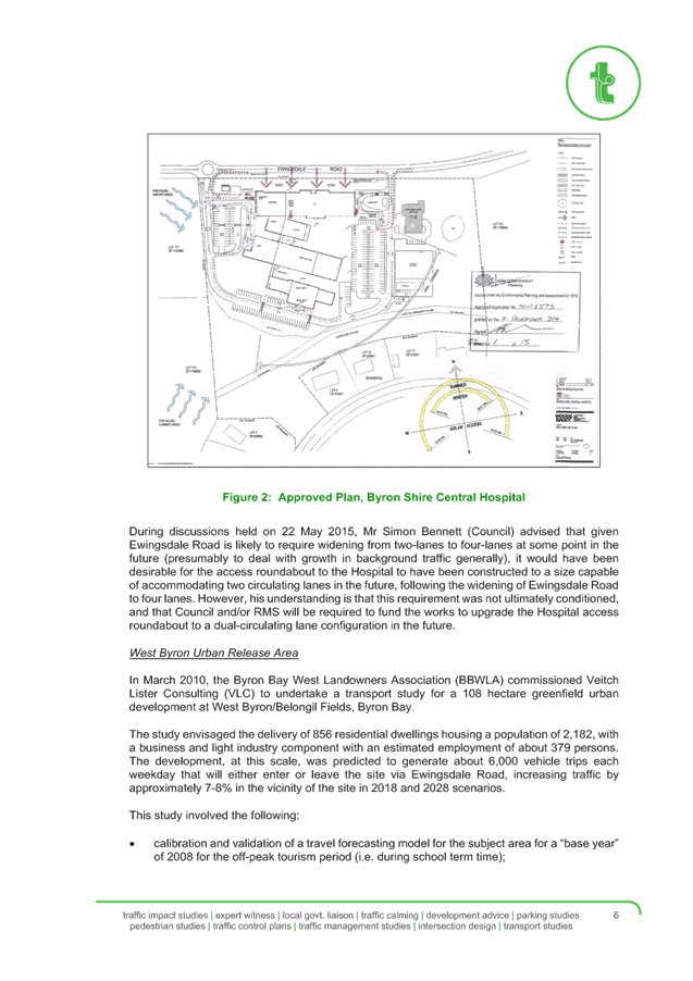
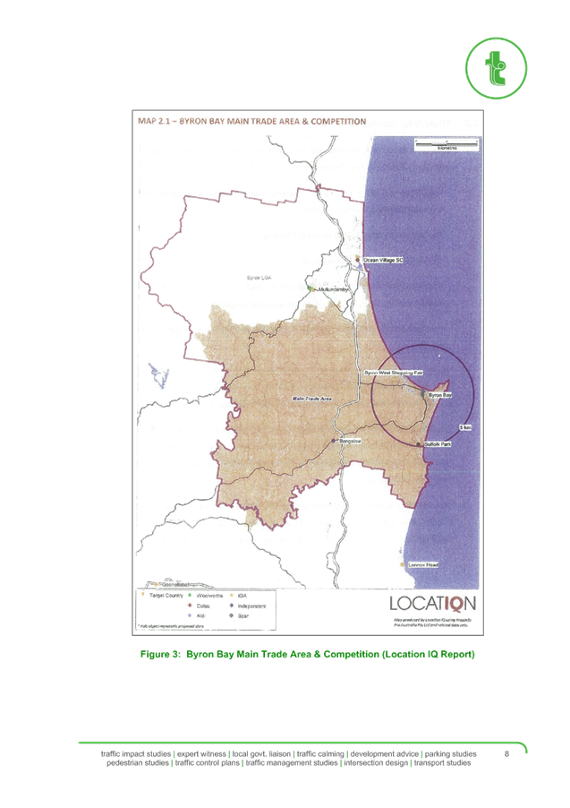
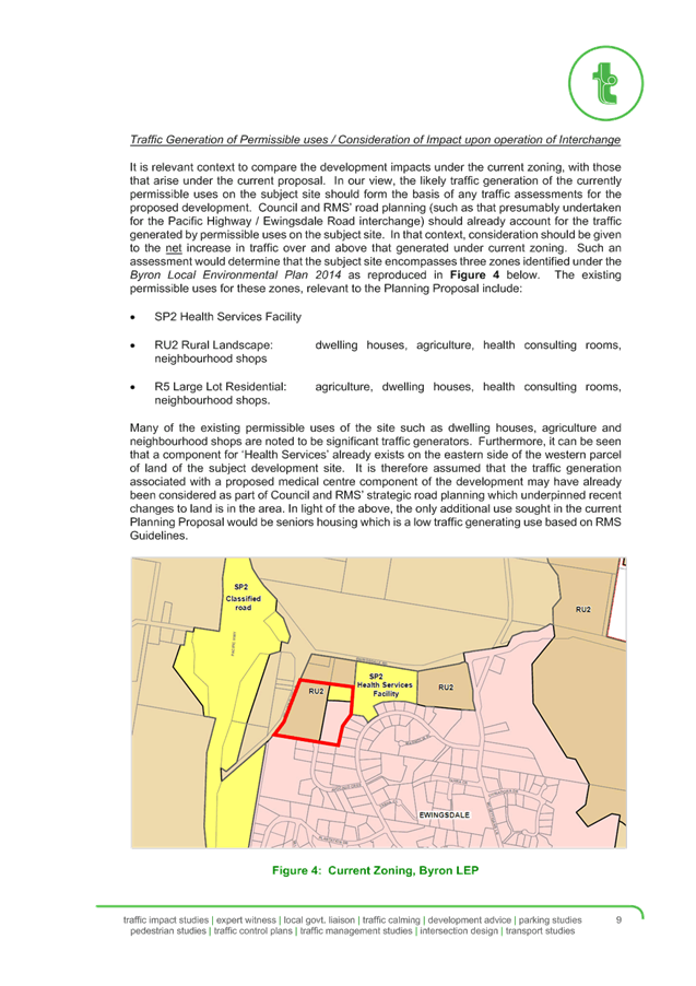
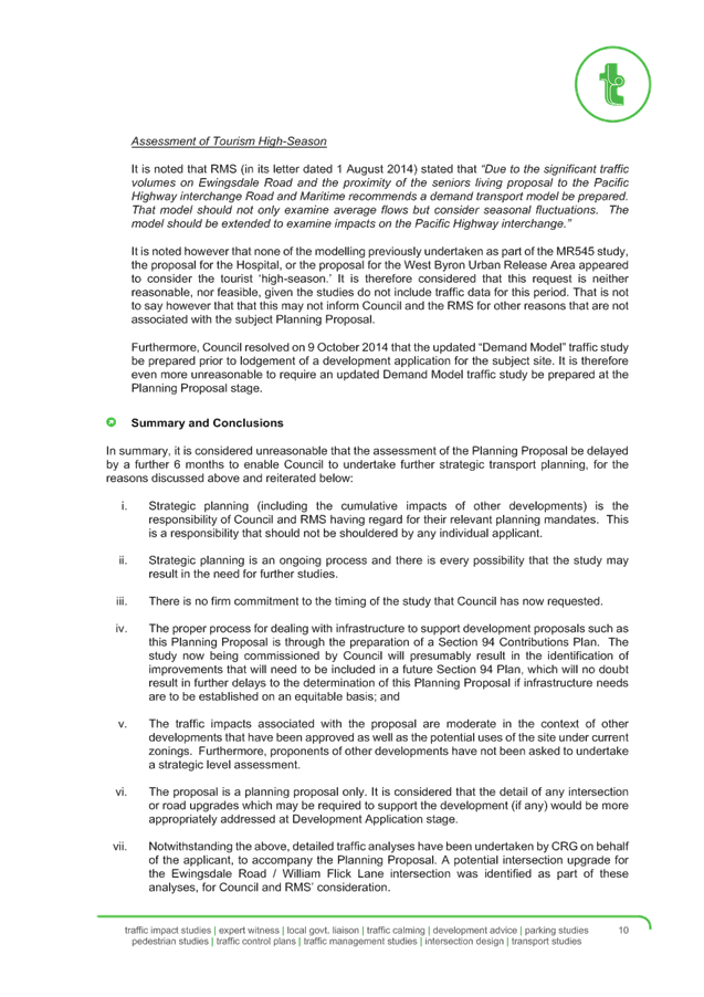
Staff Reports - Sustainable Environment and Economy 13.16 - Attachment 11
è
Belbeck Investments Pty Ltd
Byron Shire Council
Voluntary Planning Agreement
Section 93F of the Environmental Planning and Assessment Act, 1979
(NSW)
Section 93F of the Environmental Planning
and Assessment Act, 1979 (NSW)
Contents
1 Planning Agreement under the Act 1
2 Application of this Agreement 1
3 Operation of this Agreement 1
4 Definitions and interpretation 2
4.1 Definitions 2
4.2 Interpretation 4
5 Development Contribution to be made under this
Agreement 5
6 Application of sections 94, 94A and 94EF of the Act to
the Development 5
7 Caveat 5
8 Review of this Agreement 6
9 Dispute Resolution 6
9.1 Reference to Dispute 6
9.2 Notice of Dispute 6
9.3 Representatives of Parties to Meet 6
10 Security and Enforcement 6
10.1 Security 6
10.2 Enforcement 7
11.1 Delivery 7
11.2 Change
of Details 7
11.3 Giving
of Notice 8
11.4 Delivery
outside of business hours 8
12 Force Majeure 8
13 Costs 9
14 Entire Agreement 9
15 Governing law and jurisdiction 9
16 No fetter 10
17 Representations and warranties 10
18 Severability 10
19 Waiver 10
20 GST 10
20.1 Construction 10
20.2 Intention
of the Parties 11
20.3 Consideration
GST exclusive 11
20.4 Payment
of GST – additional payment required 11
20.5 Tax
invoice 12
20.6 Adjustment
event 12
20.7 Reimbursements 12
20.8 No
Merger 12
21 Relationship of Parties 12
22 Counterparts 13
Staff Reports - Sustainable Environment and Economy 13.16 - Attachment 11
Agreement
made at on
Parties
Byron
Shire Council ABN 14 472 131 473 of
70-90 Station Street, Mullumbimby, New South Wales (Planning Authority)
Belbeck
Investments Pty Ltd ABN 89 161 561
502 of Hanrick Curran, Level 11, 307 Queen Street, Brisbane, Queensland (Developer)
Background
A The
Developer is the owner of the Land.
B In
April 2013, the Developer submitted the Planning Proposal to the Planning
Authority to make the Amending LEP and to facilitate the Development on the
Land.
C The
Planning Proposal was lodged by the Planning Authority with DP&I on 19
September 2013 and received Gateway determination on 21 November 2013.
D In
connection with the Planning Proposal, the Developer offers to enter into this
Agreement to make the Development Contribution if the Amending LEP is made.
Operative
provisions
1 Planning
Agreement under the Act
The Parties
agree that this Agreement is a planning agreement governed by Subdivision 2 of
Division 6 of Part 4 of the Act.
2 Application of this
Agreement
This
Agreement applies to the:
(a) Land; and
(b) Development.
3 Operation
of this Agreement
This Agreement
operates on and from the date that is the later of:
(a) the date the Amending LEP
is published on the NSW Legislation website; and
(b) the date the Agreement is
entered into as required by Clause 25C(1) of the Regulation.
4 Definitions
and interpretation
4.1 Definitions
In this
Agreement the following definitions apply:
Act means the Environmental Planning and Assessment
Act 1979 (NSW).
Agreement means this planning agreement.
Amending
LEP means the Local Environmental
Plan proposed under the Planning Proposal to amend the Byron Local
Environmental Plan 2014.
Authority means, in respect of a particular context or
circumstance, each Federal, State or Local Government, semi-Government,
quasi-Government or other body or authority, statutory or otherwise, including
but not limited to any court or tribunal, having jurisdiction and
responsibility in respect of that context or circumstance.
Business
Day means a day which is not a
Saturday, Sunday or bank or public holiday in Sydney.
Commencement
Date means the date upon which the
Agreement is taken to operate under clause 3.
Completion
means the date upon which the
Development Contribution is paid to the Planning Authority.
Dealing
means subdividing, mortgaging,
charging, encumbering or otherwise dealing with the Land.
Development means the ‘Ewingsdale Seniors Living"
development as described in the Planning Proposal being a mixed use development
inclusive of seniors housing, business premises, restaurants or cafes, shops
and medical facilities.
Development
Contribution means the payment of
$25,000 to the Planning Authority as a contribution to the costs of the Traffic
Study.
DP&I means the NSW Department of Planning and
Infrastructure or any other Authority replacing it.
Explanatory
Note means the Explanatory Note attached
at schedule 2.
First
Trigger Event means the date on which
the Amending LEP is published on the NSW Legislation website.
Force
Majeure Event means any of the
following:
(a) the
declaration by a Court that the Amending
LEP is invalid and where a modified LEP is not remade in similar form within 12
calendar months of the date of the declaration; or
(b) any
of the following:
(i) act of God;
(ii) law, rule, regulation,
order or policy of any government or governmental authority;
(iii) act of war declared or
undeclared;
(iv) accident, fire, explosion,
epidemic
(v) public disorder;
(vi) riot, civil disturbance,
insurrection, rebellion, sabotage or act of terrorists;
(vii) flood, earthquake, hail,
lightning, severe weather conditions or other natural calamity;
(viii) strike, boycott, lockout or other
labour disturbance,
which:
(ix) prevents the Developer from
carrying out or completing the Development;
(x) is beyond the control of
the Developer; and
(xi) was not directly or indirectly
caused or contributed to by the Developer.
GST
Law has the meaning given to that
term in A New Tax System (Goods and Services Tax) Act 1999 (Cth) and any
other Act or regulation relating to the imposition or administration of the
GST.
Land means Lot 101 in Deposited Plan 1140936.
Local
Environmental Plan has the meaning
given to it in the Act.
LPI means the Land and Property Information of New South
Wales or any other Authority replacing it.
Party
means a party to this Agreement,
including their successors and assigns.
Planning
Application means a development
application made under the Act for the Development or a stage of the
Development.
Planning
Approval means the determination by
approval of the Planning Application for the Development or a stage of the
Development.
Planning
Proposal means the planning proposal
submitted under Part 3, Division 4 of the Act for the Amending LEP, DP&I
reference PP_2013_BYRON_002_00, or its amended form, as has been endorsed by
the Planning Authority.
Regulation means the Environmental Planning and Assessment
Regulation 2000 (NSW).
Traffic
Study means the Ewingsdale Road
Traffic Demand Modelling Study referred to in the Planning Authority's letter
to the DP&I dated 30 July 2015.
Transfer
Dealings means selling or
transferring the Land.
4.2 Interpretation
In the
interpretation of this Agreement, the following provisions apply unless the
context otherwise requires:
(a) Headings are inserted for
convenience only and do not affect the interpretation of this Agreement.
(b) If the day on which any
act, matter or thing is to be done under this Agreement is not a Business Day,
the act, matter or thing must be done on the next Business Day.
(c) A reference in this Agreement to
dollars or $ means Australian dollars and all amounts payable under this
Agreement are payable in Australian dollars.
(d) A reference in this
Agreement to any law, legislation or legislative provision includes any
statutory modification, amendment, replacement or re-enactment, and any
subordinate legislation or regulations issued under that legislation or
legislative provision.
(e) A reference in this Agreement to any agreement, deed
or document is to that agreement, deed or document as amended, novated,
supplemented or replaced.
(f) A reference to a clause, part, schedule or attachment
is a reference to a clause, part, schedule or attachment of or to this
Agreement.
(g) An expression importing a natural person includes any
company, trust, partnership, joint venture, association, body corporate or
governmental agency.
(h) Where a word or phrase is given a defined meaning,
another part of speech or other grammatical form in respect of that word or
phrase has a corresponding meaning.
(i) A word which denotes the singular denotes the plural,
a word which denotes the plural denotes the singular, and a reference to any
gender denotes the other genders.
(j) References to the word ‘include’ or
‘including’ are to be construed without limitation.
(k) A reference to this Agreement includes the agreement
recorded in this Agreement.
(l) A reference to a Party to this Agreement includes a
reference to the servants, agents and contractors of the Party, and the
Party’s successors and assigns.
(m) Any schedules and attachments form part of this Agreement.
5 Development Contribution to
be made under this Agreement
(a) Subject to this Agreement
the Developer is to make the Development Contribution within 28 days after the
First Trigger Event.
(b) If
the Developer fails to make the Development Contribution in accordance with clause
5(a), then the Developer acknowledges and agrees that, unless otherwise
agreed in writing by the Planning Authority, it will ensure that no Planning Applications are lodged with the Planning
Authority for the Development or any other development on the Land.
(c) Following the payment of
the Development Contribution, the Developer shall prepare a draft development
control plan in consultation with the Planning Authority and provide that to
the Planning Authority as soon as reasonably practicable and no later than 6
months after the Development Contribution is paid.
6 Application
of sections 94, 94A and 94EF of the Act to the Development
This
Agreement does not exclude the application of sections 94, 94A and 94EF of the
Act to the Development.
7 Caveat
(a) Until
such time as the Development Contribution is paid, the Developer agrees that
the Planning Authority may, after the Commencement Date, lodge a caveat on the
relevant folios of the Register held by the LPI pertaining to the Land.
(b) If
the Planning Authority lodges a caveat in accordance with clause 7(a),
then the Planning Authority must during such time as the caveat remains lodged
on the title of the Land:
(i) provide written
consent within 5 Business Days to any proposed Dealing in respect of the Land
other than a Transfer Dealing;
(ii) provide written consent
within 5 Business Days to a proposed Transfer Dealing in circumstances where
the proposed assignee, transferee, purchaser or other party (the "Incoming
Party") of the Land or part of the Land has executed a Novation Deed
in substantially the same form as contained in Annexure A;
(iii) remove the caveat from
the title to the Land promptly, following payment of the Development
Contribution.
8 Review of this Agreement
(a) This Agreement may be
reviewed or modified and any review or modification of this Agreement will be
conducted in the circumstances and in the manner determined by the Parties.
(b) No modification or review
of this Agreement will be of any force or effect unless it is in writing and
signed by the Parties to this Agreement.
9 Dispute Resolution
9.1 Reference
to Dispute
If a dispute
arises between the Parties in relation to this Agreement, then either Party
must resolve that dispute in accordance with this clause.
9.2 Notice
of Dispute
The
Party wishing to commence the dispute resolution processes must notify the
other in writing of:
(a) the intent to invoke this
clause;
(b) the nature or subject
matter of the dispute, including a summary of any efforts made to resolve the
dispute other than by way of this clause; and
(c) the outcomes which the
notifying Party wishes to achieve (if practicable).
9.3 Representatives
of Parties to Meet
(a) The representatives of the
Parties must promptly (and in any event within 14 Business Days of the written
notice provided in accordance with clause 9.2) meet in good faith to
attempt to resolve the notified dispute.
(b) The Parties may, without
limitation:
(i) resolve
the dispute during the course of that meeting;
(ii) agree that further
material, expert opinion or consideration is needed to effectively resolve the
dispute (in which event the Parties will, in good faith, agree to a timetable
for resolution);
(iii) agree
that the Parties are unlikely to resolve the dispute and, in good faith, agree
to a form of alternative dispute resolution (including expert determination,
arbitration or mediation) which is appropriate for the resolution of the
relevant dispute.
10 Security and Enforcement
10.1 Security
The
Parties agree that the right of the Planning Authority to register a caveat on
the Land constitutes suitable means of enforcement for the purpose of section
93F(3)(g) of the Act.
10.2 Enforcement
(a) Without limiting any other
remedies available to the Parties, this Agreement may be enforced by any Party
in any Court of competent jurisdiction.
(b) Nothing in this Agreement
prevents:
(i) a Party from
bringing proceedings in the Land and Environment Court or any other Court of
competent jurisdiction to enforce any aspect of this Agreement or any matter to
which this Agreement relates; and
(ii) the Planning Authority
from exercising any function under the Act or any other Act or law relating to
the enforcement of any aspect of this Agreement or any matter to which this
Agreement relates.
11 Notices
11.1 Delivery
Any
notice, consent, information, application or request that must or may be given
or made to a Party under this Agreement is only given or made if it is in
writing and sent in one of the following ways:
(a) Delivered or posted to
that Party at its address set out below.
(b) Faxed to that Party at its
fax number set out below.
(c) Emailed
to that Party at its email address set out below.
Byron
Shire Council
Attention: General
Manager
Address: 70-90
Station Street, Mullumbimby, New South Wales
Fax
Number: [insert]
Email: [insert]
Belbeck
Investments Pty Ltd
Attention: Leigh
& John Belbeck
Address: 85 Yarranabbe Road, Darling Point, NSW 2027
Email: leigh.belbeck@gmail.com
john.belbeck2@gmail.com
11.2 Change of
Details
If a
Party gives the other Party three Business Days' notice of a change of its
address, email address or fax number, any notice, consent, information,
application or request is only given or made by that other Party if it is
delivered, electronically sent, posted or faxed to the latest address, email
address or fax number.
11.3 Giving of
Notice
Subject
to clause 11.4, any notice, consent, invoice, information, application
or request is to be treated as given or made at the following time:
(a) if it is delivered by
process server, when it is served at the relevant address;
(b) if it is sent by
registered post, two Business Days after it is posted; and
(c) if it is sent by email, when a delivery confirmation report is received by the
sender, unless subsequently the sender receives a delivery failure
notification, indicating that the electronic mail has not been delivered.
11.4 Delivery
outside of business hours
If any
notice, consent, information, application or request is delivered on a day that
is not a Business Day, or if on a Business Day, after 5.00 pm on that day in
the place of the Party to whom it is sent, it is to be treated as having been
given or made at the beginning of the next Business Day.
12 Force Majeure
(a) If
a Party is unable by reason of a Force Majeure Event to carry out wholly or in
part its obligations under this Agreement, it must:
(i) give
to the other Parties prompt notice of the force majeure with reasonably full
particulars; and
(ii) suggest
an alternative method, if any, of satisfying its obligations under this
Agreement.
(b) If
a Party is unable to satisfy its obligations under this Agreement by an
alternative method, the obligations of the Parties, and any time periods, so
far as they are affected by the Force Majeure Event are then suspended during
continuance of the force majeure and any further period as may be reasonable in
the circumstances.
(c) The
Party giving such notice under this clause must use all reasonable efforts and
diligence to remove the Force Majeure Event or ameliorate its effects as
quickly as practicable.
(d) If
the Parties are unable to agree on the existence of a Force Majeure Event or
the period during which the obligations of the Parties, and any time periods,
are suspended during the continuance of the Force Majeure Event, that dispute
must be referred for determination under clause 9.
(e) If a Force
Majeure Event cannot be rectified to the mutual satisfaction of the Parties and
the Developer, in its sole discretion, determines that it is unable to
undertake or continue with the Development, then upon the surrender of any
existing Planning Approvals that relate to works that have not yet been
physically commenced (as defined in the Act), the Developer may terminate this
agreement by written notice to the Planning Authority in which event neither
Party will have any claim against the other under this Agreement.
(f) If paragraph
(e) applies, the Planning Authority shall do all things reasonably
necessary including executing any necessary documents to enable the Developer
to remove the notation of this Agreement on the relevant folios of the Torrens
title register held by LPI relating to the land within 20 Business Days of
receiving written request from the Developer.
13 Costs
(a) The Parties agree to bear
their own costs of preparing, negotiating, executing and stamping this
Agreement and any document related to this Agreement.
(b) The Parties agree that the
legal costs of any modification to this Agreement will be borne by the party
that requests the modification. Where more than one party requests the
modification, the legal costs associated with modification to this Agreement
will be split between the Parties equally, unless otherwise agreed in writing.
14 Entire
Agreement
(a) This Agreement contains
everything to which the Parties have agreed in relation to the matters those
documents deal with. No Party can rely on an earlier document, or
anything said or done by another Party, or by a director, officer, agent or
employee of that Party, before this Agreement was executed, except as permitted
by law.
(b) Pursuant to clause 25E(7)
of the Regulation, the Parties agree that the Explanatory Note is not to be
used to assist in construing this Agreement.
15 Governing law
and jurisdiction
This
Agreement is governed by the law of New South Wales. The Parties submit to the
non-exclusive jurisdiction of its Courts and Courts of appeal from them. The
Parties will not object to the exercise of jurisdiction by those Courts on any
basis.
16 No
fetter
Nothing
in this Agreement shall be construed as requiring the Planning Authority to do
anything that would cause it to be in breach of any of its obligations at law,
and without limitation, nothing shall be construed as limiting or fettering in
any way the exercise of any statutory discretion or duty.
17 Representations
and warranties
(a) The
Developer represents and warrants that on the date of this Planning Agreement
the Developer is the legal and beneficial owner of the Land.
(b) The
Parties represent and warrant that they have power to enter into this Agreement
and comply with their obligations under this Agreement and that entry into this
Agreement will not result in the breach of any law.
18 Severability
If a
clause or part of a clause of this Agreement can be read in a way that makes it
illegal, unenforceable or invalid, but can also be read in a way that makes it
legal, enforceable and valid, it must be read in the latter way. If any clause
or part of a clause Is illegal, unenforceable or invalid, that clause or part
is to be treated as removed from this Agreement, but the rest of this Agreement
is not affected.
19 Waiver
The fact
that a Party fails to do, or delays in doing, something the Party is entitled
to do under this Agreement, does not amount to a waiver of any obligation of,
or breach of obligation by, another Party. A waiver by a Party is only
effective if it is in writing. A written waiver by a Party is only effective in
relation to the particular obligation or breach in respect of which it is
given. It is not to be taken as an implied waiver of any other obligation or
breach or as an implied waiver of that obligation or breach in relation to any
other occasion.
20 GST
20.1 Construction
In this clause 20:
(a) words and expressions
which are not defined in this Agreement but which have a defined meaning in the
GST Law have the same meaning as in the GST Law; and
(b) GST Law has the
same meaning given to that expression in the GST Act.
20.2 Intention
of the Parties
Without
limiting the operation of this clause 20, as at the date of this
Agreement, the Parties intend that:
(a) Divisions 81 and 82 of the
GST Act apply to the supplies made under and in connection with this Agreement;
(b) no tax invoices will be
exchanged between the Parties; and
(c) no additional amount will
be payable to a Supplier (as defined in clause 20.4 below) on
account of GST.
20.3 Consideration
GST exclusive
All
prices or other sums payable or consideration to be provided under this
Agreement are exclusive of GST.
20.4 Payment of GST –
additional payment required
(a) If
an entity (Supplier) makes a taxable supply under or in connection with
this Agreement (Relevant Supply), then, subject to clause 20.4(d),
the Party required under the other provisions of this Agreement to provide the
consideration for that Relevant Supply (Recipient) must pay an
additional amount to the Supplier (GST Amount), as calculated under clause 20.4(b),
20.4(c) and 20.4(e) (as appropriate).
(b) To
the extent that the consideration to be provided by the Recipient for the
Relevant Supply under the other provisions of this Agreement is a payment of
money (including, for the avoidance of doubt, any payment under clauses 20.4(c)
and 20.4(e)), the Recipient must pay to the Supplier an additional
amount equal to the amount of the payment multiplied by the rate or rates of
GST applicable to that Relevant Supply.
(c) To
the extent that the consideration to be provided by the Recipient for that
Relevant Supply is neither:
(i) a payment of money;
nor
(ii) a taxable supply,
(Non-taxable
non monetary consideration),
the
Recipient must pay to the Supplier an additional amount equal to 1/11th
of the GST-inclusive market value of the Non-taxable non-monetary
consideration.
(d) To
the extent that the consideration payable by the Recipient is a taxable supply
made to the Supplier by the Recipient, then, notwithstanding clause 20.4(a)
and subject to clause 20.4(e), no additional amount is payable by the
Recipient to the Supplier on account of the GST payable on that taxable supply.
(e) Notwithstanding
clause 20.4(d) if the GST-inclusive market value of the
non-monetary consideration of the Relevant Supply (Supplier's taxable supply)
is less than the GST-inclusive market value of the non-monetary consideration
comprising the taxable supply made by the Recipient to the Supplier for the
Supplier's taxable supply (Recipient's taxable supply) then, the
Recipient must pay to the Supplier an additional amount equal to 1/11th
of the difference between the GST-inclusive market value of the Recipient's
taxable supply and the GST-inclusive market value of the Supplier's taxable
supply.
(f) The recipient will
pay the GST Amount referred to in this clause 20.4 in addition to
and at the same time as the first part of the consideration is provided for the
Relevant Supply.
20.5 Tax
invoice
The
Supplier must deliver a tax invoice to the Recipient before the Supplier is
entitled to payment of the GST Amount under clause 20.4. The
Recipient can withhold payment of the GST Amount until the Supplier provides a
tax invoice.
20.6 Adjustment
event
If an
adjustment event arises in respect of a taxable supply made by a Supplier under
this Agreement, the GST Amount payable by the Recipient under clause 20.4
will be recalculated taking into account any previous adjustment under this
clause to reflect the adjustment event and a payment will be made by the
Recipient to the Supplier or by the Supplier to the Recipient as the case
requires.
20.7 Reimbursements
Where a
party is required under this Agreement to pay, indemnify or reimburse an
expense, loss or outgoing of another party, the amount to be paid, indemnified
or reimbursed by the first party will be the sum of:
(a) the amount of the expense,
loss or outgoing less any input tax credits in respect of the expense, loss or
outgoing to which the other party, or to which the representative member of a
GST group of which the other party is a member, is entitled; and
(b) any additional amount
payable under clause 20.4 in respect of that reimbursement.
20.8 No Merger
This clause
200 does not merge in the completion, discharge, rescission or termination
of this document or on the transfer of any property supplied or to be supplied
under this document.
21 Relationship of
Parties
This
Agreement is not intended to create a partnership, joint venture or agency relationship
between the Parties.
22 Counterparts
This
document may consist of a number of counterparts and, if so, the counterparts
taken together constitute one document.
Staff Reports - Sustainable Environment and Economy 13.16 - Attachment 11
Schedule 1
Section 93F Requirement
|
Provision of the Act
|
This Agreement
|
|
Under section 93F(1), the Developer has:
|
|
|
(a) sought a change to an
environmental planning instrument.
|
(a) Yes
|
|
(b) made, or proposes to
make, a development application.
|
(b) Yes (to be made at
a later date)
|
|
(c) entered into an
agreement with, or is otherwise associated with, a person, to whom paragraph
(a) or (b) applies.
|
(c) No
|
|
Description of the land to which this Agreement
applies- (Section 93F(3)(a))
|
Lot 101 in Deposited Plan 1140936
|
|
Description of the change to the environmental
planning instrument to which this Agreement applies - (Section 93F(3)(b)(i))
|
Amending the Byron Local Environmental Plan 2014
to permit additional planning uses on the Land, including seniors housing,
business premises, restaurants or cafes, shops and medical facilities.
|
|
Description of the development to which this
Agreement applies- (Section
93F(3)(b)(ii))
|
The Development comprises the ‘Ewingsdale
Seniors Living" development as described in the Planning Proposal being
a mixed use development inclusive of seniors housing, business premises,
restaurants or cafes, shops and medical facilities.
|
|
The scope, timing and manner of delivery of
Development Contributions required by this Agreement - (Section 93F(3)(c))
|
See
clause 5
|
|
Applicability of Section 94 of the Act - (Section 93F(3)(d))
|
Section 94 is not excluded as it applies to the
Development.
|
|
Applicability of Section 94A of the Act - (Section 93F(3)(d))
|
Section 94A is not excluded as it applies to the
Development.
|
|
Applicability of Section 94EF of the Act - (Section 93F(3)(d))
|
Not applicable.
|
|
Applicability of Section 93F(3)(e) of the Act
|
See clause 6.
|
|
Mechanism for Dispute resolution - (Section 93F(3)(f))
|
See clause 9.
|
|
Enforcement of this Agreement - (Section 93F(3)(g))
|
See clause 7 and 10.
|
|
Registration of this Agreement (Section 93H)
|
Not
applicable.
|
|
No obligation to grant consent or exercise functions - (Section 93F(9))
|
See clause 16.
|
Explanatory Note
Environmental Planning and Assessment
Regulations 2000
(Clause 25E)
Explanatory Note
1 Planning
Agreement
Under
section 93F of the Environmental Planning and Assessment Act 1979 (NSW)
and Clause 25E of the Environmental Planning and Assessment Regulations 2000
1 Parties
Byron
Shire Council ABN 14 472 131 of 70-90
Station Street, Mullumbimby, New South Wales (Planning Authority)
Belbeck Investments Pty Ltd ABN 89 161 561 502 of of Hanrick Curran, Level 11,
307 Queen Street, Brisbane, Queensland (Developer)
2 Description of
Subject Land
The
land is contained in folio identifier Lot 101 in Deposited Plan 1140936 located
at Ewingsdale Road, Ewingsdale, New South Wales.
3 Description of
Proposed Change to Environmental Planning Instrument
The
Developer has submitted a Planning Proposal to the Planning Authority to rezone
the Land.
An Amending LEP will permit additional planning uses
on the Land, including seniors housing, business premises, restaurants or
cafes, shops and medical facilities.
4 Summary of
Objectives, Nature and Effect of the Draft Planning Agreement
The
objective of the draft Planning Agreement is to facilitate the delivery of the
Development Contribution to:
(a) assist
in the funding of the Ewingsdale Road Traffic Demand Modelling Study required
by the Planning Authority to assess and monitor the traffic impacts of
development in the region (Traffic Study); and
(b) provide
a draft development control plan to the Planning Authority as soon as
reasonably practicable and no later than 6 months after the Development
Contribution is paid to assist with better planning outcomes for the region.
The nature of the draft Planning Agreement is a
contractual relationship between the Planning Authority and the Developer for
the payment of the Development Contribution and the provision of a draft
development control plan.
The effect of the draft Planning Agreement is that the
Developer must provide:
(a) a
Development Contribution that comprises the payment of $25,000 to the Planning
Authority within 28 days of the later of the date on which the Amending LEP is
published on the NSW Legislation website and the execution of the agreement;
and
(b) a
draft development control plan to the Planning Authority as soon as reasonably
practicable and no later than 6 months after the Development Contribution is
paid.
The draft Planning Agreement does not exclude the
application of s94, s94A and s94EF of the Act to the Development.
5 Assessment of
the Merits of the Draft Planning Agreement, including the impact on the public
or any relevant section of the public
The
draft Planning Agreement satisfies the objectives of the Act through the
Developer:
(a) making
the Development Contribution to assist in the funding of the Traffic Study to
assess and monitor the traffic impacts of development in the region and to
ensure that existing communities which may be affected do not bear the cost of
this assessment; and
(b) provide
a draft development control plan to the Planning Authority as soon as
reasonably practicable and no later than 6 months after the Development
Contribution is paid to assist with better planning outcomes for the region and
community.
The
positive impact on the public is that the public will gain benefit from:
(a) the outcomes of the
Traffic Study and better planning outcomes in the region; and
(b) relevant contributions
under s94, s94A and s94EF of the Act which will be required
to be paid by the relevant proponent of the Development at the Planning
Application stage.
6 Other Matters
7.1 How the draft Planning Agreement promotes public
interest and one or more of the objects of the Act
The draft Planning Agreement promotes the public
interest by:
· providing the Development Contribution comprising a
financial contribution towards the Traffic Study and the preparation of a draft
development control plan to assist the Planning Authority to monitor the
planning impacts of development in the area and lead to better planning
outcomes in the region;
· providing for the carrying out of the required
Development Contribution in a timely manner in connection with the Amending
LEP; and
· promoting the sharing of responsibility for local
traffic impacts and monitoring between local councils and developers,
and therefore promotes the objects of the Environmental
Planning and Assessment Act 1979 as set out in s5(a)(ii) and s5(b).
7.2 How the draft Planning Agreement promotes one or
more of the elements of the council’s charter under Section 8 of the
Local Government Act 1993
The draft Planning Agreement is consistent with the
Planning Authority's charter under Section 8 of the Local Government Act 1993:
(a) to have regard to the long
term and cumulative effects of its decisions;
(b) to bear in mind that it is
the custodian and trustee of public assets and to effectively plan for, account
for and manage the assets for which it is responsible;
(c) to engage in the long term
strategic planning on behalf of the local community; and
(d) to keep the local
community and the State government (and through it, the wider community)
informed about its activities.
7.3 The planning purpose/s served by the draft
Planning Agreement
The draft Planning Agreement will provide for a
reasonable means of achieving the planning purpose by the co-ordinated
provision of local and developer funded traffic assessment and planning
impact monitoring and will assist the Planning Authority's strategic planning
of the region.
7.4 Whether the draft Planning Agreement conforms with
Council’s capital works program
The draft Planning Agreement conforms with the
Planning Authority's proposed capital works program as it assists the Planning
Authority undertake the Traffic Study to assess the likely traffic impacts
created by development in the region, which would otherwise be required to be
provided under a contributions plan under Division 6 of Part 4 of the Environmental
Planning and Assessment Act 1979.
Staff Reports - Sustainable Environment and Economy 13.16 - Attachment 11
Executed as a deed
|
Executed by Belbeck Investments Pty Ltd ABN 89 161 561 502
|
)
)
|
|
|
...........................................................
Company Secretary/Director
...........................................................
Name of Company Secretary/Director (print)
|
|
...........................................................
Director
...........................................................
Name of Director (print)
|
|
Executed
by Byron Shire Council ABN 14 472 131 473 by its duly appointed
officer in the presence of:
|
)
)
)
|
|
|
..............................................................
Witness
...............................................................
Name of Witness (print)
|
|
.............................................................
Officer
...............................................................
Name of Officer (print)
|
Staff Reports - Sustainable Environment and Economy 13.17 - Attachment 1


Reports of Committees - Corporate and Community
Services 14.1 - Attachment 1

Finance Advisory Committee Meeting
|
Venue
|
Conference Room, Station Street, Mullumbimby
|
|
Date
|
Thursday, 20 August 2015
|
|
Time
|
2.00pm
|
Reports of Committees - Corporate and Community
Services 14.1 - Attachment 1
Minutes of the Finance Advisory
Committee Meeting held on Thursday, 20 August 2015
File No: Error! Unknown document
property name.
PRESENT: Cr
B Cameron, Cr D Dey, Cr A Hunter and Cr D Woods
Staff: Mark
Arnold (Director Corporate and Community Services)
Phil
Holloway (Director Infrastructure Services)
James
Brickley (Finance Manager)
Cr Cameron (Chair) opened the meeting at 2.13pm and
acknowledged that the meeting was being held on Bundjalung Country.
Apologies:
That the apology from Ken
Gainger (General Manager) be received and accepted.
Declarations of
Interest – Pecuniary and Non-Pecuniary
There were no declarations of
interest.
Adoption of
Minutes from Previous Meetings
|
Committee Recommendation:
That the minutes of the Finance Advisory Committee Meeting
held on 14 May 2015 be confirmed
. (Dey/Woods)
The recommendation was put to the vote and declared
carried.
|
Business Arising from Previous Minutes
There was no business arising
from previous minutes.
Staff Reports - Corporate and Community
Services
|
Report No. 5.1 2014/15
Financial Sustainability Project Plan - Update on the Action Implementation
Plan as at 30 June 2015
File No: I2015/792
|
|
Committee
Recommendation:
That the Finance Advisory Committee recommend to Council:
That the update report to 30 June 2015 on the 2014/2015
Financial Sustainability Project Plan Action Implementation Plan be received
and noted. (Dey/Woods)
The recommendation was put to
the vote and declared carried.
|
|
Report No. 5.2 Budget
Review - 1 April 2015 to 30 June 2015
File No: I2015/793
|
|
Committee
Recommendation:
That the
Finance Advisory Committee recommend to Council:
1. That
That Council authorises the itemised budget variations as shown in Attachment
2 (#E2015/52657) which includes the following results in the 30 June 2015
Quarterly Review of the 2014/2015 Budget:
a) General
Fund - $0 increase in accumulated surplus/working funds
b) General
Fund - $11,502,900 increase in reserves
c) Water
Fund - $2,601,000 increase in reserves.
d) Sewerage
Fund - $2,807,700 increase in reserves
2. That
That Council adopt the revised estimated General Fund Accumulated Surplus/
(Working Funds) surplus of $1,957,550 for the 2014/2015 financial year as at
30 June 2015.
(Cameron/Woods)
The recommendation was put to
the vote and declared carried.
|
|
Report No. 5.3 Carryovers
for inclusion in 2015/2016 Budget
File No: I2015/853
|
|
Committee
Recommendation:
That the Finance Advisory
Committee recommend to Council:
1. That
he works and services, and the respective funding shown in attachment 1
(#E2015/50268), attachment 2 (#E2015/50270) and attachment 3 (#E2014/50271)
be carried over from the 2014/2015 Financial Year and that the carryover
budget allocations be adopted as budget allocation revotes for inclusion in
the 2015/2016 Budget Estimates.
2. That
Council reallocate the adopted 2015/2016 Special Rate Community Building
Maintenance outlined in Table 3 of this report to the program outlined in
Table 4 of this report. (Woods/Cameron)
The recommendation was put to
the vote and declared carried.
|
|
Report No. 5.4 Draft
Updated Long Term Financial Plan 2015-2025
File No: I2015/854
|
|
Committee
Recommendation:
That the Finance Advisory Committee recommend to Council:
That Council adopt the updated Draft Long Term Financial
Plan 2015-2025 for the General Fund and that the overall Long Term Financial
Plan be further updated upon completion of the Water and Sewerage Business
Plans. (Woods/Hunter)
The recommendation was put to
the vote and declared carried.
|
There being no further business the meeting concluded at 3.51pm.
Reports of Committees - Corporate and Community
Services 14.2 - Attachment 1

Internal Audit Advisory Committee Meeting
|
Venue
|
Conference Room, Station Street, Mullumbimby
|
|
Date
|
Thursday, 20 August 2015
|
|
Time
|
11.00am
|
Reports of Committees - Corporate and Community
Services 14.2 - Attachment 1
Minutes of the Internal
Audit Advisory Committee Meeting held on Thursday,
20 August 2015
File No: Error! Unknown document
property name.
PRESENT: Cr
B Cameron, Cr A Hunter and Cr D Woods
Staff: Ken
Gainger (General Manager)
Mark
Arnold (Director Corporate and Community Services)
Phil Holloway (Director Infrastructure Services)
James Brickley (Manager Finance)
Community:
Michael Georghiou (Chair), Craig Kelly, Tony McCabe
Internal Auditor: Paul Dwyer and Adam
Kim (Grant Thornton) were available on telephone for Reports 5.1, 5.3 and 6.1.
External Auditor: Kevin Franey
(Thomas Noble Russell) was available on telephone for Report 5.2.
Mr Michael Georghiou (Chair) opened the
meeting at 11.03am and acknowledged that the meeting was being
held on Bundjalung Country.
Apologies:
There were no apologies.
Declarations of
Interest – Pecuniary and Non-Pecuniary
There were no declarations of
interest.
Adoption of
Minutes from Previous Meetings
|
Committee
Recommendation:
That the minutes of the Internal Audit Advisory Committee
Meeting held on 14 May 2015 be confirmed. (Georghiou/Woods)
The recommendation was put to the vote and declared
carried.
|
Business Arising from Previous Minutes
There was no business arising
from previous minutes.
PROCEDURAL MOTION
That the Committee move into
Confidential Session. (Georgiou/Woods)
The recommendation was put to the vote and declared
carried.
CONFIDENTIAL
SESSION
Staff Reports - Corporate and Community
Services
|
Report No. 5.1 Internal
Audit Report August 2015
File No: I2015/790
|
|
Committee
Recommendation:
That the
Internal Audit Committee recommend to Council:
1. That Council receive and note the Internal
Audit Report – Audit Committee (August 2015) (#E2015/52756) prepared by
the Internal Auditor, Grant Thornton.
2.
That the next Internal Audit Report – Audit Committee (12
November 2015) to the Internal Audit Committee, include an update on the
target dates and explanation on the implementation of the Audit
Recommendations, with regard to resources required and / or available. (Georghiou/Woods)
The recommendation was put to the vote and declared
carried.
|
|
Report No. 5.2 Internal
Audit Report - 2015 Independent Compliance Audit Report - Compliance with the
Roads and Maritime Services of NSW DRIVES Terms of Access Agreement
File No: I2015/798
|
|
Committee
Recommendation:
That the
Internal Audit Committee recommend to Council:
1. That
the Independent Compliance Audit Report – Compliance with the Roads and
Maritime Services of NSW DRIVES Terms of Access Agreement be noted by
Council, including the responses and actions detailed by Management.
2. That
Management implement the recommendations detailed in the report and also
identified at Attachment 1 (E2015/48196). (Georghiou/Woods)
The recommendation was put to the vote and declared
carried.
|
Staff Reports - Infrastructure Services
|
Report No. 5.3 WHS
Review
File No: I2015/716
|
|
Committee
Recommendation:
That the
Internal Audit Committee recommend to Council:
1. That
the Internal Audit Report – Work, Health and safety Review - May 2015
be noted by Council along with responses and actions detailed by Management.
2. That
Council adopt recommendations and management implement the recommendations
suggested in the report identified at Attachment 1 (E2015/45948), except for
Recommendation 2 under the heading ‘WHS Framework’ and
recommendation under the heading ‘Fire Safety Equipment
Inspections’ and adopt instead the alternative actions in relation to
each of those items.
3. That Council investigate the merging
of all three (3) WHS Committees into one (1) Committee to provide an
organisation wide approach to WHS. (Georghiou/Woods)
The recommendation was put to
the vote and declared carried.
|
Confidential Reports - Corporate and Community
Services
|
Report No. 6.1 Confidential - 2015/16 Internal Audit
Plan
File No: I2015/832
|
|
Committee
Recommendation:
That the
Internal Audit Committee recommend to Council:
1. That
the Internal Audit Committee recommend that Council adopt the “2015/16
Internal Audit Plan” at Attachment 1 (#E2015/50502) prepared by Grant
Thornton.
2. That
the Report and Attachment 1 remain confidential. (Georghiou/Woods)
The recommendation was put to
the vote and declared carried.
|
PROCEDURAL MOTION
That the Committee move out of Confidential Session. (Kelly/McCabe)
The recommendation was put to the vote and declared
carried.
There being no further business the meeting concluded at 12.36pm.
Reports of Committees - Sustainable Environment and
Economy 14.3 - Attachment 1

Biodiversity and Sustainability Advisory Committee Meeting
|
Venue
|
Conference Room, Station Street, Mullumbimby
|
|
Date
|
Thursday, 6 August 2015
|
|
Time
|
9.00am
|
Reports of Committees - Sustainable Environment and
Economy 14.3 - Attachment 1
Minutes of the Biodiversity
and Sustainability Advisory Committee Meeting held on Thursday, 6
August 2015
File No: Error! Unknown document
property name.
PRESENT: Cr
S Richardson (Mayor), Cr A Hunter, Cr R Wanchap
Staff: Sharyn
French (Manager Environmental & Economic Planning)
Angus Underwood (Team Leader Natural Environment)
Sandi Middleton (Sustainability Officer)
Community
voting members: Joanna
Immig, Luke McConnell, Peter Westheimer
Community non
voting members: Chris Sanderson
Cr Simon Richardson (Chair) opened
the meeting at 9.10 and acknowledged that the meeting was being
held on Bundjalung Country.
Apologies:
Donovan Adcock, Samala Heart, Kate Smillie
Declarations of
Interest – Pecuniary and Non-Pecuniary
There were no declarations of
interest.
Adoption of
Minutes from Previous Meetings
|
Committee
Recommendation:
That the minutes of the Biodiversity and Sustainability
Advisory Committee Meeting held on 14 May 2015 be confirmed.
(Richardson/Hunter)
The recommendation was put to the vote and
declared carried.
|
Business Arising from Previous Minutes
There was no business arising
from previous minutes.
Staff Reports - Sustainable Environment and
Economy
|
Report No. 5.1 Integrated
Weed Management Strategy update
File No: I2015/503
|
|
Committee
Recommendation:
1. That the Biodiversity and Sustainability
Advisory Committee note the report.
2 . That the definition of integrated
weed management and the objectives within the strategy be reviewed with
further input from Committee members and suggested experts / others.
(Westheimer/Wanchap)
The recommendation was put to
the vote and declared carried.
|
|
Report No. 5.2 Update
report on Sustainable House Day, World Environment Day and Byron Zero
Emissions Community Forum
File No: I2015/644
|
|
Committee
Recommendation:
That the Biodiversity and Sustainability
Committee note this report, provide feedback or suggestions in relation
to funding options for BZE and/or volunteers to help project manage the
process, and to share the Sustainable House Day event with networks.
(Wanchap/Richardson)
The recommendation was put to
the vote and declared carried.
|
|
Report No. 5.3 Review
of Committee's sub-working groups
File No: I2015/785
|
|
Committee
Recommendation:
That the Biodiversity and Sustainability
Committee recommends that:
a) members
of the Commercial Organic Waste, the Renewable Energy and the Carbon
sub-working groups be informed that these sub groups will cease to be formed
and members be invited to the Zero Emissions Byron (ZEB) working groups.
b) the
Biodiversity & Conservation Strategy Review sub-working group remain and
be activated as required.
c) members
of the Sustainable Events sub-working group be informed that this sub group
will cease to be formed and members be invited to attend Council’s
Festivals Round Tables meetings.
d) the
topic of sustainable events be an agenda item for the next Committee meeting
and that Council’s Events/Grants Officer be invited to speak.
(Immig/Hunter)
The recommendation was put to
the vote and declared carried.
|
FURTHER BUSINESS
Staff provide at the next Committee meeting:
· an update on the
Low Carbon Strategy and revisit Action 56 of the Strategy.
· a report on the
Rural Land Use Strategy.
There being no further business the meeting concluded at 11.10am.
Reports of Committees - Infrastructure Services 14.4 - Attachment 1

Local Traffic Committee Meeting
|
Venue
|
Executive Team Meeting Room, Administration Building,
Mullumbimby
|
|
Date
|
Wednesday, 26 August 2015
|
|
Time
|
10.30am
|
|
Committee
Members
|
Jessica Healey – Roads and
Maritime Services
Snr Constable Anthony Darby – Police
Cr Duncan Dey
Hon Tamara Smith MP
|
Reports of Committees - Infrastructure Services 14.4 - Attachment 1
Report of the Local Traffic Committee Meeting held on Wednesday,
26 August 2015
File No: Error! Unknown document
property name.
Meeting Commenced: 10.40
am
PRESENT:
Councillor: Cr Duncan Dey
Roads and Maritime Services Representative: Jessica
Healey
Police: Snr Constable Anthony Darby
Staff: Simon Bennett
Observers: Jenny Coman (Item 6.1)
Tony
Hart (Item 6.1)
Apologies:
Tamara Smith, MP
Declarations of
Interest
There
were no declarations of interest raised.
Adoption of
Minutes from Previous Meetings
It was noted the minutes of the Local Traffic Committee
Meeting held on 24 June 2015 were tabled to Council at the Ordinary Meeting
held 16 July 2015.
Matters Arising
There were no matters arising.
Outstanding Issues/Resolutions
N/A
Regulatory Matters
|
Report No. 6.1 Request
for Heavy Vehicle restrictions, Granuaille Road, Bangalow
File No: I2015/879
|
|
Two residents of Bangalow will attend to outline their
concerns to the Committee. One of them, in their capacity of the Bangalow
Progress Association (BPA), has chaired a community meeting (details as
attached, E2015/55160) and advised they hope for the following from
Council:
1.
to get endorsement of the community concern about excessive traffic on the
roads through Bangalow and the implications for safety, health and noise
abatement;
2.
to seek action by LTC toward achievement of our immediate remediation
requests;
3.
to work with the community on the assessment of the impact of the new
motorway and the Lismore signage, through a joint RMS, Council, community
working party to determine location of traffic counters and assessment of
results before and after opening of the T2E; and
4.
support our requirement for an overall review of regional traffic flows
including the need for a southern bypass of Bangalow.
Similar concerns have been raised by another Granuaille
Road resident who seeks Council support to limit heavy vehicle use,
preferably with outright ban or very least restrictions in regard to their
operational times.
|
To assist the discussion and Committee consideration of
the request details of traffic volumes and heavy vehicle use will be
available at the meeting. It should be noted while a local road the subject
site (depicted) forms part of the state road (MR65) network and any changes
will require RMS approval.
|
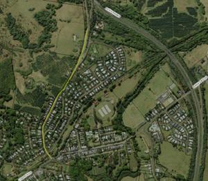
|
|
|
Committee Comments
· noted
document provided and discussed by Tony Hart (E2015/55160)
· noted
Council had supported southern bypass proposal in Council T2E EA submission
2008
· noted
Council did not and still does not support sign-posting Lismore for
southbound highway traffic at the Ewingsdale interchange, nevertheless it is
also noted motorists are increasingly using GPS over signage for directional
purposes
· however
in support of the community concern tabled it was agreed a recommendation be
made on the RMS proposal to assess Lismore signage
· as
for Granuaille Rd specifically, the following was noted:
· RMS data
provided (Feb 2015 count, 710m north of roundabout) indicates most traffic
(85th percentile) travel at speeds exceeding the posted speed
limit suggesting enforcement required and if persists engineering works be
considered to reduce speeds
· to this end, RMS
will review the traffic data and provide to the Police to see if a pattern of
speeding vehicles can be detected (e.g. time of day) to assist with targeted
enforcement
· most traffic is
considered local (i.e. regular and recurring) and may not change their route
(or habit) when the Highway upgrade is completed
· it is a public road
and part of a state network (MR65) and putting a load limit on the road is
not appropriate or warranted and would require RMS approval noting they have
undertaken development of a road corridor strategy which would review issues
such as road safety
Management Comments
Management had no comments to make in relation to this
item.
|
|
RECOMMENDATION:
1. That
Council note the concerns raised by Bangalow Progress Association (BPA)
regarding heavy vehicle use, noise and speed, and traffic volumes in general,
including concerns held regarding amenity and safety.
2. That
the Local Traffic Committee, in noting Council’s previous opposition to
sign posting Lismore on the Pacific Highway prior to the Ewingsdale
interchange, recommend that if the RMS are to proceed with their intended
assessment of such signage it be carried out only after completion of the T2E
upgrade on the basis that:
a) the
highway is fully operational, i.e. no road works or temporary speed limits
apply south of Ewingsdale Road and associated road works are completed
b) it
start with no signage for a period of at least three months
c) if
necessary, followed by the same time period with signage for comparison
3. That
Council notes that load limiting, or restriction of general access vehicles
(including heavy vehicles such as trucks up to 19 metres, buses, etc) is not
possible on a road, unless there is a road hazard or asset management concern
present.
4. That
Council notes the RMS Corridor Strategy will address speed, traffic volumes,
heavy vehicle use, signage etc, however, RMS advice and approval for signage
in regard to heavy vehicle use and noise reduction on Granuaille Road (eg
compression braking) be sought.
|
|
Report No. 6.2 Road
Closure, Mullumbimby Music Festival, 22 November 2015
File No: I2015/880
|
|
The same event as held in previous years is proposed,
including the same street parade which requires the temporary closure of
Burringbar Street and Dalley Street.
As no problems or objections have arisen from previous events,
Committee endorsement is sought.
|
|
Committee Comments
The Committee had no comments to make in relation to this
item.
Management Comments
The proponent will be advised Council no longer provide
traffic control services for such events.
|
|
RECOMMENDATION:
1. That
the Mullumbimby Music Festival Street Parade scheduled for Sunday, 22 November
2015 be endorsed, including the temporary road closure of:
a)
Dalley Street, Mullumbimby between Tincogan Street and Burringbar Street which
is effective between 11am and 12noon
b)
Burringbar Street, Mullumbimby between Station Street and Dalley Street which
is effective between 10.45am and 11.15am
c)
Lane 7, between Dalley Street and east of the
Fire Station driveway, and Lane
2, from Lane 7 to Tincogan Street, with both in effect from 4pm Thursday
19 November 2015 through to 8am Monday 23 November 2015.
2. That
the temporary road closure be subject to the following conditions, each to be
met prior to the event being held:
a)
that the organisers be responsible for implementing a Traffic Control Plan, including
the use of signed detours, as designed and implemented by those
with appropriate accreditation;
b)
payment of Council’s relevant on-road
event fee ($350 inc GST);
c)
that each temporary bus stop as required by
the event be established in accordance
with an accredited Traffic Control Plan;
d)
that public liability insurance be in place for the sum of at least $20
million;
e)
that the written concurrence of local Police and from the Fire Stations on both
Gordon Street and Dalley Street, be obtained by the organisers and provided
to Council;
f) that
Council advertise the event in accordance with the Roads Act;
g) that
Council provide prior notification of the event on Council's website.
3.3. That
the organisers note Council no longer provides traffic control services or equipment
for such events.
|
|
Report No. 6.3 Road
Closure, Twilight Markets, Brunswick Heads, 16 December 2015
File No: I2015/881
|
|
The same event as held in previous years is proposed
including the same temporary closure of Mullumbimbi Street between Park
Street and The Terrace.
As no problems or objections have arisen from previous
events Committee endorsement is sought.
|
|
Committee Comments
The Committee had no comments to make in relation to this
item.
Management Comments
The proponent will be advised Council no longer provide
traffic control services for such events
|
|
RECOMMENDATION:
1. That
the temporary road closure of Mullumbimbi Street between Park Street and The
Terrace, Brunswick Heads from 12 noon to 12 midnight on Wednesday, 16
December 2015 be approved for the holding of the annual Twilight Markets.
2.
That the temporary road closure be subject to the
following conditions:
a) that
the temporary traffic arrangements and road closure be undertaken as per a Traffic
Control Plan as designed and implemented by those with appropriate accreditation
and includes the provision of two temporary accessible (disabled) parking
bays outside the Brunswick Heads Hotel from 7am to 12noon
b) that
public liability insurance be in place for the sum of at least $20 million
c) that
the concurrence of local Police be obtained by the organisers, independent of
the Local Traffic Committee endorsement
d)
that the event be advertised in accordance
with the Roads Act
e)
that the written concurrence of local Police
be obtained by the organisers and
provided to Council
f)
that Council advertises the event in
accordance with the Roads Act
g)
that prior notification of the event be
provided on Council's website
h) that
the applicable Council fee for lodgement of a road event application apply
($350 inc GST) and be paid prior to the event
3. That
the organisers note Council no longer provides traffic control services or
equipment for such events.
|
|
Report No. 6.4 Endorsement
of One-Way Entry and Exit, Mullumbimby High School Car Park
File No: I2015/882
|
|
Council has undertaken third party works as per agreement
and as paid for by the Department of Education. This had included a footpath
on the eastern side from the pedestrian crossing linking with the student car
park which itself was subject of changes, namely the addition of a second
driveway. These changes, along with other requests or requirements of the
school, are depicted below.
However the matter relevant to the Committee is the new
car park access and egress. To this end committee endorsement is sought that
the northern driveway be entry only and the southern driveway be exit only
and relevant regulatory signage be installed.
|

|
Yellow line –
completed footpath
White arrows – endorsement sought for new entry
and exit only arrangement in student car park
Red line –
school request Council provide fencing (requires budget)
Green line –
path as part of DA condition (yet to be built, Dept
Education requirement to provide)
|
|
|
Committee Comments
· The pedestrian
fencing may be applicable for ‘Safety Around Schools’ funding
from RMS
Management Comments
· Staff have since
submitted a cost estimate and details of proposed fencing for RMS
consideration
|
|
RECOMMENDATION:
That the car park on Jubilee Avenue, Mullumbimby, as
located north-east of the intersection with Azalea Street, be endorsed and
signed with the appropriate regulatory signage for No Entry (R2-4) so that
the northern driveway be effectively an ‘Entry Only’ site and the
southern driveway be an ‘Exit Only’.
|
|
Report No. 6.5 Proposed
Loading Zone, Council Office, Station Street, Mullumbimby
File No: I2015/883
|
|
The front entry of Council’s Administration
building, located at the corner of Station Street and Burringbar Street,
Mullumbimby provides no Loading Zone, despite the numerous deliveries that
are made each day.
As a result, many delivery vehicles mount the kerb and
park adjacent to the building putting footpath users at risk. To stop
this practice concerned Council staff have requested a Loading Zone be
provided.
|
|
The most obvious site for such a facility is depicted,
ie as per the yellow circle. This however is the same location as
currently used by two mobility permit only parking spaces and therefore not
recommended.
Instead Committee endorsement is sought to remove the
three general permissible 2P limited parking spaces as per the red circle
and create a Loading Zone effective Monday-Friday 8am-4pm thereby allowing
parking at other times.
|
|
|
Committee Comments
· noted
that three well used 2P limited car spaces will be lost, however to limit
impacts or the need for extra unfunded works it was agreed the location
suggested appears most appropriate and therefore supported
Management Comments
· in
addition, a bollard is to be installed adjacent to the pedestrian crossing to
deter vehicle access onto the paved area between Council’s
administration building and the chambers
|
|
RECOMMENDATION:
That the three angled spaces on the east side of
Station Street, Mullumbimby, south of the two mobility permit (disabled)
spaces located south of Burringbar Street, be endorsed and signed as a
Loading Zone Monday-Friday 8am-4pm.
|
|
Report No. 6.6 Request
for 2P time limit, Tincogan Street, Mullumbimby
File No: I2015/884
|
|
A request has been received that a 2P time limit apply
on Tincogan Street, Mullumbimby between Dalley St and Stuart St which is
currently unrestricted.
The subject site is depicted as is the town centre where
similar 2P time limits apply weekdays and through to 12pm Saturday.
While Council will undertake a parking study this
financial year the consultation with adjacent tenants is considered a
beneficial precursor and therefore recommended to help inform the study.
|
|
|
|
Committee Comments
The Committee had no comments to make in relation to this
item
Management Comments
Management had no comments to make in relation to this
item.
|
|
RECOMMENDATION:
1. That
consultation with properties adjacent to Tincogan Street, Mullumbimby,
between Dalley Street and Stuart Street, be undertaken in regard to both
parking and traffic needs and demands and the use of a time limit to assist
with turn over.
2. That
the results of the consultation be referred to and help inform
Council’s parking study of Mullumbimby town centre, which will be
reported to Council in due course.
|
|
Report No. 6.7 Request
for Mobility Permit Parking Space, Community Gardens, Mullumbimby
File No: I2015/886
|
|
The Mullumbimby Community Gardens has requested that one
of the car spaces within the sealed and line marked car park, as located
closest to their main entry, be signed as a mobility permit only space.
This is supported and Committee endorsement is sought.
|
|
Committee Comments
The Committee had no comments to make in relation to this
item.
Management Comments
Management had no comments to make in relation to this
item.
|
|
RECOMMENDATION:
That a single car park space within the sealed car park
at the frontage of the Mullumbimby Community Gardens be marked and signed as
a mobility permit (disabled) parking space only.
|
|
Report No. 6.8 Request
for 60kph speed limit, Myocum Downs Drive, Myocum
File No: I2015/887
|
|
A resident has requested a 60kph speed limit be introduced
for the 1.2km length of Myocum Downs Drive. As shown the subject site
is a sealed, no through road, has 29 residential properties, is in a rural
setting and located approximately 3.5km south of Mullumbimby. Council
has no record of traffic volume or speeds or any crash data, based on records
dating back to 1996.
Nevertheless, the number of accesses (up to 29) and that
no through traffic occurs would suggest some of the RMS speed zone criteria
for reviewing the speed limit is met. The road is currently state
default (100kph), drive to conditions while the main road (and sole access
point) of Myocum Road has recently (in last 18 months) been reduced from a
similar, rural 100k limit to 80kph.
However as RMS are the sole authority for authorising
speed zone changes it is requested that they undertake such a review if they
believe it warranted and, if it proceeds, provide results back in due course.
|
|
Committee Comments
· noted
the high number of property accesses along the road
· RMS
to inspect the site post-meeting
Management Comments
· RMS
officer inspected the site and believes a speed limit is warranted with
details to be confirmed in due course
|
|
RECOMMENDATION:
That Council request the RMS, as the sole NSW authority
for authorising speed zone changes, undertake such review of Myocum Downs
Drive, Myocum if they believe it warranted and, if such review proceeds,
provide results back in due course.
|
|
Report No. 6.9 Request
for 60kph Speed Limit, Yelgun Road, Yelgun
File No: I2015/888
|
|
A resident has requested a 60kph speed limit be introduced
for the 1.7km length of Yelgun Road, Yelgun. The subject site is
depicted and is a sealed, no through road, has 25 adjacent properties, is in
a rural setting and located approximately 2.5km north of Billinudgel.
Council has no record of traffic volume or speeds or any crash data, based on
records dating back to 1996.
Nevertheless, the number of accesses (approx. 18 active
and up to 25 potential) and that no through traffic occurs would suggest some
of the RMS speed zone criteria for reviewing the speed limit is met.
The road is currently state default (100kph), drive to conditions while the
main road (and sole access point) of Tweed Valley Way is 80kph.
However as RMS are the sole authority for authorising
speed zone changes it is requested that they undertake such a review if they
believe it warranted and, if it proceeds, provide results back in due course.
|
|
Committee Comments
· RMS
to inspect the site post-meeting
Management Comments
· RMS
officer inspected the site and believes a speed limit is unwarranted due to
‘self regulating’ nature of the road which, if proceeds, would
mean the state default limit will remain (100kph) but not signed other than
advisory signs, eg ‘Reduce Speed to Conditions’
|
|
RECOMMENDATION:
That Council request the RMS, as the sole NSW authority
for authorising speed zone changes, undertake such review of Yelgun Road,
Yelgun if they believe it warranted and, if such review proceeds, provide
results back in due course.
|
|
Report No. 6.10 Proposed
Trial, School Bus Contra-Flow, Wilsons Creek Public School Bus Bay
File No: I2015/889
|
|
The Committee were advised this matter would be provided
in the Minutes subject to an onsite inspection occurring post-meeting.
Such a meeting was held that same day (4pm) with Council and RMS staff on the
Committee meeting onsite where the following was discussed.
As per photos below the bus bay as being funded by RMS is
near completion. The completed western end has been operational since July
catering for 3 of the 4 bus services. It is proposed the 4th
service (outbound PM), which currently uses the bus stop in the unsealed road
shoulder opposite the school, be allowed to enter the eastern end of the new
bus bay once completed in a contra-flow arrangement with signage as
depicted and restricted operation as per schematic below.
To protect the students further, who would be escorted to
the bus under teacher supervision, they will wait on the yet to be built
platform above the bus bay, use the steps into the bus bay and board
the contra-flow bus only once it has stopped and adjacent to a heavy
galvanized pedestrian fence which is to be mounted upon a median to
physically demarcate the travel lane and bus bay area. It should be noted the
Department of Education are funding the new path, platform and steps to the
bus bay.
Also as per the photos below, it can be seen how the new
bus bay will greatly improve safety and provide off-street space for
passenger and bus alike. The full potential of the bus bay and the safety
benefits it offers however will only by fully realised is all four services
can utilise the facility. This can be done by allowing a restricted and
controlled contra-flow operation as per the below schematic; i.e. only one
bus is ever present in the bus bay at anyone time (which is achievable as the
two services each AM and two at PM are by the same operator) and the
contra-flow is only available to the single PM service which requires
2-3minutes typically between 330-4pm hence the previously endorsed bus zone
signage to reflect such times of operation and (as per below schematic) the
proposed No Entry restriction at the eastern end.
Also - and most importantly of all - by allowing
this contra-flow arrangement in the bus bay it will mean no bus will need to
park opposite the school and no student will need to cross the road therefore
making the southern side bus stop in the unsealed gravel shoulder redundant
and can be removed.
As such it is recommended the Committee support the
proposed contra-flow, or in the very least endorse a controlled trial if
further confirmation of the benefits and potential risks is
needed.
Figure 1: photos
prior and after works
|
Before – looking west

Photo 1: Prior to works: obstruction and safety concerns as students cross to
the southern bus stop to access the PM outbound service
|
Before – looking west

Photo 2: Prior to works: boarding bus in road shoulder and bus remains in
travel lane (northern/school side of road where bus bay is now
constructed)
|
|
After – looking east
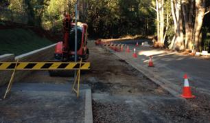
Photo 3: Eastern end – completion due 28 August, if used for
contra-flow as proposed will remove need to cross road as shown in photo 1
above
|
After – looking west
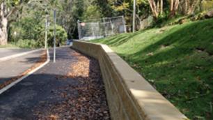
Photo 4: Post works:
boarding bus now available in new bus bay and not in road shoulder as per
Photo 2
|
|
Figure 2:
schematic of proposed operations
red text denotes work yet to be completed
as at 26/8/15
|
|
|
Committee Comments
· noted
Council staff and RMS will carry out a site inspection after this meeting
RMS comments, provided after the onsite review as
held after the LTC meeting
· it
remains that there is still risk to pedestrians and traffic with the proposed
contraflow arrangement.
· RMS
has provided comments in the June 2015 minutes which include:
o concern for the lack of
hard stand area/path adjacent the proposed separation fencing, and
o questioned enforcement of a
‘no entry’ arrangement in an isolated area as Wilsons Creek.
o Furthermore RMS recommended
u-turn facilities be investigated east of the site to negate the need for
contraflow entirely (still yet to be investigated)
· Granted however
that traffic volumes are quite low and the time of use is limited to a
brief window within 40 school zone operation times, therefore placing the
contraflow at a relatively low risk category when considering the changes
that have now taken place at the site.
· On this basis,
if the school and bus operator are willing to necessarily support this
arrangement and council as the road authority wish to pursue this option, RMS
will concur based on the following additional recommendations:
o No Entry / Buses excepted )
are also placed at the mid point of the bus bay to regulate eastbound
vehicles conflicting a bus entering/exiting from the opposing direction (further
LTC comments required for this additional regulatory device).
o That it is noted RMS reserve
the right to appeal this decision in accordance with the delegations of the
Local Traffic Committee.
o That a report is prepared
towards the end of Term 4 - 2015 to provide an update regarding the
arrangements operation. Furthermore that the details of the report are
reviewed at that time as required.
o School zone/warning
signposting as previously recommended and provided by RMS is installed.
Management Comments
· The above RMS
comments were provided and inserted after the draft report and recommendation
was circulated to the Committee for comment.
· Accordingly the
recommendations of the RMS are now inserted into Committee recommendation
|
|
RECOMMENDATION:
1. That in regard
to the constructed bus bay at the frontage of Wilson’s Creek Public School,
Council support a trial of the contra-flow arrangements as described at
Report No. 6.10 within
the Local Traffic Committee Minutes (I2015/894) and that it:
a) cease
immediately if either Council, RMS, NSW Transport, Police, the bus operator,
or the School or any authority with such power request as such, on the
proviso such request is in writing and lodged with Council prior to the end
of Term 4 2015; or
b) in
event of no such request, be adopted as a permanent measure commencing with
the start of the 2016 school year; and
c) a
report be provided to Council in due course on either of the above outcomes once
known
2. That on the basis
Part 1 is adopted, both sides of the entry to the eastern end of the bus
bay as provided between the fenced median and retaining wall and the
mid-point of the bus
bay be signed as No Entry (R2-4) Buses Excepted (R9-2) and that such signage
be removed in the event the contra-flow arrangements cease to operate.
3. That Council note and
accept the RMS advice as contained in above cited minutes, namely
that:
a) RMS
reserve the right to appeal this decision in accordance with the delegations
of the Local Traffic Committee;
b) a
report be provided prior to end of Term 4 2015 regarding the arrangements
operation and that the details of the report are reviewed at that time as
required, e.g. by the Local Traffic Committee, Council and RMS;
c) school
zone/warning sign-posting as previously recommended and provided by the RMS
be installed prior to the contra-flow trail commencing.
|
|
Report No. 6.11 Request
for Bus Stop, Byron Bay Pool
File No: I2015/890
|
|
Details to be provided at meeting for discussion. Request
for a formal bus stop is made from Blanch’s/BVC bus company, who are
the main public transport operators within the Shire.
|
|
Committee Comments
· the
Committee noted that according to the NSW Road Rules, a bus unloading or
loading passengers can legally use a loading zone such as the one nearby on
Bay Street, opposite the Beach Hotel and adjacent to Apex Park
· it
was noted however such a location or ‘dual use’ does not address
the concerns of the operator who would prefer a stop adjacent to the pool
· providing
a poolside stop however will require removal of car parking and considerable
physical works so as to provide a safe turn around area which is preferable
than a bus reversing in an urban area which can be undertaken if and when
needed a per current practice
Management Comments
· the
request would better considered as part of any future upgrade to this key
intersection, which if it did proceed, would involve bus and other transport
operators as part of the consultation process
|
|
RECOMMENDATION:
That the applicant be informed that under NSW Road
Rules 2014, a bus can legally use any loading zone whilst engaged in loading
or unloading passengers.
|
|
Report No. 6.12 Request
for No Parking limits, Market Street, Bangalow
File No: I2015/891
|
|
The adjacent public school requests No Parking apply in
Market Street, Bangalow between Byron Street and its end on Market Days and
School Days only. The subject site is shown by the yellow line.
|
Such a request is recommended as it is aimed to address
the problems of congestion and safety encountered at busy times such
a school pick up and drop off and on market days, when parking is made
available off-street with the showgrounds at the north end of the street.
It should be noted that No Parking will still provide
opportunity for up to
2-minutes to drop off and pick up. This ability can be emphasised further
by providing supplementary signage such as ‘kiss and ride’
subject to school acceptance and use of such signage.
|
|
|
|
Committee Comments
· the
Committee noted the narrow width of Market Street, Bangalow and requested
that a post-meeting site inspection confirm if width would allow parking to
remain on one side of the street and make a recommendation on the basis of
such inspection
Management Comments
· the
road width is less than 6m and No stopping applies on the eastern side
· the
width justifies that parking be disallowed on both sides of the street, hence
the recommendation made
|
|
RECOMMENDATION:
1. That
in accordance with Australian Standard 2890.5, No Parking be signed and apply
on the western side of Market Street, Bangalow.
2. That
Kiss and Ride supplementary signage be attached to the No Parking signs,
subject to the school’s concurrence, which if not forthcoming an
alternative site be investigated for such purpose.
|
Development Applications
|
Report No. 7.1 Byron
Bay Bypass – DA 10.2015.384.1
File No: I2015/892
|
|
Byron Bay Bypass – DA 10.2015.384.1
Committee advice on the project is sought and endorsement
of the regulatory controls will be proposed.
Detailed design plans will be tabled to assist the
committee’s review.
|
|
Committee Comments
· noted
the turning and exit line marking on and through the roundabout travel lanes
are not needed and could cause confusion for motorists
· noted
regulatory matters, as they arise, will be referred to the Committee at a
later date
Management Comments
Management had no comments to make in relation to this
item.
|
|
RECOMMENDATION:
That in regard to the GHD preliminary designs as
included at Appendix E of DA Application 10.2015.384.1 (as per Council
file E2015/41826) for the Byron Bay town centre bypass, Council
notes that the Local Traffic Committee:
a) provide
in-principle support for the traffic facilities and provisions
proposed;
b) recommend
the turning and exit lines shown to demarcate roundabout travel lanes be
removed from the design; and
c) require
regulatory traffic matters be referred back to the Local Traffic Committee as
and when required.
|
There being no further business the meeting concluded at 1.15
pm.