BYRON SHIRE COUNCIL
13.9 - Attachment 1
Byron Shire Council Rural Land Use Strategy
DRAFT Site Suitability Criteria & Mapping
Methodology
Cover Page
September 2015
Site Suitability Criteria & Mapping Methodology
Table of Contents
1 Introduction
1.1 Background
1.2 Purpose of the Site
Suitability Criteria and Mapping Methodology PapePurpose and scoper
1.3 Study aApproach
2 Site Suitability Criteria Methodology and Data
Table 1 –: Constrained Land
Table 2 –: Assessable Land
Table 3 –: Service cCatchment and rRoad Iinfrastructure pPriorities for Rural
Development
3 Constrained Land [discussion + maps]
3.1 Primary Production Land
3.2 High Conservation Value Vegetation
3.3 Water Supply Catchment Buffer
3.4 Mineral Resources
3.45 Steep Slopes or Landslip
Prone
3.46 Bushfire Risk
3.47 Buffers to Waster Disposal Facilities and Sewerage
Treatment PlantsCritical
Infrastructure Buffer
3.48 Acid Sulfate Soil Risk
Classes 1 &and 2
3.9 Zoning and
TenureOther excluded zones
4 Assessable Criteria [discussion + maps]
Land
4.1 Sensitive Rural Land Uses
4.2 Non Contiguous and Prime Agricultural
Lands
4.3 Biophysical Strategic Agricultural
Lands
4.4 Scenic Amenity and Rural Landscape
4.5 Category 1 & 2 Bushfire Vegetation
4.6 1:100 Year
Flood Risk and Climate Change; and Coastal
Erosion Planning Precincts 1 and 2 Bushfire Category 1 & 2 Vegetation (excluding
Extreme Bushfire areas)
4.75 Vehicle
Access Safety and Risk Flood Prone Land / Coastal Erosion Planning
PrecinctsFlood risk 100 yr + Climate Change / Erosion Prone
Precinct 1 & 2
4.8 Wildlife Habitat and
Corridors Enhancement
4.98 Indigenous
Cultural Heritage Vehicle Access Safety and Risk
4.86.
Wildlife
Habitat and Corridors
4.9. Indigenous Cultural Heritage
5 Service Catchment and Road Infrastructure Priorities for Rural Development
5.1 Service Catchment Priorities
5.2 Road Infrastructure Priorities for Future Rural Lifestyle Living Opportunities
1
Unconstrained Land
Map
[THIS PAGE IS INTENTIONALLY LEFT BLANK]
1. Introduction
1.1 Background
Byron
Shire Council is developing a Rural Land Use Strategy. The Rural Land Use
Strategy will provide a strategic framework centred onfor the management and use of rural land for living, working and leisure. It will guide future land
zoning and other planning instruments such as Local Environmental Plans.
It will also identify a range of rural land use
actions/outcomes and include a delivery program for future rural development, taking into account existing and land
supply.
Main Stages to develop the Rural Land Use Strategy
![]()
![]()
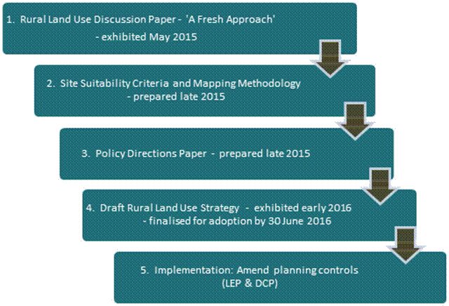
Same as Policy Directions Paper
incl RLUS ‘Overview’ diagram
1.2 Purpose of the
Site Suitability Criteria and Mapping Methodology Paperand scope (of
this report)
The purpose
of this document is to provide a comprehensive framework for determining future rural
development potential based on a range of natural
resource management, risk avoidance and social/economic servicing criteria. This in
turn will inform the development of a related
Policy Directions paper and the
Rural Lands Strategy. , this
1.3 Study aApproach
The Department of Planning and Environment are preparing a North Coast Regional Plan to replace the Far North Coast Regional Strategy. In preparing the criteria and mapping methodology, staff liaised with the Department to ensure that the Rural Land Use Strategy mapping methodology direction is consistent with the policy principles of the working draft North Coast Regional Strategy. The criteria were also informed by other relevant State, regional and/or local planning documents and best practice planning principles.
2. Site Suitability Criteria Methodology and Data
Site Suitabilityelection Criteria to Identify
Rural Potential
Land for Potential Future Rural Development
The process for
selecting potential land for tourism, conventional rural residential, Multiple
Occupancies (MO),
or Community
Title (CT)
or other non-agricultural land uses (herein referred to as ‘future rural development’)
is outlined below. The aim is to ensure that future rural development
occurs within the context of Byron Shire's environmental, economic and social
requirements.
In identifying
potential future rural development land, the appraisal site suitability criteria were used to maps
the following categories of land four Criteria:
1. [a1] Constrained Land
This identifies areas where any of the criteria listed in Table 1
are present. Constrained land will not be considered for future rural development as it includes important
natural
environmental and resource values that underpin the economic and
social framework of our rural areas and/or issues of risk
avoidance. These constraints by their degree and nature
preclude itsthe land from
development.
2. Assessable Land
This identifies areas not encumbered by any of the
Constrained Land criteria in
Table 1 but potentially affected by any one or more of
the criteria listed in Table 2 are present. Assessable Land criteria [a2] encompasses
environmental, economic and/or risk avoidance criteria which may
not necessarily preclude future rural development on the land but rather
indicate a need for a more detailed site specific
investigations to determine the site’s full development potential. The se Assessable Land
criteria in Table 2 are not comprehensive. and
An area may
have there may be other matters which need
to be taken into consideration to determine its a site’s development
potential.
3. Unconstrained Land
This identifies all areas that are neitherot
encumbered by Constrained Land criteria (Table 1) nor affected by
Assessable Land criteria (Table 2).
4. Future Rural Development Land ReleasePriorities
This identifies the prioritiesy
for future rural development of Unconstrained
Land and Assessable Land using the Service Catchment and Road Costing Infrastructure
Criteria in, Table 3. This
reflects the premise that Ffuture rural development should be close within a
reasonable distance ofto villages and town services
and be
provided with good a standard
of road access that has not been provided atdoes not
place a financial burden for on the
wider community.
From
a service catchment standpoint, Ppriority
will be given to land within 2km of a rural village, rural (public)
primary school, general store or community hall or 5km of an urban [a3] town containing a high school
(Mullumbimby and Byron Bay) service
catchment as follows:
· Priority 1: Unconstrained Land within
a 2km/5km
service catchment with a Category 1 road
· Priority 2: Assessable land within a 2km/5km service catchment service catchment
with a Category 1 road
· Priority 3: Unconstrained Land outside 2km/5km service catchments
with a
Category 1 road
In considering
future rural lifestyle living opportunities (egie. multiple occupancy;
conventional / community title rural residential subdivisionrural residential subdivision) the following road infrastructure
criteria has been applied to the above priorities:
· Priority 1 & 2 land — must be capable of providing an acceptable standard of road infrastructure at no cost to the wider community
Generally, Priority 3 land outside 2km/5km service catchments is unlikely to be considered for future rural lifestyle living opportunities. However the determination of priority land
will include consideration of unconstrained
land outside the service catchment, within a 5 minute drive of a
service centre and with a pre-existing
acceptable standard and quality of access.
Note: Land in the “unconstrained” and “assessable” land categories do not infer development rights; it merely identifies land that is potentially suitable for future rural development.
All future
rural development land would be subject to consideration of impacts on cultural
heritage and land may require a more detailed assessment.
|
Table 1: Constrained Land |
|
|
Criteria |
|
|
Primary Production Land
- - deferred
matters - S117
land mapped as State/
|
State / Regional · Far North Coast Regional Strategy 2006-31 · S117 Direction 5.3 / Northern Rivers Farmland Protection Project - Final Recommendations, February 2005 (Section 4) · Draft Far North Coast Regional Growth Plan ‘guidelines’ Local · Byron Shire Sustainable Agriculture Strategy (2004) · Rural Land Use Strategy Discussion Paper – community feedback · Byron Rural Settlement Strategy 1998 · Tweed Shire Rural Land Strategy –Resource Inventory & Land Capability Assessment (Dec, 2013) · Lismore Growth Management Strategy 2015-2035
|
|
High Conservation Value Vegetation
Land containing high conservation value vegetation
|
State / Regional · State Environmental Planning Policy No. 14 (Coastal Wetland) · State Environmental Planning Policy No. 26 (Littoral Rainforest) Local · Byron Rural Settlement Strategy 1998
· Byron Biodiversity Conservation Strategy 2004
· Lismore Growth Management Strategy 2015-2035
|
|
Water Supply Catchment Buffers
Land within a drinking water catchment and 100m of a major creek / waterway
|
Local · Byron Rural Settlement Strategy 1998 · Byron LEP 2014, Clause 6.5 –
· BSC Design Guidelines for On-Site Sewage Management for Single Households (2004) · Rous County Council draft DCP
|
|
Mineral Resource
s117 mineral resource lands, including transitional and potential areas
|
State / Regional · S117(2) Direction 1.3 – Mining, Petroleum Production and Extractive Industries · Mineral Resources Audit (mapping) Local · Byron Rural Settlement Strategy 1998
|
|
Slope
Land with slope > 32%
|
State / Regional · Planning for Bushfire Protection 2006 Local · BSC Design Guidelines for On-Site Sewage Management for Single Households (2004)
· · Lismore Growth Management Strategy 2015-2035
|
|
Extreme Bushfire Risk
Land containing Bushfire Category 1 vegetation and Slope >20%
|
State / Regional · Planning for Bushfire Protection 2006 · Lismore Growth Management Strategy 2015-2035 Local · Byron Rural Settlement Strategy 1998 (>20% slope)
|
|
Buffers to waste disposal facilities and sewage treatment plants
Land within buffer to sewage treatment plant (400m) OR waste disposal facility (500m)
|
Local · Byron Rural Settlement Strategy 1998 · Byron Development Control Plan 2010 & 2014 (Chapter B6 – Buffers)
|
|
Acid Sulf
Land within ASS Risk Class 1 or 2
|
Local · Byron Rural Settlement Strategy 1998 · Byron LEP 2014, Clause 6.1 –
Acid Sulfate Soils |
|
Other Excluded Zones Land Byron LEP 2014: RU2 Rural Landscape R5 Large Lot Residential RU5 Village AND Byron LEP 1988 (only where “deferred” from LEP 2014): 1(a) General Rural 1(d) Investigation 7(d) Scenic/Escarpment
|
State / Regional · Far North Coast Regional Strategy 2006-31 Local · Byron Rural Settlement Strategy 1998
|
Table 2: Assessable Land (1)
|
Table 2: Assessable Land (1)
|
|
|
Criteria |
|
|
Sensitive Rural Land Uses
Assess
· Location · Operation · Processing To
determine
|
- Recognition of: the importance of farmland and
agriculture; - Builds on the Byron Rural Settlement Strategy principles and Byron Shire DCP 2014 – Chapter B6 – Buffers and Minimising Land Use Conflict. - Consistent with planning strategies and principles outlined in Living and Working in Rural Areas (NSW DPI, 2007).
|
|
Non Contiguous and Prime Agricultural Lands
Assess Non-contiguous State/ Regionally Significant farmland and prime agricultural land (classes I, 2 and 3 as identified by NSW Agriculture) outside the Primary Production Land identified in Table 1
|
- Consistent with Northern Rivers Farmland Protection Project – Final Recommendations (February, 2005). - Consistent with community feedback on Rural Land Use Strategy Discussion Paper. - Potential development should be subject to merit-based assessment of the agricultural value and future economic viability of such land.
|
|
Biophysical Strategic Agricultural Lands
Assess biophysical strategic agricultural lands
|
- Biophysical Strategic Agricultural Land (BSAL) is land with high quality soil and water resources capable of sustaining high levels of productivity. - BSAL mapping important for managing competing land uses proposed on high quality agricultural land. - Consistent with DP&E advice that future rural settlement should generally avoid areas mapped as BSAL.
|
|
|
|
|
Scenic Amenity and Rural Landscape
Assess land 7(d) Scenic/ Escarpment in Byron LEP 1998 (only where “deferred” from LEP 2014)
|
- Consistent with Byron Rural Settlement Strategy site suitability criteria and community feedback on Rural Land Use Strategy Discussion Paper
|
|
|
|
|
Criteria |
|
|
Bushfire Vegetation (excluding “Extreme” b
Assess the capacity for development that does not encroach on
Category 1& 2 vegetation
|
- Adapted from Byron Rural Settlement Strategy site suitability criteria - Future development must satisfy Planning for Bush Fire Protection 2006 requirements.
|
|
- 1:100 year Flood risk + Climate Change - Coastal Erosion Planning Precincts
Assess the capacity
for development to be safe and erosion risks
|
- Adapted from Byron Rural Settlement Strategy site suitability criteria relating to flooding. - Future development subject to LEP 2014 Clause 6.3 – Flood Planning
|
|
Vehicle
access safety
Assess
vulnerability of essential access road
- Bushfire Category 1, or - Landslip - sections of road
Ensure adequate evacuation routes
|
Future development may be subject to minimum design standards being in place to reduce vulnerability of road infrastructure to the following risks:
- Bushfire – where access roads cannot provide safe (or alternative) access, egress and defendable space for emergency services during event. - Landslip – where sections of road have become unusable for long periods of time following the event (eg. Upper Wilsons Creek). |
|
Wildlife Habitat and Corridors Enhancement
Assess
|
Recognises role of wildlife corridors in minimising impacts (direct or indirect) from adjoining land uses and encouraging the recovery of threatened species, communities, populations and their habitats.
|
|
Indigenous Cultural Heritage
Consult with traditional owners (where applicable) in accordance with process established by Council |
Recognises that Byron Shire contains a wealth of Aboriginal cultural sites which include middens, stone arrangements, rock shelters and tool-making sites. Many of these are not mapped due to their cultural sensitivity. |
(1) This
Assessable Land criteria list is not absolute and that there may be other
matters which need to be
consideredrequire more
detailed assessment at the rRezoning or DA stage to determine site
suitability. This may
include, for example, consideration of indigenous cultural heritage values through formal consultation with traditional
owners or site
contamination history.
Note: Mapping
of individual assessable constraints would not be included as part of the final
Rural Land Use Strategy. Instead , but rather an
interactive PDF would be created for the community to access
that would provide mapping data about the particularlayers on
the assessable constraints
Table 3: Service Catchments and Road Upgrade Costing - Priority Future Table 3:
Future Rural Development Land Release
|
Table 3: Service Catchment and Road Infrastructure Priorities for Rural Development |
|
|
Criteria |
Supporting Rationale |
|
A. Service
Catchment Priorities
· Priority 1: Unconstrained
land within 5 km
· Priority 2: Assessable
land within 5
km of a town containing a high school (Mullumbimby and Byron
Bay) or 2km of a rural village, public primary school, general store or
community hall catering to the needs of that locality
· Priority 3: Unconstrained
land outside a service catchment
|
- A ‘service catchment’ approach
maximi - Consistent with service catchment criteria in Byron Rural Settlement Strategy1998 and Lismore Growth Management Strategy 2015-2035. - Consistent with Guidelines for Rural Settlement on the North Coast of NSW (DUAP, 1995).
|
|
B. Road
Further · capacity / condition of relevant road network; ·
Future rural lifestyle living opportunities include: conventional rural residential subdivision; multiple occupancies; and community title subdivision.
This determines land suitability in the following order of priority:
· Priority 1 & 2 service catchment areas – only where relevant road segments can be upgraded at no cost to wider community.
Priority 3
land is unlikely to be considered for future rural lifestyle living opportunities within
the timeframe of this strategy.
|
This economic imperative is supported by the following documents: - Byron Shire Council Financial Sustainability Project Plan (Asset Management Strategy) - Council Improvement Program (June2015) - Byron Rural Settlement Strategy1998 - Guidelines for Rural Settlement on the North Coast of NSW (DUAP, 1995)
|
3. Constrained Land
Certain land has not been
includedbeen excluded for from consideration
for future rural development as it makes good
environmental, economic and social sense. We need to safeguard the quality of
the natural environment and the integrity of our natural resources. Similarly,
we should not put the environment, people and assets at risk or in hazardous situations.
The criteria for
identifying ‘Constrained Land’,
as listed in Table 1 above, for precluding such land identified
as ‘Constrained Land’
are outlined detailed below.
3.1 Primary Production Land
Good agricultural land provides primary production in Byron Shire with an inherently unique advantage in productivity, diversity and adaptability. As a finite and irreplaceable resource it should be conserved and sustainably managed. The North Coast Urban Planning Strategy (1995), the NSW Coastal Policy (1997), the Northern Rivers Regional Strategy (1999), the Northern Rivers, Upper North Coast and Mid North Coast Catchment Blueprints (2002) and the Northern Rivers Farmland Protection Project 2005 all support this position.
The Northern Rivers Farmland Project reviewed earlier investigations regarding prime agricultural land and took into account the need to distinguish between very high quality and unique agricultural soils/lands and other lands that were also important to agriculture but which were more extensive and less productive generally per unit area. It identified two relevant levels of agricultural land – State and Regionally Significant. Fundamental to this project was the identification, recognition and protection of contiguous quality farmland to limit the likelihood of displacement of agricultural use by residential use and fragmentation.
Primary Production Land is included on Map xx of Appendix XX. The data used to inform this map is:
|
Description |
Data layers used |
Data custodian |
|
- Land zoned RU1 Primary Production in LEP 2014; - Deferred matters relating to 1(b1) or 1(b2) Agricultural Protection in LEP 1988;
|
1998 / 2014 LEP Zoning
|
Byron Shire Council |
|
S117 land mapped as State
|
“Northern Rivers Farmland Protection Project, Final Map 2005 (Section 117(2) Direction)” |
NSW Dept of Planning & Environment (formerly Dept of Infrastructure, Planning and Natural Resources) |
For strategic
planning purposes contiguous State or /Regionally
Significant farmland (excluding non-contiguous) and land
zoned for primary production purposes represent constrained
land.
3.2 High Conservation Value Vegetation
Byron Shire
covers about 56,000 hectares has of which 68%
is cleared land, plantations and disturbed remnant
vegetation. The ongoing loss of native vegetation cover and
consequently biodiversity is perhaps our most serious environmental
problem. The protection and enhancement of high conservation
value vegetation is integral toprovides a foundation
from which to reversingaddress this
problem.
In 2015, Council reviewed the vegetation mapping. Mapping was initially carried out in 1999 as part of the Byron Flora and Fauna Study and was partly reviewed in 2007. The 2015 review has improved the accuracy of the mapping and reflects changes in vegetation extent and composition over time.
The review used a combination of aerial photograph interpretation (API) primarily using 2014 aerial data, existing information such as, vegetation survey data from various Council and state government projects, and on-ground site inspections.
Vegetation was mapped using the State Government’s Vegetation Information System (VIS) Classification 1. database to ensure consistency with NSW standards. This system uses three levels; vegetation formations, vegetation classes and plant community types. The plant community type classification provides the most detailed description of vegetation and was developed by the state government to provide a standard approach to vegetation classification and mapping.
This mapping
provides the foundation on which to determine high conservation value
vegetation and habitats (HCV). HCV is ahas been
determined combination of ..................using
a relative
ecological value matrix weighting systems as
described in the the Byron
Biodiversity Conservation Strategy 2004 (Part 3)................................
Areas with a combined score of 27 or more are weighting of
> xx
are categorisedregarded as HCV.
The High Conservation Value Vegetation is included on Map xx of Appendix XX. The data used to inform this map is:
|
Description |
Data layers used |
Data custodian |
|
Land
|
HCV Vegetation Map (2015)
|
Byron Shire Council |
For strategic
planning purposes high conservation value vegetation and habitatsland of a
high conservation value represents constrained land.
1. [Footer - For information on the State
Government’s Vegetation Information System (VIS) Classification go to:
www.environment. nsw.gov.au/research/Visclassification.htm]
3.3 Water Supply Catchment Buffers
Regional water
resources including watercourses, dams and estuaries are of economic, social
and environmental significance both within the Shire, North Coast Region and beyond.
They are
a source forsupport urban and rural water supplies
and support
a range of tourism and recreational activities.
Water supply
catchments are areas from which surface water drains (via runoff) to a
reservoir or water storage facility. The local government areas of
Byron, Lismore and Ballina all source
their urban urban water
supplies from three rural catchments in our rural areas:
Wilson Creek, Rocky Creek Dam and Emigrant Creek. Their wCatchments associated
with water supply areas are the area from which surface water
drains (via runoff) to a reservoir or water storage facilityater quality
is directly influenced by the type of
land uses and management practices occurring within
these catchments. Some of impacts of inappropriate
rural land uses and/or and the quality
of water supply is directly related its management. poor land
management practices can include toxic algal
blooms, soil erosion, falling water tables and
increased water treatment costs.
Future rural development should have a neutral or beneficial effect on
downstream water quality. As rRural lands dwellings within
these urban
water supply catchments are generally not sewered and instead
rely on on-site wastewater management systems, requiring. Future rural development should have a
neutral or beneficial effect on downstream water quality. Maintaining
healthy riparian environments plays an important role in the quality of water
draining to the storages (supply dam) from the catchment areas and providing
valuable flood mitigation and ecological benefits.
Poor
management can result in toxic algal blooms, soil erosion, falling water tables
and increased water treatment costs. The provision
of aa 100m
separation
distance buffer vegetated
with native vegetation between a permanent water courses
and wastewater management system can substantially reduce
likelihood of pathogens entering the water supply. This is known as a ‘water
supply catchment buffer’.
Water supply catchment buffers are shown on Map xx of Appendix XX. The data used to inform this map is:
|
Description |
Data layers used |
Data custodian |
|
Land within a drinking water catchment and 100m of a major creek / waterway
|
Water catchment supply 2014
Create 100m buffer around major creeks / waterways
|
Byron Shire Council |
For strategic
planning purposes all land within a drinking water catchment and within 100m of
a major watercourse – (namely
Wilsons River, namely Emigrant, Coopers Creek,
Wilsons
or Rocky Creek and Skinners Creek) s represents
constrained land.
(Sources: Rous Water On-site Wastewater Management Guidelines, June 2008;
SSouth
East Queensland Development Guidelines for Water Quality Management in Drinking
Water
Catchments).
3.4 Mineral Resources
Quarry materials
are essential to the construction industry and economy. Section
117 Planning Direction ‘1.3 – Mining, Petroleum Production and Extractive
Industries (Environmental Planning and Assessment Act 1979), seeks to
ensure that future extraction of mineral resources and extractive materials is
not compromised by inappropriate development.
Extraction can only occur where geological deposits are located. Transportation costs are a significant cost factor. To keep costs down and remain largely self sufficient, we need to ensure that local supplies are available in sufficient quantity to satisfy current and future demands.
Inappropriately placed located conflicting land
uses can effectively alienated, or even sterilisezed
a resource. AA
land 1 km buffer of 1000m
radius taken from the boundary of identified resource ‘reserve’s
bearing s land’, including
that reserved for future quarrying purposes can be an effective
means to manage prevent land use
conflicts and protect important mineral and extractive resources.
Mineral Resources (identified, transitional and potential) are shown on Map xx of Appendix XX. The data used to inform this map is:
|
Description |
Data layers used |
Data custodian |
|
s117
mineral resources,
|
Mineral resources - Areas of proven natural resource significance (2015)
|
NSW Dept of Mineral Resources |
For strategic
planning purposes all SSection 117(2) mineral resource lands, including
transitional and potential areas, (a) 1.3 operation 1(e) in LEP
1988 reserves and transitional and potential regionally significant mineral and
extractive resource land (including buffers areas) represents
constrained land.
3.5 Slope
Land with
slopes over 32% is considered unsuitable to most forms of future rural development, in particular habitable
structures. The sSlope
is a significant constraint factor affecting effluent
disposal, stormwater runoff, bushfire risk, erosion and vehicular
access. For
example, Sslopes in excess
of 20% (11.3 degrees) can pose wastewater treatment system installation
problems, while slopes greater than 15% (8.5 degrees) may prevent treated
wastewater from being evenly distributed to the land, thereby adversely
affecting the performance of the system. At the same time Eerosion
resulting from developing on steep slopes can in turn have significant water
quality impacts. Land with slopes over 32% is
considered unsuitable to most forms of future future rural development, in particularly habitable
structures.
Land with a Slope > 32% is indentified on Map xx of Appendix XX. The data used to inform this map is:
|
Description |
Data layers used |
Data custodian |
|
|
Contour data (10m)
|
Byron Shire Council
|
For strategic planning purposes all land having slopes in excess of 32% (approx 18 degrees) represents constrained land.
(Sources: http://www.ga.gov.au/scientific-topics/hazards/landslide/basics/causes
Design
Guidelines for On-Site Sewage Management for Single Households – Byron Shire
Council
Doc #491166
3.6 Bushfire Risk
Byron Shire is fortunately located in a region which enjoys reasonably high rainfall throughout much of the year. However, at certain times of the year and under certain weather conditions, many areas of the Shire can become high to extreme fire risk areas. Bush fire is a major challenge for the community. The CSIRO predicts that climate change will contribute to harsher fire weather for Eastern Australia with an increase in the number of days having a severe bushfire rating.
All developments on land that is designated as bush fire prone must satisfy the requirements of Planning for Bush Fire Protection 2006 and AS3959 – 2009.
A key
consideration in mitigating bushfire hazard is avoidance of high risk areas. On 1In August
2002, the
Rural Fires and Environmental Assessment Legislation Amendment Act 2002 amended
the Rural Fires Act 1997 and the Environmental Planning and Assessment Act 1979the State
government introduced legislation to provide significant
improvements in bush fire safety. This included a requirement for all councils
to prepare a bush fire prone land map. The bush
fire prone land map is the triggeras the basis for
more detailed investigations to determine what bush fire protection measures
are applied to new development.
Byron Shire has three two Bushfire
Prone Categories based on vegetation types. Category 1 vegetation (essentially
areas of forest, woodlands, tall and short heaths, forested wetlands and timber
plantations) generally hold the highest risk factor. Studies by bush fire
authorities have shown however that bushfires are likely to travel
twice as fast up 10 degree slopes (as opposed to flat land) and up to four
times faster up on 20 degree
slopes.
This, can result in
certain hence
placing Category 2 areas vegetation
types (essentially grasslands, freshwater wetlands, semi-arid
woodlands, arid shrublands and rainforests) with on such
slopes also
also athaving
a high risk factor.
For strategic
planning purposes all land having Category 1 bushfire vegetation on slopes
greater than 20% (11.3 degrees) represent an ‘extreme’ fire risk and hence are
constrained land. All remaining Category 1 and 2 vegetation
on
slopes less than 20% and all Category 2 vegetationoutside
extreme fire risk areas represent assessable land
requiring more detailed investigation prior to further consideration as
potential future rural development.
Constrained and
assessable bushfire land risk is identified
on Map xx and Map xx (respectively) of Appendix
XX. The data used to inform this map is:
|
Description |
Data layers used |
Data custodian |
|
Constrained Land
Extreme bushfire risk: Assessable Land - All remaining Category
1
|
Bushfire
Protection mapping for Shire (2015)
|
Byron Shire Council |
3.7 Buffers to resource recovery and waste
disposal
facilities[a8] centers and sewage treatment plants
Waste
disposal and sewerage treatment facilities Asare
an essential part of its Council’s waste
management activities.,Council operates refuse and sewerage
treatment stations As key infrastructure installations they
represent a significant capital investment for the Shire and minimising environmental
and human health risks is central to their placement, design and operation.
Proximity to these installations is an important consideration in determining future rural development land due to potential health risks to humans including methane buildup, noise and odour. A key means for managing this risk is the use of separation buffers from future rural development.
Land which is part
of aaffected by these buffers
has
been is included on Map xx of Appendix XX. The data used to inform this map is:
|
Description |
Data layers used |
Data custodian |
|
|
Sewage treatment plant buffer Waste disposal facility buffer
|
Byron Shire Council |
For strategic
planning purposes all land within an identified sewerage buffer (400m) and refuse
buffer (500m) and sewerage buffer (400m) represents constrained land.
3.8 Acid Sulfphate
Soils
cClasses
1 and 2
Acid sulfate
soils contain pyritic sediments which can lead to the generation of sulphuric
acid when exposed to air. This is likely to occur when these soils are drained,
excavated or dredged. Scientific research has found that the release of acid
from pyritic soils can have significant impacts upon the health of aquatic
plants and animals. Similarly, drainage waters from areas of acid sulfate soils
can corrode and weaken engineering structures and release heavy metals into
recreational fishing areas. This land is often captured underby other
constraints including SEPP 14 Coast Wetlands.
A
classification scheme for acid sulfphate soils
identifies the type of works likely to present an
environmental risk if undertaken in a particular class of land and is outlined in the table below.
|
Class of land shown on acid sulf
|
Works
|
|
1 |
Any works |
|
2 |
Works below natural ground surface Works in which the watertable is likely to be lowered
|
|
3 |
Works beyond 1 metre below the natural ground surface Works by which the watertable is likely to be lowered beyond 1 metre below the natural ground surface
|
|
4 |
Works beyond 2 metres below natural ground surface Works by which the watertable is likely to be lowered beyond 2 metre below the natural ground surface
|
|
5 |
Works within 500 metres of adjacent Class 1, 2, 3 or 4 land that is below 5 metres Australian Height Datum and by which the watertable is likely to be lowered below 1 metre Australian Height Datum on adjacent Class 1, 2, 3 or 4 land.
|
For strategic
purposes all land having an Acid Sulfphate Category Risk Class
of 1 and
or 2 (refer to Map link) represents
constrained land.
Land with Acid
Sulfphate
Soil Risk class 1 or 2 are included on Map xx
of Appendix XX. The data used to inform this map is:
|
Description |
Data layers used |
Data custodian |
|
1 or 2
|
Acid
sulf 1:25,000 (2014) |
Byron Shire Council NSW Office of Environment & Heritage
|
3.9
Zoning and TenureOther excluded zones Limitations
Certain
zoning or land tTenure can or zoning mayinherently preclude land from being appropriateconsideration for consideration
for future rural development. This includes land
dedicated, reserved or committed to potential future urban,
village and open space uses. It also
includes national parks, nature
reserves and areas
already zoned for environmental
protection. This approach ensures Council maximizes its options
for accommodating future expansion of the Shire’s towns and villages while also
protecting recognised environmental assets. The Far
North Coast Regional Strategy
2006-2013 states that all land
zoned for urban purposes and future urban land release areas should be retained
for such purposes and all land
classified as ‘Environmental
Assets’ are to maintain
existing use rights. Under LEP
1988 residential development is prohibited in a number of
the environmental protection zones. National parks, nature
reserves,
conservation areas and public
recreational grounds are crown land. For
strategic planning purposes all land notsituated
outside the following zones is excluded
from consideration (ie. constrained land):zoned
Byron LEP 2014 — RU2 Rural Landscape, R5 Large Lot Residential and RU5 Village.
Byron LEP 1988 : — 1(a) General Rural,, 1(d) Investigation and 7(d)
Scenic/Escarpment (only where “deferred” from
LEP 2014), 7(d) Scenic Escarpment;
OR Byron LEP 2014: RU2 Rural Landscape,R5 Large Lot Residential and RU5 Village represents constrained land.
|
Description |
Data layers used |
Data custodian |
|
Land Byron LEP 2014: RU2 Rural Landscape R5 Large Lot Residential RU5 Village AND Byron LEP 1988 (only where “deferred” from LEP 2014): 1(a) General Rural 1(d) Investigation
7(d) Scenic/Escarpment
|
Byron LEP 1998 Zoning Maps LEP 2014 Zoning Maps |
Byron Shire Council
|
4. Assessable Land
Certain environmental, economic, social and risk avoidance matters are more appropriately considered through a detailed site specific investigation. These matters may not necessarily preclude development on the site.
The criteria listed
in Table 2 above have resulted in certain land being identified as ‘Assessable Land’. These criteria, as outlined
below, are not comprehensive and there may be other matters which need to be
consideredrequire more detailed assessment at
the rRezoning
or DA stage to determine site suitability.
4.1 Sensitive Rural Land Uses (Agricultural
Land Use Security)
The Byron Shire Council’s , through
its Sustainable Agricultural Strategy 2004 (SAS)
supports the rights of persons to carry out legitimate rural and agricultural
uses and practices. The SAS aims to create a social and planning environment
that allows agricultural production and associated activities to be pursued
without conflict and concern for long-term security for of agriculture
in the Shire. Among the Ppolicy
Aactions
recommended
in the SAS is to “carry
out recommended a stock take of agriculture land and
related activities and assessment of current and possible future uses to determine
the optimum potential (social, economic and environmental) for the land”.
Future rural development should
not undermine this optimum potential and any. strategic Aassessment should
give consider theation
to therelevant
land use characteristics of the our major
existing agricultural enterprises including:
· essential growing conditions;
· operational conditions: potential for land
use conflict or health risks from past and current land use activities
including dip site and complaints about smell, noise, dust,
airborne chemical sprays and loss of amenity particularly from intensive agriculture or horticulture; and
· processing or market place requirements: such as dairy, sugar cane, coffee and macadamia industries that share harvesting and processing facilities; and
· potential economic advantages associated with industry clusters.
Locality, topography, soil
type and climate all affect the mix of crops and livestock across the Shire
resulting in different patterns of agriculture in different areas. An initial ‘stock take’ has been carried out for farmland rated properties, Tthe
findings
of the
which ‘stocktake’ are detailed shown in
Map xx
Agricultural Land Use Structure of Appendix
XX. The data used to inform this map included land with the
farmland rateding dataactivities,
DPI standards for buffering and industry manuals. The buffers are not meant to
be absolute and may be varied on closer examination of terrain, vegetation and
farming practices.
|
Description |
Data layers used |
Data custodian |
|
|
Agricultural Land Use Buffers (2015
Dip sites and buffers ( |
Byron Shire Council
NSW Dept Primary Industries / Byron Shire Council
NSW Department of Primary Industries |
For strategic planning purposes all farmland rated activities and buffers represent assessable land requiring more detailed investigation prior to further consideration as potential future rural development.
(Sources: - Byron Shire Sustainable Agriculture Strategy 2004
- Farmers Farm and Cows Do Moo booklet (BSC, 2008)
- DPI Document mMinimum
Lots Size Methodology fFor Agricultural
Uses
(DPI, 2005)
)
‘4.2 ‘Non
Contiguous’ and ‘Prime’ Agricultural
Lands
The Northern Rivers
Farmland Project 2005 identified that certain agricultural/horticultural
industries may develop on smaller sites that have
the general characteristics of state or regionally significant farmland, but do
not fit within the definition of 'large contiguous areas'. These areas are known as ‘areas non-contiguous
farmland’ or may not
be constrained by soil characteristics. Such land
uses may include
such land uses as nurseries or
greenhouse and controlled environment
horticulture (eg. cut flowers and nurseriesgreenhouses, hydroponics).
(need to confirm when overlaying mapping) As outlined
in the’ Discussion Paper – A Fresh Approach’, tThese industries
can benefit from their proximity to the South Eastern Queensland market,
and having a strong economic multiplier are important to the local economy. In
continuing to be used for agriculture such land can also present a transition
area to Primary Production Land (Table 1).
Areas mapped
as prime agricultural
land are also an important
consideration when planning for future rural land uses. Like
‘non-contiguous’ farmland these areas may still have soil
characteristics or other agricultural values that require a
merit-based assessment at the rezoning or DA stage. The Northern
Rivers Farmland Project indentified non-contiguous areas. Their protection is
the responsibility of local Councils.
For strategic planning purposes non-contiguous State or Regionally Significant farmland and Prime Agricultural land (outside the Primary Production Land identified in Table 1) represent assessable land requiring more detailed investigation prior to further consideration as potential future rural development.
The xxx location of
‘non-contiguous’ and prime agricultural land is
included
shown on Map
xx of Appendix XX. The data used to inform this map is:
|
Description |
Data layers used |
Data custodian |
|
|
|
|
|
Prime agricultural land (classes I, 2 and 3 as identified by NSW Agriculture) outside the Primary Production Land (Table 1)
|
Prime agricultural land classes 1, 2 & 3 (2001 BSC)
Northern Rivers Farmland Project (2005) : non-contiguous lands
|
NSW Dept Primary Industries
NSW Dept of Planning & Environment / NSW Dept Primary Industries
|
For
strategic planning purposes non-contiguous State/Regionally Significant
farmland and Prime Agricultural land (classes I, 2 and 3 as
identified by NSW Agriculture) outside the Primary Production
Land (Table 1) represent assessable land
requiring more detailed investigation prior to further consideration as
potential future rural development.
4.3 Biophysical Strategic SAL Agricultural
Lands
The NSW Government
introduced the Strategic Regional Land Use Plans to better manage the potential
land use conflicts arising from the location of our high quality agricultural
land, and the mining and coal seam gas (CSG) industries. Mapping of
high-quality agricultural land capable of sustaining high levels of
productivity, known as biophysical strategic agricultural land (BSAL), has beenrepresents
an important component resource of for managing potential
land use conflictsthe planning process. Certain activities proposed within BSAL
areas Inare subject to an additional
level of investigation at the
rezoning stage. In Byron
Shire the amount of land identified as BSAL equates to approximately 9580 hectares.
The xxx location of
BSAL is included shown on Map xx of Appendix XX. The data used to
inform this map is:
|
Description |
Data layers used |
Data custodian |
|
|
|
|
|
|
|
NSW Dept of Planning & Environment |
For strategic planning purposes BSAL represents assessable land requiring more detailed investigation prior to further consideration as potential future rural development.
Key
Tourism Asset – major event venues
Byron
Shire has an established tradition of fostering live music, from new bands
playing at local venues to international acts performing at sold-out venues of
Northern Parksland (Yelgun) and Blues Fest (Tyagarrah). Live music makes an important
contribution to the diverse social and cultural fabric of our Shire.
It plays
a crucial role in developing music careers and nurturing talent; creates a rich
social environment for Shire to discover new acts or see their favourite bands;
and provides considerable economic benefits for the Shire, with many
people employed directly or indirectly in the industry.
Major
Event Venues represent a significant capital investment for the
Shire. Their location, design and operation has been planned to address issues
such as risk to the environment and traffic impacts.
Proximity
to these venues is an important consideration for future
rural development due to potential land use conflict including traffic, lighting and noise. A key means for managing this conflict
is the use of separation buffers.
Land part
of a buffer has been included on Map xx of
Appendix XX. The data used to inform this map is:
|
|
|
|
|
|
|
|
For
strategic purposes that all land within …………….buffer of identified Major Event
Sites (refer to Map link) represent assessable land
requiring more detailed investigation prior to further consideration as
potential future rural development.
S4.4 Scenic Amenity
and Rural Landscape
The basic premise
of rural settlement is that the 'rural character' of an area should be retained
or, conversely, any human elements introduced (eg dwelling houses; tourist facilities)
introduced should not dominate the
scene. Inappropriately located development can ultimately destroy the very
scenic amenity of an area which attracted residents or visitors in
the first place. Preserving the dominant landscape features or scenic
characteristics of an area is fundamental to ensuring that the visual rural
qualities of the Shire are not further diminished by future rural development.
Community
feedback on the discussion paper identified a strong value in ensuring our
prominent rural landscape features are not dominated by buildings.
These features include prominent ridges such as Coolamon Scenic Drive, Mt Chincogan
and Nightcap National Park, bushland areas such as National Parks and Nature
Reserves, major watercourses and advantage points such as Broken Hhead
and Minyon Falls. DCP 2014 Chapter C3 notes that impacts on view from
public vantage points to important landscapes and iconic places (eg. Byron Bay
Lighthouse) also should be considered.
The Byron
LEP 1988 mapped some of the more prominent landscape
features in a 7(d) Scenic/Escarpment Zone, Tthe
xxx location of
which is included shown on Map xx of Appendix XX. The data used to
inform this map is:
|
Description |
Data layers used |
Data custodian |
|
|
Land zoned 7(d)
Scenic/Escarpment
|
Byron Shire Council |
For strategic
planning purposes all land zoned in the Byron LEP 1988 as 7(d) (Scenic
Escarpment Zone) (refer to Map link ) represents an assessable land requiring more detailed
investigation prior to further consideration as potential future rural development.
Landslip
Prone Land
In
general, the
factors which influence whether a landslide will occur typically include slope
angle, climate, weathering, water content, vegetation, overloading and geology
(particularly red and dark basalt). Many human activities that are often
associated with residential or tourism development can contribute to an
increased likelihood of landslip/mass movement and include:
·
removal
of vegetation
·
interference
with, or changes to, natural drainage
·
effluent
disposal and leaking pipes
·
modification
of slopes by construction of roads, buildings, etc
·
overloading
slopes
Council….. refer to our data source **discuss to
Blythe**
The xxx
is included on Map xx of
Appendix XX. The data used to inform this map is:
|
|
|
|
|
|
|
|
4.5 Category 1 & 2 Bushfire Vegetation – refer to discussion in 3.6 above
For
strategic planning purposes all land ……………………(refer
to Map link ) represents an assessable land
requiring more detailed investigation prior to further consideration as
potential future rural development.
(Sources: - Tweed Shire Council Rural
Land Strategy 2014
-
http://www.ga.gov.au/scientific-topics/hazards/landslide/basics/causes
-
Design
Guidelines for On-Site Sewage Management for Single Households Byron Shire
Council Doc
#491166)
4.56 1:100 year Flood
Risk 100yr
and Climate Change;, and
Prone Precincts
1 and 2
The Northern Rivers Region has a warm subtropical climate reflected by a high annual rainfall with a pronounced wet season from December to April. During this season, the region is susceptible to the effects of cyclonic activity to the north which can bring considerable rain to the area that can result in flooding and/or coastal erosion.
The CSIRO
predicts as a result of anthropogenic climate change, summer
rainfall to will be more
extreme and frequent, cyclones will be less frequent and move further south and
sea levels will rises. The best
projections of sea level rise along the NSW coast, relative to 1990 sea levels,
are 40cm by 2050 and 90cm by 2100.
Floodplain
management and coastal erosion prone planning precincts aim to reduce
the impact of floods and erosionstorm events on
individual properties and the community as a
whole. They provide an integrated approach which takes into account the risk
and consequences of storm such events as
well as the social and environmental issues relating to their mitigation/management.
The Land that is flood prone and/or located within a xxx coastal
erosion planning precinct is included shown on
Map xx of Appendix XX. The data used to
inform this map is:
|
Description |
Data layers used |
Data custodian |
|
Flood prone land / coastal
erosion planning precincts |
1:100 year Flood Prone Lands (including climate change data, where available)
Coastal Erosion Planning Precincts
1
& 2 |
Byron Shire Council |
For strategic planning
purposes land having a 1:100 yr flood risk and/or contained within a
Coastal
Erosion Planning Climate Change Erosion Prone Precinct
1 & 2 (refer to Map link) represents assessable
land requiring more detailed investigation prior to further
consideration as potential future rural development.
4.67 Vehicle
Access Safety and /Risk
Critical
infrastructure at the time ofduring a disaster
event includes our roads and bridges. Every year people in
Australia are hurt, or die, trying to reach their homes and/or safe places at
times of natural disaster. In Byron Shire
access during natural disasters can be restricted by flooding, bushfire and
landslip. Floodwaters are treacherous, and the dangers
are can be hidden
beneath the surface, bridges can be washed out, and bushfires
can easily block roads with fallen vegetation or power poles. Landslips take
time to clear and can leave residents without practical access for extended
periods. The impacts of a disaster event on essential
access
roads can have be far reaching long term
affects for not only the for residents
directly affected but as a social and economic cost to the wider community.
The Byron Shire
Council Local Disaster Plan 2008 requires consideration of mitigation and
prevention strategies in regulating property development, including
consideration that some hazard impacts may require the partial or complete
evacuation. Future rural development, should be
located where
people are providedin areas with the best possible reliable
and safe road access, route particularly
should the need for evacuation arise to evacuate
people at risk.
For strategic planning purposes land having single road access through: 'high' fire risk - Category 1 bushfire vegetation or sites having a history of landslip are assessable land requiring more detailed investigation prior to further consideration as potential future rural development.
(Sources:
Byron Shire Local Disaster pPlan 2008; Emergency
Risk Management Study 2008)
The xxxRoads particularly
vulnerable bushfire and/or landslip risk is includedare shown
on Map xx of Appendix XX. The data used
to inform this map is:
|
Description |
Data layers used |
Data custodian |
|
|
- Category 1 bushfire vegetation - Landslip history
|
Byron Shire Council |
For
Strategic planning purposes land having a singular road access
through 'high' fire risk - Category 1 or through a 1 yr flood
risk with a closure period in excess of 6 hours or landslip prone road
section (refer to Map link) represents
an assessable land requiring more detailed investigation prior to further
consideration as potential future rural development.
(Sources:
Byron Shire Local Disaster
plan 2008; Emergency Risk Management Study 2008)
4.78 Wildlife
Habitat and Corridor Enhancement
A network of natural, semi
natural and engineered assetsGreen infrastructure
provides a range of ecosystem and community benefits, . These includinge:
· offsetting environmental impacts;
· mitigating the impacts of climate change;
· enhancing biodiversity and site aesthetics; and
· reconnecting people with nature.
SEPP 44 aims
to encourage the proper conservation and management of areas of natural
vegetation that provide habitat for koalas to ensure a permanent free-living
population over their present range and reverse the current trend of koala
population decline:
Connected Wwildlife
corridors are an important component
of green infrastructure are intended tothat can improve
habitat
resources and assist species to move across a landscape through increasing vegetation
cover. They can also minimise
impacts (direct or indirect) from adjoining land uses and on native
vegetation, habitats and ecosystems and to encourage the recovery
of threatened species, communities, populations and their habitats.
The xxx location of broad wildlife
corridors in the Shire is included shown on
Map xx of Appendix XX. The data used to
inform this map is:
|
Description |
Data layers used |
Data custodian |
|
|
Wildlife corridor and habitat map (BSC 2007)
|
Byron Shire Council |
For strategic planning
purposes all land within an identified wildlife habitat and corridors (refer to
Map link ) represents an assessable
land requiring more detailed investigation prior to further
consideration as potential future rural development.
4.89 Indigenous
Cultural Heritage
Section117 Planning Direction 2.3 – Heritage Conservation aims to conserve items, areas, objects and places of environmental heritage significance and indigenous heritage significance. As Council does not have an adopted Aboriginal Heritage Study in place, any future investigations of potential development land will require consultation with relevant traditional owners (where applicable) in accordance with a formal process established as a part of the new Rural Land Use Strategy.
For strategic planning purposes indigenous cultural heritage represents an assessable matter requiring more detailed investigation prior to further consideration as potential future rural development.
5 Service
Catchments and Road Infrastructure Prioritiesy for
Rural Development Land Release
A key element of
strong communities is the ability for people to access basic services and maintain and
enhance connections with each other both
socially and economicallywhile reducing environmental,
economic and social impacts. For this
reason certain forms of future rural development
should be located close to villages and towns. This is particularly important when planning for future rural lifestyle living opportunities, which also should be capable of providing a standard of road infrastructure (both condition and capacity) that does not place a financial burden on the wider community.
The criteria as
listed in Table 3 above, that result in certain land being
identified as a priority for future rural
development are outlined below.
5.1 Service Catchment Priorities
Facilities,
services and networks which help individuals,
groups and community to meet their economic and social needs and enhance
their well being are important as they strengthen communities and add value to
our quality of life.
Shops, schools,
and parks,
playing fields, community halls and major school bus stops are
important to our rural residents as they bring people together to physically
connect and feel a sense of belonging. They are the
key components of any rural service catchment. Service
catchment planning can provide economic
benefits through reduced travel times, distances and fuel consumption as well as
greater economies in service provision (eg rural school bus service). Over
time this approach will serve to
strengthen existing communities instead of creating isolated settlements
dependent on other communities.
Recognising
service catchments also has economic benefits in facilitating opportunities to minimizing
fuel consumption through trip sharing, reduce travel times and distances and
economies in service provision such as a rural school bus service.
For strategic
planning purposes a service catchment is approach has been applied
using a
(i) 5
km radius from the general post office in a urbana
town containing
a high school and (ii) a 2 km radius from
a public
primary school, neigbourhood (general)
store (where available) otherwise a public
primary school and/or community hall in villages and rural
settlements. This is consistent with the service catchment
rationale and distances applied in the Byron Rural Settlement Strategy 1998.
The Priority
service catchments areas
are included
shown on Map XXXX of Appendix X. The
data used to inform this map is:
|
Description |
Data layers used |
Data custodian |
|
Service
Catchment Priorities
· Priority 1: Unconstrained land within 5 km of a town containing a high school (Mullumbimby and Byron Bay) or 2km of a rural village, public primary school, general store or community hall catering to the needs of that locality · Priority
2: Assessable land · Priority 3: Unconstrained land outside a service catchment
|
Servicing catchments -
|
Byron Shire Council |
For strategic planning purposes all unconstrained land or assessable land within a service catchment represents the highest priority land for further consideration as potential future rural development.
5.2 Road Infrastructure Prioritiesy for future
rural lifestyle living opportunitiesLand based
on Road Cost of upgrades
Our rural
localities are interconnected by an extensive large road network
of
roads that is expensive to maintain. A Within this network
of are many narrow
roads that
linkcrawls through
the rural
hinterland linking to our the small
villages,
and towns and rural
areas. Any future rural development in the Shire future rural
lifestyle living opportunities isare
likely to require an improvement to roads and basic services to accommodate the additional population.
This not only has economic implications for those localities where future rural development occurs, but also
for the wider community as a whole. As such, servicing and infrastructure
servicing
considerations must be investigated in terms of their Shire wide
economic sustainability.
It is
important that future
rural development isFuture rural lifestyle living opportunities should be designed located to
become more self-reliant in the provision of basic infrastructure or and be
based on the user-pays principle. While many areas may be physically and
ecologically capable of future rural development, the road costs
of
servicing such development are clearly beyond the ability
of developers to pay and wouldmay require
considerable subsidy from the broader community. Such a subsidy is considered
an inequitable and inefficient use of Council’s
limited financial resources and is therefore may be unacceptable
to the community.
For strategic planning purposes future rural lifestyle living opportunities should only occur within a 2km or 5km service catchment (as defined
above) and all unconstrained
land or assessable land within a service catchment be able to
provide an acceptable level of road infrastructure at no cost to the
wider communitywith a Category 1 Road represents the
highest priority land for further
consideration as potential future rural
development.
The xxxRoad
condition and traffic capacity information is
included on Map xx of Appendix XX. The
data used to inform this map is:
|
Description |
Data layers used |
Data custodian |
|
Road Infrastructure Assessment (Future rural lifestyle living opportunities)
Assessment of service catchment priorities in 5.1 against: Ø condition / traffic capacity of relevant road network; Ø costs to wider community of proceeding with potential rural lifestyle living precincts.
This determines land suitability in the following order of priority:
· Priority 1 & 2 service catchment areas – relevant roads segments can be upgraded to required standard at no cost to wider community. Priority 3 land is unlikely to be considered for future rural lifestyle living opportunities within the timeframe of this strategy.
|
- 2015
Road condition - Road Performance Indicator Analysis to determine 10 worst performing roads (2015) - Pavement thickness and traffic capacity assessment of relevant road sections
|
Byron Shire Council |
-
Indigenous Cultural Heritage
The
Objective of S117 Planning Direction- 2.3
Heritage Conservation is to conserve items, areas,
objects and places of environmental heritage significance and indigenous
heritage significance.
For
strategic planning purposes any future investigations of
potential development land will require consultation with relevant traditional
owners in accordance with a Consultation
Policy Process (established
as a part of the strategy) and represents
an assessable matters requiring more detailed
investigation prior to further consideration as potential future rural development.
***********************************************************************************************
Glossary
Constrained Land = areas where any of the criteria listed in Table 1 are present; considered unsuitable for future rural development as they includes important environmental and resource values and/or issues of risk avoidance.
Assessable Land = areas not
encumbered by any of the Constrained Land criteria in
Table 1 but potentially affected by one or more of the criteria listed in Table
2; encompasses
environmental, economic and/or risk
avoidance criteria which may not necessarily preclude future
rural development on the land but rather indicate a need
for more detailed site specific investigations to determine the site’s full
development potential.
Future rural development = potential land for rural tourism, future rural living lifestyle opportunities and other non-agricultural land uses
Glossary
Assessable land
Constrained land
Future Rural Development
General store: is a neighbourhood shop used for the
purposes of selling general merchandise such as foodstuffs, personal care
products, newspapers and the like to provide for the day-to-day needs of people
who live or work in the local area, and may include ancillary services such as
a post office, bank or dry cleaning, but does not include restricted premises.
Alex I Stopped here as not sure if we are going to include
Appendix A
Agricultural Land Use Buffer Designation
Land uses
are taken from the brief description in the farmland rating spreadsheet. The agricultural
use that requires the greatest buffer has been the
determinant for list of uses. Note the
land parcel may have other uses, but the buffer requirements are of a lesser
value.
Buffers
Limitations
Considering the complexity in determining a safe
buffer distance applicable to multiple situations it is important that the
design of buffer areas is based on the best
possible evidence and is conservative in its approach.
Safe application of chemicals, design and use of
spray technology/equipment and requirements under existing legislation are not
specifically covered by this document. Buffers are not
substitutes for good spray management practices.
Establishment and maintenance of buffer areas
New residential developments should protect the
rights of the existing agricultural producers to continue to perform farming
activities on their land.
The following buffer distances have been applied to
minimise impacts on public health:
|
|
|
|
|
|
|
|
|
|
|
|
|
|
|
|
|
|
|
|
|
|
|
|
|
|
|
|
|
|
|
|
|
|
|
|
|
|
|
|
|
|
|
|
|
|
|
|
|
|
|
|
|
|
|
|
|
|
|
|
|
|
|
|
Future rural lifestyle living opportunities = refers to conventional rural residential subdivision, multiple occupancies and rural community title subdivision
Conventional Rural Residential subdivision – refers to the traditional or “single lot” form of subdivision of lots under Torrens Title (or freehold land) that is common to many rural residential estates in Byron Shire; often not associated with any form of agriculture.
Multiple Occupancies = are a form of rural settlement which enables a group of people to collectively own a single allotment of land and use it as their principal place of residence. Common ownership of land is established through tenants in common, trust membership, co-operative shareholding, company shareholding or partnership.
Rural Community Title Subdivision = where there is internal (freehold) ownership of rural house lots and common ownership of residue land containing driveways, access roads, shared facilities etc.
Future rural tourism development = rural tourist cabins, bed & breakfast establishments, etc. used for short term accommodation.
Future urban development = land used for urban purposes including residential, industrial and commercial activities.
Source : West Australian Department of Public
Health 2012 -
The above are provided to identify potential lands for exclusion for
consideration for residential development or other sensitive uses. They are not meant to be absolute and may be
varied on closer examination where such lands, meet the appropriate criteria
for residential development all for the buffer criteria. In this situation the
following assessment approach may be adopted:
1. Where land is being considered for subdivision or residential development a closer examination of the characteristic of the agricultural activity and the terrain will be required.
2. Matters to be considered include the existence and location of surrounding land uses,
including viticultural and agricultural activities, and site the development in
a position which will not result in the potential for land use conflict between
neighbouring land uses.
3. Applications for a site being developed for residential purposes are to
include buffer areas that are planned and funded by the proponent of that development, unless otherwise determined by mutual agreement
with existing land owners (including land owned by State and Local Authorities).
4. Buffer areas should apply from the boundary to
boundary of the conflicting land uses.
5. Consideration needs to be given to the time in
which an area remains “mixed use”. Buffer areas may be temporary and can be
reserved for pubic open spaces or
further residential development should conflicting agricultural land use has
ceased. Residential subdivision applications may include future residential
lots that will fall within the buffer area that will be constructed only should
neighbouring agricultural activities have
ceased.
6. Persons intending to live in or adjacent to an
agricultural land use area need to be fully informed of the agricultural
practices and their potential impact on health or amenity before they settle
into the area.
7. Where a vegetative buffer is planned, the proposals
must state who is responsible for planting and maintaining the buffer area
vegetation. The vegetative buffer needs to be planted and established before
building approval is granted. A legal agreement must be established that specifies the legal and
ongoing obligations on the developers, local government and landowners.
8. Any alternative design is based on a thorough
analysis of the specific site conditions by an appropriately qualified expert.
![]()