Ordinary Meeting
Public ATTACHMENTS
EXCLUDED FROM THE
Ordinary
Meeting
AGENDA
OF 29 October 2015
10. Petitions
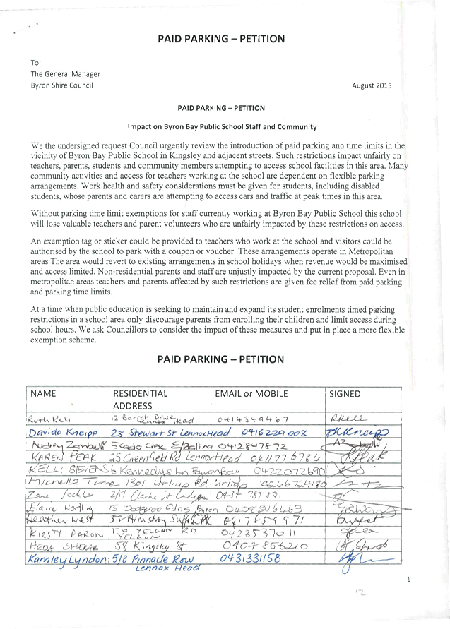
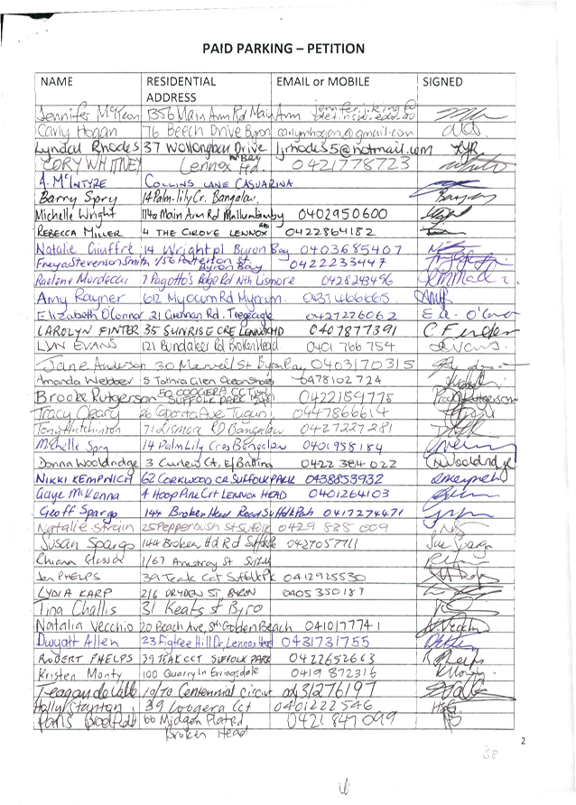
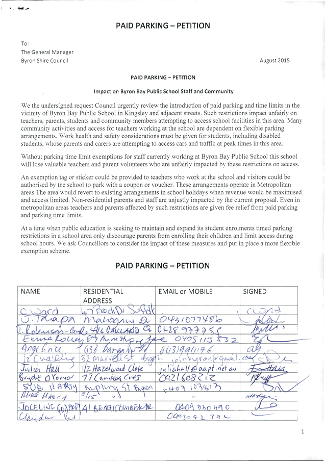
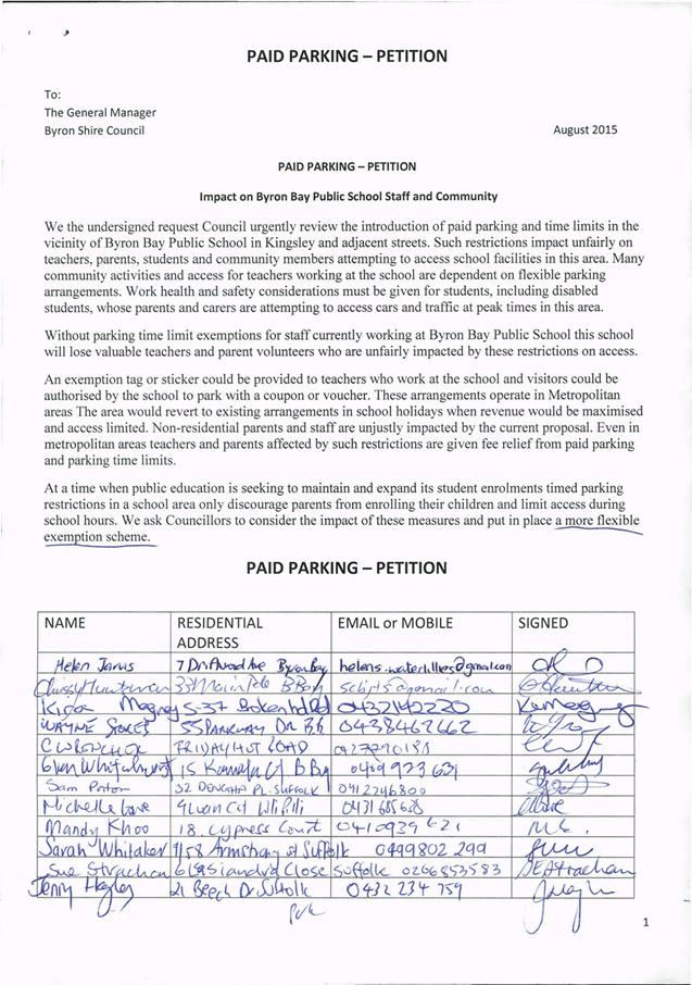
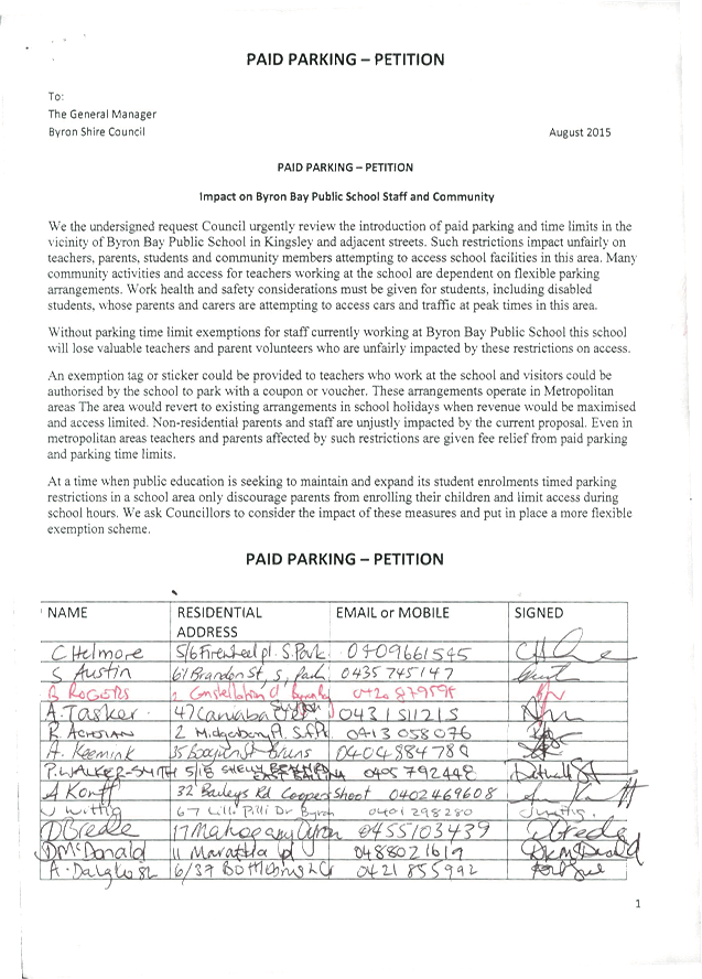
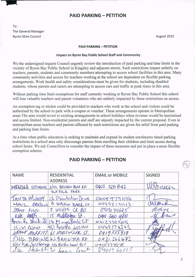
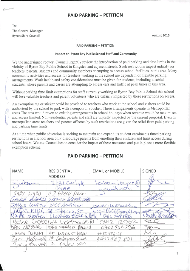
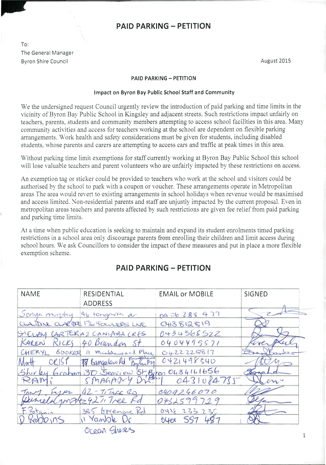
10.1 Paid Parking -
Impact on Byron Bay Public School Staff and Community
Attachment
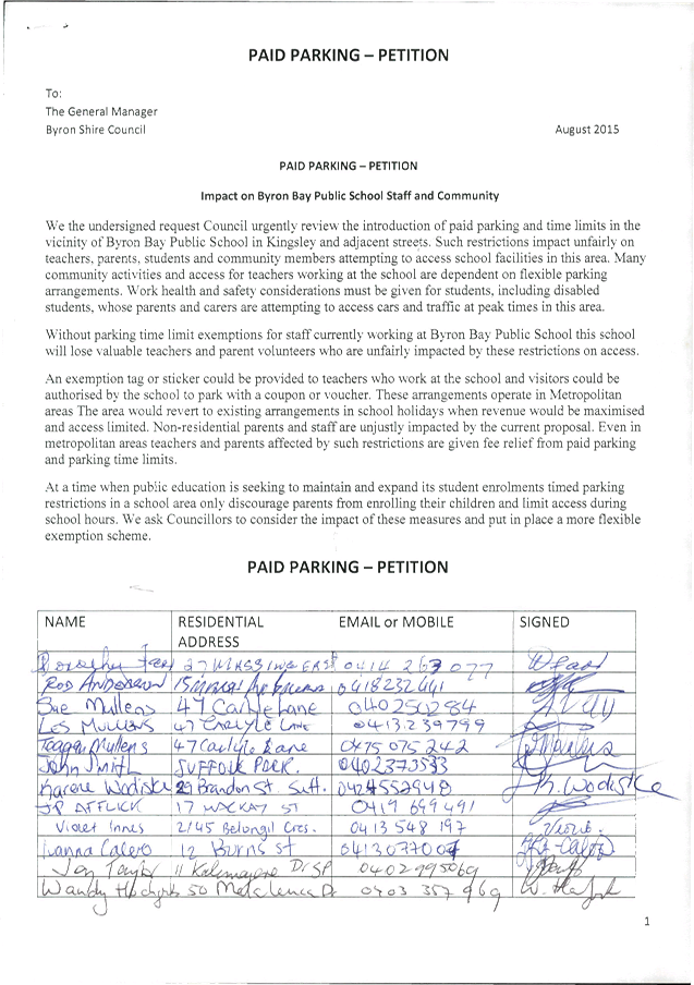
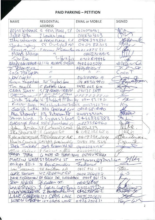
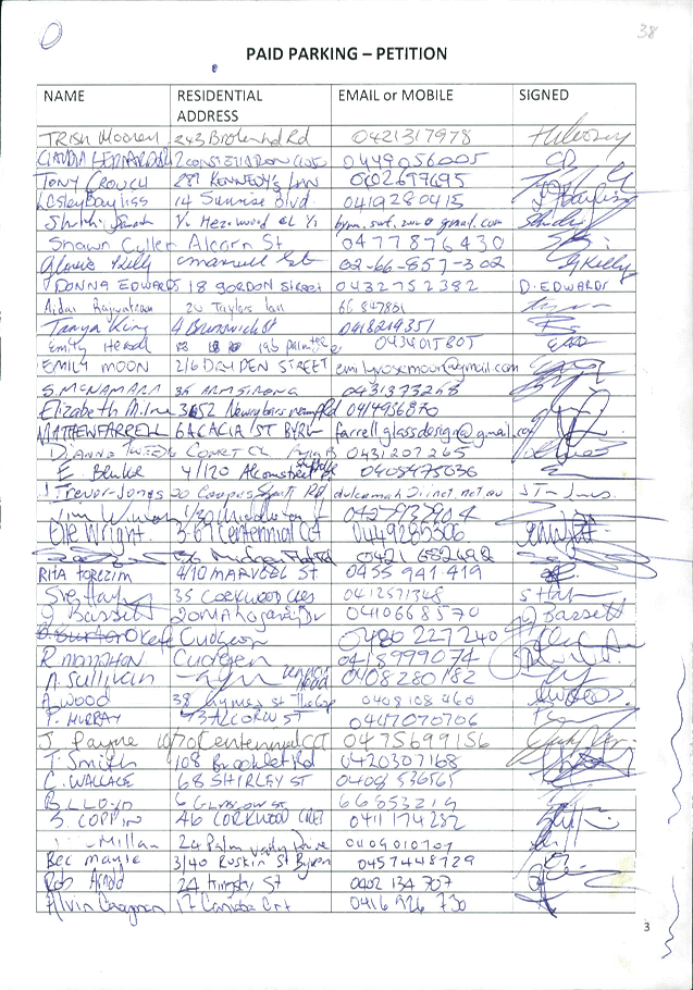
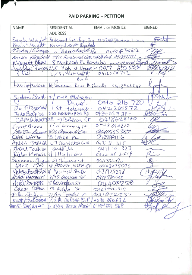
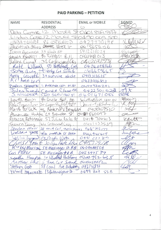
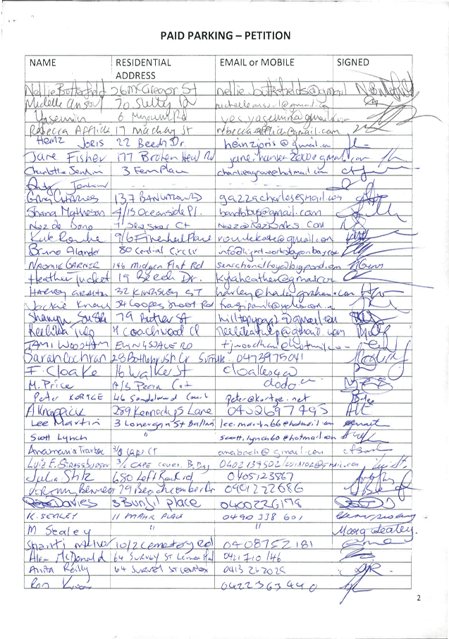
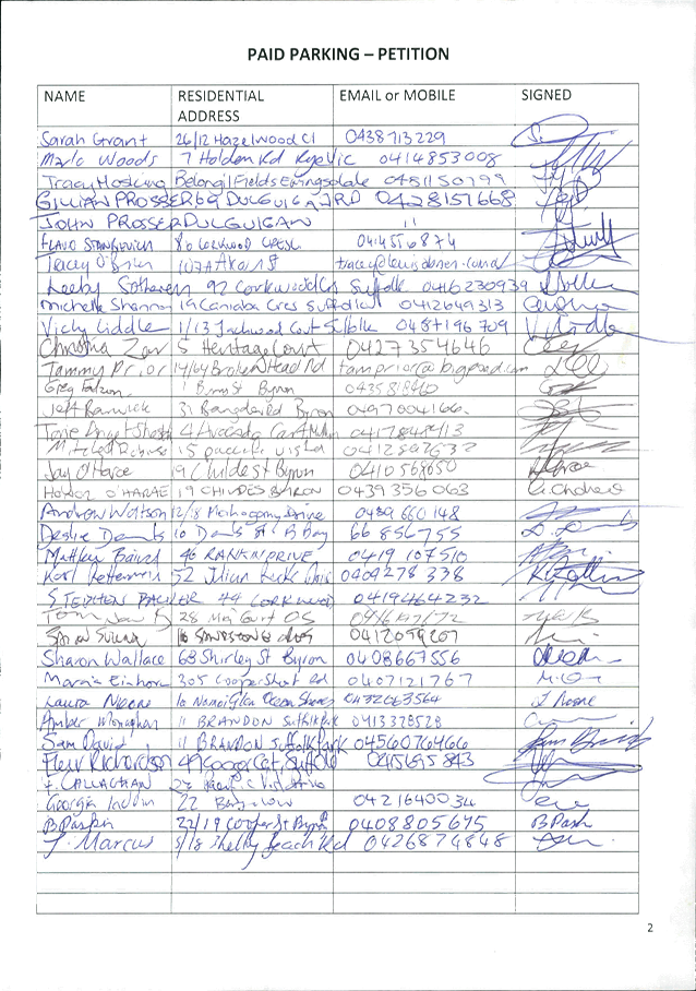
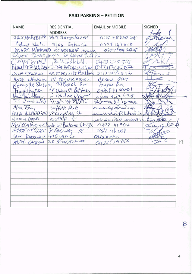
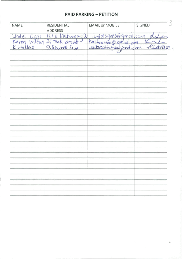
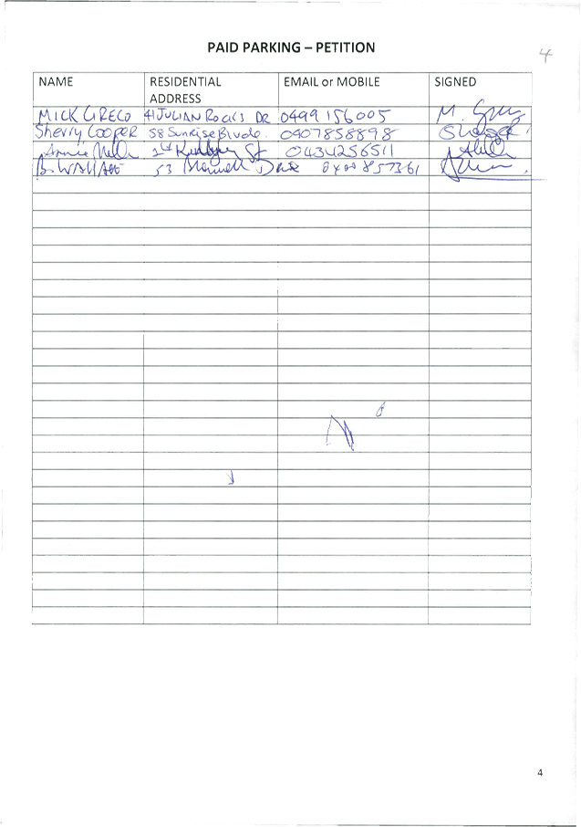
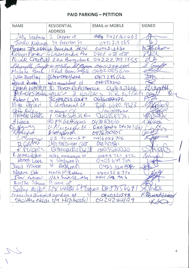
1... Petition from Byron Bay Public School - Paid Parking petition (523
signatures) 4
13. Staff Reports
Corporate and Community Services
13.1 Draft Amended
Policy - Mayor and Councillors Payment of Expenses and Provision of Facilities
Attachment
1... Draft amended Mayor and Councillors Payment of Expenses and Provision of
Facilities Policy........................................................................................ 28
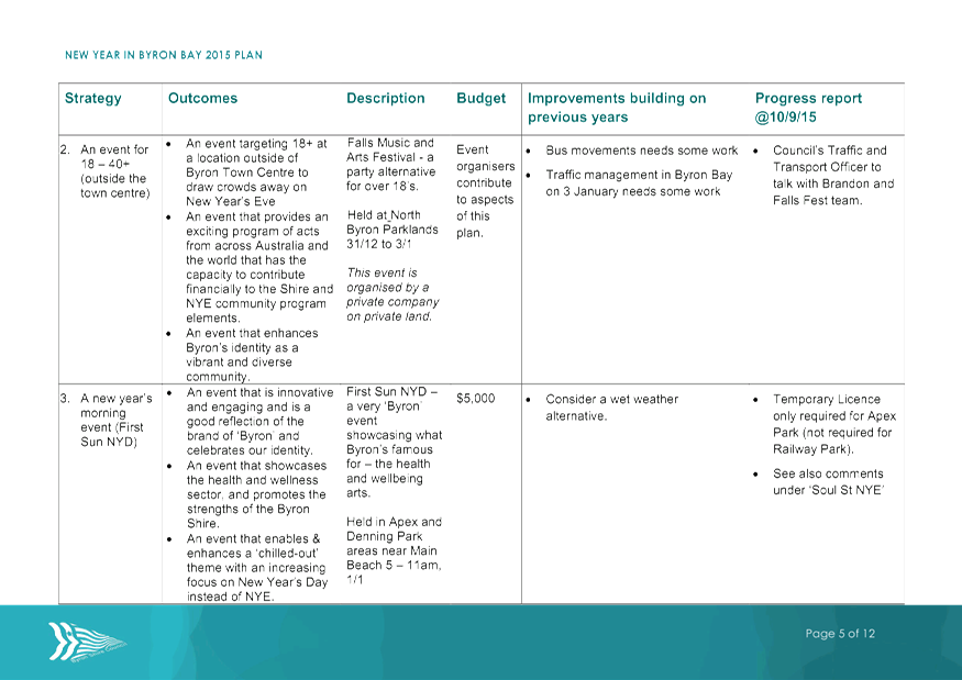
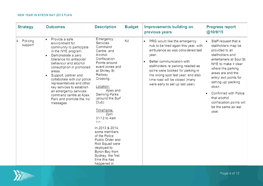
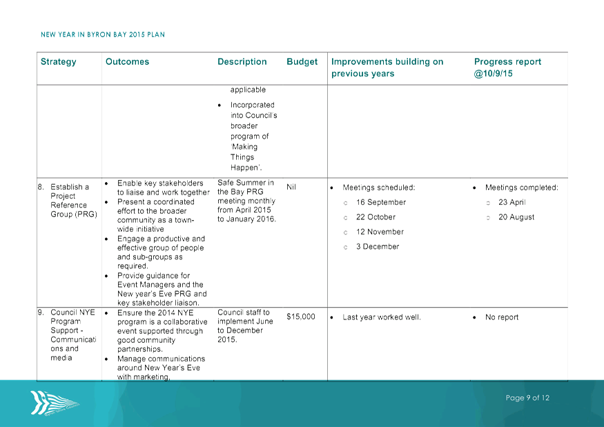
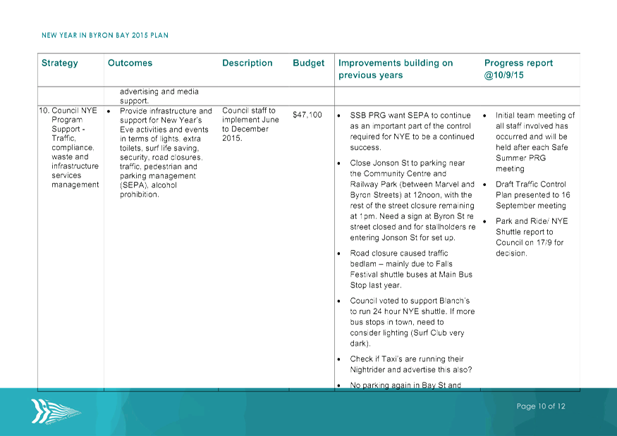
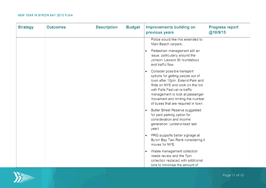
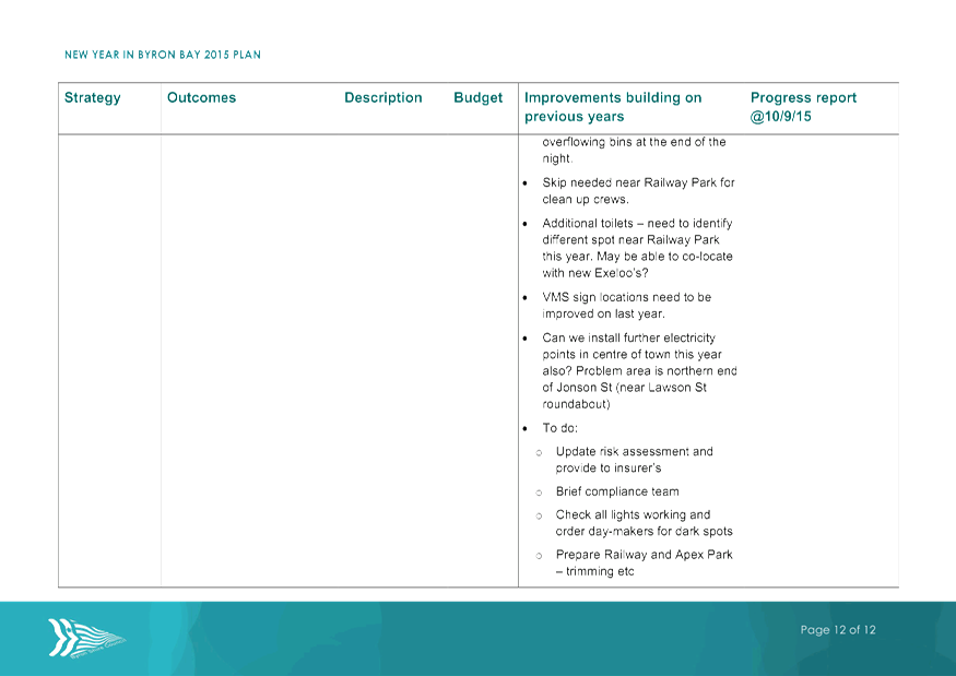
13.4 Report of the
Safe Summer in the Bay PRG meeting 16 September 2015
Attachment
1... Minutes of Safe Summer in the Bay PRG meeting 16 September 2015 46
Attachment
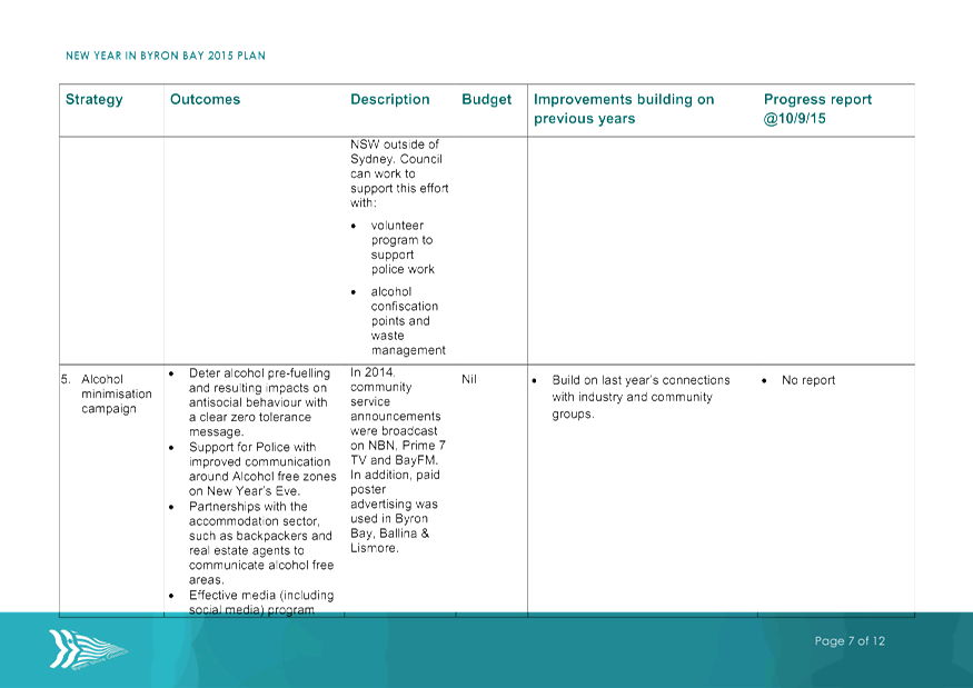
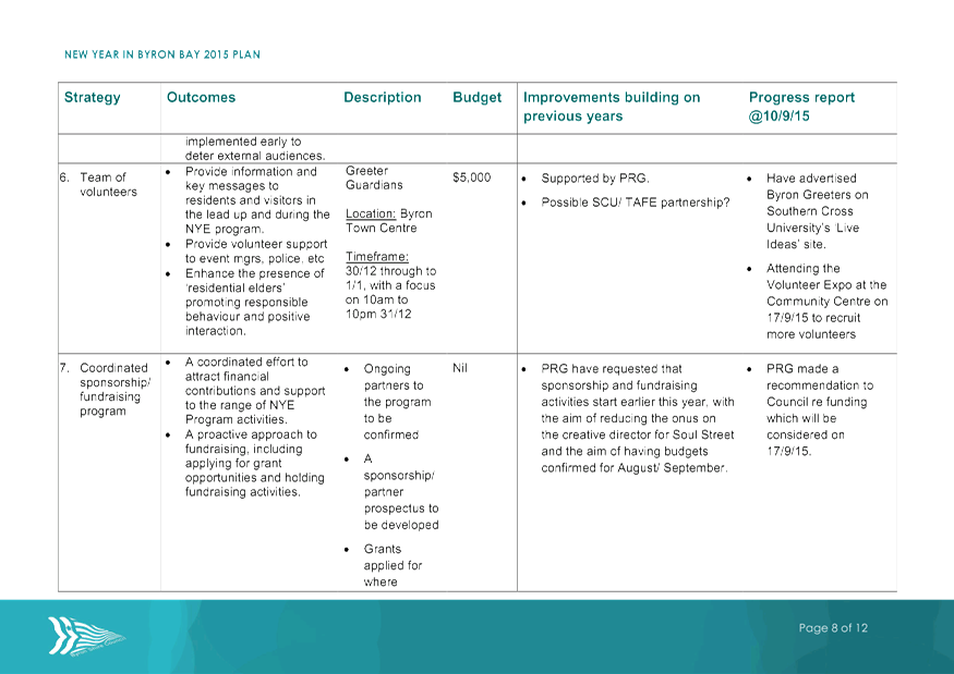
2... Plan for New Year in Byron Bay 2015 - Progress report 10-9-15........... 48
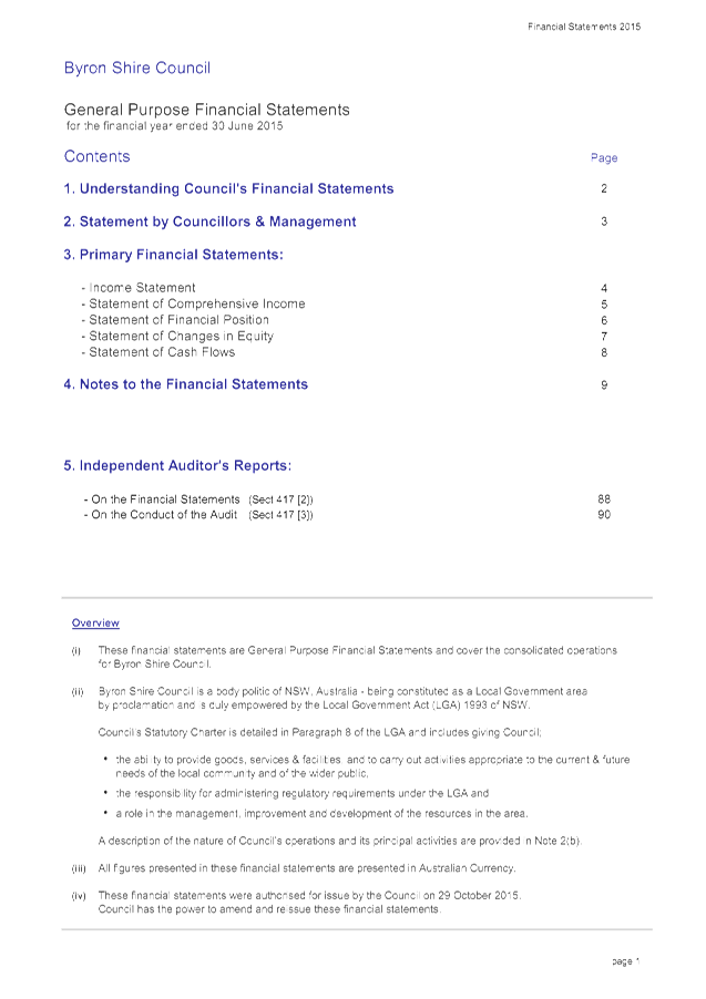
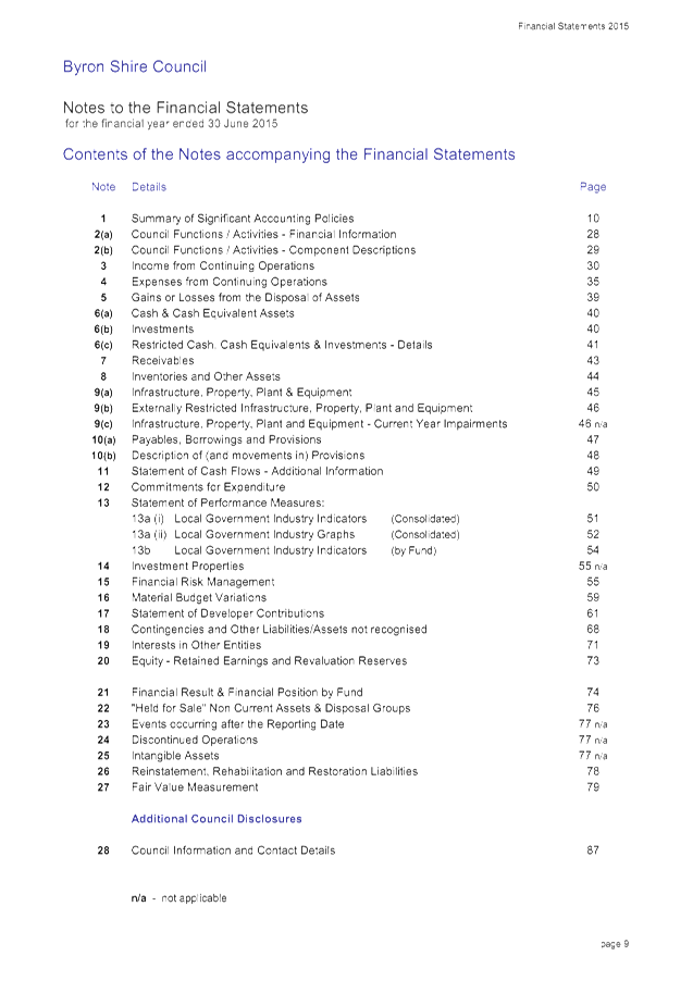
13.5 Draft 2014/2015
Financial Statements
Attachment
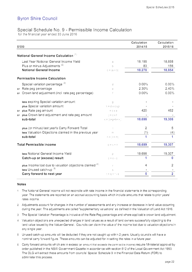
1... Draft 2014/2015 General Purpose Financial Statements........................ 60
Attachment
2... Draft 2014/2015 Special Purpose Financial Reports............................ 148
Attachment
3... Draft 2014/2015 Special Schedules...................................................... 166
Attachment
4... Draft Audit Report 2014/2015 General Purpose Financial Statements 191
Attachment
5... Draft Audit Report 2014/2015 Special Purpose Financial Statements. 193
Attachment
6... Draft Long Form Audit Report 2014/2015............................................. 195
Sustainable Environment and Economy
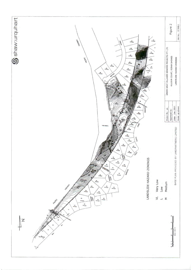
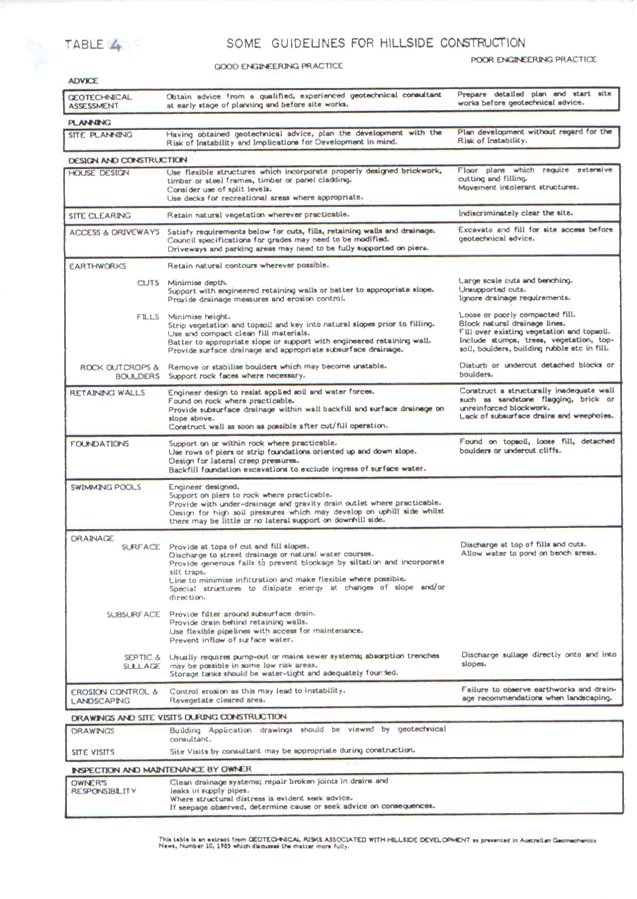
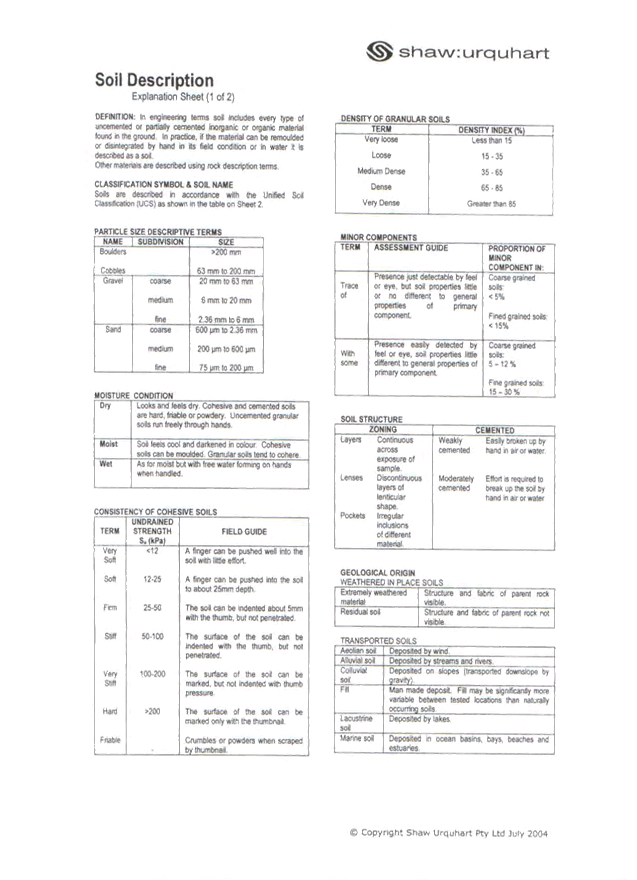
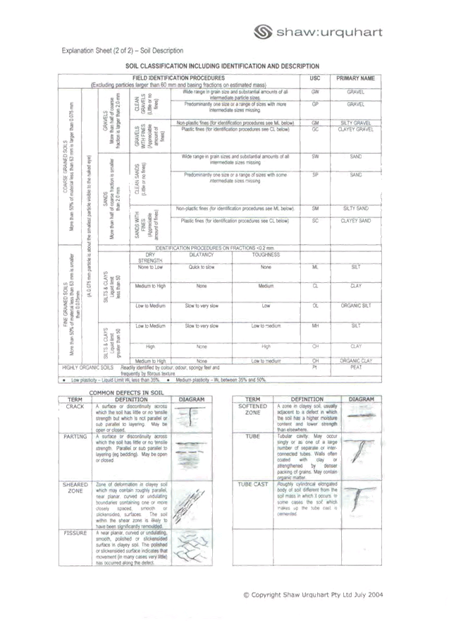
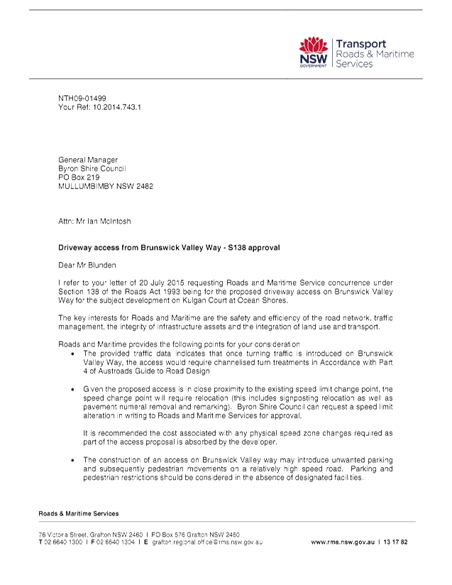
13.6 PLANNING - DA
10.2014.743.1 - Proposed five (5) lot into three (3) lot consolidation, two
boundary adjustments, strata subdivision of multi dwelling housing,
construction of thirty (30) townhouses and detached dual occupancy over four
(4) stages at 2 Kulgun Court Ocean Shores
Attachment
1... Proposed plans prepared by Planit Consulting, Leisure Brothers, geotech
report prepared by shaw urquhart consulting, noise impact assessment prepared
by CRG, Letter from RMS, driveway access S138 approval dated 25/8/15....... 212
Attachment
2... Proposed conditions of consent DA 10.2014.743.1 2 Kulgun Court Ocean
Shores............................................................................................................... 340
13.7 PLANNING -
Section 82A Application to review the refusal of Development Application No.
10.2014.742.1 for a Motel Development at 33 Lawson Street Byron Bay.
Attachment
1... Report to Ordinary meeting of Council 21/5/15..................................... 369
Attachment
2... Proposed Plans S82A Review - DA 10.2014.742.1............................. 393
Attachment
3... Draft Conditions of Development Consent - DA 10.2014.742.1........... 397
13.8 Place Activation
Plan (Masterplan) for Mullumbimby and Bangalow
Attachment
1... Draft Nambour Activation Plan and Action Sheets............................... 416
Attachment
2... Draft Bangalow DCP - Issues raised during consultation with the Community
in May 2015 that are outside the scope of the DCP and could be considered in a
Masterplan for Bangalow....................................................................... 442
13.9 PLANNING - Rural
Land Strategy – Site Suitability Criteria & Mapping Methodology
Attachment
1... Draft Rural Land Use Strategy - Site Suitability Criteria and Mapping
Methodology............................................................................................................... 443
Attachment
2... Form of Special Disclosure of Pecuniary Interest................................. 469
13.10 Adoption of the Scores on
Doors program
Attachment
1... Ordinary Meeting 29 October 2015 Attachment 1: Scores on Doors case
studies and example Scores on Doors certificate............................................. 471
13.11 PLANNING 10.2015.196.1
(Redesign of proposed development) at 40 Mullumbimbi Street Brunswick Heads
Attachment
1... Letter from Frank Stewart amended plans, Arboricultural Impact Assessment
Report.................................................................................................... 476
Attachment
2... Report Ordinary Council 17/9/15 10.2015.196.1................................... 497
Attachment
3... Amended conditions 10.2015.196.1 40 Mullumbimbi Street Brunswick Heads 525
13.13 PLANNING - 26.2015.6.1
Amendment Byron LEP 1988 - West Byron
Attachment
1... Draft Planning Proposal - Amendment to Byron LEP 1988 - West Byron Bay 540
Attachment
2... Email from Department of Planning & Environment............................. 579
Attachment
3... Letter from Landowners in support ....................................................... 581
14. Reports of Committees
Corporate and Community Services
14.1 Report of the
Arakwal Memorandum of Understanding Advisory Committee Meeting held on 19
August 2015
Attachment
1... Minutes of the Arakwal (MoU) Advisory Committee Meeting held on 19 August
2015....................................................................................................... 583
Sustainable Environment and Economy
14.2 Report of the
Biodiversity and Sustainability Advisory Committee Meeting held on 1 October
2015
Attachment
1... Minutes 01/10/2015 Biodiversity and Sustainability Advisory Committee 587
Infrastructure Services
14.3 Report of the
Water, Waste and Sewer Advisory Committee Meeting held on 8 October 2015
Attachment
1... Minutes 08/10/2015 Water, Waste and Sewer Advisory Committee.... 590
Attachment
2... Memo Myocum Quarry Landfill ........................................................... 594
Attachment
3... Myocum Landfill Leachate Management.............................................. 595
Attachment
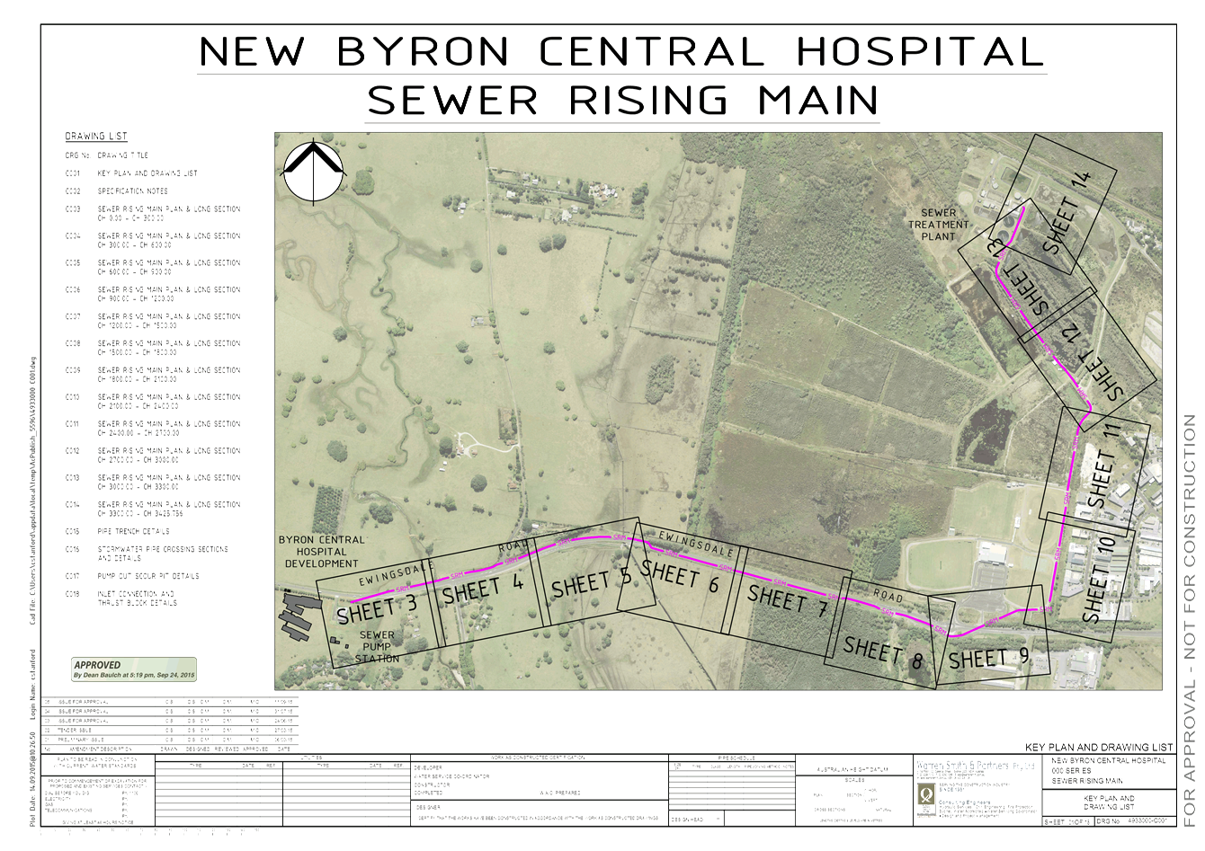
4... New Byron Central Hospital Sewer Rising Main Plan........................... 601
Petitions 10.1 - Attachment 1

Staff Reports - Corporate and Community Services 13.1 - Attachment 1

BYRON SHIRE COUNCIL
POLICY NO. 15/xxx
MAYOR AND COUNCILLORS
PAYMENT OF EXPENSES
AND
PROVISION OF FACILITIES
Staff Reports - Corporate and Community Services 13.1 - Attachment 1
INFORMATION
ABOUT THIS DOCUMENT
|
Date Commenced
|
29 March 1994
|
|
Policy Responsibility
|
Corporate and Community Services
|
|
Date Adopted
|
29 March 1994
|
Resolution No,
|
|
|
Review Timeframe
|
Within 5 months at the
end of each year
|
|
|
|
Last Review Date:
|
August 2014
|
Next Review Date
|
July 2015
|
Document History
|
Doc No.
|
Date Amended
|
Details Comments eg
Resolution No.
|
|
|
24/9/96
|
|
|
|
5/3/04
|
Res No. 04-166
|
|
#541785
|
27/9/05
|
Res No. 05-684
|
|
#606871
|
14/11/06
|
Res No. 06-730 adopted
28/6/07 07-342
|
|
#705189
|
27/9/07
|
Res No. 07-511
|
|
#754283
|
24/4/08
|
Res No. 08-252 placed on
exhibition (#760664)
|
|
#779620
|
31/8/08
|
Res No. 08-525 adopted
|
|
#790811
|
|
Come into effect 13/9/08
|
|
#779666
|
28/8/08
|
Res No. 08-525
|
|
#790824
|
|
Placed on public exhibition
|
|
#805632
|
27/11/08
|
Res No 08-727
|
|
#815079
|
27/11/08
|
Res No 08-727 (adopted after
exhibition)
|
|
#906057
|
13/8/09
|
Res No. 09-634 (adopted
after exhibition – no submissions)
|
|
#942479
|
|
Amended in accordance with
DLG Guidelines 09-36
|
|
#942479
|
7/10/10
|
Res No. 10-799 placed on
exhibition (#942479)
|
|
#1057179
|
10/02/11
|
Res No. 10-1110 adopted
10/02/11 Res No. 11-14
|
|
#1069432
|
16/3/11
|
Res No. 10-1110 adopted
10/2/11 Res No. 11-14 Typo changes – ref Clauses
|
|
#1120094
|
25/8/11
|
Reported to Council for
advertising 8/9/11 to 6/10/11.
|
|
#1151504
|
7/10/11
|
Adopted after close of
exhibition see Res 11-648 – no submissions received
|
|
#1184365
|
9/1/12
|
Updated Page 3 and 7 of 14 -
referencing Clauses
|
|
#E2012/7649
|
9/8/12
|
Adopted after close of
exhibition period see Res 12-602 – no sub received
|
|
#E2013/48106
|
29/8/2013
|
Reported to Council for
advertising #E2013/48057
|
|
#E2013/72869
|
|
Created with incorrect
Policy No.
|
|
E2013/74016
|
7/11/13
|
Adopted after close of
exhibition period – no sub received Res No. 13-411
|
|
E2014/46393
|
7/8/2014
|
Reported to Council for
advertising E2014/46307
|
|
E2014/53161
|
12/8/2014
|
Amended for exhibition as
per Res No. 14--378
|
|
E2014/61952
|
17/9/2014
|
Adopted after close of
exhibition – no submissions received
|
|
E2015/45197
|
27/8/2015
|
Draft amended reported
to Council I2015/718
|
Further Document
Information and Relationships
|
Related Legislation
|
Local Government Act
1993 Sections 23a 252, 253 254
Local Government (General) Regulation 2005
DLG Guidelines Circular 08/24 Misuse of council resources
DLG Guidelines Circular 08/37 Council decision making prior to ordinary
elections
DLG Guidelines Circular No. 09/36 Release of Revised Councillor Expenses and
Facilities Guidelines www.dlg.nsw.gov.au
ICAC Publication “No Excuse for Misuse, preventing the misuse of
council resources (Guidelines 2)” November 2002 www.icac.nsw.gov.au
|
|
Related Policies
|
Model Code of Conduct www.byron.nsw.gov.au
Light Motor Vehicle Fleet #978485
|
|
Related Procedures/
Protocols, Statements, documents
|
Email Communications
Procedure #664764
Procedures Light Motor
Vehicles
· Fees& Charges and Makes and Models #1037783
· General Terms of Use #1037780
· Size of Fleet, Type of Vehicles & Allocation of
Vehicles and Permitted Uses #1037773
Councillors Allowances Claim
Form E2013/42853 – Last Updated 01/07/2014
|
Staff Reports - Corporate and Community Services 13.1 - Attachment 1
TABLE OF CONTENTS
1. INTRODUCTION............................................................................................................. 1
2. OBJECTIVES................................................................................................................... 1
3. FIXING
AND PAYMENT OF ANNUAL FEES............................................................... 1
4. GENERAL
CONDUCT.................................................................................................... 2
5. TRAVEL
EXPENSES/PROVISIONS.............................................................................. 2
6. PAYMENT
OF EXPENSES (MONETARY LIMITS)..................................................... 3
7. FACILITIES
FOR MAYOR AND COUNCILLORS........................................................ 3
7.1. Mayor....................................................................................................................... 3
7.2. Deputy
Mayor and Councillors................................................................................ 4
7.3. Acquisition
and return of facilities and equipment by Mayor and Councillors........ 7
8. ATTENDANCE
AT CONFERENCES, SEMINARS AND TRAINING......................... 7
8.1. Who
may attend conferences, seminars and training............................................. 7
8.2. What
Conferences and Seminars may be attended............................................... 7
8.3. Training
and Development...................................................................................... 8
8.4. Guidelines
for Authorisation..................................................................................... 8
8.5. Reporting
requirements following Councillor and Mayor’s attendance at the
Conference, Seminar or Training.................................................................................................................... 9
8.6. Registration.............................................................................................................. 9
8.7. Travel
Expenses Incurred....................................................................................... 9
8.8. Accommodation.................................................................................................... 10
8.9. Out
of Pocket Expenses Incurred......................................................................... 10
8.10. Payment In Advance............................................................................................. 10
8.11. Overseas
Conferences/Seminars etc................................................................... 10
9. WHERE
EXPENSES MAY NOT BE USED................................................................. 10
10. PAYMENT OF EXPENSES FOR Spouse/Partner or
Accompanying Person........................................................................................ 11
10.1. Payment of expenses
for Spouse/Partner or Accompanying Person
at Conferences...................................................................................................... 11
10.2. Payment of expenses
for Spouse/Partner or Accompanying Person at
Official Council Functions..................................................................................... 11
11. INSURANCes................................................................................................................ 12
11.1. Personal Accident
Insurance................................................................................. 12
11.2. Professional indemnity.......................................................................................... 12
11.3. Public Liability........................................................................................................ 12
11.4. Statutory Liability................................................................................................... 12
11.5. Councillors and
Officers Liability........................................................................... 12
12. Claims Procedure................................................................................................. 13
13. DISPUTE RESOLUTION PROCESS........................................................................... 13
14. GIFTS AND BENEFITS................................................................................................ 13
15. LEGAL EXPENSES AND OBLIGATIONS.................................................................. 13
16. REFERENCE TO COUNCILLOR................................................................................. 14
Annexure A –
AllOWANCE CLAIM FORM................................................................... 15
Staff Reports - Corporate and Community Services 13.1 - Attachment 1
Policy
No: 15/xxx
|
POLICY TITLE
|
MAYOR AND COUNCILLORS payment
of EXPENSES AND PROVISION OF FACILITIES
|
1. INTRODUCTION
Under the Local Government Act
1993 including Section 252 to 254, requires that the Council must adopt a
policy concerning the payment of expenses and the provision of facilities to
the Mayor and other Councillors.
Section 428(2)(f) requires a council to include in its Annual Report:
1.1. Total
amount of money expended during the year on providing those facilities and
paying those expenses.
1.2. Council’s
policy on the provision of facilities for, and the payment of expenses to
Councillors.
1.3. The
payment of Councillors’ expenses, together with a statement of the total
amount of money expended during that year on the provision of such facilities
and the payment of such expenses.
Section 12 provides that the
public is entitled to inspect the Council’s policy concerning the payment
of expenses incurred by, and the provision of facilities to Councillors, free
of charge, and may obtain a copy, either free of charge or on payment of
reasonable copying charges.
This policy should be read in
conjunction with Council’s Code of Conduct, Policy 1.8, in particular,
Clause 8 – Personal Benefit, and Clause 10 – Access to Information
and Council Resources, DLG Circular 08/24 – Misuse of Council resources
and DLG Circular 08/37 – Council decision making prior to ordinary
elections.
2. OBJECTIVES
To ensure the Mayor and
Councillors and/or appointed Administrators of Byron Shire Council are:
2.1. reimbursed
for reasonable and appropriate expenses incurred in the performance of their
civic duties.
2.2. provided
with a range of facilities to assist in the discharge of their civic duties.
3. FIXING AND PAYMENT OF ANNUAL FEES
The Councillors annual fees do
not fall within the scope of this Policy. See Local Government Act 1993
Section 248 - Fixing and payment of annual fees for Councillors and Section 249
- Fixing and payment of annual fees for the Mayor.
4. GENERAL CONDUCT
Councillors
must act lawfully, honestly and exercise a reasonable degree of care and
diligence in carrying out their function under the Local Government Act or any
other Act. This is required under Section 439 of the Local Government Act
and reinforced in Council’s adopted Code of Conduct made under Section
440 of the Act.
5. TRAVEL EXPENSES/PROVISIONS
5.1. Councillors
are entitled to claim “mileage” allowance for use of private
vehicles when used to travel (including return) between their place of
residence or employment, utilising the most direct route possible, subject to
the Councillor’s private vehicle being currently registered and covered
by Compulsory Third Party Insurance:-
5.1.1. To
attend Council or Committee or Sub-Committee meetings and appointments at the
Council Chambers, Council’s Training Rooms, Depots and Halls/Community
Centres for Council business;
5.1.2. Inspections
within the Council’s area undertaken in compliance with a resolution of
the Council if for good reason they are unable to use transport when provided
by Council;
5.1.3. Attending
public meetings convened by the Council;
5.1.4. Individual
or personal inspections of any site within Council’s area listed on the
current Council Meeting Agenda, if for good reason they are unable to use
transport when provided by the Council;
5.1.5. To
and from the periodical conferences and seminars as stated in Clause 8.
5.1.6. To
attend Council Regional Committee of Sub- Committee meetings.
5.1.7. To
attend any other official Council events, functions, meeting and public
information sessions.
5.2. Reimbursement
will be paid at the current rate of the “mileage” allowance set by
the appropriate Local Government Industrial Award from time to time.
5.3. All
vehicle allowance claims to be made in accordance with the Claims Procedure at Section
12.
5.4. Costs
of traffic or parking fines incurred whilst travelling in private or Council
vehicles on Council business are the responsibility of the driver.
5.5. Councillors
unable or unwilling to drive to any Council business, as stated in 5.1.1 to
5.1.6, and if Council is unable to provide transport to the Council business,
may use public transport or taxis utilising the most direct route possible
which costs will be reimbursed by Council.
6. PAYMENT OF EXPENSES (MONETARY LIMITS)
6.1. No annual, monthly or daily allowance or expense
type allowance payment will be payable in any circumstance.
6.2. Monetary
limits applying to this policy include:
6.2.1. Carer’s
expenses Mayor and Councillors maximum $3,000 (total for all Councillors
including Mayor) per annum
6.2.2. Fixed
and Mobile charges for: voice calls, data services, telephone/mobile
line/handset rental
a) Mayor
- $235 per month maximum
b) Councillor - $200 (per Councillor) per
month maximum
6.2.3. Computer
hardware (including laptops, tablets and smartphones), printer, software and
services
Mayor and Councillors
a) maximum
of $2,700 (per Mayor/Councillor) in the first year only for term of office, for
initial purchase of equipment, software licenses and line installation as
deemed necessary for business paper distribution, to work with documents
supplied by Council and for communications.
b) maximum
of $1,000 (per Mayor/Councillor) in the either the second or third year of
office, for purchase of equipment, software licenses and line equipment for the
purposes stated in a) above;
c) maximum
of $1,000 (total for all Councillors including Mayor) per annum for consumables
and protective covers or carry case for equipment purchased.
d) maximum
of $2,000 (total for all Councillors including Mayor) per annum for services
(backup support) provided by hardware supplier/local providers.
6.2.4. Out
of Pocket Expenses associated with attending conferences, seminars or
training, maximum $100 per day
6.3. Reimbursement
of expenses must be made in accordance with the Claims Procedure at Clause 12.
7. FACILITIES
FOR MAYOR AND COUNCILLORS
7.1. Mayor
In addition to those facilities
provided to the Councillors in 7.2, the Mayor is entitled to receive the benefit
of:
7.1.1. The
use of a Council vehicle for official and private use by the Mayor and that the
Mayor be required to pay to Council an appropriate rate per kilometre for
his/her private use of the vehicle.
a) The
vehicle is provided in accordance with Council’s adopted Policy Light
Motor Vehicle Fleet and associated procedures being:
i) Light
Motor Vehicle -Fees & Charges and Makes and Models
ii) Light
Motor Vehicle – General Terms of Use.
iii) Light
Motor Vehicle – Size of Fleet, Type of Vehicles and Allocation of
Vehicles and Permitted Uses
b) The
vehicle be made available by arrangement with the Mayor for official Council
business;
c) An
allotted parking space at the Council’s Administration building.
d) The
vehicle be returned to Council after completion of his/her term of office,
extended leave of absence or at the cessation of his/her civic duties.
7.1.2. A
furnished office for civic duties provided in Council’s Administration
Building;
7.1.3. Secretarial
services relating to the discharge of his or her civic functions;
7.1.4. Administrative
assistance associated with civic functions, meetings and the like;
7.1.5. Office
refreshments;
7.1.6. Provision
of a Mastercard with Council’s preferred banking institution to the value
of $5,000 (see Claims Procedure at Clause 12) Note:
All expenditure on the credit card must be in accordance with the provisions of
the Policy and is not for private use.
7.2. Deputy Mayor and Councillors
The Councillors, including the
Deputy Mayor are to receive the benefit of:-
7.2.1. Access
Provisions – Appropriate provisions will be made for sight or hearing
impaired councillors or those with any other disability.
7.2.2. Business
cards - using Council’s Logo;
7.2.3. Carer
Expenses – Council will reimburse the reasonable costs of carer
arrangements, including childcare expenses and care of the elderly, disabled
and/or sick immediate family members of Councillors, to allow Councillors to
undertake their Council business obligations.
Note:
i) Reimbursement of
reasonable costs will only be available to enable the Councillor’s
attendance at essential Council activities and will be the subject of a
separate application by the affected Councillor in each instance, for
determination by the General Manager.
ii) Child/dependant care
expenses are not to be reimbursed if the care is provided by a relative of the
Councillor who ordinarily resides with the Councillor. A
‘relative’ is defined as a spouse, defacto partners, parent, son,
daughter, brother, sister or grandparent.
iii) Childcare will only be provided
to children of the Councillor up to an including the age of 16 years.
iv) After approval, Council will
reimburse actual expenses incurred by Councillors in this regard upon
submission of a claim (in line with the Claims Procedure at Clause 12)
supported by receipts and details of the activity attended. The maximum
entitlement for such expenses in accordance with the monetary limits set at
6.2.1.
7.2.4. Computer
– Council will reimburse the cost of a laptop computer and other forms of
electronic services as deemed necessary for business paper distribution and
communications, as per Clause 6.2.3.
7.2.5. Computer
Software – Council will reimburse the cost of appropriate software to
work with documents supplied by Council and other generally available file
formats, as per Clause 6.2.3.
7.2.6. Computer
Training - Training to be arranged through local providers.
7.2.7. Computer
Support – Provided by hardware supplier/local providers in
accordance with monetary limits set in 6.2.3 c).
7.2.8. Electoral
Roll - a copy (free) of whole Council area.
7.2.9. Email
Address - Councillor emails are to be in the format:
firstname.lastname@cr.byron.nsw.gov.au
Council’s IT department will arrange the set up of this domain.
7.2.10. Fax/Printing
Equipment
a) Council
will reimburse the purchase cost of a multi-function fax/printer/ scanner for
use at place of residence or business.
b) Maintenance/servicing
and consumables to be provided by external providers and the costs to be
reimbursed by Council.
c) Monetary
limits are in accordance with Clause 6.2.3.
d) The
fax number is to be provided to the public.
7.2.11. Filing
- Up to a four (4) drawer filing cabinet and associated equipment to be
used in place of residence.
7.2.12. Internet
- fixed or mobile
Council will meet the cost of Internet (data) charges, fixed or mobile (as
required) involved in the conduct of Council business, as per Clause 6.2.2.
7.2.13. Line,
Installation and Costs - The Council shall:-
a) Meet
the initial cost of installation, where necessary, of the equipment in the
residence of the Councillor, including one (1) additional extension point for
an existing phone line or one (1) separate point for a dedicated line.
b) Meet
the cost of any maintenance/servicing of the equipment including any service
call charge.
c) After
initial set up costs for telephone lines, internet broadband and fax, the
maximum payable by Council to enable Councillors to conduct their civic duties
will be as stated in Clause 6 “Payment of Expenses – Monetary
Limits”.
d) Individual
Councillors are to meet the cost of accounts above the limit set in Clause
6.2.2.
e) The
land line number is to be made available to the public.
7.2.14. Meals:
Provide sustenance prior to or during Council’s official Meetings and
meetings of Councillors with Parliamentary representatives visiting dignitaries
and other delegations, including vegetarian or other specific sustenance for
any Councillor who notifies such preference;
7.2.15. Mobile
Telephones
a) Council
will meet the monthly cost of a mobile plan within the limits set by Clause
6.2.2.
b) Individual
Councillors are to meet the cost of accounts above the limit set in Clause
6.2.2.
c) The
mobile number is to be made available to the public.
7.2.16. Postage
of official correspondence - all mail is to be directed through the
Council’s own mailing system. Reimbursement of expenses will only
be made where expenses can be verified;
7.2.17. Secretarial
Service - including typing, photocopying, printing and postage for the
following purposes:-
a) Initiating
correspondence to, answering correspondence received from residents/ratepayers,
Members of Parliament, Government Departments, other local authorities, other
Councillors, local government related bodies and organisations, the media or
the general public in relation to the business of the Council or local
government.
b) Replying
to invitations to attend functions/gatherings received in their capacity as a
Councillor.
c) Communications
to Councillors and Council’s staff on official business.
7.2.18. Stationery
- Use of official stationery and supplies to carry out official duties;
7.2.19. Telephone
Charges - Council will meet the initial costs of an extra line (see 7.2.13)
and maximum monthly charges in accordance with the monetary limits set in
Clause 6.2.2.
7.2.20. Transport
to official functions (if needed) when deputising for the Mayor;
7.2.21. Use
of Private Equipment - Councillors may use their existing
telecommunications lines. Reimbursement for use will be made in
accordance with the monetary limits set in 6.2.2. No retrospective
payments will be made on existing line rentals.
If this option is used,
Councillors are encouraged to make their landline telephone and fax numbers
available to the public. All contact numbers are to be provided to staff.
7.2.22. Typing
of official correspondence;
7.2.23. Vehicles
- Access to suitable vehicle or vehicles (if available) provided by the Council
for use on official duties connected with the office of a Councillor.
7.3. Acquisition and return of facilities and
equipment by Mayor and Councillors
a) Return
to Council all Council provided equipment. Councillors are to arrange for
disconnection of services, subscriptions or mobile phone plans in their own
name.
b) The
equipment may be purchased by the Mayor or Councillors at either trade in value
or the price Council would obtain for its disposal of particular items.
c) Council
may require reimbursement of a portion of the monetary value of the equipment
if he/she resigns in the first 12 months of service.
8. [p1] ATTENDANCE AT CONFERENCES, SEMINARS
AND TRAINING
8.1. Who may attend conferences, seminars and
training
8.1.1. Councillors
may be authorised to attend conferences, seminars and similar functions by:-
a) Preferably,
the Council, through resolution duly passed at a Council meeting arising from a
report to Council or a notice of motion by a Councillor
b) The
General Manager and Mayor jointly, [p2] provided the attendance is within the
guidelines in Clause 8.4.2 of this policy
c) The
Mayor, provided the Councillor is a substitute for another Councillor
previously authorised to attend that conference.
8.2. What Conferences and Seminars may be attended
8.2.1. The
conferences, seminars, workshops, courses and similar to which this policy
applies shall generally be confined to:
a) Local
Government Association Annual (LGA and Australian local Government Association
(ALGA) Conferences;
b) Special
“one-off” conferences called or sponsored by or for LGA and/or ALGA
on important issues;
c) Annual
conferences and congresses of the major professions in local government;
d) Australian
Sister Cities Conferences;
e) Regional
Organisation of Councils Conferences
f) Conferences
which advance the professional development of elected members in their role as
Councillors.
g) Any
meetings or conferences of organisations or bodies on which a Councillor of the
Council may be elected, or appointed to be, a delegate or member of the Council
or the LGA.
h) Seminars
which further the training and development efforts of the Council and within
the budget framework.
8.3. Training and Development
8.3.1. Council
supports and encourages an active learning process and skills development in
addition to providing for attendance at seminars and conferences related to
Council functions. It is essential that the training or educational
course is directly related to the Councillor’s civic functions and
responsibilities and within budget parameters.
8.4. Guidelines for Authorisation
8.4.1. A
resolution of Council is required to authorise attendance of Councillors at:
a) Local
Government and Shires Association Conference(s) as a voting delegate
b) Australian
Local Government Association National General Assembly as a voting delegate
c) Overseas
conferences
d) Any
other discretionary conference, seminar or training.
8.4.2. Any
discretionary conference, seminar or training (as per (d) above) not able to be
authorised at a Council meeting the General Manager and Mayor jointly [p3] may authorise Councillors’
attendance at:
· One
conference, seminar or similar function per Councillor per financial year
provided the conference is held in NSW, the ACT or South East Queensland and
the Councillor has not attended a previous conference that year
If the Mayor requires approval to attend a conference/seminar not able to be
authorised at a Council meeting the Deputy Mayor and General Manager jointly
may authorise the Mayor’s attendance.
Councillors or Mayor’s attendance at conferences authorised by the
General Manager and Mayor will be reported to the next quarterly review of the
Management Plan.
8.4.3. The
General Manager may approve the Mayor and Councillors' attendance at
events/forums held in the local area up to the value of $100.
8.4.4. Procedures:
a) Staff
will prepare a report to Council inviting nominations to attend the following
conferences:
· Local Government and
Shires Association Conference
· Australian Local
Government Association National General Assembly
b) Submission
of motions for consideration by Council will be done by notice of motion, which
can be considered during the year.
c) Staff
will remind Councillors of the opportunity to submit motions for these
conferences in May in the case of the LGSA Conference and in June in the case
of the ALGA NGA.
d) All
other conference attendance requiring Council resolution will be submitted as a
notice of motion by a Councillor wishing to attend, in accordance with
Council’s normal procedures for such notices of motion. Councillors other
than the Councillor who submitted the notice of motion may be authorised to attend
by Council.
8.5. Reporting requirements following Councillor
and Mayor’s attendance at the Conference, Seminar or Training
The Mayor and Councillors are
required to report in writing a Delegate’s Report to an Ordinary Meeting
of Council on the aspects of the conference, seminar or training relevant to
Council business and or the local community. The report must be submitted
to the General Manager within one month of the Councillor’s or
Mayor’s attendance at the Conference or Seminar.
8.6. Registration
The Council will pay all normal
registration costs which are charged by organisers, including the costs of
related official luncheons, dinners and tours which are relevant to the
interests of the Council or assist Councillors to discharge the functions of their
civic office.
8.7. Travel Expenses Incurred
Payment or reimbursement of
expenses incurred when travelling to conferences and seminars of local
government related organisations at which attendance has been approved.
8.7.1. the
travel is undertaken with all due expedition, and by the shortest practicable
route;
8.7.2. All
reasonable travel costs will be met by the Council. Where appropriate,
travel will be provided by air (economy class). Depending upon the
circumstances, it may be more appropriate for travel to be undertaken by car or
train. Where trains are used, the Council will provide first class
travel, including a sleeping berth where necessary.
8.7.3. Travel
by motor vehicle may be undertaken by Council vehicle (where available) or by
private vehicle subject to prior approval from the General Manager.
Councillors using private vehicles will be paid the “mileage”
allowance at the then current rate set by the appropriate Local Government
Industrial Award from time to time, but subject to any such payment not
exceeding economy class air fares to and from the particular destination.
8.7.4. Cost
of vehicle hire and/or taxi fares which are reasonable and incurred while
attending conferences will be reimbursed by the Council.
8.8. Accommodation
Reasonable accommodation costs
(including meals), including the night before and/or after the conference,
seminar, meeting or function including entertainment but excluding expenses of
a normal private nature.
The reasonable daily accommodation amount will be in accordance with the
Taxation ruling for that year.
8.9. Out of Pocket Expenses Incurred
So that Councillors, as delegates
of the Council attending conferences which involve an overnight stay are not
thereby financially disadvantaged, each Councillor attending in pursuance of a
Council resolution or Mayoral authority, shall be entitled to an
“out-of-pocket” allowance.
8.9.1. only
reasonable amounts are claimed or accepted towards necessary out-of-pocket
expenses to a maximum $100 per day;
8.9.2. out-of-pocket
expenses for which amounts are claimed relate only to the verified (tax
invoice) costs of meals, travel, registration fees, stationery and the like;
8.9.3. any
time occupied or travel incurred in other than Council business is not included
in the calculation of expenses to be paid; and
8.9.4. the
claim is made not later than three (3) months after the expenses were incurred,
and upon a official receipt for payments.
8.10. Payment In Advance
The Council will normally pay
registration fees, accommodation deposits and airline tickets direct in
advance. Where this is not appropriate or possible, a cash allowance or
cheque equivalent thereto will be paid to the attendee in advance.
An allowance for estimated
“out-of-pocket” expenses (up to $100 per day) may be paid to an
attendee in advance upon request, subject to a reconciliation statement,
verification of expenses and the refund of any unexpended amount being
submitted within seven (7) days of the close of the conference, seminar or
function.
8.11. Overseas Conferences/Seminars etc.
Attendance by a Councillor at any
conference, seminar, congress, forum, workshop, course, meeting, deputation,
information or training sessions, events, etc. related to the industry of local
government which are held overseas, must be authorised prior to departure by
specific resolution of the council and such resolution shall specify and detail
the conditions of attendance.
9. WHERE EXPENSES MAY NOT BE USED
9.1. Political
fundraising
Councillors may not claim
expenses to support attendance at political fundraising functions.
9.2. Communication expenses
Individual
Councillors or groups of Councillors may not claim expenses to produce and
disseminate personalised pamphlets, newsletters and the like without the prior
approval of Council being obtained via Council resolution.
10. PAYMENT OF EXPENSES
FOR Spouse/Partner or Accompanying Person
10.1. Payment of expenses for Spouse/Partner or Accompanying
Person at Conferences.
10.1.1. Where
the Councillor is accompanied by his or her spouse/partner or accompanying
person (ie. a person who has a close personal relationship with the councillor
and/or provides carer support to the councillor), all costs for the
spouse/partner or accompanying person, including travel, meals and room
upgrades are to be met by the Councillor or spouse/partner of accompanying
person.
10.1.2. The
spouse/partner or accompanying person’s registration and or program fees
(if attending), are to be paid to the conference organiser and paid at time of
registration. The Council is prepared to receive such registration and
payments and forward them on to the conference organiser with any
Councillor’s registration.
10.1.3. Where
Council meets, on account, any expenditure or costs on behalf of an
accompanying person attending a conference, such expenditure must be repaid to
the Council by the Councillor within seven (7) days of being invoiced for such
expenditure following the conclusion of the conference.
10.1.4. Limited
expenses of spouses, partners and accompanying persons will be met by Council
in association with the Mayor or Councillors’ attendance at the Local
Government Association’s Annual Conference. These expenses will be
limited to registration costs and attendance at the conference dinner.
Any additional travel and accommodation expenses and the cost of partner tours
etc. will be the personal responsibility of the individual Councillor or
spouse/partner or accompanying person.
10.2. Payment of expenses for Spouse/Partner or Accompanying
Person at Official Council Functions.
10.2.1. Council
will meet reasonable costs for spouses/partners or accompanying persons when
accompanying Mayor or Councillors at official council functions that are of a
formal and ceremonial nature within the Byron Shire. Examples include but
not limited to, Australia Day award ceremonies, civic receptions and charitable
functions or events formally supported by the Council.
10.2.2. Council
will also meet reasonable costs for a spouse/partner or accompanying person of
the Mayor, or a Councillor when they are representing the Mayor, at an official
function of the Council, or carry out an official ceremonial duty while
accompanying the Mayor (or Councillor representing the Mayor) outside the Local
Government area, but within the State or South East Queensland.
10.2.3. Payment
of expenses for a spouse, partner or accompanying person when attending the
abovementioned appropriate functions, will be limited to the ticket, meal or
the direct cost of attending the function. Additional expenses such as
accommodation, transport, grooming or special clothing are not considered to be
reimbursable expenses.
11. INSURANCes
11.1. Personal Accident Insurance
Whilst ever on Council business,
world-wide covering bodily injury caused by accidental, violent, external and
visible means up to a sub-limit for death of $500,000. Also covering
permanent disablement, temporary total disability. The cover does not
include medical expenses. Full details of personal accident
insurance are available in Council’s Insurance Manual held by the Risk
Management Officer.
11.2. Professional indemnity
For matters arising out of
Councillors’ performance of civic duties or exercise of their functions
as Councillors, provided the performance or exercise of the relevant civic duty
of function is in the opinion of Council bona fide and/or proper; subject to
any limitations or conditions set out in the policy of insurance which is, at
the direction of Council, taken out. No such benefit, irrespective of
insurance cover, shall be provided in relation to an action by one Councillor
against another Councillor or a Councillor against a member of staff.
11.3. Public Liability
For matters arising out of
Councillor’s performance of civic duties or exercise of their functions
as Councillors; subject to any limitation or conditions set out in the policy
of insurance which is, at the direction of Council, taken out. No such benefit,
irrespective of insurance cover shall be provided in relation to an action by
one Councillor against another Councillor or a Councillor against a member of
staff.
11.4. Statutory Liability
It provides protection against
fines or penalties arising out of breaches of Acts of Parliament, plus the
legal costs accrued in defending Council as an entity, individual
Councillors and officers so long as the act was not wilfully committed. The
policy will cover costs accrued before an individual is named in proceedings.
Costs are then referred to Councillors and Officers policy.
11.5. Councillors and Officers Liability
This policy provides the main
protection against personal liability for individual councillors and officers
for matter arising from employment practices, civil fines and penalties and
their defence costs, pollution defence costs and inquiries/investigations.
12. Claims Procedure
12.1. Councillors
must provide a certified claim in the form at Appendix A for all travel and out
of pocket expenses incurred. All claims must be accompanied by tax invoice
receipts.
12.2. All
claims should be made monthly unless otherwise specified. At the end of
each financial year any claims outstanding for the previous financial year must
be submitted in the first week of July.
12.3. All
reimbursement of expenses must be approved by the General Manager.
12.4. All
expenses being reimbursed must be in accordance with the provisions of this
policy.
12.5. The
Mayor’s mastercard expense claims must be accompanied by Appendix A
“Allowance Claim Form”. All expenditure must be accompanied
by Tax invoice receipts and remitted monthly by a date determined by the
Finance Department.
13. DISPUTE RESOLUTION
PROCESS
Should a dispute arise about the
provision of expenses and facilities, or when an expense claim is not approved
by the General Manager, then the disputed decision should be reviewed by the
Internal Audit Committee, with a report to the full Council meeting.
14. GIFTS AND BENEFITS
In circumstances where it is
appropriate for councillors to give a gift or benefit (for example on a council
business related trip or when receiving visitors), these gifts and benefits
should be of token value and in accordance with Council’s Code of Conduct
(clause 8.1)
15. LEGAL EXPENSES AND
OBLIGATIONS
15.1. Council
may disburse money only if the disbursement is authorised by the Local
Government Act 1993, either expressly or because it is supplemental or
incidental to or consequential upon the exercise of its functions.
15.2. In
the particular circumstances outlined below, Council may therefore indemnify or
reimburse the reasonable legal expenses of a Councillor:
15.2.1. defending
an action arising from the performance in good faith of his or her functions as
a Councillor as referred to in s731 of the Local Government Act 1993; or
15.2.2. defending
an action in defamation provided the statements complained of were made in good
faith in the course of exercising his or her functions as a Councillor; or
15.2.3. for
proceedings before any investigative or review body provided the conduct being
investigated arises from the performance in good faith of his or her functions
as a Councillor under the Local Government Act 1993, that the matter before the
investigative or review body has progressed past any initial assessment phase
to a formal investigation or review and the investigative or review body makes
a finding substantially favourable to the Councillor. Investigative or review
bodies may include:-
(i) Local
Government Pecuniary Interest and Disciplinary Tribunal
(ii) Independent
Commission Against Corruption
(iii) Office
of the NSW Ombudsman
(iv) Division
of Local Government, Department of Premier and Cabinet
(v) NSW
Police Force
(vi) Director
of Public Prosecutions
(vii) Council’s
Conduct Review Committee/Reviewer
15.2.4. In
the case of a conduct complaint made against a Councillor, legal costs will
only be made available where a matter has been referred by the General Manager
to the Conduct Review Committee to make formal enquiries into the matter in
accordance with the procedures in Council’s Code of Conduct.
15.2.5. In
the case of a pecuniary interest or misbehaviour matter legal costs will only
be made available where a formal investigation has been commenced by the
Division of Local Government.
15.3. Legal
expenses incurred in relation to proceedings or investigations arising out of
the performance by a Councillor or his or her functions as a Councillor are to
be distinguished from expenses incurred in relation to proceedings arising
merely from something that a Councillor has done during his or her term of
office. An example of the latter is expenses arising from an
investigation as to whether a Councillor acted corruptly by using knowledge of
a proposed rezoning for private gain which type of expense would not be
reimbursed.
15.4. Council
will not meet the costs of an action in defamation taken by a Councillor as
plaintiff in any circumstances.
15.5. Council
will not meet the costs of a Councillor seeking advice in respect of possible
defamation, or in seeking a non-litigious remedy for possible defamation.
15.6. Council
will not meet the costs in respect of any legal proceedings initiated by any
Councillors, acting as individuals, in any circumstances.
15.7. The
amount of expenses that may be reimbursed to a Councillor shall be reduced by
the amount of any money that are recouped by the Councillor on any basis.
15.8. The
approval of Council is required to be sought and gained, where possible, prior
to legal expenses being incurred.
16. REFERENCE TO
COUNCILLOR
A reference in this policy to a Councillor includes the
Mayor, unless the contrary is expressly indicated.
Staff Reports - Corporate and Community Services 13.1 - Attachment 1
Annexure
A – AllOWANCE CLAIM FORM
CR
____________________ ALLOWANCE CLAIM FORM
Section 252, Local
Government Act, 1993
|
Date
|
Meetings,
Authorised Council Business and Inspections
|
Vehicle
Allowance
under 2.5L =
68c KM
over
2.5L =
78c KM
Rates subject to change as per Council Agreement
(Award)
No of kms 68c
or 78c
|
Total
$
|
|
|
|
@
|
|
|
|
|
|
@
|
|
|
|
|
|
@
|
|
|
|
|
|
@
|
|
|
|
|
|
@
|
|
|
|
|
|
@
|
|
|
|
|
|
@
|
|
|
|
|
|
@
|
|
|
|
|
|
@
|
|
|
|
|
|
@
|
|
|
|
Date
|
Sundry Claims
All receipts/Tax Invoices to be enclosed
|
Sub Total
|
$
|
|
|
|
|
|
|
|
|
|
|
|
|
|
|
|
|
|
|
|
|
|
|
|
|
|
|
|
|
|
|
|
|
|
|
|
|
Total
|
$
|
I hereby certify that the
above expenses have been incurred and accordingly claim reimbursement in
accordance with Council Policy. All receipts for sundry items are attached to
this Claim Form.
Councillor
________________________ _______________________ ____________________
Name (Please Print) Signature Date
Office
Use Only
|
Equipment
|
2151.004 ___
|
Total
$___________
|
Sundry
|
2145.006
___
|
Total
$___________
|
|
Travel
|
2145.002
___
|
Total
$___________
|
Carers
Expenses
|
2145.011
___
|
Total
$___________
|
|
Conference
|
2145.004
___
|
Total
$___________
|
Equip
Support/svc
|
2145.012
___
|
Total
$___________
|
|
Telephone/data
|
2145.005
___
|
Total
$___________
|
Consumables
|
2145.013
___
|
Total
$___________
|
Authorised:
_____________________________ Date
________________ TOTAL CLAIMED $___________
E2013/42853
Staff Reports - Corporate and Community Services 13.4 - Attachment 1
UNCONFIRMED
REPORT OF THE SAFE SUMMER IN THE BAY PROJECT REFERENCE GROUP MEETING
|
Date of Meeting:
|
Thursday 16 September 2015
|
|
Time Commenced:
|
2.10pm
|
|
PRESENT:
|
Councillors:
|
Cr Simon Richardson
|
|
|
Community Representatives:
|
There are no community representatives.
|
|
|
Invited Representatives:
|
Paul Spooner (Byron Community Centre),
Tess Cullen (Byron Community Centre),
Greg Jago (Police)
Mouche Phillips (Byron Community Centre)
|
|
|
Staff:
|
Mark Arnold (Director Corporate and Community
Services), Joanne McMurtry (Community Policy Officer), Simon Bennett (Traffic
& Transport Officer)
|
|
|
|
|
|
1. APOLOGIES:
|
Cr Rose Wanchap, Brandon Saul (Falls Festival), Peter
Wood (Arts Northern Rivers), Greg Ironfield (Manager Community Development), Michael
O’Grady (Byron United/ Destination Byron/ Backpacker Group), Hannah
Spalding (Byron Bay Liquor Accord)
|
|
|
|
2. DECLARATIONS OF INTERESTS:
|
Paul Spooner (Byron Community Centre) reinforced a
previous declaration, in that he was in attendance as the Community Centre
Manager and not a Councillor, and that the Byron Community Centre conduct the
operations of Soul Street NYE and First Sun NYD events.
|
|
3. CONFIRMATION OF A QUORUM:
|
There are 9 members appointed to this group
(not including staff). Quorum was met.
|
|
4. CONFIRMATION OF PREVIOUS MINUTES
|
The previous minutes from the 20 August 2015 meeting
were adopted. (Richardson/Spooner)
|
|
5. BUSINESS ARISING FROM PREVIOUS
MEETING
|
|
|
|
1. Traffic
Control Plan
A draft Traffic Management Plan
was tabled and discussed. Discussion points noted:
· Perhaps have some
Byron Greeters located near the traffic controllers to assist with crowd
movements and information
· Look at using the
Byron Youth Service Bat Bus as one of the NYE shuttle options.
· Discussion about
locations of road barriers, toilets and stage in Jonson St. Need to work on a
better location for toilets near Railway Park. Tess and Joanne to do this.
· Invite Ambulance
staff to meetings again.
· Consider an extra
daymaker light located at the proposed temporary bus stop.
· Perhaps Falls Fest
could consider extending their ‘lanterns’ across the pedestrian
walkway between Butler St and Jonson St over the railway line.
Simon Bennett left the meeting at 2.45pm.
|
6. UPDATES
TO PLAN FOR NEW YEAR IN BYRON BAY 2015:
|
Progress on the implementing the Action Plan was discussed
and the following points made:
· Encourage
Byron United’s ‘Light up’ to include businesses along Jonson
St for NYE.
· The
radio messages last year were very good and appeared to work well.
· Discussion
around the difficulty of getting volunteers for NYE. Tess and Joanne to work
together on perhaps providing payment for some long-term Community Centre
volunteers to wear Byron Greeters t-shirts on the night.
· The
committee would really like to investigate the idea of an electricity box
installed in one of the laneway’s – Lawson Lane or Surf Alley. What
is needed is 240 volt powerpoints.
|
ACTION LIST:
|
|
1. Traffic
Management Plan to be updated following this meeting and presented to Local
Traffic Committee at their next meeting.
2. Joanne, Tess and
Mouche to work together on the following ideas:
a. locations of
road barriers, toilets and stage in Jonson St. Need to work on a better
location for toilets near Railway Park.
b. Talk to Falls
Fest re extending lanterns across the pedestrian walkway between Butler St
and Jonson St over the railway line.
c. Look at
volunteer situation for NYE
3. Invite Ambulance
staff to future Safe Summer in the Bay PRG meetings.
4. Request an
electrical box be installed in one of the laneway’s – Lawson Lane
or Surf Alley.
|
|
8. date and time of meetings for the year:
|
2
– 4pm, 22 October
11am
– 1pm, 12 November
9
– 11pm, 3 December
|
|
Time Meeting Closed:
|
3.25pm
|
|
|
|
Staff Reports - Corporate and Community Services 13.4 - Attachment 2
Staff Reports - Corporate and Community Services 13.4 - Attachment 2
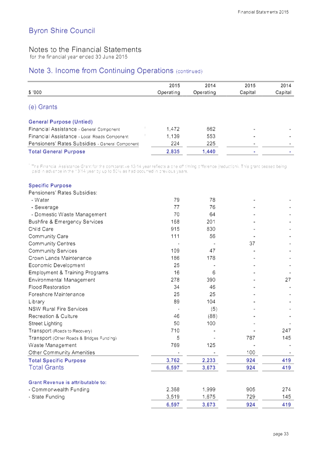
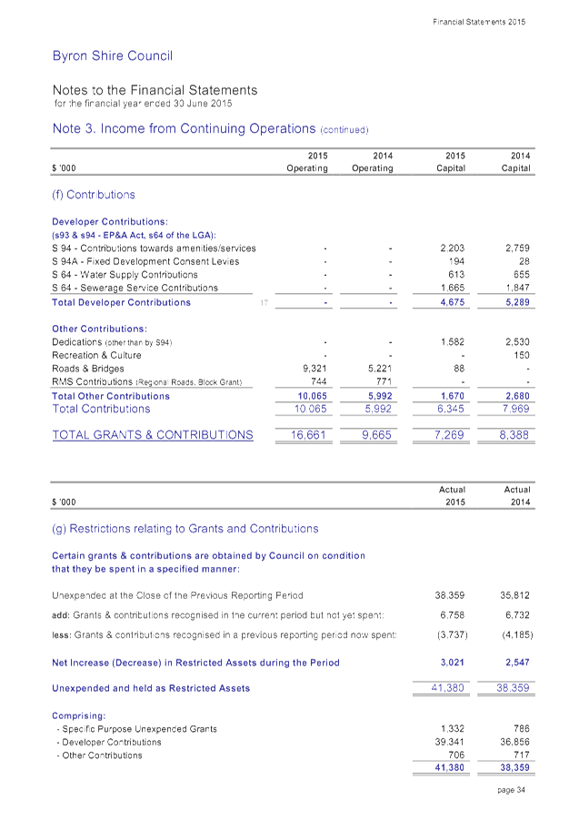
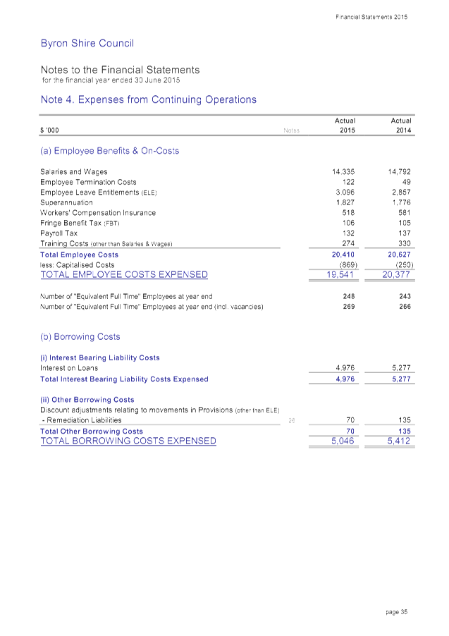
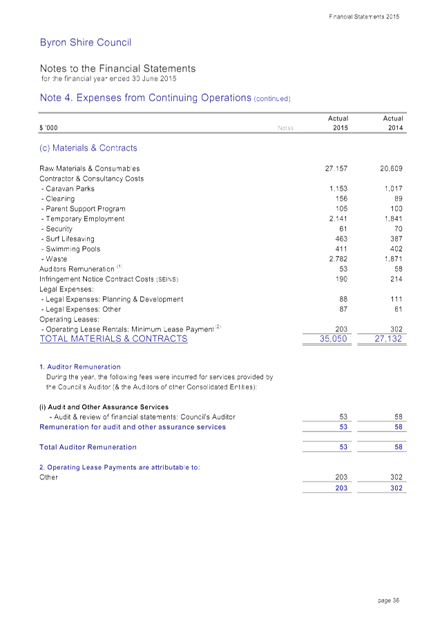
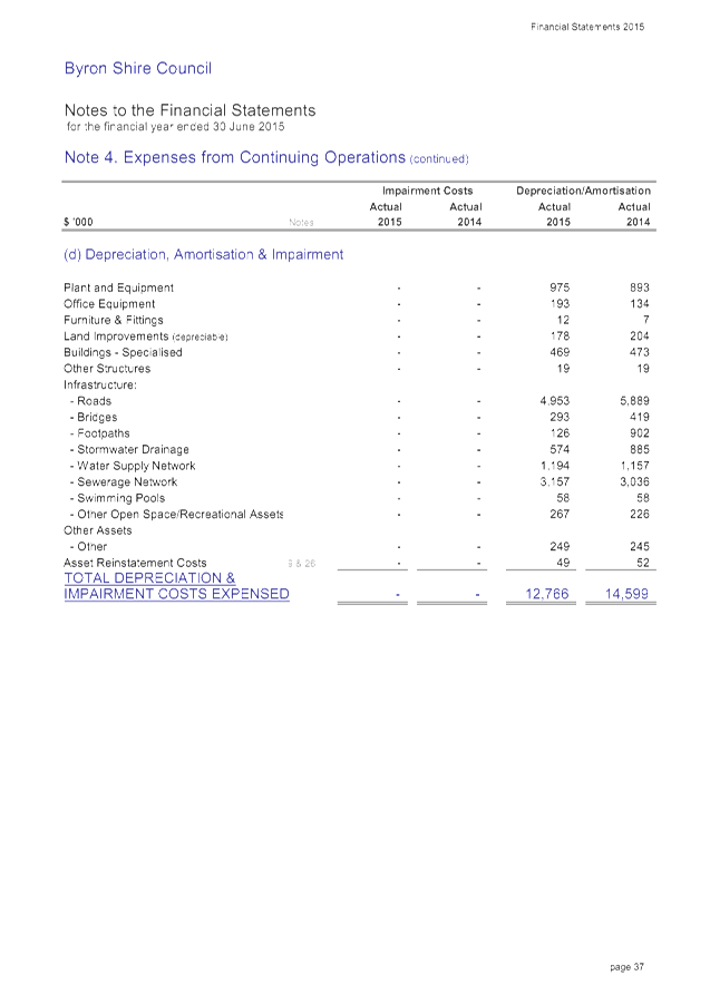
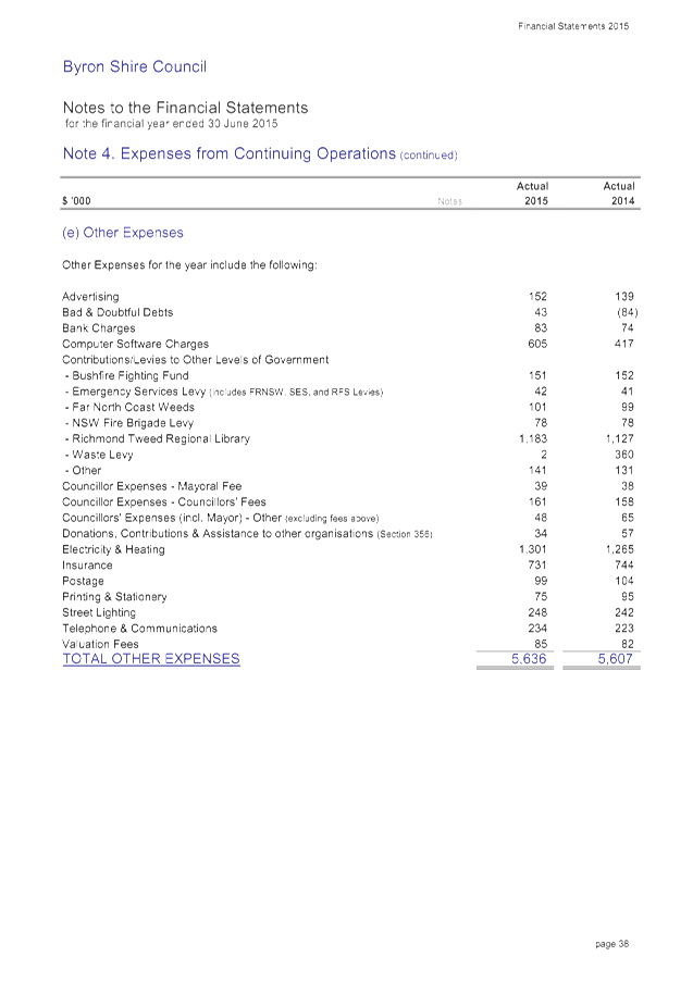
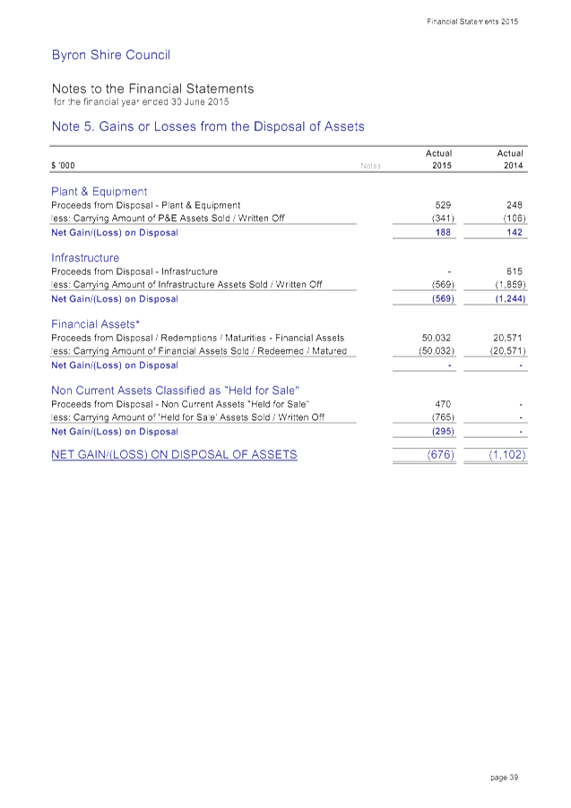
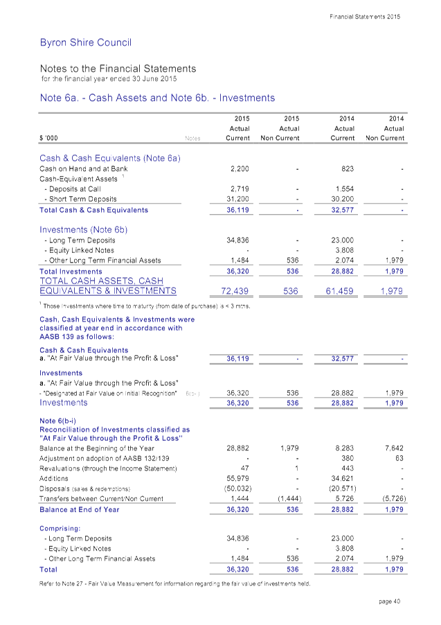
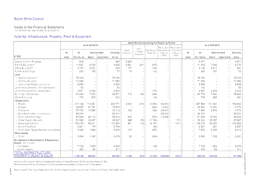
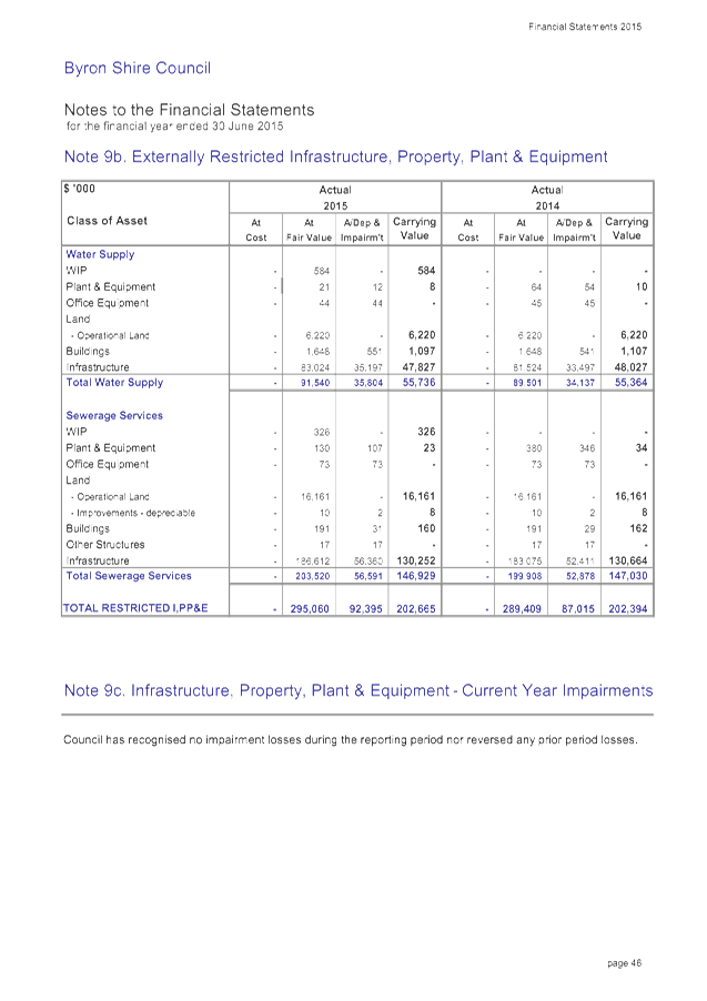
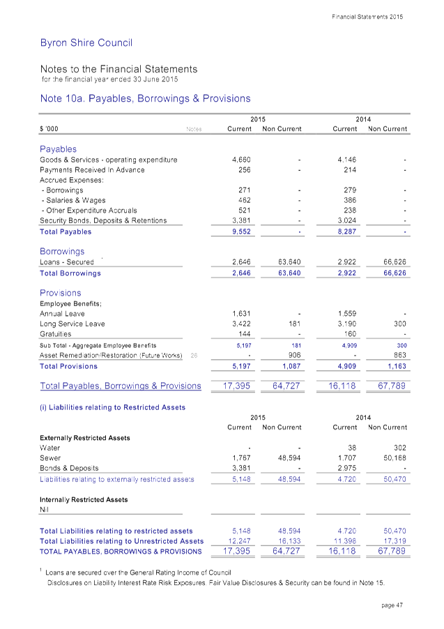
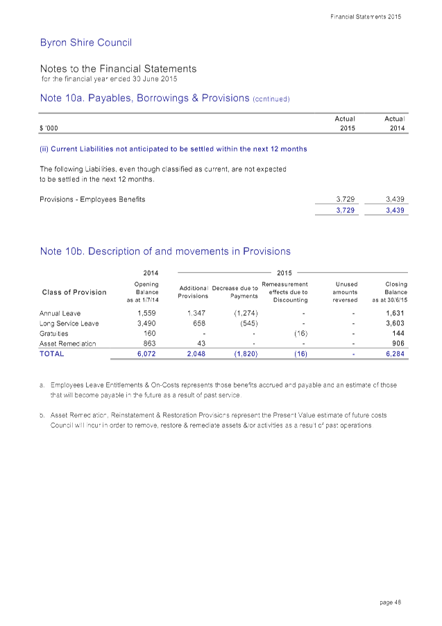
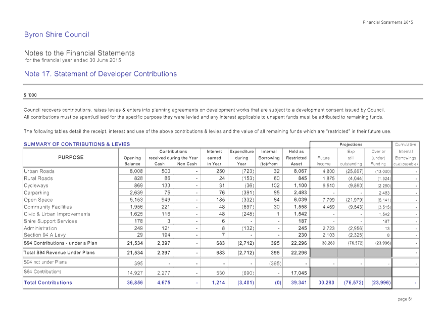
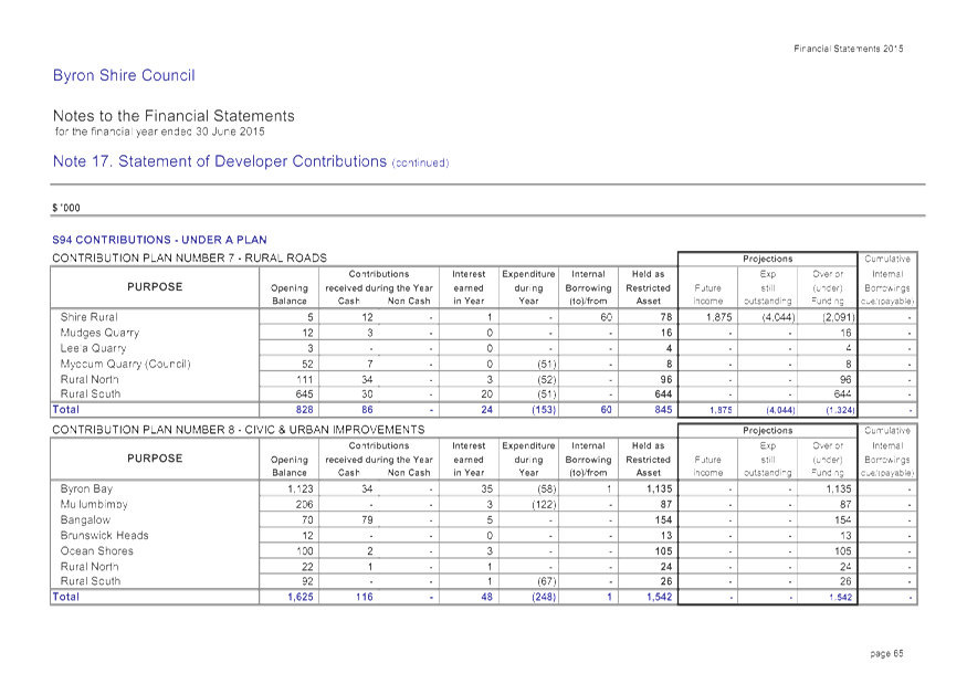
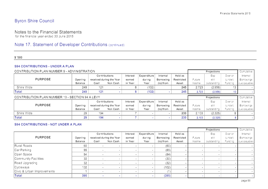
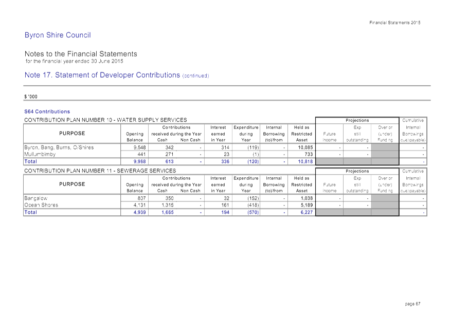
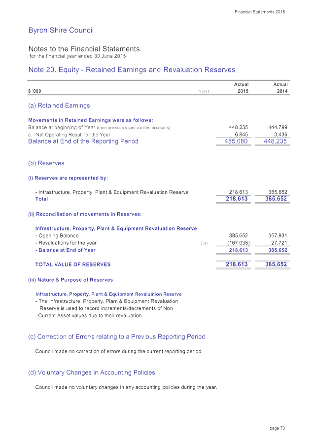
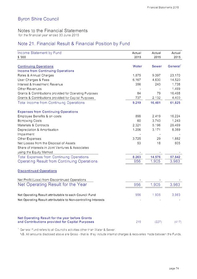
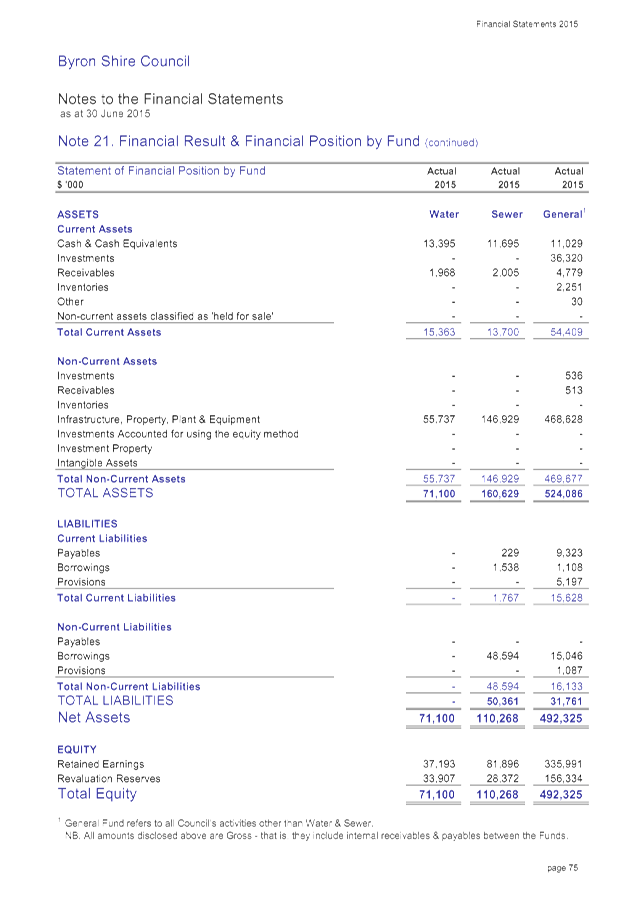
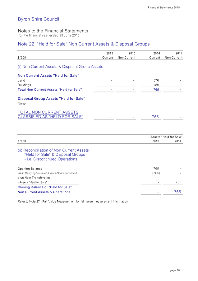
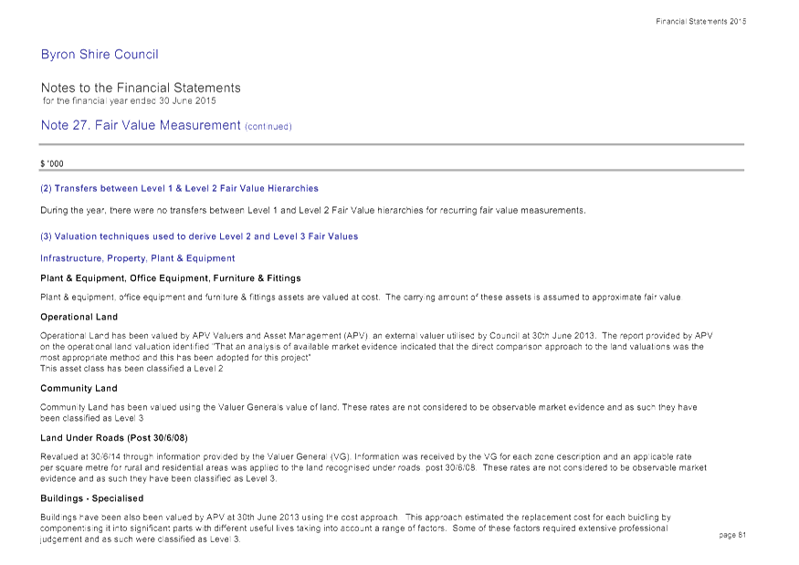
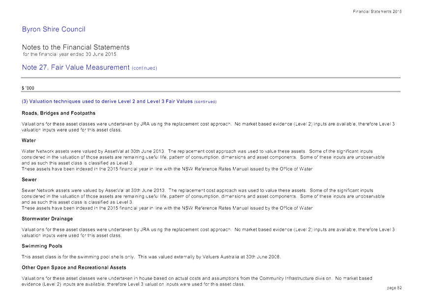
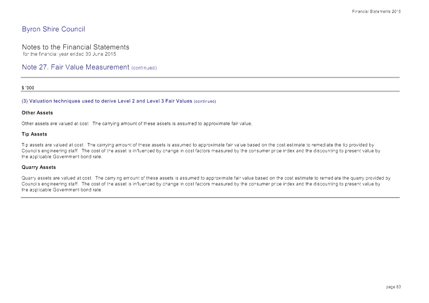
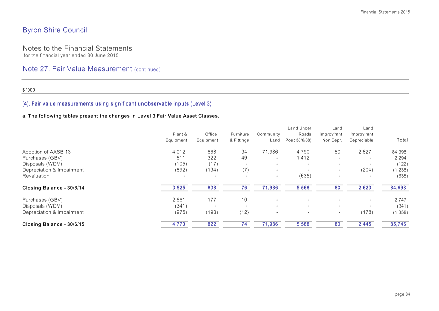
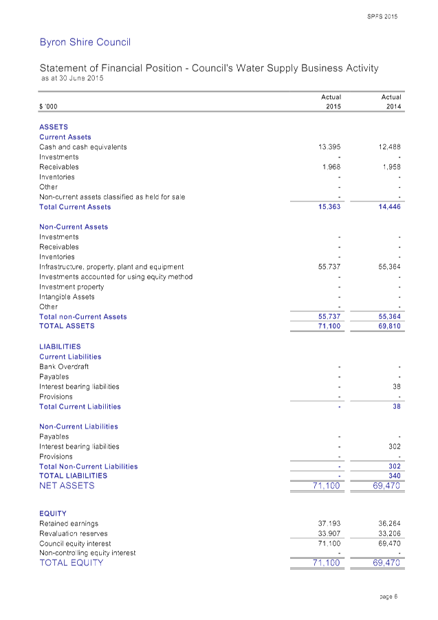
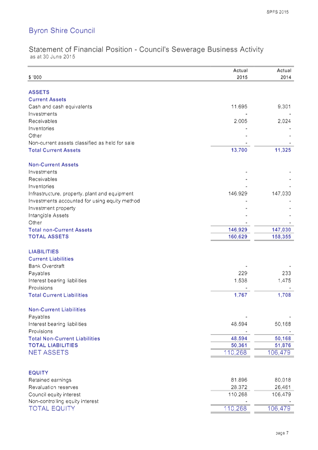
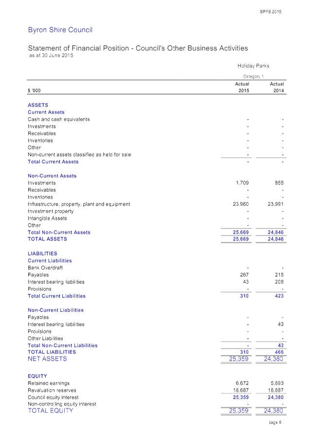
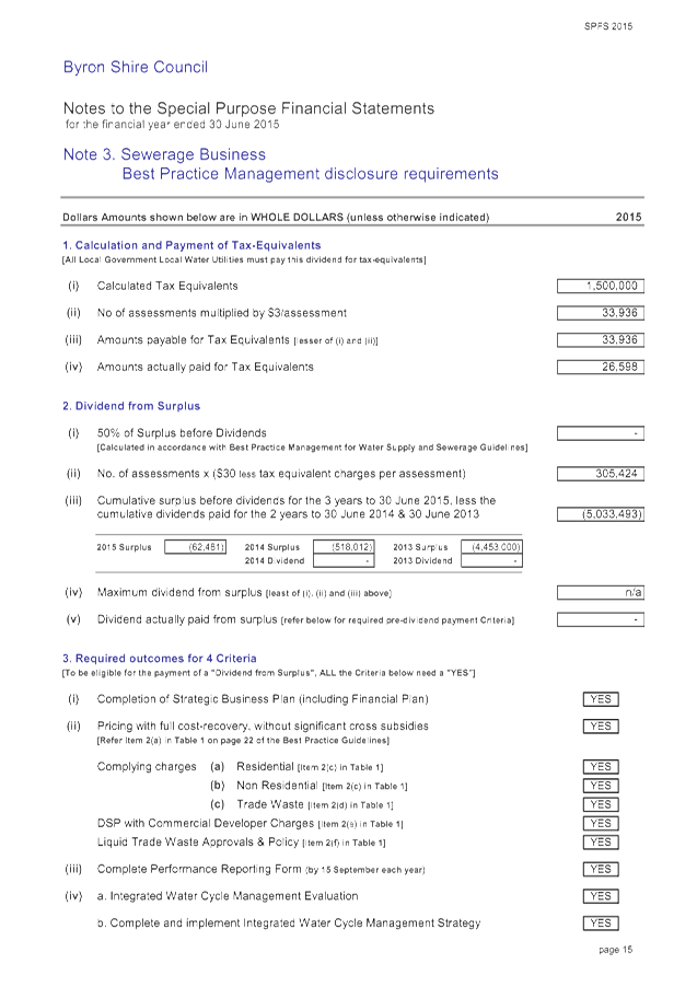
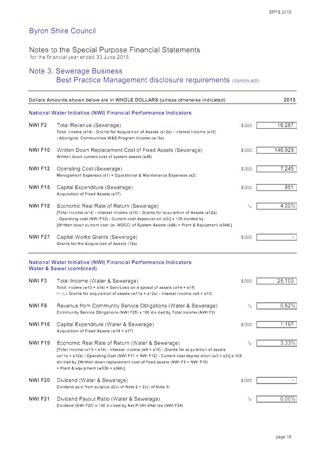
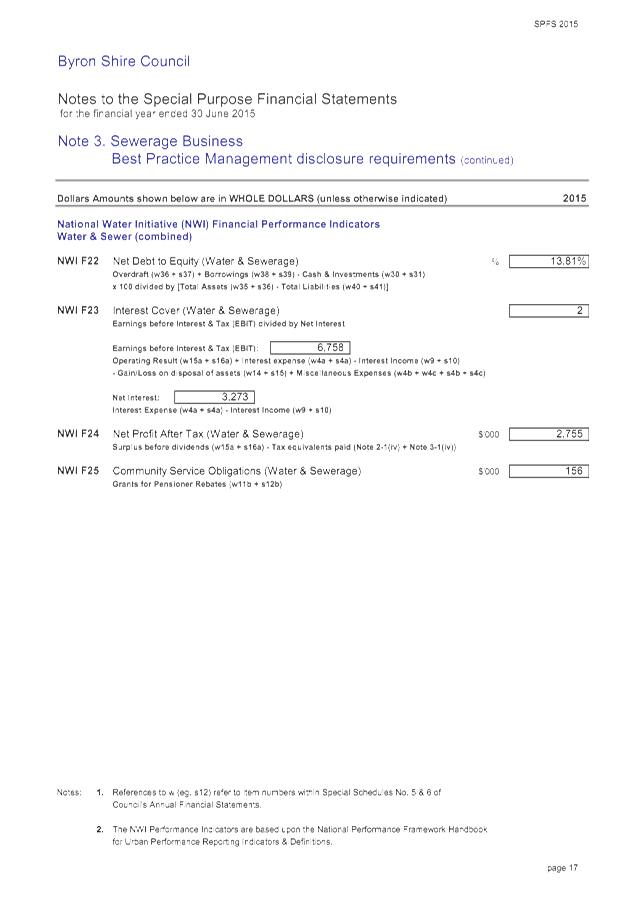
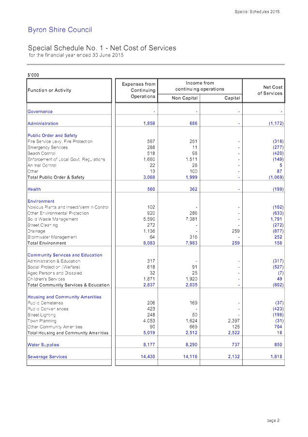
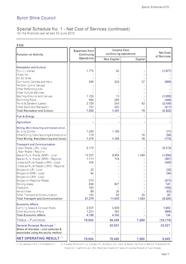
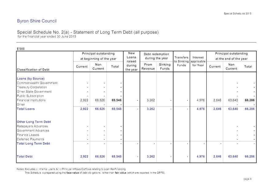
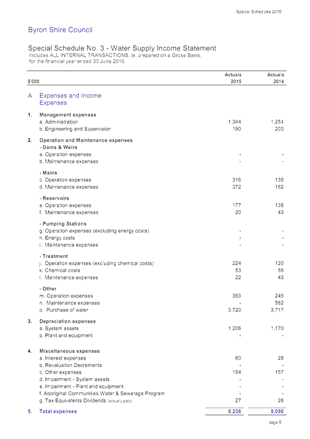
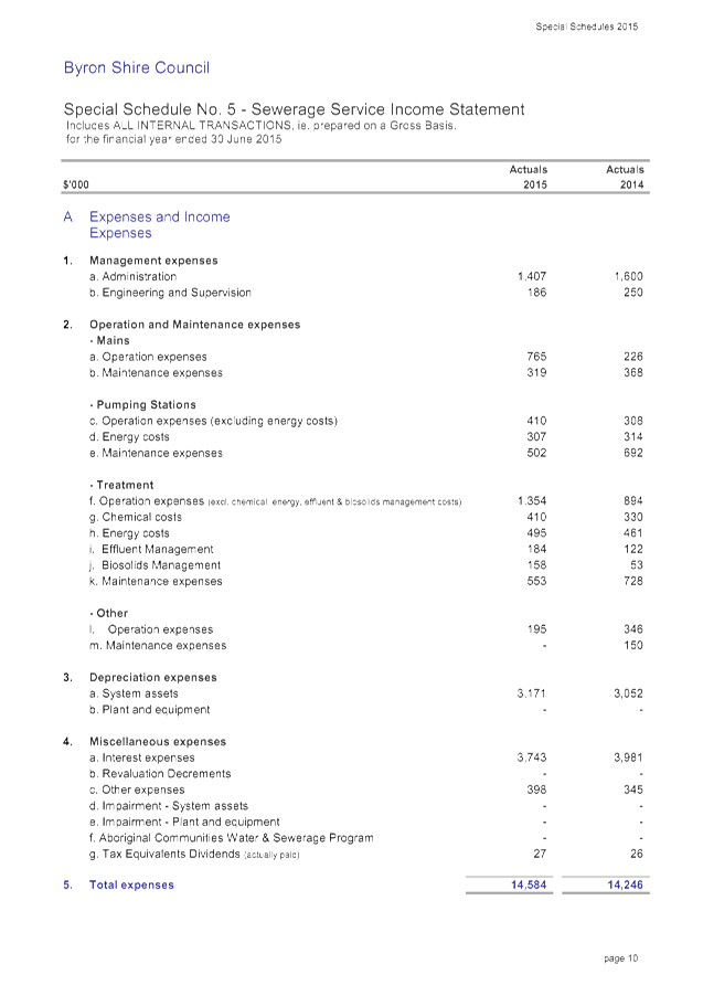
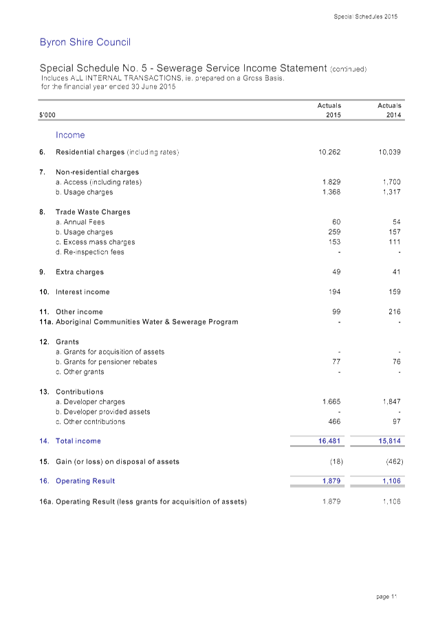
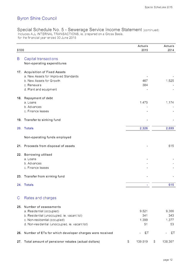
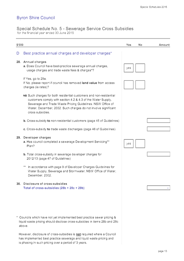
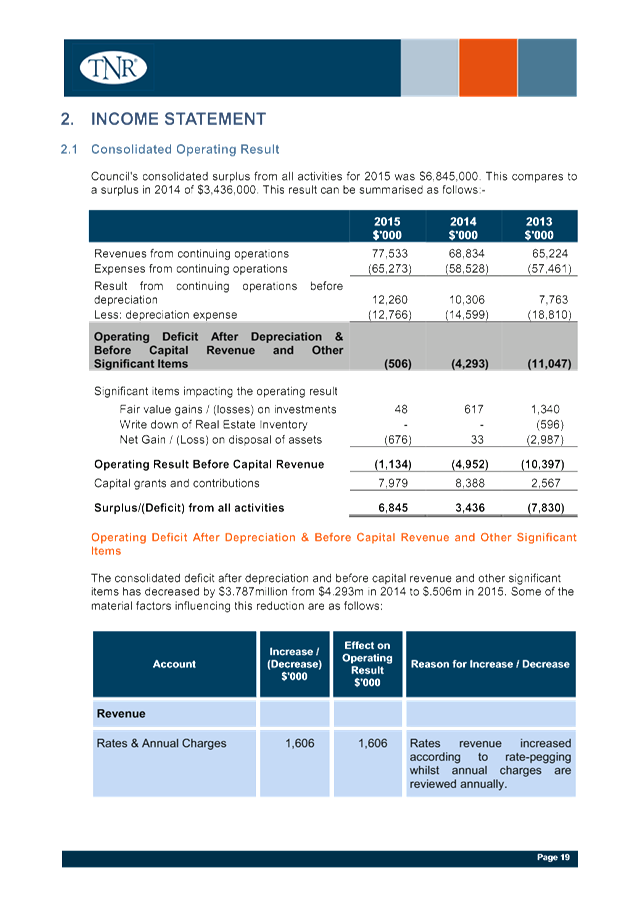
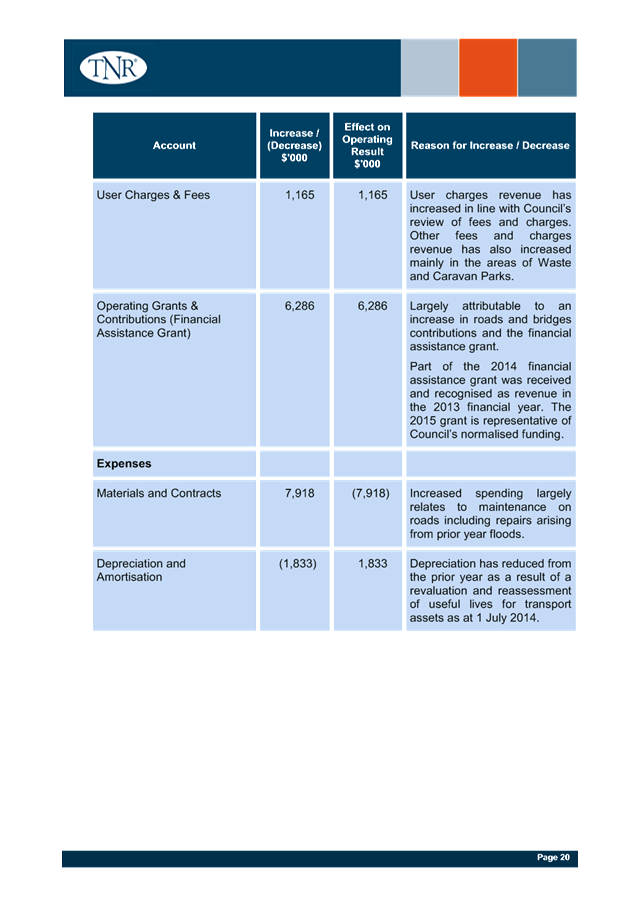
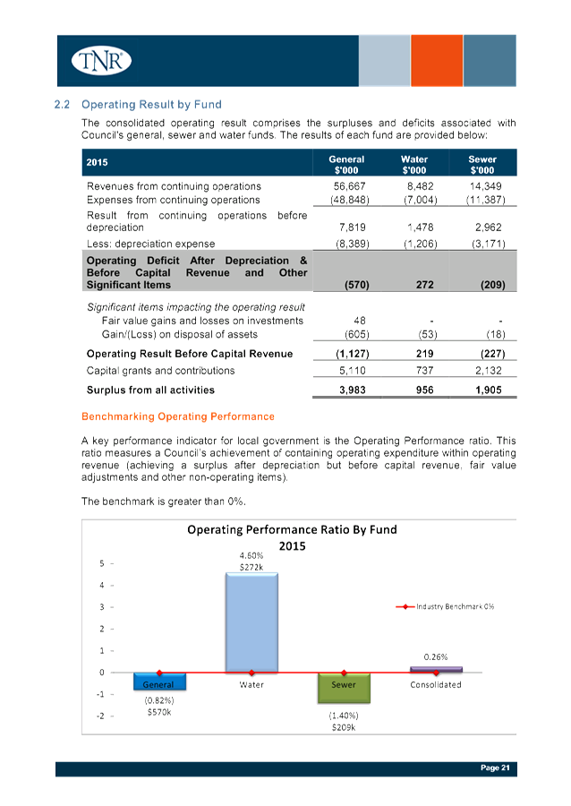
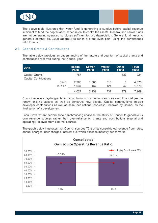
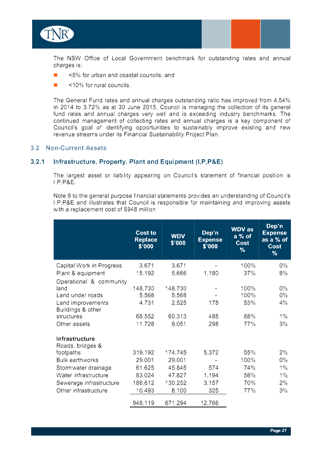
Staff Reports - Corporate and Community Services 13.5 - Attachment 1

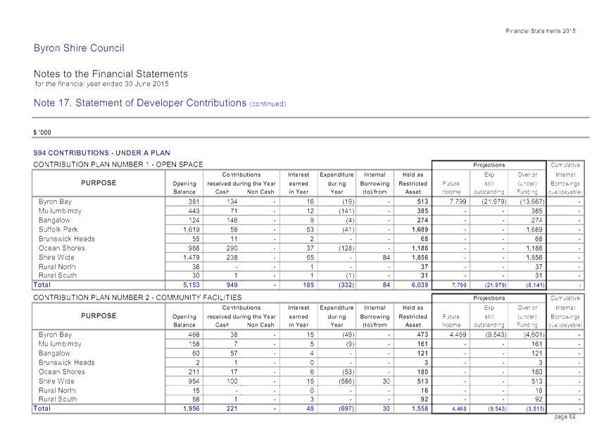
Staff Reports - Corporate and Community Services 13.5 - Attachment 1
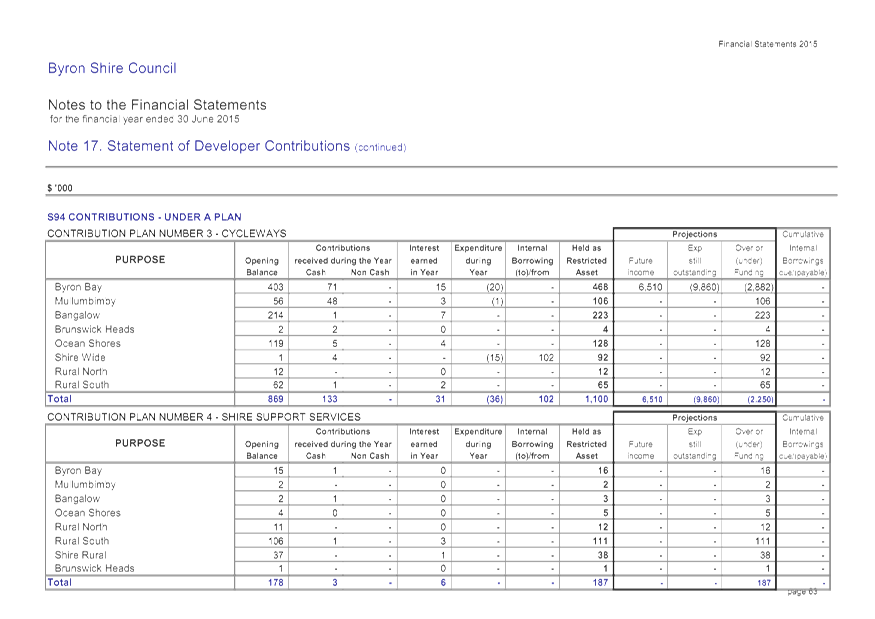
Staff Reports - Corporate and Community Services 13.5 - Attachment 1
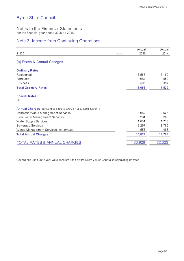
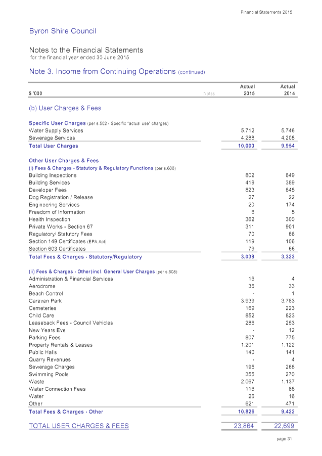
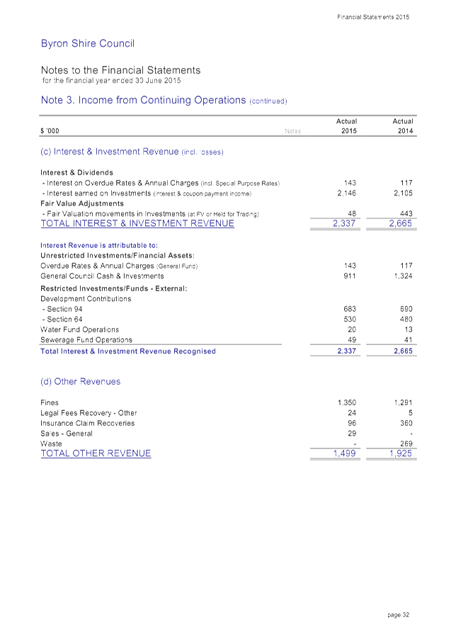
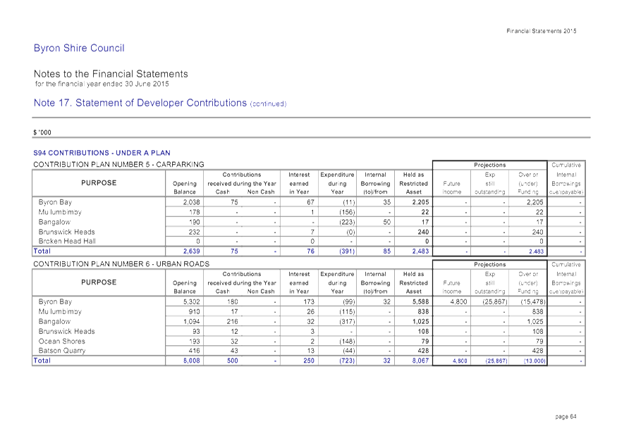
Staff Reports - Corporate and Community Services 13.5 - Attachment 1
Staff Reports - Corporate and Community Services 13.5 - Attachment 1
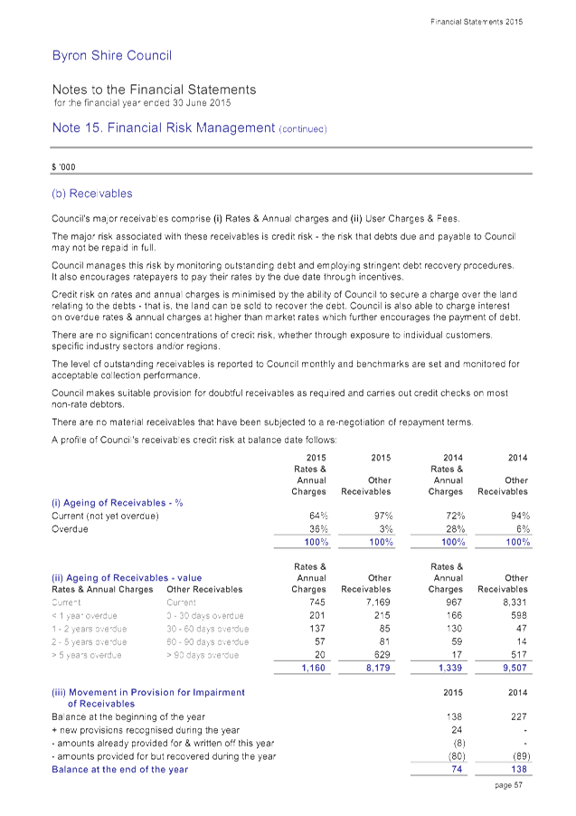
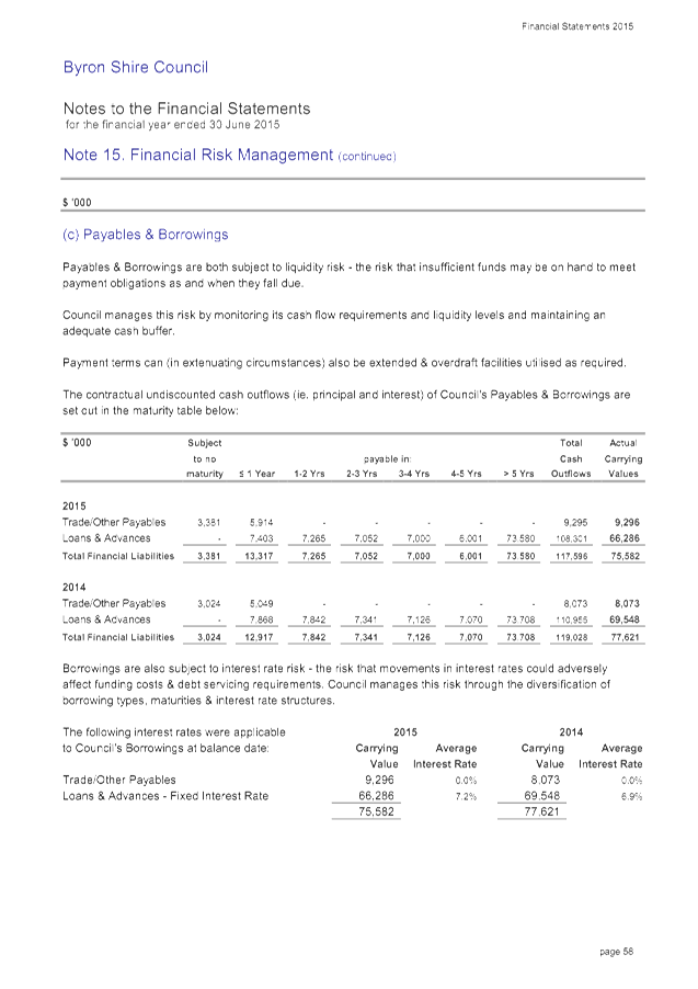
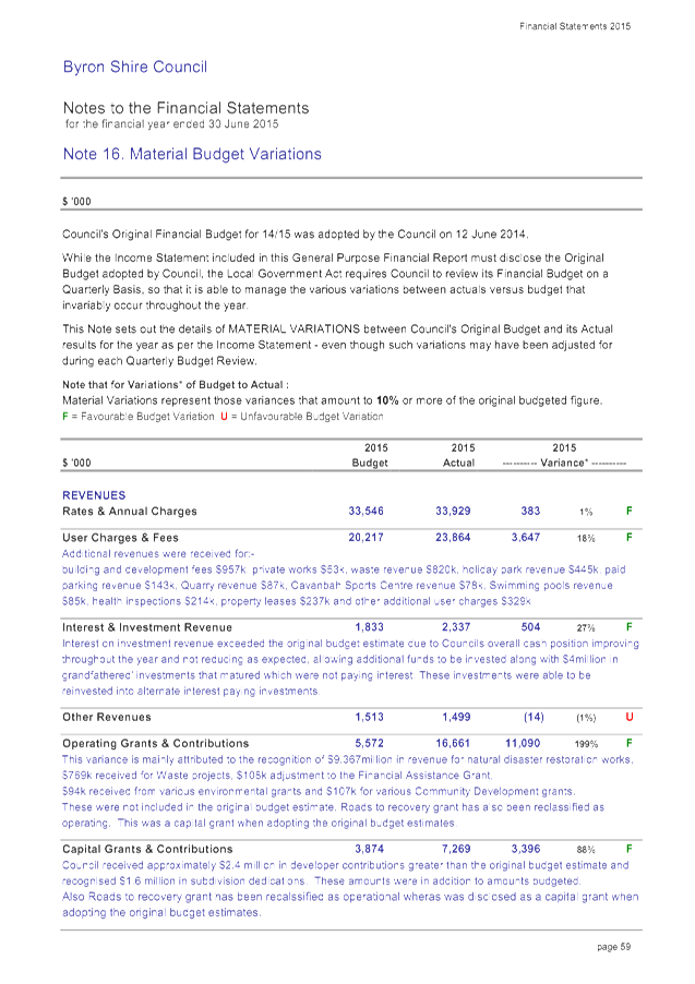
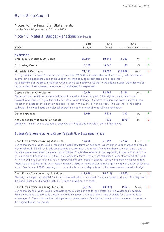
Staff Reports - Corporate and Community Services 13.5 - Attachment 1
Staff Reports - Corporate and Community Services 13.5 - Attachment 1
Staff Reports - Corporate and Community Services 13.5 - Attachment 1
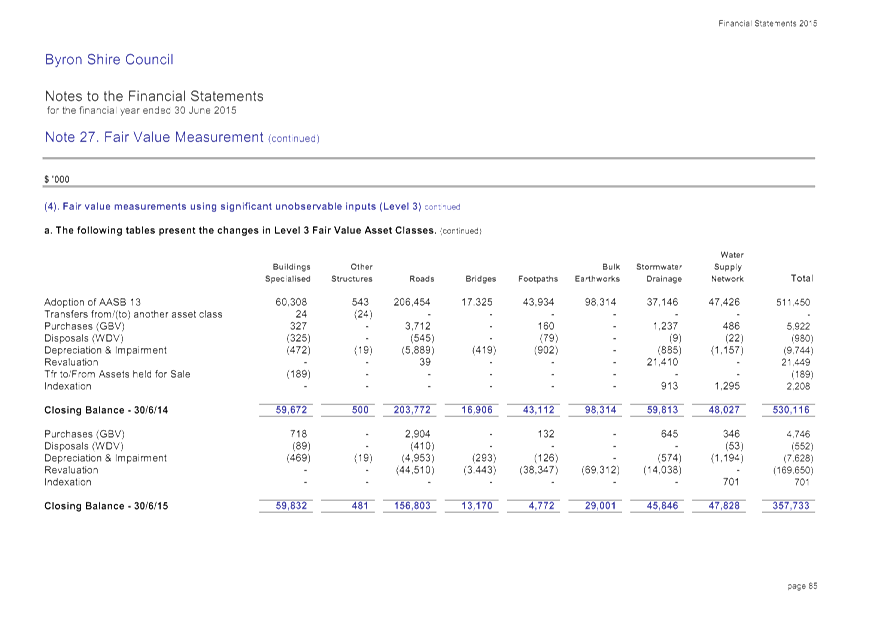
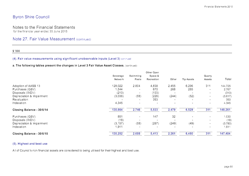
Staff Reports - Corporate and Community Services 13.5 - Attachment 1
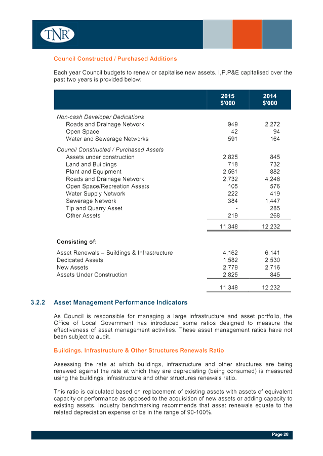
Staff Reports - Corporate and Community Services 13.5 - Attachment 2


Staff Reports - Corporate and Community Services 13.5 - Attachment 3

Staff Reports - Corporate and Community Services 13.5 - Attachment 3
Staff Reports - Corporate and Community Services 13.5 - Attachment 3
Staff Reports - Corporate and Community Services 13.5 - Attachment 3
Staff Reports - Corporate and Community Services 13.5 - Attachment 3
Staff Reports - Corporate and Community Services 13.5 - Attachment 4
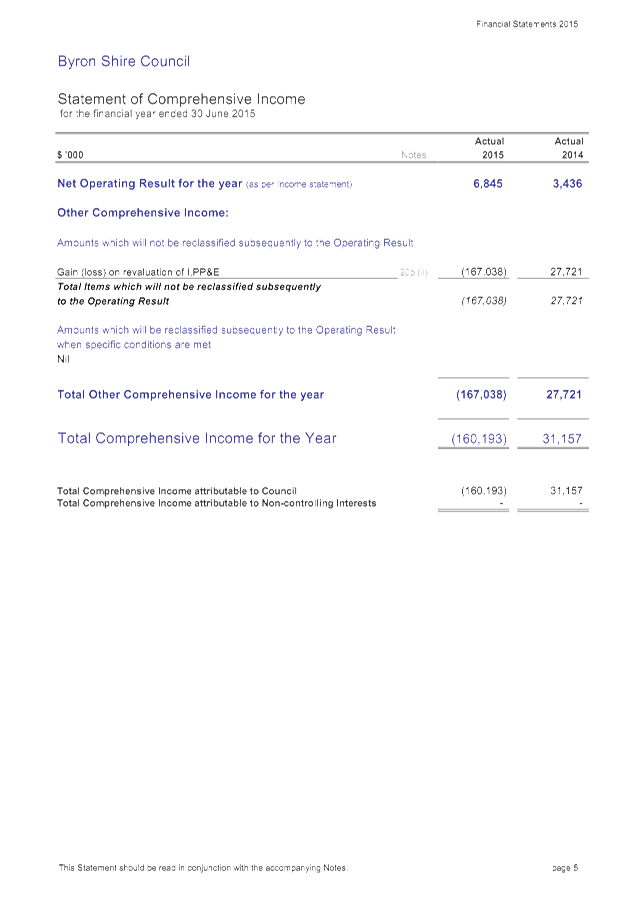
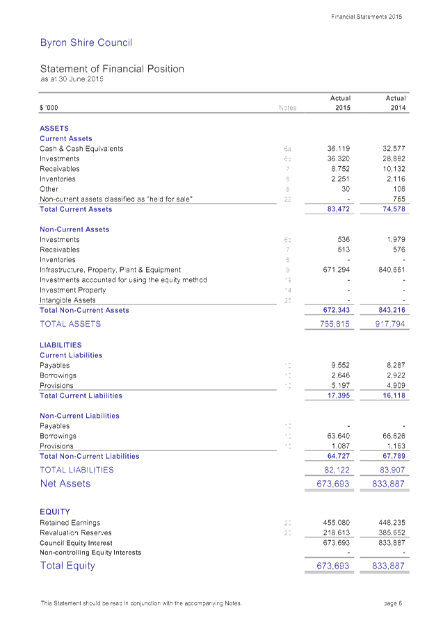
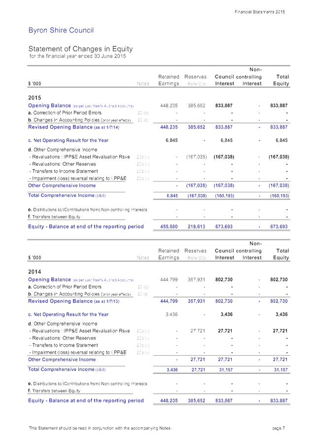
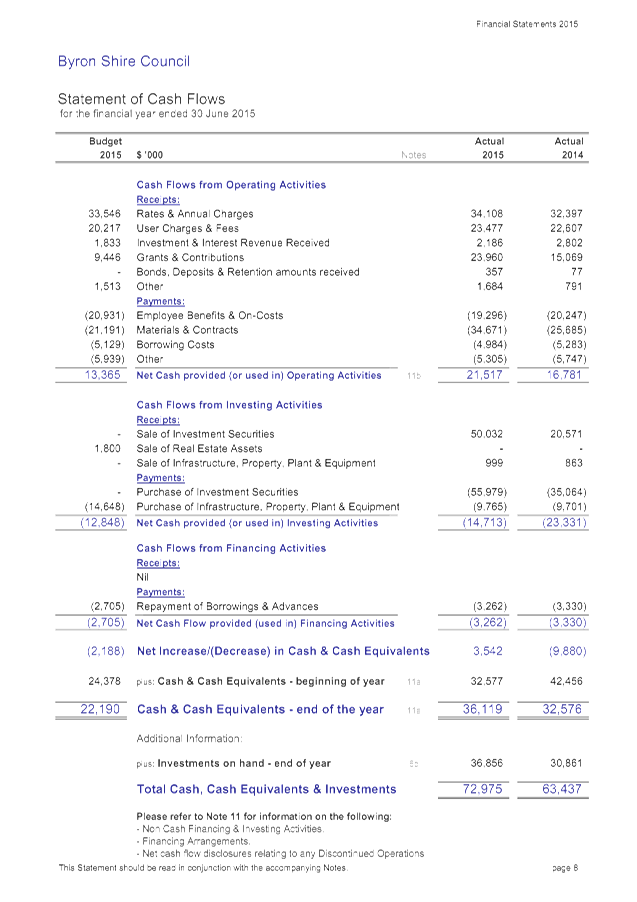
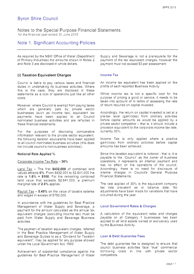
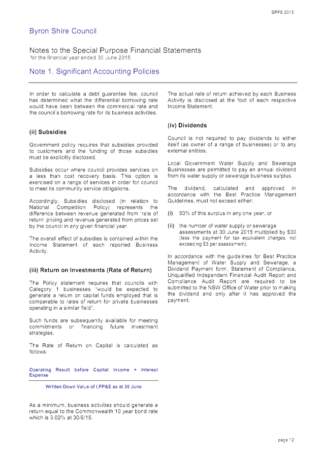
BYRON SHIRE COUNCIL
GENERAL PURPOSE
FINANCIAL STATEMENTS
INDEPENDENT
AUDITOR’S REPORT
Report on the Financial
Statements
We have
audited the accompanying financial statements of Byron Shire Council
(“the Council”), which comprises the statement of financial
position as at 30 June 2015, the income statement, statement of comprehensive
income, statement of changes in equity and statement of cash flows for the year
then ended, notes comprising a summary of significant accounting policies and
other explanatory information, and the statement by Councillors’ and
Management.
Council’s
Responsibility for the Financial Statements
The Council is responsible for
the preparation and fair presentation of the financial statements in accordance
with Australian Accounting Standards and the Local Government Act 1993
and for such internal control as the Council determines is necessary to enable
the preparation and fair presentation of financial statements that are free
from material misstatement, whether due to fraud or error.
Auditor’s
Responsibility
Our
responsibility is to express an opinion on the financial statements based on
our audit. We conducted our audit in accordance with Australian Auditing
Standards. Those standards require that we comply with relevant ethical
requirements relating to audit engagements and plan and perform the audit to
obtain reasonable assurance whether the financial statements are free from
material misstatement.
An audit
involves performing procedures to obtain audit evidence about the amounts and
disclosures in the financial statements. The procedures selected depend on the
auditor’s judgement, including the assessment of the risks of material
misstatement of the financial statements, whether due to fraud or error. In
making those risk assessments, the auditor considers internal control relevant
to the Council’s preparation and fair presentation of the financial
statements in order to design audit procedures that are appropriate in the
circumstances, but not for the purpose of expressing an opinion on the
effectiveness of the Council’s internal control. An audit also includes
evaluating the appropriateness of accounting policies used and the
reasonableness of accounting estimates made by Council, as well as evaluating
the overall presentation of the financial statements.
Our audit
responsibility does not extend to the original budget information included in
the income statement, statement of cash flows, Note 2(a), Note 16 budget
variation explanations and Note 17 forecast information, and accordingly, we do
not express an opinion on such. In addition, our audit did not include an
analysis of the prudence of business decisions made by Council or management.
We believe
that the audit evidence we have obtained is sufficient and appropriate to
provide a basis for our audit opinion.
Staff Reports - Corporate and Community Services 13.5 - Attachment 4
Independence
In conducting
our audit, we have complied with the independence requirements of the
Australian professional accounting bodies.
Opinion
In our
opinion:
a) The
Council’s accounting records have been kept in accordance with the
requirements of the Local Government Act, 1993, Chapter 13, Part 3,
Division 2;
b) The
financial statements:
i. Have
been prepared in accordance with the requirements of this Division;
ii. Are
consistent with the Council’s accounting records;
iii. Present
fairly, in all material respects, the Council’s financial position as at
30 June 2015, and of its performance and its cash flows for the year then
ended; and
iv. Are
in accordance with applicable Accounting Standards;
c) All
information relevant to the conduct of the audit has been obtained; and
d) There are no material deficiencies in
the accounting records or financial statements that have come to light in the
course of the audit.
Dated at Lismore this 22nd day
of October 2015
THOMAS NOBLE & RUSSELL
CHARTERED ACCOUNTANTS
........................................................
K R FRANEY (Partner)
Registered Company Auditor
Staff Reports - Corporate and Community Services 13.5 - Attachment 5
BYRON SHIRE COUNCIL
SPECIAL
PURPOSE FINANCIAL STATEMENTS
INDEPENDENT
AUDITOR’S REPORT
Report on the Financial
Statements
We have
audited the accompanying financial statements, being special purpose financial
statements, of Byron Shire Council (“the Council”), which comprises
the statement of financial position as at 30 June 2015, the income statement
for the year then ended, notes comprising a summary of significant accounting
policies and other explanatory information and the statement by
Councillors’ and Management.
Council’s
Responsibility for the Financial Statements
The Council is responsible for
the preparation and fair presentation of the financial statements and has
determined that the basis of preparation described in Note 1 to the financial
statements is appropriate to meet the requirements of the Local Government
Act 1993 and meet the needs of the NSW Office of Local Government. The
Council’s responsibility also includes such internal control as the
Council determines is necessary to enable the preparation and fair presentation
of financial statements that are free from material misstatement, whether due
to fraud or error.
Auditor’s
Responsibility
Our
responsibility is to express an opinion on the financial statements based on
our audit. We conducted our audit in accordance with Australian Auditing
Standards. Those standards require that we comply with relevant ethical
requirements relating to audit engagements and plan and perform the audit to
obtain reasonable assurance whether the financial statements are free from
material misstatement.
An audit
involves performing procedures to obtain audit evidence about the amounts and
disclosures in the financial statements. The procedures selected depend on the
auditor’s judgement, including the assessment of the risks of material
misstatement of the financial statements, whether due to fraud or error. In
making those risk assessments, the auditor considers internal control relevant
to the Council’s preparation and fair presentation of the financial
statements in order to design audit procedures that are appropriate in the
circumstances, but not for the purpose of expressing an opinion on the
effectiveness of the Council’s internal control. An audit also includes
evaluating the appropriateness of accounting policies used and the
reasonableness of accounting estimates made by Council, as well as evaluating
the overall presentation of the financial statements.
Our audit
responsibility does not extend to the best practice management disclosures in
note 2 and note 3, and accordingly, we do not express an opinion on such. In
addition, our audit did not include an analysis of the prudence of business
decisions made by Council or management.
We believe
that the audit evidence we have obtained is sufficient and appropriate to
provide a basis for our audit opinion.
Staff Reports - Corporate and Community Services 13.5 - Attachment 5
Independence
In conducting
our audit, we have complied with the independence requirements of the
Australian professional accounting bodies.
Opinion
In our
opinion, the special purpose financial statements of Byron Shire Council:
a) Have
been prepared in accordance with the requirements of those applicable
Australian Accounting Standards detailed in Note 1 and the Local Government
Code of Accounting Practice and Financial Reporting;
i. Are
consistent with the Council’s accounting records;
ii. Present
fairly, in all material respects, the financial position of Council’s
nominated Business Activities as at 30 June 2015 and the results of their
operations for the year then ended;
b) All
information relevant to the conduct of the audit has been obtained; and
c) There
are no material deficiencies in the accounting records or financial statements
that we have become aware of in the course of the audit.
Basis
of Accounting
Without modifying our opinion, we
draw attention to Note 1 to the financial statements which describe the basis
of accounting. The financial statements have been prepared for the purpose of
fulfilling the financial reporting requirements of the NSW Office of Local
Government. As a result, the financial statements may not be suitable for
another purpose.
Dated at Lismore this 22nd day
of October 2015
THOMAS NOBLE & RUSSELL
CHARTERED ACCOUNTANTS
.....................................................
K R FRANEY (Partner)
Registered Company Auditor
Staff Reports - Corporate and Community Services 13.5 - Attachment 6


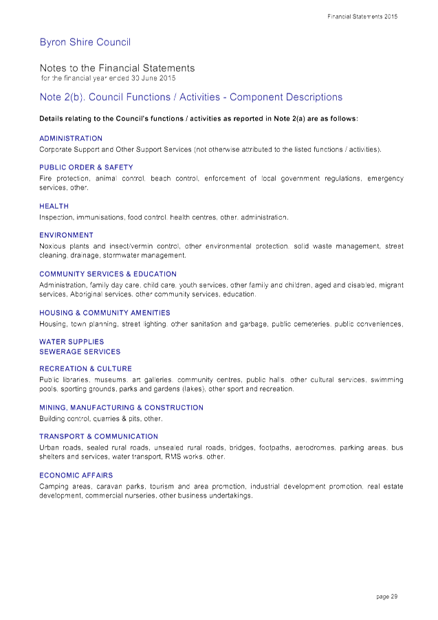
Staff Reports - Sustainable Environment and Economy 13.6 - Attachment 1
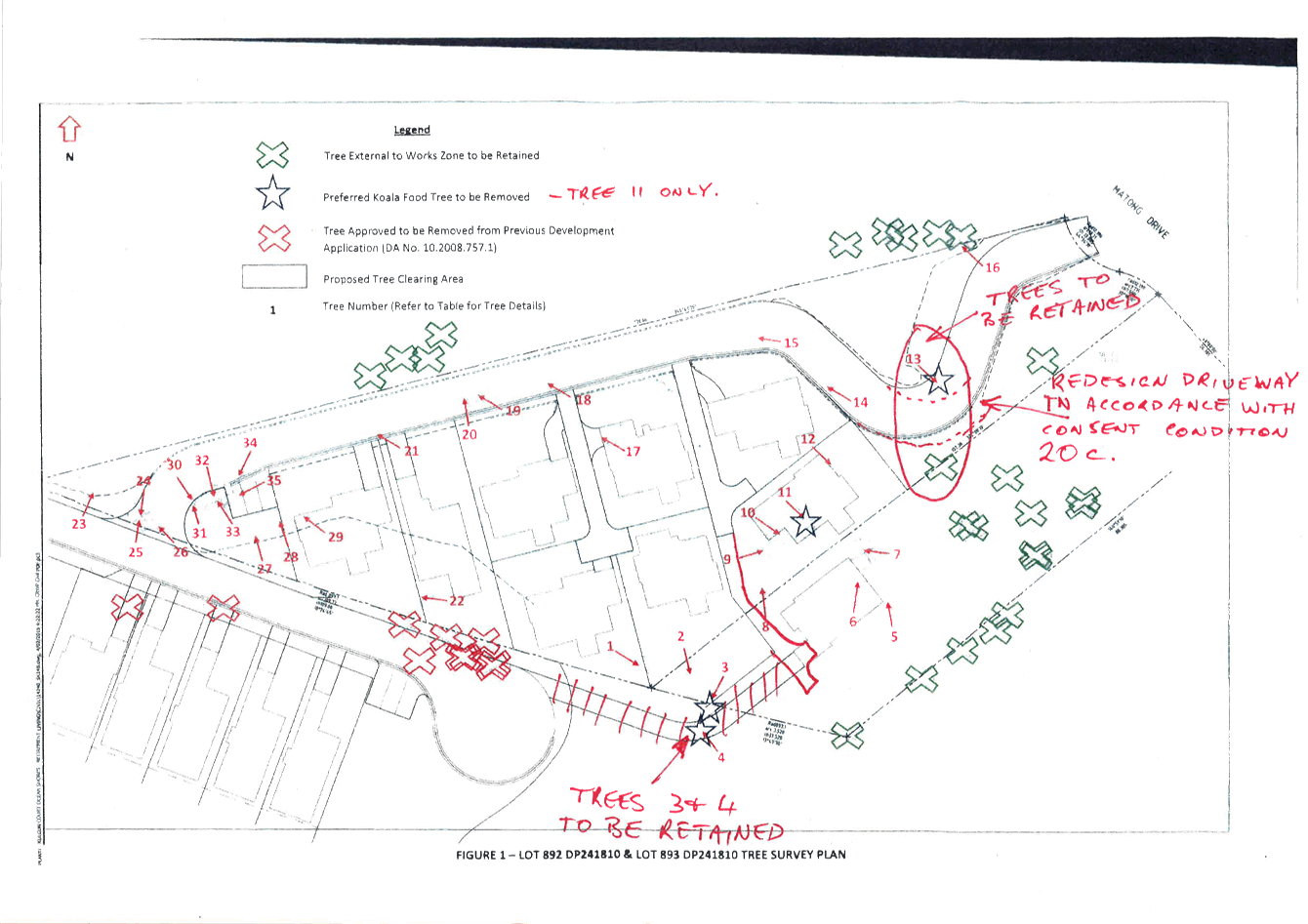
Staff Reports - Sustainable Environment and Economy 13.6 - Attachment 1
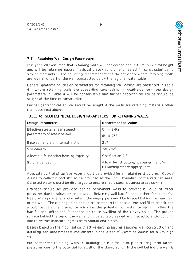
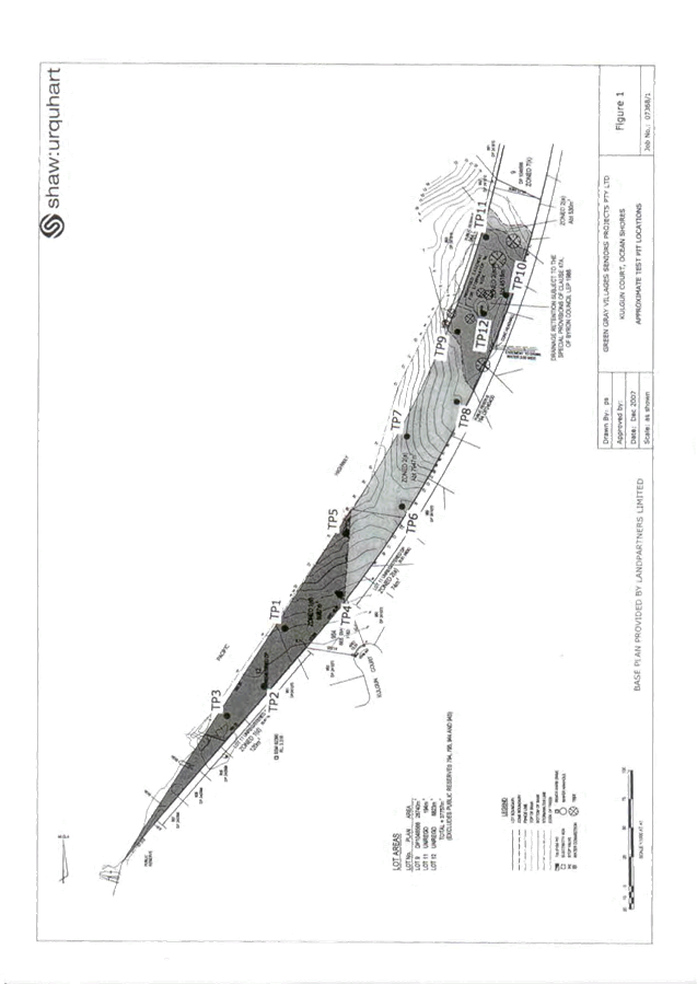


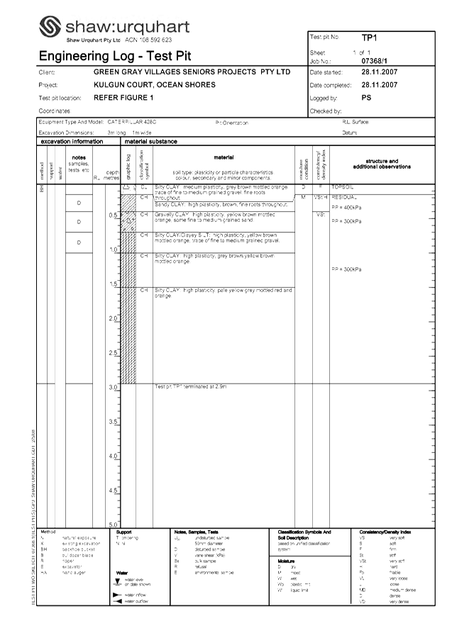
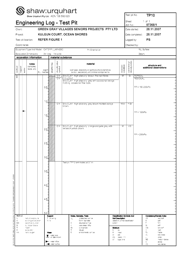
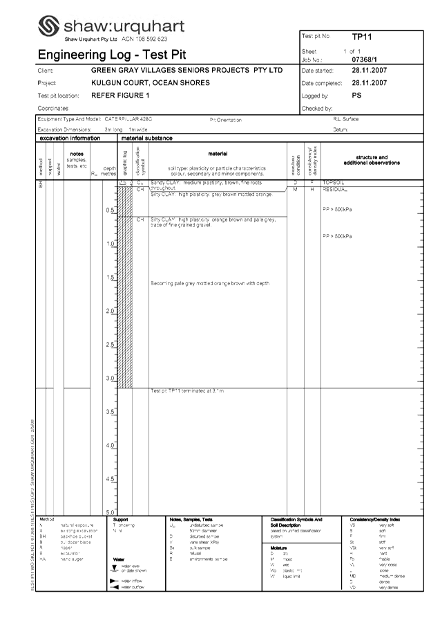
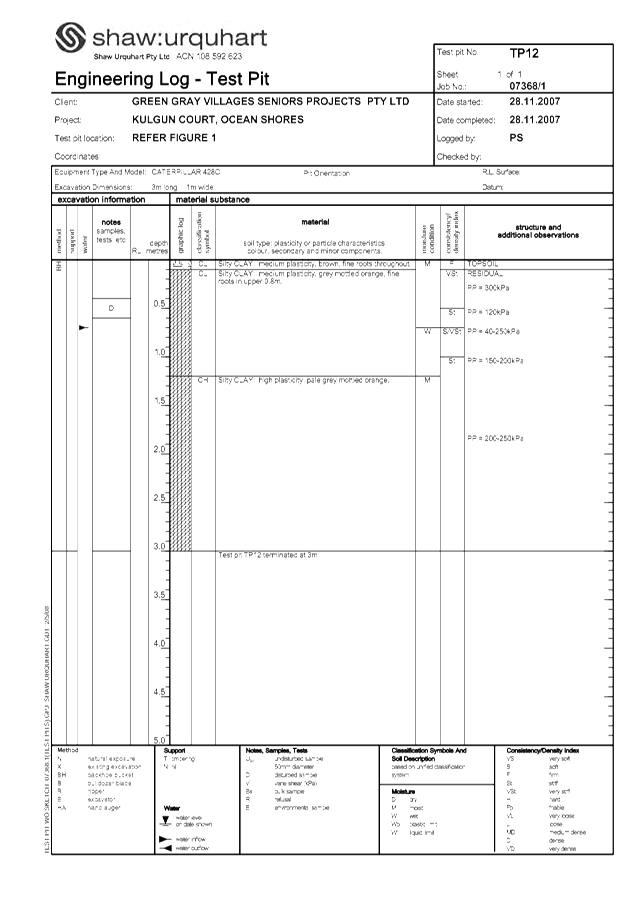
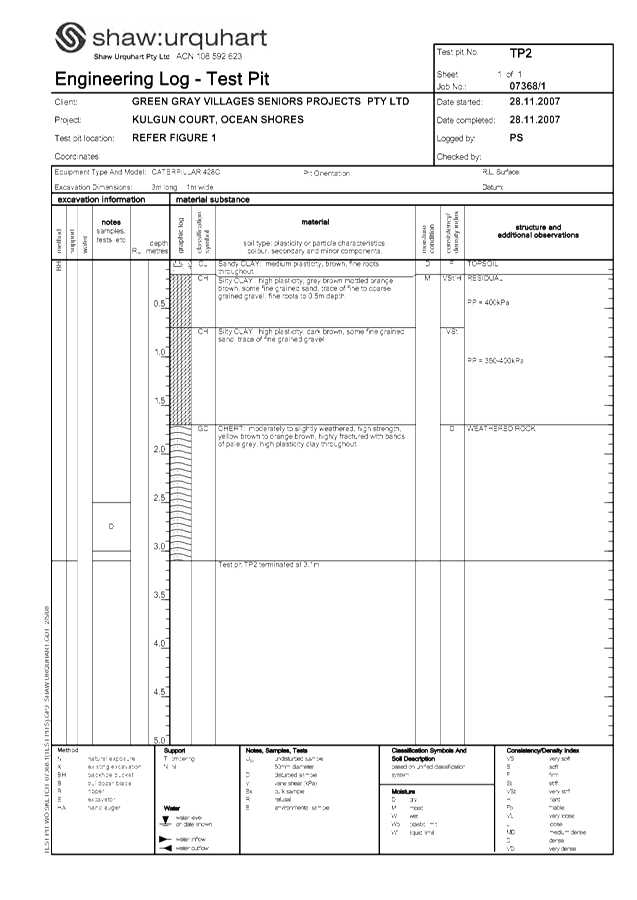
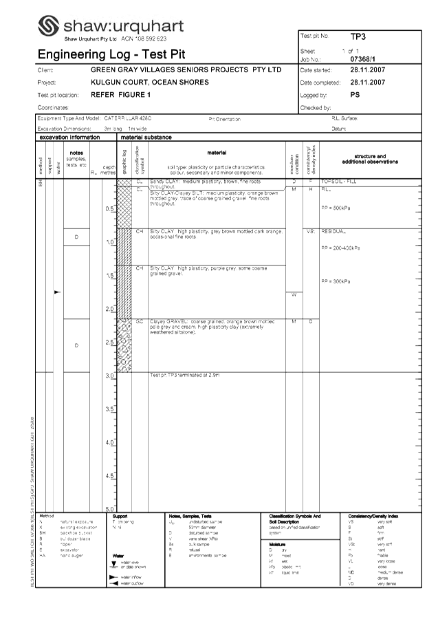
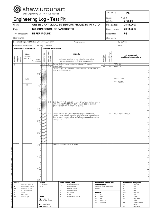
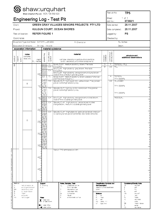
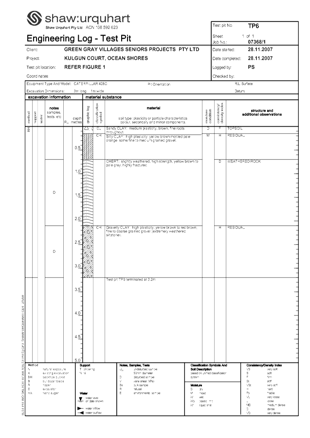
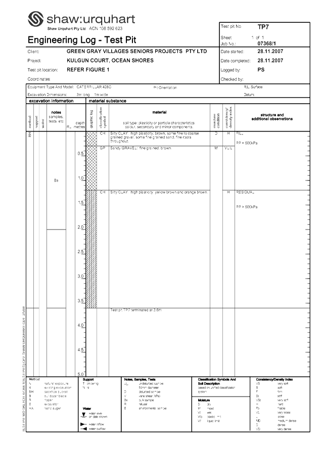
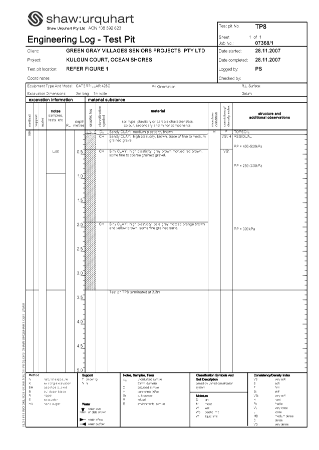
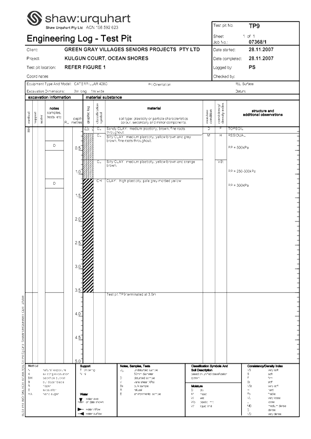

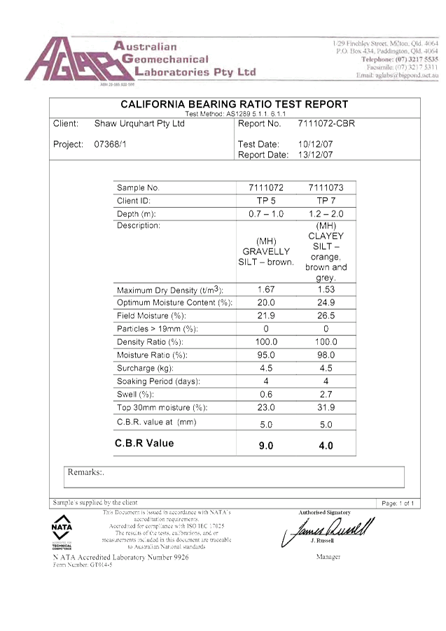
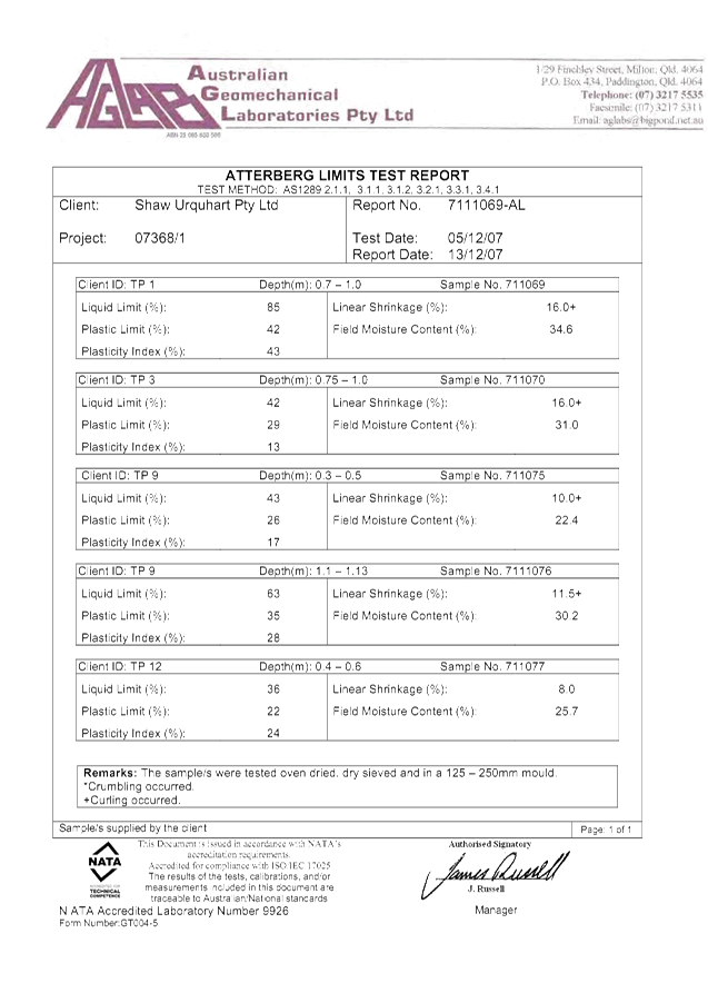

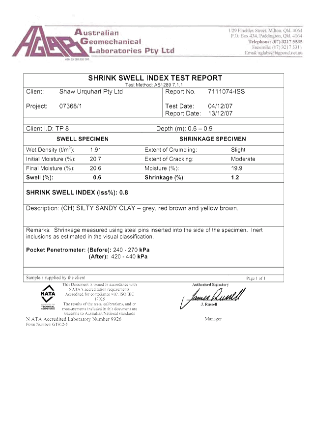
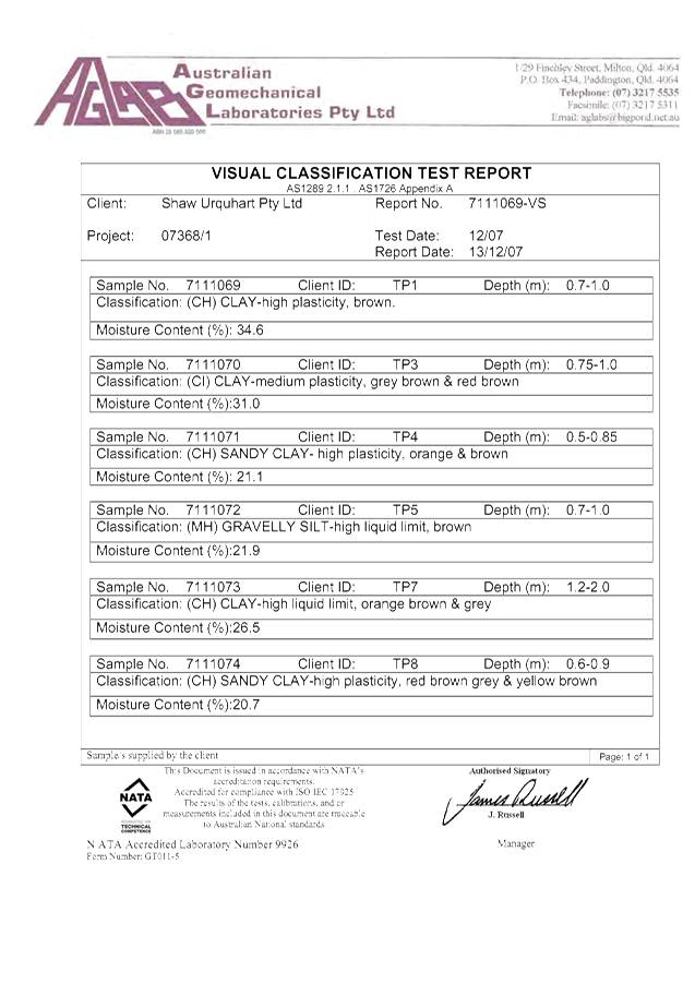
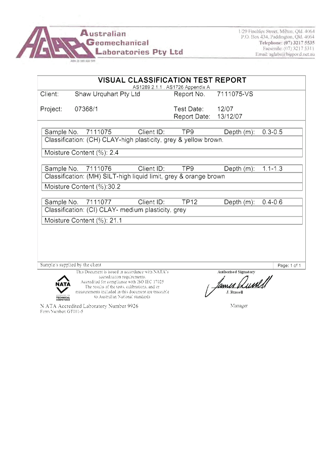
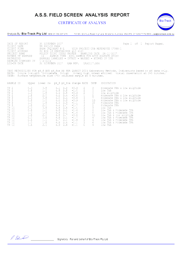
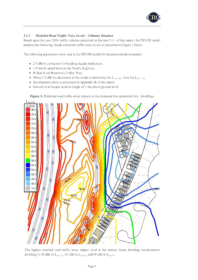
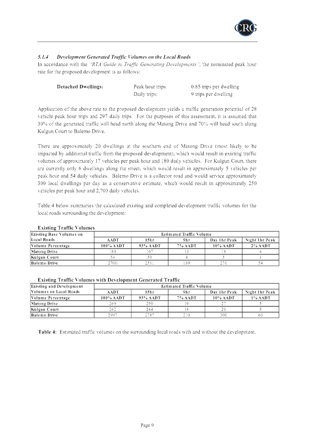
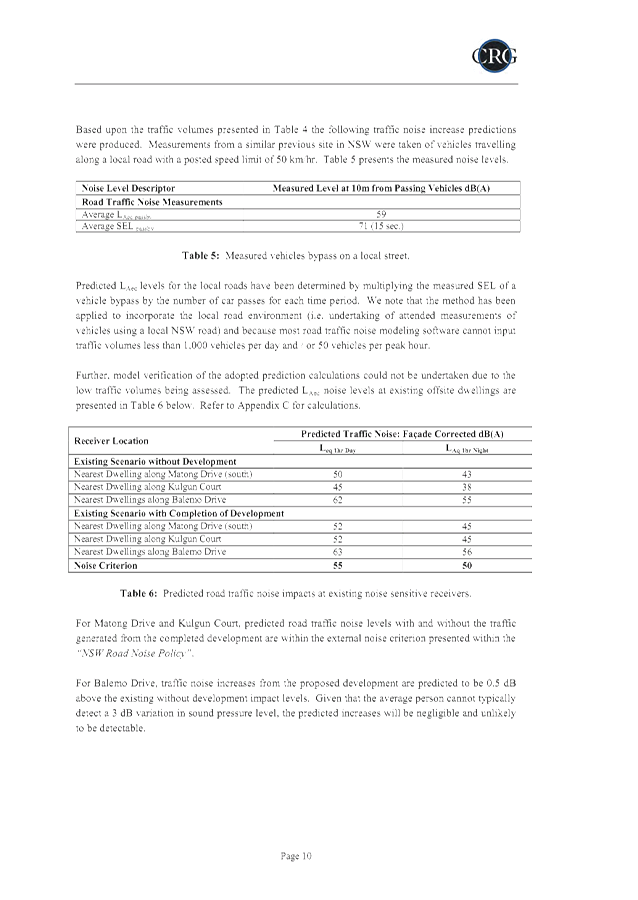
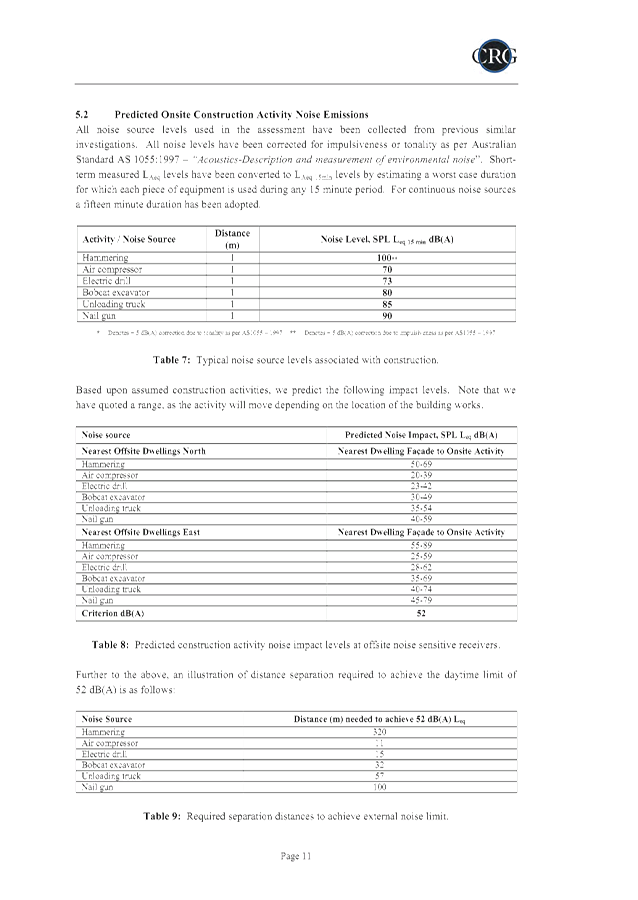

Staff Reports - Sustainable Environment and Economy 13.6 - Attachment 1
Staff Reports - Sustainable Environment and Economy 13.6 - Attachment 1


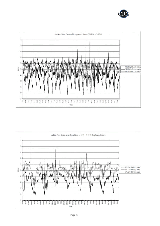

Staff Reports - Sustainable Environment and Economy 13.6 - Attachment 1
Staff Reports - Sustainable Environment and Economy 13.6 - Attachment 1

Staff Reports - Sustainable Environment and Economy 13.6 - Attachment 2
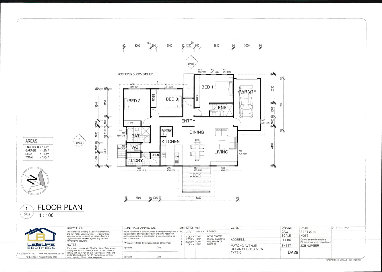
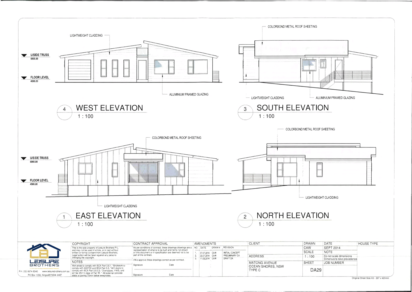
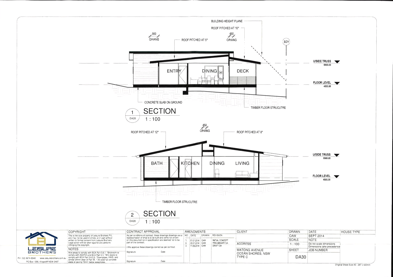
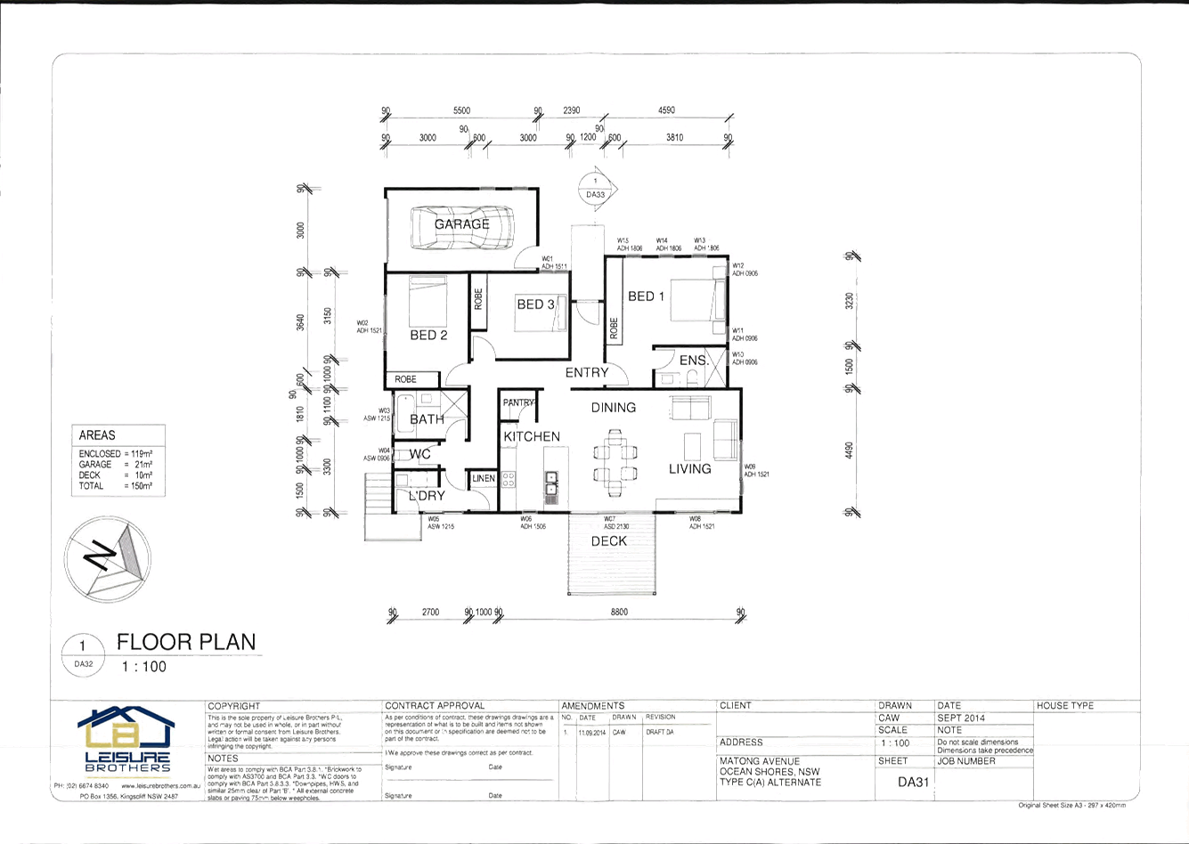
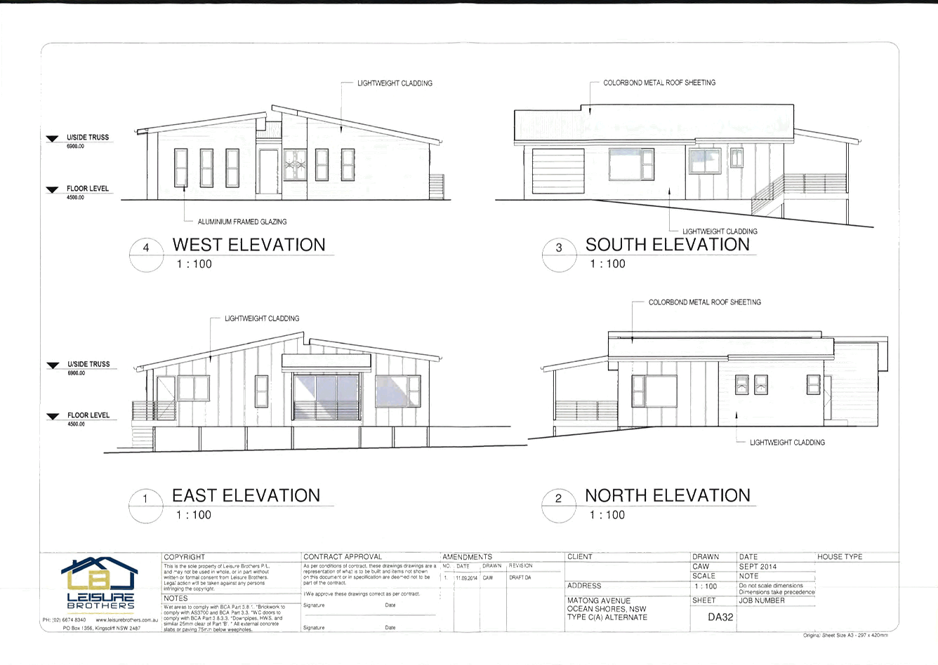
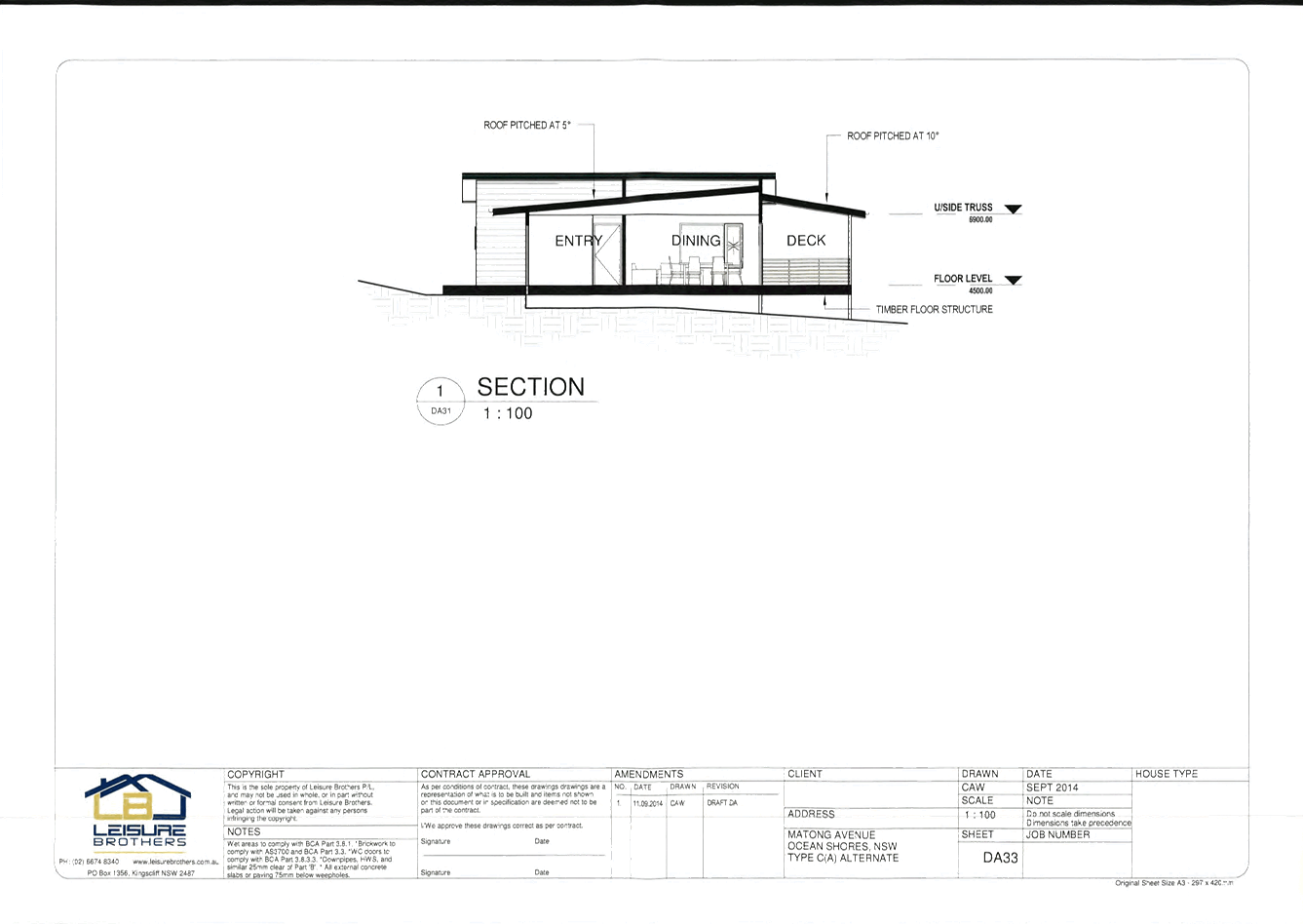
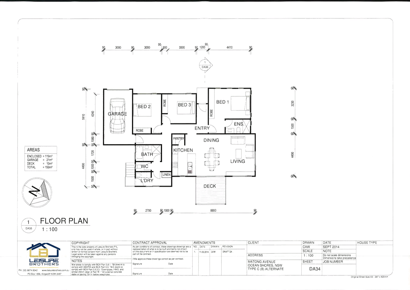
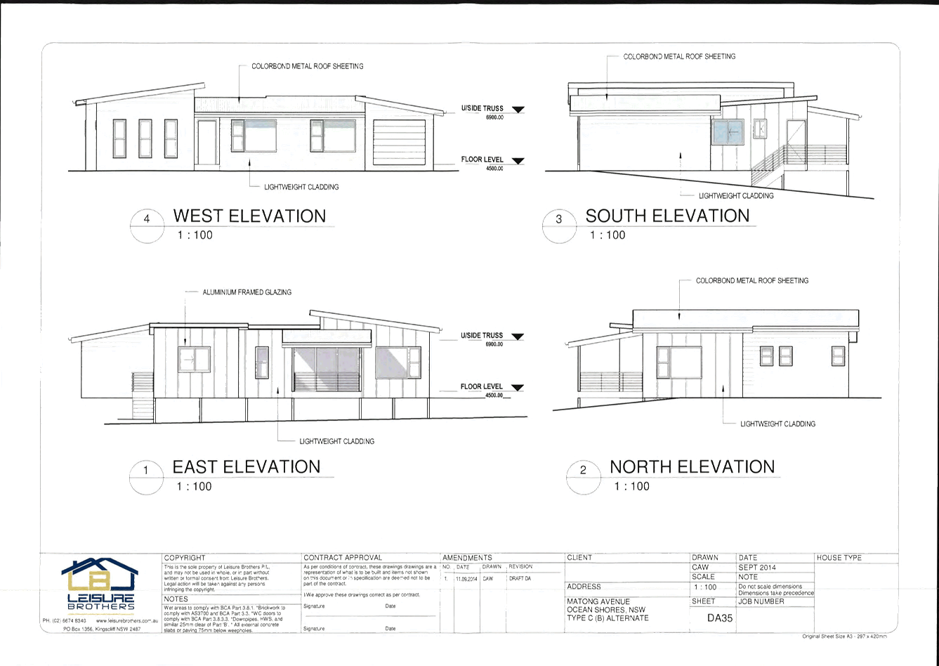
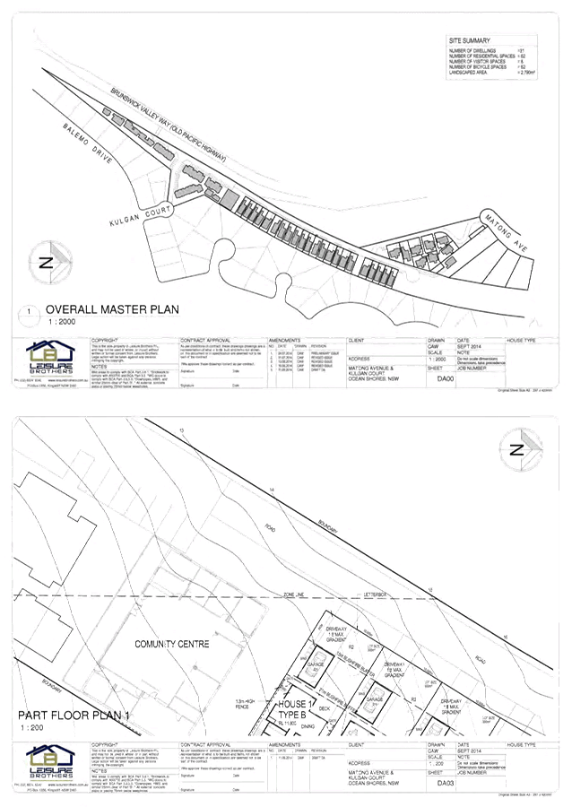
10.2014.743.1
CONDITIONS
OF CONSENT:
Staging of Construction:
· Stage 1 –
Torrens Title Lot Consolidation. (5 Lots to 3 Lots) and Boundary Adjustment
(between two lots).
· Stage 2 –
Eight (8) Residential Units, incorporating Driveway /
Carparking / Access to Mating Drive and Locked Gate for Emergency Services
(locked to prevent access through the site to Kulgun Court / Brunswick Valley
Way), and Strata Subdivision.
· Stage 3 - Eight
(8) Residential Units, incorporating Driveway /
Carparking / Access to Kulgun Court and Brunswick Valley Way and Strata
Subdivision.
· Stage 4 –
Nine (9) Residential Units, incorporating Driveway /
Carparking and Strata Subdivision.
· Stage 5 -
Five (5) Residential Units and, One (1) Dual Occupancy and Strata Subdivision
· The development
must occur this sequence.
Parameters of this
Consent
1) Development
is to be in accordance with approved plans
The development is to be in
accordance with plans listed below:
|
Plan No.
|
Description
|
Prepared by
|
Dated:
|
|
Kulgun_Proposed_Sub
|
Proposed Site Subdivision Plan
|
Planit Consulting
|
02/2015
|
|
Kulgun_Proposed_Strata
|
Proposed Strata Boundaries
|
Planit Consulting
|
02/2015
|
|
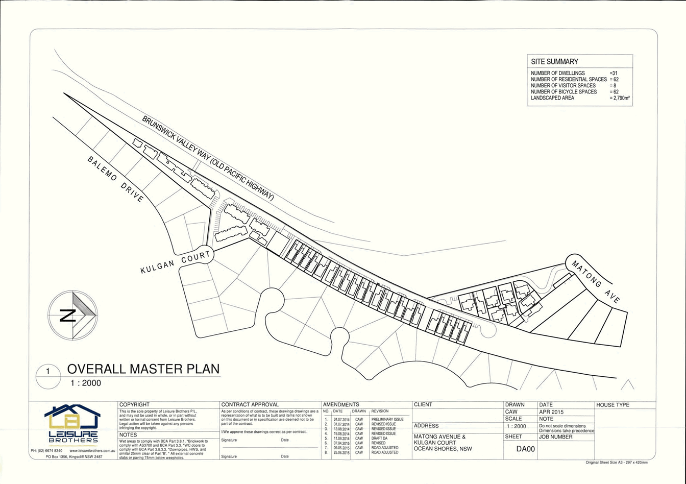
DA00
|
Overall Master Plan
|
Leisure Brothers
|
April 2015
Amendment 8
25.06.2015
|
|
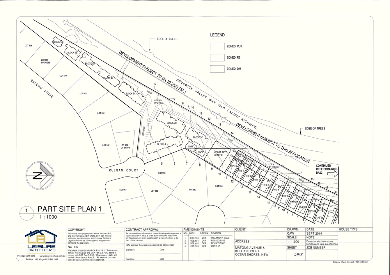
DA01
|
Part Site Plan 1
|
Leisure Brothers
|
September 2014
Amendment 4
11.09.2014
|
|
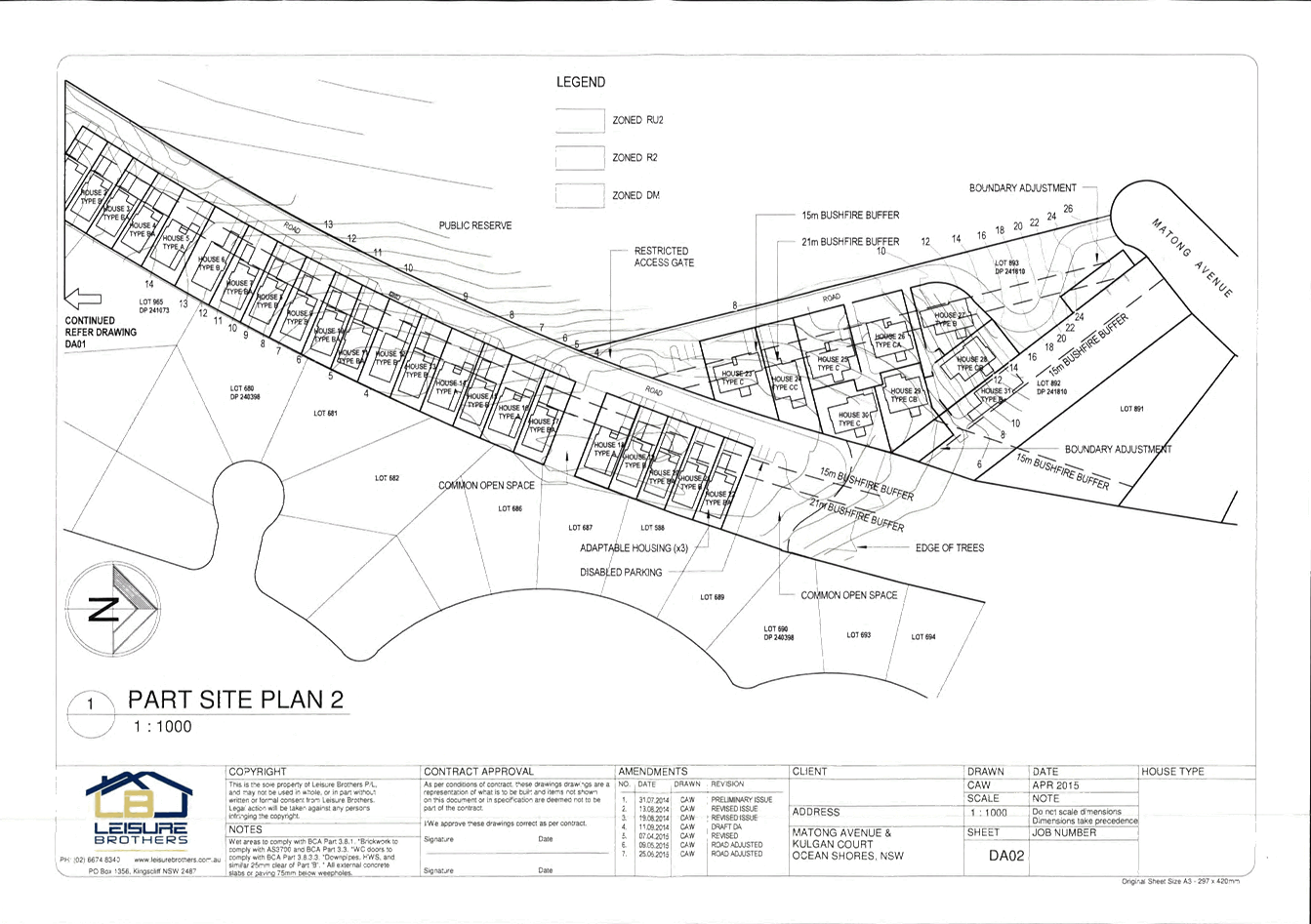
DA02
|
Part Site Plan 2
|
Leisure Brothers
|
April 2015
Amendment 7
25.06.2015
|
|
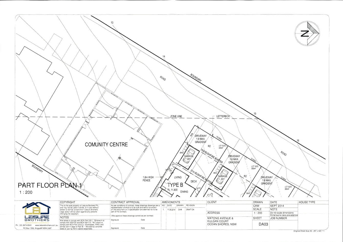
DA03
|
Part Floor Plan 1
|
Leisure Brothers
|
September 2014
Amendment 1
11.09.2014
|
|
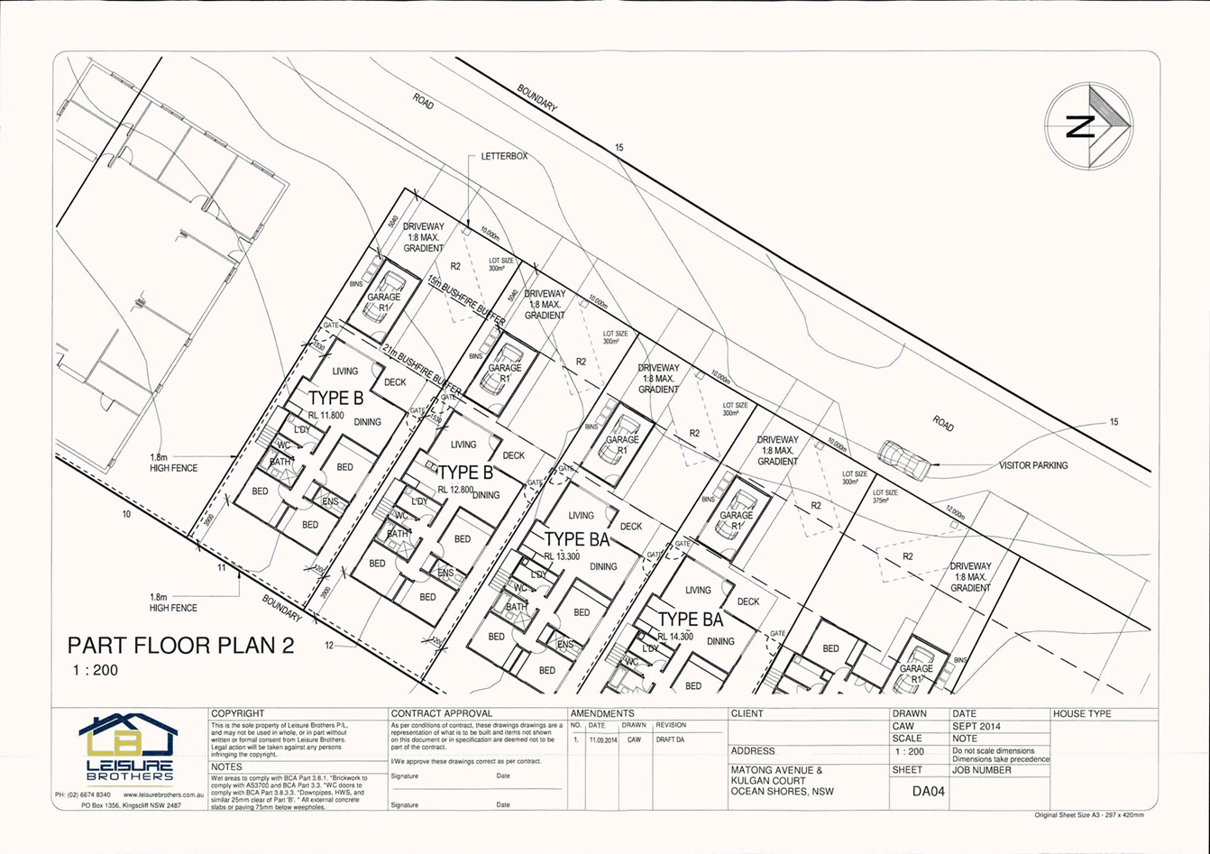
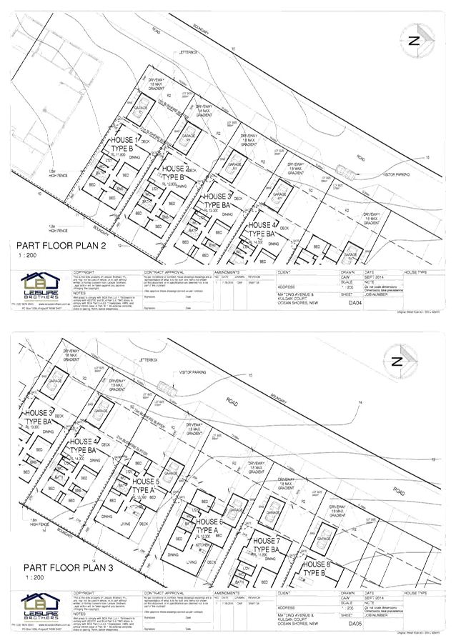
DA04
|
Part Floor Plan 2
|
Leisure Brothers
|
September 2014
Amendment 1
11.09.2014
|
|
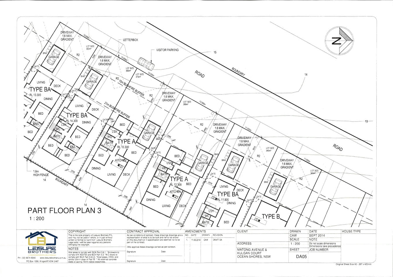
DA05
|
Part Floor Plan 3
|
Leisure Brothers
|
September 2014
Amendment 1
11.09.2014
|
|
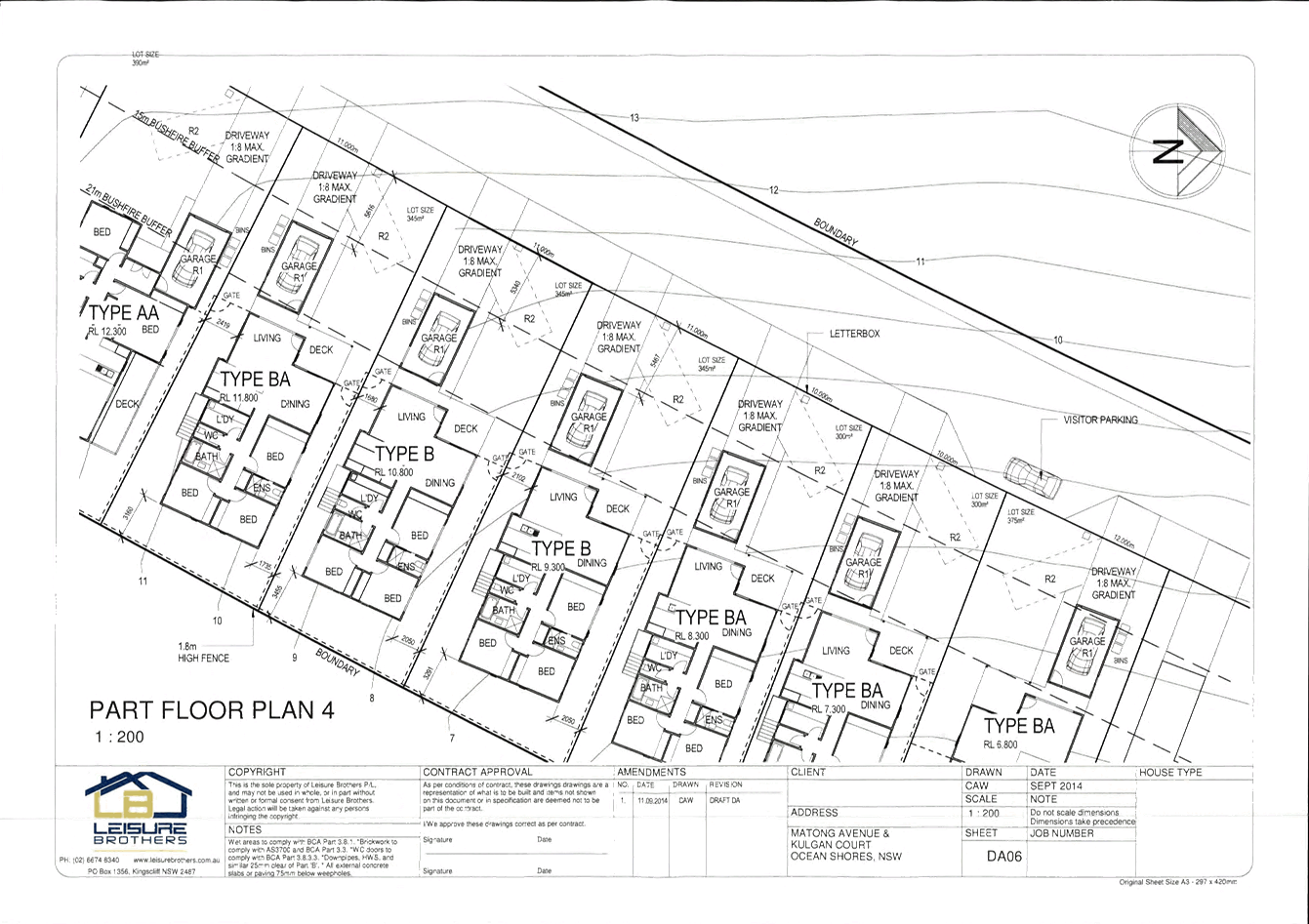
DA06
|
Part Floor Plan 4
|
Leisure Brothers
|
September 2014
Amendment 1
11.09.2014
|
|
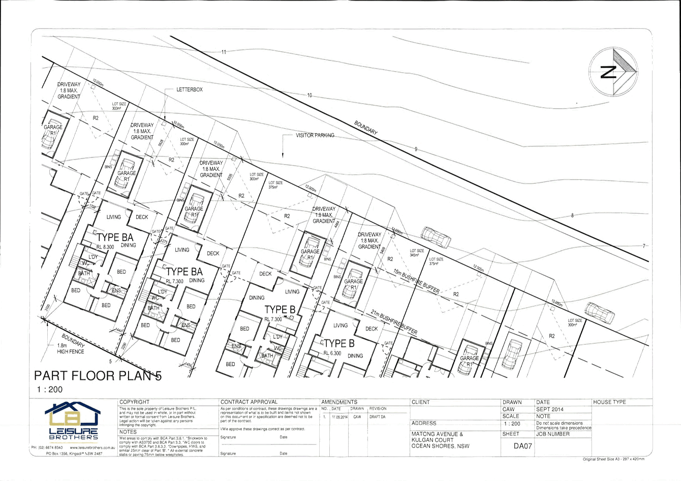
DA07
|
Part Floor Plan 5
|
Leisure Brothers
|
April 2005
Amendment 1
11.09.2014
|
|
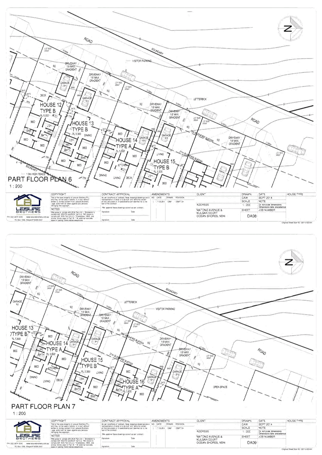
DA08
|
Part Floor Plan 6
|
Leisure Brothers
|
April 2005
Amendment 1
11.09.2014
|
|
DA09
|
Part Floor Plan 7
|
Leisure Brothers
|
April 2005
Amendment 2
25.06.2015
|
|
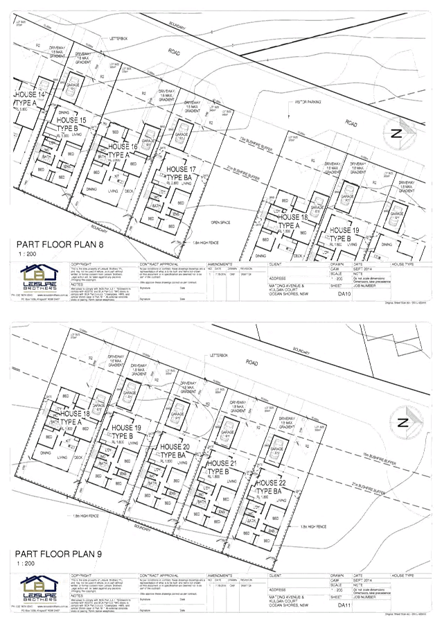
DA10
|
Part Floor Plan 8
|
Leisure Brothers
|
April 2005
Amendment 2
25.06.2015
|
|
DA11
|
Part Floor Plan 9
|
Leisure Brothers
|
April 2005
Amendment 1
11.09.2014
|
|
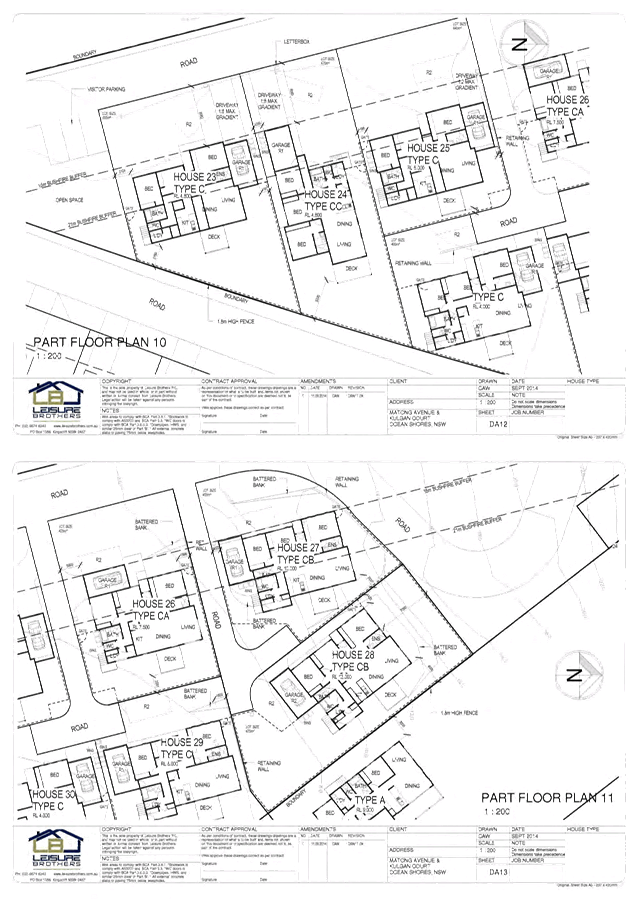
DA12
|
Part Floor Plan 10
|
Leisure Brothers
|
April 2005
Amendment 1
11.09.2014
|
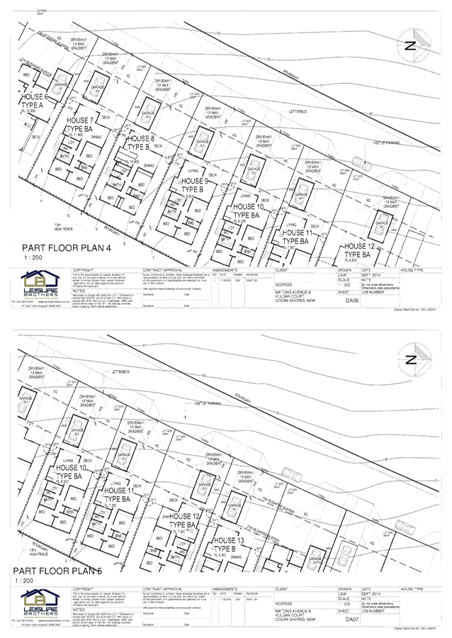
|
DA13
|
Part Floor Plan 11
|
Leisure Brothers
|
April 2005
Amendment 2
09.06.2015
|
|
DA14
|
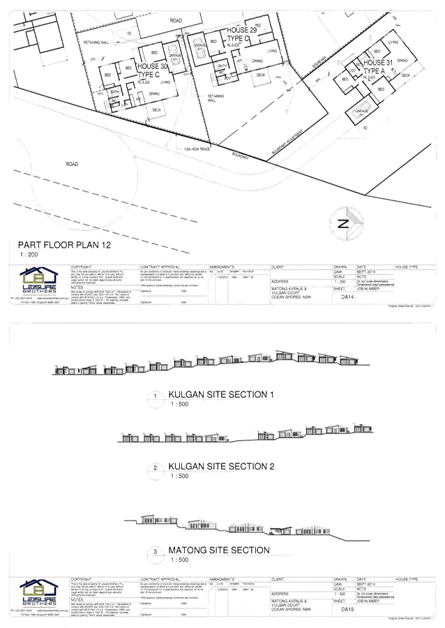
Part Floor Plan 12
|
Leisure Brothers
|
April 2005
Amendment 2
09.06.2015
|
|
DA15
|
Sections
|
Leisure Brothers
|
April 2005
Amendment 2
11.09.2014
|
|
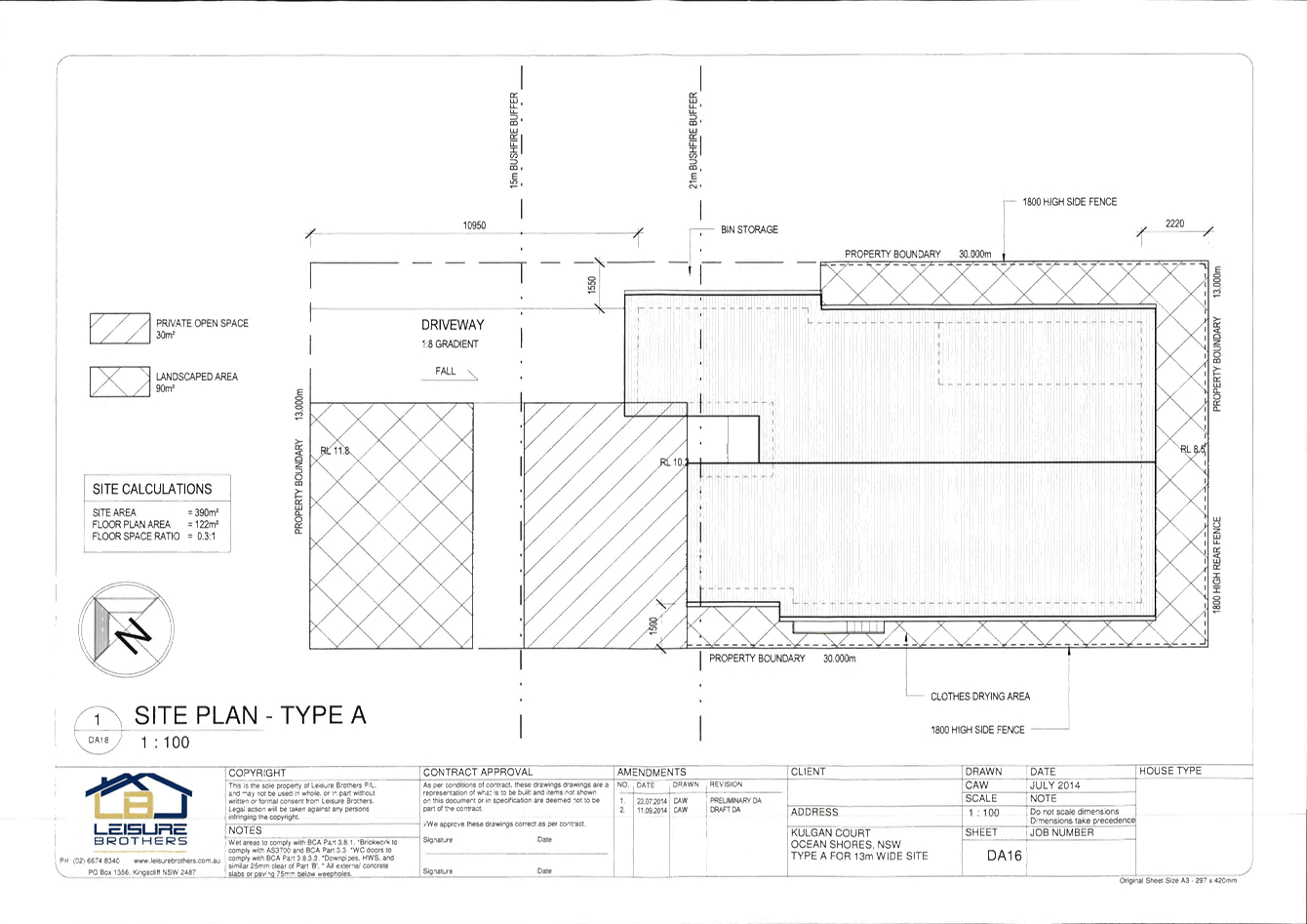
DA16
|
Site Plan - Type A
|
Leisure Brothers
|
April 2005
Amendment 1
11.09.2014
|
|
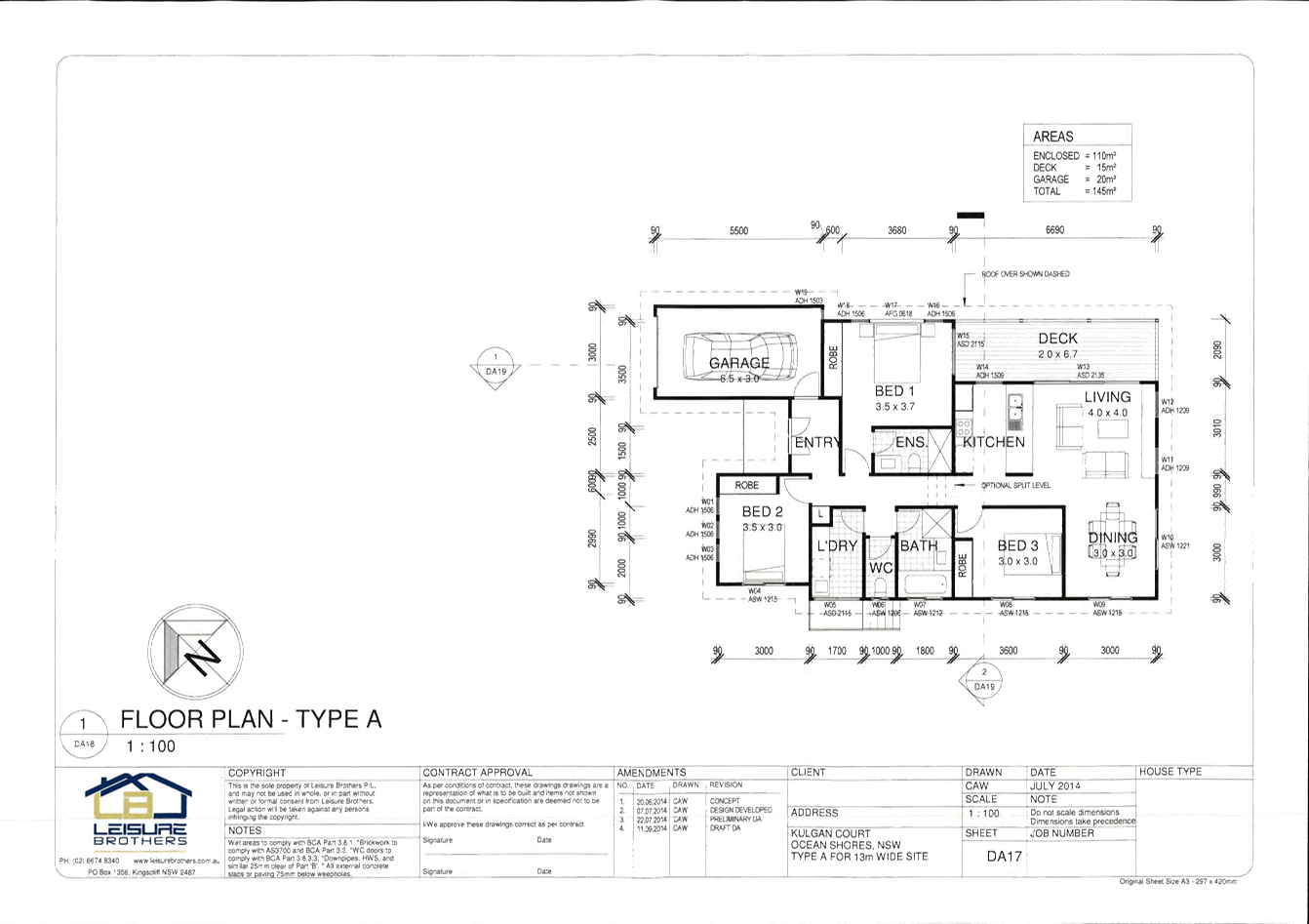
DA17
|
Floor Plan – Type A
|
Leisure Brothers
|
April 2005
Amendment 4
11.09.2014
|
|
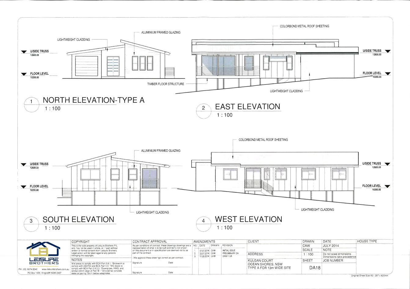
DA18
|
Elevations – Type A
|
Leisure Brothers
|
April 2005
Amendment 4
11.09.2014
|
|
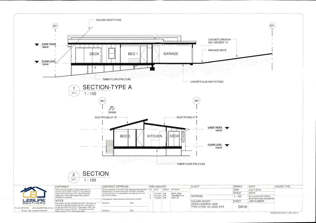
DA19
|
Sections
|
Leisure Brothers
|
April 2005
Amendment 3
11.09.2014
|
|
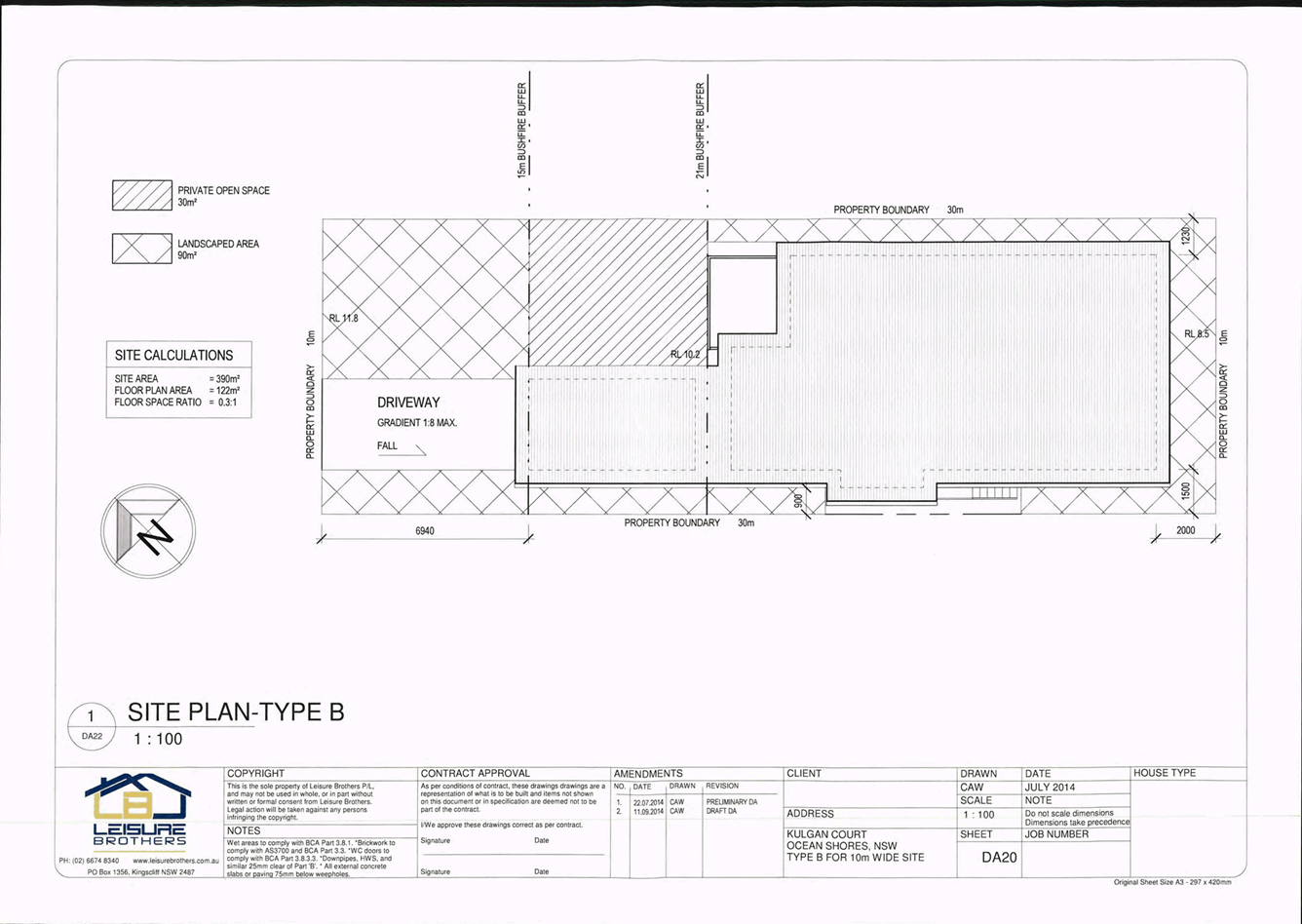
DA20
|
Site Plan – Type B
|
Leisure Brothers
|
April 2005
Amendment 2
11.09.2014
|
|
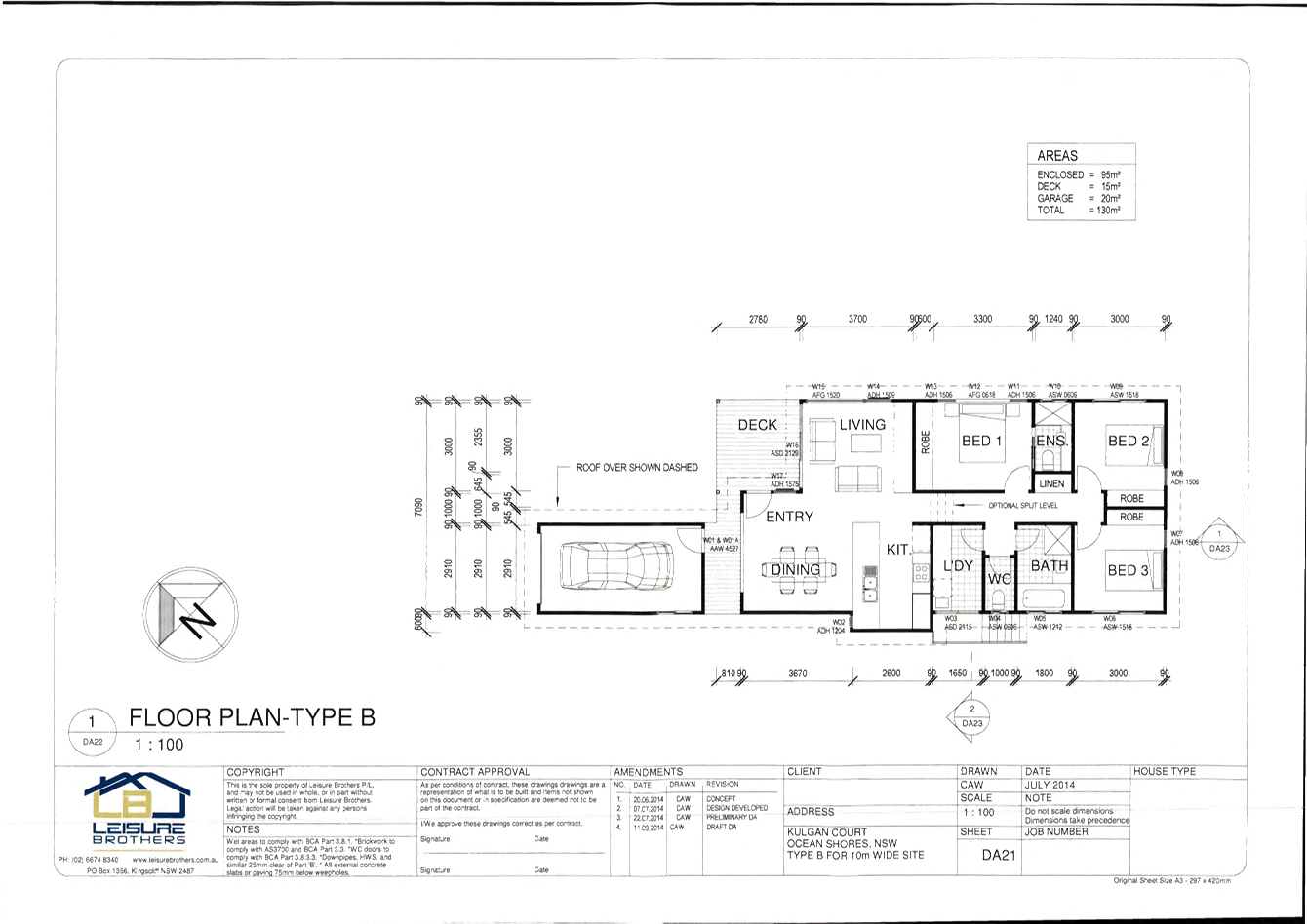
DA21
|
Floor Plan – Type B
|
Leisure Brothers
|
April 2005
Amendment 4
11.09.2014
|
|
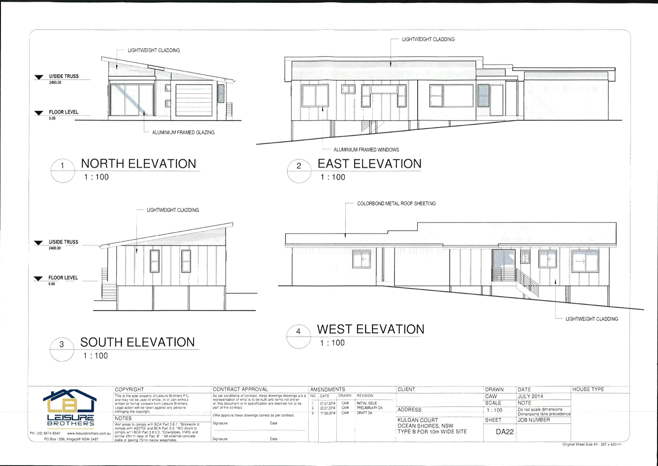
DA22
|
Elevations
|
Leisure Brothers
|
April 2005
Amendment 3
11.09.2014
|
|
DA24
|
Floor Plan – Type BA
|
Leisure Brothers
|
April 2005
Amendment 1
11.09.2014
|
|
DA25
|
Elevations
|
Leisure Brothers
|
April 2005
Amendment 1
11.09.2014
|
|
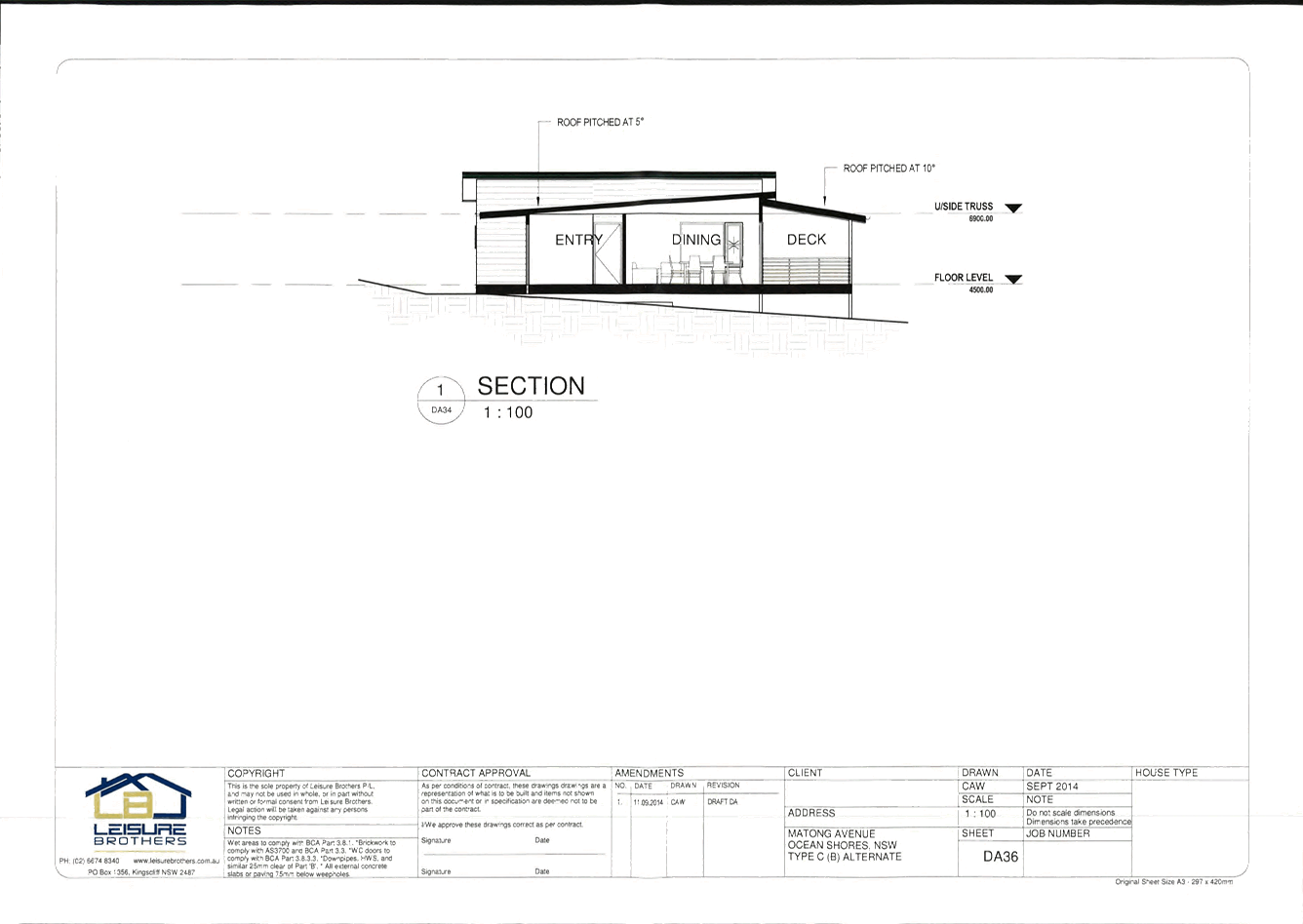
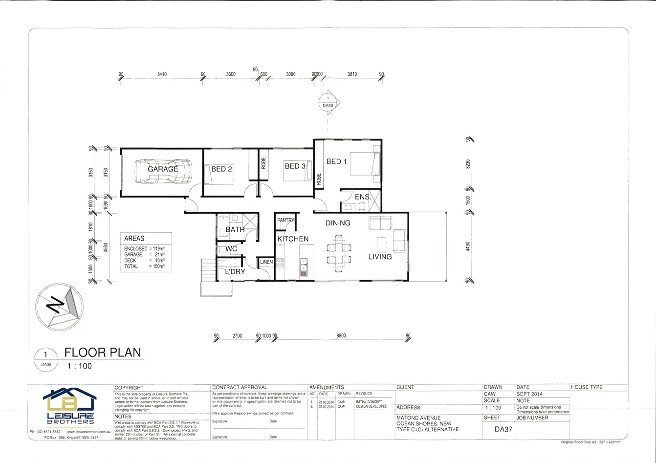
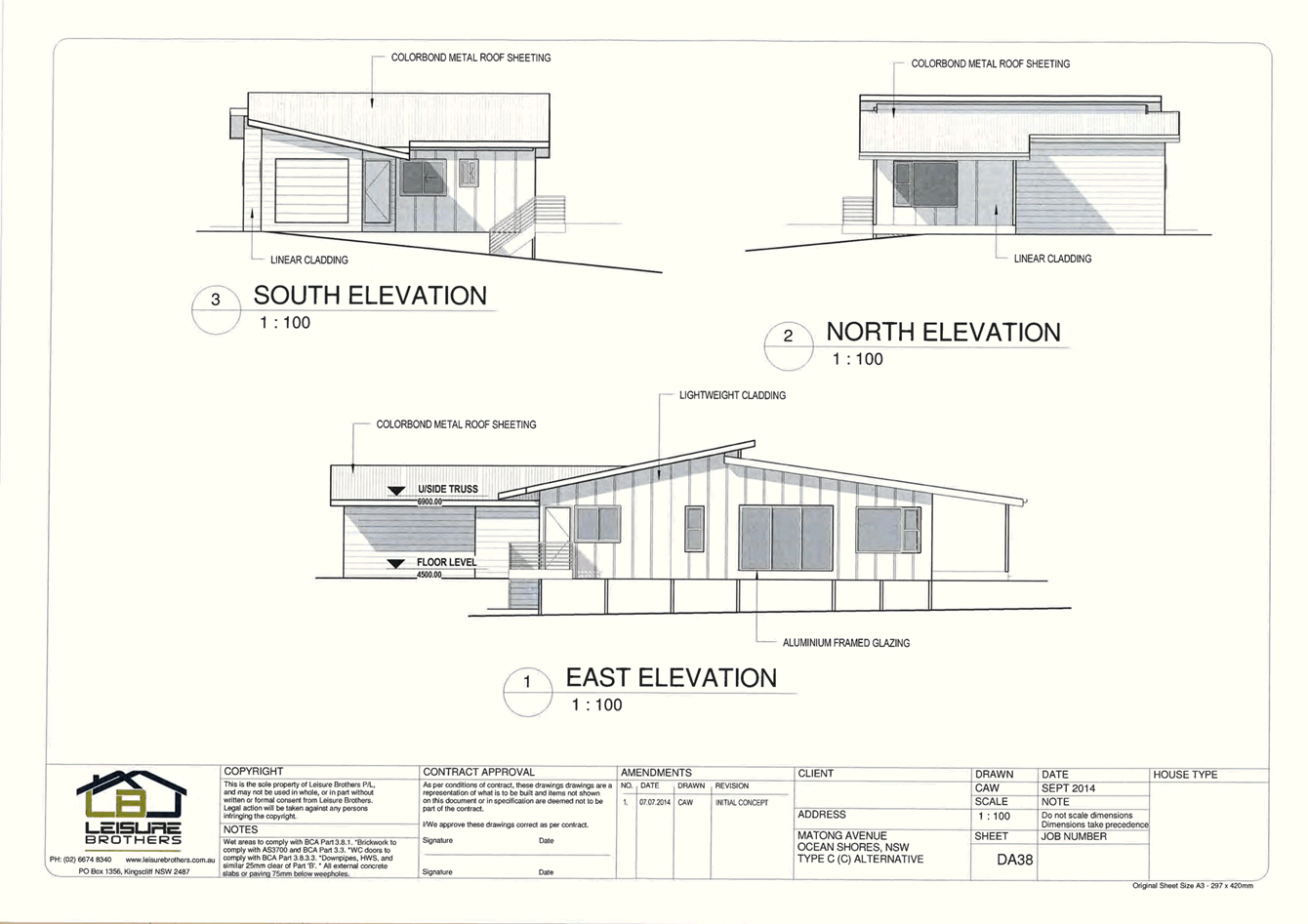
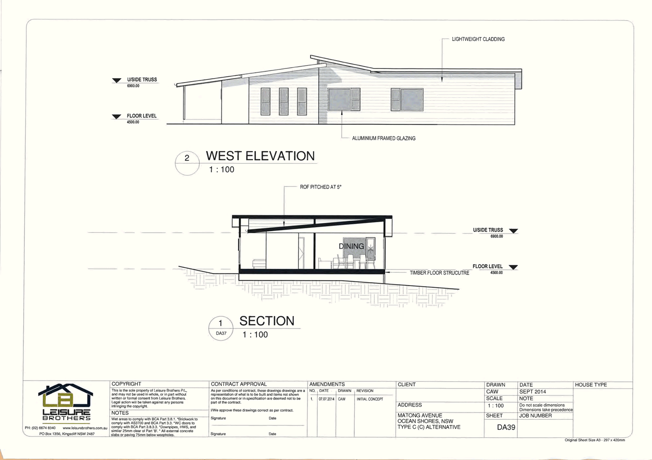
DA27
|
Matong Avenue Ocean Shores, NSW Type C
|
Leisure Brothers
|
September 2014
Amendment 2
11.09.2014
|
|
DA28
|
Floor Plan
|
Leisure Brothers
|
September 2014
Amendment 4
11.09.2014
|
|
DA29
|
Elevations
|
Leisure Brothers
|
September 2014
Amendment 3
11.09.2014
|
|
DA30
|
Sections
|
Leisure Brothers
|
September 2014
Amendment 3
11.09.2014
|
|
DA31
|
Floor Plan
|
Leisure Brothers
|
September 2014
Amendment 1
11.09.2014
|
|
DA32
|
Elevations
|
Leisure Brothers
|
September 2014
Amendment 1
11.09.2014
|
|
DA33
|
Section
|
Leisure Brothers
|
September 2014
Amendment 1
11.09.2014
|
|
DA34
|
Floor Plan
|
Leisure Brothers
|
September 2014
Amendment 1
11.09.2014
|
|
DA35
|
Elevation
|
Leisure Brothers
|
September 2014
Amendment 1
11.09.2014
|
|
DA36
|
Section
|
Leisure Brothers
|
September 2014
Amendment 1
11.09.2014
|
|
DA37
|
Floor Plan
|
Leisure Brothers
|
September 2014
Amendment 2
07.07.2014
|
|
DA38
|
Elevation
|
Leisure Brothers
|
September 2014
Amendment 1
07.07.2014
|
|
DA39
|
West Elevation – Section
|
Leisure Brothers
|
September 2014
Amendment 1
11.09.2014
|
|
07368/1-B
|
Report on Geotechnical Investigation, Slope Stability,
Landslip Kulgan Court Ocean Shores
|
Shaw & Urquhart
|
14 December 2007
|
|
Crgref:14083a
|
Environmental Noise Impact Report
|
CRG Acoustics
|
17th September 2014
|
|
|
‘Roads & Maritime Services’ letter of
approval.
|
RMS
|
25/8/2015
|
|
Figure 1
|
Lot 892 DP241810 & Lot 893 DP241810 Tree Survey Plan
|
unsigned
|
undated
|
The development is also to be in
accordance with any changes shown in red ink on the approved plans or
conditions of consent.
The approved plans and related
documents endorsed with the Council stamp and authorised signature must be kept
on site at all times while work is being undertaken.
2) Compliance
with Building Code of Australia and insurance requirements under the Home
Building Act 1989
(1) For
the purposes of section 80A (11) of the Act, the following conditions are
prescribed in relation to a development consent for development that involves
any building work:
(a) that
the work must be carried out in accordance with the requirements of the
Building Code of Australia ,
(b) in
the case of residential building work for which the Home Building Act 1989 requires there to be a
contract of insurance in force in accordance with Part 6 of that Act, that such
a contract of insurance is in force before any building work authorised to be carried
out by the consent commences.
(2) This
clause
does not apply:
(a) to
the extent to which an exemption is in force under clause 187 or 188,
subject to the terms of any condition or requirement referred to in clause
187 (6) or 188 (4), or
(b) to
the erection of a temporary building.
(3) In
this clause,
a reference to the Building Code of Australia is a reference to that Code as in
force on the date the application for the relevant construction
certificate is made.
3) Erection
of signs
(1) For
the purposes of section 80A (11) of the Act, the requirements of subclauses (2)
and (3) are prescribed as conditions of a development consent for development
that involves any building work, subdivision work or demolition work.
(2) A
sign must be erected in a prominent position on any site on which building
work, subdivision work or demolition work is being carried out:
(a) showing
the name, address and telephone number of the principal certifying authority
for the work, and
(b) showing
the name of the principal contractor (if any) for any building work and a
telephone number on which that person may be contacted outside working hours,
and
(c) stating
that unauthorised entry to the work site is prohibited.
(3) Any
such sign is to be maintained while the building work, subdivision work or
demolition work is being carried out, but must be removed when the work has
been completed.
(4) This
clause
does not apply in relation to building work, subdivision work or demolition
work that is carried out inside an existing building that does not affect the
external walls of the building.
(5) This
clause
does not apply in relation to Crown building work that is certified, in
accordance with section 109R of the Act, to comply with the technical
provisions of the State’s building laws.
(6) This
clause
applies to a development consent granted before 1 July 2004 only if the
building work, subdivision work or demolition work involved had not been
commenced by that date.
Note: Principal certifying
authorities and principal contractors must also ensure that signs required by
this clause are erected and maintained (see clause
227A which currently imposes a maximum penalty of $1,100).
4) Notification
of Home Building Act 1989 requirements
(1) For
the purposes of section 80A (11) of the Act, the requirements of this clause
are prescribed as conditions of a development consent for development that
involves any residential building work within the meaning of the Home Building Act 1989 .
(2) Residential
building work within the meaning of the Home Building Act 1989 must not be carried out
unless the principal certifying authority for the development to which the work
relates (not being the council) has given the council written notice of the
following information:
(a) in
the case of work for which a principal contractor is required to be appointed:
(i) the
name and licence number of the principal contractor, and
(ii) the
name of the insurer by which the work is insured under Part 6 of that Act,
(b) in the
case of work to be done by an owner-builder:
(i) the
name of the owner-builder, and
(ii) if
the owner-builder is required to hold an owner-builder permit under that Act,
the number of the owner-builder permit.
(3) If
arrangements for doing the residential building work are changed while the work
is in progress so that the information notified under subclause (2) becomes out
of date, further work must not be carried out unless the principal certifying
authority for the development to which the work relates (not being the council)
has given the council written notice of the updated information.
(4) This
clause
does not apply in relation to Crown building work that is certified, in
accordance with section 109R of the Act, to comply with the technical
provisions of the State’s building laws.
5) Land
to be consolidated
All five (5) separate parcels of
land are to be consolidated into three (3) allotments and registered with the
NSW Department of Lands. Provide documentary evidence to the Principal
Certifying Authority that the Lots have been consolidated and registered.
STAGE 1 CONDITIONS.
The following conditions
must be complied with prior to issue of a Subdivision Certificate (Stage 1).
6) Subdivision
Certificate application required
An application for a Subdivision
Certificate must be made on the approved form. The Subdivision Certificate
fees, in accordance with Council's adopted schedule of fees and charges, must
accompany such application.
NOTE: The
application must address ALL those conditions of consent required to be
complied with “Prior to the issue of a subdivision Certificate”
with a clear explanation how that condition has been complied with, together
with supplying ALL the relevant information/documents/certificate and/or plans
that is required by that condition.
The application MUST be one
complete, concise package, addressing all those conditions. Failure to provide
the abovementioned information in one package, will likely result in the
application being refused/rejected and returned to you.
7) Plan
of Subdivision
The final plan of subdivision must
be in accordance with the approved plan/s. A Deposited Plan Administration
Sheet (original plus one (1) copy), two (2) copies of the plan of subdivision
and any necessary section 88B instrument (original plus one (1) copy) are to be
submitted with the application for a subdivision certificate. An additional
copy of the final plan of subdivision is to be submitted showing the location
of all buildings and/or other permanent improvements including any fences,
internal access driveways/roads, effluent disposal areas and where relevant,
the 1 in 100 year flood and flood planning level extents on land within or
adjacent to a flood planning area. Where the building/s or improvements are
close to boundaries, offset distances are to be included on the additional copy
of the plan. This plan must be endorsed by a Registered Surveyor.
Any encroachments must be removed or relocated wholly within the
allotment.
8) Certificate
of Compliance – Water Management Act 2000 (All Stages)
A copy of the Certificate of
Compliance under Section 307 of the Water Management Act 2000 is to be obtained
from Byron Shire Council prior to the issue of a Subdivision Certificate.
Application forms
are available from Council’s administration building or online at http://www.byron.nsw.gov.au/files/Forms/Section_305_Certificate.pdf
to be submitted for a Certificate of Compliance with the required payment .
STAGES 2 – 5
CONDITIONS.
Stage 2 – Construction of 8
townhouses and associated infrastructure
Stage 3 – Construction of 8
townhouses and associated infrastructure
Stage 4 – Construction of 9
townhouses and associated infrastructure
Stage 5 – Construction of 5
townhouses and associated infrastructure
The following conditions
are to be complied with prior to issue of a Construction Certificate for each
stage unless indicated for a specific stage.
9) Notice
of Modification of Development Consent to be submitted. (Stage 2)
A Notice of Modification of a
Development Consent, prepared in accordance with Clause 97(1) of the
Environmental Planning and Assessment Regulation 2000, must be submitted prior
to the issue of a construction certificate for Stage 2, with respect to Development
Consent No. DA 10.2008.757.1, the notice is to provide amended plans
with Stages 2 & 3 shown deleted. All areas, including internal
driveways of Stage 1 of 10.2008.757.1 are also to be made consistent with those
plans approved under Condition 1 of this determination for Stage 2 of
10.2014.743.1
10) Ecological
Restoration Plan required (Stage 2, 3, 4 & 5 )
The construction certificate is not to be issued until Council is
satisfied that adequate measures can be implemented to ensure that the native vegetation
to be removed can be adequately compensated in accordance with Clause 5.9 of
Byron LEP 2014; Byron DCP Chapter B2 Preservation of trees and other
vegetation and Byron Biodiversity Conservation Strategy; and that the
native vegetation to be retained can be adequately protected during the
pre-construction, construction and operational phases of the development.
To satisfy Council in this matter, a detailed Ecological Restoration
Plan is to be submitted to Council and approved. The plan must be
prepared by a suitably qualified ecologist with bush regeneration
qualifications and experience, or a qualified and experienced bush regenerator
and must include:
1. Detail of all native vegetation
requiring removal to enable the development as approved including a description
of each numbered tree/vegetation community detailing its’ species (common
and botanical name); location identified on a map using GPS coordinates;
approximate height and diameter at breast height; and whether any of the following
is applicable to the species/community:
a) Large
locally indigenous trees of over 60 cm diameter at breast height,
b) Trees
identified in Appendix B2.1 – Significant Tree Register (Primary Koala
Food trees),
c) Trees
within an area of high conservation value vegetation and habitats,
d) Trees
(whether dead or alive) containing tree hollow(s),
e) Threatened
species,
e) Endangered
Ecological Communities on or adjoining the subject site.
g) Within an
identified wildlife corridor
h) Threatened
fauna habitat
k) Within
waterways, wetlands or riparian vegetation
2. The location of compensatory
plantings in plan and word form at a minimum ratio of 10 gained: 1 lost for
Tallowwoods and other native species within High Conservation Value Vegetation
or mapped Wildlife Corridors or with a diameter at breast height of >60cm,
and a minimum of 5 gained: 1 lost for other native trees. The plan must include
as a minimum:
a. Detail to include plant species, height or area covered
where a vegetation community is recognised;
b. a map at a scale of 1:200 or better illustrating the
location and extent of retained vegetation on the site in accordance with the
plan endorsed by this consent. This map should also identify all areas
where weeds exist in the vicinity of the development and the area(s) where
plantings are proposed;
c. provision for specific adequate plantings of plant species
native to the local vegetation community(s) to compensate for loss of native
vegetation from the site, including a list of species and the number of each
species proposed to be planted in rehabilitation work;
d. provision of a list of environmental weeds to be addressed
on the site, specific methods of weed removal strategies and a clear
identification of responsibility for the weed removal and rehabilitation
e. a plan for independent audit and annual reporting to
Council of weed management in retained vegetation on the site;
f. the means of protection of existing vegetation
within and adjoining the site to be preserved during the construction and
operational phases of the development in accordance with AS 4970-2009:
Protection of Trees on development sites.
g. the means of replacing connectivity between vegetation
communities in the 7(k) zoned part of the site with the Council reserve to the
west of Lot 493.
h. identification of all service connection locations within
the site demonstrating that all services must be located independently of and
will not be detrimental to any trees to be preserved.
i. a detailed works plan including cost estimates and
team days required to achieve effective habitat restoration; and
j. performance criteria against which restoration works
will be measured.
k. erection of habitat boxes to off-set the loss of natural
hollows.
l. adaptive management provisions in case of failure to
meet performance criteria.
m. Inclusion of a statement that restoration works are to be
undertaken by a qualified and experienced bush regenerator(s) over a period of
no less than five years to ensure weeds are adequately controlled and native
vegetation has sufficiently recovered.
In satisfying Council as to the
above Council must be furnished with Ecological
Restoration Plan. The plan
must be prepared by a suitably qualified ecologist with bush
regeneration qualifications and experience, or a qualified and experienced bush
regenerator.
11) Landscaping plan required (Stages 2, 3, 4 & 5)
The
application for a Construction Certificate is to include plans and
specifications that indicate the landscaping of the site. Such
landscaping plan must incorporate adequate detail to demonstrate compliance
with the provisions of Chapter B9.12.5 of Development Control Plan 2014. The
landscaping plan must indicate:
· That the majority of the plantings comprise locally
occurring rainforest trees, shrubs and ground covers,
· proposed location for planted ground covers, shrubs and
trees,
· botanical name of shrubs and trees to be planted
· mature height of trees to be planted
The plan is to
be prepared by a suitably qualified landscape architect / architect /ecologist
who has appropriate experience and competence in landscaping.
Such plans and
specifications must be approved as part of the Construction Certificate.
The Landscaping where suitable may add to the compensatory biodiversity
plantings required by Condition 10.
The
landscaping is to be in accordance with Appendix 5 of Planning for Bushfire
Protection 2006
12) Details
of acoustic treatments and ventilation measures for building construction (All
Stages)
The application for a Construction
Certificate is to include plans and specifications that demonstrate the
inclusion of acoustic treatments and ventilation measures for building
construction recommended in Section 6 of the Environmental Noise Impact Report
prepared by CRG Acoustics dated 17th September 2014. Such
plans and specifications must be approved as part of the Construction
Certificate for building works.
13) Acid
sulfate soils management plan (All relevant stages)
Acid Sulfate Soils Management Plan
is required for earthworks or works where a total volume of soil disturbed
exceeds 1000 tonnes. The Plan must be prepared by a suitably qualified
Environmental / Soil Scientist and in accordance with the Acid Sulfate Soil
Manual (ASSMAC 1998), and approved prior to the issue of a construction
certificate for those works.
14) Geotechnical
Report required – Engineering Works (All Stages)
A certificate from a professional
Engineer experienced in soil mechanics is to be provided to the Principal
Certifying Authority, certifying that:
a) the design of
the civil engineering works, including retaining walls and/or cut & fill
batters, has been assessed as structurally adequate,
b) the civil
engineering works will not be affected by landslip or subsidence either above
or below the works; and
c) adequate
drainage has been provided.
15) Sediment
and Erosion Control Management Plan required (All Stages)
The application for a Construction
Certificate is to include plans and specifications that indicate the measures
to be employed to control erosion and loss of sediment from the site. Control
over discharge of stormwater and containment of run-off and pollutants leaving the
site/premises must be undertaken through the installation of erosion control
devices such as catch drains, energy dissipaters, level spreaders and sediment
control devices such as filter fences and sedimentation basins, and shake down
areas at all vehicle access points to the development site.
Such plans and specifications must
be approved as part of the Construction Certificate.
NOTE: The plans
must be in compliance with Council's current “Northern Rivers Local
Government Development Design & Construction Manuals and Standard
Drawings”.
16) Water
and Sewerage - Section 68 approval required (All Stages)
An Approval under Section
68 of the Local Government Act 1993 to carry out water supply work and sewerage
work must be obtained.
17) On-site
stormwater detention - Section 68 approval required (All Stages)
An approval under Section 68 of
the Local Government Act 1993 to carry out on-site detention drainage system
and connection to a Council approved drainage system. The drainage design is to
provide for the following, but not limited to, works:
· The system for the
central catchment/northern portion of the site must be designed to match the post
developed ARI 100 year flows to the pre-developed ARI 5 year flows.
· The On-Site
detention basin/infrastructure must discharge via the existing stormwater
drainage pipe through Lot 686 DP 240398 to Aloota Crescent. This pipe line must
be within an easement.
· An overland flow
path for up to Q100 events within the easement.
The design is to facilitate stand
alone operational compliance for each stage of the development.
Note: The plans must be in
compliance with Council’s Development Control Plan 2002, Part N and
Council’s current “Northern Rivers Local Government Development
Design & Construction Manuals and Standard Drawings”. Refer to
Council’s website for copies of these documents.
18) Consent
required for works within the road reserve – Kulgun Court, Matong Drive
& Brunswick Valley Way.
Consent from Council must be
obtained for works within the road reserve pursuant to Section 138 of the Roads
Act 1993. Three (3) copies of engineering construction plans must accompany the
application for consent for works within the road reserve.
Such plans are to be in accordance
with Council’s Specification for Engineering Works and are to provide for
the following works at the specific Stages of development:
MATONG DRIVE: (Stage 2).
|
Driveway.
|
A concrete driveway, to facilitate two way traffic flows
for Residential, Delivery and Refuse Collection vehicles, in accordance with
Council's current “Northern Rivers Local Government Development Design
& Construction Manuals and Standard Drawings”.
|
KULGUN COURT: (Stage 3 )
|
Driveway.
|
A concrete driveway, to facilitate two way traffic flows
for Residential, Delivery and Refuse Collection vehicles, in accordance with
Council's current “Northern Rivers Local Government Development Design
& Construction Manuals and Standard Drawings”.
|
|
|
|
|
Stormwater Drainage.
|
Stormwater drainage works, pipes, pits, as required and
approved under the Section 68 Stormwater Drainage approval.
|
|
|
|
|
Adjustment of Services
|
Any roadworks are to include the adjustment and/or
relocation of services as necessary to the requirements of the appropriate
service authorities and to ensure that the services are constructed flush
with the finished surface levels.
|
|
Road Pavement AC Seal.
|
The existing road pavement seal for the full length and
area of Kulgun Court is to have a new overlay of Open Graded Asphaltic
Concrete seal.
|
|
|
|
|
BRUNSWICK VALLEY WAY. (Stage 3 to accord with RMS
approval dated 25/8/15)
|
|
|
Unrestricted Driveway.
|
A bitumen sealed (AC) unrestricted driveway, which
facilitates two way traffic flows, designed for Residential, Delivery and
Refuse Collection vehicles. The design is to be in general accordance with
Council's current “Northern Rivers Local Government Development Design
& Construction Manuals and Standard Drawings”, and, AustRoads
standards for driveway design and sight distances. The design is also to provide
for, as required, drainage culvert/infrastructure, pavement works to
Brunswick Valley Way, signage and/or linemarking (new and relocation), and
any reconstruction works to the existing guard rail. The driveway design and
construction is also to comply with the Roads & Maritime Services’
letter of approval dated 25/8/2015.
|
|
|
|
|
|
NOTE: The plans must be in compliance with
Council's current “Northern Rivers Local Government Development Design
& Construction Manuals and Standard Drawings”.
|
19) Traffic
Management Plan. (All relevant Stages ).
Consent from Council must be
obtained for a Traffic Management Plan pursuant to Section 138 of the Roads Act
1993.
The plans and specifications are
to include:
· The measures to be
employed to control traffic (inclusive of construction vehicles for the
duration of the construction of the development and haulage trucks for the
earthworks phase) during construction of the development, during the Earthworks
phase of the development and during any construction works within the public
road reserves.
· The haulage route,
frequency and size of trucks, and duration of operations for the Earthworks
phase.
· A traffic control
plan is to be designed in accordance with the requirements of the Roads and
Traffic Authority’s Manual, Traffic Control at Work Sites Version 2, and
the current Australian Standards, Manual of Uniform Traffic Control Devices
Part 3, ‘Traffic Control Devices for Works on Roads’; and
· Incorporate
measures to ensure that motorists using road adjacent to the development,
residents and pedestrians in the vicinity of the development are subjected to
minimal time delays due to construction on the site or adjacent to the site.
The traffic control plan must be
prepared by a suitably qualified and RTA accredited Work Site Traffic
Controller.
20) Car
Parking layout, Vehicle circulation and Internal Driveway/Access plans
required.
(All Relevant Stages).
The application for a Construction
Certificate is to include plans and specification that indicate internal access,
car parking and vehicle turning/manoeuvring details in accordance with the
plans approved by this consent.
The access, parking and
manoeuvring for the site is to comply with the requirements of Council’s
DCP2014 B4: Parking facilities, Part 1: Off-street car parking and AS 2890.2
– 2002 - Parking facilities, Part 2: Off-street commercial vehicle
facilities. Plans are to include, but not be limited to, the following items:
a) pavement
description, the pavement of the internal access road/driveway from Kulgun
Court through to the internal roundabout/island is to be of a smooth surface to
reduce vehicle/tyre noise;
b) pavement
description, the pavement of the internal access road/driveway from Matong
Drive, inclusive of vehicle turning bay, and, a locked gate with signage at the
southern end of the internal driveway that services the 8 units in Stage 1 to
prevent access through to Kulgun Court/Brunswick Valley Way.
c) The
internal access road from Matong Drive, through No 43 Matong Drive, is to be
designed so that the driveway comes no closer than 3 metres from the large
trees circled in red on Figure 1 ‘Lot 892 DP241810 & Lot 893 DP
241810 Tree Survey Plan’, i.e. a minimum TPZ of 3.0 metres is to be
provided.
d) The
driveway to the dual occupancy at No 41 Matong Drive is to be via a ROW through
No 43 Matong Drive.
e) the
required number of car spaces for residents, deliveries, buses, and visitors
for each stage of the development;
f) existing
and design levels;
g) longitudinal
section from the road centreline to the car space(s);
h) cross
sections;
i) drainage
(pipes, pits, on-site detention, etc.);
j) turning
paths for all design vehicles up to and including the 10m. Refuse Collection
Vehicle ;
k) vehicle
turning areas at the end of the internal access/driveway for each stage of the
development for all design vehicles up to and including the 10m. Refuse
Collection Vehicle.
l) linemarking
and signage.
The engineering plans and
specifications are to be designed by a qualified practising Civil Engineer. The
Civil Engineer is to be a corporate member of the Institution of Engineers
Australia or is to be eligible to become a corporate member and have
appropriate experience and competence in the related field.
Such plans and specifications must
be approved as part of the Construction Certificate.
NOTE: The plans
must be in compliance with Council's current “Northern Rivers Local
Government Development Design & Construction Manuals and Standard
Drawings”.
21) Flood
Planning Level for new buildings (All Stages)
The flood planning level for this
development is R.L. 4.9m A.H.D.
The plans and specifications to
accompany the construction certificate application are to indicate a minimum
floor level that is at/above this flood planning level.
This affects the southern portion
of the site, south of the Kulgun Court entrance driveway.
The plans and specifications to
accompany the construction certificate application are also to indicate the use
of flood compatible materials, fixtures and power outlets where used in the
building below the flood planning level.
22) Bond
required to guarantee against damage to public land (All Stages)
A bond of $10,000.00 is to be paid to Council as guarantee against damage
to surrounding public land and infrastructure during construction of the
proposed development. Evidence is to be provided to Council indicating the pre
development condition of the surrounding public land and infrastructure. Such
evidence must include photographs. The proponent will be held responsible for
the repair of any damage to roads, kerb and gutters, footpaths, driveway
crossovers or other assets.
Such bond will be held until
Council is satisfied that the infrastructure is maintained/repaired to pre
development conditions and that no further work is to be carried out that may
result in damage to Council’s roads, footpaths etc.
23) Public
liability insurance cover required (Stages 2, 3).
The developer and/or contractor
must produce evidence to the Principal Certifying Authority of public liability
insurance cover for a minimum of $10 million. Council is to be nominated as an
interested party on the policy.
24) Long
Service Levy to be paid (All Stages).
A Long Service Levy must be paid
to the Long Service Payments Corporation. This is a State Government Levy
and is subject to change.
These payments may be made online
at www.lspc.nsw.gov.au or at Council’s Administration Office, Station Street, Mullumbimby. Where paying to Council, cheques are to be made payable to
‘Byron Shire Council’.
For further information regarding
the Long Service Payment please refer to the website above.
25) Water
and Sewerage - Section 68 approval required (Stages 2, 3, 4 & 5).
An Approval under Section
68 of the Local Government Act 1993 to carry out water supply work and sewerage
work must be obtained.
26) Certificate
of Compliance – Water Management Act 2000 (All Stages)
A Certificate of Compliance will
be issued on completion of construction of water management works to serve the
development and/or on payment of developer charges for water and sewer as
calculated in accordance with Byron Shire Council and Rous Water Development
Servicing Plans.
Byron Shire Council acts as Rous
Water’s agent in this matter and will issue a Certificate of Compliance
on behalf of Rous Water upon payment of the Rous Water Development Servicing
Charge to this Council.
Note: Copies of the
application forms for Certificates of Compliance are available on Council’s
website http://www.byron.nsw.gov.au/files/Forms/Section_305_Certificate.pdf
or from Council’s Administration Office. Copies of Byron Shire
Council’s Development Servicing Plans are available at Council’s
Administration Office.
Developer charges will be calculated in
accordance with the Development Servicing Plan applicable at the date of
payment. A check must be made with Council to ascertain the current rates by
contacting Council’s Principal Engineer Systems Planning, Water on 02
6626 7081. Applicable charges can be found on Council’s website: http://www.byron.nsw.gov.au/development-contributions-plans-section-94-and-64
The contributions payable will
be adjusted in accordance with relevant plan and the amount payable will be
calculated on the basis of the contribution rates that are applicable at the
time of payment.
Payment by
Personal or Company Cheque will not be accepted
27) Compliance
with BASIX Certificate requirements (All Stages)
The development is to comply with
BASIX Certificate No.575291M, dated 23 September 2014. The commitments indicated
in the Certificate are to be indicated on the plans submitted for approval of
the Construction Certificate.
The plans submitted must clearly
indicate all windows numbered or identified in a manner that is consistent with
the identification on the BASIX Certificate.
Minor changes to the energy
efficiency measures may be undertaken without the issue of an amendment under
Section 96 of the Act, provided that the changes do not affect the form, shape
or size of the building.
Proposed external colours/materials
must be consistent with those shown on the approved plans referred to in
Condition No.1 of this consent. Such plans and specifications must be approved
as part of the Construction Certificate.
28) Clothes
drying (All Stages)
Plans accompanying the application
for construction certificate are to show the provision of external clothes
drying areas in accordance with Byron Development Control Plan 2014 Chapter
D1.6.6.
29) Long
Service Levy to be paid (All Stages)
A Long Service Levy must be paid
to the Long Service Payments Corporation. This is a State Government Levy
and is subject to change.
These payments may be made online
at www.longservice.nsw.gov.au
or at Council’s Administration
Office, Station Street, Mullumbimby. Where paying to Council, cheques are to be
made payable to ‘Byron Shire Council’.
For further information regarding
the Long Service Payment please refer to the website above.
30) Site
Waste Minimisation and Management Plan (All Stages)
Chapter B8 of
Byron Shire Development Control Plan 2014 (DCP 2014) aims to facilitate
sustainable waste management in a manner consistent with the principles of
Ecologically Sustainable Development. Prior
to the issue of a Construction Certificate, a Site Waste Minimisation and
Management Plan (SWMMP) must be submitted outlining measures to minimise and
manage waste generated during demolition, construction and the ongoing
operation and use of the development. The
SWMMP must specify the proposed method of recycling or disposal and the waste
management service provider.
A template is
provided on Council’s website to assist in providing this information www.byron.nsw.gov.au/files/publications/swmmp_-_pro-forma-.doc)
31) Developer
Contributions to be paid for Stage 2 (8 Townhouses).
Contributions set out in the
schedule below are to be paid to Council prior to the release of a construction
certificate for this stage. Contributions are levied in accordance with
the Byron Shire Developer Contributions Plan 2012 (as amended). The Plan
may be viewed on line at http://www.byron.nsw.gov.au/
or during office hours at the Council Offices located at Station Street, Mullumbimby.
These contributions are to fund public amenities and services as listed in the
schedule. Additional details on the specific amenities are to be found in
the Byron Shire Developer Contributions Plan 2012 (as amended).
The credit for the 5 existing lots
have been allocated to this stage.
The contributions
in the schedule are current at the date of this consent. The
contributions payable will be adjusted in accordance with the relevant plan and
the amount payable will be calculated on the basis of the contribution rates
that are applicable at the time of payment. The schedule contains a
date for which the schedule remains valid, after this date you will have to
contact Council for an updated schedule.
PAYMENTS WILL ONLY BE ACCEPTED
BY CASH OR BANK CHEQUE.
32) Developer
Contributions to be paid for Stage 3 (8 Townhouses)
Contributions set out in the
schedule below are to be paid to Council prior to the release of a construction
certificate for this stage. Contributions are levied in accordance with
the Byron Shire Developer Contributions Plan 2012 (as amended). The Plan
may be viewed on line at http://www.byron.nsw.gov.au/
or during office hours at the Council Offices located at Station Street,
Mullumbimby. These contributions are to fund public amenities and
services as listed in the schedule. Additional details on the specific
amenities are to be found in the Byron Shire Developer Contributions Plan 2012
(as amended).
The contributions
in the schedule are current at the date of this consent. The
contributions payable will be adjusted in accordance with the relevant plan and
the amount payable will be calculated on the basis of the contribution rates
that are applicable at the time of payment. The schedule contains a
date for which the schedule remains valid, after this date you will have to
contact Council for an updated schedule.
PAYMENTS WILL ONLY BE ACCEPTED
BY CASH OR BANK CHEQUE.
33) Developer
Contributions to be paid for Stage 4 (9 Townhouses)
Contributions set out in the
schedule below are to be paid to Council prior to the release of a construction
certificate for this stage. Contributions are levied in accordance with
the Byron Shire Developer Contributions Plan 2012 (as amended). The Plan
may be viewed on line at http://www.byron.nsw.gov.au/
or during office hours at the Council Offices located at Station Street,
Mullumbimby. These contributions are to fund public amenities and
services as listed in the schedule. Additional details on the specific
amenities are to be found in the Byron Shire Developer Contributions Plan 2012
(as amended).
The contributions
in the schedule are current at the date of this consent. The
contributions payable will be adjusted in accordance with the relevant plan and
the amount payable will be calculated on the basis of the contribution rates
that are applicable at the time of payment. The schedule contains a
date for which the schedule remains valid, after this date you will have to
contact Council for an updated schedule.

34) Developer
Contributions to be paid for Stage 5 (5 Townhouses and Dual Occupancy)
Contributions set out in the
schedule below are to be paid to Council prior to the release of a construction
certificate for this stage. Contributions are levied in accordance with
the Byron Shire Developer Contributions Plan 2012 (as amended). The Plan
may be viewed on line at http://www.byron.nsw.gov.au/
or during office hours at the Council Offices located at Station Street,
Mullumbimby. These contributions are to fund public amenities and
services as listed in the schedule. Additional details on the specific
amenities are to be found in the Byron Shire Developer Contributions Plan 2012
(as amended).
The contributions
in the schedule are current at the date of this consent. The
contributions payable will be adjusted in accordance with the relevant plan and
the amount payable will be calculated on the basis of the contribution rates
that are applicable at the time of payment. The schedule contains a
date for which the schedule remains valid, after this date you will have to
contact Council for an updated schedule.

35) External
lighting plan to be submitted for approval (All Stages)
The application for a Construction
Certificate is to include plans and specifications that demonstrate that safe
minimum standards of lighting (min. 0.2 Lux) can be provided without generation
of undue glare and nuisance from the lighting installations. Lighting assessment
and design should be undertaken by a suitably qualified professional with
competence in the fields of illuminating engineering and environmental design
in accordance with AS4282-1997: Control of the obtrusive effects of outdoor
lighting and NSW Workcover OH&S requirements.
The following conditions
are to be complied with prior to commencement of building works
36) Traffic
Management Plan (All Relevant Stages)
The approved traffic management
plan is to be implemented.
37) Public
safety requirements (All Relevant Stages)
All care is to be taken to ensure
the safety of the public in general, road users, pedestrians and adjoining
property. The public liability insurance cover, for a minimum of $10
million, is to be maintained for the duration of the construction of the
development. Council is not held responsible for any negligence caused by
the undertaking of the works.
38) Dilapidation
Reports required (All Relevant Stages).
Prior to the commencement of any
excavation works requiring rock drilling, blasting or breaking, a
pre-construction Dilapidation Report is to be submitted to Council detailing
the current condition of all adjoining buildings, infrastructure and roads.
This report is also advisable
prior to any earthworks.
A second Dilapidation Report shall
be submitted to Council, prior to occupation of the building (whole or
partial), to ascertain if any structural damage has occurred to any adjoining
building, infrastructure or roads.
39) Environmental
Noise Impact Report (All Stages)
All controls
and measures must be in place in accordance with the approved
Environmental Noise Impact Report.
40) Acid
sulfate soils management (All Stages)
If required
acid sulfate soil controls must be in place in accordance with any approved
Acid Sulfate Soils Management Plan.
41) Erosion
and Sediment Control Management Plan implemented (All Stages).
Erosion and sedimentation controls
are to be in place in accordance with the approved Erosion and Sediment Control
Plan.
Sediment and erosion control
measures in accordance with the approved Erosion and Sedimentation Control
plan/s must be maintained at all times until the site has been stabilised by
permanent vegetation cover or hard surface.
Any such measures that are deemed
to be necessary because of the local conditions must be maintained at all times
until the site is made stable (i.e. by permanent vegetation cover or hard
surface).
Note: Council may impose
on-the-spot fines for non-compliance with this condition.
42) Plumbing
Standards and requirements. (All Stages)
All Plumbing, Water Supply,
Sewerage and Stormwater Works shall be installed in accordance with the Local
Government Act 1993, Plumbers Code of Australia and AS/NZS 3500 Parts 0-5, the
approved plans (any notations on those plans) and the approved
specifications. The changes made are from Plumbers and Drainage
Regulation 2012 NSW Government.
a) The licensee is to
provide 24 hours notice and attend the site for the following INSPECTIONS,
prior to covering of work. Inspections will be carried out a mutually
convenient time:
i) Pre-start
and Sediment Control;
ii) Internal
Drainage;
iii) External
Drainage;
iv) Water
Rough In;
v) Fire
Services;
vi) Stackwork;
vii) Final - all work completed.
- * Note below.
b) A licensee is required
to provide to Council and owner of the property after completion of the work
and within 48 hours, a Compliance Certificate and Sewer Services Diagram /
Works as Executed drawings.
43) Imported
Fill Material (All Stages)
All fill material imported to the
site for the purpose of the development must be from a clean
source. Documentation must accompany the material certifying it as
clean or virgin material. A copy of the certification must be
provided to the certifying authority prior to any building work or construction
commencing.
The following conditions
are to be complied with during construction
44) Construction
times (All Stages)
Construction works must not
unreasonably interfere with the amenity of the neighbourhood. In particular
construction noise, when audible from adjoining residential premises, can only
occur:
a) Monday
to Friday, from 7 am to 6 pm.
b) Saturday,
from 8 am to 1 pm.
No construction work to take place
on Saturdays and Sundays adjacent to Public Holidays and Public Holidays and
the Construction Industry Awarded Rostered Days Off (RDO) adjacent to Public
Holidays.
Note: Council may impose
on-the-spot fines for non-compliance with this condition.
45) Construction
Noise (All Stages)
Construction noise is to be
limited as follows:
a) For
construction periods of four (4) weeks and under, the L10 noise level measured
over a period of not less than fifteen (15) minutes when the construction site
is in operation must not exceed the background level by more than 20 dB(A).
b) For
construction periods greater than four (4) weeks and not exceeding twenty‑six
(26) weeks, the L10 noise level measured over a period of not less than fifteen
(15) minutes when the construction site is in operation must not exceed the
background level by more than 10 dB(A)
Note: Council may impose
on-the-spot fines for non-compliance with this condition.
46) Environmental
Noise Impact Report (All Stages)
All works to be carried out in
accordance with the approved Environmental Noise Impact Report.
47) Building
construction to incorporate acoustic treatment (All Stages)
Approved plans and specifications
for acoustic treatment and ventilation measures must be incorporated during
construction for building works.
48) Acid
sulfate soils management (All Stages)
Acid sulfate soils must be managed
and disposed of in accordance with the approved Acid Sulfate Soils Management
Plan. A copy of this report must be kept on the property at all times
during construction and made available to any person.
49) Any
excavated ASS soils to be disposed of off-site (All Stages)
Any soils to be disposed of
off-site to be in accordance with NSW DECC Waste Classification Guidelines
(2008) and Approved Acid Sulfate Soils Management Plan.
50) Signs
to be erected on building and demolition sites (All stages)
A sign must be erected in a
prominent position on the work site:
a) stating
that unauthorised entry to the work site is prohibited, and
b) showing
the name of the person in charge of the work site and a telephone number at
which that person may be contacted outside working hours.
Any such sign is to be removed
when the work has been completed.
51) Builders
rubbish to be contained on site (All Stages)
All builders rubbish is to be
contained on the site in a ‘Builders Skips’ or an enclosure.
Footpaths, road reserves and public reserves are to be maintained clear of
rubbish, building materials and all other items.
52) Protection
of Native Trees (All Stages)
All trees nominated to be retained
by notation or condition as a requirement of the development consent shall be
maintained and protected during demolition, excavation and construction on the
site in accordance with AS 4970-2009 – Protection of Trees on Development
Sites.
53) Protection
of koalas and other native fauna from disturbance (Stages 2 & 4)
(i) Clearing of native
vegetation and/or earthworks as part of any development approval from Council
must be temporarily suspended within a range of 25m from any tree which is
concurrently occupied by a koala and must not resume until the koala has moved
from the tree of its own volition;
(ii) Any clearing of land
must not commence until the area proposed for clearing has been inspected for
the presence of all fauna species using the site;
(iii) Should fauna be present at
the time of proposed clearing, relevant fauna spotter/catcher protocols must be
followed to prevent injury to wildlife;
(iv) Approval to proceed with the
clearing of vegetation in accordance with this section is only valid for the
day on which the inspection has been undertaken.
(v) The individual referred
to in (ii) above, or a nominated representative, must remain on site during any
approved clearing of vegetation.
54) Prevention
of water pollution (All Stages)
Only clean and unpolluted water is
to be discharged to Council’s stormwater drainage system or any
watercourse to ensure compliance with the Protection of Environment Operations
Act.
Note: Council may impose
on-the-spot fines for non-compliance with this condition.
55) Maintenance
of Sediment and Erosion Control Measures (All Stages)
Sediment and erosion control
measures must be maintained at all times until the site has been stabilised by
permanent vegetation cover or hard surface.
56) External
Lighting (All Stages)
All lighting installations
must be installed in accordance with the approved lighting plans and
specifications.
The following conditions
are to be complied with prior to occupation of the building
57) Occupation
Certificate required (All Stages)
The building must not be occupied
until the Principal Certifying Authority has issued an Occupation Certificate.
58) Works
to be completed prior to issue of a Final Occupation Certificate (All Stages)
All of the works, indicated for
Stage 1, on the plans and approved by this consent, including any other
consents that are necessary for the completion of this development, is to be
completed and approved by the relevant consent authority/s prior to the issue
of a Final Occupation Certificate.
Any Security bond paid for this
application will be held until Council is satisfied that no further works are
to be carried out that may result in damage to Councils road/footpath reserve.
59) Car
parking areas, Internal & External Driveways, Roadworks and Drainage to be
completed. (All Relevant Stages).
The car parking areas, internal
and external driveways, roadworks and drainage works are to be constructed in
accordance with the approved plans. Signs are to be erected clearly indicating
the availability of off-street parking and the location of entry/exit points,
visible from both the street and the subject site.
60) Stormwater
disposal (All Stages)
Stormwater must be collected and
disposed of in a controlled manner such that stormwater flows are:
a) Clear
of buildings and infrastructure,
b) Not
concentrated so as to cause soil erosion,
c) Not
directly to a watercourse, and
d) Not
onto adjoining land,
e) Discharged
from the site via approved public piped drainage infrastructure and overland
flow paths.
61) Environmental
Noise Impact Report (All Stages)
The
applicant must confirm in writing that all works were carried out in accordance
with the approved Environmental Noise Impact Report.
62) Sewer
and water to be connected (All Stages)
A Certificate of Compliance under
Section 307 of the Water Management Act 2000 is to be obtained from Council
prior to the issue of an Occupation Certificate.
63) Stormwater
drainage – Certification of works (All Stages)
a) Stormwater
must be collected and disposed of in a controlled manner in accordance with the
approval granted to an application under Section 68 of the Local Government Act
1993.
b) Certificates,
such as ‘hydraulic/hydrological compliance’ and ‘structural
adequacy’ must be submitted to the Principal Certifying Authority (PCA)
prior to occupation.
c) The
certificates are to be from a suitably qualified engineer certifying that all
works have been constructed in accordance with the approved plans,
Council’s current ‘Design & Construction Manuals, Section 68
Approvals and Part B3.2.3 of DCP 2014.
64) Insect
screening (All Relevant Stages).
All windows and doors of the
proposed dwellings are to incorporate fly/insect screens.
The following conditions
are to be complied with at all times
65) No
Interference with Amenity of Neighbourhood (All Relevant Stages).
The proposed use of the premises shall
not interfere with the amenity of the neighbourhood by reason of noise,
vibration, smell, fumes, smoke, dust, wastewater or otherwise. In particular:
a) The
noise level emanating from the use of the premises must comply with the New
South Wales Industrial Noise Policy.
b) Only
clean and unpolluted water is permitted to be discharged to Councils’
stormwater drainage system or any waters.
c) All
wastes shall be contained within appropriate containers fitted with a
tight-fitting vermin-proof lid.
d) All
waste storage facilities shall be serviced and maintained to ensure that all
relevant environment protection standards are satisfied.
66) Waste
(All Relevant Stages).
All wastes removed from the site
must be managed and disposed on in accordance with NSW DECC Waste
Classification Guidelines (2008)', or similar.
67) Prohibiting/Restricting
Vehicular Access between former Lot 9 DP 1046566 & Lot 893 DP 241810 (All
Stages)
The vehicular access to/from
former Lot 9 DP 1046566 and Lot 893 DP 241810 is to restricted to
emergency/fire vehicles only. The access is to have a locked gate with signage
displaying restricted access.
The following conditions
must be complied with prior to commencement of subdivision works
68) Metered
Stand Pipe required
Prior to the
commencement of any civil works requiring water from Council water main, a
metered Stand Pipe for temporary water supply must be supplied and installed by
Council. Contact Council’s Water and Recycling Department to
arrange for this requirement on 02 6626 7081.
Note:
Council may impose on-the-spot fines for non-compliance with this
condition.
The following conditions
must be complied with during construction of subdivision works
69) Council
Specification
All works to be constructed to at
least the minimum requirements of the “Northern Rivers Local Government
Design and Construction Manual”
· Development Design
and Construction Manuals, Northern Rivers Local Government, 2009;
· Development
Servicing Plan for Water Supply Services, Byron Shire Council, 2011;
· Development
Servicing Plan for Sewerage Services, Byron Shire Council, 2011;
· Fire Flow Design
Guidelines, Water Directorate, 2011;
· Water and Sewer
Equivalent Tenement Policy (13/005), Byron Shire Council, 2013;
· Pressure Sewerage
Policy (12/014), Byron Shire Council, 2012.
· Private
Sewer Pump Station Policy (12/015), Byron Shire Council, 2012.
The following conditions
are to be complied with prior to issue of a Subdivision Certificate
70) Section
88B Instrument
A Section 88B Instrument and one
(1) copy are to be submitted with the application for a subdivision
certificate. The final plan of subdivision and accompanying Section 88B
Instrument are to provide for:
a) Sewer
Easements
The creation of easements for
drainage of sewage over all sewage pipelines and structures located within the
proposed allotments in accordance with Council’s Building Over Pipelines
Policy 4.20.
b) Easement
for Services
The creation of suitable easements
for services over the access handle(s) of proposed Lot(s)
71) Works-As-Executed
Plans
Works-as-executed plans, being
both hard copy and electronic format, certified by a suitably qualified
engineer or a registered surveyor, are to be submitted with the application for
a subdivision certificate. In the case where development involves filling of
flood prone land, an additional copy of the works-as-executed plan relating to
earthworks and final plan of subdivision must be submitted detailing the 1%
flooding contour.
72) CCTV
Inspection and Report
A Closed Circuit T.V.
(‘CCTV’) Inspection and Report, certified by a qualified engineer,
is to be submitted with the application for a Subdivision Certificate for the
following works:
a) Sewerage
Reticulation.
73) Certificate
for services within easements
The submission of a certificate
from a registered surveyor certifying that all pipelines, structures, access
driveways and/or services are located wholly within the relevant easements.
74) Water
service and meter to be connected to each lot
A water service and water meter
must be connected to all residential allotments in the subdivision using an
approved backflow prevention device. It is the applicant’s responsibility
to engage a licensed plumber who shall liaise with council during this process.
Any new water service and meter
will be at the applicants cost.
75) Certificate
of Compliance – Water Management Act 2000
Water and sewer services are to be
provided to the land in accordance with an approval granted under Section 68 of
the Local Government Act 1993.
Payment of
developer charges to Byron Shire Council for water supply and sewerage.
A copy of the Certificate of Compliance
under Section 307 of the Water Management Act 2000 is to be obtained from Byron
Shire Council prior to the issue of a Subdivision Certificate.
Application forms
are available from Council’s administration building or online at http://www.byron.nsw.gov.au/files/Forms/Section_305_Certificate.pdf
to be submitted for a Certificate of Compliance.
Approvals granted
pursuant to Section 68 of the Local Government Act 1993
Nil
General Terms of
Integrated Development Approval
Bushfire Integrated Development for 954//241073,
12//1128095, 9//1046566 & 892, 893 & 944//241810 - 2 Kulgun Court, 41
& 43 Matong Drive and Pacific Highway, Ocean Shores
Integrated Development in
accordance with Section 91 of the 'Environmental Planning and Assessment Act
1979'.
This response is to be deemed a
bush fire safety authority as required under section 100B of the 'Rural Fires
Act 1997' and is issued subject to the following numbered conditions:
1. The development proposal is
to comply with the layout identified on the following drawings:
a) 'Proposed Staging' plan (Revision 02), prepared by Planit
Consulting, dated 2 April 2015;
b) 'Overall Master Plan' (Amendment No.6), prepared by
Leisure Brothers, dated 7 April 2015;
c) 'Part Site Plan 1' (Amendment No.4), prepared by Leisure
Brothers, dated 11 September 2014; and
d) 'Part Site Plan 2' (Amendment No.5), prepared by Leisure
Brothers, dated 7 April 2015,
except as
modified by the following conditions.
Asset Protection Zones
The intent of measures is to
provide sufficient space and maintain reduced fuel loads so as to ensure
radiant heat levels of buildings are below critical limits and to prevent
direct flame contact with a building. To achieve this, the following conditions
shall apply:
2. At the commencement of
development and in perpetuity, the entire property (proposed Lots 1, 2 and 3)
except the area greater than 15 metres north of proposed 'House 22' and greater
than 15 metres east of proposed 'House 29' and 'House 30' shall be managed as
an inner protection area (IPA) as outlined within section 4.1.3 and Appendix 5
of 'Planning for Bush Fire Protection 2006' and the NSW Rural Fire Service's
document 'Standards for asset protection zones'.
Water and Utilities
The intent of measures is to
provide adequate services of water for the protection of buildings during and
after the passage of a bush fire, and to locate gas and electricity so as not
to contribute to the risk of fire to a building. To achieve this, the following
conditions shall apply:
3. Water, electricity and gas
are to comply with section 4.1.3 of 'Planning for Bush Fire Protection 2006'.
The reticulated water supply, including hydrants, shall extend into the
development.
Access
The intent of measures for
internal roads is to provide safe operational access for emergency services
personnel in suppressing a bush fire, while residents are accessing or
egressing an area. To achieve this, the following conditions shall apply:
4. Access shall comply with
section 4.2.7 of 'Planning for Bush Fire Protection 2006', except that road
widths are to comply with Table 4.1.
5. Temporary turning areas
and/or turning circles for Stages 1, 2 and 3 shall comply with the following
requirements:
a) turning areas or reversing
bays shall be not less than 6 metres wide and 8 metres deep with an inner
minimum turning radius of 6 metres and outer minimum radius of 12 metres; and
b) turning circles shall have a minimum
outer radius of 12 metres.
Design and Construction
The intent of measures is that
buildings are designed and constructed to withstand the potential impacts of
bush fire attack. To achieve this, the following conditions shall apply:
6. New construction shall comply
with Sections 3 and 7 (BAL 29) Australian Standard AS3959-2009 'Construction of
buildings in bush fire-prone areas' and section A3.7 Addendum Appendix 3 of
'Planning for Bush Fire Protection'.
7. Roofing shall be gutterless
or guttering and valleys are to be screened to prevent the build up of
flammable material. Any materials used shall be non-combustible.
8. Fencing shall be non-combustible.
Landscaping
9. Landscaping to the site is to
comply with the principles of Appendix 5 of 'Planning for Bush Fire Protection
2006'.
General Advice –
consent authority to note
Establishment asset protection
zones may require the clearing of vegetation.
This bush fire safety authority
does not authorise the clearing of any vegetation, nor does it include an
assessment of potential flora and fauna impacts of clearing vegetation for the
purpose of establishing asset protection zones. Approvals necessary for the
clearing of vegetation should be obtained prior to the establishment of the
proposed asset protection zones.
Construction Certificate
required.
This development consent is
issued under the Environmental Planning and Assessment Act 1979 and does not
relate to structural aspects or specifications of the building under the
Building Code of Australia. All buildings and alterations require the issue of
a Construction Certificate prior to works commencing. Application forms are
available from the customer services counter or Council’s website www.byron.nsw.gov.au
Occupation Certificate
required.
The building must not be
occupied until the Principal Certifying Authority has issued an Occupation
Certificate.
Principal Certifying
Authority.
Work must not commence until the
applicant has:-
appointed a Principal Certifying
Authority (if the Council is not the PCA); and
given the Council at least two
days notice of the their intention to commence the erection of the building.
Notice must be given by using the prescribed ‘Form 7’.
notified the Principal
Certifying Authority of the Compliance with Part 6 of the Home Building Act
1989.
Protection of the Environment
Operations Act 1997.
It is an offence under the
provisions of the Protection of the Environment Operations Act 1997 to act in a
manner causing, or likely to cause, harm to the environment. Anyone allowing material
to enter a waterway or leaving material where it can be washed off-site may be
subject to a penalty infringement notice (“on-the-spot fine”) or
prosecution.
Water payments under the Water Management Act 2000
Charges will be calculated based on the
additional water and sewerage load that the proposed development generates,
shown in Equivalent Tenements (ET) by the following table:
ADDITIONAL
WATER & SEWER LOAD OF DEVELOPMENT
[ET Policy No:13/005]
Stage
2
|
Water
|
0.60 ET
|
|
Bulk Water
|
0.60 ET
|
|
Sewer
|
3.00 ET
|
Stage
3
|
Water
|
6.40 ET
|
|
Bulk Water
|
6.40 ET
|
|
Sewer
|
8.00 ET
|
Stage
4
|
Water
|
7.20 ET
|
|
Bulk Water
|
7.20 ET
|
|
Sewer
|
9.00 ET
|
Stage
5
|
Water
|
4.80 ET
|
|
Bulk Water
|
4.80 ET
|
|
Sewer
|
6.00 ET
|
· To ensure access for people with access disabilities.
· To comply with the provisions of Byron L.E.P. 2014.
· To preserve the environment and existing or likely future amenity of
the neighbourhood.
· To protect the environment.
· To preserve the amenity of the area.
· To ensure adequacy of services to the development.
· To ensure public health and safety.
· To ensure compliance with Section 68 of the Local Government Act
1993.
7. DISCLOSURE
OF POLITICAL DONATIONS AND GIFTS
|
Has a Disclosure Statement been received in relation to
this application
|
No
|
|
Have staff received a ‘gift’ from anyone
involved in this application that needs to be disclosed. Where the answer is
yes, the application is to be determined by the Director or Manager of the
Planning, Development and Environment Division.
|
No
|
Staff Reports - Sustainable Environment and Economy 13.7 - Attachment 1
Report No. 13.9 PLANNING
- Development Application 10.2014.742.1 - Demolition of existing single-storey
motel building. Erection of a three (3) storey motel accommodation building
plus two (2) levels of basement parking - 33 Lawson Street, Byron Bay
Directorate: Sustainable
Environment and Economy
Report
Author: Paul
Mills, Senior Assessment Officer - Planning
File No: I2015/375
Theme: Ecology
Development and Approvals
Proposal:
|
Property description:
|
LOT: 8 SEC: 8 DP: 758207
33 Lawson Street BYRON BAY
|
|
Parcel No/s:
|
41820
|
|
Applicant:
|
D P Roberts Planning Solutions
|
|
Owner:
|
Mr P J Croke
|
|
Zoning:
|
B2 Local Centre Zone
|
|
Date received:
|
9 December 2014
|
|
Integrated Development:
|
No
|
|
Public notification or exhibition:
|
- Level
2 advertising under DCP 2014 Part A14 - Public Notification and Exhibition of
Development Applications
- Exhibition
period: 6/01/15 to 19/01/15
- Submissions: Nil.
|
|
Delegation to determination:
|
Meeting of full Council
|
|
Issues:
|
· A review of
Council’s radioactive sand fill mapping identifies the subject site is
likely to contain radioactive sand fill which could be disturbed as the
proposal involves excavation for two levels of basement parking. SEPP No.55 specifies
that Council must not grant consent unless it has assessed if the land is
contaminated. The applicant has not provided a preliminary site investigation
prepared in accordance with the relevant NSW Guidelines for SEPP No.55
(Remediation of land).
· Council may also be
liable if consent were to be granted without acting substantially in
accordance with the contaminated land planning guidelines pursuant to Section
145B (Exemption
from liability - contaminated land)
of the Environmental Planning and Assessment Act 1979.
· The subject site is
identified as containing potential Class 5 Acid Sulfate Soils and a
preliminary assessment has not been provided for acid sulfate soils. Consent
must not be granted under Clause 6.1 of Byron LEP 2014 for the carrying out
of works unless an acid sulfate soils management plan has been prepared.
· The proposal exceeds
the maximum height standard for the site by 1.64 metres (a non-compliance of
18.2% with Clause 4.3 Byron LEP 2014).
· The proposed building
exceeds the Floor Space Ratio for the site by 22.5m2 of floor area
(non-compliance of 1.7% with Clause 4.4 of Byron LEP 2014).
· The proposed building
is considered to be excessive in terms of height, bulk and scale.
· Flood prone land.
Flood barriers are proposed to be erected in the event of flooding to prevent
water entering the basement levels of the proposed building.
|
Summary:
The application seeks development consent for the demolition
of an existing single-storey motel building and outdoor parking area. The
proposal seeks to redevelop the site with the erection of a new five (5) level
motel development comprising two (2) levels of basement parking and a
three-storey motel building above. The first level of the basement is raised
approximately 1.39m above existing ground level.
The proposed motel development comprises forty-three (43)
motel rooms each with double bed, private bathroom and an external balcony.
A review of Council’s
radioactive sand fill mapping (extract shown in Figure 1) identifies the
subject site is likely to contain radioactive sand fill which could be
disturbed as the proposal involves substantial excavation for two levels of
basement parking.
The applicant has not provided a
preliminary site investigation prepared in accordance with the relevant NSW
Guidelines for SEPP No.55 (Remediation of land). On 29 April 2015, whilst drafting
this report, the applicant submitted a brief site assessment which was not
prepared in accordance with the relevant NSW Guidelines for SEPP No.55
(Remediation of land).
SEPP No.55 specifies that
Council must not grant consent unless it has assessed if the land is
contaminated; and if the land is contaminated, it is satisfied that the land is
suitable in its contaminated state (or will be suitable, after remediation) for
the purpose for which the development is proposed to be carried out;
and if the land requires remediation to be made suitable for the purpose
for which the development is proposed to be carried out, it is satisfied that
the land will be remediated before the land is used for that purpose.
Pursuant to Section 145B (Exemption from liability -
contaminated land) of the Environmental
Planning and Assessment Act 1979, Council may be liable if consent
were to be granted without acting substantially in accordance with the ‘contaminated
land planning guidelines’.
The proposal is non-compliant with the provisions of Byron
LEP 2014 Clause 4.3 (Height of buildings), Clause 4.4 (Floor space ratio),
Clause 6.1 (Acid sulphate soils) and Clause 6.2 (Earthworks).
The proposed building with a maximum height of 10.64m
exceeds the 9.0m height limit by 1.64m (a non-compliance of 18.2%). The
proposal exceeds the maximum floor space ratio by 22.5m2 (a
non-compliance of 1.7%). The applicant has submitted a written request to vary
the maximum height and floor space ratio pursuant to Clause 4.6 (Exceptions to
development standards). As detailed in this report, the applicant has not
demonstrated that compliance with the height limit or floor space ratio is unreasonable
or unnecessary.
The subject site is identified as containing Class 5 acid
sulfate soils by Council’s LEP 2014 mapping. The applicant has not
submitted a preliminary assessment of the proposed works to demonstrate that an
acid sulfate soils management plan is not required. As such consent must not be
granted in accordance with Clause 6.1 Byron LEP 2014.
The proposal is also considered to be inconsistent with
Byron DCP 2014 controls relating to the
height, bulk, scale, social impact assessment and environmental impacts for tourist
accommodation.
Overall the applicant has failed to submit essential
information to support the proposed development and the proposed development is
considered to be excessive in terms of height, bulk and scale. The proposed
development is considered to have insufficient planning merit and it is
recommended that the application be refused consent.
NOTE TO COUNCILLORS:
In accordance with the
provisions of S375A of the Local Government Act 1993, a Division is to be
called whenever a motion for a planning decision is put to the meeting, for the
purpose of recording voting on planning matters. Pursuant to clause 2(a)
under the heading Matters to be Included in Minutes of Council Meetings of
Council's adopted Code of Meeting Practice (as amended) a Division will be
deemed to have been called by the mover and seconder of all motions relating to
this report.
|
RECOMMENDATION:
That pursuant to
Section 80 of the Environmental Planning & Assessment Act 1979,
Development Application 10.2014.742.1 for demolition of existing single-storey motel building and erection
of a three (3) storey motel accommodation building plus two (2) levels of
basement parking, be refused for the
following reasons:
1. Pursuant to Section
79C(1)(a)(i) of the Environmental Planning and Assessment Act 1979,
the height of the proposed building exceeds the maximum height
shown for the land on the Height of Buildings Map,
contrary to Clause 4.3 of Byron Local Environmental
Plan 2014.
2. Pursuant to Section
79C(1)(a)(i) of the Environmental Planning and Assessment Act 1979,
the floor space ratio of the proposed building exceeds the floor space
ratio shown for the land on the Floor Space Ratio Map,
contrary to Clause 4.4 of Byron Local Environmental Plan 2014.
3. Pursuant to Section
79C(1)(a)(i) of the Environmental Planning and Assessment Act 1979, an
acid sulfate soils management plan (or a preliminary assessment) has not been
provided to Council, in accordance with
Clause 6.1 of Byron Local Environmental Plan 2014 development consent must
not be granted.
4. Pursuant to
Section 79C(1)(a)(i) of the Environmental Planning and Assessment Act 1979,
it has not been demonstrated that the subject land is not contaminated and in
accordance with Clause 7 of State Environmental Planning Policy
No.55 (Remediation of land). Council must not consent to the carrying out of
any development on land unless it has determined whether the land is
contaminated or suitable for the purpose.
5. Pursuant to Section
79C(1)(b) of the Environmental Planning and Assessment Act 1979 the
proposed height, bulk and scale of the proposed building is likely to have a
negative impact on the built environment of the locality.
6. Pursuant to Section 79C(1)(e) of the Environmental
Planning and Assessment Act 1979, the proposed development is considered
to be contrary to the public interest in terms of possible environmental
impacts.
|
Attachments:
1 Proposed
Plans Development Applicaton 10.2014.742.1 submitted by DP Roberts Planning
Solutions, E2015/27680 (provided
under separate cover)
2 Proposed
streetscape 10.2014. 742.1- (Lawson St Byron Bay), E2015/27752
3 Response
from Office of Water (Dep of Primary Industries), S2015/5025
Assessment:
1. INTRODUCTION
1.1 History/Background
Past applications over the subject site:
BA 78/2308 Building
application for Motel Additions determined 9 October 1978.
BA 82/2700 Building
Application for Unit additions determined 13 December 1982.
BA 86/2051 Building
application for Minor alterations determined 25 February 1986.
1.2 Consultation
with Applicant
Following a review of the limited information that was
submitted on 17 December 2014, the Assessment Officer wrote to the
applicant raising concerns about the excessive height and FSR of the proposal
and requested amended plans to comply with the relevant LEP 2014 controls.
The applicant responded on 1 April 2015 advising that the
proposed height non-compliance was directly related to the increased ground
floor height required to meet Council’s Flood Planning Level. However,
contrary to the applicant’s claim, the proposed 1.64m non-compliance with
the height control is not required to satisfy Council’s Flood Planning
Level. If the Flood Planning Level was the only consideration, the ground floor
of the building is only required to be raised 0.78m to achieve compliance.
It is considered the applicant could make plan amendments,
whilst maintaining a three-storey design, to achieve a significantly reduced
building height, much closer to the maximum height of 9.0m or alternatively
have a two-storey design that would be able to comply with the maximum height
of 9.0m.
The applicant has increased the ground floor height of the
building in excess of Council’s Flood Planning Level of 3.17m AHD, with
the ground floor of the proposed building being 3.78m AHD. The ground floor
level should be lowered from 3.78m to 3.17m this would immediately lower the
building by 0.61m. The applicant has also allowed 3.0m for each floor of the
building, if the floor to ceiling heights of each of the three levels were also
lowered, the overall building height would be further reduced. A revised design
not exceeding the 9 metre height limit by more than 0.50m would likely be
considered more favourably in view of the flood planning level for the subject
site.
Notwithstanding the above, the applicant has also failed to
provide essential information including a preliminary site investigation
prepared in accordance with the relevant NSW Guidelines for SEPP No.55
(Remediation of land). The applicant has also failed to provide a preliminary
assessment with regard to acid sulphate soils, without an acceptable
preliminary assessment Clause 6.1 of Byron LEP 2014 specifies that development
consent must not be granted.
1.3 Description
of the site
The subject site is located at 33 Lawson Street, Byron Bay
and is legally described as Lot 8 Section 8 DP758207. The site is located on
the northern side of Lawson Street between Middleton Street and Fletcher
Street. The rear of the site adjoins Bay Lane.
The site is a regular shaped allotment with a frontage of
20.12 metres to Lawson Street (front) and Bay Lane at the rear and a length of
50.37 metres. The applicant has advised the site has a total area of 1013m2.
The site contains an existing single-storey motel
development (Hibiscus Motel) with vehicular access from Lawson Street and
on-site parking area.
Surrounding development
Existing development on the site at 31 Lawson Street
comprises a two-storey (plus upper level mezzanine) building with commercial
development at ground level and 2 x 2 bedroom dwelling units on the first floor
and upper level mezzanine.
Existing development on the adjoining land at No.35 Lawson
Street comprises a two storey plus attic level building known as
‘Waves’.
1.4 Description
of the proposed development
The application seeks development consent for the demolition
of an existing single-storey motel building and outdoor parking area. The
proposal seeks to redevelop the site with the erection of a new five (5) level motel
development comprising two (2) levels of basement parking and a three-storey
motel building above.
The proposed motel development comprises forty-three (43)
motel rooms each with double bed, private bathroom and an external
balcony. Fifteen (15) of the proposed motel rooms have kitchenette
facilities.
An elevator and stair access is proposed between each of the
proposed levels, with a chair lift and stairs proposed to provide street level
access. Listed below in Table 1 is a summary of what is proposed
on each level.
Table 1 – Development proposed by level
|
Level
|
Details
|
|
Basement Level 2
|
twenty-six (26) car parking
spaces, service area, and one-way signal control vehicular access ramp.
|
|
Basement Level 1
|
twenty-one (21) car parking
spaces (including three accessible parking spaces and four stacked parking
spaces), bicycle parking area, garbage bin storage room, two store/service
rooms, two-way vehicle access ramp to ground level and one-way signal control
vehicular access ramp to Basement Level 2.
|
|
Level 1
(Ground Floor)
|
reception and office,
access chair lift, swimming pool and thirteen (13) motel rooms
|
|
Level 2
(First Floor)
|
fifteen (15) motel rooms
including two wheelchair accessible rooms
|
|
Level 3
(Second Floor)
|
fifteen (15) motel
rooms including one wheelchair accessible room
|
Vehicular access to the proposed basement parking levels is
proposed from Lawson Street. Basement parking is proposed to contain a total of
forty-seven (47) parking spaces including six (6) accessible parking spaces and
a separate bicycle parking area.
The proposed building incorporates rendered and painted
masonry wall construction, with elements of timber look cladding, sliding
louvre screens, operable rooves for external balconies.
2. SUMMARY
OF GOVERNMENT/EXTERNAL REFERRALS
|
|
Summary of Issues
|
|
Senior Development Engineer
|
Flood liable land, car parking, coastal erosion, internal
and external access. No objection to the proposal subject to
condition. See Doc No.A2014/34368.
|
|
Environmental Officer
|
Council’s Environmental Officer has objected to the
proposal with regard to acid sulfate soils, SEPP No.55 (remediation of land)
and dewatering.
|
|
Water & Waste Services
|
Section 68 application required for water and sewerage
connections. See Doc No.E2015/2202.
|
|
ET Engineer
|
Water and sewerage services available subject to the
payment of applicable charges. See Doc No. A2015/3932.
|
|
NSW Office of Water
|
The application was referred to the NSW Office of Water
for comment. (see Attachment 2 for comments).
|
|
|
No other referrals.
|
3. SECTION
79C – MATTERS FOR CONSIDERATION – DISCUSSION OF ISSUES
Having regard for the matters for consideration detailed in
Section 79C(1) of the Environmental Planning & Assessment Act 1979, the
following is a summary of the evaluation of the issues.
3.1. STATE/REGIONAL
PLANNING POLICIES AND INSTRUMENTS
|
Requirement
|
Proposed
|
Complies
|
|
State Environmental Planning Policy No. 71 - Coastal
Protection
Matters for consideration for development within the
coastal zone include:
- retention of existing
public access to the coastal foreshore
- impact of effluent
disposal on water quality
- development must not
discharge untreated stormwater into a coastal water body.
|
The proposal is consistent with the provisions of SEPP 71.
|
Yes
|
|
State Environmental Planning Policy No.65 - Design
Quality of Residential Flat Development
SEPP No.65 applies to ‘residential flat
building’ development.
residential flat building means a building
that comprises or includes:
(a) 3 or more storeys (not including levels
below ground level provided for car parking or storage, or both, that
protrude less than 1.2 metres above ground level), and
(b) 4 or more self-contained dwellings (whether
or not the building includes uses for other purposes, such as shops),
but does not include a Class 1a building or a Class 1b
building under the Building Code of Australia.
|
The proposal is not for a residential flat building and as
such SEPP No.65 is not applicable.
|
N/A
|
|
State Environmental Planning Policy No 55 - Remediation
of Land (SEPP No.55)
Clause
7 of SEPP No.55 specifies that contamination and remediation
is to be considered in determining development application.
|
See assessment following this
Table.
|
No*
(*see assessment
following this Table)
|
|
Building Code of Australia
|
The proposed development is
considered to be capable of satisfying the Building Code of Australia.
|
Satisfactory
|
|
Demolition
|
Should the application have
been considered favourably conditions to require compliance with the relevant
Australian Standard for demolition would have been imposed.
|
Yes
|
|
Disability Access (DDA)
Access for persons with
disabilities and integration into surrounding streetscapes without creating
barriers. (Council Res.10-1118)
|
The proposal seeks to provide
a chair lift from the Lawson Street level to provide accessibility. The
proposed elevator would provide internal accessibility.
|
Satisfactory
|
State Environmental Planning Policy No 55 - Remediation
of Land
Clause 7 of SEPP No.55 sets out Council’s obligations
in the assessment of land contamination and remediation. Clause 7(1)(a)
specifies:
“(1) A
consent authority must not consent to the carrying out of any development on
land unless:
(a) it has
considered whether the land is contaminated, and
(b) if the land is contaminated,
it is satisfied that the land is suitable in its contaminated state (or will be
suitable, after remediation) for the purpose for which the development is
proposed to be carried out, and
(c) if the land
requires remediation to be made suitable for the purpose for which the
development is proposed to be carried out, it is satisfied that the land will
be remediated before the land is used for that purpose.”
The applicant has not provided a preliminary site
investigation prepared in accordance with the relevant NSW Guidelines for SEPP
No.55 (Remediation of land) with regard to history or condition of the subject
site.
A review of Council’s radioactive sand fill mapping
(extract shown in Figure 1) identifies the subject site is likely to
contain radioactive sand fill.
The applicant was requested to provide a preliminary site
investigation in accordance with SEPP No.55 Guidelines to allow for a
preliminary assessment to be undertaken. Despite this request the applicant has
not submitted a preliminary assessment prepared in accordance with the relevant
NSW Guidelines for SEPP No.55 (Remediation of land).
Pursuant to Clause 7(1)(a) of SEPP No.55, Council as consent
authority, must not consent to the carrying out of this development as it has
not been able to determine whether land is contaminated.
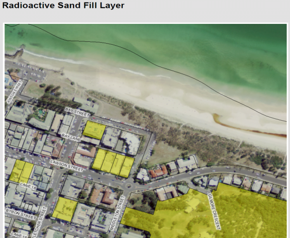
Figure 1 – Subject site shown in yellow as containing
possible radioactive sand fill
It is noted that on 29 April 2015 the applicant submitted a
brief assessment which was not prepared in accordance with the relevant NSW
Guidelines for SEPP No.55 (Remediation of land).
It is also important to note that Section 145B (Exemption from
liability - contaminated land)
of the Environmental Planning and Assessment Act 1979, states, (in
part):
(1) A
planning authority does not incur any liability in respect of anything done or
omitted to be done in good faith by the authority in duly exercising any
planning function of the authority to which this section applies in so far as
it relates to contaminated land (including the likelihood of land being
contaminated land) or to the nature or extent of contamination of land.
(2) This
section applies to the following planning functions:
(c) the
processing and determination of a development application and any application
under Part 3A or Part 5.1,
(d) Without
limiting any other circumstance in which a planning authority may have acted in
good faith, a planning authority is (unless the contrary is proved) taken to
have acted in good faith if the thing was done or omitted to be done
substantially in accordance with the contaminated land planning guidelines in
force at the time the thing was done or omitted to be done.
(e) This
section applies to and in respect of:
(a) a councillor,
and
(b) an employee of
a planning authority, and
(c) a public
servant, and
(d) a person
acting under the direction of a planning authority,
in the same way as it applies
to a planning authority.
As advised in Section 145B
of the Environmental Planning and Assessment Act 1979, Council may
incur liability if it were to grant consent to the proposed development without
acting substantially in accordance with the current contaminated land planning
guidelines.
3.2 BYRON
LOCAL ENVIRONMENTAL PLAN 2014
Zone: B2 Local Centre
Definition: Hotel or motel accommodation
|
LEP Summary of Requirement
|
Proposed
|
Complies
|
|
Zone B2 Local Centre
1 Objectives
of zone
•
To provide a range of retail, business, entertainment and community uses that
serve the needs of people who live in, work in and visit the local area.
•
To encourage employment opportunities in accessible locations.
•
To maximise public transport patronage and encourage walking and cycling.
•
To encourage vibrant centres by allowing residential and tourist and visitor
accommodation above commercial premises.
|
The proposed development is considered to be generally
consistent with the objectives of the B2 Local Centre Zone.
|
Yes
|
|
Permissibility
hotel or motel accommodation means a
building or place (whether or not licensed premises under the Liquor Act 2007) that
provides temporary or short-term accommodation on a commercial basis and
that:
(a) comprises rooms or self-contained suites,
and
(b) may provide meals to guests or the general
public and facilities for the parking of guests’ vehicles,
but does not include backpackers’ accommodation, a
boarding house, bed and breakfast accommodation or farm stay accommodation.
|
The proposed hotel or motel accommodation is permissible
with the consent of Council within the B2 Local Centre Zone.
|
Yes
|
|
2.7 Demolition
requires development consent
The demolition of a building or work may be carried out
only with development consent.
|
This application seeks consent for the demolition of the
existing motel.
|
Yes
|
|
4.3 Height
of buildings
(1) The objectives of this clause are as follows:
(a) to achieve building design that does not
exceed a specified maximum height from its existing ground level to finished
roof or parapet,
(b) to ensure the height of buildings
complements the streetscape and character of the area in which the buildings
are located,
(c) to minimise visual impact, disruption of
views, loss of privacy and loss of solar access to existing development.
(2) The height of a building on any land is not to
exceed the maximum height shown for the land on the Height of Buildings Map. The Height of
Buildings Map provides the maximum height limit of 9.0 metres for the
subject site.
|
Maximum roof height (excluding lift tower) 13.03m AHD
lowest level below 2.39m AHD. Maximum height calculated to be 10.64m.
|
No*
(*See assessment following this Table)
|
|
4.4 Floor
space ratio
(2) The maximum floor space ratio for a building on
any land is not to exceed the floor space ratio shown for the land on the Floor Space Ratio Map. The FSR Map identifies
the site to have a maximum FSR of 1.3:1.
|
Gross floor area calculations by level: Ground
level 398.0m2 First
Floor 470.7m2
Second Floor 470.7
m2
Total
GFA 1339.4m2
Site area 1013m2/ GFA 1339.4m2.
Proposed FSR is 1.322:1
|
No*
(*See assessment following this Table)
|
|
4.6
Exceptions to development standards
(1) The objectives of this clause are as follows:
(a) to provide an
appropriate degree of flexibility in applying certain development standards
to particular development,
(b) to achieve
better outcomes for and from development by allowing flexibility in
particular circumstances.
|
See assessment following this table.
|
No
|
|
5.5 Development
within the coastal zone
Development consent must not be granted to development on
land that is wholly or partly within the coastal zone unless the consent
authority has considered the matters within Clause 5.5 and is satisfied with
regard to the matters in Clause 5.5.
|
The proposed development is considered to be acceptable
with regard to the matters for consideration within the coastal zone.
|
Yes
|
|
6.1 Acid
sulfate soils
(1) The objective of this clause is to ensure that
development does not disturb, expose or drain acid sulfate soils and cause
environmental damage.
(2) Development consent is required for the carrying
out of works described in the table to this subclause on land shown on the Acid Sulfate Soils Map as being of the class
specified for those works.
|
Class of land
|
Works
|
|
5
|
Works within 500 metres of adjacent Class 1, 2, 3 or 4
land that is below 5 metres Australian Height Datum and by which the
watertable is likely to be lowered below 1 metre Australian Height Datum on
adjacent Class 1, 2, 3 or 4 land.
|
(3) Development consent must not be granted under
this clause for the carrying out of works unless an acid sulfate soils
management plan has been prepared for the proposed works in accordance with
the Acid Sulfate Soils Manual and has been provided to the consent authority.
(4) Despite subclause (2), development consent is
not required under this clause for the carrying out of works if:
(a) a preliminary assessment of the proposed
works prepared in accordance with the Acid Sulfate Soils Manual indicates
that an acid sulfate soils management plan is not required for the works, and
(b) the preliminary assessment has been
provided to the consent authority and the consent authority has confirmed the
assessment by notice in writing to the person proposing to carry out the
works.
...
(6) Despite subclause (2), development consent is not
required under this clause to carry out any works if:
(a) the works involve the disturbance of less
than 1 tonne of soil, and
(b) the works are not likely to lower the
watertable.
|
The subject site is identified as containing Class 5 acid
sulfate soils by Council’s LEP 2014 mapping. The proposal involves
excavation for a two level basement. The applicant has not submitted a preliminary
assessment of the proposed works to demonstrate that an acid sulfate soils
management plan is not required. As such consent must not be granted under
Clause 6.1.
|
No
|
|
6.2 Earthworks
(1) The objective of this clause is to ensure that
earthworks for which development consent is required will not have a
detrimental impact on environmental functions and processes, neighbouring
uses, cultural or heritage items or features of the surrounding land.
(2) Development consent is required for earthworks
unless the earthworks are exempt development under this Plan or another
applicable environmental planning instrument.
(3) In deciding whether to grant development consent
for earthworks (or for development involving ancillary earthworks), the
consent authority must consider the following matters:
(a) the likely disruption of, or any
detrimental effect on, drainage patterns and soil stability in the locality
of the development,
(b) the effect of the development on the likely
future use or redevelopment of the land,
(c) the quality of the fill or the soil to be
excavated, or both,
(d) the effect of the development on the existing
and likely amenity of adjoining properties,
(e) the source of any fill material and the
destination of any excavated material,
(f) the likelihood of disturbing relics,
(g) the proximity to, and potential for adverse
impacts on, any waterway, drinking water catchment or environmentally
sensitive area,
(h) any appropriate measures proposed to avoid,
minimise or mitigate the impacts of the development.
|
A large amount of excavation is associated with the
construction of the proposed two level basement. The environmental
impacts of the proposed excavation have not been able to be adequately
assessed in the absence of information on matters such as acid sulphate
soils, dewatering and land contamination.
|
No
|
|
6.3 Flood
planning
(1) The objectives of this clause are as follows:
(a) to minimise the flood risk to life and
property associated with the use of land,
(b) to allow development on land that is
compatible with the land’s flood hazard, taking into account projected
changes as a result of climate change,
(c) to avoid significant adverse impacts on
flood behaviour and the environment.
(2) This clause applies to land at or below the
flood planning level.
(3) Development consent must not be granted to
development on land to which this clause applies unless the consent authority
is satisfied that the development:
(a) is compatible with the flood hazard of the
land, and
(b) will not significantly adversely affect
flood behaviour resulting in detrimental increases in the potential flood
affectation of other development or properties, and
(c) incorporates appropriate measures to manage
risk to life from flood, and
(d) will not significantly adversely affect the
environment or cause avoidable erosion, siltation, destruction of riparian
vegetation or a reduction in the stability of river banks or watercourses,
and
(e) is not likely to result in unsustainable
social and economic costs to the community as a consequence of flooding.
(4) In determining a development application for
development at or below the future flood planning level, the consent
authority must, in addition to the matters referred to in subclause (3), also
consider the following matters:
(a) the proximity of the development to the
current flood planning area,
(b) the intended design life and scale of the
development,
(c) the sensitivity of the development in
relation to managing the risk to life from any flood,
(d) the potential to modify, relocate or remove
the development.
(5) A word or expression used in this clause has the
same meaning as it has in the Floodplain Development Manual (ISBN 0
7347 5476 0) published by the NSW Government in April 2005, unless it
is otherwise defined in this clause.
|
The proposed development is capable of complying with the
flood planning controls in Clause 6.3. The proposed ground floor level
exceeds the flood planning level of 3.17 AHD by 0.61m.
|
Yes
|
|
6.6 Essential
services
Development consent must not be granted to development
unless the consent authority is satisfied that any of the following services
that are essential for the development are available or that adequate
arrangements have been made to make them available when required:
(a) the supply of water,
(b) the supply of electricity,
(c) the disposal and management of sewage,
(d) stormwater drainage or on-site
conservation,
(e) suitable vehicular access.
|
The essential services identified in Clause 6.6 are
available.
|
Yes
|
3.2.1 Byron Local Environmental Plan 2014 –
Exceptions to
development standards Clause 4.6 Assessment
1. Non-compliance
with Clause 4.3 Height of buildings (Clause 4.6 assessment)
Clause 4.6(3) specifies:
(3) Development
consent must not be granted for development that contravenes a development
standard unless the consent authority has considered a written request from the
applicant that seeks to justify the contravention of the development standard
by demonstrating:
(a) that
compliance with the development standard is unreasonable or unnecessary in the circumstances
of the case, and
(b) that
there are sufficient environmental planning grounds to justify contravening the
development standard.
Assessment: A written
request has been submitted by the applicant seeking to justify a building
height of 10.09m on the subject site. The maximum height of the proposed
building is 10.64m, not 10.09m as stated in the written request. The proposed
building is 1.64m higher than the 9.0m height control (a non-compliance of
18.2%).
It is considered that the
development standard (height of buildings) has not been demonstrated to be
unreasonable or unnecessary in the circumstances of this case. The applicant
has also not demonstrated there are sufficient environmental planning grounds
to justify the contravention. The applicant has provided matters to justify the
proposed contravention and the relevant matters are assessed as follows:
- The
height of the existing building at No.35 Lawson Street is 14.14m. The
development consent (DA 5.1993.167.1) for the increased height of this building
was granted in 1993 under a different height control. The existing building at
No 35 Lawson Street, has a sloping roofline containing only smaller
‘attic’ areas above the former 7.5m limit. Council previous DCP set
a 7.5m height limit measured at the top-plate of the outer walls of the
building (not the roofline). No.35 Lawson Street is also a corner allotment
which may allow for height increase.
- Development
application 10.2014.361.1 allowed alterations and additions to the building at
No.35 Lawson Street to reach a height of 13.03m. This application involved
lowering the height of the existing building from the existing 14.14m to
13.03m. It is also noted these approved alterations and additions have not been
commenced.
- The
applicant has stated the additional height of the building is a direct result
of the flood prone nature of the site and the need to elevate the ground floor
to Council’s flood level plus freeboard. This is not correct, the
additional floor height to satisfy Council’s flood planning level is
approximately 0.77m, whilst the proposed height non-compliance is 1.64m.
- The applicant notes that
the proposed development will not adversely impact on the streetscape in view
of other existing buildings including those on the opposite side of Lawson
Street. The proposed increase in height and bulk of the building is not
considered to be compatible with the streetscape. It is considered the relevant
streetscape assessment involves only the northern side Lawson Street between
Middleton Street and Fletcher Street. The streetscape drawing submitted does
not establish the relevant streetscape within the 9.0m height control area. Any
reference to buildings on the opposite side of Lawson Street is not considered
relevant as the height limit there is 11.5m.
(4)
Development consent must not be granted for development that contravenes a
development standard unless:
(a) the consent
authority is satisfied that:
(i) the
applicant’s written request has adequately addressed the matters required
to be demonstrated by subclause (3), and
Assessment: It is
considered that the applicant’s written request contains miscalculations
and does not adequately address the matters as required by subclause 3.
(ii) the
proposed development will be in the public interest because it is consistent
with the objectives of the particular standard and the objectives for
development within the zone in which the development is proposed to be carried
out, and
Assessment: The
objectives of Clause 4.3 (height of buildings) are as follows:
(a) to
achieve building design that does not exceed a specified maximum height from
its existing ground level to finished roof or parapet,
(b) to
ensure the height of buildings complements the streetscape and character of the
area in which the buildings are located,
(c) to
minimise visual impact, disruption of views, loss of privacy and loss of solar
access to existing development.
(2)
The height of a building on any land is not to exceed the maximum height shown
for the land on the Height of Buildings Map.
It is considered the proposed
height of the building does not satisfy the objectives of Clause 4.3. The proposed
building height is considered to be excessive in the relevant streetscape. The
proposed development is considered to be generally consistent with the
objectives of the B2 Local Centre Zone as these objectives do not refer to
built form.
(b) the
concurrence of the Director-General has been obtained.
Assessment: Concurrence of
the Director-General is able to be assumed for non-compliances with Clauses 4.6
(pursuant to Planning Circular 08-003).
2. Non-compliance
with Clause 4.4 Floor space ratio (Clause 4.6 assessment)
Clause 4.6(3) specifies:
(3) Development
consent must not be granted for development that contravenes a development
standard unless the consent authority has considered a written request from the
applicant that seeks to justify the contravention of the development standard
by demonstrating:
(a) that
compliance with the development standard is unreasonable or unnecessary in the
circumstances of the case, and
(b) that
there are sufficient environmental planning grounds to justify contravening the
development standard.
Assessment: It is
considered that the development standard (floor space ratio) has not been
demonstrated to be unreasonable or unnecessary in the circumstances of this
case. The applicant has also not demonstrated there are insufficient
environmental planning grounds to justify the contravention. The applicant has
provided the following comments in an attempt to justify the proposed
contravention, which are assessed below:
- “The
proposed variation is minor as it only requests a 1.7% variation.”
The proposed 1.7% variation
represents an additional 22.5m2 of gross floor area.
- The
degree if variation will represent no material change in the building (sic)
The deletion of 22.5m2
of gross floor area would result in a material change in the proposed building.
- There
are no additional bulk and scale impacts as a result of the minor
non-compliance.
The proposed additional 22.5m2
of gross floor area increases the bulk of the building. The proposed increased
floor area is also exacerbated by the substantial height non-compliance of the
building.
- The
proposed variation results in better internal amenity for the proposal.”
No evidence or explanation has
been submitted by the applicant to support the above claim. The deletion of one
motel room would be sufficient to satisfy the maximum FSR maintaining the
internal amenity.
(4)
Development consent must not be granted for development that contravenes a
development standard unless:
(a) the consent
authority is satisfied that:
(i) the
applicant’s written request has adequately addressed the matters required
to be demonstrated by subclause (3), and
Assessment: It is
considered that the applicant’s written request does not adequately
address the matters required to be demonstrated in subclause 3 as detailed.
(ii) the
proposed development will be in the public interest because it is consistent
with the objectives of the particular standard and the objectives for
development within the zone in which the development is proposed to be carried
out, and
Assessment: The
objectives of Clause 4.4 (floor space ratio) are as follows:
(a) to
ensure that new buildings are appropriate in relation to the character, amenity
and environment of the locality,
(b) to
enable a diversity of housing types by encouraging low scale medium density
housing in suitable locations,
(c) to
provide floor space in the business and industrial zones adequate for the
foreseeable future,
(d) to
regulate density of development and generation of vehicular and pedestrian
traffic,
(e) to
set out maximum floor space ratios for dual occupancy in certain areas.
(2)
The maximum floor space ratio for a
building on any land is not to exceed the floor space ratio shown for the land
on the Floor Space Ratio Map.
It is considered the proposed FSR
of the building does not satisfy the objectives of Clause 4.4.
(b) the
concurrence of the Director-General has been obtained.
Assessment: Concurrence of
the Director-General is able to be assumed for non-compliances with Clauses 4.6
(pursuant to Planning Circular 08-003)
3.2.2 Draft EPI that is or has been placed on
public exhibition and details of which have been notified to the consent
authority
No relevant Draft Environmental Planning Instruments have
been identified.
3.3 DEVELOPMENT
CONTROL PLAN
|
Byron
Development Control Plan 2014
|
|
Control
|
Assessment
|
Compliance
|
|
Chapter B11 Planning for Crime
Prevention
|
|
B11.2.1 Development that Requires a Formal Crime Risk
Assessment
1. Council will expect
a formal Crime Risk Assessment for the following types of development:
…….
other developments that, in the
Council’s opinion, are likely to create a risk of crime.
2. Development Applications
for the proposals listed in 1. above must be accompanied by a formal Crime
Risk Assessment prepared by or on behalf of the applicant in accordance with
NSW Police Force guidelines. The Crime Risk Assessment shall:
a) assess the
crime risk characteristics of the area;
b) make
provision in the design process to minimise crime risk; and
c) address the
CPTED principles as they apply to the proposed development.
|
The proposed two level
basement car park may provide an increased crime risk area. The submitted
statement of Environmental Effects has not addressed Planning for Crime
Prevention.
Should the application have
been considered favourably further details would have been requested with
regard to planning for crime prevention.
|
No
|
|
Chapter B12 Social Impact Assessment
|
|
B12.1.3 Application of
this Chapter
A Social Impact Assessment (SIA) is required for
tourist and visitor accommodation for 50 or more persons.
A Social Impact Assessment must be conducted and certified by a
suitably qualified person and in manner prescribed in Chapter B12.
|
The application has not
submitted a Social Impact Assessment.
|
No
|
|
Chapter D3 – Tourist Accommodation
|
|
D3.2.1 Location and Siting
The siting, design and operation of tourist accommodation and
associated development must not adversely affect important conservation
values, ecological systems or characteristics of the site or the Shire.
Development must respect and contribute to the natural environmental systems
and values of its location and surrounds.
|
The
proposed design of the development involves two levels of basement parking.
It has not been demonstrated that the proposed development will not adversely
affect conservation values and respect the natural environment.
|
No
|
|
Development applications for proposals located in or near
ecologically sensitive areas, areas of high conservation values and/ or
important natural features or sites must include a full description of those
ecological, conservation and natural values and systems, together with a
comprehensive, professional assessment of the impact of the proposed
development thereon. The impact assessment must include an evaluation of the
effectiveness and sustainability of any proposed amelioration and management
measures.
|
The
site is located in an ecologically sensitive area in terms of acid sulphate
soils and groundwater. The application does not include a full description of
those ecological, conservation and natural values and systems, together with
a comprehensive, professional assessment of the impact of the proposed
development thereon.
|
No
|
|
D3.2.4 Character and Design in Business and Mixed Use
Zones
Tourist accommodation in Zones B1, B2 and B4 must be compatible in character and
amenity with development in the locality. The provisions of the following
Sections in Chapter D4 Commercial and Retail Development apply to all tourist
accommodation development in Zones B1, B2 and B4 in the same way they apply
to commercial and retail development in Business and Mixed Use zones:
Section D4.2.1 – Design Character of Retail and Business
Areas.
Section D4.2.2 – Design Detail and Appearance.
|
Noted.
|
Yes
|
|
D3.3.6 Hotel or Motel Accommodation
The design and operation of hotel or motel accommodation must be
compatible with the streetscape and character of development in the locality.
Development applications must demonstrate that the proposed
development will be appropriately designed and landscaped consistent with the
requirements of Chapters B11 Planning for Crime Prevention and B9
Landscaping.
Hotel or motel accommodation development must not adversely affect the amenity of the
precinct in which it is located. Development applications may need to be
accompanied by a Social Impact Assessment prepared pursuant to Chapter B12
Social Impact Assessment, where applicable.
External pedestrian access must be provided between
accommodation units and other facilities associated with the development,
including car parking. The access must comprise covered connecting pathways
or access balconies with an all-weather surface and must be integrated with
the overall landscape plan for the development.
Motels must incorporate eating and living areas and facilities,
together with outdoor recreation/ living areas with access to winter sun and
summer shade. They may also include self-contained cooking facilities.
Development must be designed and constructed to minimise noise
and vibration impacts on occupants of adjoining or nearby dwellings or
buildings.
|
The
proposed excessive height and excessive bulk of the proposed building is not
considered to be compatible with the streetscape on
the
northern side of Lawson Street between
Middleton Street and
Fletcher
Street.
The
applicant has not demonstrated compliance with Chapters B11 Planning for
Crime Prevention or Chapter B9 Landscaping.
The
applicant has not satisfied the requirements for Social Impact Assessment
detailed in Chapter B12.
Pedestrian
access is provided between accommodation units and other facilities including
car parking.
|
No
|
|
D4.2.2 Design Detail and Appearance
The design of new buildings must reflect and enhance the
existing character of the precinct. The design, scale, bulk, design and
operation of business, commercial and retail
development must be compatible with the streetscape and with the aesthetics,
function and amenity of development in the locality.
Building
design, roof profile, detailing, colours, materials and the like that are
visible from the street and from adjoining properties must be compatible with
any dominant design themes in the surrounding locality.
The
pattern of windows in retail areas must provide visual interest and variation
and must relate to those of adjacent buildings. Building materials must
relate to the context of buildings within the area to achieve continuity and
harmony. Contrasting materials may be used to provide diversity, however
materials and colour must not be used so that they dominate the streetscape.
|
The
design, bulk and scale of this development is not compatible with the
streetscape on the northern side of Lawson Street between Middleton Street
and Fletcher Street.
|
No
|
|
Chapter D8 - Public Art
|
|
D8.2.1 Provision of Public Art
1. Development
to which this Section applies must include the provision of public art to the
value of at least 2% of the total development cost (calculated in accordance
with the Environmental Planning & Assessment Regulation) up to a
maximum of $25,000, as an integral part of the development.
2. The
public art must be permanent and durable, and must be provided in a location
on the development site that is freely accessible to members of the public or
clearly visible from the public domain.
3. Details
of the proposed public art must be submitted as part of the Development
Application documentation. The documentation must include details of the
nature and form of the proposed public art; and must define and illustrate
its intended location and approximate size.
4. The
documentation must also demonstrate how the proposed public art meets the
following Design Selection Criteria:
a) relevance
and appropriateness of the work in relation to its site;
b) relevance
and appropriateness of the work to Byron Shire, including the Shire’s
Aboriginal heritage, its particular natural environment and its diverse
culture;
c) consistency
with the Byron Shire Cultural Plan and Public Art Policy;
d) consideration
of public safety, including public use of and access to the public art and
associated space;
e) consideration
of maintenance and durability, including potential for vandalism;
f) evidence
of funding sources and satisfactory budget, including provision for ongoing
maintenance; and
g) evidence
of Public Liability Insurance to cover construction and installation of the
work.
|
The proposed development
triggers the need to provide public art in accordance with Chapter D8. Should
the application have been considered favourably a condition would have been
imposed to require public art be provided in accordance with Chapter D8.
Details of the proposed public
art were not submitted as part of the Development Application
documentation.
|
No
|
|
Section B8 Waste Minimisation and Management
|
|
A Site Waste Minimisation
and Management Plan (SWMMP) is to be submitted with a Development
Application and must show all matters specified within Section B8.4.
|
Should the application have
been considered favourably a condition would have been included to require
the submission of a SWMMP generally in accordance with B8.4.2.
|
No
|
|
Chapter B4 Traffic Planning, vehicle parking,
circulation and access
|
|
B4.2.5 Car Parking
Requirements
1. Unless
otherwise specified elsewhere in this DCP, car parking is to be provided in
accordance with the schedule contained in Table B4.1
Food and drink premises require one (1)
parking space required per 20m2 of GFA in Business Zone.
|
The proposed number of
parking spaces and the access arrangements has been assessed as satisfactory.
|
Yes
|
|
Chapter E5 Certain
Locations in Byron Bay and Ewingsdale
|
|
E5.4.1 Development and servicing of land affected by
predicted coastal hazards
All services must be provided from the landward side of the
development such that the building is between the services and the erosion
escarpment.
Development within the ‘Coastal Erosion Hazard Area’
on the Byron Bay Coastal Hazards Map (E5.1) will be considered on the
understanding that any consent granted will be subject to the proviso that
should the erosion escarpment come within 50 metres of any building
then the development consent will cease.
If the development consent does cease then the owner of the land
will be responsible for the removal of all buildings.
The option of demolition as the means of removal will be
available to all buildings.
Prior to the issue of a Construction Certificate a restriction
as to user must be placed on the title pursuant to the provisions of
section 88E of the Conveyancing Act 1919, stating:
“The subject land and any
improvements erected thereon must not be used for the purpose of (land use)
in the event that the erosion escarpment as defined by the Works and Services
Director of the Council of the Shire of Byron from time to time comes to within
50 metres of any buildings or any part thereof at any time erected on the
said land’.
|
Should the application have
been recommended for approval a condition would been included to require the
A Section 88E instrument to be placed on the title of the land to cease use
when the erosion escarpment comes within 50m of the site.
|
Yes
|
3.4 The likely impacts of that
development, including environmental impacts on both the natural and built
environments, and social and economic impacts in the locality
Built Environment
The proposed development is considered to be excessive in
terms of height, bulk and scale. The proposed building is not considered to be
compatible with the built environment as detailed in Section 3.2.1 of this
report.
Natural Environment
A large amount of excavation is associated with the
construction of the proposed two level basement. The environmental
impacts of the proposed excavation have not been able to be adequately assessed
in the absence of information on matters such as acid sulphate soils,
dewatering and land contamination.
Social and economic impacts
The proposed development is considered to be acceptable with
regard to social and economic impacts in the locality.
3.5 The
suitability of the site for the development
The site is also located within the coastal erosion zone,
should the application have been recommended for approval a condition would
have been imposed to address this issue.
3.6 Submissions made in accordance
with this Act or the regulations
The application was notified / advertised in accordance with
the Level 2 provisions of Council’s DCP 2014 Part A14 - Public
Notification and Exhibition of Development Applications. The exhibition period
occurred from 6 January 2015 to 19 January 2015. Council’s records
indicate that no submissions were received.
3.7 Public
interest
The proposed development is considered to be contrary to the
public interest as the development significantly exceeds the height limit
prescribed by the local planning instrument which has been the subject of an
extensive community consultation process.
4. DEVELOPER
CONTRIBUTIONS
4.1 Water
& Sewer Levies
ET assessment
|
Development
|
Number
|
ET Rate
|
ET
|
|
Water
|
Sewer
|
Water
|
Sewer
|
|
1 bedroom motel units
Ref 6.4
|
43
|
0.30 / bedroom
|
0.45 / bedroom
|
12.9
|
19.35
|
|
Office
Ref 8.4
|
9.8 m2
|
0.01 / m2
|
0.004 / m2
|
0.098
|
0.0392
|
|
Swimming pool – Indoor
Ground Floor
|
Assumed
3m x14m
@1.5m deep
|
Using Swimming pool calculator #E2015/9848
|
0.76
|
0.51
|
|
Swimming pool – Indoor
Top Floor
|
Assumed
2m x 14m
@1.5m deep
|
Using Swimming pool calculator #E2015/9848
|
0.66
|
0.51
|
|
Swimming pool – Outdoor
Top Floor
|
Assumed
12m x 3m
@1.5m deep
|
Using Swimming pool calculator #E2015/9848
|
0.72
|
0.51
|
|
TOTAL
|
15.138
|
20.9192
|
Therefore this development generates an additional load of:
· 15.14 – 3.50
(credit) = 11.64 ET for Water & Bulk Water;
· 20.92 – 5.05
(credit) = 15.87 ET for Sewer.
NB: figures are from the current Water and Sewer Equivalent
Tenements Policy (13/005).
Had the application been recommended for approval it would
require payment of Developer Servicing Charges of:
· 11.64 ET
onto Councils Water & Bulk Water;
· 15.87 ET
onto Councils Sewer.
4.2 Section
94 Contributions
Had the application been recommended for approval a
condition would have been included to require payment of the Section 94A levy.
5. CONCLUSION
A review of Council’s
radioactive sand fill mapping identifies the subject site is likely to contain
radioactive sand fill which could be disturbed as the proposal involves
substantial excavation for two levels of basement parking. SEPP No.55 specifies
that Council must not grant consent unless it has assessed if the land is
contaminated. It is also noted that Council may be liable if consent were
to be granted without acting substantially in accordance with the
‘contaminated land planning guidelines’ pursuant to Section 145B (Exemption from liability -
contaminated land) of the Environmental
Planning and Assessment Act 1979.
The proposal is non-compliant with the provisions of Byron
LEP 2014 Clause 4.3 (Height of buildings), Clause 4.4 (Floor space ratio),
Clause 6.1 (Acid sulfate soils) and Clause 6.2 (Earthworks).
The proposed building with a maximum height of 10.64m
exceeds the 9.0m height limit by 1.64m (a non-compliance of 18.2%). The
proposal exceeds the maximum floor space ratio by 22.5m2 (a
non-compliance of 1.7%). Whilst the applicant has submitted a written request
to vary the maximum height and floor space ratio pursuant to Clause 4.6
(Exceptions to development standards), the applicant has not demonstrated that
compliance with height limit or floor space ratio is unreasonable or
unnecessary.
The subject site is identified as containing Class 5 acid
sulfate soils by Council’s LEP 2014 mapping. The applicant has not
submitted a preliminary assessment of the proposed works to demonstrate that an
acid sulfate soils management plan is not required. As such development consent
must not be granted in accordance with Clause 6.1 Byron LEP 2014.
The proposal is also considered to be inconsistent with
Byron DCP 2014 controls relating to the
height, bulk, scale, social impact assessment and environmental impacts for tourist
accommodation.
Overall the applicant has failed to submit essential
information to support the proposed development. The proposed 1.64m
non-compliance with the maximum height limit has not been adequately justified
by the applicant. The proposed development is considered to have insufficient
planning merit and it is recommended that the application be refused consent.
6. RECOMMENDATION
It is recommended
that pursuant to Section 80 of the Environmental Planning & Assessment Act
1979, development application no. 10.2014.742.1 for demolition of existing single-storey motel building and erection
of a three (3) storey motel accommodation building plus two (2) levels of
basement parking, be refused for the
following reasons:
1. Pursuant to Section 79C(1)(a)(i) of the Environmental
Planning and Assessment Act 1979, the height of the proposed building
exceeds the maximum height shown for the land on the Height of Buildings Map,
contrary to Clause 4.3 of Byron Local Environmental
Plan 2014. 2.
2. Pursuant to Section 79C(1)(a)(i) of the Environmental
Planning and Assessment Act 1979, the floor space ratio of the
proposed building exceeds the floor space ratio shown for the land on the Floor Space Ratio Map,
contrary to Clause 4.4 of Byron Local Environmental Plan 2014.
3. Pursuant to Section 79C(1)(a)(i) of the Environmental
Planning and Assessment Act 1979, an acid sulfate soils management
plan (or a preliminary assessment) has not been provided to Council, in accordance with Clause 6.1 of Byron Local Environmental
Plan 2014 development consent must not be granted.
4. Pursuant to Section 79C(1)(a)(i) of the Environmental
Planning and Assessment Act 1979, it has not been demonstrated that the
subject land is not contaminated and in accordance with Clause 7
of State Environmental Planning Policy No.55 (Remediation of land). Council
must not consent to the carrying out of any development on land unless it has
determined whether the land is contaminated or suitable for the purpose.
5. Pursuant to Section 79C(1)(b) of the Environmental
Planning and Assessment Act 1979 the proposed height, bulk and scale of the
proposed building is likely to have a negative impact on the built environment
of the locality.
6. Pursuant to
Section 79C(1)(e) of the Environmental Planning and Assessment Act 1979,
the proposed development is considered to be contrary to the public interest in
terms of possible environmental impacts.
7. DISCLOSURE
OF POLITICAL DONATIONS AND GIFTS
|
Has a Disclosure Statement been received in relation to
this application
|
No
|
|
Have staff received a ‘gift’ from anyone
involved in this application that needs to be disclosed. Where the answer is
yes, the application is to be determined by the Director or Manager of the
Planning, Development and Environment Division.
|
No
|
Provide Disclosure Statement register details here: Nil.
Staff Reports - Sustainable Environment and Economy 13.7 - Attachment 2
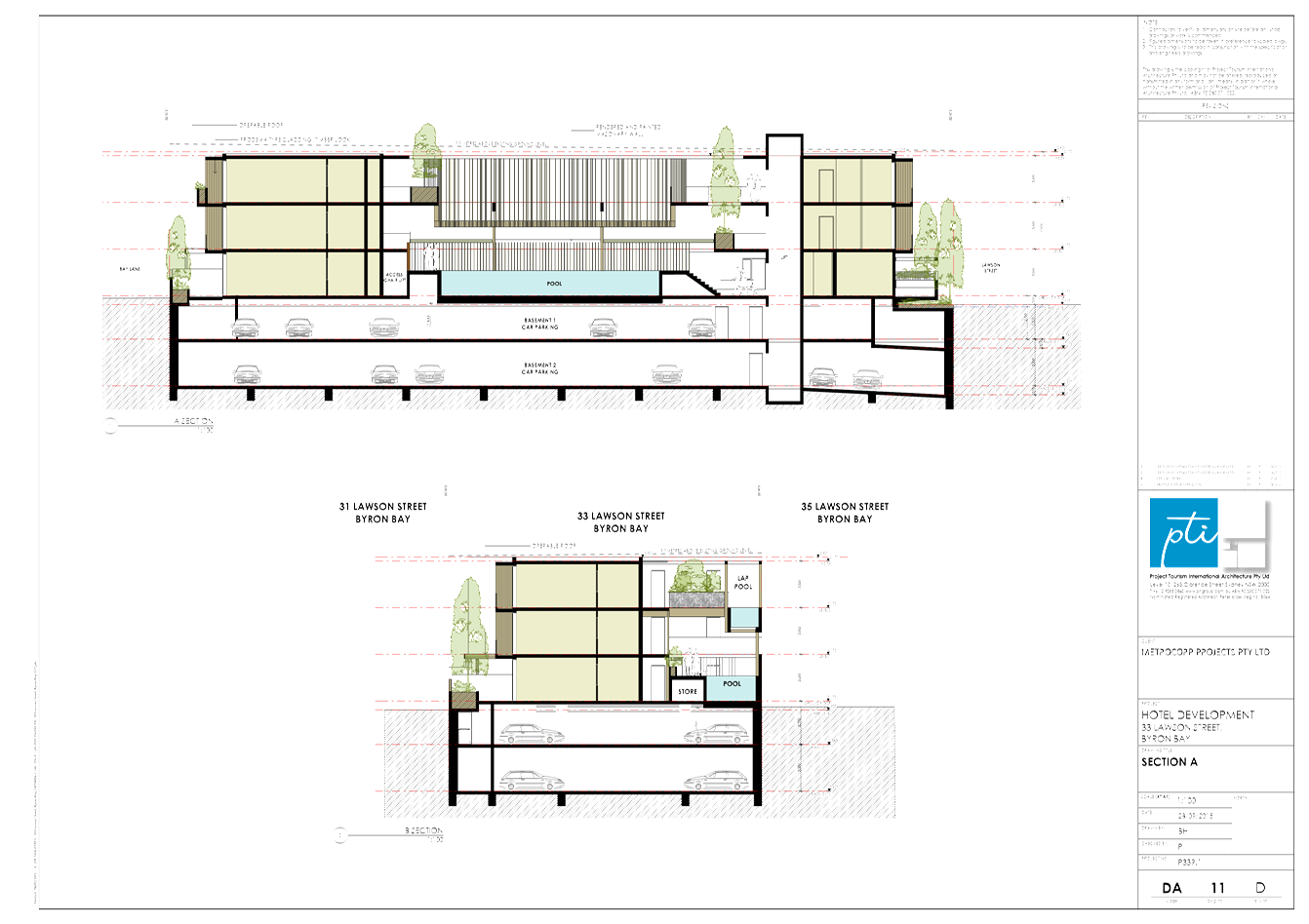
Staff Reports - Sustainable Environment and Economy 13.7 - Attachment 3
S82A Review 10.2014.742.1
Conditions
of consent:
Schedule
A - Deferred Commencement Condition/s pursuant to Section 80(3).
The following condition/s concern matters as to which the
Council must be satisfied before the consent can operate.
A. Acid Sulfate
Soils Management Plan
This consent does not operate until Council is satisfied that
acid sulphate soils can be appropriately managed during the construction of the
development.
To satisfy Council in this
matter, an acid sulphate soils management plan for the development, prepared in
accordance with the Acid Sulfate Soils Manual, must be submitted to Council for
approval which describes the following:
a) Description of the site, including maps;
b) Area of the site and area(s) of
disturbance;
c) Site attributes including site landform
and geology, details of any native vegetation, depth to watertable and likely
seasonal variation;
d) Maximum depth of excavation and level in
AHD, volume of soil to be excavated, timing of works, water quality testing,
calculated cone of depression;
e) Plan showing locations of all boreholes,
details of all sampling equipment, evidence of good materials handling
procedures and laboratory certification;
f) Full details of calculations used
to determine the liming rate or any other ameliorant;
g) Details of all measures to
avoid/minimise any disturbance of ASS and dewatering of excavations;
h) Details of measures to minimise the
oxidation exposure times of all ASS excavations and stockpiles;
i) Details of measures to
segregate, stockpile, treat and dispose of ASS and acid drainage waters,
including the provision of associated leachate and sediment control measures
and procedures;
j) Details of measures to
ensure that acid drainage waters are not discharged to Council’s
stormwater system nor any watercourse or drainage channel;
k) Details of measures to ensure that
management of ASS will be undertaken in accordance with the Acid Sulfate
Soil Manual (ASSMAC, 1998);
l) Details of measures to
ensure that any off-site disposal of ASS will be in accordance with the
‘NSW DECC (2008) Waste Classification Guidelines’;
m) Details of validation testing to confirm that
sufficient ameliorant has been incorporated into the ASS to prevent any future
acidification;
n) Names and contact details of persons
responsible;
o) Monitoring strategy; and
p) Contingency procedures.
The Plan must be prepared by a suitably qualified Environmental / Soil
Scientist and in accordance with the Acid Sulfate Soil Manual (ASSMAC
1998). This Plan must take into account the findings any approved Soils
and Water Management Plan and approved Acid Sulfate Soils Plan.
Evidence of compliance with the above conditions, sufficient
to satisfy the Council as to those matters, must be provided within 24 months
of this notice. If satisfactory evidence is produced in accordance with this
requirement, Council will give written notice to the applicant of the date from
which the consent operates.
If Council has not notified the applicant within a period of
28 days after the applicant’s evidence is produced to it, the Council is,
for the purposes only of Section 97 of the Environmental Planning and
Assessment Act 1979, taken to have notified the applicant that Council is not
satisfied as to those matters on the date on which that 28 day period expires.
Schedule B - Conditions pursuant to
Section 80(1)
Upon satisfaction of the deferred
commencement condition/s, the following conditions apply:
1. Development is to be
in accordance with approved plans
The development is to be in accordance
with plans listed below:
|
Ref No.
|
Description
|
Author
|
Date
|
|
DA 03 D
|
Ground Floor Plan
|
Project Tourism International Architects
|
6 July 2015
|
|
DA 04 E
|
Basement 2 Floor Plan
|
Project Tourism International Architects
|
28 September 2015
|
|
DA 05 E
|
Basement 1 Floor Plan
|
Project Tourism International Architects
|
28 September 2015
|
|
DA 06 C
|
First Floor Plan
|
Project Tourism International Architects
|
6 July 2015
|
|
DA 07 C
|
Second Flor Plan
|
Project Tourism International Architects
|
6 July 2015
|
|
DA 08 C
|
Roof Plan
|
Project Tourism International Architects
|
6 July 2015
|
|
DA 09 D
|
Elevations North + South
|
Project Tourism International Architects
|
6 July 2015
|
|
DA 10 D
|
Elevations East + West
|
Project Tourism International Architects
|
6 July 2015
|
|
DA 11 D
|
Section A
|
Project Tourism International Architects
|
28 September 2015
|
|
DA 12 D
|
Section C
|
Project Tourism International Architects
|
28 September 2015
|
2. Compliance with
Building Code of Australia and insurance requirements under the Home Building
Act 1989
(1) For
the purposes of section 80A (11) of the Act, the following conditions are
prescribed in relation to a development consent for development that involves
any building work:
(a) that the work must be carried
out in accordance with the requirements of the Building Code of Australia ,
(b) in the case of residential
building work for which the Home Building Act 1989
requires there to be a contract of insurance in force in accordance with Part 6
of that Act, that such a contract of insurance is in force before any building
work authorised to be carried out by the consent commences.
(2) This clause
does not apply:
(a) to the extent to which an
exemption is in force under clause 187 or 188, subject to the terms of any
condition or requirement referred to in clause 187 (6) or 188
(4), or
(b) to the erection of a temporary
building.
(3) In this clause,
a reference to the Building Code of Australia is a reference to that Code as in
force on the date the application for the relevant construction
certificate is made.
3. Erection of signs
(1) For the purposes
of section 80A (11) of the Act, the requirements of subclauses (2)
and (3) are prescribed as conditions of a development consent for development
that involves any building work, subdivision work or demolition work.
(2) A sign must be
erected in a prominent position on any site on which building work, subdivision
work or demolition work is being carried out:
(a) showing the name, address and
telephone number of the principal certifying authority for the work, and
(b) showing the name of the
principal contractor (if any) for any building work and a telephone number on
which that person may be contacted outside working hours, and
(c) stating that unauthorised entry
to the work site is prohibited.
(3)
Any such sign is to be maintained while the building work, subdivision work or
demolition work is being carried out, but must be removed when the work has
been completed.
(4) This
clause
does not apply in relation to building work, subdivision work or demolition
work that is carried out inside an existing building that does not affect the
external walls of the building.
(5) This
clause
does not apply in relation to Crown building work that is certified, in
accordance with section 109R of the Act, to comply with the technical
provisions of the State’s building laws.
(6) This
clause
applies to a development consent granted before 1 July 2004 only if the
building work, subdivision work or demolition work involved had not been
commenced by that date.
Note: Principal certifying authorities and principal
contractors must also ensure that signs required by this clause are erected and
maintained (see clause 227A which currently imposes a maximum penalty of
$1,100).
4. Shoring and adequacy
of adjoining property
(1) For
the purposes of section 80A (11) of the Act, it is a prescribed condition of development
consent that if the development involves an excavation that extends below the
level of the base of the footings of a building, structure or work (including
any structure or work within a road or rail corridor) on adjoining land, the
person having the benefit of the development consent must, at the
person’s own expense:
(a) protect and support the building, structure
or work from possible damage from the excavation, and
(b) where necessary, underpin the building,
structure or work to prevent any such damage.
(2) The
condition referred to in subclause (1) does not apply if the person having the
benefit of the development consent owns the adjoining land or the owner of the
adjoining land has given consent in writing to that condition not applying.
The following conditions are to be
complied with prior to issue of a Construction Certificate for demolition works
5. Remediation of
contaminated land
The application for a
construction certificate must be accompanied by a Detailed Contaminated Land Assessment
and Remedial Action Plan prepared by a suitably qualified contaminated land
specialist with experience in the remediation of contaminated land. The
Remedial Action Plan must conform to NSW
EPA Guidelines for Consultants Reporting on Contaminated Sites 1997 and
all other applicable standards.
The Remedial Action Plan
must be approved as part of the Construction Certificate for Demolition.
The following conditions are to be
complied with prior to issue of a Construction Certificate for building works
6. Public Art
Details of publicly visible public
art proposed to be installed are to be provided to Council for assessment to
ensure its validity, appropriateness, location and value of a minimum
$25,000.00.
7. Section 94A Levy to
be paid
Prior to the issue of a construction certificate the section
94A levy required by the Byron Developer Contributions Plan 2012 shall be paid
to Council.
The levy will be calculated as follows:
Levy payable = %C x $C
Where:
%C is
the levy rate applicable as set out in the latest Ministerial Direction issued
under section 94E of the Environmental Planning and Assessment Act 1979.
$C is
the proposed cost of carrying out the development.
The rate of %C is:
|
Proposed
cost of the development
|
Maximum
percentage of the levy
|
|
Up to
$100,000
|
Nil
|
|
$100,001–$200,000
|
0.5 percent
|
|
More than $200,000
|
1.0 percent
|
The cost of development shall be shall be calculated in
accordance with clause 25J of the regulation and shall be set out in Schedule
2. A copy of completed Schedule 2 shall be submitted with the payment to
Council.
8. Certificate of
Compliance – Water Management Act 2000
A Certificate of Compliance will be issued on completion of
construction of water management works to serve the development and/or on
payment of developer charges for water and sewer as calculated in accordance
with Byron Shire Council and Rous Water Development Servicing Plans.
Byron Shire Council acts as Rous Water’s agent in this
matter and will issue a Certificate of Compliance on behalf of Rous Water upon
payment of the Rous Water Development Servicing Charge to this Council.
Note: Copies of the
application forms for Certificates of Compliance are available on
Council’s website http://www.byron.nsw.gov.au/files/Forms/Section_305_Certificate.pdf
or from Council’s Administration Office. Copies of Byron Shire
Council’s Development Servicing Plans are available at Council’s
Administration Office.
Developer charges will be calculated in
accordance with the Development Servicing Plan applicable at the date of
payment. A check must be made with Council to ascertain the current rates by
contacting Council’s Principal Engineer Systems Planning, Water on 02
6626 7081. Applicable charges can be found on Council’s website: http://www.byron.nsw.gov.au/development-contributions-plans-section-94-and-64
The contributions payable will be adjusted in accordance
with relevant plan and the amount payable will be calculated on the basis of
the contribution rates that are applicable at the time of payment.
PAYMENTS WILL ONLY BE ACCEPTED BY CASH OR BANK CHEQUE.
9. Water and Sewerage -
Section 68 approval required
An Approval under Section 68 of the Local Government Act 1993
to carry out water supply work and sewerage work must be obtained.
10. On-site stormwater detention -
Section 68 approval required
An approval under Section 68 of the Local Government Act 1993
to carry out on-site detention drainage system and connection to a Council
approved drainage system.
Note: The plans must be in compliance with Council’s
Development Control Plan 2010, Part N and Council’s current
“Northern Rivers Local Government Development Design & Construction
Manuals and Standard Drawings”. Refer to Council’s website for
copies of these documents.
11. Geotechnical & Structural
certification
A certificate from a professional Engineer(s) experienced in
Geotechnical and Structural Engineering is to be provided to the Principal
Certifying Authority, certifying that:
a) the design of
the civil engineering works for the basement car park structure, including
retaining walls, earthworks, dewatering, has been assessed as structurally
adequate,
b) the civil
engineering works will not be affected by landslip or subsidence either above
or below the works;
c) the civil
engineering works will not affect the structural integrity of the adjacent
buildings, and;
d) adequate
drainage has been provided.
12. Dilapidation Report
The submission of a certified report
from suitably qualified and practising geotechnical and structural engineers,
certifying that the method of construction and dewatering will not adversely
impact/effect the structural integrity and support of the neighbouring
buildings and associated private and public infrastructure within the zone of
influence of the construction site. The report is to also address the
current structural state of those buildings and infrastructure.
The engineers are to be Corporate Members of the Institution
of Engineers Australia.
13. Plans of retaining walls,
earthworks and drainage
The application for a Construction Certificate is to include
plans and specifications that indicate retaining wall structures or other
approved methods of preventing movement of the soil, where any excavation or
filled area exceeds 600mm in height. Adequate provision must be made for
drainage.
Such plans and specifications must be approved as part of
the Construction Certificate.
14. Consent required for works
within the road reserve – Lawson Street
Consent from Council must be obtained for works within the
road reserve pursuant to Section 138 of the Roads Act 1993. Three (3) copies of
engineering construction plans must accompany the application for consent for
works within the road reserve.
Such plans are to be in accordance with Council’s
current Design & Construction Manuals and are to provide for the following
works:
|
Driveway
|
A new concrete driveway and
layback in accordance with Council’s standard “Northern Rivers
Local Government Development Design & Construction Manuals and Standard
Drawings”. The footpath profile must be designed to comply with
Council’s design standards. Concrete ‘wave pattern’ finish
is required.
|
|
Full width footpath
|
Full width (or an approved
equivalent) concrete footpath for the full frontage of the site at a
crossfall of 1 % or 1:100 (maximum 2.5% or 1 in 40). Concrete ‘wave
pattern’ finish is required.
|
|
Footpath embellishment
|
Grading, trimming, topsoiling
and turfing of the unpaved footpath area.
|
|
Adjustment of Services
|
Footpath works are to include
the adjustment and/or relocation of services as necessary to the requirements
of the appropriate service authorities and to ensure that the services are
constructed flush with the finished surface levels.
|
15. Traffic Management Plan –
Road works Lawson Street
Consent from Council must be obtained for a Traffic
Management Plan pursuant to Section 138 of the Roads Act 1993. The plans and
specifications are to include the measures to be employed to control traffic
(inclusive of construction vehicles) during construction of the development.
The traffic control plan is to be designed in accordance with the requirements
of the Roads and Traffic Authority’s Manual, Traffic Control at Work
Sites Version 2, and the current Australian Standards, Manual of Uniform
Traffic Control Devices Part 3, ‘Traffic Control Devices for Works on
Roads’.
“The plan shall incorporate measures to ensure that
motorists using road adjacent to the development, residents and pedestrians in
the vicinity of the development are subjected to minimal time delays due to
construction on the site or adjacent to the site”.
The traffic control plan must be prepared by a suitably qualified
and RTA accredited Work Site Traffic Controller.
16. Sediment and Erosion Control
Management Plan required
The application for a Construction Certificate is to include
plans and specifications that indicate the measures to be employed to control
erosion and loss of sediment from the site. Control over discharge of
stormwater and containment of run-off and pollutants leaving the site/premises
must be undertaken through the installation of erosion control devices such as
catch drains, energy dissipaters, level spreaders and sediment control devices
such as filter fences and sedimentation basins.
Such plans and specifications must be approved as part of
the Construction Certificate.
NOTE: The plans must be in compliance with Council's
current “Northern Rivers Local Government Development Design &
Construction Manuals and Standard Drawings”.
17. Car parking layout, vehicle
circulation and access plans required
The application for a Construction Certificate is to include
plans and specification that indicate access, parking and manoeuvring details
in accordance with the plans approved by this consent.
The access, parking and manoeuvring for the site is to
comply with the requirements of Council’s DCP 2014, AS 2890.1-2004:
Parking facilities, Part 1: Off-street car parking and AS 2890.2 – 2010 -
Parking facilities, Part 2: Off-street commercial vehicle facilities. Plans are
to include, but not be limited to, the following items:
a) Fully
dimensioned plan indicating horizontal & vertical dimensions/clearances,
parking bays, access aisles, access ramps and gradients, demonstrating
compliance with the current Australian Standards;
b) Flood
gate systems, or other designs, to prevent flood inundation up to the Flood
Planning Level;
c) Design
levels;
d) Longitudinal
sections;
e) Cross
sections;
f) Drainage
(pipes, pits, on-site detention, etc.);
g) Turning
paths;
h) Linemarking
and signage.
The engineering plans and specifications are to be designed
by a qualified practising Civil Engineer. The Civil Engineer is to be a
corporate member of the Institution of Engineers Australia or is to be eligible
to become a corporate member and have appropriate experience and competence in
the related field.
Such plans and specifications must be approved as part of
the Construction Certificate.
NOTE: The plans must be in compliance with Council's
current “Northern Rivers Local Government Development Design &
Construction Manuals and Standard Drawings”.
18. Flood Planning Level for new
buildings
The Flood Planning Level for this development is R.L.
3.2m A.H.D.
The plans and specifications to accompany the construction
certificate application are to indicate a minimum floor level that is above the
flood planning level.
The plans and specifications to accompany the construction certificate
application are also to indicate the use of flood compatible materials,
fixtures and power outlets where used in the building below the flood planning
level.
19. Bond required to guarantee
against damage to public land
A bond of $10,000 is
to be paid to Council as guarantee against damage to surrounding public land
and infrastructure during construction of the proposed development. Evidence is
to be provided to Council indicating the pre development condition of the
surrounding public land and infrastructure. Such evidence must include
photographs. The proponent will be held responsible for the repair of any
damage to roads, kerb and gutters, footpaths, driveway crossovers or other
assets.
Such bond will be held until Council is satisfied that the
infrastructure is maintained/repaired to pre development conditions and that no
further work is to be carried out that may result in damage to Council’s
roads, footpaths etc.
20. S.88E Restriction to be placed
on title – Coastal erosion
Documentary evidence is to be provided to the Principal
Certifying Authority that a restriction-as-to-user, pursuant to the provisions
of S.88E of the Conveyancing Act, 1919, has been placed on the title to the
land, the subject of this consent, stating:‑
The development granted via development consent number 10.2014.742.1
must cease if at any time the coastal erosion escarpment comes within 50 metres
of the building subject of the consent. The development the subject of this
consent must be demolished and removed immediately. Further the landowner must
suitably revegetate the land.
In this restriction coastal erosion escarpment means the
landward limit of erosion in the dune system caused by storm waves.
Please note: Documents requiring the endorsement of Council
associated with the creation or cancellation of easements, restrictions,
covenants are subject to fees listed within Council’s Fees & Charges.
21. Commercial Swimming Pool Design
Swimming pools (including spa’s) are subject to Public
Health Act 2010 & Regulation 2012 requirements.
Water demands and sewerage loading from pools will be
generated by top-up water requirements due to splash-out, evaporation, backwash
water demand and backwash water discharged to sewer.
A letter of receipt will be issued on completion of:
· Provision of
detailed design plans, including pump size/capacity, filter type/size/capacity,
pipework diameters for the swimming pool and associated water management
processes;
· The swimming pool
is also subject to Trade Waste requirements.
22. Groundwater Contingency
Management Plan required
Application
for a construction certificate is to include a Groundwater Contingency Management
Plan. This Plan must take into account the findings any approved Soils and
Water Management Plan and approved Acid Sulfate Soils Plan. The Plan must
be prepared by a suitably qualified Environmental / Soil Scientist and approved
as part of the Construction Certificate application.
23. Soil and Water Management Plan
required
Application for a construction certificate must be
accompanied by:
a) A
licence from the NSW Department of Natural Resources (DNR) for the dewatering
of excavations and any associated groundwater monitoring bores.
b) A detailed Soil and Water Management Plan, approved by Council, for
the management of dewatering activities, acid sulfate soils disturbance and
discharge water quality.
c) Documentary
evidence that a suitably qualified environmental scientist/engineer with
experience in groundwater management has been engaged by the proponent to
oversee and be responsible for all works associated with the implementation of
the approved Soil and Water Management Plan.
d) Contact
details of the aforesaid responsible person, including an emergency 24-hour
phone number. These details must also be provided to Council’s
Environmental Services Department.
24. Environmental Management Plan
An
Environmental Management Plan (EMP) must be submitted to Council for approval prior to the issue of the construction
certificate for any building works. The EMP must be prepared by a
suitably qualified professional and contain details of measures to be
undertaken to ensure that construction works do not result in any off-site
impacts that could interfere with neighbourhood amenity.
25. Noise Management Plan
A Noise
Management Plan must be submitted to Council for approval prior to the issue of
the construction certificate for any building works. The Noise Management
Plan must be prepared by a suitably qualified acoustic practitioner and detail
the methods that will be implemented for the whole project to minimise
construction noise. Information should include:
a) identification
of nearby residences and other sensitive land uses;
b) assessment
of expected noise impacts;
c) detailed
examination of feasible and reasonable work practices that will be implemented
to minimise noise impacts;
d) strategies
to promptly deal with and address noise complaints;
e) details
of performance evaluating procedures (for example, noise monitoring or checking
work practices and equipment);
f) procedures
for notifying nearby residents of forthcoming works that are likely to produce
noise impacts;
g) reference
to relevant consent conditions; and
h) name
and qualifications of person who prepared the report.
Note to EO: Refer to DECC’s ‘Interim Construction Noise
Guideline’ (2009) for more information (see http://www.environment.nsw.gov.au/noise/constructnoise.htm).
26. Dewatering Management Plan
required
Dewatering Management Plan to Council’s Team Leader, Environment
Services for approval prior to issue of the Construction Certificate.
This Plan must take into account the findings any approved Soils and Water
Management Plan and approved Acid Sulfate Soils Plan and include the
following:
· water quality criteria for waters to
be discharged to the stormwater system, to be derived from ANZECC / ARMCANZ
(2000) Fresh and Marine Water Quality Guidelines 95 % species protection
trigger levels for freshwaters, or similar. Parameters to include, but not be
limited to, pH, electrical conductivity, dissolved oxygen, total suspended
solids, turbidity, ammonia, oxidised nitrogen (NOx), Total Nitrogen (TN),
Filterable Reactive Phosphorus, Total Phosphorus, Total Petroleum Hydrocarbons,
Benzene, toluene, ethyl benzene, xylene (BTEX), Polycyclic Aromatic
Hydrocarbons (PAHs) and Aluminium;
· details of proposed water treatment
prior to discharge to ensure compliance with the above water quality criteria,
including those that are manual and automated;
· details of water sampling
methodologies and frequencies for each parameter;
· details of disposal methods if water
does not comply with above criteria; and
· details of a 24-hour contact person
and telephone number for complaints.
27. Unexpected Findings Protocol -
Contamination & Remediation
An
Unexpected Findings Protocol (UFP) must be prepared and submitted to Council
for approval prior to the issue of Construction Certificate. The UFP must
be prepared by a suitable qualified person experienced in matters relating to
Contamination of Land and Remediation, to the satisfaction of Council’s Director
of Planning, Development and Environment.
28. Site Waste Minimisation and
Management Plan
Chapter 1: Part F of Byron Shire
Development Control Plan 2010 (DCP 2010) aims to facilitate sustainable waste
management in a manner consistent with the principles of Ecologically
Sustainable Development. Prior to the issue
of a Construction Certificate, a Site Waste Minimisation and Management Plan
(SWMMP) must be submitted outlining measures to minimise and manage waste
generated during demolition, construction and the ongoing operation and use of
the development. The SWMMP must specify the
proposed method of recycling or disposal and the waste management service
provider.
A template is provided on
Council’s website to assist in providing this information www.byron.nsw.gov.au/files/publications/swmmp_-_pro-forma-.doc)
29. Landscaping plan required
The application for a Construction
Certificate is to include plans and specifications that indicate the
landscaping within the balcony/terrace areas of the site. The landscaping plan
must indicate:
a) proposed
location for planted shrubs and trees.
b) botanical
name of shrubs and trees to be planted.
c) mature
height of trees to be planted.
d) The
plan is to be prepared by a suitably qualified landscape architect / architect
/ecologist who has appropriate experience and competence in landscaping.
Such plans and
specifications must be approved as part of the Construction Certificate.
The following conditions are to be
complied with prior to any building or demolition works commencing
30. Approved Environmental Plans
must be implemented
The works engineer must certify to the Principal Certifying Authority
that all requirements contained in the following have been implemented:
· Acid
Sulfate Soils Management Plan
· Soil
and Water Management Plan
· Environmental
Management Plan
· Groundwater
Contingency Management Plan
· Dewatering
Management Plan
· Unexpected
Findings Protocol - Contamination & Remediation
31. Traffic Management Plan
The approved traffic management plan is to be implemented.
32. Public safety requirements
All care is to be taken to ensure the safety of the public
in general, road users, pedestrians and adjoining property. The public
liability insurance cover, for a minimum of $10 million, is to be maintained
for the duration of the construction of the development. Council is to be
nominated as an interested party on the policy. Council is not held responsible
for any negligence caused by the undertaking of the works.
33. Erosion and Sediment Control
Management Plan
Erosion and sedimentation controls are to be in place in
accordance with the approved Erosion and Sediment Control Plan.
Sediment and erosion control measures in accordance with the
approved Erosion and Sedimentation Control plan/s must be maintained at all
times until the site has been stabilised by permanent vegetation cover or hard
surface.
Any such measures that are deemed to be necessary because of
the local conditions must be maintained at all times until the site is made
stable (i.e. by permanent vegetation cover or hard surface).
Note: Council may impose on-the-spot fines for
non-compliance with this condition.
34. Signs to be erected on building
and demolition sites
A sign must be erected in a prominent position on the work
site:
a) stating
that unauthorised entry to the work site is prohibited, and
b) showing
the name of the person in charge of the work site and a telephone number at which
that person may be contacted outside working hours.
Any such sign is to be removed when the work has been
completed.
35. Builders rubbish to be contained
on site
All builders rubbish is to be contained on the site in a
‘Builders Skips’ or an enclosure. Footpaths, road reserves and
public reserves are to be maintained clear of rubbish, building materials and
all other items.
The following conditions are to be
complied with during building or demolition works
36. Disconnection of existing water and
sewer prior to demolition
Existing water and sewer services must located on site and be properly capped at the main by
a licenced plumber. All water and sewer disconnections must be
inspected by the Byron Shire Council inspectors prior to backfilling.
- If a property is
demolished and no longer needs water supply and/or a sewerage service, a
licensed plumber must disconnect the service at the main (also known as
'capping the service').. The plumber must also return the water meter to
Council’s inspector at the time of inspection.
- If your development involves consolidating lots and you
don’t need all the existing services, you
must correctly disconnect them. This ensures that you aren’t billed for
unused services and helps avoid future hidden leaks.
Your Plumber must obtain a Plumbing
Permit at least two (2) working days prior to commencing work. Please
forward an Application for a Plumbing Permit to your plumber to complete and to
return to Council prior to commencement of disconnection works. Refer to http://www.byron.nsw.gov.au/files/Forms/Plumbing_Drainage_Permit.pdf.
37. Water service and meter to be
connected
A water service and water meter must be
connected to the property using an approved backflow prevention device. It is
the applicant’s responsibility to engage a licensed plumber who shall
liaise with council during this process.
Any new water service and meter will be
at the applicants cost.
38. Prevention of water pollution
Only clean and unpolluted water is to be discharged to
Council’s stormwater drainage system or any watercourse to ensure
compliance with the Protection of Environment Operations Act.
Note: Council may impose on-the-spot fines for non-compliance
with this condition.
39. Electrical and Mechanical
Equipment
For buildings constructed on flood liable land, the
electrical and mechanical materials, equipment and installation must conform to
the requirements of Chapter C2 of Development Control Plan 2014.
40. Construction times
Construction works must not unreasonably interfere with the
amenity of the neighbourhood. In particular construction noise, when audible
from adjoining residential premises, can only occur:
a) Monday
to Friday, from 7 am to 6 pm.
b) Saturday,
from 8 am to 1 pm.
No construction work to take place on Saturdays and Sundays
adjacent to Public Holidays and Public Holidays and the Construction Industry
Awarded Rostered Days Off (RDO) adjacent to Public Holidays.
Note: Council may impose on-the-spot fines for
non-compliance with this condition.
41. Construction Noise
Construction noise is to be limited as follows:
a) For
construction periods of four (4) weeks and under, the L10 noise level measured
over a period of not less than fifteen (15) minutes when the construction site
is in operation must not exceed the background level by more than 20 dB(A).
b) For
construction periods greater than four (4) weeks and not exceeding twenty‑six
(26) weeks, the L10 noise level measured over a period of not less than fifteen
(15) minutes when the construction site is in operation must not exceed the
background level by more than 10 dB(A).
Note: Council may impose on-the-spot fines for
non-compliance with this condition.
42. Approved Environmental Plans
must be implemented
Works must be in accordance with the following approved plans:
· Acid Sulfate Soils
Management Plan
· Soil and Water Management
Plan
· Environmental
Management Plan
· Groundwater
Contingency Management Plan
· Dewatering Management
Plan
· Unexpected
Findings Protocol - Contamination & Remediation
43. WorkCover Authority
All works must be undertaken in
accordance with the requirements of the WorkCover Authority.
44. Removal of asbestos and other
wastes
All wastes, including asbestos and lead-contaminated wastes, associated
with these works are to be handled and disposed of in accordance with the
requirements of the Work Cover Authority. The applicant/owner is to produce
documentary evidence that this condition has been met. Wastes must be disposed
of at a Licensed Waste Facility. All wastes removed from the site must be
managed and disposed of in accordance with NSW DECC Waste Classification
Guidelines (2008) www.environment.nsw.gov.au/resources/waste/08202classifyingwaste.pdf
All asbestos wastes associated with removal of the existing dwelling to
be disposed of in accordance with the requirements of the WorkCover
Authority. The applicant/owner is to produce documentary evidence that
this condition has been met.
45. Support for neighbouring
buildings
If an excavation extends below the level of the base of the footings of
a building on an adjoining allotment of land, the person causing the excavation
to be made:
a) must
preserve and protect the adjoining building from damage;
b) if
necessary, must underpin and support the building in an approved manner;
c) must,
at least 7 days before excavating below the level of the base of the footings
of a building on an adjoining allotment of land, give notice of intention to do
so to the owner of the adjoining allotment of land and furnish particulars of
the excavation to the owner of the building being erected or demolished.
The owner of the adjoining allotment of land,
public road or any other public place is not to be held liable for any part of
the cost of work carried out, whether carried out on the allotment of land
being excavated or on the public road, any other public place or the adjoining
allotment of land.
46. All excavated soils to be
disposed of off-site
All excavated soils to be disposed of off-site and in accordance with NSW
DECC Waste Classification Guidelines (2008) and the approved Remedial
Action Plan.
47. Imported Fill
Any imported fill material used to back fill tank pits must be certified
as clean or virgin material. The applicant/owner is to produce
documentary evidence that this condition has been met.
The following conditions are to be
complied with prior to occupation of new building works
48. Road damage
Any damage
caused to Council or other Public Authority’s assets as a result of
construction works associated with the approved development is to be repaired,
to the satisfaction of the public authority, by the contractor/developer prior
to the issue of any Occupation Certificate.
Any Security
bond paid for this application will be held until Council is satisfied that no
further works are to be carried out that may result in damage to Councils
road/footpath reserve.
49. Works to be completed prior to
issue of a Final Occupation Certificate
All of the works indicated on the plans and approved by this
consent, including any other consents that are necessary for the completion of
this development, are to be completed and approved by the relevant consent
authority/s prior to the issue of a Final Occupation Certificate.
Any Security bond paid for this application will be held
until Council is satisfied that no further works are to be carried out that may
result in damage to Councils road/footpath reserve.
50. Car parking, driveways and
access areas to be completed and signs to be provided.
The car parking, driveways and access areas are to be
constructed in accordance with the approved plans. Signs are to be erected
clearly indicating the availability of off-street parking and the location of
entry/exit points, visible from both the street and the subject site.
51. Geotechnical & Structural
Certification required – Completed Engineering Works
A Certification from a professional Engineer(s) experienced
in Geotechnical and Structural Engineering is to be provided to the Principal
Certifying Authority, certifying that:
a) the constructed
completed civil engineering works, inclusive of the basement car park
structure, retaining walls, earthworks, drainage, has been assessed as
structurally adequate,
b) the civil
engineering works will not be affected by landslip or subsidence either above
or below the works;
c) the civil
engineering works will not affect the structural integrity of the adjacent
buildings, and;
d) adequate
drainage has been provided.
52. Stormwater disposal
Stormwater must be collected and disposed of in a controlled
manner such that stormwater flows are:
a) Clear
of buildings and infrastructure,
b) Not
concentrated so as to cause soil erosion,
c) Not
directly to a watercourse, and
d) Not
onto adjoining land.
53 Floor
Levels
Prior to the issue of an occupation certificate the
owner/builder of a development is to confirm in writing to Council the as-built
levels are as per the approved designs (i.e. the heights are confirmed by a
registered surveyor). The heights which should be provided would be habitable
floor, non-habitable floor, basement car park floors, flood gate level (of
inundation protection).
54 Stormwater
drainage – Certification of works
a) Stormwater
must be collected and disposed of in a controlled manner in accordance with the
approval granted to an application under Section 68 of the Local Government Act
1993.
b) Certificates,
such as ‘hydraulic/hydrological compliance’ and ‘structural
adequacy’ must be submitted to the Principal Certifying Authority (PCA)
prior to occupation.
c) The
certificates are to be from a suitably qualified engineer certifying that all
works have been constructed in accordance with the approved plans,
Council’s current ‘Design & Construction Manuals, Section 68
Approvals and DCP 2014.
d) The
submission of works as executed drawings for the storm water prior to a final
plumbing inspection.
55 Public
Art
The approved public art work is to be
installed within the development.
56 Certification
required
The works
engineer must certify to the Principal Certifying Authority that all works have
been carried out in accordance with the approved Environmental Management Plans
including:
· Acid Sulfate Soils
Management Plan
· Soil and Water Management
Plan
· Environmental
Management Plan
· Groundwater
Contingency Management Plan
· Dewatering
Management Plan
· Unexpected
Findings Protocol - Contamination & Remediation
57 Dilapidation
report
The submission
of a certified report from suitably qualified and practising geotechnical and
structural engineers, certifying what, if any, impacts/effects that the
completed development has had on the neighbouring buildings and associated
private and public infrastructure within the zone of influence of the
construction site. The report is to also address what measures are to be
implemented, and in what time frame, to rectify any such identified defects.
The engineers are to be Corporate Members
of the Institution of Engineers Australia.
The following conditions will need
to be complied with at all times
58 Vehicles
to enter/leave in a forward direction
Vehicles using any
off-street loading/unloading and/or parking area must enter and leave in a
forward direction. All driveways and turning areas must be kept clear of
obstructions that prevent compliance with this condition.
59 Landscaping
to be maintained
The landscaping
within the approved landscaping plan must be maintained at all times.
60 Swimming
pool discharge
Swimming
pool’s discharge for waste water is to be in accordance with AS/NZS
3500.2.2, Section 10.9 & Figure 10.2.
61 Swimming
Pool controlled discharge rate
The maximum
allowable flow rate of filtered backwash water into the sewer is 0.45 L/s.
62 Public
use of swimming pool
The swimming
pool must operate in accordance with the NSW Public Health (Swimming Pools and
Spa Pools) Regulation 2000 and related NSW Health Department guidelines. The
swimming pool water is to be re-circulated, filtered and disinfected in
accordance with the requirements of Council’s Senior Environmental Health
Officer and the NSW Health Department. The swimming pool water is to be
maintained at satisfactory levels of purity for bathing at all times.
A
child-resistant barrier fence that complies with AS 1926.1 “Fencing for
swimming pools” must surround the swimming pool. The occupier of the
premises must ensure that there is at all times a sign in the immediate
vicinity of the swimming pool bearing the words ‘Young children must be
supervised when using this swimming pool’. The sign is to be a prominent
position and be otherwise in accordance with clause 9 of the Swimming Pools
Regulation.
Adequate
supervision, resuscitation information and an emergency response plan must be
provided when the pool is in use.
The swimming
pool and associated facilities must comply with the requirements of the NSW
Occupational Health & Safety Act 2000. Further inquiries in respect of this
condition should be directed to the WorkCover NSW by telephoning (02) 6622 0088
(Lismore).
Swimming
pool’s discharge for wastewater is to be in accordance with AS/NZS
3500.2.2, Section 10.9 & Figure 10.2.
The filter pump
is to be located such that noise from its operations does not cause a nuisance
to adjoining residents. If necessary an acoustic enclosure must be provided
around the pump to achieve the required noise attenuation.
The swimming
pool water is to be re-circulated, filtered and disinfected in accordance with
the requirements of Council and NSW Health. The swimming pool water is to
be maintained at satisfactory levels of purity for bathing at all times.
63 Unexpected
Findings Protocol - Contamination & Remediation
The subject site must be managed at all times
in accordance with any long-term management recommendations resulting from the Unexpected
Findings Protocol (UFP).
64 Car
Parking spaces are to be available for the approved use
A minimum of 46 car parking spaces are to be provided and
maintained, together with all necessary access driveways and turning areas, to
the satisfaction of Council.
Tenants and customers of the development must have
unrestricted access to the car parking spaces on a daily basis during business
hours of the development.
No car parking spaces are to be reserved (generally or
specifically) for any tenant or customer. Only carparking spaces required for
the residential component (manager’s unit) of the development are to be
reserved and made available for particular residents.
65 Vehicles
to enter/leave in a forward direction
Vehicles using any off-street loading/unloading and/or
parking area must enter and leave in a forward direction. All driveways and
turning areas must be kept clear of obstructions that prevent compliance with
this condition.
66 Flood
Evacuation Plan
A copy of the approved flood evacuation plan is to be
laminated in clear plastic and displayed in a prominent location(s) within the
development.
67 Swimming
pool discharge
Swimming pool’s discharge for waste
water is to be in accordance with AS/NZS 3500.2.2, Section 10.9 & Figure
10.2.
68 Swimming
Pool controlled discharge rate
The maximum allowable flow rate of
filtered backwash water into the sewer is 0.45 L/s.
Construction Certificate required:
This development consent is issued under
the Environmental Planning and Assessment Act 1979 and does not relate to
structural aspects or specifications of the building under the Building Code of
Australia. All buildings and alterations require the issue of a Construction
Certificate prior to works commencing. Application forms are available from the
customer services counter or Council’s website www.byron.nsw.gov.au
Occupation Certificate required:
The building must not be occupied until the
Principal Certifying Authority has issued an Occupation Certificate.
Signs require consent:
Council’s Planning Instruments
requires development consent for most forms of advertising signs and
structures. The Council has adopted a policy relating to outdoor advertising
that sets out standards for various forms of advertising. Information is
available from Council’s Local Approvals Branch.
Principal Certifying Authority:
Work must not commence until the applicant
has:-
· appointed a
Principal Certifying Authority (if the Council is not the PCA); and
· given the Council
at least two days notice of the their intention to commence the erection of the
building. Notice must be given by using the prescribed ‘Form 7’.
· notified the
Principal Certifying Authority of the Compliance with Part 6 of the Home
Building Act 1989.
Penalties apply for failure to comply
with development consents
Failure to comply with conditions of development
consent may lead to an on the spot fine (generally $600) being issued pursuant
to section 127A of the Environmental Planning & Assessment Act 1979 or
prosecution pursuant to section 125 of the Environmental Planning &
Assessment Act 1979.
Protection
of the Environment Operations Act 1997:
It is an offence under
the provisions of the Protection of the Environment Operations Act 1997 to act
in a manner causing, or likely to cause, harm to the environment. Anyone
allowing material to enter a waterway or leaving material where it can be
washed off-site may be subject to a penalty infringement notice
(“on-the-spot fine”) or prosecution.
Water payments under the Water
Management Act 2000
Charges will be
calculated based on the additional water and sewerage load that the proposed
development generates, shown in Equivalent Tenements (ET) by the following
table:
ADDITIONAL
WATER & SEWER LOAD OF DEVELOPMENT
[ET Policy No:13/005]
|
Water
|
11.64 ET*
|
|
Bulk Water
|
11.64 ET*
|
|
Sewer
|
15.87 ET*
|
*Please note ET figures based on assumed swimming pool
characteristics. These figures are subject to change upon receiving detailed
swimming pool designs.
· To ensure access for people with access disabilities.
· To comply with the provisions of Byron Local Environmental Plan
2014.
· To preserve the environment and existing or likely future amenity of
the neighbourhood.
· To protect the environment.
· To preserve the amenity of the area.
· To ensure adequacy of services to the development.
· To ensure public health and safety.
· To ensure compliance with Section 68 of the Local Government Act
1993.
Staff Reports - Sustainable Environment and Economy 13.8 - Attachment 1
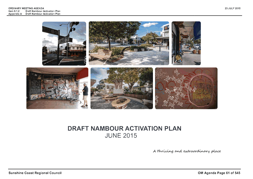
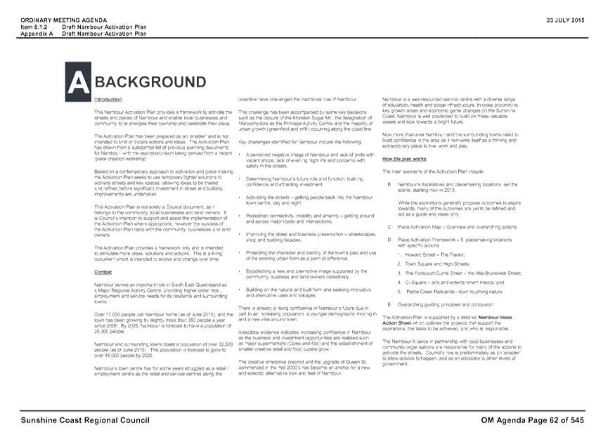
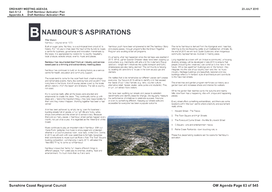
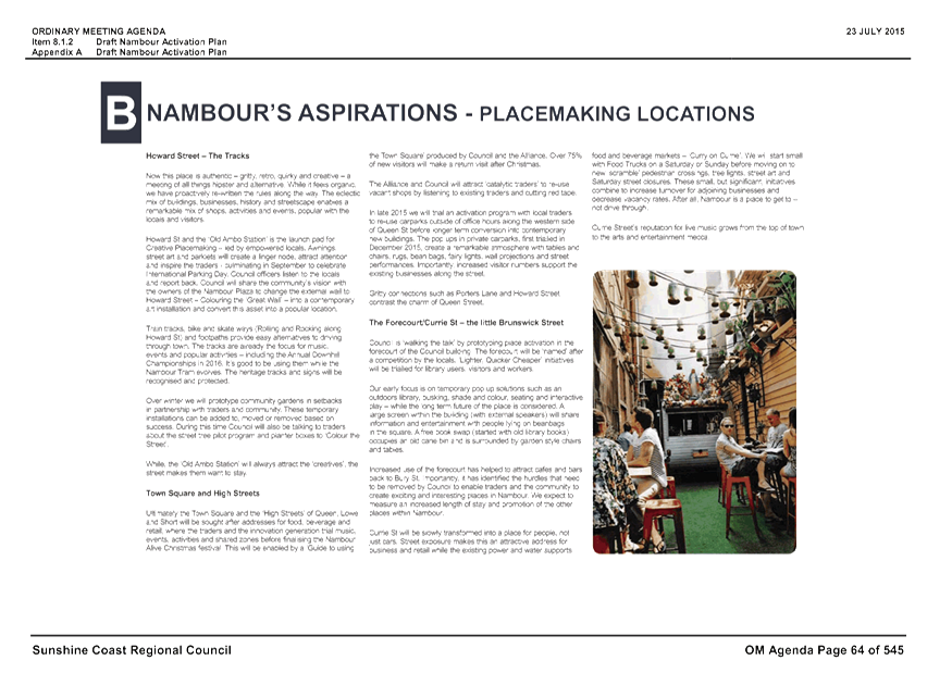
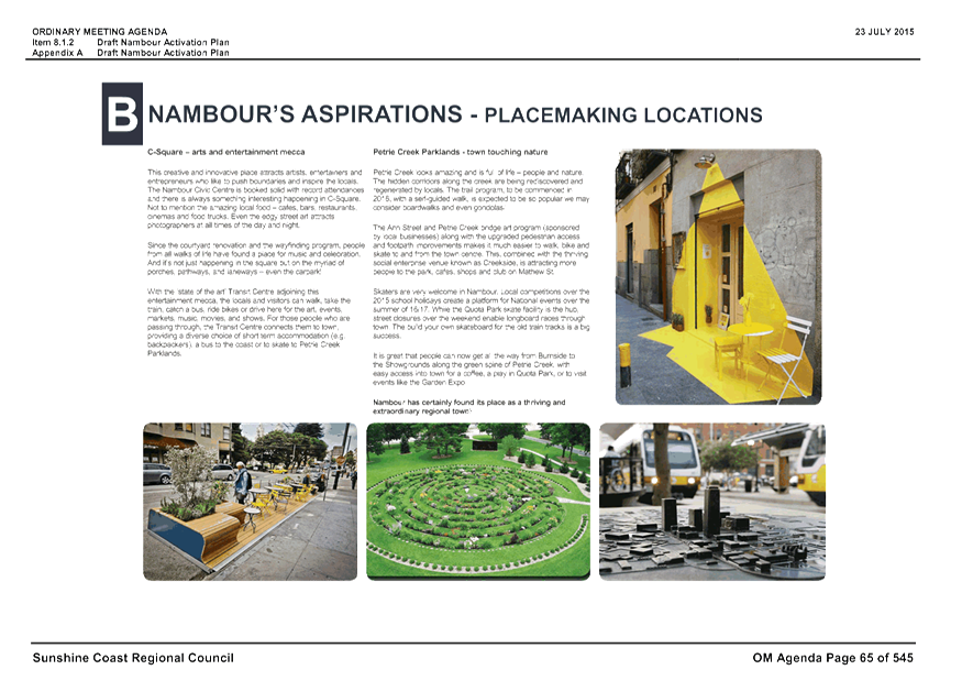
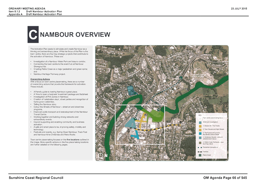
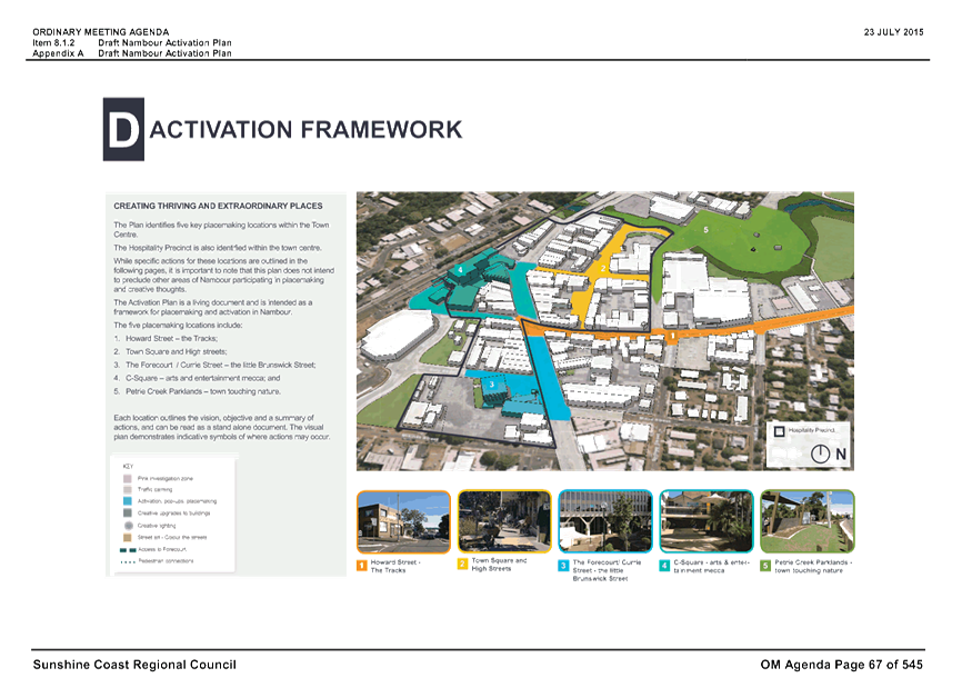
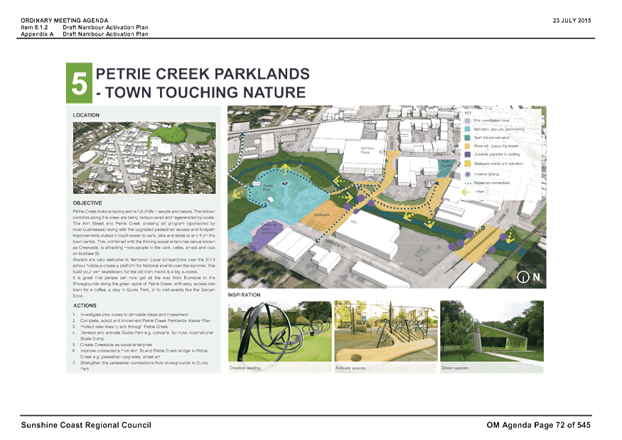
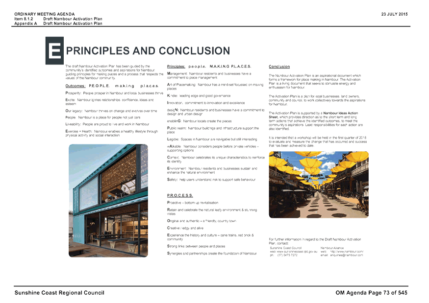
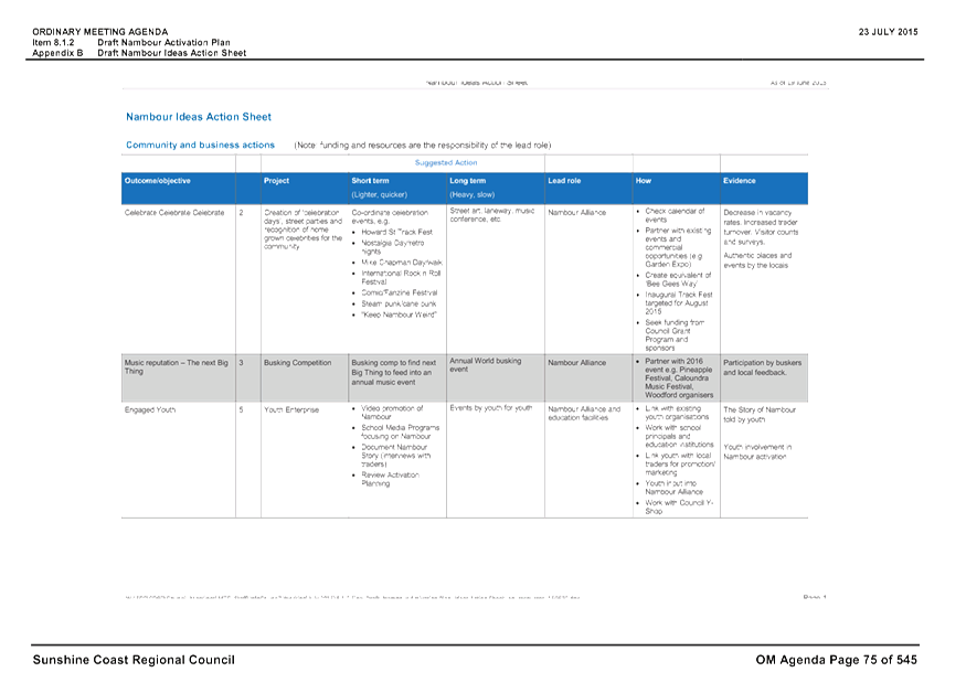
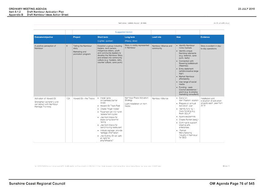
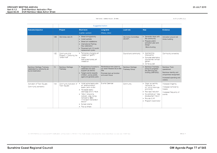
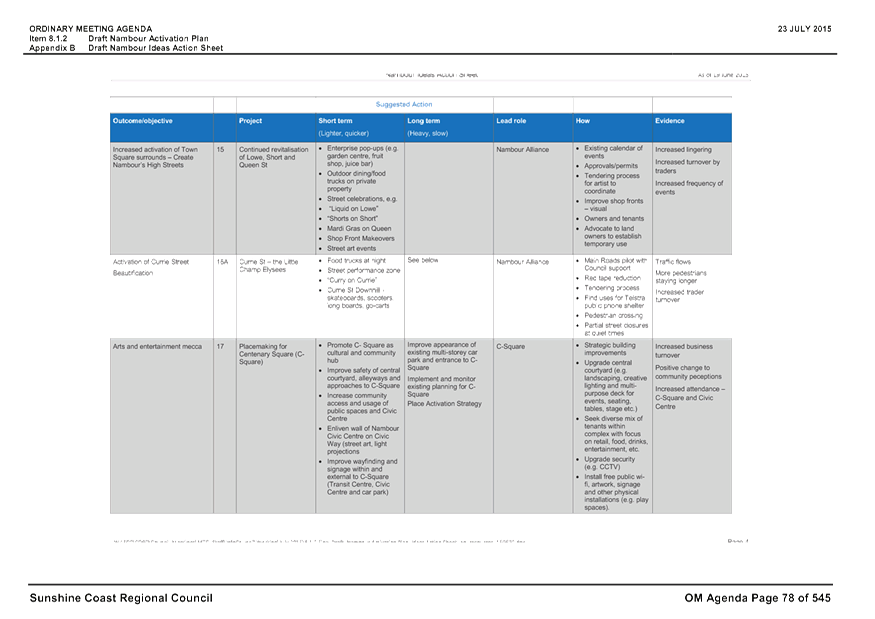
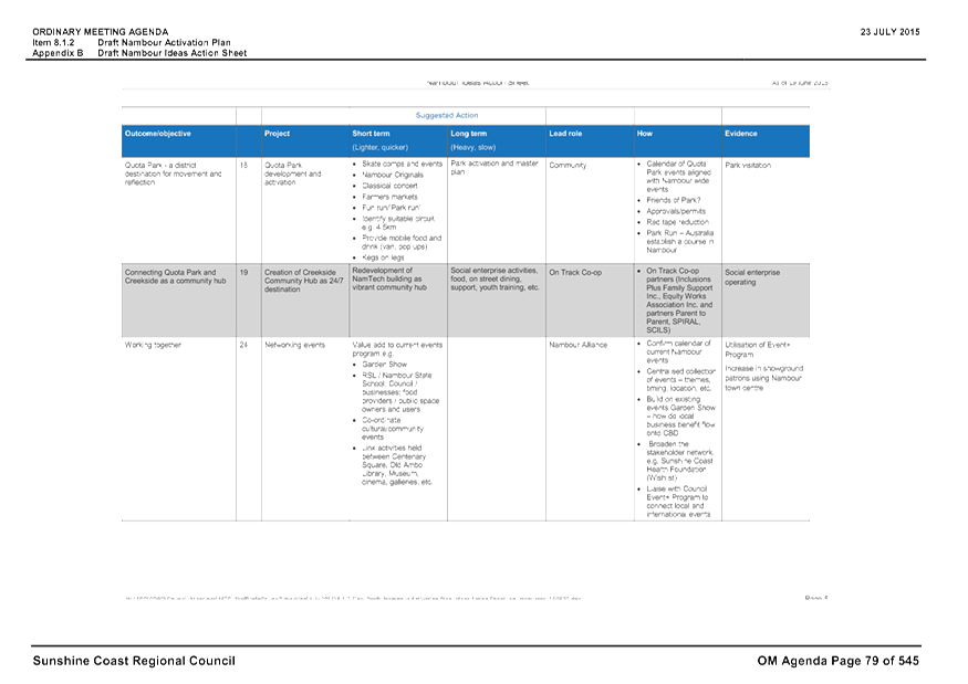
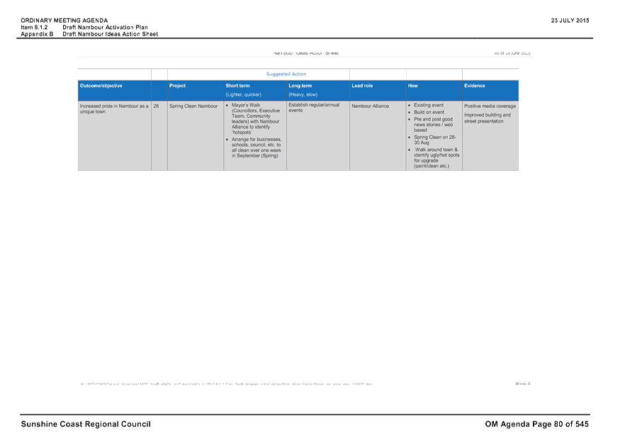
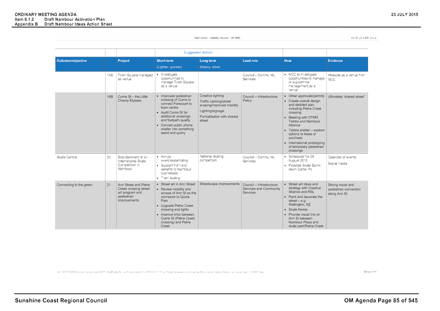

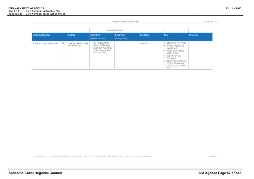
Staff Reports - Sustainable Environment and Economy 13.8 - Attachment 2
Draft Bangalow DCP
Issues
raised during consultation with the Community in May 2015 that are outside the
scope of the DCP and could be considered in a Masterplan for Bangalow
|
· 20-30 year vision required
· Caravan parking, accommodation
– no provision
· Railway siding potential for
better use eg. parking
· Needs to look beyond B2 zone
· Developer Funded Masterplan
· Accommodation needed for tourists
· RMS – land excess –
industrial possibilities or caravan park site
· Affordable housing and retirement
village needed
· Review traffic flow. eg. enable
one way through Station Street north towards Leslie Street following the
railway land south west to roundabout and back round to Byron Street with
additional parking provided on railway land
· Traffic – an increasing
number of rural residents travel into Bangalow. This will increase when
secondary dwellings permitted on rural land
· Difficult to visualise Station
Street without addressing traffic flow
· Ensure captured info/views of
tonight again value to MasterPlan process
· Second crossing of railway line
– history of investigation
· Lineal – ‘gun
barrel’; what about a meeting place
· Walking pedestrianised areas/
Walking distance - live close
· Speed Zone for Village Centre
should be 40 kmh like Clunes.
- Needs
to be enforced
- Better
signage to slow traffic down “Bangalow is a village slow down”
etc Like Clunes
- Speed
cameras
School
· Location – is it suitable/
viable for growing community?
· School bus stop
· pedestrian crossing at end of
Station Street on Byron Street – danger issues (history of a proposal
by Council about 2 years ago)
· School access – safe access
for kids required, pick up and drop off needs to be addressed.
· Will the Primary School exist and
remain in the same location into the future?
|
Staff Reports - Sustainable Environment and Economy 13.9 - Attachment 1
Byron Shire Council Rural Land Use Strategy
Site Suitability Criteria
& Mapping Methodology
September
2015
Site Suitability Criteria
& Mapping Methodology
Table of Contents
1 Introduction
1.1 Background
1.2 Purpose
of the Site Suitability Criteria and Mapping Methodology Paper
1.3 Study Approach
2 Site
Suitability Criteria Methodology and Data
Table 1 :
Constrained Land
Table 2 :
Assessable Land
Table 3 :
Service Catchment and Road Infrastructure Priorities for Rural Development
3 Constrained
Land
3.1 Primary Production Land
3.2 High Conservation Value Vegetation
3.3 Water Supply Catchment Buffer
3.4 Mineral Resources
3.5 Slopes
3.6
Bushfire
3.7 Buffers to Waster Disposal Facilities and Sewerage
Treatment Plants
3.8 Acid Sulfate Soil Classes 1 and 2
3.9
Other excluded zones
4 Assessable
Land
4.1 Sensitive Rural Land Uses
4.2 Non Contiguous and Prime Agricultural Land
4.3
Biophysical Strategic Agricultural Lands
4.4
Scenic Amenity and Rural Landscape
4.5
Category 1 & 2 Bushfire Vegetation
4.6
1:100 Year Flood Risk and Climate Change; and Coastal Erosion Planning
Precincts 1 and 2
4.7
Vehicle Access Safety and Risk
4.8 Wildlife
Habitat and Corridor Enhancement
4.9
Indigenous Cultural Heritage
5 Service
Catchment and Road Infrastructure Priorities for Rural Development
5.1 Service
Catchment Priorities
5.2 Road
Infrastructure Priorities for Future Rural Lifestyle Living Opportunities
[THIS PAGE IS INTENTIONALLY LEFT BLANK]
1. Introduction
1.1 Background
Byron Shire Council is developing a Rural
Land Use Strategy. The Rural Land Use Strategy will provide a strategic
framework for the management and use of rural land for living, working and
leisure. It will guide future land zoning and other planning instruments such
as Local Environmental Plans.
It will also identify a range of rural land use
actions/outcomes and include a delivery program for future rural development,
taking into account existing land supply.
Main Stages to develop the Rural
Land Use Strategy


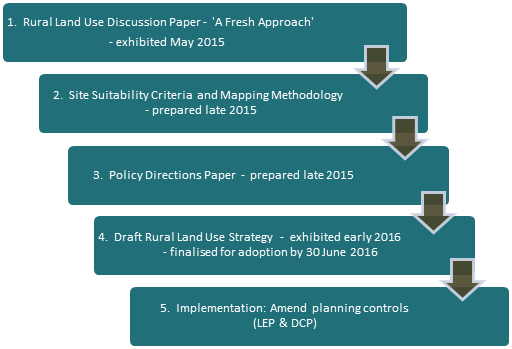
1.2 Purpose
of the Site Suitability Criteria and Mapping Methodology Paper
The purpose of this document is to provide a comprehensive framework for
determining future rural development potential based on a range of natural
resource management, risk avoidance and social/economic servicing
criteria. This in turn will inform the development of a related Policy
Directions paper and the Rural Lands Strategy.
1.3 Study
Approach
The Department of Planning and Environment
are preparing a North Coast Regional Plan to replace the Far North Coast
Regional Strategy. In preparing the criteria and mapping methodology, staff
liaised with the Department to ensure that the Rural Land Use Strategy mapping
methodology direction is consistent with the policy principles of the working
draft North Coast Regional Strategy. The criteria were also informed by other relevant State, regional and/or local
planning documents and best practice planning principles.
2. Site Suitability
Criteria Methodology and Data
The process for selecting potential land
for tourism, conventional rural residential, Multiple Occupancies, Community
Title or other non-agricultural land uses (herein referred to as ‘future rural development’) is outlined
below. The aim is to ensure that future rural development
occurs within the context of Byron Shire's environmental, economic and social
requirements.
In identifying potential future rural development
land, site suitability criteria were used to map the
following categories of land:
1. [a4] Constrained Land
This identifies
areas where any of the criteria listed in Table 1 are present. Constrained land
will not be considered for future rural
development as it includes important environmental and resource
values and/or issues of risk avoidance. These constraints by their degree and
nature preclude the land from development.
2. Assessable Land
This identifies
areas not encumbered by any of the Constrained Land criteria in
Table 1 but potentially affected by one or more of the criteria listed in Table
2. Assessable Land [a5] encompasses
environmental, economic and/or risk avoidance criteria which may not
necessarily preclude future rural development
on the land but rather indicate a need for more detailed site specific
investigations to determine the site’s full development potential. The
criteria in Table 2 are not comprehensive and there may be other matters which
need to be taken into consideration to determine a site’s development
potential.
3. Unconstrained Land
This identifies
areas that are neither encumbered by Constrained Land criteria (Table 1) nor
affected by Assessable Land criteria (Table 2).
4. Future Rural Development Priorities
This identifies
priorities for future rural development
of Unconstrained Land and Assessable Land using the Service Catchment and Road
Infrastructure Criteria in Table 3. This reflects the premise that future rural development should be within a
reasonable distance of village and town services and be provided with a
standard of road access that does not place a financial burden on the wider
community. From a service catchment standpoint, priority will be given to
land within 2km of a rural village, public primary school, general store or
community hall or 5km of a [a6] town containing a
high school (Mullumbimby and Byron Bay) as follows:
· Priority 1: Unconstrained Land within a 2km/5km service
catchment
· Priority 2: Assessable land within a 2km/5km service catchment
· Priority 3: Unconstrained Land outside 2km/5km service catchments
[a7]
In considering future rural lifestyle living opportunities (ie. multiple occupancy; conventional / community title
rural residential subdivision) the following road infrastructure criteria has
been applied to the above priorities:
· Priority 1 & 2 land — must be capable
of providing an acceptable standard of road infrastructure at no cost to the
wider community
Priority
3 land outside 2km/5km service catchments is unlikely to be considered for future rural lifestyle living opportunities.
Note: Land in the
“unconstrained” and “assessable” land categories do not
infer development rights; it merely identifies land that is potentially
suitable for future rural development.
|
Table 1:
Constrained Land
|
|
Criteria
|
Supporting Planning Framework
|
|
Primary Production Land
- Land zoned RU1 Primary Production in LEP
2014;
- deferred matters relating to 1(b1) or
1(b2) Agricult-ural Protection in LEP 1988;
- S117 land mapped as State/Regionally
Significant farmland (excluding non-contiguous)
|
State / Regional
· Far North Coast Regional
Strategy 2006-31
· S117 Direction 5.3 / Northern
Rivers Farmland Protection Project - Final Recommendations, February 2005
(Section 4)
· Draft Far North Coast
Regional Growth Plan ‘guidelines’
Local
· Byron Shire Sustainable
Agriculture Strategy (2004)
· Rural Land Use Strategy
Discussion Paper – community feedback
· Byron Rural Settlement
Strategy 1998
· Tweed Shire Rural Land
Strategy –Resource Inventory & Land Capability Assessment (Dec,
2013)
· Lismore Growth Management
Strategy 2015-2035
|
|
High Conservation Value Vegetation
Land containing high conservation value vegetation
|
State / Regional
· State Environmental Planning
Policy No. 14 (Coastal Wetland)
· State Environmental Planning
Policy No. 26 (Littoral Rainforest)
Local
· Byron Rural Settlement
Strategy 1998
· Byron Biodiversity
Conservation Strategy 2004
· Lismore Growth Management
Strategy 2015-2035
|
|
Water Supply Catchment Buffers
Land within a drinking water catchment and 100m of a
major creek / waterway
|
Local
· Byron Rural Settlement
Strategy 1998
· Byron LEP 2014, Clause 6.5
– Drinking Water Catchments (objectives)
· BSC Design Guidelines for
On-Site Sewage Management for Single Households (2004)
· Rous County Council draft DCP
|
|
Mineral Resource
s117 mineral resource lands, including transitional
and potential areas
|
State / Regional
· S117(2) Direction 1.3 –
Mining, Petroleum Production and Extractive Industries
· Mineral Resources Audit
(mapping)
Local
· Byron Rural Settlement
Strategy 1998
|
|
Slope
Land with slope > 32%
|
State / Regional
· Planning for Bushfire
Protection 2006
Local
· BSC Design Guidelines for
On-Site Sewage Management for Single Households (2004)
Byron Rural Settlement
Strategy 1998·
· Lismore Growth Management
Strategy 2015-2035
|
|
Extreme Bushfire Risk
Land containing Bushfire
Category 1 vegetation
and
Slope >20%
|
State / Regional
· Planning for Bushfire
Protection 2006
· Lismore Growth Management Strategy
2015-2035
Local
· Byron Rural Settlement
Strategy 1998 (>20% slope)
|
|
Buffers to waste disposal facilities and
sewage treatment plants
Land within buffer to
sewage treatment plant (400m) OR
waste disposal facility (500m)
|
Local
· Byron Rural Settlement
Strategy 1998
· Byron Development Control
Plan 2010 & 2014 (Chapter B6 – Buffers)
|
|
Acid Sulfate Soils (ASS)
Classes 1 and 2
Land within
ASS Risk Class 1 or 2
|
Local
· Byron Rural Settlement
Strategy 1998
· Byron LEP 2014, Clause 6.1 – Acid
Sulfate Soils
(risk classes 3-5 considered manageable)
|
|
Other
Excluded Zones
Land outside the
following zones:
Byron LEP
2014:
RU2 Rural
Landscape
R5 Large Lot
Residential
RU5 Village
AND
Byron LEP
1988 (only
where “deferred” from LEP 2014):
1(a) General
Rural
1(d)
Investigation
7(d)
Scenic/Escarpment
|
State / Regional
· Far North Coast Regional Strategy
2006-31
Local
· Byron Rural Settlement
Strategy 1998
|
|
Table 2:
Assessable Land (1)
|
|
Criteria
|
Supporting Rationale[s8]
|
|
Sensitive Rural Land Uses
Assess potential impacts
associated with rated
farmland activities in terms of:
· Location
· Operation
· Processing
To determine farming
activity clusters and suitable buffers (including ex-dip sites) to minimise
conflict between farming and non-farming land uses
|
- Recognition of: the
importance of farmland and agriculture; the changing nature of agriculture
and key trends, demands and issues affecting agriculture; and the economic
advantages associated with industries that cluster or diversify.
- Builds on the Byron Rural
Settlement Strategy principles and Byron Shire DCP 2014 – Chapter
B6 – Buffers and Minimising Land Use Conflict.
- Consistent with planning
strategies and principles outlined in Living and Working in Rural Areas
(NSW DPI, 2007).
|
|
Non Contiguous and Prime Agricultural
Lands
Assess Non-contiguous State/ Regionally Significant
farmland and
prime agricultural land (classes I, 2 and 3 as identified by NSW Agriculture) outside the Primary
Production Land identified
in Table 1
|
- Consistent with Northern
Rivers Farmland Protection Project – Final Recommendations (February,
2005).
- Consistent with community
feedback on Rural Land Use Strategy Discussion Paper.
- Potential development should
be subject to merit-based assessment of the agricultural value and future
economic viability of such land.
|
|
Biophysical Strategic Agricultural Lands
Assess biophysical strategic agricultural lands
|
- Biophysical Strategic
Agricultural Land (BSAL) is land with high quality soil and water resources
capable of sustaining high levels of productivity.
- BSAL mapping important for
managing competing land uses proposed on high quality agricultural land.
- Consistent with DP&E
advice that future rural settlement should generally avoid areas mapped as
BSAL.
|
|
Scenic Amenity and Rural Landscape
Assess land zoned
7(d) Scenic/ Escarpment
in Byron LEP 1998 (only
where “deferred” from LEP 2014)
|
- Consistent with Byron
Rural Settlement Strategy site suitability criteria and community
feedback on Rural Land Use Strategy Discussion Paper
|
|
Criteria
|
Supporting Rationale[s9]
|
|
Category 1
& 2
Bushfire
Vegetation
(excluding
“Extreme”
bushfire risk
areas in Table 1)
Assess the
capacity for development that does not encroach on Category 1& 2
vegetation
|
- Adapted from Byron Rural
Settlement Strategy site suitability criteria
- Future development must
satisfy Planning for Bush Fire Protection 2006 requirements.
|
|
- 1:100 year Flood risk + Climate Change
- Coastal Erosion Planning Precincts 1 & 2
Assess the capacity for development to be safe and
capable of managing flood and/or coastal
erosion risks
|
- Adapted from Byron Rural
Settlement Strategy site suitability criteria relating to flooding.
- Future development subject to
LEP 2014 Clause 6.3 – Flood Planning
|
|
Vehicle access safety and
risk
Assess vulnerability of
essential access roads to:
- Bushfire Category 1, or
- Landslip - sections
of road having a history of landslip
Ensure adequate evacuation
routes
|
Future development may be subject to
minimum design standards being in place to reduce vulnerability of road
infrastructure to the following risks:
- Bushfire – where access roads
cannot provide safe (or alternative) access, egress and defendable space for
emergency services during event.
- Landslip – where sections of
road have become unusable for long periods of time following the event (eg.
Upper Wilsons Creek).
|
|
Wildlife Habitat and Corridors Enhancement
Assess potential for enhancement of wildlife corridors
|
Recognises role of wildlife corridors in
minimising impacts (direct or indirect) from adjoining land uses and
encouraging the recovery of threatened species, communities, populations and
their habitats.
|
|
Indigenous Cultural Heritage
Consult with traditional owners (where applicable)
in accordance with process established by Council
|
Recognises that Byron Shire contains a
wealth of Aboriginal cultural sites which include middens, stone
arrangements, rock shelters and tool-making sites. Many of these are
not mapped due to their cultural sensitivity.
|
(1) This Assessable Land criteria list
is not absolute and that there may be other matters which require more detailed
assessment at the rezoning or DA stage to determine site suitability.
This may include, for example, consideration of indigenous cultural heritage
values through formal consultation with
traditional owners or site
contamination history.
Note: Mapping of individual assessable constraints
would not be included as part of the final Rural Land Use Strategy.
Instead an interactive PDF would be created for community access that would
provide mapping layers on the assessable constraints
|
Table 3: Service Catchment and Road Infrastructure
Priorities for Rural Development
|
|
Criteria
|
Supporting Rationale
|
|
A. Service Catchment Priorities
(apply to all future rural development)
Determine
development priorities based on proximity to town and village service
catchments as follows:
· Priority 1: Unconstrained land within 5 km of a town
containing a high school (Mullumbimby and Byron Bay) or 2km of a rural
village, public primary school, general store or community hall catering to
the needs of that locality
· Priority 2: Assessable land within 5 km of a town containing a
high school (Mullumbimby and Byron Bay) or 2km of a rural village, public
primary school, general store or community hall catering to the needs of that
locality
· Priority 3: Unconstrained land outside a service
catchment
|
- A ‘service
catchment’ approach maximises opportunities for people to access basic
services and connect with each other both socially and economically. It
also facilitates economies in service provision such as a rural school bus
service.
- Consistent with service
catchment criteria in Byron Rural Settlement Strategy1998 and Lismore
Growth Management Strategy 2015-2035.
- Consistent with Guidelines
for Rural Settlement on the North Coast of NSW (DUAP, 1995).
|
|
B. Road Infrastructure Priorities (apply
to future rural lifestyle living opportunities)
Further
assessment of above priorities against:
· capacity / condition of relevant road
network;
· costs to wider community of proceeding
with potential rural lifestyle living precincts.
Future rural
lifestyle living opportunities include: conventional rural residential subdivision;
multiple occupancies; and community title subdivision.
This determines
land suitability in the following order of priority:
· Priority 1 & 2 service catchment
areas – only where
relevant road segments can be upgraded at no cost to wider community.
Priority 3 land is unlikely to
be considered for future rural
lifestyle living opportunities within the timeframe of this
strategy.
|
Priority areas for future rural
lifestyle living should be within reasonable distance of village and town
services and have adequate road infrastructure (both condition and capacity)
that will not place a financial burden on the wider community. That is,
any required road upgrade to achieve an acceptable standard will need to be provided at no
cost to wider community.
This economic imperative is supported by
the following documents:
- Byron Shire Council Financial
Sustainability Project Plan (Asset Management Strategy)
- Council Improvement Program (June2015)
- Byron Rural Settlement
Strategy1998
- Guidelines for Rural
Settlement on the North Coast of NSW (DUAP, 1995)
|
3.
Constrained Land
Certain land has been excluded from
consideration for future rural development
as it makes good environmental, economic and social sense. We need to safeguard
the quality of the natural environment and the integrity of our natural
resources. Similarly, we should not put the environment, people and assets at risk
or in hazardous situations.
The criteria for identifying ‘Constrained Land’, as listed in Table 1
above, are detailed below.
3.1 Primary Production Land
Good agricultural land provides primary
production in Byron Shire with an inherently unique advantage in productivity,
diversity and adaptability. As a finite and irreplaceable resource it should be
conserved and sustainably managed. The North Coast Urban Planning Strategy
(1995), the NSW Coastal Policy (1997), the Northern Rivers Regional Strategy (1999),
the Northern Rivers, Upper North Coast and Mid North Coast Catchment Blueprints
(2002) and the Northern Rivers Farmland Protection Project 2005 all support
this position.
The Northern Rivers Farmland Project
reviewed earlier investigations regarding prime agricultural land and took into
account the need to distinguish between very high quality and unique
agricultural soils/lands and other lands that were also important to
agriculture but which were more extensive and less productive generally per unit
area. It identified two relevant levels of agricultural land – State and
Regionally Significant. Fundamental to this project was the identification,
recognition and protection of contiguous quality farmland to limit the
likelihood of displacement of agricultural use by residential use and
fragmentation.
Primary Production Land is included on Map xx of Appendix XX. The data used to
inform this map is:
|
Description
|
Data layers used
|
Data custodian
|
|
- Land zoned RU1 Primary Production in LEP
2014;
- Deferred matters relating to 1(b1) or
1(b2) Agricultural Protection in LEP 1988;
|
1998 / 2014 LEP
Zoning
|
Byron Shire
Council
|
|
S117 land mapped
as State or Regionally Significant farmland
|
“Northern
Rivers Farmland Protection Project, Final Map 2005 (Section 117(2)
Direction)”
|
NSW Dept of Planning & Environment (formerly
Dept of Infrastructure, Planning and Natural Resources)
|
For strategic planning purposes State or
Regionally Significant farmland (excluding non-contiguous) and land zoned for
primary production purposes represent constrained
land.
3.2 High
Conservation Value Vegetation
Byron Shire covers about 56,000 hectares of
which 68% is cleared land, plantations and disturbed remnant vegetation. The
ongoing loss of biodiversity is perhaps our most serious environmental problem.
The protection and enhancement of high conservation value vegetation provides a
foundation from which to address this problem.
In 2015, Council reviewed the vegetation
mapping. Mapping was initially carried out in 1999 as part of the Byron Flora
and Fauna Study and was partly reviewed in 2007. The 2015 review has improved
the accuracy of the mapping and reflects changes in vegetation extent and
composition over time. The review used a combination of aerial photograph
interpretation (API) primarily using 2014 aerial data, existing information
such as, vegetation survey data from various Council and state government
projects, and on-ground site inspections.
Vegetation was mapped using the State
Government’s Vegetation Information System (VIS) Classification 1.
database to ensure consistency with NSW standards. This system uses three
levels; vegetation formations, vegetation classes and plant community types.
The plant community type classification provides the most detailed description
of vegetation and was developed by the state government to provide a standard
approach to vegetation classification and mapping.
This mapping provides the foundation on
which to determine high conservation value vegetation and habitats (HCV).
HCV has been determined using a relative ecological value matrix as described
in the Byron Biodiversity Conservation Strategy 2004 (Part 3). Areas with a combined score of 27 or more are
regarded as HCV.
The High Conservation Value Vegetation is
included on Map xx of Appendix XX.
The data used to inform this map is:
|
Description
|
Data layers used
|
Data custodian
|
|
Land containing
high conservation value vegetation and habitats
|
HCV Vegetation
Map (2015)
|
Byron Shire
Council
|
For strategic planning purposes high
conservation value vegetation and habitats represent constrained
land.
1. For information on the State Government’s
Vegetation Information System (VIS) Classification go to: www.environment.nsw.gov.au/research/Visclassification.htm
3.3 Water
Supply Catchment Buffers
Regional water resources including
watercourses, dams and estuaries are of economic, social and environmental
significance both within the Shire, North Coast Region and beyond. They support
urban and rural water supplies and a range of tourism and recreational
activities.
Water supply catchments are areas from
which surface water drains (via runoff) to a reservoir or water storage
facility. The local government areas of Byron, Lismore and Ballina source
their urban water supplies from three rural catchments: Wilson Creek, Rocky
Creek Dam and Emigrant Creek. Their water quality is directly influenced by the
type of land uses and management practices occurring within these
catchments. Some of impacts of inappropriate rural land uses and/or poor
land management practices can include toxic algal blooms, soil erosion, falling
water tables and increased water treatment costs.
Future rural
development should have a neutral or beneficial
effect on downstream water quality. As rural dwellings within urban water
supply catchments are generally not sewered and instead rely on on-site
wastewater management systems, requiring a 100m separation distance between a
permanent water course and wastewater management system can substantially
reduce likelihood of pathogens entering the water supply. This is known as a
‘water supply catchment buffer’.
Water supply catchment buffers are shown on
Map xx of Appendix XX. The data
used to inform this map is:
|
Description
|
Data layers used
|
Data custodian
|
|
Land within a drinking water catchment and 100m of a
major creek / waterway
|
Water catchment supply 2014
Create 100m buffer around major creeks / waterways
|
Byron Shire
Council
|
For strategic planning purposes all land
within a drinking water catchment and within 100m of a major watercourse
(namely Wilsons River, Coopers Creek, or Rocky Creek and Skinners Creek)
represents constrained land.
(Sources: Rous
Water On-site Wastewater Management Guidelines, June 2008;
South East Queensland Development Guidelines for
Water Quality Management in Drinking Water
Catchments).
3.4 Mineral
Resources
Quarry materials are essential to the construction
industry. Section 117 Planning Direction ‘1.3 – Mining, Petroleum
Production and Extractive Industries (Environmental Planning and Assessment
Act 1979), seeks to ensure that future extraction of mineral resources and
extractive materials is not compromised by inappropriate development.
Extraction can only occur where geological
deposits are located. Transportation costs are a significant cost factor. To
keep costs down and remain largely self sufficient, we need to ensure that
local supplies are available in sufficient quantity to satisfy current and
future demands.
Inappropriately located land uses can
effectively alienate, or even sterilise a resource. A
1 km buffer taken from the boundary of identified resources can be an effective
means to prevent land use conflicts and protect important mineral resources.
Mineral Resources (identified, transitional
and potential) are shown on Map xx of Appendix
XX. The data used to inform this map is:
|
Description
|
Data layers used
|
Data custodian
|
|
s117 mineral
resources, including transitional and potential areas
|
Mineral
resources - Areas of proven natural resource significance (2015)
|
NSW Dept of
Mineral Resources
|
For strategic planning purposes all Section
117(2) mineral resource lands, including transitional and potential areas,
represent constrained land.
3.5 Slope
Slope is a significant factor affecting
effluent disposal, stormwater runoff, bushfire risk, erosion and vehicular
access. For example, slopes in excess of 20% (11.3 degrees) can pose wastewater
treatment system installation problems, while slopes greater than 15% (8.5
degrees) may prevent treated wastewater from being evenly distributed to the
land, thereby adversely affecting the performance of the system. At the
same time erosion resulting from developing on steep slopes can in turn have
significant water quality impacts. Land with slopes over 32% is
considered unsuitable to most forms of future
rural development, particularly habitable structures.
Land with a Slope > 32% is indentified
on Map xx of Appendix XX. The data
used to inform this map is:
|
Description
|
Data layers used
|
Data custodian
|
|
Slope > 32%
|
Slope percentage – 1 meter hybrid (2015)
Contour data (10m)
|
Byron Shire Council
|
For strategic planning purposes all land
having slopes in excess of 32% (approx 18 degrees) represents constrained land.
(Sources:
http://www.ga.gov.au/scientific-topics/hazards/landslide/basics/causes
Design Guidelines for On-Site
Sewage Management for Single Households – Byron Shire Council
3.6 Bushfire
Byron Shire is
fortunately located in a region which enjoys reasonably high rainfall
throughout much of the year. However, at certain times of the year and under
certain weather conditions, many areas of the Shire can become high to extreme
fire risk areas. Bush fire is a major challenge for the community. The CSIRO
predicts that climate change will contribute to harsher fire weather for
Eastern Australia with an increase in the number of days having a severe
bushfire rating.
All developments on land that is designated
as bush fire prone must satisfy the requirements of Planning
for Bush Fire Protection 2006 and AS3959 – 2009.
A key consideration in mitigating bushfire
hazard is avoidance of high risk areas. In August 2002, the State government
introduced legislation to provide significant improvements in bush fire safety.
This included a requirement for all councils to prepare a bush fire prone land
map as the basis for more detailed investigations to determine what bush fire
protection measures are applied to new development.
Byron Shire has two Bushfire Prone
Categories based on vegetation types. Category 1 vegetation (essentially areas
of forest, woodlands, tall and short heaths, forested wetlands and timber
plantations) generally hold the highest risk factor. Studies by bush fire
authorities have shown that bushfires are likely to travel twice as fast up 10
degree slopes (as opposed to flat land) and up to four times faster on 20
degree slopes. This can result in certain Category 2 vegetation types
(essentially grasslands, freshwater wetlands, semi-arid woodlands, arid
shrublands and rainforests) on such slopes also having a high risk factor.
For strategic planning purposes all land
having Category 1 bushfire vegetation on slopes greater than 20% (11.3 degrees)
represent an ‘extreme’ fire risk and hence are constrained land. All
remaining Category 1 and 2 vegetation outside extreme fire risk areas represent assessable land requiring more detailed investigation prior to further
consideration as potential future rural development.
Constrained and assessable bushfire risk is
identified on Map xx and Map xx (respectively)
of Appendix XX. The data used to inform this map is:
|
Description
|
Data layers used
|
Data custodian
|
|
Constrained Land
Extreme bushfire risk: Category 1
bushfire vegetation on slopes >20%
Assessable Land
- All
remaining Category 1 and 2 bushfire vegetation (excluding ‘extreme
bushfire risk)
|
Bushfire Protection mapping for Shire
(2015)
|
Byron Shire Council
|
3.7 Buffers
to waste disposal facilities[a10] and sewage treatment plants
Waste disposal and sewerage treatment
facilities are an essential part of Council’s waste management
activities. As key infrastructure installations they represent a
significant capital investment for the Shire and minimising environmental and
human health risks is central to their placement, design and operation.
Proximity to these installations is an
important consideration in determining future
rural development land due to potential health risks to humans
including methane buildup, noise and odour. A key means for managing this risk
is the use of separation buffers from future rural
development.
Land affected by these buffers is included
on Map xx of Appendix XX. The data
used to inform this map is:
|
Description
|
Data layers used
|
Data custodian
|
|
Land within buffer to sewage treatment plant (400m)
OR waste disposal facility (500m)
|
Sewage treatment
plant buffer
Waste disposal
facility buffer
|
Byron Shire
Council
|
For strategic planning purposes all land
within an identified sewerage buffer (400m) and refuse buffer (500m) represents
constrained land.
3.8 Acid
Sulfate Soil Classes 1 and 2
Acid sulfate soils contain pyritic
sediments which can lead to the generation of sulphuric acid when exposed to
air. This is likely to occur when these soils are drained, excavated or
dredged. Scientific research has found that the release of acid from pyritic
soils can have significant impacts upon the health of aquatic plants and
animals. Similarly, drainage waters from areas of acid sulfate soils can
corrode and weaken engineering structures and release heavy metals into
recreational fishing areas. This land is often captured by other constraints
including SEPP 14 Coast Wetlands.
A classification scheme for acid
sulfate soils identifies the type of works likely to present an
environmental risk if undertaken in a particular class of
land and is outlined in the table below.
|
Class of
land shown on acid sulfate soils map
|
Works
|
|
1
|
Any works
|
|
2
|
Works below natural ground
surface
Works in which the watertable is
likely to be lowered
|
|
3
|
Works beyond 1 metre below the
natural ground surface
Works by which the watertable is likely to be lowered
beyond 1 metre below
the natural ground surface
|
|
4
|
Works beyond 2 metres below
natural ground surface
Works by which the watertable is
likely to be lowered beyond 2 metre below the natural ground surface
|
|
5
|
Works within 500 metres of
adjacent Class 1, 2, 3 or 4 land that is below 5 metres Australian Height
Datum and by which the watertable is likely to be lowered below 1 metre
Australian Height Datum on adjacent Class 1, 2, 3 or 4 land.
|
For strategic purposes all land having an
Acid Sulfate Risk Class of 1 or 2 represents constrained
land.
Land with Acid Sulfate Soil Risk class 1 or
2 are included on Map xx of Appendix XX.
The data used to inform this map is:
|
Description
|
Data layers used
|
Data custodian
|
|
Land within ASS
Risk class
1 or 2
|
Acid sulfate
soil categories
1:25,000 (2014)
|
Byron Shire
Council
NSW Office of
Environment & Heritage
|
3.9 Other excluded zones
Certain
zoning or land tenure can inherently preclude land from consideration for future rural development.
This includes land dedicated, reserved or committed to potential future urban,
village and open space uses. It also includes national parks, nature
reserves and areas already zoned for environmental protection. This
approach ensures Council maximizes its options for accommodating future
expansion of the Shire’s towns and villages while also protecting
recognised environmental assets. For strategic planning purposes all land
situated outside the following zones is excluded from consideration (ie. constrained land):
Byron LEP 2014
— RU2 Rural Landscape, R5 Large Lot Residential and RU5 Village.
Byron LEP 1988
— 1(a) General Rural, 1(d) Investigation and 7(d) Scenic/Escarpment (only
where “deferred” from LEP 2014);
|
Description
|
Data layers used
|
Data custodian
|
|
Land outside the following zones:
Byron LEP 2014:
RU2 Rural Landscape
R5 Large Lot Residential
RU5 Village
AND
Byron LEP 1988 (only where “deferred” from LEP 2014):
1(a) General Rural
1(d) Investigation
7(d) Scenic/Escarpment
|
Byron LEP 1998
Zoning Maps
LEP 2014 Zoning
Maps
|
Byron Shire
Council
|
4. Assessable
Land
Certain environmental, economic, social and
risk avoidance matters are more appropriately considered through a detailed
site specific investigation. These matters may not necessarily preclude
development on the site.
The criteria listed in Table 2 above have
resulted in certain land being identified as ‘Assessable
Land’. These criteria, as outlined below, are not comprehensive
and there may be other matters which require more detailed assessment at the
rezoning or DA stage to determine site suitability.
4.1 Sensitive
Rural Land Uses
Council’s
Sustainable Agricultural Strategy 2004 (SAS) supports the rights of persons to
carry out legitimate rural and agricultural uses and practices. The SAS aims to
create a social and planning environment that allows agricultural production
and associated activities to be pursued without conflict and concern for
long-term security of agriculture in the Shire. Among the policy actions
recommended in the SAS is to “carry out a stock take of agriculture
land and related activities and assessment of current and possible future uses
to determine the optimum potential (social, economic and environmental) for the
land”.
Future rural development should not undermine
this optimum potential and any strategic assessment should consider the
relevant land use characteristics of our major existing agricultural
enterprises including:
· essential
growing conditions;
· operational
conditions: potential for land use conflict or health risks from past and
current land use activities including dip site and complaints
about smell, noise, dust, airborne chemical sprays and loss of amenity
particularly from intensive agriculture or horticulture;
· processing
or market place requirements: such as dairy, sugar cane,
coffee and macadamia industries that share harvesting and processing
facilities; and
· potential economic advantages associated with industry clusters.
An initial ‘stock take’ has
been carried out for farmland rated properties,
the findings of which are shown in Map xx of Appendix XX. The data
used to inform this map included farmland rated activities, DPI standards for
buffering and industry manuals. The buffers are not meant to be absolute and
may be varied on closer examination of terrain, vegetation and farming
practices.
|
Description
|
Data layers used
|
Data custodian
|
|
Farmland Rated
Activities and associated buffers (including dip site buffers)
|
Farmland
Rated Activities (2015)
Agricultural
Land Use Buffers (2015)
Dip sites and buffers (2014)
|
Byron Shire
Council
NSW Dept Primary Industries / Byron Shire Council
NSW Department
of Primary Industries
|
For strategic planning purposes all
farmland rated activities and buffers represent assessable land requiring more detailed investigation prior to further
consideration as potential future rural development.
(Sources:
- Byron Shire Sustainable Agriculture Strategy 2004
- Farmers Farm and Cows Do
Moo booklet (BSC, 2008)
- Minimum Lots Size
Methodology for Agricultural Uses (DPI, 2005)
4.2 ‘Non
Contiguous’ and ‘Prime’ Agricultural Land
The Northern
Rivers Farmland Project 2005 identified that certain agricultural/horticultural
industries may develop on smaller sites that have the general characteristics
of state or regionally significant farmland, but do not fit within the
definition of 'large contiguous areas'. These areas are known as
‘non-contiguous farmland’ and may include such land uses as
nurseries or controlled environment horticulture (eg. greenhouses,
hydroponics). These industries can benefit from their proximity to the
South Eastern Queensland market, and having a strong economic multiplier are
important to the local economy.
Areas mapped as prime agricultural land are
also an important consideration when planning for future rural land uses.
Like ‘non-contiguous’ farmland these areas may still have soil
characteristics or other agricultural values that require a merit-based
assessment at the rezoning or DA stage.
For strategic planning purposes
non-contiguous State or Regionally Significant farmland and Prime Agricultural
land (outside the Primary Production Land identified in Table 1) represent assessable land
requiring more detailed investigation prior to further consideration as
potential future rural development.
The location of
‘non-contiguous’ and prime agricultural land is shown on Map xx of Appendix XX. The data used to
inform this map is:
|
Description
|
Data layers used
|
Data custodian
|
|
Prime
agricultural land (classes I, 2 and 3 as identified by NSW Agriculture)
outside the Primary Production Land (Table 1)
Non-contiguous
State or Regionally Significant farmland
|
Prime
agricultural land classes 1, 2 & 3 (2001 BSC)
Northern Rivers Farmland Project (2005) :
non-contiguous lands
|
NSW Dept Primary
Industries
NSW Dept of
Planning & Environment / NSW Dept Primary Industries
|
4.3 Biophysical
Strategic Agricultural Lands
The NSW Government
introduced the Strategic Regional Land Use Plans to better manage the potential
land use conflicts arising from the location of our high quality agricultural
land, and the mining and coal seam gas (CSG) industries. Mapping of
high-quality agricultural land capable of sustaining high levels of productivity,
known as biophysical strategic agricultural land (BSAL), represents an
important resource for managing potential land use conflicts. Certain
activities proposed within BSAL areas are subject to an additional level of
investigation at the rezoning stage. In Byron Shire the amount of land
identified as BSAL equates to approximately 9580 hectares.
The location of BSAL is shown on Map xx of Appendix XX. The data used to
inform this map is:
|
Description
|
Data layers used
|
Data custodian
|
|
Biophysical
strategic agricultural land (BSAL)
|
|
NSW Dept of
Planning & Environment
|
For strategic planning purposes BSAL represents assessable land
requiring more detailed investigation prior to further consideration as
potential future rural development.
4.4 Scenic
Amenity and Rural Landscape
The basic premise
of rural settlement is that the 'rural character' of an area should be retained
or, conversely, any human elements introduced (eg dwelling houses; tourist
facilities) should not dominate the scene. Inappropriately located development
can ultimately destroy the very scenic amenity of an area which attracted
residents or visitors in the first place. Preserving the dominant landscape
features or scenic characteristics of an area is fundamental to ensuring that
the visual rural qualities of the Shire are not further diminished by future rural development.
Community feedback on the discussion paper
identified a strong value in ensuring our prominent rural landscape features
are not dominated by buildings. These features include prominent ridges such as
Coolamon Scenic Drive, Mt Chincogan and Nightcap National Park, bushland areas
such as National Parks and Nature Reserves, major watercourses and advantage
points such as Broken Head and Minyon Falls.
The Byron LEP 1988 mapped some of the more
prominent landscape features in a 7(d) Scenic/Escarpment Zone, the location of
which is shown on Map xx of Appendix XX.
The data used to inform this map is:
|
Description
|
Data layers used
|
Data custodian
|
|
Lands of high
scenic and/or escarpment values
|
Land zoned 7(d)
Scenic/Escarpment in Byron LEP 1998
|
Byron Shire
Council
|
For strategic planning purposes all land
zoned in the Byron LEP 1988 as 7(d) (Scenic Escarpment Zone) (refer to Map link
) represents assessable land requiring more
detailed investigation prior to further consideration as potential future rural development.
4.5 Category
1 & 2 Bushfire Vegetation – refer to
discussion in 3.6 above
4.6 1:100
year Flood Risk and Climate Change; and Coastal Erosion Planning Precincts 1
and 2
The Northern
Rivers Region has a warm subtropical climate reflected by a high annual
rainfall with a pronounced wet season from December to April. During this
season, the region is susceptible to the effects of cyclonic activity to the
north which can bring considerable rain to the area that can result in flooding
and/or coastal erosion.
The CSIRO predicts as a result of climate
change, summer rainfall will be more extreme and frequent, cyclones will be
less frequent and move further south and sea levels will rise. The best
projections of sea level rise along the NSW coast, relative to 1990 sea levels,
are 40cm by 2050 and 90cm by 2100.
Floodplain management and coastal erosion
planning precincts aim to reduce the impact of storm events on individual
properties and the community as a whole. They provide an integrated approach
which takes into account the risk and consequences of such events as well as
the social and environmental issues relating to their management.
Land that is flood prone and/or located
within a coastal erosion planning precinct is shown on Map xx of Appendix XX. The data used to inform this map
is:
|
Description
|
Data layers used
|
Data custodian
|
|
Flood prone
land / coastal erosion planning precincts
|
1:100 year Flood
Prone Lands (including climate change data, where available)
Coastal Erosion
Planning Precincts 1 & 2
|
Byron Shire
Council
|
For strategic planning purposes land having
a 1:100 yr flood risk and/or contained within Coastal Erosion Planning Precinct
1 & 2 (refer to Map link) represents assessable
land requiring more detailed investigation prior to further
consideration as potential future rural
development.
4.7 Vehicle
Access Safety and Risk
Critical
infrastructure during a disaster event includes our roads and bridges. In Byron
Shire access during natural disasters can be restricted by flooding, bushfire
and landslip. Floodwaters are treacherous, dangers can be hidden beneath the surface,
bridges can be washed out and bushfires can easily block roads with fallen
vegetation or power poles. Landslips take time to clear and can leave residents
without practical access for extended periods. The impacts of a disaster
event on essential access roads can be far reaching not only for residents
directly affected but as a social and economic cost to the wider community.
The Byron Shire Council Local Disaster Plan
2008 requires consideration of mitigation and prevention strategies in
regulating property development, including consideration that some hazard
impacts may require the partial or complete evacuation. Future rural development, should be located in
areas with reliable and safe road access, particularly should the need
for evacuation arise.
For strategic planning purposes land having
single road access through: 'high' fire risk - Category 1 bushfire
vegetation or sites having a history of landslip are assessable land
requiring more detailed investigation prior to further consideration as
potential future
rural development.
(Sources: Byron Shire Local Disaster Plan 2008; Emergency
Risk Management Study 2008)
Roads particularly vulnerable bushfire
and/or landslip risk are shown on Map xx of
Appendix XX. The data used to inform this map is:
|
Description
|
Data layers used
|
Data custodian
|
|
Vulnerability of
essential access road’s to high bushfire hazard and/or landslip risk
|
Map displaying
the following layers:
- Category 1 bushfire
vegetation
- Landslip history
|
Byron Shire
Council
|
4.8 Wildlife
Habitat and Corridor Enhancement
Green
infrastructure provides a range of ecosystem and community benefits, including:
· offsetting environmental impacts;
· mitigating the impacts of climate change;
· enhancing biodiversity and site aesthetics; and
· reconnecting people with nature.
Connected wildlife corridors are an
important component of green infrastructure that can improve habitat resources
and assist species to move across a landscape through increasing vegetation
cover. They can also minimise impacts (direct or indirect) from adjoining
land uses and encourage the recovery of threatened species, communities,
populations and their habitats.
The location of broad wildlife corridors in
the Shire is shown on Map xx of Appendix XX.
The data used to inform this map is:
|
Description
|
Data layers used
|
Data custodian
|
|
Potential /
Future wildlife corridors (not including HCV areas identified in Table 1)
|
Wildlife
corridor and habitat map (BSC 2007)
|
Byron Shire
Council
|
For strategic planning purposes all land
within identified wildlife corridors represents assessable
land requiring more detailed investigation prior to further
consideration as potential future rural
development.
4.9 Indigenous
Cultural Heritage
Section117 Planning Direction 2.3 –
Heritage Conservation aims to conserve items, areas, objects and places of environmental
heritage significance and indigenous heritage significance. As Council
does not have an adopted Aboriginal Heritage Study in place, any future
investigations of potential development land will require consultation with
relevant traditional owners (where applicable) in accordance with a formal
process established as a part of the new Rural Land Use Strategy.
For strategic planning purposes indigenous
cultural heritage represents an assessable matter requiring more detailed
investigation prior to further consideration as potential future rural development.
5 Service
Catchment and Road Infrastructure Priorities for
Rural Development
A key element of strong communities is the
ability for people to access basic services and connect with each other both
socially and economically. For this reason certain forms of future rural development should be located close
to villages and towns. This is particularly important when planning for future rural lifestyle living opportunities, which also should be capable of providing a
standard of road infrastructure (both condition and capacity) that does not
place a financial burden on the wider community.
5.1 Service
Catchment Priorities
Shops, schools and community halls are
important to our rural residents as they bring people together to physically
connect and feel a sense of belonging. They are the key components of any
rural service catchment. Service catchment planning can provide
economic benefits through reduced travel times, distances and fuel consumption
as well as greater economies in service provision (eg rural school bus
service). Over time this approach will serve to strengthen existing
communities instead of creating isolated settlements dependent on other
communities.
For strategic planning purposes a service
catchment approach has been applied using a
(i) 5 km radius from the general post
office in a town containing a high school and (ii) 2 km radius from a public
primary school, general store (where available) and/or community hall in
villages and rural settlements. This is consistent with the service catchment
rationale and distances applied in the Byron Rural Settlement Strategy
1998.
Priority service
catchment areas are shown on Map XX of
Appendix X. The data used to inform this map is:
|
Description
|
Data layers used
|
Data custodian
|
|
Service Catchment Priorities
(future rural development)
Development
priorities based on proximity to town and village service catchments as
follows:
· Priority 1: Unconstrained land within 5 km of a town
containing a high school (Mullumbimby and Byron Bay) or 2km of a rural
village, public primary school, general store or community hall catering to
the needs of that locality
· Priority 2: Assessable land
within 5 km of a town containing a high school (Mullumbimby and Byron Bay) or
2km of a rural village, public primary school, general store or community
hall catering to the needs of that locality
· Priority 3: Unconstrained land outside a service
catchment
|
Servicing
catchments - areas
within 2km of a rural village, public primary school, general store or
community hall or within 5 km of a town containing a high school (Mullumbimby
and Byron Bay)
|
Byron Shire
Council
|
For strategic planning purposes all unconstrained
land or assessable land within a service catchment represents the highest priority land for further consideration as potential
future rural development.
5.2 Road
Infrastructure Priorities for future rural lifestyle living opportunities
Our rural localities are interconnected by
an extensive road network that is expensive to maintain. Within this network
are many narrow roads that link the rural hinterland to our small villages and
towns. Any future rural lifestyle living
opportunities are likely to
require an improvement to roads and basic services to accommodate the
additional population. This not only has economic implications for those
localities where future rural development
occurs, but also for the wider community as a whole. As such, infrastructure
servicing considerations must be investigated in terms of their Shire wide
economic sustainability.
Future rural
lifestyle living opportunities should be located to
become more self-reliant in the provision of basic infrastructure and be based
on the user-pays principle. While many areas may be physically and ecologically
capable of future rural development,
the road costs of servicing such development may require considerable subsidy
from the broader community. Such a subsidy is considered an inequitable and
inefficient use of Council’s limited financial resources and therefore
may be unacceptable to the community.
For strategic planning purposes future rural lifestyle living opportunities should only occur within a 2km or 5km service catchment (as defined
above) and be able to provide an acceptable level of road infrastructure at no
cost to the wider community.
Road condition and traffic capacity
information is included on Map xx of Appendix
XX. The data used to inform this map is:
|
Description
|
Data layers used
|
Data custodian
|
|
Road Infrastructure Assessment
(Future rural lifestyle
living opportunities)
Assessment of service catchment priorities in 5.1
against:
Ø condition / traffic capacity of relevant
road network;
Ø costs to wider community of proceeding
with potential rural lifestyle living precincts.
This determines
land suitability in the following order of priority:
· Priority 1 & 2 service catchment
areas – relevant
roads segments can be upgraded to required standard at no cost to wider
community.
Priority
3 land
is unlikely to be considered for future rural lifestyle living opportunities
within the timeframe of this strategy.
|
- 2015 Road condition
assessment using Roughness (NAASRA), Rutting (PRI) and Texture values and
costing (BSC 2015);
- Road Performance Indicator
Analysis to determine 10 worst performing roads (2015)
- Pavement
thickness and traffic capacity assessment of relevant road
sections
|
Byron Shire Council
|
***********************************************************************************************
Glossary
Constrained Land = areas where any of
the criteria listed in Table 1 are present; considered unsuitable for future rural development as they includes
important environmental and resource values and/or issues of risk avoidance.
Assessable Land = areas not encumbered
by any of the Constrained Land criteria in
Table 1 but potentially affected by one or more of the criteria listed in Table
2; encompasses environmental, economic and/or risk avoidance criteria which may
not necessarily preclude future rural
development on the land but rather indicate a need for more
detailed site specific investigations to determine the site’s full
development potential.
Future rural development =
potential land for rural tourism, future rural living lifestyle opportunities and other non-agricultural land uses
Future rural lifestyle living opportunities =
refers to conventional
rural residential subdivision, multiple occupancies and
rural community title subdivision
Conventional Rural Residential subdivision – refers to the traditional or “single lot” form of
subdivision of lots under Torrens Title (or freehold land) that is common to
many rural residential estates in Byron Shire; often not associated with any
form of agriculture.
Multiple Occupancies = are a form of rural settlement which enables
a group of people to collectively own a single allotment of land and use it as
their principal place of residence. Common ownership of land is established
through tenants in common, trust membership, co-operative shareholding, company
shareholding or partnership.
Rural Community Title Subdivision = where there is internal (freehold) ownership
of rural house lots and common ownership of residue land containing driveways,
access roads, shared facilities etc.
Future rural
tourism development = rural tourist cabins, bed
& breakfast establishments, etc. used for short term accommodation.
Future urban
development = land used for urban purposes
including residential, industrial and commercial activities.
Staff Reports - Sustainable Environment and Economy 13.9 - Attachment 2
Local
Government (General) Regulation 2005
Schedule 3A Form of special disclosure
of pecuniary interest
(Clause 195A)
Local
Government Act 1993
Form of Special Disclosure of Pecuniary Interest
1 The particulars of this form are to be written in
block letters or typed.
2 If any space is insufficient in this form for all
the particulars required to complete it, an appendix is to be attached for that
purpose which is properly identified and signed by you.
Important information
This information is being collected for the purpose of
making a special disclosure of pecuniary interests under sections 451 (4) and
(5) of the Local Government Act 1993. You must not make a special disclosure that you know
or ought reasonably to know is false or misleading in a material particular.
Complaints made about contraventions of these requirements may be referred by
the Director-General to the Local Government Pecuniary Interest and
Disciplinary Tribunal.
This form must be completed by you before the
commencement of the council or council committee meeting in respect of which
the special disclosure is being made. The completed form must be tabled at the
meeting. Everyone is entitled to inspect it. The special disclosure must be
recorded in the minutes of the meeting.
Special
disclosure of pecuniary interests
by
____________________________________________________________________________________
[full
name of councillor]
in the matter of
__________________________________________________________________________
[insert
name of environmental planning instrument]
which is to be considered at a meeting of the
______________________________________________________________________________________
[name of council or council committee (as the case
requires)]
to be held on the _________________ day of __________________________
201
|
Pecuniary
interest
|
|
Address of land
in which councillor or an associated person, company or body has a
proprietary interest (the identified land)
|
|
|
Relationship of identified land to councillor
[Tick or cross one box.]
|
Councillor
has interest in the land (e.g. is owner or has other interest arising out of
a mortgage, lease, trust, option or contract, or otherwise).
Associated
person of councillor has interest in the land.
Associated company
or body of councillor has interest in the land.
|
|
Matter giving rise to pecuniary interest
|
|
Nature of land that is subject to a
change
in zone/planning control by proposed
LEP (the subject land)
[Tick or cross one box]
|
The identified
land.
Land
that adjoins or is adjacent to or is in proximity to the identified land.
|
|
Current
zone/planning control
[Insert name
of current planning instrument and identify relevant zone/planning control
applying to the subject land]
|
|
|
Proposed
change of zone/planning control
[Insert name of proposed
LEP and identify proposed change of zone/planning control applying to the
subject land]
|
|
|
Effect
of proposed change of zone/planning control on councillor
[Insert
one of the following:
“Appreciable financial gain” or
“Appreciable
financial loss”]
|
|
[If
more than one pecuniary interest is to be declared, reprint the above box and
fill in for each additional interest.]
_____________________________
Councillor’s
signature
_____________________________
Date
[This
form is to be retained by the Council’s general manager and included in
full in the minutes of the meeting]
Staff Reports - Sustainable Environment and Economy 13.10 - Attachment 1
Ordinary Meeting 29 October 2015
Attachment 1: Scores on Doors case studies and example
Scores on Doors certificate.
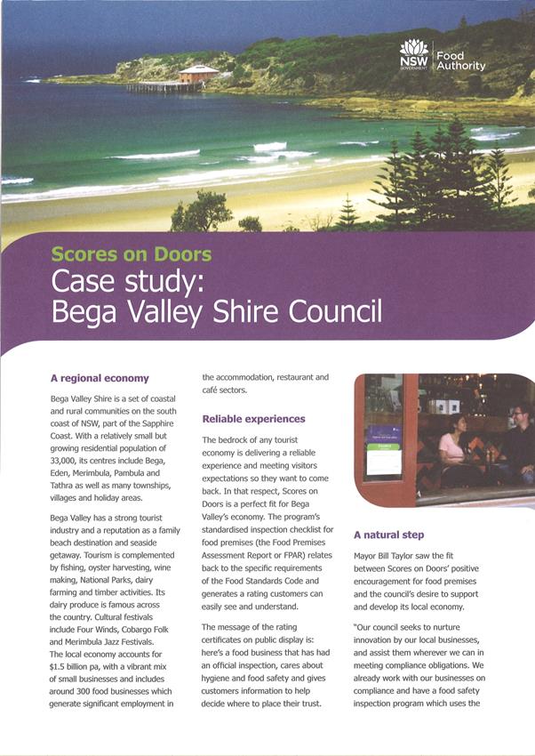

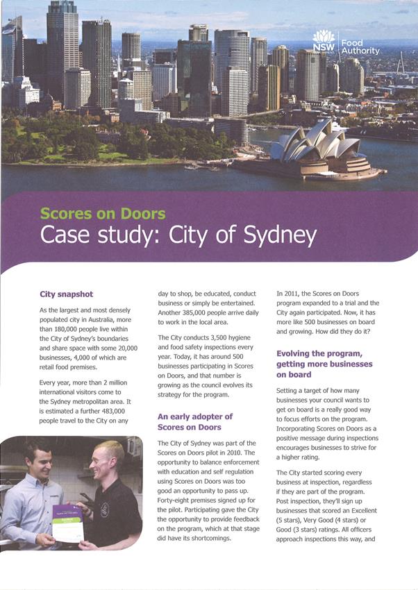
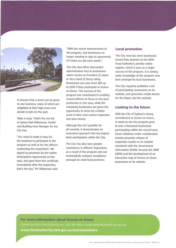

Figure
1: example certificate that will be consistent in design across they state to
enhance recognition and marketability.
Staff Reports - Sustainable Environment and Economy 13.11 - Attachment 1
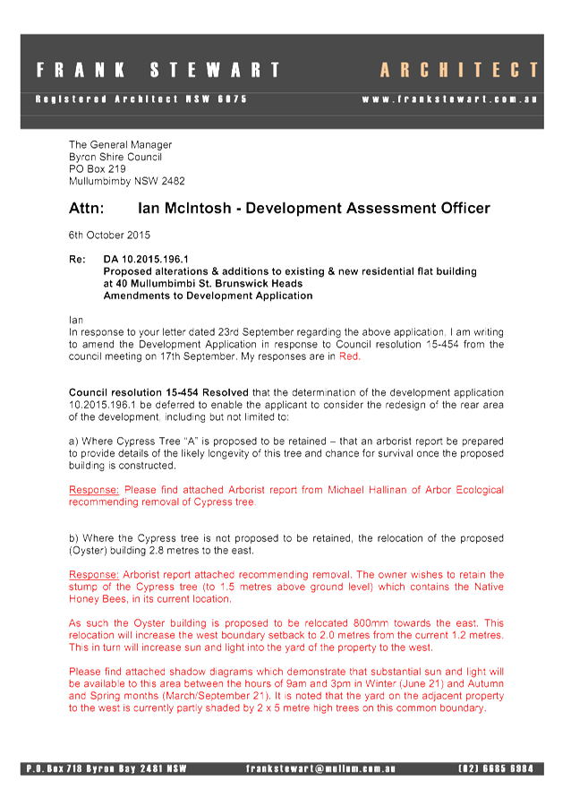
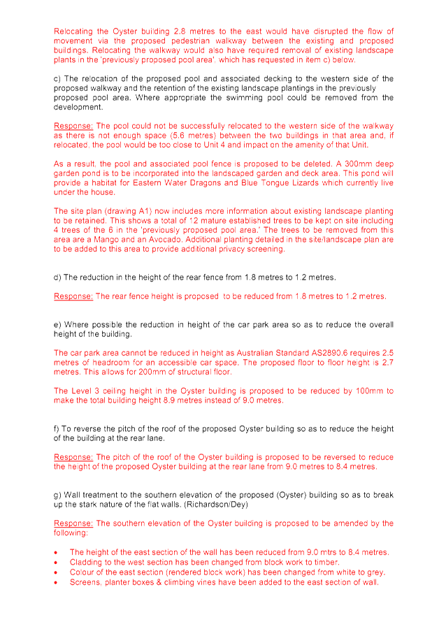

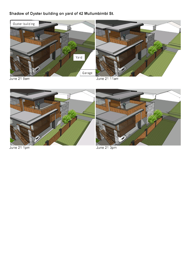
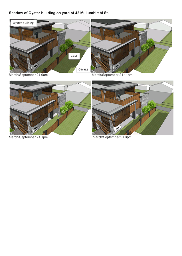
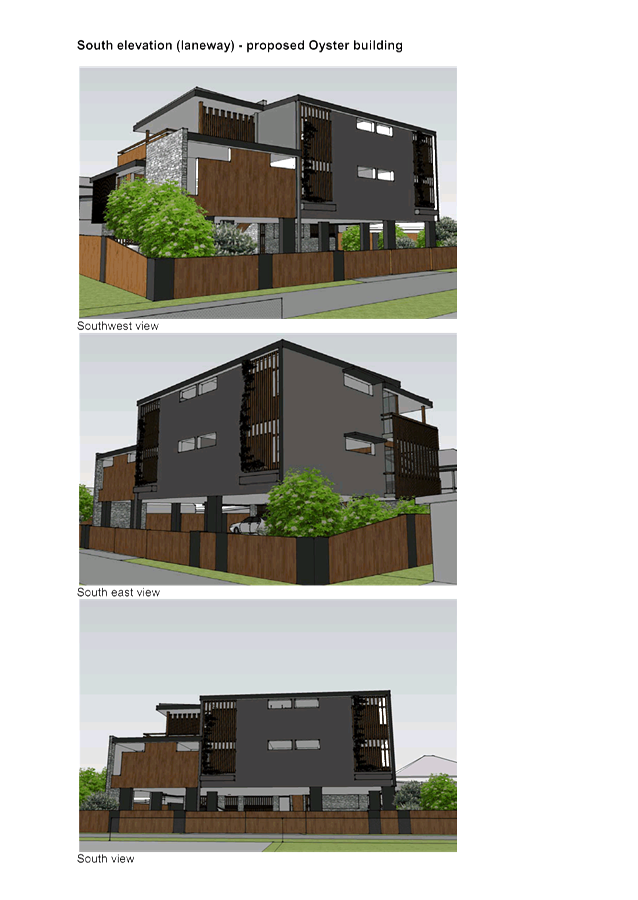
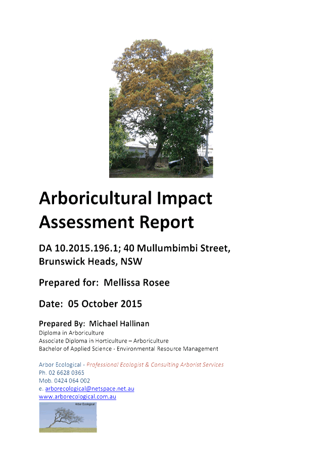
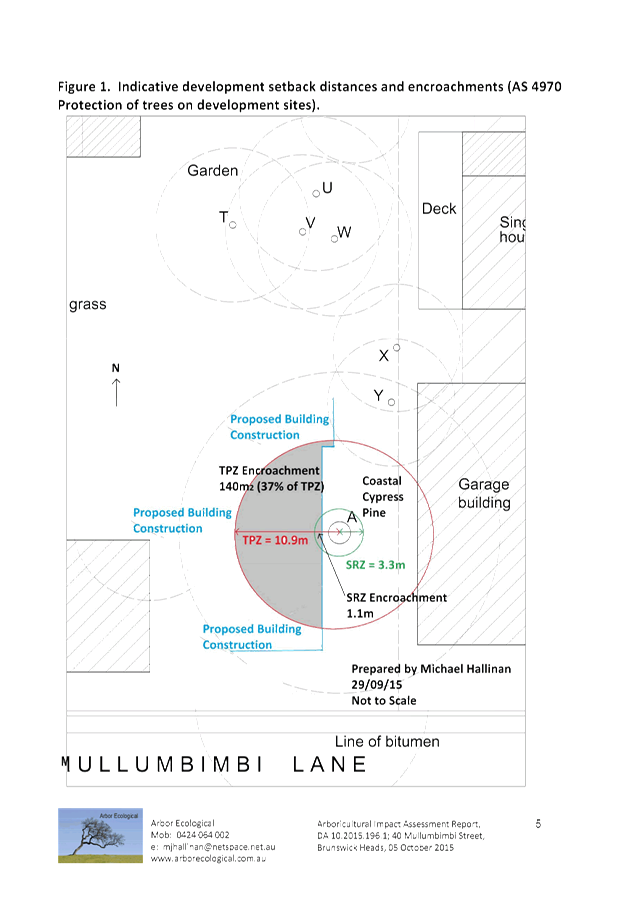
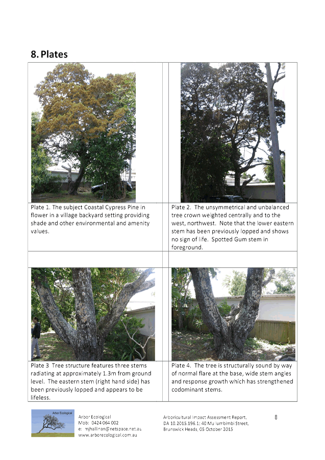

Staff Reports - Sustainable Environment and Economy 13.11 - Attachment 1
Staff Reports - Sustainable Environment and Economy 13.11 - Attachment 2
Report No. 13.11 PLANNING
- 10.2015.196.1 - Alterations to dwelling and a new residential flat building
eight serviced apartments and a managers residence at 40 Mullumbimbi Street
Brunswick Heads
Directorate: Sustainable
Environment and Economy
Report
Author: Ian
McIntosh, Assessment Officer
File No: I2015/812
Theme: Ecology
Development and Approvals
Proposal:
Development Application
10.2015.196.1 seeks consent to undertake alteration and additions to the
existing heritage building, known as “Barnes House” which is
currently divided into three residential flats, and change of use for tourist
accommodation in the form of serviced apartments. Additionally a separate three
storey building at the rear of the site is proposed building which will contain
an additional four serviced apartments, a swimming pool, open deck areas and
car parking for eleven cars.
|
Applicant:
|
Frank Stewart Architect
|
|
Owner:
|
Ms M J Rosee
|
|
Zoning:
|
Zone No. B2 Local Centre
|
|
Date received:
|
10 April 2015
|
|
Integrated Development:
|
No
|
|
Public notification or exhibition:
|
- Level
2 advertising under DCP 2014 Part A14 – Public Notification and
Exhibition of Development Applications
- Exhibition
period: 22/4/15 to 5/5/15
- Submissions: For =
1 Against = 9
|
|
Other approvals (S68/138):
|
(60) Water & Sewer (51) Roads Act
|
|
Planning Review Committee:
|
Yes
|
|
Delegation to determination:
|
|
|
Issues:
|
· Heritage
· Public Interest
|
Summary:
|
The proposal seeks consent to undertake alteration and
additions to the existing heritage building, known as “Barnes
House” which is currently divided into three residential flats and change
of use to tourist accommodation in the form of serviced apartments. The
proposed works are mostly to the internal floor layout and to raise the
building, by approximately 0.9m to allow the proposed downstairs living areas
to comply with Building Code of Australia specifications.
The external works proposed are similar to those approved
via DA 10.2008.719.1, however this application proposes to change the
internal layout of the three existing flats so that the building will contain
four serviced apartments and a Manager’s Unit. The Manager’s Unit
will be at ground level along with Unit 4 which will provide adaptable
housing.
Also proposed is a separate three storey building at the
rear of the site, this differs from 10.2008.719.1 which granted consent to a
detached double storey Manager’s Residence in the same location.
The proposed building will contain an additional four serviced apartments, a
swimming pool and open deck area and underfloor & external car parking
for eleven cars.
The proposal is consistent with Council’s planning
controls and generally with the guidelines for Brunswick Heads, whilst
providing a means for the embellishment and protection of the existing
heritage building, “Barnes House” on the site. The proposal
will generally maintain the visual appearance of the existing building whilst
its use as a place to provide low key tourist accommodation is consistent
with the village character of Brunswick Heads as a seaside destination for
tourists and residents.
The additional freestanding building is at the rear of
‘Barnes House’ and will not detract from its visual appearance.
The proposal is consistent with the relevant state
planning instruments and with BLEP2014. The proposal is generally consistent
with BDCP2014 except for a variation to a portion of the side boundary fence
that is 2.4 metres high to act as a privacy screen between the swimming pool
and deck area and the adjoining neighbour. The variation is supported by this
report. The proposed variation to the front fence height and the change from
a picket type fence to masonry and timber front fence with gatehouse is
considered to detract from the heritage character and is not supported;
subsequently the plans are to be marked in red to delete this part of the
proposal.
|
NOTE TO COUNCILLORS:
In accordance with the
provisions of S375A of the Local Government Act 1993, a Division is to be
called whenever a motion for a planning decision is put to the meeting, for the
purpose of recording voting on planning matters. Pursuant to clause 2(a)
under the heading Matters to be Included in Minutes of Council Meetings of
Council's adopted Code of Meeting Practice (as amended) a Division will be
deemed to have been called by the mover and seconder of all motions relating to
this report.
|
RECOMMENDATION:
That pursuant to
Section 80 of the Environmental Planning & Assessment Act 1979,
development application 10.2015.196.1 for alterations to a dwelling and a new residential flat
building to be eight serviced apartments and manager’s residence, be granted consent subject to the conditions
listed in Attachment 2 #E2015/49495.
|
Attachments:
1 Proposed
Plans 10.2015.196.1 - 40 Mullumbimbi Street Brunswick Heads, E2015/50662
2 Draft
conditions 10.2015.196.1 - 40 Mullumbimbi Street Brunswick Heads, E2015/49495
3 Letter
from Frank Stewart, Architect - 10.2015.196.1 - Additional Information, S2015/9642
4 Statement
of Heritage Impact 10.2015.196.1 40 Mullumbimbi Street Brunswick Heads, E2015/50756
5 Confidential
- submissions 10.2015.196.1 40 Mullumbimbi Street Brunswick Heads, E2015/50875
Report
Assessment:
1. INTRODUCTION
1.1 History/Background
BA 63/69 to convert the existing dwelling into three flats
10.2000.180.1 Tree Removal
Approved 18/04/2000
10.2008.719.1 Change
of use - residential flats to a tourist facility and construction of a new 2
storey caretakers residence - Approved 05/05/2009
10.2012.96.1 Tree
Removal – 3 trees - Approved 17/04/2012
1.2 Description
of the site
The subject property is zoned B2 – Local Centre pursuant
to Byron LEP 2014 and has an area of 1179 m2. The property is within
close walking distance to shops, restaurants, bars, amenities and the beach.
The property contains a two storey weatherboard building
which has been divided into residential flats. It is believed the
building known as the Barnes House was constructed prior to the start of the 20th
Century with timber sourced from various landholdings held by pastoralist Henry
Barnes in the Casino region. “Verbal records” indicate that the
area under the building may have been used as an interim school room on the
closure of the school in 1896 and the reopening of a new school in 1898 in
Brunswick Heads. The property is identified under the BLEP 2014 as a Heritage
Item (Schedule 5).
Consent was granted in 1969 under BA 63/69 to convert the
dwelling into three flats.
The front setback contains vegetation including a stately
Poinciana tree that is considered to be a component of the heritage streetscape
character.
The land is generally level with the yard landscaped with
lawn and garden trees and shrubs. An old garage has been constructed at the
rear of the property which is accessible from Lane No. 3. The land is elevated
with a level in excess of 4.25 m AHD.
1.3 Description
of the proposed development
The proposal seeks consent to undertake alteration and
additions to the existing heritage building (‘Pearl’), mostly to
the internal floor layout and to raise the building, by approximately 0.9m to
allow the downstairs living areas to comply with Building Code of Australia
specifications.
The external works proposed are almost identical to those
approved via DA 10.2008.719.1, however this application proposes to change the
internal layout of the three existing flats so that the building will contain
four serviced apartments (Units 1, 2, 3 & 4), and a Manager’s unit.
The Manager’s unit will be at ground level along with Unit 4 which will
provide adaptable housing. One car parking space is provided for the Manager
and this can also be used as a disabled access space should it be required.
Proposed external works to ‘Barnes House’ almost
identical to previous approval.
Existing approval for raising and alterations to
‘Barnes House’
Also proposed is a separate three storey building
(‘Oyster’), at the rear of the site which, under consent
10.2008.719.1, contained a separate double storey Manager’s Residence.
The proposed building will contain an additional four
serviced apartments, a swimming pool and open deck area and underfloor &
external car parking for eleven cars. The existing garage/ shed located on the
rear boundary with Mullumbimbi Lane is to be demolished as previously consented
to in 10.2008.719.1.
The proposed new building comprises:
Ground
floor
· car parking for 9
guests and 2 visitors (including 1 x disabled access and 1 x multi use).
· 1.8 metre high
rear fence of timber panels between masonry piers with 1.15 metre high rear
gates between car parking area and Mullumbimbi Lane
· Deck with disabled
access and swimming pool with landscape gardens and masonry and planted privacy
screens to neighbours private open spaces.
First
Floor
· Units 5, 6 & 7
each containing one bedroom with ensuite bathroom, and a kitchen area within a
living area with north facing balcony,
First
floor
· Unit 8 two
bedrooms with ensuite bathrooms, a sitting room separated from the living room
by a kitchen and western and northern balconies.
The proposal is consistent with Council’s planning
controls for the zone and guidelines for Brunswick Heads, whilst providing a
means for the embellishment and protection of the existing heritage building
known as “Barnes House” on the site. The proposal will
generally maintain the visual appearance of the existing building whilst its
use as a place to provide tourist accommodation is consistent with the village
character of Brunswick Heads as a seaside destination for tourists.
Proposed seven serviced apartment development
Proposed seven serviced apartment development
2. SUMMARY
OF GOVERNMENT/EXTERNAL REFERRALS
|
|
Summary of Issues
|
|
Development Engineer
|
Supported conditionally (see detailed comments below)
|
|
Environmental Health Officer
|
Not required
|
|
Water & Waste Services
|
Supported conditionally
|
|
Systems Engineer
|
ETs apply supported conditionally
|
Car Parking Satisfactory (07/7/15) Unsatisfactory(20/5/15)
20/5/2015.
The Application is for 9
Serviced Apartments, (2 x 2B/R, 7 x 1 B/R) plus 1 Manager’s Residence. (a
total of 12 bedrooms).
Council’s
DCP 2014, Chapter B4, states that ‘Serviced Apartments’ is to refer
to ‘Medium Density Housing’ for on site car parking rates. Such a
development requires 10 car spaces plus 3 visitor spaces. The DCP also states
that, for this type of development, stacked parking is not appropriate.
The
application proposes only 10 car spaces in total, 2 of which are stacked. There
are no visitor spaces being provided, claiming that it is a tourist development
and does not comprise permanent dwellings and thus requests a relaxation of the
provision of visitor car parking.
The parking
rate required is 1 space per 1 or 2B/R units plus 1 space per 4 units for
visitors. The current proposal requires 13 car spaces and only 10 are proposed.
No stacked car parking is allowed, but this proposal requires 2 stacked spaces.
The car
parking distribution and layout, as presented, does NOT comply with the current
DCP 2014.
NOTE:
An
alternative layout of the development could provide the site with the car
parking required per the DCP. A development comprising 1 Manager’s Unit,
4 x 2 B/R units, and, 3 x 1 B/R units would require 8 car spaces plus 2 visitor
spaces. This equates to 10 car spaces, no requirement for stacked car parking
and retains the capacity of 12 bedrooms.
07/7/2015.
Subsequent to meeting with the
Applicant on 15/6/15, the following parking arrangements are agreed to.
The number of units was
reduced by one.
The car spaces in the front
yard could either be used by the Manager or for Disabled.
As the Manager is on site at all times, especially to
book people in, the disabled space was decided to be placed in the rear
adjacent to the disabled unit. The space is larger than a standard one and also
has shared use bay adjacent which could also be used as one of the 3 visitor
spaces. It was also presented, that the visitor spaces get limited use in
tourist developments and villages. It was considered that in this case that the
shared use could be functional, particularly as there is a resident manager on
the site to organise/assist in the parking arrangements for the disabled and
visitors and the overall efficient functioning of the parking arrangements on
the site. The proposal now provides 8 car spaces plus 2 visitor spaces. This
equates to 10 car spaces plus one for the manager.
The consent can be conditioned
to address these issues.
Traffic/Roadworks
Satisfactory Unsatisfactory Not applicable
The existing development,
comprising of 1 x 3B/R unit, 1 x 2b/r unit, and, 1 x 1 B/R unit would generate
17 vehicles/day along the rear Lane.
The proposed development,
comprising of 3 x 2B/R units, and, 5 x 1B/R units would generate 40
vehicles/day along the rear Lane. The Manager’s unit would generate 5
vehicles/day accessing onto the front street.
The proposed development
doubles the traffic generation from the site onto the rear Lane. The additional
23 vehicle trips per day can be catered for along the Lane. The alignment is
straight with good sight distance. The formation is flat with bitumen seal and
grassed verges, being satisfactory to facilitate 2 vehicles to pass each other.
The Lane exhibits a relatively low speed, shared use environment.
Notwithstanding this, there is
concern expressed (submissions on the DA) regarding the perceived speed and
volume of vehicles using the Lane, in particular using the Lane as a through
‘short cut’ route. (This occurs irrespective of this development
occurring).
This has been discussed (now
and previously) with Council’s Traffic Engineer. This matter and proposed
development will be an Agenda Item for the next Local Traffic Committee meeting
(24 June 2015, which in part, one way traffic flows will be considered.
The development was not
rejected by the committee, although that not being the charter of the
committee.
Irrespective of the above, it
is prudent and consistent to provide a two way bitumen seal pavement in the
Lane for the ‘frontage’ of the site and east through to join up
with the existing two way pavement at the Park Street end of the Lane. The
profile and formation of the Lane should be comparable to the existing two way
section of the Lane.
The consent can be conditioned accordingly.
The Application also seeks
concurrent approval for roadworks (a new driveway in Mullumbimbi Street. A
new concrete driveway and layback is required from the existing kerb line
through to the property boundary. The driveway from the gutter line to the edge
of road pavement seal is to be bitumen sealed. Approval for this driveway
can be granted with this consent and the consent can be conditioned
accordingly.
Heritage Officer
This application was not referred to a Heritage Advisor as
the works proposed to ‘Barnes House’ are almost identical to those
approved by 10.2008.719.1. That development Application was forwarded to
Council’s consultant Heritage Advisor for comment who advised that the
proposed development would have minimal impact on the heritage and urban values
of the building and the proposed changes respect the heritage values of the building
and would provide a viable use into the future. Recommendations were made which
were added as conditions of consent in relation to the following:
- Details of demolition works including demolition plans
- Photographic recording prior to the commencement of works
- Photographic recording of the works in progress
- Lodgement with the Brunswick Valley Historical Society of copies of
the demolition plans and photographic recordings
- Regular inspections by the Heritage Adviser during the works and
prior to handover
Those recommendations, in addition to the two points below,
will be included as consent conditions should consent be granted to this
application.
- Reuse and labeling of important features such as the under floor
timber stumps, particularly one with the words ‘Gins Only’ written
on it.
- Details of two ‘Open Days’ per year where Barnes House
and the historic item display will be open to the public.
The construction of the 4 unit building in the rear of the
yard will not detract from the heritage character of the streetscape of
Mullumbimbi Street.
3. SECTION
79C – MATTERS FOR CONSIDERATION – DISCUSSION OF ISSUES
Having regard for the matters for consideration detailed in
Section 79C(1) of the Environmental Planning & Assessment Act 1979, the following
is a summary of the evaluation of the issues.
State/Regional Planning
Policies and instruments - Issues
3.1. STATE/REGIONAL
PLANNING POLICIES AND INSTRUMENTS
|
Requirement
|
Requirement
|
Proposed
|
Complies
|
|
SEPP 55 – Contaminated Lands
|
Council [CP11] must:
(a) considered whether the land is
contaminated, and
(b) if the land is contaminated,
if the land is suitable in its contaminated state or after remediation, and
(c) be satisfied the land will be
remediated before the land is used.
|
The property has been used for residential purposes for
more than 100 years. It is considered the property is suitable for
residential use.
Conditions of consent recommended in relation to
demolition concerning asbestos and lead paint
|
Yes
|
|
SEPP No. 71 - Coastal Protection
|
Matters for consideration for development within the
coastal zone:
- retention of existing
public access to the coastal foreshore
- impact of effluent
disposal on water quality
- development must
not discharge untreated stormwater into a coastal water body
|
- No public access to the
coastal foreshore will be impeded or diminished as part of the proposal
- The proposed
manager’s residence is to be connected to an on-site disposal system
which has been assessed as satisfactory in term of impact upon the
environment.
- Stormwater is to be
disposed to Council’s Stormwater System
- No overshadowing
of the foreshore reserve or the beach is proposed
- The development is
landward of the defined erosion zones
- The development is
within the existing urban area of Brunswick Heads and is unlikely to
adversely impact upon the scenic or visual amenity of the coastline.
|
Yes
|
|
SEPP BASIX
|
Certificate required for manager’s residence/unit
|
Certificate No 622567S, dated 8 April 2015
|
Yes
|
|
NSW Coastal Policy 1997
|
Protection of coastal access,
environment and amenity
|
The proposal raises no issues in terms of the Coastal
Policy.
|
Yes
|
|
Building Code of Australia
|
Buildings to comply with the BCA
|
All building work to comply with the BCA. Appropriate
condition of consent recommended
|
Yes
|
|
Demolition
|
Demolition to be carried out in accordance AS2601
|
All demolition work to comply with the AS2601. Appropriate
condition of consent recommended
|
Yes
|
|
Disability Access (DDA)
|
Access for persons with disabilities
and integration into surrounding streetscapes without creating barriers. (Council Res.10-1118)
|
Disability access proposed.
|
Yes
|
*
Non-complying issues discussed below
3.2. BYRON
LOCAL ENVIRONMENTAL PLAN 2014
Zone: Zone No. B2 Local Centre
Definition: Serviced apartments
|
LEP Requirement
|
Summary of Requirement
|
Proposed
|
Complies
|
|
Meets zone objectives B2 – Local Centre
|
•
To provide a range of retail, business, entertainment and community uses that
serve the needs of people who live in, work in and visit the local area.
• To
encourage employment opportunities in accessible locations.
• To
maximise public transport patronage and encourage walking and cycling.
• To
encourage vibrant centres by allowing residential and tourist and visitor accommodation
above commercial premises.
|
Serviced apartments will allow tourist accommodation
within walking/cycling distance of town centre, beaches and boat harbour
foreshore.
Tourist accommodation will provide additional income
within the town through visitor spending and tourist industry services.
|
Yes
|
|
Permissible use
|
Note. Serviced apartments are a type of tourist
and visitor accommodation
Serviced apartment means:
a building (or part of a building) providing self-contained accommodation to
tourists or visitors on a commercial basis and that is regularly serviced or
cleaned by the owner or manager of the building or part of the building or
the owner’s or manager’s agents.
|
Serviced apartments with owner/ manager to live on
site
|
Yes
|
|
3.1 Exempt & Complying development
|
3) To be exempt development, the
development:
(d) must not be carried out on
land that comprises, or on which there is, an item that is listed on the
State Heritage Register under the Heritage Act 1977 or that is subject to an interim
heritage order under the Heritage Act 1977.
|
The application includes signage for which detail has
not been provided. Subsequently the signage is not approved should the
application be approved.
As signage can not be exempt a consent condition is
to be included stating that any signage requires consent.
|
Yes
|
|
4.3 Height of Buildings
|
The height of a building on any land is not to exceed the
maximum height shown for the land on the Height of Buildings Map = 9.0m
|
Maximum height = 9.0m
|
Yes
|
|
4.4 Floor space ratio
|
The maximum floor space ratio for a building on any land
is not to exceed the floor space ratio shown for the land on the Floor Space Ratio Map = 0.75:1
|
Proposed floor space ratio is 0.749:1
Total Gross Floor area = 884m2
Site Area = 1179m2
|
Yes
|
|
5.6: Architectural roof features
|
Check: Does the roof comply with the height limits
of Clause 4.3
|
Maximum roof height 9.0m
|
Yes
|
|
5.9: Preservation of trees or vegetation
|
Must not remove or otherwise injure any vegetation
prescribed by Chapter 2 of BDCP2014, without development consent.
|
Consent sought for removal of 8 trees of which 5 are
prescribed natives, 3 x tuckeroos & 1 x eucalypt, the eucalypt being an unsuitable
species for the location and a grevillea.
A compensatory planting is proposed and will be
conditioned via a Landscape Plan to be submitted prior to CC..
|
Yes
|
|
5.10: Heritage conservation
|
Check: Is it a:
· Heritage
item = Yes
· Aboriginal object
= No
· Building in a
heritage conservation area. = No
|
The existing dwelling is a heritage item ‘Barnes
House’
|
Yes
|
|
|
2(a) - Consent is required to:
(i) Alter
the exterior of a heritage item
(b) making structural changes
to the interior of a heritage item.
(e) Erecting a building on land
on which a heritage item is located.
|
Consent sought
|
Yes
|
|
|
5 Heritage Assessment
Before granting consent to land on which a heritage item
is located a Council may request a heritage assessment.
|
‘Statement of Heritage Significance and Conservation
Policy’ & ‘Statement of Heritage Impact’ provided.
|
Yes
|
|
|
6 Heritage conservation management plans
After considering the heritage significance Council may
require the submission of a heritage management plan.
|
‘Statement of Heritage Significance and Conservation
Policy’ & ‘Statement of Heritage Impact’ provided are
considered to adequately address heritage issues.
|
Yes
|
|
|
10 Conservation Incentives
The consent authority may grant
consent to development for any purpose of a building that is a heritage item
or of the land on which such a building is erected, even though development
for that purpose would otherwise not be allowed by this Plan, if the consent
authority is satisfied that:
(a) the
conservation of the heritage item is facilitated by the granting of consent,
and
(b) the
proposed development is in accordance with a heritage management document
that has been approved by the consent authority, and
(c) the
consent to the proposed development would require that all necessary
conservation work identified in the heritage management document is carried
out, and
(d) the
proposed development would not adversely affect the heritage significance of
the heritage item, including its setting, and
(e) the
proposed development would not have any significant adverse effect on the
amenity of the surrounding area.
|
a) change of use from residential flats to tourist
accommodation will enable a wider population to be informed of the history of
‘Barnes House’ from staying within the heritage item and viewing
a proposed display of historical items.
b).The ‘Statement of Heritage Significance and
Conservation Policy’ & ‘Statement of Heritage Impact’
are to be stamped as part of the consent.
c).The ‘Statement of Heritage Significance and
Conservation Policy’ & ‘Statement of Heritage Impact’
are to be stamped as part of the consent.
d).It is considered that the proposed alterations will not
adversely affect the heritage significance but will ensure management and
protection of the heritage item.
e). It is unlikely that the alterations to ‘Barnes
House’ will result in any significant adverse effects on the amenity of
the surrounding area, neither adjoining dwelling is a heritage item.
|
Yes
|
|
6.1: Acid sulphate soils
|
Class 4 PASS
Works > 2.0m below ground level may impact ASS
|
No excavation > 1.5m below ground level proposed.
|
Yes
|
|
6.2: Earthworks
|
Check: Matters under Clause 6.2(3)
Maximum earthworks = 2.0m
|
No earthworks >1.5m proposed (swimming pool).
|
Yes
|
|
6.6: Essential Services
|
Check: See B3 & B4 DCP
· water,
· sewer,
· electricity
· stormwater
· vehicle access
|
Site is fully serviced
|
Yes
|
* Non-complying issues
discussed below
Byron Local Environmental Plan
2014- Issues
No issues
Draft EPI that is or has been
placed on public exhibition and details of which have been notified to the
consent authority - Issues
Nil
3.3 DEVELOPMENT
CONTROL PLANS
Development Control Plan 2014
|
Byron
Development Control Plan 2014
|
|
Control
|
Assessment
|
Compliance
|
|
1)
Chapter B10 -
Signage
|
|
2)
B10.1.3
|
The Statement of Heritage Significance & Conservation
Policy states that “there will be new timber signs approx. 0.5m2 identifying
the establishment at the front & rear. However as no detail has been
provided and as signage is not exempt within a heritage item site, should
consent be granted a consent condition is to be included stating signage
requires separate development consent.
|
Yes
|
|
Chapter B11 Planning for Crime Prevention
|
|
3)
B11.2.1 Development that Requires
a Formal Crime Risk Assessment
1. Council will expect a formal Crime
Risk Assessment for the following types of development:
4)
new or refurbished shopping centres or
transport interchanges; or
5)
residential developments or
subdivisions comprising more than 20 dwellings or 20 lots;
6)
any subdivision that creates
pedestrian egress from the end of a cul-de-sac to another public road, public
reserve or the like; or
7)
car parks with more than 20 spaces; or
8)
any commercial premises involving the
construction or alteration of basement car parking; or
9)
development or redevelopment of a
mall or other public place;
10)
health services facilities,
nightclubs, pubs, registered clubs, restricted
premises, sex services premises, small bars; and
11)
12)
other developments that, in the
Council’s opinion, is likely to create a risk of crime.
|
The proposed tourist accommodation with live in on-site
manager is not considered to be a development that is likely to create a risk
of crime.
|
Yes
|
|
Chapter D3 – Tourist Accommodation
|
|
13)
D3.2.1 Location and Siting
14)
The siting, design and operation of tourist
accommodation and associated development must not conflict with important
ecological characteristics of the site or the Shire, and respects the natural
systems and values of its location and surrounds.
|
The existing and proposed
development is located within a B2 - Local Centre Zone and is therefore
unlikely to adversely impact important ecological characteristics of the site
or the Shire.
|
Yes
|
|
15)
D3.2.4 Character & Design
in Business and Mixed Use Zones
16)
17)
Tourist accommodation in Zone B2 must
be compatible in character and amenity with development in the locality. The
provisions of the following Sections in Chapter D4 Commercial and Retail
Development apply to all tourist accommodation development in Zone B2 in the
same way they apply to commercial and retail development in Business and
Mixed Use zones:
18)
a)Section D4.2.1 – Design
Character of Retail and Business Areas.
19)
b)Section D4.2.2 – Design
Detail and Appearance.
20)
|
See detailed discussion below.
|
Yes
|
21) D4.2.1 – Design Character of Retail and Business
Areas.
22)
23)
To promote pedestrian and cycle
usage, together with reduced vehicle dependency in the Shire’s business,
commercial and retail areas.
24)
25)
To encourage safety, accessibility
and human scale in the Shire’s business, commercial and retail areas.
26)
27)
To encourage diverse,
multi-functional business, commercial and retail centres that provide a
compatible range of commercial, recreational and community activities
appropriate to the Shire’s climate, environment, social fabric and scenic
character.
28)
29)
To ensure that development
reinforces the role of centres within the Shire’s commercial centres
hierarchy.
30)
31)
To ensure that establishment and operation of new development
contributes to and does not detract from the social and economic robustness,
diversity and vitality of retail, business and community areas and precincts.
The existing development on the site comprises a building
approved as three residential units. The proposed development involves a change
of use to serviced apartments to cater for visitors to the coastal village of
Brunswick Heads. The proposal will increase the accommodation within the
existing building from six bedrooms (within three apartments), to seven
bedrooms within five apartments including an owner/ manager’s unit. The
proposed detached dwelling at the rear will add a further three serviced
apartments (3 x 1 bed & 1 x 2 bed).
The proximity of the development to the businesses of the
town centre, the beach and Brunswick River foreshores enables easy pedestrian
and cycle access which will encourage visitors to leave their vehicles parked
at the development.
The scale of the development is
appropriate to the heritage character of the existing building and the
surrounding neighbourhood. The owner/operator has collected historical items,
and information associated with the original property owners, and is proposing
to create a historical display within the common areas for guests, a condition
will ensure this. It is also proposed, & conditioned, to hold two public
‘Open Days’ for people to observe ‘Barnes House’ and
the historical artefacts displayed within.
Previously Byron Shire
Council’s Heritage consultant confirmed that
the historical and cultural memory of
"Barnes house" was a key contributing factor in its listing as a
heritage item (10.2008.719.1). The opening up to guests of the heritage listed
"Barnes house" and presentation of these items will contribute to
visitors developing an understanding of part of the cultural history of Byron
Shire.
A screened waste bin storage
area for 6 x 240L bins is to be provided, out of public view, at the rear of
‘Barnes House’.
D4.2.2 – Design Detail and Appearance.
32) Objectives
1. To ensure that development is
compatible with the design and amenity of development in the locality.
33)
34) Performance Criteria
35)
1. The design of new buildings
must reflect and enhance the existing character of the precinct. The design,
scale, bulk, design and operation of business, commercial and retail
development must be compatible with the streetscape and with the aesthetics,
function and amenity of development in the locality.
36)
37)
2. Building design, roof
profile, detailing, colours, materials and the like that are visible from the
street and from adjoining properties must be compatible with any dominant
design themes in the surrounding locality.
38)
39) 3. The pattern of windows in retail areas must provide
visual interest and variation and must relate to those of adjacent buildings.
Building materials must relate to the context of buildings within the area to
achieve continuity and harmony. Contrasting materials may be used to provide
diversity, however materials and colour must not be used so that they dominate
the streetscape.
The proposed development is not
directly in the retail area of Brunswick Heads. The streetscape of the front of
the property is part of the heritage character of the heritage item and
provides visual interest. The existing shade trees within the Mullumbimbi
Street setback which are to remain also form part of the local character
streetscape appeal of ‘Barnes House’.
The adjoining development to the
south comprises a 5 unit residential flat building with ground floor shops with
zero setback facing Mullumbimbi Street.
Existing development along
Mullumbimbi Street & within the B2 zone comprises mixed use shop top
housing & residential units. There is a single storey dwelling adjoining to
the west. The proposed conversion of Barnes House is within character of the
locale.
‘Barnes House’ 40
Mullumbimbi Street (trees in front setback to be retained).
38
Mullumbimbi Street (shop top housing five apartments) (east)

34
(shop-top housing), 32 (residential flats) & 30 (Raised dwelling), Mullumbimbi
St (east)
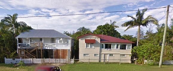
6
& 7 Mullumbimbi St (opposite 40)
Single
storey dwelling 42 Mullumbimbi St (west)
The proposed use as tourist
accommodation is compatible with the town centre location. The proposed
development is considered a low rise, low key development to be managed by the
owners living on the property and catering to the needs of the guests. The
development is close by the town, beach and river at Brunswick Heads which are
popular local attractions for visitors. The scale of the development is
appropriate to the heritage character of the existing building and the
surrounding neighbourhood and reflects the low-scale, tourist coastal village
image of Brunswick Heads.
The proposed building (Oyster)
has been designed in contrast to the existing heritage building (Pearl). The
building has contemporary lines and forms to avoid mimicking the character of
the existing heritage building. The colours are generally black, white and
tones of grey. The building utilises natural stone cladding and natural timber
screen elements and hard landscaping as design features.
The SEE claims “these
elements, and the deliberate contrast in building forms between the existing
and new buildings, express the conceptual theme of the Pearl and Oyster, which
is a reference to the Oyster industry of Brunswick Heads. This is intended to
be seen as a harmony of opposites and the relationship between Brunswick Heads
industrial history and the present day focus on tourism"
40)
D 3.3.7
Serviced Apartments
41)
42)
Objectives
43)
44)
1. To ensure
that serviced apartment development is compatible with the character and
amenity of development in the locality.
45)
46)
2. To ensure
that establishment of serviced apartment development does not adversely affect
the social and economic robustness, diversity and vitality of retail, business
and community areas and precincts.
47)
48)
Performance
Criteria
49)
50)
1. The design
and operation of serviced apartments must be compatible with the streetscape
and character of development in the locality.
51)
52)
2. Development
applications must demonstrate that the proposed development is designed and
landscaped consistent with the requirements of Chapters B11 Planning for Crime
Prevention and B9 Landscaping.
53)
54)
3. Serviced
apartments must not
adversely affect the amenity of the precinct in which it is located.
55)
56)
4. Serviced
apartments must comply
with the requirements of Chapter D1 Residential Development in Urban and
Special Purpose Zones, Section D1.6.
As detailed in D4.2.1 &
D4.2.2 the proposed serviced apartments, tourist accommodation is compatible
with the town centre location.
The proposed development is a
low rise, low key development, to be managed by the owner’s family living
on the property and thereby catering to the needs of the guests and ensuring the
preservation of amenity to neighbours.
The development is close by the
town, beach and river at Brunswick Heads which are popular local attractions
for visitors. The scale of the development is appropriate to the heritage
character of the existing building and the surrounding neighbourhood and
reflects the low-scale, tourist-beach image of Brunswick Heads.
The proposed serviced apartment
development is compatible with the character and amenity of existing
development in the locality. The area around the existing and proposed
buildings is vegetated and is not visually prominent.
The proposed new building
complies with all other BLEP2014 and BDCP2014 requirements, including density,
height, setback, car parking, landscaping and open space requirements, and will
be compatible with the existing and planned scenic quality and character of the
locality.
The proposed development will
have social and economic benefits for the village of Brunswick Heads. The
development is located within an area identified as suitable for tourism and
will help provide for a growing economy in this area. The construction of the
building and associated works will provide employment within the construction
and allied industries.
The proposed serviced apartment
development will add to the existing social & economic robustness and the
diversity and vitality of retail, business and community areas and precincts.
|
Byron
Development Control Plan 2014
|
|
Control
|
Assessment
|
Compliance
|
|
57) D1.6 – Multi Dwelling Housing,
Residential Flat Buildings & Attached Dwellings
|
|
58)
D1.6.1 - Private
Open Space Courtyards
59)
60)
|
The proposed development is
for tourism i.e. short stay accommodation and not for permanent residents.
Notwithstanding each unit has a private open space balcony or access to a landscaped
private outdoor area.
|
Yes
|
|
61)
D1.6.2 – Open
Space Balcony
62)
63)
|
All above ground units have
direct access to a private open space balcony with an area of 15m2
and at minimum length & width of 2.4m.
All units are oriented
towards the north except for 3 & 4, which have a south-west orientation.
|
Yes
|
|
64)
D1.6.3 - Landscaping
|
Landscaping has been
conditioned to be in accordance with BDCP2014.
|
Yes
|
|
65)
|
|
|
66) E4.1.2 Aims of this Chapter
67) The
primary purpose of this Chapter of the DCP is to provide relevant criteria and
standards for the future development of the Brunswick Heads Urban Area.
The aims of this Chapter are:
68)
1. To facilitate and provide
guidelines for the development of the Brunswick Heads Urban Area consistent
with the provisions of the Byron LEP 2014, the Brunswick Heads Settlement
Strategy 2004 and other relevant strategies and Chapters of this DCP.
69)
2. To maintain and enhance the
appearance and atmosphere of Brunswick Heads as a low-key, family-friendly
coastal village.
70)
3. To encourage new development to
complement, support and strengthen the character, living amenity and tourist
potential of the town and to maintain and enhance pedestrian and cycle access.
71)
4. To foster and reinforce the
restoration and protection of the riverside environment of Brunswick Heads.
72)
5. To continue to implement
environmentally sustainable development principles in the town’s business
area; and to further enhance its role as a dynamic local business sector
offering a range of employment opportunities.
73)
6. To reinforce the town’s
historical linkages and to protect identified heritage items.
The proposal is generally
consistent with the aims of Chapter E.
It is considered that the proposed alterations will not
adversely affect the heritage significance but will ensure management and
protection of the heritage item. It is unlikely that the alterations to
‘Barnes House’ will result in any significant adverse effects on
the amenity of the surrounding area neither adjoining dwelling is a heritage
item. Notwithstanding the proposed stone and timber front fence and gatehouse
have not been sufficiently addressed and those two components are not supported
by this report. Subsequently the proposed front fence and gatehouse will be
crossed out in red on the plans should the application be approved.
E4.2.1 Brunswick Heads -
Character. Bulk and Scale of Development
Performance Criteria
The existing and desired future
character of Brunswick Heads is defined by the following characteristics:
Business and Mixed Use Areas
Land zoned
B2 provides a safe, low traffic speed, pedestrian/cycle friendly environment
that encourages outdoor dining and community activity in the street.
Development
in this area uses setbacks, planting and design elements to contribute
positively to village amenity and create a pedestrian/cycle friendly
streetscape.
New
commercial and retail development is consistent with the requirements of
Chapter D4 Commercial and Retail Development. Development is designed to
enhance the low key, family-friendly, coastal village character, streetscape
and scale of Brunswick Heads.
New
development respects the north coast climatic conditions and adopts sustainable
design principles. lt incorporates footpath awnings and sun and rain protection
for pedestrians. Landscaping is provided in accordance with the requirements of
Chapter B9 Landscaping. Development respects heritage items.
The proposed development has an
outdoor dining area for guests and is compatible with a safe, low traffic
speed, pedestrian/cycle friendly environment.
The existing building on
Mullumbimbi St. (Pearl) has an existing set back approx. 7 metres from the
front boundary and incorporates existing established landscaping. The design
elements of the heritage listed building such as pitched roof, sub floor
screen, timber posts, wide verandahs, domestic scale, timber stair &
balustrade detail are to be retained, as they forms part of the heritage
character of the building.
The rear laneway is
predominantly a service road and provides access for car parking and services.
This frontage will have a 1.8m high timber and masonry fence and 1.15 metre
high gate to comply with safe sightlines for pedestrians & traffic using
the lane, and landscaping to reduce the apparent scale of the building on this
frontage.
The design elements of the
heritage listed building combined with the complimentary new rear yard building
will contribute to the low key, family-friendly, coastal village character,
streetscape and scale of Brunswick Heads.
Development Control Plan 2014
- Issues
No issues
3.4 The likely impacts of that
development, including environmental impacts on both the natural and built
environments, and social and economic impacts in the locality
Site Waste Minimisation and Management: Standard
condition applies
|
Impact on:
|
Likely significant impact/s?
|
|
Natural environment
|
No significant impacts.
|
|
Built environment
|
The proposed development is in keeping with the objectives
of the B2 Local Centre zone, and is compliant with the planned maximum site
density ratio of (0.75:1) while maintaining the heritage values and character
of ‘Barnes House’. The heritage character of the streetscape is
maintained by new building being sited, with maximum separation, in the rear
yard and accessed via the rear lane. The proposed development is not
out of character with the area which is dominated with two storey buildings,
holiday flats up to 9.0 metres in height, and large and/or elevated dwelling
houses.
|
|
Social Environment
|
The development caters directly to the high demand for
tourist accommodation in the locality. The proposed units within the
refurbished ‘Barnes House’ will include an accessible unit and
historical display to add to guest’s awareness of the history of the
heritage dwelling and Brunswick Heads coastal village. The new 3 unit
building will have a high level of amenity and the location is within easy
walking and cycling distance to the town centre, river & beaches.
|
|
Economic impact
|
The construction will have short term benefits to the
local economy.
The tourist accommodation will have long term financial
benefit to the local economy and will ensure the maintenance of the heritage
item.
|
3.5 The
suitability of the site for the development
The site is located within Zone B2 – Local Centre,
with high connectivity to local services and amenities. All planning and
environmental constraints affecting the site are considered to have been
satisfactorily addressed by the application and/or the conditions of consent
recommended at the end of this report. The subject property is not
affected by flooding, bushfire or geotechnical constraints, and the application
is supported on Engineering grounds (#A2015/10764).
The site is suitable for the proposed development.
3.6 Submissions
made in accordance with this Act or the regulations
There were eleven submissions made against the development
application and one in support.
It is noted that another two of the submissions generally
supported the application but with some reservations.
|
Issue
|
Comment
|
|
The proposal is an overdevelopment of the site.
|
The proposal complies with the maximum 0.75:1 Site Density
Ratio for the B2 zone & maximum height restriction.
|
|
Doesn’t comply with car parking requirements
|
The number of Units has been reduced (Unit 9 deleted) car
parking now complies.
|
|
We weren’t consulted prior to lodgement.
|
Not required but Noted.
|
|
Traffic issues in the laneway not addressed.
|
Council has considered the number of additional traffic
movements in the lane and have applied consent conditions for an upgrade to
the lane. Local Traffic committee is also looking into the potential for
making the lane one way.
|
|
Garbage bins should be relocated.
|
The bins have been relocated to behind building
‘Pearl’.
|
|
Height should be reduced to 7.5 metres.
|
The height limit for the site and surrounding land is
9.0m. The residential flat building adjacent to the east is 9.0m high.
|
|
We object to the length and height of the masonry fence
next to the swimming pool, & the swimming pool location right next to our
western boundary and the impact on our amenity.
|
The applicant met with adjoining owners and the height of
the masonry wall, which is to screen the pool and to protect the amenity of
neighbours, has been reduced 0.5m from 2.8m to 2.3m and the length reduced
from by 1.4m from 10.5m to 9.1m.
The pool is separated from the masonry wall on the side
boundary by a 1.7m wide disabled access ramp.
The swimming pool deck has been lowered by more than 0.5m.
|
|
The application requests stacked parking which is not
consistent with the DCP
|
Stacked parking is limited to the on-site manager only if
& when the disabled parking is required in the Mullumbimbi Street
setback. Otherwise the disabled space is provided at the rear of the disabled
access unit.
|
|
There should be a laneway policy in Brunswick Heads to
protect the character of the rear lanes.
|
The character of rear lanes are regulated within
residential zones, the subject land is within a business zone where development
is allowed
|
|
Landscaping as proposed is inadequate
|
Landscaping has been conditioned to be in accordance with
BDCP2014.
|
|
The importance of the site’s main
house to Brunswick Heads’ heritage is acknowledged and also the need
for the owner to undertake improvements to the site so as to make their
investment in the property sustainable. We also support, in principle, the
property being used for serviced apartments.
|
Noted.
|
|
There is a mango tree on the fenceline
that is proposed to be removed. We were not consulted.
|
Removal for a mango tree does not form part of this
consent. However, fruit trees are exempt for removal under Byron LEP2014
& BDCP2014. Removal of a mango tree on the boundary is a matter between
the adjoining neighbours.
|
|
No Heritage Impact Statement.
|
A ‘Statement of Heritage Significance and
Conservation Policy’ & a ‘Statement of Heritage Impact’
were provided and are considered to adequately address heritage issues.
The proposed external works to ‘Barnes House’
are virtually identical to what was previously supported by Council’s
Heritage Advisor and subsequently approved by Council via DA 10.2008.719.1.
|
|
Is there going to be commercial signage
in the front?
|
Signage not approved as part of this consent, if granted.
A consent condition stating that is to be included in any consent.
|
|
The opening of the front fence for a
driveway will decrease the street parking by at least one space
|
‘Barnes House’ has street frontage to
Mullumbimbi Street and therefore has the right to vehicle access.
|
|
The state of the gutters footpaths and
verges in Mullumbimbi Street are hazardous and it is impossible to place the
waste bins for collection.
|
Roads Act Approval has been granted for a concrete
driveway and concrete layback from the property boundary through to the edge
of gutter. A bitumen sealed driveway from the edge of gutter/layback through
to the existing road pavement seal.
|
|
Noise impact on residences.
I am already impacted by the Brunswick
Heads Hotel.
|
The proposed development is for short term tourist
accommodation comprising 8 serviced apartments and a manager’s
residence.
There is no nexus between noise generated elsewhere and
the proposed development. A condition re noise generation is to be included
should consent be granted. On-site manager will have ability to ensure
neighbourhood noise amenity is maintained.
|
|
Impact on solar access from 3 storey
dwelling
|
The proposed development complies with maximum 9.0m height
controls.
|
|
Lifting of the dwelling and excavation
may effect the water table there are bores in the area.
|
Highly unlikely
|
|
The DA doesn’t mention any changes
to the power pole that we share in the road reserve.
|
Council is not the electricity provider however there
would not appear to be any reason for the pole, which is not on the subject
land to be impacted.
|
|
The maximum height in the area should be
7.5m not 9m, as stated in the Brunswick Heads Settlement Strategy
|
The BLEP2014 controls the maximum building heights across
the shire. The Height Map in the under BLEP2014. Allows 9.0m.
Note the adjoining commercial/residential development to
the east is 9.0m high.
|
|
The stone & timber front fence is not
in keeping with the picket fence and should not be supported.
|
While it is not clear that the existing front picket fence
was part of the Heritage item listing, it does however, form part of the
heritage character in the streetscape. No detail of the proposed fence other
than it is 1.35 metres high and made from stone and timber; the front fence
is not supported.
|
|
There are no shadow diagrams.
|
Development in the B2 – Local Centre zone is not
subject to the same Building Height Plane and setback controls that apply in
residential zones. The buildings comply with the height controls.
|
|
Any argument that tries to enforce a 7.5
metre height limit is nonsense as 9.0m is consistent with what the BHSS
wanted as voted in 2004.
|
Noted
|
|
It is also wrong to argue that the site
is an overdevelopment as the unit entitlement is permissible.
|
Noted
|
|
Any argument from adjoining and nearby
owners in the residential zone that special consideration should be given to
the southern side of Mullumbimbi Street is wrong as it has historically been
zoned for commercial and people chose to live there.
|
Noted
|
|
The applicant lives within the B2 zone
and is entitled to undertake the maximum development permissible to
ensure financial viability.
|
Noted
|
|
The laneway problems could be solved by
placing no parking signs and enforcing the parking requirements of commercial
buildings on the corner of Park St & Mullumbimbi Lane.
|
Noted
|
|
Exemption for stacked parking for the
manager’s site in the Mullumbimbi St frontage should be supported as
such ‘valet’ parking is not uncommon other tourist accommodation
developments.
|
Proposed and supported.
|
|
Compensatory planting of a tuckeroo
should be conditioned.
|
Landscaping with local rainforest species, including a 3 x
tuckeroo trees is to be conditioned.
|
|
The raising of the building should not
destroy the historical significance of the fact that aboriginal staff were
‘housed under the house and one of the stumps has ‘Gins
Only’ written on it and this should be preserved.
|
The owner has indicated that the stump mentioned, and
other useable stumps that need to be removed, will be featured in other areas
of the proposed development i.e. the walkway between the buildings and will
be labelled to highlight their heritage significance.
It should also be noted that the owner has indicated a
willingness to educate the interested public about the heritage of
‘Barnes House’ and Brunswick Heads via two ‘Open
Days’ per year. This can be conditioned.
|
|
The rear yards along Mullumbimbi Lane
have become home to water dragons and other reptiles.
|
The reptiles will still be able to inhabit the garden
areas which will no doubt be enjoyed by the guests.
|
|
The height of the buildings will increase
the concentration of fruit bats flying over my property.
|
It is not understood why this would be expected, fruit
bats are very capable flyers and can easily fly higher than 9.0m.
|
NOTE: The applicant provided Council with responses
to submissions, plus additional information regarding the proposed heritage
item display to be exhibited within Barnes House that will be open to the
public two open days. Attachment 3.
3.7 Public
interest
The development as proposed development is not contrary to
the public interest.
4. DEVELOPER
CONTRIBUTIONS
4.1 Water
& Sewer Levies
Referral Report #A2015/10770; Assessed
by Jason Stanley
Current Situation
Existing entitlements have been sourced from the DA
10.2008.719.1 ET assessment (#DM850667).
Using the current day ET Policy 13/005, the existing sewer,
water and bulk water entitlements are as follows:
Table 1 - Calculation of Existing Water & Sewer ETs
|
Ref
|
Development Type
|
Standard
Unit
|
Quantity
|
ET Rate (ET/unit)
|
ET Load
|
|
Water
|
Sewer
|
Water
|
Sewer
|
|
3.7
|
1 bedroom unit
(Unit 2)
|
Dwelling
|
1
|
0.40
|
0.50
|
0.40
|
0.50
|
|
3.8
|
2 bedroom unit
(Unit 3)
|
Dwelling
|
1
|
0.60
|
0.75
|
0.60
|
0.75
|
|
3.9
|
3 bedroom unit
(Unit 1)
|
Dwelling
|
1
|
0.80
|
1.00
|
0.80
|
1.00
|
|
TOTAL
|
1.80
|
2.25
|
Therefore, the existing ET entitlement for this property is:
· 1.80 ET for
Water & Bulk Water; and
· 2.25 ET for
Sewer.
Proposed Development
The application seeks development consent constructing 9
serviced apartments, managers unit and pool. The proposed development will
generate the following load:
Table 2 - Calculation of
Proposed Development Water & Sewer ETs
|
Ref
|
Development Type
|
Standard
Unit
|
Quantity
|
ET Rate (ET/unit)
|
ET Load
|
|
Water
|
Sewer
|
Water
|
Sewer
|
|
3.11
|
1 bedroom Managers Unit
|
Dwelling
|
1
|
0.40
|
0.50
|
0.40
|
0.50
|
|
6.6
|
Unit 1 & 2
2 bedroom serviced apartment
|
Dwelling
|
2
|
0.50
|
0.75
|
1.00
|
1.50
|
|
6.6
|
Unit 3, 4, 5, 6, 7, 8, 9
1 bedroom serviced apartment
|
Dwelling
|
7
|
0.33
|
0.50
|
2.31
|
3.50
|
|
11.7
|
Swimming Pool
Commercial premises
|
Assume 3m
(W) x 5.6m (L) x 1.5m (D)
Using #E2015/9848
|
0.42
|
0.31
|
|
TOTAL
|
4.13
|
5.81
|
Table 3 - Calculation of
Additional Water & Sewer ET Load
|
|
Water
|
Sewer
|
|
Existing ET Entitlements
(Table 1)
|
1.80
|
2.25
|
|
Proposed Development ET
loading (Table 2)
|
4.13
|
5.81
|
|
Additional ET loading
|
2.33
|
3.56
|
Therefore, this development generates an additional load
onto Councils Water, Bulk Water and Sewer System
Council requires Payment of Developer Servicing Charges
(prior to issue of a construction certificate) of:
· 2.33 ET for
Water & Bulk Water; and
· 3.56 ET for
Sewer.
4.2 Section
94 Contributions
Section 94A Levy to be paid
Prior to the issue of a construction certificate the section
94A levy required by the Byron Developer Contributions Plan2012 shall be paid
to Council.
The levy will be calculated as follows:
Levy payable = %C x $C
Where: %C is
the levy rate applicable as set out in the latest Ministerial Direction issued
under section 94E.
$C is the proposed cost of carrying out the
development.
The rate of %C is:
|
Proposed
cost of the development
|
Maximum
percentage of the levy
|
|
Up to
$100,000
|
Nil
|
|
$100,001–$200,000
|
0.5 percent
|
|
More than $200,000
|
1.0 percent
|
The cost of development shall be
shall be calculated in accordance with clause 25J of the regulation. The
Cost Summary Report (copy attached) as set out in schedule 2 of the Section 94A
contributions plan shall be submitted to Council with the with the
payment. Copies of Cost Summary Report are available at Council’s
main office or may be downloaded from http://www.byron.nsw.gov.au/
5. CONCLUSION
The proposal seeks consent to undertake alteration and
additions to the existing heritage building, known as “Barnes
House” which is currently divided into three residential flats and change
of use to tourist accommodation in the form of serviced apartments. The
proposed works are mostly to the internal floor layout and to raise the
building, by approximately 0.9m to allow the proposed downstairs living areas
to comply with Building Code of Australia specifications.
The external works proposed are similar to those approved
via DA 10.2008.719.1, however this application proposes to change the internal
layout of the three existing flats so that the building will contain four
serviced apartments and a Manager’s Unit. The Manager’s unit will
be at ground level along with Unit 4 which will provide adaptable housing. One
car parking space is provided for the on-site manager.
Also proposed is a separate three storey building at the
rear of the site, this differs from 10.2008.719.1 which granted consent to a
detached double storey Manager’s Residence in the same location.
The proposed building will contain an additional four serviced apartments, a
swimming pool and open deck area and underfloor & external car parking for
eleven cars.
The proposal is consistent with Council’s planning
controls and generally with the guidelines for Brunswick Heads, whilst
providing a means for the embellishment and protection of the existing heritage
building, “Barnes House” on the site. The proposal will
generally maintain the visual appearance of the existing building whilst its
use as a place to provide low key tourist accommodation is consistent with the
village character of Brunswick Heads as a seaside destination for tourists and
residents.
The additional freestanding building is at the rear of and
well separated from, ‘Barnes House’ and will not detract from its
visual appearance.
The proposal is consistent with the relevant state planning
instruments and with BLEP2014. The proposal is generally consistent with
BDCP2014 save for a variation to sections of side boundary fence that are 2.4
metres high to act as a privacy screen between the swimming pool and deck area
and the adjoining neighbour. The variation is supported by this report.
The proposed variation to the front fence height and the
change from a picket type fence to masonry and timber front fence with
gatehouse, is considered to detract from the heritage character and is not
supported. Subsequently the plans are to be marked in red to delete this part
of the proposal.
The application is supported subject to consent conditions.
6. RECOMMENDATION
That pursuant to Section
80 of the Environmental Planning & Assessment Act 1979, development
application 10.2015.196.1 for alterations
to a dwelling and a new residential flat building to be eight serviced
apartments and manager’s residence,
be granted consent subject to the conditions listed in Attachment 2
#E2015/49495.
7. DISCLOSURE
OF POLITICAL DONATIONS AND GIFTS
|
Has a Disclosure Statement been received in relation to
this application
|
No
|
|
Have staff received a ‘gift’ from anyone
involved in this application that needs to be disclosed. Where the answer is
yes, the application is to be determined by the Director or Manager of the
Planning, Development and Environment Division.
|
No
|
Provide Disclosure Statement register details here: Nil
Staff Reports - Sustainable Environment and Economy 13.11 - Attachment 3
10.2015.196.1
CONDITIONS
OF CONSENT:
Parameters of this
Consent
1) Development is to be in
accordance with approved plans
The development is to be in accordance with plans listed
below:
|
Plan No.
|
Description
|
Prepared by
|
Dated:
|
|
A1
Issue C
|
Site Plan Landscape Plan
|
Frank Stewart Architects
|
March 2015
|
|
A5
Issue A
|
Level 1 Floor Plan (Pearl)
|
Frank Stewart Architects
|
March 2015
|
|
A6
Issue A
|
Level 2 Floor Plan (Pearl)
|
Frank Stewart Architects
|
March 2015
|
|
A7
Issue A
|
East & North Elevation
|
Frank Stewart Architects
|
March 2015
|
|
A8
Issue A
|
West & South Elevation
|
Frank Stewart Architects
|
March 2015
|
|
A9
Issue C
|
Level 1 Floor Plan (Oyster)
|
Frank Stewart Architects
|
March 2015
|
|
A10
Issue B
|
Level 2 Floor Plan (Oyster)
|
Frank Stewart Architects
|
March 2015
|
|
A11
Issue B
|
Level 3 Floor Plan (Oyster)
|
Frank Stewart Architects
|
March 2015
|
|
A13
Issue C
|
North & South Elevation (Oyster)
|
Frank Stewart Architects
|
March 2015
|
|
A14
Issue C
|
East & West Elevation (Oyster)
|
Frank Stewart Architects
|
March 2015
|
|
|
Statement of Heritage Significance and Conservation Policy
|
Frank Stewart Architects
|
April 2015
|
|
|
|
|
|
The development is also to be in accordance with any changes
shown in red ink on the approved plans or conditions of consent.
The approved plans and related documents endorsed with the
Council stamp and authorised signature must be kept on site at all times while
work is being undertaken.
2) Compliance with Building
Code of Australia and insurance requirements under the Home Building Act 1989
(1) For the purposes of section 80A (11) of the Act, the following conditions are
prescribed in relation to a development consent for development that involves
any building work:
(a) that the work must be carried
out in accordance with the requirements of the Building Code of Australia ,
(b) in the case of residential
building work for which the Home Building Act 1989
requires there to be a contract of insurance in force in accordance with Part 6
of that Act, that such a contract of insurance is in force before any building
work authorised to be carried out by the consent commences.
(2) This clause does not apply:
(a) to the extent to which an
exemption is in force under clause 187 or 188, subject to the terms of any
condition or requirement referred to in clause 187 (6) or 188
(4), or
(b) to the erection of a temporary
building.
(3) In this clause, a reference to
the Building Code of Australia is a reference to that Code as in force on the
date the application for the relevant construction certificate is made.
3) Erection of signs
(1) For the purposes of section 80A (11) of the Act, the requirements of subclauses (2)
and (3) are prescribed as conditions of a development consent for development
that involves any building work, subdivision work or demolition work.
(2) A sign must be erected in a prominent
position on any site on which building work, subdivision work or demolition
work is being carried out:
(a) showing the name, address and
telephone number of the principal certifying authority for the work, and
(b) showing the name of the
principal contractor (if any) for any building work and a telephone number on
which that person may be contacted outside working hours, and
(c) stating that unauthorised entry
to the work site is prohibited.
(3) Any such sign is to be
maintained while the building work, subdivision work or demolition work is
being carried out, but must be removed when the work has been completed.
(4) This clause does not apply
in relation to building work, subdivision work or demolition work that is
carried out inside an existing building that does not affect the external walls
of the building.
(5) This clause does not apply
in relation to Crown building work that is certified, in accordance with section 116G of the Act, to comply with the technical
provisions of the State’s building laws.
(6) This clause applies to a
development consent granted before 1 July 2004 only if the building work,
subdivision work or demolition work involved had not been commenced by that
date.
Note: Principal certifying authorities and principal
contractors must also ensure that signs required by this clause are
erected and maintained (see clause 227A which currently imposes a
maximum penalty of $1,100).
4) Notification of Home
Building Act 1989 requirements
(1) For the purposes of section 80A (11) of the Act, the requirements of this clause
are prescribed as conditions of a development consent for development that
involves any residential building work within the meaning of the Home Building Act 1989 .
(2) Residential building work within
the meaning of the Home Building Act 1989
must not be carried out unless the principal certifying authority for the
development to which the work relates (not being the council) has given the
council written
notice of the following information:
(a) in the case of work for which a
principal contractor is required to be appointed:
(i) the name and licence
number of the principal contractor, and
(ii) the name of the insurer
by which the work is insured under Part 6 of that Act,
(b) in the case of work to be done by an owner-builder:
(i) the name of the
owner-builder, and
(ii) if the owner-builder is
required to hold an owner-builder permit under that Act, the number of the
owner-builder permit.
(3) If arrangements for doing the
residential building work are changed while the work is in progress so that the
information notified under subclause (2) becomes out of date, further work must
not be carried out unless the principal certifying authority for the
development to which the work relates (not being the council) has given the
council written
notice of the updated information.
(4) This clause does not apply
in relation to Crown building work that is certified, in accordance with section 116G of the Act, to comply with the technical
provisions of the State’s building laws.
5) Existing building/s to
be bought into compliance with fire safety provisions
In accordance with Clause 94 of Environmental Planning &
Assessment Regulation 2000, the existing building is to be brought into
compliance with the fire protection and structural provisions of the Building
Code of Australia.
6) Concurrent Approvals
The following approvals are provided under Section 78A of
Environmental Planning and Assessment Act:
Concurrent Approvals under Section 68 of the Local
Government Act 1993
Part B Water
supply, sewerage and stormwater drainage work
B1 Carrying out water supply work
B3 Installing, altering,
disconnecting or removing a meter connected to a service pipe
B4 Carrying out sewerage work
B6 Connecting a private drain or
sewer with a public drain or sewer under the control of a council or with a
drain or sewer which connects with such a public drain or sewer
These works must be carried out to the satisfaction of Byron
Shire Council and can not be assessed for the purpose of compliance, or
otherwise deemed acceptable by a private certifier.
The following conditions
are to be complied with prior to issue of a Construction Certificate
7) Heritage Management Plan
A Heritage Management Plan prepared by a suitably qualified
professional with experience in heritage buildings to be prepared and submitted
for approval prior to the issue of the Construction Certificate. The plan is to
include the following details and measures:
· Details of demolition works including demolition plans
· Photographic recording prior to the commencement of works
· Photographic recording of the works in progress
· Lodgment with the Brunswick Valley Historical Society of copies of
the demolition plans and photographic recordings
· Regular inspections by a recognized Heritage Consultant during the
works (Minimum of two) and prior to the issue of the Occupation Certificate.
· Reuse and labeling of important features such as the under floor
timber stumps, particularly one with the words ‘Gins Only’ written
on it.
· Details of two ‘Open Days’ per year where Barnes House
and the historic item display will be open to the public.
8) Section 94A Levy to be
paid
Prior to the issue of a construction certificate the section
94A levy required by the Byron Developer Contributions Plan2012 shall be paid
to Council.
The levy will be calculated as follows:
Levy payable = %C x $C
Where: %C is
the levy rate applicable as set out in the latest Ministerial Direction issued
under section 94E.
$C is
the proposed cost of carrying out the development.
The rate of %C is:
|
Proposed cost of the
development
|
Maximum percentage of the
levy
|
|
Up to $100,000
|
Nil
|
|
$100,001–$200,000
|
0.5 percent
|
|
More than $200,000
|
1.0 percent
|
The cost of development shall be
shall be calculated in accordance with clause 25J of the regulation. The
Cost Summary Report (copy attached) as set out in schedule 2 of the Section 94A
contributions plan shall be submitted to Council with the with the payment.
Copies of Cost Summary Report are available at Council’s main office or
may be downloaded from http://www.byron.nsw.gov.au/
9) On-site stormwater
detention - Section 68 approval required
An approval under Section 68 of the Local Government Act
1993 to carry out on-site detention drainage system and connection to a Council
approved drainage system.
Note: The plans must be in compliance with
Council’s Development Control Plan 2010, Part N and Council’s current
“Northern Rivers Local Government Development Design & Construction
Manuals and Standard Drawings”. Refer to Council’s website for
copies of these documents.
10) Consent required for works within
the road reserve – Rear Lane.
Consent from Council must be obtained for works within the
road reserve pursuant to Section 138 of the Roads Act 1993. Three (3) copies of
engineering construction plans must accompany the application for consent for
works within the road reserve.
Such plans are to be in accordance with Council’s
current Design & Construction Manuals and are to provide for the following
works:
|
|
|
|
Adjustment of Services
|
Road works are to include the adjustment and/or relocation
of services as necessary to the requirements of the appropriate service
authorities and to ensure that the services are constructed flush with the
finished surface levels.
|
|
Road pavement and drainage – Rear Lane
|
Pavement widening and construction of the existing bitumen
sealed rear Lane for the full width of the Lot and through to the existing
full width construction of the Lane east of the Lot at the Park Street end.
The new construction is to be of a comparable width, formation and profile as
that fully constructed section. The works are to provide for two way traffic
flows, bitumen seal pavement, drainage as required and concrete edge/kerb
and/or kerb & gutter.
|
11) Roads Act Approval – New
Driveway in Mullumbimbi Street.
Approval has been granted with this consent (Council
reference No: 51.2015.196.10 For the following works within the road reserve of
Mullumbimbi Street:
a) Driveway
– A concrete driveway and concrete layback from the property boundary
through to the edge of gutter. A bitumen sealed driveway from the edge of
gutter/layback through to the existing road pavement seal.
12) Traffic Management Plan Roadworks
in Mullumbimbi Street & Rear Lane.
Consent from Council must be obtained for a Traffic
Management Plan pursuant to Section 138 of the Roads Act 1993. The plans and
specifications are to include the measures to be employed to control traffic
(inclusive of construction vehicles) during construction of the development.
The traffic control plan is to be designed in accordance with the requirements
of the Roads and Traffic Authority’s Manual, Traffic Control at Work
Sites Version 2, and the current Australian Standards, Manual of Uniform
Traffic Control Devices Part 3, ‘Traffic Control Devices for Works on
Roads’.
“The plan shall incorporate measures to ensure that
motorists using road adjacent to the development, residents and pedestrians in
the vicinity of the development are subjected to minimal time delays due to
construction on the site or adjacent to the site”.
The traffic control plan must be prepared by a suitably
qualified and RTA accredited Work Site Traffic Controller.
13) Car parking layout, vehicle
circulation and access plans required.
The application for a Construction Certificate is to include
plans and specification that indicate access, parking and manoeuvring details
in accordance with the plans approved by this consent.
The access, parking and manoeuvring for the site is to
comply with the requirements of Council’s DCP 2014, AS 2890.1-2004:
Parking facilities, Part 1: Off-street car parking and AS 2890.2 – 2010 -
Parking facilities, Part 2: Off-street commercial vehicle facilities.
Plans are to include, but not be limited to, the following
items:
a) pavement
description;
b) a
minimum of 12 on site car spaces; inclusive of 1 space for Manager, 1 disabled
space, and 3 visitor spaces;
c) existing
and design levels;
d) Safety
Sight Line Triangle at rear Lane access (per AS 2890.1);
e) drainage
(pipes, pits, on-site detention, etc.);
f) turning
paths;
g) linemarking
and signage;
Such plans and specifications must be approved as part of
the Construction Certificate.
NOTE: The plans must be in compliance with
Council's current “Northern Rivers Local Government Development Design
& Construction Manuals and Standard Drawings”.
14) Bond required to guarantee against
damage to public land
A bond of $2000 is to be paid to Council as guarantee
against damage to surrounding public land and infrastructure during
construction of the proposed development. Evidence is to be provided to Council
indicating the pre development condition of the surrounding public land and
infrastructure. Such evidence must include photographs. The proponent will be
held responsible for the repair of any damage to roads, kerb and gutters,
footpaths, driveway crossovers or other assets.
Such bond will be held until Council is satisfied that the
infrastructure is maintained/repaired to pre development conditions and that no
further work is to be carried out that may result in damage to Council’s
roads, footpaths etc.
15) Certificate of Compliance –
Water Management Act 2000
A Certificate of Compliance will be issued upon payment of
developer charges for water and sewer as calculated in accordance with Byron
Shire Council and Rous Water Development Servicing Plans.
Byron Shire Council acts as Rous Water’s agent in this
matter and will issue a Certificate of Compliance on behalf of Rous Water upon
payment of the Rous Water Development Servicing Charge to this Council.
Note: Copies of the
application forms for Certificates of Compliance are available on
Council’s website http://www.byron.nsw.gov.au/files/Forms/Section_305_Certificate.pdf
or from Council’s Administration Office. Copies of Byron Shire
Council’s Development Servicing Plans are available at Council’s
Administration Office.
Developer charges will be calculated in
accordance with the Development Servicing Plan applicable at the date of
payment. A check must be made with Council to ascertain the current rates by
contacting Council’s Principal Engineer Systems Planning, Water on 02
6626 7081. Applicable charges can be found on Council’s website: http://www.byron.nsw.gov.au/development-contributions-plans-section-94-and-64
The contributions payable will be adjusted in accordance
with relevant plan and the amount payable will be calculated on the basis of
the contribution rates that are applicable at the time of payment.
Payment by
Personal or Company Cheque will not be Accepted
16) BCA Report
A report from an appropriately qualified person detailing
how the existing building “Barnes House” will be upgraded in terms
of the Fire Safety and Structural provisions of Part B,C,D, and E of the BCA is
to be submitted to the PCA for approval prior to the issue of the Construction
Certificate.
17) Heritage Management
The Heritage Management Plan to be followed during
construction of the proposed development.
18) Geotechnical Report required
– Soil Classification
A soil report is to be provided to the Principal Certifying
Authority from a professional Engineer experienced in Geotechnical Science as
to the classification of the soil type on the site, consistent with the
requirements of AS2870.
19) Long Service Levy
A Long Service Levy must be paid to the Long Service
Payments Corporation. These payments may be made to Council’s
Administration Office, Station Street, Mullumbimby. Cheques are to be made
payable to Byron Shire Council. This is a State Government Levy and is subject
to change.
20) Public liability insurance cover
required
The developer and/or contractor must produce evidence to the
Principal Certifying Authority of public liability insurance cover for a
minimum of $10 million. Council is to be nominated as an interested party on the
policy.
21) Landscaping plan required
The application for a Construction Certificate is to include
plans and specifications that indicate the landscaping of the site. Such
landscaping plan must incorporate adequate detail to demonstrate compliance
with the provisions of Chapter 9.2.4, 9.3 & 9.6, of Development Control
Plan 2014. It is preferred that locally occurring rainforest species including
at least 3 tuckeroo trees are planted. The landscaping plan must
indicate:
a) proposed
location for planted shrubs and trees
b) botanical
name of shrubs and trees to be planted
c) mature
height of trees to be planted
d) location
of grassed and paved areas, and
e) location
of trees identified for retention in the development application plans.
f) The
plan is to be prepared by a suitably qualified landscape architect / architect
/ecologist who has appropriate experience and competence in landscaping.
*Note: eucalypt species are
unsuitable for this site.
Such plans and specifications must be approved as part of
the Construction Certificate.
22) Compliance with BASIX Certificate
requirements
The development is to comply with BASIX Certificate No.
622567S, dated 8 April 2015
The commitments indicated in the Certificate are to be
indicated on the plans submitted for approval of the Construction Certificate.
Note that the plans submitted must clearly indicate all
windows numbered or identified in a manner that is consistent with the
identification on the BASIX Certificate.
Minor changes to the energy efficiency measures may be
undertaken without the issue of any amendment under Section 96 of the Act,
provided that the changes do not affect the form, shape or size of the
building.
Proposed colours must be consistent with the provisions of
Section D2.2.3 of Council’s Development Control Plan 2014. Note that
white colours are not permissible.
Such plans and specifications must be approved as part of
the Construction Certificate.
The following conditions
are to be complied with prior to commencement of building works
23) Traffic Management Plan
The approved traffic management plan is to be implemented.
24) Erosion and Sediment measures
Erosion and sedimentation controls are to be in place in
accordance with the Guidelines for Erosion & Sediment Control on
Building Sites. A copy may be downloaded from Council’s web site at http://www.byron.nsw.gov.au/pdfs/stormwater/sediment_erosion.pdf.
Particular attention is to be given to the provision of the following sediment and erosion control measures:
a) Temporary
driveway from the edge of road to the building site;
b) Temporary
downpipes immediately installed after the roof has been erected;
c) Silt
fence or sediment barrier.
Sediment and erosion control measures must be maintained
at all times until the site has been stabilised by permanent vegetation cover
or hard surface.
Note: Council may impose on-the-spot fines for
non-compliance with this condition.
Any such measures that are deemed to be necessary because
of the local conditions must be maintained at all times until the site is made
stable (i.e. by permanent vegetation cover or hard surface).
25) Plumbing Standards and
requirements.
All Plumbing, Water Supply,
Sewerage and Stormwater Works shall be installed in accordance with the Local
Government Act 1993, Plumbers Code of Australia and AS/NZS 3500 Parts 0-5, the
approved plans (any notations on those plans) and the approved
specifications. The changes made are from Plumbers and Drainage
Regulation 2012 NSW Government.
a) The
licensee is to provide 24 hours notice and attend the site for the following INSPECTIONS,
prior to covering of work. Inspections will be carried out a mutually
convenient time:
i) Pre-start
and Sediment Control;
ii) Internal
Drainage;
iii) External
Drainage;
iv) Water
Rough In;
v) Fire
Services;
vi) Stackwork;
vii) Final
- all work completed. - * Note below.
b) A
licensee is required to provide to Council and owner of the property after
completion of the work and within 48 hours, a Compliance
Certificate and Sewer Services Diagram/ Works as Executed drawings.
Note: Council will send
each plumber proformas of these documents when the Notice of Work permit has
been issued by Council to allow the plumber to commence work.
26) Water service and meter to be
connected
A water service and water meter must be connected to the
property using an approved backflow prevention device. It is the
applicant’s responsibility to engage a licensed plumber who shall liaise
with council during this process.
Any new water service and meter will be at the applicants
cost.
27) Disconnection of existing water and
sewer prior to demolition
Existing water and sewer services
must located on site and be properly capped at the main by a licenced
plumber. All water and sewer disconnections must be inspected by
the Byron Shire Council inspectors prior to backfilling.
- If a property is
demolished and no longer needs water supply and/or a sewerage service, a
licensed plumber must disconnect the service at the main (also known as
'capping the service').. The plumber must also return the water meter to
Council’s inspector at the time of inspection.
- If your development involves consolidating lots and you
don’t need all the existing services, you
must correctly disconnect them. This ensures that you aren’t billed for
unused services and helps avoid future hidden leaks.
Your Plumber must obtain a Plumbing Permit at least
two (2) working days prior to commencing work. Please forward an
Application for a Plumbing Permit to your plumber to complete and to return to
Council prior to commencement of disconnection works. Refer to http://www.byron.nsw.gov.au/files/Forms/Plumbing_Drainage_Permit.pdf.
The following conditions
are to be complied with during construction
28) Construction times
Construction works must not unreasonably interfere with the
amenity of the neighbourhood. In particular construction noise, when audible
from adjoining residential premises, can only occur:
a) Monday
to Friday, from 7 am to 6 pm.
b) Saturday,
from 8 am to 1 pm.
No construction work to take place on Saturdays and Sundays
adjacent to Public Holidays and Public Holidays and the Construction Industry
Awarded Rostered Days Off (RDO) adjacent to Public Holidays.
Note: Council may impose on-the-spot fines for
non-compliance with this condition.
29) Construction Noise
Construction noise is to be limited as follows:
a) For
construction periods of four (4) weeks and under, the L10 noise level measured
over a period of not less than fifteen (15) minutes when the construction site
is in operation must not exceed the background level by more than 20 dB(A).
b) For
construction periods greater than four (4) weeks and not exceeding twenty‑six
(26) weeks, the L10 noise level measured over a period of not less than fifteen
(15) minutes when the construction site is in operation must not exceed the
background level by more than 10 dB(A)
Note: Council may impose on-the-spot fines for
non-compliance with this condition.
30) Builders rubbish to be contained on
site
All builders rubbish is to be contained on the site in a
‘Builders Skips’ or an enclosure. Footpaths, road reserves and
public reserves are to be maintained clear of rubbish, building materials and
all other items.
31) TV Antennae
TV Antennae and satellite dishes are to be limited where
possible and sited such that they are not readily visible from Mullumbimbi Street
32) Demolition of building
All asbestos wastes associated with removal of the existing
shed/garage to be disposed of in accordance with the requirements of the
Workcover Authority. The applicant/owner is to produce documentary
evidence that this condition has been met. Council requires 48 hours
notice prior to disposal at Council’s waste depot.
Any work involving the removal of lead paint must not cause
lead contamination of the air or the ground.
33) Prevention of water pollution
Only clean and unpolluted water is to be discharged to
Council’s stormwater drainage system or any watercourse to ensure
compliance with the Protection of Environment Operations Act.
The following conditions
are to be complied with prior to issue of a Final Occupation Certificate
34) Works to be completed prior to
issue of a Final Occupation Certificate
All of the works indicated on the plans and approved by this
consent, including any other consents that are necessary for the completion of
this development, are to be completed and approved by the relevant consent
authority/s prior to the issue of a Final Occupation Certificate.
Any Security bond paid for this application will be held
until Council is satisfied that no further works are to be carried out that may
result in damage to Councils road/footpath reserve.
35) Car parking areas to be completed and
signs to be provided.
The car parking areas are to be constructed in accordance
with the approved plans. Signs are to be erected clearly indicating the
availability of off-street parking and the location of entry/exit points,
visible from both the street and the subject site.
36) Driveways & Roadworks in
accordance approved plans
The driveways and roadworks are to be constructed in
accordance with the approved plans.
37) Stormwater disposal
Stormwater must be collected and disposed of in a controlled
manner such that stormwater flows are:
a) Clear
of buildings and infrastructure,
b) Not
concentrated so as to cause soil erosion,
c) Not
onto adjoining land.
38) Works As Executed drawings are
required.
The submission of Works As Executed drawings for the
Roadworks.
39) Access
and facilities for persons with disabilities are to be provided
Access and facilities for persons with disabilities are to
be provided in accordance with Part D3 of Building Code of Australia and AS
1428 - Design for Access and Mobility.
40) Final
Fire Safety Certificate (Form 15)
For all works other than domestic construction the Principal
Certifying Authority is to be furnished with a final fire safety certificate
signed by the owner(s) of the property. The certificate is to indicate that all
fire safety measures required to be installed in the building as indicated in
the fire safety schedule approved with the Construction Certificate/Complying
Development Certificate have been installed and meet relevant Australian
Standards for design & installation. Refer to http://www.byron.nsw.gov.au/forms/firesafetystatement
The following conditions
are to be complied with at all times
41) Car Parking spaces are to be
available for the approved use
A minimum of 12 car parking spaces; inclusive of 1 Manager’s
car space, 1 disabled car space, 3 visitor car spaces, are to be provided and
maintained, together with all necessary access driveways and turning areas, to
the satisfaction of Council.
Tenants and customers of the development must have
unrestricted access to the car parking spaces on a daily basis during business
hours of the development.
No car parking spaces are to be reserved (generally or
specifically) for any tenant or customer. Only one carparking space required
for the manager’s/residential component of the development is to be
reserved and made available for particular residents.
42) Building not to be used for
residential occupation
Excluding the Manager’s Unit, the building must not be
used for any form of permanent residential occupation.
43) Vehicles to enter/leave in a
forward direction
Vehicles using the car parking off the rear Lane must enter
and leave in a forward direction. All driveways and turning areas must be kept
clear of obstructions that prevent compliance with this condition.
44) Operator/Manager must reside on the
premises
The Operator/Manager of the serviced apartment establishment
must be the permanent residents of the dwelling. The establishment must
not be used, in whole or part for the permanent or long-term accommodation of
any person other than the person or persons who operate and manage the
establishment and who normally reside in the dwelling.
45) Restriction on guest/tourist units
& bedrooms
A maximum number of 8 units and 11 bedrooms within
the serviced apartment tourist development are to be used as guest/tourist
serviced apartments.
46) Neighbourhood
Amenity
The
proposed tourist facility shall not interfere with the amenity of the
neighbourhood by reason of noise, vibration, smell, fumes, smoke, dust,
wastewater or otherwise.
In
particular:
a)
The noise level emanating from the use of the premises must comply with the New
South Wales Industrial Noise Policy so as not to cause offensive noise.
b)
Only clean and unpolluted water is permitted to be discharged to
Councils’ stormwater drainage system or any waters.
c)
All wastes shall be contained within appropriate containers fitted with a
tight-fitting vermin-proof lid.
d)
47) Fire extinguisher and fire blanket
to be located in every kitchen
An appropriate fire extinguisher and fire blanket must be
located and maintained in every kitchen. An effective evacuation plan
must be developed and displayed to ensure the safe escape of patrons from for
all areas of the building.
Swimming pool fencing is to comply with the requirements of
the Swimming Pool Act 1992 and Regulations at all times.
Consent granted under the Roads Act 1993
The following works in
the road reserve are granted consent pursuant to Section 138 of the Roads Act
1993.
o Driveway
– A concrete driveway and concrete layback from the property boundary
through to the edge of gutter. A bitumen sealed driveway from the edge of
gutter/layback through to the existing road pavement seal.
This consent is issued by
Byron Shire Council, being the road authority, for the above proposed works
and/or structures subject to the following conditions:
1) Gutter
crossing and driveway are to be constructed in accordance with Council's
current “Northern Rivers Local Government Development Design &
Construction Manuals and Standard Drawings”.
2) All
work is to be in accordance with Council’s adopted standards.
3) Twenty
four hours notice must be given for the following required inspections:
a) upon
placing of all formwork and reinforcement, prior to pouring concrete, prior to
placement of bitumen seal, and
b) upon
completion of all work.
4) All
care is to be taken to ensure the safety of the public in general, road users,
pedestrians and adjoining property. The developer and/or contractor must
produce evidence to Council of Public Liability Insurance cover for a minimum
of $10 Million prior to the commencement of any works. Council is to be
named as a Principal in the policy. Council is not be held responsible
for any negligence caused by the undertaking of the works.
Please contact
Council’s Local Approvals and Certification Officer for the booking of
inspections on (02) 6626 7050.
Construction Certificate required:
This development consent is issued under the Environmental
Planning and Assessment Act 1979 and does not relate to structural aspects or
specifications of the building under the Building Code of Australia. All
buildings and alterations require the issue of a Construction Certificate prior
to works commencing. Application forms are available from the customer services
counter or Council’s website www.byron.nsw.gov.au
Occupation Certificate required:
The building must not be occupied until the Principal
Certifying Authority has issued an Occupation Certificate.
Signs require consent:
Council’s Planning Instruments requires development
consent for most forms of advertising signs and structures. The Council has
adopted a policy relating to outdoor advertising that sets out standards for
various forms of advertising. Information is available from
Council’s Local Approvals Branch.
Disability Discrimination Act:
All development other than domestic construction must meet
the provisions of the Disability Discrimination Act 1992 under which civil
action may be taken if access for people with disabilities is denied or provide
in a discriminatory way.
Protection of the Environment
Operations Act 1997:
It is an offence under the
provisions of the Protection of the Environment Operations Act 1997 to act in a
manner causing, or likely to cause, harm to the environment. Anyone allowing
material to enter a waterway or leaving material where it can be washed
off-site may be subject to a penalty infringement notice (“on-the-spot
fine”) or prosecution.
Water payments under the Water Management Act 2000
Charges will be calculated based on the
additional water and sewerage load that the proposed development generates,
shown in Equivalent Tenements (ET) by the following table:
ADDITIONAL
WATER & SEWER LOAD OF DEVELOPMENT
(ET Policy No:13/005)
|
Water
|
2.33 ET
|
|
Bulk Water
|
2.33 ET
|
|
Sewer
|
3.56 ET
|
NB: Information regarding Development Servicing charges can
be found on the Byron Shire Council website (http://www.byron.nsw.gov.au/development-contributions-plans-section-94-and-64).
These charges will enable you to calculate the total contribution charges
payable when you are ready to pay them. Developer charges will be
calculated in accordance with the Development Servicing Plan applicable at the
date of payment.
Section 94A Levy to be paid
The levy will be calculated as follows:
Levy payable = %C x $C
Where: %C is
the levy rate applicable as set out in the latest Ministerial Direction issued
under section 94E.
$C is
the proposed cost of carrying out the development.
The rate of %C is:
|
Proposed cost of the
development
|
Maximum percentage of the
levy
|
|
Up to $100,000
|
Nil
|
|
$100,001–$200,000
|
0.5 percent
|
|
More than $200,000
|
1.0 percent
|
The cost of development shall be
shall be calculated in accordance with clause 25J of the regulation. The
Cost Summary Report (copy attached) as set out in schedule 2 of the Section 94A
contributions plan shall be submitted to Council with the with the payment.
Copies of Cost Summary Report are available at Council’s main office or
may be downloaded from http://www.byron.nsw.gov.au/
SCHEDULE
2
Cost
Summary Report
[Development
Cost greater than $500,000]
DA /CC/CDC No.........................................................................................................................
DATE:..........................................................................................................................................
APPLICANT’S NAME:................................................................................................................
APPLICANT’S ADDRESS:.........................................................................................................
DEVELOPMENT DETAILS:.......................................................................................................
DEVELOPMENT ADDRESS:....................................................................................................
ANALYSIS OF DEVELOPMENT COSTS:
|
Gross Floor Area –
Commercial
|
m2
|
Gross Floor Area –
Other
|
m2
|
|
Gross Floor Area –
Retail
|
m2
|
Total Gross Floor Area
|
m2
|
|
Gross Floor Area –
Car Parking
|
m2
|
Total Site Area
|
m2
|
|
Total Development Cost
|
$
|
Total Car Parking - Spaces
|
|
|
Total Construction Cost
|
$
|
|
|
|
Total GST
|
$
|
|
|
I certify that I have:
· inspected
the plans the subject of the application for development consent or
construction certificate.
· calculated
the development costs in accordance with the definition of development costs in
clause 25J of the Environmental Planning and Assessment Regulation 2000 at
current prices.
· included
GST in the calculation of development cost.
Signed:
...........................................................................................................................................
Date:
..............................................................................................................................................
Name:
............................................................................................................................................
Phone:
............................................................................................................................................
Position
and Qualifications: ...........................................................................................................
Address:
REASONS for imposition of
conditions
· To
ensure access for people with access disabilities.
· To
comply with the provisions of Byron L.E.P. 2014.
· To
provide adequate off street parking space for the anticipated traffic that will
be generated by the development.
· To
ensure the development is completed in accordance with conditions of consent
and approved plans.
· To
preserve the environment and existing or likely future amenity of the
neighbourhood.
· To
ensure adequate access to and from the development.
Staff Reports - Sustainable Environment and Economy 13.13 - Attachment 1

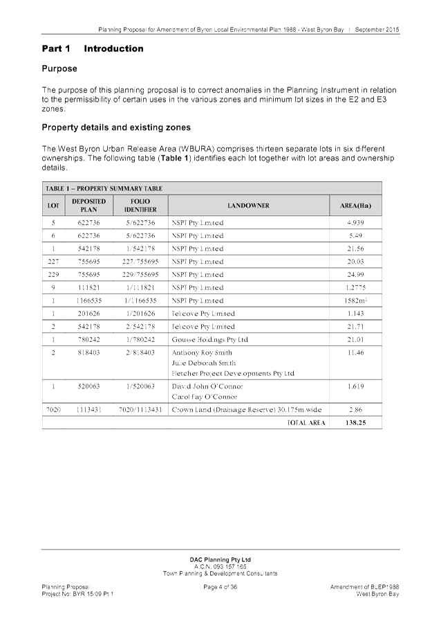
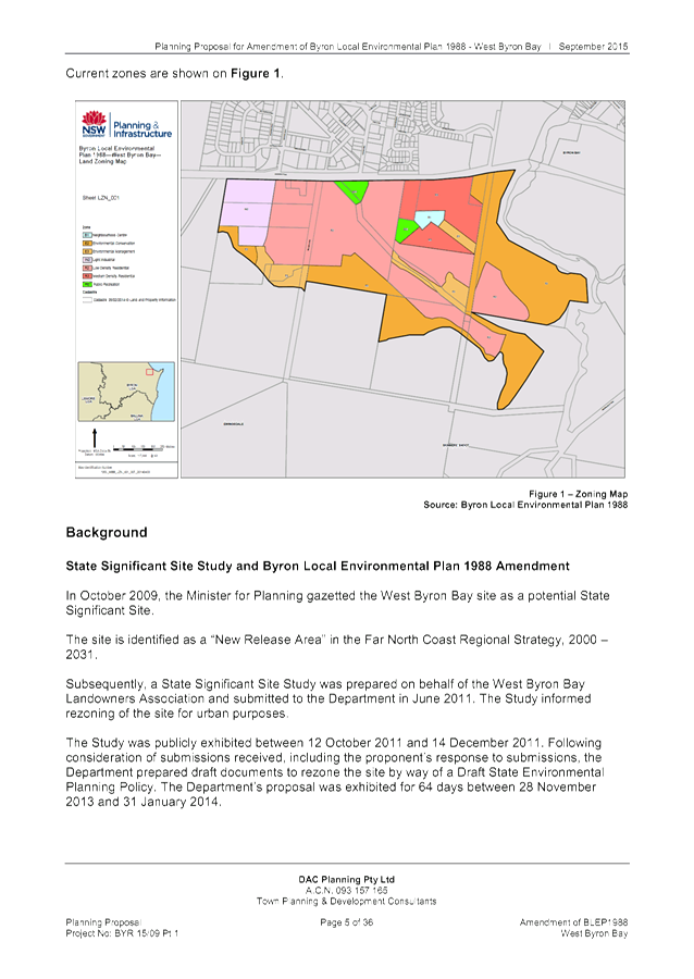
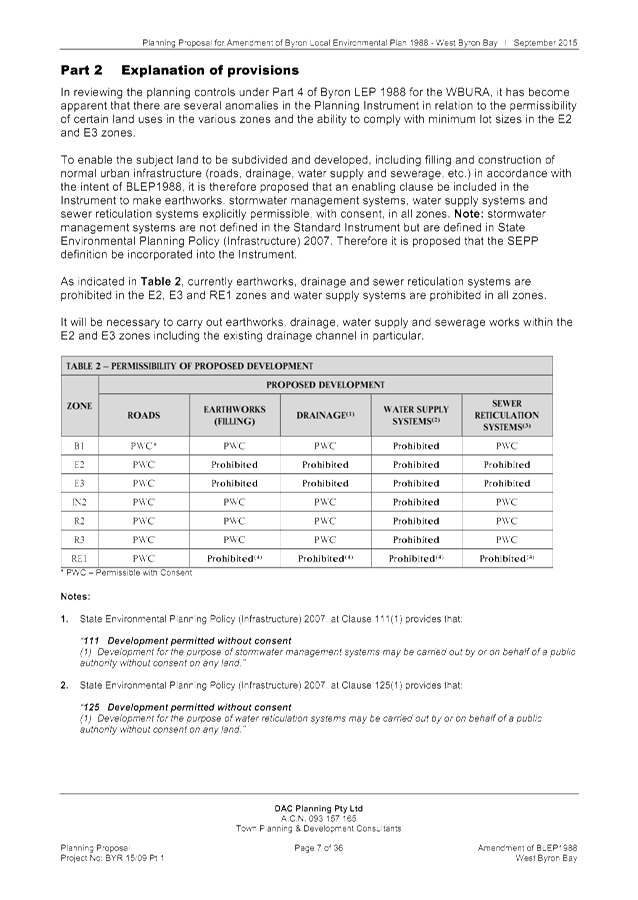
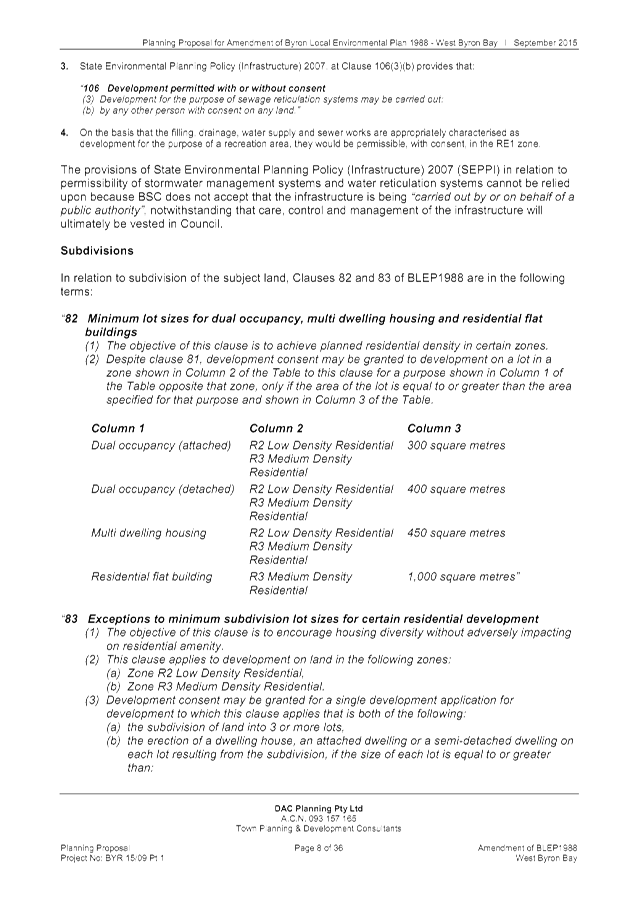
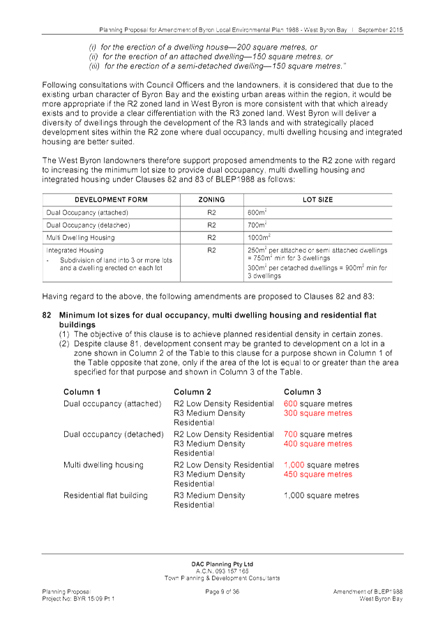
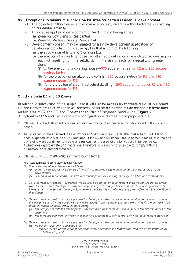
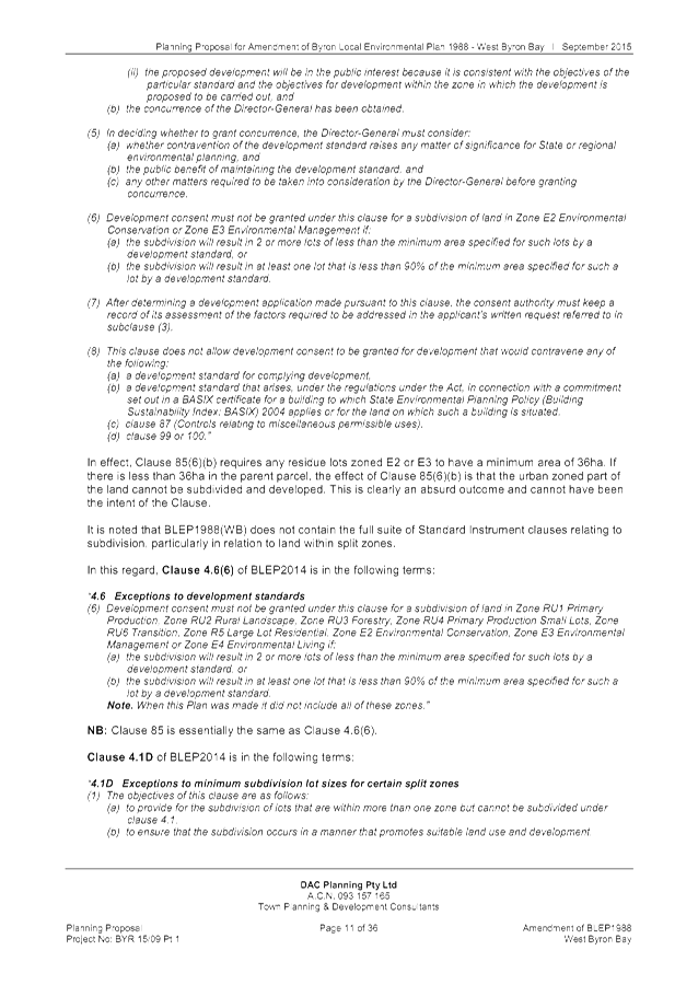
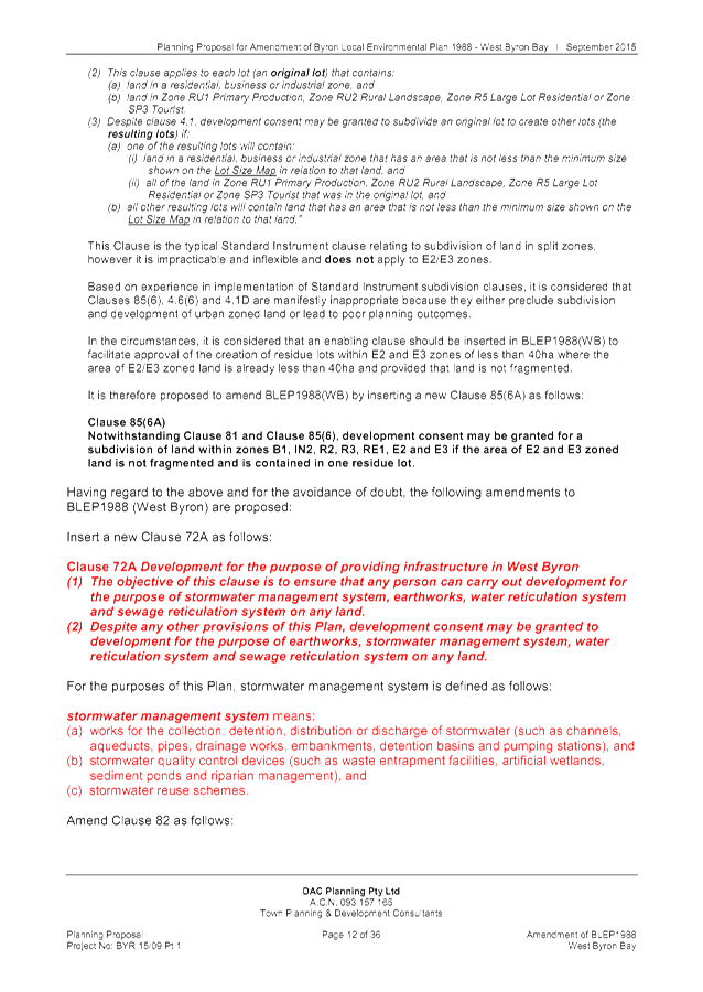
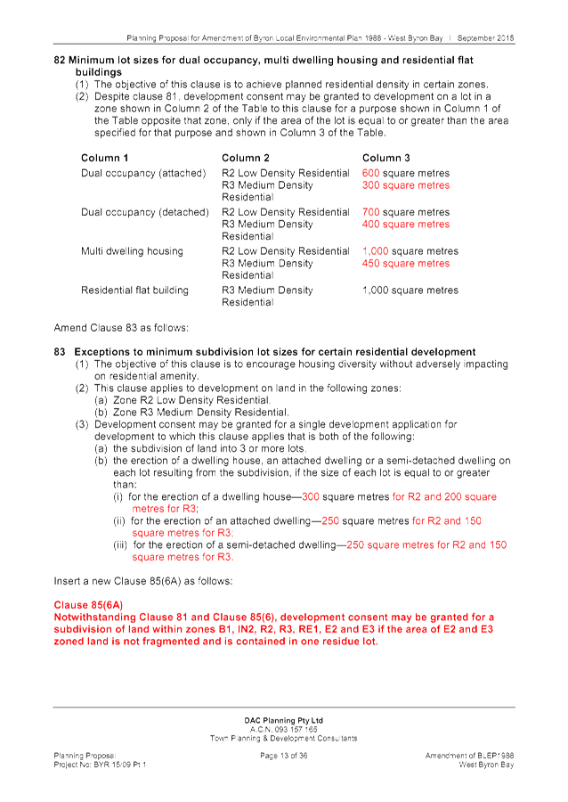
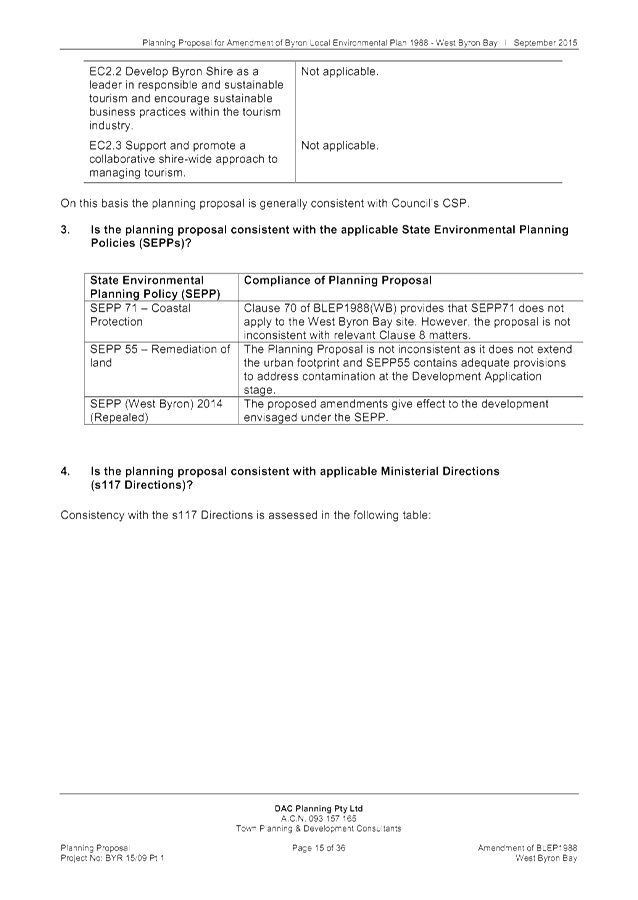
Staff Reports - Sustainable Environment and Economy 13.13 - Attachment 1
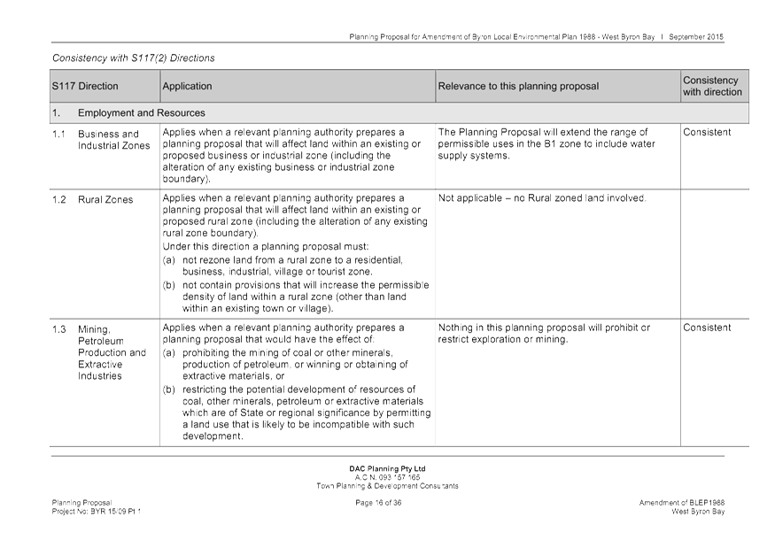
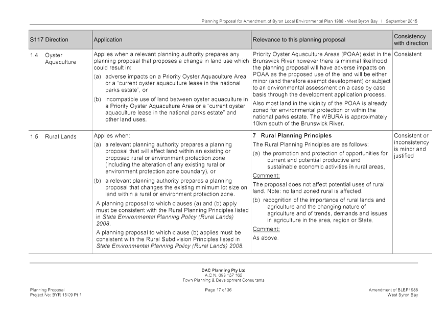
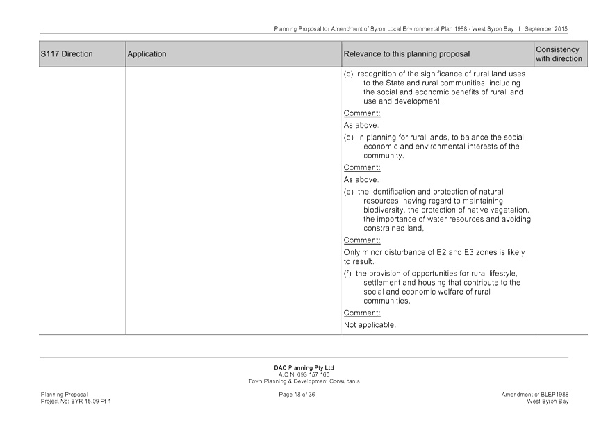
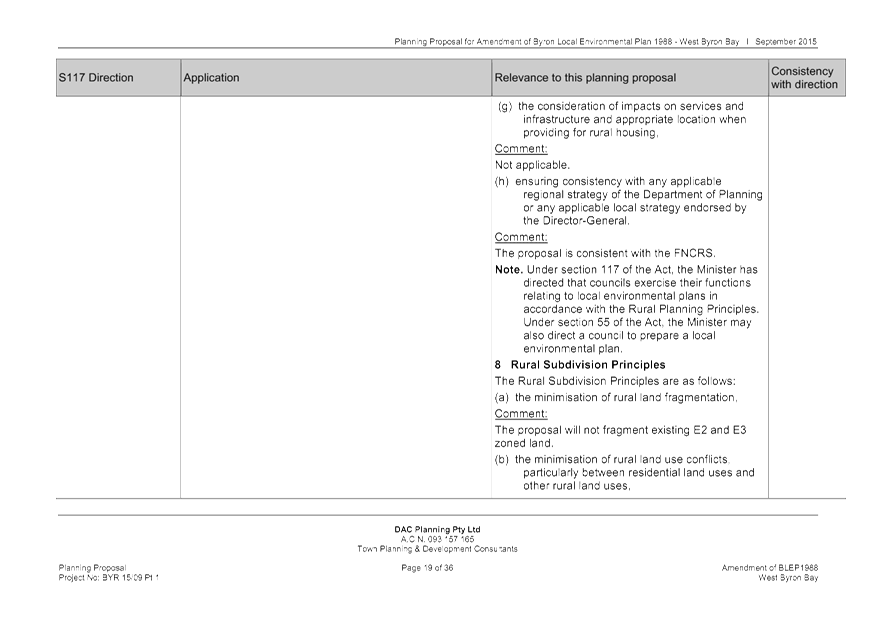
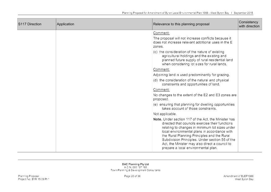
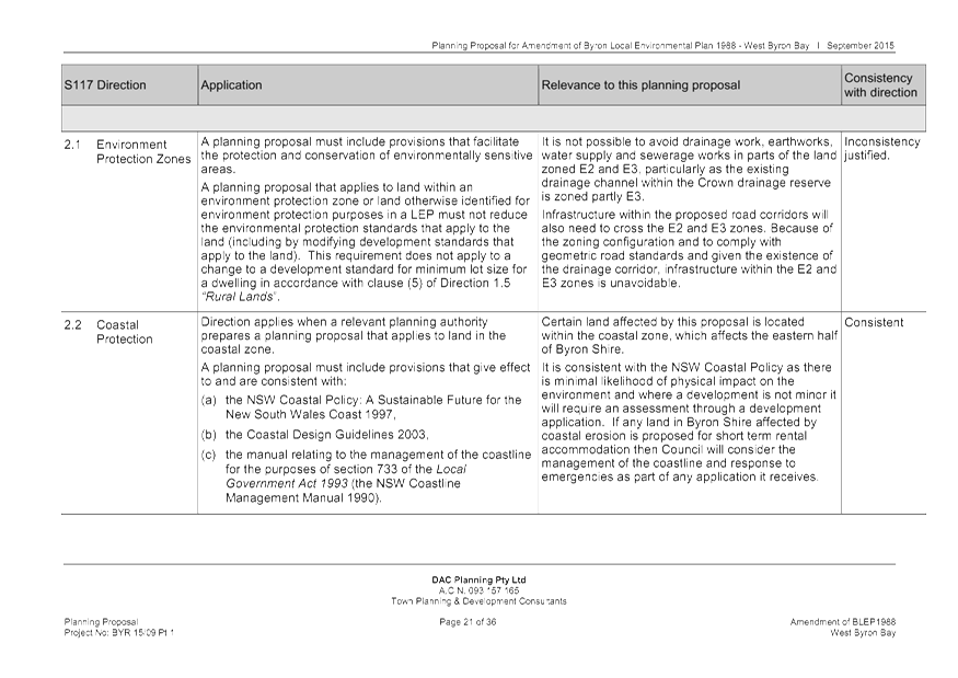
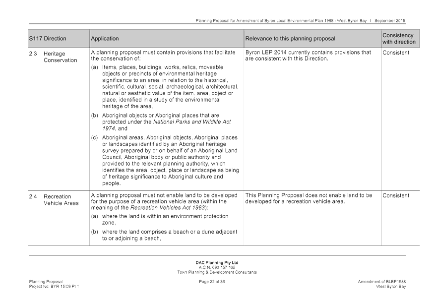
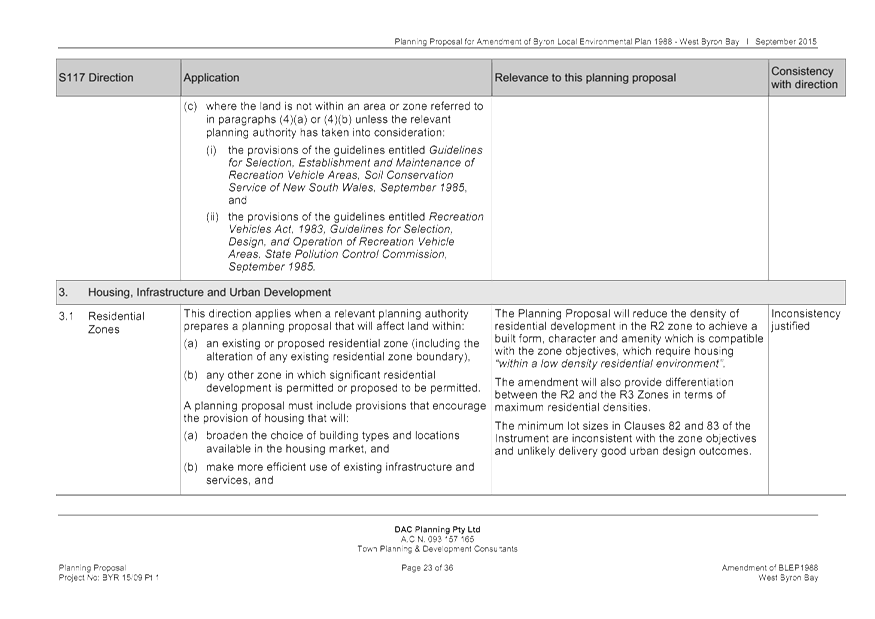
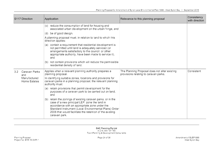
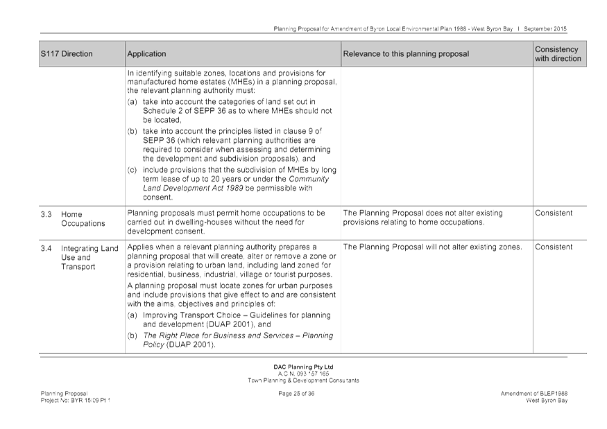
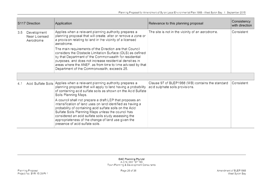
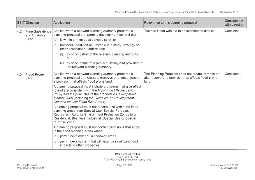
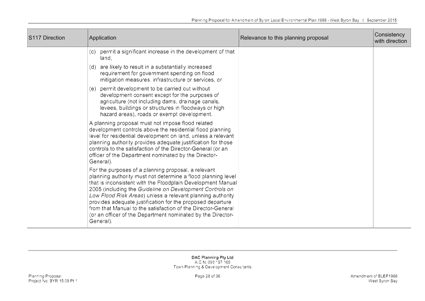
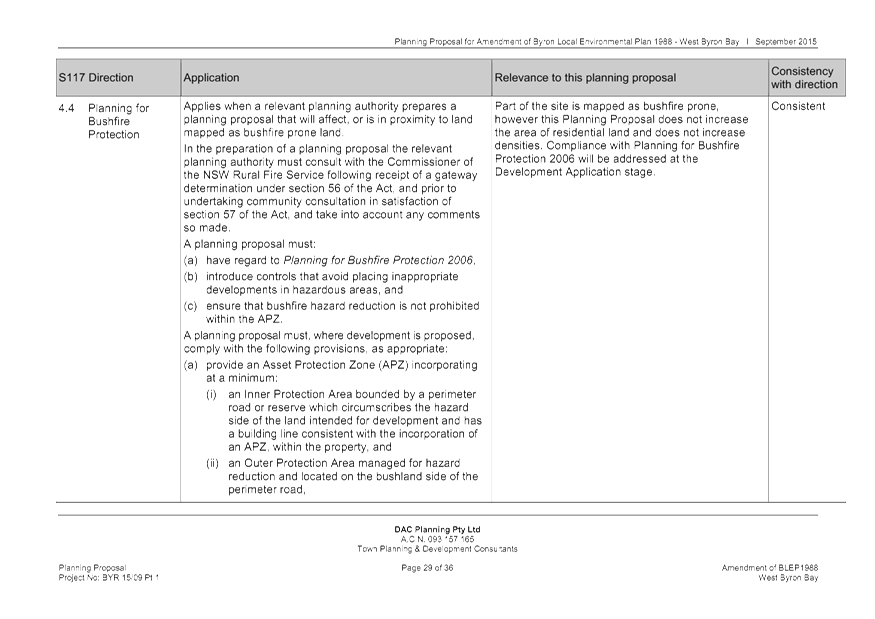
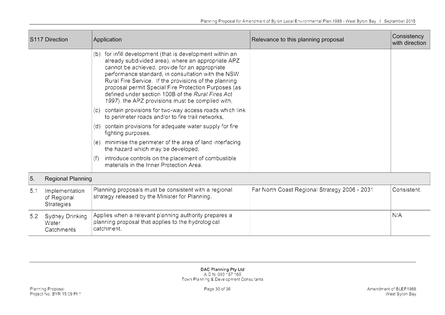
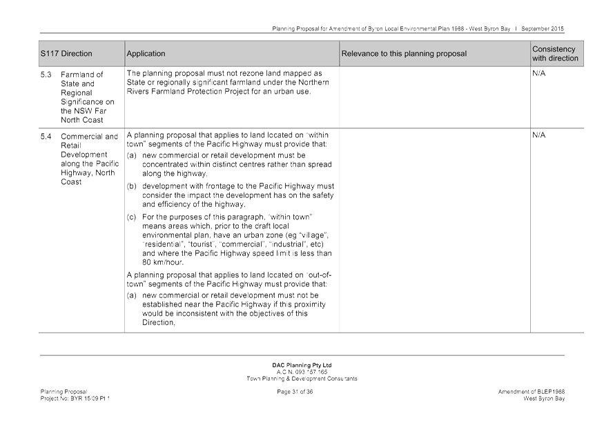
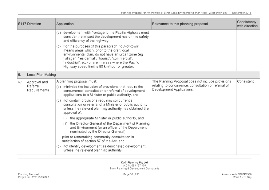
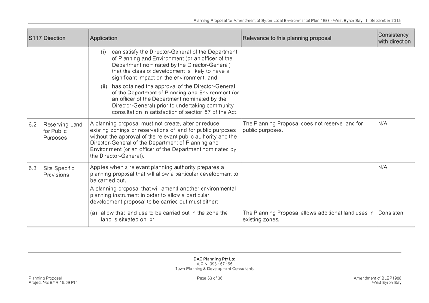
Staff Reports - Sustainable Environment and Economy 13.13 - Attachment 1
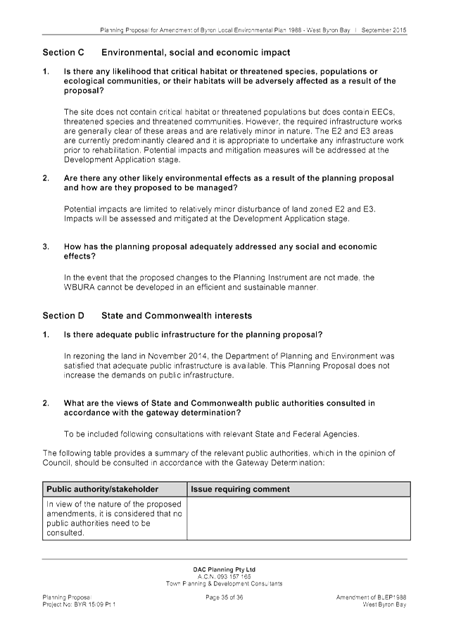
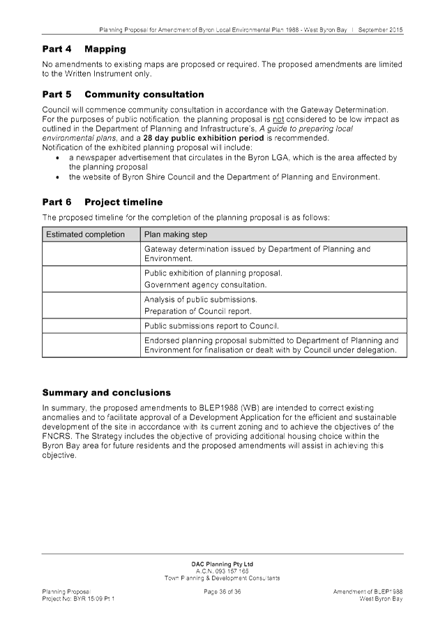
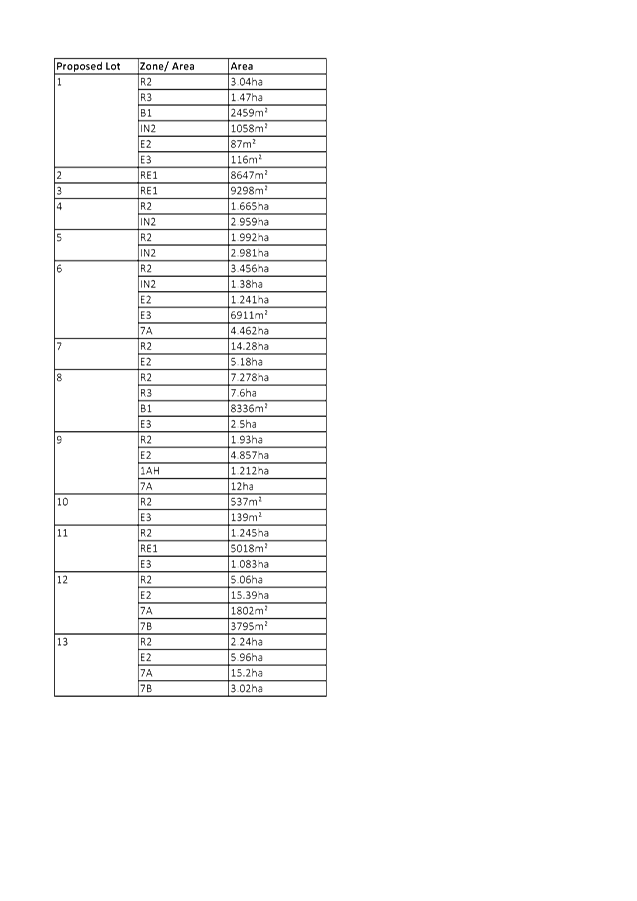
Staff Reports - Sustainable Environment and Economy 13.13 - Attachment 1
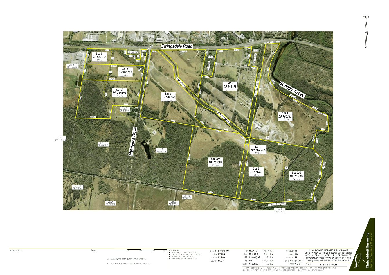
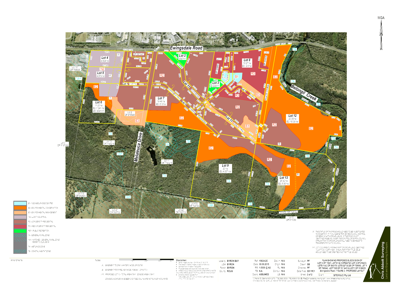
Staff Reports - Sustainable Environment and Economy 13.13 - Attachment 2
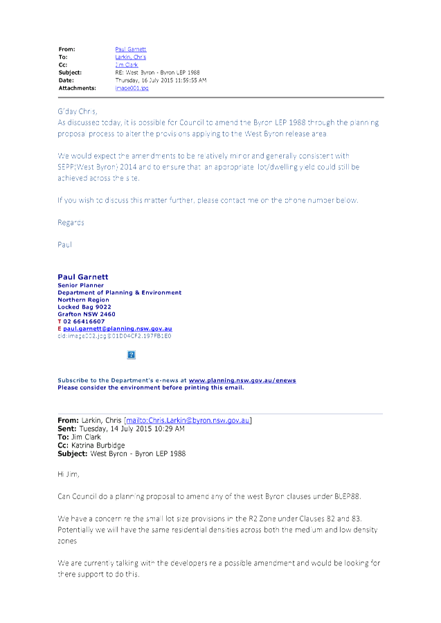
Staff Reports - Sustainable Environment and Economy 13.13 - Attachment 3
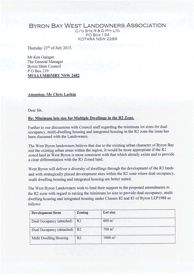
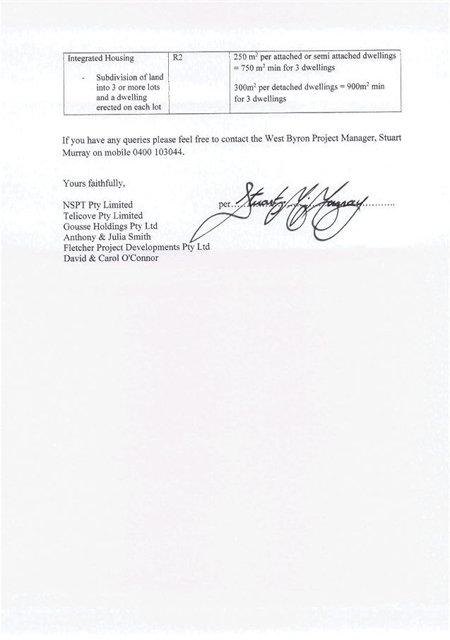
Reports of Committees - Corporate and Community
Services 14.1 - Attachment 1

Arakwal Memorandum of Understanding Advisory Committee Meeting
|
Venue
|
Meeting Room 1, Council Offices, Mullumbimby
|
|
Date
|
Wednesday, 19 August 2015
|
|
Time
|
2.30pm
|
Reports of Committees - Corporate and Community
Services 14.1 - Attachment 1
Minutes of the Arakwal
Memorandum of Understanding Advisory Committee Meeting held on Wednesday,
19 August 2015
File No: I2015/1293
PRESENT: Cr
S Richardson (Mayor), Cr P Spooner
Staff: Greg
Ironfield (Manager Community Development)
Belle
Arnold (Indigenous Projects Officer)
Phil
Warner ( Capital Projects Officer )
Ralph
James (Coordinator Legal Services)
Tamara
Warrington (Minute Taker)
Community: BJ
Kay , Delta Kay
Cr Spooner
(Chair) opened the meeting at 2:41pm and acknowledged that the
meeting was being held on Bundjalung Country.
Apologies:
There was an apology from Gavin
Brown.
Declarations of
Interest – Pecuniary and Non-Pecuniary
There were no declarations of
interest.
Adoption of
Minutes from Previous Meetings
|
Recommendation:
That the minutes of the Arakwal Memorandum of Understanding
Advisory Committee Meeting held on 14 May 2015 be confirmed.
|
The recommendation was put to
the vote and declared carried. (Spooner/Kay)
Business Arising from Previous Minutes
Cr Richardson provided committee members with a draft Notice
of Motion for Indigenous Cultural Awareness Celebration for discussion.
Staff Reports - Corporate and Community
Services
|
Report No. 5.1 Arakwal
MoU Implementation Plan 2015 -16
File No: I2015/373
|
|
Committee
Recommendation 5.1.1
That the Arakwal MoU Advisory Committee endorse the
2015/16 Arakwal MoU Implementation Plan (E2015/50307). (Spooner/D Kay)
The recommendation was put to
the vote and declared carried.
|
|
Report No. 5.2 Ti
Tree Lake Plan of Management
File No: I2015/816
|
|
Committee
Recommendation 5.2.1
1. That
the Arakwal MoU Advisory Committee note the progress report on the Ti Tree
Lake Plan of Management.
2. That
Council write to the Office of Environment and Heritage and National Parks
and Wildlife Service providing a copy of the progress report (E2015/50137). (D Kay/B Kay)
The recommendation was put to
the vote and declared carried.
|
|
Report No. 5.3 Bundjalung
of Byron Bay, Arakwal People Cemetery Provisions
File No: I2015/817
|
|
Committee
Recommendation 5.3.1
That the Arakwal MoU Committee seek information from
Council staff on the processes required and the scope of works for the
Bundjalung of Byron Bay, Arakwal People to have an identified area in the
Byron Bay Cemetery for further consideration. (Kay/Spooner)
The recommendation was put to
the vote and declared carried.
|
|
Report No. 5.4 NAIDOC
Week Byron Shire 2015
File No: I2015/819
|
|
Committee
Recommendation 5.4.1
That the committee note the success of the Byron Shire
NAIDOC Week 2015 Program and the increase in the community partnerships
involved in the delivery of the program of events.
(Spooner/Richardson)
The recommendation was put to
the vote and declared carried.
|
Verbal Reports
Broken Head Quarry Development
Ralph provided the Committee with an update on the Land and
Environment Court Class 1 appeal against the refusal of the development.
Ralph provided information as to the role which Objectors
might play in the proceedings.
Action request from Belle to Ralph for information to send
to stakeholders .
Byron Bay Bypass
Phil, Cr Richardson and Cr Spooner provided the Committee
with an overview of the Byron Bay Bypass.
General discussion on previous routes and reasoning for
selection of the adopted Bypass route.
Action request from Delta to Councillors to provide email
reply.
Midden Update
Belle provided the Committee with an update on project.
Manager of Utilities to work with Belle and Delta to resolve
stormwater drainage issues on Clarkes Beach.
Action request from Cr Richardson to Belle to liaise with
Jane Laverty for invitation to Arakwal for Byron Bay Town Centre Master Plan
Charette Workshop on 3 September. Belle to also attend.
Belle to send site inspection invitation to Cr Richardson.
There being no further business the meeting concluded at 4:13
pm.
Reports of Committees - Sustainable Environment and
Economy 14.2 - Attachment 1
Biodiversity and Sustainability Advisory Committee Meeting
|
Venue
|
Conference Room, Station Street, Mullumbimby
|
|
Date
|
Thursday, 1 October 2015
|
|
Time
|
2.00pm
|
Reports of Committees - Sustainable Environment and
Economy 14.2 - Attachment 1
Minutes of the Biodiversity
and Sustainability Advisory Committee Meeting held on Thursday, 1
October 2015
File No: I2015/1293
PRESENT: Cr
S Richardson (Mayor), Cr A Hunter, Cr R Wanchap, Cr Basil Cameron (left 2.30)
Staff: Sharyn
French (Manager Environmental & Economic Planning)
Alex
Caras (Team Leader Land Planning) – Report 5.1
Claire
McGarry (Events and Grants Officer) – Report 5.2
Michelle Chapman (Minute Taker) – left 2.45
Community
voting members: Andy
Baker, Luke McConnell, Kate Smillie, Peter Westheimer
Community non
voting members: Chris Sanderson,
Cr Richardson (Chair) opened the meeting at
2.20pm and acknowledged that the meeting was being held on
Bundjalung Country.
Apologies:
Sandi Middleton (Sustainability
Officer), Angus Underwood (Team Leader Natural Environment), James Mayson, Donovan Adcock, Joanna Immig
Declarations of
Interest – Pecuniary and Non-Pecuniary
There were no declarations of
interest.
Adoption of
Minutes from Previous Meetings
|
Committee
Recommendation:
That the minutes of the Biodiversity and Sustainability
Advisory Committee Meeting held on 6 August 2015 be confirmed, noting the
minutes were reported to 17 September Ordinary meeting resulting in Res
15-433 to 15-435.
(Richardson/Westheimer)
The recommendation was put to the vote and declared carried.
|
Business Arising from Previous Minutes
Cr Cameron – Integrated
Weed Management Strategy, interested in expanding to rural areas and
relationship with Roadside vegetation Management Plan.
· Include as item
agenda for next meeting and invite Cr Cameron for input.
Cr Simon Richardson - Zero
Emissions Byron
· Major companies
are interested in partnerships to achieve the Beyond Zero Eissions targets
Staff Reports - Sustainable Environment and
Economy
|
Report No. 5.1 Biodiversity,
revegetation and rural residential living
File No: I2015/838
|
|
Committee
Recommendation:
That the Biodiversity and
Sustainability Advisory Committee:
1. note
this report.
2. request
that Biodiversity and Sustainability Advisory Committee members be considered
members on the Rural Land Use Bounce group, if formed.
3. request
Staff explore the ability to use rural development contributions for
biodiversity enhancement works.
4. receive
regular updates on the Rural Land Use Strategy by it becoming a regular
agenda item for this Committee.
5. support
Staff exploring landowner incentive options for biodiversity enhancement
works at the local property and landscape scale.
(Richardson/Westheimer)
The recommendation was put to
the vote and declared carried
|
|
Report No. 5.2 Event
Sustainability
File No: I2015/1104
|
|
Committee
Recommendation:
That the Biodiversity and
Sustainability:
1. note
the report and provide feedback to Council’s Events and Grants Officer.
2. encourage
further conversations with event providers to facilitate rail based transport
to and from the sites.
(Westheimer/Baker)
The recommendation was put to
the vote and declared carried..
|
There being no further business the meeting concluded at 3.40pm.
Reports of Committees - Infrastructure Services 14.3 - Attachment 1

Water, Waste and Sewer Advisory Committee Meeting
|
Venue
|
Conference Room, Station Street, Mullumbimby
|
|
Date
|
Thursday, 8 October 2015
|
|
Time
|
9.00am
|
Reports of Committees - Infrastructure Services 14.3 - Attachment 1
Minutes of the Water,
Waste and Sewer Advisory Committee Meeting held on Thursday, 8
October 2015
File No: I2015/1293
PRESENT: Cr
S Richardson (Mayor), Cr D Dey and Cr R Wanchap
Staff: Phil
Holloway (Director Infrastructure Services)
Peter
Rees (Manager, Utilities)
Michael
Matthews (Manager, Open Space & Resource Recovery)
Michael
Bingham (Environmental Health Officer)
Susan
Sulcs (Minute Taker)
Community: Col
Draper, Madeleine Green, Luke McConnell
Cr Dey (Chair) opened the meeting at 9.13am
and acknowledged that the meeting was being held on Bundjalung Country.
Apologies:
There were apologies received from David Fligelman and Leah
Kapral
Declarations of
Interest – Pecuniary and Non-Pecuniary
Madeleine Green declared a non-pecuniary interest in the
meeting. The nature of the interest being that Ms Green lives in the vicinity
of the Myocum Transfer Station.
Adoption of
Minutes from Previous Meetings
|
Committee
Recommendation:
That the minutes of the Water, Waste and Sewer Advisory
Committee Meeting held on 7 May 2015 be confirmed. (Dey/Green)
The recommendation was put to the vote and declared carried.
|
Business Arising from Previous Minutes
Myocum Landfill Leachate Management
Michael Matthews provided an update.
Organics Program
Michael Matthews provided an update on the Leachate
Management System at Byron Resource Recovery Centre. Landfill volumes reduced
by 30% and less leachate generation.
Phil Holloway provided an update on the new bin service and
monitoring of contamination and participation rates.
Cr Wanchap left the meeting at 9.36am.
Rous Water Demand Management Plan
Peter Rees provided an update and slide regarding New Byron
Central Hospital Sewer Rising Main
Staff Reports - Sustainable Environment and
Economy
|
Report No. 5.1 Update
of the CERA Program
File No: I2015/876
|
|
Committee
Recommendation:
That Council note the progress to date
with regard to the Community Engagement and Risk Communication Program for
On-site Sewage Management. (Richardson/Green)
The recommendation was put to
the vote and declared carried.
|
Committee Recommendation
That Council note the memo E2015/64015 of 1 October 2015 to
the Committee and that further expenditure will be needed to achieve approval
for an expansion of landfill at Myocum.
(Dey/McConnell)
The recommendation was put to a vote and declared
carried.
Cr Richardson left the meeting at 10.50am
Actions:
1. Michael
Matthews to action request from Cr Richardson for an update on organic bin
collection at Main Beach. Update to be provided at next meeting.
2. Peter
Rees to action request from Cr Dey for the Design parameters for ultimate
sizing to the Rising Main for Hospital is sent to the Committee members.
3. Peter
Rees to provide review for data of volume of reuse water to Main Arm
properties.
4. Peter
Rees to provide review options for increasing irrigation, eg. whether
electricity can be subsidised, changing outflows to Brunswick River and changes
in irrigation practices.
5. Michael
Matthews to circulate to Committee any data of fate of organics at Lismore
Organic Facility and contamination data.
There being no further business the meeting concluded at 10.52am.
Reports of Committees - Infrastructure Services 14.3 - Attachment 2
MEMO TO: Water,
Waste and Sewer Advisory Committee
COPY TO: Manger,
Open Space and Resource Recovery
MEMO
FROM: Director Infrastructure
Services & Capital Projects Officer
SUBJECT: Myocum
Quarry Landfill
DATE: 1
October 2015
RECORD
NO: E2015/64015
Council submitted the Development Application (DA) for the
proposed Myocum Quarry Landfill (MQL) project in late October 2014. The DA
included the EIS prepared by consultants Cardno and included a revised Air
Quality Impact Assessment as requested by the Environmental Protection
Authority (EPA) during the stakeholder “adequacy assessment” phase
of the project.
The EIS and LEMP were on public exhibition for the community
to review and provide comment from 19 November 2014 to 18 December 2014.
Council has since received comments from three NSW agencies:
the NSW EPA, NSW Office of Water and NSW Rural Fire Service. Comments from the
NSW EPA in particular were extensive and sought further detailed information.
The detailed information requires additional investigations and assessments
with an estimated cost of up to $250,000. Accordingly, it was necessary to
conduct a strategic review of this project to allow consideration of the best
way forward on the MQL project.
Tim Fitzroy & Associates were engaged in June 2015 to
undertake the strategic review. The review is currently in a Final Draft stage
and includes:
· Research on the
strategic context since adoption of the current waste disposal strategy. This
includes but is not be limited to the current position of the Myocum Transfer
Station/Closed Landfill, Hyder reports, Morrison Low reports, Transport and
Disposal contract, NSW and QLD Waste Levy positions, GM’s Regional
Initiative, and emerging trends;
· A review /
addendum to the current waste disposal strategy;
· A review and
assessment of the available options to Council going forward including:
- Continuing
to pursue approval for a putrescible waste landfill,
- Change
to a non putrescible waste landfill eg C&D waste,
- Change
to a resource recovery area, and/or
- Abandon
future use of this quarry area and move to restoration;
· Consideration of
the benefits, costs, risks and timing for the options; and
· Conclusions and
recommendations.
Once the strategic review is finalised it will be submitted
to the Executive Team for a recommendation on the preferred path for the future
disposal options of Byron Shires waste.
……………………………………
Phil Holloway
Reports of Committees - Infrastructure Services 14.3 - Attachment 3
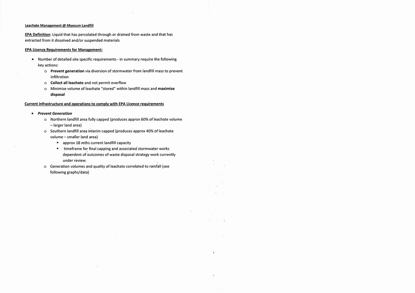
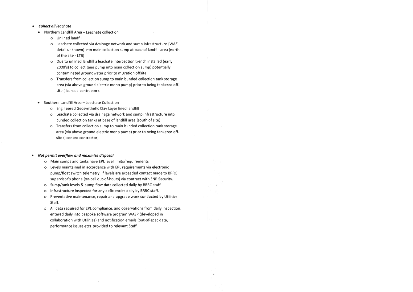
Reports of Committees - Infrastructure Services 14.3 - Attachment 3
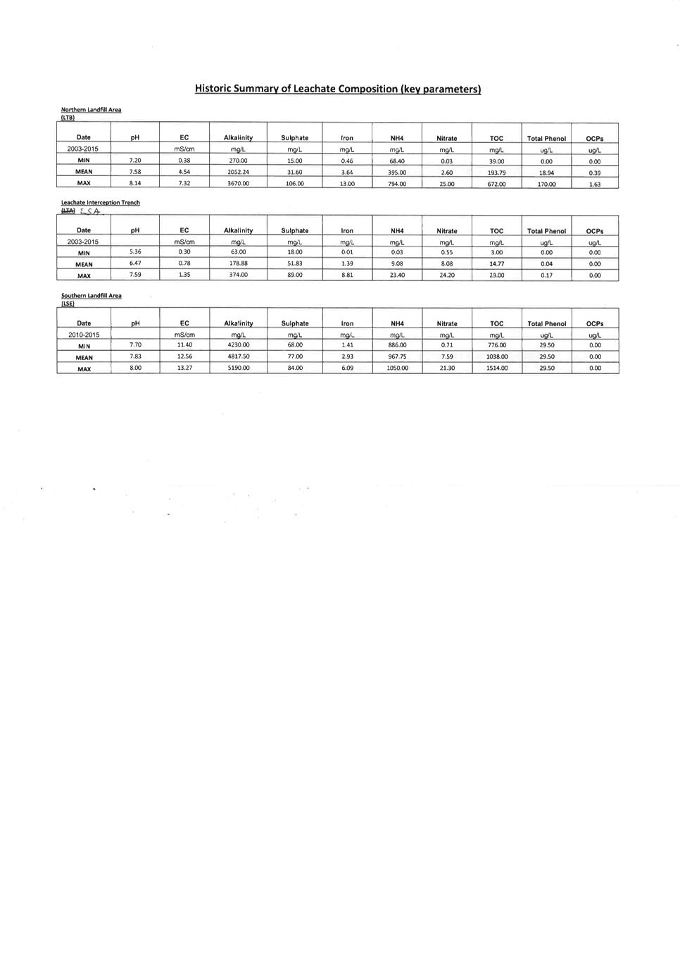

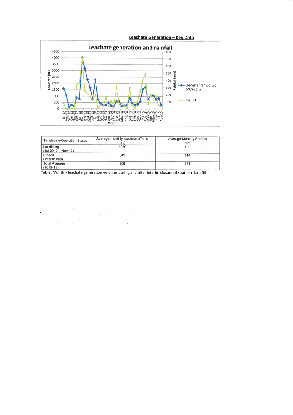
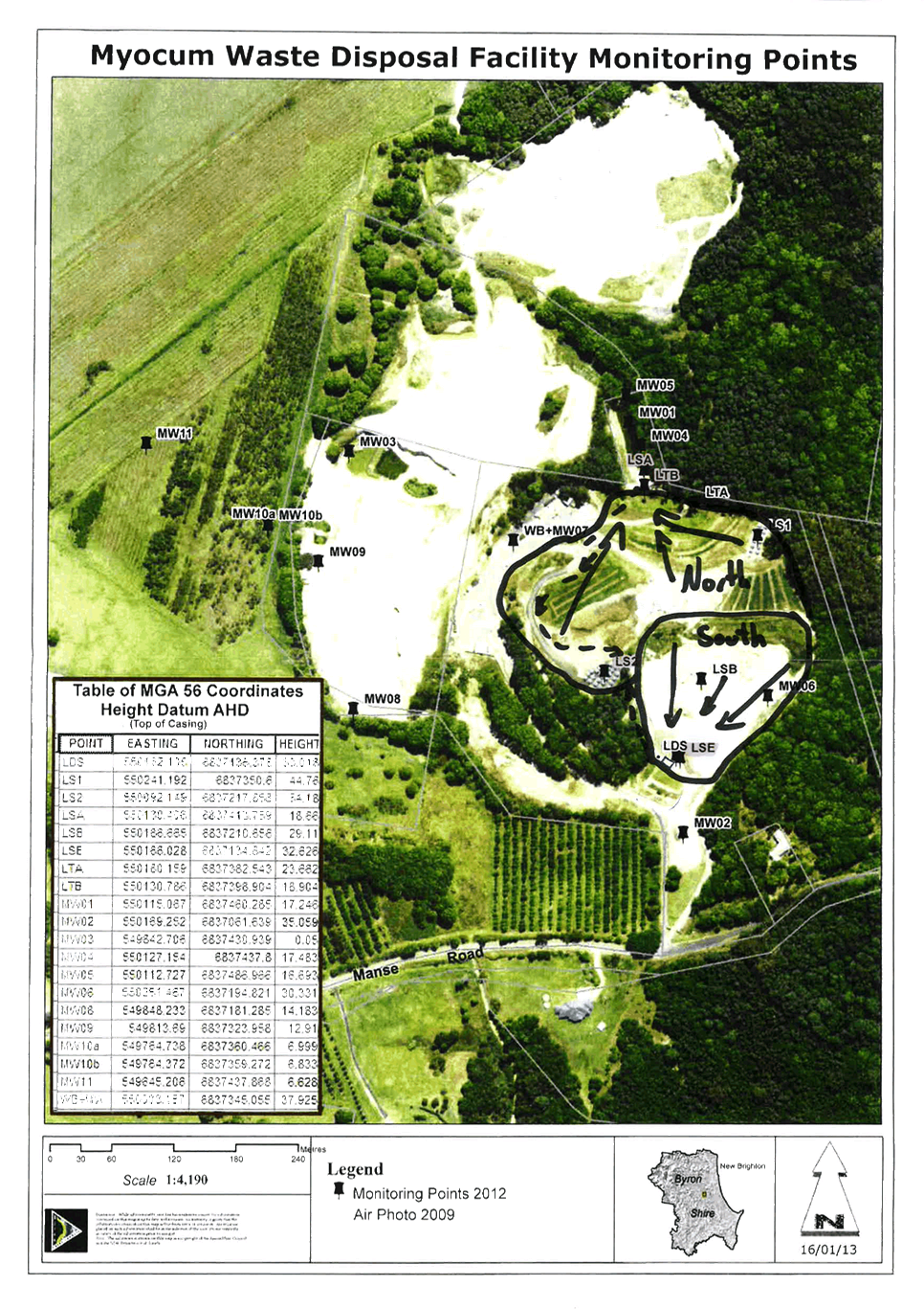
Reports of Committees - Infrastructure Services 14.3 - Attachment 4