13.22 - Attachment 1
1. Introduction
1.1. Purpose
The
purpose of this planning proposal is to amend Byron Local Environmental Plan
2014 so that land located at Granuaille Crescent; Bangalow is rezoned from RU1
Primary Production to R2 Low Density Residential. The planning proposal also
seeks to apply a Floor Space Ratio (FSR) of 0.5:1 and a Minimum Lot Size (MLS)
of 600 square metres to the subject land. The subject land is described as part
of Lot 232 DP 1194657, part of Lot 231 DP 1194657 and part of Lot 233 DP
1194657 as shown in Maps 1 and 2.
1.2. Planning
context
This
planning proposal was initially prepared by Planners North on behalf of Instant
Steel Pty Ltd for land at Lot 232 DP 1194657, Granuaille Crescent, Bangalow. The
proposal requests the rezoning of part of Lot 232 DP 1194657 from RU1 Primary Production
to R2 Low Density Residential; apply a Floor Space Ratio (FSR) of 0.5:1; and
apply a Minimum Lot Size (MLS) of 600 square metres. At the Byron Shire
Council Meeting of 27 August 2015, Council considered the planning proposal and
resolved:
15- 389 Resolved
1. That
Council proceed with the planning proposal to rezone part of Lot 232 DP
1194657, Bangalow (as identified in Map 1 of this report), to R2; and apply FSR
of 0.5;1 and MLS of 600 sq metres.
2. That
Council amend the planning proposal to include the rezoning of part of Lot 231
and part of Lot 233 of DP 1194657, Bangalow, (as identified in Map 1 of this
report), to R2; and apply FSR of 0.5;1 and MLS of 600 sq metres.
3. That
Council ensure that the planning proposal is consistent with Gateway
determination and/or Council requirements prior to public exhibition.
In
accordance with the Council resolution the planning proposal has been amended
to include the additional land referred to in 2. of the above resolution.
1.3. Background
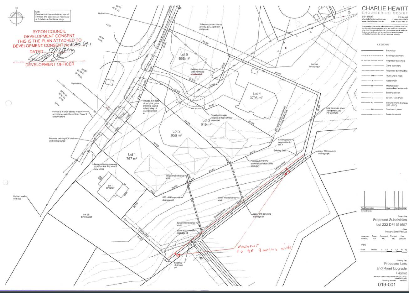
A
residential subdivision of Lot 232 DP 1194657 was approved in December 2014 for
four residential lots zoned R2 ranging in size from 656 to 958m2 and one lot of
3,709m2 that contains both R2 and residual RU1 rural zoned land. The rural land
is a legacy of a previous rezoning in which this portion was deemed too steep
to be rezoned for residential development. The remnant rural land is surrounded
on three sides by residential land and is of insufficient size to be productive
agricultural land. The approved subdivision designated dwelling envelopes and
required a Section 88B instrument to restrict dwellings to these dwelling
envelopes (refer to Attachment 1 for the approved plan of subdivision).
The
Statement of Environmental Effects accompanying the DA stated the applicant
intends to lodge a subdivision application in the future, to create the
‘Ultimate Subdivision of the land’, to include steep sections of RU1 land in
the residential lots. Council advised the applicant that a clearer way to
achieve the development sought would be to amend the Byron LEP 2014 to rezone
the steep portion of the lot from RU1 to R2, subject to a Section 88 instrument
that excludes buildings on the land, and then submit a further subdivision
application.
In
addition, Council staff considered that two small adjacent areas zoned RU1 should
also be included in the R2 Low Density Residential zone at this location.
Council resolution (15-389), as included above, expands the land subject to
this planning proposal to also include part of Lot 231 DP 1194657 and part of
Lot 233 DP 1194657. The latter is a small rectangular piece immediately south
of Lot 232 and a narrow strip located between Lot 232 and the R2 Low Density
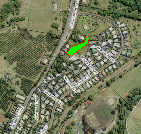
Residential zoned land to the east as shown in the Maps 1 and 2 below.
Map 1 Site Locality Map – subject
land is outlined in red
Map 2 Subject land outlined in red
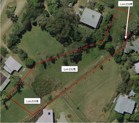
2.1. The Subject Land
The
subject land, as illustrated in Map 2 above, is located at the northern
entrance of the village of Bangalow in the vicinity of the Bangalow Reservoir
site. The land is vacant with no significant vegetation. Parts of the subject
land are steep being greater than 30% slopes. It has an approximate area of
3,170 square metres comprising:
· part of Lot 232 DP 1194657: - 2,445
square metres
· part of Lot 231 DP 1194657 - 510
square metres
· part of Lot 233 DP 1194657 - 215
square metres
It
is bounded by an existing residential subdivision to the west, south and east,
and rural zoned land and Council’s water tower to the north (refer to Map 3).
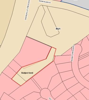
2.2. Current
Zones and Controls
The
subject land is zoned RU1 Primary Production under Byron LEP 2014. The Minimum
Lot Size for the RU1 zone is 40 hectares. No FSR applies currently to the RU1
land.
Map 3 Current LEP 2014 Zoning
Part 1 Objectives and Intended Outcomes
The
primary objective of this planning proposal is to zone the subject land from
RU1 Primary Production to R2 Low Density Residential under Byron Local
Environmental Plan 2014 (LEP 2014).
The
area proposed to be zoned R2 is small, is surrounded by residential zoned land
on three sides, is not used for agriculture due to its limited size, and has no
significant environmental values. It is a logical “rounding off” of an existing
urban area.
Part 2 Explanation
of the Provisions
The
intended outcomes are to be achieved by an amendment to Byron Shire LEP 2014
by:
· Applying a
zoning of R2 Low Density Residential to the subject land;
· Applying a
maximum floor space ratio of 0.5:1 to the subject land; and
· Applying a
minimum lot size of 600 square metres to the subject land.
Part 3 Justification
Section A Need for the planning proposal
No.
The planning proposal to rezone the subject land is a consequence of a
residential subdivision approval for Lot 232 DP1194657. In addition, Council
resolved that two small adjacent areas should be included in the R2 Low Density
Residential zone at this location.
The
subject land is currently zoned RU1 but is of insufficient size to be
productive agricultural land. The RU1 zone is meant to identify rural land that
is capable of sustainable primary industries. The zone permits a wide range of
uses that would not be appropriate within close proximity to existing
residential neighbourhoods including intensive livestock and plant agriculture
and rural industries.
The
subject land is surrounded on three sides by land zoned R2 Low Density
Residential. The objectives and permitted uses of the R2 zone are appropriate
for this serviced land in a residential neighbourhood on the edge of Bangalow.
The
planning proposal is the only way to change the land zoning and planning
controls applying to the subject land.
Section B Relationship
to strategic planning framework
Far North
Coast Regional Strategy
The
Far North Coast Regional Strategy (FNCRS) identifies the Town and Village
Growth Boundary for Bangalow. The subject land falls just outside this
boundary. Zoning this land for residential purposes is therefore inconsistent
with the FNCRS. However, the site is classified as “non –coastal” under the
FNCRS because it is located west of the Pacific Highway. A residential zone
outside of the Town and Village Growth Boundary must be assessed against the
Sustainability Criteria set out in the FNCRS; that assessment is provided in Table
1 below.
In
this case the area of the proposed R2 zone is small and is a logical “rounding
off” of an existing urban area rather than a genuine greenfield site.
Table 1 Assessment
against Sustainability Criteria
|
Threshold Sustainability
Criteria for any proposed development site outside designated areas In
regional strategies
|
Measurable explanation of criteria
|
Comments
|
|
1. Infrastructure Provision
Mechanisms in place to ensure utilities, transport, open
space and communication are provided in a timely and efficient way
|
· Development is consistent with the outcomes of Far
North Coast Regional Strategy, any subregional strategy, regional
infrastructure plan and relevant section 117 direction/s.
· The provision of infrastructure (utilities, transport,
open space, and communications) is costed and economically feasible based on
Government methodology for determining infrastructure development
contributions.
· Preparedness to enter into development agreement
|
· No change in
the density or utilisation level of the land is anticipated as a consequence
of the Planning Proposal.
|
|
2. Access
Accessible transport options for efficient and
sustainable travel between homes, jobs, services and recreation to be
existing or provided
|
· Accessibility of the area by public transport and/or
appropriate road access in terms of:
> Location/land
use – to existing networks and related activity centres.
> Network
– the area’s potential to be serviced by economically efficient
transport services.
> Catchment
– the area’s ability to contain, or form part of the larger urban area
which contains adequate transport services. Capacity for land use/ transport
patterns to make a positive contribution to achievement of travel and
vehicle use goals.
· No net negative impact on performance of existing
subregional road, bus, rail, ferry and freight network.
|
· The land is
well located in terms of its proximity to the Ballina and Byron Bay
hospitals, airports and the like. No negative impact is anticipated in
relation to accessibility for jobs, services or recreation.
|
|
3. Housing Diversity
Provide a range of housing choices to ensure a broad
population can be housed
|
· Contributes to the geographic market spread of housing
supply, including any government targets established for aged, disabled or
affordable housing.
|
· The proposal
will broaden the scope for housing choice providing for appropriate infill
subdivision within the existing Bangalow Town Centre.
|
|
4. Employment Lands
Provide regional/local employment opportunities to
support the Far North Coast’s expanding role in the wider regional and NSW
economies
|
· Maintain or improve the existing level of sub-regional
employment self containment.
· Meets subregional employment projections.
· Employment-related land is provided in appropriately
zoned areas.
|
· The ultimate
construction of dwelling-houses within the adjacent approved residential
subdivision will provide for local employment opportunities.
|
|
5. Avoidance of Risk
|
Land use conflicts, and risk
to human health and life, avoided
· No residential development within 1:100 floodplain.
· Avoidance of physically constrained land, e.g.
> High slope.
> Highly erodible.
· Avoidance of land use conflicts with adjacent existing
or future land use as planned under relevant subregional or regional
strategy.
· Where relevant available safe evacuation route (flood
and bushfire).
|
· No change in risk is anticipated as a consequence of
the Planning Proposal.
· The configuration, size and location of that part of
the land presently zoned RU1 Primary Production is not considered suitable
for agricultural land use. The site adjoins existing urban development to
the west, south and east.
|
|
6. Natural Resources
Natural resource limits not exceeded/ environmental
footprint minimised
|
· Demand for water within infrastructure capacity to
supply water and does not place unacceptable pressure on environmental flows.
· Demonstrates most efficient/suitable use of land
> Avoids identified
significant agricultural land
> Avoids productive
resource lands – extractive industries, coal, gas and other
mining, and quarrying.
· Demand for energy does not place unacceptable pressure
on infrastructure capacity to supply energy-requires demonstration of
efficient and sustainable supply solution.
|
· No change in
demand for natural resources is anticipated as a consequence of the amendment
to the Local Environmental Plan as proposed.
|
|
7. Environmental Protection
Protect and enhance biodiversity, air quality, heritage,
and waterway health
|
· Consistent with government-approved Regional
Conservation Plan (if available).
· Maintains or improves areas of regionally significant
terrestrial and aquatic biodiversity (as mapped and agreed by DEC). This
includes regionally significant vegetation communities, critical habitat,
threatened species, populations, ecological communities and their habitats.
· Maintain or improve existing environmental condition
for air quality.
· Maintain or improve existing environmental condition
for water quality:
> Consistent with
community water quality objectives for recreational water use
and river health (DEC and CMA).
> Consistent with
catchment and stormwater management planning (CMA and council).
· Protects areas of Aboriginal cultural heritage value
(as agreed by DEC).
|
· The proposed
rezoning is not considered likely to result in any impacts in terms of
biodiversity, air quality, and heritage or waterway health.
|
|
8. Quality and Equity in Services
Quality health, education, legal, recreational, cultural
and community development and other government services are accessible
|
· Available and accessible services.
> Do adequate
services exist?
> Are they at
capacity or is some capacity available?
> Has Government
planned and budgeted for further service provision?
> Developer funding
for required service upgrade/access is available.
|
· The proposal is
unlikely to have any impact on health, education, recreation or other
services provided by government.
|
Bangalow
Settlement Strategy 2003
Although
this strategy is outdated it remains the current residential strategy approved
by Council for Bangalow. It does not identify the subject land as a future
urban area because it has little or no housing yield. The subject land
(outlined in red on Map 4) is immediately adjacent to Area 1 in this
strategy. The zoning of this land for residential purposes is a minor zone
boundary adjustment and is justifiably inconsistent with the Bangalow
Settlement Strategy.
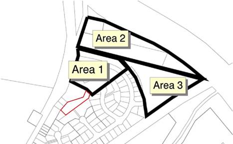
Map 4 –
Investigation Areas for Bangalow (from Bangalow Settlement Strategy 2003)
State and
Regional Farmland
The
subject land is mapped as regionally significant farmland in the Northern
Rivers Farmland Protection Project. It is not identified as Biophysical
Strategic Agricultural Land (BSAL) in the mapping undertaken recently by the
State government.
The
subject land is a very small area and it is not being used for any commercial
agriculture. It is open mown grass land that is surrounded by residential
development. The Northern Rivers Farmland Protection Project (2005) outlines
criteria to be addressed in relation to using regionally significant farmland
for residential purposes. A response to the criteria is provided in the
assessment against S117 Directions in the following pages.
In
2012 Council adopted a 10 year + Community Strategic Plan 2022
(CSP). The plan is based on five key themes being Corporate Management,
Economy, Environment, Community Infrastructure, Society and Culture. The
planning proposal is generally consistent with the following relevant Goals set
out in Table 2:
Table 2 Consistency with Community Strategic
Plan
|
GOALS
|
COMMENTS
|
|
CM1.1 Improve the
transparency, effectiveness and accountability of Council.
|
Council
exhibits all planning proposals to ensure transparency in its rezoning
processes.
|
|
CM1.4 Comply with
NSW State government legislation for local government integrated planning and
reporting.
|
This
planning proposal is consistent with the government’s framework established pursuant
to the Environmental Planning and Assessment Act.
|
|
CM4.1 Promote
community compliance with Acts, Regulations, Instruments and Council policies
and standards.
|
This
planning proposal is consistent with the relevant Acts Regulations and
Policies of Council and the NSW State Government.
|
|
SC2.4 Create
vibrant liveable places and spaces within towns and villages for people of
all ages and abilities.
|
The
proposed rezoning will contribute to the creation of a vibrant liveable place
for residents.
|
|
EN1.1 Protect,
restore and maintain the biodiversity values, ecosystems and ecological
processes of the Byron Shire.
|
|
On this
basis the planning proposal is generally consistent with Council’s CSP.
The
planning proposal is generally consistent or justifiably inconsistent with the
applicable State Environmental Planning Policies. The key SEPP’s that require
particular consideration are SEPP 55 Remediation of Land and SEPP (Rural Lands)
2008.
SEPP 55 Remediation of Land
Clause
7(1) of SEPP 55 requires that a Council cannot approve a rezoning application
(especially from rural to residential) unless it has duly considered whether
such land is contaminated.
Consultants
undertook a preliminary site investigation pursuant to SEPP 55 in December 2010
in relation to an earlier subdivision and rezoning proposal. This work covered
all of the subject land and is still applicable as no additional potentially
contaminating use has been carried out on the subject land since the work was
undertaken. The investigation concluded:
“Based on the site history, site inspections and the
laboratory results from soil sampling; there is a low level of risk that
the subject site is contaminated with residual chemicals from activities
associated with current or past land use. Following a review of the
results of laboratory analysis of soil samples taken from the subject site it
is our considered view that there would appear to be little environmental or
health hazard associated with development approval being granted for the
future rezoning (from 1(b1) agricultural to 2(a) residential under Byron
LEP 1988.”
On
this basis the planning proposal is consistent with SEPP 55 Remediation of
land.
SEPP (Rural Lands) 2008
This
SEPP focuses mainly on the issue of unnecessary fragmentation of rural land and
in particular state and regional farm land. The principles in the SEPP are
required to be considered as part of the S.117 directions when rezoning land.
In this case the land has already been significantly fragmented by past
approvals for subdivision and the proposed rezoning is in recognition that this
is no longer farmland of regional significance.
On
this basis the planning proposal is justifiably inconsistent with SEPP (Rural
Lands) 2008.
A
summary assessment of the Planning Proposal against the Directions issued by
the Minister for Planning under Section 117 of the EP&A Act is provided in Table
3 below.
The
planning proposal is justifiably inconsistent with S. 117 Direction 1.2 Rural
Zones, 1.5 Rural Lands, 5.1 Implementation of Regional Strategies and 5.3
Farmland of State and Regional significance on the NSW Far North Coast. It is
generally compliant with the other S.117 Directions. Details of the
non-compliance and how this can be justified are as follows:
13.22 - Attachment 1
Section C Environmental,
social and economic impact
The proposed
land to be rezoned from RU1 Primary Production to R2 Low Density Residential
does not contain any significant vegetation and is predominently cleared. The
proposal is not likely to result in any impacts on critical habitat, threatened
species or ecological communities.
No
environmental impacts are anticipated as a result of the proposed rezoning of
the subject land to R2 Low Density Residential.
The proposal
is a minor rezoning of the land to correct what is effectively an anomaly
across the site. It will not result in any adverse social or economic impacts
on the Bangalow community.
Section D State and
Commonwealth interests
The proposal
places no increased pressure to local infrastructure provision. Contributions
will be levied for water and sewer in accordance with Council’s adopted plans.
State and
Commonwealth public authorities have not been formally involved in this
planning proposal as it is yet to receive Gateway Approval.
At this
stage there do not appear to be any issues of interest to Commonwealth
authorities.
This
planning proposal seeks the following map amendments to Byron Shire LEP 2014:
· Amendment to the Byron LEP 2014 Land Zoning Map to
apply a zoning of R2 Low Density Residential to the subject land shown in Map
2; and
· Amendment to the Byron LEP 2014 Floor Space Ratio
Map to apply a FSR of 0.5:1 to the subject land shown in Map 2; and
· Amendment to the Byron LEP 2014 Lot Size
Map to apply a MLS of 600 square metres to the subject land shown in Map 2.
Council
will commence community consultation in accordance with the Gateway
Determination. For the purposes of public notification, the planning proposal
is considered to be low impact and a 14 day public exhibition period
is recommended.
Notification of the exhibited
planning proposal will include:
· a newspaper advertisement that circulates
in the Byron LGA, which is the area affected by the planning proposal;
· the website of Byron Shire Council and the
Department of Planning and Environment.
The proposed timeline for the completion of the planning
proposal is as follows:
|
Estimated completion
|
Plan making step
|
|
October 2015
|
Gateway determination issued by Department of Planning
and Environment.
|
|
November 2015
|
Public exhibition of planning proposal.
Government agency consultation.
|
|
December 2015
|
Analysis of public submissions.
Preparation of Council report.
|
|
February 2016
|
Public submissions report to Council.
|
|
February 2016
|
Submission of endorsed LEP amendment to Parliamentary
Counsel for drafting (if delegated).
|
|
March 2016
|
Council to make the LEP amendment (if delegated).
|
|
March 2016
|
Forwarding of LEP amendment to Department of Planning
and Environment for notification (if delegated).
|
Statutory
analysis undertaken in this planning proposal demonstrates that the proposed
rezoning is consistent, or justifiably inconsistent, with State and Council
strategies and policies and therefore has sufficient merit to be supported.
The planning
proposal should proceed to amend Byron LEP 2014 to apply the R2 Low Density
Residential zone, an FSR of 0.5:1 and MLS of 600 sq metres over part of Lot 232
DP 1194657, part of Lot 231 DP 1194657 and part of Lot 233 DP 1194657 as shown
in Map 2 of this document.
It is also
concluded that the matter is sufficiently minor that no further information or
specialist reports are required prior to exhibition.