Public ATTACHMENTS
EXCLUDED FROM THE
Ordinary
Meeting
AGENDA
OF 10 December 2015
9. Notices of Motion
9.3 Byron
Central Hospital Staffing and Services
Attachment
1... BCH Consultation Paper Final................................................................... 4
13. Staff Reports
13.2 Report of the
Public Art Assessment Panel meeting 5 November 2015
Attachment
1... Minutes of Public Art Assessment Panel meeting held 5 November 2015 21
Attachment
2... byron_shire_development_control_plan_dcp_2014-part_d_chapter_d8_-_public_art................................................................................................................. 25
Attachment
3... Brief - call for Expressions of interest from Arakwal artists for
indigenous artwork on Byron Shire Water Infrastructure........................................................ 31
Attachment
4... Call for Expressions of Interest for artistic treatment of Byron Shire
Water Infrastructure (Sewer Pump Stations)..................................................... 37
13.4 Financial
Sustainability Plan 2015/16
Attachment
1... Draft 2015-2016 Financial Sustainability Plan......................................... 45
13.5 Report of the
Safe Summer in the Bay PRG meeting 12 November 2015
Attachment
1... Minutes of the Safe Summer in the Bay PRG 12 November 2015........ 77
Sustainable Environment and Economy
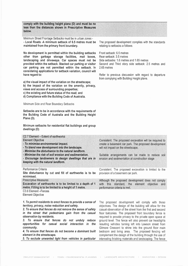
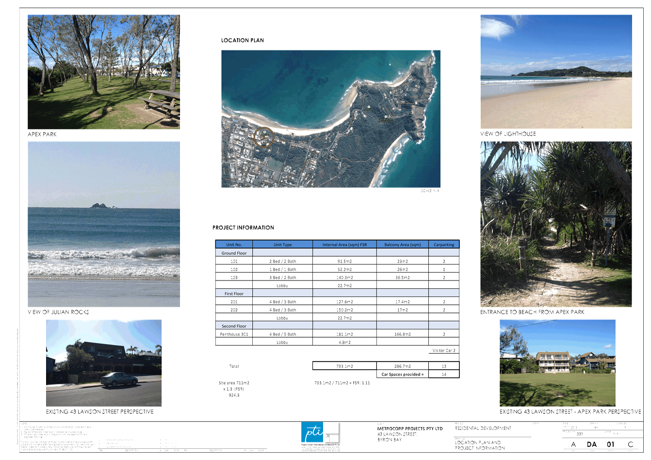
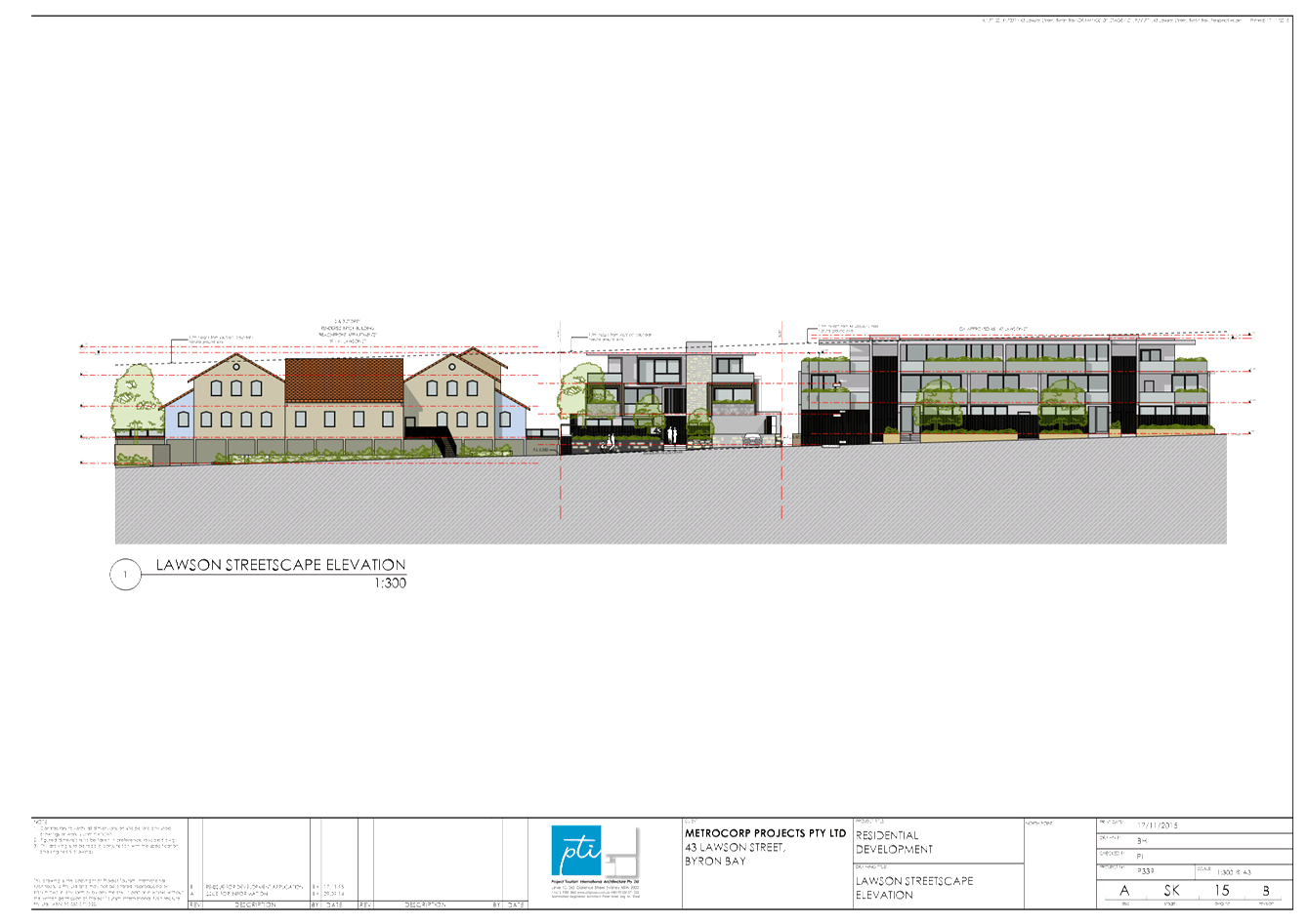
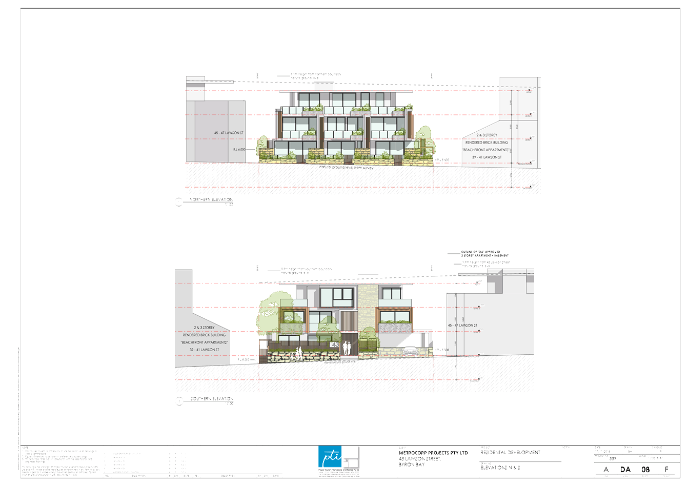
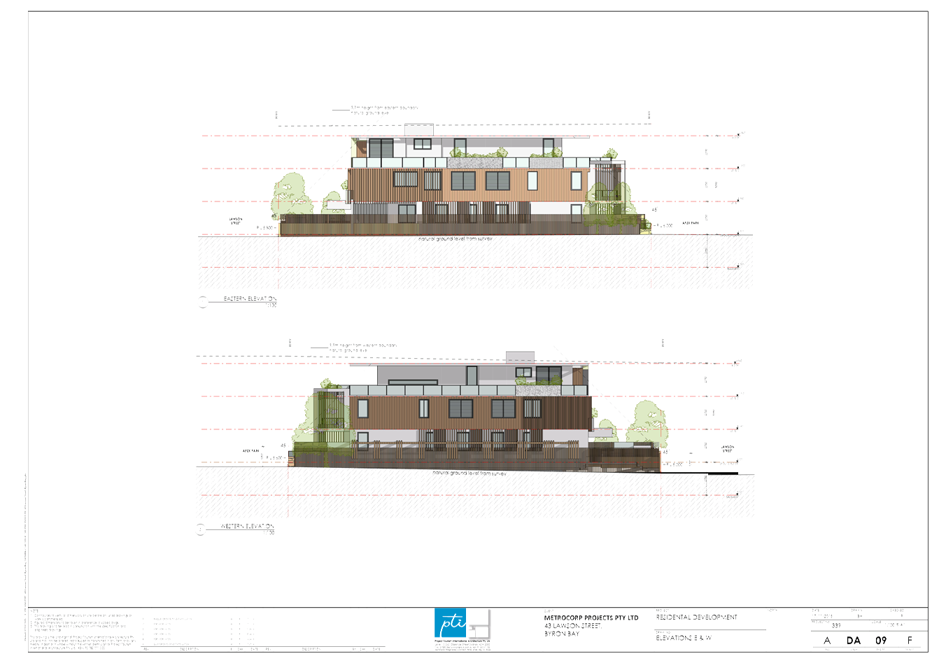
13.10 PLANNING - Outcome of
meeting (res 15-110) - 10.2014.417.1 - Demolition of existing
residential flat building & construction of a new residential flat building
and associated works at 43 Lawson Street Byron Bay
Attachment
1... Original Assessment Report.................................................................... 79
Attachment
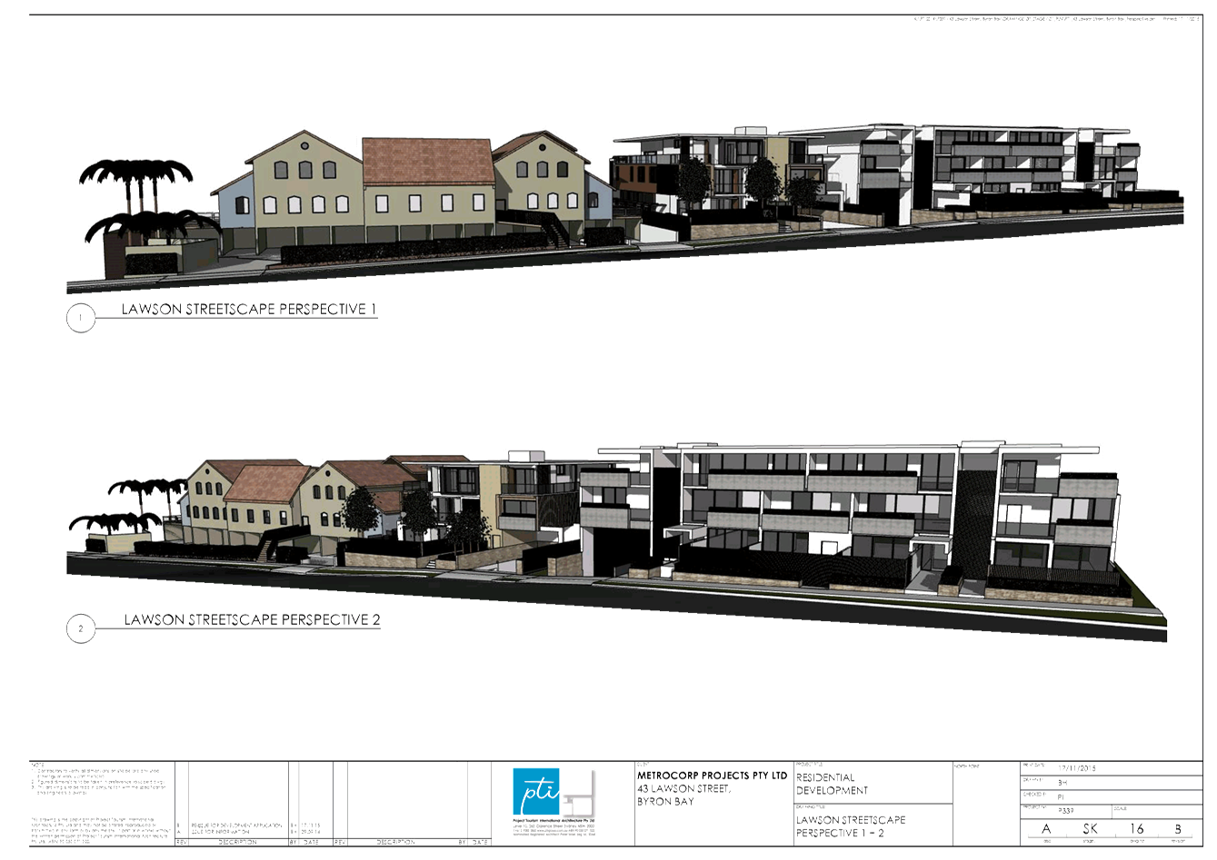
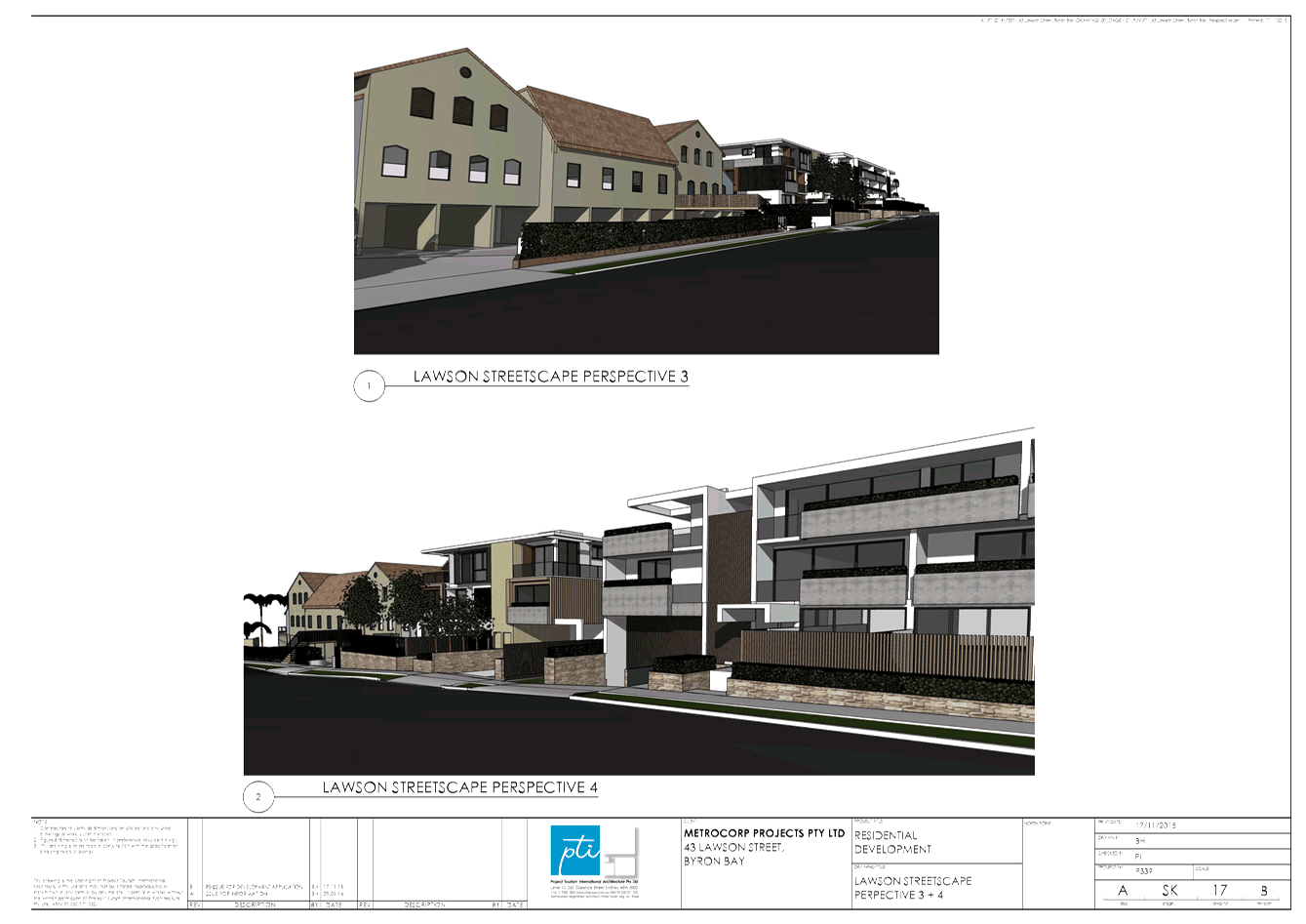
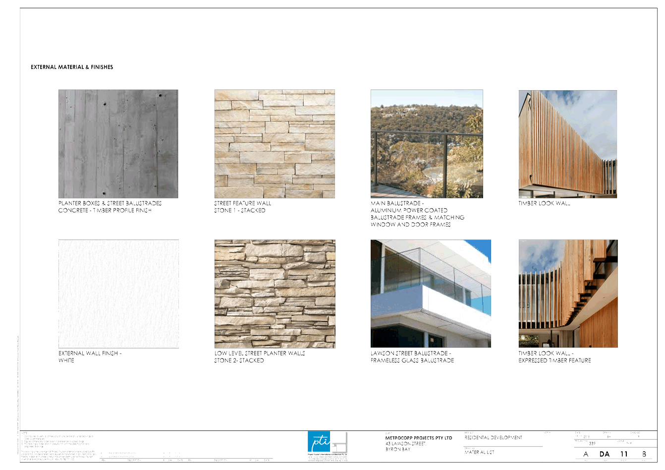
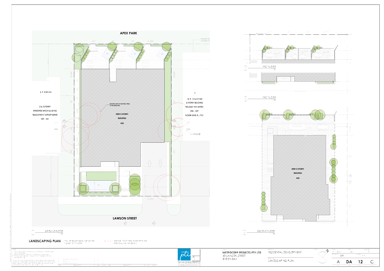
2... Plans of proposed development received 17/11/2015............................ 99
Attachment
3... Draft Conditions of Consent - 43 Lawson Street, Byron Bay................ 131
13.11 Compliance Priorities
Program - 2016
Attachment
1... 2016 Compliance Priorities Program .................................................... 149
Attachment
2... Compliance Guidelines - Private Functions in Rural Zones.................. 150
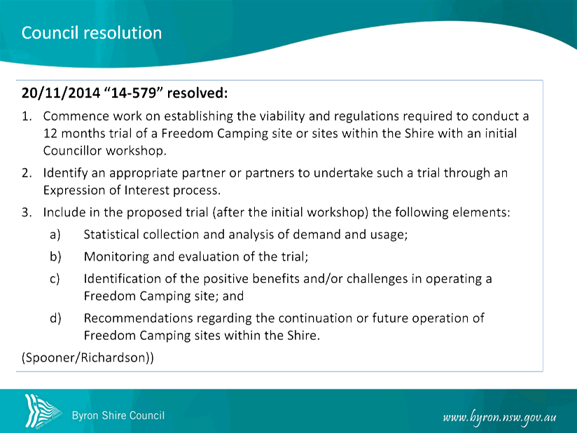
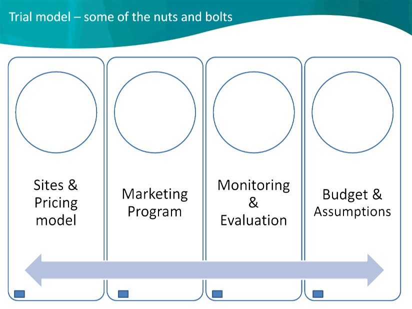
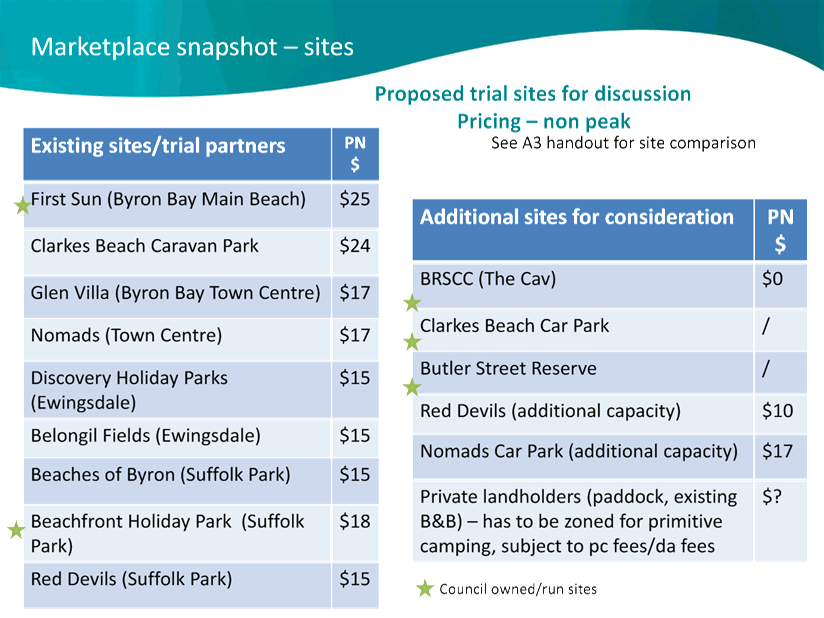
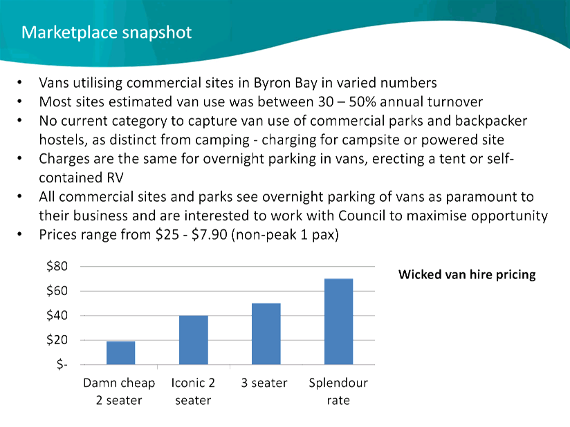
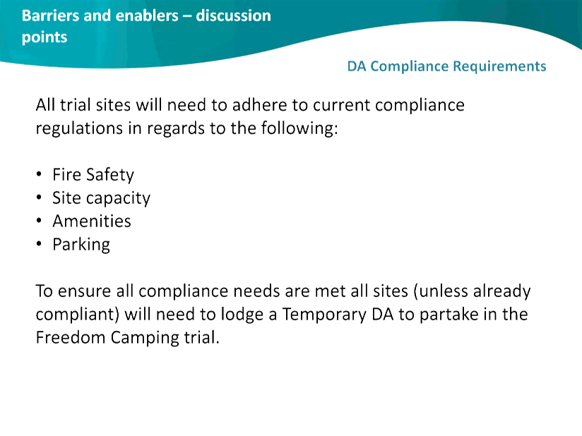
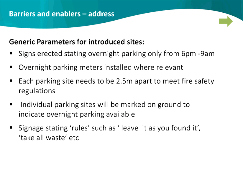
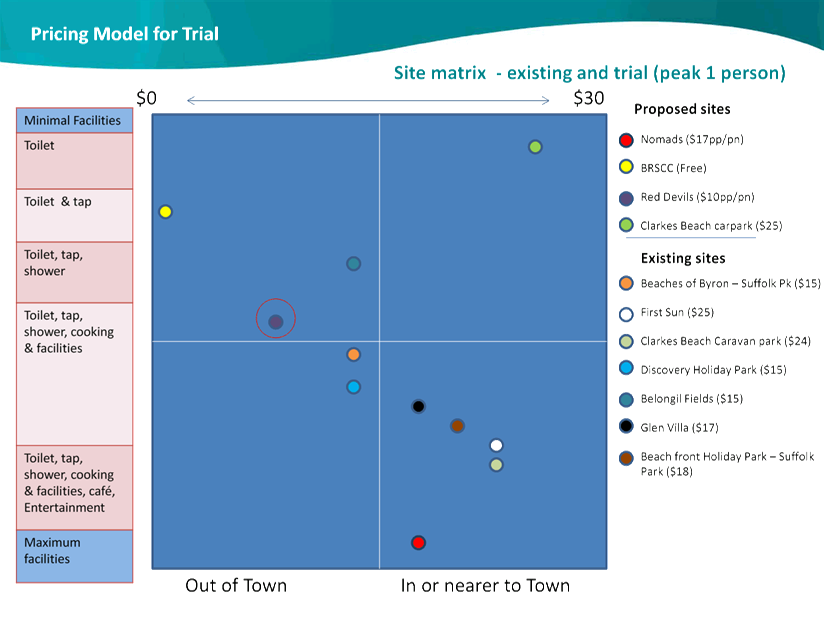
13.13 Freedom Camping Trial -
Byron Bay
Attachment
1... Freedom Camping Trial Site Selection Matrix - Presented at the Strategic
Planning Workshop on 28 May 2015.................................................................... 153
Attachment
2... Budget for the Freedom Camping Trial at The Cavanbah Centre........ 155
Attachment
3... Freedom Camping Trial - Freedom Camping Trial Presentation to the
Strategic Planning Workshop on 28 May 2015..................................................... 158
13.15 PLANNING - Rural Land Use
Strategy – Site Suitability Criteria & Mapping Methodology and
related mapping
Attachment
1... Draft Rural Land Use Strategy - Site Suitability Criteria and Mapping
Methodology (as revised), including related maps...................................................... 181
Attachment
2... Form of Special Disclosure of Pecuniary Interest................................. 207
13.18 Update on s68 applications
for Approval to Operate - Brunswick Heads Holiday Parks
Attachment
1... Draft MoU between NSW Crown Holiday Parks Trust and Byron Shire Council 209
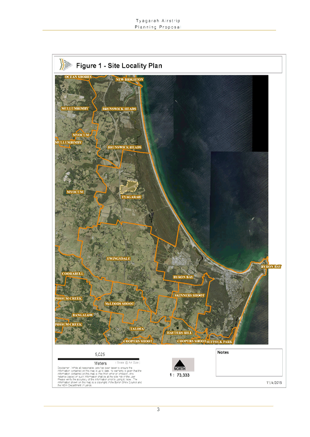
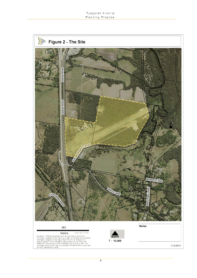
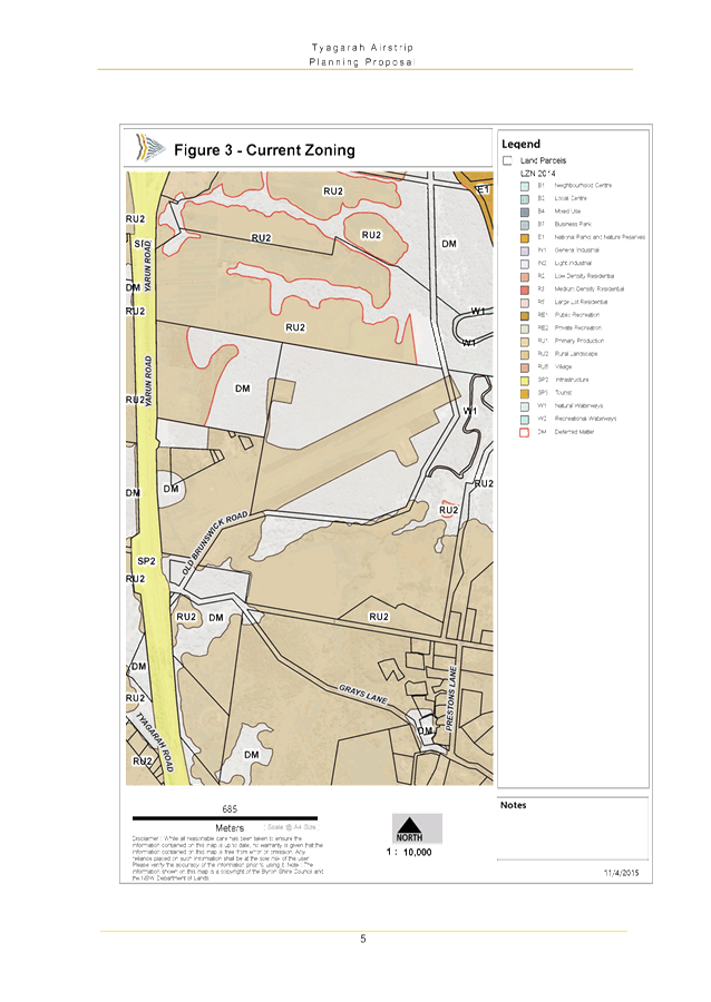
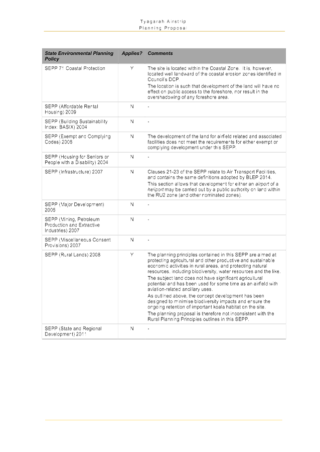
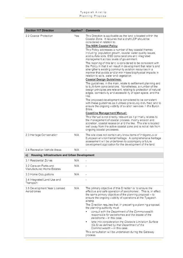
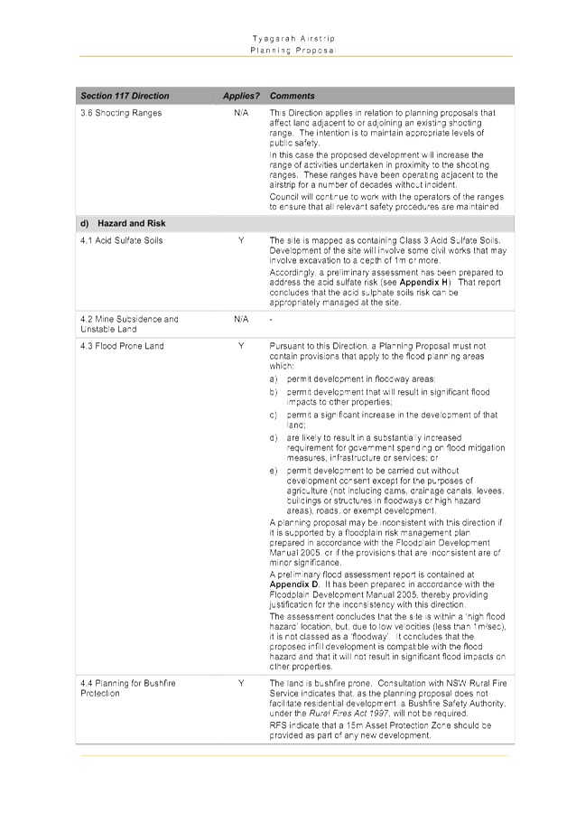
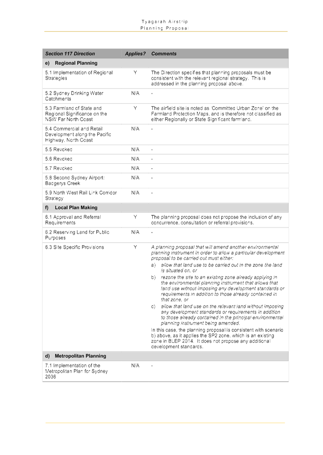
13.19 PLANNING - Tyagarah Airstrip
Planning Proposal
Attachment
1... Tyagarah Airstrip Planning Proposal..................................................... 213
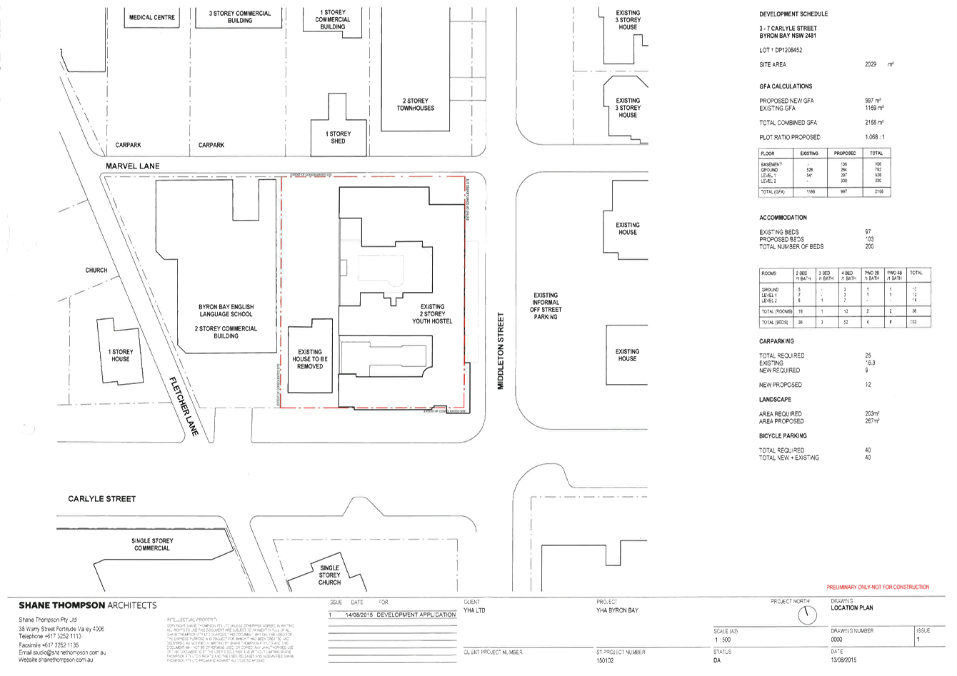
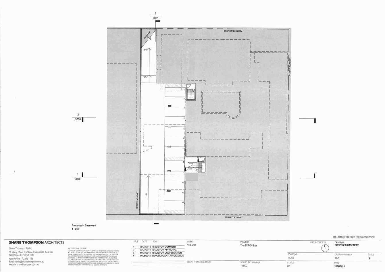
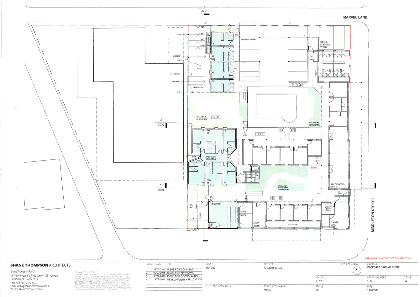
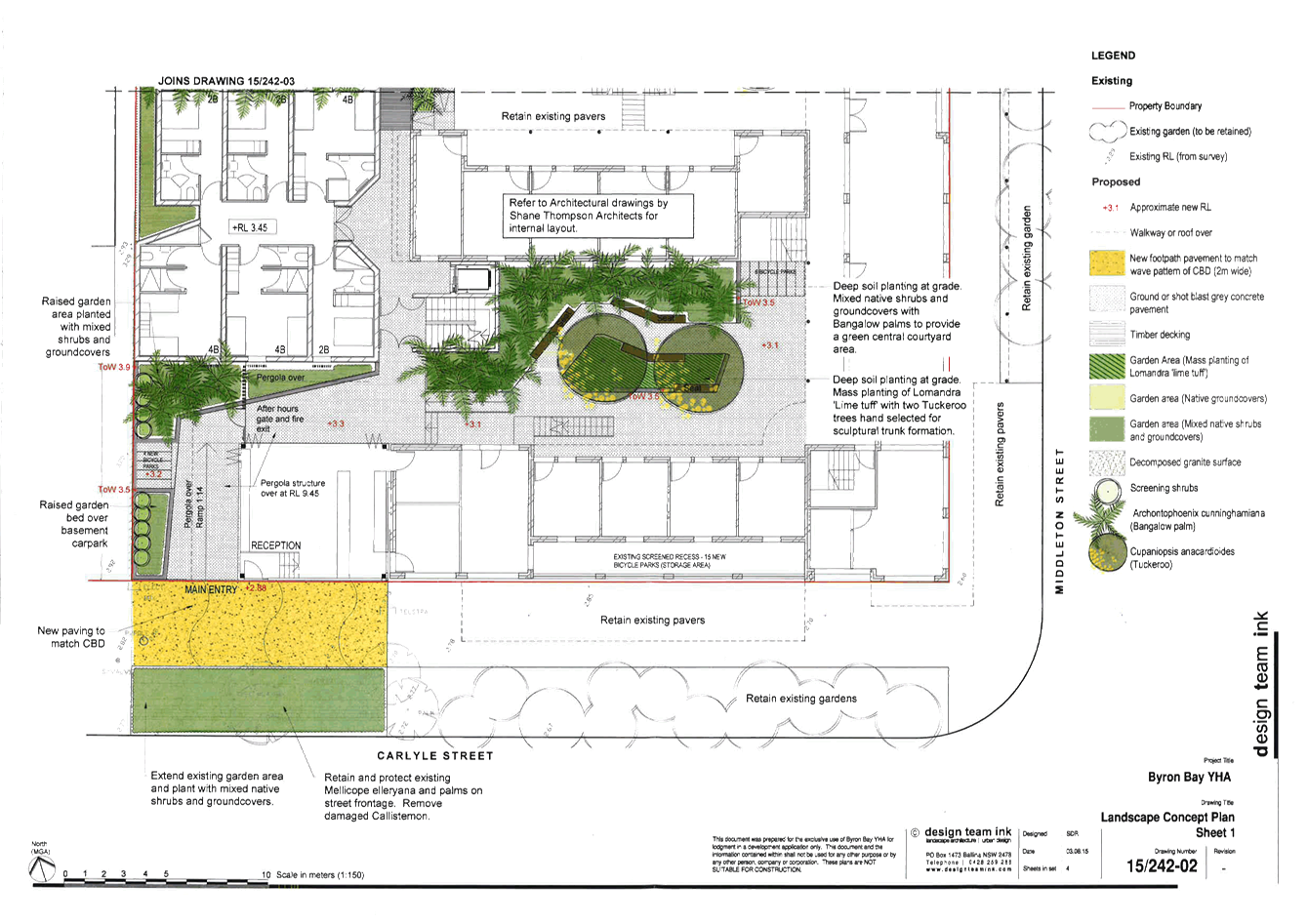
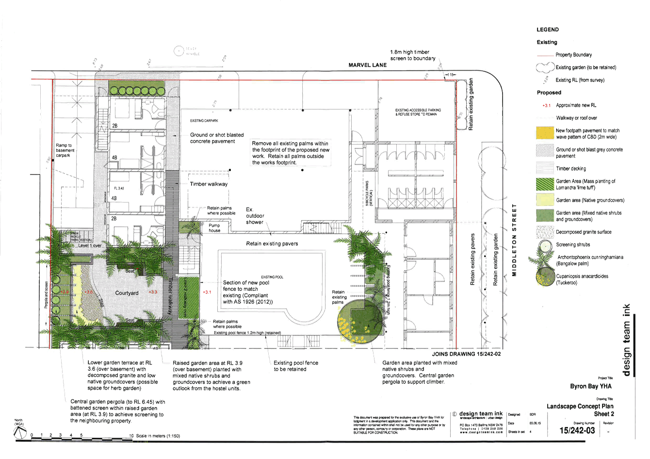
13.20 PLANNING - Development
Application 10.2015.505.1 - Alteration and additions to existing backpackers
accommodation, including demolition of an existing dwelling and construction of
a new three level building with basement carpark to increase capacity to 200
beds
Attachment
1... Conditions of consent 10.2015.505.1.................................................... 430
Attachment
2... Proposed development plans 10.2015.505.1........................................ 445
13.21 PLANNING - Submissions
Report - Planning Proposal for Secondary Dwellings in RU5 Village Zone
Attachment
1... Planning Proposal to permit secondary dwellings in the RU5 zone ..... 450
Attachment
2... Submission from NSW Rural Fire Service - Planning Proposal to permit
secondary dwellings in RU5.................................................................................... 475
Attachment
3... Form of Special Disclosure of Pecuniary Interest................................. 477
13.22 PLANNING - Submissions
Report - Planning Proposal to rezone land at Granuaille Crescent,
Bangalow, to R2 Low Density Residential.
Attachment
1... Planning Proposal for rezoning land at Granuaille Crescent to R2 ...... 479
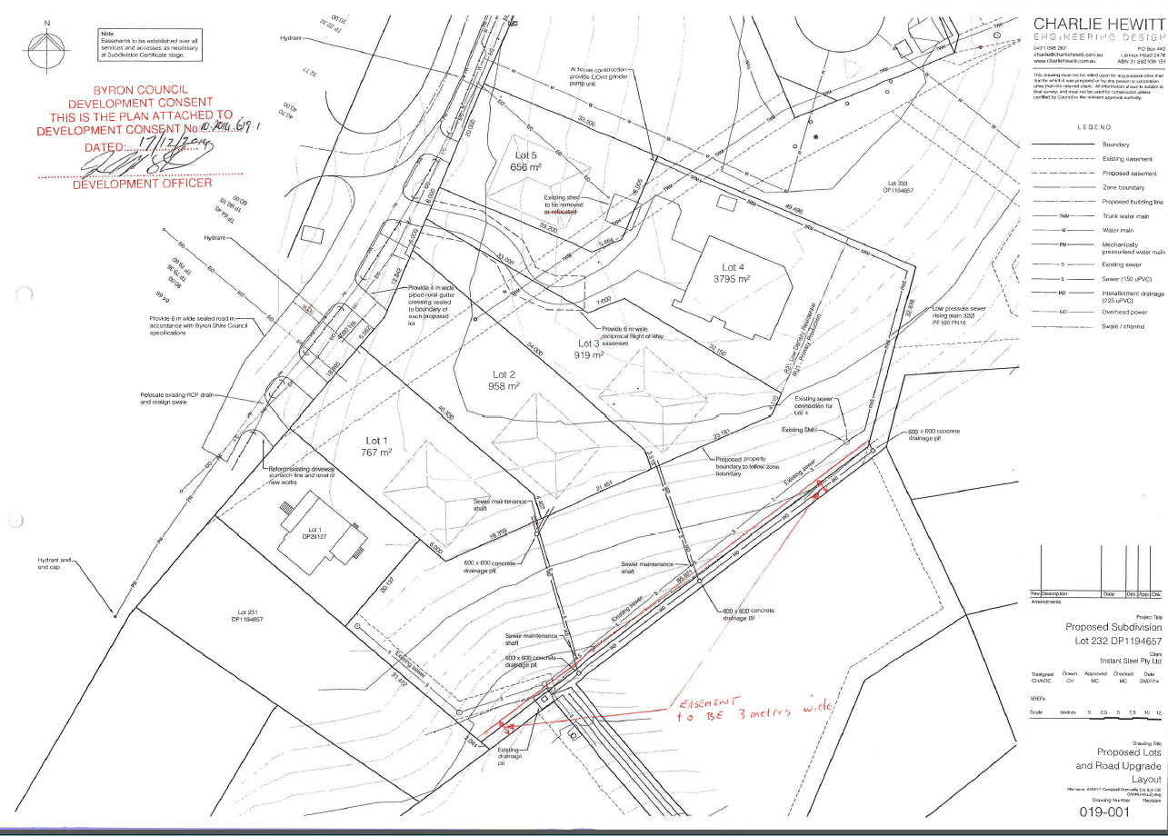
Attachment
2... Site ID Map for rezoning of Lots 233, 232, 231 DP 1194657, Granuaille
Crescent, Bangalow to R2 ..................................................................................... 510
Attachment
3... Land Zoning Map for rezoning of Lots 233, 232, 231 DP 1194657, Granuaille
Crescent, Bangalow to R2..................................................................... 511
Attachment
4... Floor Space Ratio Map for rezoning of Lots 233, 232, 231 DP 1194657,
Granuaille Crescent, Bangalow to R2..................................................................... 512
Attachment
5... Lot Size Map for rezoning of Lots 233, 232, 231 DP 1194657, Granuaille
Crescent, Bangalow to R2 ..................................................................................... 513
Attachment
6... Form of Special Disclosure of Pecuniary Interest................................. 514
Infrastructure Services
13.23 Infrastructure Works in the
North of the Council Area
Attachment
1... South Golden Beach Street Drainage Works Program and road renewal /
reconstruction 10 year program 24.2014.10.1...................................... 516
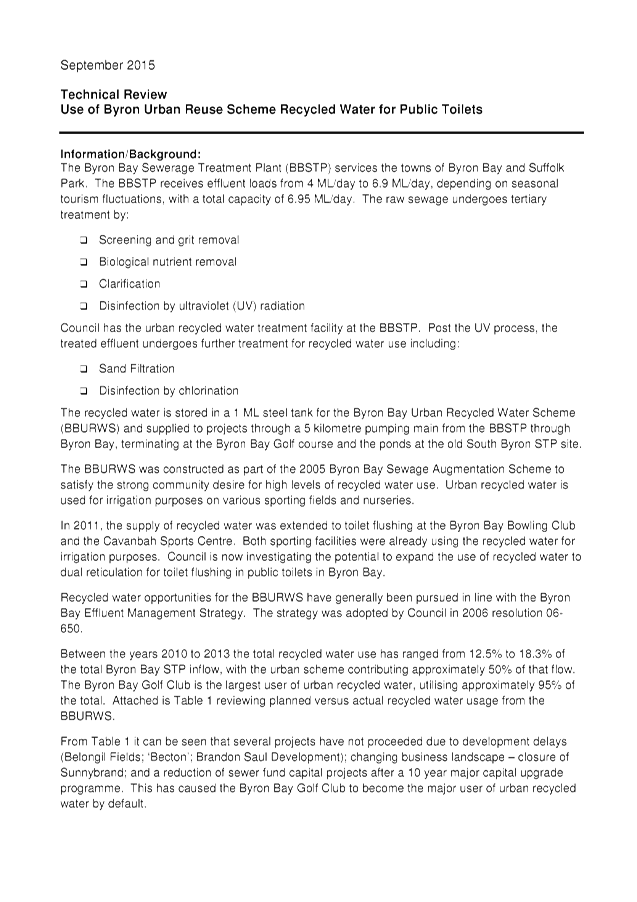
13.24 Extending Recycled Waste
Water from West Byron STP to the Byron Foreshore
Attachment
1... Technical Review Use of Byron Urban Reuse Scheme Recycled Water for Dual
Reticulation............................................................................................ 517
Attachment
2... Figure 1 Schematic Byron Bay Urban Recycled Water Proposed Extension 522
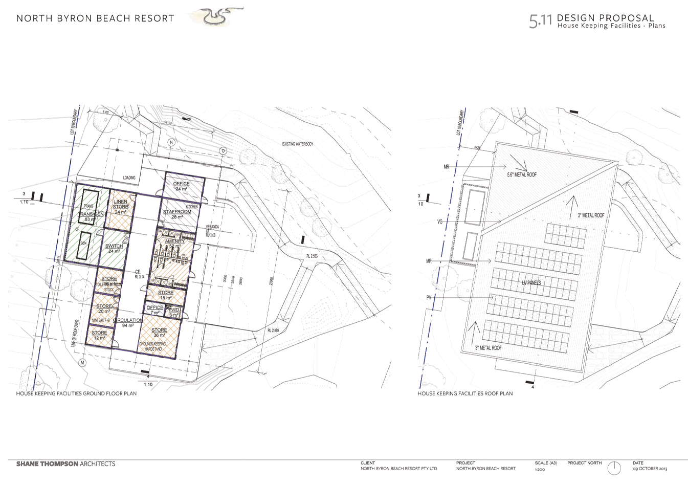
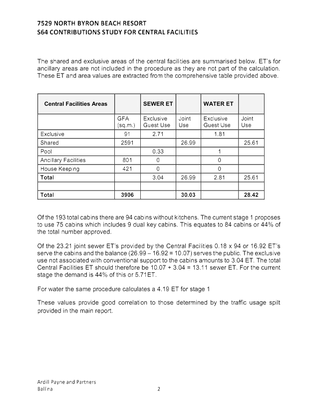
13.31 10.2013.562.1 North Byron Beach
Resort Central Facilities ET Assessment
Attachment
1... Planners North Letter Requesting Referral to Council.......................... 523
Attachment
2... Planners North Letter Rationale for ET Reduction................................ 524
Attachment
3... Planners North Letter Submission to Byron Shire Council regarding ETs 10
April 2014 - Redmapped................................................................................ 535
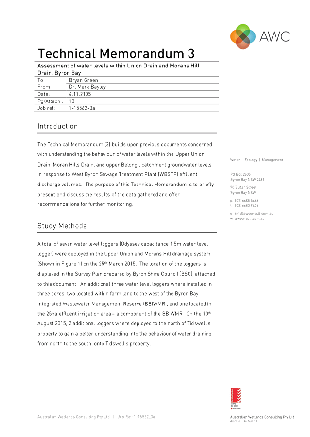
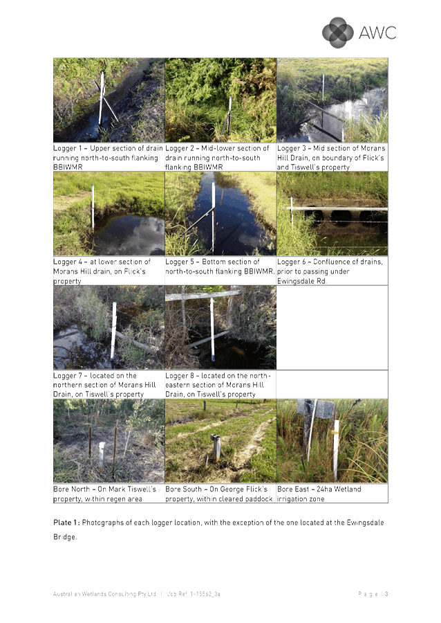
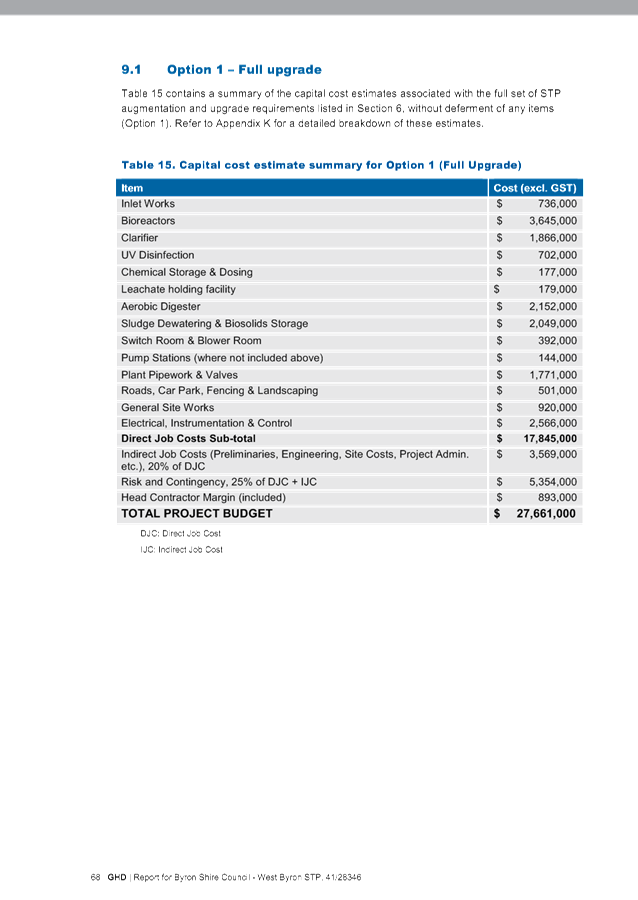
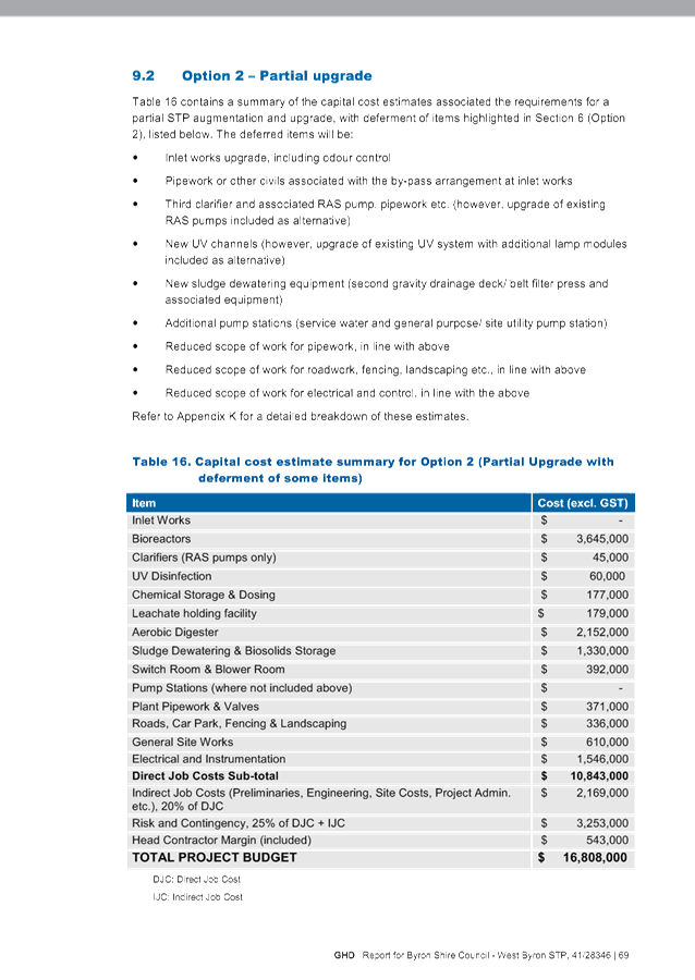
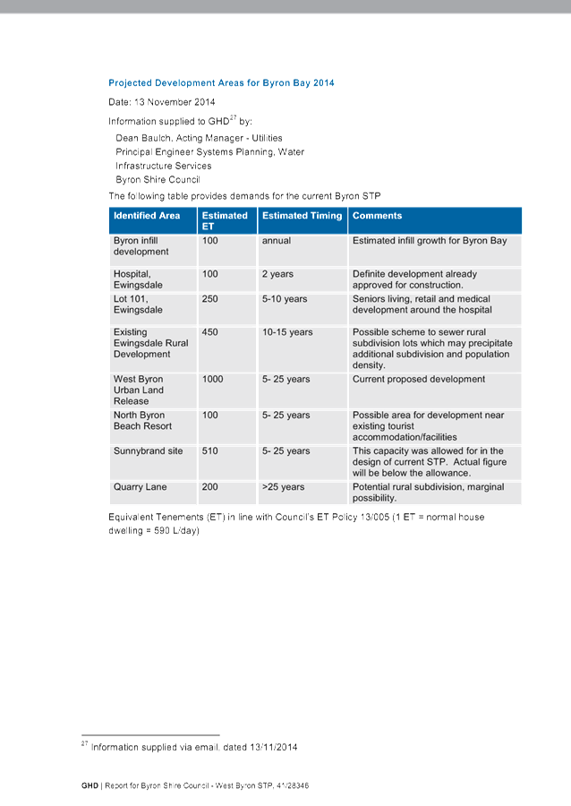
13.33 Byron Bay Sewage Treatment
Plant Capacity and the Belongil Fate of the Effluent
Attachment
1... 3 - Union Drain WL Assessment - Oct 2015......................................... 560
Attachment
2... Byron STP Capacity Review - Final Report August 2015 - GHD......... 574
14. Reports of Committees
Corporate and Community Services
14.1 Report of the
Internal Audit Advisory Committee Meeting held on 12 November 2015
Attachment
1... Minutes of the Internal Audit Advisory Committee Meeting held on 12
November 2015....................................................................................................... 714
14.2 Report of the
Arakwal Memorandum of Understanding Advisory Committee Meeting held on 19
August 2015
Attachment
1... Minutes of the Arakwal MoU Advisory Committee Meeting held on 19 August
2015............................................................................................................... 718
Infrastructure Services
14.3 Report of the
North Byron Coastal Creeks Flood Risk Management Committee Meeting held on 28
October 2015
Attachment
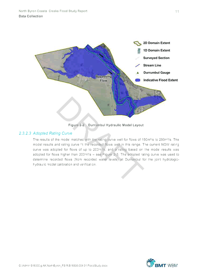
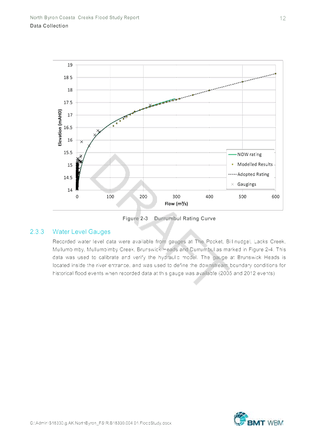
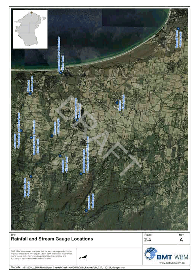
1... Minutes 28/10/2015 North Byron Coastal Creeks Flood Risk Management
Committee............................................................................................. 723
Attachment
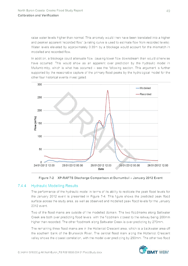
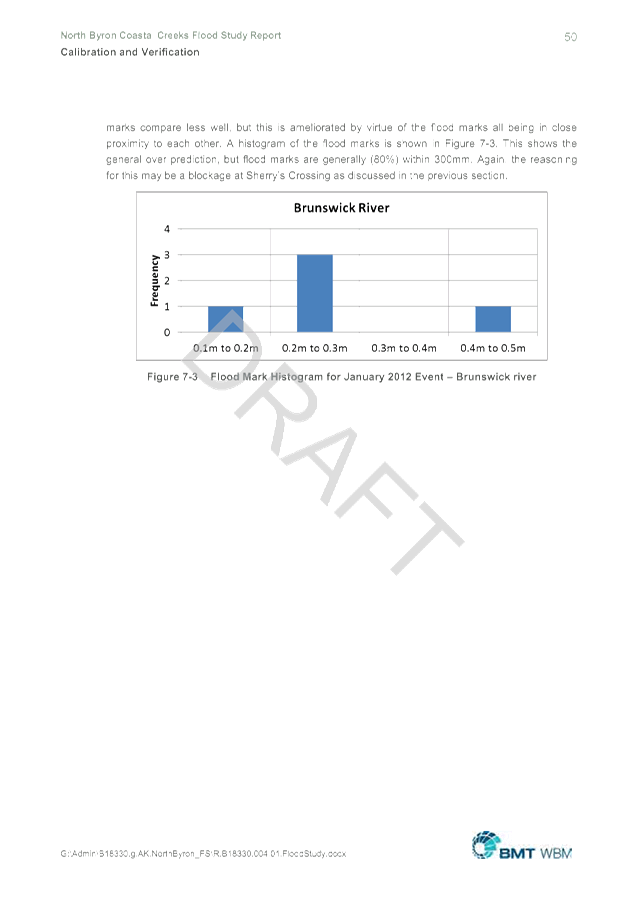
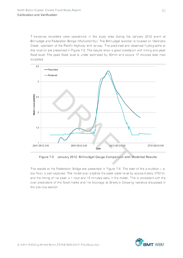
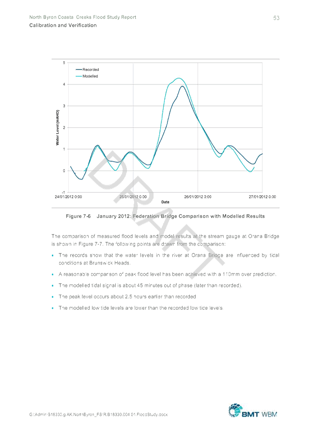
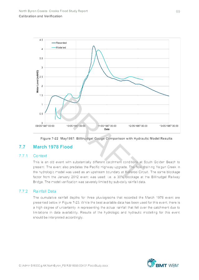
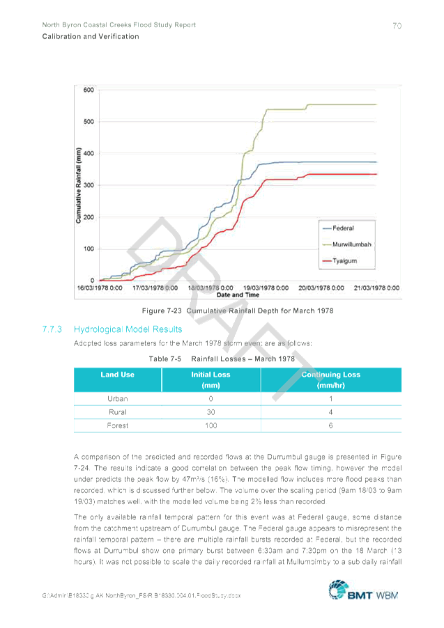
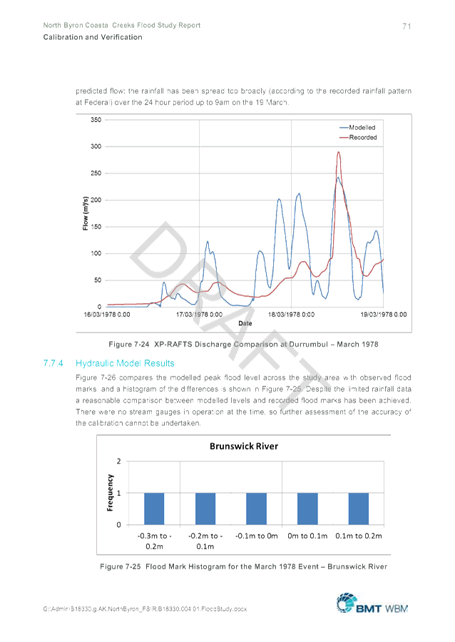
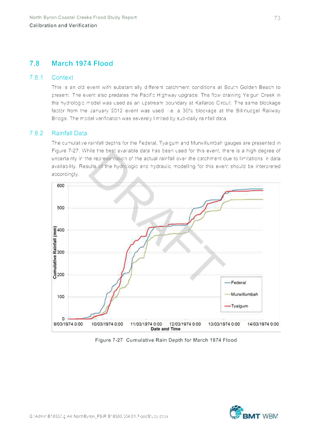
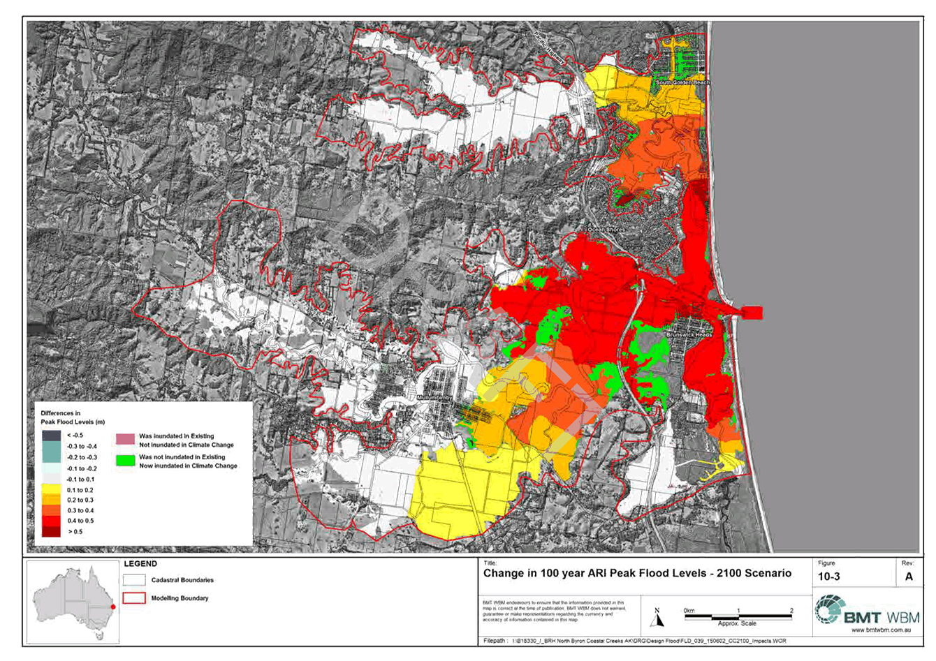
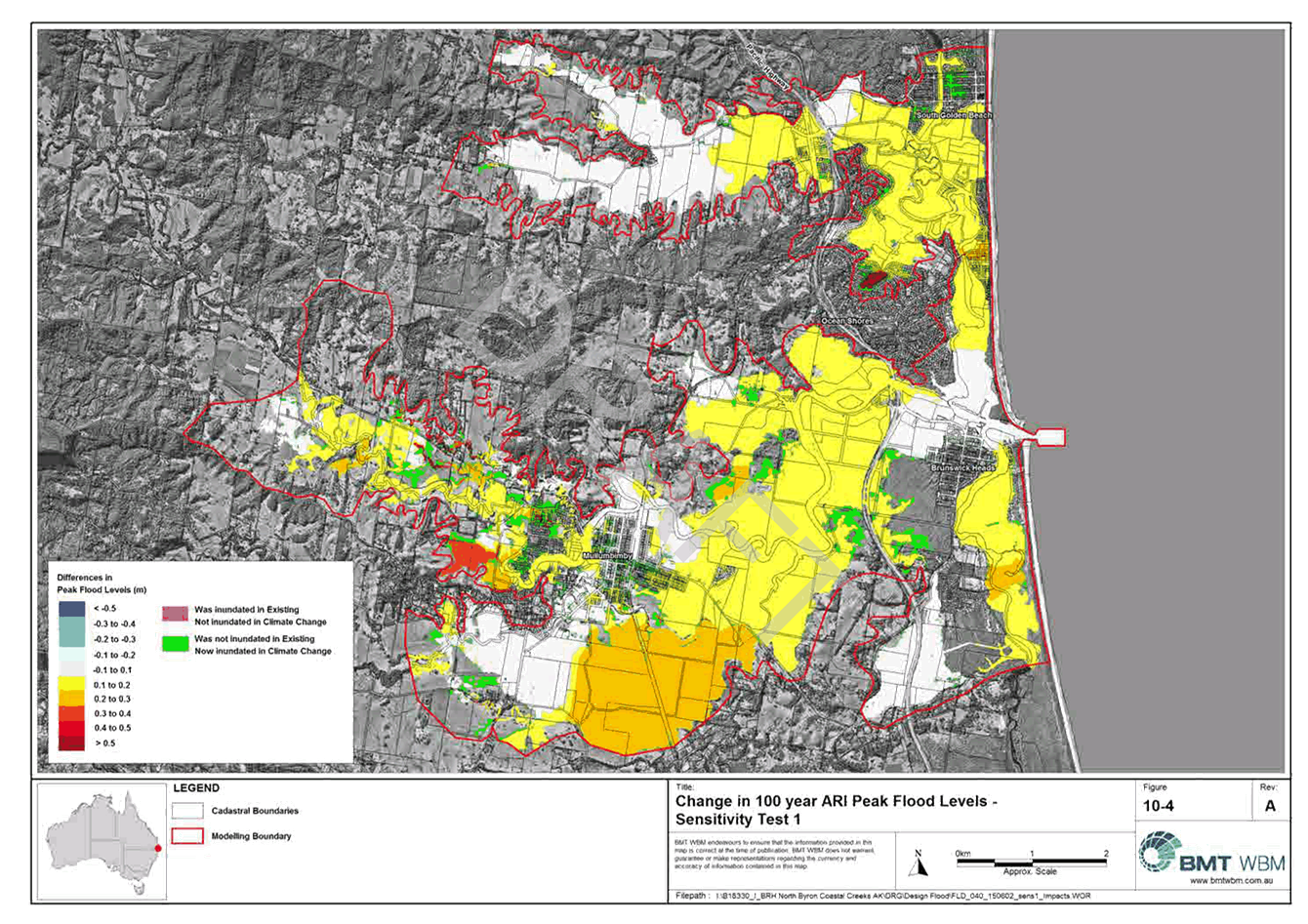
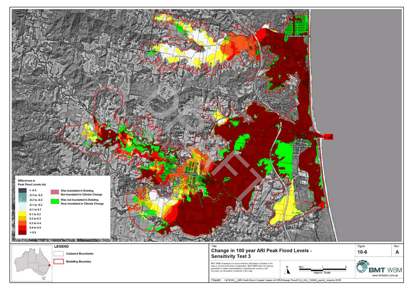
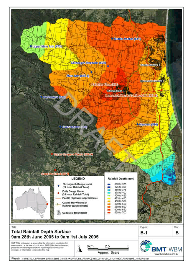
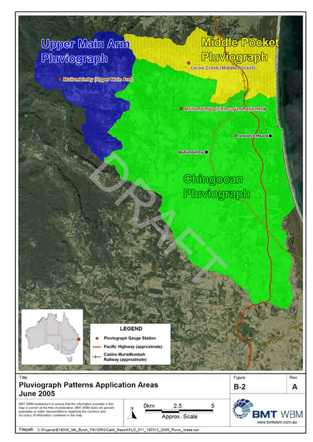
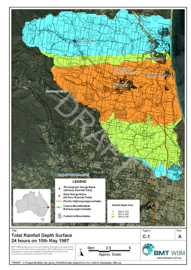
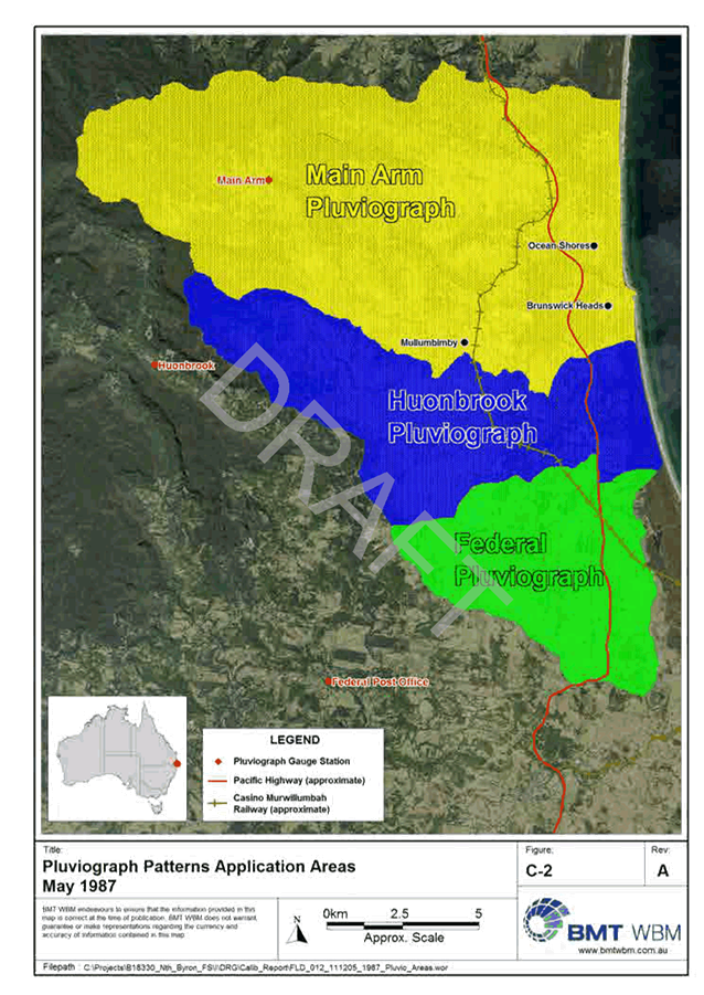
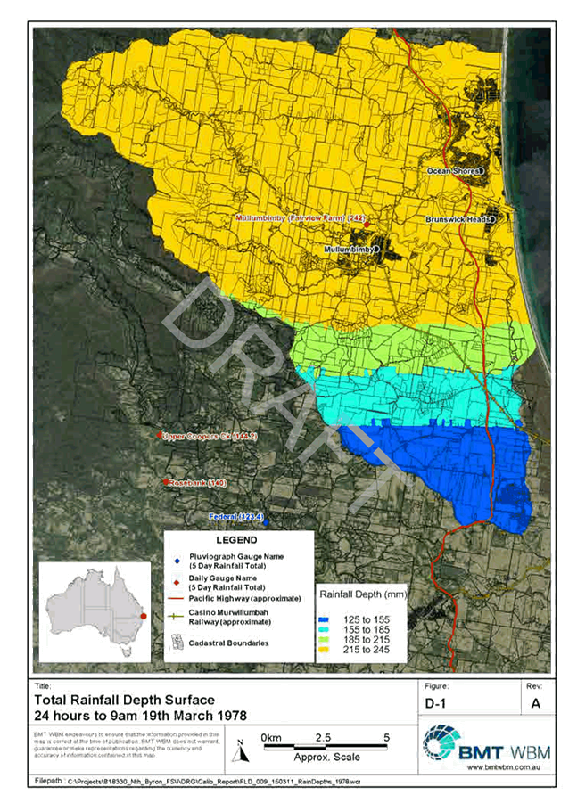
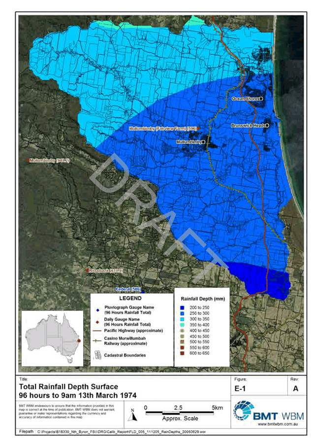
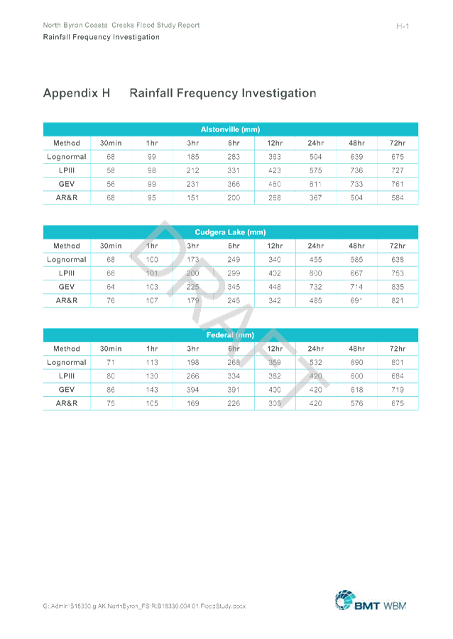
2... North Coastal Creeks Draft Flood Study - Calibration Report - Low Res 726
14.4 Report of the
Local Traffic Committee Meeting held on 25 November 2015
Attachment
1... Minutes 25/11/2015 Local Traffic Committee....................................... 922
Minutes of the Byron
Shire Council Public Art Assessment Panel Meeting held on Thursday 5 November
2015
E2015/72538
PRESENT: Cr P Spooner
Staff: Joanne
McMurtry (Community Policy Officer)
Community: Peter Wood (Arts Northern Rivers) (By teleconference)
Suvira
McDonald (Community Artist member)
Tracey
Whitaker (Community member)
Denise
Napier (Community member)
Rick
Molloy (Practising Artists Network)
Paul Spooner
opened the meeting at 1.45pm and acknowledged that the meeting was being held
on Bundjalung Country.
APOLOGIES: Cr S
Richardson, Paula Cordeiro (Community Artist member), Michele Zarro (Community
member), Gavin Brown (Bundjalung of Byron Bay Aboriginal Corporation
(Arakwal)), Andy Erskine
DECLARATIONS
OF INTEREST – PECUNIARY AND NON-PECUNIARY
Suvira McDonald
declared an interest in item 5.1 as an artist that may be interested in any
work that may arise from the new development.
CONFIRMATION OF A QUORUM:
There are ten people on the Panel. Quorum numbers were met.
CONFIRMATION
OF PREVIOUS MINUTES:
That the minutes
of the Public Art Assessment Panel meeting held on 6 August 2015 be adopted.
(Napier/Wood)
BUSINESS
ARISING FROM PREVIOUS MINUTES (Verbal updates)
5.1 Public
Art in new development
Simon Richardson and Denise Napier met with
the developer and staff re DCP requirements for public art on new developments.
A verbal report of the meeting was provided. The developer is currently
considering options prior to submitting some concept designs.
RECOMMENDATION
5.1:
That the
Public Art Assessment Panel recommend to Council to amend the DCP Chapter D8
‘Public Art’ to include under ‘Prescriptive Measures’
point 2 “or make an equivalent contribution to Councils public art
budget.”
(Spooner/ Wood)
5.2 Priority
public art locations in Ocean Shores and Suffolk Park
This item was
deferred to the next meeting.
5.3 Mullumbimby
Sculpture Walk
Suvira
McDonald reported:
· The engineering reports have been finalised.
· An application for an occupation certificate has been lodged.
· Expecting to install over summer.
· Have notified Creative Partnerships that a final report will
probably be provided in March 2016.
5.4 Electricity
Padmount Substations
The artwork has
now been installed at both sub-stations.
5.5 Rose
McKinley painting
The artwork has
now been installed in the Byron Bay Library.
5.6 Bus
Shelter corner Jonson & Carlyle Streets
The artwork has
now been installed at the bus stop.
5.7 Public
Art Small Grants
Two of the
public art small grants have been acquitted and finalised – Simpson’s
Sofa and Fishtales (from the Brunswick Nature Sculpture Walk). The mural at
Byron Community Centre is expected to be finalised shortly. This leaves the
Memorial Seat in Brunswick Heads – the applicant has until 30 June 2016
to finalise the grant.
PUBLIC ART PROPOSALS
6.1 Public Art on Byron Shire Water
Infrastructure
RECOMMENDATION
6.1:
That the Public Art Assessment Panel
recommend to Council to commission public artwork as per the
‘Briefs’ provided on the following water infrastructure in the
Byron Shire, to be funded from water and sewer budgets:
Brief 1:
· Paterson’s
Hill Water Tank
· Wategos Water
Tank
Brief 2:
· Several sewerage
pump stations (selected locations listed in the report, limited by budget
allocation for the 2015/16 financial year)
(Wood/ Napier)
Notes:
· Denise
Napier is happy to assist if banner mesh is decided on as a material.
· Peter
Wood offered the services of Arts Northern Rivers Indigenous Arts Development Officer – Mark Cora.
Tracey
Whittaker arrived at 2.30pm.
6.2 Public Art Proposal – Temporary
loan of sculpture by Allan Horstmanhoff
RECOMMENDATION
6.2:
That the Public Art Assessment Panel
recommend to Council to accept the temporary loan of ‘The Beast
Within’ by Allan Horstmanhoff and allow the sculpture to remain in situ
following the Brunswick Nature Sculpture Walk event in October 2015 for up to
twelve months.
(McDonald/ Molloy)
Action:
· Suggest the sculpture be moved to a more prominent location such as
on South Beach Rd near the Jules Hunt sculpture – across the road in
Torakina Park.
6.3 Public Art Proposal – Temporary
loan of sculpture by Jules Hunt
RECOMMENDATION
6.3:
That the Public Art Assessment Panel
recommend to Council to accept the temporary loan of ‘Beautiful
Nature’ by Jules Hunt and allow the sculpture to remain in situ following
the Brunswick Nature Sculpture Walk event in October 2015 for up to twelve months.
(McDonald/ Molloy)
6.4 Public Art Proposal – ELYSIUM in
Lawson Lane
Rebecca
Townsend and Sarah Workman were present for this item.
The Panel
suspended standing orders to receive a presentation from the proponents for the
project.
RECOMMENDATION
6.4:
1. That the
Public Art Assessment Panel note the presentation provided by ‘Creative
Road’ and recommend to Council to support the concept of the
beautification proposal for Lawson Lane as one of the initial projects arising
from the Byron Bay Town Centre Masterplan for reasons listed below:
a. It meets many of the objectives of the Public Art
Policy and will have excellent outcomes to further public art in the Shire
b. Is has the potential to be the
‘lighthouse’ project that will provide a benchmark for future
public art projects
c. There are opportunities to provide mentorship for
young local artists
2. The Public
Art Assessment Panel recommend that Council be a key stakeholder in the
development and implementation of this proposal.
(Spooner/Napier)
6.5 Public Art Proposal – “Youth
Seat’ and ‘Fishing Seat’ – part of Ten Seats Project,
Brunswick Heads
RECOMMENDATION
6.5:
That the Public Art Assessment Panel
recommend that Council to support the Brunswick Heads Ten Seat Project by
making a donation of $2,000 to the Tweed Street Taskforce being $1,000 for the
‘Youth Seat’ and $1,000 for the ‘Fishing Seat’ pending
full and final concept designs for both seats.
(McDonald/ Whittaker)
Notes:
· The Panel noted the excellent application, although some panel members
would like to understand the whole ‘Ten Seat Project’ better as a
whole.
· Are the Tweed St Taskforce talking with the new owners of the
Brunswick Heads Fishing Coop?
· The Panel questioned the skate park as the best location for the
youth seat, considering it seems to be aimed at young children, not teenagers
8. DATE
AND TIME OF NEXT MEETING
The next meeting
of the Public Art Assessment Panel will be advised – likely in February
2016
There
being no further business the meeting concluded at 3.50pm.

CALL FOR EXPRESSIONS
OF INTEREST
FROM
ARAKWAL ARTISTS AND CREATIVES FOR INDIGENOUS ARTWORK ON BYRON SHIRE WATER
INFRASTRUCTURE
Introduction
This
document outlines the background and details for developing indigenous artwork
concept designs and installation on Byron Shire Water Infrastructure. This
brief relates directly to the Paterson’s Hill Water Reservoir and Wategos
Water Reservoir.
According
to the Memorandum of
Understanding between Bundjalung of Byron Bay Aboriginal Corporation
(Arakwal) and Byron
Shire Council are calling for expressions of interest from indigenous artists
interested in submitting concept designs for artwork on two water reservoirs in
Byron Bay. Both reservoirs are in prominent locations, as described below. Due
to the high profile locations, this art installation is considered an
opportunity to showcase local indigenous artwork and demonstrate commitment to
the Memorandum of Understanding between Byron Shire Council and Bundjalung of
Byron Bay (Arakwal) Aboriginal Corporation.
It is also
an opportunity to express some of the community core values and key messages to
locals and visitors alike. A copy of the destination brand guidelines have been
provided to assist with understanding the community core values and key brand
messages which may be appropriate, or may trigger some other creative ideas.
Proposals
may be submitted for one or more parts of the following tasks:
1. Artwork concept
designs and installation of artwork on the Paterson’s Hill Water
Reservoir, and/or
2. Artwork concept
designs and installation of artwork on the Wategos Water Reservoir
The
Public Art Assessment Panel will be overseeing the artistic process as governed
by the Public Art Guidelines and Criteria and Public Art Policy.
This
is one of two briefs. This brief includes two large water reservoirs and the
second brief is for artistic treatment to Sewer Pump Stations around the Shire.
Background
A: Memorandum of Understanding
Following Native Title Claims in the 1990’s, an Indigenous
Land Use Agreement (ILUA) between the Federal Government and the Bundjalung of
Byron Bay Arakwal People was developed to implement part of these Native Title
Claims. A further Native Title Claim was made resulting in two more ILUAs which
were signed in 2006.
Byron Shire Council entered into a Memorandum of Understanding
with Bundjalung of Byron Bay Aboriginal Corporation (Arakwal) in July 2013. A
key part of the MOU is to develop public art opportunities for Arakwal people
to have artistic and cultural expression.
B: Public Art on Water Infrastructure in
Byron Shire
Many
of Council’s water assets are the subject of graffiti and other damage.
It has been identified that public art may be a solution some way towards the
problem with the aim of achieving a tidier, more beautiful Shire and a chance
to showcase local artists work.
Council
have invested significant resources in developing the Byron Bay Town Centre
Masterplan as outlined below. Beautifying the Shires water infrastructure
supports the Masterplan and efforts to improve the town centre.
The
dimensions of the reservoirs are:
· Paterson Street – Wall height
5.5 metres / Circumference – 77 metres
· Wategos – Wall height –
4.5 metres / Circumference 37 metres. This location only needs painting/
artistic treatment around half of the reservoir.
Photos of
the sites are provided below (taken in July 2015).
Whilst the
type and style of artwork is open, due to the size of Paterson’s Hill
Water Reservoir, a mural may be the appropriate treatment. However the Wategos
Water Reservoir may lend itself to other treatments such as a digital image on
bannermesh.
Wategos Water Tank

Patterson’s Hill Water Tank Highly
visible
C: Primary Brand: Byron (Don’t
Spoil Us, We’ll Spoil You)
 Byron
Shire Council developed a new identity/ brand for Byron Shire, which aims to
attract appropriate visitor markets, extend visitor length of stay and
encourage visitor dispersal throughout the Shire. The Visual Identity Guide for the Byron
brand is attached. The
brand was developed with considerable community consultation and is based on
the community core values (listed in the Visual Identity Guide).
Byron
Shire Council developed a new identity/ brand for Byron Shire, which aims to
attract appropriate visitor markets, extend visitor length of stay and
encourage visitor dispersal throughout the Shire. The Visual Identity Guide for the Byron
brand is attached. The
brand was developed with considerable community consultation and is based on
the community core values (listed in the Visual Identity Guide).
A
communications strategy to implement the brand seeks to, over time, change the
visitor type by overcoming the Byron Bay party-town image and attract visitors
to Byron Shire that respect and love the Shire as much as the locals do.
The
brand is simply ‘Byron’. The
brand essence is: “Byron Shire has an energy, an attitude, and a sense of
community. It’s the people who live here and love this place, that make
it what it is. It’s the musicians, the elders, the artists, the plumbers,
the farmers, the surfers, the healers, the councillors, the millionaires, the
buskers, the writers, the greenies, the capitalists, the misfits.”
D: Byron Bay Town Centre Masterplan
The Byron
Bay Town Centre Masterplan is almost finalised. The Masterplan will provide the
framework for a completely revitalised town centre while ensuring Byron
Bay’s character is preserved and enhanced.
Byron Bay is
a town where the community have strong values and beliefs that has created a
culture where sustainable practices and alternate ways of living, play a
crucial role in the way our community chooses to lead their lives. This culture
is a key ingredient that defines Byron Bay and will be harnessed, preserved and
celebrated in the development of a town centre masterplan.
When
completed, the Masterplan will promote the town’s natural environment,
relaxed atmosphere, spiritual and cultural diversity, health and well-being
experiences, innovative enterprises, and provide a consistent image for Byron
Bay. This will help to attract appropriate visitor markets, extend length of
stays and encourage visitor dispersal across the Shire. More importantly, an
innovative place making strategy will provide a vibrant and diverse town centre for the resident
population to enjoy - a place to be reclaimed.
E: Byron Shire Council – Supporting
Local Public Art
Byron
Shire Council support the development of the arts and creative industries as
demonstrated in the Byron Shire Cultural Plan (2008 – 2013), the Arts and
Creative Industries Strategy for the Byron Shire (2009 – 2012) and a
Public Art Policy.
The
Public Art Policy states:
· A centre for arts and culture, the
Northern Rivers is renowned for its creative communities and for its beautiful
coastal and rainforest environments.
· Culture is the expression of the
history, heritage, customs, arts, recreation, creativity and values of our
community. Council seeks to protect the cultural and place values of local
areas and streetscapes; to reflect heritage, character and charm, in the interest
of the community as whole. This policy will support the engagement of local
artists to create public art works and will directly benefit the local
community by generating employment, building commitment and sustainability.
Furthermore, it creates opportunities for creative learning and information
sharing about cultural activities.
· Byron Shire Council recognises that
the daily lives of residents and visitors can be enriched and enlivened through
the presence of quality works of art in the Shire. Council also recognises that
a collection of such art will attract visitors with shared values.
· Public Art is one way to recognise
local artists and values whilst adding a new dimension to public spaces in the
Shire. This policy is designed to support Public Art in Byron Shire within a
framework that clearly outlines the practical considerations for management and
selection of such artwork. The framework will ensure the distinctiveness and
mix of cultural values in each of the towns, rural villages and localities is
reflected by Public Art installations. It is to be used by Council staff and
external parties such as developers, architects and urban designers for
commissioning new works, acquiring existing works, collection management and
maintenance.
Council
has developed the Public Art Guidelines and Criteria. The commissioning of any
artwork by Council is undertaken using the Public Art Guidelines and Criteria.
All of the documents mentioned above are available on Council’s website
under ‘publications’.
Council
established the Public Art Assessment Panel (PAAP) in order to provide
recommendations to Council following assessment of artwork proposals. The
process of commissioning this artwork will require some liaison with the PAAP
as outlined in the Public Art Guidelines and Criteria (specifically section 6).
In
assessing each concept the Public Art Assessment Panel aims to ensure that the
successful proposal:
1. is
of a high standard in terms of design and technical and structural execution;
2. is
culturally appropriate
3. requires
low level maintenance
4. does
not pose risk or WH&S management issues
5. best
meets the requirements outlined in the project brief and Council’s
broader objectives
6. meets
relevant building and safety standards
7. does
not pose any long-term conservation issues
8. meets
the requirements of the project budget
9. will
meet the specified timeframe; and
10. is assessed on
the basis of the guidelines outlined in this document and Council’s Public
Art Policy.
The process
will include:
1. Interested
artists submit an expression of interest (EOI)/ Proposal, including images of
their previous work, a concept design for the project and proposals for the
installation of the work.
2. The
EOI of the shortlisted artists will be assessed by the PAAP. This may require
the artist to be present to talk to their EOI (to be confirmed).
3. The
PAAP will select a preferred concept design and make a recommendation to
Council.
4. Once
Council has endorsed the preferred artwork, the successful artist will be
offered a contract agreement which will outline the specific terms and
conditions of the project between the stakeholders. (A sample contract is
available in the Public Art Guidelines and Criteria Appendix 5)
5. The
artist will undertake the commission.
Objectives
of the Engagement
1. To
provide Byron Shire Council with a creative treatment or artwork on the two
water reservoirs located as indicated in Byron Bay;
a. Expressing
the Shire’s indigenous culture, creativity and values of the community in
mind (communicating community core values and key messages);
b. Will
provide inspiration as viewed from a distance;
c. Which
will deter graffiti and thereby reduce, if not eliminate, the need for regular
graffiti removal;
d. Will
have very minimal, if any, future maintenance costs;
e. Will
be of low risk in regards to work, health and public safety.
Scope of Works
The Artist
shall provide enough information to address the objectives above, including,
but not necessarily limited to the following major tasks for one or more parts
of this Expression of Interest:
1. Provide information as follows in
order for the Public Art Assessment Panel to consider the expression of
interest:
1.1. submit a
concept design and proposal for the installation of the work for the one or
both of the water reservoirs
1.2. a proposal of the artwork (ie the
details of materials, etc) (a pro forma is available to use based on Appendix 9
of the Public Art Guidelines and Criteria)
1.3. a maintenance manual (a pro forma is
available to use based on Appendix 6 of the Public Art Guidelines and Criteria)
1.4. a public art risk assessment (a pro
forma is available to use based on Appendix 10 of the Public Art Guidelines and
Criteria)
1.5. submit
samples or images of previous work demonstrating your experience on similar
projects
2. If
requested, be available to speak to your expression of interest with the Public
Art Assessment Panel members (to be confirmed).
3. If
successful, artwork to be installed by the artist according to the concept
design approved by Council.
Timeline
EOI’s
must be lodged with Council prior to the deadline, being 4pm Friday 15
January 2016.
|
Milestone
|
Date
|
Payment
schedule
|
|
Proposals
to be submitted by 4pm
|
15
January 2016
|
|
|
Milestone
1 – Commission commences (contract to be signed)
|
March
2016
|
50%
|
|
Milestone
2 – artwork is installed, practical completion and project
evaluation finalised
|
27 May
2016
|
50%
|
Enquiries
to Joanne McMurtry, Community Policy Officer, Byron Shire Council on phone 6626
7316 or via email joanne.mcmurtry@byron.nsw.gov.au

CALL FOR
EXPRESSIONS OF INTEREST
FROM
ARTISTS AND CREATIVES FOR ARTISTIC TREATMENT OF BYRON SHIRE WATER
INFRASTRUCTURE (PUMP STATIONS)
Introduction
This
document outlines the background and details for developing artistic treatment
concept designs and installation on Byron Shire Water Infrastructure –
specifically sewer pump stations.
Byron Shire
Council are calling for expressions of interest from individuals or consortiums
of artists interested in submitting concept designs for artwork on several
sewer pump stations in the Byron Shire. These art installations are considered
an opportunity to showcase local artwork and also provide an opportunity to
express some of the community core values and key messages to locals and
visitors alike. A copy of the destination brand guidelines have been provided
to assist with understanding the community core values and key brand messages
which may be appropriate, or may trigger some other creative ideas.
Proposals
including artwork concept designs may be submitted for one or more
sewer pump stations across the Shire, as outlined below.
The
Public Art Assessment Panel will be overseeing the artistic process as governed
by the Public Art Guidelines and Criteria and Public Art Policy.
This
is one of two briefs. This brief includes the artistic treatment to Sewer Pump
Stations around the Shire and the second brief is for artwork on two large
water reservoirs.
Background
A: Public Art on Water Infrastructure in
Byron Shire
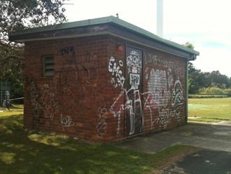
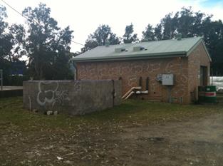
Many
of Council’s water assets are the subject of graffiti and other damage.
It has been identified that public art may be a solution some way towards the
problem with the aim of achieving a tidier, more beautiful Shire and a chance
to showcase local artists work.
Council
have invested significant resources in developing the Byron Bay Town Centre
Masterplan as outlined below. Beautifying the Shires water infrastructure
supports the Masterplan and efforts to improve the town centre.
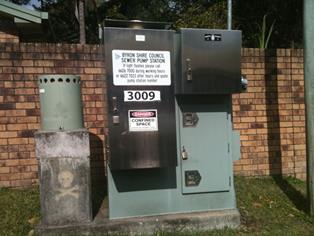
There are
several sewer pump stations around the Shire that could benefit from artistic
treatment as listed in the table below. In the initial year, expressions of
interest should focus on high profile stations, with a spread across the Shire
and perhaps include two of the bigger stations and two smaller ones. The type
and style of artwork is open to discussion and may include murals or other
paint or media treatments, sculpture and or landscape art.
The budget
allocated to this project for 2015/16 financial year is $20,000 and submissions
will be expected to outline which pump stations will be included by the artist.
The intention is that over several years, most of the pump stations will be
artistically treated in a staged process, as budget allows.
With each
pump station reflecting the immediate local area, eventually, the water
infrastructure across the Shire will become a public art collection or public
space gallery interpreting the surroundings.
Photos of some
of the sites are provided below (taken in July 2015).
|
SEWER PUMP
STATIONS
|
|
|
Bangalow
|
|
1001
|
Pacific Highway
|
|
1003
|
Lismore Road
|
|
Brunswick Heads
|
|
2001
|
South Beach Road
|
|
2008
|
Sports ground
|
|
2010
|
Bayside Way
|
|
Byron Bay
|
|
3001
|
Bangalow Road
|
|
3002
|
Tennyson Street
|
|
3004
|
Milton Street
|
|
3005
|
Childe Street
|
|
3006
|
Marine Parade,
Wategos
|
|
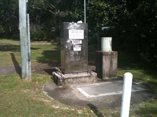
3007
|
Broken Head Road,
Suffolk Park
|
|
3009
|
Clifford Street,
Suffolk Park
|
|
3017
|
High School
|
|
3018
|
Cemetery Road
|
|
3020
|
Armstrong Street
South, Suffolk Park
|
|
3029
|
Beach Road, Broken
Head
|
|
Mullumbimby
|
|
4000
|
Station and Train
Streets
|
|
4004
|
Palm Avenue
|
|
4005
|
Pine Street
|
|
|
|
Examples of sewerage pump stations
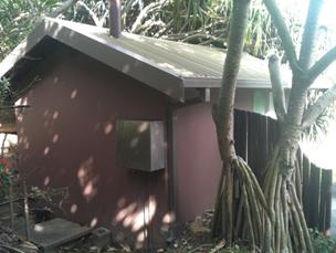
Wategos Pump Station
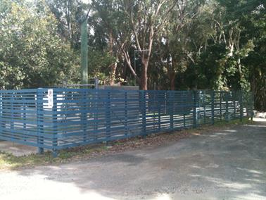
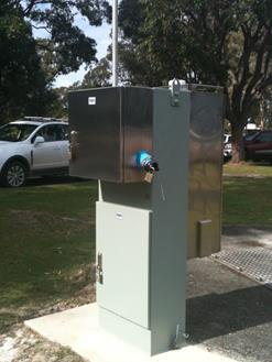
Old Bangalow Road Pump Station (near Eden Garden
Centre) Byron Bay High School Station
Suffolk Park Broken
Head Road
Byron Bay Rec Ground Byron
Bay Rec Ground
Bayshore Drive near Depot
B: Primary Brand: Byron (Don’t
Spoil Us, We’ll Spoil You)
 Byron
Shire Council developed a new identity/ brand for Byron Shire, which aims to
attract appropriate visitor markets, extend visitor length of stay and
encourage visitor dispersal throughout the Shire. The Visual Identity Guide for the Byron
brand is attached. The
brand was developed with considerable community consultation and is based on
the community core values (listed in the Visual Identity Guide).
Byron
Shire Council developed a new identity/ brand for Byron Shire, which aims to
attract appropriate visitor markets, extend visitor length of stay and
encourage visitor dispersal throughout the Shire. The Visual Identity Guide for the Byron
brand is attached. The
brand was developed with considerable community consultation and is based on
the community core values (listed in the Visual Identity Guide).
A
communications strategy to implement the brand seeks to, over time, change the
visitor type by overcoming the Byron Bay party-town image and attract visitors
to Byron Shire that respect and love the Shire as much as the locals do.
The
brand is simply ‘Byron’. The
brand essence is: “Byron Shire has an energy, an attitude, and a sense of
community. It’s the people who live here and love this place, that make
it what it is. It’s the musicians, the elders, the artists, the plumbers,
the farmers, the surfers, the healers, the councillors, the millionaires, the
buskers, the writers, the greenies, the capitalists, the misfits.”
C: Byron Bay Town Centre Masterplan
The Byron
Bay Town Centre Masterplan is almost finalised. The Masterplan will provide the
framework for a completely revitalised town centre while ensuring Byron
Bay’s character is preserved and enhanced.
Byron Bay is
a town where the community have strong values and beliefs that has created a
culture where sustainable practices and alternate ways of living, play a
crucial role in the way our community chooses to lead their lives. This culture
is a key ingredient that defines Byron Bay and will be harnessed, preserved and
celebrated in the development of a town centre masterplan.
When
completed, the Masterplan will promote the town’s natural environment,
relaxed atmosphere, spiritual and cultural diversity, health and well-being
experiences, innovative enterprises, and provide a consistent image for Byron
Bay. This will help to attract appropriate visitor markets, extend length of
stays and encourage visitor dispersal across the Shire. More importantly, an
innovative place making strategy will provide a vibrant and diverse town centre for the resident
population to enjoy - a place to be reclaimed.
D: Byron Shire Council – Supporting
Local Public Art
Byron
Shire Council support the development of the arts and creative industries as
demonstrated in the Byron Shire Cultural Plan (2008 – 2013), the Arts and
Creative Industries Strategy for the Byron Shire (2009 – 2012) and a
Public Art Policy.
The
Public Art Policy states:
· A centre for arts and culture, the
Northern Rivers is renowned for its creative communities and for its beautiful
coastal and rainforest environments.
· Culture is the expression of the
history, heritage, customs, arts, recreation, creativity and values of our
community. Council seeks to protect the cultural and place values of local
areas and streetscapes; to reflect heritage, character and charm, in the
interest of the community as whole. This policy will support the engagement of
local artists to create public art works and will directly benefit the local
community by generating employment, building commitment and sustainability.
Furthermore, it creates opportunities for creative learning and information
sharing about cultural activities.
· Byron Shire Council recognises that
the daily lives of residents and visitors can be enriched and enlivened through
the presence of quality works of art in the Shire. Council also recognises that
a collection of such art will attract visitors with shared values.
· Public Art is one way to recognise
local artists and values whilst adding a new dimension to public spaces in the
Shire. This policy is designed to support Public Art in Byron Shire within a framework
that clearly outlines the practical considerations for management and selection
of such artwork. The framework will ensure the distinctiveness and mix of
cultural values in each of the towns, rural villages and localities is
reflected by Public Art installations. It is to be used by Council staff and
external parties such as developers, architects and urban designers for
commissioning new works, acquiring existing works, collection management and
maintenance.
Council
has developed the Public Art Guidelines and Criteria. The commissioning of any
artwork by Council is undertaken using the Public Art Guidelines and Criteria.
All of the documents mentioned above are available on Council’s website
under ‘publications’.
Council
established the Public Art Assessment Panel (PAAP) in order to provide
recommendations to Council following assessment of artwork proposals. The
process of commissioning this artwork will require some liaison with the PAAP
as outlined in the Public Art Guidelines and Criteria (specifically section 6).
In
assessing each concept the Public Art Assessment Panel aims to ensure that the
successful proposal:
1. is
of a high standard in terms of design and technical and structural execution;
2. is
culturally appropriate
3. requires
low level maintenance
4. does
not pose risk or WH&S management issues
5. best
meets the requirements outlined in the project brief and Council’s
broader objectives
6. meets
relevant building and safety standards
7. does
not pose any long-term conservation issues
8. meets
the requirements of the project budget
9. will
meet the specified timeframe; and
10. is assessed on
the basis of the guidelines outlined in this document and Council’s Public
Art Policy.
The process
will include:
1. Interested
artists submit an expression of interest (EOI)/ Proposal, including images of
their previous work, a concept design for the project and proposals for the
installation of the work.
2. The
EOI of the shortlisted artists will be assessed by the PAAP. This may require
the artist to be present to talk to their EOI (to be confirmed).
3. The
PAAP will select a preferred concept design and make a recommendation to
Council.
4. Once
Council has endorsed the preferred artwork, the successful artist will be
offered a contract agreement which will outline the specific terms and
conditions of the project between the stakeholders. (A sample contract is
available in the Public Art Guidelines and Criteria Appendix 5)
5. The
artist will undertake the commission.
Objectives
of the Engagement
1. To
provide Byron Shire Council with a creative or artistic treatment on selected
pump stations from the above table;
a. Expressing
the Shire’s culture, creativity and values of the community in mind
(communicating community core values and key messages);
b. Reflect
the immediate local area where the station is located;
c. Will
provide inspiration as viewed from a distance or a fast moving motor vehicle;
d. Which
will deter graffiti and thereby reduce, if not eliminate, the need for regular
graffiti removal;
e. Will
have very minimal, if any, future maintenance costs;
f. Will
not obstruct access to pump stations;
g. Will
be of low risk in regards to work, health and public safety.
Scope of Works
The Artist
shall provide enough information to address the objectives above, including,
but not necessarily limited to the following major tasks:
1. Provide information as follows in
order for the Public Art Assessment Panel to consider the expression of
interest:
1.1. submit a concept design and proposal
for the installation of the work for the selected pump stations, outlining which pump stations are
part of the submission keeping in mind it is Council’s preference to
commence with stations
in highly visible locations, with a spread across the Shire and perhaps include
two of the bigger stations and two smaller ones.
1.2. a proposal of the artwork (ie the
type, style and details of materials, etc) (a pro forma is available to use
based on Appendix 9 of the Public Art Guidelines and Criteria)
1.3. a maintenance manual (a pro forma is
available to use based on Appendix 6 of the Public Art Guidelines and Criteria)
1.4. a public art risk assessment (a pro
forma is available to use based on Appendix 10 of the Public Art Guidelines and
Criteria)
1.5. submit
samples or images of previous work demonstrating your experience on similar
projects
2. If
requested, be available to speak to your expression of interest with the Public
Art Assessment Panel members (to be confirmed).
3. If
successful, artwork to be installed by the artist according to the concept
design approved by Council.
Timeline
EOI’s
must be lodged with Council prior to the deadline, being 4pm Friday 15
January 2016.
|
Milestone
|
Date
|
Payment
schedule
|
|
Proposals
to be submitted by 4pm
|
15
January 2016
|
|
|
Milestone
1 – Commission commences (contract to be signed)
|
March
2016
|
50%
|
|
Milestone
2 – artwork is installed, practical completion and project
evaluation finalised
|
27 May
2016
|
50%
|
Enquiries
to Joanne McMurtry, Community Policy Officer, Byron Shire Council on phone 6626
7316 or via email joanne.mcmurtry@byron.nsw.gov.au

BYRON SHIRE COUNCIL
Financial Sustainability Plan
2015/16
This page has been
intentionally left blank.
TABLE OF CONTENTS
1. Overview.. 1
2. The Plan. 4
3. Expenditure Review.. 6
4. Revenue Review.. 7
5. Land Review and Property Development. 9
Strategic Objectives. 9
Land Register 9
Yields. 9
Key Land Sites. 10
Development Options and Timeframes for Key Land Sites. 11
Review of Strategic Options for Land Management 15
Conclusion. 15
6. Strategic Procurement. 16
7. Policy and Decision Making. 18
8. Potential Commercial Opportunities. 21
9. Volunteerism.. 23
10. Collaborations and Partnerships. 25
11. Asset Management. 26
12. Long Term Financial Planning. 27
13. Performance Indicators. 29
14. Summary of 2014/15 Financial Outcomes. 30
15. Action Implementation Plan. 31
This page has been
intentionally left blank
FINANCIAL
SUSTAINABILITY PLAN (FSP) 2015/16
1. Overview
This is the third Financial Sustainability Plan
(“FSP”) prepared by Council and includes the projects and
strategies to be progressively implemented and actioned during the 2015/16
Financial Period. The projects and strategies identified have a focus of
improving the financial sustainability of Council as an organisation over the
short, medium and longer term.
Council adopted its first FSP on 9 May 2013 (Resolution 13-238).
This FSP was for the 2013/14 Financial Period and during this period the
progress achieved in the implementation of the FSP Action Plan was reported
quarterly to the Finance Advisory Committee in accordance with Resolution 13-148.
Council adopted its second FSP on 7 August 2014 (Resolution 14-326)
for the 2014/15 Financial Period, with the progress achieved in the
implementation of the FSP Action Plan again reported quarterly to the Finance
Advisory Committee.
Although the FSP is for a specific financial period the
projects and strategies identified in the Plan may need to be developed,
implemented and reported on over a number of periods.
The FSP is not a requirement of the integrated planning and
reporting provisions detailed in the Local Government Act 1993, but it is an
adopted Council Plan, prepared by Council to detail projects and strategies
that it has identified and developed to improve and maintain its financial
sustainability.
The FSP is also used by Council to inform the preparation of
Byron Shire Council’s 10 Year Long Term Financial Plan
(“LTFP”) and the annual review of this Plan. The LTFP is a
component of the Council’s Resourcing Strategy and is a requirement of
the integrated planning and reporting framework.
The projects and strategies identified in the FSP
2015/16 have been used to inform the scenarios in the LTFP
2015-2025, which was adopted by Council on 17 September 2015 (Resolution 15-427).
The development, implementation and review of the annual FSP
and the FSP Action Plan is a key element of this Council’s strong focus
on addressing its long term financial sustainability. This strong focus has
been developed as part of the Council’s commitment and response to the
NSW local government reform process.
In 2012 the Minister for Local Government announced that as
part of the NSW local government reform process he had:
(a) commissioned
the NSW Treasury Corporation (“TCORP”) to undertake a financial
assessment of all NSW councils; and
(b) commissioned
the Office of Local Government to undertake an assessment of each
council’s infrastructure renewal backlog,
Byron Shire Council following that announcement worked with
both authorities and its external auditors to gain a clear picture of its long
term financial sustainability. In March of 2013 TCORP released the Byron
Council’s “Financial Assessment, Sustainability and Benchmarking
Report”.
This Report stated that Council’s financial outlook
was described as “weak and deteriorating” with this assessment
being based upon successive operating deficits, high debt, and a deteriorating
capacity to fund infrastructure maintenance and renewal.
The Report prepared by TCORP provided an assessment of the
following key areas:
· The financial
capacity of the Council to undertake additional borrowings
· The long term
sustainability of the Council
· The financial
performance of the Council in comparison to a range of similar Councils and
measured against prudent benchmarks
TCORP at that time prepared a Financial Sustainability
Rating (“FSR”) and an Outlook for Council in which it assessed
Council as being:
· Financial
Sustainability Rating Weak
· Outlook Negative
The NSW State Government in 2014, as part of the NSW local
government reform process and following the release of the TCORP Reports and
the Report of NSW Independent Local Government Review Panel, announced the Fit
for the Future (“FFF”) program.
Under the FFF program all local government authorities were required to
submit a Council Improvement Proposal (“CIP”) by 30 June 2015. The
Independent Pricing and Regulatory Tribunal (IPART) was appointed to the role
of the “expert panel” and was tasked with assessing the
Proposals (CIPs) and reporting to the Office of Local Government with a final
assessment report by 16 October 2015.
Council had previously been assessed, as part of the FFF
work undertaken by the NSW Independent Local Government Review Panel, as having
the “scale” to remain as a stand alone Council, with the
“capacity” of a Council to be financially sustainable in the medium
to longer term. Council as such was assessed as having the “scale and
capacity” to be financially sustainable and this assessment informed
the IPART review of the CIP submitted by Council.
The 2013/14 and 2014/15 FSP informed and provided the
foundation for the strategies and actions detailed in the CIP submitted by
Council. The CIP has in turn informed the strategies and actions detailed in
the 2015/16 FSP.
Council in the Report titled “Assessment of Council
Fit for the Future Proposals, Local Government – Final Report October
2015”, prepared for the Office of Local Government by IPART was
determined as being Fit For the Future. Council on the basis of the CIP
submitted to the OLG was assessed by IPART as having satisfied the financial
criteria overall and also each of the three elements of this criteria being
sustainability, infrastructure and service management and efficiency.
Based on the IPART assessment of the Council’s CIP and
its determination that Council is Fit For the Future, the objective set by
Council in both the adopted 2013/14 and 2014/15 Financial Sustainability
Project Plans that Council “in line with its stated objectives and the
strategies detailed in the Financial Sustainability Project Plan the
performance of Council in achieving its stated objectives will be firstly to
address the outlook rating and secondly to improve the Financial Sustainability
rating” has been achieved.
The focus of Council will now be on the implementation of
the strategies set out in the CIP to ensure the financial sustainability of
Council in the medium to long term and to further maintain its Fit For the Future
rating.
The CIP set out the five (5) key strategies to be
implemented by Council over a five (5) year period to enable it to be able to
satisfy the seven (7) Benchmarks established by the OLG for a Council to be
assessed as being fit for the future or financially sustainable. The 2015/16
FSP includes the actions from the key CIP Strategies being implemented by
Council in the 2015/16 Financial Period. In addition the FSP also sets out a
number of other strategies actions that have been identified to enhance and
support the overall financial sustainability of the Council.
The key strategies included in the FSP 2015/16 are as
follows.
· The
completion of the re-structure of Council’s operations to enable capacity
building
· rationalising
Council’s property portfolio and associated investment strategies
· an
accelerated plan for debt reduction
· investing
in Council’s business activities such as caravan parks
· examining
new opportunities for raising additional revenue from Byron’s growing
tourist and visitor market
· increasing
revenues from own source revenue activities such as paid parking schemes
· reducing
operational expenditure
· increased
focus on asset management programs and activities
· reinvestment
of additional own source revenues in asset renewal and maintenance programs and
works
· realisation of
efficiency savings through strategic procurement initiatives
2. The
Plan
Objectives
The objectives of the Financial Sustainability Plan are as
follows:
· improve the
financial sustainability of Council
· address the asset
renewal funding gap
· improve
Council’s asset management and maintenance systems and programs
· retire outstanding
debt and progressively increase the capacity of Council to borrow for
infrastructure renewal projects
· identify and
realise viable and sustainable commercial opportunities
· identify
opportunities for and achieve cost and waste reductions in operating and/or
cost activities of Council
· identify
opportunities for sustainable increases to existing recurrent revenues, and to
research, investigate and evaluate opportunities for deriving new, recurrent
and sustainable sources of revenue identify and pursue new and recurrent
revenue sources including opportunities arising from the strong tourism/visitor
market
· increase resource
sharing through collaboration with government agencies and community
stakeholders
· improve the
overall financial performance of Council
The Financial Sustainability Plan includes a number of
chapters addressing these objectives.
Chapters
The main areas or chapters of the Plan are:
· Expenditure Review
· Revenue Review
· Land Review and
Property Development
· Strategic and
Procurement
· Policy and
Decision Making
· Potential
Commercial Opportunities
· Volunteerism
· Collaborations and
Partnerships
· Asset Management
· Long Term
Financial Planning
The actions proposed by Council being as detailed in each of
these areas
Performance Criteria
The TCORP in its Report titled “Financial
Sustainability of New South Wales Local Government Sector released in April
2013” has assessed Council as
· Financial
Sustainability Rating Weak
· Outlook Negative
“Weak” Financial Sustainability Rating is
defined as follows:
· A
local government with an acceptable capacity to meet its financial commitments
in
the short to
medium term and a limited capacity in the long term.
· It
has a record of reporting moderate to significant operating deficits with a
recent
operating
deficit being significant. It is unlikely to be able to address its operating
deficits,
manage unforseen financial shocks and any adverse changes in its business,
without the
need for significant revenue and/or expense adjustments.
· The
expense adjustments would result in significant changes to the range of and/or
quality of
services offered.
· It
may experience difficulty in managing core business risks.
and “Negative Outlook” is defined as:
· As
a result of a foreseeable event or circumstance occurring, there is the
potential for
deterioration
in the local government’s capacity to meet its financial commitments
(short
and/or long
term) and resulting change in its rating. However, it does not necessarily
indicate that a rating change may
be forthcoming.
Council through the actions that it has implemented from its
adopted 2013/14 and 2014/15 FSP has made significant progress in addressing
both the Financial Sustainability Rating of “Weak” and the
Outlook rating of “Negative”.
The IPART assessment of Byron Shire Council (refer page 155
of Assessment of Council Fit for the Future Proposals, Local Government
– Final Report October 2015”) as Fit For the Future and that in
the CIP submitted by Council that its Plan satisfies the financial criteria
overall and also each of the three elements of this criteria being sustainability,
infrastructure and service management and efficiency, demonstrates the progress
achieved by Council.
The CIP includes an assessment of the current performance of
Council in the seven (7) Performance Measure/Benchmark indicators developed for
the Fit For the Future program and where the Council does not currently a
Performance Indicator the strategies to be implement over the next five (5)
financial years, to be either meet the mandatory performance indicators or to
show or demonstrate significant progress in the non-mandatory performance
indicators by the 2019/2020 financial year.
Council in the CIP has provided a Plan that details the
strategies and actions that will see it achieve six (6) of the seven (7)
Performance Indicators, including all of the mandatory indicators by 2019/2020
and show significant improvement in the seventh indicator, being the
Infrastructure Backlog Ratio by 2019/2020.
Further information is provided in Chapter 13 –
Performance Measures on these performance indicators which it will be
using to monitor its progress in achieving its stated objectives during the
2015/16 Financial Year.
Council in Chapter 14 has included a summary of the
financial outcomes that it achieved during the 2014/15 Financial Year.
Council in Chapter 15 – Action Implementation Plan has
summarised the actions proposed throughout the Plan and is the template to be
used for the quarterly reporting to the Finance Advisory Committee.
3. Expenditure
Review
This was one of the key strategies identified in the 2013/14
FSP and the 2014/15 FSP and is again a key strategy area in the 2015/16 FSP.
This strategy is central to Council achieving the FSP objective to” identify
opportunities for and achieve cost and waste reductions in operating and/or
cost activities of Council”.
During the 2013/14 and 2014/15 Financial Years the General
Manager established an Expenditure Review Group consisting of nominated members
of staff. The role of the Expenditure Review Group was to review and assess the
cost activities of Council to identify areas where expenditure maybe reduced
and to make recommendations to the General Manager and the Executive Team on
actions to be implemented to reduce costs and wastage, without reducing the
capacity of Council in the area of service provision.
In the 2015/16 Financial Year the overarching function of
the Expenditure Review Committee has been assumed into the Strategic
Procurement Steering Committee. The role of the Strategic Procurement Steering
Committee is by definition focussed on Strategic Procurement and the actions of
this Committee are detailed and discussed further in Chapter 6.
The responsibility of the Expenditure Review Group in
identifying opportunities for and to achieve cost and waste reductions in
operating and/or cost activities of Council has with the implementation of the
new Monthly Management Finance Reporting been delegated to Directors, Managers
and responsible staff.
The new Monthly Management Reporting requires staff to be
responsible for Program budgets and the expenditures incurred in the Program
areas during each financial year. The same staff also play an important role in
the development of Budgets for the future years as part of the Operational Plan
and Budget preparation process.
The accountability of Staff for Program area budgets has
meant that opportunities or recommendations for efficiencies or cost reduction
is driven by the Staff involved in or responsible for the delivery of Programs
and who have the best understanding of the activities, services or works. An
outcome of this is that the savings or efficiency measures when implemented are
owned by staff and are more successful and sustainable.
Where savings are identified and realised, the savings will
also be reported to the Council through the quarterly budget review
process. Any policy changes proposed as a means of facilitating improved
financial outcomes will also be periodically reported to the Council for
consideration.
Action Implementation Plan
1. Recommendations on expenditure
savings or efficiency gains identified by responsible staff reported to the
Executive Team.
2. Monthly Management Finance
Reports provided to the Executive Team.
3. Monthly Management Finance
Reports provided to Councillors.
4. Progress reports to the Finance
Committee on the implementation of the adopted FSP actions.
5. Report to Council through the
Quarterly Budget Review any identified expenditure savings.
6. Report to Council any
recommendations regards policy changes.
4. Revenue
Review
This was one of the key strategies identified in the adopted
2013/14 FSP and 2014/15 FSP is again a key strategy area in the in the 2015/16
FSP. This strategy is central to Council achieving the FSP objective to “identify
opportunities for sustainable increases to existing recurrent revenues, and to
research, investigate and evaluate opportunities for deriving new, recurrent
and sustainable sources of revenue”.
During the 2013/14 and 2014/15 Financial Years the General
Manager established a Revenue Review Group consisting of nominated members of
staff. The role of the Revenue Review Group was to progressively make
recommendations to the General Manager and the Executive Team on opportunities
for sustainable increases to existing recurrent revenues, and to research,
investigate and evaluate opportunities for deriving new, recurrent and
sustainable sources of revenue.
The main revenue sources reviewed under the adopted 2013/14
FSP and 2014/15 were:
· paid parking
· competitive fees
and charges regime
· active management
and marketing of Council facilities
· sponsorship
· grow capacity to
attract government grants
· identify new own
revenue sources
· review of the
restricted funds held by Council
The role of the Revenue Review Group will not be continued
during the 2014/15 Financial Period as the roles performed by the Group have
been either delegated to a dedicated Internal Staff Working Groups such as the
Paid Parking Working Group or been delegated to individuals such as Directors,
Managers and/or responsible staff. An example of this is the annual review of
the fees and charges undertaken and reported to Council as part of the
development of Revenue Policy for the next financial year.
The main initiatives identified for investigation and review
by the organisation during the 2015/116 Financial Period are:
· implementation of
a Paid Parking Scheme for Byron Bay
· to continue the
review of adopted fees and charges and to recommend to Council increases or new
fees and charges within a competitive fees and charges framework
· active management
and marketing of Council facilities including the Cavanbah Centre
· to investigate and
recommend new sponsorship opportunities
· examine web site
advertising
· establishment of new
fees and charges structures for commercial facilities such as the Tyagarah
Airfield
· continue to
investigate further opportunities for Council to improve its revenue recovery
and collection systems to improve its cash flows
· the management of
its investment portfolio to maximise interest returns whilst meeting
expenditure commitments
· investigate, lobby
and prepare submissions for grant funding for significant infrastructure
projects
Internal Staff Working Groups will be required to report to
the Executive Team on the progress achieved on the implementation of their
specific initiative/s and where appropriate to also report initiatives to the
Council’s Finance Committee and/or Council. Any proposed policy changes
required to facilitate recommended revenue raising opportunities will also be
periodically reported to the Council.
Individual staff will report and make recommendations to the
Executive Team and/or Finance Committee and Council through a same process.
Action Implementation Plan
1. Internal Staff Working Groups
to report to the Executive Team on the progress achieved on the implementation
of their specific initiative/s .
2. Internal Staff Working Groups/
staff to report to the Executive Team any proposed opportunities for deriving new/additional
revenue.
3. Report to the Finance Committee
and/or the Council any proposed opportunities for deriving new/additional
revenue.
4. Report to Council any
recommendations regarding policy change and/ or increases to existing or new
revenue sources.
5. Prepare
submissions and lobby for grant funding for significant infrastructure
projects.
5. Land
Review and Property Development
The 2013/14 FSP activated land and property development as a
key option to improve the long term financial sustainability of Council.
This element of the Plan seeks to identify
potential strategic objectives and options for the holistic management of land
holdings and identify a potential cash flow for Council from land/ asset
development and sales that can be deployed to achieve those objectives.
Significant progress has been made in accordance with the
2014/15 plan, including:
· Roundhouse –
completion of the land reclassification process to enable sale of the lots.
· South Byron STP
– infrastructure demolition contract awarded and works commenced.
· Lot 12 Bayshore
– REF completed, tree removal DA approved and site works commenced. Major
restoration works will be completed in 2015/16.
· Station St –
DA lodged and approved. S96 seeking changes prepared and lodged.
· Lot 22 Mullum
– strategic assessment completed.
· Vallances Rd
– purchase of Crown Rd to increase options.
The Plan continues to focus on key sites
which it is believed provide Council the greatest opportunity. A program of
action has been developed over the next two financial years and is presented at
section 5.5.
Strategic Objectives
The following strategic objectives have
informed the analysis in the Plan and are recommended to guide decision making
on Council’s key operational land holdings.
· demonstrate that Council's land holdings are a key opportunity to
assist with long term financial sustainability
· maximise the financial return on the investment from Council's
operational land holdings
· utilise the equity in Council's land holdings to create revenue for
key asset maintenance and renewal programs
· consider Council's land holdings as a portfolio of properties
to be managed collectively to promote financial sustainability
· establish a funding source and capacity to develop the potential of
Council's operational land holdings.
Land Register
Council’s Land Registers were updated
in 2011 and reported to Council in December 2011.
There are a total of 101 individual
operational land entries. The majority of land parcels could be described as of
a minor nature. The Plan seeks to identify and address key sites.
Yields
Land valuation information has been
obtained in relation to some key sites as a result of reporting matters to
Council. Where this information is available it has been used in the Plan.
The yield assessments presented in this
report are broad estimates only that can be refined as the development of any
given property progresses.
Key Land Sites
The 2015/16 Plan continues to focus on the
key sites identified in the 2013/14 FSPP and an additional initiative involving
the sale of surplus small parcels of land has been added. These sites provide
Council with the greatest opportunity for development and sale commensurate
with available resources.
The key properties identified in this Plan
are owned by the four Fund areas, General, Water, Sewer and Waste.
General Fund
· Roundhouse, Ocean Shores
· Lot 12 Bayshore Drive, Byron Bay
· Station Street, Mullumbimby
· Yaran Road, Tyagarah part Lot 49/881232 (adjacent to Tyagarah
Aerodrome – northern side)
· Lot 22, Mullumbimby
· Bayshore Drive Works Depot, Byron Bay (Lot
102, DP1087996)
· Various small surplus land parcels (new)
Water Fund
· Fletcher
Street Cottage / Old Library, Byron Bay
Sewer Fund
· Old South Byron STP site
· Old Brunswick Heads STP site
· Brunswick Valley STP, Vallances Road, Mullumbimby (including two
houses)
· Bangalow STP, Dudgeons Lane, Bangalow
· Lot 4, Mill Street, Mullumbimby
Waste
· Lots 3 & 29 Manse Road, Myocum (including houses)
· Lot 15 (including the 'Bower Cottage') Dingo Lane, Myocum
· Lot 16 Dingo Lane, Myocum
Development Options and Timeframes for Key
Land Sites
|
Key Land
Site
|
Assumed
Option
|
Approx Yield
|
2013/2014
|
2014/2015
|
2015/2016
|
2016/2017
|
2017/2018
|
|
General Fund
|
|
|
|
|
|
|
|
|
5.1 Roundhouse
|
Subdivision and
sale
(eleven lots)
|
$2,000,000
|
Subdivision
works completed
|
Land
reclassification process.
|
Complete sale.
|
|
|
|
5.2 Lot 12
Bayshore
|
Sale post
cleanup
|
Unknown due to
large clean up costs, however industrial land of this scale has increased in
value.
|
Amalgamation of lots
1&2 completed.
Clean up
assessment completed.
|
Voluntary plan
of management (VPM), EIS, DA and commence clean up contract.
|
Complete clean
up contract and finalize land contamination status.
|
Evaluation and
possible sale
|
|
|
5.3 Old Telstra
Depot Site
|
Sale following
rezoning
|
$500,000
|
Council has
resolved to sell by process detailed in the Council resolution.
|
Completed Sale
– proceeds restricted and used for preparation and construction of the
Station St subdivision.
|
|
|
|
|
5.4 Station
Street
(* Dependent upon
on sale of Telstra site)
|
Subdivision and
sale (4 lots)
|
$800,000 (yield
will be influenced by the scope of works necessary in Station St for
stormwater, kerb & gutter, tree removal etc)
|
Planning,
investigation and DA development
|
Subdivision
approval and preparation of S96 to vary the consent conditions.
|
Subject to S96
approval and viability, complete the subdivision.
|
Complete Sale
|
|
|
5.5 Yaran Road
Tyagarah Airfield
|
Subdivision and
sale
|
To be determined
|
|
Investigate
flood and environmental options for subdivision (from Aerodrome) and
development options
|
DA completion
and approval. Commercial assessment and potential works.
|
Sale or
commercial lease
|
|
|
5.6 Lot 22
Mullum
(New)
(* Dependent upon
on sale of Telstra site and Station Street)
|
Subdivision and
sale
|
To be determined
|
Council workshop
held regarding options, including a presentation by SASTHA on affordable
housing.
|
Investigation,
flood assessment, and options development.
|
Planning
requirements and DA development
|
DA approval and
commence works.
|
Complete works.
|
|
5.7 Bayshore
Drive Works Depot, Byron Bay
(Lot 102, DP1087996, 1.79
hectares)
(New)
|
Sale
|
To be determined
|
|
Preliminary
investigation undertaken and feasibility study prepared on the potential
re-location of the Works Depot to an alternate site and sale of the current
site.
|
Progress the
assessment and optimization of depot based services.
|
Reassess the
feasibility and options for a potential re-location.
|
Implement chosen
option.
|
|
|
|
|
|
|
|
|
|
|
Water Fund
|
|
|
|
|
|
|
|
|
5.8 Fletcher St
|
Rental and development
|
Sale of part of
a mixed development could yield a valuable long term asset with associated
rental income.
|
Rental
agreements established with the Salvation Army and Golden Breed.
|
Planning,
investigation and assessment around options/concept plans for site,
redevelopment
|
Business case
and resolve preferred development model.
DA
preparation and approval.
|
Development
implementation.
|
Finalize
development.
|
|
|
|
|
|
|
|
|
|
|
Sewer Fund
|
|
|
|
|
|
|
|
|
5.9 Laboratory
|
Sale post lease
|
$600,000
|
Sold and
proceeds used to part repay and refinance sewerage loan no 56.
|
|
|
|
|
|
5.10 South Byron
STP
|
Sale post
rezoning and DCP or retention as a tourism facility.
|
Sale $3,000,000
Annual tourism
return yet to be determined.
|
Detailed site
contamination and remediation action plan completed.
|
Infrastructure
demolition.
Future option
determination.
Start
remediation.
Start rezoning.
|
Future option
determination.
Start
remediation.
Start rezoning.
|
Complete
rezoning.
Finalize
remediation.
Commence
implementation of chosen option.
|
Complete implementation.
|
|
5.11 Brunswick
Heads STP
|
Remediation and
open space
|
This site
represents land that could be used for community purposes post remediation
which will cost $1.5m
|
Commenced
remediation assessment.
|
Complete
remediation assessment.
|
Start demolition
and remediation.
|
Complete
remediation. Create chosen open space option subject to funding.
|
|
|
5.12 Brunswick
Valley STP, Vallances Rd.
|
Sale post
rezoning
|
$1,800,000
|
Planning
commenced. Liaison with Lands Dept.
|
Complete crown
road purchase.
|
Complete rural
settlement strategy review.
|
Assess
development options.
|
Implement chosen
option
|
|
5.13 Bangalow
STP
|
Sale post
rezoning
|
$500,000
|
Pending
|
Pending
|
Complete rural
settlement strategy.
|
Assess
development options.
|
Subdivision DA.
Commence works
|
|
5.14 Lot 4, Mill
St
|
Sale
|
$200,000
|
Completed access
works
|
Complete options
review, including potential consolidation with the Vallances Rd property.
|
Complete rural
settlement strategy.
|
Assess
development options.
|
Implement chosen
option eg new use, consolidation or immediate sale.
|
|
5.15 Various
small surplus land parcels
|
Sale
|
To be determined
|
|
|
Commence sale
program.
|
Continue program
if viable.
|
Complete rural
settlement strategy.
|
|
|
|
|
|
|
|
|
|
|
Waste Fund
|
|
|
|
|
|
|
|
|
5.16 Lots 3
& 29 Manse Road
|
Sale
|
$1,000,000
|
Implemented
disposal contract. Landfilling ceased.
|
Complete Quarry
Landfill DA.
|
Complete
assessment of Quarry Landfill/ resource recovery options.
|
Implement chosen
option.
|
Sell Lot 3 &
29 and use funds to pay down loans to reduce debt servicing costs.
|
|
5.17 Lot 15
Dingo Lane Myocum
|
Retained
|
NA
|
Quarry Landfill
EIS completed.
|
Quarry DA
assessment
|
Complete
assessment of Quarry Landfill/ resource recovery options.
|
Assess retention
and sale options Potential sale.
|
Potential sale
|
|
5.18 Lot 16
Dingo Lane Myocum
|
Sale
|
$1,200,000
|
Quarry Landfill
EIS completed.
|
Quarry DA
assessment.
|
Complete
assessment of Quarry Landfill/ resource recovery options.
|
Assess retention
and sale options Potential sale.
|
Potential sale
|
Review of Strategic
Options for Land Management
The key properties identified in this Plan
are owned by the four Fund areas, General, Water, Sewer and Waste. It is clear
there are similarities but also differences between the circumstances of each
Fund. As a result the approach and options for property development and asset
sales will be different in each area.
The General Fund has limited
capacity to borrow, a budget always under pressure to be in surplus, and a
significant maintenance backlog for key assets. General Fund land assets in
accordance with strategies detailed in the adopted CIP will be utilised to
address in part these pressures. It is important to avoid a ‘fire
sale’ approach but in cases where strategic land sale does occur, the sale
proceeds should be (unless Council directs otherwise – e.g. to retire
debt, directed to the Property Development Reserve, etc) directed to a newly
created Infrastructure Renewal Reserve. Where funds are directed to the
Property Development Reserve these funds will be used to facilitate any
necessary expenditure required to make other potential land sites identified
for sale to be sold or facilitate funding to develop retained properties so as
to generate a recurrent income stream for Council. Other options include
(1) for the principal in the infrastructure reserve not to be utilised but
interest generated be directed as additional funding towards infrastructure
maintenance or renewal; and (2) for funds accumulated in the Infrastructure
Renewal Reserve to be utilised as matching funds to release Section 94 funds
that are currently underutilised for infrastructure projects due to the non
availability of “matching” General Fund sources. The management of
this reserve could also be matched with designated investments so that the
interest specifically generated by this reserve is allocated to it.
The Water Fund has a low debt
servicing ratio, significant reserves and a funded capital works program going
forward. Service pricing charges are at median levels. The Fletcher St property
was opportunistically purchased using the Water Fund as an available source of
funds rather than for any particular strategic outcomes associated with the
Water Fund. The property has significant value and the opportunities for
development and the need to realise financial benefits is far more aligned with
the General Fund. As such, the potential transfer/ purchase of the property
from the Water Fund to the General Fund remains an important consideration.
The Sewer Fund has a high debt
servicing ratio (now trending downward) as a result of loans used for the
completion of the major program of sewerage system augmentations. As a result
service pricing charges are comparatively high and reserves have been depleted.
The sale of properties could assist with the objective of bringing service
pricing charges progressively back to a median value.
The Waste Reserves have been under
pressure due to a range of reasons. Sale of the available land holdings at a
prudent time will assist with paying down debt and alleviating the cost
pressure of debt servicing charges.
Conclusion
The long term financial sustainability of Byron Shire
Council is fundamental to the continuance of the local government area and the
organisation. There is an imperative in focussing with renewed energy on the
opportunity afforded to Council through its operational land holdings. The
available land holdings, particularly in the General Fund, are not extensive
and as such the stewardship of these assets is critical in creating a sustained revenue stream for key asset maintenance and renewal
programs.
Progression of future options for the key strategic land
holdings identified in this Plan will require prioritisation and variously need
an investment of financial and staff resources.
6. Strategic
Procurement
Procurement has a powerful impact on the bottom line of
organisations engaged in the process of purchasing and the challenge is to
extract maximum benefit to those activities. Strategic procurement is the
development of, and continuous review and improvement to, a plan and framework
that ensures maximum procurement benefit and ongoing compatibility with the
organisation’s other deliverables and objectives. To demonstrate the
importance of Strategic Procurement, Council could achieve between 0.5% and 1%
savings through its procurement spend then this could have the ability for
Council to save between $180,000 and $390,000 per annum. Improvements
already delivered under the Strategic Procurement Roadmap are yielding
expenditure savings, and the adopted Council Improvement Plan anticipates achieving
the 1% ongoing from 2016/17 financial year.
The benefits of taking a strategic approach to procurement
are:
· Direct cost
savings through lower prices paid.
· Increased value
added benefits (such as other social, economic, and environmental objectives)
· Savings achieved
through improved systems and process efficiencies (including new technologies)
To leverage the maximum benefit from procurement activities,
Council recently completed a strategic procurement review and implement the
first 12-months of improvements:
· Review Council
purchases and how much it costs to ensure best possible pricing can be
achieved.
· Identify risks for
Council associated with procurement activity to ensure they are managed
appropriately.
· Identify
Council’s strategic objectives to identify priority areas for maximum
value-add benefits (economic, social, and environmental).
· Council’s
procurement systems, processes, methodologies, and resourcing to identify
priority areas for efficiency and productivity gains.
· Established
Strategic Procurement Steering committee
· Adopted the
centre-led procurement model and established roles and responsibilities
· Recruited the new
Strategic Procurement Coordinator
· Participating in
the NOROC Regional Procurement initiatives
· Implemented the
first 6-months of strategic procurement improvement initiatives
The strategic procurement review provided a series of
further recommendations, the next 12 months key actions for 2015/16 are set out
below:
Action Implementation Plan
1. Develop
contracts management guidelines and processes
2. Develop
annual procurement plan
3. Develop
and implement priority contracts program
4. Detailed
spend analysis and reporting
5. Implement
on-going procurement and contract management training program
6. Implement
targeted program to reduce invoice numbers and transaction costs
7. Develop
social and sustainable procurement and economic development plan
8. Review
purchase to pay process
9. Implement
purchasing cards for low value high volumed transactions
7. Policy
and Decision Making
The Policy and Decision making of the Council can have
short, medium and long financial implications on the sustainability of Council.
Council during its current term has taken and adopted a
number of measures to assist and guide it in its policy and decision making
process. In adopting these measures the Council acknowledges and recognises
that not all decisions can be made based solely on achieving the objective of improving
the financial sustainability of Council.
Council in its policy and decision making processes also
gives consideration to other adopted infrastructure, economic, environment,
society and cultural objectives.
For the purpose of achieving the objective of improving
the financial sustainability of Council, the following measures are used or
have been adopted by Council.
Financial Modelling and Reporting
Council under the Integrated Planning and Reporting
Framework is required as part of the Resourcing Strategy, developed to support
the implementation of the adopted Delivery Program and annual Operational Plan,
to prepare a Long Term Financial Plan (“LTFP”) (10 years), Asset
Management Plan (“AMP”) (10 years) and Work Force Plan (4 years).
Further details on both the LTFP and AMP are provided in later Chapters of the
FSPP.
The Long Term Financial Plan (LTFP) is reviewed and adopted
by Council each year is prepared based on assumptions and predictions over a
longer period of ten years.
The LTFP is used to guide Council in assessing the long and
medium term implications of its decision and policy making processes and
provides Council with information on the projected long term financial
sustainability of Council as an organisation.
Council under the Integrated Planning and Reporting
Framework is also required in its annual Statement of Revenue Policy to include
its Estimates of Income and Expenditure for the following financial period
(refer clause 201(1)(a) LGR 2005). This is the annual budget prepared and
adopted by Council.
The Budget prepared by Council each year also includes a
projection of the estimates of income and expenditure over a further three year
period or the period of the four year Delivery Program. This provides Council
with information on the medium term financial sustainability of Council as an
organisation.
The adopted annual budget is used to guide Council in
assessing the short term implications of its decision and policy making
processes.
Council during each Financial Year is required by clause 203
LGR 2005 to review progressive performance against these plans not later than
two months after the end of each quarter (except for the June quarter). This
process is referred to as the Quarterly Budget Review (QBR), and includes by
reference to the estimates of Income and Expenditure in adopted in the
Statement of Revenue (budget), details the revised estimate of income and
expenditure for the remainder of that financial year.
The QBR provides Council with information on the short term
financial sustainability of Council as an organisation during each financial
year and informs both Council and the Community of the revenue and expenditure
trends against adopted Budget. Each QBR is reported firstly to the Finance
Advisory Committee (“FAC”) and then Council. The reports to both
the FAC and Council include recommendations from Management on required budget
adjustments. The report to Council is also informed by any recommendations from
the FAC on required budget adjustments.
Council at its Ordinary meeting held on 19 September 2013
resolved that it receive a monthly Finance Report for a trial period of twelve
(12) months. Council at the conclusion of the trial period amended the template
of the Finance Report and resolved that Monthly Finance report prepared in
accordance with adopted template be distributed to Councillor on a
monthly basis.
The Monthly Finance Report is used to guide Council in
assessing the short term implications of its decision and policy making processes.
Council Reports
Each Report to Council includes a section on the financial
implications of the actions, activities, services or programs dealt with in the
Report or the Notice of Motion being considered.
The information detailed in the financial implication
section of a Council Report provides Council with information on the impact of
the actions, activities, services or programs dealt with in the Report, with a
budget area.
Policy Framework
Council through its regular policy and decision making
processes can potentially impact on the long term financial sustainability of
the organisation so it is critical that the financial implications of each
decision is considered carefully on the basis of its potential short, medium
and long term impacts. The Council’s Long Term Financial Planning tools
can now be used for effective financial modelling of potential council
decisions and Council is encouraged to avail itself of this resource prior to
making key decisions that have financial implications.
Council is a politically based community organisation and as
such councillors are regularly pressured by constituents to support various
community initiatives which often have unforseen, (unbudgeted) and recurrent
financial implications. While the desire to satisfy changing community
expectations is natural and understandable, the Community Strategic Plan
represents a compact between the Council and its constituency and represents a
discipline in decision-making by the Council. It is important that Council recognises
that it can no longer be “all things to all people” and maintains
the discipline inherent within this community compact.
Council at its Ordinary meeting held on 18 April 2013
adopted a policy framework to assist it and the FAC to address the short term
financial sustainability of the Council during the 2012/13 Financial Year.
This framework was also applied to the 2013/14 and
2014/15 Financial Years and will, with the adoption of the 2015/16 FSP, also be
applied to the 2015/16 Financial Year.
The Framework used by Council in its Decision and Policy
Making processes to assess and consider the financial implications of these
processes is as follows:
· That Council
not pass any resolutions authorising new or additional expenditures of money
unless an available funding source is identified and quarantined for that
purpose.
In addition Council has determined that:
· That any
general revenue funded allocated expenditure, not expended in a financial year,
will NOT be automatically carried over to the next financial year before it is
reviewed and priorities established.
· That in March
each year that staff with budget programs in the General Fund will consider the
current financial position of each of their budget programs in terms of the
remainder of the financial year and that any existing expenditure items funded
from general revenue (that is items not funded by reserves, water, sewer or
waste revenues or specific purpose grants and contributions) not spent, be
reviewed and where budgets have not been committed and do not need to be
expedited, that these budgets be identified as expenditure savings.
In relation to the first dot point above, staff will be
required, after the end of each Financial Year to submit a bid for any budgets
to be carried over, and these bids will be reported to the FAC and then Council
for consideration.
Policy Review
Council has developed over time numerous policies to
establish direction and assist in implementation of operational decisions
through delegation. Some Council policies could be considered to include
wording that is restrictive and may not provide for timely decision making on
the use of public land or for the day to day operations. It is proposed
that those policies not already reviewed, be reviewed during the 2015/16
Financial Year to provide more enabling wording and guidelines to then allow
more timely operational decision making through delegation.
Action Implementation Plan
1. Council continue to consider the
short, medium and long term financial impacts and the context of
Council’s long term financial sustainability in its on-going policy and
decision making processes.
2. That any unspent budget votes
from the 2014/15 budget recommended to be carried over to the 2015/16 Budget be
reported to Council following the end of the 2014/15 Financial Year.
3. That the monthly Finance Report
be distributed to Councillors on a monthly basis.
4. That polices that contain wording
or provisions that are considered to be restrictive be reviewed to incorporate
enabling wording and guidelines for Council’s consideration and approval.
8. Potential
Commercial Opportunities
Council from time to time will be presented with the ability
to consider a project that has a potential commercial opportunity that it could
investigate and develop. Council is in the position to consider, investigate
and development potential commercial opportunities both in its role as a
Council and also as the Reserve Trust Manager for Crown Reserves that it
controls and manages on behalf of the Crown.
These opportunities may include the development of current
commercial activities such as the operation of the Council owned and managed
Holiday Parks or a new commercial activity. New commercial activities may be
associated with the functions that Council currently carries out such as car
parking or it might be associated with a new functional area.
The Local Government Act 1993 imposes a framework on
Councils regarding its involvement in potential commercial activities. The
Office of Local Government has also issued Guidelines under Section 23A to
provide Council’s with guidance on areas such Public Private
Partnerships, Tendering and Capital Expenditure.
Council under the Local Government Act and the issued
Guidelines is required, as part of its governance framework, to consider any
proposal with regard to the cost, benefits and business risk to the Council and
the wider community. The first consideration of Council in regard to any
potential commercial activity is to whether it is within the power of the
Council to participate.
Council to date since being elected in September 2012 has
identified a number of potential commercial opportunities and ventures that it
could consider in the future. These include:
· Development
of Byron Bay Swimming Pool/Café
· Development
of its Holiday Parks (First Sun and Suffolk Park)
· Development
of a Multi-level car park (Byron)
· Foreshore
public amenities combined with commercial kiosk/café
· Redevelopment
of the Railway park Precinct including the Old Stationmasters Cottage (Byron
Bay Visitor Information Centre)
· Redevelopment
of the Old Fletcher Street Library Building
· Redevelopment
of the Byron Bay Surf Club
· Future
management and development of the Tyagarah Aerodrome
The commercial opportunities and ventures identified are
located on both Council owned and managed Crown Land.
Council at an Ordinary meeting held on 21 November 2013
resolved (13-613) to fund and proceed with the development of a
Masterplan for the Byron Bay Town Centre. A number of the commercial
opportunities and ventures identified fall within the Masterplan area and the
preliminary investigation or consideration of these projects will form part of
the masterplanning process.
Following the Masterplan process, which has involved and
included extensive community consultation, further detailed project
investigation maybe required for these projects or of other opportunities and
ventures identified during the process.
Other projects fall within separate studies or reports being
prepared for Council by external Consultants. These projects include the future
management and development of the Tyagarah Airfield.
Council at its Ordinary meeting held on 27 February 2014
resolved to commence the process to reclassify part of Lot 100 DP 1023737,
being the land on which the Suffolk Park Beachfront Holiday Park. The
reclassification process is a pre-requisite to the preparation of a Plan
Management of the Holiday Park and development of Holiday Park in accordance
with the adopted Plan of Management.
Management will progressively prepare and submit to Council
reports on potential commercial opportunities and ventures. The reports will
enable Council to consider any commercial opportunity in terms of its
responsibility to the community for the prudent management of community assets
and finances. Reports will need to identify the scope of any project and/or
venture along with the estimated project costs including feasibility studies,
probity planning, design costs and scoping costs.
The business case for and risk associated with any project
and/or venture will also need to be identified.
Council in considering any proposal will need to ensure that
the proposal is commercially sound and meets the Community’s needs and
objectives as detailed in the Community Strategic Plan and also the
Council’s objectives as detailed in the Delivery Program and the
Operational Plan.
Action Implementation Plan
1. Management will progressively
prepare and submit to Council reports on any potential Commercial opportunities
and ventures identified in the Masterplan for the Byron Bay Town Centre.
2. Management to prepare and
submit to Council reports on any potential Commercial opportunities and
ventures when identified for any other specific projects, such as:
a) Future
management and development of the Tyagarah Aerodrome
b) Development
of Byron Bay Swimming Pool/Café
c) Redevelopment
of the Old Fletcher Street Library Building
9. Volunteerism
The Byron Shire Local Government area has a high participant
rate for community members in the area of volunteerism. Volunteerism is an
effective way for community members to be involved in their community and for
the community to assist Council in the delivery of services and activities in
financially sustainable way.
Council has for many years managed a number of community
facilities and hall through Committees established under section 355 of the
Local Government Act 1993. The members of the S355 Committees are appointed by
Council from nominations received from interested community persons who
volunteer their time to assist Council with the management of the community
facility or hall.
The delivery of this function or service to the community,
by this means, ensures local ownership and pride in the facility or hall and
also in its operation and maintenance.
Council, based on the success of this relationship and the
financial and social benefits derived by Council and the community, has
identified other areas for the community to assist Council in the delivery of
services and activities in financially sustainable way.
To pursue these areas further, Council has developed an
enabling ‘Volunteering with Council’ Policy and guidelines for
Council staff to manage and encourage volunteer projects.
Since its election in September 2012, Council has identified
a number of actions to considered in the future, including:
· Address
and overcome the current risk averse approach
· Create
volunteer network support and resourcing capacity
· Nurture
and promote social enterprises
· Develop
small scale “neighbourhood” infrastructure projects suitable for
local volunteer groups
In the past few years Council has introduced a number of
community volunteer projects including Beautify Byron Day (2013 & 2014),
Beautify Bangalow (2015) as well as the establishment of the Byron Greeters and
a volunteer register.
Council in the 2014/15 Financial Year, in
addition to the traditional relationships that it has fostered over a number of
years with S355 Committees, Landcare and Dunecare groups along with other
volunteer groups on environmental and sustainability projects, is seeking to
further develop the Beautify Byron Day and to also develop a
number of “adopt a” projects such as:-
· Adopt a
road
· Adopt a
garden bed
· Adopt a
park
Management will progressively prepare and submit to Council
reports on these issues and opportunities.
Action Implementation Plan
1. Council to hold a volunteer
recognition event, and two networking/information sessions for Section 355
Management Committees.
2. Council will update, promote and
increase the number of participants on the Volunteer Register.
3. Management will progressively
prepare and submit to Council reports on the areas of volunteerism.
10. Collaborations
and Partnerships
This area is important to the short, medium and long term
financial sustainability of Council. The importance of Council pursuing both
collaborations and partnerships has been highlighted by the recommendations of
the Independent Local Government Review Panel in its consultation discussion
paper in April 2013 “Future Directions for NSW Local Government
– Twenty Essential Steps” for the North Coast Councils.
In the discussion paper the Independent Local Government
Review Panel is recommending that a new regional Joint Organisation
(“JO”) be established including all NOROC Councils that will
undertake a broad range of strategic functions to support the member Councils.
Council to date since being elected in September 2012 has
not resolved to investigate any potential opportunities for a collaboration or
partnership but has identified number areas that it could consider in the
future. These areas include:
· Establishment
of a Joint Organisation
· Shared
services
· Joint
strategic procurement
· Collaborate
with government agencies and community organisations in delivering shared
projects and outcomes
· Support
local events and grow “user pays” visitor economy
· Explore
shared regional strategic planning opportunities
· Activate
collaborative arrangements outlined in and supported by Council’s MOU
with Southern Cross University
Initiatives flowing from the NSW Local Government Reform
process support improved collaboration between councils and regional
organisations. In an era where resources are increasingly scarce it makes good
sense to work together with government agencies, regional organisations and
community stakeholders to deliver shared outcomes which give communities a
better “bang for their buck” and eradicate unnecessary duplication
and waste.
It is important though for Council to
document these actions as part of the Financial Sustainability Project Plan, to
not only place these actions on the record, but to also to put itself in a
position to pursue any opportunities that may arise as the LG landscape
changes.
Council during the 2014/15 Financial Year
continued to investigate and implement where feasible a number of Agreements or
Memorandums of Understanding with other Councils and Organisations. These
Agreements were prepared to assist with the sharing of services, assets or
resources.
Management will progressively prepare and submit to Council
reports on any opportunities for a collaborative or partnership relationship.
Action Implementation Plan
1. Management will progressively
prepare and submit to Council reports on any potential opportunities for a
collaboration or partnership.
11. Asset
Management
Council has an adopted Asset Management Policy (E2015/27107)
Council has an adopted Asset Management Plan (#DM1252114)
and this document will be updated in 2015/16.
Byron Shire Council is the custodian of
over $800 million of community assets which enable council to provide services
to the community. These include roads, drains, bridges, footpaths, public
buildings, recreational facilities, parks, gardens, water, sewerage and waste
assets. A large number of Council’s services to the community are
delivered through infrastructure assets.
The DLG Planning and Reporting Manual
states, “as custodian, Council is responsible for effectively
accounting for and managing these assets and having regard for the long term
and cumulative effects of its decisions. This is a core function of councils
and is reflected in the Charter in 28 of the Act”.
Asset management is defined in the
International Infrastructure Management Manual (IIMM) as, “ the
systematic and coordinated activities and practices of an organization to
optimally and sustainably deliver on its objectives through the cost effective
lifecycle management of assets”.
The IIMM sets out how an organization can
develop its asset management capacity and capability through increasing
maturity levels from a minimum standard to core, then intermediate and finally
advanced. Council is continuing to develop its asset management capacity and
capability. This will allow Council to increasingly address the growing drivers
from all levels of government to improve asset management and thereby provide
continuity of services to the community on a sustainable basis.
Council has addressed the requirements of the NSW Fit for
Future Program for infrastructure management and asset management in the
Council Improvement Plan (E2015/38307)
Council is also addressing the requirements of the NSW Local
Government Asset Management audit preparedness assessment.
The following actions in 2015/16 support achievement of
these outcomes.
Action Implementation Plan
|
1.
|
Prepare an infrastructure report for the Fit for Future
program
|
Special Schedule 7 report, complete
|
|
2.
|
Revalue community land, other assets and land improvements
to support Fit for Future reporting
|
Valuations, completed by 30 June 2016
|
|
3.
|
Implement the newly completed asset service plans to
address Fit for Future program priorities
|
Service plans implementation, progressing
|
|
4.
|
Improve the level of asset information to better assist
decision making and focus the deployment of asset management resources
|
Critical asset data improved, = high level of confidence
|
|
5.
|
Develop capital investment strategies and plans that
target sustainability and our Fit for Future program priorities
|
10 year capital plans aligned with Fit for the Future
priorities, compete
|
|
6.
|
Creatively develop new and revised funding strategies for
better community outcomes
|
Development charging plans reflect community priorities,
complete
|
|
7.
|
Engage with the community on the challenges of asset
management
|
Community Infrastructure Advisory Committee meetings,
quarterly
|
12. Long
Term Financial Planning
The need to develop a Long Term Financial Plan (LTFP) is a
requirement of Section 403(2) of the Local Government Act 1993.
Council is required under the Integrated Planning and
Reporting framework to review its LTFP annually.
The LTFP provides a framework in which a Council can assess
its revenue building capacity to meet the activities and level of services
outlined in its Community Strategic Plan, Delivery Program and Operational
Plan. It also:
· Establishes
greater transparency and accountability of Council to the Community.
· Provides
an opportunity for early identification of financial issues and any likely
impacts in the longer term.
· Provides
a mechanism to solve financial problems as a whole, see how other plans fit
together and understand the impact of some decisions on other plans or
strategies.
· Provides
a means of measuring Council’s success in implementing strategies.
· Confirms
that Council can remain financially sustainable in the longer term.
The LTFP must
support or provide for the following essential elements:
· Must
be used to inform the decision making during the finalisation of the Community
Strategic Plan and the development of the Delivery Program.
· Must
be for a minimum of 10 years.
· Must
be updated at least annually as part of the development of the Operational
Plan.
· Must
be reviewed in detail as part of the four yearly review of the Community
Strategic Plan.
The basic
structure of LTFP must include the following:
· Projected
income and expenditure, balance sheet and cash flow statement.
· Planning
assumptions used.
· Methods
of monitoring financial performance.
· Sensitivity
analysis and modelling for different scenarios.
Council at its Ordinary meeting held on 17 September 2015
resolved via Resolution 15-427:
‘That Council adopt the updated Draft Long Term
Financial Plan 2015-2025 for the General Fund
and that the overall Long Term Financial Plan be further
updated upon completion of the Water
and Sewerage Business Plans’.
The 2015-2025 Long Term Financial Plan has also been updated
to include the Fit for the Future benchmarks as performance indicators and is
reflective of the five scenarios lodged by Council to the Independent Pricing
and Regulatory Tribunal (IPART) as part of Council’s endorsed Council
Improvement Proposal (CIP).
The 2015/2016 Budget Estimates were adopted by Council form
the base year of the 2015-2025 Long Term Financial Plan but it only contains
information relevant to the General Fund.
During the course of the 2015/2016 financial year, the Long
Term Financial Plan 2015-2025 will be updated and reported to the Finance
Committee to include the consolidation of Water and Sewerage business plan
information once received.
In addition it is proposed to develop the 2016-2026 Long
Term Financial Plan as part of the 2016/2017 Operational Plan process with
adoption anticipated at the time Council adopts the 2016/2017 Operational Plan
prior to 30 June 2016.
Action Implementation Plan
1. Update the 2015-2025 Long Term
Financial Plan with Water and Sewerage business plan information during the
2015/2016 financial year.
2. Develop the 2016-2026 Long Term
Financial Plan in conjunction with the 2016/2017 Operational Plan and report to
the Finance Advisory Committee/Council prior to 30 June 2016.
13. Performance
Indicators
The success of any plan after the initial and ongoing
implementation needs to be measured. This is also true for
Council’s Financial Sustainability Project Plan (FSSP). To do this,
Council needs to be able to identify what improvements have been made to the
overall financial sustainability of Council, over time through the
implementation of the strategies/actions contained in the FSSP.
Performance indicators are a tool to demonstrate the
achievement of the FSPP strategies/actions.
The outcomes from the implementation of the FSPP 2014/15
have been identified in the earlier chapters of this document with the
financial outcomes summarised in Chapter 14 - Summary of 2014/15 Financial
Outcomes. The financial outcomes for the
FSPP 2015/16 will be measured as follows:
· Through quarterly
reporting to the Finance Advisory Committee (FAC) and Council on FSPP outcomes.
· The recognition of
new or increased revenues and / or with expenditure savings (financial
outcomes) will be recognised through the QBR process. Structural changes to
both revenue sources and expenditure will be updated in the base budget during
the preparation of the 2016/17 Budget. The financial outcomes delivered by the
FSP will then flow into the Council’s Long Term Financial Plan.
· Comparison and
assessment of the Note 13 and Special Schedule 7 performance ratios disclosed
annually in Council’s audited financial statements which should indicate
a trend improvement from FSPP outcomes.
· Ongoing monitoring
of the seven benchmarks established for the NSW Government ‘Fit for the
Future’ regime to ensure Council maintains it’s ‘Fit’
Outcome.
Action Implementation Plan
1. Ongoing quarterly reporting to
the Finance Advisory Committee (FAC) and Council on FSPP outcomes.
2. Recognition through the QBR
process of financial outcomes delivered by the FSPP.
3. Structural changes to both
revenue sources and expenditure will be updated in the base budget during the
preparation of the 2016/17 Budget.
4. The financial outcomes delivered
by the FSPP updated into the Council’s Long Term Financial Plan and
modelled in the Long Term Financial Plan Scenarios.
5. Assessment of the Note 13 and
Special Schedule 7 performance ratios disclosed annually in Council’s
audited financial statements which should indicate a trend improvement from
FSSP outcomes.
6. Assessment of the seven
‘Fit for Future’ benchmarks on an ongoing basis to ensure Council
maintains the ‘Fit’ outcome.
14. Summary
of 2014/15 Financial Outcomes
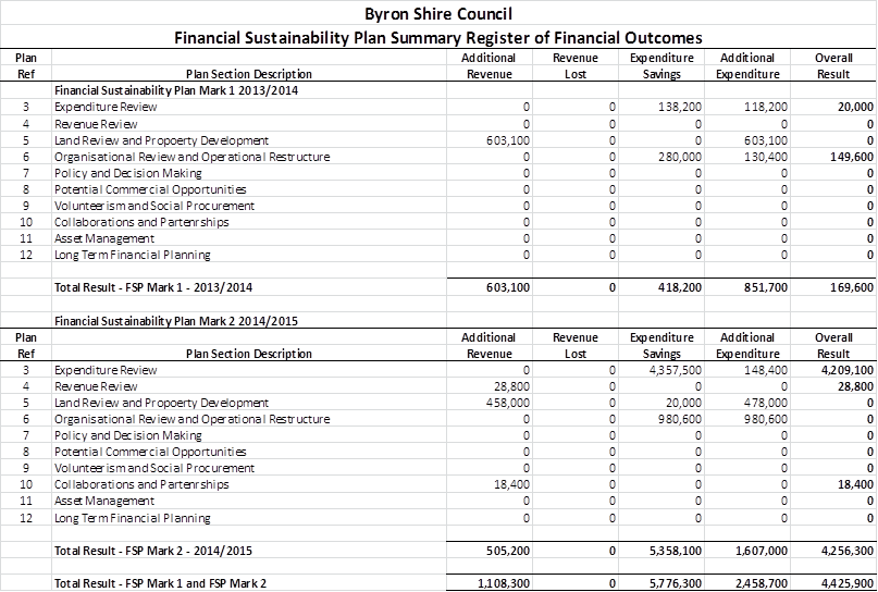
15. Action
Implementation Plan
The Action Implementation Plan is annexed to this Plan, see
E2015/XXXXX.
Note:
The Action Implementation Plan will be prepared following
the adoption of the 2015/16 FSP and include the Actions detailed in the adopted
Plan for each Chapter.
UNCONFIRMED
REPORT OF THE SAFE SUMMER IN THE BAY PROJECT REFERENCE GROUP MEETING
|
Date of Meeting:
|
Thursday 12 November 2015
|
|
Time Commenced:
|
11.10am
|
|
PRESENT:
|
Councillors:
|
Cr Rose Wanchap
|
|
|
Community Representatives:
|
There are no community representatives.
|
|
|
Invited Representatives:
|
Paul Spooner (Byron Community Centre),
Tess Cullen (Byron Community Centre),
Mouche Phillips (Byron Community Centre)
Brandon Saul (Falls Festival)
Bjorn Peterson (Byron Bay Chamber of Commerce)
|
|
|
Staff:
|
Joanne McMurtry (Community Policy Officer)
|
|
|
|
|
|
1. APOLOGIES:
|
Cr Simon Richardson, Greg Jago (Police), Peter Wood
(Arts Northern Rivers), Hannah Spalding (Byron Bay Liquor Accord)
|
|
|
|
2. DECLARATIONS OF INTERESTS:
|
Paul Spooner (Byron Community Centre) reinforced a
previous declaration, in that he was in attendance as the Community Centre
Manager and not a Councillor, and that the Byron Community Centre conduct the
operations of Soul Street NYE and First Sun NYD events.
|
|
3. CONFIRMATION OF A QUORUM:
|
There are 9 members appointed to this group
(not including staff). Quorum was met.
|
|
4. CONFIRMATION OF PREVIOUS MINUTES
|
The previous minutes from the 16 September 2015
meeting were adopted. (Spooner/ Phillips)
|
|
5. BUSINESS ARISING FROM PREVIOUS
MEETING
|
|
|
|
· Recommendation to
Council re SEPA not adopted
· Recommendation to
Council re additional funds ($20,000) was adopted (15-472)
· NYE Shuttle bus
from The Cavanbah Centre to corner Jonson/Lawson St between 5pm to 3am (15-474)
Paul Spooner arrived at 11.45pm.
|
6. UPDATES
TO PLAN FOR NEW YEAR IN BYRON BAY 2015:
|
Progress on the implementing the Action Plan was discussed
and the following points made:
· Crystal
Castle have become a partner with Council through the Making Things Happen
program and have offered their ‘experience development team’ to
assist with First Sun NYD. Joanne to set up a meeting between Crystal Castle
and Byron Community Centre to get the ball rolling.
· Soul
St NYE budget is going well, but still $5,000 short to pay for programming
planned. Tess and Joanne did a site walk around and came up with a plan of
where to locate toilets and possible additional electricity points.
· Discussion
was held about festoon or lantern lighting to add to the festive mood of the
night.
· Council
will be putting additional toilets plumbed in at Apex Park to complement the
Exeloo’s over the busy summer period.
· The
draft Traffic Management Plan was discussed, including reducing the bus
movements of Falls Festival buses in town for NYE. Joanne to set up a separate
meeting with Brandon Saul and Simon Bennett to discuss what will work for all
parties.
· Council
have decided to book St John’s First Aid for NYE. The closer NYE is to
the weekend, the greater the risk of injury and anti-social behaviour. Also,
the emergency hub of Police and Ambulance only happens if emergency services
are not required elsewhere on the night.
|
ACTION LIST:
|
|
1. Joanne to set up
the following meetings:
a. Crystal Castle
and Byron Community Centre re First Sun NYD event
b. Falls Festival
and Council’s Traffic & Transport Officer re reducing bus movements
in town on NYE
c. Between
Council’s Media Liaison Officer and Byron Community Centre re marketing
|
|
8. date and time of NEXT meeting:
|
9
– 11pm, 3 December
|
|
Time Meeting Closed:
|
12.40pm
|
|
|
|
DEVELOPMENT APPLICATION EVALUATION REPORT
Doc No. #A2014/19344
|
DA No:
|
10.2014.417.1
|
|
Proposal:
|
Demolition of existing residential flat building &
construction of a new residential flat building and associated works
|
|
Property description:
|
LOT: 0 SP: 16094
43 Lawson Street BYRON BAY
|
|
Parcel No/s:
|
41930
|
|
Applicant:
|
D P Roberts Planning Solutions
|
|
Owner:
|
The Owners of Strata Plan 16094
|
|
Zoning:
|
7(f2) Urban Coastal Land Zone
|
|
Date received:
|
18 July 2014
|
|
Integrated Development:
|
No
|
|
Public notification or exhibition:
|
- Level
2 advertising under DCP 2010 Chapter 17 – Public Notification and
Exhibition of Development Applications
- Exhibition
period: 29/7/14 to 11/8/14
- Submissions: For 0
Against 2
|
|
Other approvals (S68/138):
|
Not applicable
|
|
Planning Review Committee:
|
N/A
|
|
Delegation to determination:
|
Council
|
|
Recommendation:
|
It is
recommended that pursuant to Section 80 of the Environmental Planning &
Assessment Act 1979, Development Application No. 10.2012.474.1 for demolition of existing residential flat
building and construction of new residential flat building and associated
works, be refused for the following reasons:
1. Pursuant to Section 79C(1)(a)(i) of the Environmental Planning
& Assessment Act 1979, the proposal fails to meet the development
standard for maximum height of buildings as set out within Clause 40 of Byron
Local Environmental Plan 1988. An objection under State Environmental
Planning Policy No. 1 to vary this development standard is not supported.
2. Pursuant to Section 79C(1)(a)(iii) of the Environmental
Planning & Assessment Act 1979, the proposal breaches a number of
requirements within Development Control Plan 2010 including the maximum
building height plane, maximum density provisions, minimum landscaping
requirements, provision of clothes drying areas, maximum cut and fill and
maximum fence heights.
3. Pursuant to Section 79C(1)(b) of the Environmental Planning
& Assessment Act 1979, the proposal is likely to have a significant
impact on the surrounding built environment and the occupants of that
environment.
4. Pursuant to Section 79C(1)(a)(i) of the Environmental Planning
& Assessment Act 1979, the proposal fails to demonstrate that the
development has sufficient design quality having regards to the principles
and code requirements of State Environmental Planning Policy No. 65 –
Design Quality of Residential Flat Development.
5. Pursuant to Section 79C(1)(a)(ii) of the Environmental
Planning & Assessment Act 1979, the proposal is inconsistent with the
future planning direction for the site as set out within Clauses 4.1E, 4.3
and 4.4 Byron Local Environmental Plan 2014, which is an instrument that has
been the subject of public consultation under the Environmental Planning and
Assessment Act 1979.
6. Pursuant to Section 79C(1)(e) of the Environmental Planning
& Assessment Act 1979, the it is not in the public interest to support
the proposal as it breaches a number of development control requirements and
has an adverse impact on the surrounding built environment.
7. Pursuant to Section 79C(1)(c) of the Environmental Planning
& Assessment Act 1979, the site is assessed as being unsuitable for the
development proposed.
8. Pursuant to Section 79C(1)(d) of the Environmental Planning
& Assessment Act 1979, consideration of public submissions received with
respect of the proposal raise valid planning reasons to refuse the
Development Application.
9. Pursuant to Section 79C(1)(a)(i) of the Environmental Planning
& Assessment Act 1979, the proposal fails to demonstrate that the site is
suitable for use having regards to the assessment requirements of State
Environmental Planning Policy No. 55 – Remediation of Land.
|
1. INTRODUCTION
1.1 History/Background
The subject allotment contains a three storey building that
contains 6 x 2 bedroom units that were approved under Building Application No.
1980/10. The existing building is somewhat unique in the locality, constructed
of face brick walls, aluminium framed windows and concrete tile roofing. The
building includes an attached single storey garage fronting Lawson Street with
provision for 6 vehicles.
The Development Application was lodged with Council on 18 July
2014 which was three days before the commencement of Byron Local Environmental
Plan 2014. Accordingly, the proposal is required to be assessed in
consideration of Byron Local Environmental Plan 1988 and Byron Development
Control Plan 2010. It is noted that the Environmental Planning and Assessment
Act 1979 requires Council to consider Byron Local Environmental Plan 2014 as a
draft instrument only.
1.2 Description
of the site
The site of the proposed development is described as Lots 1-6
in Strata Plan 16094 and is located at No. 43 Lawson Street, Byron Bay. The allotment is located on the northern side of Lawson Street and takes access from
this through road.
The allotment has a rectangular configuration with a street
frontage and rear boundary dimensions of 21.3 metres, and side boundary
dimensions of 33.38 metres, providing an area of 711 square metres. The site is
generally level throughout but falls very slightly from the centre of the
allotment to the north, south and west. Large residential allotments adjoin to
the east and west, with an apartment building occupying the adjacent lot to the
west. An apartment building occupying the allotment to the east was recently
demolished to make way for a new development. A public reserve adjoins the site
to the north which extends into the Byron Bay foreshore.
Vegetation on the site is limited to grasses and isolated
landscaping trees and palms.
1.3 Description
of the proposed development
Development consent is sought to demolish the existing
development on the site and construct a new residential flat building made up
of a basement level and three levels above ground.
The design includes three separate units on both the ground
level and first level, and a single unit on the second level. Terrace and
balcony areas are proposed on the northern side of the building providing solar
access for each individual unit. Four swimming pools are proposed at ground
level and a lap pool and spa are proposed on the second floor.
The proposed building includes a mix of materials and
incorporates balcony areas on the northern and southern elevations. The
majority of bedrooms within the development are located along the eastern and
western elevations with screened windows facing neighbouring properties. A
total of 16 car parking spaces are proposed within the basement car park. Internal
staircases and a lift provide access to each floor within the development.
An indicative landscaping plan has been submitted to support
the development. The configuration of the proposed units are described below:
|
Unit
|
Bedrooms
|
Parking
|
Gross Floor Area
|
Private open space
provision
|
|
1
|
2
|
2 spaces
|
94.0m2
|
22.6m2 courtyard with plunge pool
|
|
2
|
1
|
2 spaces
|
54.9m2
|
25.6m2 courtyard with plunge pool
|
|
3
|
3
|
2 spaces
|
95.3m2
|
22.6m2 courtyard with plunge pool
|
|
4
|
3
|
2 spaces
|
121.0m2
|
13.6m2 balcony
|
|
5
|
1
|
2 spaces
|
54.9m2
|
17.1m2 balcony
|
|
6
|
3
|
2 spaces
|
141.4m2
|
13.6m2 balcony
|
|
7
|
4
|
2 spaces
|
214.5m2
|
166.8m2 balcony with lap pool & spa
|
2. SUMMARY
OF REFERRALS
|
|
Issue
|
|
Development Engineer
|
Access, parking, stormwater disposal, coastal erosion and
contributions.
|
|
Water & Waste Services
|
Water supply and Sewer connection
Clause 45 of Byron LEP 1988
Developer contributions
|
|
Environmental Officer
|
SEPP 55, Noise, Land use conflicts, acid sulfate soils
|
|
NSW Office of Water
|
Dewatering licence
|
2.1 Comments
from NSW Office of Water
The
proposal includes over 3 metres of excavation to create a basement car parking
area. Such would likely require a dewatering licence. Correspondence from NSW
Office of Water advised as follows:
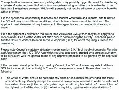
2.2 Consultation
with Applicant
An initial assessment of the proposal identified a number of
non-compliances with Council’s development control requirements. These
include breaches of the maximum height requirements of Byron Local
Environmental Plan 1988 and multiple breaches of Development Control Plan 2010
relating to building setbacks, building height plane, overshadowing, privacy,
lack of landscaping, bulk and scale.
Clause 40 of Byron Local Environmental Plan 1988 prescribes
maximum height requirements for the subject site. A maximum overall height of
9.0 metres and a maximum uppermost floor level of 4.5 metres apply in this
case. The proposal breaches both of these requirements. An objection under
State Environmental Planning Policy No. 1 was submitted with the Development
Application requesting a variation to the requirements of Clause 40, arguing
that compliance with the height controls is unreasonable and unnecessary in the
circumstances of the case.
In August 2014, the Applicant was formally requested to
provide an amended proposal that addressed the non-compliances raised in the
initial assessment. A meeting was held with the Applicant to discuss options to
achieve greater compliance with Council’s development controls. These
included reducing the height of the proposal, increasing the boundary setbacks
and reducing the number of proposed dwelling units. In addition, issues raised
within public submissions that were received during the public exhibition of
the development application were discussed. These included privacy, density and
overshadowing concerns.
The original proposal that was submitted to Council in July
2014 sought approval for 9 dwelling units. Amended plans were submitted by the
Applicant in late August 2014 showed a reduction in the number of proposed
dwelling units to 7. In addition, the amended plans showed some additional deep
soils landscape planting areas. However, the amended proposal made no
improvement to the design of the development having regards to height, building
setbacks, building height plane, overshadowing, privacy, bulk and scale.
Documentation accompanying the amended plans submitted by the
Applicant argued that an existing approval on the adjoining property to the
east (45-47 Lawson Street) provides a level of justification for the variations
proposed within the amended design. A review of the development approval
history of this adjoining site confirms that the approved design relates back
to a Development Application for a motel that was granted consent in April
2001, a time when the maximum height controls in Byron Shire were very
different to the current controls. Further, the most recently approved plans
for this neighbouring property provide a greater level of compliance with
building setback and building height plane controls than the proposal for 43
Lawson Street.
The subject site is surrounded by a mixture of development
forms and densities. The proposal seeks to create a similar form of development
to that approved on the adjoining site to the east, however the subject site is
significantly smaller that the neighbouring property with less area available
to accommodate a development of its proposed height and density. The small site
area (711 square metres) creates a situation where non-compliances with
development controls cumulate to a point where the design is not able to be
supported on planning grounds.
Further conversations were entered into with the Applicant in
November/December 2014 seeking to have outstanding planning issues resolved.
However, the Applicant indicated at that time that the final proposal had been
submitted to Council for assessment. Accordingly, a draft assessment report for
the proposal was completed in February 2014 with a recommendation for refusal.
A copy of this draft assessment report was forwarded to the Applicant with an
invitation to provide an amended proposal which addressed the issues raised
within the report. No response was received from the Applicant.
3. SECTION
79C – MATTERS FOR CONSIDERATION – DISCUSSION OF ISSUES
Having regard for the matters for consideration detailed in Section
79C(1) of the Environmental Planning & Assessment Act 1979, the following
is a summary of the evaluation of the issues.
3.1. STATE/REGIONAL
PLANNING POLICIES AND INSTRUMENTS
|
Requirement
|
Requirement
|
Proposed
|
Complies
|
|
State Environmental Planning Policy No. 1 –
Development Standards
|
Refer to issues section below.
|
Refer to issues section below.
|
Refer to issues section below.
|
|
State Environmental Planning Policy No. 71 - Coastal
Protection
|
Matters for consideration for development within the
coastal zone:
- retention of existing
public access to the coastal foreshore
- impact of effluent
disposal on water quality
- development must
not discharge untreated stormwater into a coastal water body
|
- No public access to the
coastal foreshore will be impeded or diminished as part of the proposal
- No effluent is proposed
to be disposed other than to Council’s sewerage system.
- Stormwater is to be
discharged to the street.
|
Yes
Yes
Yes
|
|
State Environmental Planning Policy No. 55 –
Remediation of Land
|
Council must:
(a) considered
whether the land is contaminated, and
(b) if
the land is contaminated, if the land is suitable in its contaminated state
or after remediation, and
a) be
satisfied the land will be remediated before the land is used.
|
As the proposal is likely to significantly remove most of
the surface soil layer over the property, the risk from past land use
contamination may have been considered to be low.
Concerns might be raised in relation to potential hazards
from radioactive sands. Councils’ mapping does not have any information
to indicate the hazard rating for this land.
SEPP 55 should have been addressed by the applicant.
Insufficient information provided to make a determination.
|
No
|
|
NSW Coastal Policy 1997
|
Development within the Coastal Zone must be consistent
with the Aims, Objectives and Strategic Actions of the Coastal Policy.
|
The proposal does not compromise the provisions of the
Coastal Policy.
|
Yes
|
|
Building Code of Australia
|
The proposal must be capable of compliance with the
structural and safety requirements of the Building Code of Australia.
|
A condition can be included if consent is granted to
ensure the BCA requirements are met.
|
Yes
|
|
Demolition
|
Demolition is to be carried out in accordance with the
requirements of Workcover and AS2601 – Demolition of Structures.
|
A condition can be included if consent is granted to
ensure the Workcover and AS2601 requirements are met.
|
Yes
|
Disability Access (DDA)
|
Access for persons with
disabilities and integration into surrounding streetscapes without creating
barriers. (Council Res.10-1118)
|
Although DDA requirements are not triggered for the
proposed residential flat building, the design includes a lift to provide
access from the basement to each level of the development.
|
N/A
|
* Issues discussed below
State/Regional Planning Policies and
instruments - Issues
State Environmental Policy No. 1 – Development
Standards
The proposed development includes the demolition of an
existing three storey building and replacement with a new building with a
basement car parking area and three levels above ground. The new building
exceeds the two prescriptive requirements of Clause 40 of Byron Local
Environmental Plan 1988:
b) the uppermost floor
level of the proposed building is 5.8 metres above the existing ground level.
This is 1.3 metres over the maximum 4.5 metre requirement of Clause 40.
c) the overall height of
the proposed building is 10.2 metres above ground level at the highest point of
the building. This is 1.2 metres over the maximum 9.0 metre requirement of
Clause 40.
The Applicant has submitted an objection under State
Environmental Planning Policy No. 1 arguing that compliance with the
requirements of Clause 40 is unreasonable and unnecessary in the circumstances
of the case. Comments in relation to this objection are provided under the
relevant assessment headings below.
· Is
compliance with the standard consistent with the aims of SEPP 1 and does
compliance with the standard hinder the objects of the EP&A Act 1979 under
Section 5(a)(i) and 5(a)(ii).
These objects of the Act are to encourage:
(i) the proper management,
development and conservation of natural and artificial resources, including
agricultural land, natural areas, forests, minerals, water, cities, towns and
villages for the purpose of promoting the social and economic welfare of the
community and a better environment,
(ii) the promotion and
co-ordination of the orderly and economic use and development of land,
Byron Local Environmental Plan 1988 sets out development standards
to co-ordinate the orderly and economic development of land. The fact that the
proposal deviates from the requirements of this plan is contrary to this
object. Although the aims of SEPP 1 are to provide flexibility in applying
development standards, it is not satisfied in this case that the variation
proposed is well founded.
· Is
compliance with the standard unreasonable or unnecessary in the circumstances
of the case and is the development standard unreasonable or unnecessary.
The applicant provides the following comments in this regard:
A review of the approved plans for the existing development on
the site shows that the building to be demolished has a height of 8.8 metres
which is consistent with the 9.0 metre maximum. As stated, this building is to
be demolished and a completely new building erected in its place. With a vacant
site to work from, it is not possible to form an argument that it is
unreasonable and unnecessary to design a building that meets the overall 9.0
metre height requirement. This aspect of the SEPP No. 1 Objection is not
supported.
Documentation accompanying the amended plans submitted by the
Applicant argued that an existing approval on the adjoining property to the
east (45-47 Lawson Street) provides a level of justification for the variations
proposed within the amended design. Council’s Development Application
file for this site shows that in April 2001, consent was granted to Development
Application No. 10.2000.460.1 for a new motel development at 45-47 Lawson Street.
The approved motel met Council’s height requirements at the time, which
prescribed a maximum 7.5 metres when measured from ground level to the top
plate of the building. The approved development contained three storeys and an
overall height of 10.83m above ground level.
Council’s records indicate that Development Consent No.
10.2000.460.1 was lawfully commenced, but in December 2012 the owners of 45-47
Lawson Street submitted an amended design as part of a new Development
Application for the site (Development Application No. 10.2012.407.1). This
amended proposal included an objection under State Environmental Planning
Policy No. 1 to the overall height of the development, with an overall height
of 10.2 metres proposed. This proposal was supported by on the basis that the
2001 approval for Development Application No. 10.2000.460.1 allowed a greater
height.
It is agreed that the 4.5 metre uppermost floor level
requirement of Clause 40 can be varied using SEPP No. 1 on the basis that Byron
Local Environmental Plan 2014 no longer includes an uppermost floor level
development standard. It would be unreasonable and unnecessary to enforce this
aspect of Clause 40 when the new Local Environmental Plan does not require it.
It is noted that in 2014, Council determined not to support a
variation to the maximum 9.0 metre height requirement for a development
proposal within Station Street, Bangalow. A subsequent appeal to the NSW Land
and Environment Court was successfully defended on this determination.
State Environmental Planning Policy No. 65 – Design
Quality of Residential Flat Development
|
Requirement
|
Proposed
|
Complies
|
|
(a) an explanation of the
design in terms of the design quality principles set out in Part 2 of State Environmental
Planning Policy No 65—Design Quality of Residential Flat Development,
|
Refer to issues section below.
|
Refer to issues section below.
|
|
(b) drawings of the proposed
development in the context of surrounding development, including the
streetscape,
|
Drawings were submitted with the Development Application
partly showing the streetscape.
|
Yes
|
|
(c) development compliance
with building heights, building height planes, setbacks and building envelope
controls (if applicable) marked on plans, sections and elevations,
|
The drawings submitted do not accurately detail the
maximum 9.0 metre overall height and maximum 4.5 metre uppermost floor level
requirements.
|
No
|
|
(d) drawings of the proposed
landscape area, including species selected and materials to be used,
presented in the context of the proposed building or buildings, and the
surrounding development and its context,
|
The landscaping plans submitted are indicative only.
|
No
|
|
(e) if the proposed
development is within an area in which the built form is changing, statements
of the existing and likely future contexts,
|
Comments have been provided in this regard, particularly
addressing the new construction on the adjoining allotment to the east.
|
Yes
|
|
(f) photomontages of the
proposed development in the context of surrounding development,
|
Photomontages were proposed as part of the Development
Application.
|
No
|
|
(g) a sample board of the
proposed materials and colours of the facade,
|
Sample board of the proposed materials and colours was not
provided with the development application.
|
No
|
|
(h) detailed sections of
proposed facades,
|
Sections were submitted as part of the plan set.
|
Yes
|
|
(i) if appropriate, a model
that includes the context.
|
A model was not warranted in this case.
|
Yes
|
Design Quality Principles
|
In
determining a development application for consent to carry out residential
flat development, a consent authority is to take into consideration the
design quality of the residential flat development when evaluated in
accordance with the design quality principle.
|
Comment
|
|
Principle 1: Context
Good design
responds and contributes to its context. Context can be defined as the key
natural and built features of an area.
Responding
to context involves identifying the desirable elements of a location’s
current character or, in the case of precincts undergoing a transition, the
desired future character as stated in planning and design policies. New
buildings will thereby contribute to the quality and identity of the area.
|
Although limited details
of materials and colours were provided, the proposal appears to use elements
similar to those used on the approved development on the adjoining site to
the east (which is under construction).
|
|
Principle 2: Scale
Good design
provides an appropriate scale in terms of the bulk and height that suits the
scale of the street and the surrounding buildings.
Establishing
an appropriate scale requires a considered response to the scale of existing
development. In precincts undergoing a transition, proposed bulk and height
needs to achieve the scale identified for the desired future character of the
area.
|
The proposal exceeds the
maximum height requirements of both Byron LEP 1988 and Byron LEP 2014.
Further, the proposal exceeds the building height plane requirements of DCP
2010 and DCP 2014. As these document prescribe the desired future character
of the area, the bulk and scale of the proposed development is not
appropriate.
|
|
Principle 3: Built form
Good design
achieves an appropriate built form for a site and the building’s
purpose, in terms of building alignments, proportions, building type and the
manipulation of building elements.
Appropriate
built form defines the public domain, contributes to the character of
streetscapes and parks, including their views and vistas, and provides
internal amenity and outlook.
|
As above.
|
|
Principle 4: Density
Good design
has a density appropriate for a site and its context, in terms of floor space
yields (or number of units or residents).
Appropriate
densities are sustainable and consistent with the existing density in an area
or, in precincts undergoing a transition, are consistent with the stated
desired future density. Sustainable densities respond to the regional
context, availability of infrastructure, public transport, community
facilities and environmental quality.
|
As above.
|
|
Principle 5: Resource, energy and water efficiency
Good design
makes efficient use of natural resources, energy and water throughout its
full life cycle, including construction.
Sustainability
is integral to the design process. Aspects include demolition of existing
structures, recycling of materials, selection of appropriate and sustainable
materials, adaptability and reuse of buildings, layouts and built form,
passive solar design principles, efficient appliances and mechanical
services, soil zones for vegetation and reuse of water.
|
The original Development
Application included a BASIX Certificate (for 9 units). An amended
Certificate was not submitted for the revised proposal (for 7 units).
|
|
Principle 6: Landscape
Good design
recognises that together landscape and buildings operate as an integrated and
sustainable system, resulting in greater aesthetic quality and amenity for
both occupants and the adjoining public domain.
Landscape
design builds on the existing site’s natural and cultural features in
responsible and creative ways. It enhances the development’s natural
environmental performance by co-ordinating water and soil management, solar
access, micro-climate, tree canopy and habitat values. It contributes to the
positive image and contextual fit of development through respect for
streetscape and neighbourhood character, or desired future character.
Landscape
design should optimise useability, privacy and social opportunity, equitable
access and respect for neighbours’ amenity, and provide for practical
establishment and long term management.
|
The proposal includes an
indicative landscaping plan that is well short of Council’s required
landscaping for the site.
|
|
Principle 7: Amenity
Good design
provides amenity through the physical, spatial and environmental quality of a
development.
Optimising
amenity requires appropriate room dimensions and shapes, access to sunlight,
natural ventilation, visual and acoustic privacy, storage, indoor and outdoor
space, efficient layouts and service areas, outlook and ease of access for
all age groups and degrees of mobility.
|
The proposal includes
lift access and a variety of unit layouts. Private open space and balcony
areas have also been incorporated into the design.
|
|
Principle 8: Safety and security
Good design
optimises safety and security, both internal to the development and for the public
domain.
This is
achieved by maximising overlooking of public and communal spaces while
maintaining internal privacy, avoiding dark and non-visible areas, maximising
activity on streets, providing clear, safe access points, providing quality
public spaces that cater for desired recreational uses, providing lighting
appropriate to the location and desired activities, and clear definition
between public and private spaces.
|
The proposal has well
defined public and private spaces. The proposed balconies face north over the
public reserve.
|
|
Principle 9: Social dimensions and housing affordability
Good design
responds to the social context and needs of the local community in terms of
lifestyles, affordability, and access to social facilities.
New
developments should optimise the provision of housing to suit the social mix
and needs in the neighbourhood or, in the case of precincts undergoing
transition, provide for the desired future community.
New
developments should address housing affordability by optimising the provision
of economic housing choices and providing a mix of housing types to cater for
different budgets and housing needs.
|
The application states
that the proposal increases affordable housing options within Byron Bay. This
statement is not supported in the context of this proposal. The development
is clearly a high-end residential proposal.
|
|
Principle 10: Aesthetics
Quality
aesthetics require the appropriate composition of building elements,
textures, materials and colours and reflect the use, internal design and
structure of the development. Aesthetics should respond to the environment
and context, particularly to desirable elements of the existing streetscape
or, in precincts undergoing transition, contribute to the desired future
character of the area.
|
Although limited details
of materials and colours were provided, the proposal appears to use elements
similar to those used on the approved development on the adjoining site to
the east (which is under construction).
|
3.2. BYRON LOCAL
ENVIRONMENTAL PLAN 1988
Zone: 7(f2) Urban Coastal Land Zone
Definition: Residential Flat Building
|
LEP Requirement
|
Summary of Requirement
|
Proposed
|
Complies
|
|
Clause 9 - Meets objectives of 7(f2) Urban Coastal Land
Zone
|
(a) to identify urban land likely to be
influenced by coastal processes,
(b) to permit urban development within
the zone subject to the council having due consideration to the intensity of
that development and the likelihood of such development being adversely
affected by, or adversely affecting, coastal processes,
(c) to permit urban development within
the zone subject to the council having due consideration to:
(i) the need to relocate
buildings in the long term,
(ii) the need for development
consent to be limited to a particular period,
(iii) the form, bulk, intensity
and nature of the development, and
(iv) continued safe public access to the
site, and
(d) to allow detailed provisions to be
made, by means of a development control plan, to set aside specific areas
within the zone for different land uses and intensities of development.
|
The subject site has been identified as being influenced
by coastal processes as it is located within Coastal Erosion Precinct No. 2.
An assessment of the proposal found that the site is over
90 metres from the February 2010 erosion escarpment.
The proposal can be supported having regards to the
objectives (a) and (b) of the zone subject to conditions that limit the time
period of the consent should a large erosion event or a series of events
occur in the future.
In relation to Objective (c), the proposal does not raise
any public access issues, and time periods could be applied to the consent if
approved. However, the form, bulk and intensity of the proposed development
has been assessed as excessive for the 711 square metre site. The proposal is
inconsistent with a number of planning controls and is not supported in its
current form.
|
Yes
No
|
|
Clause 9 - Permissible use
|
Residential flat building means a building which contains 3
or more dwellings.
|
A ‘residential flat building’ is a land use
that is permissible with consent within the 7(f2) Zone. The proposal includes
7 dwellings within a 711 square metre allotment. The proposed density is
discussed within the section of this report addressing DCP 2010 below.
|
Yes
|
|
Clause 40 - Height of buildings
|
Overall height of development must not exceed 9.0m above
existing ground level and the maximum height of the upper floor must not
exceed 4.5m above existing ground level.
|
Height 10.2 metres
Upper Floor Level 5.8 metres
|
No*
|
|
Clause 45 - Provision of Services
|
Prior adequate arrangements must be made for the provision
of services to the allotment.
|
The allotment has access to Council’s water and
sewer services. Stormwater disposal is proposed to existing infrastructure.
|
Yes
|
|
Clause 52 – Tree Preservation
|
In conjunction with Cluse 2, minimise the removal of
vegetation.
|
The proposal includes the removal of all vegetation from
the site to accommodate the proposed development. No issues are raised with
the proposed removal as it relates to common landscape species only.
|
Yes
|
*Issues discussed below
BYRON LOCAL ENVIRONMENTAL PLAN 1988 -
Issues
Clause 40 – Height of Buildings
The proposed residential flat building exceeds the two
prescriptive requirements of Clause 40, that is the 4.5 metre upper most floor
level and the 9.0 metre overall height requirement. The uppermost floor of the
proposed development has a height of 5.8 metres above the existing ground
level. The overall height is 10.2 metres above ground level at the highest
point of the building.
The Development Application includes an objection under State
Environmental Planning Policy No. 1 to the development standards set out within
Clause 40. This is discussed under Section 3.1 of this report above.
Draft EPI that is or has been placed on
public exhibition and details of which have been notified to the consent
authority - Issues
Draft Byron Local Environmental Plan 2012 commenced public
exhibition on 24 September 2012 and subsequently became effective on 21 July
2014.
Land use zone (Cl. 2.3) – Byron Local
Environmental Plan 2014 lists the subject property within the R3 Medium
Density Residential Zone, a zone in which multi dwelling housing and
residential flat buildings remain a permissible form of development.
Minimum lot size for residential flat buildings (Cl. 4.1E)
– this Clause of Byron Local Environmental Plan 2014 requires a minimum
allotment size of 800 square metres for residential flat buildings within the
R3 Medium Density Residential Zone. The subject site has an area of only 711
square metres. The proposal is inconsistent with the provisions of Clause 4.1E,
but benefits from an existing residential flat building on the property.
Maximum floor space ratio (Cl. 4.4) – the maximum
floor space ratio map within Byron Local Environmental Plan 2014 provides a
0.8:1 maximum for the subject site. With a site area of 711 square metres and a
gross floor area of 776 square metres, the proposal has a floor space ratio of
1.09:1 (which is 207.2 square metres greater than that permitted under Byron
Local Environmental Plan 2014, this is almost equivalent to the total floor
area of Proposed Unit 7 as shown in the DCP table below). The proposed floor
area is excessive for the site having regards to the 2014 Local Environmental
Plan.
Maximum height of buildings (Cl. 4.3) – the
maximum height of buildings map within Byron Local Environmental Plan 2014
provides a 9.0 metre limit within the subject site which is consistent with
Byron Local Environmental Plan 1988. The applicant seeks to vary this
requirement using a SEPP No. 1 objection. As discussed earlier in this report,
the objection is not supported. The fact that the 2014 Local Environmental Plan
reinforces the 9.0 metre maximum height requirement provides further
justification not to support a variation.
3.3 DEVELOPMENT
CONTROL PLANS
Development Control Plan 2010
|
Development
Control Requirement
|
Proposed
|
Required
|
Compliance
|
|
Site Area (Sec. C3.5 DCP 2010)
|
710.994 m2
|
1900m2
|
No
|
|
Frontage (Sec. C3.5 DCP 2010)
|
21.3 m
|
20m
|
Yes
|
|
Height (Cl. 40 BLEP 1988)
|
Overall height
|
10.2 m
|
9m
|
No
|
|
Uppermost floor
|
5.3 m
|
4.5m
|
No
|
|
Maximum cut / fill (Sec. C2.7 DCP 2010)
|
1.4 m fill
|
1.0 m (max)
|
No
|
|
3.6m cut
|
1.0 m
|
No
|
|
Gross Floor
Area
|
Unit 1
|
94.0m2
|
-
|
N/A
|
|
Unit 2
|
54.9m2
|
-
|
N/A
|
|
Unit 3
|
95.3m2
|
-
|
N/A
|
|
Unit 4
|
121.0m2
|
-
|
N/A
|
|
Unit 5
|
54.9m2
|
-
|
N/A
|
|
Unit 6
|
141.4m2
|
-
|
N/A
|
|
Unit 7
|
214.5m2
|
-
|
N/A
|
|
Total
|
776 m2
|
-
|
N/A
|
|
Density Control (Sec. C7.1 (DCP 2010)
|
|
Unit Size
|
Small (<55m2 floor plan area)
|
2 units
|
200m2 / unit
|
-
|
|
Medium (55-85m2 floor plan area)
|
0 units
|
250m2 / unit
|
-
|
|
Large (>85m2 floor plan area)
|
5 units
|
300m2 / unit
|
-
|
|
Total
|
7 units on 711m2
|
Required Site Area:
1900m2
|
No
|
|
Setbacks
(Sec. 2.6 DCP 2002 & Sec 2.13 DCP 14)
|
Front (building)
|
6.5m
|
6.5m
|
Yes
|
|
Front (pool)
|
1.2m
|
6.5m
|
No
|
|
Rear (building)
|
>5.0m
|
0.9m
|
Yes
|
|
Rear (pool)
|
0.0m
|
0.0m
|
Yes
|
|
Side (east)
|
1.5m
|
0.9m
|
Yes
|
|
Side (west)
|
1.5m
|
0.9m
|
Yes
|
|
Building Height Plane
(Sec. 2.5 DCP 2010)
|
Front
|
Above BHP
|
Below BHP
|
No*
|
|
Rear
|
Above BHP
|
Below BHP
|
No*
|
|
Side (east)
|
Above BHP
|
Below BHP
|
No*
|
|
Side (west)
|
Above BHP
|
Below BHP
|
No*
|
|
On Site Car Parking (Table G2.1 DCP 2010) –
Residential Flat Building
|
|
Unit Size
(One (1) space per unit must be covered)
|
< 55m2 floor area @ 1 / unit
|
2 spaces
|
2 spaces
|
Yes
|
|
55-85m2 floor area @ 1.5 / unit
|
0 spaces
|
0 spaces
|
N/A
|
|
> 85m2 floor area @ 2 / unit
|
10 spaces
|
10 spaces
|
Yes
|
|
Visitor Parking @ 1 / 4 units
|
4 spaces
|
2 spaces
|
Yes
|
|
Common Landscaped Area (Sec. C7.5 DCP 2010)
|
|
Treatment
|
Minimum 75% absorbent finish
|
|
|
No
|
|
Unit Size
|
<55m2 floor plan area
|
2 units
|
50m2 per
unit
|
No
|
|
55-85m2 floor plan area
|
0 units
|
70m2 per
unit
|
N/A
|
|
>85m2 floor plan area
|
5 units
|
90m2 per
unit
|
No
|
|
Private Open Space – Courtyards (Sec. C7.2
DCP 2010)
|
|
Minimum Area at Natural Ground Level
|
Unit 1
|
>30m2
|
30m2
|
Yes
|
|
Unit 2
|
>30m2
|
30m2
|
Yes
|
|
Unit 3
|
>30m2
|
30m2
|
Yes
|
|
Unit 4
|
~
|
Balcony
|
See below
|
|
Unit 5
|
~
|
Balcony
|
See below
|
|
|
Unit 6
|
~
|
Balcony
|
See below
|
|
|
Unit 7
|
~
|
Balcony
|
See below
|
|
Minimum Dimensions
|
Unit 1
|
4m x 4m
|
4m x 4m
|
Yes
|
|
Unit 2
|
4m x 4m
|
4m x 4m
|
Yes
|
|
Unit 3
|
4m x 4m
|
4m x 4m
|
Yes
|
|
Unit 4
|
~
|
~
|
N/A
|
|
Unit 5
|
~
|
~
|
N/A
|
|
|
Unit 6
|
~
|
~
|
N/A
|
|
|
Unit 7
|
~
|
~
|
N/A
|
|
Private Open Space – Balconies (Sec. C7.3 DCP
2010)
|
|
Private Open Space Balconies
|
Unit 1
|
|
0m2
|
Yes
|
|
Unit 2
|
|
0m2
|
Yes
|
|
Unit 3
|
|
0m2
|
Yes
|
|
Unit 4
|
13.6m2
|
15m2
|
No
|
|
Unit 5
|
17.1m2
|
15m2
|
Yes
|
|
Unit 6
|
13.6m2
|
15m2
|
No
|
|
Unit 7
|
166.8m2
|
15m2
|
Yes
|
|
Sound Proofing (Sec. C7.6 DCP 2010)
|
|
Noise Sources Sited Away from Adjoining Properties
|
Yes
|
|
Sound Resisting Division Walls and Floors
|
Yes
|
|
Clothes Drying Facilities – Suitably Screened
(Sec. C7.7 DCP 2010)
|
|
Rate
|
7.5m line per dwelling
|
No
|
|
Area
|
Minimum 6m2 (or sufficient area to
accommodate)
|
No
|
|
Garbage (Sec. C7.8 DCP 2010)
|
|
Bins
|
Min. 1 x 240L per unit
|
Yes
(basement)
|
|
Equity of Access & Mobility (Sec. C7.9 DCP
2010)
|
|
1 adaptable dwelling per 10 dwellings in accordance
with AS4299
|
N/A
|
|
Continuous Path of Travel in accordance with AS1428.2
|
N/A
|
|
1 parking space in accordance with AS2890 Part 1 per
adaptable dwelling
|
N/A
|
|
1 visitor parking space in accordance with AS2890 Part
1 per 100 spaces
|
N/A
|
|
Pipes and Vents (Sec. C7.10 DCP 2010)
|
|
Concealed Within Walls
|
Yes
|
|
Access Provided
|
Yes
|
|
TV Antennas (Sec. C7.11 DCP 2010)
|
|
Common Antenna or Dish System
|
N/A
|
|
Fence Heights (Sec. C3.6 DCP 2010)
|
|
Front Fence
|
2.6m
|
1.2m
|
No
|
|
Side Fence (within front building setback line)
|
2.6m
|
1.2m
|
No
|
|
Side Fence (behind building setback)
|
2.1m
|
1.8m
|
No
|
|
Rear Fence
|
1.8m
|
1.8m
|
Yes
|
|
|
|
|
|
|
|
|
|
|
|
|
|
*Non-complying issues
discussed below
Development Control Plan 2010 - Issues
Chapter 1 Part C - Residential Development
Part C2.5 - Building Height Plane
The proposed building encroaches on the building height plane
on all four property boundaries. The Applicant has sought a variation to
the DCP requirement for these encroachments.
Southern and Northern Boundaries
An inspection of the site confirmed that the adjoining land to
the south comprises a public road reserve (Lawson Street) and that the land to
the north is a public reserve. The image below demonstrates that the building
height plane encroachments on these boundaries are minor. The impacts on the
adjoining lands to the north and south is likely to be minimal. A variation to
the building height plane requirements on these boundaries could be supported
if the application is approved.
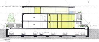
Figure 1 – Proposed development showing building height plane
encroachments on northern and southern boundaries
Eastern and Western Boundaries
The proposed development includes significant breaches on the
building height plane on the eastern and western boundaries of the allotment.
Figure 1 below shows the extent of the proposed encroachments in red. Figure 2
shows the existing building that is to be demolished, also showing building
height plane encroachments.
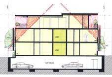
Figure 2 – Proposed development showing building height plane encroachments
one eastern and western boundaries
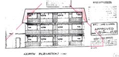
Figure 3 – Existing development showing building height plane
encroachments on eastern and western boundaries
It is clear from the figures above that the proposed
development will result in a substantial increase in building height plane
encroachments. The proposed building is setback 1.5 metres to both the eastern
and western boundaries of the allotment, which is significantly less than the
minimum 4.3 metre side boundary setbacks of the existing building. It is noted
also that the proposed building extends for over 24 metres along the 33 metre
length of the property. The building located on the adjoining allotment to the
west has a setback of approximately 3.5 metres from the common boundary to the
site. A recent approval for a development on the adjoining allotment to the
east allowed a building setback of 1.65 metres.
The objectives of Part C2.5 of DCP 2010 relate to the
protection of privacy, solar access and the views of adjacent properties. In
the case of the proposed development, additional privacy and overshadowing
impacts will arise as a result of the building height plane encroachments. It
is noted that the design includes extensive covered deck areas on the uppermost
floor with a balustrade height of 1 metre allowing overlooking into the
adjoining properties. In particular, the design allows overlooking into the
private open space of units on the adjacent property to the west. Further, the
proposal will overshadow these private open space areas in morning periods. A
public submission was received in relation to the Development Application
raising the issues of privacy and overshadowing as reasons for objecting to the
proposal.
In correspondence dated 26 August 2014, the applicant was
requested to provide an amended building design to reduce the extent of
building height plane encroachments and achieve greater compliance with the
objectives of the development control. However, the applicant elected not to
make any modification to the overall bulk and scale of the development,
providing Council with the following response:
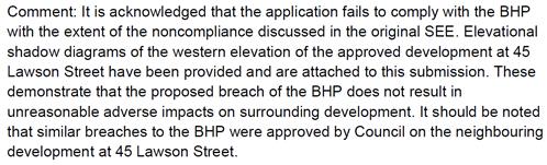
A review of the plans that were approved on the adjoining
allotment to the east (45 Lawson Street) indicates that a three storey building
with a setback of 1.65 metres to the common boundary is to be constructed. It
is agreed that this adjoining development will result in overshadowing and
privacy impacts on the subject development site. However the development
proposed as part of the subject Development Application has slightly smaller
setbacks (1.5 metres) to the eastern and western boundaries, with significant
overshadowing and privacy impacts likely to occur on the adjacent property to
the west.
An assessment of the proposal having regards to the objectives
of Part C2.5 of Development Control Plan indicates that the current design
cannot be supported.
Parts C7.1, C7.2, C7.3 & C7.5 – Density of
Development
In August 2014 the Applicant was requested to provide an
amended design that scales back the proposal to align with the existing
dwelling density, as well as providing landscaping and open space in accordance
with the requirements of the development control plan. The applicant responded
by consolidating some of the proposed units, thereby reducing the number of
units on site from 9 to 7. The Applicant argued the following (in part):
Whilst it is acknowledged
that this application seeks a greater variation then the development approval
next door, the end result will be a development which is more affordable and
will provide a greater variation of housing supply for the surrounding area.
Affordability is an issue that Byron Shire Council has been struggling to deal
with for an extended period of time, the only way to address this issue in
central Byron is to provide smaller more affordable dwellings.
The comments provided by the applicant above hold no weight in
this assessment as in no way can it be argued that the amended proposal to
provide seven beach side units near the centre of Byron Bay with gross floor
areas (excluding balconies) of between 54.9m2 and 214.5m2
fall within the ‘affordable housing’ category. This response does
not justify the variation proposed to the maximum density on the site. Note
that Clause 17 of Byron Local Environmental Plan 1988 requires a minimum 800
square metre site for two dwellings in a dual occupancy arrangement. The
proposal comprises seven dwellings on a 711 square metre site. The fact that an
existing approval for six units exists is the only valid argument for a
variation to density on the property. However, such should be designed with
regards to adequate building height plane, setbacks, landscaping and open space
provision.
Part C7.7 – Clothes Drying Facilities
No provision of drying areas (noting laundry facilities are
provided, and swimming pools) for occupants. This is unsatisfactory for a
development of this nature.
Chapter 1 Part G – Vehicle
Circulation and Parking
External Access
The existing driveway is to be removed. A new driveway is
proposed adjacent to the site’s “eastern” boundary. The
proposed arrangements are satisfactory and the consent can be conditioned
accordingly if approval is granted.
Safety sight lines are required to be complied with at the at
the front property boundary line, in accordance with the current Australian
Standards AS 2890. 1 – 2004. Again, the consent can be conditioned
accordingly to require this compliance.
Internal Access
There are limited design details of the access ramp/driveway
to the basement car park submitted with the DA. It appears that the access can
be designed to complying standards. If approval is granted, the consent can be
conditioned accordingly to ensure this requirements is met.
Car Parking
The application proposes 16 car spaces, inclusive of 2 visitor
car spaces. This appears to be generally derived from Council’s former
DCP 2010.
In accordance with Council’s newly adopted DCP 2014, a
total of 14 car spaces are required, inclusive of 3 visitor car spaces.
The parking requirements are based on the following rates:
· 1
space per 1 or 2 bedroom unit.
· 2
spaces per 3 or more bedroom unit.
· 1
visitor space per 4 units.
Design plans are the demonstrate compliance with the current
Australian Standards AS 2890.1 – 2004, and DCP 2014, in respect to the
following items, but not limited to, as follows:
· Vertical
and horizontal dimensions/clearances
· Driveway
gradients
· Safety
sight lines/triangle at the driveway front boundary interface
· One
disabled parking bay and vertical clearances required
Traffic/Roadworks
This redevelopment of the site, retaining residential units,
should have no measurable effect on the traffic load or level of service on the
surrounding road network.
Part N - Stormwater Management
On site detention stormwater management will be required for
the new complex. The exposed driveway ramp will require a stormwater management
design inclusive of a pump out system for the basement car park. The design is
to also be in accordance with DCP 2014.
Part J - Coastal Erosion
The site is within Precinct 2, and the consent can be
conditioned accordingly.
Geotechnical Hazards
No apparent geotechnical constraints
Other Matters
The adjacent Apex Park (Public Reserve) must not be used for
site access nor storage of materials. The consent can be conditioned
accordingly.
3.4 The
likely impacts of that development, including environmental impacts on both the
natural and built environments, and social and economic impacts in the locality
The subject site and immediate surrounds were inspected
multiple times during the assessment of the Development Application. These
inspections identified private open space and clothes drying areas on the
adjoining property to the west of the site (No. 39-41 Lawson Street). A site
assessment found that the proposal will impact adversely on these areas. The
proposed building is to be constructed with a maximum height of 10.2 metres and
with minimum boundary setbacks of 1.5 metres (excluding window screens which
extend further into the side setbacks). An assessment indicates that the
proposal will overlook and overshadow the private open space areas within the
adjacent property, resulting in adverse impacts on the occupants. Preliminary
shadow diagrams were submitted by the Applicant as part of amended proposal,
however such did not resolve overshadowing impacts on the adjoining property.
Site Waste Management: If approved, a condition could be
imposed requiring a site waste minimisation plan to be submitted. In this
regard, the proponent must establish an extracted solid waste management plan
which identifies the volumes, classification and ultimate destination of all
solid waste materials created by the proposed demolition works, and basement
excavation.
Garbage: A condition could also be imposed to ensure that
adequate provision is made for containment, storage and management of all waste
generated by the development. The proposal indicates a ‘garbage
room’ in the basement car park. Adequate “garbage” capacity
needs to be provided for the proposed units, as well as a location with
sufficient ventilation and capacity to clean-up spilt putrescibles wastes and
dirty bins.
Bush Fire: Council’s GIS indicates that the subject site
is within a buffer area to bush fire hazards. The Development Application did
not include any details to address this constraint. If the application was to
be granted consent, further assessment would be required with respect to
bushfire protection.
3.5 The
suitability of the site for the development
The subject site is an existing urban allotment within the
7(f2) Urban Coastal Land Zone under Byron Local Environmental Plan 1988. It has
access to water, sewer, drainage, electricity and communication services. The
site is largely clear of vegetation other than common landscape species. The
land does not contain steep slopes and is not prone to flooding. Access is
available from Lawson Street to the south. The site is within a buffer area to
bush fire hazards, but threats could be managed by implementing bush fire
protection measures into the development.
The site contains a residential flat building comprising 6
units over three stories, with an attached vehicle garage at ground level. The
existing development has generous building setbacks and is satisfactorily
accommodated within the site in the context of the historic approval that it was
constructed under. However, the proposed development introduces a significant
increase in bulk and scale to the site. An assessment has found that the
property is of insufficient area to accommodate the development as proposed.
The proposal breaches building setback and height controls.
Despite a number of positive attributes, the site is not
deemed to be suitable for the development proposed. The development will
adversely impact on adjoining properties due to its limited dimensions. The
proposed 7 unit residential flat building cannot be accommodated within the
site without significant breaches of Council’s development control
requirements.
3.6 Submissions
made in accordance with this Act or the regulations
Two submissions were received in respect of the proposed
development. A summary of the issues raised within the submissions with a
comment in relation to each is provided below:
|
Issue
|
Comment
|
|
Excessive Density
|
Council’s assessment concludes that the proposed
density is excessive for the site.
|
|
Excessive height
|
The proposed objection under SEPP No. 1 to the height
of the development is not supported.
|
|
Overshadowing on adjoining
development
|
An assessment confirmed that significant adverse
impacts are likely to result from the proposed development with respect to
overshadowing on adjoining properties. The proposal is not supported on these
grounds.
|
|
Insufficient setbacks
|
It is agreed that the proposed 1.5 metre setback for a
3 storey development is insufficient given the overshadowing and loss of privacy
impacts that will result.
|
|
Insufficient landscape area
|
The lack of landscaping and deep soil planting areas
on the site is a result of the excess bulk and scale of the proposed
development. The proposal is not supported on these grounds.
|
|
Boundary to boundary basement car
park and lack of deep soil planting areas
|
As above.
|
|
Privacy impacts
|
An assessment of the proposal confirmed that
unacceptable privacy impacts will result from the three storey development,
particularly on the adjoining allotment to the west. The application is not
supported on these grounds.
|
|
Number of units exceeds
Council’s maximum
|
The site has been assessed as being of insufficient
area to accommodate 7 units. DCP 2010 provides for a maximum of 3 small units
on the site based on 1 unit for every 200m2 (note that a
‘small’ unit is less than 55m2 in area). The site
benefits by an existing building containing 6 units. It is reasonable to
allow the 6 existing units to be replaced with a new building containing 6
units, subject to bulk and scale provisions being met. This has not occurred
in this case and the proposal for 7 new units is not supported.
|
3.7 Public
interest
The proposal does not meet the maximum 9.0 metre height
requirement set out within Byron Local Environmental Plan 1988 and a number of
Development Control Plan requirements relating to building design. It is not in
the public interest to support the development application given its
substantial breaches of development control requirements and objections from
the public.
4. DEVELOPER
CONTRIBUTIONS
4.1 Water &
Sewer Levies
Water & Sewer Levies would be applicable if the
Development Application was granted consent.
4.2 Section 94
Contributions
Section 94 contributions would be applicable if the
Development Application was granted consent.
4. CONCLUSION
Development consent is sought to demolish the existing
residential flat development on the site and construct a new residential flat
building made up of a basement level (containing 16 car parking spaces) and
three levels above ground.
The design includes three separate dwelling units on both the
ground level and first level, and a single dwelling unit on the second level.
Terrace and balcony areas are proposed on the northern side of the building
providing solar access for each individual unit. Four swimming pools are
proposed at ground level and a lap pool and spa are proposed on the second
floor. Additional balcony areas are also proposed on the second floor facing
east and west.
An assessment of the proposal identified a number of non
compliances with Council’s development control requirements. These
include breaches of the maximum height requirements of Byron Local
Environmental Plan and multiple breaches of Development Control Plan 2010.
Despite requests by Council, issues relating to building setbacks, building
height plane, overshadowing, privacy, lack of landscaping, bulk and scale were
unable to be resolved by the applicant during the assessment of the
application.
Two public submissions were received with respect to the
proposal raising objections to the development. Such were found to have valid
planning reasons for their objections. An assessment of the site found that it
is not suitable for the bulk and scale of the development proposed. The
proposal is likely to result in significant adverse impacts on the built
environment (overshadowing and privacy impacts). It is not in the public
interest to support the proposal in this context.
Given that over 7 months have passed since the Development
Application was first submitted to Council, and the efforts made to resolve
planning issues with the Applicant, it is concluded from an assessment of the
proposal that consent should be refused in this instance.
5. RECOMMENDATION
It is recommended that
pursuant to Section 80 of the Environmental Planning & Assessment Act 1979,
Development Application No. 10.2012.474.1 for demolition of existing residential flat building and construction of
new residential flat building and associated works, be refused for the
following reasons:
1. Pursuant
to Section 79C(1)(a)(i) of the Environmental Planning & Assessment Act
1979, the proposal fails to meet the development standard for maximum height of
buildings as set out within Clause 40 of Byron Local Environmental Plan 1988.
An objection under State Environmental Planning Policy No. 1 to vary this
development standard is not supported.
2. Pursuant
to Section 79C(1)(a)(iii) of the Environmental Planning & Assessment Act
1979, the proposal breaches a number of requirements within Development Control
Plan 2010 including the maximum building height plane, maximum density
provisions, minimum landscaping requirements, provision of clothes drying
areas, maximum cut and fill and maximum fence heights.
3. Pursuant
to Section 79C(1)(b) of the Environmental Planning & Assessment Act 1979,
the proposal is likely to have a significant impact on the surrounding built
environment and the occupants of that environment.
4. Pursuant
to Section 79C(1)(a)(i) of the Environmental Planning & Assessment Act
1979, the proposal fails to demonstrate that the development has sufficient
design quality having regards to the principles and code requirements of State
Environmental Planning Policy No. 65 – Design Quality of Residential Flat
Development.
5. Pursuant
to Section 79C(1)(a)(ii) of the Environmental Planning & Assessment Act
1979, the proposal is inconsistent with the future planning direction for the
site as set out within Clauses 4.1E, 4.3 and 4.4 Byron Local Environmental Plan
2014, which is an instrument that has been the subject of public consultation
under the Environmental Planning and Assessment Act 1979.
6. Pursuant
to Section 79C(1)(e) of the Environmental Planning & Assessment Act 1979,
the it is not in the public interest to support the proposal as it breaches a
number of development control requirements and has an adverse impact on the
surrounding built environment.
7. Pursuant
to Section 79C(1)(c) of the Environmental Planning & Assessment Act 1979,
the site is assessed as being unsuitable for the development proposed.
8. Pursuant
to Section 79C(1)(d) of the Environmental Planning & Assessment Act 1979,
consideration of public submissions received with respect of the proposal raise
valid planning reasons to refuse the Development Application.
9. Pursuant
to Section 79C(1)(a)(i) of the Environmental Planning & Assessment Act
1979, the proposal fails to demonstrate that the site is suitable for use
having regards to the assessment requirements of State Environmental Planning
Policy No. 55 – Remediation of Land.
Conditions of
consent
1) Development
is to be in accordance with approved plans
The development
is to be in accordance with plans listed below:
|
Ref No.
|
Description
|
Author
|
Date
|
|
DA 02 B
|
Survey Plan (Demolition Plan)
|
Project Tourism International Architects
|
17/11/2015
|
|
DA 03 D
|
Site Analysis / Basement Plan
|
Project Tourism International Architects
|
17/11/2015
|
|
DA 04 I
|
Ground Floor & First Floor Plans
|
Project Tourism International Architects
|
17/11/2015
|
|
DA 05 H
|
Second Floor Plans & Roof Plan
|
Project Tourism International Architects
|
17/11/2015
|
|
DA 06 D
|
Sections A & B
|
Project Tourism International Architects
|
17/11/2015
|
|
DA 07 C
|
Section C & D
|
Project Tourism International Architects
|
17/11/2015
|
|
DA 08 F
|
Elevation N & S
|
Project Tourism International Architects
|
17/11/2015
|
|
DA 09 F
|
Elevations E & W
|
Project Tourism International Architects
|
17/11/2015
|
|
DA 10 B
|
3D Perspective Views
|
Project Tourism International Architects
|
17/11/2015
|
2) Compliance
with Building Code of Australia and insurance requirements under the Home
Building Act 1989
(1) For the
purposes of section 80A (11) of the Act, the following
conditions are prescribed in relation to a development consent for development
that involves any building work:
(a) that the work
must be carried out in accordance with the requirements of the Building Code of
Australia ,
(b) in the case
of residential building work for which the Home Building Act 1989
requires there to be a contract of insurance in force in accordance with Part 6
of that Act, that such a contract of insurance is in force before any building
work authorised to be carried out by the consent commences.
(2) This clause does not apply:
(a) to the extent
to which an exemption is in force under clause 187 or 188,
subject to the terms of any condition or requirement referred to in clause 187 (6) or 188
(4), or
(b) to the
erection of a temporary building.
(3) In this clause, a reference to
the Building Code of Australia is a reference to that Code as in force on the
date the application for the
relevant construction certificate is made.
3) Erection
of signs
(1) For the purposes
of section 80A (11) of the Act, the
requirements of subclauses (2) and (3) are prescribed as conditions of a
development consent for development that involves any building work,
subdivision work or demolition work.
(2) A sign must be
erected in a prominent position on any site on which building work, subdivision
work or demolition work is being carried out:
(a) showing the
name, address and telephone number of the principal certifying authority for
the work, and
(b) showing the
name of the principal contractor (if any) for any building work and a telephone
number on which that person may be contacted outside working hours, and
(c) stating that
unauthorised entry to the work site is prohibited.
(3)
Any such sign is to be maintained while the building work, subdivision work or
demolition work is being carried out, but must be removed when the work has
been completed.
(4) This
clause does not apply
in relation to building work, subdivision work or demolition work that is
carried out inside an existing building that does not affect the external walls
of the building.
(5) This
clause does not apply
in relation to Crown building work that is certified, in accordance with section 109R of the Act, to comply
with the technical provisions of the State’s building laws.
(6) This
clause applies to a
development consent granted before 1 July 2004 only if the building work,
subdivision work or demolition work involved had not been commenced by that date.
Note: Principal certifying authorities and principal
contractors must also ensure that signs required by this clause are erected and
maintained (see clause 227A which
currently imposes a maximum penalty of $1,100).
4) Shoring
and adequacy of adjoining property
(1) For
the purposes of section 80A (11) of the Act, it is a prescribed condition of
development consent that if the development involves an excavation that extends
below the level of the base of the footings of a building, structure or work
(including any structure or work within a road or rail corridor) on adjoining
land, the person having the benefit of the development consent must, at the
person’s own expense:
(a) protect and support the building, structure
or work from possible damage from the excavation, and
(b) where necessary, underpin the building,
structure or work to prevent any such damage.
(2) The
condition referred to in subclause (1) does not apply if the person having the
benefit of the development consent owns the adjoining land or the owner of the
adjoining land has given consent in writing to that condition not applying.
The following conditions are to be
complied with prior to issue of a Construction Certificate for
demolition works
5) Dilapidation
Report
The submission of a certified report
from suitably qualified and practising geotechnical and structural engineers,
certifying that the method of construction and dewatering will not adversely
impact/effect the structural integrity and support of the neighbouring
buildings and associated private and public infrastructure within the zone of
influence of the construction site. The report is to also address the
current structural state of those buildings and infrastructure.
The engineers are to be Corporate Members of the Institution
of Engineers Australia.
The following conditions are to be
complied with prior to issue of a Construction Certificate for building works
6) Amended
Plans required
The plans that are submitted and approved
as part of the Construction Certificate must incorporate the following
modifications:
a) The
roof over the pool deck on the western side of the uppermost floor must be
reduced so that an eave of no more than 600mm extends from the western wall of
the uppermost floor. The purpose of this modification is to reduce
overshadowing on the adjoining property to the west. Reducing the roof area to
600mm on the eastern side of the uppermost floor is optional.
b) The
existing 600mm wide planter box shown on the western side of the uppermost
floor must be extended north and south for the full length of the western deck
area. The height of planter box must meet the Building Code of Australia and be
not more than 1010mm. Landscaping within the planter box is to be limited to
low growing shrubs.
c) The
doors to the lift within the basement must be altered to achieve consistency
with the floors above.
d) As
Unit 202 has two areas with laundry facilities, one must be deleted from the
floor plan.
7) Certificate
of Compliance – Water Management Act 2000
A Certificate of Compliance will be issued on completion of
construction of water management works to serve the development and/or on
payment of developer charges for water and sewer as calculated in accordance
with Byron Shire Council and Rous Water Development Servicing Plans.
Byron Shire Council acts as Rous Water’s agent in this
matter and will issue a Certificate of Compliance on behalf of Rous Water upon
payment of the Rous Water Development Servicing Charge to this Council.
Note: Copies of the
application forms for Certificates of Compliance are available on
Council’s website http://www.byron.nsw.gov.au/files/Forms/Section_305_Certificate.pdf
or from Council’s Administration Office. Copies of Byron Shire
Council’s Development Servicing Plans are available at Council’s
Administration Office.
Developer charges will be calculated in
accordance with the Development Servicing Plan applicable at the date of
payment. A check must be made with Council to ascertain the current rates by
contacting Council’s Principal Engineer Systems Planning, Water on 02
6626 7081. Applicable charges can be found on Council’s website: http://www.byron.nsw.gov.au/development-contributions-plans-section-94-and-64
The contributions payable will be adjusted in accordance
with relevant plan and the amount payable will be calculated on the basis of
the contribution rates that are applicable at the time of payment.
PAYMENTS WILL ONLY BE ACCEPTED BY CASH OR BANK CHEQUE.
8) Water
and Sewerage - Section 68 approval required
An Approval under Section 68 of the Local Government Act
1993 to carry out water supply work and sewerage work must be obtained.
9) On-site
stormwater detention - Section 68 approval required
An approval under Section 68 of the Local Government Act
1993 to carry out on-site detention drainage system and connection to a Council
approved drainage system.
Note: The plans must be in compliance with Council’s
Development Control Plan 2010, Part N and Council’s current
“Northern Rivers Local Government Development Design & Construction
Manuals and Standard Drawings”. Refer to Council’s website for
copies of these documents.
10) Geotechnical
& Structural certification
A certificate from a professional Engineer(s) experienced in
Geotechnical and Structural Engineering is to be provided to the Principal
Certifying Authority, certifying that:
a) the design of
the civil engineering works for the basement car park structure, including
retaining walls, earthworks, dewatering, has been assessed as structurally
adequate,
b) the civil
engineering works will not be affected by landslip or subsidence either above
or below the works;
c) the civil
engineering works will not affect the structural integrity of the adjacent
buildings, and;
d) adequate
drainage has been provided.
11) Plans
of Basement Carpark, Retaining Wall Structures, Earthworks, Drainage and Site
Dewatering
The application for a Construction Certificate is to include
plans and specifications of the Basement Carpark that indicate (but not limited
to) : Retaining Wall Structures, Earthworks, Drainage, Pump Out System and,
Site Dewatering (as applicable).
Such plans and specifications must be approved as part of
the Construction Certificate.
12) Engineer’s
Certification required – Engineering Design Works Basement Car Park.
A certificate from a professional Engineer experienced in
structural and geotechnical Engineering, is to be provided to the Principal
Certifying Authority, certifying that:
a) the design of
the civil engineering works for the basement car park, including retaining
walls, earthworks excavations, has been assessed as structurally adequate,
b) the
civil engineering works will not be affected by landslip or subsidence either
above or below the works; and
c) adequate
drainage has been provided.
13) Sediment
and Erosion Control Management Plan required
The application for a Construction Certificate is to include
plans and specifications that indicate the measures to be employed to control
erosion and loss of sediment from the site. Control over discharge of
stormwater and containment of run-off and pollutants leaving the site/premises
must be undertaken through the installation of erosion control devices such as
catch drains, energy dissipaters, level spreaders and sediment control devices
such as filter fences and sedimentation basins.
Such plans and specifications must be approved as part of
the Construction Certificate.
NOTE: The plans must be in compliance with Council's
current “Northern Rivers Local Government Development Design &
Construction Manuals and Standard Drawings”.
14) On-site
stormwater detention - Section 68 approval required
An approval under Section 68 of the Local Government Act
1993 to carry out on-site detention drainage system and connection to a Council
approved drainage system.
Note: The plans must be in compliance with Council’s
Development Control Plan 2010, Part N and Council’s current
“Northern Rivers Local Government Development Design & Construction
Manuals and Standard Drawings”. Refer to Council’s website for
copies of these documents.
15) Consent
required for works within the road reserve – Lawson Street.
Consent from Council must be obtained for works within the
road reserve pursuant to Section 138 of the Roads Act 1993. Three (3) copies of
engineering construction plans must accompany the application for consent for
works within the road reserve.
Such plans are to be in accordance with Council’s
current Design & Construction Manuals and are to provide for the following
works:
|
Driveways, Kerb & Gutter
|
Construction of one (1) new driveway.
Removal of existing driveway.
Reinstatement of footpath area, kerb & gutter and road
pavement, as/where required.
|
|
The driveways, kerb & gutter, footpath and
associated works are to be in accordance with Council's current
“Northern Rivers Local Government Development Design & Construction
Manuals and Standard Drawings”.
|
16) Traffic
Management Plan -
Consent from Council must be obtained for a Traffic
Management Plan pursuant to Section 138 of the Roads Act 1993.
The plans and specifications are to include the measures to
be employed to control traffic (inclusive of construction vehicles) during the
demolition and construction phases of the development, for the
driveway/roadworks in Lawson Street and for the construction vehicles
manoeuvring throughout the earthworks phase.
The traffic control plan is to be designed in accordance
with the requirements of the Roads and Traffic Authority’s Manual,
Traffic Control at Work Sites Version 2, and the current Australian Standards,
Manual of Uniform Traffic Control Devices Part 3, ‘Traffic Control
Devices for Works on Roads’.
“The plan shall incorporate measures to ensure that
motorists using road adjacent to the development, residents and pedestrians in
the vicinity of the development are subjected to minimal time delays due to
construction on the site or adjacent to the site”.
The traffic control plan must be prepared by a suitably
qualified and RMS accredited Work Site Traffic Controller.
17) Basement
Car parking layout, vehicle circulation and access plans required.
The application for a Construction Certificate is to include
plans and specification that indicate access, parking and manoeuvring details
in accordance with the plans approved by this consent.
The access, parking and manoeuvring for the site is to
comply with the requirements of Council’s DCP 2014, AS 2890.1-2004:
Parking facilities, Part 1: Off-street car parking and AS 2890.2 – 2010 -
Parking facilities, Part 2: Off-street commercial vehicle facilities. Plans are
to include, but not be limited to, the following items:
a) Fully
dimensioned layout plan to scale of the internal driveway/access ramp and the
basement car park which also indicates compliance with the current Australian
Standards in respect to horizontal and vertical dimensions and clearances;
b) Turning/manoeuvre
paths for the design B99 vehicle;
c) Existing
and design levels;
d) Longitudinal
section of the driveway from the road centreline through to the basement car
park; which should also show vertical clearances where the B99 vehicle and driveway
ramp enters the basement car park structure, in compliance with Section 5.3.1
and Figure 5.3 of AS2890.1- 2004.
e) Cross
sections;
f) Drainage
(pipes, pump out pits/system, collection tanks, etc.);
g) Safety
sight distances for the driveway, in compliance with DCP 2014 – B4.2.4;
h) A
minimum of 14 car spaces, inclusive of 1 disabled car space, and, inclusive of
3 visitor car spaces;
i) Linemarking
and signage.
The Engineering plans and specifications are to be designed
by a qualified practising Civil Engineer. The Civil Engineer is to be a
corporate member of the Institution of Engineers Australia or is to be eligible
to become a corporate member and have appropriate experience and competence in
the related field.
Such plans and specifications must be approved as part of
the Construction Certificate.
NOTE: The plans must be in compliance with Council's
current “Northern Rivers Local Government Development Design &
Construction Manuals and Standard Drawings”.
18) Developer
Contributions to be paid
Contributions set out in the
schedule at the end of this consent are to be paid to Council prior to the
release of a construction certificate. Contributions are levied in
accordance with the Byron Shire Developer Contributions Plan 2012 (as amended).
The Plan may be viewed on line at http://www.byron.nsw.gov.au/ or during
office hours at the Council Offices located at Station Street,
Mullumbimby. These contributions are to fund public amenities and
services as listed in the schedule. Additional details on the specific
amenities are to be found in the Byron Shire Developer Contributions Plan 2012
(as amended).
The contributions
in the schedule are current at the date of this consent. The
contributions payable will be adjusted in accordance with the relevant plan and
the amount payable will be calculated on the basis of the contribution rates
that are applicable at the time of payment. The schedule contains a date
for which the schedule remains valid, after this date you will have to contact
Council for an updated schedule.
PAYMENTS
WILL ONLY BE ACCEPTED BY CASH OR BANK CHEQUE.
19) Bond
required to guarantee against damage to public land
A bond of $5000 is to
be paid to Council as guarantee against damage to surrounding public land and
infrastructure during construction of the proposed development. Evidence is to
be provided to Council indicating the pre development condition of the
surrounding public land and infrastructure. Such evidence must include
photographs. The proponent will be held responsible for the repair of any
damage to roads, kerb and gutters, footpaths, driveway crossovers or other
assets.
Such bond will be held until Council is satisfied that the
infrastructure is maintained/repaired to pre development conditions and that no
further work is to be carried out that may result in damage to Council’s
roads, footpaths etc.
20) Public
liability insurance cover required
The developer and/or contractor must produce evidence to the
Principal Certifying Authority of public liability insurance cover for a
minimum of $10 million. Council is to be nominated as an interested party on
the policy.
21) S.88E
Restriction to be placed on title – Coastal erosion
Documentary evidence is to be provided to the Principal
Certifying Authority that a restriction-as-to-user, pursuant to the provisions
of S.88E of the Conveyancing Act, 1919, has been placed on the title to the
land, the subject of this consent, stating:‑
The development granted via development consent number 10.2014.417
must cease if at any time the coastal erosion escarpment comes within 50 metres
of the building subject of the consent. The development the subject of this
consent must be demolished and removed immediately. Further the landowner must
suitably revegetate the land.
In this restriction coastal erosion escarpment means the
landward limit of erosion in the dune system caused by storm waves.
Please note: Documents requiring the endorsement of
Council associated with the creation or cancellation of easements,
restrictions, covenants are subject to fees listed within Council’s Fees
& Charges.
22) Groundwater
Contingency Management Plan required
Application for a construction
certificate is to include a Groundwater Contingency Management Plan. This Plan
must take into account the findings any approved Soils and Water Management
Plan and approved Acid Sulfate Soils Plan. The Plan must be prepared by a
suitably qualified Environmental / Soil Scientist and approved as part of the
Construction Certificate application.
23) Soil
and Water Management Plan required
Application for a construction certificate must be accompanied by:
a) A
licence from the NSW Department of Natural Resources (DNR) for the dewatering
of excavations and any associated groundwater monitoring bores.
b) A
detailed Soil and Water Management Plan, approved by Council, for the
management of dewatering activities, acid sulfate soils disturbance and
discharge water quality.
c) Documentary
evidence that a suitably qualified environmental scientist/engineer with
experience in groundwater management has been engaged by the proponent to
oversee and be responsible for all works associated with the implementation of
the approved Soil and Water Management Plan.
d) Contact
details of the aforesaid responsible person, including an emergency 24-hour
phone number. These details must also be provided to Council’s
Environmental Services Department.
24) Environmental
Management Plan
An Environmental Management Plan
(EMP) must be submitted to Council for approval
prior to the issue of the construction certificate for any building
works. The EMP must be prepared by a suitably qualified professional and
contain details of measures to be undertaken to ensure that construction works
do not result in any off-site impacts that could interfere with neighbourhood
amenity.
25) Noise
Management Plan
A Noise Management Plan must be
submitted to Council for approval prior to the issue of the construction
certificate for any building works. The Noise Management Plan must be
prepared by a suitably qualified acoustic practitioner and detail the methods
that will be implemented for the whole project to minimise construction noise.
Information should include:
a) identification
of nearby residences and other sensitive land uses;
b) assessment
of expected noise impacts;
c) detailed
examination of feasible and reasonable work practices that will be implemented
to minimise noise impacts;
d) strategies
to promptly deal with and address noise complaints;
e) details
of performance evaluating procedures (for example, noise monitoring or checking
work practices and equipment);
f) procedures
for notifying nearby residents of forthcoming works that are likely to produce
noise impacts;
g) reference
to relevant consent conditions; and
h) name
and qualifications of person who prepared the report.
Note to EO: Refer
to DECC’s ‘Interim Construction Noise Guideline’ (2009) for
more information (see http://www.environment.nsw.gov.au/noise/constructnoise.htm).
26) Dewatering
Management Plan required
Dewatering
Management Plan to Council’s Team Leader, Environment Services for approval
prior to issue of the Construction Certificate. This Plan must take into
account the findings any approved Soils and Water Management Plan and approved
Acid Sulfate Soils Plan and include the following:
· water quality criteria for waters to
be discharged to the stormwater system, to be derived from ANZECC / ARMCANZ
(2000) Fresh and Marine Water Quality Guidelines 95 % species protection
trigger levels for freshwaters, or similar. Parameters to include, but not be
limited to, pH, electrical conductivity, dissolved oxygen, total suspended
solids, turbidity, ammonia, oxidised nitrogen (NOx), Total Nitrogen (TN),
Filterable Reactive Phosphorus, Total Phosphorus, Total Petroleum Hydrocarbons,
Benzene, toluene, ethyl benzene, xylene (BTEX), Polycyclic Aromatic
Hydrocarbons (PAHs) and Aluminium;
· details of proposed water treatment
prior to discharge to ensure compliance with the above water quality criteria,
including those that are manual and automated;
· details of water sampling
methodologies and frequencies for each parameter;
· details of disposal methods if water
does not comply with above criteria; and
· details of a 24-hour contact person
and telephone number for complaints.
27) Unexpected
Findings Protocol - Contamination & Remediation
An Unexpected Findings Protocol (UFP)
must be prepared and submitted to Council for approval prior to the issue of
Construction Certificate. The UFP must be prepared by a suitable
qualified person experienced in matters relating to Contamination of Land and
Remediation, to the satisfaction of Council’s Director of Planning,
Development and Environment.
28) Site
Waste Minimisation and Management Plan
Chapter 1: Part F of Byron Shire
Development Control Plan 2010 (DCP 2010) aims to facilitate sustainable waste
management in a manner consistent with the principles of Ecologically
Sustainable Development. Prior to the issue
of a Construction Certificate, a Site Waste Minimisation and Management Plan (SWMMP)
must be submitted outlining measures to minimise and manage waste generated
during demolition, construction and the ongoing operation and use of the
development. The SWMMP must specify the
proposed method of recycling or disposal and the waste management service
provider.
A template is provided on
Council’s website to assist in providing this information www.byron.nsw.gov.au/files/publications/swmmp_-_pro-forma-.doc)
29) Landscaping
plan required
The application for a Construction
Certificate is to include plans and specifications that indicate the
landscaping within the balcony/terrace areas of the site. The landscaping plan
must indicate:
a) proposed
location for planted shrubs and trees.
b) botanical
name of shrubs and trees to be planted.
c) mature
height of trees to be planted.
d) The
plan is to be prepared by a suitably qualified landscape architect / architect
/ecologist who has appropriate experience and competence in landscaping.
Such plans and
specifications must be approved as part of the Construction Certificate.
The following conditions are to be
complied with prior to any building or demolition works commencing
30) Approved
Environmental Plans must be implemented
The works engineer
must certify to the Principal Certifying Authority that all requirements
contained in the following have been implemented:
· Acid
Sulfate Soils Management Plan
· Soil
and Water Management Plan
· Environmental
Management Plan
· Groundwater
Contingency Management Plan
· Dewatering
Management Plan
· Unexpected
Findings Protocol - Contamination & Remediation
31) Traffic
Management Plan
The approved traffic management plan is to be implemented.
32) Public
safety requirements
All care is to be taken to ensure the safety of the public
in general, road users, pedestrians and adjoining property. The public
liability insurance cover, for a minimum of $10 million, is to be maintained
for the duration of the construction of the development. Council is to be
nominated as an interested party on the policy. Council is not held
responsible for any negligence caused by the undertaking of the works.
33) Erosion
and Sediment Control Management Plan
Erosion and sedimentation controls are to be in place in
accordance with the approved Erosion and Sediment Control Plan.
Sediment and erosion control measures in accordance with the
approved Erosion and Sedimentation Control plan/s must be maintained at all
times until the site has been stabilised by permanent vegetation cover or hard
surface.
Any such measures that are deemed to be necessary because of
the local conditions must be maintained at all times until the site is made
stable (i.e. by permanent vegetation cover or hard surface).
Note: Council may impose on-the-spot fines for
non-compliance with this condition.
34) Signs
to be erected on building and demolition sites
A sign must be erected in a prominent position on the work
site:
a) stating
that unauthorised entry to the work site is prohibited, and
b) showing
the name of the person in charge of the work site and a telephone number at
which that person may be contacted outside working hours.
Any such sign is to be removed when the work has been
completed.
35) Builders
rubbish to be contained on site
All builders rubbish is to be contained on the site in a
‘Builders Skips’ or an enclosure. Footpaths, road reserves and
public reserves are to be maintained clear of rubbish, building materials and
all other items.
The following conditions are to be
complied with during building or demolition works
36) Construction
times
Construction works must not unreasonably interfere with the
amenity of the neighbourhood. In particular construction noise, when audible
from adjoining residential premises, can only occur:
a) Monday
to Friday, from 7 am to 6 pm.
b) Saturday,
from 8 am to 1 pm.
No construction work to take place on Saturdays and Sundays
adjacent to Public Holidays and Public Holidays and the Construction Industry
Awarded Rostered Days Off (RDO) adjacent to Public Holidays.
Note: Council may impose on-the-spot fines for
non-compliance with this condition.
37) Construction
Noise
Construction noise is to be limited as follows:
a) For
construction periods of four (4) weeks and under, the L10 noise level measured
over a period of not less than fifteen (15) minutes when the construction site
is in operation must not exceed the background level by more than 20 dB(A).
b) For
construction periods greater than four (4) weeks and not exceeding twenty‑six
(26) weeks, the L10 noise level measured over a period of not less than fifteen
(15) minutes when the construction site is in operation must not exceed the
background level by more than 10 dB(A)
Note: Council may impose on-the-spot fines for
non-compliance with this condition.
38) Signs
to be erected on building and demolition sites
A sign must be erected in a prominent position on the work
site:
c) stating
that unauthorised entry to the work site is prohibited, and
d) showing
the name of the person in charge of the work site and a telephone number at
which that person may be contacted outside working hours.
Any such sign is to be removed when the work has been
completed.
39) Builders
rubbish to be contained on site
All builders rubbish is to be contained on the site in a
‘Builders Skips’ or an enclosure. Footpaths, road reserves and
public reserves are to be maintained clear of rubbish, building materials and
all other items.
40) Prevention
of water pollution
Only clean and unpolluted water is to be discharged to
Council’s stormwater drainage system or any watercourse to ensure
compliance with the Protection of Environment Operations Act.
Note: Council may impose on-the-spot fines for
non-compliance with this condition.
41) Disconnection
of existing water and sewer prior to demolition
Existing water and sewer services must located on site and be properly capped at the main by
a licenced plumber. All water and sewer disconnections must be
inspected by the Byron Shire Council inspectors prior to backfilling.
- If a property is
demolished and no longer needs water supply and/or a sewerage service, a
licensed plumber must disconnect the service at the main (also known as
'capping the service').. The plumber must also return the water meter to
Council’s inspector at the time of inspection.
- If your development involves consolidating lots and you
don’t need all the existing services, you
must correctly disconnect them. This ensures that you aren’t billed for
unused services and helps avoid future hidden leaks.
Your Plumber must obtain a Plumbing
Permit at least two (2) working days prior to commencing work. Please
forward an Application for a Plumbing Permit to your plumber to complete and to
return to Council prior to commencement of disconnection works. Refer to http://www.byron.nsw.gov.au/files/Forms/Plumbing_Drainage_Permit.pdf.
42) Water
service and meter to be connected
A water service and water meter must be
connected to the property using an approved backflow prevention device. It is
the applicant’s responsibility to engage a licensed plumber who shall
liaise with council during this process.
Any new water service and meter will be
at the applicants cost.
43) Prevention
of water pollution
Only clean and unpolluted water is to be discharged to
Council’s stormwater drainage system or any watercourse to ensure
compliance with the Protection of Environment Operations Act.
Note: Council may impose on-the-spot fines for
non-compliance with this condition.
44) Electrical
and Mechanical Equipment
For buildings constructed on flood liable land, the
electrical and mechanical materials, equipment and installation must conform to
the requirements of Chapter C2 of Development Control Plan 2014.
45) Approved
Environmental Plans must be implemented
Works must be in
accordance with the following approved plans:
· Acid
Sulfate Soils Management Plan
· Soil
and Water Management Plan
· Environmental
Management Plan
· Groundwater
Contingency Management Plan
· Dewatering
Management Plan
· Unexpected
Findings Protocol - Contamination & Remediation
46) WorkCover
Authority
All works must be undertaken in accordance with the
requirements of the WorkCover Authority.
47) Removal
of asbestos and other wastes
All wastes, including asbestos and lead-contaminated wastes, associated
with these works are to be handled and disposed of in accordance with the
requirements of the Work Cover Authority. The applicant/owner is to produce
documentary evidence that this condition has been met. Wastes must be disposed
of at a Licensed Waste Facility. All wastes removed from the site must be
managed and disposed of in accordance with NSW DECC Waste Classification
Guidelines (2008) www.environment.nsw.gov.au/resources/waste/08202classifyingwaste.pdf
All asbestos
wastes associated with removal of the existing dwelling to be disposed of in
accordance with the requirements of the WorkCover Authority. The
applicant/owner is to produce documentary evidence that this condition has been
met.
48) Support
for neighbouring buildings
If an excavation
extends below the level of the base of the footings of a building on an
adjoining allotment of land, the person causing the excavation to be made:
a) must
preserve and protect the adjoining building from damage;
b) if
necessary, must underpin and support the building in an approved manner;
c) must,
at least 7 days before excavating below the level of the base of the footings
of a building on an adjoining allotment of land, give notice of intention to do
so to the owner of the adjoining allotment of land and furnish particulars of
the excavation to the owner of the building being erected or demolished.
The
owner of the adjoining allotment of land, public road or any other public place
is not to be held liable for any part of the cost of work carried out, whether
carried out on the allotment of land being excavated or on the public road, any
other public place or the adjoining allotment of land.
49) All
excavated soils to be disposed of off-site
All excavated soils
to be disposed of off-site and in accordance with NSW DECC Waste
Classification Guidelines (2008) and the approved Remedial Action Plan.
50) Imported
Fill
Any imported fill
material used to back fill tank pits must be certified as clean or virgin
material. The applicant/owner is to produce documentary evidence that
this condition has been met.
The following conditions are to be
complied with prior to occupation of new building works
51) Road
damage
Any damage caused to Council or other
Public Authority’s assets as a result of construction works associated
with the approved development is to be repaired, to the satisfaction of the
public authority, by the contractor/developer prior to the issue of any
Occupation Certificate.
Any Security bond paid for this
application will be held until Council is satisfied that no further works are
to be carried out that may result in damage to Councils road/footpath reserve.
52) Works
to be completed prior to issue of a Final Occupation Certificate
All of the works indicated on the plans and approved by this
consent, including any other consents that are necessary for the completion of
this development, are to be completed and approved by the relevant consent
authority/s prior to the issue of a Final Occupation Certificate.
Any Security bond paid for this application will be held
until Council is satisfied that no further works are to be carried out that may
result in damage to Councils road/footpath reserve.
53) Car
parking, driveways and access areas to be completed and signs to be provided.
The car parking, driveways and access areas are to be
constructed in accordance with the approved plans. Signs are to be erected
clearly indicating the availability of off-street parking and the location of
entry/exit points, visible from both the street and the subject site.
54) Geotechnical
& Structural Certification required – Completed Engineering Works
A Certification from a professional Engineer(s) experienced
in Geotechnical and Structural Engineering is to be provided to the Principal
Certifying Authority, certifying that:
a) the constructed
completed civil engineering works, inclusive of the basement car park
structure, retaining walls, earthworks, drainage, has been assessed as
structurally adequate,
b) the civil
engineering works will not be affected by landslip or subsidence either above
or below the works;
c) the civil
engineering works will not affect the structural integrity of the adjacent
buildings, and;
d) adequate
drainage has been provided.
55) Stormwater
disposal
Stormwater must be collected and disposed of in a controlled
manner such that stormwater flows are:
a) Clear
of buildings and infrastructure,
b) Not
concentrated so as to cause soil erosion,
c) Not
directly to a watercourse, and
d) Not
onto adjoining land.
56) Stormwater
drainage – Certification of works
a) Stormwater
must be collected and disposed of in a controlled manner in accordance with the
approval granted to an application under Section 68 of the Local Government Act
1993.
b) Certificates,
such as ‘hydraulic/hydrological compliance’ and ‘structural
adequacy’ must be submitted to the Principal Certifying Authority (PCA)
prior to occupation.
c) The
certificates are to be from a suitably qualified engineer certifying that all
works have been constructed in accordance with the approved plans,
Council’s current ‘Design & Construction Manuals, Section 68
Approvals and DCP 2014.
d) The
submission of works as executed drawings for the storm water prior to a final
plumbing inspection.
57) Certification
required
The works engineer must certify to the
Principal Certifying Authority that all works have been carried out in
accordance with the approved Environmental Management Plans including:
· Acid Sulfate Soils
Management Plan
· Soil and Water Management
Plan
· Environmental
Management Plan
· Groundwater
Contingency Management Plan
· Dewatering
Management Plan
· Unexpected
Findings Protocol - Contamination & Remediation
58) Dilapidation
report
The submission of a certified report from
suitably qualified and practising geotechnical and structural engineers,
certifying what, if any, impacts/effects that the completed development
has had on the neighbouring buildings and associated private and public
infrastructure within the zone of influence of the construction site. The
report is to also address what measures are to be implemented, and in what time
frame, to rectify any such identified defects.
The engineers are to be Corporate Members
of the Institution of Engineers Australia.
The following conditions are to be
complied with prior to occupation of the building
59) Works
to be completed prior to issue of a Final Occupation Certificate
All of the works indicated on the plans and approved by this
consent, including any other consents that are necessary for the completion of
this development, are to be completed and approved by the relevant consent
authority/s prior to the issue of a Final Occupation Certificate.
Any Security bond paid for this application will be held
until Council is satisfied that no further works are to be carried out that may
result in damage to Councils road/footpath reserve.
60) Car
Parking areas to be completed and signs to be provided.
The car parking areas are to be constructed in accordance
with the approved plans. Signs are to be erected clearly indicating the
availability of off-street parking and the location of entry/exit points,
visible from both the street and the subject site.
61) Internal
& External driveway in accordance approved plans
The internal and external driveways, and, vehicle
manoeuvring areas are to be constructed in accordance with the approved plans.
62) Stormwater
disposal
Stormwater must be collected and disposed of in a controlled
manner such that stormwater flows are:
e) Clear of
buildings and infrastructure,
f) Not
concentrated so as to cause soil erosion,
g) Not onto
adjoining land.
63) Floor
Levels
Prior to the issue of an occupation certificate the
owner/builder of a development is to confirm in writing to Council the as-built
levels are as per the approved designs and compliance with the current
Australian Standards (ie the heights are confirmed by a registered surveyor).
The heights/levels which should be provided would be basement car park floor
and vertical clearances and horizontal dimensions.
64) Stormwater
drainage – Certification of works
The certificates are to be from a suitably qualified
engineer certifying that all works have been constructed in accordance with the
approved plans, and Council’s current ‘Design & Construction
Manuals’ and DCP.
65) Engineer’s
Certification required – Constructed Basement Car Park
A certificate from a professional Engineer experienced in
structural and geotechnical Engineering, is to be provided to the Principal
Certifying Authority, certifying that:
· the
constructed engineering works for the basement car park; including retaining
walls, drainage, and earthworks excavations, has been supervised and assessed
as structurally adequate,
· all
works have been constructed in accordance with the approved plans and
Council’s current “Design & Construction Manuals”.
The following conditions will need
to be complied with at all times
66) Car
Parking spaces are to be available for the approved use
A minimum of 14 car spaces, inclusive of 1 disabled car
space are to be provided and maintained, together with all necessary access
driveways and turning areas, to the satisfaction of Council.
67) Vehicles
to enter/leave in a forward direction
Vehicles using any off-street loading/unloading and/or
parking area must enter and leave in a forward direction. All driveways and
turning areas must be kept clear of obstructions that prevent compliance with
this condition.
68) Landscaping
to be maintained
The landscaping within the approved
landscaping plan must be maintained at all times.
69) Swimming
pool discharge
Swimming pool’s discharge for waste
water is to be in accordance with AS/NZS 3500.2.2, Section 10.9 & Figure
10.2.
70) Swimming
Pool controlled discharge rate
The maximum allowable flow rate of
filtered backwash water into the sewer is 0.45 L/s.
71) Unexpected
Findings Protocol - Contamination & Remediation
The subject site must be managed at all times
in accordance with any long-term management recommendations resulting from the Unexpected
Findings Protocol (UFP).
Construction Certificate required:
This development consent is issued under
the Environmental Planning and Assessment Act 1979 and does not relate to
structural aspects or specifications of the building under the Building Code of
Australia. All buildings and alterations require the issue of a Construction
Certificate prior to works commencing. Application forms are available from
Council’s website www.byron.nsw.gov.au
Occupation Certificate required:
The building must not be occupied until the
Principal Certifying Authority has issued an Occupation Certificate.
Signs require consent:
Council’s Planning Instruments
requires development consent for most forms of advertising signs and
structures. The Council has adopted a policy relating to outdoor advertising
that sets out standards for various forms of advertising. Information is
available from Council’s Local Approvals Branch.
Principal Certifying Authority:
Work must not commence until the applicant
has:-
· appointed
a Principal Certifying Authority (if the Council is not the PCA); and
· given
the Council at least two days notice of the their intention to commence the
erection of the building. Notice must be given by using the prescribed
‘Form 7’.
· notified
the Principal Certifying Authority of the Compliance with Part 6 of the Home
Building Act 1989.
Penalties apply for failure to comply
with development consents
Failure to comply with conditions of
development consent may lead to an on the spot fine (generally $600) being
issued pursuant to section 127A of the Environmental Planning & Assessment
Act 1979 or prosecution pursuant to section 125 of the Environmental Planning
& Assessment Act 1979.
Protection
of the Environment Operations Act 1997:
It is an offence under
the provisions of the Protection of the Environment Operations Act 1997 to act
in a manner causing, or likely to cause, harm to the environment. Anyone
allowing material to enter a waterway or leaving material where it can be
washed off-site may be subject to a penalty infringement notice
(“on-the-spot fine”) or prosecution.
Civil Works
The civil works shall be designed and constructed in
accordance with Council’s Engineering Standard current at the time of
submission of Engineering Plans for approval by Council. Approval of
Engineering Plans will be current for a period of two years after which time
Council may require the alteration to the Engineering Design to comply with
standard current at that date.
Schedule of Development
Contributions
The following contributions are current at
the date of this consent. The contributions payable will be adjusted in
accordance with the relevant plan and the amount payable will be calculated on
the basis of the contribution rates that are applicable at the time of payment.
The current contribution rates are available from Council offices during office
hours. Payments will only be accepted by cash or bank cheque.
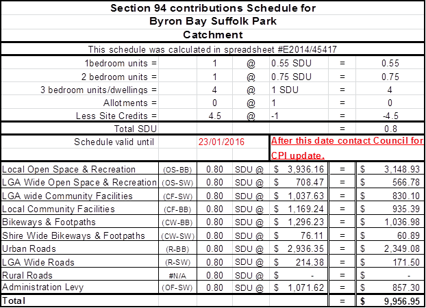
· To
ensure access for people with access disabilities.
· To
comply with the provisions of Byron Local Environmental Plan 2014.
· To
preserve the environment and existing or likely future amenity of the
neighbourhood.
· To
protect the environment.
· To
preserve the amenity of the area.
· To
ensure adequacy of services to the development.
· To
ensure public health and safety.
· To
ensure compliance with Section 68 of the Local Government Act 1993.
COMPLIANCE PRIORITIES PROGRAM - 2016
1. Very High Priorities:
1.1 Developments,
actions, works, activities or uses that places people’s lives at
immediate risk or that cause or are likely to cause a significant risk of
environmental harm or pollution;
1.2 Significant
environmental and public health incidents;
1.3 Dangerous
and/or menacing dogs;
1.4 Traffic,
parking and unapproved camping activity enforcement;
1.5 Asbestos
containing material (ACM) being illegally dumped on public land
2. High Priorities
2.1 Provide
education or workshops and undertake compliance enforcement programs for;
(a) Places
of shared accommodation (commercial and non commercial)
(b) Swimming
pool safety including legislative requirements
(c) Improving
compliance standards for unapproved dwellings
(d) Onsite
sewage management systems (including CERA project)
(e) Food
safety inspections
(f) Awareness
of current public health requirements
(g) Companion
Animals with a high emphasis on high visibility enforcement and public
education. (15-465)
(h) Safe
procedures for handling and disposal of Asbestos Containing Materials
(i) Seasonal
public health issues and community preparedness including issuing a minimum of
two media releases.
2.2 Responses
to complaints about recurring noise disturbance, public nuisance from premises,
maintenance of alcohol free zones;
NOTE: One-off complaints to be addressed by information and education in the
first instance as a “routine”
priority.
2.3 Unauthorised
events, including unapproved dwellings, wedding receptions, parties,
'doof’ and 'rave' parties;
3. Medium Priorities
3.1 Development
or activities without consent, or non-compliance with consent, permit or
licence conditions where these appear to pose no immediate threat to life,
property, public health or the environment;
3.2 Livestock
on public roads;
3.3 Non-compliant
signage (07-550, 06-204).
3.4
Uncontrolled dogs and/or cats including those kept on land where Policy or
Development consent prohibits it.
(14-544)
4. Routine Priorities
4.1
All other matters.
E2015/76485
 BYRON
SHIRE COUNCIL
BYRON
SHIRE COUNCIL
COMPLIANCE GUIDELINES
Weddings, Private
Parties or other Private Functions in Rural Zones
NOTE: These guidelines do not apply to the use of
premises for any type of commercial use for weddings, parties and functions. If
you do propose to use your premises on a commercial basis, this may constitute
a Function Centre, which is a defined use under the terms of the Byron Local
Environmental Plan 2014. It is recommended that you obtain professional
planning advice prior to carrying out any commercial use of your premises as a
function centre or the like.
Weddings, private parties or other
private functions are identified as a type of exempt development under State
Environmental Planning Policy (Exempt and Complying Development Codes) 2008,
which is available online at www.legislation.nsw.gov.au.
These guidelines are based on the interpretation of the
Building Code of Australia in conjunction with State Environmental Planning
Policy (Exempt and Complying Development Codes) 2008 and other relevant
legislation.
These guidelines only apply to the following zones:
Byron Local Environmental Plan
2014
· R5 Large Lot
Residential
· RU1 Primary Production
· RU2 Rural Landscape
· RU5 Village
Byron Local Environmental Pan
1988
· Zone No
1(a)—(General Rural Zone)—black edging, lettered “1
(a)” and coloured light brown.
· Zone No
1(b1)—(Agricultural Protection (b1) Zone)—black edging, lettered
“1 (b1)” and coloured light brown.
· Zone No
1(b2)—(Agricultural Protection (b2) Zone)—black edging, lettered
“1 (b2)” and coloured light brown.
· Zone No
1(c1)—(Small Holdings (c1) Zone)—black edging, lettered “1
(c)” and coloured light brown.
· Zone No
1(c2)—(Small Holdings (c2) Zone)—black edging, lettered “1
(c2)” and coloured light brown.
Does your proposed wedding,
private party or other private function comply with the following standards?
1. No
more than 300 guests.
2. Tents
and marquees must not have a combined greater floor area than 300 square
metres.
3. Each
tent or marquee is greater than 3 metres from any boundary.
4. Each
tent or marquee must be erected so as to provide an unobstructed pedestrian
circulation area at least 1.5m wide around the perimeter of the tent or
marquee, unless it is attached to or abuts a building with no separation,
5. Each tent or marquee must be erected at ground level,
6. Each
tent or marquee must have the following number of exits arranged so as to
afford a ready means of egress from all parts of the tent or marquee to open
space or a road:
(i) 1
exit if the tent or marquee has a floor area of not more than 25m2,
(ii) 2
exits if the tent or marquee has a floor area of not more than 100m2,
(iii) 4
exits in any other case,
(iv) If
any tent or marquee includes internal seating, stalls, tables or other
obstructions, a clear path of travel to any exit no greater than 40m in length must
be provided,
7. Each
tent or marquee must have a width for each exit of at least:
(i) 850mm
if the floor area of the tent or marquee is less than 150m2, or
(ii) 1m
in any other case, no tent or marquee can have a wall height exceeding 4m,
8. Each
tent or marquee must have a height, as measured from the surface on which the
tent or marquee is erected to the highest point of the tent or marquee, not
exceeding 6m,
9. No
tent or marquee can contain tiered seating,
10. Any
wedding, private party or other private function must take place only during
the following periods:
(i) 7.30
am to 11.00 pm on Monday, Tuesday, Wednesday or Thursday,
(ii) 7.30
am to 12.00 am on Friday or Saturday,
(iii) 8.00
am to 8.00 pm on Sunday,
11. If the
development is carried out for the purposes of a wedding, private party or
other private function (unless it is a community event to which Subdivision 7
applies):
(i) each
tent or marquee must not be erected on the land for more than 7 days, and
(ii) the
number of days for which a tent or marquee is erected on the land together with
the number of days for which tents or marquees have previously been erected on
the land for private functions in the same calendar year must not exceed 30
days.
12. In any
other case—each tent or marquee must not remain on the land for more than
two days after the function or after the completion of the filming at the
location,
13. Arrangements
must be made for the removal of any waste or recyclable materials likely to be
generated as a result of the function or the filming activities.
14. Sanitary
basins and hand washing facilities for female patrons.
|
Number Female Patrons
|
Number Closet
Pans
|
Number Wash
Basins
|
|
1 -25
|
1
|
1
|
|
26 - 50
|
2
|
2
|
|
51 - 100
|
3
|
3
|
|
101 - 150
|
4
|
3
|
|
151 - 200
|
5
|
3
|
|
201 - 250
|
6
|
3
|
|
251 - 300
|
7
|
3
|
15. Sanitary
basins and hand washing facilities for male patrons.
|
Number Male Patrons
|
Number Closet
Pans
|
Number Urinals
|
Number Wash
Basins
|
|
1 -50
|
1
|
1
|
1
|
|
51 - 100
|
1
|
2
|
2
|
|
101- 150
|
2
|
3
|
2
|
|
151 - 200
|
2
|
4
|
2
|
|
201 - 250
|
2
|
5
|
3
|
|
251 - 300
|
2
|
6
|
3
|
16. All
parking must be contained within the property boundaries and adequate access
must be provided for emergency vehicles.
|
Site
|
BRSCC
|
Clarkes Beach Car Park
|
First Sun Caravan Park
|
Beach Front Holiday Park Suffolk Park
|
Red Devil Park
|
Belongil Fields Camp
Grounds
|
Key:  Council
Initiated Trial Sites Council
Initiated Trial Sites
 Exsting
Caravan / Camping sites Exsting
Caravan / Camping sites
|
|
Nomads Byron Bay Arts & Industry
Estate
|
Discovery Holiday Park
|
Glen Villa
|
Clarkes Beach Caravan Park
|
|
Land ownership & Consent
|
Council Owned and managed.Zoned RE1.
POM does allow for primitive camping. Zoning is
Public Recreation.
|
Zoned 6A, 7F1. Crown Reserve – Council is trust
manager.
|
Operational / Community (car park) Land. Zone 7f2.
|
Community Land. Zone 7f2.
|
Crown Reserve with crown tenure Zoned 6B/ 7A/ 7B.
Existing approval to operate a camping ground.
|
Private. Currently zoned 1D and has existing approval
for camping.
|
Private. Zoning is SP3 Owners have approached council
with an interest to work together.
|
Zoning is SP3 .Current consent for Caravan park
|
Current consent for Caravan park. Zoned R2.
|
Zoned 6A, 7F1 Current consent for Caravan park.
|
|
Reason for recommendation / positive impacts
|
· Council managed /
good control site for trial
· Good hard stand access
· Well positioned for overflow events
|
· Central location close to hot spots and beach
· No cost to establish
|
· Central location
· Already take in large van numbers
· Capacity to include more vans
|
· Out of central area option
· close to Suffolk hot spots
· have capacity
|
· Have strong interest to change business model to
include overnight parking
· Have capacity to invest in infrastructure
· Full facilities
· 24hr caretaker
|
· Current van site
· Interested to partake in trial
|
· Current Backpacker hub
· Area on site near entry carpark identified as
possible freedom camping location for 20 bays. Subject to DA.
· Owners keen to proceed.
|
· Current Van site
· Interested to partake in trial
|
· Current van site
· Interested to partake in trial
|
· Current van site
· Interested to partake in trial
|
|
Location
|
Out of town
Good access
|
Beach-front location
|
Prime Position / beach-front
|
Beach-front and not far from
Suffolk Park Shopping Centre
|
Out of town centre but close
to beach and Suffolk hot spots
|
Out of town centre, but lots of space and reasonable
priced.
|
Skinners Shoot Road. Central
and walking distance to town .
|
Out of town centre, but offers
full facilities
|
Butler Street Central
and walking distance to town
|
Lighthouse
Road Beach-front location
walking
distance to town
|
|
Existing facilities
|
Toilets: 5 x F, 2 x M, 1 urinal, 1 disabled. Drinking
tap, sewer and water services available to carpark
|
Toilets:3 X F, 2 X male, 1 disabled, BBQ
|
Full caravan park facilities: Toilets, showers, BBQs,
wifi, security, sheltered area
|
Full caravan park facilities:
Toilets, showers, BBQs, wifi, security, sheltered area
|
Full facilities + 24 hr caretaker
|
Full caravan park facilities + cooking shelter +
seating area
|
Full facilities, + kitchenette + entertainment.
|
Full Facilities+ pool+ tennis Court + wifi +BBQs
+shelter + dump point
|
Full Facilities+ pool+ tennis Court + wifi +BBQs
+shelter + dump point
|
Full caravan park facilities: Toilets, showers, BBQs,
wifi, security, sheltered area + dump point
|
|
Capacity
|
Large
|
Small – 20 spaces proposed
|
Large
|
Large
|
Medium
|
Medium
|
Medium
|
Large
|
Large
|
Large
|
|
Potential negative impacts
|
Could impact on revenue by effecting daily events.
Developer Servicing fees could be prohibitive if can’t be made exempt
for trial purposes.
|
Vans highly visible. Close to residential zone.
|
Already caters to high end of vanpacker market.
Potentially wont assist with reducing illegal camping
|
Already caters to high end of vanpacker market.
Potentially wont assist with reducing illegal camping
|
Might be too far out of town to make impact on trial.
|
Future development makes this site only a temporary
solution
|
Already high volume site, might be over capacity if
more spaces introduced.
|
Already caters to high end of vanpacker market.
Potentially wont assist with reducing illegal camping
|
Already caters to high end of vanpacker market.
Potentially wont assist with reducing illegal camping
|
Already caters to high end of vanpacker market.
Potentially wont assist with reducing illegal camping
|
|
Est. Council Investment for trial
|
Waste Management $5332 + Signage $230 = $5,562
If necessary toilet cleaning costs to be added.
|
Waste Management $5332 + Signage $230 = $5,562
|
N/A – existing operation
|
N/A – existing operation
|
Dedicated trial signage $230
|
N/A – existing operation
|
Dedicated trial signage $230
|
N/A – existing operation
|
N/A – existing operation
|
N/A – existing operation
|
SITES CONSIDERED BUT DEEMED INAPPROPRIATE FOR TRIAL
RECCOMENDATION
|
Site
|
Butler Street Reserve
(#142250)
|
Byron Bay Recreation Grounds,
Cr Carlyle, Cowper & Tennyson Sts (#177670)
|
|
Land ownership & Consent
|
Crown Reserve –
Council is trust manager. Purpose is public recreation. Zoned 6a.
|
Community Land. Zoned 6a.).
|
|
Reason for removal from trial
|
· Contaminated Site
· Land allocated for use in Masterplan
· Current POM doesn’t allow camping
· Current site of weekly markets
|
· Land allocated for use in Masterplan
· High residential zone
· Too visible to residents
· Site would have to be rezoned and the Plan of
Management revised (POM currently doesn’t allow camping
|
Costs
and infrastructure required at The Cavanbah Centre for a proposed Freedom
Camping Trial
The mechanics
1. Freedom
Campers would be located at the Ewingsdale Road end of the car park (see the
diagram above). This will ensure current users are not impacted by the trial
and this location supports the existing water and sewerage infrastructure
available.
2. The
highlighted area allows for twenty vans per night and a capacity of 60 people
(a spacing of 2.5m per vehicle is required for fire safety)
3. Freedom
Campers to access the site from 6pm to 9am, seven days a week.
4. Campers
can stay for a maximum of four consecutive nights.
5. Camping
will cost $10 per vehicle, per night.
6. Campers
will pay for a ticket using an installed permit machine.
7. Security
will patrol the site twice nightly to ensure campers have purchased tickets and
no anti-social or illegal behaviour is taking place at the centre.
Infrastructure required
The following infrastructure is required to accommodate
Freedom Campers:
1. Amenities:
a. An
amenities block within 50m of the camping site, containing the following
infrastructure:
b. 1
x disabled toilet
c. 2
x unisex toilets
d. 4
x coin operated showers (2 x female, 2 x male)
e. These
facilities would be cleaned and restocked with supplies twice a day.
2. Waste:
a. 6
x 240L waste bins
b. 6
x 240L recycling bins
c. The
waste would be collected weekly (and reviewed monthly to ensure demand is being
met)
3. Signage:
a. 2
signs at The Cavanbah demarcating the Freedom Camping area
b. Signage
at the Freedom Camping ‘hot spots’ in town encouraging campers to
relocate to The Cavanbah Centre
c. Signage
at the entrance to The Cavanbah Centre
Budget to operate a 12 month Freedom Camping Trial at
The Cavanbah Centre
|
Item
|
Cost
|
|
Income
|
|
|
Assumption – an average of 15 vans
per night at a cost of $10 per van
|
$54,600
|
|
Operational Funds
|
Funds not identified
|
|
Total income
|
$54,600
|
|
|
|
Expenses
|
|
|
12 month Freedom Camping trial at The
Cavanbah site:
Waste
Management (12 bins)
Security
Signage
Cleaning
(amenities block, car park and nature reserves (2-3 hours a day)
Risk
Management and Contingency
Section
64 contribution for Water and Sewer costs (fees could be waived for the trial
period)
Amenities
block
Plumbing
water and sewer - amenities block
Development
Application
Permit
machine
Total
Cost including Section 64 contributions
Total
Cost excluding Section 64 contributions
|
$2,958
$25,480
$1,840
$91,000
$5,000
$14,670.11 per site x 20 sites
= $293,400
$30,000
$30,000
$285
$8,700
$491,963
$195,263
|
|
Marketing education campaign
Social
Media
Digital
campaign
Flyers
Intermediary
consultation and partnering with holiday parks, backpacker hostels, Wicked
Vans, Jucy Vans and the Byron Visitor Centre
Data
collection and monitoring
|
$30,000
|
|
Cost of regulatory staff to patrol Byron
Bay ‘hot spots’ and move people on to the Cavanbah Centre and
issue infringements to non-complying van packers.
|
$53,414
|
|
Total
Expenses
|
$278,677
|
|
Income
– Expenses (net cost to Council)
|
$224,077 Revenue is estimated at $54,600
|
Byron Shire Council Rural Land Use Strategy
Site Suitability Criteria
& Mapping Methodology
- revised
version incorporating changes resulting from Council resolution 15-569 on 29/10/15
November
2015
Site Suitability Criteria & Mapping Methodology
Table of Contents
1 Introduction
1.1 Background
1.2 Purpose
of the Site Suitability Criteria and Mapping Methodology Paper
1.3 Study Approach
2 Site
Suitability Criteria Methodology and Data
Table 1 :
Constrained Land
Table 2 :
Assessable Land
Table 3 :
Service Catchment and Road Infrastructure Priorities for Rural Development
3 Constrained
Land
3.1 Primary Production Land
3.2 High Conservation Value Vegetation
3.3 Water Supply Catchment Buffer
3.4 Mineral Resources
3.5 Slopes
3.6
Bushfire
3.7 Buffers to Waster Disposal Facilities and Sewerage
Treatment Plants
3.8 Acid Sulfate Soil Classes 1 and 2
3.9
Other excluded zones
4 Assessable
Land
4.1 Sensitive Rural Land Uses
4.2 Non Contiguous and Prime Agricultural Land
4.3
Biophysical Strategic Agricultural Lands
4.4
Scenic Amenity and Rural Landscape
4.5
Category 1 & 2 Bushfire Vegetation
4.6
1:100 Year Flood Risk and Climate Change; and Coastal Erosion Planning
Precincts 1 and 2
4.7
Vehicle Access Safety and Risk
4.8
Wildlife Habitat and Corridor Enhancement
4.9
Indigenous Cultural Heritage
5 Service
Catchment and Road Infrastructure Priorities for Rural Development
5.1 Service
Catchment Priorities
5.2 Road
Infrastructure Priorities for Future Rural Lifestyle Living Opportunities
APPENDIX 1 –
Site Suitability Maps
1. Introduction
1.1 Background
Byron Shire Council is developing a Rural
Land Use Strategy. The Rural Land Use Strategy will provide a strategic
framework for the management and use of rural land for living, working and
leisure. It will guide future land zoning and other planning instruments such
as Local Environmental Plans.
It will also identify a range of rural land use
actions/outcomes and include a delivery program for future rural development,
taking into account existing land supply.
Main Stages to develop the Rural
Land Use Strategy


1.2 Purpose
of the Site Suitability Criteria and Mapping Methodology Paper
The purpose of this document is to provide a comprehensive framework for
determining future rural development potential based on a range of natural
resource management, risk avoidance and social/economic servicing
criteria. This in turn will inform the development of a related Policy
Directions paper and the Rural Lands Strategy.
1.3 Study
Approach
The Department of Planning and Environment
are preparing a North Coast Regional Plan to replace the Far North Coast
Regional Strategy. In preparing the criteria and mapping methodology, staff
liaised with the Department to ensure that the Rural Land Use Strategy mapping
methodology direction is consistent with the policy principles of the working
draft North Coast Regional Strategy. The criteria were also informed by other relevant State, regional and/or local
planning documents and best practice planning principles.
2. Site Suitability
Criteria Methodology and Data
The process for selecting potential land
for tourism, conventional rural residential, Multiple Occupancies, Community
Title or other non-agricultural land uses (herein referred to as ‘future rural development’) is outlined
below. The aim is to ensure that future rural
development occurs within the context of Byron Shire's
environmental, economic and social requirements.
In identifying potential future rural development
land, site suitability criteria were used to map the
following categories of land:
1. [a1] Constrained Land
This identifies
areas where any of the criteria listed in Table 1 are present. Constrained land
will not be considered for future rural development
as it includes important environmental and resource values and/or issues of
risk avoidance. These constraints by their degree and nature preclude the land
from development.
2. Assessable Land
This identifies
areas not encumbered by any of the Constrained Land criteria in
Table 1 but potentially affected by one or more of the criteria listed in Table
2. Assessable Land [a2] encompasses
environmental, economic and/or risk avoidance criteria which may not
necessarily preclude future rural development
on the land but rather indicate a need for more detailed site specific
investigations to determine the site’s full development potential. The
criteria in Table 2 are not comprehensive and there may be other matters which
need to be taken into consideration to determine a site’s development
potential.
3. Unconstrained Land
This identifies
areas that are neither encumbered by Constrained Land criteria (Table 1) nor
affected by Assessable Land criteria (Table 2).
4. Future Rural Development Priorities
This
considers priorities for future rural
development of Unconstrained Land and Assessable Land using the
‘Service Catchment and Road Infrastructure Criteria’ in Table 3.
This reflects the premise that future rural development should be within
a reasonable distance of village and town services and be provided with a
standard of road access that does not place a financial burden on the wider
community. From a service catchment standpoint, priority generally will be given to ‘assessable’ and
‘unconstrained’ land within:
(i) 5 km radius from the general post office in a town containing a high
school; or
(ii) 2 km radius from a primary school or general store in villages and rural
settlements.
For all unconstrained and assessable
land, whether within or outside a service catchment area, the following also
must be considered:
· capacity / condition of
relevant road network; and
· costs to wider community of
proceeding with potential rural lifestyle living precincts.
These and other matters will need to be
considered at the draft Rural Land Use Strategy stage.
Note: Land in the
“unconstrained” and “assessable” land categories do not
infer development rights; it merely identifies land that is potentially
suitable for future rural development.
|
Table 1:
Constrained Land
|
|
Criteria
|
Supporting Planning Framework
|
|
Primary Production Land
- Land zoned RU1 Primary Production in LEP
2014;
- deferred matters relating to 1(b1) or
1(b2) Agricult-ural Protection in LEP 1988;
- S117 land mapped as State/Regionally
Significant farmland (excluding non-contiguous)
|
State / Regional
· Far North Coast Regional
Strategy 2006-31
· S117 Direction 5.3 / Northern
Rivers Farmland Protection Project - Final Recommendations, February 2005
(Section 4)
· Draft Far North Coast
Regional Growth Plan ‘guidelines’
Local
· Byron Shire Sustainable
Agriculture Strategy (2004)
· Rural Land Use Strategy
Discussion Paper – community feedback
· Byron Rural Settlement
Strategy 1998
· Tweed Shire Rural Land
Strategy –Resource Inventory & Land Capability Assessment (Dec,
2013)
· Lismore Growth Management
Strategy 2015-2035
|
|
High Conservation Value Vegetation
Land containing high conservation value vegetation
|
State / Regional
· State Environmental Planning
Policy No. 14 (Coastal Wetland)
· State Environmental Planning
Policy No. 26 (Littoral Rainforest)
Local
· Byron Rural Settlement
Strategy 1998
· Byron Biodiversity
Conservation Strategy 2004
· Lismore Growth Management
Strategy 2015-2035
|
|
Water Supply Catchment Buffers
Land within 100m of a major creek / waterway located
in a drinking water catchment
|
Local
· Byron Rural Settlement
Strategy 1998
· Byron LEP 2014, Clause 6.5
– Drinking Water Catchments (objectives)
· BSC Design Guidelines for
On-Site Sewage Management for Single Households (2004)
· Rous County Council draft DCP
|
|
Mineral Resource
s117 mineral resource lands, including transitional
and potential areas
|
State / Regional
· S117(2) Direction 1.3 –
Mining, Petroleum Production and Extractive Industries
· Mineral Resources Audit
(mapping)
Local
· Byron Rural Settlement
Strategy 1998
|
|
Slope
Land with slope > 32%
|
State / Regional
· Planning for Bushfire
Protection 2006
Local
· BSC Design Guidelines for
On-Site Sewage Management for Single Households (2004)
· Byron Rural Settlement
Strategy 1998
· Lismore Growth Management
Strategy 2015-2035
|
|
Extreme Bushfire Risk
Land containing Bushfire
Category 1 vegetation
and
Slope >20%
|
State / Regional
· Planning for Bushfire
Protection 2006
· Lismore Growth Management Strategy
2015-2035
Local
· Byron Rural Settlement
Strategy 1998 (>20% slope)
|
|
Buffers to waste disposal facilities and
sewage treatment plants
Land within buffer to
sewage treatment plant (400m) OR
waste disposal facility (500m)
|
Local
· Byron Rural Settlement
Strategy 1998
· Byron Development Control
Plan 2010 & 2014 (Chapter B6 – Buffers)
|
|
Acid Sulfate Soils (ASS)
Classes 1 and 2
Land within
ASS Risk Class 1 or 2
|
Local
· Byron Rural Settlement
Strategy 1998
· Byron LEP 2014, Clause 6.1 – Acid
Sulfate Soils
(risk classes 3-5 considered manageable)
|
|
Other
Excluded Zones
Land outside the
following zones:
Byron LEP
2014:
RU2 Rural Landscape
R5 Large Lot
Residential
RU5 Village
AND
Byron LEP
1988 (only
where “deferred” from LEP 2014):
1(a) General
Rural
1(d)
Investigation
7(d)
Scenic/Escarpment
|
State / Regional
· Far North Coast Regional
Strategy 2006-31
Local
· Byron Rural Settlement
Strategy 1998
|
|
Table 2:
Assessable Land (1)
|
|
Criteria
|
Supporting Rationale[s3]
|
|
Sensitive Rural Land Uses
Assess potential impacts
associated with rated
farmland activities in terms of:
· Location
· Operation
· Processing
To determine farming
activity clusters and suitable buffers (including ex-dip sites) to minimise
conflict between farming and non-farming land uses
|
- Recognition of: the
importance of farmland and agriculture; the changing nature of agriculture
and key trends, demands and issues affecting agriculture; and the economic
advantages associated with industries that cluster or diversify.
- Builds on the Byron Rural
Settlement Strategy principles and Byron Shire DCP 2014 – Chapter
B6 – Buffers and Minimising Land Use Conflict.
- Consistent with planning
strategies and principles outlined in Living and Working in Rural Areas
(NSW DPI, 2007).
|
|
Non Contiguous and Prime Agricultural
Lands
Assess Non-contiguous State/ Regionally Significant
farmland and
prime agricultural land (classes I, 2 and 3 as identified by NSW Agriculture) outside the Primary
Production Land identified
in Table 1
|
- Consistent with Northern
Rivers Farmland Protection Project – Final Recommendations (February,
2005).
- Consistent with community
feedback on Rural Land Use Strategy Discussion Paper.
- Potential development should
be subject to merit-based assessment of the agricultural value and future
economic viability of such land.
|
|
Biophysical Strategic Agricultural Lands
Assess biophysical strategic agricultural lands
|
- Biophysical Strategic
Agricultural Land (BSAL) is land with high quality soil and water resources
capable of sustaining high levels of productivity.
- BSAL mapping important for
managing competing land uses proposed on high quality agricultural land.
- Consistent with DP&E
advice that future rural settlement should generally avoid areas mapped as
BSAL.
|
|
Scenic Amenity and Rural Landscape
Assess land zoned
7(d) Scenic/ Escarpment
in Byron LEP 1998 (only
where “deferred” from LEP 2014)
|
- Consistent with Byron
Rural Settlement Strategy site suitability criteria and community
feedback on Rural Land Use Strategy Discussion Paper
|
|
Criteria
|
Supporting Rationale[s4]
|
|
Category 1
& 2
Bushfire Vegetation
(excluding
“Extreme”
bushfire risk
areas in Table 1)
Assess the
capacity for development that does not encroach on Category 1& 2
vegetation
|
- Adapted from Byron Rural
Settlement Strategy site suitability criteria
- Future development must satisfy
Planning for Bush Fire Protection 2006 requirements.
|
|
- 1:100 year Flood risk + Climate Change
- Coastal Erosion Planning Precincts 1 & 2
Assess the capacity for development to be safe and
capable of managing flood and/or coastal
erosion risks
|
- Adapted from Byron Rural
Settlement Strategy site suitability criteria relating to flooding.
- Future development subject to
LEP 2014 Clause 6.3 – Flood Planning
|
|
Vehicle access safety and
risk
Assess vulnerability of
essential access roads to:
- Bushfire Category 1, or
- Landslip - sections
of road having a history of landslip
Ensure adequate evacuation
routes
|
Future development may be subject to
minimum design standards being in place to reduce vulnerability of road
infrastructure to the following risks:
- Bushfire – where access roads
cannot provide safe (or alternative) access, egress and defendable space for
emergency services during event.
- Landslip – where sections of
road have become unusable for long periods of time following the event (eg.
Upper Wilsons Creek).
|
|
Wildlife Habitat and Corridors Enhancement
Assess potential for enhancement of wildlife corridors
|
Recognises role of wildlife corridors in
minimising impacts (direct or indirect) from adjoining land uses and
encouraging the recovery of threatened species, communities, populations and
their habitats.
|
|
Indigenous Cultural Heritage
Consult with traditional owners (where
applicable) in accordance with process established by Council
|
Recognises that Byron Shire contains a
wealth of Aboriginal cultural sites which include middens, stone
arrangements, rock shelters and tool-making sites. Many of these are
not mapped due to their cultural sensitivity.
|
(1) This Assessable Land criteria list
is not absolute and that there may be other matters which require more detailed
assessment at the rezoning or DA stage to determine site suitability.
This may include, for example, consideration of indigenous cultural heritage
values through formal consultation with
traditional owners or site
contamination history.
Note: Mapping of individual assessable constraints
would not be included as part of the final Rural Land Use Strategy.
Instead an interactive PDF would be created for community access that would
provide mapping layers on the assessable constraints
|
Table 3: Service Catchment and Road Infrastructure
Priorities for Rural Development
|
|
Criteria
|
Supporting Rationale
|
|
Service Catchment
Priorities
(apply to all future rural development)
Determine
development priorities based on proximity to town and village service
catchments as follows:
· Priority 1: Unconstrained land within 5 km of a town containing high schools or 2km of a rural
village containing any of the following features catering to the needs of
that locality: primary school; general store.
· Unconstrained land that
is outside of the service catchment areas will be considered subject to
the following, where relevant to the development;
- existing
school bus services are accessible within 100m from the site boundary,
- primary
access to the land is via a major local road or regional road (excluding the
motorway),
- land
that satisfies the service catchment criteria (eg
primary school, general store) that are available in an adjoining local
government area.
· Priority 2: Assessable land within 5 km of a town containing high schools or 2km of a rural
village containing any of the following features catering to the needs of
that locality: primary school; general store.
· Assessable land that is
outside of the service catchment areas will be considered subject to the
following, where relevant to the development;
- existing
school bus services are accessible within 100m from the site boundary,
- the
primary access to the land is via a major local road or regional road
(excluding the motorway),
- land
that satisfies the service catchment criteria (eg primary
schools, general store) that are available in an adjoining local
government area.
For
all unconstrained and assessable land, whether within or outside a service
catchment area, the following must be considered:
· capacity / condition of
relevant road network;
· costs to wider
community of proceeding with potential rural lifestyle living precincts
Development
will only be considered where relevant road segments can be upgraded at no
cost to wider community.
|
A ‘service catchment’
approach maximises opportunities for people to access basic services and
connect with each other both socially and economically. It also
facilitates economies in service provision such as a rural school bus
service.
Consistent with service catchment
criteria in Byron Rural Settlement Strategy1998 and Lismore Growth
Management Strategy 2015-2035.
Consistent with Guidelines for Rural
Settlement on the North Coast of NSW (DUAP, 1995).
Priority areas for future rural development will have adequate road
infrastructure (both condition and capacity) that will not place a financial
burden on the wider community. That is, any required road upgrade to
achieve an acceptable standard will need to be provided at no cost to wider
community.
This economic imperative is supported by
the following documents:
- Byron Shire Council Financial
Sustainability Project Plan (Asset Management Strategy)
- Council
Improvement Program (June2015)
- Byron Rural
Settlement Strategy1998
- Guidelines for
Rural Settlement on the North Coast of NSW (DUAP, 1995)
|
3.
Constrained Land
Certain land has been excluded from
consideration for future rural development
as it makes good environmental, economic and social sense. We need to safeguard
the quality of the natural environment and the integrity of our natural
resources. Similarly, we should not put the environment, people and assets at
risk or in hazardous situations.
The criteria for identifying ‘Constrained Land’, as listed in Table 1
above, are detailed below.
3.1 Primary Production Land
Good agricultural land provides primary
production in Byron Shire with an inherently unique advantage in productivity,
diversity and adaptability. As a finite and irreplaceable resource it should be
conserved and sustainably managed. The North Coast Urban Planning Strategy
(1995), the NSW Coastal Policy (1997), the Northern Rivers Regional Strategy
(1999), the Northern Rivers, Upper North Coast and Mid North Coast Catchment
Blueprints (2002) and the Northern Rivers Farmland Protection Project 2005 all
support this position.
The Northern Rivers Farmland Project
reviewed earlier investigations regarding prime agricultural land and took into
account the need to distinguish between very high quality and unique
agricultural soils/lands and other lands that were also important to agriculture
but which were more extensive and less productive generally per unit area. It
identified two relevant levels of agricultural land – State and
Regionally Significant. Fundamental to this project was the identification,
recognition and protection of contiguous quality farmland to limit the
likelihood of displacement of agricultural use by residential use and
fragmentation.
Primary Production Land is included on Map
1 of Appendix 1. The data used to inform this map is:
|
Description
|
Data layers used
|
Data custodian
|
|
- Land zoned RU1 Primary Production in LEP
2014;
- Deferred matters relating to 1(b1) or
1(b2) Agricultural Protection in LEP 1988;
|
1998 / 2014 LEP
Zoning
|
Byron Shire
Council
|
|
S117 land mapped
as State or Regionally Significant farmland
|
“Northern
Rivers Farmland Protection Project, Final Map 2005 (Section 117(2)
Direction)”
|
NSW Dept of Planning & Environment (formerly
Dept of Infrastructure, Planning and Natural Resources)
|
For strategic planning purposes State or
Regionally Significant farmland (excluding non-contiguous) and land zoned for
primary production purposes represent constrained
land.
3.2 High
Conservation Value Vegetation
Byron Shire covers about 56,000 hectares of
which 68% is cleared land, plantations and disturbed remnant vegetation. The
ongoing loss of biodiversity is perhaps our most serious environmental problem.
The protection and enhancement of high conservation value vegetation provides a
foundation from which to address this problem.
In 2015, Council reviewed the vegetation
mapping. Mapping was initially carried out in 1999 as part of the Byron Flora
and Fauna Study and was partly reviewed in 2007. The 2015 review has improved
the accuracy of the mapping and reflects changes in vegetation extent and
composition over time. The review used a combination of aerial photograph
interpretation (API) primarily using 2014 aerial data, existing information
such as, vegetation survey data from various Council and state government
projects, and on-ground site inspections.
Vegetation was mapped using the State
Government’s Vegetation Information System (VIS) Classification 1.
database to ensure consistency with NSW standards. This system uses three
levels; vegetation formations, vegetation classes and plant community types.
The plant community type classification provides the most detailed description
of vegetation and was developed by the state government to provide a standard
approach to vegetation classification and mapping.
This mapping provides the foundation on
which to determine high conservation value vegetation and habitats (HCV).
HCV has been determined using a relative ecological value matrix as described
in the Byron Biodiversity Conservation Strategy 2004 (Part 3). Areas with a combined score of 27 or more are
regarded as HCV.
The High Conservation Value Vegetation is
included on Map 2 of Appendix 1. The data used to inform
this map is:
|
Description
|
Data layers used
|
Data custodian
|
|
Land containing
high conservation value vegetation and habitats
|
HCV Vegetation
Map (2015)
|
Byron Shire
Council
|
For strategic planning purposes high
conservation value vegetation and habitats represent constrained
land.
1. For information on the State Government’s
Vegetation Information System (VIS) Classification go to:
www.environment.nsw.gov.au/research/Visclassification.htm
3.3 Water
Supply Catchment Buffers
Regional water resources including
watercourses, dams and estuaries are of economic, social and environmental
significance both within the Shire, North Coast Region and beyond. They support
urban and rural water supplies and a range of tourism and recreational
activities.
Water supply catchments are areas from
which surface water drains (via runoff) to a reservoir or water storage
facility. The local government areas of Byron, Lismore and Ballina source
their urban water supplies from three rural catchments: Wilson Creek, Rocky
Creek Dam and Emigrant Creek. Their water quality is directly influenced by the
type of land uses and management practices occurring within these
catchments. Some of impacts of inappropriate rural land uses and/or poor
land management practices can include toxic algal blooms, soil erosion, falling
water tables and increased water treatment costs.
Future rural
development should have a neutral or beneficial
effect on downstream water quality. As rural dwellings within urban water
supply catchments are generally not sewered and instead rely on on-site
wastewater management systems, requiring a 100m separation distance between a
permanent water course and wastewater management system can substantially
reduce likelihood of pathogens entering the water supply. This is known as a
‘water supply catchment buffer’.
Water supply catchment buffers are shown on
Map 3 of Appendix 1. The data used to inform this map is:
|
Description
|
Data layers used
|
Data custodian
|
|
Land within a drinking water catchment and 100m of a
major creek / waterway
|
Water catchment supply 2014
Create 100m buffer around major creeks / waterways
|
Byron Shire
Council
|
For strategic planning purposes all land
within a drinking water catchment and within 100m of a major watercourse
(namely Wilsons River, Coopers Creek, or Rocky Creek and Skinners Creek)
represents constrained land.
(Sources: Rous
Water On-site Wastewater Management Guidelines, June 2008;
South East Queensland Development Guidelines for
Water Quality Management in Drinking Water
Catchments).
3.4 Mineral
Resources
Quarry materials are essential to the
construction industry. Section 117 Planning Direction ‘1.3 –
Mining, Petroleum Production and Extractive Industries (Environmental
Planning and Assessment Act 1979), seeks to ensure that future extraction
of mineral resources and extractive materials is not compromised by
inappropriate development.
Extraction can only occur where geological
deposits are located. Transportation costs are a significant cost factor. To
keep costs down and remain largely self sufficient, we need to ensure that
local supplies are available in sufficient quantity to satisfy current and
future demands.
Inappropriately located land uses can
effectively alienate, or even sterilise a resource. A
1 km buffer taken from the boundary of identified resources can be an effective
means to prevent land use conflicts and protect important mineral resources.
Mineral Resources (identified, transitional
and potential) are shown on Map 4 of Appendix 1. The data
used to inform this map is:
|
Description
|
Data layers used
|
Data custodian
|
|
s117 mineral
resources, including transitional and potential areas
|
Mineral
resources - Areas of proven natural resource significance (2015)
|
NSW Dept of
Mineral Resources
|
For strategic planning purposes all Section
117(2) mineral resource lands, including transitional and potential areas,
represent constrained land.
3.5 Slope
Slope is a significant factor affecting
effluent disposal, stormwater runoff, bushfire risk, erosion and vehicular
access. For example, slopes in excess of 20% (11.3 degrees) can pose wastewater
treatment system installation problems, while slopes greater than 15% (8.5
degrees) may prevent treated wastewater from being evenly distributed to the
land, thereby adversely affecting the performance of the system. At the
same time erosion resulting from developing on steep slopes can in turn have
significant water quality impacts. Land with slopes over 32% is considered
unsuitable to most forms of future rural
development, particularly habitable structures.
Land with a Slope > 32% is indentified
on Map 5 of Appendix 1. The data used to inform this map
is:
|
Description
|
Data layers used
|
Data custodian
|
|
Slope > 32%
|
Slope percentage – 1 meter hybrid (2015)
Contour data (10m)
|
Byron Shire Council
|
For strategic planning purposes all land
having slopes in excess of 32% (approx 18 degrees) represents constrained land.
(Sources:
http://www.ga.gov.au/scientific-topics/hazards/landslide/basics/causes
Design Guidelines for On-Site
Sewage Management for Single Households – Byron Shire Council
3.6 Bushfire
Byron Shire is
fortunately located in a region which enjoys reasonably high rainfall
throughout much of the year. However, at certain times of the year and under
certain weather conditions, many areas of the Shire can become high to extreme
fire risk areas. Bush fire is a major challenge for the community. The CSIRO
predicts that climate change will contribute to harsher fire weather for
Eastern Australia with an increase in the number of days having a severe bushfire
rating.
All developments on land that is designated
as bush fire prone must satisfy the requirements of Planning
for Bush Fire Protection 2006 and AS3959 – 2009.
A key consideration in mitigating bushfire
hazard is avoidance of high risk areas. In August 2002, the State government
introduced legislation to provide significant improvements in bush fire safety.
This included a requirement for all councils to prepare a bush fire prone land
map as the basis for more detailed investigations to determine what bush fire
protection measures are applied to new development.
Byron Shire has two Bushfire Prone
Categories based on vegetation types. Category 1 vegetation (essentially areas
of forest, woodlands, tall and short heaths, forested wetlands and timber
plantations) generally hold the highest risk factor. Studies by bush fire
authorities have shown that bushfires are likely to travel twice as fast up 10
degree slopes (as opposed to flat land) and up to four times faster on 20
degree slopes. This can result in certain Category 2 vegetation types
(essentially grasslands, freshwater wetlands, semi-arid woodlands, arid
shrublands and rainforests) on such slopes also having a high risk factor.
For strategic planning purposes all land
having Category 1 bushfire vegetation on slopes greater than 20% (11.3 degrees)
represent an ‘extreme’ fire risk and hence are constrained land. All
remaining Category 1 and 2 vegetation outside extreme fire risk areas represent assessable
land requiring more detailed investigation
prior to further consideration as potential future rural development.
Constrained and assessable bushfire risk is
identified on Map 6 and Map 15, respectively, of Appendix 1.
The data used to inform this map is:
|
Description
|
Data layers used
|
Data custodian
|
|
Constrained Land
Extreme bushfire risk: Category 1
bushfire vegetation on slopes >20%
Assessable Land
- All
remaining Category 1 and 2 bushfire vegetation (excluding ‘extreme
bushfire risk)
|
Bushfire Protection mapping for Shire
(2015)
|
Byron Shire Council
|
3.7 Buffers
to waste disposal facilities[a5] and sewage treatment plants
Waste disposal and sewerage treatment
facilities are an essential part of Council’s waste management
activities. As key infrastructure installations they represent a
significant capital investment for the Shire and minimising environmental and
human health risks is central to their placement, design and operation.
Proximity to these installations is an
important consideration in determining future
rural development land due to potential health risks to humans
including methane buildup, noise and odour. A key means for managing this risk
is the use of separation buffers from future rural
development.
Land affected by these buffers is included
on Map 7 of Appendix 1. The data used to inform this map
is:
|
Description
|
Data layers used
|
Data custodian
|
|
Land within buffer to sewage treatment plant (400m)
OR waste disposal facility (500m)
|
Sewage treatment
plant buffer
Waste disposal
facility buffer
|
Byron Shire
Council
|
For strategic planning purposes all land
within an identified sewerage buffer (400m) and refuse buffer (500m) represents
constrained land.
3.8 Acid
Sulfate Soil Classes 1 and 2
Acid sulfate soils contain pyritic
sediments which can lead to the generation of sulphuric acid when exposed to
air. This is likely to occur when these soils are drained, excavated or
dredged. Scientific research has found that the release of acid from pyritic
soils can have significant impacts upon the health of aquatic plants and
animals. Similarly, drainage waters from areas of acid sulfate soils can
corrode and weaken engineering structures and release heavy metals into
recreational fishing areas. This land is often captured by other constraints
including SEPP 14 Coast Wetlands.
A classification scheme for acid
sulfate soils identifies the type of works likely to present an
environmental risk if undertaken in a particular class of
land and is outlined in the table below.
|
Class of
land shown on acid sulfate soils map
|
Works
|
|
1
|
Any works
|
|
2
|
Works below
natural ground surface
Works in which the
watertable is likely to be lowered
|
|
3
|
Works beyond 1
metre below the natural ground surface
Works by which the watertable is likely
to be lowered beyond 1 metre below
the natural ground
surface
|
|
4
|
Works beyond 2
metres below natural ground surface
Works by which the
watertable is likely to be lowered beyond 2 metre below the natural ground
surface
|
|
5
|
Works within 500
metres of adjacent Class 1, 2, 3 or 4 land that is below 5 metres Australian
Height Datum and by which the watertable is likely to be lowered below 1
metre Australian Height Datum on adjacent Class 1, 2, 3 or 4 land.
|
For strategic purposes all land having an
Acid Sulfate Risk Class of 1 or 2 represents constrained
land.
Land with Acid Sulfate Soil Risk class 1 or
2 are included on Map 8 of Appendix 1. The data used to
inform this map is:
|
Description
|
Data layers used
|
Data custodian
|
|
Land within ASS
Risk class
1 or 2
|
Acid sulfate
soil categories
1:25,000 (2014)
|
Byron Shire
Council
NSW Office of
Environment & Heritage
|
3.9 Other excluded zones
Certain
zoning or land tenure can inherently preclude land from consideration for future rural development.
This includes land dedicated, reserved or committed to potential future urban,
village and open space uses. It also includes national parks, nature
reserves and areas already zoned for environmental protection. This
approach ensures Council maximizes its options for accommodating future
expansion of the Shire’s towns and villages while also protecting
recognised environmental assets. For strategic planning purposes all land
situated outside the following zones is excluded from consideration (ie. constrained land):
Byron LEP 2014
— RU2 Rural Landscape, R5 Large Lot Residential and RU5 Village.
Byron LEP 1988
— 1(a) General Rural, 1(d) Investigation and 7(d) Scenic/Escarpment (only
where “deferred” from LEP 2014);
Land within excluded zones are shown on Map
9 of Appendix 1. The data used to inform this map is:
|
Description
|
Data layers used
|
Data custodian
|
|
Land outside the following zones:
Byron LEP 2014:
RU2 Rural Landscape
R5 Large Lot Residential
RU5 Village
AND
Byron LEP 1988 (only where “deferred” from LEP 2014):
1(a) General Rural
1(d) Investigation
7(d) Scenic/Escarpment
|
Byron LEP 1998
Zoning Maps
LEP 2014 Zoning
Maps
|
Byron Shire
Council
|
Land that is unconstrained
land for future rural development is shown on Map 10 of Appendix 1.
4. Assessable
Land
Certain environmental, economic, social and
risk avoidance matters are more appropriately considered through a detailed
site specific investigation. These matters may not necessarily preclude
development on the site.
The criteria listed in Table 2 above have
resulted in certain land being identified as ‘Assessable
Land’. These criteria, as outlined below, are not comprehensive
and there may be other matters which require more detailed assessment at the
rezoning or DA stage to determine site suitability.
4.1 Sensitive
Rural Land Uses
Council’s
Sustainable Agricultural Strategy 2004 (SAS) supports the rights of persons to
carry out legitimate rural and agricultural uses and practices. The SAS aims to
create a social and planning environment that allows agricultural production
and associated activities to be pursued without conflict and concern for
long-term security of agriculture in the Shire. Among the policy actions
recommended in the SAS is to “carry out a stock take of agriculture
land and related activities and assessment of current and possible future uses
to determine the optimum potential (social, economic and environmental) for the
land”.
Future rural development should not undermine
this optimum potential and any strategic assessment should consider the
relevant land use characteristics of our major existing agricultural
enterprises including:
· essential
growing conditions;
· operational
conditions: potential for land use conflict or health risks from past and
current land use activities including dip site and complaints
about smell, noise, dust, airborne chemical sprays and loss of amenity
particularly from intensive agriculture or horticulture;
· processing
or market place requirements: such as dairy, sugar cane,
coffee and macadamia industries that share harvesting and processing
facilities; and
· potential economic advantages associated with industry clusters.
An initial ‘stock take’ has
been carried out for farmland rated properties,
the findings of which are shown in Map 11 of Appendix 1.
The data used to inform this map included farmland rated activities, DPI
standards for buffering and industry manuals. The buffers are not meant to be
absolute and may be varied on closer examination of terrain, vegetation and
farming practices.
|
Description
|
Data layers used
|
Data custodian
|
|
Farmland Rated
Activities and associated buffers (including dip site buffers)
|
Farmland
Rated Activities (2015)
Agricultural
Land Use Buffers (2015)
Dip sites and buffers (2014)
|
Byron Shire
Council
NSW Dept Primary Industries / Byron Shire Council
NSW Department
of Primary Industries
|
For strategic planning purposes all
farmland rated activities and buffers represent assessable land requiring more detailed investigation prior to further
consideration as potential future rural development.
(Sources:
- Byron Shire Sustainable Agriculture Strategy 2004
- Farmers Farm and Cows Do
Moo booklet (BSC, 2008)
- Minimum Lots Size
Methodology for Agricultural Uses (DPI, 2005)
4.2 ‘Non
Contiguous’ and ‘Prime’ Agricultural Land
The Northern
Rivers Farmland Project 2005 identified that certain agricultural/horticultural
industries may develop on smaller sites that have the general characteristics
of state or regionally significant farmland, but do not fit within the
definition of 'large contiguous areas'. These areas are known as
‘non-contiguous farmland’ and may include such land uses as nurseries
or controlled environment horticulture (eg. greenhouses, hydroponics).
These industries can benefit from their proximity to the South Eastern
Queensland market, and having a strong economic multiplier are important to the
local economy.
Areas mapped as prime agricultural land are
also an important consideration when planning for future rural land uses.
Like ‘non-contiguous’ farmland these areas may still have soil
characteristics or other agricultural values that require a merit-based
assessment at the rezoning or DA stage.
For strategic planning purposes
non-contiguous State or Regionally Significant farmland and Prime Agricultural
land (outside the Primary Production Land identified in Table 1) represent assessable land
requiring more detailed investigation prior to further consideration as
potential future rural development.
The location of
‘non-contiguous’ and prime agricultural land is shown on Map 12 of
Appendix 1. The data used to inform this map is:
|
Description
|
Data layers used
|
Data custodian
|
|
Prime
agricultural land (classes I, 2 and 3 as identified by NSW Agriculture)
outside the Primary Production Land (Table 1)
Non-contiguous
State or Regionally Significant farmland
|
Prime
agricultural land classes 1, 2 & 3 (2001 BSC)
Northern Rivers Farmland Project (2005) :
non-contiguous lands
|
NSW Dept Primary
Industries
NSW Dept of
Planning & Environment / NSW Dept Primary Industries
|
4.3 Biophysical
Strategic Agricultural Lands
The NSW Government
introduced the Strategic Regional Land Use Plans to better manage the potential
land use conflicts arising from the location of our high quality agricultural
land, and the mining and coal seam gas (CSG) industries. Mapping of
high-quality agricultural land capable of sustaining high levels of productivity,
known as biophysical strategic agricultural land (BSAL), represents an
important resource for managing potential land use conflicts. Certain
activities proposed within BSAL areas are subject to an additional level of
investigation at the rezoning stage. In Byron Shire the amount of land
identified as BSAL equates to approximately 9580 hectares.
The location of BSAL is shown on Map 13 of
Appendix 1. The data used to inform this map is:
|
Description
|
Data layers used
|
Data custodian
|
|
Biophysical strategic
agricultural land (BSAL)
|
|
NSW Dept of
Planning & Environment
|
For strategic planning purposes BSAL represents assessable land
requiring more detailed investigation prior to further consideration as
potential future rural development.
4.4 Scenic
Amenity and Rural Landscape
The basic premise
of rural settlement is that the 'rural character' of an area should be retained
or, conversely, any human elements introduced (eg dwelling houses; tourist
facilities) should not dominate the scene. Inappropriately located development
can ultimately destroy the very scenic amenity of an area which attracted
residents or visitors in the first place. Preserving the dominant landscape
features or scenic characteristics of an area is fundamental to ensuring that
the visual rural qualities of the Shire are not further diminished by future rural development.
Community feedback on the discussion paper
identified a strong value in ensuring our prominent rural landscape features
are not dominated by buildings. These features include prominent ridges such as
Coolamon Scenic Drive, Mt Chincogan and Nightcap National Park, bushland areas
such as National Parks and Nature Reserves, major watercourses and advantage
points such as Broken Head and Minyon Falls.
The Byron LEP 1988 mapped some of the more
prominent landscape features in a 7(d) Scenic/Escarpment Zone, the location of
which is shown on Map 14 of Appendix 1. The data used to
inform this map is:
|
Description
|
Data layers used
|
Data custodian
|
|
Lands of high scenic
and/or escarpment values
|
Land zoned 7(d)
Scenic/Escarpment in Byron LEP 1998
|
Byron Shire
Council
|
For strategic planning purposes all land
zoned in the Byron LEP 1988 as 7(d) (Scenic Escarpment Zone) (refer to Map link
) represents assessable land requiring more
detailed investigation prior to further consideration as potential future rural development.
4.5 Category
1 & 2 Bushfire Vegetation – refer to
discussion in 3.6 above
4.6 1:100
year Flood Risk and Climate Change; and Coastal Erosion Planning Precincts 1
and 2
The Northern
Rivers Region has a warm subtropical climate reflected by a high annual
rainfall with a pronounced wet season from December to April. During this
season, the region is susceptible to the effects of cyclonic activity to the
north which can bring considerable rain to the area that can result in flooding
and/or coastal erosion.
The CSIRO predicts as a result of climate
change, summer rainfall will be more extreme and frequent, cyclones will be
less frequent and move further south and sea levels will rise. The best
projections of sea level rise along the NSW coast, relative to 1990 sea levels,
are 40cm by 2050 and 90cm by 2100.
Floodplain management and coastal erosion
planning precincts aim to reduce the impact of storm events on individual
properties and the community as a whole. They provide an integrated approach
which takes into account the risk and consequences of such events as well as
the social and environmental issues relating to their management.
Land that is flood prone and/or located
within a coastal erosion planning precinct is shown on Map 16 of
Appendix 1. The data used to inform this map is:
|
Description
|
Data layers used
|
Data custodian
|
|
Flood prone
land / coastal erosion planning precincts
|
1:100 year Flood
Prone Lands (including climate change data, where available)
Coastal Erosion
Planning Precincts 1 & 2
|
Byron Shire
Council
|
For strategic planning purposes land having
a 1:100 yr flood risk and/or contained within Coastal Erosion Planning Precinct
1 & 2 (refer to Map link) represents assessable
land requiring more detailed investigation prior to further
consideration as potential future rural
development.
4.7 Vehicle
Access Safety and Risk
Critical
infrastructure during a disaster event includes our roads and bridges. In Byron
Shire access during natural disasters can be restricted by flooding, bushfire
and landslip. Floodwaters are treacherous, dangers can be hidden beneath the
surface, bridges can be washed out and bushfires can easily block roads with
fallen vegetation or power poles. Landslips take time to clear and can leave
residents without practical access for extended periods. The impacts of a
disaster event on essential access roads can be far reaching not only for
residents directly affected but as a social and economic cost to the wider
community.
The Byron Shire Council Local Disaster Plan
2008 requires consideration of mitigation and prevention strategies in regulating
property development, including consideration that some hazard impacts may
require the partial or complete evacuation. Future
rural development, should be located in areas with reliable
and safe road access, particularly should the need for evacuation arise.
For strategic planning purposes land having
single road access through: 'high' fire risk - Category 1 bushfire
vegetation or sites having a history of landslip are assessable land
requiring more detailed investigation prior to further consideration as
potential future
rural development.
(Sources: Byron Shire Local Disaster Plan 2008; Emergency
Risk Management Study 2008)
Roads particularly vulnerable bushfire
and/or landslip risk are shown on Map 17 of Appendix 1. The data used to
inform this map is:
|
Description
|
Data layers used
|
Data custodian
|
|
Vulnerability of
essential access road’s to high bushfire hazard and/or landslip risk
|
Map displaying
the following layers:
- Category 1 bushfire
vegetation
- Landslip history
|
Byron Shire
Council
|
4.8 Wildlife
Habitat and Corridor Enhancement
Green
infrastructure provides a range of ecosystem and community benefits, including:
· offsetting environmental impacts;
· mitigating the impacts of climate change;
· enhancing biodiversity and site aesthetics; and
· reconnecting people with nature.
Connected wildlife corridors are an
important component of green infrastructure that can improve habitat resources
and assist species to move across a landscape through increasing vegetation
cover. They can also minimise impacts (direct or indirect) from adjoining
land uses and encourage the recovery of threatened species, communities,
populations and their habitats.
The location of broad wildlife corridors in
the Shire is shown on Map 18 of Appendix 1. The data used to
inform this map is:
|
Description
|
Data layers used
|
Data custodian
|
|
Actual
/ Potential / Future wildlife corridors (not including Note: Assessable
components do not include HCV areas identified in Table 1)
|
Wildlife
corridor and habitat map (BSC 2007)
|
Byron Shire
Council
|
For strategic planning purposes all land
within identified wildlife corridors represents assessable
land requiring more detailed investigation prior to further
consideration as potential future rural
development.
4.9 Indigenous
Cultural Heritage
Section117 Planning Direction 2.3 –
Heritage Conservation aims to conserve items, areas, objects and places of
environmental heritage significance and indigenous heritage significance.
As Council does not have an adopted Aboriginal Heritage Study in place,
any future investigations of potential development land will require
consultation with relevant traditional owners (where applicable) in accordance
with a formal process established as a part of the new Rural Land Use Strategy.
For strategic planning purposes indigenous
cultural heritage represents an assessable matter requiring more detailed
investigation prior to further consideration as potential future rural development.
All 'unconstrained' and 'assessable'
rural development land is shown in Map 19 of
Appendix 1.
5 Service
Catchment and Road Infrastructure Priorities for
Rural Development
A key element of strong communities is the
ability for people to access basic services and connect with each other both
socially and economically. For this reason certain forms of future rural development should be located close
to villages and towns. This is particularly important when planning for future rural lifestyle living opportunities, which also should be capable of providing a
standard of road infrastructure (both condition and capacity) that does not
place a financial burden on the wider community.
5.1 Service
Catchment Priorities
Shops, schools and community halls are
important to our rural residents as they bring people together to physically
connect and feel a sense of belonging. They are the key components of any
rural service catchment. Service catchment planning can provide
economic benefits through reduced travel times, distances and fuel consumption
as well as greater economies in service provision (eg rural school bus
service). Over time this approach will serve to strengthen existing
communities instead of creating isolated settlements dependent on other
communities.
For strategic planning purposes a service
catchment approach has been applied using a
(i) 5 km radius from the general post
office in a town containing a high school and (ii) 2 km radius from a primary school or general store in villages
and rural settlements. This is consistent with the service catchment rationale
and distances applied in both Australian and overseas planning literature. It
is also consistent with the State government’s funding priorities set out
in the Northern Rivers Regional Transport Plan (2013) the Byron Rural
Settlement Strategy 1998.
Priority service
catchment areas are shown on Map
19A of Appendix 1. The data used to inform this map is:
|
Description
|
Data layers used
|
Data custodian
|
|
Service
Catchment Priorities
(apply to all future rural development)
· Priority 1: Unconstrained land within 5 km of a town
containing high schools or 2km of a rural village containing any of the
following features catering to the needs of that locality: primary school,
general store.
· Unconstrained land outside of
the service catchment areas satisfying any of the following conditions:
- existing
school bus services which are accessible within 100m from the site
boundary,
- the primary
access to the land is a major local road or regional road (excluding the
motorway),
- land that
satisfies the service catchment criteria (eg primary
school, general store) that are available in an adjoining local
government area.
· Priority 2: Assessable land within 5 km of a town containing
high schools or 2km of a rural village containing any of the following
features catering to the needs of that locality: primary school, general
store.
· Assessable land outside of
the service catchment areas satisfying any of the following conditions;
- existing
school bus services which are accessible within 100m from the site
boundary,
- the primary
access to the land is a major local road or regional road (excluding the
motorway),
- land that
satisfies the service catchment criteria (eg primary
schools, general store) that are available in an adjoining local
government area.
For all
unconstrained and assessable land, whether within or outside a service
catchment area, the following must be considered:
· capacity / condition of relevant road
network;
· costs to wider community of proceeding
with potential rural lifestyle living precincts
Development will
only be considered where relevant road segments can be upgraded at no cost to
wider community.
|
2km/5km
Servicing catchments
School
bus services (BSC, ????)
Sub-arterial
and Major Rural Roads
Rural
primary schools; General stores
2km/5km
Servicing catchments
Same
as for ‘Priority 1’ above.
|
Byron Shire
Council
School
bus service providers
Byron Shire
Council
Byron Shire
Council
Byron Shire
Council
Byron Shire Council
|
For strategic planning purposes all
unconstrained land or assessable land within a service catchment represents the
highest priority land for further
consideration as potential future rural
development.
5.2 Road
Infrastructure Priorities for future rural lifestyle living opportunities
Our rural localities are interconnected by
an extensive road network that is expensive to maintain. Within this network
are many narrow roads that link the rural hinterland to our small villages and
towns. Any future rural lifestyle living
opportunities are likely to
require an improvement to roads and basic services to accommodate the
additional population. This not only has economic implications for those
localities where future rural development
occurs, but also for the wider community as a whole. As such, infrastructure
servicing considerations must be investigated in terms of their Shire wide
economic sustainability.
Future rural
lifestyle living opportunities should be located to
become more self-reliant in the provision of basic infrastructure and be based
on the user-pays principle. While many areas may be physically and ecologically
capable of future rural development,
the road costs of servicing such development may require considerable subsidy
from the broader community. Such a subsidy is considered an inequitable and
inefficient use of Council’s limited financial resources and therefore
may be unacceptable to the community.
For strategic planning purposes all future rural lifestyle living opportunities, should only occur within a 2km
or 5km service catchment (as defined above) and whether within or outside a service catchment area,
must be able to provide an acceptable level of road infrastructure at no
cost to the wider community.
At a minimum, any
assessment of road infrastructure (condition, traffic capacity and cost to
upgrade) information is included on Map xx of Appendix XX. The data
used to should have regard to the following information this map is:
|
Description
|
Data layers used
|
Data custodian
|
|
Road Infrastructure Assessment
(Future rural lifestyle
living opportunities)
Assessment of service catchment
priorities in 5.1 Future rural lifestyle
living opportunities
against:
Ø condition / traffic capacity of relevant
road network;
Ø costs to wider community of proceeding
with potential rural lifestyle living precincts.
|
- 2015 Road condition
assessment using Roughness (NAASRA), Rutting (PRI) and Texture values and
costing (BSC 2015);
- Road Performance Indicator
Analysis to determine 10 worst performing roads (2015)
- Pavement
thickness and traffic capacity assessment of relevant road
sections
- Most current $$ cost per lineal meter of required road
upgrades
|
Byron Shire Council
|
***********************************************************************************************
Glossary
Agricultural land use = a subset of rural land used for any of the following
agricultural purposes as defined in Byron LEP 2014: aquaculture; extensive
agriculture; intensive livestock agriculture; and intensive plant agriculture.
Constrained Land = areas where any of
the criteria listed in Table 1 are present; considered unsuitable for future rural development as they includes
important environmental and resource values and/or issues of risk avoidance.
Assessable Land = areas not encumbered
by any of the Constrained Land criteria in
Table 1 but potentially affected by one or more of the criteria listed in Table
2; encompasses environmental, economic and/or risk avoidance criteria which may
not necessarily preclude future rural
development on the land but rather indicate a need for more
detailed site specific investigations to determine the site’s full
development potential.
Future rural development =
potential land for rural tourism, conventional rural residential subdivision,
Multiple Occupancies, Community Title or other
non-agricultural land uses
Future rural lifestyle living opportunities =
refers specifically to conventional rural residential subdivision, multiple
occupancies and rural community title subdivision
Conventional Rural Residential subdivision – refers to the traditional or “single lot” form of
subdivision of lots under Torrens Title (or freehold land) that is common to
many rural residential estates in Byron Shire; often not associated with any
form of agriculture.
Multiple Occupancies = are a form of rural settlement which enables
a group of people to collectively own a single allotment of land and use it as
their principal place of residence. Common ownership of land is established
through tenants in common, trust membership, co-operative shareholding, company
shareholding or partnership.
Rural Community Title Subdivision = where there is internal (freehold) ownership
of rural house lots and common ownership of residue land containing driveways,
access roads, shared facilities etc.
Future rural tourism development = rural tourist cabins, bed & breakfast establishments, farm stay accommodation, etc. used for short
term accommodation.
Future urban development = land used for urban purposes including residential, industrial
and commercial activities.
Local Government (General) Regulation 2005
Schedule 3A Form of special disclosure
of pecuniary interest
(Clause 195A)
Local
Government Act 1993
Form of Special Disclosure of Pecuniary Interest
1 The particulars of this form are to be written in
block letters or typed.
2 If any space is insufficient in this form for all
the particulars required to complete it, an appendix is to be attached for that
purpose which is properly identified and signed by you.
Important information
This information is being collected for the purpose of
making a special disclosure of pecuniary interests under sections 451 (4) and
(5) of the Local Government Act 1993. You must not make a special disclosure that you know
or ought reasonably to know is false or misleading in a material particular.
Complaints made about contraventions of these requirements may be referred by
the Director-General to the Local Government Pecuniary Interest and
Disciplinary Tribunal.
This form must be completed by you before the
commencement of the council or council committee meeting in respect of which
the special disclosure is being made. The completed form must be tabled at the
meeting. Everyone is entitled to inspect it. The special disclosure must be
recorded in the minutes of the meeting.
Special
disclosure of pecuniary interests
by
____________________________________________________________________________________
[full
name of councillor]
in the matter of
__________________________________________________________________________
[insert
name of environmental planning instrument]
which is to be considered at a meeting of the
______________________________________________________________________________________
[name of council or council committee (as the case
requires)]
to be held on the _________________ day of __________________________
201
|
Pecuniary
interest
|
|
Address of land
in which councillor or an associated person, company or body has a
proprietary interest (the identified land)
|
|
|
Relationship of identified land to councillor
[Tick or cross one box.]
|
Councillor
has interest in the land (e.g. is owner or has other interest arising out of
a mortgage, lease, trust, option or contract, or otherwise).
Associated
person of councillor has interest in the land.
Associated company
or body of councillor has interest in the land.
|
|
Matter giving rise to pecuniary interest
|
|
Nature of land that is subject to a
change
in zone/planning control by proposed
LEP (the subject land)
[Tick or cross one box]
|
The identified
land.
Land
that adjoins or is adjacent to or is in proximity to the identified land.
|
|
Current
zone/planning control
[Insert name
of current planning instrument and identify relevant zone/planning control
applying to the subject land]
|
|
|
Proposed
change of zone/planning control
[Insert name of proposed
LEP and identify proposed change of zone/planning control applying to the
subject land]
|
|
|
Effect
of proposed change of zone/planning control on councillor
[Insert
one of the following:
“Appreciable financial gain” or
“Appreciable
financial loss”]
|
|
[If
more than one pecuniary interest is to be declared, reprint the above box and
fill in for each additional interest.]
_____________________________
Councillor’s
signature
_____________________________
Date
[This
form is to be retained by the Council’s general manager and included in
full in the minutes of the meeting]
Memorandum
of Understanding
Between
NSW Crown
Holiday Parks Trust
And
Byron
Shire Council
2015
Memorandum
of Understanding
Between
the NSW Crown Holiday Parks Trust and Byron Shire Council
1.0 INTRODUCTION
1.1 Preamble
The NSW Crown Holiday Parks Trust (Trust) is responsible for
the management a number of Crown reserves located in Brunswick Heads NSW.
These include the Ferry Reserve, Massy Greene and Terrace Reserve Holiday
Parks. The Trust also manages four Public Foreshore Reserves in Brunswick
Heads known as Banner park, Terrace park, Torakina park and Simpsons Creek
Reserve.
This memorandum of understanding sets out the parties’
agreement to a set of general principles, which define the roles of the parties
and their commitments in relation to the care control and management of the
crown reserves in Brunswick Heads, and the consideration of applications lodged
by the Trust for approvals to operate the above holiday parks.
To guide this process the parties have agreed to enter into
this Memorandum of Understanding (MOU).
1.2 Objectives
Under this Memorandum of Understanding the parties intend to
reach agreement on:
1. the
portion of each Crown reserve that will be retained as the operational area of
the holiday park
2. the
remaining portion of each Crown reserve that will be available for public
use
3. a
timetable for review and amendment of the adopted Plans of Management to
facilitate the above and any other consequential amendments
4. arrangements
for the potential transfer of responsibility for management of four Brunswick
Heads foreshore public reserves from the Trust to Council.
1.3 Responsibilities
The
Parties each have specific responsibilities under respective NSW
legislation.
1. The Trust is responsible under
the Crown Lands Act, for the management of specified Crown lands in accordance
with Objectives and Principles of Crown land management, whilst operating in
the best interest of the State and the people of NSW.
2. The Minister has adopted Plans
of Management for the three Crown Reserve Holiday parks and for the Brunswick
Heads Foreshore Public Reserves. The Trust has a statutory obligation under the
Crown Lands Act to carry out and give effect to the adopted plans, and to
ensure that no operations are undertaken on or in relation to the reserve
unless they are in accordance with the adopted plans.
3. Council is responsible under the Local Government Act 1993
for development and achieving sustainable outcomes on behalf of the Byron Shire
community and the State of NSW.
4. Council is responsible for the issue of approvals to
operate holiday parks in accordance with the provisions of the NSW Local
Government Act
1.4 Representation, Communication
and subsequent Agreements
1. The Parties will select and
nominate appropriate representatives to attend to negotiations and to fulfil
the objectives set out in Clause 1.2 of this Memorandum of Understanding.
2. The parties will facilitate
regular contact and discussions between their nominated representatives to
fulfil the objectives set out in Clause 1.2 of this Memorandum of
Understanding.
3. The parties may enter into
subsequent financial, contractual or other agreements to fulfil the objectives
set out in Clause 1.2 of this Memorandum of Understanding.
4. The parties acknowledge that any
agreements reached by their representatives may be subject to subsequent
consideration and approval by:
a. In the case of the NSW Crown
Holiday Parks Trust – the NSW Crown Holiday Parks Trust Board, NSW
Department of Primary Industries – Lands, or the Minister for Lands
b. In the case of Byron Shire
Council – the elected Council
1.4 Description of Reserves
The following reserves are included in this Memorandum of
Understanding
|
Reserve Name
|
Reserve No.
|
Gazetted Public Purpose
|
Land Details
|
|
Ferry Reserve Holiday Park
|
R74701
|
Public Recreation
|
Lot 101 & 102, DP851964
Lots 10 & 11
DP1169547
Part of adjoining road
reserves
Lot 40, DP1134059
Lot 420, DP804961
|
|
Terrace Reserve Holiday Park
(Includes Banner Park, Terrace Park and Simpsons
Creek Park)
|
R82999
|
Resting Place & Public
Recreation
|
Lot 416, DP 728666
Lot 313, DP755692
Lot 403, DP 728637
Lot 408, DP728643
Lot 1 DP 1169548 Lot
50 DP1169550
|
|
Massey Green Holiday Park
|
R91536 & Part R1012196
|
Caravan and Camping Park.
(91536). Access, Public Requirements, rural services, tourism
purposes and environmental and heritage conservation
|
Lot 409, DP728650,
Lot 7005, DP1113421
Lot 20 DP 1169546
|
|
Torakina Park
|
Part R82780
|
Future public requirements
|
Part Lot 423 DP729272
|
2.0 ADMINISTRATIVE PROVISIONS
The parties mutually agree:
1. Nothing
in this Memorandum of Understanding shall be deemed or construed by the parties
or any third party as creating the relationship of partnership or joint venture
or the relationship of principal and agent between the parties or between the
Authority and the Council;
2. In
relation to all matters the subject of this Memorandum of Understanding, to act
and consult in good faith with transparency;
3. To
not disclose to any third party, any information which a party has declared to
be confidential, unless there is a statutory requirement to do so
4. To
establish a protocol for community engagement and dissemination of information
to the media on negotiations between the parties under this MOU
5. A
variation of this Memorandum of Understanding must be in writing and signed by
the parties;
6. Unless
otherwise agreed in writing, each party will bear its own costs and expenses in
relation to the negotiation, preparation, execution, delivery and completion of
this Memorandum of Understanding and any other related documentation.
7. This
Memorandum of Understanding will terminate after a period of three years but
may be extended at any time by the mutual agreement of the parties, in writing
and signed by the parties.
8. Either
party may terminate this Memorandum of Understanding prior to the termination
date, by providing (30) days written notice to the other party.
SIGNATORIES
Byron
Shire Council NSW
Crown Holiday Parks Trust
Simon
Richardson Wendy
Machin
Mayor Chair
Ken
Gainger Steve
Edmonds
General Manager Chief
Executive Officer

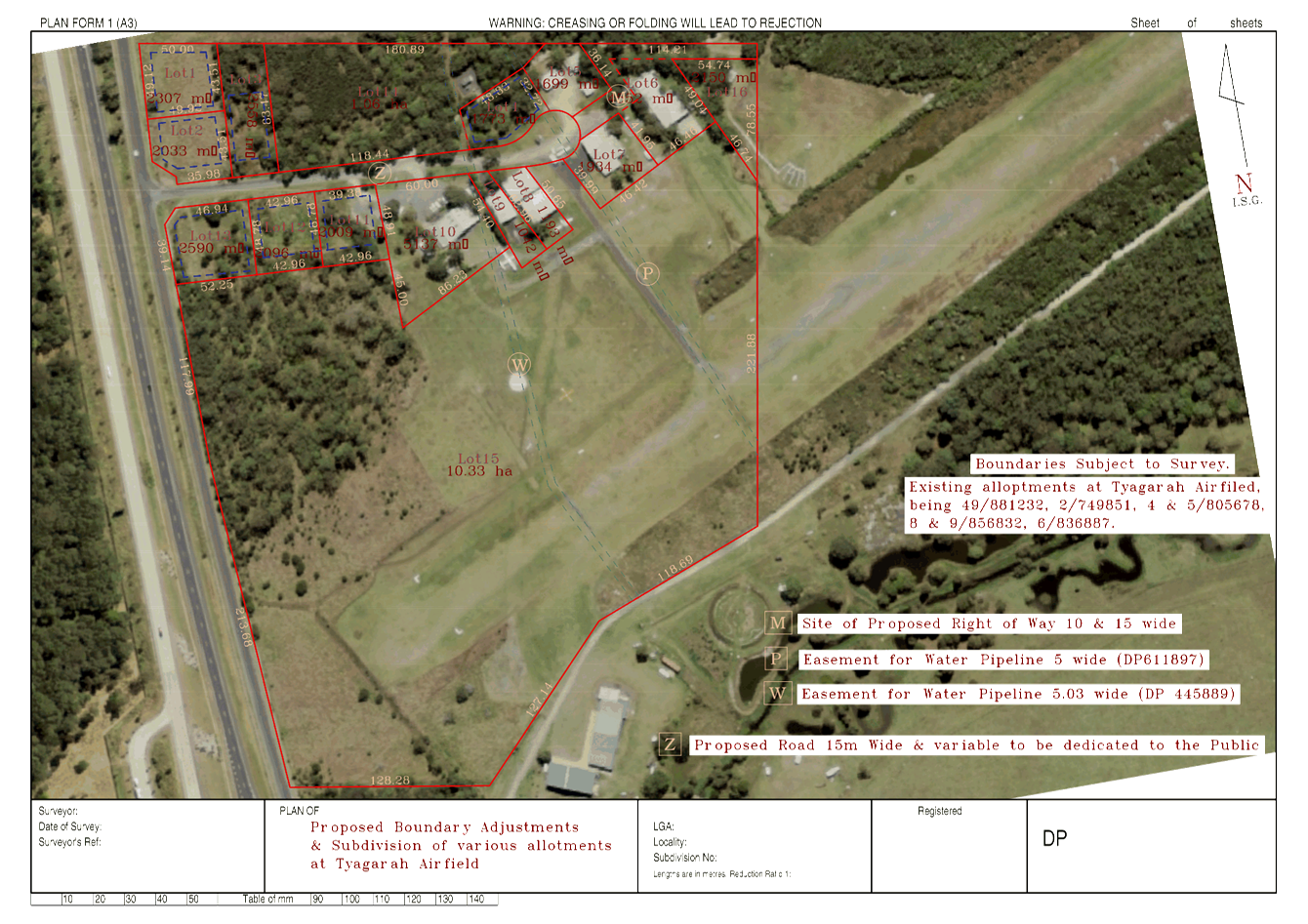
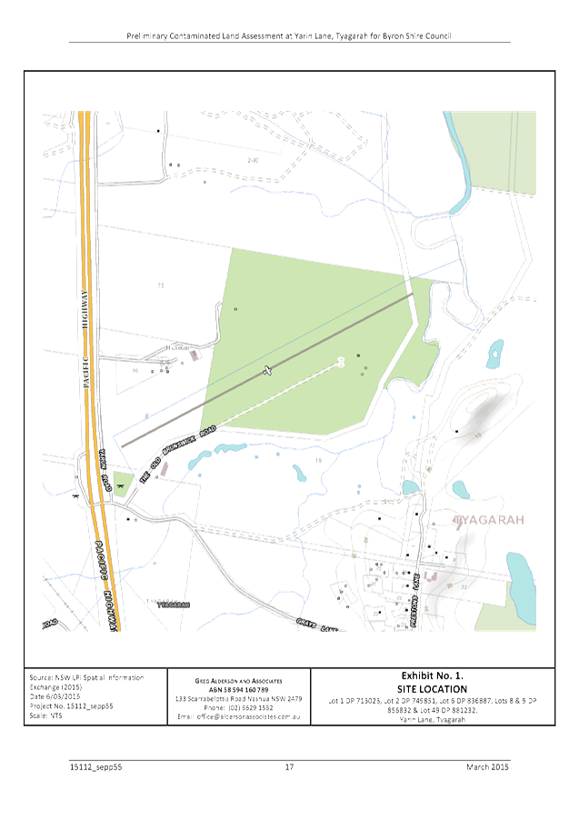
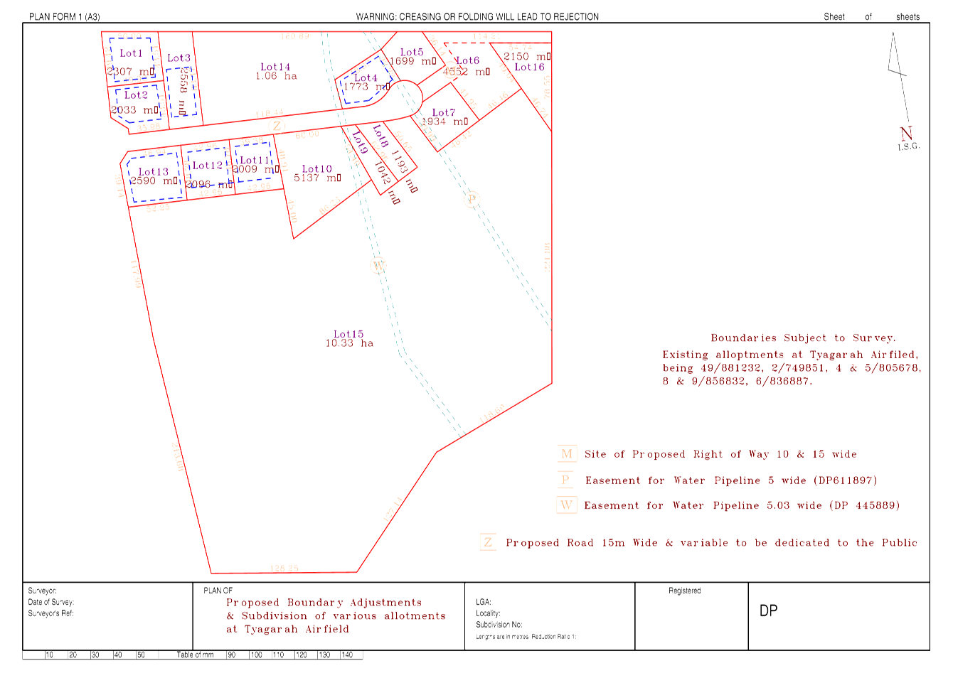
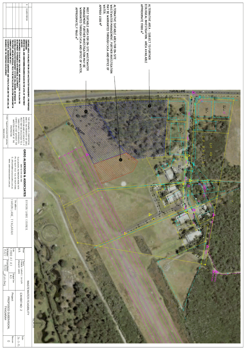
CONDITIONS
OF CONSENT:
Parameters of this
Consent
1) Development is to be in
accordance with approved plans
The development is to be in accordance with plans listed
below:
|
Plan No.
|
Description
|
Prepared by
|
Dated:
|
|
0100
(Issue 1)
|
Existing site + existing roof plan (demolition plan)
|
Shane Thompson
|
13/08/15
|
|
0101
(Issue 1)
|
Existing ground floor plan
(demolition plan)
|
Shane Thompson
|
13/08/15
|
|
0102
(Issue 1)
|
Existing level 1 plan
(demolition plan)
|
Shane Thompson
|
13/08/15
|
|
0200
(Issue 1)
|
Existing / demolition elevations
|
Shane Thompson
|
13/08/15
|
|
0201
(Issue 1)
|
Existing / demolition elevations
|
Shane Thompson
|
13/08/15
|
|
1100
(Issue 3)
|
Proposed roof
|
Shane Thompson
|
13/08/15
|
|
1101
(Issue 4)
|
Proposed basement
|
Shane Thompson
|
13/08/15
|
|
1102
(Issue 4)
|
Proposed ground floor
|
Shane Thompson
|
13/08/15
|
|
1103
(Issue 4)
|
Proposed level 1
|
Shane Thompson
|
13/08/15
|
|
1104
(Issue 4)
|
Proposed level 2
|
Shane Thompson
|
13/08/15
|
|
2000
(Issue 2)
|
Proposed elevations
|
Shane Thompson
|
13/08/15
|
|
2001
(Issue 2)
|
Proposed elevations
|
Shane Thompson
|
13/08/15
|
|
3000
(Issue 1)
|
Proposed sections
|
Shane Thompson
|
13/08/15
|
|
3001
(Issue 2)
|
Proposed sections
|
Shane Thompson
|
13/08/15
|
|
15/242-01
|
Design Intent and Plant Schedule
|
Design Team Ink
|
03.08.15
|
|
15/242-02
|
Landscape Concept Plan Sheet 1
|
Design Team Ink
|
03.08.15
|
|
15/242-03
|
Landscape Concept Plan Sheet 2
|
Design Team Ink
|
03.08.15
|
|
15/242-04
|
General Notes
|
Design Team Ink
|
03.08.15
|
|
7853
|
Soil and Water Management Plan
|
Ardill Payne & Partners
|
July 2015 (as amended 28/10/15
|
|
7853
|
Acid Sulfate Soils Contingency Plan
|
Ardill Payne & Partners
|
October 2015
|
|
15106
|
Environmental Noise Report
|
CRG Acoustics
|
6 August 2015
|
|
|
Social Impact Assessment
|
Planning Resolutions
|
August 2015
|
The development is also to be in accordance with any changes
shown in red ink on the approved plans or conditions of consent.
The approved plans and related documents endorsed with the
Council stamp and authorised signature must be kept on site at all times while
work is being undertaken.
2) Shoring and adequacy
of adjoining property
For the purposes of section 80A (11) of the Act, it is a
prescribed condition of development consent that if the development involves an
excavation that extends below the level of the base of the footings of a
building, structure or work (including any structure or work within a road or
rail corridor) on adjoining land, the person having the benefit of the
development consent must, at the person’s own expense:
(a) protect and support the building, structure
or work from possible damage from the excavation, and
(b) where necessary, underpin the building,
structure or work to prevent any such damage.
3) Compliance with Building
Code of Australia and insurance requirements under the Home Building Act 1989
(1) For the purposes of section 80A (11) of the Act, the following
conditions are prescribed in relation to a development consent for development
that involves any building work:
(a) that the work must be carried
out in accordance with the requirements of the Building Code of Australia ,
(b) in the case of residential
building work for which the Home Building Act 1989
requires there to be a contract of insurance in force in accordance with Part 6
of that Act, that such a contract of insurance is in force before any building
work authorised to be carried out by the consent commences.
(2) This clause does not apply:
(a) to the extent to which an
exemption is in force under clause 187 or 188,
subject to the terms of any condition or requirement referred to in clause 187 (6) or 188
(4), or
(b) to the erection of a temporary
building.
(3) In this clause, a reference to
the Building Code of Australia is a reference to that Code as in force on the
date the application for the
relevant construction certificate is made.
4) Erection of signs
(1) For the purposes of section 80A (11) of the Act, the
requirements of subclauses (2) and (3) are prescribed as conditions of a
development consent for development that involves any building work,
subdivision work or demolition work.
(2) A sign must be erected in a prominent
position on any site on which building work, subdivision work or demolition
work is being carried out:
(a) showing the name, address and
telephone number of the principal certifying authority for the work, and
(b) showing the name of the
principal contractor (if any) for any building work and a telephone number on
which that person may be contacted outside working hours, and
(c) stating that unauthorised entry
to the work site is prohibited.
(3) Any such sign is to be
maintained while the building work, subdivision work or demolition work is
being carried out, but must be removed when the work has been completed.
(4) This clause does not apply
in relation to building work, subdivision work or demolition work that is
carried out inside an existing building that does not affect the external walls
of the building.
(5) This clause does not apply
in relation to Crown building work that is certified, in accordance with
Section 109R of the Act, to comply
with the technical provisions of the State’s building laws.
(6) This clause applies to a
development consent granted before 1 July 2004 only if the building work,
subdivision work or demolition work involved had not been commenced by that
date.
Note: Principal certifying authorities and principal
contractors must also ensure that signs required by this clause are
erected and maintained (see clause 227A
which currently imposes a maximum penalty of $1,100).
5) New South Wales
Food Act 2003 and Food Regulation 2010
The kitchen must be operated and maintained to ensure that
the requirements of the Food Act 2003 and Food Regulation 2010
(incorporating Food Standard Code) are satisfied at all times. Access to
the Food Standard Code is available at http://www.foodstandards.gov.au
The operator is required to ensure that the business is registered
with the NSW Food Authority. Notification may be carried out or updated when
required at http://www.foodnotify.nsw.gov.au
6) Neighbourhood
Amenity
The use of the development must not interfere with the
amenity of the neighbourhood by reason of noise, vibration, smell, fumes,
smoke, dust, wastewater or otherwise. The development must comply with the
following:
a) The noise
level emanating from the use of the development must comply with the New South
Wales Industrial Noise Policy prepared by NSW EPA 2000.
b) All
guests and staff must be made aware that they must keep noise levels down to
maintain neighbourhood amenity.
c) No glass
recycling to be emptied between 8pm and 8am any day;
d) An
external walk around to be performed by night staff every hour between 9pm and
4am to stay on top of any noise;
e) 9pm,
kitchen cleaner to close all louvers in both male bathrooms to control noise;
f) Night
staff to try and encourage staggered departures by enforcing no alcohol from
10pm and quiet time from 11pm in outdoor common areas; and
g) Morning
cleaner to do a walk around building after sweeping and collect rubbish from
gardens and across the road on the Council reserve.
7) Pool safety sign
The occupier of the premises must ensure that there is at
all times a sign in the immediate vicinity of the swimming pool bearing the words
‘Young children must be supervised when using this swimming pool’.
The sign is to be a prominent position and be otherwise in accordance with
clause 9 of the Swimming Pools Regulation, or similar.
8) Swimming pool health
requirements
The swimming pool water is to be re-circulated, filtered and
disinfected in accordance with the requirements of Council and NSW
Health. The swimming pool water is to be maintained at satisfactory
levels of purity for bathing at all times
The following conditions
are to be complied with prior to issue of a Construction Certificate
9) Existing building to
comply with fire safety provisions
In accordance with Clause 94 of Environmental Planning &
Assessment Regulation 2000, the existing building is to be brought if necessary
into compliance with the fire protection and structural provisions of the
Building Code of Australia.
10) Geotechnical Report required
– Building Works
A certificate from a professional Engineer experienced in
Geotechnical Science is to be provided to the Principal Certifying Authority,
certifying that the site is stable and will not be affected by landslide or
subsidence at, above or below the site when the building is erected. The
certificate must be prepared in accordance with AS 1726.
11) Plans of retaining walls and
drainage
The application for a Construction Certificate is to include
plans and specifications that indicate retaining walls or other approved
methods of preventing movement of the soil, where any excavation or filled area
exceeds 600mm in height. Adequate provision must be made for drainage.
Such plans and specifications must be approved as part of
the Construction Certificate.
12) Sediment and Erosion Control
Management Plan required
The application for a Construction Certificate is to include
plans and specifications that indicate the measures to be employed to control
erosion and loss of sediment from the site. Control over discharge of
stormwater and containment of run-off and pollutants leaving the site/premises
must be undertaken through the installation of erosion control devices such as
catch drains, energy dissipaters, level spreaders and sediment control devices
such as filter fences and sedimentation basins.
Such plans and specifications must be approved as part of
the Construction Certificate.
NOTE: The plans must be in compliance with
Council's current “Northern Rivers Local Government Development Design
& Construction Manuals and Standard Drawings”.
13) On-site stormwater detention -
Section 68 approval required
An approval under Section 68 of the Local Government Act
1993 to carry out on-site detention drainage system and connection to a Council
approved drainage system.
Note: The plans must be in compliance with
Council’s Development Control Plan 2010, Part N and Council’s
current “Northern Rivers Local Government Development Design &
Construction Manuals and Standard Drawings”. Refer to Council’s
website for copies of these documents.
14) Consent required for works within
the road reserve
Consent from Council must be obtained for works within the
road reserve pursuant to Section 138 of the Roads Act 1993. Three (3) copies of
engineering construction plans must accompany the application for consent for
works within the road reserve.
Such plans are to be in accordance with Council’s
current Design & Construction Manuals and are to provide for the following
works:
|
Driveway
|
A driveway(s) in accordance with Council's current
“Northern Rivers Local Government Development Design & Construction
Manuals and Standard Drawings”. Generally conform to the Concept Plan
prepared by Ardill Payne 7853/SK1 B
|
15) Traffic Management Plan
Consent from Council must be obtained for a Traffic
Management Plan pursuant to Section 138 of the Roads Act 1993. The plans and
specifications are to include the measures to be employed to control traffic
(inclusive of construction vehicles) during construction of the development.
The traffic control plan is to be designed in accordance with the requirements
of the Roads and Traffic Authority’s Manual, Traffic Control at Work
Sites Version 2, and the current Australian Standards, Manual of Uniform
Traffic Control Devices Part 3, ‘Traffic Control Devices for Works on
Roads’.
“The plan shall incorporate measures to ensure that
motorists using road adjacent to the development, residents and pedestrians in
the vicinity of the development are subjected to minimal time delays due to
construction on the site or adjacent to the site”.
The traffic control plan must be prepared by a suitably
qualified and RTA accredited Work Site Traffic Controller.
16) Car parking layout, vehicle
circulation and access plans required.
The application for a Construction Certificate is to include
plans and specification that indicate access, parking and manoeuvring details
in accordance with the plans approved by this consent.
The access, parking and manoeuvring for the site is to
comply with the requirements of Council’s Development Control Plan 2014,
AS 2890.1-2004: Parking facilities, Part 1: Off-street car parking and AS
2890.2 – 2010 - Parking facilities, Part 2: Off-street commercial vehicle
facilities. Plans are to include, but not be limited to, the following items:
a) pavement
description;
b) site
conditions affecting the access;
c) existing
and design levels;
d) longitudinal
section from the road centreline to the car space(s);
e) drainage
(pipes, pits, on-site detention, etc.);
f) turning
paths;
g) linemarking
and signage.
The engineering plans and specifications are to be designed
by a qualified practising Civil Engineer. The Civil Engineer is to be a
corporate member of the Institution of Engineers Australia or is to be eligible
to become a corporate member and have appropriate experience and competence in
the related field.
Signage shall be provided at the street frontage of the
driveway advising users to give way to exiting vehicles.
Car Park #8 as notated on Ardill Payne Plan 7853/SK1 shall
be used as a manoeuvring area and shall be signed as no parking or no standing.
2 Disabled Car Parking spaces must be provided within the subject allotment
(Note: Minimum floor to ceiling height for accessible parking spaces is 2.5m)
Such plans and specifications must be approved as part of
the Construction Certificate.
NOTE: The plans must be in compliance with
Council's current “Northern Rivers Local Government Development Design
& Construction Manuals and Standard Drawings”.
17) Access and facilities for disabled
The application for a Construction Certificate is to include
plans and specifications that indicate access and facilities for persons with
access disabilities to and within the development in accordance with AS 1428.1
- Design for Access and Mobility and Part D3 of the Building Code of Australia.
Such plans and specifications must be approved as part of the Construction
Certificate.
18) Dilapidation Report
The submission of a certified report from suitably qualified
and practising geotechnical and structural engineers, certifying that the
method of construction will not adversely impact/effect the structural
integrity and support of the neighbouring buildings and associated private and
public infrastructure within the zone of influence of the construction
site. The report is to also address the current structural state of those
buildings and infrastructure.
The engineers are to be Corporate Members of the Institution
of Engineers Australia.
19) Section 94A Levy to be paid
Prior to the issue of a construction certificate the section
94A levy required by the Byron Developer Contributions Plan2012 shall be paid
to Council.
The levy will be calculated as follows: Levy payable = %C
x $C
Where: %C is
the levy rate applicable as set out in the latest Ministerial Direction issued
under section 94E.
$C is
the proposed cost of carrying out the development.
The rate of %C is:
|
Proposed cost of the
development
|
Maximum percentage of the
levy
|
|
Up to $100,000
|
Nil
|
|
$100,001–$200,000
|
0.5 percent
|
|
More than $200,000
|
1.0 percent
|
The cost of development shall be
shall be calculated in accordance with clause 25J of the regulation. The
Cost Summary Report (copy attached) as set out in schedule 2 of the Section 94A
contributions plan shall be submitted to Council with the with the payment.
Copies of Cost Summary Report are available at Council’s main office or
may be downloaded from http://www.byron.nsw.gov.au/
As an alternative to the
provision of the cost summary report prepared by a quantity surveyor Council
will accept the contract price for the construction.
20) Site Waste Minimisation and
Management Plan
Chapter B8 of Byron Shire Development Control Plan 2014 (DCP
2014) aims to facilitate sustainable waste management in a manner consistent
with the principles of Ecologically Sustainable Development. Prior to the issue
of a Construction Certificate, a Site Waste Minimisation and Management Plan
(SWMMP) must be submitted outlining measures to minimise and manage waste
generated during demolition, construction and the ongoing operation and use of
the development. The SWMMP must specify the proposed method of recycling or
disposal and the waste management service provider.
A template is provided on Council’s website to assist
in providing this information www.byron.nsw.gov.au/files/publication/swmmp -
pro-forma-.doc
21) Garbage store area to be provided
The application for a Construction Certificate is to include
plans and specifications that indicate the proposed garbage store area. The
proposed garbage store area is to be designed and constructed in accordance
with the requirements of Chapter B8 of the Byron Shire Council Development
Control Plan 2014. The enclosure must incorporate a concrete base with
enclosure of suitable materials to provide adequate site and top screening and
visual integration with the buildings and landscape treatment.
22) Water and Sewerage - Section 68
approval required
An approval under Section 68 of the Local Government
Act 1993 to carry out water supply work and sewerage work must be obtained.
23) Trade Waste - Section 68 approval
required
An approval under Section 68 of the Local Government
Act 1993 to discharge trade waste into Council’s sewer must be obtained
in accordance with NSW Office of Water Liquid Trade Waste Regulations
Guidelines 2009, Council’s Liquid Trade Waste Policy and Liquid Trade
Waste Guidelines.
Commercial, business, trade and industrial activities
discharging or proposing to discharge to the sewer are required to notify
Council and complete the Trade Waste Registration Form available at the
Mullumbimby Office and from Council’s website at: http://www.byron.nsw.gov.au/files/publications/liquid_trade_waste_application_form_0.pdf
24) Certificate of Compliance –
Water Management Act 2000
A Certificate of Compliance will be issued upon payment of
developer charges for water and sewer as calculated in accordance with Byron
Shire Council and Rous Water Development Servicing Plans.
Byron Shire Council acts as Rous Water’s agent in this
matter and will issue a Certificate of Compliance on behalf of Rous Water upon
payment of the Rous Water Development Servicing Charge to this Council.
Note: Copies of the
application forms for Certificates of Compliance are available on
Council’s website http://www.byron.nsw.gov.au/files/Forms/Section_305_Certificate.pdf
or from Council’s Administration Office. Copies of Byron Shire
Council’s Development Servicing Plans are available at Council’s
Administration Office.
Developer charges will be calculated in
accordance with the Development Servicing Plan applicable at the date of
payment. A check must be made with Council to ascertain the current rates by
contacting Council’s Principal Engineer Systems Planning, Water on 02
6626 7081. Applicable charges can be found on Council’s website: http://www.byron.nsw.gov.au/development-contributions-plans-section-94-and-64
The contributions payable will be adjusted in accordance
with relevant plan and the amount payable will be calculated on the basis of
the contribution rates that are applicable at the time of payment.
Payment by Personal or Company Cheque will not be accepted.
25) Details of onsite mechanical plant design to be
submitted for approval
Mechanical plant must be designed and installed to comply
with noise criterion recommended in Section 4.0 of Environmental Noise Impact
Report prepared by CRG Acoustics dated 6th August 2015.
Details and specifications must be accompanied by an acoustic assessment report
from a suitably qualified acoustic consultant and must be approved as part of
the Construction Certificate for building works.
26) Details of acoustic treatments for
building construction to be submitted for approval
The application for a construction certificate must include
plans and specifications that demonstrate the inclusion of acoustic treatments
recommended in Section 6.0 of Environmental Noise Impact Report prepared by CRG
Acoustics dated 6th August 2015. Such plans and specifications
must be approved as part of the Construction Certificate for building works.
27) Environmental Management
Plan
An Environmental Management Plan (EMP) must be submitted to
Council for approval prior to the issue of the construction certificate for
building works. The EMP must detail the methods that will be implemented
for the whole project and:
a) be
prepared by a suitably qualified professional;
b) contain
details of measures to be undertaken to ensure that construction works do not
result in any off-site impacts, including those that could interfere with
neighbourhood amenity;
c) include
a Waste Management Strategy that details the management of building wastes
created as a result of the construction including on-site storage and disposal
of building wastes; and
d) include
details of complaints handling process.
28) Noise Management Plan
A Noise Management Plan must be submitted to Council for
approval prior to the issue of the construction certificate for building
works. The Noise Management Plan must detail the methods that will be
implemented for the whole project to minimise construction noise. Information
must include:
a) identification
of nearby residences and other sensitive land uses;
b) assessment
of expected noise impacts;
c) detailed
examination of feasible and reasonable work practices that will be implemented
to minimise noise impacts;
d) strategies
to promptly deal with and address noise complaints;
e) details
of performance evaluating procedures (for example, noise monitoring or checking
work practices and equipment);
f) procedures
for notifying nearby residents of forthcoming works that are likely to produce
noise impacts;
g) reference
to relevant consent conditions; and
h) name
and qualifications of person who prepared the report.
Note: Refer to DECC’s ‘Interim Construction
Noise Guideline’ (2009) for more information (see http://www.environment.nsw.gov.au/noise/constructnoise.htm).
29) Details of pool fence required
The application for a Construction Certificate is to include
plans and specifications that indicate the details of the fence around the
swimming pool in accordance with the Swimming Pools Act 1992 and AS1926.1. Such
plans and specifications must be approved as part of the Construction
Certificate.
30) Dewatering Management Plan required
Dewatering Management Plan to be submitted to Council for
approval prior to issue of the Construction Certificate. This Plan must
take into account the findings any approved Soils and Water Management Plan and
approved Acid Sulfate Soils Contingency Plan and include the following:
· copy
of licence from the NSW Department of NSW Office of Water for the dewatering of
excavations and any associated groundwater monitoring bores;
· water
quality criteria for waters to be discharged to the stormwater system, to be
derived from ANZECC / ARMCANZ (2000) Fresh and Marine Water Quality Guidelines
95 % species protection trigger levels for freshwaters, or similar. Parameters
to include, but not be limited to, pH, electrical conductivity, dissolved
oxygen, total suspended solids, turbidity, ammonia, oxidised nitrogen (NOx),
Total Nitrogen (TN), Filterable Reactive Phosphorus, Total Phosphorus, Total
Petroleum Hydrocarbons, Benzene, toluene, ethyl benzene, xylene (BTEX),
Polycyclic Aromatic Hydrocarbons (PAHs) and Aluminium;
· details
of proposed water treatment prior to discharge to ensure compliance with the
above water quality criteria, including those that are manual and automated;
· details
of water sampling methodologies and frequencies for each parameter;
· details
of disposal methods if water does not comply with above criteria; and
· details
of a 24-hour contact person and telephone number for complaints.
31) Groundwater Contingency Management
Plan required
Application for a construction certificate is to include a
Groundwater Contingency Management Plan. This Plan must take into account the
findings any approved Soils and Water Management Plan and approved Acid Sulfate
Soils Contingency Plan. The Plan must be prepared by a suitably qualified
Environmental / Soil Scientist and approved as part of the Construction
Certificate application.
32) Unexpected Findings Protocol -
Contamination & Remediation
An Unexpected Findings Protocol (UFP) must be prepared and
submitted to Council for approval prior to the issue of Construction
Certificate. The UFP must be prepared by a suitable qualified person
experienced in matters relating to Contamination of Land and Remediation, to
the satisfaction of Council’s Director of Planning, Development and
Environment.
The following conditions
are to be complied with prior to commencement of building or demolition works
33) Disconnection of existing water and
sewer prior to demolition
Existing water and sewer services
must located on site and be properly capped at the main by a licensed
plumber. All water and sewer disconnections must be inspected by
the Byron Shire Council inspectors prior to backfilling.
- If a property is
demolished and no longer needs water supply and/or a sewerage service, a
licensed plumber must disconnect the service at the main (also known as
'capping the service').. The plumber must also return the water meter to
Council’s inspector at the time of inspection.
- If your development involves consolidating lots and you
don’t need all the existing services, you
must correctly disconnect them. This ensures that you aren’t billed for
unused services and helps avoid future hidden leaks.
Your Plumber must obtain a Plumbing Permit at least
two (2) working days prior to commencing work. Please forward an
Application for a Plumbing Permit to your plumber to complete and to return to
Council prior to commencement of disconnection works. Refer to http://www.byron.nsw.gov.au/files/Forms/Plumbing_Drainage_Permit.pdf.
The following conditions
are to be complied with during construction/demolition
34) Demolition work
The existing dwelling house structure is to be demolished in
accordance with AS 2601 - Australian Standard AS 2601-
1991: The Demolition of Structures, published by Standards Australia,
and as in force at 1 July 1993.
35) Construction Traffic
The construction works must be managed to ensure safe and
efficient movement of construction related vehicles onto, off and within the
construction site, whilst minimising disruptions/impacts and maintaining a safe
environment for vehicular and pedestrian traffic external to the site during
the construction phases. Any proposal to regulate traffic on the public road
must obtain separate approval from Council of a traffic management plan under
section 138 of the Roads Act 1993.
36) Construction/demolition times
Construction/demolition works must not unreasonably
interfere with the amenity of the neighbourhood. In particular
construction/demolition noise, when audible on adjoining residential premises,
can only occur:
a) Monday
to Friday, from 7 am to 6 pm.
b) Saturday,
from 8 am to 1 pm.
c) No
construction/demolition work to take place on Sundays or Public Holidays.
37) Construction/demolition noise
Construction/demolition noise is to be limited as follows:
d) For
construction/demolition periods of four (4) weeks and under, the L10 noise
level measured over a period of not less than fifteen (15) minutes when the
construction/demolition site is in operation must not exceed the background
level by more than 20 dB(A).
e) For
construction/demolition periods greater than four (4) weeks and not exceeding
twenty six (26) weeks, the L10 noise level measured over a period of not less
than fifteen (15) minutes when the construction site is in operation must not
exceed the background level by more than 10 dB(A).
38) Builders rubbish to be contained on
site
All builders rubbish is to be contained on the site in a
‘Builders Skips’ or an enclosure. Footpaths, road reserves and
public reserves are to be maintained clear of rubbish, building materials and
all other items.
39) Maintenance of sediment and erosion
control measures
Sediment and erosion control measures must be maintained at
all times until the site has been stabilised by permanent vegetation cover or
hard surface.
40) Prevention of water pollution
Only clean and unpolluted water is to be discharged to
Council’s stormwater drainage system or any watercourse to ensure
compliance with the Protection of Environment Operations Act.
41) Approved Environmental Plans must
be implemented
All controls and measures
must be maintained in accordance with the following approved plans:
· Acid
Sulfate Soils Contingency Plan
· Soil
and Water Management Plan
· Environmental
Management Plan
· Noise
Management Plan
· Groundwater
Contingency Management Plan
· Dewatering
Management Plan
· Unexpected
Findings Protocol - Contamination & Remediation
The applicant is required to
ensure that the construction management and all construction staff must be made
aware of their responsibility to abide by the plans.
42) Dewatering of Excavations
Dewatering of excavations must
be conducted in accordance with the approved dewatering plan. Only clean
and unpolluted water is to be discharged to Council’s stormwater drainage
system or any watercourse to ensure compliance with the Protection of
Environment Operations Act.
43) Demolition, construction and building
wastes
All wastes, including asbestos and lead-contaminated wastes,
associated with these works are to be handled and disposed of in accordance
with the requirements of the Work Cover Authority. The applicant/owner is to
produce documentary evidence that this condition has been met. Wastes must be
disposed of at a Licensed Waste Facility. All wastes removed from the
site must be managed and disposed of in accordance with NSW DECC Waste
Classification Guidelines (2014) www.environment.nsw.gov.au/resources/waste/08202classifyingwaste.pdf
44) All excavated soils to be disposed
of off-site
All excavated soils to be
disposed of off-site and in accordance with NSW DECC Waste Classification
Guidelines (2014) and approved environmental management plans.
45) Support for neighbouring buildings
If an excavation extends
below the level of the base of the footings of a building on an adjoining
allotment of land, the person causing the excavation to be made:
a) must
preserve and protect the adjoining building from damage;
b) if
necessary, must underpin and support the building in an approved manner;
c) must,
at least 7 days before excavating below the level of the base of the footings of
a building on an adjoining allotment of land, give notice of intention to do so
to the owner of the adjoining allotment of land and furnish particulars of the
excavation to the owner of the building being erected or demolished.
The owner of the adjoining allotment of land, public road or
any other public place is not to be held liable for any part of the cost of
work carried out, whether carried out on the allotment of land being excavated
or on the public road, any other public place or the adjoining allotment of
land.
46) Sound proofing
Division walls between
attached dormitories must be of sound resisting materials constructed with
minimum sound transmission loss in accordance with the Building Code of
Australia.
The following conditions
are to be complied with prior to issue of a Final Occupation Certificate
47) Works to be completed prior to
issue of a Final Occupation Certificate
All of the works (including landscape works and bush fire
mitigation measures specified within the Bush Fire Safety Authority) indicated
on the plans and approved by this consent, including any other consents that
are necessary for the completion of this development, are to be completed and
approved by the relevant consent authority/s prior to the issue of a Final
Occupation Certificate.
Any Security bond paid for this application will be held
until Council is satisfied that no further works are to be carried out that may
result in damage to Councils road/footpath reserve.
48) Public Art
Public art is to be provided in
accordance with Byron Development Control Plan 2010, Chapter 1 Part E. All art
work is to be provided and installed in accordance with Council’s
Development Control Plan 2010 prior to issue of the Occupation
Certificate. Evidence of Public Art expenditure to a minimum cost of
$25,000.00 is to be provided prior to the issue of the Occupation Certificate.
49) Dilapidation Report
The submission of a certified report from suitably qualified
and practising geotechnical and structural engineers, certifying what, if any,
impacts/effects that the completed development has had on the neighbouring
buildings and associated private and public infrastructure within the zone of
influence of the construction site. The report is to also address what
measures are to be implemented, and in what time frame, to rectify any such
identified defects. The engineers are to be Corporate Members of the Institution
of Engineers Australia.
50) Mechanical plant noise attenuation
A suitably qualified acoustic consultant must certify that
noise treatment measures have been constructed in order to achieve compliance
with the noise criterion recommended in Section 4.0 of Environmental Noise
Impact Report prepared by CRG Acoustics dated 6th August 2015.
Certification must be submitted to Council prior to the
issue of an Occupation Certificate.
51) Certification required
The works engineer must certify to the Principal Certifying
Authority that all works have been carried out in accordance with the approved
Environmental Management Plans including:
· Acid
Sulfate Soils Contingency Plan
· Soil
and Water Management Plan
· Environmental
Management Plan
· Noise
Management Plan
· Groundwater
Contingency Management Plan
· Dewatering
Management Plan
· Unexpected
Findings Protocol - Contamination & Remediation
52) Compliance with the NSW Food Act
and Food Regulation
The kitchen must be constructed to comply with the New South
Wales Food Act 2003 and Food Regulation 2010. Requirements of Food Standard
Code 3.2.3 and Australian Standard AS4674 – 2004 “Design,
construction and fit-out of food premises” to be considered to
achieve the necessary construction standards.
53) Unexpected Findings Protocol -
Contamination & Remediation
The works engineer must
certify to the Principal Certifying Authority that all works have been carried
out in accordance with the approved Unexpected Findings Protocol (UFP).
54) Signs required
A sign must be erected in a prominent position within the
existing ablution rooms displaying the following words, or words to that
effect: “NOISE LEVELS - please RESPECT our NEIGHBOURS”.
55) Stormwater drainage –
Certification of works
a) Stormwater
must be collected and disposed of in a controlled manner in accordance with the
approval granted to an application under Section 68 of the Local Government Act
1993.
b) Certificates,
such as ‘hydraulic/hydrological compliance’ and ‘structural
adequacy’ must be submitted to the Principal Certifying Authority (PCA)
prior to occupation.
c) The
certificates are to be from a suitably qualified engineer certifying that all
works have been constructed in accordance with the approved plans,
Council’s current ‘Design & Construction Manuals, Section 68
Approvals and Part N of DCP 2010 (Certificate of Compliance form).
· To ensure access for people with access disabilities.
· To comply with the provisions of relevant Environmental Planning
Instruments.
· To preserve the environment and existing or likely future amenity of
the neighbourhood.
· To protect the environment.
· To preserve the amenity of the area.
· To ensure adequacy of services to the development.
· To ensure public health and safety.
· To ensure compliance with Section 68 of the Local Government Act
1993.
Consent granted under the Roads Act 1993
The following works in
the road reserve are granted consent pursuant to Section 138 of the Roads Act
1993.
· Gutter crossing and driveway from the kerb to the
property boundary.
This consent is issued
by Byron Shire Council, being the road authority, for the above proposed works
and/or structures subject to the following conditions:
1) Gutter
crossing and driveway are to be constructed in accordance with Council's
current “Northern Rivers Local Government Development Design &
Construction Manuals and Standard Drawings”.
2) All
work is to be in accordance with Council’s adopted standards.
3) Twenty
four hours notice must be given for the following required inspections:
a) upon
placing of all formwork and reinforcement, prior to pouring concrete, and
b) upon
completion of all work.
4) All
care is to be taken to ensure the safety of the public in general, road users,
pedestrians and adjoining property. The developer and/or contractor must
produce evidence to Council of Public Liability Insurance cover for a minimum
of $10 Million prior to the commencement of any works. Council is to be
named as a Principal in the policy. Council is not be held responsible
for any negligence caused by the undertaking of the works.
Please contact
Council’s Local Approvals and Certification Officer for the booking of
inspections on (02) 6626 7050.
Water payments under the Water Management Act 2000
Charges will be calculated based
on the additional water and sewerage load that the proposed development
generates, shown in Equivalent Tenements (ET) by the following table:
ADDITIONAL
WATER & SEWER LOAD OF DEVELOPMENT
(ET Policy No:13/005)
|
Water
|
13.96 ET
|
|
Bulk Water
|
13.96 ET
|
|
Sewer
|
21.39 ET
|
NB: Information regarding Development Servicing charges can
be found on the Byron Shire Council website (http://www.byron.nsw.gov.au/development-contributions-plans-section-94-and-64).
These charges will enable you to calculate the total contribution charges
payable when you are ready to pay them. Developer charges will be
calculated in accordance with the Development Servicing Plan applicable at the
date of payment.
NSW Office of Water
The Statement of Environmental Effects indicates the likely
need for dewatering. Any take of water as a result of minor temporary
dewatering activities that is estimated to be less than 3 megalitres per year
(3ML/yr) will generally not require a licence or approval from DPI Water.
It is the applicant's responsibility to assess and monitor
water take and impacts, and to advise DPI Water if they exceed these
conditions, at which time a licence must be obtained. The applicant must also
meet all requirements of other agencies and consent authorities as per usual.
If it is the applicant's estimation that water take will
exceed 3ML/yr then they must apply for a licence under Part 5 of the Water Act
1912 prior to commencing the activity. DPI Water would require the following
additional information prior to accepting a licence application:
o
More detailed information on the proposed/required depth of dewatering and
proposed/required depth of excavation at the site.
o
A table specifically committing to discharge water quality criteria should be
produced as part of the soil and water management plan, rather than referencing
a table showing background results for the receiving environment, ie. a table
committing to pH 6.16 —6.54 etc.
o
It is unclear how records will be kept for compliance purposes from the inline
meter and dossing operation. Further information should be supplied in this
regard. In addition, it is the applicant's responsibility to ensure that post
construction dewatering is not required. Further information on controlled
activity approvals under the Water Management Act 2000 can be obtained from the
Office of Water's website.
Protection
of the Environment Operations Act 1997:
It is an offence under the
provisions of the Protection of the Environment Operations Act 1997 to act in a
manner causing, or likely to cause, harm to the environment. Anyone allowing
material to enter a waterway or leaving material where it can be washed
off-site may be subject to a penalty infringement notice (“on-the-spot
fine”) or prosecution.
SCHEDULE
2
Cost
Summary Report
[Development
Cost greater than $500,000]
DA /CC/CDC No.........................................................................................................................
DATE:..........................................................................................................................................
APPLICANT’S NAME:................................................................................................................
APPLICANT’S ADDRESS:.........................................................................................................
DEVELOPMENT DETAILS:.......................................................................................................
DEVELOPMENT ADDRESS:....................................................................................................
ANALYSIS OF DEVELOPMENT COSTS:
|
Gross Floor Area –
Commercial
|
m2
|
Gross Floor Area –
Other
|
m2
|
|
Gross Floor Area –
Retail
|
m2
|
Total Gross Floor Area
|
m2
|
|
Gross Floor Area –
Car Parking
|
m2
|
Total Site Area
|
m2
|
|
Total Development Cost
|
$
|
Total Car Parking - Spaces
|
|
|
Total Construction Cost
|
$
|
|
|
|
Total GST
|
$
|
|
|
I certify that I have:
· inspected
the plans the subject of the application for development consent or
construction certificate.
· calculated
the development costs in accordance with the definition of development costs in
clause 25J of the Environmental Planning and Assessment Regulation 2000 at
current prices.
· included
GST in the calculation of development cost.
Signed: .........................................................................................................................................
Date: ..............................................................................................................................................
Name: ...........................................................................................................................................
Phone: ..........................................................................................................................................
Position and Qualifications: .....................................................................................................
Address:

PLANNING
PROPOSAL FOR SECONDARY DWELLINGS
IN RU5 VILLAGE ZONE
(Byron Shire Council)
GATEWAY
VERSION (#E2015/13874)
(Authority ref: 26.2015.2.1)
3 March 2015
This page has been intentionally left blank
Contents
Introduction.. 4
Purpose……….. 4
Property details and
existing zones. 4
Background… ……………………………………………………………………………………4
Part
1 Objectives and intended outcomes. 6
Part
2 Explanation of provisions. 6
Part
3 Justification.. 6
Section A Need for the planning proposal 6
1 Is the planning proposal a result of any strategic
study or report?. 6
2 Is the planning proposal the best means of achieving
the objectives or intended outcomes, or is there a better way?. 6
3 Is there a net community benefit?. 6
Section B Relationship to strategic planning framework. 6
1 Is the planning proposal consistent with the
objectives and actions contained within the applicable regional or sub-regional
strategy (in this case the Far North Coast Regional Strategy)?. 6
2 Is the planning proposal consistent with the local
Council’s Community Strategic Plan, or other local strategic plan?. 7
3 Is the planning proposal consistent with the
applicable State Environmental Planning Policies (SEPPs)?. 7
4 Is the planning proposal consistent with applicable
Ministerial Directions (s117 Directions)? 8
Section C Environmental, social and economic impact 23
1 Is there any likelihood that critical habitat or
threatened species, populations or ecological communities, or their habitats
will be adversely affected as a result of the proposal?. 23
2 Are there any other likely environmental effects as a
result of the planning proposal and how are they proposed to be managed?. 23
3 How has the planning proposal adequately addressed any
social and economic effects? 23
Section D State and Commonwealth interests. 23
1 Is there adequate public infrastructure for the
planning proposal?. 23
2 What are the views of State and Commonwealth public
authorities consulted in accordance with the gateway determination?. 23
Part
4 Mapping.. 25
Part
5 Community consultation.. 25
Part
6 Project timeline. 25
Summary
and conclusions. 25
Introduction
Purpose
At the Byron Shire Council meeting of 13 June
2013, Council discussed the need to amend its new LEP and resolved as follows:
“2. Permissibility of dual occupancies (detached) and secondary dwellings in the RU1, RU2
and RU5 zones be considered in a Planning
Proposal to amend the Byron LEP 2012 after
the plan’s gazettal.”
This resolution affects two different types of land,
being the RU1 Primary Production and RU2 Rural Landscape land that are the
predominant zones for the non-urban parts of Byron Shire, and the RU5 Village
land that affects Billinudgel, Federal and Main Arm villages only.
Given the different impacts of this resolution on a
rural area compared to an urban area, the planning proposal was split into two
parts. This planning proposal deals only with the amendment of Byron LEP
2014 in relation to the RU5 Village zone. A separate planning proposal
dealing with the RU1 and RU2 zones component of the resolution was dealt with
previously and has received a Gateway Approval, has been publicly exhibited and
is due to be reported back to Council for finalisation in the June 2015.
A report dealing with the RU5 Village zone was
considered by Byron Shire Council on 20 November 2014 where Council resolved as
follows:
14-596
Resolved:
1. That
Byron LEP 2014 be amended to permit secondary dwellings with Council consent as
an additional use in the RU5 Village zone.
2. That
Staff prepare a planning proposal to achieve this and forward it to the
Department of Planning and Environment for Gateway Determination.
Property details and existing zones
The planning proposal directly affects all land zoned
RU5 Village under Byron LEP 2014. This currently includes Billinudgel,
Federal and Main Arm villages.
Background
Byron LEP 2014 prohibits secondary dwellings in the
RU5 Village zone. Under Byron LEP 1988 Council permitted only attached
dual occupancy dwellings in the RU5 zone as the concept of secondary dwellings
did not exist. A major factor in the content of LEP 2014 was that it
would largely transition the 1988 planning controls into the Standard LEP
format without too many policy changes. Secondary dwellings can be both
attached and detached so they were listed as prohibited. Attached dual
occupancies are still permitted.
The issue of detached dual occupancy and secondary
dwellings in the RU5 zone was raised during the public exhibition, but it was
not in the exhibited draft LEP so staff recommended that it be dealt with as a
planning proposal after gazettal of the new LEP.
A report to Council’s
Ordinary Meeting of 20 November 2014 identifies the issues that arise if either
secondary dwellings or detached dual occupancy dwellings are permitted in the
RU5 zones in Byron Shire. On consideration of this report Council agreed
to proceed to allow secondary dwellings with consent in the RU5 zone but not
detached dual occupancy dwellings.
In
Byron LEP 2014 the current definitions and controls apply:
secondary dwelling means a self-contained dwelling that:
(a) is established
in conjunction with another dwelling (the principal dwelling),
and
(b) is on the same
lot of land as the principal dwelling, and
(c) is located
within, or is attached to, or is separate from, the principal dwelling.
(Note: See clause 5.4 for controls relating to the total
floor area of secondary dwellings.)
Also
Clause 5.4 of LEP 2014 currently states:
“If development for
the purposes of a secondary dwelling is permitted under this Plan, the total
floor area of the dwelling (excluding any area used for parking) must not
exceed whichever of the following is the greater:
(a) 60 square
metres,
(b) 35% of the total
floor area of the principal dwelling.”
Part
1 Objectives and intended outcomes
This planning proposal will permit secondary dwellings
in the RU5 Village zone with Council consent.
This should provide for an additional form of village
housing for land owners that (if correctly implemented) should have limited
negative impacts on neighbouring land uses.
Part
2 Explanation of provisions
The intended outcomes are to be achieved by an
amendment to Byron Shire Council LEP 2014 as follows:
Amend the Land Use Table in Part 2 of LEP 2014
for the RU5 Village zone to delete the words
“secondary dwellings” from the Prohibited section. This has
the effect of permitting secondary dwellings in the RU5 zone.
No other changes are proposed. If the Department gives a Gateway
Determination to proceed with the planning proposal, the amendment will be
subject to public consultation and changes can be made in light of comments
from the community.
Part
3 Justification
Section A Need
for the planning proposal
1 Is
the planning proposal a result of any strategic study or report?
No.
The planning proposal is an amendment to LEP 2014 that came up at a Councillor
workshop during discussion of submissions relating to the draft Shire-wide
LEP. The resolution then came from Council after considering a planning report
in November 2014.
2 Is the planning
proposal the best means of achieving the objectives or intended outcomes, or is
there a better way?
A
planning proposal is considered to be the only way to change the land use table
for the RU5 zone.
3 Is
there a net community benefit?
The Net
Community Benefit Criteria is identified in the NSW Government’s
publication The Right Place for Business and Services. Assessment
against the Net Community Benefit Assessment Criteria is not appropriate for a
planning proposal that deals with village housing issues.
Section B Relationship
to strategic planning framework
1 Is
the planning proposal consistent with the objectives and actions contained
within the applicable regional or sub-regional strategy (in this case the Far
North Coast Regional Strategy)?
The
planning proposal is largely consistent with the outcomes and actions contained
within the Far North Coast Regional Strategy (FNCRS). In particular, the
actions related to Settlement and Housing and Environment and Natural
Resources. The proposal specifically responds to the following actions:
§ Councils will plan for a range of housing types of
appropriate densities, location and suitability that are capable of adapting
and responding to the ageing of the population.
§ Local government will consider a range of affordable
housing strategies, including forms of low cost housing.
2 Is
the planning proposal consistent with the local Council’s Community
Strategic Plan, or other local strategic plan?
In 2012 Council adopted a 10 year + Community
Strategic Plan 2022 (CSP). The plan is based on five key themes being
Corporate Management, Economy, Environment, Community Infrastructure, Society
and Culture. The planning proposal is generally consistent with the
following relevant Goals:
|
EN3.6 Support
initiatives that enhance socio-economic prosperity and resilience at the
local level
|
Permitting
additional village housing options can enhance the social outcomes for
extended families or others that want to live in a village locality as well
as providing rental income for a property owner.
|
On this
basis the planning proposal is generally consistent with Council’s CSP.
3 Is
the planning proposal consistent with the applicable State Environmental
Planning Policies (SEPPs)?
Most
State Environmental Planning Policies are not applicable to this planning
proposal. The planning proposal is consistent with State Environmental
Planning Policy No 55 – Remediation of land as discussed below.
SEPP No 55 – Remediation of Land
SEPP 55
(Remediation of Land) recognises that land which is known to be contaminated by
past land uses can still be zoned for development as long as:
“(a) the planning authority
has considered whether the land is contaminated, and
(b) if the land is
contaminated, the planning authority is satisfied that the land is suitable in
its contaminated state (or will be suitable, after remediation) for all the
purposes for which land in the zone concerned is permitted to be used, and
(c) if the land requires
remediation to be made suitable for any purpose for which land in that zone is
permitted to be used, the planning authority is satisfied that the land will be
so remediated before the land is used for that purpose.“
In
this case no land is actually being rezoned and the secondary dwelling will
only be permissible where a dwelling is already permitted on the land.
Because
the planning proposal is not significantly increasing the range of sensitive
land uses on the site and past land use will still be addressed in any
development application, it is consistent with the SEPP.
4 Is
the planning proposal consistent with applicable Ministerial Directions
(s117 Directions)?
Consistency
with the s117 Directions is assessed in the following Table 1.
Table
1: Consistency with S117(2) Directions
|
S117 Direction
|
Application
|
Relevance to this planning proposal
|
Consistency with direction
|
|
1. Employment and Resources
|
|
1.1 Business
and Industrial Zones
|
Applies when a relevant
planning authority prepares a planning proposal that will affect land within
an existing or proposed business or industrial zone (including the alteration
of any existing business or industrial zone boundary).
|
This planning proposal will
not affect business or industrial zones.
|
N/A
|
|
1.2 Rural
Zones
|
Applies when a relevant
planning authority prepares a planning proposal that will affect land within
an existing or proposed rural zone (including the alteration of any existing
rural zone boundary).
Under this direction a planning
proposal must:
(a) not rezone land from a
rural zone to a residential, business, industrial, village or tourist zone.
(b) not contain provisions
that will increase the permissible density of land within a rural zone (other
than land within an existing town or village).
|
This planning proposal will
not alter the zone of any rural land. RU5 Village is an urban zone.
|
N/A
|
|
1.3 Mining,
Petroleum Production and Extractive Industries
|
Applies when a relevant
planning authority prepares a planning proposal that would have the effect
of:
(a) prohibiting the mining of
coal or other minerals, production of petroleum, or winning or obtaining of
extractive materials, or
(b) restricting the potential
development of resources of coal, other minerals, petroleum or extractive
materials which are of State or regional significance by permitting a land
use that is likely to be incompatible with such development.
|
Nothing in this planning
proposal will prohibit or restrict exploration or mining.
|
N/A
|
|
1.4 Oyster
Aquaculture
|
Applies when a relevant
planning authority prepares any planning proposal that proposes a change in
land use which could result in:
(a) adverse impacts on a
Priority Oyster Aquaculture Area or a “current oyster aquaculture lease
in the national parks estate”, or
(b) incompatible use of land
between oyster aquaculture in a Priority Oyster Aquaculture Area or a
“current oyster aquaculture lease in the national parks estate”
and other land uses.
|
Priority
Oyster Aquaculture Areas (POAA) exist in the Brunswick River however there is
minimal likelihood the planning proposal will have adverse impacts on POAA as
an environmental assessment will be required on a case by case basis.
Also most land in the vicinity of the POAA is already zoned for environmental
protection or within the national parks estate.
|
Consistent.
|
|
1.5 Rural
Lands
|
Applies when:
(a) a relevant planning
authority prepares a planning proposal that will affect land within an
existing or proposed rural or environment protection zone (including the
alteration of any existing rural or environment protection zone boundary), or
(b) a relevant planning
authority prepares a planning proposal that changes the existing minimum lot
size on land within a rural or environment protection zone.
A planning proposal to which clauses (a) and (b)
apply must be consistent with the Rural Planning Principles listed in State
Environmental Planning Policy (Rural Lands) 2008.
A planning proposal to which clause (b) applies must
be consistent with the Rural Subdivision Principles listed in State
Environmental Planning Policy (Rural Lands) 2008.
|
This planning proposal will
not affect land zoned RU1 or RU2.
|
N/A
|
|
2 Environment
and Heritage
|
|
2.1 Environment
Protection Zones
|
A planning
proposal must include provisions that facilitate the protection and
conservation of environmentally sensitive areas.
A planning
proposal that applies to land within an environment protection zone or land
otherwise identified for environment protection purposes in a LEP must not
reduce the environmental protection standards that apply to the land
(including by modifying development standards that apply to the land).
This requirement does not apply to a change to a development standard for
minimum lot size for a dwelling in accordance with clause (5) of
Direction 1.5 “Rural Lands”.
|
The
planning proposal does not alter or remove any environment protection zone.
|
N/A
|
|
2.2 Coastal
Protection
|
Direction
applies when a relevant planning authority prepares a planning proposal that
applies to land in the coastal zone.
A planning
proposal must include provisions that give effect to and are consistent with:
(a) the
NSW Coastal Policy: A Sustainable Future for the New South Wales Coast 1997,
(b) the
Coastal Design Guidelines 2003,
(c) the
manual relating to the management of the coastline for the purposes of
section 733 of the Local Government Act 1993 (the NSW Coastline
Management Manual 1990).
|
Certain
land affected by this proposal is located within the coastal zone, which
affects the eastern half of Byron Shire.
It is
consistent with the NSW Coastal Policy as there is minimal likelihood of
physical impact on the environment and it will require an assessment of the
visual impact on a case by case basis. RU5 land does not currently apply to
any land in Byron Shire affected by coastal erosion issues. If this is
the case in the future then Council will consider the management of the
coastline should it be relevant to an application it receives.
|
Consistent.
|
|
2.3 Heritage
Conservation
|
A planning
proposal must contain provisions that facilitate the conservation of:
(a) Items,
places, buildings, works, relics, moveable objects or precincts of
environmental heritage significance to an area, in relation to the
historical, scientific, cultural, social, archaeological, architectural,
natural or aesthetic value of the item, area, object or place, identified in
a study of the environmental heritage of the area,
(b) Aboriginal
objects or Aboriginal places that are protected under the National Parks
and Wildlife Act 1974, and
(c) Aboriginal
areas, Aboriginal objects, Aboriginal places or landscapes identified by an
Aboriginal heritage survey prepared by or on behalf of an Aboriginal Land
Council, Aboriginal body or public authority and provided to the relevant
planning authority, which identifies the area, object, place or landscape as
being of heritage significance to Aboriginal culture and people.
|
Byron LEP
2014 currently contains provisions that are consistent with this
Direction. This planning proposal will not alter those provisions and
they will apply to any future applications for secondary dwellings.
|
N/A
|
|
2.4 Recreation Vehicle Areas
|
A planning proposal must not enable land to be developed for the
purpose of a recreation vehicle area (within the meaning of the Recreation
Vehicles Act 1983):
(a) where the land is within an environment protection zone,
(b) where the land comprises a beach or a dune adjacent to or
adjoining a beach,
(c) where the land is not within an area or zone referred to in
paragraphs (4)(a) or (4)(b) unless the relevant planning authority has
taken into consideration:
(i) the provisions of the guidelines entitled Guidelines
for Selection, Establishment and Maintenance of Recreation Vehicle Areas,
Soil Conservation Service of New South Wales, September 1985, and
(ii) the provisions of the guidelines entitled Recreation
Vehicles Act, 1983, Guidelines for Selection, Design, and Operation of
Recreation Vehicle Areas, State Pollution Control Commission, September 1985.
|
The proposal does not enable land to be developed for the purpose of a
recreation vehicle area.
|
N/A
|
|
3. Housing, Infrastructure and Urban
Development
|
|
3.1 Residential
Zones
|
This direction applies when a
relevant planning authority prepares a planning proposal that will affect
land within:
(a) an
existing or proposed residential zone (including the alteration of any
existing residential zone boundary),
(b) any
other zone in which significant residential development is permitted or
proposed to be permitted.
A planning proposal must include
provisions that encourage the provision of housing that will:
(a) broaden
the choice of building types and locations available in the housing market,
and
(b) make
more efficient use of existing infrastructure and services, and
(c) reduce
the consumption of land for housing and associated urban development on the
urban fringe, and
(d) be
of good design.
A planning proposal must, in
relation to land to which this direction applies:
(a) contain
a requirement that residential development is not permitted until land is
adequately serviced (or arrangements satisfactory to the council, or other
appropriate authority, have been made to service it), and
(b) not
contain provisions which will reduce the permissible residential density of
land.
|
The
planning proposal will affect residential zoned land (village).
The purpose
of the LEP amendment is to broaden the choice for residential buildings in
the RU5 zoned areas by permitting secondary dwellings.
This may
have a slight reduction on the consumption of land for housing on the urban
fringe.
This will
not significantly affect the density of RU5 land as attached dual occupancy
is currently permitted.
It will
give the choice of having a detached secondary dwelling if it meets the
criteria in the LEP.
Existing
clause 6.6 of Byron LEP 2014 already requires adequate essential services to
be available to the land at the time at which consent is granted.
|
Consistent
|
|
3.2 Caravan
Parks and Manufactured Home Estates
|
Applies
when a relevant planning authority prepares a planning proposal.
In identifying
suitable zones, locations and provisions for caravan parks in a planning
proposal, the relevant planning authority must:
(a) retain
provisions that permit development for the purposes of a caravan park to be
carried out on land, and
(b) retain the
zonings of existing caravan parks, or in the case of a new principal LEP,
zone the land in accordance with an appropriate zone under the Standard
Instrument (Local Environmental Plans) Order 2006 that would facilitate the
retention of the existing caravan park.
In
identifying suitable zones, locations and provisions for manufactured home
estates (MHEs) in a planning proposal, the relevant planning authority must:
(a) take
into account the categories of land set out in Schedule 2 of
SEPP 36 as to where MHEs should not be located,
(b) take into account the
principles listed in clause 9 of SEPP 36 (which relevant planning
authorities are required to consider when assessing and determining the
development and subdivision proposals), and
(c) include provisions that
the subdivision of MHEs by long term lease of up to 20 years or under
the Community Land Development Act 1989 be permissible with consent.
|
This
proposal does not seek development for the purposes of a caravan park or
manufactured homes estate, nor does it impact upon any land that does permit
development for the purposes of a caravan park or manufactured homes estate.
|
N/A
|
|
3.3 Home
Occupations
|
Planning proposals must permit
home occupations to be carried out in dwelling-houses without the need for
development consent.
|
This proposal does not alter
home occupation provisions in Byron LEP 2014.
|
N/A
|
|
3.4 Integrating
Land Use and Transport
|
Applies when a relevant
planning authority prepares a planning proposal that will create, alter or
remove a zone or a provision relating to urban land, including land zoned for
residential, business, industrial, village or tourist purposes.
A planning proposal must
locate zones for urban purposes and include provisions that give effect to
and are consistent with the aims, objectives and principles of:
(a) Improving Transport
Choice – Guidelines for planning and development (DUAP 2001), and
(b) The Right Place for
Business and Services – Planning Policy (DUAP 2001).
|
The planning
proposal will alter the RU5 Village zone permitted uses. However, it will not
extend the zone boundary or create a new zoned area. There is unlikely to be
any impact on public transport as a result of this planning proposal.
|
Consistent.
|
|
3.5 Development
Near Licensed Aerodrome
|
Applies when a relevant
planning authority prepares a planning proposal that will create, alter or
remove a zone or a provision relating to land in the vicinity of a licensed
aerodrome.
The main requirements of the
Direction are that Council takes into consideration the Obstacle Limitation
Surface (OLS) as defined by that Department of the Commonwealth for
residential purposes, and does not increase residential densities in areas
where the ANEF, as from time to time advised by that Department of the
Commonwealth, exceeds 25.
|
The planning
proposal will alter provisions on RU5 land. This zone is not currently
located in the vicinity of the Tyagarah aerodrome.
|
N/A
|
|
4. Hazard and Risk
|
|
4.1 Acid
Sulfate Soils
|
Applies when a relevant
planning authority prepares a planning proposal that will apply to land
having a probability of containing acid sulfate soils as shown on the Acid
Sulfate Soils Planning Maps.
A council shall not prepare a
draft LEP that proposes an intensification of land uses on land identified as
having a probability of containing acid sulfate soils on the Acid Sulfate
Soils Planning Maps unless the council has considered an acid sulfate soils
study assessing the appropriateness of the change of land use given the
presence of acid sulfate soils.
|
The Billinudgel village is
zoned RU5 and is affected by acid sulfate soils. Main Arm and Federal are not
affected. The planning proposal
will not necessarily lead to intensification of land uses proposed on land
identified on the Acid Sulfate Soils Planning Maps. Council will
consider acid sulfate soils if it receives an application in this location in
accordance with cl. 6.1 of Byron LEP 2014.
|
Consistent.
|
|
4.2 Mine
Subsidence and Unstable Land
|
Applies when a relevant
planning authority prepares a planning proposal that permits development on
land that:
(a) is within a mine subsidence
district, or
(b) has been identified as
unstable in a study, strategy or other assessment undertaken:
(i) by or on behalf of
the relevant planning authority, or
(ii) by or on behalf of a
public authority and provided to the relevant planning authority.
|
This proposal does not impact
on any mine subsidence area.
|
N/A
|
|
4.3 Flood
Prone Land
|
Applies when a relevant
planning authority prepares a planning proposal that creates, removes or
alters a zone or a provision that affects flood prone land.
A planning proposal must
include provisions that give effect to and are consistent with the NSW Flood
Prone Land Policy and the principles of the Floodplain Development Manual
2005 (including the Guideline on Development Controls on Low Flood
Risk Areas).
A planning proposal must not
rezone land within the flood planning areas from Special Use, Special
Purpose, Recreation, Rural or Environment Protection Zones to a Residential,
Business, Industrial, Special Use or Special Purpose Zone.
A planning proposal must not
contain provisions that apply to the flood planning areas which:
(a) permit development in
floodway areas,
(b) permit development that
will result in significant flood impacts to other properties,
(c) permit a significant
increase in the development of that land,
(d) are likely to result in a
substantially increased requirement for government spending on flood
mitigation measures, infrastructure or services, or
(e) permit development to be
carried out without development consent except for the purposes of
agriculture (not including dams, drainage canals, levees, buildings or
structures in floodways or high hazard areas), roads or exempt development.
A planning proposal must not
impose flood related development controls above the residential flood
planning level for residential development on land, unless a relevant
planning authority provides adequate justification for those controls to the
satisfaction of the Director-General (or an officer of the Department
nominated by the Director-General).
For the purposes of a planning
proposal, a relevant planning authority must not determine a flood planning
level that is inconsistent with the Floodplain Development Manual 2005
(including the Guideline on Development Controls on Low Flood Risk Areas)
unless a relevant planning authority provides adequate justification for the
proposed departure from that Manual to the satisfaction of the
Director-General (or an officer of the Department nominated by the
Director-General).
|
The planning proposal will not
rezone any land. Byron LEP 2014 already contains a flood planning
clause that would apply to secondary dwellings if they were proposed on land
that is flood prone.
Given that attached dual
occupancy is already permitted in the RU5 zone, the planning proposal will
not permit significant development on flood prone land (beyond that already
permitted).
Secondary dwellings will
require Council consent. Their inclusion in Byron LEP 2014 as a
permitted use in the RU5 zone is consistent with the Floodplain Development
Manual 2005, and there is unlikely to be a net increase in demand for flood
rescue services for sites where it is approved.
|
Consistent.
|
|
4.4 Planning
for Bushfire Protection
|
Applies when a relevant
planning authority prepares a planning proposal that will affect, or is in
proximity to land mapped as bushfire prone land.
In the preparation of a
planning proposal the relevant planning authority must consult with the
Commissioner of the NSW Rural Fire Service following receipt of a gateway
determination under section 56 of the Act, and prior to undertaking
community consultation in satisfaction of section 57 of the Act, and
take into account any comments so made.
A planning proposal must:
(a) have regard to Planning
for Bushfire Protection 2006,
(b) introduce controls that
avoid placing inappropriate developments in hazardous areas, and
(c) ensure that bushfire hazard
reduction is not prohibited within the APZ.
A planning proposal must, where development is
proposed, comply with the following provisions, as appropriate:
(a) provide an Asset Protection
Zone (APZ) incorporating at a minimum:
(i) an Inner Protection
Area bounded by a perimeter road or reserve which circumscribes the hazard
side of the land intended for development and has a building line consistent
with the incorporation of an APZ, within the property, and
(ii) an Outer Protection Area
managed for hazard reduction and located on the bushland side of the
perimeter road,
(b) for infill development
(that is development within an already subdivided area), where an appropriate
APZ cannot be achieved, provide for an appropriate performance standard, in
consultation with the NSW Rural Fire Service. If the provisions of the
planning proposal permit Special Fire Protection Purposes (as defined under
section 100B of the Rural Fires Act 1997), the APZ provisions
must be complied with,
(c) contain provisions for
two-way access roads which link to perimeter roads and/or to fire trail
networks,
(d) contain provisions for
adequate water supply for fire fighting purposes,
(e) minimise the perimeter of
the area of land interfacing the hazard which may be developed,
(f) introduce controls on the
placement of combustible materials in the Inner Protection Area.
|
Some parts of the land zoned
RU5 in Byron Shire may be identified as bushfire prone land. This will
be a consideration in any application for a secondary dwelling.
Consultation with the
Commissioner of the NSW Rural Fire Service following receipt of a gateway
determination under section 56 of the Act will take place when the
gateway determination has been received. It is assumed that any
concerns they may have can be addressed.
|
Consistent.
|
|
5. Regional
Planning
|
|
5.1 Implementation
of Regional Strategies
|
Planning proposals must be
consistent with a regional strategy released by the Minister for Planning.
|
The planning proposal is
largely consistent with the outcomes and actions contained within the Far
North Coast Regional Strategy (FNCRS). In particular, the actions
related to Settlement and Housing and Environment and Natural
Resources. The proposal specifically responds to the following actions:
Councils will plan for a range of housing types of
appropriate densities, location and suitability that are capable of adapting
and responding to the ageing of the population.
Local government will consider a range of affordable
housing strategies, including forms of low cost housing.
The limited area of RU5 zoned
land will also limit the location and impact of secondary dwellings.
|
Consistent.
|
|
5.2 Sydney
Drinking Water Catchments
|
Applies when a relevant
planning authority prepares a planning proposal that applies to the
hydrological catchment.
|
The proposal is not within
this catchment.
|
N/A
|
|
5.3 Farmland
of State and Regional Significance on the NSW Far North Coast
|
The planning proposal must not
rezone land mapped as State or regionally significant farmland under the
Northern Rivers Farmland Protection Project for an urban use.
|
No land is proposed to be
rezoned by this planning proposal. It is a minor change to the land use
controls for RU5 zoned land.
|
N/A
|
|
5.4 Commercial
and Retail Development along the Pacific Highway, North Coast
|
A planning proposal that
applies to land located on “within town” segments of the Pacific
Highway must provide that:
(a) new commercial or retail
development must be concentrated within distinct centres rather than spread
along the highway,
(b) development with frontage
to the Pacific Highway must consider the impact the development has on the
safety and efficiency of the highway.
(c) For the purposes of this
paragraph, “within town” means areas which, prior to the draft
local environmental plan, have an urban zone (eg “village”,
“residential”, “tourist”, “commercial”,
“industrial”, etc) and where the Pacific Highway speed limit is
less than 80 km/hour.
A planning proposal that
applies to land located on “out-of-town” segments of the Pacific
Highway must provide that:
(a) new commercial or retail
development must not be established near the Pacific Highway if this
proximity would be inconsistent with the objectives of this Direction,
(b) development with frontage
to the Pacific Highway must consider the impact the development has on the
safety and efficiency of the highway.
(c) For the purposes of this
paragraph, “out-of-town” means areas which, prior to the draft
local environmental plan, do not have an urban zone (eg
“village”, “residential”, “tourist”,
“commercial”, “industrial”, etc) or are in areas
where the Pacific Highway speed limit is 80 km/hour or greater.
|
This planning proposal does
not affect commercial or retail uses in proximity to the Pacific Highway.
|
N/A
|
|
6. Local Plan
Making
|
|
6.1 Approval
and Referral Requirements
|
A planning proposal must:
(a) minimise the inclusion of
provisions that require the concurrence, consultation or referral of
development applications to a Minister or public authority, and
(b) not contain provisions
requiring concurrence, consultation or referral of a Minister or public
authority unless the relevant planning authority has obtained the approval
of:
(i) the appropriate
Minister or public authority, and
(ii) the Director-General of
the Department of Planning and Environment (or an officer of the Department
nominated by the Director-General),
prior to undertaking community consultation in
satisfaction of section 57 of the Act, and
(c) not identify development
as designated development unless the relevant planning authority:
(i) can satisfy the
Director-General of the Department of Planning and Environment (or an officer
of the Department nominated by the Director-General) that the class of
development is likely to have a significant impact on the environment, and
(ii) has obtained the approval
of the Director-General of the Department of Planning and Environment (or an
officer of the Department nominated by the Director-General) prior to
undertaking community consultation in satisfaction of section 57 of the
Act.
|
The planning proposal will not
include provisions that require the concurrence, consultation or referral of
development applications to a Minister or public authority.
|
N/A
|
|
6.2 Reserving
Land for Public Purposes
|
A planning proposal must not
create, alter or reduce existing zonings or reservations of land for public
purposes without the approval of the relevant public authority and the Director-General
of the Department of Planning and Environment (or an officer of the
Department nominated by the Director-General).
|
The planning proposal does not
create, alter or reduce land reserved for a public purpose.
|
N/A
|
|
6.3 Site
Specific Provisions
|
Applies when a relevant
planning authority prepares a planning proposal that will allow a particular
development to be carried out.
A planning proposal that will
amend another environmental planning instrument in order to allow a
particular development proposal to be carried out must either:
(a) allow that land use to be
carried out in the zone the land is situated on, or
(b) rezone the site to an
existing zone already applying in the environmental planning instrument that
allows that land use without imposing any development standards or
requirements in addition to those already contained in that zone, or
(c) allow that land use on the
relevant land without imposing any development standards or requirements in
addition to those already contained in the principal environmental planning
instrument being amended.
A planning proposal must not
contain or refer to drawings that show details of the development proposal.
|
The planning proposal does not
seek to allow a particular development to be carried out.
The planning proposal does not
contain schematic drawings.
|
N/A
|
Section C Environmental,
social and economic impact
1 Is
there any likelihood that critical habitat or threatened species, populations
or ecological communities, or their habitats will be adversely affected as a
result of the proposal?
No.
Byron Shire is a biodiversity hot spot with large numbers of threatened species
and endangered ecological communities. This planning proposal does not prevent
the proper assessment and management of these attributes when future
development applications are lodged. Secondary dwellings would generally
be regarded as minor development as a primary dwelling would normally be in
place on the subject land. It will only affect land zoned RU5
Village. However if appropriate, Council will still require a thorough
ecological assessment to accompany any application consistent with its
“Guidelines for Ecological Assessment in Byron Shire”.
2 Are
there any other likely environmental effects as a result of the planning
proposal and how are they proposed to be managed?
The
planning proposal may result in an impact on village character over time.
This will depend on the extent of take up of secondary dwellings and the style
and location of structures. Council will need to consider this in any DA.
Other environmental impacts, such as managing on-site effluent disposal, can be
addressed at the development assessment stage.
3 How
has the planning proposal adequately addressed any social and economic effects?
The
planning proposal will allow additional choices of dwelling types to rural land
owners, which has the potential to provide increased social, financial and
physical support for residents of village areas. It also allows family
members to support an ageing population. It may also permit lower cost rental
accommodation in some situations.
Section D State
and Commonwealth interests
1 Is
there adequate public infrastructure for the planning proposal?
Secondary dwellings in villages are typically going to
be self-sufficient in water and on-site sewage management. Power and
telephone will usually be linked to the primary dwelling (if not also
self-sufficient). Section 94 contributions may be applicable to
development applications for secondary dwellings but this will be a future
decision for Council. If collected, these contributions will be applied
to village and rural road maintenance and services as provided in
Council’s Contributions Plan. Council may need to consider how it
wants the Contributions Plan to apply to secondary dwellings. Requiring a
shared driveway to the public road will assist in minimising traffic
issues. On balance, the planning proposal is unlikely to create excessive
demands for public infrastructure.
2 What
are the views of State and Commonwealth public authorities consulted in
accordance with the gateway determination?
State and
Commonwealth public authorities have not been formally involved in this
particular planning proposal as it is yet to receive Gateway Approval.
At this
stage there do not appear to be any issues of interest to Commonwealth
authorities.
The following table provides a summary of the relevant
public authorities, which in the opinion of Council, should be consulted in
accordance with the Gateway Determination:
|
Public
authority/stakeholder
|
Issue
requiring comment
|
|
NSW Rural Fire Service
|
Section 117 of the
Environmental Planning and Assessment Act 1979, Ministerial
Direction 4.4 to consult with the Commissioner of the NSW Rural Fire
Service.
|
Part
4 Mapping
The
planning proposal does not involve any map amendments.
Part
5 Community consultation
Council will commence community consultation in
accordance with the Gateway Determination. For the purposes of public
notification, the planning proposal is not considered to be low impact
as outlined in the Department of Planning and Infrastructure’s, A guide
to preparing local environmental plans, and a 28 day public
exhibition period is recommended.
Notification of the exhibited planning proposal will
include:
§ a newspaper advertisement that circulates in the Byron
LGA, which is the area affected by the planning proposal
§ the website of Byron Shire Council and the Department
of Planning and Environment.
Part
6 Project timeline
The
proposed timeline for the completion of the planning proposal is as follows:
|
Estimated completion
|
Plan making step
|
|
September 2015
|
Gateway determination
issued by Department of Planning and Environment.
|
|
October/November 2015
|
Public exhibition of
planning proposal.
Government agency
consultation.
|
|
December 2015
|
Analysis of public
submissions.
Preparation of Council report.
|
|
December 2015
|
Public submissions
report to Council.
|
|
February 2016
|
Endorsed planning
proposal submitted to Department of Planning and Environment for
finalisation.
|
Summary
and conclusions
Byron Shire Council has initiated a planning proposal
to modify its 2014 LEP to permit secondary dwellings in the RU5 zone.
The preferred method to achieve this will be to amend
the Land Use Table in Part 2 of LEP 2014 for the RU5 Village zone to
delete the words “secondary dwellings”
from the Prohibited section. This has the effect of permitting secondary
dwellings in the RU5 zone.
The planning proposal is broadly consistent with the
Far North Coast Regional Strategy and SEPPs. It is also consistent with
section 117 Directions.
It is not considered that this planning proposal
raises any issues that require further studies or detailed assessment.
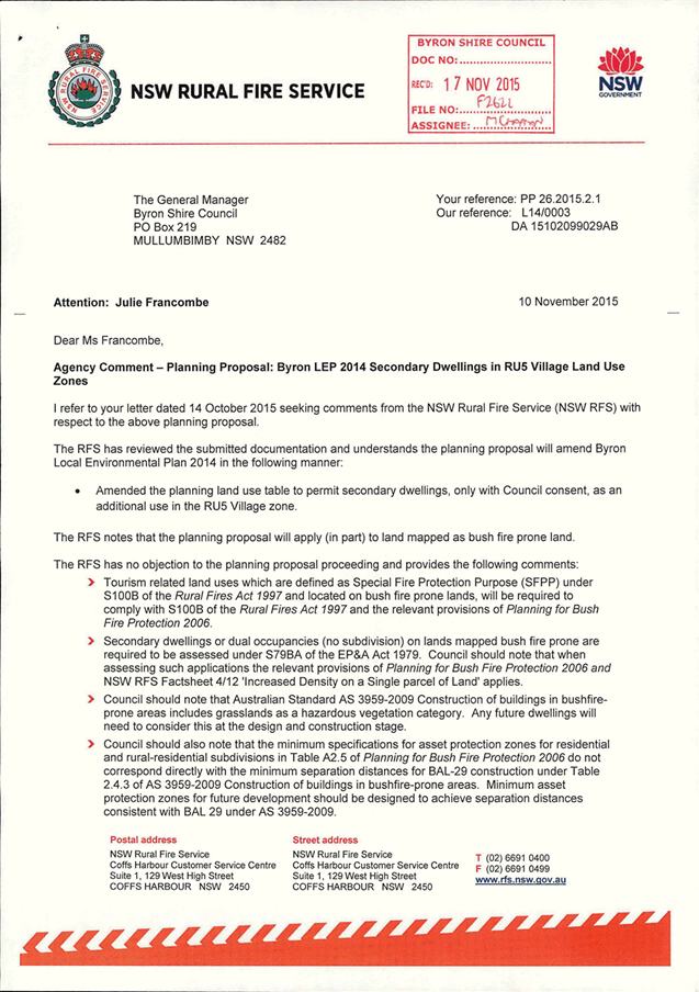

Local Government (General) Regulation 2005
Schedule 3A Form of special disclosure
of pecuniary interest
(Clause 195A)
Local
Government Act 1993
Form of Special Disclosure of Pecuniary Interest
1 The particulars of this form are to be written in
block letters or typed.
2 If any space is insufficient in this form for all
the particulars required to complete it, an appendix is to be attached for that
purpose which is properly identified and signed by you.
Important information
This information is being collected for the purpose of
making a special disclosure of pecuniary interests under sections 451 (4) and
(5) of the Local Government Act 1993. You must not make a special disclosure that you know
or ought reasonably to know is false or misleading in a material particular.
Complaints made about contraventions of these requirements may be referred by
the Director-General to the Local Government Pecuniary Interest and
Disciplinary Tribunal.
This form must be completed by you before the
commencement of the council or council committee meeting in respect of which
the special disclosure is being made. The completed form must be tabled at the
meeting. Everyone is entitled to inspect it. The special disclosure must be
recorded in the minutes of the meeting.
Special
disclosure of pecuniary interests
by
____________________________________________________________________________________
[full
name of councillor]
in the matter of
__________________________________________________________________________
[insert
name of environmental planning instrument]
which is to be considered at a meeting of the
______________________________________________________________________________________
[name of council or council committee (as the case
requires)]
to be held on the _________________ day of __________________________
201
|
Pecuniary
interest
|
|
Address of land
in which councillor or an associated person, company or body has a
proprietary interest (the identified land)
|
|
|
Relationship of identified land to councillor
[Tick or cross one box.]
|
Councillor
has interest in the land (e.g. is owner or has other interest arising out of
a mortgage, lease, trust, option or contract, or otherwise).
Associated
person of councillor has interest in the land.
Associated company
or body of councillor has interest in the land.
|
|
Matter giving rise to pecuniary interest
|
|
Nature of land that is subject to a
change
in zone/planning control by proposed
LEP (the subject land)
[Tick or cross one box]
|
The identified
land.
Land
that adjoins or is adjacent to or is in proximity to the identified land.
|
|
Current
zone/planning control
[Insert name
of current planning instrument and identify relevant zone/planning control
applying to the subject land]
|
|
|
Proposed
change of zone/planning control
[Insert name of proposed
LEP and identify proposed change of zone/planning control applying to the
subject land]
|
|
|
Effect
of proposed change of zone/planning control on councillor
[Insert
one of the following:
“Appreciable financial gain” or
“Appreciable
financial loss”]
|
|
[If
more than one pecuniary interest is to be declared, reprint the above box and
fill in for each additional interest.]
_____________________________
Councillor’s
signature
_____________________________
Date
[This
form is to be retained by the Council’s general manager and included in
full in the minutes of the meeting]

Planning
proposal
for
rezoning of land at
Granuaille
Crescent, Bangalow
Exhibition
Version (#E2015/73577)
Byron Shire Council
Authority ref: 26.2014.14.1
November 2015
This
page has been intentionally left blank
Table
of Contents
1. Introduction. 1
1.1. Purpose. 1
1.2. Planning context 1
1.3. Background. 1
2. Site Description. 3
2.1. The Subject Land. 3
2.2. Current Zones and Controls. 3
3. Planning Proposal 4
Part 1 Objectives and Intended Outcomes. 4
Part 2 Explanation of the Provisions. 4
Part 3 Justification. 4
Section
A Need for the planning proposal 4
Section
B Relationship to strategic planning framework. 4
Section
C Environmental, social and economic impact 26
Section
D State and Commonwealth interests. 26
Part 4 Mapping. 27
Part 5 Community consultation. 27
Part 6 Project timeline. 27
Conclusion. 27
List of maps
Map 1 Site
Locality Map – subject land is outlined in
red……………………………………………2
Map 2 Subject
land outlined in
red…………………………………………………………………......2
Map 3 Current
LEP 2014
Zoning…………………………………………………………………….....3
List of Tables
Table 1 Assessment
against Sustainability
Criteria……………………………………………………5
Table 2 Consistency
with Community Strategic
Plan………………………………………………….8
Table 3 Assessment
against Section 117
Directions………………………………………………...10
Attachments
Attachment 1: Approved Subdivision
Plan……………………………………………………………….Error!
Bookmark not defined.
1. Introduction
1.1.
Purpose
The purpose of
this planning proposal is to amend Byron Local Environmental Plan 2014 so that
land located at Granuaille Crescent; Bangalow is rezoned from RU1 Primary
Production to R2 Low Density Residential. The planning proposal also
seeks to apply a Floor Space Ratio (FSR) of 0.5:1 and a Minimum Lot Size (MLS)
of 600 square metres to the subject land. The subject land is described as part
of Lot 232 DP 1194657, part of Lot 231 DP 1194657 and part of Lot 233 DP
1194657 as shown in Maps 1 and 2.
1.2. Planning
context
This planning
proposal was initially prepared by Planners North on behalf of Instant Steel
Pty Ltd for land at Lot 232 DP 1194657, Granuaille Crescent, Bangalow.
The proposal requests the rezoning of part of Lot 232 DP 1194657 from RU1 Primary
Production to R2 Low Density Residential; apply a Floor Space Ratio (FSR) of
0.5:1; and apply a Minimum Lot Size (MLS) of 600 square metres. At the
Byron Shire Council Meeting of 27 August 2015, Council considered the planning
proposal and resolved:
15- 389
Resolved
1. That
Council proceed with the planning proposal to rezone part of Lot 232 DP
1194657, Bangalow (as identified in Map 1 of this report), to R2; and apply FSR
of 0.5;1 and MLS of 600 sq metres.
2. That
Council amend the planning proposal to include the rezoning of part of Lot 231
and part of Lot 233 of DP 1194657, Bangalow, (as identified in Map 1 of this
report), to R2; and apply FSR of 0.5;1 and MLS of 600 sq metres.
3. That
Council ensure that the planning proposal is consistent with Gateway
determination and/or Council requirements prior to public exhibition.
In accordance
with the Council resolution the planning proposal has been amended to include
the additional land referred to in 2. of the above resolution.
1.3. Background
A residential
subdivision of Lot 232 DP 1194657 was approved in December 2014 for four
residential lots zoned R2 ranging in size from 656 to 958m2 and one lot of
3,709m2 that contains both R2 and residual RU1 rural zoned land. The rural land
is a legacy of a previous rezoning in which this portion was deemed too steep
to be rezoned for residential development. The remnant rural land is surrounded
on three sides by residential land and is of insufficient size to be productive
agricultural land. The approved subdivision designated dwelling envelopes and
required a Section 88B instrument to restrict dwellings to these dwelling
envelopes (refer to Attachment 1 for the approved plan of subdivision).
The Statement
of Environmental Effects accompanying the DA stated the applicant intends to
lodge a subdivision application in the future, to create the ‘Ultimate
Subdivision of the land’, to include steep sections of RU1 land in the
residential lots. Council advised the applicant that a clearer way to achieve
the development sought would be to amend the Byron LEP 2014 to rezone the steep
portion of the lot from RU1 to R2, subject to a Section 88 instrument that
excludes buildings on the land, and then submit a further subdivision application.
In addition,
Council staff considered that two small adjacent areas zoned RU1 should also be
included in the R2 Low Density Residential zone at this location. Council
resolution (15-389), as included above, expands the land subject to this
planning proposal to also include part of Lot 231 DP 1194657 and part of Lot
233 DP 1194657. The latter is a small rectangular piece immediately south of
Lot 232 and a narrow strip located between Lot 232 and the R2 Low Density
Residential zoned land to the east as shown in the Maps 1 and 2 below.
Map 1 Site
Locality Map – subject land is outlined in red
Map 2 Subject
land outlined in red
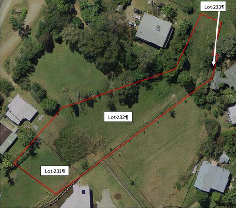
2. Site Description
2.1. The
Subject Land
The subject
land, as illustrated in Map 2 above, is located at the northern entrance of the
village of Bangalow in the vicinity of the Bangalow Reservoir site. The
land is vacant with no significant vegetation. Parts of the subject land are
steep being greater than 30% slopes. It has an approximate area of 3,170
square metres comprising:
· part of Lot
232 DP 1194657: - 2,445 square metres
· part of Lot
231 DP 1194657 - 510 square metres
· part
of Lot 233 DP 1194657 - 215 square metres
It is bounded
by an existing residential subdivision to the west, south and east, and rural
zoned land and Council’s water tower to the north (refer to Map 3).
2.2. Current
Zones and Controls
The subject
land is zoned RU1 Primary Production under Byron LEP 2014. The Minimum
Lot Size for the RU1 zone is 40 hectares. No FSR applies currently to the
RU1 land.
Map 3 Current
LEP 2014 Zoning
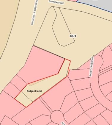
3. Planning
Proposal
Part 1 Objectives
and Intended Outcomes
The primary
objective of this planning proposal is to zone the subject land from RU1
Primary Production to R2 Low Density Residential under Byron Local
Environmental Plan 2014 (LEP 2014).
The area
proposed to be zoned R2 is small, is surrounded by residential zoned land on
three sides, is not used for agriculture due to its limited size, and has no
significant environmental values. It is a logical “rounding off” of
an existing urban area.
Part 2 Explanation
of the Provisions
The intended
outcomes are to be achieved by an amendment to Byron Shire LEP 2014 by:
· Applying a zoning of
R2 Low Density Residential to the subject land;
· Applying a maximum
floor space ratio of 0.5:1 to the subject land; and
· Applying a minimum
lot size of 600 square metres to the subject land.
Part 3 Justification
Section A Need
for the planning proposal
1. Is the planning
proposal a result of any strategic study or report?
No. The
planning proposal to rezone the subject land is a consequence of a residential
subdivision approval for Lot 232 DP1194657. In addition, Council resolved
that two small adjacent areas should be included in the R2 Low Density
Residential zone at this location.
The subject
land is currently zoned RU1 but is of insufficient size to be productive
agricultural land. The RU1 zone is meant to identify rural land that is capable
of sustainable primary industries. The zone permits a wide range of uses that
would not be appropriate within close proximity to existing residential
neighbourhoods including intensive livestock and plant agriculture and rural
industries.
The subject
land is surrounded on three sides by land zoned R2 Low Density
Residential. The objectives and permitted uses of the R2 zone are
appropriate for this serviced land in a residential neighbourhood on the edge
of Bangalow.
2. Is the planning
proposal the best means of achieving the objectives or intended outcomes, or is
there a better way?
The planning
proposal is the only way to change the land zoning and planning controls applying
to the subject land.
Section B Relationship
to strategic planning framework
1. Is the planning
proposal consistent with the objectives and actions contained within the
applicable regional or sub-regional strategy?
Far North
Coast Regional Strategy
The Far North
Coast Regional Strategy (FNCRS) identifies the Town and Village Growth Boundary
for Bangalow. The subject land falls just outside this boundary.
Zoning this land for residential purposes is therefore inconsistent with the
FNCRS. However, the site is classified as “non
–coastal” under the FNCRS because it is located west of the Pacific
Highway. A residential zone outside of the Town and Village Growth
Boundary must be assessed against the Sustainability Criteria set out in the
FNCRS; that assessment is provided in Table 1 below.
In this case
the area of the proposed R2 zone is small and is a logical “rounding
off” of an existing urban area rather than a genuine greenfield site.
Table 1 Assessment
against Sustainability Criteria
|
Threshold Sustainability
Criteria for any proposed development site outside designated areas In
regional strategies
|
Measurable
explanation of criteria
|
Comments
|
|
1.
Infrastructure Provision
Mechanisms in place to ensure
utilities, transport, open space and communication are provided in a timely
and efficient way
|
· Development is
consistent with the outcomes of Far North Coast Regional Strategy, any
subregional strategy, regional infrastructure plan and relevant section 117
direction/s.
· The provision of
infrastructure (utilities, transport, open space, and communications) is
costed and economically feasible based on Government methodology for
determining infrastructure development contributions.
· Preparedness to
enter into development agreement
|
· No
change in the density or utilisation level of the land is anticipated as a
consequence of the Planning Proposal.
|
|
2.
Access
Accessible transport options for
efficient and sustainable travel between homes, jobs, services and recreation
to be existing or provided
|
· Accessibility of
the area by public transport and/or appropriate road access in terms of:
> Location/land
use – to existing networks and related activity centres.
> Network
– the area’s potential to be serviced by economically
efficient transport services.
> Catchment
– the area’s ability to contain, or form part of the
larger urban area which contains adequate transport services.
Capacity for land use/ transport patterns to make a positive
contribution to achievement of travel and vehicle use goals.
· No net negative
impact on performance of existing subregional road, bus, rail, ferry and
freight network.
|
· The
land is well located in terms of its proximity to the Ballina and Byron Bay
hospitals, airports and the like. No negative impact is anticipated in
relation to accessibility for jobs, services or recreation.
|
|
3.
Housing Diversity
Provide a range of housing choices to
ensure a broad population can be housed
|
· Contributes to
the geographic market spread of housing supply, including any government
targets established for aged, disabled or affordable housing.
|
· The
proposal will broaden the scope for housing choice providing for appropriate
infill subdivision within the existing Bangalow Town Centre.
|
|
4.
Employment Lands
Provide regional/local employment
opportunities to support the Far North Coast’s expanding role in the
wider regional and NSW economies
|
· Maintain or
improve the existing level of sub-regional employment self containment.
· Meets
subregional employment projections.
· Employment-related
land is provided in appropriately zoned areas.
|
· The
ultimate construction of dwelling-houses within the adjacent approved
residential subdivision will provide for local employment opportunities.
|
|
5.
Avoidance of Risk
|
Land
use conflicts, and risk to human health and life, avoided
· No residential
development within 1:100 floodplain.
· Avoidance of
physically constrained land, e.g.
>
High slope.
>
Highly erodible.
· Avoidance of
land use conflicts with adjacent existing or future land use as planned under
relevant subregional or regional strategy.
· Where relevant
available safe evacuation route (flood and bushfire).
|
· No change in risk is anticipated as a consequence of the
Planning Proposal.
· The configuration, size and location of that part of the land
presently zoned RU1 Primary Production is not considered suitable for
agricultural land use. The site adjoins existing urban development to
the west, south and east.
|
|
6.
Natural Resources
Natural resource limits not exceeded/
environmental footprint minimised
|
· Demand for water
within infrastructure capacity to supply water and does not place
unacceptable pressure on environmental flows.
· Demonstrates
most efficient/suitable use of land
>
Avoids identified significant agricultural
land
>
Avoids productive resource lands
– extractive industries, coal, gas and
other mining, and quarrying.
· Demand for
energy does not place unacceptable pressure on infrastructure capacity to
supply energy-requires demonstration of efficient and sustainable supply
solution.
|
· No
change in demand for natural resources is anticipated as a consequence of the
amendment to the Local Environmental Plan as proposed.
|
|
7.
Environmental Protection
Protect and enhance biodiversity, air
quality, heritage, and waterway health
|
· Consistent with
government-approved Regional Conservation Plan (if available).
· Maintains or
improves areas of regionally significant terrestrial and aquatic biodiversity
(as mapped and agreed by DEC). This includes regionally significant
vegetation communities, critical habitat, threatened species, populations,
ecological communities and their habitats.
· Maintain or
improve existing environmental condition for air quality.
· Maintain or
improve existing environmental condition for water quality:
>
Consistent with community water
quality objectives for recreational
water use and river health (DEC and
CMA).
>
Consistent with catchment and stormwater
management planning (CMA and council).
· Protects areas
of Aboriginal cultural heritage value (as agreed by DEC).
|
· The
proposed rezoning is not considered likely to result in any impacts in terms
of biodiversity, air quality, and heritage or waterway health.
|
|
8.
Quality and Equity in Services
Quality health, education, legal,
recreational, cultural and community development and other government
services are accessible
|
· Available and
accessible services.
>
Do adequate services exist?
>
Are they at capacity or is some capacity
available?
>
Has Government planned and budgeted
for further service provision?
>
Developer funding for required service
upgrade/access is available.
|
· The
proposal is unlikely to have any impact on health, education, recreation or
other services provided by government.
|
Bangalow
Settlement Strategy 2003
Although this
strategy is outdated it remains the current residential strategy approved by
Council for Bangalow. It does not identify the subject land as a future urban
area because it has little or no housing yield. The subject land (outlined in
red on Map 4) is immediately adjacent to Area 1 in this strategy.
The zoning of this land for residential purposes is a minor zone boundary
adjustment and is justifiably inconsistent with the Bangalow Settlement
Strategy.
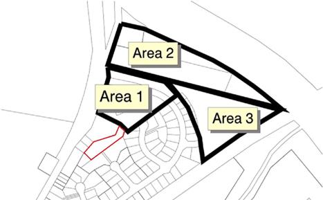
Map 4 –
Investigation Areas for Bangalow (from Bangalow Settlement
Strategy 2003)
State and
Regional Farmland
The subject
land is mapped as regionally significant farmland in the Northern Rivers
Farmland Protection Project. It is not identified as Biophysical
Strategic Agricultural Land (BSAL) in the mapping undertaken recently by the
State government.
The subject
land is a very small area and it is not being used for any commercial
agriculture. It is open mown grass land that is surrounded by residential
development. The Northern Rivers Farmland Protection Project (2005)
outlines criteria to be addressed in relation to using regionally significant
farmland for residential purposes. A response to the criteria is provided
in the assessment against S117 Directions in the following pages.
2. Is the planning
proposal consistent with the Council’s Community Strategic Plan or other
local strategic plan?
In 2012 Council
adopted a 10 year + Community Strategic Plan 2022 (CSP). The
plan is based on five key themes being Corporate Management, Economy,
Environment, Community Infrastructure, Society and Culture. The planning
proposal is generally consistent with the following relevant Goals set out in Table
2:
Table 2 Consistency
with Community Strategic Plan
|
GOALS
|
COMMENTS
|
|
CM1.1 Improve the transparency,
effectiveness and accountability of Council.
|
Council exhibits all
planning proposals to ensure transparency in its rezoning processes.
|
|
CM1.4 Comply with NSW State government
legislation for local government integrated planning and reporting.
|
This planning proposal is
consistent with the government’s framework established pursuant to the
Environmental Planning and Assessment Act.
|
|
CM4.1 Promote community compliance with
Acts, Regulations, Instruments and Council policies and standards.
|
This planning proposal is
consistent with the relevant Acts Regulations and Policies of Council and the
NSW State Government.
|
|
SC2.4 Create
vibrant liveable places and spaces within towns and villages for people of
all ages and abilities.
|
The proposed rezoning will
contribute to the creation of a vibrant liveable place for residents.
|
|
EN1.1 Protect,
restore and maintain the biodiversity values, ecosystems and ecological
processes of the Byron Shire.
|
The proposed rezoning will not impact on the
biodiversity values, ecosystems and ecological processes of the Byron Shire.
|
On this basis the planning proposal is generally consistent
with Council’s CSP.
3. Is the planning
proposal consistent with the applicable State Environmental Planning Policies
(SEPPs)?
The planning
proposal is generally consistent or justifiably inconsistent with the
applicable State Environmental Planning Policies. The key SEPP’s that
require particular consideration are SEPP 55 Remediation of Land and SEPP
(Rural Lands) 2008.
SEPP 55
Remediation of Land
Clause 7(1) of
SEPP 55 requires that a Council cannot approve a rezoning application
(especially from rural to residential) unless it has duly considered whether
such land is contaminated.
Consultants
undertook a preliminary site investigation pursuant to SEPP 55 in December 2010
in relation to an earlier subdivision and rezoning proposal. This work covered
all of the subject land and is still applicable as no additional potentially
contaminating use has been carried out on the subject land since the work was
undertaken. The investigation concluded:
“Based
on the site history, site inspections and the laboratory
results from soil sampling; there is a low level
of risk that the subject site is contaminated
with residual chemicals from activities associated with current
or past land use. Following a review of
the results of laboratory analysis of soil samples taken from
the subject site it is our considered view that there would appear to
be little environmental or health hazard associated with
development approval being granted for the future rezoning
(from 1(b1) agricultural to 2(a) residential under
Byron LEP 1988.”
On this basis
the planning proposal is consistent with SEPP 55 Remediation of land.
SEPP (Rural
Lands) 2008
This SEPP
focuses mainly on the issue of unnecessary fragmentation of rural land and in
particular state and regional farm land. The principles in the SEPP are
required to be considered as part of the S.117 directions when rezoning land.
In this case the land has already been significantly fragmented by past
approvals for subdivision and the proposed rezoning is in recognition that this
is no longer farmland of regional significance.
On this basis
the planning proposal is justifiably inconsistent with SEPP (Rural Lands) 2008.
4. Is the planning
proposal consistent with applicable Ministerial Directions
(s117 Directions)?
A summary
assessment of the Planning Proposal against the Directions issued by the
Minister for Planning under Section 117 of the EP&A Act is provided in Table
3 below.
The planning
proposal is justifiably inconsistent with S. 117 Direction 1.2 Rural Zones, 1.5
Rural Lands, 5.1 Implementation of Regional Strategies and 5.3 Farmland of
State and Regional significance on the NSW Far North Coast. It is
generally compliant with the other S.117 Directions. Details of the
non-compliance and how this can be justified are as follows:
Table 3 Assessment
against Section 117 Directions
|
S117 Direction
|
Application
|
Relevance to this planning proposal
|
Consistency with direction
|
|
1. Employment
and Resources
|
|
1.1 Business
and Industrial Zones
|
Applies when a relevant
planning authority prepares a planning proposal that will affect land within
an existing or proposed business or industrial zone (including the alteration
of any existing business or industrial zone boundary).
|
This planning
proposal will not affect the boundaries or extent of business or industrial
zones.
|
N/A
|
|
1.2 Rural
Zones
|
Applies when a relevant
planning authority prepares a planning proposal that will affect land within
an existing or proposed rural zone (including the alteration of any existing
rural zone boundary).
Under this direction a
planning proposal must:
(a) not rezone land
from a rural zone to a residential, business, industrial, village or tourist
zone.
(b) not contain
provisions that will increase the permissible density of land within a rural
zone (other than land within an existing town or village).
|
This planning proposal affects
land zoned entirely RU1 that is proposed to be zoned R2. It will also lower
the minimum lot size from 40 hectares to 600 square metres.
The inconsistency is justified
in this case because the subject land is surrounded by residential zoned land
on three sides, is not used for agriculture due to its limited size, and has
no significant environmental values. The land is serviced. The
inconsistency is justifiable as a minor matter pursuant to sub clause 5(d) of
the Direction.
|
Justifiably
inconsistent
|
|
1.3 Mining,
Petroleum Production and Extractive Industries
|
Applies when a relevant
planning authority prepares a planning proposal that would have the effect
of:
(a) prohibiting the
mining of coal or other minerals, production of petroleum, or winning or
obtaining of extractive materials, or
(b) restricting the
potential development of resources of coal, other minerals, petroleum or
extractive materials which are of State or regional significance by
permitting a land use that is likely to be incompatible with such
development.
|
Nothing in this planning
proposal will prohibit or restrict exploration or mining.
|
N/A
|
|
1.4 Oyster
Aquaculture
|
Applies when a relevant
planning authority prepares any planning proposal that proposes a change in
land use which could result in:
(a) adverse impacts on
a Priority Oyster Aquaculture Area or a “current oyster aquaculture
lease in the national parks estate”, or
(b) incompatible use of
land between oyster aquaculture in a Priority Oyster Aquaculture Area or a
“current oyster aquaculture lease in the national parks estate”
and other land uses.
|
No
relevance.
|
N/A
|
|
1.5 Rural
Lands
|
Applies when:
(a) a relevant planning
authority prepares a planning proposal that will affect land within an
existing or proposed rural or environment protection zone (including the
alteration of any existing rural or environment protection zone boundary), or
(b) a relevant planning
authority prepares a planning proposal that changes the existing minimum lot
size on land within a rural or environment protection zone.
A planning proposal to which
clauses (a) and (b) apply must be consistent with the Rural Planning Principles
listed in State Environmental Planning Policy (Rural Lands) 2008.
A planning proposal to which
clause (b) applies must be consistent with the Rural Subdivision Principles
listed in State Environmental Planning Policy (Rural Lands) 2008.
|
This planning proposal will
affect land zoned RU1 that is proposed to be zoned R2. It proposes to
alter the minimum lot size for the subject land from 40 hectares to 600
square metres. It is inconsistent with the Rural Planning Principles
and Rural Subdivision Principles listed in State Environmental Planning
Policy (Rural Lands) 2008 because it is mapped as regionally significant farm
land and yet it is proposed for a residential zone.
The inconsistency is justified
in this case because the subject land is surrounded by residential zoned land
on three sides, is not used for agriculture due to its limited size, and has
no significant environmental values. The land is serviced. The
inconsistency is justifiable as a minor matter pursuant to sub clause 6(b) of
the Direction.
|
Justifiably inconsistent.
|
|
|
|
2.1 Environment
Protection Zones
|
A planning
proposal must include provisions that facilitate the protection and
conservation of environmentally sensitive areas.
A planning
proposal that applies to land within an environment protection zone or land
otherwise identified for environment protection purposes in a LEP must not
reduce the environmental protection standards that apply to the land
(including by modifying development standards that apply to the land).
This requirement does not apply to a change to a development standard for
minimum lot size for a dwelling in accordance with clause (5) of Direction
1.5 “Rural Lands”.
|
The planning
proposal does not alter or remove any environment protection zone. No
environmental standards will be reduced by the proposed LEP changes.
|
Consistent.
|
|
2.2 Coastal
Protection
|
Direction
applies when a relevant planning authority prepares a planning proposal that
applies to land in the coastal zone.
A planning
proposal must include provisions that give effect to and are consistent with:
(a) the NSW Coastal
Policy: A Sustainable Future for the New South Wales Coast 1997,
(b) the Coastal Design
Guidelines 2003,
(c) the manual relating
to the management of the coastline for the purposes of section 733 of the Local
Government Act 1993 (the NSW Coastline Management Manual 1990).
|
The site is
classified as “non-coastal” under the Far North Coast Regional
Strategy because it is located west of the Pacific Highway.
|
N/A
|
|
2.3 Heritage
Conservation
|
A planning
proposal must contain provisions that facilitate the conservation of:
(a) Items, places,
buildings, works, relics, moveable objects or precincts of environmental
heritage significance to an area, in relation to the historical, scientific,
cultural, social, archaeological, architectural, natural or aesthetic value
of the item, area, object or place, identified in a study of the
environmental heritage of the area,
(b) Aboriginal objects
or Aboriginal places that are protected under the National Parks and
Wildlife Act 1974, and
(c) Aboriginal areas,
Aboriginal objects, Aboriginal places or landscapes identified by an
Aboriginal heritage survey prepared by or on behalf of an Aboriginal Land
Council, Aboriginal body or public authority and provided to the relevant
planning authority, which identifies the area, object, place or landscape as
being of heritage significance to Aboriginal culture and people.
|
Byron LEP
2014 currently contains provisions that are consistent with this
direction.
|
N/A
|
|
2.4 Recreation
Vehicle Areas
|
A planning proposal must not enable land to be developed for the
purpose of a recreation vehicle area (within the meaning of the Recreation
Vehicles Act 1983):
(a) where the land is
within an environment protection zone,
(b) where the land
comprises a beach or a dune adjacent to or adjoining a beach,
(c) where the land is
not within an area or zone referred to in paragraphs (4)(a) or (4)(b) unless
the relevant planning authority has taken into consideration:
(i) the provisions of the guidelines entitled Guidelines
for Selection, Establishment and Maintenance of Recreation Vehicle Areas,
Soil Conservation Service of New South Wales, September 1985, and
(ii) the provisions of the guidelines entitled Recreation
Vehicles Act, 1983, Guidelines for Selection, Design, and Operation of
Recreation Vehicle Areas, State Pollution Control Commission, September 1985.
|
The proposal does not enable land to be developed for the purpose of a
recreation vehicle area.
|
N/A
|
|
3. Housing,
Infrastructure and Urban Development
|
|
3.1 Residential
Zones
|
This direction applies when a
relevant planning authority prepares a planning proposal that will affect
land within:
(a) an existing
or proposed residential zone (including the alteration of any existing
residential zone boundary),
(b) any other
zone in which significant residential development is permitted or proposed to
be permitted.
A planning proposal must include
provisions that encourage the provision of housing that will:
(a) broaden the choice
of building types and locations available in the housing market, and
(b) make more efficient
use of existing infrastructure and services, and
(c) reduce the consumption
of land for housing and associated urban development on the urban fringe, and
(d) be of good design.
A planning proposal must, in
relation to land to which this direction applies:
(a) contain a
requirement that residential development is not permitted until land is
adequately serviced (or arrangements satisfactory to the council, or other
appropriate authority, have been made to service it), and
(b) not contain
provisions which will reduce the permissible residential density of land.
|
The
planning proposal will rezone land from rural to residential.
It will not
affect the density of residential development.
Existing
clause 6.6 of Byron LEP 2014 already requires adequate essential services to
be available to the land at the time at which consent is granted.
|
Consistent.
|
|
3.2 Caravan
Parks and Manufactured Home Estates
|
Applies
when a relevant planning authority prepares a planning proposal.
In
identifying suitable zones, locations and provisions for caravan parks in a
planning proposal, the relevant planning authority must:
(a) retain provisions
that permit development for the purposes of a caravan park to be carried out
on land, and
(b) retain the zonings
of existing caravan parks, or in the case of a new principal LEP, zone the
land in accordance with an appropriate zone under the Standard Instrument
(Local Environmental Plans) Order 2006 that would facilitate the retention of
the existing caravan park.
In
identifying suitable zones, locations and provisions for manufactured home
estates (MHEs) in a planning proposal, the relevant planning authority must:
(a) take into account
the categories of land set out in Schedule 2 of SEPP 36 as to where MHEs
should not be located,
(b) take into account
the principles listed in clause 9 of SEPP 36 (which relevant planning
authorities are required to consider when assessing and determining the
development and subdivision proposals), and
(c) include provisions
that the subdivision of MHEs by long term lease of up to 20 years or under
the Community Land Development Act 1989 be permissible with consent.
|
No
relevance.
|
N/A
|
|
3.3 Home
Occupations
|
Planning proposals must permit
home occupations to be carried out in dwelling-houses without the need for
development consent.
|
This proposal does not alter
home occupation provisions in Byron LEP 2014.
|
N/A
|
|
3.4 Integrating
Land Use and Transport
|
Applies when a relevant
planning authority prepares a planning proposal that will create, alter or
remove a zone or a provision relating to urban land, including land zoned for
residential, business, industrial, village or tourist purposes.
A planning proposal must
locate zones for urban purposes and include provisions that give effect to
and are consistent with the aims, objectives and principles of:
(a) Improving Transport
Choice – Guidelines for planning and development (DUAP 2001), and
(b) The Right Place
for Business and Services – Planning Policy (DUAP 2001).
|
The subject
land is surrounded by residential zoned land on three sides and is very
small. There is unlikely to be any impact on public transport as a result of
this planning proposal.
|
Consistent.
|
|
3.5 Development
Near Licensed Aerodrome
|
Applies when a relevant
planning authority prepares a planning proposal that will create, alter or
remove a zone or a provision relating to land in the vicinity of a licensed
aerodrome.
The main requirements of the
Direction are that Council considers the Obstacle Limitation Surface (OLS) as
defined by that Department of the Commonwealth for residential purposes, and
does not increase residential densities in areas where the ANEF, as from time
to time advised by that Department of the Commonwealth, exceeds 25.
|
No relevance.
|
N/A
|
|
4. Hazard and Risk
|
|
4.1 Acid
Sulfate Soils
|
Applies when a relevant
planning authority prepares a planning proposal that will apply to land
having a probability of containing acid sulfate soils as shown on the Acid
Sulfate Soils Planning Maps.
A council shall not prepare a
draft LEP that proposes an intensification of land uses on land identified as
having a probability of containing acid sulfate soils on the Acid Sulfate
Soils Planning Maps unless the council has considered an acid sulfate soils
study assessing the appropriateness of the change of land use given the
presence of acid sulfate soils.
|
The subject
land does not contain acid sulfate soils.
|
N/A
|
|
4.2 Mine
Subsidence and Unstable Land
|
Applies when a relevant
planning authority prepares a planning proposal that permits development on
land that:
(a) is within a mine
subsidence district, or
(b) has been identified
as unstable in a study, strategy or other assessment undertaken:
(i) by or on behalf of the relevant planning
authority, or
(ii) by or on behalf of a public authority and provided to
the relevant planning authority.
|
No relevance.
|
N/A
|
|
4.3 Flood
Prone Land
|
Applies when a relevant
planning authority prepares a planning proposal that creates, removes or
alters a zone or a provision that affects flood prone land.
A planning proposal must
include provisions that give effect to and are consistent with the NSW Flood
Prone Land Policy and the principles of the Floodplain Development Manual
2005 (including the Guideline on Development Controls on Low Flood Risk Areas).
A planning proposal must not
rezone land within the flood planning areas from Special Use, Special
Purpose, Recreation, Rural or Environment Protection Zones to a Residential,
Business, Industrial, Special Use or Special Purpose Zone.
A planning proposal must not
contain provisions that apply to the flood planning areas which:
(a) permit development
in floodway areas,
(b) permit development
that will result in significant flood impacts to other properties,
(c) permit a
significant increase in the development of that land,
(d) are likely to
result in a substantially increased requirement for government spending on
flood mitigation measures, infrastructure or services, or
(e) permit development
to be carried out without development consent except for the purposes of
agriculture (not including dams, drainage canals, levees, buildings or
structures in floodways or high hazard areas), roads or exempt development.
A planning proposal must not
impose flood related development controls above the residential flood
planning level for residential development on land, unless a relevant
planning authority provides adequate justification for those controls to the
satisfaction of the Director-General (or an officer of the Department nominated
by the Director-General).
For the purposes of a planning
proposal, a relevant planning authority must not determine a flood planning
level that is inconsistent with the Floodplain Development Manual 2005
(including the Guideline on Development Controls on Low Flood Risk Areas)
unless a relevant planning authority provides adequate justification for the
proposed departure from that Manual to the satisfaction of the
Director-General (or an officer of the Department nominated by the
Director-General).
|
The subject land is not flood
prone land.
|
N/A
|
|
4.4 Planning
for Bushfire Protection
|
Applies when a relevant
planning authority prepares a planning proposal that will affect, or is in
proximity to land mapped as bushfire prone land.
In the preparation of a
planning proposal the relevant planning authority must consult with the
Commissioner of the NSW Rural Fire Service following receipt of a gateway
determination under section 56 of the Act, and prior to undertaking community
consultation in satisfaction of section 57 of the Act, and take into account
any comments so made.
A planning proposal must:
(a) have regard to Planning
for Bushfire Protection 2006,
(b) introduce controls
that avoid placing inappropriate developments in hazardous areas, and
(c) ensure that
bushfire hazard reduction is not prohibited within the APZ.
A planning proposal must,
where development is proposed, comply with the following provisions, as
appropriate:
(a) provide an Asset
Protection Zone (APZ) incorporating at a minimum:
(i) an Inner Protection Area bounded by a perimeter
road or reserve which circumscribes the hazard side of the land intended for
development and has a building line consistent with the incorporation of an
APZ, within the property, and
(ii) an Outer Protection Area managed for hazard reduction
and located on the bushland side of the perimeter road,
(b) for infill
development (that is development within an already subdivided area), where an
appropriate APZ cannot be achieved, provide for an appropriate performance standard,
in consultation with the NSW Rural Fire Service. If the provisions of
the planning proposal permit Special Fire Protection Purposes (as defined
under section 100B of the Rural Fires Act 1997), the APZ provisions
must be complied with,
(c) contain provisions
for two-way access roads which link to perimeter roads and/or to fire trail
networks,
(d) contain provisions
for adequate water supply for fire fighting purposes,
(e) minimise the
perimeter of the area of land interfacing the hazard which may be developed,
(f) introduce
controls on the placement of combustible materials in the Inner Protection
Area.
|
The subject land is not
bushfire prone land.
|
N/A
|
|
5. Regional
Planning
|
|
5.1 Implementation
of Regional Strategies
|
Planning proposals must be consistent
with a regional strategy released by the Minister for Planning.
|
The planning proposal is
inconsistent with a key aspect of the Far North Coast Regional Strategy
(FNCRS).
The subject land is located
outside of the Town and Village Growth Boundary for Bangalow identified in
the FNCRS.
However the site is classified
as “non–coastal” under the FNCRS because it is located west
of the Pacific Highway. Council can support a residential zone outside of the
Town and Village Growth Boundary subject to meeting the Sustainability
Criteria. The purpose of the Sustainability Criteria is to enable
Council to consider planning proposals that are logical town extensions in
the absence of a strategy.
In this case the inconsistency
is justified because the subject land is surrounded by residential zoned land
on three sides, is not used for agriculture, is fully serviced and has no
significant environmental values. It is very small (approx. 0.3
hectares) and is an irregular shape. It is a logical correction of a zone
that dates back to the LEP 1988. The inconsistency is justifiable as
a minor matter pursuant to sub clause 5 of the Direction that achieves the
overall intent of the regional strategy and does not undermine the
achievement of its vision, land use strategy, policies, outcomes or actions.
It will not expand Bangalow
beyond its logical residential boundary and eliminates a rural zone that no
longer fits with the dominant surrounding land use.
|
Justifiably inconsistent.
|
|
5.2 Sydney
Drinking Water Catchments
|
Applies when a relevant
planning authority prepares a planning proposal that applies to the
hydrological catchment.
|
The proposal is not within
this catchment.
|
N/A
|
|
5.3 Farmland
of State and Regional Significance on the NSW Far North Coast
|
The planning proposal must not
rezone land mapped as State or regionally significant farmland under the
Northern Rivers Farmland Protection Project for an urban use.
|
The subject land is mapped as
regionally significant farmland on the Departments maps. The inconsistency
is justifiable as follows:
The inconsistency with the
FNCRS has already been justified. It can also be justified against
Section 4 of the report titled Northern Rivers Farmland Protection Project
– Final Recommendations, February 2005 as follows:
The final recommendations
state that urban development could be considered on regionally significant
farmland if all seven of the following criteria apply.
1. The proposal is not
a new urban area or a disjointed suburb. There is no viable alternative because
it is correcting an outdated zone boundary. It is a “rounding
off” of an existing urban area.
2. The subject land is
located next to existing residential zones on three sides
3. It will not be a
wedge into regionally significant farmland because the nearest land use on
three sides is residential and the fourth side is the Council reservoir and
its curtilage. The nearest agricultural land is across Granuaille Road about
100 metres from the subject land. The 0.3 ha of land is already isolated.
Allowing an urban zone on this site will not disrupt the use of other
farmland.
4. The subject
0.3 ha is currently not used for horticulture or grazing which dominates
local agriculture. This land is not critical to the viability of either
industry. No agricultural infrastructure or transport routes will be
affected by this site being zoned residential. The key road transport
links of Granuaille Road and the Pacific Motorway will remain as fully
functional road transport links.
5. No impacts arising
from the residential zone will compromise the Macadamia production, or
grazing being carried out on other significant farmland in the general area.
6. The land
surrounding the subject land is not subject to existing land use conflicts
relating to agriculture. If dwellings are built on the subject land
this will not exacerbate any known agricultural conflicts.
7. No filling is
required for the subject land. It is not flood prone.
Therefore all seven of the
criteria can be met by the planning proposal.
|
Justifiably inconsistent.
|
|
5.4 Commercial
and Retail Development along the Pacific Highway, North Coast
|
A planning proposal that
applies to land located on “within town” segments of the Pacific
Highway must provide that:
(a) new commercial or
retail development must be concentrated within distinct centres rather than
spread along the highway,
(b) development with
frontage to the Pacific Highway must consider the impact the development has
on the safety and efficiency of the highway.
(c) For the purposes of
this paragraph, “within town” means areas which, prior to the
draft local environmental plan, have an urban zone (e.g.
“village”, “residential”, “tourist”,
“commercial”, “industrial”, etc) and where the
Pacific Highway speed limit is less than 80 km/hour.
A planning proposal that
applies to land located on “out-of-town” segments of the Pacific
Highway must provide that:
(a) new commercial or
retail development must not be established near the Pacific Highway if this
proximity would be inconsistent with the objectives of this Direction,
(b) development with
frontage to the Pacific Highway must consider the impact the development has
on the safety and efficiency of the highway.
(c) For the purposes of
this paragraph, “out-of-town” means areas which, prior to the
draft local environmental plan, do not have an urban zone (e.g.
“village”, “residential”, “tourist”,
“commercial”, “industrial”, etc) or are in areas
where the Pacific Highway speed limit is 80 km/hour or greater.
|
This planning proposal does
not affect commercial or retail uses in proximity to the Pacific Highway.
|
N/A
|
|
6. Local
Plan Making
|
|
6.1 Approval
and Referral Requirements
|
A planning proposal must:
(a) minimise the
inclusion of provisions that require the concurrence, consultation or
referral of development applications to a Minister or public authority, and
(b) not contain
provisions requiring concurrence, consultation or referral of a Minister or
public authority unless the relevant planning authority has obtained the
approval of:
(i) the appropriate Minister or public authority,
and
(ii) the Director-General of the Department of Planning
and Environment (or an officer of the Department nominated by the
Director-General),
prior to undertaking community consultation in
satisfaction of section 57 of the Act, and
(c) not identify development
as designated development unless the relevant planning authority:
(i) can satisfy the Director-General of the
Department of Planning and Environment (or an officer of the Department
nominated by the Director-General) that the class of development is likely to
have a significant impact on the environment, and
(ii) has obtained the approval of the Director-General of
the Department of Planning and Environment (or an officer of the Department
nominated by the Director-General) prior to undertaking community
consultation in satisfaction of section 57 of the Act.
|
The planning proposal will not
include provisions that require the concurrence, consultation or referral of
development applications to a Minister or public authority. It does not
identify development as designated development.
|
N/A
|
|
6.2 Reserving
Land for Public Purposes
|
A planning proposal must not
create, alter or reduce existing zonings or reservations of land for public
purposes without the approval of the relevant public authority and the
Director-General of the Department of Planning and Environment (or an officer
of the Department nominated by the Director-General).
|
The planning proposal does not
create, alter or reduce land reserved for a public purpose.
|
N/A
|
|
6.3 Site Specific
Provisions
|
Applies when a relevant
planning authority prepares a planning proposal that will allow a particular
development to be carried out.
A planning proposal that will
amend another environmental planning instrument in order to allow a
particular development proposal to be carried out must either:
(a) allow that land use
to be carried out in the zone the land is situated on, or
(b) rezone the site to
an existing zone already applying in the environmental planning instrument
that allows that land use without imposing any development standards or
requirements in addition to those already contained in that zone, or
(c) allow that land use
on the relevant land without imposing any development standards or requirements
in addition to those already contained in the principal environmental
planning instrument being amended.
A planning proposal must not
contain or refer to drawings that show details of the development proposal.
|
The planning proposal does not
seek to allow a particular development to be carried out.
The planning proposal does not
contain schematic drawings.
|
N/A
|
Section
C Environmental, social and economic
impact
1. Is there any
likelihood that critical habitat or threatened species, populations or
ecological communities, or their habitats will be adversely affected as a
result of the proposal?
The proposed land to be rezoned from RU1 Primary Production
to R2 Low Density Residential does not contain any significant vegetation and
is predominently cleared. The proposal is not likely to result in any impacts
on critical habitat, threatened species or ecological communities.
2. Are there any
other likely environmental effects as a result of the planning proposal and how
are they proposed to be managed?
No environmental impacts are anticipated as a result of the
proposed rezoning of the subject land to R2 Low Density Residential.
3. How has the
planning proposal adequately addressed any social and economic effects?
The proposal is a minor rezoning of the land to correct what
is effectively an anomaly across the site. It will not result in any adverse
social or economic impacts on the Bangalow community.
Section D State
and Commonwealth interests
1. Is there adequate
public infrastructure for the planning proposal?
The proposal places no increased pressure to local
infrastructure provision. Contributions will be levied for water and
sewer in accordance with Council’s adopted plans.
2. What are the views
of State and Commonwealth public authorities consulted in accordance with the
gateway determination?
State and Commonwealth public authorities have not been formally
involved in this planning proposal as it is yet to receive Gateway Approval.
At this stage there do not appear to be any issues of
interest to Commonwealth authorities.
Part 4 Mapping
This planning proposal seeks the following map amendments to
Byron Shire LEP 2014:
· Amendment to the Byron LEP 2014 Land Zoning
Map to apply a zoning of R2 Low Density Residential to the subject land shown
in Map 2; and
· Amendment to the Byron LEP 2014 Floor Space
Ratio Map to apply a FSR of 0.5:1 to the subject land shown in Map 2; and
· Amendment to the Byron LEP 2014 Lot Size Map to apply
a MLS of 600 square metres to the subject land shown in Map 2.
Part 5 Community
consultation
Council will
commence community consultation in accordance with the Gateway
Determination. For the purposes of public notification, the planning
proposal is considered to be low impact and a 14 day public exhibition
period is recommended.
Notification of
the exhibited planning proposal will include:
· a newspaper advertisement that circulates in the
Byron LGA, which is the area affected by the planning proposal;
· the website of Byron Shire Council and the Department
of Planning and Environment.
Part 6 Project
timeline
The proposed timeline for the
completion of the planning proposal is as follows:
|
Estimated completion
|
Plan making step
|
|
October 2015
|
Gateway determination issued by Department of Planning
and Environment.
|
|
November 2015
|
Public exhibition of planning proposal.
Government agency consultation.
|
|
December 2015
|
Analysis of public submissions.
Preparation of Council report.
|
|
February 2016
|
Public submissions report to Council.
|
|
February 2016
|
Submission of endorsed LEP amendment to Parliamentary
Counsel for drafting (if delegated).
|
|
March 2016
|
Council to make the LEP amendment (if delegated).
|
|
March 2016
|
Forwarding of LEP amendment to Department of Planning
and Environment for notification (if delegated).
|
Conclusion
Statutory analysis undertaken in this planning proposal
demonstrates that the proposed rezoning is consistent, or justifiably
inconsistent, with State and Council strategies and policies and therefore has
sufficient merit to be supported.
The planning proposal should proceed to amend Byron LEP 2014
to apply the R2 Low Density Residential zone, an FSR of 0.5:1 and MLS of 600 sq
metres over part of Lot 232 DP 1194657, part of Lot 231 DP 1194657 and part of
Lot 233 DP 1194657 as shown in Map 2 of this document.
It is also concluded that the matter is sufficiently minor
that no further information or specialist reports are required prior to
exhibition.
Attachment
1: Approved Subdivision Plan
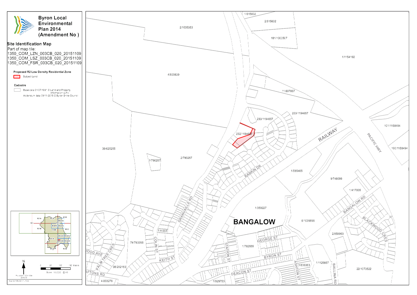
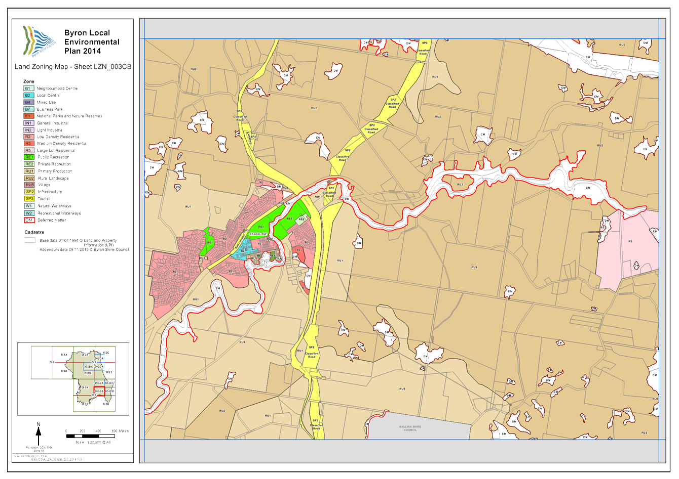
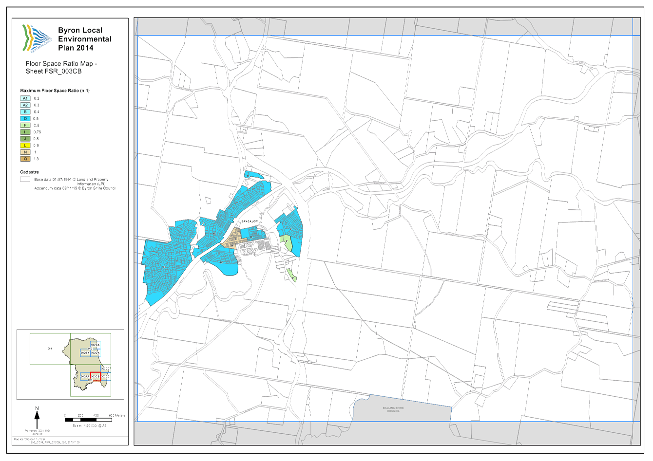
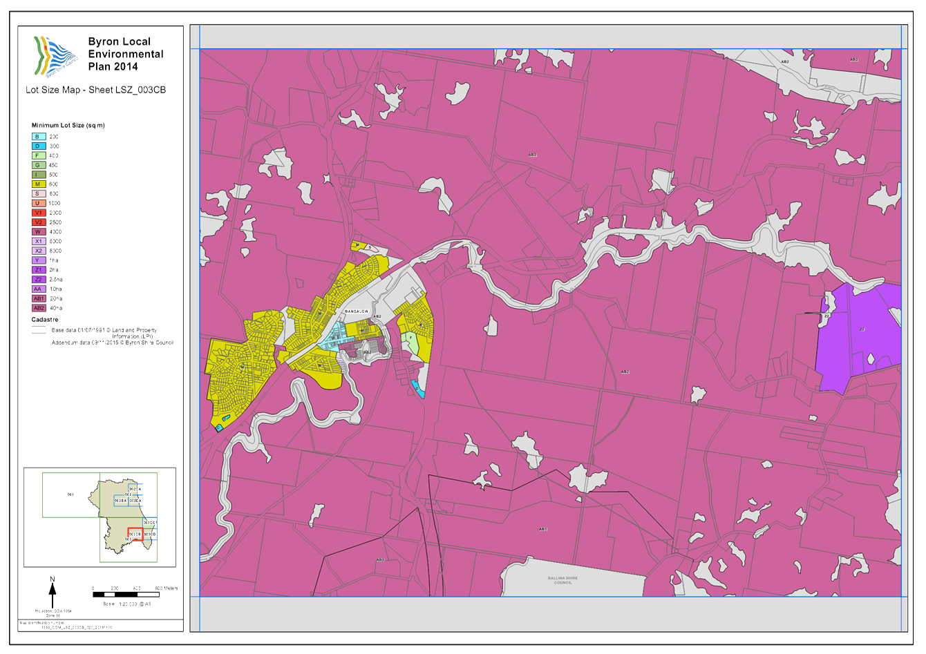
Local Government (General) Regulation 2005
Schedule 3A Form of special disclosure
of pecuniary interest
(Clause 195A)
Local
Government Act 1993
Form of Special Disclosure of Pecuniary Interest
1 The particulars of this form are to be written in
block letters or typed.
2 If any space is insufficient in this form for all
the particulars required to complete it, an appendix is to be attached for that
purpose which is properly identified and signed by you.
Important information
This information is being collected for the purpose of
making a special disclosure of pecuniary interests under sections 451 (4) and
(5) of the Local Government Act 1993. You must not make a special disclosure that you know
or ought reasonably to know is false or misleading in a material particular.
Complaints made about contraventions of these requirements may be referred by
the Director-General to the Local Government Pecuniary Interest and
Disciplinary Tribunal.
This form must be completed by you before the
commencement of the council or council committee meeting in respect of which
the special disclosure is being made. The completed form must be tabled at the
meeting. Everyone is entitled to inspect it. The special disclosure must be
recorded in the minutes of the meeting.
Special
disclosure of pecuniary interests
by
____________________________________________________________________________________
[full
name of councillor]
in the matter of __________________________________________________________________________
[insert
name of environmental planning instrument]
which is to be considered at a meeting of the
______________________________________________________________________________________
[name of council or council committee (as the case
requires)]
to be held on the _________________ day of __________________________
201
|
Pecuniary
interest
|
|
Address of land
in which councillor or an associated person, company or body has a
proprietary interest (the identified land)
|
|
|
Relationship of identified land to councillor
[Tick or cross one box.]
|
Councillor
has interest in the land (e.g. is owner or has other interest arising out of
a mortgage, lease, trust, option or contract, or otherwise).
Associated
person of councillor has interest in the land.
Associated company
or body of councillor has interest in the land.
|
|
Matter giving rise to pecuniary interest
|
|
Nature of land that is subject to a
change
in zone/planning control by proposed
LEP (the subject land)
[Tick or cross one box]
|
The identified
land.
Land
that adjoins or is adjacent to or is in proximity to the identified land.
|
|
Current
zone/planning control
[Insert name
of current planning instrument and identify relevant zone/planning control
applying to the subject land]
|
|
|
Proposed
change of zone/planning control
[Insert name of proposed
LEP and identify proposed change of zone/planning control applying to the
subject land]
|
|
|
Effect
of proposed change of zone/planning control on councillor
[Insert
one of the following:
“Appreciable financial gain” or
“Appreciable
financial loss”]
|
|
[If
more than one pecuniary interest is to be declared, reprint the above box and
fill in for each additional interest.]
_____________________________
Councillor’s
signature
_____________________________
Date
[This
form is to be retained by the Council’s general manager and included in
full in the minutes of the meeting]
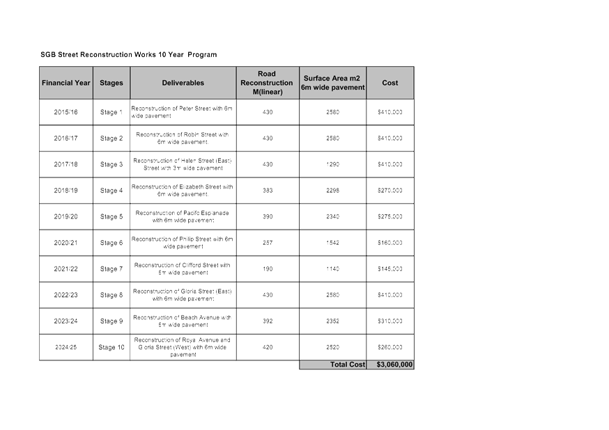
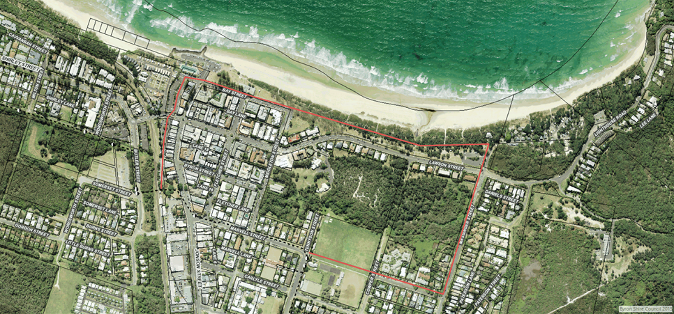
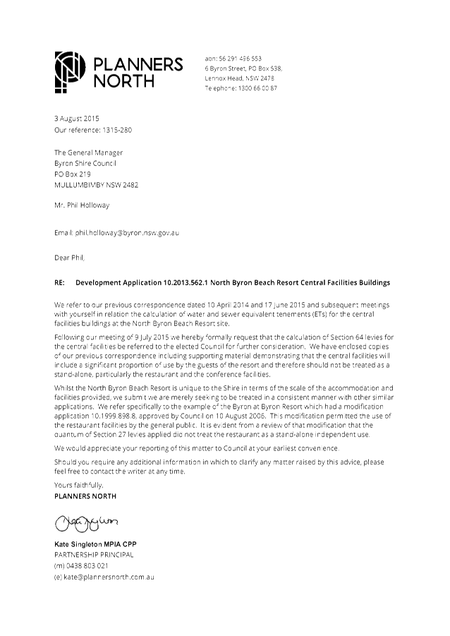
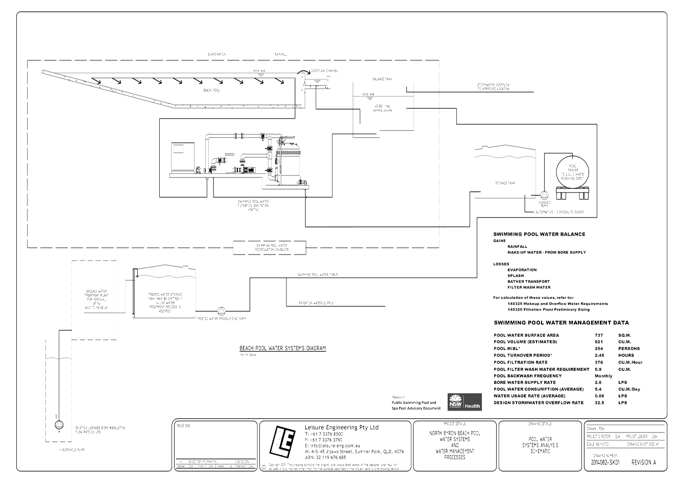

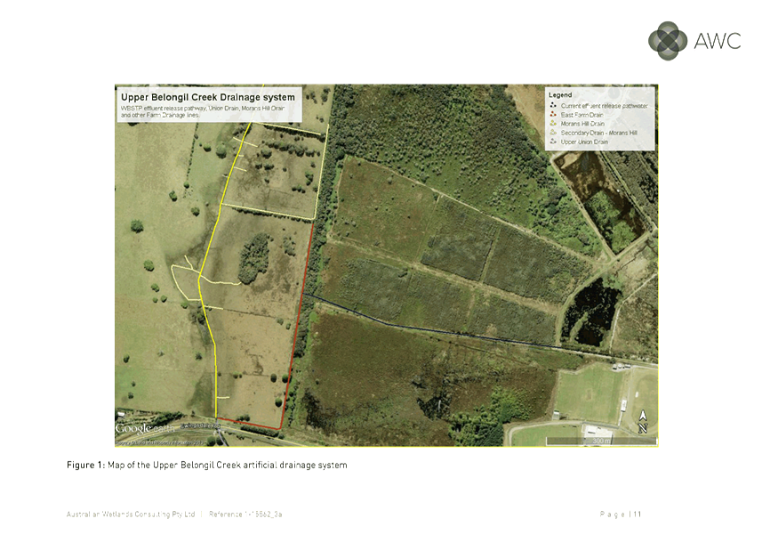
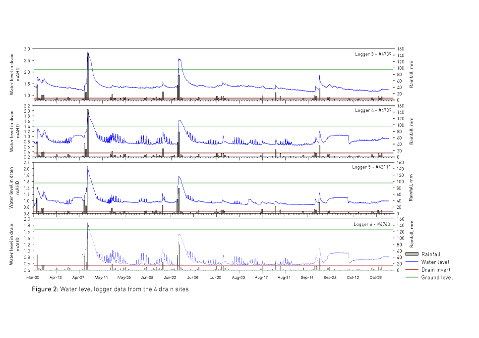
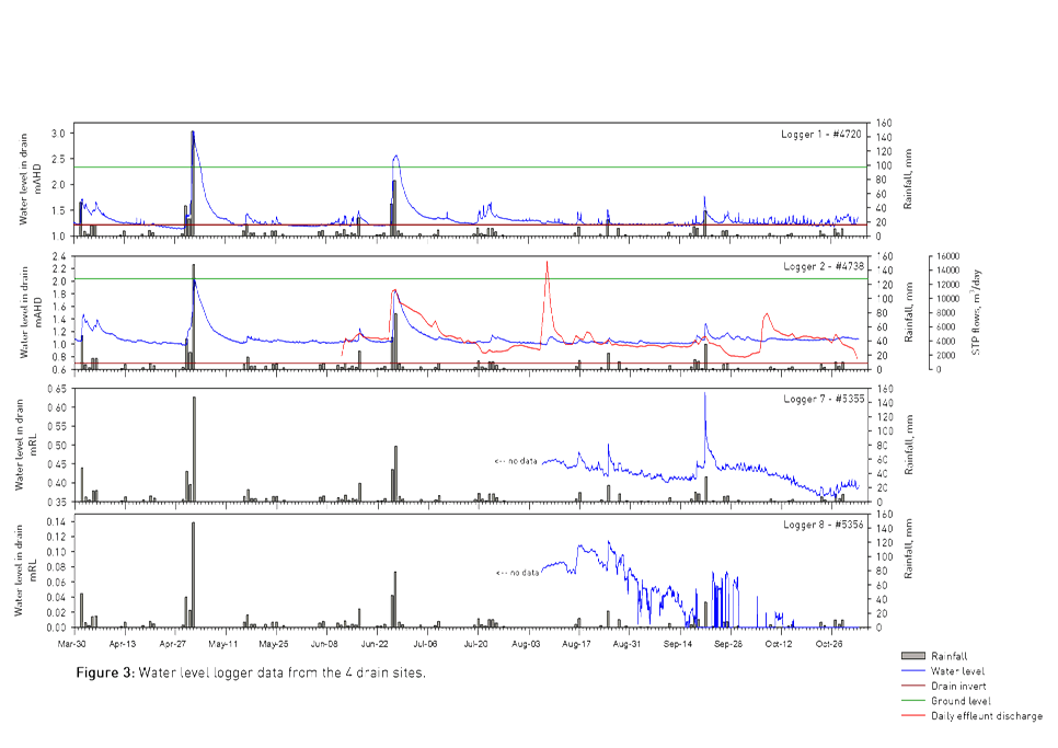
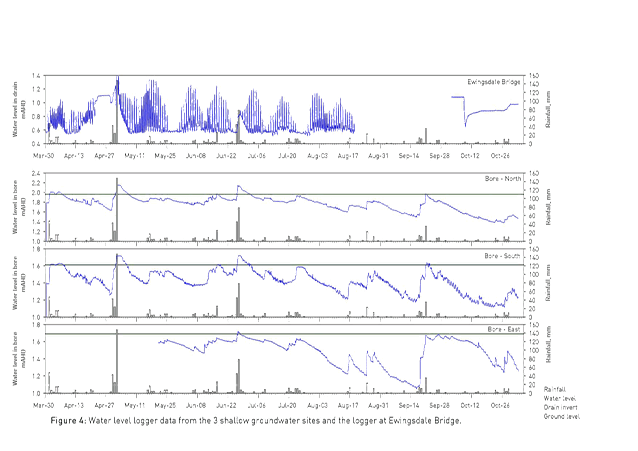
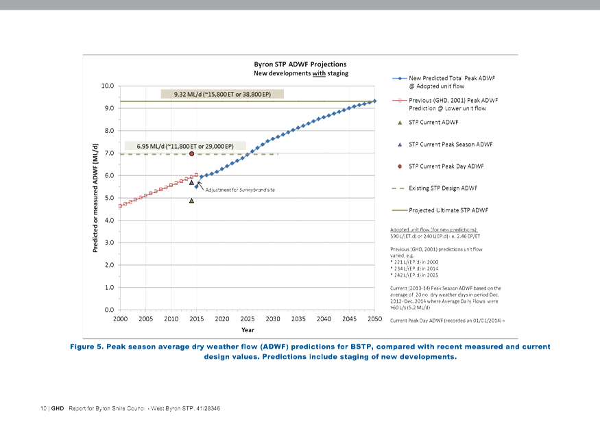
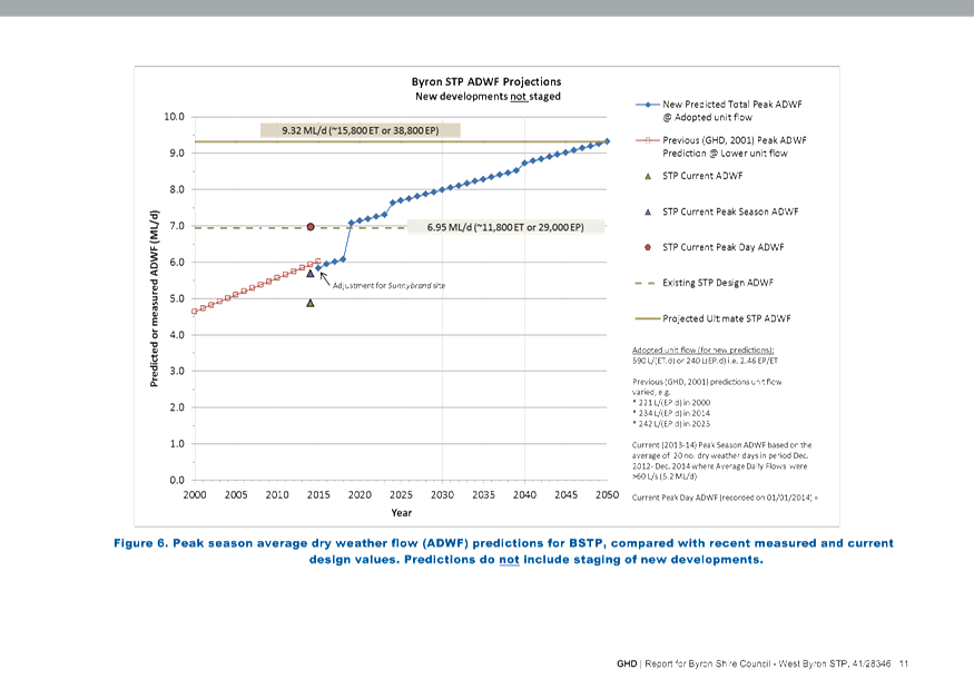
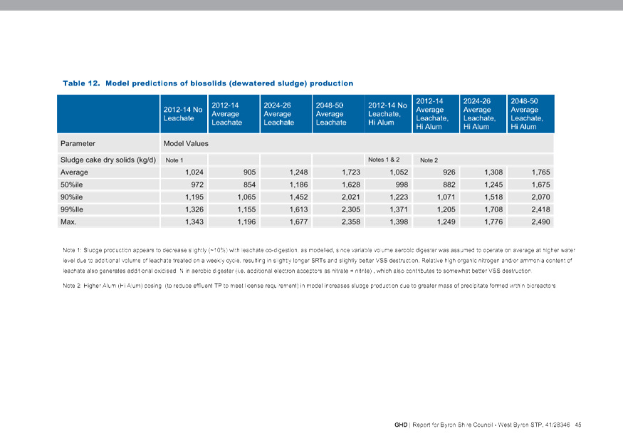

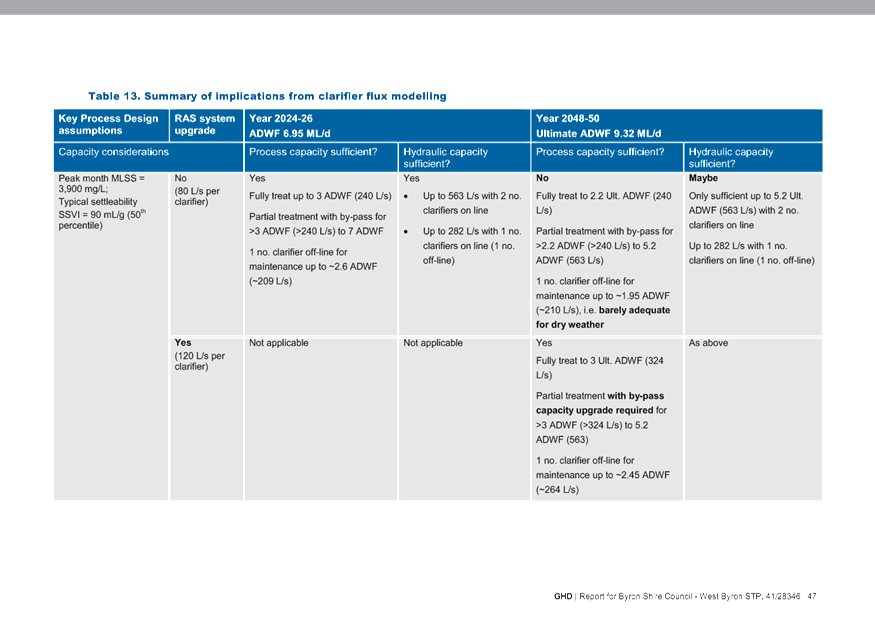
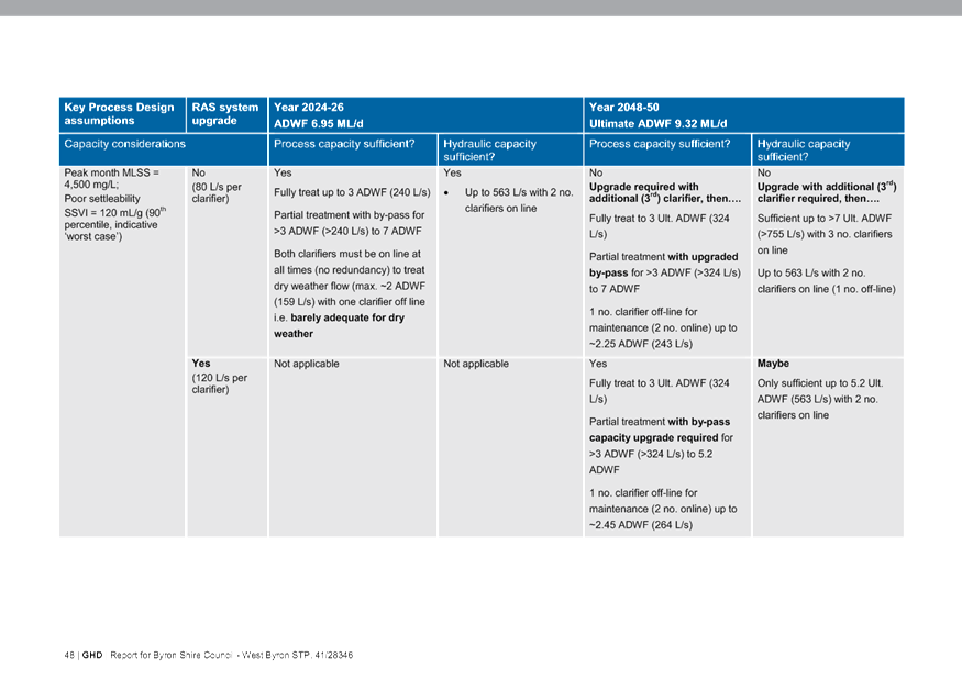
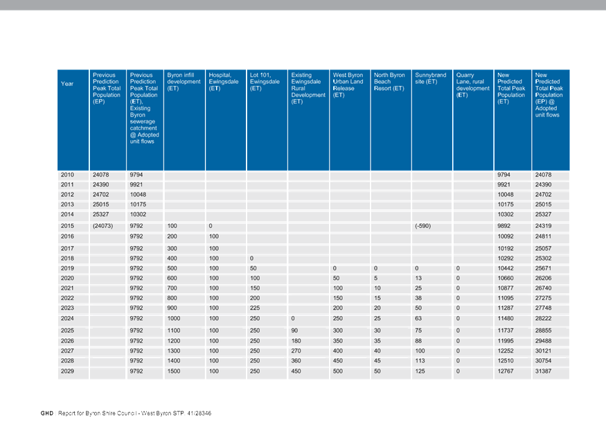
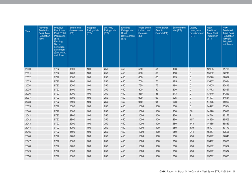
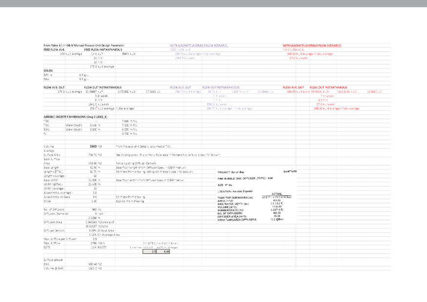

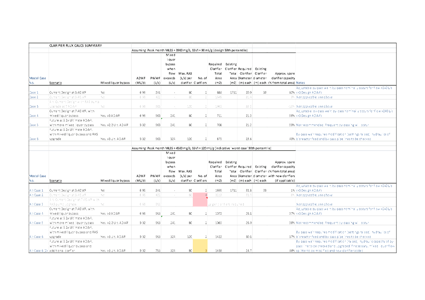


Internal Audit Advisory Committee Meeting
|
Venue
|
Conference Room, Station Street, Mullumbimby
|
|
Date
|
Thursday, 12 November 2015
|
|
Time
|
11.00am
|
Reports of Committees - Corporate and Community
Services 14.1 - Attachment 1
Minutes of the Internal
Audit Advisory Committee Meeting held on Thursday, 12 November
2015
File No: I2015/1496
PRESENT: Cr
B Cameron (arrived 11.16am), Cr A Hunter and Cr D Woods
Staff: Mark
Arnold (Director Corporate and Community Services)
Phil Holloway (Director Infrastructure Services)
Trish Kirkland (Manager Governance Services)
Community:
Michael Georghiou (Chairperson), Craig Kelly, Tony McCabe
Internal
Auditor: Paul Dwyer and Adam Kim (Grant Thornton)
Michael Georghiou (Chair)
opened the meeting at 11.04am and acknowledged that the meeting
was being held on Bundjalung Country.
Apologies:
There was an apology received from
Ken Gainger (General Manager).
PROCEDURAL MOTION
That the apology from Ken Gainger (General Manager) be
received. (Georghiou/Woods)
Declarations of
Interest – Pecuniary and Non-Pecuniary
There were no declarations of
interest.
Adoption of
Minutes from Previous Meetings
|
Committee
Recommendation
That the minutes of the Internal Audit Advisory Committee
Meeting held on 22 October 2015 be confirmed. (Georghiou/Woods)
|
Business Arising from Previous Minutes
There was no business arising
from previous minutes.
|
Procedural
Motion
|
|
Committee
Recommendation:
That Council change the order of business to deal with
Report 5.2 next on the Agenda.
(Georghiou/Hunter)
The recommendation was put to the vote and declared carried.
|
Staff Reports - Corporate and Community
Services
|
Report No. 5.2 Meeting
Dates for Internal Audit Committee for 2016
File No: I2015/1301
|
|
Committee
Recommendation:
That the Internal Audit Committee adopt the following
dates for the Internal Audit Committee meetings for 2016, with all meetings
commencing at 11.00am:
· Thursday,
18 February 2016
· Thursday,
12 May 2016
· Thursday,
18 August 2016
· Thursday,
20 October 2016
· Thursday,
10 November 2016. (Georghiou/Woods)
The recommendation was put to
the vote and declared carried.
|
|
Procedural Motion
|
|
Committee
Recommendation:
That Committee move into Confidential Session to deal with
Reports 5.1 and 5.3.
(Georghiou/Woods)
The recommendation was put to the vote and declared carried.
|
|
Report No. 5.1 Internal
Audit Report November 2015
File No: I2015/1248
|
|
Committee
Recommendation:
That the
Internal Audit Committee recommend to Council:
That Council receive and note the Internal Audit Report
– Audit Committee (November 2015) (#E2015/71201) prepared by the
Internal Auditor, Grant Thornton. (Georghiou/Woods)
The recommendation was put to
the vote and declared carried.
|
|
Report No. 5.3 Internal
Audit Report - Inventory Control Review
File No: I2015/1356
|
|
Committee
Recommendation:
1. That
Management review the comments for Actions 3 and 5 and prepare a further
report for the next meeting of the Internal Audit Advisory Committee on these
Actions from the Inventory Control Review.
2. That,
subject to point 1 above, the Internal Audit Report – Inventory Control
Review - September 2015 be noted by Council along with responses and actions
detailed by Management. (Georghiou/Woods)
The recommendation was put to
the vote and declared carried.
|
There being no further business the meeting concluded at 12.15pm.
Arakwal Memorandum of Understanding Advisory Committee Meeting
|
Venue
|
Meeting Room 1, Council Offices, Mullumbimby
|
|
Date
|
Wednesday, 19 August 2015
|
|
Time
|
2.30pm
|
Reports of Committees - Corporate and Community
Services 14.2 - Attachment 1
Minutes of the Arakwal
Memorandum of Understanding Advisory Committee Meeting held on Wednesday,
19 August 2015
File No: I2015/1496
PRESENT: Cr
S Richardson (Mayor), Cr P Spooner
Staff: Greg
Ironfield (Manager Community Development)
Belle
Arnold (Indigenous Projects Officer)
Phil
Warner ( Capital Projects Officer )
Ralph
James (Coordinator Legal Services)
Tamara
Warrington (Minute Taker)
Community: BJ
Kay , Delta Kay
Cr Spooner
(Chair) opened the meeting at 2:41pm and acknowledged that the
meeting was being held on Bundjalung Country.
Apologies:
There was an apology from Gavin
Brown.
Declarations of
Interest – Pecuniary and Non-Pecuniary
There were no declarations of
interest.
Adoption of
Minutes from Previous Meetings
|
Recommendation:
That the minutes of the Arakwal Memorandum of
Understanding Advisory Committee Meeting held on 14 May 2015 be confirmed.
|
The recommendation was put to
the vote and declared carried. (Spooner/Kay)
Business Arising from Previous Minutes
Cr Richardson provided committee members with a draft Notice
of Motion for Indigenous Cultural Awareness Celebration for discussion.
Staff Reports - Corporate and Community
Services
|
Report No. 5.1 Arakwal
MoU Implementation Plan 2015 -16
File No: I2015/373
|
|
Committee
Recommendation 5.1.1
That the Arakwal MoU Advisory Committee endorse the
2015/16 Arakwal MoU Implementation Plan (E2015/50307). (Spooner/D Kay)
The recommendation was put to
the vote and declared carried.
|
|
Report No. 5.2 Ti
Tree Lake Plan of Management
File No: I2015/816
|
|
Committee
Recommendation 5.2.1
1. That
the Arakwal MoU Advisory Committee note the progress report on the Ti Tree
Lake Plan of Management.
2. That
Council write to the Office of Environment and Heritage and National Parks
and Wildlife Service providing a copy of the progress report (E2015/50137). (D Kay/B Kay)
The recommendation was put to
the vote and declared carried.
|
|
Report No. 5.3 Bundjalung
of Byron Bay, Arakwal People Cemetery Provisions
File No: I2015/817
|
|
Committee
Recommendation 5.3.1
That the Arakwal MoU Committee seek information from
Council staff on the processes required and the scope of works for the
Bundjalung of Byron Bay, Arakwal People to have an identified area in the
Byron Bay Cemetery for further consideration. (Kay/Spooner)
The recommendation was put to
the vote and declared carried.
|
|
Report No. 5.4 NAIDOC
Week Byron Shire 2015
File No: I2015/819
|
|
Committee
Recommendation 5.4.1
That the committee note the success of the Byron Shire
NAIDOC Week 2015 Program and the increase in the community partnerships
involved in the delivery of the program of events.
(Spooner/Richardson)
The recommendation was put to
the vote and declared carried.
|
Verbal Reports
Broken Head Quarry Development
Ralph provided the Committee with an update on the Land and
Environment Court Class 1 appeal against the refusal of the development.
Ralph provided information as to the role which Objectors
might play in the proceedings.
Action request from Belle to Ralph for information to send
to stakeholders .
Byron Bay Bypass
Phil, Cr Richardson and Cr Spooner provided the Committee
with an overview of the Byron Bay Bypass.
General discussion on previous routes and reasoning for
selection of the adopted Bypass route.
Action request from Delta to Councillors to provide email
reply.
Midden Update
Belle provided the Committee with an update on project.
Manager of Utilities to work with Belle and Delta to resolve
stormwater drainage issues on Clarkes Beach.
Action request from Cr Richardson to Belle to liaise with
Jane Laverty for invitation to Arakwal for Byron Bay Town Centre Master Plan
Charette Workshop on 3 September. Belle to also attend.
Belle to send site inspection invitation to Cr Richardson.
There being no further business the meeting concluded at 4:13
pm.
North Byron Coastal Creeks Flood Risk Management Committee Meeting
|
Venue
|
Meeting Room 1, Station Street, Mullumbimby
|
|
Date
|
Wednesday, 28 October 2015
|
|
Time
|
1.00pm
|
Reports of Committees - Infrastructure Services 14.3 - Attachment 1
Minutes of the North
Byron Coastal Creeks Flood Risk Management Committee Meeting held on Wednesday,
28 October 2015
File No: I2015/1496
PRESENT: Cr
S Richardson (Mayor) and Cr D Dey
Staff: James
Flockton (Flood and Drainage Engineer)
Susan
Sulcs (Minute Taker)
Invited
Members: Phillip Buchanan (OEH)
Community: Jim
Mangleson, Mathew Lambourne
Consultant:
Richard Sharpe
(BMT WBM)
Cr Dey
(Chair) opened the meeting at 1.10 and acknowledged that the
meeting was being held on Bundjalung Country.
Apologies:
Apologies received from Andrew
Page, Phillip Holloway
Declarations of
Interest – Pecuniary and Non-Pecuniary
There were no declarations of
interest.
Adoption of
Minutes from Previous Meetings
|
Recommendation:
That the minutes of the North Byron Coastal Creeks
Flood Risk Management Committee Meeting held on 23 June 2015 be confirmed.
|
Dey/Richardson
The recommendation was put to the vote and declared
carried.
Business Arising from Previous Minutes
There was no business arising
from previous minutes.
Staff Reports - Infrastructure Services
|
Report No. 5.1 North
Byron Coastal Creeks Flood Study - Calibration Report
File No: I2015/1214
|
|
RECOMMENDATION:
1. That the
name of the Project be changed to North Byron Shire, and that this document
be named North Byron Shire Flood Study.
2. That
Council accept as satisfactory the calibration report provided by BMT WBM
(Attachment 2) and ask BMT WBM to proceed with preparation of design flood
event modelling.
3. That
BMT WBM finalise the DRAFT North Byron Coastal Creeks Flood Study and staff
present this to Council for review and placement on public exhibition as per
Council policy.
|
Dey/Lambourne
The recommendation was put to the vote and declared
carried.
There being no further business the meeting concluded at 3.12pm.
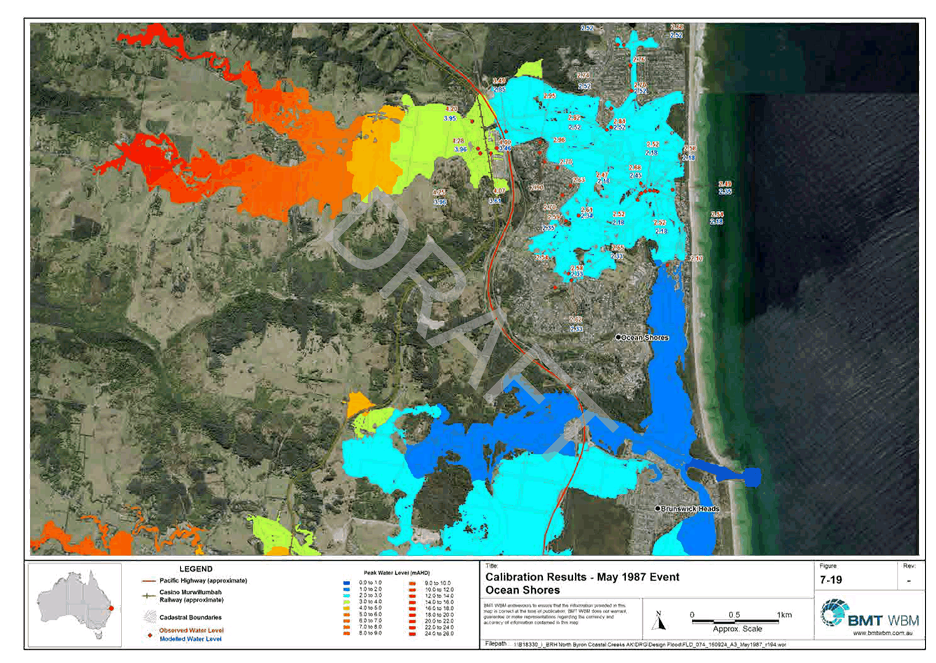
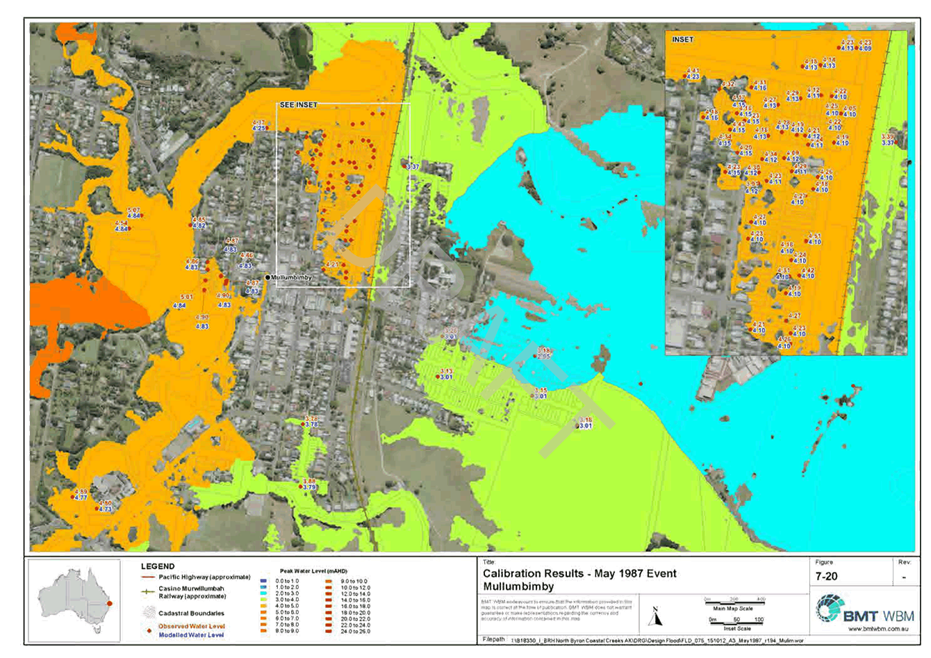
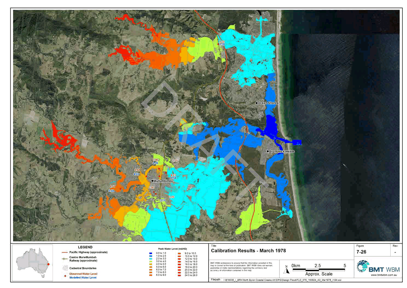
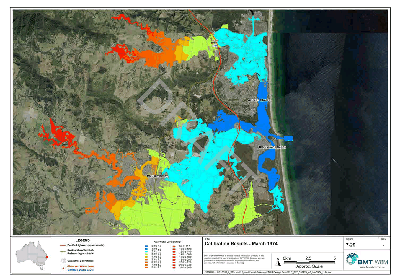
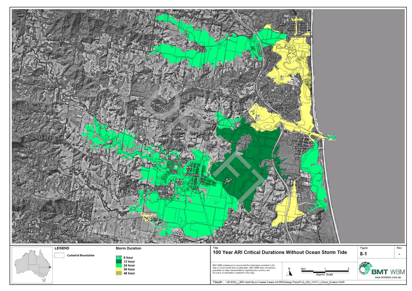
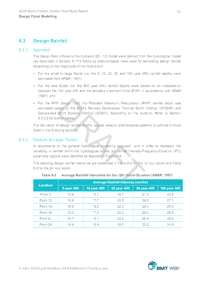
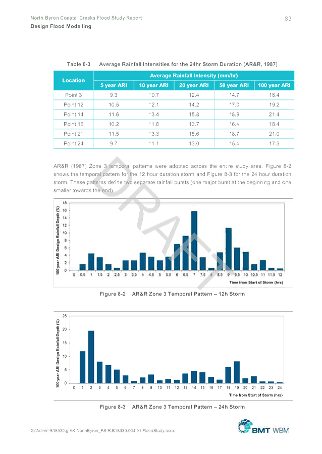
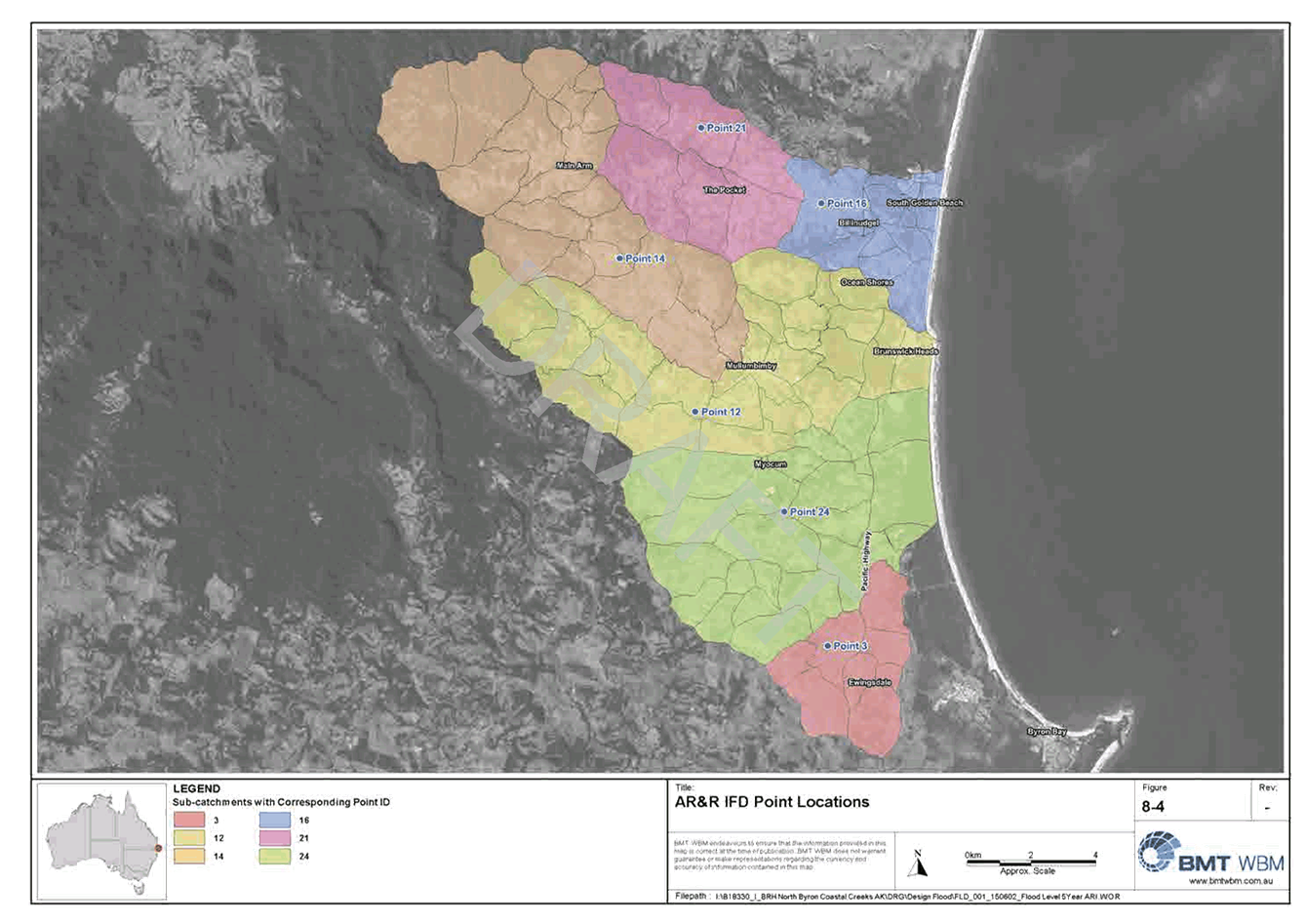
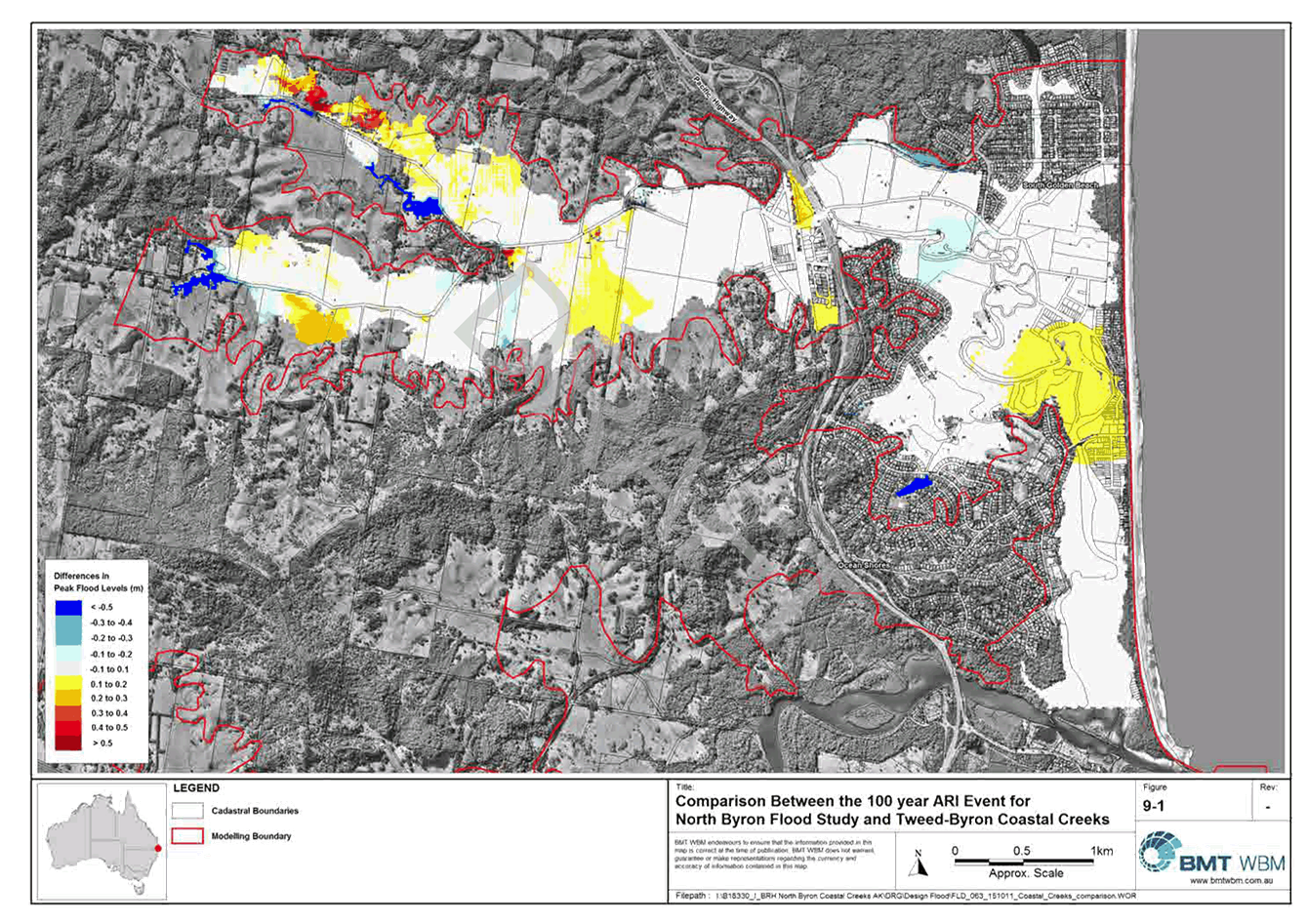
Local Traffic Committee Meeting
|
Venue
|
Conference Room, Station Street, Mullumbimby
|
|
Date
|
Wednesday, 25 November 2015
|
|
Time
|
10.30am
|
|
Committee
Members
|
Jessica Healey – Roads and
Maritime Services
Snr Constable Anthony Darby – Police
Cr Duncan Dey
Hon Tamara Smith MP
|
Reports of Committees - Infrastructure Services 14.4 - Attachment 1
Report of the Local Traffic Committee Meeting
held on Wednesday, 25 November 2015
File No: I2015/1496
Meeting Commenced: 10.30am
PRESENT:
Councillor: Cr Duncan Dey
Roads and Maritime Services Representative:
Jessica Healey, and Joshua Barkham
Police: Snr Constable Ray Wilson
Staff: Simon Bennett
Apologies:
Amy Phillips, Office of Tamara
Smith MP
Declarations of
Interest
There
were no declarations of interest raised.
Adoption of
Minutes from Previous Meetings
|
Recommendation:
The minutes of the Local Traffic Committee Meeting held
on 26 August 2015 were adopted with matters arising as follows
|
Matters Arising
· Granuille Road
heavy vehicle signage request with RMS to install ‘No Compression
braking’ sign and Council has put No Through Road sign in at intersection
of Byron Street and Station Street
· Mullumbimby Music
Festival – last weekend. General parking on RFS station driveway
complaint. Next year include RFS station in all event planning. BSC
Rangers were active. Staff contacted Rangers to monitor the situation and
advised RFS to request Police to monitor and arrest people parked illegally.
Possible installation of tow away signage next year.
· RMS advised Speed
Zones underway for Yelgun Road and Myocum Downs Drive
· 6.10 Contraflow
bus bay trial at Wilsons Creek Public School was to commence when pedestrian
fencing and median were installed.
Outstanding Issues/Resolutions
· Bus bay /
cul-de-sac parking and intersection treatment at main road and path at St
Finbarr’s and Byron Bay High School requires investigation and report
· Physical median to
reinforce No Right Turn at Mullumbimby Woolworths not yet done
Regulatory Matters
|
Report No. 6.1 Pay
Parking and Resident Parking Permit Schemes, Byron Bay
File No: I2015/1394
|
|
Committee advice and endorsement is sought on several previously
discussed and e-mailed matters including:
- RMS
concurrence (as received 6 October) for the parking schemes and meters;
- the
time limits and signage proposed;
- the
physical resident and resident guest permit and the electronic permit known
as the pay parking exemption;
- that
permit holders need not print and display a ticket.
RMS Concurrence
On the 6 October 2015 Manager Network & Safety Services of
the RMS Northern Region provided e-mail concurrence as follows
RMS
concurrence is given to implement the proposed parking scheme with approved meters
and time limits. This also includes RMS concurrence for resident permit zones
The extent of the pay parking is shown in Figure 1. As this
shows most are local streets and Council car parks with some changes as
follows. However as part of the regional road network is included RMS
concurrence was required.
Figure 1: pay
parking area (as used in local newspaper advertising)
As advised to the RMS, Council has resolved to accept the tender
of Australian Parking and Revenue Control Pty Ltd (APARC) and their
“Strada” model, including 123 x Strada PAL (black and white
screen) and 12 x Strada Evolution (full colour). The Strada model
is on the RMS “Approved pay parking devices and systems” as per
this web link:
http://www.rms.nsw.gov.au/business-industry/partners-suppliers/guidelines/parking-device-list.html
RMS concurrence was required (as received) for the use of such
meters and their installation on the following streets which are part of the
regional classified (MR545) road network:
- Shirley
Street, east of Milton Street; and
- full
length of Jonson Street.
Pay Parking and Resident Permit Areas – extent and time
limits
A copy of 8 October 2015 Council report (I2015/1188) is
provided; it was also provided to RMS when the above concurrence was
received. Council however made minor changes to some limits as per Resolution
15-519, a copy of which will also be provided and Committee endorsement
sought. It included time limits for both schemes, with the typical signage
layout shown at Figure 2.
It should be noted that most time limits in the pay parking area
remain the same and where changes have occurred it has been to increase the
time limit, namely in some Council car parks (from 4P to all day) and
on-street parking outside the town centre core, for example Jonson Street
south of Kingsley St changes from 1P to all day. The streets east of
Middleton Street remain all day parking as does north side Shirley Street
with further additional all day parking to be provided on Butler Street Reserve
which is anticipated to provide 250 new car spaces operating 6am-6pm.
Figure 2: proposed
signage layout (typical)
|
Proposed
- Typical Layout
Pay Parking

|
Proposed -
Typical Layout
Resident
Scheme

|
Resident Permit versus Pay Parking Exemption
As per Resolution 15-519 and several previous of Council, it has
been resolved that the Resident Parking Permit be provided free permits of
two (2) per household. As RMS Permit Parking guidelines must be
adhered in such a matter two permit types will be issued to each household,
one being for the resident (2 of, as per Figure 3) and the other being for
their guest (2 of). A copy of the relevant section of the RMS
guidelines (Section 10) will be available at the meeting.
Figure 3: proposed
resident parking permit – to be displayed on dashboard
|
Front side –
display on dashboard

|
Back side –
map
|
The pay parking exemption will be electronic (as allowed by RMS
guidelines) and Council has resolved the e-permit apply to the licence plate
which must be entered at the meter which will recognise the exception, which
applies to paying the meter only, not the time limits.
E-permit holders need not print and display a ticket
While the RMS guidelines suggest tickets be printed and
displayed, namely for enforcement, it is understood this is not necessary for
those with permits, including Council’s electronic permit being the pay
parking exemption. Thus Committee advice/concurrence for such approach
is sought noting that those that do not hold an exemption will be required to
print and display a ticket with such advice to be detailed at the meter.
|
|
Committee Comments
· support the supplementary signage
depicted
· noted RMS concurrence has been received
· noted the extent of pay parking and the
rationale of the resident scheme to discourage parking in residential streets
Management Comments
Nil
|
|
RECOMMENDATION:
1. That Council note
the Roads and Maritime Services concurrence for both the Pay Parking and
Resident Parking Permit Schemes, including the type of parking meter, type of
scheme (being a Metered Registration Pay Parking Scheme) and its installation
on roads parts of the classified regional road network.
2. That the Local
Traffic Committee endorse Council’s 8 October 2015 Resolution
15-519 for the time limits to apply in both Pay Parking and the Resident
Parking Permit Schemes.
3. That the
sign-posting as proposed in this report (I2015/1394) be endorsed and
implemented in accordance with relevant standards and requirements.
4. That the physical
Resident Parking Permit and the Resident Visitor Permit must contain the
details as stipulated in the RMS Permit Parking guidelines, however the
matter of colour, design, cost and distribution is a matter for Council.
5. That the pay by
plate Metered Registration pay parking scheme as adopted by Council will
require the input of the vehicle licence plate each and every time a vehicle
is parked and that:
a) those with an electronic permit
(known as the pay parking exemption) will not be required to print and
display a parking ticket; and
b) those without such
exemption will each time they park be required to print and display a parking ticket.
|
|
Report No. 6.2 Request
for changes to "No Stopping" Market Street, Bangalow
File No: I2015/576
|
|
Council recently endorsed the LTC recommendation, as
follows:
13-654
Resolved that the existing short length of No Stopping on the west
side of Market Street, Bangalow, located opposite George Street, be changed
to the same restriction that applies adjacent; i.e. No Parking – 8am to
5pm. Parking Market Days Only.
Staff have since meet with the
adjacent Bangalow Public school Principal (Susie Boyle) and P&C
President. In attendance was also the President of the showground trust (Jan
Holbert). These representatives made two requests.
First is that Council extend
the No Parking restriction endorsed as above so as to include all days, and
preferably effective at all times or very least on School Days. Due to
the limited width of the road, existence of No Parking on the east side and
that little impact (including residents) is believed likely, this request is
supported and Committee endorsement is sought.
The second request is to
endorse parking signage within the showground to assist with traffic
circulation, staff parking and general safety. These benefits are expected
by the implementation of the arrangements depicted which are recommended,
namely:
a) as per pink and blue lines, install “One Way
– School Days Only” signage;
b) as per orange box, sign area as “School Staff
Parking - School Days Only”; and
c) as per blue line, sign as “No Parking –
School Days Only” and that it be supplemented with “Kiss and
Ride” signage.
Figure
1: graphical depiction of recommendation
NB: red line=existing No Parking; yellow line=No
Parking/Res 13-654
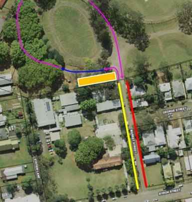
|
|
Committee Comments
· Kiss and Ride
area for school parking needs to be managed by the School
· to implement
Kiss and Ride is subject to relevant Guidelines:
http://roadsafety.transport.nsw.gov.au/stayingsafe/schools/dropoff_pickup.html.
· RMS provided the
words for Part 3 of the recommendation post-meeting.
Management Comments
Signage, poles and their installation will cost approx.
$500 and has no budget and will need to be funded from an existing project or
operational budget, for example maintenance or traffic facilities
|
|
RECOMMENDATION:
1. 1. That
Council endorse No Parking on the west side of Market Street, Bangalow
between Byron Street and its northern end, and that it be effective all days
between 8am and 6pm.
2. That
in support of the Bangalow Public School and Showground Trust proposal Council
endorse and sign the parking and traffic arrangements upon the Bangalow
Showground as depicted in this report (I2015/576) which are as follows:
a) as
per pink and blue lines, install “One Way – School Days
Only” signage;
b) as
per orange box, sign area as “School Staff Parking - School Days
Only”; and
c) also
along the blue line, sign as “No Parking – School Days
Only” and that it be supplemented with “Kiss and Ride”
signage.
3. That
the use of the Kiss and Ride be subject to the:
a) confirmation
of the school support for the initiative, which may include a brief
communication strategy for promotion of efficient use (i.e. distribution of
Roads & Maritime educational material available from the Centre for Road
Safety Website; Parent/carer letters; School Newsletter etc.).
b) Identification
of volunteers and/or teachers approved by the school community, including
demonstrated understanding of liability in respect to of volunteers and
students. Please note that the school must also develop policies and
procedures to administer the initiative.
c) details
of proposed operation times and roster of volunteers and/or teachers.
|
|
Report No. 6.3 Gilmore
Crescent - Restricted Parking Area
File No: I2015/1407
|
|
In light of changes about to be implemented due to the
introduction of pay parking throughout Byron Bay town centre, Gilmore
Crescent poses challenges, namely an unregulated parking area with most of
the road (as the below map shows) being upon crown land and not within a road
reserve; therefore meaning Council is not considered the authority over the
land.
However most of the existing road was built specifically
for access to two facilities: Sandhill’s Child Care and the Youth
Activity Centre (YAC). Accordingly the car parking as also shown was
constructed ancillary to these same two facilities. As both car park areas
fall outside of the pay parking scheme (until such time crown approval is
gained) a means of regulating the parking is required; otherwise the
constructed parking area will not meet its intended purpose. This is
especially likely for the child care which unlike the YAC operates with both
consistent, staffed hours Monday-Friday (except for Christmas/New Year) and
during times when pay parking will apply, being 9am-6pm every day.
Therefore of the two facilities the child care is seen as
more critical at this time and provides:
· 10 permissive parking spaces on the south side opposite
the centre;
· 8 permissive + 2 mobility permit car spaces on the north
side at front of the Centre; and
· that No Parking applies 1am to 5am.
Figure 1:
proposal and location
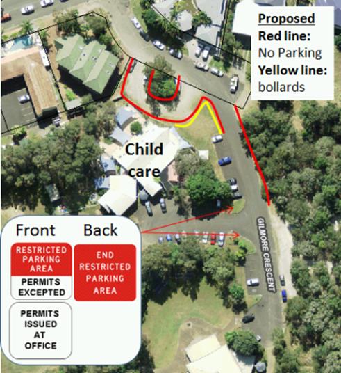
A lunchtime site inspection on 11 November found all
spaces in use except the permit parks, indicating that strong demand already
exists. However exacerbating the situation further is that currently no time
limit applies, and that enforcement is not possible given lack of signage and
the inability to distinguish vehicles between child care staff, patrons and
other users. However as the parking area is clearly upon crown land and
situated at the child care frontage with a single point of entry/exit it is
believed regulation is possible (and appropriate) via designating the car
park as a Restricted Parking Area (permits excepted).
Under such a scheme permits would be controlled and issued
by Council’s child care management for the purpose of displaying on
vehicle dashboards. The design and location of the proposed signage is
depicted, i.e. at entry/exit of the car park area.
The regulatory signage is also depicted including proposed
modification of R5-541 to include “Permits Excepted” and no
changes to R5-542, noting both can be enforced under NSW Road Rule 168-1:
(1) The driver of a vehicle (other than a
public utility service vehicle) must not stop in a restricted parking area,
unless the driver is:
(a) stopping in a parking station or in
accordance with the directions marked on (or on a sign displayed adjacent to)
a parking bay, or
(b)
actually engaged in dropping off, or picking up, passengers or goods.
Maximum penalty: 20 penalty units.
(2)
A restricted parking area is an area with:
(a) a restricted parking area sign on each
road into the area, and
(b) an end restricted parking area sign on
each road out of the area.
(3)
In this rule:
vehicle does not include a bicycle or animal that is
being ridden.
To assist further, supplementary signage is also
recommended; noting an example is also depicted which according to the above
road rule needs to be installed adjacent to the regulatory signage. It is
also noted that the use of permits is only likely to be required by long term
parking (i.e. child care staff) as the above road rule allows for short stays
who are in the act of dropping off or picking up (which will namely be
parents/carers).
Figure 2:
recommended regulatory and supplementary signage
|

|

|

|
|
R5-541 Modified
|
R5-542
|
Supplementary
sign
|
It should be noted Council/LTC
have set a precedent for use of a Restricted Parking Area via the 2012
resolution 12-496 which has been implemented with success and without need of
further review at Council’s First Sun Holiday Park in Byron Bay.
Lastly, given the child care does not operate weekends
there is potential the Restricted Parking Areas not apply at such times and
on this Committee advice is sought.
On a related matter, Committee advice and endorsement is
also sought for introducing No Parking restrictions to the road and grassed
verge on the north-east of the child care as also depicted, noting the red
line represents the extent of the proposed No Parking and the yellow line
indicates bollards (approx. 15 spaced at 2m apart).
With the commencement of pay parking it is expected this
already in-demand parking area will only increase noting that on 11 November
during a site visit the area was at ‘capacity’ with:
· 9 vehicles parked on the east side;
· 6 vehicles parked on the grass verge;
· 6 vehicles parked within the turning circle; and
· 11 vehicles parked on Gilmore Crescent proper.
In doing so, vehicles had parked adjacent to the child
care fence line and across the grass verge blocking access. To stop this
practice No Parking as proposed is required. Alternatively options to
regulate and allow permissive parking could be investigated.
|
|
Committee Comments
· Noted that
Gilmore Crescent while upon crown land is (for enforcement purposes) a road
related area
· Administration
of the permits noted as a Council matter
Management Comments
Nil
|
|
RECOMMENDATION:
1. That
the start and end of the Restricted Parking Area – Permits Excepted be
implemented respectively via installation of RMS signs R5-541 and R5-542 at
the car park entry and egress at the frontage of the Sandhill’s Child
Care Centre, Gilmore Crescent, Byron Bay.
2. That
adjacent to the signage erected according to Part 1, a supplementary sign
indicating how permits are obtained be installed.
3. That
Council note the Local Traffic Committee advice that the signage within Part
1 can be enforced under NSW Road Rule 168-1.
4. That
the grassed turning-circle located north-east of the child care be signed as
No Parking and it extend south along the western kerb line and eastern edge
of the road as depicted at Figure 1 of this report (file I2015/1407).
5. That
the use of bollards to reinforce the No Parking recommended is a matter for
Council and their use does not need Local Traffic Committee
endorsement.
|
|
Report No. 6.4 Road
Closures Byron Bay Triathlon
File No: I2015/1408
|
|
This annual event marks the
end of the triathlon season and attracts over 1,000 participants. The main
event is again proposed for a Saturday and as in previous years requires
substantial road closures and traffic management, albeit slightly reduced
timeframes as the proponent advises and acknowledges in their submission for
the 2016 event that:
· The total time the road was closed
was approximately in 2012 - 3.6 hours and 2013 – 2.7 hours, and 2015
– 2.5 hours.
· The traffic management and detour
management was comprehensive throughout the effected roads, though at key
intersection delays of up to 20 minutes were experienced regularly.
· The delays particularly around
Suffolk Park and Bangalow Road caused upset.
Given this the proponent
submission outlines a Proposed
Closure/Escort Model for
the 2016 event:
The proposed total
time roads are closed is
approximately 2.5
hours. The southbound
lane is affected for
approximately 1.45
hours; and northbound lane
affected for approximately
2.5 hours.
o First bike on course estimated
at 12.20pm.
o Race course southbound closed by 12.00pm and then progressively
through four
zones as riders head southbound under Police escort.
o The southbound to Lennox
Heads will open under
Police control from Suffolk
Park after last
southbound rider has passed.
o The number
of cross over
points closer
to town will remain at two. (east /
west).
o The athletes
will operate on a curfew
and stragglers will be collected by a support vehicle which
will clear the
course.
The proponent submission
then continues to state:
Police have expressed concern regarding the risks mixing of
athletes and vehicles on the cycle course. In 2013, 2014 and 2015, a complete
road closure for a reduced period of time was used which addressed these
risks but did cause complications for traffic flows.
The common view for 2016 is that the road should be closed
for as short as time possible and traffic should be eliminated except at
Suffolk Park.
This will mean significant
lengths of the only north/south route to/from Byron Bay will be closed
including the main road network of Bangalow Rd, Byron Bay and Broken Head Rd
which is north, south and at Suffolk Park.
The maps provided by the
proponent are reproduced below and indicate the extent of the closures and
traffic management. Consistently however in these past years Clifford Street
at Suffolk Park has been subject of most complaint and longest delays (30
minutes or more) which can occur subject to the timing of the cycling leg.
This will likely to remain a problem.
However despite this and
general reported inconvenience and delays, each year results in few (2-3)
formally lodged complaints. Moreover the event is well advertised in advance
(notice to residents provided), has no reported safety problems, is well
controlled with Police and traffic control involvement and is anticipated and
well received from local traders and accommodation providers.
As such Committee
endorsement is sought for the road closures and traffic management proposed.
Figure 1: proponents maps reproduced
.
|
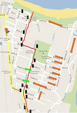
Town centre
|
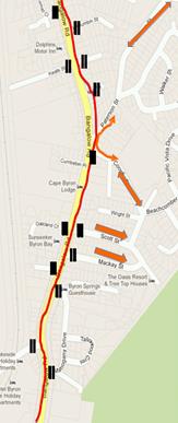
Bangalow Rd
|
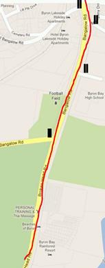
Bangalow Rd
|
|
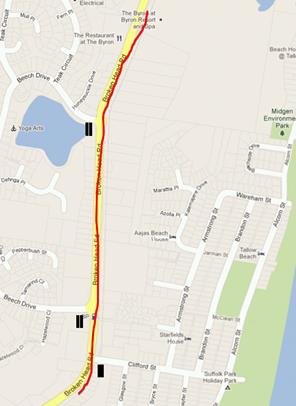
Suffolk Park
|

Coast Rd - onto
Ballina shire
|
|
|
Committee Comments
· Cr Dey advised
he intends to move at Council that Council liaise with Tweed Council to
consider a) the capacity of our Shire to host the current or future number of
on road events per year and b) the attractions of NSW to events generated in
Qld.
· Proponent to
provide a detailed TCP for Committee input (via email or next meeting)
· RMS advised a
preference to standardise wording for use by Local Government in regard to
road events and will provide such wording for the recommendation
Management Comments
· RMS standardised
wording has now been incorporated into the recommendation.
· The Committee
will receive further details of the event by email or next meeting (3
February)
|
|
RECOMMENDATION:
1. That
approval of the temporary road closures within Byron Bay for undertaking the
7 May 2016 Byron Bay Triathlon apply to the following, subject to each being
implemented no earlier than 12 noon and removed no later than 4pm:
a) Bay Street, between
Fletcher Street and Middleton Street
b) Middleton Street,
between Bay Street and Marvell Street
c) Marvell Street,
between Middleton Street and Tennyson Street
d) Tennyson Street,
between Marvell Street and Browning Street
e) Bangalow Road,
between Browning Street and Broken Head Road
f) Broken Head Road, from
Bangalow Road to the Ballina LGA boundary
g) Lawson Street,
between Middleton Street and Massinger Street
2. That
the approval provided in Part 1 is subject to:
a) NSW
Police approval is obtained;
b) Local
Traffic Committee advice is sought for the event Traffic Management Plan
(including Risk Management Plan and Traffic Control Plan/s) prior to
implementation of traffic control devices including road closures, noting
that:
i) conformance
with approved Traffic Management Plan and associated Traffic Control Plans
which shall be implemented and controlled by Roads & Maritime Services
accredited persons;
ii) all
signage erected for the event to not cause a hazard for motorists or
pedestrians and be removed immediately following the completion of the event;
and
iii) temporary
Speed Zone Authorisation is obtained from the roads authority for any reduced
speed limit/s required as part of the traffic control for the event; and that
where local Council is the roads authority, notification of any reduced speed
limit should be forwarded to Roads and Maritime Service and NSW Police.
iv) approval
of Roads and Maritime Services is obtained by way of a Road Occupancy License
where event is on a state road or where the event may impact the state road
network.
c) The
event organiser:
i) advertising
the impact of the event via a notice in the local weekly paper a minimum of
one week prior to the operational impacts taking effect, noting it must
include the event name, specifics of any traffic impacts or road closures and
times, alternative route arrangements, event organiser, a personal contact
name and a telephone number for all event related enquiries or complaints;
ii) providing
copy of the advert for Council's web page;
iii) informing
community and business that are directly impacted (e.g. adjacent to the
event) via written information which is delivered to the property in a timely
manner so as to document, consider and respond to any concerns raised;
iv) arranging
for private property access and egress affected by the event;
v) liaising
with bus and taxi operators and ensuring arrangements are made for provision
of services during conduct of the event;
vi) consulting
with emergency services and any identified issues be addressed;
vii) holding
$20m public liability insurance cover which is valid for the event;
viii) payment
of Council’s Road Event application fee prior to the event.
d) any
event involving on-road cycling, the event organiser must:
i) obtain
the endorsement of Bicycle NSW or the relevant peak-body that is
representative of the approved activity ; and
ii) ensure
it is conducted and sign-posted in accordance with the Roads & Maritime
Services Guidelines for Bicycle Road Races.
|
|
Report No. 6.5 Road
Closures Byron Bay Blues Festival
File No: I2015/1409
|
|
Two matters are to be tabled to the Committee, one being
the proposed 2016 Blues Festival Traffic Management Plan and the second is
the DA proposal to increase the number of smaller events on the site. Both
will be impacted by the likelihood of the RMS proposed closure of Grays Lane.
For the 2016 Blues Fest event this is the only change to
previous years TMP and will be countered by onsite parking management, namely
vehicles parked north and south onsite will only be able to depart north and
south respectively therefore avoiding the crossing of such traffic which in
past year has contributed significantly to delays departing the site at the
end of each of the five days.
As for the second item of increasing the number of smaller
events each year, that applicant has proposed a single TMP be developed that
can be used and shared for each such event, noting the Blues Fest is a large
event with 25,000 people in total while 15,000 in total is deemed a medium
sized event and a small event is 1,000 patrons plus staff. There is potential
for certain ‘small events’ to generate high spikes in traffic
during times that coincide with already high traffic (other events, public
holidays etc.) which has been raised as a key issue.
Details of both matters will be available at the Committee
meeting, noting endorsement is sought for the first matter and Committee
advice is sought for the second item.
|
|
Committee Comments
· Two key coinciding factors: change in access to the Highway is a
key and critical component with mooted closure of Gray’s Lane and it
coincides with the proposed increase in patronage.
· Therefore a capacity issue is apparent and Committee need to see
the Traffic Assessment Report and detailed Traffic Control Plans before
making a decision on approving
· Such documents need to be submitted to Council in time for changes
and to allow sufficient time for consideration of all the issues, e.g.
in December for February meeting
· Potential approval conditions could be the installation of a
dedicated southbound on-ramp for the Festival; provision of off-site parking
and shuttle bus.
· Similarly, for the proposed smaller events a traffic assessment is
required that considers capacity of local road network, especially as smaller
events are likely to have majority of patrons arrive and depart at the same
time so stop and release may be required.
Management Comments
Nil
|
|
RECOMMENDATION:
1. That the 2016 Blues Festival organisers submit a
Traffic Impact Assessment and Traffic Control Plan prior to the February 2016
Local Traffic Committee meeting.
2. That in regard to other proposed events at the
Tyagarah Blues Festival site, the proponent undertakes a Traffic Impact
Assessment report in regard to events with 1,000 people or more and provides
it and the corresponding Traffic Management Plan(s) to the Local Traffic
Committee for review.
3. That event proposals are submitted to Council with
supporting and relevant detail so as to provide sufficient time for
assessment, amendments and meeting of approval conditions imposed,
including those by and of other authorities such as Roads and Maritime Services
and Police.
|
|
Report No. 6.6 Road
Closures Falls Festival 2015/16 Traffic Management Plan
File No: I2015/1410
|
|
Due to the Falls Festival (as part their Dept. of Planning
conditions) required LTC review no less than 60 days prior to the event the Committee
received details of the proposal via e-email on 16 October 2015. From that
process the Committee concurred with recommendation as now tabled which has
since been provided to the proponent.
As part of the e-mail the following was attached and with
copies to be made available at the meeting:
· TMP including
detailed TCP;
· Traffic
Evaluation Report of 2015 event – as dated 16/2/15; and
· Memo from Greg
Alderson & Associates, dated 7 October 2015 which advised:
Main changes:
· No traffic controllers on public road, therefore no
reduced speed zone at Link Road. Only reduced speed zone from Gate D to Jones
Road on Tweed Valley Way;
· No stopping from Shara Boulevard to Wooyung Road to
reduce parking on Tweed Valley Way and improve potential for Police and
rangers to enforce no stopping and reduce trespassing;
· Approval for 20,000 patrons (17,500 last year);
· 2 ingress days (last year 3 ingress days) to reduce
duration of camping due to heat;
· Stacked camping/parking in camping area – cars
not separated from camping, but in a structured efficient manner as has been
done at Falls in Lorne for years.
Other comments:
· SIDRA modelling shows that no traffic controllers
are required;
· Contingency plans for Spine Road congestion (if that
occurs) are: double lane, one way on Spine Road, snake in southern car park,
temporary parking in southern car park during peak (this car park is now
available for Falls due to approved 20,000 patron number)
· Traffic controllers are on call for any queuing on
public road, to control end-of queue;
· VMS signs are incorporated on TVW southbound and BVW
northbound well clear of potential end of queue, to provide queue warning if
required
· Refer to section 2.3 of report for stacked parking
and camping. This is fundamentally different than the mixed parking and
camping of SITG 2013 and it should increase flexibility for any required
changes on site.
|
|
Committee Comments
· Traffic Impact
Analysis prepared and supplied by Falls Fest consultants Greg Alderson and
Associates who have done previous year’s events and traffic planning.
· It was also
noted matter had been endorsed via e-mail prior to the meeting and that
recommendation stands as reproduced above
Management Comments
Nil
|
|
RECOMMENDATION:
That the temporary traffic
management and regulatory changes within the series of Traffic Control Plans
as related to the Falls Festival as to be held at the North Byron Parklands
site Yelgun between 31 December 2015 and 2 January 2016 inclusive be accepted
subject to:
a) their
design and implementation being undertaken as specified on each plan and by
those with appropriate RMS accreditation and the holding of current and appropriate
levels of insurance and liability cover;
b) meeting
of the advertising requirements of the Roads Act 1993;
c) event
being notified on Council's website;
d) consideration
of any submissions received;
e) the
approved event size being sufficient (20,000 patrons) to trigger use of the south
carpark as per the DA Condition for its use;
f) the
temporary No Stopping where applied, including on Brunswick Valley Way (between
Shara Boulevard and Tweed Valley Way) and on Tweed Valley Way (between
Brunswick Valley Way and Wooyong Road), is implemented prior to the event
and in accordance with relevant state requirements and Australian Standards;
g) a
communications protocol developed and maintained by those involved in the implementation
of traffic management including monitoring and ability to implement
contingency plans as and when directed;
h) monitoring
of vehicle volumes that arrive and depart the festival site and on the local
road network;
i) inclusion
in the brief for the 2015/16 event's Traffic Evaluation Report of consideration
that the 2106/17 event will not have Sunday as its departure day, as
was the case in 2015/16;
j) the
holding of an event debrief within the month following the festival which includes
but not limited to Council, RMS and Police; and
k) written
approval of both the RMS and Police separate to Byron Shire Local Traffic
Committee, including approval of Roads and Maritime Services is obtained
including a Road Occupancy Licence where an event is on a state road or
where the event may impact the state road network
|
|
Report No. 6.7 Road
Closures New Years Eve Byron Bay
File No: I2015/1411
|
|
Council last year (2014)
held the second annual 'Soul Street' New Year Eve (NYE) event which required
a road closure from of the main street of Jonson Street, Byron Bay between
Lawson Street through to the car park entry at Railway Park just north of
Marvell Street. The same road closure is now sought as pictured;
however a split time is sought with the southern end to close from 12noon and
the northern end from 1pm. The road closure would then be lifted no later
than by 7am the next day (1 January 2015).
Other closures are shown,
such as securing of Council owned and operated public car park (Lawson Street
south car park) for participants of the event only (e.g. stall holders) and
provision of an emergency vehicle access route under guidance of traffic control
positioned at sites 2 and 3. Removal of parking from streets (as per dotted
red line) from 6am will also occur as will traffic control personnel with
include two each at sites 1, 2 and 3.
Figure 1: TMP proposal
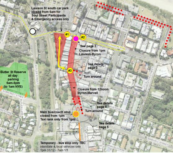
This year Council will run a NYE shuttle
service between 3pm and 3am from the Cavanbah sports centre on Ewingsdale Rd
(3km west of town) to the site depicted below; i.e. at the top end of the
street closure.
The below figure also
provides detail on the role of the traffic control to be positioned during
the day at sites 1 and 2, noting when two personnel are at each they will
assist with control of pedestrian and vehicle movement at the Jonson / Lawson
Street roundabout.
Figure 2: NYE Shuttle drop off / pick up point and
traffic control sites 1 and 2
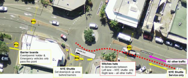
It should be noted the road
closure impacts on local taxi and bus operators and interstate coach
services. As in the past, these stakeholders will be advised directly and
accommodated where possible, noting this NYE the main bus/coach stop will be
for taxi and smaller passenger service vehicles only while the bus/coach and
larger vehicles will be provided for south of the main stop so as they avoid
the turn-around south end of the road closure and can exit directly via
Marvell St. Both south and north bound vehicles can use this temporary
bus/coach stop if they wish by detouring or alternatively (as local services
do) use the existing southbound bus stop opposite.
|
|
Committee Comments
· Third year for
Council’s Soul Street Event. Various starting times have been trialled.
· No park and
ride, only a one-day shuttle bus service. Proposal to bring the bus to the
site for family friendly service.
· Police raised
the potential use of heavier barriers for safety for demarcating the shuttle
bus stop.
· Remove car
parking about five spaces from 1pm for a the shuttle bus service starting at
3pm, noting RMS raised Shuttle Bus could stop there, with water barriers
· No witches hats
to be used.
Management Comments
Nil
|
|
RECOMMENDATION:
1. That
the Local Traffic Committee supports Council's temporary traffic management
initiatives for Byron Bay New Year's Eve and approves the road closure of
Jonson Street, Byron Bay between Lawson Street through to the car park entry
at Railway Park (north of Marvell Street) from 12noon on 31 December 2015 and
its removal by no later than 7am on the 1 January 2016.
2. That
the above approval remain subject to Council endorsement of the event prior
to implementation and is subject to the following requirements:
a) traffic
control plans are designed and implemented by those with the appropriate NSW
(RMS) accreditation;
b) advertising
is undertaken as required by the Roads Act plus the publication of a map and explanatory
notes in a local newspaper and on Council's website;
c) the
letterbox drop of properties adjacent and prior to the Jonson Street closure
and Bay Street, Marvell Street and Byron Street parking changes; and
d) that
all parties involved in Council's NYE events hold or least covered by,
appropriate and relevant levels of insurance and public liability cover as
required by Council.
|
|
Report No. 6.8 Road
Closures Bangalow Christmas Eve Carnival
File No: I2015/1412
|
|
Each year the Bangalow
Chamber of Commerce organise the Christmas Eve street parade that requires
closure of Byron Street, Bangalow which occurs 5.30pm to 10pm between the
Granuaille Road, Lismore Road and Byron Street roundabout and Market Street
intersection.
The event has no reported
problems, with Council again providing s356 community funding and involved in
implementing the temporary traffic control which includes a detour for
through traffic via Deacon Street.
On these grounds Committee
endorsement of the event is sought.
|
|
Committee Comments
· Council to
provide TCP to the Committee
· First year
Council not implementing the TCP, and organisers to engage accredited third
party.
· RMS road
occupancy license needed. organisers can sign up online as available at:
http://www.rms.nsw.gov.au/business-industry/road-occupancy-licence/index.html
Management Comments
Nil
|
|
RECOMMENDATION:
1. That the temporary traffic
arrangements for the Bangalow Christmas Eve Carnival, scheduled for 24
December 2016 and includes the temporary closure of Byron Street between
Granuaille Road and Market Street between the hours of 5.00pm and 10.00pm, be
endorsed.
2. That the organisers be responsible for
implementing a Traffic Control Plan, including the use of signed detours, as
designed and implemented by those with appropriate accreditation and be
advised Council’s fee for holding an on-road event will apply.
3. That public liability insurance be in
place for the sum of at least $20 million.
4. That the concurrence of the Police and
RMS be sought by the organisers, independent of the Local Traffic Committee
endorsement, including, approval of Roads and Maritime Services is
obtained by way of a Road Occupancy License as event is on a state road or
may impact the state road network.
5. That the event be advertised in
accordance with the Roads Act charged at cost to the organisers.
6. That the event be notified on Council's website.
7. That it be noted Council do not provide traffic
control services for such events and that RMS accredited persons can only do
so.
|
|
Report No. 6.9 Request
for Give Way, Dandaloo Way and Reka Way, Ocean Shores
File No: I2015/1414
|
|
A resident has advised of concerns for safety at the
unmarked and unsigned intersection and has requested Give Way be provided.
Given the main through traffic is as per yellow line it is believed the Give
Way is most appropriate on Dandaloo Way as pictured. Committee advice
is sought as is endorsement of a preferred treatment.
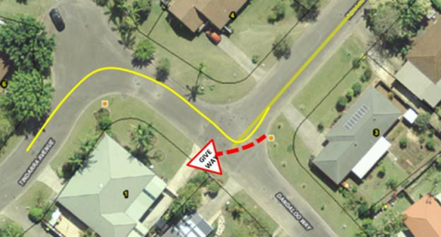
|
|
Committee Comments
RMS suggested
the Give Way treatment not be undertaken as pictured and instead be located
on Reka Way as per standard practice. Police concurred.
Management Comments
Nil
|
|
RECOMMENDATION:
That a Give Way treatment be signed and marked
on Reka Way, Ocean Shores at the intersection with Dandaloo Way.
.
|
|
Report No. 6.10 Request
for restrictive parking and exemptions, RFS Station, Alcorn St, Suffolk Park
File No: I2015/1415
|
|
RFS Station at Suffolk Park has requested restrictive
parking be implemented to at least south side of the driveway on Alcorn
Street, Suffolk Park which allows RFS volunteers attending the station
opportunity to park in close proximity, thereby saving time in case of
emergency. The site and the proposal are depicted.
To stop general permissive
parking the options are either No Stopping, No Parking or potentially declare
it a Restricted Parking Area (RPA). Either way, a second condition that
allows some vehicles an exemption to that rule is required, plus the ability
to recognise which vehicles is exempt to the rule. Further complications are
then ability to manage and enforce the rule. Therefore in short, Council need
to consider not just approval (which requires LTC endorsement) but
administration, management and enforcement.
However relevant to the
Committee is firstly the justification for an appropriate parking regulation.
To assist the Byron Bay RFS Captain (Gregg Miller) provided the following
response to these e-mailed questions:
Q1.
How many vehicles need such parking (i.e. max number at any one time)?
generally
we would have five cars to most call outs , we park nose in on the southern
side of the station drive and on occasion 1 or 2 spaces on the northern
side of the drive
Q2. Do the vehicles
have any logos/branding on them, or as I presume they mostly private
vehicles?
they
are private vehicles however…able to provide identity stickers if
required
3. Do or could RFS
members carry any standard identification they could leave on the vehicle
dashboard?
as
above identity sticker for the windscreen
4. Do you have
preference for where parking is reserved – or is either side of the
station driveway ok?
prefer
the space on the southern side of the station driveway
generally we can get five cars in this space
5. Based on last 12
months, how often is such parking been required and, when so, how often has
it been a problem?
The
brigade attended 76 incidents last year April 2014 till March 2015, the
problem has occurred over the past three months , with the residents of the
flat two doors down on the opposite side of the road parking in these spaces,
and their trailer. As we operate 24/7 there is no specific time that
were there.
6. Is there a time
more problematic than others? For example is between 6pm-6am generally ok/low
demand parking, or is it weekend problem only or Mon-Friday day time, etc.
Please advise. Without such detail I will assume the problem is mainly
daytime due to adjacent park and beach access.
Park
and Beach access has never been a problem. Generally they if visitors, park
to the northern side of the park, locals generally walk. At weekend we do
experience high volume of families using the park, and children's playground.
As above question 5, the residents are there every evening, and throughout
the days of the week, their cars are generally parked there also at weekends
as there appears that there is not enough parking spaces at the units. On the
10th of September there was a wedding in the park, and no spaces available at
all. The closest park to the station was at the northern end of Gagging
Park.
Based on the above responses it
appears the main recurring problem is local residents parking adjacent to the
fire station and therefore providing restrictive parking on the south side of
the driveway, where five vehicles can be accommodated, will be sufficient for
most occasions. Further review can be done later if required.
Given a speed hump is approx.
10m south of the driveway it is recommended that No Parking – Byron
Shire Council Authorised Vehicles Excepted be signed through to it and to 5m
north of the RFS driveway.
Figure 1: length of restriction (blue line) and position
of the two signs (red circles)
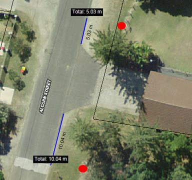
|
|
Committee Comments
Endorsement is
on grounds of providing for staff/volunteers of an Emergency Services and not
a regulation or benefit that would extend to general public
Management Comments
Nil
|
|
RECOMMENDATION:
1. That
No Parking – Byron Shire Council Authorised
Vehicles Excepted be signed on Alcon Street, Suffolk Park
commencing from 5m north of the RFS station driveway and continuing south to
the speed hump.
2. That
recognising which vehicles are an exception to the rule is a matter for
Council and RFS, noting a visual permit displayed on the vehicle dashboard
will assist with enforcement and is recommended.
|
|
Report No. 6.11 Approval
of two mobility permit spaces, Middleton Street car park, Byron Bay
File No: I2015/1416
|
|
Council recently completed the construction of a car park
in Middleton Street, Byron Bay. The design is depicted and shows the two
sites now signed as a Mobility Permit Parking space as numbered on the plan
as 15 and 30. Committee endorsement of this is now sought.
Figure 1: design
plan showing sites 15 and 30 – signed as mobility permit spaces
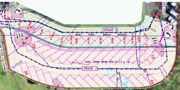
|
|
Committee Comments
Endorsed subject to compliance with relevant mobility
parking standards
Management Comments
Nil
|
|
RECOMMENDATION:
That Local Traffic Committee endorse the installation
and signage of two mobility permit parking spaces in the Middleton Street car
park, Byron Bay at spaces as marked on Council’s design plan 1641
numbered 15 and 30, subject to compliance with relevant standards.
|
|
Report No. 6.12 Proposed
No Parking and time limits to Loading Zones, Bay Lane, Byron Bay
File No: I2015/1417
|
|
Council has received complaints from a local business
owner in Bay Lane, Byron Bay who is experiencing loss of property access and
visibility due to people parking in the Loading Zone area outside their
shops. They claim parking can occur for up to 90-minutes and that in the
afternoon the mix of loading vehicles and the commencement of the evening
dining (whereby tables/chairs are put on the footpath area) exacerbate the
problem they report.
While this requires enforcement, part of the request is to
limit the time in the Loading Zone and/or even consider restricting the hours
of its operation, and while the proponent wishes this settled quickly, such
outcome is unlikely as changes will require consultation and given the
approaching Christmas/New Year period will mean reports back to LTC/Council
in February 2016 at earliest, unless no objections are received during
consultation or the Committee are able to provide in-principle support as
recommended.
The recommendation also includes restricting 15m of the western
end of the Loading Zone to being operational between 6am-10am only with 15
minutes time limits to apply during such times and that No Parking applies
other times within the same 15m length. In doing this leaves approximately
50m of Loading Zone, available at all times.
Figure 1: yellow
line=no stopping; red line=Loading Zone (approx. 65m length)
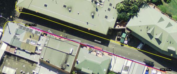
Figure 2: use of
the Loading Zone in front of shops

|
|
Committee Comments
Consultation required to understand impacts of and support
for the proposal before it proceeds.
Management Comments
Nil
|
|
RECOMMENDATION:
That subject to concurrence of adjacent shops including
the Beach Hotel opposite, Council endorse restricting 15m of
the western end of the Loading Zone to being operational between 6am-10am
only with 15-minute time limit to apply during such times and that No Parking
applies at all other times within the same 15m length.
|
|
Report No. 6.13 Request
for speed humps, Seven Mile Beach Road, Byron Bay
File No: I2015/1418
|
|
Private property owner on the gravel road of Seven Mile
Beach Road, Byron Bay has offered to pay for the sealing of approximately a
320m length, which as shown commences approximately 40m south of Lot 3
driveway and continues northward covering three property driveways.
Once sealed the proponent would also like to introduce
speed reducing measures and has suggested speed humps. Committee advice on
the appropriate traffic calming measure however is sought.
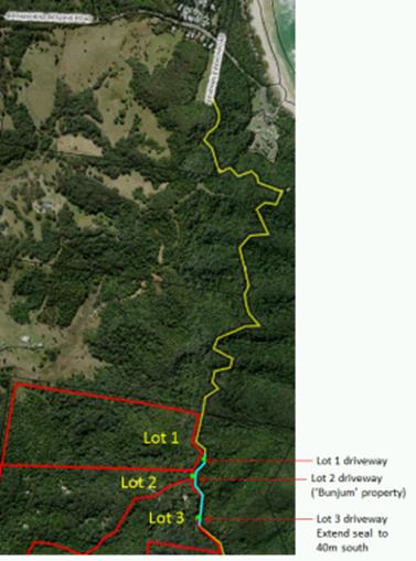
|
|
Committee Comments
· Committee does
not agree to the installation of speed humps in an unrestricted speed
unsealed road, or a small length of sealed section.
· Speed humps are
an urban treatment and typically require lighting, kerb and gutter and within
a slower speed environment (50k or less speed limit).
· REF process
required prior to sealing as the impacts of sealing this road need to be
considered, noting an REF is not a part of regulatory decisions of the LTC.
Management Comments
Nil
|
|
RECOMMENDATION:
That Council notes that the Local Traffic Committee
does not endorse the use of speed humps on the proposed sealed section of
Seven Mile Beach Road, Broken Head in a default rural speed limit area, and
that a reduced speed limit is not appropriate.
|
|
Report No. 6.14 Proposed
Massinger Street and Lawson Street roundabout, Byron Bay
File No: I2015/1419
|
|
Council is proceeding with development of a roundabout for
the intersection of Massinger Street, Lawson Street and Lighthouse Road,
Byron Bay. Extract of the design plan is reproduced and full design plan will
be available at the meeting for review.
Committee advice is sought plus endorsement of the extent
of No Stopping shown, noting the proposal of such restriction extends on the
east side of Massinger Street for approximately 110m and will assist with an
ongoing problem of roadside, on the verge parking that occurs most of the
summer holiday period and in particular mitigate the three (3) residential
properties from being parked out by the public using this area to access the
beach; noting that parking out of the driveways has been an ongoing source of
complaints by residents to Council. Further, between Daniel Street and
Kipling Street, No Stopping will stop the parking on the proposed drainage
swale
Residents have been advised of the project with a
notification letter advising of the proposed parking changes.
The introduction of No Stopping in Lawson Street and
Lighthouse Road ensures that minimum safe carriage way widths are maintained
at the roundabout approach lanes.
ßNORTH
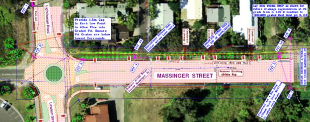
|
|
Committee Comments
· There may be an enforcement issue following the installation of
the No Stopping signs. Need to be reviewed following installation for future
consideration.
· Request that the design plan be reviewed to achieve same result
with fewer signs installed, subject to compliance with sign posting
standards.
Management Comments
Nil
|
|
RECOMMENDATION:
That the Local Traffic Committee endorse the traffic
and parking regulatory aspects of Council design plan no. 2211
for the construction of a roundabout at the intersection of Massinger Street,
Lawson Street and Lighthouse Road, Byron Bay.
|
|
Report No. 6.15 Proposed
Restricted Parking Area, Byron Bay Library
File No: I2015/1424
|
|
The Byron Bay library car park has been provided onsite
for the benefit of staff and patrons. Due to its town centre location
and high parking demand in the vicinity, it is frequently used by others. As
a result options to restrict and regulate parking have been discussed and to
this end Committee advice is sought on the benefit of implementing a
Restricted Parking Area – Permits Excepted.
As raised in another item on this same (25 November 2015)
agenda, it is believed such a scheme is appropriate given the car park is
well defined by a single point of access/egress and the issuing of permits
can be undertaken as required by Council staff within the library to assist
with enforcement and deter use by those who do not have the library as their
destination.
The location and the signage
recommended are depicted.
Figure 1:
proposal and location
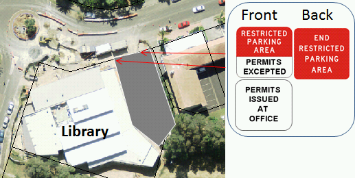
Similar to a related agenda item, under such a scheme
permits would be controlled and issued by Council’s library management
for the purpose of displaying on vehicle dashboards. Such undertaking would
however only be required by longer term parking (e.g. staff) and not those
simply dropping off or picking up goods or passengers.
The regulatory signage is also depicted including proposed
modification of R5-541 to include “Permits Excepted” and no
changes to R5-542, noting both can be enforced under the previously cited NSW
Road Rule 168-1; and to assist further, supplementary signage is also
recommended as shown.
Figure 2:
recommended regulatory and supplementary signage
|
|
|
|
|
R5-541 Modified
|
R5-542
|
Supplementary
sign
|
It should be noted Council/LTC
have set a precedent for use of a Restricted Parking Area via the 2012
resolution 12-496 which has been implemented with success and without need of
further review at Council’s First Sun Holiday Park in Byron Bay.
As the library operates seven (7) days a week the
Restricted Parking Area would apply at all times.
|
|
Committee Comments
Change wording for sign plate to state
“Permits Issued at Library”
Management Comments
Nil
|
|
RECOMMENDATION:
1. That the start
and end of the Restricted Parking Area – Permits Excepted be
implemented respectively via installation of RMS signs R5-541 and R5-542 at
the Byron Bay library car park entry and egress as located on Lawson Street,
Byron Bay.
2. That adjacent to the
signage erected according to Part 1, a supplementary sign indicating how
permits are obtained be installed, i.e. “Permits issued at
Library”
3. That Council note the
Local Traffic Committee advice that the signage within Part 1 can be enforced
under NSW Road Rule 168-1.
|
|
Report No. 6.16 Request
for No Stopping, Authorised Vehicles Excepted, rear of Australia Post, Deacon
Street, Bangalow
File No: I2015/1431
|
|
A request has been received from the Manager of Australia
Post, Deacon Street Bangalow that signage requiring “No Stopping -
Authorised Vehicles Excepted” be installed at the rear of the building
to allow Australia Post vehicles access. At present vehicles are parking in
the laneway blocking access to postal vehicles, despite No Parking signs, and
vigilant compliance monitoring of the area.
Committee endorsement is sought; noting it recommended the
length to which it applies covers the rear of the post office and the public
land adjacent which provides a path through to the main street.
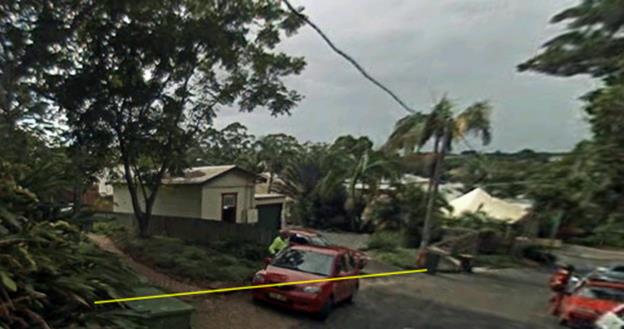
|
|
Committee Comments
Concern for precedent as not emergency service, however
accept that Australia Post provide public service and the exception is to
apply to their branded vehicles in the act of delivery/pick up.
Management Comments
Nil
|
|
RECOMMENDATION:
1. That
Local Traffic Committee endorse the installation of No Stopping –
Council Authorised Vehicles Excepted, signage at the rear of Australia
Post property in Deacon Street, Bangalow and the same restriction continue
westward to also cover Council land which provides pedestrian access through
to the main street.
2. This
exception applies to “Australia Post” delivery vehicles only.
|
There being no further business the meeting concluded at
2.30pm.