Agenda
Ordinary
Meeting
Thursday,
7 April 2016
held
at Council Chambers, Station Street Mullumbimby
commencing
at 9.00am
 Public Access relating to items
on this Agenda can be made between 9.00am and 10.30am on the day of the
Meeting. Requests for public access should be made to the General Manager
or Mayor no later than 12.00 midday on the day prior to the Meeting.
Public Access relating to items
on this Agenda can be made between 9.00am and 10.30am on the day of the
Meeting. Requests for public access should be made to the General Manager
or Mayor no later than 12.00 midday on the day prior to the Meeting.
Ken
Gainger
General
Manager
What is a “Conflict of Interests” - A conflict of
interests can be of two types:
Pecuniary - an interest that a person has in a matter because of a reasonable
likelihood or expectation of appreciable financial gain or loss to the person
or another person with whom the person is associated.
Non-pecuniary – a private or personal interest that a Council
official has that does not amount to a pecuniary interest as defined in the
Local Government Act (eg. A friendship, membership of an association, society
or trade union or involvement or interest in an activity and may include an
interest of a financial nature).
Remoteness – a person does not have a pecuniary interest in a matter
if the interest is so remote or insignificant that it could not reasonably be
regarded as likely to influence any decision the person might make in relation
to a matter or if the interest is of a kind specified in Section 448 of the
Local Government Act.
Who has a Pecuniary Interest? - a person has a pecuniary interest in a
matter if the pecuniary interest is the interest of the person, or another
person with whom the person is associated (see below).
Relatives, Partners - a person is taken to have a pecuniary interest in a
matter if:
§ The person’s
spouse or de facto partner or a relative of the person has a pecuniary interest
in the matter, or
§ The person, or a
nominee, partners or employer of the person, is a member of a company or other
body that has a pecuniary interest in the matter.
N.B. “Relative”, in relation to a person means any of the
following:
(a) the
parent, grandparent, brother, sister, uncle, aunt, nephew, niece, lineal
descends or adopted child of the person or of the person’s spouse;
(b) the
spouse or de facto partners of the person or of a person referred to in
paragraph (a)
No Interest in the Matter - however, a person is not taken to have a
pecuniary interest in a matter:
§ If the person is
unaware of the relevant pecuniary interest of the spouse, de facto partner,
relative or company or other body, or
§ Just because the
person is a member of, or is employed by, the Council.
§ Just because the
person is a member of, or a delegate of the Council to, a company or other body
that has a pecuniary interest in the matter provided that the person has no
beneficial interest in any shares of the company or body.
Disclosure and participation in meetings
§ A Councillor or a
member of a Council Committee who has a pecuniary interest in any matter with
which the Council is concerned and who is present at a meeting of the Council
or Committee at which the matter is being considered must disclose the nature
of the interest to the meeting as soon as practicable.
§ The Councillor or
member must not be present at, or in sight of, the meeting of the Council or
Committee:
(a) at any
time during which the matter is being considered or discussed by the Council or
Committee, or
(b) at any
time during which the Council or Committee is voting on any question in
relation to the matter.
No Knowledge - a person does not breach this Clause if the person did
not know and could not reasonably be expected to have known that the matter
under consideration at the meeting was a matter in which he or she had a
pecuniary interest.
Participation in Meetings Despite Pecuniary Interest (S 452 Act)
A Councillor is not prevented from taking part in the consideration or
discussion of, or from voting on, any of the matters/questions detailed in
Section 452 of the Local Government Act.
Non-pecuniary Interests - Must be disclosed in meetings.
There are a broad range of options available for managing conflicts &
the option chosen will depend on an assessment of the circumstances of the
matter, the nature of the interest and the significance of the issue being
dealt with. Non-pecuniary conflicts of interests must be dealt with in at
least one of the following ways:
§ It may be appropriate
that no action be taken where the potential for conflict is minimal.
However, Councillors should consider providing an explanation of why they
consider a conflict does not exist.
§ Limit involvement if
practical (eg. Participate in discussion but not in decision making or
vice-versa). Care needs to be taken when exercising this option.
§ Remove the source of
the conflict (eg. Relinquishing or divesting the personal interest that creates
the conflict)
§ Have no involvement by
absenting yourself from and not taking part in any debate or voting on the
issue as if the provisions in S451 of the Local Government Act apply
(particularly if you have a significant non-pecuniary interest)
RECORDING OF VOTING ON PLANNING MATTERS
Clause 375A of the Local Government Act 1993
– Recording of voting on planning matters
(1) In this section, planning
decision means a decision made in the exercise of a function of a council
under the Environmental Planning and Assessment Act 1979:
(a) including a decision
relating to a development application, an environmental planning instrument, a
development control plan or a development contribution plan under that Act, but
(b) not including the making of
an order under Division 2A of Part 6 of that Act.
(2) The general manager is
required to keep a register containing, for each planning decision made at a
meeting of the council or a council committee, the names of the councillors who
supported the decision and the names of any councillors who opposed (or are
taken to have opposed) the decision.
(3) For the purpose of
maintaining the register, a division is required to be called whenever a motion
for a planning decision is put at a meeting of the council or a council
committee.
(4) Each decision recorded in
the register is to be described in the register or identified in a manner that
enables the description to be obtained from another publicly available
document, and is to include the information required by the regulations.
(5) This section extends to a
meeting that is closed to the public.
Ordinary Meeting
BUSINESS OF Ordinary Meeting
1. Public Access
2. Apologies
3. Requests for Leave of
Absence
4. Declarations of Interest
– Pecuniary and Non-Pecuniary
5. Tabling of Pecuniary
Interest Returns (s450A Local Government Act 1993)
6. Adoption of Minutes from
Previous Meetings
6.1 Ordinary
Meeting held on 17 March 2016
7. Reservation of Items for
Debate and Order of Business
8. Mayoral Minute
9. Notices of Motion
9.1 Support
for Mens Shed at Bangalow................................................................................ 5
9.2 Trial
of temporary traffic calming...................................................................................... 8
10. Petitions
10.1 Against
kitchen and showers at the Girl Guides Hall, Byron Bay................................... 10
10.2 Against
the Development Plan for Lot 101 Ewingsdale.................................................. 11
11. Submissions and Grants
12. Delegates' Reports
13. Staff Reports
Corporate and Community Services
13.1 National
General Assembly of Local Government 2016................................................ 12
Sustainable Environment and Economy
13.2 PLANNING
- 26.2013.2.1 - Ewingsdale Seniors Housing and Commercial Uses Planning
Proposal......................................................................................................................................... 16
13.3 PLANNING
- 26.2013.3.1 Planning Proposal for Rezoning of Land at Tallowood Ridge Estate,
Mullumbimby................................................................................................................... 31
13.4 PLANNING
- Submissions Report on Draft LEP Amendment 26.2015.5.1 Planning Proposal
for Short Term Rental Accommodation............................................................................... 43
13.5 Draft
Coastal Zone Management Plan Byron Bay Embayment.................................... 53
13.6 Report
of the Planning Review Committee Meeting held on 10 March 2016................ 63
Infrastructure Services
13.7 Potential
Bulk Closure of Road Reserves Suffolk Park DP11632 to be held by Council as
operational land for sale to adjoining landowners.............................................................................. 65
13.8 Status
Report - Footpath at Marine Parade, Wategos.................................................... 71
13.9 Byron
Bay Pay Parking Scheme - criteria for 6 month review...................................... 76
13.10 Bridge
replacement prorities........................................................................................... 82
13.11 Refund
of Trade Waste Non Compliant Charges........................................................... 91
14. Reports of Committees
Corporate and Community Services
14.1 Report
of the Arakwal Memorandum of Understanding Advisory Committee Meeting held on 1
March 2016..................................................................................................................... 93
Sustainable Environment and Economy
14.2 Report
of the Heritage Advisory Committee Meeting held on 16 February 2016.......... 97
Infrastructure Services
14.3 Report
of the Community Infrastructure Advisory Committee Meeting held on 3 March 2016 101
14.4 Report
of the Transport Advisory Committee Meeting held on 10 March 2016........... 104
14.5 Report
of the Water, Waste and Sewer Advisory Committee Meeting held on 3 March 2016 107
14.6 Report
of the Belongil Catchment Advisory Committee Meeting held on 8 March 2016 111
15. Questions
With Notice
15.1 Herbicide
Use................................................................................................................ 114
Councillors are
encouraged to ask questions regarding any item on the business paper to the
appropriate Executive Manager prior to the meeting. Any suggested amendments to
the recommendations should be provided to the Administration section prior to
the meeting to allow the changes to be typed and presented on the overhead
projector at the meeting.
Notices of Motion 9.1
Notices of Motion
Notice of Motion No. 9.1 Support
for Mens Shed at Bangalow
File No: I2016/196
|
I move that Council:
1. Support in principle, the
initiative by Lions and others to establish and operate a Men’s Shed at
Bangalow; and
2. Allocate funding of $10,000 to the
Mens Shed project in Bangalow, as a s356 Donation to be donated in kind (by
way of fees waived for example) or if not then as cash.
|
Councillor’s
Background Notes:
On its website,
the Australian Mens Shed Association (AMSA; mensshed.org) says:
The Australian Men’s Shed Association is the peak body
representing more than 930 Men’s Sheds in Australia by providing
practical support, specialised services and resources.
At the 2nd National Men’s Shed Conference in Manly, September
2007, Professor Barry Golding, a Men’s Shed researcher from Federation
University Ballarat, stated in his key note address that “Men
don’t talk face to face they talk shoulder to shoulder”. This
drew unanimous mutterings of approval from all 350 delegates and the quote
became the Australian Men’s Shed Associations motto.
The website goes on to say that
Mens Shed is “any community-based, non-profit, non-commercial
organization that is accessible to all men and whose primary activity is the
provision of a safe, friendly and healing environment where men are able to
work on meaningful projects at their own pace in their own time in the company
of other men. A major objective is to advance the well-being and health
of their male members and to encourage social inclusion”.
As Councillors
heard in Brian Mackney’s submission to our Ordinary Meeting of 25
February, Bangalow has decided to host a Mens Shed and is looking for
assistance to establish one on a site in the town. We also received
emails in February in the same vain.
I support the
project.
Council staff have
advised that Council’s Budget Review for the September 2015 quarter
included a vote of $38,000 for s356 Contributions/Donations. This budget
is yet to be allocated and could be considered to help fund this project.
Recommended priority relative to other Delivery Plan
tasks:
Donating via the
s356 system requires no more work than the consideration of Council.
Definition of the project/task:
Allocate $10,000 to
the Mens Shed project in Bangalow.
Source of Funds (if applicable):
Signed: Cr
Duncan Dey
Management Comments by Mark
Arnold, Director Corporate and Community Services:
(Management Comments must not include formatted
recommendations – resolution 11-979)
Clarification of project/task:
Council in regard to the Notice of Motion as currently
worded needs to clarify whether it wishes to either:-
1. Donate
$10,000 to the Bangalow Lions Club as a cash component to use how they wish for
the development of the Men’s Shed;
OR
2. Pay
all Council’s fees associated with the Men’s Club under
Council’s Policy “Section 356 Donations – Reimbursement of
Council Application Fees for Community Groups”.
Council has in its Section 356 Donation budget for 2015/2016
a total of $36,000 (Job No.2341.233) of unallocated moneys.
Council receives many requests for financial assistance for
community projects and up until the insertion of these moneys into the budget
it has been unable to consider those requests. Requests that have been received
since Council in its September Quarterly Budget Review, included the budget
allocation of $36,000 for S356 Community Contributions and Donations, have been
listed below:-
· Federal Community
Pre-school - - removal of dangerous tree $5,000
- Roof
extension $8,180 + DA Fees
· Mullumbimby SEED - Toilet
Block $10,000
· Shower van for the Homeless
approx. $80,000 + running costs $14,000 – requesting contribution from
Council.
It is proposed to submit a report to the May Ordinary meeting
on these requests, to provide Council with a process to allow for the equitable
distribution of the unallocated Section 356 Donation budget, in
accordance with Council Policy, ‘Section 356 Donations, Community
Organisations, Other Groups and Persons”.
It is matter for Council to consider whether it allocates
funding to Mens Shed Project in Bangalow at this meeting or defers and includes
the consideration of this request as part of the May report to Council.
It should be noted that any community groups can apply for
refund of Council fees under Council Policy “Section 356 Donations
– Reimbursement of Council Application Fees for Community Groups”.
Council has on 2015/16 allocated a budget of $2,000 (Job No. 2341.9) of which
there is $1,058 unallocated this financial year.
Comments by General Manager:
Council staff have previously discussed with the Bangalow
Lions Club possible “in-kind” support for the construction of an
ingress and egress to the new car park that has been developed on the Catholic
Church land upon which the Mens’ Shed has been constructed. The
ingress/egress would involve the sacrifice of 4 Council car parking spaces at
the end of the recently resealed Station Street on-street car park. Access to
the Mens’ Shed car park cannot be achieved without the sacrifice of these
car parking spaces. This “offer” was made on the basis that the
Mens’ Shed car park would be made available for parking by the general
public. The Bangalow Lions subsequently determined that they would construct
the ingress/egress at their cost but to date they have not sought
Council’s approval to do so. Council approval is necessary as this
construction would require a formal decision by Council to forego four
on-street car parking spaces with potential on-going revenue loss should pay
parking be considered for Bangalow at some time in the future. This proposal is
further complicated by Bangalow Lions still considering whether to lease car
parking spaces within their car park to local business operators or alternatively
commit to their new car park being available for use by the general public.
These discussions provide some context to the Bangalow Lions Club’s
request for a financial contribution towards this project.
Director responsible for task implementation:
Director Corporate and Community Services
Relationship to, priority
of, and impact on other projects/tasks:
This donation could be
considered when Councils considers any other requests for donations in
accordance with Council’s Policy ‘Section 356 Donations –
Community Organisations, Other Groups and Persons”.
Financial and Resource Implications:
If Council wishes to allocate $10,000 to Bangalow Lions for
the Men’s Shed project, this will decrease the unallocated funds to
$26,000.
Legal and Policy Implications:
All Section 356 Donation moneys are considered and processed
- under Council Policy “Section 356 Donations Community Organisations,
Other Groups and Persons”.
Requests for refund of Council fees can be considered under
Council Policy “Section 356 Donations – Reimbursement of Council
Application Fees for Community Groups”.
Council Polices referred to above can be found on
Council’s web site at http://www.byron.nsw.gov.au/policies
Notices of Motion 9.2
Notice of Motion No. 9.2 Trial
of temporary traffic calming
File No: I2016/230
|
I move that
Council consider approval of a trial of temporary traffic calming (sand bag
chicanes) along the route of Massinger – Paterson Street between Lawson
Street/Lighthouse Road and Bangalow Road (along with appropriate signage).
|
Councillor’s Background Notes:
Community consultation with residents along Massinger and
Paterson Street has highlighted speed issues along that route. Especially since
the Massinger Street upgrade and paid parking has resulted in more families
using this area for beach parking! Residents put forward this suggestion.
Recommended priority relative to other Delivery Plan
tasks:
Along with footpath options to improve pedestrian safety.
Source of Funds (if applicable):
TBA
Signed: Cr
Chris Cubis
Management Comments by Simon Bennett, Traffic and Transport
Planner:
(Management Comments must not include formatted
recommendations – resolution 11-979)
Clarification of project/task:
If the trial is approved, it would require implementing
temporary measures to reduce traffic speed. This assumes that traffic speed is
a problem. Without collection of vehicle data (speed and volume) this
assumption can not be tested.
As data was collected prior to re-constructing the street,
it is therefore recommended speed and volume counts again be undertaken,
preferably at the same sites. This can be arranged quickly (within the
fortnight) and is relatively inexpensive when compared to cost of implementing
traffic calming.
Such data will then allow comparison of speed and volume
data pre and post construction. The same sites will then be used for the same
data collection to again be undertaken when the temporary measures are
introduced. Without such data an assessment of the effectiveness of the trial
will not be quantitatively possible.
The data will also help justify the extent of the treatments
required and assist in any budget scrutiny (e.g. benefit to cost) or assessment
when considering if the trial warrants a permanent undertaking. Such data will
also help with any advice or approvals that may be sought, for example to the
Local Traffic Committee (LTC) at their 1 June meeting.
Reporting to LTC is recommended, and therefore will occur if
the trial is approved and prior to such measures being implemented so as to
seek their advice and/or their endorsement, which if required will likely mean
that the trial will need to meet RMS criteria and any applicable Australian
standard, noting an intention of both is to improve safety (which is also a
rationale of the proposal) and minimise risk of undertaking such actions.
Director responsible for task implementation:
Director Infrastructure Services
Relationship to, priority of, and impact on other
projects/tasks:
The proposal is tabled following the recent reconstruction
of a section of Massinger Street.
The works undertaken however was a maintenance project and
did not include any upgrades, enhancements or changes to existing traffic
facilities.
Financial and Resource Implications:
There is no budget for this trial at this time.
The project for the pavement renewal of Massinger Street
between Kipling Street and Carlyle Street has been delivered for less than the
cost estimate and budget by about $181,000, but it is proposed to transfer
these funds to the pavement renewal of Massinger Street between Kipling Street
and Lawson Street, which is in very poor condition and needs to be
reconstructed to complete the full pavement renewal of this street between Lawson
Street and Carlyle Street.
Therefore if Council resolve to proceed with the trial a
budget will be required.
While sand bags and barrier boards/signs would be an
inexpensive option, it is possible they are not supported by the LTC, noting
such measures are typically only implemented when road works or hazardous
conditions exist.
Therefore it is recommended the budget be provided for other
possible measures (for example use of water filled barriers, pre-cast concrete
islands, etc). Therefore as a guide only, a budget of $20,000 is
suggested to be made available which is expected to covers costs of all
undertakings required to implement and assess the trial.
Legal and Policy Implications:
It is recommended that physical traffic or speed calming
measures (be they temporary or permanent) conform to relevant state and national
standards. This helps with consistency of implementing such measures, plus aim
to improve safety and minimise risk. To this end LTC advice is recommended
before the trial is undertaken.
Petitions 10.1
Petitions
Petition No. 10.1 Against kitchen and showers at the Girl Guides Hall, Byron Bay
Directorate: Corporate and Community Services
Report
Author: Sarah
Ford, Manager Community Development
File No: I2016/126
Theme: Community Infrastructure
Facilities Management
At Council’s Ordinary meeting held on 4 February 2016 the
Mayor tabled a petition containing 46 signatures which states:
“We, the
neighbours and local visitors to the Rec. Grounds, are against the proposal to
put a Soup Kitchen and Toilet and Shower Facilities for the
‘Homeless’…”
Comments from Director Corporate and Community Services:
The petition request is noted and alternate community uses
of the Girl Guides Hall located at the Byron Bay Recreation Ground are being
assessed. Other locations and proposals for the delivery of homeless services
are being considered.
|
RECOMMENDATION:
1. That
the petition regarding the kitchen and showers at the Girl Guides
Hall, Byron Bay be noted.
2. That
the petition be referred to the Director Corporate and Community Services.
|
Attachments:
1 Excerpt of
Petition tabled at the Ordinary meeting 04/02/16 - Girl Guides Hall, E2016/9915
Petitions 10.2
Petition No. 10.2 Against the Development Plan for Lot 101 Ewingsdale
Directorate: Sustainable Environment and Economy
Report
Author: Sharyn
French, Manager Environmental and Economic Planning
File No: I2016/218
Theme: Ecology
Development and Approvals
At Council’s Ordinary meeting held on 25 February the
Mayor tabled a petition containing 147 signatures which states:
”We the community want
rural not urban”
|
RECOMMENDATION:
1. That
the petition regarding Development Plan for Lot 101 Ewingsdale (Lot
101 DP 1140936) be noted.
2. That
the petition be referred to the Director Sustainable Environment and Economy.
|
Attachments:
1 Excerpt of
Petition - Development Plan for Lot 101 Ewingsdale, E2016/15863
Staff Reports - Corporate and Community Services 13.1
Staff Reports - Corporate and Community
Services
Report No. 13.1 National
General Assembly of Local Government 2016
Directorate: Corporate
and Community Services
Report
Author: Mila
Jones, Corporate Governance Coordinator
File No: I2016/223
Theme: Corporate Management
Councillor Services
Summary:
This report is provided in accordance with Council’s
Policy Mayor and Councillors Payment of Expenses and Provision of Facilities,
Clause 8.4.1 “A resolution of Council is required to authorise
attendance of Councillors at …b) Australian Local Government Association
National General Assembly as a voting delegate.”
Council has received notification that the National General
Assembly of Local Government will be held from 19 to 22 June 2016 in Canberra.
The Call for Motions Discussion Paper requires that motions from Councillors
are to be lodged with ALGA no later than 11.59pm on Friday 22 April 2016.
|
RECOMMENDATION:
1. That
Council authorise the following Councillors to attend the 2016
National General Assembly of Local Government to be held at the National
Convention Centre in Canberra from 19 to 22 June 2016:
Cr
_________________________ and Cr _________________________
2. That
Cr _____________________ will be the voting delegate.
3. That
Council endorse the following motions for submission to the National General
Assembly:
Submission
A _________________________
Submission
B _________________________
|
Attachments:
1 National
General Assembly of Local Government 2016 call for motions discussion paper, E2016/16502
2 National
General Assembly 2016 Program and Motions Information, E2016/16510
3 Memo to
Councillors - Call for motions for 2016 National General Assembly of Local
Government, E2016/16544
Report
Council has received the program and registration details
for the National General Assembly of Local Government (NGA) to be held in Canberra
from 19 to 22 June 2016.
Council’s Policy Mayor and Councillors Payment of
Expenses and Provision of Facilities, clause 8.4.1. states “A
resolution of Council is required to authorise attendance of Councillors
at…b) Australian Local Government Association National General Assembly
as a voting delegate.”
Council is entitled to one voting delegate in the debating
session.
Conference Motions
The Mayor and Councillors Payment of Expenses and Provision
of Facilities Policy also states at clause 8.4.4.(b) that “Submission
of motions for consideration by Council will be done by notice of motion, which
can be considered during the year.”
As motions to the NGA are to be received by ALGA no later
than 11.59pm on Friday 22 April 2016 and must first be endorsed by Council
prior to submission, a memo was provided to Councillors (Attachment 3) advising
of the due date for Notices of Motion to be submitted in time for this Agenda
and for discussion at this meeting.
See Call for Motions below regarding information that must
be included in a motion. Staff will submit any adopted motions to ALGA on
behalf of a Councillor/s following the meeting of 7 April.
Call for Motions
This year’s theme is “Partners in an
Innovative and Prosperous Australia”. To be eligible for
inclusion in the NGA Business Papers and then debate on the floor of the NGA,
motions must follow the principles:
1. Be
relevant to the work of local government nationally;
2. Be
consistent with the themes of the Assembly;
3. Complement
or build on the policy objectives of your state and territory local government
associations;
4. Propose
a clear action and outcome, and
5. Not
be advanced on behalf of external third parties which may seek to use the NGA
to apply pressure to Board members, to gain national political exposure for
positions that are not directly relevant to the work of, or in the national
interest of local government.
To assist Councils in preparing motions, a Discussion Paper
has been prepared and can be seen at Attachment 1 to this report.
Motions should generally be in a form that seek the
NGA’s support for a particular action or policy change at the Federal
level which will assist local governments to meet local community needs e.g. That
this National General Assembly call on the Federal government to restore
indexation to local government financial assistance grants.
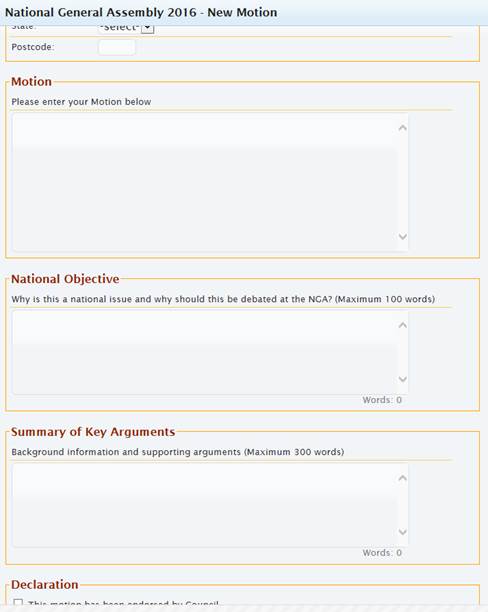
As shown in the following image, motions require a clear
national objective (maximum 100 words); a summary of the key arguments in
support of the motion (maximum 300 words) and endorsement by Council.
Conference Details
Where: National
Convention Centre, Canberra, ACT
Dates: Sunday
19 June to Wednesday 22 June 2016
Costs:
(per delegate) Registration Fee
(early bird received by 6 May 2016) $925.00
Accommodation (approx)
(4 nights) $1,000.00
Travel
(approx.) $800.00
Total: $2,725.00
Financial Implications
Council has an allocation for conferences of $19,100 within
the 2015/16 budget (2145.04). There has
been $7,770.00 committed as at 14 March 2016. Council is therefore able
to fund the cost of two delegates from this budget.
Statutory and Policy
Compliance Implications
In accordance with Council’s Policy Mayor and
Councillors Payment of Expenses and Provision of Facilities “A
resolution of Council is required to authorise attendance of Councillors at
…b) Australian Local Government Association National General Assembly as
a voting delegate.”
Staff Reports - Sustainable Environment and Economy 13.2
Staff Reports - Sustainable Environment and
Economy
Report No. 13.2 PLANNING
- 26.2013.2.1 - Ewingsdale Seniors Housing and Commercial Uses Planning
Proposal
Directorate: Sustainable
Environment and Economy
Report
Author: Sharyn
French, Manager Environmental and Economic Planning
Shannon Burt, Director Sustainable
Environment and Economy
Christopher Soulsby, Development
Planning Officer S94 & S64
File No: I2015/1582
Theme: Ecology
Planning Policy and Natural Environment
Summary:
The Ewingsdale seniors housing and commercial uses planning
proposal for Lot 1 DP 1140936, (the Site) proposes to amend the Byron LEP 2014
to enable seniors housing, medical centre, business premises, restaurants and
cafes, and shops.
The Site is not in an approved Local Growth Management
Strategy (LGMS) or the Far North Coast Regional Strategy or draft North Coast
Regional Plan. Council decided to review this unsolicited planning proposal
on its merits because, at the time, there was no clear time frame for reviewing
either the FNCRS or preparing a LGMS. The planning proposal is an
opportunistic response to the decision by the State Government to locate the
new Byron hospital on rural land adjacent to the subject site at
Ewingsdale. It has been publicly exhibited twice and the community
feedback on both occasions has been mostly opposed to the planning
proposal. With the top issues being traffic and congestion, impacts on
the Ewingsdale character and quality of life, density and height of buildings,
and excessive number of dwellings.
The seniors housing option with a medical centre and
commercial uses is the preferred use put forward by the current landowners but
it may not be the highest and best use of the land. There has been no
holistic review of the Ewingsdale locality, how this site will influence the
future of Ewingsdale or how it will interact with the new urban area at West
Byron. Approving this planning proposal is pre-empting the outcome of a
future strategy. Council has commenced preparation of a Residential
Strategy. The draft Residential Strategy is expected to be presented to
Council by June 2016. This Site could be considered for urban use as part
of this broader process.
In the absence of this Site being holistically considered in
a strategic plan and up until now not having a sufficiently detailed traffic
study, the planning proposal has been problematic. The absence of a
detailed traffic study resulted in significant delays to the Sites
consideration. Roads and Maritime Services (RMS) advised Council on 1
August 2014 that the work undertaken by the proponent was inadequate and a
demand transport model was required. At the time the proponent declined
to undertake this work as they believed that the traffic assessment provided
with the planning proposal was adequate for the purposes of the planning
proposal process. The new traffic study now provided by the proponent has
shown that the location of the commercial precinct on the western portion
cannot be accommodated and needs to relocate to the eastern portion.
Additionally, the roundabout at the McGettigans Lane
intersection with Ewingsdale Rd will be essential for development on the
eastern portion of the site to proceed. The roundabout is identified in
Council’s section 94 plan as the 4th highest priority for
expenditure of developer contributions. The higher priority works
preceding this roundabout will likely exhaust all the existing s94 funds, as
such Council is not in a position to fund this roundabout at this point in
time. For the development to proceed the developer would need to
build the roundabout. A Voluntary Planning Agreement (VPA) can facilitate
this where the cost of the works undertaken by the developer is offset against
the urban road contributions. As the roundabout is critical to the
Site’s ability to be developed it must be entered into at the planning
proposal stage.
The advice from Roads and Maritime Services on the traffic
study also raised the issue of the access to the eastern portion of the site
from a classified road - Ewingsdale Road. The Infrastructure SEPP states
that Council must not grant consent to development on land that has a frontage
to a classified road where vehicle access can be provided by another road -
McGettigans Lane.
The proponent has prepared a draft DCP which has raised
issues not previously considered in the planning proposal and which must be
dealt with in an LEP. As such amendments are required to the planning
proposal if Council proceeds. Under the Environmental Planning and
Assessment Act 1979, Council may, at any time, vary its planning proposal
for any reason. If Council does so, a revised planning proposal must be
forwarded to the Minister who will determine if further community consultation
is required. Noting that irrespective of the Ministers determination
Council may decide to undertake further community consultation.
The draft DCP submitted by the proponent requires
significant rework before Council can consider its release for public
exhibition. The proponent has advised that until the LEP amendment is
made no further work will be funded on the draft DCP.
This report provides information on the exhibited voluntary
planning proposal, the draft DCP and the new traffic study. It also
addresses matters for Council to consider in deciding to proceed or not with
the planning proposal.
NOTE TO COUNCILLORS:
In accordance with the
provisions of S375A of the Local Government Act 1993, a Division is to be
called whenever a motion for a planning decision is put to the meeting, for the
purpose of recording voting on planning matters. Pursuant to clause 2(a)
under the heading Matters to be Included in Minutes of Council Meetings of
Council's adopted Code of Meeting Practice (as amended) a Division will be
deemed to have been called by the mover and seconder of all motions relating to
this report.
|
RECOMMENDATION:
1. That
Council proceed with an amended planning proposal for Lot 101
DP1140936, Ewingsdale, subject to a draft voluntary planning agreement for
the construction of the McGettigans Lane roundabout by the developer with
arrangements for the offsetting of developer contributions against the cost
of works for the roundabout being entered into on the making of the LEP
amendment.
2. That
the planning proposal for Lot 101 DP1140936, Ewingsdale (#E2014/39455)
be amended where necessary to include the following changes:
a) amend
the Additional Permitted Uses Map to show the relocation of the commercial
precinct to the eastern portion of the site as defined by Precinct 5 –
Rural retail,
b) amend
the relevant sections of the planning proposal that describe the location of
the commercial precinct,
c) include
limits for the combined maximum total floor area of 3000m2 for
commercial uses to 1200m2 and medical centre to 1800m2,
d) include
an FSR of 0.3:1 and an FSR map for the site, excluding the commercial
precinct on the eastern portion of the site,
e) exclude
site access from Ewingsdale Road, and
f) that
the proposed wording for the amendment to Schedule 1 of Byron LEP 2014 be
amended as follows:
‘Use of certain land at
Ewingsdale Road, Ewingsdale:
(1) This clause
applies to land at Ewingsdale Road, Ewingsdale, being Lot 101 DP 1140936.
(2) Development
for the purposes of Seniors Housing, Medical Centre, Business Premises,
Restaurants or Cafes, and Shops is permitted with development consent.
(3) All
commercial uses listed in subclause (2) are restricted to the land identified
as ‘Area A’ on the Additional Permitted Uses Map and limited to a
combined maximum total floor area of 1200m².
(4) Medical
centre uses listed in subclause (2) are restricted to the land identified as
‘Area A’ on the Additional Permitted Uses Map and limited to a
maximum total floor area of 1800m².’
(5) Access
to the land directly from Ewingsdale Road is excluded.
3. That
Council forward the revised planning proposal to the Department of Planning
and Environment under Section 58 of the Environmental Planning and Assessment
Act 1979 for the Minister to determine if further community consultation is
required and irrespective of the Ministers decision Council re-exhibits the
amended planning proposal for a period of 28 days as soon as practicable
together with the two draft voluntary planning proposals: the previously
exhibited draft VPA in Attachment 4 and the new draft VPA on the McGettigans
Lane roundabout.
4. That
the draft DCP be amended in consultation with Council staff and
Attachment 7, concurrently with the amendments to the planning proposal, to
finalise the draft DCP expeditiously for Council’s consideration and
public exhibition either with the amended planning proposal or as soon as
practicable thereafter.
|
Attachments:
1 Summary of
Council reports and resolutions relating to Ewingsdale Seniors Housing and
Commercial Uses Planning Proposal - Lot 101 DP1140936, Ewingsdale, E2016/17561
2 Ewingsdale
Retirement Facility Traffic Study Report, E2016/18036
3 Response
from Roads and Maritime Services regarding Traffic Study, E2016/18182
4 Draft
Voluntary Planning Agreement for Traffic Study, E2016/227
5 Confidential
- Submissions 26.2013.2.1 Ewingsdale Seniors Living Voluntary Planning
Agreement, E2016/16788
6 Draft DCP
2014 Chapter E9 Ewingsdale Seniors Living, E2016/18391
7 DCP
meeting minutes and matters to be addressed - Ewingsdale Seniors Living, E2016/18348
8 Letter
from Henry Davis York re Ewingsdale Seniors Living - Comments on draft DCP and
traffic study, E2016/18393
Background
The Site (Lot 101 DP1140936, Ewingsdale) has been the
subject of a number of Council reports since 2011 to amend the Byron LEP to
permit seniors housing and a range of commercial uses. Council resolved
to proceed with an amended planning proposal at the 13 June 2013 meeting. A
brief summary of the Council reports and resulting resolutions relating to the
Site are provided in Attachment 1.
Planning Proposal to amend Byron LEP 2014
The planning proposal’s objective was to permit
additional uses on the Site to accommodate the following:
· On
the western portion of Lot 101:
(a) Seniors housing and
residential care facilities; and
(b) Retail facilities
including a supermarket and speciality stores and medical facilities in the
area marked “A” on the Additional Permitted Uses Map [Figure
1]
· On
the eastern portion of Lot 101 – seniors housing.
Council resolved (resolution
13-492) that this would be implemented by way of an amendment to Schedule 1 of
Byron LEP 2014 as follows:
Use of certain land at Ewingsdale Road, Ewingsdale
1) This clause applies to
land at Ewingsdale Road, Ewingsdale being Lot 101 DP 1140936.
2) Development for the
purposes of Seniors Housing, Medical Centre, Business Premises, Restaurants or
Cafes, and Shops is permitted with development consent.
3) All commercial uses
listed in subclause (2) are restricted to the land identified as ‘Area
A’ on the Additional Permitted Uses Map and limited to a combined maximum
total floor area of 3000m2.
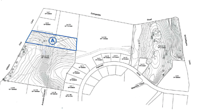
Figure 1: ‘Area
A’ – Additional Permitted Uses Map
See Council’s website here for a
copy of the exhibited planning proposal (E2014/39455).
http://www.byron.nsw.gov.au/public-exhibition/2014/12/08/planning-proposal-to-amend-byron-lep-2014-lot-101-dp-1140936-ewingsdale
The most recent decision of Council on this matter was at
the 17 September 2015 meeting at which Council resolved:
Resolution 15-459
1. Proponent to prepare
draft DCP along with a basic concept plan in consultation with Council and
provide that to Council as soon as possible.
2. Proponent to prepare
and complete at their own cost a Traffic demand study for the planning
proposal.
3. Proponent and
Council to finalise draft VPA so that:
a) $15,000 is paid to Council after
the LEP is amended to contribute to the wider traffic studies
b) $3,000 is paid to Council for
its legal costs to finalise the VPA
c) The VPA is to be placed on
public exhibition
This report provides an update on resolution 15-459 and
matters for Council to consider in deciding to proceed or not with the planning
proposal.
Traffic Demand Study
Council received from the proponent the Ewingsdale
Retirement Facility Development Control Plan Traffic Study Report (Attachment
2) late last year. The study was forwarded to Roads and Maritime Services
(RMS) for their advice. Correspondence received from RMS on the 18 January 2016
advised that:
Due to the volume of referrals
received over the Christmas closedown period and leave arrangements Roads and
Maritime Services will be unable to respond to your referral until mid to late
February 2016.
RMS provided their advice on 29 February 2016, Attachment
3, advising:
|
RMS Advice
|
Staff Comment
|
|
The traffic study adequately identifies the road
improvements necessary to manage Ewingsdale Rd up until 2028
|
Noted. After 2028 the single lane roundabout at the
hospital reaches saturation. This intersection will have queue length
on the west approach exceeding 309m in the AM peak and 142m on the east
approach in the PM peak. The SIDRA modelling undertaken by Bitzios
shows that if this roundabout is upgraded to dual lane by 2028 the
intersection will function acceptably.
After 2028 the highway roundabout also reaches saturation
with queues exceeding 88m down the off ramp to the Pacific Highway.
The intersection of William Flick Lane and Ewingsdale Road
will function adequately at 2028 if the right turn out is prohibited.
The right turn into William Flick Lane will still be available. Traffic
heading to Byron Bay from William Flick Lane will have to turn left and make
a u-turn at the Pacific Highway Roundabout.
|
|
Relocation of the commercial precinct to the eastern
portion of the Site is integral to traffic management along this section of
Ewingsdale Rd
|
The intersection of William Flick Lane and Ewingsdale Road
was originally proposed to be a roundabout to service the commercial
component of the development. There is insufficient room between the
Pacific Highway roundabout and the Hospital roundabouts to place another
roundabout at this intersection. Not being able to construct a
roundabout at this intersection required the relocation of the retail
component of the commercial area to the eastern portion of the site.
The DCP retains a commercial precinct on the western side,
the medical centre (precinct P2 on Figure 2).
Additionally the size of the area set aside for Precinct 1
in the draft DCP (Figure 2) and the type of land uses proposed
eg. hairdresser, gym, spa etc will need to ensure they are of a size and
scale appropriate to the adjoining seniors living development to be
considered ancillary and for the sole use of the developments
occupants. This is discussed in further detail in the Draft DCP section
below.
|
|
The left in / left out proposed for precincts 5 to 8 is
inconsistent with Clause 101 (2) (a) of the Infrastructure SEPP (ISEPP) as
Ewingsdale is a classified road.
|
There is alternative vehicle access from a road other than
the classified Ewingsdale Road. There is no reason why an access to the
commercial component of the development cannot be provided off McGettigans
Lane. Such an access does not need to pass through the high care
component of the seniors living proposal which may have a separate access from
McGettingans Lane. The draft DCP should be amended to show the
commercial area accessed from McGettingans Lane and the access onto
Ewingsdale Road deleted.
ISEPP clause:
101
Development with frontage to classified road
(1)
The objectives of this clause are:
(a) to ensure that new development does not
compromise the effective and ongoing operation and function of classified
roads, and
(b) to prevent or reduce the potential impact
of traffic noise and vehicle emission on development adjacent to classified
roads.
(2)
The consent authority must not grant consent to development on land that has
a frontage to a classified road unless it is satisfied that:
(a) where practicable, vehicular access to the
land is provided by a road other than the classified road, and
(b) the safety, efficiency and ongoing
operation of the classified road will not be adversely affected by the
development as a result of:
(i) the design of the vehicular access to the
land, or
(ii) the emission of smoke or dust from the development,
or
(iii) the nature, volume or frequency of
vehicles using the classified road to gain access to the land, and
(c) the development is of a type that is not
sensitive to traffic noise or vehicle emissions, or is appropriately located
and designed, or includes measures, to ameliorate potential traffic noise or
vehicle emissions within the site of the development arising from the
adjacent classified road.
|
|
The roundabout at the McGettigans Lane intersection with
Ewingsdale Rd will be essential for development on the eastern portion of the
site to proceed.
|
The roundabout is identified in Council’s section 94
plan as the 4th highest priority for expenditure of developer
contributions. Higher priority works in the plan are the Byron Bay
Bypass, Bayshore Drive roundabout and the Sunrise roundabout. These
three projects will likely exhaust all the developer contributions currently
held in trust by Council and will utilise future income into the plan until
at least 2021. On this basis Council is not in a position to fund this
roundabout at this point in time. As the RMS has identified this
intersection upgrade as essential to the development and Council is not in a
position to fund it. For the development to proceed in the absence of council
s94 funds the developer would need to build the roundabout. A Voluntary
Planning Agreement (VPA) would be required where the proponent enters into a
cost sharing arrangement with Council and the cost of the works undertaken by
the applicant is offset against the urban road contributions.
Whilst the timing of the VPA can be at either the planning
proposal stage or the development assessment stage, it is recommended the
draft VPA be entered into in conjunction with the planning proposal to ensure
that the proposed uses can be developed on the Site and to appropriately
manage the impacts of the development on the adjoining road network.
|
In summary, the issues of the relocation of the access to
the commercial component to McGettigans Lane in the draft DCP, prevention of
direct access to Ewingsdale Road and the timing of the construction of the
roundabout and voluntary planning agreement are critical to the support of the
planning proposal.
Voluntary Planning Agreement (VPA)
The Voluntary Planning Agreement (Attachment 4)
was amended and made available for public inspection from 14 January to 15
February 2016. The VPA provides for a development contribution of:
(a) $15,000 to the
Planning Authority as a contribution to the costs of traffic studies; and
(b) $3,000 to the
Planning Authority as a contribution to the costs of the preparation of this
Agreement.
Seventeen submissions were received, all of which objected
to the VPA and or the Planning Proposal, Confidential Attachment 5.
Some of the submissions requested that:
1. A DCP workshop be
convened which includes community representatives, adjoining neighbours,
developer’s representatives, council staff and councillors prior to
reporting the DCP to Council
2. The Traffic Study and
resulting council reports be presented and discussed with adjoining residents
and the Ewingsdale Progress Association prior to a final report being placed on
the Council meeting agenda
In relation to the first issue, if the planning proposal
moves forward, it is proposed that a workshop on the draft DCP be convened with
the above attendees during the public exhibition.
If the planning proposal proceeds the VPA takes affect as
follows:
This Agreement operates on and from the date that is the
later of:
(a) the date the Amending LEP is
published on the NSW Legislation website; and
(b) the date the Agreement is
entered into as required by Clause 25C(1) of the Regulation
Clause 25C(1) of the Environmental Planning and
Assessment Regulation 2000 states: A planning
agreement is not entered into until it is signed by all the parties to the
agreement.
Development Control Plan (DCP)
A draft Development Control Plan (DCP) (Attachment 6)
was received from the proponent on the 4 December 2015. The draft DCP
proposes 8 precincts for the site, Figure 2, being:
· P
1: Community and recreational facilities
· P
2: Potential day surgery or self contained apartment homesteads
· P
3: Self contained retirement village apartments 1, 2 and 3 bedroom
· P
4: Self contained retirement village semi-detached villas
· P
5: Rural retail
· P
6: High care assisted living
· P
7: Low care assisted living
· P
8: Family accommodation
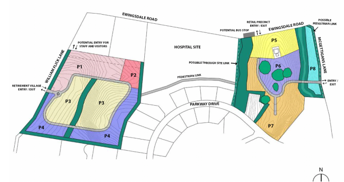
Figure 2: Eight Precincts
The draft DCP was reviewed by various Council staff and
Council’s heritage advisor. A number of issues were identified in the
review that must be addressed prior to advancing the draft DCP. A copy of the
meeting minutes that include the matters to be addressed is included in Attachment
7.
On 3 March 2016, staff discussed with the proponent’s
consultants the matters to be addressed in the draft DCP and the RMS advice on
the traffic study. The consultants formally responded by letter dated 15 March
2016, Attachment 8.
In relation to the draft DCP they advised:
Our client recognises that
finalisation of the DCP will involve further work and it doesn't shy away from
that. However, until our client has the certainty that the project will
proceed, the expenditure of further resources is not appropriate.
Once the amendment is made to
the LEP, then further work on the draft DCP can be undertaken.
Whilst there are a number of issues that need to be
addressed in the draft DCP the significant issues are:
1. Relocation
of commercial uses to the eastern portion of the lot
2. Amount
of land allocated to commercial uses
3. Floor
Space Ratios
4. Visitor
accommodation
5. Buffers
6. Site
access
1. Relocation
of commercial uses to the eastern portion of the lot
The commercial uses were
exhibited in the planning proposal as applying to the western portion of the
Land, Figure 1. The DCP now proposes, as a result of the
traffic study findings, to relocate the retail portion of ‘Area A’
to the eastern portion of the site, with the medical centre remaining on the
western portion. The medical centre is currently permissible with consent under
the lands current Special Purpose zone.
The relocation of the commercial
uses to the eastern portion of the Site is supported.
There is concern that retention of a commercial medical
centre on the western portion doesn’t accord with the RMS advice that relocation
of the commercial precinct to the eastern portion of the Site is integral to
traffic management along this section of Ewingsdale Rd. There is also
concern that the draft DCP shows that access to the medical centre would be
through the staff service driveway across Essential Energy land. No response
has been received from the proponent as to what discussion have been held with
Essential Energy to secure this access way.
Whilst access to the Site is a
matter for the draft DCP and the development application (DA) stage, Council
needs to be relatively certain that access issues can be managed in amending
the LEP to enable additional uses.
If Council proceeds with the
planning proposal, an amended planning proposal showing the new location of the
commercial development will need to be submitted to the Minister.
2. Amount
of land allocated to commercial uses
The exhibited planning proposal
advised that, all commercial uses are restricted to the land identified as
‘Area A’ on the Additional Permitted Uses Map (Figure 1)
and limited to a combined maximum total floor area of 3000m2.
The draft DCP allocates the
total maximum floor area of 3000m2 to Precinct 5 on the eastern
potion of the site and no floor area has been allocated to the medical centre
proposed to remain on the western portion (Precinct 2).
In response to community
concerns about the amount of commercial space proposed in the exhibited
planning proposal, the Council report to the 17 September 2015 meeting
recommended that if the planning proposal proceeds then the commercial uses be
limited to a maximum floor area of 1200m2 and the medical centre
1800m2.
The allocation of the total
maximum floor area of 3000m2 to Precinct 5 (on the eastern portion),
does not leave any floor area to accommodate the potential medical centre on
the western potion.
A retail precinct of 3000m2
is bigger than the existing 2800m2 Bayshore Drive shopping centre
that services all of Sunrise estate and the future West Byron development.
As reported to Council at the 9
October 2014 meeting:
Paul McFarland, a lecturer from the University of New
England conducted a peer review of the Retail Floorspace Analysis (Annexure 9
in the planning proposal). The review highlights a number of unresolved
issues with the retail analysis such as the limited catchment area of the
study, overly optimistic projections about unmet retail demand in Byron, lack
of justification for the scale of the commercial development and lack of
evidence that it is only designed to cater for the proposed development,
hospital visitors and adjoining residential population.
The hospital itself would normally only generate demand
for a ‘neighbourhood shop’ size retail outlet (up to 200 m2)
servicing staff, patients and visitors. Presumably the retail is
therefore needed to support the seniors housing (only about 400 persons), the
hospital and some of the existing Ewingsdale residents. Taking the figure
from Annexure 9 of the planning proposal prepared by LOCATIQN (March 2013) of
2.2 m2 per person, the seniors housing development would generate
demand for 880m2. Rounding these figures up suggests that 1200m2
should be more than enough floor area for a future supermarket to support
the projected development, the future hospital and adjoining residents.
This would permit a small supermarket of about 1000m2 and 200m2
for cafes and other shops or business premises. ‘Medical
centre’ uses could take up the remaining 1800m² of floor area to
bring the total for all non-residential uses on the subject land to 3000m²
as initially intended.
A number of potential commercial
uses are proposed in Precinct 1- Recreation and community clubhouse. The uses
described for this precinct in Table E9.2 of the Draft DCP include: indoor
hydrotherapy pool, gymnasium, meditation and wellbeing space, hairdresser and
spa, tennis court, bowling green etc. Precinct 1 includes mostly RU2
zoned land and some SP2 zoned land. Restaurants and cafes are already permissible
with consent in the RU2 zone. The DCP states that these facilities are for use
by the independent living precincts. Given the size of Precinct 1 to the
adjoining independent living precincts, the nature and amount of facilities
being proposed and public access to this precinct, it could be viewed as an
additional commercial precinct to that being proposed in Precinct 2 (medical
centre) and Precinct 5 (business premises, shops, restaurants and cafes).
Traffic impacts generated by
known and possible commercial uses will need to be considered. RMS advice on
the Traffic Study stated: Integral to traffic management along this section
of Ewingsdale Rd will be relocation of the commercial precinct (precinct 8) to
the eastern portion of the subject site. Not all commercial development is
relocating to the eastern portion. The medical centre is proposed to be
retained on the western side.
If some or all of the proposed
facilities in Precinct 1 are made available to the general public then the
resulting traffic impacts would need further consideration and an amendment to
the planning proposal would be required to enable commercial uses in designated
areas on both the eastern and western portion of the Site.
It is recommend that the maximum
floor area limit of 3000m2 for the commercial areas be retained, and
limit the maximum floor area for commercial uses (Precinct 5) to 1200m2
and the medical centre (Precinct 2) to 1800m2. It is also
recommended that no commercial uses be permitted in Precinct 1, noting that
restaurants and cafes are already permissible with consent in Precincts 1
underlying RU2 zone.
3. Floor
Space Ratios (FSR)
The planning proposal was silent on FSRs. If FSRs are to be
designated for the Site they must be included on the FSR Maps in Byron LEP 2014;
this will require a change to the planning proposal.
The draft DCP, proposes a range
of FSRs as follows:
|
Precinct
|
FSR
|
|
Precinct 1: Community
and recreational facilities
|
0.5:1
|
|
Precinct 2: Potential
Day Surgery or self contained apartment homesteads
|
0.5:1
|
|
Precincts 3 and 4: Self
contained dwellings
|
0.5:1
|
|
Precinct 5: Retail
|
limited
by maximum floor area of 3000m2
|
|
Precincts 6 and 7: assisted
living
|
1:1
|
|
Precinct 8: family
accommodation
|
0.5:1
|
The FSR proposed for the Site
are based on those included in the Seniors Housing SEPP - residential care
facilities and hostels have an FSR of 1:1 or less and self contained dwellings
have an FSR of 0.5:1 or less.
Although the Seniors Housing
SEPP doesn’t apply to the land, as the SEPP generally applies to urban
zoned land or land adjoining urban zoned land, the planning principles in the
SEPP could be applied if considered appropriate for the semi rural location.
Submissions received on both
public exhibitions of the planning proposal raised the issue of density. The
Council report to the 17 September 2015 meeting included the comments received
from both public exhibitions. One of the top three issues raised by the
community was ‘density including plot ratio, height and number of
dwellings is excessive’. Staff’s response to this was that:
‘if the planning proposal proceeds it is recommended that a Floor Space
Ratio Map be prepared for the site to limit any Seniors Housing to 0.3:1 under
the LEP 2014. This will not apply to the commercial precinct (Area A) as
it would be limited by maximum floor area’.
The proposed 0.3:1 FSR was in
recognition of the semi rural environment surrounding the Site and a means to
ensure adequate landscaping is provided.
Council needs to consider if the
proposed FSRs in the draft DCP are appropriate for the various precincts and
the Sites location as they are substantially more than what was proposed in
response to public feedback. The planning proposal will need to be amended to include
provision for an FSR map showing Council’s preferred mix of densities for
the various precincts.
It is recommended that an FSR of 0.3:1 be applied to the
seniors housing component of the Site in keeping with the semi rural location.
4. Visitor
accommodation
The draft DCP states that Precinct 8 – Retirement
village visitor accommodation, ‘will provide ancillary visitor
accommodation for relatives and friends of occupants of the retirement
village’. It is questionable that this form of visitor accommodation
is subordinate to the seniors housing as it is not necessary to the functioning
of the primary use - seniors housing. Additionally, visitor accommodation could
adequately function independent to the seniors housing.
The exhibited planning proposal did not include provision
for visitor accommodation. If Council considered that this form of development
is appropriate on the land, the planning proposal would need to be amended to
enable this land use.
It is recommended that this form
of land use (visitor accommodation) is not appropriate in this location and is
not essential to the functioning of the intended primary seniors housing use.
As such no amendment to the planning proposal is recommended in this regard.
5. Buffers
Buffers to the concrete batching plant and electric
substation were raised in the community submissions and it was also raised by
Essential Energy in relation to its depot and substation. The submissions were
reported to Council at the 9 October 2014 and 17 September 2015 meetings. It
was recommended that if the planning proposal proceeds that adequate buffers of
approximately 20 metres between the concrete plant/electricity substation and
any future seniors development be provided and incorporated into a site
specific DCP.
The buffers proposed in the draft DCP are only 10 metres
wide. The draft DCP will need to be amended to increase the buffer widths to 20
metres.
6. Site
access
As previously discussed access
should not be granted to the Site from a classified road, (Ewingsdale Rd),
where practical alternative access roads exist. Whilst this is a matter to be
considered at the DA stage, the draft DCP needs to be amended to remove this
access option.
Draft DCP Amendments
Amendments to the draft DCP are not integral to finalising
the planning proposal. If the planning proposal proceeds then it would be
preferable to have an adopted DCP for the Site prior to the first DA being
lodged. The proponent has advised that ‘once the amendment is made to the
LEP, then further work on the draft DCP can be undertaken’. Substantial
work is required on the draft DCP prior to Council considering it for public
exhibition.
It is recommended that if Council supports the planning
proposal proceeding then further work be undertaken by the proponent, in
consultation with Council, to finalise the draft DCP for public exhibition.
Planning Proposal Amendments
The intent of the planning proposal is to enable additional
uses on the Site. Council must be reasonably satisfied that the Site can accommodate
the additional uses. The draft DCP raises a number of issues that are not
addressed in the planning proposal and the traffic study findings require
changes to the planning proposal. As certain matters can only be dealt
with in an LEP, if the planning proposal proceeds it must be amended prior to
sending to the Minister. The matters to be included in the planning proposal
are:
|
Issue
|
Planning
Proposal Amendment
|
|
Relocation of commercial area to the eastern portion of
the Site
|
Amend the Additional Permitted
Uses Map to show the relocation of the commercial precinct to the eastern
portion of the site as defined by Precinct 5 – Rural retail.
Amend the relevant sections of
the planning proposal that describe the location of the commercial precinct.
|
|
Amount of land allocated to commercial uses
|
Amend the planning proposal to
limit the combined maximum total floor area of the commercial uses to 1200m2
and limit the maximum floor area for the medical centre to 1800m2.
|
|
Floor Space Ratios (FSR)
|
Amend the planning proposal to
include an FSR of 0.3:1 for the seniors housing component of the Site.
|
|
Site Access
|
Amend the planning proposal to
prevent direct access from Ewingsdale Road.
|
Section 58 of the Environmental
Planning and Assessment Act 1979, states that Council may, at any time, vary
its planning proposal as a consequence of its consideration of any submission
or report during community consultation or for any other reason. If Council
does so, a revised planning proposal must be forwarded to the Minister who will
determine if further community consultation is required. Noting that
irrespective of the Ministers determination Council may decide to undertake
further community consultation.
58 Relevant planning
authority may vary proposals or not proceed
(1) The relevant planning
authority may, at any time, vary its proposals as a consequence of its
consideration of any submission or report during community consultation or for
any other reason.
(2) If it does so, the
relevant planning authority is to forward a revised planning proposal to the
Minister.
(3) Further community
consultation under section 57 is not required unless the Minister so directs in
a revised determination under section 56.
(4) The relevant planning
authority may also, at any time, request the Minister to determine that the
matter not proceed.
It is recommended that the planning proposal be amended and
the revised planning proposal be forwarded to the Minister as required under
section 58 of the EP&A Act 1979. That irrespective of the Ministers
direction to undertake further community consultation, Council re-exhibits the
amended planning proposal for a period of 28 days.
Proponent has requested the Minister to appoint an
alternative relevant planning authority
Council has been advised by the Department of Planning and
Environment that they have received a request from the proponent for the
Minister to appoint an alternate relevant planning authority under section
54(2)(d) of the Environmental Planning and Assessment Act 1979 to
complete the planning proposal:
54 Relevant planning
authority
(2) The Minister may
direct that the Secretary (or any other person or body prescribed by the
regulations) is the relevant planning authority for a proposed instrument in
the following cases:
(d) the council for the
local government area concerned has, in the opinion of the Minister, failed to
comply with its obligations with respect to the making of the proposed
instrument or has not carried out those obligations in a satisfactory manner,
The Department is reviewing the request and will provide a
formal request to Council for comment. At the time of writing this report the
formal request was yet to be received.
Conclusion
Given the high level of community interest and the complex
nature of this Site, it would be advantageous to keep the planning proposal,
DCP and VPAs coupled for transparency and for Council to make an informed
decision about the appropriateness of the development uses proposed for the
Site.
Section 25D (1A) of the EP&A Regulation 2000 requires
that voluntary planning agreements are exhibited with or as soon as possible
after the exhibition of a planning proposal or DA:
25D Public
notice of planning agreements
(1A) If a planning authority
proposes to enter into a planning agreement, or an agreement to amend or revoke
a planning agreement, in connection with a proposed change to a local
environmental plan, the planning authority is to ensure that public notice of
the proposed agreement, amendment or revocation is given:
(a) if practicable, as part
of and contemporaneously with, and in the same manner as, any public notice of
the relevant planning proposal that is required under Part 3 of the Act, or
(b) if it is not practicable
for notice to be given contemporaneously, as soon as possible after any public
notice of the relevant planning proposal that is required under Part 3 of the
Act and in the manner determined by the planning authorities that are parties
to the agreement.
The planning proposal was last exhibited in November
/December 2014. Nearly 16 months has lapsed since the planning proposal
was exhibited. The draft VPA (Attachment 4) was exhibited
in January / February 2016, more than 12 months after the planning proposal was
exhibited. As a result of public submissions from past exhibitions and
the development model now proposed in the draft DCP a number of amendments are
recommended to the planning proposal. To provide transparency in the
process to amend the Byron LEP 2014 to enable additional uses on the Site and
to ensure impacts on the adjoining road network are appropriately managed, it
is recommended that the amended planning proposal be exhibited together with:
· the
previously exhibited draft VPA for $15,000 to Council as a contribution
to the costs of traffic studies and $3,000 as a contribution to the costs of
the preparation of the VPA,
· along with a new
draft VPA requiring the construction of the McGettigans Lane roundabout by the
developer with arrangements for the offsetting of developer contributions
against the cost of works for the roundabout.
As an adopted DCP is integral to informing a development
application for the Site it is proposed that, if the planning proposal
proceeds, further work be undertaken by the proponent in conjunction with
Council staff to finalise the draft DCP for public exhibition. Whilst it
would be preferable to exhibit the draft DCP along with the amended planning
proposal, it is not a legislative requirement. However as the DCP is needed
to inform a DA for the Site, it is important to finalise the DCP expeditiously
to ensure a Council adopted DCP is available on the commencement of the LEP
amendment in order to adequately asses any DA lodged thereafter. As such
it is recommended that the work on the draft DCP occur in tandem with the
amendments being made to the planning proposal and a final draft be exhibited
as soon as possible, but not necessarily with the planning proposal.
Financial Implications
All Council costs in relation to the planning proposal and
DCP are funded by the proponent.
At 30 June 2015 there was $5,588,000 in the Byron Bay /
Suffolk Park Urban Roads s94 account. The 2015/16 budget has $1,795,000
of works being funded from this account. The year to date (20/3/2016)
income is $67,000 and if this trend continues total income for the year will be
approximately $90,000. This will leave $3,882,100 in this account.
All of this will be required for the Byron Bay Bypass. Further income
into this account will be direct to the works at Bayshore Drive roundabout and
then Sunrise Blvd roundabout prior to funds being directed to McGettigans Lane
roundabout. It is unlikely that Council will be able to fund the
McGettigans Lane roundabout with s94 funds until after 2021.
If the planning proposal is to proceed the roundabout at
McGettigans Lane is essential. As Council cannot afford to fund these
works in the next 5 years these works would have to be forward funded by the
developer with the costs being offset against their developer contributions.
In the absence of a voluntary planning agreement from the developer to
construct the roundabout, the planning proposal should only proceed on receipt
of a draft VPA.
Statutory and Policy
Compliance Implications
The Gateway Determination
issued by the Department of Planning and Environment requires that the LEP be
completed by 28 May 2016.
Staff Reports - Sustainable Environment and Economy 13.3
Report No. 13.3 PLANNING
- 26.2013.3.1 Planning Proposal for Rezoning of Land at Tallowood Ridge Estate,
Mullumbimby
Directorate: Sustainable
Environment and Economy
Report
Author: Fiona
Sinclair, Planner
File No: I2015/1584
Theme: Ecology
Planning Policy and Natural Environment
Summary:
This report
presents a Planning Proposal for the extension of the Tallowood Ridge
residential estate, which seeks to alter the land use zones with consequential
minimum lot size and floor space ratio changes.
Council
staff have reviewed the Planning Proposal, as submitted by the proponent
Bayview Land Development Pty Ltd, and can support an amended version of it (as
shown in Attachments 1 and 2).
This Planning Proposal
precedes the Draft Residential Strategy that Council is currently preparing as
part of a shire-wide review of residential land supply and demand. It is
considered that the Planning Proposal has merit to precede the new strategy for
the following reasons:
· The Planning
Proposal process has already commenced as Council previously resolved on 19
September 2013 (13-493) to receive and send a Planning Proposal for the
extension of the Tallowood Ridge Estate to the Department of Planning and
Environment (DPE) for Gateway Determination.
· This report is as
a result of further advice received from the DPE.
· The proposed
extension to the Tallowood Ridge residential area is largely consistent with
the ‘site suitability criteria mapping’ that Council has prepared
to inform the new Residential Strategy and the subject land is very likely to
be identified in the strategy as a potential future residential release area.
· The current
Planning Proposal proposes a relatively minor expansion of an existing urban
area that can provide land quickly to meet short-term market demand while
Council investigates longer term options through its’ new Residential
Strategy.
The
Planning Proposal (included as Attachments 1 and 2) seeks to rezone
approximately:
· 5 hectares
of the existing R2 Low Density Residential zone to RU2 Rural Landscape
· 5 hectares
of the RU1 Primary Production zone to RU2 Rural Landscape
· 3 hectares
of the RU1 Primary Production zone to RE1 Public Recreation
· 12 hectares
of the RU2 Rural Landscape zone and RU1 Primary Production to R2 Low Density
Residential zone.
The balance of the site will
remain in its current mix of zones. Changes to minimum lot size and floor
space ratios will match the zone changes.
The Planning Proposal
will:
· increase the opportunity for residential development
by providing an increase in land supply of approximately 65 lots
· zone existing public recreation facilities to a public
recreation zone
· incorporate environmental areas (remnant vegetation
and riparian corridors) into an RU2 zone as a holding pattern until further
assessment for the purposes of determining environmental zones can be done
consistent with the Minister for Planning and Environment’s recent 117(2)
Direction regarding the application of E zones and environmental overlays
in Far North Coast LEPs and the Northern Councils E Zone Review Final
Recommendations.
The land has been subject to a range of studies and reports (included in
Attachment 2) that support the extension of the residential zoned area. The
reports demonstrate that the land is largely suitable for residential purposes
and can be adequately serviced with urban infrastructure. The area is in
close proximity to existing social services and will enable construction of
innovative and diverse housing typologies that will contribute to the local
economy. Land use buffers can be provided and the proposed future residential
development will have little to no adverse impacts on existing significant
agricultural lands. Minor areas of constrained land (ie steeply sloping
or flood prone areas) can be dealt with at the development assessment stage
through subdivision design and potential filling.
The
Planning Proposal is consistent with all relevant SEPPs. It is consistent
with most of the relevant Section117 Directions, and where inconsistencies
occur they can be justified. An assessment against the Far North Coast
Regional Strategy Sustainability Criteria concluded that the proposed extension
to the Tallowood Ridge Estate is appropriate.
The DPE has recently released the new Draft North
Coast Regional Plan which is currently on public exhibition until 2 June
2016. The Draft Plan outlines a vision for the future of the North Coast and will
guide strategic planning across the region over the next 20 years. An
assessment against the Draft
North Coast Regional Plan indicates that the land proposed for rezoning for
residential purposes in the current Planning Proposal is not identified as
‘Proposed Urban Land’ and is not within the ‘Urban Growth
Area’ boundary for Mullumbimby, as shown in the Urban Growth Area Map for
Byron LGA. However the Draft
North Coast Regional Plan specifically recognises
that the DPE will be undertaking further work with Byron Shire Council to
identify land suitable for inclusion in the urban growth areas and that the
relevant maps will be amended accordingly. Given that the subject land is
highly consistent with Council’s ‘site suitability criteria
mapping’ for inclusion in the new Residential Strategy, the subject land
is very likely to be included in any future amendments to the urban growth area
for Mullumbimby.
The Planning Proposal
process has already commenced and it is therefore reasonable that the proposed
rezoning of the subject land precedes the Residential Strategy currently in
preparation.
There is sufficient information to enable Council to support the
amended Planning Proposal (Attachments 1 and 2) and forward it to the
Department of Planning and Environment for a Gateway Determination.
NOTE TO COUNCILLORS:
In accordance with the
provisions of S375A of the Local Government Act 1993, a Division is to be
called whenever a motion for a planning decision is put to the meeting, for the
purpose of recording voting on planning matters. Pursuant to clause 2(a)
under the heading Matters to be Included in Minutes of Council Meetings of
Council's adopted Code of Meeting Practice (as amended) a Division will be
deemed to have been called by the mover and seconder of all motions relating to
this report.
|
RECOMMENDATION:
1. That
Council send the Planning Proposal to amend Byron LEP 2014
(Attachment 1) including the Sustainability Criteria Assessment and
relevant technical reports (Attachment 2), to the NSW Department of Planning
and Environment for a Gateway Determination,
2. That
Council request the Department of Planning and Environment retain
delegated authority to make the LEP Amendment, as the subject land is not
identified as a future urban release area and is outside the Town and Village
Growth Boundary for Mullumbimby in the Far North Coast Regional Strategy,
3. That
Council include the areas proposed for
environmental protection purposes in this planning proposal in any shire wide
E zone criteria assessment that Council undertakes in the future relevant to
the Minister for Planning and Environment’s Section 117(2) Direction
regarding the application of E2 and E3 Zones and Environmental Overlays in
Far North Coast LEPs.
|
Attachments:
1 Planning
Proposal for Tallowood Ridge, E2016/18397
2 Sustainability
Criteria Assessment & Technical Reports, E2016/16179
3 Superceeded
Maps from Proponent's Planning Proposal, E2016/16311
4 Form of
Special Disclosure of Pecuniary Interest, E2012/2815
Report
The Planning Proposal
This Planning Proposal relates
to land located at Tallowood Ridge Estate, Mullumbimby, described as part
Lot 80 in Deposited Plan 1202269. It also affects an un-made
road that traverses north / south through Lot 80 and one that abuts it
immediately to the south. Lot 80 is an irregular shaped lot that is in
several pieces. It has a total area of 59.1 hectares.
Approximately 25 hectares is affected by zone changes in this Planning
Proposal. The balance of the zones within the subject land will not
change. The subject land is shown in Figure 1 below.
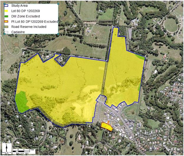
Figure 1: Site
Identification Map
Current
Zones and Controls
The subject land is zoned part
RU1 Primary Production, part RU2 Rural Landscape, part R2 Low Density
Residential and part Deferred Matter under Byron LEP 2014. The Deferred
Matter land remains zoned Rural 1(a) General Rural under LEP 1988. Figure
2 below shows the current land zoning under Byron LEP 2014.
The Minimum Lot Size (MLS) for
the RU1 and RU2 zone is 40 hectares. The MLS for the R2 zone is
400 square metres. The Floor Space Ratio (FSR) for the R2 land
is 0.5:1. No FSR currently applies to the RU1 or RU2 land.
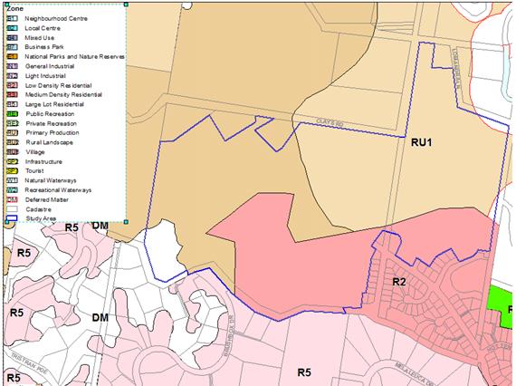
Figure 2:
Current Land Zoning, Byron LEP 2014
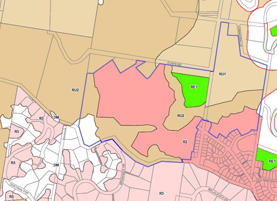
Figure 3: Proposed Land
Zoning, Byron LEP 2014
Proposed
Zones and Controls
Council has considered the information submitted by the proponent and
prepared a Planning Proposal (Attachments 1 and 2). As shown in
Figure 3 above, the Planning Proposal seeks to amend the existing zones under
Byron LEP 2014 to:
· permit additional
residential development on the subject site;
· consolidate
environmentally sensitive land (and some steep land) into a single rural zone
(as a holding pattern until further assessment for the purposes of determining
environmental zones is done consistent with the Minister for Planning and
Environment’s recent 117(2) Direction regarding the application of
E zones and environmental overlays in Far North Coast LEPs and the Northern
Councils E Zone Review Final Recommendations);
· allocate a public
recreation zone to sports fields that are under construction;
· allocate a RU2
zone to a riparian corridor that passes through the site.
The Planning Proposal will rezone:
· approximately
5 hectares of the existing R2 Low Density Residential zone to RU2 Rural
Landscape
· approximately
5 hectares of the RU1 Primary Production zone to RU2 Rural Landscape
· approximately
3 hectares of the RU1 Primary Production zone to RE1 Public Recreation
· approximately
12 hectares of the RU2 Rural Landscape zone and RU1 Primary Production to
R2 Low Density Residential zone.
The balance
of Lot 80 will remain in its current mix of zones. The three small
areas of Deferred Matter cannot be amended by this Planning Proposal as they
are not subject to Byron LEP 2014. They can only be amended by also
amending Byron LEP 1988. It is not practicable that this be done as part
of this Planning Proposal and these areas will remain as Deferred Matters for
the time being. Deferred Matter areas may be considered for rezoning in the
future, when Council undertakes further assessment consistent with the recent 117
Direction regarding the application of E zones and environmental overlays
in Far North Coast LEPs and the methodology outlined in the Northern
Councils E Zone Review Final Recommendations report.
The Planning Proposal will also:
· make consequential
changes to maps regarding Floor Space Ratio controls to reflect the proposed
RU2, R2 and RE1 zones;
· make consequential
changes to maps regarding Minimum Lot Sizes to reflect the proposed RU2, R2,
and RE1 zones.
Mapping for the recommended zones
and controls is included in the recommended Planning Proposal (Attachment 1).
The
Difference Between the Proponent’s Proposal and the Recommended Planning
Proposal
The
applicant submitted a Planning Proposal seeking to:
· rezone the subject
land to part R2 Low Density Residential, part R5 Large Lot Residential, part
RE1 Public Recreation, part SP2 Infrastructure, part RU1 Primary Production and
part RU2 Rural Landscape under Byron LEP 2014;
· apply a Floor
Space Ratio (FSR) of 0.5:1; 0.4:1; and 0.3:1 to different parts of the R2 zone;
and
· apply a Minimum
Lot Size (MLS) of 400 square metres, 600 square metres,
1000 square metres, 4000 square metres, 2 hectares, and
40 hectares variously across the suggested zones.
Mapping from the
proponent’s Planning Proposal is included in Attachment 3.
The
applicant considers the Planning Proposal is needed for the following reasons:
· the current R2 Low
Density Residential zone under LEP 2014 includes vegetation and riparian land
worth preserving, and flood prone land that should not be developed;
· the extension to
the R2 Low Density Residential zone will allow the orderly use of land for
residential purposes that is also a logical extension to Tallowood Ridge
Estate;
· it is an
opportunity to apply the RE1 Public Recreation zone to align with a past
approval for sports facilities on the site;
· to place existing
stormwater infrastructure in an SP2 zone;
· to remove the
Deferred Matters from the subject land; and
· in response to a
Council resolution which sought to rationalise the zoning of the site.
Key
differences between the proponent’s proposal and the recommended Planning
Proposal (prepared by Council staff) are as follows:
· The
proposed R5 Large Lot Residential zone over the steep, cleared land at the
western edge of Lot 80 is not supported. Given that this planning
proposal pre-empts the Byron Rural Land Use Strategy which is currently being
prepared, Council does not consider there is sound planning rationale for the
creation of an isolated pocket of R5 zoned land as part of this rezoning. The
land is very steep and will provide very few dwelling lots. It will also be
land-locked with no access until the R2 land to the east is developed. It
is recommended that this land remains in the RU2 zone with a 40 hectare
MLS for the foreseeable future. Council could consider a dwelling
entitlement for the residue lot in due course when final residential lot
boundaries are established.
· There
is no planning rationale to support small pocket parks or stormwater infrastructure
being included in the RE1 or SP2 zones, respectively. They were approved
in the R2 zone and can stay in that zone, even when they have been dedicated to
Council.
· This
Planning Proposal cannot change the zone of the Deferred Matter land, as requested
by the proponent, as it is subject to LEP 1988.
· The
Minimum Lot Size (MLS) of 400 square metres throughout the R2 zone is
supported to provide flexibility to future lot sizes. A 1000 square
metre lot size is supported on steeper land in the north-west corner of the
subject land. All RU1 and RU2 land will have a 40 hectare MLS,
consistent with the zone elsewhere in the Shire.
· A
Floor Space Ratio (FSR) of predominantly 0.5:1 on R2 land is supported, with
0.4:1 in one small area at the southern boundary (to provide for bushfire
buffers) and 0.3:1 on steeper land in the north-west corner.
Council staff advised the proponent, Mr Eric Freeman of
Bayview Land Development, of the above modifications to the Planning Proposal
by phone on 3 March 2016 and further discussions were held via phone and email
on 3-4 March 2016. Mr Freeman objected to he removal of the R5 Large Lot
Residential zone he had proposed over the steep, cleared land at the western
edge of Lot 80. Council staff considered his objection and concluded that the
land was not suitable for R5 zoning for the reasons outlined above. As such, an
RU2 Rural Landscape Zone has been retained over the steep land in the
recommended Planning Proposal.
Past Council
Resolutions on this Planning Proposal and the Department of Planning Response
In response to Koala habitat
mapping relevant to the subject land, Council resolved on 14 March 2013 (13-143):
“That Council invite the developer of Tallowood
Ridge Estate, Mullumbimby (Lot 36 DP 1169053) to lodge a planning
proposal for Council’s consideration to amend Council’s Local
Environmental Plan to adjust the residential zone boundary.”
In May 2013 the applicant submitted a Planning Proposal to
rearrange the zone boundaries on the subject land and increase the area of
residential zoned land.
Council considered the Planning
Proposal on 19 September 2013, and resolved (13-493):
“1. That amended plans be submitted to
Council, in draft LEP 2012 format, addressing the steeper slopes on the western
portion of the land showing:
a) Land
Zoning,
b)
Minimum Lot Size, and
c) Floor
Space Ratio.
2. That Council forward the
amended planning proposal to the Department of Planning and Infrastructure for
a Gateway Determination.
3. That
should the Department of Planning and Infrastructure issue a positive Gateway
Determination, prior to the planning proposal being placed on public exhibition
a Development Control Plan or Concept Plan for the new residential areas needs
to be prepared to adequately address the following issues at a minimum:
i) Buffer
areas between existing rural/residential lots,
ii)
Buffer areas to existing drainage lines, and
iii) Riparian areas along boundaries for potential
koala habitat regeneration.”
In relation to Item 3 above, the
zone boundaries proposed in the Planning Proposal deal with these buffer
issues. The current masterplan for the site (refer Figure 3 of Attachment 1)
also indicates bushland revegetation works to restore the riparian buffer at
different stages of the approved subdivision development. No further
development controls or plans are required for this rezoning.
Amended mapping was supplied to
Council and the Planning Proposal was sent to the Department of Planning and
Environment (DPE) on 26 February 2014, requesting a Gateway Determination.
Discussions ensued at officer level about what information was missing, and on
19 May 2014 Council’s then Executive Manager Planning and
Environment, requested that the DPE allow Council to withdraw the Gateway
Determination so the applicant could have time to submit additional
information. The DPE advised in a letter dated 27 May 2014 that it
would stop the Gateway process at Council’s request. The Department
followed that up on 2 June 2014, advising Council specifically what was
needed if this Planning Proposal was to proceed. The issues notified by
DPE are:
· A
variation to the growth boundary in this instance can be sought subject to
satisfying the sustainability criteria in the FNCRS.
· A
revised proposal should address each of the criteria in detail to assist in
justifying the rezoning.
· Any
revised proposal needs to address this matter and clearly identify the land
subject to the rezoning.
· There
are a number of inconsistent statements within the Planning Proposal, for
example in relation to value of the vegetation on site and the extent of land
subject to the proposed rezoning.
· The
Planning Proposal needs to provide justification for the inconsistency with the
current Mullumbimby Settlement Strategy and the reasons why it’s appropriate
that a variation be supported prior to reviewing and updating the strategy.
· The
proposal involves areas of steep, flood prone and regionally significant
agricultural land. The proposal could be strengthened if greater detail was
provided on how these matters are being addressed. Consideration could be given
to the proposed minimum lot size to address these issues, in particular on the
steeper areas of the land.
The applicant has now provided
additional information in response to the DPE concerns which has been used to
inform the Planning Proposal (in Attachments 1 and 2).
Key
Issues
· Far
North Coast Regional Strategy and the Sustainability Criteria
· Draft
North Coast Regional Plan
· Mullumbimby
Settlement Strategy, 2003
· Vegetation
· Steep
land
· Regional
farmland
· Flood
prone land
· State
policy and planning controls
Far
North Coast Regional Strategy and the Sustainability Criteria
The majority of the subject site
is located outside the Town and Village Growth Boundary Areas under the Far North
Coast Regional Strategy (FNCRS). That part of the subject site that is
zoned R2 Low Density Residential is within the “existing urban
footprint”, but no part is identified as “proposed future urban
release areas”.
The FNCRS
specifically provides that innovative development proposals can be considered,
even if they affect land located outside of the Town and Village Growth
Boundary maps. To be considered, the land needs to be located outside of
the coastal area (it must be located west of the Pacific Highway), and it must
be demonstrated that the site satisfies the Sustainability Criteria listed in
Appendix 1 to the FNCRS.
The subject
land is located west of the Pacific Highway and the Sustainability Criteria
Assessment that addresses each criterion in detail is attached to this report
(Attachment 2). The Sustainability Criteria Assessment concludes
that the Tallowood Ridge Estate Planning Proposal (as amended) satisfies the
Sustainability Criteria and should be supported by the DPE.
Draft North Coast Regional Plan
The DPE has recently released a new Draft North
Coast Regional Plan which is currently on public exhibition until 2 June
2016. The Draft Plan outlines a vision for the future of the North Coast and will
guide strategic planning across the region over the next 20 years. An
assessment against the Draft
North Coast Regional Plan indicates that the land proposed for rezoning for
residential purposes in the current Planning Proposal is not identified as
‘Proposed Urban Land’ and is not within the ‘Urban Growth
Area’ boundary for Mullumbimby, as shown in the Urban Growth Area Map for
Byron LGA. However the Draft
North Coast Regional Plan specifically recognises
that the DPE will be undertaking further work with Byron Shire Council to
identify land suitable for inclusion in the urban growth areas and that the
relevant maps will be amended accordingly. Given that it is highly consistent
with Council’s ‘site suitability criteria mapping’ for
inclusion in the new Residential Strategy, the subject land is very likely to
be included in any future amendments to the urban growth area for Mullumbimby.
Mullumbimby Settlement Strategy, 2003
The Mullumbimby Settlement
Strategy was prepared in 2003. It contained four locations that may yield
residential lots, but only Tallowood Ridge has progressed in the last
12 years. A new residential strategy is in preparation and will be
exhibited as a draft in 2016. The extension to Tallowood Ridge Estate is
proposed to be included in that strategy. The subject land will potentially
provide 65 extra lots. It is a logical expansion and
“rounding off” of an existing urban area that can provide suitable
land quickly to meet short-term market demand while Council continues to
investigate longer term options through its new Strategy. The Planning
Proposal process has already commenced and it is therefore reasonable that it
precedes the Residential Strategy currently in preparation.
Vegetation
A flora and
fauna assessment has been undertaken for the site and it identified some small
areas of regenerating lowland sub-tropical and dry rainforest that have
ecological value at the southern boundary. Some significant flora species
have been located and will also be protected. The site has limited koala
food trees (about 4%), but those that are present will be protected.
Council’s new High Environmental Values mapping (currently in preparation
and not yet endorsed by Council) shows that the land is largely free of
constraints and is not in a recognised local or regional wildlife corridor.
The Planning Proposal seeks to protect remnant fauna habitat and
environmentally sensitive areas on the site through the use of an RU2 Rural
Landscape zone (as a holding pattern until
further assessment for the purposes of determining environmental zones can be
done consistent with the Minister for Planning and Environment’s recent 117(2)
Direction regarding the application of E zones and environmental overlays
in Far North Coast LEPs and the Northern Councils E Zone Review Final
Recommendations report. Specifically:
§ by
zoning riparian areas on each side of an existing drainage channel system
between residential zoned and good agricultural land, and
§ by
protecting in perpetuity the Sclerophyll forest in the south and south-west
corner of the subject site which provides habitat for a range of fauna.
Steep land
The majority of
the site that is proposed to be included in a R2 Low Density Residential zone
is not steep land. However, it does contain small areas that are greater
than 20% slope at the edges. This land is not impossible to develop for
residential purposes but can create problems with infrastructure such as roads
and pipelines. It can also lead to excessive cut and fill to create house
sites. In some circumstances it may be more prone to land slip, however
slope alone is not the only factor that leads to landslips. The
geotechnical assessment undertaken for the site identifies some areas as having
a moderate slip potential and these areas are not proposed for residential
development.
The steepest land on the site will be
retained in the RU2 zone on the western and southern boundary of
Lot 80. A small area of steep land where there may be some surface
instability, located in the north-western corner of the site, will be zoned R2
but will be allocated a 1000 m2 MLS to reflect the need to have
larger lots on steeper sites. Further consideration of the slope issue
can occur during detailed subdivision design.
Regional farmland
The subject land contains approximately
20 hectares of regionally significant agricultural land identified in the
Northern Rivers Farmland Protection Project. However, only about
0.5 hectares of this will be zoned R2 Low Density Residential (because
it’s isolated from the main area). An area of approximately
3 hectares will be zoned RE1 Public Recreation to reflect an existing
consent for sports facilities. The balance of the regionally significant
farmland will be retained in the RU1 and RU2 rural zones. The existing
and proposed residential development will be buffered from the consolidated
area of regionally significant farmland by a riparian area. The impact on
farmland will be minimal. An assessment against the Northern
Rivers Farmland Protection Project criteria for using farmland for urban
development is included in the Planning Proposal.
Flood prone land
The subject land is partly flood prone and
studies (as well as past court cases) have identified some of the land is
affected in 20 Year ARI flood events or greater. The Draft North Byron
Flood Study is on public exhibition from 18 January to 29 February
2016. The flood study maps and discusses flood behaviour for the entire
Brunswick River catchment including the subject land. It looks at
flooding up to the extreme event known as a Probable Maximum Flood (PMF), which
is a flood with an annual return interval of greater than 500 years.
Taking this extreme PMF map, the subject land is affected slightly more than
previously expected (approximately 2 hectares of proposed R2 land), but in
the same location. This level of flooding on the edge of a floodplain can
be dealt with by
filling of the land. Small amounts of filling in a fringe locality
typically have a low probability of affecting other flood prone areas.
An extract of the Draft North Byron Flood
Study mapping is included in the Sustainability Criteria Assessment
(Attachment 2).
This Planning Proposal includes most of the
flood prone land as either RU1, RU2 or RE1. This land will be mostly
retained as either a riparian buffer or for agriculture. It also includes
the approved sports fields. The Planning Proposal also removes some areas
of flood prone land from the R2 zone and places it in the RU2 zone. Approximately
1 hectare of flood affected land adjacent to the north/south drainage line
and near Clays Road is proposed for inclusion in the R2 zone. This land
is west of the connector road from the estate to Clays Road and will need to be
filled if it is to be used for dwellings. Inclusion of this area in the
R2 zone will provide flexibility in road design and lot layout.
Infrastructure associated with residential development may be located on flood
prone land, if appropriate. Should any development in flood prone areas
be contemplated, the provisions of existing clause 6.3 of the Byron LEP
2014 will apply at the development application stage.
State
Policy and Planning Controls
The Planning Proposal is
generally consistent with the applicable State Environmental Planning
Policies. The key SEPPs that require particular consideration are SEPP 55
Remediation of Land, SEPP (Rural Lands) 2008, SEPP 44 Koala Habitat
Protection and SEPP 71 Coastal Protection. These are
addressed in more detail in the attached Planning Proposal (Attachment 1).
The Planning Proposal is
generally consistent with the relevant Section 117 Directions. It is
justifiably inconsistent with Direction 1.2 - Rural Zones; 1.3 - Mining, Petroleum
Production and Extractive Industries; 2.1 - Environment Protection
Zones; 4.2 - Mine Subsidence and
Unstable Land; 4.3 - Flood Prone Land.
In all cases the inconsistency is reasonable and should not inhibit the
Planning Proposal from getting a Gateway Determination.
The Planning Proposal is inconsistent
at this stage (pending consultation with Rural Fire Service) with
Direction 4.4 - Planning for Bushfire
Protection. It is not anticipated that there will be any
issues in dealing with bushfire proteciton on this site.
All Section 117 Directions
are addressed in more detail in the attached Planning Proposal
(Attachment 1).
Conclusion
The Planning Proposal attached
to this report is consistent, or justifiably inconsistent with State and
Council strategies and policies, and therefore has sufficient merit to be supported.
The Sustainability Criteria Assessment concludes that the Tallowood Ridge
Estate Planning Proposal satisfies the Sustainability Criteria and should be
supported by the Department of Planning and Environment, notwithstanding the
land is not identified in the Town and Village Growth Boundary of the FNCRS.
Council should proceed with this
Planning Proposal to amend Byron LEP 2014 to apply the R2 Low Density
Residential zone, RE1 Public Recreation zone, RU1 Primary Production zone, and
RU2 Rural Landscape zone over part of Lot 80 DP 1202269 as shown in
Attachment 1. It should also amend the Minimum Lot Size and Floor
Space Ratio maps for this land as shown in Attachment 1.
Because of the work undertaken
to date for this Planning Proposal and the relatively simple approach that is
recommended, no further information or specialist reports are likely to be
required prior to exhibition of the Planning Proposal.
Financial
Implications
If Council chooses to proceed
with the Planning Proposal, it is able to recover the processing costs for an
applicant-initiated LEP amendment. Council has already received an amount
from the applicant to cover initial costs associated with preparing this
Council report. If the Planning Proposal is to proceed through the
Gateway Determination process then full cost recovery of the remaining stages
will be required by Council. If the applicant chooses not to pay then the
Planning Proposal will not proceed.
If Council chooses not to
proceed then the matter does not incur any additional costs.
Statutory
and Policy Compliance Implications
The relevant policy
considerations are addressed above and in the attached Planning Proposal.
Staff Reports - Sustainable Environment and Economy 13.4
Report No. 13.4 PLANNING
- Submissions Report on Draft LEP Amendment 26.2015.5.1 Planning Proposal
for Short Term Rental Accommodation
Directorate: Sustainable
Environment and Economy
Report
Author: Chris
Larkin, Major Projects Planner
File No: I2016/146
Theme: Ecology
Planning Policy and Natural Environment
Summary:
This report presents the public
exhibition outcomes on a planning proposal to amend Byron Local Environmental
Plan (LEP) 2014 in relation to Short Term Rental Accommodation (Holiday
Letting). Specifically it is proposed to permit this activity as exempt development
for dwellings comprising 3 bedrooms or less and where being used for less than
90 days in a calendar year. For dwellings that cannot satisfy the exempt
provisions, an enabling clause is proposed whereby development approval can be
sought to use the dwelling for short term rental accommodation.
The planning proposal received a
Gateway Determination to proceed to public exhibition from the Department of
Planning and Environment and was placed on public exhibition for a period of 6
weeks from 22 October 2015 to 4 December 2015. Fifty eight public
submissions have been received raising various issues. The Gateway
determination required Council to consult with two government agencies
including NSW Rural Fire Service (RFS). The RFS have advised they have no
objection to the planning proposal proceeding, subject to an amendment to the
wording of the exempt clause for short term rental accommodation.
The Minister for Planning and
Environment has issued an authorisation for Council to exercise delegation to
make this LEP amendment should Council decide to proceed with it. This
report recommends that Council proceed with the planning proposal as modified
by a minor amendment.
NOTE TO COUNCILLORS:
In accordance with the
provisions of S375A of the Local Government Act 1993, a Division is to be
called whenever a motion for a planning decision is put to the meeting, for the
purpose of recording voting on planning matters. Pursuant to clause 2(a)
under the heading Matters to be Included in Minutes of Council Meetings of
Council's adopted Code of Meeting Practice (as amended) a Division will be
deemed to have been called by the mover and seconder of all motions relating to
this report.
|
RECOMMENDATION:
1. That
Council modify the planning proposal in relation to the exempt
provisions as proposed in the NSW Rural Fire Service submission to state:
6. Prior
to commencement, where the dwelling is located on mapped bushfire prone land,
a bushfire safety authority under Section 100B of the Rural Fires Act 1997
shall be obtained and all conditions of the Bushfire Safety Authority must be
complied with.
2. That
Council forward the modified planning proposal to amend Byron
LEP 2014, as included in Attachment 1 of this report, to NSW Parliamentary
Counsel’s Office requesting that a draft LEP instrument be prepared, under
section 59(1) of the Environmental Planning and Assessment Act 1979.
3. That
Council liaise with Parliamentary Counsel’s Office (PCO)
as necessary to finalise the content of the draft LEP and to enable PCO to
issue an Opinion that the plan can be made.
4. That
Council make the draft LEP under delegated authority and
forward the plan to the NSW Department of Planning and Environment for
notification on the NSW Government legislation website.
|
Attachments:
1 Final
Planning Proposal for Short Term Rental Accommodation , E2016/16026
2 Comments
from NSW Rural Fire Service , S2015/14155
3 Letter
from Destination NSW, S2015/13936
4 Confidential
- Combined pdf of Submissions 26.2015.5.1 short term rental accommodation
holiday letting part1, E2016/20024
5 Confidential
- Combined pdf of Submissions 26.2015.5.1 short term rental accommodation
holiday letting Part 2, E2016/20025
6 Form of
Special Disclosure of Pecuniary Interest , E2012/2815
1.
Report
Overview
At the Ordinary Meeting of 30 April 2015, Council adopted (Resolution
15-186) the Byron Shire Short Term Holiday Accommodation Action Plan, and
resolved inter alia to prepare a planning proposal to amend Byron LEP 2014 and
submit it to the Department of Planning for a Gateway Determination.
Two planning proposals were prepared in response to the
resolution, one to address the new requirements for short term rental
accommodation (holiday letting) and the other to improve controls for certain
types of tourism development. A report on the controls for certain types
of tourism development was tabled at the 4 February 2016 meeting and
subsequently adopted (Resolution 16-026). This report deals with the
planning proposal for short term rental accommodation.
In summary, the planning proposal recommended the following
amendments to Byron LEP 2014:
1. Insert a new clause into
the LEP to permit dwelling to be able to be used for short term rental accommodation
on a commercial basis with development consent. The clause will limit the
number of occupants to 2 per bedroom (excluding children under 5 years of
ages).
2. Insert exempt provisions
in Schedule 2 for Short Term Rental Accommodation where the dwelling comprises
a maximum of 3 bedrooms, is not used for more than 90 days in a calendar year,
limits the number of occupants, and requires compliance of additional measures
in relation to fire safety, amenity impacts, and management of complaints.
Council has also proposed
amendments to Byron DCP 2014 to facilitate changes anticipated by both Planning
Proposals and to give guidance to developers, land owners, Council and the
wider community as to planning matters for consideration at the development
application stage. The Draft DCP amendments will be tabled at a later Council
meeting.
Consultation
The
planning proposal received a
Gateway determination to proceed to public exhibition from the Department of
Planning and Environment on 10 August 2015 and was placed on public
exhibition for a period of 6 weeks from 22 October to 4 December 2015.
A condition of the Gateway
Determination required Council to consult with NSW Rural Fire Service and
Tourism NSW (now Destination NSW). Comments have been received from these
Government Agencies and are included at Attachments 2 and 3.
Government Agency Submissions
NSW Rural Fire Service
The Rural Fire Service (RFS) noted that the planning
proposal is not consistent with S117 Direction 4.4 Planning for Bush Fire Protection,
particularly in relation to Item 5(b) – “introduce controls that
avoid placing inappropriate developments in hazardous areas”.
Notwithstanding this inconsistency the RFS have raised no objection to the
planning proposal proceeding subject to a minor amendment for the exempt
development provisions as follows.
Prior to commencement, where
the dwelling is located on mapped bush fire prone land, a Bush Fire Safety
Authority under S100B of the Rural Fires Act 1997 shall be obtained and all
conditions of the Bush Fire Safety Authority must be complied with.
It is recommended that this amendment be supported to ensure
any bushfire issues are appropriately investigated and managed prior to a
dwelling being used for short term rental accommodation as requested by the RFS
Destination NSW
The Gateway Determination required Council to consult with
Tourism NSW (now Destination NSW). Destination NSW have advised they do not
comment on planning proposals for Local Environmental Plans.
Public Submissions
The Planning Proposal was exhibited for 6 weeks from 22
October to 4 December 2015 in accordance with the Gateway Determination.
Council was also required to consult with the Holiday Rental Industry
Association (HRIA). Council received 58 submissions including comments
from the HRIA. The following issues were raised and staff have provided
comments for Council’s consideration.
|
No.
|
Issues Raised
|
Staff Comment
|
|
|
General
|
|
1.
|
Suggest that Council wait for the conclusion of a current
NSW enquiry into holiday letting
|
The Enquiry is yet to conclude and make any recommendations
in relation to planning controls. The Gateway determination from the
Department of Planning and Environment has provided Council with a 12 month
timeframe for the draft LEP amendment to be finalised. Discussions with the
DPE indicate that Council should progress with the Planning Proposal.
|
|
2.
|
All holiday lets should require DA
There should not be any exempt provisions
|
Council has resolved to introduce limited exempt
provisions.
|
|
3.
|
Planning controls should not
be used to address behavioural problems;
The Holiday and Short Term
Rental Code of Conduct should be the basis for managing the issue, with STRA
remaining exempt
|
The planning controls will assist with ensuring land
owners, operators and holiday makers abide by the Code of Conduct. Where such
properties are managed as per the Code then it is unlikely that properties
will come to Council’s attention in terms of any undesirable
behavioural problems.
|
|
4.
|
There should not be any
controls on STRA, as there are existing nuisance laws in place to handle
‘problems’
|
A number of NSW councils have introduced planning controls
to legitimise the use of dwellings as STRA and to remove any potential for
legal challenges on the permissibility.
|
|
5.
|
Support the provisions in
urban/ residential areas, but should not be applied in rural areas
|
Council has resolved to support STRA in all zones where
the dwelling has been approved.
|
|
6.
|
Secondary dwellings should not
be allowed to be used for STRA – these were ‘allowed’ as an
affordable housing initiative.
|
Secondary dwellings have been approved under the SEPP
(Affordable rental Housing) 2007 for that purpose and not for STRA.
|
|
7.
|
Experience – STRAs with
an on-site manager result in fewer incidents of disturbance
|
Noted.
|
|
8.
|
Number of bedrooms –
should be restricted to ‘approved’ bedrooms
|
Noted.
|
|
9.
|
Operators welcome the
provisions, which will ‘clean up’ those who are doing wrong
|
Noted.
|
|
10.
|
Controls should not operate
within RU1 and RU2 zones
|
Council has resolved to support STRA in all zones where a
dwelling is permissible and has been approved.
|
|
11.
|
Council should work with
tourism authorities to develop an independent grading system for STRA
properties
|
Noted – following the introduction of planning
controls local tourism authorities could liaise with Council to develop such
a grading system.
|
|
12.
|
Council should apply noise
limits as determined by the EPA’s Industrial Noise Policy
|
The provisions of the Protection of the Environment
Operation Act 1997 which covers noise issues applies in Byron Shire at
all times.
|
|
13.
|
Regulations could have a
negative impact on the Byron Shire economy
|
As STRA is not a permissible use at present, it is
unlikely the introduction of planning controls to make it a permissible use
will have an adverse impact on local economies.
|
|
14.
|
Costs of obtaining approvals
is excessive
|
DA Fees are established under the EPA Act 1979 and
associated Regulations. Fees for a change of use application where no
building or demolition work is proposed is currently set at $285 (Clause 250
EPA Regulations 2000).
|
|
15.
|
Do not support the need for
development consent for STRA. All dwellings with 4 bedrooms or less
should be exempt
|
Noted.
|
|
16.
|
Will proposed changes be
applicable within ‘Deferred Matters’?
|
No - the Proposed amendments will only apply to land under
Byron LEP 2014.
|
|
17.
|
Requirements for DA should not
apply to existing cases, just to new ones
|
Controls will apply to all properties in Byron LEP 2014
unless the development has an existing historical approval to be used for
STRA.
|
|
|
Impacts on Housing & Rental Availability
|
|
18.
|
Increased use of STRA will
reduce the amount of permanent rental accommodation available and increase
the current housing affordability issues
Longer term rentals are
restricted to winter periods. After that, rents increase substantially,
and availability of ‘residential rental’ is severely restricted
Linked to impacts on
affordability/ availability. Residents ‘forced out’ of
Byron Bay
|
Noted.
|
|
|
Community Impacts
|
|
19.
|
Absentee owners have no
connection to the community
STRA significantly changes the
culture and social fabric – particularly in Byron Bay
|
Noted.
|
|
|
Exempt Provisions
|
|
20.
|
90 day period should be clarified to mean ’90 days
occupancy’ and not ’90 days availability’
Exemptions should be limited to rentals to relatives of
residents and for much shorter period than 90 days per annum
90 day period is too long for an exempt activity
|
The 90 day period relates to occupancy of the dwelling as
a short term rental. Use of the dwelling by family members and relatives
would be considered as normal residential use of the dwelling as opposed to
letting it out to unrelated holiday makers.
Council has resolved to use 90 days in the exempt clause.
|
|
21.
|
Should require that owners/ managers ‘must attend in
person’ when responding to complaints
|
In terms of responding to complaints, if the matter can be
resolved by way of a phone call, then that is considered a suitable response.
However if a complaint is not resolved, then it may be escalated to become a
substantiated complaint. A land owner would seek to avoid having a
substantiated complaint registered against their property.
|
|
22.
|
Children under 5 should not be excluded from maximum
number of people (suggest changing to 2 and under)
|
Council has resolved to exempt children under 5 from the
calculations.
|
|
23.
|
Exempt provisions should include maximum number of people,
rather than people per bedroom. This should be included on signage
|
The numbers per bedroom generate a maximum number per
household on a sliding scale based on the bedrooms in the house.
|
|
24.
|
Clarity required for
“substantiated complaint” – if 2 or more residents complain
about a single incident, is this more than 1 complaint?
“Substantiated complaint” should be replaced
by “Written complaint”
|
This has been previously reported to Council in that a
substantiated complaint is one that has been investigated and proven –
not just a written complaint.
|
|
25.
|
Suggest that Council develop a fact sheet on how to
successfully resolve neighbours complaints
Suggest that Council run information sessions for owners/
managers
|
With the introduction of planning controls Council will
need to consider running information sessions and prepare fact sheets on
handling noise complaints and the like.
|
|
26.
|
Font size on A3 sign should be increased from 40mm to
50mm, and the Registration Number should be included
|
A minimum 40mm font is considered adequate.
|
|
27.
|
Requirement for signage
creates security concerns, highlighting that a dwelling is holiday let and
therefore will have vacant period
|
Land owners could remove such signage when a property is
not being holiday let, It is noted some real estate agencies place holiday
let signage at the front of properties already.
|
|
28.
|
Suggest including a control
prohibiting ‘visitors’ after 10pm and before 8am, with a maximum
of 6 between those times
Use of outdoor areas and
pools should be prohibited between 9pm and 8am
|
Specific measures prohibiting provisions relating to
visitor hours and use of outdoor areas and pools have been removed from the
exempt clause in part on the direction of the Department of Planning and
Environment to simplify the controls. Also and as discussed in the Planning
Proposal in the event that a noise issue eventuates from visitors, this could
develop into a substantiated complaint which the operator would normally seek
to avoid should they wish to continue operating.
|
|
29.
|
Should include requirement for STRA owner to have
appropriate public liability insurance
|
Appropriate insurance is a civil matter for land owners to
consider.
|
|
30.
|
Both indoor and outdoor areas within STRA should be fitted
with functioning soundproofing
|
It is considered soundproofing a building and or its
outdoor areas is not warranted. As discussed above any STRA that generated an
adverse impact through noise may lead to a complaint. The premises would no
longer be compliant with the exempt provisions should more than 2 substantiated
complaints be made.
|
|
|
Enforcement
|
|
31.
|
Concerns that investigation/
enforcement will be beyond the current Council resources – policy
cannot be effective without properly resourced enforcement. Council
should have a ranger on call 24/7
In particular, exempt
provision of 90 day limit – how are days recorded and by whom?
|
As discussed in previous reports to Council, appropriate
resources will need to be made available for enforcement.
Where a complaint is made regarding a property being used
for more than 90 days, Council would commence investigation proceedings and
take appropriate action.
|
|
32.
|
Enforcement relies on
neighbours making complaints
|
Noted.
|
|
33.
|
Current enforcement undertaken
by Holiday Letting Organisation is not working well; not resolving issues
|
The HLO is one organisation providing a management service
for land owners. Without controls being formally in place it is difficult to
judge the success or otherwise of current property managers in resolving
holiday letting issues.
|
|
34.
|
Council enforcement is
essential. Self-regulation does not sufficiently protect neighbourhood
amenity.
Enforcement of number of
guests per bedroom is difficult if not impossible.
Council must be willing to
‘shut down’ operations subject to substantiated complaints.
|
It is intended that Council will take enforcement action
for properties that generate substantiated complaints.
|
|
35.
|
It is vital that someone is
available to attend STRA properties upon complaint to resolve issues –
(available 24/7, able to attend within 30 mins)
|
The issue is the resolution of the complaint within 30
minutes. Where it is not resolved within this time frame it is anticipated
the complaint will be escalated to Council or the Police where an
investigation may deem it to be a substantiated complaint.
|
|
|
DA Considerations
|
|
36.
|
Objections from neighbours
should be seriously considered in assessing applications
|
Noted.
|
|
37.
|
Provisions should include
clear definition of ‘when the amenity of neighbourhood is
reduced’
|
Council will rely upon the POEO Act 1997 and general noise
criteria for when neighbourhood amenity is impacted upon. Issues of privacy
and overlooking are easier to identify and will become obvious from either
the DA plans or from a site inspection.
|
|
|
Commercial/ Tourist Zones v Residential Areas
|
|
38.
|
STRA should be restricted to
defined commercial/ tourism zones
Holiday letting is a
commercial use which should not be allowed in a residential area
|
Council has resolved to support STRA in all zones where a
dwelling is permissible and has been approved.
|
|
|
Impact on Property Values and Rating Issues
|
|
39.
|
PP is unclear whether
commercial rates will apply – clarity required
|
Rating of properties is a matter for consideration under
the Local Government Act 1993 and not the planning proposal.
|
|
40.
|
STRA in residential areas will
increase property values, which will increase rates. This will
negatively affect residents who do not wish to use their dwellings for STRA
|
Unimproved Land Values are used to determine the level of
rates charged. These are affected by a range of factors. The impact of STRA
on land values is not a matter for planning consideration.
|
|
41.
|
Owners/ operators should be
required to pay ‘commercial’ rates (suggest a rate per bed) or
additional infrastructure charges of some sort
|
As discussed above this is not a matter for the planning
proposal.
|
|
42.
|
Residents negatively affected
by noisy STRA should receive a rate reduction
|
As discussed above this is not a matter for the planning
proposal.
|
|
43.
|
Owners should not be required to pay commercial rates
– unnecessary financial burden – STRA is no more
‘commercial’ than long-term rental
|
As discussed above this is not a matter for the planning
proposal.
|
|
|
Submissions specific to areas outside Byron Bay
|
|
44.
|
Costs for obtaining approvals
would be passed on to tenants. In areas outside of Byron Bay (i.e.
prime area), this would impact on viability of STRA
|
Noted – matter for individual land owners as to how
they would recover any costs with operating the STRA.
|
|
45.
|
Issues outside of Byron do not
require the same procedures – exempt development should not be limited
to 90 days; DAs should not be required
|
In drafting the shire wide exempt provisions separate provisions
for different areas of the shire have not been considered.
|
|
46.
|
Requiring owners to offer
their properties through existing agents would provide sufficient control
|
Noted.
|
|
47.
|
Plan fails to adequately
address economic impacts of proposal, particularly impacts on tourism
economy, particularly relevant to Brunswick Heads
|
Considering STRA is not a permissible use at present, it
is unlikely the introduction of planning controls to make it a permissible
use will have an adverse impact on local economies.
|
|
|
Car parking
|
|
48.
|
Additional car parking should
be required – more than existing residential provisions
|
Car parking rates are considered adequate.
|
|
|
Holiday Rental Industry
Association
|
|
49.
|
The 2013 Code of Conduct
referenced in the PP is no longer operative – replaced by National
Version 24 March 2015
Important legal distinction
– STRA ‘guest’ not ‘tenant’ – guests are
not subject to Residential Tenancy laws and are therefore owner/ manager
control of anti-social behaviour is much easier than in the case of
‘conventional’ residential tenant – Code of Conduct
provides appropriate controls
Prohibitions / DA requirements
could result in reduction in supply of around 1,415 rooms – associated
loss of visitor expenditure and economic impacts. Flow-on impact on
property values, jobs etc – PP does not assess the significance of
these impacts
Suggest change to definition:
“Short term
residential accommodation means a dwelling, or part of a dwelling, that
provided short-term accommodation, but does not include bed and breakfast
accommodation or serviced apartments. “Short-term” means
each stay does not exceed three consecutive months.”
Exempt provisions:
- limiting
to 3 bedrooms is unnecessary and inappropriate
- limiting
to principal residences excludes the majority of existing STRA properties in
Byron
- limiting
to 90 days is unnecessary; could result in residential properties remaining
vacant for long periods
- should
allow 2 people per bedroom, plus 2, with no restriction on children of any
age
Suggests:
- STRA
to be exempt in dwellings containing no more than 6 bedrooms;
- The
owner or manager must comply with the Holiday and Short Term Rental Code of
Conduct
STRA proposals that do not
meet the suggested exempt criteria should be dealt with as Complying
Development
Requiring consent of
owners’ corporations in strata/ community schemes is inappropriate
Excluding properties after 2
substantiated complaints – this will be dealt with in the Code of
Conduct by delisting ‘rogue properties’ by delisting from the
major digital platforms
|
It is Council’s preference that any Code of Conduct
be endorsed by the NSW Department of Planning and Environment.
Noted - Council encourages landowners to actively manage
guests and evict them if required.
Council is endeavouring to introduce planning controls to
ensure STRA is a legitimate land use under the Planning Scheme and to enable
the activity to occur with consent or as exempt development.
The final wording of any LEP clause will be a matter for
Parliamentary Counsel.
The Planning Proposal with exempt and DA provisions was
prepared following consultation with the community, stakeholders and
councillors. Provisions regarding number of bedrooms, number of occupants and
days rented per annum for exempt are considered reasonable, and if
development is not able to comply with the exempt provisions, then land
owners can apply via a development application.
The use of DA and Exempt provisions is consistent with
planning provisions already endorsed by the Department of Planning for other
Councils (e.g. Gosford, Wyong LEPs).
Owners consent from body corporate is consistent with
similar provisions introduced into the Wyong LEP 2013.
Council would encourage all digital platforms to delist
‘rogue’ operators that fail to abide by the conditions of
approval and have generated more than 2 substantiated complaints to prevent
them from advertising there properties for STRA. This will assist Council in
managing non complaint properties.
|
The Minister for Planning and
Environment has issued an authorisation for Council to exercise delegation to
make this LEP amendment should Council decide to proceed with it.
Recommendation
It is recommended that Council proceed with the planning
proposal incorporating the amendments proposed by the NSW Rural Fire Service in
relation to the Exempt category for Short Term Rental Accommodation.
Financial Implications
As a Council initiated planning proposal the administration
cost has been met by Council.
Statutory and Policy
Compliance Implications
Council has followed the
statutory process to amend Byron LEP 2014 through this planning proposal.
Council should now decide whether to proceed to finalise the planning proposal,
either with or without amendments.
Staff Reports - Sustainable Environment and Economy 13.5
Report No. 13.5 Draft
Coastal Zone Management Plan Byron Bay Embayment
Directorate: Sustainable
Environment and Economy
Report
Author: Shannon
Burt, Director Sustainable Environment and Economy
Sharyn French, Manager
Environmental and Economic Planning
Catherine Knight, Coastal
Estuaries Officer
File No: I2016/216
Theme: Ecology
Planning Policy and Natural Environment
Summary:
The draft Coastal Zone Management Plan for the Byron Bay
Embayment (draft CZMP) is currently being prepared and is due to be tabled and
considered by Council for adoption at the Extra Ordinary Meeting on 12 May 2016
for public exhibition to commence on 12 May 2016. This is in accordance with
Res 16-028.
The ‘Coastal Hazard Management Study – Byron Bay
Embayment’ (WRL, 2016), herein referred to as the ‘Management
Study’, is a key document for informing the preparation of the draft CZMP
and for developing a coastal hazard risk management strategy for Belongil
Beach.
On 10 December 2015, Council noted version 5 of the
management study (Res 15-655). Since this time, the cost benefit analysis
component of the management study, as well as other parts of the main report,
have been revised and updated. The revised work is in response to comments by
the state government Office of Environment and Heritage on the cost benefit
analysis, and also Res 16-028. The Management Study (Final Revision 1.0) is
tabled for consideration and noting by Council.
After due consideration of the Management Study, as well as
other information, including the legislative and policy framework for preparing
the draft CZMP, a number of coastal hazard risk management strategies are
recommended for Council’s consideration, and incorporation into the draft
CZMP. This includes an adaptive ‘seawall with walkway’ strategy for
Belongil Beach, with accompanying adaptive planning and development controls.
Estimated costings associated with the recommended strategy
for Belongil Beach are provided in the Management Study. These costs are in the
order of $15M. A preliminary funding model was developed for the Management
Study, made up of private landowners (80% contribution), Council, State
Government Coastal Management Program and Crown Lands (almost 7% each). For
Council, this amount will be a minimum of approximately $1M, for which funding
will need to be determined, assuming other parties make their respective
contributions. The development of a collaborative funding model for coastal
hazard risk management at Belongil Beach, will be a prerequisite to
implementing and realising any potential management strategy or action, as
prescribed in the draft CZMP.
The current, but incomplete version of the draft Coastal
Zone Management Plan Byron Bay Embayment (draft CZMP) is tabled for noting by
Council, in accordance with Res 16-028. This version of the CZMP incorporates
the management strategies recommended in this report.
The CZMP Project Reference Group (PRG) members are invited
to submit feedback on the version of the draft CZMP attached to this report,
where such feedback has not already been received. PRG feedback will be
considered in preparing the next draft of the CZMP, which, in accordance with Res
16-028, is due to be tabled and considered by Council for adoption for public
exhibition on the 12 May 2016.
|
RECOMMENDATION:
1. That
Council note the revised Coastal Hazard Management Study
– Byron Bay Embayment (Final Revision 1.0)’, prepared by the
consultants Water Research Laboratory (2016).
2. That
Council adopt the following management strategies for
incorporation into the draft coastal zone management plan Byron Bay
Embayment:
a) an
adaptive ‘seawall with walkway’ strategy for managing coastal
hazard risks at Belongil Beach, with six main components:
i) Develop
funding Model.
ii) Develop
impact monitoring program.
iii) Design
‘seawalls with walkway’.
iv) Develop
planning and development controls and conditions for ‘seawalls with
walkway’.
v) Construct
‘seawalls with walkway’ – incorporating two public beach
accesses (plus the Manfred Street access) and dune revegetation works.
vi) Revise
and update coastal hazard land use and development planning controls –
providing for adaptation of development.
b) Jonson
Street Protection Works - upgrade works, remove spur groynes and improve
beach access and amenity, as per Council resolution 14 – 66, and
monitor impacts.
c) Revise
and update coastal hazard land use and development planning controls - for
development at The Pass to Clarkes Beach, Main Beach, Cavvanbah (First Sun
Caravan Park to Border Street), and North Beach, providing for adaptation of
development.
d) Dune
revegetation and ‘soft’ dune stabilisation - for all precincts,
as a ‘supporting’ coastal hazard risk management strategy.
e) Emergency
action sub plan for coastal erosion emergencies - applicable to all
precincts, as a ‘supporting’ coastal hazard risk management
strategy.
f) Coastal
hazard investigation Lighthouse Road and Captain Cook Car Park -
investigation of future coastal hazard risks and bedrock levels at and
adjacent to Lighthouse Road and Captain Cook Car Park.
g) Coastal
hazard investigation Marine Parade, Wategos Beach - investigation of future
coastal hazard risks (inundation) and integrity of existing ad hoc coastal
protection works at, Wategos Beach.
h) Monitor
coastal processes and impacts on North Beach.
3. That
Council note the draft Coastal Zone Management Plan Byron Bay
Embayment (Draft CZMP) as attached to this report and the review status of
the draft CZMP by the CZMP Project Reference Group, as detailed at Table 1 of
this report.
|
Attachments:
1 Executive
Summary Coastal Hazard Management Study - Byron Bay Embayment FINAL Revision 1
Water Research Laboratory (WRL) Technical Report 2013/28, E2016/18876
2 DRAFT CZMP
BBE - Part A General Information, E2016/18890
3 DRAFT CZMP
BBE - Part B Coastal Hazards and Risk Management, E2016/18893
4 DRAFT CZMP
BBE - Part C Community Uses, E2016/18894
5 DRAFT CZMP
BBE - Part D Open Coast Ecosystem Health, E2016/18895
6 DRAFT CZMP
BBE - Part E Draft Emergency Action Sub Plan, E2016/18936
Report
The draft Coastal Zone Management Plan for the Byron Bay
Embayment (draft CZMP) is currently being prepared for exhibition in May 2016
(as per Res 16-028).
The ‘Coastal Hazard Management Study – Byron Bay
Embayment’ (WRL, 2016), herein referred to as the Management Study, is a
key document for informing the draft CZMP, providing an assessment of potential
strategies, and recommended actions, with respect to coastal hazard risk
management for the Byron Bay Embayment.
The Management Study (Final, dated 5 November 2015) was
noted by Council in November 2016 (Res 15-655). Since this time, the cost
benefit analysis component of the study, as well as other parts of the main
report, have been revised. This revision was required in response to comments
from the state government Office of Environment and Heritage (OEH), as reported
to Council on 4 February 2016.
The Executive Summary from the Management Study (Final
Revision 1.0) is at Attachment 1. The full Management Study report
(Final Revision 1.0), can be downloaded from Council’s website at:
http://www.byron.nsw.gov.au/coastal-hazard-management-study-for-the-byron-bay-embayment
The additional work on the CBA
and Management Study is reflected in the results provided at Table ES.2 of the
Executive Summary at Attachment 1. This additional work accords with Res
16-028, part 7 (reproduced below), with reference to the ‘BSC base
case’. The BSC base case may be compared to the consultants’
‘best estimate’ case. From ES.2, the best performing economic
option is the adaptive scheme with engineered ‘seawall with
walkway’ (only) for both the BSC base case and the consultant’s
best estimate.
16-028 Resolved
that Council (relevant part only):
7. Urgently instructs
consultants Water Research Laboratory and sub-consultants Griffith
Centre for Coastal Management
that in addition to the latest commissioned work, the revised
CBA must:
a) Include Benefit Cost Ratio
(BCR) tables which apply the original consideration of all affected properties
irrespective of their owner-occupier status.
b) Include BCR tables which
apply the current Valuer General valuation of all affected properties.
c) Include BCR tables which
apply the original tourist expenditure values (i.e. not reduced by a factor of
0.3).
d) Include BCR tables which
retain the one-off property uplift factor (14% reverse premium) to property
values.
It is recommended that Council note the revised Coastal
Hazard Management Study – Byron Bay Embayment (Final Revision
1.0)’, prepared by the consultants Water Research Laboratory (2016).
With reference to the management study, the following
recommendation was made by the consultant for Belongil Beach:
WRL recommends that as a
minimum, the status quo be improved with Stage 1 (engineered seawall) of Option
6, the adaptive scheme. This sub option as a standalone measure has the best
economic performance. The full three stage adaptive management protection
scheme has components of:
· Stage 1:
Seawall with walkway (Figure ES.2);
· Stage 2a: An
initial self-filling trial groyne;
· Stage 2b:
Additional groynes; and
· Stage 3: Small
scale sand nourishment.
Progress to later stages would
be warranted if triggers within the adaptive scheme are reached, however,
economic modelling indicates that, relative to the status quo, increased beach
width over a 1 km stretch of Belongil is not economically viable.
A preliminary design for the ‘seawall with
walkway’, as developed for the management study, is depicted at Figure 1
below.
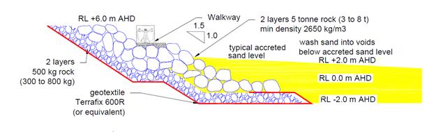
Figure 1 Preliminary seawall
design incorporating alongshore access (WRL, 2016)
In addition to the above recommendation for Belongil Beach,
the management study recommends a number of coastal hazard risk management
strategies for the other areas of the Byron Bay Embayment. These are detailed
at Attachment 1, section ES.8.
After due consideration of the management study report, as
well as other information, including the legislative and policy framework for
preparing the draft CZMP, the coastal hazard risk management strategies
recommended for incorporation into the draft CZMP are detailed below.
Belongil Beach
The strategy recommended for Belongil Beach is underpinned
by the consultant’s recommendation concerning Stage 1 of the
‘adaptive management protection scheme’, i.e. ‘engineered
seawall with walkway’. Additional measures are required however for
meeting legislative requirements and for providing for ‘adaptation’
in response to implementation, funding, and climate based uncertainties.
The additional measures proposed are:
a) tailored
planning controls and conditions for the ‘seawalls with walkway’,
with conditions on the works for: monitoring, maintenance, management of
impacts, potential modification, upgrade or removal;
b) revised
and updated, adaptive planning controls and conditions on development in
coastal hazard areas.
Accordingly, an adaptive ‘seawall with walkway’
strategy is recommended for managing coastal hazard risks at Belongil Beach,
with six main components, some of which may be implemented in parallel:
a) Develop
funding Model.
b) Develop
impact monitoring program.
c) Design
‘seawalls with walkway’.
d) Develop
planning and development controls and conditions for ‘seawalls with
walkway’.
e) Construct
‘seawalls with walkway’ – incorporating two public beach
accesses (plus the Manfred Street access) and dune revegetation works.
f) Revise
and update coastal hazard land use and development planning controls –
providing for adaptation of development.
g) Compliance
and enforcement.
As per the consultant’s recommendation, there is a
possibility that other stages in the ‘adaptive management protection
scheme’ may be implemented at some time in the future. These stages are
beyond the scope of the draft CZMP implementation timeframe, which is 15 years,
and will require further investigation, including analysis of the impacts of
implementing Stage 1 of the ‘adaptive management protection
scheme’.
Other areas
The following strategies are recommended for managing
coastal hazard risks in other areas of the Byron Bay Embayment:
a) Jonson
Street Protection Works - upgrade works, remove spur groynes and improve beach
access and amenity, as per Council resolution 14 – 66, and monitor
impacts.
b) Revise
and update coastal hazard land use and development planning controls - for
development at The Pass to Clarkes Beach, Main Beach, Cavvanbah (First Sun
Caravan Park to Border Street), and North Beach, providing for adaptation of
development. Compliance and enforcement.
c) Dune
revegetation and ‘soft’ dune stabilisation - for all precincts, as
a ‘supporting’ coastal hazard risk management strategy.
d) Emergency
action sub plan for coastal erosion emergencies - applicable to all precincts,
as a ‘supporting’ coastal hazard risk management strategy.
e) Coastal
hazard investigation Lighthouse Road and Captain Cook Car Park - investigation
of future coastal hazard risks and bedrock levels at and adjacent to Lighthouse
Road and Captain Cook Car Park.
f) Coastal
hazard investigation Marine Parade, Wategos Beach - investigation of future
coastal hazard risks (inundation) and integrity of existing ad hoc coastal
protection works at, Wategos Beach.
g) Monitor
coastal processes and impacts on North Beach.
Draft CZMP
In accordance with part 9 of Resolution 16-028, as
reproduced below, the draft CZMP BBE is herein tabled for Council’s
consideration at Attachments 2 to 6. Columns 1 and 2 of Table 1
explain the various parts of the draft CZMP, as composed of separate parts (or
attachments).
16-028 Resolved
that Council (relevant part only):
9. Amends the indicative CZMP
BBE time-frames contained on page 82 of report 13.10 as follows:
a) Task 2(f). A report will
be presented to Council at the 7 April Ordinary Meeting containing the
management strategy for the draft CZMP BBE for adoption, as well as all other
draft sections of the CZMP for consideration.
b) Tasks 7 & 8. Prepare
first draft CZMP for adoption at and Extraordinary meeting of Council on 12 May
2016.
c) Task 9. CZMP is exhibited
for 28 days from 12 May to 10 June.
d) Task 9. PRG reviews
submissions and reports to Council.
e) Task 10. An Extraordinary
Meeting will be convened on 29 June to adopt a final draft CZMP for adoption
and immediate submission on 30 June 2016.
Given the timeframes imposed by Res 16-028 (part 9), the
draft CZMP attached to this report, most notably Part B, has been written under
the assumption that the coastal hazard risk management strategies recommended
in this report are adopted, without amendment, by Council. Pending the outcome
of this report, various parts of the draft CZMP, especially Part B, may require
revision and re-writing.
CZMP Project Reference Group (CZMP PRG) – Review of
draft CZMP
As per the CZMP PRG Constitution and as reported to Ordinary
Meeting 17 March 2016, Report No. 13.8, an objective of the CZMP PRG is as
follows:
a) Review
draft CZMP BBE and provide feedback to staff prior to the tabling of the draft
CZMP BBE at a Council meeting, and prior to the draft CZMP BBE being
‘adopted for public exhibition’.
The CZMP PRG has reviewed several chapters of the draft CZMP
already and feedback has been received from several members. Table 1 details
the review of the draft CZMP chapters by the PRG.
Due to strict timeframes and resources available to meet
these timeframes, consideration of feedback already obtained from CZMP PRG
members has not been incorporated into the version of the draft CZMP as
attached to this report. The CZMP PRG feedback will be incorporated into the
next version, to be tabled at Extraordinary Meeting 12 May 2016.
Given the timeframes imposed by Res 16-028 (Part 9), it
should be noted that the CZMP PRG may not review the draft CZMP, in its
entirety, prior to it being tabled for adoption for exhibition at Extraordinary
Meeting 12 May 2016. Table 1 details the drafting and review status of the
various parts of the draft CZMP, as attached to this report, and expectations
in terms of the final PRG review outcome.
Table 1 Structure, drafting and review status of the
draft CZMP, as per attachments 2 to 6 of this report
|
Attachment to this report
|
Part / Section
|
Drafting Status
|
Current PRG Review Status
|
Consideration of PRG comments
|
Final PRG review outcome
|
|
Attachment 2
|
Part A – General
Information
|
Mostly complete.
Appendix 2 incomplete:
- Councillor workshops
- Council resolutions
|
Most parts already reviewed
by PRG.
Since PRG review:
- minor edits
- Vision Statement added
- Management Objectives added
- Appendix 1 and 2 added.
|
Feedback on new material
invited, due 21 April.
Feedback will be considered
as part of preparing 12 May draft CZMP.
|
PRG review objective will
be satisfied.
|
|
Attachment 3
|
Part B – Coastal
Hazards and Risk Management
|
Coastal hazards and risk
assessment - complete
Coastal hazards risk
management strategy – incomplete, dependent on Council resolution
(outcome of this report).
Appendix 2 - incomplete
Detailed funding schedules
outstanding.
|
Coastal Hazards and Coastal
Hazards Risk Assessment moved from Part A to Part B. Already reviewed by PRG.
Since PRG review:
- minor edits
- updated to WRL (2016).
- coastal hazards risk management strategy added.
|
Feedback on new material
invited, due 21 April.
Feedback will be considered
as part of preparing 12 May draft CZMP.
|
PRG review objective will
be partially satisfied.
|
|
Attachment 4
|
Part C – Community
Uses
|
Almost complete.
|
Most parts already reviewed
by PRG.
Since PRG review:
- inclusion of Management Objectives to Table 3 and 4.
- Amendments to Indigenous Cultural Heritage section
(C2).
- section 6.5 removed.
|
Feedback on new material
invited, due 21 April.
Feedback will be considered
as part of preparing 12 May draft CZMP.
|
PRG review objective will
be mostly satisfied.
|
|
Attachment 5
|
Part D – Open Coast
Ecosystem Health
|
Almost complete.
|
Most parts already reviewed
by PRG.
Since PRG review:
inclusion of Management
Objectives to Table 1.
|
Feedback on new material
invited, due 21 April.
Feedback will be considered
as part of preparing 12 May draft CZMP.
|
PRG review objective will
be mostly satisfied.
|
|
Attachment 6
|
Part E – Emergency
Action Sub Plan
|
Partially complete –
propose general content to remain as per draft EASP (2011), with an update to
reflect Council’s organisation structure, relevant consultation
activities.
|
None reviewed by PRG.
|
Feedback invited, due 21
April.
Feedback will be considered
as part of preparing 12 May draft CZMP.
|
PRG review objective will
be mostly satisfied.
|
It is recommended that
Council note the draft Coastal Zone Management Plan Byron Bay Embayment, as
attached to this report, and the review status of the draft CZMP by the PRG, as
detailed at Table 1.
Financial Implications
The management study includes preliminary costings and
hypothetical funding models for the adaptive management protection scheme,
detailed at sections 11.6 and 11.7, and summarised at Section ES.7, Attachment
1. Noting that only Stage 1 ‘seawalls with walkway’ is being
recommended for the draft CZMP in this report.
The engineering costs associated with Stage 1 of the
Belongil Beach strategy, have been estimated by the consultant to be in the
order of $15M. There are assumptions that underpin these costings, and the
figures should be read and interpreted within the context of these assumptions,
which have not been tested or validated.
A preliminary funding model was developed for the Management
Study for the Belongil Beach strategy, and is summarised at Section ES.7 of
Attachment 1. This model includes private landowners (80% contribution),
Council, State Government Coastal Management Program and Crown Lands (almost 7%
each). For Council, this amount will be a minimum of approximately $1M, for
which funding will need to be determined (assuming other parties make their
respective contributions). The development of a collaborative funding model for
coastal hazard risk management at Belongil Beach, will be a prerequisite to
implementing and realising any potential management strategy or action, as
prescribed in the certified CZMP.
It is intended that a more detailed hypothetical funding
model for coastal hazard risk management at Belongil Beach, will be provided in
the 12 May draft CZMP and / or accompanying Council report. The financial implications
of the coastal hazard risk management strategies that are endorsed by Council,
as an outcome of this report, for all precincts, will be detailed in the 12 May
Council report.
The costs associated with the preparation of the management
study were reported to Council on 19 November 2015. Table 2 provides updated
costings associated with the management study, with additional costs largely
associated with the revisions to the CBA.
Table 2 Expenses
and funding (ex GST) for preparing the Coastal Hazard Management Strategy Byron
Bay Embayment (WRL, 2016) as at time of preparing report
|
Expenditure Description
|
BSC Funds ($)
|
State Government Funds
($)
|
Total Expenditure* ($)
|
|
Original contract amount
|
50,000
|
49,500
|
99,500
|
|
Variation 1: investigation sand
transfer system, funding split
|
18,000
|
18,000
|
36,000
|
|
Variation 2: additional
cost benefit and distribution analysis
|
27,340
|
0
|
27,340
|
|
Formal response Cost
Benefit Analysis (CBA) comments
|
1,950
|
0
|
1,950
|
|
Additional meetings,
workshops
|
2,760
|
2,620
|
5,380
|
|
CBA workshop: 8 December
2015
|
4,130
|
4,130
|
8,260
|
|
Variation 3: Revision to
cost benefit analysis (estimated)
|
13,500
|
|
13,500
|
|
Miscellaneous (e.g.
catering and advertising)
|
1,454
|
0
|
1,454
|
|
Total
|
119,134
|
74,250
|
193,384
|
* Excluding
internal Council costs for managing and administering the project, reviewing
reports etc.
Statutory and Policy
Compliance Implications
The draft CZMP is being prepared in response to a
Ministerial Direction under Part 4A of the Coastal Protection Act 1979
and in accordance with the ‘Guidelines for Preparing Coastal Zone
Management Plans’ (OEH, 2013).
Part A, Appendix 1 of the draft CZMP, at Attachment 2,
details the statutory and legislative framework under which the draft CZMP is
being prepared.
Part B of the draft CZMP, at Attachment 3, provides
more details with respect to the statutory and policy compliance implications
of the Belongil Beach management strategy that has been recommended for
adoption by Council, refer Tables 9 and 10.
It should be noted that, in accordance with section 55G (2)
of the CP Act, Council must consult with relevant public authorities prior to
submitting the draft CZMP to the Minister, in the manner as specified in the
‘Guidelines for Preparing Coastal Zone Management Plans’ (OEH,
2013). With reference to Section 1.3 of OEH, 2013, this manner is as follows:
A council submitting a draft
CZMP to the Minister for certification is to also provide to the
Minister copies of written
correspondence from public authorities supporting any actions
contained in the draft CZMP
which they are responsible for or that affect their land or assets.
Consultation with public authorities is being facilitated
through the activities of the CZMP PRG and it is envisaged that the process
detailed above will be carried out during the exhibition of the draft CZMP.
Whilst staff will make every effort to receive written confirmation from public
authorities as per the requirements of the CP Act, and within the CZMP
timeframes as per Res 16-028, this cannot be guaranteed, as there are factors,
such as the response times from agencies, that are beyond the control of staff.
Staff Reports - Sustainable Environment and Economy 13.6
Report No. 13.6 Report
of the Planning Review Committee Meeting held on 10 March 2016
Directorate: Sustainable
Environment and Economy
Report
Author: Wayne
Bertram, Manager Sustainable Development
File No: I2016/222
Theme: Ecology
Development and Approvals
Summary:
This report provides the outcome of the Planning Review
Committee Meeting held on 10 March 2016.
|
RECOMMENDATION:
That the report be noted.
|
Report:
The meeting commenced at 1.00pm
and concluded at 1.10pm.
Present: Crs Dey, Hunter,
Cameron
Apologies: Nil
As Council determined the
original development applications, the Section 96 applications to modify the following
development consents were referred to the Planning Review Committee to decide
if the modification applications could be determined under delegated authority.
The following Section 96
applications were reviewed with the outcome shown in the final column.
|
DA No.
|
Applicant
|
Property Address
|
Proposal
|
Exhibition
Submissions
|
Reason/s
Outcome
|
|
10.2001.438.4
|
Geolink Consulting
|
23B Sunrise Lane
Ewingsdale
|
S96 to modify conditions of approval
|
Level 2
7/1/16 to 20/1/16
No submission received
|
Delegated Authority
|
|
10.2015.353.2
|
Brandon Saul Holdings Pty Ltd
|
Bayshore Drive
Byron Bay
|
S96 amend condition 26 to allow staging of developer
contributions
|
Level 0
|
Delegated Authority
|
Staff Reports - Infrastructure Services 13.7
Staff Reports - Infrastructure Services
Report No. 13.7 Potential
Bulk Closure of Road Reserves Suffolk Park DP11632 to be held by Council as
operational land for sale to adjoining landowners
Directorate: Infrastructure
Services
Report
Author: Deanna
Savage, Administration Officer Infrastructure Services
File No: I2016/117
Theme: Community Infrastructure
Projects and Commercial Opportunities
Summary:
Council has received some
enquiries into the potential purchase of Council owned road reserve / lanes
within DP11632.
Approximately half of
Council Road Reserves in this DP have already closed and on-sold to adjoining
land owners, this report proposes that Council move forward on the closure of
the whole of DP11632 to allow the remaining adjoining landowners the
opportunity to purchase these lots once closed.
|
RECOMMENDATION:
1. That
Council endorses the closure of all remaining Council road reserves / lanes
in DP11632 as one application to Crown, so they can be held by Council as
operational land for sale to adjoining landowners.
2. That
Council endorses all fees associated with the application to Crown, including
but not limited to:
a) advertising
costs associated with application
b) Crown
application fees
c) Council’s
surveyors fees, sub division, survey and valuation
3. That
Council ascertain market value per square meter of Council owned Road Reserve
in DP11632 by retaining a suitably qualified Valuer and delegate to the
General Manager the authority to enter into a contract for the sale of each
lot, once created, for a value no less than the highest value placed on per
square meter by the independent Valuer.
4. Without
limiting the delegation to the General Manager to negotiate a contract
suitable to the Council, terms and conditions of any contract will include
requirements for:
a) the
applicant to pay all costs associated with the individual purchase of lots in
DP11632 once operational land, including but not limited to:
i) Council application fees
ii) all registration fees
iii) legal costs
b) that
lots, once created and sold, be consolidated into corresponding property
parcel numbers.
5. An
easement over portions of each lot for the purposes of providing Stormwater
Discharge is to be created, with each lot being determined
individually. This will be done within the guidelines of ‘Building
over Pipelines and Other Underground Structures’ Policy No 4.20.
6. That
Council authorise the affixing of the Council seal to and the signing of all
documents necessary to affect any sale and transfer of lots in DP11632 of
Council operational land at Suffolk Park.
|
Attachments:
1 Signed
Statutory Declaration of Anthony John Buckley for DP 11632 stating that work
was completed on lane ways, E2016/3203
2 Letter
from NSW Land & Property Information regarding Roads and Lanes in DP11632
(refers to E2015/29035), S2015/6791
3 Letter to
Manager at Crown Lands Newcastle re clarification of closure of DP11632
(enclosing letter S2015/6791), E2015/66808
4 'Building
Over Pipelines and Other Underground Structures' Policy No. 4.20 adopted
8/10/09 Res No. 09-798 (Current_Policies), DM906135
Report
 Land
Information
Land
Information
DP 11632 – Suffolk Park – Road Reserve Lanes
Information/Background
DP 11632 was registered in 1922 by Frederick Lyle
Suffolk. The land had been purchased in 1910.
In the late 1970s early 1980s Council opened up to all land
owners the possibility of closing and purchasing the lanes / road reserves in
between the properties. They were offered to adjoining landowners and to
properties next door, not necessarily adjacent to the property. This has
created a somewhat zigzag effect along the lanes closed, with some easements
created, land locks and the remainder having been grassed over.
The laneways in Suffolk Park were never properly constructed
and development of this sub-division didn’t really start until the late
1950s. The lanes however, were used for the collection of night-soil and
as access to the rear of properties in the late 1960s and early 1970s.
Due to the lack of use by Council now and the fact that DP
11632 was registered in the 1920s, so historical information is limited,
evidence of previous use is difficult to ascertain on site. A light
covering of a hailstone type of material was apparently used on these laneways.
Use of most of the laneways for access stopped after Council sewer mains
were laid in the laneways in the mid 1970s. The recollections of Council
officers employed at that time have formed the basis of Council’s claim to
previous use of the laneways. A Statutory Declaration has been signed by
a long standing employee of Council, Anthony Buckley, who has been with Council
for over 34 years and recalls doing work on these lanes. (Attachment 1
E2016/3203)
The last closure and sale of land in this DP was finalised
in December 2015. Due to the Crown needing evidence of prior works, this
transfer and sale took close to three (3) years to finalise successfully in
Council’s favour. Council then sought to confirm in writing the
status of the lanes and roads within DP 11632 for all future closures and sales
to proceed without delay. Attachment S2015/6791, letter from the Land and
Property Information, confirms that:
“In respect of your question as to the status of
the roads and lanes in the above Deposited Plan (registered in 1922), I advise
that section 336(3) of Local Government Act 1919 (now repealed) operated to
vest, on registration of the plan, those roads and lanes in the then local
Council.”
This letter, however, only clarifies that the lanes do vest
in Council as Council Road Reserve. Council still has to prove the use of
the lanes and prior works being completed on the lanes.
There have been further requests by adjoining land owners to
purchase the road / laneways in this DP. The Geocortex images above show
in red the open road / laneways that have the potential for closure and sale to
adjoining land owners.
The letter written to the Manager Crown Lands Newcastle
(Attachment 3 E2015/66808) has been passed to Michele Hurcum from Crown Lands
Grafton. She has stipulated that the letter may accompany the application
for closure, however the letter only clarifies that the road reserves / lanes
are roads vested in Council, it still does not clarify that the road reserves /
lanes were constructed. The Statutory Declaration signed by Anthony
Buckley will also accompany the application, to help show that work was
completed on these lanes, as well as the fact that 60 odd applications have
been dealt with since 1974 within Crown Lands and all have stayed vested with
Council and sold to adjoining land owners.
Financial Implications
Council will need to outlay the initial costs associated
with Closing of DP 11632. Fees associated with the application to Crown
include:
· advertising
costs
· Crown
application fees
· Council’s
surveyors fees, sub division, survey and valuation
Council will also need to retain the services of a suitably
qualified Valuer to ascertain market value per square meter of Council owned
Road Reserve in DP11632.
Once the Road reserve / laneways are closed and individual
lots become Council operational land, the applicant is to pay all costs
associated with the individual purchase of the lots, including but not limited
to:
· Council
application fees
· all
registration fees
· legal
costs
Statutory and Policy Compliance Implications
Local Government Act 1993
Once the land becomes Operational there are no limitations
on Council’s capacity to sell the land.
Local Government (General) Regulation 2005
Pursuant to clause 400, the seal of a council must not be
affixed to a document unless the document relates to the business of the
council and the council has resolved (by resolution specifically referring to
the document) that the seal be so affixed.
ROADS
ACT 1993 – Sect 43
(1) This
section applies to land vested in a council and forming part of a former public
road.
(2) Land to which this section
applies is operational land for the purposes of the Local
Government Act 1993 unless, before the land becomes vested in the council, the
council resolves that it is to be community land, in which case the land is
community land.
(3) If the land is disposed of by
sale, the proceeds of sale (less the costs of the sale) are to be paid to the Council.
(4) Money received by a council
from the proceeds of sale of the land is not to be used by the council except
for acquiring land for public roads or for carrying out road work on public
roads.
Building over Pipelines and other underground Structures
Policy No 4.20
Policy included as Attachment 4 (DM906135).
Staff Reports - Infrastructure Services 13.8
Report No. 13.8 Status
Report - Footpath at Marine Parade, Wategos
Directorate: Infrastructure
Services
Report
Author: Rob
Serventi, Contract Engineer
File No: I2015/1422
Theme: Community Infrastructure
Local Roads and Drainage
Summary:
To update Council on the current project status for the
provision of improved pedestrian and traffic infrastructure linking
existing pathways in Marine Parade, Wategos.
|
RECOMMENDATION:
That in relation to the Marine Parade Pedestrian and
Traffic Impact Assessment Report a one-way traffic flow with a mix of
parallel and 45 degree parking on beach side whilst maintaining existing
parallel parking on the residential side (Option 3) is endorsed.
OR
That in relation to the Marine Parade Pedestrian and
Traffic Impact Assessment Report a Shared Zone that provides better vehicle
speed regulation in a highly pedestrianized environment (Option 4) is
endorsed.
|
Attachments:
1 Draft
Consultant's Report on Marine Parade Pedestrian and Traffic Impact Assessment, E2016/17825
2 Marine
Parade Options Summary - March 2016, E2016/17462
3 Additional
Parking West end of Marine Parade, E2016/17676
Report
Background
Council engaged the services of consultants to develop
options for the provision of a 2m wide pedestrian footpath in Marine Parade,
Wategos. The new footpath was required to link the existing footpath at
the western end of Marine Parade with the existing National Parks and Wildlife
Service (NPWS) footpath at the eastern end of Marine Parade to Cape Byron.
4 options developed include:
· Option 1 –
two-way traffic flow with parallel parking both sides where practicable.
· Option 2 –
One-way traffic flow with a mix of parallel and 45 degree parking on beach side
only
· Option 3 –
One-way traffic flow with a mix of parallel and 45 degree parking on beach side
whilst maintaining existing parallel parking on the residential side.
· Option 4 - Shared
zone that opens the beach promenade to Marine parade and provides additional
parking at the approach roads to Marine Parade.
The existing and additional parking spaces for each option
are shown in the table below:
|
Option
|
Traffic Flow
|
Existing
Parking #
|
Additional
Parking
|
Additional
Pedestrian Amenity
|
|
Option 1
|
Two Way
|
61
|
18
|
no
|
|
Option 2
|
One Way
|
61
|
24
|
no
|
|
Option 3
|
One Way
|
61
|
35
|
no
|
|
Option 4
|
Two way
Shared Zone
|
61
|
18
|
yes
|
# Between Pandanus Lane and Julian Parade
Council’s consultant has completed a pedestrian and
traffic impact assessment, which is attached and includes a Road Safety Audit
to identify hazards recommends Option 4 - Shared Zone as the preferred
technical solution.
The attached Marine Parade - Options Summary – March
2016 outlines the main design issues considered for each option, the pros and
cons of each, and provides some commentary in relation to impacts, costs and
benefits, including existing and additional future staged parking.
The Local Traffic Committee (LTC) considered the options at
their meeting held 24 June 2015 and recommended:
RECOMMENDATION:
That Council supports the Local Traffic Committee
endorsement of either of the proposed one-way traffic options for the beach
front section of Marine Parade, Wategos from west to east through to the
intersection of Julian Place.
The resolution of Council at its meeting on 16 July 2015
after consideration of the LTC recommendation above was as follows:
Res 15-360
That this matter be deferred until after further
consultation with the Wategos residents and community at large and a briefing
to Councillors at a Strategic Planning Workshop regarding the three options and
the results of the any consultation.
Preliminary Consultation
The preliminary consultation undertaken by the consultant
was as follows:
Wategos Beach Protection Association
Draft submission provided E2015/51280 regarding the three options.
Site meeting held 10 August 2015 and the main discussion
points were:
· keep “2-way
traffic” opposed to one way traffic
· consider
“Shared Zone” alternative option, include landscape design and
minimal barrier fencing
· “Shared
Zone” could be an interim solution
· preference for
pedestrian movement over parking spaces
· look at traffic
flows and parking restrictions (time, no stopping, resident schemes, etc)
around entire loop.
· improve signage to
reduce accidental visits to Wategos
National Parks & Wildlife Service (NPWS)
· prefer Option 2
keep “2-way traffic” opposed to one way traffic
· retaining walls be
consistent with rock walls near picnic area
· fencing be
consistent with NPWS Fence
· concrete path be
consistent with existing
· confirm road
boundary
· NPWS get approval
for fitness station
· consider mobile
vendor station in road reserve
A briefing was provided to Councillors at a Strategic
Planning Workshop held 13 August 2015.
Issues considered at the workshop included:
· costs
· potential impacts
to traffic flow (if one-way option adopted) with respect to vehicles that need
to return back to the area to gain parking spaces
· impacts to local
residential amenity
· footpath
treatments
· parking demand and
number of spaces available
· need for detailed
traffic assessment of the area and associated impacts
· consideration of a
shared zone and approval processes
Action since the August 2015 Strategic Planning
Workshop
Pedestrian and traffic counts have been undertaken in December
2015 and January 2016 to inform a pedestrian and traffic impact assessment
report on the four options above.
The Marine Parade pedestrian and traffic impact assessment
report on the four options has been developed by Council’s consultants to
assess road and pedestrian safety issues, traffic management issues and impacts
of the two one way options, a two way option and a shared zone concept.
Potential for future formalisation of parking has also been analysed in the
consultant’s report, which is attached.
The report identifies deficiencies for road and pedestrian
signage, pedestrian amenity and safety and suggestions for improving the
parking turnaround and recommends a Shared Zone preferred treatment to best
cater for the high number of pedestrians that are on Marine Parade.
A briefing was provided to Councillors at a Strategic Planning
Workshop held 11 February 2016 on the four options.
Next Steps and Design Development
After the resolution by Council of an endorsed option,
design development and detailed design shall be commenced and includes:
· Detailed land and
services survey
· Development of
design to respond to Traffic / Pedestrian Impact Assessment
· Development of
design to incorporate coastal process hazards management
· Project approvals
· Detailed design /
construction documentation
· Updated
construction estimate
· Ecological
assessment
· Review of
Environmental Factors
The final design will need to adequately cater for
recommendations or key issues identified in the Draft Coastal Zone Management
Plan Byron Bay Embayment, specifically with respect to coastal processes,
hazards and their management at this location.
It is envisaged that the works would be undertaken in
2016/2017 subject to provision of the required additional funding as part of
the 2016 / 2017 budget process.
Financial Implications
Funding for Marine Parade Footpath in 2015/16 is $241,300
with costs to date being $63,601. This leaves a balance of $177,699.
Currently there is no funding being offered from NPWS.
Preliminary Costs for the four Concept Designs are:
· Option 1 –
Two way traffic flow $445K
· Option 2 –
One-way traffic flow $380K
· Option 3 –
One-way traffic flow $460K
· Option 4 –
Shared zone – $480K
Costs are preliminary estimates only to facilitate option
selection and are subject to further geotechnical investigation and detailed design,
including investigation of the foreshore revetment structure works under Marine
Parade.
Additional funding will be needed in 2016/17 to undertake
the works associated with the preferred Council solution.
Statutory and Policy Compliance Implications
There are no negative implications proposed in this report.
Staff Reports - Infrastructure Services 13.9
Report No. 13.9 Byron
Bay Pay Parking Scheme - criteria for 6 month review
Directorate: Infrastructure
Services
Report
Author: Simon
Bennett, Traffic and Transport Planner
File No: I2016/46
Theme: Community Infrastructure
Local Roads and Drainage
Summary:
The purpose of the report is to establish the criterion for
the first formal review of the scheme, noting that Council resolved such review
occur within 6-months of it operating. Accordingly the review, and any
changes it may warrant, will be reported to Council June 2016.
This report makes no recommendations in regard to changes to
the meter registration (pay parking) scheme that began operating in Byron Bay
December 2015.
To assist the review and to provide an avenue for formal
feedback, a survey, as provided at Attachment 1, is proposed to be made
available. This survey is designed and proposed for three reasons.
For one, it will further explore questions outlined at Table
2 of this report which were included in the Byron Bay Chamber of Commerce
February 2016 conducted survey which, as briefly discussed in this report,
provides a mixed response in regard to the economic impact of pay parking but
makes clear three concerns shared by some of the 98 respondents: the lack of
credit card/request for coins; that 1P and 2P time limits are considered too
short and restrictive; and a preference that permit holders need not interact
with the meter.
Secondly, the survey at Attachment 1 is designed to remain
current and available at all times (for example online) to assist with a formal
and ongoing channel of feedback and thirdly provide a basis for comparison for
future reviews.
Undertaking such future reviews, as with a formal review
within 6-months of it first operating, is consistent with Roads and Maritime
Services (RMS) requirements, whose criteria for such a review must also be
considered and is outlined at the end of this report.
|
RECOMMENDATION:
That the criterion proposed for the 6-month
review, including the proposed survey, be endorsed and reported back to
Council in June 2016.
|
Attachments:
1 Proposed
Pay Parking Survey for 6-month Review and beyond, E2016/18399
Report
Council introduced a meter
registration pay parking scheme in Byron Bay in three (3) distinct stages.
Stage 1 – 23 December 2015 1-hour
(1P) and 2-hour (2P) commenced;
Stage 2 – 17 January 2016 four-hour
(4P) and all day (0P) sites included; and
Stage 3 – 11 March 2016 start
of credit card payment at the meter.
By 11 March, and despite the
inability to make credit card payments, meter revenue had surpassed
$500,000. Ten days later, by the 21 March, meter revenue had neared
$610,000 with credit cards accounting for $34,000 (or 31%) of revenue since it
became operational. Based on these trends meter revenue is on track to
meet projected revenue (after costs) of $2M pa.
Exceeding projections is the
uptake of the pay parking exemption (hereon referred to as an ePermit). Table 1
below details the uptake of the ePermit (by permit type) and vehicles
registered with the scheme as at 26 February 2016.
Given that account holders can
have a 25% free loading for 2 or more permits purchased a simple calculation
can not be made on revenue. However it can be confirmed the total value of new
ePermits by 21 March 2016 was $341,979, which includes those upgrading from the
old coupon to the new scheme and explains the odd number and unrounded
number.
Table
1: permits and vehicles registered as at 26 February 2016
|
Type
|
Permits
|
Plates
|
|
Residents
|
6,903
|
6,903
|
|
Workers
|
178
|
178
|
|
Business accounts
|
56
|
126
|
|
Pensioners
|
3,027
|
3,005
|
|
Trade/commercial accounts
|
52
|
108
|
|
Totals
|
10,216
|
10,320
|
As per the proposed criterion, a
more detailed analysis of permits will be provided as part of the 6-month
review, which will also include effort to understand postcode and locality
breakdown, plus the frequency permits are being used. Doing so will help understand
the value of the permit and allow comparison of the parking occupancy of permit
holders versus those that pay the meter, which the parking study indicated
could be as low as 30% being locals at peak periods and as high as 70% locals
in non-peak.
Such analysis will also help
understand the potential take-up of the swipe card which Council has resolved
to provide at a one-off cost of $27.50. It is anticipated such a card
will be purchased mainly by those that enter their plate at the meter frequently,
if not daily, as it will contain the details of a single licence plate only and
will remove the need to manually enter those same details at the meter on the
proviso the end-user instead registers the vehicle licence plate each time they
park by using the swipe card in a similar manner of making a contactless credit
card payment.
More immediately however it is
proposed that to gauge the potential uptake of the swipe card it be included as
part of the public submission period recommended for April/May which is aimed
to further help the 6-month review.
Such a submission period, with
specific questions such as those at Attachment 1, is proposed to be undertaken
via a web-based survey to allow stakeholder and community feedback. In
addition to providing an ability to gain quantitative data for typically
qualitative (or subjective) matters, such a survey will also help provide a
formal channel for feedback (now and in the future) and assist with improving
and reviewing Council’s educational and information material, including
at the meter, FAQs, plus understand the improvements to be made to
Council’s and the permit page websites.
Undertaking such a survey should
also help highlight where extra customer service attention is required,
including further staff training and their understanding of and on the scheme
including its administrative systems so as to ensure consistency and accuracy
ensues for both the administration of, and communications about, the scheme is
being provided.
And as noted, there is benefit
that this survey always be available in some form to ensure consistency with
future reviews and allow a formal process for ongoing feedback. More
specifically, undertaking such a survey as shown at Attachment 1 as part of the
6-month review will help further explore the questions within the Byron Chamber
of Commerce (ex-BU) February 2016 conducted survey which resulted in 98
responses (n=98). The survey is available online at https://www.surveymonkey.com/r/CQ635SR
and Table 2 lists the questions and a summary of the responses to that survey
as provided to Council by the Chamber.
Table
2: questions and summary of responses to BBCoC pay parking survey
|
Question
|
Summary of responses
|
|
What is the name of your
business?
|
98 respondents
|
|
At what email address would
you like to be
contacted?
|
98 respondents
|
|
Has paid parking improved
being able to find a car park during the peak Christmas holiday period?
|
48.98% said Yes; 25.7% said No
9.18% said Same, 13.27% said
Other or provided comments
|
|
What
was customer feedback on paid parking during the peak holiday period?
|
7.14% stated feedback was
Positive; 55.10% stated it was negative; 21.43% said it was
‘mixed’; 16.33% said there was ‘none’
|
|
Has
paid parking changed your customers'
shopping
habits for the better or worse?
|
6.12% said it was
‘better’; 56.12% stated it was ‘worse’; 37.76% said
it was the ‘same’
|
|
As
a local, has paid parking changed your shopping habits for accessing the CBD?
|
36% said no; 37% said yes and
using ;outer’ regions more; 26.8% said other or provided comment
|
|
Has
paid parking had a financial impact on your business?
|
Of the 88 responses to this
question, near 54% said turnover was the same or slight increase
|
|
Has
your customer patronage been impacted by paid parking?
|
50% stated it was the same or
busier, while 30% stated it was less busy and 20% found it very quiet
|
|
Do
you have any other business feedback on the implementation of paid parking
for Council?
|
All 98 respondents provided a
comment in regard to this question as discussed below
|
As shown in Table 2 above, while
the CoC survey drew a mixed response on the impact pay parking has had on
trade, it did highlight three clear concerns in response to Q9 . The first has
since been resolved however, that being credit card payments be available at
the meter.
The second trend was that time
limits in 1P (1-hour) and 2P (2-hour) locations are seen by some respondents as
to short of duration, despite the fact such time limits did not change and did
exist prior to pay parking, and have done so for many years, e.g. 1P in Jonson
Street and Lawson Street and 2P in Fletcher Street. If anything, this
appears to suggest that the interaction with the meter each time a vehicle is
parked (as required by Council) is reinforcing the time limit and therefore
making people more acutely aware of the parking duration they have. Such
an assumption however can be tested against infringement and Licence Plate
Recognition (LPR) data during the review.
However if it is found to be
true that interacting with the meters has changed behaviour, i.e. greater
compliance with the sign-posted time limit is occurring, then it would appear
to diminish the argument of a third trend notable within the chamber’s
survey results which was the request by several respondents that permit holders
need not interact with the meter at all when they park.
While this change could be made
by Council, as it is Council policy and not a regulatory requirement of NSW
Road Rules or a Meter Parking Registration scheme, it is not recommended, at
this time at least.
The entry of the licence plate
at the meter provides reliable and valuable data in regard to permit and
parking use/turnover; and if such a change to Council’s policy is to
considered it is recommended it be done when the 6-month review is completed
and on the proviso a licence plate recognition (LPR) system is equipped in
Council’s patrol car which is fully integrated with the meters, which was
always intended to occur after the new meter scheme was fully operational.
Criterion for review of pay
parking
The following is proposed as the
criteria for the 6-month pay parking review which will be reported to Council
June 2016.
1. e-PERMITS (i.e. pay parking exemptions): total; type; postcode
and registration analysis; use/occupancy; method of obtainment and proof; plus
provide audit at 6-month review to determine fraudulent use/ineligibility, and
where applicable, consider restricting the postcode options on the online
application form to Byron shire only.
2. METER: turnover/use; permit (free) Vs paid use; merchant fees; use/demand
of printing tickets; faults and complaints; revenue - cash Vs card; additional
costs beyond contract; value of comprehensive maintenance agreement (as per
tender) versus actual hours/duties, e.g. calls to fault line, number of
automated faults, response times, time to fix a fault, etc.
3. INFRINGEMENTS: review pre and post pay parking infringement type,
number issued and revenue; types of meter infringements; Road Rules and related
implications (if any).
4. TIME LIMITS: review adequacy and mix; survey/review areas that
are subject of requests received; consider changes in holistic fashion not via
ad-hoc changes with report to Local Traffc Committee/Council.
5. PARKING CHANGES: for example dedicated motorcycle spots,
use/demand/options for Butler Street Reserve and other all day areas, such as
change from 4P to all day at Lawson Street south and north car parks.
6. REVENUE AND COSTS: compare actual versus forecast and use of car parks
and revenue derived pre and post new scheme; consider funds allocated to crown
versus council general funds; also consider monthly lease fee, advertising,
signage and staffing/administration.
7. RMS GUIDELINES: as per the Pay Parking guidelines outlined below
(see Policy Implications).
As noted, while this criterion
is proposed for the 6-month review, no changes to the pay parking scheme however
is proposed by this report and that none be implemented until such a review is
reported.
Financial Implications
Nil at this time. The review will be conducted by staff.
Funding remains available in budget which was set aside for implementing pay
parking. This will be used if extra costs are incurred, but expected to be
minimal and at most include newspaper advertising.
Statutory and Policy Compliance Implications
NSW Road Rules and regulation as related to a Meter
Registration Parking Scheme is relevant and needs to be considered in any
changes that may arise from the forthcoming review.
As for the review itself, it is recommended it also
incorporates the criteria of the RMS Pay Parking guidelines including
submission of the completed review to the RMS after Council has received it in
June 2016.
The current version of the RMS Pay Parking Guideline is
available online:
http://www.rms.nsw.gov.au/business-industry/partners-suppliers/documents/technical-manuals/payparkingv4.pdf
Section 17 – Effectiveness Audit is most
relevant to Council’s review. On page 2, the guidelines state the purpose
of such an audit is to:
…ensure the appropriateness and effectiveness of
pay parking schemes implemented by parking authorities and also assist in the
planning and implementation of future schemes.
More specifically Section 17 states the “benefits
of monitoring and conducting” an audit, which includes:
· determine if the
objectives of the scheme are achieved, including RMS own objectives as outlined
at Section 3 of their guidelines, the most relevant believed to be:
o safety and traffic
efficiency gains in the context of travel demand management;
o provide equitable access to
parking spaces; and
o where demand exceeds
supply, ration parking areas to allow short and medium
parking during business hours, ;
· ensure that
a pay parking scheme remains the appropriate parking control solution;
· Provide a
valuable supplement to the studies carried out before establishing the scheme;
· Identify any
unexpected or unacceptable impacts that warrant modification/s;
· Provide
objective information to the road users on the effectiveness of the scheme.
· Provide
information on the performance of the scheme or individual elements of the
scheme which may be useful to the parking authority and RMS for future schemes.
· Provide
information for RMS to assist with any future updating of the policies and
guidelines in this document or amendments...
Section 17 of the RMS guideline also states that:
…the term ‘audit’ is intended to be used as
a formal examination of the scheme and its performance rather than an informal
system of spot checks and assessment. A typical audit, besides being a formal
examination of the scheme and its performance, would also include a
questionnaire with feedback from the road users and all the relevant
stakeholders (ie. the NSW Police Force, Local Government and Shires Association,
councils and declared organisations).
Initially, while a self-audit is proposed, RMS
reserves the right to undertake an independent audit of any scheme.
The ‘measure of effectiveness’ of a scheme
is defined as the means of quantitatively or qualitatively determining the
success as well as the appropriateness of the scheme.
To this end the RMS guideline
provides the following “check list” which:
…should be used as a minimum when conducting the
effectiveness audit:
• Appropriateness of the scheme in meeting the
objectives listed in Section 3 of these guidelines.
• Appropriateness of the location/s.
• Utilisation levels / occupancy of parking spaces.
• Level of parking turn over.
• Level of illegal parking (eg. over stay, not paying
the parking fee, meter feeding etc.).
• Improvements to traffic flows, traffic speeds and
traffic safety.
• Level of enforcement and number of penalty notices
issued.
• Improvement to the environment.
• A questionnaire survey of road users and stakeholders.
Lastly in regard to the audit,
the RMS guideline also states that within one month of conducting the audit,
the completed audit report is to be submitted to the RMS.
And while not specifically part
of the RMS audit requirements, it is recommended the Council review does also
consider the criteria as stated at Appendix A of the RMS guideline for the
“Evaluation of new means of, and schemes for, payment of parking fees
(pay parking
devices or systems) in meter,
ticket, phone and coupon parking schemes.”
While such criteria (as follows)
is used by RMS for evaluating new schemes, it is believed their consideration
in the Council review will assist in any future audit the RMS may themselves
undertake.
A.1 Meter parking
The following criteria will be used in the evaluation
of parking meters and the means of, and schemes for, payment of parking fees in
meter parking schemes:
• Ease of use and understanding of the operation of the
machine by the motorists including clear and readable instructions on the machine
in ambient lighting conditions.
• Acceptance of coins of various denominations.
• Ability to use other payment methods such as smart
cards, credit cards, and mobile phones in addition to cash (notes or coins or
both).
• Ease of enforcement.
• Administrative simplicity.
• Maintenance aspects.
• Environmental friendliness.
• Vandal and fraud proof aspects.
• How quality is to be assured over a long period of
time.
Staff Reports - Infrastructure Services 13.10
Report No. 13.10 Bridge
replacement prorities
Directorate: Infrastructure
Services
Report
Author: Phil
Warner, Manager Assets and Major Projects
File No: I2016/161
Theme: Community Infrastructure
Local Roads and Drainage
Summary:
The purpose of this report is to address Res 15-682
pertaining to a needs analysis of road bridges requiring replacement and
refurbishments in order to determine priorities. This report is to advise
Council on:
a) the condition status of
bridges;
b) present
a methodology for the assessment and prioritization of bridge works and in
particularly bridge replacements; and
c) provide an update on the
purchase of surplus steel Australian Defence Force (ADF) bridges.
|
RECOMMENDATION:
That detailed investigation commence for the deployment
of the recently purchased surplus 25m and 35m Australian Defence Force
(ADF) bridges for the replacement of James and O’Meara’s Bridges
respectively.
|
Report
The purpose of this report is to address Res 15-682
pertaining to a needs analysis of road bridges requiring replacement and
refurbishments in order to determine priorities.
Separately Council considered a report at 25 February 2015
meeting regarding the potential purchase of surplus Australian Defence Force
steel bridges. This report also makes reference to the associated resolution
(Res 16-077).
Overview of status
Council has 31 road bridges and the following summary table
shows the type and average condition of those:
|
Construction Type
|
Number of Bridges
|
Average Condition
|
|
Timber
|
9
|
3.7 - Fair to Poor
|
|
Concrete
|
18
|
2.7 - Good to Fair
|
|
Steel
|
1
|
4 - Poor
|
|
Other - mixed
|
3
|
3.3 – Fair to Poor
|
|
All
|
31
|
3.1 - Fair
|
The timber bridges were generally built many years before
the others and thus it can be expected that they are nearest to the end of
service life.
Some 11 road bridges are in Poor Condition of which 6 road
bridges have load limits , and at least 3 of these (Booyong Bridge,
O’Mearas Bridge and Parkers Bridge are at risk of being closed within say
5 years unless their refurbishment or replacement is funded.
Some 15 other bridges are at Condition 3 and progressing
towards becoming problematic in the future.
Many of the timber bridges are at the end of their service
life and load limits are affecting the level of service available to the
community. Many of these are not viable to invest in major repairs or
refurbishment, but require replacement with new bridges, either steel, concrete
or fibreglass component bridges.
The Timber Bridge Management Report from the IPWEA (NSW)
Roads and Transport Directorate (May 2015) notes that bridges in poor condition
have a very high risk profile and represent a clear backlog that needs to be
managed. Since 2005, bridges across NSW in the medium risk zone have been
progressing into the high risk zone at about the same rate that bridges have
been renewed with the additional funding programs from Councils and the NSW
Government.
Status of individual bridges
The broad status of individual bridge condition (in order of
the bridge number assigned by Council) is as follows:
|
Road Bridge Name
|
Condition – Overall
Status
|
Type of Structure
|
Last Inspection and Type
|
2016 Inspection Proposed and
Type
|
|
Byron Creek
|
4 - Poor
|
Doolan (concrete) deck/timber girders and piles
|
26/10/15 – Level 2 -bored
|
Level 2
|
|
J C Snow
|
3 - Fair
|
Concrete
|
4/3/15 – Level 2
|
Level 1
|
|
O’Meara’s
|
4 - Poor
|
Timber
|
23/7/15 – Level 2 - bored
|
Level 2
|
|
Parkers
|
4 - Poor
|
Timber
|
22/10/15 – Level 2 -bored
|
Level 2
|
|
Scarrabelottis
|
4 - Poor
|
Steel
|
June 2015 – Level 3 -Phase 1 - High Level
|
Level 3 - Phase 2 – High Level
|
|
Booyong
|
4 - Poor
|
Timber
|
20/10/15 – Level 2 -bored
|
Level 2
|
|
South Arm
|
4 - Poor
|
Timber
|
26/10/15 – Level 2 -bored
|
Level 2
|
|
Belongil Creek
|
4 - Poor
|
Concrete
|
4/3/15 – Level 1
|
Level 2 – or later if repairs undertaken
|
|
Ureka Road
|
1 – As built
|
Concrete
|
4/3/15 – Level 2
|
Level 1
|
|
Keyes
|
3 - Fair
|
Concrete
|
4/3/15 – Level 2
|
Level 1
|
|
Donaghy’s
|
3 - Fair
|
Concrete
|
4/3/15 – Level 1
|
Level 2
|
|
Upper Main Arm
|
3 - Fair
|
Timber
|
10/10/15 – Level 2 -bored
|
Level 2
|
|
Palmwoods
|
3 - Fair
|
Concrete
|
22/2/15 – Level 2
|
Level 1
|
|
Settlement
|
3 - Fair
|
Concrete
|
26/2/15 – Level 1
|
Level 2
|
|
Sherries
|
3 - Fair
|
Concrete
|
26/2/15 – Level 1
|
Level 2
|
|
Williams
|
3 - Fair
|
Concrete
|
26/2/15 – Level 1
|
Level 2
|
|
Azalea Street
|
2 - Good
|
Concrete
|
27/2/15 – Level 2
|
Level 1
|
|
Chinbible Creek
|
4 - Poor
|
Concrete
|
27/2/15 – Level 2
|
Level 1
|
|
Kings Creek
|
3 - Fair
|
Concrete
|
27/02/15 – Level 1
|
Level 2
|
|
North Ocean Shores
|
3 - Fair
|
Concrete
|
4/03/15 – Level 1
|
Level 2
|
|
Orana
|
3 - Fair
|
Concrete
|
2/03/15 – Level 1
|
Level 2
|
|
Possum Creek
|
1 – As built
|
Concrete
|
4/3/15 – Level 2
|
Level 1
|
|
Willows Road
|
1 – As built
|
Concrete
|
26/2/15 – Level 1
|
Level 2
|
|
Sherrington
|
3 - Fair
|
Timber
|
26/2/15 – Level 1
|
Level 2 (bored)
|
|
Pocket Road
|
3 - Fair
|
Concrete
|
26/2/15 – Level 1
|
Level 2
|
|
Wilson Creek (Pioneer)
|
3 - Fair
|
Concrete
|
2/3/15 – Level 1
|
Level 2
|
|
English
|
3 - Fair
|
Timber
|
4/3/15 – Level 1
|
Level 2 (bored)
|
|
Thompsons
|
4 - Poor
|
Timber
|
19/10/15 – Level 2 -bored
|
Level 2
|
|
Palm Tree Creek
|
4 - Poor
|
Steel/Timber
|
3/3/15 – Level 2
|
Level 1
|
|
Coral Avenue
|
2 - Good
|
Doolan (concrete) deck/timber girders and piles
|
27/2/15 – Level 2
|
Level 1
|
|
Saltwater Creek
|
1 – As built
|
Steel/Timber
|
27/2/15 – Level 2
|
Level 1
|
|
James
|
4 - Poor
|
Timber
|
21/10/15 – Level 2 -bored
|
Level 2
|
Other road bridges in the Shire which are managed by others
include:
1. Federation
Bridge – RMS
2. St
Helena – SRA – to be replaced
3. McCauley’s
Lane – SRA – to be replaced
There are 12 footbridges in Byron Shire; the following three
have been recently inspected:
|
Foot Bridge Name
|
Condition – Overall
Status
|
Type of Structure
|
Last Inspection and Type
|
2016 Inspection Proposed and
Type
|
|
Brunswick
|
2 - Good
|
Timber
|
3/3/15 – Level 2
|
Level 2 (bored)
|
|
Helen Street
|
2 - Good
|
Steel/Timber
|
2/3/15 – Level 1
|
Level 2
|
|
Tallow Creek
|
4 - Poor
|
Timber
|
23/10/15 – Level 2 - bored
|
Level 2
|
Bridge replacement priorities
The following table presents information on five bridges
that are in the most need of replacement.
|
Bridge Name
|
Bridge Age
|
Existing Length
|
Existing Lanes and Load Limit
|
Comment
|
|
James
(Booyong
Rd)
|
1940
|
22m
|
1 lane -15
Tonne
|
Temporary
bridge closure possible with alternative route available.
Potentially
critical for heavy plant and equipment supply to Scarrabelottis Bridge
|
|
O’Meara’s
(Binna
Burra Rd)
|
1930
|
33.1m
|
1 lane
– 5 Tonne
|
Temporary
bridge closure possible with alternative route available.
|
|
Scarrabelottis
(Scarrabelottis
Rd)
|
1972
|
33.6m
|
1 lane
– 10 Tonne
|
Replacement
of second-hand Bailey bridge.
No
alternative route presents renewal challenges.
|
|
Parkers
(Friday
Hut Rd)
|
1936
|
28.2m
|
1 lane
– 3 Tonne
|
Temporary
bridge closure possible with alternative route available.
|
|
Booyong
(Booyong
Rd)
|
1961
|
36
|
1 lane
– 3 Tonne
|
Temporary
bridge closure possible with alternative route available.
|
The following matrix is a proposed basis for the assessment
and prioritization of bridge works and in particularly bridge replacements.
|
Factor
|
Measure as %
|
Weighting
|
Score out of 100
|
|
Funded – Section 94 or External
|
% of project cost funded
|
10%
|
|
|
Road Function in Road - Network
|
Bridge AADT*/ Bridge Group Highest AADT*
|
20%
|
|
|
Alternative Access Available
|
Yes = zero
No = 100%
|
30%
|
|
|
Bridge Load Limit
|
42 Tonne = Normal
LL = Load Limit
Measure =(42 – LL)/42
|
20%
|
|
|
Alternate Route Travel Time times affected vehicles and
school bus passengers
|
(Extra travel time x ((AADT*x % Heavy Trucks )+ Number of
School Bus Passengers Affected))/Bridge Group Highest Tally
|
20%
|
|
|
|
|
Total = 100%
|
Maximum 100
|
*AADT – Average Annual Daily Traffic – how many
vehicles per day
This draft matrix has been applied to the five bridges
requiring replacement as follows:
|
BRIDGE
|
TOTAL SCORE (Maximum = 100)
|
|
Booyong
|
25
|
|
James
|
25
|
|
O'Meara's
|
50
|
|
Parkers
|
56
|
|
Scarrabelottis
|
50
|
The potential weakness in the above assessment is that it
only reflects the current status which could change. For example, if James
Bridge were to be load limited to 5 Tonne the result would alter as follows:
|
BRIDGE
|
TOTAL SCORE (Maximum = 100)
|
|
Booyong
|
25
|
|
James
|
62
|
|
O'Meara's
|
50
|
|
Parkers
|
56
|
|
Scarrabelottis
|
50
|
Council has been successful in purchasing two modular
surplus ADF steel bridges of 25m and 35 m lengths. It is possible further ADF
steel bridges will be available in the future.
The current one lane bridges that Council may want to
replace with surplus ADF are as follows:
|
Priority
|
Bridge Name
|
Existing Length
|
Ideal ADF Length
|
Alternative ADF Length
|
Comment
|
|
1
|
James
|
22m
|
25m
|
30
|
|
|
2
|
O’Meara’s
|
33.1m
|
35m
|
40
|
|
|
3
|
Scarrabelottis
|
33.6m
|
35m
|
NA
|
|
|
4
|
Parkers
|
28.2
|
30
|
25
|
|
|
5
|
Booyong
|
36
|
40
|
35
|
|
It is recommended that investigation and pre-construction
effort for deployment of the two bridges be targeted to replace:
1. James
Bridge – 25m modular steel bridge
2. O’Meara’s
Bridge – 35m modular steel bridge
The primary reasons for this recommendation are as follows:
Construction/ Launching
Both O’Meara’s and James bridge sites have
suitable river bank cross sections that enable a safer launch from rollers
inside the span of the bridge, whereas the Scarrabelottis Bridge site is
problematic because of the steepness of the launch bank.
35m ADF Bridge
a) The
Scarrabelottis bridge replacement is complicated for a range of reasons
including the constraint of moving plant, and material across the 10 Tonne Load
limited bridge (the only access).
b) The
Scarrabelottis Bridge replacement has the potential for a different bridge type
– a Uni-Bridge – single lane, either adjacent to the existing
bridge or on the existing foundations subject to further assessment.
c) Booyong
Bridge has lower traffic volumes and viable alternative routes. It may prove
feasible to be closed rather than to be replaced.
25m ADF Bridge
a) Parkers
Bridge is longer than is ideal for deployment of the 25m ADF bridge.
b) James
Bridge is the primary access for a larger precinct including school buses and
the Pork Processing facility employing 85 persons. It is also the preferred
access for the replacement of Scarrabelottis Bridge. Although recent bridge
inspections did not require a further reduction of the load limit from the
existing 15T (because of some emergency works undertaken), this is only a
temporary state in the current rate of aging and deterioration. A future severe
load limit on this bridge would be very problematic with substantial impacts on
the community.
It will be essential that there is community consultation in
the proposed bridge replacement projects because it is probable the existing
bridges will need to be closed for an extended period.
Sources of funding
The majority of Council’s bridges are part of the
rural road network, as such there are very limited applicable sources of S94
funding. An exception is the renewal of Blindmouth Creek crossing which is
progressing using available S94 funds.
The bridge program, and in particular bridge replacements,
will need to be funded through a combination of prioritized Council funds and
Federal/ State Government grants.
The current draft 2016/17 budget and the associated forward
estimates include $7.9 m for the bridge program.
In August 2015, Council applied to Round 2 of the National
Bridge Replacement Program (which had $100M to offer Councils on a 50/50 cost
sharing basis) for the following three projects with a total cost of $5.9M.
1. Blindmouth
Creek Crossing at Main Arm Road, Main Arm
2. O’Meara’s
Bridge
3. Scarrabelottis
Bridge
None of these applications were successful against some 250
applications seeking $330M of which 141 projects have been funded.
Council has since had informal feedback from the Department
of Infrastructure and Regional Development which may assist in any future
applications under Round 3 and beyond. It was suggested that Blindmouth Creek
Crossing may be successful in the next round, O’Meara’s Bridge is
probably unlikely to be successful and that Scarrabelottis Bridge does not
serve a large enough community to be successful.
In December 2015, Council applied to Round 2 of the NSW
Fixing Country Roads program. The expression of interest was for $1.95m to
refurbish James, Parkers and Booyong bridges. Council has been advised it was
not successful to move to the formal application stage. The focus of this
program is to improve road freight productivity and the program is administered
by the freight unit of Transport for NSW.
There is a further NSW program called Bridges for the Bush.
The challenge of achieving grant funding for bridges on comparatively minor
country roads is highlighted by the stated purpose of this program. The
NSW road network is critical to the movement of freight in Australia. Half the
nation's road freight and three quarters of all interstate road freight
journeys are on NSW roads. With the road freight task predicted to nearly
double by 2030, significant investment in the NSW road network is required to meet
the demand for increased access of larger, safer and heavier freight vehicles.
Addressing the state's deficient rural bridges is a key priority for NSW
investment as the bridges currently present the most critical restrictions to
freight access. The Bridges for the Bush initiative will enhance freight
productivity in country NSW. It is an investment in critical infrastructure to
remove a number of significant freight pinch points or bottlenecks on the state
road network and to improve the safety and reliability of some old bridge
structures.
Conclusions
Council has been able to
purchase two surplus ADF bridges and it is possible further ADF steel bridges
will be available in the future.
It is recommended that
detailed investigation be completed for use of the 35m bridge to replace
O’Meara’s Bridge and use of the 25m bridge to replace James Bridge.
The replacement of Scarrabelottis Bridge presents a number
of technical challenges. It is possible that further detailed investigation
will reveal that it may not be viable to install a larger ADF bridge on the
alignment of the current bridge. A smaller one lane bridge built adjacent to
the existing bridge maybe the best option.
Opportunities for grant funding must continue to be
explored. Successful grant applications will variously accelerate the timing of
bridge replacements and also allow funds to be directed to other priority
works.
The bridge program going forward will need to be funded
annually to complete ongoing risk management actions, inspections, maintenance
and the renewal of poor condition elements/ components of bridges. This last
area of action is critical in minimizing the need for load limits and also
reducing the overall condition of a bridge deteriorating to a point where
complete replacement is the only cost effective option. A good example of this
approach in action is the recent work on Byron Creek Bridge at Bangalow.
The 2015 Byron Creek Bridge inspection and load limit
assessment identified one very weak pile that without strengthening would bring
the load limit down to 15 Tonne. Council strengthened the pile in-situ and the
general access limit of 42.5 Tonne remains in place. The following photographs
show the installed pile support.
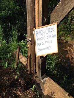
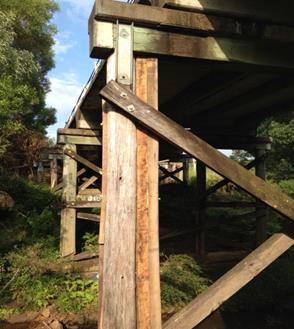
Consideration needs to be given to the benefit and cost of
replacing some bridges on minor rural roads where clear and viable alternative
routes exist. The high capital cost and ongoing maintenance costs may not be
justified in terms of use and a sustainable level of service. A potential
example is Booyong Bridge, pictured below.
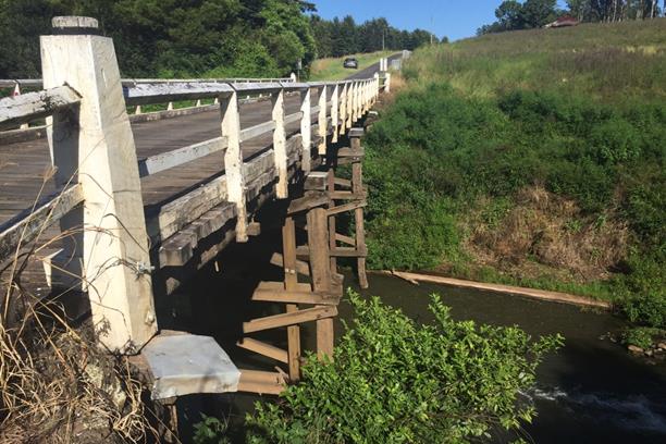
Booyong Bridge (Wilsons River)
Financial Implications
Financial implications have been addressed in the above
section on sources of funding.
The proposed detailed investigations and detailed designs
for the replacement of James and O’Meara’s bridges will be costed
and any necessary budget adjustments reported to the March quarterly review.
Statutory and Policy
Compliance Implications
Council has an adopted Asset
Management Policy. In cases where the deterioration of bridges indicates that the
capacity to service the general access limit of 42.5 Tonne, appropriate risk
management measures are deployed until the replacement/ renewal of the bridge
or bridge components is possible. These risk management measures include load
limits, vehicle limits, speed limits, vehicle monitoring, and signage.
Staff Reports - Infrastructure Services 13.11
Report No. 13.11 Refund
of Trade Waste Non Compliant Charges
Directorate: Infrastructure
Services
Report
Author: Peter
Rees, Manager Utilities
File No: I2016/232
Theme: Community Infrastructure
Sewerage Services
Summary:
A partial refund of non-compliance charges paid by the
owners of Bay Leaf and Ginger Pig under Councils’ revenue policy is
considered appropriate. The partial refund is calculated as $13,741.97.
Trade waste non-compliance charges were levied in this case
due to ongoing delays in achieving compliance with Council requests in relation
to liquid trade waste issues at the above premises.
In this case there were mitigating circumstances due to
negotiations between the tenant and the property owner.
As a consequence of the way liquid trade waste penalty
charges accrue, it is considered the penalty realised in this case is
disproportionate to Councils’ costs in the matter.
|
RECOMMENDATION:
That a refund of $13,741.97 of Trade Waste
charges be made to Ginger Pig premises assessment.
|
Report
Following a request from the owner of premises Bay Leaf and
Ginger Pig it has been agreed to review the trade waste charges that have been
applied in this case.
Directives from the NSW Department of Industries - Water,
require that Council adopt trade waste policies and procedures in accordance
with the NSW Trade Waste Regulations 2009. The trade waste penalty charges
adopted in Councils’ revenue policy reflect these state government
requirements.
Trade waste non-compliance charges are not often used but
have generally proven to be an effective means of achieving compliance in
problematic cases. These charges accrue to the property owner under the sewer
rating system and apply based on a premises water usage for an entire three
month billing period. The penalty that accrued in this case was exacerbated by
delays that arose with negotiations between the owner and tenant. These delays
in complying with Council requirements resulted in accrual of penalty charges
over three billing periods.
Councils’ costs have been assessed based on the trade
waste officers supervision time and standard trade waste charges that would
normally have accrued during the period.
It is considered reasonable to refund that part of the
penalty fees that are in excess of Councils costs in the matter.
Financial Implications
Total Penalty charges $15,671.92
Reapplying the trade waste charges without the penalty
amounts to $585.95 for the three billing periods.
This then suggests a reversal of $15,085.97
($15,671.92-$585.95).
The amount of the reversal is further reduced by
Council’s costs of $1,344.00.
This therefore suggests a total write off of $13,741.97.
A report to Council is required as the GM only has
delegation to consider debts up to $5,000.
Recommendation: That a refund of $13,741.97 be approved by
Council.
A credit of this magnitude has no material financial impact
on the sewer budget.
Statutory and Policy Compliance Implications
Nil.
Reports of Committees - Corporate and Community Services 14.1
Reports of Committees - Corporate and Community
Services
Report No. 14.1 Report of the Arakwal Memorandum of Understanding Advisory Committee
Meeting held on 1 March 2016
Directorate: Corporate and Community Services
Report
Author: Belle
Arnold, Community Project Officer
Sarah Ford, Manager Community
Development
File No: I2016/217
Theme: Society and Culture
Community Development
Summary:
The Arakwal Memorandum of Understanding Advisory Committee
met on 1 March to discuss the Arakwal Identified Area
in the Byron Bay Cemetery, the Ti Tree Lake Plan of Management progress,
Indigenous Projects Grant programs, community events and planning matters.
|
RECOMMENDATION:
1. That
Council note the minutes of the Arakwal Memorandum of Understanding Advisory
Committee Meeting held on 1 March 2016.
|
|
2. That Council
adopt the following Committee and Management Recommendation:
Report No. 5.1 Arakwal Identified Area in the
Byron Bay Cemetery
File No:
I2016/42
Committee Recommendation 5.1.1
That the progress of the
investigations into the establishment of an identified area for Arakwal
People in the Byron Bay Cemetery and request for the provision of further
details from the Arakwal Corporation regarding scope and size be noted.
|
|
3. That Council
adopt the following Committee and Management Recommendation:
Report No. 5.2 Ti Tree Lake PoM Update
File No:
I2016/44
Committee
Recommendation 5.2.1
1. That
Council note that the Arakwal MoU Advisory Committee:
a) Considered
the draft signage proposed to be installed on Council land in the Ti Tree
Lake Aboriginal Place area;
b) Approved
the locations for this signage to be installed in the Ti Tree Lake Aboriginal
Place area.
2. That
the progress in the matter of Taylors Lake Road restricted access be
noted.
3. That
the Council, as a stakeholder, support the National Parks and Wildlife
Service Ti Tree Lake Plan of Management.
|
|
4. That
Council adopt the following Committee and Management Recommendation:
Report No. 5.3 Indigenous
Projects Grant Applications Updates
File No: I2016/45
Committee Recommendation 5.3.1
1. That
the successful grant application for the “Singing Up
Country” for Aboriginal language and arts projects in the Byron Shire
be noted.
2. That
Council note that staff have reapplied to NSW Department of Heritage for
funding to undertake an
Aboriginal Cultural Heritage Planning Study for the Byron Shire.
|
Attachments:
1 Minutes of
the Arakwal Memorandum of Understanding Advisory Committee Meeting 1 March
Minutes, I2016/150
2 Ti Tree
Lake Prelininery Plan of Management, E2015/26736
Report
The attachment to this report provides the minutes of the
Arakwal Memorandum of Understanding Advisory Committee Meeting of 1 March 2016
for determination by Council.
The following additional information is provided in support
of Committee Recommendation 5.2.1 in relation to the report to the Committee on
the Ti Tree Lake Plan of Management.
The Arakwal
MoU states:
1.2.2 Ti
Tree Lake (Taylors Lake)
This area
is one of the most significant sites to the Arakwal people. It is their
objective to have this area protected as an Aboriginal site. Arakwal would like
to protect this area from all forms of tourism and development. Arakwal have
requested that, as a matter of priority, any developments regarding zoning,
consultation with other community groups, proposed developments, tourism
operators and Council, consider the cultural significance of this area.
Further, that Council provide transparent information to Arakwal on any matters
relating to the Ti Tree Lake areas, especially in regard to proposed developments
on or around the area.
Ti
Tree Lake is south of Byron Bay. Oral histories explain that both the present
Ti Tree Lake and another lake to the north once formed one large lake. Today, a
sand barrier has formed between them where sand mining occurred.
The buffer around the lake is home to wetlands, littoral
rainforest and other coastal lands and habitats. Land to the north of Ti Tree
(Taylor's) Lake was also declared an Aboriginal Area in June 2010 (NPWS).
Ti Tree (Taylor's) Lake Aboriginal Place encompasses the lake, as well as a
buffer of surrounding land owned by the Jali Aboriginal Land Council, the
National Parks and Wildlife Service and Byron Shire Council.
In
March 2015 National Parks and Wildlife Service’s (NPWS) Area Manager, Sue
Walker contacted Byron Shire Council regarding a Plan of Management for the Ti
Tree(Taylors) Lake Aboriginal Place. On 27 April Council staff met with
Dianne Mackey from NPWS and Delta Kay (NPWS/ Bundjalung of Byron Bay, Arakwal
People) to discuss a potential partnership approach in the creation and
implementation of a Plan of Management for the Aboriginal Place, including the
buffer lands around the lake. The Jali Aboriginal Land Council has also
been approached as an important partner in the process. At this meeting a
draft Preliminary Draft Management Plan was presented for discussion
(Attachment 1).
This report recommends
that Council as a key stakeholder support the adoption of the Ti Tree Lake Plan
of Management. On basis that Council supports the Plan of Management staff will
write to National Parks and Wildlife Service advising of this support.
Council’s participation in
a comprehensive and strategic Plan of Management (PoM) to protect the cultural
and natural values of the lake fits within the scope and intention of the
Arakwal Memorandum of Understanding (MoU).
Staff have worked to address the
actions outlined under Council’s responsibilities in the draft Ti Tree
PoM. The Arakwal MoU Advisory Committee has discussed the implementation
of the Ti Tree Lake PoM at its May 2015, November 2015 and March 2016 meetings.
The committee recommendation from the most recent meeting is as detailed below:
Committee
Recommendation 5.2.1
1. That
the Arakwal MoU Advisory Committee:
a) Consider
the draft signage attached to this report to be installed on Council land in
the Ti Tree Lake Aboriginal Place area;
b) Approve
the locations for this signage to be installed in the Ti Tree Lake Aboriginal
Place area.
2. That
the Arakwal MoU Advisory Committee note the progress in the matter of
Taylors Lake Road restricted access.
3. That the
Arakwal MoU Advisory Committee recommend that Council, as a stakeholder,
support the NPWS Ti Tree Lake Plan of Management.
Part 3 of the above recommendation has been amended in the
recommendations made to this report to reflect, should Council adopt the
recommendation, that Council support for the NPWS Ti Tree Lake Plan of
Management.
Management Comments
The committee recommendations are supported by management
and are provided in the attachment to this report. The committee
recommendations made in this report have been amended to read as
recommendations from the Committee for adoption by Council.
Financial Implications
As per the Reports listed within the Arakwal Memorandum of Understanding
Advisory Committee Meeting of 1 March 2016.
Statutory and Policy Compliance Implications
As per the Reports listed within the Arakwal Memorandum of
Understanding Advisory Committee Meeting of 1 March 2016.
Reports of Committees - Sustainable Environment and Economy 14.2
Reports of Committees - Sustainable Environment
and Economy
Report No. 14.2 Report of the Heritage Advisory Committee Meeting held on 16 February 2016
Directorate: Sustainable Environment and Economy
Report
Author: Shannon
Burt, Director Sustainable Environment and Economy
File No: I2016/219
Theme: Ecology
Development and Approvals
Summary:
This report provides the minutes of the Heritage Advisory
Committee Meeting of 16 February 2016 for determination by Council.
|
RECOMMENDATION:
1. That
Council note the minutes of the Heritage Advisory Committee Meeting held on
16 February 2016.
|
|
2. That Council
adopt the following Committee Recommendation(s):
Report No. 5.1 Heritage Strategy
File No:
I2015/1590
Committee Recommendation 5.1.1
That the Committee note the
comments/notes discussed at the meeting held 16 February 2016, and the
discussions on the development of the Heritage Strategy for Byron Shire
inclusive of the 4 points as follows:
Identify
· Missing
Potential Items – Further Assessment
· Aboriginal
Study
· Natural
Heritage
· Pioneers
Heritage – Risk of Loss
· Bangalow
Conservation
· Social
Heritage
· Vulnerable
non-listed in each area
· Trees and
Stumps
· Orchards
Arboretums
· Additional
Listings
· Green
Frog – (Steam Locomotive)
Protect
· National
and State Laws
· Local
Level
· Byron LEP
2014
· DCP
Provisions
· Notification
· Transparency
· Heritage
Item v Conservation Area
· Concern
about Irreversible Loss
· Demolition
by Neglect
· Community
vigilance
· State
Level Heritage Listings
Enhance
· Grants
– Local Fund
· Correct
Use of Materials Colours
· Adaptive
Re-Use
· Heritage
Rebate Valuations
· Sympathetic
Extension – Investment and Retention of Item
· Restoration/Reconstruction
· Secondary
Dwellings , Good neighbour development– Complementary Designs –
DCP Controls
· Dual
Occupancy Infill
· Curtilage
Promote
· Awareness
of Consent - Regulations
·
Information Kits
· Frequently
asked Questions
· Press
Release
· Bangalow
Colour Schedules
· Researched
with Options
· Education
· Masterplans
· Interpretation
· Murals
· Location
relevance
· Ongoing
maintenance
· Content
· Apps
– Trails Information
· Walk
of Fame – The people Social Significance – Each Community
Committee Recommendation 5.1.2
That all Committee members
are welcome to send in suggestions or comments for the draft Heritage
Strategy content to Council, and these comments will be combined and
forwarded to the Heritage Advisor.
Committee Recommendation 5.1.3
That the Heritage Advisor
bring back a draft Heritage Strategy to the next Committee meeting scheduled
for the 12 April, 2016 for further discussion.
Committee Recommendation 5.1.4
That June Grant be appointed
as the alternate Community Representative for Leonard Bates.
Committee Recommendation
5.1.5
That
the “WW1 Memorial Coastal Cypress Pines, at the Terrace Crown Reserve
at Brunswick Heads”, be assessed for heritage significance and added as
a local heritage item to the LEP.
|
Attachments:
1 Minutes
Heritage Advisory Committee held 16 February, 2016, I2016/56
Report
The attachment to this report provides the minutes of the
Heritage Advisory Committee Meeting of 16 February 2016 for determination by Council.
The Agenda for the meeting can be found via the following
link:
http://byron.infocouncil.biz/Open/2016/02/HER_16022016_AGN_538_AT.PDF
Committee Recommendation
The Committee recommendations are supported by management
and are provided in the attachment to this report.
Financial Implications
As per the Reports listed within the Heritage Advisory
Committee Meeting of 16 February 2016.
Statutory and Policy
Compliance Implications
As per the Reports listed within the Heritage Advisory
Committee Meeting of 16 February 2016.
Reports of Committees - Infrastructure Services 14.3
Reports of Committees - Infrastructure Services
Report No. 14.3 Report of the Community Infrastructure Advisory Committee Meeting
held on 3 March 2016
Directorate: Infrastructure Services
Report
Author: Tony
Nash, Manager Works
Phil Warner, Manager Assets and
Major Projects
File No: I2016/214
Theme: Community Infrastructure
Asset Management
Summary:
The attachment to this report
provides the minutes of the Community Infrastructure Advisory Committee Meeting
of 3 March 2016 for determination by Council.
|
RECOMMENDATION:
1. That
Council note the minutes of the Community Infrastructure Advisory Committee
Meeting held on 3 March 2016.
|
|
2. That Council
adopt the following Committee Recommendation:
Report No. 5.1 Status report on 2015/16 Local
Roads Capital Works Program
File No:
I2015/1503
Committee Recommendation 5.1.1
That Council notes the
actions taken to implement the 2015/16 Local Roads Capital Works Program.
|
|
3. That Council
adopt the following Committee Recommendation:
Report No. 5.2 Capital Renewal and
Maintenance of Rural Drainage Assets
File No:
I2016/40
Committee Recommendation 5.2.1
That Council use the
information in the report about ‘Capital
Renewal and Maintenance of Rural Drainage Assets’ to
inform future budget planning and the provision of additional funds for rural
drainage assets in conjunction with funding for other asset classes.
|
|
4. That Council
adopt the following Committee Recommendation:
Report No. 5.3 Level of Service - Sealed Road
Network
File No:
I2016/108
Committee Recommendation 5.3.1
That Council undertake
community consultation on Levels of Service for the
road network, in association with the Community Satisfaction Survey due in
June 2016.
|
|
5. That Council
adopt the following Committee Recommendation:
Report No. 5.4 Update Report on Restoration
of 2012 & 2013 Landslips.
File No:
I2016/115
Committee Recommendation 5.4.1
That Council notes that 11 of
the landslips from the 2012 and 2013 Declared Natural Disasters are complete
and the restoration of the one (1) remaining landslip at Upper Wilsons Creek
(end of road) will be complete in March 2016.
|
|
6. That Council
adopt the following Committee Recommendations:
Report No. 5.5 Update report about Federal
Drive, Goonengerry
File No:
I2016/118
Committee Recommendation 5.5.1
That Council note:
1. The
status of the planning and preconstruction activities for the Federal
Drive, Goonengerry Road reconstruction project.
2. The
expected start date for the road works as mid 2016.
|
|
7. That Council
adopt the following Committee Recommendation:
Report No. 5.6 Quality Control in Road
Construction Works and Pothole Filling
File No:
I2016/119
Committee Recommendation 5.6.1
Committee Recommendation:
That Council note the
information contained in the report about ‘Quality Control in Road
Construction Works and Pothole Filling’.
|
Attachments:
1 Minutes
Community Infrastructure Advisory Committee Meeting 3 March 2016, I2016/199
Report
The attachment to this report provides the minutes of the
Community Infrastructure Advisory Committee Meeting of 3 March 2016 for
determination by Council.
The agenda may be viewed at http://www.byron.nsw.gov.au/meetings
The Committee recommendations are supported by management
and are provided in the attachment to this report.
Financial Implications
As per the Reports listed within the Community
Infrastructure Advisory Committee Meeting of 3 March 2016.
Statutory and Policy
Compliance Implications
As per the Reports listed within the Community
Infrastructure Advisory Committee Meeting of 3 March 2016.
Reports of Committees - Infrastructure Services 14.4
Report No. 14.4 Report of the Transport Advisory Committee Meeting held on 10 March 2016
Directorate: Infrastructure Services
Report
Author: Simon
Bennett, Traffic and Transport Planner
File No: I2016/227
Theme: Community Infrastructure
Local Roads and Drainage
Summary:
The attachment to this report
provides the minutes of the Transport Advisory Committee Meeting of 10 March
2016 for determination by Council.
|
RECOMMENDATION:
1. That
Council note the minutes of the Transport Advisory Committee Meeting held on
10 March 2016.
|
|
2. That Council
adopt the following Committee Recommendation:
Report No. 5.1 Outstanding Resolutions -
Transport Advisory Committee
File No:
I2016/193
Committee Recommendation 5.1.1
1. That
Council note that the Transport Advisory Committee regard the following as
completed:
a) Resolution
14-409, on the proviso it informs the development of Council’s bike
plan which is to be drafted and subject of consultation during 2016 and to be
concluded during the 2016/17 financial year
b) Resolution
14-565, on the basis that Part 2 is continued and superseded as follows:
(i) Broken
Head Road, Suffolk Park (bike plan project no. 73, between the Beech Drive
roundabouts) is given priority for design, costing, consultation and funding,
with options to be reported back to the Committee at the next meeting for the
development of a continuous cycleway link between Suffolk Park and Byron Bay
which follows the road corridor
(ii) Bangalow
Road (from Browning Street to Old Bangalow Road) and Broken Head Road (from
Old Bangalow Road to Beech Drive) continues to be pursued
(iii) two
Bangalow projects, being Rafton’s Road for an off-road path (bike plan
project no. 43) and a path adjacent to Lismore Road, from Rifle Range Road to
town (project no. 40), are developed with a project scope to assist determine
their priority, cost and community acceptance, plus assist with the Bangalow
master plan (place making) process to be undertaken in 2016
(iv) the
bike plan review includes a revision of those projects within Council’s
s94 contributions plan
(v) those
projects to be undertaken as per Resolution 15-131
c) Resolution
13-649, subject to the undertaking of the pedestrian and cyclist counts and
inclusion of crash data described and reported back to the next Committee
meeting
d) Resolution
15-528, the completion of which will be subject of the Council report which
reviews the first six months of Byron Bay pay parking
e) Resolutions
16-037, 16-038, 16-040 and 16-041
|
|
3. That Council
adopt the following Committee Recommendation:
Report No. 5.2 Proposed Development and
Contents of a Council Transport Strategy
File No:
I2016/194
Committee Recommendation 5.2.1
1. That
Council notes the Transport Advisory Committee is working toward the
development of a Shire-wide Transport Strategy.
2. The
following should be considered for Objectives in the Strategy:
a) the
desire to move toward zero emissions
b) telecommunications
c) access
issues
d) improvement
of public transport
e) addressing
inter town gaps
f) the
‘measuring’ of outcomes
g) efficiency
and costs
h) sustainability
i) quadruple
bottom line assessment
j) feasibility
k) anticipation
and acknowledgement of land use and corridor analysis
l) renewable
energy, rapid transport backbone system
|
|
4. That Council
adopt the following Committee Recommendation:
Report No. 5.3 Byron Transport Information
Day
File No:
I2016/195
RECOMMENDATION:
That Council notes
that Northern Rivers Social Development Council (Transport Development
Officer) is planning a ‘Byron Transport Information Day’, (funded
by Transport NSW) in Mullumbimby in May 2016.
|
Attachments:
1 Minutes
Transport Advisory Committee Meeting 10/03/16, I2016/211
Report
The attachment to this report provides the minutes of the Transport
Advisory Committee Meeting of 10 March 2016 for determination by Council.
The agenda may be viewed at http://www.byron.nsw.gov.au/meetings.
The Committee recommendations are supported by management
and are provided in the attachment to this report.
Financial Implications
As per the Reports listed within the Transport Advisory
Committee Meeting of 10 March 2016.
Statutory and Policy
Compliance Implications
As per the Reports listed within the Transport Advisory
Committee Meeting of 10 March 2016.
Reports of Committees - Infrastructure Services 14.5
Report No. 14.5 Report of the Water, Waste and Sewer Advisory Committee Meeting held
on 3 March 2016
Directorate: Infrastructure Services
Report
Author: Peter
Rees, Manager Utilities
Michael Matthews, Manager Open
Space and Resource Recovery
File No: I2016/225
Theme: Community Infrastructure
Water Supplies
Summary:
The attachment to this report
provides the minutes of the Water, Waste and Sewer Advisory Committee Meeting
of 3 March 2016 for determination by Council.
|
RECOMMENDATION:
1. That
Council note the minutes of the Water, Waste and Sewer Advisory Committee
Meeting held on 3 March 2016.
|
|
2. That Council
adopt the following Recommendation:
Report No. 5.1 Updates of Previous Action
Items
File No:
I2015/1403
Committee Recommendation
5.1.1
1. That
Council notes the information and updates in relation to Action Items
1 – 5 from the Water, Waste and Sewer Advisory Committee
meeting held 8 October 2015.
2. That
Council recognise the Committee’s preference that three (3) bin
stations be part of at least some bin stations, in particular Main Beach and
Railway Park, and a report be provided to Council outlining the value and
viability of such a service.
3. That
Council investigate alternatives to using potable water (e.g. recycled water)
as the Additional Flow, cited on page 21 (page 13 of #E2015/62158) of
attachment 1 to report 5.1.
|
|
3. That Council
adopt the following Committee Recommendation:
Report No. 5.2 Ongoing supply of Kitchen
Caddies
File No: I2015/1404
Committee Recommendation
5.2.1
1. That
Council advertise the fee of $5 (plus GST) for a kitchen caddy, for a period
of 28 days seeking submissions from the public in accordance with clause 610F
of the NSW Local Government Act 1993.
2. That
if no submissions are received against the fee during the exhibition period,
Council adopt the fee of $5 (plus GST) for a replacement kitchen caddy.
3. That
if submissions are received during the exhibition period against the fee, a report
be brought to Council.
|
|
4. That Council
adopt the following Committee Recommendation:
Report No. 5.3 Policy for Water Leaks
File No:
I2016/8
Committee Recommendation 5.3.1
1. That
the Agenda for the next Water, Waste and Sewer Advisory Committee meeting
include a report on uptake under Sections 2.2 to 2.5 of Policy 12/006.
The report is to include a redacted list with columns:
· date applied
· date
determined
· water consumed
· average water
consumed over previous 2 years
· $ paid for
water
· $ waived for
sewer
· nature of
leak and repair
· average water
consumed since repair
2. That
the following matters be considered for a revision of the Policy:
a)
Council’s response time (2.2e) and consistency of
ongoing communication between Council and the resident
b) what
happens if the owner has owned the property for less than two years (2.2g)?
c) consider
redefining leakage (2.2c)
|
|
5. That Council
adopt the following Committee Recommendation:
Report No. 5.4 Introduction of Price On
Application fee for bulk loads of putrescible waste deposited at the Byron
Resource Recovery Centre
File No:
I2016/138
Committee Recommendation
5.4.1
1. That
Council advertise the fee ‘Price On Application for Bulk Volumes of
Putrescible Waste (subject to staff approval)’ for a period of 28 days,
seeking submissions from the public in accordance with clause 610F of the NSW
Local Government Act 1993.
2. That
if no submissions are received during the exhibition period against the fee,
Council adopt the fee of ‘Price On Application for Bulk Volumes of
Putrescible Waste (subject to staff approval)’.
3. That
if submissions are received against the fee during the exhibition period, a
report be brought to Council.
|
|
6. That Council
adopt the following Committee Recommendation:
Report No. 5.5 Review of Council's Waste
Disposal Strategy 2009
File No:
I2016/141
Committee Recommendation
5.5.1
That Council endorse the
development of a revised ‘Waste Disposal Strategy’, utilising the
recommended short, medium and long term options presented in the following
report ‘Review of Council’s Waste Disposal Strategy 2009’.
|
|
7. That Council
adopt the following Committee Recommendation:
Report No. 5.6 Brunswick Valley Sewage
Treatment Plant Daily Flows from Dec 2010 to Feb 2016
File No:
I2016/148
Committee Recommendation
5.6.1
1. That
Council note Average Dry Weather Flow (ADWF) for Brunswick Valley STP is of
the order of 1.1 ML/day (eg November 2014).
2. That
Council note the three highest Wet Weather Flows on record for Brunswick
Valley STP since its commissioning at the end of 2010 were:
23.4
ML/day in April 2013;
19.6
ML/day in February 2015; and
17.3
ML/day in March 2013.
3. That
Council receive annual updates of the above figures (ADWF, PWWF) via its
Water, Waste and Sewer Committee, or equivalent.
4. That
Council receive similar data via its Water, Waste and Sewer Committee, or
equivalent, for its other three STPs.
|
Attachments:
1 Minutes
Water, Waste and Sewer Advisory Committee Meeting 03/03/16, I2016/162
Report
The attachment to this report
provides the minutes of the Water, Waste and Sewer Advisory Committee Meeting
of 3 March 2016 for determination by Council.
The agenda may be viewed at http://www.byron.nsw.gov.au/meetings
The Committee recommendations are supported by management
and are provided in the attachment to this report.
Financial Implications
As per the Reports listed within the Water, Waste and Sewer
Advisory Committee Meeting of 3 March 2016.
Statutory and Policy
Compliance Implications
As per the Reports listed within the Water, Waste and Sewer
Advisory Committee Meeting of 3 March 2016.
Reports of Committees - Infrastructure Services 14.6
Report No. 14.6 Report of the Belongil Catchment Advisory Committee Meeting held on 8 March 2016
Directorate: Infrastructure Services
Report
Author: Peter
Rees, Manager Utilities
File No: I2016/262
Theme: Community Infrastructure
Sewerage Services
Summary:
The attachment to this report provides the minutes of the
Belongil Catchment Advisory Committee Meeting of 8 March 2016 for determination
by Council.
|
RECOMMENDATION:
1. That
Council note the minutes of the Belongil Catchment Advisory Committee Meeting
held on 8 March 2016.
|
|
2. That Council
adopt the following Committee recommendation(s):
Report No. 5.1 Proposed Committee Meeting
Dates 2016
File No:
I2016/197
Committee Recommendation 5.1.1
That the committee seek to
meet on the following Mondays in 2016 at 9 am:
18 April
30 May
27 June
|
|
3. That Council
adopt the following Committee recommendation(s):
Report No. 5.2 Belongil Swamp Drainage Union
Negotiations
File No:
I2016/198
Committee Recommendation 5.2.1
That a report be brought to the next Belongil
Catchment Advisory Committee Meeting outlining possible Union Drain
management options including:
1. Council supporting drain
management by the Drainage Union, which may include the Union operating in a
more conforming manner (DPI letter of 10 February 2015 E2016/15181)
2. Dissolving the existing
Drainage Union management and Council establishing a new body
3. Dissolving
the existing Union management and Council taking over management
responsibilities
|
|
4. That Council
adopt the following Committee recommendation(s):
Report No. 5.3 Belongil Creek Fate of the
Effluent Alternative Flowpath Project
File No:
I2016/200
Committee Recommendation 5.3.1
That a report about the
‘Belongil Creek Fate of the Effluent
Alternative Flowpath Project’ be brought to the next Belongil
Catchment Advisory Committee Meeting.
|
Attachments:
1 Minutes
08/03/2016 Belongil Catchment Advisory Committee, I2016/210
Report
The attachment to this report
provides the minutes of the Water, Waste and Sewer Advisory Committee Meeting
of 3 March 2016 for determination by Council.
The agenda may be viewed at http://www.byron.nsw.gov.au/meetings
The Committee recommendations are supported by management
and are provided in the attachment to this report.
Financial Implications
As per the Reports listed within the Belongil Catchment
Advisory Committee Meeting of 8 March 2016.
Statutory and Policy Compliance Implications
As per the Reports listed within the Belongil Catchment
Advisory Committee Meeting of 8 March 2016.
Questions With Notice 15.1
Questions With Notice
Question with Notice No. 15.1 Herbicide Use
File No: I2016/220
|
Cr Duncan Dey asks the following questions:
1. What
is the format in which Council records the volumes of herbicides it uses within
the Shire?
2. Is
such data broken down into types or brands of herbicide?
3. Does
the data include the sectors of Council using the herbicide or the
geographical areas of application?
4. Can
Council please supply annual data or for another time period for the most
recent 5 years of record?
5. What
other public authorities or agencies use herbicides within the Shire (eg RMS,
railways, NPWS)?
6. Do
those authorities publish their annual usage and is that information
available on a Shire area basis?
Response Director Infrastructure Services:
Due to timeframe required to complete answers to the
Question with Notice, staff were not available to finalise the response for
the collation of the meeting agenda, however will be available at the time of
the next ordinary meeting 28 April 2016.
1. Open
Space and Works records the volume of herbicides within the shire
electronically (Excel) with the following details captures
· Operator
· Date
· Time
· Situation
· Location
· Product
· Method
· Target
Weeds
· Age
Class
· Weed
Density
· Weather
· Amount
· Additives
· Ratio
· Total
Mix L
The
Bush Regeneration have historically captured data electronically (Excel)
· Date
· Site
· Hours
worked
· Product
and quantity
2. Yes
3. Data
is separated into management areas of council and is further broken down to
Open Space, Roads, Cemeteries and broad localities, for example Ocean Shores
Parks.
4. Data
will be available by the next ordinary meeting.
5. It
is our understanding that all government agencies that manage land within the
shire use or have used herbicides as a means to control weeds. A list
will be available by the next ordinary meeting.
6. This
is being investigated by staff and advice will be provided by the next
ordinary meeting.
|