Agenda
Ordinary
Meeting
Thursday,
4 August 2016
held
at Council Chambers, Station Street, Mullumbimby
commencing
at 9.00am
Public Access relating to items
on this Agenda can be made between 9.00am and 10.30am on the day of the
Meeting. Requests for public access should be made to the General Manager
or Mayor no later than 12.00 midday on the day prior to the Meeting.
Ken
Gainger
General
Manager
What is a “Conflict of Interests” - A conflict of
interests can be of two types:
Pecuniary - an interest that a person has in a matter because of a reasonable
likelihood or expectation of appreciable financial gain or loss to the person
or another person with whom the person is associated.
Non-pecuniary – a private or personal interest that a Council
official has that does not amount to a pecuniary interest as defined in the
Local Government Act (eg. A friendship, membership of an association, society
or trade union or involvement or interest in an activity and may include an
interest of a financial nature).
Remoteness – a person does not have a pecuniary interest in a matter
if the interest is so remote or insignificant that it could not reasonably be
regarded as likely to influence any decision the person might make in relation
to a matter or if the interest is of a kind specified in Section 448 of the
Local Government Act.
Who has a Pecuniary Interest? - a person has a pecuniary interest in a
matter if the pecuniary interest is the interest of the person, or another
person with whom the person is associated (see below).
Relatives, Partners - a person is taken to have a pecuniary interest in a
matter if:
§ The person’s
spouse or de facto partner or a relative of the person has a pecuniary interest
in the matter, or
§ The person, or a
nominee, partners or employer of the person, is a member of a company or other
body that has a pecuniary interest in the matter.
N.B. “Relative”, in relation to a person means any of the
following:
(a) the
parent, grandparent, brother, sister, uncle, aunt, nephew, niece, lineal
descends or adopted child of the person or of the person’s spouse;
(b) the
spouse or de facto partners of the person or of a person referred to in
paragraph (a)
No Interest in the Matter - however, a person is not taken to have a
pecuniary interest in a matter:
§ If the person is
unaware of the relevant pecuniary interest of the spouse, de facto partner,
relative or company or other body, or
§ Just because the
person is a member of, or is employed by, the Council.
§ Just because the
person is a member of, or a delegate of the Council to, a company or other body
that has a pecuniary interest in the matter provided that the person has no
beneficial interest in any shares of the company or body.
Disclosure and participation in meetings
§ A Councillor or a
member of a Council Committee who has a pecuniary interest in any matter with
which the Council is concerned and who is present at a meeting of the Council
or Committee at which the matter is being considered must disclose the nature
of the interest to the meeting as soon as practicable.
§ The Councillor or
member must not be present at, or in sight of, the meeting of the Council or
Committee:
(a) at any
time during which the matter is being considered or discussed by the Council or
Committee, or
(b) at any
time during which the Council or Committee is voting on any question in
relation to the matter.
No Knowledge - a person does not breach this Clause if the person did
not know and could not reasonably be expected to have known that the matter
under consideration at the meeting was a matter in which he or she had a
pecuniary interest.
Participation in Meetings Despite Pecuniary Interest (S 452 Act)
A Councillor is not prevented from taking part in the consideration or
discussion of, or from voting on, any of the matters/questions detailed in
Section 452 of the Local Government Act.
Non-pecuniary Interests - Must be disclosed in meetings.
There are a broad range of options available for managing conflicts &
the option chosen will depend on an assessment of the circumstances of the
matter, the nature of the interest and the significance of the issue being
dealt with. Non-pecuniary conflicts of interests must be dealt with in at
least one of the following ways:
§ It may be appropriate
that no action be taken where the potential for conflict is minimal.
However, Councillors should consider providing an explanation of why they
consider a conflict does not exist.
§ Limit involvement if
practical (eg. Participate in discussion but not in decision making or
vice-versa). Care needs to be taken when exercising this option.
§ Remove the source of
the conflict (eg. Relinquishing or divesting the personal interest that creates
the conflict)
§ Have no involvement by
absenting yourself from and not taking part in any debate or voting on the
issue as if the provisions in S451 of the Local Government Act apply
(particularly if you have a significant non-pecuniary interest)
RECORDING OF VOTING ON PLANNING MATTERS
Clause 375A of the Local Government Act 1993
– Recording of voting on planning matters
(1) In this section, planning
decision means a decision made in the exercise of a function of a council
under the Environmental Planning and Assessment Act 1979:
(a) including a decision
relating to a development application, an environmental planning instrument, a
development control plan or a development contribution plan under that Act, but
(b) not including the making of
an order under Division 2A of Part 6 of that Act.
(2) The general manager is
required to keep a register containing, for each planning decision made at a
meeting of the council or a council committee, the names of the councillors who
supported the decision and the names of any councillors who opposed (or are
taken to have opposed) the decision.
(3) For the purpose of
maintaining the register, a division is required to be called whenever a motion
for a planning decision is put at a meeting of the council or a council
committee.
(4) Each decision recorded in
the register is to be described in the register or identified in a manner that
enables the description to be obtained from another publicly available
document, and is to include the information required by the regulations.
(5) This section extends to a
meeting that is closed to the public.
Ordinary Meeting
BUSINESS OF Ordinary Meeting
1. Public Access
2. Apologies
3. Requests for Leave of
Absence
4. Declarations of Interest
– Pecuniary and Non-Pecuniary
5. Tabling of Pecuniary
Interest Returns (s450A Local Government Act 1993)
6. Adoption of Minutes from
Previous Meetings
6.1 Byron
Shire Reserve Trust Committee held on 9 June 2016
6.2 Ordinary
Meeting held on 9 June 2016
6.3 Extraordinary
Meeting held on 29 June 2016
6.4 Extraordinary
Meeting held on 14 July 2016
7. Reservation of Items for
Debate and Order of Business
8. Mayoral Minute
9. Notices of Motion and Rescission
9.1 Mayor's
Discretionary Allowance...................................................................................... 6
9.2 (16-334)
10.2016.189.1, 116 Stuart Street Mullumbimby................................................. 8
9.3 Councillor
Membership Post-Election of Committees.................................................... 11
10. Petitions
10.1 Speed
Bump Needed in Blackwood Crescent, Bangalow ............................................ 14
11. Submissions and Grants
12. Delegates' Reports
13. Staff Reports
Corporate and Community Services
13.1 Local
Government NSW Annual Conference 2016....................................................... 16
13.2 Council
Investments June 2016...................................................................................... 21
Sustainable Environment and Economy
13.3 Report
of the Planning Review Committee Meeting held on 2 June 2016..................... 27
13.4 Byron
Coast Koala Plan of Management....................................................................... 29
13.5 Report
of the Planning Review Committee Meeting held on 23 June 2016................... 35
13.6 PLANNING
- Broken Head Quarry rehabilitation works ............................................... 37
13.7 PLANNING
- Draft Rural Land Use Strategy: Public Submissions Report................... 40
13.8 PLANNING
- 10.2016.152.1 Secondary Dwelling, 30 Pinegroves Road, Myocum...... 50
13.9 PLANNING
- 26.2016.1.1 - Planning Proposal for rezoning of land at Buckleys Road
Tyagarah......................................................................................................................................... 65
13.10 PLANNING
- Section 96 application 10.2014.230.2 to amend conditions of approval relating
to operation of a Rural Tourist Facility (wedding centre) at 440 Bangalow Road
Talofa... 86
13.11 PLANNING
- Submissions Report - 26.2014.7.1 - Planning Proposal for Housekeeping Minor
Amendments to Byron LEP 2014................................................................................... 99
13.12 Mullumbimby
Masterplan Project Plan......................................................................... 102
13.13 PLANNING
- Draft Byron Shire Residential Strategy.................................................. 105
Infrastructure Services
13.14 Handover
of Road Assets from Roads & Maritime Services resulting from the Tintenbar
to Ewingsdale Pacific Highway Upgrade Project............................................................. 111
14. Reports of Committees
Sustainable Environment and Economy
14.1 Report
of the Biodiversity and Sustainability Advisory Committee Meeting held on 23
June 2016....................................................................................................................................... 115
14.2 Report
of the Heritage Advisory Committee Meeting held on 21 June 2016............... 118
Infrastructure Services
14.3 Report
of the Belongil Catchment Advisory Committee Meeting held on 30 May 2016 121
14.4 Report
of the Community Infrastructure Advisory Committee Meeting held on 2 June 2016 125
14.5 Report
of the Water, Waste and Sewer Advisory Committee Meeting held on 2 June 2016 127
14.6 Report
of the Transport Advisory Committee Meeting held on 14 June 2016............. 130
14.7 Report
of the Belongil Catchment Advisory Committee Meeting held on 27 June 2016 133
14.8 Report
of the Local Traffic Committee Meeting held on 8 June 2016......................... 135
6.1 Road closure, Lighthouse Road - Byron Bay Lighthouse
Run, Sunday
23 October 2016…………………………………………………………………………….135
6.2 Coorabell
Public School Bus Route - Request for Upgrade and Maintenance
at 3 Bus
Stops at Federal, Ewingsdale,
Mullumbimby…………………………………..136
6.3 Splendour, 21 July 2016 -
Traffic Management Plan……………………………..136
6.4 Request for No Stopping - Rural
Fire Service Station, Gordon St,
Mullumbimby…………………………………………………………………………………137
6.5 Request for Speed Reviews -
Wilsons Creek Road………………………………138
6.6 Road
Event - Monthly Criterium Cycle Races, Industrial Estate, Request for 3 Year
agreement from September 2016………………………………………………...…138
6.7 Review of Signage location and
enforcement - Magic Bus…………………..….139
6.8 Request for No Standing signs
on Shirley Street, Byron Bay (corner of
Dryden St)……………………………………………………………………………………139
7.1 New Roundabout and speed zone, Tweed
Valley Way, Yelgun……………..…139
7.2 Development Applications for
Local Traffic Committee Advice………………....139
8.1 Event - Byron Bay Writers
Festival & Ideas Market from 5 to 8 August 2016…139
15. Questions
With Notice
Nil
16. Confidential Reports
Corporate and Community Services
16.1 Confidential - Grant 5-year Market
Licences for Preferred Proposals................ 142
16.2 Confidential - Sale of Operational Land
- Periwinkle Children's Centre Inc......... 144
Infrastructure Services
16.3 Confidential - Tender 2015-0035
Residential Subdivision Works 70-90 Station Street Mullumbimby Award
Recommendation Report........................................................... 145
16.4 Confidential - Construction of the
Byron Bay Urban Recycled Water Scheme Expansion 146
16.5 Confidential - Tender Evaluation Report
2016-0011 Provision of Surf Life Saving Services for Byron and Tweed Shire
Councils.................................................................................. 148
16.6 Confidential - Contract 2016-0001 Paid
Parking and Beach Locker Cash Collection Outcome....................................................................................................................................... 149
Councillors are
encouraged to ask questions regarding any item on the business paper to the
appropriate Director prior to the meeting. Any suggested amendments to the
recommendations should be provided to Councillor Support prior to the meeting
to allow the changes to be typed and presented on the overhead projector at the
meeting.
Notices of Motion 9.1
Notices of Motion
Notice of Motion No. 9.1 Mayor's
Discretionary Allowance
File No: I2016/616
|
I move:
1. That
Council note the following donation from the Mayor’s
Discretionary Allowance 2015/16:
Byron Zero
Emissions – Zero Emissions Baseline Research - $950
2. That
Council advertise the donation in accordance with Section 356 of the
Local Government Act 1993.
|
Councillor’s Background Notes:
Byron Zero Emissions
– Zero Emissions Baseline Research - $950
Donation to Zero Emissions
Byron to be used to complete the Zero Emissions Byron baseline research.
Recommended priority relative to other Delivery Plan
tasks:
Minimal Impact.
Definition of the project/task:
That Council note and advertise the donation from
Mayor’s Discretionary Allowance for 2015/16.
Source of Funds (if applicable):
Mayor’s Discretionary Allowance (2153.13)
Signed: Cr
Simon Richardson
Management Comments by Mark Arnold, Director Corporate and
Community Services:
Clarification of project/task:
Advertise the making of donation from the Mayor’s
Discretionary Allowance being:
· Byron
Zero Emissions – Zero Emissions Baseline Research - $950
Director responsible for task implementation:
Director Corporate and Community Services
Relationship to, priority of, and impact on other
projects/tasks:
This will have minimal impact on other projects/tasks.
Financial and Resource Implications:
The 2015/16 Budget adopted by Council included an allocation
of $1,950.00 for budget item Mayor – Discretionary Allowance. Funds
of $1,000 have previously been paid from this budget item, leaving an amount of
$950,for the making of the nominated donation. Following this payment the
remaining balance in the unallocated amount of the Mayor’s Discretionary
Allowance will be nil.
Legal and Policy Implications:
In relation to the making of Section 356 Donations from the
Mayor – Discretionary Allowance, Council at its Ordinary meeting held on
14 May 2009 resolved as follows: -
“09-349 Resolved that Council confirm that
all s356 donations, to be made from the budget allocation “Mayor –
Discretionary Allowance”, must be the subject of a resolution of the
Council at Ordinary or Extraordinary meeting.”
This Notice of Motion is to confirm the making of the listed
Section 356 Donation.
The Section 356 Donation will be advertised and public
notice of financial assistance provided in accordance with Section 356 of the
Local Government Act 1993.
Notices of Motion and Rescission 9.2
Notice of Rescission
Motion No. 9.2 (16-334)
10.2016.189.1, 116 Stuart Street Mullumbimby
File
No: I2016/718
|
We move that Council rescind Resolution No. 16-334
from its Extraordinary meeting held on 29 June 2016 which reads as
follows:
16-334 Resolved that pursuant to Section 80 of the Environmental
Planning & Assessment Act 1979, development application 10.2016.189.1 for multi dwelling housing (10 single bedroom
Dwellings) and demolition of existing structures, be granted consent subject
to the recommended conditions listed in Attachment 2 #E2016/42093. (Ibrahim/Spooner)
|
If successful we intend to move:
1. That
Council defer development application 10.2016.189.1 for multi dwelling units
(10 single bedroom units) and demolition of existing structures to allow for
further consultation with the applicant to seek an amended design that is more
compatible with the character of the local area, including heritage
conservation zone, particularly regarding bulk, scale and form.
2. That
a report be presented back to the next available Council meeting on this
consultation and any amendments proposed to the design.
Attachments:
1 Amended
Plans - 10.2016.189.1, E2016/63192
2 Heritage
Referral Assessment regarding amended plans - 10.2016.189.1, E2016/63191
Signed: Cr
Rose Wanchap
Cr Duncan Dey
Cr Basil Cameron
Comments from Director Sustainable Environment and
Economy:
Since the notice of lodgement of the rescission motion with
Council, the applicants have entered into discussions with staff and some
councillors about amendments to the design and site layout of the proposal to
address issues raised in the debate on this DA at the Council meeting 29 June
2016.
The applicant submitted amended plans, Attachment 1 to
Council on 5 July 2016.
The applicant has advised as follows:
“The plans respond to concerns raised at the
Council meeting of the 29th of June.
Our understanding is that whilst the application is
fully compliant with the relevant legislation and hence recommended for
approval by council staff, certain councillors had concerns in respect to the
number of car spaces and acoustic privacy to the adjoining neighbours.
As such, and as a gesture of good faith, we hereby
offer to modify the application on the basis that council staff agree with such
changes, and the application is once again recommended for approval with
determination to occur at the August 4th council meeting.”
Amended plans
The amendments to the plans as previously considered by
Council at the meeting held 29 June 2016 include:
· The addition of a carport providing an additional
parking space adjacent to Unit 1 (a driveway to Stuart Street is now proposed
to be retained in order to provide access to the proposed additional parking
space);
· An additional two (2) motorcycle parking spaces have
been proposed at the rear of the site adjacent to the southern boundary;
· The bicycle parking area has been relocated to between
the proposed two buildings;
· A proposal for a “share car” to be made a
condition of consent (a single car to be parked on site which is available for
the common use by residents of the site), and
· A proposal for an acoustically rated boundary fence to
be made a condition of consent.
Character of the local area (additional comments)
Concerns have also been raised regarding the compatibility
of the proposed development with the ‘character’ of the local area
and Clause 16A of the Affordable Rental Housing SEPP. Detailed consideration
has been given to the proposal and its compatibility with the character of the
local area, the following additional matters are noted.
The subject site is located within an urban block bordered
by Stuart Street (west), Burringbar Street (north), Station Street (east) and
Fern Street (south). The northern portion of this block contains larger
commercial buildings forming part of the Mullumbimby commercial centre. The central
and southern portions of the block contain residential development
predominantly detached houses.
Having regard specifically to the Stuart Street streetscape,
the proposed upper level rooms are located predominantly within the pitched
roof design and should not appear from the street as second storey.
Having regard to development footprint, the proposed
development comprises two separate buildings each of a size comparable to
existing single dwellings in this block (and in the older established
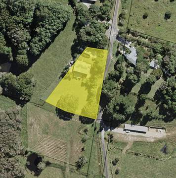
residential areas of Mullumbimby). It is noted that the properties at 126A
Stuart Street and 101A Station Street both contain dwellings at the rear which
front McGoughans Lane (See Figure 1). These dwellings each have a
building footprint equal to, or greater than, the size of the proposed
development.
Having regard to the planning principle in Project
Venture Developments v Pittwater Council [2005] NSW Land and Environment
Court it is also noted that to be compatible does not mean a the development
has to be the same.
On balance, following consideration of the acceptable nature
of the physical impacts of the development on surrounding development, and the
appearance, bulk and scale of the development being in harmony with buildings
in the immediate area, it is considered the proposed development is compatible
with the character of the local area. Consent is able to be granted for the
proposed development having regard to Clause 16A of the Affordable Rental
Housing SEPP.
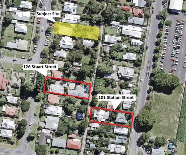
Figure 1
– Location of subject site in relation to the properties at 126 Stuart
Street and 101 Station Street
Heritage Assessment
The comments received from Council’s Heritage Advisor
in relation to latest set of amended plans are also attached to the report for
Council consideration, Attachment 2.
Notices of Motion 9.3
Notice of Motion No. 9.3 Councillor
Membership Post-Election of Committees
File No: I2016/679
|
I move that Council offer Councillors serving on
Advisory Committees, Section 355 Committees and Project Reference Groups
short-term “community membership” of those committees and PRGs,
up to the post-election disbandment of each Committee or PRG.
|
Councillor’s Background Notes:
Council’s Advisory Committees and Project Reference
Groups will ‘survive’ the election on 10 September 2016 to the
extent of still meeting and dealing with their advisory role in their
pre-election format. The first or second meeting of Council will then
reformat the Committees and PRGs and appoint Councillors. Community
positions are then advertised. New community members are likely to be
appointed in about November 2016.
For current Councillors retiring from office, this creates a
gap in the opportunity to contribute to the advisory process - they lose their
committee membership from the end of their term on Council. They can then
apply to join the new Committee or PRG, along with other community applicants.
The applications are usually determined by Council towards the end of the
year.
This motion offers Councillors like myself, who wish to
continue their contribution through the transition period, an avenue to do
so.
In my own case, I wish to continue as a community member
after 10 September on the following Committees and PRGs:
1. Belongil
Catchment Advisory Committee
2. Belongil
Creek Floodplain Risk Management Advisory Committee
3. Community
Infrastructure Advisory Committee
4. Durrumbul
Community Hall Section 355 Management Committee
5. Koala
Plan of Management Project Reference Group
6. Mullumbimby
Masterplan Scoping Project Reference Group
7. North
Byron Coastal Creeks Flood Risk Management Committee
8. Transport
Advisory Committee
9. Water,
Waste and Sewer Advisory Committee
Recommended priority relative to other Delivery Plan
tasks:
This is a minor procedural matter requiring little priority
but also little time to execute. The election in September creates the
time frame – these appointments should occur in the week following
it.
Definition of the project/task:
Appoint as community members to Council’s Advisory
Committees and Project Reference Groups those ex-Councillors who wish to
continue on Committees and / or PRGs where they held membership as a Councillor
in the 2012-16 term of Council. That membership then expires at the same
time as other community members of the Committee or PRG.
Source of Funds (if applicable):
No funding is required.
Signed: Cr
Duncan Dey
Management Comments by Mark Arnold, Director Corporate and
Community Services:
Clarification of project/task:
The next Council at its first meeting on 29 September 2016
will consider three (3) reports regarding firstly the establishment of the
Advisory Committees, Project Reference Groups and Section 355 Committees, and
then secondly the determination of the Councillor Representatives on these
Committees. Council will also following the election seek nominations for
Community representatives on the Advisory Committees, Project Reference Groups
and Section 355 Committees established by the new Council. The Community
Representatives will be appointed by the new Council.
The Notice of Motion lodged by Cr Dey proposes that the current
Council appoint from 10 September to the date of the appointment of the new
community representatives the Advisory Committees, Project Reference Groups and
Section 355 Committees, any Councillor that nominates themselves, as a
Community Representative.
This would be a new practice and create a precedent for
future Councils.
The Notice of Motion is also proposed on the basis that the
current structure for Advisory Committees, Project Reference Groups and Section
355 Committees will be confirmed by the new Council, and that these Advisory
Committees, Project Reference Groups and Section 355 Committees will meet in
the period between the election, and the appointment of the new Community
Representatives. This may or may not be the case.
The Guidelines for Section 355 Management Committees adopted
by Council states:
“The term of office for
Section 355 Management Committees and the Boards of Management is the
same term as the current
Council, with the addition of an extra three months after the General
15 Election of Councillors ie
all Section 355 Management Committee members will cease to hold
office at the end of December 2016.”
Staff understand the desire of Cr Dey to continue to be a
part of these Committees following the election, and the community benefit that
it may bring, and that the Notice of Motion is proposed to enable any
Councillor to continue to serve and contribute to the community, but the
precedent that it would set would impact on future Councils.
The appointment of Community Representatives is a matter for
Council and would require the terms of reference for each the effected Advisory
Committees and Project Reference Groups to be amended to incorporate the
additional number of Community Representatives.
Director responsible for task implementation:
Director Corporate and Community Services
Relationship to, priority of, and impact on other
projects/tasks:
There would be a minimal impact on other projects/tasks.
Financial and Resource Implications:
There would be no financial impacts should Council adopt the
Notice of Motion proposed by Cr Dey. There would no fees or allowances payable
to a Councillor appointed as a community representative from 10 September to
the appointment of community representatives by Council to the Advisory
Committees, Project Reference Groups and Section 355 Committees established by
the Council for the next term of Council.
Legal and Policy Implications:
This would create a precedent for future Councils.
Petitions 10.1
Petitions
Petition No. 10.1 Speed Bump Needed in Blackwood Crescent, Bangalow
Directorate: Infrastructure Services
Report
Author: Dominic
Cavanough , Contract Engineer
File No: I2016/623
Theme: Community Infrastructure
Asset Management
At Council’s Ordinary meeting held on 9 June 2016 the
Mayor tabled a petition containing 26 signatures which states:
“Partition for
speed bump in Blackwood Crescent”
Comments from Director Infrastructure Services:
Installation of traffic calming devices such as Flat Top
Road Humps (road hump) in a local traffic management area will require a joint
site investigation by RMS, Police and Council Officers. The findings of
the joint investigation are to determine the best solutions is to be reported
to the Local Traffic Committee.
Figure 1.
Blackwood Crescent, Bangalow highlighted in orange.
Potential Road Hump Benefits
· Minor Speed reductions using
gentle road humps
· Speed humps will visually
impress motorists that the street is meant to be low speed.
· Potential to reduce incidents
· May reduce some resident
complaints
Potential Road Hump Disadvantages
· Residents are likely to have
increased noise levels
· Causes traffic to use other
streets to avoid the road humps and moves the problem
· Heavy vehicles and emergency
services have to travel very slowly to negotiate these obstacles
· Vehicles have the potential to
run off the road onto the shoulder to avoid the road hump
· Potential vehicle damage
and/or personal injury if approached at speed
· Emergency vehicles will take
longer response times
· Vehicles slow down then
accelerate which creates increased air pollution
· Vehicles headlights are likely
to be raised to eye level creating a dazzling effect and may disturb residents.
· Increased capital costs to
install
· Regular maintenance required.
Summary
In summary, road humps are not a preferred traffic calming
device as they have a tendency to cause issues for local residents with
increased noise levels, uncomfortable ride and slower emergency response
times. Installing speed humps is an additional capital cost for council
that requires regular maintenance and inspections.
|
RECOMMENDATION:
1. That
the petition regarding speed bump needed in Blackwood Crescent,
Bangalow be noted.
2. That
the petition be referred to the Director Infrastructure Services to be
investigated with findings to be reported to the Local Traffic Committee.
3. That
any options endorsed by the Local Traffic Committee be subject to Council
considering funding implications.
|
Attachments:
1 Excerpt of
E2016/41591 Petition requesting Speed Bump Needed in Blackwood Crescent,
Bangalow, E2016/41594
Staff Reports - Corporate and Community Services 13.1
Staff Reports - Corporate and Community
Services
Report No. 13.1 Local
Government NSW Annual Conference 2016
Directorate: Corporate
and Community Services
Report
Author: David
Royston-Jennings, Corporate Governance and Strategic Planning Officer
File No: I2016/710
Theme: Corporate Management
Councillor Services
Summary:
In accordance with Council’s Policy 14/010 Mayor and
Councillors Payment of Expenses and Provision of Facilities, clause
8.4.1: “A resolution of Council is required to authorise
attendance of Councillors at Local Government and Shires Association
Conference(s) as a voting delegate.”
The Local Government Association of NSW Annual Conference
2016 will be held from 16 to 18 October 2016 at WIN Entertainment Centre,
Wollongong, NSW.
|
RECOMMENDATION:
1. That
Council authorise three Councillors to attend the Local Government
Association of NSW Annual Conference 2016 to be held at the WIN Entertainment
Centre, Wollongong, NSW from 16 to 18 October 2016.
2. That
Council determine the three Councillors to attend the Local Government
Association of NSW Annual Conference 2016 at its Ordinary Meeting on 29
September 2016.
|
Report
The Local Government Association of NSW Annual Conference
2016 will be held at the WIN Entertainment Centre, Wollongong, NSW, from 16 -
18 October 2016.
In accordance with Council’s Policy 14/010 Mayor and
Councillors Payment of Expenses and Provision of Facilities, clause 8.4.1(a)
states: “A resolution of Council is required to authorise
attendance of Councillors at (a) Local Government and Shires Association
Conference(s) as a voting delegate.”
Council is entitled to three voting delegates in the
debating session. This number is determined by population.
Policy 14/010 also states at clause 8.4.4. that: “Submission
of motions for consideration by Council will be done by notice of motion, which
can be considered during the year” as motions must first be endorsed
by Council prior to submission to the Local Government Association a notice
of motion would be required by 22 August 2016 however an extension may be
granted to 25 August to allow for Byron Shire Council’s next Ordinary
Meeting. Information regarding the structure of motions is attached over
the page.
Additional information and updates can be found on the Local
Government Associations website at the address below.
http://www.lgsa.org.au/events-training/local-government-nsw-annual-conference
The purpose of this Report is to enable Council to authorise
the attendance of three (3) Councillor delegates to the Local Government
Association of NSW Annual Conference 2016, to be held at the WIN Entertainment
Centre, Wollongong, NSW from 16 to 18 October 2016. This will allow the number
of delegates attending to be submitted as part of the registration process.
The new Council at its Ordinary meeting on 29 September 2016
will determine the three (3) Councillors and the names of those Councillors
will be forwarded to LGNSW to complete the registration process.
Financial Implications
Council has an allocation for Conferences (2145.004) of
$19,300 within the 2016/17 budget. There has been no expenditure so far
from this budget item and therefore Council is able to fund the cost of three
delegates from this budget.
Where: WIN
Entertainment Centre, Wollongong, NSW
Dates: Sunday
16 October - Tuesday 18 October 2016
Costs
per person: Registration Fee (early bird due 31 August) $900.00
Flights
(approx) $300.00
Conference
Functions (approx) $300.00
Accommodation (approx) $800.00
Total $2,300.00
Statutory and Policy
Compliance Implications
In accordance with Council’s Policy 14/10 Mayor and
Councillors Payment of Expenses and Provision of Facilities “A
resolution of Council is required to authorise attendance of Councillors at
Local Government and Shires Association Conference(s) as a voting
delegate.”
Excerpt from the Conference website:
Staff Reports - Corporate and Community Services 13.2
Report No. 13.2 Council
Investments June 2016
Directorate: Corporate
and Community Services
Report
Author: James
Brickley, Manager Finance
File No: I2016/714
Theme: Corporate Management
Financial Services
Summary:
This report includes a list of investments and identifies
Council’s overall cash position for the month of June 2016 for
Council’s information.
This report is prepared to comply with Regulation 212 of the
Local Government (General) Regulation 2005.
|
RECOMMENDATION:
That the report listing Council’s
investments and overall cash position as at 30 June 2016 be noted.
|
Report
In relation to the investment portfolio for June 2016,
Council has continued to maintain a diversified portfolio of investments. At 30
June 2016, the average 90 day bank bill rate (BBSW) for the month was
1.99%. Council’s performance to 30 June is approximately 2.93%.
Councils’ performance is again higher than the benchmark. This is
largely due to the active ongoing management of the investment portfolio,
maximising investment returns through secure term deposits
The table below identifies the investments held by Council
as at 30 June 2016:
Schedule of
Investments held as at 30 June 2016
|
Purch Date
|
Principal ($)
|
Description
|
CP*
|
Rating
|
Maturity Date
|
Type
|
Interest Rate Per
Annum
|
Current Value
|
|
20/06/12
|
500,000
|
HERITAGE BANK LTD BONDS
|
N
|
BBB+
|
20/06/17
|
B
|
7.25%
|
520,000.00
|
|
03/06/16
|
1,000,000
|
WESTPAC CLIMATE BOND
|
N
|
AA-
|
03/06/21
|
FRN
|
3.16%
|
1,000,080.00
|
|
04/04/16
|
1,000,000
|
AUSWIDE BANK LTD
|
P
|
BBB
|
04/07/16
|
TD
|
3.01%
|
1,000,000.00
|
|
08/02/16
|
2,000,000
|
NAB
|
P
|
AA-
|
08/07/16
|
TD
|
3.02%
|
2,000,000.00
|
|
06/06/16
|
2,000,000
|
NAB
|
N
|
AA-
|
04/10/16
|
TD
|
2.96%
|
2,000,000.00
|
|
04/04/16
|
2,000,000
|
NAB
|
N
|
AA-
|
04/08/16
|
TD
|
3.10%
|
2,000,000.00
|
|
07/04/16
|
2,000,000
|
BANKWEST
|
P
|
A1+
|
06/07/16
|
TD
|
3.00%
|
2,000,000.00
|
|
02/05/16
|
1,000,000
|
BANKWEST
|
N
|
A1+
|
04/07/16
|
TD
|
2.70%
|
1,000,000.00
|
|
12/05/16
|
2,000,000
|
NAB
|
N
|
AA-
|
12/09/16
|
TD
|
2.99%
|
2,000,000.00
|
|
23/05/16
|
2,000,000
|
NAB
|
N
|
AA-
|
23/11/16
|
TD
|
2.98%
|
2,000,000.00
|
|
05/04/16
|
2,000,000
|
SUNCORP
|
P
|
A+
|
03/08/16
|
TD
|
3.05%
|
2,000,000.00
|
|
04/04/16
|
2,000,000
|
AUSWIDE BANK LTD
|
N
|
BBB
|
04/07/16
|
TD
|
3.01%
|
2,000,000.00
|
|
02/06/16
|
2,000,000
|
NAB
|
N
|
AA-
|
30/09/16
|
TD
|
2.96%
|
2,000,000.00
|
|
02/05/16
|
2,000,000
|
NAB
|
N
|
AA-
|
02/09/16
|
TD
|
3.08%
|
2,000,000.00
|
|
14/04/16
|
1,000,000
|
NAB
|
N
|
AA-
|
14/07/16
|
TD
|
3.09%
|
1,000,000.00
|
|
06/06/16
|
1,000,000
|
NAB
|
N
|
AA-
|
04/10/16
|
TD
|
2.96%
|
1,000,000.00
|
|
09/05/16
|
1,000,000
|
NAB
|
N
|
AA-
|
08/08/16
|
TD
|
2.98%
|
1,000,000.00
|
|
14/03/16
|
3,000,000
|
BANKWEST
|
N
|
A1+
|
12/07/16
|
TD
|
3.00%
|
3,000,000.00
|
|
06/06/16
|
2,000,000
|
NAB
|
N
|
AA-
|
05/09/16
|
TD
|
2.93%
|
2,000,000.00
|
|
02/02/16
|
3,000,000
|
ME BANK
|
P
|
BBB
|
04/07/16
|
TD
|
2.95%
|
3,000,000.00
|
|
05/05/16
|
2,000,000
|
NAB
|
N
|
AA-
|
05/09/16
|
TD
|
3.01%
|
2,000,000.00
|
|
19/05/16
|
2,000,000
|
NAB
|
N
|
AA-
|
19/08/16
|
TD
|
2.95%
|
2,000,000.00
|
|
26/05/16
|
2,000,000
|
NAB
|
N
|
AA-
|
25/08/16
|
TD
|
3.02%
|
2,000,000.00
|
|
29/02/16
|
2,000,000
|
AMP BANK
|
P
|
A
|
29/08/16
|
TD
|
3.00%
|
2,000,000.00
|
|
02/06/16
|
2,000,000
|
NAB
|
N
|
AA-
|
01/09/16
|
TD
|
2.94%
|
2,000,000.00
|
|
06/04/16
|
2,000,000
|
NAB
|
N
|
AA-
|
04/07/16
|
TD
|
3.07%
|
2,000,000.00
|
|
07/04/16
|
2,000,000
|
BANK OF QUEENSLAND
|
N
|
A2
|
07/07/16
|
TD
|
3.00%
|
2,000,000.00
|
|
26/04/16
|
2,000,000
|
ME BANK
|
N
|
BBB
|
26/07/16
|
TD
|
3.06%
|
2,000,000.00
|
|
01/02/16
|
2,000,000
|
POLICE CREDIT UNION
|
P
|
NR
|
01/08/16
|
TD
|
3.10%
|
2,000,000.00
|
|
06/06/16
|
2,000,000
|
ME BANK
|
N
|
BBB
|
06/09/16
|
TD
|
2.95%
|
2,000,000.00
|
|
09/05/16
|
1,000,000
|
NEWCASTLE PERMANENT
|
P
|
BBB+
|
08/08/16
|
TD
|
2.85%
|
1,000,000.00
|
|
17/05/16
|
2,000,000
|
BANKWEST
|
N
|
A1+
|
04/07/16
|
TD
|
2.60%
|
2,000,000.00
|
|
01/06/16
|
2,000,000
|
BEYOND BANK
|
P
|
A2
|
01/09/16
|
TD
|
3.00%
|
2,000,000.00
|
|
01/06/16
|
2,000,000
|
SUNCORP
|
N
|
A1
|
29/09/16
|
TD
|
2.85%
|
2,000,000.00
|
|
05/05/16
|
2,000,000
|
BEYOND BANK
|
N
|
A2
|
03/08/16
|
TD
|
3.10%
|
2,000,000.00
|
|
10/05/16
|
2,000,000
|
ME BANK
|
N
|
BBB
|
07/09/16
|
TD
|
2.95%
|
2,000,000.00
|
|
10/05/16
|
2,000,000
|
ME BANK
|
N
|
BBB
|
08/08/16
|
TD
|
2.95%
|
2,000,000.00
|
|
13/05/16
|
2,000,000
|
ME BANK
|
N
|
BBB
|
11/08/16
|
TD
|
2.90%
|
2,000,000.00
|
|
17/05/16
|
2,000,000
|
ME BANK
|
N
|
BBB
|
16/08/16
|
TD
|
2.90%
|
2,000,000.00
|
|
23/05/16
|
1,000,000
|
POLICE CREDIT UNION
|
N
|
NR
|
23/09/16
|
TD
|
2.95%
|
1,000,000.00
|
|
02/06/16
|
2,000,000
|
BEYOND BANK
|
P
|
A2
|
31/08/16
|
TD
|
2.90%
|
2,000,000.00
|
|
N/A
|
2,222,613
|
CBA BUSINESS ONLINE SAVER
|
N
|
A
|
N/A
|
CALL
|
1.80%
|
2,222,613.42
|
|
Total
|
76,722,613
|
|
|
|
|
AVG
|
2.93%
|
76,742,693.42
|
|
Note 1.
|
CP = Capital protection on maturity
|
|
|
N = No Capital Protection
|
|
|
Y = Fully covered by Government Guarantee
|
|
|
P = Partial Government Guarantee of $250,000 (Financial
Claims Scheme)
|
|
Note 2.
|
Type
|
Description
|
|
|
|
FRN
|
Floating Rate Note
|
Principal can vary based on
valuation, interest payable via a floating interest rate that varies each
quarter.
|
|
|
TD
|
Term Deposit
|
Principal does not vary during investment term. Interest
payable is fixed at the rate invested for the investment term.
|
|
|
CALL
|
Call Account
|
Principal varies due to cash flow demands from
deposits/withdrawals, interest is payable on the daily balance.
|
Note 3. Term
Deposits can be traded on a day-to-day basis, and therefore Council is not
obliged to hold the investments to the maturity dates.
New Investment Opportunity taken in respect of Resolution
15-515
On 3 June 2016, Council purchased a five year Floating Rate
Note investment for $1,000,000 issued by the Westpac Bank. This type of
investment is allowable under the Ministerial Investment Order and is in line
with Council’s resolution 15-515 in regard to Environmental and
Socially Responsible Investments. The investment return varies but is
calculated on movements in the three month bank bill swap rate plus a fixed
margin of 1.17%. The current return is 3.16% per annum. Proceeds
from the funds (Westpac are hoping to raise just over $1billion) from investors
will then be issued to entities as loans by Westpac only for renewable energy
projects ie wind farms and low carbon commercial buildings in Australia. The
investment is called the Westpac Climate Bond and it has been certified by the
Climate Bonds Initiative.
For the month of June 2016, as indicated in the table below,
there is a dissection of the investment portfolio by investment type. It
illustrates the current fair value of investments has decreased since May 2016,
but overall is still demonstrating a cumulative unrealised gain of $20,080.
Dissection
of Council Investment Portfolio as at 30 June 2016
|
Principal Value ($)
|
Investment Linked to:-
|
Current Market Value ($)
|
Cumulative Unrealised Gain/(Loss) ($)
|
|
73,000,000.00
|
Term
Deposits
|
73,000,000.00
|
0.00
|
|
1,000,000.00
|
Floating
Rate Note
|
1,000,080.00
|
80.00
|
|
2,222,613.42
|
Business
On-Line Saver (At Call)
|
2,222,613.42
|
0.00
|
|
500,000.00
|
Bonds
|
520,000.00
|
20,000.00
|
|
76,722,613.42
|
|
76,742,693.42
|
20,080.00
|
The current value of an investment compared to the principal
value (face value or original purchase price) provides an indication of the
performance of the investment without reference to the coupon (interest) rate. The
current value represents the value received if an investment was sold or traded
in the current market, in addition to the interest received.
The table below provides a reconciliation of investment
purchases and maturities for the period 25 May 2016 to 30 June 2016 on a
current market value basis.
Movement in
Investment Portfolio – 25 May 2016 to 30 June 2016
|
Item
|
Current
Market Value (at end of month) $
|
|
Closing Balance at
24 May 2016
|
80,743,045.21
|
|
Add: New
Investments Purchased
|
20,000,000.00
|
|
Add: Call Account
Additions
|
0.00
|
|
Add: Interest from
Call Account
|
3,968.21
|
|
Less: Investments
Matured
|
24,000,000.00
|
|
Less: Call Account
Redemption
|
0.00
|
|
Less: Fair Value
Movement for period
|
(4,320.00)
|
|
Closing Balance at
30 June 2016
|
76,742,693.42
|
Investments
Maturities and Returns – 25 May 2016 to 30 June 2016
|
Principal Value
($)
|
Description
|
Type
|
Maturity Date
|
Number of Days
Invested
|
Interest Rate Per
Annum
|
Interest Paid on
Maturity $
|
|
3,000,000.00
|
NAB
|
TD
|
26/05/16
|
90
|
3.02%
|
22,339.73
|
|
2,000,000.00
|
Beyond Bank
|
TD
|
01/06/16
|
92
|
3.00%
|
15,123.29
|
|
2,000,000.00
|
Suncorp
|
TD
|
01/06/16
|
90
|
3.01%
|
14,843.84
|
|
2,000,000.00
|
NAB
|
TD
|
02/06/16
|
121
|
3.01%
|
19,956.72
|
|
2,000,000.00
|
NAB
|
TD
|
02/06/16
|
122
|
3.02%
|
20,190.48
|
|
2,000,000.00
|
NAB
|
TD
|
06/06/16
|
94
|
3.09%
|
15,915.62
|
|
2,000,000.00
|
ME Bank
|
TD
|
06/06/16
|
122
|
2.95%
|
19,720.55
|
|
1,000,000.00
|
NAB
|
TD
|
06/06/16
|
91
|
3.10%
|
7,728.77
|
|
2,000,000.00
|
NAB
|
TD
|
06/06/16
|
119
|
3.01%
|
19,626.85
|
|
2,000,000.00
|
Suncorp
|
TD
|
07/06/16
|
90
|
3.02%
|
14,893.15
|
|
2,000,000.00
|
Bank Of Queensland
|
TD
|
23/06/16
|
120
|
3.00%
|
19,726.03
|
|
2,000,000.00
|
Suncorp
|
TD
|
30/06/16
|
90
|
3.00%
|
14,794.52
|
|
24,000,000.00
|
|
|
|
|
|
204,859.55
|
The overall ‘cash position’ of Council is not
only measured by what funds Council has invested but also by what funds Council
has retained in its consolidated fund or bank account as well for operational
purposes. In this regard, for the month of June 2016 the table below identifies
the overall cash position of Council as follows:
Dissection
of Council Cash Position as at 30 June 2016
|
Item
|
Principal Value ($)
|
Current Market Value ($)
|
Cumulative Unrealised Gain/(Loss) ($)
|
|
Investments
Portfolio
|
|
|
|
|
Term Deposits
|
73,000,000.00
|
73,000,000.00
|
0.00
|
|
Floating Rate Note
|
1,000,000.00
|
1,000,080.00
|
80.00
|
|
Business On-Line
Saver (At Call)
|
2,222,613.42
|
2,222,613.42
|
0.00
|
|
Bonds
|
500,000.00
|
520,000.00
|
20,000.00
|
|
Total Investment
Portfolio
|
76,722,613.42
|
76,742,693.42
|
20,080.00
|
|
|
|
|
|
|
Cash at Bank
|
|
|
|
|
Consolidated Fund
|
2,822,126.08
|
2,822,126.08
|
0.00
|
|
Total Cash at Bank
|
2,822,126.08
|
2,822,126.08
|
0.00
|
|
|
|
|
|
|
Total Cash
Position
|
79,544,739.50
|
79,564,819.50
|
20,080.00
|
Financial Implications
Council uses a diversified mix of investments to achieve
short, medium and long-term results.
Statutory and Policy
Compliance Implications
In accordance with Regulation 212 of the Local Government
(General) Regulation 2005, the Responsible Accounting Officer of Council must
provide Council with a monthly report detailing all monies Council has invested
under section 625 of the Local Government Act 1993.
The Report must be presented at the next Ordinary Meeting of
Council after the end of the month being reported. In this regard, the
current Council Meeting cycle does not always allow this to occur, especially
when investment valuations required for the preparation of the report, are
often received after the deadline for the submission of reports for the
meeting. Endeavours will be made to ensure the required report will be
provided to Council and this will for some months require reporting for one or
more months.
Council’s investments are carried out in accordance
with section 625(2) of the Local Government Act 1993 and Council’s
Investment Policy. The Local Government Act 1993 allows Council to invest money
as per the Ministers Order – Forms of Investment, last published in the
Government Gazette on 11 February 2011.
Council’s Investment Policy includes the objective of
maximising earnings from authorised investments and ensuring the security of
Council Funds.
Council at its Ordinary Meeting held 8 October 2015 resolved
through resolution 15-515 to insert a new objective into its adopted
Investment Policy, which gives a third tier consideration by Council to
Environmental and Socially Responsible Investments, when making investment
decisions.
Staff Reports - Sustainable Environment and Economy 13.3
Staff Reports - Sustainable Environment and
Economy
Report No. 13.3 Report
of the Planning Review Committee Meeting held on 2 June 2016
Directorate: Sustainable
Environment and Economy
Report
Author: Chris
Larkin, Major Projects Planner
File No: I2016/613
Theme: Ecology
Development and Approvals
Summary:
This report provides the outcome of the Planning Review
Committee Meeting held on 2 June 2016.
|
RECOMMENDATION:
That the report be noted.
|
Report:
The meeting commenced at 1.20pm
and concluded at 1.32pm.
Present: Crs Dey, Richardson,
Hunter
Staff: Shannon Burt
(Director Sustainable Environment and Economy, Chris Larkin (Major Projects
Planner).
Apologies: Cr Cameron
The following development
applications were reviewed with the outcome shown in the final column.
|
DA No.
|
Applicant
|
Property Address
|
Proposal
|
Exhibition
Submissions
|
Reason/s
Outcome
|
|
10.2016.235.1
|
Bureau SRH Architects
|
32-34 Byron St
Bangalow
|
Alterations and Additions to Existing Commercial
Building - including a sub ground level carpark, Restaurant and Three
(3) One Bedroom Motel Units
|
Level 2
5/5/16 to 18/5/16
21submissions
|
The number of public submissions
The extent of variation to Council policies proposed
The perceived public significance of the application
Council
|
|
10.2016.248.1
|
Ardill Payne & Partners
|
32 Azalea St
Mullumbimby
|
Subdivision: Three (3) Lots
|
Level 1
12/5/16 to 25/5/16
10 submissions
|
Delegated Authority
|
|
10.2016.250.1
|
Ardill Payne & Partners
|
16 Azalea St
Mullumbimby
|
Subdivision: Five (5) Lots
|
Level 1
12/5/16 to 25/5/16
5 submissions
|
Delegated Authority
|
Staff Reports - Sustainable Environment and Economy 13.4
Report No. 13.4 Byron
Coast Koala Plan of Management
Directorate: Sustainable
Environment and Economy
Report
Author: Greg
Shanahan , Natural Environment Policy and Projects Officer
File No: I2016/690
Theme: Ecology
Planning Policy and Natural Environment
Summary:
Following public exhibition in early 2014, the draft Byron
Coast Koala Plan of Management (KPOM) was reported to Council in October 2014,
where Council resolved to receive legal advice on a number of questions about
the KPOM and State Environmental Planning Policy No 44 – Koala Habitat
Protection (SEPP 44). This legal advice was subsequently received and
distributed to Councillors as an attachment at the 27 August 2015 Council
meeting.
Changes were made to the draft KPOM in response to legal
advice, together with updating of the habitat mapping informed by the 2015
updated vegetation mapping of the coastal areas of the Shire. The changes
resulted in the draft KPOM submitted to Council on 27 August.
On 27 August 2015 Council resolved to commission a peer
review of the draft KPOM and associated habitat mapping, and place the draft
KPOM on public exhibition for a further two weeks.
The Project Reference Group (PRG), tasked with providing
advice and guidance on the preparation of the KPOM to ensure that it meets the
aim of SEPP 44, workshopped with Councillors and koala ecologists to create the
terms of reference (TOR) to direct the peer review.
Niche Environment and Heritage were commissioned in 2016 to
peer review the KPOM based on the TOR.
This report recommends that the peer review recommendations
guide the amending of the KPOM, and that the resultant plan be adopted by
Council and forwarded to the Department of Planning and Environment for their
consideration and approval.
|
RECOMMENDATION:
That Council:
1. Adopt
the Byron Coast Koala Plan of Management, as reported to 27 August 2015
meeting, incorporating any changes made in accordance with recommendations
listed in Table 1 of this report.
2. Submit
the Byron Coast Koala Plan of Management to the Director of the Department of
Planning and Environment for approval in accordance with SEPP 44.
3. Delegate
to the General Manager the authority to make any non-policy amendments or
minor changes required to the Byron Coast Koala Plan of Management prior to
submitting the Plan to the Department of Planning and Environment, including
those that may be required by the Department following submission of the
Plan.
4. Receive
a report detailing any changes required by the Department of Planning and
Environment in response to recommendation 3.
|
Attachments:
1 KPOM
Submission summary September 2015, E2016/63322
2 Byron
Coast KPoM Peer Review, E2016/20104
3 KPOM peer
review table of recommendations, E2016/63327
4 Form of
Special Disclosure of Pecuniary Interest, E2012/2815
Report
Following the public exhibition of the draft KPOM in early
2014, a revised draft was reported to Council in October 2014 where Council
resolved to receive legal advice (14-494).
In response to legal advice and advice from the Department
of Planning and Environment (DPE), in June 2015 changes were made to the draft
KPOM. This included changing key definitions, issues with habitat mapping,
development assessment requirements, Koala Management Precincts and habitat
buffers and corridors. Council’s Legal Services Branch has reviewed the
amended draft KPOM against the legal advice and the original draft KPOM. Legal
Services’ view is that the amended draft KPOM addresses the issues raised
by the legal advice.
The 2015 updating of the vegetation mapping for the Byron
coast based on recent aerial photography allowed Council staff to update the
Koala habitat mapping contained in the draft KPOM. The amended version of the draft KPOM was reported to Council at the 27
August 2015 Council meeting, where Council Resolved (15-404):
1. Commission a Peer Review of the
Byron Coast CKPOM and associated habitat mapping.
2. The preferred agency is the
University of Queensland Koala Ecology Group. In the event that this group is
not available to undertake the review, alternative persons may be proposed by
staff at the workshop in item 7. below.
3. Staff will prepare the Peer
Review terms of reference based on public submissions received and questions
raised by Councillors.
4. The draft CKPOM will be placed
on Council's website as soon as possible to allow interested parties to make
further submissions. Two weeks will be provided for additional submissions to
be lodged.
5. Unspent project funding will be
used to fund the Peer Review.
6. In the event that there are
major barriers to the implementation of this resolution, a staff report will be
presented to Councillors in workshop.
7. A workshop will be provided for
Councillors in two weeks to oversee the submissions, Peer Review terms of
reference and other related issues including legal advice and SEPP 44.
In response to resolution 15-404, Part 4 above, the
draft KPOM was placed on the Council website for a period of two weeks, and
public submissions were invited. There were a total of 33 submissions received.
Of these, 27 supported the adoption of the plan, four provided comments and two
objected. See Attachment 1 for detailed analysis of the 2015
submissions. A copy of all submissions has been provided to Councillors on CD.
In response to resolution 15-404, Parts 1, 2 and 3,
Councillors, PRG members and staff at a Strategic Planning Committee Workshop
on 24 September 2015 drafted the terms of reference (TOR) to direct the peer
review. Four potential consultants were identified and provided with a Request
for Quotation.
Niche Environment and Heritage were subsequently engaged to
undertake the peer review. The resultant peer review (Attachment 2)
is formatted to address each of the eleven key points raised by the terms of
reference. At the start of each chapter, the particular point from the TOR is
quoted, followed by a detailed response from Niche’s ecological
perspective.
On 14 April 2016, Niche’s senior ecologist provided a
presentation to Strategic Planning Workshop to outline findings contained
within the Peer Review.
On 5 May a PRG meeting was held to discuss the peer review
findings.
Attachment 3 summarises the key
recommendations contained within the peer review. Comments supplied by PRG
members, including input from community representatives and the Office of
Environment & Heritage (OEH) representative were collated and added to the
table, together with ecological and Legal Services comments.
The peer review concluded:
“The
CKPOM is considered to be largely consistent with current legislation,
literature and other CKPOMs. Implementation of the plan, following consideration
of this Peer Review, will provide a comprehensive and thorough framework for
development assessment, management of key threats, community engagement,
conservation and restoration of Koala habitat.”
Based on the recommendations from the peer review, and in
response to the public exhibition submissions, PRG and staff comments,
recommendations for minor adjustments to the KPOM have been included in Table 1
of this report.
Table 1: Recommended changes to the
draft Koala Plan of Management
|
Ref.
|
KPOM Part
|
KPOM page
|
Recommendation
|
Source of amendment
|
|
1
|
Section A
1.2
|
17
|
Add:
In September 2015 an
additional two weeks was provided for interested parties to make submissions
on the revised KPOM. During this second exhibition period a total of 33
submissions were received.27 submissions (82%) supported the adoption
of the KPOM. Six of these submissions objected to the weakening of the Plan
since the 2014 version. Four submissions (12%) provided comments. Two
submissions (6%) objected to certain parts of the Plan.
|
Result of second public exhibition
|
|
2
|
Section B 5.5.2
|
35
|
Add:
(ii) Council shall
amend the Byron Shire Development Control Plan 2014 to include properties
under one hectare in size with owners willing to include their land as
Potential Koala Habitat
|
Peer Review
TOR 5
|
|
3
|
Section B 5.5.6
|
37
|
Add:
4. To improve
and enhance the potential for koalas to safely cross roads located within
koala corridors, install traffic calming measures and/or provide other
mitigating measures.
|
Public exhibition
|
|
4
|
Section C
6.1
|
41
|
Add:
(ix) New Koala food
tree planting provides an important element in habitat restoration due to
recognised rapid uptake by Koalas
|
Peer Review
TOR 3
|
|
5
|
Section C
9.2.1
|
48
|
Add:
(i)e) Council will seek to
create a map layer identifying high risk areas where high levels of dog
ownership coincide with or are adjacent to Core Koala Habitat.
|
Peer Review
TOR 6(b)
|
|
6
|
Part 2
|
67
|
Section 12.5 first paragraph:
Replace the words “evacuation
from” with “movement within and out of”
|
Peer Review
TOR 9
|
|
7
|
Part 2
|
70
|
Add:
13.2.3 BioBanking
The Biodiversity Banking
and Offsets Scheme, 'BioBanking', is designed to address the loss of
biodiversity values from habitat degradation. The NSW Government has
introduced BioBanking to help address the loss of biodiversity values,
including threatened species, due to habitat degradation and loss. Koalas are
a “species credit” species under BioBanking. Landowners with
Koala habitat which is subject to a BioBanking agreement need to ensure the
following management actions
· Apply
ecological fire management practices
· Exclude
domestic stock grazing
· Replanting
(for use in "Low condition" vegetation)
· Supplementary
planting (for use in "Moderate to good condition" vegetation)
· Weed
control
Further information is
available at http://www.environment.nsw.gov.au/biobanking/
|
Peer Review
TOR 10
|
The amended Byron Coast KPOM will:
· Provide certainly
for landholders and planners by a providing consistent, transparent development
assessment process
· Reduce the
assessment requirements and associated cost for landholders in most
circumstances, particularly minor development.
· Eliminate the
requirement and cost associated with developing a site specific KPOM.
Currently approved KPOM’s include Coffs Harbour
(2000), Port Stephens (2002), Kempsey (2011), Lismore (2013) and Tweed (2015)
as well as draft KPOM’s for Richmond Valley and Bellingen
LGA’s. Ballina Council has adopted their KPOM and are awaiting
approval from the DPE.
Financial Implications
The KPOM details a number of management actions which
require funding either through staff time or budget allocation. Ongoing
progression of the KPOM implementation will occur in line with the annual
budget process.
Statutory and Policy
Compliance Implications
Pursuant to the State Environment Planning Policy No 44
– Koala Habitat Protection, a plan of management may be prepared for
the whole or part of a local government area listed in Schedule 1 of the SEPP (includes
Byron Shire). Once adopted by Council the KPOM must be approved by the DPE.
Staff Reports - Sustainable Environment and Economy 13.5
Report No. 13.5 Report
of the Planning Review Committee Meeting held on 23 June 2016
Directorate: Sustainable
Environment and Economy
Report
Author: Chris
Larkin, Major Projects Planner
File No: I2016/692
Theme: Ecology
Development and Approvals
Summary:
This report provides the outcome of the Planning Review
Committee Meeting held on 23 June 2016.
|
RECOMMENDATION:
That the report be noted.
|
Report:
The meeting commenced at 1.15pm
and concluded at 1.40pm.
Present: Crs Dey, Hunter,
Cameron, Wanchap
Staff: Chris Larkin (Major
Projects Planner).
Apologies: Nil
The following development
applications were reviewed with the outcome shown in the final column.
|
DA No.
|
Applicant
|
Property Address
|
Proposal
|
Exhibition
Submissions
|
Reason/s
Outcome
|
|
10.2016.273.1
|
Ardill Payne & Partners
|
17 Ballina Road Bangalow
|
Stage One: Two (2) Lot Subdivision Stage Two: Construction
of 20 Two Bedroom Dwelling Houses and Strata Subdivision
|
Level 2
19/5/16 to 1/6/16
2 submissions
|
Outside staff Delegations
(Cost of works)
Council
|
|
10.2016.183.1
|
Mr K Emery
|
369 Booyong Road
Nashau
|
Relocation of Dwelling House to Create Dual Occupancy
(Detached)
|
Level 1
14/4/16 to 27/4/16
2 submissions
|
Delegated Authority
|
Council determined the
following development application on the 16 July 2015. The Section 96
application to modify the development consent was referred to the Planning
Review Committee whereby it was decided that application can be determined
under delegated authority as noted below.
|
DA No.
|
Applicant
|
Property Address
|
Proposal
|
Exhibition
Submissions
|
Reason/s
Outcome
|
|
5.1987.208.6
|
Planners North Pty Ltd
|
144 Bayshore Drive
Byron Bay
|
S96 to Amend Condition 66A Regarding Flood Planning Level
|
Level 0
|
Delegated Authority
|
Staff Reports - Sustainable Environment and Economy 13.6
Report No. 13.6 PLANNING
- Broken Head Quarry rehabilitation works
Directorate: Sustainable
Environment and Economy
Report
Author: Wayne
Bertram, Manager Sustainable Development
Noreen Scott, EA Sustainable
Environment and Economy
File No: I2016/700
Theme: Ecology
Development and Approvals
Summary:
Council at the Ordinary Meeting 17 September 2015 considered
a report regarding the rehabilitation works required for the Broken Head Quarry
at Suffolk Park.
In relation to this report Council resolved the following:
15-452 Resolved:
1. That
Council note the report on rehabilitation works as required within the original
consent conditions.
2. That
Council contact the owners of the land and request an update on the plan for
rehabilitation works.
15-453 Resolved:
That Council receive a report, as soon as the current
court case is over, on enforcement action to achieve the outstanding
rehabilitation.
This report provides an update in relation to compliance
action in relation to Council resolutions 15-452(2) and 15-453.
As the NSW Department of Planning and Environment was the
original consent authority for the development application it is considered the
appropriate regulatory authority for enforcement of the quarry development.
Council’s compliance staff are currently working with the NSW Department
of Planning and Environment, who have taken the lead role to ensure that all
conditions of development consent are met.
NOTE TO COUNCILLORS:
In accordance with the
provisions of S375A of the Local Government Act 1993, a Division is to be
called whenever a motion for a planning decision is put to the meeting, for the
purpose of recording voting on planning matters. Pursuant to clause 2(a)
under the heading Matters to be Included in Minutes of Council Meetings of
Council's adopted Code of Meeting Practice (as amended) a Division will be
deemed to have been called by the mover and seconder of all motions relating to
this report.
|
RECOMMENDATION:
That Council note the report.
|
Attachments:
1 Letter
Department of Urban Affairs and Planning dated 26 May 1999, E2016/50886
Report
Background
Broken Head Quarry was approved by way of a Commission of
Inquiry in 1998 under Development Consent 5.1997.465.1. The whole site has an
area of 52.32 ha, being 24.61 ha on the eastern side of Broken Head Road and
27.71 ha on the western side of Broken Head. Approximately 22 hectares has been
developed and disturbed from existing and past quarrying activities, whilst the
remainder of the site comprises vegetation.
In response to a loss of some 10.8 hectares of native
vegetation, the development consent for the expansion and continuation of the
quarry required rehabilitation to be undertaken. Rehabilitation was required to
be undertaken in sections (following the sequence of extraction), once
quarrying activity in each section was completed. Rehabilitation involved
earthworks to achieve an amenable landform and restoration of native
vegetation. Methods (including the flora species to be used) for both ‘temporary’
and ‘final’ rehabilitation methods are detailed within the
application and made valid through consent conditions.
The sand and gravel stocks within the approved quarry area
are now nearly exhausted. Seeking an alternative use for the site, in 2014 the
quarry owners sought development consent for a Community Title development
comprising 41 residential lots, as well as common property and service areas.
Council resolved in November 2014 (14-645) to refuse
the development application No. 10.2014.331.1 for reasons including
permissibility under current and proposed land use zones and the
‘sterilisation’ of areas understood as required to be restored and
protected.
Court Actions
As a result of the refusal of DA No. 10.2014.331.1 a Class 1
application seeking orders that DA No. 10.2014.331.1, for a Community Title
subdivision to create 45 lots, comprising 42 residential lots, 2 neighbourhood
property lots and 1 common property lot on part of the Broken Head sand and
gravel quarry, be approved.
On 1 December 2015 Acting Senior Commissioner Brown delivered
judgment in the proceedings with the orders of the Court as follows:
(1) The appeal is dismissed.
(2) Development Application 10.2014.331.1 for the subdivision
of land known as the Broken Head Quarry, off Broken Head Road, Broken Head is
refused.
(3) The exhibits are returned with the exception of exhibit 2.
Essentially, the Commissioner found that the proposed
development is not consistent with the objectives of the 1(e) Extractive
Resources Zone under LEP 1998.
The applicant for development consent then appealed against
that dismissal on a number of questions of law. An error with respect to a
question of law is the only basis available to appeal against a decision of a
Commissioner. The appeal was heard before a Judge of the Land and Environment
Court on 26 May 2016. Judgement was delivered on 31 May 2016.
The Court found that the appellant was unable to demonstrate
any error on a question of law in the (then) Acting Senior Commissioner’s
process and the appeal was dismissed.
Council Resolutions
In relation to Council resolution (15-452(2)) Council
staff wrote to the owners of the land and requested an update on the plan for rehabilitation
works in November 2015 and again in March 2016. As at the 24 June 2016
Council had not received any response to Council’s request to provide
information for the rehabilitation of the quarry site.
As Council had not received any response to the request for
information, staff contacted the compliance division of the NSW Department of
Planning and Environment in order to progress the compliance with the terms of
the development consent.
In relation to Council resolution (15-453) Council’s
compliance staff are currently working with the NSW Department of Planning and
Environment, who have taken the lead role to ensure that all conditions of
development consent are met so that the progressive and final rehabilitation of
the quarried areas occur. As the NSW Department of Planning and Environment was
the original consent authority for the development application they are
considered the appropriate regulatory authority for enforcement of the
development.
Financial Implications
All enforcement requirements of Development Application
97/0465 will be undertaken by the compliance division of the NSW Department of
Planning and Environment and as such there will be limited resource and
financial implications for Council.
Statutory and Policy Compliance Implications
Nil.
Staff Reports - Sustainable Environment and Economy 13.7
Report No. 13.7 PLANNING
- Draft Rural Land Use Strategy: Public Submissions Report
Directorate: Sustainable
Environment and Economy
Report
Author: Alex
Caras, Team Leader Land Use Strategy
File No: I2016/734
Theme: Ecology
Planning Policy and Natural Environment
Summary:
Council has prepared a draft Rural
Land Use Strategy (RLUS) to guide the future zoning and use, protection and/or
development of our rural lands over the next 20 years. The draft RLUS and
supporting documents were exhibited for just over six weeks. Over 830
submissions were received raising a range of issues. The majority of
submissions came from the local community, with many of their issues being
strongly aligned with those identified in government agency submissions.
The community is generally positive
about the future of agriculture in the Shire and region and supports the
policies for securing long term environmental and rural economy outcomes.
The local community is also passionate about
their rural areas and the values they provide,
with the prevailing concern being a lack of trust and confidence in the process and strategy to deliver
on these outcomes. The overall view was that the consultation does not
reinforce a two way relationship between the community and Council, the
actions are in some cases at odds with the generally well supported RLUS policy
directions and there is a bias towards facilitating rural lifestyle living
opportunities.
The Department of Planning &
Environment (DPE) submission has recommended a number of significant amendments
to the determination of rural lifestyle living
opportunities to ensure that the strategy is consistent with State policy and
to enable State Government endorsement. This
has resulted in a significantly reduced number of priority areas than was exhibited,
which will also require a road intersection assessment (capacity and
functionality) to ensure that the sites identified (Attachment 3) can
accommodate future development.
This
report presents a summary of the key issues raised in public submissions to the
draft RLUS, including a planning response to
these, and recommends that Council adopt the
proposed changes to the draft RLUS to enable submission to DPE for final
endorsement. As the draft RLUS is intended to be a ‘living’ document, it will
be reviewed periodically with the aim of
making further improvements as new information becomes available.
NOTE TO COUNCILLORS:
In accordance with the
provisions of S375A of the Local Government Act 1993, a Division is to be
called whenever a motion for a planning decision is put to the meeting, for the
purpose of recording voting on planning matters. Pursuant to clause 2(a)
under the heading Matters to be Included in Minutes of Council Meetings of
Council's adopted Code of Meeting Practice (as amended) a Division will be
deemed to have been called by the mover and seconder of all motions relating to
this report.
|
RECOMMENDATION:
That
Council:
a) adopt
the proposed amendments to the draft Rural Land Use Strategy (RLUS)
and supporting documents as contained in Table 1 of this report, to enable
submission to and final endorsement by Department of Planning &
Environment;
b) prior
to submitting a final RLUS to the Department of Planning & Environment,
undertake an intersection ‘capacity and functionality’ assessment
for priority rural lifestyle living opportunity areas ‘1’ and
‘2’ (as identified in Attachment 3), to determine whether the
nearest road intersection servicing each area can accommodate future
development; and
c) incorporate
the assessment outcomes from ‘2.’ above into the RLUS (where
applicable) prior to submitting to the Department of Planning &
Environment for final endorsement.
|
Attachments:
1 Submissions
Summary Report, E2016/63451
2 Submissions
from Government Agencies, E2016/63299
3 Draft
Rural Land Use Strategy – revised Map 4 and Table 9, E2016/63452
4 Draft
Rural Land Use Strategy – exhibition version, E2016/63346
5 Form of
Special Disclosure of Pecuniary Interest, E2012/2815
Report
Overview
The draft Rural Land Use Strategy (RLUS) has been prepared
as part of a staged process that commenced in early 2015. The draft RLUS
will guide the future zoning and use, protection and/or
development of our rural lands over the next 20 years.
At the Ordinary Meeting of 17
March 2016, Council resolved (Resolution 16-097) to publicly exhibit the
draft RLUS for a minimum period of 6 weeks. This report presents a
summary of the key issues raised in public submissions together with a planning
response to these and recommended changes to the RLUS to enable endorsement by
Department of Planning & Environment (DPE).
Consultation
The draft RLUS and supporting
documents were exhibited for just over six weeks from 7 April 2016 to 20 May
2016. Community engagement during this period included stakeholder
notification, advertisements, interactive website, information stalls, meetings
with community group representatives (eg Main Arm Progress Association;
Skinners Shoot Residents Association; Northern Rivers Food), community forum
and responding to phone/email enquiries. Relevant government agencies
where also notified and staff held follow-up discussions with DPE.
Over 830 submissions were received
raising a range of issues but generally focused on the rural settlement aspects
of the draft RLUS. The majority of submissions came from the local
community, with many of their issues being strongly aligned with those
identified in the government agency submissions received (eg. need for RLUS to
provide greater certainty). There were also a number of submissions in
support of the non-settlement aspects of the draft RLUS, including measures
that work towards a prosperous agricultural sector that looks after the natural
resource base and encourages the establishment of priority enhancement
corridors. The submissions have been
summarised along with corresponding planning comments and/or
recommendations in Attachment 1.
Copies of government agency submissions are contained in
Attachment 2, while copies of all submissions have been provided to councillors
on CD.
Key Amendments Arising from
Submissions
A number of amendments are
proposed to the draft RLUS to addresses key issues raised by the community and
government agencies. The most significant amendments are in
response to submission issues raised by DPE and are considered necessary to
enable their endorsement of the draft RLUS. These are set out below:
1. Inclusion
of slopes > 25% (14 degrees) in Table 1 of Site Suitability
Criteria and Mapping Methodology (reduced from original threshold of slopes
> 32% or 18 degrees)
This amendment is to be applied in
the determination of unconstrained land for priority rural lifestyle living
opportunities.
2. Exclusion
of 2km service catchments
3. Exclusion
of areas that cannot be adequately serviced by existing or committed road
infrastructure
Amendments ‘2’ and
‘3’ are to be applied in the determination of suitable localities
for priority rural lifestyle living opportunities and affect Site Suitability
Criteria and Mapping Methodology, Policy Directions Paper and draft RLUS.
This is consistent with
DPE’s settlement planning guidelines (principles 19 and 20) and the
approach applied to other councils to ensure that identified priority release
areas can be serviced adequately by existing or committed road infrastructure.
4. Removal
of Figure 4 and all variation criteria
This is to be replaced by revised
criteria used to identify priority rural lifestyle living opportunities
(Section 3.3, Map 4 and Table 9 of draft RLUS)
5. Revised
Priority Release Areas to better reflect unconstrained land in
appropriate locations having regard to amendments ‘1’ –
‘4’ above (Attachment 3).
Table 1 details proposed amendments to the draft RLUS and
supporting documents. All RLUS references (e.g. section, map) relate to
the exhibited version (Attachment 4)
Abbreviations used to identify the
source of changes proposed are as follows:
|
Source Abbreviation
Explanation
DPE (Department of
Planning and
Environment)
OEH (Office of
Environment and Heritage)
DPI (Department of
Primary Industries)
Rous (Rous Water)
|
DIRE (Department of
Industry, Resources and Energy)
SCS (supported by
community submissions)
RCS (data accuracy
matter raised in community
submission)
Int
(Internal staff recommendation to improve clarity)
|
Table 1 – Recommended changes to draft RLUS
|
Item No
|
Revision
Item
|
Source of
change
|
Document
requiring amendment (section / map/ page reference)
|
|
Policy
Directions
Paper
|
SSCMM
|
RLUS
and
Appendix
|
|
1)
|
Housing
supply / demand
i. Provide a 20 year
supply/demand context to inform the draft RLUS and include analysis in
Appendix 1 (with corresponding reference in RLUS document)
|
DPE
SCS
|
|
|
P
(RLUS sections 3 & 4; App 1)
|
|
ii. Relate analysis to existing
village supply and existing R5 supply (ie. how much is required to cover a
5-year shortfall?)
|
DPE
SCS
|
|
|
(RLUS sections 3 & 4; App 1)
|
|
iii. Add a notation on Page A-9
under ‘What guidelines may be needed’ that provides supporting
rationale behind Action 6 (ie. improving Council’s data base on
subdivision and dwelling approval) in the RLUS
|
DPE
SCS
|
|
|
(App 1)
|
|
iv. Amend RLUS to reflect Community
Title approvals in the Main Arm locality.
|
RCS
|
|
|
(RLUS Map 1)
|
|
2)
|
Purpose of
key documents
Site
Suitability Criteria and Mapping
i. Revise 1.2 (Purpose) wording to reflect
that primary purpose was to identify potentially suitable land for rural
tourism, RLLO and Urban Investigation.
|
Int
|
P
|
P
(p1)
|
P
(RLUS p7)
|
|
ii. Revise 1.3 (Study approach) to
clarify that a 2-step analysis was undertaken:
a) Step 1: Identification of potentially suitable
land for rural tourism, RLLO and Urban Investigation – noting that
preferred RLLO areas are further investigated in RLUS process (Step 2
below)
b) Step 2: more detailed investigation of
preferred RLLO development areas (ie. based on revised criteria as
detailed in Item 4 of this table)
|
DPE
SCS
|
|
(p1)
(pp 2, 16- 23)
|
(RLUS Sec 3.1 p.14)
RLUS Sect 4.1, p38
RLUS Maps
1, 4,4a and 4b;
(App 2)
|
|
iii. Clarify that SSCMM is a
‘living document’ that will be updated as needed to reflect
latest information available, trends in best practice, etc.
|
Int
|
|
(Sect 1.2, p1)
|
(RLUS Overview p7, Monitoring and Review
p63)
|
|
Policy
Directions Paper
iv. Clarify that policy
directions are intended to secure long term outcomes and apply over the
Strategy’s 20-year timeframe
|
Int
SCS
|
(Sect 1.2, p1)
|
|
(RLUS Overview p8; Monitoring and Review
p63)
|
|
3)
|
Constrained,
Assessable and Unconstrained Land Classification
i. Revise classification to
include the following in Table 1 ‘Constrained Land’:
a) Revised slope constraint
threshold of 25% or 14 degrees (reduced from 32% or 18 degrees);
b) 1:100 year flood risk and
climate change lands identified in the North Byron Flood Study Mapping,
Belongil 100 year inundation and West Byron flood planning area
|
DPE
Rous
CSC
|
P
(Sect 2.4, p.5)
|
P
(Sects
2 – 5);
(Maps 5 and 16)
|
P
(RLUS Sect 3.1 p.14)
|
|
ii. Remove Koreelah Quarry’ site
in Skinners Shoot (confirmed in advice from GSNSW)
|
DIRE
|
|
(Map 4 and Section 3.4)
|
|
|
iii. Provide additional clarity on buffers
applied to Sensitive Farmland Rating uses
|
DPI
SCS
|
|
(p16; Map 11)
|
|
|
|
|
|
|
|
|
|
4)
|
Map
4 priority rural lifestyle living opportunities (RLLO)
i. Amend Maps 4, 4a and 4b
to reflect the following priority RLLO determination criteria :
a) Situated west of the
Pacific Highway (undeveloped sites only) AND within a 5 km radius of a town
with a high school
b) Not identified in a draft or adopted
strategy for future urban purposes
c) contains at least 10 ha of unconstrained
land AND does not require access through constrained land as identified in
Table 1 of the Site Suitability Criteria and Mapping Methodology
d) can be adequately serviced by existing or committed road
infrastructure at a standard suitable for predicted level and type of traffic
resulting from development.
[Note: An intersection assessment (capacity and functionality) will be
required for priority sites ‘1’ and ‘2’ identified on
revised Map 4, to confirm suitability for DPE endorsement and to satisfy
Policy Direction 3 of ‘Our Rural Infrastructure’ (ie. road
upgrades at no cost to wider community). This assessment will need to
be undertaken prior to submission of a final RLUS to DPE.]
|
DPE OEH
DPI
SCS
|
P
(p10)
|
P
(p2)
(Table 3)
(Map 19A)
(Sect 5)
|
P
(RLUS Sects 3.3, 3.4 and 4.1
(RLUS Table 9)
(RLUS Maps
4,4a and 4b)
(App 2)
|
|
|
|
|
|
|
|
4)
ii. Amend
RLUS to reflect the following priority localities based on revised criteria
above: |
(1) McAuley’s lane
(2) Wilsons Cr/Alidenes Rd
(3) Coopers Shoot Road
(4) Linnaeus Estate
|
|
|
‘As above’ for 4)(i)
|
|
5)
|
Decision
framework and Variations (Fig 4)
i. Remove Figure 4
Decision Framework and all variation criteria and replace with revised
criteria detailed in Item 4) i. of this Table.
|
DPE
DPI
SCS
|
|
|
P
(RLUS Figure 4; p34; and Map 4)
|
|
6)
|
Future
urban/village residential investigation areas
i. Delete references
to ‘village’ and ensure RLUS section 3.3.2 adequately addresses
villages
ii. Reframe related wording
so that it does not appear to pre-empt the Residential Strategy (in
preparation)
iii. Relocate Table 10 and Maps 5, 5a and 5b
to an Appendix
|
DPE
|
|
|
P
(RLUS Sections 3.3.2 and 4.2)
(App 2)
|
|
7)
|
Miscellaneous additional Policy Direction changes
i. Rural Economy 3.4 Policy
Direction 1 – remove reference to draft NCRP and farmland
variation criteria
|
DPE
|
P
(Sect 3.4, p.6)
|
|
P
(RLUS Sect3.2, p.18)
|
|
Item No
|
Revision Item
|
Source of change
|
Document requiring amendment (section / map/ page
reference)
|
|
Policy Directions
Paper
|
Policy Directions
Paper
|
Policy Directions
Paper
|
|
8)
|
Miscellaneous additional RLUS Action changes
i. Amend Table
2 by inserting:
a) Planning
Improvements: an addition dot point under the action for opportunities in
our local planning framework:
· ‘rural tourism opportunities that are directly
associated with primary production’
b) Planning Improvements:
two additional dots point under the action for reviewing guidelines to manage
potential impacts:
· ‘needs of emergency management and disaster preparedness.’
· ‘the siting, design and function of
buffers’
c) Partnership Building:
a new dot point as follows:
· ‘investigate opportunities for council to partner with the community
to ensure a long-term future of agriculture in the Shire’
|
DPI
SCS
|
|
|
P
(RLUS Table 2 p19)
|
|
ii. Amend RLUS Table 3
‘Partnership Building’ by inserting:
a) a new action
in Planning Improvements:
‘investigate
a strategic framework for resolving dwelling entitlement issues’
b) two new
actions in Partnership Building:
· ‘to
identify opportunities in our local planning framework to achieve ongoing
conservation and protection of culturally significant lands’
· ‘work with traditional owners to identify ways
to improve the ongoing protection of culturally significant lands.’
|
SCS
OEH
SCS
|
|
|
P
(RLUS Table 3 p25)
|
|
iii. Insert a reference to the
Wilson River Catchment Management Plan in Figure 2
|
Rous
|
|
|
P
RLUS Fig 2
|
|
9)
|
Action Plan
i) Amend relevant Actions to accord with above
changes
|
Int
|
|
|
P
RLUS
Table 11
|
Government Agency Submissions
It is important to understand that
submission issues raised by the relevant government agencies can be an
overriding determinant of what, if any, post-exhibition changes are made to the
draft RLUS. This is because the draft RLUS must be consistent with the
relevant State/regional planning and policy framework (e.g. s117 directions;
SEPPs; settlement planning guidelines). As the RLUS requires approval by
the Director-General of the Department of Planning & Environment (DPE)
before it can come into effect, the strongest weighting has been given to the
changes requested by DPE (Attachment 1). Council’s support for
these changes, which strongly align with submission issues raised by the local
community, is considered fundamental to DPE’s endorsement of a final
RLUS.
Future Monitoring, Review and
Amendments
The draft
RLUS is intended to be a ‘living’ document to guide the future zoning and use, protection and/or
development of our rural lands over the next 20 years. Once adopted,
there will be ongoing annual monitoring of the Strategy with the aim of making
further improvements as additional information becomes available. This
includes monitoring of the implementation of Strategy actions as well as approvals for future rural lifestyle living opportunities,
rural secondary dwellings and subdivision in our village zones.
A comprehensive review of the Strategy and
supporting documents will be required every 5 years at a minimum to
collectively consider annual monitoring information and determine what, if any,
additions or deletions should be made to land nominated in the Strategy
for rural lifestyle living opportunities. Any future
strategy amendments will require DPE endorsement to take effect.
Recommendation
This report recommends that
Council:
· adopt
the proposed amendments to the RLUS and supporting documents as contained Table
1 of this report;
· undertake
an ‘intersection capacity and functionality’ assessment for
priority rural lifestyle living opportunity areas ‘1’ and
‘2’ shown on the revised RLUS Map 4 (Attachment 3), to ensure there
will be adequate capacity to accommodate future development;
· amend
RLUS to incorporate the ‘intersection capacity and functionality’
assessment outcomes (as applicable) prior to submitting to the Department of
Planning & Environment for final endorsement.
Financial
Implications
The cost of preparing the draft
RLUS has been met by Council.
The costing did not include
provision for an intersection capacity and functionality assessment for
priority rural lifestyle living opportunity areas ‘1’ and
‘2’ (Attachment 3). This cost would
normally be met by the applicant (developer) at the planning proposal stage.
However given the State Government’s position that the assessment should
be undertaken as part of the strategy preparation and prior to its endorsement,
this cost will need to be met in the short term by Council and can be funded
out of the existing budget.
There may be scope to recuperate
this cost, should the findings of this assessment determine that one or more of
the areas can proceed subject to a Section 94 Area-Specific Contributions Plan
being prepared.
Statutory
and Policy Compliance Implications
The
proposed changes to the draft RLUS and supporting documents are consistent with
the relevant Commonwealth, State and Regional policy frameworks.
Staff Reports - Sustainable Environment and Economy 13.8
Report No. 13.8 PLANNING
- 10.2016.152.1 Secondary Dwelling, 30 Pinegroves Road, Myocum
Directorate: Sustainable
Environment and Economy
Report
Author: Rob Van
Iersel, Consultant Planner
Shannon Burt, Director Sustainable
Environment and Economy
File No: I2016/741
Theme: Ecology
Development and Approvals
Proposal:
|
DA No:
|
10.2016.152.1
|
|
Proposal:
|
Secondary Dwelling
|
|
Property description:
|
LOT: 12 DP: 854466
30 Pinegroves Road MYOCUM
|
|
Parcel No/s:
|
205870
|
|
Applicant:
|
Mr G M Chaffer & Ms R A Chaffer
|
|
Owner:
|
Mr G M & Ms R A Chaffer
|
|
Zoning:
|
Zone No. R5 Large Lot Residential
|
|
Date received:
|
16 March 2016
|
|
Integrated Development:
|
No
|
|
Public notification or exhibition:
|
- Level
1 advertising under DCP 2014 Part A14 – Public Notification and
Exhibition of Development Applications
- Exhibition
period: 7 April 2016 to 20 April 2016
- Submissions: 3 Against
|
|
Other approvals (S68/138):
|
On-site Sewage Management System (70)
|
|
Issues:
|
· Located in a
bushfire buffer area
· Located within
front boundary setback
|
Summary:
Development consent is sought for a Secondary Dwelling on a
property located at 30 Pinegroves Road, Myocum. The property is a rural
residential lot with an area of 4,300m2. It is located off the
eastern end of Pinegroves Road, which ends in a cul-de-sac close to the
north-eastern corner of the property. The road then continues as a sealed
‘driveway’ within the road reserve along the eastern boundary of
the site, servicing a number of properties to the south.
The property has approximately 90m road frontage along this
eastern boundary. It contains an existing residential dwelling, shed and
swimming pool, with two driveways, one in the north-east corner accessing the
shed and the second adjacent to the dwelling.
The proposed development seeks approval for the construction
of a single-storey, one-bedroom, secondary dwelling on the subject site.
An objection to the proposal has been submitted by a
councillor, who is a neighbour of the subject property. In the interests
of probity, Council has a procedure that where submissions to a development
application have been lodged by councillors, the application is to be assessed
by an independent planner and determined by Council.
The assessment and recommendation of the independent planner
is contained in this report.
The proposed development is permissible pursuant to the
provisions of State Environmental Planning Policy (Affordable Rental Housing)
2009, and is generally consistent with the provisions of Byron LEP 2014 and DCP
2014. It is not likely to result in significant impacts on the existing
environment. It is recommended that consent be granted subject to
conditions.
NOTE TO COUNCILLORS:
In accordance with the
provisions of S375A of the Local Government Act 1993, a Division is to be
called whenever a motion for a planning decision is put to the meeting, for the
purpose of recording voting on planning matters. Pursuant to clause 2(a)
under the heading Matters to be Included in Minutes of Council Meetings of
Council's adopted Code of Meeting Practice (as amended) a Division will be
deemed to have been called by the mover and seconder of all motions relating to
this report.
|
RECOMMENDATION:
That, pursuant to
Section 80 of the Environmental Planning & Assessment Act 1979,
development application no. 10.2016.152.1 for a secondary dwelling, be granted consent subject to the conditions
in Attachment 1 (#E2016/53838).
|
Attachments:
1 Proposed
Consent Conditions 10.2016.152.1, E2016/53838
2 Proposed
Plans 10.2016.152.1, E2016/53839
3 Confidential
- Submissions received 10.2016.152.1, E2016/53840
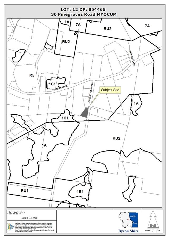
Assessment:
1. INTRODUCTION
1.1 History/Background
The subject site has been developed with a double-storey
dwelling house including carport. Consent for the existing dwelling was
issued on 15 September 2005 and a Construction Certificate was issued on 9 June
2006. The land is zoned R5 Large Lot Residential under Byron LEP 2014.
1.2 Description
of the site
The subject site is a rural residential property located at
30 Pinegroves Road, Myocum with an area of 4,300m2. It is located
off the eastern end of Pinegroves Road, which ends in a cul-de-sac close to the
north-eastern corner of the property. The road then continues as a sealed
‘driveway’ within the road reserve along the eastern boundary of
the site, servicing a number of properties to the south.
The property has approximately 90m road frontage along this
eastern boundary. It contains an existing residential dwelling, shed and
swimming pool, with two driveways, one in the north-east corner accessing the
shed and the second adjacent to the dwelling. The site context is shown
below.
The existing dwelling is located at the top of the site,
which falls steeply to the south. There is established vegetation along
much of the street frontage, with a number of large trees adjacent to the
southern boundary. The remainder of the site is predominantly clear of
vegetation with the exclusion of landscape plantings near the dwelling and
towards the north-western corner of the site.
The site is identified as being
designated bushfire prone land (Figure 2), located partly within the buffer
zone, and is proximate to Vegetation Category 1 Zone to the south (>90m from
proposed secondary dwelling).
|
|
|
Figure 2: Bushfire
Prone Land – Buffer Area
|
1.3 Description
of the proposed development
The proposed development seeks approval for the construction
of a secondary dwelling on the subject site, which will contain:
§ One (1) bedroom;
§ Combined kitchen and living room;
§ Combined bath and laundry room; and
§ 15m2 verandah.
The secondary dwelling will be constructed using
‘woodland grey colourbond corrugated vertical steel’ wall cladding and
‘basalt colourbond bondor solarspan’ corrugated roof panels.
It has a timber floor, generally at ground level on the northern elevation, and
raised approximately 2.5m above existing ground level at the southern
elevation. Vertical timber slats are proposed to shield the underfloor
area. It has a total floor area of 50.4m2.
Private open space will be provided by two verandahs on the
northern and southern sides of the living room.
2. SUMMARY
OF GOVERNMENT/EXTERNAL REFERRALS
|
|
Summary of Issues
|
|
Development Engineer
|
Not required for this application
|
|
Environmental Health Officer
|
Supported conditionally
|
|
Water & Waste Services
|
Not required for this application
|
|
Building Surveyor
|
Not required for this application
|
|
Fire Control Officer
|
Not required for this application
|
|
Ecologist
|
Not required for this application
|
|
Tree Preservation Officer
|
Not required for this application
|
|
Government Authorities
|
Not required for this application
|
3. SECTION
79C – MATTERS FOR CONSIDERATION – DISCUSSION OF ISSUES
Having regard for the matters
for consideration detailed in Section 79C(1) of the Environmental Planning
& Assessment Act 1979, the following is a summary of the evaluation of the
issues.
SECTION 79B
Under S79B of the Act, Council
must be satisfied that prior to making a determination for development on
bushfire prone land, that the development complies with the document Planning
for Bushfire Protection 2006 (PBP). The site is designated as bushfire
prone land. A discussion of the relevant issues under PBP is addressed below.
Section
79BA
1. Vegetation and Slope
Category
|
Direction
|
Slope
|
Vegetation Category
|
Distance to Hazard
|
Proposed APZ
|
|
North
|
Up Slope
|
Managed Land
|
35m
|
10m
|
|
East
|
Flat
|
Managed Land
|
40m
|
10m
|
|
South
|
Downslope (10-15o)
|
Forested Wetland
|
90m
|
30m
|
|
West
|
Flat
|
Rainforest
|
100m
|
10m
|
2. Construction Standards and
Design
Based on the
distance to hazards, slopes and vegetation categories above, Table A3.4 of
Appendix 3 in Planning for Bushfire Protection 2006 provides that the
proposed development should be constructed in accordance with BAL 12.5.
Recommend that
a Condition be applied requiring the construction to comply with the requirements
of sections 3&5 and BAL12.5 under section 6 of AS3959 –
2009.
3. Asset Protection Zones
Based on the
distance to hazards, slopes and vegetation categories above, Table A2.5 of
Appendix 2 in Planning for Bushfire Protection 2006 provides that the
proposed secondary dwelling should have a minimum APZ to the North, East and
West of 10m and 30m to the South.
The required 10m
APZ to the North, East and West, and 30m APZ to the South can be
accommodated using the land within the allotment and the road reserve to the
east.
A condition is
recommended that the appropriate parts of the site be managed as an Inner
Protection Area, as outlined in
section 4.1.3 and Appendix 5 of ‘Planning for Bush Fire Protection
2006’ (PBP) and the NSW Rural Fire Service's document ‘Standards
for asset protection zones’.
4. Landscaping
No additional landscaping is proposed in conjunction with the development
of the Secondary Dwelling.
5. Services
Public Roads
The site has access directly onto Pinegroves Road, which is a two-way sealed
public road, which is adequate to handle vehicle movements in an emergency.
Water
The site is
serviced by onsite rainwater storage and a new tank is proposed to be connected
to the secondary dwelling.
Electricity
Electricity is supplied to the subject site and will
be connected to the proposed dwelling.
6. Fencing
No additional fencing is proposed as part of the development.
State/Regional Planning
Policies and instruments - Issues
3.1. STATE/REGIONAL
PLANNING POLICIES AND INSTRUMENTS
|
Requirement
|
Requirement
|
Proposed
|
Complies
|
|
State Environmental Planning
Policy (Affordable Rental Housing) 2009
|
A secondary dwelling is
permissible in the R5 zone pursuant to cl 23 of this SEPP. The
provisions of the SEPP are addressed below.
|
Yes
|
|
State Environmental
Planning Policy (Rural Lands) 2008
|
Applies considerations to
rural subdivisions or rural dwellings in a rural zone, a rural residential
zone or an environment protection zone:
(a) the existing uses and approved uses of land
in the vicinity of the development,
(b) whether or not the development is likely to
have a significant impact on land uses that, in the opinion of the consent
authority, are likely to be preferred and the predominant land uses in the
vicinity of the development,
(c) whether or not the development is likely to
be incompatible with a use referred to in paragraph (a) or (b),
(d) if the land is not situated within a rural
residential zone, whether or not the development is likely to be incompatible
with a use on land within an adjoining rural residential zone,
(e) any measures proposed by the applicant to
avoid or minimise any incompatibility referred to in paragraph (c) or (d).
|
Yes
|
|
State Environmental
Planning Policy BASIX – Building Sustainability Index
|
BASIX Certificate
Required for:
· New
dwellings
· Alterations
> $50,000:00
· Pools
> 40,000 kl
|
A BASIX certificate has been
provided with the development application relating to the new secondary
dwelling.
|
Yes
|
|
Building Code of Australia
|
The proposal must be capable
of compliance with the structural and safety requirements of the Building
Code of Australia.
|
A condition has been
recommended for inclusion in the consent to ensure the BCA requirements are
met.
|
Yes
|
|
Demolition
|
Not Applicable
|
Yes
|
|
Disability Access (DDA)
|
Access for persons with
disabilities and integration into surrounding streetscapes without creating
barriers. (Council Res.10-1118)
|
Access to dwellings is
provided wholly within the property.
|
Yes
|
State/Regional
Planning Policies and instruments - Issues
State Environmental
Planning Policy (Affordable Rental Housing) 2009:
In this
SEPP, a secondary dwelling is defined as:
a
self-contained dwelling that:
(a) is established in conjunction with
another dwelling (the principal dwelling), and
(b) is on the same lot of land (not being an individual
lot in a strata plan or community title scheme) as the principal dwelling, and
(c) is located within, or is attached to, or
is separate from, the principal dwelling.
The proposal is consistent with this definition.
The provisions relating to secondary dwelling apply to land
within the R5 zone and cl 22(1) provides that a secondary dwelling is
permissible with development consent in this zone.
The proposal complies with the relevant provisions of cl 22,
as outlined below:
2) A consent
authority must not consent to development to which this Division applies if
there is on the land, or if the development would result in there being on the
land, any dwelling other than the principal dwelling and the secondary
dwelling.
Complies. The proposal will result in only one
principal dwelling and the proposed secondary dwelling.
3) A consent
authority must not consent to development to which this Division applies
unless:
(a) the total floor area of the
principal dwelling and the secondary dwelling is no more than the maximum floor
area allowed for a dwelling house on the land under another environmental
planning instrument, and
Complies. BLEP 2014 does not specify a maximum floor
space ratio in this locality.
(b) the total floor
area of the secondary dwelling is no more than 60 square metres or, if a
greater floor area is permitted in respect of a secondary dwelling on the land
under another environmental planning instrument, that greater floor area.
Complies. The floor area of the secondary dwelling is
50.4m2.
4) A consent
authority must not refuse consent to development to which this Division applies
on either of the following grounds:
(a) site area
if:
(i) the
secondary dwelling is located within, or is attached to, the principal
dwelling, or
(ii) the
site area is at least 450 square metres,
Complies. The proposed second dwelling is not within
or attached to the primary dwelling, but the site is well over the 450m2
minimum area requirement.
(b) parking
if no additional parking is to be provided on the
site.
No additional
parking is proposed. However, space is available on-site for parking
adjacent to the existing driveway.
3.2. BYRON
LOCAL ENVIRONMENTAL PLAN 2014
Zone:
R5 Large Lot Residential
Definition:
Secondary Dwelling
|
LEP Requirement
|
Summary of Requirement
|
Proposed
|
Complies
|
|
Permissible use –
Secondary Dwelling
|
secondary
dwelling means a self-contained dwelling that:
a) is established in conjunction with
another dwelling (the principal dwelling), and
b) is on the same lot of land as the
principal dwelling, and
c) is located within, or is attached
to, or is separate from, the principal dwelling.
|
See
above. A secondary dwelling is permissible with consent in the R5 zone
pursuant to cl 22 of SEPP (Affordable rental Housing) 2009.
The provisions of this SEPP
‘over-ride’ the provisions of BLEP 2014.
|
Yes
|
|
Meets R5 (Large Lot Residential) Zone objectives
|
• To provide residential housing in a
rural setting while preserving, and minimising impacts on, environmentally
sensitive locations and scenic quality.
• To ensure that large residential lots
do not hinder the proper and orderly development of urban areas in the
future.
• To ensure that development in the area
does not unreasonably increase the demand for public services or public
facilities.
• To minimise conflict between land uses
within this zone and land uses within adjoining zones.
|
The secondary dwelling will not hinder the development of
the site into the future.
The secondary dwelling will not conflict with adjoining
land uses as the site is surrounded by R5 Zoned land.
|
Yes
|
|
Cl 4.3 Height of Buildings.
|
Overall height of development
must not exceed 9.0m above existing ground level
|
The maximum height of the secondary dwelling will be 5.5m
above ground level. The secondary dwelling will not exceed 9.0m from ground
level.
|
Yes
|
|
Cl 5.4 Controls relating to
miscellaneous permissible uses
|
(9)
Secondary dwellings
If development for the purposes of a secondary dwelling is permitted, the
total floor area of the dwelling (excluding any area used for parking) must
not exceed whichever of the following is the greater:60 square metres,
a) 35% of the total floor area of the principal dwelling.
|
The secondary dwelling has a total floor area of 50.4m2.
|
Yes
|
|
Cl 5.9: Preservation of
trees or vegetation
|
The objective of this clause is to preserve the amenity of
the area, including biodiversity values, through the preservation of trees
and other vegetation.
|
The proposed development does
not involve the removal of significant vegetation onsite, although some
landscape plantings will be removed. Additional planting is recommended to
compensate for this removal and to retain a visual ‘shield’ along
the adjoining road frontage.
|
Yes
|
|
Cl 6.2 – Earthworks
|
Earthworks will not have a
detrimental impact on environmental functions and processes, neighbouring
uses, cultural or heritage items or features of the surrounding land
|
The proposed secondary dwelling is designed on piers and
will involve minimal earthworks.
|
Yes
|
|
Cl 6.6: Essential Services
|
· water,
· sewer,
· electricity
· stormwater
· vehicle
access
|
Rainwater Tanks
OSMS – Conditions attached
Connected
Rainwater Tanks
Direct to Pinegroves Road
|
Yes
Yes
Yes
Yes
Yes
|
|
|
|
|
|
Byron Local Environmental Plan
2014 - Issues
No significant issues are related to the proposal.
3.3 DEVELOPMENT
CONTROL PLANS
Development Control Plan 2014
|
Development Control Requirement
|
Requirement
|
Applicable/Complies?
|
|
Part
B Controls Applying Generally to Development Application
|
|
B3 & B4:
Services & Vehicle
parking
|
Dwelling= 2 spaces
As outlined above, the
provisions of SEPP (Affordable Rental Housing) 2009 provide that additional
parking is not mandatory for a secondary dwelling. Notwithstanding
this, there is space within the subject site, adjacent to the proposed
secondary dwelling, that could provide parking for 2 cars.
|
Yes
|
|
B6 Buffers and Minimising Land
Use Conflict
|
To ensure that development
proposals are designed to minimise land use conflicts.
The secondary dwelling is
appropriately located away from surrounding rural properties and complies
with Table B6.1 in relation to rural activities.
|
Yes
|
|
B8.3.2 Construction of
Buildings or Structures
|
A Site Waste Minimisation and
Management Plan (SWMMP) must be submitted with Development Applications
seeking consent for construction of buildings or structures.
This can be conditioned in
this case.
|
Yes
|
|
Part D –
Chapter D1 Residential Accommodation in Urban, Village and Special Purpose
Zones
|
|
D1.2.1 Building Height
Plane
|
The proposed
second dwelling complies with the BHP.
|
Yes
|
|
D1.2.2 Setbacks from Boundaries
|
Road (East) –
4.5m
|
3m
|
No – Assessment provided below
|
|
Side and Rear:
Consistency with Objectives
and Performance Criteria. Compliance with BCA. Assessment of DCP 2014 Chapter
B6 Buffers and Minimising Land Use Conflict.
Located approximately 40m to
southern and western boundaries and 12m from existing dwelling house onsite.
|
Yes
|
|
D1.2.3 Screening the
Underfloor Space of Buildings
|
Vertical timber slats are
proposed to screen the underfloor.
|
Yes
|
|
D1.2.4 Character and Visual
Impact
|
The proposed second dwelling has been sited within the
property to minimise the earthworks that would be needed if it were located
further away from the road boundary. Because of the slope of the land,
significant works would be required to get an internal driveway to alternate
locations.
The existing screen planting at the road boundary will
assist to soften the visual impact of the building and additional planting
along the boundary is recommended.
|
Yes
|
|
D1.2.5 Fences
|
No fencing is proposed in this application.
|
N/A
|
|
D1.2.6 Balconies
|
Verandahs are proposed on the northern and southern
elevation but do not dominate the visual character of the building.
|
Yes
|
|
D1.4.1 Private Open Space
|
The proposed secondary dwelling has access to an extensive
area of yard, which can be used as private open space.
|
Yes
|
|
D1.4.2 Access and Car
Parking
|
Access is proposed via the existing driveway, which
services the primary dwelling.
On-site car parking space is available.
|
Yes
|
|
D1.4.3 Siting, Design and
Character
|
The proposed development is acceptable in terms of
compatibility with the primary dwelling and the visual character of the site.
|
Yes
|
|
|
|
|
* Non-complying issues
discussed below
Development Control Plan 2014
- Issues
D1.2.2 Setbacks from Boundaries
Objectives
1. To
achieve varied and interesting streets that complement and harmonise with
existing and planned streetscapes and development in the locality.
2. To
achieve good orientation and spacing of residential developments that achieve
high quality living environments relative to sunlight, shade, wind and weather
protection, residential amenity and proximity of neighbouring development.
3. To
achieve effective use of allotments to create useable and liveable private open
space and courtyards.
4. To
provide flexibility in siting and design of dwelling house development in urban
residential areas.
Assessment
The subject site has an 80m frontage to the Pinegroves Road
(road reserve) along the eastern boundary and the proposed secondary dwelling
is located 3m from this frontage. Pinegroves Road terminates in a
cul-de-sac head approximately 20m north of the subject site and is unformed
along the full frontage of the property; access to the site is via a sealed
driveway servicing four (4) properties, which includes the subject site.
The location of the secondary dwelling is behind a stand of
existing mature trees, which will screen the development from most adjoining
properties and is also sited to provide off-street parking close to the
existing dwelling (gravel driveway and parking area).
The secondary dwelling is located to reduce the likelihood
of conflict between rural land uses and the proposed development, as the
secondary dwelling is setback a significant distance from RU2 Zones, which are
within 70m of the development.
Given the secondary dwelling does not front a sealed
“thru-road”, is screened by mature vegetation and has been located
to maximise buffer distances to RU2 Zones, it is considered that the proposed
frontage setback is acceptable in this instance.
3.4 The likely impacts of that
development, including environmental impacts on both the natural and built
environments, and social and economic impacts in the locality
|
Impact on:
|
Likely significant
impact/s?
|
|
Natural environment
|
No. The proposal will not have
a significantly adverse impact on the natural environment of the locality.
|
|
Built environment
|
No. The proposal will not have
a significantly adverse impact on the built environment of the locality.
|
|
Social Environment
|
No. The proposal will not have
a significant social impact on the locality.
|
|
Economic impact
|
No. The proposal will not have
a significant economic impact on the locality.
|
Site Waste Minimisation
and Management:
Builders
rubbish is required to be contained on the site. The site is serviced by
Council’s domestic waste collection service. A full Site Waste
Minimisation and Management Plan will be required with the application for
Construction Certificate.
3.5 The
suitability of the site for the development
The subject site is an existing
allotment within the large-lot rural zone. The site is suitable for the
proposed development subject to conditions.
|
Suitability of Driveway Access:
|
Access to the site is proposed from Pinegroves Road, which
terminates 20m to the north of the site. A sealed driveway provides
access to the site and a number of other allotments at the end of Pinegroves
Road. The existing driveway is satisfactory in this instance and
parking and manoeuvring onsite can comply with AS 2890.1:2004, Parking
facilities, Part 1: Off-street car parking.
|
|
On-site Sewage Management System:
|
OSMS approved (#A2016/8457).
|
|
Buffers from adjoining land uses:
|
The proposed dwelling house is located a sufficient
distance from likely future intensive agriculture or horticulture.
|
|
Electricity Supply:
|
Power is available via existing low voltage power supply.
|
|
General:
|
The proposed dwelling is a suitable form of development
for the subject site and is in keeping with the character of the existing
development within the locality. The proposed location of the secondary
dwelling house is appropriate in relation to the topographic, vegetation and
visual impact constraints of the land.
|
3.6 Submissions
made in accordance with this Act or the regulations
There were 3 submissions made, objecting to the
development application.
|
Issue
|
Comment
|
|
Insufficient setback from Pinegroves Road
Reduced set back is visual intrusion into rural vista.
|
The subject site has an 80m frontage to the Pinegroves
Road (road reserve) along the eastern boundary and the secondary dwelling is
proposed to be located 3m from this frontage.
Pinegroves Road terminates in a cul-de-sac head approximately
20m north of the subject site and is unformed along the full frontage of the
property. Access within the road reserve past the cul-de-sac is via a
sealed driveway servicing four (4) properties, which includes the subject
site.
The location of the secondary dwelling is behind a stand
of existing mature trees, which will screen the development from adjoining
properties.
It is proposed to be located adjacent to the existing
driveway and off-street parking, close to the existing dwelling (gravel
driveway and parking area).
The secondary dwelling is located to reduce the likelihood
of conflict between rural land uses adjoining to the west and south and the
proposed development as the secondary dwelling is setback a significant
distance from RU2 Zoned, which is around 70m to the south of the development.
Given the secondary dwelling does not front a sealed
thru-road, is screened by mature vegetation, and has been located to maximise
buffer distances to adjoining rural properties, it is considered that the
proposed frontage setback is acceptable in this instance.
A condition is recommended that additional landscape
planting is implemented along the property boundary, directly downslope of
the proposed secondary dwelling, to compensate for the removal on existing
on-site landscape plantings.
|
|
Insufficient setback to Pinegroves – concern that
future residents of second dwelling will complain about passing traffic (to
complainants property)
|
The proposed second dwelling is located behind an existing
stand of mature trees, which run along the entire length of the Pinegrove
Road frontage.
These trees provide a visual shield for future residents
of the dwelling. Some on-site landscape plantings will be removed for
the secondary dwelling and a condition is recommended that additional landscape
planting is implemented along the property boundary, directly downslope of
the proposed secondary dwelling, which will further assist to address this
issue.
|
|
Insufficient space to park a car (including visitor
parking)
|
Secondary dwellings are not required to provide additional
parking, in accordance with SEPP (Affordable Rental Housing) 2009.
Notwithstanding this, parking is available over the gravel
turning area that exist onsite.
|
|
Road noise will infiltrate into the secondary dwelling
given the elevated nature of the development.
|
There are no restrictions on the applicants providing an
elevated construction as the overall height of the dwelling is approximately
5m high – which is well below the 9m maximum height of building overlay.
|
|
Stormwater diversion around the dwelling
|
Stormwater will be diverted around the dwelling to avoid
rutting of the piers under the dwelling. This stormwater can adequately
discharge across the lot given the 4300m2 of site area and
topography sloping down to the floodplain near the southern boundary of the
site.
|
|
Concerns about a potential additional access point off
Pinegroves Road
|
There are two existing driveways accessing the site
– one to the rural shed in the northern corner and one to the existing
dwelling. The proposed secondary dwelling will use the existing
driveway that services the dwelling, so no new access points are proposed.
|
3.7 Public
interest
The proposed development does not compromise the public
interest.
4. DEVELOPER
CONTRIBUTIONS
4.1 Water
& Sewer Levies
As there is no increase in the load on these services, no
contributions will be required for water and sewer services.
4.2 Section
94 Contributions
Clause 2.14
of the S94 Plan states:
Development for the purposes
of a secondary dwelling as defined in State Environmental Planning Policy will
be exempted from the obligation to pay a contribution under this Contributions
Plan where the secondary dwelling is integral and subordinate to the primary
dwelling. Where the secondary dwelling is subject to the following requirements
a. That the maximum size of the secondary dwelling does
not exceed 60m2.
b. That the floor space ratio for the whole development of
the site does not extend beyond 0.5:1 and that 25% of the site must be covered
by absorbent surfaces such as lawn or landscaping.
c. That the secondary dwelling does not increase the
overall number of bedrooms on the site to greater than 5.
d. That the applicant has an approval for a secondary
dwelling subject to a condition of consent that the development is not to be
used for tourism purposes.
This proposal meets these
requirements. Accordingly no contributions will be levied.
5. CONCLUSION
Development consent is sought for a Secondary Dwelling
located at 30 Pinegroves Road, Myocum.
The proposed development is permissible pursuant to the
provisions of State Environmental Planning Policy (Affordable Rental Housing)
2009, and is generally consistent with the provisions of Byron LEP 2014 and DCP
2014. It is not likely to result in significant impacts on the existing
environment. It is recommended that consent be granted subject to
conditions.
Staff Reports - Sustainable Environment and Economy 13.9
Report No. 13.9 PLANNING
- 26.2016.1.1 - Planning Proposal for rezoning of land at Buckleys Road
Tyagarah
Directorate: Sustainable
Environment and Economy
Report
Author: Sharyn
French, Manager Environmental and Economic Planning
Shannon Burt, Director Sustainable
Environment and Economy
File No: I2016/744
Theme: Ecology
Planning Policy and Natural Environment
Summary:
This report outlines the
details of an applicant initiated Planning Proposal that was submitted by
applicant Ardill Payne & Partners on behalf of Michael and Susanne Hunter (Tyagarah
Holdings P/L) in regards to land at
Buckleys Road, Tyagarah. The Planning Proposal seeks to alter the land use
zones with consequential minimum lot size and floor space ratio changes to
permit rural residential development over part of the site. The Planning
Proposal has been reviewed and it is recommended that it should not proceed.
If approved, the Planning Proposal would rezone
approximately 21 hectares of the existing RU2 Rural Landscape (and
Deferred Matter) zones to R5 Large Lot Residential, with the balance of
the subject land to remain in its current zones. A minimum lot size of
2000m2 is proposed by the applicant to be supplied with reticulated
water and sewerage. Floor space ratios will not apply (as is currently
the case). The Planning Proposal would supply about 100 rural residential
lots to the market if developed.
The land has not been subject to a
comprehensive range of studies and reports that would normally be required to
support a planning proposal that is inconsistent with current Council and state
government planning strategies. If the matter were to proceed, then (extensive)
further studies would be required.
The Planning Proposal is not consistent
with relevant SEPPs. It is not consistent with a number of the relevant
s117 Directions. Where inconsistencies occur, they have not been
justified.
The Planning Proposal is not consistent
with the Byron Rural Settlement Strategy 1998 or the Far North Coast Regional
Strategy. It is not consistent with the draft Byron Rural Land Use
Strategy or the draft North Coast Regional Plan.
It proposes a significant new rural residential
release area which pre-empts the completion of Council’s strategic
planning process currently under way (i.e. preparation of the draft Byron Rural
Land Use Strategy).
There is insufficient information to enable
Council to support an amended Planning Proposal and it is recommended that
Council not proceed with this Planning Proposal.
Council staff advised the applicant that it
would not support the planning proposal due to its inconsistencies with both
Council and state government planning strategies, by letter dated 20 May 2016.
Council staff attended a site inspection with the applicant on 14 June 2016
where the inconsistencies were further discussed. Staff recommended that the
Planning Proposal be withdrawn but the applicant has requested that it be
reported to Council for determination.
NOTE TO COUNCILLORS:
In accordance with the
provisions of S375A of the Local Government Act 1993, a Division is to be
called whenever a motion for a planning decision is put to the meeting, for the
purpose of recording voting on planning matters. Pursuant to clause 2(a)
under the heading Matters to be Included in Minutes of Council Meetings of
Council's adopted Code of Meeting Practice (as amended) a Division will be
deemed to have been called by the mover and seconder of all motions relating to
this report.
|
RECOMMENDATION:
That
Council:
a) Consider
the planning proposal from Ardill Payne and Partners on behalf of Tyagarah
Holdings P/L to rezone approximately 21 hectares of RU2 Rural Landscape
(and Deferred Matter) zoned land to R5 Large Lot Residential
(Attachment 1 E2016/54224));
b) Not
proceed with this planning proposal to amend Byron LEP 2014 (or Byron LEP
1988) for the reasons outlined in this report and notify the applicant of its
decision;
c) Request
the Minister for Planning to determine that the matter not proceed.
|
Attachments:
1 Applicant's
Planning Proposal, E2016/54224
2 Special
discosure of pecuniary interest form, E2012/2815
Report
The Planning Proposal
This Planning Proposal relates to land located at Buckleys
Road (off Grays Lane), Tyagarah. The land involved is described as
Lots 1 and 2 DP 1126204 and Lot 7 DP 573269. The land
is traversed by two unmade roads that are not listed as subject to the Planning
Proposal. The combined area of the three lots is approximately
90 hectares. Approximately 21 hectares is proposed to be zoned
R5 Large Lot Residential in this Planning Proposal, which the applicant
suggests will yield approximately 100 lots with a minimum lot size of 2000m2.
The balance of the zones within the subject land will not change.
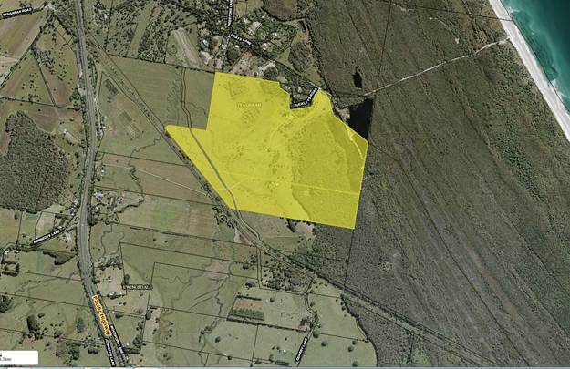
Figure 1: Subject Land
The applicant submitted a Planning Proposal
(Attachment 1) seeking to:
· rezone
approximately 21 hectares of the subject land to R5 Large Lot Residential;
and
· apply a Minimum
Lot Size (MLS) of 2000 square metres to the R5 zone.
The applicant has also suggested (but not supplied) a voluntary
planning agreement (VPA) between the land owners and the Council, which would
be exhibited with the Planning Proposal, if supported. The VPA would dedicate
all SEPP 14 land on the site to a public authority (to be agreed); extend
a sewer main to service the subject land and nearby land to the north; upgrade
low-lying sections of Grays Lane to avoid flood inundation and seal the
remainder of the road; surrender all existing consents that apply to the
subject land; and dedicate a water body (an ex-sand quarry) to a public
authority (to be agreed).
The applicant considers the Planning Proposal is needed
because it will:
· provide additional
land for rural residential development;
· increase housing
choice and stimulate economic development from housing construction;
· eliminate a high
impact tourist development approval that would likely adversely impact on
surrounding natural areas;
· lead to public
benefits if the VPA is implemented.
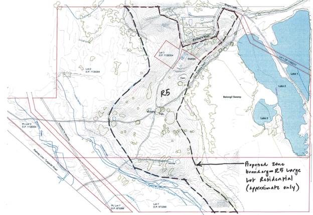
Figure 2: Proposed Zoning Plan - approximate extent
of the proposed R5 Large Lot Residential zone (shown as black dashed line)
within the subject site (lot boundaries are shown in red)
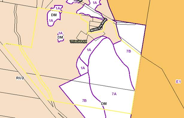
Figure 3: Current Zoning under Byron LEP 2014 and LEP
1988 (Combined Zoning Map)
Current Zones and Controls
The subject land is zoned part RU2 Rural Landscape and part
Deferred Matter under Byron LEP 2014. The Deferred Matter land remains
zoned 1(a) General Rural, 7(a) Wetlands and 7(b) Coastal Habitat, under Byron
LEP 1988. The Minimum Lot Size for the RU2 zone is
40 hectares. No Floor Space ratio (FSR) currently applies to the RU2
zoned land. The Minimum Lot Size (MLS) for the 1(a), 7(a) and 7(b) zones
is also 40 hectares.
Key Issues
· Amending Byron LEP
1988
· Byron Rural
Settlement Strategy 1998
· Draft Byron Rural
Lands Strategy 2016
· Far North Coast
Regional Strategy
· Draft North Coast
Regional Plan
· NSW Settlement
Planning Guidelines
· Vegetation
· Steep land
· Flood prone land
· Regional farmland
· State policy and
planning controls
Amending Byron LEP 1988
Part of the site remains subject to Byron LEP 1988 because
of a decision by the state government to defer some areas from Byron LEP 2014
and not include any E2, E3 or E4 zones in the new LEP. The Department has
indicated in discussion with staff regarding previous planning proposals that
it is not going to permit further amendments to Byron LEP 1988 on a
“piece meal” basis. The small area of Deferred Matter cannot
be amended by this Planning Proposal as it is not subject to Byron LEP
2014. It can only be amended by also amending Byron LEP 1988. It is
not practicable that this be done as part of this Planning Proposal.
Byron Rural Settlement Strategy 1998
This strategy remains the current and relevant rural
residential strategy adopted by Council and approved by the state government.
It assessed in detail land throughout Byron Shire, including the Tyagarah
area. The subject land was identified on Map 21 as including some
land that contains minimal physical or ecological constraints (based on 1998
constraint mapping). However, it is not identified for rural land sharing
or community title development on Maps 2 or 23. It was identified on
Map 9 of the strategy as having potential for rural tourist cabins.
It has obtained a number of approvals to date for cabins and rural
tourism-related uses. The applicant documents the existing consents in
their Planning Proposal.
The request to permit small lot subdivision on the site is a
request for rural residential development for land that is not in the Byron
Rural Settlement Strategy 1988 rural land release program.
On this basis, the proposal to rezone the land to permit
small lot subdivision is not consistent with the Byron Rural Settlement
Strategy 1998.
Draft Byron Shire Rural Land Use Strategy 2016
The draft Byron Shire Rural Land Use Strategy was exhibited
during April and May 2016. It has not been adopted in its final form by
Council and has not been agreed to by the Department of Planning and
Environment (as required by both the Far North Coast Regional Strategy and the
draft North Coast Regional Plan). As it has been exhibited, it is
worthwhile to examine if the subject land is consistent with the draft Byron
Shire Rural Land Use Strategy.
The focus of the draft Strategy (page 5 of the draft)
is:
“on enabling future rural lifestyle living
opportunities in areas that are relatively unconstrained from development, have
a strong potential to build on and strengthen existing communities and have
reasonable access to major town services. Such opportunities can only be
realised in locations where an acceptable standard of road infrastructure can
be provided at no cost to the wider community.”
The draft Strategy states on page 30 that:
“new large lot residential subdivision
opportunities only in areas:
• identified
on Maps 4,4a and 4b (refer to Section 4 ‘Land Release
Program’) and/or that can satisfy the decision framework outlined in
Figure 4;
• not
adopted within an approved urban land release strategy for urban development,
or not identified for future village development in this strategy (as
identified in Maps 5, 5a and 5b - refer to Section 4 ‘Land
Release Program’); and
• where
an acceptable standard of road infrastructure can be provided at no cost to the
• wider
community.”
The subject land is not identified on Maps 4, 4a or 4b
so it could only be regarded as consistent with the draft Strategy if it meets
the decision framework in Figure 4 and is located where an acceptable
standard of road can be provided at no cost to the wider community.
The draft Strategy is based on four key themes by which land
is assessed as being potentially suitable for rural residential development:
1. Our Rural Environment
2. Our Rural Economy
3. Our Rural Community
4. Our Rural Infrastructure
Based on the work Council has undertaken, a decision
framework (figure 4 on page 34 of the draft) can be used as a guide
as to whether land is suitable for rural residential development.
Typically, land east of the Pacific Highway is not suitable
unless it meets the objectives/criteria of the draft Strategy, and the relevant
criteria of the North Coast Regional Plan and the NSW Settlement Planning
Guidelines. (The latter two documents are discussed later in this
report.)
The Rural Environment objectives/criteria of the
draft Strategy provide a basis for assessing a potential site for rural
residential suitability based on its physical characteristics. In this
case, the applicant has undertaken a site characteristics assessment that was
based on Council’s GIS data and only considered acid sulfate soils,
terrestrial biodiversity, flooding, waterways and bushfire hazard. It did
not include a slope analysis (even though the land contains some steep areas),
did not include a site-specific ecological assessment of the land, and did not
include an Aboriginal archaeological assessment. It also disregards the
mapping of much of the site as regionally significant farmland, and does not
acknowledge that the southern part of the site is subject to a buffer area for
an unexploited sand resource (identified on s117 maps).
On this basis, the subject land does not meet the Rural
Environment criteria for inclusion in the draft Strategy.
The Rural Economy objectives/criteria of the draft
Strategy provide a basis for assessing a potential site for rural residential
suitability based on its rural economic characteristics, including agriculture
and tourism. In this case, the applicant has included a large area of
regionally significant farmland that is contiguous with other areas (not
isolated). They have not provided a detailed evaluation of the site
against the Interim Variation Criteria in the draft North Coast Regional
Plan. They have not provided an agricultural assessment of the land to
support their conclusion that the land is marginal (it is currently used for
grazing). They do not acknowledge that the adjacent land is used for
sugar cane production and do not provide a land use conflict risk assessment.
The applicant acknowledges that the site has multiple rural tourism consents,
but fails to consider how these would contribute to the economy if activated as
an alternative to the proposed rural residential development.
On this basis, the subject land does not meet the Rural
Economy criteria for inclusion in the draft Strategy.
The Rural Community objectives/criteria of the draft
Strategy provide a basis for assessing a potential site for rural residential
suitability based on retaining the “rural” in the landscape when
considering future rural housing opportunities. It also includes
identifying future rural lifestyle opportunities where people can connect with
the surrounding farmland and natural areas, and that support and strengthen our
rural villages. A key factor in these criteria is the 2 kilometre
and 5 kilometre service catchments identified on Map 1 (page 24
of the draft). The subject land is not located within any of the
16 urban and village catchments in the Shire. It is located in proximity
to the community title land sharing developments north of Grays Lane (about
30 dwellings), but will be about three times larger in dwelling yield than
this area. It does not “build” on any existing zoned R5 Large
Lot Residential land. The closest community service focal point is the
Tyagarah service station and shop located about 3.5 kilometres to the
north. The nearest school is about 8 kilometres away, and the site
is 7 kilometres away from the new Byron central hospital.
On this basis, the subject land does not meet the Rural
Community criteria for inclusion in the draft Strategy.
The Rural Infrastructure objectives/criteria of the
draft Strategy provide a basis for assessing a potential site for rural
residential suitability in terms of infrastructure, including roads, water,
electricity, waste minimisation, and community infrastructure such as
halls. In this case, the applicant suggests that reticulated water and
sewerage will be supplied to the lots, and that the applicant will upgrade Grays
Lane to provide flood-free access to the Pacific Highway. Details are not
supplied on any infrastructure issue; however the applicant offers a voluntary
planning agreement to undertake the works at their own cost. This would
include installing a 3 kilometre (approximately) sewer pipeline via the
disused rail corridor to the West Byron STP. The cost and practicality of
this, and upgrading Grays Lane and supplying reticulated water from the Rous
main that traverses the site, have not been assessed in the application.
Council also needs to be clear that it would be supplying urban infrastructure
(water and sewerage) to a rural residential land use. This in itself is
inconsistent with the concept of rural residents being self-sufficient and Council
supplying scarce infrastructure cost effectively to sites without cost to the
wider community.
On this basis, the subject land does not meet the Rural
Infrastructure criteria for inclusion in the draft Strategy.
A report on the draft Rural Land Use Strategy (RLUS) is also
being considered at this meeting. If Council resolves to make amendments to the
draft RLUS, the above assessment may change.
Far North Coast Regional Strategy (FNCRS)
The FNCRS specifically states (on page 28) that rural
residential development will be located close to existing centres (this site is
not within the 2 kilometres or 5 kilometres radius that Council
uses), and avoid significant environmental and landscape value areas as well as
natural resource land. In this case, the environmental and landscape
assessment has been minimal, and the subject land is affected partly by a
buffer to a significant sand resource and substantially by regionally
significant farm land. The FNCRS is clear that for land east of the
Pacific Highway, only that land in an approved land release strategy will be
rezoned. The subject land is east of the Pacific Highway and is not
included in the Byron Rural Settlement Strategy 1998.
On this basis, the subject land is not consistent with the
FNCRS.
Draft North Coast Regional Plan
The draft North Coast Regional Plan was exhibited recently
(closed on 2 June 2016) and will, in due course, replace the FNCRS.
However, it has no statutory basis at this time, and is considered here
primarily because it is referenced in the draft Byron Shire Rural Land Use
Strategy. The draft North Coast Regional Plan states (on page 50)
that land will only be zoned for future rural residential development if it is
consistent with a strategy agreed between Council and the Department of
Planning and Environment and consistent with the Settlement Planning
Guidelines. As discussed above, the subject land is not consistent with
the Byron Rural Settlement Strategy 1998, which is the only agreed rural
residential strategy that applies to Byron Shire. Consistency with the
Settlement Planning Guidelines is discussed below.
On this basis, the subject land is not consistent with the
draft North Coast Regional Plan.
NSW Settlement Planning Guidelines
The NSW Settlement Planning Guidelines were prepared by the
State government to guide councils in preparing Growth Management Strategies
that may include a rural settlement component. In the context of the
draft North Coast Regional Plan (page 50), DPE lists six issues that should
guide councils in planning for rural residential development. The
following is an assessment of the subject land against these six issues:
|
Avoiding areas prone to natural hazards including bushfire
and flood
|
The 21 ha nominated as the developable land in this
Planning Proposal is mostly above the flood planning level and is mostly not
bushfire prone land. It is affected by bushfire buffers. The main
access (Grays Lane) is regularly affected by flooding in a number of
locations. The applicant has suggested this can be raised to a
flood-free status and sealed, but has not indicated how this may affect the
floodplain or other properties, and has not supplied any cost estimates to
show that it is plausible in the context of this development.
|
|
Avoiding areas of high environmental value and Aboriginal
and heritage significance
|
The areas known by Council to be of high conservation
significance (e.g. the SEPP 14 wetlands) have been excluded from the
developable land. However, no site-specific ecological assessment has
been undertaken, so there is no assessment of the remnant trees and scattered
vegetation on the site; no assessment of the accuracy of the wetland mapping;
and no assessment of the grassland (eg for Hairy Joint Grass). It is
not appropriate to defer this to a later stage given that this site is not
identified by Council in an agreed strategy.
There has also been no assessment of Aboriginal cultural
heritage and no indication of liaison with the LALC or local Aboriginal
community. It is not appropriate to defer this to a later stage given
that this site is not identified by Council in an agreed strategy.
|
|
Potential impacts on and land use risks to agricultural
activities and productive natural resources
|
The subject land is substantially contiguous regionally
significant farmland, which will be lost from production if the Planning
Proposal proceeds. This loss has not been properly justified. The
location of the proposed rural residential lots in proximity to grazing land
and/or sugar production land has not been adequately addressed.
Deferring a land use conflict risk assessment to a later stage is not
appropriate.
Part of the subject land is also subject to a buffer
around a potential sand resource identified by the State government.
The potential for this resource to be sterilised has not been properly
considered.
There has been no preliminary analysis of the subject land
for potential contamination from past use, other than the statement that it
does not contain a dip site. It is not appropriate to defer this to a
later stage given that this site is not identified by Council in an agreed
strategy.
|
|
Proximity and access to employment and higher order
services in the region
|
The subject land is located outside Council’s
preferred local 2 km and 5 km catchment areas. It has good
access to higher order services via the Pacific Highway, but RMS has not been
consulted about the traffic from this Planning Proposal accessing the Pacific
Highway at Grays Lane.
|
|
The location of water catchments and impacts on water
quality or supply
|
If the proposed development is to have reticulated water
and sewer then stormwater controls will be the key water quality issue with
future development. This can be dealt with through water sensitive
design controls.
|
|
The existing demand and supply of rural residential lots
in the area including neighbouring LGAs
|
The draft Byron Rural Land Use Strategy (as exhibited)
identifies potential new rural residential lots (page 30 of the draft)
in existing zoned land that could become available for rural settlement and,
in addition, maps priority localities for potential new large lot residential
land release. The applicant has not justified why the subject land
should be rezoned now and/or ahead of the other priority locations.
|
On this basis, the subject land is not consistent with the
NSW Settlement Planning Guidelines.
Vegetation
A site-specific flora and fauna assessment has not been
undertaken. There is no assessment of the remnant trees and scattered
vegetation on the site; no assessment of the accuracy of the wetland mapping;
and no assessment of the grassland (e.g. for Hairy Joint Grass). It is
not appropriate to defer this to a later stage given that this site is not identified
by Council in an agreed strategy.
Steep Land
The majority of the site that is proposed to be included in
a R5 Large Lot Residential zone is not steep land. However, it does
contain small areas (near Buckleys Road) that may be greater than
20% slope. This land is not impossible to develop for rural
residential purposes but can create problems with infrastructure such as roads
and pipelines. It can also lead to excessive cut and fill to create house
sites. In some circumstances it may be more prone to land slip, however
slope alone is not the only factor that leads to landslips. No site-based
slope analysis or geotechnical assessment has been undertaken for the
constraints analysis. It is not appropriate to defer this to a later
stage given that this site is not identified by Council in an agreed strategy.
Flood Prone Land
The subject land is partly flood prone and Council mapping
has been used in the constraints assessment to identify land affected by the
“I in 100 year flood event”. The part of the site that
is proposed to be included in a R5 Large Lot Residential zone is indicated as
not flood affected, although this has not been established with site-based
survey. The key issue is that, on a regular basis, the site is entirely
cut off by flooding in several places along Grays Lane. The applicant
suggests that Grays Lane can be raised to a flood-free status but has not
indicated how this may affect the floodplain or other properties (or the
Pacific Highway), and has not supplied any cost estimates to show that it is
plausible in the context of this development. Inclusion of major works on
a Council road as part of a VPA based on minimal information is not prudent.
On this basis, the issue of flooding is not resolved
satisfactorily.
Regional Farmland
The majority of the site that is proposed to be included in
a R5 Large Lot Residential zone is identified as regionally significant
farmland in the Northern Rivers Farmland Protection Project, as shown in the
shaded brown area below.
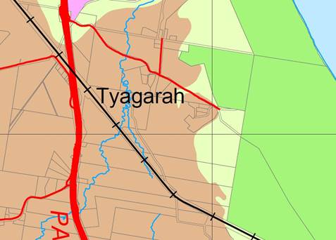
The impact on farmland will be that approximately
21 hectares will be lost from future production directly.
There will also be the potential for increased land use conflicts where the
proposed R5 land adjoins land that may be used for cattle or sugar cane
production at any time in the future. This may diminish the production
value of adjacent land. The Planning Proposal does not make any objective
assessment of the agricultural values of the land, suggesting it “does
not contain suitable topography or soil type”. However, no evidence
is provided to support this assertion. In relation to using regionally
significant farmland for rural residential development, the Northern
Rivers Farmland Protection Project states (page 27):
“Regionally significant
farmland cannot be considered for rural residential rezoning. The
only exception is where the land is identified in a council rural settlement
strategy which has been agreed to between December 1994 and December 2004 under
clause 20 of the North Coast Regional Environmental Plan (or placed on
public exhibition by the end of 2004 and subsequently approved). Councils
when preparing new rural residential settlement strategies cannot consider
regionally significant farmland for inclusion.”
On this basis, the subject land is not consistent with the
NSW State government position on regional farmland.
State Policy and Planning Controls
The Planning Proposal is generally consistent with the
applicable State Environmental Planning Policies. However, it is
inconsistent with SEPP 55 Remediation of Land and SEPP (Rural
Lands) 2008. The inconsistencies are as follows:
|
State Environmental Planning Policy (SEPP)
|
Compliance of Planning Proposal
|
|
SEPP 55 – Remediation of Land
|
A Preliminary Contamination Report has not been prepared
for the subject land. It is agreed that there is no recorded dip site
on the land, but no other information on land contamination is
supplied. Without this information, Council is not able to decide if
the land is contaminated from past use (and if it is contaminated, whether it
can be remediated). The Planning Proposal is inconsistent with this
SEPP and as the land is not within an agreed strategy, it is not appropriate
that such work be deferred until after the Gateway Determination.
|
|
SEPP (Rural Lands) 2008
|
The aims of this Policy are as follows:
(a) orderly
and economic use and development of rural lands,
(b) regard
to Rural Planning Principles and the Rural Subdivision Principles,
(c) to
implement measures designed to reduce land use conflicts,
(d) to
identify State significant agricultural land,
(e) to
amend provisions of other environmental planning instruments relating to
concessional lots in rural subdivisions.
No State significant agricultural land occurs on the
subject land. The Planning Proposal intends to create a new rural
residential area that will change both rural lot size and rural dwelling
permissibility. The Planning Proposal could have a significant impact
on surrounding rural land. The Planning Proposal is inconsistent with
this SEPP. Further detail is provided below under s117
Direction 1.5.
|
The Planning Proposal raises issues in relation to ten s117
Directions. It is inconsistent with seven of these directions as follows:
|
S117 Direction
|
Application
|
Relevance to this Planning Proposal
|
Consistency with Direction
|
|
1.2 Rural Zones
|
Applies when a relevant planning authority prepares a
planning proposal that will affect land within an existing or proposed rural
zone (including the alteration of any existing rural zone boundary).
Under this direction a planning proposal must:
(a) not rezone land from a rural
zone to a residential, business, industrial, village or tourist zone
(b) not contain provisions that
will increase the permissible density of land within a rural zone (other than
land within an existing town or village).
|
If the Planning Proposal were supported, approximately
21 hectares of the RU2 Rural Landscape (and Deferred Matter) land would
change to R5 Large Lot Residential zone. This is clearly inconsistent
with the objective of this direction to protect the agricultural production
value of rural land.
The applicant states that the Planning Proposal is
consistent because it complies with the draft Byron Rural Land Use
Strategy. There is no basis for this conclusion, as explained earlier
in this report.
The draft Byron Rural Land Use Strategy does not identify
the land which is the subject of this Planning Proposal and has not been
approved by the Director of the Department of Planning and Environment.
The Planning Proposal has not been justified by a study
prepared in support of it which gives consideration to the objectives of this
direction.
The Planning Proposal is not in accordance with the
relevant Regional Strategy (the FNCRS), prepared by the Department of
Planning and Environment, which gives consideration to the objective of this
direction.
This Planning Proposal is not of minor significance.
The inconsistency has not been justified.
|
Not Consistent
|
|
1.3 Mining, Petroleum Production and Extractive
Industries
|
Applies when a relevant planning authority prepares a
planning proposal that would have the effect of:
(a) prohibiting the mining of coal
or other minerals, production of petroleum, or winning or obtaining of
extractive materials, or
(b) restricting the potential
development of resources of coal, other minerals, petroleum or extractive
materials which are of State or regional significance by permitting a land
use that is likely to be incompatible with such development.
|
Rezoning an area of RU2 zoned land to R5 will prevent the
use of that part of the land for mining or extractive industry. State
government resource mapping shows that there is a significant unexploited
sand resource located south of the subject land. The buffer to this
extends into the 21 ha identified by the applicant as proposed rural
residential land.
The Planning Proposal would be incompatible with any
future extraction of this resource.
|
Not Consistent
|
|
1.4 Oyster Aquaculture
|
Applies when a relevant planning authority prepares any
planning proposal that proposes a change in land use which could result in:
(a) adverse impacts on a Priority
Oyster Aquaculture Area or a “current oyster aquaculture lease in the
national parks estate”, or
(b) incompatible use of land
between oyster aquaculture in a Priority Oyster Aquaculture Area or a
“current oyster aquaculture lease in the national parks estate”
and other land uses.
|
Priority Oyster Aquaculture Areas (POAA) exist in the
Brunswick River, however there is minimal likelihood that this Planning
Proposal will have adverse impacts on them if stormwater is dealt with
appropriately (should the development proceed).
|
Consistent
|
|
1.5 Rural Lands
|
Applies when:
(a) a relevant planning authority
prepares a planning proposal that will affect land within an existing or
proposed rural or environment protection zone (including the alteration of
any existing rural or environment protection zone boundary), or
(b) a relevant planning authority
prepares a planning proposal that changes the existing minimum lot size on
land within a rural or environment protection zone.
A planning proposal to which clauses (a) and (b)
apply must be consistent with the Rural Planning Principles listed in State
Environmental Planning Policy (Rural Lands) 2008.
A planning proposal to which clause (b) applies must
be consistent with the Rural Subdivision Principles listed in State
Environmental Planning Policy (Rural Lands) 2008.
|
This Planning Proposal will affect land zoned mostly RU2
and partly “deferred matter” under LEP 2014. It proposes to
rezone approximately 21 ha to R5 and alter the minimum lot size for the
subject land from 40 ha to approximately 0.2 ha.
It is inconsistent with the Rural Planning Principles
listed in State Environmental Planning Policy (Rural Lands) 2008 as
follows:
(a) the promotion and
protection of opportunities for current and potential productive and
sustainable economic activities in rural areas – removing
21 ha of agricultural land from production will reduce the opportunity
for farming on or adjacent to the land. It will also reduce the likelihood of
extractive industry on the adjacent resource.
(b) recognition of the
importance of rural lands and agriculture and the changing nature of
agriculture and of trends, demands and issues in agriculture in the area,
region or State – the planning proposal will directly affect
regionally significant agricultural land that is currently used for beef
cattle grazing.
(c) recognition of the
significance of rural land uses to the State and rural communities, including
the social and economic benefits of rural land use and development
– the Planning Proposal will take place on land that has for some time
been earmarked for rural tourism including a range of development approvals
for cabin development, restaurant, and a camping ground. These will be
lost to rural residential development if it proceeds.
(d) in planning for rural
lands, to balance the social, economic and environmental interests of the
community – there is insufficient information to gauge the social,
economic and environmental impacts of this Planning Proposal, both on and off
the subject land.
(e) the identification and
protection of natural resources, having regard to maintaining biodiversity,
the protection of native vegetation, the importance of water resources and
avoiding constrained land – the Planning Proposal does not include
an assessment of the remnant trees and scattered vegetation on the
site. There is no assessment of the accuracy of the wetland mapping and
no assessment of the grassland (eg for Hairy Joint Grass). There is no
slope analysis and no site-specific land contamination assessment.
(f) the provision of
opportunities for rural lifestyle, settlement and housing that contribute to
the social and economic welfare of rural communities – the subject
land is not located within any of the 16 urban and village catchments
identified by Council in the Shire. It does not relate directly to the
community title land sharing developments north of Grays Lane. It is
unlikely to contribute to the economic welfare of an identified rural
community.
(g) the consideration of
impacts on services and infrastructure and appropriate location when
providing for rural housing – the applicant is suggesting that
reticulated water and sewerage be supplied to about one hundred 0.2 ha
lots serviced by a sealed, flood-free access road. There is
insufficient detail to justify this level of services for low density rural
housing in this location. There is no assessment of the cost and
practicality of supplying this level of services to this location.
There is no consideration as to whether this is the best use of resources.
(h) ensuring consistency with
any applicable regional strategy of the Department of Planning or any
applicable local strategy endorsed by the Director-General – the
Far North Coast Regional Strategy applies to Byron Shire and this Planning
Proposal is not consistent with it. It is also inconsistent with the
Byron Rural Settlement Strategy 1998. It is also inconsistent with the
draft Byron Shire Rural Lands Strategy and the draft North Coast Regional
Plan.
The Planning Proposal is inconsistent with the Rural
Subdivision Principles listed in State Environmental Planning Policy
(Rural Lands) 2008 as follows:
(a) the minimisation of rural
land fragmentation – the existing 90 ha rural property is
proposed to be subdivided into 100 small lots and a residue. This
is inconsistent with this principle.
(b) the minimisation of rural
land use conflicts, particularly between residential land uses and other
rural land uses – the proposed small lots will be in proximity to a
range of existing and potential rural land uses including grazing, sugar
production or extractive industries. The potential for rural land use
conflicts will be significant if this land is used for rural residential
development.
(c) the consideration of the
nature of existing agricultural holdings and the existing and planned future
supply of rural residential land when considering lot sizes for rural lands
– the use of this land for rural residential purposes is not
consistent with the planned future supply of such land in Byron Shire.
(d) the consideration of the
natural and physical constraints and opportunities of land – a
constraints analysis has been supplied, however there is insufficient
information to be certain that the proposed rural residential development has
been located in response to the constraints and opportunities of the land.
(e) ensuring that planning for
dwelling opportunities takes account of those constraints – there
is insufficient information to be certain that the proposed rural residential
development will take account of all of the potential site constraints.
|
Not Consistent
|
|
2.1 Environment Protection Zones
|
A planning proposal must include provisions that
facilitate the protection and conservation of environmentally sensitive
areas.
A planning proposal that applies to land within an
environment protection zone or land otherwise identified for environment
protection purposes in a LEP must not reduce the environmental protection
standards that apply to the land (including by modifying development
standards that apply to the land).
This requirement does not apply to a change to a
development standard for minimum lot size for a dwelling in accordance with
clause (5) of Direction 1.5 “Rural Lands”.
|
Part of the 21 ha proposed for inclusion in the R5
zone in this Planning Proposal is currently zoned 7(b) Coastal Habitat
under LEP 1988.
The applicant states that the Planning Proposal is
consistent because the SEPP 14 wetlands on the site will be protected by
future E zones when they are introduced into Byron LEP 2014. There
is minimal ecological consideration of the area currently zoned
7(b) Coastal Habitat. The applicant has decided that it is a
mapping error.
The Planning Proposal has not been justified by a study
prepared in support of it which gives consideration to the objectives of this
direction.
The Planning Proposal is not in accordance with the
relevant Regional Strategy (the FNCRS), prepared by the Department of
Planning, which gives consideration to the objective of this direction.
The Planning Proposal is not of minor significance.
The inconsistency has not been justified.
|
Not Consistent
|
|
4.1 Acid Sulfate Soils
|
Applies when a relevant planning authority prepares a
planning proposal that will apply to land having a probability of containing
acid sulfate soils as shown on the Acid Sulfate Soils Planning Maps.
A council shall not prepare a draft LEP that proposes an intensification
of land uses on land identified as having a probability of containing acid
sulfate soils on the Acid Sulfate Soils Planning Maps unless the council has
considered an acid sulfate soils study assessing the appropriateness of the
change of land use given the presence of acid sulfate soils.
|
The 21 ha suggested for inclusion in the R5 zone
generally avoids the areas mapped as likely to contain acid sulfate soils.
Some land to which this Planning Proposal will apply may
be affected by acid sulfate soils. Council will consider acid sulfate
soils if it receives an application in this location for any intensive land
use (such as rural housing) in accordance with existing clause 6.1 of
Byron LEP 2014.
|
Consistent
|
|
4.3 Flood Prone Land
|
Applies when a relevant planning authority prepares a
planning proposal that creates, removes or alters a zone or a provision that
affects flood prone land.
A planning proposal must include provisions that give
effect to and are consistent with the NSW Flood Prone Land Policy and the
principles of the Floodplain Development Manual 2005 (including the Guideline
on Development Controls on Low Flood Risk Areas).
A planning proposal must not rezone land within the flood
planning areas from Special Use, Special Purpose, Recreation, Rural or
Environment Protection Zones to a Residential, Business, Industrial, Special
Use or Special Purpose Zone.
A planning proposal must not contain provisions that apply
to the flood planning areas which:
(a) permit development in floodway
areas,
(b) permit development that will
result in significant flood impacts to other properties,
(c) permit a significant increase
in the development of that land,
(d) are likely to result in a
substantially increased requirement for government spending on flood
mitigation measures, infrastructure or services, or
(e) permit development to be
carried out without development consent except for the purposes of
agriculture (not including dams, drainage canals, levees, buildings or
structures in floodways or high hazard areas), roads or exempt development.
A planning proposal must not impose flood related
development controls above the residential flood planning level for
residential development on land, unless a relevant planning authority
provides adequate justification for those controls to the satisfaction of the
Director-General (or an officer of the Department nominated by the
Director-General).
|
The 21 ha suggested for inclusion in the R5 zone
generally avoids the areas mapped by Council as flood prone land.
No assessment has been made of the flood affected Grays
Lane, which is the main access to the subject land.
Should any development in flood prone areas be
contemplated, the provisions of existing clause 6.3 of Byron LEP 2014
will apply at development stage.
|
Consistent
|
|
4.4 Planning for Bushfire Protection
|
Direction applies to a planning proposal on land mapped as
bushfire prone land.
Council must consult with the NSW Rural Fire Service.
Council must have regard to Planning for Bushfire
Protection 2006.
Must introduce controls that avoid placing inappropriate
development in hazardous areas.
|
The Planning Proposal does not include a bushfire
assessment of the subject land. Council’s 2008 bushfire prone
land mapping has been used to identify hazard areas and buffers, but there is
no evidence of ground-truthing this information. In the absence of
site-specific information, it should be assumed that the Planning Proposal is
not compliant with this Direction.
|
Not Consistent
|
|
5.1 Implementation of Regional Strategies
|
Planning proposals must be consistent with a regional
strategy released by the Minister for Planning.
|
The Planning Proposal is inconsistent with a key aspect of
the Far North Coast Regional Strategy (FNCRS).
Pages 28 and 30 of the FNCRS state that “no
further rezoning for rural residential development (other than land in an
approved land release strategy) will be permitted in the Coastal
Area”. The Coastal Area is defined as that land east of the
Pacific Highway and includes the subject land. The subject land is not
identified in the Byron Rural Settlement Strategy 1998. This remains as
the only agreed rural residential strategy for Byron Shire.
|
Not Consistent
|
|
5.3 Farmland of State and Regional Significance on
the NSW Far North Coast
|
The planning proposal must not rezone land mapped as State
or regionally significant farmland under the Northern Rivers Farmland
Protection Project for urban or rural residential use.
|
Most of the 21 ha suggested for inclusion in the R5
zone is identified as regionally significant farmland under the Northern
Rivers Farmland Protection Project and sits outside any of the identified
“town and village growth boundary” areas of the FNCRS.
The [relevant] objectives of this Direction are:
(a) to ensure that the best
agricultural land will be available for current and future generations to
grow food and fibre,
(c) to reduce land use conflict
arising between agricultural use and non-agricultural use of farmland as
caused by urban encroachment into farming areas.
This Planning Proposal does not meet the above objectives
because it will use regionally significant farmland for rural residential
development and will increase the potential for land use conflict with
remaining agricultural land use in the locality.
|
Not Consistent
|
The applicant has failed to
address the inconsistency with the following section 117 Directions:
Direction 1.2 – Rural Zones
1.3 – Mining, Petroleum
Production and Extractive Industries
1.5
– Rural Lands
2.1 – Environment
Protection Zones
4.4 – Planning for Bushfire
Protection
5.1
– Implementation of Regional Strategies
5.3
– Farmland of State and Regional Significance on the NSW Far North Coast.
It is not appropriate that the inconsistencies be addressed
post-Gateway Determination. The inconsistencies are sufficient to warrant
that the Planning Proposal be refused.
Council staff initially advised the
applicant that it would not support the planning proposal due to the inconsistencies
with both Council and state government planning strategies, by letter dated 20
May 2016. Council staff also attended a site inspection with the applicant on
14 June 2016 where the inconsistencies were discussed. Staff recommended that
the Planning Proposal be withdrawn but the applicant has requested that it be
reported to Council for determination.
Options to Move Forward
There are a number of options open to Council on this
matter:
1. Proceed to a Gateway
Determination with the proponent’s Planning Proposal (Attachment 1)
2. Proceed to a Gateway
Determination with an amended Planning Proposal
3. Not proceed with the
Planning Proposal.
Conclusion
The Planning Proposal attached to this report which has been
prepared by the applicant, is not suitably supported by studies or other
relevant information. It is inconsistent with a range of State and
Council strategies and policies, and therefore does not have sufficient
planning merit to be supported.
It is recommended that Council not proceed with this
Planning Proposal to amend Byron LEP 2014 (and Byron LEP 1988) to apply the
R5 Large Lot Residential zone over approximately 21 hectares of land
at Tyagarah.
Financial Implications
If Council chooses to proceed with the Planning Proposal, it
is able to fully recover the processing costs for an applicant-initiated LEP
amendment. Council has already received an amount from the applicant to
cover initial costs associated with preparing this Council report. If the
Planning Proposal is to proceed through the Gateway Determination process then
full cost recovery of the remaining stages will be required by Council.
If Council chooses not to proceed then the matter does not incur any additional
costs.
Statutory and Policy Compliance Implications
The relevant policy considerations are addressed in this
report.
Staff Reports - Sustainable Environment and Economy 13.10
Report No. 13.10 PLANNING
- Section 96 application 10.2014.230.2 to amend conditions of approval relating
to operation of a Rural Tourist Facility (wedding centre) at 440 Bangalow Road
Talofa
Directorate: Sustainable
Environment and Economy
Report
Author: Rob Van
Iersel, Consultant Planner
Shannon Burt, Director Sustainable
Environment and Economy
File No: I2016/748
Theme: Ecology
Development and Approvals
Proposal:
|
Proposed modification:
|
S96 to Modify Conditions 41(f), 42, 43 and 45 relating
to the Operation of the Rural Tourist Facility
|
|
Original Development:
|
Alteration/Additions to existing dwelling and use as a
rural tourist facility for the purposes of holding weddings and providing
holiday accommodation for up to 12 occupants
|
|
Type of S.96 sought:
|
S96(2) Other modification
|
|
Property description:
|
LOT: 2 DP: 1071115
|
|
440 Bangalow Road TALOFA
|
|
Parcel No/s:
|
239328
|
|
Applicant:
|
Newton Denny Chapelle
|
|
Owner:
|
Bandora Holdings Pty Ltd
|
|
Zoning:
|
Zone No. RU2 Rural Landscape
|
|
S96 date received:
|
15 March 2016
|
|
Original DA determination date:
|
13 October 2014
|
|
Integrated Development:
|
No
|
|
Public notification or exhibition:
|
- Level
1 advertising under DCP 2014 Part A14 – Public Notification and
Exhibition of Development Applications
- Exhibition period: 30
March 2016 to 12 April 2016
- Submissions: For
0 Against 4
|
|
Issues:
|
· Acoustic
impacts (noise and disturbance)
|
Summary:
The existing development consent
allows the use of an existing dwelling for a maximum of 26 weddings per year,
with on-site accommodation for a maximum of 12 guests. Conditions apply
limiting the maximum number of marque and in house weddings, and establishing
the maximum monthly frequency of the events.
The current application seeks to modify the development
consent by amending four conditions of the approval, as follows:
· Condition
41(f) – modify such that private fireworks would not be permitted under
any circumstances;
· Condition
42 – modify the approved frequency of weddings – existing condition
includes a limitation of a total of 3 weddings per calendar month –
proposed to change to limit of 2 weddings per month for 7 months of the year
(January, February, June, July, August, November and December); with 4 weddings
per calendar month for the months of March, April, May, September and October
(no change proposed to total number of weddings allowed per year);
· Condition
43 – modify the finishing times for weddings, to have all amplified music
finishing at 10pm; all amplified announcements within the marquee finishing at
9.30pm; and all guests to have left the site by 10.30pm; and
Condition 45 – modify the condition so that marquees
are removed from site the first working day after the wedding, rather than the
day immediately after the wedding.
NOTE TO COUNCILLORS:
In accordance with the
provisions of S375A of the Local Government Act 1993, a Division is to be
called whenever a motion for a planning decision is put to the meeting, for the
purpose of recording voting on planning matters. Pursuant to clause 2(a)
under the heading Matters to be Included in Minutes of Council Meetings of
Council's adopted Code of Meeting Practice (as amended) a Division will be
deemed to have been called by the mover and seconder of all motions relating to
this report.
|
RECOMMENDATION:
That pursuant to
Section 96 of the Environmental Planning & Assessment Act 1979,
application no. 10.2014.230.2 to
modify Conditions 41(f), 42, 43 and 45 relating to the Operation of the Rural
Tourist Facility, be approved by modifying development consent 10.2014.230.1 as outlined in Attachment 1.
|
Attachments:
1 10.2014.230.2
Modified Conditions of Consent, E2016/54308
2 Current
Consent 10.2014.230.1, E2016/54323
3 Confidential
- 10.2014.230.2 Submissions, E2016/54257
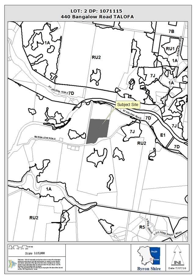
Assessment:
1. INTRODUCTION
1.1 Details
of approved development and any subsequent modifications
Development consent 10.2014.230.1 was issued on 13 October
2014 and approved the use of a rural dwelling as a wedding venue, with
accommodation for up to 12 guests.
The approval provides for a maximum of 26 weddings per year,
and allows for “marquee weddings”, where a 200m2 marquee
is erected temporarily on a level pad to the north-west of the dwelling, and
“in house” weddings, which are conducted within the pool area
directly adjacent to the dwelling.
Condition 42, in addition to limiting the total number of
weddings to 26 per annum, also imposes a limit of:
· 13 marquee
weddings per year;
· a maximum of 2
marquee weddings in any one calendar month; and
· a maximum of 3
weddings, in total, in any one calendar month.
The original application attracted six objections, from
owners of adjacent and nearby properties, and the approval was subsequently
challenged in the Land & Environment Court by one of those objectors.
The legal challenge was dismissed on 7 December 2015, but has been
appealed. The appeal is not yet finalised.
1.2 Section
96 modifications sought
The application proposes the following amendments to
conditions of approval:
1. Condition 41(f)
Current Condition:
No private fireworks displays are permitted unless
conducted by a licensed pyrotechnician under the Explosives Regulation 2013 and
in strict compliance with all NSW Workcover Authority requirements.
Neighbours with domestic pets or animals likely to be affected by the loud
noise from fireworks shall be notified at least 24 hours before any private
fireworks event so that they can make appropriate alternative arrangements.
Proposed Condition:
No private fireworks displays are permitted on the site
in association with the Rural Tourist Facility.
The applicant advises that there is no intention for
fireworks associated with the site use.
2. Condition 42
Current
Condition:
The number of weddings are limited to twenty six (26)
per year with no more than thirteen (13) marquee weddings per year. No more
than 2 marquee weddings to be held in any calendar month, and no more than 3
weddings in total to be held in any calendar month.
Proposed Condition:
The number of weddings is limited to twenty six (26)
per year with no more than thirteen (13) marquee weddings per year. No
more than 2 marquee weddings to be held in any calendar month. For the
months of January, February, June, July, August, November and December no more
than 2 weddings are to be held in any calendar month. During the months
of March, April, May, September and October no more than 4 weddings are to be
held in any calendar month.
The applicant advises that the modification is requested to
enable the facility to better address the seasonal nature of weddings in the
locality.
As proposed, the modification makes no change to:
§ the total number of weddings
allowed per annum – maximum of 26;
§ the maximum number of marquee
weddings allowed – 13 per annum; and
§ the maximum number of marque
weddings allowed in any calendar month – 2.
What it proposes to change is the monthly frequency of
weddings. The approval currently allows no more than 3 weddings (in
total) in any month. The change would reduce the allowable number of
weddings from 3 to 2 for the 7 nominated months of the year, and increase the
allowable number from 3 to 4 for the nominated 5 months of the year.
3. Condition 43
Current
Condition:
For marquee weddings, all amplified music from Bands,
DJ’s and the like to cease by 9.30pm with all guests (except those
staying on the premises) to have left the site by 10.30pm. For in house
weddings, amplified music to cease by 10pm and all guests (except those staying
on the premises) to have left the site by 10.30pm.
Proposed Condition:
All amplified music (including bands, DJs and the like)
is to occur in the pool area and is to cease by 10pm. All guests (except
those staying on the premises) are to have left the site by 10.30pm. For
marquee weddings, all amplified announcements in the marquee are to cease at
9.30pm.
The original consent sought to differentiate between
amplified music within a marquee and that from an in house wedding (i.e. where
no marque is used).
The applicant states that all amplified music occurs within
the pool area of the existing dwelling, regardless of whether it is a marque
wedding or an in house wedding. The modification therefore seeks to
impose one finishing time for amplified music for all weddings, and the later
time of 10pm is proposed.
The proposed modification notes that amplified announcements
(speeches and the like) will occur within the marquee, and proposes that these
would finish at 9.30pm.
No change is proposed to the time by which guests not
staying at the premises are to leave the site.
4. Condition 45
Current
Condition:
Marquees are to be erected for no more than four days
in a row, and are to be removed the day after the wedding.
Proposed Condition:
Marquees are to be erected for no more than four days
in a row, and are to be removed the first ‘standard’ working day
following the event.
The applicant notes that most weddings occur on a Friday or
Saturday night, and that the current wording requires removal of the marquee on
a Sunday, when those responsible for the removal are not working.
No change is proposed to the maximum number of days a
marquee can be erected, but the modification to ‘standard working
day’ rather than the ‘day after the event’ reflects general
working conditions.
1.3 Section
96(2) Modifications
A consent authority may, on application being made by the
applicant or any other person entitled to act on a consent granted by the
consent authority and subject to and in accordance with the regulations, modify
the consent if:
(a) it
is satisfied that the development to which the consent as modified relates is
substantially the same development as the development for which consent was
originally granted and before that consent as originally granted was modified
(if at all),
Assessment: The changes proposed primarily
modify the monthly frequency of weddings. There is no change to the
maximum number of weddings allowed per annum, nor a change to the maximum
number of marquee weddings.
Given the nature of the modifications sought, it is
considered that the development as modified will be substantially the same as
that originally approved.
(b) it
has consulted with the relevant Minister, public authority or approval body
(within the meaning of Division 5) in respect of a condition imposed as a
requirement of a concurrence to the consent or in accordance with the general
terms of an approval proposed to be granted by the approval body and that
Minister, authority or body has not, within 21 days after being consulted,
objected to the modification of that consent,
Assessment: There were no public authority
referrals required for the original application.
(c) it
has notified the application in accordance with:
(i) the
regulations, if the regulations so require, or
(ii) a
development control plan, if the consent authority is a council that has made a
development control plan that requires the notification or advertising of
applications for modification of a development consent, and
Assessment: Level 1 advertising was undertaken
in accordance with DCP 2014 Part A14 – Public Notification and Exhibition
of Development Applications.
(d) it
has considered any submissions made concerning the proposed modification within
the period prescribed by the regulations or provided by the development control
plan, as the case may be.
Assessment: All submissions have been
considered. See Section 3.6 of this report.
3) In determining an
application for modification of a consent under this section, the consent
authority must take into consideration such of the matters referred to in
section 79C (1) as are of relevance to the development the subject of the
application.
Assessment: See Section 3 of this report.
2. SUMMARY
OF REFERRALS
|
|
Summary of Issues
|
|
Environmental Health Officer
|
See comments below
|
|
Development Engineer
|
Referrals not required for this application
|
|
Water & Waste Services
|
|
Building Surveyor
|
|
Fire Control Officer
|
|
Tree Preservation Officer
|
|
Government Authorities
|
Environmental Health Officer:
The original development
application was subject to detailed assessment by Council’s Environmental
Health officer, including a review by the (then) Team Leader, Environmental
Services.
These assessments were instrumental in the negotiations of
conditions for the consent in regard to noise issues, resulting in limitation
on the number, type and frequency of weddings. Given that the proposed
modifications will not change the key parameters of maximum number of weddings
and maximum number of marquee weddings, formal referral of the application to
Council’s Environmental Health Officer has not been undertaken.
3. SECTION
79C – MATTERS FOR CONSIDERATION – DISCUSSION OF ISSUES
Having regard for the matters for consideration detailed in
Section 79C(1) of the Environmental Planning & Assessment Act 1979, the
following is a summary of the evaluation of the issues.
3.1. STATE/REGIONAL
PLANNING POLICIES AND INSTRUMENTS
No change to assessment of the original development application
10.2014.230.1, where no relevant state or regional planning issues were
identified.
3.2. BYRON
LOCAL ENVIRONMENTAL PLAN 2014
The original development application was assessed under the
provisions of Byron LEP 1988, which was in place at the time that the
application was lodged. The proposal met the definition of “rural
tourist facility”, which was a permissible land use in the 1(a) General
Rural Zone. [Note: This was a central issue of contention in the
subsequent Land and Environment Court case, Roden v Bandora Holdings Pty Ltd,
and the Court found that “the approved development meets the definition
of a “rural tourist facility” and is permissible in the 1(a)
General Rural Zone”.]
Pursuant to Byron LEP 2014, the site is zoned RU2 Rural
Landscape Zone. Under Byron LEP 2014, the development would fall within
the definition of function centre, which is a prohibited development in
the RU2 Zone.
A function centre is defined as “a building or
place used for the holding of events, functions, conferences and the like, and
includes convention centres, exhibition centres, and reception centres, but
does not an entertainment facility”.
Notwithstanding this, the development is approved under
Byron LEP 1988, and the applicant is entitled, pursuant to Section 96 of the
Act, to apply to modify that consent. In considering this request,
Council should be satisfied that, although prohibited under Byron LEP 2014, the
proposal is not inconsistent with the objectives of the RU2 zone, and that it
would not undermine the planning intent of relevant controls with LEP 2014.
The RU2 Zone objectives state:
§ To encourage sustainable primary
industry production by maintaining and enhancing the natural resource base.
§ To maintain the rural landscape
character of the land.
§ To provide for a range of
compatible land uses, including extensive agriculture.
§ To enable the provision of
tourist accommodation, facilities and other small-scale rural tourism uses
associated with primary production and environmental conservation consistent
with the rural character of the locality.
§ To protect significant scenic
landscapes and to minimise impacts on the scenic quality of the locality.
The assessment of the original application considered these
objectives, as LEP 2014 was an exhibited draft at the time that the application
was lodged. That assessment concluded:
the limited number of events
proposed and the conditions of consent to restrict marquee events, hours of
operation, number of weddings per month and amplified music the development is
considered to be not antipathetic with, or hostile to the RU2 Zone
objectives or the objectives under Clause 6.8 and will not detract from the
achievement of those objectives nor undermine the planning intent of the
controls contained within that plan. The proposal is considered to be
satisfactory.
The current modification proposes a change to the permitted
frequency of weddings, but otherwise retains the key restrictions imposed on
the original consent. It is considered, therefore, that the modification
as proposed does not alter the conclusion of the original assessment.
Draft EPI that is or has been
placed on public exhibition and details of which have been notified to the
consent authority - Issues
No draft EPIs affect the proposal.
3.3 DEVELOPMENT
CONTROL PLANS
Development Control Plan 2014
|
Development Control Requirement
|
Requirement
|
Complies?
|
|
Part
B Controls Applying Generally to Development Application
|
|
B3 & B4:
Services & Vehicle
parking
|
The proposed modification do
not generate any additional demands for services or car parking
|
Yes
|
|
B6 Buffers and Minimising Land
Use Conflict
|
See submissions below.
Operation of the approved development has resulted in allegations of land use
conflict associated with disturbance for adjoining properties from noise at
weddings on the site.
The
conditions of approval relating to the number and frequency of weddings were
intended to address the potential for these conflicts.
Allegations
of non-compliance with conditions are being addressed separately to this
assessment.
The proposed
modifications will not alter the key restrictions, being the limitation on
the total number of weddings, the limit on the total number of marquee
weddings, and the limit on the number of marque weddings in any calendar
month.
The proposed
change to frequency of weddings would result in a reduction of the maximum
monthly allowance for seven (7) months of the year, with an increase in
frequency for the remaining five (5) months.
It should be
noted that the monthly maximum allowances are not able to be achieved for
every calendar month, as that would result in substantially more that the
total annual allowance (i.e. total annual allowance: 26 weddings; total
annual number of weddings if current maximum monthly allowance could be
achieved: 36 weddings).
The proposed
modification will result in one four month period and one three month period
of reduced wedding frequency (i.e. ‘out of season’).
As modified,
the maximum monthly allowance could not be achieved for every calendar month,
as that would exceed the annual maximum allowance of 26 weddings in total.
It is
therefore more likely that, as a result of the modification, in the
‘out of season’ periods, there could be more weekends where there
is no activity, providing potential for an increased ‘reprieve’
for adjoining land owners.
This is
balanced by the potential for a greater frequency of weddings in the shorter
‘wedding season’ period.
Overall, it
is considered that the proposed modifications provide a slightly better
outcome in terms of potential land use conflicts.
|
Yes
|
|
Chapter
D3 Tourist Accommodation
|
|
D3.2.3 Character and Design
in Rural Zones
|
Relevant
performance criteria:
Tourist accommodation
development in Zones RU1 and RU2 must be compatible in character and amenity
with the surrounding rural and natural landscape, and with development in the
locality.
The
development is not primarily for the purpose of tourist accommodation.
Nonetheless, the assessment above concludes that the proposed modifications
will not result in any significant change to character of the approved
development, in terms of the amenity of the area.
All
development to which this Chapter applies in Rural Zones must be low scale
consistent with the relevant Aims, Guiding Principles, Best Practice
Guidelines and Performance Standards contained in the Byron Rural Settlement
Strategy 1998
The proposed
modifications do not change the scale of the approved development.
|
Yes
|
3.4 The likely impacts of that
development, including environmental impacts on both the natural and built
environments, and social and economic impacts in the locality
The modifications as proposed are not likely to result in
any significant alteration to the environmental, economic or social impacts
associated with the approved development.
In effect, the changes are likely to result in a slight
improvement in social outcomes, providing an increased number of times within
seven calendar months where there is no wedding activity.
3.5 The
suitability of the site for the development
The approval of the original application determined that the
site was suitable for the development as proposed. The proposed
modifications do not alter that conclusion.
3.6 Submissions
made in accordance with this Act or the regulations
The application was notified in accordance with Level 1
notification procedure from DCP 2014 Part A14 - Public Notification and
Exhibition of Development Applications from 30 March to 12 April 2016.
Council’s records indicate that a total of four (4) submissions were
received. Following is a summary of the matters raised in the
submissions.
|
Summary of issue/ matter raised
|
Comment
|
|
Support for strengthening of condition prohibiting
fireworks.
|
Noted
|
|
The proposed changes are about making sure that they gain
additional weddings in any one year.
|
The changes as proposed will not achieve any increase in
allowable weddings per annum.
|
|
By allowing additional weddings in summer and longer hours
for music they are ensuring that the venue will be more appealing to more
clients; hence more weddings in any one year.
|
See above – no changes to allowable wedding per
annum.
See assessment below regarding
amplified music hours – it is proposed the ‘earlier’
finishing time of 9.30pm, which currently applies to amplified music within a
marquee, should be applied to all weddings.
|
|
There is a pattern of non-compliance with a number of
existing conditions.
|
Investigation of alleged non-compliance has commenced, but
will await the outcome of current legal action.
|
|
Original conditions were subject of detailed assessment
and should not be ‘watered down’.
|
As described in this report, it is considered that the
modifications proposed in this application do not weaken the conditions, in
that the key parameters of limits on total number of weddings; limit on total
number of marquee weddings; and limit on monthly number of marquee weddings,
will not be changed, and the finishing time for amplified music will be
earlier.
|
|
“Peak season: (i.e. the five month proposed for
increased frequency) coincide with warmer weather. This will impact on
ability for neighbours to enjoy outdoor spaces at their properties.
|
This is not the case.
The five months proposed for increased frequency are March, April, May,
September and October, which are in Autumn and Spring.
In any case, the increase in frequency in these months is
offset by a decrease in wedding frequency in the remaining seven months of
the year, which includes the summer period
|
|
Noise from marque events is currently
‘controlled’ by a finishing time of 9.30pm for amplified
music. Council should not allow a change in this time.
|
The applicant advises that
amplified music is never located within the marque, but occurs adjacent to
the pool area at the dwelling. For in house weddings, the current
condition allows music to go to 10pm, and the applicant suggests that this
later date should apply to all weddings.
Notwithstanding the location
of the band or DJ on site, it is clear from submissions received that
amplified music can be audible outside the site.
It is considered that 9.30pm
is a reasonable time for amplified music to finish. Imposing this
earlier time for amplified music for all events also provides a balance to
the increased frequency of weddings for five months.
|
|
Rural Tourist Facility now a prohibited land use in Byron
LEP 2014
|
See Section 3.2 above –
DA 10.2014.230.1 was approved under the provisions of Byron LEP 1988, where
Rural Tourist Facility was a permissible use.
The modification as proposed
is not inconsistent with the objectives of the RU2 zone or other controls in
Byron LEP 2014.
|
|
Current use of the land is not consistent with the
objectives of the Environmental Planning and Assessment Act – does not
promote ‘social and economic welfare of the community’ or
‘encourage the promotion and co-ordination of the orderly and economic
use and development of land’.
|
This submission is made in
relation to allegations that the current activities have a detrimental impact
on the amenity of adjoining land.
This issue is addressed above
and in the body of this report.
|
|
Modification of the consent is not in the public interest.
|
As above.
|
3.7 Public
interest
The submissions raised a number of ‘public
interest’ issues. It is considered that the proposed modification
is acceptable in terms of the public interest, subject to an adjustment to the
condition relating to finishing times for amplified music, such that all music
is finished by 9.30pm.
4. DEVELOPER
CONTRIBUTIONS
4.1 Water
& Sewer Levies
No change to previous assessment.
4.2 Section
94 Contributions
No change to previous assessment.
5. CONCLUSION
The application proposes to change a number of conditions,
as discussed below:
1. Condition 41(f)
Current Condition:
No private fireworks displays are permitted unless
conducted by a licensed pyrotechnician under the Explosives Regulation 2013 and
in strict compliance with all NSW Workcover Authority requirements.
Neighbours with domestic pets or animals likely to be affected by the loud
noise from fireworks shall be notified at least 24 hours before any private
fireworks event so that they can make appropriate alternative arrangements.
Proposed Condition:
No private fireworks displays are permitted on the site
in association with the Rural Tourist Facility.
The proposed modification is supported, as it results in a
total prohibition of fireworks.
2. Condition 42
Current
Condition:
The number of weddings are limited to twenty six (26)
per year with no more than thirteen (13) marquee weddings per year. No more
than 2 marquee weddings to be held in any calendar month, and no more than 3
weddings in total to be held in any calendar month.
Proposed Condition:
The number of weddings is limited to twenty six (26)
per year with no more than thirteen (13) marquee weddings per year. No
more than 2 marquee weddings to be held in any calendar month. For the
months of January, February, June, July, August, November and December no more
than 2 weddings are to be held in any calendar month. During the months
of March, April, May, September and October no more than 4 weddings are to be
held in any calendar month.
The proposed change is supported, as it retains the import
limitations of:
§ the total number of weddings
allowed per annum – maximum of 26;
§ the maximum number of marquee
weddings allowed – 13 per annum; and
§ the maximum number of marque
weddings allowed in any calendar month – 2.
The proposed change to frequency
of weddings would result in a reduction of the maximum monthly allowance for
seven (7) months of the year, with an increase in frequency for the remaining
five (5) months.
It should be noted that the
monthly maximum allowances are not able to be achieved for every calendar
month, as that would result in substantially more that the total annual allowance
(i.e. total annual allowance: 26 weddings; total annual number of weddings if
current maximum monthly allowance could be achieved: 36 weddings).
The proposed modification will
result in one four month period and one three month period of reduced wedding
frequency (i.e. ‘out of season’).
As modified, the maximum monthly
allowance could not be achieved for every calendar month, as that would exceed
the annual maximum allowance of 26 weddings in total.
It is therefore more likely
that, as a result of the modification, there could be more weekends in the
‘out of season’ periods where there is no activity, providing
potential for an increased ‘reprieve’ for adjoining land
owners.
This is balanced by the
potential for a greater frequency of weddings in the shorter ‘wedding
season’ period.
Overall, it is considered that the proposed modifications
provide a slightly better outcome in terms of potential land use conflicts.
3. Condition 43
Current
Condition:
For marquee weddings, all amplified music from Bands,
DJ’s and the like to cease by 9.30pm with all guests (except those
staying on the premises) to have left the site by 10.30pm. For in house
weddings, amplified music to cease by 10pm and all guests (except those staying
on the premises) to have left the site by 10.30pm.
Proposed Condition:
All amplified music (including bands, DJs and the like)
is to occur in the pool area and is to cease by 10pm. All guests (except
those staying on the premises) are to have left the site by 10.30pm. For marquee
weddings, all amplified announcements in the marquee are to cease at 9.30pm.
The original consent sought to differentiate between
amplified music within a marquee and that from an in house wedding (i.e. where
no marque is used). The applicant states, however, that all amplified
music occurs within the pool area of the existing dwelling, regardless of
whether it is a marque wedding or an in house wedding. The imposition of
one finishing time for amplified music for all weddings is supported, but it is
considered that the earlier time of 9.30pm should apply to ensure that
potential conflicts with neighbours are minimised.
4. Condition 45
Current
Condition:
Marquees are to be erected for no more than four days
in a row, and are to be removed the day after the wedding.
Proposed Condition:
Marquees are to be erected for no more than four days
in a row, and are to be removed the first ‘standard’ working day
following the event.
The change can be supported, particularly as the total
number of days (four) remains unchanged.
Staff Reports - Sustainable Environment and Economy 13.11
Report No. 13.11 PLANNING
- Submissions Report - 26.2014.7.1 - Planning Proposal for Housekeeping Minor
Amendments to Byron LEP 2014
Directorate: Sustainable
Environment and Economy
Report
Author: Fiona
Sinclair, Planner
File No: I2016/749
Theme: Ecology
Planning Policy and Natural Environment
Summary:
This report presents the
outcomes of the public exhibition of a Council initiated Planning Proposal to
undertake a number of minor ‘housekeeping’ amendments to Byron
Local Environmental Plan (LEP) 2014.
The Planning Proposal (included
as Attachment 1) received a positive Gateway determination from the Department
of Planning and Environment and was placed on public exhibition for a period of
14 days from 5 to 19 May 2016. Two submissions, raising two issues, were
received during the public exhibition period. The issue of reviewing dual
occupancy lot sizes will be considered as part of the Residential Strategy and
the second issue acknowledges the importance of an existing heritage item.
This report recommends that
Council proceed with the planning proposal without amendment.
The Minister for Planning and
Environment has issued an authorisation for Council to exercise delegation to
make this LEP amendment should Council decide to proceed with it.
NOTE TO COUNCILLORS:
In accordance with the
provisions of S375A of the Local Government Act 1993, a Division is to be
called whenever a motion for a planning decision is put to the meeting, for the
purpose of recording voting on planning matters. Pursuant to clause 2(a)
under the heading Matters to be Included in Minutes of Council Meetings of
Council's adopted Code of Meeting Practice (as amended) a Division will be
deemed to have been called by the mover and seconder of all motions relating to
this report.
|
RECOMMENDATION:
That
Council
1. Forward
the planning proposal to amend Byron LEP 2014, as exhibited and included in
Attachment 1 of this report, to NSW Parliamentary Counsel’s Office
requesting that a draft LEP instrument be prepared.
2. Liaise
with Parliamentary Counsel’s Office (PCO) as necessary to finalise the
content of the draft LEP and to enable PCO to issue an Opinion that the plan
can be made.
3. Make
the draft LEP under delegated authority and forward the plan to the NSW
Department of Planning and Environment for notification on the NSW Government
legislation website.
|
Attachments:
1 Planning
Proposal for Housekeeping Minor Amendments to Byron LEP 2014, E2016/27775
2 Confidential
- 26.2014.7.1 Submissions , E2016/54180
3 Form of
Special Disclosure of Pecuniary Interest, E2012/2815
Report
At its meeting of 30 October 2014, Council resolved to initiate a
planning proposal to undertake a number of ‘housekeeping’
amendments to the Byron Local Environmental Plan (LEP) 2014:
14-509
Resolved:
1. That a minor
corrections and amendments planning proposal be prepared that seeks to amend
Byron LEP in the manner set out in Table 1 of this report (#E2014/66629).
2. That the
General Manager (or delegate of his choice) be delegated the authority to
include additional non-policy amendments in the planning proposal (not already
identified in this report) for minor corrections and amendments to Byron LEP
2014.
3. That the
General Manager (or delegate of his choice) be delegated the authority to assume
the role of the ‘relevant planning authority’ pursuant to the
Environmental Planning & Assessment Act 1979 in relation to preparation and
finalisation (whether Council has delegated authority to make the plan or not)
of any other planning proposals consisting of non-policy matters such as
corrections and consequential and/or minor amendments; and that Council be
advised of any such amendments made under delegated authority.
Council
prepared the Planning Proposal which involves twenty-one different amendments
to the Byron LEP 2014, in order to correct minor errors in maps and written
provisions that have been identified since the instrument came into effect in July 2014. All
the proposed amendments are minor in nature and are not policy related.
The Planning Proposal (refer
Attachment 1) received a positive Gateway determination from the Department of
Planning and Environment on 27 August 2016 and, in accordance with the gateway
requirements, was placed on public exhibition for a period of 14 days from 5 to
19 May 2016.
A total of two submissions were
received during the public exhibition period. Each submission is
summarised in the table below with a response from Council staff on the matters
raised:
|
No.
|
Summary of submission
|
Staff Comments
|
|
|
Relates to Item 1 in the
Planning Proposal - I would like to draw your attention to Table 1 item 1
24 Mill Street Mullumbimby because this house is a fine example of a heritage
item and should remain in the Heritage precinct once the E3 zone is worked
out.
|
No changes are proposed to the
heritage precinct. 24 Mill Street, Mullumbimby will remain as a listed
heritage item in Schedule 5 of Byron LEP 2014.
|
|
|
Relates to Item 17 in the
Planning Proposal - Item #17 relates to the need to correct a
typographical error in Clause 4.1E of the published version of the LEP
that referred to ‘Zone RU2 Rural Landscape’ instead of
‘Zone R2 Low Density Residential’. Although this
was clearly a typographical error and is in need of correction the proposed
800sqm minimum lot size for ‘attached dual occupancies’ deserves
reconsideration for the following reasons;
· Attached
dual occupancies are able to maintain a lower scale character than detached
dual occupancies (one structure per lot Vs several), as such, it stands to
reason that the minimum lot size for an attached dual occupancy should be
smaller than that of a detached dual occupancy (i.e. 600sqm for attached and
800sqm for detached).
· Attached
dual occupancies can provide additional housing within existing urban areas
and reduce demand on greenfield expansion, without compromising low scale
built form and maintaining high levels of amenity.
· Attached
dual occupancies can provide more affordable housing and represents a good
example of the 'economic use and
development of land'.
|
The most appropriate minimum
lot size for dual occupancy developments will be considered as part of the
new residential strategy currently being prepared.
|
Recommendation
It is recommended that Council proceed with this planning
proposal without amendment.
Financial Implications
As a Council initiated planning proposal the costs for staff
time in preparing and processing the planning proposal will be met by Council.
Statutory and Policy Compliance Implications
Council has followed the
statutory process to amend Byron LEP 2014 through this planning proposal.
Council should now decide whether to proceed to finalise the planning proposal
(either with or without amendments).
Staff Reports - Sustainable Environment and Economy 13.12
Report No. 13.12 Mullumbimby
Masterplan Project Plan
Directorate: Sustainable
Environment and Economy
Report
Author: Tara
McGready, Senior Planner
File No: I2016/754
Theme: Ecology
Planning Policy and Natural Environment
Summary:
Council established a PRG to develop a project plan for the
Mullumbimby Masterplan. The PRG has satisfied the objectives of its
Constitution and a Mullumbimby Masterplan Project Plan has been developed,
Attachment 1.
The project plan identifies funding, to a total of $115,000
required for the preparation of the Mullumbimby Masterplan.
This report proposes the adoption of the Mullumbimby
Masterplan Project Plan and the allocation of funding for the development of
the Mullumbimby Masterplan.
|
RECOMMENDATION:
1. That
Council endorse the Mullumbimby Masterplan Project Plan as presented
in Attachment 1 (#E2016/64398).
2. That
Council allocate funds as follows for the development of the
Mullumbimby Masterplan:
· $12,000
from section 94 ‘Open Space Mullumbimby’ for the Masterplan
· $30,000
from section 94 ‘Urban Road Mullumbimby’ for the Movement Study
· $30,000
from section 94A for the Place Activation Seed Funding
· $43,000
from Land and Natural Environment reserve
|
Attachments:
1 Mullumbimby
Masterplan Project Plan , E2016/64398
Report
At its Ordinary meeting of 29 October 2015, Council resolved
as follows:
15-555
Resolved (relevant part only):
1. That
Council establish a PRG to develop a draft brief, delivery plan and process for
a Mullumbimby Masterplan.
2. That
the Mullumbimby Masterplan PRG be comprised of three Councillors and up to five
community members.
3. That
the Mullumbimby Masterplan PRG report to Council and be wound up within six
months of establishment subject to Council consideration of a final report.
At its Ordinary meeting of 4 February 2016, Council resolved
(16-027) to appoint 5 community members to the PRG, and to run a second round
of advertising for Expressions of Interest to appoint 2 further community
members to the PRG. At its ordinary meeting of 17 March 2016, Council appointed
another 4 community members to the PRG (resolution 16-106). A total of 9 PRG
members were appointed after two rounds of EOIs.
The PRG have met 4 times since their first meeting was held
on the 31 March 2016 and the group’s 6 month term is due to expire on 30
September 2016, subject to Council consideration of a final report. At its last
meeting of 23 June 2016, the PRG finalised the draft project plan for the
Mullumbimby Masterplan for Council endorsement. This satisfies the PRG’s
Constitution objectives as adopted by Council resolution 16-027, as follows:
The purpose of the Mullumbimby Masterplan Scoping Project Reference Group
is:
a) Develop
a project plan, with the assistance of Council staff,
for the Mullumbimby masterplan. This includes developing a project brief,
delivery plan and a process for the development of the masterplan.
b) To identify who should be involved in the different stages of
preparing the Mullumbimby masterplan.
The draft Mullumbimby Masterplan Project Plan (Attachment 1)
sets out the aim and objectives for the Masterplan, the process for its
development and identifies who should be involved at each stage of the project
plan.
A key mechanism for successful governance of the Masterplan
process is the formation of a project governance working group – referred
to as ‘Guardian Group’ (GG) – at the very outset of the
process. This group will take responsibility for guiding the preparation of the
Masterplan. At key points throughout the three parts of the masterplan process,
the group will be engaged through workshops and provide input into and guide
the content of the plan. The project plan shows the points within the process
where the GG will be engaged.
The first step of the project plan – the Mullumbimby Have
Your Say Survey - has commenced. This step was endorsed by Council at its
meeting of 9 June 2016 as follows:
16-306
Resolved:
That Council undertake a community survey in June in the
form of three Questions as agreed at the Project Reference Group meeting of 23
May to be available on Council's website, via survey monkey and in hard copy
distributed in public businesses such as shops in Mullumbimby and in Council's
foyer.
The community survey was distributed by members of the PRG
and was open for responses from 10 June to 30 June. A total of 298 responses
were received. The responses are currently being recorded and analysed.
Financial Implications
Funding, additional to staff time, is required for a number
of steps within the project plan. Approximate funding requirements have been
shown next to certain steps in the project plan and is summarised in the table
below.
A total of $115,000 is required to develop the Mullumbimby
Masterplan. As a comparison, Council allocated $310,000 for the development of
the Byron Bay Town Centre Masterplan, which didn’t include the
preparation of a Movement Study.
|
Component of
Masterplan
|
Approximate
funds needed
|
S94/94a funds
available
|
Funding
shortfall
|
|
Workshop facilitation and assistance with preparation of Masterplan
by consultant/s.
|
$55,000
|
$12,000
|
$43,000
|
|
Movement Study
|
$30,000
|
$30,000
|
-
|
|
Place activation project seed funding (similar to Byron
Bay Place making Seed Fund)
|
$30,000
|
$30,000
|
-
|
|
TOTAL
|
$115,000
|
$72,000
|
$43,000
|
The funding shortfall can be met by the Land and Natural
Environment reserve.
Statutory and Policy
Compliance Implications
The Local Government (General) Regulation 2005 states:
211 Authorisation of
expenditure
(1) A council, or a
person purporting to act on behalf of a council, must not incur a liability for
the expenditure of money unless the council at the annual meeting held in
accordance with subclause (2) or at a later ordinary meeting:
(a) has approved the expenditure, and
(b) has voted the money necessary to
meet the expenditure.
(2) A council
must each year hold a meeting for the purpose of approving expenditure and
voting money.
(3) All such
approvals and votes lapse at the end of a council’s financial year.
However, this subclause does not apply to approvals and votes relating to:
(a) work carried out or started, or
contracted to be carried out, for the council, or
(b) any service provided, or
contracted to be provided, for the council, or
(c) goods or materials provided, or
contracted to be provided, for the council, or
(d) facilities provided or started, or
contracted to be provided, for the council, before the end of the year
concerned, or to the payment of remuneration to members of the council’s
staff.
Staff Reports - Sustainable Environment and Economy 13.13
Report No. 13.13 PLANNING
- Draft Byron Shire Residential Strategy
Directorate: Sustainable
Environment and Economy
Report
Author: Alex
Caras, Team Leader Land Use Strategy
File No: I2016/762
Theme: Ecology
Planning Policy and Natural Environment
Summary:
This report
presents key highlights of the draft Byron Shire Residential Strategy and
supporting Housing Needs Report for Council’s consideration. The
aim of the Residential Strategy is to set a clear vision and policy framework
for the Shire’s urban residential lands, having regard to the wider
state/regional planning framework and the Housing Needs Report. A
key focus of the draft Strategy is on ‘where’ and ‘what type
of’ future housing will need to be delivered to accommodate future
population growth in the Shire to 2036. As not all sections of the draft
Strategy are 100% complete for exhibition purposes, it is recommended that
Council adopt a staged approach and exhibit those sections of the working draft
Strategy identified in Attachment 2 together with the supporting Housing Needs
Report (Attachment 1) for public comment.
NOTE TO COUNCILLORS:
In accordance with the
provisions of S375A of the Local Government Act 1993, a Division is to be
called whenever a motion for a planning decision is put to the meeting, for the
purpose of recording voting on planning matters. Pursuant to clause 2(a)
under the heading Matters to be Included in Minutes of Council Meetings of
Council's adopted Code of Meeting Practice (as amended) a Division will be
deemed to have been called by the mover and seconder of all motions relating to
this report.
|
RECOMMENDATION:
1. That Council exhibit
those parts of the working draft Byron Shire Residential Strategy contained
in Attachment 2 (#E2016/65098)for public comment.
2. That the Housing Needs
Report (Attachment 1 #E2016/63711) be made available as supporting
information.
|
Attachments:
1 Byron
Housing Needs report (December, 2015), E2016/63711
2 Parts of
Working Draft Byron Residential Strategy suitable for public exhibition, E2016/65098
Report
Background
Among the key actions identified in
Council’s 2015-16 Operational Plan was to “Prepare the
Residential Lands Strategy” (4.2.2). This is in response to
activity EN 2.1.1 in the 2013-17 Delivery Plan to “Develop and
implement strategic planning studies, strategies and plans”.
The process for preparing a residential strategy commenced
in late 2014 and has been undertaken in three stages as follows:
· Draft Urban and
Rural Housing Discussion Paper
· Housing Needs
Report
· Draft Residential
Strategy
Figure 1 below provides an overview of the strategy process
to date.
Council engaged Buckley Vann Town Planning (consultant) to
undertake stages 2 and 3 above, which are discussed in more detail below.
Housing Needs Report (Stage 2)
The purpose of the Housing Needs
Report (the ‘report’) was to identify housing need, supply and
market issues in Byron Shire and use this information as a basis for
recommending future policy directions to inform the draft Residential
Strategy. The report was completed in December 2015 and is contained in
Attachment 1.
Some of the main learnings identified in the report include:
· Attractive,
well designed and practical smaller housing is possible and needed
· Delivering
a different product at a different price point requires two things:
- reducing the size of lots
- reducing the size of
houses
· Engineering
standards should support innovation, be more flexible and consider what is
actually required, rather than standard practice
· Suite
of mechanisms required to support more affordable and diverse housing products
(not just small lots)
· The
language around providing more affordable and diverse products needs to change,
as certain terms and phrases reinforce preconceptions
· Council
needs to lead by example
· Partnerships
are powerful
Two key components informing the
report recommendations were:
· Targeted
stakeholder consultation (real estate agents, local developers, local planning
consultants, researchers, social housing providers, and providers of
accommodation for older people); and
· Best
Practice Australian Case studies (Economic Development Queensland UrbanGrowth
NSW project – Thornton development)
The final report recommends a
range of housing tools and mechanisms focussed on:
I)
Regulatory or policy changes, which include:
· Targeted
amendments to subdivision provisions;
· Consideration
of building height increases;
· Identification
of dwellings per hectare targets; and
· Reconsideration
of floor space ratio criteria.
II)
Internal governance/or policy matters, which include:
· Targeted
developer incentives (reduced/waive contributions costs for specific
development types);
· Clear
vision on what housing product/price point is specifically being targeted and
use this to inform policy change, future investigations; demonstration
projects, etc.;
· Additional
studies and investigations for residential land supply;
· Investigation
into targeted infill redevelopment sites; targeted height bonuses (sites or
precincts); and in particular to identify new residential land opportunities
that have fewer impediments for residential development (that is, appropriate
infrastructure, fewer topographic/environmental constraints, etc).
III)
Council led initiatives, which include:
· Fast
track approvals for targeted residential development (by type or quality)
(reduce holding costs; bring products on the market sooner);
· Changing
the language around housing types (town cottages, garden homes; patio homes);
· Demonstration
projects/joint ventures/partnering – building a relationship with the
development industry of sharing ideas, expectations;
· Best
practice model/exemplar information, suitable housing typologies, etc.;
· Cultural
change – communicating that Council is motivated to address the issue of
housing its local residents and is actively encouraging high quality, diverse
housing mix; seeking design excellence; and working with the development
community for better, sustainable outcomes for its community; and
· Partnerships with
like-minded partners Urban Growth NSW, EDQ, local UDIA groups, etc.
It is considered that
implementing an appropriate mix of the above tools and mechanisms will increase
Council’s capacity to deliver:
· more
variety of dwelling types appearing in the local market (i.e. greater housing
diversity), which will also help satisfy unmet housing preference across the whole
community (in particular key workers, families, empty nesters and first home
buyers) and thereby better responding to housing needs throughout the full life
cycle;
· slightly
higher yields of housing stock from the same land supply (through for example,
supporting smaller housing on smaller lots, increased height allowances, and so
on); and as a consequence of these; and
· greater
price variation (particularly showing up at or below the current median price
point) that benefit home owners and/or is passed on by investors in the form of
lower rental prices.
Draft Residential Strategy (Stage 3)
The aim of the
draft Residential Strategy (the ‘Strategy’) is to set a clear
vision and policy framework for the Shire’s urban residential lands,
having regard to the wider state/regional planning framework and the Housing
Needs Report findings and recommendations. A key focus of the draft
Strategy is on ‘where’ and ‘what type of’ future
housing will need to be delivered to accommodate future population
growth. To align with the Draft North Coast
Regional Plan the draft Strategy has a 2016-2036 planning horizon.
Key
highlights from the working draft Strategy so far include:
1) The Draft North Coast Regional
Plan 2016 estimates that Byron Shire will need to plan for 3,750-4,500
dwellings by 2036. These figures include dwellings approved since 2011
and take into account projected population growth, housing demand and mix to
meet different household needs, allowances for tourism opportunities (eg
holiday accommodation) and a surplus to address any changes in growth
projections;
2) The majority of future housing
stock will be located in urban areas with new housing supply between 2016-2036
expected to be provided in the following three ways:
· Existing
vacant residential zoned land (potentially 1,700 dwellings);
· Urban
consolidation / Infill (potentially 780 dwellings);
· Rezoning
of new greenfield sites (potentially 1,070
dwellings).
Collectively
this equates to 3,550 potential new dwellings with approximately 70% of these
(2,480 dwellings) capable of being delivered from existing
vacant residential zoned land and urban consolidation/infill development.
3) When combined with the
1,540 dwellings, dual occupancies and secondary dwellings already approved
since 2011, there is capacity for the Shire to deliver more than 5,000 urban
dwellings over the 2011-2036 period of the draft North Coast Regional Plan.
4) A mapping analysis was
undertaken to identify opportunities and constraints to future residential
housing delivery in the Shire, which in turn has underpinned the dwelling
estimates in ‘2)’ above. The assumptions used in the mapping
analysis may only be realised if there are suitable planning mechanisms in
place to encourage and support greater housing diversity (and hence housing
choice).
5) Sites identified as
having future urban or village development potential in the draft Rural Land
Use Strategy were also considered in the mapping analysis (‘4’
above). Collectively both strategies will provide a blueprint for future
growth management in the Shire and also will inform Council’s employment
land strategy (to be prepared in 2016-17).
6) There may be opportunities to provide a higher proportion
of future housing through infill development (compared to greenfield
development) – in particular through redevelopment of larger lots for
duplex, terrace, integrated or apartment style housing ¾ if this approach is supported by Council and the
community.
7) Housing diversity and infill development are not only
important in meeting future housing demand in the Shire, but also in delivering
housing that:
• Is well located in relation
to existing employment and services, reducing the reliance on car based
transport;
• Has the potential to fill the
gap in for housing products missing within the Shire – including more
affordable housing for key workers, housing for seniors and older persons, and
housing for young persons and couples; and
• Does not contribute to
ongoing, unnecessary urban sprawl with its associated cost implications for
infrastructure delivery and servicing.
The draft Strategy is not at a
stage of completion where it can be exhibited as a stand-alone document.
However, those sections that have been completed collectively provide a clear
strategic framework for considering ‘where’ and ‘what type
of’ future housing can be delivered to accommodate future population
growth. As such, Council may wish to adopt a staged approach and exhibit
those parts of the working draft Strategy contained in Attachment 2 together
with the supporting Housing Needs Report (Attachment 1) for public
comment. This would provide an opportunity for early community engagement
on potential greenfield and infill residential opportunities, as well as gauge
community opinion on preferred housing forms (e.g. small lot housing versus
medium density townhouse development) and breakdown of future residential
development (e.g. proportion of new dwellings be provided as infill development
versus releasing new areas of land for greenfield development?). The
community’s feedback would inform the next stage of finalising the draft
Strategy which will then be reported to Council for consideration and
exhibition.
It is anticipated that the
exhibition period will run for a minimum of six weeks and include the use of
interactive web site survey/s, media releases, information stalls and other
means of informing and engaging the wider community.
Affordable Housing
Council at its
9 June 2016 Ordinary Meeting resolved to give consideration (in the development
of the Byron Shire Residential Strategy) to how different planning instruments
and policies may be used to encourage the construction and/or provision of
affordable housing within the Byron Shire, including:
Res
16-292
b) Establishing
an affordable housing target to provide the incentive to implement, measure and
monitor the provision of affordable housing within the Byron Shire.
i) Establishing
an affordable housing target to provide the incentive to implement, measure and
monitor the provision of affordable housing within the Byron Shire.
ii) Measures
that encourage the promotion of the efficient supply of well-located diverse
housing;
iii) Incentives
that promote the provision of affordable housing enabled through the LEP and
other planning policies;
iv) Requirements
for the development of affordable housing in appropriate locations with the use
of mandatory provisions;
v) A
review of Section 94 concessions to identify and consider support for
affordable housing developments such as:
· an agreed rental
to achieve an affordability concession; e.g. 80% market value
· identified
affordable housing to have an appointed community housing manager to monitor
any agreed upon affordability provisions;
· the development
of a council maintained affordability register to provide data on affordability
developments and to measure if any agreed upon targets for affordability in the
Shire are being achieved.
vi) A
review of the timing of Section 64 and Section 94 charges to encourage
affordable housing initiatives (e.g. payment of charges delayed until an
occupation certificate is granted).
vii) A
review of the potential for allowing manufactured housing in infill development
to encourage affordability purchases. e.g. enabling purchase of a house while
leasing the land on which it stands.
viii) That
a review of land suitable for housing stock be investigated and reported to
Council.
The above
matters will be considered as part of the next stage of completing the draft
Strategy and may progress as specific policy directions and/or actions to be
implemented. A review of what other councils are doing to address
affordable housing is currently underway.
Summary and recommendation
This report presents key
highlights of draft Strategy and supporting Housing Needs Report for
Council’s consideration. As not all sections of the draft Strategy
are 100% complete for exhibition purposes, it is recommended that Council
exhibit those parts of the working draft Strategy contained in Attachment 2)
for public comment. The supporting Housing Needs Report (Attachment 1) will be
made available as supporting information.
Financial Implications
The cost of preparing the draft
Strategy has been met by Council.
Statutory
and Policy Compliance Implications
The
completed components of the draft Strategy (Attachment 2) are consistent with the relevant Commonwealth, State and
Regional policy frameworks.
Staff Reports - Infrastructure Services 13.14
Staff Reports - Infrastructure Services
Report No. 13.14 Handover
of Road Assets from Roads & Maritime Services resulting from the Tintenbar
to Ewingsdale Pacific Highway Upgrade Project
Directorate: Infrastructure
Services
Report
Author: Tony
Nash, Manager Works
File No: I2016/719
Theme: Community Infrastructure
Local Roads and Drainage
Summary:
To advise Council of the handover of new local road assets
at Arrowhead Road, Wiley Road and Tinderbox Road and the handover on midnight
14 August 2016 of old Pacific Highway assets, now Hinterland Way, between
Bangalow Road and the southern Council boundary after completion of the Pacific
Highway Upgrade Project between Tintenbar and Ewingsdale (T2E) by the Roads and
Maritime Services (RMS).
|
RECOMMENDATION:
That the information in this report be
noted, including the handover by the Roads and Maritime Services (RMS) on
midnight 14 August 2016 of old Pacific Highway assets, now Hinterland Way,
between Bangalow Road and the southern Council boundary.
|
Attachments:
1 Letter
from RMS about Handover of Assets from T2E Project to Byron Shire Council., E2016/64121
2 T2E
Mapping for Handover of Assets to Council, E2016/64119
Report
The T2E Upgrade has resulted
in the bypass of a 22km section of the former Pacific Highway between the
interchange at Tintenbar (within Ballina Shire) and the northern interchange
roundabouts at Ewingsdale. Approximately 13 km of this section lies within
Byron Shire.
The Pacific Highway is a
Classified Road within the NSW road network and the RMS are the State agency
responsible for this road and its assets. A classified road is defined in
the Roads Act 1993, as:
classified
road means any of the following:
(a) a main road,
(b) a highway,
(c) a freeway,
(d) a controlled access road,
(e) a secondary road,
(f) a tourist road,
(g) a tollway,
(g1) a
transitway,
(h) a State work.
The NSW Roads Act 1993 provides
at s56 “The changing of the route
or boundaries of a
classified road does not affect the classification of the road and the road has the same classification along the new route or between the new boundaries as it had along the old route or
between the old boundaries.”
RMS confirms that the former
Pacific Highway, (also forming part of the Hinterland
Way) between Bangalow and Ewingsdale will retain the classification as a State Road,
including the three (3) roundabout pavements at the interchanges at Bangalow
and Ewingsdale. This will allow RMS to have full control of these roads and the
State Road route when the St Helena tunnel is closed for any purpose. These
road sections are marked orange on the attached maps.
The landscaping in the central islands
at the three (3) roundabouts will be Council’s responsibility, together
with landscaping around the edges of the roundabouts as these are considered
“town entry treatments” by RMS. This is a consistent approach for
the other highway interchanges with our Council area and for other LGA’s
along the Pacific Highway route. The exact locations of the maintenance
responsibilities for RMS and Council that have been negotiated with RMS will
captured spatially and included as layer on Council’s GIS, so there is a
clear understanding & knowledge by staff for the future.
Consistent with the provision of
S56 of the NSW Roads Act 1993
and given that the new Pacific Highway
is now operational, the old Pacific Highway from Tintenbar to Bangalow (now forming part of the Hinterland Way) is automatically declassified to local road status and there is no need for gazettal
of this adjustment. These road sections are marked pink on the attached
maps.
RMS
will withdraw from the provision of maintenance to the bypassed section of the
former Pacific Highway between Skinner's Creek (southern Byron Shire Council
boundary with Ballina Shire Council) and the southern interchange roundabout at
Bangalow from midnight 14th August 2016. Ongoing maintenance and responsibility
for the above mentioned section of the Hinterland Way will by default
automatically revert to Byron Shire Council as the roads authority pursuant to
the NSW Roads Act 1993
This withdrawal by RMS is in
line with the longstanding administrative arrangements for road management
agreed between the State Government and Local Government NSW (LGNSW).
A ten (10) year maintenance
works schedule, funded 100% by RMS, is currently being negotiated for the
bypassed section of the former Pacific Highway between Skinner's Creek and the
southern interchange roundabout at Bangalow. Council’s submission was for
approximately $840,000 (excluding any maintenance for the Skinners Creek
culvert)
The specialist study into
the future maintenance of the culvert at Skinners Creek is progressing, however
as an interim arrangement, RMS will commit to assisting with necessary culvert rehabilitation planning
until the ten (10) year
maintenance works schedule is determined. These discussions will involve
Ballina Shire Council as the culvert will be a part asset of both
Council’s, with the arrangements for asset inspections and maintenance
responsibilities to be determined and finalised. This is not an uncommon situation
for roads that traverse LGA boundaries.
There are several new local roads that
have been constructed by RMS as part of the T2E project, being:
· Wiley Rd
· Arrowhead Rd
· Part of Tinderbox Rd
These road sections are
marked blue on the attached maps.
These new road pavements have been constructed as part of
the T2E project by the contractor (Lendlease), for the RMS. Their
maintenance is currently the responsibility of the contractor during the twelve
(12) months defects liability period under the contract. At the end of
this period the responsibility and maintenance will revert to Council.
Council staff have been involved with staff from the RMS and
their contractor for the acceptance of these roads into the defects liability
period. There are no unresolved issues associated with these three roads.
The dedication of these road assets to Council by RMS are
similar to the assets created by developers as part of conditions of consent
for subdivisions and other building developments.
The dilapidation of the local road network used by the
construction traffic has been an item of discussion between Council, RMS and
Lendlease. The road in discussion is Bangalow Road, Bangalow, between the new
highway and Tinderbox Road.
This section of Bangalow Road consists of two parts and in
two vey different conditions:
1. Tinderbox
Road to east of Coopers Shoot Road, which is in good condition.
2. Highway
southbound on ramp to east of Coopers Shoot Road, which is in poor condition
and was in this condition before the T2E highway upgrade project.
Another road discussed with the RMS has been William Flick
Lane, which was not part of the T2E project and not included in the T2E
dilapidation surveys. The condition of William Flick Lane is generally unaffected
by the T2E works but there are some minor items to be discussed and resolved.
Both these items will be resolved in due course as staff from Council and RMS
meet regularly.
Financial Implications
The RMS will assist Council financially
with the handover of the old Pacific Highway assets with a ten (10) year maintenance woks schedule funded completely
by them. Council’s submission was for approximately $840,000 (excluding
any maintenance for the Skinners Creek culvert)
The dedication of the new road assets in Wiley Rd,
Arrowhead Rd part of Tinderbox Rd, will not attract any financial assistance
from RMS.
Statutory and Policy
Compliance Implications
The handover of the old Pacific Highway assets are in
accordance with S56 of Roads Act 1993, which is as follows:
56 Variation of route etc
of classified roads
The changing of the route or boundaries of a classified
road does not affect the classification of the road and the road has the same
classification along the new route or between the new boundaries as it had
along the old route or between the old boundaries.
Reports of Committees - Sustainable Environment and Economy 14.1
Reports of Committees - Sustainable Environment
and Economy
Report No. 14.1 Report of the Biodiversity and Sustainability Advisory Committee
Meeting held on 23 June 2016
Directorate: Sustainable Environment and Economy
Report
Author: Sharyn
French, Manager Environmental and Economic Planning
File No: I2016/702
Theme: Ecology
Planning Policy and Natural Environment
Summary:
This report provides the minutes of the Biodiversity and
Sustainability Advisory Committee Meeting of 23 June 2016.
|
RECOMMENDATION:
1.
That Council note the minutes of the
Biodiversity and Sustainability Advisory Committee Meeting held on 23 June
2016.
|
|
2. That Council
does not adopt Committee Recommendation under Business Arising from Previous
Minutes as shown in this report and Attachment 1, but instead adopts the
Management Recommendation as follows:
Management Recommendation
That Council peer review the
draft Integrated Weed Management Strategy against Council resolution 13-621
to ensure its compliance and that a detailed costed implementation plan be
prepared to inform Council’s Financial Sustainability Plan, and that
this work be reported to Council along with the draft Strategy for Councils
consideration.
That Council consider an
allocation of $20,000 in the quarterly budget review to undertake the peer
review and detailed costed implementation plan.
|
Attachments:
1 Minutes
23/06/2016 Biodiversity and Sustainability Advisory Committee, I2016/680
Report
The attachment to this report provides the minutes of the
Biodiversity and Sustainability Advisory Committee Meeting of 23 June 2016 for
determination by Council. The agenda for this meeting can be located on
Council’s website at: http://byron.infocouncil.biz/RedirectToDoc.aspx?URL=Open/2016/06/BSAC_23062016_AGN_510_AT.PDF
Committee
Recommendation - Business arising from previous minutes:
That a workshop be held with members of the Biodiversity and
Sustainability Advisory Committee on the Integrated Weed Management Strategy
and a report provided to the next Committee Meeting.
Management Comments
In accordance with the Committee Recommendation above,
Management advise that the draft Byron Shire Integrated Weed Management
Strategy has been prepared in accordance with Council resolution 13-621:
Resolution 13-621
1. That
Council develop a Shire Wide Integrated Weed/Pest Management Policy for Council
owned and managed lands, and a Shire Wide Integrated Weed/Pest Management
Strategic Action Plan for Council owned and managed lands in consultation with
Council staff, community and experts in the field.
2. That
the following are included within the vision of the Integrated Weed/Pest
Management Policy:
a) An
aspiration to reach the goal of ceasing the use of all non-organic chemical
based herbicides and the repetitive use of all non-organic chemical pesticides,
in highly frequented, public use areas, within 5 years.
b) Consideration
that non organic chemical herbicides are the least preferred, though currently
are, at times essential management option, and the process of managing
weeds and controlling vegetation should be undertaken in a way that minimises
adverse effects.
c) Promotion
of the concept of best practice weed management, taking an integrated approach
to the control of weeds and vegetation, and uses methods that have the least
potential to adversely affect human health and the environment while achieving
the desired outcome.
d) A
statement outlining desired outcomes of the Policy.
3. That
an Integrated Weed and Pest Management Strategic Action Plan considers:
a) A
non-organic chemical use audit for weed control, including an outline of where
it is used, the types used and the current budget of use.
b) Increasing
native plantings as a method of weed control.
c) An
updated report every two years outlining progress of the goal of ceasing the
use of all non-organic chemical based herbicides and the repetitive use of
nonorganic chemical pesticides, within 5 years, impediments to this target and
possible options that have arisen and that this report compares the relative
environmental costs & benefits.
d) Within
a review, the investigation of different possible management options, within
different areas and ecosystems and a prioritisation of areas to be targeted.
e) Possible
cooperation with Universities for selecting waterway sites to monitor and test
the impacts of using non organic chemicals, possibly as a research project as a
case study.
f) Investigation
of further opportunities to make significant reductions in non-organic chemical
use, for example, rate incentives for organic farmers and subsidising
responsible non organic chemical use training for farmers.
g) Investigation
of using one park or open space within the Shire as a 'trial park' to engage
community support and test non chemical methods.
The development of the IWMS by Australian Wetland Consulting
was overseen by an internal working group comprising staff from both the
Sustainable Environment and Economic Planning and Infrastructure Services
Directorates.
Consultation undertaken in preparing the draft strategy
includes:
· Workshops and
progress reports to the Biodiversity and Sustainability Committee
· Workshop with
Landcare and Dunecare groups including:
o Brunswick Heads Community
Dunecare
o Green and Clean Awareness team
o New Brighton Dunecare
o Suffolk Park Dunecare
o Brunswick Valley Landcare
o Bangalow Land and Rivercare
o Goonengerry Landcare
o Wilsons Creek/ Huonbrook
Landcare
o Byron Shire Chemical Free
Group
· Direct
consultation with Far North Coast Weeds
· Progress reports
to Councils Executive Team
It is recommended that before reporting the draft Strategy
to Council for consideration and public exhibition, that the draft Strategy be
peer reviewed in accordance with Council resolution 13-621 to ensure its
compliance and that a detailed costed implementation plan be prepared to inform
Council’s Financial Sustainability Plan.
Committee Recommendation 5.1.1
That the Biodiversity and Sustainability Advisory Committee
note the report and support the allocation of $40,000 from the Environmental
Levy Reserve towards the Zero Emission Byron development of mitigation
strategies.
Management Comments
In accordance with the Committee Recommendation above,
advise that this recommendation was resolved at the 29 June 2016 Extraordinary
meeting, Resolution 16-348.
The remainder of the committee
recommendations are supported by management and are provided in the attachment
to this report.
Financial Implications
Costs to undertake the peer review and fully costed
implementation plan are in the order of $20,000. It is recommended that Council
consider allocating funds to this in the quarterly budget review to be reported
at the 25 August 2016 meeting.
Statutory and Policy
Compliance Implications
As per the Reports listed within the Biodiversity and
Sustainability Advisory Committee Meeting of 23 June 2016.
Reports of Committees - Sustainable Environment and Economy 14.2
Report No. 14.2 Report of the Heritage Advisory Committee Meeting held on 21 June 2016
Directorate: Sustainable Environment and Economy
Report
Author: Shannon
Burt, Director Sustainable Environment and Economy
File No: I2016/745
Theme: Ecology
Development and Approvals
Summary:
The report provides the minutes of the Heritage Advisory
Committee Meeting of 21 June 2016 for determination by Council.
|
RECOMMENDATION:
1. That
Council note the minutes of the Heritage Advisory Committee Meeting held on
21 June 2016.
|
|
2. That Council
adopt the following Committee Recommendations:
Report No. 5.1 Heritage Discussion Topics
File No:
I2016/589
Committee Recommendation 5.1.1
That the Heritage Advisory
Committee recommend to Council that the draft Byron Shire Heritage Strategy
2016-2019 be adopted with the following amendments:
i. Under
Heading No 1 “Operate a Heritage Committee to provide community
input to heritage matters in the Byron Shire Council Area”
Remove
italics, in Action No 2, and Action No 6.
ii. Under
Heading No 7 “Present Educational and Promotional Programs”
Add the following words to
Action 1 “Development the webpage to facilitate easy access to the
community based heritage study and other information on Council
website”.
iii. Under
the Heading “Introduction”
Check lines 10 - 20 in terms
of the accuracy regarding the wording to traditional custodians of the land
and make any changes as required
iv. Under
Heading No 2 “Identify Heritage Items in the Byron Shire and list
them in the Local Environmental Plan”
Action 1 check the wording in
terms of appropriate local Aboriginal Land Council and make changes as
required
Committee Recommendation
5.1.2
That the Heritage Advisory
Committee top high 4 priorities identified from the draft Heritage Strategy
2016-2019 are as follows:
· No 7 “Present
Educational and Promotion Programs Education”.
· No 3 “ Appoint a
Heritage Advisor to assist Council, the community and owners of listed
Heritage Items, properties in Heritage Conservation Areas or potential
items”.
· No 4 “Manage
heritage in the Byron Shire area in a positive manner”.
· No 2 “Identify
Heritage Items in the Byron Shire and list them in the Local Environmental
Plan”.
Committee Recommendation 5.1.3:
That the Heritage Advisory
Committee top ‘high’ actions identified from the draft Heritage
Strategy 2016-2019 are as follows:
· Website heritage
information and maps.
· Information pamphlet.
· Consider review of
notification requirements of development applications.
· A forum aimed at
planners, developers, real estate industry supported by media release.
· Consider street
signage/plaque, to identify heritage conservation areas.
· SHI link to be placed
on Council’s website.
|
Attachments:
1 Minutes
21/06/2016 Heritage Advisory Committee, I2016/625
Report
The attachment to this report provides the minutes of the
Heritage Advisory Committee Meeting of 21 June 2016 for determination by
Council. The agenda for this meeting can be located on Council’s
website at:
http://byron.infocouncil.biz/RedirectToDoc.aspx?URL=Open/2016/06/HER_21062016_AGN_540_AT.PDF
The committee recommendations are supported by management
and are provided in the attachment to this report.
Financial Implications
As per the Reports listed within the Heritage Advisory
Committee Meeting of 21 June 2016.
Statutory and Policy
Compliance Implications
As per the Reports listed within the Heritage Advisory
Committee Meeting of 21 June 2016.
Reports of Committees - Infrastructure Services 14.3
Reports of Committees - Infrastructure Services
Report No. 14.3 Report of the Belongil Catchment Advisory Committee Meeting held on 30 May 2016
Directorate: Infrastructure Services
Report
Author: Peter
Rees, Manager Utilities
File No: I2016/614
Theme: Community Infrastructure
Waste and Recycling Services
Summary:
The attachment to this report provides the minutes of the
Belongil Catchment Advisory Committee Meeting of 30 May 2016 for determination
by Council.
|
RECOMMENDATION:
1. That
Council note the minutes of the Belongil Catchment Advisory Committee Meeting
held on 30 May 2016.
|
|
2. That Council
adopt the following Committee and Management Recommendation(s):
Report No. 5.1 Belongil Catchment Management
Plan Review of Actions
File No:
I2016/522
Committee Recommendation 5.1.1
1. That
Council develop and implement a water monitoring programme for the Belongil
Catchment incorporating:
a) Actions
1, 3, 6, 9, 11, 22, 51, 55, 82, 96, 130, 131, 133, 135, 139, 144 as listed in
Attachment 2 to today's Report 5.1
b) invitations
to relevant local academic institutions such as Southern Cross University to
support and add via student and academic projects
2. That
Council receive reports via its Belongil Catchment Advisory Committee on the
following:
a) a
detailed communication and education plan based on the Plans and Strategies
listed in section 2 ‘Purpose’ of this Committee's Constitution
and on combining Water, Sewer and Stormwater functions
b) a
design for the Butler Street drain incorporating a natural channel shape and
route, plus a wetlands filter system
c) a
project plan for the Butler Street drainage upgrade, that work to coincide
with the Byron Bay Bypass project
3. That
Council notes Actions 29, 31, 32, 51, 80 listed in Attachment 2 to Report 5.1
in Committee Agenda for 30 May 2016 and receive a report via this Committee's
next meeting on the opening strategy for the Belongil Estuary including:
a) DPI
Water advice, preferably in person, at the Committee meeting
b) copies
of:
i) the
"Belongil Estuary Mouth Opening Plan"
ii) the
Review of Environmental Factors of 2005
iii) the
current License in force until 2022
iv) six-monthly
monitoring reports to date "Byron Estuary Entrance Management
Report"
4. That
the Committee receive a report at its next meeting on the status of actions
5, 16 – 20, 25, 26, 29, 38 – 41, 43, 49 - 52, 147 – 154, as
listed in Attachment 2 to today's Report 5.1
|
|
3. That Council
adopt the following Committee and Management Recommendation(s):
Report No. 5.2 Data Collection Belongil
Drains Technical Note 4
File No:
I2016/539
Committee Recommendation 5.2.1
1. That
the Committee note the report.
2. That
the data logging programme in the Belongil drains is continued.
3. That
Council instruct the operator collecting this data to check logger function
monthly, so that malfunctions leading to loss of many months of data are
avoided.
4. That
survey is undertaken to determine the height to AHD of bores and hence new
loggers 7 and 8.
5. Council
investigate the costs and benefits of conducting a sewage effluent tracer
study (stable isotopes or other appropriate method) to 'map' its flow through
the upper Belongil catchment.
|
|
4. That Council
adopt the following Committee and Management Recommendation(s):
Report No. 5.3 Proposed Belongil Catchment
Water Quality Test Programme
File No:
I2016/540
Committee Recommendation 5.3.1
That Council undertake water
quality sampling as follows for a period of 12 months, to be reviewed before
it ends so that continuity is not broken:
1. dry
weather sampling monthly
2. event
sampling as soon as possible after rain and flow commence, then daily during
major events (especially after extended dry weather) down to a flow level to
be determined, not exceeding 20 sample days per year
3. consideration
of further sites at Clarkes Beach Lagoon, Clarkes Beach at the Cowper Street
drain and Bangalow Road between Cooper and Mackay Streets
4. consideration
of permanent loggers at key points
5. consideration
of ‘citizen sampling’ data
|
|
5. That Council
adopt the following Committee and Management Recommendation(s):
Report No. 5.4 Belongil Swamp Drainage Union
Issues
File No:
I2016/541
Committee Recommendation 5.4.1
1. That
the Committee note the report.
2. That
the letter at Attachment 1 to the Agenda (E2016/27767) be amended as follows
and issued as Resolved by Council on 19 May (Resolution 16-247) so that the
meeting can take place in June 2016:
a) in
the first paragraph, change the last clause to "... and is therefore not
operating in accordance with its obligations"
b) in
the third paragraph, advise the source of the "purpose" cited
|
Attachments:
1 Minutes of
the Belongil Catchment Advisory Committee Meeting 30/05/16, I2016/590
Report
The attachment to this report provides the minutes of the
Belongil Catchment Advisory Committee Meeting of 30 May 2016 for determination
by Council. The agenda for this meeting can be located on Council’s
website at:
http://www.byron.nsw.gov.au/meetings
The committee recommendations are supported by management
and are provided in the attachment to this report.
Financial Implications
As per the Reports listed within the Belongil Catchment
Advisory Committee Meeting of 30 May 2016.
Statutory and Policy
Compliance Implications
As per the Reports listed within the Belongil Catchment
Advisory Committee Meeting of 30 May 2016.
Reports of Committees - Infrastructure Services 14.4
Report No. 14.4 Report of the Community Infrastructure Advisory Committee Meeting
held on 2 June 2016
Directorate: Infrastructure Services
Report
Author: Tony
Nash, Manager Works
File No: I2016/621
Theme: Community Infrastructure
Local Roads and Drainage
Summary:
The attachment to this report provides the minutes of the
Community Infrastructure Advisory Committee Meeting of 2 June 2016 for
determination by Council.
|
RECOMMENDATION:
1. That
Council note the minutes of the Community Infrastructure Advisory Committee
Meeting held on 2 June 2016.
|
|
2. That Council
adopt the following Committee and Management Recommendation:
Report No. 5.1 Strategic Asset Management
Plan - General Fund
File No:
I2016/140
Committee Recommendation 5.1.1
That Council endorse the
draft Strategic Asset Management Plan for the purpose of community
consultation to support the planned Special Rate Variation (SRV) as
identified in Council’s Improvement Plan (CIP).
|
|
3. That Council
adopt the following Committee and Management Recommendation:
Report
No. 5.2 Status Report for the
2015/16 Local Roads Capital Works Program
File No:
I2016/516
Committee Recommendation 5.2.1
That Council notes the
successful implementation to date of the 2015/16 Local Roads Capital
Works Program.
|
Attachments:
1 Minutes
Community Infrastructure Advisory Committee Meeting 02/06/16, I2016/601
Report
The attachment to this report provides the minutes of the
Community Infrastructure Advisory Committee Meeting of 2 June 2016 for
determination by Council. The agenda for this meeting can be located on
Council’s website at:
http://www.byron.nsw.gov.au/meetings
The recommendations are supported by management and are
provided in the attachment to this report.
Financial Implications
As per the Reports listed within the Community
Infrastructure Advisory Committee Meeting of 2 June 2016.
Statutory and Policy
Compliance Implications
As per the Reports listed within the Community
Infrastructure Advisory Committee Meeting of 2 June 2016.
Reports of Committees - Infrastructure Services 14.5
Report No. 14.5 Report of the Water, Waste and Sewer Advisory Committee Meeting held
on 2 June 2016
Directorate: Infrastructure Services
Report
Author: Peter
Rees, Manager Utilities
File No: I2016/622
Theme: Community Infrastructure
Waste and Recycling Services
Summary:
The attachment to this report provides the minutes of the
Water, Waste and Sewer Advisory Committee Meeting of 2 June 2016 for
determination by Council.
|
RECOMMENDATION:
1. That
Council note the minutes of the Water, Waste and Sewer Advisory Committee
Meeting held on 2 June 2016.
|
|
2. That Council
adopt the following Committee and Management Recommendation:
Report No. 5.1 STP Flow Data Report
File No:
I2016/542
Committee Recommendation 5.1.1
That the report regarding STP Flow Data Report be noted.
|
|
3. That Council
adopt the following Committee and Management Recommendation(s):
Report No. 5.2 History and Future of Inflow
and Infiltration in Byron Shire Council's Sewer Systems
File No:
I2016/543
Committee Recommendation 5.2.1
That Council receive reports
via its Water, Waste & Sewer Advisory Committee, or similar, on:
a)
works to overcome inflow and infiltration as listed
at the end of section 1.0 of Council's ‘Final Project Review’ of
June 2010 on the ‘Mullumbimby Sewerage System Inflow and Infiltration
Programme PRP1 Integrated Strategy’ including:
i. complete
the work on the gravity system in catchments 4001 and 4003b
ii. continue
with inspection of private assets
iii. implement
routine investigation and repairs for both public and private infrastructure
in our operational and maintenance activities
b)
results, if any, from later Pollution Reduction Programmes
(PRP) including PRP2
c) Average
Dry Weather Flow (ADWF) to Peak Wet Weather Flow (PWWF) ratios
for:
i. the
New Brighton sewer sub-catchment, for comparison of our local Low
Pressure Pumping System (LPPS) with traditional gravity systems
serving the Shire's other urban areas
ii. the
Mullumbimby Public School (LPPS).
|
|
4. That Council
adopt the following Committee and Management Recommendation(s):
Report No. 5.3 Main Arm Reuse Options
File No:
I2016/544
Committee Recommendation 5.3.1
1. That
the Committee note the report regarding Main Arm Reuse Options.
2. That
Council receive a report via its Water, Waste and Sewer Advisory Committee,
or similar, on reuse supplied to Byron Bay Golf Course and amounts irrigated.
3. That
consideration by given to potential users along Myocum Road.
|
|
5. That Council
adopt the following Committee and Management Recommendation:
Report No. 5.4 Container Deposit Scheme (CDS)
Information Session
File No:
I2016/548
Committee Recommendation 5.4.1
That Council note that the
Water Waste and Sewer Advisory Committee was presented information regarding
a container deposit scheme.
|
|
6. That Council
adopt the following Committee and Management Recommendation:
Report No. 5.5 Scope of the Water, Waste and
Sewer and Related Committees
File No:
I2016/549
Committee Recommendation 5.5.1
That Council note the Water,
Waste and Sewer Advisory Committee was provided with information about the
recent report to Council reviewing all Committees.
|
Attachments:
1 Minutes
Water, Waste and Sewer Advisory Committee Meeting 02/06/16, I2016/600
Report
The attachment to this report provides the minutes of the
Water, Waste and Sewer Advisory Committee Meeting of 2 June 2016 for
determination by Council. The agenda for this meeting can be located on
Council’s website at:
http://www.byron.nsw.gov.au/meetings
The Committee recommendations are supported by management
and are provided in the attachment to this report.
Financial Implications
As per the Reports listed within the Water, Waste and Sewer
Advisory Committee Meeting of 2 June 2016.
Statutory and Policy
Compliance Implications
As per the Reports listed within the Water, Waste and Sewer
Advisory Committee Meeting of 2 June 2016.
Reports of Committees - Infrastructure Services 14.6
Report No. 14.6 Report of the Transport Advisory Committee Meeting held on 14 June 2016
Directorate: Infrastructure Services
Report
Author: Helen
Waldron, EA Infrastructure Services
File No: I2016/685
Theme: Community Infrastructure
Roads and Maritime Services
Summary:
The attachment to this report
provides the minutes of the Transport Advisory Committee Meeting of 14 June
2016 for determination by Council.
|
RECOMMENDATION:
1. That Council
note the minutes of the Transport Advisory Committee Meeting held on 14 June 2016.
|
|
2. That
Council adopt the following Committee and Management Recommendation(s):
Report No. 5.1 Update of Bikeways Plan
File No:
I2016/626
Committee Recommendation 5.1.1
That Council note:
1. That
the Transport Advisory Committee is reviewing Council’s Bike Plan, as
adopted in August 2008.
2. That
the review include:
a) updating
of maps and tables within the current, adopted Plan
b) Resolution
16-137 of Ordinary Meeting 7 April 2016
c) consideration
of on-road options more often, due to affordability
d) consideration
of route options between Mullumbimby and Brunswick Heads, including:
i) on-road
ii) off-road
(beside-the-road)
iii) non-road
routes (on the floodplain)
iv) #79
on Table 6
e) consideration
of the following routes in Ocean Shores:
i) Balemo
Drive (#15 on Table 6)
ii) Identification
of ‘squeeze points’ etc on the on-road advisory routes #25 to #30
on Table 6
iii) #12
on Table 6 – Kolora Way Bridge and whether that upgrade is still a
priority
f) road
width options ( e.g. cycle rideable hard shoulder) and their applicability to
our road hierarchy, including conflicts between road widening and
environmental values in the road reserve.
|
Attachments:
1 Minutes
Transport Advisory Committee Meeting 14/06/16, I2016/628
Report
The attachment to this report provides the minutes of the
Transport Advisory Committee Meeting of 14 June 2016 for determination by
Council. The agenda for this meeting can be located on Council’s
website at:
http://www.byron.nsw.gov.au/meetings
The committee recommendations are supported by management
and are provided in the attachment to this report.
Financial Implications
As per the Reports listed within the Transport Advisory
Committee Meeting of 14 June 2016.
Statutory and Policy
Compliance Implications
As per the Reports listed within the Transport Advisory
Committee Meeting of 14 June 2016.
Reports of Committees - Infrastructure Services 14.7
Report No. 14.7 Report of the Belongil Catchment Advisory Committee Meeting held on 27 June 2016
Directorate: Infrastructure Services
Report
Author: Peter
Rees, Manager Utilities
File No: I2016/736
Theme: Community Infrastructure
Local Roads and Drainage
Summary:
The attachment to this report provides the minutes of the
Belongil Catchment Advisory Committee Meeting of 27 June 2016 for determination
by Council.
|
RECOMMENDATION:
1. That
Council note the minutes of the Belongil Catchment Advisory Committee Meeting
held on 27 June 2016.
|
|
2. That Council
adopt the following Committee and Management Recommendation(s):
Report No. 5.1 Belongil Creek Opening
Strategy Overview
File No:
I2016/678
Committee Recommendation 5.1.1
That Council:
1. recognise
that the mouth of Belongil Creek being 'open' allows ocean energy into the
Estuary and can increase flood levels in low-lying areas of the Belongil
catchment, in comparison with the mouth being 'closed'
2. fund
the preparation of a long term opening strategy for Belongil Creek in
accordance with the report to the Belongil Catchment Advisory Committee
meeting of 29 June 2016
|
|
3. That Council
adopt the following Committee and Management Recommendation:
Report No. 5.2 Status of Actions
File No:
I2016/681
Committee Recommendation 5.2.1
That the report to the
Belongil Catchment Advisory Committee outlining the status of actions is
noted.
|
Attachments:
1 Minutes
Belongil Catchment Advisory Committee Meeting 27/06/16, I2016/688
Report
The attachment to this report provides the minutes of the
Belongil Catchment Advisory Committee Meeting of 27 June 2016 for determination
by Council. The agenda for this meeting can be located on Council’s
website at:
http://www.byron.nsw.gov.au/meetings
Thecommittee recommendations are supported by management and
are provided in the attachment to this report.
Financial Implications
As per the Reports listed within the Belongil Catchment
Advisory Committee Meeting of 27 June 2016.
Statutory and Policy
Compliance Implications
As per the Reports listed within the Belongil Catchment
Advisory Committee Meeting of 27 June 2016.
Reports of Committees - Infrastructure Services 14.8
Report No. 14.8 Report of the Local Traffic Committee Meeting held on 8 June 2016
Directorate: Infrastructure Services
Report
Author: Shannon
Manning, Traffic and Transport Administration Assistant
File No: I2016/761
Theme: Community Infrastructure
Local Roads and Drainage
Summary:
This report contains the recommendations of the Local
Traffic Committee (LTC) meeting as held on the 8 June 2016.
|
RECOMMENDATION:
1. That
Council note the minutes of the Local Traffic Committee Meeting held on 8
June 2016.
|
|
2. That Council
adopt the following Committee Recommendation(s):
Report No. 6.1 Road closure, Lighthouse Road
- Byron Bay Lighthouse Run, Sunday 23 October 2016
File No:
I2016/384
1. That
the 10km Byron Lighthouse Fun Run to be held Sunday 23 October 2016, which
includes the temporary road closures below, be endorsed between these times:
a) Lighthouse
Road between Brooke Drive (at The Pass) and Palm Valley Way (entry to
Wategos) between the hours of 7:00am and 08:00am
b) Clarkes
Beach Car Park between the hours of 6:00am and 10:00am
c) Lawson
Street, from Massinger Street / Lighthouse Road intersection to the caravan
park, between the hours of 7:00am and 7:15am
2. That
the approval provided in Part 1 is subject to:
a) NSW
Police approval is obtained;
b) implementation
of the approved Traffic Management Plan
c) The
event organiser:
i) advertising
the impact of the event via a notice in the local weekly paper a minimum of
one week prior to the operational impacts taking effect, noting it must
include the event name, specifics of any traffic impacts or road closures and
times, alternative route arrangements, event organiser, a personal contact
name and a telephone number for all event related enquiries or complaints
ii) providing
copy of the advert for Council's web page
iii) informing
community and business that are directly impacted (eg adjacent to the event)
via written information which is delivered to the property in a timely manner
so as to document, consider and respond to any concerns raised
iv) arranging
for private property access and egress affected by the event
v) liaising
with bus and taxi operators and ensuring arrangements are made for provision
of services during conduct of the event
vi) consulting
with emergency services and any identified issues be addressed
vii) holding
$20m public liability insurance cover which is valid for the event
viii) paying
of Council’s Road Event Application Fee prior to the event
ix) The
attainment (by the event proponent) of Cape Byron Headland Trust written
concurrence of the event
x) Consultation
with the Byron Bay Beach Cafe and North Coast Holiday Parks Clarkes Beach
xi) consultation
with Council’s Works Team regarding status of the construction of the
roundabout at Lawson / Massinger Streets / Lighthouse Road
|
|
3. That Council
adopt the following Committee Recommendation(s):
Report No. 6.2 Coorabell Public School Bus
Route - Request for Upgrade and Maintenance at 3 Bus Stops at Federal,
Ewingsdale, Mullumbimby
File No:
I2016/506
1. That
the Local Traffic Committee receive a further report on the following
three locations proposed as bus zones (school days only 07:45 - 09:15 and
15:00 - 16:15), subject to design and consultation with the relevant bus
companies:
a) Lot
3 Federal Drive (opposite Australia Post)
b) 61
Myocum Road, Ewingsdale
c) 1149
Myocum Road, Myocum
2. That
each location be investigated and any improvements be reviewed with assistance
from the Coorabell Public School and the relevant bus service
3. That
the bus zone at 61 Myocum Road, Ewingsdale be incorporated into the design of
Myocum Road Pavement Rehabilitation Project, expected to start in 2016 / 2017
|
|
4. That Council
adopt the following Committee Recommendation(s):
Report No. 6.3 Splendour, 21 July 2016 -
Traffic Management Plan
File No:
I2016/507
1. That
the Splendour in the Grass Music Festival (Friday, 22 July 2016 to Sunday 24
July 2016) temporary traffic management plan and regulatory changes be
endorsed, subject to NSW Police approval.
2. The
attached Traffic Control Plan and Traffic Management Plan be noted.
3. That
the Traffic Management Plan be implemented as approved.
4. That
the event organiser:
i) advertise
the impact of the event via a notice in the local weekly paper a minimum of
one week prior to the operational impacts taking effect, noting it must
include the event name, specifics of any traffic impacts or road closures and
times, alternative route arrangements, event organiser, a personal contact
name and a telephone number for all event related enquiries or complaints
ii) provide
a copy of the advert for Council's web page
iii) inform
community and business that are directly impacted (eg adjacent to the event)
via written information which is delivered to the property in a timely manner
so as to document, consider and respond to any concerns raised;
iv) arranging
for private property access and egress affected by the event
v) liaise
with bus and taxi operators and ensuring arrangements are made for provision
of services during conduct of the event
vi) consult
with emergency services and any identified issues be addressed
vii) hold
$20m public liability insurance cover which is valid for the event
viii) pay
Council’s Road Event application fee prior to the event
ix) hold
a event debrief within a month following the festival which includes but is
not limited to Council, RMS and Police
|
|
5. That Council
adopt the following Committee Recommendation(s):
Report No. 6.4 Request for No Stopping -
Rural Fire Service Station, Gordon St, Mullumbimby
File No:
I2016/509
1. That
‘No Parking – Authorised Vehicles Excepted’ be signed on
Gordon Street, Mullumbimby, commencing from 0 m to 15 m covering the
Mullumbimby Rural Fire Service (RFS) Station driveway
2. That
RFS Mullumbimby be advised that RFS-authorised vehicles must be identified by
displaying their standard RFS permit on the dashboard of approved vehicles
and that vehicles which do not display the RFS permit will be subject to
enforcement
|
|
6. That Council
adopt the following Committee Recommendation(s):
Report No. 6.5 Request for Speed Reviews -
Wilsons Creek Road
File No:
I2016/503
That Wilsons Creek Road be referred to the RMS for a
speed zone review.
|
|
7. That Council
adopt the following Committee Recommendation(s):
Report No. 6.6 Road Event - Monthly Criterium
Cycle Races, Industrial Estate, Request for 3 Year agreement from September
2016
File No:
I2016/505
1. That
the Byron Bay Cycle Club’s Criterium Racing circuit at Byron Bay
Industrial Estate, to be held on the first Sunday of each month from 4
September 2016 to the last Sunday in August 2019, be endorsed between these
times:
a) Centennial
Circuit between Bayshore Drive and Wollongbar Drive, Tasman Way, Wollongbar
Drive and Brigantine Street (between Centennial Circuit and Wollongbar Drive)
between the hours of 06:00 and 09:00
2. That
the approval provided in Part 1 is subject to NSW Police approval being
obtained
3. That
the attached Traffic Control Plan and Traffic Management Plan be noted
4. That
the Traffic Management Plan be implemented as approved
5. That
the event organiser:
i. provide
wording for Council’s website noting the impact of the event and including
the event name, specifics of any traffic impacts or road closures and times,
alternative route arrangements, event organiser, a personal contact name and
a telephone number for all event related enquiries or complaints
ii. inform
community and business that are directly impacted (eg adjacent to the event)
via written information which is delivered to the property in a timely manner
so as to document, consider and respond to any concerns raised
iii. arrange
for private property access and egress affected by the event
iv. liaise
with bus and taxi operators and ensuring arrangements are made for provision
of services during conduct of the event
v. consult
with emergency services and any identified issues be addressed
vi. hold
$20m public liability insurance cover which is valid for the event
vii. pay Council’s Road Event application fee prior
to the event
|
|
8. That Council
adopt the following Committee Recommendation(s):
Report No. 6.7 Review of Signage location and
enforcement - Magic Bus
File No:
I2016/512
That the bus zone on
Lighthouse Road near the intersection of Tallow Beach Road (as pictured in
the Agenda) be extended and signage moved a few metres westward to finish as
close as possible to the power pole near the driveway.
|
|
9. That Council
adopt the following Committee Recommendation(s):
Report No. 6.8 Request for No Standing signs
on Shirley Street, Byron Bay (corner of Dryden St)
File No:
I2016/531
That the issue of site
distance at intersections on Shirley Street Byron Bay, from Kendall to
Wordsworth Street, be reviewed.
|
|
10. That Council adopt the
following Committee Recommendation(s):
Report No. 7.1 New Roundabout and speed zone,
Tweed Valley Way, Yelgun
File No:
I2016/510
That the RMS be requested to
review speed limits on Tweed Valley Way / Brunswick Valley Way at the
motorway link road intersection.
|
|
11. That Council adopt the
following Committee Recommendation(s):
Report No. 7.2 Development Applications for
Local Traffic Committee Advice
File No:
I2016/534
That Council notes
that the Local Traffic Committee provided no traffic advice to the
Development Engineers regarding relevant Development Applications at their
meeting held 8 June 2016.
|
|
12. That Council adopt the
following Committee Recommendation(s):
Report No. 8.1 Event - Byron Bay Writers
Festival & Ideas Market from 5 to 8 August 2016
File No:
I2016/593
1. That
the temporary traffic management plan for the Byron Bay Writers Festival and
Ideas Market, to be held from Friday 5 August to Sunday 7 August 2016, be
endorsed, subject to NSW Police approval.
2. That
the attached Traffic Management Plan (and Traffic Control Plans provided on 7
June 2016) be noted.
3. That
the Traffic Management Plan be implemented as approved.
4. That
the event organiser:
i) advertise
the impact of the event via a notice in the local weekly paper a minimum of
one week prior to the operational impacts taking effect, noting it must
include the event name, specifics of any traffic impacts or road closures and
times, alternative route arrangements, event organiser, a personal contact
name and a telephone number for all event related enquiries or complaints;
ii) provide
a copy of the advert for Council's website
iii) inform
community and business that are directly impacted (eg adjacent to the event)
via written information which is delivered to the property in a timely manner
so as to document, consider and respond to any concerns raised
iv) arrange
for private property access and egress affected by the event
v) liaise
with bus and taxi operators and ensure arrangements are made for provision of
services during conduct of the event
vi) consult
with emergency services and any identified issues be addressed
vii) hold
$20m public liability insurance cover which is valid for the event; and
viii) pay
of Council’s Road Event application fee prior to the event.
|
Attachments:
1 Minutes of
Local Traffic Committee Meeting held 8/6/16, i2016/592
Report
The attachment to this report provides the minutes of the
Local Traffic Committee Meeting of 8 June 2016 for determination by
Council. The agenda for this meeting can be located on Council’s
website at:
http://www.byron.nsw.gov.au/meetings
The committee recommendations are supported by management
and are provided in the attachment to this report.
Financial Implications
As per the Reports listed within the Local Traffic Committee
Meeting of 8 June 2016.
Statutory and Policy
Compliance Implications
As per the Reports listed within the Local Traffic Committee
Meeting of 8 June 2016.
Confidential Reports - Corporate and Community Services 16.1
Confidential Reports - Corporate and Community
Services
Report No. 16.1 Confidential - Grant 5-year Market
Licences for Preferred Proposals
Directorate: Corporate
and Community Services
Report
Author: Trish
Kirkland, Manager Governance Services
Paula Telford, Leasing and
Licensing Coordinator
File No: I2016/737
Theme: Economy
Economic Development
Summary:
The new Sustainable Community Markets Policy requires that
all future Market Licence Agreements be awarded by an open and competitive
process.
The Request for Proposal to grant new five year market
licences to operate farmers and artisan markets on Council Public Land was
publically advertised from 5 May 2016 to 25 May 2016, with the call for
proposals closing at 2pm on 22 June 2016.
Proposals were assessed by an independent evaluation panel
between 23 June 2016 and 25 July 2016 in accordance with the evaluation
plan. This report recommends that the panel’s preferred proposals
are granted 5-year Market Licences.
RECOMMENDATION:
1. That
pursuant to Section 10A(2)(c) and (d)i of the Local Government Act, 1993,
Council resolve into Confidential Session to discuss the report Grant 5-year
Market Licences for Preferred Proposals.
2. That
the reasons for closing the meeting to the public to consider this item be that
the report contains:
a) information
that would, if disclosed, confer a commercial advantage on a person with whom
the Council is conducting (or proposes to conduct) business
b) commercial
information of a confidential nature that would, if disclosed prejudice the
commercial position of the person who supplied it
3. That
on balance it is considered that receipt and discussion of the matter in open
Council would be contrary to the public interest, as:
disclosure could prejudice the
Council's position in finalising the long term licence agreements with the
successful proponents.
OR, ALTERNATIVELY WHERE
THE MEETING IS NOT PROPOSED TO BE CLOSED:
RECOMMENDATION:
1. That
pursuant to Section 11(3) of the Local Government Act, 1993, resolve that the
Annexures to the report, Grant 5-year Market Licences for Preferred Proposals
are to be treated as confidential as they relate to matters specified in
s10A(2)(c) and s10A(2)(d)i of the Local Government Act 1993.
2. That
Council adopt the recommendation set out on the final page of the Report.
Attachments:
1 Confidential
- Signed Memo from General Manager consideration of objections received from
s47A public notice of proposed 5 year licence (MarketsRFP_2016), E2016/28973
2 Confidential
- Draft Final Evaluation Report: RPF 5-year Market Licence (MarketsRFP_2016), E2016/65900
Confidential Reports - Corporate and Community Services 16.2
Report No. 16.2 Confidential - Sale of Operational Land
- Periwinkle Children's Centre Inc
Directorate: Corporate
and Community Services
Report
Author: Mark
Arnold, Director Corporate and Community Services
File No: I2016/746
Theme: Society and Culture
Children's Services
Summary:
Council under its adopted
2015/16 Financial Sustainability Plan has a strategic objective of reviewing
its operational land holdings and rationalising its portfolio of properties to
promote financial sustainability.
In consultation with the
Management Committee for the Periwinkle Children’s Centre Inc, staff have
been exploring the options for the disposal and sale of the Operational Land at
5 Sunrise Boulevard Byron Bay upon which the Periwinkle Children’s Centre
buildings are located to the Management Committee.
With the expiry of the
previous lease for the land on 31 December 2016, a further twelve (12) month
lease was granted to allow these options to be explored, which included Council
obtaining a valuation for the land and the negotiation of a contract of sale
for disposal of Operational Land at 5 Sunrise Boulevard Byron Bay with teh
Periwinkle Children’s Centre Inc Management Committee.
Negotiations have reached a
stage where a contract of sale has been agreed between the parties and could be
executed subject to a Resolution of Council.
This report is provided to
Council to consider and authorise the sale of the property.
RECOMMENDATION:
1. That
pursuant to Section 10A(2)(c) of the Local Government Act, 1993, Council
resolve into Confidential Session to discuss the report Sale of Operational
Land - Periwinkle Children's Centre Inc.
2. That
the reasons for closing the meeting to the public to consider this item be that
the report contains:
a) information
that would, if disclosed, confer a commercial advantage on a person with whom
the Council is conducting (or proposes to conduct) business
3. That
on balance it is considered that receipt and discussion of the matter in open
Council would be contrary to the public interest, as:
disclosure could adversely
impact Council's position in finalising the contract of sale with Periwinkle
Children's Centre Inc.
Confidential Reports - Infrastructure Services 16.3
Confidential Reports - Infrastructure Services
Report No. 16.3 Confidential - Tender 2015-0035
Residential Subdivision Works 70-90 Station Street Mullumbimby Award
Recommendation Report
Directorate: Infrastructure
Services
Report
Author: Evan
Elford, Contract Engineer
File No: I2016/742
Theme: Community Infrastructure
Projects and Commercial Opportunities
Summary:
On 8 October 2015 the General
Manager provided authorisation to prepare and advertise tenders for Residential
Subdivision Construction Works at 70 – 90 Station Street, Mullumbimby.
The tender was readvertised 14
June 2016 following the unsuccessful previous tender and closed on 30 June
2016.
Tenders have been assessed in accordance with the provisions
of the Local Government (General) Regulation 2005.
RECOMMENDATION:
1. That
pursuant to Section 10A(2)(c) and (d)i of the Local Government Act, 1993,
Council resolve into Confidential Session to discuss the report Tender
2015-0035 Residential Subdivision Works 70-90 Station Street Mullumbimby Award
Recommendation Report.
2. That
the reasons for closing the meeting to the public to consider this item be that
the report contains:
a) information
that would, if disclosed, confer a commercial advantage on a person with whom
the Council is conducting (or proposes to conduct) business
b) commercial
information of a confidential nature that would, if disclosed prejudice the
commercial position of the person who supplied it
3. That
on balance it is considered that receipt and discussion of the matter in open
Council would be contrary to the public interest, as:
Disclosure could adversely
impact Council's position in the upcoming negotiations.
OR, ALTERNATIVELY WHERE
THE MEETING IS NOT PROPOSED TO BE CLOSED:
RECOMMENDATION:
1. That
pursuant to Section 11(3) of the Local Government Act, 1993, resolve that the
Annexures to the report, Tender 2015-0035 Residential Subdivision Works 70-90
Station Street Mullumbimby Award Recommendation Report are to be treated as
confidential as they relate to matters specified in s10A(2)(c) and s10A(2)(d)i
of the Local Government Act 1993.
2. That
Council adopt the recommendation set out on the final page of the Report.
Confidential Reports - Infrastructure Services 16.4
Report No. 16.4 Confidential - Construction of the
Byron Bay Urban Recycled Water Scheme Expansion
Directorate: Infrastructure
Services
Report
Author: Peter
Rees, Manager Utilities
File No: I2016/765
Theme: Community Infrastructure
Sewerage Services
Summary:
A review of non drinking water
uses in inner Byron Bay identified an opportunity to create a new recycled
water supply area by expanding the Byron Bay Urban Recycled Water Scheme
(BBURWS). Public toilet flushing and irrigation demands between the
Recreation Grounds, Clarkes Beach and the CBD which are currently supplied with
potable water could be supplied with recycled water if connected to the BBURWS
via a new ring main. Toilet flushing in private premises such as hotels
could also be supplied if connected.
A concept design and cost estimate
was developed for the BBURWS expansion project in an initial scoping
study. This was subsequently refined and documented further through a
detailed design and specification. The resulting project consists of 1.8
km of DN90 ring main between two connections to the existing BBURWS trunk main
at the Recreation Grounds and Railway Park, and 600 m of DN90/DN40 branches off
the new ring main to toilet blocks at the Recreation Grounds, Clarkes Beach,
Fish Heads Restaurant, First Sun Holiday Park and Railway Park.
The purpose of this report is to
present to Council the outcome of a public tender for the construction of the
BBURWS expansion.
Tenders have been assessed in accordance with the provisions
of the Local Government (General) Regulation 2005.
RECOMMENDATION:
1. That
pursuant to Section 10A(2)(d)i of the Local Government Act, 1993, Council
resolve into Confidential Session to discuss the report Construction of the
Byron Bay Urban Recycled Water Scheme Expansion.
2. That
the reasons for closing the meeting to the public to consider this item be that
the report contains:
a) commercial
information of a confidential nature that would, if disclosed prejudice the
commercial position of the person who supplied it
3. That
on balance it is considered that receipt and discussion of the matter in open
Council would be contrary to the public interest, as:
(a) commercial information of a
confidential nature that would, if disclosed prejudice the commercial position
of the person who supplied it.
OR, ALTERNATIVELY WHERE
THE MEETING IS NOT PROPOSED TO BE CLOSED:
RECOMMENDATION:
1. That
pursuant to Section 11(3) of the Local Government Act, 1993, resolve that the
Annexures to the report, Construction of the Byron Bay Urban Recycled Water
Scheme Expansion are to be treated as confidential as they relate to matters
specified in s10A(2)(d)i of the Local Government Act 1993.
2. That
Council adopt the recommendation set out on the final page of the Report.
Attachments:
1 Confidential
- BBURWS Expansion Tender Evaluation Report 2016-0010, E2016/64511
Confidential Reports - Infrastructure Services 16.5
Report No. 16.5 Confidential - Tender Evaluation Report
2016-0011 Provision of Surf Life Saving Services for Byron and Tweed Shire
Councils
Directorate: Infrastructure
Services
Report
Author: Michael
Matthews, Manager Open Space and Resource Recovery
File No: I2016/767
Theme: Community Infrastructure
Open Space and Recreation
Summary:
The Request for Tender (RFT)
sought tenders from suitably qualified and experienced parties for the
Provision of Surf Life Saving Services for Byron and Tweed Shire Council.
The successful tenderer will be
required to provide surf life saving services at beaches located in the Tweed
and Byron Shires for a period of five years subject to satisfactory performance
by the successful Tenderer, as determined by Byron and Tweed Shire Councils.
Tenders have been assessed in accordance with the provisions
of the Local Government (General) Regulation 2005.
RECOMMENDATION:
1. That
pursuant to Section 10A(2)(d)i of the Local Government Act, 1993, Council
resolve into Confidential Session to discuss the report CONFIDENTIAL - Tender
Evaluation Report 2016-0011 Provision of Surf Life Saving Services for Byron
and Tweed Shire Councils.
2. That
the reasons for closing the meeting to the public to consider this item be that
the report contains:
a) commercial
information of a confidential nature that would, if disclosed prejudice the
commercial position of the person who supplied it
3. That
on balance it is considered that receipt and discussion of the matter in open
Council would be contrary to the public interest, as:
Disclosure could adversely
impact Council's position in the upcoming negotiations.
OR, ALTERNATIVELY WHERE
THE MEETING IS NOT PROPOSED TO BE CLOSED:
RECOMMENDATION:
1. That
pursuant to Section 11(3) of the Local Government Act, 1993, resolve that the
Annexures to the report, CONFIDENTIAL - Tender Evaluation Report 2016-0011
Provision of Surf Life Saving Services for Byron and Tweed Shire Councils are
to be treated as confidential as they relate to matters specified in
s10A(2)(d)i of the Local Government Act 1993.
2. That
Council adopt the recommendation set out on the final page of the Report.
Attachments:
1 Confidential
- Report 04/08/2016 Council Tender Evaluation Report 2016-0011 Provision of
Surf Life Saving Services for Byron and Tweed Shire Councils Confidential, I2016/767
Confidential Reports - Infrastructure Services 16.6
Report No. 16.6 Confidential - Contract 2016-0001 Paid
Parking and Beach Locker Cash Collection Outcome
Directorate: Infrastructure
Services
Report
Author: Tony
Nash, Manager Works
James Brickley, Manager Finance
Bronwyn Challis, Strategic
Procurement Co-ordinator
File No: I2016/773
Theme: Community Infrastructure
Local Roads and Drainage
Summary:
Council at its Ordinary Meeting held 19 May 2016 considered
report 16.1 ‘CONFIDENTIAL – Evaluation of Paid Parking and Beach
Collection Tenders 2016-0001’. Following Council’s
consideration, Council resolved through resolution 16-248 not to accept
any tenders. Council also resolved to delegate to the General Manager to
conduct negotiations on Council’s behalf and report the outcome of those
negotiations to Council. This report is to advise Council the outcome of
those negotiations.
RECOMMENDATION:
1. That
pursuant to Section 10A(2)(c) and (d)ii of the Local Government Act, 1993,
Council resolve into Confidential Session to discuss the report Contract
2016-0001 Paid Parking and Beach Locker Cash Collection Outcome.
2. That
the reasons for closing the meeting to the public to consider this item be that
the report contains:
a) information
that would, if disclosed, confer a commercial advantage on a person with whom
the Council is conducting (or proposes to conduct) business
b) information
that would, if disclosed, confer a commercial advantage on a competitor of the
council
3. That
on balance it is considered that receipt and discussion of the matter in open
Council would be contrary to the public interest, as:
Disclosure would reveal
commercial information supplied by potential contractors Council has been
negotiating with which could prejudice Council entering into a contract.
OR, ALTERNATIVELY WHERE
THE MEETING IS NOT PROPOSED TO BE CLOSED:
RECOMMENDATION:
1. That
pursuant to Section 11(3) of the Local Government Act, 1993, resolve that the
Annexures to the report, Tender 2015-0035 Residential Subdivision Works 70-90
Station Street Mullumbimby Award Recommendation Report are to be treated as
confidential as they relate to matters specified in s10A(2)(c) and s10A(2)(d)i
of the Local Government Act 1993.
2. That
Council adopt the recommendation set out on the final page of the Report.
Attachments:
1 Confidential
- Referee Checks for T2016-0001 Paid Parking and Beach Locker Cash Collection, E2016/63425