Agenda
Ordinary
Meeting
Thursday,
20 April 2017
held
at Council Chambers, Station Street, Mullumbimby
commencing
at 9.00am
 Public Access relating to items
on this Agenda can be made between 9.00am and 10.30am on the day of the
Meeting. Requests for public access should be made to the General Manager
or Mayor no later than 12.00 midday on the day prior to the Meeting.
Public Access relating to items
on this Agenda can be made between 9.00am and 10.30am on the day of the
Meeting. Requests for public access should be made to the General Manager
or Mayor no later than 12.00 midday on the day prior to the Meeting.
Mark
Arnold
Acting
General Manager
What is a “Conflict of Interests” - A conflict of
interests can be of two types:
Pecuniary - an interest that a person has in a matter because of a reasonable
likelihood or expectation of appreciable financial gain or loss to the person
or another person with whom the person is associated.
Non-pecuniary – a private or personal interest that a Council
official has that does not amount to a pecuniary interest as defined in the
Local Government Act (eg. A friendship, membership of an association, society
or trade union or involvement or interest in an activity and may include an
interest of a financial nature).
Remoteness – a person does not have a pecuniary interest in a matter
if the interest is so remote or insignificant that it could not reasonably be
regarded as likely to influence any decision the person might make in relation
to a matter or if the interest is of a kind specified in Section 448 of the
Local Government Act.
Who has a Pecuniary Interest? - a person has a pecuniary interest in a
matter if the pecuniary interest is the interest of the person, or another
person with whom the person is associated (see below).
Relatives, Partners - a person is taken to have a pecuniary interest in a
matter if:
§ The person’s
spouse or de facto partner or a relative of the person has a pecuniary interest
in the matter, or
§ The person, or a
nominee, partners or employer of the person, is a member of a company or other
body that has a pecuniary interest in the matter.
N.B. “Relative”, in relation to a person means any of the
following:
(a) the
parent, grandparent, brother, sister, uncle, aunt, nephew, niece, lineal
descends or adopted child of the person or of the person’s spouse;
(b) the
spouse or de facto partners of the person or of a person referred to in
paragraph (a)
No Interest in the Matter - however, a person is not taken to have a
pecuniary interest in a matter:
§ If the person is
unaware of the relevant pecuniary interest of the spouse, de facto partner,
relative or company or other body, or
§ Just because the
person is a member of, or is employed by, the Council.
§ Just because the
person is a member of, or a delegate of the Council to, a company or other body
that has a pecuniary interest in the matter provided that the person has no
beneficial interest in any shares of the company or body.
Disclosure and participation in meetings
§ A Councillor or a
member of a Council Committee who has a pecuniary interest in any matter with
which the Council is concerned and who is present at a meeting of the Council
or Committee at which the matter is being considered must disclose the nature
of the interest to the meeting as soon as practicable.
§ The Councillor or
member must not be present at, or in sight of, the meeting of the Council or
Committee:
(a) at any
time during which the matter is being considered or discussed by the Council or
Committee, or
(b) at any
time during which the Council or Committee is voting on any question in
relation to the matter.
No Knowledge - a person does not breach this Clause if the person did
not know and could not reasonably be expected to have known that the matter
under consideration at the meeting was a matter in which he or she had a
pecuniary interest.
Participation in Meetings Despite Pecuniary Interest (S 452 Act)
A Councillor is not prevented from taking part in the consideration or
discussion of, or from voting on, any of the matters/questions detailed in
Section 452 of the Local Government Act.
Non-pecuniary Interests - Must be disclosed in meetings.
There are a broad range of options available for managing conflicts &
the option chosen will depend on an assessment of the circumstances of the
matter, the nature of the interest and the significance of the issue being
dealt with. Non-pecuniary conflicts of interests must be dealt with in at
least one of the following ways:
§ It may be appropriate
that no action be taken where the potential for conflict is minimal.
However, Councillors should consider providing an explanation of why they
consider a conflict does not exist.
§ Limit involvement if
practical (eg. Participate in discussion but not in decision making or
vice-versa). Care needs to be taken when exercising this option.
§ Remove the source of
the conflict (eg. Relinquishing or divesting the personal interest that creates
the conflict)
§ Have no involvement by
absenting yourself from and not taking part in any debate or voting on the
issue as if the provisions in S451 of the Local Government Act apply
(particularly if you have a significant non-pecuniary interest)
RECORDING OF VOTING ON PLANNING MATTERS
Clause 375A of the Local Government Act 1993
– Recording of voting on planning matters
(1) In this section, planning
decision means a decision made in the exercise of a function of a council
under the Environmental Planning and Assessment Act 1979:
(a) including a decision
relating to a development application, an environmental planning instrument, a
development control plan or a development contribution plan under that Act, but
(b) not including the making of
an order under Division 2A of Part 6 of that Act.
(2) The general manager is
required to keep a register containing, for each planning decision made at a
meeting of the council or a council committee, the names of the councillors who
supported the decision and the names of any councillors who opposed (or are
taken to have opposed) the decision.
(3) For the purpose of
maintaining the register, a division is required to be called whenever a motion
for a planning decision is put at a meeting of the council or a council
committee.
(4) Each decision recorded in
the register is to be described in the register or identified in a manner that
enables the description to be obtained from another publicly available
document, and is to include the information required by the regulations.
(5) This section extends to a
meeting that is closed to the public.
Ordinary Meeting
BUSINESS OF Ordinary Meeting
1. Public Access
2. Apologies
3. Requests for Leave of
Absence
4. Declarations of Interest
– Pecuniary and Non-Pecuniary
5. Tabling of Pecuniary
Interest Returns (s450A Local Government Act 1993)
6. Adoption of Minutes from
Previous Meetings
6.1 Ordinary
Meeting held on 23 March 2017
7. Reservation of Items for
Debate and Order of Business
8. Mayoral Minute
8.1 Review
of Natural Disaster Response Protocols.............................................................. 5
9. Notices of Motion
9.1 Mayor's
Discretionary Allowance...................................................................................... 6
9.2 All
Abilities Beach Access Report..................................................................................... 8
9.3 Brunswick
Heads Caravan Parks................................................................................... 11
9.4 Withdrawal
of Draft Coastal Zone Management Plan 2016........................................... 17
9.5 Online
Road Register...................................................................................................... 20
9.6 Review
of Tyagarah Airstrip Planning Proposal ............................................................ 22
10. Petitions
11. Submissions and Grants
11.1 Byron
Shire Council Current Grant Applications as at 29 March 2017.......................... 28
12. Delegates' Reports
13. Staff Reports
Corporate and Community Services
13.1 Policy
5.52 Commercial Activities on Coastal and Riparian Crown Reserves - Commerical
Sub-Licence Fees................................................................................................................... 31
13.2 Section
355 Committee - Resignations and Appointment of new members.................. 37
13.3 National
General Assembly of Local Government 2017................................................ 42
13.4 Council
Investments March 2017................................................................................... 45
13.5 Landowners
consent to Coastal Panel development applications for repair to existing rock
protection at Belongil........................................................................................................................ 51
13.6 Integrated
Planning and Reporting - Public Exhibition 2017........................................... 57
13.7 Public
Exhibition - Draft 2017/2018 Statement of Revenue Policy................................ 67
Sustainable Environment and Economy
13.8 Report
of the Planning Review Committee Meeting held on 21 March, 2017............... 83
13.9 Regulatory
Impact Statement - Draft Biosecurity Regulations 2016.............................. 85
13.10 PLANNING
- Submissions Report - 26.2015.1.1 - Planning Proposal to permit a heliport and
amend the minimum lot size at Tyagarah Airfield....................................................................... 88
13.11 PLANNING
- 10.2016.273.1 Multi Dwelling development plus Strata Subdivision, 21 Ballina
Road Bangalow......................................................................................................................... 99
13.12 Update
West Byron Development Control Plan - Advice from the Minister for Planning 121
13.13 Rural
Land Use Strategy Implementation Plan ............................................................ 124
Infrastructure Services
13.14 Erosion
at Clarkes Beach, Byron Bay.......................................................................... 128
13.15 Multi
Use of Rail Corridor Within Byron Shire............................................................... 132
14. Reports of Committees
Infrastructure Services
14.1 Report
of the Water, Waste and Sewer Advisory Committee Meeting held on 2 March 2017 135
14.2 Report
of the Local Traffic Committee Meeting held on 21 March 2017..................... 138
6.2 Events - ullum2Bruns Paddle -
28 May 2017 - Road One Way. 139
6.3 Regulatory Signage - Wilfred St
2 - No Stopping - Emergency Services. 140
7.1 Event
- Byron St, Bangalow - Road Closure - Bangalow Billy Cart Derby 21 May 2017 140
7.2 Traffic - Events - Byron Bay
Triathlon 13 May 2017 - Road Closures. 141
7.3 Traffic - Events - Byron Bay
Blues Festival 13 to 17 April 2017. 142
8.1 DA - Splendour in the Grass,
21-23 July 2017. 143
15. Questions With Notice
15.1 Unauthorised
Short Term Holiday Accommodation..................................................... 146
16. Confidential Reports
Infrastructure Services
16.1 Confidential - Belongil Creek Bridge
Pile Repairs and Corrosion Protection Works 147
Councillors are
encouraged to ask questions regarding any item on the business paper to the
appropriate Director prior to the meeting. Any suggested amendments to the
recommendations should be provided to Councillor Support prior to the meeting
to allow the changes to be typed and presented on the overhead projector at the
meeting.
Mayoral Minute 8.1
Mayoral Minute
Mayoral Minute No. 8.1 Review
of Natural Disaster Response Protocols
File No: I2017/448
|
I move that a Natural Disaster report be brought to
Council prior to the Winter that:
1. Reviews
and reports on Council extreme weather and disaster communication protocols, including:
a) Investigation
on the use of SMS messaging to update, inform and alert residents at times of
extreme weather events
b) Liaising
with other high subscriber media outlets to provide as broad coverage as
possible
c) Providing
updates at least four times daily that include
i) status
updates on council controlled assets (including sporting centres, libraries
and pools)
ii) infrastructure
(including roads, bridges, causeways, parks and cycleways)
iii) updates
provided by external organisations and essential and emergency service
providers
d) Contracting
extra temporarily communication staff to support the work of permanent
communication staff
2. Reviews
and reports on any successes, failings or inefficiencies of Council operated
or maintained infrastructure during the recent natural disaster, including:
a) Causeways,
bridges, sewerage treatment plants and flood pump stations
b) Flexibility
of increasing opening hours at the Myocum Resource and Recovery Centre within
Environment Protection Agency operation licence
c) Optimising
sub contractors and external specialists or support workers in order to
undertake and conclude clean up and green waste clearing as soon as possible
and the resultant financial implications
d) Establishing
protocols for utilising or providing regional support
3. Reviews
and reports on Council community support protocols, including:
a) Acknowledging
the benefit of a volunteer Byron Shire ‘Mud Army’ and instigating
the creation of a database of residents to establish a coordinated volunteer
response to assist with the clean up and support for disaster affected
residents.
b) Establishing
procedures to be established to ensure the Byron Shire Mud Army is activated
effectively and as soon as practicable to support formal clean up and
resident support organisations
c) Council’s
role in liaising with emergency and social services in gathering data and
information and facilitating donations, relief and fund raising and for
submitting grant or disaster relief support funding applications
|
Signed: Cr
Simon Richardson
Notices of Motion 9.1
Notices of Motion
Notice of Motion No. 9.1 Mayor's
Discretionary Allowance
File No: I2017/414
|
I move:
1. That
Council confirm the following donations from the Mayor’s
Discretionary Allowance 2016/17:
a) $500
- 2017 Northern Rivers Science and Engineering Challenge & Discovery Day
b) $600
– International Council for Local Environmental Initiatives
2. That
Council advertise the donations in accordance with Section 356 of the
Local Government Act 1993.
|
Councillor’s
Background Notes:
a. 2017 Northern Rivers Science
and Engineering Challenge & Discovery Day - $500 – Bronze Sponsorship
Donation of Bronze
Sponsorship for this event is $500 and will used towards the Northern Rivers
Science and Engineering Challenge and Discovery Days. This event is
in it’s 11th Year will be held at Southern Cross University in June 2017.
It is a nationwide outreach
program led by the University of Newcastle in conjunction with various partners
and sponsors.
The Challenge involves up to
768 students, usually Years 9 and 10, taking part in activities designed to
demonstrate the varied and practical elements of science and engineering.
A Discovery Day involves up
to 768 primary school students and is designed for Years 5-6 (NSW Stage 3).
b. International Council for Local
Environmental Initiatives - $600
Donation is Byron Shire
Council’s annual membership of the International Council for Local
Environmental Initiatives (ICLEI).
ICLEI – Local
Governments for Sustainability is the leading global network of more than 1,500
cities, towns and regions committed to building a sustainable future.
It is the world’s
leading association of cities and local governments dedicated to sustainable
development. ICLEI members benefit from access to programs, frameworks
and tools and the sharing of experiences through ICLEI’s regional and
worldwide networks.
Further information can be
found at http://oceania.iclei.org/
Recommended priority relative to other Delivery Plan
tasks:
Minimal Impact.
Definition of the project/task:
That Council note and advertise the donations from the
Mayor’s Discretionary Allowance for 2016/17.
Source of Funds (if applicable):
Mayor’s Discretionary Allowance (2153.13)
Signed: Cr
Simon Richardson
Management Comments by Mark
Arnold, Director Corporate and Community Services:
(Management Comments must not include formatted
recommendations – resolution 11-979)
Clarification of project/task:
Confirm and advertise the making of donations from the
Mayor’s Discretionary Allowance for 2016/17 being:
a. $500
- 2017 Northern Rivers Science and Engineering Challenge & Discovery Day
b. $600
– International Council for Local Environmental Initiatives
Director responsible for task implementation:
Director Corporate and Community Services
Relationship to, priority of, and impact on other
projects/tasks:
This will have minimal impact on other projects/tasks.
Financial and Resource Implications:
The 2016/17 Budget adopted by Council included an allocation
of $1,950.00 for budget item Mayor – Discretionary Allowance. The
balance remaining in the unallocated amount of the Mayor’s Discretionary
Allowance is $1,950.00. Sufficient funds are available for making the
nominated donations totalling $1,100.00.
Legal and Policy Implications:
In relation to the making of Section 356 Donations from the
Mayor – Discretionary Allowance, Council at its Ordinary meeting held on
14 May 2009 resolved as follows: -
“09-349 Resolved that Council confirm that
all s356 donations, to be made from the budget allocation “Mayor –
Discretionary Allowance”, must be the subject of a resolution of the
Council at Ordinary or Extraordinary meeting.”
This Notice of Motion is to confirm the making of the listed
Section 356 Donation.
The Section 356 Donation will be advertised and public
notice of financial assistance provided in accordance with Section 356 of the
Local Government Act 1993.
Notices of Motion 9.2
Notice of Motion No. 9.2 All
Abilities Beach Access Report
File No: I2017/424
|
I move that Council:
1. Provide
a report on:
a) The
different options for providing beach access to all Byron Shire beaches,
including temporary options such as Mobility Matting
b) Costs
of providing all ability beach access on all Byron Shire’s beaches
c) A
preferred priority list of locations to ensure at least all ability access
point at each beach
d) Possible
funding sources
2. Liaise
with relevant stakeholders, including Marine Parks Authority, the Arakwal
Corporation, Access Consultative Working Group (ACWG), NPWS and Disabled
Surfers Association, Far North Coast to provide information on matters
arising from point 1.
3. Ensure
this report informs Councils current Disability Inclusion Action Planning
(DIAP) which is required by the NSW Disability Inclusion Act 2014 (The Act).
4. Write
to local State and Federal Members and relevant Ministers seeking support in
providing this essential infrastructure
|
Signed: Cr Simon
Richardson
Councillor’s supporting information:
Currently many of our community cannot access our wonderful
and therapeutic beaches-something most of us take for granted. Many adults with
mobility impairments, families with children with disabilities, elderly
residents and visitors with unstable walking functionality cannot reach and
enjoy our beautiful coastline.
Currently, two Sandcruiser Beach Wheelchairs are available
to use in Byron Shire. One of the wheelchairs is located at the
Pacific Apartments opposite Clarkes Beach in Byron Bay and the other is located
at the Brunswick Valley Community Centre opposite the Brunswick Heads Surf Life
Saving Club. The Sandcruiser Beach Wheelchairs are available for free public
use, ensuring access to the beach for everyone. These wheelchairs have been
gratefully received by wheelchair user groups and it is terrific they are made
available.
However, what all of us want more than anything, regardless
of our age or physical abilities, is independence-of thought, of action, of
mobility. The best outcome would be for everyone to be able to reach our
beaches without requesting special assistance and providing all ability access
to our beaches would provide this.
Staff comments by Deb Stafford, Community Project Officer, Corporate
and Community Services:
(Management Comments must not include formatted
recommendations – resolution 11-979)
In relation to item 1, 2 and 3: As part of the Disability
Inclusion Action Planning (DIAP), Council has engaged with the Access
Consultative Working Group and with community members who experience
disability. The aspirational identified goal was universal beach access within
the Shire. In acknowledgement of financial constraints, it has been proposed
that beach access be implemented in light of both relative usage and
geographical equity.
Further operational costing would be useful to determine where
Council resources could be best distributed to maximise access for the greatest
number of people in the community.
The DIAP process highlighted the opportunity for Council to
develop partnerships in order to achieve access outcomes. This was strongly
supported by the local community, as evidenced in the external engagement
findings. Such partnerships would maximise the effectiveness of identified
access strategies and the efficiency of Council’s resource use.
Partnerships could include funding, procurement and other operational
considerations.
As a result of Council’s DIAP process, the issue of
beach access has been considered already and falls within three key areas of
the draft Delivery Program 2017-2021 and Operational Plan 2017-2018:
· Cl3.4.1 Council’s
public spaces will be accessible and inclusive for all; and
· SC1.2.1 Increase
accessibility of all facilities; and
· CM3.1.2 Develop an
inclusive organisational partnership strategy.
In relation to item 4: This will be undertaken as part of existing
organisational operations.
Staff comments by Michael Matthews, (Manager Open Space and
Resource Recovery), (Infrastructure Services):
Water Safety for the community is of paramount
importance. Our Shire beaches consist of reaches of dynamically high-energy
systems to dynamically low-energy systems that present variable risks to water
users under variable conditions.
Council has contracted Australian Lifeguard Service (ALS) to
provide surf life saving services for high public use beaches at set times and
periods. ALS employs highly skilled and
appropriately trained staff that can advise on the particular hazards that our
patrolled beaches present under general and deteriorating conditions.
It should be noted that people
with a disability, people that are unfamiliar with a particular location and
people with lower than average skills, perception or judgment, can be exposed
to elevated risks in these environments.
Where additional engineered structures are placed within
dynamic dune systems, design and maintenance ability will need additional
consideration.
Financial/Resource/Legal Implications:
The preparation of the report to Council would be undertaken
within existing allocated resources. The costs and financial implication of any
works or ongoing maintenance programs will be included as part of the report to
Council.
Recommended priority relative to other Delivery Plan
tasks:
Community Strategic Plan Strategies:
CM1.2 - Ensure Council decision making supports the fair
allocation of resources, services and facilities
CM1.4- Comply with NSW State government legislation for
local government integrated planning and reporting
CM3.1- Implement collaborative partnerships that support
efficient use of resources
SC1.1 Advocate and lobby State and Federal Government for
the needs of all members of the Byron Shire community to have access to
required services, infrastructure and facilities
SC1.2 Provide accessible facilities that support leisure,
learning and recreation for people of all ages
SC2.1 Provide a range of recreational, cultural and
community opportunities
SC2.3 Facilitate positive family and community influences on
child development
EN1.3 Manage coastal processes, hazards and development so
that diversity, amenity and accessibility of he Shire’s coastline is
maintained
Cl3.4 Ensure all public parks and open spaces are
accessible, maintained and managed to meet the recreational needs of current
and future residents
Definition of the project/task:
Investigation into the provision of all ability beach access
across the Shire.
Notices of Motion 9.3
Notice of Motion No. 9.3 Brunswick
Heads Caravan Parks
File No: I2017/426
|
I move that Council direct NSWCHPT to amend POMs and
concept drawings and adopt the following operational boundaries for the
Brunswick Heads Holiday Parks:
1. TERRACE
HOLIDAY:
a) Foreshore
Boundary
A
foreshore boundary along Simpson’s Creek to be setback 7m from the top
of the riverbank in Terrace Park. A 3m setback from the foreshore boundary is
required for any dwelling or camp site as per the Local Government
(Manufactured Homes Estates, Caravan Parks & Camping Grounds) Act
2005.
b)
Western Boundary
Part
1 (a) (i) of Resolution 12-995 remains unchanged. This is shown on the
attached map.
c)
The northern boundary is parallel to Fingal
Street and 3.0m south of the centre of the footbridge where its timber ends
at Fingal Street and does not include the shared car park. (See
attached map)
d) The southern boundary of the
Terrace Holiday Park lies north of WW1 Memorial Coastal Cypress Pines and
immediately south of the building alignment of the existing amenities block
then across to the foreshore so to exclude any of the January 2015 ground
truthed Coastal Cypress Pines as shown on the attached map
OPTIONS FOR CONDITION OF USE FOR SOUTHERN TERRACE AREA
a) Resolution passed at the public meeting
held by Brunswick Heads Progress Association on 6.3.17 reads: Terrace Caravan
Park -WW1 MEMORIAL PINE PARK IN THE SOUTHERN AREA OF THE TERRACE RESERVE:
We request Council
to reaffirm the operational boundaries of the Terrace caravan park and
consider returning the WW1 Memorial Pine Park area to its intended use as a
reflective public space with the opportunity then to have the park
rehabilitated and restored with replacement of plantings.
- No
camping permitted in the Southern area of Terrace Park
b) The Southern
area remains outside operational area, with conditional use at specific times
for 'soft/primitive camping' only at peak holiday periods i.e
Christmas, Easter and School Holidays only. Primitive camp sites are
unpowered sites for tents and or camper trailers (to be limited by weight).
c) Request that NSW Holiday Parks Trust
incorporate the following in the draft plans of management -- a tree
management strategy that prohibits:
· use of
any land within a 5m radius of a Coastal Cypress Pine to prohibit compaction
of soil
· no
discharge of untreated water over the critical root system
· removal
of exotic grasses and introduction of native grasses within the area of the
critical
· root
system
· progressive
on site replacement of each memorial pine
2. MASSEY GREENE HOLIDAY
PARK
a) Northern
Foreshore Boundary
The northern foreshore boundary
along the Brunswick River to be setback 7m from the top of the riverbank in
Massy Greene. A 3m setback from the foreshore boundary is required for any
dwelling or camp site as per the Local Government (Manufactured Homes Estates,
Caravan Parks & Camping Grounds) Act 2005.
b) Western
Boundary - Part Lot 7005
The operational boundary of the
caravan park to be aligned with the existing picket fence on the western side
of Massy Greene adjoining Site 88 through to foreshore Site 101 and the high
water mark as identified in the attached map.
c) Eastern
Boundary
The eastern boundary alignment
(between Lot 409 and Lot 20) to remain in current location along revetment
wall and Tweed St extending to Old Pacific Highway as previously determined
(identified in the attached map).
d) Southern
Boundary
Inclusion of part old Pacific Hwy
road reserve along new fence alignment on the southern edge of Lot 20 –
as identified in the attached map
3. FERRY
RESERVE
The
following lands are excluded from the operational area:
· Part Lot
2 (Lot 102 DP851964) the foreshore area/boat ramp (part Lot 11 DP
1169547) which is to be retained for
public use (noting that pubic includes Park patrons). This is the land between the mean high water mark and the former
public road reserve LOT 10 DP 116954
· Lot 10 DP
1169547 - Riverside Crescent - 3,124sqm retained for shared use and emergency
use.
The
following lands are to be included within the operational area:
· part Lot 11 in DP 1169547 being part of the Old Pacific
Highway, Brunswick Heads but excluding that part of Lot 11 being
the boat ramp area as approximated on the map is excluded.
· The area shown on government gazettal notice dated 4 May
2012 and described under Schedule 3
"as Crown Land shown by black outline and hatching on the diagram
hereunder Area 1.645 hectares File No 10/15243, being part of Old Pacific Highway Brunswick Heads
of
· Lot 40 DP 1134059 of 1277sqm
· Part Lot 102 2 DP 851964 being the southern part of the
lot adjoining the former road reserve Lot 10 DP
116954
· Lot 101 DP 851964
|
Attachments:
1 Overlays
of boundary maps for people after 9.3.17 presentation by NSWCHPT, E2017/22679 ⇨

2 Terrace
map with the southern boundary relocated and northern boundary marked as per
Council's resolution, E2017/22312
⇨

3 Lot 11 -
the boat ramp area at Ferry Reserve, E2017/22308
⇨

4 Resolution
12-995 20 December 2012, E2017/22309
⇨
5 SEPP 14
map which clearly shows the land location of the SEPP as well as the adjoining
mangroves, E2017/22311 ⇨
Signed: Cr
Cate Coorey
Councillor’s supporting information:
1. TERRACE
HOLIDAY:
a) Foreshore
Boundary
A
foreshore boundary along Simpson’s Creek to be setback 7m from the top of
the riverbank in Terrace Park. A 3m setback from the foreshore boundary is
required for any dwelling or camp site as per the Local Government
(Manufactured Homes Estates, Caravan Parks & Camping Grounds) Act
2005.
NOTE: Since 2000 BSC has
consistently reiterated resolutions about the 10m setback to all built
structures, and a clearly defined foreshore/operational boundary is urgently
required to protect the public walkway. It also facilitates the relocation of
long term tenants off the foreshore)
b)
Western Boundary
Part
1 (a) (i) of Resolution 12-995 remains unchanged. This is shown on the attached
map.
c)
The northern boundary is parallel to Fingal
Street and 3.0m south of the centre of the footbridge where its timber ends at
Fingal Street and does not include the shared car park. (See attached
map)
NOTE: the above (b) and
(c) is taken from resolution 12-995 of 20 December
d) The southern boundary of the
Terrace Holiday Park lies north of WW1 Memorial Coastal Cypress Pines and
immediately south of the building alignment of the existing amenities block
then across to the foreshore so to exclude any of the January 2015 ground
truthed Coastal Cypress Pines as shown on the attached map
NOTE: This moves the
boundary north of the resolution of 12-995 of 20 December 2012 when the pines
weren't ground truthed and brings it in line with the notion of what type of
use would be permissible as per resolution 15-651 of 10 December 2015 as stated
in (b) below
OPTIONS
FOR CONDITION OF USE FOR SOUTHERN TERRACE AREA
a)
Resolution passed at the public meeting held by
Brunswick Heads Progress Association on 6.3.17 reads: Terrace Caravan Park -WW1
MEMORIAL PINE PARK IN THE SOUTHERN AREA OF THE TERRACE RESERVE
We
request Council to reaffirm the operational boundaries of the Terrace caravan
park and consider returning the WW1 Memorial Pine Park area to its intended use
as a reflective public space with the opportunity then to have the park
rehabilitated and restored with replacement of plantings.
- No camping permitted in the Southern area of Terrace Park
NOTE: This would return
the southern area of the Terrace Reserve to parkland and has broad community
support
b) The Southern area remains
outside operational area, with conditional use at specific times for 'soft/primitive
camping' only at peak holiday periods i.e Christmas, Easter and School Holidays
only. Primitive camp sites are unpowered sites for tents and or camper
trailers (to be limited by weight).
NOTE: This reflects
Condition 31 in previous license agreements and endorsed in RESOLUTION 15-651
Part 3 OF 10 DECEMBER 2015
“Overflow”
boundary for primitive camping:
LGA requires sites to be no more
than 100m from ablution block at Nana St. which was the traditional
“overflow” boundary. A new temporary ablution was installed in
2007, to allow expansion into SEPP 14 area. Prior to this, the SEPP
14 had restricted any overflow use of the area.
Temporary ablution block needs
to be removed from the Southern/SEPP 14 area
There is a major problem
defining trailers to be limited by weight. These new camper trailers are
weighing in a 1.2tonne and then there is the weight of the vehicle pulling
it! Any arborist knows that weight on the critical root system is thwart
with destruction of a tree.
c)
Request that NSW Holiday Parks Trust incorporate the
following in the draft plans of management -- a tree management strategy
that prohibits
- use of any land within a 5m radius of a
Coastal Cypress Pine to prohibit compaction of soil
- no discharge of untreated water over the
critical root system
- removal of exotic grasses and introduction of
native grasses within the area of the critical
- root system
- progressive on site replacement of each
memorial pine
NOTE: This condition/request
comes from resolution 16-464 part (c) of 25 August 2016
2. MASSEY GREENE HOLIDAY
PARK
a) Northern
Foreshore Boundary
The northern foreshore boundary along
the Brunswick River to be setback 7m from the top of the riverbank in Massy
Greene. A 3m setback from the foreshore boundary is required for any dwelling
or camp site as per the Local Government (Manufactured Homes Estates,
Caravan Parks & Camping Grounds) Act 2005.
NOTE: Since 2000 BSC has consistently reiterated
resolutions about the 10m setback to all built structures, and a clearly
defined foreshore/operational boundary is urgently required to protect the
public walkway.
b) Western
Boundary - Part Lot 7005
The operational boundary of the
caravan park to be aligned with the existing picket fence on the western side
of Massy Greene adjoining Site 88 through to foreshore Site 101 and the high
water mark as identified in the attached map.
NOTE: This comes from Resolution 12-947 part (d) of
6 December 2012 but clarifies the boundary through sites 142 and 101 on the
foreshore. The purpose of this boundary is to make long term sites 88, 87
and 86 together with the amenities block compliant.)
c) Eastern
Boundary
The eastern boundary alignment
(between Lot 409 and Lot 20) to remain in current location along revetment wall
and Tweed St extending to Old Pacific Highway as previously determined
(identified in the attached map).
d) Southern
Boundary
Inclusion of part old Pacific Hwy road
reserve along new fence alignment on the southern edge of Lot 20 –
as identified in the attached map
NOTE: (c) and (d) come from Resolution 12-995 (b)
of 20 December 2012)
In Massy Greene the community has
conceded lands along the Old Pacific Highway and part Lot 7005 plus in the
eastern area to advantage NSWCHPT and at the same time bring long term sites
and the amenities block into compliance.
3. FERRY
RESERVE
The following
lands are excluded from the operational area:
a)
Part Lot 2 (Lot 102 DP851964) the foreshore area/boat
ramp (part Lot 11 DP 1169547) which is to be
retained for public use (noting that pubic includes Park patrons). This is the
land between the mean high water mark and the
former public road reserve LOT 10 DP 116954
b)
Lot 10 DP 1169547 - Riverside Crescent - 3,124sqm
retained for shared use and emergency use.
The
following lands are to be included within the operational area:
(i) part Lot 11 in DP 1169547
being part of the Old Pacific Highway, Brunswick Heads but excluding that part
of Lot 11 being the boat ramp area as approximated on the map is
excluded.
(ii) The area shown on government
gazettal notice dated 4 May 2012 and
described under Schedule 3 "as Crown Land shown by black outline and
hatching on the diagram hereunder Area 1.645 hectares File No 10/15243, being part of Old
Pacific Highway Brunswick Heads of
(iii) Lot 40 DP 1134059 of 1277sqm
(iv) Part Lot 102 2 DP 851964 being the
southern part of the lot adjoining the former road reserve Lot 10 DP 116954
(v) Lot 101 DP 851964
NOTE: This has come from
Resolution 12-627 of 9 August 2012 and Council's preference to include the
compulsorily acquired lands (i), (ii) and (iii) above into the caravan
park..... The compulsorily acquired land has never been formally added to the
caravan park.
Staff comments by Shannon Burt, Director Sustainable
Environment and Economy:
(Management Comments must not include formatted recommendations
– resolution 11-979)
A comprehensive review of the Crown Lands Plans of
Management for Ferry Reserve, The Terrace Reserve and Massey Green Holiday
Parks including the operational areas and site boundaries is currently being
undertaken by NSW Crown Holiday Park Trust. This review has included to
date extensive community and Council consultation, site inspections and
meetings.
This review was initiated by the NSW Crown Holiday Park
Trust to address the concerns of the community about the park operations and
boundaries that has been ongoing since the adoption of the Plans of Management;
and also to ensure that the Holiday Parks can achieve compliance and submit new
Approvals to Operate for each of the Holiday Parks under the Local Government
Act and Regulation. Previously they have relied on savings provisions and
Ordinance 70 for this. None of the Parks have current Approvals to Operate.
The above recommendations do not accord with the most recent
consultation and or proposals put forward by NSW Crown Holiday Park Trust, and
are contrary to legal and planning advice that has been received by the Trust
with respect to their ‘continuing use rights’ under the
Environmental Planning and Assessment Act, and Local Government Act and Regulation.
The recommendations refer to a myriad of previous Council
resolutions, all of which have been taken into consideration by the NSW Crown
Holiday Park Trust in this review process. While not all of the above
recommendations have been fully included in the review this is because in some
instances these recommendations would be retrograde to the current proposals
and or not legally required. The key elements included are – provision of
more foreshore open space, removal of encroachments or potential encroachments
from foreshore open space areas, improved layout and design for park occupants,
and Cypress Pine protection.
Financial/Resource/Legal Implications:
Potential costs associated with legal action should the NSW
Crown Holiday Park Trust need a Court resolution of the above matters, to
progress the Plan of Management and Applications for Approval to Operate the
Brunswick Heads Crown Holiday Parks.
Is the proposal consistent with any Delivery Program
tasks?
N/A
Notices of Motion 9.4
Notice of Motion No. 9.4 Withdrawal
of Draft Coastal Zone Management Plan 2016
File No: I2017/441
|
I move that Council write to the new Minister
for the Environment, the Hon. Gabrielle Upton, requesting the withdrawal of
the draft Coastal Zone Management Plan for the Byron Bay Embayment 2016 (CZMP
BBE), which was hurriedly submitted in an incomplete state to the then
Minister for Planning, the Hon. Rob Stokes, mid-2016.
|
Signed: Cr
Jan Hackett
Councillor’s supporting information:
An incomplete draft CZMP BBE was forwarded hurriedly at the
close of the last Council to satisfy the ‘final date for submission of
plans’ for the old coastal zone management act (now defunct).
Advice from the OEH and the Coastal Panel to the then
Minister for Planning, the Hon Rob Stokes, recommended non certification of
that draft until certain legal requirements were met due to the many
inadequacies of the rushed draft.
On 11 November 2016, Council representatives met with the
Hon Rob Stokes to discuss the draft. The Minister made it clear that he did not
favour certification of the draft CZMP as it stood.
We now have a new Minister in charge of coastal matters and
a new Act for coastal management.
Under these circumstances it would surely benefit all
concerned to expedite the withdrawal of such a flawed and communally
unsupported draft CZMP.
The sooner our New Council can begin work on a new coastal
management plan which brings the community with us and which satisfies the new
legislation the better.
I am confident many aspects of the former draft together
with the scientific reports that informed it can be used in any new plan. This
should not necessitate starting all over from square one, but could result in a
more considered and comprehensive approach to future coastal care and planning
in the Shire.
Staff comments by Shannon Burt, Director Sustainable
Environment and Economy & Ralph James, Legal Service Coordinator:
(Management Comments must not include formatted
recommendations – resolution 11-979)
Background
This matter
was previously discussed by Council at the meeting on 6 October 2016 –
see link below to Mayoral Minute
Mayoral Minute No. 8.1 Withdrawal of Draft
Coastal Zone Management Plan 2016
http://byron.infocouncil.biz/Open/2016/10/OC_06102016_AGN_533.PDF
Mayoral Minute No. 8.1
Withdrawal of Draft Coastal Zone Management Plan 2016
File No: I2016/1014
16-518 Resolved that
Council write to the NSW Minister for Planning, the Hon. Rob Stokes to request:
1. That the meeting requested
to discuss the submitted CZMP be expedited.
2. That the Minister defer
determination on the draft CZMP BBE until after the meeting.
(Richardson/Lyon)
The motion was put to the vote and declared carried.
A meeting subsequently occurred at the 2016 Coastal
Conference between the then Minister Stokes, Minister for Planning, Mayor
Richardson, Councillor Hackett, Director Sustainable Environment and Economy
and Manager Environmental and Economic Planning, with the undertaking that a
decision on the draft CZMP BBE would be forthcoming. No decision or formal
advice has been received to date. A decision and or formal advice is
necessary for Council and staff to progress a final pathway for this plan
process to be complete.
On 30 March 2017, The Mayor wrote to the new Minister for
Environment, The Hon Gabrielle Upton urgently seeking advice and support to
progress finalisation of the draft Plan stressing the time delay to date.
Staff have also made contact with the Minister’s
office seeking a meeting about the same. At the time of writing this report no
response had been received.
Current Notice of Motion
The Notice of Motion proposes Council resolve to write to
the new Minister for the Environment requesting the withdrawal of the CZMP
which Council resolved to adopt and then sent to the Minister for review and
certification under the Coastal Protection Act (CP Act), on 30 June 2016.
The resolution of 29 June 2016 and dispatch of the CZMP
approved at that Council meeting, did not discharge both Council’s
statutory obligations and its power.
The statutory function is to be exercised pursuant to the
Ministerial direction under s55B(1) which provides: “a Council whose
area, or part of whose area, is included within the coastal zone may, and must,
if directed to do so by the Minister, make a coastal zone management plan in
accordance with this Part”.
Council’s statutory obligation is to make a CZMP in
accordance with Part 4A of the CP Act. That function or power is not yet
discharged. Currently the CZMP is with the Minister pursuant to s. 55G. The
Minister’s function is to review the CZMP and certify (or not) that it
has been prepared in accordance with the CP Act (s. 55G(4)(a)). If so
certified, the Council is obliged to make the plan and publish it in the
Gazette. The Minister can seek advice from the Coastal Panel, which can
recommend changes.
The making of the CZMP is only part way through the process.
It is not “made” until it is certified by the Minister to be
prepared in accordance with the Act (s. 55G(4)), resolved to be adopted by the
Council and published in the gazette (see s. 55H).
By the terms of
the above section, it is the making of the plan (that is, the plan being
given legal effect; which is authorised by section 55H) that is the relevant
power Council is required to mandatorily exercise if directed to do so.
This means the administrative step of submitting the CZMP to the Minister, as
part of the process for making the plan, is not the ultimate exercise of power.
As a result, it is possible there is more flexibility for Council to remake an
administrative step on the journey to exercising an ultimate function, compared
with exercising the ultimate function itself.
Council cannot
now stop the Minister from performing their functions under the Act
regarding the draft CZMP (that is, their power to certify the draft CZMP and
direct that it be made).
This is because,
assuming Council has completed a CZMP that is within power, the Act confers no
express power on Council to arbitrarily withdraw the draft CZMP from the
Minister’s consideration. Council would need to rely on an implied power
to do this. Given there are ways for plans to be amended or repealed once
Gazetted (section 55I), it is difficult to find any such implied, arbitrary
power.
Even if Council
could establish that the draft CZMP was unlawfully compiled, it appears difficult
to argue Council could arbitrarily withdraw the draft CZMP from consideration.
If the draft CZMP is unlawful, the Minister’s decision making would also
be infected and subject to judicial review. In the context of this oversight,
there would appear to be little need to confer on Council the power to recall a
draft CZMP without the Minister’s consent.
However as
stated, there appears to be little stopping Council from asking the Minister to
stop considering whether or not the CZMP should be certified. It has done this
previously and the Minister agreed.
There is no statutory proscription against Council writing
to request the Minister return the plan or asking him to refuse to certify the
plan and it is not beyond power to do so. However, there is nothing in the Act
which expressly provides for “formal” withdrawal of the plan and
the Council could not compel the Minister in the exercise of his functions.
It is a matter for the Minister in her discretion to
certify, refuse to certify or return the CZMP to Council directing it to amend
and resubmit the Plan with recommended changes if required.
Financial/Resource/Legal Implications:
N/A
Is the proposal consistent with any Delivery Program
tasks?
N/A
Notices of Motion 9.5
Notice of Motion No. 9.5 Online
Road Register
File No: I2017/442
|
I move that council prepare and maintain a list
or list/s on the council web site of roads that are currently underway or in
the schedule of works that is:
a) Prepared
monthly on a rolling 4-year cycle of works including anticipated start date
of repairs/upgrades to each road
b) Shows
the current status of each road with respect to any funding contingencies
c) Links
with the budget for roads
d) Enables
feedback from residents with respect to any road on the list or any road that
it is felt should be on the list that isn’t
|
Signed: Cr
Michael Lyon
Councillor’s
supporting information:
With IPART set to determine our rate rise and residents
understandably keen to know that their extra dollars are spent wisely, it is
important that we can show how this extra money will be spent. The state of the
roads has been an ongoing issue and one of the main drivers for the community
in accepting the rate rise. By giving residents real-time information we
can hopefully build trust around the increase rate burden and the need for
it. It also gives people who are on some of the worst roads in the shire
the hope and expectation that they are not forgotten about or at the least
gives them a chance to be heard in a forum specifically designed for this type
of feedback.
Staff comments by Phillip
Holloway, Director Infrastructure Services:
(Management Comments must not include formatted
recommendations – resolution 11-979)
Staff are supportive of improving available information on
road works across the shire and this motion if successful will support the
current renewal of Council Web page and online presence.
Council will adopt its 2017/18 budget in June 2017 and in
preparation of this staff has developed ongoing works programs for future years
to coincide and inform the Long Term Financial Plan.
As part of the consideration of the proposed Special Rate
Variation, Council considered the need to improve transparency and
accountability of expenditure allocation and improved web information will
improve this. A more integrated web page with improved information and
access will improve community awareness and feedback into planned works.
Examples of Council current road works web pages can be
found at
http://www.byron.nsw.gov.au/roads-capital-works-2016-17
http://www.byron.nsw.gov.au/repairing-roads
http://www.byron.nsw.gov.au/road-works
http://www.byron.nsw.gov.au/weather-event-road-closures
http://www.byron.nsw.gov.au/bridges
In terms of the web page the key component is the currency
of the information and it will require updates as budget reviews arise from
time to time and where priorities change.
The new information could be made available within the
capital works page http://www.byron.nsw.gov.au/roads-capital-works-2016-17 and would require the inclusion of a web form to
capture feedback.
As the new website is developed, staff will also seek to
include the functionality of road work maps and improved integration with
MyRoadInfo.
Financial/Resource/Legal Implications:
Approved 2017/18 Capital Works program
Is the proposal consistent with any Delivery Program
tasks?
CM2.1
- Use a range of effective communication tools to engage the community to
support transparent and accountable Council decision making.
Notices of Motion 9.6
Notice of Motion No. 9.6 Review
of Tyagarah Airstrip Planning Proposal
File No: I2017/443
|
I move:
1. That Council note the
inconsistency between the wording of the’ Intent’ and’
Objectives’ of the Tyagarah Airstrip Planning Proposal as endorsed by
Council in Resolution 15-659 in December 2015 compared with the version of
the Tyagarah Airstrip Planning Proposal that was put on public exhibition in
May 2016 and forwarded through the Gateway process of the Department of
Planning.
2. That Council note the
difference between ‘heliport’ and ‘helipad’ as
defined in the Byron Shire LEP (2014):
helipad means a place not open to the
public used for the taking off and landing of helicopters
heliport means a place open to the public that is used for the
taking off and landing of helicopters, whether or not it includes: (a) a
terminal building, or (b) facilities for the parking, storage or repair of
helicopters.
3. That Council not progress
the Tyagarah Airstrip Planning Proposal until clarity of meaning is agreed
upon by resolution of Council and the following have been completed:
a) Council commissions a Social Impact
Assessment (SIA) associated with any expansion and intensification of
commercial uses at the Tyagarah Airfield;
b) An assessment of noise impacts impacts associated
with any expansion and intensification of commercial uses at the Tyagarah
Airfield
c) Council provides a full income and
expenditure and profit and loss statement for the Tyagarah Airfield since
2010 including council staff time and resources and all consultancies, legal
opinions and contracts tendered;
d) Council adopts the recommendation of the Office
of Environmental and Heritage (OEH) and prepares a strategic floodplain risk management plan for the future
management of the Simpsons Creek floodplain, and
4. That Council reassesses its
support for Tyagarah Airfield subject to a report on
the cumulative ecological impacts of all tree clearing required for the
airfield.
5. That Council not clear any more
vegetation from the site or any other works until the actions described in 1.
are completed.
6. That a detailed
financial projection of any future proposal be provided to Council.
7. That Councillors hold a
workshop to consider other uses for the site that do not involve increased
aircraft activity.
8.
That any future use of the site involves genuine community
consultation to include all affected stakeholders.
|
Attachments:
1 Tyagarah
Airfield - The Airport Group Draft Future Aviations Options presentation, E2017/23472 ⇨
2 OEH
Response Tyagarah Airfield Additional Information - Signed DY 201703..., E2017/23473 ⇨
Signed: Cr
Cate Coorey
Councillor’s
supporting information:
· The Tyagarah
Airstrip Planning Proposal was developed and adopted by the previous Council.
The Proposal as it was advertised and sent to the Department of Planning for a
Gateway determination to amend Byron Local Environmental Plan (LEP) 2014 to
facilitate the future inclusion of a heliport at the airstrip, allow the
subdivision of the land to rectify lots that were previously created for lease
purposes but not registered, formalise the existing internal roadway, and
create additional lots to utilise operational Council land.
· The LEP
amendment as proposed and publicly exhibited in April 2016 is notably different
from the Planning Proposal that Council moved be sent to the Minister for
Gateway approval on the 10th December 2015. There was no resolution of
Council to publicly exhibit the Planning Proposal as it currently exists and
the altered Planning Proposal was never brought back before Council for
endorsement.
· Council
motion 15-659 and the associated agenda attachment – the draft
Tyagarah Airstrip Planning Proposal – from 10th December 2015
make no mention that the primary purpose of the change to the Byron LEP is to
include a heliport as a permitted use. The Intent and Objective as
outlined in the Planning Proposal refer to a helipad but that has a different
meaning under the definitions of the Byron LEP 2014:
helipad means a place not open to
the public used for the taking off and landing of helicopters
heliport means a place open to
the public that is used for the taking off and landing of helicopters, whether
or not it includes:
(a) a terminal building, or
(b) facilities for the parking, storage or repair of helicopters.
Note.
Heliports are a type of air transport facility—see the definition of that
term in this Dictionary
· The public exhibition of the Proposal did not
meet community expectations of clear and transparent decision making. A
heliport at Tyagarah is not a minor planning amendment for the surrounding
community. All residents
within 5km (or possibly further depending on an impact assessment) of Tyagarah
Airstrip should have received written notification from the Council
regarding the Planning Proposal to allow them to make comment.. Given that Council
notices were published in the Byron Shire News, which is not delivered to
Tyagarah or Myocum, it is likely no residents even knew about it.
· The Planning
Proposal is based on the ‘Future Aviation Options Report’ prepared
by the Airport Group and considers increasing commercial aviation activity at
Tyagarah and particularly increased helicopter usage, I believe the degree of
community consultation should have been much wider.
· It is
unlikely that any proposed joy flights (6-8 per day, according to the Options
Report) would only hover above the airfield; they would be flying over a large
part of the Shire. It is unlikely that this would have broad community support.
The stakeholders therefore are greater than those consulted for the Options
Report who were only the current lessees at the airstrip. This is very poor
stakeholder consultation and should have been challenged by Council at the
time.
· The
ecological impacts of the Tyagarah ‘upgrade’ are concerning with a
several hundred trees being cleared yet the clearing is being done is stages so
it is difficult to get a whole picture as to what the cumulative effects of
this staged work will be particularly with regard to the koala habitat
identified on the site and its connection to adjacent habitat areas.
· Additional consideration must be given to the
input provided by the Office of Environment and Heritage who wrote to council
on the 8th of March 2017 and raised concerns relating to flood impacts in the
Simpsons Creek Catchment. OEH recommended Council prepare a strategic
floodplain risk management plan for the future management of the Simpsons Creek
floodplain before approving more “ad hoc” development in the
catchment.
· Several key reports and studies that would
properly consider impacts –social, noise, traffic, financial, ecological,
pollution – should have been undertaken before the forwarding of this
Proposal to the Department of Planning for Gateway determination.
· This Council
needs to do better than the last one and look at this again -- in detail.
Staff comments by
Shannon Burt, Director Sustainable Environment and Economy & Michael
Matthews, Manager Open Space and Resource Recovery:
(Management Comments must not include formatted
recommendations – resolution 11-979)
The staff response to this Notice of Motion is provided in 3
separate parts below:
Planning
Key timeline points are:
· Resolution of
Council to prepare a Planning Proposal meeting 10 December 2015
http://byron.infocouncil.biz/Open/2015/12/OC_10122015_AGN_389.PDF
Report No. 13.19 PLANNING - Tyagarah Airstrip Planning Proposal
File No: I2015/1435
15-659 Resolved:
1. That Part 1 Objectives and Intended Outcomes in the Planning Proposal
be amended in paragraph 2 as follows:
a) After “(joy flights…)” insert the words “as
well as commercial uses”.
2. That Council proceed with the planning proposal in Attachment 1 as
amended in point 1 above, and send it to the Department of Planning and
Environment for a Gateway determination.
3. That Council request the Department of Planning and Environment to
delegate to Council the preparation and making of the LEP Amendment.
· Following
resolution 15-659, updated Planning Proposal went to Department of Planning,
including the change made by the resolution and requesting a Gateway
Determination (sent 18 Dec 2015)
· In
March 2016, Department of Planning advised staff by email that the majority of
additional uses sought by the Planning Proposal are permissible with consent
under Clause 23 of State Environmental Planning Policy (Infrastructure) 2007
(SEPP); therefore the Planning Proposal did not need to include “premises
for retail, business, recreational, residential or industrial uses” (this
includes tourist
uses, which fall under ‘recreational”; it does not, however,
include a heliport).
23 Development permitted
with consent
Development for any of the following
purposes may be carried out with consent on land within the boundaries of an existing
air transport facility, if the development is ancillary to the air transport
facility:
(a) passenger terminals,
(b) facilities for the receipt,
forwarding or storage of freight,
(c) hangars for aircraft
storage, maintenance and repair,
(d) premises for retail,
business, recreational, residential or industrial uses.
· Staff’s
original position was that clause 23 of the SEPP applied to “air
transport facilities”, and there was some conjecture that the Tyagarah
Airfield did not fall within this definition. The Department however were
firm in their view that the Tyagarah Airfield did meet that definition; thereby
allowing a broader range of uses as outlined in Cl. 23 of the SEPP to be
permissible with consent in their own right.
· The Planning
Proposal was therefore amended as requested by the Department to remove
reference to those superfluous land use items. A gateway
determination was granted to enable consultation.
· The amended
version of the Planning Proposal was exhibited in accordance with the Gateway
determination and the Act.
· In summary -
The planning proposal was placed on public exhibition for a period of 28 days,
from 5 May 2016 to 2 June 2016. Seven public submissions were received
during the exhibition period, in addition to submissions from the Australian
Department of Infrastructure and Regional Development, NSW Rural Fire Service
and NSW Office of Environment and Heritage. One further late public
submission was received in February 2017, with a supplementary submission
provided shortly after.
· Of the eight
public submissions received (includes the late submission):
•
one was in objection, suggesting that the use of the land as an airfield should
be
discontinued and the site used instead for “high technology
industry”, and raising a
number of other issues that are addressed in the body of this report;
•
three submissions expressed support for the proposal; and
•
four submissions were not directly relevant to the planning proposal, instead
including:
- suggested
improvements to existing facilities at the site;
-
a desire by existing tenants to remain on-site;
-
suggested opportunities to increase revenue; and
-
concerns from the Cape Byron Pistol Club regarding potential
impacts
on their site
(located outside of the planning proposal area) associated with ecological
offset proposals.
· In relation
to “heliport”, the original Planning Proposal, which was reported
to Council in December 2015, included “heliport” as a permissible
use; noting “It is envisaged that helicopter use would be similar to
current aeroplane use, being for a combination of private aviation and tourism/
recreational activities (joy flights etc.).
· A link to the
Department LEP tracking web site is here and provides all their relevant
documents.
http://leptracking.planning.nsw.gov.au/PublicDetails.aspx?Id=2462
· A report on
the Planning Proposal status and exhibition is part of the Agenda 20 April 2017
Ordinary Meeting.
Environmental
The majority of tree treatment work consists of pruning or
lopping trees and shrubs that has encroached the Obstacle limitation Surface of
the airfield.
Ecological Assessments (Review of Environmental Factors)
have been separately prepared by independent environmental and ecologist
professionals and for both Stage 1 and Stage 2 works, which have concluded that
no significant adverse effect is likely for flora or fauna.
The cumulative effects of vegetation works for Stage 1 and
Stage 2 were considered in an Ecological Assessment for Stage 2 works, and in
the development of a Compensatory Planting Plan.
Habitat connectivity for Koalas on the Tyagarah Airfield is
not affected by the proposed works.
The extent of impact of the Stage 2 works on Koala habitat
is limited to the pruning of two Swamp Mahoganies to ~50% of their present
height. It is expected that these trees will re-sprout, however, if these trees
were removed, impacts for Koalas would still be minimal. The main threat
to Koalas in the Tyagarah Airfield area is not the lack of food trees, but the
ongoing risk of road kill.
Operations
Tyagarah Airfield is an unlicensed unregistered airfield for
the purposes of CASA regulations. Aircraft with a maximum take off weight
(MTOW) in excess of 5,700kg, or having a main landing gear tyre pressure in
excess of 450 kilopascals (65 psi), or any jet powered aircraft are not
permitted to land at Tyagarah Airfield.
Landing and parking fees for permitted aircraft are as
adopted under Councils Fees and Charges.
As a non-certified and non-registered aerodrome, the
facility does not support air transport operations for more than 9 passenger
seats greater than once a week or more however the airfield does support
recreational aircraft use.
Vegetation Encroachment of the OLS.
Although Under Civil Aviation Regulation 92(1) (d), it is
the pilots legal responsibility to ensure a place is safe to land or take off,
it is the operators responsibility to apply due diligence in providing
information to aircraft uses of any known encroachment of the Obstacle
Limitation Surface (Safe landing and take off envelope). This information
is provided on Councils website for the Tyagarah Airfield.
The Obstacle Limitation Surface extends over Crown Land
Special Aerodrome (65% of the facilities land tenure), Council Owned
Operational Land (35% of the facilities land tenure) and Private land outside
the facility. A diligent approach to removing vegetation that has
encroached the OLS safety envelope whilst providing consideration and
minimising the impacts on flora and fauna under professional ecologist guidance
via the REF process is being undertaken. Continual removal of
encroachments in consideration of possible environmental impacts is considered
to be a Due Diligent approach.
Financial/Resource/Legal Implications:
Landing and Take off from the Airfield
Under Civil Aviation Regulation 92(1) (d), it is an offence
for a person to land or lake off from a place which is not “suitable for
use as an aerodrome for the purposes of landing and taking off of aircraft;
having regard to all the circumstances of the proposed land or take off
(including prevailing weather conditions), the aircraft can land at or take off
from the place of safety. A pilot in command of an aircraft must
establish where he/she intends landing or taking off can be done, in the aircraft
which he/she is operating, in safety and in accordance with all the applicable
data and regulations.
In a recent
decision of the Supreme Court of NSW, (albeit on a different topic) a roads
authority was found liable in negligence when a local resident, walking his
dogs at night on a poorly lit roadside verge in a suburban area, fell
over the obscured edge of an unfenced culvert and into the rocky
drain three metres below. The plaintiff and the dogs sustained serious injuries
as a result of the fall.
This case is an example of when a Council’s failure to take
action to address a risk of harm of which it had actual knowledge, could expose
it to damages.
The
evidence established that there were multiple people in the Council who
had “actual
knowledge” of the particular risk posed
Council should take heed of this decision and be proactive about
managing the specific risks of harm of which they have actual knowledge. A
failure to manage these risks may give rise to potential future liability in
negligence.
Is the proposal consistent with any Delivery Program
tasks?
Yes – CM1: Effective governance, business, project and
financial management.
Submissions and Grants 11.1
Submissions and Grants
Report No. 11.1 Byron
Shire Council Current Grant Applications as at 29 March 2017
Directorate: Corporate
and Community Services
Report
Author: Jodi
Frawley, Grants Co-ordinator
File No: I2017/410
Theme: Corporate Management
Governance Services
Summary:
This report provides an update to Councillors on grant
submissions since the previous Council meeting.
|
RECOMMENDATION:
That Councillors note the report.
|
Attachments:
1 Byron
Shire Council Current Grant Applications as at 29 March 2017, E2017/17105 ⇨
Report
This report provides an update to Councillors on grant
submissions since the previous Council meeting.
Funding Applications Submitted
· NSW DPI- Fisheries, Recreational
Fishing Trust
· NSW Industry, Elsa Dixon
Aboriginal Employment Fund
· Australian Government,
Infrastructure and Regional Development, Community Development Programme
· Australian Government,
Infrastructure and Regional Development, community Investments Stream (2
applications)
Funding Applications Successful
· NSW Office of
Environment and Heritage, Flying-Foxes Camp Management
· NSW Office of Premier
and Cabinet, Tourism Demand Driver Infrastructure Funding
Funding Opportunities Identified For Consideration By
Staff
· NSW Veterans Affairs,
Community War Memorials Fund
· NSW Office of
Environment and Heritage, Heritage Near Me, Heritage Activation Grant
· NSW Office of
Environment and Heritage, Heritage Near Me, Local Heritage Strategic Projects
· NSW Office of
Environment and Heritage, Environment Trust – Education
· NSW Office of
Environment and Heritage, Environment Trust – Council Roadside Reserves
· NSW Office of
Environment and Heritage, Floodplain Management Program
· Australian Government,
Bridges Renewal Programme (2 projects)
· Australian Government,
Office of Prime Minister and Cabinet, Smart Cities and Suburbs – Round 1
Funding Submissions Awaiting Notification
· NSW, Justice, Crime
Prevention Grants
· NSW, Justice, NSW
Community Safety Fund
· Australian Government,
Infrastructure and Regional Development, Building Better Regions Fund,
Infrastructure Stream
It should also be noted that staff are actively working to
prepare major project submission for the following funding rounds as soon as
they are announced:
· NSW Government,
‘Poles and Wires’ funding (NSW Government)
· Australian Government,
Regional Jobs and Industry for North Coast NSW
· Australian Government,
Building Better Regions Fund, Round 2
Additional information on the Grant Submissions made and or
pending is provided in Attachment 1 – Grants report as at 29 March 2017
Financial Implications
N/A
Statutory and Policy
Compliance Implications
N/A
Staff Reports - Corporate and Community Services 13.1
Staff Reports - Corporate and Community
Services
Report No. 13.1 Policy
5.52 Commercial Activities on Coastal and Riparian Crown Reserves - Commerical
Sub-Licence Fees
Directorate: Corporate
and Community Services
Report
Author: Paula
Telford, Leasing and Licensing Coordinator
File No: I2017/223
Theme: Corporate Management
Governance Services
Summary:
Current sub-licences permitting commercial activities on
crown land under Crown Licence RI 406617 expires on 31 August 2017. Council is
now required to call a new tender for the letting of new sub-licences under a
new Crown Licence RI 564194 to commence 1 September 2017. Before Council may
call the open tender, Council must first set a standard fee, for each type of
Class 2 commercial activity in accordance with resolution 12-872.
Draft Policy 5.52 - Commercial Activities on Coastal and
Riparian Crown Reserves defines a Class 2 Activities as a commercial activities
including surf schools, personalised surf schools, stand up paddle boarding
schools, sea kayaks, mobile kiosk and mobile beach security locker hire.
Council’s Draft 2017/2018 fees and charges lists some
fees for Class 2 commercial activities sub-licences including.
· Commercial surf
schools $8,989 pa increase by CPI annually;
· Personalised surf
schools $2,909 pa increase by CPI annually; and
· Sea kayak $41,160
pa increase by CPI annually.
A survey of other Councils revealed a substantial difference
between licence fees for commercial activities on crown lands, with Byron Shire
having the highest fee structure.
Submissions received from current Class 2 sub-licensees
indicated the set Class 2 activity sub-licences fees were unsustainably high
because fees were based on an unrealistic scale from a 2012 tender, the need to
bring fees in line with Ballina Shire, conditions attached to sub-licences and
dependency on weather conditions restricted sub-licensees ability to generate
income.
The following guidance provided by Item 13.5 of the Draft
Policy 5.52 - Commercial Activities on Coastal and Riparian Crown Reserves
(‘the Policy’), Council recommends changes to its 2017/2018 fees
and charges to set the following sub-licence fees for Class 2 commercial
activities:
· Commercial surf
schools $5,000 pa increase by CPI annually;
· Personalised surf
schools $2,270 pa increase by CPI annually;
· Stand up Paddle
Board schools $960 pa increase by CPI annually; and
· Sea kayaks $25,000
pa increase by CPI annually.
Financial implications from the proposed changes in fees and
charges for Class 2 activities will result in a 39% decrease in income.
The decrease can be justified by bring in line Councils sub-licence fees for
commercial activities on Crown lands with other surveyed councils.
|
RECOMMENDATION:
1. That
the 2017/2018 fees and charges be set for the following
sub-licence fees for Class 2 commercial activities as follows:
· Commercial
surf schools $5,000 pa increase by CPI annually;
· Personalised
surf schools $2,270 pa increase by CPI annually;
· Stand up
Paddle Board schools $960 pa increase by CPI annually; and
· Sea kayaks
$25,000 pa increase by CPI annually.
2. That
Council adopts the 2017/2018 fees and charges for Class 2 commercial
activities,and places the draft fees and charges on public exhibition for a
period of 28 days; and
a) should
no submission be received, then adopt the fees and charges for the 2017/2018
financial year; or
b) should
any submissions be received that the submission be reported to Council.
|
Report
In 2012, Council called an open tender to let commercial
sub-licences, for the purpose of surf schools, personalised surf schools and
sea kayaks tours. Sub-licences were let under authority of Crown Licence RI
406617, for a period of five (5) years terminating on 31 August 2017.
Council is now required to call a new tender for the letting of new
sub-licences under new Crown Licence RI 564194 to commence 1 September 2017.
Before calling an open tender, Council is required to amend
Policy 5.52 - Commercial Activities on Coastal and Riparian Crown Reserves,
(‘Policy’). The Policy guides Council’s decision-making by
determining the number and type of sub-licences that may be offered in a new
tender process. Two working parties were convened, in accordance with Reserve
Trust resolution 17-047 to inform Policy changes. The resulting, Draft
Policy, is tabled at the Reserve Trust meeting of 20 April 2017 for approval to
be placed on twenty eight days public exhibition before adoption.
Class 2 Commercial Activities
Draft Policy 5.52 - Commercial Activities on Coastal and
Riparian Crown Reserves, provides for the following commercial activities,
known as Class 2 Activities that may be sub-licenced by Council under authority
of Crown Licence RI 564194:
a) Surf
schools, four sub-licences only;
b) Personalised
surf schools, two sub-licences only;
c) Stand
up Paddle Board Schools, three sub-licences only;
d) Sea
kayak tours, two sub-licences only;
e) Mobile
Kiosk, one sub-licence only;
f) Mobile
Beach Security Lockers, one-sub-licence only; and
Before Council may call the open tender, Council must first set
a standard fee, for each type of Class 2 commercial activity in accordance with
resolution 12-872.
Standard fees for Class 2 commercial activities
In the 2012 open tender, Council called for tenderers to
submit a sub-licence fee, as a reflection of the current market value of the
sub-licences. A subsequent independent probity report, on the 2012 open
tender process, recommended that Council determine a standard sub-licence fee,
prior to re-tendering for new sub-licences.
Council resolved in Resolution 12-872, to set a standard fee
for each type of Class 2 commercial activity based on a commercial value
assessment. The commercial value assessment methodology applied, was the
average fee submitted in the 2012 open tender for each class of commercial
activities, and increased annually thereafter by CPI.
Applying this methodology the following sub-licence fees for
Class 2 commercial activities for 2017/2018 are:
|
Class 2 Commercial Activity type
|
2017/2018 standard
fee (inc GST)
|
|
· Surf School
|
$8,989
|
|
· Personalised
Surf School
|
$2,909
|
|
· Sea Kayaks
|
$41,160
|
Review of standard fees for Class 2 commercial activities
On 29 November 2016, Council held a meeting with current
Class 2 sub-licensees, to inform amendments to Policy 5.52. Following the
meeting each Class 2 sub-licensees provided written a submission to Council.
Submissions identified a review of the standard fees to the
following:
|
Class 2 Commercial Activity type
|
Submissions on
standard fee
|
|
· Surf School
|
$5,000or less
|
|
· Personalised
Surf School
|
$2,000
or less
|
|
· Sea Kayaks
|
Between $15,000 and
$20,000
|
Submissions requested a reduction in the standard fees
because:
a) the
standard fee is too high being based on an unrealistic scale from the previous
tender and therefore not reflective of the current market value and
unsustainably high;
b) of
a need to bring Byron surf schools sub-licences terms and conditions in line
with Ballina Shire to reduce the unfair advantage to current sub-licensee who
operate additionally out of Ballina;
c) the
ability to operate commercially is wholly dependent on weather conditions;
d) restrictions
on the client – instructor ratio, means an additional instructor is
required to supervise two clients under surf school sub-licences;
e) the
restrictions on the number of classes per day, limits the ability to generate
revenue; and
f) without
changes to sub-licence conditions to increase, either the number of
permitted classes per day and/or the client – instructor ratio, the
current standard fee is set too high and is unsustainable.
Comparison of fees with other Council’s
The below table lists a comparison with other
Council’s fees for commercial activities on coastal and Crown reserves:
|
Licence fee
|
Licence Fee
|
Notes
|
|
Ballina Council
|
$1,790
|
Annual
licence.
Surf
schools, fitness groups, stand up paddle boarding.
|
|
Coffs Harbour Council
· 2 licensed areas
|
$4,400
|
Annual licence.
Standard fee for
commercial activities on Crown reserves.
|
|
Gold Coast City Council
|
$204
|
Annual licence.
|
|
Kempsey Council
|
$1,155
|
Annual licence.
Surf schools only.
|
|
Newcastle City Council
· 2 licenced areas
|
$700
|
Annual licence fee.
Surf schools, stand
up paddle boards.
|
|
Northern Beaches Council
|
$320
|
Per week licence.
Surf school, sea
kayaks only summer months.
|
|
Tweed Shire Council
|
$3,224
|
Annual licence.
Surf schools.
|
|
Wollongong City Council
|
$942
|
Annual licence.
Surf schools only.
|
|
NSW Crown Holiday Parks
|
$148
|
Annual licence.
Stand up Paddle
Boards.
|
Setting of new standard fees for Class 2 commercial
activities
In determining standard fees for Class 2 commercial
activities, Item 13.5 of the Draft Policy 5.52 - Commercial Activities on
Coastal and Riparian Crown Reserves (‘the Policy’) gives guidance.
In setting the standard fee for Class 2 activities the following must be
considered;
a) The
nature of the activity;
b) Scale
of its operation;
c) Use
and impact on the coastal Crown reserves; and
d) Impact
on the community both beneficial and detrimental.
For each Class 2 activity the following is considered:
1. Commercial
surf school sub-licences:
o Nature of the activity is
limited to 4 surf school sub-licenses;
o Scale of operations is limited
to 2 classes per day, maximum 10 students with 2 instructors, conditional on
suitable surf conditions;
o Use of crown reserves is
limited to ten licenced locations with schools operating at least 100m apart;
o Benefit to the community is
local employment. A detriment to employment is to set surf school sub-licences
too high.
The standard fee is $8,989 pa. The fee is considerably
higher than other councils. The restriction of two schools pre day, limited to
ten in students in total, restricts surf schools ability to generate income and
employment. Surf schools submitted a fee of $5,000 pa which is comparable with
Coffs Harbour and Tweed, but significantly less that Ballina and the Gold
Coast. Note surveyed councils only offer annual licences.
Council recommends the annual fee for commercial surf school
sub-licences is set at $5,000 pa, increased annually by CPI as reflective of
the current market value for the sub-licence.
2. Commercial
personalised surf schools sub-licences:
o Nature of the activity is
limited to 2 surf school sub-licenses;
o Scale of operations is limited
to 2 classes per day, maximum 2 students to one instructor, conditional on
suitable surf conditions;
o Use of crown reserves is
limited to ten licenced locations with schools operating at least 100m apart;
o Benefit to the community is
local employment. A detriment to employment is to set surf school sub-licences
too high.
Personalised surf schools are a sub-set of a commercial surf
school. The current standard fee is $2,909 pa. No comparative Council fees were
available. Applying the same percentage reduction as commercial surf schools, a
fee of $2,270 pa is provided as a more reflective market value for five year
sub-licences.
Council recommends the annual fee for commercial
personalised sub-licences is set at $2,270 pa increased annually by CPI as
reflective of the current market value for the sub-licence.
3. Commercial
Sea kayak tour sub-licences:
o Nature of the activity is
limited to 2 sea kayak sub-licenses;
o Scale of operations is limited
to 2 classes per day, maximum 18 kayaks and is conditional on ocean conditions;
o Use of crown reserves is
limited to 2 locations including the Brunswick River.
o Benefit to the community is
local employment. A detriment to employment is to set surf school sub-licences
too high.
The standard fee is currently $41,160 pa. The value of sea
kayak sub-licences is reduced by limitations on class numbers and sizes,
restrictions in locations and ocean conditions. The restrictions affect
operator’s ability to generate income and employment. Sea Kayak operators
submitted a fee between $15,000 and $20,000 as more reflective market value.
Council recommends the annual fee for commercial sea kayak
sub-licences is set at $25,000 pa, increased annually by CPI as reflective of
the current market value for the sub-licence.
4. Commercial
Stand Up Paddle sub-licences
o Nature of the activity is
limited to 3 stand up paddle board sub-licenses;
o Scale of operations is limited
to 2 classes per day, maximum 8 student to one instructor restricted to flat
waters in the Brunswick River;
o Use of crown reserves is
limited to 3 locations in the Brunswick River.
o Benefit to the community is
local employment. A detriment to employment is to set surf school sub-licences
too high.
No standard fee is currently set for stand up paddle board
sub-licences. NSW Crown Holiday Parks Trust set a fee of $148 pa. Sub-licence
restrictions of two classes per day, limited to eight students only in the
Brunswick River, restricts the sub-licensee’s ability to generate income
and employment. Comparable Council fees range from $1,790 pa to $148 pa.
Council recommends the annual fee for commercial stand up
paddle board sub-licences is set at $960 pa, increased annually by CPI as
reflective of the current market value for the sub-licence.
Deferred setting of other Class 2 activities
Council recommends the setting of sub-licence fees for Class
2 activities being mobile kiosk and mobile security locker is deferred to a
future meeting to enable Council to fully work through the terms and conditions
attached to these sub-licence types.
Financial Implications
Reduction of fees and charges for Class 2 activities on
coastal and riparian will impact funds available to be returned to maintain
crown reserves under Council control and management.
An estimate of the Income generated under 2016/2017 fees and
charges for Class 2 activities includes $35,428 from four surf schools
sub-licences, $5,732 from two personalised surf school sub-licences and $81,104
from two sea kayak sub-licences totalling$122,264 pa.
If Council continues with the same fee structure then fees
and charges in 2017/2018 for Class 2 activities would increase to $125,701 pa.
The current Class 2 sub-licence fees paid by the Operators
holding a sub-licence were determined by the last tender process. The total
fees payable by the current Operators holding a Class 2 sub-licence (including
the fifth surf school) for the 2016/17 Financial Year is $127,036.32.
The proposed changes to Class 2 licences fees structure
would reduce income by 39% to the value of $77,420 on the current set fees and
charges. The reduction is justified in bringing Byron Class 2
sub-licences fees more in line with other surveyed councils.
Statutory and Policy Compliance Implications
Nil.
Staff Reports - Corporate and Community Services 13.2
Report No. 13.2 Section
355 Committee - Resignations and Appointment of new members
Directorate: Corporate
and Community Services
Report
Author: Joanne
McMurtry, Community Project Officer
File No: I2017/329
Theme: Society and Culture
Community Development
Summary:
This report provides an update on Section 355 committee
member resignations and recommends new appointments where appropriate.
|
RECOMMENDATION:
1. That
the Cook Pioneer Centre Mullumbimby continue to receive assistance to find
new members for the Management Committee.
2. That
Anthony Reardon be thanked for his work with the Cook Pioneer Centre
Mullumbimby Committee and the Mullumbimby Civic Hall Board of Management.
3. That
Shelagh Pepper, Noel Hart and Jay Pearse be thanked for their work with the
Lone Goat Gallery Board of Management.
4. That
Dianne Pymble-Ward and Helen Graveson be thanked for their work with the
Ocean Shores Community Centre Management Committee.
5. That
Christine Willmott be appointed to the Senior Citizens Hall Byron Bay
Management Committee.
6. That
Michelle Clark be thanked for her work on the South Golden Beach Community
Centre Management Committee over a number of years and that Tony Horrigan be
appointed to the South Golden Beach Community Centre Management Committee.
7. That
Council note that work is continuing with the Heritage House Bangalow
Management Committee previous members to reactivate this committee or find
alternative management solutions.
|
Attachments:
1 Confidential
- Confidential annexure to report appointment of additional community
representatives to Section 355 committees March 2017, E2017/17473
Report
This report provides an update on Section 355 committee
member resignations and recommends some new appointments.
A number of resignations and requests for new membership
have been received as outlined below.
Cook
Pioneer Centre Mullumbimby Committee
A resignation has been received from Anthony Reardon on both
the Cook Pioneer Hall Management Committee and the Mullumbimby Civic
Hall Board of Management. The Cook Pioneer Hall Mullumbimby committee have
asked for more members to assist with committee work.
Council advertised in Council Notices during January and
February 2017 for new members of both the Cook Pioneer Hall Mullumbimby
and the Senior Citizen’s Hall Byron Bay. No expressions of
interest were received for the Cook Pioneer Hall.
Management Recommendation:
That the Cook Pioneer Centre Mullumbimby continue to receive
assistance to find new members for the Management Committee.
That Anthony Reardon be thanked for his work with the Cook
Pioneer Centre Mullumbimby Committee and the Mullumbimby Civic Hall Board of
Management.
Lone
Goat Gallery Board of Management
Resignations have been received from Shelagh Pepper, Noel
Hart and Jay Pearse.
Current members on this Board of Management are:
Councillors
Cr Jan Hackett
Cr Sarah Ndiaye (alternate)
Community Representatives:
Maureen Lightfoot (Treasurer)
Howard Sedgmen
Denise Napier
Faye Dorczak
Margaret White
Management Recommendation:
That Shelagh Pepper, Noel Hart and Jay Pearse be thanked for
their work with the Lone Goat Gallery Board of Management.
Ocean
Shores Community Centre Management Committee
Resignations have been received from Dianne Pymble-Ward and
Helen Graveson.
Current members on this Management Committee are:
Councillors
Cr Jeannette Martin
Cr Cate Coorey (alternate)
Community Representatives:
Leigh Rees (Secretary)
Leah Kapral (Bookings)
Gail Fuller (Chair/ Treasurer)
Robyn Bolden
Management Recommendation:
That Dianne Pymble-Ward and Helen Graveson be thanked for
their work with the Ocean Shores Community Centre Management Committee.
Senior
Citizens Hall Byron Bay Management Committee
A nomination has been received from Christine Willmott.
Details of nominee can be found in the confidential attachment.
Current members on this Management Committee are:
Councillors
Cr Sarah Ndiaye
Cr Cate Coorey (alternate)
Community Representatives:
Jim Beatson (Chair)
Jay Pearse (Vice Chair)
Nancy English (Secretary)
Alice Jervis (Treasurer)
Margaret Robertson (Bookings)
Cas Lloyd
Management Recommendation:
Due to this being a new committee, it is recommended that
Christine Willmott be appointed to the Senior Citizens Hall Byron Bay
Management Committee.
South
Golden Beach Community Centre Management Committee
A resignation has been received from Michelle Clark and a
nomination from Tony Horrigan. The committee would like more members to assist
with committee work as another member of the committee has been called overseas
on a family matter indefinitely.
Current members on this Management Committee are:
Councillors
Cr Basil Cameron
Cr Sarah Ndiaye (alternate)
Community Representatives:
Lotte Boer
Richard Willan (Bookings)
Zerina Millard (Chair)
Jennifer Parenteau
Gabrielle Ranaldi (Secretary)
Maureen Lightfoot (Treasurer)
Management Recommendation:
That Michelle Clark be thanked for her work on this
committee over a number of years and that Tony Horrigan be appointed to the
Committee.
Heritage
House Bangalow Management Committee
Council is asked to note that staff are continuing to work with the Heritage
House Bangalow Management Committee previous members to reactivate this
committee or find other alternative management solutions.
Management Recommendation:
That Council note that work is continuing with the Heritage House
Bangalow Management Committee previous members to reactivate this committee or
find alternative management solutions.
Financial Implications
Community Members of Section 355 Management Committees are
volunteer positions unless otherwise resolved by Council.
Statutory and Policy
Compliance Implications
Management Committees and Boards of Management operate under
Guidelines which states:
3.2 Committee Membership
Committee
membership will number not less than four and not more than nine and each
committee will state the actual number in their Terms of Reference unless
otherwise decided by Council. The exception will be the Bangalow Parks
(Showground) committee which numbers twelve. Council reserves the right to
appoint up to two Councillors to each Committee. The total number of members
includes office bearer committee members and Councillor members which are
appointed by Council.
Whilst
no particular qualifications are necessary (not withstanding 3.1.a), a
commitment to the activities of the Committee and a willingness to be actively
involved in Committee issues is essential. Committees work best when the
workload is shared amongst committee members and there is evident goodwill and
cooperation amongst members.
Further information on the operations and meeting minutes
for these Committees and Boards can be found on Council’s web site at http://www.byron.nsw.gov.au/section-355-committees.
Staff Reports - Corporate and Community Services 13.3
Report No. 13.3 National
General Assembly of Local Government 2017
Directorate: Corporate
and Community Services
Report
Author: David
Royston-Jennings, Corporate Governance and Strategic Planning Officer
File No: I2017/409
Theme: Corporate Management
Councillor Services
Summary:
This report is provided in accordance with Council’s
Policy Mayor and Councillors Payment of Expenses and Provision of Facilities,
Clause 8.4.1 “A resolution of Council is required to authorise
attendance of Councillors at …b) Australian Local Government Association
National General Assembly as a voting delegate.”
The National General Assembly of Local Government will be
held from 18 to 21 June 2017 in Canberra. The Call for Motions Discussion Paper
requires that motions from Councillors are to be lodged with ALGA no later than
11.59pm on Friday 21 April 2017.
|
RECOMMENDATION:
1. That
Council authorise the following Councillors to attend the 2017
National General Assembly of Local Government to be held at the National
Convention Centre in Canberra from 18 to 21 June 2017:
Cr
_________________________ and Cr _________________________
2. That
Cr _____________________ will be the voting delegate.
|
Attachments:
1 Letter
from the Australian Local Government Association Invitation to the mayor to
attend the National General Assembly of Local Government , S2017/5394 ⇨

2 Letter
from the Australian Local Government Association with 2017 National General
Assembly Of Local Government - Call for Motions, S2017/2743 ⇨

3 Memo to
Councillors - Call for motions for 2017 National General Assembly of Local
Government, E2017/12238 ⇨

Report
Council has received the program and registration details
for the National General Assembly of Local Government (NGA) to be held in
Canberra from 18 to 21 June 2017 (attachment 2).
At its Ordinary Meeting on 23 March 2017, Council resolved
as follows:
Council
Resolution 17-064:
1. That
Council authorise two Councillors to attend the 2017 National General
Assembly of Local Government to be held at the National Convention Centre in
Canberra from 18 to 21 June 2017.
2. That
the voting delegate be determined at the next Council Meeting.
3. That
Council endorse the following motion for submission to the National General
Assembly:
Submission
A: That the ALGA invest in raising awareness of and appreciation for the
extensive services provided by local government, including but not limited,
producing audio and video productions for webcasting and other advertising and
building a dedicated web platform with resources for community and local
government, referring to Life, Well Run, an initiative, of the International
City/County Management Association as a guide (see http://lifewellrun.org/).
Council’s Policy Mayor and Councillors Payment of
Expenses and Provision of Facilities, clause 8.4.1. states “A
resolution of Council is required to authorise attendance of Councillors
at…b) Australian Local Government Association National General Assembly
as a voting delegate.”
Council is entitled to one voting delegate in the debating
session.
Conference Motions
The Mayor and Councillors Payment of Expenses and Provision
of Facilities Policy also states at clause 8.4.4.(b) that “Submission
of motions for consideration by Council will be done by notice of motion, which
can be considered during the year.”
As motions to the NGA are to be received by ALGA no later
than 11.59pm on Friday 21 April 2017 and must first be endorsed by Council
prior to submission, a memo was provided to Councillors (Attachment 3) advising
of the due dates for Notices of Motion to be submitted in time for this Agenda
and for discussion at this meeting.
See Call for Motions below regarding information that must
be included in a motion. Staff will submit
any adopted motions to ALGA on behalf of a Councillor/s following the meeting
of 20 April 2017.
Call for Motions
This year’s theme is “Building
Tomorrow’s Communities”. To be eligible for inclusion in
the NGA Business Papers, and subsequent debate on the floor of the NGA, motions
must meet the following criteria:
1. be
relevant to the work of local government nationally
2. be
consistent with the themes of the NGA
3. complement
or build on the policy objectives of your state and territory local government
association
4. be
from a council which is a financial member of their state or territory local
government association
5. propose
a clear action and outcome
6. not
be advanced on behalf of external third parties that may seek to use the NGA to
apply pressure to Board members or to gain national political exposure for
positions that are not directly relevant to the work of, or in the national
interests of, local government.
To assist Councils in preparing motions, a Discussion Paper
has been prepared and can be seen at Attachment 2 to this report.
Motions should be lodged electronically using the online
form available on the NGA website at: www.alga.asn.au. All motions
require, among other things, a contact officer, a clear national objective, a
summary of the key arguments in support of the motion, and endorsement of your
council. Motions should be received by ALGA no later than 11:59pm on
Friday 21 April 2017, electronically in the prescribed format.
Conference Details
Where: National
Convention Centre, Canberra, ACT
Dates: Sunday
18 June to Wednesday 21 June 2017
Costs:
(per delegate) Registration Fee
(early bird received by 5 May 2017) $929.00
Accommodation (approx)
(4 nights) $1,000.00
Travel
(approx.) $800.00
Total: $2,729.00
Financial Implications
Council has an allocation for conferences of $19,300 within
the 2016/17 budget (2145.004). There has been $9,380 expended and
committed as at 28 March 2017.
Statutory and Policy
Compliance Implications
In accordance with Council’s Policy Mayor and
Councillors Payment of Expenses and Provision of Facilities “A
resolution of Council is required to authorise attendance of Councillors at
…b) Australian Local Government Association National General Assembly as
a voting delegate.”
Staff Reports - Corporate and Community Services 13.4
Report No. 13.4 Council
Investments March 2017
Directorate: Corporate
and Community Services
Report
Author: James Brickley,
Manager Finance
File No: I2017/413
Theme: Corporate Management
Financial Services
Summary:
This report includes a list of investments and identifies
Council’s overall cash position for the month of March 2017 for
Council’s information.
This report is prepared to comply with Regulation 212 of the
Local Government (General) Regulation 2005.
|
RECOMMENDATION:
That the report listing Council’s
investments and overall cash position as at 31 March 2017 be noted.
|
Report
In relation to the investment portfolio for the month of
March 2017, Council has continued to maintain a diversified portfolio of
investments. The average 90 day bank bill rate (BBSW) for the month of
March 2017 was 1.80%. Council’s performance to 31 March 2017 is 2.63%.
Council’s performance is again higher than the benchmark. This is
largely due to the active ongoing management of the investment portfolio,
maximising investment returns through secure term deposits.
The table below identifies the investments held by Council
as at 31 March 2017:
Schedule of
Investments held as at 31 March 2017
|
Purch Date
|
Principal ($)
|
Description
|
CP*
|
Rating
|
Maturity Date
|
Type
|
Interest Rate Per
Annum
|
Current Value
|
|
20/06/12
|
500,000
|
HERITAGE BANK LTD BONDS
|
N
|
BBB+
|
20/06/17
|
B
|
7.25%
|
520,000.00
|
|
24/03/17
|
1,000,000
|
NAB SOCIAL BOND (GENDER EQUALITY)
|
N
|
AA-
|
24/03/22
|
B
|
3.44%
|
1,000,000.00
|
|
03/06/16
|
1,000,000
|
WESTPAC CLIMATE BOND
|
N
|
AA-
|
03/06/21
|
FRN
|
2.94%
|
1,014,420.00
|
|
28/10/16
|
650,000
|
TEACHERS MUTUAL BANK
|
N
|
BBB+
|
28/10/19
|
FRN
|
3.17%
|
650,000.00
|
|
06/01/17
|
2,000,000
|
NAB
|
P
|
AA-
|
18/04/17
|
TD
|
2.63%
|
2,000,000.00
|
|
12/01/17
|
2,000,000
|
NAB
|
N
|
AA-
|
12/04/17
|
TD
|
2.61%
|
2,000,000.00
|
|
22/02/17
|
2,000,000
|
NAB
|
N
|
AA-
|
12/07/17
|
TD
|
2.56%
|
2,000,000.00
|
|
02/12/16
|
2,000,000
|
NAB
|
N
|
AA-
|
07/04/17
|
TD
|
2.71%
|
2,000,000.00
|
|
04/01/17
|
1,000,000
|
NAB
|
N
|
AA-
|
04/04/17
|
TD
|
2.64%
|
1,000,000.00
|
|
05/12/16
|
2,000,000
|
NAB
|
N
|
AA-
|
03/04/17
|
TD
|
2.71%
|
2,000,000.00
|
|
04/01/17
|
3,000,000
|
ME BANK
|
P
|
BBB
|
04/05/17
|
TD
|
2.75%
|
3,000,000.00
|
|
06/03/17
|
2,000,000
|
NAB
|
N
|
AA-
|
30/08/17
|
TD
|
2.58%
|
2,000,000.00
|
|
22/02/17
|
2,000,000
|
NAB
|
N
|
AA-
|
12/07/17
|
TD
|
2.57%
|
2,000,000.00
|
|
28/11/16
|
2,000,000
|
AMP BANK
|
P
|
A
|
29/05/17
|
TD
|
2.70%
|
2,000,000.00
|
|
03/01/17
|
2,000,000
|
NAB
|
N
|
AA-
|
03/04/17
|
TD
|
2.65%
|
2,000,000.00
|
|
06/01/17
|
2,000,000
|
BANK OF QUEENSLAND
|
P
|
A2
|
06/04/17
|
TD
|
2.50%
|
2,000,000.00
|
|
01/02/17
|
2,000,000
|
POLICE CREDIT UNION
|
P
|
NR
|
02/08/17
|
TD
|
2.70%
|
2,000,000.00
|
|
05/12/16
|
2,000,000
|
ME BANK
|
N
|
BBB
|
05/04/17
|
TD
|
2.75%
|
2,000,000.00
|
|
01/12/16
|
2,000,000
|
BEYOND BANK
|
P
|
A2
|
01/06/17
|
TD
|
2.85%
|
2,000,000.00
|
|
01/02/17
|
2,000,000
|
BEYOND BANK
|
N
|
A2
|
10/05/17
|
TD
|
2.65%
|
2,000,000.00
|
|
07/12/16
|
2,000,000
|
ME BANK
|
N
|
BBB
|
07/04/17
|
TD
|
2.75%
|
2,000,000.00
|
|
08/03/17
|
2,000,000
|
ME BANK
|
N
|
BBB
|
08/08/17
|
TD
|
2.55%
|
2,000,000.00
|
|
28/02/17
|
2,000,000
|
BEYOND BANK
|
N
|
A2
|
21/06/17
|
TD
|
2.65%
|
2,000,000.00
|
|
04/01/17
|
3,000,000
|
BANK OF QUEENSLAND
|
N
|
A2
|
04/07/17
|
TD
|
2.75%
|
3,000,000.00
|
|
04/01/17
|
1,000,000
|
BANANACOAST CU
|
P
|
NR
|
04/07/17
|
TD
|
2.75%
|
1,000,000.00
|
|
08/03/17
|
2,000,000
|
NAB
|
N
|
AA-
|
07/07/17
|
TD
|
2.56%
|
2,000,000.00
|
|
16/03/17
|
2,000,000
|
AMP BANK
|
N
|
A
|
18/09/17
|
TD
|
2.75%
|
2,000,000.00
|
|
10/03/17
|
2,000,000
|
NAB
|
N
|
AA-
|
09/06/17
|
TD
|
2.52%
|
2,000,000.00
|
|
27/01/17
|
2,000,000
|
ME BANK
|
N
|
BBB
|
27/04/17
|
TD
|
2.65%
|
2,000,000.00
|
|
04/10/16
|
1,000,000
|
BANK OF QUEENSLAND
|
N
|
A2
|
04/04/17
|
TD
|
2.65%
|
1,000,000.00
|
|
04/01/17
|
2,000,000
|
BEYOND BANK
|
N
|
A2
|
04/07/17
|
TD
|
2.75%
|
2,000,000.00
|
|
16/12/16
|
1,500,000
|
AUSWIDE BANK LTD
|
P
|
A2
|
28/06/17
|
TD
|
2.80%
|
1,500,000.00
|
|
12/12/16
|
1,000,000
|
AUSWIDE BANK LTD
|
N
|
A2
|
13/06/17
|
TD
|
2.80%
|
1,000,000.00
|
|
16/12/16
|
1,000,000
|
POLICE CREDIT UNION
|
N
|
NR
|
05/07/17
|
TD
|
2.87%
|
1,000,000.00
|
|
20/01/17
|
1,000,000
|
AMP BANK
|
N
|
A
|
19/7/17
|
TD
|
2.80%
|
1,000,000.00
|
|
20/01/17
|
1,000,000
|
BANK OF QUEENSLAND
|
N
|
A2
|
26/7/17
|
TD
|
2.80%
|
1,000,000.00
|
|
03/02/17
|
1,000,000
|
MYSTATE BANK
|
N
|
NR
|
09/08/17
|
TD
|
2.75%
|
1,000,000.00
|
|
14/02/17
|
2,000,000
|
ME BANK
|
N
|
BBB
|
17/05/17
|
TD
|
2.60%
|
2,000,000.00
|
|
16/02/17
|
1,000,000
|
BANK OF QUEENSLAND
|
N
|
A
|
15/08/17
|
TD
|
2.70%
|
1,000,000.00
|
|
21/02/17
|
1,000,000
|
BEYOND BANK
|
N
|
A2
|
24/05/17
|
TD
|
2.65%
|
1,000,000.00
|
|
01/03/17
|
1,000,000
|
BANANACOAST CU
|
N
|
NR
|
06/09/17
|
TD
|
2.75%
|
1,000,000.00
|
|
03/03/17
|
1,000,000
|
BANANACOAST CU
|
N
|
NR
|
06/09/17
|
TD
|
2.75%
|
1,000,000.00
|
|
03/03/17
|
2,000,000
|
HOLIDAY COAST CU
|
N
|
NR
|
13/06/17
|
TD
|
2.70%
|
2,000,000.00
|
|
06/03/17
|
1,000,000
|
THE CAPICORNIAN CU
|
P
|
NR
|
23/08/17
|
TD
|
2.70%
|
1,000,000.00
|
|
07/03/17
|
2,000,000
|
BEYOND BANK
|
N
|
A2
|
19/07/17
|
TD
|
2.65%
|
2,000,000.00
|
|
07/03/17
|
1,000,000
|
REGIONAL AUSTRALIA BANK
|
P
|
NR
|
28/06/17
|
TD
|
2.70%
|
1,000,000.00
|
|
23/03/17
|
1,000,000
|
POLICE CREDIT UNION
|
N
|
NR
|
27/09/17
|
TD
|
2.80%
|
1,000,000.00
|
|
N/A
|
651,081
|
CBA BUSINESS ONLINE SAVER
|
N
|
A
|
N/A
|
CALL
|
1.40%
|
651,081.29
|
|
Total
|
76,301,081
|
|
|
|
|
AVG
|
2.63%
|
76,335,501.29
|
|
Note 1.
|
CP = Capital protection on maturity
|
|
|
N = No Capital Protection
|
|
|
Y = Fully covered by Government Guarantee
|
|
|
P = Partial Government Guarantee of $250,000 (Financial
Claims Scheme)
|
|
Note 2.
|
Type
|
Description
|
|
|
|
B
|
Bonds
|
Principal can vary based on
valuation, interest payable via a fixed interest, payable each quarter.
|
|
|
FRN
|
Floating Rate Note
|
Principal can vary based on
valuation, interest payable via a floating interest rate that varies each quarter.
|
|
|
TD
|
Term Deposit
|
Principal does not vary during investment term. Interest
payable is fixed at the rate invested for the investment term.
|
|
|
CALL
|
Call Account
|
Principal varies due to cash flow demands from
deposits/withdrawals, interest is payable on the daily balance.
|
Note 3. Term
Deposits can be traded on a day-to-day basis, and therefore Council is not
obliged to hold the investments to the maturity dates.
Environmental and Socially
Responsible Investing
During March 2017, Council
purchased a $1,000,000 Social Bond based on Gender Equality issued by the
National Australia Bank. This investment has been classified as a
“Gender Equality” Social Bond as it allows Council’s
investment to support the financing or re-financing of loans to organisations
that are cited by the Workplace Gender Equality Agency (WGEA) as Employers of
Choice for Gender Equality. In addition the ability of organisations to
access the loan financing/refinancing are prohibited if their business
activities are linked to alcohol, gambling, tobacco, military weapons,
predatory lending, fossil fuels, palm oil, transport of live cattle and
whaling. This is a fixed rate Bond which means the interest rate will
remain constant for the life of this 5 year investment. This investment
aligns with Council resolution 15-515, and was purchased due to the
purpose of the investment and its favourable rate of return.
For the month of March 2017, as indicated in the table
below, there is a dissection of the investment portfolio by investment type. It
illustrates the current fair value of investments has improved by $10,690 since
February 2017, and is demonstrating a cumulative unrealised gain of $34,420.
Dissection
of Council Investment Portfolio as at 31 March 2017
|
Principal Value ($)
|
Investment Linked to:-
|
Current Market Value ($)
|
Cumulative Unrealised Gain/(Loss) ($)
|
|
72,500,000.00
|
Term
Deposits
|
72,500,000.00
|
0.00
|
|
1,650,000.00
|
Floating
Rate Note
|
1,664,420.00
|
14,420.00
|
|
651,081.29
|
Business
On-Line Saver (At Call)
|
651,081.29
|
0.00
|
|
1,500,000.00
|
Bonds
|
1,520,000.00
|
20,000.00
|
|
76,301,081.29
|
|
76,335,501.29
|
34,420.00
|
The current value of an investment compared to the principal
value (face value or original purchase price) provides an indication of the
performance of the investment without reference to the coupon (interest) rate. The
current value represents the value received if an investment was sold or traded
in the current market, in addition to the interest received.
The table below provides a reconciliation of investment
purchases and maturities for the month of March 2017 on a current market value
basis.
Movement in
Investment Portfolio – 1 to 31 March 2017
|
Item
|
Current
Market Value (at end of month) $
|
|
Opening Balance at
28 February 2017
|
79,823,039.47
|
|
Add: New
Investments Purchased
|
20,000,000.00
|
|
Add: Call Account
Additions
|
0.00
|
|
Add: Interest from
Call Account
|
1,771.82
|
|
Less: Investments
Matured
|
22,500,000.00
|
|
Less: Call Account
Redemption
|
1,000,000.00
|
|
Add: Fair Value
Movement for period
|
10,690.00
|
|
Closing Balance at
31 March 2017
|
76,335,501.29
|
Investments
Maturities and Returns – 1 to 31 March 2017
|
Principal Value
($)
|
Description
|
Type
|
Maturity Date
|
Number of Days
Invested
|
Interest Rate Per
Annum
|
Interest Paid on
Maturity $
|
|
2,000,000.00
|
NAB
|
TD
|
02/03/17
|
91
|
2.70%
|
13,463.02
|
|
2,000,000.00
|
NAB
|
TD
|
03/03/17
|
119
|
2.73%
|
17,801.10
|
|
2,000,000.00
|
Bankwest
|
TD
|
06/03/17
|
91
|
2.60%
|
12,964.38
|
|
1,000,000.00
|
NAB
|
TD
|
06/03/17
|
119
|
2.74%
|
8,933.16
|
|
2,000,000.00
|
NAB
|
TD
|
06/03/17
|
91
|
2.70%
|
13,463.02
|
|
2,000,000.00
|
ME Bank
|
TD
|
08/03/17
|
90
|
2.65%
|
13,068.49
|
|
2,000,000.00
|
NAB
|
TD
|
08/03/17
|
90
|
2.67%
|
13,167.13
|
|
2,000,000.00
|
NAB
|
TD
|
10/03/17
|
98
|
2.70%
|
14,498.64
|
|
2,000,000.00
|
AMP Bank
|
TD
|
16/03/17
|
210
|
2.95%
|
33,945.21
|
|
2,000,000.00
|
ME Bank
|
TD
|
22/03/17
|
128
|
2.65%
|
18,586.30
|
|
1,500,000.00
|
ME Bank
|
TD
|
22/03/17
|
125
|
2.75%
|
14,126.71
|
|
2,000,000.00
|
NAB
|
TD
|
29/03/17
|
132
|
2.74%
|
19,818.08
|
|
22,500,000.00
|
|
|
|
|
|
193,835.24
|
The overall ‘cash position’ of Council is not
only measured by what funds Council has invested but also by what funds Council
has retained in its consolidated fund or bank account as well for operational purposes.
In this regard, for the month of March 2017 the table below identifies the
overall cash position of Council as follows:
Dissection
of Council Cash Position as at 31 March 2017
|
Item
|
Principal Value ($)
|
Current Market Value ($)
|
Cumulative Unrealised Gain/(Loss) ($)
|
|
Investments
Portfolio
|
|
|
|
|
Term Deposits
|
72,500,000.00
|
72,500,000.00
|
0.00
|
|
Floating Rate Note
|
1,650,000.00
|
1,664,420.00
|
14,420.00
|
|
Business On-Line
Saver (At Call)
|
651,081.29
|
651,081.29
|
0.00
|
|
Bonds
|
1,500,000.00
|
1,520,000.00
|
20,000.00
|
|
Total Investment
Portfolio
|
76,301,081.29
|
76,335,501.29
|
34,420.00
|
|
|
|
|
|
|
Cash at Bank
|
|
|
|
|
Consolidated Fund
|
4,120,802.34
|
4,120,802.34
|
0.00
|
|
Total Cash at Bank
|
4,120,802.34
|
4,120,802.34
|
0.00
|
|
|
|
|
|
|
Total Cash
Position
|
80,421,883.63
|
80,456,303.63
|
34,420.00
|
Financial Implications
Council uses a diversified mix of investments to achieve
short, medium and long-term results.
Statutory and Policy
Compliance Implications
In accordance with Regulation 212 of the Local Government
(General) Regulation 2005, the Responsible Accounting Officer of Council must
provide Council with a monthly report detailing all monies Council has invested
under section 625 of the Local Government Act 1993.
The Report must be presented at the next Ordinary Meeting of
Council after the end of the month being reported. In this regard, the
current Council Meeting cycle does not always allow this to occur, especially
when investment valuations required for the preparation of the report, are
often received after the deadline for the submission of reports for the
meeting. Endeavours will be made to ensure the required report will be
provided to Council and this will for some months require reporting for one or
more months.
Council’s investments are carried out in accordance
with section 625(2) of the Local Government Act 1993 and Council’s
Investment Policy. The Local Government Act 1993 allows Council to invest money
as per the Ministers Order – Forms of Investment, last published in the
Government Gazette on 11 February 2011.
Council’s Investment Policy includes the objective of
maximising earnings from authorised investments and ensuring the security of
Council Funds.
Council at its Ordinary Meeting held 8 October 2015 resolved
through resolution 15-515 to insert a new objective into its adopted
Investment Policy, which gives a third tier consideration by Council to
Environmental and Socially Responsible Investments, when making investment
decisions.
Staff Reports - Corporate and Community Services 13.5
Report No. 13.5 Landowners
consent to Coastal Panel development applications for repair to existing rock
protection at Belongil.
Directorate: Corporate
and Community Services
Report
Author: Ralph
James, Legal Services Coordinator
File No: I2017/435
Theme: Corporate Management
Governance Services
Summary:
Councillors have been provided with a previous staff report
and have had the benefit of two workshops in relation to the granting of
landowners consent to the lodgement of Development Applications for the repair
of rock protection at Belongil.
The grant of land owners consent requires consideration
against the background of the resolution of the long-running proceedings
against Council brought by a number of Belongil landowners, some of whom are
the applicant’s for consent to repair existing rock protection.
The giving of owner’s consent to a development
application does not impinge upon Council’s statutory obligation to
assess the application under the provisions of the Environmental Planning and
Assessment Act 1979. The giving of its consent as owner of the land only has
one purpose which is to enable it to lawfully determine and dispose of the
development application in accordance with the provisions of the EPA Act.
Council does not have the power of a private land holder
arbitrarily to withhold consent. If Council does nothing, or refuses to grant
consent, the Court may exercise all the powers of Council on appeal including
the power to consent to the lodgement of the application.
|
RECOMMENDATION:
1. That
Council note that:
a) the
giving of land owner’s consent to a development application does not
impinge upon a consent authority’s statutory obligation to assess the
application under the provisions of applicable legislation.
b) the
giving of landowner consent has one purpose which is to enable the consent
authority to lawfully determine and dispose of the development application in
accordance with the provisions of applicable legislation.
2. That
Council give landowners consent to lodge Development Applications to the
Coastal Panel for repair of existing coastal protection works at, on or
adjacent (as the case may be) to the properties:
28 and 28A Childe Street
Byron Bay
44 Childe Street Byron Bay
48 Childe Street Byron Bay
Unit 1, 1 Don Street Byron
Bay
Unit 2, 1 Don Street Byron
Bay
1A Don Street Byron Bay
6B Childe Street Byron Bay
|
Report
Councillors have been provided with a staff report and have
had the benefit of a workshop in relation to the granting of landowners consent
to the lodgement of Development Applications for the repair of rock protection
at Belongil.
On 23 February 2017 Council resolved:
1. That
Council defer consideration of granting owners consent to lodge Development
Applications for repair of existing coastal protection works at, on or adjacent
to the properties:
· 28 and 28A
Childe Street Byron Bay
· 44 Childe
Street Byron Bay
· 48 Childe
Street Byron Bay
· Unit 1, 1 Don
Street Byron Bay
· Unit 2, 1 Don
Street Byron Bay
· 1A Don Street
Byron Bay
· 6B Childe
Street Byron Bay
until such time as Council
has had the opportunity to consider each Development Application in order to
appreciate the precise location, extent and nature of the proposed repair
works.
2. That
Council’s consideration of granting owners consent to lodge Development
Applications for repair of existing coastal protection works occur within 1
month of copies of the Development Applications relating to all of the above
properties having been received by Council.
3. That
the applications for owners consent to lodge Development Applications for
repair of existing coastal protection works be reported to Council at its first
ordinary meeting after the expiry of the period in 2 above.
At the workshop held on 9 March 2017
Councillors were advised that staff had contacted the Coastal Panel seeking an
extension of time to enable Council to make a submission and that the Coastal
Panel had indicated that an extension would be granted after it (the Coastal
Panel) had received additional information it had requested from the
applicants.
On 20 March 2017 the Coastal Panel advised as follows:
The purpose of this letter is to inform you that the
additional information as requested by the Coastal Panel in relation to each of
the applications has now been received.........
The Coastal Panel is now
seeking a response from Council concerning matters as outlined in our letter
dated 17 February 2017. This includes confirmation (or otherwise) of landowner
consent; comment in relation to any of the development applications; and a separate
response addressing integrated development at Nos 28 and 28A Childe Street
(CP17-004). This response is respectfully requested by 7 April 2017.
Following discussion at the workshop on 6 April 2017 staff
wrote to the Coastal Panel seeking an extension in respect of the question of
land owner consent to 21 April 2017.
Both the giving of land owners consent and matters to be
included in any Council submission as to the individual applications require
consideration against the background of the resolution of the long-running
proceedings against Council brought by a number of Belongil landowners, some of
whom are the applicant’s for consent to repair existing rock protection.
Order 1 of 12 August 2016
This Order provides an injunction preventing Council from
taking steps to remove the current protective works as they currently exist.
This order essentially preserves the status quo. That is, the existing
protective works relevant to each landowner, which are defined by reference to
an annotated aerial photo, are allowed to stay in place. These works are
defined in the orders as the “Current Protection”.
The settlement did not give the Plaintiffs any permission to
build any new works, or to repair or replace the Current Protection. If
the Current Protection is damaged or destroyed, or washed away, the Plaintiffs
must follow the usual process to seek approval from the relevant consent
authority, and the applicable landowner, for permission to rebuild, repair or
replace the works. Council did not give any promises in this regard (but
in relation to Council’s role as landowner, see comments in relation to
order 2).
The settlement contemplated that the Plaintiffs may wish to
apply for planning permission to carry out repairs. This opportunity was
available to the Plaintiffs regardless of the proceedings and no dispensations
were granted to the Plaintiffs in this regard. If the Plaintiffs
obtain the necessary approval to repair the current protection and commence
those repairs within a specified period of time (12 months after obtaining all
necessary consents, which consents must be applied for within 12 months of the
settlement orders), then the repaired works are also covered by agreement that
Council cannot require them to be removed.
The properties relevant to the development application is
before the Coastal Panel are:
11 and 12: Unit 1, 1 Don
Street, Byron Bay
The Eleventh and Twelfth
Plaintiffs (Simon and Lisa Clowes) - Lot 2 of Strata Plan 65430.
3: 1A Don Street, Byron Bay
The Third Plaintiff (Ralph Lauren
Pty Ltd) – Lot 2 in Section 2 of Deposited Plan 1623.
1 and 2: Unit 2, 1 Don
Street, Byron Bay
The First Plaintiff (Ralph Lauren
57 Pty Ltd) and the Second Plaintiff (PJ George Investments Pty Ltd) - Lot 1 in
Strata Plan 65430.
4: 48 Childe Street and 44
Childe Street Byron Bay
The Fourth Plaintiff (Robert
Watson) - Lots 18, 19, 20, 59, 60 and 61 in Section 2 of Deposited Plan 1623,
and Lots 21, 22, 23, and 57 in Section 2 of Deposited Plan 1623.
5: Childe Street, Byron Bay
The Fifth Plaintiff (Immer Pty
Ltd) - Lots 32 – 36 Section 2 of Deposited Plan 1623.
9: 6B
Childe Street, Byron Bay
The Ninth Plaintiff (Stewartville
Pty Limited) - Lots 32 and 33 in Section 3 of Deposited Plan 1623.
Order 2 of 12 August
2016
The Court NOTES that should landowners consent and access
be required from the First Defendant for works under Paragraph 1(b), that
consent and access will not be unreasonably withheld.
This is not a promise to approve any substantive application
– it merely relates to landowner’s consent to the making of an
application, which is a requirement of the EP&A Act. The withholding
of owners’ consent by Council is something that the Land and Environment
Court can, and regularly does, overturn, pursuant to power conferred by s39(2)
of the Land and Environment Court Act.
The order also notes that Council will not unreasonably
withhold access to its land for the purposes of the Claimants carrying out any
approved works. Council may still withhold access if it has a reasonable
basis to do so – for example, if the carrying out of the proposed works
would unreasonably interfere with public access or give rise to safety
concerns.
The concept of access not being unreasonably refused is
based upon provisions in the Coastal Protection Act which provide that a
public authority must not unreasonably refuse a person access to public land to
enable the person to lawfully place temporary coastal protection works on the
land.
The cases of Sydney CC v IPHO 149 LGERA 329 and Sydney
City Council v Claude Neon Ltd 67 LGRA 187 are relevant in the following
respects.
The giving of landowner’s consent to the lodgement of
a development application by a Council does not impinge upon or affect the
statutory obligation imposed on the Council to assess the merits of the
development application under the provisions of the Environmental Planning
and Assessment Act 1979. The giving of owner’s consent to the
lodgement of an application is not the same as giving development consent to
the application. Whether a person can lawfully carry out development on land
depends upon both (1) considerations associated with title to the land and (2)
considerations associated with questions of environmental planning (per Hodges
JA in Sydney CC v IPOH [2006] NSWCA 300 at 2).
When the owner of land is the consent authority itself, the
giving or withholding of consent to the making of an application is not
something that determines the applicant’s right, as a matter of title, to
carry out the development. All the giving of consent does is to permit the
application to go forwards so that the consent authority can assess it on the
criteria set out in s 79C of the Act (Sydney CC v IPHO at 6).
However, the case of Sydney CC v IPOH confirms that
where the land the subject of the application is owned by the Council from
whose decision the appeal is brought, its function in giving consent to the
making of the application is an aspect of the power to grant or refuse
development consent to the application. In other words, the giving of its
consent as owner of the land only has one purpose which is to enable it to
lawfully determine and dispose of the development application in accordance with
the provisions of the EPA Act (per Tobias JA at 34). It is also open to the
Council to give its consent to the making of a development application by
giving development consent to the application (at 48).
In the case of Sydney City Council v Claude Neon Ltd
the Court of Appeal held that where a development application was made to
Council for consent to the erection of a structure which projected over a
public road, the council as the owner of the road was empowered to give its
consent to the making of the application. If it did not do so and the Applicant
for consent appealed to the Land and Environment Court against the refusal
of its development application then the court was empowered to give consent to
the making of the application. Sydney City Council v IPOH confirmed that
the principles in Claude Neon extended not only to public roads but also to
other public land owned by Council.
In the case of Shellharbour Municipal Council v Rovili
Pty Ltd (1989) 16 NSWLR 104, (referred to in Sydney v IPHO) Clarke
JA said as follows (in relation to the submission that the
Council’s power to give consent to the making of a development
application was not a function conferred or imposed by a planning and
environmental law and the right to give or decline such consent was, it was
argued, incidental to the council’s ownership of the land comprising the
road and as to be treated no differently that the right of an owner of private
land to withhold consent):
“If the appellant was a private person then that
submission would undoubtedly be correct. It is hard to conceive a situation in
which a court could require an adjoining landowner to give consent under s
77(1)(b). But that is not this case.
As Hope JA pointed out in Claude Neon, the council does
not have the power of a private land holder arbitrarily to withhold consent. Nor
would it be a proper exercise of its power to decline consent simply
“because it wished to frustrate the right of the adjoining owner to
obtain approval for the erection of the structure”.(emphasis added)
The council is placed in a special situation where an
application is made to it for development approval for the erection of a
structure partly on its road. The fact that it has not given its consent to the
making of the application does not, as Claude Neon established, debar its
consideration of the merits of the application.
Furthermore, if it simply does nothing the applicant may
appeal to the court which has all the powers of the council including the power
to consent to the lodgement of the application.
If this be correct then the power to grant the consent to
the making of the application should be seen as an incident of the power to
grant or refuse the application and the exercise of that power should be
understood as falling within s 20(2)(b) of the Court Act.”
Having regard to the decisions, and applying them to present
circumstances:
1. the
giving of landowner consent has one purpose which is to enable the consent
authority to lawfully determine and dispose of the development application in
accordance with the provisions of applicable legislation.
2. the
giving of land owner’s consent to a development application does not
impinge upon a consent authority’s statutory obligation to assess the
application under the provisions of applicable legislation.
3. Council
does not have the power of a private land holder arbitrarily to withhold
consent. If the Council does nothing, the Court may exercise all the powers of
the Council on appeal including the power to consent to the lodgement of the
application.
The applicants have also
sought landowners consent from the Department of Industry-Lands.
Financial Implications
Council could be exposed to its own legal costs and adverse
legal costs in any proceedings in the Land and Environment Court or the Supreme
Court should Council be found to have unreasonably refused landowners consent.
Statutory and Policy
Compliance Implications
Unreasonable refusal of landowners consent could result in
appeal proceedings to the Land and Environment Court or the relisting of
proceedings in the Supreme Court.
Staff Reports - Corporate and Community Services 13.6
Report No. 13.6 Integrated
Planning and Reporting - Public Exhibition 2017
Directorate: Corporate
and Community Services
Report
Author: Mila
Jones, Corporate Governance Coordinator
File No: I2017/436
Theme: Corporate Management
Governance Services
Summary:
At its Ordinary Meeting on 27 October 2016, Council
confirmed its endorsement of the Community Strategic Plan (CSP) and a review of
the Delivery Program for 2017-2021 and Operational Plan for 2017-2018.
Council has subsequently developed a draft Delivery Program 2017-2021 and
Operational Plan 2017-2018. Minor revisions to the CSP have also been
necessary to allow for an update of its links to the latest State and regional
plans as well as inserts relating to disability inclusion action planning which
is in accordance with the NSW Disability Inclusion Act 2014.
In accordance with the Local Government Act, the Draft
Delivery Program and Operational Plan must be exhibited for 28 days.
Prior to the adoption of Draft Delivery Program and Operational Plan, Council
must consider any submissions received during the exhibition period.
This report has been prepared to allow Council to amend or
alter the Activities contained in the Operational Plan 2017-2018 section, prior
to the document being placed on public exhibition, and to provide Councillors
with the proposed public exhibition activities.
The Operational Plan must include a statement of the
Council’s Revenue Policy for the 2017-2018 financial period. The Revenue
Policy which includes the draft 2017/2018 Budget, Rates and Charges and Fees
and Charges is the subject of a separate report to this meeting.
Council’s Resourcing Strategy has not been included in
this report and is not required to be placed on public exhibition.
Council reviewed and adopted the current Strategic Asset Management Plan and
Long Term Financial Plans during the Special Rate Variation process in February
2017.
|
RECOMMENDATION:
1. That
the following draft Integrated Planning and Reporting documents be placed on
public exhibition for a period of 28 days:
a) Community
Strategic Plan 2017-2027
b) Delivery
Program 2017-2021 and Operational Plan 2017-2018
2. That,
should there be no submissions received, the documents be adopted, however if
submissions are received, a further report will be brought to Council on
22 June 2017 reporting on the submissions and a revised set of
documents where necessary.
|
Attachments:
1 DRAFT
Community Strategic Plan 2027, E2017/24915
⇨
2 Draft
Delivery Program 2017-2021 and Operational Plan 2017-2018, E2017/24954 ⇨
3 Community
Strategic Plan Internal Consultation - Consultant Report 2017, E2017/23607 ⇨
Report
In accordance with the Local Government Act 1993, Council is
required to review its Integrated Planning and Reporting (IP&R)
documentation within nine months of a council election (ie by 30 June 2017).
Council is also required by the NSW Disability Inclusion Act 2014 to undertake
disability inclusion action planning by 1 July 2017. Council has identified
that it will include the disability inclusion action planning process through
the IP&R framework as opposed to developing a stand-alone Disability
Inclusion Action Plan (DIAP).
At its Ordinary Meeting on 27 October 2016, Council resolved
(16-550):
1. That Council:
a) re-adopt
the existing CSP 2022 with no changes, allowing for the endorsement of a review
to take place in the next financial year 2017-2018 which will include the
Disability Inclusion Act requirements per b) below; and
b) update
the Delivery Program for the new term of Council by 30 June 2017 and include
Disability Inclusion Act requirements.
2. That
Council endorse the existing themes based on social, environmental, economic
and civic leadership issues as prescribed by the IP&R Framework Guidelines.
Although it was resolved at point 1 to re-adopt the existing
CSP, minor revisions have been required to update its links to the latest State
and regional plans. Minor inserts relating to disability inclusion action planning
were also required in order to comply with the Disability Inclusion Act 2014 by
1 July 2017. The CSP with minor amendments is attached to this Report at
Attachment 1.
A full review of our CSP will be undertaken in the new
financial year, and the process will include a comprehensive engagement
strategy.
A spreadsheet containing draft Delivery Program Actions (and
Operational Plan Activities) was distributed on 14 March 2017 to Councillors
for comment and two workshops were held on 21 March and 6 April to receive any
further input into the Delivery Program Actions. This report has been
prepared to allow Council to review and to make any amendments, additions
and/or deletions to the Operational Plan Activities prior to the draft Delivery
Program 2017-2021 and Operational Plan 2017-2018 being placed on public
exhibition.
Any amendment, addition and/or deletion of an Activity in
the draft Operational Plan is likely to have an impact on the draft 2017-2018
Budget, and therefore, potentially on the financial position of Council.
The draft Delivery Program Actions and Operational Plan
Activities are included in the draft Delivery Program 2017-2021 and Operational
Plan 2017-2018 attached to this Report at Attachment 2.
At the workshop on 6 April with Councillors, some amendments
to Delivery Program Actions were identified. The bulk of the amendments
have been included in the draft document. The following amendments were
not able to be added in time for the production of this Agenda however will be
investigated for inclusion prior to public exhibition:
1. Society
and Culture Action SC3.2.1 Support Aboriginal cultural vibrancy within the
Shire – Consider alternate wording for “vibrancy”.
2. Environment
Action EN2.1.2 Establish planning for and provision of inclusive and accessible
housing that can meet the needs of our community – Consider alternate
wording “Implement innovative mechanisms for planning and provision of
housing that meets the needs of our community.” The terms
“inclusive” and “accessible” to be carried through to
Activities
3. Environment
Strategy EN3.1 – Include “Develop and implement a framework to
support achieving zero net emissions”
4. Environment
Action EN3.1.2 Support inclusive community environmental and sustainability
projects - Check supporting community projects
5. Community
Infrastructure Action CI2.2.1 Provide waste and resource
recovery services – Add public private partnerships to total waste
stream. Refer to partnerships and collaboration for efficiency for what we don’t
currently provide
6. Community Infrastructure
Action CI2.4.1 Provide and facilitate local emergency management – This
Action to be separated into two actions (1 Disaster Plan and 2 Business and
Operational); add wording to the Activities “Develop robust systems to
develop … “, “Enhance communication to community during
Natural Disasters”; strong communication protocol; strong facilitation to
liaise with community groups; sub-contractors and staff levels
7. Community
Infrastructure Action CI2.5.1 Participate in regional waste management
programs and initiatives – Consider moving this Action to the procurement
Action within the Corporate Management theme
The Revenue Policy, which is to be included in the
Operational Plan 2017-2018 includes details of the proposed Rates and Charges
for 2017/18, the draft 2017/18 Fees and Charges and draft 2017/18 Budget. This
information is currently included in the report to this Council Meeting titled
Public Exhibition – Draft 2017/2018 Statement of Revenue Policy. It will
be incorporated into the Delivery Program and Operational Plan once resolved by
Council.
It is proposed that all these documents will be placed on
public exhibition in April to enable submissions to be received, and for these
submissions to be considered and reported back to Council, prior to 30 June
2017 deadline for the adoption of these documents by Council.
Disability Inclusion Action
Planning
Council’s Disability
Inclusion Action Planning (DIAP), required by the Disability Inclusion Act (2014),
has been incorporated into the Community Strategic Plan, Delivery Program and
Operational Plan. Our consultants undertook extensive consultation with the
DIAP Internal Steering Group (a cross section of Council staff),
Council’s Access Consultative Working Group and community (including
individual community members with lived experience of disability) to identify
and prioritise actions and activities. The DIAP process also included internal
mapping of Council’s current documentation and processes and risk analysis
to prioritise implementation.
The following table provides a checklist of the mandatory
requirements under DIA legislation for councils.
|
Legislative requirements
|
|
Have people with disability been consulted in the
disability inclusion action planning process?
|
|
Are there strategies and actions to provide access to
buildings, events and facilities?
|
|
Are there strategies and actions to provide access to
information?
|
|
Are there strategies and actions to support employment of
people with disability?
|
|
Are there strategies and actions to encourage and create
opportunities for people with disability to access the full range of services
and activities available in the community?
|
|
Have you provided a report on your disability inclusion
action planning consultation with people with disability to the Disability
Council NSW?
|
|
Do actions and strategies support the goals of the NSW
Disability Inclusion Act?
|
|
Has a copy of the disability inclusion action planning
documentation been given to the Disability Council NSW?
|
|
Is the disability inclusion action planning documentation
publicly available?
|
Integrated Planning and Reporting Requirements
The draft Delivery Program 2017-2021 and Operational Plan
2017-2018:
1. Comprises
the statutorily required 4 year Delivery Program ie the actions that Council
proposes to progress over the next 4 years intended to meet the 10 year
strategies of the Community Strategic Plan.
2. Includes
the statutorily required annual Operational Plan ie the activities that Council
proposes to progress in the next year intended to deliver the actions of the
Delivery Program.
3. Is
a combined document as this is permitted, it reduces the number of documents,
provides better line of sight between our long, medium and short term goals,
and it is also a format which has already been commonly used by many other
councils (and accepted by the Office of Local Government).
4. Has
been prepared bringing forward items from the current Delivery Program, adopted
Plans and Strategies and resolutions where they are consistent with the draft
budget and available funding.
5. Has
been prepared based on the draft budget (and should changes be made to the
draft budget in turn could affect the funding sources for Actions).
The Actions in the Delivery Program flow from the Community
Strategic Plan and in turn, the Operational Plan Activities must flow from the
Actions in the Delivery Program. Further, it is a requirement that the Actions
and Activities must be able to be traced sideways through the Resourcing
Strategy (ie Long Term Financial Plan, Asset Management Plan and Workforce
Strategy) and the annual Budget. That is, the whole suite of documents
are required to be, and are, integrally linked and changes to one, eg the
budget, will most likely result in a need for changes to be made to the others.
Integrated
Planning and Reporting Framework
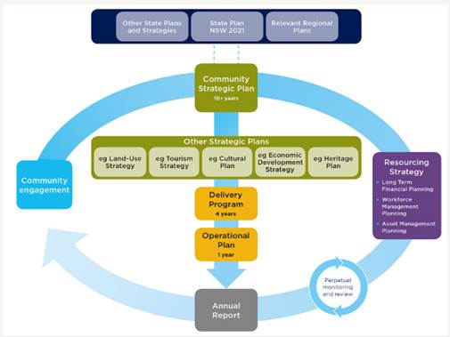
OLG Integrated
Planning and Reporting Manual for local government in NSW: Example of cascading
levels of details
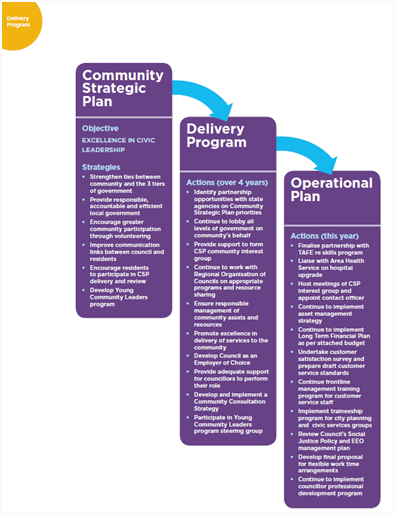
Key Milestones
The following key milestones
have been completed or are due for completion in the near future:
|
Key Milestones
|
Action Owner
|
Completion
|
|
Phase 1 -
Commencement
|
|
1. Report to ET on CSP Review options for reporting to Councillors
|
Executive Team
|
12 Oct 2016
|
|
2. Present the proposed review process to Councillors at a Strategic
Planning Workshop
|
Corporate Governance
|
20 Oct 2016
|
|
3. Report to Council to endorse or
amend the CSP themes and the option for the review of CSP
|
Corporate Governance
Community Development
|
27 Oct 2016
|
|
Phase
2 – Exhibition and Consultation
|
|
4. DIAP consultation and
engagement including community members with disability, Access Consultative
Working Group, and disability service providers
|
Consultants
Community Development
|
Dec 2016 to Feb 2017
|
|
5. Complete internal consultation sessions with internal steering group,
directors, managers and coordinators with focus on both disability inclusion
and CSP
|
Consultants
Community Development,
Corporate Governance
|
Dec 2016 to Mar 2017
|
|
6. Identify with relevant staff,
the key findings from DIAP community consultation, for inclusion in the
Delivery Program and CSP where necessary
|
Community Development,
Corporate Governance
|
Mar 2017
|
|
7. Report to ET to review draft
Delivery Program Actions and Operational Plan Activities
|
Corporate Governance
Community Development
|
Mar 2017
|
|
8. Workshops held with Councillors for input into Delivery Program
Actions
|
Consultant, Community
Development,
Corporate Governance
|
21 Mar and 6 Apr 2017
|
|
9. Report to Council the Draft CSP
(with minor changes based on DIAP legislation and updated state and regional
plans), Delivery Program and Operational Plan for endorsement to publicly
exhibit.
|
Corporate Governance
|
20 Apr 2017
|
|
10. Publicly exhibit the Draft CSP,
Delivery Program and Operational Plan and refer to regional and state
agencies
|
Corporate Governance
|
21 Apr – 18 May 2017
|
|
11. Review
of feedback from public exhibition
|
Corporate Governance
Community Development
|
End May 2017
|
|
12. Report
to Council on submissions and subsequent revisions of the CSP, Delivery
Program and Operational Plan
|
Corporate Governance
|
22 Jun
|
Engagement
Already held:
Section 12 of the Disability
Inclusion Act 2014 requires that people with disability must be consulted as
part of the disability inclusion action planning (DIAP) process. This
engagement was undertaken by Council’s consultants, Tim Childs Consulting
and Training. Key documents were developed to enable consistent messaging
with any external DIAP consultation. A cohort of people with disability
was also consulted to gather input from their experience and develop ideas for
possible inclusion solutions. This built upon consultation with the Access
Consultative Working Group and local disability service providers as well as
DIAP survey results that were gathered earlier in 2016. Further details
on DIAP engagement can be seen at Attachment 3.
DIAP consultation also
included Council’s Internal Steering Group which had representatives from
each area of Council. The group included two Directors as process champions.
The goal of this group was to develop access and inclusion strategies across
the breadth of the organisation.
Further consultation (other than DIAP specific) to-date has
included:
· Executive
Team meetings
· Councillors’
workshops on 21 March and 6 April 2017 for Councillors to provide input in the
Delivery Program Actions for 2017-2021
· Two all staff
workshops for input into Council’s future CSP
· Engagement
processes in the recent past, eg Council has recently engaged with a community
satisfaction survey, asset management survey, Coastal Zone Management and Safer
Community Compact, asset survey, SRV survey and information stands.
To be held:
During the public exhibition phase the draft CSP, draft
Delivery Program 2017-2021 and Operational Plan 2017-2018 (including Revenue
Policy, budget, and fees and charges) will be placed on exhibition from 21
April to 18 May 2017. Any submissions received by Council will be
reported to the Ordinary Meeting on 22 June 2017 to consider the submissions
prior to adoption of the documents.
The exhibited documents will be supported by a summary
document that includes key activities that Council will undertake in the
2017-2018 period. Promotional tasks, such as advertisements and
information stands will be used to raise awareness and encourage submissions on
the public exhibition of the Draft Delivery Program and Operational Plan.
Key highlights from the
Operational Plan 2017-2018
The following projects are
key highlights from the Operational Plan 2017-2018 and listed under the themes
of the CSP:
Corporate Management:
· Develop an inclusive Customer Service Strategy with
Action Plan
· Facilitate annual Community Donations Program
· Implement the Sustainable Procurement Plan, including
social procurement objectives
· Develop and implement risk management framework
· Develop and implement Business Continuity Plan/Disaster
Recovery Plan
· Undertake community wellbeing project
· Review the Community Strategic Plan for currency and
to identify gaps
· Develop and launch new
website with increased residential and ratepayer opportunities to conduct
business and engage
Economy:
· Continue to strengthen partnerships between Council
and the business community
· Implement Social Innovation Action Plan
· Develop, initiate and
pilot Youth Innovation Strategy
· Continue to implement
Byron Shire Tourism Management Plan
Society and Culture:
· Implement identified
access and inclusion strategies from Byron Shire Recreational Needs Assessment
· Develop and manage
service level agreement with Richmond Tweed Regional Library
· Support the Safe Summer
in the Bay initiative
· Continue to
monitor, inspect, enforce and investigate complaints in relation to community
safety and the environment
· Continue to monitor, inspect, enforce and investigate
complaints in relation to public and environmental health
· Continue to implement Byron Bay Town Centre Masterplan
· Implement public art program
· Develop Mullumbimby Place Activation Masterplan
· Develop Bangalow Place
Activation Masterplan
· Develop Cultural and
linguistically diverse (CALD) network and activity directory
· Implement efficiency
programs in Child Services
· Initiate and develop service mapping in the Shire
· Deliver outcomes from the Arakwal Memorandum of
Understanding
· Support cultural restoration processes in the
Bundjalung community
· Provide accessible
training, inclusive support and capacity building to Council volunteer
Committees (s355)
Environment:
· Prepare a Shire Wide
Integrated Weed Management Strategy
· Prepare a Shire wide
Plan/Strategy to improve the resilience of koala population
· Finalise Residential
Lands Strategy
· Finalise Rural Land Use Strategy
· Scope and implement a comprehensive Employment Lands
Strategy
· Finalise and implement Coastal Zone Management Plan
Byron Bay Embayment
· Scope and prepare a comprehensive Development Control
Plan (DCP) review
· Scope and prepare Byron Town Centre Local
Environmental Plan (LEP) and Development Control Plan (DCP) review
· Investigate and
implement planning controls to encourage an increase in the supply of
affordable and inclusive housing stock
Community Infrastructure:
· Plan and deliver prioritized Pedestrian and Access
Mobility (PAMP) facilities
· Prepare an Integrated Transport and Movement
Plan (ITMP)
· Update key road traffic plans to manage future traffic
demands.
· Finalise report on review intermodal use of the Byron
Rail Corridor
· Implement Parking Management Strategies for Bangalow,
Belongil, Mullumbimby and Brunswick Heads, incorporating accessible parking
requirements based on community need (which may exceed legislative
requirements).
· Investigate use of Byron Arts and Industry Park
stormwater infrastructure to deliver improved social, environmental and
integrated water management opportunities
· Implementation of approved and funded capital asset
renewal projects including Special Rate Variation projects
· Implement replacement of high priority road bridges
across the Shire
· Ocean Shore Community Centre Upgrade - Scope of Works confirmed and draft project plan
completed
· Commence construction of the Byron Bay Bypass works
· Finalise Construction of the Sunrise/Ewingsdale Road
Roundabout
· Finalise construction of the Bayshore Drive/Ewingsdale
Road Roundabout
· Byron Rail Corridor activation project commenced
Financial Implications
The draft Delivery Program 2017-2021 and Operational Plan
2017-2018 has been developed in house within existing resources.
Consultant fees for the purpose of DIAP activities have been budgeted for in
the 2016-2017 budget. There will be costs of about $3,100 associated with exhibition of these documents.
Statutory and Policy Compliance Implications
Councils are required to prepare a Community Strategic Plan
and associated documents under the Integrated Planning and Reporting
Framework. This is regulated by the Local Government Act 1993 and in
compliance with the Integrated Planning and Reporting Guidelines.
Under the Disability Inclusion Act 2014, Council must have
disability inclusion action planning in place by 1 July 2017. This
planning must align with our IP&R framework and will be embedded directly
into our documents.
Staff Reports - Corporate and Community Services 13.7
Report No. 13.7 Public
Exhibition - Draft 2017/2018 Statement of Revenue Policy
Directorate: Corporate
and Community Services
Report
Author: James
Brickley, Manager Finance
File No: I2017/459
Theme: Corporate Management
Financial Services
Summary:
The preparation of Council’s annual Operational Plan,
including Statement of Revenue Policy (comprised of Budget Estimates, Rates and
Charges, Borrowings and Fees and Charges) is regulated under the Integrated
Planning and Reporting Framework requirements legislated by the Local
Government Act 1993 (Sections 402 to 406). Management, in consultation with the
elected Council, have developed the 2017/2018 Statement of Revenue Policy
comprised of Budget Estimates, Rates and Charges, Borrowings and Fees and
Charges.
The information in this report is directly linked to and
supports the report also included in the agenda to this Ordinary Meeting of
Council concerning the Integrated Planning and Reporting documents relating to
the review of the Community Strategic Plan 2017-2027, Delivery Plan 2017-2021
and Operational Plan 2017-2018.
This report recommends placing these documents, subject to
any amendments, on public exhibition for not less than 28 days.
|
RECOMMENDATION:
1. That
Council adopt for exhibition the Draft 2017/2018 Statement of Revenue Policy,
comprising Budget Estimates, Rates and Charges, Borrowings and Fees and
Charges.
2. That
the Draft 2017/2018 Statement of Revenue Policy, comprising of the
Budget Estimates, Rates and Charges, Borrowings and Fees and Charges be
placed on public exhibition for a period of 28 Days.
|
Attachments:
1 Draft
2017-2018 Budget Estimates (Detailed), E2017/22841
⇨
2 Draft
2017-2018 Budget Summary Statements and Reserves, E2017/22852 ⇨
3 Draft
2017-2018 Revenue Policy, E2017/23434
⇨
4 Draft
2017-2018 Fees and Charges, E2017/24210
⇨
Report
The preparation of Council’s annual Operational Plan,
including the Statement of Revenue Policy (comprised of Budget Estimates, Rates
and Charges, Borrowings and Fees and Charges) is regulated under the Integrated
Planning and Reporting Framework requirements legislated by the Local
Government Act 1993 (Sections 402 to 406). Management, in consultation with the
elected Council, have developed the 2017/2018 Statement of Revenue Policy
comprised of Budget Estimates, Rates and Charges, Borrowings and Fees and
Charges.
The information in this report is directly linked to and
supports the report also included in the agenda to this Ordinary Meeting of Council
concerning the Integrated Planning and Reporting documents relating to the
review of the Community Strategic Plan 2017-2027, Delivery Plan 2017-2021 and
Operational Plan 2017-2018.
This report recommends placing these documents, subject to
any amendments, on public exhibition for not less than 28 days.
Draft 2017-2018 Budget Estimates
The Draft 2017/2018 Budget Estimates are based on the
2016/2017 budget reviewed at 31 December 2016 with various changes to reflect
the updated cost of service delivery across all programs developed from the
input received from each Council Directorate.
The Draft 2017/2018 Budget Result on a Consolidated (All
Funds) basis forecast a surplus budget result with the details of that result
being included below at Table 1.
Table 1 –
Forecast Budget Result 2017/2018 Consolidated (All Funds)
|
Item
|
Amount $
|
|
Operating Result
|
|
|
Operating Revenue
|
75,503,500
|
|
Less: Operating Expenditure
|
74,873,600
|
|
Operating Result – Surplus/(Deficit)
|
629,900
|
|
|
|
|
Funding Result
|
|
|
|
|
|
Operating Result – Surplus/ (Deficit)
|
629,900
|
|
Add: Non cash expenses – Depreciation
|
13,175,500
|
|
Add: Capital Grants and Contributions
|
24,867,700
|
|
Add: Loan Funds Used
|
2,160,000
|
|
Add: Asset Sales
|
0
|
|
Less: Capital Works
|
(44,685,100)
|
|
Less: Loan Principal Repayments
|
(2,639,800)
|
|
Funding Result – Surplus/(Deficit) (Cash
Movement)
|
(6,491,800)
|
|
Reserves Movement – Increase/(Decrease)
|
(6,541,800)
|
|
Overall Budget Result – Surplus/(Deficit)
(Operating + Funding)
|
50,000
|
The above budget result in Table 1 is assuming the Council’s
application for a Special Rate Variation(SRV) of 7.50% including rate pegging
of 1.50% is approved by the Independent Pricing and Regulatory Tribunal
(IPART). If Council’s SRV is not approved, the Draft 2017/2018
Budget Result on a Consolidated (All Funds) basis still forecasts a surplus
budget result with the details of that result being included below at Table 2.
Table 2 –
Forecast Budget Result 2017/2018 Consolidated (All Funds)
|
Item
|
Amount $
|
|
Operating Result
|
|
|
Operating Revenue
|
74,318,500
|
|
Less: Operating Expenditure
|
74,770,100
|
|
Operating Result – Surplus/(Deficit)
|
(451,600)
|
|
|
|
|
Funding Result
|
|
|
|
|
|
Operating Result – Surplus/ (Deficit)
|
(451,600)
|
|
Add: Non cash expenses – Depreciation
|
13,175,500
|
|
Add: Capital Grants and Contributions
|
24,867,700
|
|
Add: Loan Funds Used
|
2,160,000
|
|
Add: Asset Sales
|
0
|
|
Less: Capital Works
|
(43,822,700)
|
|
Less: Loan Principal Repayments
|
(2,639,800)
|
|
Funding Result – Surplus/(Deficit) (Cash
Movement)
|
(6,710,900)
|
|
Reserves Movement – Increase/(Decrease)
|
(6,760,900)
|
|
Overall Budget Result – Surplus/(Deficit)
(Operating + Funding)
|
50,000
|
The impact of the SRV in gross terms if not approved alters
the Draft 2017/2018 Budget Estimates on a Consolidated (All Funds) basis as
outlined in Table 3:
Table 3 – Forecast
SRV Impact on Budget Result 2017/2018 Consolidated (All Funds)
|
Item
|
Amount $
|
|
Operating Result
|
|
|
Operating Revenue
|
(1,185,000)
|
|
Less: Operating Expenditure
|
(103,500)
|
|
Operating Result – Surplus/(Deficit)
|
(1,081,500)
|
|
|
|
|
Funding Result
|
|
|
|
|
|
Operating Result – Surplus/ (Deficit)
|
(1,081,500)
|
|
Add: Non cash expenses – Depreciation
|
0
|
|
Add: Capital Grants and Contributions
|
0
|
|
Add: Loan Funds Used
|
0
|
|
Add: Asset Sales
|
0
|
|
Less: Capital Works
|
(862,400)
|
|
Less: Loan Principal Repayments
|
0
|
|
Funding Result – Surplus/(Deficit) (Cash
Movement)
|
(219,100)
|
|
Reserves Movement – Increase/(Decrease)
|
(219,100)
|
|
Overall Budget Result – Surplus/(Deficit)
(Operating + Funding)
|
0
|
As Table 3 indicates the additional revenue from the SRV if
approved is estimated to be $1,185,000 which equates to 6.00% of the 7.50%
overall SRV increase. As the 7.50% includes the announced 1.50% rate peg,
if the SRV is not approved, it will be the 6.0% component or the estimated
$1,185,000 in 2017/2018 that Council will not be able to raise.
The detailed Draft 2017/2018 Budget Estimates prepared on
the assumption the SRV is approved are detailed at Attachment 1. The
amount of SRV revenue is currently allocated to the following budget items
listed in Table 4 below:
Table 4- Proposed
SRV Allocation 2017/2018
|
Item
|
Total
Budget $
|
SRV
Funding $
|
Other
Funding $
|
|
Operating Expenditure
|
|
|
|
|
Rural Drainage Maintenance
|
146,500
|
36,900
|
109,600
|
|
North – Urban Drainage Maintenance
|
136,400
|
21,100
|
115,300
|
|
South – Urban Drainage Maintenance
|
155,200
|
21,100
|
134,100
|
|
Byron Bay Pool Maintenance
|
40,900
|
12,200
|
28,700
|
|
Mullumbimby Pool Maintenance
|
40,800
|
12,200
|
28,600
|
|
Total Operating Expenditure
|
519,800
|
103,500
|
416,300
|
|
|
|
|
|
|
Item
|
Total
Budget $
|
SRV
Funding $
|
Other
Funding $
|
|
Capital Expenditure
|
|
|
|
|
Broken Head Road
|
1,191,600
|
300,000
|
891,600
|
|
Station Street Bangalow
|
46,600
|
46,600
|
0
|
|
Pine Avenue Mullumbimby
|
610,000
|
75,500
|
534,500
|
|
The Terrace Brunswick Heads
|
379,400
|
379,400
|
0
|
|
Byron Bay Town Centre – Landscape/Precinct Plan
|
88,400
|
60,900
|
27,500
|
|
Total Capital Expenditure
|
2,316,000
|
862,400
|
1,453,600
|
|
|
|
|
|
|
Transfer to Reserve
|
|
|
|
|
Byron Bay Pool – Renewals to be determined
|
219,100
|
219.100
|
0
|
|
Total Transfer to Reserve
|
219,100
|
219,100
|
0
|
|
|
|
|
|
|
Total SRV
|
3,054,900
|
1,185,000
|
1,869,900
|
Should the SRV not be approved, then the budget items in
Table 4 above will not proceed or will need the extent of works proposed
revised to accommodate available funding.
Table 1 (with SRV) and Table 2 (without SRV) indicates a
forecasted budget surplus result of $50,000 and this relates to the General
Fund. The forecast General Fund Unrestricted Cash Balance position based
on the draft budget included at Table 1 and 2 is outlined in Table 5 below:
Table 5 –
Forecast General Fund Unrestricted Cash Balance
|
Item
|
$
|
|
Forecast unrestricted cash balance to 30 June 2017 at 31
December 2016 Budget Review
|
1,146,500
|
|
Add: Estimated initial draft 2017/2018 budget result
|
50,000
|
|
Forecast unrestricted cash balance at 30 June 2018
|
1,196,500
|
In addition to Tables 1 and 5 above, budgeted financial
statements incorporating a Operating Statement and Cash Flow Statement have
been produced. These financial statements replicating the format of
Council’s Annual Financial Statements are included in Attachment 2 along
with a one page summary of all Council budget program outcomes and the
estimated balance of Council reserves as at 30 June 2018.
To arrive at the Draft Budget Results outlined in Table 1
(SRV option) for the 2017/2018 financial year, Council’s revenue and
operational expenses are expected to be derived from the following sources and
allocated respectively as outlined in the graphs below:
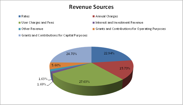
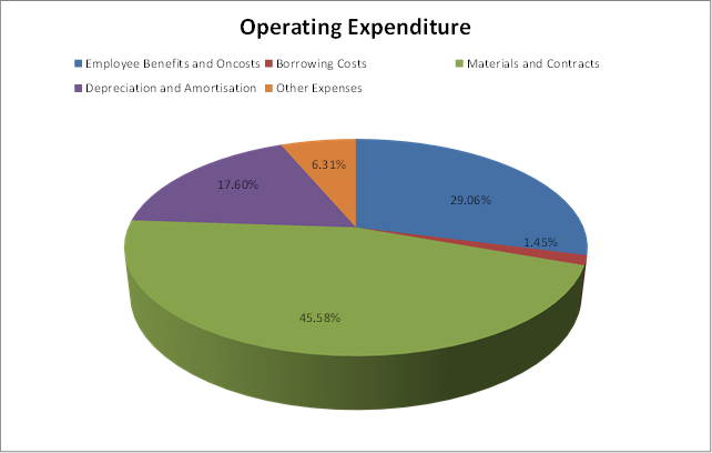
In addition to the operational aspects of the proposed Draft
2017/2018 Budget Estimates, Council is proposing a capital works program of
$44.685million (SRV option). By Fund, the projected capital works are:
· General Fund
$38.436million
· Water Fund
$1.890million
· Sewerage Fund
$4.358million
Specific capital works projects have been detailed in
Attachment 1, which for 2017/2018 has been presented in a different format for
the General Fund, to improve the disclosure of funding sources for specific
projects including:
· Section 94 funding
to describe the specific part of the Section 94 Plan and catchment that is
providing the funding for a project.
· Where reserve
funds are funding a project, identification of the reserve being utilised.
· Separation of
funding provided by Special Rate Variations (SRVs) including previously granted
SRVs prior to 2008/2009 (Council’s last approved SRV) and the proposed
SRV for 2017/2018.
Of the $38.436million for capital works related to the
General Fund, $34.777million is allocated towards Roads and Drainage projects
including $19.812million allocated to the Byron Bay Bypass.
The Draft 2017/2018 Budget Estimates also propose new loan
borrowings of $2.160million of a $6.000million borrowing program over the next
three financial years to fund a bridge replacement program. These are the
first new loan borrowings for Council in at least the last five years as
Council has been concentrating of debt reduction. Whilst only
$2.160million is required for 2017/2018, should Council approve the loan
borrowings, it may be worth testing the market to consider the merits of
borrowing the entire $6 million loan program up front, investing what is not
required but considering interest rates on offer at the time borrowings may be
sought.
Draft 2017-2018 Revenue Policy
The Draft 2017/2018 Revenue Policy has been prepared to
support the funding requirements of the Draft 2017/2018 Budget Estimates.
The major components of the Draft 2017/2018 Revenue Policy
are discussed in this report including:
· Draft General Land
Rates and Charges
· Draft Fees and
Charges
· Implementation of
the Fire and Emergency Services Levy (FESL)
Draft General Land Rates and Charges
The Draft 2017/2018 Revenue Policy includes two rating
structure tables with the only difference being the rating yields
derived. As Council has applied for a Special Rates Variation (SRV), it
must show a rating structure table with the SRV included and one without the
SRV, on the basis that the SRV is not approved and only normal rate pegging is
applied.
The Draft 2017/2018 Revenue Policy in regards to the
Ordinary Rates section as been re-written to outline a proposed new rating
structure for Council to consider. The rating structure outlined in
Attachment 3 is based on outcomes from the following events:
· Council resolution
17-023 from the Ordinary Council Meeting held 2 February 2017.
· Presentation to
the Finance Advisory Committee 16 February 2017
· Review by the
Executive Team 1 March 2017
· Presentation to
the Council Strategic Planning Workshop 9 March 2017
· Presentation to
the Council Strategic Planning Workshop 6 April 2017 in conjunction with the
Draft 2017/2018 Budget Estimates.
There were a number of alternate options provided but the
option currently presented in the Draft 2017/2018 Revenue Policy is based on
the following:
· Retention of the
ad valorem rate subject to a minimum rate.
· Retention of
existing rating categories.
· Abolition of the
historical differentials where the ad valorem rate was established for
Residential, then the ad valorem rate for Business was set at 150% of
Residential, then the ad valorem rate for Business Byron Bay CBD set at 200% of
Residential and the Farmland ad valorem rate was set at 73.73% of Residential.
· Application of new
land values provided by the Valuer General for the 2017/2018 financial year to
coincide with the introduction of the Fire and Emergency Services Levy (FESL)
by the NSW Government.
· Application of the
Special Rate Variation (SRV) of 7.50% if approved. On this basis the
minimum rate will increase for 2017/2018 from $695.00 to $747.00 or $52.00.
· Redistribution of
the rating yields between rating categories as outlined in Table 6 below
compared to the rating yields from 2016/2017 which has reduced the rate yield
from the Residential category but increased the rate yield to the Business and
Farmland categories.
Table 6 –
Proposed Rating Yield % by Rating Category
|
Rating Category
|
% Proposed Yield
2017/2018
|
Actual % Yield
2016/2017
|
|
Residential
|
74.00%
|
76.20%
|
|
Business – Other
|
12.50%
|
11.50%
|
|
Business – Byron Bay CBD
|
8.50%
|
7.90%
|
|
Farmland
|
5.00%
|
4.40%
|
|
Total
|
100.00%
|
100.00%
|
The current ratepayer population in Byron Shire Council is
distributed amongst the following rating categories outlined in Table 7:
Table 7 –
Ratepayer Population Distribution 2017/2018
|
Rating Category
|
Number of
Ratepayer Assessments
|
Proportion of
Ratepayer Population %
|
|
Residential
|
13,339
|
87.00%
|
|
Business – Other
|
1,098
|
7.20%
|
|
Business – Byron Bay CBD
|
349
|
2.30%
|
|
Farmland
|
542
|
3.50%
|
|
Total
|
15,328
|
100.00%
|
Given the distribution of the Ratepayer population, if
Council alters the redistribution of the rating yield amongst the rating
categories, a small decrease in the Residential rating category creates
significant increases in the Business and Farmland rating categories.
A comparison of the proportion of the ratepayer population
and proportion of rate yields contributed by each rating category is provided
in the graph below:
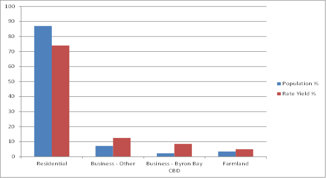
If Council proceeds with the suggested rating option
contained in the Draft 2017/2018 Revenue Policy, and assuming the SRV is
approved, a series of tables has been prepared to compare current 2016/2017
ordinary rates payable and to show the ordinary rate price path over the four
years of the proposed SRV by land value range and rating category as follows:
Table 8 –
Residential Rating
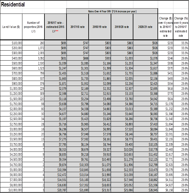
Table 9 –
Business – Other Rating
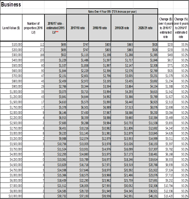
Table 10 –
Business - Byron Bay CBD Rating
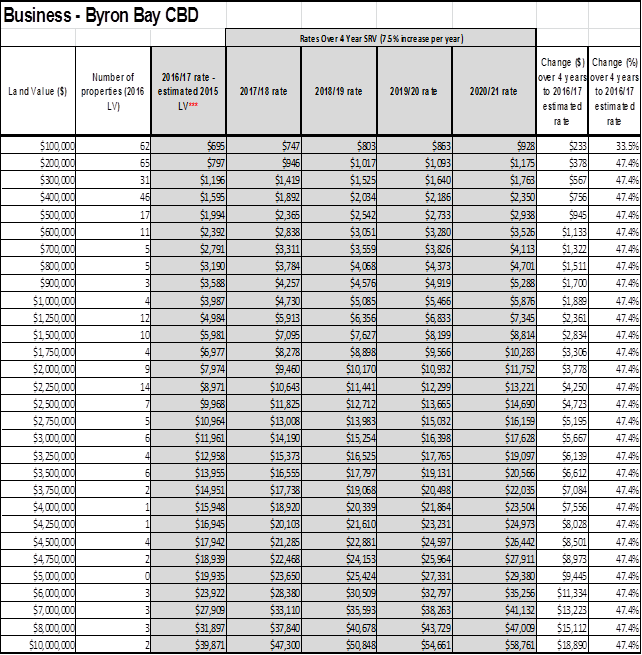
Table 11 –
Farmland Rating
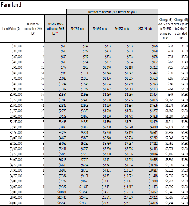
Please Note: *** The land values in tables 3 to 6
above are the new 2016 base date land value ranges to apply in the 2017/2018
financial year. To calculate the comparable 2016/2017 rates payable,
these land values have been discounted by the increase in the actual 2016 base
date land values by rating category to provide a more realistic and accurate
comparison. The discount applied is Residential 9.7%, Business –
Other 11.00%, Business – Byron Bay CBD 13.40% and Farmland 8.40%.
The outcome of the four tables immediately above (Tables 8
to 11) naturally will be different if the Special Rate Variation is not
approved and Rate Pegging only is to apply but represent an indicative outcome
if it is approved.
As the recommended rating structure for 2017/2018 will
create a redistribution of the rating yield, especially to the Business
category as a whole, which is now proposed to contribute 21.00% of
Council’s rate yield overall compared to the 19.40% previously
contributed. Council during the normal public exhibition period of the Draft
2017/2018 Operational Plan (including the Revenue Policy), will need to conduct
additional consultation with the Byron Shire Business community to ensure they
are informed of the proposed changes.
Given the proposed SRV, a review of waste, water and
sewerage charges has been conducted and it is proposed for 2017/2018 not to
increase these unit charges from those charged in 2016/2017. In respect
of waste charges, these have been reviewed to the extent of proposed service
types with the three bin service offered by Council. In addition, the
stormwater charge has not increased given it is a regulated charge that has not
changed over the last ten years.
Draft Fees and Charges
The Draft 2017/2018 Fees and Charges have been reviewed by
respective program managers and included at Attachment 4. Where possible,
fees have been altered/increased to reflect the following specific changes:
· Increases in the
Consumer Price Index (CPI)/Indexation assumed at 1.50%.
· Review of fees and
charges including benchmarking/cost of service provision and where possible
introduction of new fees to assist Council generate additional/enhanced revenue
as themed by its Financial Sustainability Plan(FSP).
· The Office of
Local Government is yet to determine the fee to apply for Section 603
Certificates or the Statutory Interest Rate to apply to overdue rates and
charges. Once determination has been advised, it is proposed Council
apply the maximum amounts advised in respect of both items.
· Fees currently
disclosed for Richmond Tweed Regional Library are the current fees for
2016/2017. Council is yet to receive advice from Lismore City Council as
to the fees to apply for 2017/2018.
For the 2017/2018 financial year, the Draft Fees and Charges
have continued to be developed utilising fees and charges software to manage
fees and charges that was implemented on 2016/2017 for the first time.
Fire and Emergency Services Levy (FESL)
All Councils in NSW for the first time will be required to
levy the Fire and Emergency Services Levy (FESL) on all rateable property from
1 July 2017. The levy will be calculated on the basis of a rate applied
to land value depending upon the FESL classification applied to each property.
It clearly needs to be understood, whilst the FESL will
appear on the Rate Notice, it is not Council revenue but is revenue for NSW
Treasury to assist in the funding of Emergency Services. This levy will
replace the previous levy included in insurance premiums for those in the
community who hold property insurance.
With respect to the FESL, Councils do not determine the
fixed charges/ad valorem rates to apply and will remit all FESL revenue
collected to the NSW Treasury. Councils are simply the collection agent
on behalf of NSW Treasury. It is for this reason, whilst there is some
disclosure in the Revenue Policy on the FESL, Council has not and will not
provide the fixed charges/ad valorem rates to be charged. Council is also
not required to approve the FESL charges.
Consultation
A presentation was provided to the Council Strategic
Planning Workshop held on 6 April 2017 concerning the Draft 2017/2018 Revenue
Policy subject of this report. A report is also being provided to the Finance
Advisory Committee for consideration at its Meeting to be held on 13 April 2017
consistent with this report for review and consideration. Recommendations
from the Finance Advisory Committee will be advised to Council by way of Memo
prior to the 20 April 2017 Ordinary Council Meeting.
The Draft 2017-2018 Statement of Revenue Policy
incorporating the Draft 2017-2018 Budget Estimates will be included in the
Draft 2017-2021 Delivery Plan that incorporated to Draft 2017-2018 Operational
Plan will be placed on public exhibition for a period of no less than 28 days
seeking submissions from the community.
Financial Implications
The proposed Draft 2017/2018 Budget Estimates provided in
this report indicate a projected budget surplus of $50,000. This
projected surplus is the estimated outcome whether Council’s application
for a Special Rate Variation (SRV) is approved by the Independent Pricing and
Regulatory Tribunal (IPART) or not approved.
Detailed financial aspects of the Draft 2017/2018 Budget
Estimates are outlined for Council to consider earlier in this report.
The Draft 2017/2018 Revenue Policy is an integral part to
Council’s Operational Plan and provides the basis for Council to raise
the required revenue to fund the estimated operating and capital expenditures
contained in the proposed Draft 2017/2018 Budget Estimates.
There are direct financial implications to ratepayers of
Council in regards to the proposed rates and charges contained in the Draft
2017/2018 Revenue Policy as it will determine, subject to final adoption after
public exhibition and consideration of submissions, what ratepayers will be
requested to pay when rate notices are issued in July 2017.
Statutory and Policy
Compliance Implications
In respect of the Draft 2017-2018 Operational Plan including
the Statement of Revenue Policy, Council must comply with the provisions of
Section 405 of the Local Government Act 1993 as described below concerning the
adoption of an Operational Plan.
405 Operational plan
“(1)
A council must have a plan (its operational plan) that is adopted before the
beginning of each year and details the activities to be engaged in by the
council during the year as part of the delivery program covering that year.
(2)
An operational plan must include a statement of the council’s revenue policy
for the year covered by the operational plan. The statement of revenue policy
must include the statements and particulars required by the regulations.
(3)
A council must prepare a draft operational plan and give public notice of the
draft indicating that submissions may be made to the council at any time during
the period (not less than 28 days) that the draft is to be on public
exhibition. The council must publicly exhibit the draft operational plan in
accordance with the notice.
(4)
During the period of public exhibition, the council must have for inspection at
its office (and at such other places as it may determine) a map that shows
those parts of its area to which each category and sub-category of the ordinary
rate and each special rate included in the draft operational plan applies.
(5)
In deciding on the final operational plan to be adopted, a council must
consider any submissions that have been made concerning the draft plan.
(6)
The council must post a copy of its operational plan on the council’s
website within 28 days after the plan is adopted.”
The specific statements required by Council to be disclosed
as part of its Revenue Policy are determined by Clause 201 of the Local
Government (General) Regulation 2005 as follows:
201 Annual statement
of council’s revenue policy
“(1) The
statement of a council’s revenue policy for a year that is required to be
included in an operational plan under section
405 of the Act
must include the following statements:
(a) a statement containing a
detailed estimate of the council’s income and expenditure,
(b)
a statement with respect to each ordinary rate and each special rate proposed
to be levied,
Note: The
annual statement of revenue policy may include a note that the estimated yield
from ordinary rates is subject to the specification of a percentage variation
by the Minister if that variation has not been published in the Gazette when
public notice of the annual statement of revenue policy is given.
(c) a statement with respect to
each charge proposed to be levied,
(d) a statement of the types of
fees proposed to be charged by the council and, if the fee concerned is a fee
to which Division 3 of Part 10 of Chapter 15 of the Act
applies, the amount of each such fee,
(e) a statement of the
council’s proposed pricing methodology for determining the prices of
goods and the approved fees under Division 2 of Part 10 of Chapter 15 of the Act
for services provided by it, being an avoidable costs pricing methodology
determined by the council in accordance with guidelines issued by the
Director-General,
(f) a statement of the amounts
of any proposed borrowings (other than internal borrowing), the sources from
which they are proposed to be borrowed and the means by which they are proposed
to be secured.
(2) The
statement with respect to an ordinary or special rate proposed to be levied
must include the following particulars:
(a) the ad valorem amount (the
amount in the dollar) of the rate,
(b) whether the rate is to have
a base amount and, if so:
(i) the amount in dollars of
the base amount, and
(ii) the percentage, in
conformity with section
500 of the Act,
of the total amount payable by the levying of the rate, or, in the case of the
rate, the rate for the category or sub-category concerned of the ordinary rate,
that the levying of the base amount will produce,
(c) the estimated yield of the
rate,
(d) in the case of a special
rate-the purpose for which the rate is to be levied,
(e) the categories or
sub-categories of land in respect of which the council proposes to levy the
rate.
(3) The
statement with respect to each charge proposed to be levied must include the
following particulars:
(a) the amount or rate per unit
of the charge,
(b) the differing amounts for
the charge, if relevant,
(c) the minimum amount or
amounts of the charge, if relevant,
(d) the estimated yield of the
charge,
(e) in relation to an annual
charge for the provision by the council of coastal protection services (if
any)-a map or list (or both) of the parcels of rateable land that are to be
subject to the charge.
(4) The
statement of fees and the statement of the pricing methodology need not include
information that could confer a commercial advantage on a competitor of the
council. “
Staff Reports - Sustainable Environment and Economy 13.8
Staff Reports - Sustainable Environment and
Economy
Report No. 13.8 Report
of the Planning Review Committee Meeting held on 21 March, 2017
Directorate: Sustainable
Environment and Economy
Report
Author: Chris
Larkin, Major Projects Planner
File No: I2017/354
Theme: Ecology
Development and Approvals
Summary:
This report provides the outcome of the Planning Review
Committee Meeting held on 21 March, 2017.
|
RECOMMENDATION:
That Council note the report.
|
Report:
The meeting commenced at 1.05pm
and concluded at 1:30pm.
Present: Crs, Hackett,
Hunter, Martin, Cameron and Coorey
Staff: Chris Larkin
(Major Projects Planner).
Apologies: Crs Richardson,
Ndiaye,
The following development
applications were reviewed with the outcome shown in the final column.
Council determined the
following original development applications. The Section 96 application
to modify these development consents are referred to the Planning Review
committee to decide if the modification applications can be determined under
delegated authority.
|
DA No.
|
Applicant
|
Property Address
|
Proposal
|
Exhibition
Submissions
|
Reason/s
Outcome
|
|
10.2015.686.4
|
Bayview land Development
Pty Ltd
|
Tuckeroo Avenue
Mullumbimby
|
S96 to modify condition 44
|
Level 0
|
Delegated
Authority
|
|
10.2009.314.11
|
Bayview land Development
Pty Ltd
|
Coral Avenue
\Mullumbimby
|
S96 for correction of error
in description of land on Land Use Plan 2.1B
|
Level 0
|
The
perceived public significance of the application.
Council
|
Staff Reports - Sustainable Environment and Economy 13.9
Report No. 13.9 Regulatory
Impact Statement - Draft Biosecurity Regulations 2016
Directorate: Sustainable
Environment and Economy
Report
Author: Clare
Manning, Natural Environment Projects and Policy Officer
File No: I2017/294
Theme: Ecology
Planning Policy and Natural Environment
Summary:
To broadly summarise the draft Biosecurity Regulation 2016
(draft Regulation) and note that the draft Regulations consolidate multiple
pieces of legislation relating to biosecurity including the Noxious Weed Act
1993 following the passing of the Biosecurity Act 2015 (Act) through
Parliament. The Biosecurity Act and Regulations will continue to provide
specific legal requirements for state-level priority weeds and high-risk
activities.
Gazettal of the draft Regulations in their current form,
including mandatory requirements to eradicate noxious weeds or if that is not
practicable, destroy as much of that weed as is practicable and suppress the
spread of any remaining weed, is likely to have significant social, economic
and environmental implications for Council. The Act and draft Regulations
have triggered the need for Council to review its approach to integrated pest1
management in the long term.
1Pest means a species, strain or biotype of a
plant or animal, or a disease agent, that has the potential to cause, either
directly or indirectly, harm to (a) human, animal or plant health or (b) the
environment (Biosecurity Act 2015).
|
RECOMMENDATION:
That Council note:
1. The
information contained in this report on the draft Biosecurity
Regulation 2016.
2. That
Council staff are undertaking an internal peer review of the draft
Integrated Weed Strategy March 2016.
3. That
Council staff are developing a Directions Document to provide a
continued direction for reducing the use of pesticide2 on Council
land in the long term.
|
1 Pesticide
means an agricultural chemical product as defined by the Agricultural and
Veterinary Chemicals Code Act 1994. Definition of pesticides covers,
bactericides baits, fungicides, herbicides, insecticides, lures, rodenticides
and repellents. Pesticides are used in commercial, domestic, urban and rural
environments (Pesticides Act 1999).
Report
Fourteen separate pieces of legislation including the
Noxious Weed Act 1993 have been wholly repealed with the passing of the
Act. The Act and Regulations will continue to provide specific legal
requirements for state-level priority weeds and high-risk activities.
Prohibited Matter
Prohibited Matter is listed in Schedule 2, Part 1 of the NSW
Biosecurity Act 2015 and is aimed at prevention. This list includes weeds that
are nationally targeted for eradication and which are not presently in NSW.
Control Orders
Weed Control Order 2017 (Part 6 Division 1) under the NSW
Biosecurity Act will include weeds that are subject to a Control Order for the
purpose of eradication. Control Orders will be proposed as required to address
subsequent eradication campaigns where appropriate.
Biosecurity Zones
Biosecurity Zones are listed in Part 5 of the draft
Biosecurity Regulation 2016. These zones are created to allow on-going
‘strategic’ management. Zones are aimed at containment. However,
each species may be subject to recommended measures tailored by the region
either within the zone or outside it. A bitou bush biosecurity zone has been identified
between Cape Byron and the Queensland-New South Wales border. Eradication
of the weed or if that is not practicable, destroy as much of the weed as is
practicable and suppress the spread of any remaining weed will be mandatory.
Mandatory Measures
Mandatory Measures are listed in Division 8 of the draft
Biosecurity Regulation 2016. They are used where specific action is required to
mitigate the biosecurity risk to protect an asset e.g. Endangered Ecological
Community or threatened species. It must be noted that Byron Shire has
extremely high biodiversity at the ecosystem, species and genetic levels. The
Shire is centred in the Wet Subtropics Bioregion, an area of great ecological
significance. This is one of the richest and most diverse regions for fauna and
flora in Australia. Indeed, Byron Shire supports amongst the highest
number of threatened species in New South Wales. Approximately 70 plant species
and 90 animal species recognised as vulnerable or endangered are known to occur
in the Shire
The mandatory measures include prohibition on certain
dealings - including Weeds of National Significance (Clause 29), parthenium
weed carriers - machinery and equipment (Clause 31) and duty to notify of
importation of plants into the state (Clause 30). Nine (or 33%) of the weed
species under Mandatory Measure are found in the Byron Shire.
Social, Economic and
Environmental Implications
If adopted, the Regulation is likely to have significant
social, economic and environmental implications for Council, particularly in
light of Council’s aspirational goal of ceasing the use of all
non-organic chemical based herbicides and the repetitive use of all non-organic
chemical pesticides (Resolution 13-621).
In the absence of detail in the draft Regulations, Council
staff made a submission to the NSW Department of Primary Industries. Council
staff had concerns about the ambiguous use of terminology such as the mandatory
requirements to eradicate the said weed or if that is not ‘practicable’,
destroy as much of the weed as is ‘practicable’. This use of
terminology is open to interpretation and potentially risks an outcome where
landowners undertake no works to eradicate the said weed or suppress the spread
of any remaining weed on their land.
More significantly are the financial implications to an
owner or occupier of land in a biosecurity zone and/or with mandatory measures.
Recent case studies in the Shire have shown that reverting to hand-weeding (as
part of the transition to a non-organic pesticide-free approach) while equally
effective to the use of synthetic pesticide, such alternative methods can
result in up to an approximate 8-fold increase in labour to control a weed
infestation and/or an increase soil disturbance that can result in new weed
infestations. Over time this may lead to less biodiversity outcomes and
potentially increase areas of occupational health. Nonetheless, since
Council’s Resolution 13-621, Council has reduced the use of
pesticides (specifically herbicides) over the last 3-years but details are yet
to be reported.
Conclusion
In response to (i) the Biosecurity Act and Regulations and
(ii) Resolution 13-621 Council staff is currently reviewing its position with
respect to the use of all pesticide use and reviewing the draft Integrated Weed
Management Strategy. The review process will lead to a Directions
Document that aims to provide a continued direction for working towards
reducing the use of pesticides on Council managed land in the long term
including a draft policy framework that recognises the need to minimise the use
of pesticides and combines or promotes alternative methods that are sustainable
and practical for the situation, but consider where required e.g. to meet
current legislation, to use them responsibly in the control pests.
As part of integrated pest management approach Council staff
is committed to providing a safe and healthy environment.
Staff Reports - Sustainable Environment and Economy 13.10
Report No. 13.10 PLANNING
- Submissions Report - 26.2015.1.1 - Planning Proposal to permit a heliport and
amend the minimum lot size at Tyagarah Airfield
Directorate: Sustainable
Environment and Economy
Report Author: Rob
Van Iersel, Consultant Planner
File No: I2017/322
Theme: Ecology
Planning Policy and Natural Environment
Summary:
This report presents the outcomes of the public exhibition
of the planning proposal relating to the Tyagarah Airfield site. The proposal
seeks to amend Byron Local Environmental Plan (LEP) 2014 to permit a heliport
at the site and to amend the minimum lots size applicable to the land.
The proposed amendment relates to eight Council-owned lots,
located immediately north of the airfield runway. It relates only to the
areas within the site that are zoned RU2 under Byron LEP 2014.
There are two areas that are Deferred Matters under the
LEP. Those parts of the site are not included in the planning proposal.
The planning proposal is included as Attachment 1. It
will amend Schedule 1 of the LEP to specify that development for the purposes
of a heliport is permitted with development consent on the land.
It will also amend the Minimum Lot Size Map to establish a
minimum lot size of 1,000m2 for the land (currently 40ha). The
reduction in minimum lot size will allow the subdivision of the land to rectify
lots that were previously created for lease purposes but not registered,
formalise the existing internal roadway, and create additional lots to utilise
operational Council land to ensure that the airfield is economically
sustainable.
The planning proposal received an initial Gateway
determination from the Department of Planning and Environment on 24 March
2016. A revised Gateway was issued on 28 November 2016 following
Council’s request for an extension of time in order for additional
technical studies to be prepared in response to the submission from the Office
of Environment and Heritage (OEH).
The planning proposal was placed on public exhibition for a
period of 28 days, from 5 May 2016 to 2 June 2016. Seven public
submissions were received during the exhibition period (see Attachment 2), in
addition to submissions from the Australian Department of Infrastructure and
Regional Development (Attachment 3), NSW Rural Fire Service (Attachment 4) and
NSW Office of Environment and Heritage (Attachment 5). One further late
public submission was received in February 2017, with a supplementary
submission provided shortly after (included in Attachment 2).
Of the eight public submissions received (includes the late
submission):
· one was in
objection, suggesting that the use of the land as an airfield should be
discontinued and the site used instead for “high technology
industry”, and raising a number of other issues that are addressed in the
body of this report;
· three submissions
expressed support for the proposal; and
· four submissions
were not directly relevant to the planning proposal, instead including:
- suggested
improvements to existing facilities at the site;
- a
desire by existing tenants to remain on-site;
- suggested
opportunities to increase revenue; and
- concerns
from the Cape Byron Pistol Club regarding potential impacts on their site
(located outside of the planning proposal area) associated with ecological
offset proposals.
NSW OEH raised a number of concerns in regard to the
planning proposal, requesting further detail and assessment regarding cultural
heritage issues; flooding and biodiversity.
A number of additional studies were prepared to address
these concerns and, following review of that additional information, OEH
advised that they have no remaining concerns regarding the planning proposal.
The remaining agency submissions raised no objections to the
planning proposal.
This report recommends that Council proceed with the
planning proposal.
The Minister for Planning and Environment has issued an
authorisation for Council to exercise delegation to make this LEP amendment,
should Council decide to proceed with it.
NOTE TO COUNCILLORS:
In accordance with the
provisions of S375A of the Local Government Act 1993, a Division is to be
called whenever a motion for a planning decision is put to the meeting, for the
purpose of recording voting on planning matters. Pursuant to clause 2(a)
under the heading Matters to be Included in Minutes of Council Meetings of
Council's adopted Code of Meeting Practice (as amended) a Division will be
deemed to have been called by the mover and seconder of all motions relating to
this report.
|
RECOMMENDATION:
That Council
1. Forward
the planning proposal to the NSW Parliamentary Counsel’s Office
requesting that a draft LEP instrument be prepared.
2. Liaise
with Parliamentary Counsel’s Office as necessary to finalise the
content of the draft LEP and to enable the Office to issue an Opinion that
the plan can be made.
3. Make
the draft LEP under delegated authority and forward the plan to the NSW
Department of Planning and Environment for notification on the NSW Government
legislation website.
|
Attachments:
1 Planning
Proposal as Exhibited, E2016/27739
⇨
2 Confidential
- Public Submissions, E2017/17203
3 Submission
- Commonwealth Dept of Infrastructure and Regional Development, E2017/17209 ⇨
4 Submission
- NSW Rural Fire Service , E2016/82881
⇨
5 Office
Environment & Heritage - initial submission / comments, E2017/17198 ⇨
6 Office
Environment & Heritage Final Response Tyagarah Airfield , E2017/16804 ⇨
7 Aboriginal
Cultural Heritage Assessment LtdCHA_EV460_160914(2), E2016/84241 ⇨
8 Flood
Study , E2017/9027 ⇨
Report
Background
The Airport Group (TAG) was engaged by Council in 2012 to
undertake a future options report for the Tyagarah Airfield (resolution
01/12/2011).
The analysis completed by TAG made a number of
recommendations as to how the Tyagarah Airfield could become financially
sustainable to meet the objectives of Council’s Financial Sustainability
Project Plan.
These included:
· Minor runway
upgrade works;
· Ratification of occupancy
agreements;
· Implementation of
formal management processes; and
· Development of
existing land.
This Planning Proposal is a result of the recommendation to
develop the existing land.
At the Council meeting of 10 December 2015, Council considered
a planning proposal relating to the Tyagarah Airfield site and resolved to send
the planning proposal to the NSW Department of Planning and Environment for
Gateway Approval (15-659).
The proposal relates to land located on the eastern side of
the Pacific Highway, north of Grays Lane at Tyagarah, which is accessed from
Yarun Road. The site contains the following Council-owned operational
properties.
|
Lot
2 DP 749851
|
1,460m2
|
Leased.
Contains an existing industrial shed/ hangar
|
|
Lot
1 DP 713023
|
1.525ha
|
Subdivided
for lease purposes under DP 805678 – see below:
|
|
Lot
4 DP 805678
|
5,136m2
|
Created
for lease purposes. Leased to private individual. Contains the base and
business premise of Skydive Byron Bay
|
|
Lot
5 DP 805678
|
1.011ha
|
Created
for lease purposes. Currently vacant.
|
|
Lot
6 DP 836887
|
867.9m2
|
Leased.
Contains two existing hangars
|
|
Lot
8 DP 856832
|
385.7m2
|
Leased.
Contains an existing building owned by the Byron Lapidary Society
|
|
Lot
9 DP 856832
|
747.8m2
|
Leased.
Contains an existing building servicing as administration for a joy flight
operator
|
|
Lot 49 DP 881232
|
13.21ha
|
Residual
of the Council-owned land. Contains the western end of runway and, in the
north-eastern sector, the Tyagarah Public Hall and associated amenities
building.
The land leased and used by the Tyagarah Clay Shooting
Club is partially on this land, and partially on the adjoining Crown Land
(Lot 181). Part of the land is also leased to the Tyagarah Recreation and
Flying Club as the site for their hanger.
|
The proposal relates only to the areas within the site that
are zoned RU2 under Byron LEP 2014. There are two areas that are Deferred
Matters under the LEP. Those parts of the site are not included in the
planning proposal.
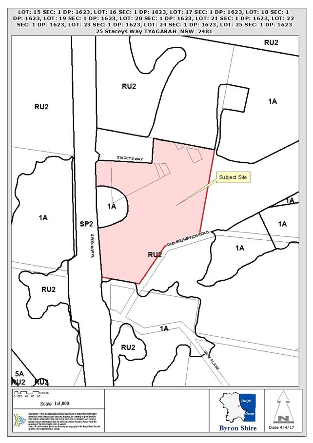
The proposal will amend Schedule 1 of the Byron LEP 2014 to
specify that development for the purposes of a heliport is permitted with
development consent on the land.
It will also amend the Minimum Lot Size Map to establish a
minimum lot size of 1,000m2 for the land (currently 40ha). The
reduction in minimum lot size will allow the subdivision of the land to rectify
lots that were previously created for lease purposes but not registered,
formalise the existing internal roadway, and create additional lots to utilise
operational Council land to ensure that the airfield is economically
sustainable.
The planning proposal received an initial Gateway
determination from the Department of Planning and Environment on 24 March
2016. A revised Gateway was issued on 28 November 2016 following
Council’s request for an extension of time in order for additional
technical studies to be prepared in response to the submission from the Office
of Environment and Heritage (OEH).
Consultation
In accordance with the requirements of the Gateway
determination, the planning proposal was placed on public exhibition for a
period of 28 days, from 5 May 2016 to 2 June 2016. Seven public
submissions were received during the exhibition period, in addition to
submissions from the Australian Department of Infrastructure and Regional
Development, NSW Rural Fire Service and NSW Office of Environment and
Heritage. One further late public submission was received in February
2017, with a supplementary submission provided shortly after.
The Gateway determination required Council to consult with:
· NSW Office of
Environment and Heritage (OEH);
· Department of the
Commonwealth responsible for aerodromes and the lessee of the aerodrome;
· NSW Roads and
Maritime Service (RMS); and
· NSW Rural Fire
Service (RFS).
The submissions received from those agencies are included as
Attachments 3, 4 and 5 and are summarised below (Note: RMS did not make a
submission).
NSW Rural Fire Service:
The RFS raised no objection to the planning proposal, and
provided the following comments:
· The proposed
internal road, at subdivision stage, shall comply with the public road
provisions of Planning for Bush Fire Protection 2006.
· Reticulated
water supply to the development, at subdivision stage, shall comply with Planning
for Bush Fire Protection 2006.
· All buildings
to be constructed on each proposed and existing allotments, shall have a
minimum 15 metre separation distance from the property boundary adjoining the
hazard.
· Each proposed
lot shall be maintained as an ‘inner protection area’ as per
Planning for Bush Fire Protection 2006 and the NSW RFS document Standards for
Asset Protection Zones.
Australian Government
Department of Infrastructure and Regional Development:
The Department provided no comment on the intent and content
of the proposal, noting that if, in the future, an application is made to
establish a heliport at the site the Department would welcome the opportunity
to comment.
NSW Office of Environment and
Heritage:
Prior to finalising a submission, OEH advised that, while
the addition of heliport to the Schedule of additional permitted uses was
supported, they identified a number of issues requiring further
consideration. They provided a number of recommendations, which are
identified below, together with comments relating to how those recommendations
were subsequently addressed.
1. Prepare
an Aboriginal cultural heritage assessment in support of the planning proposal.
Council engaged Everick Heritage
Consultants to undertake an Aboriginal Cultural Heritage Assessment for the
project (see Attachment 6). That assessment was undertaken in conjunction
with representatives of the Arakwal Aboriginal Corporation Byron Bay. It
concluded that there are no culturally significant sites or areas affected by
the proposal.
The Cultural Assessment Report was
provided to OEH, who advised that they have no outstanding issues relating to
the planning proposal.
2. Prepare
an appropriate flood assessment in support of the planning proposal.
Council engaged BMT WBM to undertake
the flood assessment for the project (see Attachment 7). That assessment
involved the expansion of existing contemporary flood modelling to account for
the site. In that modelling, the assessment conservatively assumed that
the entire planning proposal site would be filled.
The modelling demonstrated
negligible food increases external to the site, associated with the assumed
filling.
The Flood Assessment was provided to
OEH, who advised that they have no outstanding issues relating to the planning
proposal.
3. Confirm
the location and extent of proposed “new lots” and associated
infrastructure to be enabled by the planning proposal to allow the OEH to
accurately assess the potential extent of direct and indirect impacts on
biodiversity arising from the proposed Minimum Lot Size Map and whether these
lots and associated infrastructure extend into deferred areas. The Minimum Lot
Size Map should align with the boundaries of the proposed subdivision area and
avoid deferred areas and areas of high environmental value.
There was some confusion created by
the inclusion (as appendices to the planning proposal) of various technical
studies previously prepared to examine the subdivision potential of the
land.
Further information was provided to
OEH clarifying that a detailed subdivision proposal has not yet been developed,
but that avoidance of areas of high environmental value would be a design
criteria for any future development. The extent of the planning proposal
site was also clarified, noting that deferred areas are not included within the
proposal.
4. Confirm
whether Endangered Ecological Communities are present in the planning area and
their full extent by demonstrating due consideration of the edaphic features of
the site in addition to the floristic characteristics present, including in
areas identified as regrowth native vegetation.
Additional ecological information
was provided as requested.
5. Assess
the indirect impacts on biodiversity values of future land uses to be enabled by
the planning proposal.
6. Confirm
the full extent of requirements for Asset Protection Zones and consider these
in assessing the planning proposal.
7. Confirm
the planning proposal is consistent with the NSW Coastal Policy and apply
appropriate zonings recognising the land’s inherent conservation values.
8. Confirm
the planning proposal is consistent with the Far North Coast Regional
Conservation Plan
Additional information was provided
as requested in relation to these matters, and OEH have advised that they have
no outstanding issues relating to the planning proposal.
Public Submissions
Seven public submissions were received during the exhibition
period, with one further late public submission received in February 2017 (with
a supplementary submission provided shortly after).
Of the eight public submissions received (includes the late
submission):
· one was in
objection, suggesting that the use of the land as an airfield should be
discontinued and the site used instead for “high technology industry”;
and raising a number of other issues that are addressed in the body of this
report;
· three submissions
expressed support for the proposal; and
· four submissions
were not directly relevant to the planning proposal, instead including:
- suggested
improvements to existing facilities at the site;
- a
desire by existing tenants to remain on-site;
- suggested
opportunities to increase revenue; and
- concerns
from the Cape Byron Pistol Club regarding potential impacts on their site
(located outside of the planning proposal area) associated with ecological
offset proposals.
The following table summarises issues raised in the
submissions, and provides staff comments for Council’s consideration.
|
Issues Raised
|
Staff Comment
|
|
Letter of Objection (late submission):
|
|
Cumulative environmental and social impacts of the
compliance works necessary to bring the airstrip up to CASA standards have
not been addressed
|
The planning proposal does not relate to any works
proposed or required on the airstrip. It deals primarily with existing
and proposed use of land directly adjoining the strip to the north.
|
|
A better alternative would be to maintain the planning
proposal to reduce minimal lot size but to replace the use of “heliport
permitted with consent” with “high technology industry permitted
with consent”
|
Suggestion is noted. It would require a new planning
proposal, a new Gateway determination and re-exhibition.
|
|
The Tyagarah Airfield Aviation Option Report prepared by
The Airport Group – Australian Airports Association (2013),
commissioned by Council, was not publicly released as part of the planning
proposal.
|
That report was commissioned to provide internal advice to
Council regarding the operation of the airfield. It was referred to in
the planning proposal, to provide relevant background and context to the
current proposal.
|
|
The Byron Shire Council Tyagarah airfield future strategic
direction project was not made publicly available
|
The planning proposal is part of the project, but it is
not considered to be relevant for the whole of that project to be publicly
exhibited for the purposes of finalising this planning proposal.
|
|
No social impact assessment was completed regarding
increased noise pollution as part of expanded or intensified airfield
operations or possible new heliport operations
|
The planning proposal merely establishes a mechanism
whereby a heliport and subdivision proposals could be considered at the site.
Any future development proposals
would be subject to a detailed merits assessment, which would include an
examination of noise and other potential impacts.
The amendment of the LEP, as
proposed, provides no guarantees regarding the merit assessment, nor does it
in any way suggest that such development would be approved in the absence of
positive merit assessment outcomes.
As such, it is considered that
social assessment is not required at this planning proposal stage.
|
|
No report on existing noise and operational complaints
relating to the Tyagarah airfield was prepared
|
See above. In relation to noise, the TAG Tyagarah
Airfield Options Report (March, 2014) noted:
“The airstrip and the approaches to the North
east and South West ends of the runway are not close to any township.
As such, noise abatement and mitigation is not an important operational
consideration. It is understood that BSC has received some complaints
on aircraft movements but due to limited movements and space population
density, aircraft noise is considered minimal relative to background noise
including traffic noise along the highway.”
|
|
No Tyagarah airfield operational plan or occupational
health and safety plan has been prepared to accompany the proposal
|
Such plans are not considered necessary in relation to
this planning proposal.
|
|
Notice should also have been issued to the Aircraft Noise
Ombudsman and Air Services Australia for comment on the planning proposal
|
Consultation was undertaken in accordance with the
Department of Planning and Environment’s Gateway Determination.
|
|
The additional use map for helicopter use does not need to
cover the entire area of the planning proposal. It is inappropriate to do so
and a heliport is not needed at Tyagarah airfield. Even the need for a
helipad is questionable. All reference to a heliport should be removed from
the planning proposal. If it is deemed that helicopter landing facilities are
required, then references to “heliport” in the planning proposal
should be replaced with “helipad”
|
The justification for, and location of, and heliport
proposal will be assessed in a future development application, should one be
lodged.
Having the additional use map
cover the whole of the planning proposal site provides flexibility.
The relevant LEP definitions are:
helipad means
a place not open to the public used for the taking off and landing of helicopters.
heliport means
a place open to the public that is used for the taking off and landing of
helicopters, whether or not it includes:
(a) a
terminal building, or
(b) facilities
for the parking, storage or repair of helicopters.
The definition of helipad is much
more limited in terms of potential future operations.
It is considered that, subject to
detailed assessment of any future development applications, a heliport could
be a suitable use at this site.
|
|
The changed minimum lot size map is appropriate but the
use of the land for retail or residential purposes should be further
investigated. A way should be found to specifically NOT permit any ancillary
use of the land for retail or residential uses until further studies on
impacts are carried out.
|
The planning proposal does not alter the existing planning
controls in relation to retail or residential uses.
|
|
Due to the existing social impact of the Tyagarah Airfield
on a small percentage of the population in Tyagarah, Myocum and Brunswick
Heads all residences should have received written notification of the
planning proposal and been notified of the 28 day public exhibition period.
No formal written notice was provided. The Byron Shire News published council
notices but it is only delivered to less than half of the residences in this
area. As a consequence, many community members who are directly impacted by
Tyagarah Airfield missed out on any opportunity to publicly comment on the
planning proposal.
|
The public exhibition was appropriate for the nature of
the proposal.
Any future application for a
heliport would require notification and public exhibition.
|
|
The ecological assessment that was carried out as part of
the Planning Proposal included the condition that the number of lots be
significantly reduced but the planning proposal continues to recommend a 15
lot sub-division. This should be changed to reflect the conditions in the
ecological assessment.
|
The ecological assessment was undertaken in relation to a
proposed subdivision layout that is no longer relevant.
The ecological report, and other
technical reports, were included in the planning proposal to provide
background overview of the site.
The planning proposal does not
recommend or promote any development layout.
Any future development application
for subdivision of the land will need to include a detailed and updated
ecological assessment that demonstrates that the subdivision design is an
appropriate response to the environment of the site.
|
|
I am requesting a Public Hearing be held on the Tyagarah
Airfield Planning proposal despite the gateway determination not requiring
one.
|
Section 57(5) of the Environmental Planning and
Assessment Act 1979 provides that, in relation to a draft LEP, a person
making a submission may request a public hearing into the matters raised.
Council can arrange such a
hearing if it considers that the issues raised in the submission are of such
significance that they should be the subject of a hearing.
In the circumstances of this
planning proposal, it is considered that the submission does not raise issues
of a significance to warrant a public hearing.
|
|
The submissions also included a number of detailed
comments and objections relating to airfield operational matters and in
relation to proposals for clearing / pruning works undertaken in relation to
maintaining the Obstacle Limitation Surface around the airfield.
These matters are not directly
relevant to the planning proposal, which seeks only to allow
‘heliport’ as a permissible use (subject to consent) and to
reduce the minimal lot size that could be applicable for the future
subdivision of land.
|
|
Letters of support:
|
|
|
I recognise the economic, social and transport benefit
that the airfield provides to the community and I also acknowledge the need
for a commercial heliport in the region to accommodate the increasing
helicopter traffic and usage in the area.
|
Noted.
|
|
As a long term lessee at Tyagarah Airfield, I support
Council in this proposal. I feel the measures outlined, together with
an equitable “users pays” system will go a long way to ensuring
the future viability of the Tyagarah Airfield.
|
Noted.
|
|
As a flight instructor, business owner and lessee, I
express strong support for the proposal
|
Noted.
|
|
Other letters:
|
|
|
New hangars should be built on higher ground, a safe distance
from both sides of the airstrip. Suggestions relating to location of parking
areas.
|
Noted.
|
|
Tyagarah Clay Target Club wishes to continue tenure over
the lands currently used
|
Noted.
|
|
Detailed submission from Cape Byron Pistol Club, primarily
relating to ecological issues, such as offset proposals that have potential
to impact on the area leased by the Club.
|
The area leased by the Club is outside of the area covered
by the planning proposal. The ecological offset proposals relate to
Obstacle Limitation Surface works, which are not part of this planning
proposal.
|
|
A number of opportunities suggested that have the
potential to increase Council’s ability to increase revenue from the
airfield.
|
Noted. Not directly relevant to the planning
proposal.
|
|
Some inaccuracies identified in the leasing arrangements
outlined in the planning proposal.
|
Noted.
|
Many of the issues and concerns raised relate to the
specifics of potential future land use, particularly helicopter use, and
potential ecological impacts associated with current and proposed vegetation
management works (tree clearing and pruning to maintain the obstacle limitation
surface adjoining the airstrip).
In relation to future uses, the planning proposal merely
provides a mechanism whereby development for the purposes of a heliport and/or
subdivision of the land can be considered. Development consent will be
required for any such proposals and the provisions of the Environmental
Planning and Assessment Act will apply, requiring a detailed environmental
assessment of any proposal.
The planning proposal does not provide any guarantee
regarding the success of any such assessment.
Recommendation
It is recommended that Council proceed with the planning
proposal (Attachment 1).
Financial Implications
As a Council initiated planning proposal, the administration
cost has been met by Council.
Statutory and Policy
Compliance Implications
Council has followed the appropriate statutory process to
amend BLEP 2014 through this planning proposal.
Staff Reports - Sustainable Environment and Economy 13.11
Report No. 13.11 PLANNING
- 10.2016.273.1 Multi Dwelling development plus Strata Subdivision, 21 Ballina
Road Bangalow
Directorate: Sustainable
Environment and Economy
Report
Author: Rob Van
Iersel, Consultant Planner
Chris Larkin, Major Projects
Planner
File No: I2017/359
Theme: Ecology
Development and Approvals
Proposal:
|
Proposal description:
|
Stage One: Two (2) Lot Subdivision; Stage Two:
Construction of 20 Two Bedroom Dwelling Houses and Staged Strata Subdivision
|
|
Property description:
|
LOT: 3 DP: 1220608
|
|
21 Ballina Road BANGALOW
|
|
Parcel No/s:
|
268262
|
|
Applicant:
|
Ardill Payne & Partners
|
|
Owner:
|
Ms G Hart-Hughes
|
|
Zoning:
|
R3 Medium Density Residential / PART DM Deferred Matter
(1(a) General Rural under BLEP 1988)
|
|
Date received:
|
5 May 2016
|
|
Integrated Development:
|
Yes
Controlled Activity under Water
Management Act 2000;
Bush Fire Safety Authority under Rural
Fires Act 1997
|
|
Public notification or exhibition:
|
- Level
2 advertising under DCP 2014 Part A14 – Public Notification and
Exhibition of Development Applications
- Exhibition
period: 19/05/16 TO 01/06/16
- Submissions received: 2
objections
|
|
Other approvals (S68/138):
|
Not applicable
|
|
Planning Review Committee:
|
Meeting 23/6/2016
|
|
Delegation to determination:
|
Council
|
|
Issues:
|
· SEPP No. 1
Objection – minimum lot size in 1(a) zone (residual lot)
· Cl 4.6 variation
– building height limit
· Compliance with
DCP provisions – minor encroachment into Building Height Plane
|
Summary:
The development application proposes a two lot subdivision,
which will create a ‘development lot’ 6,000m2 in area,
to be developed by the staged construction (and staged strata subdivision) of
five separate two-storey buildings, each containing four two-bedroom
residential units (i.e. 20 units in total). A residual lot of 1.822 hectares
will also be created with a dwelling entitlement.
The site is located at the end of Ballina Road, which was
previously the Pacific Highway and now terminates in a cul-de-sac at the
frontage to the site. The development site is zoned R3 Medium Density
Residential, and the proposal is considered to satisfy the objectives of this
zone.
It is considered the development generally complies with the
provisions of Byron LEP 2014 and Byron DCP 2014 for multi dwelling housing and
subdivision. A minor breach of the 9 metre height limit is proposed in relation
to a small section of Building 5, containing Units 17-20 by half a metre for a
length of approximately 1.2m. The applicant has sought a variation to the
height limit, and having regard to the topography of the land and the level of
variation being sought, strict compliance with the development standard is not
warranted in this instance.
In general the development will not generate adverse impacts
on the surrounding built and natural environment, whilst the proposal is
unlikely to create a dangerous precedent. The development will provide for an
alternate form of accommodation not readily available in Bangalow which will
suit those wishing to live in smaller housing within the town. The application
is recommended for approval subject to conditions of consent
NOTE TO COUNCILLORS:
In accordance with the
provisions of S375A of the Local Government Act 1993, a Division is to be
called whenever a motion for a planning decision is put to the meeting, for the
purpose of recording voting on planning matters. Pursuant to clause 2(a)
under the heading Matters to be Included in Minutes of Council Meetings of
Council's adopted Code of Meeting Practice (as amended) a Division will be
deemed to have been called by the mover and seconder of all motions relating to
this report.
|
RECOMMENDATION:
That, pursuant to Section 80 of the Environmental
Planning and Assessment Act 1979, development application 10.2016.273.1
for the subdivision of land and the construction of a multi-dwelling
residential development (including staged strata subdivision), be granted
approval subject to the conditions listed in Attachment 3 (#E2017/21284).
|
Attachments:
1 Proposed
Plans Multi Dwelling development plus strata subdivision at 21 Ballina Road
Bangalow , E2017/20985 ⇨
2 Proposed
Engineering Plans subdivision 21 Ballina Road Bangalow prepared by Ardill Payne
, E2017/22589 ⇨
3 Recommended
Conditions of Consent, E2017/21284
⇨
4 Confidential
- Submission received DA 10.2016.273.1 17 Ballina Road Bangalow , E2017/20987
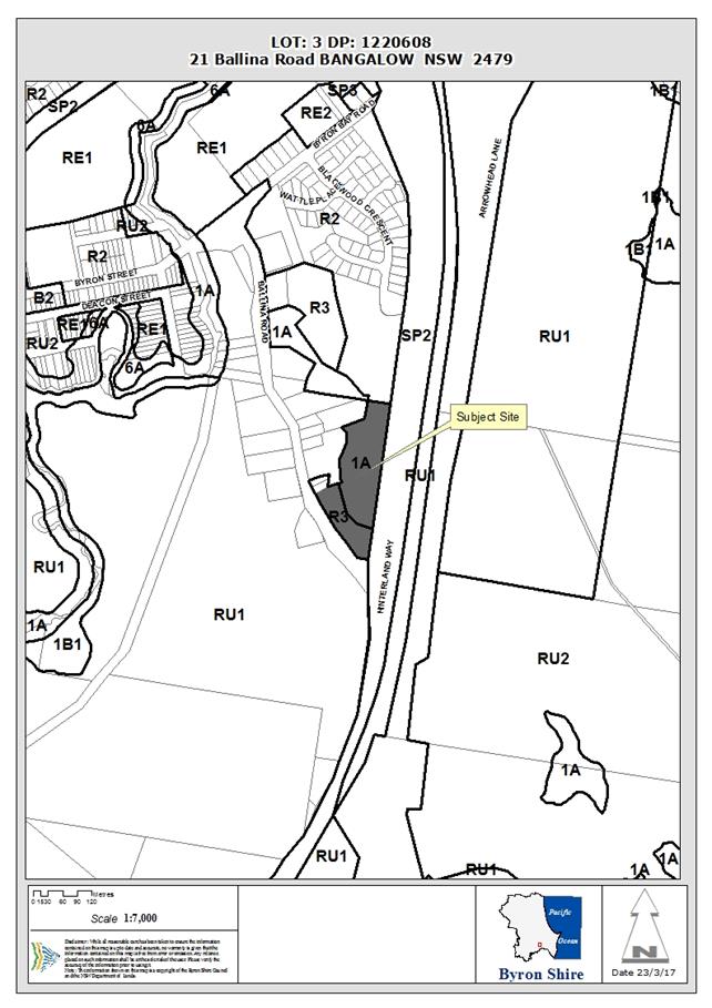
Assessment:
1. INTRODUCTION
1.1 History/Background
The property is vacant and rural and residential land with
no specific development history at present
1.2 Description
of the proposed development
This application seeks approval for residential development
to be carried out in stages:
1. The
subdivision of the site to create two lots:
· proposed Lot 1,
with an area of 6,000m2, encompassing the majority of the area zoned
R3 Medium Density Residential (at Ballina Road frontage); and
· proposed Lot 2,
with an area of 1.882ha, being the residue of the existing site (containing a
small area fronting Ballina Road within the R3 zone, and the remainder of the
lot containing the deferred land, which is zoned 1(a) General Rural under BLEP
1988).
2. Construction
and strata subdivision of a multi-dwelling development, containing 20
two-bedroom units in 5 separate double-storey buildings.
The construction and strata
subdivision of the units is proposed to be under taken in stages, with the
western-most building, containing units 1-4, to be constructed first.
This building will be subdivided under the Strata Schemes Development Act
2015, and the staged strata subdivision will also create four additional
‘development lots’, to be developed in the following subsequent
stages of building construction:
· Stage 2 –
Building 2 containing Units 5-8;
· Stage 3 –
Building 3 containing Units 9-12;
· Stage 4 –
Building 4 containing Units 13-16; and
· Stage 5 –
Building 5 containing Units 17-20.
Construction of the whole of the
internal driveway and associated engineering and stormwater works will occur
with the Stage 1 building construction.
Each of the five buildings has the same design and
materials, constructed using a combination of fibre cement cladding, metal wall
sheeting, rendered brickwork with a metal roof. Each building contains
garages toward the street frontage, with the unit buildings behind stepping
down the slope. A single garage is provided for each unit, with five open
visitor spaces provided along the internal driveway.
One-way access is proposed, with an entry from Ballina Road
on the western side and exit on the east. Given the slope of the land,
the internal driveway is below street level. The units are similar in design
and layout, containing two bedrooms toward the street frontage, with kitchen,
dining and living areas toward the east. Balconies are included off all
living areas with an area of 18m2. The units each have a floor
area of approximately 100m2, proving a total Gross Floor Area of
2,000m2 for the development.
1.3 Description
of the site
|
Land is legally described as:
|
LOT: 3 DP: 1220608
|
|
Property address is:
|
21 Ballina Road BANGALOW
|
|
Land is Zoned:
|
R3 Medium Density Residential / PART DM Deferred Matter
(1(a) General Rural under BLEP 1988)
|
|
Land area is:
|
2.482ha
|
|
Property is constrained by:
|
Bush fire prone land (vegetation buffer)
|
|
|
Drinking water catchment
|
|
|
Key fish habitat
|
|
|
Regionally significant farmland
|
The site is located at the edge of the Bangalow Village, in
an area characterised mainly by single dwellings. The site has an eastern
frontage of 324m to the Hinterland Way and a south-western frontage of
approximately 160m to Ballina Road (the old Pacific Highway) which terminates
in a cul-de-sac at the southern end of the property.
The site is vacant, with some stands of vegetation, located
primarily in the north of site and parts of the eastern and western
boundaries. A small creek traverses the site, located behind the proposed
building location. The site falls sharply from the Ballina Road frontage, where
the elevation is at around RL 60m AHD. The low lying parts of the
site, around the creek and in the northern section average around RL 50m AHD.
The
Site (Source: Six Maps)
Site
Locality (Source: Six Maps)
2. SUMMARY
OF REFERRALS
|
Referral
|
Issue
|
|
Environmental Health Officer
|
No objections subject to conditions.
|
|
Development Engineer
|
A Strata Development Contract and associated Plan have been
submitted for the proposal that links the approved development to the vacant
strata lots created during subdivision process
No objections subject to conditions.
|
|
S64 / Systems Planning Officer
|
No objections subject to conditions.
|
|
S94 / Contributions Officer
|
Contributions are payable. Condition recommended.
|
|
Rural Fire Service
|
Bush Fire safety Authority issued. Included in
recommended conditions.
|
|
Department of Planning & Environment
|
Concurrence issued relating to SEPP No. 1 Objection (see
explanation below).
|
|
Department of Primary Industries Water
|
General Terms of Approval issued for Controlled Activity
Approval. Included in recommended conditions.
|
Issues:
Department of Primary Industries Water
The Department initially expressed concerns regarding the
proximity of the buildings to an existing water course within the site.
The applicants responded by amending the proposal to move two of the buildings
forward on the site, to maximise the set back to the creek. In response to this
amendment, the Department has now issued their General Terms of Approval,
agreeing to the integrated development consent.
NSW Rural Fire Service
The property is on land that is identified as bushfire prone
land. The development application was referred to the NSW Rural Fire Service,
whereby a Bush Fire Safety Authority was issued under Section 100B of the Rural
Fires Act 1997. The conditions contained in that Authority are included
in the Recommendation of this Report below.
3. SECTION
79C – MATTERS FOR CONSIDERATION – DISCUSSION OF ISSUES
Having regard to the matters for consideration detailed in
Section 79C(1) of the Environmental Planning & Assessment Act 1979
(EP&A Act), the following is a summary of the evaluation of the issues.
3.1 State Environmental Planning
Instruments
|
|
Satisfactory
|
Unsatisfactory
|
|
State
Environmental Planning Policy No 1—Development Standards
|
☒
|
☐
|
|
Consideration: Stage 1 of the development involves the
subdivision of the existing Lot 3, to create Proposed Lot 1, being the
majority of land zoned R3, to be developed in Stage 2 for the units, and a
residue parcel, Proposed Lot 2. Lot 2 contains a potential dwelling
site within the R3 zone, but the majority of the lot is zoned 1(a) General
Rural under BLEP 1988.
The minimum lot size for
subdivision of land zoned 1(a) is 40ha. Proposed Lot 2 has an area of
1.882 ha.
The applicants have submitted an
objection under SEPP No 1, arguing that the need to adhere to the 40ha
development standard is unreasonable in the subject case, based on the fact
that the 1(a) zoned land is not fragmented by the proposed subdivision.
The objection is well founded in
this case and can be supported.
The Department of Planning and
Environment have issued concurrence to the approval of this objection.
|
|
State
Environmental Planning Policy No 14—Coastal Wetlands
|
☒
|
☐
|
|
Consideration: There are no mapped SEPP 14 wetlands in
this locality.
|
|
State
Environmental Planning Policy No 26—Littoral Rainforests
|
☒
|
☐
|
|
Consideration: There are no mapped SEPP 26 Littoral
Rainforests in this locality.
|
|
State
Environmental Planning Policy No 44—Koala Habitat Protection
|
☒
|
☐
|
|
Consideration: The site has an area greater than
1ha. It does not, however, contain potential koala habitat.
|
|
State
Environmental Planning Policy No 55—Remediation of Land
|
☒
|
☐
|
|
Consideration: The potential for contamination was
assessed as part of the previous rezoning of the site (2007), concluding that
the land use history is such that there is no likelihood of soil
contamination. No further assessment is necessary.
|
|
State
Environmental Planning Policy No 65—Design Quality of Residential
Apartment Development
|
☒
|
☐
|
|
Consideration: The SEPP only applies to residential
development containing 3 or more storeys. Not applicable in this case.
|
|
State
Environmental Planning Policy (Building Sustainability Index: BASIX) 2004
|
☒
|
☐
|
|
Consideration: ABSA certification has been provided.
|
3.2A Byron Local Environmental Plan 2014 (LEP 2014)
Zone: R3
Medium Density Residential and part DM Deferred Matter (zoned 1(a) General
Rural under Byron Local Environmental Plan 1988)
Definition: Multi dwelling housing means 3 or more dwellings (whether
attached or detached) on one lot of land, each with access at ground level, but
does not include a residential flat building (which is defined as 3 or more
dwellings within a single building).
Multi
dwelling housing is a type of residential accommodation.
Permissibility: Subdivision
is permissible pursuant to clause 2.6 of the LEP. Multi dwelling
housing is permissible with consent in the R3 zone.
Schedule
3 of the LEP provides that strata subdivision is exempt development, but
only where it proposes the subdivision of an existing lawfully erected
building. The subject application proposes a staged strata subdivision,
to create a number of ‘development lots’ so that the residential
unit buildings can be constructed and sold in stages. As such, the staged
strata subdivision requires development consent, and is permissible pursuant to
cl. 2.6.
|
LEP - Summary of Requirement
|
Proposed
|
Complies
|
|
Objectives of the R3 Medium
Density Residential zone
Objectives
of zone
• To
provide for the housing needs of the community within a medium density
residential environment.
• To
provide a variety of housing types within a medium density residential
environment.
• To
enable other land uses that provide facilities or services to meet the day to
day needs of residents.
|
The proposed development provides for additional
residential housing and is consistent with these zone objectives.
|
Yes
|
|
Clause 4.1 Minimum subdivision lot size
The minimum lot size for the R3 component of this site is
300m2.
|
Proposed Lot 1 (which will be development for the
residential units) has an area of 6,000m2.
The minimum lots size development
standard does not apply to the strata subdivision component.
|
Yes
|
|
Clause 4.1E Minimum lots sizes for dual occupancies,
multi dwelling housing and residential flat buildings
Provides that multi dwelling housing cannot be approved in
the R3 zone unless the lot has an area of at least 800m2.
|
The multi dwelling housing will be constructed on proposed
Lot 1, which has an area of 6,000m2.
|
Yes
|
|
Clause 4.3 Height of buildings
The Height of Buildings Map
specifies a maximum height of 9m.
|
There is a section of the building containing Units 17-20
that exceeds the maximum height limit, with a maximum height of 9.5m over a
section of roof for approximately 1.2m in length.
The application includes a
request, made pursuant to cl 4.6, to approve a variation to the 9m building
height development standard.
The variation request is
addressed below.
|
No
|
|
Clause 4.4 Floor space ratio
The Floor Space Ratio Map specifies a maximum of 0.6: 1
for this site.
|
The development site (proposed Lot 1) has an area of
6,000m2. The total floor space of the units is approximately
2,000m2 (see above) providing a maximum FSR of 0.3:1.
|
Yes
|
|
Clause 4.6 Exceptions to development standards
This clause provides a degree of flexibility in applying
certain development standards.
|
See assessment below. The requested variation is
acceptable in the subject case. The concurrence of the Department of
Planning and Environment can be assumed, because BLEP 2014 incorporates the
Standard Template clause for this purpose.
|
|
|
Clause 6.2 Earthworks
The intent of this clause is to minimise the environmental
impacts associated with earthworks.
|
Some cut and fill is required to set the internal driveway
and buildings into the sloping site. The concept design provided is
based on minimising cuts required for the access and internal driveway, with
garage levels and building floor levels dependant on the driveway level.
The driveway requires minor cut
at its western end and minor filling at the east.
Overall, it is apparent that the
design has minimised the earthworks required, and that these works will not
result in adverse environmental impacts.
|
Yes
|
|
6.3 Flood planning
Development consent must not be granted to development on
land to which this clause applies unless the consent authority is satisfied
that the development is compatible with the flood hazard of the land, and
will not significantly adversely affect flood behaviour resulting in
detrimental increases in the potential flood affectation of other development
or properties.
|
Previous flood modelling in the Bangalow locality suggest
a 1 in 100 year flood level of RL 47.85m AHD. Given that a low lying
watercourse traverses the site, it is apparent that the low lying areas of
the site will experience some local flooding.
The proposed buildings have a
minimum floor level at around RL 54m AHD, so will not be impacted by
flooding. Being above the flood level, the development will also not effect
flood behaviour within or outside the site.
|
Yes
|
|
6.6 Essential services
Council must be satisfied at that all required services
are available.
|
The application has demonstrated that appropriate services
can be provided for all lots.
As originally lodged, the
proposed development raised issues relating to effective stormwater
management. The applicants were requested to revise aspects of the
design to correct these issues and, as currently proposed, the development is
satisfactory in relation to stormwater management.
|
Yes
|
|
6.7 Affordable housing in residential and business
zones
In approving development for residential accommodation in
the R3 zone, Council must consider the need for providing affordable housing.
|
While the application has not been made pursuant to the
SEPP (Affordable Rental Housing), in providing 20 two-bedroom apartments, the
development will provide housing that is affordable in the Bangalow context.
The majority of housing stock in
Bangalow consists of single dwellings on larger lots. There are very
few units available in the village, and these units will therefore provide
additional housing options for moderate income families.
|
Yes
|
Clause 4.6 –
Variation to development standard: maximum building height
The Applicant has submitted a
clause 4.6 variation request, which is considered with reference to relevant
matters as follows:
1. Introduction
– Summary of proposed development
The development application
proposes the construction of multi dwelling in the form of 5 buildings, each
containing 4 two-bedroom units, providing a total of 20 units.
2. Clause
4.6 Exceptions to Development Standards
Clause 4.6 of Byron LEP 2014
provides that development consent
may be granted for development even though the development would contravene a
development standard imposed by the LEP.
It specifies, however, that
consent must not be granted unless Council has considered a written request
from the applicant that seeks to justify the contravention of the development
standard by demonstrating:
(a) that
compliance with the development standard is unreasonable or unnecessary in the
circumstances of the case, and
(b) that
there are sufficient environmental planning grounds to justify contravening the
development standard.
These matters are assessed below
in item 7.
3. The
Development Standard to be varied
The development standard to be
varied is contained in clause 4.3 of LEP 2014. In this case, the Height
of Buildings map specifies a maximum height of 9m.
4. Extent
of Variation to the Development Standard
The architects’ plans show
that the building containing Units 17-20 (the eastern most building) has a
maximum height of 9.5m. The 9m development standard is breached for a
distance of approximately 1.2m of the roof line.
5. Objective
of the Development Standard
The objectives of the development
standard are:
(a) to
achieve building design that does not exceed a specified maximum height from
its existing ground level to finished roof or parapet,
(b) to
ensure the height of buildings complements the streetscape and character of the
area in which the buildings are located,
(c) to
minimise visual impact, disruption of views, loss of privacy and loss of solar
access to existing development.
6. Objectives
of the Zone
The objectives of the R3 Medium
Density Residential Zone are:
· To provide for
the housing needs of the community within a medium density residential
environment.
· To provide a
variety of housing types within a medium density residential environment.
· To enable other
land uses that provide facilities or services to meet the day to day needs of
residents.
7. Assessment
– the specific questions to be addressed:
(a) Clause
4.6(3)(a) – Is compliance with the development standard unreasonable or
unnecessary in the circumstances of the case?
Non-compliance with the standard
arises, in this case, primarily due to the topography of the site, which slopes
relatively steeply down from the road frontage, and also falls slightly across
the site, from west to east. The floor level of each of the five unit buildings
is linked to the internal driveway level and the floor level of the
garages. BCA access requirements limit the grade allowable from garage
level to the adjoining floor level.
In the eastern end of the site,
because of existing topography, the internal access (and garage level) is
approximately 1-1.5m above ground level. This is necessary to achieve the
appropriate access grade and to minimise the need to cut the driveway at the
western end.
Because the garage is set above
the natural ground level, the associated building also needs to be set above
natural ground (to achieve the required access grades). Given the slope
down the hill and across the property, the NW corner of the building ends up at
a maximum height of 9.5m for a short distance. Reducing this corner to comply
with the development standard would require lowering the whole of the
development, which would result in the need to cut into the hill for the
western end of the driveway, which would require further substantial earthworks
to get the driveway from the adjoining road level into the site.
The overall impacts of that would
be greater than the potential impacts associated with the small extent of
non-compliance with the height limit.
Given that this section of the
building overlooks the vacant residue lot, which has an entitlement for a
single dwelling, it is considered that the height does not result in impacts on
adjoining land.
Overall, in the circumstances,
compliance with the development standard is unreasonable.
(b) Clause
4.6(3)(b) – Are there sufficient environmental planning grounds to
justify contravening the development standard?
See
above. Given the zoning of the site and the location of the
non-compliance within the site, there are sufficient environmental planning
grounds to support the variation required.
(c) Clause
4.6(4)(a)(ii) – Is the proposed development in the public interest? Is it
consistent with the objectives of the standard and the zone as set out above?
The development is consistent with
the R3 Medium Density zone objectives. It is also consistent with the
objectives of the building height standard, in that the majority of the
buildings are well below the 9m maximum and the small area of breach is located
at the point furthest away from existing development. There are also no
lots located further to the east, which could be impacted by the height.
The proposed development would
produce a better planning outcome than one that strictly complies with the
development standard because requiring strict compliance would result in a need
for more earthworks across most of the development site.
3.2B Byron Local Environmental Plan 1988 (LEP 1988)
The majority of Proposed Lot 2 is zoned 1(a) Rural under the
BLEP 1988. The creation of this lot will not fragment the area zoned
1(a); the entirety of that area remains unchanged within this residue lot
(which also has a small area adjacent to proposed Lot 1 which is zoned R3 under
BLEP 2014).
|
LEP - Summary of Requirement
|
Proposed
|
Complies
|
|
Objectives of the 1(a)
General Rural Zone
• to
encourage and permit a range of uses creating a pattern of settlement, at a
scale and character that maintains or enhances the natural, economic,
cultural, social and scenic amenity of the rural environment of the Shire of
Byron,
• to
encourage and permit a pattern of settlement which does not adversely affect
the quality of life of residents and visitors and maintains the rural
character,
• to
ensure development only occurs on land which is suitable for and economically
capable of that development and so as not to create conflicting uses,
• to
allow the use of land within the zone for agricultural purposes and for a
range of other appropriate purposes whilst avoiding conflict between other
uses and intensive agriculture,
• to
identify lands (shown hatched on the map) which in the opinion of the council
possess a limited capability for more intensive uses or development,
• to
restrict the establishment of inappropriate traffic generating uses along
main road frontages other than in road side service areas,
• to
ensure sound management of land which has an extractive or mining industry
potential and to ensure that development does not adversely affect the
potential of any existing or future extractive industry,
• to
enable the provision of rural tourist accommodation and facilities only where
such facilities are compatible with the form and density of the nature of the
locality, and
• to
permit the development of limited light industries which do not pose any
adverse environmental impact, (eg software manufacture and film processing),
and
• to
ensure that the development and use of land shown cross-hatched on the map
adjacent to areas of significant vegetation and wildlife habitat do not
result in any degradation of that significant vegetation and wildlife
habitat, and that any development conserves and protects and enhances the
value of the fauna and flora.
|
The proposed development creates a lot which contains the
area zoned 1(a) General Rural, but no development is proposed within that
area.
The lot created will have a
dwelling entitlement, but there is an area zoned R3 Medium Density
Residential under BLEP 2014 which is more likely to contain a future
dwelling.
The proposal raises no issues
which are inconsistent with the zone objectives.
|
Yes
|
|
Clause 10 Subdivision generally
Specifies that consent is required for the subdivision of
land
|
|
Yes
|
|
Clause 11 Subdivision in rural areas for agriculture
etc.
This clause specifies a minimum lot size of 40ha for land
zoned 1(a) General Rural.
|
Proposed lot 2, which contains the 1(a) zoned land, does
not have an area of 40ha.
The applicants have provided an
objection under SEPP No. 1 (discussed above) in relation to this standard.
The objection is considered to be
well founded in this case as the proposed subdivision does not fragment the
existing area of 1(a) or create any additional entitlement within that zone.
|
No
|
|
Clause 24 Development of flood liable land
Council must be satisfied that development will not
restrict the flow of flood water or increase the level of flooding outside
the site.
|
The 1(a) zoned land
contains an existing creek and the areas immediately around this creek are
flood liable. There is no physical development in this flood liable
area, so the development is acceptable in regard to the requirements of this
clause.
|
Yes
|
3.3 Any
proposed Instrument that has been the subject of public consultation and has
been notified to the consent authority
There are no applicable draft planning instruments.
3.4A Byron Shire Development Control Plan 2014
(DCP 2014)
|
Byron Development Control
Plan 2014
|
|
Control
|
Assessment
|
Compliance
|
|
Chapter B3 Services
|
|
B3.2.1 Provision of
Services
|
|
|
|
a) Water Supply
Development shall be
provided with an adequate water supply connection or have suitable
arrangements in place for the provision of an adequate water supply service.
|
Reticulated water supply is
available to the site and can be provided and/or upgraded as required to
service the proposed development.
|
Yes
|
|
b) Electricity Supply
Development shall be
provided with an adequate connection to grid supplied electricity services or
its equivalent
|
Conventional connection to
grid is proposed.
|
Yes
|
|
c) Telecommunications Infrastructure
Development shall be
provided with adequate access to the telecommunications network for fixed
line telephone services.
|
Conventional services are
proposed.
|
Yes
|
|
d) Sewage Management
Development shall be provided
with an adequate reticulated sewer connection or have suitable arrangements
in place for such a connection to be made where access to reticulated sewer
is available
|
Conventional reticulated
sewerage is proposed.
|
Yes
|
|
e) Stormwater and Drainage
Development applications
must contain sufficient information to assess whether the proposed stormwater
system is effective and feasible, both within the site and in its connection
to the public drainage system.
|
Stormwater Management Plan
was provided to support the application.
|
Yes
|
|
f) Road Access – General
Development must comply
with road access requirements contained in Chapter B4 Traffic Planning,
Vehicle Parking, Circulation and Access, and the Northern Rivers Development
& Design Manual.
|
Access
is provided from Ballina Road by way of a one-way driveway entering from the
western side of proposed Lot 1 (unit site) and exiting at the eastern end.
Access
is also available to the residual lot (proposed Lot 2) by a separate driveway
off Bangalow Road, immediately east of the proposed unit exit driveway.
Concepts
have been provided to demonstrate these access works can be designed and
constructed in accordance with relevant standards.
|
Yes
|
|
Chapter B4 Traffic Planning, Vehicle Parking, Circulation and Access
|
|
B4.2.1 Traffic Impact
Development likely to result in moderate to high traffic impacts
(10-15+ peak hour trips) is required to be supported by a Traffic Impact
Statement
|
A Traffic Impact Statement
has been submitted. It identifies that the development is likely to
generate in the order of 8-10 peak hour trips.
The property is located at
the eastern end of Ballina Road, which terminates at the SE boundary of the
land. This was previously the Pacific Highway and contains a two-way
bitumen sealed road.
Ballina Road intersects
with Byron Street at an intersection containing dedicated turning lanes.
The Statement concludes
that the proposed development is acceptable in terms of traffic generation
and potential impacts.
|
Yes
|
|
B4.2.3 Vehicle Access
and manoeuvring areas
Driveways and
manoeuvring areas are to be designed and constructed in accordance with the
requirements of the current editions of Australian Standard 2890 and the
Northern Rivers Local Government Development & Design Manual.
|
Sufficient information has
been provided demonstrating that access can be provided to both lots and all
buildings in accordance with these requirements.
|
Yes
|
|
B4.2.5 Car parking
requirements
In relation to medium
density residential development, the DCP requires:
· 1 space per 1 or 2 bedroom unit;
· 1 visitor space per 4 units (or part thereof);
Each dwelling is to have
at least 1 covered space.
|
The proposed development
includes:
· 20 two-bedroom units @ 1 space = 20 spaces; and
· 1 visitor space per 4 units = 5 spaces.
A total of 25 spaces are
provided, with 20 provided in garages (one for each unit) and 5 open spaces
in the access driveway.
|
Yes
|
|
Chapter B9 Landscaping
|
|
B9.4 Multi dwelling
housing, residential flat buildings and attached dwellings
|
|
B9.4.1 Landscape Principles
The following design
requirements apply to multi dwelling housing, attached dwellings and
residential flat buildings developments:
· retention of suitable existing vegetation;
· screen planting to street frontages and driveway
areas, to provide privacy between dwelling houses and around the boundaries
of the site;
· provision of pleasant landscaped settings for the
enjoyment of residents;
· planting selection that relates to building scale
and mass.
|
The proposed development
requires the removal of a single Camphor laurel tree. There is no other
significant vegetation within the development footprint.
Landscaping
is proposed along the street frontage side of the internal driveway, but the
grades here, with the driveway well below the level of the street, are such
that this planting will not provide an effective screen.
A
condition is recommended requiring screen planting within the verge of the
Ballina Road reserve.
|
Yes
|
|
The common landscaped area
must be at least 90m2 per unit (large units).
A minimum of 75% of the
total common landscaped area of the site must consist of deep soil
areas. Areas of landscaping over underground car parks, and the like,
cannot be included in the calculation of deep soil areas.
|
There is sufficient area
available within Proposed Lot 1 to meet this requirement. A detailed
landscape plan will be required at Construction Certificate stage to
demonstrate where this common landscaped area will be provided.
|
Yes
|
|
Chapter B13 Access and
Mobility
|
|
B13.2.2 Multi dwelling housing,
attached dwellings, residential flat buildings, shop to housing and serviced
apartments
Design and Access in
accordance with AS1428.1 – Design for Access and Mobility
–General Requirements for Access – New Buildings (for class 3, 5,
6, 7, 8 and 9 buildings) and AS 4299 -Adaptable Housing must be provided to
and within a minimum of 10% of units.
|
Proposed
Units 1 & 2 have been designed in accordance with these requirements.
|
Yes
|
|
Chapter D1 Residential
Accommodation in Urban, Village and Special Purpose Zones
|
|
D1.2 General Provisions
|
|
D1.2.1 Building Height
Plane
The building height
plane in combination with boundary setbacks prescribed in this DCP, and
building height prescribed in the Byron LEP 2014, form the maximum building
envelope for all residential development
|
The
proposal involves minor encroachments into the Building Height Plane, which
are identified and assessed below.
As
outlined below, the encroachments do not result in overshadowing or privacy
issues and can therefore be supported.
|
No – but variation supported
|
|
D1.2.2 Setbacks
Street frontage –
4.5m
Side & Rear –
1.5m (& BHP)
Between buildings
– 3m
|
Proposed:
Street
frontage: min. approx. 9m
Sides:
min. approx 3.4m
Between
buildings: 3.1m
|
Yes
|
|
D1.6 Multi dwelling
housing, residential flat buildings and attached dwellings
|
|
D1.6.1 Private open
space courtyards
Each dwelling must have
access to an individual courtyard at ground level having a minimum area of
30m2 and a minimum length and width each of 4 metres, not
including any area used exclusively for the circulation or parking of
vehicles. The courtyard must be designed to facilitate access to winter
sunshine and must be landscaped to Council’s satisfaction.
|
Each
ground floor dwelling has access to yard space meeting these requirements.
Upper
floor dwellings are provided with balconies (see below).
|
No – but open space balconies provided (see
D1.6.2)
|
|
D1.6.2 Open space
balcony
Where dwellings are
situated or have access entirely above the ground level of the development,
Council may consent to the provision of private open space by means of a
balcony which is of sufficient size and which is located so as to provide a
usable private outdoor area to Council’s satisfaction.
A
private open space balcony must have a minimum area of 15m2 and a
minimum length and width of 2.4 metres. A private open space balcony
must be demonstrated to have appropriate orientation and adequate provision
for winter sun and summer shade
|
The
proposed upper floor units all include balconies that meet the requirements.
|
Yes
|
|
D1.6.5 Sound proofing
Division walls between
dwellings must be of sound-resisting construction to Council's satisfaction.
The
floors in single storey multi-dwelling housing, residential flat buildings
and attached dwellings must be so constructed or treated as to minimise the
conduct of sound between dwellings.
|
The
proposed development can comply. Relevant BCA provisions will apply.
|
Yes
|
|
D1.6.6 Clothes drying
facilities
The minimum provision of
clothes drying facilities must be at the rate of 7.5 metres of line per
dwelling, located in suitably screened external drying areas.
|
Drying
areas/ decks are provided for each unit.
|
Yes
|
|
Chapter E2 – Bangalow
|
|
E2.1.2 Objectives of
this Chapter
1. To facilitate and provide guidelines for the development of the
Bangalow Urban Area consistent with the provisions of Byron LEP 2014 and
other relevant Chapters of this DCP.
2. To maintain and enhance the unique character and amenity of Bangalow
as a rural township with strong historical linkages and heritage values; and
to encourage new development to complement that special character to support
and strengthen the historical context, heritage values, living amenity and
tourist potential of the town.
3. To provide for a variety of residential development forms and
densities, including innovative multi dwelling housing and other medium
density forms which best utilise the town’s topography and maximises
the use of services.
4. To establish specific guidelines for the conservation of places and
buildings identified as historically significant with criteria for
extensions, alterations and infill development sympathetic to the important
buildings in terms of design, scale, detailing, materials, colours, etc.
5. To provide for an upgraded network of public open space, integrated
with pedestrian access, cycleway and recreation facilities to meet public
open space and recreation needs as the town expands.
6. To preserve areas of significant habitat and vegetation value, to
promote their active regeneration and to protect them from the impacts of
development and domestic animals.
7. To allow for the provision and upgrading of community facilities to
meet needs as growth occurs.
|
The proposed development is
generally consistent with these aims. It will provide for a variety of
housing, in a medium density form. There is little existing medium
density in the Village, so the development provides complimentary housing
options.
|
Yes
|
|
E2.2.1 Character,
Bulk and Scale of Development
Proposed development
must respect and complement this historical and architectural significance in
its setting. Development applications must demonstrate that:
a) The character, bulk, scale, density and landscape treatment
of proposed development will be compatible with and will enhance the low
rise, historical character and scale of Bangalow, its built environment and
its surrounds, including the characteristics (a) to (e) inclusive in Section
E2.1.3 above.
b) Building materials, textures, finishes and colours
will be compatible with and will enhance the low rise, historical character
and scale of Bangalow, its built environment and its surrounds, including the
characteristics discussed above where relevant. Reflective colours or
surfaces are to be avoided unless required for heritage reasons.
c) Where applicable the proposed development is
consistent with the requirements of Chapter C1 Non-Indigenous Heritage.
|
The subject site is one of
only two sites zoned for medium density development in Bangalow.
It
is expected therefore, that the development on this site would be of a
greater density than the remainder of the village.
The
existing residential stock within the village is generally characterised by
single timber dwellings.
The
design of the proposed units does not reflect that existing character, with
five two-storey buildings that are virtually identical. The materials
are more in keeping with the existing character, using fibre cement sheeting
and colourbond roofing.
The
topography of the site helps to mask the bulk of the buildings, in that they
are sited well below the level of the adjoining street. The location at
the end of this street also assists.
Overall,
it is considered that the design of the development is acceptable in its
context.
|
Yes
|
|
E2.4 Development
outside the Conservation Area
|
|
|
|
E2.4.3 New Urban
Areas
New development must
complement the bulk, scale and character of development in the existing town
to assist compatibility between new and old development in terms of
streetscape, landscaping, building materials, colour, roof pitch and
materials
|
Discussed above.
|
Yes
|
|
E2.5 Bangalow Urban
release Areas
|
The site is nominated as
Urban Release Area 4 (South).
|
|
|
E2.5.3 Desired Future
Character
Street Design: Not relevant to this area
Natural Environment: Remnant bushland, wetland and riparian vegetation
are to be retained where possible and enhanced as significant natural
features within the land.
Water Sensitive Urban
Design: Stormwater management
including at-source treatments.
Pedestrian and Cycle
Linkages: Not relevant to
this area
Solar Access: Dwellings should be sited to maximise solar
access.
|
The riparian area
associated with the small creek that flows through the site will be enhanced
in accordance with a vegetation management plan required by the Controlled
Activity approval (Water Management Act).
Stormwater
management measures have been assessed and are acceptable.
The
units are appropriately orientated to maximise solar access.
|
Yes
|
|
E2.5.6 Buffers and
Environmental Corridors
A riparian corridor must
be rehabilitated adjacent to the new residential areas.
|
See above
|
Yes
|
Building Height Plane encroachments:
1. The
western elevation of Building 1 (Units 1-4):
The encroachment involves a small
section of the roof edge.
This building adjoins an existing
residential lot, containing a single dwelling. The area of encroachment
is located slightly downslope of the rear of the adjoining dwelling, which is
to the west. The encroachment is not likely to result in overshadowing or
privacy impacts for the adjoining dwelling.
2. The
eastern elevation of Building 5 (Units 17-20):
The encroachment involves the upper
floor balcony (Unit 20).
This encroachment is associated with
the Stage 1 (internal) subdivision boundary between proposed Lots 1 and
2. There is no dwelling on proposed Lot 2.
The Building Height Plane encroachments are quite minor,
resulting from the topography of the site. They do not result in
overshadowing or privacy impacts for neighbouring lots and can therefore be
supported.
3.4B Byron Shire Development Control Plan 2010 (DCP 2010)
DCP 2010 is an applicable matter for consideration in the
assessment of the subject development application in accordance with subsection
79C(1) of the EP& A Act because its purpose is to provide planning
strategies and controls for various types of development permissible in
accordance with LEP 1988.
There is no physical development proposed within the 1(a)
zoned land, and therefore there are no relevant provisions of DCP 2010.
3.5 Any
Planning Agreement or Draft Planning Agreement?
|
|
Yes
|
No
|
|
Is there any applicable planning agreement or draft
planning agreement?
|
☐
|
☒
|
3.6 Environmental
Planning & Assessment Regulation 2000 Considerations
The proposal raises no issues for consideration in terms of
Clauses 92, 93, 94 and 94A of the Regulations.
3.7 Any coastal zone management
plan?
The site is not in the coastal zone and no CZMP applies.
3.8 The likely impacts of that
development, including environmental impacts on both the natural and built
environments, and social and economic impacts in the locality
|
Impact on:
|
Likely significant impact/s?
|
|
Natural environment
|
The proposal will not have a significantly adverse impact
on the natural environment of the locality.
|
|
Built environment
|
The proposal will not have a significantly adverse impact
on the built environment of the locality.
|
|
Social Environment
|
The proposal will not have a significant social impact on
the locality.
|
|
Economic impact
|
The proposal will not have a significant economic impact
on the locality.
|
Minor impacts are anticipated during the construction phase.
Appropriate conditions of consent are recommended in relation to hours of work,
construction noise, builders waste and the like to manage such impacts
3.9 The
suitability of the site for the development
The site is one of only two areas of R3 Medium Density
Zoning in Bangalow, with the other also located along Ballina Road. The
site is a cleared, serviced, urban lot on the edge of the existing
village. Given the location and the slope of the lot down from the road
frontage, medium density development is somewhat ‘hidden’ from
view.
The development is consistent with the planning intent of
the land and the site is suitable for the development as proposed.
3.10 Submissions
made in accordance with this Act or the regulations
The development application was publicly exhibited.
There were 2 submissions made on the development application, objecting to the
proposed development. The issues raised in objection are addressed below:
|
Issue
|
Comment
|
|
The development is out of character with the
surrounding residences which are of workers cottage or
‘Queenslander’ styles. Some of heritage value that date
back to the early 1900s.
|
The proposed units are quite different in design from the
single dwellings located in the area.
The site, however, is zoned
differently to the adjoining land, with an R3 Medium Density Residential zone
as opposed to an R2 Low Density residential Zone.
It is considered that the density
and character of the development is consistent with the planning intent of
the R3 zone.
|
|
Twenty apartments on such a small block is
unprecedented in Bangalow and is certainly not in keeping with the semi-rural
nature of Ballina Road.
|
See above. The site is zoned R3 Medium Density
Residential. The development is consistent with the planning controls
applicable to this zone.
|
|
The aesthetic nature of the proposed buildings is on no
way sympathetic to the style of architecture commonly seen in the rest of the
street, or the town of Bangalow for that matter.
|
The buildings are of a more conventional medium density
design, and not reflective of the ‘Queenslander’ style that is
prevalent in Bangalow.
The Queenslander style, however,
is specific to low density, predominantly single-dwelling, residential
development and does not translate well to a multi-dwelling form.
The matter was raised with the
applicant who provided a evidence of contemporary residential design existing
throughout Bangalow, particularly in more recent subdivision areas near the
subject site.
Having regards to the location of
the site on the southern periphery of the Bangalow, the design of the
development set well below street level reducing the impact of the bulk of
the proposed buildings, and in the absence of any clear development
guidelines to direct applicants to construct Queenslander style housing, this
is not a reason for refusal.
|
|
Concern regarding impacts on the water course
|
Conventional construction management techniques will be
able to effectively manage protection of the creek.
The General terms of Approval
associated with the Department of Primary Industry Water’s Controlled
Activity approval also require rehabilitation and vegetation management plans
that will further protect the water course.
|
|
Flooding – concerns that development will
exacerbate flooding of downstream properties
|
Flood modelling undertaken in this area indicates that the
1 in 100year flood level is approximately at the location of the water course
on the land.
The buildings are all set above
this level and will therefore have no impact on downstream flooding.
|
3.11 Public
interest
The proposed development will provide for a form of medium
density housing which is not readily available in Bangalow. It is likely such
housing will be utilised by smaller households such as couples, young families
and others wishing to downsize. It is considered the development is unlikely to
prejudice or compromise the public interest or create a dangerous precedent.
3.12 Section 5A of
the EP&A Act – Significant effect on threatened species
Having regard to sections 5A, 5C and 5D of the EP&A Act, there is unlikely to be a significant effect on threatened species,
populations or ecological communities, or their habitats as a result of the
proposed development as no tree clearing is required.
3.13 Section 5B of
the EP&A Act – Have regard to register of critical habitat
The
NSW Critical Habitat Register does not identify any critical habitat on or
adjacent to the site.
4. DEVELOPER
CONTRIBUTIONS
4.1 Water
& Sewer Levies
Water & Sewer levies are payable.
4.2 Section
94 Contributions
Developer contributions are
payable.
5. CONCLUSION
It is considered the development generally complies with the
provisions of Byron LEP 2014 and Byron DCP 2014 for multi dwelling housing and
subdivision. A minor breach of the 9 metre height limit is proposed in relation
to a small section of Building 5, containing Units 17-20 by half a metre for a
length of approximately 1.2m. The applicant has sought a variation to the
height limit, and having regard to the topography of the land and the level of
variation being sought, strict compliance with the development standard is not
warranted in this instance. The development site is zoned R3 Medium Density
Residential, and the proposal is considered to satisfy the objectives of this
zone, and the planning intent for the site.
It is concluded the development will not generate impacts on
the surrounding built and natural environment, whilst the proposal is unlikely
to create a dangerous precedent. The development will provide for an alternate
form of accommodation not readily available in Bangalow which will suit those
wishing to live in smaller housing within the town. The application is
recommended for approval subject to conditions of consent
6. RECOMMENDATION
It is recommended that,
pursuant to Section 80 of the Environmental Planning & Assessment Act
1979, development application 10.2016.273.1 for Stage One: Two (2) Lot Subdivision; and Stage Two: Construction of
20 Two Bedroom Dwelling Houses and Strata Subdivision, be granted consent
subject to the conditions listed in Attachment 3(#E2017/21284).
7. DISCLOSURE
OF POLITICAL DONATIONS AND GIFTS
|
Has a Disclosure Statement been received in relation
to this application
|
No
|
|
Have staff received a ‘gift’ from anyone
involved in this application that needs to be disclosed. Where the answer is
yes, the application is to be determined by the Director or Manager of the
Planning, Development and Environment Division.
|
No
|
Provide Disclosure Statement register details here: Not
applicable
Staff Reports - Sustainable Environment and Economy 13.12
Report No. 13.12 Update
West Byron Development Control Plan - Advice from the Minister for Planning
Directorate: Sustainable
Environment and Economy
Report Author: Shannon
Burt, Director Sustainable Environment and Economy
File No: I2017/430
Theme: Ecology
Planning Policy and Natural Environment
Summary:
Council has prepared and
publically exhibited a draft West Byron Urban Release Area DCP. The
purpose of the DCP was to
provide guidance to the West Byron Urban Release Area, including staging plan:
transport movement hierarchy; landscaping; stormwater and water quality
management controls. Over 750 submissions were received.
Council considered a report on the
submissions at the 17 November 2016 meeting and resolved ‘that subject
to peer reviews of frog, koala, traffic, and water and flood management
reports,
Council approve the Byron
Shire Development Control Plan 2014 - Chapter E8 West Byron Urban
Release Area and associated
amendments to Part A and Part D of the Byron Shire Development
Control Plan 2014 in Attachments 1 and 2 at the first Ordinary
Meeting after Council’s summer recess’. (Resolution 16-583)
Part 4 of the resolution stated: “4. That if the Department is not
supportive of the timeline outlined in 1, Council endorse the DCP
without the peer reviews and that these reviews be completed after the DCP has been approved.”
Council has now received written
advice from the Minister for Planning The Hon Anthony Roberts about the
finalisation of the West Byron Development Control Plan.
The purpose of this report is to
advise Council of this advice, and to confirm the response to be given to the
Minister having regard to Part 4 of Resolution 16-583 and Resolutions 17-045
and 17-071 which pertain to the scope of Peer Reviews sought of the DCP by
Council.
|
RECOMMENDATION:
That Council:
1. Approve
the Byron Shire Development Control Plan 2014 – Chapter E8 West Byron
Urban Release Area and associated amendments to Part A and Part D of the
Byron Shire Development Control Plan 2014 in Attachments 1 (#E2017/22828) and
2 (E2017/23011), and that notice of the decision be published in a local
newspaper within 28 days of this decision being made.
2. Notify
the Minister for Planning of the decision made in (1).
3. Not
proceed with the peer reviews of the Development Control Plan
2014 – Chapter E8 West Byron Urban Release Area as per
Resolutions 16-583, 17-045 and 17-071.
|
Attachments:
1 Letter
from Minister for Planning dated 30 March 2017 , E2017/22828 ⇨
2 draft
Amendments to Part A and Part D of Byron Shire DCP 2014, E2017/23011 ⇨
3 Draft
Byron DCP 2014 Chapter E8 - West Byron Urban Releasae Area, E2016/83304 ⇨
Report
Council has prepared and
publically exhibited a draft West Byron Urban Release Area DCP. The
purpose of the DCP was to
provide guidance to the West Byron Urban Release Area, including staging plan:
transport movement hierarchy; landscaping; stormwater and water quality
management controls. Over 750 submissions were received.
Council considered a report on
the submissions at the 17 November 2016 meeting and resolved ‘that
subject to peer reviews of frog, koala, traffic, and water and flood management
reports,
Council approve the Byron
Shire Development Control Plan 2014 - Chapter E8 West Byron Urban
Release Area and associated
amendments to Part A and Part D of the Byron Shire Development
Control Plan 2014 in Attachments 1 and 2 at the first Ordinary
Meeting after Council’s summer recess’. (Resolution 16-583)
Part 4 of the resolution stated: “4. That if the Department is not
supportive of the timeline outlined in 1, Council endorse the DCP
without the peer reviews and that these reviews be completed after the DCP has been approved.”
Council has now received written
advice from the Minister for Planning The Hon Anthony Roberts about the
finalisation of the West Byron Development Control Plan (Attachment 1).
In short the Minister:
· Has reviewed the matter
and the staff report and recommendation from the 17 November 2016;
· Is concerned about the
amendments proposed and the impact on site as well as the additional peer
reviews being required prior to it being finalised;
· Requests that Council
respond within 28 days as to why the DCP cannot immediately by made, with only
the Council staff post exhibition amendments; and
· If no response, will
issue a direction for the DCP to be made or he will make the DCP.
Council received an email copy of the letter from the
Minister dated 30 March 2017. Council has until the 27 April 2017 to
respond.
It is staff recommendation that Council advise the Minister
that it will proceed with the finalisation of the DCP in accordance with Part 4
of Res 16-583.
This will also assist with the management and assessment of
development applications likely to be received in the near future. It should be
noted that the Environmental Planning and Assessment Act enables such
development applications to be submitted in the absence of a DCP for the site.
Given that this resolution provides for the peer reviews to
be completed after the DCP is made, staff seek Council clarification whether or
not there is a need to continue with the peer reviews of the DCP as per
Resolutions 16-583, 17-045 and 17-071 given that a DCP if made will be
operational. This also takes into consideration the cost of the peer reviews.
This is discussed below.
In the circumstances it is staff recommendation that the
peer reviews not proceed.
Financial Implications
The cost of undertaking the peer review has not been
allocated within Council’s existing budget and requires funding to
proceed to meet the requirements of Resolution 17-045 and 17-071. Consideration
of the funding will be given as part of the 2017/18 budget process if deemed
necessary to progress further given the Minister’s letter and advice. The
cost of the peer review is approximately $20,000.
Statutory and Policy
Compliance Implications
A Development Control Plan is made under the provisions of
the Environmental Planning and Assessment Act 1979.
As advised in the Minister’s letter a direction can be
issued to Council under section 74F of the Environmental Planning and
Assessment Act to make the DCP.
Staff Reports - Sustainable Environment and Economy 13.13
Report No. 13.13 Rural
Land Use Strategy Implementation Plan
Directorate: Sustainable
Environment and Economy
Report
Author: Shannon
Burt, Director Sustainable Environment and Economy
File No: I2017/444
Theme: Ecology
Planning Policy and Natural Environment
Summary:
Council considered Report No. 13.12 - Strategic
Planning Project Update at its Ordinary Meeting of 23 February 2017.
This report presented a summary of the status, key actions
and any financial considerations required to progress the key planning studies,
strategies and plans current, including the Rural Land Use Strategy.
With respect to the Rural Land Use Strategy Council at this
meeting resolved:
“17-045 Resolved:
…
2. That
Council adopt the project recommendations contained in this report being:
a) amend the draft Rural Land Use Strategy to address the matters
raised in the Department’s letter (Attachment 1) and present an amended
draft strategy back to Council for adoption together with a full program for
implementation.….”
The purpose of this report is to address Item 2 in
resolution 17-045 above.
|
RECOMMENDATION:
That Council adopt:
1. The
amended ‘Rural Land Use Strategy’ and supporting ‘Policy
Directions Paper’ and ‘Site Suitability Criteria & Mapping
Methodology’ (as contained in Attachments 2-4 E2017/24327, E2017/24339,
E2017/24343 respectively), and submit these documents back to the Department
of Planning and Environment for final endorsement.
2. A
prioritisation order for the Actions contained in the ‘Rural Land Use
Strategy Implementation Plan’ as follows: (X-Y to be included at
meeting);
3. The
‘Rural Land Use Strategy Implementation Plan’ (as contained in
Attachment 5 #E2017/23508), as amended by 2 above.
|
Attachments:
1 Response
letter from NSW Department of Planning & Environment dated 20Oct2016 - re
endorsement of Draft Rural Land Use Strategy (as adopted 4/8/16), E2017/24308 ⇨
2 Amended
draft RLUS and Appendicies - incorporating changes in response to 20 October
2016 submission from DPE, E2017/24327
⇨
3 Site
Suitability Criteria and Mapping Methodology (as amended), E2017/24339 ⇨
4 Rural Land
Use Strategy Policy Directions Paper (as amended), E2017/24343 ⇨
5 Rural Land
Use Strategy Implementation Plan, E2017/23508
⇨

Report
Council at its 4 August 2016 meeting resolved (Res 16-414)
to adopt the draft Rural Land Use Strategy with a number of amendments.
The Strategy was finalised to incorporate the adopted amendments and forwarded
to the Director General of the Department of Planning and Environment for
endorsement.
The Department responded to the
adopted document advising that ‘at this stage the Department is unable
to endorse the Strategy’ due to a number of outstanding matters that
need to be addressed. Attachment 1 contains the Department of
Planning and Environment’s response letter.
Council considered Report No. 13.12 - Strategic
Planning Project Update at its Ordinary Meeting of 23 February 2017.
With respect to the Rural Land Use Strategy, Council at this
meeting resolved:
“17-045
Resolved:
….2. That Council adopt
the project recommendations contained in this report being:
a) amend the draft Rural Land Use Strategy to address the matters
raised in the Department’s letter (Attachment 1) and present an amended
draft strategy back to Council for adoption together with a full program for
implementation….”
The amended Rural Land Use Strategy is contained in
Attachment 2 to this report. In summary the main changes made to accord
with the resolution above, are inclusion of amendments in response to
submission issues raised by Department of Planning & Environment (DPE) in
order to enable their endorsement of a final document. These are set out below:
1. Identification of slopes > 25% (14 degrees)
in Policy Directions Paper and Site Suitability Criteria and Mapping
Methodology as ‘constrained land’ (reduced from original threshold
of slopes > 32% or 18 degrees)
This
amendment has been applied in the determination of ‘constrained
land’ for rural lifestyle living opportunities and is generally
consistent with slope thresholds used by other councils in the region.
2. Exclusion
of 2km service catchments (as presence of a primary school and/or general
store is considered unlikely to provide a sufficient level of service to
support new rural residential development)
3. Exclusion
of areas that cannot be adequately serviced by existing or committed road
infrastructure
This is consistent with
DPE’s settlement planning guidelines (principles 19 and 20) and the
approach applied to other councils to ensure that identified priority release
areas can be serviced adequately by existing or committed road infrastructure.
4. Removal
of ‘Figure 4 – Decision Framework for Future Rural Lifestyle Living
Opportunities’ and all variation criteria (as identified in Res 16-414)
This has been replaced by the following revised criteria used to
identify new large lot residential subdivision
opportunities (with only 2 sites now
satisfying criteria):
i) situated west of the Pacific Highway (undeveloped sites only) AND within
a 5 km radius of a town with a high school; and
ii) not
identified in a draft or adopted strategy for future urban purposes, or for
future village / urban development in this strategy (Append 2); and
iii) contains
at least 10ha of unconstrained land AND does not require access through
constrained land, as identified in Table 1 of the Site Suitability Criteria and
Mapping Methodology; and
iv) can be
adequately serviced by existing or committed road infrastructure at a standard
suitable for the predicted level and type of
traffic resulting from development, at no cost to the wider community.
Future
alternative proposals that are supported by Council can only be progressed via
an amendment to the RLUS. This will ensure they are considered in a shire
wide context, transparently and by the community.
5. Removal
of the 8 additional sites included in Res 16-414 of previous Council
These sites were not included in
the draft RLUS that went on exhibition in 2016.’
6. Revised Priority Sites for future rural
lifestyle living opportunities to better reflect unconstrained land in appropriate locations having regard to amendments
‘1’ – ‘5’ above and community submissions
received during exhibition. [ Note: these are the same sites that were
reported to Council for adoption in August 2016]
Where required, the
above amendments have also been included in the Site Suitability Criteria and
Mapping Methodology and Policy Directions Paper, as contained in Attachments 3
and 4 respectively.
Note: Attachment
3 (Site Suitability Criteria and Mapping Methodology) does not include the
supporting maps due to their large file size. Instead the maps can be
viewed on Council’s website at http://www.byron.nsw.gov.au/rural-land-use-strategy
by scrolling to the following map links:
· SSCMM Maps 1-7
· SSCMM Maps 8-14
· SSCMM Maps 15-18
· SSCMM Map 19
· SSCMM Maps 20-20A
Attachment 5 is the Rural Land Use Strategy
Implementation Plan prepared to inform the development of specific project and
engagement plans to deliver the key actions in the Strategy.
Staff seek clarification from councillors about
their priorities as the current Implementation Plan has not been arranged to
reflect a specific prioritisation. Council’s endorsement of an
Implementation Plan will assist staff in the preparation of work plans for
agreed high priority key actions with resourcing for the next financial year.
Councillors received a briefing on the above matters at the
councillor workshop on 6 April, 2017. This report requests Council’s
consideration and adoption of the above documents.
Financial Implications
Projects plans will be considered for the high priority key
actions as part of the forward budget process.
Statutory and Policy
Compliance Implications
This Strategy is consistent with Commonwealth, State and
Regional policy frameworks and provides an understanding and perspective from a
local level.
Staff Reports - Infrastructure Services 13.14
Staff Reports - Infrastructure Services
Report No. 13.14 Erosion
at Clarkes Beach, Byron Bay
Directorate: Infrastructure
Services
Report
Author: James
Flockton, Drain and Flood Engineer
Chloe Dowsett, Coastal and Estuary
Officer
File No: I2017/411
Theme: Ecology
Planning Policy and Natural Environment
Summary:
At Council’s Ordinary Meeting held 23 March 2017 it
was resolved that a report be provided to the next Council meeting outlining
the issues contributing to “erosion taking place through the tertiary
coastal dune” at the far end of Clarkes Beach near the Holiday Park.
|
RECOMMENDATION:
That Council note the report outlining the
issues contributing to the erosion at Clarkes Beach, Byron Bay.
|
Background
At Council’s Ordinary Meeting held 23 March 2017 it
was resolved:
17-095
Resolved that
Council:
1. Prepare a report
for Council's meeting on the 20th of April outlining the issues that are
contributing to the massive erosion taking place through the tertiary coastal
dune and caused by a stormwater outlet which is discharging from a
height of approximately 5m above Main Beach at the far end of Clarke's Beach
Caravan Park, also exposing ancient Aboriginal middens.
2. Establish
whether Council consulted or gave any opinion or approval on the design of the
stormwater outlet.
3. Take
urgent action to reduce its contributions to erosion at the stormwater outlet
and work with other stakeholders, encouraging them to do the same while an
alternative outlet arrangement is established and implemented.
4. Ascertain
its responsibilities in relation to the stormwater outlet and determine whether
it meets best practice guidelines or method for this sensitive, much loved,
public and controversial coastal environment.
5. Receive
a report at its Ordinary Meeting in May outlining what corrective actions were
agreed to for the eastern stormwater outlet (to protect the midden currently
being exposed) and when they will be carried out.
Report
The purpose of this report is to provide Council with an
outline of the issues contributing to the large-scale shoreline erosion of
tertiary dunes at Clarkes Beach and localised erosion in the vicinity of the
Clarkes Beach Holiday Park eastern stormwater outlet currently threatening an
Aboriginal midden.
The beach erosion that has occurred (and is occurring) along
Clarkes Beach particularly in the vicinity of the Clarkes Beach Holiday Park is
caused by the macro-effects of the northward movement (or lack) of sand along
the east coast. The eastern stormwater outlet at the Clarkes Beach
Holiday Park is causing localised erosion effects only.
Council has been liaising with technical staff from the
Office of Environment and Heritage (OEH) and has received professional advice
from the Senior Coastal and Estuary Officer (OEH) that the eastern stormwater
outlet is creating localised erosion only, and that erosion of the seaward toe
of the tertiary dune is by wave action.
It is the erosion of the seaward toe of the dune that is
threatening an Aboriginal midden, however, stormwater flows from Lighthouse
Road and the Holiday Park are also contributing to the loss of the midden.
Erosion of the seaward toe of the dune by wave action is a
natural process and an issue quite unrelated to the stormwater outlet
issue. This is also stated in a Technical Report prepared by Coastal Zone
Management and Planning (Angus Gordon, previous NSW Coastal Panel member). This
Technical Report, “Stormwater Management and Gully Rehabilitation
Clarkes Beach, Byron Bay’ (Report No 2016/4 prepared September 2016) provides
a peer review of an engineering and site rehabilitation report prepared for NSW
Crown Holiday Parks Trust (NSWCHPT) titled “Concept Design Options for
Stormwater management and Site Rehabilitation Clarkes Beach Reserve” (Ardill
Payne and Partners, June 2016).
Excerpts from the Angus Gordon report “Stormwater
Management and Gully Rehabilitation Clarkes Beach, Byron Bay’ (Report No
2016/4 prepared September 2016) state:
“The report (Concept Design Options for Stormwater management
and Site Rehabilitation Clarkes Beach Reserve) presents the predicted
coastal erosion hazard for the Holiday Park as contained in the Water Research
Laboratory Report (Coastal Hazard management Study, Byron Bay Embayment, Carley
et al, 2016). Figure 2 of this report shows that the midden on the eastern
side of the erosion gully is under threat from the “Immediate erosion
hazard” due to natural processes. Further, it also shows that much
of the gully will be impacted by the projected 2050 recession of the coastal
shoreline. In addition, by 2100 the gully will potentially have been totally
eliminated. These findings are in keeping with the results of earlier
studies (Gordon et al, 1978 and WBM, 2000)”.
“While there is some
indurated sand/rock material that may slow the shoreline recession rate, the
available evidence is that the midden will be lost in the short to medium term
and will suffer progressive degradation in the shorter term, as is currently
happening. This is due to the projected natural ambulation of the coastal
shoreline, not erosion from the gully. The current erosion escarpment at
the back of the beach along the length of the holiday park is testament to this
natural recessional trend in this area of the embayment”.
Council has received professional
advice from OEH that the Byron Bay Embayment is presently starved of sand,
especially in the southern area of Clarkes Beach due to the limited sand
bypassing of Cape Byron. Coastal processes at the moment are not
conducive to the accretion of beaches as there has been an insignificant southerly
swell regime for the past 1- 2 years which is the primary factor for movement
of sand by longshore drift. The area also received a large north-easterly
swell last year in June 2016.
In parallel with present reduced
longshore sand transport (and as stated in the report excerpts above), the
Byron Bay Embayment is undergoing a long term trend of shoreline recession
which is significantly higher in embayments north of controlling headlands,
such as Clarkes Beach (Byron Shire Coastline Hazards Assessment Update,
BMT WBM report prepared for Byron Shire Council, September 2013).
NSWCHPT have completed various
upgrades to the park, including road, stormwater drains and structures in the
eroded gully. Council and NPWS have also undertaken upgrade works in the
Captain Cooks carpark that has increased the pavement area contributing to
runoff. These works may or may not have increased the erosion in the
gully. This is hard to quantify or prove either way, therefore, it is not
proposed to investigate it further. However, it is noted that Council
staff are not aware of Council ever being consulted about the NSWCHPT works.
There are no typical best practice guidelines for resolving
issues such as these. There a various hard and natural engineering
solutions for gully and beach erosion around stormwater outlets and all have
good and bad features. Council staff will be working with NSWCHPT, NPWS and
Consultant Ardill Payne and Partners to prepare the most efficient engineering
design available that maintains the beauty of the area, while protecting it
from erosion in the long term.
Council staff met with North Coast Holiday Park (NSWCHPT)
staff, OEH and NPWS staff on site at Clarkes Beach on Wednesday 8 March
2017. Agreement was reached for NSWCHPT and Council to immediately
implement corrective action at the eastern stormwater outlet to protect the
midden currently being exposed. It was acknowledged that the
macro-effects of the northward movement of sand causing the general beach
erosion would eventually impact significantly on the midden regardless of what
short term actions are implemented.
A follow up meeting between Council staff and NSWCHPT was
completed on Friday 10 March 2017 to initiate the approval process for both the
short term and medium term work required for this area, to outline stakeholder
responsibilities and to commence the project. NSWCHPT are leading the
project and commissioning the design/s for the short term and longer terms
works identified. There is in principle agreement from Council staff that
there will be a contribution to the project in relation to stormwater flow
coming from Lighthouse Road into the holiday park. The quantum of the
contribution and the methodology to quantify the cost split between the various
parties is yet to be determined.
Council staff will continue to liaise with NSWCHPT to
finalise the engineering design/s and provide advice/support on the planning
pathway and approvals (as required).
Council staff will provide a further report once more
details of the proposed corrective actions have been agreed to for the eastern
stormwater outlet, and the proposed time frames and costs. It is noted
Council is not the lead agency in the delivery of this project and is subject
to the time frames and execution of on-ground actions by NSWCHPT.
Financial Implications
The NCHP has indicated it will be the lead agency in
undertaking this work. Council will however need to identify funds to
contribute to the short term mitigation measures to protect the midden.
The NPWS has indicated legal action may be taken in relation to the midden
damage if no action is taken in the short term.
It is expected that the total cost of the short term
mitigation measures around the stormwater outlet will be of the order of
$200,000, Council’s contribution to this is yet to be discussed in detail
or agreed.
Statutory and Policy
Compliance Implications
The Local Government Act 1993 also sets out a broad range of
Council responsibilities to ensure Council manage the local environment
effectively. They are no clear clauses that cover this particular issue,
however, clause 7 states:
7 Purposes of Act
The purposes of this Act are as follows:
(a) to provide the legal framework for the
system of local government for New South Wales,
(b) to set out the responsibilities and powers
of councils, councillors and other persons and bodies that constitute the
system of local government,
(c) to provide for governing bodies of councils
that are democratically elected,
(d) to facilitate engagement with the local
community by councils, councillors and other persons and bodies that constitute
the system of local government,
(e) to provide for a system of local government
that is accountable to the community and that is sustainable, flexible and
effective.
OEH have the ability to use the POEO Act 1997 for
environmental protection, they may issue clean up notices to a Council, to
enforce resolution of inappropriate practices. Clause 91 of this Act deals with
clean up notices. They are not appealable and can incur fines of up to
$250,000 for corporations. They can also use the NPWS Act 1974 for
similar issues.
At this stage NPWS are satisfied Council and NSWCHPT are
working towards a resolution to the issue. However, this may change if it does
not continue to progress to on ground works.
Staff Reports - Infrastructure Services 13.15
Report No. 13.15 Multi
Use of Rail Corridor Within Byron Shire
Directorate: Infrastructure
Services
Report
Author: Joshua
Winter, Civil Engineer
File No: I2017/453
Theme: Community Infrastructure
Open Space and Recreation
Summary:
Council resolved on 19 December 2016 under Resolution 16-670
to undertake works to illustrate to the State Government a community wide
support for multi-use of the rail corridor within Byron Shire and to prepare
for possible funding opportunities. The resolution supported multi use of
the rail corridor within Byron Shire defined as a dual use within the rail
corridor, comprising public transport provisions in conjunction with a walking
and cycling path where feasible.
The resolution supported developing a consultant’s
brief for completing a state
and use of the rail corridor report and an economic and social feasibility
report, in order to present a formal, costed and community supported project
within the rail corridor to achieve local transport and tourism benefits within
Byron Shire.
Council
staff have prepared a brief incorporated in a Request for Tender document, as
provided in Attachment 1 for Council’s information, review and approval.
|
RECOMMENDATION:
1. That Council review
Attachment 1 (E2017/24777) – Request for Tender – Multi Use Rail
Corridor, prepared by Council staff, and endorse proceeding to Tender
utilising this document.
2. That Council
allocate a budget of $200,000 from the Infrastructure Renewal Reserve to undertake
the works identified in the Request for Tender.
|
Attachments:
1 RFT
Request for Tender - Multi Use Rail Corridor, E2017/24777
⇨
Report:
Council Resolution 16-670 dated
19 December 2016 resolved as follows:-
|
Resolved
16-670 that Council with the intent to illustrate to the State
Government a community wide support for multi use of the rail corridor within
Byron Shire and to prepare for possible funding opportunities:
1. Supports a dual use
within the rail corridor, comprising public transport provision in conjunction
with a walking and cycling path where feasible.
2. Convenes
a meeting with the community group, Friends of the Byron Line, MPs Tamara
Smith and Ben Franklin and representatives of Regional Development Australia-
Northern Rivers, to consider opportunities to develop a consultant’s
brief for completing a state and use of the rail corridor report and an
economic and social feasibility report, in order to present a formal, costed
and community supported project within the rail corridor to achieve local
transport and tourism benefits within Byron Shire.
3. Notes the following
that may need to be included in a brief:
State
and Use of Corridor Report
1.
Engineering study on re- instatement of
railway:
i)
bridge conditions and costs for repair
ii)
track condition and cost for repair
iii)
other infrastructure
2.
Engineering study on construction of a walking
and cycling path within the rail corridor
but clear of the rail line itself and possibly diverting out of the corridor where
there are significant obstructions like narrow rock cuttings or tunnels
3. Identification
of pinch spots
i)
consideration of facilitating signalled,
shared uses or diverting trail
ii)
land identification and costs for outside
corridor land access
4.
Accessibility Issues
5.
Weights of transport options and
implications.
6.
Speeds and required fencing
7.
Residential impact-noise etc.
Economic
and Social Feasibility
1.
Park and Ride option including possible
locations, estimate usage
2.
Events and Festivals- estimate usage,
including utilising Yelgun and Tyagarah stations
3.
Markets- usage estimates
4.
Analysis of local and regional
5.
Estimate local and regional patronage
catchment
6.
Estimate community benefits and savings of
decreasing car use- environmental
and road network
7.
New business opportunities arising within
corridor
8.
Above and below rail costs.
9.
Funding models-including cost sharing
options-public and private
10.
Options if transport activity is disrupted, out of
service
11.
Health and social benefits
12.
Risk management
13.
Peripheral and adjacent land uses and value
add opportunities
14.
Degree of community revitalisations
15. Tourism
usage
4. That
a report be provided to Council prior to Easter 2017 with the outcomes of the
meeting referred to in 2 above.
5. Reports back to Council a
draft brief, with recommendations as to:
a) A preferred structure of the
consultants brief; ie, the possibilities of creating two
or three separate briefs to report on varied aspects within the overall
brief.
b) Ways forward to seek expressions of
interest
c) The work that can be completed
within Council, with community assistance and
by consultants
d) the possibilities of complimenting
information required within this brief with other
council investigations, in particular its Transport Study for Byron Bay
e) a
funding source
6. Writes
to the MPs Tamara Smith, Ben Franklin and Walt Secord; informing them of this
resolution with requests for their assistance in supporting Council’s
endeavours.
7. Writes
to Regional Development Australia- Northern Rivers, informing them of this resolution
with requests for their assistance in supporting Council’s endeavours.
8. Writes
to neighbouring councils, informing them of this resolution with an
invitation for them to
participate in investigating the feasibility of a multi-modal use of the rail
corridor.
|
As per resolution item numbers 3
and 5, Council staff have prepared a consultant’s brief for completing a state and use of the
rail corridor report and an economic and social feasibility report, in order to
present a formal, costed and community supported project within the rail
corridor to achieve local transport and tourism benefits within Byron Shire.
Financial Implications
A budget of $200,000 from the Infrastructure Renewal Reserve
is to be allocated to undertake the Works identified in the Request for Tender.
Statutory and Policy Compliance Implications
The tendering process would be undertaken in accordance with
the statutory requirements of the Local Government Act 1993.
Reports of Committees - Infrastructure Services 14.1
Reports of Committees - Infrastructure Services
Report No. 14.1 Report of the Water, Waste and Sewer Advisory Committee Meeting held
on 2 March 2017
Directorate: Infrastructure Services
Report
Author: Helen
Waldron, EA Infrastructure Services
File No: I2017/346
Theme: Community Infrastructure
Waste and Recycling Services
Summary:
The attachment to this report provides the minutes of the
Water, Waste and Sewer Advisory Committee Meeting of 2 March 2017 for
determination by Council.
|
RECOMMENDATION:
1. That
Council note the minutes of the Water, Waste and Sewer Advisory Committee
Meeting held on 2 March 2017.
|
|
2. That Council
adopt the following Committee Recommendation:
Report No. 4.1 Resource Recovery Current
State of Play
File No:
I2016/1256
Committee Recommendation 4.1.1
That Council notes the
Water, Waste and Sewer Advisory Committee was provided with a presentation on
current and recent Resource Recovery projects.
|
|
3. That Council
adopt the following Committee Recommendations:
Report No. 4.2 Ocean Shores to Brunswick
Valley STP Transfer Feasibility Study
File No:
I2017/244
Committee Recommendation 4.2.1
1. That
Council notes the report, including risks associated with Option 4 in
Section 13 recommendations and that Council investigate the operational risks
(as described under Item 5).
2. That
the Water, Waste and Sewer Advisory Committee meet again prior to the
scheduled meeting in June 2017.
|
|
4. That Council
adopt the following Committee Recommendations:
Report No. 4.3 Water and Sewer Strategic
Business Plan Workshop
File No:
I2017/246
Committee Recommendation 4.3.1
That at the next meeting of
the Water, Waste and Sewer Committee the following expenditure items be
considered for addition to a revised Water and Sewer Strategic
Business Plan:
i) overcome
fundamental problems in the sewer connections and lines in Mullumbimby,
Brunswick Heads and Byron Bay
ii) make
reuse (e.g. agricultural irrigation) the primary means of disposal ahead of
discharge to waterways
iii) bring
in full-spectrum testing and treatment (including alkyl-phenols) of sewage
iv) consider
minimising energy usage and the use of renewable energy
|
Attachments:
1 Minutes
Water, Waste and Sewer Advisory Committee Meeting 02/03/17, I2017/249 ⇨
Report
The attachment to this report provides the minutes of the
Water, Waste and Sewer Advisory Committee Meeting of 2 March 2017 for
determination by Council. The agenda for this meeting can be located on
Council’s website at:
http://byron.infocouncil.biz/Open/2017/03/WWSAC_02032017_AGN_630_AT.PDF
The Committee recommendations are supported by management
and are provided in the attachment to this report.
Financial Implications
As per the Reports listed within the Water, Waste and Sewer
Advisory Committee Meeting of 2 March 2017.
Statutory and Policy
Compliance Implications
As per the Reports listed within the Water, Waste and Sewer
Advisory Committee Meeting of 2 March 2017.
Reports of Committees - Infrastructure Services 14.2
Report No. 14.2 Report of the Local Traffic Committee Meeting held on 21 March 2017
Directorate: Infrastructure Services
Report
Author: Dominic
Cavanough , Contract Engineer
File No: I2017/445
Theme: Community Infrastructure
Local Roads and Drainage
Summary:
The attachment to this report provides the minutes of the
Local Traffic Committee Meeting of 21 March 2017 for determination by
Council.
|
RECOMMENDATION:
1. That
Council note the minutes of the Local Traffic Committee Meeting held on 21
March 2017.
|
|
2. That Council
adopt the following Committee Recommendations:
Report No. 6.1 Traffic - Events - Anzac Day
2017 - Road Closures in Byron, Mullumbimby, Brunswick Heads, Bangalow
File No:
I2017/154
Committee Recommendation 6.1.1
1. That
Council approve the Traffic Management Plan for the four ANZAC Day
Marches for 25 April 2017 for the Return Services League sub branches of
Byron Bay, Mullumbimby, Bangalow and Brunswick Heads / Billinudgel.
2. That
the approval provided in Part 1 is subject to:
a) separate approvals by NSW Police and RMS
being obtained, noting that the Bangalow event is on a state road or may
impact the state road network
b) implementation of the approved Traffic
Management Plan and Traffic Control Plan, including the use of signed
detours, as designed and implemented by those with appropriate accreditation
c) that the impact of the event be advertised
via a notice in the local weekly paper a minimum of one week prior to the
operational impacts taking effect, noting it must include the event name,
specifics of any traffic impacts or road closures and times, alternative
route arrangements, event organiser, a personal contact name and a telephone
number for all event related enquiries or complaints
d) the event be notified on Council’s
webpage
e) the event organiser:
i. undertake consultation with
community and affected businesses including adequate response / action to any
raised concerns
ii. undertake consultation with emergency
services and any identified issues addressed
iii. holding $20m public liability insurance
cover which is valid for the event
iv. paying Council’s Road Event
Application Fee prior to the event
v. that a debrief be held within two weeks of the
event involving staff, Police (if they had incidents) and traffic controllers
3. That
Council:
a) assists
where requested with implementing the necessary temporary road closures and
detours
b) places a
public notice advertisements in a local weekly newspaper which is circulated
prior to the event and a copy of which is placed on Council’s web site
c) write to the
applicants, RSL sub-branches at Byron Bay, Bangalow, Brunswick Heads and
Mullumbimby asking them to have their requests for their 2018 events to
Council by 08 January 2018.
4. That
the approvals provided above are subject to NSW Police approval being
obtained and that each event is undertaken either under Police escort and /
or traffic control and / or Council’s implemented traffic control.
|
|
3. That Council
adopt the following Committee Recommendation(s):
Report No. 6.2 Events - Mullum2Bruns Paddle -
28 May 2017 - Road One Way
File No:
I2017/156
Committee Recommendation 6.2.1
1. That
Council approve the Traffic Management Plan for the Mullum2Bruns Paddle 2017
to be held Sunday 28 May 2017, that includes the temporary road closure
below:
a) Brunswick
Terrace, Mullumbimby between Tincogan Street and Gordon Street One Way),
between 06:30am and 10:00am on Sunday 28 May 2017.
2. That
the approval provided in Part 1 is subject to:
a) separate
approvals by NSW Police and RMS being obtained
b) implementation
of the approved Traffic Management Plan and Traffic Control Plan, including
the use of signed detours, as designed and implemented by those with
appropriate accreditation;
c) that
the impact of the event be advertised via a notice in the local weekly paper
a minimum of one week prior to the operational impacts taking effect, noting
it must include the event name, specifics of any traffic impacts or road
closures and times, alternative route arrangements, event organiser, a
personal contact name and a telephone number for all event related enquiries
or complaints.
d) the
event be notified on Council’s webpage.
e) the
event organiser:
i. undertake
consultation with community and affected businesses including adequate
response/action to any raised concerns.
ii. undertake
consultation with emergency services and any identified issues addressed.
iii. holding
$20m public liability insurance cover which is valid for the event.
iv. paying
Council’s Road Event Application Fee prior to the event.
3. That
a debrief be held within two weeks of the event involving staff, Police (if
they had incidents) and traffic controllers.
|
|
4. That Council
adopt the following Committee Recommendation(s):
Report No. 6.3 Regulatory Signage - Wilfred
St 2 - No Stopping - Emergency Services
File No:
I2017/300
Committee Recommendation 6.3.1
That Council:
1. approve
the installation of No Stopping signs and lines at the Billinudgel Ocean
Shores Rural Fire Brigade Station at 2 Wilfred St, Billinudgel
2. approve
funding for the works
|
|
5. That Council
adopt the following Committee Recommendation(s):
Report No. 7.1 Event - Byron St, Bangalow -
Road Closure - Bangalow Billy Cart Derby 21 May 2017
File No:
I2017/151
Committee Recommendation 7.1.1
1. That
Council approve the Traffic Management Plan for the Bangalow Billy Cart Derby
to be held on Sunday 21 May 2017, that includes the temporary road closure
below:
a) Byron
Street, Bangalow between Ashton Street and Granuaille Road, between 6am and
4pm on Sunday 21 May 2017.
2. That
the approval provided in Part 1 is subject to:
a) separate
approvals by NSW Police and RMS being obtained, noting that the event is on a
state road or may impact the state road network
b) implementation
of the approved Traffic Management Plan and Traffic Control Plan, including
the use of signed detours, as designed and implemented by those with
appropriate accreditation
c) that
the impact of the event be advertised via a notice in the local weekly paper
a minimum of one week prior to the operational impacts taking effect, noting
it must include the event name, specifics of any traffic impacts or road
closures and times, alternative route arrangements, event organiser, a
personal contact name and a telephone number for all event related enquiries
or complaints
d) the
event be notified on Council’s webpage
e) the
event organiser:
i. undertake
consultation with community and affected businesses including adequate
response/action to any raised concerns
ii. undertake
consultation with emergency services and any identified issues addressed
iii. holding
$20m public liability insurance cover which is valid for the event
iv. paying
Council’s Road Event Application Fee prior to the event
3. That
a debrief be held within two weeks of the event involving staff, Police (if
they had incidents) and traffic controllers.
|
|
6. That Council
adopt the following Committee Recommendation(s):
Report No. 7.2 Traffic - Events - Byron Bay
Triathlon 13 May 2017 - Road Closures
File No:
I2017/160
Committee Recommendation 7.2.1
1. That
Council approve the Traffic Management Plan for the Byron Bay Triathlon to be
held Saturday 13 May 2017, that includes the temporary road closure below:
a) Lawson
Street (Middleton Street to Massinger St), between 11:30am and 3:30pm
on Saturday 13 May 2017
b) Marvell
Street, Middleton Street , Bay Street (Fletcher St to Middleton St), Bay
Ln (Fletcher St to
Middleton St), Marvell St (Middleton St to Tennyson St),
Tennyson St, between 12:00pm and 3:30pm on Saturday 13 May 2017
c) Bangalow
Road (Browning St to Broken Head Rd), between 12:25pm and 3:30pm
on Saturday 13 May 2017
d) Broken
Head Road (Bangalow Rd to Ross Lane), between 1:00pm and 3:30pm
on Saturday 13 May 2017
2. That
the approval provided in Part 1 is subject to:
a. separate
approvals by NSW Police and RMS being obtained, noting that the event is on a
state road or may impact the state road network
b. implementation
of the approved Traffic Management Plan and Traffic Control Plan, including
the use of signed detours, as designed and implemented by those with
appropriate accreditation
c. that
the impact of the event be advertised via a notice in the local weekly paper
a minimum of one week prior to the operational impacts taking effect, noting
it must include the event name, specifics of any traffic impacts or road
closures and times, alternative route arrangements, event organiser, a
personal contact name and a telephone number for all event related enquiries
or complaints
d. the
event be notified on Council’s webpage
e. the
event organiser:
i. undertake
consultation with community and affected businesses including adequate
response/action to any raised concerns.
ii. undertake
consultation with emergency services and any identified issues addressed.
iii. holding
$20m public liability insurance cover which is valid for the event.
iv. paying
Council’s Road Event Application Fee prior to the event.
3. That
a debrief be held within two weeks of the event involving staff, Police (if
they had incidents) and traffic controllers.
|
|
7. That Council
adopt the following Committee Recommendation(s):
Report No. 7.3 Traffic - Events - Byron Bay
Blues Festival 13 to 17 April 2017
File No:
I2017/162
Committee Recommendation 7.3.1
1. That
Council approve the Traffic Management Plan for the Byron Bay Bluesfest 2017
to be held on Thursday 13 April 2017 to Monday 17 April 2017, that includes
the including the installation and enforcement of No Camping and No Stopping
signs between 6am and 6pm, subject to conditions at:
a. Gulgan
Road, from Mullumbimby Road intersection to the Pacific Highway interchange
at Tyagarah
b.
Foxs Lane, Tyagarah
c.
Tanner Lane and Yarin Lane, Tyagarah and
d.
Grays Lane, Tyagarah
2. That
the approval provided in Part 1 is subject to:
a.
separate approvals by NSW Police and RMS being
obtained, noting that the event is on a state road or may impact the state
road network
b. implementation
of the approved Traffic Management Plan and Traffic Control Plan, including
the use of signed detours, as designed and implemented by those with
appropriate accreditation
c. that
the impact of the event be advertised via a notice in the local weekly paper
a minimum of one week prior to the operational impacts taking effect, noting
it must include the event name, specifics of any traffic impacts or road
closures and times, alternative route arrangements, event organiser, a
personal contact name and a telephone number for all event related enquiries
or complaints
d. the
event be notified on Council’s webpage
e. the
event organiser:
i. undertake
consultation with community and affected businesses including adequate
response/action to any raised concerns
ii. undertake
consultation with emergency services and any identified issues addressed
iii. hold
$20m public liability insurance cover which is valid for the event
iv. pay
Council’s Road Event Application Fee prior to the event
3. That
a debrief be held within two weeks of the event involving staff, Police (if
they had incidents) and traffic controllers.
|
|
8. That Council
adopt the following Committee Recommendation(s
Report No. 8.1 DA - Splendour in the Grass,
21-23 July 2017
File No:
I2017/301
Committee Recommendation 8.1.1
1. That
Council approve the Traffic Management Plan for Splendour in the Grass 2017,
to be held Friday 21 July 2017 to Sunday 23 July 2017, that includes
including the installation and enforcement of No Camping and No Stopping
signs between 6am and 6pm, subject to conditions at Tweed Valley Way,
Brunswick Valley Way and Yelgun Road
2. That
the approval provided in Part 1 is subject to:
a. separate
approvals by NSW Police and RMS being obtained, noting that the event is on a
state road or may impact the state road network
b. implementation
of the approved Traffic Management Plan and Traffic Control Plan, including
the use of signed detours, as designed and implemented by those with
appropriate accreditation
c. that
the impact of the event be advertised via a notice in the local weekly paper
a minimum of one week prior to the operational impacts taking effect, noting
it must include the event name, specifics of any traffic impacts or road
closures and times, alternative route arrangements, event organiser, a
personal contact name and a telephone number for all event related enquiries
or complaints
d. the
event be notified on Council’s webpage
e. the
event organiser:
i. undertake
consultation with community and affected businesses including adequate
response/action to any raised concerns
ii. undertake
consultation with emergency services and any identified issues addressed
iii. holding
$20m public liability insurance cover which is valid for the event
iv. paying
Council’s Road Event Application Fee prior to the event
v. the
holding of an event debrief within a month following the festival which
includes but not limited to Council, RMS and Police
3. Council’s
Parking Enforcement be invited to assist the event in compliance of no
stopping areas within the Road Reserve
4. That
a debrief be held within two weeks of the event involving staff, Police (if
they had incidents) and traffic controllers
|
Attachments:
1 Minutes
Local Traffic Committee Meeting 21/03/17, I2017/348
⇨
Report
The attachment to this report provides the minutes of the
Local Traffic Committee Meeting of 21 March 2017 for determination by
Council. The agenda for this meeting can be located on Council’s
website at:
http://byron.infocouncil.biz/Open/2017/03/LTC_21032017_AGN_709_AT.PDF
The committee recommendations are supported by management
and are provided in the attachment to this report.
Financial Implications
As per the Reports listed within the Local Traffic Committee
Meeting of 21 March 2017.
Statutory and Policy
Compliance Implications
As per the Reports listed within the Local Traffic Committee
Meeting of 21 March 2017.
Questions With Notice 15.1
Questions With Notice
Question with Notice No. 15.1 Unauthorised
Short Term Holiday Accommodation
File No: I2017/368
|
At Council’s Ordinary Meetings held on 27 October
2016 and 2 February 2017, Mr David Wallace asked the following questions
during Public Notice both of which were taken on notice:
Question on Notice Council meeting 27 October 2016
–
A condition for approval of a secondary dwelling is that
they are not holiday let. How many legal secondary dwellings are there in the
Shire and how many are illegally holiday let or lived in by the owner(s)
whilst they illegally let their principal home?
Response Director Sustainable Environment and Economy:
Council has approved some 512 ‘secondary
dwellings’ – as of 28 November 2016. Council has no
specific records as to how many may be ‘holiday let’ and or how
many may be lived in by the owner of the property, however a random survey of
50 secondary dwellings in the urban coastal areas of Byron Shire found 18%
(9) appear to be available for ‘holiday let’ purposes from data
available on various web site platforms (e.g. Stayz, Air Bnb, Byron Bay
Holiday Rentals etc.) or have had complaints lodged in relation to possible
holiday let of the secondary or principle dwelling.
Question on Notice Council meeting 2 February 2017
–
What were the other legal actions undertaken in the LEC
against illegal holiday letting and what ongoing legal action has been
undertaken to recover the $300,000?
Response Director Sustainable Environment and Economy:
Staff have investigated this matter and have not been
able to locate a case within the timeframe where Council has prosecuted for ‘illegal
holiday letting’; apart from one which is the matter of BSC v. Blaney.
In this matter, the costs incurred by Council were
around $60,000. The court awarded costs to Council. The case was run by
Council’s external lawyers, who were negotiating a position that
Council would accept $1,800 per month for 24 months (totalling
$43,200). This offer was not responded to. Contact with Blaney was
lost. Council has instructed its lawyers to further pursue efforts to recover
costs.
Staff have investigated numerous other instances of
alleged ‘unauthorised tourist and visitor accommodation’ in the
period, which have not had an LEC prosecution outcome. The staff time
involved in such investigations and the time involved in taking statements
and issuing Notices and Orders and, in some cases seeking external legal
advice, have all contributed to the overall costs associated with enforcement
of unauthorised tourist and visitor accommodation. This expenditure is not
recoverable.
|
Confidential Reports - Infrastructure Services 16.1
Confidential Reports - Infrastructure Services
Report No. 16.1 Confidential - Belongil Creek Bridge
Pile Repairs and Corrosion Protection Works
Directorate: Infrastructure
Services
Report
Author: Shane
Pearce, Engineer - Bridges
File No: I2017/357
Theme: Community Infrastructure
Asset Management
Summary:
Staff prepared and advertised
tenders for Belongil Creek Bridge – Pile Repairs and Corrosion Protection
Works.
The open tender process opened on
15 November 2016 and closed on 13 December 2016.
This report is presented to
Council on the Tender evaluation assessment outcome, to enable Council to
determine the successful Tenderer.
Tenders have been assessed in accordance with the provisions
of the Local Government (General) Regulation 2005.
RECOMMENDATION:
1. That pursuant
to Section 10A(2)(c) and (d)i of the Local Government Act, 1993, Council
resolve into Confidential Session to discuss the report CONFIDENTIAL - Belongil
Creek Bridge Pile Repairs and Corrosion Protection Works.
2. That the
reasons for closing the meeting to the public to consider this item be that the
report contains:
a) information
that would, if disclosed, confer a commercial advantage on a person with whom
the Council is conducting (or proposes to conduct) business
b) commercial
information of a confidential nature that would, if disclosed prejudice the
commercial position of the person who supplied it
3. That on balance
it is considered that receipt and discussion of the matter in open Council
would be contrary to the public interest, as:
(c)
information that would, if disclosed, confer a commercial advantage on a person
with whom the Council is conducting (or proposed to conduct) bussiness; and
(d) (i) commercial information of a confidential nature that would, if
disclosed prejudice the commecial position of the person who supplied it.
OR, ALTERNATIVELY WHERE
THE MEETING IS NOT PROPOSED TO BE CLOSED:
RECOMMENDATION:
1. That pursuant
to Section 11(3) of the Local Government Act, 1993, resolve that the Annexures
to the report, CONFIDENTIAL - Belongil Creek Bridge Pile Repairs and Corrosion
Protection Works are to be treated as confidential as they relate to matters
specified in s10A(2)(c) and s10A(2)(d)i of the Local Government Act 1993.
2. That Council
adopt the recommendation set out on the final page of the Report.
Attachments:
1 Confidential
- Tender Assessment Belongil Bridge, E2017/22625