Local Traffic Committee Meeting
A Local Traffic Committee Meeting of
Byron Shire Council will be held as follows:
|
Venue
|
Cavanbah Centre, Ewingsdale Road, Byron Bay
|
|
Date
|
Tuesday, 16 January 2018
|
|
Time
|
10.00am
|
|
Committee
Members
|
Alan Eichmann – Roads and
Maritime Services
Snr Constable David Brigg – Police
Cr Basil Cameron
Tamara Smith MP
|
Phil Warner
Acting Director Infrastructure Services I2018/18
Distributed 09/01/18
Local Traffic Committee Meeting
BUSINESS OF MEETING
1. Apologies
2. Declarations of Interest
– Pecuniary and Non-Pecuniary
3. Adoption of Minutes from
Previous Meetings
3.1 Local
Traffic Committee Meeting held on 31 October 2017
3.2 Extraordinary
Local Traffic Committee Meeting held on 13 December 2017
4. Matters Arising
5. Outstanding
Issues/Resolutions
6. Regulatory Matters
6.1 Council
resolutions and recommendation processes....................................................... 3
6.2 Ewingsdale
Road Roundabouts - Signs and Linemarking................................................ 4
6.3 Byron
Bay Pay Parking Time Limit Review - Endorsement of Council Resolved Changes to
Time Limits in Byron Bay......................................................................................................... 10
6.4 Traffic
- The Esplanade 13 - Regulatory Signs - Formalise parking in cul-de-sac......... 15
6.5 Traffic
- Cowper St 34 - Regulatory Signage - No Parking 1am - 6am......................... 19
6.6 Traffic
Compliants on Clays Road and Coral Ave.......................................................... 22
7. Development Applications
7.1 DA
10.2017.510.1 - Mixed Use development, Jonson and browning Streets, Byron Bay 27
Local Traffic Committee Meeting 6.1
Regulatory Matters
Report No. 6.1 Council resolutions and recommendation processes
File No: I2017/2008
The purpose of this report is to request the Committee
review and provide advice and comments in relation to the legislative
requirements and procedural processes that need to be followed to enable the
committee to fulfil its roles and obligations and associated interactions with
Council through recommendations and associated resolutions.
As a consequence of recent queries raised by Council in
relation to procedural processes around LTC advice, recommendations and Council
adoption of those recommendations, advice and comments are sought regarding the
procedural processes pertaining to, but not limited to;
1. Situations
where Council has resolved to take certain actions pending future advice or
recommendations from LTC and or;
2. Situations
where Council has made a resolution that is not in accordance with LTC
recommendations.
In preparing such advice, committee members are asked to
review meeting procedures including attendance and apologies notifications and
provision of comments for agenda items.
|
RECOMMENDATION:
That the advice and comments of the Local
Traffic Committee in relation to the procedural processes required to execute
its roles and responsibilities be provided to the Council.
|
Local Traffic Committee Meeting 6.2
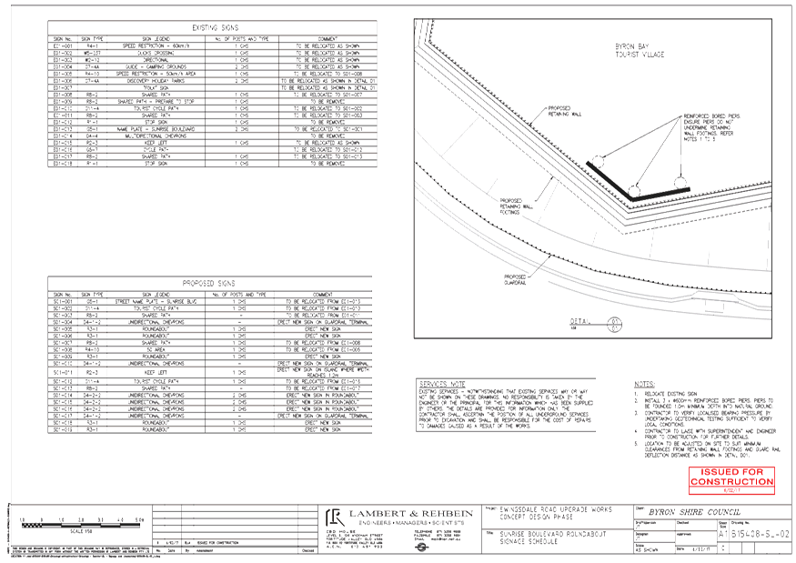
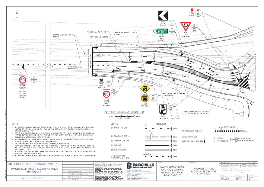
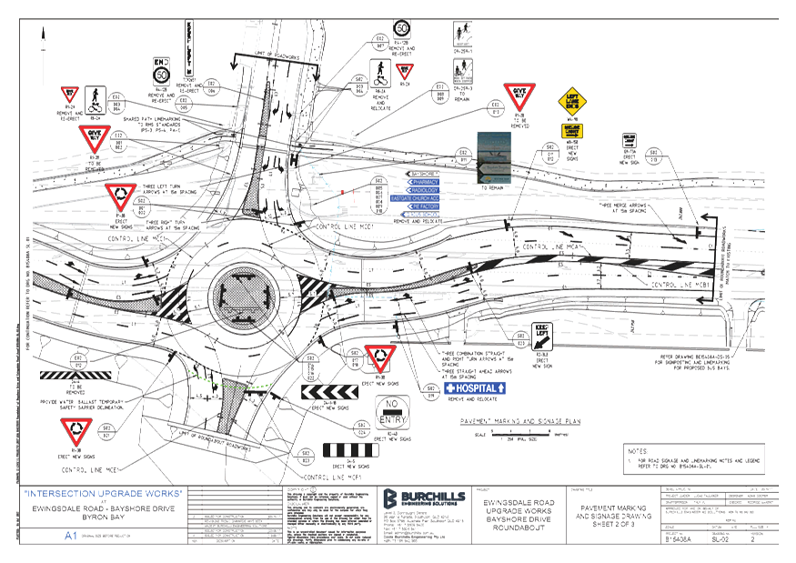
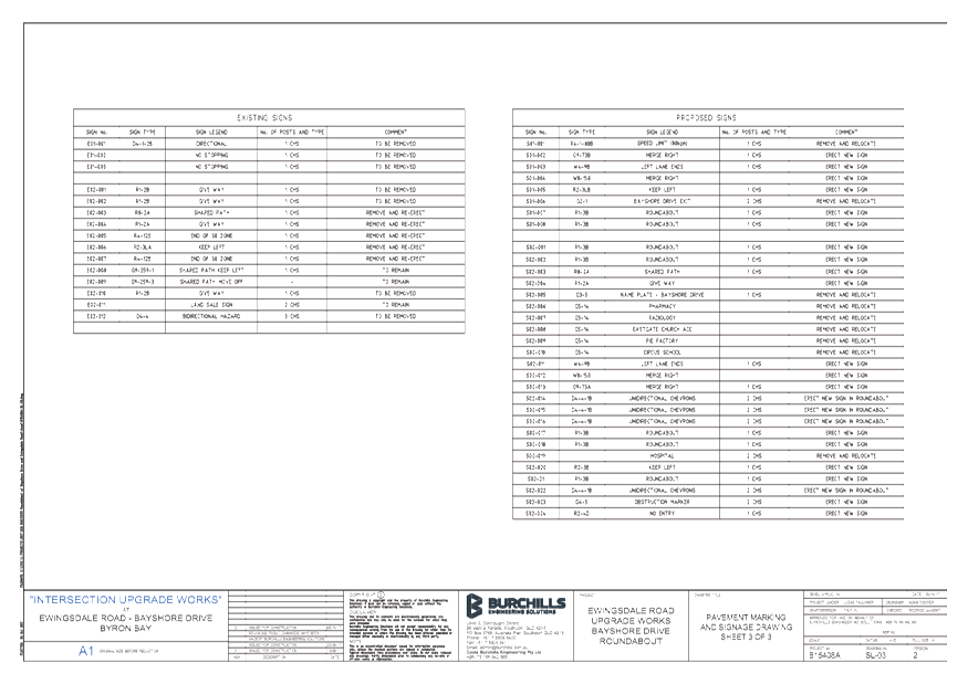
Report No. 6.2 Ewingsdale Road Roundabouts - Signs and Linemarking
File No: I2017/2009
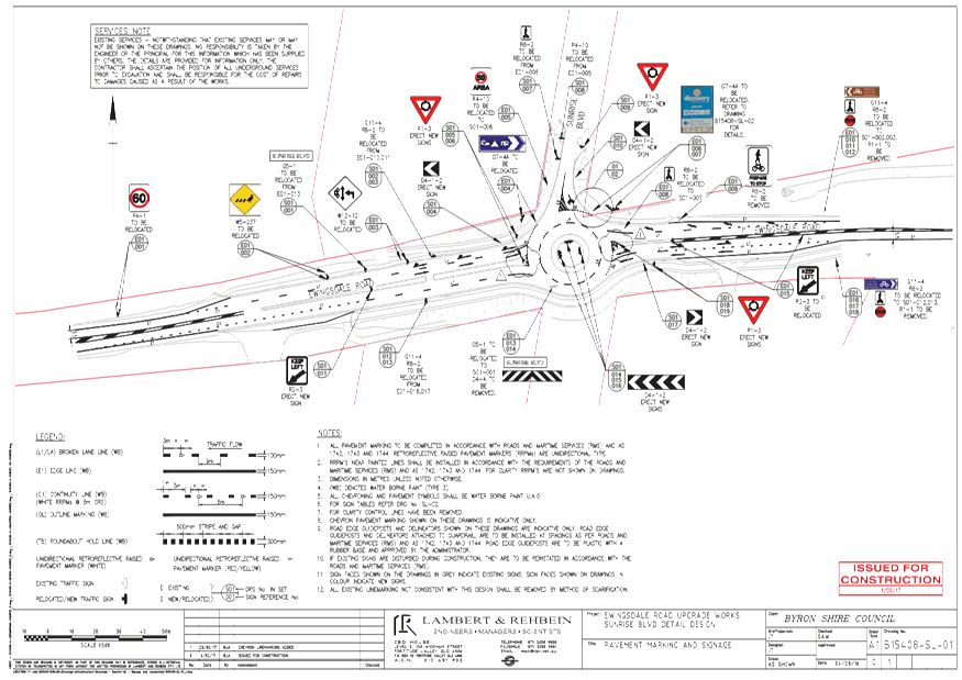
This report seeks LTC concurrence
and endorsement for the proposed regulatory signs and line marking for two
roundabouts on Ewingsdale Road, Byron Bay, being at the intersections with
Sunrise Boulevard and Bayshore Drive.
Detailed pavement marking and
signage plans have been attached for both roundabouts.
|
RECOMMENDATION:
That the Local Traffic Committee endorse the
Pavement Marking and Signage Plans for the Ewingsdale Road roundabouts as
detailed below:
a) Sunrise
Boulevard roundabout as per Attachment 1 (E2017/115555)
b) Bayshore
Drive roundabout as per Attachment 2 (E2017/115586)
|
Attachments:
1 24.2016.57.1
- Sunrise RAB - 2016-0037 - Pavement Marking and Signage Plan, E2017/115555 ,
page 5⇩ 
2 24.2015.48.1
- Bayshore RAB - 2017-0014 - Pavement Marking and Signage Plan, E2017/115586 ,
page 7⇩ 
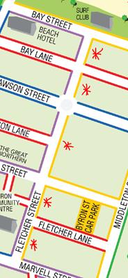
Regulatory Matters 6.2 - Attachment 1
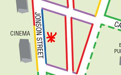
Regulatory Matters 6.2 - Attachment 2
Local Traffic Committee Meeting 6.3
Report No. 6.3 Byron Bay Pay Parking Time Limit Review - Endorsement of Council
Resolved Changes to Time Limits in Byron Bay
File No: I2017/2071
Council resolved on 21 September
2017 under Resolution 17-425 to undertake investigation and community
consultation regarding possible revisions to the time limits in various areas
of the pay parking area in Byron Bay.
Council staff undertook community
consultation regarding the proposed changes. Based on
the survey and consultation feedback, it was proposed that the majority of the
community were in favour of the changes as detailed.
Council
subsequently resolved 17-697 as follows;
1. That
the changes to the parking time limits in the Byron Bay pay parking area as
outlined below be endorsed:
a) Wordsworth Street –
modify 2P zone to OP (no limit) zone.
b) Shirley Street –
modify 4P zone to OP (no limit) zone.
c) Lawson Street North and
South Car Parks – modify from OP (no limit) to 4P.
d) Somerset Street and Butler
Street Reserve – modify to free parking zone.
e) Butler Street –
modify 4P zone to OP (no limit) zone.
f) Byron Street –
modify 2P zone to 1P zone.
g) Fletcher Street –
modify eastern side from 4P to 2P.
h) Jonson Street –
modify Carlyle to Kingsley zone from 1P to 2P.
2. That
a budget of $15,000 be approved from Pay Parking Operations in Byron Bay to
modify the signage.
3. That
a report be prepared for the Local Traffic Committee for concurrence prior to
actioning for items 1a), 1b), 1c), 1e), 1f), 1g) and 1h).
4. That the
modification in item 1d) for Somerset Street and Butler Street Reserve be
implemented as soon as possible.
5. That
staff provide a report with an analysis of resident and non-resident usage for
the different paid parking time zones.
The following pages detail the endorsed changes and the
likely result of each.
Wordsworth Street
Issue Identified – There is currently a 2P that
was most likely implemented when the Byron Hospital was still in operation.
Proposed Change – Modify the 2P section to a OP
section (no limit).
Likely Result – Encourage longer term parking
outside the town centre and maintain consistency throughout Wordsworth Street.
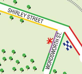
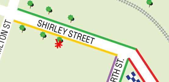
Shirley Street
Issue Identified – There is currently a 4P that
was most likely implemented when the Byron Hospital was still in operation.
Proposed Change – Modify the 4P section to a OP
section (no limit).
Likely Result – Encourage longer term parking
outside the town centre and maintain consistency throughout the Shirley Street
& Wordsworth Street area.
Lawson Street North and South Car Parks
Issue Identified – The Lawson Street north and
south car parks currently have OP (no limit) for pay parking. This does not
promote long term parking outside the town centre.
Proposed Change – Modify the OP (no limit) area
to a 4P area.
Likely Result – Encourage long term parking
outside the town centre.

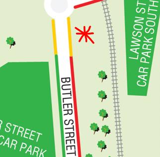
Butler Street
Issue Identified – There is currently a 4P pay
parking area that is not consistent with Butler Street and the Master Plan
intention to promote long term parking outside the town centre.
Proposed Change – Modify the 4P area to a OP
(no limit) area.
Likely Result – Encourage longer term parking
outside the town centre and maintain consistency throughout Butler Street.
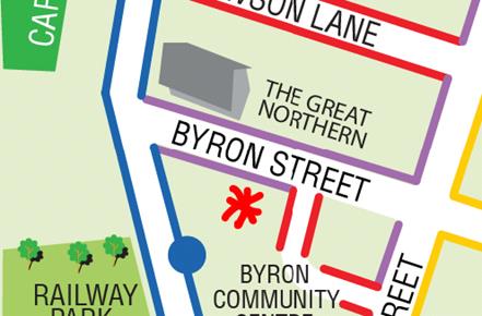
Byron Street
Issue Identified – Byron Street currently has a
2P zone from Jonson Street to Fletcher Street.
Proposed Change – Modify the 2P area to a 1P
area.
Likely Result – Consistently encourage shorter
term parking in the town centre.
Fletcher Street
Issue Identified – There is currently 4P
parking along the full length of Fletcher Street on the eastern side. This does
not promote longer term parking outside the town centre and provides an
opportunity for employees to utilise this area for parking.
Proposed Change – Modify the 4P area to a 2P
area.
Likely Result – Encourage long term parking
outside the town centre.
Jonson Street
Issue Identified – There is currently 1P
parking zone on Jonson Street from Carlyle Street to Kingsley Street. This is
not consistent with the gradual increase of time zones from the town centre.
Proposed Change – Modify the 1P area to a 2P
area.
Likely Result – Gradually increase time zones
as the distance from the town centre increases.
|
RECOMMENDATION:
That the Local Traffic Committee endorse Council
Resolution 17-697,clause 3, providing concurrence for the changes to the time
limits as detailed below:
a) Wordsworth
Street – modify 2P zone to OP (no limit) zone.
b) Shirley
Street – modify 4P zone to OP (no limit) zone.
c) Lawson
Street North and South Car Parks – modify from OP (no limit) to 4P.
e) Butler
Street – modify 4P zone to OP (no limit) zone.
f) Byron
Street – modify 2P zone to 1P zone.
g) Fletcher
Street – modify eastern side from 4P to 2P.
h) Jonson
Street – modify Carlyle to Kingsley zone from 1P to 2P.
|
Local Traffic Committee Meeting 6.4
Report No. 6.4 Traffic - The Esplanade 13 - Regulatory Signs - Formalise parking in
cul-de-sac
File No: I2017/2081
SUMMARY
On the 6 December 2017, Evan Elford met with concerned
residents of The Esplanade, New Brighton to discuss parking, access and vehicle
movement issues. The residents offered support for signage to regulate parking
and to assist with vehicular movement management.
OFFICER RECOMMENDATION
That Council regulate parking in the Southern cul-de-sac end
of The Esplanade, New Brighton.
LINKAGE TO OUR COMMUNITY STRATEGIC PLAN
|
Theme
|
Community Infrastructure
|
Services and infrastructure
that sustains, connects and integrates our communities and environment.
|
|
Objective
|
CI2
|
Provision of essential
services
|
|
Strategy
|
CI2.3
|
Provide roads and drainage
infrastructure within the Shire
|
|
Measures
|
CI2.G
|
Provide road, drainage and transport infrastructure within
the Shire
|
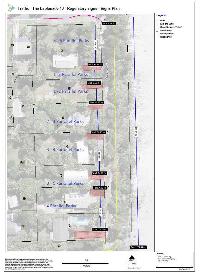
BACKGROUND
On the 6 December 2017, Evan Elford met with concerned
residents of The Esplanade, New Brighton to discuss parking, access and vehicle
movement issues. There is currently no regulatory parking signage in this
section of the road reserve.
The concept design provided has been developed in
consideration of the discussions held on site and identified site constraints
providing No Parking on the Eastern side of the Esplanade and the Parallel
Parking Areas along the Western edge of the Esplanade. Additional advisory
signage at the intersection with Orana Road will be required to advise the road
is not suitable larger RV type vehicles and caravans, noting that garbage
collection trucks will still be required to access the street.
Regulating the parking could reduce the current supply to
between sixteen and twenty two Parallel Parks for vehicles less than six meters
long however it will also assist to maintain clear access for residents and
service vehicles..
KEY ISSUES
1. Vehicles
are being parked across driveways.
2. Service
vehicle access is being restricted.
3. There
is a lack of regulatory parking signage to be able to enforce.
COUNCIL IMPLICATIONS
§ Budget/Financial
Estimate of $3,960 for
twenty two signs at $180 per sign. Vacuum excavation is recommended to avoid
services in this area.
A further estimate of
$20,000 would be required to complete a full survey, geotechnical investigation
and design to formalise the road and parking.
§ Asset Management
Estimate of $2,200 for 10
signs at $10.00 per sign/year for an expected life of 10 years. Council will
need to maintain signage ongoing, including cleaning and replacement (if
necessary).
§ Policy or Regulation
Delegated to council for
authorisation in conjunction with:
- Prescribed
traffic control devices - division 1 of Part 4 (Sections 50 to 55) of the Road
Transport (Safety and Traffic Management) Act, 1999.
- R5-41
No Parking - NSW Road Rules 168, $108 fine.
- No
Camping by order Local Government Act 1993 – Section 632, $80 fine.
§ Consultation
Consultation with
residents to be completed once the concept design is finalised.
§ Legal and Risk Management
Travellers and visitors
are drawn to the car park adjacent to the beach due to its discreet location.
The residents seek to deter over parking in this area so they can access their
homes safely and provide safe access for refuse services.
|
RECOMMENDATION:
That, subject to available funds, Council regulate
parking in the Southern cul-de-sac end of The Esplanade, New Brighton through
the installation of “No Parking” and “Parallel
Parking”and other relevant and appropriate signage to improve access
for residents and service vehicles.
|
Attachments:
1 Signs
Plan, E2017/116041 , page 18⇩ 
Regulatory Matters 6.4 - Attachment 1
Local Traffic Committee Meeting 6.5
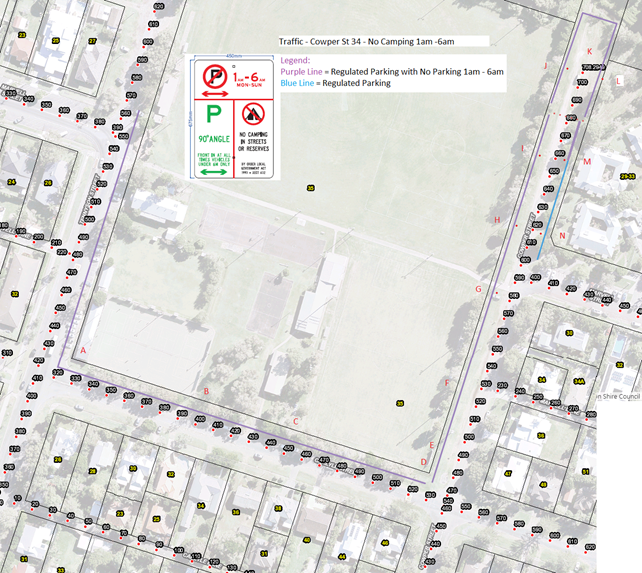
Report No. 6.5 Traffic - Cowper St 34 - Regulatory Signage - No Parking 1am - 6am
File No: I2018/11
SUMMARY
Community Enforcement has
requested assistance to resolve illegal camping within the road reserve around
the Byron Recreation Ground in Carlyle, Cowper and Tennyson Streets, Byron Bay.
They have proposed that regulated parking be installed with signs stating
‘No Parking 1am to 6am’.
OFFICER RECOMMENDATION
That Council regulate parking around the Byron Recreational
Ground by installing ‘No Parking 1am to 6am’ signage to deter
illegal camping.
LINKAGE TO OUR COMMUNITY STRATEGIC PLAN
|
Theme
|
Community Infrastructure
|
Services and infrastructure
that sustains, connects and integrates our communities and environment.
|
|
Objective
|
CI2
|
Provision of essential
services
|
|
Strategy
|
CI2.3
|
Provide roads and drainage
infrastructure within the Shire
|
|
Measures
|
CI2.G
|
Provide road, drainage and transport infrastructure within
the Shire
|
BACKGROUND
Councils Team Leader Community Enforcement has advised that
illegal camping is being carried out around the reserve due to a lack of
regulatory parking signage. Community Enforcement would like to close the
gravel road section of Cowper Street to deny access to illegal campers.
KEY ISSUES
1. Anti
social behaviour is occurring with people camping illegally.
2. There
is a lack of regulatory parking signage to be able to enforce illegal camping.
COUNCIL IMPLICATIONS
§ Budget/Financial
Estimate of $3,080
includes fourteen new signs.
§ Asset Management
Estimate of $980 for 14
signs at $10.00 per sign/year for an expected life of 7 years. Council will
need to maintain signage ongoing, including cleaning and replacement (if
necessary).
§ Policy or Regulation
Delegated to council for
authorisation in conjunction with:
- Prescribed
traffic control devices - division 1 of Part 4 (Sections 50 to 55) of the Road
Transport (Safety and Traffic Management) Act, 1999.
- R5-41
No Parking (specified times) - NSW Road Rules 168, $108 fine.
- No
Camping by order Local Government Act 1993 – Section 632, $80 fine.
§ Consultation
Consultation to be
completed once the design is finalised with the Byron Recreational Grounds and
the Feros Care management of the Byron Bay Village.
§ Legal and Risk Management
Travellers and visitors
are drawn to the car park adjacent to the Byron Recreational Ground due to its
discreet location and the proximity to water, toilets and undercover
facilities. Community Enforcement seek to deter this activity as it has
resulted in antisocial behaviour occurring after dark. Limited no camping signs
are visible in this area however it is difficult to enforce compliance.
|
RECOMMENDATION:
That
Council regulate parking around the Byron Recreation Ground including Tennyson,
Carlyle and Cowper Streets by installing ‘No Parking 1am to 6am’ signage
when funds become available.
|
Local Traffic Committee Meeting 6.6
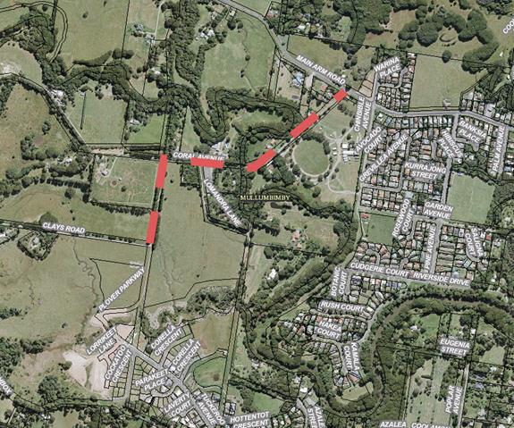
Report No. 6.6 Traffic Compliants on Clays Road and Coral Ave
File No: I2018/13
The purpose of this report is to seek the advice of the
Local Traffic Committee (LTC) on the intersection treatment of Plover Parkway
and Clays Road.
Council has received two complaints about vehicles speeding,
dust, safety, and amenity on Clays Road and Coral Avenue since the opening of
Plover Parkway. A copy of the complaints is provided in the attachments (E2018/1889
and E2018/2033). The subject length of road is shown in the aerial image
below.
The original development application for the subdivision DA
10.2009.314.1 was approved by the NSW Land and Environment Court.
This DA was for the first stage of 29 lots and set out the
concept plan for the estate as part of a staged development consent.
This consent did not require the upgrade of Coral Avenue or
Clays Road.
A subsequent development consent DA 10.2009.151.1 approved
the sports field on Plover Parkway. At the time of the original approvals, due
to the proposed staging of the subdivision works, the sports fields were likely
to be constructed prior to the construction of the culvert over the creek on
Plover Parkway. This meant that the only access to the sports field would be
via Clays Road. Condition 11 of the sports field DA required upgrade
works for these access roads. The developer’s responsibility to
seal these sections arose from the need to provide access to the sports field
and not because of the traffic generated by the subdivision. This is why
the requirement to seal is in the sports field consent and not in the
subdivision consent.
11 Consent
required for works within the road reserve –Clays Road and Coral Avenue.
Consent from Council, and the Crown where applicable, must
be obtained for works within the road reserve pursuant to Section 138 of the
Roads Act 1993. Three (3) copies of Engineering construction plans must
accompany the application for consent for works within the formed road reserves
of Clays Road and Coral Avenue.
Such plans are to be in accordance with Council’s
“Northern Rivers Development Design & Construction Manuals and
Standard Drawings.”
· Reconstruct
the gravel sections of Coral Avenue and Clays Road from the northern site
boundary through to the vicinity of Lomandra Lane with a bitumen seal having a
nominal width of 6m. with gravel/grassed shoulders and drainage.
This development consent was subsequently amended when the
staging of the main subdivision consent was altered and there was potential for
the culvert to be built and access provided from the estate rather than via
Clays Road. Condition 11 was modified as follows:
11 Consent required for
works within the road reserve –Clays Road and Coral Avenue.
The Consent was changed with the addition of the following
clause.
This condition does not need to be complied with if the
road access to Tuckeroo Ave is completed and dedicated as public road prior to
the dedication of the reserves as required by condition 37.
Traffic calming devices (speed bumps) have been installed on
Plover Parkway to discourage through traffic. It is not the developers
responsibility to upgrade this section of road at this point in time.
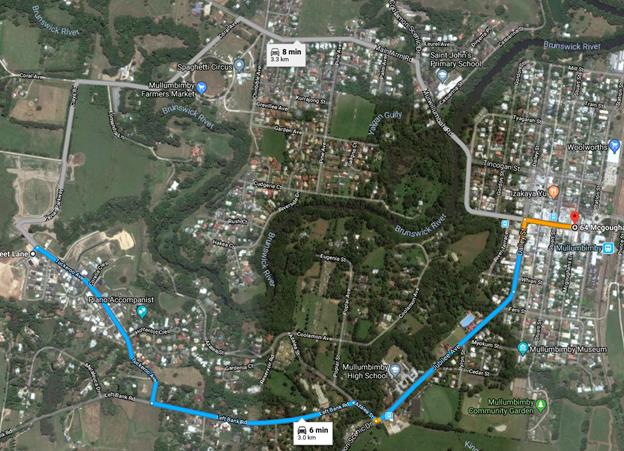
Despite the traffic calming on Plover Parkway there is
anecdotal evidence of an increase in vehicles using Clays Road. The
travel time and distance for the two routes into town is very similar when
taken from the western end of the new estate (refer to google maps extract below).
Council will place traffic
counters out on the northern end of Plover Parkway and the Southern end of
Tuckeroo Ave to determine the traffic volumes using the two routes.
Dependant on the volumes the option to temporarily close Plover Parkway may be
further investigated and subsequently reported back to LTC.
In the interim Council is seeking
advice from LTC on the appropriate regulatory signage and treatment of the
intersection of Plover Parkway and Clays Road. Clays Road is gravel and
up until recently was an elbow bend as shown on the aerial image below.
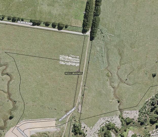
With the opening of Plover Parkway
it has now become a T-junction with the predominant movement being a north
south through movement.
Options to regulate this
intersection are to:
1. Place a Give Way sign on western approach to
the T-junction on Clays Road; or
2. Place a Stop sign and line marking on the
sealed southern approach of Plover Parkway.
|
RECOMMENDATION:
1. That
a Give Way sign be placed on western approach to the T-junction on
Clays Road; and
2. That
this matter be reported back to LTC once traffic counts on Plover
Parkway and the Southern end of Tuckeroo Ave have been completed should
Council wish to close access via Plover Parkway.
|
Local Traffic Committee Meeting 7.1
Development Applications
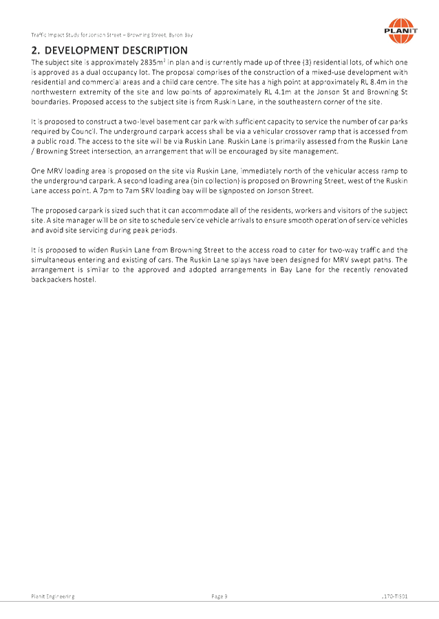
Report No. 7.1 DA 10.2017.510.1 - Mixed Use development, Jonson and browning
Streets, Byron Bay
File No: I2017/1906
The Committee considered a report on this matter at the
meeting of 31 October 2017 and provided the following comments:
The Committee does not have a concept drawing to refer to
and does not have enough information to assess the impacts on the surrounding
road network with particular regard to links with the Byron Bay bypass and
planning for cycleway and pedestrian access linkages in the Bangalow Rd
corridor. The committee also requires documentation for trucks swept
paths, and where the drop off for the preschool area will be located.
The LTC requests a briefing by both planning and the
proponent to provide more documentation in early December 2017.
Council staff and the proponent’s traffic consultant
will attend the LTC meeting to provide the required briefing.
The report from the meeting of 31 October is reproduced
below.
SUMMARY
Council has received a Development Application (DA
10.2017.510.1) from Mr M Scott, on behalf of JGD Developments Pty Ltd for a
mixed use development comprising commercial premises, café, child care
centre, shop top housing and serviced apartments. The development is
located on the south-west corner of the Jonson Street/ Browning Street
intersection in Byron Bay.
OFFICER RECOMMENDATION
That the LTC review the proposed
changes to Ruskin Lane and potential Byron Bay Bypass conflicts and provided
comments for the consideration of the Planning Team.
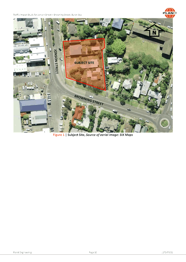
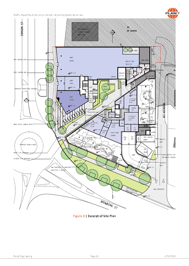
BACKGROUND
Ruskin Lane
The site which is subject to
development application 10.2017.510.1 is located at the corner of Jonson and
Browning Streets, Byron Bay, adjacent to the proposed Byron Bypass roundabout.
Ruskin Lane, which is currently a sealed two-way lane, adjoins the eastern
boundary of the site.
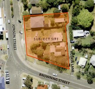
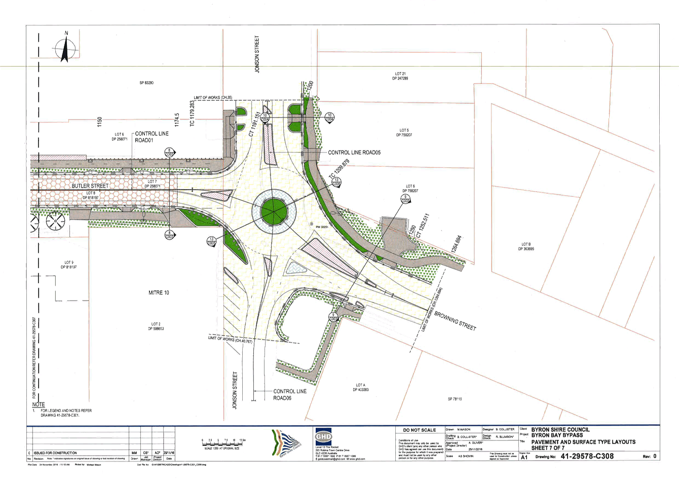
Fig. 1
- Proposed Site Pre Byron Bay Bypass Roundabout
The application proposes to
construct a mixed use development involving:
· Two shops and a café at ground level, fronting
Jonson Street;
· A child care centre at ground level fronting Browning
Street;
· 24 residential apartments in three levels above the shops
and café;
· 26 serviced apartments (tourist accommodation) in three
levels above the child care centre; and
· Two basement levels of car parking containing a total of
122 car parking spaces as well as bicycle and motorcycle parking, with access
off Ruskin Lane.
The Traffic Impact Study that accompanies the Development
Application (see Attachment 1) estimates total traffic generation to be
approximately 349.7 – 375.7 DVT’s and 86.54 – 89.04
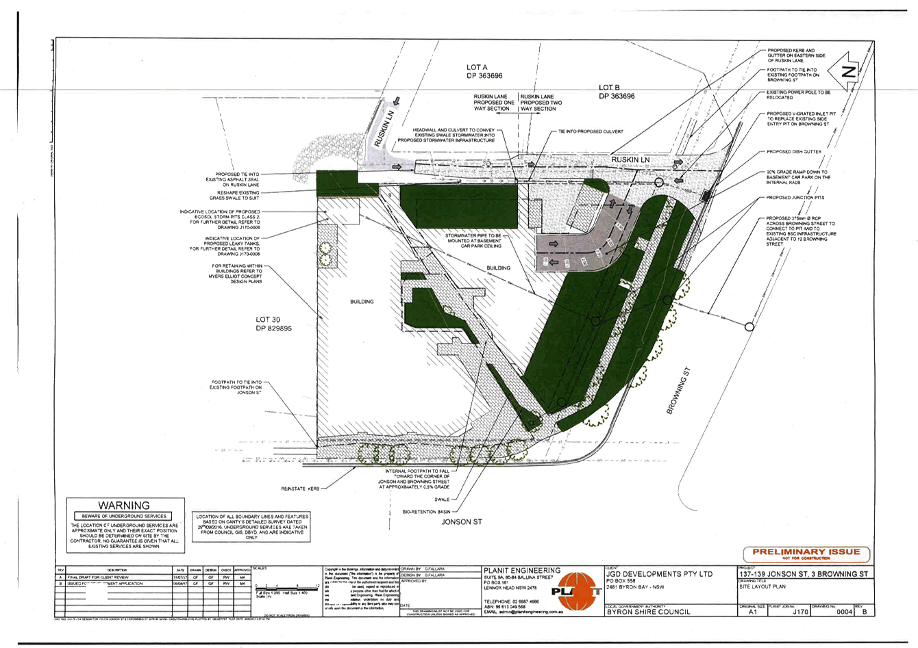
PHT’s and proposes the following changes to Ruskin Lane:
· Widen Ruskin Lane
and Browning St intersection for approximately 35m from Browning Street to
cater for two-way traffic and MRV manoeuvring (see Fig. 2);
· MRV loading bay
off Ruskin Lane adjacent to basement ramp;
· The remainder of
Ruskin Lane (approximately 135m) is proposed to be converted to one-way with
entry only from Tennyson Street;
· Ruskin Lane to be
restricted to left in / out movements only;
· A convex mirror
installed at the Ruskin Lane / Browning St intersection to provide pedestrians
with improved sight lines.
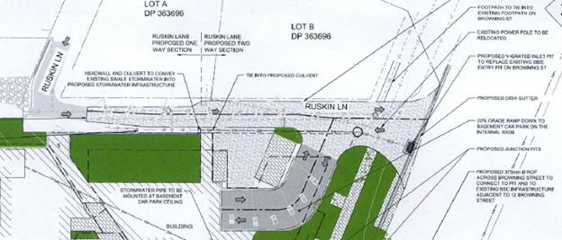
Fig. 2 - Works proposed at Ruskin
Lane / Browning St intersection
|
|
|
|
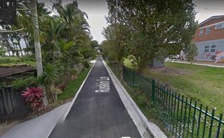
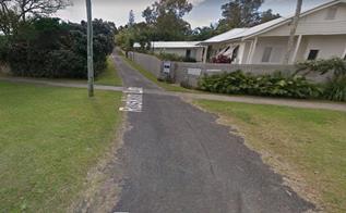
West from Tennyson
Intersection
|
North
from Browning St Intersection
|
Fig 3 – Ruskin Lane
Bypass Roundabout
The development has absolute frontage onto the proposed
Bypass Roundabout at the intersection of Jonson St / Browning St. Council
is in the process of acquiring the SW portion of the subject site for road
widening for the roundabout. To compensate a strip of land will be added
to the subject property along Browning St (see Fig. 4).
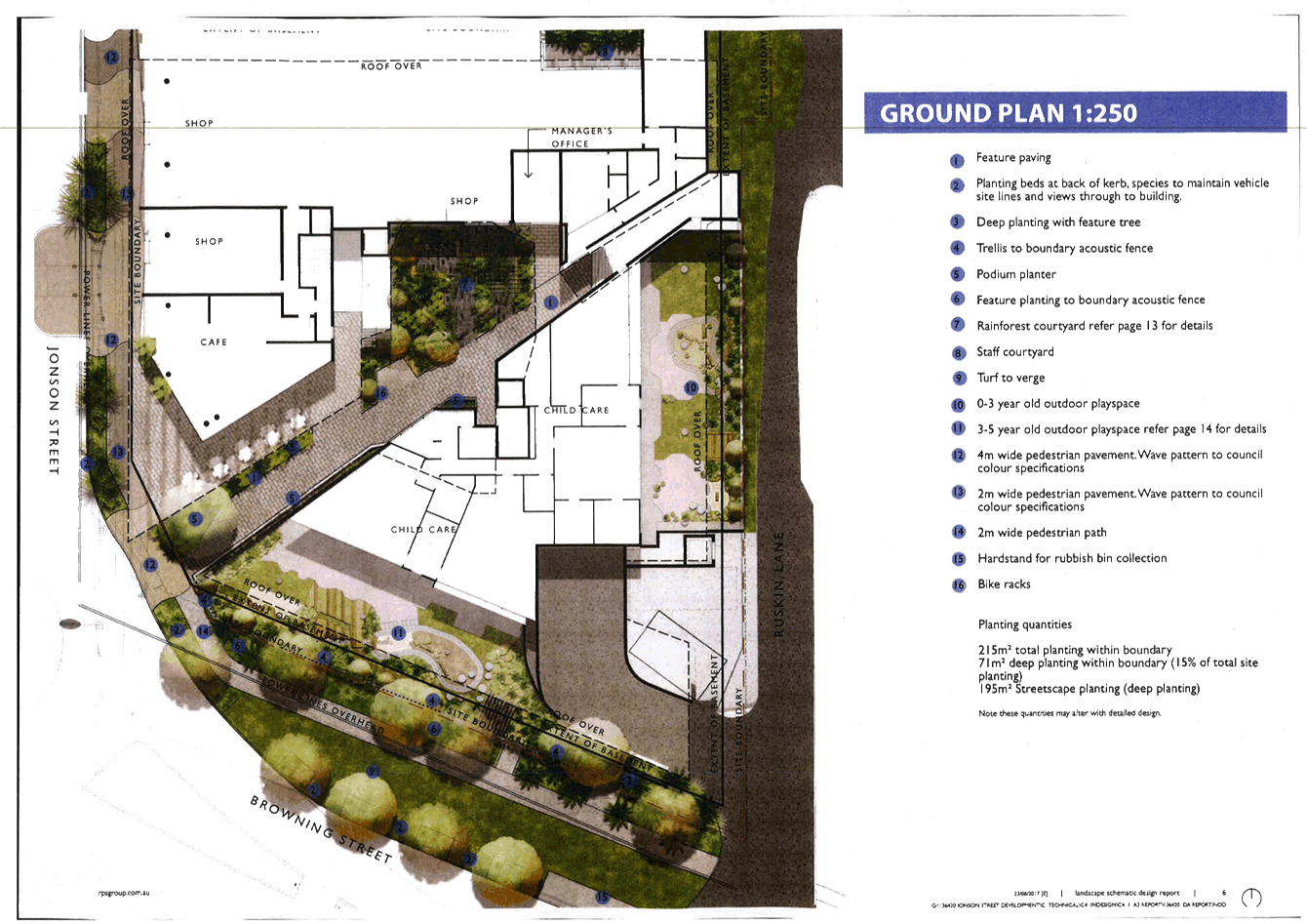
The proposed development introduces challenges relating to
construction timing and sequencing. The first plan within Attachment 2
illustrates the current roundabout design that assumes the subject site remains
unchanged. The second plan illustrates the proposed ground floor and
landscape design. The third plan illustrates the extent of road and
drainage works proposed in the road reserve. Together these plans
illustrate driveway access to Lots 5 and 6 and footpath alignment are redundant
post construction of the development. The third plan illustrates works
across the width and length of Browning St.
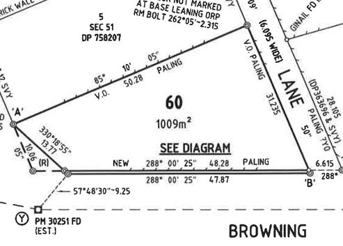
Fig 4. – Boundary changes
KEY ISSUES
Ruskin Lane
1. The
Council must refer all traffic related matters to the Local Traffic Committee
(LTC) prior to exercising its delegated functions for the Regulation of
Traffic.
Byron Bay Bypass
2. How
to manage the sequence of construction if:
(i) the
proposed DA is constructed first , or
(ii) the
Bypass Roundabout is constructed first.
3. How
the proposed development may impact the Bypass Roundabout design.
COUNCIL IMPLICATIONS
· Budget/Financial
Unknown
· Asset
Management
Council will need to maintain
signage for Ruskin Lane and maintain road and drainage assets within both
Ruskin Lane and Browning St.
· Policy
or Regulation
Delegated to council for
authorisation in conjunction with prescribed traffic control devices - division
1 of Part 4 (Sections 50 to 55) of the Road Transport (Safety and Traffic
Management) Act, 1999.
· Consultation
The application has been
referred to the RMS for comment.
· Legal
and Risk Management
The development will result in
increased pedestrian and vehicular activity at the Ruskin Lane / Browning St
intersection and the Bypass Roundabout.
|
RECOMMENDATION:
That the Local Traffic Committee’s
comments relating to DA 10.2017.510.1 be provided to the Council Planning
Team.
|
Attachments:
1 Attachment
1 Traffic Impact Study, E2017/96782
, page 32⇩ 
2 Attachment
2 Bypass Roundabout Conflicts, E2017/97532
, page 73⇩
Development Applications 7.1 - Attachment 1

Development Applications 7.1 - Attachment 2