Agenda
Ordinary
Meeting
Thursday,
22 February 2018
held
at Council Chambers, Station Street, Mullumbimby
commencing
at 4.00pm
Public Access relating to items
on this Agenda can be made between 9.00am and 10.30am on the day of the
Meeting. Requests for public access should be made to the General Manager
or Mayor no later than 12.00 midday on the day prior to the Meeting.

Mark
Arnold
Acting
General Manager
What is a “Conflict of Interests” - A conflict of
interests can be of two types:
Pecuniary - an interest that a person has in a matter because of a reasonable
likelihood or expectation of appreciable financial gain or loss to the person
or another person with whom the person is associated.
Non-pecuniary – a private or personal interest that a Council
official has that does not amount to a pecuniary interest as defined in the
Local Government Act (eg. A friendship, membership of an association, society
or trade union or involvement or interest in an activity and may include an
interest of a financial nature).
Remoteness – a person does not have a pecuniary interest in a matter
if the interest is so remote or insignificant that it could not reasonably be
regarded as likely to influence any decision the person might make in relation
to a matter or if the interest is of a kind specified in Section 448 of the
Local Government Act.
Who has a Pecuniary Interest? - a person has a pecuniary interest in a
matter if the pecuniary interest is the interest of the person, or another
person with whom the person is associated (see below).
Relatives, Partners - a person is taken to have a pecuniary interest in a
matter if:
§ The person’s
spouse or de facto partner or a relative of the person has a pecuniary interest
in the matter, or
§ The person, or a
nominee, partners or employer of the person, is a member of a company or other
body that has a pecuniary interest in the matter.
N.B. “Relative”, in relation to a person means any of the
following:
(a) the
parent, grandparent, brother, sister, uncle, aunt, nephew, niece, lineal
descends or adopted child of the person or of the person’s spouse;
(b) the
spouse or de facto partners of the person or of a person referred to in
paragraph (a)
No Interest in the Matter - however, a person is not taken to have a
pecuniary interest in a matter:
§ If the person is
unaware of the relevant pecuniary interest of the spouse, de facto partner,
relative or company or other body, or
§ Just because the
person is a member of, or is employed by, the Council.
§ Just because the
person is a member of, or a delegate of the Council to, a company or other body
that has a pecuniary interest in the matter provided that the person has no
beneficial interest in any shares of the company or body.
Disclosure and participation in meetings
§ A Councillor or a
member of a Council Committee who has a pecuniary interest in any matter with
which the Council is concerned and who is present at a meeting of the Council
or Committee at which the matter is being considered must disclose the nature
of the interest to the meeting as soon as practicable.
§ The Councillor or
member must not be present at, or in sight of, the meeting of the Council or
Committee:
(a) at any
time during which the matter is being considered or discussed by the Council or
Committee, or
(b) at any
time during which the Council or Committee is voting on any question in
relation to the matter.
No Knowledge - a person does not breach this Clause if the person did
not know and could not reasonably be expected to have known that the matter
under consideration at the meeting was a matter in which he or she had a
pecuniary interest.
Participation in Meetings Despite Pecuniary Interest (S 452 Act)
A Councillor is not prevented from taking part in the consideration or
discussion of, or from voting on, any of the matters/questions detailed in
Section 452 of the Local Government Act.
Non-pecuniary Interests - Must be disclosed in meetings.
There are a broad range of options available for managing conflicts &
the option chosen will depend on an assessment of the circumstances of the
matter, the nature of the interest and the significance of the issue being
dealt with. Non-pecuniary conflicts of interests must be dealt with in at
least one of the following ways:
§ It may be appropriate
that no action be taken where the potential for conflict is minimal.
However, Councillors should consider providing an explanation of why they
consider a conflict does not exist.
§ Limit involvement if
practical (eg. Participate in discussion but not in decision making or
vice-versa). Care needs to be taken when exercising this option.
§ Remove the source of
the conflict (eg. Relinquishing or divesting the personal interest that creates
the conflict)
§ Have no involvement by
absenting yourself from and not taking part in any debate or voting on the
issue as if the provisions in S451 of the Local Government Act apply
(particularly if you have a significant non-pecuniary interest)
RECORDING OF VOTING ON PLANNING MATTERS
Clause 375A of the Local Government Act 1993
– Recording of voting on planning matters
(1) In this section, planning
decision means a decision made in the exercise of a function of a council
under the Environmental Planning and Assessment Act 1979:
(a) including a decision
relating to a development application, an environmental planning instrument, a
development control plan or a development contribution plan under that Act, but
(b) not including the making of
an order under Division 2A of Part 6 of that Act.
(2) The general manager is
required to keep a register containing, for each planning decision made at a
meeting of the council or a council committee, the names of the councillors who
supported the decision and the names of any councillors who opposed (or are
taken to have opposed) the decision.
(3) For the purpose of
maintaining the register, a division is required to be called whenever a motion
for a planning decision is put at a meeting of the council or a council
committee.
(4) Each decision recorded in
the register is to be described in the register or identified in a manner that
enables the description to be obtained from another publicly available
document, and is to include the information required by the regulations.
(5) This section extends to a
meeting that is closed to the public.
Ordinary Meeting
BUSINESS OF Ordinary Meeting
1. Public Access
2. Apologies
3. Requests for Leave of
Absence
4. Declarations of Interest
– Pecuniary and Non-Pecuniary
5. Tabling of Pecuniary
Interest Returns (s450A Local Government Act 1993)
6. Adoption of Minutes from
Previous Meetings
6.1 Byron
Shire Reserve Trust Committee held on 1 February 2018
6.2 Ordinary
Meeting held on 1 February 2018
7. Reservation of Items for
Debate and Order of Business
8. Mayoral Minute
8.1 Future
Use of the Surplus Transport for NSW land in Mullumbimby............................... 6
9. Notices of Motion
9.1 Byron
Bay Historical Walk - Stage 2................................................................................. 8
9.2 Design
Options for Jonson Street Protection Works...................................................... 10
9.3 Submission:
North Byron Parklands .............................................................................. 14
10. Petitions
10.1 Speed
Limits and Signage on The Pocket Road............................................................ 17
11. Submissions and Grants
11.1 Byron
Shire Council Submissions and Grants as at 31 January 2018........................... 18
12. Delegates' Reports
13. Staff Reports
Corporate and Community Services
13.1 Operational
Plan 2017-2018 - 6-month progress report to 31 December 2017............. 20
13.2 Council
Resolutions Quarterly Review - 1 October 2017 to 31 December 2017........... 23
13.3 Draft
Community Strategic Plan and Community Solutions Panel ............................... 26
13.4 Update
on Resolution 17-585 regarding Adani and the Carmichael mine...................... 35
13.5 Byron
Environment Centre............................................................................................. 41
13.6 Council
Budget Review - 1 October 2017 to 31 December 2017.................................. 44
13.7 Bangalow
A&I Hall - new fee 'community rate'.............................................................. 54
13.8 Council
Investments January 2018................................................................................. 56
13.9 Tender
Assessment - Legal Services Contract 2017-0054............................................ 63
13.10 Joint
Organisation of Councils........................................................................................ 68
Sustainable Environment and Economy
13.11 Update
on the CZMP for the Eastern Precincts of the Byron Bay Embayment............ 73
13.12 PLANNING
- 24.2017.82.1 'Housekeeping' Amendment - Byron DCP 2014 (Various Chapters)......................................................................................................................................... 78
13.13 Draft
Constitutions for new Biodiversity Advisory Committee and Sustainability and
Emissions Reduction Advisory Committee...................................................................................... 86
13.14 24.2017.81.1
Amendment to DCP 2014 Chapter E5 - Bayshore Drive (Habitat).......... 90
13.15 PLANNING
- Development Application No.10.2017.639.1 dual occupancy (detached),
alterations and additions to existing dwelling house and two (2) lot strata
subdivision of land at 33 Kallaroo Circuit Ocean Shores................................................................................................................. 97
13.16 PLANNING
- 24.2018.6.1 - Car Share Policy and Draft Amendments to Byron Development
Control Plan 2014 Chapter B4: Traffic Planning, Vehicle Parking, Circulation
and Access..... 120
13.17 PLANNING
- 26.2017.3.1 - Update on Planning Proposal for rezoning of land at Saddle and
Gulgan Roads between Mullumbimby and Brunswick Heads.................................................. 127
13.18 Cities
Power Partnership (CPP) Pledge....................................................................... 136
13.19 PLANNING
- Development Application 10.2017.402.1 - Subdivision to create eighteen (18)
residential allotments, a public reserve, a drainage reserve, a residual
allotment, associated roads, earthworks, landscaping and infrastructure at 77
Tuckeroo Avenue Mullumbimby.... 138
13.20 PLANNING
- Development Application 10.2017.364.1 - Boundary adjustment/Subdivision to
create two lots at 25 Station Street Mullumbimby.................................................................... 155
13.21 Policy:
Commercial use of road reserves..................................................................... 168
13.22 PLANNING
- Development Application 10.2017.474.1 Multi Dwelling Housing Consisting of
Twenty Five (25) 1 Bedrooms 70 - 90 Station Street Mullumbimby......................................... 170
Infrastructure Services
13.23 Mafeking
Road and other requests to enact Council Policy 4.17................................. 209
13.24 Contributions
for Secondary Dwellings ........................................................................ 218
14. Reports of Committees
Infrastructure Services
14.1 Report
of the Local Traffic Committee Meeting held on 16 January 2018.................. 223
15. Questions
With Notice
15.1 Bangalow
Parking Strategy........................................................................................... 227
15.2 Sewer
inspection reports............................................................................................... 228
15.3 General
Manager delegations....................................................................................... 230
15.4 Sewer
Pump Station 5004............................................................................................ 236
15.5 Crown
Recreation Reserve 33876 (Lot 407 DP728640).............................................. 237
15.6 Simpsons
Creek............................................................................................................ 238
15.7 Ocean
Shores STP and Brunswick Valley STP........................................................... 239
15.8 Drain
Clearing at Billinudgel.......................................................................................... 240
15.9 Bangalow
Paid Parking and the NSW Heritage Register............................................. 241
15.10 Rural
Accommodation Figures..................................................................................... 242
15.11 Byron
Bay Bypass......................................................................................................... 244
15.12 Council
Compliance regarding Tree Removal ............................................................. 245
15.13 Tyagarah
Aerodrome.................................................................................................... 246
15.14 Byron
Bypass................................................................................................................ 247
15.15 Brunswick
Valley STP................................................................................................... 249
15.16 Byron
Bay Ballooning ................................................................................................... 250
Councillors are
encouraged to ask questions regarding any item on the business paper to the
appropriate Director prior to the meeting. Any suggested amendments to the
recommendations should be provided to Councillor Support prior to the meeting
to allow the changes to be typed and presented on the overhead projector at the
meeting.
Mayoral Minute 8.1
Mayoral Minute
Mayoral Minute No. 8.1 Future
Use of the Surplus Transport for NSW land in Mullumbimby
File No: I2018/206
|
I move that Council:
1. Write
to the Minister for Transport, requesting time for Council to develop,
through a carefully considered, community focused and design led process,
preferred future use options for the surplus railway land in Mullumbimby as
identified by Transport for NSW (TfNSW). Council also wishes to seek the
deferment of any decision or process involved in offering the land for sale
prior to any public tender process, so Council in partnership with the
community, form and develop a proposal to either purchase the site or pursue
a long term Community Title or lease arrangement.
2. When
considering best use options for this site, Council notes:
a) The
strategically important position of the surplus railway land in Mullumbimby;
b) The
financially and environmentally detrimental impact unsympathetic development
at the town’s entrance would have on its heritage character and tourist
appeal;
c) The
collaborative and effective work recently undertaken by Council and its
resident Guidance Group in considering the masterplan design and
functionality of the town, its parking and mobility requirements, the urgent
need for more diverse, affordable housing, and the potential to encourage
small creative and start-up businesses to locate in the town and redress a
significant shortfall in employment opportunities; and
d) The
rail corridor (either side of the existing rail line) is non-operational (as
opposed to closed) and the corridor cannot and will not be declared surplus.
e) The
great opportunity for a partnership between TfNSW, Council and the Byron
community to develop a mutually beneficial outcome of value to all.
3. Write
to Tamara Smith MLA and Ben Franklin MLC seeking their support and
advocacy within NSW Parliament and with TfNSW.
|
Background Notes:
It has come to light that land within the rail corridor
dissecting Mullumbimby has been deemed surplus to the needs of its owner
Transport for NSW and is likely to be put on the open market for sale in the
near future.
This parcel of land has long been identified as
strategically vita. It Is the most visible a gateway to Mullumbimby and sits
either side of rail infrastructure that should be maintained as such. It is
large enough to address some of the desirable housing and economic outcomes
sought by Council and the community. These include housing affordability and
diversity, and creating spaces for small enterprises, work from home
opportunities and other similar activities. All could contribute to maintaining
a healthy town centre economy as well as help meet the need for housing
appropriate for contemporary home buyers and renters of all ages.
As a first principle, we should acknowledge the great desire
the sites do not to become a legacy of bad planning or create soulless
development Council, the community and visitors will have to live with and
regret for decades to come. Mullumbimby deserves development sympathetic to its
character and heritage but is of its time and looks to the future.
The sites offer wonderful potential to be an exciting
challenge and opportunity to realise best practice planning and
environmentally, socially and economically sustainable development.
This Mayoral Minute does not commit Council to purchase the
land, it simply seeks to enter into a dialogue with TfNSW in order to ensure
time can be made available for Council to work with the community to develop
design and use options, consider appropriate planning mechanisms to get the
best outcome for the site’s future and, if possible, show that commercial
sound outcomes that benefit TfNSW and Council can be identified. This is not
something that can be properly done in a matter of weeks or a few months.
I believe we can get a group of local architects, town and
social planners, and other local exerts, to put their collective minds and
talents together. They would be fully briefed and charged with generating a
range of options that helps the community identify those most suitable
Mullumbimby but creates value for TfNSW. Let’s see if Council can assist
with this process, work alongside the community to help facilitate the best
outcomes, and ensure best practice design and planning approaches reflect the
values and needs of the Mullumbimby community. The desirable end result would
be LEP and DCP controls that ensure a superior development outcome on these
critically important public land holdings.
Key connections to the Community Strategic Plan Include:
Community Objective CM3: Effective partnerships with all
levels of government
Community Objective EC1: A diverse inclusive economic base
and support for local businesses
Community Objective SC1: Support communities to achieve
equitable access to an appropriate range and level of whole of life services
such as healthcare, education and housing.
SC2.4 Create vibrant liveable places and spaces within
towns and villages for people of all ages and abilities.
Community Objective EN2: Sustainable towns, villages and
rural settlements that: respect our natural environment; create an inclusive
social environment, and
integrate harmoniously with the character of local areas;
and provide more inclusive social environments
Definition of the project/task:
Seeking State government support for Council and
community supported outcomes on the recently identified surplus Transport for
NSW land in Mullumbimby
Source of Funds (if applicable):
None required at this stage
Signed: Cr
Simon Richardson
Notices of Motion 9.1
Notices of Motion
Notice of Motion No. 9.1 Byron Bay
Historical Walk - Stage 2
File No: I2018/174
|
I move:
That council extend their support to the
Byron Bay Historical Society History Trail expressed in Resolution 15-336 and
allocate $8,000 plus some additional in-kind costs labour and materials to
install QR code points on site.
|
Attachments:
1 BYRON BAY
HISTORICAL SOCIETY FORESHORE HISTORY TRAIL, E2018/9406

Signed: Cr
Basil Cameron
Councillor’s supporting information:
The
Byron Bay Historical Society have been working on this project since 2014 and
have allocated many hundreds of hours setting up the programming as well
as investing several thousand’s in hardware and site development.
All
the stories and the computer links and software is in place and all that is
required now are the read points and posts in place to complete the project.
The
Council did pass a resolution on the 17 July 2015 Res No 15-336
The council endorse the two projects
outlined in report No 4.11215/554:
A) Foreshore History Trail
B) Byron Bay Whale trail
And provide permission for signage to
be installed along the Byron Bay foreshore.
There
was to be in-kind support for the history trail with out defining what the
in-kind was to be. However some in kind assistance is continuing to be provided
through Open Space staff.
This
is an important project for residents to acknowledge the area’s history
and to inform locals and visitors.
It
is recommended that the requested funding be allocated from an appropriate
tourism program as it is consistent with the aims of the Tourism Management
Plan and dovetails with efforts to attract visitors interested in experiential
tourism and helps to promote Byron Shire as a place to be enjoyed and
respected.
A
summary of the project and its benefits is attached.
Recommended
priority relative to other Delivery Plan tasks:
As an ongoing
joint project of the Byron Bay Historical Society and Council, the priority is
considered high with significant benefits for the community.
Definition of
the project/task:
Provide in kind
support and funding to complete the Byron Bay History Trail in the form of read
points and posts for signage.
Source of Funds (if applicable):
Crown Parking Reserve (for components on Crown
Land managed by Council)
Staff comments by Michael Matthews, Manager Open Space and
Resource Recovery, Infrastructure Services:
(Management Comments must not include formatted
recommendations – resolution 11-979)
In-kind support can include:-
· Dial Before you Dig searches
and underground service locations
· Confirming exact placement in consideration
of maintenance, amenity and public safety.
· Installation
The majority of the history trail is within Council managed
Crown Land and as such, an appropriate funding source for any Council
contribution would be Crown Paid Parking Reserve.
Financial/Resource/Legal Implications:
Council as the Trustee has authorisation to support and
provide funds to enable this project (within land in which it is Trustee) to be
delivered. It is understood that the BB Historical Society have owners
consent for elements of the project that are within National Parks and Wildlife
Service Estate.
Is the proposal consistent with any Delivery Program
tasks?
No
Notices of Motion 9.2
Notice of Motion No. 9.2 Design
Options for Jonson Street Protection Works
File No: I2018/192
|
I move:
1. That
further options for the design of Jonson St protection works and Main Beach access
be canvassed, evaluated and costed prior to any commencement of work.
2. That
OEH be invited to attend a future SPW asap to discuss new ideas and
suggestions for a revitalized concept plan for the JSPW that meets their
requirements of:
i. protecting
public assets
ii. reducing
the constructed footprint on the natural environment
iii. having
a positive impact on adjacent and downdrift beaches (Cavanbah, Belongil) i.e.
removing the groynes
iv. where
possible, preferencing soft stabilization and the management of social and
natural ecosystems.
3. That
Council engage a recognized and innovative coastal engineer, to explore and
draw up a range of concept plans that meet OEH requirements and fit in with
the Byron Bay Masterplan vision for Main Beach.
|
Signed: Cr
Jan Hackett
Councillor’s supporting information:
Main Beach, Byron Bay, is an
international attraction and yet we must have the ugliest and
most dysfunctional beach
frontage on the east coast of Australia.
Given the failure of the rock
wall and groynes now in place, a reworking of this area, known as
Jonson St protection works, was
submitted as part of the 2016 CZMP for the Byron Bay
Embayment - since rejected by
the State Government Planning Department.
Minister Gabrielle Upton has
invited Council to resubmit the eastern half of the rejected 2016
CZMP, of which the Jonson St
protection works and beach access forms a major part.
The 2016 CZMP was decried by the
community at large, which had no substantive say in its
design.
Rushed through by a committee
with vested interests in the outcome for the western half of
the Plan (now delayed and to be
designed separately under new CMP legislation), the work
to be done at Jonson St was
little more than making a few small half baked adjustments and
alterations - eg. Removal of the
groynes, securing the failing rockface in front of the degraded
carpark and adding some concrete
steps and vehicular access to the beach itself.
It's hardly a plan to improve or
beautify the beachfront and will not add any longevity to
protecting built assets over the
coming years.
From recent coastal conferences,
I have noted that marine engineers are now looking at new
and more innovative ways to to
approach protecting beach assets from sea rise and storm
impacts. Somewhere between hard
rock revetments (which scour the beach of sand - as we
have seen at Main Beach- and
have a high failure rate), and retreat (although even that nasty
is now been considered and
costed), there are middle ground options being designed and
proposed as alternative and
gentler (but just as effective) ways of extending the life of both
the beach and the commercial
& residential assets built on the beachfront itself.
Byron Shire calls itself an
innovative and 'different' community which protects its environment
and lifestyle options. We need
to demonstrate this by seeking innovative as well as cost
effective ways of improving our
world famous foreshore and make it something we are truly
proud of.
Subsequent to the 8 February SPW, Chloe Dowset has
approached the OEH and found they would be open to revisit the JSPW as per the
2016 CZMP and consider new concepts for the upgrade.
I move therefore that the OEH be invited to attend a future
SPW asap to discuss new ideas and suggestions for a revitalized concept plan
for the JSPW that meets their requirements of:
· protecting public assets
· reducing the constructed
footprint on the natural environment
· having a positive impact
on adjacent and downdrift beaches (Cavvanbah, Belongil) i.e. removing the
groynes for one
· where possible,
preferencing soft stabilization and the management of social and natural
ecosystems.
Following the EOH workshop, I move that Council engage a
recognized and innovative coastal engineer (similar to Angus Gordon for
example), to explore and draw up a range of concept plans that meet OEH
requirements and fit in with the BB Masterplan vision for Main Beach.
Supporting Images


Staff comments by Shannon Burt, Director, Sustainable
Environment and Economy:
(Management Comments must not include formatted
recommendations – resolution 11-979)
A Strategic Planning Workshop (SPW) on the draft Coastal
Zone Management Plan (CZMP) for the Eastern Precincts of the Byron Bay
Embayment was held 8 February.
At this SPW, updates on the CZMP delivery, OEH advice and
feedback to Council staff to date, proposed management strategies including the
Jonson Street protection works (JSPW) were provided to councillors.
Councillors expressed concern about the concept plan for
JSPW being that tied to the previous resolutions of Council; and asked about
the ability to look at alternate options, now that the Masterplan has been
adopted.
Following the SPW on 8 February, staff had discussions with
OEH and they have confirmed:
1. They do
not require an adopted concept design for the upgrade of the JSPW for
inclusion in the CZMP in order for the CZMP to be certified.
2. They are
supportive of revisiting and reconsidering other concepts for the upgrade of
the JSPW.
To further discussion with Council, OEH have agreed to
attend a future SPW with councillors this is anticipated for 8 March.
Noting that any future design for protection works must
accord with any legislation applicable and best practice coastal management
practice.
Financial/Resource/Legal Implications:
Unknown until the CZMP is finalised. Grant funding may be
available to Council.
Is the proposal consistent with any Delivery Program
tasks?
Yes - EN1.3.1 Implement Coastal Zone Management Program
Notices of Motion 9.3
Notice of Motion No. 9.3 Submission:
North Byron Parklands
File No: I2018/193
|
I move:
1. Council
notes the Final Determination Report (‘determination approval’),
Final Concept Approval (‘concept approval’) and Final Project
Approvals (‘project approval’) of 24 April 2012 in relation to
the Yelgun site (North Byron Parklands).
2.
Council notes the statement of the Final Determination Report on page 11 as
follows
After
the trial period, the Commission considers that a new application should be
lodged with Council for events to continue. In considering any future project
applications, the Council must take into consideration the performance of
events during the trial, the effectiveness of the management plans, the
monitoring results of environmental conditions and the completion of Stage 2
works (on-site sewerage and water infrastructure).
3. Council
prepares a submission in relation to Cultural Events Site - State
Significant Development Application (SSD 8169) (‘the
application’) affirming that the environmental and community interests
are best served if an application for a permanent events site were to be
assessed, considered and determined by Byron Shire Council in accordance with
the statement of the Planning Assessment Commission (PAC) set out in 2 above.
4. The
submission to PAC note with concern that the application is proceeding
without the following conditions of the concept approval being met.
B4(3)
The stage 2 works must be completed prior to any outdoor event after 2017.
C1(2) The stage 2 works must be completed before any outdoor events are held
after 2017
Note: Stage 2 works include ‘a water
treatment facility’ and ‘a wastewater treatment facility’.
5. The
submission notes the unreasonable difficulties that residents and others
including community representatives on the Regulatory Working Group (RWG)
have experiences in having concerns addressed by DPE and details issues,
complaints and submissions, previously raised by Council, residents,
businesses and others regarding the application or otherwise of approval
conditions during the trial period.
6. The
submission states that the proposed increase in numbers or frequency of
events is not currently justified given the lack of stage 2 facilities and
impacts on the environment, residents and others in the community.
7. The
submission notes that the proponents did not meet with Council staff prior to
lodgement of the application and details issues raised by staff in meetings
with DPE including, but not limited to the following.
a) The current
events operations and associated on site and off site impacts at its current
approved capacity – and how these events are being monitored and PAC
conditions enforced as this is critical to how the site or events could be
managed at double or triple the number.
b) The large volume
of documents to be reviewed and the complexity of the proposal and variations
to the existing development requiring time and specialist staff for this
review to occur - e.g. ecology, noise,
infrastructure water and sewer, road, stormwater, flooding, traffic - and
what specialist staff did the DPE have to do this.
c) The timing and
length of exhibition period given the above and Council meeting cycle, noting
a community desire for an independent review of the trail period and
application as well as and extended exhibition period until at least 2 March.
|
Signed: Cr
Basil Cameron/Cr Cate Coorey
Councillor’s
supporting information:
In
2008 Council approved a trial event at the North Byron Parklands site at
Yelgun. This approval
was
subsequently quashed by the Land and Environment Court due to the proposal to
build a road
through
the 7k wetlands environmental zone (equivalent E2 zone under the current LEP).
The
Court
also noted a ‘place of assembly’ was also not permitted in a 7k
zone.
Although
the environmental sensitivity and importance of the land zoned 7k has not
changed, an
application
to the Planning Assessment Commission (PAC) nevertheless approved the creation
of
an
events site for a five year trial in 2012. The PAC approval stated that Council
should be the assessment authority for any application after the trial period.
As
indicated by the wording of the motion a significant number of issues are
outstanding and have
not
been satisfactorily resolved and have remained the subject of considerable
community concern
and
debate during the trial period. These include significant issues such as noise,
anti social impacts on surrounding communities as well as concerns about
effective safety and evacuation measures and environmental monitoring that has
not been as robust as intended by the PAC approval.
As
noted in the motion key infrastructure including a wastewater treatment
facility and water treatment facility required to have been constructed and
operational prior to any application for a permanent event site have not been
undertaken in accordance with conditions of the PAC approval.
As
such an increase in the numbers of attendees to 50,000 people for large events
can not be
supported.
The
motion also refers to the numbers and complexity of the documentation and
concerns raised
by
staff in discussions with DPE regarding sufficient time for effective
evaluation of the proposal
and
outstanding issues. For this reason, the full extent of matters to be covered
in a submission
can
not be included by the deadline for submission of this Notice of Motion.
Therefore it is intention
of
the mover and seconder to continue to compile matters into a single document
and distributed
to
Councillors as soon as possible prior to the meeting on 22 February. It is
proposed that the
document
will then be referenced in the motion to be put to Councillors at that meeting.
Recommended priority relative to other Delivery Plan
tasks:
High.
Submission due by 2 March 2018
Definition of the project/task:
Prepare submission regarding
‘the application’ incorporating discussion of issues as stated in
the
motion.
Source of Funds (if applicable):
N/A
Staff comments by Shannon
Burt, Director, Sustainable Environment and Economy:
(Management Comments must not include formatted
recommendations – resolution 11-979)
A staff meeting was recently held with DPE staff regarding
the North Byron Parklands applications advising of Council’s intention to
lodge a submission, but difficulties to do so due to the timing and length of
the exhibition period.
In response
the DPE has extended the time for Council to lodge a submission to 2 March to
enable
consideration
of the applications at the 22 February meeting.
Staff will
incorporate the issues as stated in the motion in the Council submission.
Financial/Resource/Legal Implications:
N/A
Is the proposal consistent with any Delivery Program
tasks?
N/A
Petitions 10.1
Petitions
Petition No. 10.1 Speed Limits and Signage on The Pocket Road
Directorate: Infrastructure Services
Report
Author: Evan
Elford, Team Leader Infrastructure Planning
File No: I2018/107
Theme: Community Infrastructure
Roads and Maritime Services
At Council’s Ordinary meeting held on 1 February 2018,
Cr Richardson tabled a petition containing 16 signatures which states:
“…We, the
undersigned, petition the Mayor and Councillors of Byron Shire Council to:
· Traffic
travelling along this stretch of The Pocket Road should be restricted to a
speed of 60 km/hr
· Clearer signs
should be placed along The Pocket Road to indicate the intersections with
Moffatts Road and Middle Pocket Road.
· Traffic should
be warned about the concealed driveways by appropriate signs.”
Comments from Director Infrastructure Services:
The petition has been listed as an agenda item for the Local
Traffic Committee (LTC) for consideration at its meeting on 20 March 2018
|
RECOMMENDATION:
1. That
the petition regarding Speed Limits and Signage on The Pocket Road be
noted.
2. That
the petition be referred to the Director Infrastructure Services.
3. That
in accordance with Council Resolution 18-035, Council receive a further
report regarding speed limits and signage on The Pocket Road following
consideration of the petition by the Local Traffic Committee.
|
Submissions and Grants 11.1
Submissions and Grants
Report No. 11.1 Byron
Shire Council Submissions and Grants as at 31 January 2018
Directorate: Corporate
and Community Services
Report
Author: Jodi
Frawley, Grants Co-ordinator
File No: I2018/73
Theme: Corporate Management
Governance Services
Summary:
Council have submitted
applications for a number of grant programs which, if successful, would provide
significant funding to enable the delivery of identified projects. This
report provides an update on these grant submissions.
|
RECOMMENDATION:
That Council note the report and Attachment
(E2018/6444)
|
Attachments:
1 Byron
Shire Council Submissions and Grants as at 31 January 2018, E2018/6444 
Report
This report provides an update on grant submissions
including funding applications submitted and new potential funding
opportunities.
Funding Applications – Successful
· Brunswick Heads
Boat Harbour Boat Ramp - $500,000
Additional information on the grant submissions made and/or
pending is provided in Attachment 1 – Submissions and Grants report as at
31 January 2018.
Financial Implications
If Council is successful in obtaining the identified grants more than $20
million would be achieved which would provide significant funding for Council
projects. Some of the grants require a contribution from Council (either
cash or in-kind) and others do not. Council’s contribution is funded. The
potential funding and allocation is noted below:
|
Requested funds from funding bodies
|
20,300,170
|
|
Council cash contribution
|
11,127,343
|
|
Council in-kind Contribution
|
394,280
|
|
Other contributions
|
17,329,960
|
|
Funding applications
submitted and awaiting notification (total project value)
|
50,388,891
|
Statutory and Policy
Compliance Implications
Council is required under Section 409 3(c) of the Local Government
Act 1993 to ensure that ‘money that has been received from the
Government or from a public authority by way of a specific purpose advance or
grant, may not, except with the consent of the Government or public authority,
be used otherwise than for that specific purpose’. This legislative
requirement governs Council’s administration of grants.
Staff Reports - Corporate and Community Services 13.1
Staff Reports - Corporate and Community
Services
Report No. 13.1 Operational
Plan 2017-2018 - 6-month progress report to 31 December 2017
Directorate: Corporate
and Community Services
Report
Author: Mila
Jones, Corporate Governance Coordinator
File No: I2017/1028
Theme: Corporate Management
Governance Services
Summary:
Council’s Operational Plan
outlines its projects and activities to achieve the commitments in its
four-year Delivery Program.
This report summarises the
Council’s progress towards achieving the annual activities contained in
the 2017-2018 Operational Plan. This report is the six-month
progress report as at 31 December 2017. More than 36 per cent of
activities have been completed, 61 per cent substantially completed and 2 per
cent yet to commence.
|
RECOMMENDATION:
That Council note the six-month progress report to
31 December 2017 (Attachment 1 E2018/10208) on the Operational Plan
2017-2018.
|
Attachments:
1 Delivery
Program 2017-2021 Progress Report 01/07/17 to 31/12/17, E2018/10208
Report
The purpose of this report is to
provide Council with the six month progress report on the annual Activities
contained in the Operational Plan 2017-2018, as at 31 December 2017. The
Operational Plan 2017-2018 is the annual activities component of the 2017-2021
Delivery Program adopted by Council on 22 June 2017.
The Operational Plan progress
report contains üAchieved
lSubstantially
achieved ûNot achieved icons for “at a glance” progress
status. It also includes “exception” reporting explanatory
notes where progress indicators have a red status. A comprehensive
progress report is provided at Attachment 1, and a summary is set out here:
|
36.5%
completed
|
61%
substantially
completed
|
2.5%
not achieved
|
Achievements
Notable achievements (grouped by Community Strategic Plan
theme) for the six month period include:
· Corporate
management – Total grant funding won $12,061,092 with an application
success rate of 75% (projects won - 21 of 29); a crisis management team has
been established to develop Council’s approach to business continuity and
improvements to disaster recovery planning with community and authorities; A
deliberative, participatory planning process is underway with the Mullumbimby
Hospital Site Project Reference Group
· Economy –
The Byron Region Food booklet has been produced; business survey resulted in
over 1000 responses; the Chincogan Charge was secured as a new event
· Society and Culture
– Rail Park and Rail Corridor catalyst site projects have commenced
· Environment
– the Flying Fox Management Plan and the Rural Land Use Strategy have
been adopted
· Community
infrastructure – Masterplan ready for endorsement on 1 February 2018;
|
21 heritage
style enclosures, were removed and replaced with a combination of 28 waste
and 26 recycling bins;
32 bins
removed from Byron Bay in 2016 were upcycled for use double/triple enclosures
in the main streets and at the netball courts;
12 of the
removed heritage bins have been reused in the surrounding parks and cemetery;
|
|
|
Completion of Stage 1 of Byron Resource Recovery
Collection Masterplan – Mobile Aerated Floor Composting Facility
|
|
Financial Implications
The Council’s financial
performance for the reporting period is addressed in the Quarterly Budget
Review, which is subject to a separate report.
Statutory and Policy Compliance Implications
The General Manager is required under Section 404 (5) of the
Local Government Act 1993 to provide regular progress reports as to the
Council’s progress with respect to the principal activities detailed in
the Delivery Program/Operational Plan. Progress reports must be provided
at least every six months.
Staff Reports - Corporate and Community Services 13.2
Report No. 13.2 Council
Resolutions Quarterly Review - 1 October 2017 to 31 December 2017
Directorate: Corporate
and Community Services
Report
Author: David
Royston-Jennings, Corporate Governance Officer
File No: I2018/3
Theme: Corporate Management
Governance Services
Summary:
This report provides an update on the status of Council
resolutions.
Council should note that 104 resolutions were completed
during the period 1 October to 31 December 2017, which is an increase from 79
resolutions completed during the previous quarter and 92 resolutions completed
during the same period in 2016.
There were 131 active resolutions as at 31 December 2017. Of
these 131 active resolutions, only 6% had not received any action recorded
towards implementation within 30 days as at 31 December 2017.
Resolutions could be active or overdue as a result of budget
constraints, staff resourcing, extended negotiations with stakeholders, or
other reasons.
|
RECOMMENDATION:
1. That
Council receive and note the information provided in this report on active
Council Resolutions in Attachment 1 (#E2018/2576).
2. That
Council note the completed Resolutions in Attachment 2 (#E2018/1123).
3. That
Council close Resolutions 16-530, 17-121, 17-260, 17-369, 17-386, 17-521 and
17-665, due to them being no longer relevant, superseded by subsequent
resolutions, or not resourced.
|
Attachments:
1 Active
Council Resolutions as at 31 December 2017, E2018/2576

2 Completed
Council Resolutions 1 October 2017 - 31 December 2017, E2018/1123
Report
This report provides a quarterly
update on the status of Council Resolutions to 31 December 2017.
As at 31 December 2017:
· 104 resolutions were
completed since 1 October
· 131 resolutions remained
active
The active Council resolutions per Council terms are
provided below:
· 112 active Council
Resolutions from current Council (2016-2020)
· 18 active Council
Resolutions from previous Council (2012-2016)
· 1 active
Council Resolution from prior Council (2008-2012)
It is worth noting when considering the increase in active
resolutions during this period that between 1 October and 31 December 2017
Council held three Ordinary meetings and two Extraordinary meetings. These five
meetings took place within a 49 day period, meaning that Council met once
almost every ten days during this time, resulting in an increase of
resolutions.
Resolutions completed during this reporting period include adoption
of the Supporting Partnerships Policy, endorsement of the 2016/17 Annual
Report, a review of Mullumbimby Outside of School Hours Care Services, granting
of licences for surf schools, adoption of the 2018 meeting schedule and review
of paid parking in Bangalow.
Details of completed resolutions for the period are provided
at Attachment 2 (E2018/1123).
Table 1 provides a summary of Council resolutions that are
no longer relevant or that have been superseded either by other resolutions,
legislative change or other matters.
Table 1: Council resolutions that are no longer relevant
or that have been superseded by other resolutions:
|
Meeting Date
|
Resolution No.
|
Report Title
|
Staff Comments
and Recommendation
|
|
16/10/2016
|
16-530
|
Review of Policy 15/005 and Procedures for Advertising of
Proposed Development and Approvals
|
Amendments to the NSW Planning Act in effect. New
Regulations to be developed to support the changes including requirements for
advertising and notification of development applications. A review of
Council’s DCP can occur following the release of more information
from DPE.
|
|
24/08/2017
|
17-369
|
Power Up – Northern Rivers Electric Vehicle Strategy
|
Strategy has been launched. Follow up work to be
incorporated into the Emissions Reduction Strategy program Res 17-639.
|
|
21/09/2017
|
17-386
|
Byron Energy Action Tank
|
Superseded by Res 17-640.
|
|
26/10/2017
|
17-521
|
Update Draft Coastal Zone Management Plan – Byron
Bay Embayment
|
Superseded by Res 17-641.
|
|
20/04/2017
|
17-121
|
Review of Tyagarah Airstrip Proposal.
|
Superseded by Res 17-327.
|
|
22/06/17
|
17-260
|
Byron Affordable Housing Summit Issues Action Plan
|
Superseded by Res 17-432, Res 17-601 & Res 17 643.
|
Table 2 provides a summary of Council resolutions that
cannot be implemented due to resources not being available, allocated, or are
allocated to other adopted projects, services, activities or works. Any
resulting decisions of Council will be incorporated into the next quarterly
review of resolutions.
Table 2: Council resolutions that are not resourced
|
Meeting Date
|
Resolution No.
|
Report Title
|
Staff Comments
and Recommendation
|
|
14/12/2017
|
17-665
|
Planning – s96 10.2016.551.2 S96 for Design
Amendments to Dwelling House at 70 Kingsley Street
|
The resolution requires Council to complete a review on
heritage conservation areas or precincts in Byron Bay. This project is
subject to funding under the Office of Environment and Heritage – NSW
Heritage Grants Program which is not open again until late 2018.
|
Financial Implications
A number of resolutions note that resource constraints limit
completion of action required.
Statutory and Policy Compliance Implications
· Council
requires a quarterly report be prepared to allow it to consider the six monthly
Operational Plan and Quarterly Budget reviews along with a review of Council
Resolutions.
· Implementation
of Council Resolutions in accordance with the Local Government Act 1993.
· This report
has been prepared in accordance with Part 3c) of Resolution 14-417.
Staff Reports - Corporate and Community Services 13.3
Report No. 13.3 Draft
Community Strategic Plan and Community Solutions Panel
Directorate: Corporate
and Community Services
Report
Author: Mila
Jones, Corporate Governance Coordinator
File No: I2017/2082
Theme: Corporate Management
Governance Services
Summary:
A new Community Strategic Plan has been drafted and is
presented to Council for endorsement for public exhibition.
Council undertook a significant engagement program in late
2017 to understand the community’s priorities and aspirations for Byron
Shire for the next ten years. More than 2000 people provided feedback through
various channels including targeted engagement undertaken by the Mullumbimby
and District Neighbourhood Centre.
A brief summary of engagement outcomes include:
· Desire for
improvements to infrastructure
· Managing
growth and change
· Addressing
affordability
· Balancing
the benefits and impacts of tourism
· Need for
more community-led decision making
· Lack of
trust in Council decision making and in groups or organisations
· A feeling of
inequitable resource allocation across the Shire
· Ensuring the
natural environment is protected
· Improving
transport
· Support and
promotion of arts and cultural programs
· Concern
about lack of community connectedness, access to housing and safety
The Community Strategic Plan has been drafted to explicitly
address this feedback – it is essential that the plan reflects community
priorities and aspirations. It is a collective document that needs to be
owned by the community, Council and other partners.
The draft plan sets out an overarching vision for the next
ten years. The vision will be delivered through five key objectives (as
outlined below) and supporting strategies:
1. We
have infrastructure, transport and services which meet our expectations
2. We
celebrate our lifestyle, culture and sense of community
3. We
protect and enhance our environment
4. We
manage growth and change responsibly
5. We
have community-led decision making which is open and inclusive
Should Council endorse the draft plan, public exhibition
will be undertaken during March.
As resolved by Council at its 1 February 2018 meeting
(resolution 18-027), a Community Solutions Panel will be administered by
research foundation newDemocracy, where a group of 28 randomly selected community
members prepare recommendations on Council’s infrastructure priorities.
This report details the engagement outcomes from
consultation undertaken last year, outlines the key components of the draft
Community Strategic Plan and summarises proposed engagement activities moving
forwards.
|
RECOMMENDATION:
That Council:
1.
Notes the outcomes from community engagement undertaken in late
2017 (Attachment 1 E2018/10080) and that the report be published.
2.
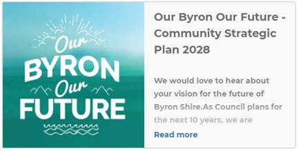
Endorses “Our Byron, Our Future” (draft Community
Strategic Plan 2028) (Attachment 2 E2018/10708) for public exhibition and
seeks feedback specifically on:
a)
Proposed vision
b)
Proposed strategies
c)
Unique characteristics for each village and township (which will
be developed in partnership with masterplan and guidance groups)
3.
Should there be no submissions received, adopt “Our
Byron, Our Future”, however if submissions are received, a
further report will be brought to Council reporting on the submissions with a
revised Plan where necessary.
|
Attachments:
1 Community
Strategic Plan 2028 Engagement Outcomes Report, E2018/10080
2 Draft
Community Strategic Plan 2028 - For Public Exhibition, E2018/10708 
Report
The new Community Strategic Plan (CSP) has been developed to
guide long term future planning to meet the needs and aspirations of the
community. This latest review is an opportunity for a fresh approach to
long term strategic planning, driven by community input following a
comprehensive engagement program.
On 24 August 2017, Council endorsed the CSP review project
plan and engagement strategy. In keeping with the project plan and
engagement strategy, a draft CSP has been developed and informed by the outcomes
of the community engagement activities to-date.
A sound CSP can be used by councils and other stakeholders
in the community as a lobbying tool, to support funding applications and to
confirm strategic priorities.
Engagement activities and participation
The overall phase one engagement objectives were to:
· Inform the
community and stakeholders about the development of a new CSP
· Provide an
opportunity from the outset for the community and stakeholders to be involved
in the development of the new CSP
· Seek input
on a long-term vision for Byron Shire
· Gain a
better understanding of local community issues and priorities
· Hear from as
many people across the Shire as possible
· Hear from a
diverse range of individuals and groups
· Provide opportunities
for both face to face and online engagement
The first phase of engagement commenced on 3 November 2017
and concluded on 19 December 2017. The total number of people who
actively participated in the engagement process was 2,769 people - 265 people
attended a workshop, 883 people engaged online and using social media, 420
people attended an interactive pop up activity and 3 people provided a written
submission.
The engagement program has included 76 hours of face to face
engagement supported by other online activities:
· Community,
stakeholder, Progress Association, Masterplan and Village Guidance Group, and
Community Roundtable workshops
· Interactive
pop-up activities
· Councillor
workshops and briefings
· Aboriginal
Services Coalition meeting
· Staff
workshop, survey and forum
· Online
survey
· Online 'Big
ideas for Byron Shire' activity
· Online
'Stories of Byron Shire' activity
· Social media
posts, videos and discussion
· Survey for
local businesses
· Mullumbimby
and District Neighbourhood Centre - Harwood community engagement approach
In conjunction with the Our Byron Our Future
engagement, activities targeting local businesses and ‘hard to
reach’ people were carried out. These activities comprised of a business
survey which had 895 participants and a Harwood community engagement approach
run by the Mullumbimby and District Neighbourhood Centre which directly engaged
303 people living in the post code 2483.
Council staff and Councillors were also consulted during a
staff workshop and at two Strategic Planning Workshops.
|
|
|
Have your say - Our Byron Our Future
(www.yoursaybyronshire.com.au/ourbyron)
|
Engagement outcomes
The key themes that emerged commonly across all types of
engagement with the community, and which have been used to inform the draft CSP
include:
· Desire for
improvements to infrastructure, with an emphasis on fixing local roads
· Managing
growth and change while protecting the lifestyle which makes living in Byron
Shire unique
· Providing
strategies to ensure living in Byron Shire is affordable for locals and future
generations, and to ensure young people don't have to move from the area due to
lack of employment or housing options
· Balancing
the benefits and impacts of tourism in a sustainable manner which provides
maximum value for the local community
· Providing
opportunities and support for greater levels of community lead involvement and
empowerment in local decision making
· A lack of
trust in Council decision making, and a feeling that past feedback has been
ignored or not acted upon by elected Councillors and staff
· A feeling of
inequitable resource allocation across the Shire, with a feeling that the Byron
Bay town centre receives more resourcing and service than other parts of the
Shire
· Ensuring the
natural environment is protected and that Council supports the community to
develop climate friendly initiatives
· Investigating
opportunities and strategies to improve transport across the Shire
· Greater
support and promotion of arts and cultural programs across the Shire
Comprehensive details can be read in the Community
Engagement Outcomes report at Attachment 1 to this report.
Targeted conversations
The Mullumbimby and District
Neighbourhood Centre Inc. (MDNC) partnered with Council to carry out targeted
engagement of people in the post code of 2483. The purpose of this pilot was to
hear from people who may not usually engage with Council on a topic such as the
CSP, and to take the engagement process out in to the community as opposed to
in a Council meeting room.
The main concerns raised
included lack of community connectedness, access to housing, safety, a lack of
trust in groups or organisations and a desire to see action out of engagement.
Development of the CSP
Based on the key engagement outcomes a draft CSP has been
developed for public exhibition. It seeks to provide an overarching
vision supported by objectives and strategies. It is important that there
is a clear line of sight between community feedback and the proposed objectives
and strategies.
Based on the feedback that emerged from the engagement
process, a community vision has been identified as:
Our community is empowered to be creative, innovative and
listened to as we shape the future way of living that we want.
While we strongly protect our Shire; its natural
environment, lifestyle, diversity and community spirit, we welcome visitors and
the contribution they make to our culture.
Our future is sustainable, we have the services and
infrastructure we need to thrive, and we encourage and support local business
and industry.
We foster the arts and cultural activities, respect and
acknowledge our first peoples and celebrate and embrace diverse thinking and
being.
Council is seeking feedback on this draft community vision
and a final vision, based on further community input, will be decided following
the public exhibition period.
The CSP has set the following community objectives and
supporting strategies to achieve our vision.
Community Objective 1: We have infrastructure, transport and
services which meet our expectations
Supporting Strategies:
1.1 Provide
a road network which is safe, accessible and maintained to an acceptable level
of service
1.2 Provide
essential services and reliable infrastructure which meet an acceptable
community standard
1.3 Support,
through partnership, a network of integrated sustainable transport options
1.4 Provide
a regular and acceptable waste and recycling service
1.5 Provide
continuous urban water and sewerage services within the Shire
1.6 Manage
traffic and parking in an efficient manner
Community Objective 2: We celebrate our lifestyle,
culture and sense of community
Supporting Strategies:
2.1 Support
and encourage our vibrant culture and creativity
2.2 The
community is provided with a wide range of services, by Council and other
agencies, that contribute to the wellbeing of the Byron Shire community.
2.3 Provide
and facilitate access to local community spaces, facilities and activities
2.4 Support
a culture of community safety and respect for local values
Community Objective 3: We protect and
enhance our natural environment
Supporting Strategies:
3.1 Partner
to protect and enhance our biodiversity, ecosystems and ecology
3.2 Strive
to become a zero emissions community
3.3 Partner
to protect and enhance the health of the Shire’s coastlines, estuaries,
waterways and catchments
3.4 Support
and future proof our local farmers and our food bowl
Community Objective 4: We manage
growth and change responsibly
Supporting Strategies:
4.1 Manage
development to respect the character of our towns and villages
4.2 Support
affordable housing in appropriate locations across the Shire
4.3 Promote
and support local business development, education and employment opportunities
4.4 Support
tourism and events that reflect our culture and lifestyle
4.5 Work
to improve community resilience in our changing environment
Community Objective 5: We manage
growth and change responsibly
Supporting Strategies:
5.1 Engage and involve community in
Council’s decision making process
5.2 Create a culture of trust with
the community by being open, genuine and transparent
5.3 Support Councillors to carry out
their duties
5.4 Allocate resources in a fair and
holistic manner
5.5 Deliver a high level of customer
service
5.6 Manage Council’s finances,
assets and workforce sustainably
The next level of planning and reporting comes in the form
of the four year Delivery Program, which describes how the vision and community
outcomes outlined in the CSP are to be translated into actions through specific
activities and programs. To arrive at this next level of planning,
further steps are required and are discussed below.
Next steps
|
The Community Engagement
Outcomes report will be made available to the community, and can be read in
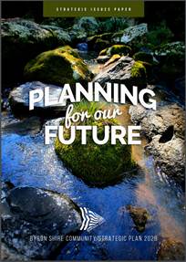
conjunction with the Strategic Issues Paper which is available on the
“your say Byron Shire” website at www.yoursaybyronshire.com.au/30886/documents/68147.
Phase two of the engagement
activities, which have already commenced and will continue during the public
exhibition phase of the draft CSP 2028 includes:
a) Performance
and Wellbeing Indicators Framework
As part of phase two of the CSP engagement program a
series of high level, overarching performance indicators will be determined.
These indicators will provide a way of measuring how Council is progressing
to achieving the community vision.
|
|
Council is in the process of developing a community
wellbeing indicators framework. The community is currently being asked to
provide feedback via our “Happy Byron” Survey (available at www.yoursaybyronshire.com.au/happybyron)
on elements of this framework, with a view to help improve wellbeing in our
area and to develop a baseline of community wellbeing to enable measurements of
success in this field.
b) Community
Solutions Panel
As resolved by Council at its 1 February 2018 (RES 18-027)
meeting, a Community Solutions Panel will be administered by research
foundation newDemocracy, where a group of 28 randomly selected community
members prepare recommendations on Council’s infrastructure priorities.
To engage even more thoroughly with the community about how
resources should be allocated over coming years a project is underway to see if
a community deliberation can be designed which delivers an informed voice of
everyday people. This informed voice will directly consider resourcing issues
which will be at the centre of Council's Delivery Plan. nDF’s intent is
to:
Undertake a bespoke jury-style
process – a Community Solutions Panel – so that a group of
randomly-selected local residents with time, free access to information, a
clear authority and given the starting point of possible solutions (prepared by
active interests and Council), can reach a shared, considered judgement,
reflecting the views of everyday people and thus assist councillors to make a
more widely-trusted public decision.
The aim is to provide a transparent, robust and genuine
process with a methodology which all interests can see is fair and can
therefore accept the results.
The following table outlines
the proposed activities and timeline for this process:
|
Date
|
Activity
|
|
End January
|
Email invitation
distributed and targeted face-to-face recruitment
|
|
Early February
|
Recruitment period
|
|
February
|
Solicitation of
proposed solutions from stakeholders through community workshops and online
|
|
End February
|
Panel randomly
selected, notified and confirmed
|
|
End February
|
Briefing Book sent to
panellists
|
|
Wednesday, 7 March
|
Introductory meeting of Panel (Council presentation)
|
|
Saturday, 10 March
|
First meeting (engagement with Councillors and exploration of
solutions proposed by stakeholders)
|
|
Saturday, 17 March
|
Second meeting of Panel (exploration)
|
|
Saturday, 24 March
|
Third and final meeting of Panel (deliberation and produce recommendations)
|
|
|
Council staff then
incorporate into draft Delivery Plan in readiness for exhibition
|
|
5 April
|
Panellists present
recommendations to Councillors
|
|
19 April
|
Council meeting to
refer draft Delivery Program for exhibition
|
|
30 April – 27 May
|
Formal exhibition of
Delivery Program
|
|
7 June
|
SPW on exhibition
feedback and any issues arising
|
|
21 June
|
Council meeting to
adopt Delivery Program (and all other documents)
|
c) Delivery
Program and Operational Plan
Cascading out of the ten year strategies of the CSP come the
four year actions in our Delivery Program to meet those strategies and then the
annual activities in our Operational Plan to meet the four year actions. Phase
two of the community engagement program will assist Council and staff to
consider priorities and resourcing for the Delivery Program.
As indicated in the activity timeline above, it is proposed
that once the final CSP has been endorsed in late March and further
consultation has taken place, a draft Delivery Program and Operational Plan
will be brought to Council on 19 April for public exhibition.
Financial Implications
The development of the Community Strategic Plan is included
in the 2017/18 budget (account 2052.4). Expenditure includes engagement
specialists, research fund contribution, documentation preparation, advertising
costs and miscellaneous items including staff overtime, equipment and hall hire
of approximately.
An adjustment has been included in the December 2017
Quarterly Budget Review to accommodate the Community Solutions Panel project.
Statutory and Policy
Compliance Implications
1. The
Integrated Planning and Reporting Framework is governed by Section 402 of the
Local Government Act 1993:
402 Community strategic plan
(1) Each
local government area must have a community strategic plan that has been
developed and endorsed by the council. A community strategic plan is a plan
that identifies the main priorities and aspirations for the future of the local
government area covering a period of at least 10 years from when the plan is
endorsed.
(2) A
community strategic plan is to establish strategic objectives together with
strategies for achieving those objectives.
(3) The
council must ensure that the community strategic plan:
(a) addresses
civic leadership, social, environmental and economic issues in an integrated
manner, and
(b) is
based on social justice principles of equity, access, participation and rights,
and
(c) is
adequately informed by relevant information relating to civic leadership,
social, environmental and economic issues, and
(d) is
developed having due regard to the State government’s State Plan and
other relevant State and regional plans of the State government.
(4) The
council must establish and implement a strategy (its community engagement
strategy), based on social justice principles, for engagement with the local
community when developing the community strategic plan.
(5) Following
an ordinary election of councillors, the council must review the community
strategic plan before 30 June following the election. The council may endorse
the existing plan, endorse amendments to the existing plan or develop and
endorse a new community strategic plan, as appropriate to ensure that the area
has a community strategic plan covering at least the next 10 years.
(6) A
draft community strategic plan or amendment of a community strategic plan must
be placed on public exhibition for a period of at least 28 days and submissions
received by the council must be considered by the council before the plan or
amendment is endorsed by the council.
(7) Within
28 days after a community strategic plan is endorsed, the council must post a
copy of the plan on the council’s website and provide a copy to the
Departmental Chief Executive. A copy of a community strategic plan may be
provided to the Departmental Chief Executive by notifying the Minister of the
appropriate URL link to access the plan on the council’s website.
2. The
Office of Local Government’s Guidelines list all the mandatory
requirements from the Act, the Regulation and the Essential Elements that the
Guidelines require that councils follow. Councils must comply with these
Essential Elements when planning and reporting to comply with the Local
Government Act.
With regard to the CSP, the
Essential Elements prescribe:
What are the general
requirements of the Community Strategic Plan?
1.1 The
Community Strategic Plan should be developed and delivered as a partnership
between the council, state agencies, community groups and individuals. It
should address a broad range of issues that are relevant to the whole
community.
What information must be
considered when preparing the Community Strategic Plan?
1.2 Information
that identifies key issues and challenges must be presented to the community in
an accessible format to assist its participation in the planning process.
1.3 In
addition to the legislative requirement to consider State government plans, any
relevant State or regional draft plans and strategies that are available at the
time of preparing the Community Strategic Plan must also be considered.
1.4 Due
consideration must also be given to the expected levels of service expressed by
the community when preparing the Community Strategic Plan. Even though the
Community Strategic Plan is a high level strategic document, these discussions
are important to inform development of this plan and actions within subsequent
plans.
How
should the community be involved in preparing the Community Strategic Plan?
1.5 As
a minimum, the Community Engagement Strategy prepared and implemented by the
council must identify relevant stakeholder groups within the community and
outline methods that will be used to engage each group.
1.6 The
council must place the Draft Community Strategic Plan on public exhibition for
a period of at least 28 days and comments from the community must be accepted
and considered prior to the endorsement of the final Community Strategic Plan.
Staff Reports - Corporate and Community Services 13.4
Report No. 13.4 Update
on Resolution 17-585 regarding Adani and the Carmichael mine
Directorate: Corporate
and Community Services
Report
Author: Bronwyn
Challis, Strategic Procurement Co-ordinator
Tony Nash, Manager Works
File No: I2018/30
Theme: Corporate Management
Governance Services
Summary:
On 23 November 2017, Council resolved (Res 17-585) to
implement a range of actions in regards to Adani, the Carmichael mine and Byron
Shire Council’s use of contractors who are involved in the construction
or operation of the Carmichael mine or otherwise have ties to Adani.
This report provides an update to Councillors and the Byron
Shire community on the implementation of Resolution 17-585.
|
RECOMMENDATION:
That Council:
1. Notes
the work done to date to implement Resolution 17-585.
2. Notes
that correspondence received from Downer confirms that they have no intention
of pursuing contracts for work on the Carmichael mine and Downer is now
listed in the “Who’s Out” section of the Market Forces
website Adani list.
3. Resolves
to continue Contract 2015-0026 with Downer EDI for the Supply and Delivery of
Emulsion.
4. Resolves
to continue Contract 2016-0017 with Skilltech Consulting Services (a
subsidiary of Downer) for Water Meter Reading.
5.
Resolves to continue Contract 2017-0016 NOROC Road Surfacing Services for
asphalt supply and lay, pavement stabilisation and bitumen sealing with
Downer P/L, RPQ Group and NSW Spray Seal P/L (a subsidiary of Downer)
as panel contractors.
6.
Resolves to continue the progressive procurement engagements with GHD for the
restoration of landslips funded through the NDRRA Program as detailed in this
report.
7.
Resolves to continue the existing procurement engagements with GHD for the
finalisation of the North Ocean Shores Fire Main Upgrade and Byron STP Odour
Control Upgrade Inlet Works Investigation.
|
Attachments:
1 Confidential
- Council-Downer contract - legal advice, E2018/4709
2 Downer
press release regarding Adani and Carmichael mine, E2018/4369 
3 Letter to
Prime Minster regarding procurement with Adani related companies Res 17-585, E2017/114030
4 Letter to
Premier of Queensland regarding procurement with Adani related companies Res
17-585, E2017/114023
5 PDF
version of E2017/113291 Letter to Mayors and Councillors regarding procurement
with Adani related companies Res 17-585, E2018/4735

6 PDF Copy
of E2017/109247 Companies that may have ties to Adani - Procurement Toolbox
2017, E2018/5228
7 Pdf Copy
of E2018/4676 Letter (No 2) to Arrium, Cardno, GHD, Komatsu, Price Waterhouse
Cooper (PWC), QBE, Skilltech Consulting, SMEC, Worley Parsons and WSP Parsons
Brickerhoff re involvement with Adani in construction of the Carmichael mine to
advise of, E2018/5244
8 PDF Copy
of E2018/4678 Letter (No 3) to Aracdis and Zurich re involvement with Adani in
construction of the Carmichael mine to advise of resolution 17-585 - Aradis and
Zurich, E2018/5246
9 PDR Copy
Of E2018/3875 Letter (No 1) to Downer re involvement with Adani in construction
of the Carmichael mine to advise of resolution 17-585, E2018/5241
10 Memo to all staff re
Procurement from companies with ties to Adani, e2018/4709
11 Confidential
Attachment for Council Report to 22 February 2018 Meeting regarding an update
to Councillors re Adani & Res 17-585., E2018/8683

12 Downer response to
BSC - Feb 2018, E2018/10510
Report
On 23 November 2017, Council resolved (Res 17-585) a range
of actions in regards to Adani, the Carmichael mine and Byron Shire
Council’s procurement from suppliers who are involved in the construction
or operation of the Carmichael mine or otherwise have ties to Adani.
Below is an update on the implementation of each part of the
resolution:
1. Council
note the Stop Adani campaign event in Byron Bay and events around Australia for
the National Stop Adani Day of Action on 7 October 2017 to support the farmers
directly affected and the wide community’s concerns over this mine.
Noted. No other action
required.
2. Council
resolves not to contract or engage in services under an existing contract with
Downer EDI or any of its subsidiaries, including the RPQ Group and NSW Spray
Seal, until they publicly withdraw from their agreement with Adani to construct
and operate the Carmichael mine and publicly renounce any further involvement
with Adani and the Carmichael mine.
On 18 December 2017,
Downer EDI Limited issued a press release which has been attached to this
report announcing that “Adani and Downer have mutually agreed to
cancel all Letters of Award relating to the [Carmichael] mine services and
related infrastructure. Downer will provide transitional services to Adani
until 31 March 2018.”
Byron Shire Council
currently has three contracts in place with Downer or its subsidiaries for the
supply of goods and services:
a) Contract
2017-0016 NOROC Road Surfacing Services for asphalt supply and lay, pavement
stabilisation and bitumen sealing. Downer EDI and NSW Spray Seal are both on
the panel of suppliers.
b) Contract
2015-0026 Supply and Delivery of Emulsion to NOROC Councils with Downer EDI.
c) Contract
2016-0017 Water Meter Reading with Skilltech Consulting Services who are part
of the Spotless Group which is now part of the Downer Group.
As Contract 2017-0016 is a panel
arrangement, Council are at liberty to use whichever suppliers on the panel
they would like. Council staff have stopped engaging NSW Spray Seal under
Contract 2017-0016 and were investigating using other suppliers on the panel.
However, with the cancellation of the contract to Downer to operate the
Carmichael mine, it is recommended that use of Downer EDI or any of its
subsidiaries, including the RPQ Group and NSW Spray Seal be allowed.
Contract 2015-0026 and Contract
2016-0017 are more problematic as Council has entered into a sole supplier agreement
with Downer EDI and Skilltech Consulting Services respectively for the
provision of goods/services.
Legal advice has been obtained in
regard to any possible consequences should Council no longer obtain emulsion
from Downer under Contract 2015-0026. The legal advice received is provided in
a confidential attachment to this report. It is noted that no longer using
2015-0026 may result in a financial loss to Council.
Contract 2015-0026 expires on 31
July 2018 with one twelve-month extension option available. Since Downer
will no longer be involved with the Carmichael mine after March 2018, it is
recommended that Council continue to use Contact 2015-0026 to avoid any
financial penalties from cancelling the contract. Both Lismore City and Tweed
Shire Councils are continuing to purchase emulsion from Downer under Contract
2015-0026.
There is no provision in Contract
2016-0017 for Council to terminate the Contract without cause. The
Contract commits Council to purchase meter reading services from Skilltech
Consulting Services for a period of five years from 1 February 2017. If
Council was to terminate the contract early in accordance with Resolution
17-585, Council could be liable to compensate the supplier for the amount which
would have ordinarily been payable under the contract. With four years
remaining on the Contract, this could amount to Council paying in excess of
$200,000 if it terminated the contract early for no contractual reason.
3. Council
investigates further companies to which at present or in the future Council may
award contracts that may have any involvement in contracting for the
development and operation of the Carmichael mine, or otherwise have ties to
Adani.
Council’s
procurement templates have all been updated to request from proponents
information regarding any ties they may have to Adani. This information is used
in the evaluation process and any proponent that declares involvement with the
Carmichael mine or has ties to Adani will be deemed non-compliant, excluded
from further evaluation, and ineligible for a contract with Byron Shire
Council.
Council staff are also
maintaining a list of companies that are known to have ties to Adani that staff
can reference when engaging suppliers to provide goods or services to Council.
Companies that are listed on the Marketforces website (https://www.marketforces.org.au/info/key-issues/theadanilist/)
as already connected to Adani as well as other companies identified as having
ties to Adani are listed in the staff document.
All Council staff have
been advised via an internal memo of resolution 17-585 and the resources that
are available to assist them to implement the requirements of the resolution.
Copy attached.
4. Council
resolves not to award future contracts to those companies identified in point
three that are involved with Adani or the construction of the Carmichael mine
until they renounce any involvement with Adani and the Carmichael mine.
As described in #3
above, resources have been made available to staff to assist them in
implementing the requirements of this resolution. However, it must be noted
that not awarding future contracts with the identified companies may
significantly impact Council’s current and future operations.
Currently GHD are
providing engineering and other associated services to Council for the
restoration of landslips resulting from the weather events and declared natural
disasters in June 20165 and March 2017. These restoration works are
funded under the National Disaster Relief and Recovery Arrangements (NDRRA)
Program and not funded by Council. There is time limitations associated with
these restoration works. GHD have been engaged in a progressive manner after
approval by RMS for:-
· Initial site
assessment for public safety
· Concept designs
and estimates
· Detailed designs
and estimates
· Environmental
assessments
· Preparation of
contract documents
· Contract
management
· Project management
The requirements of the NDDRA
program is that Council cannot cost its own staff to these projects during
normal business hours so it is mandatory that we use contractors and
consultants if we want 100% cost recovery from the government for these works.
The list of projects where GHD are
currently engaged are:
June 2016 Flood Damage –
3 Slips – Upper Coopers Creek x 2 and Coolamon Scenic Drive (CSD1)
Currently, an extension for works
has been lodged with RMS as the works are expected finish after June
2018. It is imperative that GHD continue to execute the Tender Package
and engage contractors to continue the work as without GHD doing so, Council
risks completing these works directly from Council funds and without the
assistance of NDRRA funding.
March 2017 Flood Damage –
3 Slips – Johnsons Road; Coolamon Scenic Drive (CSD2) and Yamble Drive
Reservoir
Discussions have been made to
present the two 2017 slips to contractors tendering for the 2016 works.
To complete and expedite these works, it is necessary to keep GHD to maintain
continuity for delivery.
Additionally, the close proximity
of CSD1 and CSD2 make it possible to conduct the works simultaneously –
reducing costs and impact to the community.
Byron Bay Town Centre Bypass
GHD have provided extensive
services in the delivery of this project to date. The implications of
this relationship going forward is still being assessed.
North Ocean Shores Fire Main
Upgrade
GHD have provided extensive
contract superintendent services for this project to date. The contract is
nearing practical completion. Services are outstanding to the value of
$30,000.
Byron STP Odour Control Upgrade
Inlet Works Investigation
GHD are providing extensive
technical investigative services for this project on a critical component
of the treatment plant. Extensive planning and programming are required
for this work. Services are outstanding to the value of $30,000.
5. Council
writes to Downer EDI, the RPQ Group, NSW Spray Seal and any other companies
identified in point three alerting them to this motion and similar actions in
neighbouring Councils, and urging them to reconsider their involvement with
Adani and the construction of the Carmichael mine.
On 22 January 2018
Council wrote to Downer EDI, the RPQ Group, NSW Spray Seal, Skilltech
Consulting Services, GHD, QBE, Arrium Steel, Worley Parsons, Eco Logical,
Wagners, WSP Parsons Brinckerhoff, Cardno, Komatsu and Arcadis to alert them to
this motion and urge them to reconsider their involvement with Adani and the
construction of the Carmichael mine. These are all companies from which Council
currently or have in the past purchased goods or services. The letters are
provided as an attachment to this report.
On 9 February 2018,
Council received a response from Downer regarding their relationship with Adani
and the Carmichael mine. The letter is attached to this report and confirms
that Downer has no intention of pursuing contracts for work on the Carmichael
mine and Downer is now listed in the “Who’s Out” section of
the Market Forces website Adani list.
6. Council
writes to the Prime Minister, the Hon. Mr Malcolm Turnbull and Queensland
Premier, the Hon, Annastacia Palaszczuk and to all councils across Australia
(addressed to mayors and councillors) to express in the most respectful terms
our extreme concern about the Adani mine and alert them to the contents of this
motion.
Letters were sent as
above on 12 December 2017 and are provided as attachments to this report. Responses
have been received from the following Councils: Wakefield Regional Council,
Council of Lower Eyre Peninsula, City of West Torrens, East
Gippsland Shire Council, Brisbane City Council, Colac Otway Shire
Council, Whitsunday Regional Council, City of Port Phillip, Shoalhaven City
Council, Goulburn Mulwaree Council, City of Randwick, and Isaac Regional
Council.
Financial Implications
The financial implications of
implementing resolution 17-585 may be approximately $4M. This includes:
· Potential
costs of not honouring existing contracts for emulsion and meter reading
services.
· Cost
of purchasing emulsion from another supplier for the remainder of 2017/18.
· Cost
of purchasing meter reading services from another supplier for the remainder of
2017/18
· Loss
of government funding for restoration of landslips
· Costs
of works for existing engagements for water and sewer works
Full details of the calculations
are provided as a confidential attachment to this report.
It must be noted that there will also likely be additional
costs of implementing 17-585 in future years as Council pays more for water
meter reading services and road surfacing materials and services.
Statutory and Policy
Compliance Implications
Council has an existing contract (2015-0026) with Downer for
the supply and delivery of emulsion. Legal advice received and attached to this
report advises that whilst this contract can be cancelled, there may be
financial implications to Byron Shire Council.
Council also has an existing contract (2016-0017) with
Skilltech Consulting Services for water meter reading. There is no provision in
the Contract for Council to terminate the contract without cause. It is highly
likely that Council would be liable to compensate the supplier should we
terminate the Contract early.
Council’s Financial Sustainability Plan requires
Council to make savings from its procurement activities. Having to use
suppliers other than Downer and its subsidiaries for the supply and delivery of
emulsion, spray sealing services, and water meter reading services will
directly affect the savings Council is able to obtain from its procurement
activities for 2017/18. Therefore the required 1% savings may not be achieved
this year if Council cancels its existing contracts with Downer and its
subsidiaries.
Staff Reports - Corporate and Community Services 13.5
Report No. 13.5 Byron
Environment Centre
Directorate: Corporate
and Community Services
Report
Author: Mark
Arnold, Director Corporate and Community Services
File No: I2018/57
Theme: Community Infrastructure
Open Space and Recreation
Summary:
Council at its Ordinary
meeting held on 23 November 2017, following consideration of Report 13.35
– Resolution 17-556 Additional Information on Railway Park, resolved (in
part), as follows:-
3. Request staff to enter into discussions with the Byron Environment
Centre about the future
occupation/location of the rotunda structure and bring a report on the
outcome of those
discussions
back to the first Council meeting in 2018.”
This Report has been prepared
to inform Council of the discussions with representatives of the Byron
Environment Centre regarding the future occupation and or location of the
Rotunda Structure.
|
RECOMMENDATION:
1.
That Council receive and note this report.
2. That Council authorise
staff to continue the discussions with the Byron Environment Centre
about the future occupation/location of the rotunda structure.
|
Report
Council at its Ordinary
meeting held on 23 November 2017, following consideration of Report
13.35 – Resolution 17-556 Additional Information on Railway Park
resolved via Resolution 17-575 as follows:-
“Resolved
that Council:
1. Note the report.
2. Request staff to commence work to include Railway Park in an
updated Plan of Management with the aim of completing the process by 30 June
2018.
3. Request staff to enter into discussions with the Byron Environment
Centre about the future
occupation/location of the rotunda structure and bring a report on the
outcome of those discussions back to the first Council meeting in 2018.”
In accordance Part
3 of the Resolution a meeting was arranged and took place on 7 December 2017
with representatives of the Byron Environment Centre Management Committee, John
Lazarus and Sharon Curry. The meeting was held in the Council Administration
Building at Mullumbimby, with the staff representatives being the Director
Sustainable Environment and Economy and the Director Corporate and Community
Services.
In accordance
Resolution 17-575 the purpose of the meeting was for staff to enter into
discussions with representatives of the Byron Environment Centre
(“BEC”) regarding the future occupation and or location of Rotunda
structure.
The
representatives of the BEC made it clear from the commencement of meeting that
the BEC did not support or accept the Byron Bay Town Centre Master Plan, or any
actions relating to works proposed within Railway Park, not authorised by a
Plan of Management for Railway Park.
In relation to
future occupation and or location of the Rotunda structure the BEC
representatives made the following requests to Council:
· That
the Rotunda stay in its current position within Railway Park
· That
the Railway Park Plan of Management process be the mechanism to determine the
location (either the current or another site) and authorise the use and
occupation of the Rotunda structure
In addition
to the discussions on the future occupation and location of the Rotunda
structure, the representatives also asked staff to arrange a walk around of
Railway Park with the Consultant Landscape Architect preparing the Railway
Square Landscape Concept Plan. This request was made in response to an offer
extended by the Mayor, during earlier discussions with representatives of the
Byron Environment Centre.
A walk around
was arranged for Monday, 11 December 2017, but was postponed pending
consideration by of the Mayoral Minute – Railway Square Landscape Concept
and Design at the December Ordinary meeting on 14 December 2017, and the
provision to the BEC of scaled drawings from the latest version of the
Concept Plans. T
The walk
around was rescheduled to Monday, 18 December 2017 and was attended by Dan
Plummer of Plummer & Smith Landscape Architects, Director Corporate and
Community Services and six representatives of the BEC.
While the walk around
provided the representatives of the BEC with an opportunity to discuss and ask
questions of the Landscape Architect, regarding the Railway Square Landscape
Concept and Design Plan adopted by Council on 14 December 2017, it also allowed
a more specific discussion of potential locations.
The following is a summary
of these discussions points relating to the location of the Rotunda location-
· BEC to provide further
advice on any other potential site locations for the Rotunda structure in the
park. It is understood that the preferred location is the current site, with
reasons for this preference being predominately associated with the cost of
relocating the Rotunda structure and any works that might be required as a
result of the relocation process. The other potential locations identified were
a site near or on the location identified for the Art Seat and a site closer to
the entry to the park near the pocket park.
· Discussion was had in
relation to the relocation process but it was agreed that this discussion was
pre-emptive and that future discussions would need to be informed by advice on
the structural integrity of the current structure.
It was also agreed that in accordance with the intent of
Resolution 17-575 that staff would continue discussions with the BEC. That
these discussions would allow Council to provide advice on the scope and timing
of any works within Railway park that might impact on the use and occupation of
the Rotunda structure by the BEC.
The above discussions were undertaken on the basis of
providing information to the BEC representatives, and noting that nothing that
was discussed or requested by the BEC representatives, should be seen or
interpreted as the BEC providing support of the works proposed by the
adopted Railway Square Landscape Concept and Design Plan.
The notes taken by staff on the other matters discussed
during the walk around have been provided to the Consultant Landscape
Architect.
The above information and any future information provided by
the BEC would also be used to inform the preparation of the Plan of Management
for Railway Park (refer Part 2 of Resolution 17-575).
Financial Implications
The costs incurred in relation to the discussions were
within existing allocated budgets.
Statutory and Policy Compliance Implications
Refer Part 3 of Resolution 17-575 being:
3. Request staff to enter into discussions with the Byron Environment
Centre about the future
occupation/location of the rotunda structure and bring a report on the
outcome of those
discussions
back to the first Council meeting in 2018.”
Staff Reports - Corporate and Community Services 13.6
Report No. 13.6 Council
Budget Review - 1 October 2017 to 31 December 2017
Directorate: Corporate
and Community Services
Report
Author: James
Brickley, Manager Finance
File No: I2018/66
Theme: Corporate Management
Financial Services
Summary:
This report is prepared to comply with Regulation 203 of the
Local Government (General) Regulation 2005 and to inform Council and the
Community of Council’s estimated financial position for the 2017/2018
financial year, reviewed as at 31 December 2017.
This report contains an overview of the proposed budget
variations for the General Fund, Water Fund and Sewerage Fund. The
specific details of these proposed variations are included in Attachment 1 and
2 for Council’s consideration and authorisation.
Attachment 3 contains the Integrated Planning and Reporting
Framework (IP&R) Quarterly Budget Review Statement (QBRS) as outlined by
the Division of Local Government in circular 10-32.
|
RECOMMENDATION:
1. That
Council authorise the itemised budget variations as shown in Attachment 2
(#E2018/9537) which includes the following results in the 31 December 2017 Quarterly
Review of the 2017/2018 Budget:
a) General
Fund – $42,300 decrease to the Estimated Unrestricted Cash Result
b) General
Fund - $14,700 increase in reserves
c) Water
Fund - $106,500 decrease in reserves
d) Sewerage
Fund - $799,300 decrease in reserves
2. That
Council adopt the revised General Fund Estimated Unrestricted Cash Result of
$888,300 for the 2017/2018 financial year as at 31 December 2017
|
Attachments:
1 Budget
Variations for General, Water and Sewerage Funds, E2018/9612
2 Itemised
Listing of Budget Variations for General, Water and Sewerage Funds, E2018/9537
3 Integrated
Planning and Reporting Framework (IP&R) required Quarterly Review
Statement, E2018/9550
Report
Council adopted the 2017/2018 budget on 22 June 2017 via
Resolution 17-268. It also considered and adopted the budget
carryovers from the 2016/2017 financial year, to be incorporated into the
2017/2018 budget at its Ordinary Meeting held on 24 August 2017 via Resolution 17-322.
Since that date, Council has reviewed the budget taking into consideration the
2016/2017 Financial Statement results and progress through the first half of
the 2017/2018 financial year. This report considers the December 2017
Quarter Budget Review.
The details of the budget review for the Consolidated,
General, Water and Sewer Funds are included in Attachment 1, with an itemised
listing in Attachment 2. This aims to show the consolidated budget
position of Council, as well as a breakdown by Fund and Principal Activity. The
document in Attachment 1 is also effectively a publication outlining a review
of the budget and is intended to provide Councillors with more detailed
information to assist with decision making regarding Council’s finances.
Contained in the document at Attachment 1 is the following
reporting hierarchy:
Consolidated Budget
Cash Result
General Fund Cash
Result Water Fund Cash Result Sewer
Cash Result
Principal Activity Principal
Activity Principal
Activity
Operating Income Operating
Expenditure Capital income Capital
Expenditure
The pages within Attachment 1 are presented (from left to
right) by showing the original budget as adopted by Council on 22 June 2017
plus the adopted carryover budgets from 2016/2017 followed by the resolutions
between July and September, the September Review, resolutions between October
and December and the revote (or adjustment for this review) and then the
revised position projected for 30 June 2018 as at 31 December 2017.
On the far right of the Principal Activity, there is a
column titled “Note”. If this is populated by a number, it
means that there has been an adjustment in the quarterly review. This
number then corresponds to the notes at the end of the Attachment 1 which
provides an explanation of the variation.
There is also information detailing restricted assets
(reserves) to show Council estimated balances as at 30 June 2018 for all
Council’s reserves.
A summary of Capital Works is also included by Fund and
Principal Activity.
Office of Local Government Budget Review Guidelines:-
The Office of Local Government on 10 December 2010 issued
the new Quarterly Budget Review Guidelines via Circular 10-32, with the
reporting requirements to apply from 1 July 2011. This report includes a
Quarterly Budget Review Statement (refer Attachment 3) prepared by Council in
accordance with the guidelines.
The Quarterly Budget Review Guidelines set a minimum
standard of disclosure, with these standards being included in the Local
Government Code of Accounting Practice and Financial Reporting as mandatory
requirements for Council’s to address.
Since the introduction of the new planning and reporting
framework for NSW Local Government, it is now a requirement for Councils to
provide the following components when submitting a Quarterly Budget Review
Statement (QBRS):-
· A signed statement by
the Responsible Accounting Officer on Councils financial position at the end of
the year based on the information in the QBRS
· Budget review income and
expenses statement in one of the following formats:
o Consolidated
o By fund (e.g General, Water, Sewer)
o By function, activity, program etc
to align with the management plan/operational plan
· Budget Review Capital
Budget
· Budget Review Cash and
Investments Position
· Budget Review Key
performance indicators
· Budget Review Contracts
and Other Expenses
The above components are included in Attachment 3:-
Income and Expenditure Budget Review Statement by Type
– This shows Council’s income and Expenditure by type. This
has been split by Fund. Adjustments are shown, looking from left to
right. These adjustments are commented on through the last 16 pages of
Attachment 1.
Capital Budget Review Statement – This
statement identifies in summary Council’s capital works program on a
consolidated basis and then split by Fund. It also identifies how the
capital works program is funded.
Cash and Investments Budget Review Statement – This
statement reconciles Council’s restricted funds (reserves) against
available cash and investments. Council has attempted to indicate an
actual position as at 31 December 2017 of each reserve to show a total cash
position of reserves with any difference between that position and total cash
and investments held as available cash and investments. It should be
recognised that the figure is at a point in time and may vary greatly in future
quarterly reviews pending on cash flow movements.
Key Performance Indicators (KPI’s) –
At this stage, the KPI’s within this report are:-
o Debt Service Ratio - This
assesses the impact of loan principal and interest repayments on the
discretionary revenue of Council.
o Rates and Annual Charges
Outstanding Ratio – This assesses the impact of uncollected rates and
annual charges on Councils liquidity and the adequacy of recovery efforts
o Asset Renewals Ratio – This
assesses the rate at which assets are being renewed relative to the rate at
which they are depreciating.
These may be expanded in future to accommodate any
additional KPIs that Council may adopt to use in the Long Term Financial Plan
(LTFP.)
Contracts and Other Expenses - This report highlights any
contracts Council entered into during the October to December quarter that are
greater then $50,000.
CONSOLIDATED RESULT
The following table provides a summary of the overall
Council budget on a consolidated basis inclusive of all Funds budget movements
for the 2017/2018 financial year projected to 30 June 2018 but revised as at 31
December 2017.
|
2017/2018 Budget Review Statement as at 31 December 2017
|
Original Estimate (Including Carryovers)
1/7/2017
|
Adjustments to 31 Dec 2017 including Resolutions*
|
Proposed 31 Dec 2017 Review Revotes
|
Revised Estimate 30/6/2018 at 31/12/2017
|
|
Operating Revenue
|
76,828,000
|
2,530,900
|
190,600
|
79,549,500
|
|
Operating Expenditure
|
79,542,600
|
3,252,800
|
324,500
|
83,119,900
|
|
Operating Result –
Surplus/Deficit
|
(2,714,600)
|
(721,900)
|
(133,900)
|
(3,570,400)
|
|
Add: Capital Revenue
|
27,790,000
|
(18,543,700)
|
143,300
|
9,389,600
|
|
Change in Net Assets
|
25,075,400
|
(19,265,600)
|
9,400
|
5,819,200
|
|
Add: Non Cash Expenses
|
12,939,400
|
0
|
0
|
12,939,400
|
|
Add: Non-Operating Funds
Employed
|
2,160,000
|
2,516,000
|
(1,277,000)
|
3,399,000
|
|
Subtract: Funds Deployed for
Non-Operating Purposes
|
(64,587,000)
|
20,099,900
|
334,200
|
44,152,900
|
|
Cash Surplus/(Deficit)
|
(24,412,200)
|
3,350,300
|
(933,400)
|
(21,995,300)
|
|
Restricted Funds –
Increase / (Decrease)
|
(24,419,500)
|
3,572,200
|
(891,100)
|
(21,738,400)
|
|
Forecast Result for the
Year – Surplus/(Deficit) – Unrestricted Cash Result
|
7,300
|
(221,900)
|
(42,300)
|
(256,900)
|
|
|
|
|
|
|
GENERAL FUND
In terms of the General Fund projected Unrestricted Cash
Result the following table provides a reconciliation of the estimated position
as at 31 December 2017:
|
Opening Balance – 1
July 2017
|
$1,145,200
|
|
Plus original budget
movement and carryovers
|
$7,300
|
|
Council Resolutions July
– September Quarter
|
($50,000)
|
|
September Review –
increase/(decrease)
|
($161,900)
|
|
Council Resolutions October
– December Quarter
|
($10.000)
|
|
Recommendations within this
Review – increase/(decrease)
|
($42,300)
|
|
Forecast Unrestricted
Cash Result – Surplus/(Deficit) – 30 June 2018
|
($256,900)
|
|
Estimated Unrestricted
Cash Result Closing Balance – 30 June 2018
|
$888,300
|
The General Fund financial position overall has decreased by
$42,300 as a result of this budget review. The proposed budget changes
are detailed in Attachment 1 and summarised further in this report below.
Council Resolutions impacting the Budget Result
Resolution 17-500 resolved that Council reinstates the Feral
Animal Management Program by allocating $10,000 to assist meeting the costs of
a trapper from January to June 2018. There was no suggested funding
source for this resolution and at this point no funding source has been
identified.
Budget Adjustments
The budget adjustments identified in Attachments 1 and 2 for
the General Fund have been summarised by Budget Directorate in the following
table:
|
Budget Directorate
|
Revenue
Increase/
(Decrease) $
|
Expenditure
Increase/
(Decrease) $
|
Accumulated
Surplus (Working Funds) Increase/ (Decrease) $
|
|
General Manager
|
0
|
0
|
0
|
|
Corporate & Community Services
|
182,400
|
110,000
|
72,400
|
|
Infrastructure Services
|
(898,000)
|
(739,900)
|
(158,100)
|
|
Sustainable Environment & Economy
|
176,300
|
132,900
|
43,400
|
|
Total Budget Movements
|
(539,300)
|
(497,000)
|
(42,300)
|
Budget Adjustment Comments
Within each of the Budget Directorates of the General Fund,
are a series of budget adjustments identified in detail at Attachment 1 and
2. More detailed notes on these are provided in Attachment 1 but in
summary the major additional items included are summarised below by Directorate
and are included in the overall budget adjustments table above:
Corporate and Community Services
· In the General Purpose
Revenues Program an additional $73,300 in revenue has been recognised from
general rates through the amount of supplementary valuations and levies year to
date greater then the budget estimate.
· In the Corporate
Services Program it is proposed to increase expenditure by an estimated
$100,000 for legal expenses. This can be funded through the Legal
Services reserve. There is also an additional $60,000 required to cover
costs of the consultancies associated in the development of the Council’s
new Community Strategic Plan funded from savings in the Strategic Procurement
Roadmap budget.
Infrastructure Services
· In the
Supervision & Administration program, it is proposed to increase
expenditure by $40,000 for uniform issues to account for new boots, uniforms
and hi-vis work wear for staff that is now required at the Depot for Work
Health and Safety reasons. This is offset by a support services cost
adjustment to other budget programs.
· In the Local Roads and
Drainage program, there are a number of adjustments outlined under Note 17 in
the Budget Variations explanations section of Attachment 1. Further
disclosure is included in the third and fourths page of Attachment 2 under the
budget program heading Local Roads and Drainage.
· In the Open Space and
Recreation program, operating income and expenditure increased by $52,000 due
to a grant received for a Shark Management Strategy.
· In the Waste &
Recycling program it is proposed to increase capital expenditure by $88,000 for
Organics Processing Infrastructure – The budget forecasts for this
project were approximately $88,000 under actual costs due to unforeseen EPA
restrictions on the use of fill for engineering preparation works. Council
had planned to use excavated public road material from infrastructure works
projects as general fill, however the EPA did not provide approval and as such
Council had to purchase quarry products at a higher cost.
· In the Facilities
Management program It is proposed to decrease operating expenditure by $22,100
due to the budget for the contract of Mullumbimby swimming pool being more than
the contract.
Sustainable Environment and Economy
· In the Development and
Certification program, it is proposed to increase income by $80,000 and
expenditure by $17,000 to budget for the Information and Technology Service
fee. The expenditure will part fund the Process Improvement Officer
position
· In the Planning Policy
and Natural Environment Program, It is proposed to increase income and
expenditure to accommodate the OEH New Brighton Beach Scraping grant ($56,300),
and an increase to the OEH Saving our Species Iconic Koala grant
($40,000). It is also proposed to allocate $10,000 to the Bangalow village
plan and Mullumbimby masterplan to engage a graphic designer for document
design and desktop publication for both of these projects.
WATER FUND
After completion of the 2016/2017
Financial Statements the Water Fund as at 30 June 2017 has a capital works
reserve of $4,953,000 and held $6,692,100 in section 64 developer
contributions.
The estimated Water Fund reserve
balances as at 30 June 2018, and forecast in this Quarter Budget Review, are
derived as follows:
Capital Works Reserve
|
Opening Reserve Balance at 1
July 2017
|
$4,953,800
|
|
Plus original budget reserve
movement
|
1,539,000
|
|
Less reserve funded carryovers
from 2016/2017
|
(124,800)
|
|
Resolutions July -
September Quarter – increase / (decrease)
|
0
|
|
September Quarterly Review
Adjustments – increase / (decrease)
|
(40,000)
|
|
Resolutions October - December
Quarter – increase / (decrease)
|
0
|
|
December Quarterly Review
Adjustments – increase / (decrease)
|
(56,500)
|
|
Forecast Reserve Movement for
2017/2018 – Increase / (Decrease)
|
1,317,700
|
|
Estimated Reserve Balance at 30
June 2018
|
$6,271,500
|
Section 64 Developer
Contributions
|
Opening Reserve Balance at 1
July 2017
|
$6,692,100
|
|
Plus original budget reserve
movement
|
(1,874,000)
|
|
Less reserve funded carryovers
from 2016/2017
|
(2,645,300)
|
|
Resolutions July -
September Quarter – increase / (decrease)
|
0
|
|
September Quarterly Review
Adjustments – increase / (decrease)
|
(70,000)
|
|
Resolutions October - December
Quarter – increase / (decrease)
|
0
|
|
December Quarterly Review
Adjustments – increase / (decrease)
|
(50,000)
|
|
Forecast Reserve Movement for
2017/2018 – Increase / (Decrease)
|
(4,639,300)
|
|
Estimated Reserve Balance at
30 June 2018
|
$2,052,800
|
Movements for Water Fund can be seen in Attachment 1 with a
proposed estimated decrease to reserves (including S64 Contributions) overall
of $106,500 from the 31 December 2017 Quarter Budget Review.
SEWERAGE FUND
After completion of the 2016/2017
Financial Statements the Sewer Fund as at 30 June 2017 has a capital works
reserve of $7,372,800 and plant reserve of $827,800. It also held
$9,583,600 in section 64 developer contributions.
Capital Works Reserve
|
Opening Reserve Balance at 1
July 2017
|
$7,372,800
|
|
Plus original budget reserve
movement
|
(1,008,100)
|
|
Less reserve funded carryovers
from 2016/2017
|
(102,200)
|
|
Resolutions July - September
Quarter – increase / (decrease)
|
0
|
|
September Quarterly Review
Adjustments – increase / (decrease)
|
24,000
|
|
Resolutions October - December
Quarter – increase / (decrease)
|
0
|
|
December Quarterly Review
Adjustments – increase / (decrease)
|
(524,300)
|
|
Forecast Reserve Movement for
2017/2018 – Increase / (Decrease)
|
(1,610,600)
|
|
Estimated Reserve Balance at
30 June 2018
|
$5,762,200
|
Plant Reserve
|
Opening Reserve Balance at 1
July 2017
|
$827,800
|
|
Plus original budget reserve
movement
|
0
|
|
Less reserve funded carryovers
from 2016/2017
|
0
|
|
Resolutions July -
September Quarter – increase / (decrease)
|
0
|
|
September Quarterly Review
Adjustments – increase / (decrease)
|
(12,300)
|
|
Resolutions October - December
Quarter – increase / (decrease)
|
0
|
|
December Quarterly Review
Adjustments – increase / (decrease)
|
0
|
|
Forecast Reserve Movement for
2017/2018 – Increase / (Decrease)
|
(12,300)
|
|
Estimated Reserve Balance at
30 June 2018
|
$815,500
|
Section 64 Developer
Contributions
|
Opening Reserve Balance at 1
July 2017
|
$9,583,600
|
|
Plus original budget reserve
movement
|
(188,800)
|
|
Less reserve funded carryovers
from 2016/2017
|
(1,949,600)
|
|
Resolutions July -
September Quarter – increase / (decrease)
|
0
|
|
September Quarterly Review
Adjustments – increase / (decrease)
|
(26,700)
|
|
Resolutions October - December
Quarter – increase / (decrease)
|
0
|
|
December Quarterly Review
Adjustments – increase / (decrease)
|
(275,000)
|
|
Forecast Reserve Movement for
2017/2018 – Increase / (Decrease)
|
(2,440,100)
|
|
Estimated Reserve Balance at
30 June 2018
|
$7,143,500
|
Movements for the Sewerage Fund can be seen in Attachment 1
with a proposed estimated overall decrease to reserves (including S64
Contributions) of $799,300 from the 31 December 2017 Quarter Budget Review.
Legal Expenses
One of the major financial concerns for Council over
previous years has been legal expenses. Not only does this item potentially
represent a large expenditure item funded by general revenue, but can also be
susceptible to large fluctuations.
The table that follows indicates the allocated budget and
actual legal expenditure within Council on
a fund basis as at 31 December 2017.
Total Legal Income & Expenditure as at 31 December
2017
|
Program
|
2017/2018
Budget ($)
|
Actual ($)
|
Percentage To
Revised Budget
|
|
Income
|
|
|
|
|
Legal Expenses Recovered
|
0
|
0
|
0%
|
|
Total Income
|
0
|
0
|
0%
|
|
|
|
|
|
|
Expenditure
|
|
|
|
|
General Legal Expenses
|
201,000
|
170,320
|
84.7%
|
|
Total Expenditure General Fund
|
201,000
|
170,320
|
84.7%
|
Note: Due to current legal matters, it is estimated that
Council may incur costs for legal expenses of approximately $100,000 in
addition to the original budget. In view of this, there is a
recommendation in this report to allocate an additional $100,000 to the General
Legal Expenses budget, funded from the Legal Services Reserve. This will
leave an estimated Legal Services Reserve balance at 30 June 2018 of $324,500.
Byron Railway Precinct Projects
The adopted 2017/2018 Budget Estimates currently provides an
allocation of $790,800 funded from the Infrastructure Renewal Reserve, TDDI
Grant and a Visitor Centre contribution for projects related to the Byron Bay
Master Plan – Railway Precinct.
A summary of the current projects with funded budgets
associated with the Byron Railway Precinct are outlined in the table below:
|
Job No
|
Project
|
Proposed Budget
2017/2018 $
|
Funding from
TDDI Grant $
|
Funding from
Infrastructure Renewal Reserve $
|
Funding from
Section 94
$
|
Funding from
Visitor Centre Contribution $ (1)
|
|
4835.187
|
Byron Bay Town Centre Masterplan
|
239,300
|
0
|
239,300
|
0
|
0
|
|
4835.188
|
Byron St Connection Upgrade
|
139,000
|
69,500
|
69,500
|
0
|
0
|
|
4835.189
|
Railway Park Upgrade
|
237,500
|
118,800
|
118,700
|
0
|
0
|
|
4835.190
|
Visitor Centre Refurbishment
|
130,000
|
50,000
|
0
|
30,000
|
50,000
|
|
4835.191
|
Visitor Centre Technology Project
|
45,000
|
22,500
|
22,500
|
0
|
0
|
|
|
Total
|
790,800
|
260,800
|
450,000
|
30,000
|
50,000
|
(1) This
contribution whilst budgeted and invoiced is yet to be paid to Council.
With the addition of the TDDI grant revenue to
Council’s existing budget allocation of $500,000, there is now $790,800
available towards projects in the Byron Railway Precinct.
There are a number of Railway Precinct projects that have
been identified and have current expenditure allocated against them but do not
have a budget:-
|
Job No
|
Project
|
Actual Expenditure
to 31 December 2017 (Inc Commitments)
|
|
4835.219
|
Byron Rail Corridor Park (RPP18)
|
$57,043
|
|
4835.222
|
Conservation Management Strategy (RPP9)
|
$8,824
|
|
4835.223
|
Market/Comm Relocation/Use DAs (RPP11)
|
$480
|
|
4835.224
|
Rail Corridor Contam'tion Ass (RPP12)
|
$32,096
|
|
4835.225
|
Farmers Market Relocation (RPP13)
|
$21,890
|
|
|
Total
|
$120,334
|
Allocating budgets for these projects will be required by
Council at a future point before the end of the 2017/2018 financial year.
These need to be addressed no later than the 31 March 2017 Quarter Budget
Review.
Financial Implications
The 31 December 2017 Quarter Budget Review of the 2017/2018
Budget has decreased the overall budget result by $42,300. As a result
there is a decrease of $42,300 to the estimated unrestricted cash balance
attributable to the General Fund, with this becoming an estimated $888,300 at
30 June 2018. This is below the adopted target of Council of
$1,000,000. It is recommended that Council will need to recover the
2017/2018 budget result to at least a balanced outcome over the remainder of
the 2017/2018 financial year and be conscious of this when considering matters
with financial implications.
Statutory and Policy
Compliance Implications
In accordance with Regulation 203
of the Local Government (General) Regulation 2005 the Responsible Accounting
Officer of a Council must:-
(1) Not later than 2 months after the end of each quarter
(except the June quarter), the responsible accounting officer of a council must prepare and submit to the council a budget review statement that shows, by
reference to the estimate of income and expenditure set out in the statement of
the council’s revenue policy included in the operational plan for the
relevant year, a revised estimate of the income and expenditure for that year.
(2) A budget review statement must include or be
accompanied by:
(a) a report as to whether or not the responsible
accounting officer believes that the statement indicates that the financial
position of the council is satisfactory, having regard to the original estimate
of income and expenditure, and
(b) if that position is unsatisfactory, recommendations
for remedial action.
(3) A budget review statement must also include any
information required by the Code to be included in such a statement.
Statement by Responsible Accounting Officer
This report indicates that the short term financial position
of the Council is still satisfactory for the 2017/2018 financial year, having
consideration of the original estimate of income and expenditure at the 31
December 2017 Quarter Budget Review.
This opinion is based on the estimated General Fund
Unrestricted Cash Result position and that the current indicative budget
position for 2017/2018 outlined in this Budget Review is recovered during the remainder
of the 2017/2018 financial year. It is most important this occurs and the
current projected budget deficit of $256,900 does not deteriorate further.
There needs to be an awareness that any modifications
proposed for Council’s budget are not approved without consideration of
funding if additional expenditure is proposed through either reallocation of
existing budgets, additional revenue or available reserves.
Whilst not covered in this budget review, Council needs to
recognise that the maintenance expenditure budgets in the Local Roads and
Drainage Program are under pressure. Current expenditure trends suggest
there is not sufficient funding to support maintenance expenditure up to the
end of the financial year. Urban Road Maintenance and Bridge Maintenance
budgets are examples. Any additional expenditure over and above the current
budget estimates will of course increase the budget deficit in future quarterly
budget reviews if not addressed.
The short term financial position of Council may become
unsatisfactory if work is not undertaken to address the current budget position
and any unfunded expenditure in the remaining two quarterly budget reviews or
by separate report to Council.
Staff Reports - Corporate and Community Services 13.7
Report No. 13.7 Bangalow
A&I Hall - new fee 'community rate'
Directorate: Corporate
and Community Services
Report
Author: Joanne
McMurtry, Community Project Officer
File No: I2018/72
Theme: Society and Culture
Community Development
Summary:
It has come to Council’s attention during community
consultation in the past few months in Bangalow that the Bangalow A&I Hall
fees and charges seem to be precluding many local organisations from using the
hall as they historically have. This report outlines new fees under the
‘community rate’ and requests Council to introduce them earlier
than the 1st July 2018 to encourage local organisations to use the
hall once again.
|
RECOMMENDATION:
1. That the
new fees for Bangalow A&I Hall outlined below be placed on public exhibition
for 28 days.
|
Bangalow A&I Hall (community rate)
|
Proposed fee
|
|
Per hour
|
$20
|
|
Per session/ half day (4 hours)
|
$150
|
|
Per day
|
$300
|
|
Backstage hire
|
$100
|
|
Balcony (premium seating, per day)
|
$100
|
|
Kitchen hire (per day)
|
$160
|
|
Kitchen hire (per hour – minimum hire 2 hours)
|
$20
|
2. That
if no submissions are received during the public exhibition period,
the new fees be adopted and incorporated into Council’s fees and
charges.
|
Attachments:
1 Bangalow
A&I Hall adopted fees & charges 2017-18, E2018/6625
Report
It has come to Council’s attention during community
consultation in the past few months in Bangalow that the Bangalow A&I Hall
fees and charges seem to be precluding many local organisations from using the
hall as they historically have.
Following investigations and discussions about the fees and
charges for the Bangalow A& I Hall, the Board of Management have
recommended the introduction of new fees under the ‘community rate’
to encourage local organisations to use the hall once again. The new rates
include an hourly rate, therefore allowing flexibility for community groups to
use the hall and kitchen for periods less than the half day rate.
Rather than wait to introduce these new fees in the new
financial year, Council are requested to adopt these new fees now to allow
implementation earlier than 1st July 2018.
|
Bangalow A&I Hall (community rate)
|
2017/18 fee
|
Proposed fee
|
|
Per hour
|
N/A
|
$20
|
|
Per session/ half day (4 hours)
|
$165
|
$150
|
|
Per day
|
$330
|
$300
|
|
Backstage hire
|
$110
|
$100
|
|
Balcony (premium seating, per day)
|
$110
|
$100
|
|
Kitchen hire (per day)
|
$187
|
$160
|
|
Kitchen hire (per hour – minimum hire 2 hours)
|
N/A
|
$20
|
Financial Implications
As outlined in the report, the new community rate fees
represent approximately a 10% reduction. All other fees, eg standard rates and
major commercial rates, for Bangalow A&I Hall are proposed to remain
unchanged (see Attachment 1).
Statutory and Policy Compliance Implications
Under section 610F of the
Local Government Act 1993, if, after the date on which the operational plan
commences the nature or extent of an existing service is changed, Council must
give public notice (in accordance with section 705) for at least 28 days of the
fee proposed for the new or changed service.
Staff Reports - Corporate and Community Services 13.8
Report No. 13.8 Council
Investments January 2018
Directorate: Corporate
and Community Services
Report
Author: James
Brickley, Manager Finance
File No: I2018/86
Theme: Corporate Management
Financial Services
Summary:
This report includes a list of investments and identifies
Council’s overall cash position for the month of January 2018 for
Council’s information.
This report is prepared to comply with Regulation 212 of the
Local Government (General) Regulation 2005.
|
RECOMMENDATION:
That the report listing Council’s
investments and overall cash position as at 31 January 2018 be noted.
|
Report
In relation to the investment portfolio for the month of
January 2018, Council has continued to maintain a diversified portfolio of
investments. At 31 January 2018, the average 90 day bank bill rate (BBSW)
for the month of January was 1.79%. Council’s performance to 31 January
2018 is 2.52%. Council’s performance is again higher than the
benchmark. This is largely due to the active ongoing management of the
investment portfolio, maximising investment returns through secure term
deposits and purchasing floating rate notes with attractive interest rates.
The table below identifies the investments held by Council
as at 31 January 2018:
Schedule of
Investments held as at 31 January 2018
|
Purch Date
|
Principal ($)
|
Description
|
CP*
|
Rating
|
Maturity Date
|
No Fossil
Fuel ADI
|
Type
|
Interest Rate Per
Annum
|
Current Value
|
|
24/03/17
|
1,000,000
|
NAB Social Bond (Gender Equality)
|
P
|
AA-
|
24/03/22
|
N
|
B
|
3.25%
|
1,011,100.17
|
|
28/10/16
|
650,000
|
Teachers Mutual Bank
|
P
|
BBB+
|
28/10/19
|
Y
|
FRN
|
3.17%
|
653,642.89
|
|
31/03/17
|
1,000,000
|
CBA Climate Bond
|
P
|
AA-
|
31/03/22
|
N
|
FRN
|
3.25%
|
1,000,000.00
|
|
16/11/17
|
750,000
|
Bank of Queensland
|
P
|
BBB+
|
16/11/21
|
N
|
FRN
|
2.63%
|
750,000.00
|
|
08/08/17
|
2,000,000
|
Bank of Queensland
|
N
|
BBB+
|
05/02/18
|
N
|
TD
|
2.60%
|
2,000,000.00
|
|
17/08/17
|
1,000,000
|
Bank of Queensland
|
N
|
BBB+
|
19/02/18
|
N
|
TD
|
2.55%
|
1,000,000.00
|
|
05/09/17
|
1,000,000
|
Bananacoast Credit Union
|
P
|
NR
|
06/03/18
|
Y
|
TD
|
2.60%
|
1,000,000.00
|
|
06/09/17
|
1,000,000
|
Bananacoast Credit Union
|
N
|
NR
|
07/03/18
|
Y
|
TD
|
2.60%
|
1,000,000.00
|
|
15/09/17
|
1,000,000
|
Peoples Choice Credit Union
|
P
|
BBB
|
15/03/18
|
Y
|
TD
|
2.55%
|
1,000,000.00
|
|
27/09/17
|
1,000,000
|
Bank of Queensland
|
N
|
BBB+
|
27/03/18
|
N
|
TD
|
2.50%
|
1,000,000.00
|
|
04/10/17
|
2,000,000
|
Police Credit Union
|
P
|
NR
|
04/04/18
|
Y
|
TD
|
2.70%
|
2,000,000.00
|
|
04/10/17
|
1,000,000
|
NAB
|
N
|
AA-
|
05/03/18
|
N
|
TD
|
2.55%
|
1,000,000.00
|
|
04/10/17
|
1,000,000
|
NAB
|
N
|
AA-
|
05/02/18
|
N
|
TD
|
2.52%
|
1,000,000.00
|
|
05/10/17
|
1,000,000
|
Police Credit Union
|
N
|
NR
|
05/04/18
|
Y
|
TD
|
2.56%
|
1,000,000.00
|
|
17/10/17
|
1,000,000
|
Police Credit Union
|
N
|
NR
|
17/04/18
|
Y
|
TD
|
2.55%
|
1,000,000.00
|
|
23/10/17
|
1,000,000
|
Bank of Queensland
|
N
|
BBB+
|
23/04/18
|
N
|
TD
|
2.55%
|
1,000,000.00
|
|
30/10/17
|
2,000,000
|
Beyond Bank
|
P
|
BBB
|
07/02/18
|
Y
|
TD
|
2.42%
|
2,000,000.00
|
|
02/11/17
|
2,000,000
|
Police Credit Union
|
N
|
NR
|
02/05/18
|
Y
|
TD
|
2.73%
|
2,000,000.00
|
|
03/11/17
|
1,000,000
|
Maitland Mutual Building society
|
P
|
NR
|
02/05/18
|
Y
|
TD
|
2.55%
|
1,000,000.00
|
|
06/11/17
|
2,000,000
|
NAB
|
N
|
AA-
|
05/02/18
|
N
|
TD
|
2.49%
|
2,000,000.00
|
|
08/11/17
|
2,000,000
|
ME Bank
|
P
|
BBB
|
07/02/18
|
Y
|
TD
|
2.42%
|
2,000,000.00
|
|
08/11/17
|
1,500,000
|
Auswide Bank Ltd
|
P
|
BBB-
|
07/02/18
|
Y
|
TD
|
2.35%
|
1,500,000.00
|
|
10/11/17
|
2,000,000
|
ME Bank
|
N
|
BBB
|
13/03/18
|
Y
|
TD
|
2.42%
|
2,000,000.00
|
|
15/11/17
|
1,000,000
|
The Capricornian Credit Union
|
P
|
NR
|
16/04/18
|
U
|
TD
|
2.55%
|
1,000,000.00
|
|
15/11/17
|
1,000,000
|
The Capricornian Credit Union
|
N
|
NR
|
15/03/18
|
U
|
TD
|
2.50%
|
1,000,000.00
|
|
17/11/17
|
1,000,000
|
Hunter United Employees Credit Union
|
P
|
NR
|
16/02/18
|
U
|
TD
|
2.50%
|
1,000,000.00
|
|
17/11/17
|
1,000,000
|
Bank of Queensland
|
N
|
BBB+
|
19/03/18
|
N
|
TD
|
2.45%
|
1,000,000.00
|
|
17/11/17
|
1,000,000
|
Police Credit Union
|
N
|
NR
|
17/05/18
|
Y
|
TD
|
2.75%
|
1,000,000.00
|
|
17/11/17
|
1,000,000
|
ME Bank
|
N
|
BBB
|
16/02/18
|
Y
|
TD
|
2.50%
|
1,000,000.00
|
|
23/11/17
|
1,000,000
|
ME Bank
|
N
|
BBB
|
23/02/18
|
Y
|
TD
|
2.40%
|
1,000,000.00
|
|
23/11/17
|
2,000,000
|
NAB
|
N
|
AA-
|
23/02/18
|
N
|
TD
|
2.49%
|
2,000,000.00
|
|
23/11/17
|
1,000,000
|
The Capricornian Credit Union
|
N
|
NR
|
23/05/18
|
U
|
TD
|
2.55%
|
1,000,000.00
|
|
24/11/17
|
1,000,000
|
ME Bank
|
N
|
BBB
|
24/05/18
|
Y
|
TD
|
2.55%
|
1,000,000.00
|
|
28/11/17
|
1,000,000
|
Bananacoast Credit Union
|
N
|
NR
|
28/02/18
|
Y
|
TD
|
2.65%
|
1,000,000.00
|
|
28/11/17
|
1,000,000
|
ME Bank
|
N
|
BBB
|
28/02/18
|
Y
|
TD
|
2.40%
|
1,000,000.00
|
|
30/11/17
|
2,000,000
|
NAB
|
N
|
AA-
|
30/04/18
|
N
|
TD
|
2.49%
|
2,000,000.00
|
|
30/11/17
|
2,000,000
|
ME Bank
|
N
|
BBB
|
30/04/18
|
Y
|
TD
|
2.49%
|
2,000,000.00
|
|
01/12/17
|
1,000,000
|
Defence Bank
|
P
|
BBB
|
20/03/18
|
U
|
TD
|
2.65%
|
1,000,000.00
|
|
01/12/17
|
1,000,000
|
Defence Bank
|
N
|
BBB
|
01/03/18
|
U
|
TD
|
2.50%
|
1,000,000.00
|
|
04/12/17
|
1,500,000
|
ME Bank
|
N
|
BBB
|
06/03/18
|
Y
|
TD
|
2.40%
|
1,500,000.00
|
|
06/12/17
|
1,000,000
|
Hunter United Employees Credit Union
|
N
|
NR
|
06/04/18
|
U
|
TD
|
2.55%
|
1,000,000.00
|
|
08/12/17
|
2,000,000
|
ME Bank
|
N
|
BBB
|
08/06/18
|
Y
|
TD
|
2.55%
|
2,000,000.00
|
|
08/12/17
|
2,000,000
|
My State Bank
|
P
|
W/D
|
08/06/18
|
Y
|
TD
|
2.65%
|
2,000,000.00
|
|
15/12/17
|
1,000,000
|
Auswide Bank Ltd
|
N
|
BBB-
|
15/03/18
|
Y
|
TD
|
2.40%
|
1,000,000.00
|
|
19/12/17
|
2,000,000
|
Credit Union Australia
|
P
|
BBB
|
19/06/18
|
Y
|
TD
|
2.60%
|
2,000,000.00
|
|
19/12/17
|
2,000,000
|
Gateway Credit Union
|
P
|
NR
|
19/04/18
|
Y
|
TD
|
2.50%
|
2,000,000.00
|
|
02/01/18
|
1,000,000
|
ME Bank
|
N
|
BBB
|
04/04/18
|
Y
|
TD
|
2.40%
|
1,000,000.00
|
|
02/01/18
|
2,000,000
|
ME Bank
|
N
|
BBB
|
04/07/18
|
Y
|
TD
|
2.55%
|
2,000,000.00
|
|
09/01/18
|
1,000,000
|
Gateway Credit Union
|
N
|
NR
|
11/05/18
|
Y
|
TD
|
2.50%
|
1,000,000.00
|
|
10/01/18
|
1,000,000
|
Bankwest
|
P
|
AA-
|
10/04/18
|
N
|
TD
|
2.50%
|
1,000,000.00
|
|
12/01/18
|
1,000,000
|
Bank of Queensland
|
N
|
BBB+
|
12/06/18
|
N
|
TD
|
2.55%
|
1,000,000.00
|
|
12/01/18
|
1,000,000
|
Bankwest
|
N
|
AA-
|
12/06/18
|
N
|
TD
|
2.55%
|
1,000,000.00
|
|
12/01/18
|
1,000,000
|
Bankwest
|
N
|
AA-
|
12/04/18
|
N
|
TD
|
2.50%
|
1,000,000.00
|
|
23/01/18
|
1,000,000
|
AMP Bank
|
P
|
A
|
23/07/18
|
N
|
TD
|
2.60%
|
1,000,000.00
|
|
24/01/18
|
1,000,000
|
ME Bank
|
N
|
BBB
|
24/07/18
|
Y
|
TD
|
2.60%
|
1,000,000.00
|
|
29/01/18
|
2,000,000
|
Rural Bank
|
P
|
BBB+
|
30/07/18
|
Y
|
TD
|
2.60%
|
2,000,000.00
|
|
31/01/18
|
2,000,000
|
AMP Bank
|
N
|
A
|
03/08/18
|
N
|
TD
|
2.60%
|
2,000,000.00
|
|
N/A
|
571,384
|
CBA Business Online Saver
|
N
|
A
|
N/A
|
N
|
CALL
|
1.40%
|
571,384.37
|
|
12/01/18
|
1,001,190
|
NSW Treasury Corp
|
N
|
AAA
|
N/A
|
Y
|
CALL
|
1.27%
|
1,001,190.43
|
|
Total
|
75,972,574
|
|
|
|
|
|
AVG
|
2.52%
|
75,987,317.86
|
|
Note 1.
|
CP = Capital protection on maturity
|
|
|
N = No Capital Protection
|
|
|
Y = Fully covered by Government Guarantee
|
|
|
P = Partial Government Guarantee of $250,000 (Financial
Claims Scheme)
|
|
|
|
|
Note 2.
|
No Fossil Fuel ADI
|
|
|
Y = No investment in Fossil Fuels
|
|
|
N = Investment in Fossil Fuels
|
|
|
U = Unknown Status
|
|
Note 3.
|
Type
|
Description
|
|
|
|
B
|
Bonds
|
Principal can vary based on
valuation, interest payable via a fixed interest, payable usually each
quarter.
|
|
|
FRN
|
Floating Rate Note
|
Principal can vary based on
valuation, interest payable via a floating interest rate that varies each
quarter.
|
|
|
TD
|
Term Deposit
|
Principal does not vary during investment term. Interest
payable is fixed at the rate invested for the investment term.
|
|
|
CALL
|
Call Account
|
Principal varies due to cash flow demands from deposits/withdrawals,
interest is payable on the daily balance.
|
Environmental and Socially
Responsible Investing
An additional column has been
added to the schedule of Investments above, to identify if the financial
institution holding the Council investment, has been assessed as a ‘No
Fossil Fuel’ investing institution. This information has been
sourced through www.marketforces.org.au and identifies financial
institutions that either invest in fossil fuel related industries or do
not. The graph below highlights the percentage of each classification
across Council’s total investment portfolio in respect of fossil fuels
only.
The notion of Environmental and
Socially Responsible Investing is much broader than whether a financial
institution as rated by ‘marketforces.org.au’ invests in fossil
fuels or not. Council’s current Investment Policy defines
Environmental and Socially Responsible Investing at Section 4.1 of the
Policy. Council’s Investment Policy can be found at the following
link:
http://www.byron.nsw.gov.au/files/publications/council_investments_policy_2017.pdf
In this regard Council has an additional
two investments that are with financial institutions that invest in fossil
fuels but the purposes of the investments are in accord with the broader
definition of Environmental and Socially Responsible investments as indicated
below:
1. $1,000,000 investment with the National Australia Bank maturing
on 24 March 2022 known as a Social Bond that promotes Gender Equity.
2. $1,000,000 investment with Commonwealth Bank maturing on 31
March 2022 known as a Climate Bond.
For the month of January 2018, as indicated in the table
below, there is a dissection of the investment portfolio by investment type:
Dissection
of Council Investment Portfolio as at 31 January 2018
|
Principal Value ($)
|
Investment Linked to:-
|
Current Market Value ($)
|
Cumulative Unrealised Gain/(Loss) ($)
|
|
71,000,000.00
|
Term
Deposits
|
71,000,000.00
|
0.00
|
|
2,400,000.00
|
Floating
Rate Note
|
2,403,642.89
|
3,642.89
|
|
571,384.37
|
Business
On-Line Saver (At Call)
|
571,384.37
|
0.00
|
|
1,001,190.43
|
NSW Treasury Corp
(T Corp)
|
1,001,190.43
|
0.00
|
|
1,000,000.00
|
Bonds
|
1,011,100.17
|
11,100.17
|
|
75,972,574.80
|
|
75,987,317.86
|
14,743.06
|
The current value of an investment compared to the principal
value (face value or original purchase price) provides an indication of the
performance of the investment without reference to the coupon (interest) rate. The
current value represents the value received if an investment was sold or traded
in the current market, in addition to the interest received.
The table below provides a reconciliation of investment
purchases and maturities for month of January 2018 on a current market value
basis.
Movement
in Investment Portfolio – January 2018
|
Item
|
Current Market Value (at end of month) $
|
|
Opening
Balance at 01 January 2018
|
74,984,261.21
|
|
Add:
New Investments Purchased
|
14,000,000.00
|
|
Add:
Call Account Additions
|
0.00
|
|
Add:
Interest from Call Account
|
1,866.22
|
|
Less:
Investments Matured
|
13,000,000.00
|
|
Add:
T Corp Additions
|
1,000,000.00
|
|
Add:
Interest from T Corp
|
1,190.43
|
|
Less:
Call Account Redemption
|
1,000,000.00
|
|
Less:
Fair Value Movement for period
|
0.00
|
|
Closing
Balance at 31 January 2018
|
75,987,317.86
|
Investments
Maturities and Returns – January 2018
|
Principal Value ($)
|
Description
|
Type
|
Maturity Date
|
Number of Days Invested
|
Interest Rate Per Annum
|
Interest Paid on Maturity $
|
|
1,000,000
|
Banana Coast Credit
Union
|
TD
|
04/01/18
|
184
|
2.70%
|
13,610.96
|
|
1,000,000
|
National Australia
Bank
|
TD
|
04/01/18
|
92
|
2.50%
|
6,601.37
|
|
1,000,000
|
National Australia
Bank
|
TD
|
09/01/18
|
92
|
2.51%
|
6,326.58
|
|
1,000,000
|
National Australia
Bank
|
TD
|
11/01/18
|
132
|
2.52%
|
8,492.06
|
|
1,000,000
|
Auswide Bank
|
TD
|
11/01/18
|
92
|
2.50%
|
6,301.37
|
|
1,000,000
|
Bank of Queensland
|
TD
|
12/01/18
|
150
|
2.55%
|
10,479.45
|
|
1,000,000
|
Auswide Bank
|
TD
|
15/01/18
|
94
|
2.50%
|
6,438.36
|
|
1,000,000
|
National Australia
Bank
|
TD
|
20/01/18
|
92
|
2.48%
|
6,250.96
|
|
1,000,000
|
ME Bank
|
TD
|
24/01/18
|
90
|
2.42%
|
5,967.12
|
|
2,000,000
|
Rural Bank
|
TD
|
29/01/18
|
123
|
2.50%
|
16,849.32
|
|
2,000,000
|
ME Bank
|
TD
|
30/01/18
|
92
|
2.42%
|
12,199.45
|
|
13,000,000
|
|
|
|
|
|
99,517.00
|
The overall ‘cash position’ of Council is not
only measured by what funds Council has invested but also by what funds Council
has retained in its consolidated fund or bank account as well for operational
purposes. In this regard, for the month of January 2018 the table below
identifies the overall cash position of Council as follows:
Dissection
of Council Cash Position as at 31 January 2018
|
Item
|
Principal Value ($)
|
Current Market Value ($)
|
Cumulative Unrealised Gain/(Loss) ($)
|
|
Investments
Portfolio
|
|
|
|
|
Term Deposits
|
71,000,000.00
|
71,000,000.00
|
0.00
|
|
Floating Rate Note
|
2,400,000.00
|
2,403,642.89
|
3,642.89
|
|
Business On-Line
Saver (At Call)
|
571,384.37
|
571,384.37
|
0.00
|
|
NSW Treasury Corp
(T Corp)
|
1,001,190.43
|
1,001,190.43
|
0.00
|
|
Bonds
|
1,000,000.00
|
1,011,100.17
|
11,100.17
|
|
Total Investment
Portfolio
|
75,972,574.80
|
75,987,317.86
|
14,743.06
|
|
|
|
|
|
|
Cash at Bank
|
|
|
|
|
Consolidated Fund
|
1,513,192.85
|
1,513,192.85
|
0.00
|
|
Total Cash at Bank
|
1,513,192.85
|
1,513,192.85
|
0.00
|
|
|
|
|
|
|
Total Cash
Position
|
77,485,767.65
|
77,500,510.71
|
14,743.06
|
Financial Implications
Council uses a diversified mix of investments to achieve
short, medium and long-term results.
Statutory and Policy
Compliance Implications
In accordance with Regulation 212 of the Local Government
(General) Regulation 2005, the Responsible Accounting Officer of Council must
provide Council with a monthly report detailing all monies Council has invested
under section 625 of the Local Government Act 1993.
The Report must be presented at the next Ordinary Meeting of
Council after the end of the month being reported. In this regard, the
current Council Meeting cycle does not always allow this to occur, especially
when investment valuations required for the preparation of the report, are
often received after the deadline for the submission of reports for the
meeting. Endeavours will be made to ensure the required report will be
provided to Council and this will for some months require reporting for one or
more months.
Council’s investments are carried out in accordance
with section 625(2) of the Local Government Act 1993 and Council’s
Investment Policy. The Local Government Act 1993 allows Council to invest money
as per the Ministers Order – Forms of Investment, last published in the
Government Gazette on 11 February 2011.
Council’s Investment Policy includes the objective of
maximising earnings from authorised investments and ensuring the security of
Council Funds.
Council at its Ordinary Meeting held 8 October 2015 resolved
through resolution 15-515 to insert a new objective into its adopted
Investment Policy, which gives a third tier consideration by Council to
Environmental and Socially Responsible Investments, when making investment
decisions.
Staff Reports - Corporate and Community Services 13.9
Report No. 13.9 Tender
Assessment - Legal Services Contract 2017-0054
Directorate: Corporate
and Community Services
Report Author: Ralph
James, Legal Counsel
File No: I2018/94
Theme: Corporate Management
Governance Services
Summary:
On 13 September 2017 the General
Manager gave approval for Council to go to tender for Legal
Services using the open request for tender
process as per Section 55 of the Local Government Act.
Tenders have been assessed in
accordance with the provisions of the Local Government (General) Regulation
2005.
This report provides an overview
of the tender submissions and seeks Council to award the tender as per the
recommendation in the attached confidential report.
|
RECOMMENDATION:
That Council award Tender Legal Services Contract 2017-0054
in accordance with the recommendation made in the Evaluation Panel
Recommendation Report for the Provision of Legal Services (#E2018/3130).
|
Attachments:
1 Confidential
- Evaluation Panel Recommendation Report-Provision of Legal Services, E2018/3130
Report
On 13 September 2017 the General
Manager gave approval for Council to go to tender for Legal
Services using the open request for tender
process as per Section 55 of the Local Government Act.
The proposed contract for legal
services subject of this Tender is for a period of three years with the option
to extend the contract for two additional periods of one year at
Council’s sole discretion.
The objective of the tender is
to:
• Provide
timely access to qualified legal services.
• Enable
the provision of high quality, cost competitive and consistent legal services
to Council.
• Reduce
the administrative effort by Council by engaged lawyers and/or firms through an
approved panel arrangement.
Tenders were advertised in Tenders Online between 24 October
2017 and 14 November 2017, in the Sydney Morning Herald on 24 October 2017, in the
Byron Shire News on 26 October 2017 and on Council’s website between 24
October 2017 and 14 November 2017.
The tender was available for download free of charge from
Council’s E-Tendering portal.
Eleven (11) tenders were received electronically through
E-Tendering. The tenderers are listed below. They are listed in order of
receipt. This listing does not reflect any ranking assessment.
1. Holding
Redlich
2. Redenbach
Lee
3. Swaab
Attorneys
4. Marsdens
Law Group
5. McInnes
Wilson
6. Moray
& Agnew
7. Lander
and Rogers
8. McCullough
Robertson
9. McCabes
10. Wiltshire
Webb
11. HWL
Ebsworth
Tender Evaluation
The Tender Assessment Panel comprised three staff members,
including the Legal Counsel who is the Council Officer assigned to management
of Council’s legal services. The other Panel members were the Manager
Corporate Services and the Strategic Procurement Coordinator.
Tenders were initially assessed for conformity and all of
the tenders received were accepted as conforming with the “Conditions of
Tendering”.
Tenders were evaluated against three capability selection
criteria, which were:
Profile and relevant experience
This criterion was evaluated on
I. the
tenderers business being relevant to what Council is seeking,
II. that
the tenderer has relevant experience, particularly in providing the
deliverables and in local government,
III. a
commitment to improving environmental impact, has programs in place to provide
employment/training for disadvantaged people.
Quality and availability of resources
This criterion was evaluated on
i. Clear
management structure, that key personnel have relevant qualifications and
experience
ii. Enough
staff to do the work and that those staff have relevant skills and experience
iii. Minimal
use of subcontractors that Any subcontractors that are used are well managed to
ensure compliance
Delivery plan
This criterion was evaluated on
i. The
tenderer has processes and systems in place to manage the work
ii. Offers
metrics for managing performance
iii. Clear
and realistic information plan that demonstrates understanding of
Council’s requirements
iv. Commitment
to purchase supplies/services from NOROC businesses, social enterprise and/or
indigenous businesses.
v. Offers
employment for local/disadvantaged people.
vi. Products
offered or used offer sustainability advantages (e.g. Australian
made/recyclable et cetera)
The Tender Assessment Panel also assessed pricing as per the
attached evaluation assessment. A combination of the capability ranking and the
pricing brought about a value for money ranking. Overall value for money for
each respondent was calculated using the quality: price ratio. The respondent
with the highest quality:price ratio offers the best overall value for money.
The Tender Assessment Panel considered it would be
preferable to have a minimum of two suppliers on the panel to sustain
competitiveness and ensure availability.
The Evaluation report recommends to Council that it award
the tender to the top four ranked tenderers.
Council’s resolution should list the successful
tenderers in ‘alphabetical order’, as is usually the case where
multiple suppliers are appointed to avoid any inference otherwise being drawn
as to the commercial-in-confidence information contained in the tender
submissions.
Financial Implications
There are no financial implications from entering into
contracts under this Tender because the Request for Tender made it very clear
that even if Council appointed a service provider or multiple service providers
to a panel, that would not be a guarantee of allocation by Council of legal
work.
That is, even if Council appoints tenderers under this
contract, Council has the right not to consume any legal services at all, in
which case there would be no financial implications to Council. However, the
reality is that Council will, over the period of the contract, most likely
consume some legal services.
The amount of legal services Council consumes as a result of
taking enforcement and regulatory action, defending decisions made on
development, planning and environmental applications, defending third party
challenges to other decisions by Council and on obtaining advice and other
services, such as conveyancing, varies considerably from year to year.
Council always endeavours to minimise expenditure on legal
services by undertaking as much of Councils legal work in-house via the
professional services of the Legal Services team.
Statutory and Policy Compliance Implications
The tendering process has been undertaken in accordance with
Council’s procurement policy, and the provisions of the Local Government
(General) Regulation 2005.
The Local Government
(General) Regulations 2005 define the options available to Council. An
extract is provided below.
LOCAL GOVERNMENT (GENERAL)
REGULATION 2005
178
ACCEPTANCE OF TENDERS
(1) After
considering the tenders submitted for a proposed contract, the council must
either:
(a) accept the tender that, having
regard to all the circumstances, appears to it to be the most advantageous, or
(b) decline to accept any of the
tenders.
(1A) Without limiting subclause (1), in considering the
tenders submitted for a proposed contract for the performance of domestic or
other waste management services, the council must take into account whether or
not existing workers (within the meaning of clause 170) will be offered
employment or engagement on terms and conditions comparable to those applicable
to the workers immediately before the tender was submitted.
(2) A council must ensure that every
contract it enters into as a result of a tender accepted by the council is with
the successful tenderer and in accordance with the tender (modified by any
variation under clause 176). However, if the successful tender was made by the
council (as provided for in section 55 (2A) of the Act), the council is not
required to enter into any contract in order to carry out the requirements of
the proposed contract.
(3) A council that decides not to
accept any of the tenders for a proposed contract or receives no tenders for
the proposed contract must, by resolution, do one of the following:
(a) postpone or cancel the proposal
for the contract,
(b) invite, in accordance with clause
167, 168 or 169, fresh tenders based on the same or different details,
(c) invite, in accordance with
clause 168, fresh applications from persons interested in tendering for the
proposed contract,
(d) invite, in accordance with clause
169, fresh applications from persons interested in tendering for contracts of
the same kind as the proposed contract,
(e) enter into negotiations with any
person (whether or not the person was a tenderer) with a view to entering into
a contract in relation to the subject matter of the tender,
(f) carry out the requirements
of the proposed contract itself.
(4) If a council resolves to enter
into negotiations as referred to in subclause (3) (e), the resolution must
state the following:
(a) the council's reasons for
declining to invite fresh tenders or applications as referred to in subclause
(3) (b)-(d),
(b) the council's reasons for
determining to enter into negotiations with the person or persons referred to
in subclause (3) (e).
179
NOTIFICATION OF ACCEPTANCE OF SUCCESSFUL TENDER
As soon as practicable after entering into a contract in
accordance with clause 178 or deciding not to accept any of the tenders for a
proposed contract, a council must:
(a)
send to all tenderers whose tenders were not accepted
notices to the effect that their tenders were unsuccessful or, as the case may
be, that none of the tenders for the proposed contract was accepted, and
(b)
display in a conspicuous place that is accessible to members
of the public a notice specifying the name of the tenderer whose tender was
accepted and the amount of the successful tender or, if none of the tenders was
accepted, a notice to that effect.
Staff Reports - Corporate and Community Services 13.10
Report No. 13.10 Joint
Organisation of Councils
Directorate: Corporate
and Community Services
Report
Author: Ralph
James, Legal Counsel
File No: I2018/95
Theme: Corporate Management
Governance Services
Summary:
A report was been prepared and submitted to 1 February
Ordinary meeting on this subject. The purpose of the Report being to provide
Council with an update on the status of Regional Joint Organisations of
Councils, and to allow Council to consider the invitation from the Office of
Local Government, issued in its correspondence dated 1 December 2017 (refer
Attachment 1), for Council to voluntarily join the Northern Rivers Joint
Organisation of Councils.
Council following consideration of the Report resolved via
Resolution 18-043 as follows:
“1. That Council defer consideration of the report for the
purposes of a Strategic Planning
Workshop
(SPW) to receive details and implications of the proposed legislative and
governance
framework for Joint Organisations and how it might change decision making
processes
of Council in the future and in particular, participation of the community,
accountability
and transparency of decision making.
2. That Council, following the
SPW, receive a further report at the 22 February meeting.”
|
RECOMMENDATION:
That, in accordance with Part 7 of Chapter 12 of the
Local Government Act 1993 (Act), Council:
1. Inform
the Minister for Local Government (Minister) of the Council’s
endorsement of the Minister recommending to the Governor the establishment of
a Joint Organisation in accordance with this resolution.
2. Approve
the inclusion of the Council’s area in the Joint Organisation’s
area.
3. Request
that the Joint Organisation be established to cover the Council’s area
and any one or more of the following council areas:
a) Richmond
Valley
b) Lismore
City
c) Ballina
Shire
d Kyogle
e) Tweed
Shire
4. Authorises
the General Manager to provide the Minister with a copy of this resolution
including the date on which Council made this resolution before 28 February
2018.
5. Authorises the
General Manager to, on the expiry of a period of 28 days from the making of
this resolution, inform the Minister that this resolution has not been
rescinded.
|
Attachments:
1 Letter
from the Office of Local Government-Joint Organisations, E2018/4097
2 Joint
Organisation Information Pack, E2018/4099
3 Second
Reading speech Mr John Barilaro ( Monaro—Deputy Premier, Minister for
Regional New South Wales, Minister for Skills, and Minister for Small Business)
, E2018/7877
Report
The Office of Local Government (“OLG”) has
written to Councils following the recent passage by the NSW Parliament of the
Local Government Amendment (Regional Joint Organisations) Bill 2017. The OLG in
its correspondence of 1 December 2017 has stated that this legislation allows
for Councils to voluntarily join a new Joint Organisation “to
strengthen regional coordination and improve the delivery of important
infrastructure and services for communities through strategic planning,
collaboration and shared leadership and advocacy”.
Council has been invited to establish and nominate to join
the Northern Rivers Joint Organisation of Councils.
The
Office of Local Government in its Joint Organisations – Frequently Asked
Questions provides the following information on structure and purpose of a
Joint Organisation.
“A
Joint Organisation is a new entity under the Local Government Act comprising
member councils in regional NSW to provide a stronger voice for the communities
they represent.
A
Joint Organisation will provide a more structured, permanent way for local
councils, State agencies and other interested groups to collaborate. Each
region will decide its own priorities, working on short and long term projects
such as attracting a new industry to the region or improving the health of a
river system. By putting their resources together and focusing on the unique
challenges and strengths of their whole region, Joint Organisation members can
drive better outcomes for local residents.
Each Joint Organisation will comprise at least three
member councils and align with one of the State’s strategic growth
planning regions. One of the member council’s mayors will be elected
chairperson and an Executive Officer may be appointed.”
Further information on the proposed Joint Organisations and
the entire process is available on the Office of Local Government’s
website (olg.nsw.gov.au), under the heading of Strengthening Local Government.
The following link is provided http://www.olg.nsw.gov.au/content/joint-organisations-strengthen-regional-nsw.
Byron Shire currently sits within the North Coast State
Planning Region along with Tweed Shire, Ballina Shire, Bellingen Shire, Kyogle,
Richmond Valley, Nambucca Shire, Lismore City, Clarence Valley, Kempsey Shire,
Coffs Harbour City and Port Macquarie-Hastings Councils.
The Office of Local Government in the information
provided to Councils on Joint Organisations and the next steps (Attachment 2),
has indicated that a Council should consult with other Councils within their
allocated Regional Planning Region, to identify the member Councils for a Joint
Organisation.
NOROC at a meeting held in November 2016 resolved to endorse
the submission to the NSW Government’s Joint Organisations: Getting
the Boundaries Right report (16/17:R14).The submission stated that NOROC
supported the proposed boundaries for the Northern Rivers Joint , and that
NOROC included the Kyogle, Richmond Valley, Tweed, Byron, Lismore and Ballina
Local Government areas, and that the alignment of the proposed boundary for the
Joint Organisation and the current NOROC boundary would ensure a smoother
transition process.
Each of the individual Councils within the area of a
proposed Joint Organisation needs to pass a resolution establishing the Joint
Organisation and its membership, and confirming that the Council wishes to be
member of the Joint Organisation.
This format and the content of the resolution has been
prescribed by the Office of Local Government. The resolution when passed by
Council, along with the Council’s nomination to join a Joint
Organisation, needs to be submitted to the Office of Local Government prior to
28 February 2018.
This report has been prepared to allow Council to consider
the invitation from the Office of Local Government, for Council to join the
Northern Rivers Joint Organisation of Councils, by passing the required
resolution.
Financial Implications
At
this stage there is not anticipated to be any additional resource or financial
implications to Council, although this could change over time if the Joint
Organisation sought to increase its level of service to the member councils and
a higher staff resource was needed. This would only occur in consultation with
the member councils.
The
current contribution to NOROC is approximately $15,500.
Initial establishment funding is
to be provided by the State Government, with $3.3 million to be allocated to
the project. NOROC, or the new Joint Organisation, will look at opportunities
to access this funding for projects that may benefit the region.
Statutory and Policy
Compliance Implications
Local Government Act 1993.
The
legislation provides as follows for joint organisations:
(a) it enables
the making of proclamations by the Governor to constitute joint organisations
and provides for the area of the joint organisation (a joint organisation area) to consist of at least 2 council areas,
(b) it
prohibits a council area from being included in a joint organisation area
unless the council has resolved to approve inclusion of the council’s
area in the joint organisation area,
c) a
joint organisation established under a proclamation is constituted as a body
corporate with the powers of an individual both in and outside the State,
(d) the
principal functions of a joint organisation are to establish strategic regional
priorities, provide regional leadership and identify and take up opportunities
for inter-governmental co-operation on regional matters,
(e) joint
organisations may also deliver services to or on behalf of councils and provide
assistance to councils (including capacity building), subject to any
restrictions imposed by the regulations,
(f) a
joint organisation is to make decisions through its board, which will contain
voting and non-voting representatives. The voting representatives will be the
mayor of each council whose area is included in the joint organisation (a member council) as well as one additional representative
for each member council if the board determines that additional representatives
are to be added,
(g) the role
of the board is to direct and control the affairs of the joint organisation.
The board is to prepare and adopt a charter for the joint organisation,
(h) the
chairperson of the joint organisation is to be elected by the voting
representatives from the representatives who are mayors and is to hold office
for 2 years and may, if the board
so
determines, be a non-voting chairperson,
(i) regulations
may be made to enable alternates to be appointed for voting representatives and
may provide that the alternates may only act for limited periods,
(j) a
voting representative will cease to hold office when he or she ceases to be the
mayor or councillor of a member council, resigns, has a nomination revoked or
is removed from office by the Minister and will be suspended for any period of
suspension as a mayor or councillor,
(k) a member
council may request that the Minister remove the mayor of the council from the
board on the ground of exceptional circumstances, with or without the consent
of the mayor,
(l) the
role of the executive officer of a joint organisation is to conduct the
day-to-day management of the joint organisation and to give effect to lawful
decisions of the joint organisation,
(m) the functions of
the joint organisation may be exercised by means of the representatives, by a
committee or by other provision or means, jointly with another person or persons
or a member council or by a delegate,
(n) a joint
organisation cannot require a member council to delegate a function to it,
(o) if an
administrator is appointed for a member council, the administrator may exercise
the functions, and has the same number of votes as, all of the voting
representatives of that council,
(p) the
Governor may make proclamations amending the constitution of, or dissolving, a
joint organisation,
(q) provisions
enabling savings and transitional provisions to be included in proclamations
constituting councils will apply to proclamations made under the proposed Part,
(r) a
function of the joint organisation may be delegated to a committee, the
executive officer or any other person or body. The executive officer may sub-delegate
the function as well as delegate his or her functions. A joint organisation may
also sub-delegate to a committee, the executive officer or any other person or
body functions delegated to the joint organisation by the Chief Executive of
the Office of Local Government or a member council,
(s) the
regulations will be able to provide for the making of financial contributions
by member councils to a joint organisation and this may include making
employees available for the purposes of the joint organisation,
(t) limitations
are imposed on the employment of staff pending certain declarations,
(u) provisions
of the Local Government Act 1993
that apply to councils are
applied to joint organisations as if they were councils, subject to specified exclusions.
Regulations may also be made to exclude the application of additional
provisions and to apply excluded provisions.
The intent of the Government in introducing the legislation
and its intended operation of Joint Organisations is set out in the Second
Reading Speech of Mr John Barilaro ( Monaro—Deputy Premier,
Minister for Regional New South Wales, Minister for Skills, and Minister for
Small Business) Attachment 3.
Staff Reports - Sustainable Environment and Economy 13.11
Staff Reports - Sustainable Environment and
Economy
Report No. 13.11 Update
on the CZMP for the Eastern Precincts of the Byron Bay Embayment
Directorate: Sustainable
Environment and Economy
Report
Author: Chloe
Dowsett, Coastal and Biodiversity Coordinatior
File No: I2017/2004
Theme: Ecology
Planning Policy and Natural Environment
Summary:
This report provides an update on the development of the
draft Coastal Zone Management Plan (CZMP) for the Eastern Precincts of the
Byron Bay Embayment (Cape Byron to Main Beach) for submission to the Minister
in June 2018. Also outlined in this report are revised timeframes as previously
reported on the delivery of the CZMP to the Minister.
The revised timeframes are based on a request from the
Office of Environment and Heritage (OEH) to complete a formal review of the
CZMP (requiring up to 3 weeks) prior to the CZMP going to public exhibition.
This aims to increase the potential for Ministerial certification of the plan prior
to the lapsing of the existing legislations transitional arrangements.
|
RECOMMENDATION:
That Council
note the report.
|
Report
Background
Council considered a report at the 26 October 2017 meeting
on the Minister’s and NSW Coastal Panel’s advice on the draft
Coastal Zone Management Plan for the Byron Bay Embayment, which included
amongst other advice excising the Belongil Spit area from the plan and
resubmitting for Ministerial certification. At this meeting Council
resolved (Resolution 17-521) to prepare a Coastal Zone Management Plan (CZMP)
for the Eastern Precincts of the Byron Bay Embayment (BBE) for Cape Byron to
Main Beach, comprising Wategos/Little Wategos, The Pass, Clarkes Beach and Main
Beach precincts.
It is critical to have the new CZMP completed and with the
Minister for certification prior to the lapsing of the existing
legislation’s transitional arrangements. It is expected that the
legislation will come into effect within the next few months; therefore the new
CZMP should ideally be with the Minister by end of June 2018, to leave ample
time for review and approval of the plan.
Plan Development
The development of a draft CZMP for the Eastern Precincts of
the BBE has commenced and is progressing well. The process for developing the
plan has been more complex than just simply ‘splitting’ the plan in
two, as new coastal issues have emerged within the planning area. As such,
early engagement and involvement with public agencies has taken place from the
beginning of the process.
Management issues and actions presented in the preceding
CZMP BBE relating to the Eastern Precincts were not a focus of the Coastal
Panel of OEH review in 2016 as the complex issues at Belongil Spit took
precedent and overshadowed other precincts (Cape Byron to Main Beach). Hence, actions
and strategies proposed in the newly formed CZMP for the Eastern Precincts have
been fleshed out in more detail in close consultation with agencies and OEH.
A workshop was held on 24 January 2018 with some agencies in
attendance and others providing written comments for discussion at the
workshop. The workshop was very productive to gain feedback on the proposed
actions and strategies, and discuss new issues relevant to the planning area.
Agency support for the actions in the plan that pertain to
them is critical to the success of the plan and agency agreement in the form of
a ‘Letter of Support’ is required to accompany the CZMP document.
Advice, comment and feedback has already been received on
the preliminary draft plan by the Office of the Environment and Heritage (OEH)
with the main comments provided below and a response as to how these comments
have been addressed.
#1: The plan needs to be clear, concise and upfront as to
how it proposes to manage this section of the coast.
The newly formed plan is succinct with the majority of
background information on management issues and objectives now in Appendices.
The plan is open and transparent and seeks to accord with the guidance of
existing Council policy and State legislation. The plans aims to manage this
section of the coast based on Councils current planning controls and
resolutions.
#2: The plan needs to be fully furnished prior to
submission to the Minister. The plan should be accompanied by letters of
support from Public Agencies before being submitted to the Minister. The plan
will most likely be reviewed by the NSW Coastal Panel, and time does not allow
for the Coastal Panel to request additional information of any kind.
To achieve this, the plan will be formally reviewed by
OEH (3 weeks required) with comment requested from Public Agencies prior to
going to Council for endorsement and Public Exhibition. This aims to ensure
agency agreement of the plan and that the plan is 100% certifiable (to the best
of our knowledge) by the Minister. The plan needs to be a fully furnished final
draft prior to submission with accompanying letters of support from agencies.
#3: The upgrade of the Jonson Street Protection Works
(JSPW) is a positive strategy and will provide public benefit, amenity and
safety. This strategy should be at the forefront of the plan and needs to be
outlined in more detail.
The highest and most costly priority action to retain
coastal protection works at Main Beach (Jonson Street) is now at the forefront
of this plan. More detail has been given in the plan as to the justification
for the retention and upgrade of the works, the masterplanning process recently
completed, the benefits to the community (access, amenity, safety, and
protection of the town centre) and actions required to be completed.
#4: High priority actions/strategies should ideally be
budgeted for and included in Councils IP& R framework. This shows Council
commitment and intention to implementing the proposed management
strategies.
This report recommends that Council allocate
$150,000 (50% of project costs) for the Jonson Street Protection Works
pre-construction stage over the 2018/19 and 2019/2020 financial years.
OEH have been working closely with council staff in the
development of the plan and are committed to assisting council in the delivery
of a fully furnished CZMP to the Minister by June 2018. Trying to ensure the
success of the CZMP, OEH have requested they complete a formal review of the
draft plan prior to the plan being publicly exhibited. This review may take up
to 3 weeks.
Project Delivery
At the 14 December 2017 meeting council considered a report
on the delivery timeframes for the CZMP. At this time it was expected that a
draft plan would be reported to the 22 February 2018 meeting. However, due
to OEHs request to complete a formal review of the CZMP prior to going to
public exhibition, the timeframe for delivery of the plan has been pushed back
by one month.
Outlined below is the current delivery and timeframes for
this project.
|
When
|
What
|
Status
|
|
December 2017
|
Commence development of the CZMP for the Eastern Precincts
BBE (Cape Byron to Main Beach)
|
Commenced
|
|
Report to 14 December Council meeting on status of draft plan
and other coastal projects.
Plan for the Eastern Precincts acknowledged as highest
priority project.
|
Complete
|
|
January 2018
|
Workshop with Public Agencies (24 Jan) on the draft plan
|
Complete
|
|
February 2018
|
Close consultation with OEH to finalise the draft plan.
Preliminary review of draft CZMP by OEH and public
agencies.
Workshop for Councillors (8 Feb) - presentation of draft
plan and agency comments/feedback.
Report to Council (22 Feb) – update on development
of plan.
Formal review by OEH (3 weeks)
|
Commenced and on-going
Complete
Complete
This report
Pending
|
|
March 2018
|
Report to Council (22 Mar) on draft CZMP. Council approve
draft CZMP to go to public exhibition.
Community engagement activities.
|
Pending
|
|
April 2018
|
Public Exhibition (4-5 weeks).
Community engagement activities.
|
Pending
|
|
May 2018
|
Review submissions and feedback.
Report to Council, finalise plan.
Seek letters of support from public agencies.
|
Pending
|
|
June 2018
|
Submit to Minister for certification.
|
Pending
|
|
July 2018
|
Review and approval of the CZMP.
|
Pending
|
Financial Implications
Council resolved that it would consider an allocation of
$150,000 (50% of project costs) at the 14 December 2017 meeting (Res 17-641).
Statutory and Policy Compliance Implications
The Coastal Protection Act 1979 is soon to be
repealed by the Coastal Management Act 2016.
Staff Reports - Sustainable Environment and Economy 13.12
Report No. 13.12 PLANNING
- 24.2017.82.1 'Housekeeping' Amendment - Byron DCP 2014 (Various Chapters)
Directorate: Sustainable
Environment and Economy
Report Author: Steve
Daniels, Project Officer - Planning Reforms
File No: I2018/10
Theme: Ecology
Planning Policy and Natural Environment
Summary:
This report presents the public exhibition outcomes for a
proposed ‘housekeeping’ amendment to Byron DCP 2014 (various
chapters) in accordance with Council Resolution 17-414. The
amendment seeks to resolve a number of anomalies and inconsistencies that create
issues when assessing development applications. An itemised description
and rationale for the proposed amendments was provided in report 13.11 to the
21 September 2017 Council Meeting
http://byron.infocouncil.biz/Open/2017/09/OC_21092017_AGN_610_WEB.htm
The proposed amendment was placed on public exhibition for a
period of 30 days from Thursday 16 November 2017 to Friday 15 December
2017. Five submissions were received during the exhibition period.
The majority of submissions raise concerns with regard to
proposed amendment ‘Item 8’ which seeks changes to Chapter D2:
Residential Accommodation and Ancillary Development in Rural Areas.
The remaining issues raised were in relation to proposed amendment ‘Item
3’ which seeks changes to Chapter B3: Services, and amendment
‘Item 11’ which seeks changes to Chapter D8: Public Art.
Submission details and staff responses to each submission are provided in the
body of this report. No changes are proposed as a result of the submissions.
Item 12 of the draft amendment proposed a new DCP chapter
– Chapter D9: Child Care Centres. Following the introduction
of State Environmental Planning Policy (Educational Establishments and
Childcare Facilities) 2017, this chapter is now redundant and it’s
recommended that it be removed.
Additional changes are also recommended to Item 4, B3.2.1:
Provision of Services. Since the proposed amendment was first
reported to Council, the NSW Department of Planning has issued Planning
Circular No. PS 17-002 which recommends that consent authorities adopt a model
condition of consent for real estate developments. The condition of consent
relates to the provision of telecommunications infrastructure and requires that
developers install fibre-ready facilities to all individual lots and/or
premises in a real estate development project so as to enable fibre to be
readily connected. Recommended changes to Item 4, B3.2.1: Provision of
Services are detailed in Attachment 1.
It should be noted that Item 4 also enables alternative
means of telecommunications access for rural subdivision to be considered where
the applicant can demonstrate that an NBN service is available. No
changes to this provision are recommended.
Item 7 of the draft amendment proposes minor changes to D1.2.2
Setbacks from Boundaries.
An additional amendment is recommended to clarify that in
instances where parking provision is not required by the DCP (i.e. visitor
parking is not required for a dwelling house); informal parking within the
driveway may be provided. If parking provision is required by the DCP, it
must not be provided within setbacks. Recommended changes to Item 7, D1.2.2
Setbacks from Boundaries are detailed in Attachment 1.
NOTE TO COUNCILLORS:
In accordance with the
provisions of S375A of the Local Government Act 1993, a Division is to be
called whenever a motion for a planning decision is put to the meeting, for the
purpose of recording voting on planning matters. Pursuant to clause 2(a)
under the heading Matters to be Included in Minutes of Council Meetings of
Council's adopted Code of Meeting Practice (as amended) a Division will be
deemed to have been called by the mover and seconder of all motions relating to
this report.
|
RECOMMENDATION:
1. That
Council adopts the exhibited amendments to Byron DCP 2014 with the following
changes:
a) removal
of Chapter D9: Child Care Centres;
b) amendment
to B3.2.1 Provision of Services as contained in Attachment 1; and
c) amendment
to D1.2.2 Setbacks from Boundaries as contained in Attachment 1.
2. Adopt
the Byron DCP 2014 amendment and give public notice of the decision within 28
days.
|
Attachments:
1 24.2017.82.1
- Schedule of Proposed Amendments to Byron - Amended following public
exhibition, E2018/10197
2 Confidential
- 24.2017.82.1 Submissions, E2018/6624
Report
Council resolved to proceed with preparation and public
exhibition of the proposed amendments to Byron DCP 2014 (various chapters) on
the 21 September 2017 as follows:
17-414 Resolved:
1. That
Council proceed with preparation and public exhibition of the Byron DCP 2014
amendments proposed in this report, as detailed in Attachment 1 (#E2017/86663)
and Attachment 2 (#E2017/85812) as amended below:
Item 4 - Chapter
B3 Services B3.2.1 Provision of Services
3.
Telecommunications Infrastructure
c)
Alternative means of telecommunications access for rural subdivision may be
considered where the applicant can demonstrate that an NBN service is available
and is supported by a letter from a recognised telecommunications consultant
confirming that each allotment can be serviced by such a system.
Approvals for rural
subdivisions utilising alternative means of telecommunications access will
require restrictions on the title of all new allotments consistent with the
concept sought by the developer (e.g. fixed line telephone services not
provided).
2. That
Council receive a further report for consideration of submissions following the
statutory public exhibition period;
3. That
should there be no submissions, the amendments to the DCP be adopted as of the
close of the statutory public exhibition period date, and notified accordingly.
The proposed amendment was placed on public exhibition for a
period of 30 days from Thursday 16 November 2017 to Friday 15 December 2017 in
accordance with Res 17-414. Five public submissions were
received during the exhibition period and one staff submission has been
included in this report.
Submissions
Council received five submissions during the exhibition
period. No amendments to the DCP are recommended as a result of the
submissions. The table below identifies the key issues raised in the
submissions and includes staff comments for Council’s consideration.
The table below should be read with reference to Attachment
1 (Schedule of Proposed Amendments).
|
Issue Raised in Submission
|
Staff Comment
|
|
DCP Amendment Item 3:
· Council should
consider an amendment to the DCP to ensure that acoustic barriers and
associated infrastructure are to be contained within the development they are
servicing.
|
Noted. This suggestion will be considered for a
future amendment to the DCP.
|
|
DCP Amendment Item 8:
· Given that our
Council has invested a great deal of time for affordable housing, it appears
at odds with itself to then reduce the number of studios that can be
constructed on rural lands. Rural lots play a vital role in providing a
mix of affordable housing and this does not seem to be recognised by Council.
|
This submission reflects the unlawful practice of building
rural studios for the purpose of separate habitation, be it in the form of
rental accommodation or holiday letting.
Existing DCP provisions require that a studio must not be
used for separate habitation. The objective of the controls is to
enable construction and use of a detached building where, because of its
nature or space requirements, the proposed use of the building is not
practical within the confines of the dwelling. Examples of such uses
may include a workshop, art space or home office.
Therefore, proposed controls pertaining to rural studios
should have no bearing on addressing affordable housing concerns within the
Shire.
|
|
· There are no
clear reasons or objectives given for the changes to D2.7.1 Studios.
|
The reasons/objectives stated for all amendments included
under ‘Item 8’ are:
· To ensure that
the character and amenity of the Shire’s rural zones does not become
compromised by over development.
· To ensure that
planning controls applicable to rural zones seek to achieve a scale of
residential development that is consistent with the objectives of the zone.
|
|
· Studios should
be allowed for each approved dwelling within a rural allotment. Many
households have a need for a workspace that is external to the main dwelling
building and working from home is becoming more popular with the rollout of
the NBN.
|
The proposed controls do not strictly prohibit the
construction of more than one rural studio. The Objectives and
Performance Criteria applicable to D2.7.1 Studios enable the
construction of a studio where it can be demonstrated that a legitimate need
exists for the studio. Therefore, a development application seeking an
additional studio may be considered if the applicant has satisfied this
requirement.
|
|
· It is logical
that if one studio per dwelling is permitted in a multiple occupancy, it
should also be permitted in a dual occupancy.
|
Both dwellings in a rural dual occupancy development are
owned by a single land owner unless later subdivided. A rural studio
may be shared among the residents of the property or an additional studio may
be considered if there is a demonstrated need for the studio and it will not
result in over development of the land.
This scenario is distinctly different from multiple
occupancy development whereby the lot is collectively owned. For a
multiple occupancy development, the DCP permits a rural studio for each
dwelling in the interest of equity among each of the individual owners of the
land.
The key objective for Item 8 is to manage the scale of
rural residential development and ensure that the rural character and rural environment
is not compromised by over development. In this regard, it should be
noted that multiple occupancy development is only permissible in certain
mapped locations within the Shire that have been selected based on suitable
site characteristics for accommodating this form and scale of rural
development.
|
|
· There is a
problem with the proposed amendment and its description because both a
primary dwelling and a dual occupancy may be expanded houses and both the
primary dwelling and dual occupancy could theoretically have a studio and
secondary dwelling as part of their dwelling.
|
The submission is correct in stating that both a primary
dwelling and a dual occupancy may be expanded houses. However, where
this arrangement constitutes more than six (6) residential buildings, the
proposed controls would require applicants to demonstrate that there is a
need for more than six (6) buildings and that the rural character and rural
environment will not be adversely affected by over development.
The submission is incorrect in stating that both the
primary dwelling and dual occupancy could theoretically have a secondary
dwelling. A secondary dwelling is quite literally a ‘second
dwelling’ on the property and must meet Byron LEP 2014 requirements
with regard to gross floor area. An application for three (3) or more dwellings
would be assessed as ‘multi-dwelling housing’ which is not
permissible in rural zones.
It should be noted that where a development application
for a rural studio would result in more than six (6) buildings on the
property, the proposed controls would again require the applicant to
demonstrate that there is a need for more than six (6) buildings and that the
rural character and rural environment will not be adversely affected by over
development.
|
|
· Item 8 does not
take into consideration the Affordable Housing SEPP which allows Group Homes
(temporary and permanent) in rural zones where a dwelling is permitted.
|
For applications where the provisions of a SEPP apply
(such as an application seeking approval for a Group Home), the provisions of
the SEPP take precedence over any DCP provisions that may obstruct the
application of the SEPP.
|
|
DCP Amendment Item 11
Object to the proposed amendment on the
following grounds:
1. The amendment has been proposed at a time when
Council’s Public Art Policy and Guidelines are under review.
2. No justification for the proposed amendment has
been provided by Council
3. The proposed amendment allows developers to escape
commissioning and displaying public art in their development, thereby
devaluing public art as an essential component of significant developments
4. The proposed amendment does nothing to address the
unfair and regressive nature of the Developer Contribution as it applies to
public art
5. No method of valuing the cost of a work/s of public
art is outlined, or referred to, in the draft chapter
|
This amendment relates to Council
Resolution 15-604 which resolved;
1. That Council amend the DCP Chapter D8 ‘Public
Art’ to include under ‘Prescriptive Measures’ point 2
“In lieu of providing Public Art, the applicant could enter into a
Voluntary Planning Agreement with Council to provide an equivalent financial
contribution for the installation of Public Art in a suitable
location.”
The amendment responds to the fact that not all
developments subject to DCP Chapter D8 ‘Public Art’ will
provide suitable opportunities for the display of art works in a public
setting. An example of such an occurrence would be a private
development with limited street frontage or public exposure.
Where practical opportunities for public art display are
limited, the proposed amendment provides a solution by allowing developers to
fund ‘off-site’ art works in suitable locations that are
accessible to the public. Entering into a Voluntary Planning Agreement
with Council is an appropriate mechanism for developers to provide for public
art in such instances.
Points 4 and 5 of the submission are noted. These
points will be considered under a comprehensive review of Chapter D8
Public Art.
|
Staff Review
· Item 4 of the
draft amendment proposed changes to B3.2.1 Provision of Services.
Since the proposed amendment was first reported to Council, the NSW Department
of Planning has issued Planning Circular No. PS 17-002 which recommends that
consent authorities adopt a model condition of consent for real estate
developments. The condition of consent relates to the provision of
telecommunications infrastructure and requires that developers install
fibre-ready facilities to all individual lots and/or premises in a real estate
development project so as to enable fibre to be readily connected.
Point b) of Item 4 has been
amended to reflect this requirement (see Attachment 1), however certain forms
of development are considered exempt, typically where it would be impractical
or costly to upgrade existing infrastructure. The exemptions are required
under Commonwealth law.
It should be noted that the
condition of consent is not recommended to apply in rural areas. Therefore, no
changes are recommended to the exhibited amendment which enables alternative
means of telecommunications access for rural subdivision to be considered where
the applicant can demonstrate that an NBN service is available.
· Item 7 of the
draft amendment proposed minor changes to D1.2.2 Setbacks from Boundaries.
An additional amendment
is recommended to clarify that in instances where parking provision is not
required by the DCP (i.e. visitor parking is not required for a dwelling
house); informal parking within the driveway may be provided. If parking
provision is required by the DCP, it must not be provided within
setbacks. Recommended changes to Item 7, D1.2.2 Setbacks from
Boundaries are detailed in Attachment 1.
· Item 12 of the
draft amendment proposed a new DCP chapter – Chapter D9: Child Care
Centres. Following the introduction of State Environmental Planning
Policy (Educational Establishments and Childcare Facilities) 2017, this chapter
is now redundant and it is recommended that it be removed.
Financial Implications
As this is a Council initiated DCP amendment, the processing
costs will be borne by Council. If Council chooses not to proceed then
the matter does not incur any additional costs.
Statutory and Policy
Compliance Implications
The amendment of development control plans is governed
by Environmental Planning and Assessment Regulation 2000 (Part 3
– Development Control Plans). The amendment process is summarised below:
Part 3 of the regulation states that a draft development
control plan must be publicly exhibited for at least 28 days and copies of the
draft development control plan are to be made publicly available. After
considering any submissions about the draft development control plan that have
been duly made, the council:
(a) may approve the
plan in the form in which it was publicly exhibited, or
(b) may approve the
plan with such alterations as the council thinks fit, or
(c) may decide not to
proceed with the plan.
The council must give public notice of its decision in a
local newspaper within 28 days after the decision is made. Notice of a
decision not to proceed with a development control plan must include the
council’s reasons for the decision. A development control plan
comes into effect on the date that public notice of its approval is given in a
local newspaper, or on a later date specified in the notice.
The relevant policy considerations are addressed above.
Staff Reports - Sustainable Environment and Economy 13.13
Report No. 13.13 Draft
Constitutions for new Biodiversity Advisory Committee and Sustainability and
Emissions Reduction Advisory Committee
Directorate: Sustainable
Environment and Economy
Report
Author: Sharyn
French, Manager Environmental and Economic Planning
File No: I2018/19
Theme: Ecology
Planning Policy and Natural Environment
Summary:
At the 28 November 2017 Extraordinary meeting Council
resolved (Res 17-611) to reorganise the existing Biodiversity and
Sustainability Panel into two new committees:
1. Biodiversity Advisory
Committee, and
2. Sustainability
and Emissions Reduction Advisory Group Committee
Council also resolved that the draft Terms of Reference and
community membership be developed with the assistance of nominated Councillors.
This report tables the draft Terms of Reference, membership
and meeting schedule for Council’s consideration.
|
RECOMMENDATION:
1. That
Council nominate up to three councillors for each of the Biodiversity
Advisory Committee, and Sustainability and Emissions Reduction Advisory
Committee.
2. That
Council invite the previous Biodiversity and Sustainability Panel members to
nominate for one or both of the committees and extend and invitation to Zero
Emissions Byron for their nominated representative to participate in the
Sustainability and Emissions Reduction Advisory Committee.
3. That
the draft Terms of Reference for the Biodiversity Advisory Committee
(Attachment 1 E2017/2233), and Sustainability and Emissions Reduction
Advisory Committee (Attachment 2 E2017/2239) be confirmed at their respective
first meetings.
4. That
Council adopt the meeting scheduled for both advisory groups as follows:
Sustainability and
Emissions Reduction Advisory Committee
· First week of
March 2018 subject to nominated councillor availability
· 11.30am 29
March 2018
· 11.30am 28
June 2018
· 11.30am 30
August 2018
· 11.30am 25
October 2018
Biodiversity Advisory
Committee
· First week of
March 2018 subject to nominated councillor availability
· 2pm 12 April
2018
· 2pm 14 June
2018
· 9am 11
October 2018
· 9am 20
December 2018
5. That
an amount of $3,000 is considered in the 2018/19 budget to support the
committee meetings.
|
Attachments:
1 Draft
Constitution - Sustainability and Emissions Reduction Advisory Committee,
E2018/2239
2 Draft
Constitution - Biodiversity Advisory Committee, E2018/2233
Report
At 28 November Extraordinary meeting Council resolved the following
(Resolution 17-611):
That Council:
1. Agree
to the overarching concept of a reorganising the Biodiversity Advisory Group
and Sustainability and Emissions Reduction Advisory Group.
2. The
model and terms of reference and membership be drafted with the nominated
Councillors Coorey, Ndiaye, Martin and Hunter.
3. That
the two new groups be designated as Committees as opposed to panel.
4. That
Council receive a further report to confirm the model and terms of reference
and membership of the new Biodiversity Advisory Committee and Sustainability
and Emissions Reduction Committee in February 2018.
5. That,
given the substantial amount of issues pertaining to Biodiversity and
Sustainability in the Shire, and the schedule of meetings be devised that
reflects this.
6. That
the first meetings of the new Biodiversity Advisory Group and Sustainability
and Emissions Reduction Advisory Group occur at the earliest possible
opportunity in 2018.
This report tables the draft Terms of Reference (TOR) and
proposed membership which were developed with the assistance of some of the
councillors nominated by Resolution 17-611, part 2.
Draft Terms of Reference
Draft constitutions have been prepared and attached.
See Attachment 1 – Biodiversity Advisory Committee and Attachment 2 - Sustainability
and Emissions Reduction Advisory Committee. It is proposed that the draft
TOR be confirmed by each Advisory Group at their first meeting.
Membership
It is proposed that the former Biodiversity and
Sustainability Panel members be invited to nominate for community membership on
one or both of the two new committees. Former Panel members are: Samala Heart,
Joanna Immig, Luke McConell, Chris Sanderson, Peter Westheimer, and Andy Baker.
In addition, Zero Emissions Byron will be invited to
nominate a representative on the Sustainability and Emissions Reduction
Advisory Committee.
It is proposed that Councillor representation on each
Advisory Committee be determined by Council at this meeting.
Meeting Dates
Thursdays are Councils nominated meeting dates. The
following are meeting times available on a Thursday:
Sustainability and Emissions Reduction Advisory Committee
· 11.30am 29 March
2018
· 11.30am 28 June
2018
· 11.30am 30 August
2018
· 11.30am 25 October
2018
Biodiversity Advisory Committee
· 2pm 12 April 2018
· 2pm 14 June 2018
· 9am 11 October
2018
· 9am 20 December
2018
Resolution 17-611 called for meetings as soon as possible.
In addition to the above meetings it is proposed that a further meeting be held
during the first week of March subject to the nominated councillor’s
availability.
The first meeting agenda will address item 6 Induction in
the draft constitution; confirmation of the draft Terms of Reference; reports
on relevant projects and develop a future meeting agenda schedule.
Financial Implications
Some of the proposed Committee meeting times cover the lunch
period and funds are required for catering. Additionally some meetings may
engage professionals to present on a particular subject of relevance to the
committees and some may use different meeting formats such as field days and
workshops. An amount of $3,000 is required, to support the committee meetings.
Statutory and Policy Compliance Implications
The Local Government (General) Regulation 2005
states:
260 Council may establish committees
(1) A council may, by
resolution, establish such committees as it considers necessary.
(2) A committee is to consist
of the mayor and such other councillors as are elected by the councillors or
appointed by the council.
(3) The quorum for a
meeting of a committee is to be:
(a) such number of members as the council decides,
or
(b) if the council has not decided a
number—a majority of the members of the committee.
Staff Reports - Sustainable Environment and Economy 13.14
Report No. 13.14 24.2017.81.1
Amendment to DCP 2014 Chapter E5 - Bayshore Drive (Habitat)
Directorate: Sustainable
Environment and Economy
Report
Author: Steve
Daniels, Project Officer - Planning Reforms
File No: I2018/31
Theme: Ecology
Planning Policy and Natural Environment
Summary:
This report presents the public exhibition outcomes for a
proposed amendment to Byron DCP 2014 Chapter E5 – Bayshore Drive
(Habitat) in accordance with Council Resolution 17-244.
The proposed DCP amendment (Draft DCP) was placed on public
exhibition for a period of 30 days from 23 November 2017 to 22 December
2017. A Development Application for the site was lodged by the applicant
and exhibited concurrently with the Draft DCP. One public submission to
the Draft DCP was received during the exhibition period.
The submission highlighted anomalies in the Draft DCP that
are generally minor or typographical in nature. Correcting these errors ensure
that the Draft DCP and the development concept adopted by Council under Res
17-224 are consistent. Submission details and staff responses
to the public submission are provided in the body of this report.
In addition to the public submission, Staff’s review
of the draft DCP identified minor amendments generally related to the
ecological enhancement components and minor typographical corrections.
These amendments will rectify any anomalies or inconsistencies that may cause
problems when assessing development applications.
This report recommends that Council approve the exhibited
Draft DCP Chapter E5 with changes in accordance with Attachment 1 to this
report.
NOTE TO COUNCILLORS:
In accordance with the
provisions of S375A of the Local Government Act 1993, a Division is to be
called whenever a motion for a planning decision is put to the meeting, for the
purpose of recording voting on planning matters. Pursuant to clause 2(a)
under the heading Matters to be Included in Minutes of Council Meetings of
Council's adopted Code of Meeting Practice (as amended) a Division will be
deemed to have been called by the mover and seconder of all motions relating to
this report.
|
RECOMMENDATION:
1. That
Council amend the exhibited Draft Byron DCP 2014 Chapter E5 in
accordance with Attachment 1 (E2018/7848) to this report.
2. Adopt
the Byron DCP 2014 amendment and give public notice of the decision within 28
days.
|
Attachments:
1 24.2017.81.1
[DRAFT] Byron DCP Chapter E5_Proposed Amendments following Public Exhibition, E2018/7848
2 Confidential
- 24.2017.81.1 - Public Submissions, E2018/7068
Report
Council received a request
from Planners North (the Applicant) to amend Chapter E5 (section 5.5) of Byron
Development Control Plan 2014 (DCP 2014) relating to the ‘Habitat’
development (previously known as ‘Bayshore Village’).
Council resolved to proceed
with preparation and public exhibition of the proposed DCP amendment on 22 June
2017 as follows:
17-224 Resolved:
1. That Council support the request from the Applicant
(Planners North) to amend Development Control Plan 2014 – Chapter E5.5,
as it applies to the Habitat development at LOT 3 DP 1004514, Bayshore Drive
BYRON BAY, to reflect the revised ‘Masterplan’ precincts and
‘DCP Amendment Proposal Summary’ contained in Attachment 2 to this
report; and
2. That the applicant be requested to lodge a formal
Development Application that can be exhibited at the same time as the proposed
DCP amendments for this site.
The ‘DCP Amendment
Proposal Summary’ referenced in the above Council resolution and
accessed at: http://byron.infocouncil.biz/RedirectToInvalidFileName.aspx?FileName=OC_22062017_ATT_607.HTM*$PDF3_ATTACHMENT_4080_2
, necessitated consequential amendments to many elements of DCP 2014 Chapter
E5.5 in order to maintain a logical consistency with the development
concept.
The proposed amendment was
placed on public exhibition for a period of 30 days from 23 November 2017 to 22
December 2017 in accordance with Res 17-244. One public
submission was received during the exhibition period (Attachment 2). The
proposed amendment was exhibited at the same time as the Development
Application submitted by the applicant in accordance with Res 17-244.
Subject Site
The subject site is comprised of 6 lots and has an area of
4.921ha. It is located adjacent to and immediately northwest of the Byron Arts
and Industry Estate, as illustrated in Figure 1 below.
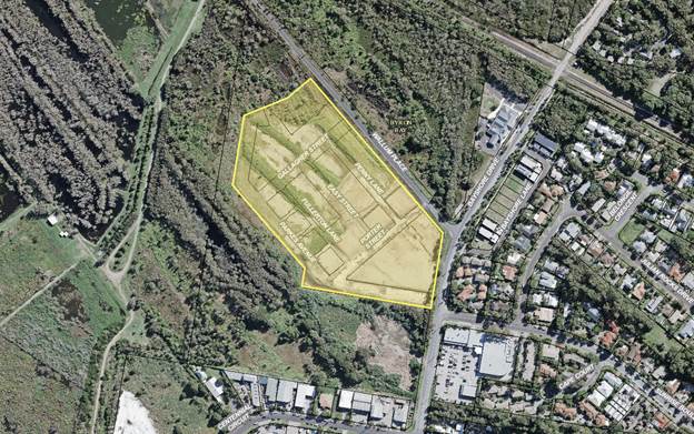
Figure 1 – Subject Site
Background
The site has an extensive history and due to a number of
changes, in particular the rezoning of the site to B4 Mixed Use Zone, the
applicant submitted a revised development concept consistent with the
objectives of the new zone.
The revised concept proposal was reported to Council on 22
June 2017. The proposal responds to the change of zoning by offering a
similar style mixed use development, but reconfigured to deliver increased
residential and commercial yields across much of the site.
Public Submissions
Council received one public submission during the exhibition
period. The proposed amendments are generally minor or typographical in
nature, and generally occur where elements of the draft DCP are inconsistent
with the concept adopted by Council under Res 17-224. Table
1 below describes the proposed amendments detailed in the submission and
includes staff comments for Council’s consideration. These
amendments have been discussed with the proponent.
Table 1 below should be read with reference to Attachment 1
where the proposed amendments are shown in red text.
Table 1: Public Submissions
|
Exhibited DCP
(Attachment 1) Page & Section
|
Proposed Amendment
|
Staff Comment
|
|
Page 13
E5.5.3.4
Precinct Plan
|
Under subheading:
2 (c) Precinct 2: Pocket Living
Remove reference to “6x three bedroom units”.
|
Supported.
The amendment is consistent with the concept adopted by
Council.
|
|
Page 14
E5.5.4.1
Land Use, Management and Environmental Assessment
|
Under subheading:
Prescriptive Measures
1. Land
use and Density
Change the maximum number of residential dwellings
provided within the site from 140 to 152.
|
Supported.
Provision of 152 dwellings is consistent with the concept
adopted by Council.
|
|
Page 15
E5.5.4.1
Land Use, Management and Environmental Assessment
|
Under Table:
E5.1 – Land Uses Consistent with Desired Future
Character
Change the Built Gross Floor Area for Precinct 1 from
6100m2 to 7430m2.
|
Supported.
The 6100m2 figure accounts for the cumulative
lot size of the Tired Living component of Precinct 1, not the Built Gross
Floor Area.
|
|
Page 16
E5.5.4.1
Land Use, Management and Environmental Assessment
|
Under Table:
E5.2 – Setbacks
Include a 4 metre minimum setback to the external property
(lot) boundary for Precinct 1.
Change the internal roads minimum setback for Precincts 2
& 3 from 3 metres to 0.5 metres.
|
Supported
Inclusion of a 4 metre minimum setback to the external
property (lot) boundary for Precinct 1 is consistent with the setback
provisions for Precincts 2 & 3. This inclusion also removes any
ambiguities that may create issues for assessment officers.
Changing the internal roads minimum setback for Precincts
2 & 3 from 3 metres to 0.5 metres is consistent with the setback
provisions for Precinct 1.
|
|
Page 23
E5.5.4.4
Site and Open Space Design
|
Under subheading:
Prescriptive Measures
2. Private
Open Space
Amend point (c) to require that each ground floor unit has
a minimum 49m2 private landscaped area (including terrace) plus
additional common area.
|
Supported.
The proposed amendment is reflective of the increased
residential densities provided across the site under the concept adopted by
Council.
|
|
Page 29
Map E5.3
Habitat Precinct Plan
|
Amend the map label for Precinct 1 to show an area of
12129m2.
|
Supported.
This amendment corrects a typographical error.
|
Staff Review
The issues noted below include minor corrections, generally
related to the ecological enhancement components of the Draft DCP. These
amendments will rectify any anomalies or inconsistencies that may cause
problems when assessing development applications.
Table 2 below should be read with reference to Attachment 1
where the proposed amendments are shown in red text.
Table 2: Staff Review
|
Exhibited DCP
(Attachment 1) Page & Section
|
Proposed Amendment
|
|
Page 3 & 4
Contents, Maps, Figures and Tables
|
Note: Consequential updates to page numbers may be
required should Council choose to adopt amendments proposed in this report.
|
|
Page 16
E5.5.4.1
Land Use, Management and Environmental Assessment
|
Under Table:
E5.1 – Land Uses Consistent with Desired Future
Character
Change the Consistent Land Uses for Precinct 5 to read
“Ecological enhancement, restoration, management and
monitoring”. This change better reflects all the elements of the
Council approved Acid Frog Management Plan: Habitat North Beach, Byron
Bay by Geolink Environmental Management and Design, Version 4 dated
4/5/17.
|
|
Page 17
E5.5.4.1
Land Use, Management and Environmental Assessment
|
Typographical change to correct numbering error for
prescriptive measures ‘Buffering’ and ‘Environmental
Assessment’.
|
|
Page 17
E5.5.4.1
Land Use, Management and Environmental Assessment
|
Under subheading:
Prescriptive Measures
3. Buffering
Remove reference to “Lot 1 DP 1004514” and
replace with “Lot 12 DP 1189646”. This amendment reflects a
change to the legal description of the lot after the lot was dedicated to
Council.
|
|
Page 27
E5.5.4.7
Ecological Enhancement
|
Under subheadings:
Performance Criteria; and
Prescriptive Measures
Update to include the full title of the Council approved
“Acid Frog Management Plan: Habitat North Beach, Byron Bay
by Geolink Environmental Management and Design, Version 4 dated
4/5/17”.
Additionally, note that habitat restoration applies both
within the site and on adjoining lands.
These amendments remove any ambiguities that may cause
problems for assessment officers.
|
Financial Implications
The proposed amendments to DCP 2014 will be funded by the
Applicant to ensure full cost-recovery.
Statutory and Policy
Compliance Implications
The amendment of development control plans is governed
by Environmental Planning and Assessment Regulation 2000 (Part 3
– Development Control Plans). The amendment process is summarised below:
Part 3 of the regulation states that a draft development
control plan must be publicly exhibited for at least 28 days and copies of the
draft development control plan are to be made publicly available. After
considering any submissions about the draft development control plan that have
been duly made, the council:
(a) may approve the
plan in the form in which it was publicly exhibited, or
(b) may approve the
plan with such alterations as the council thinks fit, or
(c) may decide not to
proceed with the plan.
The council must give public notice of its decision in a
local newspaper within 28 days after the decision is made. Notice of a
decision not to proceed with a development control plan must include the
council’s reasons for the decision. A development control plan
comes into effect on the date that public notice of its approval is given in a
local newspaper, or on a later date specified in the notice.
The relevant policy considerations are addressed above.
Staff Reports - Sustainable Environment and Economy 13.15
Report No. 13.15 PLANNING
- Development Application No.10.2017.639.1 dual occupancy (detached),
alterations and additions to existing dwelling house and two (2) lot strata
subdivision of land at 33 Kallaroo Circuit Ocean Shores
Directorate: Sustainable
Environment and Economy
Report
Author: Patricia
Docherty, Planner
File No: I2018/33
Theme: Ecology
Development and Approvals
|
DA No:
|
10.2017.639.1
|
|
Proposal description:
|
Construction of a new
dwelling house to create a dual occupancy (detached), alterations and
additions to existing dwelling house and two (2) lot strata subdivision of
land
|
|
Property description:
|
LOT: 2083 DP: 808462
|
|
33 Kallaroo Circuit OCEAN SHORES
|
|
Parcel No/s:
|
130610
|
|
Applicant:
|
Ardill Payne & Partners
|
|
Owner:
|
Mrs J M Mangleson
|
|
Zoning:
|
R2 Low Density Residential
|
|
Date received:
|
13 November 2017
|
|
Integrated Development:
|
Yes – Bush Fire Safety Authority s.100B Rural
Fires Act 1997
|
|
Public notification or exhibition:
|
- Level
1 advertising under DCP 2014 Part A14 – Public Notification and
Exhibition of Development Applications
- Exhibition
period: 30/11/17 to 13/12/17
- Submissions received:
One (1) objection
|
|
Planning Review Committee:
|
No
|
|
Delegation to determination:
|
Council
|
|
Issues:
|
· Byron LEP 2014 -
Clause 4.1E Minimum lot size (4.9 %variation)
· Byron LEP 2014
– Clause 4.1Minimum lot sizes for dual occupancies, multi dwelling
housing and residential flat buildings (36-37% variation)
· Byron LEP 2014 -
Clause 6.6 Essential Services. Driveway access clearance doesn’t
comply with Australian Standards
· Byron DCP 2014
– access and parking, landscape principles, privacy fence on a
front boundary; cannot be supported; objectives for private open space; and
character
· Public
submission
· Bushfire prone
land
· Acid sulfate
soils class 2
· Does not address
all reasons for previous refusal for same development (10.2016.844.1)
· Building height
plane on the western elevation
· Suitability of
the site for the development as proposed
· Public interest
(undesirable precedent)
|
Summary:
An application has been received to construct a new dwelling
to create a dual occupancy (detached), alterations and additions to an existing
dwelling and strata title subdivision at 33 Kallaroo Circuit, Ocean Shores.
The subject site has an area of 760.7m2, and the
development would result in a (4.9%) breach of the 800m2 minimum lot
size development standard for dual occupancies under clause 4.1E of Byron LEP
2014. The proposed strata title subdivision will result in a significant
breach of the 600m ² minimum lot size development standard under Clause
4.1 of the Byron LEP (37%).
In addition, the proposal is inconsistent with provisions of
Byron LEP 2014 in relation to essential services for driveway access and
controls in Byron DCP 2014 in terms of minimum landscaped areas, private open
space, car parking, driveway access, character and fencing.
For reasons explained further in the attachment to this
report, proposed variations to Byron LEP and DCP 2014 are not supported. The
inconsistency is symptomatic of a constrained site, which has limited room to
accommodate a single storey three bedroom dwelling due to the large footprint
and central location of the existing house. It follows that the clause 4.6
request to vary the minimum lot size is also not supported as there is
insufficient justification to vary the standard. The site attributes are not
conducive to a smaller lot size.
The proposal is not considered to represent a good
development outcome, particularly given that alternative design options may
exist. Approving variations to these standards and controls without sufficient
justification may set an undesirable precedent and is not in the public
interest.
Accordingly, the application is recommended for refusal.
NOTE TO COUNCILLORS:
In accordance with the
provisions of S375A of the Local Government Act 1993, a Division is to be
called whenever a motion for a planning decision is put to the meeting, for the
purpose of recording voting on planning matters. Pursuant to clause 2(a)
under the heading Matters to be Included in Minutes of Council Meetings of
Council's adopted Code of Meeting Practice (as amended) a Division will be
deemed to have been called by the mover and seconder of all motions relating to
this report.
|
RECOMMENDATION:
Pursuant to Section 80 of the Environmental Planning & Assessment
Act 1979, development application .10.2017.639.1 for construction of a new dwelling house to
create a dual occupancy (detached), alterations and additions to existing
dwelling house and two (2) lot strata subdivision of land, be Refused for
following reasons:
a) Pursuant
to Section 79C (1)(a)(i) of the Environmental Planning and Assessment Act
1979, the proposed development does not comply with clause 4.1E of Byron
Local Environmental Plan 2014, which sets an 800m2 minimum lot
size for dual occupancies (detached) in the R2 Low Density Residential Zone.
b) Pursuant
to Section 79C (1)(a)(i) of the Environmental Planning and Assessment Act
1979, the proposed development does not comply with clause 4.1of Byron
Local Environmental Plan 2014, which sets a 600m2 minimum lot
size for new lots.
c) Pursuant
to Section 79C (1)(a)(i) of the Environmental Planning and Assessment Act
1979, the written request accompanying the proposed development fails to
comply with clause 4.6 of Byron Local Environmental Plan 2014.
Insufficient justification has been provided to demonstrate that compliance
with development standards is unreasonable or unnecessary or that there are sufficient environmental
planning grounds to justify contravening the standard’ or that proposed
development is in the public interest.
d) Pursuant
to Section 79C (1)(a)(i) of the Environmental Planning and Assessment Act
1979, the proposed development does not comply with clause 6.6 of Byron
Local Environmental Plan 2014, which requires development consent
must not be granted to a development unless suitable vehicular access has
been provided. The driveway width for the rear dwelling does not meet
obstruction clearance requirements in accordance with Australian Standards
AS2890.1.
e) Pursuant
to Section 79C (1) (a) (iii) of the Environmental Planning and Assessment Act
1979, the proposed development does not comply with Chapter B9 Landscaping of
Byron Development Control Plan 2014. The proposal does not comply with the
objectives of Part B9.5 Dual Occupancies and Semi Detached Dwellings. Landscape
principles to provide a pleasant environment for enjoyment of occupants of
each dwelling – lack of deep soil planting in rear yard for use by
existing property.
f) Pursuant
to Section 79C (1)(a)(iii) of the Environmental Planning and Assessment Act
1979, the proposed development does not comply with Chapter D1 Residential
Accommodation in Urban, Village and Special Purpose Zones of Byron
Development Control Plan 2014. Private open space for the existing dwelling
comprises a minimal sized fenced area (34 m²) bound by a driveway on two
sides. Insufficient information has been provided to demonstrate how the
proposed development can meet the objectives of Part D1.5.4 Private Open
Space, privacy fence on a front boundary cannot be supported under
Part D.1.2.5; and Part D1.5.2 DCP Character principles – does
not provide adequate private open space – conflicts with proposed rear
privacy fence, driveway width and interface with vehicles.
g) Pursuant
to Section 79C (1)(a)(iii) of the Environmental Planning and Assessment Act
1979, the proposed development does not comply with Chapter B4 Traffic
Planning, Vehicle Parking, Circulation and Access of Byron Development
Control Plan 2014 in relation to the provision of stacked car parking for
both dwellings. Fails to demonstrate it will not adversely affect the
use of private open space and width of driveway not meeting obstruction
clearance requirements in accordance with Australian Standards AS2890.1.
h) Pursuant
to the provisions of Section 79C (1)(c) of the Environmental Planning and
Assessment Act 1979, the site is not considered suitable for the development
as proposed, as there is insufficient area to accommodate the proposed three
bedroom dwelling and associated vehicle access, resulting in an
overdevelopment of the site.
i) Pursuant
to the provisions of Section 79C (1)(e) of the Environmental Planning and
Assessment Act 1979, approval of a development which contravenes
Council’s adopted development standards and development controls
without sufficient justification may set an undesirable precedent and is not
in the public interest. Options for an alternative design may exist to
achieve better outcomes in relation to private open space, landscaping,
fencing vehicle access, and car parking.
|
Attachments:
1 DA.10.2017.639.1
Drawings for Council Report, E2018/6666
2 Confidential
- submission received, E2018/7963
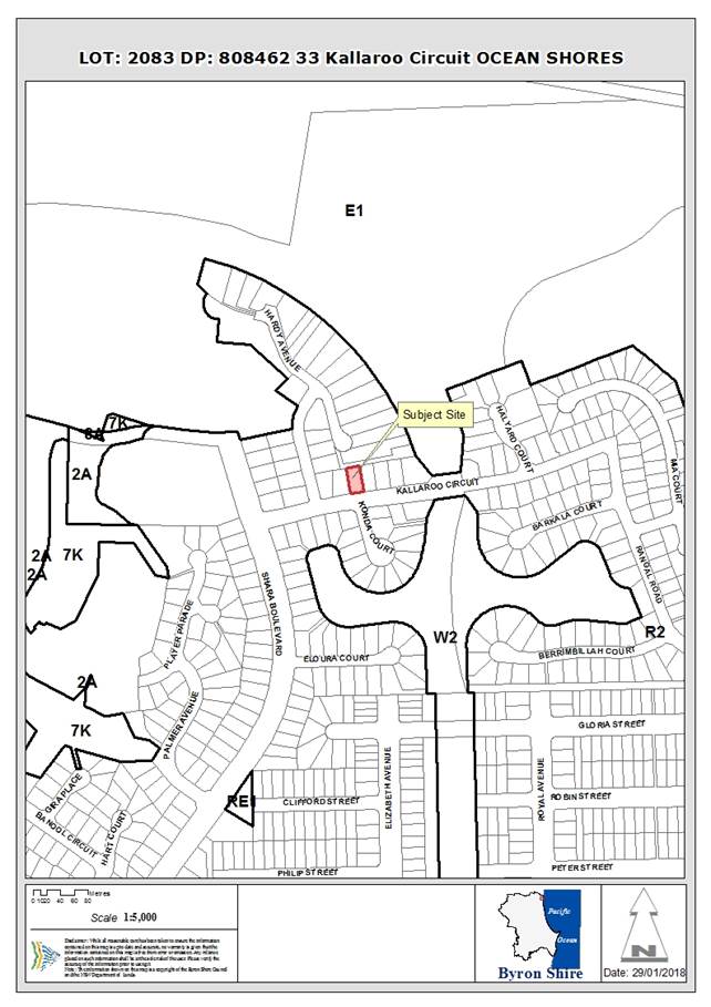
Assessment:
1. INTRODUCTION
1.1. History/Background
|
BA 5.1994.2293.1
|
Dwelling
|
Approved 18/05/1994
|
|
BA 6.1994.2750.1
|
Additions & alterations to dwelling
|
Approved 17/11/1994
|
|
DA 10.2016.844.1
|
Construct New Dwelling House to Create Dual Occupancy
(Detached), Alterations and Additions to Existing Dwelling House and Strata
Subdivision
|
Refused 04/07/2017
|
Development Application No. 10.2016.844.1 was refused
primarily because the site has an area less than the 800m2 minimum
area required under clause 4.1E of Byron LEP 2014 for a dual occupancy
(attached) and insufficient justification was provided to support a variation
to a development standard, particularly due to the multiple constraints
including driveway access, stacked parking and private open space.
The proposal to subdivide the lot to create a new strata
plan would require a variation to Clause 4.1 Minimum Lot Size in excess of 37%
comprising Two (2) new lots of 382 m² and 378.73 m².
Council staff met the applicant and owner on 9th
August 2017 to discuss the reasons for refusal of the original DA
10.2016.844.1.
In particular:
· Landscaping did
not meet the prescriptive requirements or objectives of the DCP. The new
dwelling resulted in a high site coverage and excessive hard surfaces.
· The private
open space for the existing dwelling was poor and did not meet the objectives
of the DCP. Due to the central location of the existing dwelling, there would
be no backyard, and the proposed courtyard was bound by a driveway on two
sides, offering poor privacy, solar access, safety and amenity.
· The stacked
parking situation was undesirable. Although the DCP doesn’t specifically
outlaw such a layout - it would have been awkward and could have potentially
resulted in future conflict.
· The above
issues were symptomatic of the lot size being too small for the proposed
development; hence the clause 4.6 variation was not justified.
Options to address these issues were discussed,
including:
· Altering the
patio for the existing dwelling – to try and create a private, landscaped
courtyard for residents;
· Altering the
size and layout of the new dwelling to increase the separation between
dwellings, and provide more landscaping;
· Other general
options such as having a secondary dwelling instead.
During the meeting the applicant proposed options such as
removing the decks to increase landscaped area. Staff indicated that any
changes to improve the design would be viewed positively, but ultimately it
would be up to them to come up with a satisfactory design with sufficient merit
to warrant approval.
The current application is lodged effectively to review that
determination. The review process provided under Section 82A of the Environmental
Planning & Assessment Act 1979 is not available in this case, as the
proposal is integrated development pursuant to that Act; being a Bush
Fire Safety Authority s 100B Rural Fires Act 1997.
1.2. Description
of the proposed development
This application seeks approval to construct a new dwelling
to create a dual occupancy (detached), plus alterations and additions to an
existing dwelling and strata subdivision. In detail, the application proposes
the following:
1) New
dwelling to create dual occupancy (detached)
a) 96.83
m2, single storey building;
b) Weathertex
external cladding with metal skillion roofs;
c) 3
bedrooms;
d) Open
plan lounge/dining/kitchen;
e) Laundry,
bathroom, WC and separate ensuite for bedroom 1; and
f) Single
carport with additional hardstand space in stacked configuration.
2) Alterations
and additions to existing dwelling house
a) Removal
of the existing
awning to the eastern elevation of
the existing
dwelling;
b) Alterations
to internal garage and dwelling floor plan;
c) Partially
demolish double garage and convert to single garage;
d) Provision
of new driveway down eastern boundary to service new dwelling; and
e) construction
of privacy fences, including a front fence to Kallaroo Circuit to provide an
extra private open space to the existing dwelling house.
3) Tree
removal
a) Removal
of two trees in the rear yard immediately behind the existing house.
4) Strata
subdivision
a) Strata
subdivision to create separate strata lots and common property for each
dwelling house.
Changes made to plans previously refused under 10.2017.639.1
are:
· deletion of the
32.98m 2 paved patio areas that adjoined the master bedroom and the
lounge/dining room- to provide increased landscaped open space that will form
part of the deep soil zones on the site;
· reduction in the
area of the roof of the proposed dwelling which previously extended over the
paved patio area that adjoined the lounge/dining room;
· provision of
a concept landscaping plan;
· removal of the
awning on the eastern elevation of the existing dwelling house;
· addition of
privacy/amenity fencing surrounding the private open space areas of Residence
1.
The new dwelling is provided with approximately 81m 2
of useable landscaped area excluding the area around the car port and under the
eaves on the southern boundary containing rainwater tanks and other utilities,
falling short of the 90m2 minimum requirement.
Private open space for the existing dwelling is provided by
way of removal of an existing awning and a fenced area, bound on two sides by a
driveway. The applicant has not demonstrated how this area can be configured to
comply with the relevant objectives of the development control.
Demolition of the existing two car garage will result in
tandem parking for both dwellings, which is generally considered to be an
undesirable outcome.
The minimal width of the driveway access handle combined
with the overhanging eaves is also not acceptable providing a minimum clearance
of approximately 2.5 metres, failing to meet Australian Standards AS2890.1.
Numerous cumulative issues arise from the proposed
development:
· Byron LEP 2014
– Non-compliance with minimum subdivision lot size: general (Clause 4.1)
and specific to dual occupancies detached (Clause 4.1E).
· Clause 4.6
Variation of 37% for (Clause 4.1) minimum lot size - subdivision not justified.
· Clause 4.6
Variation of 4.9 % for (Clause 4.1E) 800 m² minimum lot size for dual
occupancies – insufficient merit to justify.
· Byron LEP 2014 -
Clause 6.6 - Essential Services - development consent must not be granted to a
development unless suitable vehicular access has been provided (driveway width
for the rear dwelling does not meet obstruction clearance requirements -
Australian Standards AS2890.1 or DCP 2014.
· Non-compliance
with Part B4.2.2 of Byron DCP 2014 (stacked parking between both
dwellings – fails to demonstrate it will not adversely affect the use of
private open space);
· Non
–compliance with DCP 2014 Part B4.2.3 (suitable vehicular access has not
been provided - overhanging eaves into the driveway);
· Non-compliance
with Part B9.5 of Byron DCP 2014 (landscape principles and minimum landscaped
area to provide a pleasant environment for enjoyment of occupants of each
dwelling – lack of deep soil planting in rear yard for use by
existing property);
· Non-compliance
with D.1.2.5 of Byron DCP(privacy fence on a front boundary cannot be
supported;
· Non compliance
with Part D1.5.4 of Byron DCP 2014 (objectives for private open space);
· Non-compliance
with Part D1.5.2 of Byron DCP Character principles – does not provide
adequate private open space – conflicts with proposed privacy fence,
driveway width and interface with vehicles – refer to Landscape Plan,
Drawing 8, Revision a, dated 19/09/2017.
· Does not address
all reasons for previous refusal for same development (10.2016.844.1);
· Building height
plane on the western elevation;
· Suitability of the
site for the development as proposed; and
· Public interest
(undesirable precedent).
1.3. Description
of the site
|
Land is legally described as
|
LOT: 2083 DP: 808462
|
|
Property address is
|
33 Kallaroo Circuit OCEAN SHORES
|
|
Land is zoned:
|
R2 Low Density Residential
|
|
Land area is:
|
760.7m2
|
|
Property is constrained by:
|
Acid Sulfate Soils (Class 2)
|
|
|
Bushfire prone land
|
The property contains a single storey dwelling with brick
veneer walls and a brown tiled roof. The existing dwelling contains four
bedrooms and a double garage. A covered patio is located behind the
double garage, which opens up onto a large backyard area with views of the
Council reserve to the north.
The site is located within an established residential
subdivision in north Ocean Shores, surrounded by single storey dwelling houses,
which appear to date to the early to mid 1990’s. Most feature brick
veneer walls with tiled roofs.
Aerial image and site photos of the proposed development
site are illustrated at figure 1 to 5.
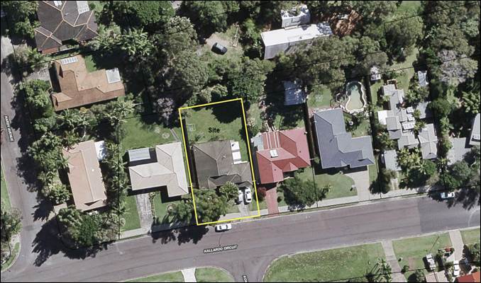
Figure 1:
Aerial image of site – 33 Kallaroo Circuit, Ocean Shores (Lot: 2083 DP:
808462)
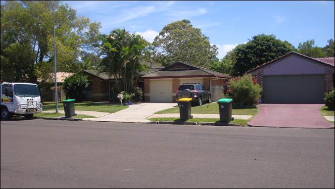
Figure 2:
Existing dwelling looking north from Kallaroo Circuit (centre frame). The
double garage to be reduced to a single garage with stacked car parking and a
new driveway down the eastern boundary.


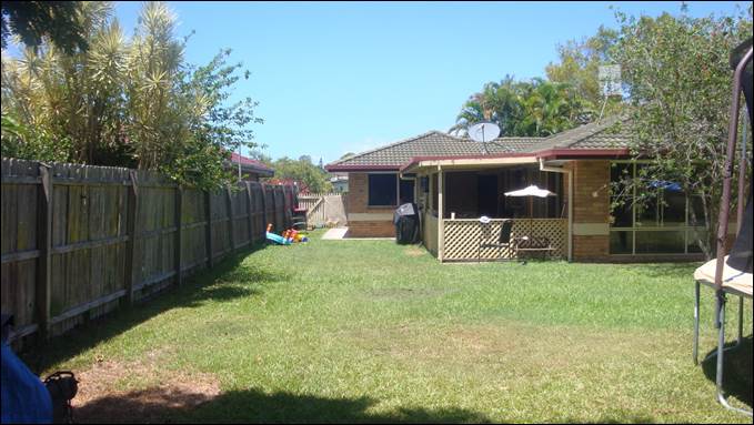
Figure 3:
Existing dwelling as viewed from the proposed development site in a southerly
direction. The white lines indicate the proposed strata subdivision. Yellow
line indicates the section of garage to be demolished to accommodate the new
driveway (lines are indicative only).


Figure 4:
Existing dwelling viewed from backyard. Covered patio overlooking driveway is
the nominated private open space for the existing house.
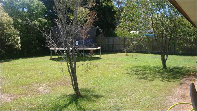
Figure 5:
Proposed dwelling site located behind the existing house. Planted vegetation
will be removed. Council reserve adjoins to the north, and residential
dwellings adjoin to the east and west.
A similar application for development of the site has
previously been refused (Development Application No. 10.2016.844.1).
Whilst Development Application No. 10.2017.639.1 partly addresses some of the
reasons for refusal in relation to landscaping and private open space, it is
considered that it does not address all reasons for refusal.
The application does not adequately justify variation to
development standards for minimum lot size and the development has not been
redesigned to address reduce the overall layout and footprint of the dwelling
resulting in overdevelopment, minimal landscaped space for the original
dwelling the majority of which is in the front set-back. The layout of
the site also results in stacked parking and insufficient driveway access with
inadequate clearance widths.
2. SUMMARY OF
REFERRALS
|
Referral
|
Issue
|
|
Development Engineer
|
Reasons for Refusal
Not Supported
The development application is not supported from
engineering grounds and should be refused for the following reasons:
1. Essential
Services
Suitable Vehicular Access
In accordance with Byron LEP
2014 Section 6.6 development consent must not be granted to a development
unless suitable vehicular access has been provided. Suitable vehicular access
has not been provided for the following reasons:
· Residence 2 has
not provided parked cars with sufficient room to manoeuvre to enter and leave
in a forward direction as required by Council’s DCP 2014 Chapter
B4.2.3.
· For Residence 2,
if two cars are stacked on site the car parked adjacent to the boundary can
not exit without both cars performing complex manoeuvres.
· For Residence 2,
the driveway width for the rear dwelling does not meet AS2890.1 requirements.
Where there is an obstruction more than 150mm high adjacent to the driveway
300mm clearance must be provided in accordance with AS2890.1.
· When a car is
stacked in the front dwelling access to the rear dwelling is considered tight
and undesirable. This additional concern does not provide sufficient merit to
warrant variants on the above concerns.
Stormwater Drainage
Pursuant to Section 79C
(1)(a)(iii) of the Environmental Planning and Assessment Act 1979 and in
accordance with Byron LEP 2014 Section 6.6 development consent must not be
granted to a development unless adequate arrangements have been made for
stormwater drainage. As insufficient stormwater drainage information has been
submitted Council can not have confidence residence 2 can drain to the street
in accordance with Council requirements.
2. Stacked
Parking
Pursuant to Section 79C
(1)(a)(iii) of the Environmental Planning and Assessment Act 1979 and DCP
2014 Chapter B4.2.2 stacked parking is not favoured but may be permitted
where the development has merit. Given the significant concerns listed above
it is considered the proposed stacked parking does not have sufficient merit.
Concerns are exacerbated by the existing double garage being reduced into
stacked parking.
|
|
Section 64 Systems - ET Engineer
|
This development generates an additional load onto
Councils Water, Bulk Water and Sewer System
Council requires Payment of Developer Servicing Charges
(prior to issue of a construction/subdivision certificate) of:
· 0.6 ET
for Water &
· 0.6 ET Bulk
Water; and
· 1.0 ET
for Sewer.
|
|
Rural Fire Service
|
Proposal was referred to the Rural Fire Service for
approval under s100B of the Rural Fires Act 1997. The RFS have issued general
terms of approval should the application be supported.
|
All other referral retracted as no longer relevant to
refused development: Environmental Health Officer, S94 / Contributions Officer.
3. SECTION 79C
– MATTERS FOR CONSIDERATION – DISCUSSION OF ISSUES
Having regard to the matters for consideration detailed in
Section 79C(1) of the Environmental Planning & Assessment Act 1979
(EP&A Act), the following is a summary of the evaluation of the issues.
3.1 State Environmental
Planning Instruments
4.2 Byron Local Environmental Plan
2014 (LEP 2014)
LEP 2014 is an applicable matter for consideration in the
assessment of the subject development application in accordance with subsection
79C(1) of the EP&A Act because it applies to the subject land and the
proposed development. The LEP 2014 clauses that are checked below are of
relevance to the proposed development:
|
Part 1
|
☒1.1|
☒1.1AA| ☒1.2| ☒1.3| ☒1.4| ☒Dictionary| ☒1.5| ☒1.6| ☒1.7| ☒1.8| ☒1.9
|
|
Part 2
|
☒2.1|
☒2.2 | ☒2.3 |☒Land Use Table | ☒2.6| ☒2.7
|
|
Part 4
|
☒4.1|
☒4.1E|☒4.3|☒4.4 |☒4.5 | ☒4.6
|
|
Part 5
|
☒5.5
|
|
Part 6
|
☒6.1|
☒6.2| ☒6.6| ☒ 6.7
|
In accordance with LEP 2014 clauses 1.4 and 2.1 – 2.3:
(a) The
proposed development is defined in the LEP 2014 Dictionary as Dual Occupancy
(detached). Strata subdivision is not defined in the LEP, but is defined in
Section 4B of the Environmental Planning and Assessment Act 1979;
(b) The
land is within the R2 Low Density Residential zone according to the Land Zoning
Map;
(c) The
proposed development is permissible with consent. Strata subdivision is
permitted with consent pursuant to clause 2.6 of the LEP; and
(d) Regard
is had for the Zone Objectives as follows:
|
Zone Objective - R2 Low Density Residential
|
Consideration
|
|
To provide
for the housing needs of the community within a low density residential
environment.
|
The proposal will provide additional housing stock for
the area. Dual occupancy development is generally not antipathetic to
the zone objectives. However, the proposal is inconsistent with clauses
4.1, 4.1E and 6.6 in Byron LEP 2014 and various development controls in Byron
DCP 2014 and is therefore not supported.
|
|
To enable
other land uses that provide facilities or services to meet the day to day
needs of residents.
|
N/A.
|
The remaining checked clauses have been taken into
consideration in the assessment of the subject development application in
accordance with subsection 79C(1) of the EP&A Act. The proposed
development complies with all these clauses of LEP 2014 (in some cases subject
to conditions and/or to the satisfaction of other assessing officers), except
in relation to Clauses 4.1, 4.1E and 6.6, which are considered further below:
Clause 4.1 Minimum
subdivision lot size
The Minimum Lot Size Map specifies 600m2 for this
locality. Recent Land and Environment Court judgments determined that:
a) the
exemption contained in subclause 4.1(4) only applies to subdivisions where the
parent allotment is a lot in a strata plan or community title scheme;
b) LEPs
do not permit strata subdivision which does not comply with the minimum size
requirement specified in subclause 4.1(3); and
c) Strata
subdivision that does not comply with the minimum lot size is prohibited.
That variation request is considered with reference to relevant
matters as follows:
1. Introduction
– Summary of proposed development
The development application
proposes Strata Title subdivision of a proposed detached dual occupancy on a
site area of 760.7m2. Resultant lots would be 378m2
and 382m2.
2. Clause
4.6 Exceptions to Development Standards
LEP 2014 clause 4.6 allows
the granting of development consent, even though the development would
contravene a development standard. However, Council must first consider a
written request from the Applicant that seeks to justify the contravention of
the development standard by demonstrating:
a) that compliance with the development standard is unreasonable or
unnecessary in the circumstances of the case, and
b) that there are sufficient environmental planning grounds to justify
contravening the development standard.
Council must be
satisfied that the Applicant’s written request has adequately addressed
the matters required to be demonstrated and that the proposed development will
be in the public interest because it is consistent with the objectives of the
particular standard and the objectives for development within the zone in which the development
is proposed to be carried out (noting that the concurrence of the Secretary is
not required to be obtained in this instance).
3. The
Development Standard to be varied
The development standard to be
varied is the minimum lot size planning control of 600m2 applicable
to this site under LEP 2014 clause 4.1 as described above.
4. Extent
of Variation to the Development Standard
The proposed strata subdivision
would result in 2 new lots of 378m2 and 382m2. The
extent of the variation therefore ranges from 36 to 37% for the new lots.
5. Objective
of the Development Standard
The objectives of the development standard,
as outlined in subclause 4.1(1) are:
a) to ensure that lot sizes are compatible with local environmental values
and constraints; and
b) to facilitate efficient use of land resources for residential and other
human purposes.
6. Objectives
of the Zone
The objectives of the land use
zone (R2 Low density residential) have been addressed in this section of this
report above.
The proposal will provide
additional housing stock for the area. Dual occupancy development is
generally not antipathetic to the zone objectives. However, the proposal
is inconsistent with clauses 4.1, 4.1E and 6.6 in Byron LEP 2014 and various
development controls in Byron DCP 2014 and is therefore not
supported.
7. Assessment
– the specific questions to be addressed:
(a) Clause
4.6(3)(a) – Is compliance with the development standard unreasonable or
unnecessary in the circumstances of the case?
NO
(b) Clause
4.6(3)(b) – Are there sufficient environmental planning grounds to
justify contravening the development standard?
NO
(c) Clause
4.6(4)(a)(ii) – Is the proposed development in the public interest? Is it
consistent with the objectives of the standard and the zone as set out above?
NO
The proposed development is not considered to meet the
assessment questions. The applicant has failed to provide sufficient
justification to vary this development standard (Clause 4.1). For the
reasons outlined in this report the response is NO to all questions in
subclauses 4.6 (3) (a), (b) and 4.6(4) (a) (ii).
Clause 4.1E Minimum lot sizes
for dual occupancies, multi dwelling housing and residential flat buildings
This clause sets a minimum lots size of 800m2 for
detached dual occupancy in the R2 low density residential zone. The site
has an area of 760.7m2, which is 4.9% below the required development
standard.
The application includes a
submission, made pursuant to Clause 4.6 of the LEP, seeking to justify the variation
to the 800m2 minimum lot size development standard (applicable to
dual occupancies).
That variation request is considered with reference to
relevant matters as follows:
1. Introduction
– Summary of proposed development
The development application
proposes Strata Title subdivision of a proposed detached dual occupancy on a
site area of 760.7m2. Resultant lots would be 378m2
and 382m2.
2. Clause
4.6 Exceptions to Development Standards
LEP 2014 clause 4.6 allows
the granting of development consent, even though the development would
contravene a development standard. However, Council must first consider a
written request from the Applicant that seeks to justify the contravention of
the development standard by demonstrating:
c) that compliance with the development standard is unreasonable or
unnecessary in the circumstances of the case, and
d) that there are sufficient environmental planning grounds to justify
contravening the development standard.
Council must be
satisfied that the Applicant’s written request has adequately addressed
the matters required to be demonstrated and that the proposed development will
be in the public interest because it is consistent with the objectives of the
particular standard and the objectives for development within the zone in which the development
is proposed to be carried out (noting that the concurrence of the Secretary is
not required to be obtained in this instance).
3. The
Development Standard to be varied
The development standard to be
varied is the minimum lot sizes for dual occupancies, multi dwelling housing
applicable under LEP 2014 Clause 4.1E, as described above.
4. Extent
of Variation to the Development Standard
The extent of the variation under
Clause 4.1E would result in a variation of 4.9% from the development standard
to permit dual occupancies (attached) in the R2 Low density residential zone.
5. Objective
of the Development Standard
The objectives of the development
standard, as outlined in subclause 4.1E(1):
(1) The objective of this
clause is to achieve planned residential density in certain zones.
(2) Development consent
may be granted to development on a lot in a zone shown in Column 2 of the table
to this clause for a purpose shown in Column 1 of the table opposite that zone,
if the area of the lot is equal to or greater than the area specified for that
purpose and shown in Column 3 of the table. [Extracted as follows:]…
|
Column 1
|
Column 2
|
Column 3
|
|
Dual occupancy (detached)
|
Zone R2 Low Density Residential, Zone R3 Medium Density Residential
|
800 square metres
|
6. Objectives
of the Zone
The objectives of the land use
zone (R2 Low density residential) have been addressed in this section of this
report above.
The proposal will provide
additional housing stock for the area. Dual occupancy development is
generally not antipathetic to the zone objectives. However, the proposal
is inconsistent with clauses 4.1, 4.1E and 6.6 in Byron LEP 2014 and various
development controls in Byron DCP 2014 and is therefore not supported.
7. Assessment
– the specific questions to be addressed:
(d) Clause
4.6(3)(a) – Is compliance with the development standard unreasonable or
unnecessary in the circumstances of the case?
NO
(e) Clause
4.6(3)(b) – Are there sufficient environmental planning grounds to
justify contravening the development standard?
NO
(f) Clause
4.6(4)(a)(ii) – Is the proposed development in the public interest? Is it
consistent with the objectives of the standard and the zone as set out above?
NO
The proposed development is not considered to meet the
assessment questions. The applicant has failed to provide sufficient
justification to vary this development standard (Clause 4.1). For the
reasons outlined in this report the response is NO to all questions in
subclauses 4.6 (3) (a), (b) and 4.6(4) (a) (ii).
Clause 6.6 Essential
Services
Clause 6.6 of Byron LEP 2014 states that:
Development consent must not be granted to development
unless the consent authority is satisfied that any of the following services
that are essential for the development are available or that adequate
arrangements have been made to make them available when required:
(a) the supply of water,
(b) the supply of electricity,
(c) the disposal and management of sewage,
(d) stormwater drainage or on-site
conservation,
(e) suitable vehicular access.
The driveway width for the rear dwelling does not meet
obstruction clearance requirements in accordance with Australian Standards
AS2890.1. Development consent must not be granted to a development unless
suitable vehicular access has been provided.
4.3 Any proposed Instrument
that has been the subject of public consultation and has been notified to the
consent authority
Draft SEPP (Coastal Management) 2016
The draft SEPP proposes to replace SEPP 14 (Coastal
Wetlands), SEPP 26 (Littoral Rainforest) and SEPP 71(Coastal Protection).
It will redefine the current ‘Coastal Zone’, to be within four
coastal management areas:
· coastal wetlands
and littoral rainforests area
· coastal
environment area;
· coastal use area;
and
· coastal
vulnerability area.
The subject site will be mapped within the coastal use
area. The proposed development is not in a wetland, littoral rainforest,
coastal environment area or coastal vulnerability area. The proposed
amendments to the consent do not raise any specific issues that apply to the
coastal use area provisions under the draft SEPP.
4.4 Byron Shire Development
Control Plan 2014 (DCP 2014)
DCP 2014 is an applicable matter for consideration in the
assessment of the subject development application in accordance with subsection
79C(1) of the EP& A Act because it applies to the land to which LEP 2014
applies. The DCP 2014 Parts/Chapters that are checked below are of relevance to
the proposed development:
|
Part A
|
X
|
|
Part B Chapters:
|
XB2 | XB3 | XB4 | XB6 | XB7 | XB8 | XB9| XB14
|
|
Part C Chapters:
|
n/a
|
|
Part D Chapters
|
X D1
|
|
Part E Chapters
|
n/a
|
These checked Parts/Chapters have been taken into
consideration in the assessment of the subject development application in
accordance with subsection 79C(1) of the EP&A Act. The proposed development
complies with all sections of these Parts/Chapters, except in relation to
certain prescriptive measures which are considered further (having regard to
the DCP 2014 Section A1 Dual Path Assessment) as follows:
|
What Section and prescriptive measure does the development
not comply with?
|
Does the proposed development comply with the Objectives
of this Section? Address.
|
Does the proposed development comply with the Performance
Criteria of this Section? Address.
|
|
Part B4.2.2
Parking Layout Standards
|
No
|
No - stacked parking between both dwellings –
fails to demonstrate it will not adversely affect the use of private open
space.
|
|
Part B4.2.3
Vehicle Access and Manoeuvring
|
No
|
No - suitable vehicular access has not been provided -
overhanging eaves into the driveway.
|
|
Part B9.5.1 Landscaping - Dual Occupancies &
Semi Detached Dwellings
|
No
|
No - landscape principles and minimum landscaped area to
provide a pleasant environment for enjoyment of occupants of each dwelling
– lack of deep soil planting in rear yard for use by existing
property.
|
|
Part D.1.2.1
Building Height Plane
|
Yes. It is considered that the proposed development
would:
1. To ensure that residential development is designed
to minimise impacts on solar access and privacy on adjoining properties, and
on the views from adjacent existing buildings.
2. To ensure that the occupants of the building
or buildings will enjoy the optimum use of winter sunlight and summer shade.
|
Yes, the proposal reasonably demonstrates that it meets
the performance criteria of Section D1.2.1:
|
|
Part D.1.2.5
Fences
|
No
|
No -privacy fence of a height suitable to provide visual
obstruction on a front boundary cannot be supported
|
|
Part D1.5.2
Dual Occupancy and Semi-Detached Dwellings
Character
|
No
|
No. Character principles – does not provide adequate
private open space – conflicts with proposed privacy fence, driveway
width and interface with vehicles – refer to Landscape Plan, Drawing 8,
and Revision A, dated 19/09/2017. Trim Doc# E2018/6666
|
|
Part D1.5.4
Dual Occupancy and Semi-Detached Dwellings
Private Open Space
|
No
|
No. Objectives for private open space are not met.
|
The proposed development fails to meet the relevant
Objectives of DCP 2014.
4.5 Any Planning Agreement or
Draft Planning Agreement?
|
|
Yes
|
No
|
|
Is there any applicable planning agreement or draft
planning agreement?
|
☐
|
☒
|
|
Consideration: Not applicable
|
4.6 Environmental Planning
& Assessment Regulation 2000 Considerations
|
Clause
|
This control is applicable to the proposal:
|
I have considered this control as it relates to the
proposal:
|
If this control is applicable, does the proposal
comply?
|
|
92
|
Yes
|
Yes
|
Yes
|
|
93
|
No
|
N/A
|
N/A
|
|
94
|
No
|
N/A
|
N/A
|
|
94A
|
No
|
N/A
|
N/A
|
* Non-compliances and any other significant issues
discussed below
4.7 Any coastal zone management
plan?
|
|
Satisfactory
|
Unsatisfactory
|
Not applicable
|
|
Is there any applicable coastal zone management plan?
|
☐
|
☐
|
☒
|
|
Consideration: Not applicable
|
4.8 The likely impacts of that
development, including environmental impacts on both the natural and built
environments, and social and economic impacts in the locality
|
Impact on:
|
Likely significant impact/s?
|
|
Natural environment
|
No. The proposal will not have a significantly adverse
impact on the natural environment of the locality.
|
|
Built environment
|
The proposed development will result in an undesirable
outcome for residents of the existing dwelling, leaving it with little
private open space adjoining a narrow driveway. It is recognised that the
proposal is unlikely to result in significant impacts on surrounding
development, however considering non-compliances with Byron LEP 2014 and
Byron DCP 2014, the impacts on the built environment are not considered to be
acceptable and the application is recommended for refusal.
|
|
Social Environment
|
No. The proposal will not have a significant social impact
on the locality.
|
|
Economic impact
|
No. The proposal will not have a significant economic
impact on the locality.
|
All relevant Council policies that are applicable to the
proposed development have been considered in relation to this assessment.
4.9 The suitability of the site
for the development
The site is constrained by a small lot size and a centrally
located existing dwelling. The resulting design does not address the
constraints of the site and is attempting to fit a three bedroom dwelling into
a small backyard of approximately 310m² in area (excluding the driveway
access handle).
In accordance with Byron LEP 2014 Section 6.6 development
consent must not be granted to a development unless suitable vehicular access
has been provided. Suitable vehicular access for has not been provided with
insufficient clearance from adjacent boundaries; necessitating stacked vehicles
that are unable to enter and leave in a forward direction without both cars
performing complex manoeuvres.
The driveway width for the rear dwelling does not meet
AS2890.1 requirements. Where there is an obstruction more than 150mm high
adjacent to the driveway, 300mm clearance must be provided in accordance with
AS2890.1. When a car is stacked in the front dwelling access to the rear
dwelling is considered tight and undesirable. This additional concern does not
provide sufficient merit to warrant variants on the above concerns.
The proposal is not compliant with Byron LEP 2014 and DCP
2014. Due to the above constraints, it is not feasible to site a three bedroom
single storey dual occupancy (detached) of the proposed scale on the subject
allotment, although smaller dwelling types that do not require car parking may
be possible. The site is therefore not considered suitable for the proposed
development.
4.10 Submissions made in accordance with
this Act or the regulations
The application was notified for a period of 14 days from
30/11/17 to 13/12/17. One public submission was received in the form of a
letter of objection. A number of issues were raised as follows:
|
Issue
|
Assessing Officer Comment
|
|
consent must not be granted for detached dual occupancies
on R2 zoned land unless the lot has an area of greater than 800m2;
|
Objection is well founded. Refer to Section 4.2 above.
|
|
minimum lot size 600m2. The asked for 378m2 and 382m2 lot
are grossly below the 600m2 limit, in fact they are barely over HALF the
required size;
|
Objection is well founded. Refer to Section 4.2 above.
|
|
unsuitable provision of parking;
|
Objection is well founded. The site does not provide for
suitable parking access that meets requirements for essential services.
|
|
breach of the building height plane and non-compliance
with council’s other development controls;
|
There is a minor breach of the building height plane. This
and other non- compliance with Byron Development Control Plan is assessed in
Section 4.4 above.
|
|
overdevelopment of the site;
|
Objection is well founded in relation the constraints of
the site, which has limited room to accommodate a single storey detached
three bedroom dwelling due to the large footprint and central location of the
existing house.
|
|
character and streetscape;
|
Objection is well founded in relation to the layout and
fails to meet character principles – does not provide adequate private
open space – conflicts with proposed privacy fence, driveway width and
interface with vehicles on site
|
|
impacts on amenity;
|
Objection is well founded in relation to the layout and
conflicts between access, open space, siting design and character.
|
|
tree removal;
|
Approval for tree removal is not considered to be an
impediment to this particular development.
|
|
holiday rental concerns;
|
Objection is conjecture. Potential for holiday rental is
not considered to be relevant to the proposed development. Unlawful short
term holiday rental would be a compliance matter.
|
|
inconsistency with the zone objectives;
|
Objection is well founded. The land use is consistent but
the proposed design and layout is not consistent with the objectives of the
R2 Low density zone. Refer to Section
|
|
potential for damage to neighbouring properties during
construction.
|
Objection not relevant – construction management
matters addressed at construction certificate stage - development not
recommended for approved.
|
Most of the resident’s concerns are considered to be
well founded. The applicant has failed to demonstrate compliance with
Byron LEP 2014 and DCP 2014, and has not demonstrated sufficient justification
to vary the minimum lot size standards.
4.11 Public interest
Approving variations to these standards and controls without
sufficient justification may set an undesirable precedent and is not in the
public interest.
4.12 Section 5A of the EP&A Act –
Significant effect on threatened species
Having regard to sections 5A, 5C and 5D of the EP&A Act, there is unlikely to be a significant effect on threatened species,
populations or ecological communities, or their habitats as a result of the
proposed development because no high environmental value land is located on the
lot.
4.13 Section 5B of the EP&A Act –
Have regard to register of critical habitat
The NSW Critical
Habitat Register does not identify any critical habitat on or adjacent to the
site.
5. DEVELOPER
CONTRIBUTIONS
5.1 Water & Sewer Levies
Section 64 levies would be payable, however this is not
relevant as the application is recommended for refusal.
5.2 Section 94 Contributions
S94 contributions would be payable should the application
have been supported. This is not relevant in the circumstances as the
application is recommended for refusal.
6. DISCLOSURE OF
POLITICAL DONATIONS AND GIFTS
|
Has a Disclosure Statement been received in relation
to this application
|
No
|
|
Have staff received a ‘gift’ from anyone
involved in this application that needs to be disclosed. Where the answer is
yes, the application is to be determined by the Director or Manager of the
Planning, Development and Environment Division.
|
No
|
Provide Disclosure Statement register details here: Not
applicable
7. CONCLUSION
The proposed development not consistent with Clause 4.1;
4.1E; 4.6; and 6.6 of Byron Local Environmental Plan 2014 and Parts
B4.2.2; B4.2.3 ; B9.5; D.1.2.5; D1.5.4; and D1.5.2 of Byron Development
Control Plan 2014, and the site is not suitable for the proposed development or
in the public interest. Accordingly, the proposed development is recommended
for refusal.
8. RECOMMENDATION
It is recommended that
pursuant to Section 80 of the Environmental Planning & Assessment Act 1979,
development application no. 10.2017.639.1 for construction of a new dwelling house to create a dual occupancy
(detached), alterations and additions to existing dwelling house and two (2)
lot strata subdivision of land, be refused for the following reasons:
REASONS
FOR REFUSAL
j) Pursuant
to Section 79C (1)(a)(i) of the Environmental Planning and Assessment Act
1979, the proposed development does not comply with clause 4.1E of Byron
Local Environmental Plan 2014, which sets an 800m2 minimum lot
size for dual occupancies (detached) in the R2 Low Density Residential Zone.
k) Pursuant
to Section 79C (1)(a)(i) of the Environmental Planning and Assessment Act
1979, the proposed development does not comply with clause 4.1of Byron
Local Environmental Plan 2014, which sets a 600m2 minimum lot
size for new lots.
l) Pursuant
to Section 79C (1)(a)(i) of the Environmental Planning and Assessment Act
1979, the written request accompanying the proposed development fails to
comply with clause 4.6 of Byron Local Environmental Plan 2014.
Insufficient justification has been provided to demonstrate that compliance
with development standards is unreasonable or unnecessary or that there are sufficient environmental
planning grounds to justify contravening the standard’ or that proposed
development is in the public interest.
m) Pursuant
to Section 79C (1)(a)(i) of the Environmental Planning and Assessment Act
1979, the proposed development does not comply with clause 6.6 of Byron
Local Environmental Plan 2014, which requires development consent
must not be granted to a development unless suitable vehicular access has been
provided. The driveway width for the rear dwelling does not meet
obstruction clearance requirements in accordance with Australian Standards
AS2890.1.
n) Pursuant
to Section 79C (1) (a) (iii) of the Environmental Planning and Assessment Act
1979, the proposed development does not comply with Chapter B9 Landscaping of
Byron Development Control Plan 2014. The proposal does not comply with the
objectives of Part B9.5 Dual Occupancies and Semi Detached Dwellings. Landscape
principles to provide a pleasant environment for enjoyment of occupants of each
dwelling – lack of deep soil planting in rear yard for use by existing
property.
o) Pursuant
to Section 79C (1)(a)(iii) of the Environmental Planning and Assessment Act
1979, the proposed development does not comply with Chapter D1 Residential
Accommodation in Urban, Village and Special Purpose Zones of Byron Development
Control Plan 2014. Private open space for the existing dwelling comprises a
minimal sized fenced area (34 m²) bound by a driveway on two sides.
Insufficient information has been provided to demonstrate how the proposed
development can meet the objectives of Part D1.5.4 Private Open Space, privacy
fence on a front boundary cannot be supported under Part D.1.2.5; and Part
D1.5.2 DCP Character principles – does not provide adequate private open
space – conflicts with proposed rear privacy fence, driveway width and
interface with vehicles.
p) Pursuant
to Section 79C (1)(a)(iii) of the Environmental Planning and Assessment Act
1979, the proposed development does not comply with Chapter B4 Traffic
Planning, Vehicle Parking, Circulation and Access of Byron Development Control
Plan 2014 in relation to the provision of stacked car parking for both
dwellings. Fails to demonstrate it will not adversely affect the use of
private open space and width of driveway not meeting obstruction clearance
requirements in accordance with Australian Standards AS2890.1.
q) Pursuant
to the provisions of Section 79C (1)(c) of the Environmental Planning and
Assessment Act 1979, the site is not considered suitable for the development as
proposed, as there is insufficient area to accommodate the proposed three
bedroom dwelling and associated vehicle access, resulting in an overdevelopment
of the site.
r) Pursuant
to the provisions of Section 79C (1)(e) of the Environmental Planning and
Assessment Act 1979, approval of a development which contravenes
Council’s adopted development standards and development controls without
sufficient justification may set an undesirable precedent and is not in the
public interest. Options for an alternative design may exist to achieve better
outcomes in relation to private open space, landscaping, fencing vehicle
access, and car parking.
Staff Reports - Sustainable Environment and Economy 13.16
Report No. 13.16 PLANNING
- 24.2018.6.1 - Car Share Policy and Draft Amendments to Byron Development
Control Plan 2014 Chapter B4: Traffic Planning, Vehicle Parking, Circulation
and Access.
Directorate: Sustainable
Environment and Economy
Report
Author: Rob Van
Iersel, Major Projects Planner
File No: I2018/36
Theme: Ecology
Planning Policy and Natural Environment
Summary:
The Byron Bay Town Centre Masterplan (Masterplan) identifies
strategic priorities based on the principle of a pedestrian prioritised centre
that supports and integrates alternate modes of transport.
The Masterplan is the start of a 20 year implementation
strategy that identifies the need for a review of planning controls in the
Local Environmental Plan (LEP) and the Development Control Plan (DCP) and the
preparation of an Access and Movement Strategy that focuses on attracting
people into the centre and encouraging car parking and traffic circulation to
be located on the periphery– ‘People In - Cars Out’.
There are a number of factors that have contributed to
traffic congestion in the Town Centre, and there are a range of initiatives
being undertaken to change the situation.
As part of this, draft DCP controls are being prepared that
aim to reduce the number of ancillary car parking spaces associated with
residential/ tourist development within the business zone in Byron Bay.
This will be achieved by providing an optional maximum number of car
parking spaces for residential development, serviced apartments, hotels or
motels, but only where they are a component of a mixed use development that has
commercial or community activities on the ground floor.
Parking spaces will still need to be provided for the
commercial components of such development in accordance with the minimum
requirements outlined in Chapter 4 of the DCP.
Reducing parking spaces within the town centre is one of a
number of measures being planned to change the Town Centre from a car focused
area to a people focused area. Other measures include the bypass, the
provision of additional parking at the periphery of the centre, park and ride
initiatives, and improved cycling and pedestrian networks and
infrastructure. Car share also has a strong potential to play a role in
reducing car numbers in the centre.
In addition to reducing the number of cars that need to
enter the town centre, minimising the requirement for on-site car parking
spaces can facilitate redevelopment within the centre of smaller, better
buildings, by reducing the need to provide large areas within (or under) sites
for car parking.
Under the current DCP car parking provisions, and given the
size and pattern of existing properties in the town centre, the development of
a mixed use building, with commercial uses at ground level and residential
above, will generally require the amalgamation of sites, simply to provide the
space to construct a car park.
The physical space needed to provide a car park invariably
results in buildings that are significantly larger in scale.
Over time, such redevelopment will change the existing
character of Byron, through the loss of the smaller local-scale
buildings.
Reducing or eliminating the need to provide basement or
larger at-ground car parking will enable the redevelopment of sites at smaller
scales. Combined with amendments of planning controls that facilitate
design excellence and street activation, this will facilitate a greater
diversity of design and better buildings in town.
The amendments to the car parking requirements outlined in
this report are a first step in that process.
Where a mixed use development proposal seeks to ‘opt
out’ of providing the specified maximum number of parking spaces for the
residential / tourist components, applicants will need to provide a Sustainable
Travel Plan, addressing how alternative, feasible and practical
transport options will be available for residents.
The provision of car share parking spaces is encouraged as a
key component of a Sustainable Travel Plan, and is identified in
the draft DCP parking controls as an alternative to on site car parking.
Increased bicycle storage, motorcycle and scooter parking and electric vehicle
charging facilities would also contribute.
There is demand for car share options and the uptake of this
and other share economy modes of transport is expected to increase over the
next 10 years. Car share is a real alternative to private car ownership
that can be delivered to Byron Bay Town Centre now.
A draft Car Share Policy has been prepared for discussion
purposes, to assist in providing a framework for the delivery of viable car
share options, and to support the proposed DCP amendments to Chapter B4:
Traffic Planning, Vehicle Parking, Circulation and Access.
NOTE TO COUNCILLORS:
In accordance with the
provisions of S375A of the Local Government Act 1993, a Division is to be
called whenever a motion for a planning decision is put to the meeting, for the
purpose of recording voting on planning matters. Pursuant to clause 2(a)
under the heading Matters to be Included in Minutes of Council Meetings of
Council's adopted Code of Meeting Practice (as amended) a Division will be
deemed to have been called by the mover and seconder of all motions relating to
this report.
|
RECOMMENDATION:
That Council:
1. Endorse
the principles of the report to develop a pilot project for car share;
2. Request
staff to exhibit the draft Policy and the suggested DCP 2014 amendments
together for a period of 28 days;
3. Note
that, if no submissions are received, the amendments are to be adopted as at
the date of the close of exhibition and notified accordingly;
4. Support
progression of an expression of interest from car share companies for a pilot
project in Byron and Mullumbimby, and that a further workshop and report to
Council to occur following the EOI process.
|
Attachments:
1 Draft
Amendments to Byron DCP Chapter B4- Byron Bay Town Centre Maximum Parking
Rates, E2018/8685 
2 Research
Paper Car Sharing in the Byron Shire, E2018/9939
3 Draft Car
Share Policy - Council meeting 22 Feb 2018, E2018/8681
Report
Draft DCP Amendment:
The suggested amendment to Chapter 4 of the DCP will relate
only to the Byron Bay Town Centre, being the land currently zone for business
purposes.
The primary intention is to reduce the number of parking
spaces required for the residential and/ or hotel/ motel/ serviced apartment
components of mixed use developments in the Town Centre, by specifying a maximum
rather than minimum number of car parking spaces.
Parking requirements for the commercial/ business components
would not change.
Reducing parking spaces within the town centre, and
providing alternatives such as enhanced parking on the periphery of town and
initiating car sharing options, will provide two key benefits:
1. Reducing
the number of cars that need to enter the town centre; and
2. Unlocking
the ability for developers to design smaller footprint, better buildings within
the Town Centre, by reducing the need to provide larger areas within (or under)
sites for car parking.
Under the current DCP car parking provisions, and given the
size and pattern of existing properties in the town centre, the development of
a mixed use building, with commercial uses at ground level and residential
above, will generally require the amalgamation of sites, simply to provide the
space to construct a car park. For most developments, the space
requirements also mean that the car parking can only be achieved at basement
level.
In addition to significantly increasing the cost of
development, associated with the purchase of multiple properties and basement
excavation, the physical space needed to provide a car park invariably results
in buildings that are significantly larger in scale.
Over time, such redevelopment will change the existing
character of Byron, through the loss of the smaller local-scale
buildings. This will also continue and exacerbate the current scenario
where it is very difficult for smaller local businesses to establish in the
town centre.
Reducing or eliminating the need to provide basement or
larger at-ground car parking can enable the redevelopment of sites at smaller
scales. Combined with amendments to planning controls that facilitate
design excellence and street activation, this will facilitate a greater
diversity of design and better, more affordable, buildings in town.
The suggested amendment to Chapter 4 of the DCP specifies
the following maximum car parking rates residential and tourist
components of mixed use developments:
· For
Residential Accommodation components of any mixed use development, parking
provision is optional up to the following maximum rate:
1 space per unit, plus
1 visitor space per 5 dwellings
· For Hotel
and Motel Accommodation or Serviced apartments components of mixed use
development, parking provision is optional up to the following maximum rate:
1 space per unit, plus
1 space for on-site manager
Where an application for a mixed use development proposes to
provide less than the specified number of parking spaces for the residential or
tourist components, the draft DCP will require:
· the
preparation of a Sustainable Transport Plan;
· the
provision of secure undercover bicycle parking and ‘end of trip’
facilities;
· motorcycle
and scooter parking; and
· participation
in a locally provided car share scheme.
Sustainable Travel Plan
The intention of this is to
encourage new development to manage the transport and parking needs of future
residents/ occupants through options that maximise walking, cycling, public
transport and car sharing.
The Plan should be developed in consideration of the
realistic transport options available in Byron Bay Town Centre, the nature and
future use of the development proposed, and the availability of alternative
options such as car sharing, car pooling and the like.
The suggested wording for the draft DCP amendment is
outlined in Attachment 1.
Car Share:
Councils in Australia and overseas have taken steps to
encourage and support this emerging alternative to private vehicle ownership
with interesting results in relation to the effects it has on travel patterns
and behaviour.
A research paper regarding car share is contained in
Attachment 2.
The key findings of the research
paper are:
· For
every car share used, around 10-12 cars are taken off the road.
· Both
traditional car sharing and peer-to-peer car sharing services are growing in
patronage in Australia, particularly within cities and metropolitan
areas.
· In
Europe and the USA, the car share industry is large and expanding with
point-to-point services. Helsinki, for example, is claiming it will
transform its existing public transport network into a comprehensive,
point-to-point “mobility on demand” system by 2025 – one
that, in theory, would be so good that nobody would have any reason to own a
car[1].
· Autonomous
vehicles will be arriving in Australia soon and there is an array of research
and forecasting looking at how autonomy and the share economy will converge to
provide driverless vehicles ‘on demand’ in the future.
· Car
sharing can be more cost effective than ownership of a car. This is
particularly true if you live in a city and if you drive less than 5,000km per
year.
· A
majority of LGAs in central Melbourne and Sydney now have car share schemes and
many are underpinned by sustainable transport strategies and Car Share
Policies. Car Sharing is expanding in Brisbane, Adelaide and possibly
other cities soon. GoGet was aiming to move into Newcastle by the end of
2017.
· In
these cities, changes to strategic planning are shaping new ways of thinking
about the necessity for a private car and car parking located within new
development; particularly where residents, workers and tenants have good access
to housing in mixed use buildings that are close to shops and services.
· The
option to share vehicles for occasional essential trips over longer distances
is an attractive alternative to owning and maintaining a private car.
Byron Shire Council has already invested in a number of
sustainable transport initiatives over the last decade that meet similar
objectives to those of car sharing.
A pilot project would enable Council to build on its ongoing
investment in alternative sustainable transit options. It would be one of
the first regional LGAs to implement a car sharing trial with a commercial
provider – demonstrating leadership.
There is also an opportunity for Council to consider how it
uses its own car pool, which could be used more efficiently, and to align with
the existing Northern Rivers Car Pool; and to maximise the use and benefit of
the Council owned Electric Vehicle and charging station.
A pilot would enable Council to explore new approaches to
car sharing (with the providers) to explore what works and what doesn’t
work in a regional area and why. This will provide valuable research and
inspire new ways of thinking about Byron Shire’s current dependence on
car ownership.
There are a number of options (and combination of options)
in terms of next steps:
1) Create
a policy that enables Byron Shire to take up commercial car sharing schemes
if and when viable. This could include various models of car sharing to
suit the needs of our resident and visitor population in response to demand.
2) Conduct
a procurement process to run a pilot for a trial period of 1-2 years
with a traditional car share company (where a company owns and supplies a
car or a fleet of cars to be shared by its users/members). The
purpose of the trial will be to determine the real need and value of car
sharing to the community and to assess the financial viability of commercial
car sharing in a regional area with a small residential population (but large
tourism footprint).
3) Conduct
a pilot for a trial period of 1-2 years involving a combination of
various models of car sharing, if deemed feasible, such as traditional,
peer-to-peer and social enterprise/not for profit. Develop criteria to
measure the success or otherwise of the pilot to establish what works and what
doesn’t.
4) Explore
what is possible and viable during a pilot period for Council to become an
‘anchor tenant’ for car sharing. The objective would be
for council staff to lead by example by utilising a car sharing scheme either
with its existing fleet and/or commercially managed vehicles to replace a
percentage of Council’s own pool cars. This would enable staff to
opt-in to use car share vehicles to occasionally get to and from work or use a
car share vehicle while at work. It could even give staff access to
underutilised vehicles at the weekend such as a ute for short trips.
5) Council
to consider engaging other potential partner ‘anchor tenants’
during the trial/pilot including major hotels and other major employment
providers to widen the shire/region’s exposure to car sharing as a
concept.
6) Any
pilot should be cognisant of the existing Northern Rivers Carpool scheme to
compliment or extend its functionality.
As outlined in the draft Policy contained as Attachment 3,
Council’s involvement with a pilot project could involve dedication of
specified on-street or off-street car parking spaces.
It is suggested that Council invite Expressions of Interest
from established car share firms to indicate how they would intend to establish
the service in Byron Bay Town Centre. The Expressions would also outline
Council’s role in any such scheme.
Financial Implications
The financial implications will depend on the nature and
scale of any pilot program, and the extent of Council’s involvement in
same.
Statutory and Policy
Compliance Implications
This report recommends that Byron DCP 2014 be amended to
require a maximum number of car parking spaces for specified development
in the Byron Bay Town Centre, rather than the current requirement for a minimum
number of spaces (for that development).
Staff Reports - Sustainable Environment and Economy 13.17
Report No. 13.17 PLANNING
- 26.2017.3.1 - Update on Planning Proposal for rezoning of land at Saddle and
Gulgan Roads between Mullumbimby and Brunswick Heads
Directorate: Sustainable
Environment and Economy
Report
Author: Natalie
Hancock, Senior Planner
File No: I2018/46
Theme: Ecology
Planning Policy and Natural Environment
Summary:
Council
at its 22 June 2017 meeting considered a report on Byron Affordable Housing
Summit Issues Action Plan and resolved (17-260), where appropriate, to invite
the lodgement of a Planning Proposal for the purpose of affordable housing.
A
Planning Proposal was lodged by Planners North and Balanced Advice on behalf of
certain land owners of Saddle Road and Gulgan
Road in Mullumbimby and Brunswick Heads.
The proposal is for a significant and large
new urban growth area for Byron Shire. The proponent estimates the Planning
Proposal would supply approximately 495 rural residential and residential
dwellings to the market, if developed.
A significant number of landowners included in the Planning
Proposal have objected to their inclusion in the Planning Proposal. Further,
questions have been raised about the ‘affordable housing’ component
of the proposal and mechanism for delivery, which was the pretext for it being
submitted to Council.
Staff have reviewed the Planning Proposal (Attachment 1
to this Report) and met with the proponents, Planners North and Balanced
Advice, to discuss the Planning Proposal.
Staff also consulted with the Aboriginal heritage
stakeholders and the landowners in The Saddle Road precinct.
There are a number of matters that need further
consideration to enable an informed and final decision by staff on the Planning
Proposal, including cultural heritage, farmland protection, and infrastructure
and precinct design.
A rezoning review may be requested by a
proponent if Council has not supported or made a decision within 90 days of
receipt of a planning proposal. The discussions with the proponent addressed
this matter and they have confirmed in writing that they have no intention to
trigger any “Pre Gateway Review” in relation to the processing of
the Saddle Road Planning Proposal (Attachment 2).
The
proponents also advised that they have commenced the cultural heritage work.
This
report details the current assessment status, key matters yet to be considered
and a logical process for their consideration. As such it is recommended
that Council note the report and that the planning proposal will be tabled for
Council’s consideration once further information is provided is
available.
Notwithstanding
the staff recommendation, there are other options available for Council as well
and these are discussed in the conclusion to the report.
NOTE TO COUNCILLORS:
In accordance with the
provisions of S375A of the Local Government Act 1993, a Division is to be
called whenever a motion for a planning decision is put to the meeting, for the
purpose of recording voting on planning matters. Pursuant to clause 2(a)
under the heading Matters to be Included in Minutes of Council Meetings of
Council's adopted Code of Meeting Practice (as amended) a Division will be
deemed to have been called by the mover and seconder of all motions relating to
this report.
|
RECOMMENDATION:
That Council note the report and that the
Planning Proposal (26.2017.3.1) will be reported to Council for consideration
once further information is available.
|
Attachments:
1 Planning
Proposal from Planners North & Balanced Advice, E2017/92604
2 Letter
from Planners North Re: Cultural Heritage Excavations and Planning Proposal
Review, E2018/6782
3 Confidential
- Land owners early submissions on the Saddle Road Planning Proposal received
Sept 2017 - Jan 2018, E2018/10699
4 Confidential
- Land owners early submission on Saddle Road Planning Proposal received at 7
February 2018 Land owner meeting, E2018/10704
5 Appendix A
of North Coast 2036 Regional Plan 2017, E2018/6648
6 Special
Disclosure of Pecuniary Interest Form, E2012/2815
Report
The
Planning Proposal
This Planning Proposal relates to land located at
Saddle Road and Gulgan Road, inclusive of Bashforths Lane and Mangrove Lane,
between Mullumbimby and Brunswick Heads. The land, described by the
applicant as the subject land or study precinct, is approximately
315 hectares and covers 37 lots of varying sizes plus road reserves
(Figure 1).
The Planning Proposal proposes to rezone approximately
126 hectares of the existing RU1 Primary Production, RU2 Rural
Landscape and Deferred Matter zones to R2 Low Density Residential,
R3 Medium Density Residential, R5 Large Lot Residential,
RU5 Village and SP1 Special Activities. All proposed zones are
preliminary at this stage.
The balance of the subject land (189 hectares) would
either remain in its current zones or be zoned E3 Environmental
Management.
A range of residential lot sizes is proposed across the
subject land.
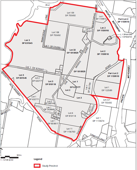
Figure 1: Subject
land
Background and Assessment Process to date
Council resolved at the Ordinary Meeting of 6 October
2016 to convene a Byron Shire Housing Summit prior to the adoption of the Byron
Shire Residential Strategy. The summit was held on 10 February 2017,
and over 100 people attended. The report on the housing summit
presented to Council on 22 June 2017 noted that:
“In response to
the issue of ‘land availability’, at the Councillor workshop held
11 May 2016, support was expressed for the identification of and
progression of potential pilot sites ahead of the Residential Land Strategy to
rezone land that could be used to achieve affordable/diverse housing outcomes
for the Shire.”
At this meeting Council resolved (Res 17-260,
relevant part) to:
2. Support
further discussions with landowners of land in Attachment 1, and progression of
work necessary to establish the feasibility of the sites in Attachment 1 and
Attachment 2 for affordable housing; and also site ‘17’ Saddle
Road land identified in the Draft Preliminary Residential Housing Strategy; and
where appropriate, invite lodgement of Planning Proposals to rezone the land
for this purpose.
The extent of the ‘subject land’ in the Planning
Proposal is larger than site 17 as referred to in the resolution and as shown
on Figure 2. Table 1 summarises that process to date in response to actioning
Item 2 of Resolution 17-260.
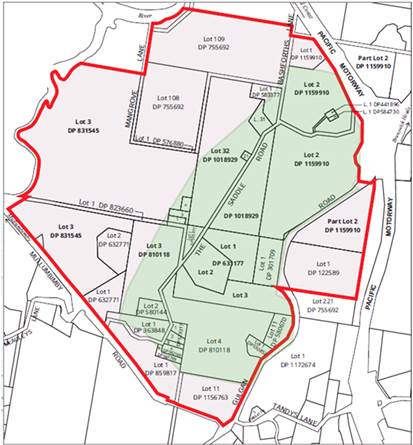
|
|
|
Planning Proposal Subject
Land
|
|
|
|
|
|
|
|
Site 17 as identified in
the Preliminary Draft Residential Strategy
|
Figure 2: Comparison of Site 17 to extent of planning
proposal
Table 1: Process to date in response to Res 17-260 Item 2
|
Date
|
|
Process to date
|
|
22 June 2017
|
|
Council at its Ordinary Meeting considered a report on
affordable housing options and resolved in part to support further
discussions with landowners in Site 17 (The Saddle Road precinct) in the
draft Residential Strategy to establish feasibility of the Area for
affordable housing and where appropriate invite a proposal to rezone land for
this purpose.
|
|
30 August 2017
|
|
A meeting was held with
landowners in The Saddle Road precinct to:
· advise
of the Res 17-260
· provide
an update on the draft Residential Strategy site suitability mapping in
relation to The Saddle Road precinct
· explain
key planning considerations for any future residential development in this
precinct , including infrastructure servicing
· gain
a better understanding of landowner views about future residential
opportunities in this precinct, including affordable housing opportunities
Cultural heritage was raised by attendees as a key issue
for The Saddle Road precinct.
|
|
15 Sept 2017
|
|
Subject Planning Proposal lodged with Council. The
proponent has indicated that this Planning Proposal was lodged in response to
the invitation extended under Res 17-260.
|
|
October 2017
|
|
Council notified by the proponent of a proposed Aboriginal
Cultural Heritage Assessment of The Saddle Road area.
Council staff consulted with the Tweed Byron Local
Aboriginal Land Council (TBLALC) and the Bundjalung of Byron Bay Aboriginal
Corporation (Arakwal) on their requirements regarding assessment
consultation.
|
|
November 2017
|
|
Council staff conveyed to the proponent’s cultural
heritage consultants the need for a comprehensive Cultural Heritage
Assessment of The Saddle Road area.
|
|
Sept – Dec 2017
|
|
Number of The Saddle Road precinct landowners advised
Council of their objection to being included in the Planning Proposal.
(Attachment 3.)
|
|
23 November 2017
|
|
Council at the Ordinary Meeting resolved (Res
17-601, relevant part) to:
3.
Council in relation to the Saddle Road EOI sites, no further action is to be
taken under Res 17-260 (Item 5) until the Planning Proposal assessment for
this locality has been completed and considered by Council in December.
|
|
Dec 2017
|
|
It was originally intended to have a
report assessing this Planning Proposal included in the agenda for the 14
December 2017 Ordinary Meeting as per the Res 17-601. However,
Council’s Executive Team, formed the view that it would be appropriate
to allow a further period of consultation between planning staff and the
proponents and the objectors before the report was put before Council. Such
consultation would make the ultimate staff report more robust and would serve
to more fully advise Councillors and put them in a position to make a fully
informed decision.
|
|
Jan 2018
|
|
Meeting held with the proponent to discuss the status of
the Planning Proposal. Proponent provided a letter subsequent to this meeting
advising that they ‘have no intention to trigger any “Pre Gateway
Review” in relation to the processing of the Saddle Road Planning
Proposal’ (correspondence contained in Attachment 2).
|
|
1 Feb2018
|
|
Council
at the Ordinary Meeting resolved (Res 18-038) to:
1. That
in relation to the Saddle Road EOI sites a further report be presented to
Council on their potential for affordable housing against the Council
endorsed assessment criteria and methodology and any current Council
resolutions pertaining to the land.
2. That a
report on the status of the Saddle Road Planning Proposal be completed
and considered by Council at the 22 February 2018 Council meeting.
|
|
7 Feb 2018
|
|
Meeting (arranged by Council staff) held with the
landowners and the proponent to discuss the status of the
Planning Proposal and EOI process.
Landowners reiterate the issues raised at the August
landowner meeting including:
· cultural
heritage
· regionally
significant farmland
· infrastructure
and services
· practicality of
the location for affordable housing
· impacts on
landscape amenity and consistency with existing Council policy around
protection of rural landscapes.
The following Councillors were also in attendance: Mayor
Simon Richardson; Councillors: Michael Lyon, Jan Hackett, Basil Cameron, Cate
Coorey and Janette Martin.
Since this meeting further landowner
objections have been received. (Attachment 4.)
|
|
Feb 2018
|
|
Response from Roads and Maritime Services in regard to
Council’s preparation of local growth management strategies, advising
that the development of a Saddle Road as a Residential Precinct (potential
400 homes) is likely to have an impact on the Gulgan Road, Brunswick Heads - Pacific
Highway interchange as out of town development will be reliant on employment
and services in Mullumbimby, Brunswick and Byron Bay. Roads and Maritime
recommends that any investigation be informed by a Traffic Impact Assessment
to determine origin and destination, increase in peak demand at interchanges
and any infrastructure requirements to be included in relevant contributions
plans.
|
|
20 Feb 2018
|
|
Meeting with Department of Primary Industries to discuss a
number of projects including the draft Residential Strategy - Saddle Road
Precinct and the implications of the regionally significant farmland
designation.
|
Initial Assessment of Planning Proposal and Key Issues
Staff
have undertaken an initial assessment of the Planning Proposal and identified a
number of key issues in need of further consideration. The North Coast Regional
Plan 2036 (NCRP) Action 1.1 (page 17) requires councils to “Focus
future urban development to mapped urban growth areas.” The subject
land is not within a designated ‘urban growth area’ under
any local growth management strategies. However it was partially indicated as
one of the possible areas for residential in the Preliminary Draft Residential
Strategy exhibited in August 2016. The NCRP incorporates capacity for the
consideration of a variation if land is outside a designated urban growth area
boundary and sets variation principles.
Below is a summary of the key
issues in relation to proceeding with this Planning Proposal prior to the
adoption of a Residential Strategy based on the Urban Growth Area Variation
Principles contained in Appendix A of the NCRP (Attachment 5).
Cultural Heritage
Any development culminating out of a rezoning must protect
and manage Aboriginal cultural heritage. As part of its engagement commitments,
Council has met with the Bundjalung of Byron Bay Aboriginal Corporation
(Arakwal) and the Tweed Byron Local Aboriginal Land Council (TBLALC) about this
Planning Proposal. The consultation confirmed that The Saddle Road area is of
interest to both the Arakwal and TBLALC and that it is appropriate for their
involvement in the Cultural Heritage Assessment.
The proponent is currently undertaking a Cultural Heritage
Assessment. It is Council staff’s understanding that this assessment will
involve engagement with the Arakwal and TBLAC in order to fully appreciate any
potential cultural heritage sites and their broader significance within this
locality. Their involvement is considered critical to the credibility of this
assessment, as well as ensuring the Planning Proposal satisfies the
requirements of Section 117 (2) of the Environmental Planning and Assessment
Act 1979 Direction 2.3 Heritage Conservation.
The findings of this assessment are critical to the
determination of the appropriateness of this area as a new urban growth area.
Until this is known it would be premature to progress with a determination of
the Planning Proposal.
Farmland Protection
Section 117 (2) of the Environmental Planning and
Assessment Act 1979 Direction 5.3 Farmland of State
and Regional Significance on the NSW Far North Coast – The Northern
Rivers Farmland Mapping Project identifies parts of the subject land as
significant non-contiguous regional farmland. The NCRP requires that any urban
growth boundary variation to be consistent with relevant Section 117 Directions
and in proposing land for uses other than farmland it address Important
Farmland Interim Variation Criteria NCRP Appendix B. Consultation is required
with Department of Primary Industry’s (DPI) to determine the position of
compliance with the NCRP Important Farmland Interim Variation Criteria. A
meeting has been arranged with DPI officers to discuss this matter on 20 February
2018. Any relevant considerations from this meeting will be provided to
Councillors as a Report addendum prior to the 22 February Ordinary Meeting.
Infrastructure
The
variation needs to consider the use of committed and planned major transport, water
and
sewerage infrastructure, and have no cost to government. Infrastructure
capacity and sequencing were not considered as part of the preliminary analysis
for the Residential Strategy and further investigation is required. The Saddle
Road is a satellite location (i.e. out of town) with the Planning Proposal
indicating potential for over 495 new dwellings. The
new infrastructure likely to be needed to support this site will impact on its
affordability and it is not clear how any major upfront infrastructure will be
funded given that a major motivation for the development is low cost housing. Further
discussions are required with the proponent to determine requirements, service
delivery approach and potential cost. The variation principle requires ‘adequate and
cost effect infrastructure be provided to match the expected population.’
Regulatory Framework and
Addressing Council Resolution for Affordable Housing
Council’s resolution to proceed ahead of the
Residential Strategy is grounded on the basis that early implementation would
provide affordable housing. The
subject land is away from existing community facilities and social structure
and therefore it’s not an obvious affordable housing site. The NCRP
Direction 25 supports the delivery of more opportunities for affordable housing
and suggests the use of Precinct Plan to assist in its delivery.
Further discussions are required with the proponent around
effective means for delivering affordable housing, infrastructure and addressing
the other land issues that
require additional information from the proponent including resolution of
environmental zones; land use conflict risk assessment; land contamination
extent and remediation options; use of flood affected land; public transport
and site connectivity; and accurate bushfire hazard information. A number of
regulatory approaches are available for use in such situations including a
Voluntary Planning Agreement, Chapter in Development Control Plan or Precinct
Plan under the NCRP. All these options allow for design considerations and
could also bring together the concerns of different interest groups within the
community.
Any
option considered for this site must be done in line with Council’s
Supporting Partnership Policy.
Conclusion
After an initial assessment of the Planning Proposal
(Attachment 1 to this Report), consulting with proponents Planners North
and Balanced Advice, the Aboriginal heritage stakeholders and the landowners in
The Saddle Road precinct, it is considered that the assessment process is
dependant on the outcomes of investigations into a number of key issues, being:
1. Cultural Heritage Assessment
(most critical)
2. Regionally significant
farmland
3: Infrastructure
4: Affordable Housing Delivery
Agreement
5. Appropriate regulatory
framework
A report back to Council to
enable a determination on the Planning Proposal is proposed to be provided by
staff once the key issues above, and any other issues that arise as a
consequence of the more detailed assessment have been appropriately investigated.
However, in the meantime
other options available to Council include:
1. Not proceed at all with the Planning Proposal as
submitted.
2. Not proceed further with the Planning Proposal until the
Residential Strategy is adopted by Council.
3. Request an amended Planning Proposal that accords only
with the ‘Site 17’ area and that this is subject to the more
detailed assessment being proposed.
4. Request that an expression of interest for the Brunswick
Eco Village proposal be submitted and progressed as part of the category 1
Saddle Road EOI’s already submitted, independent of the planning proposal
submitted.
5. Combination of the above.
Financial Implications
If Council chooses to proceed with the Planning Proposal, it
is able to fully recover the processing costs for an applicant-initiated LEP
amendment. Council has already received an amount from the applicant to
cover initial costs associated with preparing this Council report and an
assessment report. If the Planning Proposal is to proceed through the
Gateway determination process then full cost recovery of the remaining stages
will be required by Council. If Council chooses not to proceed then the
matter does not incur any additional costs.
Statutory and Policy
Compliance Implications
The relevant policy considerations are addressed in this
report.
Staff Reports - Sustainable Environment and Economy 13.18
Report No. 13.18 Cities
Power Partnership (CPP) Pledge
Directorate: Sustainable
Environment and Economy
Report
Author: Ronnie
Lawton, Sustainability and Emissions Reduction Officer
File No: I2018/54
Theme: Ecology
Planning Policy and Natural Environment
Summary:
The Cities Power Partnership (CPP) is a free national
program that exists to celebrate and accelerate the emission reduction and
clean energy successes of Australian towns and cities. In July 2017, Byron
Shire Council joined the CPP program. As part of this program Council must
pledge to take five key actions, which will be promoted via CPP social media,
and monitored and reported by Council to CPP on a biannual basis.
This report provides the five
pledge items selected and endorsed by Council’s Executive Team for
Councils consideration.
|
RECOMMENDATION:
That Council submit the five pledge items in
Table 1, column 2 of this report as the Council’s commitment to the
Cities Power Partnership.
|
Report
The CPP program provides participating councils a range of
actions from which to select 5 pledge items. These actions are based on pledge
items within 4 Key Areas:
1. Renewable
Energy,
2. Energy
Efficiency,
3. Sustainable
Transport, and
4. Work
Together and Influence.
There is no end date to achieve the pledge items. Council
should strive to deliver outcomes against the selected pledges. The importance
is that Council has investigated the items pledged and taken action where
feasible. This will inform Council’s biannual report to CPP.
Table 1 below details the five pledge items selected and
endorsed by Council’s Executive Team. Only the Pledge Item description (2nd
column of Table 1) is required to be submitted to CPP.
Table 1: Five Pledge items
|
Key Area
|
Pledge Item
|
Proposed Project
|
|
1.
Renewable Energy
|
(a) Install
renewable energy (solar PV and battery storage) on council buildings, for
example childcare facilities, libraries, street lighting, recreation centres,
sporting grounds, and council offices.
|
Ongoing installs of Solar PV.
|
|
(b) Power
council operations by renewables, directly (with solar PV or wind), or by
purchasing Greenpower (from electricity retailers). Set targets to increase
the level of renewable power for council operations over time.
|
2027 100% Renewable Energy Target.
|
|
2.
Energy Efficiency
|
(a) Create
a revolving green energy fund to finance energy efficiency projects and
receive $ savings.
|
Maintain revolving green energy fund.
|
|
3.
Sustainable Transport
|
(a) Provide
fast-charging infrastructure throughout the city at key locations for
electric vehicles (EVs).
|
Maintain fast-charge station at Byron Bay Library. Promote
the EV strategy encouraging further EV infrastructure.
|
|
4.
Work Together & Influence
|
(a) Support
local community energy groups with their community energy initiatives.
|
Ongoing. E.g. Enova’s Repower Byron project
|
Financial Implications
Depending on the project, clean energy or emissions
reduction initiatives have potential to cost Council or save Council. As such,
each project will need to be assessed on a case by case basis.
Statutory and Policy Compliance Implications
Nil
Staff Reports - Sustainable Environment and Economy 13.19
Report No. 13.19 PLANNING
- Development Application 10.2017.402.1 - Subdivision to create eighteen (18)
residential allotments, a public reserve, a drainage reserve, a residual
allotment, associated roads, earthworks, landscaping and infrastructure at 77
Tuckeroo Avenue Mullumbimby
Directorate: Sustainable
Environment and Economy
Report
Author: Paul
Mills, Senior Planner
File No: I2018/80
Theme: Ecology
Development and Approvals
Proposal:
|
DA No:
|
10.2017.402.1
|
|
Proposal description:
|
Subdivision to create
eighteen (18) residential Lots, a public reserve, a drainage reserve,
a residual lot and associated roads, earthworks, landscape and infrastructure
works (Stage 6 of Tallowood Ridge Estate)
|
|
Property description:
|
LOT: 105 DP: 1232439
|
|
77 Tuckeroo Avenue MULLUMBIMBY
|
|
Parcel No/s:
|
268751
|
|
Applicant:
|
Bayview Land Development Pty Ltd
|
|
Owner:
|
Gainsplay Pty Ltd
|
|
Zoning:
|
Part R2 Low Density Residential / Part RU1 Primary
Production / Part RU2 Rural Landscape Zone / Part 1(a) General Rural
Zone (LEP 1988)
|
|
Date received:
|
26 July 2017
|
|
Integrated Development:
|
Yes - Bush Fire Safety Authority, Section 100B Rural Fires
Act 1997
|
|
Public notification or exhibition:
|
- Level
2 advertising under DCP 2014 Part A14 – Public Notification and
Exhibition of Development Applications
- Exhibition
period: 17/8/17 to 30/8/17
- Submissions received:
Nil.
|
|
Delegation to determination:
|
Meeting of full Council (Application includes a SEPP No.1
Objection to Clause 11 of Byron LEP 1988 - 11.25% variation to minimum lot
size)
|
|
Issues:
|
· Stage Development
Consent/Concept Approval for subdivision of the site has been issued
(10.2009.314). In accordance with Section 83D(2) of the Act the proposed
development must be consistent with staged development consent 10.2009.314
which is in force at the time of writing this report.
· Flood liable
land - Flood Study Submitted
· Bush Fire Prone
Land. S100B received from RFS with conditions
· Impact of works
on riparian rehabilitation corridor
· Retention of
large existing Tallowwood tree
· The application
includes a SEPP No.1 objection to Clause 11(1) regarding the 40 hectare
minimum lot size for land within Zone 1(a) General Rural. Concurrence has
been granted by the Department of Planning and Environment. Compliance with
the development standard is considered unreasonable, unnecessary and not
practical in the circumstances of this case and the SEPP No.1 objection to
Clause 11(1) of the Byron LEP is supported.
|
Summary:
Development Consent is sought for the construction of Stage
5 of the Tallowood Ridge Estate which includes:
· 18 lot residential
subdivision;
· public reserve
land dedication for riparian plantings and restoration (area 2.48 hectares);
· stormwater
drainage reserve;
· a residual
allotment (area 35.5 hectares);
· bulk earthworks (cut
and fill);
· dedication of
roads, and
· street landscaping
and related civil infrastructure.
In response to the public notification process, no
submissions were received. The applicant has submitted an Arborist Report
considering the impact of the development on vegetation including an old
growth tallowwood tree near the entrance to this residential stage. The
applicant has demonstrated that the tree can be retained and maintained within
the subdivision. A condition has been included to require tree preservation
measures being undertaken in accordance with AS 4970-2009 – Protection
of Trees on Development Sites during the construction period. Land is also
to be dedicated for riparian plantings and restoration as part of the
development.
The proposed development is considered to satisfy the
relevant environmental planning instruments and development control plan 2014 ,
and is consistent with the Staged Development Consent for “Tallowood
Ridge Estate”. The development is recommended for consent subject
to conditions.
NOTE TO COUNCILLORS:
In accordance with the
provisions of S375A of the Local Government Act 1993, a Division is to be
called whenever a motion for a planning decision is put to the meeting, for the
purpose of recording voting on planning matters. Pursuant to clause 2(a)
under the heading Matters to be Included in Minutes of Council Meetings of
Council's adopted Code of Meeting Practice (as amended) a Division will be
deemed to have been called by the mover and seconder of all motions relating to
this report.
|
RECOMMENDATION:
That pursuant
to Section 80 of the Environmental Planning & Assessment Act 1979,
development application 10.2017.402.1 for Subdivision to create eighteen (18)
residential allotments, a residual lot, public reserve, drainage reserve and
associated roads and infrastructure works (Stage 6 of Tallowood Ridge Estate)
be granted consent subject to the recommended conditions listed in
Attachment 2.
|
Attachments:
1 Proposed
Plans prepared by CivilTech , E2018/8405
2 Conditions
of consent, E2018/7060
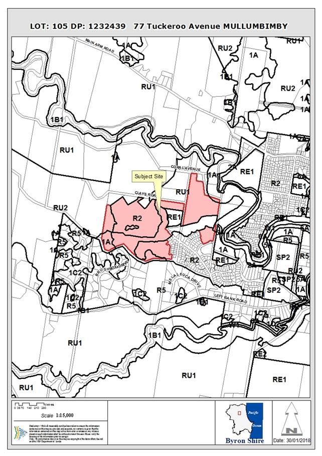
Assessment:
1.1. History/Background
The following past applications over the subject site are
noted:
DA 10.2009.314.1 for a staged development under
Sections 83A to 83D of the Environmental Planning and Assessment Act 1979 was
refused by Council on 12 November 2009. The proposed development comprises a
subdivision of approximately 240 lots and a range of infrastructure with a
detailed development application for Stage 1 comprising 31 lots.
Prior to the determination of the Development Application,
an appeal was lodged with the NSW Land & Environment Court against the
deemed refusal of the proposal. The court issued consent orders granting
consent to a staged plan for the subdivision of the site with the first stage
comprising 29 residential allotments. The first stage has been constructed and
the lots registered.
Section 96 Applications for 10.2009.314.1 have been
granted over the past seven years the most recent being Section 96 application
reference 10.2009.314.10 which was granted approval on 13 June 2016 to alter
the open space, staging, roads, bikeways, rehabilitation areas, residential
density and relocation of a potential commercial site.
Development Application 10.2011.117.1 - Stage 2
Tallowood Ridge Estate was granted consent on 4 April 2012 for urban
subdivision comprising 28 residential allotments and associated civil
infrastructure and access roads.
Development Application 10.2013.549.1 - Stage 3
Tallowood Ridge Estate was granted consent on 6 February 2014 for Subdivision
to create thirty-one (31) residential allotments, one (1) residual allotment,
roads, a stormwater detention basin, landscaping and related infrastructure
works (Stage 3 of Tallowood Ridge Estate).
Development Application 10.2015.79.1 - Stage 4A
Tallowood Ridge Estate was granted consent on 25 November 2015 for Subdivision
to create thirteen (13) residential allotments, public reserves and associated
infrastructure works.
Development Application 10.2015.686.1 - Stage 5
Tallowood Ridge Estate was granted consent on 25 August 2016 for Subdivision to
create twenty-four (24) residential allotments, a public reserve, a residual
allotment, associated roads and infrastructure.
Development Application 10.2016.161.1 - Stage 4B
Tallowood Ridge Estate was granted consent on 31 August 2017 for Subdivision to create fifteen (15) residential
lots, dedicate Public Reserve and extend existing Corella Crescent road reserve.
1.2. Description
of the site
|
Land is legally described as
|
LOT: 105 DP: 1232439
|
|
Property address is
|
77 Tuckeroo Avenue MULLUMBIMBY
|
|
Land is zoned:
|
Part R2 Low Density Residential / Part RU1 Primary
Production / Part RU2 Rural Landscape / Part 1(a) General Rural Zone
|
|
Land area is:
|
44.9 hectares
|
|
Property is constrained by:
|
Flood Liable Land, Bush fire prone land, High Conservation
Value, High Environmental Value Land
|
1.3. Description
of the proposed development
This application seeks development consent for Stage 6 of
Tallowood Ridge Estate including Subdivision to create Eighteen (18)
residential Lots, a residual Lot (area of 35.6 hectares), associated public
reserve (riparian corridor), drainage reserve, roads, infrastructure, landscape
and riparian revegetation works.
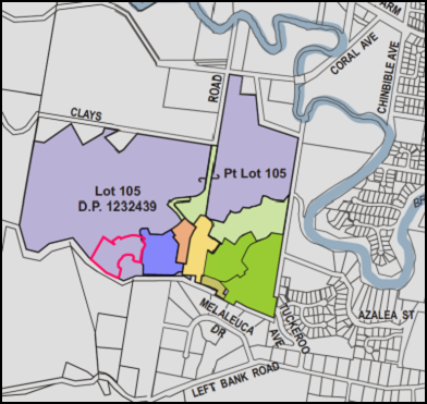
Figure 1 – Location of proposed Stage 6 residential lots
(outlined in pink)
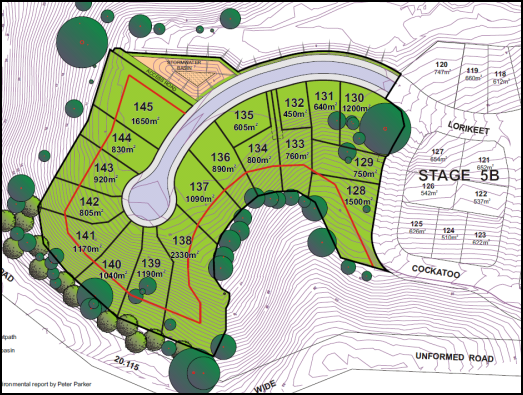
Figure 2 – Diagram of proposed residential lots Stage 6
(red line is extent of bush fire APZ to rear of lots)
1. SUMMARY OF
REFERRALS
The application was considered by Council’s Development
Engineer, Ecological Planner, ET Engineer, Section 94 Officer and where
necessary conditions of consent have been included as recommended by these
officers.
The application included a SEPP No.1 Objection which was
considered by the NSW Department of Planning and Environment and concurrence
was granted.
The application also sought Integrated Development Approval
from the NSW Rural Fire Service which is discussed in Section 2.1 of this
report.
2. Integrated
Development - Section 100B Rural Fires Act 1997
NSW
Rural Fire Service
This response
is to be deemed a bush fire safety authority as required under section
100B of the 'Rural Fires
Act 1997' and is issued
subject to the following numbered conditions:
1. The development proposal is to comply with the subdivision layout identified on the drawing titled
‘Subdivision Layout Plan’ prepared by CivilTech,
numbered 1002-DA62 (Issue
A), dated 3 July 2017, except as modified by the
following conditions:
Asset Protection Zones
The intent of measures is to provide
sufficient space and maintain
reduced fuel loads so as to ensure radiant
heat levels of buildings are below critical
limits and to prevent direct flame contact
with a building. To achieve this,
the following conditions shall apply:
2. At the issue of subdivision certificate and in perpetuity, the entire
area of all residential lots shall be managed
as an inner protection area (IPA) as outlined within section 4.1.3 and Appendix 5 of 'Planning for Bush Fire Protection 2006' and the NSW Rural Fire Service's document 'Standards for asset protection zones'.
3. A
restriction to the land use pursuant to section 88B of the Conveyancing Act
1919 shall be placed over Lots 128, 129, 133, 134 and 136 to 145 (inclusive) to
prohibit the construction of a dwelling or Class 10 building within 10 metres
of a dwelling, in the area identified as APZ (asset protection zone) on the
plan titled ‘Subdivision Layout Plan’ prepared by CivilTech,
numbered 1002-DA62 (Issue A), dated 3 July 2017.
Water and Utilities
The
intent of measures is to provide adequate services of water for the protection
of buildings during and after the passage of a bush fire, and to locate gas and
electricity so as not to contribute to the risk of fire to a building. To
achieve this, the following conditions shall apply:
4. Water,
electricity and gas are to comply with section 4.1.3 of 'Planning for Bush Fire
Protection 2006'.
Access
The
intent of measures for public roads is to provide safe operational access to
structures and water supply for emergency services, while residents are seeking
to evacuate from an area. To achieve this, the following conditions shall
apply:
5. Public
road access shall comply with section 4.1.3 (1) of 'Planning for Bush Fire
Protection 2006', except that:
• a perimeter road is not
required; and
• the dead end road may be
greater than 200 metres.
The
intent of measures for internal roads is to provide safe operational access for
emergency services personnel in suppressing a bush fire, while residents are
accessing or egressing an area. To achieve this, the following conditions shall
apply:
6. A
restriction to the land use pursuant to section 88B of the Conveyancing Act
1919 shall be placed over Lots 128, 133, 134 and 136 to 145 (inclusive)
requiring pedestrian access to be maintained to the rear of the lots for fire
fighting activities.
Landscaping
7. Landscaping
to the site is to comply with the principles of Appendix 5 of 'Planning for
Bush Fire Protection 2006'.
General Advice – consent authority to note
Asset
protection zone distance calculations for certain perimeter lots have been
based on site specific modelling of potential bush fire impacts provided by
Bushfire Certifiers. Some of these lots may not have a building envelope able
to meet the deemed-to-satisfy separation distances for BAL 29 under
AS3959-2009. In these circumstances, future proposals for complying development
may be affected and any application for development on the land may be required
to provided site specific modelling of potential bush fire impacts to
demonstrate the ability to comply with ‘Planning for Bush Fire Protection
2006’.
2.2 Section
83D - Status of staged development applications
and consents
In accordance with Section 83D(2) of the Act the proposed
development must be consistent with staged development consent 10.2009.314
which is in force at the time of writing this report. Section 83D(2) specifies:
83D Status
of staged development applications and consents
(2) While
any consent granted on the determination of a staged development application
for a site remains in force, the determination of any further development
application in respect of that site cannot be inconsistent with that consent.
Following a review of the approved concept plan details
(Council ref 10.2009.314) it is considered that subject to conditions the
proposed plans are generally consistent. Condition No.5 of the Stage Development
Consent specifies as follows:
5) Phasing of
Development
The development must be carried out in 7 separate stages as
described on Plan 6.1 – Stages Plan of the ‘Future Concept
Proposals’ document, and occur in the following order:
|
Stage
|
Works comprised within stages as shown on Plan 6.1
– Stages Plan
|
|
1
|
‘Stage 1’ and ‘Stage 1 Plantings and
Restoration’
|
|
2
|
‘Stage 2’ and ‘Stage 2 Plantings and
Restoration’
|
|
3
|
‘Stage 3’; ‘Stage 3 Plantings and
Restoration except as modified by DA 10.2009.151.3’; Basketball and
Tennis Court as approved by DA 10.2009.151.3 and ‘New Bikeway’ as
generally shown within Plan 8.1 – Proposed Road and Bikeway Systems of
the ‘Future Stages Concept Proposals’ document.
|
|
4
|
‘Stage 4’ ‘Sports Field as approved
in DA 10.2009.151.3’; access road and temporary turning area, car
parking and extension of road though to Clays Road” and ‘Stage 4
Plantings and Restoration’.
|
|
5
|
‘Stage 5’ and ‘Stage 5 Plantings and
Restoration’ and ‘New Bikeway’ along ridgeline to link
Stage 3 with Brushbox Drive (as generally shown within Plan 8.1 – Proposed Road and Bikeway Systems of the ‘Future Stages Concept
Proposals’ document)
|
|
6
|
‘Stage 6’; ‘Stage 6 Plantings and
Restoration’; and ‘Stage 6 Flood-free gravel track to Clays Road’
|
|
7
|
‘Stage 7’ and ‘Stage 7 Plantings and
Restoration’
|
Bike ways shown within Plan 8.1 must be completed as part of
the corresponding stage as shown within Plan 6.1 with the exception that a bike
way link must be provided to the sports fields as part of Stage 3. The
‘Sports Fields’, bike ways and the ‘Plantings and
Restoration’ areas may be completed in an advanced order to the nominated
staging but must not occur any later than the specific stages in which they are
nominated.
It is considered that the current application for Stage 5 is
generally consistent with the phasing of construction required by Condition
No.5. It is understood the flood free gravel track mentioned for Stage 6 was
deleted from the concept by a Section 96 amendment with the authorisation of
Council’s Development Engineer.
Development Consent 10.2009.314 also requires the proposed
development to accord with the approved document entitled ‘Future
Stages Concept Proposals’ (concept plan). The following matters
of particular relevance to proposed Stage 5 are noted:
Section 9 Subdivision Pattern
Section 9 of the approved ‘Future Stages
Concept Proposals’ document specifies, in part:
“The Schematic
Subdivision Layout Plan provides for a variety of lot types and titling
approaches, as follows:
· The
conventional lots have an area between 550 and 1200m² and will be
subdivided as Torrens Title lots; and
· A
sprinkling of small lots will have an area of approximately 425m² and will
be subdivided as Torrens Title lots.”
The proposed smallest lot size has an area of 450m²
(Proposed Lot 132). The proposal is considered to be consistent with the
minimum lot size provisions within Section 9.
3. SECTION 79C
– MATTERS FOR CONSIDERATION – DISCUSSION OF ISSUES
Having regard to the matters for consideration detailed in
Section 79C(1) of the Environmental Planning & Assessment Act 1979
(EP&A Act), the following is a summary of the evaluation of the issues.
3.1 State Environmental
Planning Instruments
|
|
Satisfactory
|
Unsatisfactory
|
|
State
Environmental Planning Policy No 1 - Development Standards
|
☒
|
☐
|
|
Consideration: See assessment in Section 4.2B of this
report.
|
|
State
Environmental Planning Policy No 44 - Koala Habitat Protection
|
☒
|
☐
|
|
Consideration: Council’s Ecologist has assessed the
proposal against SEPP No.44 noting that parts of the site are considered to
represent potential koala habitat. Previous survey results indicate the site
is unlikely to be regarded as core habitat, but is known to be used for
movement and dispersal.
|
|
State
Environmental Planning Policy No 55—Remediation of Land
|
☒
|
☐
|
|
Consideration: Council’s Environmental Officer has
previously noted that the staged development consent (Concept Plan approval
10.2009.314.1) has considered and allowed for residential development of the
subject land in view the requirements and matters for consideration provided
within SEPP No.55.
The subject land is considered to be suitable for the
proposed development without need for further detailed investigation. The
recent land use history does not indicate any activities which are likely to
have caused site contamination.
|
|
State
Environmental Planning Policy No 71—Coastal Protection
|
☒
|
☐
|
|
Consideration: The proposed subdivision will not compromise
any of the applicable provisions of SEPP No.71. The proposal shall not
restrict access to the foreshore of the Main Arm of the Brunswick River.
Development Consent 10.2009.314 granted Staged Development consent for the
subdivision of the subject land meeting the requirements for a master plan
(DCP) required by Clause 18(d) of SEPP No.71.
|
|
State
Environmental Planning Policy (Infrastructure) 2007
|
☒
|
☐
|
|
Consideration: No issues identified.
|
|
State
Environmental Planning Policy (Rural Lands) 2008
|
☒
|
☐
|
|
Consideration: The proposed subdivision is considered to
satisfy the relevant matters for consideration in the Rural Lands SEPP and
proposing fragmentation of land within the R2 Low Density Residential Zone.
|
4.2A Byron Local Environmental Plan 2014 (LEP 2014)
LEP 2014 is an applicable matter for consideration in the
assessment of the subject development application in accordance with subsection
79C(1) of the EP&A Act because it applies to the subject land and the
proposed development. The LEP 2014 clauses that are checked below are of relevance
to the proposed development:
|
Part 1
|
☒1.1|
☒1.1AA| ☒1.2| ☒1.3| ☒1.4| ☒Dictionary| ☒1.5| ☒1.6| ☒1.7| ☒1.8| ☐1.8A| ☒1.9|
☐1.9A
|
|
Part 2
|
☒2.1|
☒2.2 | ☒2.3 |☒Land Use Table | ☐2.4 | ☐2.5 | ☐2.6 | ☐2.7 | ☐2.8
|
|
Part 3
|
☐3.1|
☐3.2| ☐3.3
|
|
Part 4
|
☐4.1|
☐4.1A| ☐4.1AA| ☐4.1B |☐4.1C| ☒4.1D| ☐4.1E| ☐4.2| ☐4.2A| ☐4.2B| ☐4.2C| ☐4.2|☐4.3|☐4.4 |☐4.5 | ☐4.6
|
|
Part 5
|
☐5.1|
☐5.2| ☐5.3| ☐5.4| ☐5.5| ☐5.6| ☐5.7| ☐5.8|☐5.9| ☐ 5.9AA| ☐5.10| ☐5.11| ☐5.12|
☐5.13
|
|
Part 6
|
☐6.1|
☐6.2| ☐6.3| ☐6.4| ☐6.5| ☐6.6| ☐ 6.7| ☐6.8| ☐6.9
|
In accordance with LEP 2014 clauses 1.4 and 2.1 – 2.3:
(a) The
proposed development is defined in the LEP 2014 Dictionary as Subdivision;
(b) The
land is within the R2 Low Density Residential / Part RU1 Primary Production /
PART DM Deferred Matter / Part RU2 Rural Landscape according to the Land Zoning
Map;
(c) The
proposed development is permissible with consent; and
(d) Regard
is had for the Zone Objectives as follows:
|
Zone Objective
|
Consideration
|
|
R2 Low Density Residential Zone
• To provide for the housing needs of the community
within a low density residential environment.
• To enable other land uses that provide facilities
or services to meet the day to day needs of residents.
|
The proposed subdivision and associated works are
considered to be consistent with the Objectives of the R2 Zone.
|
|
RU2 Rural Landscape Zone
• To encourage sustainable primary industry
production by maintaining and enhancing the natural resource base.
• To maintain the rural landscape character of the
land.
• To provide for a range of compatible land uses,
including extensive agriculture.
• To enable the provision of tourist accommodation,
facilities and other small-scale rural tourism uses associated with primary
production and environmental conservation consistent with the rural character
of the locality.
• To protect significant scenic landscapes and to
minimise impacts on the scenic quality of the locality.
|
The proposed subdivision retains all land within the RU2
Zone within a single Lot and is considered to be consistent with the
Objectives of the RU2 Zone.
|
|
RU 1 Primary Production Zone
• To encourage sustainable primary industry
production by maintaining and enhancing the natural resource base.
• To encourage diversity in primary industry
enterprises and systems appropriate for the area.
• To minimise the fragmentation and alienation of
resource lands.
• To minimise conflict between land uses within this
zone and land uses within adjoining zones.
• To encourage consolidation of lots for the
purposes of primary industry production.
• To enable the provision of tourist accommodation,
facilities and other small-scale rural tourism uses associated with primary
production and environmental conservation consistent with the rural character
of the locality.
• To protect significant scenic landscapes and to
minimise impacts on the scenic quality of the locality.
|
The proposed subdivision retains all land within the RU1
Zone within Lot and is considered to be consistent with the Objectives of the
RU1 Zone.
|
The remaining checked clauses have been taken into
consideration in the assessment of the subject development application in
accordance with subsection 79C(1) of the EP&A Act. The proposed development
complies with all clauses of LEP 2014 (in some cases subject to conditions
and/or to the satisfaction of other assessing officers).
Minimum Lot Size
The minimum lot size in the R2 Low Density Residential Zone
is 400sqm on the subject land. Each of the proposed lots exceeds 400sqm in
area.
4.2B Byron Local Environmental Plan 1988 (LEP 1988)
LEP 1988 is an applicable matter for consideration in the
assessment of the subject development application in accordance with subsection
79C(1) of the EP&A Act because it applies to the subject land and the
proposed development. The LEP 1988 clauses that are checked below are of
relevance to the proposed development:
|
Part 1
|
☒1|
☒2| ☒2A| ☒3| ☒4| ☒5| ☒LEP 1988 Dictionary| ☒7
|
|
Part 2
|
☒8|
☒9
|
|
Part 3
|
☐10|
☒11| ☐11A| ☐11B| ☐12| ☐13| ☐14| ☐15| ☐16| ☐17| ☐17A| ☐17B| ☐18| ☐19| ☐22| ☐22| ☐23| ☐24| ☐25| ☐27| ☐ 29| ☐29AA| ☐29A| ☐30| ☐31| ☐32| ☐33| ☐34| ☐35| ☐36| ☐37| ☐38| ☐38A| ☐38B| ☐39| ☐39A| ☐39B| ☐39C| ☐40| ☐41| ☐42| ☐43| ☐44| ☐45| ☐46| ☐47| ☐47AA| ☐47A| ☐48| ☐49| ☐51| ☐52| ☐53| ☐54| ☐55| ☐56| ☐ 57| ☐58| ☐59| ☐60| ☐61| ☐62| ☐63| ☐64
|
|
Part 5
|
| ☐65|
☐66| ☐67| ☐68| ☐69| ☐70| ☐71| ☐72| ☐73| ☐74| ☐75| ☐76| ☐77| ☐78| ☐79| ☐80| ☐81| ☐82| ☐83| ☐84| ☐85| ☐86| ☐87| ☐88| ☐89| ☐90| ☐91| ☐92| ☐93| ☐94| ☐95|
☐96|
☐97| ☐98| ☐99| ☐100| ☐101
|
In accordance with LEP 1988 clauses 5, 8 and 9:
(a) The
proposed development is defined in the LEP 1988 Dictionary as Subdivision;
(b) The
land is within the LEP1988 1A General Rural Zone according to the map under LEP
1988;
(c) The
proposed development is permissible with consent; and
(d) The
proposed development is consistent with the relevant objectives of the Zone for
the following reasons:
|
Zone Objective
|
Consideration
|
|
(a) to encourage and permit a
range of uses creating a pattern of settlement, at a scale and character that
maintains or enhances the natural, economic, cultural, social and scenic
amenity of the rural environment of the Shire of Byron,
(b) to encourage and permit a
pattern of settlement which does not adversely affect the quality of life of
residents and visitors and maintains the rural character,
(c) to ensure development only
occurs on land which is suitable for and economically capable of that
development and so as not to create conflicting uses,
(d) to allow the use of land
within the zone for agricultural purposes and for a range of other
appropriate purposes whilst avoiding conflict between other uses and
intensive agriculture,
(e) to identify lands (shown
hatched on the map) which in the opinion of the council possess a limited
capability for more intensive uses or development,
(f) to restrict the establishment
of inappropriate traffic generating uses along main road frontages other than
in road side service areas,
(g) to ensure sound management of
land which has an extractive or mining industry potential and to ensure that
development does not adversely affect the potential of any existing or future
extractive industry,
(h) to enable the provision of
rural tourist accommodation and facilities only where such facilities are
compatible with the form and density of the nature of the locality, and
(i) to permit the development of
limited light industries which do not pose any adverse environmental impact,
(eg software manufacture and film processing), and
(j) to ensure that the
development and use of land shown cross-hatched on the map adjacent to areas
of significant vegetation and wildlife habitat do not result in any
degradation of that significant vegetation and wildlife habitat, and that any
development conserves and protects and enhances the value of the fauna and
flora.
|
The subject site contains three small portions of land
within the 1A General Rural Zone each portion is well below the 40 hectare
minimum lot size. The proposal seeks to retain all the land within the 1A
Zone within one residual Lot. The proposed development is considered to be
consistent with the objectives of the 1A Zone.
|
The remaining checked clauses have been taken into
consideration in the assessment of the subject development application in
accordance with subsection 79C(1) of the EP&A Act. The proposed development
complies with all clauses of LEP 1988 (in some cases subject to conditions
and/or to the satisfaction of other assessing officers).
State Environmental Planning Policy No. 1 Objection -
Non-compliance with Clause 11(1) of Byron LEP 1988
Pursuant to Clause 11(1) of Byron LEP 1988, the minimum area
of a lot created to be created within the 1(a) General Rural Zone is 40
hectares. The proposed subdivision proposes to create 18 residential Lots in
accordance with Byron LEP 2014 minimum Lot size map. However the residue lot
containing 1(a) zoned land has an area of 35.5 hectares and is therefore less
than the required 40 hectare minimum for the 1(a) General Rural Zone.
The applicant has submitted a SEPP No.1 Objection to the
minimum allotment size. The applicant seeks a variation to the development
standard applying to the minimum allotment size for subdivision within the 1(a)
General Rural zoned land.
A written objection was submitted
with the development application asserting that compliance with the minimum 40
hectare lot size development standard is unreasonable and unnecessary as the
existing allotment has Staged Development Consent (10.2009.314) for residential
subdivision and this development standard is would prevent the orderly and
economic use of the land.
Clause 3 of SEPP No.1 specifies the
following aims and objectives:
“This Policy provides
flexibility in the application of planning controls operating by virtue of
development standards in circumstances where strict compliance with those
standards would, in any particular case, be unreasonable or unnecessary or tend
to hinder the attainment of the objects specified in section 5 (a) (i) and (ii)
of the Act.”
Section 5 of the Environmental
Planning and Assessment Act 1979 provides that the objects of the
Act relevant to State
Environmental Planning Policy No. 1 are:
“(a) to encourage:
(i) the
proper management, development and conservation of natural and artificial
resources, including agricultural land, natural areas, forests,
minerals, water, cities,
35 towns
and villages for the purpose of promoting the social and economic welfare of
the community and a better environment,
(ii) the
promotion and co-ordination of the orderly and economic use and development of
land,”
Clause 7 of
SEPP No.1 specifies that consent may be granted:
Where the consent authority is satisfied that the
objection is well founded and is also of the opinion that granting of consent to
that development application is consistent with the aims of this Policy as set
out in clause 3, it may, with the concurrence of the Director, grant consent to
that development application notwithstanding the development standard the
subject of the objection referred to in clause 6.
Strict compliance with the 40
hectare standard is not considered necessary in the circumstances of this
application. The submitted SEPP No.1 Objection is considered to be well founded
and compliance with the standard in this instance is unreasonable and
unnecessary in view of the following:
· The land contains
multiple zones and is subject to Stage Development Consent ref 10.2009.314
which identified for residential subdivision;
· The site contains
three (3) small separate portions of land within the 1(a) General Rural Zone
and maintains theses areas within a single residual lot;
· the objection has
planning merit by facilitating the subdivision of land within the R2 Low
Density Residential Zone to create 18 additional allotments which are
significantly exceed the minimum Lot size of 400sqm on the subject land.
In correspondence dated 24 January
2018 the Department of Planning and Environment issued concurrence for the
proposal stating, in part:
“Concurrence was granted in this
instance for the following reasons:
· The
variation of the development standard will enable the orderly development of an
area of residential zoned land on the site;
· The area of 1(a) General
Rural zoned land is already smaller than the development standard; and
· There is no public benefit
in maintaining the development standard in this instance.”
Compliance with the development
standard is considered unreasonable and unnecessary in the circumstances of
this case and the SEPP No.1 objection is therefore supported.
4.3 Any proposed Instrument
that has been the subject of public consultation and has been notified to the
consent authority
Draft SEPP (Coastal Management) 2016
The Draft Coastal Management
State Environmental Planning Policy (SEPP) proposes to establish a new,
strategic land use planning framework for coastal management. It is intended to
support the implementation of the management objectives set out in the Coastal
Management Act 2016.
Once adopted, the Coastal
Management SEPP will be the single land use planning policy for coastal
development and will bring together and modernise provisions from SEPP 14
(Coastal Wetlands), SEPP 26 (Littoral Rainforests) and SEPP 71 (Coastal
Protection).
The aim of the Draft SEPP is to
promote an integrated and co-ordinated approach to planning in the
‘Coastal Zone’, identifying four coastal management areas:
· coastal wetlands
and littoral rainforests area
· coastal environment
area;
· coastal use area;
and
· coastal
vulnerability area.
The subject site is mapped within the ‘coastal use
area’ and ‘coastal environment area’. The draft
provisions for consideration of development within this area generally reflect
the existing matters for consideration currently outlined in SEPP 71.
The subject site does not fall within a ‘coastal
vulnerability area’ as it is not identified within the ‘Coastal
Erosion Hazard Area’. The proposal is considered to be acceptable
having regard to the provisions of the Draft SEPP particularly Divisions No.2,
4 & 5. The proposed development is not in proximity of a wetland or
littoral rainforest.
4.4A Byron Shire Development Control Plan 2014
(DCP 2014)
DCP 2014 is an applicable matter for consideration in the
assessment of the subject development application in accordance with subsection
79C(1) of the EP& A Act because it applies to the land to which LEP 2014
applies. The DCP 2014 Parts/Chapters that are checked below are of relevance to
the proposed development:
|
Part A
|
☐
|
|
Part B Chapters:
|
☒B2|
☒ B3| ☒ B4| ☒ B5| ☒ B6| ☒ B7| ☒ B8| ☒ B9| ☐B10| ☒ B11| ☐B12| ☐B13| ☒B14
|
|
Part C Chapters:
|
☐C1|
☒C2| ☐C3| ☐C4
|
|
Part D Chapters
|
☐D1|
☐D2| ☐D3| ☐D4| ☐D5| ☒ D6| ☐D7| ☐D8
|
|
Part E Chapters
|
☐
E1| ☐E2| ☒ E3| ☐E4| ☐E5| ☐E6| ☐ E7
|
These checked Parts/Chapters have been taken into
consideration in the assessment of the subject development application in
accordance with subsection 79C(1) of the EP&A Act. The proposed development
is demonstrated to meet the relevant Parts/Chapters (in some cases subject to
conditions and/or to the satisfaction of other assessing officers), for
residential subdivision. .
4.4B Byron Shire Development Control Plan 2010 (DCP 2010)
DCP 2010 is an applicable matter for consideration in the
assessment of the subject development application in accordance with subsection
79C(1) of the EP& A Act because its purpose is to provide planning
strategies and controls for various types of development permissible in
accordance with LEP 1988. The DCP 2010 Chapters/Parts that are checked below
are of relevance to the proposed development:
|
Chapter 1 Parts:
|
☒A|
☒B| ☐C| ☐D| ☐E| ☐F| ☐G| ☐H| ☐J| ☒K| ☐L| ☒ N
|
|
Chapters:
|
☐4|
☐6| ☐7| ☐8| ☐9| ☐10| ☒11| ☐12| ☐14| ☐15| ☐16| ☐17| ☐18| ☐19| ☐20| ☐21| ☐22
|
These checked Chapters/Parts have been taken into
consideration in the assessment of the subject development application in
accordance with subsection 79C(1) of the EP&A Act. The proposed development
is demonstrated to meet the relevant controls of DCP 2010 for residential
development and subdivision.
4.5 Any Planning Agreement or
Draft Planning Agreement?
|
|
Yes
|
No
|
|
Is there any applicable planning agreement or draft
planning agreement?
|
☐
|
☒
|
|
Consideration: Not applicable.
|
4.6 Environmental Planning
& Assessment Regulation 2000 Considerations
The proposed development is considered to be consistent with
the additional matters for consideration provided in the NSW Environmental
Planning and Assessment Regulation 2000.
4.7 Any coastal zone management
plan?
|
|
Satisfactory
|
Unsatisfactory
|
Not applicable
|
|
Is there any applicable coastal zone management plan?
|
☐
|
☐
|
☒
|
|
Consideration: At the time of this report the NSW
Government has not adopted Council’s Draft CZMP.
|
4.8 The likely impacts of that
development, including environmental impacts on both the natural and built
environments, and social and economic impacts in the locality
|
Impact on:
|
Likely significant impact/s?
|
|
Natural environment
|
The applicant has submitted an Arborist Report considering
the impact of the development on vegetation including an old growth
tallowwood tree near the entrance to this residential stage. The applicant
has demonstrated that the tree can be retained and maintained in good health
within the subdivision. A condition has been included to require tree
preservation measures being undertaken in accordance with AS 4970-2009
– Protection of Trees on Development Sites during the construction
period. Land is also to be dedicated for riparian plantings and restoration
as part of the development.
It is considered the proposal will not have a
significantly adverse impact on the natural environment of the locality.
|
|
Built environment
|
No. The proposal will not have a significantly adverse
impact on the built environment of the locality having regards to the
masterplan approval for this development.
|
|
Social Environment
|
No. The proposal will not have a significant social impact
on the locality.
|
|
Economic impact
|
No. The proposal will not have a significant economic
impact on the locality other than positive impacts through the construction
stage of the development and subsequent development of the lots for dwelling
houses.
|
4.9 The suitability of the site
for the development
|
Issue
|
Comment
|
|
Services
- Water/
Sewer/ Stormwater
- Ph./
power
- Access
|
All essential services are available.
|
|
Hazards
- Flooding
- ASS
- Bushfire
- Landslip
|
Council’s development engineers have included
conditions where necessary to address the issues flooding and slope stability
(geotechnical assessment).
Condition/s has been included to manage acid sulfate
soils.
RFS has issued a Section 100B BFSA for satisfy planning
for bush fire protection.
|
|
Land Use conflicts
|
No conflicts identified. Land has concept approval for
residential subdivision.
|
4.10 Submissions made in accordance with
this Act or the regulations
The development application was publicly exhibited in
accordance with the Level 2 provisions of DCP 2014. Council’s records
indicate (at the time of this report) that no submissions were received.
4.11 Public interest
The proposed development is unlikely to prejudice or
compromise the public interest or create an undesirable precedent.
4.12 Section 5A of the EP&A Act –
Significant effect on threatened species
Having regard to sections 5A, 5C and 5D of the EP&A Act, there is unlikely to be a significant effect on threatened species,
populations or ecological communities, or their habitats as a result of the
proposed development because Council’s
Ecologist undertaken an inspection of the subject site and the information
submitted and determined the proposal is unlikely to have a significant impact
on threatened species or their habitat.
4.13 Section 5B of the EP&A Act –
Have regard to register of critical habitat
The NSW Critical
Habitat Register does not identify any critical habitat on or adjacent to the
site.
5. DEVELOPER
CONTRIBUTIONS
5.1 Water & Sewer Levies
Section 64 levies will be payable.
5.2 Section 94 Contributions
Section 94 Contributions will be
payable.
6. CONCLUSION
The proposed development is consistent with the relevant
environmental planning instruments and planning controls applicable to the site
apart from technical non-compliance with Clause 11 of Byron LEP 1988.
The application includes a SEPP No.1 objection to Clause
11(1) regarding the 40 hectare minimum lot size for land within Zone 1(a)
General Rural. It is considered that no planning benefit is to be gained from
preventing the subdivision of containing Land within the R2 Low Density
Residential Zone while maintaining all land within the 1(a) General Rural Zone
on a single residual lot. Concurrence has been granted by the Department of
Planning and Environment. Compliance with the development standard is
considered unreasonable, unnecessary and not practical in the circumstances of
this case and the SEPP No.1 objection to Clause 11(1) of the Byron LEP is supported.
The proposal raises no significant issues in terms of
environmental impacts which cannot be managed, and the site is considered to be
suitable for the proposed development subject to conditions.
7. DISCLOSURE OF
POLITICAL DONATIONS AND GIFTS
|
Has a Disclosure Statement been received in relation
to this application
|
No
|
|
Have staff received a ‘gift’ from anyone
involved in this application that needs to be disclosed. Where the answer is
yes, the application is to be determined by the Director or Manager of the
Planning, Development and Environment Division.
|
No
|
Provide Disclosure Statement register details here: Not
applicable.
Staff Reports - Sustainable Environment and Economy 13.20
Report No. 13.20 PLANNING
- Development Application 10.2017.364.1 - Boundary adjustment/Subdivision to
create two lots at 25 Station Street Mullumbimby
Directorate: Sustainable
Environment and Economy
Report
Author: Luke
Munro , Planner
File No: I2018/82
Theme: Ecology
Development and Approvals
Proposal:
|
Proposal description:
|
Subdivision (2 into 2 Lots) to Create Two (2) Lots
|
|
Property description:
|
LOT: 2 DP: 727348, LOT: 35 SEC: 3 DP: 2772
|
|
25 Station Street MULLUMBIMBY
|
|
Parcel No/s:
|
145710, 122880
|
|
Applicant:
|
Ardill Payne & Partners
|
|
Owner:
|
Mr J & Mrs K M Northcott
|
|
Zoning:
|
R2 Low Density Residential
|
|
Date received:
|
12 July 2017
|
|
Integrated Development:
|
No
|
|
Public notification or exhibition:
|
- Level
1 advertising under DCP 2014 Part A14 – Public Notification and
Exhibition of Development Applications
- Exhibition
period: 27/7/17 to 9/8/17
- Submissions received:
None
|
|
Planning Review Committee:
|
Not applicable
|
|
Delegation to determination:
|
Council
|
|
Issues:
|
· Located on Flood
Prone Land
· Located on Acid
Sulfate Soils (Class 3)
· Clause 4.6
variation to Minimum Lot Size
|
Summary:
Development consent is sought for Subdivision (2 into 2 Lots)
to Create Two (2) Lots over 25 Station Street, Mullumbimby.
The proposed lot sizes are not in accordance with Clause 4.1
of Byron LEP 2014 due to their lot size. The development application is
supported by a request for a variation pursuant to clause 4.6 of the LEP. The
circumstances of the case warrant a more flexible approach to application of
the minimum lot size given the site currently comprises two existing lots of
less than 600m2. The Applicant’s variation request is supported and the
development application is recommended for approval despite the non-compliance.
In this regard no additional lots or dwelling entitlements are being created.
The proposed development is considered to be an appropriate
response to the characteristics of the site having regard to the provisions of
the LEP and Byron DCP 2014, and the development application is recommended for
approval subject to conditions. The proposed development is not contrary to the
public interest, raises no issues and warrants approval.
NOTE TO COUNCILLORS:
In accordance with the
provisions of S375A of the Local Government Act 1993, a Division is to be
called whenever a motion for a planning decision is put to the meeting, for the
purpose of recording voting on planning matters. Pursuant to clause 2(a)
under the heading Matters to be Included in Minutes of Council Meetings of
Council's adopted Code of Meeting Practice (as amended) a Division will be
deemed to have been called by the mover and seconder of all motions relating to
this report.
|
RECOMMENDATION:
That pursuant to
Section 80 of the Environmental Planning & Assessment Act 1979,
development application 10.2017.364.1 for Subdivision (2 into 2 Lots) to Create Two (2) Lots, be granted consent subject to conditions
listed in Attachment 2 (#E2018/7107).
|
Attachments:
1 Proposed
Plan of subdivision prepared by Ardill Payne, E2018/7108
2 conditions
of consent , E2018/7107
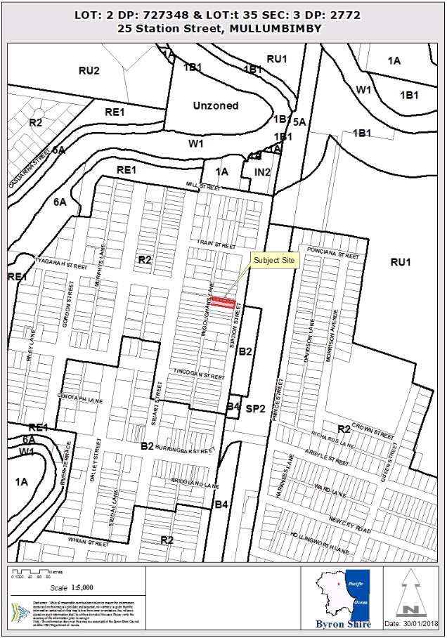
Assessment:
1. INTRODUCTION
1.1. History/Background
This application is for subdivision of two (2) Council
approved allotments which contain an existing dwelling house straddling both
lots.
1.2. Description
of the proposed development
This application seeks approval for a Subdivision (2 into 2
Lots) to Create Two (2) Lots
The existing dwelling house straddles the two lots with an
area of 310.4m2 (Lot 2 DP727348) and 561.5m2 (Lot 3 DP2772). The proposal will
realign the existing boundaries of the existing 2 lots into two lots of
434.72m2 each.
The existing dwelling house which straddles the existing two
lots will be wholly contained within Lot 1 which will have frontage to Station
Street. Lot 2 will front onto McGougans Lane.
The site has a garage at the rear of the existing dwelling
which will be wholly contained within proposed Lot 2, leaving Lot 1 with car
parking in the front yard of Lot 1. Lot 1 will require a concreted hardstand
area for the parking of two (2) vehicles in accordance with Chapter B4 of the
Byron DCP 2014 – a condition has been recommended to this effect.
Plan of subdivision
1.3. Description
of the site
|
Land is legally described as
|
LOT: 2 DP: 727348, LOT: 35 SEC: 3 DP: 2772
|
|
Property address is
|
25 Station Street MULLUMBIMBY
|
|
Land is zoned:
|
R2 Low Density Residential
|
|
Land area is:
|
310.4 m2 & 561.5m2
|
|
Property is constrained by:
|
Acid Sulfate Soils Class 4 and is liable to flooding.
Bushfire does not affect the site.
|
The site contains an existing single storey dwelling house
and detached garage in the rear yard. The site has access from both Station
Street and McGougans Lane. The dwelling house is constructed what appears to be
asbestos sheeting and roofing (there is no proposal to remove the dwelling or
undertake alterations and additions to the dwelling house).
2. SUMMARY OF
REFERRALS
|
Referral
|
Issue
|
|
Development Engineer
|
No objections subject to conditions of consent
|
3. SECTION 79C
– MATTERS FOR CONSIDERATION – DISCUSSION OF ISSUES
Having regard to the matters for consideration detailed in
Section 79C(1) of the Environmental Planning & Assessment Act 1979
(EP&A Act), the following is a summary of the evaluation of the issues.
3.1 State Environmental
Planning Instruments
4.2A Byron Local Environmental Plan 2014 (LEP 2014)
LEP 2014 is an applicable matter for consideration in the
assessment of the subject development application in accordance with subsection
79C(1) of the EP&A Act because it applies to the subject land and the
proposed development. The LEP 2014 clauses that are checked below are of
relevance to the proposed development:
|
Part 1
|
☐1.1|
☒1.1AA| ☒1.2| ☒1.3| ☒1.4| ☒Dictionary| ☐1.5| ☒1.6| ☒1.7| ☐1.8| ☐1.8A| ☒1.9|
☐1.9A
|
|
Part 2
|
☒2.1|
☒2.2 | ☒2.3 |☒Land Use Table | ☐2.4 | ☐2.5 | ☒2.6 | ☐2.7 | ☐2.8
|
|
Part 3
|
☐3.1|
☐3.2| ☐3.3
|
|
Part 4
|
☒4.1|
☐4.1A| ☐4.1AA| ☐4.1B |☐4.1C| ☐4.1D| ☐4.1E| ☐4.2| ☐4.2A| ☐4.2B| ☐4.2C| ☐4.2|☒4.3|☒4.4 |☒4.5 |☐4.6
|
|
Part 5
|
☐5.1|
☐5.2| ☐5.3| ☐5.4| ☒5.5| ☐5.6| ☐5.7| ☐5.8| ☐5.9| ☐5.9AA| ☒5.10| ☐5.11| ☐5.12|
☐5.13
|
|
Part 6
|
☒6.1|
☐6.2| ☒6.3| ☐6.4| ☐6.5| ☒6.6| ☐ 6.7| ☐6.8| ☐6.9
|
In accordance with LEP 2014 clauses 1.4 and 2.1 – 2.3:
(a) The
proposed development is defined in the LEP 2014 Dictionary as Subdivision;
(b) The
land is within the R2 Low Density Residential according to the Land Zoning Map;
(c) The
proposed development is permitted with consent; and
(d) Regard
is had for the Zone Objectives as follows:
|
Zone Objective
|
Consideration
|
|
To provide for the
housing needs of the community within a low density residential environment.
|
The proposed subdivision will provide a range of housing
types in the locality and maintains the existing character of the residential
area.
|
|
To enable other land uses
that provide facilities or services to meet the day to day needs of
residents.
|
Not Applicable
|
The remaining underlined clauses have been taken into
consideration in the assessment of the subject development application in
accordance with subsection 79C(1) of the EP&A Act. The proposed development
complies with all of these clauses (in some cases subject to conditions and/or
to the satisfaction of other assessing officers), except in relation to clause
which is considered further as follows:
|
What clause does the development not comply with and
what is the nature of the non-compliance?
|
Further consideration, including whether the
development application is recommended for approval or refusal accordingly
|
|
4.1 Minimum subdivision lot
size
(1) The objectives of this clause are as follows:
(a) to ensure that lot sizes are compatible with
local environmental values and constraints,
(b) to facilitate efficient use of land resources for
residential and other human purposes.
(2) This clause applies to a subdivision of any land shown
on the Lot Size Map that requires development consent and that is carried out after
the commencement of this Plan.
(3) The size of any lot resulting from a subdivision of
land to which this clause applies is not to be less than the minimum size
shown on the Lot Size Map in relation to that land.
(4) This clause does not apply in relation to the
subdivision of individual lots in a strata plan or community title scheme.
|
See assessment below.
|
4.1
Minimum subdivision lot size
Clause 4.1 of LEP 2014 is
accessible via: https://www.legislation.nsw.gov.au/#/view/EPI/2014/297/part4/cl4.1
Matters under subclause (3) are addressed as follows:
The size of any lot resulting from a subdivision of land to
which this clause applies is not to be less than the minimum size shown on the Lot Size Map in
relation to that land.
The existing dwelling house straddles two lots with an area
of 310.4m2 (Lot 2 DP727348) and 561.5m2 (Lot 3 DP2772). The proposal will
realign the existing boundaries of the existing 2 lots into two lots of
434.72m2 each.
The Applicant has submitted a clause 4.6 variation request
(refer to Doc #E2017/71746). The clause 4.6 variation request is considered
with reference to relevant matters as follows:
a) Introduction
– Summary of proposed development
The development application
proposes a boundary realignment of two (2) lots into two (2) lots, each of the
current lots have an area of 310.4m2 (Lot 2 DP727348) and 561.5m2 (Lot 3
DP2772) and will result in two lots of 434.72m2 each.
b) Clause
4.6 Exceptions to Development Standards
Clause 4.6 of Byron LEP 2014 is
accessible via: http://www.legislation.nsw.gov.au/fragview/inforce/epi+297+2014+pt.4-cl.4.6+0+N?tocnav=y
c) The
Development Standard to be varied
The development standard to be
varied is contained in LEP 2014 subclause 4.1(3), which is accessible via: https://www.legislation.nsw.gov.au/#/view/EPI/2014/297/part4/cl4.1
The Minimum Lot Size planning
control is a development standard in accordance with the applicable definition
in the Dictionary and clause 4.5 of the Environmental Planning and Assessment
Act 1979 because it is provisions of an environmental planning instrument in
relation to the carrying out of development, being provisions by or under which
requirements are specified or standards are fixed in respect of any aspect of
that development, including, requirements or standards in respect of setting a minimum lot size for any land and is not to be less than the minimum
lot size shown for the land on the Minimum Lot Size Map
d) Extent
of Variation to the Development Standard
The Statement of Environmental
Effects indicates that the current lots have an area of 310.4m2 (Lot 2
DP727348) and 561.5m2 (Lot 3 DP2772) and will result in two lots of 434.72m2
each. The proposal seeks a boundary realignment to reconfigure the existing
lots into two (2) lots with a lot size of 434.72m2 each. This will result in
each allotment being approximately 27.5% less than the minimum lot size
identified on the Minimum Lot Size Map.
However the proposal will not make
the existing non-compliance worse.
The extent of the variation to the
minimum lot size development standard is therefore 27.5%.
e) Objective
of the Development Standard
The objectives of the development
standard are stated in LEP 2014 subclause 4.1(1) which states:
(a) to ensure that lot
sizes are compatible with local environmental values and constraints,
(b) to facilitate
efficient use of land resources for residential and other human purposes
f) Objectives
of the Zone
The objectives of the R2 Low
Density Residential Zone which applies to the location of the proposed boundary
realignment are stated in the Land Use Table to LEP clause 2.8, which states:
• To provide for
the housing needs of the community within a low density residential
environment.
• To enable
other land uses that provide facilities or services to meet the day to day
needs of residents.
g) Assessment
– the specific questions to be addressed:
(a) Clause
4.6(3)(a) – Is compliance with the development standard unreasonable or
unnecessary in the circumstances of the case?
The site currently consists of two
(2) non-compliant lots. Requiring compliance with the development standard is
unnecessary in this instance as there will be no further intensification of the
development potential of the site and will maintain the lot sizes of the
existing lots with the resultant lots each commanding an area of 434.72m2.
a. The
boundary realignment/reconfiguration is a two into two lots development and
will average out the existing two lot sizes to lots with an area of 434.72m2.
b. There
currently exists the ability to develop a single dwelling house on each of the
existing lots, the current proposal will not increase this development potential
and will provide a better and more functional lot layout for future dwellings
onsite.
c. The
lots sizes are consistent within the streetscape and character of the
surrounding low density residential area. There will be no impact on the
streetscape as a result of this development application.
(b) Clause
4.6(3)(b) – Are there sufficient environmental planning grounds to
justify contravening the development standard?
The proposed realignment of
property boundaries will result in lots which average out the area between the
existing two lots and will result in a change to the alignment to the existing
dividing lot boundary.
There are sufficient grounds to
justify the proposal on environmental planning grounds as follows:
· Better
relationship with surrounding subdivision pattern with a more appropriate lot
size of 434.72m2 each rather than a 310.4m2 and 561.5m2 lot
· The development
will enable the retention of the exiting dwelling house (on a single lot with
no change to the streetscape);
· The Lot sizes are
consistent with the surrounding neighbourhood, and width of lots.;
· Given the site is
located within a Flood Prone Area there will be no increase in intensity of
development as a result of this proposal.
· the proposed
reconfiguration enables the allotments to contain an building envelope
measuring 12m x 15m;
· the proposed rear
allotment (Lot 2) is to be provided right of footway to Station Street;
· the site is
located within an existing urban area with close proximity to the Mullumbimby
business district and with a level topography, pedestrian and cycling is a
common form of transport;
· pedestrian
accessibility and service provision (garbage collection, postal services) are
able to be provided from the main street frontage on Station Street;
· the existing
dwelling on the proposed Lot 1 will comply with the floor space ratio of 0.5:1.
There are
sufficient environmental planning grounds to justify contravening the
development standard.
(c) Clause
4.6(4)(a)(ii) – Is the proposed development in the public interest? Is it
consistent with the objectives of the standard and the zone as set out above?
The proposal
provides an opportunity to provide a more suitable lot layout which is capable
of contain a building envelope measuring 12m x 15m and will enable the more
efficient use of land through enabling a vacant lot of land for development
without having the existing dwelling straddling both existing lots.
Numerically no
additional lots or dwelling entitlements are created as a result of this
development.
The proposal
will enable the future contribution to the provision of residential housing in
close proximity to the Mullumbimby town centre whilst preserving, and
minimising impacts on, infrastructure provision and maximising utilisation of
these resources.
Further the
proposal is consistent with the objectives of the development standard and the
zone. The proposal will not create an undesirable precedent in the
circumstances given there are a number of similar developments proximate to the
site which have created similar boundary realignments.
The proposed
development is not significantly contrary to the public interest because it
will not adversely affect the welfare and wellbeing of the broader public.
The proposed lot sizes are not in accordance with Clause 4.1
of Byron LEP 2014. The development application is supported by a request for a
variation pursuant to clause 4.6 of the LEP. The circumstances of the case
warrant a more flexible approach to application of the minimum lot size given
the site currently comprises two existing lots of less than 600m2. The
Applicant’s variation request is supported and the development
application is recommended for approval despite the non-compliance.
6.1 Acid Sulfate Soils
Soil disturbance is proposed and where excavations are
greater than 2m in depth a Condition has been recommended requiring the
preparation of an Acid Sulfate Soils Management Plan.
6.3 Flood Planning
The existing dwelling house will remain onsite and future
dwellings will be subject to requirements to comply with the Flood Planning
Levels of 4.72mAHD.
4.3 Any proposed Instrument
that has been the subject of public consultation and has been notified to the
consent authority
Draft SEPP (Coastal Management) 2016
The draft SEPP proposes to replace SEPP 14 (Coastal
Wetlands), SEPP 26 (Littoral Rainforest) and SEPP 71(Coastal Protection).
It will redefine the current ‘Coastal Zone’, to be within four
coastal management areas:
· coastal wetlands
and littoral rainforests area
· coastal
environment area;
· coastal use area;
and
· coastal
vulnerability area.
The subject site will be mapped within the coastal use
area. The proposed development is not in a wetland, littoral rainforest,
coastal environment area or coastal vulnerability area. The proposed
amendments to the consent do not raise any specific issues that apply to the
coastal use area provisions under the draft SEPP.
4.4A Byron Shire Development Control Plan 2014
(DCP 2014)
DCP 2014 is an applicable matter for consideration in the
assessment of the subject development application in accordance with subsection
79C(1) of the EP& A Act because it applies to the land to which LEP 2014
applies. The DCP 2014 Parts/Chapters that are checked below are of relevance to
the proposed development:
|
Part A
|
|
|
Part B Chapters:
|
☐B2|
☒B3| ☒B4| ☐B5| ☐B6| ☐B7| ☒B8| ☐B9| ☐B10| ☐B11| ☐B12| ☐B13|
☐B14
|
|
Part C Chapters:
|
☐C1|
☒C2| ☐C3| ☐C4
|
|
Part D Chapters
|
☒D1|
☐D2| ☐D3| ☐D4| ☐D5| ☐D6| ☐D7| ☐D8
|
|
Part E Chapters
|
☐
E1| ☐E2| ☒E3| ☐E4| ☐E5| ☐E6| ☐ E7
|
These underlined Parts/Chapters have been taken into
consideration in the assessment of the subject development application in
accordance with subsection 79C(1) of the EP&A Act. The proposed development
complies with all sections of these Parts/Chapters (in some cases subject to
conditions and/or to the satisfaction of other assessing officers), except in
relation to certain prescriptive measures which are considered further (having
regard to the DCP 2014 Section A1 Dual Path Assessment) as follows:
|
What Section and prescriptive measure does the
development not comply with?
|
Does the proposed development comply with the
Objectives of this Section? Address.
|
Does the proposed development comply with the
Performance Criteria of this Section? Address.
|
|
B4.2.5 Car Parking Requirements
|
Yes
The existing dwelling will have adequate area in the front
of the site for 2 car parking spaces – both of which will be uncovered.
|
Yes
The existing dwelling will have adequate area in the front
of the site for 2 car parking spaces – both of which will be uncovered.
|
|
C1.4.9 Subdivision
To retain the development and subdivision pattern of the
Heritage Conservation Areas including their characteristic rhythm and
spacings of the built form.
|
Yes
The proposal will retain the existing street frontage and
typical subdivision pattern (lot width).
|
Yes
The proposal will retain the existing street frontage and
typical subdivision pattern (lot width).
|
|
D6.4.3 Infill Subdivision with Rear Lane Access
Legal pedestrian access is to be provided back to the main
street frontage by way of a Right of footway, common property or battleaxe
subdivision design. This can also be used for the provision of services
(water, sewer, power and telecommunications) to the rear dwelling house / lot
and enable garbage and postal services to be collected from the street as
opposed to the laneway. Where it is to be used for pedestrian purposes only,
the handle to be a minimum 1.2 metres wide to facilitate easy access and manoeuvring
of a garbage bin, whilst also providing a main street frontage for visitors
and delivery services.
|
Yes
A consent condition plans as amended in red require the
creation of suitable rights of carriageway over the access pathway which
connects proposed rear Lot(s) through to Station Street. Minimum width of
1.2m.
|
Yes
The plans have been amended in red requiring the creation
of suitable rights of carriageway over the access pathway which connects
proposed rear Lot(s) through to Station Street. Minimum width of 1.2m.
|
The proposed development is demonstrated to meet the
relevant Objectives of DCP 2014.
4.5 Any Planning Agreement or
Draft Planning Agreement?
|
|
Yes
|
No
|
|
Is there any applicable planning agreement or draft
planning agreement?
|
☐
|
☒
|
4.6 Environmental Planning
& Assessment Regulation 2000 Considerations
|
Clause
|
This control is applicable to the proposal:
|
I have considered this control as it relates to the
proposal:
|
If this control is applicable, does the proposal
comply?
|
|
92
|
Yes
|
Yes
|
Yes
|
|
93
|
No
|
N/A
|
N/A
|
|
94
|
No
|
N/A
|
N/A
|
|
94A
|
No
|
N/A
|
N/A
|
* Non-compliances and any other significant issues
discussed below
4.7 Any coastal zone management
plan?
|
|
Satisfactory
|
Unsatisfactory
|
Not applicable
|
|
Is there any applicable coastal zone management plan?
|
☐
|
☐
|
☒
|
4.8 The likely impacts of that
development, including environmental impacts on both the natural and built
environments, and social and economic impacts in the locality
|
Impact on:
|
Likely significant impact/s?
|
|
Natural environment
|
No. The proposal will not have a significantly adverse
impact on the natural environment of the locality.
|
|
Built environment
|
No. The proposal will not have a significantly adverse
impact on the built environment of the locality.
|
|
Social Environment
|
No. The proposal will not have a significant social impact
on the locality.
|
|
Economic impact
|
No. The proposal will not have a significant economic
impact on the locality.
|
4.9 The suitability of the site
for the development
The site is a serviced, unconstrained property and is
suitable for the proposed development.
4.10 Submissions made in accordance with
this Act or the regulations
The development application was publicly exhibited .
There were 0 submissions made on the development
application:
4.11 Public interest
The proposed development is unlikely to prejudice or
compromise the public interest or create a dangerous precedent
4.12 Section 5A of the EP&A Act –
Significant effect on threatened species
Having regard to sections 5A, 5C and 5D of the EP&A Act, there is unlikely to be a significant effect on threatened species,
populations or ecological communities, or their habitats as a result of the
proposed development.
4.13 Section 5B of the EP&A Act –
Have regard to register of critical habitat
The NSW Critical
Habitat Register does not identify any critical habitat on or adjacent to the
site.
5. DEVELOPER
CONTRIBUTIONS
5.1 Water & Sewer Levies
No Section 64 levies will be required.
The proposed development does not generate additional
loading onto Council’s Water, Bulk Water and or Sewer systems beyond the
existing ET entitlements.
5.2 Section 94 Contributions
No Section 94 Contributions will
be required.
Clause 2.13 of the plan states:
“This plan assumes that all existing allotments have an underlying
credit of one SDU except in the following circumstances:
(a) Lots created without Council approval by way of departmental
subdivision by the Crown; or
(b) Lots created for the purposes of utility installations; or
(c) [Deleted in amendment 2]; or
(d) Lots created by way of the closure of a public or crown
road; or
(e) Lots to which clause 15 of the Byron LEP applies and that
form part of an existing holding where a dwelling has already been erected upon
another lot within that holding; or
(f) Vacant lots within commercial or industrial
zones.
Lots that meet the criteria
listed in (a) to (f) do not have any credit and development upon this land that
increases population will be required to pay a contribution.”
Each of these lots meets the criteria of this clause and is
not excluded by items a-f. No contributions are payable.
6. DISCLOSURE OF
POLITICAL DONATIONS AND GIFTS
|
Has a Disclosure Statement been received in relation
to this application
|
No
|
|
Have staff received a ‘gift’ from anyone
involved in this application that needs to be disclosed. Where the answer is
yes, the application is to be determined by the Director or Manager of the
Planning, Development and Environment Division.
|
No
|
Provide Disclosure Statement register details here: Not
applicable
7. CONCLUSION
Development consent is sought for Subdivision (2 into 2 Lots)
to Create Two (2) Lots over 25 Station Street, Mullumbimby. The proposed lot
sizes are not in accordance with Clause 4.1 of Byron LEP 2014. The development
application is supported by a request for a variation pursuant to clause 4.6 of
the LEP. The circumstances of the case warrant a more flexible approach to
application of the minimum lot size given the site currently comprises two
existing lots of less than 600m2. The Applicant’s variation request is
supported and the development application is recommended for approval despite
the non-compliance.
The proposed development is considered to be an appropriate
response to the characteristics of the site having regard to the provisions of
the LEP and Byron DCP 2014, and the development application is recommended for
approval subject to conditions. The proposed development is not contrary to the
public interest, and the proposal warrants approval.
Staff Reports - Sustainable Environment and Economy 13.21
Report No. 13.21 Policy:
Commercial use of road reserves
Directorate: Sustainable
Environment and Economy
Report
Author: Sarah
Nagel, Community Enforcement Officer
File No: I2018/83
Theme: Community Infrastructure
Open Space and Recreation
Summary:
Council considered a report and draft policy
‘Commercial Use of Road Reserves’ at the Ordinary meeting on 26
October 2017.
The draft policy was placed on public exhibition for an
extended period until 30 November to 17 January 2018. No submissions were
received. It is recommended the policy be adopted.
|
RECOMMENDATION:
That Council adopt the Commercial Use of Road
Reserves Policy (#E2018/9436).
|
Attachments:
1 Attachment
1 Draft Policy Commercial Use of Road Reserves 22 February 2018, E2018/9436
Report
Council considered a report and draft policy
‘Commercial Use of Road Reserves’ at the Ordinary meeting on 26
October 2017 where it was resolved (17-454):
1. That
one Council policy incorporates the commercial use of road reserves authorised
under the Roads Act;
2. That
the policy incorporates all licenced/approved activities on those areas as
authorised under the Roads Act i.e. mobile food vendors, mobile product
vendors, footpath dining and goods and chattels;
3. That
the policy works in conjunction with Council’s policy “Road
Airspace”; and
4. That
the policy works in conjunction with Council’s policy 5.52
“Commercial Activities on Coastal and Riparian Crown Reserves”.
The draft policy was placed on public exhibition for an
extended period between 30 November 2017 and 17 January 2018. No submissions
were received. It is recommended the policy be adopted.
Separate to the policy, further work will now continue to
identify suitable sites where licensed venders can operate, recommend a fee
structure and an expression of interest/lease process for the issue of
licenses. This will be reported to Council at a later date.
Financial Implications
Adoption of the policy will provide methodology for Council
to approve and collect revenue for the use of Council’s road reserves for
a commercial benefit.
Statutory and Policy Compliance Implications
1. Building Code of Australia
2. Byron Local Environmental
Plan 2014
3. Byron Shire Development
Control Plan 2014
4. Environmental Planning and
Assessment Act 1979
5. Factories, Shops and
Industries Act 1962
6. Food Act 2003
7. Local Government Act 1993
8. Local Government (General)
Regulation 2005
9. Protection of the Environment
Operations Act 1997
10. Retail Leases Act 1994
11. Road Transport Act 2013
12. Roads Act 1993
13. Work Health and Safety Act 2011
14. NSW Food Authority – Guidelines
for Mobile Food Vending Vehicles
15. Council’s Road Airspace Policy
16. Council’s Footpath Dining
Policy
17. Council’s Itinerant Food Vendor
Policy
Staff Reports - Sustainable Environment and Economy 13.22
Report No. 13.22 PLANNING
- Development Application 10.2017.474.1 Multi Dwelling Housing Consisting of
Twenty Five (25) 1 Bedrooms 70 - 90 Station Street Mullumbimby
Directorate: Sustainable
Environment and Economy
Report Author: Chris
Larkin, Manager Sustainable Development
File No: I2018/100
Theme: Ecology
Development and Approvals
Proposal:
|
DA No:
|
10.2017.474.1
|
|
Proposal description:
|
Multi Dwelling Housing Consisting of Twenty Five (25) 1
Bedroom Dwellings (Under the Provisions of the State Environmental Planning
Policy (Affordable Rental Housing) 2009: Infill Affordable Housing. The
proposed development would be undertaken in two (2) stages.
|
|
Property description:
|
LOT: 10 DP: 850902
|
|
70-90 Station Street MULLUMBIMBY
|
|
Parcel No/s:
|
203540
|
|
Applicant:
|
North Coast Community Housing
|
|
Owner:
|
Byron Shire Council
|
|
Zoning:
|
B4 Mixed Use
|
|
Date received:
|
1 September 2017
|
|
Integrated Development:
|
No
|
|
Delegations to Determine:
|
Council
|
|
Public notification or exhibition:
|
- Level
2 advertising under DCP 2014 Part A14 – Public Notification and
Exhibition of Development Applications
- Exhibition
period: 21/9/17 to 11/10/17
- Submissions received: Eight
(8) plus one external referral response.
|
|
Issues:
|
· Compatibility of
the proposal with the Mullumbimby Heritage Conservation Area.
· Compliance with
planning controls.
· Compatibility
with the existing built environment and surrounding land uses, including an
adjacent pre-school and the disused North Coast railway line.
· Flooding and
stormwater drainage.
· Timing of the
completion of an approved subdivision over the site.
|
|
Summary:
|
The application seeks
development consent for a multi-dwelling housing development containing 25 x
1 bedroom units. The layout incorporates five (5) separate buildings each
containing five (5) units. It is proposed to undertake the development in two
(2) stages.
The proposal was submitted
under the provisions of SEPP (Affordable Rental Housing) 2009 and consists of
19 units to be offered as entry level home ownership for people on moderate
incomes, and six (6) units to be rented at less than 80% of market rent.
The buildings are described as
Buildings A – E. Buildings A, D and E (15 units) would be
constructed in Stage 1 and Buildings B and C (10 units) in Stage 2.
All units are accessed via
individual entries from ground level (via stairs or a pathway) and contain
two (2) living levels with the upper level being a mezzanine lounge within
the roof profile.
All buildings are elevated
above the finished ground level to achieve minimal habitable floor levels for
flooding, with Building E having a higher elevation than the other four (4)
buildings to provide parking underneath. The total number of car parking
spaces provided is 14 (excluding 5 tandem spaces).
The original publically
exhibited plans for the proposal identified that the development would be
known as ‘Rail Yard’. Following a suggestion from Councils
Heritage Panel, the applicant has agreed to change the name to the
‘Mill Yard’ to strengthen the ties to the original use of the
site. The proposal has been reviewed by Councils Heritage Consultant and no
objections to the proposal have been raised in relation to heritage issues.
The applicant was notified in
accordance with the level 2 procedure of Byron DCP 2014. In response to the
public notifications process, Councils records indicate that a total of 8
submissions were received.
The proposal involves
non-compliances with various controls of Byron DCP 2014. However, the
proposal non-compliance’s are largely the result of designing to the
numerical standards permitted by SEPP (Affordable Rental Housing) 2009.
The proposal has been reviewed
by the relevant Council Units and no objections have been raised subject to
recommended conditions of consent.
The proposal is considered to
have sufficient planning merit to be supported subject to the conditions
included in the recommendation of this report.
|
NOTE TO COUNCILLORS:
In accordance with the
provisions of S375A of the Local Government Act 1993, a Division is to be
called whenever a motion for a planning decision is put to the meeting, for the
purpose of recording voting on planning matters. Pursuant to clause 2(a)
under the heading Matters to be Included in Minutes of Council Meetings of
Council's adopted Code of Meeting Practice (as amended) a Division will be
deemed to have been called by the mover and seconder of all motions relating to
this report.
|
RECOMMENDATION:
That pursuant
to Section 80 of the Environmental Planning & Assessment Act 1979,
Development Application No. 10.2017.474.1 for Multi Dwelling Housing Consisting of
Twenty Five (25) 1 Bedroom Dwellings (Under the Provisions of the State Environmental
Planning Policy (Affordable Rental Housing) 2009: Infill Affordable Housing,
be granted approval subject to the conditions listed in Attachment 2
#E2018/8240.
|
Attachments:
1 Proposed
Plans NCCH, E2018/8546
2 Conditions
of consent , E2018/8240
3 Site Waste
Minimisation and Management Plan, Lucena Stormwater Assessment and Management ,
E2018/8551
4 Confidential
- Submissions received, E2018/8295
INTRODUCTION
1.1. History/Background
The subject site is a 16,082m2 parcel of land that is owned by
Byron Shire Council. It contains the Byron Shire Council administration
building, chambers, car park and Mullumbimby Community Pre-School. Following an
independent assessment of a development application, Development Consent
10.2014.404.1 was issued on 30 October 2014 for the subdivision of the subject
site into 6 lots as follows:
· Proposed
Lot 1 - 11,030.5m2 parcel of land comprising the existing Council
administration building, chambers, library, pocket park, car parking areas, and
ancillary landscaped land at the northern portion of the site.
· Proposed
Lots 2, Lot 3, Lot 4, & Lot 5 – Four (4) x 804.4m2 lots
within the currently undeveloped area between the existing car park and
pre-school.
· Proposed
Lot 6 - 1837.4m2 lot containing the existing Mullumbimby Pre-school
and associated outdoor areas at the southern portion of the site.
The application has been amended under the provisions of
Section 96 of the Environmental Planning and Assessment Act 1979, on two
occasions. The modification applications were:
· 10.2014.404.2
-This modification application incorporated the following amendments:
o to
remove the requirement for a 1.2m wide footpath for the full property frontage.
o to
remove the requirement for kerb and gutter for the full property frontage.
This application was granted consent on 27 August 2015.
· 10.2014.404.3
-This modification application sought approval to stage the development, and
make changes to infrastructure provision. The application was approved on 22
September 2017 and stages the development as follows:
o Stage
1 creates 2 lots, which would be further subdivided in Stages 2 & 3.
The intention of Stage 1 is to create a serviced ‘development lot’
(i.e. Lot 1), which can then be sold.
o Stage
2 - creation of a new lot containing the existing pre-school, separating
that site from the remainder of the property.
o Stage
3 involves the remainder of the approved development, being the creation of
the four lots nominated as Lots 2-5 on the originally approved plan. If
the proposed affordable housing development proceeds, this stage would not
occur.
In 2015, Byron Shire Council
resolved to sell proposed Lot 1 to North Coast Community Housing (NCCH) at an
independently verified market value, for the purpose of an affordable housing
project. It is this proposed lot that is subject of the current proposal.
Subdivision work for Stage 1 has
commenced however the subdivision certificate has not yet been issued.
Past applications recorded over the subject site relate to the
Byron Shire Council administration building and the child care centre. Other
than the subdivision mentioned above, there are no other relevant historical
applications relating the vacant portion of land known as proposed Lot 1.
1.2. Description
of the site
|
Land is legally described as
|
LOT: 10 DP: 850902
|
|
Property address is
|
70-90 Station Street, Mullumbimby.
|
|
Land is zoned:
|
B4 Mixed Use
|
|
Land area is:
|
16090 m2
|
|
Property is constrained by:
|
Flood Liable Land
Acid Sulfate Soils Class 4
Mullumbimby Heritage Conservation
Area
|
As described above, development consent has been issued for
the subdivision of the site into six lots. The lots have not yet been created
and therefore the development application is lodged over the parent parcel ie.
10 DP 850902. All building work associated with the proposal would occur over
proposed Lot 1. If approved, work on the proposal would not be able to commence
until such time as the subdivision for Stage 1 is registered.
Proposed Lot 1 is a vacant, relatively flat piece of land
which has a proposed area of 3244m2. It does not contain any
vegetation of significance other than the large fig tree which is located
within the road reserve at the front of the site. The adjoining land comprises:
· North
- Proposed Lot 3 containing the Byron Shire Council administration building,
chambers and car park. The car park is located immediately adjacent to the site
of the proposed development.
· South
- Proposed Lot 2 containing the Mullumbimby Community Pre-school.
· East
- The dis-used North Coast railway line. Further to the east, on the opposite
side of the railway reserve is residential and rural land.
The location of the subject site is shown on Figure 1, and
Figure 2 illustrates the approved subdivision and staging layout.
Figure 1 - Location
Figure 2 - Proposed Subdivision Layout and Staging
1.3. Description
of the proposed development
The application seeks
development consent for a multi-dwelling housing development containing 25 x 1
bedroom units. The layout incorporates five (5) separate buildings each
containing five (5) units. It is proposed to undertake the development in two
(2) stages as follows:
· Stage
1 - 15 units located in Buildings A, D and E.
· Stage
2 - 10 units located in Buildings B and C.
The layout of the development is
illustrated in Figure 3.
All units have a gross floor area of 51m2 and are
accessed via individual entries from ground level (via stairs or a pathway).
They contain two habitable levels with the upper level being a mezzanine lounge
within the roof profile, and the lower level containing an open plan kitchen
and dining, bathroom, bedroom and a covered balcony.
All buildings are elevated above
the finished ground level on a suspended concrete slab to achieve minimal
habitable floor levels for flooding. Building E has a higher elevation than the
other four (4) buildings and contains parking underneath. A typical floor plan
is provided in Figure 4.
The total number of car parking
spaces provided is 14 (excluding 5 tandem spaces). Five of these, plus 5 tandem
spaces, are located below Building E, and 9 are located in a communal outdoor
parking area.
A single access point is
provided from Station Street, adjacent to the proposed boundary with
pre-school.
The buildings would be
constructed using corrugated steel zincalume roofing and a mix of corrugated
steel with vertical timber cladding on the walls.
An identification sign on
vertical timber sleepers is proposed at the front of the site. This sign would
identify the development name ie. The Mill Yard’.
The fig tree within the road
reserve is to remain. A communal open space is proposed to be provided within
the site, adjacent to the tree.
The proposal was submitted under
the provisions of SEPP (Affordable Rental Housing) 2009 and consists of 19
units to be offered as entry level home ownership for people on moderate
incomes, and six (6) units to be rented at less than 80% of market rent.
Figure 3 - Site Plan
Figure 4 - Typical Floor Plan
1. SUMMARY OF
REFERRALS
|
Referral
|
Issue
|
|
Environmental Health Officer*
|
Issues addressed include acid sulfate soils, contaminated
land, waste management, land use conflicts, noise impacts and mosquito/biting
midge management. No objections, subject to conditions. Refer to Doc # A2017/30104.
|
|
Development Engineer
|
Flood liable land, access, car parking and stormwater
management.
No objection to the proposal subject to conditions. See
Doc#A2017/23049.
|
|
S64 / Systems Planning Officer
|
Provision of bulk water, water and sewerage services. No
objection to the proposal subject to conditions including payment of
applicable charges. See Doc #A2017/23050.
|
|
S94 / Contributions Officer
|
Section 94 Contributions are applicable for the proposed
development. A condition has been included to require payment of the Section
94 contributions. The applicant has not sought an exemption. See Doc
#A2017/23052
|
|
Heritage Consultant
|
Impact of the proposed development on the Mullumbimby
Heritage Conservation Area. No objections to the proposal. See Heritage
Referral Report dated November 2017.
|
|
John Holland Rail
|
Requested that Council consider noise and vibration in the
assessment of the application and ensure that no additional stormwater flows
toward the rail corridor, and that the rail boundary is securely fenced.
|
Issues:
The primary issue related to the comments made by John
Holland Rail with respect to noise and vibration. This issue is discussed later
in this report. It is confirmed that no additional stormwater will flow towards
the railway land and that the boundary will be secured with timber lapped and
capped fencing.
2. SECTION 79C
– MATTERS FOR CONSIDERATION – DISCUSSION OF ISSUES
Having regard to the matters for consideration detailed in
Section 79C(1) of the Environmental Planning & Assessment Act 1979
(EP&A Act), the following is a summary of the evaluation of the issues.
2.1 State Environmental
Planning Instruments
|
Policy
requirement/summary
|
Proposed
|
Complies
|
|
State Environmental
Planning Policy (Affordable Rental Housing) 2009
|
|
6 Affordable
housing
Note.The
Act defines affordable housing as follows:
affordable housing means housing for very low income households,
low income households or moderate income households, being such households as
are prescribed by the regulations or as are provided for in an environmental
planning instrument.
(1) In this Policy, a household is taken to be a
very low income household, low income household or moderate income household
if the household:
(a) has
a gross income that is less than 120 per cent of the median household income
for the time being for the Greater Sydney (Greater Capital City Statistical
Area) (according to the Australian Bureau of Statistics) and pays no more
than 30 per cent of that gross income in rent, or
(b) is
eligible to occupy rental accommodation under the National Rental
Affordability Scheme and pays no more rent than that which would be charged
if the household were to occupy rental accommodation under that scheme.
(2) In this Policy, residential development is
taken to be for the purposes of affordable housing if the development is on
land owned by the Land and Housing Corporation.
|
The proposal consists of 19 units to be offered for people
on moderate incomes with 6 units to be rented at less than 80% of market rent
as affordable housing.
It is normal for such housing to be made affordable for a
period of 10 years after which market rates for rent would apply.
The applicants have proposed that such housing though will
be made affordable in perpetuity. Conditions to apply.
|
Yes
|
|
8 Relationship
with other environmental planning instruments
If there is
an inconsistency between this Policy and any other environmental planning
instrument, whether made before or after the commencement of this Policy,
this Policy prevails to the extent of the inconsistency.
|
The development application has been made under the
provisions of State Environmental Planning Policy
(Affordable Rental Housing) 2009 (AH SEPP) and the provisions of this
SEPP prevail over any inconsistencies with Byron LEP 2014.
|
Noted
|
|
10 Development
to which Division applies
(1) This Division applies to development for the
purposes of dual occupancies, multi dwelling housing or residential flat
buildings if:
(a) the development concerned is permitted
with consent under another environmental planning instrument, and
(b) the development is on land that does not
contain a heritage item that is identified in an environmental planning
instrument, or an interim heritage order or on the State Heritage Register
under the Heritage Act 1977.
(3)
Despite subclause (1), this Division does not apply to development on land
that is not in the Sydney region unless all or part of the development is
within 400 metres walking distance of land within Zone B2 Local Centre or
Zone B4 Mixed Use, or within a land use zone that is equivalent to any of
those zones.
|
Multi dwelling housing is permissible with consent on the
subject site under Byron LEP 2014.
The site does not contain a heritage item.
The site is zoned B4 Mixed Use, therefore, this Division
applies.
|
Yes
|
|
13 Floor
space ratios
(1) This clause applies to development to which
this Division applies if the percentage of the gross floor area of the development
that is to be used for the purposes of affordable housing is at least 20 per
cent.
(2) The maximum floor space ratio for the
development to which this clause applies is the existing maximum floor space
ratio for any form of residential accommodation permitted on the land on
which the development is to occur, plus:
(a) if the existing maximum floor space ratio
is 2.5:1 or less:
(i) 0.5:1—if the percentage of the gross
floor area of the development that is used for affordable housing is 50 per cent
or higher, or
(ii) Y:1—if the percentage of the gross
floor area of the development that is used for affordable housing is less
than 50 per cent,
where:
AH is the percentage of the gross floor area of the
development that is used for affordable housing.
Y = AH ÷ 100
|
The proposal seeks to provide
6 of the 25 proposed dwellings (24% floor area) as affordable housing. These
dwellings will be managed by a community housing provider. Any consent will
be conditioned to require a restrictive covenant be placed on the title to
enforce this requirement. As discussed this will be in perpetuity.
The proposed floor space ratio
(FSR) of 0.39:1 (which is calculated on the site area of proposed lot 1, not
the current site area) complies with the Byron LEP 2014 maximum of 0.6:1. The
FSR when calculated over the entire site area is approximately 0.44:1.
The applicant is not seeking
to make use of the FSR bonus available under this clause.
|
Yes
|
|
14 Standards that cannot be used to refuse consent
(1) Site
and solar access requirements
A consent authority must not refuse consent to development to which this
Division applies on any of the following grounds:
(b) site area
if the site area on which it is proposed to carry out the development is at
least 450 square metres,
(c) landscaped area if:
(i) in the case of a development
application made by a social housing provider—at least 35 square metres
of landscaped area per dwelling is provided, or
(ii) in any other case—at
least 30 per cent of the site area is to be landscaped,
(d) deep soil zones
if, in relation to that part of the site area (being the site, not only of
that particular development, but also of any other associated development to
which this Policy applies) that is not built on, paved or otherwise sealed:
(i) there is soil of a
sufficient depth to support the growth of trees and shrubs on an area of not
less than 15 per cent of the site area (the deep soil zone), and
(ii) each area forming part of
the deep soil zone has a minimum dimension of 3 metres, and
(iii) if practicable, at least
two-thirds of the deep soil zone is located at the rear of the site area,
(e) solar access
if living rooms and private open spaces for a minimum of 70 per cent of the
dwellings of the development receive a minimum of 3 hours direct sunlight
between 9am and 3pm in mid-winter.
(2) General
A consent authority must not refuse consent to development to which this
Division applies on any of the following grounds:
(a) parking if:
(i) in the case of a development
application made by a social housing provider for development on land in an
accessible area—at least 0.4 parking spaces are provided for each
dwelling containing 1 bedroom, at least 0.5 parking spaces are provided for
each dwelling containing 2 bedrooms and at least 1 parking space is provided
for each dwelling containing 3 or more bedrooms, or
(ii) in any other case—at
least 0.5 parking spaces are provided for each dwelling containing 1 bedroom,
at least 1 parking space is provided for each dwelling containing 2 bedrooms
and at least 1.5 parking spaces are provided for each dwelling containing 3
or more bedrooms,
(b) dwelling size
if each dwelling has a gross floor area of at least:
(i) 35 square metres in the case
of a bedsitter or studio, or
(ii) 50 square metres in the
case of a dwelling having 1 bedroom, or
(iii) 70 square metres in the
case of a dwelling having 2 bedrooms, or
(iv) 95 square metres in the
case of a dwelling having 3 or more bedrooms.
(3) A
consent authority may consent to development to which this Division applies
whether or not the development complies with the standards set out in
subclause (1) or (2).
|
Site area
The subject allotment has an area exceeding 450m2.
Therefore site area is not able to used as a reason for refusing consent to
this development application.
Landscape area
The total landscaped area proposed is 1180m2,
which is equivalent to approximately 47m2 of landscaped area per
dwelling. The application is made by a social housing provider. In accordance
with Clause 14 landscaped area cannot be used as a ground for refusal of this
Development Application.
Deep Soil Zones
The total area of deep soil
zones proposed on the new lot is 840m2 which is 26% of the total
site area of proposed lot 1. Calculations have not been undertaken with
respect to deep soil zones over the parent parcel. This would only be an
issue if deep soil zones were considered to be inadequate and Council was
considering refusal of the application on this basis. The intent of the SEPP
is met in this regard as it complies with respect of the proposed lot, which
will be created prior to construction commencing.
Sixty percent of the deep soil
zone is located behind the building line, however, a large area is also
provided at the front of the site, around the communal open space area,
adjacent to the existing fig tree.
Solar Access
The applicant has advised that over 70% of the proposed
dwellings receive the required solar access. Plans have been provided to
support this.
Parking spaces
At least 0.5 parking spaces are provided for
each dwelling containing 1 bedroom. A total of 14 parking spaces are provided
for the proposed 25 single bedroom dwellings, excluding the 5 tandem spaces.
The applicant is also providing a share car for residents of the development,
and combined with the istes proximity to shops and other amenities, car
parking is considered acceptable. Appropriate conditions to apply.
Dwelling size
The applicant has submitted a floor plan
indicating that each of the proposed dwellings has a ‘gross floor
area’ exceeding 50m2.
|
Noted
|
|
15 Design
requirements
(1) A consent authority must not
consent to development to which this Division applies unless it has taken
into consideration the provisions of the Seniors Living Policy: Urban
Design Guidelines for Infill Development published by the Department of
Infrastructure, Planning and Natural Resources in March 2004, to the extent
that those provisions are consistent with this Policy.
|
The proposed development is considered to be generally
consistent with the Seniors Living Policy: Urban Design
Guidelines for Infill Development published by the
Department of Infrastructure, Planning and Natural Resources in March 2004.
|
Yes
|
|
16A Character
of local area
A consent authority must not consent to
development to which this Division applies unless it has taken into
consideration whether the design of the development is compatible with the
character of the local area.
|
Council’s Heritage
Consultant has assessed the proposal in terms of compatibility with the local
area and raised no objection to the proposed development. Suggestions were
made with respect to proposed building materials to be used, which the
applicant has incorporated into an amended design.
The proposed development is
considered to be compatible with the character of the local area and
Mullumbimby Conservation Area.
Further comments in relation to heritage are made later in
this report.
|
Yes
|
|
17 Must be used for affordable housing for 10 years
(1) A
consent authority must not consent to development to which this Division
applies unless conditions are imposed by the consent authority to the effect
that:
(a) for 10 years from the date
of the issue of the occupation certificate:
(i) the dwellings proposed to
be used for the purposes of affordable housing will be used for the purposes
of affordable housing, and
(ii) all accommodation that is
used for affordable housing will be managed by a registered community housing
provider, and
(b) a restriction will be
registered, before the date of the issue of the occupation certificate,
against the title of the property on which development is to be carried out,
in accordance with section 88E of the Conveyancing
Act 1919, that will ensure that the requirements
of paragraph (a) are met.
(2)
Subclause (1) does not apply to development on land owned by the Land and
Housing Corporation or to a development application made by, or on behalf of,
a public authority.
|
The applicant has nominated
dwellings 3, 8, 15, 16, 19 and 20 as long term affordable housing.
The applicant has proposed
that the housing be set aside in perpetuity.
Relevant condition(s) will be
placed on any consent to implement the requirements of this clause.
|
*Yes
(Subject
to conditions)
|
|
18 Subdivision
Land on which development has been carried
out under this Division may be subdivided with the consent of the consent
authority.
|
The subject development application does not seek consent
for subdivision at this time. However, the application documentation
indicates that strata subdivision is proposed in the future.
|
Noted
|
|
State Environmental Planning Policy (State and Regional
Development) 2011
|
|
Part 4 - Regional development
This Part applies to development of a
class or description included in Schedule 4A to the Act. If applicable, the
development application must be determined by the Joint Regional Planning
Panel.
Schedule 4A of the Act identifies
the following as ‘regional development’
Council related
development over $5 million
Development
that has a capital investment value of more than $5 million if:
(a) a
council for the area in which the development is to be carried out is the applicant
for development consent, or
(b) the
council is the owner of any land on which the development is to be carried
out, or
(c) the
development is to be carried out by the council, or
(d) the
council is a party to any agreement or arrangement relating to the
development (other than any agreement or arrangement entered into under the
Act or for the purposes of the payment of contributions by a person other
than the council).
|
The proposal is Council related development as the land is
currently owned by Byron Shire Council. The applicant has provided an
estimated cost less than $4.9875 million for the project including GST. GST
is not included in the definition of Capital Investment Value.
The costing provided is based on the applicants experience
with similar projects in the Shire.
The proposal is therefore local development.
|
Yes
|
|
State Environmental Planning Policy (Infrastructure)
2007
|
|
Division 15 Subdivision 2 applies to
‘Development in or adjacent to rail corridors and interim rail
corridors - notification and other requirements.
85 Development adjacent to
rail corridors
(1) This clause applies to development on land
that is in or adjacent to a rail corridor, if the development:
(a) is
likely to have an adverse effect on rail safety, or
(b) involves
the placing of a metal finish on a structure and the rail corridor concerned
is used by electric trains, or
(c) involves
the use of a crane in air space above any rail corridor.
(2) Before determining a development
application for development to which this clause applies, the consent
authority must:
(a) within
7 days after the application is made, give written notice of the application
to the rail authority for the rail corridor, and
(b) take
into consideration:
(i) any
response to the notice that is received within 21 days after the notice is
given, and
(ii) any
guidelines that are issued by the Secretary for the purposes of this clause
and published in the Gazette.
(3) Land is adjacent to a rail corridor
for the purpose of this clause even if it is separated from the rail corridor
by a road or road related area within the meaning of the Road Transport Act 2013.
86 Excavation in, above, below or
adjacent to rail corridors
(1) This
clause applies to development (other than development to which clause 88
applies) that involves the penetration of ground to a depth of at least 2m
below ground level (existing) on land:
(a) within,
below or above a rail corridor, or
(b) within
25m (measured horizontally) of a rail corridor, or
(b1) within
25m (measured horizontally) of the ground directly below a rail corridor, or
(c) within
25m (measured horizontally) of the ground directly above an underground rail
corridor.
(2) Before determining a development
application for development to which this clause applies, the consent
authority must:
(a) within
7 days after the application is made, give written notice of the application
to the rail authority for the rail corridor, and
(b) take
into consideration:
(i) any
response to the notice that is received within 21 days after the notice is
given, and
(ii) any
guidelines issued by the Secretary for the purposes of this clause and
published in the Gazette.
(3) Subject to subclause (5), the
consent authority must not grant consent to development to which this clause
applies without the concurrence of the rail authority for the rail corridor
to which the development application relates.
(4) In deciding whether to provide
concurrence, the rail authority must take into account:
(a) the
potential effects of the development (whether alone or cumulatively with
other development or proposed development) on:
(i) the
safety or structural integrity of existing or proposed rail infrastructure
facilities in the rail corridor, and
(ii) the
safe and effective operation of existing or proposed rail infrastructure
facilities in the rail corridor, and
(b) what
measures are proposed, or could reasonably be taken, to avoid or minimise
those potential effects.
(5) The consent authority may grant
consent to development to which this clause applies without the concurrence
of the rail authority concerned if:
(a) the
rail corridor is owned by or vested in ARTC or is the subject of an ARTC
arrangement, or
(b) in
any other case, 21 days have passed since the consent authority gave notice
under subclause (2) (a) and the rail authority has not granted or refused to
grant concurrence.
87 Impact
of rail noise or vibration on non-rail development
(1) This clause applies to development
for any of the following purposes that is on land in or adjacent to a rail
corridor and that the consent authority considers is likely to be adversely
affected by rail noise or vibration:
(a) residential accommodation,
(b) a place of public worship,
(c) a hospital,
(d) an
educational establishment or centre-based child care facility.
(2) Before determining a development application
for development to which this clause applies, the consent authority must take
into consideration any guidelines that are issued by the Secretary for the
purposes of this clause and published in the Gazette.
(3) If the development is for the
purposes of residential accommodation, the consent authority must not grant
consent to the development unless it is satisfied that appropriate measures
will be taken to ensure that the following LAeq levels are not exceeded:
(a) in
any bedroom in the residential accommodation—35 dB(A) at any time
between 10.00 pm and 7.00 am,
(b) anywhere
else in the residential accommodation (other than a garage, kitchen, bathroom
or hallway)—40 dB(A) at any time.
|
As the site is adjacent to the
disused north coast railway line, John Holland Rail were notified of the
proposal and their comments sought. These comments were outlined in the
referral section of this report.
The applicant has confirmed
that there will be no excavation below 2 metres below existing ground level
within 25 metres of the corridor. Therefore, clause 86 does not apply and
concurrence is not required.
The Department of Planning has
published the document titled ‘Rail Corridors and Busy Roads - Interim
Guidelines’ (December 2008) for the purpose of this clause.
The definition of a
‘rail corridor’ includes
· Land that is owned, leased managed or
controlled by a public authority for the purpose of a railway or rail
infrastructure facilities, or
· Land that is zoned under an environmental
planning instrument predominantly or solely for the development for purpose
of a railway or rail infrastructure facility
Whilst this document applies to the proposal as the adjacent land meets
the definition of a rail corridor, it is difficult to assess potential
impacts as the rail line is not used, it may never be utilised for train
services, and if it is used in the future, the type and frequency of service
is not known. Therefore, potential noise and vibration levels cannot be
accurately assessed.
Notwithstanding, given that
the rail line is not used, the development is not likely to be a
‘adversely affected by rail noise or vibration’ as set out in
clause 87(1).
These issues are discussed at
the end of this Table.
|
Yes, the required referral and assessment has been
undertaken.
|
|
State
Environmental Planning Policy (Exempt and Complying Development Codes) 2008
|
|
Division 2 contains the Advertising and Signage Exempt
Development Code. Subdivision 2 relates to Building identification signs.
|
The proposed identification
sign is not exempt development as it is not attached to the building and the
land is within a heritage conservation area.
|
The sign requires development consent.
|
|
State Environmental Planning Policy No 55 - Remediation
of Land
|
|
Where a change of use is proposed the Council must
consider a report provided by the applicant specifying the findings of a
preliminary investigation (and detailed investigation if necessary) of the
land in accordance with the contaminated land planning guidelines.
|
See assessment following this table.
|
*Yes
(Subject
to conditions)
|
|
State
Environmental Planning Policy No 64—Advertising and Signage
|
|
3. Aims, objectives etc
(1) This Policy aims:
(a) to
ensure that signage (including advertising):
(i) is
compatible with the desired amenity and visual character of an area, and
(ii) provides
effective communication in suitable locations, and
(iii) is
of high quality design and finish, and
(b) to
regulate signage (but not content) under Part 4 of the Act, and
(c) to
provide time-limited consents for the display of certain advertisements, and
(d) to
regulate the display of advertisements in transport corridors, and
(e) to
ensure that public benefits may be derived from advertising in and adjacent
to transport corridors.
(2) This Policy does not regulate the content of
signage and does not require consent for a change in the content of signage.
13 Matters
for consideration
(1) A consent authority (other than in a case to
which subclause (2) applies) must not grant consent to an application to
display an advertisement to which this Policy applies unless the
advertisement or the advertising structure, as the case requires:
(a) is
consistent with the objectives of this Policy as set out in clause 3 (1) (a),
and
(b) has
been assessed by the consent authority in accordance with the assessment
criteria in Schedule 1 and the consent authority is satisfied that the
proposal is acceptable in terms of its impacts, and
(c) satisfies
any other relevant requirements of this Policy.
|
The proposal includes an identification
sign at the front of the site, within the road reserve.
A condition of any approval will require
the sign to be relocated so that it is located wholly within the property
boundaries.
The sign would be approximately 1.5m x
1.2 m and contain the wording ‘The Mill Yard’. It would be
attached to a 2m x 1.5m (approximate) wall constructed from vertical timber
sleepers.
The design of the sign is compatible
with the overall design of the development, is suitable in terms of heritage
considerations and would not be illuminated.
It is considered that the proposal meets
the requirements of the SEPP.
|
|
|
State Environmental Planning Policy No. 71 - Coastal
Protection
|
|
Council must have regard for the
matters of consideration under Parts 2 and 4 of SEPP No. 71 when assessing
development within the coastal zone. These matters include:
- retention of existing public access to the coastal
Foreshore
- impact of effluent disposal on water quality
- development must not discharge untreated stormwater into
a coastal water body
|
Public access to the coastal foreshore will not be
impeded or diminished.
Effluent is not proposed to be disposed other than to
Council’s sewerage system.
The proposed stormwater management plan details the
method of treating stormwater runoff and is considered acceptable in this
instance by Council’s Development Engineer.
The site is not located within a sensitive coastal
location, subdivision is not proposed, a master plan is not required.
|
Yes
|
|
State Environmental Planning Policy Building
Sustainability Index 2004 (BASIX)
Applies to new residential dwellings and alterations and
additions with a value greater than $50 000. Development is to accord with a
completed BASIX Certificate.
|
The plans of the proposed dwellings are consistent with
the requirements as detailed on the submitted BASIX Certificate. The
applicant has submitted an Assessor Certificate.
|
Yes
|
|
North Coast Design Guidelines
Standards for building design on the North Coast of NSW.
|
The design is considered to be generally consistent with
the guidelines.
|
Yes
|
|
NSW Coastal Policy 1997
The subject site is located within 1km landward of the
open coast high water mark and is subject to the provisions of the NSW
Coastal Policy.
|
The proposed development is
considered to be consistent with the Goals, Objectives and Strategic Actions
of the NSW Coastal Policy 1997.
|
Yes
|
|
Building Code of Australia
Ability for the proposed development to comply with the
requirements of the BCA.
|
The proposal is considered to be able to satisfy the
requirements of the Building Code of Australia. Standard conditions will be
imposed on any consent.
|
Yes
|
|
Disability Access (DDA)
Access for persons with disabilities
and integration into surrounding streetscapes without creating barriers. (Council Res.10-1118)
|
The proposal seeks to provide
3 dwellings as adaptable dwellings.
|
Yes
|
State Environmental Planning
Policy No.55 (Remediation of land)
Council’s Environmental
Officer has advised as follows:
A Stage 1 Preliminary
Contamination Assessment (Environmental Engineering Solutions, (August 2017)
identified the presence of lead in composite samples in excess of the Health
Investigation Levels for a residential land use (NEPM 1999 (updated 2013).
A condition of consent is to be included requiring
assessment of individual samples by way of a Detailed Site Investigation and
Remedial Action Plan (if required) prior to the issue of a Construction
Certificate for the proposed development.
State Environmental Planning
Policy (Infrastructure) 2007
With respect to the issue of
noise, Council’s Environmental Officer has advised as follows:
The
proposed development is located adjacent the disused Mullumbimby Rail corridor
and consequently is captured by SEPP Infrastructure - Division 15 Railways -
Subdivision 2. It should be noted the SEPP requirements are intended for the
control of rail noise from an operating railway rather than a non operational
one.
A
Preliminary Acoustic Assessment has been conduct by CRG Acoustics (17 August
2017) for the proposed residential development. The rail line is not in
use and there are no definite plans for recommissioning of the rail line,
therefore it is not possible to produce accurate noise impact predictions as
the variables of: type of rolling stock (electric, diesel etc; speed of
traffic; number of carriages and condition or state of track are all unknown.
Conventional
treatment options include the construction of an acoustical barrier, building
treatment (walls, windows/doors, roof/ceiling and ventilation).
CRG
stress that given the level of uncertainty regarding rail services, it is not
possible to provide an accurate level of Acoustical treatment.
It is
more likely than not that any future reinstatement of rail services would be
limited in size, scale and duration to meet local needs. The subsequent
rail noise impacts would envitably be restricted.
The
implementation of conditions to restrict a noise source that cannot reasonably
be predicted for a future use that is improbable is deemed to be unreasonable.
It is my
view that given the improbability of rail services and the inability to predict
the noise impacts of any future rail activities, the imposition of conditions
to require acoustical treatment would appear to be superfluous.
It should
be noted that the whilst the proposed 1800mm hardwood timber to be installed
along the common boundary will prevent unauthorized entry to the railway it has
not been designed as an Acoustic Barrier.
It is also noted that should the development be affected in
some capacity by noise associated with a train in the future, such noise would
be intermittent and short lived in comparison to road noise along the Station
Street Boundary, which includes trucks, cars and buses from the early morning
through the day and into the late evening. No such requirement applies in terms
of road vehicle noise. Further, in terms of nexus and applying the Newbury
test, imposing a requirement for the attenuation of the development from rail
noise when no such noise exists is unreasonable and unnecessary in this
instance. A similar conclusion could therefore also be reached with
respect of vibration
4.2A Byron Local Environmental Plan 2014 (LEP 2014)
Byron LEP 2014 is an applicable matter for consideration in
the assessment of the subject development application in accordance with
subsection 79C(1) of the EP&A Act because it applies to the subject land
and the proposed development. The LEP 2014 clauses that are checked below are
of relevance to the proposed development:
|
Part 1
|
☒1.1|
☒1.1AA| ☒1.2| ☒1.3| ☒1.4| ☒Dictionary| ☒1.5| ☒1.6| ☒1.7| ☒1.8| ☐1.8A| ☒1.9|
☐1.9A
|
|
Part 2
|
☒2.1|
☒2.2 | ☒2.3 |☒Land Use Table | ☐2.4 | ☐2.5 | ☐2.6 | ☐2.7 | ☐2.8
|
|
Part 3
|
☐3.1|
☐3.2| ☐3.3
|
|
Part 4
|
☐4.1|
☐4.1A| ☐4.1AA| ☐4.1B |☐4.1C| ☐4.1D| ☐4.1E| ☐4.2| ☐4.2A| ☐4.2B| ☐4.2C| ☐4.2|☒4.3|☒4.4 |☒4.5 | ☐4.6
|
|
Part 5
|
☐5.1|
☐5.2| ☐5.3| ☐5.4| ☒5.5| ☐5.6| ☐5.7| ☐5.8|☐5.9| ☐ 5.9AA| ☐5.10| ☐5.11| ☐5.12|
☐5.13
|
|
Part 6
|
☒6.1|
☒6.2| ☒6.3| ☐6.4| ☐6.5| ☒6.6| ☒ 6.7| ☐6.8| ☐6.9
|
In accordance with LEP 2014 clauses 1.4 and 2.1 – 2.3:
(a) The
proposed development is defined in the LEP 2014 Dictionary as a
‘multi-dwelling housing’ development, which is:
· multi dwelling housing means 3 or more dwellings (whether attached or detached) on
one lot of land, each with access at ground level, but does not include a
residential flat building.
(b) The land is
within the B4 Mixed Use according to the Land Zoning Map;
(c) The proposed
development is permissible with consent; and
(d) Regard is made
for the Zone Objectives as follows:
Zone objectives:
• To
provide a mixture of compatible land uses.
• To
integrate suitable business, office, residential, retail and other development
in accessible locations so as to maximise public transport patronage and
encourage walking and cycling.
Comments: The
proposal would contribute towards providing a mix of compatible land uses in
the locality. The site is suitably located with respect to walking and cycling
and its location beside the town centre, reduces the need for the use of public
transport services compared to a more distant location for the development type
proposed.
The following table outlines
other relevant clauses of the Byron LEP 2014 and discusses whether the proposal
complies with the relevant requirements.
|
LEP Summary of Requirement
|
Proposed
|
Complies
|
|
Clause 4.3 - Height
of buildings
Maximum height limit as shown
on the Height of Buildings Map is 9.0 metres.
|
The maximum height of the proposed building is 8.9 metres.
|
Yes
|
|
Clause 4.4 Floor
space ratio
Maximum floor space ratio for
a building on the subject site is not to exceed 0.6:1 as shown on the Floor
Space Ratio Map.
|
· The
total area of the subject allotment (parent parcel) is 16090m2.
· The
total area of proposed Lot 1 is 3244m2
· The
proposed gross floor area of the building is approximately 1275m2.
· The
existing buildings on the site have a GFA of approximately 5770m2 (by
interpretation from scaled aerial photograph)
· Proposed
FSR (parent parcel) is approximately 0.44:1.
· Proposed
FSR (proposed lot 1) is approximately 0.39:1.
|
Yes
|
|
Clause 5.5 Development within the coastal zone
This clause applies to
development within the coastal zone and requires that development consent is
not to be granted unless the consent authority has considered certain matters
relating to public foreshore access, visual impacts, environmental impacts,
heritage, coastal hazards etc.
|
The relevant clauses have been
examined and the proposal is considered satisfactory with respect to the
relevant considerations. The proposal does not raise any significant coastal
development issues.
|
Yes
|
|
Clause 5.10(5) Heritage Conservation
The subject site is within the
Mullumbimby Heritage Conservation Area and within the setting (100 metres) of
the following heritage items identified in Schedule 5 of Byron LEP 2014:
· Heritage
Item - dwelling house at No.87 Station Street (located opposite the subject
site).
· Heritage
Item - dwelling house at No.93 Station Street (located opposite the subject
site).
The Railway Station (Heritage
Item No. I150) is located approximately 120 metres to the northeast.
Pursuant to Clause 5.10(5) the
consent authority may require a heritage management document to be prepared.
|
The applicant has submitted a Statement of Heritage
Impact. The application was referred to Councils Heritage Consultant for
assessment. No specific objections were raised to the proposal.
|
Yes- refer to
discussion in LEP 2014 Issues
section of this report.
|
|
Clause 6.1 Acid Sulfate Soils
Class 4 - Works more than
2 metres below the natural ground surface. Works by which the watertable is
likely to be lowered more than 2 metres below the natural ground surface.
|
A Preliminary Acid Sulfate
Soil Assessment was undertaken by Greg Alderson & Associates (April 2014)
as part of the subdivision of the subject site. A management plan was
prepared requiring all disturbed soil at a depth greater than 0.3m to be
limed at a rate of 3.9 kg lime/m3.
Council’s Environmental
Officer has raised no objection to the proposal subject to a condition being
included on any consent requiring the implementation of the ASS Management
Plan.
|
Yes
|
|
Clause 6.3 Flood Planning Level
(2) This clause applies to land at or
below the flood planning level.
(3) Development consent must not be
granted to development on land to which this clause applies unless the
consent authority is satisfied that the development:
(a) is compatible with the flood
hazard of the land, and other matters specified within subclause 3.
(4) In determining a development
application for development at or below the future flood planning level, the
consent authority must, in addition to the matters referred to in subclause
(3), also consider other matters in subclause 4.
|
Council’s Development Engineer has raised no
objection to the proposal in terms of flooding. Flooding is discussed
further in relation to Byron DCP 2014.
|
Yes
|
|
Clause 6.6 Essential
services
Development
consent must not be granted to development unless the consent authority is
satisfied that any of the following services that are essential for the
development are available or that adequate arrangements have been made to
make them available when required:
(a) the supply of water,
(b) the supply of electricity,
(c) the disposal and management of sewage,
(d) stormwater drainage or on-site
conservation,
(e) suitable vehicular access.
|
Council’s Development Engineer has examined the
proposal with respect to services and has raised no objections subject to
conditions of approval. Further discussion regarding servicing the proposed
development is made with respect to Byron DCP 2014.
|
Yes, subject to conditions.
|
|
6.7 Affordable housing in
residential and business zones
(1) The objectives of
this clause are as follows:
(a) to increase the supply of affordable
housing for very low, low and moderate income earning households,
(b) to provide accommodation to support a
diverse residential population inclusive of all income groups within Byron,
(c) to ensure a housing mix and tenure choice
including affordable housing,
(d) to ensure that affordable housing is
identified by the Council as in demand and located close to transport and
services appropriate to the intended households.
(2) Development consent
must not be granted for the purposes of residential accommodation or to the
subdivision of any land in Zone R2 Low Density Residential, Zone R3 Medium
Density Residential, Zone B2 Local Centre or Zone B4 Mixed Use unless the
consent authority has considered:
(a) the need for providing, maintaining or
retaining affordable housing, and
(b) the need for imposing conditions relating
to providing, maintaining or retaining affordable housing including, but not
limited to, imposing covenants and the registration of restrictions about
users.
(3) For the purposes of
this clause, affordable housing means housing for very low income
households, low income households or moderate income households.
|
All matters raised in Clause
6.7 have been given consideration. The proposal meets the objective of this
clause and the site is suitably located near the town centre to provide
access to services and facilities. Demand for affordable housing within Byron
Shire is acknowledged.
Conditions have been included
in the recommendation to require the provision of six (6) dwellings as
affordable housing and for the housing to be managed by a social/community
housing provider (as defined under Part 1 Clause 6 of SEPP (Affordable Rental
Housing) 2009. The applicant has advised in writing that they are willing to
provide affordable rental housing as specified above.
|
Yes,
subject to conditions
|
Byron Local Environmental Plan
2014 - Issues
Mullumbimby Heritage Conservation Area
The development application is
accompanied by a Statement of Heritage Impact (SOHI) (Urbis, August 2017). It
examines the proposal with respect to the relevant clauses of the Byron LEP
2014 and the Byron DCP Performance Criteria. It specifically addresses the
proposal with respect to siting and setting, scale and form, design, materials
and finishes and roofs and parapets.
The report contains the
following ‘Statement of Heritage Impact’:
The proposed
redevelopment of the subject site has been designed with specific regard for
the heritage significance of the MCA and is sympathetic to the strong
residential ‘local character’ of Station Street. The proposed scale
and bulk of the concept design is directly responsive to both the height and
scale of the prevailing character of traditional residential building stock
(Precinct 2) and would bridge the ‘bulk’ differential between this
and the modern large-scale Council Administration building and library on the
eastern side of Station Street.
The Proposal is
designed in a contemporary manner, and does not seek to imitate or replicate
any architectural style of buildings/elements within the MCA. Its form, use of
materials and finishes, however reference a vernacular architectural aesthetic
whilst incorporating design cues from an ‘industrial vernacular’ of
railway and light industrial factories. The proposed redevelopment will not
physically impact on the MCA or any of its built elements, and will enhance the
understanding of the history of the site through built form and materials
design, as well as public interpretation devices such as signage (yet to be
developed).
Council’s Heritage
Consultant has examined the proposal and concluded as follows:
Comments
on Proposal
a)
The proposed overall design character with high pitched roofs and traditional
uncoloured metal and timber detailing provides a link to the historical
industrial use of the site and the importance of timber in this region.
The
proposed development is considered to satisfactorily address Article 22 from
the Burra Charter (Version 2013) regarding ‘New Work’, as outlined
below. It is important that this article or part of it, is not read in
isolation. The clause states that the work should be ‘readily
identifiable as such but must respect and have minimal impact on the cultural
significance of the place’. New work also has to be consistent with
several other heritage conservation principles in terms of the precautionary
approach, values, setting, change and adaption, and the need to respect the
significance of the place through its form, scale, character, colour texture
and material.
. b)
The use of uncoloured metal is supported and is preferred to a
colorbond/painted metal finishes due to the traditional aesthetic character of
uncoloured metal which works well in a contemporary style as well. The use of
galvanised steel is also encouraged as it has a different aesthetic finish to
zincalume, and will be less reflective. As discussed during the heritage panel
meeting, the final schedule of materials for different elements may need to be
further refined to address reflectivity issues in some areas.
. c)
The proposed buildings to be located on the direct frontage of the development
to Station Street are considered to be sympathetic in scale, form, setbacks and
spacing and setting to the traditional dwellings on the opposite side of the
road without being a direct copy. Building E, which is elevated to provide for
flood height and car parking underneath, provides some variety to the building
form on the site, is set back from the street frontage and will be considerably
softened by retention of the mature tree.
d)
Interpretation of the history of the site is to be incorporated through several
ways, such as lettering in paving, storytelling and information through plaques
or sculpture, use of blank walls, and digital applications as part of a town
heritage trail. End walls of buildings could be considered for potential
integration in the design of the interpretation. Further details are to be
supplied and can be conditioned as part of the application. A name change to
Mill Yard was suggested at the Panel meeting in preference to Rail Yard to
reflect the timber mill history of the site.
Conclusion
I
concur with the findings of the SOHI prepared by Urbis dated 21 August 2017 and
consider that the proposed development would not have an adverse impact upon
the assessed heritage significance of the site or the setting of the
Mullumbimby Conservation Area.
Recommendations
As
per Urbis Report
1. 9.2.1- Management of Unexpected
Finds
2. 9.2.2 Integration of Potential
Archaeological Items and Interpretive Devices
3. Materials: A final schedule of
external materials and finishes is to be provided
for Council approval.
As mentioned Councils Heritage
Panel also reviewed the proposal and suggested a name change of the development
from the Rail Yard to the Mill Yard, and to also further consider external
finishes. In response, the applicant has made the requested name change and
also included external finishes in consultation with Councils Heritage Advisor
which includes vertical timber cladding to
provide a transition from the horizontal painted boards characteristic of the
walls on the residential side of the street to the subject site, and zincalume
roofing.
4.3 Any proposed Instrument
that has been the subject of public consultation and has been notified to the
consent authority
Draft SEPP
(Coastal Management) 2016
The
site is affected by this draft SEPP as it identified on the “Coastal Use
Area Map”. The coastal use area is land adjacent to coastal waters,
estuaries, coastal lakes and coastal lagoons, where impacts of development on
the use land enjoyment of the beaches, foreshores, dunes estuaries, lakes and the
ocean needs to be considered. The site is identified on this map due to its
proximity to Brunswick River, approximately 640 metres from the site. In this
regard, the proposed development would occupy a lot approved as part of a
subdivision for residential development and would not impact of the use of
beaches, foreshores or other coastal areas.
The
site not identified on the ‘Coastal Environment Area Map’ or
‘Coastal Hazard Map’.
The
proposal is considered satisfactory with respect to this draft SEPP.
4.4A Byron Shire Development Control Plan 2014
(DCP 2014)
DCP 2014 is an applicable matter for consideration in the
assessment of the subject development application in accordance with subsection
79C(1) of the EP& A Act because it applies to the land to which LEP 2014
applies. The DCP 2014 Parts/Chapters that are checked below are of relevance to
the proposed development:
|
Part A
|
☒
|
|
Part B Chapters:
|
☐B2|
X☐B3| X☐B4| X☐B5| X☐B6| X☐B7|X ☐B8| X☐B9| X☐B10|X ☐B11|X ☐B12| X☐B13|
☐B14
|
|
Part C Chapters:
|
X☐C1| ☐XC2|
☐C3| ☐C4
|
|
Part D Chapters
|
☐XD1| ☐D2|
☐D3| ☐D4| ☐D5| ☐D6| ☐D7| ☐D8
|
|
Part E Chapters
|
☐
E1| ☐E2| X☐E3| ☐E4| ☐E5| ☐E6| ☐ E7
|
The relevant controls are addressed in the Table below.
|
DCP Chapter and Controls
|
Assessment
|
|
Part A - Preliminary
|
The
application was advertised in accordance with the DCP (Level 2 advertising).
|
|
Chapter B3 - Services
B3.2.1 Provision of Services
|
Councils
Development Engineer has examined the proposal with respect to the provision
of services and raises no objections subject to conditions of consent.
Water:
Available to the site
Sewer:
To connect the site to sewer the existing sewer system will need to be
extended approximately 65m from the corner of Fern St and Station St and long
the full frontage of the Child Care Centre.
Road
Access: Satisfactory.
Electricity
and telecommunications: Satisfactory
|
|
B3.2.3 Stormwater
management
|
Councils
Engineer has advised:
A
SWMP has been submitted (E2017/116238) and is acceptable.
The
site has two catchments, the southern half of the site and the northern half
of the site. A drainage easement / overland flow path bisects the site and
runs east west through the site.
The
southern catchment discharges to a concrete lid stormwater pit in the road
reserve. The northern half discharges into a KIP located at the mid point of
the site frontage.
A
5000L OSD tank is proposed for each building block. Given there are 5
building blocks this provides total OSD of 25000L. This meets OSD
requirements.
Council’s
Comprehensive Guidelines for Stormwater Management requires no more than 15%
of the site to bypass the OSD system. The proposed design captures only
40% of the site with 60% bypassing OSD. This is not considered a concern
given adequate OSD has been provided and given the whole stormwater system
passes through a SPEL Filter Vault.
The SWMP is based on an old site plan. However, the proposed drainage
layout will work for the latest site plan.
Easements:
A
drainage easement is to be created along northern half of the eastern
boundary, from Council’s car park. This is because of the drainage
system leading from Council’s car park to a discharge point mid way
along the eastern boundary.
A 2.5m wide stormwater swale runs west to east through the site to
provide a flow path for localised storm inundation. It appears buildings A
and D will overhang the stormwater swale with piers being constructed within
the swale. This is not permitted as an easement must be placed over this
swale prohibiting any development within the easement. The swale can’t
be easily moved unless they delete the pedestrian walkway along the southern
shoulder of the swale.
It
should be noted that amended plans have been provided and no objections are
raised in relation to drainage. The easement referred to above, is to be
created as part of the subdivision creating proposed Lot 1.
Stormwater
Quality and Treatment
To meet stormwater quality requirements the SWMP proposes 2 * SPEL
Filter Vaults. One at the discharge point for the northern half of the site
and one for the southern. While these products are acceptable they require
maintenance over time to remove sediment type waste. Reference to the ongoing
maintenance of the stormwater system, and in particular the SPEL Filter
Vault’s, must be made within the Plan of Management. This can be conditioned.
|
|
B3.2.4 Sediment and Erosion Control Measures
|
Sediment
and erosion control can be addressed by way of consent conditions.
|
|
Chapter B4 - Traffic Planning, Vehicle Parking, Circulation and
Access
|
The
proposal does not achieve compliance with the parking rates specified in the
DCP. However, compliance with SEPP (Affordable Rental Housing) 2009 is
achieved and therefore, the proposal cannot be refused on this basis.
Parking
spaces sizes and manoeuvrability has been assessed and is satisfactory.
In
relation to traffic impact, Councils engineer has advised that:
Given the site is to be “Affordable Housing” with a
reduced car parking rate of 0.5 spaces per unit, the 25 Affordable housing
units are therefore expected to have the same traffic generation as a 12 * 2
bedroom units medium density development. Such a development would have low
impact traffic generation.
It
is also noted the development is within close walking distances to shops,
restaurant, the town pool and other public amenities. The site in terms of
traffic and parking generation is well suited for the proposed
development.
|
|
Chapter B5 - Providing for Cycling
|
Provision
has been made for the on-site storage of bicycles. The proposal is
satisfactory in this regard.
|
|
Chapter B6 - Buffers and Minimising Land Use Conflict
|
Potential conflicts that need to be addressed relate
the adjoining pre-school (south) and railway line (east). In relation to
these matters, Councils Environmental Health Officer has assessed this issue
and has raised no concerns in relation to potential land use conflicts with
the pre-school or railway line. Relevant matters in relation to the location
adjacent to the pre-school is that:
· The closest building is setback approximately 8.5
metres from the southern boundary
· The closest units are oriented to the east and west,
not towards the site.
· Fencing is proposed for privacy.
· Management measures are proposed with respect to
potential impacts from the garbage bin storage area adjacent to the common
boundary. This is discussed further, later in this report..
Potential
noise and vibration issues have previously been addressed.
There
are no specific buffer distances prescribed in the DCP for these land uses.
|
|
Chapter B7 - Mosquitoes and Biting Midges
|
The
following measures are proposed in accordance with recommended measures
outlined in Chapter B7 of the BDCP 2014:
All windows are to be
screened in accordance with the prescriptive measures contained within the
DCP.
|
|
Chapter B8 - Waste Minimisation and Management
B8.4.2 Multi Dwelling Housing
|
The
applicant has submitted a SWMMP generally in accordance with B8.4.2.
The proposed development includes a secure bin area
for storage of 3 x 1100L waste and 3x11 COL recycling bins and 4 x 240 L
green bins.
The bin area is proposed to be located adjacent to
the central parking area.
Council’s Environmental Health Officer has
assessed the proposal and notes that to ensure the bin area is keep clean and
tidy, a provision for a cold water tap will be installed and a quarterly
sanitization program is proposed to minimises odours.
The
waste and recycling bins will be collected by a nominated commercial waste
contractor on a weekly basis.
Further,
the applicant has submitted a draft Plan of Management committing to the
preparation of an on-going waste management plan in order to maintain
cleanliness.
|
|
Chapter B9 - Landscaping
B9.4.1and 9.4.2 Multi Dwelling Housing
|
The
proposed development is considered to satisfy the landscape requirements of
Clause B9.4.1. It is noted that total landscaped area is in accordance with
SEPP (Affordable Rental Housing) 2009.
The
proposed 25 dwellings each under 55m2 in floor area require a
common landscaped area of 1250m2. The proposed common landscape
area is approximately 311m2. As the proposal meets the
intent of the AH SEPP (and will comply following registration of the
subdivision), it is considered that this non-compliance is justified.
|
|
B9.4.2 Common Landscaped Areas
|
Over
75% of the common landscape area consists of deep soil zones.
The
submitted landscape plan needs to be updated to reflect changes made to the
site plan. A revised landscape plan required as a condition of consent.
|
|
Chapter B11 - Planning for Crime Prevention
|
A
formal Crime Risk Assessment has not been prepared, which is required for
developments greater that 20 dwellings. However, in the circumstances this is
considered satisfactory as the development application has been prepared in
accordance with SEPP (Affordable Rental Housing) and the associated
guidelines. Notwithstanding, the applicant has advised that the proposal
incorporates the following Crime Prevention through Environmental Design
(CPTED) measures:
· Windows facing the Station St and the Council carpark as well as
the internal common pathways.
· Delineation between private and communal spaces.
· The development has a distinct entrance to each dwelling, to
assist territorial reinforcement.
The
proposal is considered satisfactory in this regard.
|
|
Chapter B13 - Access and Mobility
|
The
DCP requires that 10% (rounded up to the nearest whole number) of the units
be adaptable housing. Therefore, the DCP requires 3 units be adaptable. The
proposal complies in this regard.
|
|
Chapter B14 - Excavation and Fill
|
The proposed development has
been designed to comply with the flood planning level of 5.03AHD. Therefore,
minimal earthworks will be undertaken during construction of buildings A to
D. Construction of the ground level slab associated with Building E and the
car park will involve minimal soil disturbance below 300mm from the existing
ground level.
The
proposal is satisfactory with respect to this Chapter.
|
|
Chapter C1 - Non-Indigenous Heritage
|
The
SOHI has addressed this DCP and no objections to the proposal has been raised
by Councils Heritage Advisor.
|
|
Chapter C2 - Areas Affected by Flood
|
Councils
Development Engineer assessed the proposal as original submitted against the
DCP and required additional information and amended plans. The original
assessment was:
A flood flow path passes through the southern part of the site from
Station St to the Rail line. The flow path is flood affected from the
20yr ARI event and greater.
Building Block E has been design to be elevated to allow for water
flow through the site. The bottom 700mm of the fence along the eastern boundary
is to have open grill to allow overland flow through the fence line.
However, this is potentially negated by the fact the applicant
proposes to fill the flood path (with the exception of the stormwater swale
remaining unfilled). The existing ground level for the southern flood path
portion of the site is approximately 3.6m AHD adjacent to the central
stormwater swale to 4m adjacent to the preschool. The applicant proposes to
fill this southern flood way portion of the site up to 4.15m AHD. This amounts
to filling the flood flow path with 0.6 – 0.15m of fill.
The WSL for the 20 and 50 yr storm event is 4.05 and 4.17m AHD.
Therefore, filling the site to 4.15m AHD will potentially dam the flood path
and result in increased backwater effects for house opposite the site on
Station St.
A 2.5m wide overland flow stormwater swale runs west to east through
the site to provide a low flow overland flow path for localised storm
inundation. If the southern portion of the site is filled then floodwater
velocities will be channalised along this swale, thus potentially increasing
the Hazard Classification of the site to High. In addition, it appears
buildings A and D will overhang the stormwater swale with piers being
constructed within the swale. This
is not permitted as an easement must be placed over this swale prohibiting
any development within the easement.
Therefore, to support the filling of the southern portion of the site
the applicant is to model the impact of the proposed development and fill to
determine the potential impact the development will have on the surrounding
neighbourhood.
In
response, the applicant provided additional information and amended plans.
The subsequent evaluation advised that:
An amended site plan has been submitted (E2018/2011) and are
acceptable. The amended plans propose:
· To have a maximum RL of 4m south of the overland
stormwater swale drain. This will allow for overland flow across the site for
the 20yr ARI storm events and greater (20yr ARL WSL = 4.05m AHD). While the
southern portion of the site will be
· To elevate the water tanks adjacent to the utility
area to ensure flood overland flow can pass under these tanks
· Reconstruct the overland stormwater swale drain so
it is not located under Building A or D.
While the site is not classified as flood affected in a 10yr ARI
storm event there is the potential for the site to be flood affected via
backwater affects along the street piped stormwater system. The 10 yr ARI WSL
to the south west of the site is 3.75m AHD. The car park RL is proposed to be
4m AHD. This provides 250mm freeboard and is considered acceptable. Normally
300mm is required but given the indirect nature of the flooding (via
backwater affects along the stormwater piped system) 250mm freeboard is
consider acceptable as the volume of flood water will be chocked by the piped
system.
The
proposal complies with required minimum floor levels.
|
|
Chapter D1 - Residential Development in Urban and Special Purpose
Zones
D1.2.1 Building Height Plane
|
The
proposed development is able to comply with the BHP adjacent to 3 of the 4
boundaries. An encroachment occurs with the elevated Building E, adjacent to
the eastern rail way reserve boundary. This is considered to be an acceptable
encroachment as the adjoining land is the dis-used railway corridor where
there will not be any residential shadowing impacts, a large buffer exists to
any other dwellings to the east and it will not result in additional
unacceptable visual impacts.
|
|
D1.2.2 Setbacks from Boundaries
|
The
proposed front setback of 4.5 metres complies.
The
minimum side boundary setback is 1.825m, which also complies.
|
|
D1.2.3 Screening the Underfloor Space of Buildings
|
Buildings
are elevated to achieve minimum floor levels with respect to flooding. The
landscaping proposed provides adequate screening.
|
|
D1.2.4 Character & Visual Impact
|
The
character and visual impacts of the proposal has been assessed in the SOHI,
with no objections raised by Councils Heritage advisor.
The
building height complies with the Byron LEP and the materials proposed to be
used are in accordance with the Heritage Advisors advice.
|
|
D1.2.5 Fences
|
Lapped and capped fencing
is proposed along the common boundary with the pre-school and the rail way
line property. The height of the fences are 1.8 metres along the rear
boundary and 2.1m along the southern pre-school boundary. This height
(2.1m) exceeds Councils normal requirements (ie. 1.2 m within the building
line and 1.8m for the remainder) but has been raised to this height following
a planning assessment and request to the applicant to increase privacy and
decrease potential impacts with the pre-school. The section within the
building line will need to be reduced to 1.2 metres within the building line
in accordance with Council policy. Narrow landscaping up to 3 metres high is
proposed along this fence.
|
|
D1.2.6 Balconies
|
Proposed balconies would
not dominate the visual character of the development and are well integrated
into the building design.
|
|
D1.2.7 Pedestrian and Cycle Access
|
The
proposed development provides connectivity to the local footpath network. The
site is identified as having frontage to a potential off road shared cycleway
and footpath in Council’s adopted Bike Strategy and Action Plan.
|
|
D1.6.1 Private Open Space Courtyards and 1.6.2 Open Space Balcony
|
Private
open space is limited to the balconies of each unit, which do not meet the
size requirements of the DCP but meets the requirements of SEPP (Affordable
Rental Housing) 2009.
|
|
D1.6.3 Landscaping
|
This
has been addressed with respect to Chapter B9.
|
|
D1.6.4 On-Site Car Parking
|
Council’s
Development Engineer has raised no objection to the proposed parking and
circulation areas subject to conditions. In accordance with SEPP (Affordable
Rental Housing) 2009 at
least 0.5 parking spaces are provided for each dwelling containing 1 bedroom.
A total of 14 parking spaces (plus 5 tandem spaces) are provided for the
proposed 25 single bedroom dwellings. A share car is also to be provided. Car
parking is considered acceptable.
|
|
D1.6.6 Clothes Drying Facilities
|
External
clothes drying areas are available for each unit on their balcony, via a fold
down clothes line. These areas will be suitably screened.
|
|
D1.6.7 Equity of Access and Mobility
|
The
proposed development incorporates 3 adaptable housing units in accordance
with the provisions of the DCP.
|
|
D1.7 Affordable Housing
|
Refer
to Clause 6.7 of the Byron LEP 2014.
The DCP identifies that Council may consider applying
a condition to the development consent for affordable housing requiring that
the development not be used for the purposes of tourist and visitor
accommodation including holiday letting.
It is proposed to include a
condition containing this requirement.
|
|
Chapter E3 - Mullumbimby
E3.3 Character, Bulk and Scale of Development
E3.4 Urban Design and Infill Development
|
The
site is within Precinct 1 of the DCP.
Council’s
Heritage Advisor has raised no objection to the proposal with respect to
urban design issues.
|
4.5 Any Planning Agreement or
Draft Planning Agreement?
|
|
Yes
|
No
|
|
Is there any applicable planning agreement or draft
planning agreement?
|
☐
|
☒
|
|
|
4.6 Environmental Planning
& Assessment Regulation 2000 Considerations
|
Clause
|
This
control is applicable to the proposal:
|
I
have considered this control as it relates to the proposal:
|
If
this control is applicable, does the proposal comply?
|
|
92
|
Yes
|
The proposal is considered satisfactory with respect to
compliance with the Coastal Policy
|
Yes
|
|
93
|
No
|
|
|
|
94
|
No
|
|
|
|
94A
|
No
|
|
|
* Non-compliances and any other significant issues
discussed below
4.7 Any coastal zone management
plan?
|
|
Satisfactory
|
Unsatisfactory
|
Not applicable
|
|
Is there any applicable coastal zone management plan?
|
☐
|
☐
|
☒
|
|
Consideration:
|
4.8 The likely impacts of that
development, including environmental impacts on both the natural and built
environments, and social and economic impacts in the locality
|
Impact on:
|
Likely significant impact/s?
|
|
Natural environment
|
No. The proposal will not have a significantly adverse
impact on the natural environment of the locality.
|
|
Built environment
|
No. The proposal will not have a significantly adverse
impact on the built environment of the locality. The proposal is satisfactory
with respect to heritage considerations.
|
|
Social Environment
|
No. The proposal will not have a significant social impact
on the locality.
|
|
Economic impact
|
No. The proposal will not have a significant economic
impact on the locality.
|
Relevant development impact issues have been addressed in
the context of the statutory consideration above.
Issues raised in public submissions are addressed below.
4.9 The suitability of the site
for the development
The preceding statutory assessment demonstrates that the site
is suitable for the proposed development.
4.10 Submissions made in accordance with
this Act or the regulations
The application was notified in accordance with the Level 2
procedure within Council’s DCP 2014. In response to the public notification
process, Council’s electronic records indicate that a total of eight (8)
submissions were received.
Following is a summary of planning matters raised in the
submissions.
|
SUBMISSION 1
|
|
Community debate has not
occurred regarding best use of the land. Should postpone until after the
Mullumbimby Master Plan has been completed.
Price of $1.3million for the purchase of the land is
too low.
Doesn’t
conform to heritage character
Inadequate parking. too many units in the space and
insufficient open space.
Site should be retained for a
future carpark for the light rail service
|
A valid development
application has been lodged with Council as the owner of the land providing
its consent to lodge an application. This report has assessed the proposal
under current planning controls and has found it to be a suitable land use.
It is a matter for Council to decide whether there needs to be any further
community debate concerning potential uses of the land, given that they have
previously resolved to consider the site for affordable housing.
The price of the land is not a
DA assessment consideration.
As discussed throughout this
report, the impact on heritage character is considered to be satisfactory.
Parking and density complies
with the requirements of the AH SEPP.
There is no firm committed
proposal for a light rail service. If this service does eventuate, other
parking options will need to be considered. The site has already been
approved for a residential subdivision.
|
|
SUBMISSION 2
|
|
Inadequate car parking.
Council car park and verge is not acceptable for overflow car parking spaces
which will affect amenity.
Road surface and line marking
along Station Street and Fern Street are already in disrepair.
Profits should be put towards
the upgrade of these streets.
|
As discussed, car parking complies with the SEPP and this
issue cannot be used as a reason for refusal.
Councils engineers have assessed the road network to be
suitable for the proposal.
|
|
SUBMISSION 3
|
|
Excessive Scale contributing
to the lack of open space –
only open space is a private balcony.
No suitable local open space.
Conflict is documents regarding
the number of bedrooms in each unit resulting in lack of definite assessment
of occupant numbers and need for open space.
Need to commit to some units
for the NSW Housing wait list.
|
The floor space ratio complies with the AH SEPP
requirements and no bonuses are being sought. Therefore, scale is considered
acceptable.
Communal open space will be provided along the site
frontage adjacent to the large fig tree.
The plans indicate that the development is for one (1)
bedroom units.
The number of affordable housing units to be managed by
NCCH (a social housing provider) complies with the requirements of the AH
SEPP.
|
|
SUBMISSION 4
|
|
Excessive scale and impact on
local amenity
Infrastructure not adequate
for size of development –
traffic and parking already a problem
Scale and design not
sympathetic with heritage character –
contrary to LEP
DA documentation is imprecise
in relation to number of bedrooms etc. No definite assessment for the number
of occupants
DA need to include undertaking
of contribution towards NSW Housing Social housing
Lack of open space
Open space in essential to
mental health & wellbeing.
Area should be a park
Flooding issues
Unresolved sewerage issues in
this part of town
|
The floor space ratio complies
with the AH SEPP. Therefore, scale is considered acceptable.
It is acknowledged that
Council’s DCP 2014 requires more on-site parking spaces than what
is proposed. The AH SEPP requires the proposed 25 single bedroom dwellings to
provide a minimum of 13 spaces. Fourteen (14) spaces plus 5 tandem spaces are
proposed. As discussed, the proposal cannot be refused on this basis.
Councils engineers have
assessed infrastructure as being suitable for the proposal subject to
conditions.
25 x 1 bedroom units are
proposed.
As mentioned above, the number
of affordable housing units to be managed by NCCH (a social housing provider)
complies with the requirements of the AH SEPP.
Issues of open space has also
previously been discussed in relation to the AH SEPP and is satisfactory with
respect to the standards required.
Councils engineers have
assessed the proposal in respect of flooding and have no objections subject
to conditions. Refer to comments in the DCP section of this report.
As discussed, provision of
infrastructure has been assessed by Councils engineers and this is deemed to
be satisfactory subject to conditions.
|
|
SUBMISSION 5
|
|
19/6 split for affordable
housing is a poor split –
does not address the affordable housing issue
The zinc cladding does not
reflect the predominant bunker houses in the area
Lack of open space
Problems with existing
sewerage system
Lack of car parking resulting
in use of Councils car park.
|
The number/ratio of affordable
housing units complies with the provisions of the AH SEPP.
The external cladding of the
units has been amended to include a vertical timber finish on the end walls.
The proposed building material are considered to be acceptable and no
objections are raised from Councils Heritage Advisor in this regard.
The issues relating to the
provision of open space, car parking and infrastructure provision has been
discussed and it is considered that Council cannot justify refusal of the
application on these grounds.
|
|
SUBMISSION 6
|
|
Oppose if it inhabits the use
of the railway line by train services.
Developers and future tenant
need to not oppose a restart of the rail line as a condition of approval.
|
At this time, it is not known what the nature of any future
train service would be, if it is used for this purpose at all.
The imposition of a condition as suggested in this
submission is not considered practical or enforceable.
|
|
SUBMISSION 7 –
Mullumbimby Community Pre-School
|
|
There are examples of discrepancies
within DA, including the number of bedrooms, fence heights, car parking
numbers and number of adaptable housing units.
Fence height of 1.2m or 1.8m –
both not adequate for privacy.
There are windows facing the
pre-school. Concern with privacy, (Building E)
How will kids be protected
from noise, fumes – who will deal with OH&S issues.
Smell of rubbish
Unsightly view of the bins
from pre-school
Exposure to the kids of the
bin sanitation process.
Amenities issues
Concern with waste collection
arrangements.
Increased flooding of school
yard.
Increase traffic on road.
Reversing vehicles will back
towards the pre-school fence – fumes
Screen plants are not adequate
|
Some of the examples of
discrepancies are clarified elsewhere in the DA documentation, through direct
consultation with the applicant and by way of amended plans as part of the DA
assessment process.
To further reduce potential
privacy impacts, the fence along the common boundary has been since been
increased in height to 2.1 metres. Conditions to apply.
The windows facing the common
boundary with the pre-school are in proposed Unit 25 (Building E) which is
set back approximately 8.5 metres from the common boundary. The windows
include a high narrow window in the mezzanine lounge and a dining room window
on the lower floor level. Potential for privacy impacts or overlooking is
limited.
The windows from Unit 1 in
Building A are setback over 32 metres from the common boundary.
Potential impacts on privacy
are considered satisfactory.
The garbage bin area will be
screened from the school by the proposed fence.
In relation waste management
impacts, the applicant has submitted a draft Plan of Management for the
ongoing management of the development.
The Body Corporate Manager will be responsible for the day to day
operations of the development, including enforcing the Body Corporate
By-Laws.
The Body Corporate Managers
phone number will be made available to neighbours who wish to register a
complaint or comment about the premises.
The management plan includes a
commitment that prior to construction, the applicant will hold a pre-start
meeting with the school.
Any consent will be
conditioned to require compliance with the Plan of Management.
It is considered that the
issues raised in relation to potential amenity impacts do not warrant refusal
of the application given that the design complies with the AH SEPP, setbacks
along the common boundary comply with Councils DCP, the car parking area is
designed to comply with manoeuvring standards, a substantial fence is
proposed along the common boundary and the site is within a mixed use area,
close to the town centre.
The proposal is satisfactory
with respect to potential flooding.
The screen planting along the
common boundary includes plants that grow up 3 metres in height which is
considered adequate. Further detailed landscaping plans will be required as a
condition of any consent.
|
|
SUBMISSION 8
|
|
How will excess stormwater be
managed
· No
detail in SEE
· Remedial
work is required
Concerns with density
Lack of car parking for
demographic target
Amenity impacts
No community consultation
prior to sale to NCCH
|
Additional stormwater detail
was provided by the applicant and assessed by Councils engineers as
satisfactory.
Density and car parking issues
have previously been discussed.
The proposed development is
buffered from the property of the objector by the railway line. Given this
substantial setback, direct amenity impacts on this resident are considered
to be satisfactory.
Concern regarding consultation
prior to the Council resolution to sell the land is not a matter for
consideration in the assessment of this application.
|
4.11 Public interest
The proposal to increase the stock of affordable housing in
the Byron Shire is considered to be consistent with the public interest.
The proposed development is unlikely to prejudice or
compromise the public interest or create an undesirable precedent.
As the development application is satisfactory with respect
to compliance with statutory planning controls, and potential impacts can be
satisfactorily managed by complying with consent conditions, it is considered
that it is in the public interest to issue consent.
4.12 Section 5A of the EP&A Act –
Significant effect on threatened species
Having regard to sections 5A, 5C and 5D of the EP&A Act, there is unlikely to be a significant effect on threatened species,
populations or ecological communities, or their habitats as a result of the
proposed development because the existing disturbed nature of the land.
4.13 Section 5B of the EP&A Act –
Have regard to register of critical habitat
The NSW Critical
Habitat Register does not identify any critical habitat on or adjacent to the
site.
5. DEVELOPER
CONTRIBUTIONS
5.1 Water & Sewer Levies
Section 64 levies will be
payable.
The existing ET entitlement for
the property is 1ET for water and 1 ET for sewer.
Councils ET Engineer has
assessed the additional ET load as follows:
Calculation of
Proposed Development Water & Sewer ETs
|
Ref
|
Development Type
|
Standard
Unit
|
Quantity
|
ET Rate (ET/unit)
|
ET Load
|
|
Water
|
Sewer
|
Water
|
Sewer
|
|
3.7
|
Units - 1
bedroom (Stage 1)
|
Dwelling
|
15
|
0.4
|
0.5
|
6.0
|
7.5
|
|
3.7
|
Units - 1
bedroom (Stage 2)
|
Dwelling
|
10
|
0.4
|
0.5
|
4.0
|
5.0
|
|
TOTAL
|
10.0
|
12.5
|
Calculation of
Additional Water & Sewer ET Load
STAGE 1
|
|
Water
|
Sewer
|
|
DA 10.2014.404.3 ET
Entitlements (Table 1)
|
1
|
1
|
|
Proposed Development ET
loading (Table 2)
|
6.0
|
7.5
|
|
Additional ET loading
|
5.0
|
6.5
|
STAGE 2
|
|
Water
|
Sewer
|
|
Proposed Development ET
loading (Table 2)
|
4.0
|
5.0
|
|
Additional ET loading
|
4.0
|
5.0
|
Therefore, this development generates an additional load
onto Councils Water and Sewer System
Council requires Payment of Developer Servicing Charges
(prior to issue of a construction/subdivision certificate) of:
· 9.0 ET for
Water &
· 11.5 ET for
Sewer.
5.2 Section 94 Contributions
This proposal will increase the
demand for public facilities and amenities and a condition of consent will
require the payment of contributions, where applicable.
6. DISCLOSURE OF
POLITICAL DONATIONS AND GIFTS
|
Has a Disclosure Statement been received in relation
to this application
|
No
|
|
Have staff received a ‘gift’ from anyone
involved in this application that needs to be disclosed. Where the answer is
yes, the application is to be determined by the Director or Manager of the
Planning, Development and Environment Division.
|
No
|
Provide Disclosure Statement register details here: Not
applicable
7. CONCLUSION
The proposal is considered to
satisfy the relevant provisions of the Byron LEP 2014, SEPP (Affordable Rental
Housing) 2009 and other relevant State Environmental Planning Policies. It is
also generally is consistent with and the Byron DCP 2014, with any variation
justified by site conditions or compliance with the AH SEPP, which prevails
over the DCP.
The proposal is considered to have sufficient planning merit
to be supported subject to the conditions included in the recommendation of
this report.
8. RECOMMENDATION
It is recommended that
pursuant to Section 80 of the Environmental Planning & Assessment Act 1979,
development application No. 10.2017.474.1 for Multi Dwelling Housing Consisting of Twenty Five (25) 1 Bedroom
Dwellings to be constructed in two stages be granted approval subject to
conditions of consent.
Staff Reports - Infrastructure Services 13.23
Staff Reports - Infrastructure Services
Report No. 13.23 Mafeking
Road and other requests to enact Council Policy 4.17
Directorate: Infrastructure
Services
Report
Author: Joshua
Provis, Road and Bridge Engineer
File No: I2018/17
Theme: Community Infrastructure
Local Roads and Drainage
Summary:
Council has received a request to construct and seal the
1.4km unsealed gravel section of Mafeking Road by enacting Council Policy 4.17.
There have also been several other requests from residents
wishing to enact Council Policy 4.17 at Cedar Road, Wilsons Creek; Grays Lane,
Tyagarah; and potentially Settlement Road, Durrumbul.
Council Policy 4.17 states that Council will bring the
standard of a road pavement up to a level ready for sealing, should a resident
or residents be able to pay for the cost of a bitumen seal.
This report details the previous discussions with residents
on other roads where payment has been made for construction and sealing of
roads ; discusses the requests that have been made recently and outlines the
scope of each of the projects, resident’s contributions and indicative
costs for Council and potential funding sources.
|
RECOMMENDATION:
1. That
Council note:-
a. That
a proposed revised Policy 4.17 is expected to be reported to Council in the
near future; and
b. That
there are no road projects in the current approved 2017/18 capital works
program or the 10 year planned program for construction and sealing of gravel
roads and asset renewal projects would need to be deferred to free up funding
to be allocated towards the construction and sealing of these unsealed road
projects.
2. That
the consideration of these requests by the residents for the construction of
sealing of these roads proceed after the review of Policy 4.17.
3. That
the residents be thanked for their initiative to contribute towards the
upgrading of the roads adjacent to their property at their cost but be
advised of Council’s decision that there is no Council funding
currently or in the immediate future to undertake these works in accordance
with the current Policy 4.17.
|
Attachments:
1 Letter
received from Patrick Morrisey in regards to road surface deterioration and
requesting advice on a solution - 230 Mafeking Road, GOONENGERRY, S2017/17596
2 Letter
received from Patrick Morrisey in regards to Sediment Pollution and request
Number: 9763 at Mafeking Road, GOONENGERRY, S2018/275
3 Cost
Estimate for Mafeking Road and Cedar Road Sealing, E2018/11016
4 PDF of
E2017 32558 24.2015.20.1 Grays Lane Upgrade - 2017 Presentation on
options, E2018/11004
5 24.2015.20.1
- Grays Lane Upgrade Option - Works Project Estimate (PDF), E2018/11013
6 Memo to
Councillors from Director Infrastructure Services - Grays Lane Upgrade Update, E2017/50120
7 PDF of
I2017 1699 Action Memo Item - Settlement Road Proposed Actions Council 02
11 2017, E2018/11009
8 PDF of
I2017 1316 Report 02 11 2017 Council Settlement Road Proposed Actions
Extraordinary, E2018/11010
9 Settlement
Road SPW Presentation, E2017/94174
Report
Council Policy 4.17
The copy of the Council
policy can be found at the following link, but is repeated in the report:
http://www.byron.nsw.gov.au/policies
Policy 4.17
POLICY TITLE: CONTRIBUTION
TO THE COST OF SEALING OF UNSEALED
ROADS ADJACENT TO PROPERTIES
AT REQUEST OF OWNERS
FILE REFERENCE: COR050505
Date Adopted 28
November 1995
Date of Review -
1. OBJECTIVES
1.1. To
minimise dust nuisance to residents.
1.2. To improve
the amenity of the road reserve adjacent to properties.
2. POLICY STATEMENT
2.3. Where
a property owner requests to have the road surface adjacent to their property
bitumen
sealed and the road is not listed on a current works programme, the owner pays
for the
cost of sealing and Council contributes the cost of the pavement upgrading
necessary
before the sealing work can be applied.
2.4. This
offer is conditional upon:
a) The
Council road making plant is working in the area and the work is carried out as
part of
normal activities at Council’s convenience.
b) The
sealing of the section of road would not preclude future works, or be negated
by
future
realignment, etc.
c) The
landowner is to contribute the full cost of a two (2) coat bitumen seal (prime/seal).
d) The full
width of the existing payment is to be sealed.
e) Where
more than one landowner fronts the section of the road to be sealed then
arrangements
for apportioning the costs is to be agreed by all landowners fronting that
section of road prior to any
work occurring.
It should be noted that Council Policy 4.17 is currently
under review and is expected to be reported in Council in March or April 2018.
The aim of the policy review is to strengthen the design
standards, provide a better framework for quality assurance of construction
works, review apportionment of costs between Council and Residents, and bring
the policy in line with Council’s ‘Fit for the Future’
outcomes.
Resolutions from Council meeting on 1 February 2018
At this Council meeting, a Notice of Motion was considered
regarding the construction and sealing of Mafeking Road and following is the
Council resolution:
Res 18-026
Resolved
that Council:
1. Note the submissions and
proposals to contribute funds provided by residents regarding the sealing of
Mafeking Road.
2. Provide in principle
support for the application of Council Policy 4.17 Contribution to the cost of
sealing of unsealed roads adjacent to properties at request of owners, for the
remaining 1.4 km of Mafeking Road.
3. Receive a report at the 22
February meeting:
a) detailing cost estimates
for works involved in sealing 1.4 km of Mafeking Road up to a 5 meter seal with
essential only reformation to achieve this width; and
b) identifying
funding options.
At the same Council meeting, a Notice of Motion was
considered about the allocation of the paid parking money generated in Byron
Bay and following is the Council resolution:
Res 18-023
Resolved:
1. That
Council note:
i) the
commitment to ensure ‘at least 50%’ of paid parking revenue from
Byron Bay is committed to projects in Byron Bay has been met;
ii) Shire-wide
community support for paid parking is based on an equitable distribution of
revenue throughout the Shire to address impacts on infrastructure from tourism.
2. That
Council affirm that 50% of all non-Crown paid parking revenue from Byron Bay
continue to be used to fund projects in Byron Bay.
3. That
the distribution of all paid parking revenue be reviewed should additional paid
parking schemes be implemented.
4. That
in order to provide information on the projects funded by revenue obtained from
paid parking, Council produce a paid parking information table on its website
that clearly displays: estimated revenue, particular projects, estimated cost
of project, actual cost of project, and completion status of project.
Resolution 18 – 023 is important as it affects the
potential source of funding that Council can consider towards the allocation
for the construction and sealing of gravel roads under the existing
apportionments in Policy 4.17.
Recent works for the construction and sealing a gravel
roads
In the last five years or so, Council has been approached by
the residents and engaged in substantial discussions over time for the
construction and sealing of gravel unsealed roads at Skinners Shoot Road,
Skinners Shoot and Seven Mile Beach Road, Broken Head.
The initial requests were for Council to fund 100% the
construction and sealing of these gravel roads. The discussions then progressed
to enacting Policy 4.17 with Council to pay the costs for the preparation and
construction of the gravel pavement and the property owner to pay for the
bitumen seal. This was not achievable as Council at that time or in the
immediate future did not have funding to undertake the preparation and
construction of the gravel pavement. The final result in both instances were
that the residents either paid 100% or the majority of costs associated with
the preparation, construction gravel pavement and the bitumen sealing.
At Skinners Shoot Road, the total cost of the actual works
was about $105,000, resident contributions were greater than $90,000 and the
balance paid for by Council using S94 contributions. The works were undertaken
by a contractor with Council’s staff supervising the contractor and the
wages of those staff were costed to existing Council operational budgets. The
residents undertook the consultation and arrangements for the paying of their
contributions, which Council learnt were not equal by all residents along the
length of the roadworks of Skinners Shoot Road. The exact information and
details of the negotiations, arrangements, etc were confidential and is
retained by the property owners.
At Seven Mile Beach Road, two residents paid for the
preparation, construction of the gravel pavement and the bitumen sealing of a
400 m section of the road immediately adjacent to their properties. Total cost
of the works was about $30,000, which equated to approximately the full cost of
the works, which were undertaken by Council roads construction staff. The
works were supervised by Councils Team Leaders who normally supervise Council
staff during these works, however, the wages of the Team Leaders were not
costed to the project but rather to existing Council operational budgets.
The final outcome in both the circumstances was that the
importance of sealing the road was greater to the residents than
Council’s ability to provide the funding for its share of the works under
policy 4.17 and resulted in the residents paying either 100% or the vast
majority of the total construction costs for these works.
The standards of construction of both roads was a basic
width seal, limited road shoulder and minimal but necessary table drains and
any required down slope and upslope batters but built to contemporary road
pavement design and construction standards.
Requests
Council has received requests from residents for a number of
roads.
1. Mafeking
Road, Goonengerry
2. Cedar
Road, Wilsons Creek
3. Gray’s
Lane, Tyagarah
4. Potentially
Settlement Road, Durrumbul.
Mafeking Road, Goonengerry
The correspondence received by the local resident, Mr
Morrissey, is attached and raises a number of issues in support of
sealing the road. These issues were also raised in Notice of Motion No. 9.3 at
the Council meeting on 1 February 2018 and further in the address during public
forum at the same Council meeting by two other residents of Mafeking Road:
· There
is a negative environmental impact resulting from gravel and dust sediment
washing away from the road into environmentally sensitive habitat, due the
steep topography and high rainfall.
· There
is a negative environmental impact resulting from dust and its effect on
endangered flora and fauna.
· There
is a negative health impact to residents resulting from dust from the unsealed
road
· Vehicle
numbers are exacerbating the problems as it is used by tourists as an
alternative to Repentance Creek Road.
The annual average daily traffic (AADT) for Mafeking Road
and Repentance Creek Road is shown in the table below. The data cannot be used
to determine whether vehicles are using Mafeking Rd as an alternative to
Repentance Creek Road but does show that heavy vehicles are tending to avoid
the unsealed road.
|
Road
|
AADT (2 way)
|
% Heavy Vehicles
|
Year of Count
|
|
Mafeking Road
|
312
|
2.8%
|
2015
|
|
Repentance Creek Road
|
337
|
4.8
|
2015
|
From the same traffic count data collected above, vehicle
speeds were measured. It should be noted that the data was collected over seven
days.
|
Road
|
Maximum Speed
|
Minimum Speed
|
Average Speed
|
|
Mafeking Road
|
68 km/h
|
12.6 km/h
|
41.9 km/h
|
|
Repentance Creek Road
|
72.4 km/h
|
11.3 km/h
|
42.9 km/h
|
Under the request made, a number of residents have indicated
to Mr Morrisey that they are willing to contribute approximately
$50,000-$60,000 or 58% of the approximately $95,000 that comprises the cost of
the bitumen seal. The request from the residents is obviously that Council pays
the balance of approximately $35,000 -$45,000 or 42% of the cost of the bitumen
seal.
It is noted that this is outside the current requirements of
Policy 4.17.
The total estimated cost of the works to construct and seal
the 1.4 km section of Mafeking Road has been estimated at $204,000.
Estimates have been prepared that allow for only bringing
the pavement up to standard of optimum compaction, moisture content and
suitable gravel thickness, ready for sealing. It does not allow for any
formation of table trains, any widening, vertical and horizontal curve
improvement, geometric design, signage, guardrail and line marking in line with
relevant standards.
These estimated works will not have the same longevity as if
the works were undertaken to the normal and required standards, constructed by
Council staff.
Following a detailed geotechnical investigation and pavement
design, it may be determined that existing pavement structure needs more
improvement to achieve the desired design life and asset lifecycle maintenance
costs, further increasing the cost to Council.
The cost of the bitumen seal is based on actual rates under
the contracts Council has with suppliers.
Cedar Road
In October 2017 a local resident on Cedar Road, Wilson Creek
wrote to Council requesting that a portion of the road be sealed under Policy
4.17.
A second resident has recently contacted Council about the
dust issue on the same road and contributing towards the cost of the bitumen
sealed under Policy 4.17.
The issues raised by the initial resident were in regards to
significant dust on their properties and houses. The area requested to be
sealed is relatively small being about 50m in length.
The total estimated cost of the works in Cedar Road to
construct and seal the short 50 m section has been estimated at $26,825. The cost
of the seal to be paid by the residents has been estimated at $15,226. The cost
estimates for Cedar Road has only recently been reported back to the residents
and they have also been advised that the matter is being included in this
report to Council on 22 February 2018.
Estimates have been prepared that allow only bringing the
pavement up to standard of optimum compaction, moisture content and suitable
gravel thickness, ready for sealing. It does not allow for any formation of
table trains, any widening, vertical and horizontal curve improvement,
geometric design, signage, guardrail and line marking in line with relevant
standards.
These estimated works will not have the same longevity as if
the works were undertaken to the normal and required standards, constructed by
Council staff.
Following a detailed geotechnical investigation and pavement
design, it may be determined that existing pavement structure needs more
improvement to achieve the desired design life and asset lifecycle maintenance
costs, further increasing the cost to Council.
The cost of the bitumen seal is based on actual rates under
the contracts Council has with suppliers.
Compliance with Policy 4.17 would require the two landowners
to fund the full cost of the bitumen seal.
Settlement Road
In November 2017, Council resolved 17-549 as follows;
Res 17-549
1. That the Engineering
report recommendation is clarified so that preliminary or first stage road work
- including work required to be completed by Lot 3 as a Community Title DA
consent condition - can commence even if the funds for latter stage work are not
yet confirmed.
2. SRAG proposes the
formalisation of a road community/council working group to meet quarterly to
ensure an efficient and mutually satisfactory resolution to the long-standing
road hazard. This working group would comprise a representative from SRAG,
Djambul Community, Byron Council Engineering, and Byron Council councillor or
director.
3. That the RFS
standard is accepted as the only realistic option to progress road improvement
steps and reduce the hazard faced by road users.
It is unclear if Council Policy 4.17 applies to this road,
and to date no residents on Settlement Road have specifically requested to
enact Policy 4.17.
Works will continue on Settlement Road as per the Council
resolution.
Grays Lane
Following a presentation to Council’s Strategic
Planning Workshop on 7th September 2017 the following actions are
currently being worked towards by staff.
1. Investigate
the legality of narrowing the road to save cost and protect the Koala
population. This would include a lower speed limit.
2. Further
review construction estimates, including the above option.
3. Write
to NPWS requesting they contribute funds towards upgrading Grays Lane because
the nation park users generate significant amount of traffic on Grays Lane.
Letters is to detail the options Councils in considering, the likely costs and
funds Council has available.
4. Write
to residents to provide an update on works to date and advise on the options
being investigated. Letter should include a link to a survey asking, how much
property owners would be willing to contribute in order to bring the project
forward, their design standard desires, including flood immunity preferences.
5. Report
back to Council once the above has been investigated and a preferred way
forward can be recommended.
Attachments 4, 5 & 6 detail information previously
provided to Council in 2017 regarding Grays Lane.
At this stage it is unknown what costs may be required from
Council for the construction and upgrading of Grays Lane.
Financial Implications
The following table outlines
the estimate of costs for both the road pavement and bitumen seal component,
and the amount of contributions being proposed all required from the residents.
|
Road
|
Estimate for preparation
works (Council)
|
Estimate for bitumen
seal (Residents)
|
Resident Contribution
|
Shortfall for Bitumen
Seal
|
|
Mafeking Road
|
$110,000
|
$94,500
|
$50,000-$60,000
|
$35,000
- $45,000
|
|
Cedar Road
|
$26,825
|
$15,226
|
$15,226
|
Potentially
$0
|
|
TOTAL
|
$136,825
|
$109,726
|
$65,226
– $75,226
|
$35,000
- $45,000
|
All prices are exclusive of
GST.
The funding available to Council for works on local roads is
complex and constrained by the many requirements upon which the funding is
provided. This report does not list these reasons but rather identifies whether
the funding source is available to use on these for projects and provides
comments.
The following table outlines the funding sources that
Council has and their availability for use in enacting Policy 4.17:
|
Funding Source
|
Availability of Funds
|
Comment
|
|
General Revenue
|
No.
|
Current approved projects in 2017/18 or a programmed
project over the next 10 years would need to be removed and the funding be
allocated for the construction and sealing of any of these for roads.
|
|
Infrastructure Renewal Reserve
|
No.
|
Current approved projects in 2017/18 or a programmed
project over the next 10 years would need to be removed and the funding be
allocated for the construction and sealing of any of these for roads.
Resolution 18 – 023 will require a further review of
proposed planned works the next 10 years to ensure compliance with the
allocation of funding within and outside of Byron Bay. This may reduce the
ability to use these funds for these types of projects.
|
|
Section 94
|
Potentially
|
Dependant if road is in a S94 catchment area but unlikely
for Mafeking Road, Cedar Road and Settlement Road.
|
|
Special Rate Variation
|
No
|
Cannot be spent on Policy 4.17 as these funds are for
asset renewal only.
|
|
Grants - RTR
|
Yes
|
These funds traditionally have been used by Council for resealing
and asset renewal of failed road pavements and associated assets. It would be
a change in direction for Council to use these funds to construct and seal
gravel roads
|
|
Grants – Other
|
No
|
There are no known grants available for these types of
projects on local roads unless they are associated with traffic Blackspots,
which has not been the situation for these roads to date.
|
|
Loans
|
No
|
It is unlikely that loan funds would be utilised for these
works as they are to a lesser standard than Council would normally construct
and hence their longevity is reduced
|
|
Byron Pay Parking (50% outside Byron)
|
Yes
|
Subject to a review of the ten-year capital works program
to ensure compliance with Res 18 – 023, Council’s Financial
Sustainability Plan and Continuous Improvement Plan associated with the
Special Rate Variation recently approved by the NSW government.
|
In Councils report – Special Rate Variation –
Funding Our Future, sealing the remaining 1.4km of Mafeking Road was
identified as ‘New Essential Infrastructure Gap’ based on the
highest rate rise option. However the full rate rise was not the option
selected by Council with the 7.5% option being adopted which is to maintain,
noting there will still be deterioration of our road and other general fund
assets.
Statutory and Policy
Compliance Implications
The request made by residents at Cedar Road is the only
request that complies with the current Policy 4.17 as they are proposing to pay
the full cost of the bitumen seal.
Staff Reports - Infrastructure Services 13.24
Report No. 13.24 Contributions
for Secondary Dwellings
Directorate: Infrastructure
Services
Report
Author: Christopher
Soulsby, Development Planning Officer S94 & S64
File No: I2018/16
Theme: Community Infrastructure
Asset Management
Summary:
The purpose of this report is
to respond to items 5 and 6 of Council Resolution 17-191 with respect to
the evaluating the waiver of developer contributions on secondary dwellings and
consideration of use of the SEPP Affordable Rental Housing as a mechanism to
exempt certain types of development from paying contributions.
The review of the impact of
the wavier on rents has found that the waiver has had no impact on the rate of
increase of median rents for single bedroom dwellings. It is recommended
to remove the waiver and charge contributions on secondary dwellings.
With respect to the use of
the Affordable Rental Housing SEPP as a mechanism to allow for a waiver of
contributions, there is an existing provision in the section 94 plan to provide
for a suspension of payments for certain types of the development are used for
affordable housing. It is not proposed to change this provision.
There is currently no provision in Council’s ET policy or Development
Servicing Plans for a waiver or suspension of section 64 contributions for
affordable housing under the terms of the SEPP. This is consistent with
the Section 64 Determinations of Equivalent Tenements Guidelines 2017 issued by
the Water Directorate.
|
RECOMMENDATION:
1. That
a draft amendment to the Byron Developer contributions plan be
prepared and placed on public exhibition in accordance with the
regulations. (The draft plan shall delete clause 2.14 from the plan.)
2. That
the draft plan and submissions be reported back to Council for
consideration.
3 That
Council notify the public and seek submissions on the proposal to terminate
the waiver of section 94 and section 64 contributions for secondary
dwellings.
|
Report
Council considered Notice of
Motion No. 9.5 Secondary dwelling conditions at the
Ordinary Meeting 25 May 2017 and resolved as follows:
17-191 Resolved:
1. That Council recognises community concerns regarding the lack of
affordable housing in Byron Shire and concerns that secondary dwellings, as
defined and facilitated by the NSW State Environmental Planning Policy
(Affordable Rental Housing) 2009, are being used for tourism purposes via short
term letting, holiday letting Air Bnb and similar online platforms.
2. That Council responds to
concerns and compliance issues by:
a)
contacting all property owners with a secondary dwelling (granny flat) approved
since the
passage of
Council Resolution 11-268 and seek property owners’ confirmation that
they
are
complying with their approval and/or conditions of consent with the regard to
the
Environmental
Planning Assessment Act and to Byron Shire Council Resolution 11-268.
b)
developing a form that seeks the owners signature regarding compliance with
consent
and
Resolution 11-268 for inclusion with the correspondence to be returned to
council
within 30
days.
3. That a report be received from staff informing Council as to
the outcome of 2(a) and (b).
4. Request staff to commence the process to amend clause 2.14 in
the 2012 Byron Developer Contributions Plan to provide that the clause does not
apply to secondary dwellings used for tourism purposes.
5. Request staff to commence an evaluation of Council’s
policy of waiving Council S64 and S94 contributions for secondary dwellings as
a means to support affordable housing and provide recommendations to strengthen
affordability outcomes of secondary dwellings.
6. Request staff to identify how the Affordability Housing SEPP
2009 could be applied to establish an exception from Council S64 and S94 for
‘affordable rental accommodation’.
7. That a
further report be furnished to Council on points 5 and 6 above.
This report is in response to
items 5 and 6 of this resolution.
In early 2011 Council resolved
to waive the requirement to pay section 94 and section 64 charges for secondary
dwellings.
The purpose of the waiver was to
promote housing affordability. The waiver applied to secondary dwellings
approved under the terms of the State Environmental Planning Policy (Affordable
Rental Housing) 2009 (SEPP).
As the waiver only applied to
secondary dwellings under the SEPP that cannot be subdivided and sold, the best
indicator that the waiver is having a positive impact is the median weekly
rent. The NSW Department Family and Community Services (FACS) collates
and reports on the median weekly rent by type of dwelling by local government
area. This is based on the rental bonds lodged with the NSW Department of
Fair Trading. The latest data from FACS is dated June 2017.
Staff have evaluated the data
sets downloaded from FACS for Byron Shire and the neighbouring local government
areas (LGAs). These statistics are released quarterly. Comparisons
have been done by LGA and dwelling type and the rent indexed into 2017
dollars. June 2017 is the latest available data.
|
Median Weekly Rent for 1 Bedroom unit
|
|
|
Mar-11
|
Jun-17
|
Change
|
|
Ballina
|
205
|
280
|
26.71%
|
|
Byron
|
285
|
380
|
25.00%
|
|
Lismore
|
168
|
193
|
12.88%
|
|
Richmond Valley
|
154
|
193
|
20.26%
|
|
Tweed
|
262
|
280
|
6.36%
|
|
|
|
|
|
Median Weekly Rent for 2 Bedroom unit
|
|
|
Mar-11
|
Jun-17
|
Change
|
|
Ballina
|
314
|
325
|
3.54%
|
|
Byron
|
365
|
470
|
22.38%
|
|
Lismore
|
254
|
250
|
-1.46%
|
|
Richmond Valley
|
205
|
250
|
17.92%
|
|
Tweed
|
325
|
350
|
7.17%
|
|
|
|
|
|
Median Weekly Rent for 3 Bedroom House
|
|
|
Mar-11
|
Jun-17
|
Change
|
|
Ballina
|
422
|
488
|
13.57%
|
|
Byron
|
502
|
600
|
16.40%
|
|
Lismore
|
359
|
355
|
-1.15%
|
|
Richmond Valley
|
319
|
300
|
-6.40%
|
|
Tweed
|
419
|
460
|
8.92%
|
Source: https://www.housing.nsw.gov.au/about-us/reports-plans-and-papers/rent-and-sales-reports/issue-120
In 2015 it was reported to Council that in the time between
March 2011 and December 2014 there had been a slight decrease of $22 in the
median weekly rent for single dwelling dwellings in Byron Shire. At that
time this was evidence that the waiver of developer contributions was having a
positive impact on reducing the cost of rent for single bedroom
dwellings. This decrease has been eliminated and rents for single bedroom
dwellings have been rising at 4.53% PA above
inflation for a total increase of 25% over 6 years. This is a significant
increase above the rate of inflation and shows that the waiver of developer
contributions has not had a significant impact on housing affordability.
With the exception of single bedroom dwellings in Ballina
Shire, Byron Shire has seen the largest increases in rent across all forms of
housing from 2011 to 2017. The waiver generally doesn’t apply to
the two and three bedroom dwellings. These dwelling types pay
contributions and have seen increases in rent. If the reduction in the
cost of production of single bedroom dwellings via the waiver is not flowing
though to the renter through reduced rent then it is reasonable to assume that
this value is being captured by the land owners as a one off windfall gain at a
cost to Council.
The waiver of section 94 and section 64 contributions has
not impacted on the rate of increase in rents for single bedroom
dwellings. In fact these rents have increased faster than two and three
bedroom dwellings. This calls into question the merit of continuing with
a policy that comes at a significant cost to the water and sewer fund and the
section 94 fund. On this basis it is recommended to remove the
waiver.
The process to do this is an amendment to the section 94
plan by deletion of clause 2.14 from the plan. Clause 2.14 is set out as
follows:
2.14 Secondary
Dwellings
Development
for the purposes of a secondary dwelling as defined in State Environmental
Planning Policy will be exempted from the obligation to pay a contribution
under this Contributions Plan where the secondary dwelling is integral and
subordinate to the primary dwelling. Where the secondary dwelling is subject to
the following requirements
a. That the maximum size of the
secondary dwelling does not exceed 60m2.
b. That the floor space ratio for the
whole development of the site does not extend beyond 0.5:1 and that 25% of the
site must be covered by absorbent surfaces such as lawn or landscaping.
c. That the secondary dwelling does not
increase the overall number of bedrooms on the site to greater than 5.
d. That the applicant has an approval
for a secondary dwelling subject to a condition of consent that the development
is not to be used for tourism purposes.
The savings and transitional provisions of the plan would
mean that any development applications lodged before the commencement date of
the plan still have access to the waiver. The amendment would require
public exhibition as required by clause 28 of the Environmental Planning and
Assessment Regulation 2000.
The removal of the waiver of section 64 contributions can be
done by resolution. The termination of the waiver for the section 64
contributions would come into effect on the date of adoption of the amended
section 94 plan. A separate resolution on the waiver of section 64
contributions would be required. This would be done when the exhibition
of the draft section 94 plan is reported back to Council. It should be
noted that no separate amendment of the Development Servicing Plans (DSP) or ET
policy are required.
SEPP Affordable Housing 2009
Point 6 of the resolution requires staff to identify how the
Affordability Housing SEPP 2009 could be applied to establish an exception from
Council S64 and S94 for ‘affordable rental accommodation’.
The section 94 plan already does this via clause 2.15 as set
out below:
2.15 Exemptions
for Private Boarding Houses, Group Homes and Affordable Housing
Unless superseded by
legislation or direction, in the case of private developments such as hostels,
group homes and boarding houses, this type of development may be able to
justify a case for an exemption so long as it meets State Government criteria
for a tax exemption for low-cost residential accommodation.
An applicant may as part of
their development application make application for the suspension of
contributions. An applicant must comprehensively argue the case for
suspension including the specific circumstances that would distinguish the
subject proposal’s merit case from others.
Applications for merit
suspension will be referred to Council for formal determination and
accompanying submissions will be made public as part of that process.
Applicants should liaise with
Byron Shire Council in relation to Development Applications of this nature.
This clause captures all the other types of affordable
housing in the SEPP, except for secondary dwellings.
Council’s policy no. 13/005 Water and Sewer Equivalent
Tenements does not provide for a reduction or waiver of charges for affordable
housing. These types of housing place a demand on the water and sewer
infrastructure and should pay the contributions. This is consistent with
the Water Directorate Guidelines.
Financial Implications
There is a significant benefit to both the water and sewer
fund and the section 94 funds in the collection of the developer contributions
for secondary dwellings.
The waiver of the bulk water section 64 contributions by
Rous Water would still apply.
The following table sets out what the developer
contributions will be, if the waiver is removed for an additional single
bedroom dwelling in each catchment, assuming there is an existing 3 bedroom
dwelling on the site.
|
Charges for
an additional single bedroom dwelling
|
|
|
|
|
|
Proposed S94
|
Proposed S64
|
Total
|
|
Byron Bay Suffolk Park
|
7,141.66
|
5,425
|
12,566.66
|
|
Bangalow
|
5,428.35
|
5,425
|
10,853.35
|
|
Mullumbimby
|
10,485.75
|
5,425
|
15,910.75
|
|
Ocean Shores / South
Golden Beach
|
3,789.63
|
5,425
|
9,214.63
|
|
Rural North
|
9,810.65
|
0
|
9,810.65
|
|
Rural South
|
9,810.65
|
0
|
9,810.65
|
|
Brunswick Heads
|
5,090.77
|
5,425
|
10,515.77
|
Statutory and Policy Compliance Implications
Amendment of the section 94 plan will be undertaken in
accordance with the regulations. The termination of the waiver of the
section 64 contributions may be done by resolution and does not require
separate amendment of the DSP.
Reports of Committees - Infrastructure Services 14.1
Reports of Committees - Infrastructure Services
Report No. 14.1 Report of the Local Traffic Committee Meeting held on 16 January 2018
Directorate: Infrastructure Services
Report
Author: Evan
Elford, Team Leader Infrastructure Planning
File No: I2018/101
Theme: Community Infrastructure
Local Roads and Drainage
Summary:
The attachment to this report provides the minutes of the
Local Traffic Committee Meeting of 16 January 2018 for determination by
Council.
|
RECOMMENDATION:
1. That
Council note the minutes of the Local Traffic Committee Meeting held on 16
January 2018.
|
|
2. That Council
adopt the following Committee Recommendation:
Report No. 6.1 Local Traffic Committee
Resolutions and recommendation processes
File No: I2017/2009
Committee Recommendation 6.1
That the advice and
comments of the Local Traffic Committee in relation to the procedural
processes required to execute its roles and responsibilities be provided to
the Council.
|
|
|
3. That
Council adopt the following Committee Recommendations:
Report No. 6.2 Ewingsdale Road Roundabouts -
Signs and Linemarking
File No:
I2017/2009
Committee Recommendation 6.2.1
1. That
the Local Traffic Committee be provided with clear documentation showing
the Pavement Marking and Signage Plans for the Ewingsdale Road roundabouts as
detailed below:
a) Sunrise
Boulevard roundabout as per Attachment 1 (E2017/115555)
b) Bayshore
Drive roundabout as per Attachment 2 (E2017/115586)
2. That
the members provide comments, concurrence or otherwise through the chair
within 7 (seven) days.
3. That
separate, large format, hard and electronic copy of the plans be provided to
the RMS, Police (addressed to Highway Patrol) and members in advance of
meetings to allow for proper and detailed consideration.
|
|
4. That
Council adopt the following Committee Recommendation:
Report No. 6.3 Byron Bay Pay Parking Time
Limit Review - Endorsement of Council Resolved Changes to Time Limits in
Byron Bay
File No:
I2017/2071
Committee Recommendation 6.3.1
That the Local Traffic
Committee approve the time limits as detailed below:
a) Wordsworth
Street – modify 2P zone to OP (no limit) zone.
b) Shirley
Street – modify 4P zone to OP (no limit) zone.
c) Lawson
Street North and South Car Parks – modify from OP (no limit) to 4P.
e) Butler
Street – modify 4P zone to OP (no limit) zone.
f) Byron
Street – modify 2P zone to 1P zone.
g) Fletcher
Street – modify eastern side from 4P to 2P.
h) Jonson
Street – modify Carlyle to Kingsley zone from 1P to 2P.
|
|
5. That Council
adopt the following Committee Recommendation:
Report No. 6.4 Traffic - The Esplanade 13 -
Regulatory Signs - Formalise parking in cul-de-sac
File No:
I2017/2081
Committee Recommendation 6.4.1
That the Local Traffic
Committee recommend to Council to regulate parking in the Southern cul-de-sac
end of The Esplanade, New Brighton through the installation of “No
Parking” and “Parallel Parking” and other relevant and
appropriate signage to improve access for residents and service vehicles.
|
|
6. That Council
adopt the following Committee Recommendation:
Report No. 6.5 Traffic - Cowper St 34 -
Regulatory Signage - No Parking 1am - 6am
File No:
I2018/11
Committee Recommendation 6.5.1
That
Council regulate parking around the Byron Recreation Ground including
Tennyson, Carlyle and Cowper Streets by installing ‘No Parking 1am to
6am’ signage when funds become available.
|
|
7. That Council
adopt the following Committee and Management Recommendation:
Report No. 6.6 Traffic Complaints on Clays
Road and Coral Ave
File No:
I2018/13
Committee Recommendation 6.6.1
That a Give
Way sign not be placed on western approach to the T-junction on Clays Road
until traffic counts on Plover Parkway and Southern end of Tuckeroo Ave have
been completed.
|
|
8. That Council
adopt the following Committee Recommendation:
Report No. 7.1 DA 10.2017.510.1 - Mixed Use
development, Jonson and Browning Streets, Byron Bay
File No:
I2017/1906
Moved 7.1.1
That the Local Traffic
Committee’s comments relating to DA 10.2017.510.1 be provided to the
Council Planning Team.
|
Attachments:
1 PDF of
I2018 32 Minutes 16 01 2018 Local Traffic Committee, E2018/11023
Report
The attachment to this report provides the minutes of the
Local Traffic Committee Meeting of 16 January 2018 for determination by
Council. The agenda for this meeting can be located on Council’s
website at:
http://byron.infocouncil.biz/Open/2018/01/LTC_16012018_AGN_721_AT.PDF
Committee Recommendation
The committee recommendations are supported by management
and are provided in the attachment to this report.
Financial Implications
As per the Reports listed within the Local Traffic Committee
Meeting of 16 January 2018.
Statutory and Policy
Compliance Implications
As per the Reports listed within the Local Traffic Committee
Meeting of 16 January 2018.
Questions With Notice 15.1
Questions With Notice
Question with Notice No. 15.1 Bangalow
Parking Strategy
File No: I2017/1899
|
At Council’s Ordinary Meeting held on 23 November
2017, Jenny Coman asked the following question which was taken on notice:
Given the strong opposition to paid parking in Bangalow,
as demonstrated in the various consultation forums, and the unreliability of
revenue predictions based on inadequate and biased data;
a) why did Council decide to introduce paid parking before
the trial of changed parking time limits, recommended by Council's
consultants as the first option, was held,
b) why was a clause requiring consultation with Bangalow's
Guidance (Master Planning) Group, passed as part of the relevant motion on
24th August, not actioned while there was ample time thus rendering it
meaningless and denying community input and
c) whom should the community hold responsible for both of
the above ?
At the same Ordinary Council Meeting, Joanne Millar asked
the following question which was taken on notice:
Why has Council ignored recommendations from the
commissioned report into traffic and parking issues in Bangalow, and advice
from Council staff, relating to the introduction of paid parking in the
Bangalow CBD?
Response Director Infrastructure Services:
Council staff undertook
community consultation in May 2017 in combination with the Movement and Parking
review, which involved street stalls, workshops with relevant stakeholders
and an online survey. The information gathered through these outlets
indicated that the majority of respondents would support a Pay Parking scheme
if Council resolved to spend all net revenue raised in Bangalow.
Staff then recommended that
Council proceed direct to Pay Parking with the proviso that all revenue would
be spent in Bangalow as this was on the basis that the majority would be
supportive of Pay Parking if extra revenue would be spent in Bangalow. Whilst
it is true that the majority on base merit indicated they would not support
Pay Parking in Bangalow, most agreed that it would be a valuable source of
revenue that is much needed for the community and would support the scheme if
the funds were spent in Bangalow.
Staff have not consulted with
the Bangalow Village Plan Guidance Group yet regarding the identification of
projects that Pay Parking could fund, as it was deemed not relevant until
after it is introduced and there is an idea of the amount of revenue that
could be allocated.
|
Questions With Notice 15.2
Question with Notice No.
15.2 Sewer inspection reports
File No: I2017/1784
|
Patricia Warren asks the following question:
What and where, as identified by
Council document reference or otherwise, are the findings of the follow-up
inspection reports on the repairs to illegal domestic and/or industrial
connections, identified by Water and Recycling engineers in Mullumbimby, done
by either Council or private contractors in the 2000s?
Response Manager Utilities:
Below is an excerpt from the Mullumbimby Sewerage System
Inflow and Infiltration Programme PRP 1 Integrated Strategy Final Project
Review June 2010 report to Council in August 2010. Attached is a list of all
inspections undertaken up to and including July 2011.
Overflow Relief Gully “Pop Tops” were installed
in boundary shafts throughout catchment 4002 during November and December
2007.
Inspections of the private sewerage infrastructure
commenced in February 2008. The process was as follows:
§ enter the property;
§ undertake a physical above ground
inspection of the plumbing system;
§ undertake a CCTV inspection of
the underground pipes and fittings;
§ identify defects (note it cannot
be guaranteed that all defects will be identified as in some cases a defect
is not noticeable unless it is raining at the time);
§ send the property owner a letter
advising of defects found and requesting repairs to be undertaken;
§ if repairs not done, a follow up
letter advising repairs must be done within 28 days;
§ if repairs not done a follow up
letter with a quote for Council to effect the repairs;
§ once repairs done, a follow up
inspection undertaken by Council.
In total, there are 766 properties in catchments 4001,
4002 and 4003a and b. Since February 2008, 704 properties were
inspected. The results are:
|
Week Ending 30/07/10
|
|
Total Inspections
|
704
|
|
|
Defective
|
321
|
46%
|
|
Repaired
|
239
|
74%
|
|
Repairs in progress
|
34
|
11%
|
|
No response
|
48
|
15%
|
A critical point from this data is that 46% of the
properties had defects that permitted the ingress of stormwater. This
statistic gives credibility to the statement that private sewerage
infrastructure can potentially contribute up to 60% of stormwater inflow and
infiltration in a sewerage system.
Please find attached the database identifying the
properties inspected and whether defects were found.
|
Attachments:
1 Mullumbimby
Inflow Infiltration Spreadsheet of Inspections 2011, E2017/113492
Questions With Notice 15.3
Question with Notice No.
15.3 General Manager delegations
File No: I2018/104
|
At Council’s Ordinary Meeting held on 1 February
2018, John Anderson asked the following question which was taken on notice:
Would any councillor who was at the relevant Council
meeting last Sept who was aware that it was the intent of the relevant staff
report to that meeting for Council to give all Council powers to the
GM that it could legally give him, to give this meeting reasons for
supporting that recommendation, or, alternatively to provide such reasons for
publication in the next agenda; given that the public has a right to know the
reason for your decision?
Response Legal Counsel:
Council may, by resolution, delegate to the General
Manager any Council function other than the matters specifically set out in
section 377 of the Local Government Act 1993. It is therefore within
Council’s power to delegate to the General Manager some or all of the
power it could “legally give him”.
A report as to the General Manager’s delegation
came, inter-alia, before Council at its Ordinary Meeting on 21 September
2017.
The report was put to that meeting because Council is
required to review its delegations within the first 12 months of an
election.
Also included in the report was information as to the
General Manager’s authority in respect of the approval of tenders. Under
changes brought about by the Local Government Amendment (Governance and
Planning) Act 2016 the authority to accept a tender can be delegated
to General Managers, other than for services currently provided by Council
staff members.
It was the intention of the Government, gleaned from the
second reading speech that “more routine tendering functions will be
delegated to General Managers, while ensuring that any major decision on
outsourcing that might affect current Council staff remains a decision for
the Councillors”.
The intention of the amended clause was to remove the prohibition on
delegation by a council of the acceptance of any tender but, at the same time
prohibit delegation of the function of accepting tenders to provide services
currently provided by council staff.
It remains a requirement that all accepted tenders are
required to be publically reported on Council’s notice board and
website.
Additionally under the 2016 amendment, the General Manager
can be empowered to provide financial assistance under certain circumstances
as per below:
(a)
the financial assistance is part of a specified program, and
(b)
the program is included in the council’s draft operational plan
for the year in which the financial assistance is proposed to be given, and
(c)
the program’s proposed budget for that year does not exceed 5
per cent of the council’s proposed income from the ordinary rates
levied for that year, and
(d)
the program applies uniformly to all persons within the
council’s area or to a significant proportion of all the persons within
the council’s area.
In addition, staff recommended a minor modification to
limitations previously imposed on the General Managers delegations, namely an
increase of the financial limit on bad debt write offs. This was in order to
improve processing efficiency.
Council
debated the report and resolved to revoke its previous delegations and
adopt:
b)
Instrument of Delegation to the General Manager amended as follows:
i)
under Tender Acceptance, that the upper limit of projects is set at $250,000
The best way to glean what was in the mind of Councillors,
when debating the matter is to go to the meeting transcript. The transcript
is reproduced as follows:
Cr Cameron:
13.8 – which is a review of Council delegations.
That’s with me. I’ll put the staff recommendation up to start
with. Thank you. And looking for a seconder, there are a couple of questions
and slight adjustments I’ll probably be making. Cr Coorey, thank you.
Cr Ndiaye:
Do we know what they are?
Cr Cameron:
Yes. Now that I’ve got a seconder. I have been
seeking advice on this today, so lets just have a quick look here umm Mila
can you just have a look at 1A where it’s got that revoke the previous
delegation and adopt instrument of Delegation for - sorry 1B –
instrument of delegation for the General Manager as per attachment 2 and
amended as follows.
Umm lets just find the right one. Reference… Was
half was there. Ok. Does that table in there have a number, that general
table in that? I just want to put a reference number in there. Ah, ok.
That’s not referenced to this, so look what I’m going to say, as
follows under tender acceptance that the value of projects - the upper limit
of projects- let’s put it that way - be set to $250,000. Now
that’s my, that was one thing I had and I think there might be a couple
of us, maybe my seconder will have some issues in a minute, but I’ll
just talk to this one at the moment. This is actually - I was really trying
to look back on the history of it - advice I have is that there has been a change
to the legislation which provides for this type of delegation to be given, so
there is actually no history on it in the past, there is no comparable,
there’s no going back, so I’m thinking that the figure that I
have put in there is a good start for umm testing this delegation. I’m
noticing, you know, I see that a lot on the tenders that do come before us
are if there not up to about that there a little bit over that. Umm the
requirement for tender starts at $150,000,so it does provide scope for those
small tenders to be accepted under delegation but I think at this stage until
it settles in that that upper limit should be set at that quarter of a
million and we’ll see how we go. That’s my feeling on it,
that’s what I’m moving and as I say Councillor Cooery might have
some other questions in a minute but before we go there I will ask if there
speeches against.
Cr Coorey, did you want to –
Cr Coorey:
Yes, I did have a question, umm just with regards to the
delegation I have to say I’m not, I feel a little bit under umm informed
on this process somewhat and back in November when we first came in we had a
late report with regards to the General Manager delegation and it went from 3
million to 10 million, umm and I wasn’t sure about the understanding
around that, so I’m wondering if because I don’t necessarily
have a problem with it, but I would of liked to have understood it better. So
I’m just wondering could someone kinda give me some information on
that, whether that needs review or… thank you.
Ms. Burt:
Now I suppose the importance for that report was that we
have had an increasing cost of development and as a consequence of I suppose
just bigger developments and of construction costs increases, umm and that
increase in delegation enables to deal with dwelling houses and alterations
and additions under delegation, rather then report them to Council, that was
the intent of that. I mean the planning review committee still can call any
application for review at this stage as well.
Cr Coorey:
But if the planning review – so we have to see a DA
– the DA would come in the DA’s listing. But we don’t get
the costing’s on those usually when they come up in the list if I
recall.
Ms. Burt:
No you normally –
Cr Coorey:
In the schedule of DA’s I don’t think we get
the value of them.
Ms. Burt:
No you just normally get the property description and the
applicant details.
Cr Coorey:
Yeah
Ms. Burt:
We can provide the cost of development –
Cr Coorey:
Look, I think that would be helpful, because I think that
sometimes things come through and we don’t know what they’re
going to cost and umm I, you know, like some clarity around this, I
don’t necessarily have an issue with it. But I feel that there’s
some oversight required as to expenditures of those kind.
Ms. Burt:
Just to clarify that information is publicly available on
the website in any case, so the actual application forms and all the relevant
details are there as well, so we’re not disclosing it, it is available
Cr Coorey:
I know you’re not disclosing it but we also need, as
Councillors, we need it to make decisions that are informed and it’s
very, if I have to look at every DA to see what it costs every time it comes
up, that’s kind of rather tricky in terms of the amount of work we
already do. So, I feel that somehow, that there might need to be some
alteration around this situation. I don’t feel that it’s, it
works that well, maybe we can put the dollar value on the DA’s and when
they come up, because when you put in a DA you have to put the dollar value
in then, yeah. So maybe umm, we don’t necessarily need to have that in
this. It’s just something that you could do as a department, thank you.
Umm, so that was my only question, thank you.
Cr Hunter:
Question, to the mover.
Cr Cameron:
Cr Hunter, yes.
Cr Hunter:
Umm, with the tender acceptance, is your intention to
reduce it from $500,000 project to a $250,000 that gets automatically
reported to Councillors. Is that what it is?
Cr Cameron:
Yeah –
Cr Hunter:
Anything over $250,000. Today, that’s not much more
than a granny flat.
Cr Coorey:
I don’t know what kind of granny flats you’re
building.
Cr Cameron:
Yes, I appreciate what you’re saying Councillor and
umm, I get that taking it as a question I would say that as this is –
that’s the point I made before – this is a new delegation,
it’s not something that was there before. So, all tenders above
$150,000 were coming to us before today. In effect, we’re actually
moving it up to $250,000 but given this is a new level and a new delegation,
I’m just being cautious to say well let’s see how it works
because I still think there’s probably an appetite for the bigger
tenders to be provided to Council for determination. That’s my feeling.
That’s what the motion is proposing in effect. I hope that answers your
question. So, where are we?
Cr Coorey:
I’m – I just wanted to see if I could make a
small addition Cr Cameron?
Cr Cameron:
Yes
Cr Coorey:
Umm. I note that in the guidelines for the appointment and
oversight of general managers in delegations, it says that um, it’s
important that councils governing body ensure that proper records are kept of
applications that are determined under delegation, and that there is regular
reporting on the implementation of delegated functions. So could I perhaps
put some wording in there along that we get, say a quarterly assessment of
how the delegation is used, that way, at the moment I feel like we’re
flying blind here, we’re making decisions about delegations without
understanding of how they’ve been used in the past year. So could I add
in the following wording –
Cr Cameron:
Yes. We can work on some words. I’m going to ask
staff for how this might be dealt with already if it’s not dealt with
already? Mr Arnold, do we report, do we have a reporting regime on
delegations?
Mr. Arnold:
There’s no formal reporting regime. I’m not
sure how you would deal with that because every day there would be hundreds
of decisions made under delegation through the General Managers delegation to
staff, so I’m just, I’m not even, I don’t even know where
you’d start to collect that. If it was in relation to a particular
exercise of delegation, such as in relation to planning, you might be able to
do it but for instance, every time we sign a purchase order, that is a
delegation through from the delegation from the General Manager. Now it could
be 50, 60 100 of those a day.
Cr Cameron:
That’s exactly why I’m asking, you know, if
it’s sort of went into the system somewhere and you could just go, press
the button, and every time a delegation was exercised it would pop up for
you, that’s great, but if you have to go and compile it, that’s a
different story. Umm, so Cr Coorey, you might want to re-think that and
General Manager –
Cr Coorey:
I’m happy to re-think that but can I also ask can we
amend a delegation because it is something that again, I must convey, this is
again a rather last minute way to be dealing with delegations that we were
supposed to have dealt with in the first year and we were supposed to have
had a strategic planning workshop on this that didn’t eventuate, so,
my, we’re asked –
Cr Cameron:
The General Manager’s ready to answer your question
–
Cr Coorey:
*laughs* Could the General Manager please answer my
question?
Mr. Gainger:
Oh, look, I was just going to suggest that we’d be
happy to bring a report back on, I mean, I think the point has been made that
there are some of the delegations where there would be a limited number of
decisions made using those delegations, there are others, such as Mr Arnold
referred to, the delegations under the Act, delegations, Council can only
delegate to the General Manager, so basically the General Manager then is the
front of delegations throughout the staff of the organisation. So, no one can
do anything without those delegation. And, you know, a lot of it’s
about day to day, week to week, operations, hundreds of decisions a day, it
would be impossible to report those up but there are some such as the one
that you’re considering for tenders, there would be limited number of
decisions made using that. Similarly the one under the planning legislation
amendment that you raised earlier. So, I mean, what we could do is maybe have
a look at the delegations and come back to you with a report which suggests
which of those would be relevantly straight forward for us to report back to
you and we can periodically come back to you and give you a summary of
decisions made under those particular delegations.
Cr Coorey:
Thank you. I mean it is under the guidelines in the
department of premier and cabinet that we do this, so I’m assuming a
way can be found of us. For the larger decisions where council would likely
have an interest, we could find and get something about that. So, um, we can
amend, my other question was we could amend a delegation if that alone at a
date we can work out some reporting, so that we put that into this motion?
This recommendation for the review of delegation?
Mr. Gainger:
Through you chair, delegations can be amended or changed
at any time. They’re not fixed for 12 months or whatever, so, you know,
we can, Councillors can bring a matter forward or staff can bring a report to
council at any time suggesting variations to the delegations.
Cr Coorey:
Ok. Thank you.
Cr Cameron:
So, maybe Councillor Coorey, number 6, to pick up on what
the General Manager’s saying, could say that council receive a report
with advice on how delegations that are exercised can be reported to council,
I’m going to use that term, efficiently and effectively, but I think it
serves what we need to say here. Ok, umm, so where are we up to with the
speeches, because I’ve spoken for. We’ve had a lot of questions.
You’ve spoken. Did you question or speak, Cr Coorey? Ok, in that case,
it’s up to an against. Do we have an against? No further discussion.
Right of reply. No. so I’ll put that to a vote. Those in favour? And
yes, we’re all in favour. Thank you.
|
Questions With Notice 15.4
Question with Notice No.
15.4 Sewer Pump Station 5004
File No: I2018/109
|
Alan Dickens asked the following question which was taken
on notice:
What was the total cost of the
rebuild of sewer pump station 5004 in Tarrara Court Ocean Shores? Why is all
the electrical equipment raised above flood level? Why hasn’t the pump
well been similarly raised above flood level?
Response Director Infrastructure Services:
The sewer pump station in Terrara Court Ocean Shores is
pump station 5012 – not 5004.
Council resolved 17-016 in February 2017 to award the
contract for this work to Ledonne Construction. The total budget allocated is
$1,250,000.
The pump station has been set at the 1 in 100 year flood
level. The electrical cabinet is required to be set at this level plus 600mm
minimum in accordance with Country Energy requirements.
There is no justification to raise the pump station wet
well higher as the pumps are submersible pumps and are designed to work under
water and the existing pump well has not been flooded in any recent
significant events. From an engineering perspective the 1 in 100 year
flood level is an efficient design basis.
The electrical equipment however, cannot be submerged
without failure. The safety factor in relation to height location is much
higher.
|
Questions With Notice 15.5
Question with Notice No.
15.5 Crown Recreation Reserve 33876 (Lot 407 DP728640)
File No: I2017/1816
|
Virginie Hemmery asks the following question:
Council staff have repeatedly denied conducting tree
removal and vegetation management activities in land zoned 7(b) Coastal
Habitat Zone and W1 Natural Waterways and on Crown Recreation Reserve 33876
(Lot 407 DP728640) including provided false and misleading information to
Councillors in Record No. E2017/61432 on the 6th of June. Given that
this position is untenable and cannot be sustained in the face of clear and
compelling aerial imagery will: (a) Council now admit its error and submit
the appropriate Development Application that cover these activities retrospectively
and undertake compensatory plantings for the trees removed and (b) will
Council engage with the Arakwal Native Title claimants of the land is
relation to Councils activities and its failure to properly notify them of
Council proposed future act under the Native Title Act and begin negotiations
to properly compensate them for Councils unauthorised activity and (c) will
Council notify the NSW Marine Parks Authority and NSW Fisheries in relation
to their unauthorised in Cape Byron Marine Park and in a gazetted Key Fish
Habitat.
Response Director Infrastructure Services:
Council undertook vegetation works, referred to as stage 1
in May 2016. No treatment of vegetation was scheduled or undertaken
within Lot 407 on 728640. Please note the assertions made at public
access on the 23 November 2017 that Council staff had treated vegetation as
presented in photos is false. Please also note that the Photos as
displayed and dated, pre-date stage 1 treatment works undertaken by Council
staff / contractors and that no tree works was undertaken by Council or its
contractors between the dates as presented within the Crown Recreation
Reserve 33876.
Council will continue to assess and follow the appropriate
approval pathways for airfield safety vegetation treatment work.
|
Questions With Notice 15.6
Question with Notice No.
15.6 Simpsons Creek
File No: I2017/1817
|
Matthew O’Reilly asks the following question:
Why has Byron Council never implemented the Simpsons Creek
Rehabilitation Review of Environmental Factors and Detailed Design Document
which was publicly exhibited by Byron Council in September and October 2010?
http://www.byron.nsw.gov.au/public-exhibition/2010/10/07/simpson-s-creek-rehabilitation-detailed-design-and-community-information.
The Simpson's Creek Site is also registered as Site 14 in the Brunswick
Estuary Management Plan 2007. Further why has Council not required the
recommendations and detailed designs of this report be integrated into the
Vegetation Management Plan for the Terrace Reserve Holiday Park or the
Terrace Reserve Holiday Park Plan of Management. Council spent significant
time and resources preparing this design and review and community members
from Brunswick Heads provided input into its drafting yet it has never been
implemented.
Response Director Sustainable Environment and
Economy:
In 2009, Council received
funding through the NSW Environmental Trust for the Simpsons Creek Site 14
Bank Stabilisation and Rehabilitation Project. A detailed Concept Design and
Costing, and Review of Environmental Factors (REF) were completed along with
a community consultation program. The consultation program included public
exhibition of the draft concept design and REF for public and State
Government agency comment.
The proposed project area
spans two land allotments. One of the land allotments is managed by Council;
the other is managed by NSW Crown Holiday Parks Trust (NSWCHPT).
For many months Council staff,
whilst progressing this project, attempted to negotiate a funding commitment
to this project from NSWCHPT, as per their verbal commitment at the time
Council applied for the grant. As 80% of the project site included land owned
by NSCHPT, it was hoped that NSWCHPT would up to 80% of the project costs.
A commitment from NSWCHPT to
part fund the project (as land owners of a significant section of the
proposed project area) was not forthcoming. In addition, variation to the
scope of works was also requested by NSWCHPT which was denied by funding
body. Hence, in 2012 Council management ceased progression of this
project.
Council’s Brunswick Estuary Management Plan
(re-named Coastal Zone Management Plan for the Brunswick Estuary) has
recently been updated and re-submitted to the Minister for certification.
Site 14 is currently a management action in the plan for on-ground works
being bank stabilisation, formalisation of public access and revegetation.
This project is pending Council resources and funding.
The Plan of Management for Brunswick Heads Foreshore
Public Reserves (NSWCHPT, 2014) outlines the principal issues to be addressed
within Simpsons Creek Reserve (p. 32), being bank erosion, foreshore access
and vegetation management. As detailed in section 5.2.1 (page 41)
reference is made to advice provided to Council from Australian Wetlands
Consulting Pty Ltd, being the Simpsons Creek Rehabilitation Review of
Environmental Factors (incl. Concept Designs) completed 2010.
|
Questions With Notice 15.7
Question with Notice No.
15.7 Ocean Shores STP and Brunswick Valley STP
File No: I2018/110
|
Patricia Warren asked the following question which was
taken on notice:
What easements and when, have been purchased by BSC
across private property between Ocean Shores STP and Brunswick Valley
STP, under what authority, from what budget at what total cost and for what
purpose?
Response Director Infrastructure Services:
In February 2010, Council considered a report on the
potential to procure easements for the proposed pipeline to transfer Ocean
Shores STP effluent to the new Brunswick Valley STP for use within the
Mullumbimby effluent reuse scheme and resolved:
10-90
Resolved that in relation to affected private property
parcels being 12390, 96030, 124450, 239590 and crown land road reserves, that
council authorise subject to the parties entering an acceptable deed of
agreement:
a) the
acquisition of the easements as detailed in this report; and
b) the
affixing of the crown seal to all necessary documents that affect the acquisitions.
Staff arranged professional independent valuations of the
easements and proposed the valuations to all four private property owners.
Three of the four private property owners provided signed agreements to
compensation, which were reported to Council at the 15 December 2011 meeting.
The matter was dealt with in a Confidential session due to
the commercial nature of the report. Council resolved:
11-1086
1. That
Council resolve to delegate to the General Manager authority to negotiate the
purchase of the 3 properties, in accordance with and up to the amounts
described in this report.
2. That
Council authorise the affixing of the Council seal to all documents necessary
to acquire the properties.
3. That
the report is to remain confidential until Council becomes the registered
proprietor.
The total cost for the 3 easements was $60,000.
The budget for the purchase of these easements was the
Brunswick Area Sewage Augmentation Scheme.
|
Questions With Notice 15.8
Question with Notice No.
15.8 Drain Clearing at Billinudgel
File No: I2018/111
|
At Council’s Ordinary Meeting held on 1 February
2018, Matthew Lambourne asked the following question which was taken on
notice:
Why has there been no apparent progress on drain clearing
at Billinudgel since the SES meeting at Billinudgel on 24 September 2017 at
which SES reports that “Council rep looking at drains and work out a
plan for cleaning up?”
Response Director Infrastructure Services:
To date trees have been removed from the drain along
Wilfred Street to allow the drains to be cleaned using the excavator which
has been completed. This work is now planned to be undertaken
annually. A drain cleaning truck has cleared many of the side entry
pits in the industrial estate of sediment and rubbish - this work is ongoing
following inspections.
The drain running from Wilfred Street along the Pocket Road
for approximately 100 metres has also been cleared and mowed using a flail
mower on an excavator. The general up keep of mowing along these drains
has been contracted with the ‘House With No Steps’ contractors
for monthly maintenance.
Council has been in discussions with John Holland Rail
(JHR) regarding the drains and easements controlled by State Rail to have the
rail corridor maintained to allow proper flow of stormwater. To date there
has been no action by John Holland Rail. Council is reviewing its options in
this area.
|
Questions With Notice 15.9
Question with Notice No.
15.9 Bangalow Paid Parking and the NSW Heritage
Register
File No: I2017/1840
|
At Council’s Ordinary Meeting held on 23 November
2017, Peter Mortimore asked the following question which was taken on notice:
Are you, the Councillors,
aware that the introduction of paid parking in Bangalow will seriously damage
any application Bangalow is making to have Bangalow placed on the NSW
Heritage Register?
Response Director Sustainable Environment and
Economy:
Staff have advised of some discussion of this occurring at
the Bangalow Guidance Group meetings but nothing formal has been presented to
staff to date. Staff are unaware of whether councillors have knowledge of
this proposal.
Notwithstanding the above, the introduction of paid
parking is unlikely to have any adverse impact on a proposal to submit an
application to the NSW Heritage Council for consideration of State Heritage
Listing.
The Heritage Council has developed criteria to help
establish whether an item is state significant.
To be assessed for listing on the State Heritage Register
an item will, in the opinion of the Heritage Council, meet one or more of the
following criteria:
a) an item is important in the course, or pattern, of
NSW’s cultural or natural history;
b) an item has strong or special association with the life
or works of a person, or
group of persons, of importance in NSW’s cultural or
natural history;
c) an item is important in demonstrating aesthetic
characteristics and/or a high
degree of creative or technical achievement in NSW;
d) an item has strong or special association with a
particular community or cultural
group in NSW for social, cultural or spiritual reasons;
e) an item has potential to yield information that will
contribute to an understanding of
NSW’s cultural or natural history;
f) an item possesses uncommon, rare or endangered aspects
of NSW’s cultural or
natural history;
g) an item is important in demonstrating the principal
characteristics of a class of
NSW’s
- cultural or natural places; or
- cultural or natural environments.
Some places and items may not reach the threshold for
listing on the State Heritage Register but may be of local heritage
significance within a local government area for example ‘Central
Tilba’ and ‘Tilba Tilba’ in Eurobodalla.
An example of a township listed as State Significant on
the State Heritage Register is ‘Braidwood and its setting’.
|
Questions With Notice 15.10
Question with Notice No. 15.10 Rural
Accommodation Figures
File No: I2018/112
|
At Council’s Ordinary Meeting held on 1 February
2018, Matthew O’Reilly asked the following question which was taken on notice:
Can Council please provide figures for the number of new
dwelling or rural tourist accommodation approvals in the 2015, 2016 and 2017
calendar years. Can these figures be divided into:
§ Rural primary
dwellings
§ Rural dual
occupancies
§ Rural secondary
dwellings
§ Urban detached
dwellings
§ Urban secondary
dwellings
§ Urban dual
occupancies
§ Urban multi
dwelling housing approved as strata title developments
§ Shop top housing
§ Rural tourist
cabins, farm stay accommodation or eco tourism accommodation
NB please count total dwellings not total approvals as
often multiple dwellings are included in a single approval such as multi
dwelling housing dual occupancies or a new house and secondary dwelling
Response Director Sustainable Environment and
Economy:
There are various sources of information already publicly
available that contain demographic and housing information about Byron Shire
relevant to the above queries.
Links to these are provided below:
· Supporting documents for the
residential strategy -
http://www.byron.nsw.gov.au/residential-strategy
· Demographic and Housing data
– ABS based
https://profile.id.com.au/byron
· Department of Planning local
development performance monitoring statistics
https://www.planningportal.nsw.gov.au/local-development-performance-monitoring
· Department OF Planning North
Coast Plan
http://www.planning.nsw.gov.au/Plans-for-your-area/Regional-Plans/North-Coast
Should the above links and documents not specifically
address all of the above queries, then a written planning request needs to be
lodged for this information, and a fee for service under Council’s
adopted Fees and Charges paid for a staff member to undertake the appropriate
research to respond to the queries.
|
Questions With Notice 15.11
Question with Notice No.
15.11 Byron Bay Bypass
File No: I2017/1844
|
At Council’s Ordinary Meeting held on 23 November
2017, John Anderson asked the following question which was taken on notice:
1) Is
it the case that the figure given in the agenda for the ‘latest’
cost estimate for the Butler Street Bypass actually predates the recent court
cases about this matter and that it therefore fails to take into account
costs flowing from the conditions attached to the wetlands consent by the
Court?
2) Either
way would Council please be kind enough to provide individual estimates for
the works specified by the Court, including:
i. baseline
modelling and studies of existing water flow
ii. measures
to ensure that the road works do not affect drainage from the C.B.D
iii. height
clearance below the road dock to allow for flightless fauna & bridges or
tunnels
iv. assessment
and management of geotech issues such as acid sulphate
v. measures
to capture and filter contaminated runoff from the road dock
vi. the
purchase of bio-banking off-set credits
3) In
the interests of transparency (and in the absence of a cost-benefit analysis)
might Council also please give a breakdown of costs in relation to the Butler
Street section of the Bypass and the non-wetland section?
4) Does
the General Manager intend to seek delegated authority to spend these further
monies?
Response Director Infrastructure Services:
1) The
report to the 14 December 2017 meeting of Council advises that the current
total cost for the project is $22.5M
2) Subject
to the consideration and resolution of Council on 14 December 2017, further
work will be completed on the proposed implementation of the works in
association with RMS.
3) Subject
to the consideration and resolution of Council on 14 December 2017, further
work will be completed on the proposed implementation of the works in
association with RMS.
4) It
is anticipated the resolution of Council on 14 December 2017 will direct
further implementation of the project.
|
Questions With Notice 15.12
Question with Notice No. 15.12 Council
Compliance regarding Tree Removal
File No: I2017/1847
|
At Council’s Ordinary Meeting held on 23 November
2017, John Lazarus asked the following question which was taken on notice:
Regarding the removal of trees in Railway Park. What is the
proposed Council compliance action against the developer regarding the
developers breach of his DA Consent Conditions to protect the adjacent park
trees, and what is the proposed compliance action against Council for Council
cutting down the trees in breach of Councils own DA Consent Conditions?
Response Director Sustainable Environment and
Economy:
Railway Park is zoned RE 1 (Public Recreation) under the
Byron Local Environmental Plan 2014.
The removal of vegetation in Railway Park is guided by
Byron Shire Development Control Plan 2014, Chapter B2 Preservation of Trees
and Other Vegetation.
Within table B2.1 of Chapter B2 “Vegetation removal
required to construct, maintain or protect public infrastructure” does
not require development consent.
There is no development consent relevant to the land in
which works were performed. Therefore no consent conditions were breached.
Council carried out tree works in accordance with an
approval pursuant to the Tree Removal for Public Infrastructure Permit Form,
issued under Chapter B2 – Preservation of Trees and other vegetation of
the Byron Shire Development Control Plan 2014.
No compliance (enforcement) action is presently
contemplated.
|
Questions With Notice 15.13
Question with Notice No.
15.13 Tyagarah Aerodrome
File No: I2017/2083
|
At Council’s Ordinary Meeting held on 14 December
2017, Matthew O’Reilly asked the following question which was taken on
notice:
I can find no record of
Development Consent ever being applied for or granted relating to the
operation of an aerodrome at Tyagarah. As the crown land for the
aerodrome was leased to Byron Council in 1971 and construction of the
aerodrome commenced after that can Council please provide evidence of
development consent being granted to construct the aerodrome.
Additionally, I can find no record of Byron Council ever going through the
formal process to convert the Council owned land and the Crown owned land at
Tyagarah aerodrome from Community Land to Operational Land. Given that
the formal conversion from Community Land to Operational land is a
requirement before land can be sub-divided and that if the land is still Community
Land then a Management Plan is required can Council please provide evidence
that both Council and Crown owned land at Tyagarah Aerodrome is not Community
Land.
Response Director Infrastructure Services:
Historical Aerial photography confirms that the airfield was in
existence in 1971.
Council at this time has not
determined the exact age of Airfield, however it has been suggested that it
was constructed around the time of the Ocean Shores Development and may have
been constructed as early as 1969.
Because
of the airfield’s age, it is not surprising you can ‘find no
record of development consent’. The EP&A Act did not commence until
1979. However, the absence of EP&A development consent doesn’t
indicate the airfield is unlawful. In the absence of any other substantive
claim, Council presumes that the airfield was lawfully constructed under the
planning regime which applied at the time.
Regarding the airfield’s
land classification, based on Council’s asset management system,
Council confirms that Lot 49 on DP881232 is Council Owned Operational Land
and Lot 181 is Crown Land Special Lease Aerodrome.
Under the Local Government Act, Crown Land cannot be classified.
|
Questions With Notice 15.14
Question with Notice No.
15.14 Byron Bypass
File No: I2017/2084
|
At Council’s Ordinary Meeting held on 14 December
2017, John Anderson asked the following question which was taken on notice:
To what extent were you, the Mayor, and/or Shannon
McKelvey involved in the decision to finance the Butler Street Bypass defend
to the tune of well over $500k to date, and, if you weren’t actually
involved, to what extent were you at least aware of the ongoing proposed
expenditures after the appeal was served on Council?
Response Legal Counsel:
Q1.To what extent were you, the Mayor, and/or Shannon
McKelvey involved in the decision to finance the Butler Street Bypass defend
to the tune of well over $500k to date?
The Land and Environment Court
proceedings were an objector appeal brought pursuant to
s 98(1) of the Environmental
Planning and Assessment Act 1979 (NSW) by
the Butler Street Community Network
Incorporated against the Northern Region Joint Regional Planning Panel, GHD
Pty Ltd and Byron Shire Council. The appeal was against the grant of consent
by the JRPP on 22 June 2016 for Development Application No 10.2016.77.1
lodged by GHD on behalf of the Council, for the construction of a bypass road
and associated works (‘the Byron Bay Bypass’).
The
objector appeal was lodged on 20 July 2016 and sought that development
consent be refused to Development Application number 10.2016.77.1
Both the JRPP and GHD filed
submitting appearances.
Council’s active role in
the proceedings was authorised by the General Manager who was, in the
relevant period, delegated (emphasis added):
to give effect to the
provisions made by or under the Act and any other Act and any ordinance,
regulation and by-law conferring powers or imposing duties on the Council
including the exercise of any power and discretion conferred thereby and the
performance of any duty imposed thereby, and to give effect to any
resolution, minute, report, or policy which has been passed or
adopted by the Council;
to take such actions and
do such acts or things (not
inconsistent with the Act or any Act, ordinance, regulation, or by-law
conferring powers or imposing duties on the Council or with any resolution or
minute which has been passed or adopted by the Council) as he deems
necessary to generally manage, control and administer the affairs of the
Council including exercise of the powers and discretions of the Council and
performance of its duties.
Council had resolved twice to
progress with the preferred by pass route along Butler Street. The General
Manager and staff at his direction were obliged to implement Council’s
resolutions.
Q2.To what extent were you at least aware of the ongoing
proposed expenditures after the appeal was served on Council?
The Class 1 Application in respect to the Byron Bay Bypass
DA was served on Council on 3 August 2016. Judgement was delivered on 2 June
2017
Councillors and the Executive Team, of which Ms McKelvey
is a member, were informed of the appeal on 12 August 2016.
Thereafter the Councillors and the Executive Team were
updated as to the matter and as to the ongoing costs incurred on 9 September
2016, 17 October 2016,11 November 2016, 16 December 2016, 10 February 2017,
10 March 2017, 18 April 2017, 12 May 2017 and 22 June 2017.
Councillors and the Executive Team were updated as to
Councils costs application concerning a failed Notice of Motion on 14 July
2017 and 15 September 2017.
All of the above information is tabled in attachment 1
hereto.
In addition Councillors and the Executive Team were
provided with the following memoranda updating the proceedings in greater
detail:
Memorandum dated 9 November 2016-attachment 2 hereto.
Memorandum dated 16 November 2016. This memorandum is not
attached as it reports on the conciliation conference which was held on 2
December 2016. Matters raised at a conciliation conference are confidential
between the Commissioner, the legal representatives, the expert witnesses
involved and the parties. This update was detailed, running to 5 pages.
Memorandum dated 2 June 2017-attachment 3 hereto.
In all, over the 10 month life of the proceedings, the
Councillors and the Executive Team received 10 reports updating the
proceedings and the costs incurred together with 3 additional detailed
memoranda.
|
Attachments:
1 Information
on Byron Bay Bypass proceedings provided to Councillors and to the Executive
Team, E2017/97930
2 Memorandum
to Councillors and Executive Team updating as to bypass litigation, E2016/98253
3 Memorandum
to Councillors and Executive Team as to finalisation of the appeal hearing, E2017/60303
Questions With Notice 15.15
Question with Notice No.
15.15 Brunswick Valley STP
File No: I2017/2085
|
At Council’s Ordinary Meeting held on 14 December
2017, Patricia Warren asked the following question which was taken on notice:
What are the daily inflow and
rainfall figures for Brunswick Valley STP at EPA Monitoring Point 5 from
31.5.17 to date and why is this data no longer on line for all STPs?
Response Director Infrastructure Services:
Monitoring data for the period requested is provided
(attached).
The content of Council’s website is currently under
review and the merits of posting daily data will be reported to
Council’s Water Sewer and Waste Advisory Committee.
Staff have advised that this data was not previously
available as live data on the website and that with the implementation of the
new web site there would need to be an assessment on how existing data can be
incorporated into the website.
|
Attachments:
1 BVSTP Flow
Data Requested by Ms Warren, E2018/7302
Questions With Notice 15.16
Question with Notice No.
15.16 Byron Bay Ballooning
File No: I2017/2086
|
Virginie Hemmery asked the following question which was
taken on notice:
Can Council please advise
on whether the new owner of Byron Bay Ballooning will be required to submit a
Development Application to operate the business from Tyagarah Airfield or if
Development Consent exists or is required for the existing operations of
Byron Bay Ballooning from its current take off point adjacent to Tyagarah
Airfield?
Response Director Infrastructure Services:
The following planning advice has been received by
Infrastructure Services in relation to this question.
‘Hot air ballooning’ is not specifically
covered by Council planning controls. Only aeroplanes and helicopters.
Any ‘hot air balloon’ launching, landing or
tethering must be operated by a licensed commercial balloon pilot.
Legislation specific to the operation of ‘hot air
balloons’ is regulated by the Civil Aviation Safety Authority (CASA)
including but not limited to CASR Part 101. Adherence to all EPA noise
level standards is also required.
Balloons may be launched from land only with the
landowner’s permission.
There is also an Australian Ballooning Federation’s
‘Code of Conduct for Landowner Relations’ which applies generally
to balloon operations.
|