Local Traffic Committee Meeting
A Local Traffic Committee Meeting of
Byron Shire Council will be held as follows:
|
Venue
|
Conference Room, Station Street, Mullumbimby
|
|
Date
|
Tuesday, 28 January 2020
|
|
Time
|
10.30am
|
|
Committee
Members
|
Ian Shanahan – Roads and
Maritime Services
Snr Constable Chris Davis – Police
Cr Basil Cameron
Tamara Smith MP
|
Phillip Holloway
Director Infrastructure Services I2020/63
Distributed 21/01/20
Local Traffic Committee Meeting
BUSINESS OF MEETING
1. Apologies
2. Declarations of Interest
– Pecuniary and Non-Pecuniary
3. Adoption of Minutes from
Previous Meetings
3.1 Local
Traffic Committee Meeting held on 19 November 2019
3.2 Extraordinary
Local Traffic Committee Meeting held on 6 December 2019
4. Matters Arising
5. Outstanding
Issues/Resolutions
6. Regulatory Matters
6.1 Give
Way Sign and Linemarking - McGettigans Lane and Ewingsdale Rd, BYRON BAY 3
6.2 Events
- Byron Bay Triathlon 2020 - Traffic Management............................................... 7
6.3 Events
- Mullum2Bruns Paddle 2020.............................................................................. 23
6.4 Events
- Byron Coast Charity Walk 30 May 2020.......................................................... 32
7. Development Applications
7.1 Festival
of the Stone 2020-2022
Assessment Officer Ben Grant/ Renan Solatan............................................................ 73
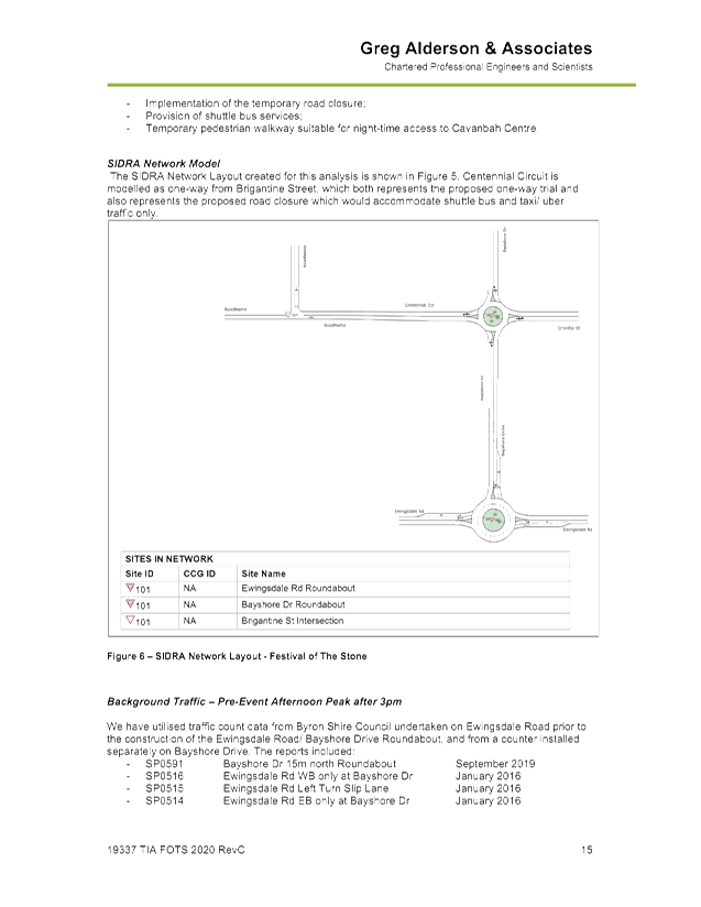
Local Traffic Committee Meeting 6.1
Regulatory Matters
Report No. 6.1 Give Way Sign and Linemarking - McGettigans Lane and Ewingsdale Rd,
BYRON BAY
File No: I2019/2057
Summary
Council recently resealed the full length of McGettigans
Lane, Ewingsdale and installed associated line marking, except at the
intersection of McGettigans Lane / Ewingsdale Road. Refer to figure 1
below for the location of McGettigans Lane.
It is now proposed to also install a new give way sign and
associated line marking at the intersection of McGettigans Lane / Ewingsdale
Road. Currently there is no approved signage at this intersection.
This report seeks to obtain LTC support for the installation
of a new give way sign and line markings.
Background
The figures below are provided to show the existing and
proposed site conditions.
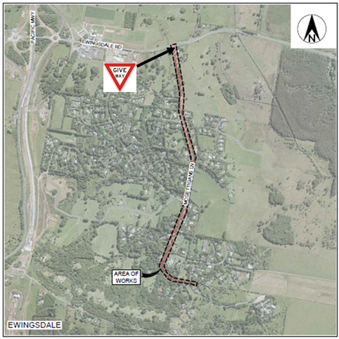
Figure 1
– McGettigans Lane locality plan.
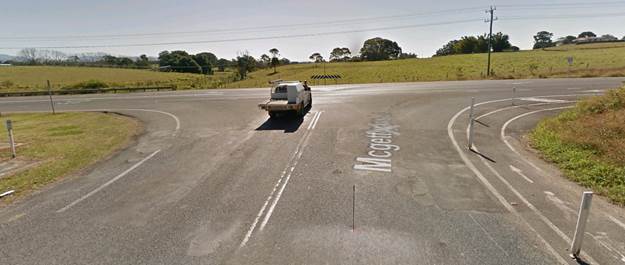
Figure 2 – McGettigans Lane / Ewingsdale Rd
intersection, Google Street View 2018.
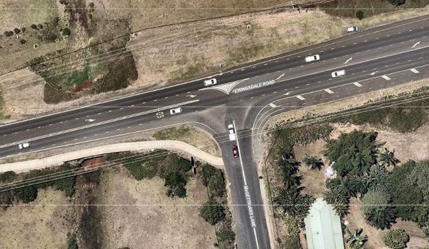
Figure 3 – McGettigans Lane / Ewingsdale Rd
intersection showing the existing Seagull type intersection.
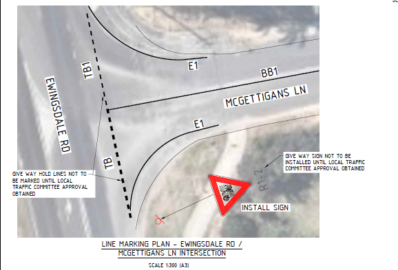
Figure 4 - McGettigans Lane / Ewingsdale Rd intersection
showing proposed Give Way signs / lines.
DISCUSSION
The installation and design of a Give Way sign and line
marking will be in accordance with Austroads Guide to Traffic Management Part
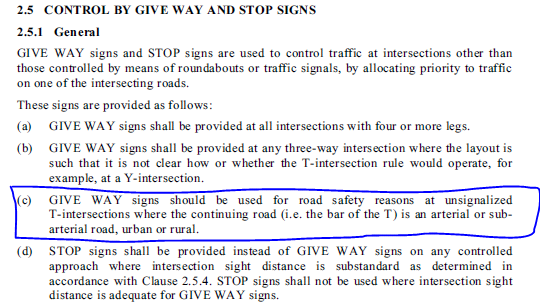
10 and Australian Standards 1742.2 (2009) Section 2.5.1 (c).
An extract from AS1742.2 is shown below. The section circled
in blue indicates the justification adopted a give way intersection.
|
RECOMMENDATION:
That Council support the installation of a Give
Way sign and line marking at the intersection of McGettigans Lane and
Ewingsdale Road subject to the signage and linemarking being designed and
installed in accordance with AS1742.2 and Austroads Guide to Traffic
Management Part 10 requirements.
|
Local Traffic Committee Meeting 6.2
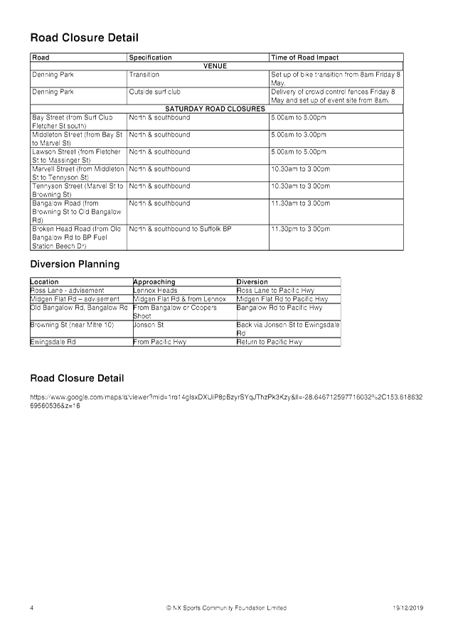
Report No. 6.2 Events - Byron Bay Triathlon 2020 - Traffic Management
File No: I2019/2149
Summary
Council has received an event
application for the 2020 Byron Bay Triathlon to be held on Saturday 9th
May 2020. The event organisers are seeking support for the proposed road
closures.
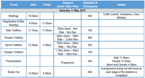
Background
This event has been running for a
number of years and the 2020 event proposes the same courses for running and
cycling that have been adopted for the 2018 and 2019 events.
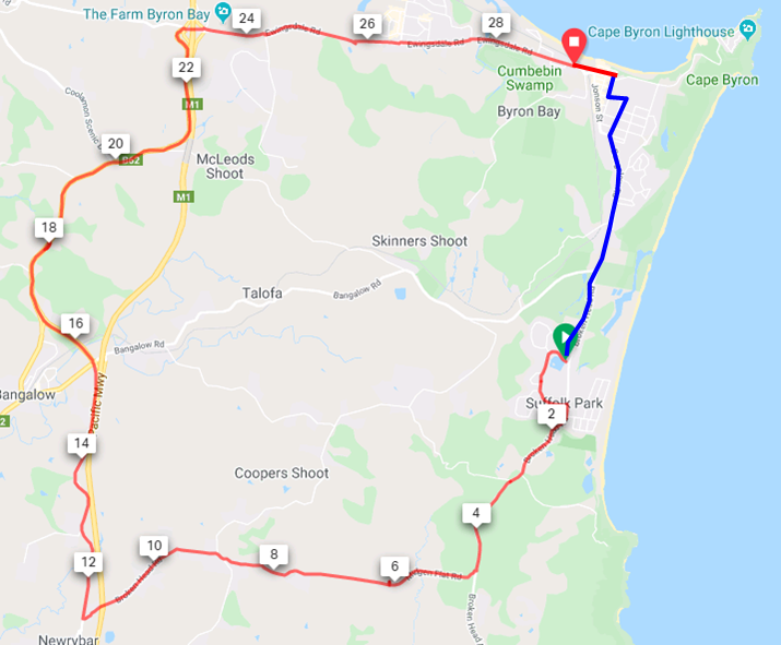
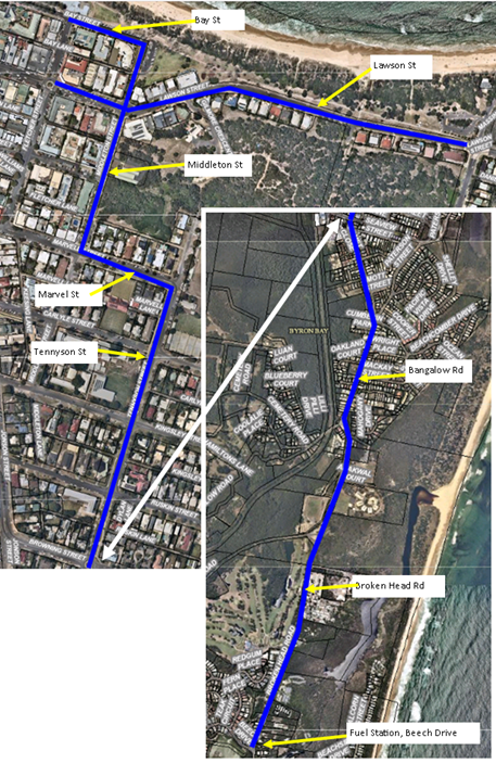
The map below shows the proposed “Olympic”
route for the cycle leg, shown by the blue and red lines. The shorter
kids and sprint events cycle only along the blue line, from the beach to
Suffolk Park and back.
The map below shows the proposed
running route for 2020 which is the same as 2019 and 2018.
The table below presents the timing of the event.
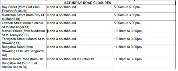
Based on the above routes and event time table the following
road closures are proposed. It is noted these times are slightly different to
the 2019 event in they propose to start ½ hour earlier than the 2019
event.
The above road closures are illustrated in the map below.
COUNCIL IMPLICATIONS
§ Budget/Financial
The event organisers are to be
invoiced for the relevant Approval of Road Events pursuant to s144 of the Roads
Act fee as per the Fees & Charges 2019/20.
§ Asset Management
N/A
§ Policy or Regulation
Regulatory traffic signage
associated with the TCP as delegated to council for authorisation in
conjunction with NSW Road Rules.
§ Consultation
After the 2019 event
the applicant undertook a post event review with key stakeholders. The 2020
event has been adopted taking into account feedback from these stakeholders.
§ Legal and Risk Management
A risk assessment is to be
undertaken as part of the Community & Transit Management Plan.
|
RECOMMENDATION:
1. That council endorse the Byron Bay Triathlon to be
held on Saturday 9th May 2020, which includes the temporary road
closures below:
Bay Street (from Fletcher St to Middleton St) 5am to
5pm
Middleton St (from Bay St to Marvel St) 5am to 3pm
Lawson St (from Fletcher St to Massinger St) 5am to 5pm
Marvell St (from Middleton St to Tennyson St) 10:30am
to 3pm
Tennyson St (Marvel St to Browning St) 10:30am to 3pm
Bangalow Rd (from Browning St to Old Bangalow Rd)
11:30am to 3pm
Broken Head Rd (Old Bangalow Rd to Beech Dr) 11:30am to
3pm
2. That the approval provided in Part 1 is subject to:-
a) Separate approvals by NSW
Police and RMS being obtained, as required;
b) The development of a
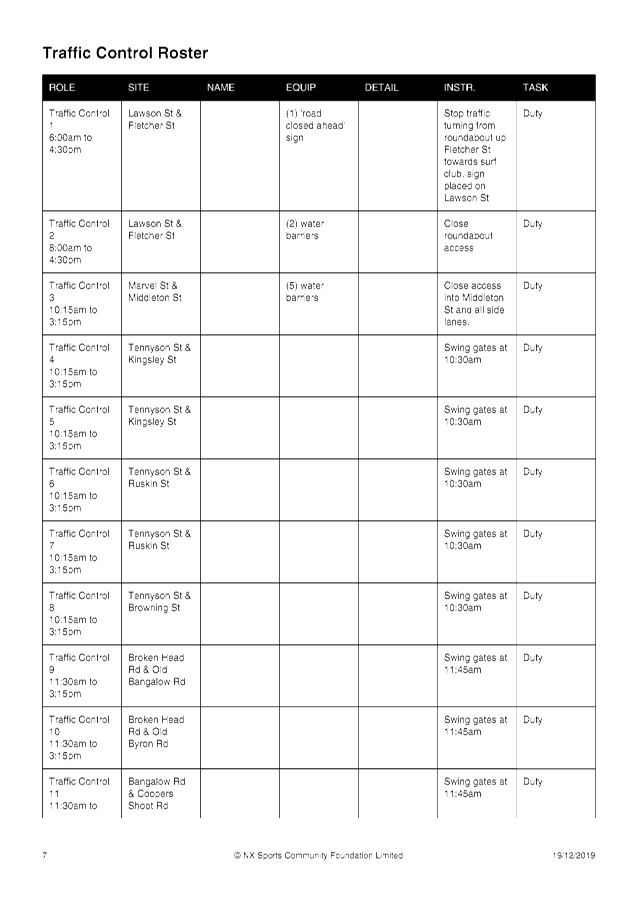
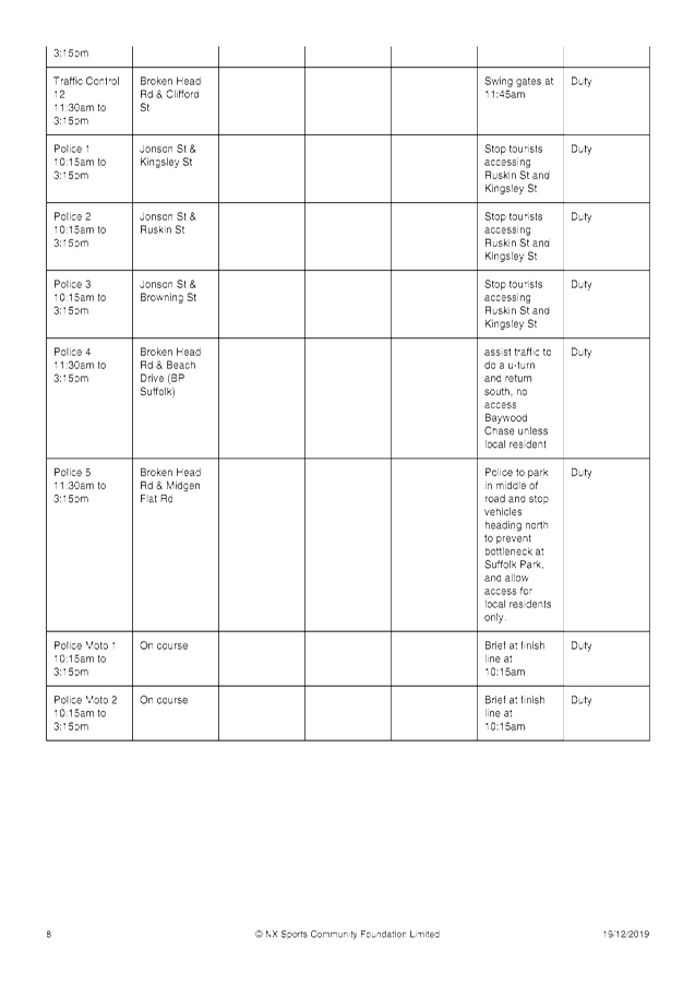
Traffic Management Plan and Traffic Control Plans for the 2020 event by those
with relevant and current RMS accreditation;
c) The Traffic Control Plan
being implemented by those with relevant and current RMS accreditation;
d) The impact of the event
be advertised, and charged at cost to the organisers, via a notice in the
local weekly paper a minimum of one week prior to the operational impacts
taking effect, noting it must include the event name, specifics of any
traffic impacts or road closures and times, alternative route arrangements,
event organiser, a personal contact name and a telephone number for all event
related enquiries or complaints;
e) the event be notified on
Council’s web page;
f) The event organiser:
i) informing community and
businesses that are directly impacted (eg within road closure zones) via
written information which is delivered to the property in a timely manner so
as to document, consider and respond to any concerns raised;
ii) arranging for private
property access and egress affected by the event;
iii) liaising with bus, taxi
and waste operators and ensuring arrangements are made for provision of services
during conduct of the event;
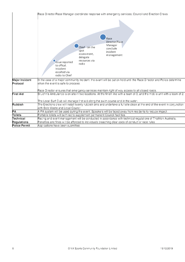
iv) consulting with emergency
services and any identified issues be addressed;
v) holding $20m public
liability insurance cover which is valid for the event;
vi) paying of Council’s
Road Event Application Fee prior to the event.
|
Attachments:
1 Byron Bay
Triathlon Letter to Local Traffic Committee LTC re event 9 May 2020, E2019/93451 ,
page 12⇩ 
Regulatory Matters 6.2 - Attachment 1
Local Traffic Committee Meeting 6.3
Report No. 6.3 Events - Mullum2Bruns Paddle 2020
File No: I2020/43
SUMMARY
Council has received an application, Traffic Management Plan
(TMP) and Traffic Control Plan (TCP) from the Mullum2Bruns Paddle Committee for
the Mullum2Bruns Paddle 2020 to be held Sunday 24 May 2020.
BACKGROUND
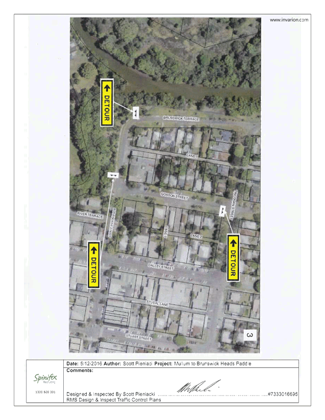
As in past years the Paddle Committee is requesting
permission for temporary one-way traffic of Brunswick Terrace, between Tincogan
Street and Tyagarah Street, Mullumbimby, between 6:30am and 10:00am.
This will allow for the registrations and start of the 2020
Mullum2Bruns Paddle to be held on Sunday 24 May 2020.
Brunswick Terrace is to be one-way in the vicinity adjacent
to the launch and registration area. The direction of traffic flow is shown
below with blue lines.
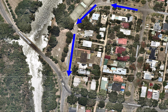
The turn from Tincogan Street into Brunswick Terrace will
have a “no right turn “sign also a “no left turn” into
Brunswick Terrace when coming off the Federation Bridge into Brunswick Terrace.
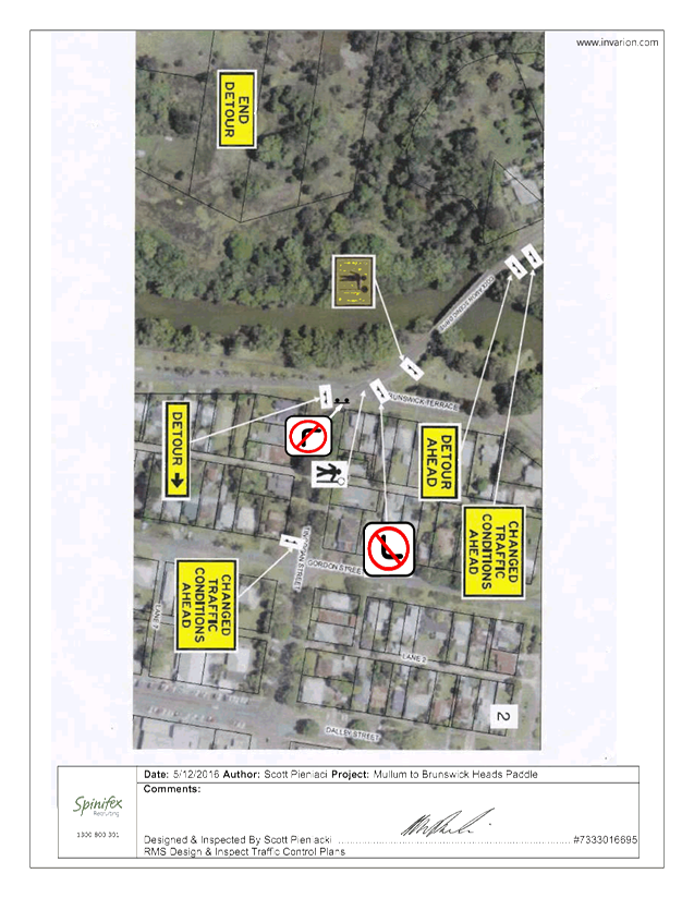
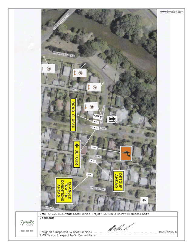
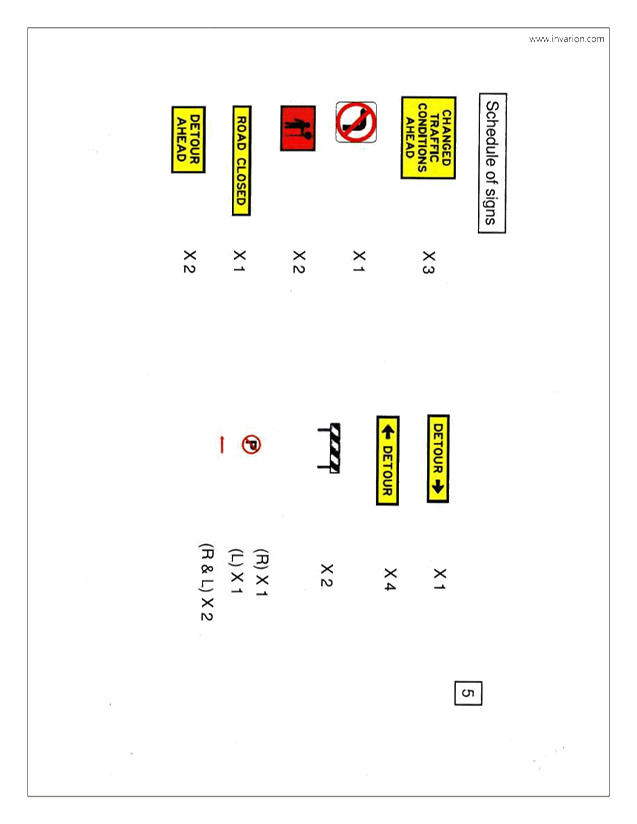
Traffic control with relevant detour signs will be installed
at the approaches to the impacted area. Plus no parking signs along the
one way part of Brunswick Terrace is proposed to control traffic.
Uniformed Marine Rescue personnel will be patrolling the
homes opposite the registration area to ensure that participants are not
parking in front of or across driveways, thereby minimising inconvenience to
the residents.
Participants will be diverted along the southern part of
Brunswick Terrace to the intersection of Brunswick Terrace & Tincogan
Street to enable them to cross to the starting area. The traffic
controllers will hold traffic crossing to the registration zone until there are
spaces for them to unload their craft.
A letter-box drop would be done 2 weeks prior to the event, informing
residents in the surrounding streets of the temporary one-way traffic closures.
COUNCIL IMPLICATIONS
§ Budget/Financial
The event organisers to be
invoiced for the relevant Approval of Road Events pursuant to s144 of the Roads
Act fee as per the Fees & Charges 2019/20.
§ Asset Management
N/A
§ Policy or Regulation
Regulatory traffic signage as delegated
to council for authorisation in conjunction with NSW Road Rules.
§ Consultation
A condition of the
endorsement of this event is that appropriate consultation is undertaken, which
may include:
· Advertising the
impact of the event in the local newspaper and on the Council website.
· Informing
community and business that are directly impacted.
· Liaising with bus
and taxi operators.
· Consulting with
emergency services.
§ Legal and Risk Management
Event organiser is required to
hold $20m public liability insurance cover which is valid for the event.
|
RECOMMENDATION:
1. That Council endorse the Mullum2Bruns Paddle
2020 to be held Sunday 24 May 2020, that includes the temporary road closure
below:
Brunswick Terrace,
Mullumbimby, between Tincogan Street and Tyagarah Street (to become one-way
traffic), between 06:30am and 10:00am on Sunday 24 May 2020.
2. That the approval provided in Part 1 is subject to:
a) the development of a
Traffic Management Plan and Traffic Control Plan(s) for the 2020 event by
those with relevant and current RMS accreditation;
b) the Traffic Control Plan
being implemented by those with relevant and current RMS accreditation;
c) that the impact of the
event be advertised via a notice in the local weekly paper a minimum of one
week prior to the operational impacts taking effect, noting it must include
the event name, specifics of any traffic impacts or road closures and times,
alternative route arrangements, event organiser, a personal contact name and
a telephone number for all event related enquiries or complaints;
d) the event be notified on
Council’s webpage;
e) the event organiser:
i) undertake consultation
with community and affected businesses including adequate response/action to
any raised concerns;
ii) undertake consultation
with emergency services and any identified issues addressed;
iii) holding $20m public
liability insurance cover which is valid for the event;
iv) paying Council’s
Road Event Application Fee prior to the event.
v) Undertake a debrief
within two weeks of the event involving event staff, Police (if they had
incidents) and traffic controllers. A debrief report is to be submitted to
Council with any future event application.
|
Attachments:
1 Event info
- Mullum2Bruns Paddle - 24 May 2020 - traffic control plans, E2020/2760 , page 26⇩ 
2 Event info
- Mullum2Bruns Paddle - 24 May 2020 - Request Permission Road Closures, E2020/2768 ,
page 31⇩ 
Regulatory Matters 6.3 - Attachment 1

Regulatory Matters 6.3 - Attachment 2

 Beneficiaries

Byron Shire Council
Local Traffic Committee
MULLUMBIMBY NSW 2484
20 December 2019
cc:
events@byron.nsw.gov.au
Re: Mullum2Bruns Paddle to be held
Sunday 24 May 2020
As in past years the
paddle committee is requesting permission for temporary one-way traffic in the
northern part of Brunswick Terrace between Tincogan & Tyagarah Streets,
Mullumbimby between the hours 6:30am – 10am to allow for the registrations
and start of the 2020 Mullum2Bruns Paddle to be held on Sunday 24 May 2020.
The turn from Tincogan
Street into Brunswick Terrace will have a “no right turn “sign also
a “no left turn” into Brunswick Terrace when coming off the
Federation Bridge into Brunswick Terrace.
We intend on employing
Spinifex traffic controllers to do our traffic control. Uniformed Marine
Rescue personnel will be patrolling the homes opposite the registration area to
ensure that participants are not parking in front of or across driveways, thereby
minimising inconvenience to the residents.
Participants will be
diverted along the southern part of Brunswick Terrace to the intersection of
Brunswick Terrace & Tincogan Street to enable them to cross to the starting
area. The traffic controllers will hold traffic crossing to the registration
zone until there are spaces for them to unload their craft.
A letter box drop will be
done 2 weeks prior to the event informing residents in the surrounding streets
of the temporary one way traffic closures.
We are applying for this
permission early so it goes to the earliest Local Traffic Committee meeting as
we need written permission from Byron Shire Council early to enable us to
include same in application for Insurance, Marine Parks, RMS etc.
Please do not hesitate to
contact me if you require any further information.
Yours
sincerely
Jackie
Irwin
Mullum2Bruns
Paddle Coordinator 2019
For The Mullum2Bruns Paddle Committee
jackie.irwin83@gmail.com
0413
024 984
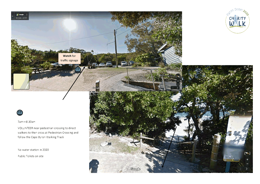
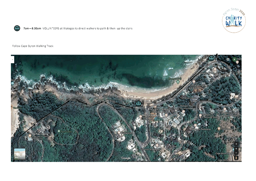
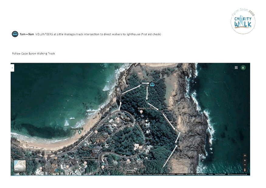
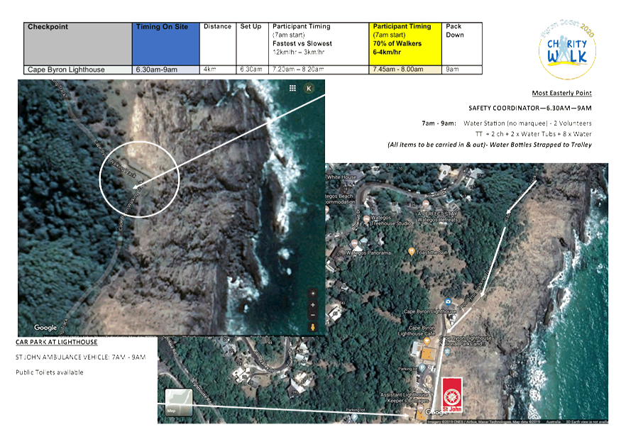
Local Traffic Committee Meeting 6.4
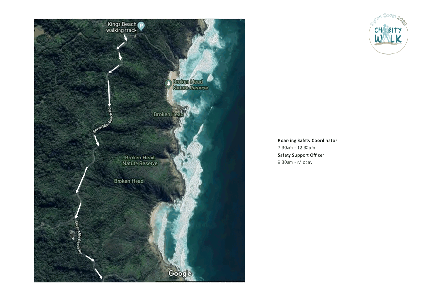
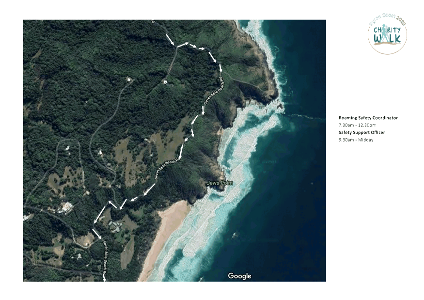
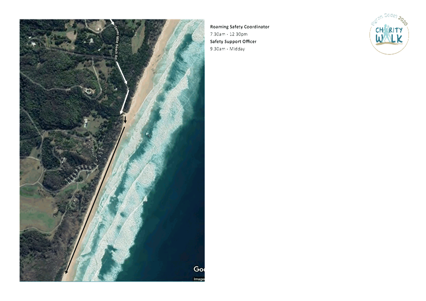
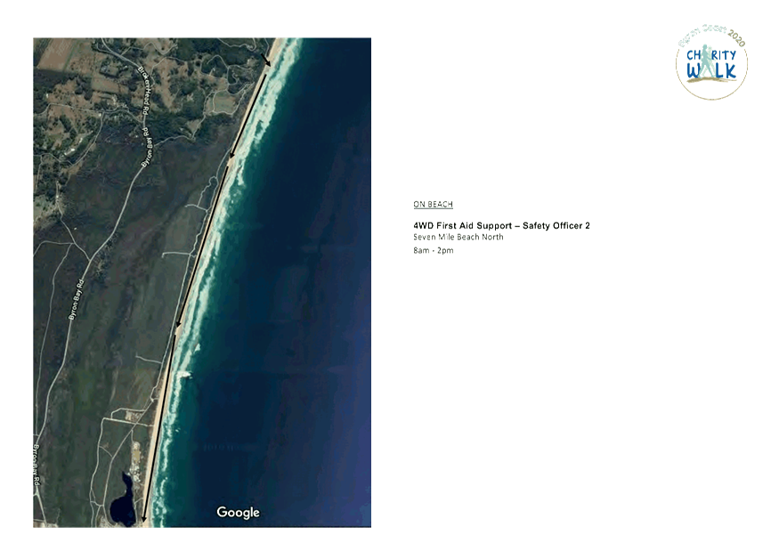
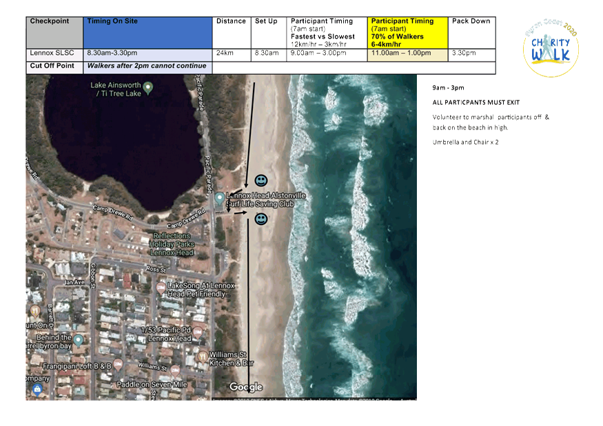
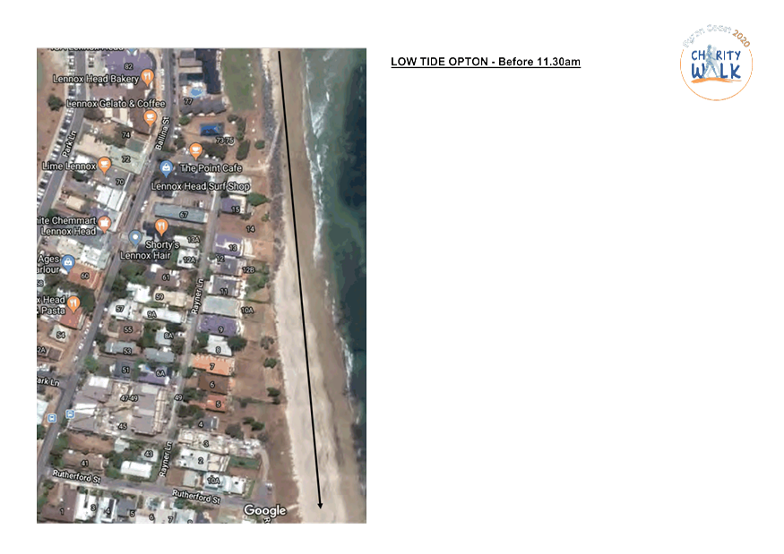
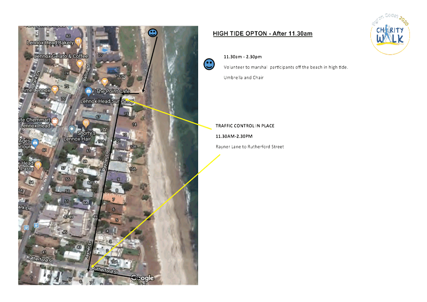
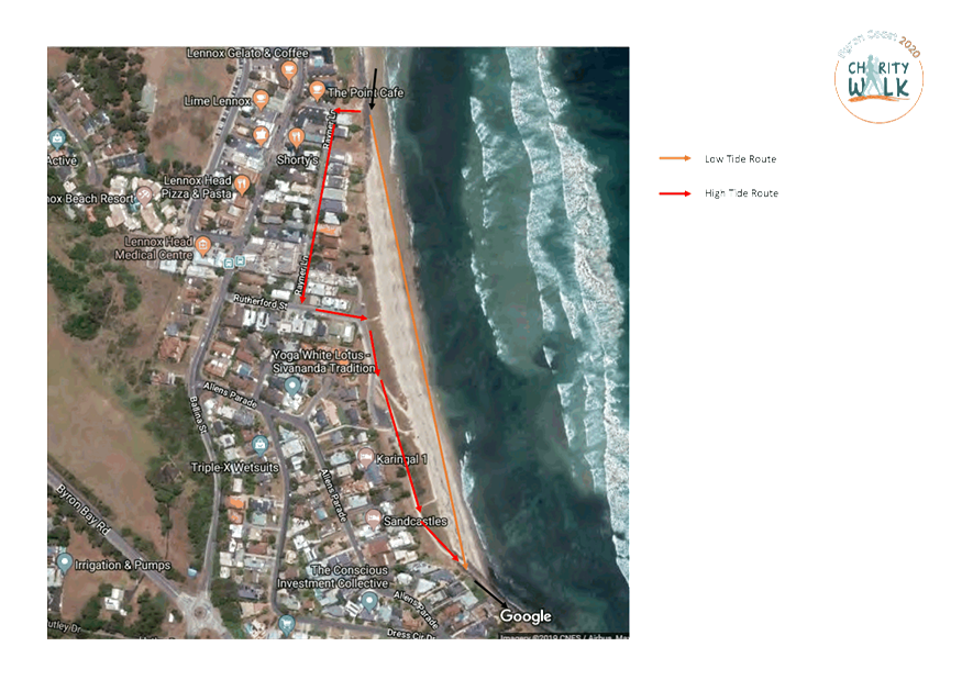
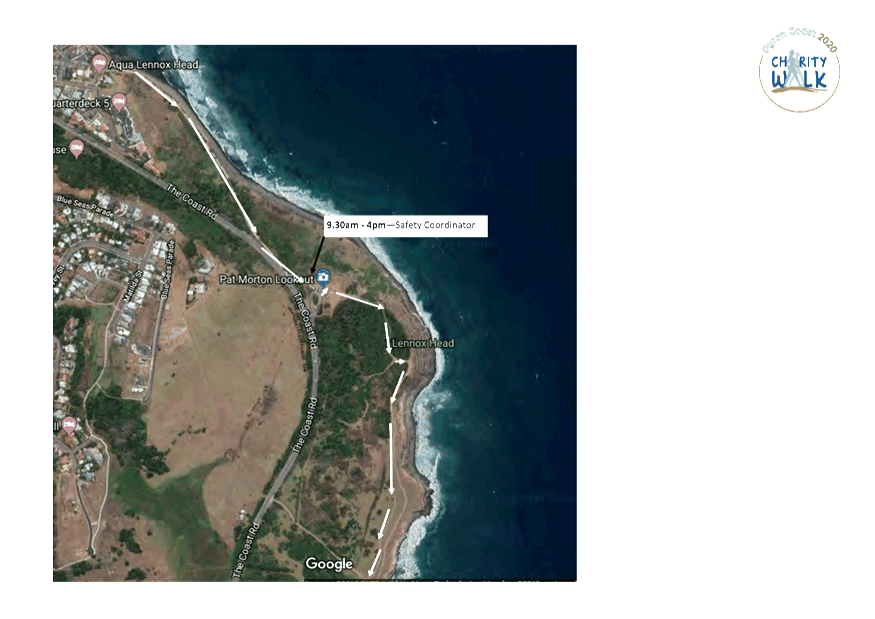
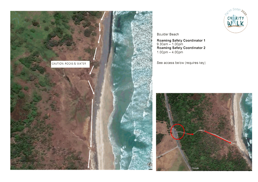
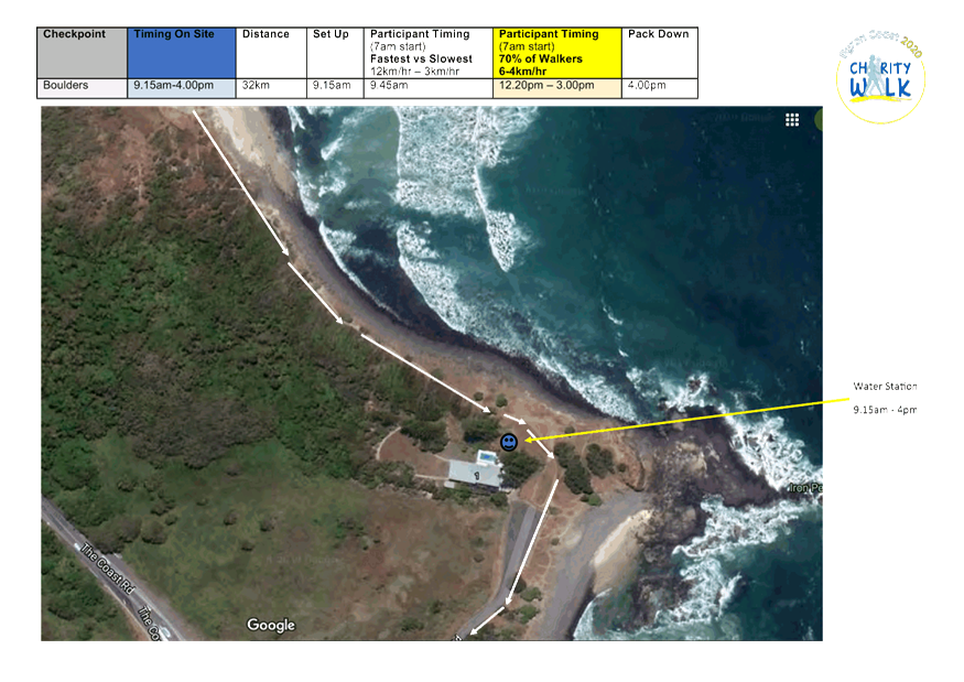
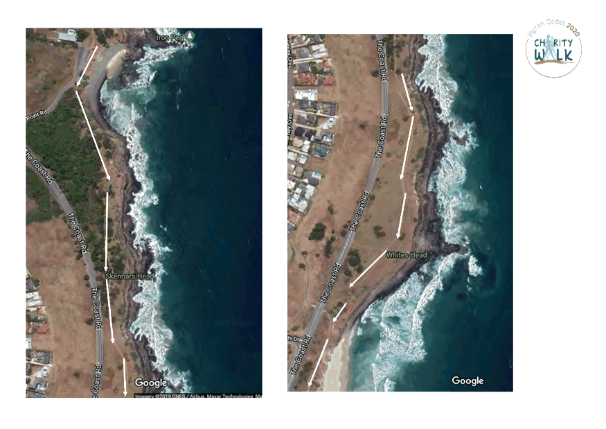
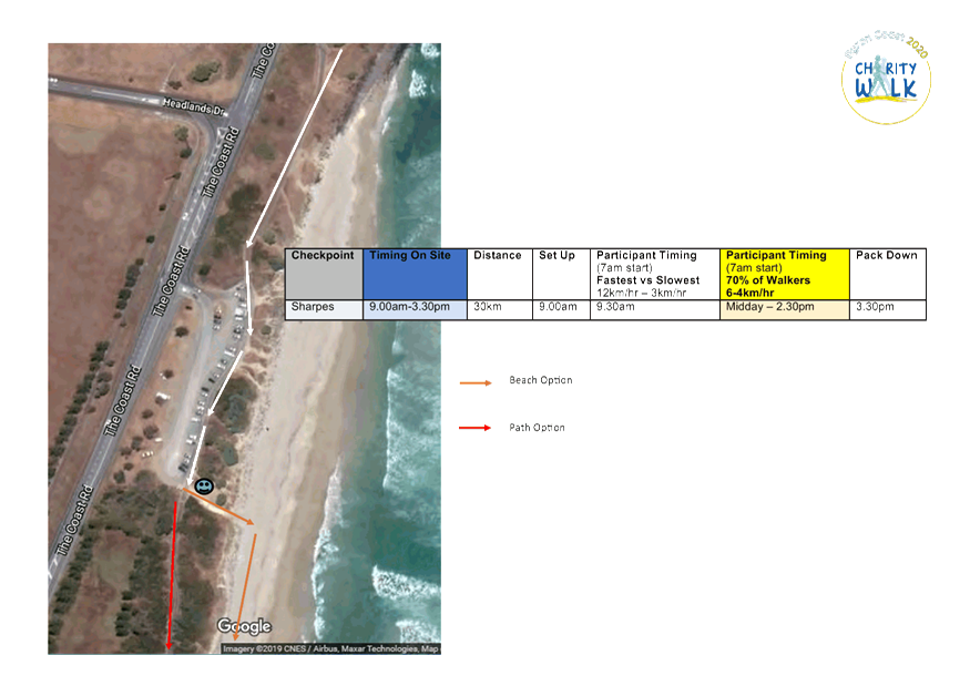
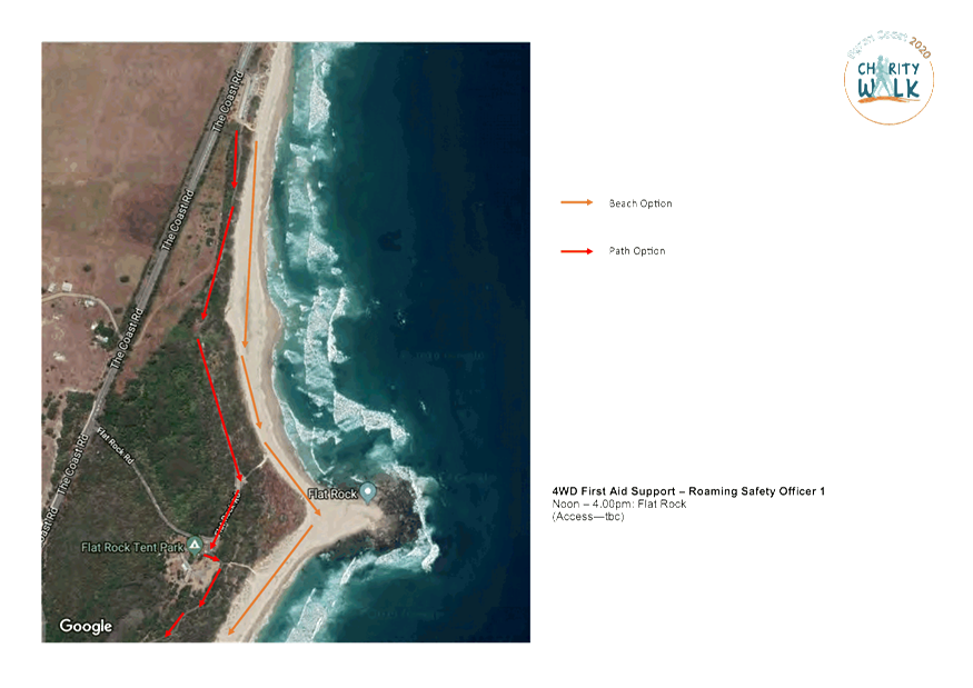
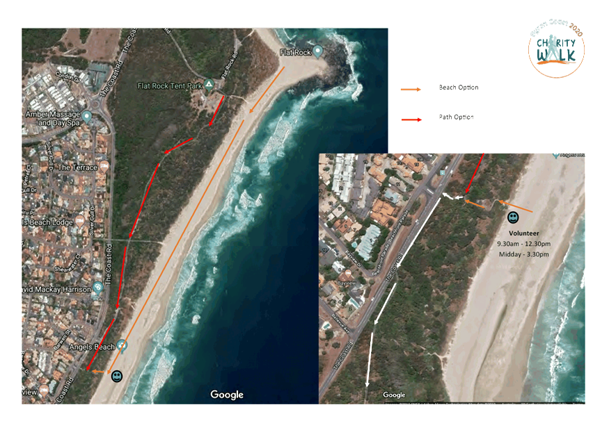
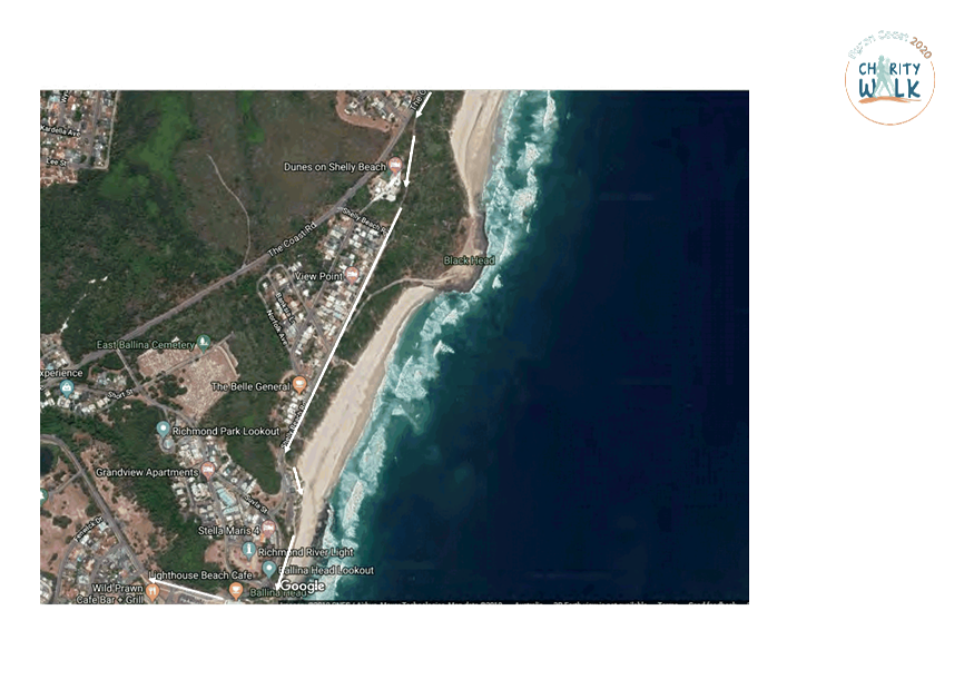
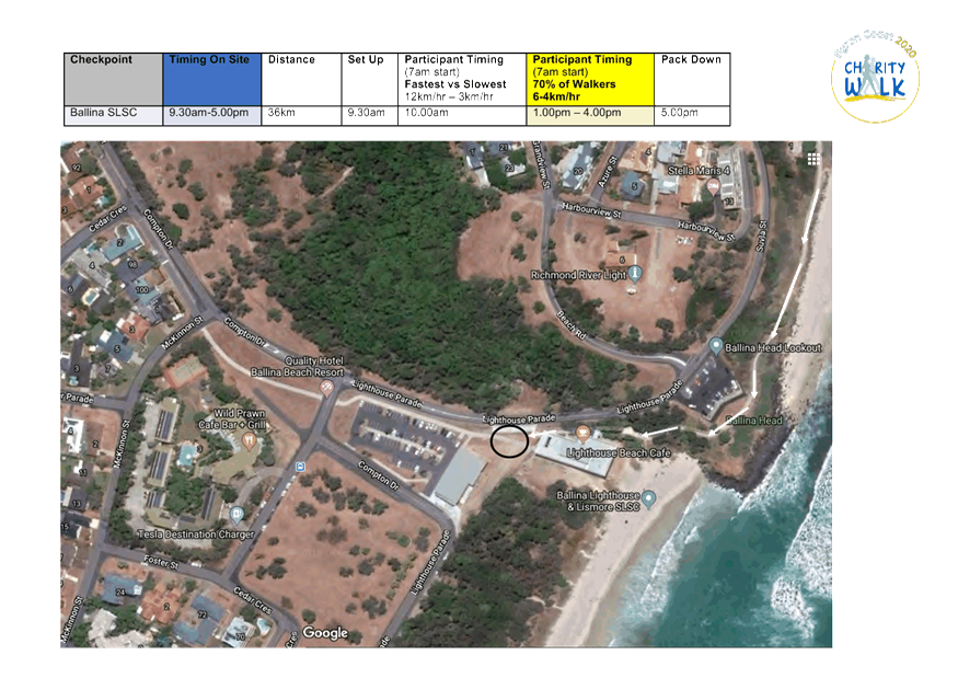
Report No. 6.4 Events - Byron Coast Charity Walk 30 May 2020
File No: I2020/45
The 2020 Byron Coast Charity Walk will be held on Saturday
30 May 2020 from 6.00am – 6.00pm and is the 9th consecutive
year for the Charity Walk. Organisers anticipate 1,600 to 1,800
participants (capped at 2,000 attendees).
For 2020 the event organisers are not closing roads, they
will remain open with participants directed by Traffic Controllers and Traffic
Control Plans.
The event was previously called the Ballina to Byron Bay
Coastal Charity Walk, and is still in aid of the Westpac Rescue Helicopter.
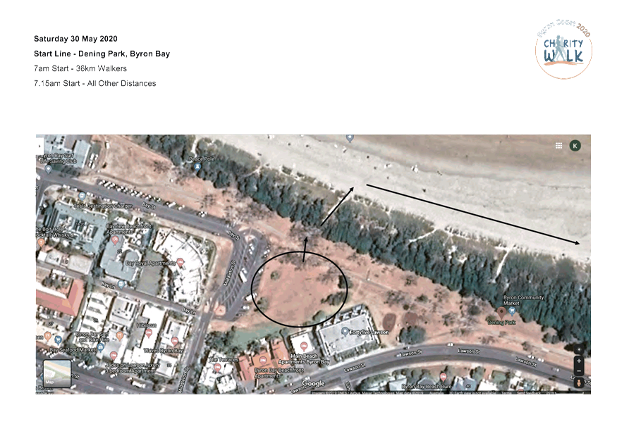
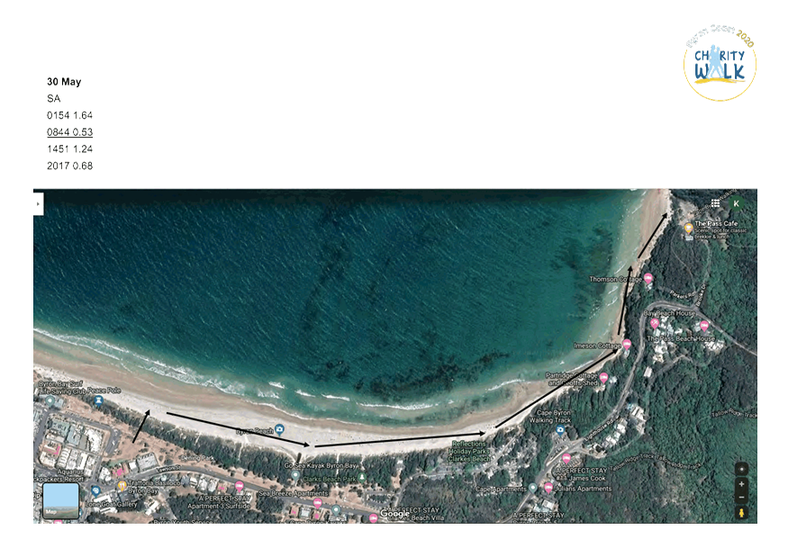
This year the walking route has been reversed: starting in Dening Park, Byron
and following the coastline south to Ballina SLSC, a total distance of 36km.
The specific route within Byron can be summarised as:
· Start at Dening
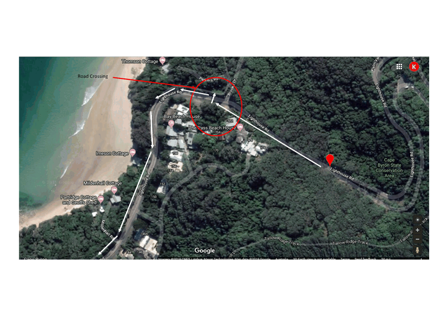
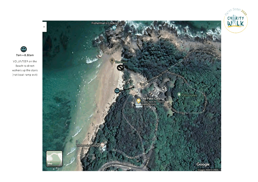
Park, Byron and head along Main Beach and Clarkes Beach to The Pass;
· Along the Cape
Byron Walking Track (NPWS) to Marine Parade at Wategos;
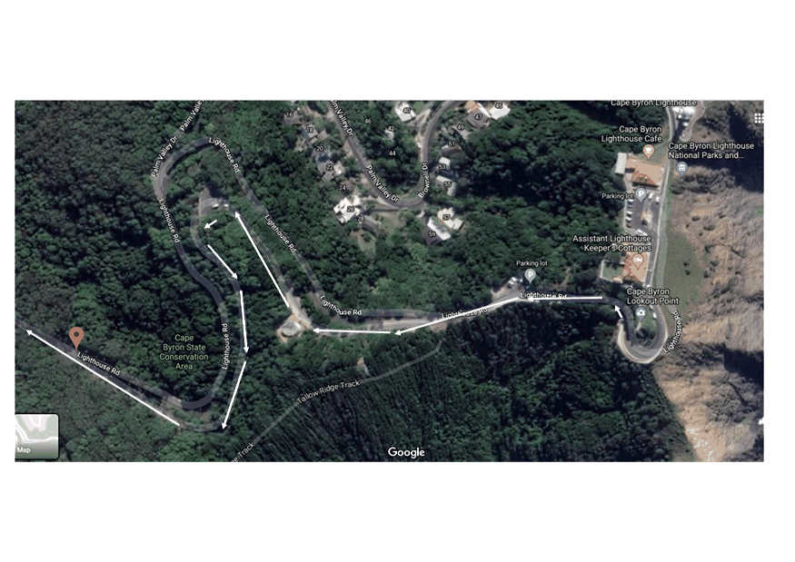
· Along Cape Byron
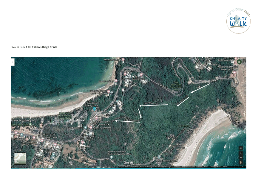
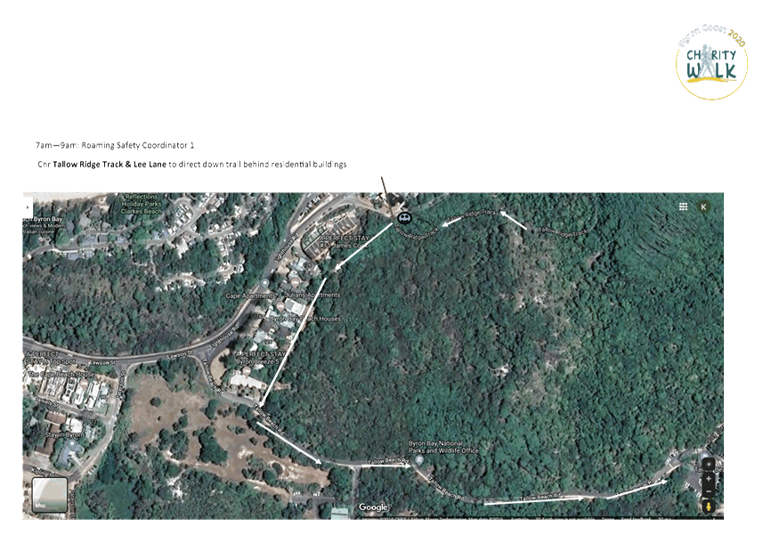
Walking Track (NPWS) around the Lighthouse and Tallow Ridge Track to Lee Lane.
· Along trail behind
residential buildings to Tallow Beach Road;
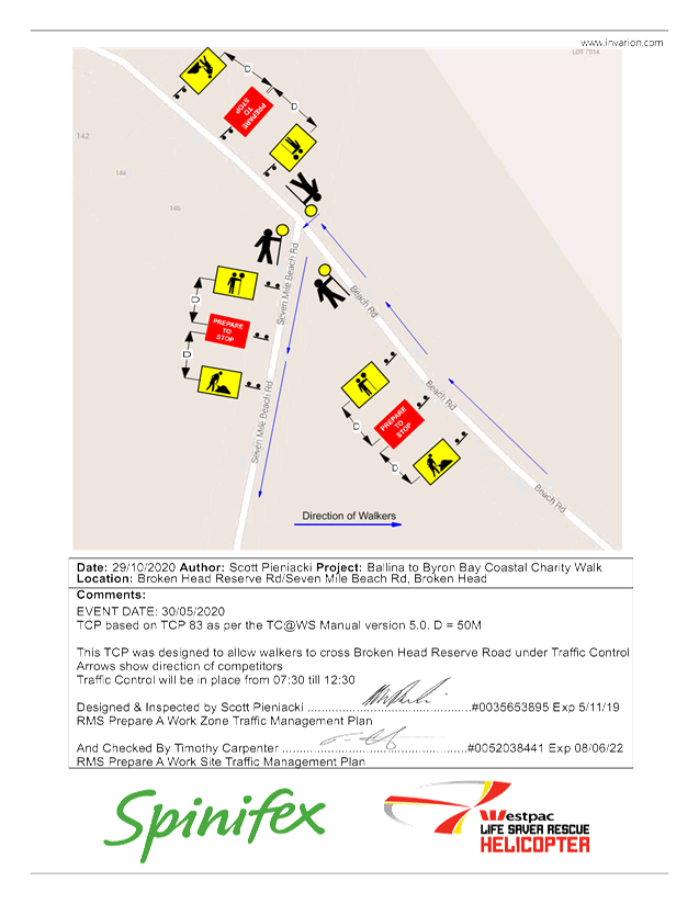
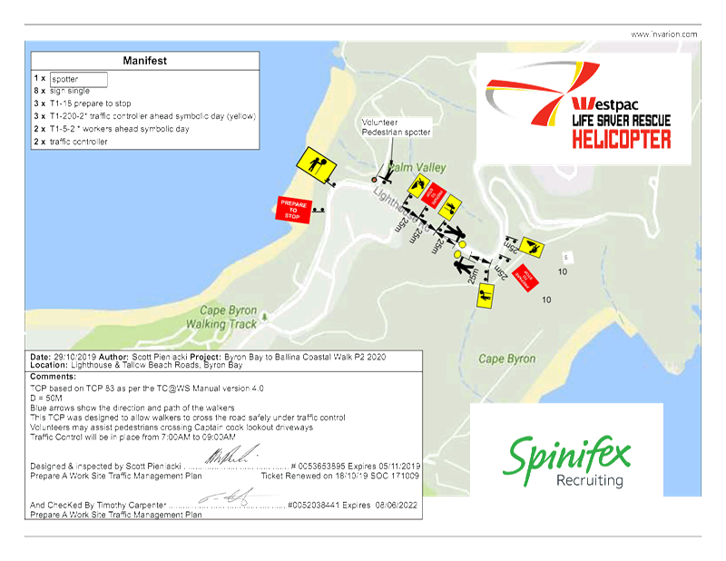
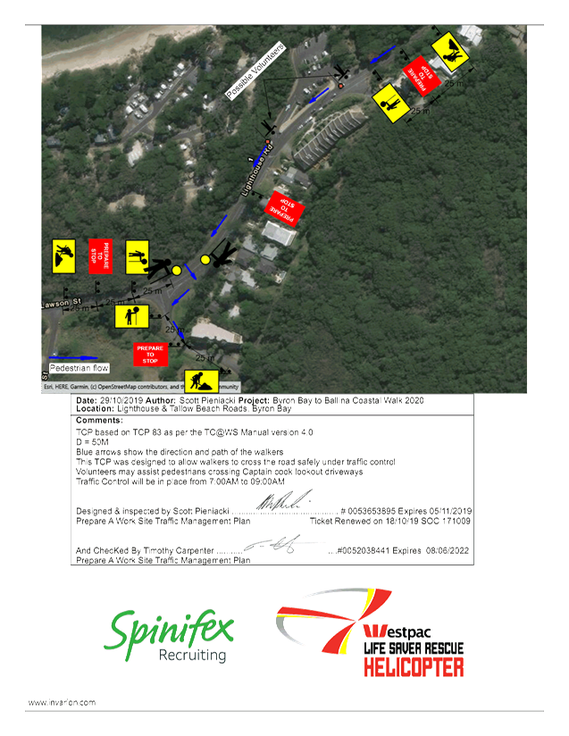
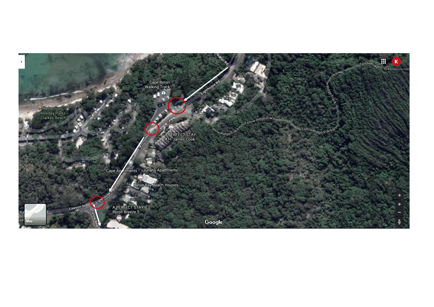
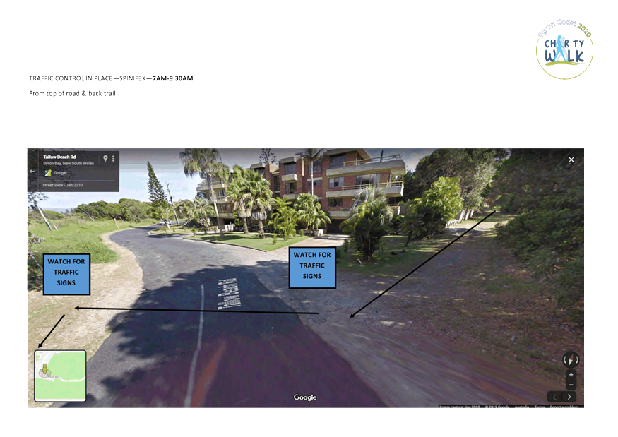
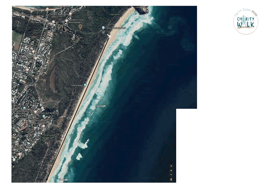
· Traffic
controllers with signage are proposed at the location where walkers enter
Tallow Beach Road – refer to Figure 1 below;
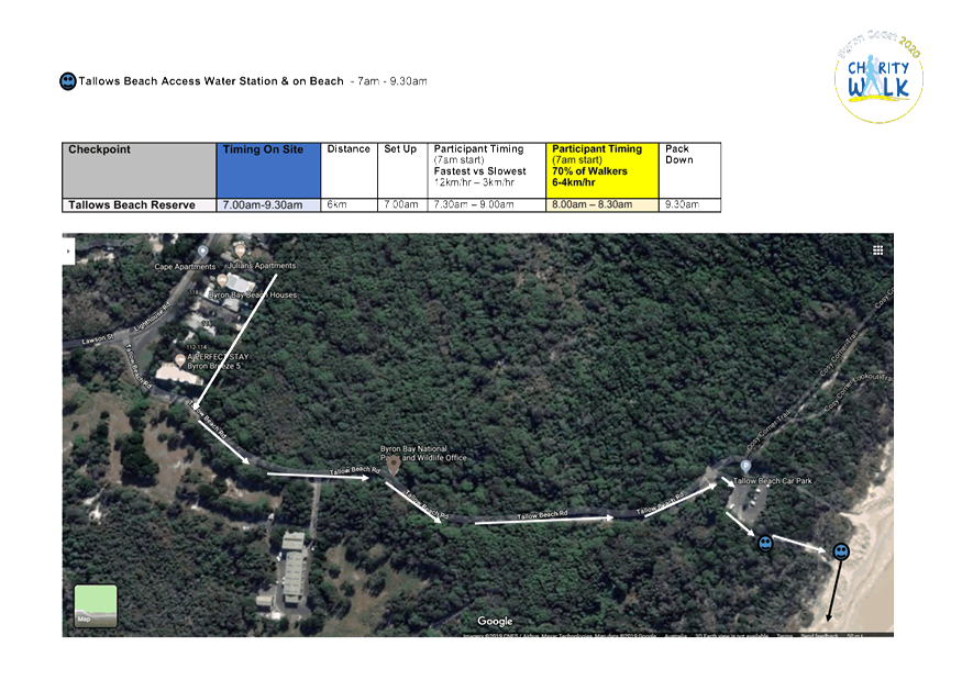
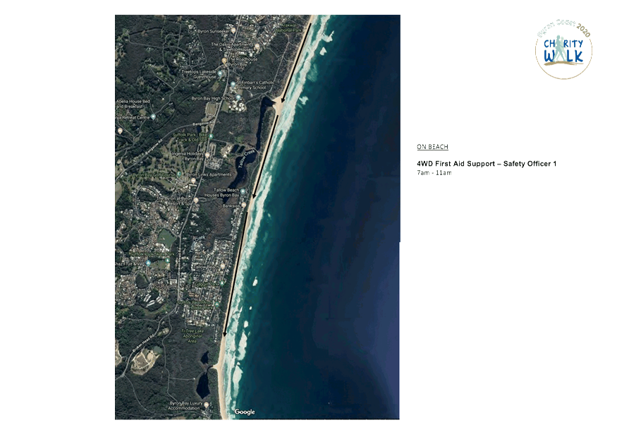
· Along Tallow Beach
Road to Tallows Beach (via carpark access);
· Along Tallows
Beach and Suffolk Park Beach to Broken Head;
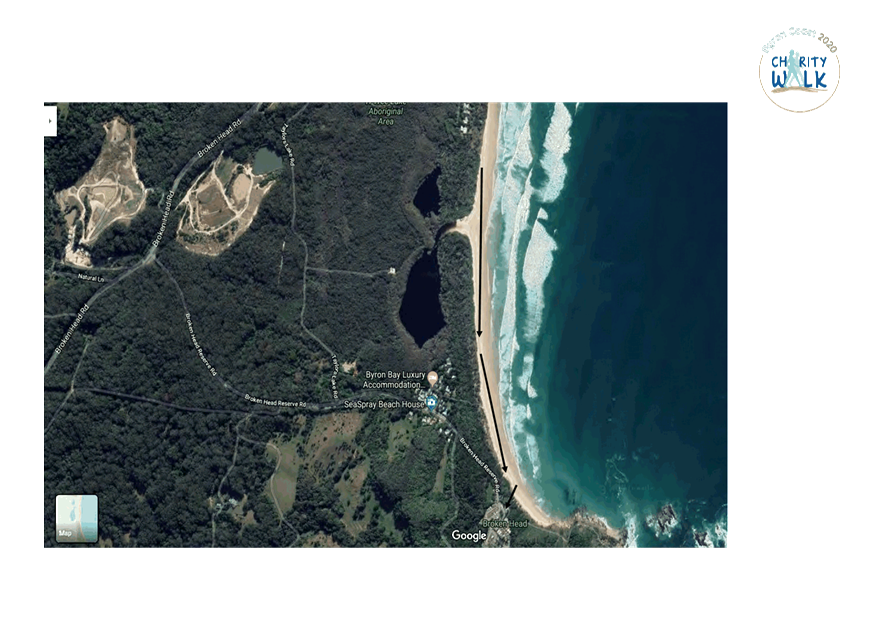
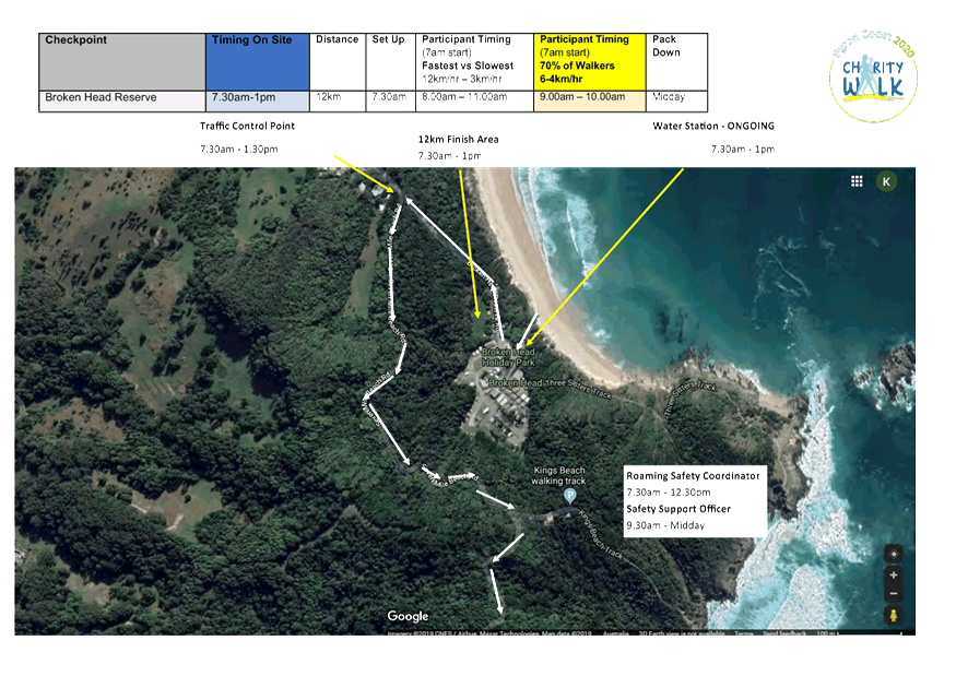
· Depart beach via
carpark access and follow Broken Head Reserve Road to the intersection of Seven
Mile Beach Road;
· Traffic
Controllers are proposed at this intersection with signage – see figure 2
below;
· Along Seven Mile
Beach Road then onto Seven Mile Beach, heading south along the beach into
Ballina Shire.
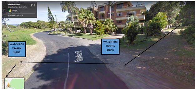
Figure 1 –Traffic control proposed to manage
pedestrains crossing Tallow Beach Road.
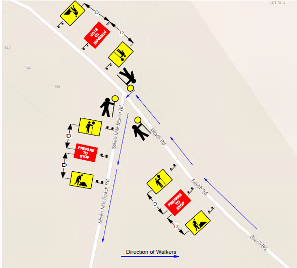
Figure 2 – proposed TCP for the Seven Mile Beach Rd /
Beach Rd intersection
|
RECOMMENDATION:
1. That Council support the
Westpac Life Saver Rescue Helicopter fundraiser, Byron Coast Charity Walk, to
be held Saturday 30 May 2020.
2. That Council support in
Part 1 is subject to:
a. The development of a
Traffic Management Plan and Traffic Control Plan(s) for the 2020 event by
those with relevant and current RMS accreditation. The Traffic Control
Plan(s) and Traffic Management Plan is to include, but is not limited to, the
following:
b. signage, which specifies
the date, hours and nature of the event, be positioned at the entrance and
exit of Seven Mile Beach Road one week prior to the event;
c. on the day of the event,
at 500m intervals, and facing both directions of travel, signs advising of
“ Special Event – Charity Walk Ahead” (or similar) are
installed prior, and removed after, the event occurs; and
d. a safety induction for
participants advising of hazards be provided.
e. Implementation of the
Traffic Management Plan and Traffic Control Plans as designed by those with
appropriate accreditation and implemented by people with appropriate
accreditation, including traffic controllers.
f. That the impact of the
event be advertised via a notice in the local weekly paper a minimum of one
week prior to the operational impacts taking effect, noting it must include
the event name, specifics of any traffic impacts or road closures and times,
alternative route arrangements, event organiser, a personal contact name and
a telephone number for all event related enquiries or complaints.
g. The event is notified on
Council’s webpage.
h. The event organiser:
i) Undertake
consultation with affected community and businesses including adequate
response/action to any raised concerns.
ii) Undertake
consultation with emergency services and any identified issues addressed.
iii) Holding
$20m public liability insurance cover which is valid for the event.
iv) Paying
Council’s Road Event Application Fee prior to the event.
|
Attachments:
1 Event
application - Byron Coast Coastal Charity Walk 2020 - combined TCPs, E2020/2984 , page 35⇩ 
2 42.2019.49.1
Event application - Byron Coast Charity Walk 2020 - route map, E2020/3037 , page 41⇩
Regulatory Matters 6.4 - Attachment 1
Regulatory Matters 6.4 - Attachment 2
Local Traffic Committee Meeting 7.1
Development Applications
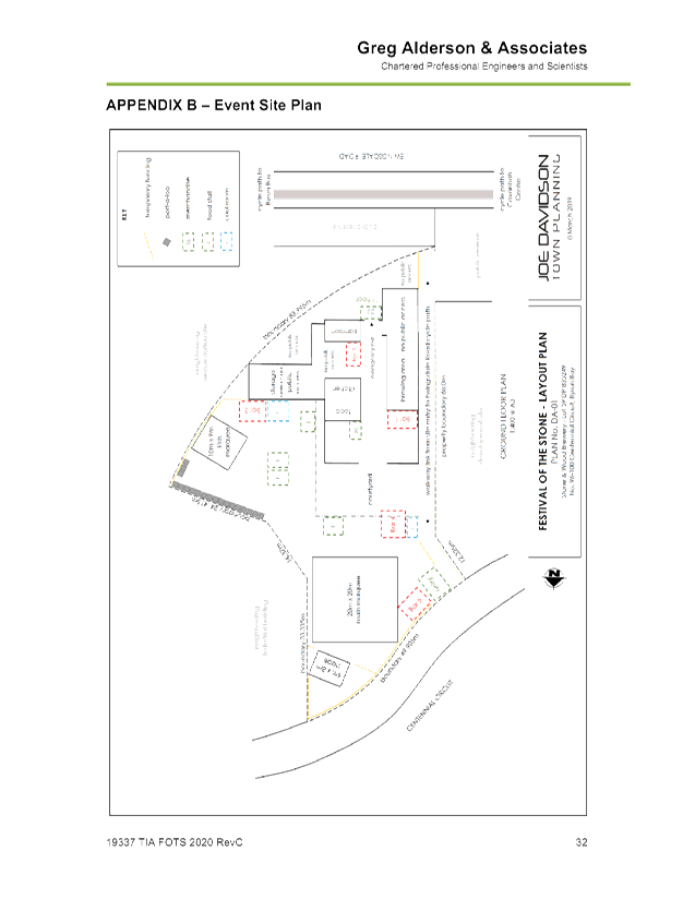
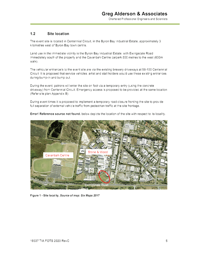
Report No. 7.1 Festival of the Stone 2020-2022
Assessment Officer Ben Grant/ Renan Solatan
File No: I2020/2
SUMMARY
Development application (DA) 10.2019.154.1 seeks approval to
hold a one-day festival over three consecutive years from 2020 to 2022 at the
new Stone and Wood micro-brewery site in the Byron Arts and Industrial Estate.
Up to 2,000 persons are expected to attend each event
inclusive of patrons and staff. Food and entertainment will be provided
along with alcoholic beverages in accordance with liquor licencing
requirements. The development application proposes temporary closure of
Centennial Avenue under traffic control as well as temporary signage in the
public road reserve along Centennial Avenue and Ewingsdale Road.
The DA and associated traffic management plan (TMP) was
previously considered at the meeting of the Local Traffic Committee (LTC) on 30
July 2019. The committee was not supportive of the proposal during this
meeting and made a number of comments in relation to pedestrian safety, hostile
vehicle mitigation, and access and drop off points. LTC recommended that an
amended TMP be prepared to suitably address the committee’s comments.
The applicant has revised the TMP in accordance with the
committee’s recommendations and resubmitted to Council for consideration.
Please refer to Attachments 1 and 2.
OFFICER RECOMMENDATION
That Council endorse Festival of the Stone to be held on
Saturday 6 June 2020, Saturday 12 June 2021 and Saturday 11 June 2022 in
accordance with the Local Traffic Committee recommendations.
BACKGROUND
Previous consideration by Local Traffic Committee
At the 30 July 2019 LTC meeting the committee was not
supportive of the proposal and made the following comments:
Police:
· Concerns about pedestrian safety as they leave the event.
Event organisers should consider a shuttle bus.
· The amount of people assembled without a barrier to the
road will require hostile vehicle mitigation strategies.
RMS:
· Concerns about queuing on Bayshore Drive and in turn
Ewingsdale Road. Concerns about the footpath shown on the plan linking
Ewingsdale Road directly to the site is not an actual footpath, crosses a
drain, and may be on private property.
· RMS suggests the drop off/pick up within the private
property of Stone & Wood. RMS would prefer a one year approval.
· Consider measures to create good visual separation between
pedestrians and traffic on Ewingsdale Road, for example flagging/bunting.
· Option to consider on-road drop-off in Centennial Circuit
during one-way trial, provided an area is delineated and there is no on-street
parking.
· Consider closing Centennial Circuit between Brigantine and
Tasman Way with traffic control to accommodate shuttle bus drop-off and
businesses, perhaps allowing taxis and Uber access.
The applicant has prepared an
amended traffic impact assessment and traffic management plan to address the
issues raised by NSW Police and RMS. Please refer to attachments 1 and 2.
Referral to RMS
The amended development
application was referred to RMS in accordance with Clause 101 of State Environmental Planning Policy
(Infrastructure) 2007 –
traffic generating development.
RMS advises:
1. The
Consent Authority should be satisfied that buses will be able to manoeuvre
safely in the heavily pedestrianised areas.
2. It
is requested that consideration be given to controlling any stopping and
parking on Ewingsdale Road during the Events.
3. The
Event organiser must make contact with Roads and Maritime Regional Operations
Section (on 1300 762 376) in the event that delays on Ewingsdale Rd have the
possibility of impacting on the Pacific Motorway, including immediate
notification of all incidents.
4. The
Event organiser is to provide appropriate resources to manage ‘end of
queue management’, including on the Pacific Motorway if required.
5. Any
regulatory signs and devices associated with the event, proposed for placement
on Ewingsdale Road will require the endorsement of the Local Traffic Committee
prior to Council approval. Please refer to A Guide to the Delegation to
Councils for the Regulation of Traffic.
PROPOSAL
Proposed development
The
applicant proposes the following details. DA 10.2019.154.1 seeks
approval to hold a one day festival over three consecutive years from 2020 to
2022 at the new Stone and Wood micro-brewery site in the Byron Arts and
Industrial Estate.
Each event will attract up to
2000 persons inclusive of patrons, volunteers, staff, performers and associated
personnel. Alcoholic beverages from the brewery will be available for
purchase during the event in accordance with liquor licencing
requirements. Temporary bars and food and drink stalls will be operating
throughout the event.
A Traffic Impact Assessment and
Traffic Control plan has been submitted but will need to be amened in
accordance with Council comments under the heading below Key Issues.
Key details
Key elements and details of the
events are as follows:
Event Dates: Saturday
8th June 2020
Saturday
6th June 2021
Saturday
12th June 2022
Operating times: 3.00pm
– 10.00pm
Total Attendees: 2,000
patrons and staff
Entertainment: Food
and Drinks, Family activities (face painting etc.), D.J.’s/Bands
Parking
and traffic arrangements
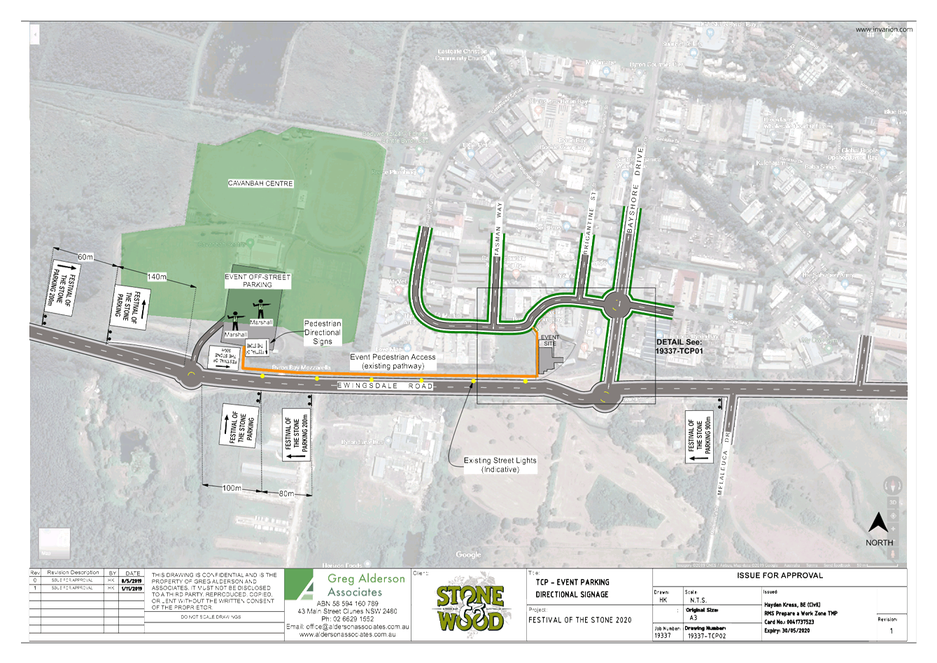
Parking for the event is to be
provided at the Cavanbah Centre (326 spaces) and in the surrounding road
network (200 spaces). Patrons can access the site from the Cavanbah
Centre on foot via a pedestrian walkway connecting to Ewingsdale Road.
Patrons parking at the Cavanbah
Centre will walk to the event using the existing off-road pathway along
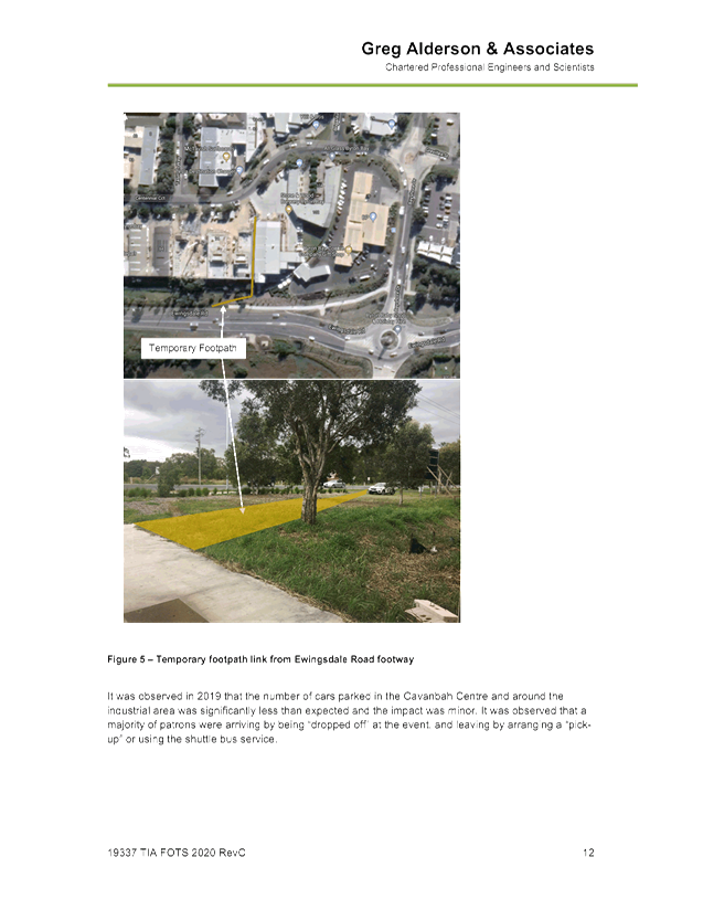
Ewingsdale Road. A temporary path link is proposed for connection to the site
from Ewingsdale Road as depicted in Figure 5 (p. 12) of the attached traffic
impact assessment report. The proposed link crosses a lot owned by Byron
Shire Council. Owners Consent may be required for this temporary work.
Public Transport
Shuttle bus service is being
arranged with local bus operators to provide transport for patrons from Byron
Bay Township to the site and return.
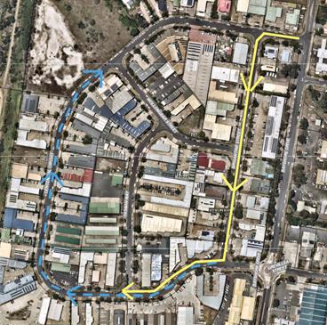
Road
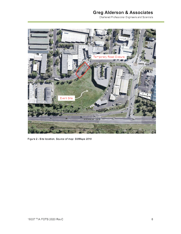
Closure
The TMP
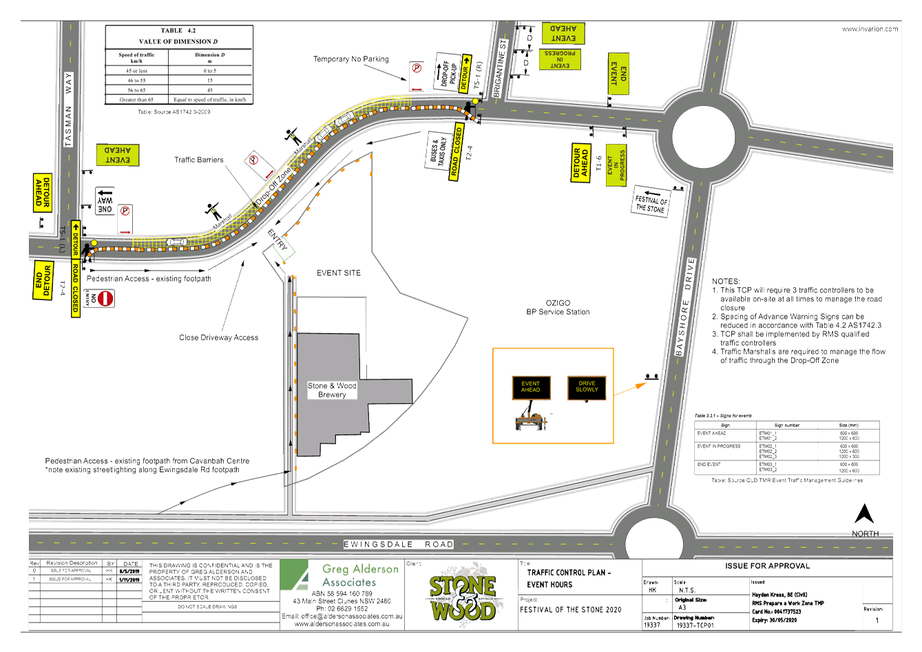
proposes temporary closure of Centennial Circuit between Brigantine Street and
Tasman Way during the event. Access to the road closure is intended to be
provided to shuttle buses and taxis under traffic control. Event marshals will
be provided to assist with managing
pedestrians and vehicle drop-offs at the site frontage.
Please refer to the Traffic Impact Assessment, Traffic
Management Plan and Traffic Control Plan in Attachments 1 and 2.
KEY ISSUES
In
response to the above, council’s Development Engineer expressed concern
over the possibility of vehicles queueing on Ewingsdale
Road and the first section of Bayshore Drive. Therefore, a condition of consent
is recommended that requires all parking and event
drop-off (including shuttle bus) to occur at the Cavanbah Centre, with the
exception of disabled and elderly drop offs which are to occur at the site
frontage.
The following condition of
consent is recommended:
Parking, Drop-off &
Pick-up
· All parking
and vehicular drop-off including shuttle bus, taxi, Uber & other mode of
transportation to for the event shall utilise Cavanbah Centre. The car parking
area in Cavanbah Centre must be maintained during the event and returned to
pre-festival conditions. Any damage to the car parking area shall be repaired
immediately and all cost shall be borne by the consent holder;
· Drop-off
& Pick-up of elderly and people with disability shall be undertaken at the
existing northern access of the site and assisted with event personnel; and
· No drop-off
& pick-up permitted along Centennial Circuit other than elderly and people
with disability
In addition, an amended TCP is
to be prepared for the endorsed routes and submitted to an approved Roads &
Maritime Services accredited person in accordance with the following condition
of consent:
Traffic Control Plan
A traffic control plan for the
endorsed routes shall be prepared by a Roads & Maritime Services accredited
person for the temporary traffic signage layout and vehicle movements to be
used during the erection and removal of signs & barrier within the road
reserve. The traffic control plan shall be submitted to and approved by
Roads & Maritime Services accredited person 24 hours prior to the event.
The consent holder shall forward the approved and Certified Traffic Control
Plan to Council.
The TCP
shall be prepared in accordance with the following:
· All Traffic
Control devices are to conform to AS 1442.2 and 1742.3
· All persons
placing and removing Traffic Control devices are to have current accreditation
from the RMS.
· All roads
are to be barriers and signs removed immediately following the event.
· The event
organisers must provide a Risk Assessment of the event and an emergency
contingency plan. These plans must be inclusive of all traffic flows.
The
following routes are endorsed:-
· Entry into
the event – Ewingsdale Road, Bayshore Drive/Centennial Circuit (north
intersection)
· Exit from
the event site – via Bayshore Drive/Centennial Circuit (north
intersection)
· Entry/Exist
via Cavanbah Centre
Council’s Development Engineers consider the proposal
to be acceptable from an engineering perspective subject to the above
conditions of consent.
The above recommendation to endorse entry and via the
Northern Bayshore Drive / Centennial Circuit intersection is designed to
prevent traffic backing up along Centennial Circuit onto Bayshore Drive.
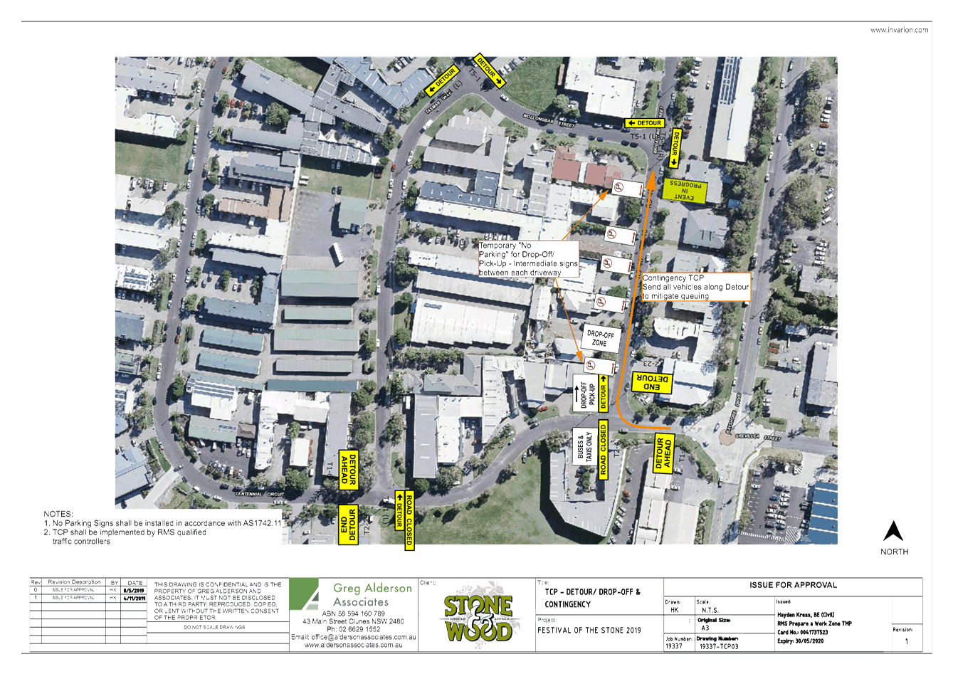
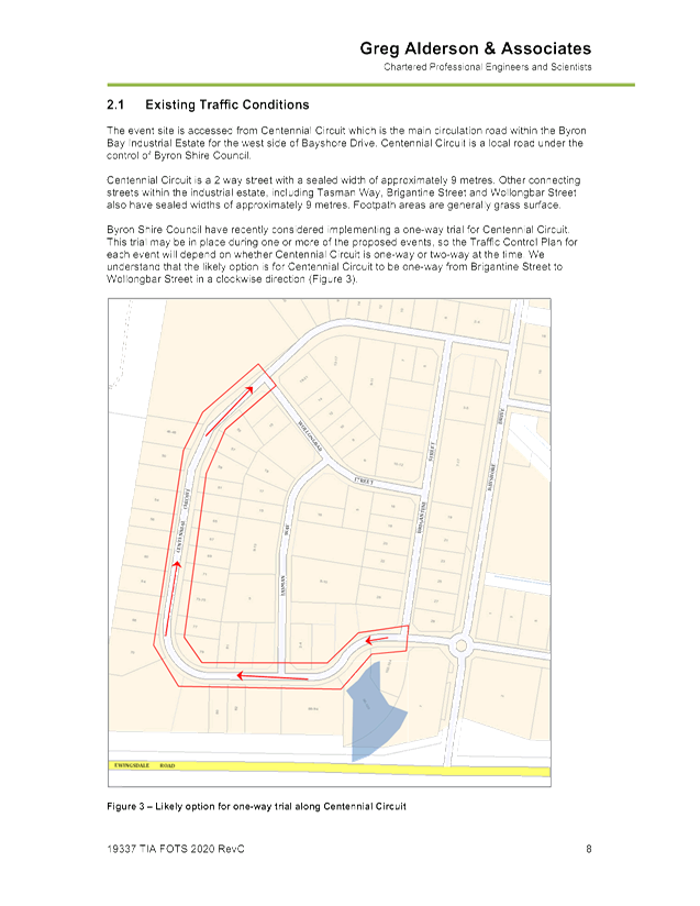
One-Way
Trial, Centennial Circuit
It is noted that Council plans
to undertake a one-way trial for Centennial Circuit. The trial proposes
to make traffic one way from the southern end of Brigantine St, along
Centennial Circuit to Wollongbar St.
This trial will commence within
the next six months. The duration off the trial has not yet been
confirmed but will last for at least 6 months and may result in a permanent
change to Centennial Circuit.
The one way trial is not
expected to conflict with the proposed road closures and traffic management for
this event.
The map below shows the proposed
one way trial direction (in blue) and the direction of shuttle bus movement (in
yellow) do not conflict.
COUNCIL IMPLICATIONS
Budget/Financial
The event organisers will be invoiced the following fees as
appropriate:
- Approval
of Road Events pursuant to s144 of the Roads Act (Advertising of event and
staff time to process), and
- Development
Certification fees – section 138 with fees being the fee applicable as at
the date of payment.
Asset Management
Not applicable.
Policy or Regulation
Delegated to council for authorisation in conjunction with:
- Actions
required to control traffic- Part 8 (Sections 114 to 124) Roads Act, 1993.
- Prescribed
traffic control devices - division 1 of Part 4 (Sections 50 to 55) Road
Transport (Safety and Traffic Management) Act, 1999.
- R5-1-3
Parking (Disable) – NSW Road Rules 203, $541 fine
- R5-400
No Stopping - NSW Road Rules 167, $253 fine
- R5-41
No Parking (specified times) - NSW Road Rules 168, $108 fine.
Consultation
A condition of the endorsement of this event is that
appropriate consultation is undertaken, including:
1. Advertising
the impact of the event in the local newspaper and on the Council website.
2. Notifying
businesses that are directly impacted by the temporary road closure.
3. Liaising
with bus and taxi operators.
4. Consulting
with emergency services.
Legal and Risk Management
If vehicles cause congestion in Centennial Circuit and Bayshore
Drive then this could directly impact in MR545 - Classified Road –
Ewingsdale Road. Appropriate approvals and insurances should be required
as a condition of the endorsement for this event.
|
RECOMMENDATION:
1. That Council endorse the Festival of the Stone to be
held on Saturday 6 June 2020, Saturday 12 June 2021 and Saturday 11 June 2022
in accordance with the Local Traffic Committee recommendations.
2. That the endorsement provided in Part 1 is subject
to:-
a. Separate approvals by NSW
Police and RMS being obtained, as required;
b. The development of a
Traffic Management Plan and Traffic Control Plan(s) for all three of the
events by those with relevant and current RMS accreditation;
c. The Traffic Control Plan,
if required, being implemented by those with relevant and current RMS
accreditation;
d. The Traffic Management
Plan and Traffic Control Plans are to include the following amendments:
i. All parking and vehicular
drop-off including shuttle bus, taxi, Uber & other mode of transportation
for the event shall utilise the Cavanbah Centre. The car parking area in
Cavanbah Centre must be maintained during the event and returned to
pre-festival conditions. Any damage to the car parking area shall be repaired
immediately and all cost shall be borne by the consent holder;
ii. Drop-off & Pick-up of
elderly and people with disability shall be undertaken at the existing
northern access of the site and assisted with event personnel; and
iii. No drop-off &
pick-up permitted along Centennial Circuit other than elderly and people with
disability
iv. Entry into the event is
to be via Ewingsdale Road and Bayshore Drive/Centennial Circuit (north
intersection)
v. Exit from the event site
is to be via Bayshore Drive/Centennial Circuit (north intersection)
vi. Entry/Exit via Cavanbah
Centre
e. The event is notified on
Council’s webpage.
f. The event organiser:
i. Holding $20m public
liability insurance cover which is valid for the event.
ii. Undertaking consultation
with emergency services and any identified issues addressed.
iii. Undertaking
consultation with community and affected businesses including adequate
response/action to any raised concerns.
iv. Paying Council’s
Road Event Application Fee prior to each event.
|
Attachments:
1 10.2019.154.1
- FOtS - TIA & TMP (Rev C), E2020/898
, page 80⇩ 
2 10.2019.154.1
- FOtS - Traffic Control Plan (Rev C), E2020/899
, page 112⇩
Development Applications 7.1 - Attachment 1
Development Applications 7.1 - Attachment 2