Agenda
Ordinary
(Planning) Meeting
Thursday,
18 June 2020
held
at Council Chambers, Station Street, Mullumbimby
commencing
at 11.00am
 Public Access relating to items
on this Agenda can be made between 11.00am and 11.30am on the day of the
Meeting. Requests for public access should be made to the General Manager
or Mayor no later than 12.00 midday on the day prior to the Meeting.
Public Access relating to items
on this Agenda can be made between 11.00am and 11.30am on the day of the
Meeting. Requests for public access should be made to the General Manager
or Mayor no later than 12.00 midday on the day prior to the Meeting.
Mark
Arnold
General
Manager
What is a “Conflict of Interests” - A conflict of
interests can be of two types:
Pecuniary - an interest that a person has in a matter because of a reasonable
likelihood or expectation of appreciable financial gain or loss to the person
or another person with whom the person is associated.
Non-pecuniary – a private or personal interest that a Council
official has that does not amount to a pecuniary interest as defined in the Code
of Conduct for Councillors (eg. A friendship, membership of an association,
society or trade union or involvement or interest in an activity and may
include an interest of a financial nature).
Remoteness – a person does not have a pecuniary interest in a matter
if the interest is so remote or insignificant that it could not reasonably be
regarded as likely to influence any decision the person might make in relation
to a matter or if the interest is of a kind specified in the Code of Conduct
for Councillors.
Who has a Pecuniary Interest? - a person has a pecuniary interest in a
matter if the pecuniary interest is the interest of the person, or another
person with whom the person is associated (see below).
Relatives, Partners - a person is taken to have a pecuniary interest in a
matter if:
§ The person’s
spouse or de facto partner or a relative of the person has a pecuniary interest
in the matter, or
§ The person, or a
nominee, partners or employer of the person, is a member of a company or other
body that has a pecuniary interest in the matter.
N.B. “Relative”, in relation to a person means any of the
following:
(a) the
parent, grandparent, brother, sister, uncle, aunt, nephew, niece, lineal
descends or adopted child of the person or of the person’s spouse;
(b) the
spouse or de facto partners of the person or of a person referred to in
paragraph (a)
No Interest in the Matter - however, a person is not taken to have a
pecuniary interest in a matter:
§ If the person is
unaware of the relevant pecuniary interest of the spouse, de facto partner,
relative or company or other body, or
§ Just because the
person is a member of, or is employed by, the Council.
§ Just because the
person is a member of, or a delegate of the Council to, a company or other body
that has a pecuniary interest in the matter provided that the person has no
beneficial interest in any shares of the company or body.
Disclosure and participation in meetings
§ A Councillor or a
member of a Council Committee who has a pecuniary interest in any matter with
which the Council is concerned and who is present at a meeting of the Council
or Committee at which the matter is being considered must disclose the nature
of the interest to the meeting as soon as practicable.
§ The Councillor or
member must not be present at, or in sight of, the meeting of the Council or
Committee:
(a) at any
time during which the matter is being considered or discussed by the Council or
Committee, or
(b) at any
time during which the Council or Committee is voting on any question in
relation to the matter.
No Knowledge - a person does not breach this Clause if the person did
not know and could not reasonably be expected to have known that the matter
under consideration at the meeting was a matter in which he or she had a
pecuniary interest.
Non-pecuniary Interests - Must be disclosed in meetings.
There are a broad range of options available for managing conflicts &
the option chosen will depend on an assessment of the circumstances of the
matter, the nature of the interest and the significance of the issue being
dealt with. Non-pecuniary conflicts of interests must be dealt with in at
least one of the following ways:
§ It may be appropriate
that no action be taken where the potential for conflict is minimal.
However, Councillors should consider providing an explanation of why they
consider a conflict does not exist.
§ Limit involvement if
practical (eg. Participate in discussion but not in decision making or vice-versa).
Care needs to be taken when exercising this option.
§ Remove the source of
the conflict (eg. Relinquishing or divesting the personal interest that creates
the conflict)
§ Have no involvement by
absenting yourself from and not taking part in any debate or voting on the
issue as of the provisions in the Code of Conduct (particularly if you have a significant
non-pecuniary interest)
RECORDING OF VOTING ON PLANNING MATTERS
Clause 375A of the Local Government Act 1993
– Recording of voting on planning matters
(1) In this section, planning
decision means a decision made in the exercise of a function of a council
under the Environmental Planning and Assessment Act 1979:
(a) including a decision
relating to a development application, an environmental planning instrument, a
development control plan or a development contribution plan under that Act, but
(b) not including the making of
an order under that Act.
(2) The general manager is
required to keep a register containing, for each planning decision made at a
meeting of the council or a council committee, the names of the councillors who
supported the decision and the names of any councillors who opposed (or are
taken to have opposed) the decision.
(3) For the purpose of
maintaining the register, a division is required to be called whenever a motion
for a planning decision is put at a meeting of the council or a council
committee.
(4) Each decision recorded in
the register is to be described in the register or identified in a manner that
enables the description to be obtained from another publicly available
document, and is to include the information required by the regulations.
(5) This section extends to a
meeting that is closed to the public.
Ordinary (Planning) Meeting
BUSINESS OF Ordinary (Planning) Meeting
1. Public Access
2. Apologies
3. Requests for Leave of
Absence
4. Declarations of Interest
– Pecuniary and Non-Pecuniary
5. Tabling of Pecuniary
Interest Returns (Cl 4.9
Code of Conduct for Councillors)
6. Adoption of Minutes from
Previous Meetings
6.1 Ordinary
(Planning) Meeting held on 21 May 2020
7. Reservation of Items for
Debate and Order of Business
8. Mayoral Minute
9. Notices of Motion
9.1 Lots
1 and 2, 22 Teak Circuit, Suffolk Park...................................................................... 5
10. Petitions
11. Submissions and Grants
12. Delegates' Reports
13. Staff Reports
Sustainable Environment and Economy
13.1 Review
of 12 month car share pilot program.................................................................. 17
13.2 Draft
Residential Strategy Submissions Review Report - Consideration of site-specific
submissions requesting designation as an Investigation Area............................................................. 20
13.3 PLANNING
- 26.2016.6 Update on The Farm at Ewingsdale Planning Proposal.......... 28
13.4 PLANNING
- Report of the 14 May 2020 Planning Review Committee........................ 33
13.5 PLANNING
- Update Land & Environment Court Proceedings - DA 10.2019.458.1 Multi
Dwelling Housing Comprising six (6) Dwellings at 6 Julian Rocks Drive Byron Bay.................... 36
13.6 PLANNING
- Byron Bay Arts & Industry Estate Precinct Plan and Lot 12 - Submissions
Report......................................................................................................................................... 52
13.7 PLANNING
- DA 10.2020.61.1 Multi-Dwelling Housing Comprising Ten (10) Dwellings at 7
Julian Rocks Drive Byron Bay.................................................................................................. 62
13.8 PLANNING
- Planning Proposal 26.2019.11.1 - Lot 6 DP 8385 Yagers Lane, Skinners Shoot -
Request for Dwelling Entitlement.................................................................................... 82
13.9 PLANNING
- Submissions Report: Draft Byron Local Strategic Planning Statement.. 90
13.10 PLANNING
- Update on resolution 20-100 Reconsider carparking plan to
Planning Agreement DA 10.2019.103.1 Restaurant at 784 Coolamon Scenice Drive
Coorabell........................ 100
14. Questions
With Notice
Questions with Notice: A response to Questions with
Notice will be provided at the meeting if possible, that response will be
included in the meeting minutes. If a response is unable to be provided
the question will be taken on notice, with an answer to be provided to the
person/organisation prior to the next Ordinary Meeting and placed on Councils
website www.byron.nsw.gov.au/Council/Council-meetings/Questions-on-Notice
Councillors are encouraged
to ask questions regarding any item on the business paper to the appropriate Director
prior to the meeting. Any suggested amendments to the recommendations should be
provided to Councillor Support prior to the meeting to allow the changes to be
typed and presented on the overhead projector at the meeting.
Notices of Motion 9.1
Notices of Motion
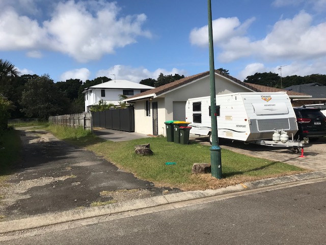
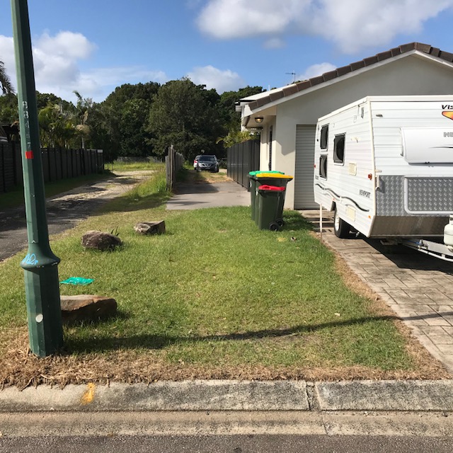
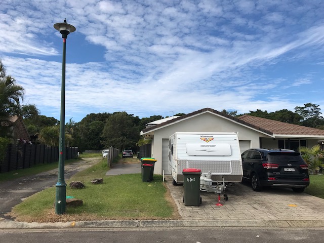
Notice of Motion No. 9.1 Lots 1
and 2, 22 Teak Circuit, Suffolk Park
File No: I2020/883
|
I move:
1. That
planning staff consult with the owners of Lots 1 and 2, 22 Teak Circuit,
Suffolk Park, to resolve any disputes over the location of adjoining
driveways as they cross over the council median strip in front of 22 Teak
Circuit.
2. That
should an agreement not be reached, any costs arising from new drawings and
planning submissions be shared equally between both residents.
3. That
should a change in plans require the relocation of the adjoining streetlight
on the median strip, relocation costs and upgrades be covered by Council.
|
Signed: Cr
Jan Hackett
Councillor’s supporting information:
Our former Council approved a DA for a subdivision of 22
Teak Circuit, Suffolk Park.
The original residence (now Lot 1), was to front a
battle-axe block (Lot 2) which has a very narrow access driveway running
parallel to the original home on its north facing side.
The owner/developer of 22 Teak Circuit sold both lots once
the subdivision was approved.
There are currently two new owners and although each
purchased in full knowledge of the approved DA plans, objections have arisen
since both purchases were finalised and Lot 1 owners are no longer happy with
the plans.
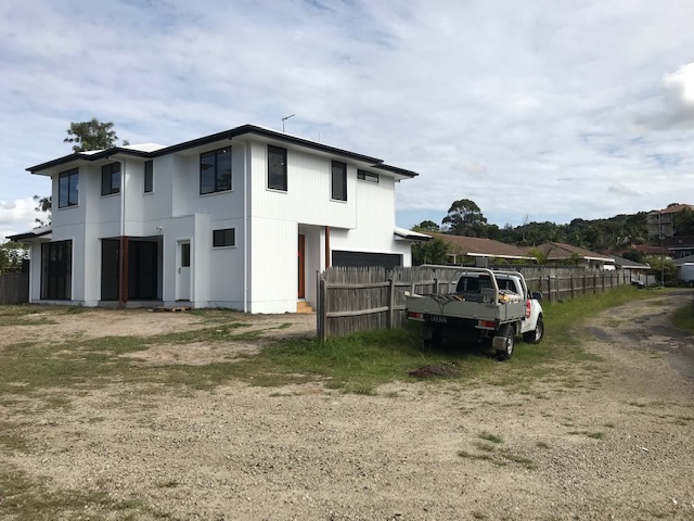
Lot 2 owners have in the meantime, presented plans to
council for a secondary dwelling on the back block. These have been approved
and their new home is nearing completion.
Meanwhile Lot 1 owners are taking legal action for loss of
amenity against the owners of Lot 2. They are unhappy about the approved
dwelling as well as the proximity of the narrow side driveway that connects the
rear block. As a result, both neighbours have stopped talking.
Regarding the location and angle of the battle-axe driveway,
an early sketch shows the Lot 2 driveway to angle across the
council median strip once it passes their private boundary. This was to clear a
street lamp-post. The final drawings show this has been straightened at the
crossover point. See 2 attachments.
The final approved plan reverts to an angled crossing over
the council median strip, thereby avoiding streetlight proximity, but requests
the relocation of the streetlight nevertheless.
For the Lot 2 driveway to cross the council median strip and
avoid the streetlight, it must angle away towards Lot 1 driveway as per the
original sketch.
On examining the drawings and plans, what seems to have
happened is that Lot 1 drive has crossed the council median strip by paving
straight out from their double garage rather than angling the crossover as per
the first sketches and approved plans. This now means that for Lot 2 driveway
to avoid the light-pole, they have to cut into the straightened
neighbour’s driveway, but only, note, where the driveways jointly cross
the council owned median strip.
Planning staff have come up with two options – see
below –
2019/180 - 22A Teak Circuit Suffolk Park -
condition to do with light pole.
The background is as follows: the applicants/owners need
to move a light pole for a battle-axe driveway to get required 3m width in
– staff were happy for it to be narrower and dovetailed into neighbour's
driveway provided they obtained the neighbour's consent. But neighbours are not
talking; they have fallen out and don’t like the new DA plans that have
been approved.
The alternate is the light pole needs to be moved to
provide room for the driveway – they only have 2.5 metres at present.
Given Lot 1 owners are taking legal action against Lot 2
owners and there is no conversation to be had between the warring parties, Lot
2 owners enquired into costs for moving the light-pole. What they
discovered was that Essential Energy insisted that if a light-pole was to be moved,
it would require an upgrade costing something like $13000. Together with costs
for relocation planning, submission et al, Lot 2 owners would be looking at
< $20,000 just to get an approved driveway entry from the street across the
council median strip to their own land and side driveway.
This leaves me with two questions and an alternative
suggestion for a solution that would better satisfy the amenity of both Lot
owners.
Question 1: Given the original plans showed that the
light-pole would be sufficiently avoided if both driveways entered the
street at a slight angle, and given that Lot 1 has not angled its double
driveway where it crosses the council median strip, Lot 2 drive would now need
to dovetail into Lot 1 drive in order to still clear the streetlight by a safe
margin; why is the owner of Lot 1 required to obtain consent from Lot 2 when
the dovetailed section is positioned as per the original approved design and is
over council land, not private land?
Question 2: If it is determined that the
streetlight must be relocated regardless, given it is a council asset and sits
on council land, should not this be at council cost?
Alternatively:
Staff consider leaving the light-pole where it sits and
negotiates with Lot 2 owners to share the adjacent Council easement, thereby
giving them easy access to their own garage on the back block.
This would alleviate the amenity issues for Lot 1 owners.
They could be offered to purchase the current battle-axe driveway for their own
use, thereby removing the amenity concerns they have with a driveway running
directly against their north facing house wall and side courtyard garden.
Photos attached.
Staff comments by Shannon Burt, Director, Sustainable
Environment and Economy:
(Management Comments must not include formatted
recommendations – resolution 11-979)
Response to question 1:
A shared driveway between landowners at the crossover is
possible, however owners consent from Lot 2 is desirable in the event that
their driveway is damaged and there is a mechanism and understanding for repair
and upgrade responsibilities should that occur between those land owners. At
this point in time there appears to be no “neighbourly agreement”
in place. Noting that this is inconsistent with Council Northern Rivers
Local Government Design Manual _ Handbook for Driveway Access to Property which
states under 3.02(5)
“Driveways are to be square to the road carriageway
and not encroach on neighbouring frontages. In some instances, such as steep
topography, Council may consider a variation to this requirement.”
Further as noted in the photos within this Notice of Motion,
driveways across the road reserve are used informally as overflow parking. With
a shared driveway crossover, the potential for conflict could arise. In
the event that an agreement was reached between neighbours then a variation to
the driveway requirements would be possible.
Response to question 2:
This is a possibility subject to a resolution of Council and
budget being provided of up to $20,000. It is however the normal responsibility
of the developer to move infrastructure where required and at their expense.
Council’s standards under the Northern Rivers Local Government Design
Manual require a 300mm clearance to existing infrastructure.
Alternative Options
Alternate option 1
Physical access to the driveway and property is possible
through the adjacent reserve. This would require an amendment to the
Development Consent and the S138 Application. The existing driveway and
crossover to the reserve would then need to be upgraded at the
applicant’s expense and an easement created over the reserve.
However it is noted an easement across the reserve is not
permitted under the Plan of Management (POM) for the site, and therefore the
POM would need to be amended or varied to permit this.
Alternative Option 2
A second and more simple option would be for a narrower
driveway of only 2.5 metres across the frontage of the property (provided the
300 mm setback to the light pole is in place), and a variation to the Northern
Rivers Local Government Design Manual to be approved.
Should this be the preferred option of Council by
resolution, this will give guidance to staff in assessing any subsequent
amendment to the current approvals, and in responding to any complaints or
queries from surrounding landowners as to why a variation was given for a
narrower driveway.
A driveway with a nominal width of 2.5 metre would provide
sufficient width for standard vehicles to enter and leave the site. In these
circumstances it would not set a precedent for other development control
variations.
If this is the preferred option by Council then the
landowners should be invited to lodge an amendment to the development consent
and the S138 Approval accordingly.
To achieve this staff amended recommendation follows:
I move:
1. That
Council note the staff comments in response to the questions raised by the NOM.
2.
The landowners be invited to lodge an amendment to the relevant development
consent and S138 Approval at their own expense to seek a variation to the
current development controls to permit a 2.5m driveway with a 300mm setback to
the light pole.
Financial/Resource/Legal Implications:
Should the staff recommendation be supported nil costs to
Council as all costs to be borne by the land owner.
Conversely, should Council seek to address the issue via the
relocation of the light pole on the owner’s behalf then a budget of up to
$20,000 would be required. There is no identified budget allocation for this to
occur.
Should the driveway be repositioned to enter the site via
neighbouring public reserve, Council will need to grant an easement across the
reserve. Survey costs and registration of the easement would be at the
applicant’s expense.
Is the proposal consistent with any Delivery Program
tasks?
No
Staff Reports - Sustainable Environment and Economy 13.1
Staff Reports - Sustainable Environment and
Economy
Report No. 13.1 Review
of 12 month car share pilot program
Directorate: Sustainable
Environment and Economy
Report
Author: Sam
Tarrant, Planning Support Officer
File No: I2020/516
Summary:
This report outlines the community usage of the share cars
operated by Popcar within Byron Bay and Mullumbimby.
In 2018 Council resolved to trial a 12 month car sharing
pilot program in Byron Shire. Popcar was selected as the most suitable operator
for the pilot.
Popcar launched on 5 June 2019, providing 8 cars in Byron
Bay and 2 in Mullumbimby.
During the pilot the share cars have been used on 506
occasions with bookings totalling 5,987 hours.
Usage has been steadily growing over the 12 months with a
slight reduction in the final months likely due to Covid-19.
The inclusion of the share cars in Byron Shire provides an
alternative transport option for the community, can help to reduce the need for
private car ownership and when coupled with other mechanisms, facilitate the
people first, cars second vision of the Byron Town Centre Masterplan.
Based on the continued use of the share cars and the
benefits this service brings to the community it is recommended that Council
continues to lease the 10 bays to Popcar to continue to operate the share cars
within Byron Shire.
|
RECOMMENDATION:
1. That
Council continues to lease the 10 bays to Popcar to provide a car
sharing service in Byron Bay and Mullumbimby and invite Popcar to renew their
annual lease.
2. That
staff liaise with Popcar and the Local Traffic Committee about possible
expansion of car parking spaces.
3. That
a report outlining the next 12 month usage statistics be provided to
Council in June 2021.
|
Attachments:
1 Car share
12 Month usage report, E2020/37787

REPORT
At the meeting of 22 February 2018, Council resolved (18-115)
to support the progression of a 12 month car share pilot. Expressions of
Interest were sought from car share companies to provide and manage 10 share
cars in Byron Shire for the 12 month pilot.
In February 2019 Council resolved (19-009) to select
Popcar as the car sharing operator for the commencement of a 12 month pilot.
This report provides the usage data for the 12 month pilot.
Popcar launched their services in Byron Shire on June 5,
2019 with 8 share cars available in Byron and 2 in Mullumbimby.
Over the past 12 months the vehicles have been used on 506
occasions. Bookings have been made totalling 5,987 hours. There are over 200
members from Byron Shire that have subscribed to the service. These
numbers demonstrate that this service is of a benefit to the community and
provides a viable alternative to private car ownership. Additionally the
vehicles are hybrid, helping to reduce carbon emissions.
A comprehensive report detailing the usage of each vehicle
from June 2019 to June 2020 is contained in Attachment 1.
It should be noted that due to Covid-19, there has been a
reduction in usage for the last couple of months of the pilot program.
There have been no issues reported from parking enforcement
about unauthorised vehicles parking in the car share bays. No negative feedback
has been received from the community regarding the bays or there locations
during the pilot.
Popcar have provided additional vehicles in the recent
Habitat Development independently of Council. The usage of these vehicles is
not included in this report.
Council also received an award from Local Government NSW for
cultural change innovation and excellence for being the first regional council
to introduce a car sharing program.
Popcar has indicated that they would like to continue to
operate this service in the Shire and would be interested in working with
Council to put additional vehicles in other locations as deemed appropriate.
Conclusion
The inclusion of the share cars in Byron Shire provides an
alternative transport option for the community, can help to reduce the need for
private car ownership and when coupled with other mechanisms, facilitate the
people first, cars second vision of the Byron Town Centre Masterplan.
Based on the continued use of the share cars and the benefits
this service brings to the community it is recommended that Popcar continue to
be provided the car parking spaces to operate the share cars within Byron
Shire.
Next steps
Popcar will be required to renew
the annual permits to operate within Byron Shire. A report will be presented to
Council in June 2021 outlining the next 12 months usage statistics.
STRATEGIC CONSIDERATIONS
Community Strategic Plan and Operational Plan
|
CSP Objective
|
L2
|
CSP Strategy
|
L3
|
DP Action
|
L4
|
OP Activity
|
|
Community
Objective 1: We have infrastructure, transport and services which meet
our expectations
|
1.6
|
Manage traffic
and parking in an efficient manner
|
1.6.3
|
Ensure new
infrastructure is planned and funded to meet the needs of the current and
future population (SP)
|
1.6.3.2
|
Report on pilot
car share program outcomes for Byron Bay
|
|
|
|
|
|
|
|
|
|
|
|
|
|
|
Legal/Statutory/Policy Considerations
.
N/A
Financial Considerations
The installation of the car share bays was funded by Popcar.
Popcar will need to apply to renew the annual permits to
continue to lease the car share bays. The permits are $110 per space as
outlined in the Car Share Procedure and Council’s Fees and Charges.
Consultation and Engagement
N/A
Staff Reports - Sustainable Environment and Economy 13.2
Report No. 13.2 Draft
Residential Strategy Submissions Review Report - Consideration of site-specific
submissions requesting designation as an Investigation Area
Directorate: Sustainable
Environment and Economy
Report
Author: Natalie
Hancock, Senior Planner
Steve Daniels, Project Officer -
Planning Reforms
File No: I2019/2062
Summary:
Council is preparing a
Residential Strategy (strategy). It is a policy framework and action plan to
guide residential development in our urban areas for at least the next 20
years. The strategy relates to future housing in Bangalow, Brunswick heads,
Byron Bay, Mullumbimby, New Brighton, Ocean Shores, South Golden Beach, Suffolk
Park and Sunrise.
Council in December 2018
resolved (resolution 18-823) to exhibit a draft
strategy and associated Appendices), noting that the documents as presented to
Council were working drafts and further refinements are required prior to
public exhibition.
The engagement at that time was
designed to inform the community about the content and direction of the
strategy and seek feedback on the development of a final strategy. This report
provides an overview of the engagement process and provides recommended
outcomes for the final strategy.
A total of 19 submissions were
received from landowners expressing an interest in having their land
designated for residential land purposes in the strategy. This report includes
a summary of the assessment outcomes for those sites and provides recommendations
for Council’s consideration.
The remaining submissions received
during the exhibition period will be addressed in a further report to Council.
|
RECOMMENDATION:
1. That
Council supports the Residential Strategy being updated to include the
following lot and DPs, as detailed in Attachment 1 (#E2020/40080), as
investigation areas in the Strategy:
a. part
of Lot 12 DP 527314 (20 Prince St Mullumbimby) due to Strategy investigation areas to the south east
potentially contributing to this being a small pocket of isolated rural
land within the Mullumbimby township.
b. Lot
1 DP1256460, Lot 1 DP803292, Lot 2 DP1256460, Lot 2 DP803292, Lot 4 DP837851,
Lot 5 DP1111848 (152 Stuart St, Mullumbimby & 124, 127,
130, 132, 134 Station St, Mullumbimby)
c. part
of Lot PT32/1169053 located east of Tuckeroo Avenue, Mullumbimby
d. Lot 3 DP1220608 (21
Ballina Road, Bangalow)
2. That
Council requests staff to advise the submission proponents of the following
sites as detailed in Attachment 1 (# E2020/40080) that their land is excluded from further consideration as part
of the investigation areas under the Residential Strategy due to
inconsistency with the North Coast Regional Plan Settlement Guidelines and
the policies and directions contained in the Byron Shire Draft Residential
Strategy:
a) Lots
1 & 2 DP 1126204 and Lot 7 DP 573269 (29 Buckleys Road,
Tyagarah)
b) Lot
1 DP 781835 (1C Ann St, Mullumbimby)
c) Lot
2 DP 875011 (142 Main Arm
Road, Mullumbimby)
d) Lot
4 DP 874348 (1897 Coolamon Scenic Drive, Mullumbimby)
e) Lot
12 DP57826 and Lots 1 & 2
DP1187038 (1862 Coolamon Scenic Drive, Mullumbimby)
f) Lot
10 DP1132925 (1982 Coolamon Scenic Drive, Mullumbimby)
g) Part
of Lot PT32/1169053 located west of
Tuckeroo Avenue, Mullumbimby
h) Part
of Lot 162 DP1251169 located on Clays
Road, Mullumbimby
i) Lot
285 DP1198641 (64 Corkwood Cr, Suffolk Park)
j) Lot
22 DP 549688 (139 Bangalow Road, Byron Bay)
k) Lot
1 DP12330 (Broken Head Quarry Site, Broken Head Rd, Suffolk
Park)
l) Lot
100 & 101 DP 1158494 (900
Bangalow Road, Bangalow)
m) Lot
3 DP1164722 (16 Bangalow Road, Bangalow)
n) The
Saddle Road area (‘Area
17’ Byron Rural Land Use Strategy)
3. That
Council requests staff to advise the submission proponents of the following
sites as detailed in Attachment 1 (# E2020/40080) that their land is excluded from further consideration as part
of the investigation areas under the Residential Strategy due to
inconsistency with the North Coast
Regional Plan Settlement Guidelines:
a)
Lot 2 DP
1032298 (75 New City Road, Mullumbimby)
b) Part
of Lot 350 DP 755695 located on Ewingsdale Road, Byron Bay
4. That
Council requests staff to update the Residential Strategy Background
Report to incorporate:
a) The
State Policy consistency check to include any new investigation areas as
supported by Council.
b) Dwelling
and population figures and infrastructure network
capacity information to reflect investigation area changes.
5. That Council requests
staff include the investigation areas identified in recommendation (1), and
make changes in recommendation (4) to the Residential Strategy document and
publicly exhibited it for a minimum 28 day period.
6. That Council notes
a further report will be tabled post the outcome of recommendation (5) above
for Council to consider any submissions received during the exhibition of the
additional investigation areas and to consider the remaining submission
issues in order to finalise the Residential Strategy.
|
Attachments:
1 Submissions
Summary Review_Potential Investigation Areas_Residential Strategy, E2020/40080 
2 Confidential
- Combined Submissions: Requests for land to be included as an Investigation
Area - draft Residential Strategy, E2020/39736
3 North Coast
Regional Plan Settlement Guidelines, E2020/41782

4 Special
Disclosure for Pecuniary Interest Annexure, E2012/2815
REPORT
Background and Purpose
Council is preparing a
Residential Strategy (strategy). It is a policy framework and action plan to
guide residential development in our urban areas for at least the next 20
years.
The strategy relates to future
housing in Bangalow, Brunswick heads, Byron Bay, Mullumbimby, New Brighton,
Ocean Shores, South Golden Beach, Suffolk Park and Sunrise.
The strategy is the result of three years of planning,
research and community consultation. This has included the Housing Needs
Report, the Housing Summit, and targeted community engagement, the Accessible
Housing Project, the Housing Roundtable and the Housing Charrette. Overall,
this collection of work clearly indicated that a healthy supply of housing for
a range of incomes, lifestyle choices, household types and life stages is
needed to maintain our community diversity and social cohesion.
Council in December 2018
resolved (Res 18-823) to exhibit a draft Residential Strategy and
associated Appendices, noting that the documents as presented to Council were
working drafts and further refinements are required prior to public
exhibition.
This report provides an overview
of the engagement process and submissions received
from landowners expressing an interest in having their land designated
for residential land purposes in the strategy. This report includes a summary
of the assessment outcomes for those sites and provides recommendations for
Council’s consideration.
The remaining submissions received
during the exhibition period will be addressed in a further report to Council.
Overview
of engagement
An Engagement
Plan for the strategy was endorsed at the 13 December 2019 Council meeting.
The
engagement program undertaken was designed to inform the community about the
content and direction of the strategy and seek feedback on the development of a
final Strategy. It built on earlier targeted engagement that has helped inform
the preparation of a preliminary draft strategy. Diagram 1 in Attachment 1
summarises the pathway taken in looking at important issues.
The structured engagement program was undertaken in two
steps.
· Shaping our
neighbourhoods (May 2019)
· Full
exhibition (28 August – 11 October 2019)
The full exhibition involved the
following activities and methods of communication outlined below:
- Notification
letters to surrounding Councils, Tweed Byron Local Aboriginal Land Council,
Arakwal and state government agencies
- Public
media, Council website, Facebook page and an e-newsletter to advertise
engagement
- Provision
of information including the RS and Background Report, FAQ and fact sheets, and
information on how to lodge a submission
- Farmers
markets stalls
- One-on-one
meetings and responses to emails & phone calls
The report recommendations were
workshopped with Councillors at a strategic planning workshop on 4 June 2020.
Submission Profile
A total of 66 submissions were
received including:
· State government agency response
· Community groups and broader community response
· Landowner
request for inclusion as an investigation area
This report provides assessment
and recommendations in relation to landowner requests for inclusion of land as
an investigation area. These submissions are provided in Attachment 2.
The remaining submissions received
during the exhibition period will be addressed in a further report to Council.
Landowner request for inclusion as an investigation area
There were 19 requests for land to be included in the
strategy as an investigation area.
As a result of an analysis as detailed in Attachment 1 a
number of parcels were supported for inclusion as investigation areas in the
strategy, these are listed below in Table 1:
Table
1 Land parcels requests –
supported as investigation areas. For
detailed assessment see Attachment 1.
|
Site #
(Attachment 1)
|
Site Description
|
|
Site 4
|
Part of Lot 12 DP 527314 (20
Prince St Mullumbimby) due to Strategy investigation areas to the south east
potentially contributing to this being a small pocket of isolated rural land
within the Mullumbimby township.
|
|
Site 6
|
Lot 1 DP1256460, Lot 1
DP803292, Lot 2 DP1256460, Lot 2 DP803292, Lot 4 DP837851, Lot 5 DP1111848 (152
Stuart St, Mullumbimby & 124, 127, 130, 132, 134 Station St, Mullumbimby)
|
|
(Part) Site 10
|
Part of Lot PT32/1169053
located east of Tuckeroo Avenue, Mullumbimby
|
|
Site 16
|
Lot 3 DP1220608 (21 Ballina Road, Bangalow)
|
In line with Council resolution (Res 19-636)
(Planning meeting 12 Dec 2019), these additional investigation areas will be
included as part of the implementation of the SEPP 70 Affordable housing
contribution scheme.
It is recommended that subject to
Council endorsement of the lots identified above being included as an
investigation area in the Strategy, staff exhibit these lands for a minimum 28
day period and report to Council any submissions received.
The balance of the requests for
specific land parcels have not been supported and Table 2 summarises the site
specific assessment outcomes for these parcels.
Table
2 Land parcels requests –
not supported as investigation areas. Table
2 summarises the site specific outcomes for these parcels, for detailed
assessment see Attachment 1.
|
Site #
(Attachment
1)
|
Site
Description
|
Recommendation
|
|
Site 1
|
Lots 1 & 2 DP 1126204 and
Lot 7 DP 573269,
29 Buckleys Road, Tyagarah
|
That the proponent be advised
that Lots 1 & 2 DP 1126204 and Lot 7 DP 573269 are excluded from further
consideration as part of the investigation areas under the Residential
Strategy due to inconsistency with the NCRP Settlement Guidelines and the
policies and directions contained in the Byron Shire Draft Residential
Strategy.
|
|
Site 2
|
Lot 2 DP 1032298
75 New City Road, Mullumbimby
|
That the proponent be advised that Lot 2 DP 1032298 is
excluded from further consideration as part of the investigation areas under
the Residential Strategy due to inconsistency with the NCRP Settlement
Guidelines.
|
|
Site 3
|
Lot 1 DP 781835
1C Ann St Mullumbimby
|
That the proponent be advised that Lot 1 DP 781835 is
excluded from further consideration as part of the investigation areas under
the Residential Strategy due to inconsistency with the NCRP Settlement
Guidelines and the policies and directions contained in the Byron Shire Draft
Residential Strategy.
|
|
Site 5
|
Lot 2 DP 875011
142 Main Arm Road, Mullumbimby
|
That the proponent be advised that Lot 2 DP 875011 is
excluded from further consideration as part of the investigation areas under
the Residential Strategy due to inconsistency with the NCRP Settlement
Guidelines and the policies and directions contained in the Byron Shire Draft
Residential Strategy.
|
|
Site 7
|
Lot 4 DP 874348
1897 Coolamon Scenic Drive,
Mullumbimby
|
That the proponent be advised that land Lot 4 DP 874348 is
excluded from further consideration as part of the investigation areas under
the Residential Strategy due to inconsistency with the NCRP Settlement
Guidelines and the policies and directions contained in the Byron Shire Draft
Residential Strategy.
|
|
Site 8
|
Lot 12 DP57826 and Lots 1 &
2 DP1187038
1862 Coolamon Scenic Drive,
Mullumbimby
|
That the proponent be advised that Lot 12 DP57826 and Lots
1 & 2 DP1187038 are excluded from further consideration as part of the
investigation areas under the Residential Strategy due to inconsistency with
the NCRP Settlement Guidelines and the policies and directions contained in
the Byron Shire Draft Residential Strategy.
|
|
Site 9
|
Lot 10 DP1132925
1982 Coolamon Scenic Drive,
Mullumbimby
|
That the proponent be advised that Lot 10 DP1132925 is
excluded from further consideration as part of the investigation areas under
the Residential Strategy due to inconsistency with the NCRP Settlement
Guidelines and the policies and directions contained in the Byron Shire Draft
Residential Strategy.
|
|
(Part) Site 10
|
Lot PT32/1169053
Tuckeroo Avenue, Mullumbimby
|
That the proponent be advised that part of Lot
PT32/1169053 located west of Tuckeroo Avenue is excluded from further
consideration as part of the investigation areas under the Residential
Strategy due to inconsistency with the NCRP Settlement Guidelines and the
policies and directions contained in the Byron Shire Draft Residential
Strategy
|
|
Site 11
|
Part of Lot 162 DP1251169
Clays Road, Mullumbimby
|
That the proponent be advised that part of Lot 162
DP1251169 is excluded from further consideration as part of the investigation
areas under the Residential Strategy due to inconsistency with the NCRP
Settlement Guidelines and the policies and directions contained in the Byron
Shire Draft Residential Strategy
|
|
Site 12
|
Lot 285 DP1198641
64 Corkwood Cr, Suffolk Park
|
That the proponent be advised that Lot 285 DP1198641 is
excluded from further consideration as part of the investigation areas under
the Residential Strategy due to inconsistency with the NCRP Settlement
Guidelines and the policies and directions contained in the Byron Shire Draft
Residential Strategy.
|
|
Site 13
|
Lot 350 DP 755695, Ewingsdale Road, Byron Bay
|
That the proponent be advised that part of Lot 350 DP
755695 is excluded from further consideration as part of the investigation
areas under the Residential Strategy due to inconsistency with the NCRP
Settlement Guidelines.
|
|
Site 14
|
Lot 22 DP 549688
139 Bangalow Road, Byron Bay
|
That the proponent be advised that Lot 22 DP 549688 is
excluded from further consideration as part of the investigation areas under
the Residential Strategy due to inconsistency with the NCRP Settlement
Guidelines and the policies and directions contained in the Byron Shire Draft
Residential Strategy.
|
|
Site 15
|
Lot 1 DP12330
Broken Head Quarry Site, Broken Head Rd, Suffolk Park
|
That the proponent be advised that Lot 1 DP12330 is
excluded from further consideration as part of the investigation areas under
the Residential Strategy due to inconsistency with the NCRP Settlement
Guidelines and the policies and directions contained in the Byron Shire Draft
Residential Strategy.
|
|
Site 17
|
Lot 100 & 101 DP 1158494
900 Bangalow Road, Bangalow
|
That the proponent be advised that Lot 100 & 101 DP
1158494 are excluded from further consideration as part of the investigation
areas under the Residential Strategy due to inconsistency with the NCRP
Settlement Guidelines and the policies and directions contained in the Byron
Shire Draft Residential Strategy.
|
|
Site 18
|
Lot 3 DP1164722
16 Bangalow Road, Bangalow
|
That the proponent be advised that Lot 3 DP1164722 is
excluded from further consideration as part of the investigation areas under
the Residential Strategy due to inconsistency with the NCRP Settlement
Guidelines and the policies and directions contained in the Byron Shire Draft
Residential Strategy.
|
|
Site 19
|
‘Area 17’ (RLUS)
The Saddle Rd
|
That the proponent be advised that The Saddle Road area is
excluded from further consideration as part of the investigation areas under
the Residential Strategy due to inconsistency with the NCRP Settlement
Guidelines and the policies and directions contained in the Byron Shire Draft
Residential Strategy.
|
Summary and next steps
This report recommends the
inclusion of additional investigation areas in the Residential Strategy.
It is
recommended that subject to Council endorsement, staff seek advice from the
DPIE as to the requirement to further exhibit these lands and if advised to do
so, that a 28 day public exhibition occur and be reported back to Council.
The remaining submissions received
during the exhibition period will be addressed in a further report to Council.
STRATEGIC CONSIDERATIONS
Community Strategic Plan and
Operational Plan
|
CSP Objective
|
L2
|
CSP Strategy
|
L3
|
DP Action
|
L4
|
OP Activity
|
|
Community
Objective 4: We manage growth and change responsibly
|
4.2
|
Support
housing diversity in appropriate locations across the Shire
|
4.2.1
|
Establish
planning mechanisms to support housing that meets the needs of our community
|
4.2.1.1
|
Finalise the
Residential Strategy
|
|
|
|
|
|
|
|
|
|
|
|
|
|
|
|
|
Legal/Statutory/Policy
Considerations
The
proposed actions are consistent with the relevant Commonwealth, State and Regional
policy frameworks.
As
the State Government has released North Coast Settlement Planning Guidelines
2019 clarification was sought on its application to the Residential Strategy.
The DPIE advised that as Council had exhibited the draft residential strategy
prior to the Department of Planning, Industry and Environment's release of the
planning guidelines on 23 October 2019, compliance with the guidelines is not
mandatory. It is however recommended that Council take into consideration the
guidelines where possible when finalising the Strategy to ensure its strategic
planning framework aligns with the North Coast Regional Plan 2036 and current
best practice.
Financial Considerations
The cost of preparing the draft
Residential Strategy has been met within Council’s budget for this
project. Additional funds may be required should Council decide to expand
the scope of this project.
Staff Reports - Sustainable Environment and Economy 13.3
Report No. 13.3 PLANNING
- 26.2016.6 Update on The Farm at Ewingsdale Planning Proposal
Directorate: Sustainable
Environment and Economy
Report
Author: Rob Van
Iersel, Major Projects Planner
File No: I2020/758
Summary:
Council considered a report on the progress of the Planning
Proposal relating to The Farm at the Planning Meeting of 20 February
2020. At that meeting, staff reported that there had been considerable
delay to the progress of the proposal associated with negotiations and
discussions around traffic matters.
There are significant traffic issues at the western end of
Ewingsdale Road, particularly relating to a lack of capacity at the motorway
roundabout. Council and Transport for NSW (TfNSW) have discussed a range
of potential actions but, as yet, TfNSW has no formal project to implement
actions in the area.
As reported to the February meeting, it was not possible to
negotiate a Voluntary Planning Agreement, which could have progressed with the
Planning Proposal, to achieve an outcome suitable to all parties.
As an alternative, Council resolved (20-026)
to seek an amended Gateway Determination for a proposal that would, in addition
to providing an approval pathway for the existing unauthorised uses, rezone a
15m wide strip of land along the Ewingsdale Road frontage of the property from
the current RU1 Primary Production to SP2 Infrastructure (Classified Road), effectively
‘reserving’ that land for future road widening.
This zoning would establish TfNSW as the authority
responsible for acquiring the strip of land at some time in the future.
In response to this proposal, TfNSW advised that, as Council
are the current roads authority for Ewingsdale Road, the SP2 zoning should be
(Local Road), rather than (Classified Road), which would mean that Council
becomes the acquisition authority.
This would impose a responsibility on Council to acquire the
‘reserved’ land, at some time in the future, in accordance with the
provisions of the Land Acquisition (Just Terms Compensation) Act 1991.
The Department of Planning, Environment & Industry have
been asked to confirm that public exhibition of the Planning Proposal could
proceed based on the current Gateway Determination, if the reserved land were
to be zoned SP2 Local Road rather than SP2 Classified Road.
In the meantime, further assessment is required to more
clearly understand the appropriateness and implications for Council if it
becomes the acquisition authority for the reserved strip of land along the
Ewingsdale Road frontage of the property.
An alternative may be to proceed with the Planning Proposal
without the SP2 zoning along the Ewingsdale Road frontage. That is likely
to require an amendment to the current Gateway Determination and might not be
supported by TfNSW.
The current Gateway Determination remains
‘active’ until October 2020. A report to Council will be
provided prior to that expiring, to outline and assess the options in respect
to this Planning Proposal.
In the interim, its is recommended that Council continue to suspend
enforcement action in relation to matters subject of the Planning Proposal
until such time as a determination is made.
NOTE TO COUNCILLORS:
In accordance with the
provisions of S375A of the Local Government Act 1993, a Division is to be
called whenever a motion for a planning decision is put to the meeting, for the
purpose of recording voting on planning matters. Pursuant to clause 2(a)
under the heading Matters to be Included in Minutes of Council Meetings of
Council's adopted Code of Meeting Practice (as amended) a Division will be
deemed to have been called by the mover and seconder of all motions relating to
this report.
|
RECOMMENDATION:
That Council:
1. Defers
further action on the Planning Proposal pending a report outlining options
and addressing the appropriateness and implications of a proposed zoning of
SP2 Infrastructure (Local Road) for the strip of land along the Ewingsdale
Road frontage of the property, and
2. Continues
to suspend enforcement action in relation to matters subject of the Planning
Proposal until such time as a determination is made. Council may,
however, use its discretion to take enforcement action in circumstances where
it is demonstrated that an unauthorised activity or use imposes significant
impacts on the environment. This undertaking does not exclude Council
from its regulatory obligations in relation to the Food Act, Local Government
Act and Protection of the Environment Operations Act.
3. Notifies
the proponent of its decision.
4. Writes
to Transport for NSW requesting that work on traffic solutions for the
western end of Ewingsdale Road is expedited.
|
REPORT
At the Council (Planning) Meeting of 20 February 2020, Council
considered a report providing an update of the Planning Proposal for The Farm.
The Planning Proposal addresses existing unauthorised land
uses at the Farm (it does not approve additional uses). Council had
previously resolved (17-671) to initiate this Planning Proposal
and seek a Gateway Determination from the Department of Planning that would
allow for its public exhibition.
The support for the Planning Proposal was to allow
authorisation of the following uses at the site:
· the bakery;
· agricultural
training/education facilities and activities;
· administration
offices;
· small-scale
information centre.
Previous compliance action
was undertaken to address the produce store, which was significantly reduced in
scale to be consistent with the existing approval for ‘roadside
stall’, and the homewares/gift shop, which was modified to operate in
accordance with the approval for a plant nursery.
Prior to issuing a Gateway Determination for this Planning
Proposal, the Department of Planning, Industry & Environment undertook
preliminary consultation with a number of State Agencies. In response,
Transport for NSW (TfNSW) recommended that a Voluntary Planning Agreement (VPA)
be negotiated as part of the Planning Proposal, to provide for a contribution
“to offsetting the development’s contribution to the traffic and
safety issues around access to the site”.
The Department advised that this request from TfNSW be
addressed prior to exhibition of the Planning Proposal.
As reported in February, considerable discussions were held
with The Farm and TfNSW around a potential VPA, to provide for the dedication
of a strip of land along the Ewingsdale Road frontage of the property, which
would allow the future widening of Ewingsdale Road between the Motorway roundabout
and McGettigans Lane.
While the VPA would not directly address traffic generation
associated with the unauthorised uses at the property, it was considered that
such dedication could be accepted as The Farm’s contribution toward
solutions for wider traffic issues.
Traffic associated with existing unauthorised uses at the
Farm is not the cause of the traffic issues, but it does contribute to the
problem. Previous discussions between Council, TfNSW and the proponent
were centred on achieving the dedication of a strip of land along the
Ewingsdale Road frontage of the Farm property, which was seen as a way in which
The Farm could contribute to traffic solutions.
The February report noted that discussions were not able to
reach a conclusion acceptable to all parties, and recommended that, instead,
Council amend the Planning Proposal to rezone of a strip of land along The
Farm’s Ewingsdale Road frontage, to SP2 Infrastructure (Classified Road).
This zoning ‘reserves’ the land for future
acquisition under the Land Acquisition (Just Terms Compensation) Act 1991
process, and the Classified Road designation would nominate TfNSW as the
authority responsible for the future acquisition.
The intention was to allow the Planning Proposal to move
forward while Council and TfNSW continue to plan and design road improvement
works which will address existing traffic issues.
In accordance with Council’s resolution at that
meeting (20-026), the Department of Planning, Industry and Environment
was requested to issue an amended Gateway Determination.
In response, the Department requested confirmation that
TfNSW supported the proposal and, in particular, would accept nomination as the
acquisition authority for the SP2 land.
In response to this proposal, TfNSW advised that, as Council
are the current roads authority for Ewingsdale Road, the SP2 zoning should be
(Local Road), rather than (Classified Road), which would mean that Council
becomes the acquisition authority.
This would establish a responsibility on Council to acquire
the ‘reserved’ land, in association with implementing future road
works in this area, or earlier if the land owner can establish
“hardship” in accordance with the provisions of the Land
Acquisition (Just Terms Compensation) Act 1991.
TfNSW advised that they could support the Planning Proposal
on that basis, but they also advised that they would not be able to support any
subsequent Development Applications that would follow in the absence of agreed
traffic solutions and certainty around the implementation of those solutions.
The Department of Planning, Environment & Industry have
been asked to confirm that public exhibition of the Planning Proposal could
proceed based on the current Gateway Determination, if the reserved land were
to be zoned SP2 Local Road rather than SP2 Classified Road.
In the meantime, further assessment is required to clearly
understand the implications for Council in becoming the acquisition authority
for the reserved strip of land along the Ewingsdale Road frontage of the
property.
An alternative may be to proceed with the Planning Proposal
without the SP2 zoning along the Ewingsdale Road frontage. That is likely
to require an amendment to the current Gateway Determination and might not be
supported by TfNSW.
The Gateway remains ‘active’ until October
2020. A report to Council will be provided prior to that expiring to
outline and assess the options in respect to this Planning Proposal.
In the interim, its is recommended that Council continue to suspend
enforcement action in relation to matters subject of the Planning Proposal
until such time as a determination is made. Council may, however, use its
discretion to take enforcement action in circumstances where it is demonstrated
that an unauthorised activity or use imposes significant impacts on the
environment. This undertaking does not exclude Council from its
regulatory obligations in relation to the Food Act, Local Government Act and
Protection of the Environment Operations Act.
Legal/Statutory/Policy Considerations
Moving forward with a zoning of SP2 Infrastructure (Local
Road) establishes Council as the acquisition authority for the land.
Acquisition of land is managed under the provisions of the Land Acquisition
(Just terms Compensation) Act 1991. Section 23 of that Act provides
that a land owner can trigger acquisition of the nominated land if they can
demonstrate hardship associated with delay in the land being acquired.
Hardship is defined under the Act.
Financial Considerations
This is a land owner funded Planning Proposal.
Consultation and Engagement
Public exhibition of the Planning Proposal has not yet
occurred, pending the outcome of discussions around traffic matters.
Staff Reports - Sustainable Environment and Economy 13.4
Report No. 13.4 PLANNING
- Report of the 14 May 2020 Planning Review Committee
Directorate: Sustainable
Environment and Economy
Report
Author: Chris
Larkin, Manager Sustainable Development
Noreen Scott, EA Sustainable
Environment and Economy
File No: I2020/751
Summary:
This report provides the outcome of the Planning Review
Committee (PRC) held on 14 May, 2020. Due to COVID-19, the PRC meeting was held
partly via Skype with one Councillor attending in person. Of the four
development applications reported to PRC, three are to be reported to Council
for determination and one application remains with staff to determine under
delegation.
NOTE TO COUNCILLORS:
In accordance with the
provisions of S375A of the Local Government Act 1993, a Division is to be
called whenever a motion for a planning decision is put to the meeting, for the
purpose of recording voting on planning matters. Pursuant to clause 2(a)
under the heading Matters to be Included in Minutes of Council Meetings of
Council's adopted Code of Meeting Practice (as amended) a Division will be
deemed to have been called by the mover and seconder of all motions relating to
this report.
|
RECOMMENDATION:
That Council endorses the outcomes of the
Planning Review Committee meeting held on 14 May 2020.
|
REPORT
The Planning Review Committee meeting scheduled for 14 May,
2020, was held via a Skype meeting with Councillor Ndiaye attending in person.
Councillors: Crs Hunter, Lyon, Cameron and Ndiaye
Apologies: Crs Coorey
Staff: Chris Larkin (Manager Sustainable Development)
The following development
applications were reviewed with the outcome shown in the final column.
|
DA No.
|
Applicant
|
Property Address
|
Proposal
|
Exhibition Submissions
|
Reason/s
Outcome
|
|
10.2020.61.1
|
Julian Rocks Developments Pty Ltd
|
7 Julian Rocks Drive
BYRON BAY
|
Multi-Dwelling Housing comprising Ten (10) Dwellings
|
Level 2
20/2/20 to 11/3/20
13 submissions
|
Report to Council
Reasons: The number of public submissions.
The perceived public significance of the application.
|
|
10.2020.142.1
|
Planners North Pty Ltd
|
6 Strand Avenue NEW BRIGHTON
|
Demolition and Construction of New Commercial Premises
|
Level 2
9/4/20 to 29/4/20
27 submissions
|
Report to Council
Reasons: The number of public submissions.
The perceived public significance of the application.
|
|
10.2019.630.1
|
Kaisa Pty Ltd
|
7-9 Brownell Dr, Wategoes
Byron Bay
|
Demolition of two exiting dwellings and construction of
two attached dwellings in a dual occupancy
|
Level 2
9/1/20 to 7/2/20
1 Submission
|
Staff Delegation
|
Council determined the following original development
application. The Section 4.55 application to modify the development consent is
referred to the Planning Review Committee to decide if the modification
application can be determined under delegated authority.
|
DA No.
|
Applicant
|
Property Address
|
Proposal
|
Exhibition/
Submissions
|
Reason/s
Outcome
|
|
10.2018.591.2
|
Argyle Street Developments Pty Ltd
|
28 Argyle Street MULLUMBIMBY
|
4.55 to Modify conditions 6 of consent being relating to
development contributions
|
Level 0
|
Report to Council
Reason: The perceived public significance of the
application.
|
Staff Reports - Sustainable Environment and Economy 13.5
Report No. 13.5 PLANNING
- Update Land & Environment Court Proceedings - DA 10.2019.458.1 Multi
Dwelling Housing Comprising six (6) Dwellings at 6 Julian Rocks Drive Byron Bay
Directorate: Sustainable
Environment and Economy
Report
Author: Luke
Munro, Planner
File No: I2020/755
Summary:
On 30 August 2019 development
application (DA) 10.2019.458.1 was received by Council. The DA sought consent
for multi dwelling housing proposal comprising 8 dwellings in 3 separate
buildings at 6 Julian Rocks Drive, Byron Bay. The application was made under
the provisions of State Environmental Planning Policy Affordable Rental Housing
(SEPP ARH) 2009.
The applicant lodged an appeal
in the NSW Land & Environment Court in November 2019, against
Council’s “deemed refusal” of the application. Council subsequently resolved to refuse the application (Res
19-632) for the reasons set out in its notice of determination dated 12
December 2019.
As part of the Land & Environment Court proceedings, a
without prejudice discussion was held on 1 May 2020, consisting of an online
meeting and discussion of modified plans, facilitated by the legal
representatives from both the Applicant and Council. The applicant has now
submitted amended plans which have reduced the number of units to 6 addressing
the reasons for refusals.
The reduction from 8 units to 6 units, has enabled the
development to be redesigned in terms of satisfying Council’s
requirements for setbacks and building height plane encroachments, and
providing a much more useable and functional private open space area for the
rear units 5 and 6. Although not a contention or reason for refusal, an added
consequential benefit from the redesigned development is that each unit will
have a car parking space.
It is recommended that the General Manager be authorised to
enter into consent orders or a Section 34 Conciliation Agreement to resolve the
matter.
NOTE TO COUNCILLORS:
In accordance with the
provisions of S375A of the Local Government Act 1993, a Division is to be
called whenever a motion for a planning decision is put to the meeting, for the
purpose of recording voting on planning matters. Pursuant to clause 2(a)
under the heading Matters to be Included in Minutes of Council Meetings of
Council's adopted Code of Meeting Practice (as amended) a Division will be
deemed to have been called by the mover and seconder of all motions relating to
this report.
|
RECOMMENDATION:
That Council authorises the General Manager to enter
into consent orders or a s34 Conciliation Agreement approving Development
Application 10.2019.458.1, subject to appropriate conditions to be finalised
under delegation.
|
Attachments:
1 Revised
Plans - 10.2019.458.1, E2020/41145

2 Confidential
- Submissions received - 10.2019.458.1, E2020/40965
Assessment:
Land and Environment Court proceedings
On 12 April 2019 proceedings
were commenced in Class 1 of the Land and Environment Court by The Kollective
appealing against Council's “deemed refusal” of development
application No. 10.2019.458.1 seeking consent for multi dwelling housing
comprising 8 dwellings on the land at 6 Julian Rocks Drive, Byron Bay.
The proceedings were listed for
a telephone directions hearing on 15 May 2017. On that day the Court listed the
matter for a conciliation conference pursuant to section 34 (see below in
Statutory and Policy implications) of the Land and Environment Court Act 1979
on 26 June 2020.
Given the circumstances which are set out
in this report, delegation is sought for the General Manager to enter into a
section 34 conciliation agreement or to go to a consent orders hearing as
Council staff are of the opinion that Council’s contentions in the Land
and Environment Court proceedings are now addressed.
Background
On 30 August 2019 development
application 10.2019.458.1(the DA) was received by Council. The DA sought
consent for multi dwelling housing proposal comprising 8 dwellings in 3
separate buildings at 6 Julian Rocks Drive, Byron Bay. The application was made
under the provisions of SEPP ARH 2009
The DA was publicly notified to
nearby and adjoining residents between 12 September 2019 and 25 September 2019.
Council received 21 objections (inclusive of 5 petitions with 289 signatures) raising
objections to the DA.
The applicant lodged an appeal
in the NSW Land & Environment Court in November 2019, against
Council’s “deemed refusal” of the application.
Council refused the DA (Res 19-632) for the
reasons set out in its notice of determination dated 12 December 2019:
1.
Pursuant to Section 4.15(1)(a) of the Environmental Planning and Assessment
Act 1979, the proposal is inconsistent with the provisions of State
Environmental Planning Policy (Affordable Rental Housing) 2009 in that:
i. the
units do not achieve adequate solar access and is inconsistent with the SEPP
(Affordable Housing) 2008;
ii. the
density and scale of the development is inconsistent with the character of the
area; and
iii. the
proposed development is inconsistent with Seniors Living Policy Urban design
guidelines for infill development.
2.
Pursuant to Section 4.15(1)(a) of the Environmental Planning and Assessment
Act 1979, the proposal does not comply with the first objective of the R2
Low Density Residential Zone under Byron LEP 2014, in that:
i. The
proposed 8 dwellings is inconsistent with the character of a low density
environment.
3. Pursuant to Section 4.15(1)(a) of the Environmental
Planning and Assessment Act 1979, the proposal does not comply with Byron
Development Control Plan 2014, in that:
i. street boundary setbacks do not
comply with the standard contained at Chapter D1.2;
ii. the
proposed development encroaches into the Building Height Plane on southern
boundary, resulting in impacts on neighbouring residential properties;
iii. inadequate
useable private open space is provided to the units, with private spaces
proposed within the front setbacks and overlapping private open spaces between
units; and
iv. the
internal unit design does not provide adequate internal amenity for future
residents
The Amended proposal
The amended application seeks
development consent for a multi dwelling housing development, including 6
dwellings, in 3 standalone buildings each containing 2 units with common/shared
driveway, car parking, circulation and landscaped areas. Each of the dwellings
incorporates a 2 storey contemporary design. Access is proposed from a common
driveway from Julian Rocks Drive through the centre of the site.
The dwellings are proposed to be
clad in weatherboard walls with sheet metal roofing. Each dwelling is proposed
to have a ground level yard with landscaped open space.
The units have been redesigned to:
• Reduce
the number of units from 8 to 6 units (each 2 bedrooms);
• Remove
the intrusions into the front setback;
• Remove
BHP encroachments;
• Improve
solar access to each unit;
• Remove
issues of overlooking of private open space areas between units;
• Improve
privacy for neighbouring sites by either removing first floor windows looking
towards side boundaries (Units 5 & 6) and providing privacy screening
(textured glass) to first floor windows (Units 1-4);
• Improve
the ability of vehicles to manoeuvre within the internal parking area; and
• Increased
the front crossover width to allow vehicles to pass.
Dwellings 1-4 will have an area of 70m2 GFA with Units 5
& 6 being slightly larger at 84m2 GFA. Each dwelling will have a private
garden area.
Six (6) parking spaces are provided, one for each of the 6
units. This is an improvement on the original design which provided only 6
spaces for a total of 8 units.
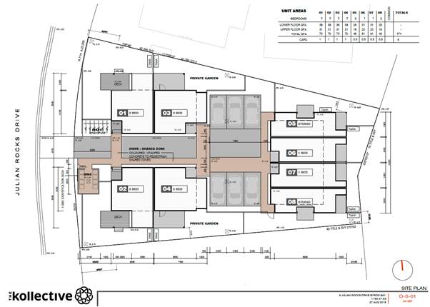
Figure 1: Site Plan - as lodged
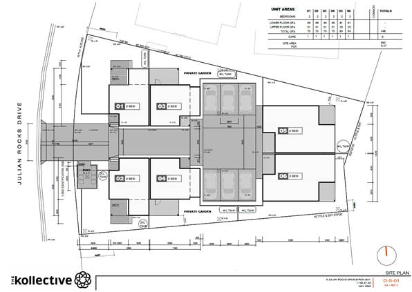
Figure 2: Site Plan – Amended Proposal
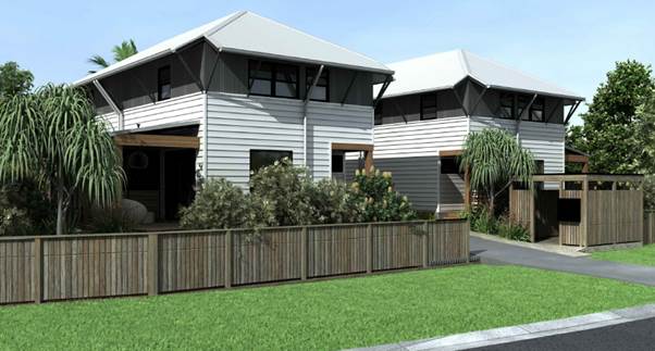
Figure 3: Perspective –
Amended Proposal
The site
|
Land is legally described
|
LOT:
41 DP: 714410
|
|
Property address
|
6
Julian Rocks Drive BYRON BAY
|
|
Land is zoned:
|
R2
Low Density Residential
|
|
Land area is:
|
951.7 m2
|
|
Property is constrained by:
|
Acid
Sulfate Soils Class 3
|
|
Is a BDAR required due to the location of the proposed
development?
|
☐ Yes ☒ No
|
|
Are there any easements in favour of Council affecting the
site?
|
☐ Yes ☒ No
|
|
Is there a Vegetation Management Plan which might affect
the proposal?
|
☐ Yes ☒ No
|
|
Is there a Voluntary Planning Agreement which might affect
the proposal?
|
☐ Yes ☒ No
|
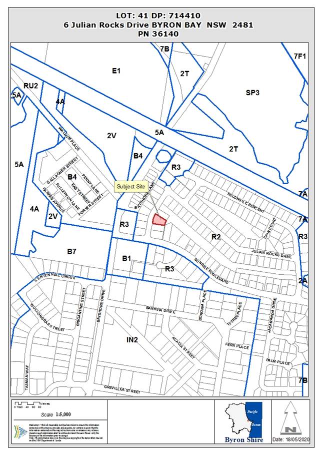
The property is known as Lot 41 DP714410 and is located at 6
Julian Rocks drive, Byron Bay. It is irregular in shape with a 23.25m slightly
curved primary frontage which tapers to 16.72m wide at the rear. The property
is 951.7m2 and is oriented roughly east /
west. The western boundary, which is the Julian Rocks Drive frontage, has a
length of 23.25m. The eastern boundary backs onto a public reserve, with a
length of 16.72m.
The property currently contains
a single dwelling with attached garage. There is no substantial vegetation on
the land, other than landscape plantings.
The locality
The subject site is flat land
located within the Sunrise Residential Estate. Julian Rocks Drive provides a
local access loop for movement through the Sunrise Residential Estate, which
was developed from the mid 1980s onwards.
The residential character is currently
dominated by single storey dwellings and dual-occupancies directly adjacent to
the site. There are a number of 2 storey developments to the north of the site
between 50m - 100m which are 2 storeys.
More variety exists to the southern
side of Sunrise Boulevard, primarily in the form of multi-dwelling housing and
dual occupancy developments. The area to the south of Sunrise Boulevard are
appropriately zoned as medium density residential R3 for multi-dwelling
housing. The dwellings in this area remain, however, a mixture of 1 and 2
storeys in height.
Council’s
contentions in the proceedings
State
Environmental Planning Policy Affordable Rental Housing (SEPP ARH) 2009
The original
proposal is inconsistent with the provisions of SEPP ARH in that:
i. the
units do not achieve adequate solar access and is inconsistent with the SEPP;
ii. the
density and scale of the development is inconsistent with the character of the
area; and
iii. the
proposed development is inconsistent with Seniors Living Policy Urban design
guidelines for infill development.
Particulars
The
original development does not achieve minimum requirements under the SEPP ARH
2009 for:
a. solar
access – the development did not achieve the minimum of 70% of
dwellings with adequate solar access;
b. density
in the vicinity of the site is generally comprised of low density
residential development comprising of dwelling houses and dual occupancy
development ; and
c. the
development did not achieve minimum design requirements taking into
consideration the provisions of the Seniors Living Policy: Urban Design
Guidelines for Infill Development published by the Department of
Infrastructure, Planning and Natural Resources in March 2004
The amended proposal
resolves the above by:
Solar Access:
In relation to solar access (Clause
14(1) (e) of the SEPP ARH 2009), Council must not refuse development made under
Division 1 if living rooms and private open spaces achieve a minimum of 70 per
cent of a development’s dwellings and receive a minimum of three hours
direct sunlight between 9am and 3pm in mid-winter.
The amended development now
provides adequate solar access to the living rooms and private open space areas
to the majority of units with the exclusion of unit 6 which achieves solar access
to the private open space area but not direct sunlight into the dwelling living
room.
The amended proposal provides 83% (5 of 6 units) of the
units with adequate solar access to living rooms and private open space areas.
The amended layout achieves the minimum of 70% of the dwellings with
adequate solar access.
Density
The amended proposal is not typical of a “low density residential
environment” as it proposes multi dwelling houses at a density of 1
dwelling per 158m2 while the prevailing density of the low density
zone for the Shire may more readily equate to 1 dwelling 600 m2 (in
accordance with the minimum lot size map).
However, the application has been submitted under the SEPP ARH which
allows for in-fill affordable housing in locations within 400 metres walking distance of land within Zone
B2 Local Centre or Zone B4 Mixed Use.
BLEP 2014 - Clause 4.1E Minimum
lots sizes for dual occupancies, multi dwelling housing and residential flat
buildings allows for multi dwelling housing on lots with an area of 1,000m2.
This requirement is inconsistent with clause 14(1) of SEPP ARH, which sets a minimum site area of 450m2 (The subject site has an area of 951.7m2).
The provisions of the SEPP ARH prevail in respect of any inconsistency and
therefore multi dwelling housing is acceptable on this site in accordance with
the SEPP ARH.
The amended proposal has reduced
the GFA of the development with the development now complying with Clause 4.4
Floor space ratio of the BLEP 2014. The FSR specified for the locality is
0.5:1. Although a FSR ‘bonus’ of 0.2:1 is available under the
provisions of SEPP ARH. The amended proposal has a complaint FSR of 0.47:1.0
with the LEP controls.
Given the reduction of dwelling
units from 8 to 6 dwellings and modifications to remove the building height
plane intrusions and modifications to improve the privacy of neighbouring
properties the development will be more in keeping with the overall character
of the area.
Provisions of the Seniors Living Policy:
Urban Design Guidelines for Infill Development
The amended proposal has
addressed the following provisions of the Seniors Living Policy: Urban Design
Guidelines for Infill Development:
Part 1 – Responding to
context
The amended proposal is generally
consistent with existing character in terms of scale and density. The design is
broken into 3 separate buildings with the site appearing as 2 x 2 storey
dwellings when viewed from Julian Rocks Drive.
Part 2 – Site Planning &
Design
The amended design removes the
previous building height plane encroachment and resolves privacy issues through
the removal of overlooking windows and fixed textured/opaque glass screening
Part 4 – Impacts on neighbours
The amended plans will not result in
the development breaching the building height plane or result in on privacy
impacts to adjoining neighbours.
Part 5 Internal site amenity
The development now provides adequate
useable private open space for each of the dwellings.
Character
The original proposal did not comply with the first
objective of the R2 Low Density Residential Zone under Byron LEP 2014, in that:
i. The
proposed 8 dwellings is inconsistent with the character of a low density
environment.
Particulars
The original development
application should be refused because the proposed development, as a result of
its scale, density and design, is inconsistent with the character of the
locality.
The amended proposal
The amended proposal is now at a scale and density, which is
more consistent with the character of the locality. The development will appear
from the street as two separate buildings not dissimilar to two storey dwelling
houses.
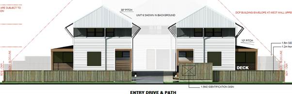
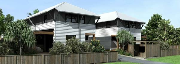
Figure 4: Appearance of 2
dwellings from Julian Rocks Drive
The residential character is
currently dominated by dwelling houses and dual-occupancies directly adjacent.
There are a number of 2 storey developments to the north of the site between 50
-100m which are 2 storey. The proposed development at 2 storeys will not be out
of character in this area and is consistent with the 9 metre height limit
established under the Byron LEP 2014.
As discussed above more variety
exists to the southern side of Sunrise Boulevard, primarily in the form of
multi-dwelling housing and dual occupancy developments. The area to the south
of Sunrise Boulevard are appropriately zoned as medium density residential R3
for multi-dwelling housing. Similarly to the west on Bayshore Drive, higher
residential density development exists. The dwellings in this area remain,
however, a mixture of 1 and 2 storeys in height.
Street Boundary Setbacks
The proposal
does not comply with Byron Development Control Plan (DCP) 2014, in that:
i. street
boundary setbacks do not comply with the standard contained at Chapter D1.2;
Particulars
The
majority of existing dwellings fronting the eastern side of Julian Rocks Drive
have a front setback of between 4.8m and 6.0m and the setback is consistently
greater than the minimum of 4.5m setback required under the DCP 2014.
The original proposal had units
fronting onto Julian Rocks Drive which included a deck structure which
protruded into this setback area, set at between 2.7m and 3.1m from the street
frontage.
The amended proposal
The amended proposal has now
removed the deck structures from within the front setback with setbacks of
between 4.5m and 5.2m which fully comply with the requirements of D1.2.2
Setbacks from boundaries.
|
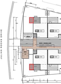
|
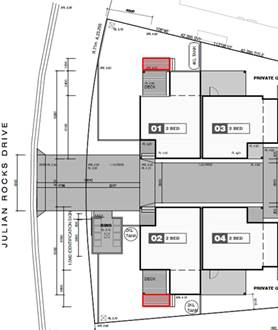
|
|
Original Proposal
|
Amended Proposal
|
Building
Height Plane
The proposal
does not comply with DCP 2014, in that:
ii. the
proposed development encroaches into the building height plane on southern
boundary, resulting in impacts on neighbouring residential properties;
Particulars
The proposed development
encroaches into the building height plane on southern boundary
The amended proposal does not encroach into the building
height plane and will reduce impacts on neighbouring properties in terms of
maintaining solar access.
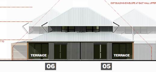
Figure 5: Amended proposal
– no BHP intrusion
Private
Open Space
The original
proposal does not comply with DCP 2014, in that:
i. inadequate
useable private open space is provided to the units, with private spaces
proposed within the front setbacks and overlapping private open spaces between
units.
Particulars
The private open space area of
units 6 and 7 overlap and overlook the private open space areas to units 5 and
8.
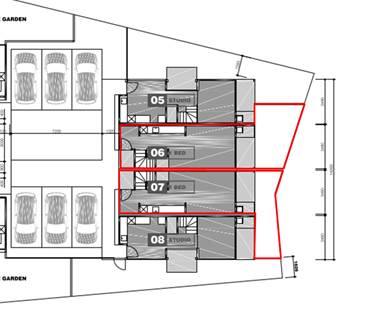
Figure 6: Original DA -
Overlapping POS areas to Units 5 & 8
The amended proposal has removed private open space areas
from within the front setbacks as discussed above. The reduction in units at
the rear of the site has removed the overlapping private open space between
units thus providing for a more functional and usable area of open space for
Units 5 and 6.

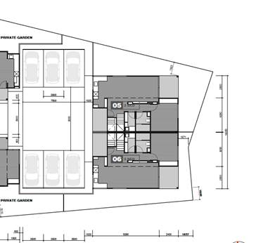
Figure 7: No overlapping of POS
areas
Inadequate
internal floor area
The proposal does not comply
with the SEPP ARH and the internal unit design does not provide adequate
internal amenity for future residents
Particulars
The
original proposed development had incorrectly classified the proposed studios,
which are one-bedroom dwellings. The proposed ‘studios’ as
previously proposed were below the required 50m2 for a 1 bedroom dwelling
under the SEPP ARH with a gross floor area of
46m2 for each of the 2 ‘studio’ dwellings when considered as 1
bedroom dwellings.
The amended proposal has now reduced the number of dwellings
from 8 to 6 dwellings. Each dwelling will now contain 2 bedrooms. Under the SEPP
ARH the minimum gross floor area for a 2 bedroom dwelling is 70m2.
All proposed dwellings have a
minimum of 70m2 gross floor area which now complies with the minimum dwelling
size for a 2 bedroom dwelling.
Public
interest
The
development application should be refused because the proposed development is
not in the public interest having regard to the nature and number of
submissions received objecting to the proposal and the Contentions listed
above.
Amended plans
The applicant has submitted amended plans which
have been considered by Council staff.
Most of the matters raised in objections have been
addressed in the amended proposal as it complies more readily with the
provisions of the SEPP ARH, LEP 2014, DCP 2014 and Council’s development
related policies.
Public Exhibition
The amended proposal was re-notified (by Council solicitors)
to all who had made previous submissions, with an exhibition period from 21
April to 13 May 2020. There were 11 submissions made in relation to the amended
proposal all objecting.
|
Re-exhibition
of amended plans April/May 2020:
|
|
Submission
|
Comment
|
|
Over development and Character of the Local Area
The proposal for 6 units
continues to be an overdevelopment of the site and fails to meet both the
provisions set out in LEP 2014 and SEPP ARH.
|
The residential character of the
neighbourhood is dominated by dwelling houses and dual-occupancies. In
surrounding streets of Sunrise Boulevarde and Bayshore Drive the residential
density increases consistent with medium density forms for Byron Shire.
With the reduction of units from
8 to 6, the separation of the development into three building with two units
each, a compliant floor space ratio and height limit with the LEP 2014
provisions, it is considered the proposal is not an overdevelopment of the
site and permitted under the SEPP ARH.
|
|
Privacy
The 2 storey nature of the
proposed development will have a negative impact upon my client’s
privacy in their rear/side yard area (located on their northern boundary).
There will be a degree of
overlooking from the second storey level of proposed Units 2 & 4.
|
The amended plans remove first floor windows looking onto
adjoining properties to the north and south to unit 5 & 6.
Units 1-4 have been amended to provide 1.5m fixed textured
glass window panels on the first floor looking over adjoining properties to
maintain privacy for all existing residents.
|
|
Traffic and Parking
The proposal provides for 6
units with 6 car spaces. While this meets the minimum
requirements of the SEPP this
number of car spaces is far below the number of car spaces needed within a
unit complex of this nature.
The street is just over 7metres wide with most average
cars, vans & work vehicles being 1.8 - 2mtrs in width and then buses
2.60mtrs it becomes a one way street then you have The garbage trucks.
|
Council cannot refuse the application based on car parking
as it complies with the minimum parking requirements of the SEPP ARH.
|
|
Affordable Housing
It is unclear from the revised
proposal whether affordable housing will be provided in the development.
|
The development will be conditioned to provide for an
affordable housing unit. The applicant has nominated unit 6 for this purpose.
|
|
Vegetation Removal
The proposal provides for the
removal of a substantial strand of trees located along the frontage to Julian
Rocks Drive.
|
A small number of shrubs will be required to be removed
for the driveway. This vegetation to be removed is considered to be
‘planted vegetation’.
|
|
Precedence of the form of development in Sunrise Estate
This proposal is likely to set
precedence for this form of development within the Sunrise Estate and is
likely to compound the negative issues of over development, loss of character
of the Sunrise Estate, privacy and amenity concerns and traffic and car
parking issues.
|
The development applied for under the SEPP ARH is only
applicable to those sites within a400m walk from a B2 Local Centre or Zone B4 Mixed Use zone. The
ability to apply for further development under the SEPP ARH is otherwise
limited within the estate.
|
|
Landscaping and Privacy
a. Reduction in Deep Soil
Planting
The amended plans provide for
a reduction in landscaped area for Unit 4
from 37m2 to 35m2 and a
substantial reduction in deep soil planting area from 30m2 to 20m2.
Provision of screen planting
in courtyard to Unit 4 and Unit 2 along southern boundary and fencing.
|
The site provides adequate deep soil planting in
accordance with the DCP 2014.
The site provides for planted shrubs and trees along all
site boundaries to assist in screening the development from adjoining
properties.
|
|
Relocation of Bicycle Parking
The amended plans show the
relocation of the bicycle parking area along the common boundary to my
client’s site, next to proposed Unit 4.
|
The bike parking has been removed from the central
location. Given that each unit will have a large private open space area,
each unit will be able to store a bike within their own outdoor areas
individually.
|
|
Gross Floor Area
The gross floor area of 438m2 includes the area for a
stairwell. Stairwells are not classed as living space. This needs adjustment.
|
Each unit has the minimum required gross floor area as
defined under the SEPP ARH.
|
|
Inadequate Public Transport
Limited bus service only is
available to the Sunrise Beach area. Blanches Bus Services run limited bus
services to Mullumbimby & to the north of the Shire that would make
working in these areas difficult or impossible to access.
|
Noted.
|
|
Inclusivity of All Community Members.
The units are all 2 storey
with tight spiral stairwells. They do not provide easy access for young
families with small children, or the elderly & no access for the
disabled.
|
A condition of approval recommends provision of an
accessible/adaptable unit in the development.
|
|
Adjustments in Amended DA
The amended DA only shows minor changes to the original DA
by reducing four units numbered 5, 6, 7 & 8 on the original plans to 2
units, numbered 5 & 6 on the amended plans. Four (4) units comprising 2
undersized studios & 2 single bedroom units have been converted to 2 x 2
bedroom units that occupy the same amount of space at ground level as the
original design.
The proposed density of people living in the units has not
decreased with these changes. No limits appear to have been placed on
occupant numbers of the two bedroom units. I thought that this would be a
requirement of the Affordable Housing SEPP?
|
There are no requirements under the SEPP ARH or the LEP
2014 or DCP 2014 to limit the number of occupants per bedroom.
|
|
Limited Social Benefit
The developer applies under the terms of SEPP ARH. In this way, site capacity
(and hence financial return) can be maximised, and local zoning does not
apply to the development.
However, the developer is not a social housing provider,
and units offered as Affordable Housing will revert to market rental rates
after 10 years.
|
Noted.
|
Financial implications
The estimated professional legal costs of defending the
appeal are $10,780 excluding GST, assuming that the hearing in the matter only
takes 1 day. If the hearing takes longer the legal costs will be higher.
Statutory and Policy
Compliance Implications
Section 34 Conferences
Conciliation in the Court is undertaken in accordance with
Section 34 of the Court Act (otherwise known as a Section 34 Conference).
Section 34 Conferences, as articulated by the Chief Judge in
(2008) 19 ADRJ 72, provide: “for a combined or hybrid dispute resolution
process involving first, conciliation and then, if the parties agree,
adjudication. The conciliation involves a Commissioner with technical expertise
on issues relevant to the case acting as a conciliator in a conference between
the parties. The conciliator facilitates negotiation between the parties with a
view to their achieving agreement as to the resolution of the dispute. If the
parties are able to reach agreement, the conciliator, being a Commissioner of
the Court, is able to dispose of the proceedings in accordance with the
parties’ agreement.”
The Court’s practice note encourages parties to
consider using Section 34 Conferences to resolve disputes or narrow the scope
of issues in dispute. The parties should properly prepare for each conference
with this purpose in mind.
In accordance with Section 34(1A) of the Court Act it is the
duty of each party to proceedings where a conciliation conference has been
arranged to participate, in good faith, in the conciliation conference.
Conciliation Agreement/Consent Orders
The differences between finalising the Court proceedings via
a Conciliation Agreement compared to Consent Orders are as follows:
1. A
Conciliation Agreement is between Council and the applicant ie Council stays
the determining authority.
Use of a Conciliation Agreement would bring the Court cases to an end
immediately and without the need for Council to include any expert witness
costs or any legal costs beyond the minor costs associated with finalising the
Conciliation Agreement.
2. Consent
Orders are Orders issued by the Court by agreement ie the Court becomes the
determining authority and has the power to refuse to issue the orders the
parties are asking for and/or to make different orders instead. With a Consent
Orders hearing, everything, including the proposed conditions, is open to the
Court to finally determine and, for example, a Commissioner might disagree with
proposed conditions and issue orders with different conditions.
Because the Court becomes the determining authority, Consent Orders will not be
entered by the Court without a hearing. That means a hearing would need to be
held (usually commencing on-site then adjourning to a local Court house) and
solicitors, expert witnesses and people who lodged an objection who wished to
make a verbal submission to the hearing would have to attend, and Council would
incur the associated legal and witnesses costs.
Usually, Consent Orders Hearing are shorter than defended hearings, often only
2 - 4 hours instead of the minimum full day hearing or more, but the hearing
still needs to be prepared for and attended, just like a defended hearing would
be, which means that the vast majority of the costs are still incurred.
Due to the reduced certainty and the higher costs, this is usually not the
option recommended by staff for disposal of the court cases where Conciliation
Agreement option is still available, as is the case here.
Conclusion
The amended proposal presented
at the without prejudice meetings to date provides for a development that
addresses the reasons for refusal. The reduction from 8 units to 6 units, has
enabled the development to be redesigned in terms of satisfying Council’s
requirements for setbacks and building height plane encroachments, and
providing a much more useable and functional private open space area for the
rear units 5 and 6. Although not a contention or reason for refusal, an added
consequential benefit from the redesigned development is that each unit will
have a car parking space.
On the basis of these amended plans, it is recommended that
the General Manager be authorised to enter into consent orders or a Section 34
Conciliation Agreement to resolve the matter.
Staff Reports - Sustainable Environment and Economy 13.6
Report No. 13.6 PLANNING
- Byron Bay Arts & Industry Estate Precinct Plan and Lot 12 - Submissions
Report
Directorate: Sustainable
Environment and Economy
Report
Author: Rob Van
Iersel, Major Projects Planner
File No: I2020/813
Summary:
In December 2018, Council resolved to engage consultants HIP
V HYPE to facilitate an Enquiry by Design (EbD) process, as a first step in the
preparation of a Precinct Plan for the Byron Arts and Industry Estate (Res
18-817).
The two-day EbD workshop was held in April 2019, with eight
key community stakeholders attending for the full two days, along with a mix of
technical experts, Council staff and Councillors. The process was extremely
productive, with great enthusiasm, creativity and intellect shown by the entire
group.
In September 2019, Council
resolved (Res 19-452) to endorse the draft Precinct Plan for the
Arts and Industry Estate for the purposes of public exhibition. That
exhibition was undertaken in April 2020 and has now concluded.
The exhibition also included a number
of structure plan options for Council-owned Lot 12 Bayshore Drive, to seek
feedback on land uses and ideas for the future development of that lot.
A copy of the submissions received and the Draft Masterplan are
attached to this report. Issues raised in the submissions have been
discussed in the body of this report.
Based on the feedback it is
considered that there is no need to amend or adjust the draft Precinct Plan as
exhibited. Most of the submissions contained ideas and commentary that
will be relevant in moving forward with the recommended actions. It
is recommended that Council adopt the Masterplan, which will facilitate
planning for the delivery of actions.
NOTE TO COUNCILLORS:
In accordance with the
provisions of S375A of the Local Government Act 1993, a Division is to be
called whenever a motion for a planning decision is put to the meeting, for the
purpose of recording voting on planning matters. Pursuant to clause 2(a)
under the heading Matters to be Included in Minutes of Council Meetings of
Council's adopted Code of Meeting Practice (as amended) a Division will be
deemed to have been called by the mover and seconder of all motions relating to
this report.
|
RECOMMENDATION:
1. That
Council adopts the Byron Bay Arts & Industry Estate Precinct Plan
as contained in Attachment 1 (E2020/21932)
2. That
Council staff commence work on planning for the implementation of
actions and put through any budget bids required for these actions at the
relevant time through the annual budget review process.
3. That
Council staff continue to refine the desired land uses, design principles and
delivery options for Lot 12 and report to the earliest available Council
meeting.
|
Attachments:
1 Final
Draft Byron Arts & Industry Estate Precinct Plan, E2020/21932
2 Confidential
- Community Submissions Precinct Plan and Lot 12, E2020/40670
3 Agency
Submissions Draft Precinct Plan, E2020/40753
REPORT
At the Council Planning meeting of
19 September 2019, Council resolved (19-452) to endorse the draft
Precinct Plan for the Arts and Industry Estate for the purposes of public
exhibition. The resolution also included a request “that staff
accelerate the preparation of a Structure Plan for Lot 12 concurrent with
the finalisation of the Draft Precinct Plan”.
Subsequent to the resolutions,
Council was approached by TAFE NSW to lease part of Lot 12 to allow them to
establish a Connected Learning Centre at the site. The TAFE request is
for an area of approx. 5,000m2 at the Bayshore Drive frontage of the
site.
In line with the September
resolution, consultants were engaged to prepare three structure plan options
for Lot 12, including one option accommodating the TAFE request. The
intent of developing the options was to assist Council in determining desired
future uses at the site and how development of those uses might be delivered.
Council
considered the structure plan options and the TAFE NSW request at the Planning
Meeting of 16 April 2020 and resolved (20-161):
1. That
Council waits until the conclusion of the enquiry by design process including
public exhibition report on the structure plan options and draft arts and
industry estate precinct plan being presented to Council for endorsement before
decisions on anchor tenants are reached.
2. That
Council reiterates its support for TAFE and the creation of a physical presence
of TAFE in Byron Bay.
3. That
Councillors are provided a presentation on possible outcomes on Lot 12 at a SPW
to be held within the timeframe of the conclusion of 1 above.
4. That
Council undertake discussions with other educational and research entities to
ascertain interest in establishing a wider collaborative education and research
precinct.
5. That
Council acknowledges and reiterates a current resolution for this site as being
a precinct of education, innovation and creative industries.
Public Exhibition
Exhibition of the draft Arts and
Industry Precinct Plan and the Lot 12 structure plan options occurred from 29
April to 26 May 2020. Engagement included social and traditional media, a
Your Say page on Council’s web page, posters distributed through the
Estate, letters to owners and an on-line information forum.
Submissions
In response to the engagement,
Council received:
· a total of 27 submissions (see Attachment 2);
· 17 of these provided commentary only on the draft Precinct
Plan;
· 4 commented only on Lot 12;
· 6 provided comments for both
· 2 of the submissions were from Community Groups;
· 8 from businesses; and
· 14 from individuals.
State Government Agencies were
also consulted, with 3 responses received (see Attachment 3).
Key issues
The feedback in general was
largely positive, with many applauding the intended outcomes of the plan.
Some key features that gained support were:
· the trial of one-way traffic circulation in Centennial
Drive as a pilot project to address access issues;
· a focus on a range of actions to provide alternate
transport options;
· actions to deliver bike/ pedestrian paths and connections;
and
· recognition of the vitality and diversity of the Estate and
actions to protect and build on those values.
In relation to Lot 12, feedback
generally supported the creation of a diverse innovations hub on the property,
with a range of suggestions for the land uses that might be involved in such a
hub.
Draft Precinct Plan:
Generally, there was support for
the Precinct Plan in providing a blue-print for the future of the estate,
including recognition of the existing strengths, primarily around the vibrancy
and diversity of the area.
With that was agreement that the
functional issues around traffic and parking are significant. A number of
submissions support the proposed one-way traffic trial for Centennial Circuit,
but many submissions suggest that urgent actions are required to address car
parking.
A summary of submission comments
is provided below:
|
Submission
|
Commentary
|
|
Precinct has potential to be home to internationally
renowned companies exporting to the world.
Support for major overhaul of
roads, footpaths etc and rebranding of the estate. - should be rebranded
urgently
Council should work with
“people who have the skills to create the right plan, then exit the two
lots they own ASAP”
The place needs to remain eclectic
and get firmly onto the world stage – need to support existing
diversity.
|
Comments are consistent with actions and intent of the
Precinct Plan.
The actions outlined in the Land
Use section of the Precinct Plan will be important in addressing these comments.
In relation to “exit the
two lots…” planning for Lot 12 is continuing. There has not
been a decision of Council regarding the future of the depot. This was
communicated clearly in the EbD workshop and is noted in the draft Precinct
Plan.
Notwithstanding, a number of
submissions recognise the central location and size of the depot land as
having the potential to be strategically important for the future of the
Estate.
|
|
Need to ensure that rents/ values don’t increase to
extent of pricing out small local business
|
Council has limited capacity to “control”
rental values.
However, this issue needs to be
considered in looking at how to plan for future land use controls in the
Estate.
|
|
Support for increased building height & review of
building design controls.
Suggest that controls for
properties fronting Bayshore Drive should promote ‘main street’
development with active frontages and awnings over footpath
|
The potential for increased building height will be
examined in the context of the scarcity of unconstrained urban land and the
strategies outlined in the adopted Business and Employment Lands Strategy.
|
|
Footpath/ cycleway links to solar train platform should be
a priority
West Byron Shopping Centre (IGA,
etc.) should be ‘upzoned’ to allow new development to ‘come
forward, to street, allowing awnings over path
|
Council’s adopted Bike Plan includes construction of
a shared path link to the existing path in the vicinity of Habitat, which
will connect the Estate to the solar train platform.
Upzoning of the West Byron
Shopping Centre is currently not within the Precinct Plan.
The Business and Employment Land
Strategy identifies that, by 2031, there is likely to be sufficient demand
for an additional large supermarket, and that West Byron may be an appropriate
location to accommodate the demand.
The future of the existing
shopping area could be reviewed in the lead up to that.
|
|
Suggest that the potential for cross pedestrian paths
should be encouraged through private lots – VPAs could be used, with
FSR/ development incentives
|
This could be looked at in the longer term land use
review.
It is important to note that
while some notional cross-property links are indicated in the draft Plan, no
land owner would be forced to provide such a path.
Cross connections are
aspirational, and Council would work with individual owners, if the
opportunity arises, to achieve mutually beneficial outcomes.
|
|
Need space for medium – large scale business
Byron needs a ‘proper
industrial estate’ with wider roads and off-street parking
|
This issue is addressed in the adopted Business and
Employment Lands Strategy, which notes that, to address ongoing demand, a
minimum additional eight to twelve hectares of land should be planned for
industrial purposes.
In undertaking that planning,
Council will need to further refine the industrial needs, in part to
determine whether the Shire can accommodate larger scale industries.
In relation to the Arts &
Industry Estate, the evolution of land uses there has resulted in a strong
diversity of uses and scales, and it would be practically impossible to seek
to ‘revert’ to a traditional industrial estate catering to larger
industries.
|
|
Bike and walking paths needed – a central parking
garage, with secure bike parking would allow users to park centrally and
cycle/ walk to individual sites
|
The Precinct Plan acknowledges the need for bike / walking
paths and recommends actions to plan for them.
While a central parking garage
might ease current parking congestion, there are no available sites to
accommodate that development in the short-term.
|
|
Strong support for walkways and cycleways and use of
drainage corridors for such – but still need to address parking
urgently – centrally located depot site ideal location for parking
area, particularly for business owners/ tenant
Timed on-street parking could
then be used for customers
|
Walkways and cycleways are proposed as part of the adopted
Bike and PAMP plans.
Work is progressing in relation
to the central drainage corridor, associated with the proposal to provide
flows of treated wastewater into that drain from the STP, and that project
includes the construction of a shared path along the drain.
See comments above regarding
depot site.
|
|
Strong support for traffic and parking solutions –
but need real actions/solutions
Suggest use of existing verges
for increase parking solutions
Suggest that shared on-street
loading bays be used to free-up space within individual properties
|
Use of existing verges for parking would negate the
possibility of providing shared paths in that space, and is therefore not
supported.
The concept of shared loading
bays can be explored in future work.
|
|
Need to address potential conflicts for people who live in
the estate, particularly noise (night)
|
The draft Precinct Plan notes that residential use will
remain a part of the estate, but at a small-scale, and preferably linked to
other commercial uses.
In further planning for
compatible land uses, it will be important to ensure that residential uses do
not dominate in the future, as that would create the potential for raising
land values and ‘pricing out’ alternate legitimate business use.
|
|
Support for future community use of depot site (with wider
parking) – Master Plan should be developed as a priority
|
See comments above.
Council will need to consider the
future options for the depot site prior to any master planning.
|
|
Should be stronger transport link to solar train station
|
See comments above – shared path connections
proposed.
|
|
Estate should be planned as an “Age Friendly”
place
|
This can be considered in moving forward with the land use
components of the Precinct Plan.
|
|
Concerned with extra traffic through Sunrise estate
Suggest extra lighting and safer footpaths in Sunrise
estate
|
This can be considered in moving forward with the land use
components of the Precinct Plan.
|
|
Suggest dredging silt build up in Belongil estuary near
Ewingsdale Road bridge
|
Not directly relevant to this Plan.
|
Lot 12:
Submissions in relation to future
uses of Lot 12 were more varied, as summarised below:
|
Submission
|
Commentary
|
|
Support for education as an anchor, but not in location or
of the scale proposed by TAFE.
Support medium density
residential – either as shop-top housing or co-housing units
Height should be 11.5m (three
storey) with potential for a central landmark building higher
Should include a central civic
open space precinct incorporating public art
Should have pedestrian and
vehicle links to Habitat
Suggest that some lots be created
for sale on “open market”
Boardwalks/ observation platforms
suggested to take advantage of high environmental value lands to west
|
Suggestions from a local architect/urban designer were
supported by a Master Plan.
Land uses and key site principles
were discussed at a Strategic Planning Workshop on 5 June 2020 and work on
refining the desired outcomes is continuing.
|
|
Beautiful and inspiring place to learn, research, to
provide local businesses and NGO’s with support in terms of research
and action projects
Management by independent not for
profit trust
TAFE should not dominate space
|
Suggestions from a local community member were also
supported by a Master Plan – as above, work continues on defining
desired outcomes.
|
|
Liked anchor option
Art studios a great idea
Affordable permanent co-housing
supported
Support 3 storey maximum
Car park at rear and green spaces
maximised
|
As above.
|
|
Height should be restricted to 2 storey
Suggested more public uses
– swimming pool, skate park, Arakwal cultural centre, child care
|
Building height is yet to be refined/ finalised. It
is unlikely, however, that the public uses nominated will form part of the
future of the site, although a cultural centre and child care could be
considered.
|
|
Retail not supported
Ideal site for real social
affordable housing
Should not be ‘given’
to private developers
|
Comments noted. Council is yet to determine delivery
options for the future of the site.
|
|
Access thru site to Cavanbah supported
|
It is suggested that bike/ pedestrian access to Cavanbah
should be achieved in planning for the future of the site.
|
|
TAFE use supported
|
Noted – previous Council resolution also supported
TAFE use.
|
|
Existing traffic/parking problems need to be solved (for
whole estate) before further development of this land
|
It is considered that future planning of Lot 12 can
progress while wider actions are implemented.
|
Agency Submissions:
|
Submission
|
Commentary
|
|
Planning, Industry & Environment - Biodiversity
and Conservation Division
|
|
Direct consultation with the
Bundjalung of Byron Bay Arakwal People should be undertaken and documented in
the Precinct Plan
|
Preliminary discussions were held with Arakwal
representatives and further engagement will take place as part of
implementation of various actions that come from the Plan.
|
|
The proposal to investigate public car parking on Council
land north of Wallum Place should ensure that areas of high environmental
value vegetation are not disturbed
|
This will be considered in detail should that suggested
car parking be pursued.
|
|
The design of drainage works associated with the multi
purpose drainage areas should enhance the drainage network function
|
Noted.
|
|
The Plan should emphasis the sensitive nature environment
within and surrounding the precinct by including SEPP Coastal management
wetlands and proximity areas on mapping
|
There are no mapped Coastal Wetlands or proximity areas
within the Study area.
|
|
Future development should avoid and mitigate impacts on
areas of high environmental value
|
Noted.
|
|
The precinct plan should refer to the NSW
Government’s Net Zero Emissions Guidance for NSW Councils
|
Implementation of various recommended actions will be
undertaken in conjunction with the actions and principles of Council’s
Net Zero Emissions Strategy.
|
|
The Plan should include actions
to minimise heat and increase urban green cover in the precinct
|
Noted – will be considered in looking at the land
use actions.
|
|
Transport for NSW
|
|
|
TfNSW supports the Draft Precinct
Plan, particularly the focus on alternative forms of travel and transport
|
Noted.
|
|
There needs to be strong
recognition of any impact on Ewingsdale Road, especially if development is
planned prior to upgrades of that road network. The timing of any land
use, traffic or density changes could cause further traffic congestion and
conflict if not acknowledged and properly managed
|
Noted – will be considered in looking at the land
use actions.
|
|
While the Draft Plan is a
high-level design document, specific to the BA&IE, it should consider any
design and access arrangements in association with the proposed residential
development to the south of Ewingsdale Road which will utilise the Bayshore
Drive and Banksia Drive intersections
|
Noted – will be considered in looking at the land
use actions.
|
|
The need to efficiently manage
the movement of larger vehicles onto and through the Estate is recognised on
page 18 of the document. This is supported, but the words ‘safety
and efficiency’ should be included to ensure the correct focus from a
road user and network safety view point
|
Noted.
|
|
Planning, Industry &
Environment
|
|
|
The Byron Arts and Industry
Estate is recognised as a key employment hub in the North Coast Regional Plan
2036 and in the Northern Rivers Regional Economic Development Strategy. I
am therefore pleased to offer the Department’s support for the Precinct
Plan and for Council’s ongoing efforts to coordinate planning for the
Estate.
|
Noted.
|
|
It is important that the proposed
increase in retail activity in the Estate does not significantly detract from
the function of the Byron Bay town centre.
|
Noted – will be considered in looking at the land
use actions.
|
|
The key land use action in the
draft Precinct Plan is Action LU2, which proposes that two major
Council-owned sites within the Precinct will potentially permit retail that
is not ancillary to uses on the sites. It will be important to establish that
retail development is appropriate on these sites in the context of the
Regional Plan and the Byron Shire Business and Industrial Lands Strategy
|
Noted – see comments above.
|
Based on all of the submissions,
it is considered that there is no need to amend or adjust the draft Precinct
Plan as exhibited. Most of the submissions contained ideas and commentary
that will be relevant in moving forward with the recommended action.
Next Steps
Should Council adopt the Precinct
Plan, staff will prepare a program for the implementation of actions. The
program will include a prioritisation of actions and consequential budget
impacts.
For Lot 12, staff will continue to
work with Councillors to refine a vision for the site, identify key future land
uses and design principles, and identify the preferred model for delivery of
the agreed outcomes.
STRATEGIC CONSIDERATIONS
Community Strategic Plan and
Operational Plan
|
CSP Objective
|
L2
|
CSP Strategy
|
L3
|
DP Action
|
L4
|
OP Activity
|
|
Community
Objective 4: We manage growth and change responsibly
|
4.1
|
Support the
visions and aspirations of local communities through place-based planning and
management
|
4.1.1
|
Develop,
implement and update Place Plans that promote place-based forward planning
strategies and actions
|
4.1.1.6
|
Develop the
Arts and Industry Estate Precinct Plan
|
|
|
|
|
|
|
|
|
|
|
|
|
|
Legal/Statutory/Policy Considerations
Nil.
Financial Considerations
Funds have been allocated to
implement the one-way traffic trial for Centennial Circuit.
Council will need to consider the
allocation of funds in order to implement actions within the Precinct Plan.
These should be looked at as a part of regular budget review process.
Staff Reports - Sustainable Environment and Economy 13.7
Report No. 13.7 PLANNING
- DA 10.2020.61.1 Multi-Dwelling Housing Comprising Ten (10) Dwellings at 7
Julian Rocks Drive Byron Bay
Directorate: Sustainable
Environment and Economy
Report
Author: Luke
Munro, Planner
File No: I2020/756
Proposal:
|
DA No:
|
10.2020.61.1
|
|
Proposal description:
|
Multi-Dwelling Housing Comprising Ten (10) Dwellings
|
|
Property description:
|
LOT: 6 DP: 714410, LOT: 7 DP: 714410
|
|
7 Julian Rocks Drive BYRON BAY, 9 Julian Rocks Drive BYRON
BAY
|
|
Parcel No/s:
|
35540, 35550
|
|
Applicant:
|
Julian Rocks Developments Pty Ltd
|
|
Owner:
|
Julian Rocks Developments Pty Ltd
|
|
Zoning:
|
R2 Low Density Residential
|
|
Date received:
|
6 February 2020
|
|
Integrated / Designated Development:
|
☐
Integrated
|
☐
Designated
|
☒
Not applicable
|
|
Concurrence required
|
No
|
|
Public notification or exhibition:
|
- Level
2 advertising under DCP 2014 Part A14 – Public Notification and
Exhibition of Development Applications
- Exhibition
period: 20/02/20 to 11/3/20
- 13
submissions received
|
|
Planning Review Committee:
|
14.05.2020
|
|
Delegation to determine
|
Council
|
|
Issues:
|
Minor building height plane intrusion
Bike path construction (5.2 – Section 7.11
Contributions)
|
Summary:
The Development Application (DA) proposes Multi-Dwelling
Housing Comprising Ten (10) Dwellings. The site has frontage to both Julian
Rocks Drive and Bayshore Lane and the development has been designed to address
both street frontages and will consist of:
· 4 x 3 bedroom
dwellings;
· 4 x 2 bedroom
dwellings; and
· 2 x 1 bedroom
units.
·
The development will include the
demolition of the 2 existing dwelling houses on the site.
The proposed development is considered to be largely
consistent with the provisions of the Byron LEP 2014 and DCP 2014 and is not
likely to result in significant impacts on the existing residential
environment. The site comprising a total area of 1561 m2 has dual
frontage with rear lane access and sits opposite a number of residential
dwellings on lots with an area of approximately 400m2 each.
The development provides for a mix of housing types and
bedroom sizes and has been appropriately designed in terms of Council’s
planning controls for heights, setbacks building height plane, car parking and
open space. The property is sited in proximity to a neighbourhood shopping
centre, the industrial estate and “Habitat” for work and shopping
access, is unconstrained and is serviced with necessary infrastructure.
It is considered the proposal will not prejudice or
compromise the public interest or create an undesirable precedent and the
application is recommended for approval subject to conditions of consent.
NOTE TO COUNCILLORS:
In accordance with the
provisions of S375A of the Local Government Act 1993, a Division is to be
called whenever a motion for a planning decision is put to the meeting, for the
purpose of recording voting on planning matters. Pursuant to clause 2(a)
under the heading Matters to be Included in Minutes of Council Meetings of
Council's adopted Code of Meeting Practice (as amended) a Division will be
deemed to have been called by the mover and seconder of all motions relating to
this report.
|
RECOMMENDATION:
That pursuant to
Section 4.16 of the Environmental Planning & Assessment Act 1979,
Development Application 10.2020.61.1 for Multi-Dwelling Housing Comprising Ten (10) Dwellings, be granted
consent subject to the conditions listed in Attachment 3 (E2020/40426).
|
Attachments:
1 Plans
10.2020.61.1, E2020/37165 
2 Perspectives
and Shadow Diagrams 10.2020.61.1, E2020/40425
3 Conditions
of consent 10.2020.61.1, E2020/40426
4 Confidential
- Submissions received 10.2020.61.1, E2020/37162
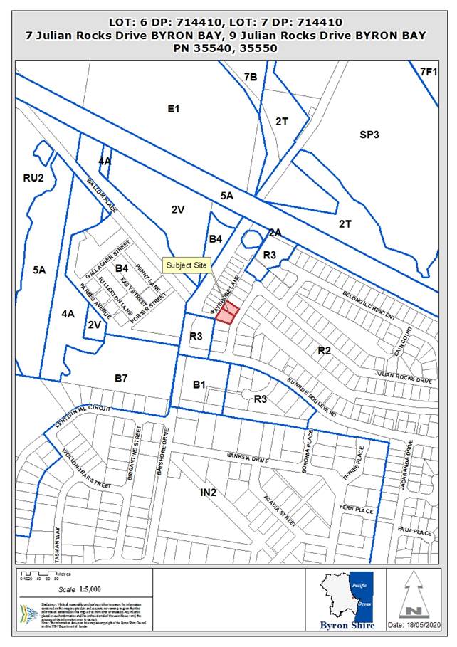
REPORT
Assessment:
1. INTRODUCTION
1.1. History/Background
The site is subject to the previous applications:
7 Julian Rocks Drive – Sewerage Drainage connection
1987
9 Julian Rocks Drive – 6.1987.2158.1 New Dwelling
Approved 07.04.1987
1.2. Description
of the proposed development
This development application seeks approval for a
Multi-Dwelling Housing Comprising Ten (10) Dwellings.
The subject allotment is legally identified as Lot 6 DP
714410 and Lot 7 DP 714410 and is known as 7 Julian Rocks Drive and 9 Julian
Rocks Drive, Byron Bay. Both lots have a dual frontage with primary frontage to
Julian Rocks Drive and secondary (rear) frontage to Bayshore Lane. Both lots
contain a single detached dwelling (to be demolished).
The proposed development will consist of a total of ten (10)
Multi dwelling housing units separated into two blocks with a central driveway
for access to Units 1 – 8 and Bayshore Lane utilised for visitor parking
and access to Units 9 & 10. The development will address both street
frontages as shown below.
Julian Rocks Drive
streetscape
Bayshore Lane
streetscape
The proposal consists of:
· 4 x 3 bedroom
dwellings
· 4 x 2 bedroom
dwellings (including one of these as an adaptable dwelling – Unit 7); and
· 2 x 1 bedroom
units.
Each unit will be provided with private open space at ground
level and Units 3 and 5 will also incorporate a first floor deck directly
accessible from the first floor kitchen and lounge room.
The side setbacks will be densely landscaped with screening
plants to ensure visual privacy between the proposed development and the
adjoining properties.
Each dwelling will contain the following:
|
Type A units
|
|
|
Ground Floor
|
Open plan kitchen, dining
& lounge
Double car garage `
Laundry
Roofed patio
Private fenced yard
|
|
First Floor
|
Master bedroom with built in
robe and ensuite
2 additional bedrooms with
built in robe
Bathroom
Linen/Storage cupboard
Study nook
|
|
Type B units
|
|
|
Ground Floor
|
Open plan kitchen, dining
& lounge
Single car garage `
External open laundry
Roofed patio
Private fenced yard
|
|
First Floor
|
Master bedroom with built in
robe and ensuite
Second bedroom with built in
robe
Bathroom
|
|
Type C units
|
|
|
Ground Floor
|
Master bedroom with built in
robe and ensuite
Powder room under stairs
External open laundry
Roofed patio
Private fenced yard
|
|
First Floor
|
Open plan kitchen, dining
& lounge
Deck
|
|
Type D unit - Adaptable Unit
|
|
|
Ground Floor
|
Open plan kitchen, dining
& lounge
External open laundry
Roofed patio
Private fenced yard
|
|
First Floor
|
Master bedroom with built in
robe
Second bedroom with built in
robe
Bathroom
|
In response to Council’s information request, the
applicant has incorporated a number of changes into the design of the dwellings
including:
· Reduced the number
of bedrooms onsite by 2 bedrooms from 24 bedrooms to 22 bedrooms overall.
· Reversing the roof
pitch of the southern unit building to reduce the BHP intrusion.
· Reducing the FSR
ratio to under 0.5:1 to comply with the LEP provisions
· Increasing private
open space areas from 561m2 to 602m2
· Provided
accessible unit with adequate dimensioned car parking area.
· Improved internal
privacy between units through use of opaque and textured glass.
· Provided large
landscaping indents in the front fence to Julian Rocks Drive.
Shadow diagrams have been submitted showing the extent of
existing overshadowing and the impact of the proposed development in relation
to overshadowing. The proposed development generally complies with the building
height plane except for a small area of encroachment on the southern corner
which is addressed in Section 4.4A of this report.
1.3. Description
of the site
A site inspection was carried out on 19 February 2020
|
Land is legally described
|
LOT: 6 DP: 714410, LOT: 7 DP: 714410
|
|
Property address
|
7 Julian Rocks Drive BYRON BAY, 9 Julian Rocks Drive BYRON
BAY
|
|
Land is zoned:
|
R2 Low Density Residential
|
|
Land area is:
|
1561.3 m2
|
|
Property is constrained by:
|
Acid Sulfate Soils Class
3
|
|
Is a BDAR required due to the location of the proposed
development?
|
☐ Yes ☒ No
|
|
Are there any easements in favour of Council affecting the
site?
|
☐ Yes ☒ No
|
|
Is there a Vegetation Management Plan which might affect
the proposal?
|
☐ Yes ☒ No
|
|
Is there a Voluntary Planning Agreement which might affect
the proposal?
|
☐ Yes ☒ No
|
Photo 1: 7 Julian Rocks Drive
Photo 2: 9 Julian Rocks Drive
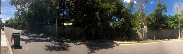
Photo 3: Bayshore Lane – looking east towards 7
and 9 Julian Rocks Drive
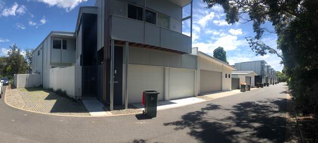
Photo 4: Bayshore Lane – looking west (opposite
7 and 9 Julian Rocks Drive)
2. SUMMARY OF
REFERRALS
|
Referral
|
Issue
|
|
Environmental Health Officer*
|
No objections subject to conditions.
|
|
Development Engineer
|
No objections subject to conditions.
|
|
S64 / Systems Planning Officer
|
No objections subject to conditions.
|
|
S94 / Contributions Officer
|
No objections subject to conditions.
|
3. SECTION 4.14
– BUSH FIRE PRONE LAND
Under section 4.14 of the Act, Council must be satisfied
prior to making a determination for development on bush fire prone land, that
the development complies with the document ‘Planning for Bush Fire
Protection 2006’. The site is not bush fire prone land.
EFFECT OF 10/50 RULE ON SIGNIFICANT VEGETATION
The site is not identified as being bushfire prone.
4. SECTION 4.15C
– MATTERS FOR CONSIDERATION – DISCUSSION OF ISSUES
Having regard to the matters for consideration detailed in Section
4.15(1) of the Environmental Planning & Assessment Act 1979 (EP&A Act),
the following is a summary of the evaluation of the issues.
4.1 State Environmental
Planning Instruments
|
|
Satisfactory
|
Unsatisfactory
|
|
State
Environmental Planning Policy No 55—Remediation of Land
|
☒
|
☐
|
|
Consideration:
Councils Environmental Health
Officer has assessed the site in relation to SEPP55 and provided the
following comments:
“The site contains two
existing approved dwellings BA 87/2305 (PR35540) and BA 87/2158 (PR35550),
both of which pre-date SEPP55. The land appears to have been used for
residential purposes since.
Desktop analysis of
Council’s archive, Geocortex mapping database and historical aerial
imagery revealed no evidence of past contaminating activities. A site
inspection conducted on 30 March 2020 did not reveal any evidence of visual
contamination; no significant observable point sources such as drums,
wastes, rubbish or unusual odours, or yellowing of vegetation were observed.
The land
use type remains unchanged and the proposed development does not result in an
increased sensitivity, and therefore, the site is considered suitable for
the intended development. No further investigation or action
warranted”
|
|
State
Environmental Planning Policy (Building Sustainability Index: BASIX) 2004
|
☒
|
☐
|
|
Consideration:
A valid BASIX Certificate has
been provided.
|
|
State Environmental Planning Policy (Coastal Management)
2018
|
☒
|
☐
|
|
Consideration:
The site is not mapped within
the Coastal Management Area or the Coastal Environment Area. As the site is
not located within either of these areas no substantive issues are raised in
regard to this.
|
4.2A Byron Local Environmental Plan 2014 (LEP 2014)
In accordance with LEP 2014 clauses 1.4 and 2.1 – 2.3:
(a) The
proposed development is defined in the LEP 2014 Dictionary as Multi dwelling
housing;
(b) The
land is within the R2 Low Density Residential according to the Land Zoning Map;
(c) The
proposed development is Permitted with Consent; and
(d) Regard
is had for the Zone Objectives as follows:
|
Zone Objective
|
Consideration
|
|
To
provide for the housing needs of the community within a low density
residential environment.
|
The proposed 10 units will provide additional dwellings
and increase housing diversity within the area.
|
|
To
enable other land uses that provide facilities or services to meet the day to
day needs of residents.
|
Not Applicable – no non residential uses are
proposed.
|
Clause 4.1E Minimum lot sizes for dual occupancies,
multi dwelling housing and residential flat buildings
The Byron LEP 2014 identifies that the minimum lot size for
multi dwelling housing development is 1,000m2. The subject site commands an
area of 1,561m2 and therefore complies with the minimum lot size requirements
for multi dwelling housing under the LEP 2014.
Clause 4.3 Height of buildings
The Height of Buildings map identifies the site has a
maximum allowable height of up to 9m.
The proposed new multi dwelling housing units will have an
approximate height of 6.5m above ground level which is below the 9.0m height
limit.
Clause 4.4 Floor space ratio
The site has an allowable Floor Space Ratio (FSR) of 0.50:1,
the current proposal has a total FSR under 0.5:1 and complies with the
allowable FSR for the site.
Clause 6.6 Essential Services
The subject site has full access
to essential services or the ability to make such services available as
required.
4.3 Any proposed Instrument
that has been the subject of public consultation and has been notified to the
consent authority
No Draft Environmental Planning Instruments apply to the
development.
4.4A Byron Shire Development Control Plan 2014
(DCP 2014)
Byron DCP 2014 applies to the development. The following
comments are provided
|
What Section and prescriptive measure does the
development not comply with?
|
Does the proposed development comply with the
Objectives of this Section? Address.
|
Does the proposed development comply with the
Performance Criteria of this Section? Address.
|
|
Chapter B2 – Preservation of Trees and Other
Vegetation
|
Yes
There is no vegetation of significance on the sites. The
proposal will incorporate extensive landscaping throughout the site.
|
Yes
The site contains existing residential landscaping which
is to be removed as part of the development.
|
|
B4.2.5 Car Parking Requirements
and table
B4.2.12 Parking Schedules
|
Yes
Total required 17 spaces onsite with 17 spaces provided
onsite.
Adequate parking is provided onsite in accordance with
Councils DCP 2014.
|
Yes
Chapter B4 of DCP 2014 requires the following car parking
spaces:
4 x 3 bedroom units = 8 parking spaces
4 x 2 bedroom units = 4 parking spaces
2 x 1 bedroom units = 2 parking spaces
Total resident parking required = 14 spaces
Total visitor parking required = 3 visitor parking spaces
Total required 17 spaces onsite with 17 spaces provided
onsite.
Adequate parking is provided onsite in accordance with DCP
2014.
|
|
Chapter B9 – Landscaping
|
Yes
The development provides a high quality landscaping
treatment that will enhance the amenity and function of the development and
provide a pleasant environment for residents that supports their needs and
encourages outdoor lifestyles.
|
Yes
The development provides a total of 572m2 of open space
areas with landscaping provided along the site frontages and along both side
boundaries. (Plus a further 30m2 of decks). Deep soil areas onsite
equate to 472m2 (over 30% of the total site) not including grass pave areas
and impervious areas. Over 75% of the landscaped areas onsite are pervious
and are deep soil zones as defined by the DCP 2014.
|
|
D1.2.1 Building Height Plane (BHP)
|
Yes
The intrusions into the BHP are considered minor and will
have no material impact on adjoining dwellings in terms of access to
sunlight, privacy, overbearing bulk and scale and are considered acceptable
in this instance.
|
Yes
The development includes a small intrusion to the terrace
roof for Unit 1 of 1.4m into the BHP for a length of 5.5m.
The remainder of the development is below the BHP with the
exception of the western elevation of the development to Bayshore Lane which
will not result in any overshadowing to adjoining properties other than the
laneway
Please also refer to additional discussion regarding
the BHP at the end of this Section.
|
|
D1.2.2 Setbacks from Boundaries
|
Yes
The location of the visitor parking is acceptable in this
instance as the location is consistent with the existing development on the
western side of Bayshore Lane and will result in more onsite landscaping
areas.
Further the visitor parking will be constructed from
permeable pavement to reduce any large expanse of concrete when viewed from
Bayshore Lane
|
Yes
The frontage setbacks for the proposed multi dwelling
housing comply with the 4.5m minimum front setback.
The rear setbacks comply with the minimum 3m setback to
laneways.
The visitor parking spaces are located within the 3m
setback to the Bayshore Lane and will be constructed with permeable pavement.
The reduced setback for visitor parking to Bayshore Lane
is considered acceptable in this instance given the western side of Bayshore
Lane has similar reduced setbacks to parking areas and utilises permeable
pavements for a number of parking areas.
|
|
D1.2.5 Fences
|
Yes
Although a 1.8m front fence is proposed to the Julian Rock
Drive frontage of the site the fence incorporates large landscaped recesses
which exceeds the minimum 0.9m x 0.9m recesses required under Prescriptive
Measures 1(c).
In this instance the front fence will not detrimentally
impact on the existing streetscape.
|
Yes
The front fence to Julian Rocks Drive incorporates large
1.5m recesses to allow landscape plantings to reduce the dominance of the
front fence in accordance with the D1.2.5 Fences, this exceeds the 0.9m x
0.9m recesses required by Prescriptive Measures 1(c).
|
|
D1.5.2 Character
And
D1.5.3 Adjoining and Adjacent Development
|
Yes
The development of a multi dwelling housing development on
a 1561m2 block is consistent with the R2 Low Density Residential Zone.
|
Yes
The proposed multi dwelling housing buildings have been
designed with two individual units fronting onto Julian Rocks Drive to
minimise the number of units overlooking the streetscape and to look as far
as possible like two dwellings.
The development is in accordance with the minimum lot size
for a multi dwelling housing development and maintains a FSR of less than
0.5:1.
|
|
D1.5.4 Private Open Space
|
Yes
Each dwelling will have adequate provision of private open
space (POS) as shown on the proposal plans.
The proposed POS areas are suitable for the anticipated
recreational needs of residents and provide direct access from living areas
in accordance with D1.6.1 Private Open Space Courtyards in DCP 2014
|
No
Unit 6 provides 28m2 of POS incorporating outdoor area and
deck areas which are directly accessible from the ground floor living area.
All other dwellings will provide between 30m2 – 80m2
of POS areas (30m2 is prescribed as the minimum).
The POS area to Unit 6 has dimensions suitable for outdoor
recreations needs for a 2 bedroom dwelling and provides northern orientation
to ensure year round comfort in terms of access to sunlight.
The proposed POS areas are suitable for the anticipated
recreational needs of residents and provide direct access from living areas
in accordance with D1.6.1 Private Open Space Courtyards of the Byron DCP 2014
|
D1.2.1 Building Height
Plane (BHP)
As a result of the
information request the applicant has redesigned/flipped the roof line of the
southern units with the skillion roof now angling down to the southern boundary
and reduced the eave overhang, thereby reducing the BHP intrusion.
|
 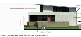
|
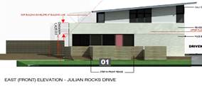
|
|
Image 1: Initial eastern elevation as submitted
|
Image 2: Amended eastern elevation with roof angle
‘flipped’.
|
The changes to the development have resulted in removing the
eaves from intruding into the BHP. The current development intrudes by 1.4m
into the BHP (Image 3) along the south eastern corner of the development for a
length of 5.5m (Image 4). The remainder of the development adjacent to the
southern boundary is below the BHP.
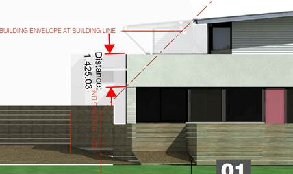
Image 3: Intrusion into BHP to the south eastern corner of Unit
1
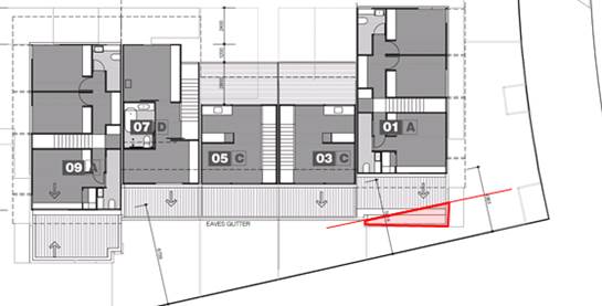
Image 4: 5.5m length of BHP intrusion to the southern
elevation of Unit 1.
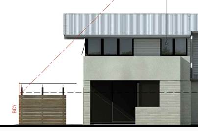
Image 5: Extent of BHP intrusion to western boundary adjacent
to Bayshore Lane.
BHP intrusion into western laneway frontage will not impact
on any residential neighbours and is a result of a large eave to protect from
western sun.
Shadow diagrams provided show the development will slightly
increase shadowing to 5 Julian Rocks Drive. The plans have been prepared
showing the existing shadow cast by the current dwelling and boundary fencing
and shadow cast by the proposed development. In this regards the increase in
overshadowing in midwinter is not unacceptable considering the development
predominantly complies with the Building height plane on this elevation.
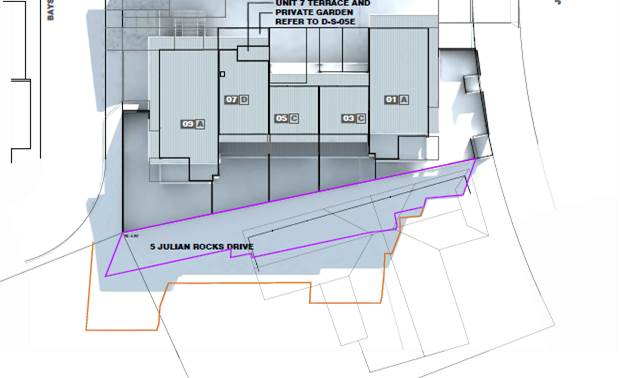
Image 6: 9am Midwinter
Shadow Plans (purple line - existing shadow, yellow line – previous
proposal)
The proposed development satisfies the relevant Objectives
of DCP 2014.
4.4B Byron Shire Development Control Plan 2010 (DCP 2010)
4.5 Any Planning Agreement or
Draft Planning Agreement?
|
|
Yes
|
No
|
|
Is there any applicable planning agreement or draft
planning agreement?
|
☐
|
☒
|
|
Consideration:
|
4.6 Environmental Planning
& Assessment Regulation 2000 Considerations
|
Clause
|
This control is applicable to the proposal:
|
I have considered this control as it relates to the
proposal:
|
If this control is applicable, does the proposal comply?
|
|
92
|
Yes
|
Yes
|
Yes – demolition of existing dwellings to be
conditioned to accord with the provisions
of AS 2601
|
|
93
|
No
|
N/A
|
N/A
|
|
94
|
No
|
N/A
|
N/A
|
|
94A
|
No
|
N/A
|
N/A
|
* Non-compliances and any other significant issues
discussed below
4.7 Any Coastal Zone Management
Plan?
|
|
Satisfactory
|
Unsatisfactory
|
Not applicable
|
|
Is there any applicable coastal zone management plan?
|
☐
|
☐
|
☒
|
|
|
4.8 The likely impacts of that
development, including environmental impacts on both the natural and built
environments, and social and economic impacts in the locality
|
Impact on:
|
Likely significant impact/s?
|
|
Natural environment
|
No. The proposal will not have a significantly adverse
impact on the natural environment of the locality.
|
|
Built environment
|
No. The proposal will not have a significantly adverse
impact on the built environment of the locality. Short term impacts will
arise during construction and conditions of consent have been recommended in
relation construction and demolition of the development to control hours of work,
construction noise, builders waste and the like.
|
|
Social Environment
|
The development will provide a mixture of housing types
for residents in the shire, conditions of consent proposed to prohibit
holiday letting.
|
|
Economic impact
|
The proposal will generate positive economic impacts
through the construction industry and associated multiplier effects through
the local economy.
|
4.9 The suitability of the site
for the development
The site is a serviced, unconstrained property and having
regards to its location to the neighbourhood shopping centre is considered
suitable for the proposed development.
4.10 Submissions made in accordance with
this Act or the regulations
The development application was publicly exhibited
There were 13 submissions made on the development application:
|
Submission
|
Comment
|
|
Short term holiday rental
These dwellings will no doubt be turned into Airbnb just
like most of the houses already are.
|
Condition/s are recommended to restrict the use of the
individual units for short term holiday rentals where legally able.
|
|
Character and density
This submission for 7-9 Julian Rocks Drive mentions medium
density housing and as far as I am aware the area is low destiny. Medium
density is out of character with this street as the majority of dwellings are
single dwellings or duplexes.
Non-compliance with Floor Space Ratio
The proposed development exceeds the Floor Space ratio
provisions by 1.5m2 over the required 0.5:1 FSR.
|
LEP 2014 identifies that the minimum lot size for Multi
Dwelling Housing development is 1,000m2. The subject site has an area of
1,561m2 and therefore complies with the minimum lot size requirements for a
dual occupancy (detached) under the LEP 2014.
The original plans supplied proposed an FSR of greater
than 0.5:1 which has now been reduced in size to comply with the maximum
allowable FSR.
|
|
Car Parking
For 10 dwellings there are only provision for 14 garages
(even though there are 25
bedrooms within in the complex). There are only 3 visitor
spaces which are only accessible from the rear of the property at Bayshore
lane.
This DA provides 10 units comprising a total of
23 bedrooms
13 car parking spaces
3 Visitor car spaces.
However this development could potentially house up to 46
residents living in this complex.
Example:- 23 Bedrooms x 2 per people per bedroom = 46
residents.
|
Please refer to Section 4.4A of this report which
demonstrates that the proposed development complies with the requirements of
Chapter B4 DCP 2014. The development requires 14 parking spaces for residents
with 3 parking spaces for visitors.
The development provides 14 parking spaces for residents
and 3 parking spaces for visitors and therefore complies with DCP 2014.
|
|
Kollective project
It seems to me that the developer has attempted to hide
the fact that this is another
Kollective project by using their Trust “Julian
Rocks Developments” to apply for this DA.
It would appear they are trying to circumvent the
opposition that occurred when they
attempted to over develop the block on the opposite side
of the road.
|
Each development application is assessed on its individual
merits and the applicable planning legislation.
|
|
Landscaping
The landscape concept plan DS04 indicates ‘deep soil
plantings’ for medium trees and
feature trees, shrubs and small trees – circle
numbers 6 and 8. There is also a single palm
and pandanus – circles 5 and 7. Given the
considerable surface area on Plan DSO4 shown ‘turf, grasses and
groundcovers’, the claim that the deep soil zone makes up 82% of the
total open space needs checking.
|
Under DCP 2014 Deep soil area means:
a specified area of the
development site, not covered by an impervious surface, that allows water on
the site to infiltrate naturally to the groundwater and allows for the future
provision of mature vegetation.
There is no requirement that trees or large shrubs are
able to be planted in these areas. The only requirement is that the Deep Soil
areas are not impervious. Areas of grass and turf can be included in Deep
Soil area calculations.
|
|
Overshadowing and Privacy
The non-compliance with the Building Height Plane under
Chapter D1 of Byron DCP 2014
demonstrates unacceptable overshadowing for the adjoining
landowner at No.5 Julian Rocks
Drive. It provides an indication that the proposed
development will cause privacy and
overshadowing impacts on adjoining lands and should not be
supported in its current form.
|
The applicant has redesigned/flipped the roof line of the
southern units with the skillion roof now angling down to the southern
boundary and reduced the eave overhang, thereby reducing the BHP intrusion.
The development intrudes by 1.4m into the BHP on the south
eastern corner of Unit 1, with the remainder of the development (excluding
eaves to the western boundary) are below the BHP. The majority of the
southern elevation of the development will be below the BHP.
Shadow diagrams provided show the development (although
mostly below the BHP) will slightly increase shadowing to 5 Julian Rocks
Drive. The development has been demonstrated to not result in unacceptable
overshadowing or overbearing with a progressively larger setback along the
southern boundary and majority compliant BHP.
|
|
Non-Compliance with Landscaped Area Requirements
The proposal does not comply with the minimum landscaped
area requirements under Chapter B9 Landscaping B9.4.2 Multi Dwelling Housing,
Attached Dwellings and Residential Flat Buildings.
The proposal fails to meet the prescriptive measures set
out of Common Landscaped Area requirement, providing only 70m2 of
Common Landscaped Area, with 491m2 of Private Open Space. Further
a minimum of 75% of the total common landscaped area must be deep soil areas.
|
The development provides a total of 572m2 of open space areas
with landscaping provided along the site frontages and along both side
boundaries. (Plus a further 30m2 of decks).
The development will provide a high quality landscaping
which will enhance the amenity and function of the development through the use
of boundary landscaping, permeable pavements and landscaped areas to break up
large expanses of concrete.
Further the 3 visitor car parking spaces will incorporate
permeable pavement to allow further infiltration of water and a softening of
the development when viewed from Bayshore Lane. Permeable pavement has also
been used for dwellings along Bayshore Lane.
Please also refer to 4.4A for further assessment.
|
|
Unit 6 provides only 28m2 of
private open space area and this is below Council’s DCP requirements
for private open space.
|
Unit 6 provides 28m2 of POS incorporating outdoor area and
deck areas which are directly accessible from the ground floor living area.
All other dwellings will provide between 30m2 – 80m2 of POS areas which
significantly exceed 30m2.
The POS area to Unit 6 has dimensions suitable for outdoor
recreations needs for a 2 bedroom dwelling and provides northern orientation
to ensure year round comfort in terms of access to sunlight.
The proposed POS areas are suitable for the anticipated
recreational needs of residents and provide direct access from living areas
in accordance with Chapter D1.6.1 Private Open Space Courtyards DCP
2014.
|
|
Social Impacts - Need for Social Impact Assessment
The proposal is an overdevelopment of the site and is
likely to negatively impact upon the social values and amenity of the current
residential neighbourhood of Sunrise Beach. The Kollective Development that
has already established in Sunrise Boulevard has already demonstrated the
impacts of unsocial behaviour, excessive noise, on-street parking and
pedestrian safety problems and congestion from lack on on-site parking. The
proposal in its current form is likely to result in similar negative social
impacts.
|
Under Chapter B12 DCP 2014 a Social Impact
Assessment is required for
residential developments or
subdivisions comprising more than 50 dwellings or lots;
This development does not require a Social Impact
Assessment under the DCP 2014.
|
|
Waste and Location of Garbage Bins
The proposal as it stands will result in excess garbage
problems within the development and may impact on adjoining residences in the
street. Each dwelling should be provided with a separate garbage bin.
|
Council’s standard urban bin services are provided
on Council’s website and for Multiple dwellings allows bins to be
shared between units.
Urban multi unit dwellings
(three or more units) Council approved, shared between two units.
· Two
bin service: 240 litre landfill bin and 240 litre recycling bin (collected
weekly)
· Three
bin service: 240 litre landfill bin (collected fortnightly), 240 litre
recycling bin and 240 litre organics bin (collected weekly)
The development provides bin services in accordance with
the above and complies with Council’s waste service provision.
|
|
Adaptable Dwelling:
There are 3 x 3 bedroom units & 7 x 2 bedroom units in
the complex. One of the 2 bedroom units, (Unit No.1) is specified as
Adaptable, AS 4299. All units have the bedrooms & bathrooms upstairs. It
is unsuitable to have stairs to these essential rooms for elderly or disabled
people, unless the measurements of the stair widths are included in the
plans, so that there is the potential for an inclinator to be installed.
|
The applicant has indicated Unit 7 will be an adaptable
unit. This has been provided with wider parking space, increased stairway/
hallway widths and additional section showing the minimum heights for
external parking areas.
|
4.11 Public interest
Having regard to the development design and general
compliance with Council’s planning controls, the proposal is unlikely to
prejudice or compromise the public interest or create an undesirable precedent.
5. DEVELOPER
CONTRIBUTIONS
5.1 Water & Sewer Levies
This development generates an additional load onto Councils
Water, Bulk Water and Sewer System Council requires Payment of Developer
Servicing Charges (prior to issue of a construction/subdivision certificate)
of:
· 4.20 ET for
Water &
· 4.20 ET Bulk
Water; and
· 5.75 ET for
Sewer.
5.2 Section 7.11 Contributions
This development will generate
a demand for additional public facilities. A condition of consent should
be imposed to require the payment of contributions.
The Byron Shire 10 Year Bike
Plan 2019 identifies a shared path at the front of this development as per the
map below. Council’s Development Engineer has recommended that the
shared bike path be constructed along Julian Rocks Drive to Sunrise Blvd It is
reasonable to offset the cost of these works against the bikeways and footpaths
contributions.
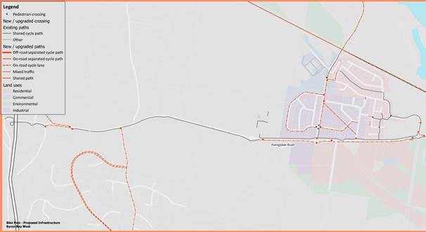
6. CONCLUSION
The DA proposes Multi-Dwelling Housing Comprising Ten (10)
Dwellings. The proposed development is satisfactory having regard to the
relevant planning instruments and controls applicable to the site. The proposal
raises no significant issues in terms of environmental impacts and the site is
considered suitable for the development. The application appropriately
addresses the relevant constraints applying to the site, and is recommended for
approval subject to the conditions listed
in Attachment 3.
7. DISCLOSURE OF
POLITICAL DONATIONS AND GIFTS
|
Has a Disclosure Statement been received in relation
to this application
|
No
|
|
Have staff received a ‘gift’ from anyone
involved in this application that needs to be disclosed. Where the answer is
yes, the application is to be determined by the Director or Manager of the
Planning, Development and Environment Division.
|
No
|
8. REASONS
FOR DECISION, HOW COMMUNITY VIEWS WERE ADDRESSED
Note:
From July 1 2018, Council’s are required to give and publicly notify
reasons for a range of planning decisions where they are deciding if
development should proceed to help community members to see how their views
have been taken into account and improve accountability to stakeholders. A
statement of reasons for the determination of this application is provided
below.
|
Statement of Reasons
|
|
The proposed modifications were minor and substantially
the same as the original development approval with no detrimental
environmental impacts.
|
|
The proposed development complies with the provisions of
Byron Local Environmental Plan 2014.
|
|
The proposed development complies with relevant State
Environmental Planning Policies
|
|
The proposed development complies with relevant provisions
of Development Control Plan 2014
|
|
The proposed development complies with Environmental
Planning & Assessment Regulation 2000 considerations.
|
|
The proposed development will not have significant adverse
impact on the natural, built or social environment or economic impacts on the
locality.
|
|
The proposed development is considered suitable for the
proposed site.
|
|
The development application was notified/advertised in
accordance with Development Control Plan 2014. Issues raised in the submissions
have been addressed during assessment of the application.
|
|
The proposed development is unlikely to prejudice or
compromise the public interest.
|
|
How community views were addressed
|
|
The DA was advertised in accordance with Development
Control Plan 2014. The submissions received were considered on merit and
addressed during assessment of the application.
To view the considerations, please contact Council to view
a copy of the assessment report relating to this DA.
|
Staff Reports - Sustainable Environment and Economy 13.8
Report No. 13.8 PLANNING
- Planning Proposal 26.2019.11.1 - Lot 6 DP 8385 Yagers Lane, Skinners Shoot -
Request for Dwelling Entitlement
Directorate: Sustainable
Environment and Economy
Report
Author: Dylan
Johnstone, Planner
File No: I2020/778
Summary:
Council has received a planning proposal to amend Byron LEP
2014. The planning proposal seeks a dwelling entitlement for the land so that
development consent can be sought for the use of an existing unauthorised
dwelling house on the land. The matter is the subject of current enforcement
action in accordance with Council’s Enforcement Policy, the outcome of
which will be determined as a consequence of Council’s resolution on this
report.
The land has an area of approximately 4.1 hectares and is
zoned RU2 pursuant to LEP 2014. The planning proposal is consistent with the Byron
Rural Land Use Strategy 2017 and the North Coast Regional Plan
2036.
The following report provides the Council with options on to
how to proceed with the planning proposal and the relevant information that has
been provided to Council to make an informed decision in this regard.
NOTE TO COUNCILLORS:
In accordance with the
provisions of S375A of the Local Government Act 1993, a Division is to be
called whenever a motion for a planning decision is put to the meeting, for the
purpose of recording voting on planning matters. Pursuant to clause 2(a)
under the heading Matters to be Included in Minutes of Council Meetings of
Council's adopted Code of Meeting Practice (as amended) a Division will be
deemed to have been called by the mover and seconder of all motions relating to
this report.
|
RECOMMENDATION:
That Council:
1. Proceed
with option 1 to request the NSW Department of Planning, Industry and
Environment to issue a Gateway determination for the planning proposal as
contained in Attachment 1 (E2020/40745).
2. Agree
that staff can proceed to obtain further studies from the applicant (if
required by the Gateway determination), then undertake public exhibition of
the planning proposal and government agency consultation based on the Gateway
determination.
3. Request
staff to prepare an Unauthorised Residential Accommodation Policy as a matter
of priority to identify planning pathways and consequences for Unauthorised
Residential Accommodation seeking regularisation, and that this be reported
to the next available Planning meeting for consideration of public
exhibition.
|
Attachments:
1 26.2019.11.1
- Planning Proposal to obtain Dwelling Entitlement Lot 6 DP 8385 - Joe Davidson
- Lot 6 Yagers Lane Skinners Shoot, E2020/40745

2 Special
Disclosure and Pecuniary Interest Form, E2012/2815
REPORT
Background
Council records indicate that ownership of the land was
transferred to the current landowners on 21 May 2014.
A Planning Certificate was issued by Council to the previous
landowner dated 5 February 2014 in accordance with Section 149(5) of the
Environmental Planning and Assessment Act 1979. This certificate specified that
a dwelling house is not permitted to be erected on the land with the
development consent of Council pursuant to Byron Local Environmental Plan 1988.
Historically, Lot 6, together with Lots 4, 7 & 8 of DP
8385 formed an “existing holding” on the relevant day
as defined within Clause 15 of LEP 1988. Pursuant to clause 15 of Byron LEP
1988 an existing holding is entitled to one ‘dwelling entitlement’
over the entire aggregation of lots in the holding.
The ownership of the four lots comprising the existing
holding changed on 11 October 2013. Clause 4B of the Environmental Planning
& Assessment Act 1979 defines ‘subdivision of land’ which
includes reference to a division of land affected by ‘conveyance,
transfer or partition’. Consequently as of 11 October 2013 the land no
longer satisfies the requirements for an “existing holding”
under the terms of Clause 15(2)(b) of LEP 1988. Accordingly Lot 6 does not hold
a dwelling entitlement as reflected in the Section 149(5) certificate issued 5
February 2014.
On 21 July 2014 Council wrote to the legal representatives
of the previous landowner in response to a request for clarification on
information contained within the Planning Certificate dated 5 February 2014
regarding the “dwelling entitlement” status of the land. This
correspondence reaffirmed Council’s position that a dwelling was not
permitted to be erected on the land. Council further advised that, should the
landowner wish to pursue a dwelling entitlement on the subject lot, a planning
proposal to amend the LEP could be submitted.
On 30 May 2016 Joe Davidson Town Planning, on behalf of the
current landowners, made application to Council for development related advice.
The application requested clarification on whether a dwelling house could be
erected on the land, under two hypothetical scenarios, in the absence of a
“dwelling entitlement” in accordance with Clause 15 of Byron Local
Environmental Plan 1988.
Council issued a response to the request for development
related advice dated 31 August 2016. This response advised that consent could
not be granted in either of the proposed scenarios as the land does not have a
“dwelling entitlement” and does not comply with Clause 15 of LEP
1988.
On 28 July 2016 Council received a complaint regarding the
alleged construction of a dwelling house on the land without consent. On the
same day the site was inspected by a Council compliance officer who determined
that construction of what appeared to be a dwelling house had commenced without
consent.
A Show Cause letter was issued on 2 August 2016 providing
the opportunity for the landowners to demonstrate why formal enforcement action
should not be taken for unauthorised development in relation to the
construction of an alleged dwelling.
On 16 August 2016 the landowners responded by advising that
the building under construction was a farm building not a dwelling house and
advised that as a farm building is permitted as exempt development in
accordance with State Environmental Planning Policy (Exempt and Complying
Development Codes) 2008 that were not in breach of the local environmental
plan.
Council accepted the response from the landowners in good
faith and on 3 February 2017 determined that no further action would be taken
at that time.
On 14 June 2018, Council again received a complaint
regarding an alleged unauthorised dwelling house on the land. The site was
inspected by a Council compliance officer on 7 July 2018 who confirmed that the
building was being used as a dwelling house.
Compliance staff subsequently issued a Notice of Proposed
Order No. 3 – Demolish Works on 18 July 2018 to require the dwelling to
be demolished.
On 3 September 2018 Council received representations from
the landowners to advise why an Order No. 3 should not be issued.
Representations advised that the building was originally constructed as a farm
building for storage and rural workers facilities (toilets showers and
lunchroom) for people that would be working on the property for agricultural
pursuits. The landowners further advised that due to a change in accommodation
circumstances their family was forced to use the farm building on the property
for accommodation.
Within the representations the landowners also advised that,
in order to rectify outstanding matters, they will seek approval to operate the
existing On-site Sewerage Management System, seek development consent for use
of the building as a dwelling house and apply for a Building Information
Certificate to demonstrate structural adequacy and safety of the building. It
was advised that Joe Davidson Town Planning would be preparing a development
application that would be lodged in 60 day time frame.
Over a time period of approximately six months the
landowners and Joe Davidson intermittently updated Council compliance staff on
progress with regard to submission of an application for approval to operate
the existing On-site Sewerage Management System, a Development Application, an
application for a Building Information Certificate, and with discussions with
Council’s Strategic Planning staff regarding obtaining a dwelling
entitlement for the land.
Given that over nine months had passed since the issue of a
Notice of Proposed Order No. 3 – Demolish Works on 18 July 2018, and that
a Development Application had not been submitted, Council compliance staff
issued an Order No. 3 – Demolish Works on 1 May 2019 requiring the
dwelling to be demolished.
The landowners’ legal representative wrote to Council
on 23 May 2019 arguing that the Order No. 3 dated 1 May was invalid and should
be withdrawn. It was argued that procedural fairness had not been granted as
Council had not sufficiently considered that the giving of the Order would make
the landowners homeless and that it is not appropriate for Council to issue an
order requiring the building to be demolished as the original configuration of
the structure is permitted as an exempt development Farm Building. Council
subsequently withdrew the Order.
A revised Notice of Proposed Order No. 1 – Stop Use of
the existing dwelling was issued on 27 August 2019 and the subject planning
proposal has been submitted to address this Notice.
Subject
Land
The land is described as Lot 6
DP 8385 with an area of approximately 4.1 hectares and has a regular
shape. The street address is informally known as 31 Yagers Lane, Skinners
Shoot. The land contains an existing unapproved dwelling house.
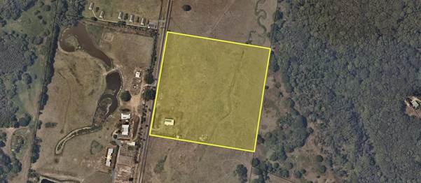
Figure 1: Subject land showing existing dwelling
The
Planning Proposal
The planning proposal
(Attachment 1) seeks to obtain a dwelling entitlement for the land that will
allow for a Development Application to be lodged with Council seeking
retrospective consent for the use of the existing building as a dwelling house
on the land.
Specifically, the planning
proposal seeks to add the land to Schedule 1 – Additional permitted uses
of LEP 2014 to permit a dwelling house with consent on Lot 6 DP 8385.
Key issues
1) Byron Shire Rural Land
Use Strategy
Action No. 22 of the Byron Shire Rural
Land Use Strategy 2017 (BSRLS) recommends investigation into a
strategic framework for resolving dwelling entitlement issues. This action
provides the strategic basis for the subject planning proposal to be assessed
and determined by Council.
2) North Coast Regional
Plan
The Plan identifies 25 strategic
directions within 4 broader goals. The following directions are identified as
being relevant to the subject planning proposal:
· Direction
1: Deliver environmentally sustainable growth
· Direction
3: Manage natural hazards and climate change
· Direction
14: Provide great places to live and work
· Direction
22: Deliver greater housing supply
· Direction
23: Increase housing diversity and choice
· Direction
24: Deliver well planned rural residential housing areas
The proposal does not offend these directions.
3) LEP 2014
The land is zoned RU2 Rural Landscape in accordance with LEP
2014.
4) Section
9.1 Directions
The
planning proposal is inconsistent with some Section 9.1 Directions because it:
· Increases
the permissible density of land within a rural zone by seeking a dwelling
entitlement for a lot which currently does not have a dwelling entitlement.
· has
not yet been referred to RFS for bushfire consideration
· introduces
site specific provisions
These inconsistencies are discussed in more detail in the
planning proposal.
5) SEPP 55 and Land Contamination
A search of Council records and geographical
information mapping did not identify any constraints of concern such as acid
sulfate soils, cattle dip sites or past land uses associated with land
contamination.
A Preliminary Contaminated Land Assessment
prepared by Greg Alderson & Associates dated November 2019 and submitted
with this planning proposal provides that soil sampling results were below the
Health Investigation Levels (HIL) in accordance with the National Environment
Protection (Assessment of Site Contamination) Measure. Reporting was
conducted in accordance NSW EPA (2000) Guidelines for Consultants Reporting on
Contaminated Sites.
The site is considered to be suitable for residential
land use. However, based on limitations identified in the submitted contaminated
land assessment, any future development application for residential land use
should include the provision of an Unexpected Findings Protocol (Contaminated
Land).
6) Bush
fire
The site is partially subject to
bush fire prone land mapping. However the location of the existing dwelling is
not subject to bush fire prone land mapping and therefore is not required to
meet Planning for Bushfire Protection 2019 requirements.
7) Flooding
Flood modelling information available to Council indicates
that the majority of the site (including the site of the existing dwelling) is
not inundated during the Probable Maximum Flood (PMF).
Access to the site during a flood is compromised as Yagers
Lane and Skinners Shoot Road are inundated during flood events, however there
is no need to evacuate during a flood given the site has land above the PMF.
8) Onsite sewage management
An on-site Wastewater Management Report prepared by Greg
Alderson & Associates dated November 2019 and submitted with this planning
proposal demonstrates that wastewater generated by a future dwelling can be
adequately managed via an On-site Sewage Management Facility comprising a Septic
Tank. The site is considered to be suitable for treatment and disposal of
wastewater.
9) Land
Use Conflict
The subject site
is located approximately 200 metres from a
former piggery to the south on Lot 8 DP 8385, and 500 metres to an electricity
power station contained on Lot 1 DP 1184803, to the southeast. Other
surrounding land uses comprise large rural residential allotments and grazing
lands. It is considered that granting of a dwelling entitlement on Lot 6
DP 8385 will not create any significant land use conflict between the
identified adjoining land uses.
10) Aboriginal
Heritage
A search of
the Aboriginal Heritage Information Management System dated 4 November 2019 was
undertaken by the applicant and submitted with this planning proposal. The
search did not identify any aboriginal sites or places within proximity of the
subject site.
11) Farmland Protection
The site is not identified as
containing regionally or state significant farmland.
12) Developer
Contributions / Planning Agreement
The planning proposal seeks to amend LEP 2014 so that a
dwelling is permitted with consent on the subject site.
If a dwelling is permitted on the site, this will create
additional demands on rural roads, community facilities, open spaces etc. Such
demands are captured by the Byron Shire Developer Contributions Plan 2012 which
requires a monetary contribution in accordance with the Plan and Section 7.11
of the Environmental Planning and Assessment Act 1979.
Ordinarily contributions would be paid at the time of
subdivision for creating a lot with a dwelling entitlement equivalent to one
Standard Dwelling Unit (SDU) (3 bedroom dwelling or greater). However, for the
purposes of this planning proposal, there is no clear mechanism within the
Contributions Plan for applying developer contributions.
The submitted planning proposal included a letter of offer
to enter into a planning agreement with Council. The offer proposes payment of
a monetary contribution equivalent to one SDU.
Council staff have no justification to require additional
contributions over and above the demand normally generated for a rural dwelling
under the terms of the Contributions Plan 2012.
However, Council may resolve to apply different terms in the
agreement if deemed reasonable and appropriate in the circumstances.
A formal agreement will need to be drafted to be exhibited
concurrently with the planning proposal.
Options to Move Forward
Staff
reported a proposed preliminary framework for an ‘Unauthorised
Residential Accommodation Policy to the Strategic Planning Workshop on 3
October 2019. The proposal outlined planning pathways for three different
scenarios involving unauthorised residential accommodation:
· Pathway 1 – Land has a dwelling entitlement and
contains unauthorised residential accommodation – development consent may
be sought.
· Pathway 2 – Land does not have a dwelling
entitlement and contains unauthorised residential accommodation – meets
the strategic merit test for LEP amendment - Planning Proposal may be submitted
before development consent may be sought.
· Pathway 3 – Land may or may not have a dwelling
entitlement and contains unauthorised residential accommodation – does
not meet the strategic merit test for LEP amendment and does not comply with
LEP and DCP provisions – Enforcement action as per Enforcement Policy
2016 to follow i.e. Orders to demolish/restore to previously approved use as
appropriate.
Recommendation
1 of this report corresponds to Pathway 2.
The
as proposed Unauthorised Residential Accommodation Policy has not progressed
since the SPW on 3 October 2019 and therefore there is no specific Council
policy framework guiding the assessment of the subject planning proposal. This
planning proposal is the first of its type and, subject to the determination,
there may be many other planning proposals that follow that will not all be
equal in their circumstances.
This
planning proposal has demonstrated that it meets the strategic merit test. The
land is not mapped as regional or state significant farmland, the land has been
historically cleared of vegetation and the existing dwelling does not present
any significant environmental impact. While parts of the land are mapped as
bushfire prone and flood prone the location of the existing dwelling is not
bushfire prone or flood prone. The site has legal and practical vehicular
access via direct frontage to Yagers Lane and the existing dwelling does not
unreasonably increase the demand for services. The site does not contain any
recorded Aboriginal sites or declared Aboriginal places.
The
above demonstrates that the existing dwelling is located on an unconstrained
site while many sites that Council’s Community Enforcement Team
investigate for unauthorised residential accommodation, particularly in the
hinterland areas, are severely constrained in terms of bushfire, access,
ecological matters, onsite sewage management etc. and can be without legal and
practical access.
It
is critical that Council have a formal policy position to guide any future
planning proposals regarding these matters.
Conclusion
This planning proposal was
anticipated as a response to compliance action that has been carried out in
relation to the existing unauthorised dwelling house on the site.
There are
two options for Council:
1. Proceed with the
planning proposal and request the DPIE to proceed to issue a Gateway
determination for the planning proposal as attached to this report;
2. Not proceed with
the planning proposal and provide reasons to the applicant; and progress
enforcement action in accordance with the Council’s Enforcement Policy.
STRATEGIC CONSIDERATIONS
Community Strategic Plan and Operational
Plan
|
CSP Objective
|
L2
|
CSP Strategy
|
L3
|
DP Action
|
L4
|
OP Activity
|
|
Community Objective 4: We manage growth and
change responsibly
|
4.2
|
Support housing diversity in appropriate locations
across the Shire
|
4.2.1
|
Establish planning mechanisms to support housing that
meets the needs of our community
|
|
|
|
Community Objective 2: We cultivate and celebrate our
diverse cultures, lifestyle and sense of community
|
2.4
|
Enhance community safety and amenity while respecting our
shared values
|
2.4.3
|
Enhance public safety, health and liveability through the
use of council's regulatory controls and services
|
2.4.3.1
|
Monitor, investigate and resolve complaints in relation
to community safety, land use and the environment
|
|
|
|
|
|
|
|
|
|
|
|
|
|
|
|
Legal/Statutory/Policy Considerations
The relevant
legal/statutory/policy considerations have been noted above.
Financial
Considerations
If Council chooses to proceed
with the planning proposal, it will be at the proponent’s expense as a
land owner initiated planning proposal. Full cost recovery of the
remaining stages will be required by Council. If the applicant chooses
not to pay then the planning proposal will not proceed.
If Council chooses not to
proceed then the matter does not incur any additional costs.
Consultation
and Engagement
If Council chooses to proceed with
the planning proposal, it will be forwarded to the NSW Department of Planning
& Environment for a Gateway determination. A positive determination
will identify any government agency or other consultation requirements.
Staff Reports - Sustainable Environment and Economy 13.9
Report No. 13.9 PLANNING
- Submissions Report: Draft Byron Local Strategic Planning Statement
Directorate: Sustainable
Environment and Economy
Report
Author: Alex
Caras, Land Use Plannning Coordinator
File No: I2020/784
Summary:
The Local Strategic Planning
Statement (LSPS) is a new legislative requirement that has been designed to
provide the link between the State Government’s strategic plans and
Council’s local land use plans and guidelines. All NSW Councils are
required to prepare a LSPS by 1 July 2020.
The draft Byron LSPS presents a 2036 vision and framework
for land use within our Shire. Structured around four (4) key themes that
align with the vision and community priorities in our Community Strategic Plan
– Our Byron Our Future 2028 (CSP), the draft LSPS includes 14
Planning Priorities along with corresponding actions, timeframes and the means
for monitoring and reporting on the delivery of these actions. Most
of these priorities align with Council’s current Delivery Program/
Operational Plan (DP/OP); however some actions are new and represent
“gaps” to be included in a future
DP/OP.
The draft LSPS was exhibited for a period of 5 weeks from 2
April – 8 May, with a total of 27 submissions received. Most
submissions focused on planning priorities and actions within the draft LSPS
relating to one or more of the following themes: Sustainable Shire; Liveable
Shire; Thriving Shire and Connected Shire.
This report provides a summary of the key matters raised in
submissions, together with a response and any proposed changes. Due to 1
July 2020 deadline for finalising Council’s LSPS, a number of the
additional priorities and actions recommended in submissions are deferred for
consideration in future LSPS reviews.
Proposed changes to the draft LSPS are presented in Table 1
of this report for Council’s consideration and endorsement. Overall
the changes are considered minor in nature.
NOTE TO COUNCILLORS:
In accordance with the
provisions of S375A of the Local Government Act 1993, a Division is to be
called whenever a motion for a planning decision is put to the meeting, for the
purpose of recording voting on planning matters. Pursuant to clause 2(a)
under the heading Matters to be Included in Minutes of Council Meetings of
Council's adopted Code of Meeting Practice (as amended) a Division will be
deemed to have been called by the mover and seconder of all motions relating to
this report.
|
RECOMMENDATION:
That Council:
1. Endorses
the recommended changes to draft Byron Shire Local Strategic Planning
Statement (LSPS), as contained in Table 1 of this report, in response to
submissions received during exhibition;
2. Authorises
the Director Sustainable Environment & Economy (through the General
Manager) to update the draft LSPS to reflect the endorsed changes, as well as
undertake any necessary formatting, grammatical edits, diagrams and/or
other ‘non-policy’ updates to ensure a suitable standard for
submission to the Department of Planning, Industry & Environment;
3. Submits
the revised LSPS to the Department of Planning, Industry & Environment on
or before the 1 July 2020 legislative deadline.
4. Notes
that there are a number of matters raised in Attachment 2 (E2020/35382) that,
due to the 1 July 2020 legislative deadline for finalising
Council’s LSPS, will be more appropriately considered in future
reviews.
|
Attachments:
1 Draft
Local Strategic Planning Statement 2020 as exhibited, E2020/21470
2 Submissions
Summary table - Draft Local Strategic Planning Statement, E2020/35382 
3 Copy of
government agency submissions, E2020/38187
4 Confidential
- Copy of non-government agency and community submissions, E2020/38181
5 Form of
Special Disclosure of Pecuniary Interest, E2012/2815
REPORT
LSPS Overview
The Local Strategic Planning
Statement is a legislative requirement designed to provide the link between the
State Government’s strategic plans and Council’s local land use
plans and guidelines. The Statement sits within Council’s Integrated
Planning and Reporting Framework, providing an important link with our
Community Strategic Plan ‘Our Byron Our Future 2028‘.
The draft Byron Shire Local Strategic Planning Statement
(LSPS) presents a 2036 vision and framework for land use within our
Shire. This includes 14 Planning Priorities along with corresponding
actions, timeframes and the means for monitoring and reporting on the delivery
of these actions. By combining key priorities and actions from our existing
land use plans and strategies into one accessible document, the LSPS aims to
make it easier for the community to understand the overall direction for land
use planning in their local area.
The LSPS will be a living document, updated regularly to
ensure it reflects current information, which in turn will inform our Local Environment Plan
(LEP), Development Control Plans
(DCP) and infrastructure contribution plans. Importantly, the LSPS must
be considered when these documents are reviewed and updated.
Due to the tight legislative timeframe for all NSW councils
to prepare their LSPS by 1 July 2020, this is an evolving document that
will be updated on a regular basis to accurately reflect completion of new land
use strategies and plans and/or changes in Council’s land use planning
priorities.
Exhibition
Council at its 19 March 2020
Planning Meeting resolved (Res 20-105):
1. That
Council endorse the draft Byron Shire Local Strategic Planning Statement
(LSPS), as contained in Attachment 1 (E2020/15696), for public
exhibition subject to the addition of an explicit reference and action to
include the desire and opportunity to activate the rail corridor, both on and
off track, as a tourism and economic driver, and also a significant transport
and mobility benefit in the ‘Support through partnership, a network of
integrated sustainable transport options’ section of the document.
2.
That Council authorise the Director Sustainable Environment and Economy
(through the General Manager) to undertake the changes required to meet
point 1, and any necessary formatting, grammatical edits, diagrams and/or
other ‘non-policy’ updates to ensure a suitable standard for public
exhibition;
3. That
Council publicly exhibit the draft Local Strategic Planning Statement during
April-May 2020 and undertake the actions/tasks identified in the Community
Engagement Plan (as contained in Attachment 2 (#E2020/15697));
4. That
Council receive a submissions report and final draft Local Strategic Planning
Statement for adoption prior to the 1 July 2020.
The draft LSPS was exhibited for a period of 5 weeks from 2
April – 8 May. A copy of the version exhibited is contained in
Attachment 1.
The following government and
non-government agencies received formal notification:
· Department of Planning, Industry & Environment
(DPIE)
o Planning Division
o Biodiversity
and Conservation Division (BCD) (Formerly OEH)
· Department of Primary Industries (DPI)
· Road and Maritime Services (RMS)
· Department of Education (DPE)
· Tweed Byron Local Aboriginal Land Council (TBLALC)
· Bundjalung of Byron Bay Aboriginal Corporation
(Arakwal).
A total of 55 submissions were received and have been
grouped into the following types:
· government agencies
· non-government agencies
· Community groups, broader community members and
other
A copy of government agency submissions is contained in
Attachment 3 and a confidential copy of non-government and community submissions
is contained in Attachment 4.
Key issues
Most submissions focused on
planning priorities and actions within the draft LSPS as they related to one or
more of the following themes:
· Sustainable Shire
· Liveable Shire
· Thriving Shire
· Connected Shire
The main issues raised in submissions can be categorised as
follows:
· recommendations to
include‘ additional’ priorities/actions
· relationship of
LSPS investigation areas to North Coast Regional Plan (NCRP)
· inclusion of
additional NCRP directions in LSPS ‘Line of Sight’ diagrams and/or
Priority Action tables (certain themes)
· additional matters
and/or reference documents for consideration
Due to 1 July 2020 deadline for finalising Council’s
LSPS, a number of the additional priorities and actions recommended in
submissions are deferred for consideration in future reviews.
Attachment 2 provides a summary of the key matters raised in
submissions, together with a response and any proposed changes.
Proposed changes to the draft LSPS are listed numerically in
Table 1 below, all of which are considered minor in nature.
Table 1 –
Recommended changes to draft Local Strategic Planning Statement following
exhibition
|
Submitter
|
Matter Raised
|
Proposed Change
|
|
DPIE
– Planning Division Northern Region
|
· Sustainable
Shire: Request amendment to line of sight diagram on p. 19 to
reference Directions 1 and 4 in the North Coast Regional Plan (NCRP).
· Liveable
Shire: Recommends that NCRP Directions 14, 16-18, 20 and 24, are
included in the line of sight diagram located on p.30.
· Connected Shire:
Amend line of sight diagram on p.50 to include Direction 9 of NCRP.
|
1. AMEND ‘Liveable Shire: Line of
Sight’ diagram to include NCRP directions 1 & 4.
2. AMEND ‘Liveable Shire: Line of
Sight’ diagram to include the NCRP directions at left.
3. AMEND ‘Connected Shire: Line of
Sight’ diagram to include NCRP direction 9.
|
|
DPIE – Biodiversity and
Conservation Division (formerly OEH)
|
· Planning Priority SP3
(Adapt to climate change and build resilience): Recommends reference to
‘Integrated Regional Vulnerability
Assessment: North Coast of New South Wales (2016)’ and the ‘North Coast Enabling Regional
Adaptation region report (2019) from
DPIE.
|
4. AMEND page 26 of draft LSPS to include reference to ‘Integrated Regional Vulnerability
Assessment: North Coast of New South Wales (2016)’ and
the ‘North Coast Enabling Regional
Adaptation region report (2019).
|
|
Heritage NSW (Dept Premier &
Cabinet)
|
· Link
(Action) LA2 - Prepare cultural heritage predictive mapping to LA4 to develop appropriate planning policies and
protection.
· Replace use of
“protect historic heritage” in the Liveable Shire: Line of
Sight section to be inclusive of Aboriginal and non-Aboriginal heritage
protection. Also, in addition to “support and celebrate our
heritage” broaden to also identify, protect and conserve.
· Heritage
NSW records show that, in addition to the items of local heritage
significance which are listed under Byron LEP 2014 and Byron LEP 1988, the
LGA contains:
o part of the ‘Gondwana
Rainforests of Australia’ which are included in both the World and
National Heritage lists
o five State Heritage Register
items, including part of the ‘High Conservation Value Old Growth
Forest’ (SHR 01487)
o three Aboriginal Places, and
o 172 Recorded Aboriginal
Sites
|
5.
AMEND Action LA2 to read: “Prepare Cultural Heritage predictive mapping for integration into
business activities, planning policies and
related provisions to protect Aboriginal heritage.
6. AMEND
Action LA4 to read: “Develop local heritage studies in consultation
with the local Aboriginal community, and adopt appropriate measures in
planning strategies and local plans to identify,
protect and conserve Aboriginal heritage.”
7. AMEND 2nd
paragraph on page 20 of draft LSPS to include information contained in the
first bullet point at left.
|
|
DPI – Agriculture
|
· Suggests further reference
to agriculture in this chapter to recognise multi-functional landscape that
rural land & agricultural industries provide, including responsibilities
of land managers to undertake best management practices. Linking relevant
sustainable land management actions of Rural Land Strategy would strengthen
the value of agriculture within LSPS beyond economic purpose.
|
8.
AMEND page 47 of draft LSPS to include reference to the “multi-functional
landscape that rural land & agricultural industries provide”.
|
|
Northern NSW Local Health
District, Health Promotion Unit
|
Planning Priority LP1 –
Support and celebrate our heritage, vibrant culture and diverse lifestyles.
· Recommends additional
wording (in bold) for action LA1 – Prepare a new Arts,
Culture and Heritage Policy to provide a strategic framework for arts and
culture in Byron Shire and opportunities for people to be involved in the
design and development of public art, space design and cultural
interpretation.
· Suggests further
detail required for action: LA2. Prepare Cultural Heritage predictive mapping
for integration into business activities
Planning
Priority LP2 – Create great places that support and encourage an
active, connected community.
· Recommends additional
wording (in bold) for planning priority LP2 –
“Create great places that support and encourage an active, healthy
and connected community.”
· Recommends additional
wording (in bold) to include 'health' in the discussion of 'high
quality lifestyle' and 'liveability': (p 34) “A high quality lifestyle
is the sum of many parts; it promotes a healthy lifestyle and provides access
to high quality built and natural environments including affordable housing
options, economic prosperity, safety, equity and opportunities for cultural
and recreational experiences.”
|
9.
AMEND Action ‘LA1’ to include additional wording at left.
10. AMEND Action
LA2 to read: “Prepare Cultural Heritage predictive mapping for
integration into business activities, planning policies and related
provisions to protect Aboriginal heritage.
11.
AMEND planning priority ‘LP2’ to include minor additional wording
at left.
12.
AMEND ‘Liveability’ discussion on p34 to include additional
wording at left.
|
|
Bundjalung of Byron Bay
Aboriginal Corporation (Arakwal)
|
· Liveability:
Actions that relate to Indigenous rights and interests; the following
actions align with NCRP Directions, 16 & 18 – this needs to be
indicated in the Liveable Shire action table p.37.
o LA2 Prepare Cultural
Heritage predictive mapping for integration into business activities –
2021
o LA3 Update Council’s
Community Participation Plan to include specific engagement strategies with
local Aboriginal communities – 2021
o LA4 Develop local heritage
studies in consultation with Aboriginal community, and adopt appropriate
measures in planning strategies and local plans to protect Aboriginal
heritage – ongoing.
· Suggests
incorporating intent of NCRP directions 16, 18 into liveable Shire Line of
sight diagram.
· States that actions
LA2-LA4 on page 37 have little link to the rest of the liveability section.
Eg. There is a statement about protecting historic heritage in the
‘Line of Sight’ diagram but nothing about Aboriginal Heritage.
· Recommends
that the wording for the KPI for LA4 be amended to include ‘protection
of Aboriginal heritage’.
· Recommends
that the current KPI for LA4 ‘Consultation Protocol developed and
consistently applied’ is more suited to LA3.
· Requires
further clarity around involvement of Aboriginal community in development of
the Arts, Culture and heritage policy mentioned in LA1 before supporting this
action.
|
13. AMEND LSPS Liveability Priority Actions on page 37 to
include alignment with NCRP Directions 16 & 18 and related actions.
14. AMEND ‘Liveable Shire: Line of
Sight’ diagram to include NCRP directions 16 & 18.
15. AMEND 1st paragraph on p31 of LSPS to include the
following additional wording: “It is important that Aboriginal
cultural heritage values are respected and protected by the land use planning
system.
16. AMEND KPI for Action LA4 on p60 of LSPS to include
the following additional wording: “ …. for protection of
Aboriginal heritage’.
17. AMEND KPI for Action LA3 on p60 of LSPS to include
the following additional wording: “…. and Consultation Protocol
developed”.
18. AMEND all references to the policy at left to read
‘Arts and Culture Policy’.
|
|
Community Groups and broader
community
|
Sustainable Shire
(i) Relevant
Land Use Strategies, Plans or Policies to be added to Documents to be
added to p.19:
o Draft Biodiversity
Conservation Strategy
(v) Issues raised around flooding:
· p.26 should note
that increased flooding of greater intensity is to be expected in the Shire
· South
Mullumbimby Independent Flood Study should be included as a relevant
plan/policy/strategy p. 30
|
19.
AMEND ‘Sustainable Shire: Line of Sight’ diagram to include
Byron Biodiversity Conservation Strategy in the Relevant Land Use
Strategies, Plans or Policies list.
20. UPDATE climate changes impact figure on LSPS p26 to include:
“ … increased frequency and extent of
flooding”.
21. AMEND ‘Liveable
Shire: Line of Sight’ diagram to include Draft Mullumbimby
Land Release Areas Flood Impact Assessment and Concept SWMP in the
Relevant Land Use Strategies, Plans or Policies list.
|
|
Other (comment from councillors)
|
· Concerned
about potentially lengthy timeframe for Action SA7 relating to preparation of
a Climate Emergency Plan.
|
22. AMEND timing of LSPS Action SA7 - Develop a Climate
Emergency Plan from ‘short-term’ 2021-2025 to
‘immediate (2019-2021).
|
Implementation,
Monitoring and Reporting
The LSPS will communicate with Byron Shire Council’s land use
strategies and integrated planning and reporting framework over a 2036 planning
horizon. To realise the priority actions from each of our themes, a series of
amendments may be required to other Council plans that provide the delivery
framework for Council’s strategic planning program. These include
Council’s LEP, DCP and infrastructure contribution plans.
Councils are legislatively required
to review their LSPS every 7 years, however the Byron LSPS is expected to be
reviewed more frequently to reflect the completion of key land use strategies
and plans (currently underway) and/or or changes in Council’s land use
planning priorities.
STRATEGIC CONSIDERATIONS
Community Strategic Plan (CSP) and Operational Plan
|
CSP Objective
|
L2
|
CSP Strategy
|
L3
|
DP Action
|
L4
|
OP Activity
|
|
Community Objective
4: We manage growth and change responsibly
|
4.1
|
Support the visions and
aspirations of local communities through place-based planning and management
|
4.1.1
|
Develop, implement and
update Place Plans that promote place-based forward planning strategies and
actions
|
4.1.1.10
|
Prepare Local Strategic
Planning Statements
|
|
|
|
|
|
|
|
|
The link between the LSPS Planning Priorities, North Coast
Regional Plan, Council’s CSP, LEP and DCP is illustrated in Figure 1.
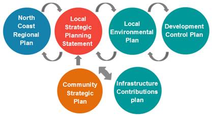
Figure 1: Strategic Policy Context
LEGAL/STATUTORY/POLICY CONSIDERATIONS
The draft LSPS has been prepared in
accordance with section 3.9 of the Environmental Planning and Assessment Act
1979 (the Act).
To meet the requirements of the Act Council must prepare and
submit its LSPS to the State government by 1 July 2020:
FINANCIAL CONSIDERATIONS
Preparation of the LSPS is being
funded from the current 2019/20 budget.
CONSULTATION AND ENGAGEMENT
The draft LSPS
builds on the extensive engagement undertaken in developing Council’s
Community Strategic Plan, Our Byron Our Future, during 2017-2018,
including community feedback regarding what residents most like and dislike
about Byron Shire, and what people would like to see retained and
changed.
It also builds on recent
consultation undertaken across a range of land use planning projects,
including:
· Local
Growth Management Strategies (Rural Land Use Strategy; Business &
Industrial Lands Strategy; draft Residential Strategy)
· Recent
place Plans (Bangalow Village Plan, Byron Bay Town Centre Master Plan, Our
Mullumbimby Masterplan, Byron Arts & Industry Estate Precinct Plan (draft))
· Tourism
Planning (Sustainable Visitation Strategy (draft), stakeholder engagement to
inform planning for Short term rental accommodation )
Stakeholder consultation before and during exhibition was
undertaken in accordance with the LSPS Communication and Engagement Plan (CEP),
which was guided by the following objectives:
· To
inform/consult the community about the Local Strategic Planning Statement
(LSPS) and its public exhibition.
· To
ensure the community has a good understanding the role of a LSPS and how it
fits in the overall planning framework.
· To
provide clear ‘plain speak’ and easily understood information via
various media and activities.
· To
attract a high level of stakeholder engagement and submissions to Council on
the draft LSPS.
The main departure from the CEP was the inability to have
face-to-face engagement with the public during the exhibition period due to
COVID-19 restrictions.
Staff Reports - Sustainable Environment and Economy 13.10
Report No. 13.10 PLANNING
- Update on resolution 20-100 Reconsider carparking plan to
Planning Agreement DA 10.2019.103.1 Restaurant at 784 Coolamon Scenice Drive
Coorabell
Directorate: Sustainable
Environment and Economy
Report
Author: Nancy
Tarlao, Planner
Noreen Scott, EA Sustainable
Environment and Economy
File No: I2020/809
Proposal
|
DA No:
|
10.2019.103.1
|
|
Proposal description:
|
Restaurant
|
|
Property description:
|
LOT: 384 DP: 727453
|
|
784 Coolamon Scenic Drive COORABELL
And Adjoining Council Road Reserve known as Scarrabelottis
Lookout
|
|
Parcel No/s:
|
13110
|
|
Applicant:
|
Newton Denny Chapelle
|
|
Owner:
|
Mr P S Grenquist & Ms Y Shibasaki
|
|
Zoning:
|
7 (d) Scenic Escarpment Zone under BLEP 1988
|
|
Date received:
|
27 February 2019
|
|
Integrated / Designated Development:
|
☐ Integrated
|
☐
Designated
|
☒
Not applicable
|
|
Public notification or exhibition:
|
- Level
2 advertising under DCP 2014 Part A14 – Public Notification and
Exhibition of Development Applications
- Exhibition
period: 21/3/19 to 3/4/19
- Submissions received: 24
submissions received
|
|
Variation request
|
☐
Clause 4.6
|
☐
SEPP 1
|
☒
Not applicable
|
|
Issues:
|
Matter deferred by Council 19 March 19 2020:
20-100
Resolved that the matter be
deferred to provide an opportunity for the proponent and staff to reconsider
an amended car parking plan in relation to the Planning Agreement and the
Development application 10.2019.103.1.
Amended car parking plan
submitted removing the need for the Planning Agreement.
|
Summary:
Development consent is sought
for a 40 seat restaurant on land adjacent to Scarrabelottis Lookout at Coolamon
Scenic Drive, Coorabell. The subject site property is long and narrow located
along the prominent part of the ridgeline in this area with the land zoned 7(d)
Scenic Escarpment. The subject site adjoins Scarrabelottis Lookout which is the
highest point in the immediate area and contains majestic 180 degree views from
Byron Lighthouse, Pacific Ocean and around towards Mount Chincogan. The
proposed restaurant adjoining Scarrabelottis Lookout is proposed to be open Wednesday
to Sunday as follows:
· Wednesday,
Thursday and Friday: 11.30 - 3.30 pm
· Saturday
– Sunday: 8.30-3.30 pm
The application also included a planning agreement for the
construction of 8 car parking spaces within the adjacent Scarrabelottis lookout
to make up for a shortfall in car parking of four spaces to support the
development. Details of the original assessment are contained in the report
link below:
https://byron.infocouncil.biz/Open/2020/03/PLAN_19032020_AGN_1154.PDF)
The application was reported to Council Planning meeting 19
March but deferred by Council as follows:
20-100 Resolved that the matter be deferred to provide an opportunity for
the proponent and staff to reconsider an amended car parking plan in relation
to the Planning Agreement and the Development application 10.2019.103.1.
(Richardson/Hunter)
The applicant has provided further
information to address the matters raised in the resolution including amended
plans. The amendments have reconfigured the car parking area so that the required
car parking is now located on-site and all access is achieved via the Council
road reserve, as such the need for the planning agreement for car parking
within the lookout is no longer required. Notwithstanding the above, the applicant has still included
a proposal to embellish the lookout (which is located within the road reserve)
as it provides access to the restaurant site. In addition to the driveway and
upgrade to the entrance at Coolamon Scenic Drive, the applicant has proposed:
· Landscaping and further plantings
· A new shelter with paving, viewing platform and
interpretative signage
· Informal parking for lookout visitors.
These
additional works are not required to satisfy the development requirements for
the restaurant, with all parking required under DCP 2010 now situated on the
development site. However, they will potentially benefit to the community and
provide uplift to the current Scarrabelottis Lookout arrangements. Conditions
of consent are recommended requiring these works be completed as part of the
development.
It is
considered the amendments to the development provide for a general improvement
to the public amenity without the need for Council to enter into the Planning
agreement with the developer to provide necessary infrastructure on council
land. The application is recommended for approval subject to Conditions of
Consent.
NOTE TO COUNCILLORS:
In accordance with the
provisions of S375A of the Local Government Act 1993, a Division is to be
called whenever a motion for a planning decision is put to the meeting, for the
purpose of recording voting on planning matters. Pursuant to clause 2(a)
under the heading Matters to be Included in Minutes of Council Meetings of
Council's adopted Code of Meeting Practice (as amended) a Division will be
deemed to have been called by the mover and seconder of all motions relating to
this report.
|
RECOMMENDATION:
That, pursuant to Section 4.16 of the Environmental Planning & Assessment Act
1979, Development Application
10.2019.103.1 for restaurant and
associated works be approved subject to conditions of consent in Attachment 2
(E2020/40669).
|
Attachments:
1 Revised
Plans 10.2019.103.1, E2020/40485
2 Recommended
Conditions of Consent, E2020/40669
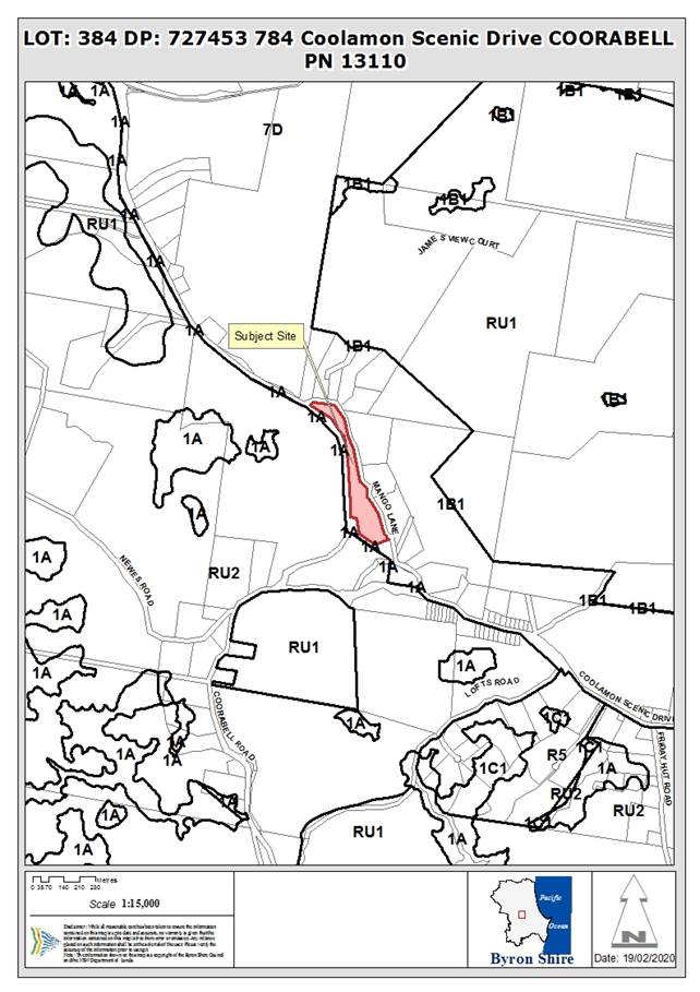
REPORT
Council considered Report No. 13.2
at the Council Planning meeting held on 19 March 2020 – DA10.2019.103.1
for land at 784 Coolamon Scenic Drive Coorabell for a Restaurant and
Planning Agreement for Upgrade of Public Road and Carpark.
The Council resolved to defer the
matter as follows:
20-100 Resolved that the matter be deferred to provide an opportunity for
the proponent and staff to reconsider an amended car parking plan in relation
to the Planning Agreement and the Development Application 10.2019.103.1.(Richardson/Hunter)
Link to the report dated 19 March
2020 below:
https://byron.infocouncil.biz/Open/2020/03/PLAN_19032020_AGN_1154.PDF
Following the
19 March 2020 Council Planning meeting, the applicant provided further
information to address the matters raised in the resolution. The plans were
amended as follows:
· Provision of the required 15 car parking
onsite removing the need for the Planning Agreement Reallocate car parking at
the lookout to the proposed site;
· Landscape improvements and embellishment
to Scarrabelottis Lookout including 10 informal parking spaces for visitors to
the lookout, new shelter and viewing platform interpretative signage and
plantings
The land use is defined under
LEP 1988 as restaurant, which is permitted with development
consent in the 7 (d) Scenic Escarpment Zone.
This report presents to Council a
response to the matters raised in this resolution as detailed below:
Reallocate car parking at the
lookout to the proposed site
The development generates the need
for 15 car spaces under DCP 2010 based on a floor area of 112m2. The
proposed development is considered to satisfy the relevant provisions of Byron
DCP 2010.
In terms of the reference under DCP 2014 Chapter B4 the same
policy calculation of 1 per 7.5m2 (GFA) in rural and non urban zones
applies. The proposal therefore also complies
with the requirements under DCP 2014 Chapter B4. An extract from the plans is
provided below.
Landscape Improvements to the
lookout
The applicant has identified the
opportunity for additional embellishment for the lookout which is volunteered
as part of the assessment process including:
· Tree/shrub landscape plantings;
· 10 x Informal gravel car spaces;
· Oversized timber wheel stop / log seating;
· Provision of a new lookout shelter;
· Viewing platform;
· Rural style boundary fencing;
· New gate to enable the lookout to be locked at night if
required.
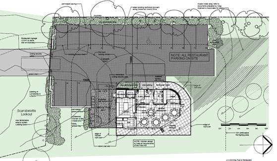
Extract DA02A Restaurant
Site Plan
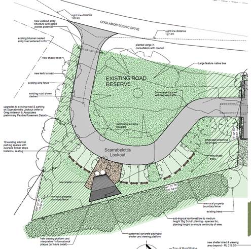
Scarrabelottis Lookout Plans
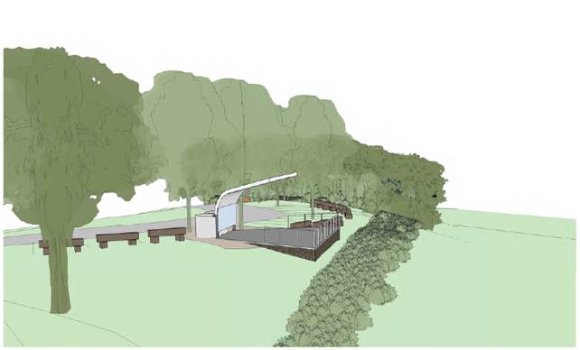
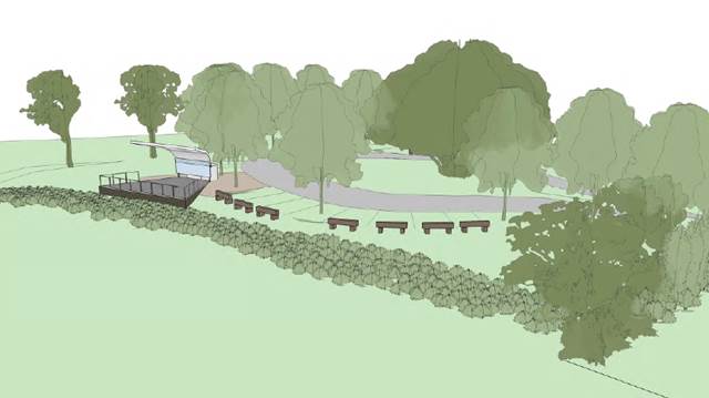
Perspectives of Viewing
Platforms
The revised landscape plan
(Scarrabelottis Lookout Option 3 – DA 08) shows the design for a upgraded
lookout and associated shelter area. The key design elements involve 10 car
parking spaces (gravel base) for visitors with oversized timber stops (to be
used for informal seating) demolition of the old shelter and construction of a
cantilevered roof structure and terrace. The new terrace area extends into a
viewing platform and interpretive signage. Additional landscaping and plantings
are proposed with native endemic species (big scrub species). Fencing on
boundaries between the lookout and subject restaurant property will provide a
degree of territorial enforcement and may assist in the land owner applying his
private property rights from overnight campers.
The works and landscaping will improve the overall
appearance and aesthetics of the lookout.
Should Council not wish to have the lookout
embellished as proposed, then Council could remove those conditions from the
development consent, with the only works undertaken in the lookout being an
access driveway to the restaurant site. It is noted that the lookout is not
public open space but road reserve and its use for access to the property is
otherwise acceptable.
Wastewater Assessment
Due to the car parking being
reconfigure the waste water area was also redesigned to accommodate these
changes. The applicant submitted an updated On-site Waste Management Assessment
report prepared by Greg Aldersons & Associates. The reconfigured waste
water disposal area has been further assessed by Council’s Environment
Health Officer and is supported subject to conditions of consent in relation to
the submission and approval of an application under S68 of the Local Government
Act 1993 for its installation and operation.
Visual Impact
Further detail has been provided
by the applicant in terms of visual impact on the Scenic amenity of Coolamon
Scenic Drive with a photo montage provided when the area is viewed from the
valley floor. Detailed plans are included in the attached plans which
demonstrate there are a range of buildings located along the ridgeline. In the
main they blend into escarpment without generating deleterious impacts on the
visual amenity of the skyline.
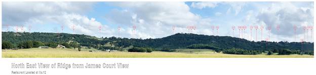
The subject building is nominated
as Building 12 on the applicants plan. As discussed in the previous DA report
to Council, the applicant has demonstrated that there is no alternative
location on this subject site to locate the proposed Restaurant and associated
waste water system. The site is physically constrained due to the steep
topography and narrow width of the site on the escarpment. Further the building
will be screened from the west by existing vegetation along the road boundary,
which will also form a back drop to the building when viewed from the east.
This will be further embellished by additional plantings whilst the colour
scheme of dark colours will further assist in mitigating any visual impacts. It
is considered the proposal meets the requirements under Clause 30 and 31 of
Byron LEP 1988 and the objectives of the 7(d) Scenic Escarpment Zone.
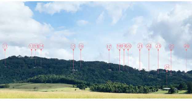
Extract of View of the
Ridgeline from James Court
Conclusion
The additional information provided by the applicant has
suitably addressed the reasons for deferral in the Council resolution. The
proposed development is in accordance with the relevant planning controls that
apply to the site, and it now does not rely upon a planning agreement for car
parking on the adjacent Scarrabelottis Lookout to meet DCP requirements.
Notwithstanding the applicant has still proposed
embellishment to the lookout in terms of landscaping and associated
improvements works including a new shelter, viewing platform, regraded car
parking and log wheel stops. The works will improve the overall appearance and
aesthetics of the lookout. Should Council not wish to have the lookout
embellished as proposed, then Council should remove these conditions from the
development consent, with the only works undertaken in the lookout being an
access driveway to the restaurant site via the road reserve.
The application is recommended for approval subject to
conditions of consent.