Agenda
Ordinary
(Planning) Meeting
Thursday,
13 August 2020
held
at Council Chambers, Station Street, Mullumbimby
commencing
at 11:00am
 Public Access relating to items
on this Agenda can be made between 11.00am and 11.30am on the day of the
Meeting. Requests for public access should be made to the General Manager
or Mayor no later than 12.00 midday on the day prior to the Meeting.
Public Access relating to items
on this Agenda can be made between 11.00am and 11.30am on the day of the
Meeting. Requests for public access should be made to the General Manager
or Mayor no later than 12.00 midday on the day prior to the Meeting.
Mark
Arnold
General
Manager
What is a “Conflict of Interests” - A conflict of
interests can be of two types:
Pecuniary - an interest that a person has in a matter because of a reasonable
likelihood or expectation of appreciable financial gain or loss to the person
or another person with whom the person is associated.
Non-pecuniary – a private or personal interest that a Council
official has that does not amount to a pecuniary interest as defined in the Code
of Conduct for Councillors (eg. A friendship, membership of an association,
society or trade union or involvement or interest in an activity and may
include an interest of a financial nature).
Remoteness – a person does not have a pecuniary interest in a matter
if the interest is so remote or insignificant that it could not reasonably be
regarded as likely to influence any decision the person might make in relation
to a matter or if the interest is of a kind specified in the Code of Conduct
for Councillors.
Who has a Pecuniary Interest? - a person has a pecuniary interest in a
matter if the pecuniary interest is the interest of the person, or another
person with whom the person is associated (see below).
Relatives, Partners - a person is taken to have a pecuniary interest in a
matter if:
§ The person’s
spouse or de facto partner or a relative of the person has a pecuniary interest
in the matter, or
§ The person, or a
nominee, partners or employer of the person, is a member of a company or other
body that has a pecuniary interest in the matter.
N.B. “Relative”, in relation to a person means any of the
following:
(a) the
parent, grandparent, brother, sister, uncle, aunt, nephew, niece, lineal
descends or adopted child of the person or of the person’s spouse;
(b) the
spouse or de facto partners of the person or of a person referred to in
paragraph (a)
No Interest in the Matter - however, a person is not taken to have a
pecuniary interest in a matter:
§ If the person is
unaware of the relevant pecuniary interest of the spouse, de facto partner,
relative or company or other body, or
§ Just because the
person is a member of, or is employed by, the Council.
§ Just because the
person is a member of, or a delegate of the Council to, a company or other body
that has a pecuniary interest in the matter provided that the person has no
beneficial interest in any shares of the company or body.
Disclosure and participation in meetings
§ A Councillor or a
member of a Council Committee who has a pecuniary interest in any matter with
which the Council is concerned and who is present at a meeting of the Council
or Committee at which the matter is being considered must disclose the nature
of the interest to the meeting as soon as practicable.
§ The Councillor or
member must not be present at, or in sight of, the meeting of the Council or
Committee:
(a) at any
time during which the matter is being considered or discussed by the Council or
Committee, or
(b) at any
time during which the Council or Committee is voting on any question in
relation to the matter.
No Knowledge - a person does not breach this Clause if the person did
not know and could not reasonably be expected to have known that the matter
under consideration at the meeting was a matter in which he or she had a
pecuniary interest.
Non-pecuniary Interests - Must be disclosed in meetings.
There are a broad range of options available for managing conflicts &
the option chosen will depend on an assessment of the circumstances of the
matter, the nature of the interest and the significance of the issue being
dealt with. Non-pecuniary conflicts of interests must be dealt with in at
least one of the following ways:
§ It may be appropriate
that no action be taken where the potential for conflict is minimal.
However, Councillors should consider providing an explanation of why they
consider a conflict does not exist.
§ Limit involvement if
practical (eg. Participate in discussion but not in decision making or vice-versa).
Care needs to be taken when exercising this option.
§ Remove the source of
the conflict (eg. Relinquishing or divesting the personal interest that creates
the conflict)
§ Have no involvement by
absenting yourself from and not taking part in any debate or voting on the
issue as of the provisions in the Code of Conduct (particularly if you have a significant
non-pecuniary interest)
RECORDING OF VOTING ON PLANNING MATTERS
Clause 375A of the Local Government Act 1993
– Recording of voting on planning matters
(1) In this section, planning
decision means a decision made in the exercise of a function of a council
under the Environmental Planning and Assessment Act 1979:
(a) including a decision
relating to a development application, an environmental planning instrument, a
development control plan or a development contribution plan under that Act, but
(b) not including the making of
an order under that Act.
(2) The general manager is
required to keep a register containing, for each planning decision made at a
meeting of the council or a council committee, the names of the councillors who
supported the decision and the names of any councillors who opposed (or are
taken to have opposed) the decision.
(3) For the purpose of
maintaining the register, a division is required to be called whenever a motion
for a planning decision is put at a meeting of the council or a council
committee.
(4) Each decision recorded in
the register is to be described in the register or identified in a manner that
enables the description to be obtained from another publicly available
document, and is to include the information required by the regulations.
(5) This section extends to a
meeting that is closed to the public.
Ordinary (Planning) Meeting
BUSINESS OF Ordinary (Planning) Meeting
1. Public Access
2. Apologies
3. Requests for Leave of
Absence
4. Declarations of Interest
– Pecuniary and Non-Pecuniary
5. Tabling of Pecuniary
Interest Returns (Cl 4.9
Code of Conduct for Councillors)
6. Adoption of Minutes from
Previous Meetings
6.1 Ordinary
(Planning) Meeting held on 18 June 2020
7. Reservation of Items for
Debate and Order of Business
8. Mayoral Minute
9. Notices of Motion
Nil
10. Petitions
11. Submissions and Grants
12. Delegates' Reports
13. Staff Reports
Sustainable Environment and Economy
13.1 PLANNING
26.2019.8.1 - Exhibition Outcomes - Submissions report - 54 Parrot Tree Place
Bangalow Planning Proposal............................................... 5
13.2 PLANNING
- 26.2019.5.1 Exhibition outcomes - submissions report - rail corridor planning
proposal................................................................................. 8
13.3 Business
and Industrial Lands Strategy staff response to Department of Planning,
Industry and Environment................................................................ 13
13.4 Review
of submissions on the draft Byron Shire Affordable Housing Contribution Policy
and Procedure.................................................................. 23
13.5 PLANNING
- Report of the 11 June 2020 Planning Review Committee......... 30
13.6 PLANNING
- Report on Variations to Development Standards 1 April 2020 to 30 June 2020................................................................................................... 32
13.7 PLANNING
- DA 10.2020.220.1 Alterations and Additions to Existing Entertainment Facility
(Brunswick Picture House) at 30 Fingal Street Brunswick Heads.............................................................................................................. 35
13.8 PLANNING
- DA 10.2019.643.1 Demolition of Existing Dwelling House and Construction of
Dual Occupancy (Attached) at 11 Brownell Drive Byron Bay. 53
14. Questions
With Notice
Questions with Notice: A response to Questions with
Notice will be provided at the meeting if possible, that response will be
included in the meeting minutes. If a response is unable to be provided
the question will be taken on notice, with an answer to be provided to the
person/organisation prior to the next Ordinary Meeting and placed on Councils
website www.byron.nsw.gov.au/Council/Council-meetings/Questions-on-Notice
Councillors are
encouraged to ask questions regarding any item on the business paper to the
appropriate Director prior to the meeting. Any suggested amendments to the
recommendations should be provided to Councillor Support prior to the meeting
to allow the changes to be typed and presented on the overhead projector at the
meeting.
Staff Reports - Sustainable Environment and Economy 13.1
Staff Reports - Sustainable Environment and
Economy
Report No. 13.1 PLANNING
26.2019.8.1 - Exhibition Outcomes - Submissions report - 54 Parrot Tree Place
Bangalow Planning Proposal
Directorate: Sustainable
Environment and Economy
Report
Author: Alex
Caras, Land Use Plannning Coordinator
File No: I2020/723
Summary:
A planning proposal to rezone a small section of RU1 Primary
Production to R2 Low Density Residential at 54 Parrot Tree Place, which will enable an additional 2 residential lots, was
presented to Council at the February planning meeting.
Council resolved 20-004 to request a gateway
determination and proceed to public exhibition.
The planning proposal was placed on exhibition from 29 April
to 29 May. Five public submissions were received all objecting to the proposed
rezoning. The submissions are addressed within this report.
Consultation with Department of Primary Industries
(Agriculture) was undertaken as per the gateway determination. No issues were
raised with the planning proposal.
It is recommended that the planning proposal be forwarded to
Parliamentary Counsel’s office as exhibited for finalisation.
NOTE TO COUNCILLORS:
In accordance with the
provisions of S375A of the Local Government Act 1993, a Division is to be
called whenever a motion for a planning decision is put to the meeting, for the
purpose of recording voting on planning matters. Pursuant to clause 2(a)
under the heading Matters to be Included in Minutes of Council Meetings of
Council's adopted Code of Meeting Practice (as amended) a Division will be
deemed to have been called by the mover and seconder of all motions relating to
this report.
|
RECOMMENDATION:
1. That
Council forward the planning proposal to amend Byron LEP 2014, as
included in Attachment 1 (E2020/6094), to NSW Parliamentary Counsel’s
Office (PCO) requesting that a draft LEP instrument be prepared.
2. That
Council liaise with PCO as necessary to finalise the content of the
draft LEP and to enable PCO to issue an opinion that the plan can be made.
3. That
Council make the draft LEP under delegated authority and forward the
plan to the NSW Department of Planning, Industry and Environment for
notification on the NSW Government legislation website.
|
Attachments:
1 26.2019.8.1
Parrot Tree Place Planning Proposal, E2020/6094

2 Confidential
- 26.2019.8.1 - Combined submissions, E2020/41458
REPORT
A planning proposal was presented
to Council at the 20 February 2020 planning meeting and Council resolved 20-004
to request a gateway determination and proceed to public exhibition.
The planning proposal rezones
approximately 690m2 of RU1 Primary Production land to R2 Low Density
Residential to correct the 400m buffer from the sewage treatment plant.
Amendments to the Minimum Lot Size and Floor Space Ratio maps are also required
to reflect the residential zoning. This amendment will enable an additional 2
residential lots.
This report presents the
exhibition outcomes of the planning proposal to rezone part of 54 Parrot Tree
Place, Bangalow.
Public exhibition
The planning proposal was placed
on exhibition from 29 April to 29 May 2020. Letters were sent to the adjacent
landowners and to the Department of Primary Industries (Agriculture) for their
comment. The planning proposal was advertised in the Echo on two occasions and
available on Council’s website. The submissions received are contained in
Attachment 2. All five public submissions object to the rezoning. The
submissions are addressed below:
|
Submission
|
Staff comment
|
|
Two additional lots in an
already crowded space should not be supported as this puts a strain on the
lack of on-street parking.
|
The planning proposal will increase the area of R2 Low
Density Residential zone on the subject land by 690m2, a
potential increase of approximately two dwellings in the context of a
residential area.
An assessment of parking and traffic impacts will occur as
part of any future development application/s for this site when lot layout
and dwelling configuration is known.
|
|
The recent development at 50
Parrot Tree Place of 3 large units is by the same developer and will further
place pressure on street parking and traffic flow.
The street is currently
bottlenecked by on street parking creating safety issues.
The road will not be able to
support the increase in cars from the additional 2 lots proposed.
|
Refer to comments above.
LEP and DCP controls will otherwise apply to any future
development application/s and will need to take into account the need for off
street parking to service the demands generated from new development.
|
|
There has been no traffic
management plans for the additional lots.
|
A traffic and parking impact assessment is not triggered
for this planning proposal. Any future development application will need to
include this assessment.
|
|
The 54 Parrot Tree Place
application is already a high-density proposal which is at odds with the
existing properties on the street, and an additional two lots will risk further
overflow cars onto a street that is already at an often dangerously full capacity.
|
The additional lots do have a smaller minimum lot size
than that of the surrounding lots in Parrot Tree Place, but are still
considered low- to medium- density.
|
|
There
should be an additional survey report completed by Council showing that the
developers surveyors measurements are correct, and not biased in anyway.
|
The survey was prepared by
a registered surveyor and has been checked by Council staff.
|
|
The attached diagram shows the
survey is from the furthest part of the STP rather than the closest edge.
|
The attached diagram referred to in this submission was indicative
only to try and demonstrate the intent of the planning proposal. The accurate
survey measures from the closest point of the STP. This survey is in the
planning proposal.
|
The Department of Primary
Industries (Agriculture) reviewed the planning proposal and because of the
minor nature of the rezoning, raised no objection to the planning proposal.
Their response is also included in Attachment 2.
Conclusion
The small increase in residential
zoning is considered to be of low impact and the issues regarding traffic and
on-street parking will be assessed with any subsequent development
applications.
It is recommended that the
planning proposal be forwarded as exhibited to the Parliamentary Counsel Office
and Department of Planning, Industry and Environment for finalisation.
STRATEGIC CONSIDERATIONS
Community Strategic Plan and
Operational Plan
|
CSP Objective
|
L2
|
CSP Strategy
|
L3
|
DP Action
|
L4
|
OP Activity
|
|
Community
Objective 4: We manage growth and change responsibly
|
4.1
|
Support the
visions and aspirations of local communities through place-based planning and
management
|
4.1.3
|
Manage
development through a transparent and efficient assessment process
|
4.1.3.10
|
Prepare and
assess Planning Proposals and Development Control Plans, and amend Local
Environmental Plan maps
|
|
|
|
|
|
|
|
|
|
|
|
|
|
|
|
|
Legal/Statutory/Policy Considerations
This planning proposal will amend the Byron LEP 2014.
Financial Considerations
This is an applicant funded proposal with all costs borne by
the applicant.
Consultation and Engagement
As per the Gateway determination as outlined in this report.
Staff Reports - Sustainable Environment and Economy 13.2
Report No. 13.2 PLANNING
- 26.2019.5.1 Exhibition outcomes - submissions report - rail corridor planning
proposal
Directorate: Sustainable
Environment and Economy
Report
Author: Rob
Van Iersel, Major Projects Planner
File No: I2020/461
Summary:
This report presents the exhibition outcomes of the rail
corridor planning proposal.
The planning proposal intends to rezone the rail corridor
between Lawson Street and Bayshore Drive in Byron Bay to SP2 Infrastructure
(Rail Corridor) and permit maintenance work associated with rail operations to
be undertaken without consent.
The planning proposal was requested by Byron Bay Railroad
Company, who operate the solar train over this section of the corridor under
licence from Transport for NSW. The request was made to:
· rationalise the
zoning of the corridor which currently is partly deferred under BLEP 2014; and
· transfer existing
savings provisions, which allow certain rail maintenance works to be undertaken
without consent, from BLEP 1988 to BLEP 2014, as they apply to this section of
rail corridor.
The proposal was exhibited from 18 March to 17 April 2020.
One public submission and four agency submissions were
received. These submissions are addressed within this report.
One minor mapping change to the planning proposal has been
made, based on the submission from Transport for NSW, requesting that the
proposed SP2 zoning be removed from a parcel of land that is in the process of
being acquired by an adjoining land owner.
The Schedule 1 Additional Permitted Uses clause has been
amended in response to the submission from the Biodiversity Conservation
Division of Department of Planning, Industry & Environment. The
amendment will clarify that development consent will be required for rail works
(including maintenance) that involve clearing of native vegetation or
alteration to existing ground levels on land mapped under State
Environmental Planning Policy (Coastal Management) 2018 as being in proximity
to a coastal wetland or littoral rainforest.
Additional information has also been included in the
planning proposal to better explain the areas mapped as proximity to coastal
wetlands under SEPP (Coastal Management) and to reference the Belongil Flood
Risk Management Study, based on the advice from the Biodiversity Conservation
Division.
The mapping change and additional information will have no
impact on the intent of the planning proposal.
It is recommended that the updated planning proposal be
forwarded to the Department of Planning, Industry and Environment for
finalisation.
NOTE TO COUNCILLORS:
In accordance with the
provisions of S375A of the Local Government Act 1993, a Division is to be
called whenever a motion for a planning decision is put to the meeting, for the
purpose of recording voting on planning matters. Pursuant to clause 2(a)
under the heading Matters to be Included in Minutes of Council Meetings of
Council's adopted Code of Meeting Practice (as amended) a Division will be deemed
to have been called by the mover and seconder of all motions relating to this
report.
|
RECOMMENDATION:
1. That
Council forward the planning proposal to amend Byron LEP 2014, as
included in Attachment 1 (E2020/32263), to NSW Parliamentary Counsel’s
Office (PCO) requesting that a draft LEP instrument be prepared.
2. That
Council liaise with PCO as necessary to finalise the content of the
draft LEP to enable PCO to issue an opinion that the plan can be made.
3. That
Council make the draft LEP under delegated authority and forward the
plan to the NSW Department of Planning, Industry and Environment for
notification on the NSW Government legislation website.
|
Attachments:
1 Rail
Corridor Planning Proposal - Post Exhibition version, E2020/32263
2 Confidential
- Public Submission, E2020/50013
3 Agency
Submissions, E2020/52469
REPORT
At the end of 2019, Council
received a request to prepare a planning proposal to amend Byron Local
Environmental Plan (BLEP) 2014. The proposal seeks to rezone a section of
the rail corridor located between Bayshore Drive and Lawson Street, Byron
Bay.
The planning proposal was requested by Byron Bay Railroad
Company, who operate the solar train over this section of the corridor under
licence from Transport for NSW. The request was made to:
· rationalise the
zoning of the corridor which currently is partly deferred under BLEP 2014,
particularly to change the W1 Natural Waterways zoning that applies to the
section of rail located on the existing bridge across Belongil Creek; and
· transfer existing
savings provisions, which allow certain rail maintenance works to be undertaken
without consent, from BLEP 1988 to BLEP 2014, as they apply to this section of
rail corridor.
At the November Planning meeting, Council resolved (Res
19-578) to forward the planning proposal to the Department of Planning,
Industry and Environment for a gateway determination and then proceed to public
exhibition.
This report presents the
exhibition outcomes of this planning proposal.
Public exhibition
The planning proposal was placed
on exhibition from 18 March to 17 April 2020.
Letters were sent to the adjoining
landowners and a number of government agencies. The planning proposal was
advertised in the Echo on two occasions and available on Council’s
website.
Following the exhibition, one
public submission was received and four State Agencies responded with written
comments. The submission and agency response are addressed below and are attached
to this report.
Public submission
The submission raised concerns
that the planning proposal may present restrictions on future uses of the rail
corridor for rail purposes other than the solar train. The writer also
sought assurances that the LEP amendments, specifically the additional
permitted uses, would not allow existing rail infrastructure, particularly the
duplicate railway tracks (siding/passing loop) in place within the nominated
section, to be removed.
Nothing in this planning proposal would
provide any exclusivity to the current operator or prevent any future rail
uses. Changing the small section of W1 Natural Waterways for the Belongil
bridge section removes a potential prohibition that could prevent future uses.
The proposed additional permitted
uses are those currently permitted without consent under the existing BLEP
1988. The planning proposal, therefore, does not allow works that could not
currently be carried out without consent.
Agency submissions
Biodiversity
Conservation Division (BCD), Department Planning, Industry & Environment
The
BCD recommended that the planning proposal should identify and discuss areas of
environmentally sensitivity along the rail corridor, including parts that are
mapped under State Environmental Planning Policy (Coastal Management) 2018.
They also recommended that the
planning proposal should reference the Belongil Creek Flood Risk Management
Study 2015 and consultation with Arakwal with relation to cultural heritage.
The planning proposal has been
amended in accordance with these recommendations.
BCD objected to the proposed
Additional Permitted Uses, in so far as they would allow development without
consent within areas mapped as Coastal Wetland or Littoral Rainforest under
SEPP (Coastal Management) 2018, or within areas mapped as proximate to those
areas.
The provisions of SEPP (Coastal
Management) 2018 take precedence over the Byron LEP. In that regard,
clause 10 of the SEPP specifies that development consent is required for any
development on land mapped as coastal wetland or littoral rainforest.
This will override the provisions of the additional permitted uses clause for
the section of the corridor mapped as Coastal Wetland.
Therefore, there is no need to
amend the proposed Additional Permitted Uses clause in this regard.
SEPP (Coastal Management) also
maps areas proximate to coastal wetland and littoral rainforest (100m from
each). Clause 11 of the SEPP sets out matters to be considered in
relation to development within these proximate areas, but it does not require
consent for all development.
It was suggested, therefore, that
the proposed Additional Permitted Uses clause be amended to exclude any
clearing of native vegetation or alteration to existing ground levels within
areas mapped as ‘proximate.
On the basis of this, BCD have
withdrawn their objection.
Rural Fire Service
Raised no issues or concerns with
regards to bush fires.
NSW Department of Primary
Industry (Fisheries)
Raised no objections to the
proposal subject to acknowledgement of the following comments:
DPI Fisheries highlights that
the subject rail corridor traverses through SEPP Coastal Wetlands, a highly
sensitive key fish habitat. Any future proposals to undertake works
within the rail corridor to facilitate operations under the new zoning will
need to avoid and minimise impacts to key fish habitat, and that any
unavoidable impacts are appropriately offset.
It should be noted that the rail corridor traverses the
Cape Byron Marine Park (CBMP), in particular, the waters of the Belongil Creek
Special Purpose Zone. These waters are protected under the Act with
disturbance and extractive being use highly regulated. Any actions or
activities arising from amended council zoning must consider Marine Estate
legislation and the intent to provide protection to the waters of Belongil
Creek and adjacent areas. Works or activities taking place within or
affecting the creek will require permission under the Act.
Within the rail corridor, the
riparian areas of Belongil Creek are mapped as coastal wetland under SEPP
(Coastal Management) 2018. As discussed above, the SEPP overrides the
Byron LEP and as such any works occurring in that part of the corridor would
require development consent. Consideration of the relevant Acts would
therefore occur for any development in this area.
Transport for NSW
Supports the proposed rezoning of
the rail corridor to SP2 Infrastructure (Rail Corridor).
Advised that some parcels backing
onto the rail corridor will be subject to boundary adjustments as Transport for
NSW excise surplus land and that it would be inappropriate to zone these
specific parts SP2 Infrastructure.
The draft zoning map has been
amended to remove two small areas of land on the edge of the rail corridor,
which are currently subject to boundary adjustment and purchase by adjoining
residential properties.
Arakwal
The Bundjalung of Byron Bay
Aboriginal Corporation (Arakwal) hold the Native Title and were invited to
provide comment on this planning proposal. At the time of writing this
report, no response had been received.
Next steps
It is recommended that the
planning proposal be forwarded to the Department of Planning, Industry and
Environment and Parliamentary Counsels Office for finalisation.
STRATEGIC CONSIDERATIONS
Community Strategic Plan and
Operational Plan
|
CSP
Objective
|
L2
|
CSP Strategy
|
L3
|
DP Action
|
L4
|
OP Activity
|
|
Community
Objective 4: We manage growth and change responsibly
|
4.1
|
Support the
visions and aspirations of local communities through place-based planning and
management
|
4.1.3
|
Manage
development through a transparent and efficient assessment process
|
4.1.3.10
|
Prepare and
assess Planning Proposals and Development Control Plans, and amend Local
Environmental Plan maps
|
|
|
|
|
|
|
|
|
|
|
|
|
Legal/Statutory/Policy Considerations
This planning proposal will amend Byron Local Environmental
Plan 2014.
Financial Considerations
This is an applicant funded planning proposal.
Consultation and Engagement
Outlined in this report.
Staff Reports - Sustainable Environment and Economy 13.3
Report No. 13.3 Business
and Industrial Lands Strategy staff response to Department of Planning,
Industry and Environment
Directorate: Sustainable
Environment and Economy
Report
Author: Natalie
Hancock, Senior Planner
File No: I2020/1054
Summary:
In
March 2020, staff forwarded the Business and Industrial Lands Strategy (BILS)
to the Department of Planning, Industry and Environment (DPIE) seeking
Ministerial approval of the strategy.
On the
12 May 2020, the DPIE - Director, Northern Region Local and Regional Planning advised
that the strategy is approved, subject to a number of qualifications and
amendments (Attachment 1).
Staff
have reviewed the DPIE comments and prepared a response report (Attachment 2)
providing the basis for the recommendations contained in this report.
Subject
to Council supporting the recommendations, a cover letter, copy of the response
report (Attachment 2) and updated BLIS will be forward to the DPIE.
NOTE TO COUNCILLORS:
In accordance with the
provisions of S375A of the Local Government Act 1993, a Division is to be
called whenever a motion for a planning decision is put to the meeting, for the
purpose of recording voting on planning matters. Pursuant to clause 2(a)
under the heading Matters to be Included in Minutes of Council Meetings of
Council's adopted Code of Meeting Practice (as amended) a Division will be
deemed to have been called by the mover and seconder of all motions relating to
this report.
|
RECOMMENDATION:
1. That
the Business and Industrial Lands Strategy be updated to:
a) Include two new actions as follows:
i) Prepare a precinct plan for land around the Byron Central Hospital to inform the
preparation and assessment of individual development proposals and ensure the
long-term functionality of this key service precinct in the Byron Shire.
ii) Amend the Byron LEP 2014 B7 Business Park Zone objectives
to extend consideration to the retail function of Mullumbimby town centre and
Brunswick Heads village centre.
b) Add
under the Business and Industrial Lands Strategy tables for investigation
areas:
i) 1
(Billinudgel), 2 (Mullumbimby), 6 (Byron West) and 7 (Bangalow) an
additional dot point under ‘key issues and further
investigations’ requiring ‘investigations to ensure that any
proposed development is consistent with relevant State and regional planning
provisions this may include the management of areas of high environmental
value, flooding and heritage/cultural significance.’
ii)
2 (Mullumbimby) and 7 (Bangalow) an additional dot point under ‘key
issues and further investigations’ requiring detailed assessment of
agricultural capability and impact on surrounding land will be required as
part of any planning proposal consistent with Section 9.1 Direction 5.3:
Farmland of State & Regional Significance on the NSW Far North Coast.
c) Insert
at the start of the Business and Industrial Suitable Lands Principles a
qualifying statement ‘the principles set out below are intended to
provide additional guidance on land that is suitable for business and
industrial purposes in Byron Shire. Should an inconsistency between a
relevant State and regional regulatory planning provisions and the principles
arise, the investigations are to ensure that any proposed development
is consistent with relevant State and regional planning provisions.’
d) Insert
under Actions 12 (Gulgan East & West) & 14 (Gulgan North) a
requirement to undertake an assessment to evaluate the potential impact of
business park development on existing business centres for any proposal
incorporating a business park.
e) Exclude
Lot 50 DP 881232 and southern part of Lot 26 DP 830652 from the Gulgan West
investigation area on the basis that it is wholly contained within a
significant regional farmland designation and a major part of the land is
anticipated to have a depth of flood water in excess of 1.5m in a 100 year
flood event, and furthermore the landowners are advised accordingly.
f) Support:
i) maintaining
of a maximum building height control for the southern end of Jonson Street at
9 metres.
ii) further
consideration of applying SEPP 70 Affordable housing contribution scheme
within the Byron Bay Town Centre.
2. That
the Department of Planning, Industry and
Environment be advised that Council:
a) has
updated the Business and Industrial Lands Strategy as per the Council
endorsed recommendations under item 1 above.
b) intends to retain the business and industrial suitable
land principles as stated in the Business and Industrial Lands Strategy.
c) intends to retain the Gulgan North as an investigation
area, independent to Gulgan East and West.
d) does
not support the use of the term ‘preliminary investigation areas’
and intends to retain all ‘investigation areas’ as identified,
subject to the adjustment of Gulgan West boundary as per item 1. Above.
e) prefers
the use of ‘anticipated delivery timeframe’ to a rigid land
release program for the Byron Shire.
|
Attachments:
1 DPIE
letter on Business and Industrial Lands Strategy, E2020/53144
2 Report -
Response on DPIE letter on Business and Industrial Lands Strategy
qualifications and amendments request, E2020/55461
3 Special
Disclosure of Pecuniary interest Annexure, E2012/2815
REPORT
In
March 2020, staff forwarded the Business and Industrial Lands Strategy (BILS)
to the Department of Planning, Industry and Environment (DPIE) seeking
Ministerial approval of the strategy.
On the
12 May 2020, the DPIE - Director, Northern Region Local and Regional Planning advised
that the strategy is approved, subject to a number of qualifications and
amendments (Attachment 1).
Staff
have reviewed the DPIE comments and prepared a response report (Attachment 2)
providing the basis for the recommendations contained in this report.
Response in summary
The
table below summarises the response report – it highlights the points
raised by the DPIE, staff response and recommendation to these.
|
DPIE advice reference/comment
|
Staff Response
|
|
Advice
a.
The
DPIE recommends preparation of a precinct plan for land around the Byron
Central Hospital to inform the
preparation and assessment of individual development proposals and ensure the
long-term functionality of this key service precinct
|
Supported
The
preparation of a precinct plan will incur a cost. The cost is dependant on
whether the work is undertaken internally or by a consultant. Any costs will
be included for consideration in future budget bids.
Recommendation:
Insert
a new Business and Industrial Lands Strategy Action 16 (noting existing
subsequent actions will be renumbered accordingly) as follows:
Prepare precinct plan for land around the Byron Central Hospital to inform the
preparation and assessment of individual development proposals and ensure the
long-term functionality of this key service precinct in the Byron Shire.
(Recommendation
1. a) i))
|
|
Advice
b.
The DPIE
supports investigation areas at Billinudgel, Bangalow, West Byron Bay and
Mullumbimby with qualification that more detailed investigations to occur at
the planning proposal stage. This to include assessment of agricultural
capability and impact on surrounding land regionally significant farmland as
relevant.
|
Supported
Recommendation:
Add
under the Business and Industrial Lands Strategy tables for investigation
areas:
1
(Billinudgel), 2(Mullumbimby), 6 (Byron West) and 7 (Bangalow) an additional
dot point under ‘key issues and further investigations’ requiring
‘investigations to ensure that any proposed development is
consistent with relevant State and regional planning provisions this may include the management of areas of high
environmental value, flooding and heritage/cultural significance.’
2
(Mullumbimby) and 7 (Bangalow) an additional dot point under ‘key issues
and further investigations’ requiring ‘detailed
assessment of agricultural capability and impact on surrounding land will be
required as part of any planning proposal consistent with Section 9.1
Direction 5.3: Farmland of State & Regional Significance on the NSW Far
North Coast.
(Recommendation
1. b))
|
|
Advice c.
The DPIE
requests that the Business and Industrial Suitable Land Principles’ on
p.79 of the BILS be amended to be consistent with the Land Release Criteria
in the North Coast Settlement Planning Guidelines 2019.
Furthermore
it was recommended that the ‘important farmland’ provisions in
the Business and Industrial Land Suitability Principles should be amended to
align with Section 9.1 Direction 5.3, the North Coast Regional Plan 2036 (NCRP)
and the Northern Rivers Farmland Protection Project - Final
Recommendations, February 2005.
|
This
request is not fully supported.
The Business and Industrial Suitable Land Principles were
in the exhibited strategy (exhibited in Nov 2018) well prior to the release
of the North Coast Settlement Planning Guidelines (the late 2019). The BLIS
is captured under the transitional arrangements in the Guidelines that
state they:
‘apply to new land use planning strategies
prepared by councils. Where a land use planning strategy has already been
publicly exhibited compliance with the Guidelines will not be
mandatory.’
It is considered that the DPIE
concerns could be addressed with refinement of the Principles text to set an
interpretive position between a State policy and the BILS.
Recommendation:
That
the DPIE be advised that Council intends to retain the Business and
Industrial Suitable Lands Principles as is.
(Recommendation
2. b))
Insert
at the start of the Business and Industrial Suitable Lands Principles a
qualifying statement ‘the principles set out are below
intended to provide additional guidance on land that is suitable for business
and industrial purposes in Byron Shire. Should an inconsistency between a
relevant state and regional regulatory planning provisions and the principles
arise; the investigations are to ensure that any proposed development is
consistent with relevant state and regional planning provisions.’
(Recommendation
1. c))
|
|
Advice
d. Relationship of a potential business
park with the existing business centres
(DPIE
advice d. is discussed in a number of following parts)
The DPIE
requests investigation areas investigations include the potential impact of business park
development on existing business centres.
|
Supported.
A
business park would most likely utilise the Zone
B7 Business Park. The objectives of this zone under LEP 2014 currently
address the zone’s relationship with the Byron Bay business centre. To
address the potential for business park development in the northern part of
the Shire, the objectives could be expanded to also reference the
relationship with Mullumbimby town centre and the Brunswick Heads village
centre.
Recommendation:
Insert under Actions 12 (Gulgan East & West) & 14
(Gulgan North) a requirement to undertake an assessment to evaluate the
potential impact of a business park on existing business centres for any
proposal incorporating a business park.
(Recommendation
1. d))
Insert a new action under Business and Industrial Lands
Strategy Direction 4 to amend the Byron LEP 2014 B7 Business Park Zone
objectives to extend consideration to retail function of Mullumbimby town
centre and Brunswick Heads village centre.
(Recommendation
1. a) ii))
|
|
Advice
d. Re: Gulgan Investigation Areas
(DPIE
advice d. is discussed in a number of parts)
The DPIE
supports the proposed strategic planning for the Gulgan East and West areas
in Action 12 of the BILS and recommends that this is extended to include the
Gulgan North area.
Further
that Gulgan North be identified as a ‘preliminary’ investigation
area along with Gulgan East and West.
|
This
request for a the North Gulgan to be strategic planned with Gulgan West and
East and the ‘Preliminary’ status designation is not supported
for reasons including:
- Gulgan
North investigation area is able to be considered and developed independent
of the other two localities. As an example infrastructure services required
for this area are not reliant the West and East Gulgan areas progressing
- due to an
earlier planning proposal for an ecovillage, the Gulgan North land has
undergone analysis at a level appropriate to a planning proposal and is
suitable to be identified as an investigation area
- Gulgan
East area already largely contains quasi industrial land uses such as a
wrecker yard and service station
- the BILS
is captured under the North Coast Settlement Planning Guidelines 2019
transitional arrangements, namely ‘where
a land use planning strategy has already been publicly exhibited compliance
with the Guidelines will not be mandatory’
- the North
Coast Regional Plan (NCRP) does not utilise the term ‘preliminary
investigation areas’. The NCRP recognises that Urban Growth Areas
‘will be subject to more detailed investigations to determine
capability and future yield. Land that is subject to significant natural
hazards and/or environmental constraints will be excluded from
development‘
- the
designation as an investigation area is consistent with the intent of a
growth area - Investigation Area – Employment Land designation under
the NCRP.
- the
required investigations raised by the DPIE are able to be addressed at the
planning proposal stage and State Directions are in place to ensure this
occurs.
In
using the term investigation areas in the BILS it has the following meaning:
An ‘investigation area’ means land considered
appropriate to be a future potential business and/or industrial land release
area. Not all land identified as an investigation area will be suitable for
development and further detailed assessment will be required usually as part
of a planning proposal to change the zoning of the land.
Recommendation:
That the DPIE be advised that Council intends to retain
the Gulgan North as an investigation area, independent to Gulgan East and
West.
(Recommendation
2. c))
That the DPIE be advised that Council does not
support the use of the term ‘preliminary’ investigation areas and
intends to retain all ‘investigation areas’ as identified,
subject to the adjustment of Gulgan West boundary (see next response).
(Recommendation
2. d))
|
|
Advice
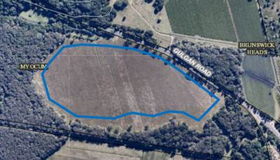
d. Re: Amount of land and land release
program
(DPIE
advice d. is discussed in a number of parts)
The DPIE requested that Council review the need for
additional employment land in the Gulgan East, West and North areas as part
of a land release program for the Byron Shire.
Amount of land and land release program cont.
|
Noting, the
DPIE concern over the quantum of land in the Gulgan west area, staff have
undertaken further preliminary assessment of flood prone land in this
locality. Based on this further analysis, indicating that the major part of Lot 50 DP 881232 and southern areas of
Lot 26 DP 830652 are anticipated to have a depth of flood water in excess of
1.5m in a 100 year flood event, as well as wholly
contained within a significant regional farmland designation; it
considered appropriate to exclude this land from the designated investigation
area. A revised boundary for the Gulgan West
investigation area is shown below.
In regard to
the need for industrial land, the BILS (page 64) identifies three growth
scenarios based on population projections and trends in industry and floor
space requirements. The BILS Background Report acknowledges that it is
prudent to provide and plan for an additional supply of land (or contingency)
above the projected in the interests of price competition
The area
of land needed as cited for the scenarios is ‘ net additional developed
land area’ to accommodated the resulting projected floor space demand
i.e. land area needed to accommodated actual industrial uses.
With
part of Gulgan West excluded, a revised ‘potential developable
land’ for the combined investigation areas in the BILS is approximately
36 ha. This figure whilst higher than Scenario 3 of 24 ha ‘net
additional developed land area’ it is not excessive when also taking
into account:
- existing development patterns in Byron Shire, the likely
premises/development land yield/per gross ha of land equates of around an 85%
yield on the gross possible developable land i.e.
85%
of 36 ha (gross) = some 30 ha (net).
- the recently released draft North Byron Flood Risk
Management Study indicates the Billinudgel industrial areas (a precinct 8 ha
in area) is given as a low priority hence status quo remains where parts of
this precinct hold limited suitably for many industrial tenancy types,
particularly with pending limitations on fill.
On
the matter of a Land Release Program, a number of Councillors at a Strategic
Planning Workshop (Nov 2019) indicated a preference not to set a specific
release program so as to avoid any restrictions on particular parcels being
able to be developed. Benefits of this approach were seen as:
- providing a new and
flexible supply in various locations across the Shire;
- avoiding the land
supply issue experienced in the Shire where one landowner can effectively
control and bank the land supply;
- providing land for
both traditional industrial use and for business park use in the short term.
Recommendation:
Exclude Lot 50 DP 881232 and southern
part of Lot 26 DP 830652 from the BILS Gulgan West investigation area on the
basis that it is wholly contained within a significant regional farmland
designation and the major part of the land is anticipated to have a depth of
flood water in excess of 1.5m in a 100 year flood event, and furthermore the
landowners advised accordingly.
(Recommendation
1. e))
That the DPIE be advised that Council and prefers the use of
‘anticipated delivery timeframe’ to a rigid land release program
for the Byron Shire.
(Recommendation
2. e))
|
|
Advice d
Council
collaborate with other Northern Rivers councils and the Department of
Planning Industry and Environment to build an evidence base, consistent with
Action 5.1 of the Regional Plan and Principle 2 of the North Coast Settlement
Planning Guidelines, to ‘consider a regional approach to land
supply’.
|
Council
has collaborated with other Northern Rivers councils and the Department of
Planning, Industry and Environment as part of the North Rivers Regional
Economic Development Strategy (REDS). The investigation area land identified
is well situated to support the REDS.
A review
of the North Coast Regional Plan provides an appropriate forum for this
collaboration; evidence based regional planning and addressing emerging and
shared opportunities.
The DPIE staff have offered to
assist with ongoing collaborative work.
|
|
Advice
e.
DPIE
supports the preparation of a database of developed and vacant zoned
industrial land under BILS Action 9 as an input to the annual North Coast
House and Land Monitor.
|
Noted.
|
Additional updates
At 22 November 2018 Council meeting (Res 18-777) it was
resolved to amend the Planning Proposal for the Byron Bay CBD (26.2017.6.1) to maintain
the maximum building height control for the southern end of Jonson Street at 9
metres, as currently mapped under Byron LEP 2014.
At the 16
April 2020 Council planning meeting (Res 20-151) it was resolved
to put further consideration of the Byron Bay Town Centre Planning Proposal -
Review of Planning Controls and draft DCP 2014 Chapter E9 on hold to enable the
establishment of a Design Panel and to allow for further consideration of
applying SEPP 70 within the Byron Bay Town Centre.
Recommendation:
That the Business and Industrial Lands Strategy be updated
to reflect the intent of Council to:
i. maintain
the maximum building height control for the southern end of Jonson Street at 9
metres;
ii. allow
for further consideration of applying SEPP 70 within the Byron Bay Town Centre.
(Recommendation 1. f))
Next steps and consultation
Subject to Council supporting
staff recommendations, a response will be provided to the DPIE advising of
Council’s position together with an update version of the BILS containing
amendments as endorsed by Council.
The landowners of Lot 50 881232
and DP Lot 26 DP 830652 will also be advised
the changes to the West Gulgan investigation areas in the BLIS.
STRATEGIC CONSIDERATIONS
Community Strategic Plan and
Operational Plan
|
CSP
Objective
|
L2
|
CSP Strategy
|
L3
|
DP Action
|
L4
|
OP Activity
|
|
Community
Objective 4: We manage growth and change responsibly
|
4.5
|
Work to improve
community resilience in our changing environment
|
4.5.1
|
Develop and
implement strategies for our community's needs
|
4.5.1.1
|
Finalise the
Business and Industrial Land Strategy
|
Legal/Statutory/Policy
Considerations
The BILS is informed by the relevant state, regional and/or
local planning framework and best practice planning principles.
Financial Considerations
The cost of preparing the BILS has been met by Council.
Staff Reports - Sustainable Environment and Economy 13.4
Report No. 13.4 Review
of submissions on the draft Byron Shire Affordable Housing Contribution Policy
and Procedure
Directorate: Sustainable
Environment and Economy
Report
Author: Natalie
Hancock, Senior Planner
File No: I2020/1095
Summary:
Council on 21 May 2020 resolved (Res 20-213)
to adopt for public exhibition a Draft Byron Shire Affordable Housing
Contribution Policy and accompanying Procedures.
The Policy provides a framework to facilitate and manage
affordable housing contributions. It provides a mechanism to secure land
and/or monetary contributions to deliver affordable housing on certain land
identified in the draft Residential Strategy and Byron Bay town centre.
The Procedure assists with the implementation of the Policy
and provides more detail on how Council intends to operate the contribution
framework in Byron Shire.
The draft Policy and Procedures were exhibited for a period
of 6 weeks from 3 June – 17 July 2020, with a total of 5 submissions
received (Attachment 1), three from community groups, one from a community
member and one representing landowners subject to an affordable housing
contribution (refer Attachment 1). All submissions were supportive of the
Policy and the need to address affordable housing, however expressed concerns
with the practical implications of affordable housing delivery.
This report provides a summary of the key matters raised in
submissions and recommends no changes to the Byron Shire Affordable Housing
Contribution Policy (refer Attachment 2) and accompanying Procedures (refer
Attachment 3).
NOTE TO COUNCILLORS:
In accordance with the
provisions of S375A of the Local Government Act 1993, a Division is to be
called whenever a motion for a planning decision is put to the meeting, for the
purpose of recording voting on planning matters. Pursuant to clause 2(a)
under the heading Matters to be Included in Minutes of Council Meetings of
Council's adopted Code of Meeting Practice (as amended) a Division will be
deemed to have been called by the mover and seconder of all motions relating to
this report.
|
RECOMMENDATION:
That Council adopt the Byron Shire Affordable Housing
Contribution Policy in Attachment 2 (E2020/55585) and accompanying Procedures
in Attachment 3 (E2020/55587).
|
Attachments:
1 Submissions
affordable housing contribution policy, E2020/55821
2 Policy
Affordable Housing Contribution 2020 - Final version, E2020/55585
3 Procedures
to accompany Policy Affordable Housing Contribution, E2020/55587
4 Special
Disclosure of Pecuniary Interest Annexure, E2012/2815
REPORT
Council on 21 May 2020 resolved (Res 20-213)
to adopt for public exhibition a Draft Byron Shire Affordable Housing
Contribution Policy and accompanying Procedures.
The draft Policy and Procedures were exhibited for a period
of 6 weeks from 3 June – 17 July 2020, with a total of 5 submissions
received, three from community groups, one from a community member and one
representing landowners subject to an affordable housing contribution
(Attachment 1). All submissions were supportive of the policy and need to
address affordable housing, however expressed concerns with the practical
implications of the delivery of affordable housing.
This report provides a summary of the key matters raised in
submissions and recommends no changes to the Byron Shire Affordable Housing
Contribution Policy Attachment 2 and accompanying Procedures Attachment
3.
Key issues
|
Matter Raised
|
Staff response
|
|
Proposed affordable housing contribution
area landowner input
Two landowners of land
potentially subject to an Affordable Housing Contribution Scheme responded by
agreeing with the Policy and the Objectives, however seeking two changes:
1. In regard to Objective vii
that states the contributions to supplement, but not replace, or be in
lieu of the application to the development of the Byron Shire Developer
Contributions Plan established under the Act, that the Policy clearly
state that no Developer Contributions, nor Water/Sewer Contributions will be
levied on the affordable housing lots/area granted to Council.
2. The contribution rates for
Mullumbimby and Bangalow are reduced from 20% to 10% on the basis that the
provision of 20% of area if that is greater than 20% of lots simply will not
work if the end development is a mix of both conventional residential lots,
as well as small lots for affordable housing.
|
1. It is unreasonable to expect
that a developer pay developer contributions on a lot that they are required
to dedicate to Council for the purposes of affordable housing. Section
7.11 contributions under Byron Shire Developer Contributions Plan 2012
Amendment 4 would not have to be paid for land that is to be subdivided for
affordable housing purposes. This policy position already exists in
clause 2.15 of the plan. No amendment of the policy as exhibited is
required.
With respect to the payment of
water and sewer charges for subdivisions of land to dedicate a lot to Council
for the purposes of affordable housing it is unreasonable to expect the
developer to pay these. As this is a separate fund of the creation of
the new lot will generate a demand for water and sewer services the
contributions should be paid. A mechanism to facilitate the payment
would be for the water and sewer contributions to be paid by Council (general
fund) from a specific reserve created for this purpose. The
reserve would be funded from the affordable housing cash contributions
paid by other developers.
Section 8 of the Procedures
enables review to reflect updates as the residential strategy and subsequent
planning proposal/s for investigation areas progress.
No amendment of the Policy
and Procedure as exhibited is required.
2. A reduction in the guiding
contribution rate of 20 % is not supported nor required. The 20% area would
be upper limit for the purposes of the Policy and is subject to further
viability testing on a case by case basis.
The Policy and Procedures are
underpinned by the logic a development needs to be viable, otherwise no
housing will be delivered.
Procedure 4.1 Establishing a
contribution rate (item) c) enables proponents as part of a
planning proposal for the upzoning to have the ability to request a
contribution rate variation for their individual precincts/project and AHCS
clause. This procedure can involve as part of a planning proposal for the
upzoning and AHCS undertaking an independent viability testing for their
individual precincts/project.
No amendment of the Policy
and Procedure as exhibited is required.
|
|
Amenity
Concern that the SEPP 70 Affordable Housing Contribution
Scheme will lead to intensification of densities in the established R2
– Residential Low Density Zone urban areas with associated amenity and
infrastructure issues.
Issues listed include:
· adequacy of
footpaths
· parking overflow
on streets
· need for
convenience to public transport
· over development
of existing lots
· importance of
respect for and reinforcement of heritage provisions
It was suggested that place planning processes and subsequent
updates to the Byron Development Control Plan 2014 (DCP) are useful avenues
to better plan for affordable housing, diversifying housing types and
densities within local areas.
|
Whilst noting the concerns
expressed over experiences with infill occurring in established residential
areas, an SEPP 70 affordable housing contribution scheme applies to land with
an upzoning and only where a contribution is viable. In the case of Byron
Shire, as indicated in the Policy, this applies to:
· Residential investigation
areas i.e. possible new release residential areas
· Byron Town
Centre.
The application of the scheme in existing established
zoned R2 and R3 areas could not occur unless there is an upzoning. An
upzoning means a change of zone to enable residential development or a change
of planning controls (such as floor space ratio) which enables greater
residential density on a site.
Planning for new release areas enables measures to be put
in place in advance for the likely densities and anticipated residents’
needs.
The SEPP 70 Affordable Housing Contribution Scheme is
distinct from two existing other State government regulations facilitating
additional housing in established residential areas:
· SEPP Affordable
Rental Housing facilitating additional affordable rental housing.
https://www.planning.nsw.gov.au/Policy-and-Legislation/Housing/Diverse-and-affordable-housing/Affordable-Rental-Housing-SEPP
· Recently enacted
Low Rise Housing Diversity Code facilitating potential fast track medium
density housing.
https://www.planning.nsw.gov.au/Policy-and-Legislation/Housing/Low-Rise-Housing-Diversity-Code/The-Low-Rise-Housing-Diversity-Code
Many of the issues raised are more pertinent to the
delivery of housing under these provisions, but nevertheless the feedback is
useful for Council when planning for new release areas, place planning and
DCP reviews.
No amendment of the Policy and Procedure as exhibited
is required.
|
|
Short Term Holiday Let impacts
Potential use of affordable dwellings for Air BNB.
Support of 90 day cap on short term holiday letting to
help reduce the need for affordable rental housing.
|
Housing delivered under a SEPP 70
Affordable Housing Contribution Scheme must be used for affordable housing.
The policy/procedures state that on land on which this type of housing is to
be delivered is to remain as Council land. Hence Council will be able to see
that this occurs.
No amendment of the Policy and Procedure as exhibited
is required.
|
|
Dwelling targets and dwelling
mix
It was raised that target number of 140 dwellings in the
Policy is in consistent with the possible 190 dwellings identified in Table 1
of the Procedures.
Concern was expressed that 20% contribution rate may lead
to an excessive number of affordable houses congregated in one location.
|
It is noted that there is an
inconsistency between the yield number in the Policy and the Procedures.
Either way the figures are indicative and subject to the actual development
outcomes on the land. The numbers in the procedures may need to be revised
based on Council (Planning) meeting of 18 June 2020 (resolution 20-276)
to include addition investigation areas in the draft residential strategy.
It is considered the baseline 140 dwelling target should
be retained in the Policy.
Section 8 of the Procedures enables review to reflect
updates as the residential strategy and subsequent planning proposal/s for
investigation areas progress. Such updates will enable community members to
remain informed on the ongoing delivery of affordable housing in their
locality.
As the housing is proposed for new release areas, an
opportunity exists for Council to work with the developer and affordable
housing providers on the placement, type and design of affordable housing and
supporting infrastructure.
Policy statement of intent 5 requires ‘in
all cases, will determine the affordable housing contribution form, in order
to: a) support a more even distribution of affordable housing within urban
areas.’‘
No amendment of the policy as exhibited is required.
|
|
Community involvement in the
process
Support for Policy objectives that focus on continued
community input in the process of affordable housing delivery
|
Noted.
It however highlighted that separate to the housing under
this Policy process, housing under the low rise medium density code –
complying development – the applicant is not required under legislation
to engage with the community as part of the formal process.
No amendment of the Policy as exhibited is required.
|
|
Planning agreements (PA)
Suggested that Council should not enter into a PA unless
the development is compatible with the character of the local area.
|
It is considered this aspect
would be captured under 5.5. When will Council not consider entering a
Planning Agreement? (item) v.
When a development is unacceptable on planning
grounds, planning benefits offered by the proponent in a Planning
Agreement will not make an unacceptable development acceptable.
The draft Byron DCP Character narratives will provide
additional guidance on local residential character.
No amendment of the Policy and Procedure as exhibited
is required.
|
|
Planning agreements (PA)
Concern was expressed that affordable housing could be
used as a tool to lever development that is in appropriate for an area.
It was suggested that the Policy clarifies that
investigation areas may contain land that may not be suitable for residential
development.
|
The adoption of this Policy is
intended to set a framework to avoid a lever situation occurring.
The Residential Strategy is the more appropriate document
to provide guidance on land that is suited to residential development.
Procedure Item 4.2 states that:
A land contribution to Council for the purpose of
affordable housing requires the land is fit for purpose.
No amendment of the Policy and Procedure as exhibited
is required.
|
|
SEPP for Affordable rental
Housing
Submissions expressed a dissatisfaction with the
housing being delivered under this SEPP issues being:
· design
disconnect with the local character/streetscape
· parking
· density of
development on a given site
· locations and
local infrastructure that are not necessarily suited to the needs of rental
tenants
· the 10 year
sunset clause on the requirement of renting at an affordable level
|
Noted.
This SEPP is a state government regulation and Council
does not have the capacity to amend.
It should be noted that the Department of Planning,
Industry and Environment (DPIE) is currently exhibiting an Explanation of
Intended Effect (EIE) for a new Housing Diversity SEPP. The EIE is on
exhibition until 9 September 2020. The proposal includes the consolidation of
three housing-related SEPPs into one. Staff will be making a submission and
will raise again these concerns for DPIE consideration.
https://www.planningportal.nsw.gov.au/proposed-new-housing-diversity-sepp
On going improvements to the Byron DCP are seeking to
address the aspects where Council does have the capacity to regulate/guide.
The draft Residential Strategy is being used to inform
place planning and long range infrastructure planning and delivery.
No amendment of the Policy and Procedure as exhibited
is required.
|
|
Inclusivity
It was suggested that the Byron DCP include requirements
for inclusivity (such as need for disabled, older people and
families)
|
This suggestion is supported and
it is noted that the draft Residential Strategy Direction 2 actions include
review of the Byron LEP and DCP to address this matter, amongst other items.
No amendment of the Policy and Procedure as exhibited
is required.
|
Next steps
It is recommended that Council adopt the Policy and
Procedures without changes.
STRATEGIC CONSIDERATIONS
Community Strategic Plan and
Operational Plan
|
CSP Objective
|
L2
|
CSP Strategy
|
L3
|
DP Action
|
L4
|
OP Activity
|
|
Community
Objective 4: We manage growth and change responsibly
|
4.2
|
Support
housing diversity in appropriate locations across the Shire
|
4.2.1
|
Establish
planning mechanisms to support housing that meets the needs of our community
|
4.2.1.3
|
Prepare an
Affordable Housing contribution scheme under SEPP 70 to be incorporated in
the local planning framework controls (Action in Residential Strategy)
|
|
|
Community
Objective 4: We manage growth and change responsibly
|
4.2
|
Support
housing diversity in appropriate locations across the Shire
|
4.2.1
|
Establish
planning mechanisms to support housing that meets the needs of our community
|
4.2.1.4
|
Investigate and
implement planning controls to encourage an increase in the supply of
affordable and inclusive housing stock (Action in Residential Strategy)
|
|
|
|
|
|
|
|
|
|
|
|
|
|
|
|
|
Legal/Statutory/Policy
Considerations
The draft Policy has been exhibited in accordance with Local
Government Act 1993 – Section 160 Public notice and exhibition of
draft local policy. Under Local Government Act 1993 – Section 160
the period of public exhibition must be not less than 28 days.
Financial Considerations
Not applicable to this report.
Consultation and Engagement
The draft Policy and
Procedures builds on the extensive engagement undertaken in developing the
draft Residential Strategy.
The exhibition was undertaken in line with the Community
Participation Plan.
Council is committed to building ongoing and meaningful
relationships and partnerships with local community and interest groups about
planning matters.
Staff Reports - Sustainable Environment and Economy 13.5
Report No. 13.5 PLANNING
- Report of the 11 June 2020 Planning Review Committee
Directorate: Sustainable
Environment and Economy
Report
Author: Chris
Larkin, Manager Sustainable Development
Noreen Scott, EA Sustainable
Environment and Economy
File No: I2020/925
Summary:
This report provides the outcome of the Planning Review
Committee (PRC) held on 11 June, 2020. Due to COVID-19, the PRC meeting was
held partly via Zoom with one Councillor attending in person. Of the two
development applications reported to PRC, one is to be reported to Council for
determination and one application remains with staff to determine under
delegation.
NOTE TO COUNCILLORS:
In accordance with the
provisions of S375A of the Local Government Act 1993, a Division is to be
called whenever a motion for a planning decision is put to the meeting, for the
purpose of recording voting on planning matters. Pursuant to clause 2(a)
under the heading Matters to be Included in Minutes of Council Meetings of
Council's adopted Code of Meeting Practice (as amended) a Division will be
deemed to have been called by the mover and seconder of all motions relating to
this report.
|
RECOMMENDATION:
That Council endorses the outcomes of the
Planning Review Committee meeting held on 11 June 2020.
|
REPORT
The Planning Review Committee meeting scheduled for 11 June,
2020 was held via a Zoom meeting with Councillor Martin attending in person.
Councillors: Crs Hunter, Hackett, Lyon, Coorey, Cameron and
Martin
Apologies: Cr Ndiaye
Staff: Chris Larkin (Manager Sustainable Development), Rob
Van Iersel, Noreen Scott (Minute Taker)
The following development
applications were reviewed with the outcome shown in the final column.
|
DA No.
|
Applicant
|
Property Address
|
Proposal
|
Exhibition Submissions
|
Reason/s
Outcome
|
|
10.2020.251.1
|
C Lonergan
|
27-31 Fletcher Street
BYRON BAY
|
Use of Take-Away Drink
Premises (coffee cart)
|
4/6/20 to 24/6/20
|
Staff Delegation
|
|
10.2020.215.1
|
Ardill Payne & Partners
|
6 Keats Street BYRON BAY
|
Multi Dwelling Housing
Comprising of Ten (10) Two Storey Detached Dwellings and Ten (10) Swimming
Pools and Strata Subdivision
|
14/5/20 to 3/6/20
14 submissions
|
The number of public
submissions
The perceived public
significance of the application
Council
|
Staff Reports - Sustainable Environment and Economy 13.6
Report No. 13.6 PLANNING
- Report on Variations to Development Standards 1 April 2020 to 30 June 2020
Directorate: Sustainable
Environment and Economy
Report
Author: Chris
Larkin, Manager Sustainable Development
Noreen Scott, EA Sustainable
Environment and Economy
File No: I2020/1088
Summary:
This report is provided as a requirement of the NSW
Department of Planning, Industry and Environment - Planning Circular 20-002 for
reporting variations to development standards to the Secretary.
NOTE TO COUNCILLORS:
In accordance with the
provisions of S375A of the Local Government Act 1993, a Division is to be
called whenever a motion for a planning decision is put to the meeting, for the
purpose of recording voting on planning matters. Pursuant to clause 2(a)
under the heading Matters to be Included in Minutes of Council Meetings of
Council's adopted Code of Meeting Practice (as amended) a Division will be
deemed to have been called by the mover and seconder of all motions relating to
this report.
|
RECOMMENDATION:
That Council adopt the report on variations to
development standards for the period 1 April 2020 to 30 June 2020.
|
REPORT
This report is provided as a requirement of the NSW
Department of Planning, Industry and Environment - Planning Circular 20-002 for
reporting variations to development standards to the Secretary for applications
made under Clause 4.6 of Byron Local Environmental Plan 2014 and Clause 64A of
Byron Local Environmental Plan 2014 1988.
The period of reporting is 1 April 2020 to 30 June 2020
which included the following DAs:
|
DA No
|
10.2019.517.1
|
|
Development
|
Mixed Use Development (Stage 4 Habitat)
|
|
Property:
|
Habitat Bayshore Drive BYRON BAY
|
|
Lot and DP:
|
LOT: 1 & 12 DP: 271119
|
|
Zoning:
|
B4 Mixed Use
|
|
Development Standard being varied
|
Clause 4.3 Height of Buildings LEP 2014
|
|
Justification Summary
|
The proposed buildings are similar in scale and height to
buildings in this precinct. Development will not result in any
overshadowing, overlooking, loss of privacy or amenity impacts in the
locality
|
|
Extent of variation
|
11% (max)
|
|
Concurrence
|
Council under assumed concurrence
|
|
Determination Date
|
21/05/2020
|
|
Determined by
|
Council
|
|
|
|
DA No.
|
10.2019.616.1
|
|
Development
|
Demolition of Existing Buildings and Construction of Mixed
Use Development
|
|
Property:
|
137-139 Jonson Street BYRON BAY
3 Browning Street, BYRON BAY
|
|
Lot and DP:
|
LOT: 21 DP: 247289
LOT: 5 DP: 758207
LOTS 60-61 DP: 1256365
|
|
Zoning:
|
B2 Local Centre
|
|
Development Standard being varied:
|
Clause 4.3 Height of Buildings LEP 2014
Clause 4.4 Floor Space Ratio LEP 2014
|
|
Justification Summary
|
The proposed building is consistent in scale to nearby
buildings and establishes the desired future character of the locality
consistent with the Byron Bay Town Centre Master Plan.
The proposed buildings are consistent in scale to nearby
buildings. The additional floor area does not contribute to the overall bulk
or scale of the building
|
|
Extent of variation
|
9% Max Height of Buildings
9.60% - FSR
|
|
Concurrence
|
Council under assumed concurrence
|
|
Determined Date
|
21/05/2020
|
|
Determined By
|
Council
|
|
|
|
DA No.
|
10.2019.630.1
|
|
Development
|
Dual occupancy (attached)
|
|
Property:
|
7 – 9 Brownell Drive,
Byron Bay
|
|
Lot and DP:
|
Lots 4 & 5 on DP112343
|
|
Zoning:
|
R2 Low Density Residential
|
|
Development Standard being varied:
|
Clause 4.3 Height of Buildings LEP 2014
|
|
Justification Summary
|
The development standard is
exceeded by small segments of the roofline as a product of the
‘step’ in the existing ground level from previous earthworks. The
remainder of the building complies with the development standard. Conversely,
the proposed roofline adheres to the development standard when juxtaposed
with the estimated (surrounding) natural ground level, which is the objective
of the standard: to assimilate with surrounding environment and character.
|
|
Extent of variation
|
9.88%
|
|
Concurrence
|
Staff under assumed concurrence
|
|
Determined Date
|
25 May 2020
|
|
Determined By
|
Director
|
STRATEGIC CONSIDERATIONS
Community Strategic Plan and Operational Plan
|
CSP Objective
|
L2
|
CSP Strategy
|
L3
|
DP Action
|
L4
|
OP Activity
|
|
Community
Objective 4: We manage growth and change responsibly
|
4.1
|
Support the
visions and aspirations of local communities through place-based planning and
management
|
4.1.3
|
Manage
development through a transparent and efficient assessment process
|
4.1.3.1
|
Assess and
determine development applications
|
|
|
|
|
|
|
|
|
|
|
|
Legal/Statutory/Policy Considerations
The report is provided as a
requirement of Planning Circular Varying
Development Standards PS 20-002
Staff Reports - Sustainable Environment and Economy 13.7
Report No. 13.7 PLANNING
- DA 10.2020.220.1 Alterations and Additions to Existing Entertainment Facility
(Brunswick Picture House) at 30 Fingal Street Brunswick Heads
Directorate: Sustainable
Environment and Economy
Report
Author: Patricia
Docherty, Planner
Noreen Scott, EA Sustainable
Environment and Economy
File No: I2020/1030
Proposal:
|
DA No:
|
10.2020.220.1
|
|
Proposal description:
|
Alterations and Additions to Existing Entertainment
Facility (Brunswick Picture House)
|
|
Property description:
|
LOT: 13 SEC: 7 DP: 758171
|
|
30 Fingal Street BRUNSWICK HEADS
|
|
Parcel No/s:
|
24240
|
|
Applicant:
|
Planners North
|
|
Owner:
|
Eight Hilton Lane Pty Ltd
|
|
Zoning:
|
B2 Local Centre
|
|
Date received:
|
6 May 2020
|
|
Integrated / Designated Development:
|
☐
Integrated
|
☐
Designated
|
☒
Not applicable
|
|
Concurrence required
|
No
|
|
Public notification or exhibition:
|
- Level
2 advertising under DCP 2014 Part A14 – Public Notification and
Exhibition of Development Applications
- Exhibition
period: 21/5/20 to 10/6/20
- Submissions received:
Nine (9) in Total (Seven (7) Support; Two (2) Object)
- Submissions
acknowledged: ☒
Yes ☐ No ☐ N/A
|
|
Delegation to determine
|
Council
|
|
Issues:
|
· Public
Submissions
· The existing
fire safety order issued by Council is to be satisfactorily completed prior
to the issue of a construction certificate.
· Noise management
conditions required.
· Operating
capacity is 200 persons seating in accordance with access upgrade report.
· Approved
existing on-site parking – double garage to be made available for use.
|
Summary:
This development application seeks approval for alterations
and additions to an existing entertainment facility (Brunswick Picture House),
including the following:
· The proposed works
seek to improve the accessibility to the premises, provide for storage
facilities, upgrade toilet facilities particularly in relation to
accessibility, provide somewhere for performers to prepare and change, and
improve the overall operation of the premises.
· The proposal
provides for the removal of existing asbestos cladding and roofing.
· The works include
replacing the existing roof with uncoloured zincalume roof sheeting.
· Solar panels are
proposed to be installed on the roof.
· Air conditioning
is to be provided for the premises to enable the doors of the facility to be
closed during performances, which will reduce potential impacts on existing,
surrounding properties.
· The works will
involve the removal of two existing planted ornamental trees.
The proposed alterations and additions do not increase the
capacity of the venue or intensify the existing use of the approved
entertainment facility.
The application appropriately addresses the relevant
constraints applying to the site, and is recommended for approval subject to
the conditions of approval attached to this report.
NOTE TO COUNCILLORS:
In accordance with the
provisions of S375A of the Local Government Act 1993, a Division is to be
called whenever a motion for a planning decision is put to the meeting, for the
purpose of recording voting on planning matters. Pursuant to clause 2(a)
under the heading Matters to be Included in Minutes of Council Meetings of
Council's adopted Code of Meeting Practice (as amended) a Division will be
deemed to have been called by the mover and seconder of all motions relating to
this report.
|
RECOMMENDATION:
That pursuant to
Section 4.16 of the Environmental Planning & Assessment Act 1979,
Development Application No. 10.2020.220.1 for Alterations and Additions to Existing Entertainment Facility
(Brunswick Picture House), be granted consent subject to the conditions of
approval attached to this report (E2020/54768).
|
Attachments:
1 10.2020.220.1
Recommended Conditions of Consent, E2020/54768
2 10.2020.220.1
Brunswick Picture House Plans, E2020/54328
3 10.2020.220.1
Noise Impact Assessment Report, E2020/34462
4 Confidential
- 10.2020.220.1 Submissions received, E2020/55686
REPORT
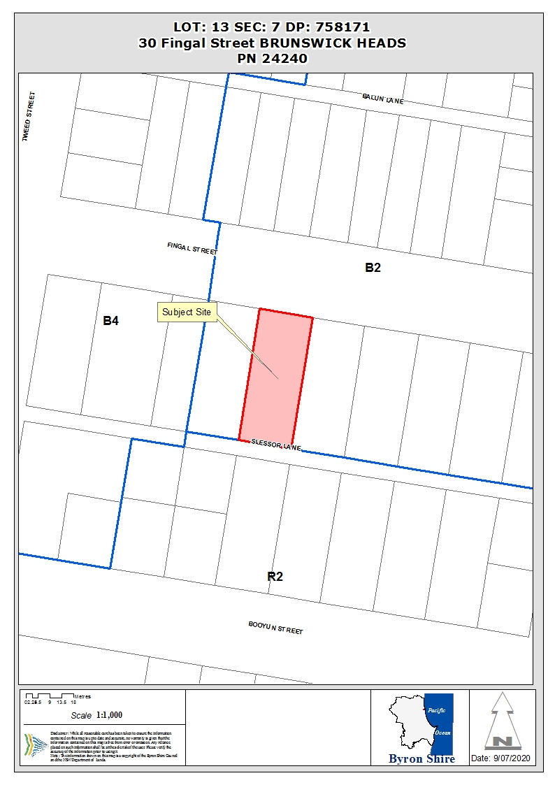
Assessment:
1. INTRODUCTION
1.1. History/Background
Available documentation references the following historical
approvals for this site:
BA 26/52 for a Picture Hall was issued on 7/4/1952.
BA 63/2076 for the purposes of an addition to
“Victory Theatre” was approved on 31/12/1963.
BA 64/2052 for a double garage adjacent to dwelling
house was applied for on 29/10/1964.
BA 71/2076 for amenities providing toilets for
patrons of the existing theatre was determined on 7/7/1971.
DA 5.1996.320.1 for conversion of an existing church
into a school was refused on 16/2/1997.
DA 10.2017.471.1 for change of use to restaurant or
café – this is ancillary to the Entertainment Facility and was
approved on 14/05/2018 for an initial period of 12 months to ensure noise
management measures is achieved. Operational conditions required that the
restaurant or cafe is not to be open to the public and patrons of the theatre
at the same time to ensure that there be no increased demand for car parking
for the development. The applicant advises a separate application will be
submitted to seek approval for this to continue.
Note. It is considered that the approvals in 1952 and
1963 remain operative and the use of the building for the purposes of a picture
house or theatre, defined under Byron Local Environmental Plan (LEP) 2014 as an
entertainment facility, has not lapsed. Furthermore, entertainment facilities
are permissible with consent on the land, zoned B2 Local Centre under LEP
2014. The application is not required to demonstrate existing or
continuing use rights pursuant to Division 4.11 Existing uses of the
Environmental Planning & Assessment Act 1979.
1.2. Description
of the proposed development
This application seeks approval for alterations and
additions to an existing entertainment facility (Brunswick Picture House),
including the following:
· The proposed works
seek to improve the accessibility to the premises, provide for storage
facilities, upgrade toilet facilities particularly in relation to
accessibility, provide somewhere for performers to prepare and change, and
improve the overall operation of the premises.
· The proposal
provides for the removal of existing asbestos cladding.
· The works include
replacing the existing roof with uncoloured zincalume roof sheeting.
· Solar panels are
proposed to be installed on the roof.
· Air conditioning
is to be provided for the premises to enable the doors of the facility to be
closed during performances, which will reduce potential impacts on existing,
surrounding properties.
· The works will
involve the removal of two existing planted ornamental trees.
The proposed alterations and additions do not increase the
capacity of the venue or intensify the existing use of the approved
entertainment facility.
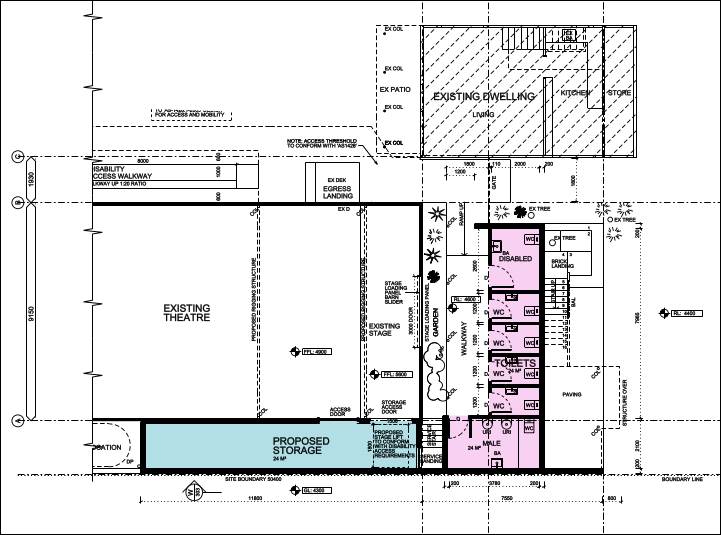
Ground floor additions
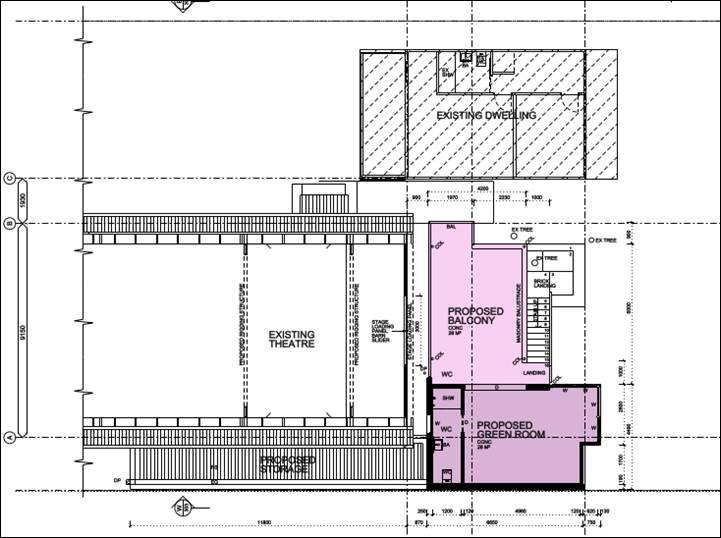
First floor additions
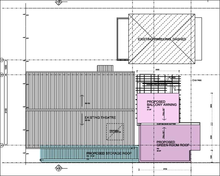
Roof replacement and additions
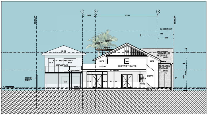
Fingal Street elevation (North)
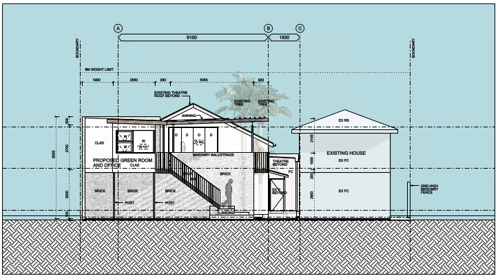
Slessor Lane elevation (South)
The proposed development is detailed in the plan set
provided in the attachments to this report.
1.3. Description
of the site
Site inspections were carried out on 12 May 2020, 11 June
2020 and 17 June 2020.
|
Land is legally described
|
LOT: 13 SEC: 7 DP: 758171
|
|
Property address
|
30 Fingal Street BRUNSWICK HEADS
|
|
Land is zoned:
|
B2 Local Centre
|
|
Land area is:
|
1,012 m2
|
|
Property is constrained by:
|
Acid Sulfate Soils Class
4.
|
|
Is a BDAR required due to the location of the proposed
development?
|
☐ Yes ☒ No
|
|
Are there any easements in favour of Council affecting the
site?
|
☐ Yes ☒ No
|
|
Is there a Vegetation Management Plan which might affect
the proposal?
|
☐ Yes ☒ No
|
|
Is there a Voluntary Planning Agreement which might affect
the proposal?
|
☐ Yes ☒ No
|
The Brunswick Picture House is located in the northern part
of the site, a dwelling and approved double garage are located
towards the south eastern corner of the site. Fingal Street is on the
northern side of the site and Slessor Lane is on the southern side of the site.
The site is in an area characterised by a broad mix of
commercial and residential uses in the Brunswick Heads business district.
The site adjoins land zoned B4 Mixed use development to the west and land zoned
R2 Low density residential is located on the opposite side of Slessor Lane to
the south.
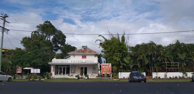
Brunswick Picture House streetscape
Brunswick Picture House from rear yard, existing dwelling
onsite to the right
Existing dwelling and double garage to the right
Existing structures on rear lot boundary obstructing
approved garage for residence – Slessors Lane
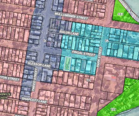 Lot and Land use zone
2. SUMMARY OF
REFERRALS
|
Referral
|
Issue
|
|
Environmental Health Officer*
|
No objections subject to conditions. Refer to Doc #A2020/24632.
|
|
Development Engineer
|
No objections subject to conditions.
|
|
Water & Sewer Engineer (Local Approvals Officer)
Concurrent Approvals
|
No objections subject to conditions for concurrent
approvals.
|
|
Building Surveyor
|
No objections subject to conditions.
|
|
Heritage Consultant
|
No objections subject to recommendations noting that it is
not a heritage item nor in a heritage conservation area.
|
* Conditions provided in the above referral are included
in the Recommendation of this Report below
3. SECTION 4.14
– BUSH FIRE PRONE LAND
Under section 4.14 of the Act, Council must be satisfied
prior to making a determination for development on bush fire prone land, that
the development complies with the document ‘Planning for Bush Fire
Protection 2019’. The site is not bush fire prone land.
4. SECTION 4.15C
– MATTERS FOR CONSIDERATION – DISCUSSION OF ISSUES
Having regard to the matters for consideration detailed in
Section 4.15(1) of the Environmental Planning & Assessment Act 1979
(EP&A Act), the following is a summary of the evaluation of the issues.
4.1 State Environmental
Planning Instruments
|
|
Satisfactory
|
Unsatisfactory
|
|
State
Environmental Planning Policy No 55—Remediation of Land
|
☒
|
☐
|
|
Consideration: The site has a long-standing history of
residential and entertainment use. There are no dip sites / buffers or known
radioactive sands on the lot. The existing structures to be demolished have
asbestos containing material. Conditions of consent for the handling
and safe disposal of asbestos are included in the recommended conditions of
consent. There is no increase in sensitivity in land use proposed. It
is considered that no further site investigation is required for the proposed
development
|
|
State
Environmental Planning Policy No 64—Advertising and Signage
|
☒
|
☐
|
|
Consideration: The proposed development does not seek
approval for additional advertising and signage.
|
|
State Environmental Planning
Policy (Coastal Management) 2018
|
☒
|
☐
|
|
Consideration: The land is in the mapped Coastal
Environment Area and Coastal Use Area and is considered to satisfy the
relevant provisions under Division 3 and 4 of the SEPP. The development
being within the urban footprint of the Brunswick Heads CBD raises no issues
in terms of the SEPP.
|
|
State Environmental Planning
Policy (Vegetation in non-rural areas) 2017
|
☒
|
☐
|
|
Consideration: The proposed removal of the planted
ornamental vegetation in the yard does not require a permit under the development control plan or
the Vegetation SEPP.
|
4.2A Byron Local Environmental
Plan 2014 (LEP 2014)
LEP 2014 is an applicable
matter for consideration in the assessment of the subject development
application in accordance with subsection 4.15(1) of the EP&A Act because
it applies to the subject land and the proposed development. The LEP 2014
clauses that are checked below are of relevance to the proposed development:
|
Part 1
|
☒1.1|
☒1.1AA| ☒1.2| ☒1.3| ☒1.4| ☒Dictionary| ☒1.5| ☒1.6| ☒1.7| ☒1.8| ☒1.9
|
|
Part 2
|
☒2.1|
☒2.2 | ☒2.3 |☒Land Use Table | ☒2.7
|
|
Part 4
|
☒4.3|☒4.4 |☒4.5
|
|
Part 6
|
☒6.1|
☒6.2| ☒6.6
|
In accordance with LEP 2014 clauses 1.4 and 2.1 – 2.3:
(a) The
proposed development is defined in the LEP 2014 Dictionary as a restaurant or
cafe;
(b) The
land is within the B2 Local Centre according to the Land Zoning Map;
(c) The
proposed development is permitted with consent; and
(d) Regard
is had for the Zone Objectives as follows:
|
Zone Objective
|
Consideration
|
|
To provide a range of retail, business,
entertainment and community uses that serve the needs of people who live in,
work in and visit the local area.
|
The proposal contributes to the existing
range of retail, business, entertainment and community uses that serve the
needs of people who live in, work in and visit the local area.
|
|
To encourage employment opportunities in
accessible locations.
|
The proposal contributes to employment
opportunities in accessible locations.
|
|
To maximise public transport patronage
and encourage walking and cycling.
|
The proposal contributes towards public
transport patronage, and walking and cycling in this central location.
|
|
To encourage vibrant centres by allowing
residential and tourist and visitor accommodation above commercial premises.
|
The proposal does not relate to allowing
residential and tourist and visitor accommodation above commercial premises.
|
The relevant clauses have been taken into consideration in
the assessment of the subject development application in accordance with
Section 4.15 of the EP&A Act. The proposed development complies with all
clauses of LEP 2014 (in some cases subject to conditions and/or to the
satisfaction of other assessing officers).
Clause 4.3 Height of Buildings
The height of buildings including the storage space, back
stage changing areas, covered deck and new roof are all substantially lower
than the maximum permissible nine (9) metre height limit:
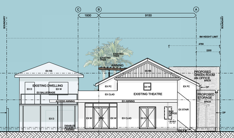
Elevation of buildings all
below 9 metre height limit
Clause 4.4 Floor Space Ratio
The total Gross Floor Area (GFA) including the alterations
and additions to the existing entertainment facility and the approved dwelling
house does not result in a Floor Space Ratio (FSR) in excess of the permissible
0.75:1 (i.e. FSR is less than 75% of 1,012 m2 site area). Proposal
Complies
Gross floor area means the sum of the floor
area of each floor of a building measured from the internal face of external
walls, or from the internal face of walls separating the building from any
other building, measured at a height of 1.4 metres above the floor, and
includes—
(a) the area of a
mezzanine, and
(b) habitable rooms in a
basement or an attic, and
(c) any shop,
auditorium, cinema, and the like, in a basement or attic,
but excludes—
(d) any area for common
vertical circulation, such as lifts and stairs, and
(e) any basement—
(i) storage, and
(ii) vehicular access,
loading areas, garbage and services, and
(f) plant rooms, lift
towers and other areas used exclusively for mechanical services or ducting, and
(g) car parking to meet
any requirements of the consent authority (including access to that car
parking), and
(h) any space used for
the loading or unloading of goods (including access to it), and
(i) terraces and
balconies with outer walls less than 1.4 metres high, and
(j) voids above a floor
at the level of a storey or storey above.
4.3 Any proposed Instrument
that has been the subject of public consultation and has been notified to the
consent authority
Not applicable
4.4A Byron Shire
Development Control Plan 2014 (DCP 2014)
The following specific
comments are made on relevant chapters of the DCP.
Chapter B4 Traffic Planning, Vehicle Parking, Circulation
and Access.
The proposal does not generate any specific additional
parking, however Provisions have been made in the recommended conditions of
consent to ensure that the existing approved parking for two vehicles in the
double garage is to be available for use by the associated dwelling house at
all times.
Chapter D4 Commercial and retail development
Setbacks - The western side of the proposed back
stage areas will be built to the boundary. There is no side setback
limitation on land zoned business under LEP 2014. The subject site and the
adjoining land are zoned for business purposes. Notwithstanding the
adjoining land use zone is mixed use and the site contains existing residential
accommodation. The assessing officer requested additional information to assess
the potential for overshadowing. A review of the submitted shadow
diagrams prepared by the registered architect has confirmed that the
development is designed to minimise impacts on solar access on adjoining
properties. This will ensure that the occupants of adjoining residential
buildings will continue to enjoy the optimum use of winter sunlight and summer
shade.
There are no additional window or door openings proposed on
the storage and back stage areas which are proposed to be built to the
boundary. The solid block wall of this part of the building is proposed
to be 4.1 metres high (storage area) and 6.2 metres high (‘green
room’), substantially below the 9 metre height limit.
Some pruning of vegetation will be required, which does not
require consent where it is overhanging the subject site.
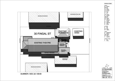
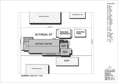
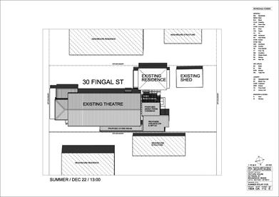
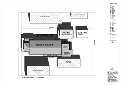
Summer solstice shadow diagrams 09.00, 11.00, 13.00,
15.00
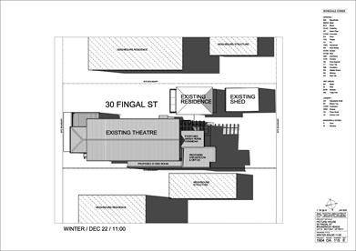
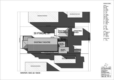
Winter solstice shadow diagrams 09.00, 11.00, 13.00,
15.00
Chapter E4 Brunswick Heads
The proposed development is satisfactory in terms of the
character, bulk and scale provisions contained within the DCP for the CBD of
Brunswick H. The additions to he theatre are well within the height
requirements under the LEP whilst the building materials do not offend the
visual amenity or character of the neighbourhood.
The proposal raises no other issues under the DCP
4.5 Environmental
Planning & Assessment Regulation 2000 Considerations
|
Clause
|
This control is applicable
to the proposal:
|
I have considered this
control as it relates to the proposal:
|
If this control is
applicable, does the proposal comply?
|
|
92
|
Yes
|
Yes
|
Yes – Conditions
apply in relation to demolition works
|
|
93
|
No
|
N/A
|
N/A
|
|
94
|
Yes
|
Yes
|
Yes – Conditions apply in relation to building code
of Australia matters
|
|
94A
|
No
|
N/A
|
N/A
|
* Non-compliances and any other significant issues
discussed below
4.6 The likely impacts of that
development, including environmental impacts on both the natural and built
environments, and social and economic impacts in the locality
|
Impact on:
|
Likely significant impact/s?
|
|
Natural environment
|
No. The proposal will not have a significantly adverse
impact on the natural environment of the locality.
|
|
Built environment
|
No. The proposal will not have a significantly adverse
impact on the built environment of the locality. See additional comments
below in relation to noise and built environmental impact on matters raised
during the exhibition period.
|
|
Social Environment
|
No. The proposal will not have a significant social impact
on the locality.
|
|
Economic impact
|
No. The proposal will not have a significant economic
impact on the locality.
|
Council Policies that are applicable to the proposed
development have been considered during assessment.
4.7 The suitability of the site
for the development
The site is a serviced, unconstrained property and is
suitable for the proposed development.
4.8 Submissions made in
accordance with this Act or the regulations
The development application was publicly exhibited from
21/05/2020 to 10/06/2020.
There were nine (9) submissions made on the development application:
- 7
For
- 2
Against
Issues of objection that are relevant matters for
consideration, primarily relate to residential amenity impacts affecting
residents to the east, west and south. These are considered, as follows:
Issue - Noise day and night affecting existing
residential development
Consideration – The Report
entitled ‘Noise Impact Assessment, Alterations and Additions Brunswick
Picture House, 30 Fingal Street Brunswick Heads Ref: 141/2016_Adds & Alts
prepared by Tim Fitzroy & Associates dated 12 February 2020.’ (see
attachment). This report considers the potential noise impact associated
with use of roof mounted air conditioning plant to manage the ambient air
within the development.
A meeting
between Council staff and the applicant’s technical experts in planning
and noise was held on 01/07/20 involved discussion about the current DA for
alterations and additions to an existing entertainment facility as an
opportunity to improve noise attenuation generally rather than specifically
with respect to the proposed air conditioning. It was agreed that the
applicant would:
1. Review
the existing development and assess the noise impacts on sensitive receivers;
2. Assess
the proposed development (new roof and a/c and building additions) and assess
the noise impacts on sensitive receivers;
3. Consider,
if appropriate (mindful of costs/benefits), opportunities to improve noise
attenuation during the redevelopment process; and
4. Submits
a revised Noise Impact Assessment to Council which includes the outcomes of
items 1, 2 and 3 with a view to providing the Best Possible Outcome to mitigate
noise impact from the development on sensitive receivers.
Sound power level from the air conditioner plant 78 dB(A) is
predicted via noise modelling to exceed the project specific noise criteria
(PSNC) by 6 dB(A) during evening and night time hours. However, it is
expected that the actual air conditioner model when specified will vary from 78
dB(A) and mitigation measures designed to ensure compliance with the PSNC at
the boundary of the nearest affected residences. Details and specifications can
be required for approval prior to the issue of a constriction certificate by
the certifying authority (PCA or Council).
Further discussions held between Council’s EHO and the
Acoustic Consultant on 20/07/20 provides that the Noise Management Plan
required for DA 10.2017.471.1 can be amended to:
1. Include
management of the alterations and additions particularly the use of outside
deck area and use of air conditioning plant.
2. Limit
operational noise during evening hours (6pm – 10pm) and night time hours
(10pm – 12am).
3. Provide
a noise monitoring program.
Having consideration for the above assessment, it is
recommended that the development be approved subject to conditions of consent
being imposed.
Compliance with the consent conditions will ensure that the
proposed alterations and additions to the existing entertainment facility Is
likely to result in a beneficial improvement to residential amenity.
Issue – Traffic and parking
Consideration – Major concerns are raised that
the building upgrades will attract more people and more frequent performances
and that this will have impacts on-street parking in the vicinity, including
Slessor Lane, including no parking for performers. The entertainment
facility was constructed prior to current DCP requirements for on site parking
for new buildings. Council has considered the nature of the additional floor
space in relation to potential patronage. All additional areas are for storage
and back of house use. The capacity of the venue is not increased and therefore
there is no parking requirement associated with the subject DA in accordance
with DCP 2014.
Discussions were had with the applicant regarding the
provision of additional parking of the rear lane as there is the capacity for
the provisions of a five spaces to alleviate parking concerns. The
applicant however has decided not to provide any further parking.
Notwithstanding, the existing approved double garage for provision of on-site
car parking for the existing dwelling is not being made available for its
intended use. This is marked on the plans as a shed. A
condition of consent is recommended that require the two car garage to be
reinstated for the approved use of on-site car parking by the occupants of the
residential dwelling house.
Issue – lack of on site loading fails to minimise
disturbance
Consideration – There is suitable access for
loading and unloading from Fingal Street to the proposed storage area and the
entry foyer. A condition of consent is recommended to require an
operational management plan to be submitted prior to the issue of an occupation
certificate to demonstrate that the operators will prioritise loading and
deliveries in relation to the Entertainment Facility to be made via Fingal
Street. Deliveries relating to the existing dwelling will not be affected by this.
Issue – lack of on-site garbage storage and waste
management fails to minimise disturbance
Consideration – an operational waste management
plan will be required to be submitted prior to the issue of an occupation
certificate to demonstrate that waste management including storage of bins and
presentation to Slessor Lane for collection will be managed so as not to be
left on the public road reserves other than for the purposes of collection.
Issue – Building to boundary affecting established
garden
Consideration – It is considered that the
proposed extension of part of the boundary is reasonable on land zoned B2 Local
adjoining another lot zoned B4 Mixed use . Both are business zones under
the LEP. There are no side setback limitations under the DCP on land
zoned residential. The amenity impacts on the adjoining residence have been
considered.
There are no additional window or door openings proposed on
the storage and back stage areas which are proposed to be built to the
boundary. The solid block wall of this part of the building is proposed
to be 4.1 metres high (storage area) and 6.2 metres high (‘green
room’). The construction will create a solid buffer between the
lots, which will have no unreasonable impacts on overshadowing or
privacy. Some pruning of overhanging planted ornamental vegetation
may be required, however this may occur at any time without development
consent.
Issue – Existing use rights
Consideration – It is considered that the
approvals in 1952 and 1963 remain operative and the use of the building for the
purposes of a picture house or theatre, defined under Byron Local Environmental
Plan (LEP) 2014 as an entertainment facility, has not lapsed. Furthermore,
entertainment facilities are permissible with consent on the land, zoned B2
Local Centre under LEP 2014. The application is not required to
demonstrate existing or continuing use rights pursuant to Division 4.11
Existing uses of the Environmental Planning & Assessment Act 1979.
Issue – Safe asbestos removal
Consideration – Recommended conditions of
consent require for asbestos and lead-contaminated wastes removal to be
undertaken by suitably qualified and experienced asbestos management
contractors in accordance with regulations. Wastes must be handled and disposed
of in accordance with the requirements of the Work Cover Authority.
The applicant/owner is to produce documentary evidence that
this condition has been met. Wastes must be disposed of at a Licenced Waste
Facility. All wastes removed from the site must be managed and disposed of in
accordance with the NSW DECC Waste Classification Guidelines (2008). A
condition for an Asbestos Removal Control Plan includes the requirement to
notification of neighbours before asbestos removal works commence. Notification
to neighbours must be provided in writing a minimum of seven (7) working days
before removal. Notification must include the expected commencement date and
timing of works.
4.9 Public interest
The proposed development is unlikely to prejudice or
compromise the public interest or create an undesirable precedent.
5. DEVELOPER
CONTRIBUTIONS
5.1 Water
& Sewer Levies
No Section 64 levies are
required
5.2 Developer Contributions
Section 7.12 Levy will be
payable.
6. CONCLUSION
The DA proposes Alterations and Additions to Existing
Entertainment Facility (Brunswick Picture House). The proposed development is
satisfactory having regard to the relevant environmental planning instruments
and planning controls applicable to the site.
The proposal raises no significant issues in terms of
environmental impacts which cannot be managed and the site is considered
suitable for the development.
The application appropriately addresses the relevant
constraints applying to the site, and is recommended for approval subject to
the conditions of consent.
7. DISCLOSURE OF
POLITICAL DONATIONS AND GIFTS
|
Has a Disclosure Statement been received in relation
to this application
|
No
|
|
Have staff received a ‘gift’ from anyone
involved in this application that needs to be disclosed. Where the answer is
yes, the application is to be determined by the Director or Manager of the
Planning, Development and Environment Division.
|
No
|
Provide Disclosure Statement register details here: Not
applicable
Staff Reports - Sustainable Environment and Economy 13.8
Report No. 13.8 PLANNING
- DA 10.2019.643.1 Demolition of Existing Dwelling House and Construction of
Dual Occupancy (Attached) at 11 Brownell Drive Byron Bay
Directorate: Sustainable
Environment and Economy
Report
Author: Rebecca
Mercer, Team Leader Planning Services
File No: I2020/1050
|
DA No:
|
10.2019.643.1
|
|
Proposal description:
|
Demolition of Existing Dwelling House and Construction of
Dual Occupancy (Attached)
|
|
Property description:
|
LOT: 6 DP: 251131
|
|
11 Brownell Drive BYRON BAY
|
|
Parcel No/s:
|
2560
|
|
Applicant:
|
Newton Denny Chapelle
|
|
Owner:
|
Mr C Bissiotis & Ms A F Bilios
|
|
Zoning:
|
R2 Low Density Residential
|
|
Date received:
|
18 December 2019
|
|
Integrated / Designated Development:
|
☐
Integrated
|
☒
Designated
|
☒
Not applicable
|
|
Concurrence required
|
No
|
|
Public notification or exhibition:
|
- Level
2 advertising under DCP 2014 Part A14 – Public Notification and
Exhibition of Development Applications
- Exhibition
period: 9/1/20 to 8/2/20
- Submissions received: 1
|
|
Variation request
|
Clause 4.6 - Height 4.94% variation and FSR 4% variation
|
|
Issues:
|
· Encroachment
into building height plane on north and south boundaries
· Exceeds maximum
floor space ratio (Clause 4.6 variation)
· Exceeds maximum
building height (Clause 4.6 variation)
· Encroachment
into front setback
· Earthworks
· Littoral
rainforest
|
Summary:
|
The development application is seeking approval for the
demolition of the existing dwelling house and the construction of a dual
occupancy (attached). The subject site is zoned R2 Low Density Residential
under the Byron LEP 2014 and the land has an area of 809 m2.
On the ground level each dwelling will involve a double
garage, laundry, powder room, storage areas, an entry foyer, stairwell, and a
lift. The first level will include three bedrooms, two ensuite bathrooms, one
standalone bathroom, and an outdoor balcony area. The third level proposes
involves an open terrace courtyard at the rear and each dwelling will
comprise an open plan kitchen/living/dining area, powder room, outdoor
balcony areas, whilst the upper level will comprise a rooftop terrace with a
swimming pool and a further powder room.
The proposal received one submission objecting to the DA.
The submission raised several concerns regarding building height, floor space
ratio, earthworks, encroachments into the front setback and the building
height plane on the southern boundary, bulk and scale, ecological and
littoral rainforest impacts, and impacts on solar access and views.
The variations to the DCP controls relating to earthworks,
front setback and building height plane are supported in the circumstances.
The variations sought are not out of character for Wategoes Beach considering
the topography of the area, the inherent littoral rainforest that many
properties retain or back onto, and the type of development already in this
part of Byron bay.
However, the variations to the development standards under
Byron LEP 2014 are not supported in terms of Clause 4.3 Height of Buildings
and Clause 4.4 Floor Space Ratio. The proposal exceeds the 9m building height
control by 445mm due to a small part of an upper level dividing wall between
the two dwellings on the pool deck exceeding the 9 metre height limit. The
proposed floor space ratio of the development is 0.52:1 exceeding the required
0.5:1 FSR by 21.6m2.
Although only minor there is no specific reason why the
development cannot be designed to comply with the development standards under
the LEP. Changes can be made easily to the layout of the development to
achieve compliance, without a significant redesign of the building.
The development is otherwise consistent with the
applicable planning instruments and development controls for this part of
Byron Bay.
It is recommended that the development be approved by way
of deferred commencement consent requiring amended plans to be
submitted to Council demonstrating compliance with the two development
standards under Byron LEP 2014.
|
NOTE TO COUNCILLORS:
In accordance with the
provisions of S375A of the Local Government Act 1993, a Division is to be
called whenever a motion for a planning decision is put to the meeting, for the
purpose of recording voting on planning matters. Pursuant to clause 2(a)
under the heading Matters to be Included in Minutes of Council Meetings of Council's
adopted Code of Meeting Practice (as amended) a Division will be deemed to have
been called by the mover and seconder of all motions relating to this report.
|
RECOMMENDATION:
That pursuant to
Section 4.16(3) of the Environmental Planning & Assessment Act 1979, development application 10.2019.643.1 for demolition
of an existing dwelling house and the construction of an attached dual
occupancy be granted a deferred commencement consent subject to the following
conditions listed in Attachment 2 (E2020/56220).
|
Attachments:
1 10.2019.643.1
- Plans, E2020/56162
2 10.2019.643.1
- Conditions of Consent, E2020/56220
3 Confidential
- 10.2019.643.1 - Submission received, E2020/55700
REPORT
Assessment:
1. INTRODUCTION
1.1. History/Background
Councils records show the following previous determination
has been made on the subject site.
· BA 6.1977.2267.1
for a Dwelling was approved 14 November 1977.
1.2. Description
of the proposed development
This application seeks approval for Demolition of Existing
Dwelling House and Construction of Dual Occupancy (Attached). The proposal
involves the demolition of the existing one-bedroom dwelling to erect an
attached four-storey dual occupancy with roof top swimming pools. The proposed
dual occupancy will comprise four levels as follows:
· Ground Level:
Each dwelling will involve a double garage, laundry, powder room, storage
areas, an entry foyer, stairwell, and a lift. There will also be a single
visitor parking space and a shared bin storage area.
· First Level: This
level involves three bedrooms, two ensuite bathrooms, one standalone bathroom,
an outdoor balcony area, stairwell, and a lift for each dwelling.
· Second Level: This
level involves an open terrace courtyard at the rear. Each dwelling will
comprise an open plan kitchen/living/dining area, powder room, outdoor balcony
areas, and a stairwell and lift.
· Third Floor: The
uppermost level of each dwelling will comprise a rooftop terrace, covered BBQ
area, seating, swimming pool, powder room, stairwell, and lift.
The development is cut into the site involving earthworks
with a maximum depth of 9.5m. Ten trees are to be removed with compensatory
plantings proposed to embellish the adjacent littoral rainforest at the rear of
the site.
1.3. Description
of the site
A site inspection was carried out on 8 January 2020. The lot
is a ‘wedge shape’ with an approximate 15.24m frontage to Brownell
Drive and an approximate 29m rear boundary. It slopes steeply upwards from the
street with levels ranging from RL 29m AHD in the North West of the site to RL
50m AHD in the south east corner of the site. There is an existing brick
dwelling house situated on the subject site which was constructed in the 70s.
|
Land is legally described as
|
LOT: 6 DP: 251131
|
|
Property address is
|
11 Brownell Drive BYRON BAY
|
|
Land is zoned:
|
R2 Low Density Residential
|
|
Land area is:
|
809.4 m2
|
|
Property is constrained by:
|
Bushfire prone land, High Environmental Value, Littoral
Rainforest
|
|
Is a BDAR required due to the location of the proposed
development?
|
☐ Yes ☒ No
|
|
Are there any easements in favour of Council affecting the
site?
|
☐ Yes ☒ No
|
|
Is there a Vegetation Management Plan which might affect
the proposal?
|
☐ Yes ☒ No
|
|
Is there a Voluntary Planning Agreement which might affect
the proposal?
|
☐ Yes ☒ No
|
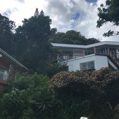
Figure 1 - Front of site
Figure 2 – Neighbouring dwelling to the south
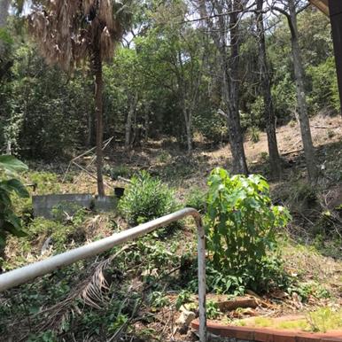
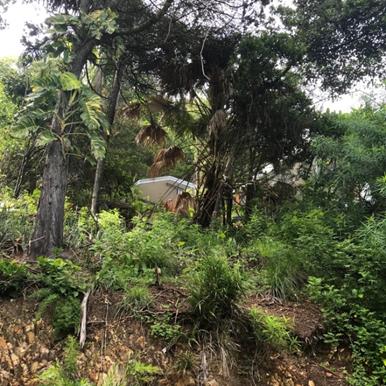
Figure 3 - Rear of the site
Figure
4 - Rear of the site to the south
2. SUMMARY OF
REFERRALS
|
Referral
|
Issue
|
|
Environmental Health Officer
|
No objections subject to conditions.
|
|
Development Engineer
|
No objections subject to conditions.
|
|
Ecologist
|
Mapped Littoral rainforest areas – see comments
below under SEPP Coastal Management 2018.
|
|
Rural Fire Service (4.14)
|
No objections subject to conditions.
|
|
Department of Planning & Environment
|
No issues of State or regional significance that apply to
the proposal. The Department recommends Council ensure the requirements of
SEPP (Coastal Management) 2018 are adequately addressed before determining
the subject development application.
|
Biodiversity Conservation Act 2016
The eastern half of the parcel is identified on the
biodiversity values map. However, Clause 7.3(4) of the Biodiversity
Conservation Regulation 2017 states ‘Despite anything to the contrary in this Part, proposed
development (other than subdivision) does not exceed the biodiversity offsets
scheme threshold merely because it is to be carried out on a lot included in
the Map if the lot was the result of a subdivision carried out before the
commencement of the Act and the lot is within land zoned R1 to R4, RU5, B1 to
B8 or IN1 to IN3 under an environmental planning instrument’. As the land is zoned R2 low density
residential and the property was created by way of subdivision in 1962 prior to
the commencement of the Act in 2016 the development does not need to enter into
the offset scheme and a BDAR report is not required.
3. SECTION 4.14
– BUSH FIRE PRONE LAND
Under section 4.14 of the Act, Council must be satisfied
prior to making a determination for development on bush fire prone land, that
the development complies with the document ‘Planning for Bush Fire
Protection 2006’. The site is bush fire prone land. The development
application was referred to the NSW Rural Fire Service, which provided
conditions which are reflected in the Recommendation of this Report below.
4. SECTION 4.15C
– MATTERS FOR CONSIDERATION – DISCUSSION OF ISSUES
Having regard to the matters for consideration detailed in
Section 4.15(1) of the Environmental Planning & Assessment Act 1979
(EP&A Act), the following is a summary of the evaluation of the issues.
4.1 State Environmental
Planning Instruments
|
|
Satisfactory
|
Unsatisfactory
|
|
State
Environmental Planning Policy No 44—Koala Habitat Protection
|
☒
|
☐
|
|
Consideration: The ecology referral states the following: The
Cape Byron State Conservation Area, which adjoins the eastern border of the parcel,
is known to contain breeding female koalas. An OEH koala record is also
located in the Conservation Area, ~40m east of the parcel.
No conditions regarding koala protection were deemed
necessary to impose by Councils Ecologist.
|
|
State
Environmental Planning Policy No 55—Remediation of Land
|
☒
|
☐
|
|
Consideration: The Environmental Health referral states
the following in relation to SEPP 55:
Stage 1 Preliminary Contaminated Land Assessment ENV
Solutions dated December 2018 concludes that soil sampling results were below
the Health Investigation Levels (HIL) in accordance with NEPM (2013) Table 1
A (1) Column A – ‘Standard’ Residential with
garden/accessible soil (home grown produce <10% fruit and vegetable intake
(no poultry), also includes childcare centres, preschools and primary
schools. Reporting was conducted in accordance NSW EPA Guidelines for Consultants
Reporting on Contaminated Sites (2000).
The proposed development is satisfactory having regard to
this SEPP.
|
|
State
Environmental Planning Policy (Building Sustainability Index: BASIX) 2004
|
☒
|
☒
|
|
Consideration: A multi-dwelling BASIX was provided for the
proposed development (1040813M).
|
|
State Environmental Planning
Policy (Coastal Management) 2018
|
☒
|
☐
|
|
Consideration: Littoral rainforest is mapped across
the eastern half of the parcel. The remainder is included in the littoral
rainforest 100m buffer. The parcel is also mapped as part of both the coastal
environment area and coastal use area under the Coastal Management SEPP. The
mapped rear half of the parcel comprises a degraded edge of the larger extent
of the ecological community; the actual vegetation in the rear of the parcel
does not align with the characteristics of the littoral rainforest ecological
community. It currently involves several exotic and non-native species and
has not been maintained or enhanced causing rainforest to develop poorly. Ten
native trees are to be removed four of which are cypress pine and appear to
have been planted whilst the providence of the remaining natives to be
removed is unknown.
Having regards to Clause 10(4) and 11 of the SEPP, Council
must be satisfied that the development:
· proposes
sufficient measures have been, or
will be, taken to protect, and where possible enhance, the biophysical,
hydrological and ecological integrity of the littoral rainforest; and
· will not significantly impact on— the biophysical, hydrological or ecological
integrity of the adjacent coastal wetland or littoral rainforest, or
the quantity and quality of surface and ground water flows to and from
the adjacent coastal wetland or littoral rainforest.
The applicant is proposing to embellish the rear of the
property and undertake compensatory planting at a rate of 10 to 1 for the
native trees to be removed. Notwithstanding the development footprint pushes
further into the littoral rainforest mapped area more then necessary through
the construction of two hardstand outdoor areas or courtyards at the rear of
each dwelling. It is considered these are unnecessary considering the large
roof top pool and balcony areas facing the street and the views of the
Pacific Ocean to the north and north west, and it is recommended the areas be
removed from the plans to enhance the area available for landscaping and
revegetation purposes and to provide a better buffer to protect and enhance
the biophysical, hydrological and ecological integrity of the littoral
rainforest to the east of the dwellings. Subject to appropriate conditions of
consent, it is considered the proposal satisfies the requirements of the
SEPP.
|
4.2 Byron Local Environmental Plan
2014 (LEP 2014)
In accordance with LEP 2014 clauses 1.4 and 2.1 – 2.3:
(a) The
proposed development is defined in the LEP 2014 Dictionary as Dual Occupancy;
(b) The
land is within the R2 Low Density Residential according to the Land Zoning Map;
(c) The
proposed development is permissible with consent; and
(d) Regard
is had for the Zone Objectives as follows:
|
Zone Objective
|
Consideration
|
|
To provide for
the housing needs of the community within a low density residential
environment.
|
The proposed dual occupancy is considered consistent with
existing and anticipated future development within the immediate locality. It
provides additional housing for the community within a low density
residential environment.
|
|
To enable other
land uses that provide facilities or services to meet the day to day needs of
residents.
|
No other land uses are proposed
|
Clause 4.1E Minimum Lot
Sizes for dual Occupancies, manor housing, multi dwelling housing, and
residential flat buildings.
The subject property has an
area of 809m2 and complies with the minimum lot size requirements of
800m2 for a dual occupancy.
Clause 4.3 Height of
Buildings
The proposed development
partially exceeds the 9m building height limit measured from natural ground
level. An extract from the plans is provided below and it can be seen that a
small part of the dividing wall between the two dwellings on the pool deck
exceeds the 9m control by 445mm. The application seeks a 4.94% variation to the
9m height; a written request for a clause 4.6 variation to a development
standard (clause 4.3) was submitted as part of the application.
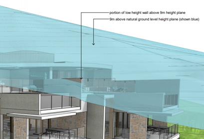
Figure 5 - Extent of building above 9m height limit
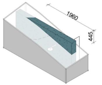
Figure 6 - Extent of building above 9m height limit
Is strict compliance with the development standard
unreasonable or unnecessary in the circumstances of the case?
The written request argues that strict compliance with the
development standard is unreasonable or unnecessary in this particular case for
the following reasons:
· The subject site
slopes upwards from the road very steeply presenting a significant design
challenge for any redevelopment of the site. The proposed building has been
designed to be set, as far as practical, within the existing slope of the land.
At the rear of the site, two of the proposed 4 levels are set below existing
ground level. This results in the vast majority of the building being set below
the 9m building height control
· The portion of the
building exceeding the 9m building height limitation relates to a centrally
located pool barrier separating the two roof deck pools. The barrier is
required in order to achieve compliance with the applicable pool safety
regulations.
· The impacts of the
building on the natural environment or amenity of the locality would not alter
if the encroaching wall was removed from the dwellings.
· The location of
the encroachment is such that it will not:
- Encroach
into views enjoyed by neighbouring properties;
- Dominate
the skyline or intrude into the scenic amenity of the locality;
- Result
in offsite overlooking or intrusion of privacy; or
- Impact
on the offsite shadows cast by the development.
Are there sufficient environmental planning grounds to
justify contravening the development standard?
The written request argues that there are sufficient
environmental planning grounds to justify contravening the development standard
for the following reasons:
· The slope of the
site presents a significant challenge for any redevelopment of the property.
The proposed building has been designed to be set, as far as practical, within
the existing slope of the land. This results in the vast majority of the building
being set below the 9m building height control.
· The application is
accompanied by a comprehensive Visual Amenity Impact Report which confirms that
the proposed building incorporates a range of design measures to ensure that
the building is a suitable addition to the locality. These include
articulation, modulation, material selection and landscaping which will
collectively result in the building representing a positive addition to the
streetscape.
· The conclusions of
the Visual Amenity Impact Report or the impact of the development on the
natural environment would not alter if the encroaching wall was removed from
the building.
Will the proposed development be in the public interest
because it is consistent with the objectives of the particular standard and the
objectives for development within the zone in which the development is proposed
to be carried out?
The objectives of the building height standard (clause 4.3)
are as follows:
(a) to
achieve building design that does not exceed a specified maximum height from
its existing ground level to finished roof or parapet,
(b) to
ensure the height of buildings complements the streetscape and character of the
area in which the buildings are located,
(c) to
minimise visual impact, disruption of views, loss of privacy and loss of solar
access to existing development.
The variation to the development standard sought is
considered to be consistent with the objectives of the standard for the
following reasons:
· The variation is
relatively minor at 4.94%.
· The portion of the
building exceeding the 9m building height limitation relates to a centrally
located pool barrier separating the two roof deck pools. The barrier is
required in order to achieve compliance with the applicable pool safety
regulations.
· The impacts of the
building on the natural environment, streetscape, and visual amenity of the
locality would not alter if the encroaching wall was removed from the
dwellings.
Has the concurrence of the Secretary has been obtained?
The concurrence of the Secretary may be assumed (under
Planning Circular 18-003) as the development does not contravene the numerical
standard (building height limit) by greater than 10%.
Consideration: It is acknowledged that the variation
is minor in terms of the small roof top wall dividing the two dwellings.
However there is no reason why this building cannot be designed to ensure
strict compliance with the 9 metre height limit and achieve a similar outcome
in terms of the development as proposed. In particular it appears the overall
height of the offending element is 2.5 metres. This wall can be reduced to 2
metres or designed on an angle to ensure compliance. Other design solutions
could also be crafted by the architects as appropriate. As such the height
variation is not supported. A condition of consent is recommended by way of
deferred commencement requiring the plans to be amended to bring the
development into compliance with the development standard under Clause 4.3 of
Byron LEP 2014.
Clause 4.4 Floor Space Ratio
The gross floor area of the proposed development is as
follows:
Ground floor: 44.2
m2
First floor: 196.7
m2
Second floor: 167.9 m2
Third floor: 11.3
m2
Total: 426.3
m2
As the site area is 809.4sqm the proposed floor space ratio
is 0.52:1 exceeding the required 0.5:1 for the site. The proposed development
exceeds the 0.5:1 FSR by 21.6sqm, seeking a 4% variation to the development
standard. A written request for a clause 4.6 variation to a development
standard (clause 4.4) was submitted as part of the application.
Is strict compliance with the development standard
unreasonable or unnecessary in the circumstances of the case?
The written request argues that strict compliance with the
development standard is unreasonable or unnecessary in this particular case for
the following reasons:
· The subject site
slopes upwards from the road very steeply. This presents a significant design
challenge for any redevelopment of the site. The proposed building has been
designed to be set, as far as practical, within the existing slope of the land.
The resultant dwellings are set over four levels.
· In order to
achieve improved accessibility through the development, each dwelling is
provided with a lift. As the lifts are not ‘communal’, they are
counted as part of the GFA of the building. Were the lifts to be excluded from
the building, the building would be compliant with the FSR requirement of
0.5:1.
· The lifts are
located at the rear of the building within the part of the building which is
largely set beneath existing ground level. Removing the lift wells would not
alter the side or rear setbacks of the proposed development. Whilst the portion
of the building containing the lift over run is compliant with the 9m building
height control the lifts were to be removed, there would be a reduction in
building height in the south eastern corner of Residence 2.
Are there sufficient environmental planning grounds to
justify contravening the development standard?
The written request argues that there are sufficient
environmental planning grounds to justify contravening the development standard
for the following reasons:
· The slope of the
site presents a significant challenge for any redevelopment of the property.
The proposed building has been designed to be set, as far as practical, within
the existing slope of the land. The proposed dwellings are set over four
levels. In order to achieve improved accessibility through the development,
each dwelling is provided with a lift. As the lifts are not
‘communal’ they are counted as part of the GFA of the building.
Were the lifts to be excluded from the building, the building would be
compliant with the FSR requirement of 0.5:1.
· The lifts are
located at the rear of the building within the part of the building which is
largely set beneath existing ground level.
· The application is
accompanied by a comprehensive Visual Amenity Impact Report which confirms that
the proposed building incorporates a range of design measures to ensure that
the building is a suitable addition to the locality. These include
articulation, modulation, material selection and landscaping which will
collectively result in the building representing a positive addition to the
streetscape. The conclusions of the Visual Amenity Impact Report, or the impact
of the development on the natural environment, would not alter if the lifts
were removed from the building.
Will the proposed development be in the public interest
because it is consistent with the objectives of the particular standard and the
objectives for development within the zone in which the development is proposed
to be carried out?
The objectives of the building height standard (clause 4.4)
are as follows:
(a) to
ensure that new buildings are appropriate in relation to the character, amenity
and environment of the locality,
(b) to
enable a diversity of housing types by encouraging low scale medium density
housing in suitable locations,
(c) to
provide floor space in the business and industrial zones adequate for the
foreseeable future,
(d) to
regulate density of development and generation of vehicular and pedestrian
traffic,
(e) to
set out maximum floor space ratios for dual occupancy in certain areas.
The variation to the development standard sought is
considered to be consistent with the objectives of the standard for the
following reasons:
· The variation is
relatively minor at 4%.
· In order to
achieve improved accessibility through the development, each dwelling is
provided with a lift. As the lifts are not ‘communal’, they are
counted as part of the GFA of the building. Were the lifts to be excluded from
the building, the building would be compliant with the FSR requirement of
0.5:1.
· The lifts are
located at the rear of the building within the part of the building which is
largely set beneath existing ground level. The impacts of the building on the
natural environment or amenity of the locality would not alter if the lifts
were removed from the dwellings.
Has the concurrence of the Secretary has been obtained?
The concurrence of the Secretary may be assumed (under
Planning Circular 18-003) as the development does not contravene the numerical
standard (floor space ratio) by greater than 10%.
Consideration: Similar to the height variation, there
is no reason why this building cannot be designed to ensure strict compliance
with the floor space ratio requirements and still achieve a similar outcome in
terms of the development as proposed. In this instance the development will
require the removal of 21.6 m2 of floor area to achieve compliance
or 10.8 m2 from each dwelling. As an example where this floor area could
be found, the building comprises a total of 12 bathrooms, ensuites and powder
rooms for the occupants of the development across multiple floors. That is six
in each dwelling. A range of other design solutions can also be employed by the
architects to reduce this floor area. As such the floor space ratio variation
is not supported in this instance. A condition of consent is recommended by way
of deferred commencement requiring the plans to be amended to bring the
development into compliance with the Clause 4.4 of Byron LEP 2014.
Clause 6.1 Acid Sulfate Soils
The subject site is not mapped as containing ASS. This is
consistent with the elevated nature of the property.
Clause 6.2 Earthworks
The proposed development is cut into the property and will
involve earthworks to a maximum depth of 9.5m. Applicants submitted a
Preliminary Geo-Tech Investigation Report which indicates the site contains
underlying rock and includes recommendations for the design of the footing and
associated earthworks.
Conditions have been recommended by Councils Development
Engineer for a Stability Assessment Report and Geotechnical Report specific to
the development for the construction certificate for approval. Conditions of
consent are recommended in relation to a dilapidation reports for the adjoining
properties and Council infrastructure. Conditions of consent are also recommended
in relation to disturbing any heritage items or relics that maybe
uncovered.
Clause 6.6 Essential Services
The proposal is a serviced allotment with water, sewer,
stormwater, power and telecommunications. Access will be provided from Brownell
Drive to the car parking garage areas.
The proposal raises no other issues under the LEP
4.3 Any proposed Instrument
that has been the subject of public consultation and has been notified to the
consent authority
Not applicable
4.4 Byron Shire Development Control
Plan 2014 (DCP 2014)
B2: Preservation of Trees and Other Vegetation
The development proposes the removal of 10 trees some of
which are likely to have been planted. The applicant has proposed to
plant in excess of 100 plants in the rear yard of the property to compensate
for the removal of these trees and to embellish or enhance the adjacent
littoral rainforest. Conditions to apply
B3: Services
The subject property has access to all necessary services.
Conditions of consent recommended in relation to driveways, connection to
water, sewer and stormwater management and payment of contributions for water
and sewer levies.
B4: Traffic Planning, Vehicle Parking, Circulation and
Access
This chapter requires 2 parking spaces be provided for each
dwelling with each dwelling involving at least 1 covered car space. The
proposed development is compliant as 2 spaces have been provided for each
dwelling.
B14: Excavation and Fill
This chapter requires general excavation to be limited to a
depth of 1m. It further states the maximum excavation restriction is not
applicable where the excavation is incorporated into the dwelling structure to
satisfy minimum car parking requirements up to a maximum height of 2 metres.
Due to the topography of the site, the proposed development will involve
significant earthworks with a maximum depth of 9.5m.
The subject site slopes upwards from the road very steeply
presenting a significant design challenge for any redevelopment of the site.
The proposed building has been designed to be set, as far as practical, within
the existing slope of the land to reduce the bulk and scale of the building,
particularly when viewed from adjoining properties. The approach was also
required in order to achieve compliant driveway grades to the building. The
areas of significant excavation will be absorbed within the building form and
will not be visible form the public street or adjoining properties.
The proposed development is considered compliant with the
objectives and performance criteria of this chapter as the proposed earthworks:
· maintain the
natural features of the locality;
· allow the
development to reduce the perceived bulk and scale, as a large proportion of
the building will in-effect be hidden into the side of the hill;
· create a landscape
and streetscape that is not unattractive to the immediate locality, and is not
out of character with surrounding development due to the topography of the
Wategos neighbourhood.
· Stormwater flowing
through the site to be suitably collected and redirected to the street drainage
system by way of catch drains
· Geotechnical
– although the design and construction of the development will need to be
carefully managed, the slope stability as noted in the applicants geotechnical
report with a Class S should be generally stable to enable the development to
proceed without significant challenges.
Conditions have been recommended by Councils Development
Engineer for a Stability Assessment Report and Geotechnical Report to be
provided prior to the issue of a Construction Certificate. A variation to the
DCP provisions is recommended in this instance.
C3: Visually Prominent Sites, Visually Prominent
Development and View Sharing
1. An
assessment of the value of the view that may be affected:
The view from the dwelling at 13 Brownell Drive comprises of
mainly water views framed by vegetation and land views these views are
considered to be highly valuable.
2. Consider
from what part of the property the views are obtained:
The views are presently obtained from the ground floor
deck/terrace and first floor deck at a standing position, mostly across the
front however some views are obtained across the side boundary between the two
properties, over the existing dwelling at 11 Brownell Drive. The views are also
obtained from some of the living areas of the dwelling. The Tenacity
Consulting v Warringah Council [2004] NSWLEC 140 case states views across
side boundaries are more difficult to protect than views from front and rear
boundaries and the expectation to retain side views is often unrealistic.
3. Assessment
of the extent of the impact:
The views will be impacted on at the north, figures 7 &
8 demonstrate the proposed dual occupancy, will partially block the existing
outlook over the vegetation and landform, however will not obstruct the
existing water views or distant landscape views. The impact on the views of the
adjoining property to the south is of a minor nature and does not impact on the
‘highly valued’ water views, the view loss is over the side boundary
which is difficult and unrealistic to maintain. The existing dwelling and decks
at 13 Brownell Drive are orientated to the north-west; most of this view will
be protected. The proposed view loss is considered minor.
Figure 7 & 8 - Proposed encroachment into the existing views
at 13 Brownell Drive
4. Assessment
of the reasonableness of the proposal that is causing the impact:
As the subject site slopes upwards from the road, the
proposed development encroaches into the building height plane on the southern
boundary. The site is constrained due to its topography and the littoral
rainforest at the rear; it is unrealistic for a development on such site to
comply with the building height plane. As the adjoining property will fully
maintain their existing ‘highly valued’ water views and any view
loss is over the side boundary, the view impact and view sharing resulting from
the proposal is considered reasonable.
The building height plane encroachments and impact on views
resulting from the proposed development are demonstrated to meet the relevant
Objectives and Performance Criteria of the above sections of the Byron DCP
2014. The proposed development is considered reasonable and acceptable having
regard to the existing development on the site and the surrounding development
within the low density urban residential area.
D1: Residential Accommodation in Urban, Village &
Special Purpose Zones
D1.2.1 Building Height Plane:
The proposed development encroaches into the building height
plane on both side boundaries on the north and south elevations. Due to the
orientation of the site and the design of the proposed development, the
northern encroachments will not adversely impact on the existing solar access,
views, or privacy currently enjoyed by the adjoining property to the north at 9
Brownell Drive.
Figure 9 below demonstrates the encroachment into the
building height plane on the southern boundary. It can be seen that the parts
of the development which encroach into the BHP are the corners of the flat roof
for level 2 and 3 and the wall to be utilised as a pool fence. Due to this,
there are no adverse impacts on the privacy currently enjoyed by the adjoining
property to the south, and as discussed above the view impacts are also
considered to be of a minor nature. The adjoining property will fully maintain
their existing ‘highly valued’ water views and any view loss is
over the side boundary which is difficult/unrealistic to protect. The view
impact and view sharing resulting from the proposal is considered reasonable.
Due to the orientation of the site, a complying development would still
overshadow 13 Brownell Drive during the winter months. The shadow diagrams
provided show the BHP encroachments do not cause further overshadowing onto the
adjoining property at 9am (Figure 10 & 11). The deck above the existing
garage will mostly be impacted at this time; however it will obtain full solar
access by midday. By midday and through to 3pm (during winter) the
overshadowing is quite minor only extending a few metres into the property at
13 Brownell. It is considered most, if not all of the windows of the dwelling
will maintain solar access during this time, the impacts will mostly be in
relation to any private open space situated on the north of the site. As previously
stated, the orientation of the site makes it unrealistic for the adjoining
property to the south to maintain full solar access during winter as a
compliant development causes similar overshadowing to the property.
Due to the topography of the site it is impractical for
development to comply fully with the BHP. As the majority of sites within the
Wategos area are constrained by a steep terrain, most development within the
area encroaches into the building height plane on side boundaries. The property
to the south at 13 Brownell Drive also involves a significant encroachment into
the building height plane on the southern boundary, as do numerous properties
along Brownell Drive. As there is a precedent set within immediate locality it
is considered unreasonable for Council to require full compliance with this BHP
control. The proposed development is considered otherwise to meet the
objectives and performance criteria of this control. The proposed encroachments
are considered reasonable and acceptable in the circumstances.
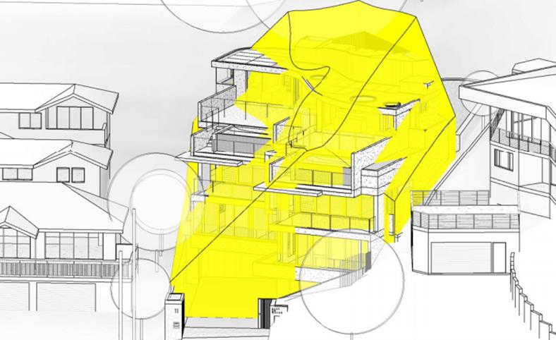
Figure 9 - Building height plane
encroachments on southern boundary (non compliant areas are unshaded)
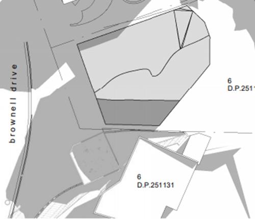
Figure 10 - Compliant development 9am winter solstice
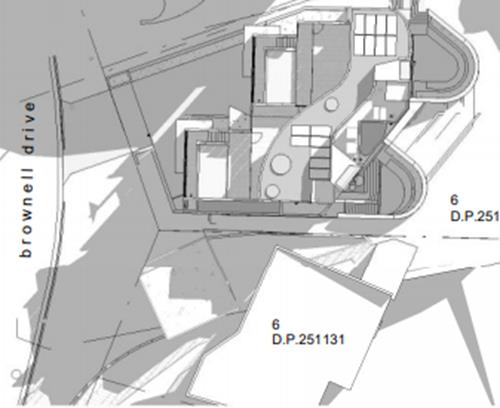
Figure 11 - Proposed development 9am winter solstice
D1.2.2 Setbacks from Boundaries:
The proposed development is compliant with the required side
and rear setbacks; however the development proposes a staggered front setback
ranging from 2.5m to 13.5m, with a small corner of the development protruding
into the 4.5m front setback as specified in the DCP.
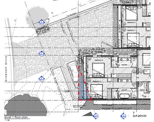
Figure 12 – Triangular area of encroachment into the front
setback
The existing dwelling on the site also involves a staggered
front setback ranging from 1.5m to 4m. The property to the south of the site
(13 Brownell Drive) has a garage with roof deck constructed to the front
property boundary. Due to the topography of Wategos there are various other
examples where development encroaches into the front setback.
Having regard to the above, and the staggered setback
arrangement as proposed, a variation to the front setback is supported in this
instance.
D1.2.4 Character & Visual Impact:
The proposed development is considered consistent with
surrounding development within the Wategos area having regard to character,
visual amenity, bulk, scale, height, architectural features, density, setbacks,
and materials and colours. The proposed building provides an articulated,
interesting façade which will sit within the topography of the site.
Suitable landscaping is proposed to assist in blending the development with the
streetscape. The proposal will involve a neutral palate of natural finishes,
course render and glass, with timber and stone highlights. Having regard to
recent development within the immediate locality, the proposed development is
not out of character and will positively contribute to the built form of the
area and the streetscape.
D1.5.4 Private Open Space:
Each dwelling must provide an area of private open space at
ground level not located in the front setback, having a minimum area of 30m2
and a minimum length and width each of 4m, excluding any area used for
vehicle circulation or parking. Both dwellings have suitable private open space
in the form of outdoor balconies on level 2, and outdoor roof terraces on level
3. The rear of the property is to be utilised as a littoral
rainforest/regeneration area, but in effect also is considered as open space
yard area and is approximately 260 m2 in area. It is considered the
proposed private open space areas satisfy the requirements of this control.
The proposal raises no other issues under the DCP.
4.5 Any
Planning Agreement or Draft Planning Agreement?
|
|
Yes
|
No
|
|
Is there any applicable
planning agreement or draft planning agreement?
|
☐
|
☒
|
|
Consideration: Not applicable
|
4.6 Environmental Planning
& Assessment Regulation 2000 Considerations
|
Clause
|
This
control is applicable to the proposal:
|
I
have considered this control as it relates to the proposal:
|
If
this control is applicable, does the proposal comply?
|
|
92
|
Yes
|
Yes
|
Conditions recommended for demolition
|
|
93
|
No
|
Not applicable
|
Not applicable
|
|
94
|
No
|
Not applicable
|
Not applicable
|
|
94A
|
No
|
Not applicable
|
Not applicable
|
4.7 Any Coastal Zone Management
Plan?
|
|
Satisfactory
|
Unsatisfactory
|
Not applicable
|
|
Is there any applicable coastal zone management plan?
|
☐
|
☐
|
☒
|
|
Consideration: Not applicable
|
4.8 The likely impacts of that
development, including environmental impacts on both the natural and built
environments, and social and economic impacts in the locality
|
Impact on:
|
Likely significant impact/s?
|
|
Natural environment
|
Yes. The proposal will involve the removal of 10 trees and
partially encroach into mapped littoral rainforest however compensatory
plantings are proposed to revegetate and enhance the site, and conditions of
consent recommended to remove hard stand courtyards from the rear of both
dwellings.
|
|
Built environment
|
No. The proposal will not have a significantly adverse
impact on the built environment of the locality. The development is generally
consistent with recent development within the Wategos area in terms of built
form, character, bulk and scale, setbacks, and height.
|
|
Social Environment
|
No. The proposal will not have a significant social impact
on the locality.
|
|
Economic impact
|
No. The proposal will not have a significant economic
impact on the locality.
|
|
Construction Impact
|
The development will generate several impacts during
construction e.g. traffic, noise, dust, etc. Conditions of consent are
recommended to control hours of work, builders waste, construction noise,
traffic control, installation of sedimentation and erosion control measures
etc. to ameliorate such impacts. Dilapidation reports are required prior to
works commencing and at the end of construction to ensure no damage to
adjoining properties and Council infrastructure.
|
Are there any Council Policies that are applicable to the
proposed development? No
4.9 The
suitability of the site for the development
The site is a serviced,
unconstrained property and is suitable for the proposed development.
4.10 Submissions made in accordance with
this Act or the regulations
The development application was publicly exhibited. There
was 1 submission
made in objection to the development application, the following concerns were
raised:
|
Issues/Concerns
|
Comments
|
|
Removal of Littoral Rainforest:
|
Although the development encroaches into the mapped
littoral rainforest, it proposes to remove only 10 trees. As the mapped
littoral rainforest was degraded and not maintained or enhanced a new
development and landscape plan will likely provide a greater outcome for the
littoral rainforest. The landscape plan has proposed compensatory planting
and conditions have been recommended by Councils Ecologist.
|
|
Contravenes Height:
|
Conditions recommended to reduce the overall height of the
development
|
|
Excessive Bulk/Floor Space Ratio:
|
Conditions of consent recommended to ensure compliance
with the FSR requirement of 0.5:1.
|
|
Breaches Building Height Plane:
|
As stated above, the BHP encroachments are considered
minor and a variation is supported in this instance.
|
|
Inadequate Setbacks and Façade Facilitation:
|
As discussed above under the DCP discussions, having
regard to the design of the development and the various precedents to setback
within the Wategoes area a variation to the front setback is supported in
this instance.
|
|
Further Assessment of Height, Bulk, Scale, and
Over-development:
The assessment of height and bulk should be carried out in
accordance with the planning principal established by the Land and
Environment Court in Veloshin v Randwick Council [2007] NSWLEC 428.
|
1. Are
the impacts consistent with impacts that may be reasonably expected under the
controls?
Yes. Impacts associated from
overshadowing, visual amenity, privacy, or views on the adjoining property
have been reasonably mitigated and are not unexpected in this area of Byron
Bay, with residential development characterised by dwellings which push the
standard planning controls. A variation to the front setback is supported as
discussed above, however deferred conditions of consent recommended in
relation to compliance with the height and floor space ratio controls. The
impacts of the proposed development are consistent with impacts that may be
reasonably expected under these controls as discussed throughout this report.
2. How
does the proposal’s height and bulk relate to the height and bulk
desired under the relevant controls?
Conditions recommended to
ensure compliance with the height and floor space ratio controls as per the
relevant planning controls under Byron LEP 2014.
The encroachments exceeding a
compliant development (BHP & front setbacks) are consistent with
development within the immediate locality as discussed in the body of the
report. The proposed bulk of the development is not deemed excessive.
3. Does
the area have a predominant existing character and are the planning controls
likely to maintain it? Does the proposal fit into the existing character of
the area?
Development within Wategos
involves characteristics such as extensive earthworks, encroachments into the
front setback, and the BHP encroachments. It is an area of high economic
status and is expected to be continuously being redeveloped creating large,
modern, and expensive dwellings. Having regard to recent development within
the immediate locality, the proposed dual occupancy is not out of character
and will positively contribute to the built form of the area and the
streetscape.
|
|
Loss of Views:
|
As discussed above a view assessment has been carried out
and it is considered the development will not have a detrimental impact on
neighbours views.
|
|
Earthworks
|
Noted – variation supported in this instance as
discussed above.
|
4.11 Public interest
It is considered the proposed development is unlikely to
prejudice or compromise the public interest or create an undesirable precedent.
5. DEVELOPER
CONTRIBUTIONS
5.1 Water & Sewer Levies
Section 64 levies will be payable.
5.2 Section 7.11 Contributions
Section 7.11 Contributions will
be payable.
6. CONCLUSION
The DA proposes Demolition of Existing Dwelling House and
Construction of a Dual Occupancy (Attached). Variations are sought to DCP
provisions relating to Building height plane, earthworks and the front setback
which are supported in this instance. However the proposed variations to
development standards in relation to height and floor space ratio under Byron
LEP 2014 are not supported, nor are the rear courtyard areas having regard to
the provisions under the SEPP Coastal Management 2018 for littoral rainforest.
It is considered the plans can be amended easily without resulting in major
changes to the overall development to ensure compliance with the LEP
provisions, and to provide a better outcome in terms of the littoral rainforest
to the rear of the development. The application is recommended for approval
subject to deferred commencement consent with amended plans required to
be submitted to Council to activate the consent.
7. DISCLOSURE OF
POLITICAL DONATIONS AND GIFTS
|
Has a Disclosure Statement been received in relation
to this application
|
No
|
|
Have staff received a ‘gift’ from anyone
involved in this application that needs to be disclosed. Where the answer is
yes, the application is to be determined by the Director or Manager of the
Planning, Development and Environment Division.
|
No
|
Provide Disclosure Statement register details here: Not
applicable