Agenda
Ordinary
(Planning) Meeting
Thursday,
15 October 2020
held
at Council Chambers, Station Street, Mullumbimby
commencing
at 11.00am
 Public Access relating to items
on this Agenda can be made between 11.00am and 11.30am on the day of the
Meeting. Requests for public access should be made to the General Manager
or Mayor no later than 12.00 midday on the day prior to the Meeting.
Public Access relating to items
on this Agenda can be made between 11.00am and 11.30am on the day of the
Meeting. Requests for public access should be made to the General Manager
or Mayor no later than 12.00 midday on the day prior to the Meeting.
Mark
Arnold
General
Manager
What is a “Conflict of Interests” - A conflict of
interests can be of two types:
Pecuniary - an interest that a person has in a matter because of a reasonable
likelihood or expectation of appreciable financial gain or loss to the person
or another person with whom the person is associated.
Non-pecuniary – a private or personal interest that a Council
official has that does not amount to a pecuniary interest as defined in the Code
of Conduct for Councillors (eg. A friendship, membership of an association,
society or trade union or involvement or interest in an activity and may
include an interest of a financial nature).
Remoteness – a person does not have a pecuniary interest in a matter
if the interest is so remote or insignificant that it could not reasonably be
regarded as likely to influence any decision the person might make in relation
to a matter or if the interest is of a kind specified in the Code of Conduct
for Councillors.
Who has a Pecuniary Interest? - a person has a pecuniary interest in a
matter if the pecuniary interest is the interest of the person, or another
person with whom the person is associated (see below).
Relatives, Partners - a person is taken to have a pecuniary interest in a
matter if:
§ The person’s
spouse or de facto partner or a relative of the person has a pecuniary interest
in the matter, or
§ The person, or a
nominee, partners or employer of the person, is a member of a company or other
body that has a pecuniary interest in the matter.
N.B. “Relative”, in relation to a person means any of the
following:
(a) the
parent, grandparent, brother, sister, uncle, aunt, nephew, niece, lineal
descends or adopted child of the person or of the person’s spouse;
(b) the
spouse or de facto partners of the person or of a person referred to in
paragraph (a)
No Interest in the Matter - however, a person is not taken to have a
pecuniary interest in a matter:
§ If the person is
unaware of the relevant pecuniary interest of the spouse, de facto partner,
relative or company or other body, or
§ Just because the
person is a member of, or is employed by, the Council.
§ Just because the
person is a member of, or a delegate of the Council to, a company or other body
that has a pecuniary interest in the matter provided that the person has no
beneficial interest in any shares of the company or body.
Disclosure and participation in meetings
§ A Councillor or a
member of a Council Committee who has a pecuniary interest in any matter with
which the Council is concerned and who is present at a meeting of the Council
or Committee at which the matter is being considered must disclose the nature
of the interest to the meeting as soon as practicable.
§ The Councillor or
member must not be present at, or in sight of, the meeting of the Council or
Committee:
(a) at any
time during which the matter is being considered or discussed by the Council or
Committee, or
(b) at any
time during which the Council or Committee is voting on any question in
relation to the matter.
No Knowledge - a person does not breach this Clause if the person did
not know and could not reasonably be expected to have known that the matter
under consideration at the meeting was a matter in which he or she had a
pecuniary interest.
Non-pecuniary Interests - Must be disclosed in meetings.
There are a broad range of options available for managing conflicts &
the option chosen will depend on an assessment of the circumstances of the
matter, the nature of the interest and the significance of the issue being
dealt with. Non-pecuniary conflicts of interests must be dealt with in at
least one of the following ways:
§ It may be appropriate
that no action be taken where the potential for conflict is minimal.
However, Councillors should consider providing an explanation of why they
consider a conflict does not exist.
§ Limit involvement if
practical (eg. Participate in discussion but not in decision making or vice-versa).
Care needs to be taken when exercising this option.
§ Remove the source of
the conflict (eg. Relinquishing or divesting the personal interest that creates
the conflict)
§ Have no involvement by
absenting yourself from and not taking part in any debate or voting on the
issue as of the provisions in the Code of Conduct (particularly if you have a significant
non-pecuniary interest)
RECORDING OF VOTING ON PLANNING MATTERS
Clause 375A of the Local Government Act 1993
– Recording of voting on planning matters
(1) In this section, planning
decision means a decision made in the exercise of a function of a council
under the Environmental Planning and Assessment Act 1979:
(a) including a decision
relating to a development application, an environmental planning instrument, a
development control plan or a development contribution plan under that Act, but
(b) not including the making of
an order under that Act.
(2) The general manager is
required to keep a register containing, for each planning decision made at a
meeting of the council or a council committee, the names of the councillors who
supported the decision and the names of any councillors who opposed (or are
taken to have opposed) the decision.
(3) For the purpose of
maintaining the register, a division is required to be called whenever a motion
for a planning decision is put at a meeting of the council or a council
committee.
(4) Each decision recorded in
the register is to be described in the register or identified in a manner that
enables the description to be obtained from another publicly available
document, and is to include the information required by the regulations.
(5) This section extends to a
meeting that is closed to the public.
Ordinary (Planning) Meeting
BUSINESS OF Ordinary (Planning) Meeting
1. Public Access
2. Apologies
3. Requests for Leave of
Absence
4. Declarations of Interest
– Pecuniary and Non-Pecuniary
5. Tabling of Pecuniary
Interest Returns (Cl 4.9
Code of Conduct for Councillors)
6. Adoption of Minutes from
Previous Meetings
6.1 Ordinary
(Planning) Meeting held on 17 September 2020
7. Reservation of Items for
Debate and Order of Business
8. Mayoral Minute
9. Notices of Motion
Nil
10. Petitions
11. Submissions and Grants
12. Delegates' Reports
13. Staff Reports
Sustainable Environment and Economy
13.1 PLANNING
- S4.55 Development Application to modify Additional On-Site Car Parking
Development Application 10.2017.474.2 Multi Dwelling Housing Consisting of
Twenty Five (25) 1 Bedrooms - 70 - 90 Station Street Mullumbimby.............................................................. 5
13.2 PLANNING
- Development Application 10.2020.100.1 Tourist and Visitor Accommodation
Comprising Six (6) Cabins at 533 Bangalow Road Talofa............................................. 14
13.3 PLANNING
- Development Application 10.2020.272.1 Use of Converted Farm Shed as Dwelling
2 of Detached Dual Occupancy at 530 Lismore Road, Binna Burra..................................... 47
13.4 PLANNING
- Report of the 17 September 2020 Planning Review Committee............. 61
13.5 PLANNING
- Development Application 10.2019.180.2 - S4.55 to Modify Condition 8 - 22A
Teak Circuit Suffolk Park......................................................................................................... 63
13.6 Draft
Development Control Plan 2014 Chapter B1 Biodiversity..................................... 72
13.7 Draft
Plan of Management Charlotte Street Park.......................................................... 76
13.8 Notification
of Upgrade Works to Mobile Phone Base Station at 8 Acacia Street, Byron Bay 80
14. COUNCILLOR Questions
With Notice
14.1 M1
and MR545 Stage 1 Application............................................................................... 83
Questions with Notice: A response to Questions with
Notice will be provided at the meeting if possible, that response will be
included in the meeting minutes. If a response is unable to be provided
the question will be taken on notice, with an answer to be provided to the
person/organisation prior to the next Ordinary Meeting and placed on Councils
website www.byron.nsw.gov.au/Council/Council-meetings/Questions-on-Notice
Councillors are
encouraged to ask questions regarding any item on the business paper to the
appropriate Director prior to the meeting. Any suggested amendments to the
recommendations should be provided to Councillor Support prior to the meeting
to allow the changes to be typed and presented on the overhead projector at the
meeting.
Staff Reports - Sustainable Environment and Economy 13.1
Staff Reports - Sustainable Environment and
Economy
Report No. 13.1 PLANNING
- S4.55 Development Application to modify Additional On-Site Car Parking
Development Application 10.2017.474.2 Multi Dwelling Housing Consisting of
Twenty Five (25) 1 Bedrooms - 70 - 90 Station Street Mullumbimby
Directorate: Sustainable
Environment and Economy
Report
Author: Ivan
Holland, Planner
File No: I2020/1434
Proposal:
|
Section 4.55 Application No:
|
10.2017.474.3
|
|
Proposed modification:
|
S4.55 for Additional On-Site Car Parking
|
|
Original Development:
|
Multi Dwelling Housing Consisting of Twenty Five (25) 1
Bedroom Dwellings (Under the Provisions of the State Environmental Planning
Policy (Affordable Rental Housing) 2009): Infill Affordable Housing
|
|
Type of modification sought:
|
|
|
|
|
|
Property description:
|
LOT: 1 DP: 1227659
|
|
88 Station Street MULLUMBIMBY
|
|
Parcel No/s:
|
269278
|
|
Applicant:
|
Agcorp Constructions Pty Ltd
|
|
Owner:
|
North Coast Community Housing
|
|
Zoning:
|
B4 Mixed Use
|
|
S4.55 Date received:
|
11 December 2019
|
|
Original DA determination date:
|
22/2/2018
|
|
Integrated Development:
|
No
|
|
Public notification or exhibition:
|
- Level
2 advertising under DCP 2014 Part A14 – Public Notification and
Exhibition of Development Applications
- Exhibition
period: 9/1/20 to 22/1/20
- Submissions received: six
(6) in opposition
|
|
Planning Review Committee:
|
13/8/2020
|
|
Delegation to determination:
|
Council
|
|
Key issue:
|
· Protection and
preservation of mature fig tree.
|
This development application has been assessed and is
reported to Council in accordance with Council’s management of Conflicts
of Interest for Development Matters.
Summary:
This application seeks approval to modify development
consent 10.2017.474.2 to provide additional on-site car parking at the southern
end of the site, adjacent to the existing, mature fig tree. Seventeen
(17) car parking spaces are now proposed (Note: the original DA approved nine
car parking spaces) in the communal parking area and the driveway has been
relocated further north to facilitate the additional car parking spaces.
Permeable pavement has been proposed for the car parking and sections of the
driveway within the tree protection zone of the fig tree. Construction of
‘carport style’ roofs over some of the car parking spaces and deleting
the requirement to provide a share car is also proposed.
Other minor consequential amendments proposed are:
· Minor
modification to paths (along the street front/west of building A and B);
· Changes
to the entry stairs at the rear/east of Building E;
· Minor
relocation of the ‘Utility’ building and inclusion of relocated
cycle parking; and
· A
reduction in the area of communal open space.
The application appropriately addresses the relevant
constraints applying to the site, raises no planning issues and is recommended
for approval subject to amended conditions.
NOTE TO COUNCILLORS:
In accordance with the provisions
of S375A of the Local Government Act 1993, a Division is to be called whenever
a motion for a planning decision is put to the meeting, for the purpose of
recording voting on planning matters. Pursuant to clause 2(a) under the
heading Matters to be Included in Minutes of Council Meetings of Council's
adopted Code of Meeting Practice (as amended) a Division will be deemed to have
been called by the mover and seconder of all motions relating to this report.
|
RECOMMENDATION:
That, pursuant to Section 4.55 of the
Environmental Planning & Assessment Act 1979, Application No.
10.2017.474.3 for Additional On-Site Car Parking, be approved by modifying
Development consent number 10.2017.474.2 as per the amended conditions in
attachment 5 (E2020/78259).
|
Attachments:
1 Current
Consent - DA 10.2017.474.2, E2018/60675

2 DA
10.2017.474.3 amended plans-annotated, E2020/78267

3 DA
10.2017.474.3 revised arborist report, E2020/77968

4 DA
10.2017.474.3 revised SWMP Rev. B, E2020/78163
5 DA
10.2017.474.3 recommended condition changes, E2020/78259

6 Confidential
- DA10.2017.474.3 submissions received, E2020/78752

Subject property and land zoning under LEP 2014.
1. INTRODUCTION
1.1. History/Background
From development assessment report for original DA
(10.2017.474.1):
The subject site is a 16,082m2 parcel of land that is
owned by Byron Shire Council. It contains the Byron Shire Council
administration building, chambers, car park and Mullumbimby Community
Pre-School. Following an independent assessment of a development application,
Development Consent 10.2014.404.1 was issued on 30 October 2014 for the
subdivision of the subject site into 6 lots as follows:
· Proposed
Lot 1 - 11,030.5m2 parcel of land comprising the existing Council
administration building, chambers, library, pocket park, car parking areas, and
ancillary landscaped land at the northern portion of the site.
· Proposed
Lots 2, Lot 3, Lot 4, & Lot 5 – Four (4) x 804.4m2 lots
within the currently undeveloped area between the existing car park and
pre-school.
· Proposed
Lot 6 - 1837.4m2 lot containing the existing Mullumbimby Pre-school
and associated outdoor areas at the southern portion of the site.
The application has been amended under the provisions
of Section 96 of the Environmental Planning and Assessment Act 1979, on two
occasions. The modification applications were:
· 10.2014.404.2
-This modification application incorporated the following amendments:
o to
remove the requirement for a 1.2m wide footpath for the full property frontage.
o to
remove the requirement for kerb and gutter for the full property frontage.
This application was granted consent on 27 August 2015.
· 10.2014.404.3
-This modification application sought approval to stage the development, and
make changes to infrastructure provision. The application was approved on 22
September 2017 and stages the development as follows:
o Stage
1 creates 2 lots, which would be further subdivided in Stages 2 & 3. The
intention of Stage 1 is to create a serviced ‘development lot’
(i.e. Lot 1), which can then be sold.
o Stage
2 - creation of a new lot containing the existing pre-school, separating
that site from the remainder of the property.
o Stage
3 involves the remainder of the approved development, being the creation of
the four lots nominated as Lots 2-5 on the originally approved plan. If
the proposed affordable housing development proceeds, this stage would not
occur.
In 2015, Byron Shire Council resolved to sell proposed
Lot 1 to North Coast Community Housing (NCCH) at an independently verified
market value, for the purpose of an affordable housing project. It is this
proposed lot that is subject of the current proposal.
Subdivision work for Stage 1 has commenced however the
subdivision certificate has not yet been issued.
Past applications recorded over the subject site relate
to the Byron Shire Council administration building and the child care centre.
Other than the subdivision mentioned above, there are no other relevant
historical applications relating the vacant portion of land known as proposed
Lot 1.
From development assessment report for first modification
(DA 10.2017.474.2):
DA10.2017.474.1 –
Approved 22/2/18
The first modification application (DA 10.2017.474.2) sought
approval to amend the conditions in relation to S94 Contributions and Water and
Sewer Headworks Charges due to the development providing affordable housing and
the applicant being a charitable organisation. The original consent was issued
with contributions based on a standard residential formula.
Council requested further information from the applicant on
4/3/20 which was further clarified by email on 12 March 2020. Council
received amended plans on 7/4/20 and a request to delete the requirement for a
share car from the approved development on 8/4/20. Council provided
preliminary comments on the amended plans and the applicant responded with
further amended plans and information on 28/4/20. Council provided preliminary
feedback on the further amended plans on 30/4/20. Further updated plans were
provided on 4/5/20 and on 7/5/20. Council provided preliminary feedback on the
further amended plans on 12/5/20. The applicant provided a letter from
the arborist on 27/7/20 and then the full arborist report on 25/8/20 with
amended plans on 26/8/20. Following comments from Council on 2/9/20, final
plans and an updated arborist report was provided on 21/9/20.
1.2. Description of the
proposed development
This application seeks approval to modify development
consent 10.2017.474.2 under S4.55 to provide Additional On-Site Car Parking.
In particular:
· Minor
modification to paths (along the street front/west of building A and B, );
· Changes
to the entry stairs at the rear/east of Building E;
· Minor
relocation of the ‘Utility’ building and inclusion of relocated
cycle parking;
· Seventeen
(17) car parking spaces in the communal parking area and construction of
‘carport style’ roofs over all car parking spaces. (Note: the
original DA approved 9 car parking spaces in the communal outdoor parking area,
which includes the share car parking space);
· Delete
the requirement for a share car (see condition 9);
· Relocation
of the driveway further to the north and into the tree protection zone of the mature
fig tree; and
· A
reduction in size of the communal open space and encroachment into the tree
protection zone of the mature fig tree at the southwest corner of the site.
1.3. Description of the site
From development assessment report for original DA
(10.2017.474.1):
|
Land is legally described as
|
LOT: 10 DP: 850902
|
|
Property address is
|
70-90 Station Street, Mullumbimby.
|
|
Land is zoned:
|
B4 Mixed Use
|
|
Land area is:
|
16090 m2
|
|
Property is constrained by:
|
Flood Liable Land
Acid Sulfate Soils Class 4
Mullumbimby Heritage Conservation
Area
|
As described above, development consent has been issued
for the subdivision of the site into six lots. The lots have not yet been
created and therefore the development application is lodged over the parent
parcel i.e. Lot 10 DP 850902. All building work associated with the proposal
would occur over proposed Lot 1. If approved, work on the proposal would not be
able to commence until such time as the subdivision for Stage 1 is registered.
Proposed Lot 1 is a vacant, relatively flat piece of
land which has a proposed area of 3244m2. It does not contain any
vegetation of significance other than the large fig tree which is located
within the road reserve at the front of the site. The adjoining land comprises:
· North
- Proposed Lot 3 containing the Byron Shire Council administration building,
chambers and car park. The car park is located immediately adjacent to the site
of the proposed development.
· South
- Proposed Lot 2 containing the Mullumbimby Community Pre-school.
· East
- The dis-used North Coast railway line. Further to the east, on the opposite
side of the railway reserve is residential and rural land.
The location of the subject site is shown on Figure 1,
and Figure 2 illustrates the approved subdivision and staging layout.
Figure 1 - Location
The site was inspected on 26 February 2020
2. SECTION 4.15 – MATTERS FOR CONSIDERATION
– DISCUSSION OF ISSUES
Having regard for the matters for consideration detailed in
Section 4.15(1) of the Environmental Planning & Assessment Act 1979, the
following is a summary of the evaluation of the issues.
2.1. State/Regional
Planning Policies, Instruments, EPA Regulations 2000
|
|
Agree or No (add
comments as required)
|
|
Proposed amendments raise
no issues under the relevant SEPPS, Policies or clauses of the EPA Regulations
2000
|
Yes
SEPP (Affordable Rental
Housing) 2009 – The proposed changes to car parking will result in
a reduced landscaped area and deep soil zone and changes to the street front
façade. The total landscaped area initially proposed was 1180m2,
which will be reduced to 1130m2 by this application. This
equates to ~34% of the site. The total area of deep soil zones
initially proposed was 840m2 or 26% of the total site area.
This application states that the modification will result in a total deep
soil zone area of 920m2 however some of the identified deep soil
zone does not appear to meet all the relevant criteria. A
total of 14 car parking spaces were initially proposed (excluding the 5
tandem spaces) in combination with a share car for residents of the
development. This application will result in a total of 25 car parking
spaces with only 10 being required for the development. As the
application is made by a social housing provider, failure to meet
landscaping, deep soil or car parking requirements cannot be used as grounds
for refusal of the application (c.14 - SEPP (Affordable Rental Housing)
2009).
SEPP (Infrastructure)
2007 – The development is adjacent to a rail corridor however (i)
as the rail corridor is not currently’ and may never be’ utilised
for train services, and (ii) the proposed changes are relatively minor and
largely relate to the opposite side of the site from the rail corridor, the
relevant provisions are not triggered by the this proposal (c.85, 86 and
87). Further, John Holland Rail was notified of the original DA and
their comments were incorporated into the assessment of this application.
SEPP (Coastal
Management) 2018 – The property is located within the mapped
coastal environment area however the proposed modifications are unlikely to
cause an adverse impact on any of the listed matters for consideration
(clause 13).
|
2.2. Byron Local Environmental
Plan 2014
|
|
Agree or No (add comments as required)
|
|
Proposed amendments raise no issues under the LEP
|
Agree
|
|
Updated elevations have been provided that include the
proposed carport structures. These structures are unlikely to have a
more than minor impact on the presentation of the building. However, it
is important that these structures are consistent with previous heritage
considerations/recommendation provided on the original DA (Clause 5.10) and
as such should incorporate “…design cues from an
‘industrial vernacular’ of railway and light industrial factories”
and “traditional uncoloured metal and timber detailing”.
Previous heritage advice also stated that the impact of
Building E would be “considerably softened by retention of the
mature tree‘’ further enforcing the importance of retaining
and protecting the fig tree in the southwest corner of the property.
|
2.3. Draft EPI that is or has
been placed on public exhibition and details of which have been notified to the
consent authority - Issues
No draft EPIs were identified that affect the proposal.
2.4. Development Control Plans
|
|
Agree or No (Add comments as required)
|
|
Proposed amendments do not generate any additional issues
that have not been previously considered
|
No - see below
|
|
Alterations to car parking and stormwater management have
been considered by Council’s Engineer and are considered acceptable subject
to recommended conditions. Measures to protect the fig tree have been
provided by the applicant’s arborist and have been included in
recommended conditions. The proposed carports were modified to remove
all carports from the street front setback and minimise footings with the
tree protection zone of the fig tree.
|
2.5. The likely impacts of that
development, including environmental impacts on both the natural and built
environments, and social and economic impacts in the locality
|
|
Agree or No (Add comments as required)
|
|
Proposed amendments do not generate any impacts that have
not been previously considered.
|
No - see below
|
|
Alterations to car parking and stormwater management will
require work within the tree protection zone of the mature fig tree. Measures
to protect the fig tree have been provided by the applicant’s arborist
and have been included in recommended conditions.
|
2.6. The suitability of the
site for the development
|
|
Agree or No. (Add comments as required)
|
|
Proposed amendments do not affect the Sites Suitability.
|
Agree
|
|
|
3.6 Submissions
made in accordance with this Act or the regulations
|
|
Agree or No. (Add comments as required)
|
|
No Submissions were received.
|
No - see below
|
|
Six (6) submissions were received in opposition to the
application. Key issue raised in the submissions was protection and
preservation of the mature fig tree. As noted above, the applicant
provided an arborist report and the suggested measures to protect the fig
tree have been included in recommended conditions.
Other key issues raised in submissions were:
· The potential
impact of exhaust fumes on children at the adjoining childcare centre.
A 2.1m high fence and a vegetation screen are proposed along the shared
boundary with the childcare centre.
· Insufficient
landscaped area. Landscaping requirements are discussed above under
SEPP (Affordable Rental Housing) 2009.
· Stormwater
management. Amended plans were provided that removed car parking from the
overland flow swale. Proposed stormwater management has been considered by
Council’s Engineer and is considered acceptable subject to recommended
conditions
· Providing for
cycling. Updated plans have been provided that detail cycle parking.
· Character of the
development. The proposed carports were modified to remove all carports
from the street front setback. Otherwise, this application does not
propose changes to the fundamental built form of the development.
|
3.7 Public
interest
Proposed amendments are unlikely to prejudice or compromise
the public interest.
4. DEVELOPER
CONTRIBUTIONS/ WATER AND SEWER CHARGES
|
|
Agree or No. (Add comments as required)
|
|
There is no nexus to levy additional contributions.
|
Agree
|
Staff Reports - Sustainable Environment and Economy 13.2
Report No. 13.2 PLANNING
- Development Application 10.2020.100.1 Tourist and Visitor Accommodation
Comprising Six (6) Cabins at 533 Bangalow Road Talofa
Directorate: Sustainable
Environment and Economy
Report
Author: Ben Grant,
Planner
File No: I2020/1439
Proposal:
|
DA No:
|
10.2020.100.1
|
|
Proposal description:
|
Tourist and Visitor Accommodation Comprising Six (6)
Cabins
|
|
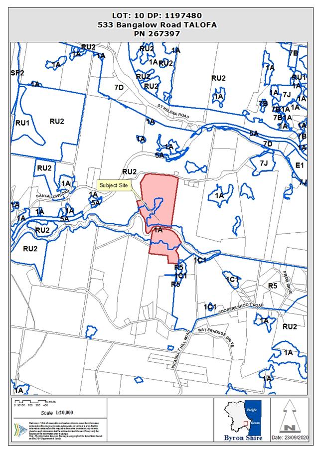
Property description:
|
LOT: 10 DP: 1197480
|
|
533 Bangalow Road TALOFA
|
|
Parcel No/s:
|
267397
|
|
Applicant:
|
Planners North
|
|
Owner:
|
Talofa Palms Pty Ltd
|
|
Zoning:
|
RU2 Rural Landscape; 1(a) (General Rural Zone)
|
|
Date received:
|
27 February 2020
|
|
Integrated / Designated Development:
|
☒
Integrated
|
☐
Designated
|
☐
Not applicable
|
|
Concurrence required
|
No
|
|
Public notification or exhibition:
|
- Level
2 advertising under DCP 2014 Part A14 – Public Notification and
Exhibition of Development Applications
- Exhibition
period: 19/3/20 to 1/4/20
- Submissions received:
Three (3)
- Submissions
acknowledged: ☒
Yes ☐ No
|
|
Variation request
|
Not applicable
|
|
Delegation to determine
|
Council
|
|
Issues:
|
· Individual
car parking for each cabin rather than centralised parking
· Cabins
located on a south facing slope
· Impact on
rural/scenic character
|
Summary:
This development application seeks consent for six (6) tourist and visitor accommodation cabins
plus new driveway, infrastructure and landscaping at 533 Bangalow Road, Talofa.
The application also includes a vegetation management plan involving ecological
restoration of the Byron Creek riparian corridor which runs through the centre
of the property.
The site is a 42 hectare property located 5km south-west of
Byron Bay, situated in a rural area characterised by grazing land, stands of
bushland, plantations and rural dwellings on lots with varying size and area.
The application originally proposed eight (8) cabins,
however the proposal was subsequently amended and reduced in scale to six
cabins. Additional information relating to landscaping, visual impact assessment
and environmental restoration were also supplied.
The main issue for consideration in this assessment is the
potential impact of the development on the rural/scenic character of the
area plus two minor variations to DCP 2014 relating to car parking design and
the south facing aspect of the land.
For reasons explained further in the body of this report,
the development is considered to be a reasonable response to the
characteristics of the site and will not have a substantially adverse impact on
rural character. The two DCP variations are generally of a minor nature and are
considered to be well founded in the circumstances.
As a compensating measure for energy efficiency, the
Applicant has opted into BASIX and will be providing 2kW solar PV energy
systems for each cabin, along with insulation and ceiling fans (for thermal
comfort) and rainwater harvesting and storage. In addition, the use of
individual car parking rather than centralised is considered to be acceptable
due to the site topography and the need to provide vehicular access to the
cabins for emergency vehicles and disabled persons. Offering parking adjacent
to each cabin in this context is considered reasonable and will not increase
the visual or environmental impact of the development.
In terms of environmental outcomes, the overall effect of
the development is likely to be positive if the restoration of Byron Creek is
undertaken in accordance with the submitted vegetation management plan. The
project will involve establishing a 3.5 hectare bush regeneration zone along
the riparian corridor, plus 2145 new rainforest trees along with weeding and
ongoing management for a period of five (5) years.
The development
application was publicly notified and advertised for a period of 14 days
between 19 March and 1 April 2020 and Council received 3 objections. Submissions
focused mostly on the scale of the development, questions over the relationship
with agriculture, and the potential impacts on rural character (it should be
noted that at the time of advertising, eight cabins were proposed).
It is considered that these issues have been appropriately
addressed through the provision of additional information, amendments to the
design, and the imposition of conditions of consent.
The development is otherwise consistent with the relevant
environmental planning instruments and development control plans applying to
the land and is recommended for approval subject to conditions of consent.
NOTE TO COUNCILLORS:
In accordance with the
provisions of S375A of the Local Government Act 1993, a Division is to be
called whenever a motion for a planning decision is put to the meeting, for the
purpose of recording voting on planning matters. Pursuant to clause 2(a)
under the heading Matters to be Included in Minutes of Council Meetings of
Council's adopted Code of Meeting Practice (as amended) a Division will be
deemed to have been called by the mover and seconder of all motions relating to
this report.
|
RECOMMENDATION:
That, pursuant to
Section 4.16 of the Environmental Planning & Assessment Act 1979,
Development Application 10.2020.100.1 for Tourist and Visitor Accommodation Comprising Six (6) Cabins, be
granted subject to the conditions of consent in Attachment 1 (E2020/77028).
|
Attachments:
1 Attachment
1 - 10.2020.100.1 Recommended Conditions, E2020/77028
2 Attachment
2 – 10.2020.100.1 Architectural and Landscaping Plans, E2020/77030
3 Attachment
3 – 10.2020.100.1 Engineering Plans, E2020/77031
4 Attachment
4 – 10.2020.100.1 SWMMP and Bin Storage Plan, E2020/77032
5 Attachment
5 – 10.2020.100.1 Visual Impact Assessment, E2020/77033
6 Attachment
6 – 10.2020.100.1 VMP & Restoration Plans, E2020/77034 
7 Attachment
7 - 10.2020.100.1 - Powerline Diversion Plan, E2020/77037
8 Attachment
8 10.2020.100.1 Submissions Redacted, E2020/77044
REPORT
1. INTRODUCTION
1.1. History/Background
Previous determinations
A search of Council records identified the following
determinations for the property:
· DA
10.2012.569.1, for a rural boundary adjustment, granted consent on 28 February
2013.
· DA
10.2013.124.1, for a two-lot rural subdivision, granted consent on 17 June
2013.
Site history
The subject site was originally part of a larger rural
holding used for dairying from the early 1900’s until the late
1980’s, following which the land was primarily used for beef cattle
grazing. The farm was subdivided in 2013 to create the subject property. A
Canary Island Palm plantation has been established on the southern end of the property.
Relocation of farm house
Council is currently considering development application
10.2020.99.1 which seeks consent to relocate the existing farm house further
away from Bangalow Road, along with alterations and additions. The new location
of the house has been identified on the plans submitted with the subject
application.
The land owner has indicated a preference to construct the
holiday cabins before the dwelling relocation although this is not mandatory
given there is no conflict between the two proposals.
1.2. Amendments
Council received amended plans on 29 July 2020 reducing the
number of cabins from eight to six. An amended vegetation management plan,
visual impact assessment, site waste management plan and powerline relocation
plan were also provided.
1.3. Description
of the proposed development
This application seeks development consent to construct six tourist and visitor accommodation cabins, along
with a new driveway, infrastructure and landscaping. A vegetation management
plan involving ecological restoration of the Byron Creek riparian corridor is
also proposed.
The proposed cabins are located on an elevated part of the
site near the existing farm house, offering southerly views over the
surrounding countryside. Each building is single storey and will have two
bedrooms, bathroom, living room, kitchenette, external deck and plunge pool.
In detail, the following is proposed:
(a) Tourist
and visitor accommodation cabins
(i) Six
cabins (including one adaptable cabin), each with an area of 60m2.
(ii) Each
cabin has two bedrooms, living room, bathroom, kitchenette, plunge pool and
outdoor deck.
(b) Access
and parking
(i) New
driveway crossover connecting to Bangalow Road.
(ii) New
sealed internal access road, ranging in width from 3.5m to 6m.
(iii) Removal
of existing driveway located in front of the farm shed.
(iv) Provision
of 12 guest car parking spaces.
(v) Installation
of roof water infiltration trenches and localised road drainage pipework to
manage driveway table runoff.
(c) Landscaping
and ecological restoration works
(i) Landscaping
around the cabins and car parking areas for privacy and amenity.
(ii) Vegetation
Management Plan for the restoration and enhancement of the rainforest areas
occurring in drainage gullies and the riparian corridor of Byron Creek.
(d) Services
and infrastructure
(i) New
on-site waste water management system to cater for the development.
(ii) Static
water supply tanks for firefighting.
(iii) Rainwater
tanks to supply potable water for each cabin.
(iv) Relocate
overhead powerlines to Bangalow Road to provide suitable clearance from the
development.

Figure 1: Architect’s impression south
elevation.
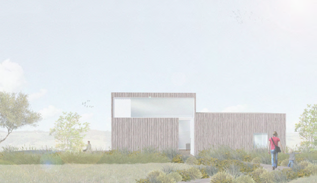
Figure 2:
Architect’s impression north elevation.
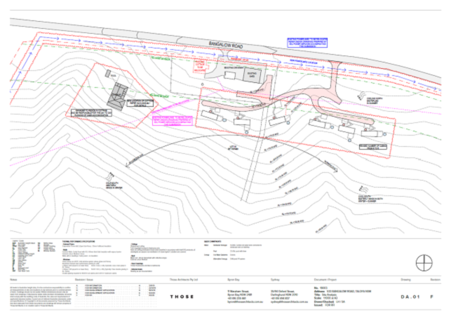
Figure 3: Site plan
showing the development layout.
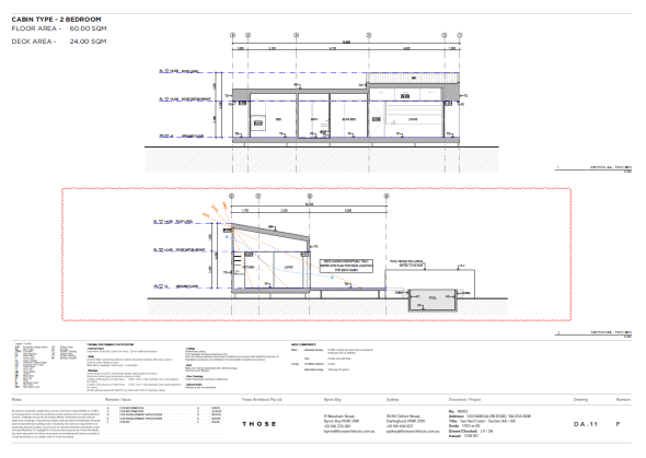
Figure 4: Cabin
section.
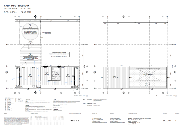
Figure 5: Cabin floor
plan.
1.4. Description
of the site
A site inspection was carried out on 15 April 2020.
The site is a 42 hectare property located 5km south-west of
Byron Bay, situated in a rural area characterised by grazing land, stands of
bushland, small scale agriculture and rural dwellings on lots with varying size
and area. The property has a 321m frontage to Bangalow Road and is bisected by
Byron Creek.
The land is cleared of vegetation apart from two isolated
patches of mixed subtropical rainforest and camphor near Byron Creek. A Canary
Island Palm plantation has been established on the southern portion of the
property, while the northern portion comprises cleared paddocks used for
grazing cattle.
Existing development comprises a small timber cottage and
two farm sheds located at the top of the ridgeline near Bangalow Road. The land
is otherwise undeveloped save for a small horse yard.
Figure 6: Aerial image
of the site.
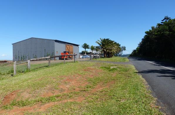
Figure 7: Entrance to
the property from Bangalow Road.
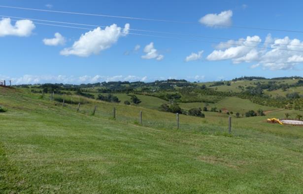
Figure 8: View south
from the proposed development site over surrounding countryside.

Figure 9: View west
towards the nearest dwelling at 549 Bangalow Road.
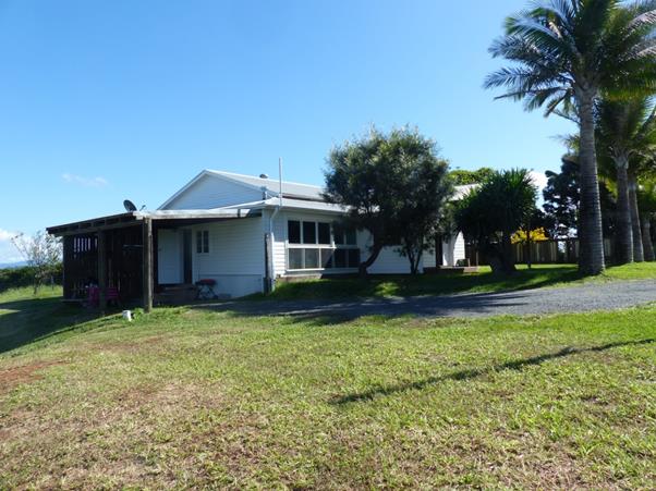
Figure 10: Existing
dwelling to be repositioned and altered via DA 10.2020.99.1.
2. SUMMARY OF
REFERRALS
|
Referral
|
Comments/Issues
|
|
Environmental Health Officer
|
No objections subject to conditions.
|
|
Development Engineer
|
No objections subject to conditions.
|
|
Development Contributions Officer
|
S7.12 levy will apply to the development.
|
|
Natural Resource Planner
|
No objections subject to minor amendments to the VMP.
|
|
Rural Fire Service
|
A Bush Fire Safety Authority has been issued by the RFS.
The development is capable of complying with the relevant conditions.
|
|
Essential Energy
|
No objections subject to powerlines being relocated in
accordance with Essential Energy’s requirements (refer to Attachment
7). See further discussion of issues in Section 4.1 - Infrastructure
SEPP.
|
* Conditions provided in the above referral are included
in the Recommendation of this Report below
3. SECTION 4.46
INTEGRATED DEVELOPMENT
Tourist and visitor accommodation is defined as a type of
“special fire protection purpose” and requires a Bush Fire Safety
Authority (BFSA) under s. 100B of the Rural Fires Act 1997.
General Terms of Approval were issued by the RFS on 26 May
2020. Refer to the recommended conditions in Attachment 1. The proposed
development is capable of complying with the conditions of the BFSA without any
significant change to the design or adverse impacts on the environment. No
clearing of vegetation is required to establish the asset protection zones
around the development.
4. SECTION 4.15C
– MATTERS FOR CONSIDERATION – DISCUSSION OF ISSUES
Having regard to the matters for consideration detailed in
Section 4.15(1) of the Environmental Planning & Assessment Act 1979 (EP&A
Act), the following is a summary of the evaluation of the issues.
4.1 State Environmental
Planning Instruments
State
Environmental Planning Policy (Koala Habitat Protection) 2019
The development
application was accepted by Council on 27 February, prior to the commencement
of the Koala Habitat Protection SEPP on 1 March 2020.
Transitional
provisions in the SEPP provide that a development application made, but not
finally determined, before the commencement of the Policy must be determined as
if the Policy had not commenced. As such, the application is to be assessed
under the former planning provisions applying through SEPP 44.
State Environmental Planning
Policy No 44—Koala Habitat Protection
SEPP 44 requires Council to consider whether the land is a
potential or core koala habitat. If the land is identified as core habitat,
consent cannot be granted unless there is a plan of management prepared for the
site in accordance with Part 3 of the SEPP.
This site is generally free of vegetation aside from patches
of mixed subtropical rainforest and camphor laurel in the gullies and riparian
corridor of Byron Creek. Less than 15% of the species in the upper and lower
strata consist of Koala food trees.
On this basis, the land is not considered to be potential or
core koala habitat as defined under SEPP 44. Consent is able to be granted
without the requirement for a plan of management.
State
Environmental Planning Policy No 55—Remediation of Land
A preliminary site investigation indicates the site was used
for dairying from the early 1900’s until the late 1980’s, following
which the land was primarily used for beef cattle grazing. Analysis of soil
samples reveal that contaminant levels are well below the Health Investigation
Levels for residential uses with access to soils.
Land in the vicinity of the proposed development is
demonstrated to be free from significant contamination and is suitable for the
proposed use in its current state.
State Environmental Planning
Policy (Building Sustainability Index: BASIX) 2004
The applicant has provided a multi-dwelling BASIX
certificate detailing energy efficient measures including photovoltaic panels,
centralised rainwater storage, energy efficient fixtures and insulation. The
relevant commitments for energy, water and thermal comfort have been shown on the
DA plans.
State Environmental Planning
Policy (Infrastructure) 2007
The provisions of SEPP (Infrastructure) 2007 have been
considered in the assessment of the development application. The relevant
clauses have been addressed below:
Clause 45 Determination of development
applications—other development
The application is subject to clause 45 of the
Infrastructure SEPP, as the proposed cabins and swimming pools are located
within 30m of a structure supporting overhead powerlines.
To address concerns over safety and amenity, the applicant
is proposing to relocate the powerlines traversing the site into the Bangalow
Road reserve, about 35m north of the current alignment. Essential
Energy’s comments in reply state that the development is considered
satisfactory based on the powerlines being relocated. A condition is
recommended that requires the powerlines to be relocated prior to the issue of
a construction certificate.
4.1 Byron Local Environmental Plan
2014 (LEP 2014)
LEP 2014 is an applicable matter for consideration in the
assessment of the subject development application in accordance with subsection
4.15(1) of the EP&A Act because it applies to the subject land and the
proposed development. The LEP 2014 clauses that are checked below are of
relevance to the proposed development:
|
Part 1
|
☒1.1|
☒1.1AA| ☒1.2| ☒1.3| ☒1.4| ☒Dictionary| ☒1.6| ☒1.7| ☒1.8| ☒1.8A| ☒1.9| ☒1.9A
|
|
Part 2
|
☒2.1|
☒2.2 | ☒2.3 |☒Land Use Table | ☒2.4 | ☒2.5 | ☒2.6 | ☒2.7 | ☒2.8
|
|
Part 4
|
☒4.3
|
|
Part 6
|
☒6.1|
☒6.2| ☒6.5| ☒6.6| ☒6.8
|
In accordance with LEP 2014 clauses 1.4 and 2.1 – 2.3:
(a) The
proposed development is defined in the LEP 2014 Dictionary as Tourist and
Visitor Accommodation;
(b) The
land is within the RU2 Rural Landscape / PART DM Deferred Matter according to
the Land Zoning Map;
(c) The
proposed development is permissible with consent; and
(d) Regard
is had for the Zone Objectives as follows:
|
Zone Objective RU2 Rural Landscape zone
|
Consideration
|
|
· To encourage sustainable primary industry production by
maintaining and enhancing the natural resource base.
· To maintain the rural landscape
character of the land.
· To provide for a range of compatible
land uses, including extensive agriculture.
· To enable the provision of tourist
accommodation, facilities and other small-scale rural tourism uses associated
with primary production and environmental conservation consistent with the
rural character of the locality.
· To protect significant scenic landscapes
and to minimise impacts on the scenic quality of the locality.
|
The proposal will reduce the available land for
primary production by ~ 2.5% (1 ha).
The proposed cabins and
dwelling are clustered near to Bangalow Road, minimising the development
footprint and reducing the loss of viable agricultural land within the site.
The proposal is unlikely to
generate land use conflict due to its low scale and substantial buffers from
adjoining farms and residences.
In terms of visual impact, the
proposed development is set below the northern ridgeline and will be screened
by vegetation amongst cabins and along Bangalow Road.
The application proposes
environmental restoration of the Byron Creek riparian corridor under a
Vegetation Management Plan consistent with the objective for environmental
conservation. The VMP proposes 3.5 hectares of bush regeneration along with
2125 new rainforest trees in 4 largely contiguous regeneration areas.
|
|
Part 4 – Principal Development Standards
|
Compliance
|
Comment
|
|
4.3 Height of Buildings
|
Yes
|
A maximum height of 9m is permitted.
A height of 4.7m is proposed.
|
|
Part 6 – Local Provisions
|
Compliance
|
Comment
|
|
6.2
Earthworks
|
Yes
|
The proposed
cabins are lightweight structures on pier footings requiring minimal
earthworks. Some cut and fill will be required for the internal access road
and car parking areas, although the effect on drainage patterns or soil
stability in the area will be negligible.
A condition
is recommended for the car parking area and access road to be suitably
landscaped and screened, along with sediment and erosion controls to be
implemented and maintained
during the construction phase.
|
|
Clause 6.5
Drinking water catchments
|
Yes
|
The site
drains to Byron Creek which feeds into the Wilsons Creek regional drinking
water catchment. The development and associated wastewater system will be
located over 400m from the Creek and will not have an adverse impact on the quality
or quantity of water entering the drinking water storage.
|
|
Clause 6.6
Essential services
|
Yes
|
The site is capable of being serviced by reticulated
electricity and telecommunications. Potable water is able to be supplied via
rainwater storage and the land is capable of accommodating effluent disposal
through an on-site waste water management system. The proposed vehicular
access offers safe and efficient access to and from the site.
|
|
Clause 6.8
Rural and nature-based tourism development
|
Yes
|
Having regard to the provisions of clause 6.8. the
proposed development is considered to be acceptable for the following
reasons:
· The
proposed development is relatively small scale and low impact, and is capable
of being generally managed and operated by the principal owner living on the
property.
· The
site has adequate vehicular access to and from a road, taking into account
the scale of the development.
· The
development is complementary to the environmental attributes of the land and
surrounds.
· The
cabins are clustered around the existing dwelling near to Bangalow Road,
minimising loss of agricultural land and providing adequate buffers to
neighbouring farms and residences.
· In
terms of visual impact, the development will sit below the northern ridgeline
and will not be clearly visible in views to the site from public places and
neighbouring’s residences. Appropriate conditions for landscaping will
help to screen the development and further minimise visual impact.
· The
property has a lawful dwelling, and
· The
development does not propose caretakers or managers residence or more than
one bed and breakfast accommodation.
|
4.2B Byron Local Environmental Plan 1988 (LEP 1988)
Most of the site is zoned RU2
Rural Landscape under Byron Local Environmental Plan 2014. A strip of land
corresponding to the riparian corridor of Byron Creek is a “deferred
matter” in LEP terms, and as such
remains zoned 1(a) General Rural Zone under Byron Local Environmental Plan
1988.
The entirety of the development
will be contained wholly within the RU2 zone.
The provisions of LEP 1988 are therefore not a relevant matter for
consideration in this assessment.
4.3 Any proposed Instrument
that has been the subject of public consultation and has been notified to the
consent authority
There are no proposed instruments with any relevance to the
subject application.
4.4A Byron Shire Development Control Plan 2014
(DCP 2014)
DCP 2014 is an applicable matter for consideration in the
assessment of the subject development application in accordance with subsection
4.15(1) of the EP& A Act because it applies to the land to which LEP 2014
applies. The DCP 2014 Parts/Chapters that are checked below are of relevance to
the proposed development:
|
Part A
|
☒
|
|
Part B Chapters:
|
☒
B2| ☒ B3| ☒ B4| ☒ B6| ☒ B8| ☒ B9| ☒ B10| ☒ B12| ☒ B13| ☒ B14
|
|
Part C Chapters:
|
☒
C3| ☒ C4
|
|
Part D Chapters
|
☒
D2| ☒ D3
|
These checked Parts/Chapters have been taken into
consideration in the assessment of the subject development application in
accordance with Section 4.15 of the EP&A Act. The proposed development
complies with all sections of these Parts/Chapters (in some cases subject to
conditions and/or to the satisfaction of other assessing officers), except in
relation to certain prescriptive measures which are considered further (having
regard to the DCP 2014 Section A1 Dual Path Assessment) as follows:
|
Chapter B3 Services
|
Compliance
|
Comment
|
|
B3.2.1 Provision of Services
Water supply
|
Yes
|
Each cabin has a rain water tank to provide potable
water for guests. The Applicant has also indicated
that a centralised water tank can be provided near the farm shed to provide
backup supply.
A condition is recommended
that requires a quality assurance program for drinking water to be supplied
to NSW Health prior to occupation of the development.
|
|
B3.2.2 On-site Sewage Management
|
Yes
|
The application proposes tertiary wastewater treatment
via AWTS system.
|
|
B3.2.4 Sedimentation and Erosion Control Measures
|
Condition
|
The site adjoins a waterway
and is located within a drinking water catchment. A sediment and erosion
control plan is therefore required in accordance with B3.2.4.
Condition recommended.
|
|
Chapter B4 Traffic Planning,
Vehicle Parking, Circulation and Access
|
Compliance
|
Comment
|
|
B4.2.1 Traffic Impact
|
Yes
|
The application included a
traffic impact statement estimating that the development would generate 2.5
trips per day per bedroom, which results in a total of 30 trips per day for a
12 bedroom facility. This is equivalent to the traffic generated by approximately
5 dwellings.
A
traffic count undertaken for Bangalow Road found a peak of 277 vehicles per
hour, for an estimated Annual Average Daily Traffic Volume of 2520 vehicles
per day. Hence, the proposed development would be likely to cause an increase
in traffic on Bangalow Road in the range of about 1% over current volumes.
Council’s
Development Engineer endorsed the findings of the traffic assessment and
concluded that the development would not have a significant impact on the
local road network.
|
|
B4.2.3 Vehicle Access and Manoeuvring Areas
|
Yes
|
Driveways and internal access roads comply AS 2890 and
the Northern Rivers Local Government Development & Design Manual. The
development is also capable of complying with RFS requirements for emergency
vehicle access.
|
|
B4.2.5 Car Parking Requirements
|
Yes
|
12 car parking spaces are required based on a rate of
1 space per bedroom.
12 car parking spaces are proposed (two per cabin).
|
|
Chapter B6 Buffers and Minimising Land Use Conflict
|
Compliance
|
Comment
|
|
B6.2.3 Planning Principles to Minimise Land use
conflict
|
Yes
|
The proposed development is located near to Bangalow
Road and has adequate buffers from adjoining farmland and residences.
The development is unlikely to cause conflict with
surrounding agricultural uses or sterilise neighbouring land from future
agricultural development.
|
|
B6.2.4 Buffers
|
Yes
|
Table B6.1 specifies a buffer distance for rural
tourist accommodation of 50m for grazing land. Distances to forestry &
plantations are subject to a site specific determination.
The development has a separation from neighbouring
grazing land of 180m and is located over 500m from the nearby Canary Palm
planation, satisfying the requirements of B6.2.4.
The development has been designed to avoid land use
conflict and satisfies the Objectives and Performance Criteria of B6.2.3.
|
|
Chapter B8 Waste Minimisation and Management
|
Compliance
|
Comment
|
|
B8.3 General Development Criteria
|
Yes
|
A Site Waste Minimisation
and Management Plan has been provided in accordance with Chapter 8.
The site is serviced by
Council garbage collection adequate to cater for the development.
Garbage bins will be stored
in an appropriate deigned enclosure and screened from public view.
|
|
Chapter B9 Landscaping
|
Compliance
|
Comment
|
|
B9.3.1 General Landscape Design
Principles
B9.6.1 Landscaping of Tourist and Visitor Accommodation
|
Condition
|
A satisfactory landscaping plan has been provided in
accordance with Chapter B9.
The landscape design features native rainforest
species planted between cabins and internal roads, plus screen plantings near
the access to Bangalow Road.
While this meets the requirements of the DCP, further
improvements are recommended through additional plantings near Bangalow Road
to help further screen the development from publicly accessible locations.
|
|
Chapter B13 Access and Mobility
|
Compliance
|
Comment
|
|
B13.2 Development Controls
|
Yes
|
The development includes one adaptable cabin with
disabled access and facilities.
|
|
Chapter B14 Excavation and Fill
|
Compliance
|
Comment
|
|
B14.2 Excavation and Fill in all Zones
|
Yes
|
Excavation and fill will be
less than 1m in depth across the site. Batters adjoining internal roads and
driveways will be appropriately landscaped.
|
|
Chapter C1 Non-Indigenous
Heritage
|
Compliance
|
Comment
|
|
C1.5.1 New Development in the
Vicinity of a Heritage Item
|
Yes
|
The adjoining property at 549
Bangalow Road contains a locally listed heritage item (I177) known as
“Byron Bay House” (formerly Ingleside).
The proposed cabins are located
approximately 330m from the Heritage Item and will not be close enough to
influence the visual and aesthetic characteristics of the building or the
historical setting of the property.
|
|
Chapter C3 Visually Prominent Sites, Visually
Prominent Development and View Sharing
|
Compliance
|
Comment
|
|
C3.2.1 Visual Impact Assessment
|
Yes
|
The application includes a visual impact assessment in
accordance with C3.2.1. Refer to Attachment 5.
As demonstrated in the montages, there is limited
visibility of the cabins travelling east on Bangalow Road and views to the
site from adjoining properties to the south are obtained at significant
distance. The single storey cabins will be partially visible to motorists
travelling west along Bangalow Road, however, the structures are set below
the northern ridgeline and will be screened by vegetation as part of the
proposed landscape design.
Overall, the development is considered to be
compatible with surrounding rural landscape and satisfies the Objectives and
Performance Criteria of Part C3.2.1.
Notwithstanding, additional
measures to further minimise the visual impact are recommended, including the
use of non-reflective building materials and additional landscaping.
|
|
Chapter C4 Development in the Drinking Water
Catchment
|
Compliance
|
Comment
|
|
C4.2.4 Water Sensitive Urban Design
|
Yes
|
The proposal will not significantly modify the natural
landform or increase stormwater runoff, particulate matter or
pollutants entering Byron Creek.
Stormwater is to be directed to infiltration trenches
and sewage effluent will be treated to a high standard by the proposed AWTS
system, located approx. 450m from the creek line.
Environmental restoration in the drainage gullies and
riparian corridor will also improve soil stability and reduce erosion.
|
|
C4.2.5 Development involving new roads and driveways
|
Yes
|
Roads and driveways will not cause undue disturbance
of soils or require removal of vegetation.
|
|
Chapter D3 Tourist Accommodation
|
Compliance
|
Comment
|
|
D3.2.1 Location and Siting
|
Yes
|
The proposed cabins have adequate buffers from
adjoining land and are sited clear of environmentally sensitive vegetation
and features of the land.
|
|
D3.2.3 Character and Design in Rural Zones
|
No*
|
Centralised parking
There is one proposed variation
to the relevant best practice guidelines of the Byron Rural Settlement
Strategy 1998 (the BRSS), which is called up by Performance Criteria D3.2.3
(3):
BRSS Section 7.2: Holiday Cabins - Guidelines
5. All
weather ‘centralised’ car parking must be provided on-site at the
rate of at least 1 car space per holiday cabin. The paving of car-parking
areas is not encouraged (except where roads need to be on more steeply
sloping lands), rather these areas should be either grass-covered or topped
with gavel to an all-weather standard to ameliorate stormwater runoff.
Individual parking for each cabin is proposed rather than
centralised parking, which departs from the above guideline. Refer to DCP
2014 Issues Section.
Other matters
South facing slope
In relation to aspect and orientation, the BRSS guidelines
generally require rural tourism development to be sited on land with a
northerly or easterly aspect. Southerly and westerly aspects are permissible,
but only in circumstances where the Applicant is able to demonstrate other
compensating arrangements to maximise solar energy collection and minimise
energy use. Part 7.2 (7)(c) of the BRSS provides:
“All
cabins are located on land having either a North, Northwest, Northeast or
East aspect or a slope of less than or equal to two degrees (2o)
unless it can be demonstrated that other compensating arrangements will
maximise solar energy collection and minimise energy use”.
The development site has a south facing aspect, however,
the proposed cabins are located on a high part of the site to take advantage
of views and breezes and therefore have relatively good access to sunlight
year round. The Applicant has opted to comply with the energy efficiency
requirements of BASIX which includes 2kW solar photovoltaic energy systems
for each cabin along with insulation and ceiling fans (for thermal comfort)
and rainwater harvesting and storage.
Given the sites relatively good solar access and adoption
of compensating measures for energy efficiency, the proposal is considered to
satisfy the requirements of the BRSS guidelines for aspect and orientation.
Clustering of development
In relation to clustering, the development extends
over a total distance of 135m with an average separation distance between all
buildings of 79m.
Such an arrangement satisfies the clustering provisions in
the BRSS guidelines, which requires cabins to be located 80m apart on average
and no more than 160m at the most.
Part 7.2 (7)(d) of the BRSS provides:
“All holiday cabins
are to be arranged in a ‘cluster pattern’ unless a dispersed
arrangement can be clearly demonstrated to be an ecologically superior
solution. In the context of rural tourist facilities, a ‘cluster’
is defined as a group of three (3) or more cabins located an average of 80m
apart and not more than 160m apart from each other with adequate screening
between cabins (i.e. to ensure privacy) and with the layout of the
developments in the cluster having regard to the physical characteristics of
the land and the need to provide access to the cabins for the provision of
accident or fire emergency and other services such as sewerage disposal
system, water supply and electricity”.
Environmental repair and enhancement
Part 8.2 (1) of the BRSS guidelines requires that dwelling
houses and holiday cabins in rural areas must contribute to environmental
repair and enhancement as follows:
“Planting of 900
native plants per dwelling-house or holiday cabin. (Thus a development
comprising six (6) holiday cabins or dwelling houses would require no fewer
that 5400 plantings)”.
Under this guideline, 5400 plantings are required for the
subject development.
The Applicant has supplied a vegetation management plan
that proposes 2145 new plantings plus 3.5 hectares of bush regeneration and
weeding along the Byron Creek riparian corridor. The environmental
enhancement works are deemed to be equivalent to 900 trees per cabin and therefore
satisfy the requirements of the BRSS guidelines.
See D3.3.4 for further explanation.
|
|
D3.3.4 Rural Tourist Accommodation and Farm Stay
Accommodation
|
No*
|
South facing slope
In relation to aspect and orientation, a similar control
to BRSS guideline 7.2 (7)(c) is Prescribed under Part D3.3.4, but
without the flexibility of allowing alternative solutions for solar
collection and energy use.
Prescriptive Measure D3.3.4
(2)(h)
(iii) all
rural tourist accommodation is to be located on land having either a North,
Northwest,/Northeast or Easterly aspect to maximise solar energy collection
and minimise energy use;
The proposed cabins are located on a south facing slope,
which departs from the Prescriptive Measure. Refer to DCP 2014 Issues
Section.
Vegetation Management Plan
Prescriptive Measure 3
requires a vegetation management plan to be provided detailing where 900
local native trees per cabin are to be planted as environmental repair and
enhancement for development.
Equivalent ecological restoration
may also be provided (in lieu of 900 trees) in certain circumstances as
follows:
“Equivalent ecological restoration may be
provided where existing native vegetation occurs on site. It is preferred
that remnant vegetation on site is restored to a local native plant community
type before additional planting is undertaken. Weed control should prioritise
invasive species and weeds of national significance (WONS)”.
The application proposes a 3.5
hectare bush regeneration zone along the Byron Creek riparian corridor,
weeding program and four restoration areas containing 2145 new rainforest
trees.
Council’s natural
resource planner noted that the bush regeneration zone was equivalent to 5600
plantings, and along with the 2145 new rainforest trees and weeding program,
was equivalent to the environmental benefit provided by 900 trees per cabin.
On
this basis, it is considered that the VMP will satisfy the environmental
repair and enhancement requirements in accordance with Prescriptive Measure
D3.3.4 (3) and the BRSS guidelines.
|
4.4A Development Control Plan 2014 –
Issues
Chapter D3 Part D3.2.3 Character and Design in Rural
Zones
The proposal has been designed with individual car parking
for each cabin, which departs from the Byron Rural Settlement Strategy 1998
Best Practice Guidelines: Part 7.2, Guideline 5:
Byron Rural Settlement
Strategy, Part 7.2 Holliday Cabins - Guidelines
5. All
weather centralised car parking must be provided on-site at a rate of at least
1 car space per holiday cabin. The paving of car-parking areas is not
encouraged (except where roads need to be on more steeply sloping lands),
rather these areas should be either grass-covered or topped with gravel to an
all-weather standard to ameliorate stormwater runoff.
The proposal must therefore be assessed against the
Objectives and Performance Criteria of D3.2.3:
Objectives
1. To
ensure that tourist accommodation in Rural Zones is compatible with the
surrounding landscape and with the character and amenity of development in the locality.
2. To
implement the relevant Aims, Guiding Principles and provisions of the Byron
Rural Settlement Strategy 1998.
Performance Criteria
1. Tourist
accommodation development in Zones RU1 and RU2 must be compatible in character
and amenity with the surrounding rural and natural landscape, and with
development in the locality.
2. The
provisions of Chapter D2 Residential Accommodation and Ancillary Development in
Rural Zones apply to all tourist accommodation development in zones RU1 and RU2
in the same way they apply to residential accommodation in Rural Zones.
3. All
development to which this Chapter applies in Rural Zones must be low scale
consistent with the relevant Aims, Guiding Principles, Best Practice Guidelines
and Performance Standards contained in the Byron Rural Settlement Strategy 1998
(‘the Strategy’) as follows:
a) The
Strategy’s relevant aims are:
i) To
ensure that ecological, social and economic considerations are successfully
integrated into the decision-making process for all future rural settlement in
Byron Shire.
ii) ……
iii) To
ensure future rural settlement is directly linked to the repair, enhancement
and protection of the natural environment, thereby increasing the Shire's
natural capital.
b) The
Strategy’s relevant Guiding Principles are:
i) overriding
principle -- all new rural settlement must meet the needs of Byron's residents
today while conserving the Shire's ecosystems, agricultural viability,
lifestyles, heritage and culture for the benefit of future generations;
ii) sustainability
-- development meets the needs of today without compromising the ability of
future generations (long timeframes) to meet their own needs and enjoy a
quality life resulting from clean air, water and soils;
iii) planning
-- Shire wide planning identifies potential rural settlement areas integrated
with catchment-based (geographical, water and social) planning;
iv) consultation
-- there is full community consultation and participation with the local
community prior to decision-making, and support for participatory settlement
planning;
v) environment
-- existing habitat areas are identified, protected and enhanced, environmental
repair is undertaken and corridors of native vegetation linking habitat areas
are provided;
vi) water
quality -- natural watercourses and the riparian lands, wetlands and
groundwater systems are protected from sources of pollution and the water
quality is maintained and improved;
vii) identity
-- Byron Shire's unique image, diverse lifestyle and local character are
maintained;
viii) facilities
-- adequate community facilities to meet the needs of rural settlement areas
are provided; and
ix) land
use -- existing and potential agricultural and horticultural land uses and
extractive resources on site are protected; and off-site, on adjacent and
nearby areas, their land uses and resources are not adversely impacted by rural
settlement.
c) The
relevant Best Practice guidelines are contained in Chapter 7 of the Strategy.
d) The
relevant Performance Standards are contained in Chapter 8 of the Strategy.
Assessment
The overarching objective of D3.2.3 is to ensure that
tourist accommodation is compatible with the rural character and amenity of the
area and to implement the aims and guiding principles of the Byron Rural
Settlement Strategy 1998 (BRSS).
In terms of planning objectives, the aim of BRSS Section 7.2
is to ensure that holiday cabins are provided “in harmony with the rural
and natural environment”. The provision of centralised car parking can,
in some circumstances, help to achieve that aim by minimising the visual and
environmental disturbance caused by internal roads and car parking areas on the
landscape.
In this particular instance, it is considered that the
proposed car parking design is able to meet the Objectives of D3.2.3 and the
Aims of the BRSS guidelines for the following reasons:
· The layout and design of the internal roads and car parking
areas generally follows the contours of the slope and will not significantly
detract from the surrounding rural environment, subject to the use of permeable
surface treatments and appropriate use of landscaping.
· Internal
roads need to be in proximity to each cabin to allow access for emergency
vehicles such as fire fighting trucks or ambulances. If strict compliance were
enforced, the Applicant would need to dedicate an additional area for centralised
guest car parking which is unlikely to result in a superior outcome in terms of
visual or environmental outcomes.
· There
is a need to provide vehicular access and disabled parking in close proximity
to the adaptable cabin. Due to the site topography, a centralised car parking
area would likely need to be located on a flatter part of the site near to
Bangalow Road and this would make access for disabled persons more difficult
that the current proposal.
Chapter D3 Part D3.3.4 Rural Tourist Accommodation and
Farm Stay Accommodation
Parts D3.3.4, Prescriptive Measure 2 (h)(ii) provides that
rural tourist accommodation is to be located on land having a north,
north-west, north-east or easterly aspect.
Prescriptive Measure D3.3.4
(2)(h)(ii)
“All rural tourist
accommodation is to be located on land having either a North, Northwest,
Northeast or Easterly aspect to maximise solar energy collection and minimise
energy use”.
The Application seeks approval for cabins on a south facing
slope, and is therefore not strictly consistent with those provisions. An
assessment against the Performance Criteria and Objectives of D3.3.4 is
required.
Objectives
1. To
ensure that rural tourist accommodation does not detract from the rural and
natural character of its locality.
2. To
ensure that rural tourist accommodation does not adversely affect the conduct
and productivity of agricultural operations on the site or nearby lands.
3. To
facilitate and support the establishment of low scale farm tourism as a secondary
business to primary production, where farm stay accommodation is proposed.
Performance Criteria
1. The
development must be located and operated so that it does not:
a) adversely
affect the conduct and productivity of agricultural operations on the site;
b) create
potential for conflict with adjoining land uses;
c) disrupt
environmental enhancement projects on the land; and
d) impact
on the ecological or environmental values of the land; and
e) conflict
with buffer requirements pursuant to Chapter B6 Buffers and Minimising Land Use
Conflict.
2. Rural
tourist accommodation must be designed and located to be compatible with the
surrounding rural and natural landscape. Where new buildings are proposed to be
constructed for the purpose of rural tourist accommodation such buildings are
to be clustered and located in proximity to the primary dwelling house on the
lot.
3. The
development is to be low scale and designed and located to be compatible with
the surrounding rural environment and of minimal environmental impact.
4. Car
parking for guests must be provided in accordance with Chapter B4 Traffic
Planning, Vehicle Parking, Circulation and Access.
5. Provision
of recycling and waste management facilities must be in accordance with Chapter
B8 Waste Minimisation and Management.
6. The
development must observe the road and boundary setback requirements specified
in Chapter D2 Residential Accommodation and Ancillary Development in Rural
Zones (D2.2.2) and the character and visual impact requirements (D2.2.3).
7. Rural
tourist accommodation to be suitably sited in accordance with the requirements
of Chapter C3 Visually Prominent Sites, Visually Prominent Development &
View Sharing.
8. Environmental
reparations are required as a part of any Rural Tourist Development. Such
repairs are to be focused on the expansion of wildlife corridors, repairing and
reconnecting vegetation remnants and enhancing riparian areas and habitat for
threatened species and endangered plant communities.
Assessment
There are no specific Objectives or Performance Criteria
under D3.3.4 relating to aspect, solar access or energy efficiency. Criteria
dealing with rural character and low scale development having minimal
environmental impact are considered relevant.
As noted elsewhere in this report, the proposed development
is located on an elevated site with relatively good access to sunlight year
round and the Applicant has opted into energy saving measures through BASIX
including solar PV energy systems for each cabin. The site also has a pleasant
outlook offering a high level of amenity for users.
On balance, the proposal is considered to be consistent with
the relevant Performance Criteria and Objectives of D3.3.4, being a low scale
development with minimal impact on the surrounding environment (Criteria 3)
that does not detract from the rural and natural character of the locality
(Objective 1).
4.4B Byron Shire
Development Control Plan 2010 (DCP 2010)
The development is wholly
within the RU2 Rural Landscape zone under Byron LEP 2014. The provisions of DCP
2010 are therefore not a relevant matter for consideration in this assessment.
4.5 Any Planning Agreement or
Draft Planning Agreement?
There are no planning agreements or draft planning
agreements associated with the application.
4.6 Environmental Planning
& Assessment Regulation 2000 Considerations
Clause 92 Additional matters that
consent authority must consider
There are no additional matters under the Regulations that
require further consideration. Conditions relating to AS 2601–the
demolition of structures are not required for the subject application as no
demolition is proposed.
4.7 The likely impacts of that
development, including environmental impacts on both the natural and built
environments, and social and economic impacts in the locality
|
Impact on:
|
Likely significant impact/s?
|
|
Natural environment
|
Impacts on vegetation and biodiversity
The proposal will not have a significantly adverse
impact on the natural environment or biodiversity. The overall effect on the
environment is likely to be positive if the restoration of Byron Creek is
undertaken in accordance with the submitted vegetation management plan.
The project will involve establishing a 3.5 hectare
bush regeneration zone along the riparian corridor, plus 2145 new rainforest
trees in 4 additional restoration areas along with weeding and ongoing
management.
Clearing entitlements under other legislation
No clearing is required to establish asset protection
zones around the development. In addition, there is no significant vegetation
within 50m of the proposed development that would be affected by the 10/50
Clearing Code.
However, to ensure the environmental enhancement
program cannot be unduly affected by clearing allowances under other
legislation, a condition is recommended that ‘switches off’ Part
5A of the Local Land Services Act and the RFS 10/50 Clearing Code. This will
prevent future clearing for agriculture without the prior approval of Council
or the native vegetation panel.
|
|
Built environment
|
Character, locating, siting, scale and external
appearance
The design, siting and character of the development is
considered to be low scale and generally compatible with the characteristics
of the surrounding environment. The cabins are single storey buildings of 60m2,
set below the ridgeline and incorporating non-reflective earth toned
materials and colours, interspersed with landscaping.
Hazards
The site is
identified as bushfire prone land but is otherwise unaffected by natural or
man made hazards. The only other issue relates to overhead powerlines however
these are to be relocated towards Bangalow Road, well clear of the
development site.
The
proposed development is capable of meeting RFS bushfire safety requirements
which includes the preparation of a bushfire emergency management and
evacuation plan.
Relationship
to development in the locality
Development
in the Talofa area consists of farms, dwellings used for rural living and a
small number of rural tourist facilities.
The amended
proposal (6 cabins) is similar in scale and design to other tourist
facilities in the area and has been appropriately sited and designed to
minimise the potential for land use conflict with adjoining agricultural
uses.
Concerns
were raised in submissions over cumulative impacts (e.g. traffic, over
development, visual impact), although this is not considered to be sufficient
grounds for refusal in the circumstances. The site is located in a different
viewing catchment to the adjacent tourist facility at 460 Bangalow Road and
the estimated traffic generation is approximately 1% over current volumes and
well within the capacity of the road network. It is considered that the
development is unlikely to have a significant cumulative effect that would
result in unacceptable impacts on the natural or built environments.
Impacts
on the existing and likely future amenity of the locality
The development has substantial buffers to
neighbouring dwellings and properties such that there is unlikely to be any
significant impact on existing and likely future amenity of the area.
Conditions are recommended preventing the use of lighting in the evening
aside from that reasonably required for safety and use of the development.
In terms of privacy, the proposed cabins are oriented
in a southerly direction, away from neighbouring residences. The development
layout offers reasonable internal privacy for users without unduly causing overlooking
or privacy issue for neighbours. The nearest dwellings are 330m and 360m to
the east and west respectively.
|
|
Social Environment
|
No. The proposal will not have a significant social
impact on the locality.
|
|
Economic impact
|
The development is likely to provide a minor short
term economic benefit by providing employment in the construction sector and
contributing to the local tourism sector in the longer term.
|
4.8 The suitability of the site
for the development
The site attributes are generally conducive to the
development having regard to slope, hazards, vegetation, services, views,
amenity, land use conflict and visual impact. The site is considered to the
generally suitable for the development subject to appropriate conditions of
consent.
4.9 Submissions made in
accordance with this Act or the regulations
The development application was publicly exhibited for a
period of 14 days in accordance with the provisions of Byron DCP 2014. Council
received thee (3) submissions objecting to the application.
Concerns from surrounding land owners mostly focus on the scale
of the development, and the associated impacts on rural and scenic character.
It should be noted that at the time of advertising, eight cabins were proposed.
Issues raised in the submissions are summarised and
discussed below.
|
Summary of Issues
|
Comment
|
|
Scale and density of development
|
|
The development is not “small scale” in
the context of its locality and property size.
|
The development has been reduced to six (6) cabins and
is now considered to meet the definition of ‘small scale’ under
LEP 2014. The development is capable of being generally managed by the owner
of the property and will have minimal visual and environmental impact.
|
|
The scale and location of the development is not low
scale and is not compatible with the surrounding landscape and character
being generally broad pasture, interspersed with vegetation patches and a few
well, spaced dwellings and accommodation.
|
See above.
|
|
The application does not demonstrate how the proposed
development will be managed and operated by the principal owner living on the
property (“without requiring additional ‘outside’ staff”
- BRSS, 1988) to establish that the development is “small-scale”.
|
Clause 6.8 of Byron LEP 2014 defines small scale as
meaning:
small scale means a scale that is small enough to be generally
managed and operated by the principal owner living on the property.
The term “generally” implies that most, but not
all of the maintenance and operation of the facility will be handled by the
principle owner living on the property. It is reasonable to expect that some
services such as cleaning or linen could be handled by external providers.
I note that
DCP’s (and the BRSS by reference) cannot impose a standard or
definition that is more onerous or inconsistent with a higher order planning
instrument such as an LEP or SEPP. The meaning of “small scale”
therefore must be taken from LEP 2014, rather than from the BRSS.
|
|
Eight cottages are proposed which in combination with
the existing cottage makes nine (9) residential buildings for the property,
which exceeds the maximum allowable of six (6), further demonstrating the
adverse character and visual impact of the development.
|
See above. The total number of buildings on the
property will be nine (9), comprising six cabins, one house, and two sheds.
In the context of a 42 hectare property, the proposal is not considered to be
an overdevelopment of the site and is similar to other properties in the
Talofa area.
|
|
This is a significant departure from the concept of
“small scale, owner operated”, and opens the door to 10 or even
12 cabin developments.
|
The application has been reduced to 6 cabins and
generally complies with the relevant planning controls. Approval of the
application would be unlikely to set an undesirable precedent allowing 10 or
12 cabin developments in the future.
|
|
Character and visual impact
|
|
The development will have a detrimental impact on the
scenic amenity and rural landscape character of the locality.
|
A visual impact assessment has been provided
demonstrating that the proposal is unlikely to have a significant impact on
the character of the area. Refer to Attachment 5.
|
|
The cumulative impacts of this development in
combination with existing residential buildings and a recently established
adjacent tourist facility will result in the locality having the appearance
of a subdivision rather than the beautiful rolling countryside enjoyed at
present.
|
Noted. However, the adjacent tourist facility at 460
Bangalow Road is located on the opposite side of the ridge (in a different
view shed) and is screened behind mature vegetation. Therefore, the
cumulative visual effect is likely to be minimal.
|
|
Significant adverse effect on the rural character of
the locality when consideration of cumulative impacts is taken into account.
Approval
of this development will result in 19 residential buildings within a 60 metre
setback from Bangalow Road along a 500m stretch of the road.
Whereas, the stretch of road
500m further west and east has two (2) and one (1) residential buildings
respectively within the 60m road setback.
|
See above.
|
|
The proposed development is not designed to be
compatible with the surrounding rural and natural landscape.
|
The number of cabins has been reduced to six and
additional landscaping proposed. The proposal is on balance considered to be
compatible with the surrounding landscape.
|
|
The amount of sealed road encompassing the driveway
access for the eight cottages, 11 new car parking spaces, pathway around each
cottage, fire tank access, as well as the tanks themselves will form a
considerable scar on the landscape.
|
Conditions area recommended for the access roads and
parking bays to be appropriately landscaped to screen and soften the
appearance of these works on the landscape.
|
|
Zone objectives – relationship with primary
production
|
|
The application does not adequately demonstrate how
the proposal will be consistent with objectives of the RU2 zone, in
particular:
· No details provided on how
the development will encourage sustainable primary industry production.
· The
application has not demonstrated that the proposed development will maintain
the rural landscape character of the land.
· Eight cottages on a 40 hectare property is not small
scale in the context of the locality.
|
The proposed development will be associated with
an environmental conservation project to regenerate the Byron Creek riparian
corridor. Existing and potential future agricultural uses of the land,
including the palm plantation and cattle grazing will not be prejudiced by
the proposal.
|
|
It is not adequately demonstrated how the development
will complement and enhance primary production on the property.
|
See above.
|
|
Water supply
|
|
The recent drought saw many
rural homes experiencing delays of 6 weeks waiting for water deliveries. This
development only relies on rainwater, yet each cottage has a flush toilet,
shower and a kitchenette and a plunge pool. The RFS also need 10,000L dedicated
for fire fighting purposes. This is not sustainable.
|
Noted. As climactic conditions
become more variable there will be an increased probability of dry periods
and droughts.
The applicant has indicated
that a centralised water tank will be available as a back-up supply for the
proposed cabins, which is considered to be a reasonable solution in the
circumstances.
|
|
Proposed Water Tanks would appear to be inadequate.
Having lived in this exact vicinity for the past 20 years, the changing
climate is such that for the past 5 years we now have extended periods of
minimal rainfall.
Given these proposed cabins also have individual
swimming pools, and the property also proposed to continue to run cattle, the
proposed water tank requirements appear grossly inadequate to satisfy all the
water needs that will be required to adequately ensure there is an adequate
water supply at all times.
|
See above.
|
|
Vegetation
|
|
Recent drought highlights the vulnerability of rural
properties with nearby vegetation. Planting 900 trees per cottage sounds
excellent but when a drought puts a deep ground cover of fallen leaves this
is a danger. From experience, it’s easy to plant and weed once, but to
maintain all the pants and keep the weeds at bay is another.
|
Noted. The proposed VMP
includes a weed removal program and has a 5 year management timeline.
|
|
Rural and nature based tourism objectives –
LEP 2014 clause 6.8
|
|
The proposal is not consistent with the objectives and
requirements of clause 6.8 of LEP 2014 – rural and nature based
tourism, as eight cottages on a 40 hectare property:
· Is not small scale or low
impact in the context of the locality,
· Will adversely impact on
scenic values of the land and amenity, and
· Is
not complementary to the rural or environmental attributes of the land.
|
Noted. The application has been reduced in scale to
six cabins and is consistent with other similar rural tourism developments in
the area.
|
|
Landscaping
|
|
Landscaping plan not provided.
|
Noted. A landscaping concept plan has since been
provided illustrating plantings along internal roads and driveways and
between cabins. Conditions are recommended to provide further plantings to
screen the development from publicly accessible locations and neighbouring
properties.
|
|
Visual impact
|
|
The proposed vegetation management plans, whilst
extensive, do not appear to show any significant vegetation to protect the
“visual integrity of the existing rural landscape”.
Under this proposal, travelling along Bangalow Road
from Hayters Hill towards Bangalow, the visual outlook will be of a
"small urban subdivision”, located in a rural environment, and
inconsistent with the planning controls.
|
Noted. Additional information regarding landscaping
has been supplied, although additional plantings are considered necessary to
screen the development from Bangalow Road.
|
|
Disabled access
|
|
The proposal fails to adequately address the
requirements of Disabled people. There appears to be no reference to
accessible parking, and the relevant requirements for hard surfaces and slope
levels across the site.
|
Amended plans have been prepared including provision
of disabled facilities in one of the cabins.
|
|
Traffic
|
|
The development will increase the volume of traffic
onto Bangalow Road.
|
Noted. The development is estimated to result in
approximately 1% increase in traffic on Bangalow Road over current volumes.
Council’s Development Engineer has assessed the development as low
impact. Bangalow Road is a sealed two way road in reasonable condition and
there are good lines of sight to and from the proposed access point for the
new development.
|
|
Driveway access and road setbacks
|
|
The proposed driveway access at 3.5m in width appears
to be inconsistent with council requirements that this be 4m
|
Noted. The main driveway access is 6m wide, which
satisfies Council and RFS requirements. Internal roads could easily be
widened by an additional 500mm to achieve 4m clearance as per RFS conditions.
|
|
The additional proposed access will result in a total
of three road accesses within 100 metres for the one property also
contributing to the adverse visual impact and large-scale of the development.
|
Amended plans have been supplied reducing the number
of driveway from three to two.
|
|
The cottage located between the “existing
cottage” and shed on the site plan does not meet the minimum road
setback for classified roads and should not be approved.
|
Noted. This cabin has since been removed from the
plans. A consolidated arrangement of 6 cabins is now proposed with each
building complying with the 15m road boundary setback requirement specified
in Part D2.2.2.
|
4.10 Public interest
The proposed development is unlikely to prejudice or
compromise the public interest or create an undesirable precedent.
5. DEVELOPER
CONTRIBUTIONS
5.1 Water
& Sewer Levies
The site is not connected to
reticulated water or sewer services. Accordingly, there is no nexus to charge
water and sewer levies under the Water Management Act.
5.2 Section 7.11 Contributions
The proposal is for tourist
accommodation and is therefore subject to a section 7.12 levy.
6. CONCLUSION
The proposed development is a satisfactory response to the
site’s constraints and the applicable planning controls that apply to the
land. Potential visual and environmental impacts have been addressed
through a reduction in the scale of the development, appropriate landscaping,
materials and a vegetation management plan to restore the Byron Creek riparian
corridor.
The application is recommended for approval subject to
conditions of consent.
7. REASONS
FOR DECISION, HOW COMMUNITY VIEWS WERE ADDRESSED
Note: From July 1 2018,
Council’s are required to give and publicly notify reasons for a range of
planning decisions where they are deciding if development should proceed to
help community members to see how their views have been taken into account and
improve accountability to stakeholders. A statement of reasons for the
determination of this application is provided below.
|
Statement of Reasons
|
|
The proposed development complies with the provisions of
Byron Local Environmental Plan 2014.
|
|
The proposed development complies with relevant State
Environmental Planning Policies
|
|
The proposed development complies with relevant provisions
of Development Control Plan 2014
|
|
The proposed development complies with Environmental
Planning & Assessment Regulation 2000 considerations.
|
|
The proposed development will not have significant adverse
impact on the natural, built or social environment or economic impacts on the
locality.
|
|
The proposed development is considered suitable for the
proposed site.
|
|
The development application was notified/advertised in
accordance with Development Control Plan 2014. Issues raised in the submissions
have been addressed during assessment of the application.
|
|
The proposed development is unlikely to prejudice or
compromise the public interest.
|
|
How community views were addressed
|
|
The DA was advertised in accordance with Development
Control Plan 2014. The submissions received were considered on merit and
addressed during assessment of the application.
To view the considerations, please contact Council to view
a copy of the assessment report relating to this DA.
|
Staff Reports - Sustainable Environment and Economy 13.3
Report No. 13.3 PLANNING
- Development Application 10.2020.272.1 Use of Converted Farm Shed as Dwelling
2 of Detached Dual Occupancy at 530 Lismore Road, Binna Burra
Directorate: Sustainable
Environment and Economy
Report Author: Jordan
Vickers, Planner
File No: I2020/1445
Proposal:
|
DA No:
|
10.2020.272.1
|
|
Proposal description:
|
Use of Converted Farm Shed as Dwelling 2 of Detached Dual
Occupancy
|
|
Property description:
|
LOT: 100 DP: 1209712
|
|
530 Lismore Road BINNA BURRA
|
|
Parcel No/s:
|
267763
|
|
Applicant:
|
Newton Denny Chapelle
|
|
Owner:
|
Mrs L James & Stoneridge Pastures Pty Ltd
|
|
Zoning:
|
RU1 Primary Production / PART RU2 Rural Landscape / PART
1A General Rural zone Byron LEP 1988
|
|
Date received:
|
17 June 2020
|
|
Integrated / Designated Development:
|
☐
Integrated
|
☐
Designated
|
☒
Not applicable
|
|
Concurrence required
|
No
|
|
Public notification or exhibition:
|
- Level
2 advertising under DCP 2014 Part A14 – Public Notification and
Exhibition of Development Applications
- Exhibition
period: 2/7/20 to 22/7/20
- No Submissions were
received
|
|
Planning Review Committee:
|
Not applicable
|
|
Variation request
|
Clause 4.6
|
|
Issues:
|
- Located
173m from existing dwelling (exceeds the 100m maximum separation distance
between dwellings – variation sought to the development standard)
|
Summary:
Development Consent is sought for the use of an already
converted Farm Shed as Dwelling 2 of a Dual Occupancy (detached) on rural land
at Binna Burra. The converted farm shed is located 173m from the existing
dwelling on the same lot. This exceeds the maximum 100m separation distance
between dual occupancy dwellings permitted under the Byron LEP 2014.
A Clause 4.6 variation has been lodged to vary the 100m
development standard.
Strict compliance with the 100m development standard is
considered unreasonable and unnecessary in the circumstances.
The proposed dwelling already exists (approved as a shed);
there is no need for additional vegetation clearing, excavation/fill and
installation of infrastructure (OSMS, driveway, stormwater etc.). The two
dwellings will be located on the same lot.
In consideration of granting a variation to the development
standard, the ongoing use of the shed as a dwelling is not inconsistent with
the objectives of the RU2 Zone or the objectives of Clause 4.2D of the
BLEP2014.
If Council were to require strict compliance with the
development standard, the landowner would have to decommission the unauthorised
dwelling back to a shed, and construct a new second dwelling 73m closer to the
existing dwelling to achieve the same end.
This scenario would be inconsistent with the compliance and
enforcement principles under the Enforcement Policy. In particular
proportionality: ensuring the level of enforcement action is
proportionate to the level of risk and seriousness of the breach; making
cost-effective decisions about enforcement action; taking action to address
harm and deter future unauthorised activity.
The application is recommended for approval subject to the
conditions listed in the recommendation. This recommendation accords with
Pathway 1 under the draft Unauthorised Dwelling Policy (20-283 & 20-471)
in so far as the land has a dwelling entitlement and contains unauthorised
residential accommodation – and development consent may be sought and
granted.
NOTE TO COUNCILLORS:
In accordance with the
provisions of S375A of the Local Government Act 1993, a Division is to be
called whenever a motion for a planning decision is put to the meeting, for the
purpose of recording voting on planning matters. Pursuant to clause 2(a) under
the heading Matters to be Included in Minutes of Council Meetings of Council's
adopted Code of Meeting Practice (as amended) a Division will be deemed to have
been called by the mover and seconder of all motions relating to this report.
|
RECOMMENDATION:
That pursuant to Section 4.16 of the
Environmental Planning & Assessment Act 1979, Development Application No. 10.2020.272.1 for Use of Converted Farm Shed as Dwelling 2
of Detached Dual Occupancy, be granted consent subject to the conditions of
approval in Attachment 2 (#E2020/73903).
|
Attachments:
1 Plans
DA10.2020.272.1, E2020/73903
2 Recommended
Conditions of Consent DA 10.2020.272.1, E2020/73931
REPORT

Assessment:
1. INTRODUCTION
1.1. History/Background
A search of Council’s records reveals the following site
history:
|
DA no.
|
Description
|
Outcome
|
|
5.1997.462.1
|
Subdivision – Boundary adjustment
|
Approved - 12/11/1997
|
|
5.1998.001.1
|
Dwelling – rural – relocate dwelling
|
Approved - 02/03/1998
|
|
6.1998.2002.1
|
Relocated Dwelling
|
Finalised - 12/12/2001
|
|
16.2000.4037.1
|
CDC – Carport
|
Approved - 26/10/2000
|
|
10.2008.120.1
|
DA – Farm Shed
|
Approved - 23/05/2008
|
|
10.2008.120.2
|
S96 – Rotate farm shed
|
Approved – 30/06/2008
|
|
16.2008.89.1
|
Alterations & Additions to Existing Dwelling
|
Approved - 23/05/2008
|
|
16.2008.89.2
|
S96 modification to kitchen & laundry
|
Approved - 30/06/2008
|
|
10.2019.440.1
|
Shed
|
Approved – 16/10/2019
|
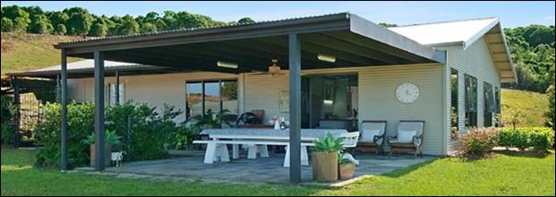
'Farm shed' advertised for private rental
1.2. Description
of the proposed development
This application seeks approval for use of an already
converted Farm Shed as Dwelling 2 of a detached dual occupancy. The proposed
dwelling 2 of the Dual occupancy as built, is located 173m from the existing
dwelling on the property. The dwelling contains two bedrooms, one bathroom, a
double carport and various in/outdoor living areas. Access to the dwelling is
granted via the existing vehicle crossover and driveway, no vegetation clearing
or excavation is required for the development.
This application is in response to
Council’s enforcement notification process.
Description of the site
The subject site known as 530
Lismore Road, Binna Burra and legally described as lot 100 on DP1209712 has a
total site area of 17.75ha and is located within the RU1 Primary Production
and RU2 Rural Landscape zones of the Byron LEP 2014 and 1A
General Rural zone of the Byron LEP 1988. The site is currently improved by a
single dwelling house, domestic outbuildings and pockets of significant
vegetation.
A site inspection was carried out on 1 July 2020.
|
Land is legally described
|
LOT: 100 DP: 1209712
|
|
Property address
|
530 Lismore Road BINNA BURRA
|
|
Land is zoned:
|
RU1 Primary Production / PART RU2 Rural Landscape / PART
1A General Rural Byron LEP 1988
|
|
Land area is:
|
17.75ha
|
|
Property is constrained by:
|
Flood Liable Land, Bushfire prone land, High Environmental
Value vegetation
|
|
Is a BDAR required due to the location of the proposed
development?
|
☐ Yes ☒ No
|
|
Are there any easements in favour of Council affecting the
site?
|
☐ Yes ☒ No
|
|
Is there a Vegetation Management Plan which might affect
the proposal?
|
☐ Yes ☒ No
|
|
Is there a Voluntary Planning Agreement which might affect
the proposal?
|
☐ Yes ☒ No
|
2. SUMMARY OF
REFERRALS
|
Referral
|
Issue
|
|
Environmental Health Officer*
|
No objections subject to conditions.
|
|
Development Engineer
|
No objections subject to conditions.
|
|
Building Surveyor
|
No objections subject to conditions.
|
|
S94 / Contributions Officer
|
No objections subject to conditions.
|
* Conditions provided in the above referral are included
in the Recommendation of this Report below
Issues:
Development Engineer:
Consent from Council must be
obtained for works within the road reserve pursuant to Section 138 of the Roads
Act 1993. Works required are on a classified road and as such concurrence from
Roads and Maritime Services (RMS) will be required. Although this triggers
Integrated Development in accordance with the EP&A Act 1979, the applicant
requested that the proposal not be referred under the subject application,
noting that they will refer to RMS when applying for the s138 Roads Act
approval.. Accordingly, a Condition has been imposed requiring an upgrade to
the driveway, with a note advising that concurrence is required from RMS.
3. SECTION 4.14
– BUSH FIRE PRONE LAND
Under section 4.14 of the Act, Council must be satisfied prior
to making a determination for development on bush fire prone land, that the
development complies with the document ‘Planning for Bush Fire Protection
(PBP) 2019’. The site is bush fire prone land.
The applicant has provided that,
as an APZ of 30m can be provided surrounding the building, the Grassland
deeming provisions are applicable. The Planning for Bushfire Protection 2019
document only permits use of the Deeming provisions where the maximum downslope
is 15 degrees.
Council’s Geocortex tool indicates that surrounding
the development, the aggregate slope is 15-30%, which approximately equates to
9 – 15 degrees (as informed by the PBP 2006 document). Accordingly, the
Deeming Provisions are applicable. To accord with the Grassland Deeming
Provisions, the proposed dwelling must achieve the following standards which
will be imposed as conditions of consent:
- BAL 12.5;
- Access to comply
with Table 5.3b;
- Static water
supply of 20,000L;
- Landscaping to
comply with provisions of Appendix 4.
4. SECTION 4.15C
– MATTERS FOR CONSIDERATION – DISCUSSION OF ISSUES
Having regard to the matters for consideration detailed in
Section 4.15(1) of the Environmental Planning & Assessment Act 1979
(EP&A Act), the following is a summary of the evaluation of the issues.
4.1 State Environmental
Planning Instruments
4.2A Byron Local Environmental Plan 2014 (LEP 2014)
Note: while the site is
traversed by both the RU1 and RU2 zones, the Dual occupancy dwelling that is the
subject of this application is located entirely within the RU2 zone.
In accordance with LEP 2014 clauses 1.4 and 2.1 – 2.3:
(a) The
proposed development is defined in the LEP 2014 Dictionary as Dual Occupancy
(detached);
(b) The
land is within the RU1 Primary Production / PART RU2 Rural Landscape / PART 1A
General Rural (1988 LEP) according to the Land Zoning Map;
(c) The
proposed development is Permitted with consent; and
(d) Regard
is had for the Zone Objectives as follows:
|
Zone Objective
|
Consideration
|
|
• To
encourage sustainable primary industry production by maintaining and
enhancing the natural resource base.
• To
maintain the rural landscape character of the land.
• To
provide for a range of compatible land uses, including extensive agriculture.
• To
enable the provision of tourist accommodation, facilities and other
small-scale rural tourism uses associated with primary production and environmental
conservation consistent with the rural character of the locality.
• To
protect significant scenic landscapes and to minimise impacts on the scenic
quality of the locality.
|
The existing shed that has been converted to a dwelling
does not compromise the potential use of the land, rural character or impact
on neighbouring properties.
|
Clause 4.2D Erection of dual occupancies
(detached) and secondary dwellings in Zones RU1 and RU2
The provisions of Clause 4.2 state
(1) The objectives of this clause are as
follows—
(a) to provide alternative accommodation for
rural families and workers,
(b) to ensure that development is of a scale
and nature that is compatible with the primary production potential, rural
character and environmental capabilities of the land,
(c) to set out consent considerations for
development of dual occupancies (detached) and secondary dwellings to address
matters such as access, siting, land suitability and potential impacts.
(2) Development consent must not be granted to
development for the purpose of a dual occupancy (detached) or secondary
dwelling on land in Zone RU1 Primary Production or Zone RU2 Rural Landscape
unless the consent authority is satisfied that—
(a) the development will not impair the use of
the land for agriculture or rural industries, and
(b) each dwelling will use the same vehicular
access to and from a public road, and
(c) any dwellings will be situated within 100
metres of each other, and
(d) the land is physically suitable for the
development, and
(e) the land is capable of accommodating the
on-site disposal and management of sewage for the development, and
(f) the development will not have an adverse
impact on the scenic amenity or character of the rural environment.
The existing shed that has been converted to a dwelling
currently provides residential accommodation for rent. The building being
single storey slab on ground is at a scale and built form consistent to that in
the surrounding area. In terms of the specific provisions under Subclause 2,
the development raises no issues other than non compliance with the 100 metre
separation distance from the other dwelling on the property. A variation is
sought to this development standard and is discussed below.
Clause 4.6:
As per the planning circular PS 18-003 - Variations to
development standards, the Secretary’s concurrence can be assumed
where a proposal seeks a variation that is less than 10% of the numerical
development standard. In this case, the numerical development standard is
clause 4.2D (2) (c), which requires that dual occupancy dwellings are located
within 100m of one another. The proposed exceedance of the standard is 73m.
Thus, as the proposed variation to the numerical development standard is 73%
concurrence cannot be assumed and the application must be determined by
Council.
1. Introduction
– Summary of Proposed Development
The application is for Use of Converted Farm Shed as Dwelling 2 of Detached
Dual Occupancy.
The converted farm shed is
located 173m from the existing dwelling on the property, being 73m more than
the prescribed numerical development standard (see image below).
2. Clause
4.6 Exceptions to Development Standards.
LEP 2014 Clause 4.6 allows the granting of
development consent in the instance that a development would contravene a
development standard. However, Council must first be satisfied by a written
request from the Applicant, that:
a) compliance with the development
standard is unreasonable or unnecessary in the circumstances of the case, and
b) there are sufficient environmental
planning grounds to justify contravening the development standard.
c) the proposed development will be in
the public interest because it is consistent with the objectives of the
particular standard and the objectives for the development within the zone in
which the development is proposed to be carried out.
3. The
Development Standard to be varied
The Development Standard to be
varied is the 100m maximum distance between dual occupancy buildings, prescribed
by Clause 4.1D(c) of LEP 2014.
4. Extent
of Variation to the Development Standard
The extent of the variation is
73m, being a variation of 73% to the development standard.
5. Objective
of the Development Standard
The objectives of the development standard, as outlined in
subclause 4.2D are:
a) to
provide alternative accommodation for rural families and workers,
b) to
ensure that development is of a scale and nature that is compatible with the
primary production potential, rural character and environmental capabilities of
the land,
c) to
set out consent considerations for development of dual occupancies (detached)
and secondary dwellings to address matters such as access, siting, land
suitability and potential impacts.
6. Objective
of the Zone
The objectives of the Rural Landscape (RU2) zone are as
follows:
(a) To
encourage sustainable primary industry production by maintaining and enhancing
the natural resource base.
(b) To
maintain the rural landscape character of the land.
(c) To
provide for a range of compatible land uses, including extensive agriculture.
(d) To
enable the provision of tourist accommodation, facilities and other small-scale
rural tourism uses associated with primary production and environmental
conservation consistent with the rural character of the locality.
(e) To
protect significant scenic landscapes and to minimise impacts on the scenic
quality of the locality.
7. Assessment
– specific questions to be addressed under LEP Clause 4.6:
(a) Clause
4.6(3) (a) – Is compliance with the development standard unreasonable or
unnecessary in the circumstances of the case?
The Clause 4.6 written request submitted by the applicant
in support of the DA advises as follows in this regard:
“The variation to the development standard is
considered warranted for the following reasons:
a. The
proposal complies with the RU2 zone objectives
As discussed in the
applicant’s statement of environmental effects, the proposal meets the
objectives of the RU2 zone in that the proposal will not impair the use of
adjoining land for agricultural purposes. Furthermore, cattle grazing will
still occur on the site.
b. The
proposal meets the objectives of Clause 4.2D
The proposal will provide
alternative accommodation on the allotment that is of a scale and nature that
is compatible with the existing development types in the locality. Alternate
sites within 100m of the existing dwelling were investigated but were not
considered suitable due to the loss of grazing land and the duplication of
infrastructure.
c. The
shed is proposed to be converted to negate the need for location of the
dwelling has been chosen to negate the need for grazing land to be lost.
In this regard:
· Converting the
shed will not result in a loss of grazing land;
· Converting the
shed will not duplicate existing infrastructure;
· Converting the
shed will not require earthworks to create a level building pad
· Converting
the shed is an adaptive reuse of existing infrastructure and services.
Strict compliance with the 100 metre development
standard is considered unnecessary in this instance given the reasons discussed
above and within the submitted documentation. Additionally, the proposal will
not impair the use of the land for agricultural purposes.”
Officer comment:
The proposed dwelling already exists (approved as a shed);
there is no need for additional vegetation clearing, excavation/fill and
installation of infrastructure (OSMS, driveway, stormwater etc.). The two
dwellings will be located on the same lot.
In consideration of granting a variation to the development
standard, the ongoing use of the shed as a dwelling is not inconsistent with
the objectives of the RU2 Zone or the objectives of Clause 4.2D of the
BLEP2014.
If Council were to require strict compliance with the
development standard, the landowner would have to decommission the unauthorised
dwelling back to a shed, and construct a new second dwelling 73m closer to the
existing dwelling to achieve the same end.
This scenario would be inconsistent with the compliance and
enforcement principles under the Enforcement Policy. In particular
proportionality: ensuring the level of enforcement action is
proportionate to the level of risk and seriousness of the breach; making
cost-effective decisions about enforcement action; taking action to address
harm and deter future unauthorised activity.
The variation to the development standard is supported in
this case.
(b) Clause
4.6(3)(b) – Are there sufficient environmental planning grounds to
justify contravening the development standard?
The Clause 4.6 written request submitted in support of the
DA advises as follows in this regard:
“As demonstrated above
and within the SEE submitted to Council, there is sufficient environmental
planning grounds to justify the breach of the development standard.”
Officer comment:
An excerpt from Initial
Action Pty Ltd v Woollahra Municipal Council [2018] NSWLEC 118 notes that:
“The focus of cl 4.6(3)(b) is on the aspect or
element of the development that contravenes the development standard, not on
the development as a whole, and why that contravention is justified on
environmental planning grounds.”
The extent of the variation sought is 73m. Based on the
staff assessment above, it is considered that there are
sufficient environmental planning grounds to justify the contravention
of the standard.
(c) Clause 4.6(4) (a)
(ii) – Is the proposed development in the public interest? Is it
consistent with the objectives of the standard and the zone as set out above?
Regarding the objectives of the standard and the zone, the
Clause 4.6 written request submitted in support of the DA advises as follows:
“The variation to the development standard is
considered warranted for the following reasons:
a. The
proposal complies with the RU2 zone objectives
As discussed within the
statement of environmental effects, the proposal meets the objectives of the
RU2 zone in that the proposal will not impair the use of adjoining land for
agricultural purposes. Furthermore, cattle grazing will still occur on the
site.
b. The
proposal meets the objectives of Clause 4.2D
The proposal will provide alternative accommodation on
the allotment that is of a scale and nature that is compatible with the
existing development in the locality. Alternate sites within 100m of the
existing dwelling were investigated but were not considered suitable due to the
loss of grazing land and the duplication of infrastructure.
Officer comment:
The proposal is consistent with the objectives of the
development standard and zone as it:
• maintains
the rural landscape character of the land;
• provides
alternate residential accommodation in the locality;
• is of a
scale and nature that does not adversely impact the primary production
potential and environmental capabilities of the land.
No submissions were received to
the proposal.
The recommendation to support the
variation accords with Pathway 1 under the draft Unauthorised Dwelling Policy
(20-283 & 20-471) in so far as the land has a dwelling entitlement and
contains unauthorised residential accommodation – and development consent
may be sought and granted. This satisfies the public interest in this case.
The request to vary a development standard is considered to
meet subclause (3) of clause 4.6, and is supported in this case.
The proposal raises no other issues under the LEP.
4.2B Byron Local Environmental Plan 1988 (LEP 1988)
Part of the site is within
the 1A General Rural zone. That part of the land the subject of this
application is within RU2 zone of LEP 2014. The proposal raises no issues that
require assessment against BLEP 1988.
4.3 Any proposed Instrument
that has been the subject of public consultation and has been notified to the
consent authority
There are none.
4.4A Byron Shire Development Control Plan 2014
(DCP 2014)
DCP 2014 is an applicable matter for consideration in the
assessment of the subject development application in accordance with subsection
4.15(1) of the EP& A Act because it applies to the land to which LEP 2014
applies. The DCP 2014 Parts/Chapters that are checked below are of relevance to
the proposed development:
|
Part A
|
☒
|
|
Part B Chapters:
|
☒B2|
☒B3| ☒B4| ☒B6| ☒B8|
|
|
Part C Chapters:
|
☒C3|
|
|
Part D Chapters
|
☒D2|
|
Chapter D2.5.2 – Character and Siting of
Dwellings
Prescriptive Measure 2
prescribes (in accordance with LEP clause 4.2D (2)(b)) that Dual occupancy
(detached) dwellings are no more than 100m apart at closest point. The
development presents a separation distance of 173m between the Dual occupancy
dwellings. A variation to this development control has been considered above
under the clause 4.6 variation discussions above.
The proposed development raises
no other issues under the DCP 2014.
4.4B Byron Shire Development Control Plan 2010 (DCP 2010)
Byron DCP 2010 does not apply in this case.
Environmental Planning & Assessment Regulation 2000
Considerations
No issues under the Regulations require consideration.
4.5 The likely impacts of that
development, including environmental impacts on both the natural and built
environments, and social and economic impacts in the locality
|
Impact on:
|
Likely significant impact/s?
|
|
Natural environment
|
No. The proposal will not have a significantly adverse
impact on the natural environment of the locality.
|
|
Built environment
|
No. The proposal will not have a significantly adverse
impact on the built environment of the locality.
|
|
Social Environment
|
No. The proposal will not have a significant social impact
on the locality.
|
|
Economic impact
|
No. The proposal will not have a significant economic
impact on the locality.
|
Council Policies applicable to the proposed development have
been considered through the assessment of this application with relevant
conditions imposed where necessary.
4.6 The suitability of the site
for the development
|
Issue
|
Comment
|
|
Services
- Water/
Sewer/ Stormwater
- Ph/
power
- Access
|
- The site is connected to power and
telecommunications infrastructure and has adequate water supply in accordance
with the DCP.
- The building is connected to an
approved On-site Sewage Management (OSMS) system which Council’s
Environmental Health Officer has confirmed is suitable for the development.
- Access is granted via a lawful
vehicle crossover at Lismore Road.
|
|
Onsite Effluent Disposal
|
- The building is connected to an
approved On-site Sewage Management (OSMS) system which Council’s
Environmental Health Officer has confirmed is suitable for the development
|
|
Hazards
- Bushfire
|
- The site is bushfire prone land
and the Grassland Deeming Provisions can apply.
|
|
Land Use conflicts
|
- No land use conflicts have been
identified.
|
4.7 Submissions
made in accordance with this Act or the regulations
The development application
was publicly exhibited. No submissions were received.
4.8 Public interest
The proposed development is unlikely to prejudice or
compromise the public interest or create an undesirable precedent.
5. DEVELOPER
CONTRIBUTIONS
5.1 Water & Sewer Levies
No Section 64 levies will be required.
5.2 Section 7.11 Contributions
Section 7.11 Contributions will
be payable.
6. CONCLUSION
The application seeks consent for the Use of Converted Farm
Shed as Dwelling 2 of Detached Dual Occupancy. The proposed development is
satisfactory having regard to the relevant planning controls applicable to the
site. The proposal raises no new issues in terms of environmental impacts. The
application is recommended for approval subject to the conditions of consent.
Staff Reports - Sustainable Environment and Economy 13.4
Report No. 13.4 PLANNING
- Report of the 17 September 2020 Planning Review Committee
Directorate: Sustainable
Environment and Economy
Report
Author: Chris
Larkin, Manager Sustainable Development
Noreen Scott, EA Sustainable
Environment and Economy
File No: I2020/1457
Summary:
This report provides the outcome of the Planning Review
Committee (PRC) held on 17 September 2020.
NOTE TO COUNCILLORS:
In accordance with the
provisions of S375A of the Local Government Act 1993, a Division is to be called
whenever a motion for a planning decision is put to the meeting, for the
purpose of recording voting on planning matters. Pursuant to clause 2(a)
under the heading Matters to be Included in Minutes of Council Meetings of
Council's adopted Code of Meeting Practice (as amended) a Division will be
deemed to have been called by the mover and seconder of all motions relating to
this report.
|
RECOMMENDATION:
That Council endorses the outcomes of the
Planning Review Committee meeting held on 17 September 2020.
|
REPORT
The Planning Review Committee meeting was held on 17
September 2020. The Meeting commenced at 4:15pm and concluded at 4:45pm.
Councillors: Crs Richardson, Ndiaye, Martin, Lyon, Hunter
Apologies: Nil
Staff: Chris Larkin (Manager Sustainable Development)
The following development
applications were reviewed with the outcome shown in the final column.
|
DA No.
|
Applicant
|
Property Address
|
Proposal
|
Exhibition Submissions
|
Reason/s
Outcome
|
|
10.2020.370.1
|
Ardill Payne
|
68 Byron Street
BANGALOW
|
Stage 1 Change of Use of
Existing Building from Residential (Dwelling House) to Commercial
(Offices/Shops) including Alterations and Additions to Existing Building and
Provision of Car Parking
Stage 2 Demolition of
Existing Detached Garage Building and Construction of a New Detached Building
to be Used for Commercial Purposes and Provision of Car Parking.
|
Level 2
20/8/20 to 9/9/20
18 submissions against
1 petition with 103
signatures
4 submission support
|
The number of public submissions.
The perceived public
significance of the application
Council
|
|
10.2020.138.1
|
Ardill Payne
|
8 Kumbellin Glen OCEAN
SHORES
|
Demolition of Existing
Dwelling House and Construction of Multi-Dwelling Housing Comprising Seven
(7) Dwellings
|
Level 2
2/4/20 to 22/4/20
11 submissions against
|
The number of public
submissions
Council
|
|
10.2019.533.1
|
Salt Whistle Bay Pty Ltd as
trustee for The Point
|
595 The Pocket Road
THE POCKET
|
Rural Industry - Intensive
Plant Agriculture and Agricultural Produce Industry
|
Level 1
25/10/19 to 7/11/19
4 submissions against
|
Under Staff Delegated
Authority
|
Staff Reports - Sustainable Environment and Economy 13.5
Report No. 13.5 PLANNING
- Development Application 10.2019.180.2 - S4.55 to Modify Condition 8 - 22A
Teak Circuit Suffolk Park
Directorate: Sustainable
Environment and Economy
Report
Author: Rebecca
Mercer, Team Leader Planning Services
File No: I2020/1461
Proposal:
|
Section 4.55 Application No:
|
10.2019.180.2
|
|
Proposed modification:
|
S4.55(1a) to Modify Condition 8
|
|
Original Development:
|
Dwelling House
|
|
Property description:
|
LOT: 2 SP: 97314
|
|
22A Teak Circuit SUFFOLK PARK
|
|
Parcel No/s:
|
269172
|
|
Applicant:
|
Mrs L E Colombo
|
|
Owner:
|
Mr U & Mrs L E Colombo
|
|
Zoning:
|
R2 Low Density Residential
|
|
S4.55 Date received:
|
17 August 2020
|
|
Original DA determination date:
|
24/06/2019
|
|
Public notification or exhibition:
|
- Level
1 advertising under DCP 2014 Part A14 – Public Notification and
Exhibition of Development Applications
- Exhibition
period: 26/8 - 8/9/2020
- Submissions received: 1
|
|
Delegation to determination:
|
Council
|
|
Issues:
|
· Potential conflicts between 22 & 22A Teak Circuit
· Does not meet the Northern Rivers
Local Government Development Design & Construction Manuals and Standard
Drawings for driveway widths.
|
Summary:
DA 10.2019.180.1 was approved on 11
July 2019 for a Dwelling House on Lot 2 of Strata Plan 97314, addressed as 22A Teak Circuit,
Suffolk Park. 22A Teak Circuit is situated to the rear of 22 Teak
Circuit and is accessed by a battle-axe handle. Condition 8 of the consent
requires the provision of a new driveway across the road reserve in accordance
with a S138 Approval and with a width of 3 metres. This has been issued
by Council but the driveway has not been constructed, although the house has
been. To construct the driveway a light pole will need to be relocated with all
costs borne by the applicant. It is noted the matter was previously
discussed by Council by way of Notice of Motion and Council resolving (20
– 275) to invite the land owners to lodge a S4.55 application to
amend the consent condition.
The application seeks to amend Condition 8 to narrow the
driveway across the road reserve to 2.5 metres so that the light pole does not
need to be relocated. The driveway will immediately adjoin the driveway at 22
Teak Circuit so that in effect there is a combined driveway width across the
road reserve far in excess of the required three metres. The owner of 22
Teak Circuit has not provided a letter of support for this shared arrangement
and has objected to the amendments on the grounds of traffic safety, arguing
the light pole should be moved and the driveway constructed to the appropriate
width as currently conditioned.
Having regard to the combined width of the driveway across
the road reserve, which is public land not private property; it is considered
that the narrower crossover to be constructed does not raise any safety
concerns. It is recommended for the reasons outlined in this report that the
driveway crossover be reduced to 2.5 meters. The application is recommended for
approval.
NOTE TO COUNCILLORS:
In accordance with the
provisions of S375A of the Local Government Act 1993, a Division is to be
called whenever a motion for a planning decision is put to the meeting, for the
purpose of recording voting on planning matters. Pursuant to clause 2(a)
under the heading Matters to be Included in Minutes of Council Meetings of
Council's adopted Code of Meeting Practice (as amended) a Division will be
deemed to have been called by the mover and seconder of all motions relating to
this report.
|
RECOMMENDATION:
That pursuant to Section 4.55 of the
Environmental Planning & Assessment Act 1979, Development Application No.
10.2019.180.2 to Modify Condition 8, be granted approval subject to the
following:
Amend Condition 8 to read.
8. Consent
required for works within the road reserve
Consent from
Council must be obtained for works within the road reserve pursuant to
Section 138 of the Roads Act 1993. Three (3) copies of engineering
construction plans must accompany the application for consent for works
within the road reserve.
Such plans are
to be in accordance with Council’s current Design & Construction
Manuals and are to provide for the following works:
|
Driveway (residential areas)
|
A nominal 2.5m wide driveway crossover
to be provided to 22a Teak Circuit, Suffolk Park and include the following:
· Provision of 0.3m separation between the existing light pole and
the new driveway servicing 22A Teak Circuit; and
· Plans to indicate steel doweling to connect the new driveway
with the existing crossover where they join within the road reserve..
· The driveway to comply (other than widths) with the requirements
of Council's current “Northern Rivers Local Government Development
Design & Construction Manuals and Standard Drawings”.
|
|
Attachments:
1 Confidential
- Submission, E2020/75476
2 10.2019.180.2
Site photos, E2020/78374
REPORT
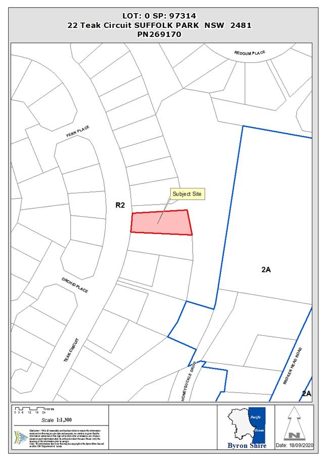
Assessment:
1. INTRODUCTION
1.1. History/Background
A number of previous determinations have been made on the
subject site as listed below:
· BA 6.1992.2448.1
for a Dwelling was approved 28 September 1992.
· BA 6.1994.2526.1
for a Pergola was approved 29 August 1994.
· DA 10.2016.772.1
for Stage 1: Two Lot Strata Subdivision, Stage 2: Dwelling House to create Dual
Occupancy was approved 26 May 2017.
· DA 10.2016.772.2
for s4.55 to modify dual occupancy dwelling design was withdrawn 17 October
2018.
· DA 10.2016.772.3
for s4.55 to modify dual occupancy dwelling design was withdrawn 13 March 2019.
· DA 10.2019.180.1
dwelling house on vacant strata lot (22a Teak Circuit) - Approved 11 July 2019.
1.2. Description of the
proposed development
This application seeks approval for a s4.55 to Modify
Condition 8 which currently states:
|
8.
|
Consent required
for works within the road reserve
Consent from Council must be obtained for works within the
road reserve pursuant to Section 138 of the Roads Act 1993. Three (3) copies
of engineering construction plans must accompany the application for consent
for works within the road reserve.
Such plans are to be in accordance with Council’s
current Design & Construction Manuals and are to provide for the
following works:
|
Driveway (residential areas)
|
A 3m wide driveway in accordance with Council's current
“Northern Rivers Local Government Development Design &
Construction Manuals and Standard Drawings”.
The existing light pole must be relocated to provide a
minimum 0.3m clearance to the edge of the driveway. All cost for the
relocation of the light pole must be borne by the applicant and design and
construction works must be in accordance with Essential Energy’s
requirement.
|
|
The applicant seeks to narrow the driveway to 2.5 metres to
avoid the need to move a light pole. With a 2.5 metre wide driveway – the
light pole will be 300 mm from the edge of the crossover. The driveway will
adjoin the wider driveway at 22 Teak Circuit which already has a nominal width
of 5 metres. (See photo below)
The matter was discussed at a Council meeting on 18 June
2020 by way of a Notice of Motion.
Council
resolved as follows: 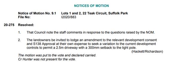
It was
discussed that the cost of streetlight relocation otherwise would cost the
applicant upwards of $20,000.
1.3. Description of the site
The development assessment report describes the site as:
|
Land is legally described as
|
LOT: 2 SP: 97314
|
|
Property address is
|
22A Teak Circuit SUFFOLK PARK
|
|
Land is zoned:
|
R2 Low Density Residential
|
|
Land area is:
|
441.1 m2
|
|
Property is constrained by:
|
Flood Liable Land, Bushfire prone land, Acid Sulfate Soils
Class 3
|
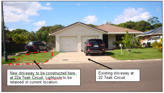
Figure 1 - Front of site
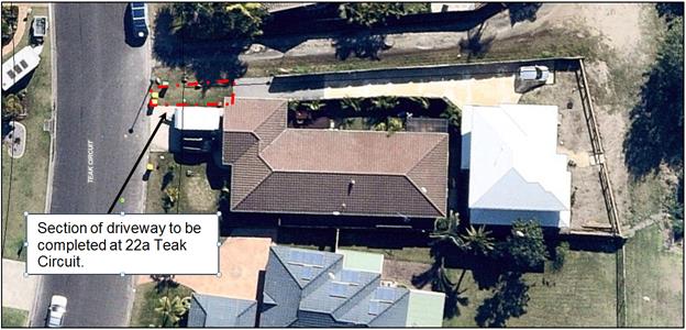
Figure 2 – 22a Teak
Circuit (light coloured roof) 22 Teak Circuit (Brown Tile Roof)
The subject dwelling on 22a Teak Circuit makes up a dual
occupancy development with 22 Teak Circuit. The owners of 22a Teak Circuit
sought and were granted approval under DA10.2018.180.1 for a dwelling that was
different to what was originally approved under DA10.2016.772.1. This approval
granted consent for Stage 1: Two Lot Strata Subdivision, Stage 2: Dwelling
House to create Dual Occupancy. The driveway was not constructed for 22a Teak
circuit when it was subdivided into two strata lots under DA10.2016.772.1.
2. SECTION 4.15 – MATTERS FOR CONSIDERATION
– DISCUSSION OF ISSUES
Having regard for the matters for consideration detailed in
Section 4.15(1) of the Environmental Planning & Assessment Act 1979, the
following is a summary of the evaluation of the issues.
Section 4.55 of the EPA Act 1979.
It is considered the development is substantially the same
development as originally approved and satisfies the requirements under S4.55
1(a) as a minor amendment to the development consent and will have minimal
environmental impact.
2.1. State/Regional Planning
Policies, Instruments, EPA Regulations 2000
Proposed amendments raise no issues under the relevant
SEPPs, Policies or clauses of the EPA Regulations 2000.
2.2. Byron Local Environmental
Plan 2014
Proposed amendment raises no issues under the LEP.
2.3. Draft EPI that is or has
been placed on public exhibition and details of which have been notified to the
consent authority - Issues
No draft EPIs affect the proposal.
2.4. Development Control Plans
Chapter B4 Traffic Planning, Vehicle Parking, Circulation
and Access
B4.2.3 Vehicle Access and Manoeuvring Areas states Driveways
and manoeuvring areas are to be designed and constructed in accordance with the
requirements of the current editions of Australian Standard 2890 and the
Northern Rivers Local Government Development & Design Manual.
The proposed driveway amendment is strictly not in
accordance with NRLG for single dwelling houses.
An assessment of the driveway width has been considered with
the retention of the light pole and a further widening of the driveway by only
2.5 metres as follows;
Manoeuvring
In terms of manoeuvring into the property with the retention
of the light pole in its current location, vehicles potentially will cross some
700 mm over the driveway crossover in the road reserve in front of 22 Teak
Circuit. This is in circumstances where you are entering the property from the
north and potentially exiting to the south. In most instances vehicles will
approach the site from the south and leave in the same direction which is the
more direct route to Broken Head Road and on to Byron Bay and beyond.
Manoeuvring
Assessment
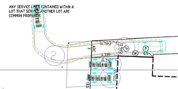
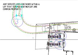
Entry
Movement
Exit Movement
Maintenance
In
the event that the driveway crossovers are damaged or need maintenance where
they join there is the potential for conflict to arise between neighbours as to
who should bear the costs of any repairs in the future. However, this is a
concrete driveway which are generally hard wearing and provided its constructed
to the appropriate width with reinforced steel and suitably
“doweled” or joined together during construction, then such repairs
are unlikely to be needed for many years. Arrangements would need to be made
between neighbours for any repairs in the future and this not something Council
needs to dictate.
The
need to move the light pole
If
the driveway was constructed at the time of the strata subdivision of the land
it is likely a shared driveway would have been required by the original developer
as currently proposed. It is also likely if Council was requested to not
require the light pole to be relocated by the original developer, similar ,
consideration would have been had to the combined driveway width across the
road frontage of both lots and that fact this is a dual occupancy development
on strata titled lots. In total this combined crossover width will be
more than 7 metres wide. It is also noted that the house on 22a Teak circuit
has been designed such that vehicles can enter and leave in forward direction.
As such residents should have no need to reverse onto Teak Circuit.
It is considered that the proposed driveway width is
suitable for the proposed development and a variation to Condition 8 is
supported.
2.5. The
likely impacts of that development, including environmental impacts on both the
natural and built environments, and social and economic impacts in the locality
The proposed amendments do
not generate any impacts that have not been previously considered.
2.6. The suitability of the
site for the development
Proposed amendments do not affect the Site Suitability for
the development.
2.7. Submissions
made in accordance with this Act or the regulations
One submission was received objection to the amendment.
|
Issues
|
Comments
|
|
· We object to having a driveway be made to be .30 from the
lamppost as then it will be crossing over the front of our driveway at 22
teak circuit
· Driveways are to be square to the road carriageway and
not encroach on neighbouring frontages
· Minimum offset of 0.3m from common property boundaries
the current DA amendment proposal will break this rule
· We want to build a low fence along our border line asap
for the safety of our children in our front yard and this will create a
hazard for our kids to play in a space with or without a fence whereto
proposed driveway amendments don't leave a required gap from our driveway and
fence we will be installing
|
As
discussed above the combined width of the driveway provides a suitable
crossover on Council land.
Due
to the width of the access handle to 22a Teak Circuit, and location of the
existing driveway to the existing garage on 22 Teak Circuit, providing a
boundary fence down that common boundary between the two lots for either land
owner is not considered suitable, and difficult to achieve, and or providing
a 0.3 m setback from boundaries for the driveway.
It
should also be noted that is not what is being amended as the application
relates to the driveway crossover of the road reserve, not the driveway locations
on private property.
|
2.8. Public
interest
Proposed amendments are unlikely to prejudice or compromise
the public interest or create an undesirable precedent.
2.9. DEVELOPER
CONTRIBUTIONS/ WATER AND SEWER CHARGES
There is no nexus to levy additional contributions.
3. CONCLUSION
The proposed amendment to condition 8 is supported having
regards to the combined width of the driveway crossover for the dual occupancy
development. The application is recommended for approval subject to amended
conditions.
STATEMENT
OF REASONS
Note:
From July 1 2018, Council’s are required to give and publicly notify
reasons for a range of planning decisions where they are deciding if
development should proceed to help community members to see how their views
have been taken into account and improve accountability to stakeholders. A
statement of reasons for the determination of this application is provided
below.
|
Statement of Reasons
|
|
The proposed modifications were minor and substantially
the same as the original development approval with no detrimental
environmental impacts.
|
|
How community views were addressed
|
|
The DA was advertised in accordance with Development
Control Plan 2014. The submissions received were considered on merit and
addressed during assessment of the application.
|
4. DISCLOSURE OF POLITICAL DONATIONS AND GIFTS
|
Has a Disclosure Statement been received in relation
to this application
|
No
|
|
Have staff received a ‘gift’ from anyone
involved in this application that needs to be disclosed. Where the answer is
yes, the application is to be determined by the Director or Manager of the
Planning, Development and Environment Division.
|
No
|
|
Provide Disclosure Statement register details here:
|
Not applicable
|
Staff Reports - Sustainable Environment and Economy 13.6
Report No. 13.6 Draft
Development Control Plan 2014 Chapter B1 Biodiversity
Directorate: Sustainable
Environment and Economy
Report
Author: Karen
Love, Research Officer – Climate Change
File No: I2020/1403
Summary:
Council’s Development Control Plan (DCP) 2014 Chapter
B1 Natural Environment has been deferred since 2014 due to the State Environmental
Planning Policy SEPP 44 – Koala Habitat Protection (SEPP 44) review and
its implications regarding the Byron Coast Comprehensive Koala Plan of
Management (CKPoM). The recent enactment of the new State Environmental Planning Policy
(SEPP) Koala Habitat Protection 2019 resulted in Council
resubmitting the CKPoM and given the legislative changes (Biodiversity
Conservation Act 2016, Local Land Services Act 2013) it is timely
that DCP Chapter B1 be reviewed and redefined (as DCP Chapter B1 Biodiversity).
Additional complexities regarding the recent legislation
have left planners, developers and the wider Byron community unsure and in need
of guidance regarding Biodiversity protection. Recent state and federal reports
conclude that their environmental protections have failed to deliver
environmental outcomes in administering the law, while the clearing of native
vegetation has increased. Additionally, the Black Summer bushfire season
(2019/2020) saw almost 60% of National Parks and State Forests in NSW burnt
alongside 35% of NE NSW Rainforest and 54% of Gondwana World Heritage
Rainforest. The result of which is that koalas are predicted to become
extinct in NSW before 2050.
Given this, DCP Chapter B1 Biodiversity has been updated to
provide clarity to planners, developers and community, and provide an
immediate, simple and effective path for Biodiversity protection within the
Shire. This report provides information on the DCP Chapter update, its context
and further supports Byron Shire’s Climate Change mitigation and
adaptation actions.
|
RECOMMENDATION:
1. That
Council endorses Development Control Plan Chapter B1 Biodiversity
(Attachment 1 #E2020/77224) for public exhibition for 28 days.
2. That
staff provide a post-exhibition report to Council, including
consideration and recommendations on submissions received during the
exhibition period.
3. That
staff update DCP Chapter A9 to include the definitions contained within DCP
Chapter B1 Biodiversity post public exhibition.
|
Attachments:
1 DRAFT DCP
Chapter B1 Biodiversity, E2020/77224
REPORT
Background
In June 2014 Council resolved to defer Chapter B1 Natural
Environment (Res 14-315) due to the SEPP 44 review. While our
Comprehensive Koala Plan of Management (CKPoM) was adopted by Council in 2016 (Res 16-435), it remained unratified by the
Department of Planning and Environment (DPE) due to non-compliance with SEPP
44. Under the new Koala Habitat Protection SEPP 2019 (enacted 1 March 2020) our
adopted CKPoM was re-submitted under clause 17 (Res 20-090) enabling ‘streamlined’
ratification despite lack of compliance with the previous SEPP. At the time of
writing, the Byron Coast CKPoM is currently being assessed for Department
Secretary approval.
Since 2014, changes to State legislation regarding land
management and environmental protections have added complexity and created
uncertainty for planners, local regulators and our community. Repealing the
former Threatened Species Conservation Act 1995, the Biodiversity
Conservation Act 2016 introduces the Biodiversity Offsets Scheme (BOS)
which has resulted in biodiversity loss within Byron Shire due to:
· offsetting
of biodiversity values outside the Shire, and
· developers
being able to enter into a monetary arrangement rather than seeking ‘like
for like’ offsets, and
· offset
requirements based on plant community types that are incorrect for the North
Coast of NSW.
In addition, repeal of the Native Vegetation Act
2003, by the Local Land Services Act 2013 (LLS Act) has permitted the
removal of native vegetation in rural areas under Schedule 5A without
regulation. This has resulted in:
· Clearing
of koala habitat within our Shire,
· Confusion
and uncertainty within our community, and
· Uncertainty
amongst regulators given a large part of the Shire remains in deferred matter.
Note that under the LLS Act the only protection afforded
koala habitat is where plantings have been funded by public monies (LLS Act
Part 2, 17(2)).
Evidence provided in recent independent reviews conducted by
the Natural Resources Commission and Audit Office of NSW states that:
· the
recent legislative changes to NSW Land Management and Biodiversity Conservation
Framework have failed to achieve environmental outcomes and
administer the law, and
· land
clearing figures have significantly increased (13-fold) since those changes.
In addition, the recent NSW Parliamentary inquiry into
koalas and koala habitat in NSW found that:
‘without
effective intervention, koalas will become extinct in NSW before 2050’
The interim report on the Environmental Protection
Biodiversity Conservation Act 1999 review states that it too has failed
in application and administration and is ‘ineffective’. It
suggests that a fundamental national environmental law reform is required with
National Environmental Standards at its foundation.
Given the increased complexities regarding biodiversity
protection and significant legislative impacts, it is timely that DCP Chapter
B1 Biodiversity be developed and administered. Not only to provide clarity
across the development application process but also to increase security
regarding biodiversity protection within our community. Such protection of
biodiversity values also underpins climate adaptation through the retention of
carbon (CO2) sinks and restoration of natural areas.
Development of DCP
Chapter B1 Biodiversity
Endorsed by the Biodiversity
Advisory Committee (BAC) and delivering the first action (Action 1.1) in the
newly adopted Byron Shire Biodiversity Conservation Strategy 2020-2030 (Res 20-332), DCP Chapter B1 applies to
development requiring determination under the Environmental Planning and
Assessment Act 1979. It delivers biodiversity planning principles, clear
development controls, examples of acceptable solutions and definitions specific
to biodiversity, including how to ‘avoid and minimise’ impacts.
It further defines ‘red flag’ areas of
significant ecological importance that should be avoided and/or buffered from
development through the use of ecological setbacks. In addition, it provides
reason for development to ‘avoid’ red flags, by reducing the
requirement for ecological assessment where avoidance is demonstrated.
Council’s Chapter B1 is based on Tweed Shire’s
DCP A19 Biodiversity and Habitat Management (adopted 2018) which:
· was
prepared through funding by the Northern Rivers Catchment Management Authority
as a DCP template for other Councils to use,
· underwent
comprehensive legal review,
· was
well received by the community (11 submissions), and
· was
the 2019 winner of the Innovation in Planning, Policies and Decision Making
Award from LGNSW.
The preparation of Chapter B1 involved significant
collaboration between Tweed Shire planners and Council’s internal
planners, as well as peer review by five local ecologists and three external
planners. The ecological setback table has had endorsement from the BAC and
while adopted directly from Tweed’s DCP, has had a comparison undertaken
across similar LGA’s.
Chapter B1 aims to ensure that
the planning and design of new development maintains or improves ecological
values within Byron Shire thereby increasing resilience which supports both
biodiversity and climate adaptation. The following objectives detail how this
aim will be achieved:
· Identify,
retain and restore native vegetation and habitats for native species in patches
of a size and configuration that will enable existing plant and animal
communities to survive in the long term and support climate adaptation.
· Identify
and retain high carbon storage ecosystems, wildlife corridors and
refugia.
· Provide
development controls that prevent the degradation or loss of ecological values
and or biodiversity.
· Provide
guidance on the information required to enable informed decision-making.
· Ensure
that construction and operational impacts of development are avoided and or
mitigated using current best practice standards.
· Provide
guidance on acceptable measures to avoid or minimise the impact of proposed
development on biodiversity including proposals affected by Part 7 of the Biodiversity
Conservation Act 2016 and the Koala Habitat Protection SEPP (2019).
· Compensate
for unavoidable habitat losses in accordance with applicable legislation, or in
the absence of such legislation, contemporary best practice.
Next steps
· Place
DCP Chapter B1 on public exhibition for 28 days and report back to Council with
submissions and any amendments.
· Update
DCP Chapter A9 with the new definitions within DCP Chapter B1 post public
exhibition.
STRATEGIC CONSIDERATIONS
Community Strategic Plan and Operational Plan
|
CSP Objective
|
L2
|
CSP Strategy
|
L3
|
DP Action
|
L4
|
OP Activity
|
|
Community Objective
3: We protect and enhance our natural environment
|
3.1
|
Partner to protect and
enhance our biodiversity, ecosystems and ecology
|
3.1.1
|
Protect and enhance our
natural environment and biodiversity
|
3.1.1.3
|
Continue to develop a
Biodiversity DCP
(Biodiversity Conservation Strategy action)
|
Legal/Statutory/Policy
Considerations
Commonwealth Environment Protection and Biodiversity
Conservation Act 1999
Environmental Planning and Assessment Act 1979
Environmental Planning and Assessment Regulation 2000
Biodiversity Conservation Act 2016
Biodiversity Conservation Regulations 2017
Coastal Management Act 2016
Fisheries Management Act 1994
Local Land Services Act 2013
Local Land Services Regulation 2014
National Parks and Wildlife Act 1974
Protection of the Environment Administration Act 1991
State Environmental Planning Policy Koala Habitat Protection
2019
State Environmental Planning Policy (Coastal Management)
2018
State Environmental Planning Policy (Vegetation in non-rural
areas) 2017
Financial Considerations
Funding for this project is
provided in the 2020/21 budget.
Consultation and Engagement
· Preliminary
discussions and on-going collaboration with Tweed Shire Council planners who
enabled development of DCP Chapter B1 through the use of their DCP as a
template.
· Development
of DCP Chapter B1 and ecological setbacks endorsed by the Biodiversity Advisory
Committee.
· Peer
review of DCP Chapter B1 by five local ecologists and local Koala Landcare
expert.
· Peer
review of DCP Chapter B1 by internal and strategic planners and open space team
leaders including a worked example assessment on a highly constrained site to
ensure compatibility.
· Internal
review of DCP Chapter B1 by compliance team.
· Peer
review of DCP Chapter B1 by external planners.
Staff Reports - Sustainable Environment and Economy 13.7
Report No. 13.7 Draft
Plan of Management Charlotte Street Park
Directorate: Sustainable
Environment and Economy
Report
Author: Julia
Curry, Sustainability and Emissions Reduction Officer
File No: I2020/1396
Summary:
A draft Plan of Management
(POM) for Charlotte Street Park, Bangalow has been prepared in accordance with
requirements of the Local Government Act 1993 (Act) and associated regulations.
A request from a community member to start a community garden on this site has
prompted this report. A PoM will enable the local community the opportunity to
submit expressions of interest for a small community garden on the site.
This report seeks Council endorsement to publicly exhibit a
POM in accordance with the requirements of the Act, and to undertake a Public
Hearing after the completion of the exhibition period.
|
RECOMMENDATION:
1. That
Council endorses the draft Plan of Management for Charlotte Street
Park (Attachment 1 #E2020/72966) for public exhibition in accordance with the
requirements of the Local Government Act 1993; including arrangements
for an independently chaired Public Hearing at the completion of the
exhibition period.
2. That
a post-exhibition report including conclusions and recommendations
from the Public Hearing, be presented to Council for consideration, and
adoption of a Plan of Management for Charlotte Street Park, Bangalow.
|
Attachments:
1 DRAFT
Charlotte Street Park Bangalow Plan of Management, E2020/72966 
REPORT
A draft POM has been developed by
staff in consultation with the local community of the Meadows Estate area of
Bangalow. There is no previous PoM for this site, and it has been developed as
a result of local interest in establishing a community garden.
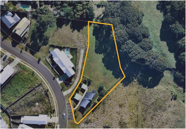
Figure 1. Aerial view of ‘Charlotte Street Park’,
Bangalow – Lot 43 DP 1228135.
The Local Government Act 1993
requires that all public land owned by Council be classified as either
community land or operational land. Council must have a POM for all community
land. This is to ensure that an endorsed framework guides the operation and
development of these community assets. In particular, section 46 1(b), states
that “a lease, licence or other estate in respect of community land
– may be granted, in accordance with an express authorisation in the plan
of management”.
Thus, with significant community
support, Council has drafted a POM to expressly authorise a small community
garden.
Progress to Date
June 2019
· Local resident of the Bangalow Meadows Estate community
makes enquiry regarding establishment of a small community garden at 33
Charlotte Street, Bangalow, for local residents’ use.
July 2019
· Identification that there was no PoM for 33 Charlotte
Street, Bangalow, and therefore a community garden could not be permitted,
under the Local Government Act 1993.
November
2019 – January 2020
· Council reached out to the local community, by way of a
letter to nearby residents, to consult with them regarding future use and
development of Charlotte Street Park, particularly for a small community
garden.
o Total of 19 responses were received from 24 residents, and
they were a mix of positive, neutral and negative. The large majority were very
supportive of a garden.
o The Arakwal Corporation was consulted and responded with
positive feedback.
The feedback indicated that there was strong support for a local
community garden, however important and legitimate issues were also raised by
residents and these have been incorporated into the PoM.
· Results of community engagement were presented to the Executive
Team and the development of a PoM for 33 Charlotte Street, Bangalow was
recommended.
February – September 2020
· Development of a draft PoM that will expressly authorise a
small community garden at the rear of the site.
· Final draft PoM reviewed by Council staff and completed in
September 2020.
Next Steps
It is recommended that the draft
PoM be placed on public exhibition, in accordance with the requirements of the Local
Government Act 1993; including arrangements for an independently chaired Public
Hearing at the completion of the exhibition period.
If the PoM is adopted, following
the exhibition period and Public Hearing, Council staff will proceed with an
expression of interest for a small community garden at 33 Charlotte Street,
Bangalow, in accordance with Council’s Community Gardens Policy.
STRATEGIC CONSIDERATIONS
Community Strategic Plan and
Operational Plan
|
CSP Objective
|
L2
|
CSP Strategy
|
L3
|
DP Action
|
L4
|
OP Activity
|
|
Community
Objective 3: We protect and enhance our natural environment
|
3.2
|
Strive to
become a sustainable community
|
3.2.1
|
Work towards
Council's zero-emissions target
|
3.2.1.13
|
Prepare a Plan
of Management for 33 Charlotte, Street Bangalow to enable the express
authorisation of a community garden.
|
|
|
Community Objective
3: We protect and enhance our natural environment
|
3.2
|
Strive to
become a sustainable community
|
3.2.2
|
Support
community environmental and sustainability projects
|
3.2.2.3
|
Support
community gardens in accordance with the Policy and Guidelines
|
|
|
|
|
|
|
|
|
|
|
|
|
|
|
Legal/Statutory/Policy
Considerations
The Local Government Act and Regulations prescribe the
process, and minimum content, for preparing POMs. Relevant sections have been
discussed, as required, in the report. Council’s Legal Counsel provided
advice that the revised template satisfied the statutory requirements for
content.
The prescribed process governing development of and
consultation on a POM, including the requirement to hold a public hearing for a
change in categorisation, must continue to be followed by Council.
Financial Considerations
Public Hearing and advertising costs can be funded from
existing operational budgets.
Consultation and Engagement
Community consultation occurred with residents and
ratepayers of Charlotte Street, Thomas Street, Meadows Close and Robinson
Street, Bangalow, via letter in November 2019. The survey results are discussed
in the body of this report.
Staff Reports - Sustainable Environment and Economy 13.8
Report No. 13.8 Notification
of Upgrade Works to Mobile Phone Base Station at 8 Acacia Street, Byron Bay
Directorate: Sustainable
Environment and Economy
Report Author: Shannon
Burt, Director Sustainable Environment and Economy
File No: I2020/1536
Summary:
Telstra representatives Downer have written to Council to
notify of an upgrade to the mobile phone base station at 8 Acacia Street Byron
Bay.
The proposal does not require development approval and
consultation is being undertaken in accordance with the requirements of Section
7 of the Mobile Phone Base Station Deployment Code 2018.
The purpose of the installation is to install 5G and upgrade
4G technologies at the existing Mobile Phone Base Station.
Feedback on the proposal will be accepted until close of
business 15 October 2020.
|
RECOMMENDATION:
That Council:
1. Provides
/ Does not provide feedback on the proposal to upgrade the mobile phone base
station at 8 Acacia Street Byron Bay.
2. Subject
to 1 above, feedback is to include the following comments: <>
|
Attachments:
1 Notification
of upgrade mobile phone base station 8 Acacia Street Byron Bay, E2020/78724
REPORT
Telstra representatives Downer have written to Council to
notify of a proposed upgrade to the mobile phone base station at 8 Acacia
Street Byron Bay.
The existing site / base station works is considered to be a
Low Impact Facility in accordance with the Telecommunications (Low-impact
Facilities) Determination 2018 or Exempt Development under the NSW State
Environmental Planning Policy (Infrastructure) 2007.
As such the proposed upgrade does not require development
approval, and consultation is being undertaken in accordance with the
requirements of Section 7 of the Mobile Phone Base Station Deployment Code
2018.
The purpose of the upgrade is to install 5G and upgrade 4G
technologies at the existing Mobile Phone Base Station.
Details of the proposed upgrade are in Attachment 1.
Feedback on the proposed upgrade will be accepted until
close of business 15 October 2020.
5G technology has been considered at various Council
meetings: 27 June 2019, 21 November 2019 and 19 March 2020. The most recent
Council resolution 20-109 was in relation to an urgency motion about the need
to make a submission to the proposed 5G upgrade to the Dalley Street
Mullumbimby mobile phone tower.
Resolved 20-109:
1. That Council contact
Telstra immediately after the meeting and request that they consider a late
submission on behalf of council due to the fact that council had not met since
the submission period commenced.
2. That Council does
not currently support the proposed upgrade that will facilitate 5G technologies
and continues to support a moratorium on the installation of 5G technology
infrastructure until the previously requested information is provided,
including:
a) identification of
and commitment by a State or Federal Government body to do a comprehensive
review of the cumulative impacts of the 5G technology,
b) identification of
who holds responsibility for the on-going monitoring of any cumulative impacts,
c) commitment from the
State Government to review the current planning processes for the installation
of small cells and consideration of any possible improvements.
The purpose
of this report is to canvass Council opinion on the need to provide feedback on
the
proposed
upgrade to the mobile phone base station, and the content of any submission if
made.
STRATEGIC CONSIDERATIONS
Community Strategic Plan and
Operational Plan
|
CSP Objective
|
L2
|
CSP Strategy
|
L3
|
DP Action
|
L4
|
OP Activity
|
|
Community Objective
4: We manage growth and change responsibly
|
4.1
|
Support the
visions and aspirations of local communities through place-based planning and
management
|
4.1.3
|
Manage
development through a transparent and efficient assessment process
|
|
|
|
|
|
|
|
|
|
|
|
|
Legal/Statutory/Policy Considerations
The existing site / base
station works is considered to be a Low Impact Facility in accordance with the
Telecommunications (Low-impact Facilities) Determination 2018 or Exempt
Development under the NSW State Environmental Planning Policy (Infrastructure)
2007.
Financial Considerations
Not relevant to this item.
Consultation and Engagement
Public consultation is being
undertaken by Downer on behalf of Telstra in accordance with the requirements
of Section 7 of the Mobile Phone Base Station Deployment Code C564:2018.
Questions With Notice 14.1
Questions With Notice
Question with Notice No. 14.1 M1
and MR545 Stage 1 Application
File No: I2020/1533
|
Cr Basil Cameron asks the following
questions in relation to document titled Byron Shire Council - M1 and
MR545 Stage 1 Application and Checklist and Appendices A-H dated
31 August 2020, being collectively an application to Infrastructure Australia
(IA) for an upgrade of the M1 interchange and MR545 as well as Memo to
Councillors dated 10 September 2020 (E2020/72369).
a) Why
were Councillors not shown the application to IA or given meaningful advice
on the proposal for an upgrade of the M1 interchange and MR545 costed at $78
million? (See Attachment 1 - Background Notes)
b) What
resolution of Council authorises the preparation and submission of the
application to IA?
c) Why
were Councillors not advised that Byron Shire Council was the proponent of an
application to IA for a road that is the responsibility of TfNSW and only
advised of the application on 10 September after the application had been
made on 31 August 2020?
d) Despite
working on a Transport Strategy and consistently raising the M1 interchange/MR545
as a case study, the Transport and Infrastructure Advisory Committee (TIAC)
were not provided with a report or advice on the proposal. Why not?
e) Why
has Byron Shire Council endorsed a proposal largely driven by a TfNSW study
with a limited study area and no analysis of what this will mean for Byron
Bay and the Ewingsdale corridor beyond the study area? Why was no independent
assessment undertaken?
f) Appendix
H is a letter of support from Hon. Ben Franklin to the Deputy Prime Minister.
How was this letter provided? Who requested or suggested the letter?
g) Was
the Member for Ballina advised of the proposal and if so was her support
sought? If she wasn’t advised, why not?
Response Director Infrastructure Services:
A full response to all questions will be provided to
Council at the meeting.
|
Attachments:
1 Attachment
1 - Background Notes, E2020/78678
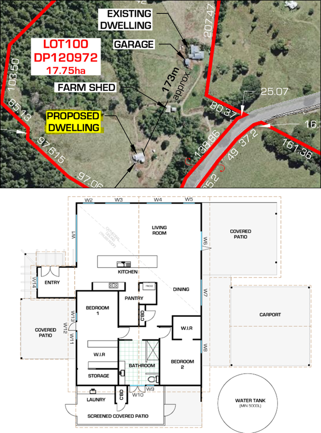
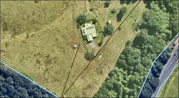 Consideration: