 Agenda
Ordinary (Planning) Meeting
 |
Thursday, 10 March 2022
Agenda
Ordinary (Planning) Meeting
|
Agenda Ordinary (Planning) Meeting
held at Council Chambers, Station Street, Mullumbimby
commencing at 11.00am
Public access relating to items on this agenda can be made between 11:00am and 11:30am on the day of the meeting. Requests for public access should be made to the General Manager or Mayor no later than 12:00 midday on the day prior to the meeting.

Mark Arnold
General Manager
CONFLICT OF INTERESTS
What is a “Conflict of Interests” - A conflict of interests can be of two types:
Pecuniary - an interest that a person has in a matter because of a reasonable likelihood or expectation of appreciable financial gain or loss to the person or another person with whom the person is associated.
Non-pecuniary – a private or personal interest that a Council official has that does not amount to a pecuniary interest as defined in the Code of Conduct for Councillors (eg. A friendship, membership of an association, society or trade union or involvement or interest in an activity and may include an interest of a financial nature).
Remoteness – a person does not have a pecuniary interest in a matter if the interest is so remote or insignificant that it could not reasonably be regarded as likely to influence any decision the person might make in relation to a matter or if the interest is of a kind specified in the Code of Conduct for Councillors.
Who has a Pecuniary Interest? - a person has a pecuniary interest in a matter if the pecuniary interest is the interest of the person, or another person with whom the person is associated (see below).
Relatives, Partners - a person is taken to have a pecuniary interest in a matter if:
· The person’s spouse or de facto partner or a relative of the person has a pecuniary interest in the matter, or
· The person, or a nominee, partners or employer of the person, is a member of a company or other body that has a pecuniary interest in the matter.
N.B. “Relative”, in relation to a person means any of the following:
(a) the parent, grandparent, brother, sister, uncle, aunt, nephew, niece, lineal descends or adopted child of the person or of the person’s spouse;
(b) the spouse or de facto partners of the person or of a person referred to in paragraph (a)
No Interest in the Matter - however, a person is not taken to have a pecuniary interest in a matter:
· If the person is unaware of the relevant pecuniary interest of the spouse, de facto partner, relative or company or other body, or
· Just because the person is a member of, or is employed by, the Council.
· Just because the person is a member of, or a delegate of the Council to, a company or other body that has a pecuniary interest in the matter provided that the person has no beneficial interest in any shares of the company or body.
Disclosure and participation in meetings
· A Councillor or a member of a Council Committee who has a pecuniary interest in any matter with which the Council is concerned and who is present at a meeting of the Council or Committee at which the matter is being considered must disclose the nature of the interest to the meeting as soon as practicable.
· The Councillor or member must not be present at, or in sight of, the meeting of the Council or Committee:
(a) at any time during which the matter is being considered or discussed by the Council or Committee, or
(b) at any time during which the Council or Committee is voting on any question in relation to the matter.
No Knowledge - a person does not breach this Clause if the person did not know and could not reasonably be expected to have known that the matter under consideration at the meeting was a matter in which he or she had a pecuniary interest.
Non-pecuniary Interests - Must be disclosed in meetings.
There are a broad range of options available for managing conflicts & the option chosen will depend on an assessment of the circumstances of the matter, the nature of the interest and the significance of the issue being dealt with. Non-pecuniary conflicts of interests must be dealt with in at least one of the following ways:
· It may be appropriate that no action be taken where the potential for conflict is minimal. However, Councillors should consider providing an explanation of why they consider a conflict does not exist.
· Limit involvement if practical (eg. Participate in discussion but not in decision making or vice-versa). Care needs to be taken when exercising this option.
· Remove the source of the conflict (eg. Relinquishing or divesting the personal interest that creates the conflict)
· Have no involvement by absenting yourself from and not taking part in any debate or voting on the issue as of the provisions in the Code of Conduct (particularly if you have a significant non-pecuniary interest)
RECORDING OF VOTING ON PLANNING MATTERS
Clause 375A of the Local Government Act 1993 – Recording of voting on planning matters
(1) In this section, planning decision means a decision made in the exercise of a function of a council under the Environmental Planning and Assessment Act 1979:
(a) including a decision relating to a development application, an environmental planning instrument, a development control plan or a development contribution plan under that Act, but
(b) not including the making of an order under that Act.
(2) The general manager is required to keep a register containing, for each planning decision made at a meeting of the council or a council committee, the names of the councillors who supported the decision and the names of any councillors who opposed (or are taken to have opposed) the decision.
(3) For the purpose of maintaining the register, a division is required to be called whenever a motion for a planning decision is put at a meeting of the council or a council committee.
(4) Each decision recorded in the register is to be described in the register or identified in a manner that enables the description to be obtained from another publicly available document, and is to include the information required by the regulations.
(5) This section extends to a meeting that is closed to the public.
BUSINESS OF Ordinary (Planning) Meeting
1. Public Access
3. Requests for Leave of Absence
4. Declarations of Interest – Pecuniary and Non-Pecuniary
5. Tabling of Pecuniary Interest Returns (Cl 4.9 Code of Conduct for Councillors)
6. Adoption of Minutes from Previous Meetings
6.1 Ordinary (Planning) Meeting held on 4 November 2021
7. Reservation of Items for Debate and Order of Business
8. Mayoral Minute
9. Notices of Motion
9.1 Councillor Representative on Byron Bay Community Association...................................... 7
9.2 Rural Neighbourhood Amenity............................ 9
10. Petitions
11. Submissions and Grants
12. Delegates' Reports
13. Staff Reports
Sustainable Environment and Economy
13.1 State government reform: Agritourism option to nominate additional clauses in LEP................... 11
13.2 PLANNING - Report of the Planning Review Committee held 10 February 2021.................... 23
13.3 PLANNING - DA 10.2021.450.1 - Redevelopment of Bangalow Public School............................... 26
13.4 PLANNING -
DA10.2021.5.1 - Dwelling House, Swimming Pool and Change of Use of Existing
Dwelling into Central Facilities Building Including Accommodation Bedrooms for
Existing Rural Tourist
Facility............................................................. 63
14. Reports of Committees
Infrastructure Services
14.1 Report of the Local Traffic Committee Meeting held on 15 February 2022 101
15. Questions With Notice
Questions with Notice: A response to Questions with Notice will be provided at the meeting if possible, that response will be included in the meeting minutes. If a response is unable to be provided the question will be taken on notice, with an answer to be provided to the person/organisation prior to the next Ordinary Meeting and placed on Councils website www.byron.nsw.gov.au/Council/Council-meetings/Questions-on-Notice
Councillors are encouraged to ask questions regarding any item on the business paper to the appropriate Director prior to the meeting. Any suggested amendments to the recommendations should be provided to Councillor Support prior to the meeting to allow the changes to be typed and presented on the overhead projector at the meeting.
BYRON SHIRE COUNCIL
Notices of Motion 9.1
Notice of Motion No. 9.1 Councillor Representative on Byron Bay Community Association
File No: I2022/134
I move:
That Council appoints Cr Asren Pugh as a Councillor contact for the Byron Bay Community Association as per their constitution.
Signed: Cr Asren Pugh
Councillor’s supporting information:
The constitution of the Byron Bay Community Association, which runs the Byron Community Centre, allows for a Councillor representative to be appointed to their management committee. The management committee has requested that we fill this role as an important link between the Centre and Council.
Staff comments
by Heather Sills, Corporate Planning and Improvement Coordinator, Corporate and Community Services:
(Management Comments must not include formatted recommendations – resolution 11-979)
Council may resolve to elect a representative to the Byron Bay Community Association. Where there is interest by another Councillor/s to be the nominated representative, a ballot by Councillors by show of hands may be an appropriate selection method.
As a representative of Council, the nominated Councillor has a duty to represent the views of the Council and the broader community.
The Byron Bay Community Association (BBCA) is a not for profit social enterprise that operates the Byron Community Centre, further information can be obtained on its website: About the BCC - Byron Community Centre
Financial/Resource/Legal Implications:
Councillors’ travel to and from meetings where they are a representative of Council is reimbursed and budgeted for in the annual budget.
Is the proposal consistent with any Delivery Program tasks?
|
CSP Objective |
CSP Strategy |
DP Action |
Code |
OP Activity |
|
Community Objective 2: We cultivate and celebrate our diverse cultures, lifestyle and sense of community |
2.2: Support access to a wide range of services and activities that contribute to the wellbeing of all members of the Byron Shire community |
2.2.1: Develop and maintain collaborative relationships with government, sector and community |
2.2.1.2 |
Participate in community planning to inform decision making, build capacity and develop a shared responsibility for actions with the community. |
BYRON SHIRE COUNCIL
Notices of Motion 9.2
Notice of Motion No. 9.2 Rural Neighbourhood Amenity
File No: I2022/153
I move:
That when Council next updates the Shire’s Development Control Plan (DCP), the update include a new clause or variation to an existing clause such that the location of a proposed Dual Occupancy / Secondary dwelling must be closer to the primary dwelling than to any dwelling approved or proposed on neighbouring properties.
Signed: Cr Duncan Dey
Councillor’s supporting information:
Experience over recent years has included several DAs approved where the new dwelling was located at great distance (up to 100m) from the Primary dwelling on the developing property but very close to an approved dwelling on the neighbouring property. Two cases that I know of are DA’s 10.2019.512 and 10.2019.540. In both cases the issue of proximity to neighbouring dwellings was highlighted in submissions, sadly to no effect.
Rural residents tend to prefer the peace, quiet and privacy of rural life over the crowded, noisy and exposed nature of urban life. Whatever size the rural allotments are, this very simple ‘rule’ would mean that the occupants of the Primary dwelling become aware of noise for example before having to be contacted by the neighbours.
In both the DAs cited above, this proposed ‘rule’ would also have meant that a significant buffer would have been available on the developing property to screen its new building rather than the neighbour being burdened with planting on their property. In one case, such planting will ruin the passive solar performance of the non-developing neighbour’s dwelling because the Dual Occupancy dwelling is located immediately north of it.
This proposal may connect with Part 3 of Resolution 21-337 which I gather is flagged for action in a Housekeeping Register. Could staff advise please?
Staff comments
by Shannon Burt, Director, Sustainable Environment and Economy:
(Management Comments must not include formatted recommendations – resolution 11-979)
Council considered Report No. 13.15 Size limitations on Secondary Dwellings in rural zones Agenda of Ordinary Meeting - Thursday, 26 August 2021 (infocouncil.biz).
Submissions were made to public access about this report.
Public Access
|
Report No and Title |
For/ Against |
Name |
Joining the meeting via |
|
|
13.2 |
Rent relief to commercial lease and sub-licence holders due to COVID-19 |
For |
Kurt Tutt |
Zoom |
|
Tricia Shantz |
Zoom |
|||
|
13.15 |
Size Limitations on Secondary Dwellings in Rural Zones |
For |
Duncan Dey |
Zoom |
|
Against |
Luke Houghton |
Written speech |
||
As a result, Council resolved 21-337 (3) to review of the existing controls in DCP 2014 D2.5, including boundary setbacks in relation to neighbouring properties in a future housekeeping DCP amendment. Report meeting date to be confirmed with staff as it is subject to competing work priorities.
Financial/Resource/Legal Implications:
None applicable to this NOM.
Is the proposal consistent with any Delivery Program tasks?
|
CSP Objective |
CSP Strategy |
DP Action |
Code |
OP Activity |
|
Community Objective 4: We manage growth and change responsibly |
4.1: Support the visions and aspirations of local communities through place-based planning and management |
4.1.3: Manage development through a transparent and efficient assessment process |
4.1.3.11 |
Prepare and assess Planning Proposals and Development Control Plans, and amend Local Environmental Plan maps |
Staff Reports - Sustainable Environment and Economy 13.1
Staff Reports - Sustainable Environment and Economy
Report No. 13.1 State government reform: Agritourism option to nominate additional clauses in LEP
Directorate: Sustainable Environment and Economy
Report Author: Natalie Hancock, Senior Planner
File No: I2022/59
Summary:
The NSW Government has published proposed amendments to the Standard Instrument (Local Environmental Plans) Amendment (Agritourism) Order 2021 to support agritourism (‘LEP Order’). Proposed changes include:
• new land use terms for ‘agritourism’, ‘farm gate premises’ and ‘farm experience premises’
• change to ‘farm stay accommodation’ definition
• transferring of ‘cellar door premises’ from a subset of ‘retail premises’ to become a subset of ‘farm gate premises’
• optional clauses for Council’s to insert into LEPs for ‘farm stay accommodation’ and ‘farm gate premises’ that introduce development standards and an ability for councils to tailor to suit local conditions.
Attachment 1 provides a copy of the NSW government information sheet together with the Standard Instrument (LEP) Amendment (Agritourism) Order 2021.
Whilst the amendments are state-wide, the Department of Planning and Environment (the Department) is allowing councils to choose to adopt the optional clauses in their LEP.
Councils were required to submit preliminary responses on the Standard Instrument LEP Agritourism nomination form by Friday 25 February 2022 to the Department. A preliminary response was provided by staff.
This report explains the proposed amendments and seeks Council confirmation to nominate a new farm gate premises clause in Byron LEP 2014 with the addition of a local objective and certain numerical development standards. Furthermore, advise the Department that ‘agritourism’ and subsets of ‘farm gate premises’ and ‘farm experience premises’ are to be limited to the RU1 Primary Production and RU2 Rural Landscape zones with a ‘permitted with consent use’ status.
Staff will provide the Department with a final response based on Council’s determination.
Council’s endorsement is required to the Department by Thursday 31 March 2022.
NOTE TO COUNCILLORS:
In accordance with the provisions of S375A of the Local Government Act 1993, a Division is to be called whenever a motion for a planning decision is put to the meeting, for the purpose of recording voting on planning matters. Pursuant to clause 2(a) under the heading Matters to be Included in Minutes of Council Meetings of Council's adopted Code of Meeting Practice (as amended) a Division will be deemed to have been called by the mover and seconder of all motions relating to this report.
RECOMMENDATION:
That Council:
1. Notes that a preliminary response on the Standard Instrument LEP Agritourism nomination form was submitted to the Department of Planning 25 February 2022.
2. Confirms the following positions on the amendments proposed in the Standard Instrument (LEP) Amendment (Agritourism) Order 2021 to be included in a final submission:
i. That ‘agritourism’ and its subsets of ‘farm gate premises’ and ‘farm experience premises’:
a) Only applies to the RU1 & RU2 zones, and
b) Nominates these uses as ‘permitted with consent’ in these zones
ii. In reference to ‘farm gate premises’:
a) includes optional LEP Order clause 5.24 in Byron LEP 2014
b) includes an additional local objective to this clause being - To support and build a Byron Shire brand, provenance, and reputation by sharing the farming story with locals and visitors in the context of people, place and produce.
c) sets a maximum gross floor area of a building used for farm gate premises at 200 square metres
d) sets a maximum number of persons that will be permitted on the landholding at any one time for the purposes of the farm gate premises at 50 persons
iii. Notes the definition change to farm stay accommodation and not nominate to include in the Byron LEP 2014 the optional clause provision.
4. Notifies the Department of Planning and Environment of Council’s determination including the justification as provided in this report by 31 March 2022.
1 Attachment
1 Agritourism NSW information sheet and SI (LEP) Amendment Order 2021, E2022/12714 ![]()
2 Special
Disclosure of Pecuniary Interest Annexure, E2012/2815
![]()
Report
Background
The NSW Government Published on 26 November 2021 proposed amendments to the Standard Instrument (Local Environmental Plans) Amendment (Agritourism) Order 2021 (LEP Order) under the Environmental Planning and Assessment Act 1979 to support agritourism.
Proposed changes in the LEP Order 2021 for Council’s consideration in this report include:
• new land use terms for ‘agritourism’, ‘farm gate premises’ and ‘farm experience premises’
• change to ‘farm stay accommodation’ definition
• optional clauses to be inserted into the Standard Instrument LEP for ‘farm stay accommodation’ and ‘farm gate premises’
• transferring of ‘cellar door premises’ to become a subset of ‘farm gate premises’.
Whilst the amendments are state-wide the Department of Planning and Environment (the Department) is asking councils to choose as to the adoption of the optional clauses into their LEP that would introduce development standards councils can tailor to suit local conditions.
Councils were required to submit preliminary responses to the Standard Instrument LEP Agritourism nomination form by Friday 25 February 2022. A preliminary response was provided by staff. This report explains the proposed amendments and seeks Council confirmation of the staff’s response.
Attachment 1 provides a copy of the NSW government information sheet together with the Standard Instrument (LEP) Amendment (Agritourism) Order 2021.
Key aspects explained
Table 1 following, summaries the changes and nomination options before Council for consideration. Following Table 1, the report sets out in more detail an explanation of the proposed provision, staff comments, recommended course of action and justification. The Department requires Councils to provide justification where they nominate to adopt the optional clauses and/or specify the land use zones to permit the new land uses in their LEPs.
Table 1: Provisions overview
|
Parent land use & subset uses |
Definition change |
Use rights by relevant zones C: Existing Permitted with consent use X: Existing Prohibited New C: Mandatory new Permitted with consent use or option for Council to make permissible |
Optional LEP clause |
|
|
|
|
RU1 |
RU2 |
|
|
Agriculture |
No |
C |
C |
n/a |
|
Agritourism |
New |
New C |
New C |
n/a |
|
Farm experience |
New |
New C |
New C |
n/a |
|
Farm gate premises |
New |
New C |
New C |
offered |
|
Cellar door premises
|
Move to subset of ‘agriculture’ |
New C |
New C |
|
|
Tourist & visitor accommodation – Farm Stay Accommodation |
Yes to include ‘moveable dwellings’ |
C |
C |
offered |
1. Agritourism
Explanation of the intended change
The new defined use ‘agritourism’ has two subsets; ‘farm gate premises’ and ‘farm experience premises’ and will sit under the parent term of ‘agriculture’.
These new land uses simply define and capture ancillary uses to a farm where: farm gate premises provides visitors to the farm with agricultural products predominantly from the farm or other farms in the region or with services or activities related to the products. Farm experience premises provides visitors to the farm with small scale and low impact tourist or recreational services on a commercial basis including horse riding, farm tours, functions or conferences, and farm field days.
The definition clarifies that these activities can only be carried out on a farm that is a primary production business or on land categorised as farmland under the Local Government Act 1995, section 515.
The Department has invited Council to:
• determine the level of consent for ‘agritourism’, ‘farm gate premises’ or ‘farm experience premise’ in the RU1 Primary Production & RU2 Rural Landscape zones, and/or
• permit these uses in zones other than the RU1 & RU2 zones.
Staff comment
Under Byron LEP 2014 agriculture is permitted with consent in the RU1 & RU2 zones, hence these new uses would also be permitted with consent in these zones. Under the definitions of farm gate premises and farm experience premises they can only be undertaken on land that is a primary production business as defined under the Income Tax Assessment Act 1997 (Cth), or which is rated ‘farmland’ by the council under the Local Government Act 1993. This gives applicants two options to show their development will be on land used for commercial farming and not a hobby or recreational farm. It also ensures that the use will not have unfettered application across the rural zones. That said, a farm gate premises can use products, activities or services related to the products from other farms in the region but it would still need to either be primary production land or have a farmland rating category.
The inclusion of these uses in the Byron LEP would not appear to require any variation to existing Clause 6.11 Temporary use of land in Zone RU2 for purpose of function centre which pertains to all lands in the RU2 Zone.
Recommendation
Advise the Department regarding ‘agritourism’ and subsets of ‘farm gate premises’ and ‘farm experience premises’ that Council:
• Only applies these uses to the RU1 & RU2 zones, and
• Nominates these uses as ‘permitted with consent’ in these zones
Justification
The addition of these uses as permitted with consent is consistent with:
· Endorsed Byron Shire Rural Land Use Strategy Actions:
- Actions 13 Identify opportunities in our local planning framework to support and strengthen low scale rural tourism opportunities, particularly those directly associated with primary production and / or improved conservation outcomes.
- Action 2 - improve data base on commercial farmland
- Action 42 encourage non farmed land to be farmed, as it may lead to a non-farming landowner partnering with a farmer to provide access to their land for commercial farming.
· Byron Shire Agriculture Action Plan adopted at the Council meeting 22 April 2021.
· Feedback from Council’s farming liaison working group in February 2021 on a submission to the NSW Agriculture Commissioner’s Agricultural Land Use Planning Strategy (ALUS) Options Paper. The group generally supported Council pursing planning provisions for affiliated non-agricultural uses to assist with overall farm income. Furthermore, that consideration be given to certain instances where farms provide services to other farms. This submission was also reported to the 22 April 2021 meeting.
2. Cellar door premises
Explanation of the intended change
‘Cellar door premises’ means a building or place that is used to sell wine by retail and that is situated on land on which there is a commercial vineyard, and where most of the wine offered for sale is produced in a winery situated on that land or is produced predominantly from grapes grown in the surrounding area.
Currently in Byron LEP 2014 ‘cellar door’ is a subset of ‘retail premises’. The LEP Order would see it moved to be a subset of the new use ‘farm gate premises’ and become permitted where such uses are permitted with consent.
Staff comment
Under Byron LEP 2014 a ‘cellar door premises’ will continue to be permitted in B2 Local Centre and B4 Mixed Use zones. With its repositioning as a subset of agritourism, farm gate premises would also be permitted with consent RU1 & RU2 zones, noting however that to staff knowledge Byron Shire does not have any commercial vineyards.
Recommendation:
That Council note ‘cellar door’ will change to a subset of agritourism and that the ‘permitted with consent’ use status in the B2 and B4 zones will remain.
3. Farm gate premises optional clause
Explanation of the intended change
To accompany this new use Council can choose to include in the Byron LEP 2014 an optional clause to apply numerical standards to the use.
The clause as set out in the LEP Order is below – the text highlighted in yellow requires input from Council. Directly following this text is staff’s recommended {numerical insert}.
Optional Clause: 5.24 Farm gate premises
(1) The objectives of this clause are—
(a) to allow for small scale tourism and related commercial uses on land used for primary production without adversely impacting the principal use of the land for primary production, and
(b) to balance the impact of tourism and related commercial uses with the use of land for primary production, the environment, scenic values, infrastructure and adjoining land uses.
(c) [set out other objectives of the clause] {Staff recommend: an additional objective – see below}
(2) Development consent must not be granted to development for the purposes of farm gate premises on a landholding unless the consent authority is satisfied that—
(a) the gross floor area of a building used for farm gate premises will not be more than [insert number no more than 200] square metres, and {Staff recommend: 200 square metres}
(b) the maximum number of persons that will be permitted on the landholding at any 1 time for the purposes of the farm gate premises will not be more insert number not more than 50] persons. {Staff recommend: 50 persons}
(3) Development consent must not be granted to development for the purposes of farm gate premises on land unless the consent authority has considered—
(a) whether the development will result in noise or pollution that will have significant adverse impact on the following on or near the land—
(i) residential accommodation,
(ii) primary production operations,
(iii) other land uses, and
(b) whether the development will have significant adverse impact on the following on or near the land—
(i) the visual amenity, heritage or scenic values,
(ii) native or significant flora or fauna,
(iii) water quality,
(iv) traffic,
(v) the safety of persons, and
(c) whether the development is on bush fire prone land or flood prone land, and
(d) the suitability of the land for the proposed development, and
(e) the compatibility of the development with nearby land uses.
Staff comment
The inclusion of this clause in the Byron LEP 2014 is optional, however the Department has made it clear that Council cannot add local clauses that can be addressed using the optional clause.
In the absence of any guidance on this use in the Byron LEP 2014 it would appear prudent to include this clause.
Under 5.24 (c) Council can set out other objectives of the clause. On review it is considered objectives provided are suitable and generally consistent with those for function centres that were formulated with community input as to expectations for non- agriculture uses in rural areas. However, the addition of a local objective that emphasises Byron Shire’s messaging around connecting visitors with our faming people, places or products on a farm is suggested:
To support and build a Byron Shire brand, provenance, and reputation by sharing the farming story with locals and visitors in the context of people, place and produce.
Recommendation:
That Council nominate in reference to ‘farm gate premises’
i) to insert optional LEP Order clause 5.24 in Byron LEP 2014
ii) to insert an additional local objective to this clause worded as follows - To support and build a Byron Shire brand, provenance, and reputation by sharing the farming story with locals and visitors in the context of our people, place and produce.
iii) to set a maximum gross floor area of a building used for farm gate premises at 200 square metres
iv) to set a maximum number of persons that will be permitted on the landholding at any 1 time for the purposes of the farm gate premises at 50 persons.
Justification
The addition of this clause and the local objective is consistent with:
· Byron Shire’s farming and tourism messages of connecting visitors with our faming people, places, or products on a farm such as Council’s Starting out an introductory guide to farming in Byron Shire and agricultural extension officer’s ongoing work.
· Endorsed Byron Shire Rural Land Use Strategy Action 14 Review guidelines for agricultural and non-agricultural uses to better manage potential impacts.
· Consultation with a Council’s farming liaison working group NSW Agriculture Commissioner’s ALUS. The group generally supported Council planning provisions setting parameters and assessment of any potential cumulative impacts to farming/agricultural land, local/regional economy, and environment and where negative avoided or mitigated.
4. Farm stay accommodation – definition change and optional clauses
Explanation of the intended change
The LEP Order will amend the existing definition of farm stay accommodation and provide for an optional clause.
The farm stay accommodation definition will be amended to include ‘moveable dwelling’ to facilitate small-scale camping on farms. Moveable dwelling means:
(a) any tent, or any caravan or other van or other portable device (whether on wheels or not), used for human habitation, or
(b) a manufactured home, or
(c) any conveyance, structure or thing of a class or description prescribed by the regulations (under the Local Government Act 1993) for the purposes of this definition.
An optional clause is offered to Council for farm stay accommodation to enable Council to provide a maximum cap on the uses such as the number of guests to ensure that farm stays are small scale. The optional clause appears to allow councils to set a maximum total number of 40 guests, based on maximum of 20 guests in moveable dwellings and 20 guests in fixed accommodation bedroom.
Staff comment
Under Byron LEP 2014 farm stay accommodation is already permitted with consent in the RU1, RU2 zones. It is a subset of the ‘tourism and visitor accommodation’ and will remain so under the LEP Order.
Permitted uses include:
• Bed and breakfast accommodation;
• Farm stay accommodation;
• Camping grounds;
• Eco-tourist accommodation (RU2 only).
Byron LEP 2014 Clause 5.4 Controls relating to miscellaneous permissible uses sets development standards for a range of permissible uses. It provides that where farm stay accommodation is permitted, the accommodation that is provided to guests must consist of no more than 12 bedrooms. This standard only applies to bedrooms and does not affect the number of permissible accommodation buildings.
Byron LEP 2014 Clause 6.8 Local Provision - Rural and Nature Based Tourism Development and the Byron Shire DCP 2014 provide further guidance around use.
Council has also considered a report that reviewed our rural tourist accommodation planning controls at the 10 December 2020 meeting and resolved (Res 20-691) to amend both our LEP and DCP in accordance with the report findings. This work will be part of a housekeeping amendment to our LEP and DCP this year.
Furthermore, the current short term rental accommodation policy regulations by the State government provide a rural landowner with a lawful residential dwelling an ability to register for STRA under SEPP Housing 2021 and holiday let with an annual cap of 180 days hence avoiding a need for a development application.
As such the use of the optional clause is pre-emptive and may lead to inconsistency with the existing LEP and DCP provisions formulated with community input. Given the complexity of rural tourist accommodation use options it is suggested that a preferrable course of action would be to consider visitor accommodation options in rural areas wholistically as part of Actioning Resolution 20-691.
Recommendation
That Council note in reference to farm stay accommodation the definition change and not nominate to include in the Byron LEP 2014 an optional clause provision.
Next steps
Council was required to submit a preliminary response to the Standard Instrument LEP Agritourism nomination form by Friday 25 February 2022 to inform the drafting of amendments. Staff provided a response in line with this report.
Council is required to confirm this initial response to the Department by means of a copy of council minutes or a letter by Thursday 31 March 2022.
A state environmental planning policy to amend relevant LEPs without the need for a planning proposal is proposed to be made in mid-2022.
Strategic Considerations
Community Strategic Plan and Operational Plan
|
CSP Objective |
CSP Strategy |
DP Action |
Code |
OP Activity |
|
Community Objective 3: We protect and enhance our natural environment |
3.4: Support and secure our farming future |
3.4.1: Develop and implement strategies to support agriculture, agri-business and farmers |
3.4.1.1 |
Continue implementation of the Agriculture Action Plan |
Recent Resolutions
· 21-203 15 Meeting April 2021 Submission to Agricultural Commissioner
· 21-149 22 April 2021 – Agriculture Action Plan adopted
· 20-269 10 December 2020 – Review of planning controls rural tourist cabins – not actioned to date.
Legal/Statutory/Policy Considerations
The amendment will be reflected in S10.7 of the Environmental Planning ad Assessment Act 1979 certificates as appropriate.
Financial Considerations
Not applicable.
Consultation and Engagement
Following the release of a state environmental planning policy to amend relevant LEPs engagement Council’s farm liaison officer will work with our farming community to enhance understanding of the new provisions.
BYRON SHIRE COUNCIL
Staff Reports - Sustainable Environment and Economy 13.2
Report No. 13.2 PLANNING - Report of the Planning Review Committee held 10 February 2021
Directorate: Sustainable Environment and Economy
Report Author: Chris Larkin, Manager Sustainable Development
File No: I2022/120
Summary:
This report provides the outcome of the Planning Review Committee (PRC) held on 10 February 2022.
NOTE TO COUNCILLORS:
In accordance with the provisions of S375A of the Local Government Act 1993, a Division is to be called whenever a motion for a planning decision is put to the meeting, for the purpose of recording voting on planning matters. Pursuant to clause 2(a) under the heading Matters to be Included in Minutes of Council Meetings of Council's adopted Code of Meeting Practice (as amended) a Division will be deemed to have been called by the mover and seconder of all motions relating to this report.
RECOMMENDATION:
That Council endorses the outcomes of the Planning Review Committee meeting held on 10 February 2021.
Report
The Planning Review Committee meeting was held on 10 February 2022. The meeting commenced at 4.10pm and concluded at 4.40pm.
Councillors: M. Lyon, S. Ndiaye, P. Westheimer, A. Pugh, C. Coorey, D. Dey, S. Balson
Apologies: A. Hunter, M, Swivel
Staff: Chris Larkin (Manager Sustainable Development)
The following development applications were reviewed with the outcome shown in the final column.
|
DA No. / Applicant |
Property Address / Proposal |
Consultation / Submissions |
Reason/s / Outcome |
|
10.2021.454.1 Ardill Payne & Partners |
19 Player Parade, OCEAN SHORES Dwelling House and Swimming Pool |
Level 1 13 - 26/8/21 2 submissions |
Staff |
|
10.2021.705.1 Mr H A Porter |
25 Hardy Avenue, OCEAN SHORES Stage 1 Subdivision of One (1) Lot to create Three (3) Lots Stage 2 Construction of Two (2) Dwelling Houses and Three (3) Secondary Dwellings resulting in a Dwelling House and Secondary Dwelling on each Lot, Earthworks and Tree Removal |
Level 1 1 – 14/12/21 24 submissions |
Council a. The number of public submissions b. Validity of Matters Raised in the public submissions c. The perceived public significance of the application
|
|
10.2021.767.1 Byron Bay Planning and Property Consultants |
7 Leslie Street BANGALOW Dwelling House and Swimming Pool including a Clause 4.6 Variation to Floor Space Ratio |
Level 2 10 - 23/1/22 3 submissions |
Staff |
Council determined the following original development applications. The S.4.55 applications to modify those consents are referred to the Planning Review Committee to decide if the modification applications can be determined under delegated authority.
|
DA No. / Applicant |
Property Address / Proposal |
Consultation / Submissions |
Reason/s / Outcome |
|
10.2014.753.6 Newton Denny Chapelle |
2 Tanner Lane TYAGARAH S4.55 Application to Modify the Existing Development Consent Relating to Hosting a Large Event over the October Long Weekend, Amendment to the Northern Event Area and to Address Amplification of Small Events |
Level 2 1 - 14/12/21 No submissions |
Staff (Cr Ndiaye declared a non-Pecuniary Interest and did not vote on this item) |
|
10.2020.102.2 Mr J V Main |
18 Red Bean Close SUFFOLK PARK S4.55 to modify condition 9 by deleting the requirement for stormwater to be directed via the kerb and gutter and instead by control discharge to the adjacent waterway (Original development: Amendment to approved two lot subdivision and construction of new dwelling on vacant lot) |
Level 1 14/12/21 to 17/01/22 No submissions
|
Staff |
|
10.2019.345.2 Balanced Systems Planning |
46 Bay Vista Lane EWINGSDALE S4.55 to Amend Bushfire Conditions – to reduce APZs around the existing dwelling subject to a performance solution to be signed off by the RFS. (Original development: Amendment to Approved Subdivision – consolidation of 5 lots into 4 lots |
Level 1 11 - 24/1/22 No submissions |
Staff |
Staff Reports - Sustainable Environment and Economy 13.3
Report No. 13.3 PLANNING - DA 10.2021.450.1 - Redevelopment of Bangalow Public School
Directorate: Sustainable Environment and Economy
Report Author: Ben Grant, Planner
File No: I2022/138
Proposal:
|
DA No: |
10.2021.450.1 |
||
|
NSW PP |
PAN-125835 |
||
|
Proposal description: |
Redevelopment of Bangalow Public School, including removal of eight demountable and permanent classroom buildings, renovations to the historic 1925 classroom building facing Byron Street, construction of a new two storey classroom building containing eight home-base rooms, tree removal, landscaping, and ancillary works. |
||
|
Property description: |
LOT: 1 DP: 782555 |
||
|
45-71 Byron Street BANGALOW |
|||
|
Parcel No/s: |
131520 |
||
|
Applicant: |
Newton Denny Chapelle |
||
|
Owner: |
Department of Education |
||
|
Zoning: |
R2 Low Density Residential |
||
|
Date received: |
26 August 2021 |
||
|
Integrated / Designated Development: |
☐ Integrated |
☐ Designated |
☐ Not applicable |
|
Concurrence required |
No |
||
|
Public notification or exhibition: |
- Level 2 advertising under DCP 2014 Part A14 – Public Notification and Exhibition of Development Applications - Exhibition period: 3/9/21 to 30/9/21 - Submissions received: 10 - Submissions acknowledged: ☒ Yes ☐ No ☐ N/A |
||
|
Planning Review Committee: |
Yes |
||
|
Delegation to determine |
Council |
||
|
Issues: |
Visual impact of the new teaching building on the Bangalow Heritage Conservation Area. Impacts on original heritage fabric and historic significance of the historic 1925 classroom building. |
||
Summary:
This development application seeks consent to redevelop the Bangalow Public School at 45-71 Byron Street, Bangalow. Proposed works include removal of eight demountable and permanent classroom buildings, renovations to the historic 1925 classroom building facing Byron Street, construction of a new two storey classroom building containing eight home-base rooms, tree removal and landscaping.
The application was notified and advertised for a period of 14 days between 3 September 2021 to 30 September 2021 and 10 submissions were received. The application has been called up to Council for determination due to the perceived public significance of the proposal.
Council’s Heritage Advisor reviewed the application and concluded that the proposal was generally acceptable from a heritage perspective, although concerns were raised over the southern elevation of the new teaching block and the extent of works needed to change the historic classroom building near Byron Street into an administration centre.
The new teaching block features a series of projecting windows on the first floor with rectangular proportions that are quite different from the established built form and fenestration found in the school and the surrounding conservation area. Notwithstanding, it is acknowledged that the school is a ‘standalone’ site which has considerable landscaped context and space from adjoining buildings. While the new building has a contemporary appearance, it will be relatively recessive in views from Byron Street due its centralised location and will be partially screen by vegetation near the site boundary.
A variety of internal works will be required to convert the historic classroom building into a new administration centre. Works include reconfiguring the internal floor plan, erecting new internal walls, construction of an entry vestibule and installation of an accessible toilet and shower. Some of these works, particularly the creation of the entry vestibule, will require removal of original heritage fabric such as brickwork, windows and joinery.
To minimise these impacts, the application aims to salvage and retain original materials on-site for future reuse. This will enable the building to be returned to its original form in the future should the need arise. Although it is not the preferred approach, salvage and storage on-site is deemed to be acceptable in this case given that works are necessary to meet access and operational requirements for the school. To assist, a condition is recommended that requires detailed photographic records of the building to be made prior to and during the works being carried out. This will create a reference for future restoration work should it be required.
In conclusion, the proposal is considered an acceptable response to the characteristics of the site and satisfies the provisions of Byron LEP 2014 and the relevant state environmental planning policies.
Overall, the proposed development will provide a significant benefit to the Bangalow community through the provision of improved educational facilities and is therefore in the public interest. The application is recommended for approval subject to the conditions of consent in Attachment 1 of this report.
It is noted that the application has been made on behalf of the Minister for Education and is classified as a Crown development application. A Council cannot refuse a Crown development application without the approval of the Minister and cannot impose a condition of consent except with the approval of either the applicant or the Minster.
Therefore, if the Council considers that the application warrants refusal, it will be necessary to defer the decision to a later date pending concurrence from the Minister to refuse the application. A similar situation exists if the Council wishes to amend or add to the recommended conditions, however, in that case only the approval of the applicant would be required.
NOTE TO COUNCILLORS:
In accordance with the provisions of S375A of the Local Government Act 1993, a Division is to be called whenever a motion for a planning decision is put to the meeting, for the purpose of recording voting on planning matters. Pursuant to clause 2(a) under the heading Matters to be Included in Minutes of Council Meetings of Council's adopted Code of Meeting Practice (as amended) a Division will be deemed to have been called by the mover and seconder of all motions relating to this report.
RECOMMENDATION:
That pursuant to Section 4.16 of the Environmental Planning & Assessment Act 1979, Development Application No. 10.2021.450.1 for redevelopment of Bangalow Public School, removal of eight demountable and permanent classroom buildings, alterations and additions to the historic classroom building facing Byron Street, construction of a new two storey classroom building containing eight home-base rooms plus tree removal, landscaping, and ancillary works, be granted consent subject to the conditions of approval shown at Attachment 1 (E2022/19524).
1 DA10.2021.450.1
Recommended Conditions (Incorporating Comments from SINSW), E2022/19524 ![]()
2 DA10.2021.450.1
Architectural Plans, E2021/127098
![]()
3 DA10.2021.450.1
Heritage Impact Statement, E2021/96590
![]()
4 DA10.2021.450.1
Addendum to Heritage Impact Statement, E2021/154621
![]()
5 DA10.2021.450.1
Landscape Plan, E2021/96595 ![]()
6 DA10.2021.450.1
Preliminary Contamination Assessment, E2021/110849
![]()
7 DA10.2021.450.1
Photomontages, Colours and Materials, E2022/16046
![]()
Report
1.1 Background
A concept design for the redevelopment of the Bangalow Public School was finalised in conjunction with the Project Reference Group in early 2021. The design process included workshops with staff, students and other stakeholders to understand what kinds of learning and recreational spaces the school required. Feedback from workshops along with an understanding of current trends in education and learning were used to guide the scope or works and design process.
Information issued by Schools Infrastructure NSW states that the concept design concept focuses on situating learning spaces around a protected school courtyard with different outdoor spaces for active play and learning.
Administration will be relocated to the historic classroom building, which will be refurbished. The intention is to make it clearer to the community where the public entry to the school is, and to make wayfinding through the school more intuitive.
1.2 Previous Determinations
The following previous determinations were identified for the site:
DA 92/237 – Development Consent issued 15 October 1992 for construction of a double classroom building. The building appears to be roughly in the same location as Block “C”.
DA 2007/107 – Development consent issued on 2 April 2007 for a roof structure of approximately 10m by 8m, providing a covered play area in between Blocks A and B.
1.3 Description of the proposed development
This development application seeks consent to redevelop the Bangalow Public School, including removal of eight demountable and permanent classroom buildings, renovations to the historic 1925 classroom building facing Byron Street, construction of a new two storey classroom building containing eight home-base rooms, tree removal, landscaping, and ancillary works.
In detail, the application proposes the following:
(1) Removal and/or demolition of buildings
Removal/demolition of five demountable classrooms and administration buildings, along with a 1950’s timber storage shed (“Block D”) and a storage building (Building SS4)
(2) Construction of new two storey teaching building
Construction of a two-storey teaching building containing eight home-base rooms, sports store, bulk store, comms room, kiln room and garden shed. Covered walkways, decking and seating areas also included.
(3) Construction of cleaner’s store, toilets and accessible shower
Construction of a single storey cleaners store and toilet facility including female WC and accessible shower. Located in the same position as former Block D.
(4) Alterations and additions to 1925 classroom building (“Block A”)
Proposed change of use from classroom building to administration block, along with a modified floor plan including construction of new walls to create a double office and security Store. Renovations also include the construction of a new entry vestibule with reception counter, and conversion of classroom 4 to an administration room.
(5) Vegetation removal
Removal of 19 native and non-native trees to facilitate construction of the new classroom building and associated landscape area.
(6) Landscaping and ancillary works
Fifty new compensatory plantings using local rainforest species to be planted near the site frontage and along station lane, framing the grassed play area at the front of the school near Byron Street. New access ramps to be provided at the street frontage and behind original 1925 classroom building facing Byron Street.
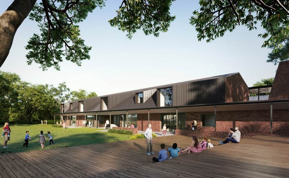
Figure 1: Artist’s impression of new classroom building, southern elevation.
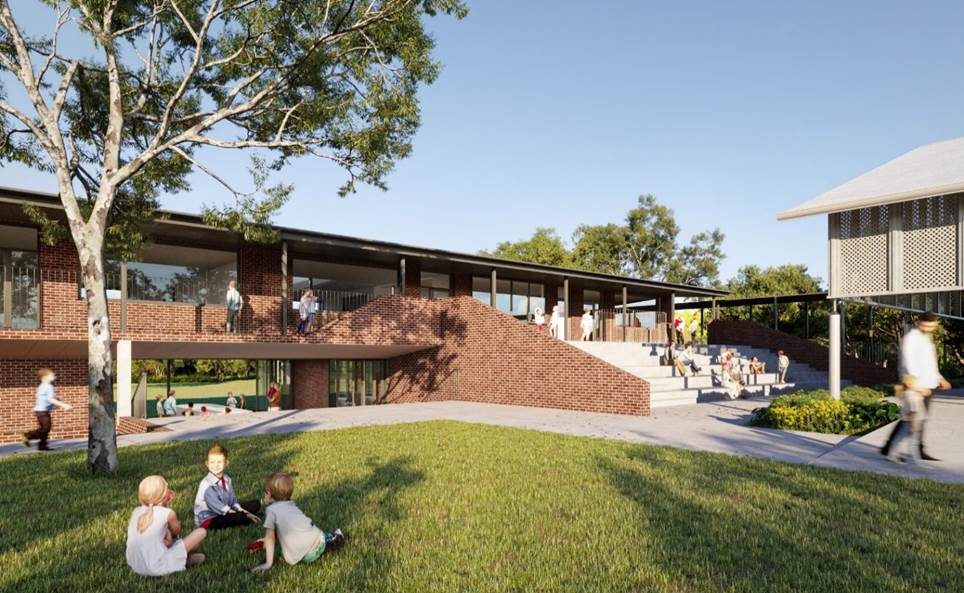
Figure 2: Artist’s impression of new classroom building, northern elevation.
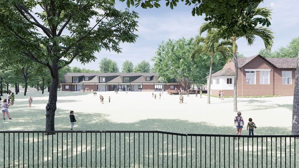
Figure 3: Illustration of the school from Byron Street, looking north.
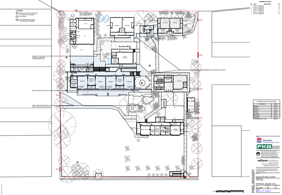
Figure 4: Site plan extract
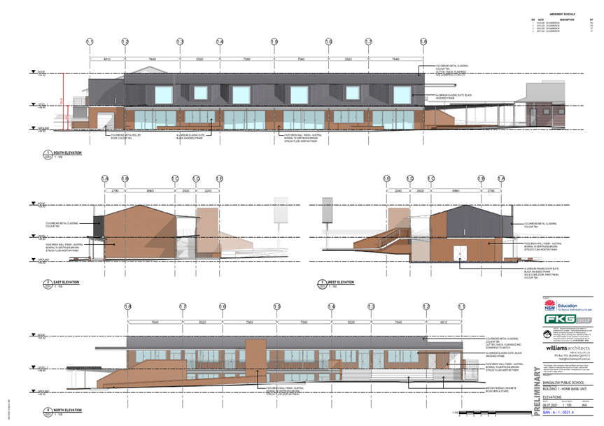
Figure 5: Elevations of proposed two storey classroom building.
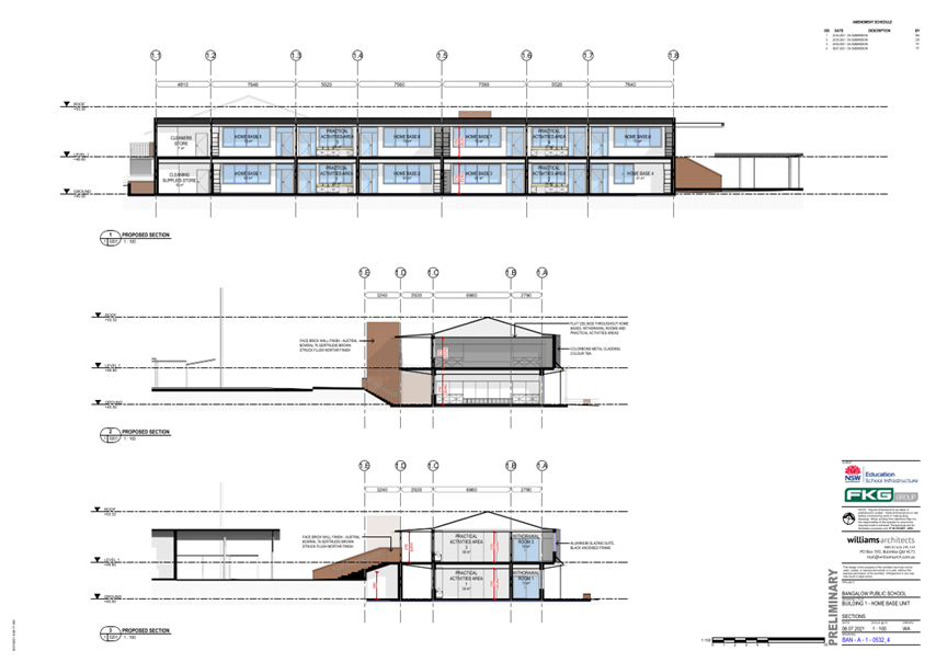
Figure 6: Sections of proposed two storey classroom building.
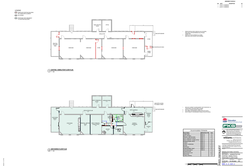
Figure 7: Proposed modifications to the floor plan of the c1925 classroom building.
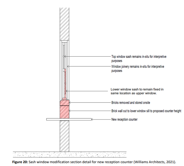
Figure 8: Proposed alteration to sash windows in the proposed administration room to create an entry vestibule.
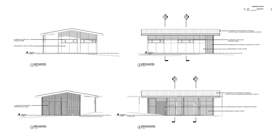
Figure 9: Sections and elevations of proposed amenities building.
1.4 Description of the site
A site inspection was carried out on 8 October 2021.
Site and Surrounds
The subject site is known as Bangalow Public School, and is located at 45 Byron Street, Bangalow. The site has three road frontages with a main frontage of 100m to Byron Street, and secondary frontages to Market Street and Station Street. The site has a total area of 1.21 hectares.
Pedestrian access can be obtained from Byron Street, and from a secondary entrance off Market Street. The school does not provide any formalised parking within the site.
The site is relatively flat and contains a collection of permanent and demountable classrooms and amenities buildings utilised for school and ancillary purposes. Key historic buildings include a c. 1925 brick classroom building near Byron Street, and a c. 1891 storage shed near market street. Prominent landscape elements include a row of palms along the Byron Street frontage and two mature Camphor laurel trees located in the centre of the site.
On the opposite side of Byron Street to the south is a row of traditional dwelling houses mixed with small commercial buildings. Land to the east is occupied by a residential area characterised by detached houses mostly of traditional design, while a row of shops and mixed commercial buildings in the Bangalow town centre lies to the east on the opposite side of Station Street. The Bangalow show grounds lies directly to the north.
Student and staff numbers
The school is co-educational and provides education for Kindergarten to Year 6 students. There are currently 250 enrolled students and 28 staff. Student drop-off and pickup points and bus zones are located on Byron Street near the School’s main entrance.
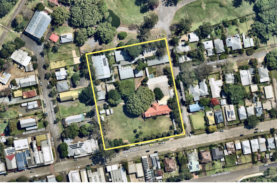
Figure 1: Aerial image of site.
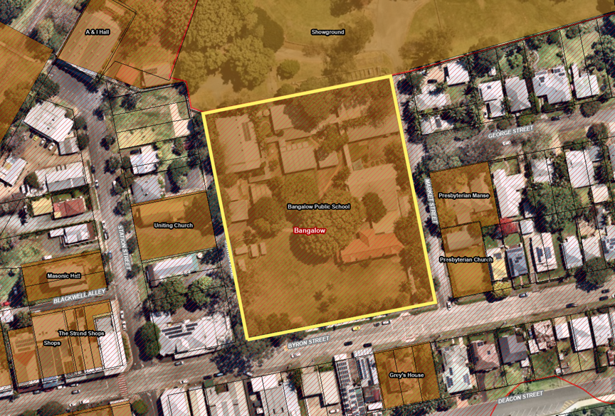
Figure 2: Aerial image of site with heritage overlay. Red hashed line indicates Bangalow heritage Conservation Area. Brown colour indicates heritage listed item.
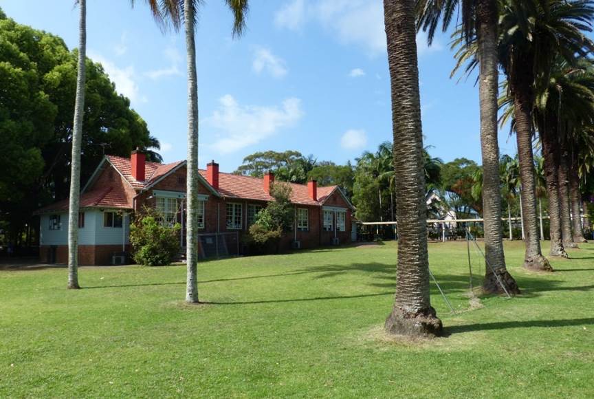
Photo 1: Original c1925 classroom building and row of Palms, viewed from Byron Street frontage.
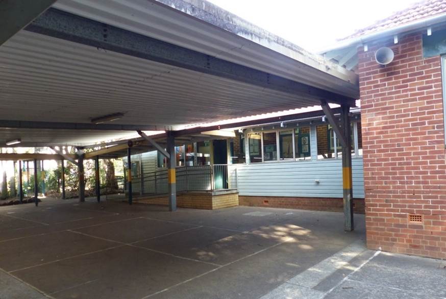
Photo 2: Covered play area and access ramp behind c1925 classroom building.
Photo 3: Original wooden sash windows to be modified for new reception counter.
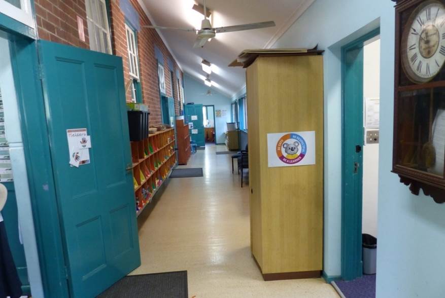
Photo 4: Enclosed verandah on the northern side of the original c1925 classroom building.
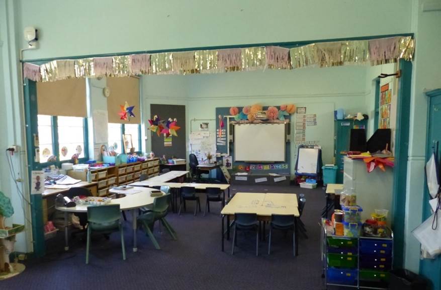
Photo 5: Opening between Classrooms 1 and 2 to be filled-in and closed.
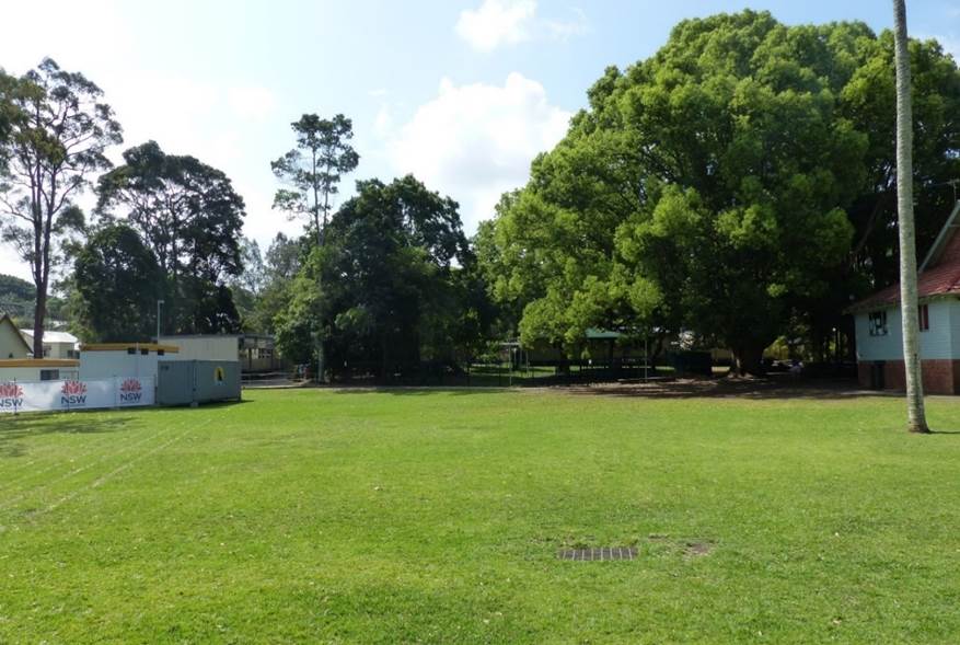
Photo 6: Proposed location of new classroom building, viewed from Byron Street frontage.
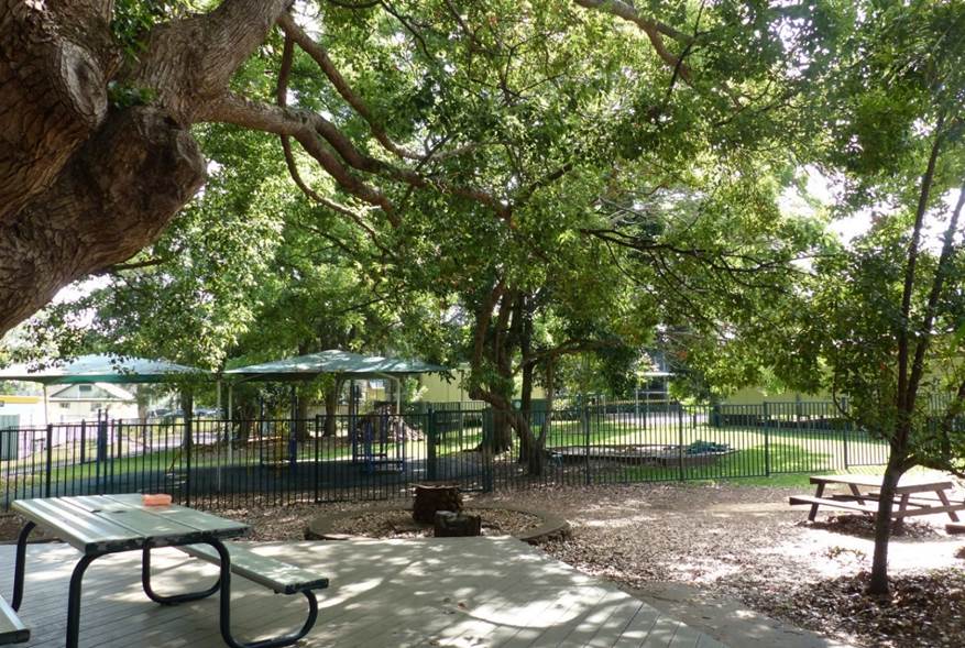
Photo 7: Proposed location of new classroom building, looking west from existing classroom building.
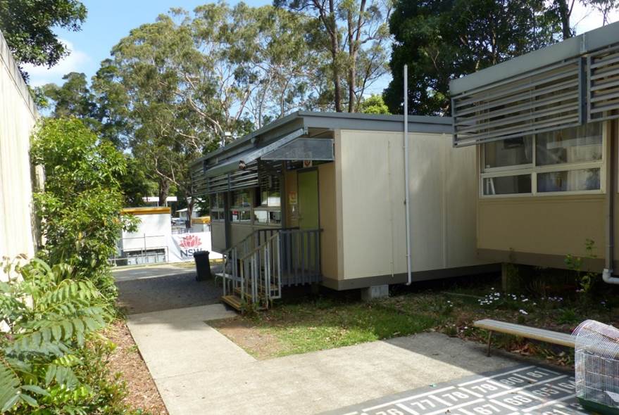
Photo 8: Proposed location of new classroom building, looking west from existing classroom building.
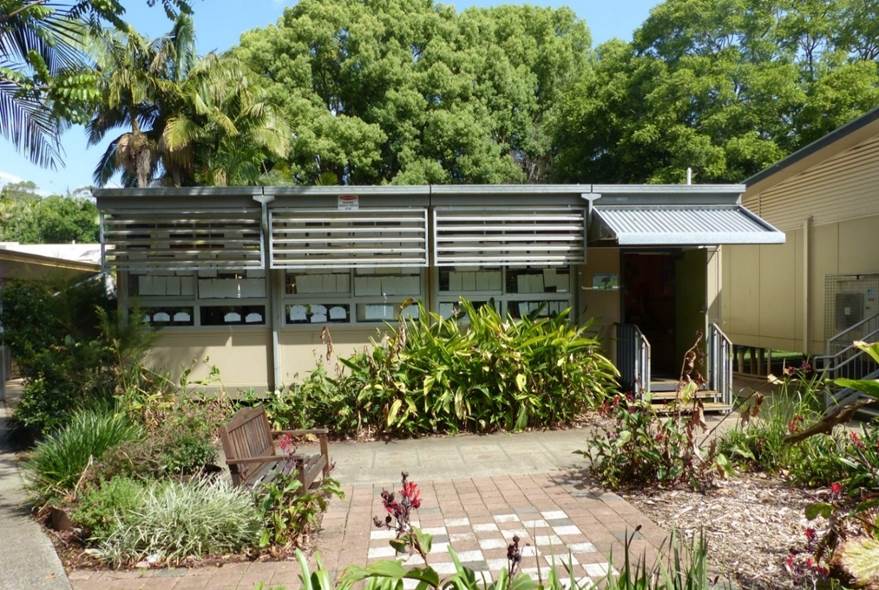
Photo 9: Demountable D14288 to be removed.
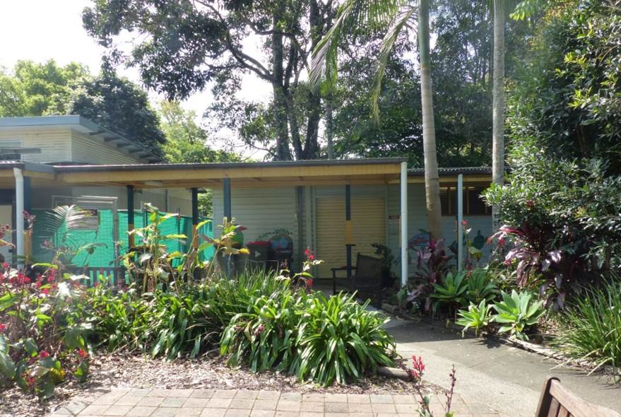
Photo 10: Building “D” to be demolished.
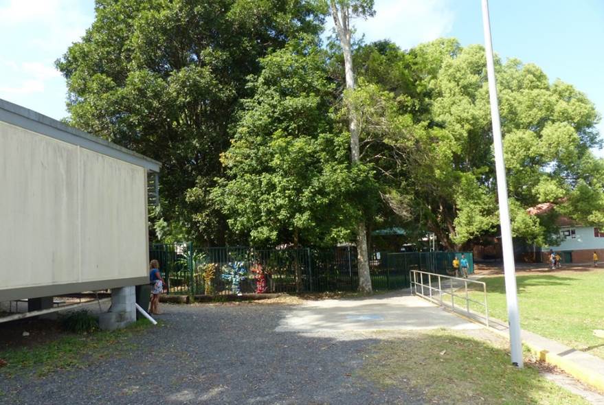
Photo 11: 18 trees to be removed (Centre frame).
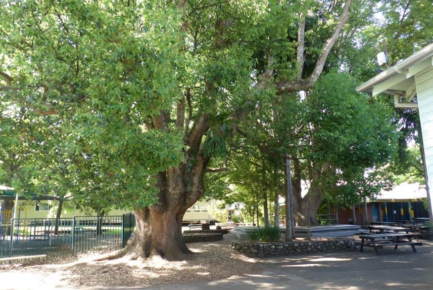
Photo 12: Two (2) large Camphor laurel trees to be retained.
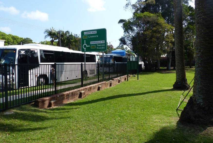
Photo 13: Bus drop-off and pickup area on Byron Street.
2. SUMMARY OF REFERRALS
|
Referral |
Comment |
|
Environmental Health Officer |
Council’s Environmental Health Officer raised no concerns about the proposal. A preliminary contaminated land assessment report has been provided which demonstrates the site is suitable for ongoing use as a school and does not require remediation. |
|
Development Engineer |
Council’s Development Engineer concluded the application was able to be supported from an engineering perspective. The proposal demonstrates there will be no significant increase in peak stormwater flows to Council’s drainage network due to the use of an on-site detention system. |
|
Building Surveyor |
Council’s Building Surveyor commented that the application is accompanied by a report addressing the construction aspects and demonstrating compliance with the BCA. Further construction details are to be provided for the Crown building certification process. |
|
Systems Planning Officer |
A Council sewer pipe is located within the school grounds and runs close to the new teaching building in the south-west corner of the site. Council’s Systems Planning officer has recommended an easement be placed over the pipe benefitting Council. |
|
Natural Resource Planner |
Council’s Natural Resources Planner commented that the proposal can be supported on ecological grounds subject to conditions of consent. |
|
Heritage Advisor |
Council’s Heritage Advisor initially expressed concern over appearance of the new teaching building, particularly the southern elevation which introduces projecting windows with square proportions. Concerns were also raised over the proposed renovations to the 1925 classroom building which involves changing the historic floor plan and removing original building fabric. However, following the submission of additional information, including photomontages and an addendum to the statement of heritage impact, Council’s Heritage Advisor agreed that the proposal was acceptable from a heritage perspective. It is acknowledged that this is a ‘standalone’ site which has considerable landscaped context and space from adjoining buildings in the HCA, and one which operates under different consent requirements. In addition, the photomontages show that the building is generally recessive in relationship to the historic school building and will be softened by existing mature landscaping on the site boundary. Conditions are recommended which requires detailed internal plans to be provided demonstrating that the internal renovations to 1925 classroom building will have minimal impact on original joinery, brickwork and other architectural features. |
3. SECTION 4.14 – BUSH FIRE PRONE LAND
The site is not bush fire prone land.
4. SECTION 4.15C – MATTERS FOR CONSIDERATION
Having regard to the matters for consideration detailed in Section 4.15(1) of the Environmental Planning & Assessment Act 1979 (EP&A Act), the following is a summary of the evaluation of the issues.
4.1 State Environmental Planning Policies (SEPPs)
State Environmental Planning Policy (State and Regional Development) 2011
Schedule 7 of the State and Regional Development SEPP identifies Crown development with a capital investment value (CIV) over $5 million as Regionally Significant Development.
The applicant provided a quantity surveyors report which confirmed that the development has a Capital Investment Value of $4.45 million, excluding GST. The proposal is therefore not classified as Regionally Significant Development and is able to be determined by Council.
State Environmental Planning Policy No 55—Remediation of Land
The applicant submitted a preliminary contaminated land assessment report in their further information which included soil sampling in selected areas of the school grounds. Analysis of the soil samples determined that heavy metal and OCP concentrations were well below the adopted health assessment criteria at all sample locations.
Council’s Environmental Health Officer endorsed the findings of the report and concluded that the site is suitable for ongoing use as an educational establishment. The soils are not considered to be a health risk for students or staff and do not require remediation.
State Environmental Planning Policy (Koala Habitat Protection) 2021
Clause 11 of the SEPP provides that council must not grant consent to carry out development on the land unless it has assessed whether the development is likely to have an impact on koalas or koala habitat. If the Council is satisfied that the development is likely to have low or no impact on koalas or koala habitat, it may grant consent to the development application.
Council’s Natural Resource Planner noted that the site contains some koala use trees as defined in Schedule 2 of the SEPP (being three semi-mature Eucalypus saligna), however, these trees are to be retained. The proposal is expected to result in low or no impact on koalas or koala habitat and is therefore considered to comply with Clause 11(3) of the Koala SEPP 2021.
State Environmental Planning Policy (Educational Establishments and Child Care Facilities) 2017
SEPP Educational Establishments aims to facilitate the effective delivery of educational establishments and early education and care facilities by establishing consistent assessment criteria and design considerations for educational establishments. Pursuant to clause 35 of SEPP, the proposed development is located within a prescribed zone, being the R2 Low Density Residential zone, and therefore development for the purpose of a school is permitted with consent.
Clause 35 Schools—development permitted with consent
In accordance with subclause (6) of clause 35, the consent authority must take into consideration the following matters before determining the application:
(a) the design quality of the development when evaluated in accordance with the design quality principles set out in Schedule 4, and
(b) whether the development enables the use of school facilities (including recreational facilities) to be shared with the community.
The development has been considered against the design quality principles in schedule 4 and demonstrates an acceptable level of compliance.
|
Principle 1 – context, built form and landscape |
The new teaching building has been setback from Byron Street and maintains and alignment with Teaching Block B. This respects the space around the c. 1925 classroom building and also helps frame a new courtyard and several play areas which helps organise the school and deliver a stronger sense of place. |
|
Principle 2 – sustainable efficient and durable |
The new teaching building has a northern orientation which enables passive solar design principles to be applies along with improved cross ventilation. The open planning and structural design allow for future adjustments to the internal room configuration to be adaptable with changing learning practices. |
|
Principle 3 – accessible and inclusive |
Relocating the administration into the historic classroom allows the building with the most prominence on site to also be the public reception. Circulation throughout the school is structured around the courtyard arrangement created by the location of the new building and its relationship to the existing buildings. This intention is to maximise visibility through this area to give people a clear sense of the site layout. In addition, access ramps and paths of travel will be upgraded, and a lift will be installed in the new teaching building to provide easy access to the first floor. |
|
Principle 4 – health and safety |
An improved entry off Market Street enables the existing heritage building to regain its presence on the site as the administration and first point of call for parents and visitors. Outdoor play spaces are accessible and encourage use of outdoor areas. Building orientation focuses on active zones for casual surveillance of the courtyard and play spaces. |
|
Principal 5 – amenity |
The new teaching building provides flexible internal planning to provide pleasant internal spaces which are adaptable and allow for collaboration between classes. Learning spaces are located away from busy roads to minimise noise impacts. |
|
Principle 6 – whole of life, flexible and adaptive |
The site planning of the new building allows flexibility on future site planning and growth for the school. Reinforcement of the courtyard design allows for a new home base building and library to be developed in the future if/as required with the school’s growth in students and staff. Flexible internal spaces allow for rooms to be changed and adapted over time, to cater for the changing needs of students and the community. |
|
Principle 7 – aesthetics |
Despite being a contemporary design with unusual window treatments, the new teaching building is generally recessive in relationship to the historic school building and will be softened by existing mature landscaping on the site boundary. |
4.2 Byron Local Environmental Plan 2014 (LEP 2014)
LEP 2014 is an applicable matter for consideration in the assessment of the subject development application in accordance with subsection 4.15(1) of the EP&A Act because it applies to the subject land and the proposed development. The LEP 2014 clauses that are checked below are of relevance to the proposed development:
|
Part 1 |
☒1.1| ☒1.1AA| ☒1.2| ☒1.3| ☒1.4| ☒Dictionary| ☒1.6| ☒1.7| ☒1.8| ☒1.8A |
|
Part 2 |
☒2.1| ☒2.2 | ☒2.3 |☒Land Use Table | ☒2.4 | ☒2.5 | ☒2.6 | ☒2.7 | ☒2.8 |
|
Part 3 |
☒3.1| ☒3.2| ☒3.3 |
|
Part 4 |
☒4.3|☒4.4 |☒4.5 |
|
Part 5 |
☒5.10| ☒5.12| ☒5.21 |
|
Part 6 |
☒6.1| ☒6.5| ☒6.6 |
In accordance with LEP 2014 clauses 1.4 and 2.1 – 2.3:
(a) The proposed development is defined in the LEP 2014 Dictionary as a school;
(b) The land is within the R2 Low Density Residential according to the Land Zoning Map;
(c) The proposed development is permitted with consent; and
(d) Regard is had for the Zone Objectives as follows:
|
Zone Objective R2 Low Density Residential |
Consideration |
|
To provide for the housing needs of the community within a low-density residential environment. |
The proposed development will provide for the day-to-day educational needs of local students and families and is compatible with the low-density residential setting of the Bangalow area. |
|
To enable other land uses that provide facilities or services to meet the day to day needs of residents. |
The remaining underlined clauses have been taken into consideration in the assessment of the subject development application in accordance with Section 4.15 of the EP&A Act. The proposed development complies with all clauses of LEP 2014 (in some cases subject to conditions and/or to the satisfaction of other assessing officers).
|
Part 4 – Principal Development Standards |
Compliance |
Comment |
|
4.3 Height of Buildings |
Yes |
A maximum height of 9m is permitted. The new teaching building will have a height of 7.8m. |
|
Part 5 – Miscellaneous provisions |
Compliance |
Comment |
|
5.10 Heritage conservation |
|
Bangalow Public School is listed as an item of heritage significance in Byron LEP 2014, is on the Section 170 Register under the Heritage Act 1977 and is located within the Bangalow Heritage Conservation Area. Under LEP Clause 5.10, Council must consider the effect of the proposed development on heritage significance of the area or item concerned. Council’s Heritage advisor considered the proposal to be acceptable from a heritage perspective, subject to conditions of consent being applied to manage impacts on the historic classroom building from the proposed internal renovations. Further discussion on this issue is provided in Section 4.3 below. |
|
5.21 Flood planning |
Yes |
The north-eastern corner of the site is mapped as flood prone land. All school buildings and associated structures are located outside this area. |
|
Part 6 – Additional local provisions |
Compliance |
Comment |
|
Clause 6.2 Earthworks
|
Yes |
Conditions are recommended for a sediment and erosion control plan to be prepared and implemented during construction. |
|
Clause 6.6 Essential services
|
Yes, subject to conditions |
The site has access to reticulated water, sewer, electricity and telecommunications services. Council’s engineer has confirmed that stormwater is able to be adequately discharged to the Council system. |
4.3 Byron LEP 2014 – Discussion of Issues
Clause 5.10 Heritage Conservation
The Bangalow Public School is listed as an item of heritage significance in Byron LEP 2014, is on the Section 170 Register under the Heritage Act 1977 and is located within the Bangalow Heritage Conservation Area.
The school dates to the early days of the Bangalow township having been established in its current location in 1891. A detailed history of the site is outlined in the Heritage Impact Statement in Attachment 3.
As identified in previous listings and heritage assessments, the c.1925 classroom building (“Building A”), and the c.1891 Shed (“Building E”), as well as the row of palms along Byron Street, and the Camphor Laurel trees located centrally in the school grounds are the remaining significant heritage elements at the school.
New Teaching Building
In terms of bulk, scale and form, Council’s Heritage Advisor concluded that the new two-storey brick teaching building is acceptable and is not likely to have an adverse impact on the setting of the c. 1925 classroom building facing Byron Street. The use of sympathetic scale and material palette will provide a harmonious relationship with other building ins the school and the surrounding area.
However, concerns were raised in relation to the box-like projecting windows on the southern elevation. These windows have square or rectangular proportions which are not consistent with the surrounding built form or fenestration in the precinct, particularly with reference to the Byron Street context and the existing school.
In response, the applicant provided additional photo montages which can be found in Attachment 7. Council’s heritage advisor acknowledged that the new teaching building will be recessive in relationship to the historic school building and will be softened by existing mature landscaping on the site boundary. The applicant also noted that the projecting windows are rectangular in shape, which matches the shape of existing windows around the school.
1925 Classroom Building
The proposed renovations to the 1925 classroom building involve reorganising the floor plan of the building and undertaking minor works to introduce new walls, accessible shower and entry vestibule. Some of the renovations will involve partial removal of original fabric such as brickwork and joinery.
To ensure the renovations have minimal impact, a condition is recommended that requires any original fabric removed as part of the renovations to be salvaged and stored on site. Photographic recording of the building for archival purposes is also required, which will enable restoration with original materials to occur in the future if necessary.
Council’s heritage advisor noted that further internal plans of the renovations would be required to ensure minimal disturbance resulting from new plumbing or walls that could affect original joinery or architectural features of the building.
4.4 Any proposed instrument that is or has been the subject of public consultation under this Act and that has been notified to the consent authority
There are no draft environmental planning instruments which have relevance to the proposed development.
4.5 Byron Development Control Plan 2014
DCP 2014 is an applicable matter for consideration in the assessment of the subject development application in accordance with subsection 4.15(1) of the EP& A Act because it applies to the land to which LEP 2014 applies. The DCP 2014 Parts/Chapters that are checked below are of relevance to the proposed development:
|
Part A |
☒ Preliminary |
|
Part B Chapters: |
☒ B1 | ☒ B2| ☒ B3| ☒ B4| ☒ B8| ☒ B9| ☒ B13| ☒ B14 |
|
Part C Chapters: |
☒ C1| ☒ C2| ☒ C4 |
|
Part E Chapters |
☒ E2 |
These checked Parts/Chapters have been taken into consideration in the assessment of the subject development application in accordance with Section 4.15 of the EP&A Act. The proposed development is demonstrated to meet the relevant Objectives of all relevant Parts/Chapters (in some cases subject to conditions and/or to the satisfaction of other assessing officers).
Effect of Education SEPP on Byron Development Control Plan 2014
Clause 35 (9) of the Education SEPP provides that a provision of a development control plan that specifies a requirement, standard or control in relation to a school is of no effect, regardless of when the development control plan was made.
This means that development controls that would normally apply in the Bangalow Heritage Conservation Area, such as those contained in chapters C1 Non-indigenous Heritage and E2 Bangalow, are unable to be considered in determining the application. Standards for car parking and other matters in Chapter B3 are also not applicable.
Consistency with DCP 2014 is addressed below for reference purposes, noting that the DCP can still be used as a guide to inform Council’s assessment of the application against LEP Clause 5.10 Heritage conservation.
Part A: Preliminary
|
Development Control |
Compliance |
Comment |
|
A14.2 Levels of Public Exhibition and Notification |
Yes |
The development has an estimated cost of ~ $4.25 million and was advertised and notified for a period of 14 days in accordance with Level 2 notification requirements. |
Chapter B1 Biodiversity
|
Development Control |
Compliance |
Comment |
|
B1.1.5 Biodiversity Planning Principles |
Yes |
Council’s natural resource planner noted that the proposal complied with the requirements of Chapter B1. |
|
B1.2.3 Koala Habitat |
Yes |
The site is not considered to be a potential koala habitat. |
Chapter B3 Services
|
Development Control |
Compliance |
Comment |
|
B3.2.1 Provision of Services Water supply |
Yes, subject to conditions |
The site has access to reticulated water and sewer services. Conditions are recommended requiring plumbing to be installed in accordance with the relevant Australian standards and requirements of the NCC. |
|
B3.2.3 Stormwater Management |
Yes, subject to conditions |
Stormwater from the new teaching building will be discharged to an onsite detention system before being diverted to Council’s stormwater system in Station Lane. Council’s Development Engineer noted the proposed system was acceptable. |
|
B3.2.4 Sedimentation and Erosion Control Measures |
Yes, subject to conditions |
A condition is recommended for a sediment and erosion control plan to be prepared an implemented during works. |
Chapter B4 Traffic Planning, Vehicle Parking, Circulation and Access
|
Development Control |
Compliance |
Comment |
|
B4.2.1 Traffic Impact |
Yes
|
The proposed development will not increase the capacity of the school, which is currently able to support a maximum of 277 students in accordance with departmental guidelines which stipulates 23.1 students per classroom. |
|
B4.2.3 Vehicle Access and Manoeuvring Areas |
Yes
|
Existing vehicular access, bus zone and student drop-off facility are deemed adequate for the school. |
|
B4.2.5 Car Parking Requirements |
No, but considered acceptable |
The school currently has 28 staff, which generates demand for 14 car parking spaces under Table B4.2.12 the DCP. Currently no formalised car parking is provided on-site. Clause 35 of the Education SEPP provides that any DCP control in relation to a school is of no effect. Council is therefore unable to consider carparking under this part of the DCP. |
Chapter B8 Waste Minimisation and Management
|
Development Control |
Compliance |
Comment |
|
B8.3 General Development Criteria |
Yes, subject to condition |
A condition is recommended for a site waste minimisation and management plan to be provided in accordance with Part B8.3. |
Chapter B9 Landscaping
|
Development Control |
Compliance |
Comment |
|
B9.3.1 General Landscape Design Principles |
Yes
|
A satisfactory landscape concept plan has been provided with the application. |
Chapter B13 Access and Mobility
|
Development Control |
Compliance |
Comment |
|
B13.2 Development Controls |
Yes
|
The proposed development has been designed to meet DDA requirements. |
Chapter B14 Excavation and Fill
|
Development Control |
Compliance |
Comment |
|
B14.2 Excavation and Fill in all Zones
|
Yes
|
Excavation to a depth of approximately 1m will be required for the footings of the new teaching building. The earthworks satisfy the prescriptive measures of B14.2. |
Chapter C1 Non-indigenous Heritage
|
Development Control |
Compliance |
Comment |
|
C1.2.2 Assessment Requirements |
Yes |
A heritage impact statement has been provided by an appropriately qualified heritage practitioner. |
|
C1.3.1 General Streetscape Context |
Yes |
Photomontages have been provided demonstrating that the new teaching building will be compatible with the general scale, height, bulk and proportions of the traditional and new buildings in the streetscape. |
|
C1.3.3 Gardens and Landscape |
Yes |
The original Camphor laurel trees behind the historic classroom building are to be retained and incorporated into a new landscaping concept. The proposal generally retains and respects the traditional landscape elements of the site. |
|
C1.4.1 Roof Form and Chimneys |
No |
The proposed roof form is incorporated into the window design discussed below. |
|
C1.4.3 Windows and Doors |
No |
The new teaching building uses anodised window frames with rectangular, rather than vertical proportions which are used in the historic classroom building and surrounding development in the conservation area. In addition, original windows in the historic classroom building will be removed to create a new entry vestibule. It is acknowledged that these guidelines do not apply by virtue of clause 35 of the Education SEPP. |
|
C1.4.4 Building Materials C1.4.5 Colours |
Yes, subject to conditions |
Building materials and colour are deemed acceptable. Brown brick is complementary to the 1925 classroom building while the metal cladding is visually recessive. |
|
C1.6.7 Bangalow Conservation Area |
Yes |
The form and materials used in the new teaching building are generally consistent with the requirements for the Bangalow HCA in Part C1.6.7. |
|
C1.5.1 New Development in the Vicinity of a Heritage Item & C1.6.11 New Development in Heritage Conservation Areas |
Yes |
While the building has a contemporary appearance, it is acknowledged that this is a ‘standalone’ site which has considerable landscaped context and space from adjoining buildings in the school and the Bangalow Heritage Conservation Area. |
Chapter C2 Areas affected by flood
|
Development Control |
Compliance |
Comment |
|
C2.3.2 Minimum Floor Levels |
Yes |
The entirety of the proposed development is located on land above the 1% AEP flood level. |
Chapter E2 Bangalow
|
Development Control |
Compliance |
Comment |
|
E2.2 Bangalow Residential Character Narrative |
Yes |
The proposed development is compatible with the residential character narrative for Bangalow. |
|
E2.3.1 Character, Bulk and Scale of Development |
Yes |
The bulk, scale and siting of the new teaching building is generally respectful to the historic and aesthetic significance of the conservation area and the original 1925 classroom building. |
|
E2.4 Development within the Conservation Area |
Yes |
The proposal is supported by a heritage impact statement and is generally consistent with the provisions of Chapter C1. |
4.6 Environmental Planning and Assessment Regulation 2000 Considerations
Clause 92 Additional matters that consent authority must consider
The proposal will involve the demolition of Building D along with the removal of five demountable classrooms. A condition is recommended for any demolition works to be carried out in accordance with Australian Standard AS2601: The demolition of structures.
Clause 94 Consent authority may require buildings to be upgraded
Council’s Building Surveyor did not identify any buildings or parts of buildings that required upgrading due to fire egress or fire separation issues. The new teaching building will be required to meet the requirements of the Building Code of Australia. Details are to be provided with the construction certificate application or assessed as part of the Crown certification process.
4.7 The likely impacts of that development, including environmental impacts on both the natural and built environments, and social and economic impacts in the locality
|
Impact on: |
Likely significant impact/s? |
|
Natural environment |
The proposal is unlikely to have a significant impact on the natural environment. At least 50 native rainforest trees are to be planted as part of a new landscaping concept for the school which will compensate for the trees removed. The two large Camphor Laurel trees in the centre of the school grounds will be retained, offering shade for students. |
|
Built environment |
The proposal will not have an adverse impact on the built environment subject to appropriate conditions of consent. |
|
Social Environment |
The proposed development will provide improved education facilities for the Bangalow area providing a social benefit to the community. |
|
Economic impact |
The proposal will not have a significant economic impact on the locality. |
|
Construction Impacts |
The development will generate minor impacts during its construction. Conditions of consent recommended to control hours of work, builders waste, construction noise, installation of sedimentation and erosion control measures and the like to ameliorate such impacts. |
4.8 The suitability of the site for the development
The proposed development is suitable for the location and supports the continuing use of the site as a school. The site attributes are conducive to the proposed development having regard to environmental constraints, heritage, access, and the availability of services.
4.9 Any submissions made in accordance with the Act or the regulations
The development application was notified and publicly exhibited for a period of 28 days between 3 September 2021 and 30 September 2021. There were ten (10) submissions made on the development application.
Submissions have been summarised in the table below with comments.
|
Issue |
Comment |
|
Bulk and scale The DA goes against the new Bangalow DCP in terms of size and scale. New works should respect the scale and character of the original and should not overpower it. |
Council’s Heritage Advisor commented that the overall scale and bulk of the building was acceptable and would not overpower the c. 1925 classroom building. Clause 35(9) of the Education SEPP means that any DCP provisions which relate to a school are of no effect. |
|
Character and visual impact The new building will have an adverse impact on the streetscape and view from Byron Street. The HIS comments on the impact of the new teaching building on Byron Street but does not refer to the impacts on the other surrounding streets and lanes. The design is generally acceptable; however, the new building must not dominate the site and should recedes to the back. It is suggested that darker recessive colours be used (Monument or iron stone). A more detailed impact assessment is needed. |
Photo montages and illustrations have been provided showing the new teaching building as viewed from Byron Street. While the new building is noticeably different to the historic classroom building, it is positioned well back from Byron Street and will not have a significantly adverse impact on the streetscape. |
|
Landscaping and tree removal Removal of 18 trees will impact on the landscape character of the school. Removal of trees amounts to no natural filtered shading, no cooling, no respiration. The landscaping plan does not provide enough detail. The landscaping and tree planting on site must be placed strategically to both soften and shield the contemporary building. The construction will require removal of a significant number of mature trees that soften the buildings impacts on the village.
|
The two large Camphor laurel trees behind the historic classroom building will be retained and will continue to provide shade and cooling for students. At least 50 new trees will be planted as part of a new landscape concept, however, it is acknowledged they will take some time to mature. Trees in the southern part of the site near Byron Street are not proposed to be removed and new trees are intended to be planted which will soften the appearance of the school buildings when viewed from Byron Street. |
|
Increase in student capacity The development will significantly add to the teaching capacity of the school, although this is not stated. What has been done to deal with additional traffic or drop offs and pickups of school children. |
The applicant provided further information indicating that the development will not result in a net increase in student or teaching capacity. No change to drop-off and pickup is proposed or required.
|
|
Impact on historic classroom building The HIS places singular emphasis on modifications to the listed heritage item, the original 1925 school and adopts a demolish salvage and store approach to heritage elements removed to accommodate proposed changes to this building. Any heritage elements removed to accommodate the proposed internal changes to the 1925 school should be reused wherever possible. Specifically timber framed heritage windows could replace aluminium framed windows on the western extension of the building to establish a more authentic heritage view from Byron Street. |
Acknowledged. Unfortunately, modifications to the original classroom building are needed to meet the Department’s standards and guidelines for access etc. Conditions are recommended for the building to be photographed for archive purposes and any original building materials to be salvaged and stored on site for potential building restoration works in the future. |
|
Inadequate information Doesn’t contain enough general information for the general public to make an assessment of the impacts. Residents need drawings on what is proposed. The heritage impact statement gives no detail of the specific modifications to the 1925 building other than to demolish and store heritage items. |
Photomontages and illustrations were provided in the applicant’s further information. These can be found in Attachment 7. The HIS provides a description of the proposed works and includes a diagram of the window modifications needed to create the entry vestibule. Council’s Heritage Advisor noted that more detailed technical plans of the internal alterations will be needed for the construction certificate application. |
|
Non-compliance with planning controls The bulk, scale and finishes do not seem to comply with the Byron DCP. The DCP guides against the use of anodised window frames on the lower storey of Building 1, because of incompatibility with the proposed heritage brick finish. Architectural images should be provided to help the public understand the proposal. |
Please note that clause 35(9) of the Education SEPP provides that any provisions in a DCP which specify design requirements or standards for a school are of no effect. As such, Council cannot rely on these DCP provisions as would normally be the case. |
|
Traffic, parking, pickup and drop off There will be an increase in traffic resulting from the school’s upgrade. This may have an impact on Byron Street during pickup and drop off times. |
The applicant confirmed that the proposed upgrades will not increase the school’s capacity. Therefore, there will be no increase in traffic. Council’s Development Engineer did not raise parking or traffic as a significant issue. |
4.10 The public interest
The proposed development will provide a benefit to the community through the provision of improved educational facilities and is therefore in the public interest.
5. SECTION 4.33 – DETERMINATION OF CROWN DEVELOPMENT APPLICATIONS
This application has been made on behalf of the Minister for Education and is therefore to be assessed as a Crown development application.
Pursuant to section 4.33(1) of the EP&A Act, a consent authority (other than the Minister) must not:
(a) refuse its consent to a Crown development application, except with the approval of the NSW Minister for Planning and Public Spaces; or
(b) impose a condition on its consent to a Crown development application, except with the approval of the applicant, or the NSW Minister for Planning and Public Spaces.
Council has consulted with the applicant and the draft conditions of consent have been finalised in accordance with section 4.33(1)(b).
If the Council considers that the applicant warrants refusal, it will be necessary to defer the decision to a later date, pending correspondence with the Minister seeking approval to refuse the application. Additionally, if the Council wishes to amend the recommended conditions, approval from either the applicant or the Minister would be required, and again the determination would need to be deferred pending that approval.
6. DEVELOPER CONTRIBUTIONS
6.1 Water & Sewer Levies
The proposed development will not generate additional load onto Council’s water or sewer network. Section 64 levies are therefore not required.
6.2 Developer Contributions
The proposed development is for educational purposes and is not residential or commercial in nature. Developer Contributions under Sections 7.11 or 7.12 or the Act are not required.
7. CONCLUSION
This application seeks consent for redevelopment of Bangalow Public School, including removal of eight demountable and permanent classroom buildings, renovations to the historic 1925 classroom building facing Byron Street, construction of a new two storey classroom building containing eight home-base rooms, tree removal, landscaping, and ancillary works.
The proposal has been assessed as being consistent with the applicable State Environmental Planning Policies and the provisions of Byron LEP 2014.
To address potential impacts on significant heritage fabric, a condition is recommended that requires original building materials to be salvaged wherever possible and stored on site for future reuse. To assist, detailed photographic recording is to be undertaken for archival purposes prior to the commencement of works. The archival footage will serve as a reference should the building be restored in the future.
Overall, the proposed development will provide a benefit to the Bangalow community through the provision of improved educational facilities and is therefore in the public interest. The application is recommended for approval subject to the conditions of consent in Attachment 1 of this report.
BYRON SHIRE COUNCIL
Staff Reports - Sustainable Environment and Economy 13.4
Report
No. 13.4 PLANNING - DA10.2021.5.1 -
Dwelling House, Swimming Pool and Change of Use of Existing Dwelling into
Central Facilities Building Including Accommodation Bedrooms for Existing Rural
Tourist
Facility.
Directorate: Sustainable Environment and Economy
Report Author: Ben Grant, Planner
File No: I2022/140
Proposal:
|
DA No: |
10.2021.5.1 |
||
|
Proposal description: |
New Dwelling House, Swimming Pool, Cabana, Shed and Change of Use of Existing Dwelling into a Central Facility Building Including Accommodation Bedrooms for Existing Rural Tourist Facility |
||
|
Property description: |
LOT: 39 DP: 625255 |
||
|
75 Rifle Range Road BANGALOW |
|||
|
Parcel No/s: |
76780 |
||
|
Applicant: |
Balanced Systems Planning Consultants |
||
|
Owner: |
Legate Pty Ltd |
||
|
Zoning: |
RU1 Primary Production |
||
|
Date received: |
5 January 2021 |
||
|
Integrated / Designated Development: |
☒ Integrated |
☐ Designated |
☐ Not applicable |
|
Public notification or exhibition: |
- Level 2 advertising under DCP 2014 Part A14 – Public Notification and Exhibition of Development Applications - Exhibition period: 19/1/21 to 2/2/21 - Submissions received: 144 - Submissions acknowledged: ☒ Yes ☐ No ☐ N/A |
||
|
Planning Review Committee: |
Yes |
||
|
Delegation to determine |
Council |
||
|
Issues: |
- Size of accommodation building. - Potential impact on koalas. |
||
Summary:
This application seeks consent for a new dwelling house, swimming pool, cabana, shed, and change of use of a dwelling house into a central facility building providing four additional bedrooms for an existing rural tourist facility at 75 Rifle Range Road, Bangalow.
The site currently contains four tourist cabins along with an established five-bedroom dwelling, clustered at the southern end of the property. The proposal aims to convert the dwelling into combined central facility and accommodation building and to construct a replacement dwelling at the northern end of the site. A new driveway crossover and access road is also proposed.
It is noted that shortly after the application was lodged, the proponent cleared vegetation in the location of the proposed access road, comprising mostly Camphor laurel along with various smaller native rainforest trees. Council officers inspected the property after receiving complaints from the public on 28 January 2021 and a stop work order was issued on the same day pending further investigation. It is understood that compliance action has commenced but the matter is not finalised at the time of writing.
The application was notified and advertised for a period of 14 days between 19 January 2021 to 2 February 2021 and 144 submissions were received. The majority of submissions relate to the clearing noted above along with concerns about the potential impact of the development on the local koala population. The application is referred to Council for determination due to the number of submissions received and the perceived public interest in the proposal.
The proposal has been assessed against the relevant planning controls applying to the site and following key issues have been identified:
· The proposed central facility and accommodation building has a floor area of 280m2 and contains five bedrooms, which significantly exceeds the maximum allowable floor area and bedroom numbers for rural tourist accommodation in Chapter D3 of DCP 2014. Parts D3.2.3 and D3.3.4 of the Chapter D3 specify that accommodation buildings should not exceed 60m2 and must contain a maximum of two bedrooms.
· The proposed new dwelling is located on a hill-top approximately 500m from the tourist and visitor accommodation which will make it difficult to manage guests and operate the facility in a responsive manner. Siting the dwelling at the opposite end of the site could also fragment remaining agricultural land on the property.
· Given the scale of the accommodation building and the potential issues with managing and operating the tourist facility, the proposal is not considered to satisfy the definition of small-scale in Clause 6.8 of Byron LEP 2014.
· The proposed access road will intersect with the central vegetation corridor on the property, the purpose of which is partly to provide a continuous connective habitat corridor for native fauna. The increased traffic and location of the access road has the potential to fragment habitat used by local koalas and increase the risk of vehicle strike.
For these reasons and others outlined in the body of this report, the proposal is considered inconsistent with the planning controls for rural tourism in LEP 2014 and DCP 2014 and could potentially have an adverse impact on the local koala population.
The application is therefore recommended for refusal for the reasons listed below.
NOTE TO COUNCILLORS:
In accordance with the provisions of S375A of the Local Government Act 1993, a Division is to be called whenever a motion for a planning decision is put to the meeting, for the purpose of recording voting on planning matters. Pursuant to clause 2(a) under the heading Matters to be Included in Minutes of Council Meetings of Council's adopted Code of Meeting Practice (as amended) a Division will be deemed to have been called by the mover and seconder of all motions relating to this report.
RECOMMENDATION:
That pursuant to Section 4.16 of the Environmental Planning & Assessment Act 1979, Development Application No. 10.2021.5.1 for new dwelling house, swimming pool, cabana, shed and change of use of existing dwelling into a central facility building including 5 individual bedroom accommodations for the existing rural tourist facility, be refused for the following reasons:
1. The proposed development is inconsistent with the objectives of the RU1 Primary Production zone because the proposed development is not small scale and may have an adverse impact on the scenic quality of the locality. The location of the new dwelling also has the potential to fragment remaining agricultural land on the property.
2. The proposed development does not comply with the requirements of Byron LEP 2014 Clause 6.8, because it is not small scale and low impact, and is not complementary to the rural and environmental attributes of the land and its surrounds.
3. The proposed development is inconsistent with the provisions for rural tourist and visitor accommodation in Part D3.3.4 of Byron DCP 2014, In particular:
a. The proposed central facility and accommodation building has a floor area greater than 60m2 and contains more than two bedrooms.
b. The development is to be low scale and designed and located to be compatible with the surrounding rural environment and of minimal environmental impact.
4. The proposed development is inconsistent with the provisions for tourist accommodation in rural zones in Part D3.2.3 of Byron DCP 2014. In particular:
a. The central facility and accommodation are non-compliant with the guidelines in Chapter 7 of the Byron Rural Settlement Strategy 1998 because the building has a floor area greater than 60m2 and contains more than two bedrooms.
b. The proposal is not considered to be low scale and is inconsistent with the relevant Aims, Guiding Principles Best Practice Guidelines and Performance Standards contained in the Byron Rural Settlement Strategy 1998.
c. The location of the new dwelling could adversely affect the conduct and productivity of agricultural operations on the site.
5. The proposed new dwelling house is likely to adversely impact scenic qualities of the locality due to its location at the peak of a hill at the northern end of the property. A Visual Impact Assessment has not been provided in accordance with Chapter C3 of Byron DCP 2014.
6. The characterisation and use of the existing dwelling as a part central facility building is not considered to be genuine and is not adequately demonstrated in the application.
7. Insufficient information has been provided to demonstrate the proposed development will not have an adverse impact on threatened species, ecological communities and their habitats including impacts on the local koala population.
8. The proposed development is not considered to be in the public interest for the following reasons:
a. The proposed development is inconsistent with the provisions of Byron LEP 2014 and Byron DCP 2014 which have been the subject of extensive community consultation. Approving the application in such circumstances is likely to set an undesirable precedent.
b. Numerous public submissions were received objecting to the proposed development, and the issues raised in submission have not been adequately addressed or deemed capable of being addressed through conditions of consent.
c. The proposed development is inconsistent with Council resolution 20-691 which aims to limit such developments to four accommodation buildings and eight bedrooms only.
1 DA10.2021.5.1
Combined Plans, E2022/16041 ![]()
2 DA10.2021.5.1
BCD Comments, E2022/16043 ![]()
3 DA10.2021.5.1
Bush Fire Safety Authority, E2022/16042
![]()
4 DA10.2021.5.1
Koala feed tree survey, E2021/111886
![]()
5 DA10.2021.5.1
Draft Vegetation Management Plan, E2021/3696
![]()
6 DA10.2021.5.1
Amended test of significance, E2022/19407
![]()
7 DA10.2021.5.1
Redacted Submissions, E2022/19414
![]()
Report
1. INTRODUCTION
1.1. History/Background
The subject property was once part of a much larger historic dairy farm that covered the northern side of Bangalow. The land was subdivided in 1982 and later used for cattle grazing and rural living. The property has recently been used for rural tourist accommodation following the construction of four cabins in 2019.
1.2. Previous determinations
The following applications are relevant to the current proposal:
· BA 81/2722 - Development consent was granted on 26 November 1981 for a four-bedroom dwelling house on the southern end of the site.
· DA 2017/360 - Development consent was granted on 1 December 2017 for rural tourist accommodation comprising four one-bedroom holiday cabins. The approval was subject to a condition requiring the preparation of an environmental enhancement and management plan (EEMP) detailing plantings and restoration of the site. The final approved EEMP included provisions for restoration of approximately 1.8 hectares of land, with 3000 new plantings and a green ‘koala habitat corridor’ extending up the central ridgeline, with a branch at the northern end providing connectivity to existing stands of native vegetation. New plantings have been substantially completed although restoration work is ongoing.
· DA 2018/162 – Development consent was granted on 28 June 2018 for a swimming pool and cabana to the north of the existing dwelling house.
1.3. Compliance actions
Shed conversion
A Restore Works Order was issued by Council on 10 April 2019, ordering the landowner to restore an existing farm shed to its original condition before it was partially converted for habitable use. It is understood that a caretaker for the tourist and visitor accommodation facility may have been residing in the shed while the existing dwelling was allegedly being used for short-term rental accommodation.
Clearing of vegetation near Rifle Range Road
Shortly after the application was lodged, the proponent cleared vegetation in the location of the proposed driveway access. Council officers inspected the property after receiving complaints from the public on 28 January 2021 and a stop work order was issued on the same day, pending further investigation.
Council’s Natural Resource Planner visited the site and noted “the cleared vegetation mostly comprised camphor laurel trees as well as smaller, regenerating native species including Guioa semiglauca, Cupaniopsis anacardioides, Syzygium australe and Melaleuca salicina. Clearing took place on the proponent’s land as well as in the road reserve”.
The property is subject to an Environmental Enhancement Management Plan (EEMP) which was approved as part of development consent 10.2017.360.1 in December 2017. The clearing is considered to contravene the EEMP (and therefore the conditions of consent).
It is understood that compliance action is ongoing at present by Council however, actions had not been finalised at the time of writing.
1.4. Description of the proposed development
This application seeks consent for a new dwelling house, swimming pool, cabana, shed, and change of use of the main dwelling house into a central facility building providing four (4) additional bedrooms for an existing rural tourist facility.
The following is proposed in detail:
(a) New dwelling house
A single storey dwelling house located on an elevated clearing at the northern end of the property. The dwelling will have three bedrooms, open plan living, laundry and double garage. The building has an L-shaped floor plan that orients living areas to the north and opens onto a large terrace and swimming pool.
(b) Swimming pool and cabana
Pool cabana and In-ground concrete swimming pool with a capacity of 70k located near the proposed dwelling house.
(c) Change of use from dwelling to tourist and visitor accommodation
Proposed change of use of the existing house to a tourist and visitor accommodation, with four (4) additional bedrooms and centralised facilities.
(d) New driveway and crossing
A new driveway access is proposed further west, extending to the new dwelling with a lower branch connecting to the existing the rural tourist facility. The old driveway, approximately 150m in length, and the access point to Rifle Range Road will be decommissioned.
(e) Vegetation Management Plan
A vegetation management plan has been submitted detailing a program to restore and enhance an unnamed creek on the western side of the property. The application proposes 2500 new rainforest trees, planted over an area of 1.5 hectares along with weeding and fencing.
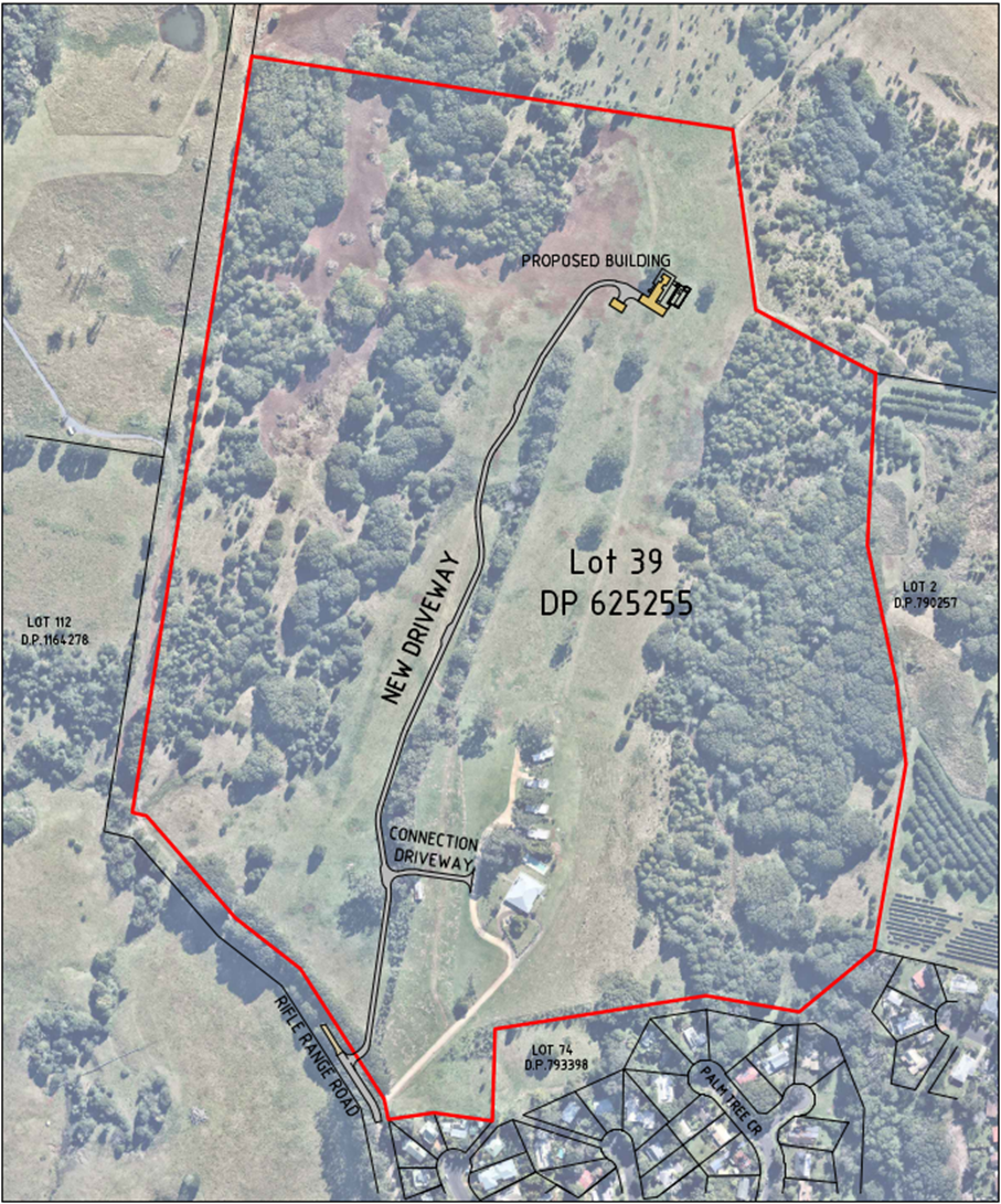
Figure 1: Site plan illustrating the proposed new dwelling house and driveway
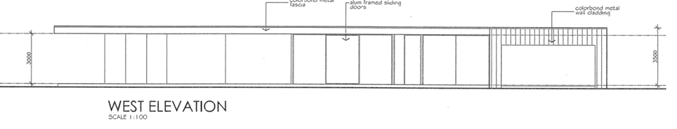

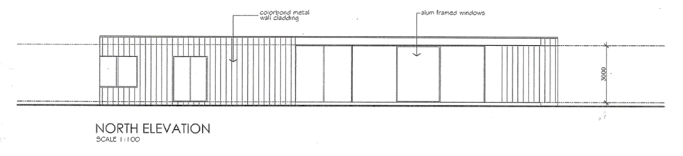
Figure 2: Elevations of the proposed dwelling house.
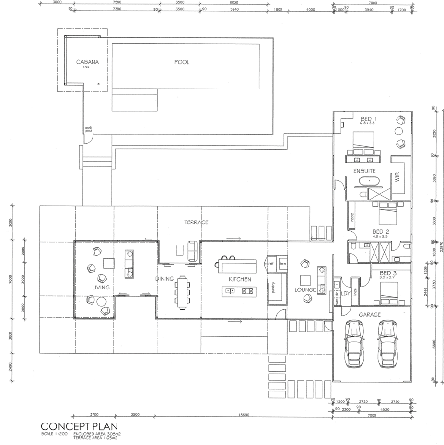
Figure 3: Floor plan of proposed dwelling and pool.
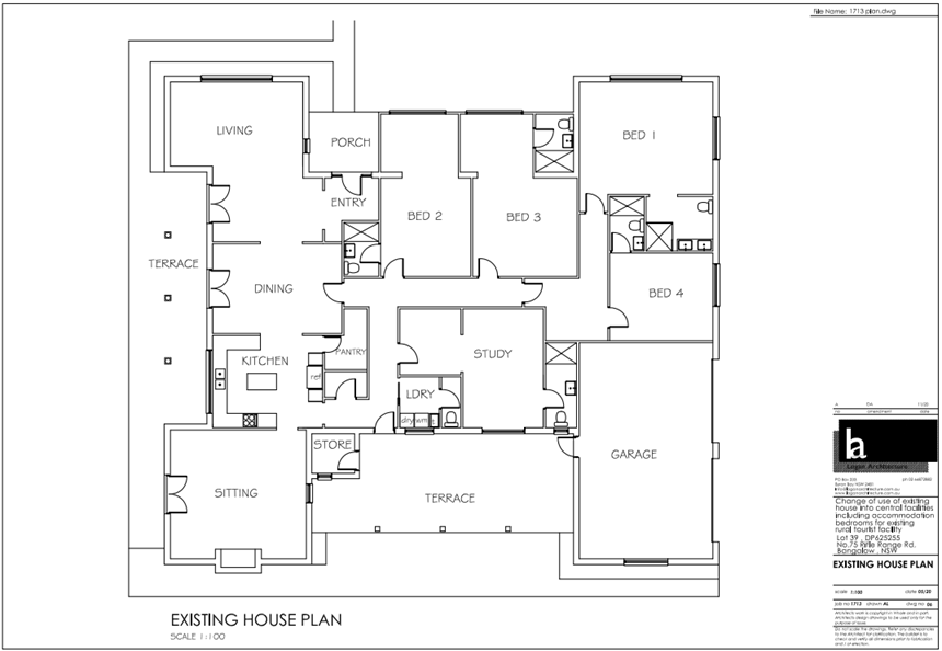
Figure 4: Floor plan layout of proposed tourist and visitor accommodation.
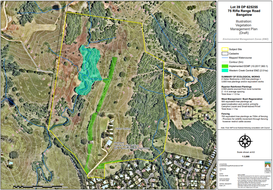
Figure 5: Vegetation Management Plan. New areas of regeneration in dark green.
1.5. Description of the site
The property is an irregular shaped parcel with an area of approximately 38.5 hectares located on the north-west outskirts of Bangalow. The land has undulating topography with a main north-south ridge running along the eastern half. Large areas of open grassland spread across the central portion of the lot while patches of mixed Camphor laurel and subtropical rainforest occupy the creek lines on the eastern and western sides of the property.
The land is zoned RU1 Primary Production and is currently used for cattle grazing and rural tourist accommodation purposes. A revegetation program has commenced in connection with the rural tourist accommodation that involves planting rainforest and koala feed tree species in the central ridgeline and southern boundary of the site.
The site contains a four-bedroom dwelling house, swimming pool and four cabins clustered at the southern end of the property. Land to the west, north and east is use for agricultural purposes such as cattle grazing and macadamias. A residential subdivision on the north-western fringe of Bangalow adjoins to the south.
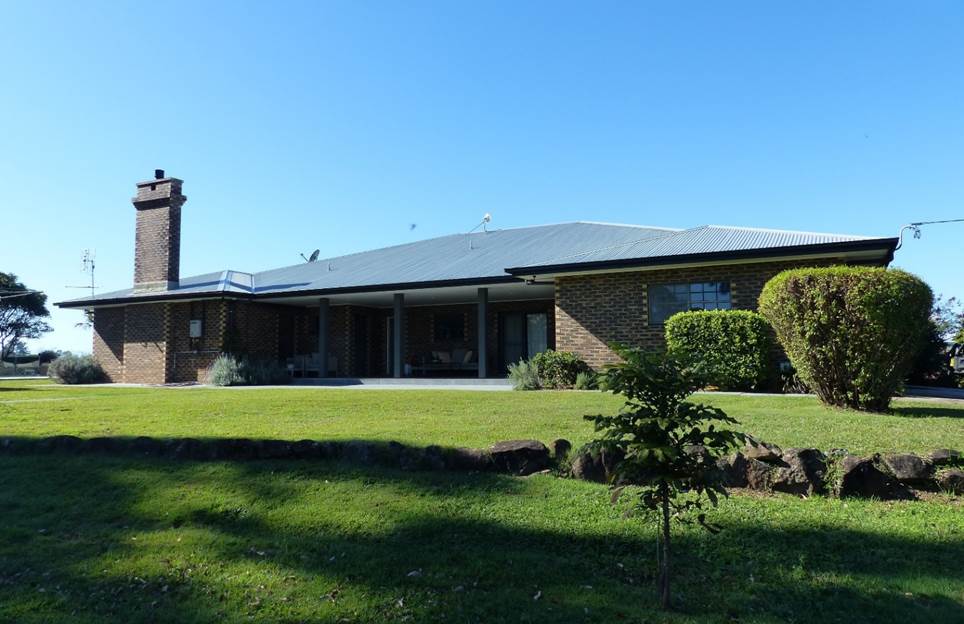
Photo 1: Existing dwelling house to be changed into tourist and visitor accommodation.
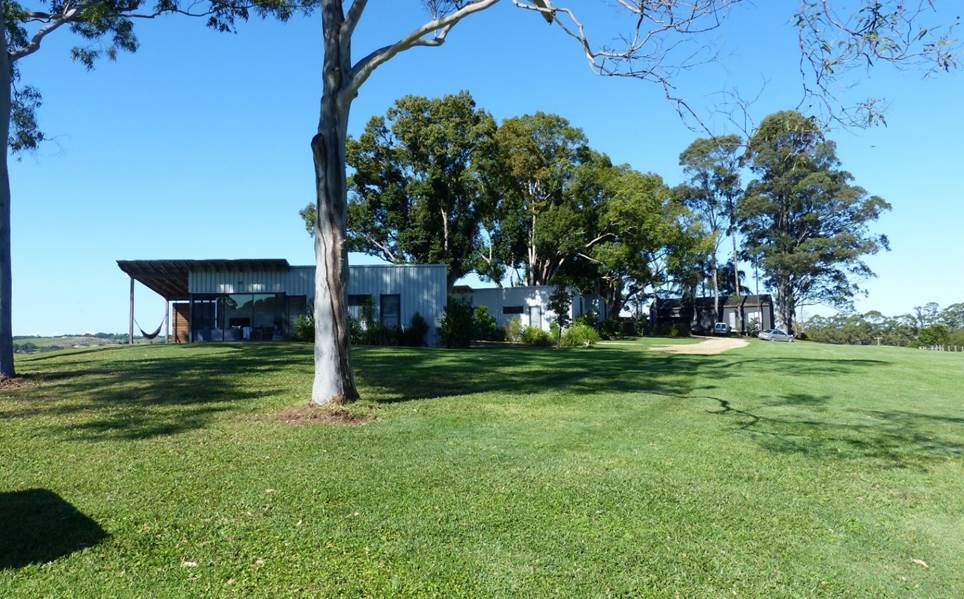
Photo 2: Four (4) holiday cabins located adjacent to the existing dwelling.
Photo 3: View from the site of proposed new dwelling, looking south towards existing cabins.
Photo 4: Vegetation corridor, running up the central ridgeline (southern end).
Photo 5: Northern section of central corridor.
Photo 6: Camphor and privet growing along the western creek riparian corridor.
Photo 7: Proposed location of new driveway viewed from Rifle Range Road looking north. The opening has already been cleared.
Photo 8: Existing driveway crossover.
Photo 9: View of Rifle Range Road from the site entrance, looking south.
2. SUMMARY OF REFERRALS
External referrals
|
Agency |
Comment |
|
Biodiversity and Conservation Division of the Department of Planning, Industry and Environment (BCD)
|
Council referred the application to BCD for comments and advice. It is noted that BCD has no statutory role in the assessment process for this application. Refer to Attachment 2. BCD commented that existing vegetation on site, including rifle range road, provides habitat for koalas, and that the vegetation consists of exotic and/or native vegetation. Some, or all, of the vegetation around the proposed second entrance may have already recently been cleared. BCD recommended that Council should consider minimising the clearing of vegetation, as clearing vegetation may impact the local koala population. Further, it was recommended that one of the two driveway entrances be rehabilitated. |
|
Rural Fire Service (S100B) |
The development is integrated development requiring a Bush Fire Safety Authority under s. 100B of the Rural Fires Act 1997. General Terms of Approval were issued by the RFS on 12 March 2021. |
Internal Referrals
|
Officer |
Comment |
|
Environmental Health Officer |
Council’s Environmental Health Officer commented that the land can accommodate on-site effluent disposal for the development. Information has been provided demonstrating the land was not contaminated and was suitable for the development in its current state. |
|
Development Engineer |
Council’s Development Engineer reviewed the application and noted that the proposed development will generate approximately 10 vehicle trips per day. Should the application be approved, it is recommended that bitumen seal on Rifle Range Road will need to be extended to the property entrance. |
|
Systems Planning Officer |
Council Systems Planning Officer commented that the proposal will generate additional load onto Council’s bulk water and sewer system. Development servicing levies are payable. |
|
Rous County Council |
The application was referred to Rous County Council (Rous) for comment. Rous requested that a condition be imposed requiring a certificate of compliance under s307 of the Water Management Act 2000 to be obtained prior to the issue of a construction certificate. |
|
Ecologist |
Council’s Natural Resource Planner determined that the 5-part test of significance provided with the application was not adequate to properly explain the likely impacts on koalas or their habitat, noting that koalas are known to exist on the site and in the surrounding area near Rifle Range Road. It was noted that if the application is to be approved, a condition should be imposed that requires the access road to be relocated to the eastern side of the property and the existing driveway retained. The following comment was provided: “The proposed connection driveway would create at least a 4m gap in the central ecological restoration area, the purpose of which is partly to provide a continuous connective habitat corridor for native fauna. It is considered that the existing driveway should be retained, and any additional access roads required should be restricted to cleared, grazed parts of the site and not intersect any part of the site containing native vegetation (see below marked up plan). This approach would also provide greater separation between vehicles and the riparian areas in the west of the site where the VMP associated with the present proposal will be focused”. |
3. ENVIRONMENTAL PLANNING AND ASSESSMENT ACT 1979
4. Section 4.46 Integrated Development
Rural Fires Act 1997
The proposed development requires a Bush Fire Safety Authority (BFSA) from the Rural Fire Service under s. 100B of the Rural Fires Act 1997 and is classified as integrated development. General Terms of Approval and a BFSA were issued by the RFS on 12 March 2021.
A copy of the BFSA is included in Attachment 3.
5. SECTION 4.15C – MATTERS FOR CONSIDERATION – DISCUSSION OF ISSUES
Having regard to the matters for consideration detailed in Section 4.15(1) of the Environmental Planning & Assessment Act 1979 (EP&A Act), the following is a summary of the evaluation of the issues.
5.1. State Environmental Planning Instruments
State Environmental Planning Policy No 55—Remediation of Land
Land contamination was previously considered as part of development application 10.2017.360.1 which was approved by the Council on 1 December 2017. A Preliminary Site Investigation (PSI) was undertaken by Balanced Systems Planning Consultants (June 2017) which found no evidence of contamination and concluded that the site is suitable for the proposed use.
Council’s Environmental Health Officer reviewed the information and concluded that the land is suitable for the proposed development in its current state and does not require remediation.
State Environmental Planning Policy (Building Sustainability Index: BASIX) 2004
A valid BASIX certificate has been supplied for the proposed dwelling house and all the necessary commitments for water, energy and thermal comfort have been shown on the DA plans. The new dwelling will need to be supplied with at least 20kL water supply and 4kW solar PV system.
State Environmental Planning Policy (Koala Habitat Protection) 2021
The Koala SEPP 2021 was introduced on 17 March 2021, approximately 2 months after the lodgement of the development application on 5 January 2021.
Savings and transitional provisions apply under Clause 18 of the policy:
18 Existing development applications
A development application mad in relation to land, but not finally determined before this Policy applied to the land, must be determined as if this Policy had not commenced in its application to the land.
In accordance with clause 18, the Koala SEPP 2021does not apply. The application must be determined in accordance with the provisions of the former Koala SEPP 2020.
State Environmental Planning Policy (Koala Habitat Protection) 2020
Koala SEPP 2020 commenced on 30 November 2020 and largely replicates the provisions of the former SEPP 44–Koala Habitat Protection which was introduced in 1995.
The SEPP establishes a three-step process for determining whether the land is considered ‘core koala habitat’. If the land is core koala habitat (as defined in the policy), development consent cannot be granted unless there is a koala plan of management in place in accordance with Part 3 of the SEPP.
The three-step process is outlined below:
8 Step 1—Is the land potential koala habitat?
(1) Before a council may grant consent to a development application for consent to carry out development on land to which this Part applies, the council must be satisfied as to whether or not the land is a potential koala habitat.
(2) The council may be satisfied as to whether or not land is a potential koala habitat only on information obtained by it, or by the applicant, from a person who is qualified and experienced in tree identification.
(3) If the council is satisfied—
(a) that the land is not a potential koala habitat, it is not prevented, because of this Policy, from granting consent to the development application, or
(b) that the land is a potential koala habitat, it must comply with clause 9.
9 Step 2—Is the land core koala habitat?
(1) Before a council may grant consent to a development application for consent to carry out development on land to which this Part applies that it is satisfied is a potential koala habitat, it must satisfy itself as to whether or not the land is a core koala habitat.
(2) The council may be satisfied as to whether or not land is a core koala habitat only on information obtained by it, or by the applicant, from a person with appropriate qualifications and experience in biological science and fauna survey and management
(3) If the council is satisfied—
(a) that the land is not a core koala habitat, it is not prevented, because of this Policy, from granting consent to the development application, or
(b) that the land is a core koala habitat, it must comply with clause 10.
10 Step 3—Can development consent be granted in relation to core koala habitat?
(1) Before granting consent to a development application for consent to carry out development on land to which this Part applies that it is satisfied is a core koala habitat, there must be a plan of management prepared in accordance with Part 3 that applies to the land.
(2) The council’s determination of the development application must not be inconsistent with the plan of management.
11 Guidelines—matters for consideration
Without limiting clause 18, a council must take the guidelines into consideration in determining an application for consent to carry out development on land to which this Part applies.
Potential and core koala habitat are defined as follows:
Potential koala habitat means areas of native vegetation where trees of the types listed in Schedule 2 constitute at least 15% of the total number of trees in the upper or lower strata of the tree component.
Core koala habitat means an area of land with a resident population of koalas, evidenced by attributes such as breeding females, being females with young, and recent sightings of and historical records of a population.
Koala feed tree species are identified in schedule 2 of the SEPP:
Schedule 2 Feed tree species
|
Scientific Name |
Common Name |
|
Eucalyptus tereticornis |
Forest red gum |
|
Eucalyptus microcorys |
Tallowwood |
|
Eucalyptus punctata |
Grey Gum |
|
Eucalyptus viminalis |
Ribbon or manna gum |
|
Eucalyptus camaldulensis |
River red gum |
|
Eucalyptus haemastoma |
Broad leaved scribbly gum |
|
Eucalyptus signata |
Scribbly gum |
|
Eucalyptus albens |
White box |
|
Eucalyptus populnea |
Bimble box or poplar box |
|
Eucalyptus robusta |
Swamp mahogany |
Step 1 – is the land potential koala habitat?
Vegetation on the site can be broken into three main patches, being (1) the eastern patch near Paddy’s Creek, (2) the western patch, which runs parallel to an unnamed creek on the western slopes, and (3) the central vegetation corridor, which is a former windbreak that has been recently enhanced with additional rainforest and eucalypt species as part of ongoing regeneration efforts on the property.
The eastern and western patches are mostly a mixture of Camphor laurel and native rainforest species, with very few koala feed tree species (KFTs) present in the upper or lower strata of the tree component. These patches are not considered to meet the definition of potential or core koala habitat in the SEPP.
The central corridor is a mixture of both native rainforest species and koala feed tree species listed in Schedule 2.
As part of the applicant’s further information, a vegetation survey was carried out by an ecologist to determine how many trees were in the central corridor, and of those, what percentage were KFTs listed in schedule 2 of the SEPP. Results were tabulated in a brief report which can be found in Attachment 4.
The survey counted a total of 1364 trees, comprising 73 trees from the former windbreak and 1291 new trees that have been planted as part of the regeneration program. New plantings comprise 125 KFTs, with the majority being infill rainforest plantings and minor natural regeneration. New and existing KFTs were found to comprise approximately 10% of trees in the central vegetation corridor. The results of the survey are reproduced in Table 1 below.
Table 1: Results of vegetation survey in central corridor.
|
Species |
No. Trees |
Schedule 2 KFTs |
|
|
Red Cedar (w) |
3 |
|
|
|
Turpentine (w) |
15 |
|
|
|
Flooded Gum (w) |
7 |
|
|
|
Tallowwood (w) |
|
13 |
|
|
Forest Red Gum (p) |
|
11 |
|
|
Tallowwood (p) |
|
3 |
|
|
Other species (p) |
609 |
|
|
|
Turpentine (w) |
1 |
|
|
|
Tallowwood (w) |
|
30 |
|
|
Flooded Gum (w) |
1 |
|
|
|
Jacaranda (w) |
1 |
|
|
|
Forest Red Gum (p) |
|
28 |
|
|
Other species |
215 |
|
|
|
Forest Red Gum |
|
34 |
|
|
Pink Bloodwood (w) |
1 |
|
|
|
Flooded Gum (w) |
1 |
|
|
|
Other species (p) |
152 |
|
|
|
Forest Red Gum (p) |
|
19 |
|
|
Other species (p) |
220 |
|
|
|
Total |
1226 |
138 |
|
|
Percentage |
89.88% |
10.12% |
|
(w) Denotes a mature tree from the former windbreak.
(p) Denotes a tree planted as part of recent regeneration efforts in the central corridor.
The definition of potential koala habitat in Clause 4 of the SEPP sets a threshold of 15% KFT’s in the upper and lower strata of the tree component to trigger further investigation for core koala habitat. If the vegetation has less than 15% KFT’s, it not considered to meet the definition of ‘potential koala habitat’ and the assessment does not proceed to Step 2.
Based on the results of the vegetation survey, it is apparent that vegetation in the central corridor is predominantly rainforest species (90%), with the remaining 10% being KFT’s identified in Schedule 2. Therefore, the vegetation does not meet the criteria for further investigation and Council is able to grant consent without requiring a koala plan of management.
Guidelines
Clause 11 provides that Council must consider the relevant Koala SEPP guidelines before determining a development application to which the SEPP applies. Further investigation by Council’s Natural Resource Planner revealed there are no guidelines in place for the Koala SEPP 2020 at the time of writing. It is understood that a set of guidelines are in the process of being developed by DPIE and may be released soon.
Further consideration of impacts on Koalas
Notwithstanding the above, koalas are known to exist in the local area and there are numerous records and photographs documenting koala presence in the vegetated corridor alongside Rifle Range Road. Further consideration of the potential impacts on koalas are discussed in Section 4.6 of this report.
4.2A Byron Local Environmental Plan 2014 (LEP 2014)
LEP 2014 is an applicable matter for consideration in the assessment of the subject development application in accordance with subsection 4.15(1) of the EP&A Act because it applies to the subject land and the proposed development. The LEP 2014 clauses that are checked below are of relevance to the proposed development:
|
Part 1 |
☒1.1| ☒1.1AA| ☒1.2| ☒1.3| ☒1.4| ☒Dictionary| ☒1.5| ☒1.6| ☒1.7| ☒1.8| ☒1.9 |
|
Part 2 |
☒2.1| ☒2.2 | ☒2.3 |☒Land Use Table | ☒2.4 | ☒2.5 | ☒2.6 | ☒2.7 | ☒2.8 |
|
Part 4 |
☒4.2A| ☒4.2D| ☒4.3 |
|
Part 6 |
☒6.2| ☒6.5| ☒6.6| ☒6.8 |
In accordance with LEP 2014 clauses 1.4 and 2.1 – 2.3:
(a) The proposed development is defined in the LEP 2014 Dictionary as Dwelling House, Swimming Pool and Tourist and Visitor Accommodation;
(b) The land is within the RU1 Primary Production according to the Land Zoning Map;
(c) The proposed development is permitted with consent; and
(d) Regard is had for the Zone Objectives as follows:
|
Zone Objective RU1 Primary Production |
Consideration |
|
To encourage sustainable primary industry production by maintaining and enhancing the natural resource base. |
The proposal is not consistent with the objectives of the RU1 Primary Production zone for the following reasons: · The residential and tourist and visitor accommodation components are spread across the site, fragmenting productive agricultural land. · Locating the new dwelling at the top of hill at the northern end of the site may have an adverse impact on the scenic qualities of locality. · The proposal is not considered to be a small-scale rural tourism use associated with primary production and environmental conservation consistent with the rural character of the locality. |
|
To encourage diversity in primary industry enterprises and systems appropriate for the area. |
|
|
To minimise the fragmentation and alienation of resource lands. |
|
|
To minimise conflict between land uses within this zone and land uses within adjoining zones. |
|
|
To encourage consolidation of lots for the purposes of primary industry production. |
|
|
To enable the provision of tourist accommodation, facilities and other small-scale rural tourism uses associated with primary production and environmental conservation consistent with the rural character of the locality. |
|
|
To protect significant scenic landscapes and to minimise impacts on the scenic quality of the locality. |
The remaining underlined clauses have been taken into consideration in the assessment of the subject development application in accordance with Section 4.15 of the EP&A Act. The proposed development complies with all clauses of LEP 2014 (in some cases subject to conditions and/or to the satisfaction of other assessing officers).
Part 1 – Preliminary
|
Provision |
Compliance |
Comment |
|
Clause 1.9A Suspension of covenants, agreements, and instruments |
Yes |
The subject property is burdened with two restrictive covenants benefitting Council as follows: 1. “No works or activities shall be carried out on the burdened land that has a negative impact on the Koala habitat on, or adjoining, the burdened land, other than in accordance with the Environmental Enhancement and Management Plan approved in accordance with conditions of development consent number DA 10.2017.360.1.” 2. “No cats or dogs shall be kept on the burdened land other than “assistance animals” as defined by the Companion Animals Act 1998 or farm working dogs directly involved in the management of the burdened land.” Council’s Natural Resource Planner concluded that the proposed access road was inconsistent with the above covenant as it would intersect with the central vegetation corridor. It may be possible to correct the issue by rearranging the driveway access, however, this is not required given the application is recommended for refusal due to the reasons outlined in this report. |
Part 4 – Principal Development Standards
|
Provision |
Compliance |
Comment |
|
4.2A Erection of dwelling houses and dual occupancies on land in certain rural zones |
Yes |
The subject property is recognised as having a dwelling entitlement. |
|
4.2D Erection of dual occupancies (detached) and secondary dwellings in Zones RU1 and RU2 |
N/A |
The application includes a new dwelling housing to be constructed approximately 500m to the north. To ensure the proposal is not characterised as a dual occupancy, a condition would need to be applied that requires the development consent for the original dwelling to be surrendered prior to the issue of an occupation certificate for the new dwelling. |
|
4.3 Height of Buildings |
Yes |
A maximum height of 9m is permitted. A height of 3.5m is proposed for the new dwelling. |
Part 5 – Miscellaneous Provisions
|
Provision |
Compliance |
Comment |
|
5.16 Subdivision of, or dwellings on, land in certain rural, residential or environment protection zones |
Yes |
The proposed new dwelling and tourist accommodation has adequate buffers from adjoining rural land. |
Part 6 – Local Provisions
|
Provision |
Compliance |
Comment |
|
6.5 Drinking water catchments
|
Yes |
The development and associated wastewater system will be located approximately 200m from the western creek. The development will not have an adverse impact on the quality or quantity of water entering the drinking water storage. |
|
6.6 Essential services
|
Yes |
The site has access to reticulated water, electricity and telecommunications. Sewage is to be disposed via OSMS and a new driveway will provide vehicular access to the proposed dwelling. |
|
6.8 Rural and nature-based tourism development
|
No |
The proposal is not considered to satisfy the requirements of Clause 6.8 because the development is not small scale and low impact and is not capable of being adequately managed by the principal owner living on the property. The new dwelling is located approximately 500m from the proposed tourist facility which will make it difficult to properly manage the behaviour of guests on an ongoing basis. In addition, the proposed central facility and accommodation building significantly exceeds the maximum floor space for an accommodation building under Byron DCP 2014 which is limited to 60m2. |
4.3 Any proposed Instrument that has been the subject of public consultation and has been notified to the consent authority
There are no proposed instruments with relevance to the subject application.
4.4A Byron Shire Development Control Plan 2014 (DCP 2014)
DCP 2014 is an applicable matter for consideration in the assessment of the subject development application in accordance with subsection 4.15(1) of the EP& A Act because it applies to the land to which LEP 2014 applies. The DCP 2014 Parts/Chapters that are checked below are of relevance to the proposed development:
|
Part A |
☒ Preliminary |
|
Part B Chapters: |
☒ B1| ☒ B3| ☒ B4| ☒ B6| ☒ B8| ☒ B9| ☒ B14 |
|
Part C Chapters: |
☒ C1| ☒ C3| ☒ C4 |
|
Part D Chapters |
☒ D2| ☒ D3 |
These checked Parts/Chapters have been taken into consideration in the assessment of the subject development application in accordance with Section 4.15 of the EP&A Act. The proposed development complies with all sections of these Parts/Chapters (in some cases subject to conditions and/or to the satisfaction of other assessing officers), except in relation to certain prescriptive measures which are considered further (having regard to the DCP 2014 Section A1 Dual Path Assessment) as follows:
Chapter B1 Biodiversity
|
Provision |
Compliance |
Comment |
|
B1.2.1 Development Envelope Controls |
Yes |
A 20m buffer from high ecological value vegetation is required. The proposed tourist accommodation has ~70m buffer from trees in the central corridor. The proposed dwelling has a buffer of ~100m from rainforest in the Paddy’s Creek riparian corridor. |
|
B1.2.2 Development infrastructure and other controls |
No |
Council’s Natural Resource Planner was unsupportive of the proposed driveway location as it conflicts with the prescribed 20m buffer distance required between roads and high ecological value vegetation. He noted that the driveway could potentially be rearranged with conditions of consent, however, further consideration of the matter is not required given the application is recommended for refusal. |
|
B1.2.3 Koala Habitat |
No |
See above. The proposed access road is only 10m from the central vegetation corridor which may affect koala movement across the site. |
|
B1.2.5 Vegetation Management Plans & Biodiversity Conservation Management Plans |
Yes |
A Vegetation Management Plan is required for rural tourist accommodation in Chapter D3 of DCP 2014. The applicant has provided a VMP in accordance with the relevant provisions of D3.2.3. |
Chapter B3 Services
|
Provision |
Compliance |
Comment |
|
B3.2.1 Provision of Services Water supply |
Yes |
The site and the proposed rural tourist facility are currently serviced by reticulated water from Rous County Council. |
|
B3.2.2 On-site Sewage Management
|
Yes |
The application proposes a new OSMS for the proposed 3-bedroom dwelling house based on secondary treatment incorporating 3kL septic tank, constructed wetlands and ETA beds. No change to the OSMS for the existing dwelling and rural tourist facility is proposed. |
Chapter B4 Traffic Planning, Vehicle Parking, Circulation and Access
|
Provision |
Compliance |
Comment |
|
B4.2.1 Traffic Impact |
Yes |
The development is estimated to generate an additional 1.83 peak hour trips (PHT) per day, for a total of 5.77 PHT including the existing 4 cabins. The proposed development is therefore considered ‘low impact’ in terms of traffic generation. However, given the current standard of Rifle Range Road, Council’s Development Engineer noted that if the application is recommended for approval, a condition should be imposed which requires the bitumen seal to be extended to the property entrance. |
|
B4.2.3 Vehicle Access and Manoeuvring Areas |
Yes |
Vehicle access and manoeuvring complies (or is capable of complying) with Council’s standards. If the application is recommended for approval, engineering details of the driveway should be provided for approval with the construction certificate application. |
|
B4.2.5 Car Parking Requirements |
Yes |
Two car parking spaces are provided for the new dwelling. Existing car parking for the dwelling are considered adequate. |
Chapter B6 Buffers and Minimising Land Use Conflict
|
Provision |
Compliance |
Comment |
|
B6.2.4 Buffers
|
Yes |
Table B6.1 specifies a buffer distance for rural tourist accommodation of 50m for grazing land and 300m to macadamia operations. The development has a separation from neighbouring grazing land and macadamia orchard of 230m and 310m respectively. |
Chapter B8 Waste Minimisation and Management
|
Provision |
Compliance |
Comment |
|
B8.3 General Development Criteria |
Yes, subject to conditions |
Rifle Range Road is serviced by Council garbage collection. If the application were to be considered favourably, further details relating to construction waste management measures would need to be provided for approval with the construction certificate application. |
Chapter B9 Landscaping
|
Provision |
Compliance |
Comment |
|
B9.3.1 General Landscape Design Principles and B9.6.1 Landscaping of Tourist and Visitor Accommodation |
Yes, subject to conditions |
The development would benefit from additional landscaping near the south-east corner to provide screening between residential properties and the access road. |
Chapter B13 Access and Mobility
|
Provision |
Compliance |
Comment |
|
B13.2 Development Controls |
Yes
|
The existing tourist development already includes one cabin with disabled access and facilities. |
Chapter C3 Visually Prominent Sites, Visually Prominent Development and View Sharing
|
Provision |
Compliance |
Comment |
|
C3.2.1 Visual Impact Assessment
|
No |
The proposed new dwelling is located on an elevated clearing (~100m AHD) at the northern end of the site. The application is not supported by a visual impact assessment in accordance with C3.2.1. |
Chapter C4 Development in the Drinking Water Catchment
|
Provision |
Compliance |
Comment |
|
C4.2.4 Water Sensitive Urban Design |
Yes |
The proposal will not significantly modify the natural landform or increase stormwater runoff, effluent or particulate matter entering the drinking water storage. |
Chapter D3 Tourist Accommodation
|
Provision |
Compliance |
Comment |
|
D3.2.1 Location and Siting
|
Yes |
The proposed tourist accommodation building has adequate buffers from adjoining land and is sited clear of environmentally sensitive vegetation and features of the land. |
|
D3.2.3 Character and Design in Rural Zones
|
No |
The proposed development is not consistent with the objectives and performance criteria of D3.2.3 for the following reasons: · The proposed central facility and accommodation building has a floor area of ~280m2, which significantly exceeds the 60m2 maximum floor area specified in Section 7.2(3) of the Byron Rural Settlement Strategy 1998.
· The proposal is not low scale and is not compatible with the relevant Aims, Guiding Principles and provisions of the Byron Rural Settlement Strategy 1998. |
|
D3.3.4 Rural Tourist Accommodation and Farm Stay Accommodation · |
No |
The proposed development is inconsistent with the Prescriptive Measures, Performance Criteria and Objectives of D3.3.4 for the following reasons: · The proposed central facility and accommodation building has a floor area of ~280m2 and five bedrooms, which significantly exceeds the 60m2 maximum floor area and two-bedroom limit specified in Prescriptive Measure D3.3.4 (2)(a).
· The proposal could disrupt existing ecological enhancement projects on the land and has the potential to impact on the ecological and environmental values of the land. |
4.5 Environmental Planning & Assessment Regulation 2000 Considerations
Clause 92 Additional matters that consent authority must consider
Not applicable.
Clause 93 Fire safety and other considerations
The RFS provided conditions requiring the existing dwelling to be upgraded to improve ember protection.
4.6 Biodiversity Conservation Act 2016
Part 7 Biodiversity assessment and approvals under Planning Act
Section 7.3 Test for determining whether proposed development or activity likely to significantly affect threatened species or ecological communities, or their habitats
The Statement of Environmental Effects includes a 5-part test of significance to address potential impacts on threatened species. The test of significance is used to determine if a development is likely to significantly affect threatened species or ecological communities under the Biodiversity Conservation Act 2016 (the Biodiversity Act).
7.3 Test for determining whether proposed development or activity likely to significantly affect threatened species or ecological communities, or their habitats
(1) The following is to be taken into account for the purposes of determining whether a proposed development or activity is likely to significantly affect threatened species or ecological communities, or their habitats—
(a) in the case of a threatened species, whether the proposed development or activity is likely to have an adverse effect on the life cycle of the species such that a viable local population of the species is likely to be placed at risk of extinction,
(b) in relation to the habitat of a threatened species or ecological community—
(i) is likely to have an adverse effect on the extent of the ecological community such that its local occurrence is likely to be placed at risk of extinction, or
(ii) is likely to substantially and adversely modify the composition of the ecological community such that its local occurrence is likely to be placed at risk of extinction,
(c) in relation to the habitat of a threatened species or ecological community—
(i) the extent to which habitat is likely to be removed or modified as a result of the proposed development or activity, and
(ii) whether an area of habitat is likely to become fragmented or isolated from other areas of habitat as a result of the proposed development or activity, and
(iii) the importance of the habitat to be removed, modified, fragmented or isolated to the long-term survival of the species or ecological community in the locality.
(d) whether the proposed development or activity is likely to have an adverse effect on any declared area of outstanding biodiversity value (either directly or indirectly),
(e) whether the proposed development or activity is or is part of a key threatening process or is likely to increase the impact of a key threatening process.
Council’s Natural Resource Planner reviewed the 5-part test and noted that the impacts on koalas were likely understated given that koalas are commonly found in the vegetation corridor alongside Rifle Range Road and near the subject site. There is also evidence of koalas using camphor laurel trees in this area for refuge and movement between habitat areas in the broader landscape.
A key concern is the location of the new driveway, which cuts through an existing movement corridor and would create at least a 4m gap in the central ecological restoration area, the purpose of which is partly to provide a continuous connective habitat corridor for native fauna. The new access road and central facility and accommodation building is a potential threat to koalas due to habitat fragmentation and increased risk of vehicle strike.
It is noted that the applicant provided an amended 5-part test of significance in their additional information (Attachment 6) however the above issues have not been satisfactorily addressed. It is considered that the proposal does have the potential to significantly impact on koalas, particularly in relation to parts (a) and (c) of the test of significance.
As noted by Council’s ecologist, the issue could potentially be addressed through conditions of consent which require the access road to be relocated to the eastern side of the property. However, given the lack of information and other non-compliances with the relevant planning controls, it is considered that consent should not be granted in the circumstances.
4.7 The likely impacts of that development, including environmental impacts on both the natural and built environments, and social and economic impacts in the locality
Natural environment
As discussed in Section 4.6, there is insufficient information to properly determine if the proposal will have an adverse impact on the natural environment, including threatened species or ecological communities or their habitats.
Built environment
The development is not considered to be low scale or compatible with the characteristics of the surrounding rural and natural environments.
Social and economic impacts
The proposal is unlikely to have a significant social or economic impact on the locality.
4.8 The suitability of the site for the development
The site attributes are not considered to be suitable for the proposal in its current form due to the potential impact on threatened species and fragmentation of prime agricultural land.
4.9 Submissions made in accordance with this Act or the regulations
The development application was publicly exhibited and notified for a period of 14 days in accordance with DCP 2014. The application received 144 submissions from the public (refer to Attachment 7).
A focus of concern was the unauthorised clearing of vegetation near Rifle Range Road and the potential impact on the local koala population. The bulk of the remaining objections expressed concern over location of the new driveway and access point, which has the potential to fragment habitat and increased the risk of vehicle strike. Traffic issues and discrepancies in the documents submitted with the application were also cited.
Key issues in the submissions have been addressed in Table 2.
Table 2. Summary of key issues in submissions.
|
Key issues |
Comment |
|
Unauthorised clearing – compliance action should be taken. |
Acknowledged. A mixture of native and non-native vegetation near Rifle Range Road was cleared to establish a second driveway crossing into the property. Compliance action is currently being progressed by Council. |
|
Loss and fragmentation of koala habitat |
It is acknowledged that the clearing of trees near Rifle Range Road has fragmented this vegetation corridor which is known to provide refuge for local koalas. As explained above, the enforcement action is currently being progressed by Council. |
|
Internal Driveway too close to koala habitat. |
Acknowledged. Council’s ecologist noted that the driveway would intersect with the central vegetation corridor and did not comply with the existing EEMP. |
|
Increased traffic |
Acknowledged. The proposal will moderately increase traffic on Rifle Range Road. Council’s Development Engineer noted that if the application were to be approved, a condition should be applied which requires Rifle Range Road to be sealed and upgraded. |
|
Rifle Range Road in poor condition |
See above. |
4.10 Public interest
The proposed development is considered contrary to the public interest given the non-compliances with LEP 2014 and DCP 2014 which have been the subject of extensive community consultation. Approving the application in such circumstance is likely to set an undesirable precedent.
It is also noted that Council resolved (20-691) to prepare new planning controls for rural tourism as follows:
20-691 Resolved that Council:
1. Requests staff to prepare a planning proposal to amend Byron Local Environmental Plan 2014 and a draft amendment to Byron Development Control Plan 2014, to accord with the recommendations of the Review of Planning Controls for Rural Tourist Accommodation in Attachment 1 (E2020/94209).
2. Authorises staff to submit the planning proposal to the Department of Industry and Environment for Gateway determination.
3. Pending gateway determination, undertakes public exhibition of the planning proposal and development control plan amendment and consult with government agencies as required by the gateway determination; and
4. Receives a report outlining the public exhibition outcomes.
5. Supports the use of the amendments in point 1 as drafted by staff as guiding principles for assessment of Rural Tourist Accommodation until such time as the amendments are finalised.
6. Requests staff to complete a review of the current developer contributions regime as it applies to Rural Tourist Accommodation and receive a report on the outcomes.
Point 5 of the resolution requires Council planning staff to use to the recommendations of the report as a guideline in the assessment of development applications for rural tourist accommodation. A summary of the proposal against the report recommendations is given below.
|
Recommendation |
Proposal |
|
Maximum 4 accommodation buildings and 8 bedrooms. |
Inconsistent. The new accommodation building will result in 11 bedrooms in total, which is above the 8-bedroom limit in the report. As discussed in Section 4.4 of this report, the proposal is not considered to be small-scale or low impact and is not reasonably capable of being managed by the principal owner living on the property. |
|
Minimum lot size 20 hectares |
Complies. Lot size is ~39.5 hectares. |
|
Clearer controls for clustering of cabins |
Inconsistent. The new dwelling and the accommodation buildings will not be clustered together. |
|
Traffic Impact Statement for >3 cabins. |
Complies. Only one additional accommodation building is proposed. |
|
Improved requirements for water supply and rainwater storage. |
Complies. The proposed accommodation building is connected to reticulated water supply. |
|
Single driveway per development |
Complies. The application seek approval to decommission the existing driveway, resulting in a single driveway for the property. |
The proposal is inconsistent with the key amendments outlined in the Council report. While it is acknowledged that Council resolutions or policies do not take precedent over existing statutory controls, it demonstrates that the proposal is generally incompatible with the desired future planning for rural tourist accommodation.
5. DEVELOPER CONTRIBUTIONS
5.1 Water & Sewer Levies
Section 64 levies are payable.
5.2 Developer Contributions
Section 7.12 contributions are not payable as the cost of works associated with the change of use is less than $100,000.
6. CONCLUSION
This application seeks consent for a new dwelling house, swimming pool, cabana, shed, and change of use of a dwelling house into a central facility building providing four additional bedrooms for an existing rural tourist facility at 75 Rifle Range Road, Bangalow.
The application is considered to be inconsistent with the planning controls for rural tourism in Byron LEP 2014 and Byron DCP 2014 and could potentially have an adverse impact on the local koala population if approved.
The proposal is therefore recommended for refusal for the reasons listed below:
7. RECOMMENDATION
RECOMMENDATION:
That pursuant to Section 4.16 of the Environmental Planning & Assessment Act 1979, Development Application No. 10.2021.5.1 for new dwelling house, swimming pool, cabana, shed and change of use of existing dwelling into a central facility building including 5 individual bedroom accommodations for the existing rural tourist facility, be refused for the following reasons:
1. The proposed development is inconsistent with the objectives of the RU1 Primary Production zone because the proposed development is not small scale and may have an adverse impact on the scenic quality of the locality. The location of the new dwelling also has the potential to fragment remaining agricultural land on the property.
2. The proposed development does not comply with the requirements of Byron LEP 2014 Clause 6.8, because it is not small scale and low impact, and is not complementary to the rural and environmental attributes of the land and its surrounds.
3. The proposed development is inconsistent with the provisions for rural tourist and visitor accommodation in Part D3.3.4 of Byron DCP 2014, In particular:
a. The proposed central facility and accommodation building has a floor area greater than 60m2 and contains more than two bedrooms.
b. The development is to be low scale and designed and located to be compatible with the surrounding rural environment and of minimal environmental impact.
4. The proposed development is inconsistent with the provisions for tourist accommodation in rural zones in Part D3.2.3 of Byron DCP 2014. In particular:
a. The central facility and accommodation are non-compliant with the guidelines in Chapter 7 of the Byron Rural Settlement Strategy 1998 because the building has a floor area greater than 60m2 and contains more than two bedrooms.
b. The proposal is not considered to be low scale and is inconsistent with the relevant Aims, Guiding Principles Best Practice Guidelines and Performance Standards contained in the Byron Rural Settlement Strategy 1998.
c. The location of the new dwelling could adversely affect the conduct and productivity of agricultural operations on the site.
5. The proposed new dwelling house is likely to adversely impact scenic qualities of the locality due to its location at the peak of a hill at the northern end of the property. A Visual Impact Assessment has not been provided in accordance with Chapter C3 of Byron DCP 2014.
6. The characterisation and use of the existing dwelling as a part central facility building is not considered to be genuine and is not adequately demonstrated in the application.
7. Insufficient information has been provided to demonstrate the proposed development will not have an adverse impact on threatened species, ecological communities and their habitats including impacts on the local koala population.
8. The proposed development is not considered to be in the public interest for the following reasons:
a. The proposed development is inconsistent with the provisions of Byron LEP 2014 and Byron DCP 2014 which have been the subject of extensive community consultation. Approving the application in such circumstances is likely to set an undesirable precedent.
b. Numerous public submissions were received objecting to the proposed development, and the issues raised in submission have not been adequately addressed or deemed capable of being addressed through conditions of consent.
c. The proposed development is inconsistent with Council resolution 20-691 which aims to limit such developments to four accommodation buildings and eight bedrooms only.
Reports of Committees - Infrastructure Services 14.1
Reports of Committees - Infrastructure Services
Report No. 14.1 Report of the Local Traffic Committee Meeting held on 15 February 2022
Directorate: Infrastructure Services
Report Author: Michelle Wilcox, Traffic & Parking Systems Officer
File No: I2022/133
Summary:
The attachment to this report provides the minutes of the Local Traffic Committee Meeting held on 15 February 2022 for determination by Council.
Council’s action on the LTC advice will be:
a) If Council is in agreement with the LTC unanimous support then the proposal may be approved. In these cases there is no conflict between Council and the advice of the LTC, consequently there is no need for Council to inform TfNSW or the NSW Police representatives of the decision.
b) If Council is in agreement with the LTC unanimous support, but no longer wants to proceed, the proposal may still be rejected.
c) If Council is in agreement with the LTC unanimous decline then the proposal may be rejected. Again there is no conflict between Council and the advice of the LTC. Consequently there is no need for Council to inform TfNSW or the NSW Police representatives of the decision.
d) If Council decides to proceed with a proposal where the advice of the LTC is not unanimous support, then the Council must first advise the RMS and the NSW Police representatives in writing of their intention to approve the proposal. TfNSW or the NSW Police may then lodge an appeal to the Regional Traffic Committee (RTC).
e) If Council decides to proceed with a proposal where the advice of the LTC is a unanimous decline, then the Council must first advise the RMS and NSW Police representatives in writing of their intention to approve the proposal. TfNSW or the NSW Police may then lodge an appeal to the RTC.
Due to the fact that the RMS and the NSW Police have the power to appeal certain decisions of the Council, the LTC cannot provide its advice to Council until both TfNSW and the NSW Police have provided their vote on the issue.
RECOMMENDATION:
That Council notes the minutes of the Local Traffic Committee Meeting held on 15 February 2022.
Report
The attachment to this report provides the minutes of the Local Traffic Committee Meeting of 15 February 2022 for determination by Council. The agenda for this meeting can be located on Council’s website at:
https://byron.infocouncil.biz/Open/2022/02/LTC_15022022_AGN_1470_AT.PDF
This report contains the recommendations of the Local Traffic Committee (LTC) meeting held on 15 February 2022.
Committee Recommendation
As per the Reports listed within the Local Traffic Committee Meeting of 15 February 2022
Management Comments
The committee recommendations are supported by management and are provided in the attachment to this report.
Two reports sought minor amendment to the construction drawings, some comments were regulatory in nature and others did not relate to regulatory matters. The following amendments have been made to the drawings:
· Council has amended the regulatory shared path signage to warning signage as requested.
· Council has replaced the stop sign with a Giveway sign as requested.
· An additional Giveway sign at the interface of southern roundabout leg and the shared path for notice by eastbound cyclists has been included as requested.
· The LTC recommendation to move the road ahead sign closer to the road is in disagreement with the Austroads guidelines. The standard states that warning signs should be 50-80m before intersection points. We have the sign at 50m. AS1742 does not provide a recommended distance for the location of this sign but states that it is optional. Staff considers that the current sign location provides adequate warning for a cyclist that the path will terminate. Staff are of the view that if the sign was placed closer to the road then the warning distance for a cyclist may be insufficient particularly if the cyclist is moving at speed, therefore Council propose to leave the warning signage in the original location.
These outcomes have been discussed with the TfNSW, LTC representative.
The Pocket Road:
· Council designed the longitudinal linemarking of the Pocket Road design in accordance with Austroads guidelines. The requested centre linemarking adjustment is as per the RMS Delineation Manual – Section 4. The requested changes have been made.
· The location of the guard rail termination point was questioned by TfNSW, however, this is not a regulatory matter. The termination point of the guardrail at the eastern end of the project is designed to the ‘point of need’ design criteria. If we extend the guard rail it will require a redesign of deflection points and terminal treatments, therefore, we propose to leave the guardrail location alone. This is covered in our safety in design report for the project and considered to be a suitable outcome for the works.
These outcomes have been discussed with the TfNSW, LTC representative.
Financial Implications
As per the Reports listed within the Local Traffic Committee Meeting of 15 February 2022.
Statutory and Policy Compliance Implications
As per the Reports listed within the Local Traffic Committee Meeting of 15 February 2022.