 Agenda
Ordinary (Planning) Meeting

Thursday, 11 August 2022
Agenda
Ordinary (Planning) Meeting
Thursday, 11 August 2022
Agenda Ordinary (Planning) Meeting
held at Council Chambers, Station Street, Mullumbimby
commencing at 11.00am
Public access relating to items on this agenda can be made between 11:00am and 11:30am on the day of the meeting. Requests for public access should be made to the General Manager or Mayor no later than 12:00 midday on the day prior to the meeting.

Mark Arnold
General Manager
CONFLICT OF INTERESTS
What is a “Conflict of Interests” - A conflict of interests can be of two types:
Pecuniary - an interest that a person has in a matter because of a reasonable likelihood or expectation of appreciable financial gain or loss to the person or another person with whom the person is associated.
Non-pecuniary – a private or personal interest that a Council official has that does not amount to a pecuniary interest as defined in the Code of Conduct for Councillors (eg. A friendship, membership of an association, society or trade union or involvement or interest in an activity and may include an interest of a financial nature).
Remoteness – a person does not have a pecuniary interest in a matter if the interest is so remote or insignificant that it could not reasonably be regarded as likely to influence any decision the person might make in relation to a matter or if the interest is of a kind specified in the Code of Conduct for Councillors.
Who has a Pecuniary Interest? - a person has a pecuniary interest in a matter if the pecuniary interest is the interest of the person, or another person with whom the person is associated (see below).
Relatives, Partners - a person is taken to have a pecuniary interest in a matter if:
· The person’s spouse or de facto partner or a relative of the person has a pecuniary interest in the matter, or
· The person, or a nominee, partners or employer of the person, is a member of a company or other body that has a pecuniary interest in the matter.
N.B. “Relative”, in relation to a person means any of the following:
(a) the parent, grandparent, brother, sister, uncle, aunt, nephew, niece, lineal descends or adopted child of the person or of the person’s spouse;
(b) the spouse or de facto partners of the person or of a person referred to in paragraph (a)
No Interest in the Matter - however, a person is not taken to have a pecuniary interest in a matter:
· If the person is unaware of the relevant pecuniary interest of the spouse, de facto partner, relative or company or other body, or
· Just because the person is a member of, or is employed by, the Council.
· Just because the person is a member of, or a delegate of the Council to, a company or other body that has a pecuniary interest in the matter provided that the person has no beneficial interest in any shares of the company or body.
Disclosure and participation in meetings
· A Councillor or a member of a Council Committee who has a pecuniary interest in any matter with which the Council is concerned and who is present at a meeting of the Council or Committee at which the matter is being considered must disclose the nature of the interest to the meeting as soon as practicable.
· The Councillor or member must not be present at, or in sight of, the meeting of the Council or Committee:
(a) at any time during which the matter is being considered or discussed by the Council or Committee, or
(b) at any time during which the Council or Committee is voting on any question in relation to the matter.
No Knowledge - a person does not breach this Clause if the person did not know and could not reasonably be expected to have known that the matter under consideration at the meeting was a matter in which he or she had a pecuniary interest.
Non-pecuniary Interests - Must be disclosed in meetings.
There are a broad range of options available for managing conflicts & the option chosen will depend on an assessment of the circumstances of the matter, the nature of the interest and the significance of the issue being dealt with. Non-pecuniary conflicts of interests must be dealt with in at least one of the following ways:
· It may be appropriate that no action be taken where the potential for conflict is minimal. However, Councillors should consider providing an explanation of why they consider a conflict does not exist.
· Limit involvement if practical (eg. Participate in discussion but not in decision making or vice-versa). Care needs to be taken when exercising this option.
· Remove the source of the conflict (eg. Relinquishing or divesting the personal interest that creates the conflict)
· Have no involvement by absenting yourself from and not taking part in any debate or voting on the issue as of the provisions in the Code of Conduct (particularly if you have a significant non-pecuniary interest)
RECORDING OF VOTING ON PLANNING MATTERS
Clause 375A of the Local Government Act 1993 – Recording of voting on planning matters
(1) In this section, planning decision means a decision made in the exercise of a function of a council under the Environmental Planning and Assessment Act 1979:
(a) including a decision relating to a development application, an environmental planning instrument, a development control plan or a development contribution plan under that Act, but
(b) not including the making of an order under that Act.
(2) The general manager is required to keep a register containing, for each planning decision made at a meeting of the council or a council committee, the names of the councillors who supported the decision and the names of any councillors who opposed (or are taken to have opposed) the decision.
(3) For the purpose of maintaining the register, a division is required to be called whenever a motion for a planning decision is put at a meeting of the council or a council committee.
(4) Each decision recorded in the register is to be described in the register or identified in a manner that enables the description to be obtained from another publicly available document, and is to include the information required by the regulations.
(5) This section extends to a meeting that is closed to the public.
OATH AND AFFIRMATION FOR COUNCILLORS
Councillors are reminded of the oath of office or affirmation of office made at or before their first meeting of the council in accordance with Clause 233A of the Local Government Act 1993. This includes undertaking the duties of the office of councillor in the best interests of the people of Byron Shire and the Byron Shire Council and faithfully and impartially carrying out the functions, powers, authorities and discretions vested under the Act or any other Act to the best of one’s ability and judgment.
BUSINESS OF Ordinary (Planning) Meeting
1. Public Access
3. Attendance by Audio-Visual Link / Requests for Leave of Absence
4. Declarations of Interest – Pecuniary and Non-Pecuniary
5. Tabling of Pecuniary Interest Returns (Cl 4.9 Code of Conduct for Councillors)
6. Adoption of Minutes from Previous Meetings
6.1 Ordinary (Planning) Meeting held on 9 June 2022
7. Reservation of Items for Debate and Order of Business
8. Mayoral Minute
9. Notices of Motion and Rescission
9.1 Development Application 10.2020.458.1 Demolition of existing structures and construction of a mixed use 5 development comprising of a specialised retail premises, business premises and two (2) shop top housing dwellings................. 8
9.2 DA 10.2021.582.1 in Kumbellin Glen, Ocean Shores............................................ 11
9.3 Line marking in Tincogan Street, Mullumbimby...................................................... 14
9.4 Decreasing risk on the Shire's floodplains............................................................... 19
9.5 Plan of management for Bangalow Sports Fields.................................................. 22
10. Petitions
10.1 Petition - No underground car parks in Brunswick Heads..................................... 26
11. Submissions and Grants
11.1 AGRN1012 - Natural Disaster $2.375 million - Program of Works...................... 27
12. Delegates' Reports
13. Staff Reports
General Manager
13.1 General Manager Delegation - Procurement.......................................................... 44
Sustainable Environment and Economy
13.2 Voluntary Planning Agreement (VPA) - 53 McAuleys Lane Planning Proposal 50
13.3 PLANNING - 26.2021.3.1 150 Lismore Road, Bangalow Submissions Report 58
13.4 PLANNING - 10.2018.384.3 - S4.55 to delay provision of suitable vehicular access for Dual Occupancy (Detached) - 183 Coopers Lane West, Main Arm.................... 68
13.5 Planning Proposal - 26.2020.2.1 Affordable housing contribution scheme submissions report.............................................................................................................................. 83
13.6 PLANNING - Use of zipline ancillary to a primitive camping ground................... 95
13.7 PLANNING - DA 10.2021.348.1 Alterations to Existing Building and Change of Use to Mixed Use Development including Shop, Office Premises and Construction of a Two-Storey Carpark........................................................................................................... 116
13.8 Byron Shire Wildlife Corridor System..................................................................... 151
13.9 DA 10.2021.511.1 Dual occupancy (detached) and swimming pool................ 165
13.10 Place Planning Collective Expression of Interest Candidate Selection........... 195
13.11 PLANNING - 10.2021.114.1 - 'Fed Sheds' Light Industry Excluding Artisan Food & Drink Premises at 467 Federal Drive, Federal...................................................... 199
13.12 PLANNING - Quarter 2 SEPP Variations April to June 2022............................. 234
13.13 DRAFT North Coast Regional Plan 2041.............................................................. 238
14. Reports of Committees
Infrastructure Services
14.1 Report of the Local Traffic Committee Meeting held on 14 June 2022............ 246
14.2 Report of the Floodplain Management Advisory Committee Meeting held on 16 June 2022............................................................................................................................. 252
14.3 Report of the Infrastructure Advisory Committee Meeting held on 16 June 2022 257
No table of contents entries found.
15. Questions With Notice
15.1 Pods and fill on rail corridor land in Mullumbimby................................................ 260
15.2 Splendour in the Grass operations......................................................................... 263
Questions with Notice: A response to Questions with Notice will be provided at the meeting if possible, that response will be included in the meeting minutes. If a response is unable to be provided the question will be taken on notice, with an answer to be provided to the person/organisation prior to the next Ordinary Meeting and placed on Councils website www.byron.nsw.gov.au/Council/Council-meetings/Questions-on-Notice
Councillors are encouraged to ask questions regarding any item on the business paper to the appropriate Director prior to the meeting. Any suggested amendments to the recommendations should be provided to Councillor Support prior to the meeting to allow the changes to be typed and presented on the overhead projector at the meeting.
BYRON SHIRE COUNCIL
Notices of Motion and Rescission 9.1
Notice of Rescission Motion No. 9.1 Development Application 10.2020.458.1 Demolition of existing structures and construction of a mixed use 5 development comprising of a specialised retail premises, business premises and two (2) shop top housing dwellings
File No: I2022/820
We move that Council rescind Resolution No. 22-314 from its Ordinary meeting held on 23 June 2022 which reads as follows:
Resolved that, pursuant to Section 4.16 of the Environmental Planning & Assessment Act 1979, Development Application No. 10.2020.458.1 for demolition of existing structures and construction of a mixed-use development comprising of a specialised retail premises, business premises and two (2) shop top housing dwellings, be granted consent subject to the recommended conditions of approval in Attachment 6 (#E2022/45336).
If successful we intend to move:
That, pursuant to Section 4.16 of the Environmental Planning & Assessment Act 1979, Development Application No. 10.2020.458.1 for demolition of existing structures and construction of a mixed-use development comprising of a specialised retail premises, business premises and two (2) shop top housing dwellings, be refused for the following reasons:
1. Pursuant to Section 4.15(1)(a)(iii) excavated basement car parks are not permitted as per Chapter E4 Brunswick Heads of the Byron DCP 2014 and is inconsistent with the character of Brunswick Heads.
3. Pursuant to Section 4.15(1)(c) the site is unsuitable as the access that vehicles would use (Veterans Lane) has a road reserve width of only 6 metres making turns difficult for passenger vehicles and impossible for heavier vehicles entering and leaving the carpark, and entering and leaving Tweed Street. The use of Veterans Lane for vehicle access as proposed will make provision of a footpath impossible and will endanger any non-vehicle users of the Lane.
4. Pursuant to Section 4.15(1)(c) the site is unsuitable for the development because the carpark floor level of 1.1m AHD is:
a) about equal to current king tide level (ie prior to Sea Level Rise);
b) is well below the 10-year flood level of 1.4m or 1.5m AHD; and
c) is 1.4m below the 100-year flood level of 2.5m AHD.
Note: the Probable Maximum Flood level at the site is higher than 5m AHD. These flood levels are sourced from the North Byron Floodplain Risk Management Study and Plan 2020.
5. Pursuant to Section 4.15(1)(c) the depth of excavation to 2m below the water table at the Mullumbimbi Street end makes the site unsuitable for the development.
6. Pursuant to Section 4.15 (1)(e) the proposal with its basement protected by a flood barrier that is raised by automatic floatation and lowered by electric pump creates an undesirable precedent and is not in the public interest, having regard to a lack of evidence that such devices operate reliably during flood events and with flood water laden with sediment and debris.
7. Pursuant to Section 4.15 (1)(e) the proposal with basement parking creates an undesirable precedent and is not in the public interest having regards as expressed by the public in 24 submissions in 2020, 3 submissions in 2021, and in a paper and online petition with over 400 signatures to date.
Signed: Cr Duncan Dey
Cr Peter Westheimer
Cr Cate Coorey
Comments from Director Sustainable Environment and Economy:
In the event of a Land Environment Court appeal, Council will need to engage its external solicitors, and as staff recommended approval, will also need to engage experts in the disciplines of Planning, Engineering and Flooding.
Comments from Legal Counsel
It is estimated that to the defend any appeal professional legal costs and experts fees would be in the order of $50,000-$80,000.
BYRON SHIRE COUNCIL
Notices of Motion 9.2
Notice of Motion No. 9.2 DA 10.2021.582.1 in Kumbellin Glen, Ocean Shores
File No: I2022/873
I move that Council reverse its decision within Resolution 22-116 of 14 April 2022 in relation to DA 10.2021.582.1 and bring that DA to a Council Meeting for Determination.
1 DA10.2021.582.1
- Architectural Plans, E2022/64006
![]()
2 Confidential - DA10.2021.582.1 - Submissions, E2022/68271
Signed: Cr Duncan Dey
Councillor’s supporting information:
At our Planning Review Committee meeting of 17 March 2022, Councillors chose to leave this DA in the hands of staff, for determination under delegated authority. As Council we then endorsed that choice at our Planning meeting on 14 April.
I for one have changed my mind for reasons as below on that outcome and wish to have the DA determined in public by Council. I hope Councillors have familiarised themselves with the issues around the DA. A previous DA 10.2020.138.1 on the property was approved in November 2020, for five units in two buildings with 5m separation between them and 1.8m setback from the eastern boundary.
The new Application seeks to raise the density of the project from the 2020 approved five units, to six. Objectors say it exceeds building height planes and does not adequately deal with parking. The project being on a T-intersection means that parking not contained on the 1075 m2 of the allotment will likely be in front of neighbours’ houses, or too close to the intersection.
There is likely a connection between commencement of the first DA and what is sought in the second.
I am told the first DA had over 20 objections. The second has 10 objections.
Staff comments
by Chris Larkin, Manager Sustainable Development, SEE:
DA10.2020.138.1 sought consent for seven dwellings. Twenty submissions were received during the exhibition of the DA. The application was reported to Council on 19 November 2020 with Staff recommending the application be approved for only 6 units and the building to be separated “into two detached buildings would more accurately reflect the desired and existing built form of the low density environment, ensure the site is capable of accommodating the required Communal Landscaped Areas and provide better vehicular manoeuvring for car parking.”
Council resolved (See Res 20-613) to approve the development application but reduced the number of dwelling by two. The pertinent condition that reduced the development to five dwellings as per the resolution states:
1. Deferred Commencement Consent – Amendments to the plans required
This consent does not operate until Council is satisfied that the following amendments have been made to the proposed development:
Amended Plans Required
Pursuant to Section 4.16(3) of the EPA Act 1979, this consent does not operate until Council is provided with a full set of architectural drawings including floor plans, elevations, sections, landscape plan and site plan. The plans are to be prepared with regard to the submitted site plan, landscape plan, ground floor plan, first floor plan, second floor plan, roof plan, elevations, and sections prepared by Story Design Collective dated 21/10/2020.
To satisfy Council in this matter the applicant must submit amended plans:
a) To amended plans must reduce the total number of units within the development to five (5) by removing two units; and
b) To separate the building into two (2) structures with a minimum separation distance of 5m to reflect the built form of the locality; and
c) To demonstrate a minimum 1.8m boundary setback from the eastern side property boundary; and
d) Demonstrating that vehicular access/egress to car parking areas is safe and efficient, to Council’s Development Engineer’s satisfaction; and
e) The retaining wall at the Goondooloo Drive frontage is either:
i. located not less than 50cm inside the front boundary with the area in front of the fence to be landscaped; or
ii. articulated with a minimum of seven (7) recessed sections at a maximum interval of 5 metres with minimum dimensions of 0.9 x 0.9 metres to allow planting of vegetation to reduce the impact of the retaining structure.
Evidence is required to be submitted of compliance with the above condition, sufficient to satisfy the Council as to those matters, within 2 years of the date of this Notice of Determination. If satisfactory evidence is produced in accordance with this requirement, the Council will give written notice to the applicant of the date from which this consent commences operation.
If Council has not notified the applicant within a period of 28 days after the applicant’s evidence is produced to it, the Council is, for the purposes only of Section 97 of the Environmental Planning and Assessment Act 1979, taken to have notified the applicant that Council is not satisfied as to those matters on the date on which that 28 day period expires.
DA10.2021.582.1 was lodged on 15 November 2021 comprising 6 dwellings in two detached buildings generally consistent with staffs original recommendation. The proposal comprises 3 x 2 bedroom dwellings each containing a covered car parking space plus three additional uncovered spaces being two visitor spaces and the third allocated to Unit 4. Council has now received 18 submissions objecting to the development. In summary issues raised include parking and traffic generation, aesthetics of the development, streetscape, overdevelopment, encroachments into the building height plane, noise and loss of privacy, tree removal. The development backs onto a public reserve to the east, has two street frontages to the west and south and residential property to the north.
The matter was reported to the Planning Review Committee on 17 March 2022 with delegations given to staff to finalise the matter. At the time there was only 10 submissions. A copy of the DA plans are attached to this report.
Should Council wish to remove delegations and in accordance with the Code of Meeting Practice 2022 for the Planning Review Committee under Clause 21.3 Councillors will need to consider:
21.3 The decision that a development application would be more appropriately determined by the elected Council, must be based on one or more of the following guidelines:
i. The number of public submissions received;
ii. The validity of the matters raised in the public submissions received;
iii. The extent of variation to Council policies proposed;
iv. The lack of policy to direct determination of the application; or
v. The perceived public significance of the application.
A copy of the submissions received to date are attached to this report.
Councillors are reminded of the provisions contained within Clause 21.4 which state:
21.4 The decision of the Committee is to be that the application is or is not to be dealt with under delegated authority. No directions are to be given, formally or informally, as to the evaluation of the development application. Where the Committee determines that an application is to be dealt with under delegated authority that application may be determined at any time after the Committee meeting.
BYRON SHIRE COUNCIL
Notices of Motion 9.3
Notice of Motion No. 9.3 Line marking in Tincogan Street, Mullumbimby
File No: I2022/922
I move that Council:
1. Consider instating line-marking on the bare tarmac of Tincogan Street Mullumbimby and the desire by users of the street to have that happen before the end of 2022.
2. Receive a report in September or October 2022 on which one or more of the following approaches can be achieved, and when and how, and at what costs and from what funding sources.
3. Consider the following approaches:
a) complete the TINCOGAN STREET STAGE 1 ROADWORKS (sheets 2 to 4 of project OSK5378, attached) for the intersections of Tincogan Street with Dalley and Stuart Streets PLUS install a Pedestrian (Zebra) Crossing between Dalley and Stuart Streets with safety lighting of the Crossing;
b) switch Give Way priority onto Tincogan Street at Dalley and Stuart Streets PLUS install the Pedestrian Crossing with safety lighting. This approach may still require approval through the Local Traffic Committee, which next meets on 16 August and 13 September; and
c) switch Give Way priority onto Tincogan Street at Dalley and Stuart Streets PLUS install the Pedestrian Crossing with safety lighting.
d) reinstate the old Give Way priorities on Dalley and Stuart Streets at Tincogan Street.
4. Include arrangements at the Pedestrian Crossing for safety lighting, investigate solar options, and install the Crossing with lighting as soon as possible.
Attachments:
1 Councils
set of drawings dated 09-07-21, E2022/70628
![]()
2 NoM's
9.8 and 9.9 of 5 August 2021, E2022/70627
![]()
Signed: Cr Duncan Dey
Councillor’s supporting information:
I am putting this Motion to this meeting of Council because one of the steps proposed in the Motion requires attention of the Local Traffic Committee at its next meeting, scheduled for 16 August.
Development and other changes in the Brunswick Valley have created traffic and parking stress in Mullumbimby. Tincogan Street is now the focus of that stress. Thirty years ago, Burringbar was the easy Street for driving through town from Federation Bridge to Argyle Street.
As use of that route built and impediments along it grew, traffic began to prefer Tincogan Street. Recognising this alternative east-west route, plus the southern one in Fern Street, Council even undertook urban-inspired CBD projects in Burringbar Street aimed at demoting vehicle transit.
The valley’s population has doubled or tripled recently but the CBD has remained the same (other than the addition of a Woolies). Traffic continues to use all three streets, all of which also serve as car parks. Woolies itself creates chaos with its vehicle entrance located in a crazy but very cheap configuration.
In 2014 Council recognised one aspect of the chaos and resolved to switch the Give Way signs on Tincogan Street intersections. Correctly, the occasional vehicles travelling north-south would give way to the dominant traffic travelling east-west.
This project stalled as town residents north of Tincogan Street feared that vehicles with smoother passage through town would be less inclined to respect pedestrian safety. It is not correct practice to use traffic chaos as a means of increasing pedestrian safety. It is true that a human sitting in two tonnes of metal is at lower risk of injury than a pedestrian. It is my view that a calmer passage through Mullumbimby will enhance pedestrian safety rather than diminish it.
That aside, the worst blow in this saga was the resurfacing of Tincogan Street in 2021. With that, all line marking was buried and the route remains free of line-marking. Anyone not familiar with the chaos should try driving east or west through Mullumbimby on a Friday (farmers market) morning. We are blessed with a farmers market on those days but the traffic impact is shocking.
On any day of the week, chaos is maximised at the intersection of Dalley and Tincogan Streets. There is no line-marking and two scenarios result, with no idea which will occur:
i. all cars stop and all cars wait until one brave driver proceeds; or
ii. no cars stop and some brake suddenly as others belt through on Dalley Street, which has formal right of way due to almost invisible red & white Give Way signs.
The motion proposes that something be done this year. It includes the pedestrian (zebra) crossing agreed to with town residents in 2021. And it includes two fall-back approaches, in case the preferred one cannot be achieved in the tight timeframe. The first fall-back is to switch Give Way directions in Tincogan Street at Dalley and Stuart Streets plus install the Pedestrian Crossing between Dalley and Stuart Streets. This approach would require approval through the Local Traffic Committee, which next meets on 16 August and 13 September. The last fall-back would be to reinstate the deeply flawed old Give Way directions and no Pedestrian Crossing.
If this proposal offends the Mullumbimby Masterplan, then I suggest that plan has not given due consideration to this matter. As stated in Staff Comments to NoM 9.8 of 5 August 2021, “the Mullumbimby Masterplan (also) identifies the need to formalise alternative routes along Fern Street and Tincogan Street”. It fails however to deal with gross impediments on both routes. Issues like lack of road width at the intersection of Tincogan and Station Streets are pivotal and may have frozen the whole ‘bypass’ concept.
It is a real shame that during the decades of high growth in the Brunswick Valley, the impacts of that growth have not been adequately considered. The chaos on Tincogan Street is just one small reflection of that inadequate consideration. This impact is only revealed only because we humans drive cars. Imagine the cumulative impacts that we don’t come across through our everyday lives: damage to habitat, loss of species, air and water pollution. Some measure of those impacts is revealed in the recently released State of The Environment report:
To the best of my knowledge the following is Council’s recent history on this issue:
Resolution of 2014 to switch Give Way directions on Tincogan Street - this didn’t happen.
Res 21-034 of 25 February 2021 to switch the Give Way directions - closed by us on 24 February 2022 after being ‘completed’ on 5 August 2021 i.e. superseded by Res 21-293.
Res 21-293 of 5 August 2021 - see NoM attached especially staff comments that Zebra crossings can be installed without the ‘warrant’ process on local roads. Arterial roads still need it. The staff comments also raised the issue of lighting for the Pedestrian Crossing. This resolution was closed by Council on 24 February 2022 after being ‘completed’ on 26 November 2021 with the following note:
“Plans have been prepared and presented to SPW. A clear consensus what not achieved. But item is complete., 2. Due to the approved consensus not being achieved this item is not supported. Further investigation and planning is underway and will be reported to Council for final direction.”
It’s my view that lack of consensus amongst Councillors is not reason endeavours to resolve the chaos in Tincogan Street.
Res 21-295 of 5 August 2021 - see NoM attached. This resolution remains open as reported to Council on 24 February 2022 after being ‘completed’ on 26 November 2021 with the following note about Part 4:
“Staff submitted a report to the October meeting of the LTC requesting technical advice. The report presented 2 pedestrian crossing options for Tincogan St. In principle, LTC recommended proceeding with Option 2 - E2021/113339., LTC advice was reported to October SPW with a mixed response from Councillors. Project is now delayed until further data and reporting has been completed to better guide appropriate outcomes.”
Two attachments:
Council’s set of drawings dated 09-07-21;
NoM’s 9.8 and 9.9 of 5 August 2021.
Staff comments
by Evan Elford, Manager Works, Infrastructure Services:
The implementation of line marking and parking arrangements in Tincogan Street were delayed while a full assessment of traffic movements was undertaken in the broader CBD to ensure proposed works fully integrated with broader traffic and pedestrian movements. The data from the consultant’s work has now been collected and is under review.
Staff have placed pressure on the consultant to ensure the report can be submitted to the next infrastructure advisory committee in September. The direction from this will then go to Council and the intention is for this direction to allow the design to be finalised and implemented.
Staff will replace the faded line marking tape as priority to ensure the intersections can be as safe as possible. Staff want to avoid placing any painted marking that may change because removal does not result in an easy to understand road layout, you can always see the old marks until the road is resurfaced and this road will not be resurfaced for sometime as it recently received an AC overlay.
Financial/Resource/Legal Implications:
Nil
Is the proposal consistent with any Delivery Program tasks?
|
CSP Objective |
CSP Strategy |
DP Action |
Code |
OP Activity |
|
|
5:
Connected Infrastructure |
5.1: Provide a safe, reliable, and accessible transport network |
5.1.2: Road renewal and upgrades - Deliver road renewal and upgrade capital works program |
5.1.2.16 |
Tincogan Street Intersection Priorities |
|
BYRON SHIRE COUNCIL
Notices of Motion 9.4
Notice of Motion No. 9.4 Decreasing risk on the Shire's floodplains
File No: I2022/926
I move that Council:
1. Acknowledge the mental, emotional, and financial suffering of people impacted by the Shire’s floods in the first half of 2022.
2. Do our best to assist those people to recover from the 2022 floods and to protect against future floods.
3. Seek advice from the next meeting of our Floodplain Management Advisory Committee on the following proposition, on how Council should approach new development going onto the Shire’s floodplains:
that Council manage zoning and development on the Shire’s floodplains to (i) create no new flood-related risks; (ii) diminish current flood-related risks, and (iii) encourage flood compatible uses on land below current and future flood levels.
Signed: Cr Duncan Dey
Councillor’s supporting information:
Stories have been told but the full story of the devastation of the 2022 floods is still unfolding. Society as a whole is realising that historic lack of planning plus more recent ignorance of flooding as an issue has encouraged people to invest and/or to inhabit flood-prone areas. For residential occupation of a floodplain, the perils are twofold: (a) dwellings may be flooded, and (b) egress from them to higher ground (including to a safe evacuation centre) may be cut by flood waters.
The science behind flood estimation is sophisticated and reliable. Estimates of flood levels and extent of flooding were sadly proven true in many parts of the Shire in the first half of 2022. Planning on floodplains is likewise sophisticated but has often been ignored. Let’s change that now.
I hope that government and insurance systems are looking after flood-impacted people to the full extent, including with land swaps. I hope that recovery systems are keeping our communities intact and nearby. This is not difficult as the Shire has ample dry land, although possibly not in public hands.
We need to separately consider what should happen in relation to growth, which may have paused in 2022 but is likely to return soon. The Shire does have dry land and does not have to house new people or set up new enterprises below flood level, including future flood levels (higher than current ones).
Part 1 of this motion acknowledges what happened here in Byron Shire in 2022. Part 2 is about looking after current occupants of floodplains, including assisting them to reduce their risks. Part 3 is about not expanding the numbers of people exposed to those flood risks.
Let’s not do what has happened in the past, where floods have occurred then memories have faded and new development has brought new victims onto known floodplains.
Staff comments
by Shannon Burt, Director, Sustainable Environment and Economy:
The February/March 2022 Flood events were unprecedented. Their impact has been felt across all communities within the Byron Shire.
Council considered a report 13.6 Proposal for a Discussion Paper - After the 2022 Floods: Working Out Possibilities Together Agenda of Ordinary (Planning) Meeting - Thursday, 9 June 2022 (infocouncil.biz)
The proposal for a Discussion Paper - After the 2022 Floods: Working Out Possibilities Together is to be based on 4 pillars:
Pillar 1 – Build back Better
Pillar 2 – Build Different
Pillar 3 – Build Elsewhere
Pillar 4 – Build back infrastructure and services appropriate for our local circumstances
It is anticipated that the discussion paper will be presented to Council in the second half of the year. Following this, community feedback will be sought through a range of engagement activities.
This discussion paper will be informed by several pieces of information currently being finalised: Council’s flood data and flood event response review, NSW Flood Inquiry findings and recommendations, Department of Planning policy and planning requirements for future settlement planning, and the result of the NSW Flood Inquiry. This also includes consideration of the North Coast Regional Plan 2036 directions as on exhibition for future settlement placement. See Direction 3: Manage natural hazards and climate change north-coast-2036-regional-plan-2017.pdf (nsw.gov.au)
In the meantime, staff can prepare a status report to the Floodplain Management Advisory Committee on the post Flood work completed to date to address the issues raised in point 3 of the notice of motion.
Financial/Resource/Legal Implications:
N/A
Is the proposal consistent with any Delivery Program tasks?
|
CSP Objective |
CSP Strategy |
DP Action |
|
4:
Ethical Growth |
4.5: Support a resilient community that can adapt and respond to change |
4.5.2: Recovery - Support disaster recovery following the 2022 flood events |
|
3:
Nurtured Environment |
3.4: Support and empower our community to adapt to, and mitigate our impact on climate change |
3.4.2: Climate change adaptation - Enhance community resilience and ability to adapt before, during, and after climate events |
BYRON SHIRE COUNCIL
Notices of Motion 9.5
Notice of Motion No. 9.5 Plan of management for Bangalow Sports Fields
File No: I2022/927
I move that:
1. Council recognises the essential role that community and sporting clubs play in supporting the social, health and wellbeing of the community. Council recognises that operating these club is difficult and, while not core business for Council, Council has a role in supporting these organisations to be successful and continue to contribute to our community.
2. Council reiterates its commitment to reducing the harm caused by poker machines in our community.
3. Council begins the process of developing a Plan of Management and Masterplan for the Bangalow Sports Fields and surrounding areas including the Bowling Club, car parking areas and proposed site of the Bangalow pool.
4. That this process include a hosted workshop with Bowling Club stakeholders and a budget of up to $2000 be made available to support this workshop.
Signed: Cr Asren Pugh
Councillor’s supporting information:
The last Plan of Management for the Bangalow Sports Fields was developed in 2005. It is so out of date that it refers to the Jeff Schneider Field as ‘western paddock’. It does not include the skate park.
There has been a long-term campaign by the community for a pool that has also raised significant funds. The pool committee and community need some certainty on this issue.
Many of the fields and facilities are not fit for purpose and the need for new changing facilities are desperate. A Plan of Management and Masterplan would assist with grant requests.
As a keystone to the area, it is essential that the Bangalow Bowling Club be included in this process.
The Bangalow Bowling Club has existed for over 100 years. It is an essential community asset that provides facilities for not only the core men’s and women’s bowling groups, but all of the Sports Clubs that operate at the Bangalow Sports Fields. It is also a social hub that enables a safe space for families to eat and drink while children play. The Club hosts many community events, is a great arts and music venue and hosts fundraising raffles for many local community groups.
Council has passed numerous motions in the past in attempting to limit poker machines within the shire. At least 40% of money that is put into poker machines comes from problem gamblers and poker machines account for 75 to 80% of problem gamblers. https://www.abc.net.au/news/2011-05-25/key-facts-gambling-in-australia/2730414
The pandemic has hit the Club hard, with capital funds being exhausted and its financial future is under pressure. Council could play an important role in helping facilitate the discussion over the Clubs future and how it might contribute to, and fit within, a comprehensive plan of management.
Staff comments
by Malcolm Robertson, Manager Open Space & Facilities, Infrastructure Services
The Bangalow Sports Fields are Council owned community land. It is a requirement under the Local Government Act that a POM is prepared for the land that will;
· specify the purposes for which the land, and any buildings or improvements, will be permitted to be used
· specify purposes for which any further development of the land will be permitted, whether under lease or licence or otherwise, and
· specify and describe the scale and intensity of any such permitted use or development.
Council’s goal is to ensure residents and visitors to Bangalow can enjoy attractive and accessible sports fields that include sport and recreation facilities that are inclusive, safe, comfortable, and enjoyable to be in and around. Community have expressed desire to see the Bangalow Sports Fields developed to better accommodate sport and recreation activities. There is potential to enhance or upgrade existing facilities within the Sports Fields precinct to improve accessibility and inclusivity and to better accommodate passive recreation.
Community’s desired changes are not reflected within the 2005 Plan of Management for the Bangalow Sports Fields so review and update is required. Consultants @Leisure Planners have been engaged to complete the POM review and to develop a concept Landscape Masterplan for the precinct and this project is currently underway.
To allow for considered development of the site and prevent ad-hoc development an overall Landscape Masterplan is also required to provide direction. The Landscape Masterplan needs to reflect changing trends in community recreation and demand for recreation facilities and ensure the public spaces are accessible and inclusive, servicing the needs of Bangalow residents at all stages of their lives, are well designed and contribute positively to the heritage character and rural amenity of the village
Adoption of a revised Plan of Management will provide the framework upon which a Landscape Masterplan can be prepared for the Sports Fields precinct. Adoption of the updated Plan of Management by Council is required prior to finalising to Masterplan, but these two processes are being run in parallel.
Core guiding documents behind the POM review include the adopted Byron Shire Open Space and Recreation Needs Assessment and Action plan and the Bangalow Village Plan.
The Recreation Needs Assessment provides a Shire-wide planning framework with consideration of the community’s current and future recreation and sporting demands. Bangalow Sports Fields are identified as the only sports park in the Bangalow planning area and several upgrades were identified in order to make the facility a quality town/village sports park.
The Bangalow Village Plan envisaged that the access road and car parking within the Sports Fields precinct would be formalised to improve safety for pedestrians. As a separate project, design consultancy Newton Denny Chapelle were previously engaged by Council to undertake the detailed design of the Bangalow Sports Field Access Road in consultation with the Bangalow Bowling Club and owners of adjoining properties. Those designs will be considered for inclusion within the overall Sports Fields Landscape Masterplan.
Previous Bangalow community desires to construct a pool within the Bangalow Sports Fields will also be considered through this process.
Engagement with community is an essential part of this process. The vision and ideas of the community and core stakeholders, combined with innovative design, will help shape the Bangalow Sports Fields. Key stakeholders including the Bangalow Bowling Club are being consulted throughout this process.
The General Manager of the Bangalow Bowling club has been kept informed on the detail of the planned Plan of Management review and Landscape Masterplan process and has offered the use of their venue to host any workshops, meetings etc required to assist with the consultation and review process also.
Key proposed dates within the current process include:
· Councillor Workshop October 6th
· Draft Plan of Management to be reported to Council Oct 27th
· Public Exhibition of draft Plan of Management Oct 31st – Nov 28th
· Community Town Hall meeting Dec 14th
· Final Plan of Management and draft concept Landscape Masterplan provided to Council for consideration and adoption of Plan of Management Feb 2023
· Public Exhibition of concept Landscape Masterplan Feb / March 2023
· Finalisation of concept Masterplan for adoption March / April 2023
Financial/Resource/Legal Implications:
Council has allocated $44,600 within the current budget to facilitate the Plan of Management review and concept Masterplan.
Is the proposal consistent with any Delivery Program tasks?
This proposal is included within the current adopted Delivery Plan.
|
CSP Objective |
CSP Strategy |
DP Action |
Code |
OP Activity |
|
5:
Connected Infrastructure |
5.4: Provide accessible community facilities and open spaces |
5.4.4: Sporting facilities and swimming pools - Ensure ongoing maintenance and upgrade of inclusive sporting facilities and swimming pools |
5.4.4.3 |
Complete review of Plan of Management and associated Landscape Masterplan for Bangalow Sportsfields and seek funding opportunities for implementation |
BYRON SHIRE COUNCIL
Petitions 10.1
Petition No. 10.1 Petition - No underground car parks in Brunswick Heads
Directorate: Corporate and Community Services
Report Author: Heather Sills, A/ Manager Corporate Services
File No: I2022/939
Council has received a petition containing 704 signatures which states:
“We the undersigned petition the Mayor and Councillors of Byron shire to:
- Amend the Byron Shire Development Control Plan, 2014, Chapter E4, Brunswick Heads, so that excavated basements (underground carparks) are not permitted anywhere in Brunswick Heads
- Refuse proposed excavated basement (underground carpark) at 7 Tweed St, Brunswick Heads DA 10.2020.458.1”
RECOMMENDATION:
1. That the petition titled ‘No underground car parks in Brunswick Heads’ (Confidential Attachment 1 #2022/72320) be noted.
2. That the petition be referred to the Director Sustainable Environment and Economy.
1 Confidential - Petition - No Underground Car Parks in Brunswick Heads, E2022/72320
BYRON SHIRE COUNCIL
Submissions and Grants 11.1
Report No. 11.1 AGRN1012 - Natural Disaster $2.375 million - Program of Works
Directorate: Corporate and Community Services
Report Author: Donna Johnston, Grants Coordinator
File No: I2022/900
Summary:
Council has been allocated an additional $2.375 million AGRN1012 Disaster Flooding funding, broken into two funding streams:
1. Local Council Support Package ($2 million)
For measures and activities not eligible through existing Disaster Recovery Funding Arrangements (DRFA) or other government grants. Council must demonstrate how the project meets the project criteria.
2. Local Council Support Package Companion Animals ($375,000)
The Companion Animal grant provides financial assistance to highly impacted councils towards supporting pound operations in assisting with reuniting and rehoming pets displaced by the floods.
This report provides an overview of each of the proposed project nominations under the two funding streams.
The Program of Works must be submitted to the funding body by 12 August 2022.
RECOMMENDATION:
1. That Council endorses the following Program of Works under the $2 million Local Council Support Package:
a) Natural Disaster Planner ($220,000)
b) Natural Disaster Policy Planner ($220,000)
c) Discussion Paper: ‘After the floods: Working out possibilities together’ ($60,000)
d) Business and Visitor Economy Strategy ($70,000)
e) South Golden Beach Resilience Betterment Program ($500,000)
f) Byron Shire Council Flooding and Drainage Easement Community Education Program ($15,000)
g) Community Education Strategy and Review of Flood Options ($40,000)
h) Byron Shire Event Strategy ($50,000)
i) Review and Update of Byron DCP 2014 Chp ‘C2’ - Areas Affected by Flood and DCP 2010 Part ‘K’ – Flood Liable Land ($25,000)
j) Byron Shire Council Drainage Enhancement Program ($390,000)
k) Supporting Community Resilience and Recovery: Emergency Communications ($90,000)
l) Supporting Community Resilience and Recovery: Spontaneous Volunteering ($90,000)
m) Northern Rivers Together – Regional marketing and promotion campaign ($50,000)
n) Project Managing Community Building Restoration ($180,000)
2. That Council endorses the following Program of Works under the $375,000 Local Council Support Package Companion Animals:
a) Animal Education and Enforcement Officer ($190,000)
b) Companion Animals Education Program ($60,000)
c) Educational signage ($95,000)
d) Microgrants for Byron Dog Rescue, Animal Welfare League Mullumbimby and Pets For Life Billinudgel ($30,000)
1 Northern
Rivers NSW Proposal & Branding Campaign, E2022/67961
![]()
Report
Council has been allocated an additional $2.375 million AGRN1012 Disaster Flooding funding.
The funding is broken into two funding streams:
1. Local Council Support Package ($2 million); and
2. Local Council Support Package Companion Animals ($375,000).
The following information provides an overview of project nominations from Council Directorates. The Program of Works must be submitted to the funding body by 12 August 2022.
The project nominations must be completed by 30 June 2024.
Local Council Support Package - $2 million
Councils must use the funding on measures and activities not eligible through existing Disaster Recovery Funding Arrangements (DRFA) or other government grants. Plus, demonstrate how the project meets the project criteria outlined below:
|
Project Criteria |
Description |
|
Diverse local recovery needs are balanced |
The community has a need for the project and its outcomes. This need can either be demonstrated through data analysis or through community driven interest in the project and its outcome.
|
|
Alignment |
The project is able to contribute to social and economic recovery needs and current recovery activities whilst avoiding duplication with other recovery initiatives already fully funded or underway. |
|
Resilience building |
The project supports the ongoing productivity, sustainability, preparedness and disaster resilience of the impacted community or infrastructure asset(s). |
|
Local support and delivery |
The community supports the project and participate, where possible, in planning and development processes. The project should aim to optimise local and Indigenous employment and procurement opportunities, including opportunities for local trades, services and other input-supplying businesses. |
|
Feasibility |
The project is feasible, risks and consequences are acceptable, and appropriate mitigation strategies are identified.
Project proponents can demonstrate delivery capacity and experience, and project readiness supports commencement and completion within program timeframes. Cost is an effective, efficient, and ethical use of resources. Council must provide evidence the project has been adequately planned, costed and appropriate mitigation strategies are in place for identified risks.
For infrastructure projects, council should demonstrate how any infrastructure is to be maintained, including evidence to demonstrate that the future operating and maintenance costs of the project can be continued. |
The following projects are proposed to be nominated under a Program of Works and submitted to the NSW Government for approval.
|
Project Nominations
– Local Council Support Package |
Amount Requested |
|
a) Natural Disaster Planner Residents wishing to return home and/or rebuild after the 2022 flood/storm events are facing significant hurdles and time delays to do this. Council needs ensure the swiftest decisions can be possible for those wishing to raise building heights to accommodate new flood heights and alter or rebuild on their land in a flood/storm proof manner to adapt to the new climate paradigm. To do this it is proposed to employ a fixed term Natural Disaster Planner to: · Develop advice/information package on appropriate standards for rebuilding in flood and storm impacted areas. Some of this work has commenced already with the DPE but needs to be championed locally. · Meet with and provide advice to landowners on rebuilding in flood and storm impacted areas as the data becomes available and policy changes occur. · Work across council directorates to provide planning expertise when needed to support wider flood and storm recovery and resilience work. · Implement a fast-track process for development applications and other council approvals directly relating to the flood and storm events and those that seek to future proof with alterations and or changes to become flood proof. Flood Recovery Projects have been identified as a priority in the recently adopted Delivery Program 2022-26, with specific Operational Plan activities to be delivered in 2022/23: Strategy: 4.5 Support a resilient community that can adapt and respond to change Delivery Program Priority: 4.5.2 – Recovery - Support disaster recovery following the 2022 flood event Resolution 22-249 also supports Council request for assistance with extra staff. 22-249 Resolved: 1. That Council notes that staff will be preparing a high-level discussion paper After the Floods – Working Out Possibilities Together for presentation to Council and community engagement later in 2022. 2. That Council submits a request to the Department of Planning and Environment (DPE) for assistance with extra staff. |
$220,000 |
|
b) Natural Disaster Policy Planner The new fixed term position will: • Support the consultants engaged to review of the existing flood provisions forming part of the 2010 and 2014 DCPs. • Prepare and manage subsequent planning proposal amendments to Byron LEP 2014 and Byron DCP 2010 and 2014 for natural disaster including flood changes. • Support the consultants engaged to prepare the Flood Discussion Paper: ‘After the floods: Working out possibilities together’ and subsequent community engagement. • Meet with and provide advice to landowners on rebuilding in flood and storm impacted areas as the data becomes available and policy changes occur. • Work across Council directorates to provide planning expertise when needed to support wider flood and storm recovery and resilience work. |
$220,000 |
|
c) Discussion Paper: ‘After the floods: Working out possibilities together’ Review existing ‘settlement strategies’ on the back of the unprecedented 2022 flood events, and to respond to the wider consideration of climate change and natural disaster management. To inform and assist these strategy reviews and compliment Council’s other work plans and programs, Council resolved (Res. 22-249) to prepare a high-level discussion paper to set out a framework for a land use and planning response to 2022 Flood Events - and identify principles/actions that could apply across the Council’s strategies, plans and programs more broadly as a result. |
$60,000 |
|
d) Business and Visitor Economy Strategy Council endorsed (Res. 21-199) the framework for the review which will consider the needs of both our business and tourism industries with timely actions to support our industries, businesses and employment. Three strategic objectives have been identified based on consultation with the business and tourism industries to date: 1. Support the resilience and longevity of local industry, business and employment. 2. Encourage our emerging sectors to flourish 3. Build informed and connected businesses. These objectives cover job security and creation, entrepreneurship and innovation, business resilience, collaboration and leadership, promotion of investment, education and training, as well as support for a sustainable visitor economy. The Economic Health Check report (currently commissioned) will also inform the new strategy along with the new Census data and the Regional Economic Development Strategy (REDS) which is currently under review. The development of this strategy will include future workshops and engagement with our business community, educational institutions, tourism industry and other key stakeholders including Councillors and state agencies. Council contribution - $10,000 |
$70,000 |
|
e) South Golden Beach Resilience Betterment Program The South Golden Beach (SGB) resilience betterment program will consist of the following projects. 1. SGB Flood Pump Generator Continuous Power Supply Install ($100,000) 2. SGB Rear Easements Enhancements Planning (project planning to complete full enhancement of SGB rear easements ($50,000) 3. SGB Rear Easements Enhancements (on ground works from planning process) ($300,000) 4. SGB soakage pits enhancements by connecting to drainage systems ($50 000) The SGB resilience betterment program will assist Council to investigate and implement solutions that will reduce flood risk and improve disaster response in SGB, and will: a) Understand consequences and mitigate risks b) Understand future opportunities for improvement c) Understand future funding needs for implementation d) Program and resource new infrastructure. |
$500,000 |
|
f) Byron Shire Council Flooding and Drainage Easement Community Education Program An education program aimed at residents and businesses to highlight the importance of open drains and easements and maintenance practices. Educations program will consist of fact sheets, social media, website updates, newspaper advertising and rates notice. The education program will assist Council and the community to ensure flooding and drainage easements are operating at the highest possible efficiency during a flooding and drainage event. |
$15,000 |
|
g) Community Education Strategy and Review of Flood Options This project aims to directly support community and social recovery and well-being through exploration of the issues and deep-rooted community opinions through: · Exploration and further analysis of flood mitigation options, i.e. dredging, removal of rock training walls in Marshalls Creek, estuary siltation, ocean outlets, modelling 2022 flood event with these scenarios. · Facilitate a Project Reference Group with directly affected residents. · Discussion with key stakeholders and broader community engagement initiatives. · Community education around what has been modelled, the results and what causes the results. The project would involve a desk-top study/analysis (literature review, modelling peer review) and in-depth community engagement initiatives. A consultant would be engaged to deliver the project (estimated approx. $50,000) with in-kind support from relevant Council staff. Community participation through engagement activities would form a key component of the project. Council contribution - $10,000 |
$40,000 |
|
h) Byron Shire Event Strategy A key Council need is to review its support for local events, on the back of the unprecedented 2022 flood events, and to ensure Council supports enabling festivals to enhance the Shire’s creative industries, provide jobs and opportunities for creative companies and workers, and contribute to community well-being. To inform and assist the strategic direction, Council resolved (Res. 22-288): 1. That Council creates an action plan to enable and encourage small and medium sized festivals to operate in Byron Shire. 2. That Council reviews small and medium sized festival proposals currently pending or recently determined to explore the feasibility for these festivals to be conducted in the period 2022-24. 3. That Council reviews its policy and processes to ensure we support enabling festivals to enhance our creative industries, provide jobs and opportunities for creative companies and workers, and to contribute to community well-being. 4. That as part of this process, council reviews their staffing and processes as part of an events strategy. 5. That council do further work to clarify the DA and tenure issues around local potential sites capable of hosting events of various sizes. Delivery of this Strategy will assist with accelerating economic recovery through improving our event sector capacity and capability to respond to and strengthen their ability to withstand and recover from future disasters. |
$50,000 |
|
i) Review and Update of Byron DCP 2014 Chp ‘C2’ - Areas Affected by Flood and DCP 2010 Part ‘K’ – Flood Liable Land This project will ensure an updated planning and development control framework based on the 2022 flood events. An updated flood planning framework will benefit the community and developers by ensuring better alignment with Council’s adopted flood risk management studies and plans and the NSW government’s Flood Prone Land Package (commenced July 2021). The updated framework will also focus on the safe occupation and efficient evacuation of people in the event of a flood.
An updated planning and development control framework that addresses future design and scale of development, as well as safe occupation and efficient evacuation of people, is a critical component of managing the economic and social impacts from flooding.
The updated flood planning framework will have a greater focus on the safe occupation and efficient evacuation of people in the event of a flood, which will improve sustainability and community preparedness to respond to major flood events in the future.
It is expected that the community will be supportive of planning projects that focus more on the safe occupation and efficient evacuation of people in the event of a flood. All stakeholders will be able to provide feedback during exhibition of the updated DCP chapters, which Council will consider before finalising.
The review and update of Byron DCP 2014 Chp ‘C2’ - Areas Affected by Flood and DCP 2010 Part ‘K’ – Flood Liable Land is an effective and efficient use of planning resources to guide the siting, design and scale of future development. The project can be feasibly completed by the end of 2022.
|
$25,000 |
|
j) Byron Shire Council Drainage Enhancement Program This project is an enhancement of the drainage maintenance program. The program will target flood affected areas and repairs and clean drains and outlets (coastal and inland) of impacts from the recent AGRN1012 sever weather and floods event; mud, silt, sand and debris. The program will allow Council to reach areas it currently cannot, due to funding shortfalls and support future stormwater and flood mitigation. Once completed, it will reduce ongoing maintenance burdens and ensure the drainage system operates at peak efficiencies and capacities. |
$390,000 |
|
k) Supporting Community Resilience and Recovery: Emergency Communications This project will support Byron Shire to better prepare for, respond to and recover from disasters by building emergency communication capability in risk prone communities. The project will incorporate the following elements, in close collaboration with local communities: · Mapping communities’ residual risk relating to communication failure, to inform identification of target communities (preliminary mapping already underway) · Consulting with target communities (preliminary consultation already underway) · Engaging consultant for communications testing, advice and solution scoping for each target community – in conjunction with emergency services · Developing a simple community emergency communications plan for each community – with redundancy · Providing funding to communities for purchasing radios/repeaters/satellite phones (based on consultant advice) · Developing standard operating procedures for maintenance and Memorandum of Understanding for community ownership · Delivering training in communities, including technical operations, emergency management protocols and mechanisms for integration with formal emergency management agencies · Scenario testing. This project will partner with, and enable further capability across, local Community Resilience Teams (CRTs) and community groups. Notably, Main Arm and Wilson’s Creek have formed community associations with communications subcommittees seeking to progress this work asap. A coordinated approach can draw potentially disparate strategies together and support more efficient and effective communications capability outcomes.
|
$90,000 |
|
l) Supporting Community Resilience and Recovery: Spontaneous Volunteering This project will support Byron Shire to better prepare for, respond to and recover from disasters by building spontaneous volunteering capability and capacity in risk-prone communities. It seeks to create a clear, collaborative approach to spontaneous volunteering for Byron Shire that can be incorporated into formal planning and communicated pre/during/post-disaster. Phase 1 will include: · Desktop review of contemporary good practice in the regional, state, national and international context · Consultation/engagement to establish target communities and pre-existing coordination capacity, including: o Local Health and Wellbeing Subcommittee o Community Resilience Network (CRN) o Community Resilience Teams (CRTs) o Local community organisations e.g. emerging community associations in Wilson’s Creek and Main Arm · Summary Report, including options for an approach to local Spontaneous Volunteering and recommendations
Phase 2 (dependent on findings of Phase 1), may include: · Brokering and endorsement of organisational roles · Appropriate resolution of legal, insurance and WHS issues · Developing organisational capability (internal and/or external) · Developing volunteering coordination resource kit · Volunteer coordination training for community groups · Scenario testing · Communication Strategy for pre/during/post-disaster settings.
|
$90,000 |
|
m) Northern Rivers Together – Regional marketing & promotion campaign To reinstate confidence and optimism in the Northern Rivers region, internally and externally, as a place to live, invest, pursue a career, visit, and identify. Project: A high-frequency marketing campaign over 12-18 months across multiple channels and broad audience segments under the theme of Northern Rivers Together, responding to this period of natural disaster and uncertainty to rally the population, business community and civic leaders to believe in the qualities, features and future of the region. Project will contribute to the economic recovery needs of the Byron Shire through the coordinated marketing campaign; in turn supporting jobs and supporting social resilience. Note: The June 2022 proposal from Northern Rivers Together is attached and contains further information on the campaign (Attachment 1. E2022/67961). Council received a similar request in 2020 and resolved: Res 20-225 – 1. That Council note the request from ‘Northern Rivers Together’ steering group for a cash contribution of $50,000 towards the implementation of the Northern Rivers NSW Brand. 2. That Council agree to provide in kind support only through professional advice, discussion and engagement with the Northern Rivers councils, and the Northern Rivers NSW Committee to the implementation phase of the Northern Rivers NSW Brand. 3. That Council notify the ‘Northern Rivers Together’ steering group of Council’s decision.
|
$50,000 |
|
n) Project Managing Community Building Restoration Fixed-term appointment to coordinate the delivery of the insurance repair program to remediate community buildings impacted by the recent flood and storm event. The role will include scoping damage, managing procurement, budgeting, and overseeing construction works/contractors. Project criteria: · Community has need for these assets to be restored as a priority. · The project aligns with social and economic recovery needs of the Shire. · All opportunities to engage local suppliers will be explored. It is critical that the required works to restore community buildings are appropriately managed. · Corporate and Community Services are the Asset Owners, but do not have resources or expertise to coordinate recovery works. · Open Spaces (Property Maintenance staff) have initiated inspections and quotes, but do not have capacity to project manage the full range of projects including: · Council Chambers · Mullumbimby RFS · CLIC Building · Mullumbimby Civic Hall · Mullumbimby District Neighbourhood Centre · Mullumbimby Scout Hall · Mullumbimby Drill Hall · Kohinur Hall. |
$180,000 |
Local Council Support Package – Companion Animals - $375,000
The Companion Animal grant provides financial assistance to highly impacted councils towards supporting pound operations in assisting with reuniting and rehoming pets displaced by the floods.
Council is required to demonstrate in their Program of Works how projects aim to contribute to one or more of the following outcomes:
· Support costs associated with additional animal surrender or rehoming as a result of flooding.
· Provide a microgrant program for local animal welfare and rescue organisations to support care and rehoming of companion animals, up to a maximum amount of $10,000 per organisation. Operations must be within the eligible local government area.
· Support programs to increase desexing and pet registration.
· Support repair, maintenance, upgrade and/or new build facilities for council pound operations focussing on disaster recovery and resilience.
|
Project Nomination – Companion Animals $375,000 |
Amount Requested |
|
a) Animal Education and Enforcement Officer
Employment of an ‘Animal Education and Enforcement Officer’ for a period of up to 20 months to increase understanding of companion animals being lost or unable to be rehomed due to flooding and reduce the potential increases in the level of pets being destroyed.
To develop and present regular and ongoing education programs for the community, schools and Council staff in relation to responsible pet ownership, including microchipping, desexing and registration and to encourage community and local economic recovery.
To support the broader Government policy directives to improve animal welfare standards.
To organise and facilitate regular community days to promote responsible companion animal ownership.
To support the introduction and implementation of Council’s Dogs in Public Spaces Strategy. |
$190,000 |
|
b) Companion Animals Education Program
Support and promotion of education programs including community events, initiatives and incentives for pet owners, workshops, school events, outreach programs for displaced pet owners (including free microchipping and desexing programs) and to enable a visible presence throughout the Shire. |
$60,000 |
|
c) Educational signage Educational signage in targeted areas within the Shire to support responsible pet ownership messaging and education. |
$95,000 |
|
d) Microgrants – Byron Shire rehoming programs Microgrants of $10,000 per organisation to three (3) local rehoming organisations – Byron Dog Rescue (rehomes dogs only), Animal Welfare League Mullumbimby (rehomes dogs and cats) and Pets For Life Billinudgel (rehomes cats only). These three charities undertake fostering and rehoming of all Byron Shire Council impounded animals. These microgrants would assist in improving animal welfare standards and support the care and rehoming of companion animals within the local government area. |
$30,000 |
Strategic Considerations
Community Strategic Plan and Operational Plan
|
CSP Objective |
CSP Strategy |
DP Action |
Code |
OP Activity |
|
1:
Effective Leadership |
1.3: Ethical and efficient management of resources |
1.3.1: Financial Management - Ensure the financial integrity and sustainability of Council through effective financial management |
1.3.1.9 |
Coordinate grant applications to support the delivery of Council projects and services within management plans, masterplans, strategic plans, council resolutions and high priority actions from feasibility studies; and support the management of successful grants |
|
3:
Nurtured Environment |
3.3: Protect the health of our coastline, estuaries, waterways, and catchments |
3.3.2: Floodplain management - Mitigate the impact of flooding on private and public property |
3.3.2.3 |
Floodplain Risk Management Committee coordination |
|
4:
Ethical Growth |
4.1: Manage responsible development through effective place and space planning |
4.1.4: LEP & DCP - Review and update the Local Environmental Plan and Development Control Plans |
4.1.4.2 |
Review and update LEP and DCP to reflect strategic land use priorities and/or legislative reforms |
|
4:
Ethical Growth |
4.5: Support a resilient community that can adapt and respond to change |
4.5.2: Recovery - Support disaster recovery following the 2022 flood events |
4.5.2.1 |
Support and coordinate community-centred, responsive and flexible recovery activities |
|
4:
Ethical Growth |
4.5: Support a resilient community that can adapt and respond to change |
4.5.3: Disaster preparedness - Support and coordinate disaster prevention, preparednes, response and recovery activities |
4.5.3.1 |
Support community and local services to develop and coordinate shared disaster resilience activities |
|
5:
Connected Infrastructure |
5.5: Provide continuous and sustainable water and sewerage management |
5.5.3: Storm-water - Provide stormwater infrastructure to manage flood mitigation and improve social and environmental outcomes |
5.5.3.5 |
Annual Stormwater Capital Maintenance Renewal Works Program |
Financial Considerations
Council is not required to make a financial contribution under the funding program, however the following potential contributions have been identified within the 2022/23 budget:
· Business and Visitor Economy Strategy - $10,000
· Community Education Strategy and Review of Flood Options - $10,000
Consultation and Engagement
Cross-divisional internal consultation was undertaken, including a review of current Council resolutions that require resources to complete.
BYRON SHIRE COUNCIL
Staff Reports - General Manager 13.1
Staff Reports - General Manager
Report No. 13.1 General Manager Delegation - Procurement
Directorate: General Manager
Report Author: Alexandra Keen, Strategic Contracts & Procurement Coordinator
Ralph James, Legal Counsel
File No: I2022/918
Summary:
This report seeks Council approval to:
a) amend the General Manager’s current delegations for acceptance and rejection of tenders, and
b) resolve that tenders are not required for flood related response and recovery works with a value of up to $1 million (GST exclusive).
RECOMMENDATION:
That Council:
1. pursuant to s377(1) of the Local Government Act 1993 increases the delegation to the General Manager with respect to accepting or rejecting tenders to $1 million (excluding GST), and $2 million (excluding GST) for contracts relating to flood response and recovery, subject to the limitation in s377(1)(i) of the Local Government Act 1993
2. pursuant to s55(3)(i) of the Local Government Act 1993 endorses for the reasons set out below, that, up until 22 February 2023, the requirements for tendering do not apply to contracts with an expected value of up to $1 million (excluding GST) which are primarily for the purpose of flood response and recovery:
a) There are still significant recovery works underway, including works associated with hinterland access and remediation, associated with the February 2022 natural disaster event, which require specialist expertise or would benefit from the continued work of current contractors in order for works to be completed in a timely manner.
b) The negative impact on the local community that the loss of access to infrastructure is having including impacts to food, housing, social connection/activities, education, work, and medical access.
c) The local market conditions where there is a high demand for contractors and materials/goods in light of neighbouring shires in the Northern Rivers and Southern Queensland also being extensively impacted by the February 2022 flood event.
1 General
Manager Delegations, e2022/57999 ![]()
2 s377
Local Government Act 1993, e2022/64978
![]()
3 s55
Local Government Act 1993, e2022/70651
![]()
Report
The cost of many contracts for the supply of goods and services has increased significantly in the past 12 months due to changed market conditions from natural disasters and the continued supply chain issues associated with COVID-19. The wide‑spread impacts of the February 2022 flood event, in particular, has reduced the availability of many contractors and goods in the local market.
Provisions withing the Local Government Act 1993 (Act) and Local Government Regulations 2021 (Regs) can be relied upon to expedite procurement processes during extenuating circumstances such as those being experienced by Byron Shire Council.
This report seeks Council approval to:
a) amend the General Manager’s current delegations for acceptance and rejection of tenders, and
b) resolve that tenders are not required for flood related response and recovery works with a value of up to $1 million (GST exclusive).
General Manager Delegation
Currently the General Manager’s delegations permit the General Manager to accept tenders up to a value of $250,000 (GST inclusive) or up to $500,000 for repair or recovery works primarily associated with declared natural disasters, BSC113 (see Attachment 1). The increase in expenditure (to $500,000) for declared natural disasters was recently introduced to the Local Government (General) Regulation 2021 via Clause 170A. This clause can be relied upon until 22 February 2023 (being 12 months from the date of the natural disaster declaration for the February 2022 Flood Event).
At present, Council must resolve to accept or reject tenders for contracts above these amounts.
Many neighbouring councils have sought to increase the delegated tender acceptance amount to their General Manager, to enable more effective and efficient responses to tenders. For example Tweed Shire Council, at its 16 June 2022 meeting, resolved to allow the General Manager to accept tenders for contracts of a value of $1 million (excluding GST) and $3 million (excluding GST) for contracts relating to flood restoration tenders.
To avoid delays in the procurement process and reduce the impact on the community, it is recommended that Byron Shire Council increase the General Manager’s delegations to permit accepting or rejecting tenders:
· up to $1 million (excluding GST); and
· up to $2 million (excluding GST) for contracts relating to flood response and recovery
Any tenders above these values will be reported to Council for resolution.
Tendering Requirements
The threshold for exemption of the tendering requirements of $250,000 contained in s55(3)(n)(1) of the Local Government Act 1993 was assented to in June 2019. Since this time the market conditions have changed significantly, and with interest rate rises it is further expected to adversely impact prices for contractors and goods/materials.
The extenuating circumstances being experienced by neighbouring councils, such as Tweed Shire Council, are also present in the Byron Shire Council markets due to its regional locality and limited availability of competitive or reliable tenders. In particular:
1. There are still significant recovery works underway, including works associated with hinterland access and remediation, associated with the February 2022 natural disaster event, which require specialist expertise or would benefit from the continued work of current contractors in order for works to be completed in a timely manner.
2. The negative impact on the local community that the loss of access to infrastructure is having including impacts to food, housing, social connection/activities, education, work, and medical access.
3. The local market conditions where there is a high demand for contractors and materials/goods in light of neighbouring shires in the Northern Rivers and Southern Queensland also being extensively impacted by the February 2022 flood event.
If Byron Shire Council is to remain competitive in the market where neighbouring councils are adapting their approaches to procurement, it is proposed that Council resolve to not apply the tendering requirements for flood response and recovery contracts with a value of up to $1 million (excluding GST) in accordance with s55(3)(i) of the Local Government Act 1993 (Attachment 3) up until 22 February 2023, being 12 months from the date of the natural disaster declaration (and in line with clause 170A of the Local Government (General) Regulation 2021).
The removal of the tendering requirement as set out above, does not exempt Council from the requirement to follow a robust procurement process involving requests for quotation to ensure value for money and a competitive approach for seeking goods and services.
Next steps
If Council resolves to accept the
changes proposed in this report, the Governance and Internal Audit Coordinator
will update the General Manager’s delegations, and this and any supported
tendering changes will be communicated to staff.
Strategic Considerations
Community Strategic Plan and Operational Plan
|
CSP Objective |
CSP Strategy |
DP Action |
Code |
OP Activity |
|
1:
Effective Leadership |
1.1: Enhance trust and accountability through open and transparent leadership |
1.1.2: Governance - Ensure legislative compliance and support Councillors to carry out their civic duties |
1.1.2.2 |
Maintain, publish and report on relevant registers including delegations, Councillors and designated staff disclosures of interests, Councillor and staff gifts and benefits, and staff secondary employment. |
|
1:
Effective Leadership |
1.3: Ethical and efficient management of resources |
1.3.4: Procurement - Ensure Council's procurement framework is robust, efficient, and effective |
1.3.4.1 |
Investigate and implement initiatives to build internal capacity in effective procurement and contract management |
Recent Resolutions
· 22-311 Review of Council Delegations
Legal/Statutory/Policy Considerations
Section 377(1) of the Local Government Act 1993 allows a council, by resolution, to delegate to the General Manager or any other person functions of the Council under the Local Government Act 1993, with the only limitation for tendering under subsection 377(1)(i) in respect of accepting tenders for services currently provided by members of staff of the council (Attachment 2).
Section 55(3)(i) permits that tenders need not be invited for a contract where, because of extenuating circumstances, remoteness of locality or the unavailability of competitive or reliable tenderers, a council decides by resolution (which states the reasons for the decision) that a satisfactory result would not be achieved by inviting tenders.
Financial Considerations
Nil.
Consultation and Engagement
BYRON SHIRE COUNCIL
Staff Reports - Sustainable Environment and Economy 13.2
Staff Reports - Sustainable Environment and Economy
Report No. 13.2 Voluntary Planning Agreement (VPA) - 53 McAuleys Lane Planning Proposal
Directorate: Sustainable Environment and Economy
Report Author: Steve Daniels, Project Officer - Planning Reforms
File No: I2022/161
Summary:
At the 10 June 2021 Council (Planning) Meeting, Council considered a planning proposal to amend Byron LEP 2014. The planning proposal (Attachment 1 & 2) relates to a single lot located at 53 McAuleys Lane, Myocum, described as Lot 8 DP 589795 (Figure 1 below). The lot is identified in the Byron Rural Land Use Strategy as one of the “Priority sites for future rural lifestyle living opportunities”.
It is anticipated that the planning proposal would enable approximately 35 large lot residential lots, 6 neighbourhood community title lots and 1 association property lot.
Council resolved (21-181) to forward the planning proposal to the NSW Department of Planning & Environment (DPE) for a Gateway determination. A Gateway determination to proceed to public exhibition was issued by the DPE on 1 November 2021.
This report seeks Council support for a draft Voluntary Planning Agreement (VPA) requiring the applicant to deliver safety upgrades to McAuleys Lane, and an upgrade of the McAuleys Lane / Mullumbimby Rd intersection. The draft VPA has been reviewed by Council’s legal team and will be exhibited concurrently with the planning proposal.
The draft VPA responds to items in Res 21-181, and also includes an updated concept design for the Mullumbimby Rd / McAuleys Ln intersection that improves the safety profile of this intersection.
RECOMMENDATION:
That Council
1. Endorses the draft Voluntary Planning Agreement (as contained in Attachment 1 to this report) for exhibition with the corresponding planning proposal for the subject land; and
2. Receives a submissions report following public exhibition to consider key issues raised.
1 Template
- Form of Special Disclosure of Pecuniary Interest - IF YOU EDIT THIS, THE
TEMPLATE IN BSC TEMPLATES MUST ALSO BE UPDATED, E2012/2815 ![]()
2 26.2021.1.1
Draft Planning Agreement - McCauleys Lane, Myocum - Draft 4.7.22, E2022/67967 ![]()
3 26.2021.1.1
VPA letter of offer, E2021/114600
![]()
4 26.2021.1.1
Updated McAuleys Lane TIA submitted 23_5_22, E2022/48874
![]()
5 26.2021.1.1
McAuleys Lane Intersection Design RSA Prepared by Geolink, E2022/67766 ![]()
Report
At the 10 June 2021 Council (Planning) Meeting, Council considered a planning proposal to amend Byron LEP 2014 Agenda of Ordinary (Planning) Meeting - Thursday, 10 June 2021 (infocouncil.biz). The planning proposal relates to a single lot located at 53 McAuleys Lane, Myocum, described as Lot 8 DP 589795 (Figure 1 below). The lot is identified in the Byron Rural Land Use Strategy as one of the “Priority sites for future rural lifestyle living opportunities”. The site is currently zoned RU2 Rural Landscape and C2 Environmental Conservation.
Council resolved (Res 21-181) to forward the planning proposal to the NSW Department of Planning & Environment (DPE) for a Gateway determination. A Gateway determination to proceed to public exhibition was issued by the DPE on 1 November 2021.
Following minor mapping amendments required by the Gateway determination, the planning proposal will rezone the RU2 area to R5 Large Lot Residential, with the existing C2 Environmental Conservation zones remaining unchanged. A portion of the land will also be identified on the Community Title / Multiple Occupancy map. It is anticipated that the planning proposal would enable approximately 35 large lot residential lots, 6 neighbourhood community title lots and 1 association property lot.
This report seeks Council support for a draft Voluntary Planning Agreement (VPA) requiring the applicant to deliver infrastructure upgrades needed to accommodate future development. This includes safety upgrades to part of McAuleys Lane, as well as an upgrade of the McAuleys Lane / Mullumbimby Rd intersection.
The landowner has submitted to Council a draft Voluntary Planning Agreement (VPA) to fund the required works (Attachment 1). The draft VPA has been reviewed by Council’s legal team and will be exhibited concurrently with the planning proposal.
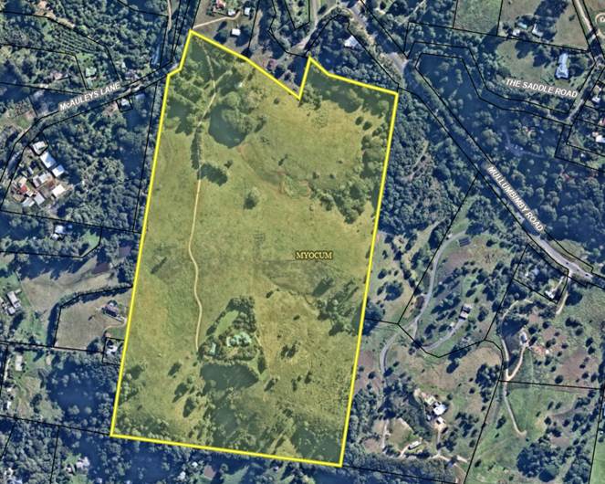
Figure 1: Subject Land
Voluntary Planning Agreement (VPA)
What is a Voluntary Planning Agreement (VPA)?
Voluntary planning agreements are used widely in the planning system as a tool for delivering innovative or complex infrastructure and public benefit outcomes in connection with planning proposals and development applications. They provide a way for planning authorities and developers to negotiate flexible outcomes in respect of development contributions.
Under such an agreement, the developer may be required to dedicate land, pay a monetary contribution, or provide some material benefit to be applied towards a public purpose.
It is important to note that a VPA is voluntary and cannot be imposed on the developer. It is negotiated in good faith between the developer and Council to achieve a good development outcome that meets the infrastructure requirements of Council and the community.
In this instance, the VPA has been negotiated to provide upgrades to McAuleys Lane and the Mullumbimby Rd / McAuleys Lane Intersection.
Council Resolution 21-181
Relevant to this report are Items 1 and 2 of Res 21-181. These items are as follows:
21-181 Resolved that Council:
1. Accept the applicant’s letter of offer to enter into a Voluntary Planning Agreement (VPA) (Attachment 6 E2021/69988) with Council as part of this planning proposal subject to the letter of offer being amended to include:
a) Safety upgrades to accommodate pedestrian and cycle links from the development site to Mullumbimby Road.
b) Integration of pedestrian and cycle links with the proposed McAuleys Lane / Mullumbimby Road intersection upgrade.
c) provision of a slip lane for turning into Saddle Road from Mullumbimby Road that provides better safety and access for cyclists, pedestrians, and all road users.
2. Require that a draft VPA be prepared in accordance with the amended letter of offer.
Following the above resolution:
· An amended letter of offer was submitted by the developer (Attachment 2).
· Council worked with the developer to update the Traffic Impact Assessment and associated intersection concept plan to address the above resolution (Attachment 3).
· A road safety audit was undertaken to assess the proposed design (Attachment 4).
· A draft VPA was prepared once Council engineers were satisfied with the proposed outcome (Attachment 1).
Discussion of the draft VPA provisions
The following discussion explains how the draft VPA addresses the requirements of the above resolution, specifically items 1(a), (b) and (c).
Item 1(a) Safety upgrades to accommodate pedestrian and cycle links from the development site to Mullumbimby Road.
The location of the proposed cycleway connecting Mullumbimby to Brunswick Heads is yet to be determined by Council. If the Mullumbimby to Brunswick Heads cycleway alignment is not adjacent to Mullumbimby Road, it would not be practical or possible to require integration with the cycleway.
Therefore, the VPA provides some flexibility by giving Council the discretion to require the payment of the Cycleway Contributions in lieu of the Developer carrying out the Cycle Path Works.
Item 1(b) Integration of pedestrian and cycle links with the proposed McAuleys Lane / Mullumbimby Road intersection upgrade.
As noted above, the location of the proposed cycleway connecting Mullumbimby to Brunswick Heads is yet to be determined. It is therefore not possible to produce a detailed concept design that includes the cycleway integration with the intersection. However, the intersection concept design appended to the VPA can be modified at the DA stage if cycleway integration with the intersection is required.
Item 1(c) provision of a slip lane for turning into Saddle Road from Mullumbimby Road that provides better safety and access for cyclists, pedestrians, and all road users.
An engineering review of this requirement found that the provision of a slip lane in this location would diminish the line-of-sight for vehicles exiting Saddle Rd. This would have a negative effect on road safety and has therefore not been included in the VPA.
The updated concept plan (Appendix A in Attachment 4) for the intersection instead provides for curb delineation at Saddle Rd making it clear where vehicles are to perform a turn. This will improve the line-of-site issue and overall safety at the intersection.
Additional Changes to the Intersection Concept Design
Refer to updated Intersection Concept Design (Appendix A in Attachment 4)
Driveway access at 110 Mullumbimby Rd
Further to addressing the requirements in the above resolution, Council engineers became aware of significant safety issues related to driveway access at 110 Mullumbimby Rd that had not been given adequate consideration when the intersection concept design was initially drafted. The location of the driveway is shown below in Figure 2.
![]()
![]()
![]()
![]()
![]()
![]()
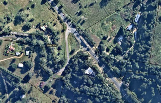
Figure 2: Location of Driveway Access – 110 Mullumbimby Rd
The GeoLink Road Safety Audit found that:
The site visit revealed significant safety issues associated with the proximity of the crest on Mullumbimby Road to the driveway providing access to No. 110 Mullumbimby Road. Although there is sufficient sight distance available to the right (northwest), the crest severely limits sight distance to the left (southeast).
The measures to prevent right turns in or out of this driveway proposed in the concept design remove the exposure to this hazard.
Preventing right turns in and out of the driveway means that driveway users heading west along Mullumbimby Rd towards Mullumbimby, will need to perform a U-turn at McAuleys Lane to access the driveway. Similarly, vehicles leaving the driveway that want to travel into Mullumbimby will need to perform a U-turn at the fruit shop road reserve on Mullumbimby Rd, or at the Gulgan Rd / Mullumbimby Rd intersection.
This constitutes a minor inconvenience for users of the driveway; however, it will significantly improve safety conditions for all road users. Preliminary discussions have been held with the landowner at 110 Mullumbimby Rd and they will be further engaged during the public exhibition process.
Recommendation
Council engineers and planning staff have worked with the developer to update the intersection concept design and prepare a voluntary planning agreement that provides the option for Council to levy contributions for cycleway integration (i.e., depending on location of the proposed cycleway connecting Mullumbimby to Brunswick Heads).
It is recommended that Council endorse the draft VPA and place the draft VPA on exhibition concurrently with the planning proposal.
Next steps
Following exhibition of the draft VPA and planning proposal, a submission report will be prepared for Council’s consideration.
Strategic Considerations
Community Strategic Plan and Operational Plan
|
CSP Objective |
CSP Strategy |
DP Action |
OP Activity |
|
Objective 4: We manage growth and change responsibly |
4.1 Support the visions and aspirations of local communities through place-based planning and management |
4.1.3 Manage development through a transparent and efficient assessment process |
4.1.3.10 Prepare and assess Planning Proposals and Development Control Plans, and amend Local Environmental Plan maps |
Recent Resolutions
· Res 21-181
Legal/Statutory/Policy Considerations
The relevant policy considerations are addressed above and in the draft Voluntary planning Agreement attached to this report.
Financial Considerations
If Council chooses to proceed with the voluntary planning agreement, it will be at the proponent’s expense as part of a landowner-initiated planning proposal.
Consultation and Engagement
Any future consultation and engagement will take place in accordance with a Gateway determination issued by the NSW Department of Planning Industry & Environment.
BYRON SHIRE COUNCIL
Staff Reports - Sustainable Environment and Economy 13.3
Report No. 13.3 PLANNING - 26.2021.3.1 150 Lismore Road, Bangalow Submissions Report
Directorate: Sustainable Environment and Economy
Report Author: Sam Tarrant, Planner
File No: I2022/554
Summary:
This report presents the public exhibition outcomes for a planning proposal to rezone part of 150 Lismore Road, Bangalow from RU1 Primary Production to IN1 General Industrial and C3 Environmental Management.
The planning proposal was exhibited from 11 April to 11 May 2022. Six public submissions and six agency submissions were received.
A number of changes to the exhibited proposal are recommended including reducing the area of IN1 zoning and increasing the C3 zoning to provide a greater buffer to Maori Creek.
It is recommended that the amended planning proposal as attached to this report is adopted and submitted to DPIE for finalisation.
NOTE TO COUNCILLORS:
In accordance with the provisions of S375A of the Local Government Act 1993, a Division is to be called whenever a motion for a planning decision is put to the meeting, for the purpose of recording voting on planning matters. Pursuant to clause 2(a) under the heading Matters to be Included in Minutes of Council Meetings of Council's adopted Code of Meeting Practice (as amended) a Division will be deemed to have been called by the mover and seconder of all motions relating to this report.
RECOMMENDATION:
That Council adopts the amended planning proposal as attached to this report (Attachment 1 - #E2022/62680) to rezone part 150 Lismore Road, Bangalow to IN1 General Industrial and C3 Environmental Management, and forwards this to the Department of Planning, Industry and Environment for finalisation.
Attachments:
1 26.2021.3.1
- Planning Proposal Post Exhibition Version, E2022/62680
![]()
2 26.2021.3.1
- Combined agency submissions, E2022/52801
![]()
3 26.2021.3.1
- Combined Public Submissions, E2022/44088
![]()
4 26.2021.3.1
- BCD and Applicant Flood Correspondence, E2022/67134
![]()
5 Template
- Form of Special Disclosure of Pecuniary Interest, E2012/2815 ![]()
Report
At the September 2021 Planning Meeting, Council received a report on a submitted planning proposal to rezone part of 150 Lismore Road, Bangalow from RU1 Primary Production to IN1 General Industrial and C3 Environmental Management.
The site is identified as an investigation area within Byron Business and Industrial Lands Strategy.
Council resolved 21-356 to proceed to public exhibition and consider a submissions report post exhibition with any recommended changes.
This report outlines the exhibition period, submissions received and recommended changes to the exhibited planning proposal.
The planning proposal was exhibited from 11 April to 11 May 2022. Notification was sent to adjoining landowners, relevant community groups and government agencies.
During exhibition, six public submissions were received including one submission that was received after exhibition had closed. In this case, the late submission has been included and considered with the other submissions.
The agency and public submissions have been summarised and addressed below. Copies of the submissions are attached to this report.
An extension to the gateway deadline was granted for this planning proposal due to the flood events delaying public exhibition and the changes recommended to the proposal from public exhibition. The gateway expires 13 November 2022.
Agency submissions
Department of Primary Industries Agriculture – No objections
Mining, Exploration and Geoscience – No objections
TransGrid – No impact to TransGrid therefore no comment required
Department of Primary Industries Fisheries – Provides comments for Council’s consideration. Notes that Maori Creek is a 4th order waterway and is considered Type 2 key fish habitat. Fisheries policy recommends a minimum buffer of 50m. Fisheries notes that Byron Creek, which is 500m downstream, is mapped as Type 1 key fish habitat and is mapped as potential habitat for the threatened species Southern Purple Spotted Gudgeon. DPI Fisheries recommends the C3 zone consistent with the Fisheries buffer policy.
The planning proposal has been updated to include a minimum 40m E3 zoned buffer from Maori Creek to the edge of the IN1 zoning with the buffer increasing to 70m at the southern portion of the lot. This is considered a suitable distance noting that there is currently very limited riparian vegetation and Byron DCP 2014, Chapter B1 Biodiversity requires a vegetation management plan or biodiversity conservation management plan to be submitted with the subdivision development application, which will result in this area being re-vegetated.
Transport for NSW – Raises no objections and provided the following comments
- TfNSW are aware of feasibility studies undertaken by Byron Shire Council to consider transport-related uses of the corridor. The planning proposal should note this.
- The preliminary site investigation report supporting the planning proposal concludes negligible risk to human health. TfNSW is currently conducting environmental assessment for contamination along the rail corridor. TfNSW is not currently aware of contaminants in the rail corridor or on the common boundaries with the development site.
The use of this site for industrial purposes will not hinder any reactivation of the rail corridor. The planning proposal has been updated to reflect this.
Biodiversity Conservation Division (BCD) – During public exhibition BCD recommended an ecological assessment be made which included a survey to determine if Hairy Joint Grass was present on the site. The applicant provided an ecological assessment report and found no Hairy Joint Grass on site. A small soak area was identified on the site. BCD assessed this report and provided the following recommendations.
- The soak area has high environmental value and should be zoned C2 Environmental Conservation including a 20m buffer
- A C3 Environmental Management zoned buffer for a distance of 20m should apply to both sides of Maori Creek
- The planning proposal should be updated to reflect the soak area and Maori Creek being included on the Biodiversity Values Map
- The flood impact study should be updated to provide details regarding the model calibration and utilise flood data from the February-March floods if available
BCD requested opportunity to review the proposal once updated with the above recommendations. The recommendations were addressed, and the amended planning proposal as presented in this report was sent to BCD who provided support for the proposal.
BCD sought clarification if data exists at the Binna Burra gauge for the February-March 2022 flood event to calibrate the flood model.
The applicants flood engineer confirmed there is data available from the February-March event at the Binna Burra gauge and that the peak is higher than the 2017 event. The inclusion of this recent event may improve model accuracy for larger events, although the model has been calibrated to a large event in 2017. The flood assessment report demonstrates an accurate relationship between the rating curve and the model predictions indicating that the existing model is likely to provide an adequate representation for larger events than were previously modelled.
Council does not have a recent adopted flood study model for this catchment, which places the onus on the applicant when preparing flood studies. The flood engineer notes that if the model was to be re-calibrated to include the 2022 event there would be a $10-15k cost for the applicant and the work would take a minimum of 3 months to complete.
The additional time required to complete a model re-run would push the planning proposal past the gateway expiration. DPIE have stated in the gateway alteration letter that they are unlikely to support any further extension to the completion time frame for this planning proposal.
In addition, the most up to date flood information will be required at the development application stage to determine flood planning level on this site, which will utilise data from the 2022 event.
Furthermore the proposed industrial zoned area has been significantly reduced since the flood assessment was produced resulting in less fill required and the development area moving away from the lower lying areas adjacent to Maori Creek.
Given the demonstrated accuracy of the flood model, the reduction in proposed industrial land, further consideration at the development application stage and gateway time restraints, it is considered that the current model is acceptable to progress the rezoning.
No response was received from Essential Energy, NRAR, TBLALC or Rous County Council.
Public submissions
Six submissions were received, one of which was accepted after exhibition had closed. The key points within the submissions have been summarised and staff have provided comment in the following table. The submissions are available in attachment 3.
|
Submission |
Staff comment |
|
An FSR of 0.75:1 is not the same as the adjoining estate as the DCP required a maximum building footprint of %50 of each allotment to minimise road parking. |
FSR is applied within the Byron LEP 2014. The adjoining industrial estate is mapped with a maximum FSR of 0.75:1 and a height limit of 9m. This forms the maximum building envelope permissible within the LEP. The DCP control referenced in this submission is taken from DCP 2010 Chapter B12. This DCP applies to land zoned under Byron LEP 1988 and does not apply to this site. |
|
The flood impact assessment is now redundant due to the recent floods which covered half of the site. Green areas need to be retained to minimise impacts from flooding. The rezoning has potential to exacerbate flooding. |
The flood study utilised the most up to date flood data available to model the flooding of the site and is likely to provide an adequate representation for larger events than were previously modelled. The report shows that the area to be rezoned for industrial use can be filled above the flood level without increasing off site flood impacts. The C3 zoned buffer has been significantly increased and will minimise the amount of fill required and limit industrial development to higher ground away from Maori Creek. |
|
The rezoning will increase the size of the industrial estate considerably and increase traffic onto Lismore Road. The bulk and scale will cause amenity impacts and a significant increase in artificial light exposure from businesses. |
The industrial zoned area has been reduced to provide a greater buffer to Maori Creek. Revegetation of the riparian area will reduce light spill from this development and the existing industrial area. The traffic assessment accompanying this proposal concludes that Lismore Road and turning lane is capable of facilitating this rezoning. |
|
The proposal will have a visual impact as it is the gateway from the west of Bangalow and should be landscaped. There is an opportunity to landscape the area to mitigate visual impacts. |
Part of the site is proposed to be zoned C3 Environmental Management. Planting of this area will be required at the development application stage. The site is small scale and directly adjoining an existing industrial estate. Future development of the site will be screened by the existing industrial estate and is unlikely to have a significant visual impact. |
|
Is there any proof that additional industrial land is required in this area? |
Direction 3: Long Term Supply (p.63) within the Business and Industrial Lands Strategy discusses the need for additional industrial land within the shire. Additional residential lands have come online over the last 5 years in Bangalow, including Clover Hill, The Meadows and Parrot Tree Place creating additional demand for employment lands. |
|
Byron Creek would be put at risk by having industrial use adjoining. The buffer is too small. |
The buffer has been increased to a minimum of 40m and a 20m environmental zone on the eastern side. This area will require suitable plantings as part of the development application for subdivision. |
|
Bangalow Progress Association supports the proposal and the inclusion of the C3 Environmental Buffer. |
Noted. |
|
Part of the adjoining industrial property is incorrectly zoned RU1 and should be corrected to IN1 |
A small area on the eastern boundary of the existing industrial estate contains an RU1 zoning. This has carried over from a subdivision of the paper road which gave additional land to lots within the estate. This area should be rezoned IN1 for consistency, however this planning proposal has only considered the subject land at 150 Lismore Road. This inconsistency has been flagged to be corrected in a future LEP housekeeping planning proposal. |
|
Stormwater impacts on the adjoining properties should be considered with impacts from filling and planned revegetation. |
The flood study completed by BMT modelled the impact on flooding from filling the site and found no observable impacts to the existing industrial estate. Further assessment of stormwater and drainage is required at the development application stage. The details of revegetation within the C3 zone are not yet available and will be submitted and considered at the development application stage. The reduced IN1 zoned area will minimise the fill required. |
|
Concern regarding noise pollution from a large extension of the industrial estate. Currently noise impacts from the existing industrial estate. |
The area proposed for industrial land is over 400m from the closest residential zone. The area proposed for expansion is relatively small and is unlikely to significantly contribute to noise pollution. Conditions for hours of operation can be applied at the development application stage. |
|
The proposal is directly adjacent to neighbourhood streets and residential dwellings. |
The area proposed for industrial land is over 400m from the closest residential zone. See above comments regarding noise impacts. |
|
There is a possibility of the rail corridor being used as a rail trail in the future. This industrial estate provides a good opportunity to provide peripheral car parking to service the rail trail. |
This site has been identified within Byron Business and Industrial Strategy as an investigation site for industrial land. The rezoning will not hinder any future reactivation of the rail corridor. |
Changes to the exhibited planning proposal
As a result of the comments received during public exhibition, a number of changes to the planning proposal are recommended including:
· Increase the C3 Environmental Management zoned buffer between Maori Creek and the IN1 land to a minimum of 40m.
· Include a 20m C3 Environmental Management buffer to the east of Maori creek
· Zone the ‘soak area’ identified in the Ecological Assessment to C3 Environmental Management
· Update the minimum lot size and floor space ratio map to reflect the change in zoning.
· Update the planning proposal to reference Maori Creek as being mapped on the Biodiversity Values map.
· Update the planning proposal to reflect the exhibition outcomes.
The updated minimum lot size and floor space ratio maps have not yet been produced. They will be updated to reflect the final adopted zone boundaries (Fig 1 below).
The changes are reflected within the post exhibition planning proposal contained in Attachment 1 (E2022/62680).
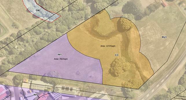
Figure 1: Updated land zoning map
Next steps
It is recommended that Council adopt the planning proposal in Attachment 1 and forward it to the Department of Planning, Industry and Environment for finalisation.
The gateway for this proposal expires on 13 November 2022.
Strategic Considerations
Community Strategic Plan and Operational Plan
|
CSP Objective |
CSP Strategy |
DP Action |
Code |
OP Activity |
|
4:
Ethical Growth |
4.1: Manage responsible development through effective place and space planning |
4.1.4: LEP & DCP - Review and update the Local Environmental Plan and Development Control Plans |
4.1.4.5 |
Consider landowner planning investigations for possible new industrial and/or business park areas, as identified in the BILS. |
Recent Resolutions
· 21-356 to proceed to public exhibition and receive a submissions report with any recommended changes.
Legal/Statutory/Policy Considerations
This planning proposal will amend Byron Local Environmental Plan 2014 in accordance with the relevant legislative requirements.
Financial Considerations
This is an applicant initiated planning proposal with all costs borne by the applicant.
Consultation and Engagement
As outlined within this report.
BYRON SHIRE COUNCIL
Staff Reports - Sustainable Environment and Economy 13.4
Report No. 13.4 PLANNING - 10.2018.384.3 - S4.55 to delay provision of suitable vehicular access for Dual Occupancy (Detached) - 183 Coopers Lane West, Main Arm
Directorate: Sustainable Environment and Economy
Report Author: Ivan Holland, Planner
File No: I2022/584
Proposal:
|
Section 4.55 Application No: |
10.2018.384.3 |
|||
|
Proposed modification: |
Modify development consent 10.2018.384.1 to delay provision of suitable vehicular access for dual occupancy (detached) |
|||
|
Original Development: |
Use of existing structure as a Dwelling House and Alterations and Additions to create Dual Occupancy (detached), Alterations and Additions to existing Dwelling House including Expanded Dwelling Module, Tree Removal and Upgrade existing Wastewater System |
|||
|
Type of modification sought: |
|
|
|
|
|
Property description: |
LOT: 2 DP: 445771 |
|||
|
183 Coopers West Lane MAIN ARM |
||||
|
Parcel No/s: |
181870 |
|||
|
Applicant: |
Mr W S Weisse |
|||
|
Owner: |
Mr W S & Mrs J L Weisse |
|||
|
Zoning: |
RU1 Primary Production / PART 1(b2) Agricultural Protection |
|||
|
S4.55 Date received: |
20 April 2022 |
|||
|
Original DA determination date: |
Deferred Commencement Approval 16 April 2020 |
|||
|
Integrated Development: |
No |
|||
|
Public notification or exhibition: |
- Level 1 advertising under the Byron Shire Council Community Participation Plan. - Exhibition period: 27 April 2022 to 10 May 2022. - Submissions received: Three (3) |
|||
Summary:
This modification application seeks to modify development consent 10.2018.384.1 to delay provision of suitable vehicular access for the dual occupancy (detached). The original application was determined by Council.
The development consent currently requires (condition 14) the access road easement alignment to be corrected to overlay the physical access road prior to the issue of a construction certificate for the alterations and additions to the dual occupancy (detached). This application seeks to alter the timing for this requirement to instead be within five (5) years of the date of determination of this modification application.
It is understood that the rights of carriageway within two of the affected properties have already been amended however there has not been agreement reached with the owners of the third property to correct the inconsistency, thus preventing compliance with condition 14 of DA 10.2018.384.1.
It is noted that the modification of the consent will enable the dual occupancy to be finalised and the dwelling to be occupied which would provide housing which is generally in short supply across the Shire and the broader region. However it remains important that this matter is resolved before the continued construction and completion of the dwelling. The conditions require the easement to be in place prior to the issue of the construction certificate.
Pushing the timing of the easement back further, could mean the second dwelling is completed and occupied but the legal access is never resolved, this would leave a compliance matter which would in summary be difficult to resolve, considering the owners of the property have since the consent was issued some 28 months ago, still to come to an appropriate legal arrangement with the relevant property to rearrange the easement. It is also noted the primary dwelling on the property is not affected by the conditions.
Having regards to the provisions contained within Clause 6.6 of the Byron LEP 2014, the proposed modification does not provide a clear mechanism to ensure the development when completed will be provided with suitable vehicle access, and the application, despite the benefits of additional housing it will provide, is recommended for refusal.
NOTE TO COUNCILLORS:
In accordance with the provisions of S375A of the Local Government Act 1993, a Division is to be called whenever a motion for a planning decision is put to the meeting, for the purpose of recording voting on planning matters. Pursuant to clause 2(a) under the heading Matters to be Included in Minutes of Council Meetings of Council's adopted Code of Meeting Practice (as amended) a Division will be deemed to have been called by the mover and seconder of all motions relating to this report.
RECOMMENDATION:
That pursuant to Section 4.16 of the Environmental Planning & Assessment Act 1979, Application No. 10.2018.384.3 to Modify development consent 10.2018.384.1 to delay provision of suitable vehicular access for dual occupancy (detached), be refused for the following reason:
1. The proposed modification does not ensure the development will have suitable vehicular access, contrary to the requirements of clause 6.6(e) of the Byron Local Environment Plan 2014.
1 10.2018.384.3
- Modification Report, E2022/31059
![]()
2 10.2018.384.1
- Applicants Legal Advice, E2020/11984
![]()
3 Confidential - submissions received 10.2018.384.3, E2022/71559
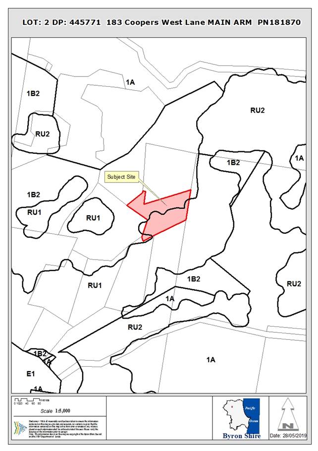
Assessment:
1. INTRODUCTION
1.1. History/Background
History
DA 10.2018.384.1 was approved by Council on 16 April 2020 as per Resolution Number 20-154:
Resolved that pursuant to Section 4.16 of the Environmental Planning & Assessment Act 1979, Development Application No.10.2018.384.1 for Alterations and Additions to existing Dwelling House Use, Alterations and Additions to existing structure to create Dual Occupancy (detached) and Upgrade Wastewater System, be approved subject to the amended conditions in document E2020/27539. (Lyon/Hackett)
The notice of determination was subsequently issued (E2020/28902) with the conditions attached to the agenda (E2020/5837) rather than those specified in the Council Resolution (E2020/27539).
An application to modify the consent (DA 10.2018.384.2) to correct this error was approved on 30 April 2020.
Background – access road
Several properties on Coopers Lane (West), Main Arm access the public road system via an access road that traverses through several properties. The access road has been in existence for many years based on a review of historical aerial photos. The entitlement for these properties to use the access road is enabled by a series of easements/rights of carriageway. Inconsistencies between the physical access road and associated legal easements for such were identified during the assessment of the original development application (DA 10.2018.384.1). This application was approved with a requirement (condition 14) for the access road and easement inconsistencies to be corrected. It is understood that the easement has been corrected in two of the three affected properties but one of the property owners, through which the access road traverses, has not been willing to support the correction of the inconsistency, thus preventing compliance with condition 14 of DA 10.2018.384.1.
The issue with the inconsistency between the access road and associated easement has been considered in several development applications subsequent to DA 10.2018.384.1 and these applications and associated decision are discussed below.
1.2. Description of the proposed development
This application seeks approval to modify development consent 10.2018.384.1 to delay provision of suitable vehicular access for the dual occupancy (detached).
Currently, condition 14 of the development consent requires the access road easement alignment to be corrected to overlay the physical access road prior to the issue of a construction certificate for the alterations and additions to the dual occupancy (detached).
This application seeks to alter the timing for this requirement to instead be within five (5) years of the date of determination of this modification application.
1.3. Description of the site
The following description was taken from the development assessment report for the original development application (10.2018.384.1):
|
Land is legally described as |
LOT: 2 DP: 445771 |
|
Property address is |
183 Coopers West Lane MAIN ARM |
|
Land is zoned: |
RU1 Primary Production / PART Deferred Matter (1(b2) Agricultural Protection) |
|
Land area is: |
2.18 ha |
2. SECTION 4.55(2)
Consideration of the applicable provisions is documented below:
· The development, as modified, is substantially the same as the originally approved development (s.4.55(2)(a)).
· Rural Fire Service has been notified of the modification application (s.4.55(2)(b)).
· The application has been appropriately notified and submissions received are considered below (s.4.55(2)(c) and (d)).
· Matters relevant to determination are considered below (s.4.55(3)).
3. ENVIRONMENTAL PLANNING AND ASSESSMENT REGULATION 2021
Consideration of the applicable provisions is documented below:
· The modification application included all necessary information (Regs.99 and 100).
· The application has been appropriately notified (Reg.107).
· Rural Fire Service has been notified of the modification application (Reg.109).
4. SUMMARY OF REFERRALS
Development Engineer
Clause 6.6(e) of the BLEP 2014 states:
Development consent must not be granted to development unless the consent authority is satisfied that any of the following services that are essential for the development are available or that adequate arrangements have been made to make them available when required—
(e) suitable vehicular access.
Current Situation
The survey by Heath & McPhail Surveying with drawing no HM18147-2 Issue A dated 16.07.2019 depicted the access alignment meandering in and out of the existing ROC easement alignment. As such the sections of the access are outside the ROW easement
Further, the alignment of the access carriageway is not generally contained in the approved alignment of the ROC in Subdivision 45/72. The existing alignment of the carriageway bypassed a section of ROC inside Lot 1 DP 445771 and meanders through an unapproved alignment inside Lot 7 DP591828 before entering back into the development lot. There is no legal documentation of the encroachment in Lot 7 DP591828.
Due to this issue, a condition was drafted to ensure Clause 6.6(e) of the BLEP
The current proposal offers to defer this requirement by 1 April 2027 and allow the issuance of Building Construction Certificate and Occupation Certificate.
The proposal was tested to see if it will satisfy clause 6.6 (e).
“Should insufficient evidence cannot be put in place by 1 April 2027, the condition will become invalid. This will result in non compliance to Clause 6.6 of BLEP 2014”
Recommendation
The proposal is not supported.
5. SECTION 4.14 – BUSH FIRE PRONE LAND
Under section 4.14 of the Act, Council must be satisfied prior to making a determination for development on bush fire prone land, that the development complies with Planning for Bush Fire Protection. The site is bush fire prone land. The original development application was referred to the NSW Rural Fire Service, which provided conditions which are included in the development consent. No changes to these conditions are proposed or required by this modification application.
6. SECTION 4.15 – MATTERS FOR CONSIDERATION – DISCUSSION OF ISSUES
Having regard to the matters for consideration detailed in Section 4.15(1) of the Environmental Planning & Assessment Act 1979 (EP&A Act), the following is a summary of the evaluation of the issues.
6.1. State Environmental Planning Instruments
The proposed modification raises no issues under the applicable SEPPs.
6.2. Byron Local Environmental Plan 2014 (LEP 2014)
LEP 2014 is an applicable matter for consideration in the assessment of the subject application in accordance with subsection 4.15(1) of the EP&A Act because it applies to the subject land and the proposal. The LEP 2014 clause of relevance to this modification application is considered below:
Clause 6.6 Essential Services
Prior to granting development consent, Council must be satisfied that “suitable vehicular access” for the development is “available or that adequate arrangements have been made to make [suitable vehicular access] available when required”.
Considering this requirement, the original development consent (10.2018.384.1) was approved with a requirement (condition 14) for the access road and easement inconsistencies to be corrected prior to the issue of a construction certificate for the alterations and additions to the dual occupancy. Condition 14 is copied below:
|
14. |
Legal Access to Property The application for a Construction Certificate is to include sufficient evidence to demonstrate that the property access road through Lot 3 DP 558858, Lot 1 DP 445771 and Lot 7 DP 591828, including any changes required by the Rural Fire Service (DA-2018-03006-CL55-1, 3 December 2019 – See Schedule 3), is wholly contained within a legal right of carriageway. Any redundant rights of carriageway/easements to be extinguished.
Such evidence must include: a) an updated survey of the access road that shows the access road and any further widening wholly within suitable rights of carriageway under the Conveyancing Act 1919. b) A copy of the registered rights of carriageway and a title search for all effected lots.
|
It is understood that the rights of carriageway within two of the affected properties have already been corrected however resolving the matter with the third property (156 Coopers Lane West – Lot 3 DP 558858) has not been achieved, thus preventing compliance with condition 14 of DA 10.2018.384.1. To resolve this matter the applicant may need to proceed to use the relevant powers under Section 88K of the Conveyancing Act 1919. At the time of approval in 2020, the applicant provided legal advice that this was one of the options that it could rely upon (See Council Planning Report 13.3 dated 20 February 2020 and Planning Report 13.6 dated 20 April 2020).
The issue with the inconsistency between the access road and associated easement has been considered in several other, recent development applications, relevant details of which are summarised below:
|
DA number |
Address |
Determination date |
Condition/s relating to access |
|
10.2018.378.1 Use of Shed as dwelling |
181 Coopers Lane West MAIN ARM |
7/9/2019 |
The misalignment of the access road and easement was not identified prior to the determination of this DA. |
|
10.2020.496.1 Use of existing building as a Dwelling house and construction of new dwelling to create dual occupancy |
187 Coopers Lane West MAIN ARM |
13/10/2021 |
1. Deferred Commencement Consent This consent does not operate until Council is satisfied as to the following matters: (a) Vehicular access The subject property must have suitable vehicular access through Lot 3 DP 558858. Lot 1 DP 445771, Lot 2 DP 445771 and Lot 7 DP 591 828. To satisfy Council that the property has suitable vehicular access, sufficient evidence must be provided to demonstrate that the access road, including any changes required by the Rural Fire Service Conditions, is wholly contained within a legal right of carriageway. Such evidence shall include but not be limited to: • A letter of consent from the owners of Lot 3 DP558858, Lot 1 DP445771, Lot 2 DP445771 and Lot 7 DP591828 for any changes required by the Rural Fire Service Conditions to the access road inside these lots; • Detailed design, construction and certification by a qualified civil engineer for the works required to meet the changes required by the Rural Fire Service Conditions; • A survey of the access road, by a registered surveyor, between the property and the Coopers West Lane Crown Road Reserve that shows the access road, including any changes required by the Rural Fire Service Conditions, is wholly within suitable rights of carriageway under the Conveyancing Act 1919; • A copy of the registered rights of carriageway and a title search for all affected lots. Any redundant rights of carriageway are to be extinguished. |
|
10.2020.368.1 (Use of Alterations and Additions to Dwelling House, Garage, Carport & Swimming Pool) |
189 Coopers West Lane MAIN ARM |
Withdrawn |
N/A. Application was withdrawn after applicant was advised of access issue. |
|
10.2001.349.3 New Dwelling House – Amended in 2021 to resolve design changes to the roof of the dwelling |
Coopers Lane West MAIN ARM (Lot 1 DP 405191) |
25/11/2021 |
Matter not originally identified when first approved in 2001. Later modifications to resolve changes to the house design which were not previously approved resulted in the following condition being imposed, noting that the dwelling is already constructed and had been occupied for a number of years. 3A. Legal Access to Property Sufficient evidence is to be provided to demonstrate that the property access road through Lot 3 DP 558858, Lots 1 and 2 DP 445771, Lot 7 DP 591828, is wholly contained within a legal right of carriageway with any redundant rights of carriageway/easements extinguished by 1 December 2026. Such evidence must include, but not be limited to: a) An updated survey of the access road that shows the access road and any further widening wholly within suitable rights of carriageway under the Conveyancing Act 1919; and b) A copy of the registered rights of carriageway and a title search for all effected lots. |
In terms of the above application, staff have tried to find a reasonable compromise to resolve the matter considering that the above examples involve dwellings that have been constructed either without approval or not in accordance with the approved plans. It would seem prudent for the various other landowners that need their access re-aligned this be carried out jointly with the applicant to limit costs.
The modification application requests that the requirement to correct the access is de-coupled from the construction certificate and instead offers a due date of 1 April 2027. In considering the proposed amendment to condition 14, Council’s Development Engineer notes that the proposed modification does not satisfy the requirements of clause 6.6 (e) of the LEP as if the access issue is not rectified by the proposed due date (1 April 2027), the condition will become invalid preventing Council from ensuring the development has suitable vehicular access.
It is pertinent the matter is resolved prior to the development proceeding further and as such the modification is not supported.
6.3. Any proposed Instrument that has been the subject of public consultation and has been notified to the consent authority
No proposed instruments were identified that are applicable to this application.
6.4. Byron Shire Development Control Plan 2014 (DCP 2014)
DCP 2014 is an applicable matter for consideration in the assessment of the subject application in accordance with subsection 4.15(1) of the EP& A Act because it applies to the land to which LEP 2014 applies. The DCP 2014 Parts/Chapters that are of relevance to the modification application are considered below:
B3 – Services
Vehicular access to the development is via a right of way (ROW) from Coopers West Lane. As discussed above, the access needs to be upgraded and the ROW needs to be re-aligned as per condition 14. Until this process is finalised, the development is not considered to have adequate road facilities (B3.2.1).
6.5. Environmental Planning & Assessment Regulation 2021 Considerations
The proposed modification raises no issues under the Regulations.
6.6. The likely impacts of that development, including environmental impacts on both the natural and built environments, and social and economic impacts in the locality
The proposed modification raises no additional issues in terms of the environmental impacts which have not been considered previously.
6.7. The suitability of the site for the development
The site is considered suitable for the development provided the access is upgraded and the ROW corrected as required by the conditions of the consent.
6.8. Submissions made in accordance with this Act or the regulations
The application was publicly exhibited, with three objections being received,
|
Key issues raised in submissions |
Consideration |
|
Reduction in obligation on the applicant to negotiate an outcome |
Noted. It remains important that this matter is resolved prior to the development proceeding. |
|
No legal right of carriageway over Lot 3 DP 558858 |
Council has obtained independent legal advice that confirms the subject property has a legal right of carriageway over Lot 3 DP 558858. |
|
Impacts of modifying the access road |
The modification application does not propose modifying the access road only altering the timeline for compliance with condition 14. |
|
Bush fire requirements |
The Rural Fire Service (RFS) have visited the subject site, reviewed the access road, and have issued approval for the development subject to conditions. The modification application does not propose any changes to bush fire conditions/requirements. The conditions recommended by the RFS do not require and changes to the physical or legal access within Lot 3 DP 558858. |
|
Not affordable housing |
The proposed development is not for affordable housing under the Housing SEPP. |
|
No right to a dual occupancy |
Dual occupancies are permitted on the subject property within the RU1 zone. This is not a relevant consideration for the current application to modify the timing to correct the vehicular access. |
|
Access requirements are different for dwelling as compared to a dual occupancy |
The requirement for suitable vehicular access applies to all developments pursuant to clause 6.6(e) of BLEP 2014. |
|
Planning history |
Noted, there appears to be a general predilection for some landowners in the Shires Hinterland to undertake development without approval. However, it is understood the dual occupancy dwelling was constructed on the subject property without approval by a previous owner. |
|
Risk of landslip |
This modification application relates only to the timing for the correction of the access easement. Landslip is not a consideration. |
|
Traffic |
As noted above, this modification application relates only to the timing for the correction of the access easement. This application has no impact on traffic generation. |
6.9. Public interest
The proposed modification has the potential to compromise the public interest and/or create an undesirable precedent. Support for delaying this resolution post the completion of the second dwelling is not supported, and potentially would leave Council with a complex compliance matter to resolve.
7. CONCLUSION
The proposed modification does not satisfy the relevant planning requirements under Clause 6.6 of Byron LEP 2014 as it will not provide Council with a clear mechanism to ensure the development is completed with legal access arrangements to the property for the additional dwelling.
The modification application is not supported.
BYRON SHIRE COUNCIL
Staff Reports - Sustainable Environment and Economy 13.5
Report No. 13.5 Planning Proposal - 26.2020.2.1 Affordable housing contribution scheme submissions report
Directorate: Sustainable Environment and Economy
Report Author: Natalie Hancock, Senior Planner
File No: I2022/659
Summary:
Section 7.32 of the Environmental Planning and Assessment Act 1979 (the Act) enables councils to impose a condition on development to require contributions for affordable housing where:
· a State Environmental Planning Policy (SEPP) identifies that there is a need for affordable housing
· it is authorised by a local environmental plan (LEP) and
· applied in accordance with an affordable housing contribution scheme (AHCS).
In 2018, the SEPP 70 – Affordable Housing was revised to expand its operation to LGAs across the state. At the 11 April 2019 Council meeting it was resolved (19-152) to prepare an affordable housing contribution scheme and the associated local environmental plan (LEP) provisions for Byron Shire.
Contributions are levied on the increase in land value generated by the rezoning of the land referred to as ‘upzoning’. Several requirements must be satisfied: evidence of a need for affordable housing, should land be upzoned that the contribution rate set is viable, and contributions are to be used for affordable housing in the local government area.
An AHCS and planning proposal was prepared and submitted to the Department of Planning and Environment (DPE) in December 2021 for gateway approval. In February 2022, the DPE granted a gateway for the planning proposal. Considering the flood event, DPE on 15 March 2022 issued an amended gateway providing additional time to exhibit and finalise the LEP amendment (Attachment 1).
The planning proposal and AHCS were placed on public exhibition from 17 May to 3 July 2022 (Attachment 2).
During this period 7 submissions and an agency response from the Rural Fire Service were received (Attachments 3 and 4). Two submissions were received from landowners directly affected by the draft provisions. All submissions supported application of contributions for affordable housing, although some questioned the required percentage for dedication.
The purpose of this report is to:
· provide an assessment of the submissions received
· recommend that Council adopt the planning proposal for a new Clause for ‘Affordable Housing’ under Part 6 ‘Additional Local Provisions
· recommend
that Council writes to the NSW government requesting an amendment to the
SEPP (Housing) 2021 to specify that any planning proposal lodged to upzone land
after the issuing of a gateway for an Affordable Housing Contribution
Scheme planning proposal for the same land will be subject to that AHCS should
the LEP amendment and AHCS come into effect.
RECOMMENDATION:
That Council
1. adopts the planning proposal to amend Byron LEP 2014, together with the Affordable housing contribution scheme as contained in Attachment 2 (E2022/53312)
2. forwards the adopted planning proposal and Affordable housing contribution scheme to NSW Parliamentary Counsel’s Office (PCO) requesting that a draft LEP instrument be prepared
3. pending receipt of PCO opinion that the plan can be made, forwards the plan to the NSW Department of Planning and Environment for notification on the NSW Government legislation website
4. requests that staff write to the DPE requesting the NSW government amend the SEPP (Housing) 2021 to specify that any planning proposal lodged to upzone land after the issuing of a gateway determination for an Affordable Housing Contribution Scheme applying to the same land, will be subject to that AHCS should the Local Environmental Plan amendment and Affordable Housing Contribution Scheme come into effect.
1 Gateway
determination correspondence Affordable housing contribution scheme
26.2020.2.1, E2022/53038 ![]()
2 Combined
PP 26.2020.2.1 and AHCS exhibition versions 2022, E2022/53312 ![]()
3 Combined
submissions on Affordable Housing Contribution Scheme Planning Proposal, E2022/62133 ![]()
4 Rural
Fire Service Response, E2022/63111
![]()
5 Summary
of Council resolutions relating to the Affordable Housing Contribution Scheme, E2022/2750 ![]()
6 Late
community feedback received outside exhibition period, E2022/62979 ![]()
7 Special
Disclosure of Pecuniary Interest Annexure for matters relating to environmental
planning instruments, E2012/2815 ![]()
Report
Background
The following summarises the process leading up to the planning proposal.
· 4 August 2016: Council resolved (16-422) to consider means for adopting affordable housing provisions in the Shire’s planning instruments
· 22 June 2017: Council resolved (17-260) to request staff to progress an expression of interest (EOI) process inviting landowners to submit affordable housing proposals for other land in the Byron Shire for the consideration of Council as part of an early implementation program to supplement Council’s Residential Lands Strategy. Result: several landowners whose land was potentially suitable under the draft strategy coming forward to be involved
· 19 April 2018: Council resolved (18-217) to request that staff write to the DPE seeking SEPP 70 – Affordable Housing, which at this time were essentially limited to metropolitan Sydney, be expanded to include Byron LGA. Result: request was successful with SEPP expanded to LGAs across the state
· 11 April 2019: Council resolved (19-152) to prepare an affordable housing contribution scheme (AHCS) and the associated local environmental plan (LEP) amendment
· 12 December 2019: Council resolved (19-636) to support consideration of the Residential Strategy investigation areas for inclusion in the AHCS.
In preparing a planning proposal it is necessary to describe the outcome sought and its justification.
Planning proposal outcome
The planning proposal seeks to include a clause in the Byron Shire LEP 2014 to enable Council to impose, as a condition of development consent on upzoned land, an affordable housing contribution in accordance with its affordable housing contribution scheme.
Justification
Section 7.32(3)(b) of the Act and SEPP 70 – Affordable Housing (Revised Schemes) is supported by a Guideline for Developing an Affordable Housing Contribution Scheme (nsw.gov.au) for councils to help them prepare affordable housing contribution schemes.
Several requirements must be satisfied: evidence of a need for affordable housing; should land be upzoned that the contribution rate as set is viable; and contributions must be used for affordable housing in the local government area.
A planning proposal satisfying such requirements was prepared and submitted to the DPE in December 2021 for gateway approval. In February 2022, the DPE granted a gateway for the AHCS planning proposal. Considering the flood event, DPE on 15 March 2022 issued an amended gateway providing additional time to complete the plan making process such that from the date of the gateway determination:
· an exhibited planning proposal be reported to Council for a final recommendation within six months
· completed in the LEP within eight months (Attachment 1).
Further details on Council resolutions throughout the process are contained in a letter provided to the DPE as part of the gateway determination process (Attachment 5).
In 2021, SEPP 70 - Affordable Housing (Revised Schemes) was incorporated into SEPP (Housing) 2021 as part of the NSW government planning reforms.
Public Exhibition
The planning proposal and AHCS were placed on public exhibition from 17 May to 29 June 2022 (Attachment 2). Following a community member’s request the exhibition period was extended to 3 July 2022.
In accordance with the gateway determination the planning proposal was sent to NSW Rural Fire Service (RFS) and Division of Housing and Property. In addition, landowners with property identified in the AHCS were notified by letter.
In the submission period, 7 submissions and a RFS agency response were received (Attachments 3 and 4). Two of the submissions were from landowners directly affected by the draft provisions.
All submissions supported the applying contributions for affordable housing, although both landowner submissions questioned the required percentage for dedication.
Other matters raised in the submissions are summarised and addressed in the next section of this report.
Matters raised
Matter 1: Agency response
The NSW RFS considered the information submitted and subsequently raised no concerns or issues in relation to bush fire.
Matter 2: Placement of affordable housing should avoid flood prone land.
Staff comment:
This concern is addressed in several ways:
· The existence of an affordable housing contribution clause in the Byron LEP 2014 and affordable housing contribution scheme does not automatically enable a planning proposal to upzone land (i.e. identified in the AHCS). This is the function of a Residential Strategy yet to be endorsed by the NSW government.
· Once a strategy is endorsed, any planning proposal to upzone land still must be assessed on its own merits, with community consultation being undertaken. Flood risk is a standard matter to considered when rezoning land for housing.
· AHCS Section ‘2.2 – Dedication of Land’ requires that land contributed for affordable housing under the scheme must be fit for residential purposes and serviced including water, sewerage, sealed roads and storm water drainage.
Matter 3: The provisions for AHCS should apply to all development in the shire.
Staff comment:
The Guidelines make it clear that affordable housing contribution schemes apply to developments that are facilitated by upzoning. Under the Guideline, an upzoning is a change of zone to enable residential development or a change of planning controls (such as floor space ratio) which enables greater residential density in site. For this reason the AHCS scope is confined to land being considered for upzoning in an adopted Residential Strategy.
Matter 4: Smaller development sites listed in the AHCS may be more vulnerable to variations in development costs and will compete in the market with other land releases that have no affordable housing contribution requirement such as Bayside and West Bryon. Hence consideration should be given to providing for:
(a) a flexible contribution based on expected development costs or
(b) a much lower contribution than 20% as now proposed.
Staff Comment:
The adopted Residential Strategy recognises that investigation areas all have varying levels of development constraints to be addressed prior to any upzoning of the land for residential purposes. Reasonably, such analysis may identify additional site-specific requirements with added cost.
In this context, the AHCS planning proposal was preceded by the Affordable Housing Contribution Policy - Byron Shire Council and procedures that offer an alternative ‘contribution pathway’ should a need arise. That is, it provides a rezoning proponent with the capacity to use a planning agreement (PA) to contribute affordable housing at a rate that varies from the scheme should an updated viability assessment justify a rate variation This pathway is facilitated by the Environmental Planning and Assessment (Planning agreements) Direction 2019 - under s7.9 of the Act .
However it is at Council’s discretion whether or not to accept a variation. Any PA would need to be exhibited with a planning proposal to rezone the land.
Should Council accept a PA then AHCS Section 1.3 clarifies that:
· the Scheme does not apply to development where an Affordable Housing Contribution has previously been applied.
· as the Act does not prescribe any particular means by which the developer’s performance of a planning agreement may be enforced, should a party fail to meet its planning obligation under a planning agreement to contribute for the purpose of providing affordable housing (then) the Scheme applies.
Matter 4: Request for reduced rate of contribution for land fronting Rankin Drive, Bangalow
Two Bangalow landowners questioned the 20% contribution rate for their land; Lot 11 DP807867, part of Lot 261 DP1262316 and part of Lot 262 DP1262316 as shown in a dashed blue line on Figure 1.
Figure 1: Existing zoning and illustrative AHCS areas
Landowner A: Lot 11 DP807867 and part of Lot 261 DP1262316
The landowner requests a reduced contribution rate of 4% of the upzoned land based on the following justification:
· site has steeper slopes contributing to a low average lot yield area of 1500m2/lot = ~7 lot/ha compared to the AHCS estimated yield of ~ 13 lots/ha
· additional cost of rerouting a Rous water main will cost $300,000-$500,000 to avoid removal of a koala food tree
· cost of new sewer pump station
· cost of roadway retaining walls associated with the gradient of the land.
Landowner B: Part of Lot 262 DP1262316
Landowner requests the application of 1-2% contribution of the value of lot sales based on mortgage/holding costs.
Staff comment:
In both instances the land has mixed zoning also shown on Figure 1. The AHCS provisions apply if land is upzoned in this instance, the RU2 Rural Landscape zoned portion.
The Guidelines recognise that Council may need to differentiate affordable housing contribution rates in different areas where a variation is substantiated, such as taking into consideration local and state infrastructure charges or specific to the development conditions applicable to the area being rezoned.
The DPE provided a costing analysis tool to accompanying the Guideline for setting out how to determine viable contribution rates, and the exhibited AHCS rates were set using this tool. An alternative costing analysis using the DPE assessment tool has not been provided by either of the landowners as part of their submission.
In relation to Landowner B’s request: To apply a rate using a formula based on an unknown future value of lot sales would be difficult to enforce and introduces a high level of uncertainty from both a monetary and timing standpoint. It also appears to be inconsistent with the Act provision 7.33 which requires contributions be made available by the consent authority for the purposes of affordable housing within a reasonable time. The landowner’s position also has not been sufficiently substantiated to support a reduction in the contribution rate (i.e., using the DPE assessment tool).
Matter 5: Lack of clarify on what happens to a contribution received
Staff comment:
The AHCS Section ‘6 Appendix C – Affordable Housing Implementation & Delivery Program Framework’ provides guidance on how contributions are to be utilised as does the Act and SEPP (Housing) 2021.
Matter 6: Appropriateness of affordable housing in Bangalow
Whilst supporting the provision of affordable housing, several submissions raised the appropriateness of affordable housing in Bangalow and a need for alignment with community values. Specific issues raised were as follows:
(i) Submission suggested halting land development in Bangalow until place planning improvements have been delivered.
Staff comment:
The AHCS does not rezone the land, nor facilitate the capacity to rezone in the absence of an adopted/endorsed Residential Strategy. Rather the AHCS specifically seeks to deliver a portion of any upzoned land as affordable housing for a combination of low- and moderate-income households.
The Northern Rivers is in the grip of an unpreceded housing crisis. The AHCS needs analysis was undertaken in mid-2019 prior to the covid and the recent flood events. The AHCS Section ‘4.3 Affordable housing demand’ states ‘an additional 3,393 dwellings are required in Byron LGA between 2016 and 2041, a proportional increase of 20%.’ It identified the ‘high levels of rental and purchase stress in Byron LGA, particularly amongst moderate income households, the high rate of people living in improvised dwellings and caravan parks, and the relatively high level of workforce containment suggests that people who work in Byron LGA lack options to rent or purchase in cheaper areas and commute into Byron LGA for work.’
The housing crisis has escalated considerably since this analysis was undertaken. The floods resulted in some 500 shire households being dislocated. A suggestion that Bangalow should be quarantined from further residential development on the basis that the community is awaiting place planning infrastructure improvements, may seem untenable and short in empathy to the situation for many currently displaced and stressed residents of the Northern Rivers.
(ii) The issue of housing mix, affordable housing and need to avoid negatively impacting on the local character and heritage of the Bangalow village in general and Ballina Road was raised.
Staff comment:
Any future rezoning of land identified as an Affordable Housing Contribution Area is subject to a separate planning proposal. Based on the 2019 population projections, 89.7% of the demand for additional dwellings in the Shire will come from increases in Couple Only and Lone Person households, suggesting a need for smaller dwellings such as residential flat buildings or multi dwelling housing. The adopted Residential Strategy has measures to guide how new residential development is to integrate with the existing Bangalow village. The community will have further opportunity to comment on planning proposals as specific land is sought to be rezoned.
(iii) Increase in traffic impacts
Staff comment:
Lismore Road & Granuaille Road have been main ‘through roads’ for more than 50 years. The Pacific motorway upgrade construction commenced late 2010. Based on the 2016 ABS census less than 50% of residents were residents of Bangalow five years earlier (in 2011). Therefore it is assumed these more recent residents have made a conscious decision to live in Bangalow, with some choosing to buy a house on or in proximity to such 'busy' through roads.
An AHCS influences the ratio of affordable housing in a development. The submissions have not provided any evidence that affordable housing households are likely to contribute to higher levels of traffic movement to other households. The investigation land captured in the AHCS is within walking distance of community facilities, a favourable outcome for affordable housing households. Any future rezoning of land identified as an Affordable Housing Contribution Area is subject to a separate planning proposal where traffic is a standard matter to considered/addressed.
(iv) Koala habitats and movement corridors
Any future rezoning of land identified as an Affordable Housing Contribution Area is subject to a separate planning proposal that must give consideration to State Environmental Planning Policy (Koala Habitat Protection) 2019, with Byron Shire part of the North Coast koala management area. The submissions have not provided any evidence that affordable housing households are likely to contribute to a higher risk for koala habitat and movement corridors.
Late community feedback
Additional feedback was received outside the extended exhibition period (Attachment 6). Both supported affordable housing. The concerns raised in one were not dissimilar to those in Matter 6 above on residential development in Bangalow.
The other feedback raised issue with a preferred approach of seeking a ‘land’ contribution. It was suggested that AHCS should also facilitate developer-built and owned affordable housing stock to be placed into the hands of a Community Housing Provider to manage.
The Guidelines require an AHCS to clarify whether the dwellings will be owned by government or a recommended community housing provider. Similarly, the Act provision 7.33 requires dedicated land to be either (i) made available by the consent authority for the purposes of affordable housing within a reasonable time or (ii) transferred by the consent authority in accordance with 7.33(3).
It is not apparent from the Guidelines nor Act provisions that the retention of dwelling ownership by the developer is an outcome envisaged.
Conclusion and Next steps
Having considered the submission issues above it considered that no amendments to the planning proposal are required. It is recommended that Council adopt this planning proposal and forward it to NSW Parliamentary Counsel’s Office (PCO) requesting that a draft LEP instrument be prepared.
Pending
Council’s adoption of this planning proposal, staff will commence
implementation of AHCS Section ‘6 Appendix C – Affordable Housing
Implementation & Delivery Program Framework’ including:
· an expression of interest process to set a register of preferred community housing providers
· establish preferred zone provisions for likely contribution transfer land to be considered as part of any landowner’s planning proposal to upzone land.
Strategic Considerations
Community Strategic Plan and Operational Plan
|
CSP Objective |
CSP Strategy |
DP Action |
Code |
OP Activity |
|
4:
Ethical Growth |
4.2: Enable housing diversity and support people experiencing housing insecurity |
4.2.2: Partnerships and pilots to address housing needs - Investigate partnerships and pilots that deliver an innovative and affordable housing model for the Shire |
4.2.2.3 |
Affordable Housing Contribution Scheme -Implementation and Delivery program |
Recent Resolutions
Encumbrances to the future process
Council at the 9 June Planning meeting resolved (22-247) to update the Residential Strategy and to prepare a Discussion Paper – Working out the possibilities together (22-249). In actioning these resolutions a situation may arise where further investigation areas or options to change the density provisions in infill areas are identified.
In the development of the exhibited AHCS a key hurdle and delay to the process was that a scheme can only apply to those sites that have not commenced the planning proposal process to upzone land. Therefore it was necessary to manage the finalisation of the Residential Strategy around the AHCS and LEP clause’s is gazettal.
It is considered this impediment could be alleviated in the future by amending the SEPP (Housing) 2021 provisions to specify that that AHCS validity date for application comes into effect upon the issuing of a gateway determination for an AHCS planning proposal (i.e. as opposed upon gazettal of the scheme). This would provide a more efficient and effective process for delivering new affordable housing stock in the Shire, as well as minimise the risk of missed affordable housing opportunities arising from planning proposals lodged post-gateway.
Recommendation
It is recommended that Council writes to
the NSW government requesting an amendment to the SEPP (Housing) 2021 to
specify that any planning proposal lodged to upzone land after the issuing
of a gateway for an AHCS planning proposal for the same land, will be
subject to that AHCS should the LEP amendment and AHCS come into effect
Legal/Statutory/Policy Considerations
This planning proposal will amend the Byron Local Environmental Plan 2014 in accordance with the relevant planning legislation.
Financial Considerations
As this is a Council initiated planning proposal, the costs of finalising will be borne by Council if it chooses to proceed.
BYRON SHIRE COUNCIL
Staff Reports - Sustainable Environment and Economy 13.6
Report No. 13.6 PLANNING - Use of zipline ancillary to a primitive camping ground
Directorate: Sustainable Environment and Economy
Report Author: Ivan Holland, Planner
File No: I2022/684
Proposal:
|
DA No: |
10.2021.683.1 |
||
|
NSW PP |
PAN-36736 |
||
|
Proposal description: |
Use of Zipline Ancillary to a Primitive Camping Ground |
||
|
Property description: |
LOT: 2 DP: 1154966 |
||
|
1156 Main Arm Road UPPER MAIN ARM |
|||
|
Parcel No/s: |
241281, 117330 |
||
|
Applicant: |
Mr N Satz |
||
|
Owner: |
Mr D W McIlrath |
||
|
Zoning: |
RU2 Rural Landscape /1(a) General Rural / 7(k) Habitat |
||
|
Date received: |
26 October 2021 |
||
|
Integrated / Designated Development: |
☐ Integrated |
☐ Designated |
☒ Not applicable |
|
Concurrence required |
No |
||
|
Public notification or exhibition: |
- Level 2 advertising under Council’s Community Participation Plan. - Exhibition period: 5 to 18 November 2021 - Submissions received: Nil (0) - Submissions acknowledged: ☐ Yes ☐ No ☒ N/A |
||
|
Variation request to Development Standards under an EPI (eg clause 4.6) |
Clause 64A |
||
|
Estimated cost |
$2,500.00 |
||
|
Delegation to determine |
Council |
||
|
Issues |
· Variation to development standard - Height of building (structure) |
||
Summary:
The DA proposes Use of Zipline Ancillary to a Primitive Camping Ground. The zipline (and campground) is located near the southern boundary of the property and Main Arm Road. The zipline runs from a 11.2m high platform, attached to a tree, for ~100m to a terminus ~3m above ground. The zipline is not to be used for commercial purposes and conditions of consent recommended accordingly. The application appropriately addresses the relevant constraints applying to the site and is recommended for approval as a deferred commencement consent and subject to the conditions attached to this Report.
NOTE TO COUNCILLORS:
In accordance with the provisions of S375A of the Local Government Act 1993, a Division is to be called whenever a motion for a planning decision is put to the meeting, for the purpose of recording voting on planning matters. Pursuant to clause 2(a) under the heading Matters to be Included in Minutes of Council Meetings of Council's adopted Code of Meeting Practice (as amended) a Division will be deemed to have been called by the mover and seconder of all motions relating to this report.
RECOMMENDATION:
That Pursuant to Section 4.16 of the Environmental Planning & Assessment Act 1979, Development Application No. 10.2021.683.1 for Use of Zipline Ancillary to a Primitive Camping Ground, be granted as a deferred commencement consent subject to the conditions in Attachment 3.
1 DA
10.2021.683.1 - Site plan, E2021/133471
![]()
2 DA
10.2021.683.1 - Variation request, E2022/53474
![]()
3 DA
10.2021.683.1 - Recommended conditions, E2022/54860
![]()
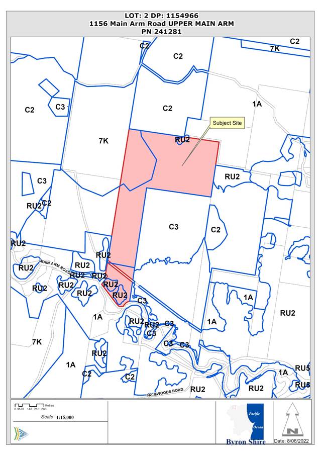
Assessment:
1. INTRODUCTION
History/Background
Council records show the following development approval history for the property:

Of key relevance to this application is DA 5.1989.173.1 being the original approval for the primitive campground on the property (Lot 5 DP 588313). Only a site plan could be located in the records for this DA (see Figure 1).
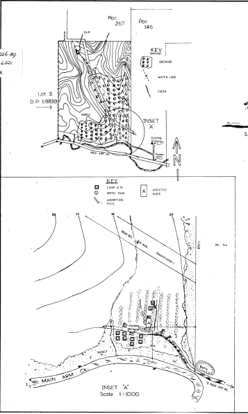
Figure 1. Site plan for DA 5.1989.173.1 – Primitive Camping Ground
The site plans (Figure 1) and file correspondence indicate that the campground is set-up and operating further east to the originally approved location and that this amended location (i.e., the current location) was approved (see extracts below).
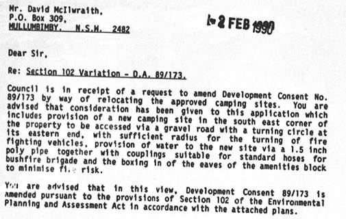
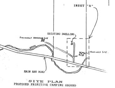
An AHIMS search for 1156 Main Arm Road did not identify any aboriginal sites or places.
Description of the proposed development
This application seeks approval for Use of Zipline Ancillary to a Primitive Camping Ground. The zipline (and campground) is located near the southern boundary of Lot 2 DP 1154966 and proximate to Main Arm Road (see Figure 2).
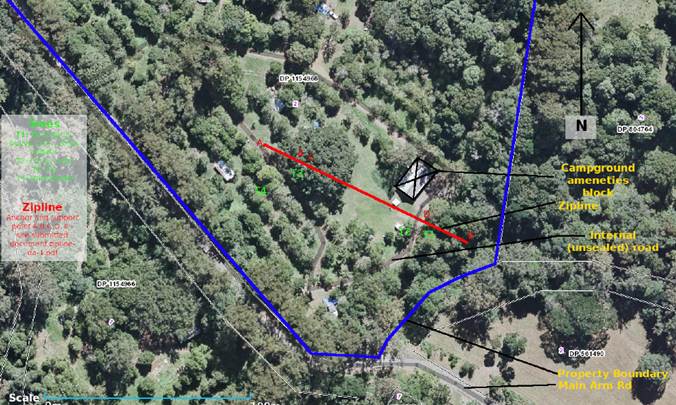
Figure 2. Site plan showing location of the zipline.
Description of the site
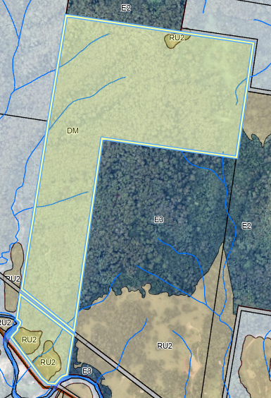
Figure 3. Aerial photo with land zoning overlay. Subject property is identified by yellow polygon.
|
Land is legally described |
LOT: 2 DP: 1154966, LOT: 5 DP: 588313 |
|
|
Property address |
1156 Main Arm Road UPPER MAIN ARM |
|
|
Land is zoned: |
RU2 Rural Landscape / PART 1A General Rural / 7K Habitat Zone Byron LEP 1988 |
|
|
Land area is: |
78.49ha |
|
|
Property is constrained by: |
· Bushfire prone land · High Environmental Value vegetation · Powerlines · Biodiversity values/key fish habitat · Koala potential habitat · Coastal wetland buffer |
|
|
|
Is a BDAR required due to the location of the proposed development? |
☐ Yes ☒ No |
|
|
Are there any easements in favour of Council affecting the site? |
☐ Yes ☒ No |
|
|
Is there a Vegetation Management Plan which might affect the proposal? |
☐ Yes ☒ No |
|
|
Is there a Voluntary Planning Agreement which might affect the proposal? |
☐ Yes ☒ No |
The property has biodiversity values mapped land however no works/use within mapped lands are proposed. Accordingly, there is no requirement for a BDAR to be prepared for this application.
2. SUMMARY OF REFERRALS
|
Referral |
Issue |
|
Building Surveyor |
No objections subject to conditions. |
3. SECTION 4.14 – BUSH FIRE PRONE LAND
Effect of 10/50 rule on significant vegetation: Nil. The property is not within an area where the 10/50 clearing code applies and the code would not apply to a zipline.
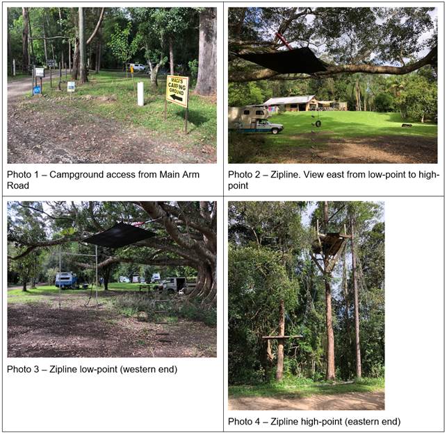
4. SECTION 4.15C – MATTERS FOR CONSIDERATION – DISCUSSION OF ISSUES
Having regard to the matters for consideration detailed in Section 4.15(1) of the Environmental Planning & Assessment Act 1979 (EP&A Act), the following is a summary of the evaluation of the issues.
State Environmental Planning Policies (SEPP)
|
Considerations |
Satisfactory |
Unsatisfactory |
|
Biodiversity and Conservation SEPP 2021 Consideration: Council’s GIS shows some areas of the property are mapped as potential koala habitat however none of the property is mapped as ‘preferred’ koala habitat and no koala sighting have been recorded. On the basis of this information, the property is not considered to be core koala habitat and the DA may be granted under this SEPP. |
☒ |
☐ |
|
Resilience and Hazards SEPP 2021 Consideration: The zipline is not within the coastal wetland or associated proximity area. Significant impacts on the lasted matters will not result from the use of the zipline. The subject property is not mapped as contaminated in Council’s GIS and no works are proposed by this application. |
☒ |
☐ |
4.2A Byron Local Environmental Plan 2014 (LEP 2014)
Note: The zipline is predominantly within the RU2 zone with the eastern end of the zipline marginally encroaching into the 1(a) zone.
LEP 2014 is an applicable matter for consideration in the assessment of the subject development application in accordance with subsection 4.15(1) of the EP&A Act because it applies to the subject land and the proposed development. The LEP 2014 clauses that are checked below are of relevance to the proposed development:
|
Part 1 |
☒1.1 | ☒1.1AA | ☒1.2 | ☒1.3 | ☒1.4 | ☒Dictionary | ☒1.5 | ☒1.6 | ☒1.7 | ☒1.8 | ☐1.8A | ☒1.9 | ☐1.9A |
|
Part 2 |
☒2.1 | ☒2.2 | ☒2.3 | ☒Land Use Table | ☐2.4 | ☐2.5 | ☐2.6 | ☐2.7 | ☐2.8 |
|
Part 3 |
☐3.1 | ☐3.2 | ☐3.3 |
|
Part 4 |
☐4.1 | ☐4.1A | ☐4.1AA | ☐4.1B | ☐4.1C | ☐4.1D | ☐4.1E | ☐4.1F | ☐4.2 | ☐4.2A | ☐4.2B | ☐4.2C | ☐4.2D | ☒4.3 | ☐4.4 | ☐4.5 | ☐4.6 |
|
Part 5 |
☐5.1 | ☐5.2 | ☐5.3 | ☐5.4 | ☐5.6 | ☐5.7 | ☐5.8 | ☐5.10 | ☐5.11 | ☐5.12 | ☐5.13 | ☐5.14 | ☐5.15 | ☐5.16 | ☐5.17 | ☐5.18 | ☐5.19 | ☐5.20 | ☐5.21 | ☐5.22 |
|
Part 6 |
☐6.1 | ☐6.2 | ☐6.4 | ☐6.5 | ☒6.6 | ☐ 6.7 | ☐6.8 | ☐6.9 | ☐6.11 | ☐ 6.12 | ☐6.13 | ☐6.14 | ☐6.15 |
In accordance with LEP 2014 clauses 1.4 and 2.1 – 2.3:
(a) The proposed development is not expressly defined in the LEP 2014 Dictionary, however, is considered as an ancillary activity to the previously approved primitive camping ground as defined within the BLEP 1988 (Note: Camping Grounds are permissible in zone RU2).
(b) The land is within the RU2 Rural Landscape according to the Land Zoning Map;
(c) The proposed development is permitted with consent; and
(d) Regard is had
for the Zone Objectives as follows:
|
Zone Objective |
Consideration |
|
• To encourage sustainable primary industry production by maintaining and enhancing the natural resource base. |
The zipline will not hinder this objective |
|
• To maintain the rural landscape character of the land. |
The zipline does not impact on the landscape character |
|
• To provide for a range of compatible land uses, including extensive agriculture. |
The zipline will not hinder this objective |
|
• To enable the provision of tourist accommodation, facilities and other small-scale rural tourism uses associated with primary production and environmental conservation consistent with the rural character of the locality. |
The zipline is complimentary, and ancillary, to the approved primitive camping ground |
|
• To protect significant scenic landscapes and to minimise impacts on the scenic quality of the locality. |
The zipline does not impact on the scenic quality of the locality. |
4.3 Height of buildings
The zipline termini are structures and fall within the definition of ‘buildings’. The western zipline terminus is within zone RU2 but is ~3.2m above ground and less than the 9m height limit.
The remaining underlined clauses have been taken into consideration in the assessment of the subject development application in accordance with Section 4.15 of the EP&A Act. The proposed development complies with all of these clauses (in some cases subject to conditions and/or to the satisfaction of other assessing officers), except in relation to Clause 4.3 Height of buildings which is considered further as follows:
4.2B Byron Local Environmental Plan 1988 (LEP 1988)
BLEP 1988 is an applicable matter for consideration in the assessment of the subject development application in accordance with subsection 4.15(1) of the EP&A Act because it applies to the subject land and the proposed development. The LEP 1988 clauses that are checked below are of relevance to the proposed development:
|
Part 1 |
☒1 | ☒2 | ☒2A | ☒3 | ☒4 | ☒5 | ☒LEP 1988 Dictionary | ☒7 |
|
Part 2 |
☒8 | ☒9 |
|
Part 3 |
☐10 | ☐11 | ☐11A | ☐11B | ☐12 | ☐13 | ☐14 | ☐15 | ☐16 | ☐17 | ☐17A | ☐17B | ☐18 | ☐19 | ☐20 | ☐22 | ☐23 | ☐24 | ☐25 | ☐27 | ☐ 29 | ☐29AA | ☐29A | ☐30 | ☐31 | ☐32 | ☐33 | ☐34 | ☐35 | ☒36 | ☐37 | ☐38 | ☐38A | ☐38B | ☐39 | ☐39A | ☐39B | ☐39C | ☒40 | ☐41 | ☐42 | ☐43 | ☐44 | ☒45 | ☐46 | ☐47 | ☐47AA | ☐47A | ☐48 | ☐48A | ☐49 | ☐51 | ☐52 | ☐53 | ☐54 | ☐55 | ☐56 | ☐ 57 | ☐58 | ☐59 | ☐60 | ☐61 | ☐62 | ☐63 | ☐64 | ☒64A | ☐64B | ☐64C | ☐64D |
In accordance with LEP 1988 clauses 5, 8 and 9:
(a) The proposed development is ancillary to “primitive camping ground” as defined in the LEP 1988 Dictionary;
(b) The land is within the LEP1988 1(a) General Rural according to the map under LEP 1988;
(c) The proposed development is permitted with consent; and
(d) The proposed development is consistent with the relevant objectives of the Zone for the following reasons:
|
Zone Objective |
Consideration |
|
(a) to encourage and permit a range of uses creating a pattern of settlement, at a scale and character that maintains or enhances the natural, economic, cultural, social and scenic amenity of the rural environment of the Shire of Byron, (b) to encourage and permit a pattern of settlement which does not adversely affect the quality of life of residents and visitors and maintains the rural character, (c) to ensure development only occurs on land which is suitable for and economically capable of that development and so as not to create conflicting uses, (d) to allow the use of land within the zone for agricultural purposes and for a range of other appropriate purposes whilst avoiding conflict between other uses and intensive agriculture, (e) to identify lands (shown hatched on the map) which in the opinion of the council possess a limited capability for more intensive uses or development, (f) to restrict the establishment of inappropriate traffic generating uses along main road frontages other than in roadside service areas, (g) to ensure sound management of land which has an extractive or mining industry potential and to ensure that development does not adversely affect the potential of any existing or future extractive industry, (h) to enable the provision of rural tourist accommodation and facilities only where such facilities are compatible with the form and density of the nature of the locality, and (i) to permit the development of limited light industries which do not pose any adverse environmental impact, (e.g., software manufacture and film processing), and (j) to ensure that the development and use of land shown cross-hatched on the map adjacent to areas of significant vegetation and wildlife habitat do not result in any degradation of that significant vegetation and wildlife habitat, and that any development conserves and protects and enhances the value of the fauna and flora. |
The use of the zipline is associated with an approved tourism use and is not contrary to the relevant zone objectives |
40 Height
The zipline termini are structures and fall within the definition of ‘buildings’. The eastern zipline terminus is within zone 1(a) and the platform is ~11.2m above ground and exceeds than the 9m height limit (see Photo 4). The application states that “The use of the platform is entirely cosmetic. It is not required for either safety of structural purposes”. Following a request by Council, the applicant provided a written request to vary the development standard with respect to height of the structure on 5/6/2022 (E2022/53251) which is considered below.
The remaining checked clauses have been taken into consideration in the assessment of the subject development application in accordance with Section 4.15 of the EP&A Act. The proposed development complies with all of these clauses (in some cases subject to conditions and/or to the satisfaction of other assessing officers), except in relation to Clause 40 Height which is considered further as follows:
Clause 64A Exceptions to Development Standards
Applicant has sought a variation to the Height (clause 40) development standard by proposing a zipline platform with a height of 11.2m (~24% variation to the standard).
The applicant has submitted a written request that strict compliance with the development standard is unreasonable or unnecessary and that there are sufficient environmental grounds to vary the controls as follows:
· A reduction in height for the zipline platform would lead to a “reduction in the margin of safety for users”.
· There will be “no discernible or detrimental environmental effect” associated with the height of the zipline platform
· A lower platform height “would detract from the novelty, excitement and enjoyment of the ride”.
It is considered that strict compliance with the development standard is unreasonable and unnecessary in the circumstances of the case and that there are sufficient environmental grounds to vary the development standard for the following reasons:
· the height and scale of the zipline platform does not conflict with the location, surrounding development or environmental characteristic of the land.
· the development standard is primarily targeted towards buildings, rather than a small (~6m2), open platform in a tree.
· the minor scale and obscured location (within and surrounding a tree) of the structure are such that visual impacts of the development are negligible
Further the proposal is in the public interest having regards to the relevant objective of the development standard being “to ensure that the height and scale of development is appropriate to its location, surrounding development and the environmental characteristics of the land” as the structure is relatively small in area (~6m2), is open (without walls or roof) and located in a tree.
The concurrence of the Planning Secretary is not required. Concurrence may be assumed by Council (but not a delegate of Council) under Planning Circular PS 20-002.
It is recommended that the development standard can be varied in this instance.
a) The development is satisfactory having regard to the requirements outlined in clause 64A;
b) The development is satisfactory having regard to applicable Department of Planning, Infrastructure and Environment Circulars;
c) The development is satisfactory having regard to relevant caselaw;
d) The DA demonstrates that compliance is with the development standard is unreasonable and unnecessary;
e) The DA demonstrates that there are sufficient environmental planning grounds to justify contravening the standard;
f) The DA demonstrates that that the development in the public interest;
g) The DA demonstrates that the development is consistent with the objectives of the standard and the zone; and
h) The DA demonstrates the grounds of the request are particular to the proposed development on this site, and that there is something particular to the development on this site to justify the variation.
4.3 Any proposed Instrument that has been the subject of public consultation and has been notified to the consent authority
No proposed instruments were identified that are relevant to this application.
4.4A Byron Shire Development Control Plan 2014 (DCP 2014)
DCP 2014 is an applicable matter for consideration in the assessment of the subject development application in accordance with subsection 4.15(1) of the EP& A Act because it applies to the land to which LEP 2014 applies. The DCP 2014 Parts/Chapters that are checked below are of relevance to the proposed development:
|
Part A |
☒ |
|
Part B Chapters: |
☒ B1 | ☐ B2 | ☐ B3 | ☐ B4 | ☐ B5 | ☐ B6 | ☐ B7 | ☒ B8 | ☐ B9 | ☐ B10 | ☐ B11 | ☐ B12 | ☒ B13 | ☐ B14 |
|
Part C Chapters: |
☐ C1 | ☐ C2 | ☐ C3 | ☐ C4 |
|
Part D Chapters |
☐ D1 | ☐ D2 | ☒ D3 | ☐ D4 | ☐ D5 | ☐ D6 | ☐ D7 | ☐ D8 | ☐ D9 |
|
Part E Chapters |
☐ E1 | ☐ E2 | ☐ E3 | ☐ E4 | ☐ E5 | ☐ E6 | ☐ E7 | ☐ E8 | ☐ E9 | ☐ E10 |
B1: Biodiversity
The zipline and associated structures encroach areas of vegetation mapped as high environmental value vegetation (subtropical rainforest), key fish habitat and koala potential habitat. Consequently, the development does not meet ecological setbacks to ‘red-flagged’ areas (B1.2.1). However, a variation to the ecological setbacks is reasonable in the circumstances as:
· no tree removal is required or proposed;
· the scale and impact of the development is minimal;
· the development does not require a managed bush fire setback;
· the development does not trigger clearing entitlements under other mechanisms (e.g., NSW RFS 10/50 Vegetation Clearing Code);
· there will be no net loss of biodiversity; and
· an arborists report was provided with the application that states “… all the anchor and support trees are adequate and suitable in terms of their use for the zipline both as anchor trees and support trees”.
D3: Tourist Accommodation
Although this chapter is applicable to the zipline (particularly D3.3.3 Caravan Parks and Camping Grounds), as ancillary development to the campground, there are no provisions that are directly relevant to the proposal.
These checked Parts/Chapters have been taken into consideration in the assessment of the subject development application in accordance with Section 4.15 of the EP&A Act. The proposed development is demonstrated to meet the relevant Objectives of all relevant Parts/Chapters (in some cases subject to conditions and/or to the satisfaction of other assessing officers).
4.4B Byron Shire Development Control Plan 2010 (DCP 2010)
DCP 2010 is an applicable matter for consideration in the assessment of the subject development application in accordance with subsection 4.15(1) of the EP& A Act because its purpose is to provide planning strategies and controls for various types of development permissible in accordance with LEP 1988. The DCP 2010 Chapters/Parts that are checked below are of relevance to the proposed development:
|
Chapter 1 Parts: |
☒A| ☐B| ☒C| ☐D| ☐E| ☐F| ☐G| ☐H| ☐J| ☐K| ☐L| ☐N |
|
Chapters: |
☐4| ☐6| ☐7| ☐8| ☐9| ☐10| ☐11| ☐12| ☐14| ☐15| ☐16| ☐17| ☐18| ☐19| ☐20| ☐21| ☐22 |
Chapter 1: Part C – Residential Development
Although this chapter is applicable to the zipline (particularly C10. Caravan Parks and Camping Grounds), as ancillary development to the campground, there are no provisions that are directly relevant to the proposal.
These checked Chapters/Parts have been taken into consideration in the assessment of the subject development application in accordance with Section 4.15 of the EP&A Act. The proposed development is demonstrated to meet the relevant Objectives of DCP 2010 (in some cases subject to conditions and/or to the satisfaction of other assessing officers).
4.5 Environmental Planning and Assessment Regulation 2000 considerations
|
|
Applicable to the proposal: |
Considered the control as it relates to the proposal: |
If this control is applicable, does the proposal comply? |
|
Clause 92 - Additional matters that consent authority must consider |
☐ Yes ☒ No |
☒ NA |
☒ NA |
|
Clause 93 Fire safety and other considerations |
☐ Yes ☒ No |
☒ NA |
☒ NA |
|
Clause 94 - Consent authority may require buildings to be upgraded |
☐ Yes ☒ No |
☒ NA |
☒ NA |
|
Clause 94A - Fire safety and other considerations applying to erection of temporary structures |
☐ Yes ☒ No |
☒ NA |
☒ NA |
4.6 The likely impacts of that development, including environmental impacts on both the natural and built environments, and social and economic impacts in the locality
|
Impact on: |
Likely significant impact/s? |
|
Natural environment |
No. The proposal will not have a significantly adverse impact on the natural environment of the locality. |
|
Built environment |
No. The proposal will not have a significantly adverse impact on the built environment of the locality. |
|
Social Environment |
No. The proposal will not have a significant social impact on the locality. |
|
Economic impact |
No. The proposal will not have a significant economic impact on the locality. |
|
Construction Impacts |
The development will generate minor impacts during its construction. Conditions of consent recommended to control hours of work, builders waste, construction noise, installation of sedimentation and erosion control measures and the like to ameliorate such impacts. |
No Council Policies that are applicable to the proposed development were identified.
4.7 The suitability of the site for the development
The site is suitable for the proposed development.
4.8 Submissions made in accordance with this Act or the regulations
The development application was publicly exhibited
There were no submissions made on the development application.
4.9 Public interest
The proposed development is unlikely to prejudice or compromise the public interest or create an undesirable precedent.
5. DEVELOPER CONTRIBUTIONS
5.1 Water & Sewer Levies
No Section 64 levies will be required.
5.2 Developer Contributions
No Developer Contributions will be required.
6. DISCLOSURE OF POLITICAL DONATIONS AND GIFTS
|
Disclosure details |
Response |
|
Has a Disclosure Statement been received in relation to this application? If Yes, Provide Disclosure Statement register reference: 91. |
Yes ☐ No ☒ |
|
Have staff received a ‘gift’ from anyone involved in this application that needs to be disclosed. |
Yes ☐ No ☒ |
7. CONCLUSION
The DA proposes Use of Zipline Ancillary to a Primitive Camping Ground (known as ‘Macca’s Campground) at 1156 Main Arm Road, Upper Main Arm. The zipline has already been constructed and a building information certificate is recommended as a deferred commencement requirement. The starting platform for the zipline is 11.2m high and above the 9m building height limit however the platform is relatively small and is located such that visual impacts are minimal. The application appropriately addresses the relevant constraints applying to the site and is recommended for approval as a deferred commencement consent and subject to the conditions attached to this Report.
BYRON SHIRE COUNCIL
Staff Reports - Sustainable Environment and Economy 13.7
Report No. 13.7 PLANNING - DA 10.2021.348.1 Alterations to Existing Building and Change of Use to Mixed Use Development including Shop, Office Premises and Construction of a Two-Storey Carpark
Directorate: Sustainable Environment and Economy
Report Author: Patricia Docherty, Planner
File No: I2022/646
Proposal:
|
Proposal description: |
Alterations to Existing Building and Change of Use to Mixed Use Development including Shop, Office Premises and Construction of a Two-Storey Carpark |
||
|
Property description: |
LOT: 9 DP: 818197, LOT: 51 DP: 844054, LOT: 4729 DP: 1228104 (Part of lot) |
||
|
156 Jonson Street BYRON BAY, 158 Jonson Street BYRON BAY, Butler Street BYRON BAY |
|||
|
Parcel No/s: |
157320, 237062, 268546 |
||
|
Applicant: |
156 Jonson Street Pty Ltd |
||
|
Owner: |
156 Jonson Street Pty Ltd |
||
|
Zoning: |
B2 Local Centre SP2 Infrastructure (Car Park) C2 Environmental Conservation C3 Environmental Management |
||
|
Date received: |
28 June 2021 |
||
|
Integrated / Designated Development: |
☐ Integrated |
☐ Designated |
☒ Not applicable |
|
Concurrence required |
Yes – CNR-28907 |
||
|
Public notification or exhibition: |
- Level 2 advertising under Council’s Community Participation Plan. - Exhibition period: 7 July 2021 – 3 August 2021 - Submissions received: Two Individual Submissions - Note. Three separate objection documents were submitted on behalf of Seadrift Residents to east. - Submissions acknowledged: ☒ Yes ☐ No ☐ N/A |
||
|
Estimated cost |
$13,658,873.00 |
||
|
Delegation to determine |
Council |
||
|
|
|
||
Summary:
This development application seeks consent for alterations and change of use of an existing building to a mixed-use development including a ground floor shop, upper-level office premises and the construction of a two-storey car park containing 231 car parking spaces. Access will be from Jonson Street.
The existing building is located on a battle axe lot with vehicular access from the south end of Jonson Street and frontage to Butler Street Bypass. This will be connected to a two-storey car park to be constructed south of the existing building.
The car park is proposed to be located over two lots. Part of the car park site relies on recent Council approval of the boundary adjustment to subdivide 2,035 m² of surplus rail land under separate development application 10.2021.750.1. This subdivision is required to be registered with NSW land registry services prior to any construction. All three lots including the mixed-use building and car park will be required to be consolidated into one lot.
The proposal will require road upgrades to the southern end of Jonson Street, removal of vegetation on land zoned SP2 (Car Park) and environmental regeneration of the adjoining conservation zoned land, which will be subject to a vegetation management plan.
A voluntary planning agreement (VPA) letter of offer has been received for the sum of $166,600.00 for public art and the VPA will be required to be executed prior to construction.
The application appropriately addresses the relevant constraints applying to the site and raises no issues of significance with regards to the applicable environmental planning instruments and development control plan. The application is recommended for approval subject to the conditions listed in the Recommendation of this Report.
NOTE TO COUNCILLORS:
In accordance with the provisions of S375A of the Local Government Act 1993, a Division is to be called whenever a motion for a planning decision is put to the meeting, for the purpose of recording voting on planning matters. Pursuant to clause 2(a) under the heading Matters to be Included in Minutes of Council Meetings of Council's adopted Code of Meeting Practice (as amended) a Division will be deemed to have been called by the mover and seconder of all motions relating to this report.
RECOMMENDATION:
That pursuant to Section 4.16 of the Environmental Planning & Assessment Act 1979, Development Application No. 10.2021.348.1 for Alterations to Existing Building and Change of Use to Mixed Use Development including Shop, Office Premises and Construction of a Two-Storey Carpark, be granted consent subject to the conditions recommended attached to this report.
1 10.2021.348.1
DA Plan set - Marked in red 2/6/22, E2022/51263
![]()
2 10.2021.348.1
Recommended Conditions of Consent, E2022/50664
![]()
3 Confidential - 10.2021.348.1 submissions, E2022/53046
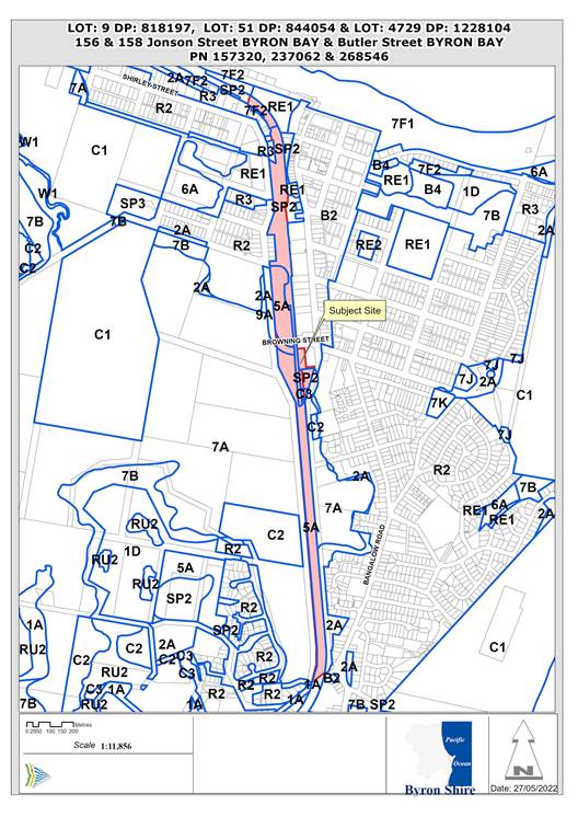
Figure 1 Site Location
Assessment:
1. INTRODUCTION
History/Background
The subject site comprises an existing building, vacant land and an excised part of the Rail Corridor.
History of approvals:
BA 6.1989.2600.1, Office & Shop, Finalised 24/08/1989
BA 6.1991. 2082.1, Alterations to Shop, Finalised 03/04/1992
DA 5.1998. 232.1, Miscellaneous - Skate Park, Approved Delegation 21/09/1998
BA 6.1998. 2421.1, 98/2421 Skatepark inside existing building, Approved Delegation12/03/1999
DA 10.2005. 331.1, Change of use to light industry with ancillary shop etc. Approved 26/09/2005
DA 10.2005. 331.2, S96 to Change condition in relation to access requirements. Approved 21/06/2006
DA 10.2005. 331.3, S.96 - To make internal and external alterations approved. Approved 16/08/2007
DA10.2005.0331.4, S96 - Continued use of brushwood fence (Change of use). Approved 08/03/2010
DA10.2010. 65. 1, Photographic studio and secure storage area ancillary. Approved 08/06/2010
DA10.2008.754.1, Alterations/Additions to the Byron Bay Services Club. Approved 01/07/2010
DA10.2010.65. 2, S96 - Delete Condition No. 8. Approved 12/05/2011
DA 10.2021.750.1, Boundary adjustment of disused rail land with adjoining land. Approved by Council 23/06/2022
Description of the proposed development
The DA proposes alterations to an existing building and change of use to a mixed use development including a ground floor shop, upper level office premises and construction of a two-storey carpark.
The proposal involves refurbishment of the existing building formerly used as a light industry by swimwear brand Wicked Weasel, to be fitted out for use as a Harris Farm Markets grocery store on the ground floor with an ancillary office, back of house cool room and bakery and separate office tenancy on the upper level. This will be connected to a two-storey car park to be constructed south of the existing building.
The proposal will require road upgrades to the southern end of Jonson Street, removal of vegetation in land zoned SP2 (Car Park) and environmental regeneration of the adjoining conservation zoned land.
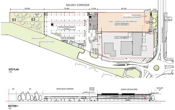 Figure 2 Site
Plan and Section
Figure 2 Site
Plan and Section
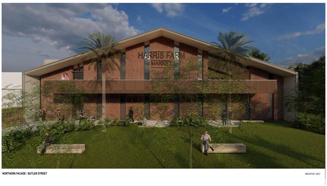 Figure
3 Illustrative Façade Butler Street
Figure
3 Illustrative Façade Butler Street
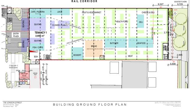
Figure 4 Proposed Ground
Floor of Building 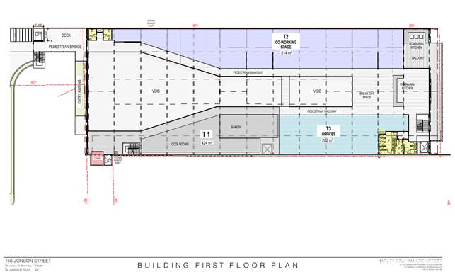
Figure 5 Proposed First Floor of Building
Description of the site
A site inspection was carried out on 6 July 2021 and 25 May 2022
|
Land is legally described |
LOT: 9 DP: 818197, LOT: 51 DP: 844054, LOT: 4729 DP: 1228104 (Part of lot boundary adjustment (DA 10.2021.750.1)
|
|
|
Property address |
156 Jonson Street BYRON BAY, 158 Jonson Street BYRON BAY, Butler Street BYRON BAY
|
|
|
Land is zoned: |
B2 Local Centre SP2 Infrastructure (Car Park) C2 Environmental Conservation C3 Environmental Management
|
|
|
Land area is: |
9,121 m2
|
|
|
Property is constrained by:
|
Flood Liable Land; Bushfire prone land; Acid Sulfate Soils Class 2; and High Environmental Value.
|
|
|
|
Is a BDAR required due to the location of the proposed development? |
☐ Yes ☒ No |
|
|
Are there any easements in favour of Council affecting the site? |
☐ Yes ☒ No |
|
|
Is there a Vegetation Management Plan which might affect the proposal? |
☒ Yes ☐ No |
|
|
Is there a Voluntary Planning Agreement which might affect the proposal? |
☒ Yes ☐ No |
The existing building is located on a battle axe lot with vehicular access from the south end of Jonson Street and frontage to Butler Street Bypass.
The proposed car park is to be located on land to the south of the existing building also with access from Jonson Street. Part of car park site relates to boundary adjustment of 2035 m² of surplus rail land approved under DA 10.2021.750.1, which would be required to be registered with NSW land registry services prior to construction.
All three lots will also be required to be consolidated.
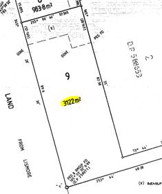
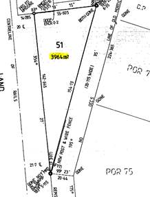
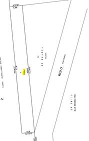
Figure 6 Extracts Deposited Plans Existing Lot 9, Existing Lot 51; and Approved Lot 1
Figure 7 Extract of Gazetted planning proposal map (26.2020.5.1).
Note. E (Environmental) Zones and now referred to as C (Conservation) Zones
Figure 8 Zoning Map Geocortex


Figure 9 Site photos view from Jonson Street Road Reserve looking north and south
2. SUMMARY OF REFERRALS
|
Referral |
Issue |
|
Environmental Health Officer |
No objections subject to conditions. |
|
Development Engineer |
No objections subject to conditions. |
|
Building Surveyor |
No objections subject to conditions. |
|
S64 / Systems Planning Officer |
No objections subject to conditions. |
|
S7.12 / Contributions Planner |
No objections subject to conditions for Voluntary Planning Agreement and S7.12 Levy. |
|
Natural Resource Planner |
No objections subject to conditions. |
|
Resource Recovery |
No objections subject to conditions. |
|
Design Excellence |
No objections subject to conditions. See additional comments below. |
|
Public Art Panel |
Applicant has made an offer to enter into a Voluntary Planning Agreement. |
|
Roads & Maritime Services |
No objections. |
|
Transport for NSW |
No objections. |
|
Essential Energy |
No objections subject to conditions. |
|
Police |
No response or objection received |
|
Bundjalung (Arakwal) |
No response or objection received |
Design excellence—Byron Bay town centre
Clause 6.13 Design excellence—Byron Bay town centre only applies to the existing building and does not apply to the car park land. A Design Excellence Panel referral was made. The following commentary about the existing building in relation to the Design Excellence requirements was received:
Overall the proposal is an appropriate response to the existing building and the changes to the building will improve its relationship to the street and town centre.
The corporate sustainability objectives of Harris Farm need to be developed in greater detail and applied to the proposal in order to achieve and demonstrate ‘design excellence’.
The number of car spaces should be reduced and this should enable redesign of the car park to improve amenity and allow for deep soil planting along the boundaries and in the centre of the carpark
Further consideration of tree species and climbers and the extent of trellises is needed.
Overall the proposal has the potential to achieve design excellence if the improvements and commitments outlined above are incorporated.
Assessing Planner Comments: Although the car park is not subject to Clause 6.13 Design Excellence, the Design Excellence referral has raised the following comments about the car park and landscape design generally. Council, being the consent authority, has the opportunity to consider these comments and decide if additional conditions of consent are warranted, to address the following:
Design Excellence Comments
The proposal has an excess of 30 car spaces. Consideration should be given to
the removal of 30 spaces that would allow the western edge of the car park to
be set back from the rail corridor by a minimum of 600mm and to allow for deep
soil planting for the creepers for the proposed green wall. It is noted
that no works are permissible in the rail corridor and no agreement for
maintenance of this land has been provided.
It is not clear why the ground level has a high clearance unless this aims to achieve natural ventilation. An alternative approach would be to cut out a section of the upper level in addition to the small triangular area noted as “feature tree planting” to allow light and air to the ground level parking below which would be made possible by the removal of the 30 excess parking spaces.
The introduction of the planted berm and the ‘green wall’ to the east is strongly supported. This requires a set back from the eastern boundary unless an agreement with council for planting in the road reserve is agreed.
Overall, the landscape drawings and artist impressions indicate inadequate shading of the open areas at ground level. (I am not aware of councils landscape policies, but in this instance I think deciduous trees that provide more shade than indigenous species Euc. tereticornis may be preferable in the this [sic] urban setting)
Design Excellence Recommendations:
1. Expand the areas of trellis on the upper car park level while still allowing for good solar access for the PV panels.
2. Select tree species that will provide extensive shade and aim for 100% canopy over the uncovered areas at ground level should be selected.
3. Investigate the introduction of a trellis over the ramp to the upper level to improve the appearance of the car park from Jonson Street.
4. Revise the design of the car park after removing 30 car spaces with the aim of reducing overall height and introducing more natural light to the ground level, allowing for deep soil for creepers within the site boundary on the west and possibly on the east if an agreement cannot be reached with council for planting within the road reserve.
Possible translation as conditions of consent:
· Provide details of species that will achieve 100% shading of the uncovered ground level area and more extensive shading of the upper car park level and ramp
· Reduce the number of car spaces to the minimum required.
Assessing Planner Consideration: According to architectural plans, the green wall is on the roadside and not on the rail corridor. A condition of consent is recommended for an amended landscaping plan to be provided prior to Construction Certification.
The proposed planted berm to the south of the car park on the land zoned C3 is not supported by Council as this land is intended to be regenerated for biodiversity purposes only in keeping with the objectives of the Environmental Conservation zone.
It is recommended by Council’s Natural Resources Planner that locally indigenous tree species be used on the site in keeping with the ecological community on the edge of the site. Council’s Natural Resources Planner has considered the submitted landscaping plan and requires that a condition of consent be imposed prior to the issue of a Construction Certificate, that the ‘Statement of Landscape Intent’ must be amended and incorporated into a detailed landscaping plan. The detailed plan must include all landscaping within the site external to the areas zoned C2 and C3. The landscaping plan must incorporate adequate detail to demonstrate compliance with the provisions of Chapter B9 of Development Control Plan 2014.
The plan must remove any non-native species and replace them with species that correspond to the naturally occurring vegetation community of the locality.
Assessing Planner Recommendation: The following specifications recommended in the condition of consent for a detailed landscaping plan address both ecological and design excellence considerations:
a) Select tree species that correspond to the naturally occurring vegetation community of the locality that will provide extensive shade and aim for 100% canopy over the uncovered areas at ground level should be selected.
b) Expand the areas of trellis on the upper car park level while still allowing for good solar access for the PV panels.
c) Investigate the introduction of a trellis over the ramp to the upper level to improve the appearance of the car park from Jonson Street.
3. SECTION 4.14 – BUSH FIRE PRONE LAND
Under section 4.14 of the Act, Council must be satisfied prior to making a determination for development on bush fire prone land, that the development complies with the document ‘Planning for Bush Fire Protection 2019’. The site is bush fire prone land. The development application is accompanied by a bushfire risk management assessment Report by Bushfire Safe (Australia) Pty Ltd dated March 2021 which provides conditions.. Condition 5 is included in the Recommendation of this Report requiring that the development must comply at all times with the requirements of bushfire risk management assessment Report by Bushfire Safe (Australia) Pty Ltd dated March 2021.
Note. Bush Fire Attack Categories
The proposed multistorey car park is exempt from bushfire construction standards.
An assessment of the bushfire attack level applicable to the proposed development was carried out using the methodology detailed in Planning for Bushfire Protection (RFS, 2019).
The bushfire risk management assessment concluded the upgrades to the existing Building shall be within a BAL-29 Bushfire Attack Level.
All vegetation within the site zoned C2 and C3 will be subject to protection in perpetuity under the provisions of a vegetation management plan.
4. SECTION 4.15C – MATTERS FOR CONSIDERATION – DISCUSSION OF ISSUES
Having regard to the matters for consideration detailed in Section 4.15(1) of the Environmental Planning & Assessment Act 1979 (EP&A Act), the following is a summary of the evaluation of the issues.
State Environmental Planning Policies (SEPP)
|
Considerations |
Satisfactory |
Unsatisfactory |
|
Biodiversity and Conservation SEPP 2021 Consideration: Chapter 2 Vegetation in non-rural areas. Chapter 2 of the B&C SEPP doesn’t apply because it only relates to vegetation clearing not ancillary to development. All vegetation clearing and compensation was assessed in Council’s ecology assessment and conditions of consent to provide for vegetation management and restoration. No clearing is proposed on land Zoned C2 or C3.
Chapter 4 Koala habitat protection The subject land is within the koala planning area as defined under the Byron Coast Comprehensive Koala Plan of Management (CKPoM) as approved under Section 4.17 of the B&C SEPP. As the subject land is less than 1 ha in area, the CKPoM does not apply to the proposal.
|
☒ |
☐ |
|
Resilience and Hazards SEPP 2021 Consideration: Chapter 2 Coastal management The proposal involves works on land within the proximity area to coastal wetlands as mapped under Chapter 2 of the R&H SEPP. The proposal is not expected to impact the biophysical, hydrological, and ecological integrity of the adjacent coastal wetland. It is therefore considered that the proposal complies with Section 2.8 of the R&H SEPP. Note. A small strip in the southern extent of the parcel is identified on the biodiversity values map. This area corresponds to a coastal wetland mapped under the R&H SEPP. No development is proposed on this part of the site. The mapped coastal wetland extends beyond the parcel to the south. There are also large areas of land identified on the biodiversity values map to the west and north. The remainder of the site is mapped as a proximity area for coastal wetland.
Chapter 4 Remediation of land The applicant has undertaken preliminary assessment in accordance with the R&H SEPP. The findings have been assessed by Council’s Environmental Health Officer in their referral assessment referred to in Section 2.1 of this report. The proposed development can be supported subject to conditions required to be net included in the recommendations of this report.
|
☒ |
☐ |
|
Transport and Infrastructure SEPP 2021 Consideration: Chapter 2 Infrastructure The DA was referred to Essential Energy in accordance with Division 5 Electricity transmission or distribution, Subdivision 2 Development likely to affect an electricity transmission or distribution network S2.48 Determination of development applications—other development. The DA was referred to Transport for NSW in accordance with Division 15 Railways Subdivision 2 Development in or adjacent to rail corridors and interim rail corridors—notification and other requirements, S 2.97 Development adjacent to rail corridors. The DA was referred to Roads and Maritime Services in accordance with Division 17 Roads and traffic, Subdivision 2 Development in or adjacent to road corridors and road reservations, S2.118 Development with frontage to classified road and S 2.121 Traffic-generating development. All conditions required by the referral agencies are included in the recommendations of this report. |
☒ |
☐ |
4.2 Byron Local Environmental Plan 2014 (LEP 2014)
In accordance with LEP 2014 clauses 1.4 and 2.1 – 2.3:
(a) The proposed development is defined in the LEP 2014 Dictionary as Mixed use development comprising shop and office and Car park;
(b) The land subject to the proposed development is within the B2 Local Centre and SP2 Infrastructure (Car Park) zone; according to the Land Zoning Map;
(c) The proposed development is permissible with consent; and
(d) Regard is had for the Zone Objectives as follows:
|
Zone Objective B2 |
Consideration |
|
• To provide a range of retail, business, entertainment and community uses that serve the needs of people who live in, work in and visit the local area. |
The proposed mixed use development comprising shop and office uses will provide retail and employment and serve the needs of the community. The proposal is in the town centre and located in proximity to available public transport routes. The proposal will be required to provide for upgrades for pedestrians and cycle facilities to also encourage walking and cycling to and from the site. The proposed development is not inconsistent with the objectives of the B2 Zone. |
|
• To encourage employment opportunities in accessible locations. |
|
|
• To maximise public transport patronage and encourage walking and cycling. |
|
|
• To encourage vibrant centres by allowing residential and tourist and visitor accommodation above commercial premises. |
|
Zone Objective SP2 Infrastructure (Car Park) |
Consideration |
|
• To provide for infrastructure and related uses. |
The proposal provides for car parking that is compatible with and not inconsistent with the objectives of the SP2 Infrastructure (Car Park) zone. |
|
• To prevent development that is not compatible with or that may detract from the provision of infrastructure. |
Note.
No development works are proposed on land zoned C2 Environmental Conservation or C3 Environmental Management. There will be a vegetation management plan applicable to these parts of the site for the purposes of biodiversity restoration in perpetuity. This is consistent with the objectives of the C2 and C3 Zone.
C2 Objectives of zone
· To protect, manage and restore areas of high ecological, scientific, cultural or aesthetic values.
· To prevent development that could destroy, damage or otherwise have an adverse effect on those values.
C3 Objectives of zone
· To protect, manage and restore areas with special ecological, scientific, cultural or aesthetic values.
· To provide for a limited range of development that does not have an adverse effect on those values.
· To encourage passive recreation and environmental education where there is no detrimental effect to land.
Environmental protection works are permissible without consent in the C2 and C3 zone.
Clause 4.3 and 4.4 development standards including height and floor space ratio (FSR)
Existing building
The existing building is subject to a maximum height of building development standard of 11.5 metres max. and floor space ratio (FSR) development standards (1.3:1).
The proposed additional highlights on the south section of the roof exceed the maximum permissible 11.5 m and the applicant has not sought to vary the development standard in accordance with 4.6 of the LEP, however this is supported in this particular case under the provisions of Clause 5.6 Architectural Roof Features. (See below)
Remaining new works to the roof are approximately 8.1 metres and do not exceed the maximum permissible 11.5 m on this part of the site.
The proposed FSR of the building is 0.46:1, which is below the permissible 1.3:1 under Clause 4.4 of Byron LEP 2014, calculated based on gross floor area (GFA) and site area, as follows:
Ground Floor = 2,693m²; First Floor = 1,580m²; Total GFA = 4,273m², Land Size= 9,121m²
FSR= 0.46:1
Proposed car park
The car park is subject to a maximum height of building of 9 metres max. but not subject to FSR development standards.
The maximum height of the car park is 8.1 metres according to elevation drawings and below the maximum permissible 9 metres.
Figure 10 Roof pop ups highlighted yellow comply with architectural roof feature clause
Figure 11 Car Park Elevations
Clause 5.6 Architectural Roof Features
The additional highlight roof windows emulate the existing highlight windows and can be considered to comply with the objectives and provisions of this clause:
5.6 Architectural roof features
(1) The objectives of this clause are as follows—
(a) to encourage variety in built form,
(b) to provide for architectural innovation,
(c) to improve the streetscape of urban areas,
(d) to protect the amenity of the streetscape by enabling the development of roof features that are compatible with the natural and built features of the locality.
(2) Development that includes an architectural roof feature that exceeds, or causes a building to exceed, the height limits set by clause 4.3 may be carried out, but only with development consent.
(3) Development consent must not be granted to any such development unless the consent authority is satisfied that—
(a) the architectural roof feature—
(i) comprises a decorative element on the uppermost portion of a building, and
(ii) is not an advertising structure, and
(iii) does not include floor space area and is not reasonably capable of modification to include floor space area, and
(iv) will cause minimal overshadowing, and
(b) any building identification signage or equipment for servicing the building (such as plant, lift motor rooms, fire stairs and the like) contained in or supported by the roof feature is fully integrated into the design of the roof feature.
It is considered that the roof pop up meets the requirements of the architectural roof features clause. Council being the consent authority can be satisfied that the new roof highlights:
· contribute a decorative element to the upper most part of the roof.
· is in keeping with the existing character of the building including replication and consistency with the existing original highlight features on the roof.
· are not an advertising structure.
· are note capable of being converted to additional floor area.
· minimising any overshadowing because it is minimal architectural feature on the upper most part of the roof and sufficiently setback from the street and all other structures adjoining the site.
Clause 5.21 Flood Planning
Much of the site is mapped as flood prone land (see below). Conditions of consent in relation for flood compatible materials and services requirements are included in the recommended conditions attached to this report.
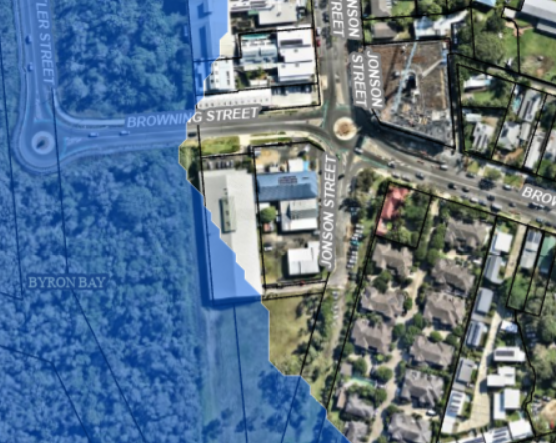
Figure 12 Extract of flood mapping (Council Geocortex)
Clause 6.1 Acid Sulfate Soils
This clause provides that, where applicable, development consent must not be granted for the carrying out of works unless an acid sulfate soils management plan (ASSMP) has been prepared in accordance with the Acid Sulfate Soils Manual.
Minimal excavation is proposed other than for footings and services and no basement car park is proposed. A preliminary ASSMP provides that Acid Sulfate Soils can be adequately managed. Relevant conditions are included in the Recommendation to the Report to ensure management of acid sulfate soils prior to and during works on the site.
Clause 6.13 Design excellence—Byron Bay town centre
This clause applies to development involving the erection of a new building or alterations to an existing building on land identified as “Design excellence” on the Design Excellence Map. The lot containing the existing building is located on land identified on the Design Excellence map. The objective of this clause is to ensure that development exhibits design excellence that contributes to the natural, cultural, visual and built character values of Byron Bay town centre.
Development consent must not be granted for development to which this clause applies unless the consent authority considers that the development exhibits design excellence. Council being the consent authority must consider whether—
(a) the building incorporates sustainable design principles, including in relation to the following—
(i) sunlight,
(ii) natural ventilation,
(iii) wind,
(iv) reflectivity,
(v) visual and acoustic privacy,
(vi) safety and security,
(vii) resource, energy and water efficiency, durability and adaptability, and
(b) a high standard of architectural design, materials and detailing appropriate to the building type and location will be achieved, and
(c) the proposed development responds well to the environmental and built characteristics of the site and achieves an acceptable relationship with other buildings on the same site and on neighbouring sites, and
(d) the form and external appearance of the development will improve the quality and amenity of the public domain, including by encouraging social activity and casual surveillance in public places, streets and laneways, and
(e) the configuration and design of public access and communal recreational areas within the residential areas—
(i) incorporate exemplary and innovative treatments, and
(ii) promote a sociable village atmosphere, and
(f) the development minimises street clutter and provides ease of movement and circulation of pedestrian, cycle, vehicular and service access, and
(g) the development coordinates shared utility infrastructure and waste management to minimise disruption at street level in public spaces, and
(h) the development appropriately addresses the following matters—
(i) heritage issues and streetscape constraints,
(ii) minimisation of bulk and massing, and modulation of, buildings,
(iii) pedestrian, cycle, vehicular and service access and circulation requirements.
In addition, development consent must not be granted to the following development unless the Byron Design Excellence Panel has endorsed the development as exhibiting design excellence—
(b) alterations or additions to an existing building that—
(ii) change the use of 500 square metres or more of gross floor area of the building,
In this clause—
Byron Design Excellence Panel means a panel, consisting of 2 or more persons, established by the consent authority for the purposes of this clause.
Council resolved on 7 November 2021 to promulgate a design excellence panel under clause 6.13 of the BLEP to ensure optimum compliance is achieved by new development with the Byron Bay Town Centre Planning controls.
Resolved 21-485 that Council appoints the Director Sustainable Environment and Economy and Mr Rod Simpson (Wilson & Simpson) as the members of the Byron Design Excellence Panel for the purposes of development application assessment under Byron Local Environmental Pan 2014 - Clause 6.13 Design Excellence – Byron Bay Town Centre.
This clause only applies to the existing building and does not include the car park land.
A Design Excellence Panel referral was made. The following commentary about the existing building in relation to the Design Excellence requirements was received:
Sustainable design principles (cl6.13 (4a))
The application is accompanied by an NCC report that states the building will be capable of meeting the requirements of Section J of the NCC. Design ‘excellence’ is by definition more than ‘compliance’. Council need not require the applicant to conform with, or use any particular rating system, although the applicant may find this the most convenient approach.
Harris Farm has over 30 establishments and so a benchmarking exercise would be well within its capability and align with its “Sustainability Manifesto”[1]Of particular relevance is the objective to “Reduce our Carbon Footprint”: Reduce our carbon footprint by staying on the cutting edge of energy and fuel-efficient initiatives….”
And “War on Waste”: “Integrate the waste hierarchy into our operations honing in on food and packaging waste.”
The approach to sustainability should be collaborative (between Council and the proponent) and not unduly onerous. The objective to “inspire our community and team” is a very welcome indication that Harris Farm is interested in ‘igniting positive change’ and engaging with the community.
Recommendations:
1. Further details and thought are needed in relation to energy, greenhouse gas emissions, water consumption and ideally, minimisation of embodied carbon.
2. Either commit to a particular rating system (GBCA, NABERS) or preferably, working from first principles, develop an environmental management approach as follows:
The framework should comprise the following components (based on and overall EMS approach) with progress reviewed regularly
a) Scoping (describing the nature of the project and identifying its environmental impacts and sustainability include human health and well-being , and what the proponent has control over or could affect)
b) Benchmarking (define a ‘business as usual’ (BAU) comparison with other properties in the Harris Farm portfolio)
c) Targets and objectives (define what the project aims to achieve compared to BAU)
d) Plan (both the design of the physical structure but also the ‘design’ of the ongoing management)
e) Implement (progressive sign-off and certainty for both council and proponent that the proposal will achieve targets)
f) Monitor (self-explanatory but needs to be part of body corporate responsibility for entire development)
g) Report (agreed formats for different ‘audiences’- technical, council, utilities, public, promotion)
h) Adjust (adjust management regime and or technology as required)
3. Reporting of performance and learning is an integral part of ‘Design Excellence’ and aligns with the Harris Farm objective to ‘inspire our community and team’ and should be strongly encouraged.
4. More consideration could be given to natural daylighting and ventilation.
Possible translation as conditions of consent:
Having regards to the above the Panel recommended a range of conditions.
· Develop and deliver a coherent reporting framework that delivers best practice sustainability outcomes that sets the standard for future developments in the region. The reporting framework should make the roles and responsibilities of the applicant, and future reporting bodies.
· Develop a schedule of regular meetings to have ongoing open and constructive communication with Byron Shire with nominated council sustainability officer or independent expert to review progress of the sustainability strategy/environmental management plan
· Develop a set of quantifiable metrics for analysing and reporting the performance of the development. This should include but not be limited to:
- tCO2-e /annum (residential, non-residential)
- kWhr- Mj/ annum total energy consumption by fuel source
- kl potable water /annum consumption (residential, non-residential)
- kl harvested water /annum (water balance reporting)
- kl recycled grey water if any
- kWhr/annum renewable energy generation
- kWhr/ annum EV charging
- carbon neutrality reporting (offsets and renewable power purchase)
- waste generation and minimisation strategies
Contextual fit
Overall the adaptation of the industrial building and modified frontage to north facade is appropriate and will be an attractive addition to the streetscape. The southern end of the town centre has a mix of light industrial buildings and the adaptation and upgrading of the existing building sets a good precedent for this part of town.
It is noted that the building will be extended towards the north by 9.327 but that the set back from the recently constructed Browning Street will allow for large street trees and planting in this set back area.
Architectural design
The existing building is built to the boundary of the rail corridor and presents a blank façade to ‘tilt slab’ wall to the west. The existing ‘street-art’ might be supplemented by a ‘legal wall’ or mural art commissioned by the applicant.
Recommendation:
1. Give consideration to the future treatment of the western façade and potential for large scale murals or commissioned art.
The above recommendations are included in conditions attached to this report except for the consideration of the future treatment of the western façade, which is not visible from the public domain at any point.
4.3 Any proposed Instrument that has been the subject of public consultation and has been notified to the consent authority
The proposal is not affected by any draft EPI’s.
4.4A Byron Shire Development Control Plan 2014 (DCP 2014)
The following comments are provided against the relevant chapters of the DCP 2014.
Chapter B1 Biodiversity, B2 Tree and Vegetation Management and Chapter B9 Landscaping
The proposed development requires removal of vegetation in land zoned SP2 (Car Park) and environmental regeneration of the adjoining conservation zoned land. The proposed building work avoids all land zoned C2 and C3. Conditions of consent are recommended that require a vegetation management plan to be implemented on the C2 and C3 zoned land. Native vegetation outside of the area described as ‘Proposed Works / Clearing Footprint’ is to be protected by a Tree Protection Zone (TPZ) exclusion fence. The fence is to be constructed in accordance with Sections 3.2 and 4.3 of AS 4970-2009 - Protection of trees on development sites.
A condition of consent is recommended to address biodiversity and tree management in a detailed landscaping plan. The detailed plan must include all landscaping within the site external to the areas zoned C2 and C3. The plan is to be prepared by a suitably qualified landscape architect/ecologist who has appropriate knowledge of the biodiversity of the north coast of NSW and experience and competence in landscaping. It must incorporate adequate detail to demonstrate compliance with the provisions of Chapter B9 of Development Control Plan 2014 and include the following:
a) Remove any non-native species and replace them with species that correspond to the naturally occurring vegetation community of the locality.
b) Ensure landscaping must be located within the site only and not on Rail land or on the Road Reserve. Any planting on the boundary that will encroach into the road reserve including any planting of the proposed green wall will require separate approval by Council’s infrastructure services.
c) Select tree species that correspond to the naturally occurring vegetation community of the locality that will provide extensive shade and aim for 100% canopy over the uncovered areas at ground level should be selected.
Chapter B3 Services
The subject site is serviced with all necessary infrastructure including water, sewer, power, telecommunications and stormwater. Conditions of consent are recommended in relation to augmenting and connecting services to the development in accordance with council’s requirements.
Chapter B4 Traffic Planning, Vehicle Planning Circulation and Access, Chapter B5 Providing for Cycling and Chapter B13 Access and Mobility
A parking oversupply of 23 parking spaces is proposed within the car park and meet the required 24 bicycle spaces are required. A total of 4 accessible spaces must be provided and sufficient cycle parking spaces are provided to enable this. The loading and waste storage areas are located to enable collection and unloading to occur on the site and for vehicles to enter and leave the site in a forward direction. It is noted the adjacent Mitre 10 has limited car parking for customers and potentially some crossover will occur.
The buildings will be accessible via ramps and a lift and must comply with the BCA. Upgrades in the road reserve are also required to improve accessibility. Conditions of consent in relation to provision of access and parking are recommended to ensure compliance with Council DCP requirements.
Chapter B8 Waste minimisation and management
The applicant submitted a waste management plan and council has recommended a detailed condition of consent that requires further management arrangements to ensure the full streams of waste including connection and maintenance of an organic digestor are suitable for the long term use of the development. Arrangements including sufficient capacity to be incorporated into the waste bin storage area to allow for additional waste streams to be added over the lifetime of the proposed use are addressed. Plans have been marked in red by the assessing officer and conditions of consent are recommended to ensure waste is effectively managed at all times.
Chapter B10 Signage
Harris Farm Market business identification signage is proposed to be erected onto the northern and southern façade of the building. No other signage is proposed. It is expected that the signage will be illuminated for night time trading. Conditions of consent are recommended to address lighting impacts across the site including a detailed lighting plan and operational management requirements.
Chapter B11 Planning for Crime Prevention
The DA was referred to NSW Police, but no response or comments were received. The applicants have proposed in the submitted documentation to provide suitable lighting throughout the development plus additional street lighting in Jonson Street for security purposes and for general nigh-time access to and from the site. The Proponents also intend to install boom-gate and security cameras at the entry and exit points to the carpark, to control and manage safety and security within the facility. It is intended that the carpark will be a privately operated facility, with time limits in place for free customer parking after which fees will apply. In general it is anticipated though the car park will be in operation generally within the proposed hours of operation of the uses onsite, save for time either side of trading hours for staff and cleaners to access the site as required. Appropriate conditions of consent are recommended for lighting and operation requirements to mitigate any anti-social behaviour or misuse of the car park.
Chapter B12 Social Impact
The applicant provided the following statement in support of the proposed development:
The community benefits associated with such a mixed-use proposal, with a sustainability focus, are significant: access and support for local producers, a conscious and dynamic food retailer for the local or visiting consumer; the redevelopment of a largely under-utilised landmark building with a strong community heritage; the enhanced employment opportunities for local people; as well as a commercial office zone for public availability to cater to the local or travelling worker.
Harris Farm strive to support local, sourcing goods from local farmers and suppliers, and creating job opportunities for local residents at their stores with the majority of employees being local residents. For example, 70% of team members at their store in Willoughby and 60% of team members at the St. Ives store live locally on the Upper North Shore of Sydney. Further, the Harris Farm group link in with Job Support to ensure that across all stores there is a safe working environment that allows for the addition of members of the job support network to work as an integral part of the Harris Farm store team. It is anticipated that the Harris Farm Market in Byron Bay will create circa 200 jobs for the local community.
The market will give local businesses the opportunity to grow through the Harris Farm concession model concept of the best baker, deli and the like. The current lease agreement with Harris Farm Markets sees their occupation of the premise for 20 years upon completion of the development. They ideally wish to be open by the end of 2022, allowing for a significant build period.
In addition to this, the building works associated with the Harris Farm development and fit-out will look to support local trades and inject significant dollars into the community at an estimated $8 million. This is in addition to the $7 million expenditure required to be invested by the developer to refurbish the existing building prior to handing over to the tenant to complete the internal fit-out.
It is considered the proposal represent a viable use of an existing factory building which will have positive socio economic impacts through job creation initially and ongoing post constructions. The proposal also provides a further competitor in the food sector against the other major supermarket chain in Byron Bay giving customers greater choice for groceries and the like. It is considered the proposal will not have a undesirable social impact on the shire.
Chapter C2 Areas affected By Flood
The flood planning level for the development has been considered by Council’s Development Engineer. In accordance with C2.3.2 of the DCP, the Required Flood Planning Level is 3.315m AHD. The proposed Flood Planning Level is 3.32m AHD. The proposal meets the FPL requirement for the development. A condition of consent is recommended to require a certificate from a registered surveyor to be submitted to the Principal Certifying Authority confirming the height of floors. An Occupation Certificate must not be issued unless the floor levels are at or above the relevant flood planning levels. A copy of the floor level certification from the registered surveyor must also be submitted to Council for the attention of Council’s Drainage and Flood Engineer.
Chapter D8 Public Art
A voluntary planning agreement letter of offer has been received for the provision of public art made pursuant to S7.7 (3) of the Environmental Planning and Assessment Act) in accordance with Chapter D8 Public Art for the sum of $166,600.00. A condition of consent is recommended for the VPA to be legally executed prior to issue of a construction certificate.
Chapter D4 Commercial and Retail Development
Hours of operation - applicant’s request for a 6am start Monday to Sunday with a 10pm finish is not supported, considering the sites proximity to residential development in Jonson and Browning Street. The recommended hours are to be Monday to Sunday 7am start and 9pm finish. Conditions also recommended in relation to the car park usage with the top floor to be vacated by 6pm Sunday to Wednesday.
Chapter E10 Byron Bay Town Centre
Chapter E10 applies to the existing ‘Wicked Weasel’ building. The applicant submitted a character statement prepared by the architect for the development. The retention of the building and the sympathetic alterations and additions including the proposed use of materials and finishes is considered to be in keeping with the aesthetic and desired future character of Byron Bay Town Centre. The proposal raises no issues in terms of the provisions of E10 and the proposal represents a viable use for the factory warehouse building
4.5 Environmental Planning and Assessment Regulation 2000
|
|
Applicable to the proposal: |
Considered the control as it relates to the proposal: |
If this control is applicable, does the proposal comply? |
|
Clause 92 - Additional matters that consent authority must consider |
☐ Yes ☒ No |
☐ Yes ☐ No ☒ NA |
☐ Yes ☐ No ☒ NA |
|
Clause 93 Fire safety and other considerations
|
☐ Yes ☒ No |
☐ Yes ☐ No ☒ NA |
☐ Yes ☐ No ☒ NA |
|
Clause 94 - Consent authority may require buildings to be upgraded. Conditions of consent for upgrades recommended. |
☒ Yes ☐ No |
☒ Yes ☐ No ☐ NA |
☒ Yes ☐ No ☐ NA |
|
Clause 94A - Fire safety and other considerations applying to erection of temporary structures |
☐ Yes ☒ No |
☐ Yes ☐ No ☒ NA |
☐ Yes ☐ No ☒ NA |
Conditions of consent to apply in terms of upgrading the building to satisfy the BCA and Fire safety requirements.
4.6 The likely impacts of that development, including environmental impacts on both the natural and built environments, and social and economic impacts in the locality
|
Impact on: |
Likely significant impact/s? |
|
Natural environment |
No. The proposal will not have a significantly adverse impact on the natural environment of the locality. |
|
Built environment |
No. The proposal will not have a significantly adverse impact on the built environment of the locality. |
|
Social Environment |
No. The proposal will not have a significant social impact on the locality. |
|
Economic impact |
No. The proposal will not have a significant economic impact on the locality. |
|
Construction Impacts |
The development will generate minor impacts during its construction. Conditions of consent recommended to control hours of work, builders waste, construction noise, installation of sedimentation and erosion control measures and the like to ameliorate such impacts. |
Council Policies that are applicable to the proposed development have been considered during assessment.
4.7 The suitability of the site for the development
The site is a serviced, generally unconstrained property and is suitable for the proposed development subject to compliance with recommended conditions of consent.
4.8 Submissions made in accordance with this Act or the regulations
The development application was publicly exhibited. There were 2 submissions made against the development application:
|
Issue |
Consideration |
|
Car Park Façade I Visual Impacts - a commitment that the façade will be totally enclosed with a solid wall on the carpark eastern and southern sides and entrance. That the approved car park façade completely screens any view of parked cars, their headlights and carpark and retail signage lighting from Seadrift. |
The lighting and acoustic impacts have been addressed and a solid wall is proposed on the upper level in accordance with the acoustic report to limit car park noise. A condition is also recommended to limit evening use of the upper level of the car park Sun-Wed. |
|
Fencing - replacement of the entire western Seadrift SP78115 boundary fence (currently a combination of colorbond and paling fence) with a suitable and agreed 2500mmH soundproof fence. |
Having regards to the design of the development and the hours of operation as per conditions of consent, it is considered there is no nexus to construct a noise fence on the opposite side of Jonson Street. |
|
Plant Screening - Robust landscaping is already detailed in the DA, in the environmental protection and management zones. Seadrift asks the owner developers to seek Council approval to extend robust landscaping along the Jonson Street 'paper road' reserve facing Seadrift. We would like the Council, regardless of approval or not, to designate more off-set land, including along the Jonson reserve road and boundary of Seadrift, 6-8 Browning Street. |
The road reserve is outside the site and there is no nexus for the developer to plant out the road frontage of the Seadrift Apartments. |
|
Pedestrian crossing - Pedestrian safety should be a priority. Clear and marked pedestrian crossings should give pedestrians priority. |
Conditions of consent required for improved pedestrian access along Jonson Street to the site from Browning Street connecting with the existing pedestrian network |
|
Cumulative traffic impacts on the bypass and local road network
|
The road network has been considered as being capable of catering for the additional traffic this development will generate. |
|
Jonson Street 'Paper Road' Security Gate – Should be kept to prevent camping and illegal dumping.
|
Conditions of consent recommended to enable the gate or moveable bollards to be relocated to the south of the new Jonson Street Road formation to prevent unauthorised access if required.
|
|
Hours of Operation – Hours should be reduced. |
Conditions of consent recommended to limit opening and closing hours from 7am to 9pm seven days a week |
|
Rubbish Collection - no rubbish collections are made outside business hours (no early morning collection). |
Conditions to apply - Goods delivery and waste collection limited to 7am to 6pm. |
|
Deliveries - The loading dock design should ensure there is no impact on Seadrift residents caused by reversing delivery truck lights or noise. No early-morning or late-night deliveries. |
Reversing within the site will be required to enable larger delivery vehicles to enter and exit the site in a forward direction. Conditions to apply for Goods delivery and waste collection limited to 7am to 6pm. |
|
Design and Bulk - The proposed two storey car park is far too bulky and interfaces negatively with both residential and natural habitat. It is a far too large a structure for this site and dominates the site. The developers state they have provided 'surplus' parking to be used for other proposed developments within this site. The parking proposed should be appropriate just for the particular development to avoid the intense bulk and scale that such a proposed carpark will inevitably result in.
|
The proposed car park is entirely consistent with the SP2 Infrastructure (Car Park) zone and does not exceed the development standards that control height and bulk. The building will be appropriately screened and landscaped to mitigate nay perceivable impacts. An alternative car park design would incorporate a basement which generates other environmental issues to resolve, and construction costs with such a car park often lead developers to then seek a further intensification of development on the site with residential and tourist accommodations. The car park as proposed is considered a practical solution to support the Harris Farm development at the southern end of the town centre. |
|
The DA should not be considered a fix for Council, as part of a 'park and walk strategy'. This is a commercial development and an 'above ground/multi storey car park' for a food retailer.
|
The car park as proposed is to support the current development only. |
|
The developer of DA 10.2021.348.1 has not indicated or lodged plans for the adjacent site, with current tenants 'Mitre 10', 'Repco' and 'Singhs'. All these tenants are on short leases. With approval of the current DA before Council and the likelihood of a second DA application for the remaining sites, this could well end up a major shopping mall. |
There are no DA’s for adjacent sites with Council for determination. |
|
Zoning- The proposed change of zoning from the existing permissible use as a Rail Corridor to the proposed permissible use as a Carpark needs further community consultation. Taking away the rights of the community regarding the Rail Corridor change needs far more consultation than has occurred at this stage. The environmental protection zones are welcomed. We would like to see the E2 proposed zoning change to a E3 category. |
Zoning is gazetted and cannot be amended by a DA. The rail land is surplus and does not affect the potential for the rail corridor to operate in future if required. The actual rail corridor remains functional in the event public transport (eg trains) returns to the rail corridor.
|
|
Bushfire Hazard
|
The proposed development has been assessed by an accredited bushfire consultant and will be compliance with Planning for Bushfire Protection 2019. |
|
Potential contamination from past land uses |
The applicant has prepared a preliminary assessment in accordance with the Resilience and Hazards SEPP and this has been assessed as satisfactory with conditions of consent recommended for the implementation of any requirements arising from the development on this land. |
|
Water flows to drain in Jonson St, along the western boundary of the road reserve and eventually into the mapped coastal wetland south of the subject site. The entire subject site occurs within a 'Proximity Area of Coastal Wetlands.'
|
Stormwater is to connect to a legal point of discharge in the road reserve in accordance with Council requirements. |
|
A loss of habitat through the destruction of several trees along the southern boundary of the proposed development. The environmental zones should be planted with indigenous trees suited to kookaburras and other birdlife and kangaroos/wallabies that are frequently spotted on this land. |
A vegetation management plan is required to be implemented. Native species will be required. No building or construction works are proposed in the environmental conservation and protection zones in the southern part of the site. |
4.9 Public interest
The proposed development is unlikely to prejudice or compromise the public interest or create an undesirable precedent.
5. DEVELOPER CONTRIBUTIONS
5.1 Water & Sewer Levies
Section 64 levies will be payable.
5.2 Developer Contributions
Section 7.12 Contributions will be payable.
6. DISCLOSURE OF POLITICAL DONATIONS AND GIFTS
|
Disclosure details |
Response |
|
Has a Disclosure Statement been received in relation to this application? If Yes, Provide Disclosure Statement register reference: 91. |
Yes ☐ No ☒ |
|
Have staff received a ‘gift’ from anyone involved in this application that needs to be disclosed. |
Yes ☐ No ☒ |
7. CONCLUSION
The proposed development is satisfactory having regard to the relevant environmental planning instruments and planning controls applicable to the site. The proposal raises no significant issues in terms of environmental impacts which cannot be managed, and the site is considered suitable for the development. The application appropriately addresses the relevant constraints applying to the site and is recommended for approval subject to the conditions attached to this report.
BYRON SHIRE COUNCIL
Staff Reports - Sustainable Environment and Economy 13.8
Report No. 13.8 Byron Shire Wildlife Corridor System
Directorate: Sustainable Environment and Economy
Report Author: Lizabeth Caddick, Biodiversity Officer
File No: I2022/738
Summary:
Landmark Ecological Services have developed a revised Wildlife Corridor System for Byron Shire, that is aimed at assisting in the strategic planning of future habitat restoration projects. As well as guiding conservation planners to maximise biodiversity conservation across the shire, the Wildlife Corridor System will support implementation of Council’s Biodiversity Development Control Plan and will help to engage the community on ways they can help conserve our local biodiversity.
The wildlife corridor map is based on current species distribution, ecology and status data for Byron Shire, and takes into consideration existing land use constraints and connections, likely impacts of climate change, and location of corridors in adjacent local government areas.
Some updates to Council’s Biodiversity DCP are required to ensure that the DCP reflects the new mapping, and to clarify the different management intents proposed for cleared and vegetated parts of corridors.
Staff are seeking Councillor support to put the Wildlife Corridor System on public exhibition along with proposed updates to Council’s Biodiversity DCP. Following public exhibition, Councillors will be presented with a summary of community feedback and will have the opportunity to decide on a final Wildlife Corridor System, along with any proposed changes to Council’s Biodiversity DCP. Any subsequent DCP amendments will need to be exhibited in accordance with the relevant legislative requirements.
RECOMMENDATION:
1. That Council endorses the Byron Shire Wildlife Corridor System for public exhibition, with proposed updates to Council’s Biodiversity DCP (as set out in this report) included as supporting information.
2. That following exhibition, Council receives a submissions report to consider key issues raised and formally adopt the new Wildlife Corridor System.
3. Following completion of ‘2’ above, that Council:
a) update DCP Chapter ‘B1 – Biodiversity’ to reflect the adopted Wildlife Corridor Map and any additional supporting amendments; and
b) exhibit the DCP chapter updates in accordance with relevant legislative requirements.
1 FINAL
REPORT - Byron Wildlife Corridor System - 10/05/2022, E2022/44542 ![]()
2 Summary of
Stakeholder Engagement - Wildlife Corridor System, E2021/137201 ![]()
Report
A wildlife corridor is a linear area that links wildlife habitat and maintains connectivity between plant and animal populations. Wildlife corridors are critical in maintaining ecological processes, such as migration, colonisation, pollination, breeding and resilience to environmental disruptions like fire, flood and disease. It is important to understand where these ecological processes occur in our local landscape, so we can maintain a functioning ecosystem. Updating Council’s wildlife corridor mapping is listed as a very high priority action in the 2020-2030 Byron Shire Biodiversity Conservation Strategy.
Landmark Ecological have developed a draft Wildlife Corridor System for Byron Shire (Attachment 1 and Figure 1 below). The intent of the Wildlife Corridor System is to:
· Provide a decision-support tool for restoration planning – i.e. to help Council, environmental groups and landholders locate restoration sites in the most strategically important locations, where they can have the greatest biodiversity benefit.
· Strategically support Council and environmental groups in seeking grant funding for biodiversity conservation projects.
· Support the implementation of Council’s Biodiversity DCP (Chapter B1) during the development assessment process, by supporting planning decisions that best protect and enhance our biodiversity, while continuing to facilitate permitted land uses, e.g. on rural or residential zoned land.
· Motivate the community, in both rural and suburban corridors, to take steps to help create and maintain wildlife connectivity in their backyards, through showing people a bigger picture view of the importance of their backyard habitat in the overall landscape.
· Inform future Council strategic planning projects, for example vegetation and riparian overlays for the E-zone review, and subdivision structure planning for lands identified under business and residential land strategies.
The Wildlife Corridor System was developed using a methodology that assesses and ranks the dispersal capacity of threatened plants and animals that have core habitat in Byron Shire. Thus, it provides a network that primarily supports those threatened species that have the most limited dispersal capability, and which also have core habitat in Byron Shire. In other words, rather than catering for every species in the shire, the wildlife corridor map defines those landscape linkages that best cater for highest priority at risk species and highest value habitats in Byron Shire. This methodology is similar to that used in development of Lismore Council’s Wildlife Corridor System (Milledge, 2012) and the regional wildlife corridor mapping developed by NSW National Parks (Scotts, 2003). Unlike these earlier models, the Byron Shire Wildlife Corridor System includes plants and ecological communities as well as animals. 62 conservation priority fauna species, 65 flora species and 11 vegetation types based on a range of geologies were used to derive the corridor system. The methodology takes into consideration:
· Current and historic species records and habitat,
· Threatened ecological communities, Big Scrub remnants, Coastal SEPP, existing areas of native vegetation regeneration.
· Existing connections (e.g., highway underpasses and waterways),
· Existing land use constraints (e.g., avoiding residential and industrial land, prime agricultural land, and roads where possible),
· Location of wildlife corridors in adjacent shires, plus OEH 2019 climate change corridors and DEC Key Habitats and Corridors for Forest Fauna (Scotts 2003),
· Likely impacts of climate change (through consideration of flood prone land, aspect, riparian habitats etc.).
In the Byron Wildlife Corridor System report (Attachment 1), Landmark recommend that the habitat blocks and connectors comprising the corridor system be prioritised for revegetation. Revegetation should focus on infilling gaps and buffering existing remnant vegetation, with the habitat blocks being considered of highest priority for restoration, as these provide the largest and most important refugia. Other high restoration priorities include the major coast to hinterland connectors, riparian buffers, big scrub remnants, and the north-south Koonyum-Goonengerry-Wilson’s River-Booyong major connector.
Restoration plantings should be appropriate for the soils and other attributes of respective
sites, and should attempt to reconstitute the floristic composition of vegetation communities likely to have been present prior to European settlement. Byron Shire Council and local Landcare groups can provide advice on suitable planting species, and the recently released TreesNearMe app (Trees Near Me NSW app | NSW Environment and Heritage) is an informative resource for detailed species composition lists within different vegetation types, both present day and pre-clearing.
Figure 1 Byron Wildlife Corridor System 2022
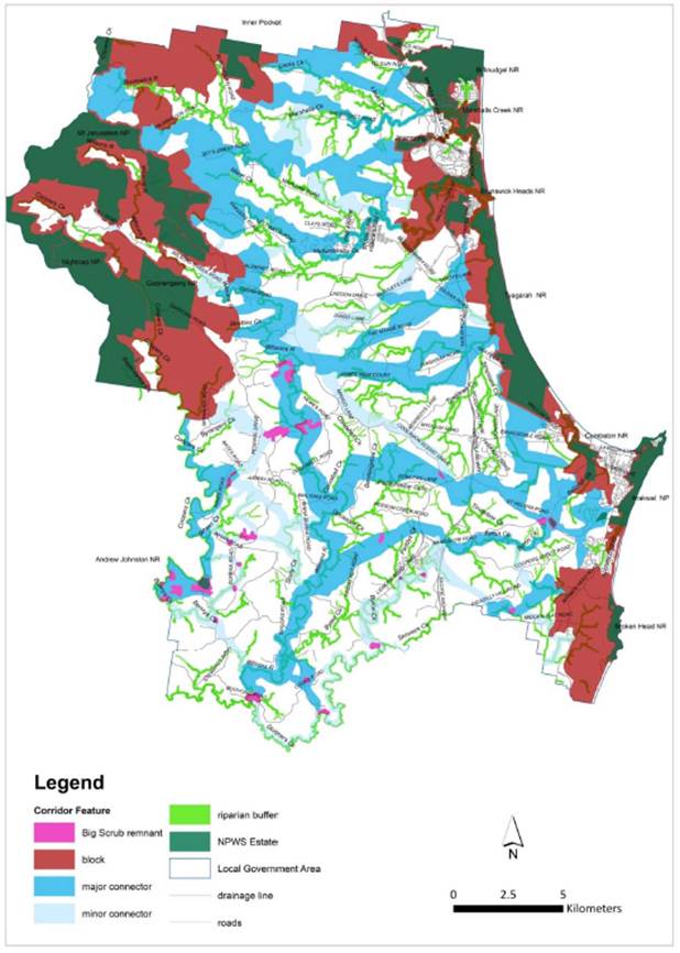
Key issues – Planning Scheme
The corridors link areas of high value habitat, and the linkages go across good quality native vegetation where possible. However, due to the fragmented nature of our landscape, some corridors also cross disturbed land, including agricultural and residential areas. Because the proposed wildlife corridors cross a range of land tenures, it is important to consider how these different land tenures will be treated in Council’s planning scheme.
· Ensure that the definition of a wildlife corridor in the DCP reflects the new mapping,
· Ensure that management intent is clear for both corridors in rural and built-up areas.
· Ensure that management intent is clear for both vegetated and cleared parts of corridors.
Pending Council’s adoption of a new Wildlife Corridor System, proposed amendments to Chapter B1 Biodiversity are summarised below. These amendments have been discussed with key stakeholders, including Councillors (Strategic Planning Workshop 7 October 2021), planning staff, local ecological experts, local town planning consultants, representatives of BOBBAC and RFS (refer Stakeholder Engagement Summary, Attachment 2).
1. Wildlife Corridor Definition
Byron Shire Development Control Plan 2014 Chapter B1 Biodiversity, currently refers to wildlife corridors using the following definition:
Wildlife corridor: refers to linear areas that link wildlife habitat and provide a crucial role in maintaining connectivity between plant and animal populations that would otherwise be at greater risk of extinction. Such corridors are critical for the maintenance of ecological processes, enabling migration, colonisation and interbreeding of plants and animals.
It is proposed to amend this definition to refer instead to the new Byron Shire Wildlife Corridor Map.
2. Biodiversity Planning Principles
Section B1.1.1 lists the biodiversity principles that underpin the provisions within the Biodiversity DCP chapter. It is recommend amending these to include specific references to wildlife corridors and their strategic importance for restoration (e.g. for compensatory plantings). These include:
P6. Habitat fragmentation and connectivity
Council decision-making should not contribute to habitat fragmentation and wherever possible, increase landscape connectivity, for example through protecting and enhancing native vegetation and wildlife habitat in Wildlife Corridors. Natural areas are strongly influenced by the landscape in which they are embedded. The larger, less disturbed and better-connected natural areas are, the more likely they are to retain a higher level of biodiversity and resilience to impacts.
P14. Biodiversity offsets and compensation
Subject to P13 above, where avoidance and minimisation have been clearly considered and illustrated, unavoidable residual impacts arising from development may be allowable. In such instances, an acceptable arrangement to compensate for, or offset the loss of biodiversity values should only occur on or near the impact site, and should be strategically located to maximise opportunities to enable plant and animal communities to survive in the long term, e.g. within a wildlife corridor or adjacent to existing wildlife habitat and riparian areas.
3. Ecological setbacks for Red Flagged areas
Table 3, B1.2.1 of the DCP describes Red-Flagged areas (i.e. features that are ecologically significant), which must be set back from the development envelope. Table 3 describes the extent of setback for various ecological features. In the current DCP, a 20m setback is required from any wildlife corridor, as per the table below:
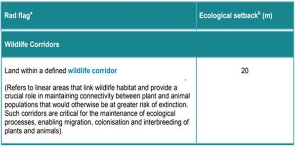
This is not a reasonable requirement where wildlife corridors go across cleared agricultural, residential or industrial land. The intention of the wildlife corridor mapping is to identify where we should focus our conservation/restoration efforts and to incentivise this, but not to restrict pre-existing land uses. Setbacks should thus be adjusted subject to the existing land use and vegetation. The corridor map also includes buffers to the corridors, so buffering of land adjacent to a corridor is not considered necessary. The following amendments to Table 3 are proposed:
|
Red Flag |
Ecological Setback |
|
Wildlife Corridors |
|
|
Native vegetation within a wildlife corridor. |
20 |
|
Areas where no native vegetation is present and all sites in Land Zones R1, R2, R3, B1, B2, IN1 and IN2 within a wildlife corridor. |
This land is not considered a red flag and no setback is required. However, the applicant should avoid and minimise impacts on corridor function through: a) avoiding development in these areas where other suitable options occur. |
To ensure clarity, a definition of ‘native vegetation’ should be included in the DCP. It is proposed that native vegetation be defined that included in the NSW Plant Community Types.
4. Koala habitat
Part B1.2.3 of the Biodiversity DCP refers to the protection of koala habitat. This section of the DCP is aimed at protecting koala habitat areas that are not protected under the Byron Shire Coastal Koala Plan of Management, which only defines core koala habitat in the coastal zone.
Wildlife corridors are referred to in part c.i., which states that:
i. The keeping of dogs is prohibited on the title of land for any new lots arising from a subdivision of land, where that land is adjacent to or forms part of koala habitat, wildlife corridors or refugia.
While pet exclusion zones have been successful in some large subdivisions in neighbouring shires (e.g. Koala Beach at Pottsville), in practical terms it would be very difficult to exclude a dog, for example, from the subdivision of a working agricultural property. It is recommended that the reference to wildlife corridors is removed from this section.
5. Guidelines for preparing Vegetation Management Plans and Biodiversity Conservation Management Plans
Greater reference to wildlife corridors in the VMP and BCMP guidelines will help to encourage compensatory or offset planting in strategically important areas. Proposed changes include:
- Inclusion of wildlife corridors in thematic site maps. The wildlife corridor maps will be publicly available via Council’s website once adopted by Council.
- In the guidelines for restoration activities, include information on siting restoration areas within/adjacent to mapped wildlife corridors, vegetation remnants and riparian zones.
These amendments to the DCP will need to be exhibited in accordance with the relevant legislative requirements.
Community Engagement
Interactive map and website
One of Council’s key intentions, in developing a Wildlife Corridor System, is to motivate our community to help create and maintain wildlife connectivity in their backyards and properties, through showing people a bigger picture view of the importance of their backyard habitat in the overall landscape.
To support restoration and encourage community interest, Council has developed a simple, interactive Wildlife Corridor web map (Figure 2, Wildlife Corridors Interactive Map (arcgis.com)). With this map, users can search for their property and find out:
· the type of corridor that crosses their property,
· the importance of the corridor,
· threatened species that may use the corridor,
· a simple planting list, based on the Brunswick Valley Landcare guides: My Local Native Garden and Climate Resilient Landscapes (refer Native plants | Brunswick Valley Landcare).
This map will be available on Council’s environment web page Environment - Byron Shire Council (nsw.gov.au), and linked to the Restoring Wildlife Habitat web page Restoring wildlife habitat - Byron Shire Council (nsw.gov.au), where landholders can find out more about what to plant where, how to create wildlife habitat, as well as links to native species planting guides. The new Brunswick Valley Landcare Climate Resilient Landscapes book provides important information for landholders on designing plantings that are resilient to fire and intense rainfall, and there is an opportunity to promote this information through Councils wildlife corridor web page.
Figure 2 Wildlife Corridors Interactive Map
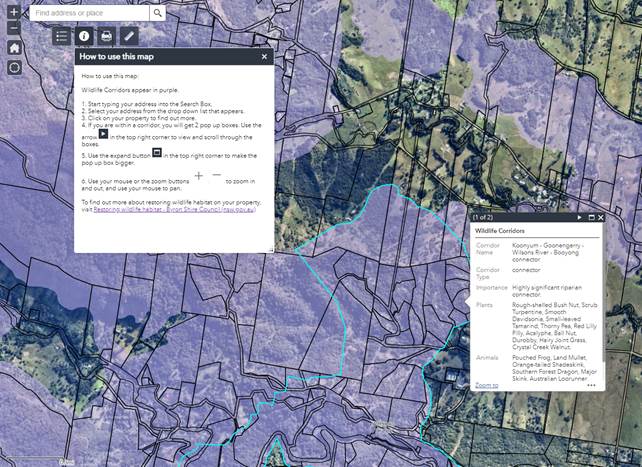
Hunks of Mullum Project
The ‘Hunks of Mullum’ project presents a good opportunity for Council to partner with the community to promote the Byron Wildlife Corridor System and how people can get involved, even in suburban areas. This project is a partnership between WildBnB, Brunswick Valley Landcare, Mullumbimby Chamber of Commerce, Creative Mullumbimby and Byron Shire Council, and aims to install 12 ‘Hunk-of-Trunk’ wildlife habitat hollows along the Brunswick River and Mullumbimby Creek (Figures 3 and 4). The habitat hollows were hand-crafted by WildBnB from eight Tallowwood trees that had to be removed from the Mullumbimby Public School in January 2022. The ‘Hunks of Mullum’ corridor aligns exactly with the Byron Wildlife Corridor System’s Mullumbimby Creek – Brunswick River Connector, which is an important local corridor link, connecting wet forest habitats of Upper Wilson’s Creek with sclerophyll communities at Brunswick Heads.
For residents living in or next to suburban wildlife corridors, installing fauna nest boxes is a good way they can contribute to improving their local corridors. Other tips on creating fauna habitat are also provided on Council’s restoring wildlife habitat web page Restoring wildlife habitat - Byron Shire Council (nsw.gov.au)
Figure 3 Hunks of Mullum Indicative Corridor
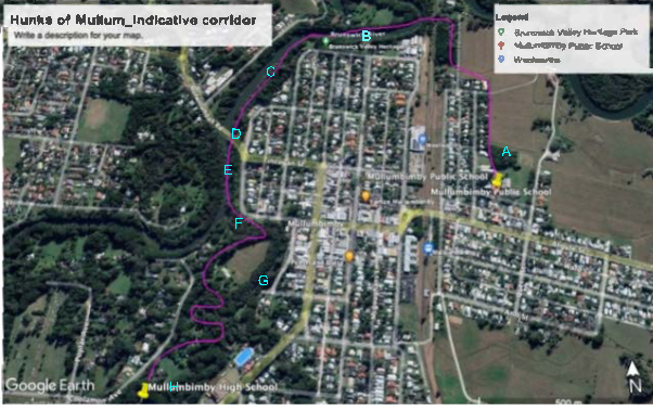
Figure 4 WildBnB’s hand-crafted Hunks-of-Trunks, salvaged from rescued waste logs
Next steps
The next stage of this project is to promote the Wildlife Corridor System via Council’s have your say page. This will give the community the opportunity to become familiar with the map, and to provide feedback, both on the map and on proposed changes to the Biodiversity DCP.
Following public exhibition, Councillors will be presented with a summary of community feedback, and will have the opportunity to decide on any changes proposed to Council’s DCP. Any subsequent DCP amendments will need to be exhibited in accordance with the relevant legislative requirements.
References
Milledge, D.R. 2012. Lismore Local Government Area - Key Habitats and Corridors System. Unpubl. rep. to Lismore City Council. Landmark Ecological Services, Suffolk Park, NSW.
Scotts, D. 2003. Key habitats and corridors for forest fauna. A landscape framework for
conservation
in north-east New South Wales. Occasional Paper 32. NSW National Parks and
Wildlife Service, Sydney, NSW.
Strategic Considerations
Community Strategic Plan and Operational Plan
|
CSP Objective |
CSP Strategy |
DP Action |
Code |
OP Activity |
|
3:
Nurtured Environment |
3.1: Partner to nurture and enhance our biodiversity, ecosystems, and ecology |
3.1.1: Native species - Use best practice land management to improve ecological resilience and reduce threats to biodiversity |
3.1.1.9 |
Seek funding to implement the Biodiversity Conservation Strategy, Coastal Koala Plan of Management and Flying Fox Camp Management Plan. |
Recent Resolutions
Resolved that Council:
1. Note the submissions received during the public exhibition period (24 March to 20 May 2020) of the Biodiversity Conservation Strategy 2020-2030, issues raised and staff responses.
2. Adopt the Biodiversity Conservation Strategy 2020-2030 with the amendments outlined in Attachment 2 (E2020/40811) of this report.
3. Make public the submissions referenced in point 1, subject to the approval of the authors
4. Also make the previous Biodiversity Conservation Strategy and the audit thereof publicly available (Coorey/Lyon)
Legal/Statutory/Policy Considerations
Refer Key Issues section above for discussion relating to Byron Shire Development Control Plan 2014, Chapter B1 Biodiversity.
Financial Considerations
N/A
Consultation and Engagement
The draft wildlife corridor map was presented to Councillors at a Strategic Planning Workshop on 7 November 2021, to local expert stakeholders through an Expert Stakeholder Workshop on 26 November 2021, and to Council’s Agriculture Cluster Group on 9 November 2021. Attachment 2 provides a summary of these discussions.
Key points raised during stakeholder engagement include:
- General support for the Wildlife Corridor System, particularly to support grant applications for conservation and regenerative agriculture projects.
- Use of some kind of interactive map to engage the community was recommended.
- Promoting the Wildlife Corridor System in partnership with the community is recommended.
- Ensuring that the community have access to advice regarding incorporating fire breaks and buffers into plantings.
- More information on what to plant where should be provided alongside the corridor map.
- Use a positive (carrot not stick) approach for developers who help to conserve and enhance wildlife corridors, e.g. through incentives. Local planning consultants can help disseminate this information if they are provided with a clear briefing.
The draft Wildlife Corridor System was also peer-reviewed by two local ecologists and their comments incorporated.
BYRON SHIRE COUNCIL
Staff Reports - Sustainable Environment and Economy 13.9
Report No. 13.9 DA 10.2021.511.1 Dual occupancy (detached) and swimming pool
Directorate: Sustainable Environment and Economy
Report Author: Patricia Docherty, Planner
File No: I2022/822
Proposal:
|
Proposal description: |
Dual occupancy (detached) and swimming pool |
||||||
|
Property description: |
LOT: 8 DP: 840653 |
||||||
|
865 Broken Head Road BROKEN HEAD |
|||||||
|
Parcel No/s: |
|||||||
|
Applicant: |
Town Planning Studio Pty Ltd |
||||||
|
Owner: |
CHLH Management Pty Ltd |
||||||
|
Zoning: |
Byron LEP 2014 RU2 Rural Landscape / PART DM Deferred Matter Byron LEP 1988 1a (General Rural) Zone and 7K (Habitat) Zone Note. Larger dwelling located in part RU2/ Part 1a; Smaller dwelling located entirely within RU2; and No works in 7K zone. |
||||||
|
Date received: |
20 August 2021 |
||||||
|
Integrated / Designated Development: |
☐ Integrated |
☐ Designated |
☒ Not applicable |
||||
|
Concurrence required |
Yes – CNR-27112 |
||||||
|
Public notification or exhibition: |
- Level 2 advertising under Council’s Community Participation Plan. - Exhibition period: From: 22 September 2021 To: 5 October 2021 - Submissions received: Five (5) - Submissions acknowledged: ☒ Yes ☐ No ☐ N/A |
||||||
|
Other approvals |
☐ N/R |
☐ W & S (68) |
☒OSMS (68) |
☐ ST (68) |
☐ RA (138) |
||
|
Other: |
|
||||||
|
Variation request to Development Standards under an EPI (e.g. clause 4.6) |
Clause 64A Variation for minor part of the upper most floor of one dwelling exceeding 4.5 metre development standard by 900mm (20%) - LEP 1998 Clause 40 Height.
|
||||||
|
Estimated cost |
$4,400,000.00 |
||||||
|
Delegation to determine |
Council |
||||||
|
Issues |
1. Road closure required for part of internal driveway built on road reserve. 2. Height variation required under Clause 64A of BLEP 1988 |
||||||
Summary:
The development application originally sought approval for:
· Dwelling house, ancillary detached garage and swimming pool; and
· Secondary dwelling with ancillary detached carport and laundry.
Due to Byron LEP 2014 Clause 5.5 Controls relating to secondary dwellings on land in a rural zone coming into force after the DA was lodged and the absence of any savings provisions permitting secondary dwellings over 70 m² on rural land, the applicant was requested to change the proposed development description.
It was agreed the development description be changed and the proposed development under assessment is for a Dual occupancy (detached) and swimming pool.
The larger of the two dwellings is proposed to be located on the north east of the site with a setback to the eastern boundary of 57.416 metres and a setback to the northern boundary of 26.233 metres. This dwelling has a floor area of 510.29 m² and is to be constructed over 3 levels. This dwelling is to be in generally the same location as a dwelling approved under DA 6.1997.2459.1. Documentation supporting the lawful commencement of that consent was provided by the applicant. Approval of the dual occupancy requires the surrender of Consent No. 6.1997.2459.1.
There are a total of five bedrooms with four of these on the ground level of the larger dwelling and a detached garage located to the north of the driveway. The back wall of the garage is setback from the northern boundary 10.815 metres. The swimming pool is proposed to be located to the south east of the larger dwelling with access from the main ground floor level. The upper level is limited to a bedroom suite and deck. A gym, plant room and water tanks are proposed at lower ground level.
The second smaller dwelling is proposed to be located adjacent to a dam on the site approximately 70 metres south west of the larger dwelling. This dwelling has a floor area of 133.79m² and is to be constructed on one level with two bedrooms. A detached car port and laundry are proposed 7.502 metres to the north east of the smaller dwelling.
The DA is required to be determined by Council due to the need for a Clause 64A Variation for minor part of the upper most floor of one dwelling exceeding 4.5 metre development standard by 900mm (20%) - LEP 1998 Clause 40 Height. It is noted the proposal complies with the overall 9 metre height standard under the BLEP 1988, and had the E Zoning review for the property been finalised the subject proposal in terms of height would have been considered as complying under the BLEP 2014.
A road closure is required for part of internal driveway built on an old section of road reserve. The applicant has initiated the road closure with Council Infrastructure Services (IS). A condition of consent is recommended to ensure the matter is resolved in an appropriate timeframe.
A Vegetation Management Plan is required by recommended conditions of consent for compensation of removal of a small areas of native vegetation comprising twelve trees.
The application appropriately addresses the relevant constraints applying to the site and is recommended for approval subject to the conditions listed in the Recommendation of this Report.
NOTE TO COUNCILLORS:
In accordance with the provisions of S375A of the Local Government Act 1993, a Division is to be called whenever a motion for a planning decision is put to the meeting, for the purpose of recording voting on planning matters. Pursuant to clause 2(a) under the heading Matters to be Included in Minutes of Council Meetings of Council's adopted Code of Meeting Practice (as amended) a Division will be deemed to have been called by the mover and seconder of all motions relating to this report.
RECOMMENDATION:
That Pursuant to Section 4.16 of the Environmental Planning & Assessment Act 1979, Development Application No. 10.2021.511.1 for Dual occupancy (detached) and Swimming Pool, be granted consent subject to the conditions of approval attached to this report.
Attachments:
1 10.2021.511.1
- Recommended Conditions of Consent, E2022/60358
![]()
2 10.2021.511.1
- Marked Up Development Plans - 865 Broken Head Road, Broken Head_PAN-120142, E2022/60359 ![]()
3 70.2021.511.1
- Concurrent Section 68 OSMS Stamped Plans, E2022/62737
![]()
4 Confidential - 10.2021.511.1 submission received, E2022/62786
 Figure 1 – Locality
Plan
Figure 1 – Locality
Plan
Assessment:
1. INTRODUCTION
History/Background
Development Approvals Record:
6.1982.2049.1 – Dwelling
5.1991.467.1 – Miscellaneous (withdrawn)
5.1993.409.1 – Subdivision, Approved 15/03/1994
5.1997.107.1 – Dwelling and Demolition of Existing Dwelling (withdrawn)
5.1997.375.1 – Dwelling and Demolition Existing Dwelling, Approved 19/11/1997
6.1997.2459.1 – BA Dwelling, Approved 26/03/1998
16.2003.101.1 – Swimming Pool, Approved 29/07/2003
10.2009.442.1 – Securing of Dwelling from Pool and Removal of Pool Fencing, Approved 23/10/2009
10.2020.325.1 – Cabana, Approved 14/08/2020
The demolition of the dwelling approved under DA 6.1997.2459.1 has already been undertaken. The applicant has provided evidence of commencement of DA 6.1997.2459.1. This approval will be surrendered and a condition of consent is recommended to require this.
Description of the proposed development
The application originally sought approval for:
· Dwelling house, ancillary detached garage and swimming pool; and
· Secondary dwelling with ancillary detached carport and laundry.
Due to Byron LEP 2014 Clause 5.5 Controls relating to secondary dwellings on land in a rural zone coming into force after the DA was lodged and the absence of any savings provisions permitting secondary dwellings over 70 m² on rural land, the applicant was requested to change the proposed development description. It was agreed the development be changed to a Dual occupancy (detached).
The proposed development under assessment in this DA is Dual occupancy (detached) and Swimming Pool.
Figure 2 - Site plan
The larger of the two dwellings is proposed to be located on the north east of the site with a setback to the eastern boundary of 57.416 metres and a setback to the northern boundary of 26.233 metres. This dwelling has a floor area of 510.29 m² and is to be constructed over 3 levels. This dwelling is to be in generally the same location as a dwelling approved under DA 6.1997.2459.1.
There are a total of five bedrooms with four of these on the ground level of the larger dwelling and a detached garage located to the north of the driveway. The back wall of the garage is setback from the northern boundary 10.815 metres. The swimming pool is proposed to be located to the south east of the larger dwelling with access from the main ground floor level. The upper level is limited to a bedroom suite and deck. A gym, plant room and water tanks are proposed at lower ground level.
The second smaller dwelling is proposed to be located adjacent to an artificial dam on the site approximately 70 metres south west of the proposed larger dwelling. This dwelling has a floor area of 133.79m² and is to be constructed on one level with two bedrooms. A detached car port and laundry are proposed 7.502 metres to the north east of the smaller dwelling.
The total floor area of both dwellings combined is 644.08 m².
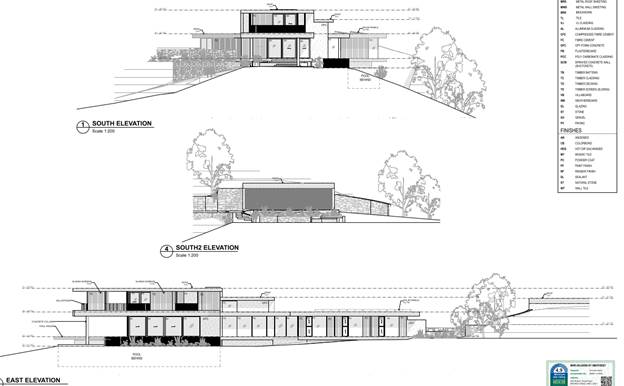
Figure 3 - Larger Dwelling South Elevations and East Elevations
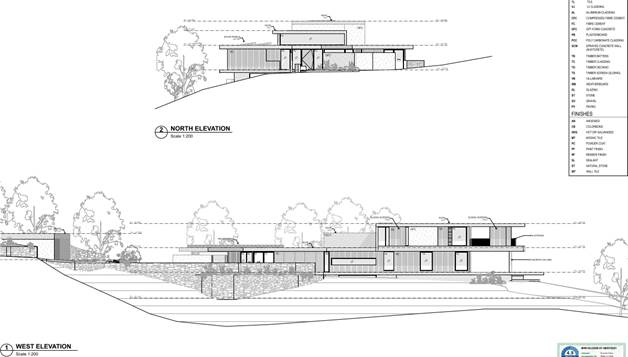
Figure 4 - Larger Dwelling North and West Elevations
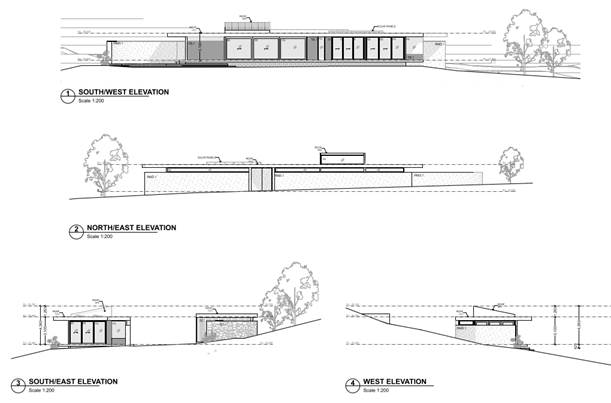
Figure 5 Smaller Dwelling Elevations
Description of the site
A site inspection was carried out on 11 November 2021
|
Land is legally described |
LOT: 8 DP: 840653 |
|
|
Property address |
865 Broken Head Road BROKEN HEAD |
|
|
Land is zoned: |
Byron LEP 2014 RU2 Rural Landscape / PART DM Deferred Matter Byron LEP 1988 1a (General Rural) Zone and 7K (Habitat) Zone |
|
|
Land area is: |
35.29 ha |
|
|
Property is constrained by:
|
Bushfire prone land; High Conservation Value / High Environmental Value; Cattle Dip Buffer |
|
|
|
Is a BDAR required due to the location of the proposed development? |
☒ Yes ☒ No |
|
|
Are there any easements in favour of Council affecting the site? |
☐ Yes ☐ No |
|
|
Is there a Vegetation Management Plan which might affect the proposal? |
☐ Yes ☒ No* |
|
|
Is there a Voluntary Planning Agreement which might affect the proposal? |
☐ Yes ☐ No |
* A Vegetation Management Plan is required to be prepared by recommended conditions of consent attached to this report.
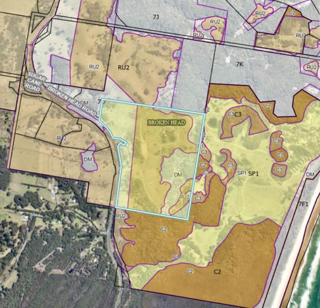
Figure 6 - Zoning Map Extract (Geocortex 6.6.22)
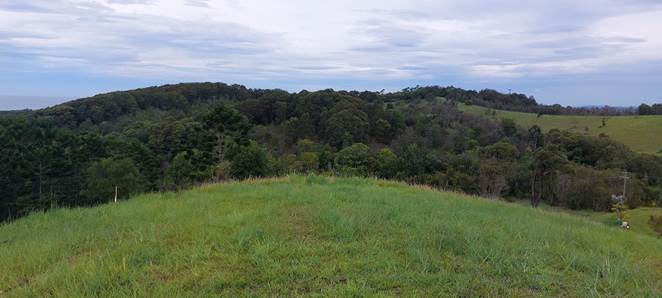
Figure 7 – Photo location of larger dwelling looking south
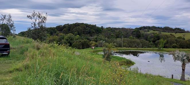
Figure 8 – Photo location of second smaller dwelling looking south
2. SUMMARY OF REFERRALS
|
Referral |
Issue |
|
Environmental Health Officer |
No objections subject to conditions. |
|
Development Engineer |
No objections subject to conditions. |
|
S64 / Systems Planning Officer |
No objections or conditions. |
|
S7.11 / Contributions Planner |
No objections subject to conditions. |
|
Natural Resource Planner |
No objections subject to conditions. |
|
Essential Energy |
Conditions recommended in relation to the power lines over the dam and its use for recreational activities. See further discussion under SEPP transport and Infrastructure below. |
|
Bundjalung (Arakwal) |
No objections or comments received. |
Issues:
Part of the existing internal driveway has been constructed across the road reserve at some time in the past two – three decades. The section of road reserve is superfluous to Councils needs and the applicant has proposed to close it off and purchase it. It is understood the relevant application has been made for this to occur through Infrastructure Services.
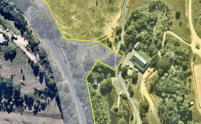
Figure 9 – Part Driveway requires road closure
3. SECTION 4.14 – BUSH FIRE PRONE LAND
Under section 4.14 of the Act, Council must be satisfied prior to making a determination for development on bush fire prone land, that the development complies with the document ‘Planning for Bush Fire Protection 2019’. The site is bush fire prone land. The development application is accompanied by a Bush Fire Assessment Report (Including Performance Solution For Access Greater Than 200m by Peter Thornton dated 28 June 2021 which provides recommendations. Condition 6 is included in the Recommendation of this Report requiring that the development must comply at all times with the requirements of Bush Fire Assessment Report (Including Performance Solution For Access Greater Than 200m by Peter Thornton dated 28 June 2021).
Effect of 10/50 rule on significant vegetation
Nil – The south east portion of the property is mapped as coastal Wetlands under the relevant SEPP and as such the 10/50 rule does not apply in terms of clearing additional vegetation beyond what is approved for asset protection zones and there maintenance. No works are located in proximity to coastal wetlands mapped on the site.
Conditions of consent require a vegetation management plan to protect native vegetation and biodiversity regeneration on the site in perpetuity.
4. SECTION 4.15C – MATTERS FOR CONSIDERATION – DISCUSSION OF ISSUES
Having regard to the matters for consideration detailed in Section 4.15(1) of the Environmental Planning & Assessment Act 1979 (EP&A Act), the following is a summary of the evaluation of the issues.
4.1 State Environmental Planning Policies (SEPP)
|
Considerations |
Satisfactory |
Unsatisfactory |
|
Resilience and Hazards SEPP 2021 Consideration: Chapter 2 Coastal Management Part of the south eastern corner of the lot is mapped under the coastal management areas including coastal wetlands. The proposed development does not affect mapped littoral rainforest or coastal wetlands and no part of the development is affected by the coastal management provisions of the SEPP. Chapter 4 Remediation of Land As the site was originally used as a banana plantation, it can be expected that the site is contaminated with residual Arsenic and Organochlorine based pesticides. It is likely that the site also contains “hotspots” where chemicals were stored and mixed, or bananas processed and packed. The Chemical Residue Assessment prepared by Soil Pacific, dated the 14.01.1998 (E2021/106441) only assessed the land area surrounding the previous primary dwelling. A further assessment was prepared by Greg Alderson Associated in January 2022 to investigate the site of the proposed second dwelling (Refer to Doc# E2022/58650. The submitted reports were assessed by Council’s Environmental Health Officer and it is considered that no further investigation is required.
|
☒ |
☐ |
|
Consideration: Chapter 2 Primary production and rural development The proposed development is not inconsistent with the aims of the chapter, including the need to reduce land use conflict and sterilisation of rural land by balancing primary production, residential development and the protection of native vegetation, biodiversity and water resources,
|
☒ |
☐ |
|
Transport and Infrastructure SEPP 2021 Consideration: Chapter 2 Infrastructure The application was referred to Essential Energy in accordance with S2.48 of the SEPP. Referral to Essential Energy resulted in comments about safety concerns related to the proximity of existing overhead powerlines to the second smaller dwelling. Based on these comments and observation at site inspection of the power lines over an artificial dam being used for recreation purposes, a condition of consent is recommended to ensure that the applicant addresses Essential Energy’s safety concerns, prior to issue of a construction certificate. The applicant is considering relocating the power underground and the condition recommended requires them to resolve this to the satisfaction of Essential Energy including the potential to relocate the power lines or make minor adjustments to the building location to ensure it is 10 metres clear of the overhead power prior to issue of a construction certificate. This will also address the separate safety issue of the use of the artificial dam for recreation and swimming purposes not subject to this DA.
|
☒ |
☐ |
|
SEPP (Building Sustainability Index: BASIX) 2004 Consideration: A valid BASIX Certificate (number: 1221524M 02) was submitted with the development application |
☒ |
☐ |
4.2A Byron Local Environmental Plan 2014 (LEP 2014)
The applicant has provided the following overlay mapping to assist in understanding the location of dwellings relative to split zoning. The larger dwelling is partly located in the RU2 Rural Landscape Zone under Byron LEP 2014 and the 1(a) General Rural Zone under Byron LEP 1988. The smaller dwelling near the dam is located entirely in the RU2 Rural Landscape Zone.
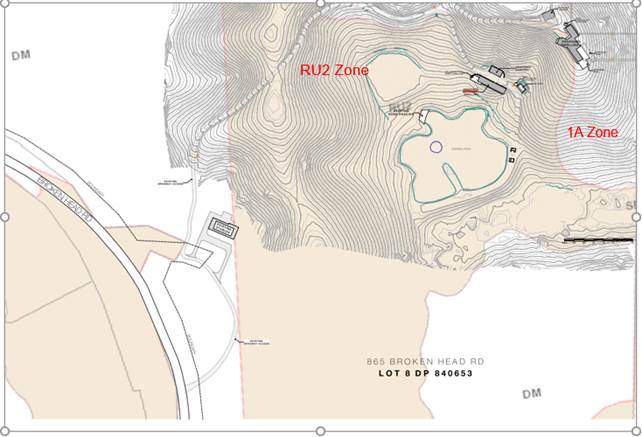
Figure 10- Split zoning overlay from applicant
The following relevant clauses under Byron LEP 2014 are discussed below
In accordance with LEP 2014 clauses 1.4 and 2.1 – 2.3:
(a) The proposed development is defined in the LEP 2014 Dictionary as Dual occupancy (detached);
(b) The land is within the RU2 Rural Landscape
(c) The proposed development is permissible with consent; and
(d) Regard is had for the Zone Objectives as follows:
|
Zone Objective |
Consideration |
|
• To encourage sustainable primary industry production by maintaining and enhancing the natural resource base. |
The proposed development is not inconsistent with the objectives of the zone. |
|
• To maintain the rural landscape character of the land. |
|
|
• To provide for a range of compatible land uses, including extensive agriculture. |
|
|
• To enable the provision of tourist accommodation, facilities and other small-scale rural tourism uses associated with primary production and environmental conservation consistent with the rural character of the locality. |
|
|
• To protect significant scenic landscapes and to minimise impacts on the scenic quality of the locality. |
Clause 4.1E Minimum lot sizes for certain residential accommodation
The proposal complies with the minimum lot size requirements of 4000 m2 for detached dual occupancies.
Clause 4.2A Erection of dwelling houses and dual occupancies on land in certain rural and environment protection zones
The subject property has a “dwelling entitlement” and as such approval of the dual occupancy is permissible with consent.
Clause 4.2D Erection of dual occupancies (detached) and secondary dwellings in Zones RU1 and RU2
The proposal raises no issues under the clause with both dwellings accessible from one driveway and within 100 metres of each other. The dwellings are generally low set, will not impact on the visual or scenic quality of the area, there is adequate land available for onsite effluent disposal, whilst the land can still be utilised for agricultural and rural purposes.
Clause 4.3 Height of Buildings
Both dwellings comply with the 9 metre height limit under the LEP.
Clause 4.1E Minimum lot sizes for certain residential accommodation
The proposal complies with the minimum lot size requirements of 4000 m2 for detached dual occupancies.
Clause 6.2 Earthworks
The main dwelling has a basement gymnasium and pool necessitating earthworks for their construction. It is considered the works will not have an adverse impacts on drainage patterns, or the existing or future amenity of adjoining properties, or affect the future use or redevelopment potential of the land. Appropriate conditions of consent are recommended in relation to uncovering or disturbing relics, sedimentation and erosion control measures, and the disposal of any fill material.
Clause 6.6 Essential Services
The proposal can be adequately serviced with all necessary infrastructure
The proposal raises no other issues under Byron LEP 2014.
4.2B Byron Local Environmental Plan 1988 (LEP 1988)The larger dwelling is partly in the 1A General Rural Zone. The proposal is permissible with consent in the zone and is satisfactory in terms of the zone objectives, the dwelling entitlement provisions under Clause 15, and the provision of services requirements under clause 45. The main issue is the height of the dwelling as discussed under Clause 40 and Clause 64A of the LEP below.
Clause 40 Height
The proposed development is complaint with the overall height limit of 9 metres
Subsection (2) (b) requires that the consent authority must not consent to the erection of a building if the floor of the topmost floor level of the building exceeds 4.5 metres above the existing ground level. This height limit is a development standard and a minor part of the upper level exceeds this in part by up to 900 mm or 5.4 metres above the existing ground level.
The applicant has submitted a written request to vary the development standard for the upper level to exceed the 4.5 metre height limit. The applicant’s written request pursuant to Clause 64A is considered in full below.
|
What clause does the development not comply with and what is the nature of the non-compliance? |
Further consideration, including whether the development application is recommended for approval or refusal accordingly |
|
|
|
Clause 64A Exceptions to Development Standards
The Applicant has sought a variation to vary a development standard for the upper most floor to not exceed 4.5 metres under Clause 40 (2) (b) of Byron LEP 1988 by proposing a building with an upper floor height of 5.4 metres on a minor part of the upper floor of the larger dwelling highlighted red in the extract of the written request below:
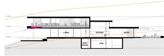
Figure 11 – Extent of floor level over 4.5 metres above ground
The applicant has submitted a written request that demonstrates that strict compliance with the development standard is unreasonable or unnecessary and that there are sufficient environmental grounds to vary the controls. It is considered that strict compliance with the development standard is unreasonable and unnecessary in the circumstances of the case and that there are sufficient environmental grounds to vary the development standard provided in the applicant’s request to vary the development standard (extracted in full below that outlines the following reasons:
Split zoning provides a unique situation wherein two Local Environmental Plans apply to the new dwelling development. Each Local Environmental Plan contains its own clause that relates the maximum height of buildings. It is only the height controls listed within Clause 40 of Byron Local Environmental Plan 1988 that provide an uppermost floor level standard. The more recently formulated height controls within Clause 4.3 of Byron Local Environmental Plan 2014 only include a maximum overall height standard.
Subsequently, this arrangement provides that only the eastern side of the proposed dwelling is prescribed with a maximum 4.5 metre uppermost floor level control. No uppermost floor level requirement applies to the western side of the dwelling. Byron Shire Council is currently preparing an amendment to Byron Local Environmental Plan 2014 to include the Deferred Matter areas of the property within the 2014 Local Environmental Plan. The landowners have agreed with Byron Shire to include the subject property within "Planning Proposal 3", whereby the north-eastern corner of the allotment will fall entirely within the RU2 Rural Landscape Zone.
Byron Local Environmental Plan 2014 includes a maximum height of buildings map, limiting the height of buildings across the vast majority of the Byron Local Government Area to 9.0 metres (an exception includes the Byron Bay Town Centre which where the overall height of buildings is limited to 11.5 metres). Byron Local Environmental Plan 2014 has abandoned the 4.5 metre uppermost floor level control. The maximum height of buildings map applies a limit to the topmost part of a building only. Byron Shire Council is satisfied that the objectives of a development standard relating to building height can be achieved without the need to limit over 50% of the property to which the Development Application relates is located within the RU2 Rural Landscape Zone under Byron Local Environmental Plan 2014. The remainder is located within a Deferred Matter area, and subsequently falls within the jurisdiction of Byron Local Environmental Plan 1988. Mapping attached to this document shows that the eastern side of the proposed dwelling, its ancillary garage and swimming pool are located within the 1 (a) General Rural Zone under Byron Local Environmental Plan 1988. The western side of the proposed dwelling and the access driveway are located within the RU2 Rural Landscape Zone under Byron Local Environmental Plan 2014.
The split zoning provides a unique situation wherein two Local Environmental Plans apply to the new dwelling development. Each Local Environmental Plan contains its own clause that relates the maximum height of buildings. It is only the height controls listed within Clause 40 of Byron Local Environmental Plan 1988 that provide an uppermost floor level standard. The more recently formulated height controls within Clause 4.3 of Byron Local Environmental Plan 2014 only include a maximum overall height standard.
Subsequently, this arrangement provides that only the eastern side of the proposed dwelling is prescribed with a maximum 4.5 metre uppermost floor level control. No uppermost floor level requirement applies to the western side of the dwelling. Byron Shire Council is currently preparing an amendment to Byron Local Environmental Plan 2014 to include the Deferred Matter areas of the property within the 2014 Local Environmental Plan. The landowners have agreed with Byron Shire to include the subject property within "Planning Proposal 3", whereby the north-eastern corner of the allotment will fall entirely within the RU2 Rural Landscape Zone.
Byron Local Environmental Plan 2014 includes a maximum height of buildings map, limiting the height of buildings across the vast majority of the Byron Local Government Area to 9.0 metres (an exception includes the Byron Bay Town Centre which where the overall height of buildings is limited to 11.5 metres).
Byron Local Environmental Plan 2014 has abandoned the 4.5 metre uppermost floor level control. The maximum height of buildings map applies a limit to the topmost part of a building only. Byron Shire Council is satisfied that the objectives of a development standard relating to building height can be achieved without the need to limit the height of the upper most floor level.
The proposed development does not exceed the 9.0 metre height control and is consistent with this policy direction from Byron Shire Council. Once the subject site is included within Byron Local
Environmental Plan 2014 (which is estimated to be late 2021), the maximum height of buildings map will provide a 9.0 metre overall building height limit consistent with other areas of the property that are located within the RU2 Rural Landscape Zone. As such, the proposed development will comply with future height controls for the site.
![]()
Figure 12 - Overall height of previously approved dwelling on site (not
constructed)
The proposed dwelling will replace an approved (but not yet constructed) dwelling that is also positioned in the north-eastern corner of the allotment. The approved dwelling design has an upper most floor level that exceeds the 4.5 metre standard. It also has an overall height that is greater than that now proposed within the site (see image below). It is submitted that the new dwelling design will provide for an improved environmental planning outcome for the site has a flat roof design and is excavated into the sit
The uppermost floor level standard is derived from an archaic clause from a Local Environmental Plan that will soon have no effect within the subject site. It is understood that the standard was introduced as a means to limit overlooking into an adjoining property from the uppermost floor level of new development. The standard may once had [sic] relevance in an urban area, however on a large rural property with generous building setbacks to neighbouring lots, the 4.5 metre uppermost floor level control does not provide any benefit to adjoining properties. The 9.0 metre overall height standard appropriately controls the height of buildings in the rural property.
The proposed floor level has a maximum floor height of 5.4 metres at the worst affected area. This comprises a variation of 900mm to the standard. Reducing the height of the floor level would not achieve any greater compliance with the objectives of Clause 40. The overall height of the development is permitted to remain at 9.0 metres as measured to the finished roof. The overall height of the development will not change by adjusting the floor level at the area of encroachment (as the remainder of the building will sit above this height). The bulk and scale of the development will remain unchanged, as permitted under Clause 40.
Byron Shire Council has recently granted approval to similar variations within a nearby property (No. 657B Broken Head Road) as part of Development Consent Nos. 10.2016.722.1 and 10.2018.529.1.
An additional example of a similar variation is Development Consent No. 10.2014.417.1 located at 43 Lawson Street, Byron Bay. The history of variations to the 4.5 metre uppermost floor level control indicates that the standard is diminished in significance, virtually abandoned by the actions of Byron Shire Council in granting similar development consent.
The proposed building design clearly meets the objectives of the development standard, which are listed within Clause 40 of Byron Local Environmental Plan 1988 as follows:
(a) to achieve building design that does not exceed a specified maximum height from its existing ground level to finished roof or parapet.
(b) to ensure that the height and scale of development is appropriate to its location, surrounding development and the environmental characteristics of the land.
Objective (a) specifically relates to the overall height of a building. No reference is made to the uppermost floor level of a building. As the proposed dwelling meets the maximum 9.0 metre height standard as measured from existing ground level to the roof/parapet, the development achieves this objective.
The proposal is consistent with Objective (b) as the proposed dwelling design has a similar height and scale to that already approved within the subject site. The approved plans from Development Consent No. 97/0375 show a three level dwelling with a larger roof structure positioned in the north-eastern corner of the property.
A review of a recent real estate advertisement for the adjoining property to the east (Linnaeus Estate -https:/www.realestate.com.au/property-house-nsw-broken+head-135153902) shows over a dozen high set accommodation buildings constructed within sloping land to the east of the allotment. The height of the proposed principal dwelling is comparable to these existing buildings within the neighbouring lot. The scale of development within the neighbouring lot (> 12 high set buildings) is significantly greater than the residential development that is proposed within No. 865 Broken Head Road.
Consideration: The proposal is in the public interest having regards to the objectives of the development standard under Clause 40 of Byron LEP 1988 for the following reasons outlined in the written request:
The approval of the contravention to the development standard is regarded as being in the public interest for three reasons:
(i) The fact that the development is consistent with the objectives of Clause 40;
(ii) The fact that the development does not exceed Byron Shire Council's more recently adopted height controls, as set out within Byron Local Environmental Plan 2014 which currently applies to approximately 50% of the property and will soon apply to the entire property.
(iii) The development is consistent with the objectives of the 1 (a) General Rural Zone. Refer to the attached Town Planning Report for discussion in this regard.
It is submitted that contravention of the 4.5 metre development standard is acceptable because, on the completion of the development, it will not be discernible that the uppermost floor level of the dwelling is above 4.5 metres in height. The Section Plan below from Harley Graham Architects design plans show that the natural ground level beneath the southern end of the dwelling will be filled. At the completion of works, the uppermost floor level will appear to be consistent with the 4.5 metre uppermost floor level control.
The concurrence of the Planning Secretary is not required.
It is recommended that the development standard can be varied in this instance.
1. The development is satisfactory having regard to the requirements outlined in clause 64A;
2. The development is satisfactory having regard to applicable Department of Planning, Infrastructure and Environment Circulars;
3. The development is satisfactory having regard to relevant caselaw;
4. The DA demonstrates that compliance is with the development standard is unreasonable and unnecessary;
5. The DA demonstrates that there are sufficient environmental planning grounds to justify contravening the standard;
6. The DA demonstrates that that the development in the public interest;
7. The DA demonstrates that the development is consistent with the objectives of the standard and the zone;
8. The DA demonstrates how the development produces a better planning outcome than one that strictly complied with the development standard; and
9. The DA demonstrates what it is about the grounds of the request that are particular to the proposed development on this site, and that there has to be something particular to the development on this site to justify the variation.
4.3 Any proposed Instrument that has been the subject of public consultation and has been notified to the consent authority
Other than the LEP amendment to bring the property fully into the Byron LEP 2014, no draft EPI’s affect the proposal. As discussed had this occurred the variation to the height limit would not have been required.
4.4A Byron Shire Development Control Plan 2014 (DCP 2014)
DCP 2014 is an applicable matter for consideration in the assessment of the subject development application in accordance with subsection 4.15(1) of the EP& A Act because it applies to the land to which LEP 2014 applies. The DCP 2014 Parts/Chapters that are checked below are of relevance to the proposed development:
|
Part A |
☒ |
|
Part B Chapters: |
☒ B1 | ☐ B2 | ☒ B3 | ☒ B4 | ☐ B5 | ☐ B6 | ☐ B7 | ☒ B8 | ☐ B9 | ☐ B10 | ☐ B11 | ☐ B12 | ☐ B13 | ☒ B14 |
|
Part C Chapters: |
☐ C1 | ☐ C2 | ☐ C3 | ☐ C4 |
|
Part D Chapters |
☐ D1 | ☒ D2 | ☐ D3 | ☐ D4 | ☐ D5 | ☐ D6 | ☐ D7 | ☐ D8 | ☐ D9 |
|
Part E Chapters |
☐ E1 | ☐ E2 | ☐ E3 | ☐ E4 | ☐ E5 | ☐ E6 | ☐ E7 | ☐ E8 | ☐ E9 | ☐ E10 |
The following relevant provisions are discussed
Byron Shire Development Control Plan - Chapter B1 Biodiversity
The proposal requires a variation to the prescriptive measures of Section B1.2.1 of Chapter B1 of the DCP. Specifically, the proposed development footprint including the asset protection zones proposes removal of native vegetation and encroaches within the required 30m setback area to EECs (littoral rainforest) on the site. The application acknowledged this and proposed to incorporate a Biodiversity Conservation Management Plan (BCMP) to compensate for this variation. The proposed ecological restoration area to be subject to the BCMP is shown below. This is considered sufficient to compensate for the encroachment into the setback area and will be conditioned. Apart from this issue, the proposal is generally in accordance with Chapter B1.
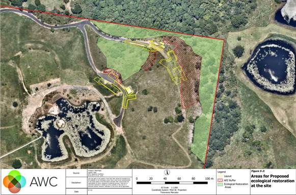
Fig 13 Proposed ecological restoration areas.
Chapter B3 Services
Chapter B14 Excavation and fill
Earthworks are proposed in relation to excavating the site for the swimming pool, the basement gym and to provide a generally level platform to construct the dwellings upon. The applicant has submitted that the earthworks are proposed lower the overall height of the development into the ground with the aim (it is assumed) to minimise the visual impact of the building, whilst the extent of the earthworks as proposed are not dissimilar to that already approved under DA97/0375, which the applicant claims has commenced. It is considered that the proposal as designed will hide a section of the development into the hill and as such will reduce the overall bulk and scale of the development. Appropriate conditions of consent are recommended in relation to appropriate geotechnical reports to support the engineering plans for the construction certificate.
Chapter D2 Residential Accommodation and ancillary development in rural zones
D2.5 Dual Occupancies and Secondary Dwellings
Car Parking – the proposal incorporates sufficient car parking of a minimum of two spaces for the main dwelling and one space for the smaller dwelling.
Character and Siting – The two dwellings are not more than 100 metres apart and serviced by a common driveway.
Soundproofing – The proposed dwellings are suitably sited apart to ensure acoustic privacy.
Private Open Space – Suitable area is available on this property for open space purposes and onsite effluent disposal.
Adjoining and Nearby development – The development is suitably sited so as not to create land use conflict with neighbours with vegetation to the northern and eastern boundaries screening the development and providing a buffer. The proposal is of a bulk, scale and height to not impact on the scenic qualities of the locality and will not have an adverse impact on neighbours views, privacy or solar access.
4.4B Byron Shire Development Control Plan 2010 (DCP 2010)
Part of the main dwelling in the 1(a) Zone is covered by the provisions contained within DCP 2010 and in particular the following comments are provided in relation Chapter C Residential Development
C2.6 Setbacks – The proposal complies with the applicable 55 metre setbacks for rural dwellings on arterial roads.
C3.1 and C3.3 Visual Impacts/ Development on or near ridgetops – The main dwellings is located such that it should not be visually prominent with a treed backdrop to the north and east of the buildings. Conditions to apply in terms of colours and materials
Environmental Planning and Assessment Regulation 2000
The proposal raises no issues under the relevant regulations.
4.6 The likely impacts of that development, including environmental impacts on both the natural and built environments, and social and economic impacts in the locality
|
Impact on: |
Likely significant impact/s? |
|
Natural environment |
No. The proposal will not have a significantly adverse impact on the natural environment of the locality. |
|
Built environment |
No. The proposal will not have a significantly adverse impact on the built environment of the locality. |
|
Social Environment |
No. The proposal will not have a significant social impact on the locality. |
|
Economic impact |
No. The proposal will not have a significant economic impact on the locality. |
|
Construction Impacts |
The development will generate minor impacts during its construction. Conditions of consent recommended to control hours of work, builders waste, construction noise, installation of sedimentation and erosion control measures and the like to ameliorate such impacts. |
Council Policies that are applicable to the proposed development have been considered during assessment.
4.7 The suitability of the site for the development
The site is a serviced, unconstrained property and is suitable for the proposed development.
4.8 Submissions made in accordance with this Act or the regulations
The development application was publicly exhibited. There were 5 submissions made on the development application:
|
Issue |
Consideration |
|
Matters not the subject of this DA including Existing horse stables and arena and cabana. In relation to this application, we request that council review compliance in relation to the works that currently exist on the site to ensure they are approved prior to the granting of any new works
|
These matters are beyond the powers of the current DA and do not preclude the consideration and recommendation for approval of the new dwellings. DA 10.2020.325.1 approved the cabana works as detailed in section 1 of this report above. The stables building was referred to compliance in September 2020 for investigation as potential illegal development and with the outcome lodged that it was an exempt development(CRM reference 30.2020.6630.1). Extent of earthworks for horse arena was referred to Compliance for further investigation on 28.6.22. These matters do not affect the development assessment and determination of the proposed dwellings and swimming pool and investigation and compliance action can occur separately. |
|
Aboriginal Cultural Heritage |
The application was referred to Bundjalung of Byron Bay Aboriginal Corporation (Arakwal) by Council at the start of the assessment process. No response or requested conditions of consent have been received by Council. Aboriginal Monitoring and oversight has not been requested. The applicant also provided a copy of an Aboriginal Heritage Information Management System(s) (AHIMs) report which shows that there are no Aboriginal sites recorded in or near the location of the subject lot nor has any Aboriginal Places been declared in or near the site location. Notwithstanding appropriate conditions of consent are recommended in relation to how an artifact would be managed in the event it is uncovered or disturbed during construction |
|
Flora and Fauna and Environmental Zones including: In relation to this application, we request that council ensure that opportunities for the enhancement of this site are secured and believe a Biodiversity Conservation Management Plan should be in place prior to any approval for additional construction on the site and be publicly exhibited.
|
The application has been assessed by Council’s Natural Resources Planner (Section 2 above) and relevant conditions of consent are recommended to ensure no adverse impacts on biodiversity as a result of the development. This includes the requirement for the applicant to prepare a Biodiversity Conservation Management Plan (BCMP), which must be prepared by a qualified ecologist with experience in ecological restoration in the northern rivers. |
|
Wastewater Disposal including concerns about stormwater and drinking water quality |
The application has been assessed by Council Environmental Health Officer and Development Engineer (Section 2 above). The details of the onsite sewage management, pool backwash and stormwater are all addressed in these assessments and conditions of consent recommended by those officers are included in the recommendation at the end of this report. It is considered the site is of size and area to manage these issues onsite |
|
Contamination |
The application was submitted with one report and was further supplemented by a more recent report to cover the site of the secondary dwelling in January 2022. These matters are addressed in the Referrals and SEPP sections 2 and 4.1 of this report. The site is considered suitable for the proposed development |
|
Contravention of a development standard |
This application was submitted with a written request to vary the development standard for part of the upper floor of the larger dwelling that is 0.9 metres above the 4.5 maximum level. The dwelling is to be located on a site with an AHD of 34metres and below the 60 m defined as a ‘visually prominent site. The written request to vary the development standard for a very minor part of the building is addressed in full in Section 4.2B above. The variation does not require the concurrence of the Planning Secretary. |
|
Request screen planting and earth tone colours |
The proposal is required to provide substantial additional vegetation for the purposes of biodiversity and standard conditions are recommended to apply requiring muted bushland and earth tones be used. Neither dwelling is located in a ‘visually prominent site’ as defined by the DCP. |
|
70 sqm limit on secondary dwellings – LEP Clause 5.5 amendment. |
With regards to the recent gazettal of development standards for secondary dwellings not to exceed 70 sqm (clause 5.5), the application description has been changed to dual occupancy (detached). This is due to the lack of any savings provisions applying to secondary dwellings on rural lots. The proposed development will meet the applicable development standards and controls related to detached dual occupancies. |
|
Substantial commencement of previous DA- current DA must be considered on its own merits. |
The applicant has demonstrated substantial commencement of the previous DA which also explains the demolition and absence of a current dwelling on the site and the extent of the driveway constructed on the site. This does preclude the development from being assessed in this context but entirely on its own merits. The previous DA for the dwelling will be required to be surrendered as recommended in the conditions of consent attached to this report. |
4.9 Public interest
The proposed development is unlikely to prejudice or compromise the public interest or create an undesirable precedent.
5. DEVELOPER CONTRIBUTIONS
5.1 Water & Sewer Levies
No Section 64 levies will be required.
5.2 Developer Contributions
Section 7.11 Contributions will be payable.
6. DISCLOSURE OF POLITICAL DONATIONS AND GIFTS
|
Disclosure details |
Response |
|
Has a Disclosure Statement been received in relation to this application? If Yes, Provide Disclosure Statement register reference: 91. |
Yes ☐ No ☒ |
|
Have staff received a ‘gift’ from anyone involved in this application that needs to be disclosed. |
Yes ☐ No ☒ |
7. CONCLUSION
The proposed dual occupancy and swimming pool is satisfactory having regard to the relevant environmental planning instruments and planning controls applicable to the site. The proposal raises no significant issues in terms of environmental impacts which cannot be managed and the site is considered suitable for the development. The application appropriately addresses the relevant constraints applying to the site and is recommended for approval subject to the recommended conditions attached to this Report.
BYRON SHIRE COUNCIL
Staff Reports - Sustainable Environment and Economy 13.10
Report No. 13.10 Place Planning Collective Expression of Interest Candidate Selection
Directorate: Sustainable Environment and Economy
Report Author: Kristie Hughes, Place Liaison Officer
File No: I2022/872
Summary:
In February 2022 Council resolved to commence an Expression of Interest (EoI) process to appoint new community representatives to the Place Planning Collective (PPC) replacing members who have reached the end of their term (Res 22-059). This process has now been completed. 32 applications were received in total.
As stipulated in the Place Planning Charter, “the collective will be made of up to twelve community members and up to three nominated Councillors” with members being appointed for a two-year term.
The EoI specifically sought applicants to represent the Bangalow, Mullumbimby and Byron Arts and Industry Estate communities. There are currently nine places available with four allocated to Mullumbimby, three places available for Bangalow and two for the Byron Arts and Industry Estate.
Previously the Place Planning Collective monthly meetings were held during business hours, which has been a barrier for some Councillors and community members to attend. The EoI surveyed applicants about suitable meeting times and consequently, meetings are now scheduled at a later timeslot with the aim of accommodating and engaging a broader spectrum of the community.
RECOMMENDATION:
1. That Council appoints nine Place Planning Collective members from the following: Attachment 1 (E2022/65420 CONFIDENTIAL Place Planning Collective applicant summary 2022), Attachment 2 (E2022/63168 CONFIDENTIAL Place Planning Collective EoI submission forms).
2. That selected members are distributed as follows:
Four members representing Mullumbimby are: _______, _______, _______ and ______.
Three members representing Bangalow are: ________, ________ and _______.
Two members representing Byron Arts & Industry Estate are:_____ and _____.
1 Confidential - Place Planning Collective EoI applicant summary 2022, E2022/65420
2 Confidential - Place Planning Collective EoI submission forms 2022, E2022/63168
Report
The Place Planning Collective
The PPC is a group of community members, staff and Councillors who guide and manage the implementation of the Mullumbimby, Bangalow, Federal, and Byron Arts and Industry Estate masterplans.
The Place Planning Collective Charter provides guidelines for the working group. The charter was endorsed by Council in May 2020 (Res 20-217).
Further information on the Place Planning Collective, its charter, members, and meeting minutes can be found on Council’s website here:
https://www.byron.nsw.gov.au/Community/Place-planning/Place-Planning-Collective
Expression of Interest Process
In February 2022 Council resolved to commence an expression of interest process to recruit additional community representatives as multiple members have reached the end of their initial tenure (Res 22-059).
As stipulated in the Place Planning Charter, “the collective will be made of up to twelve community members and up to three nominated Councillors” with members being appointed for a two-year term.
The appointed Councillors are: Cr Lyon, Cr Ndiaye and Cr Swivel as members of the Place Planning Collective and Cr Dey as an alternate.
The expression of interest was advertised on Council’s website for five weeks (May 25 2022 to July 3 2022). In addition to advertising the EoI on Council’s website and in the Echo, the invitation was extended to local community groups, business chambers, schools and preschools, along with previous participants of relevant masterplan working groups. This was to target a local cohort, more likely to be interested in participating in the PPC.
As per the EoI criteria new appointments are required to be affiliated with the Mullumbimby, Bangalow and Byron Arts and Industry Estate communities and masterplans. As the PPC is oriented around masterplans and managing their actions previous experience has shown that members without a direct interest in one of the relevant masterplans have been disengaged. It should be noted that five expressions of interest received during this process appeared to be unlinked to an existing Masterplan.
Previously the Place Planning Collective monthly meetings were held during business hours, which has been a barrier for some Councillors and community members to attend. The EoI surveyed applicants about suitable meeting times and consequently, meetings are now scheduled at a later timeslot (monthly, Tuesdays 3.30 to 5.30pm) with the aim of accommodating and engaging a broader spectrum of the community.
In total 32 submissions were received, five of those are from existing members wishing to continue their membership. There are positions available for nine members to join the Collective with three positions already filled by newer members.
Strategic Considerations
Community Strategic Plan and Operational Plan
|
CSP Objective |
L2 |
CSP Strategy |
L3 |
DP Action |
L4 |
OP Activity |
|
Community Objective 4: We manage growth and change responsibly |
4.1 |
Support the visions and aspirations of local communities through place-based planning and management |
4.1.1 |
Develop, implement and update Place Plans that promote place-based forward planning strategies and actions |
4.1.1.2 |
Continue to implement actions from Our Mullumbimby Masterplan, Bangalow Village Plan and Byron Arts and Industry Estate Plan |
Recent Resolutions
· 22-059: Council meeting February 24 2022 – PPC update and EOI for upcoming vacancies
· 21-188: Council Meeting 10 June 2021 – additional community members
· 20-703: Council Meeting 17 December 2020 – end of 2020 update
· 19-690: Council meeting 12 December 2019 – initial EOI nominations
· 19-451: Council Meeting 19 September 2019 – resolution to establish the Collective
Legal/Statutory/Policy Considerations
Nil
Consultation and Engagement
BYRON SHIRE COUNCIL
Staff Reports - Sustainable Environment and Economy 13.11
Report No. 13.11 PLANNING - 10.2021.114.1 - 'Fed Sheds' Light Industry Excluding Artisan Food & Drink Premises at 467 Federal Drive, Federal
Directorate: Sustainable Environment and Economy
Report Author: Patricia Docherty, Planner
File No: I2022/877
Proposal:
|
Proposal description: |
Light Industry Excluding Artisan Food and Drink Premises |
||
|
Property description: |
LOT: 10 DP: 790360 |
||
|
467 Federal Drive FEDERAL |
|||
|
Parcel No/s: |
22720 |
||
|
Applicant: |
Newton Denny Chapelle |
||
|
Owner: |
Davgav Pty Ltd |
||
|
Zoning: |
RU5 Village |
||
|
Date received: |
26 February 2021 |
||
|
Integrated / Designated Development: |
☐ Integrated |
☐ Designated |
☒ Not applicable |
|
Concurrence required |
Yes –CNR No. 18853 |
||
|
Public notification or exhibition: |
- Level 2 advertising under Council’s Community Participation Plan. - Exhibition period: 8/3/21 to 21/3/21 - Submissions received: 213 (152 Oppose and 61 Support) - Submissions acknowledged: ☒ Yes ☐ No ☐ N/A Note. Although not mandated Community Significant Development, under the Byron Community Participation Plan, the applicant undertook pre-lodgement consultation including advertising in The Echo inviting comments via Survey Monkey 2-28 August 2020 – 133 comments were received. 53% strongly supported. 7%, somewhat supportive. 3% neither supportive or opposed, 29% strongly opposed and 8% somewhat opposed the project. (Refer to Doc #E2021/40084). |
||
|
Variation request to Development Standards under an EPI (e.g. clause 4.6) |
No variations are requested to the Development Standards
|
||
|
Estimated cost |
$2,860,184.00 |
||
|
Delegation to determine |
Council |
||
|
Issues |
Number of submissions raising various issues, such as: · Not a residential development · Out of character with Federal · Impacts on the Village · Should await the masterplan to be completed · Car parking |
||
|
Summary: |
|||
|
The DA proposes to demolish the exiting dwelling on the land and construct three buildings to use for light industrial purposes comprising eight tenancies of varying floor areas, six (6) with mezzanine levels, and car parking for 26 vehicles, motorbike spaces and two loading zones. The subject site is within the heart of the village and sits opposite the Federal Hall. The land has an area of 4000 m2 and is zoned RU5 Village which permits a range of uses including light industry. Access and egress to the development is proposed via two new vehicle crossovers in a one-way direction through the site with all vehicles entering and leaving the site in a forward direction. Minor excavation is required at the property frontage to Federal Drive (up to 1m) and fill and retaining at the downslope (southern) side of each building. The development proposes stormwater storage tanks beneath each building and on-site sewage management and a land application area is proposed below the car park with effluent to be treated by way of a tertiary system. The property lies within the Federal Village Heritage Conservation Area under chapter E6 of Byron DCP 2014. The design of the development is considered to be sympathetic to the Heritage vernacular of the area through the use of materials and design. No part of the building exceeds the maximum permissible height on this site, which is 9 metres. The total Gross Floor Area proposed is 1364.4 m². There is no maximum Floor Space Ratio (FSR) for this location, but with a site area of 4000 m2, it is a modest 0.34:1.0. The concept landscaping for the site incorporates perimeter plantings to the side and rear boundaries. Although there were a number of objections to the development as discussed in this report, there were also a number of submissions in support of the proposal. Where relevant, issues raised in the submissions have been addressed by way of conditions of consent. In summary the proposal will provide suitable working areas for those involved in light industrial activities to lease in the hinterland areas as opposed to having to find factory space in the traditional urban areas of the Shire. Alternative development on the site would be to subdivide the parcel into 4 lots for residential use, generating a net increase in housing of three dwellings. It is unlikely such housing would be “affordable”. The subject light industrial sheds are bespoke in design as opposed to a standard concrete tilt up panel industrial development in the industrial zones of Byron Bay, Bangalow, or Mullumbimby. As such the type of tenants that the development will attract are also likely to be more bespoke and it is anticipated the development will be better suited to creative type business as opposed to a car repair business or steel work fabrication, and the building design itself would not support such activity. Conditions of consent are recommended to limit hours of operation, to move the development further to the north by a metre to provide a greater setback to the nearest dwelling and for a noise/ acoustic fence to be erected around the side and rear boundaries. The application appropriately addresses the relevant constraints applying to the site located in the RU5 Village Zone, and on balance is appropriate in design for the Federal village. The application is recommended for approval subject to the conditions of consent. |
|||
NOTE TO COUNCILLORS:
In accordance with the provisions of S375A of the Local Government Act 1993, a Division is to be called whenever a motion for a planning decision is put to the meeting, for the purpose of recording voting on planning matters. Pursuant to clause 2(a) under the heading Matters to be Included in Minutes of Council Meetings of Council's adopted Code of Meeting Practice (as amended) a Division will be deemed to have been called by the mover and seconder of all motions relating to this report.
RECOMMENDATION:
That pursuant to Section 4.16 of the Environmental Planning & Assessment Act 1979, Development Application No. 10.2021.114.1 for Light industry excluding artisan food and drink premises, be granted consent subject to the recommended conditions attached (Attachment 2 E2022/65440) to this report.
Attachments:
1 10.2021.114.1
Attachment 1 - DA Plans Amended 220707, E2022/63899
![]()
2 10.2021.114.1
Attachment 2 - Recommended Conditions of Consent, E2022/65440 ![]()
3 Confidential - 10.2021.114.1 Attachment 3 - Report Planning meeting 11 August 2022 - eSubmissions redacted, E2022/65652
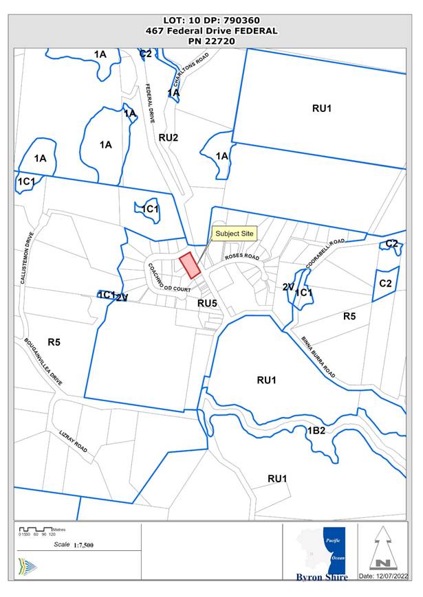 Figure 1: Locality Plan
Assessment:
5. INTRODUCTION
History/Background
A search of Council records indicates the following relevant site history:
DA 6.1989.2324.1, Dwelling, Approved 01/01/1989
22.2019.21.1, Development Advice Panel meeting 28/10/2019 (Doc # A2019/31980)
Description of the proposed development
This application seeks approval for Light Industry consisting of three buildings with ground and mezzanine floors, eight (tenancies of varying floor area, and car park including one accessible space.
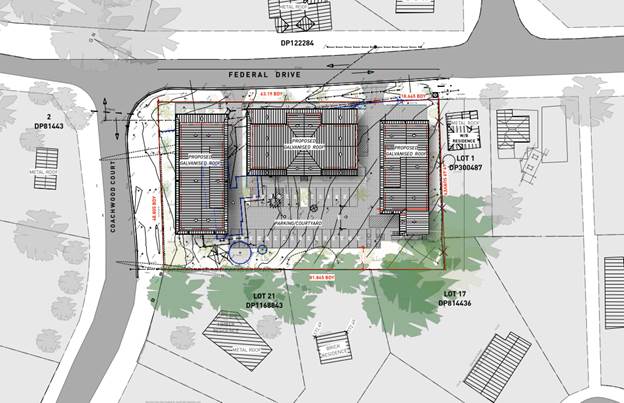 Figure 2: Site Plan and Context
Building A is located to the north on the corner of Federal Drive and Coachwood Court. Building B is located to the south of Building A and bound by the internal access and car park with frontage to Federal Drive. Building C is located to the south of the site adjoining an existing residential dwelling.
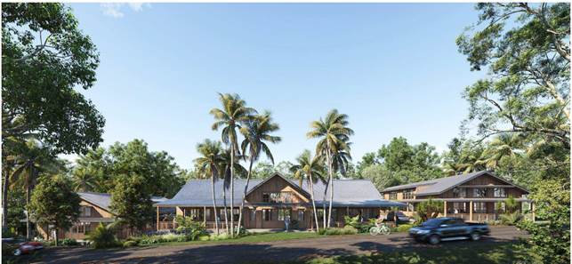 Figure 3: Artistic
Impression – Federal Drive
Figure 3: Artistic
Impression – Federal Drive
The total Gross Floor Area (GFA) of all buildings is 1364.4 m². All parts of the building do not exceed the 9-metre maximum height of buildings development standard measured vertically above existing ground level under Byron LEP 2014.
Based on spot levels and contours on the detailed site survey, the following heights are proposed:
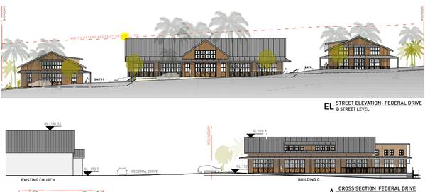
Figure 4: Cross Sections whole site with 9 metre height limit in red dash
In summary, the breakdown of each proposed building GFA, heights and excavation, is as follows:
|
Building A |
Building B: |
Building C: |
|
Unit A1 = 185.9m² Unit A2 = 111.8m² Unit A3 = 178.7m² 1 Accessible WC =7.2 m² Total GFA = 483.6m² Height = 7.5 metres 1.18 m excavation |
Unit B1 = 113.4m² Unit B2 = 233m² Unit B3 = 120.6m² 1 Accessible WC = 7.2 m² Total GFA = 474.2m² Height = 9 metres max. <1m excavation, up to 1.3m retaining |
Unit C1 = 183.3m² Unit C2 = 185.1m² Four (4) WC, one (1) accessible WC = 38.2m² Total GFA = 406.6m² Height = 8.04 metres 1.17 m excavation, up to 0.7m retaining |
Access and egress to the development is proposed via two new vehicle crossovers in a one-way direction through the site with all vehicles entering and leaving the site in a forward direction. Minor excavation at the property frontage to Federal Drive and fill and retaining at the downslope (southern) side of each building is required.
The development site is within the Federal Village Heritage Conservation Area as mapped under the DCP 2014 Chapter E6 Federal. It is considered the design of the development is sympathetic to the heritage vernacular and character of the areas through the use of pitched roofs and sympathetic materials such as zincalume sheeting and timber wall cladding. The site is not a mapped heritage item nor is the village mapped as a conservation area under the Byron LEP 2014.
The development proposes stormwater storage tanks beneath each building with an on-site sewage management system. The proposed development for Light Industry will exclude Artisan Food and Drink Premises. The applicant understands and agrees that the use is to be restricted to also prohibit food and drink premises under this DA to avoid potential amenity impacts and due to other environmental planning reasons including capacity for on-site wastewater management.
Description of the site
|
Land is legally described |
LOT: 10 DP: 790360 |
|
|
Property address |
467 Federal Drive FEDERAL |
|
|
Land is zoned: |
RU5 Village |
|
|
Land area is: |
4000 m2 |
|
|
Property is constrained by: |
Site is not serviced by reticulated water or mains sewage. Site is in Drinking Water Catchment. |
|
|
|
Is a BDAR required due to the location of the proposed development? |
☐ Yes ☒ No |
|
|
Are there any easements in favour of Council affecting the site? |
☐ Yes ☒ No |
|
|
Is there a Vegetation Management Plan which might affect the proposal? |
☐ Yes ☒ No |
|
|
Is there a Voluntary Planning Agreement which might affect the proposal? |
☐ Yes ☒ No |
The subject site known as 467 Federal Drive, Federal and legally described as Lot 10 in DP790360 has a total site area of 4000m² and is located within the Village (RU5) Zone of the Byron LEP 2014.
The site currently contains a dwelling house built in 1990 and associated planted landscaping around the dwelling. Otherwise, the majority of the site is clear of structures and vegetation other than mown grass.
The lot is located central to Federal Village and is surrounded by a mix of residential (dwelling houses), community (park & open space), commercial (restaurant and shop), and Heritage opposite the site at Federal Drive (School of Arts/Holy Trinity Anglican Church, known locally as Federal Hall / Jaspers Corner). All properties adjoining the site are also zoned RU5 Village, which permits a broad range of land uses.
The site is located in a drinking water catchment. Otherwise, no environmental constraints, Council infrastructure nor easements encumber the site. The site is not serviced by reticulated water or mains sewage. The site has access to all other essential services.
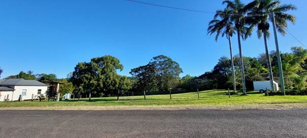 Figure 4 – Southern side
of the site is vacant looking west from Federal Drive
Figure 4 – Southern side
of the site is vacant looking west from Federal Drive
 Figure 5 – Northern
side of the site contains existing dwelling and planted landscaping
Figure 5 – Northern
side of the site contains existing dwelling and planted landscaping
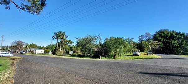 Figure 6 – Site
looking south west from intersection Federal Drive and Coachwood Court
Figure 6 – Site
looking south west from intersection Federal Drive and Coachwood Court Figure 7 – Streetscape
across Federal Drive
Figure 7 – Streetscape
across Federal Drive 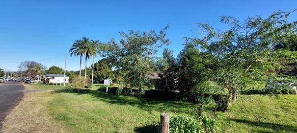 Figure
8 – Vegetation to be removed
Figure
8 – Vegetation to be removed
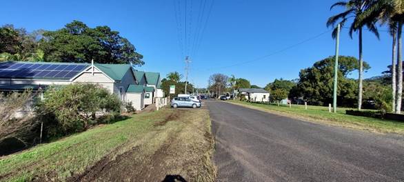 Figure Figure 9 –
Federal Drive Looking South Jaspers Corner School of Art on left
Figure Figure 9 –
Federal Drive Looking South Jaspers Corner School of Art on left

Figure 10 - Federal Hall Jasper Corner opposite the site
6. SUMMARY OF REFERRALS
|
Referral |
Issue |
|
Environmental Health Officer |
No objections subject to conditions. |
|
Development Engineer |
No objections subject to conditions. |
|
Building Surveyor |
No objections subject to construction certificate being required. |
|
S64 / Systems Planning Officer |
No objections or conditions. |
|
Contributions Planner |
Subject to 7.12 Levy condition for works over $100,000. |
|
Heritage Consultant |
No objections subject to conditions. |
|
Resource Recovery |
No objections subject to conditions. |
|
Strategic Planning |
No objections. Comments only. |
|
Essential Energy |
No objections or conditions. General comments provided. |
7. SECTION 4.14 – BUSH FIRE PRONE LAND
Under section 4.14 of the Act, Council must be satisfied prior to making a determination for development on bush fire prone land, that the development complies with the document ‘Planning for Bush Fire Protection 2019’’. The site is not bush fire prone land.
8. SECTION 4.15C – MATTERS FOR CONSIDERATION – DISCUSSION OF ISSUES
Having regard to the matters for consideration detailed in
Section 4.15(1) of the Environmental Planning & Assessment Act 1979
(EP&A Act), the following is a summary of the evaluation of the issues.
State Environmental Planning Policies (SEPP)
|
Considerations |
Satisfactory |
Unsatisfactory |
|
Resilience and Hazards SEPP 2021 Consideration: Chapter 4 Remediation of land Comment: an assessment provided with the application (Refer Doc #E2021/40070) concludes: “…The history has indicated a low potential for significant contamination resulting from use of the Site when considering the proposed development; and the results of soil sample analysis show that the surface soils on the Site do not contain concentrations of the contaminants of concern above the relevant Site Assessment Criteria; The Site is considered suitable for the proposed development for commercial/industrial development.” No further investigation is considered warranted.
|
☒ |
☐ |
|
Transport and Infrastructure SEPP 2021 Consideration: The DA was referred to Essential Energy in accordance with Chapter 2, Section 2.48 of the Transport and Infrastructure SEPP. Comments received are included in the notes attached to the recommended conditions of consent. |
☒ |
☐ |
4.2 Byron Local Environmental Plan 2014 (LEP 2014)
In accordance with LEP 2014 clauses 1.4 and 2.1 – 2.3:
(a) The proposed development is defined in the LEP 2014 Dictionary as Light Industry;
(b) The land is within the RU5 Village according to the Land Zoning Map;
(c) The proposed development is permissible with consent; and
(d) Regard is had for the Zone Objective as follows:
|
Zone Objective |
Consideration |
|
• To provide for a range of land uses, services and facilities that are associated with a rural village.
|
The proposal seeks to establish a development which will provide for a range of land uses and provide suitable facilities for a range of compatible light industry uses and employment in the village including creative industry and high tech industry, which are permissible with consent in the zone. |
Note.
light industry means a building or place used to carry out an industrial activity that does not interfere with the amenity of the neighbourhood by reason of noise, vibration, smell, fumes, smoke, vapour, steam, soot, ash, dust, wastewater, waste products, grit or oil, or otherwise, and includes any of the following—
(a) high technology industry,
(b) home industry,
(c) artisan food and drink industry,
(d) creative industry.
Note—
Light industries are a type of industry—see the definition of that term in this Dictionary.
creative industry means a building or place the principal purpose of which is to produce or demonstrate arts, crafts, design or other creative products, and includes artists’ studios, recording studios, and set design and production facilities.
Note—
Creative industries are a type of light industry—see the definition of that term in this Dictionary.
artisan food and drink industry means a building or place the principal purpose of which is the making or manufacture of boutique, artisan or craft food or drink products only. It must also include at least one of the following—
(a) a retail area for the sale of the products,
(b) a restaurant or cafe,
(c) facilities for holding tastings, tours or workshops.
Note—
See clause 5.4 for controls in industrial or rural zones relating to the retail floor area of an artisan food and drink industry.
Artisan food and drink industries are a type of light industry—see the definition of that term in this Dictionary.
high technology industry means a building or place predominantly used to carry out an industrial activity that involves any of the following—
(a) electronic or micro-electronic systems, goods or components,
(b) information technology (such as computer software or hardware),
(c) instrumentation or instruments of a scientific, industrial, technological, medical or similar nature,
(d) biological, pharmaceutical, medical or paramedical systems, goods or components,
(e) film, television or multi-media technologies, including any post production systems, goods or components,
(f) telecommunications systems, goods or components,
(g) sustainable energy technologies,
(h) any other goods, systems or components intended for use in a science or technology related field,
but does not include a building or place used to carry out an industrial activity that presents a hazard or potential hazard to the neighbourhood or that, because of the scale and nature of the processes involved, interferes with the amenity of the neighbourhood.
Note—
High technology industries are a type of light industry—see the definition of that term in this Dictionary.
The applicant has confirmed that they are not seeking approval for artisan food and drink premises and the DA has been assessed on this basis. A condition of consent is recommended that precludes artisan food and drink premises from being approved on the site. Home industry would need to be ancillary to a dwelling and no dwelling is proposed.
Clause 4.3 Height of Buildings
Based on spot levels and contours on the detailed site survey:
The highest part of Building A is 7.5 metres: RL182.00 over existing ground level RL174.50.
The highest part of Building B is at the southern side of the roof which is just below 9 metres: RL 181.5 over existing ground level RL ≥172.5.
The highest part of Building C is 8.04 metres: RL 179.00 over existing ground RL 170.96.
As detailed in Section 1 above, all parts of the building do not exceed the 9 metre maximum height of buildings development standard measured vertically above existing ground level under Byron LEP 2014.
Clause 4.5 Calculation of Floor Space Ratio and Site Area
There is no maximum Floor Space Ratio (FSR) development standard in Federal Village, zoned RU5 Village.
The subject site known as 467 Federal Drive, Federal (legally described as Lot 10 in DP790360) has a total site area of 4000m² .
The total Gross Floor Area (GFA) of all buildings is 1364.4 m².
The total FSR of buildings on a site is the ratio of the gross floor area of all buildings within the site to the site area. The FSR in this proposed development is 0.3411:1.
Clause 5.10 Heritage Conservation
The site is not a heritage item or within a heritage conservation area. The site is located opposite a heritage item at Federal Drive (School of Arts/Holy Trinity Anglican Church, known locally as Federal Hall / Jaspers Corner) The application included a heritage impact statement, prepared by Weir Phillips Heritage and was referred to Council’s Heritage Advisor and Heritage Committee.
Council’s Heritage advisor responded, as follows:
I inspected the site on 18 March 2021.
The proposed development is considered sympathetic to the context and is not likely to have any adverse impacts upon the setting of the Federal School of Arts and the Holy Trinity Anglican Church.
I do not consider that a detailed referral is required in this case and endorse the findings of Weir Phillips SOHI.
The proposed external materials are most acceptable however I would suggest a condition to control any future changes of colours/materials and signage. You can work something up from these drafts.
External Finishes - The approved colours, materials and finishes are to be maintained as per the approval. Any future changes are subject to prior approval from Council.
Reason; to protect the setting of nearby items of Environmental Heritage.
Signage - Details of all signage are to be submitted to and approved by Council prior to erection. A suite of complementary signage is required which is sympathetic to the aesthetic setting of the heritage listed items opposite the site. Any illuminated signage may only be externally illuminated and subtle in its design (and is subject to further consent)
Reason: to protect the setting of nearby items of Environmental Heritage.
Clause 6.2 Earthworks
The objective of this clause is to ensure that earthworks for which development consent is required will not have a detrimental impact on environmental functions and processes, neighbouring uses, cultural or heritage items or features of the surrounding land.
Development consent is required for the proposed excavation and fill required for the buildings and car park. At the maximum depth, the excavations will be 1.4 m deep associated with the wastewater system. The excavated area will be filled once the on-site wastewater system is installed. Minor excavation at the property frontage to Federal Drive and fill and retaining at the downslope (southern) side of each building is required.
The extent of the proposed earthworks are considered to be reasonable and necessary, subject to recommended conditions of consent to avoid, minimise or mitigate the impacts of the development.
Clause 6.5 Drinking Water Catchments
The objective of this clause is to protect drinking water catchments by minimising the adverse impacts of development on the quality and quantity of water entering drinking water storages.
This clause applies to the land because it is identified as “Drinking water catchment” on the Drinking Water Catchment Map.
Subject to recommended conditions the development is not likely to have any adverse impact on the quality and quantity of water entering the drinking water storage, having regard to the distance between the development and any waterway that feeds into the drinking water storage (over 150 metres from the site), the on-site use, storage and disposal of any chemicals on the land, and the treatment, storage and disposal of waste water and solid waste generated or used by the development. The development is designed, sited and will be managed to avoid any significant adverse impact on water quality and flows.
Clause 6.6 Essential Services
The site is not connected to Council’s Reticulated water infrastructure or sewer main. The proposed roof flow is to be captured by the rainwater tanks and then overflow from the tanks and roof is to be discharged to the Proposed Raingarden and ultimately the Inter Allotment Drainage (IAD) system.
The proposed carpark flow will be conveyed overland to the designated Raingarden. All site flow ultimately discharges to LPD A via the proposed 375mm stormwater system in existing easement up to and including the 1%AEP design event. All events in excess of this will be conveyed by a design weir to the south east.
The on-site sewage management system (OSMS) proposes disposal of effluent via a novel infiltration under the paved carpark. Council’s Design Guidelines for On-site Sewage Management for Single Households nominates evapotranspiration as the preferred process. Notwithstanding, the proposal is not for a single household and has been supported by peer review of the OSMS design. The proposal has been assessed by Council’s Environmental Health Officer with conditions recommended detailing the design specifications for a S68 application should the development application be approved.
It is considered the site has access to and will be provided with the necessary infrastructure to service the development.
Clause 4.6 Exceptions to Development Standards
Not applicable
4.3 Any proposed Instrument that has been the subject of public consultation and has been notified to the consent authority
Not applicable
4.4 Byron Shire Development Control Plan 2014 (DCP 2014)
Comments are provided on the relevant sections of the DCP
B3 – Services:
The site is not connected to Council’s Reticulated water infrastructure or sewer main. The proposed roof flow is to be captured by the rainwater tanks and then overflow from the tanks and roof is to be discharged to the Proposed Raingarden and ultimately the Inter Allotment Drainage (IAD) system.
The proposed carpark flow will be conveyed overland to the designated Raingarden. All site flow ultimately discharges to LPD A via the proposed 375mm stormwater system in existing easement up to and including the 1%AEP design event. All events in excess of this will be conveyed by a design weir to the south east.
The on-site sewage management system (OSMS) proposes disposal of effluent via a novel infiltration under the paved carpark. Council’s Design Guidelines for On-site Sewage Management for Single Households nominates evapotranspiration as the preferred process. Notwithstanding, the proposal is not for a single household and has been supported by peer review of the OSMS design. The proposal has been assessed by Council’s Environmental Health Officer with conditions recommended detailing the design specifications for a S68 application should the development application be approved.
B4 – Traffic Planning, Vehicle Parking, Circulation and Access
The proposed development requires 16 car parking spaces and there will be a total of 26 car parking spaces provided including 1 disabled accessible bay. Provision for Motorcycle and bicycle parking is available in the south west of the car park.
The DCP requires 1 Medium Rigid Vehicle (MRV) & 1 Heavy Rigid Vehicle (HRV) loading bays for industrial development. A variation is required for the provision of 1 Small Rigid Vehicle & 1 MRV loading bays. This proposed arrangement is reasonable with consideration for the scale and context of the site in the RU5 Village zone, location and surrounding road infrastructure.
B5 Providing for Cycling
Council's DCP 2014 states that no bicycle parking is required for an industrial land use, however two bicycle spaces are provided for the proposed development.
B6 – Buffers and Minimising Land Use Conflicts
The applicant submitted a Land Use Conflict Risk Assessment (LUCRA) and an Acoustic Report that does not propose food outlets nor does it support night time operating hours.
The LUCRA did not fully discuss impacts from lighting especially any security lighting. Conditions of consent are recommended to require the development to operate at all times within strict hours for operation and delivery. This requires any changes to those operations to require separate consent and for a detailed lighting / management plan to be submitted to the satisfaction of Council.
B8 Waste Minimisation and Management
The applicant submitted a detailed waste management plan, which was assessed by Council’s Resource Recovery team. Conditions of consent are recommended to address the detailed operational waste management requirements to the full satisfaction of Council.
All waste will be stored, sorted and collected on site and waste collection vehicles will enter and leave the site in a forward direction.
C1 Non Indigenous Heritage
This chapter applies because the site is land in the vicinity of a Heritage item. The site is not a heritage item or within a heritage conservation area. The site is located opposite a heritage item at Federal Drive (School of Arts/Holy Trinity Anglican Church, known locally as Federal Hall / Jaspers Corner).
The application included a heritage impact statement, prepared by Weir Phillips Heritage and was referred to Council’s Heritage Advisor and Heritage Committee.
Council’s Heritage advisor considered the proposed development to be sympathetic to the context and not likely to have any adverse impacts upon the setting of the Federal School of Arts and the Holy Trinity Anglican Church. This is considered in more detail in section 4.2 of this report.
C4 Development in a Drinking Water Catchment
As detailed in Section 4.2 above the development is subject to conditions of consent and has been assessed by Council’s Environmental Health Officer and Planner to ensure that development and use of land within the drinking water catchment does not adversely impact on the quality or quantity of public water supply.
D5.2.1 – Building Lines:
Objectives
1. To establish minimum building setbacks in industrial areas to enhance streetscape and provide suitable commercial exposure.
2. To encourage a stepped front elevation to provide variation in the front facade and building form.
In lieu of the prescribed setback distances, the proposal presents varied setbacks from the Federal Drive frontage averaging 7.2m to the main building wall for all proposed buildings. Tenancy B2 includes a deck at the Federal Drive frontage which presents a setback of 3.7m; and at its nearest point, the development presents a setback of 2m from the outermost projection to the front boundary (at the ground floor deck roof for Building B at the centre of the property) See Figure 11.
Byron DCP 2014 prescribes building line setbacks of 10m and 6m from the front boundary of the allotment for the Primary and Secondary building lines respectively, and a minimum 2m setback to a second road frontage in a standard industrial zone. It is considered that this is unreasonable in the particular circumstances of this site that is not in an industrial zone but located in Federal zoned RU5 Village and light industry is permissible in this zone.
The pattern of development in the street including a range of uses (residential, retail and community) is generally between 0 metres and 3 metres. Excessive setbacks would detract from the streetscape, push the buildings closer to the west and potentially resulting in car parking required for the site dominating the frontage. The design and layout presents a walkable, accessible frontage and deep covered decks that enhance the functionality of the outdoor areas of the building.
The Performance Criteria (PC) of this control seek to ensure that setbacks are “designed to ensure that the aesthetics and character of industrial development will be compatible with development in the locality and with the existing and desired future character of the precinct.” Similarly, PCs note that encroachments are permissible where:
a) The proposed setback enhances the design of the building and complements the streetscape; and
b) The proposed development does not adversely affect adjoining development, nor conflict with other requirements of this Chapter.
The proposed reduction in front boundary setbacks directly aligns with the streetscape within Federal Village, where reduced front boundary setbacks are common between 1.5m - 3m in adjacent residential dwellings, and to 0m in some cases for commercial premises (see Figure 12 below). Further, Prescriptive Measures of E6.5 of DCP Chapter E6 (Federal Village) require that “setbacks within the ‘Heritage Character Area’ (illustrated on Map E6.1) are to be consistent with the existing streetscape of Federal Drive in this area.”
![]()
Figure 13 – Analysis of Street setbacks Federal Drive
Council’s Heritage Advisor has reviewed the proposal and noted that “the proposed development is considered sympathetic to the [site] context and is not likely to have any adverse impacts upon the setting of the Federal School of Arts and the Holy Trinity Anglican Church” (doc #E2021/47952). While this comment speaks specifically to the Heritage aesthetic of the proposal and its impact on surrounding Heritage Items, it is noted that this aesthetic forms the fabric of the Federal Village as discussed within Chapter E6 (Federal Village) of the DCP.
The proposed provision of any street planting would require detailed discussion with Council in the context of the Federal Village Concept Plan to ensure selection and placement of any planting is complimentary to the future character of the village and maintains functional unimpeded sightlines for safe access and egress of vehicles, cyclists and no obstructions for walking, wheelchairs etc. A condition of consent is recommended to address the need for further detailed landscaping design.
Predominantly, the reduced boundary setbacks are considered consistent with the streetscape character within Federal Village.
D5.2.3 – Water and Sewer Services
DCP Chapter D5 – Industrial Development prescribes that all industrial development must be serviced by reticulated water supply and must discharge wastewater to mains sewer infrastructure. Council’s ET Engineers have advised that the proposal does not benefit from access to reticulated water or mains sewage. Council Development Engineer and Environmental Services reviewed the proposal in particular the types of light industry that will be permitted including creative industries and high-tech industries (excluding food and drink premises) and conditions of consent are recommended to address the essential services required for the development.
Chapter E6 – Federal Village
E6.5 Character Bulk and Scale of development
The proposal is compliant with Councils overall height requirements and is at a bulk and scale consistent with the character of Federal. Materials incorporate zincalumn roof sheeting and timber cladding with pitched roof forms, eaves and verandahs consistent with prescriptive measure 1. Car parking is setback behind the building away from Federal Drive so that it is not a feature of the development whilst setbacks are satisfactory as discussed above and is compliant with measures 2 and 3
E6.6 Heritage Character Area
The proposal as discussed above has been considered by Councils Heritage advisor as acceptable in terms of heritage. The development is compatible with the heritage character of the Federal Village.
E6.8 Residential Area
In accordance with the Federal Village Map, the subject site is identified as Residential Land and should be developed for that purpose. If this was the case the site would deliver an additional three residential lots, which are unlikely to be for affordable housing. The proposal as such is inconsistent with E6.8.
However DCP provisions are set to guide development and do not overrule LEP provisions. In particular Section 3.42 of the EPA Act 1979 states that “The Provisions of a development control plan made for that purpose are not statutory requirements”. This provides Council the ability to vary controls under a DCP where it is considered the development has merit.
The proposed use (Light Industry) is development which is permitted with consent in the RU5 Zone of the Byron LEP 2014.
In terms of the objectives under E6.6 the provisions state
“To ensure that development of land in the defined ‘Residential Area’ contributes to an integrated rural village that meets the residential needs of residents and is compatible with the low density, low intensity, heritage character and scale of Federal.”
In support of the development, the subject light industrial sheds are bespoke in design as opposed to a standard concrete tilt up panel industrial development in the industrial zones of Byron Bay, Bangalow or Mullumbimby. As such the type of tenants that the development will attract are also likely to be more bespoke and it is anticipated the development will be better suited to creative type business as opposed to a car repair business or steel work fabrication. It is likely such tenants will be found within the hinterland areas of the Shire, while employment opportunities will also be provided for locals alike.
The development itself comprises three buildings at a bulk, scale and character as to what is required in Federal whilst it is noted the site itself sits opposite the local church and School of Arts Hall in Federal Drive.
Conditions of consent are recommended to limit hours of operation, to move the development further to the north by a metre to provide a greater setback to the nearest dwelling and for a noise/ acoustic fence to be erected around the side and rear boundaries. The site will also be landscaped to the side and rear boundaries.
It is considered the proposed development is satisfactory in terms of the objectives under this provision, is permissible with consent under the Byron LEP 2014, whilst the design and concept of the proposal clearly has merit. A variation to E.6 is supported in this instance.
4.5 Environmental Planning and Assessment Regulation 2000 considerations
|
|
Applicable to the proposal: |
Considered the control as it relates to the proposal: |
If this control is applicable, does the proposal comply? |
|
Clause 92 - Additional matters that consent authority must consider
|
☐ Yes ☒ No |
☐ Yes ☐ No ☒ NA |
☐ Yes ☐ No ☒ NA |
|
Clause 93 Fire safety and other considerations
|
☐ Yes ☒ No |
☐ Yes ☐ No ☒ NA |
☐ Yes ☐ No ☒ NA |
|
Clause 94 - Consent authority may require buildings to be upgraded
|
☐ Yes ☒ No |
☐ Yes ☐ No ☒ NA |
☐ Yes ☐ No ☒ NA |
|
Clause 94A - Fire safety and other considerations applying to erection of temporary structures
|
☐ Yes ☒ No |
☐ Yes ☐ No ☒ NA |
☐ Yes ☐ No ☒ NA |
* Non-compliances and any other significant issues discussed below
4.6 The likely impacts of that development, including environmental impacts on both the natural and built environments, and social and economic impacts in the locality
|
Impact on: |
Likely significant impact/s? |
|
Natural environment |
No. The proposal will not have a significantly adverse impact on the natural environment of the locality. |
|
Built environment |
No. The proposal will not have a significantly adverse impact on the built environment of the locality. |
|
Social Environment |
No. The proposal will not have a significant social impact on the locality. |
|
Economic impact |
Yes – the proposal will provide factory space for light industrial purposes and will have ongoing impacts through employment generation and the like. |
|
Construction Impacts |
The development will generate minor impacts during its construction. Conditions of consent recommended to control hours of work, builders waste, construction noise, installation of sedimentation and erosion control measures and the like to ameliorate such impacts. |
4.7 The suitability of the site for the development
Issue |
Comment |
|
Services - Water/ Sewer/ Stormwater - Ph/ power - Access |
Site is not serviced by reticulated water or mains sewage. Stormwater via easement to the west. Phone power and vehicular access to public road available
|
|
Onsite Effluent Disposal |
The proposed OSMS is a high level nutrient reduction system (i.e. Tertiary treatment) with disinfection and land application method via absorption rather than evapotranspiration, based on an occupancy of thirty staff. The system incorporates a 5000 litre septic tank/ grease trap in advance of an aerated treatment system with disinfection via a 10000 litre balance tank before disposal to the land application area. The applicants OSSM design prepared by Greg Alderson and Associates was also peer review by Whitehead and Associates Environmental Consultants who concludes “This design presents a conservative and innovative approach to onsite wastewater management which responds to the constraints of the site.”
The OSSM design is considered acceptable subject to conditions of consent. This includes conditions to limit future use of the factory units such as a prohibition on food and drink premises and Artisan Food and Drink
|
|
Hazards - Flooding - ASS - Bushfire - Landslip |
The site is not affected by potential hazards including Acid Sulfate Soils, Bushfire or Flooding. A standard condition is recommended in relation for Geotechnical detail in accordance with AS 1726 prior to the issue of the construction certificate.
|
|
Land Use conflicts |
Potential land use conflicts due to adjoining residential properties have been considered. Potential impacts of noise and light are to be restricted by hours of operation, acoustic mitigation measures, light planning and management requirements. |
4.8 Submissions made in accordance with this Act or the regulations
The development application was publicly exhibited.
There were 216 submissions made on the development application:
- For: 64
Against: 152
A summary of key issues raised in the submissions and the assessing officer’s response is provided in the tables below.
|
Submission Objection: |
Comment: |
|
Perceived degradation of intrinsic village value/ Heritage: - Submitters identify concerns that the small-scale, quaint town that they enjoy, have enjoyed for decades, and continue to support, will be overrun by more tourists, less parking, and a development which they perceive to be contrary to the scale and nature of the village. - Confer that the proposal will have a material and detrimental effect on the village - Design is dominating and competes with church - Imposing structure that will diminish/overbear heritage listed church. - Reduced front boundary setbacks and scale are out of character with the village - Two-storeys does not align with village character - |
The proposed use is permissible in the zone and complies with the development standards of the Byron LEP 2014. The design of the development is cognisant of the controls of the DCP pertaining to heritage and streetscape character, aesthetic, landscaping, on-site car parking, and boundary setbacks (considered in context and alongside performance criteria). The buildings do not exceed the maximum permissible height. Each building is one storey with six of the units having an internal mezzanine floor, which is generally reflective of buildings in the locale. Council’s Heritage Adviser considers that the design complements the streetscape and nearby heritage buildings. The street cross section drawing in Figure 13 demonstrates that the tallest building will be lower than the overall height of the church on the west side of the street. |
|
Off-site impacts; - Impact of Parking, Noise & Smell on locals - Operating hours and impact on adjoining residences - Risk to wildlife in creeks from runoff (Coachwood Court) - Lighting nuisance - On street parking opposite the site to be lost (Jasper Corner) according to TIA - Overshadowing of adjacent property - Loss of breeze to properties at the west - Proximity of bathrooms to building at the south (next to kitchen and lounge room) |
The proposal provides on-site car parking in accordance with the DCP and hours of operation, stormwater quality management and the impact of the development on the surrounding environment will be controlled via conditions of consent. The development does not propose to alter the condition of street parking on the opposite side of the street. Upgrades will be required on the street frontage of the development and these treatments will be consistent with the Draft Federal Village Concept Plan. The building provides side setbacks between 3.7 and 4.8 metres to the south boundary and 10.1, 27.2 and 11 metres to the west boundaries. The winter solstice shadow diagram in figure 14 below presents the worst case scenario and demonstrates that the windows will receive full sunlight in the morning with the windows receiving partial light in the afternoon hours. To provide for a better outcome to the neighbours to the south conditions of consent are recommended to increase the developments setback to the southern boundary by a metre, and shift the entire development to the north by the same distance closer to Coachwood Court. It is considered this should significantly reduce overshadowing and still works in terms of vehicle access and egress, with consideration for the surrounding streets and intersections. |
|
Use: - Housing Shortage, residential use would be more beneficial. - Residential land should be used to provide affordable housing in the shire. - Use not align with zone. - Assumed micro-brewery
|
The site is not zoned residential. The site is zoned RU5 Rural Village where a range of permissible uses are allowed. The proposal is development that is permitted with consent in the Byron LEP 2014. The use of the development for artisan food and drink such as a brewery will not be permitted.
|
|
DCP Noncompliance: - DCP Chapter E – light industry use is not consistent with residential intent |
The proposal is development that is permitted with consent in the Byron LEP 2014. Pursuant to the EP&A Regulation 2000, a DCP is a guidance tool which is intended to be implemented within the dual assessment pathway criteria set out in the DCP; whereas the LEP is the statutory instrument prescribing land use in the shire. These matters for consideration are assessed in this report. The design of the development is cognisant of the controls of the DCP pertaining to heritage and streetscape character, aesthetic, landscaping, on-site car parking, and boundary setbacks (considered in context and alongside performance criteria). It is considered the proposal on balance is acceptable in this instance. |
|
Commercial need: - Proponent does not demonstrate commercial need for development |
The proposal is not required to justify the commercial needs as would be required for a planning proposal to rezone land for a commercial purpose. The RU5 Village zone permits light industry on the land and is the evidence based strategic planning instrument that permits the proposed use. |
|
Transport/Traffic: - Unnecessary increase in traffic & congestion - TIA based on 2016 data, and does not consider Council’s review of vehicle and pedestrian activity in Federal, or school buses in the area - On street parking to be lost (Jasper Corner) according to TIA - Overflow car parking if tenancies are occupied by commercial premises - Refuse collection proposed to be on street. Detrimental impacts as a result - No footpath for pedestrians - Light Industry demands 1 parking space/100m², however commercial premises which are anticipated to occupy the tenancies require 1/20m² |
All traffic parking, loading and waste collection required for the proposed light industry use (excluding artisan food and drink premises) is to be managed on site. The proposal is not for retail development. Refuse collection will be within the development site. Footpath to be constructed along Federal Drive Frontage. Council’s Development Engineer has considered the proposal is satisfactory subject to the recommended conditions of consent attached to this report. All parking is provided for on site in excess of what the DCP requires.
|
|
Land use conflicts - Noise impacts - Locating light industry adjacent to residential is inappropriate and LUCRA addresses agricultural land not adjacent residential land
|
This is addressed in DCP section above. Strict conditions of consent for the operation and management of the development are recommended including hours of operation. |
|
OSMS, Stormwater & Trade waste: - Issues/concerns including capacity of stormwater easement in coachwood court; quality of stormwater leaving the site flowing into drinking water catchment; the stormwater report provided with the DA is a feasibility study only and does not prove the system would work. - OSMS report is ‘feasibility’ study as opposed to detailed plan for an actual system. - Capacity of OSMS – accounts for 30 persons (staff) and does not consider users |
Council Building Inspector, Development Engineer and Environmental Services reviewed the proposal in particular the types of light industry that will be permitted including creative industries and high tech industries (excluding food and drink premises) and conditions of consent are recommended to address the essential services required for the development including OSSM and trade waste Conditions imposing any change of use needs a new DA is also imposed in the recommended conditions. · |
|
Confidence in Community Consultation: - Many local submitters attest that the community consultation report provided with the application is not an accurate reflection of the consultation/community perception. |
The DA was formally advertised in accordance with the Byron Community Participation Plan, Level 2 (Exhibition period: 8/3/21 to 21/3/21) once it was lodged. Submissions received are considered in this assessment.
Although not mandated Community Significant Development, under the Byron Community Participation Plan, the applicant undertook pre-lodgement consultation including advertising in The Echo inviting comments via Survey Monkey 2-28 August 2020 – 133 comments were received. 53% strongly supported. 7%, somewhat supportive. 3% neither supportive or opposed, 29% strongly opposed and 8% somewhat opposed the project. (Refer to Doc #E2021/40084).
|
|
Concurrent Village Master planning: - Federal Village Masterplan not completed. |
Council must accept lawfully made DAs and consider proposed Planning instruments through the assessment process. There is no draft planning instrument that will supersede Byron DCP 2014 and Byron LEP 2014 that has been exhibited. Although not a legal matter for consideration under the provisions of the EP&A Act, the Draft Federal Village Concept Plan has been considered by Council officers and the proposal for light industry on this site is not considered to be contrary to the intended outcomes of the Draft Federal Village Concept Plan that was exhibited in late 2021. Consideration of the draft Concept Plan has also been given in terms of the proposed conditions of consent in terms of road widening, footpaths and the like. It is unreasonable to withhold the determination of the DA any further, considering the merits of it and that it has been with Council since early 2021. |
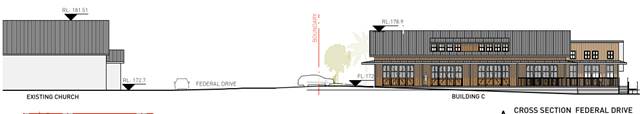
Figure 14 - Cross section showing height of church on left and proposal on right
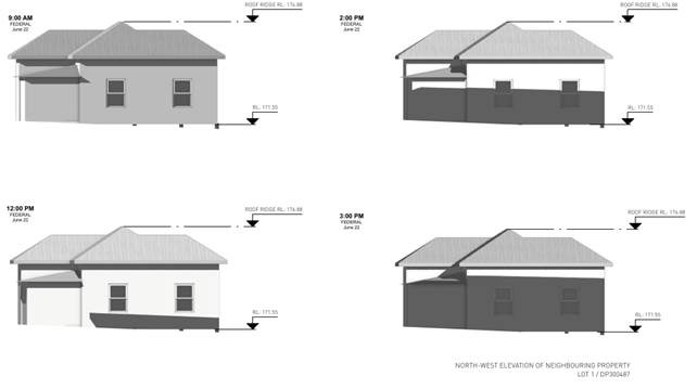 Figure 15 - Shadowing in
winter solstice of Lot 1 to south of site.
Figure 15 - Shadowing in
winter solstice of Lot 1 to south of site.
Submissions of Support:
The following points made in the submissions of support are noted and summarised as follows:
· Commercial activity is desired in the rural areas of the shire
· Design is well considered, and complimentary to village character
· Low profile workspaces are good for the community
· Employment opportunities proximal to rural living premises is considered to benefit the community
· Removing car parking from the streetscape and placing behind the buildings is appropriate and well considered.
4.9 Public interest
The proposed development is unlikely to prejudice or compromise the public interest or create an undesirable precedent.
5. DEVELOPER CONTRIBUTIONS
5.1 Water & Sewer Levies
No Section 64 levies will be required.
5.2 Developer Contributions
Section 7.12 Contributions will be payable.
6. DISCLOSURE OF POLITICAL DONATIONS AND GIFTS
|
Disclosure details |
Response |
|
Has a Disclosure Statement been received in relation to this application? If Yes, Provide Disclosure Statement register reference: 91. |
Yes ☐ No ☒ |
|
Have staff received a ‘gift’ from anyone involved in this application that needs to be disclosed. |
Yes ☐ No ☒ |
7. CONCLUSION
The proposed development is satisfactory having regard to the relevant environmental planning instruments and planning controls applicable to the site. The proposal raises no significant issues in terms of environmental impacts which cannot be managed, and the site is considered suitable for the development. The application appropriately addresses the relevant constraints applying to the site and is recommended for approval subject to the conditions of consent.
BYRON SHIRE COUNCIL
Staff Reports - Sustainable Environment and Economy 13.12
Report No. 13.12 PLANNING - Quarter 2 SEPP Variations April to June 2022
Directorate: Sustainable Environment and Economy
Report Author: Chris Larkin, Manager Sustainable Development
File No: I2022/903
Summary:
This report is provided as a requirement of the NSW Department of Planning Circular PS17-006, for reporting on exceptions to development standards for applications made under clause 4.6 of the Standard Instrument LEP and Clause 6 of SEPP 1.
NOTE TO COUNCILLORS:
In accordance with the provisions of S375A of the Local Government Act 1993, a Division is to be called whenever a motion for a planning decision is put to the meeting, for the purpose of recording voting on planning matters. Pursuant to clause 2(a) under the heading Matters to be Included in Minutes of Council Meetings of Council's adopted Code of Meeting Practice (as amended) a Division will be deemed to have been called by the mover and seconder of all motions relating to this report.
RECOMMENDATION:
That Council adopts the report on exceptions to development standards for the period April to June 2022.
Report
This report is provided as a requirement of the NSW Department of Planning Circular PS17-006, for reporting on exceptions to development standards for applications made under Clause 4.6 of the Standard Instrument LEP and Clause 6 of SEPP 1.
SEPP 1 applies to development applications submitted under Byron Local Environmental Plan 1988. Clause 4.6 applies to development applications submitted under Byron LEP 2014.
The period of reporting is for the April to June 2022 Quarter for the following DAs:
Quarter 2 April to June 2022
|
DA No. |
10.2021.384.1 |
||||||||||||||||||||||||||||||||||||||||||||||||||||||||||||||||||||||||||||||||||||||||||||||||||||||||||||||||||||||||||||||||||||||||||||||||
|
Development |
Mixed |
||||||||||||||||||||||||||||||||||||||||||||||||||||||||||||||||||||||||||||||||||||||||||||||||||||||||||||||||||||||||||||||||||||||||||||||||
|
Property: |
90-96 Jonson Street BYRON BAY |
||||||||||||||||||||||||||||||||||||||||||||||||||||||||||||||||||||||||||||||||||||||||||||||||||||||||||||||||||||||||||||||||||||||||||||||||
|
Lot and DP: |
LOT: 5 DP: 619224 |
||||||||||||||||||||||||||||||||||||||||||||||||||||||||||||||||||||||||||||||||||||||||||||||||||||||||||||||||||||||||||||||||||||||||||||||||
|
Zoning: |
B2 Local Zone |
||||||||||||||||||||||||||||||||||||||||||||||||||||||||||||||||||||||||||||||||||||||||||||||||||||||||||||||||||||||||||||||||||||||||||||||||
|
Development Standard being varied: |
Clause 4.3 Height of building |
||||||||||||||||||||||||||||||||||||||||||||||||||||||||||||||||||||||||||||||||||||||||||||||||||||||||||||||||||||||||||||||||||||||||||||||||
|
Justification Summary |
"The height of the proposal is generally compliant with the 11.5m except for the swimming pool, pool terrace fence, stairs, lift core and lift lobby which have varying non-compliances with the 11.5m of up to a maximum height of 14. 58m.These elements are for the main, ancillary to the proposal. They otherwise provide a necessary building service function and/or are necessary for the safety and amenity of building users. These elements due to roof top location and positioning will not be readily visible from the public street, will not impact on adjoining properties amenity or create additional use of the roof top area.
Notably, it is the lift core that mostly exceeds the height limit in excess of 10%." |
||||||||||||||||||||||||||||||||||||||||||||||||||||||||||||||||||||||||||||||||||||||||||||||||||||||||||||||||||||||||||||||||||||||||||||||||
|
Extent of variation |
Varies – max 27% |
||||||||||||||||||||||||||||||||||||||||||||||||||||||||||||||||||||||||||||||||||||||||||||||||||||||||||||||||||||||||||||||||||||||||||||||||
|
Concurrence |
Northern Regional Planning Panel |
||||||||||||||||||||||||||||||||||||||||||||||||||||||||||||||||||||||||||||||||||||||||||||||||||||||||||||||||||||||||||||||||||||||||||||||||
|
Determined Date |
27/5/2022 |
||||||||||||||||||||||||||||||||||||||||||||||||||||||||||||||||||||||||||||||||||||||||||||||||||||||||||||||||||||||||||||||||||||||||||||||||
|
Determined By |
NRPP |
||||||||||||||||||||||||||||||||||||||||||||||||||||||||||||||||||||||||||||||||||||||||||||||||||||||||||||||||||||||||||||||||||||||||||||||||
|
|
|||||||||||||||||||||||||||||||||||||||||||||||||||||||||||||||||||||||||||||||||||||||||||||||||||||||||||||||||||||||||||||||||||||||||||||||||
|
|||||||||||||||||||||||||||||||||||||||||||||||||||||||||||||||||||||||||||||||||||||||||||||||||||||||||||||||||||||||||||||||||||||||||||||||||
|
|
|||||||||||||||||||||||||||||||||||||||||||||||||||||||||||||||||||||||||||||||||||||||||||||||||||||||||||||||||||||||||||||||||||||||||||||||||
Strategic Considerations
Community Strategic Plan and Operational Plan
|
CSP Objective |
CSP Strategy |
DP Action |
Code |
OP Activity |
|
4:
Ethical Growth |
4.1: Manage responsible development through effective place and space planning |
4.1.1: Development assessment - Manage development through a transparent and efficient assessment process |
4.1.1.1 |
Assess and Determine DA's accordance with the relevant legislation |
Legal/Statutory/Policy Considerations
The report is provided as a requirement of NSW Department of Planning circular PS 17-006.
BYRON SHIRE COUNCIL
Staff Reports - Sustainable Environment and Economy 13.13
Report No. 13.13 DRAFT North Coast Regional Plan 2041
Directorate: Sustainable Environment and Economy
Report Author: Shannon Burt, Director Sustainable Environment and Economy
Alex Caras, Land Use Plannning Coordinator
File No: I2022/941
Summary:
The draft North Coast Regional Plan 2041 (draft Plan) is now on exhibition.
This Plan will supersede the content of and extend the timeframe of the current North Coast Regional Plan 2036 to 2041.
Councils have been given a short period of time to review and comment on the draft Plan. Unfortunately, this period commenced in early July when Council was in recess.
The purpose of this report is to provide councillors with an opportunity to formally comment on the draft Plan contents prior to staff finalising a submission to the Department of Planning about the draft Plan by the due date.
Given staff are still in the process of reviewing the draft Plan, only key issues associated with specific parts of the Plan are raised below. A more comprehensive submission to capture any other chapters/themes in the draft Plan that need to be raised, as well as additional areas that councillor’s identity, will be included in the final submission prior to submitting it to the Department of Planning.
Submissions must be made to the Department of Planning by or before the 24 August 2022 via the submission portal.
That Council:
1. Notes the short period of time and inadequate engagement that Council has been given to review and comment on the Draft North Coast Regional Plan 2041.
2. Supports a staff submission being made to the Draft North Coast Regional Plan 2041 that includes, but not limited to commentary as detailed in points 1-12 in the report, and any other issues identified by councillors.
3. Supports a request by staff to the Department of Planning that it undertakes further engagement with Council on their submission prior to the final North Coast Regional Plan 2041 being released.
Report
The first North Coast Regional Plan – the 2036 plan – was released in 2017.
The current Plan 2036 applies to the 12 local government areas of Tweed, Byron, Ballina, Lismore, Kyogle, Richmond Valley, Clarence Valley, Coffs Harbour, Bellingen, Nambucca, Kempsey, and Port Macquarie–Hastings.
It is a 20-year land-use plan that focuses on and informs all areas of local strategic planning, from the development of local plans to the assessment of planning proposals.
The Department of Planning and Environment reviews and updates regional plans every 5 years to reset priorities.
An updated draft North Coast Regional Plan 2041 is now on exhibition. Draft North Coast Regional Plan 2041 (nsw.gov.au)
The draft plan provides an overarching framework to guide subsequent and more detailed land-use plans, development proposals and infrastructure funding decisions at a regional, subregional, and local level. It is a statutory document.
An extract of the draft plan table of contents shown below:
Council Engagement to date
The draft Plan project timeline is shown on the following page, noting that:
- Phase 1 engagement was high-level and largely limited to issue identification and LGA narratives. Beyond that, councils did not have the opportunity to actively participate on drafting of the Plan, despite undertakings by Department of Planning that this would occur. Furthermore, notwithstanding Council’s request to see an early/pre-exhibition draft, staff were not given an opportunity to comment on draft Plan currently on exhibition.
- Phase 2 (current phase) exhibition commenced on 11 July. It is disappointing that this exhibition is so short and commenced during the July councillor recess period. Just over 6 weeks exhibition for such a significant statutory planning document is considered inadequate.
- The engagement program for the draft Plan comprises a series of online activities via an engagement hub. This includes an ideas wall, online information sessions (2 council and 3 community in total). A formal submission via the online submission form is also encouraged.
Staff recently participated in the online workshop for Northern Rivers councils about the draft Plan held by the Department of Planning. Although informative, it was largely one-way consultation and councils were not provided with a follow-up copy of any of the webinar slides and many questions raised by staff remained unanswered.
Key issues
As stated above, given staff are still in the process of reviewing the draft Plan, only key issues associated with specific parts of the Plan are raised below. A more comprehensive submission to capture any other chapters/themes in the draft Plan that need to be raised, as well as additional areas that councillors identify, will be included in the final submission prior to submitting it to the Department of Planning. Staff comments follow in no order:
1. Format, content, and language of the Regional Plans is standardised across NSW. The look and feel of each one is the same. As such the North Coast Regional Plan looks and sounds the same as the others. It is therefore easy for regions of difference with a need to be considered as such to get lost in the generic.
2. Comments about the inadequate consultation with impacted councils have been provided in the report and will be included in the submission. For such an important statutory plan the level of engagement and two-way communication has not been acceptable.
3. There appears a general disconnect between what councils have been advocating for in recent submissions to state government about local land use, and the objectives and strategies in the draft Plan. For example, mapping of agricultural land and ability to use it for new settlement, and or innovative farm use and activities is not recognised. Further, new and different terms like ‘Important Agriculture Land’ are used in the draft Plan (Strategy 8.1) and are without definition or context. There are other examples of this which staff will include in the submission.
4. The draft Plan has adopted a new approach to population and dwelling targets. Instead of applying to each individual LGA, a regional approach to supply will apply. This is in the form of an Urban Development Program (UDP). The UDP will require councils to provide a 10-year housing supply pipeline whereby the first 2-5 years of this is to be zoned and development ready, with planning approvals and infrastructure plans in place. This represents a very onerous and unrealistic demand on councils and does not guarantee the timely release of such land for housing. Further the UDP fails to recognise the need for a re-evaluation of land use opportunities and constraints in the region post 2022 Flood Events, which is likely to significantly impact any immediate to short term housing supply. It also fails to address land banking and or STRA impacts on permanent housing supply.
5. The draft Plan includes a strategy that local housing strategies must prioritise new infill development to meet the region’s housing target of 40% multi dwellings and small lots. This is instead of new green field development. It is unclear how this approach will work across the region in terms of who is responsible for the majority share of housing, and or if this means that densification by stealth will be imposed by the Department of Planning where there is a supply deficit and or policy impasse.
7. The draft Plan offers no new insights into how the region can address its housing crisis. It repeats the known planning controls and mechanisms to deliver affordable housing – these include bonuses, reduced contributions, planning incentives and new caravan parks on unconstrained land. None of these planning responses have worked in the region to date. While short term supply may result from a development that benefits from one of these mechanisms, the ability to secure the housing built for a long-term affordable housing supply is negated by the governance model that applies thereafter.
8. The draft Plan makes specific reference to accommodation needed for seasonal and itinerant workers but falls short in referring to critical/key workers as a focus cohort in the region. A standard planning pathway to help councils plan for and manage accommodation for critical/key workers, not just those on the land, is a missed opportunity.
9. The draft Plan identifies the need to establish a Housing Affordability Roundtable to build knowledge, identify measures to improve housing affordability and diversity. Without funding to kick start a housing program to support the delivery of exemplar housing developments and governance models this roundtable will potentially become another talking fest. The draft Plan could instead identify the use of the existing Joint Organisations and sub working groups to lever a basis for future housing discussions and initiatives.
10. The draft Plan refers to the importance of (inter alia) biodiversity and cultural mapping to protect values and culturally important sites and that councils need to undertake this work. Mapping is resource and cost intensive and needs to ground-truthed by appropriate persons. The draft Plan is silent on what funding and or support councils will be given to do this important work. There are other examples of this issue in the draft Plan that staff will include in the submission.
11. The draft Plan continues to rely on the previously adopted Settlement Planning Guidelines that restrict councils in their ability to review and consider alternate responses to growth needs and opportunities in their local areas because of population change, emerging land uses and business models e.g., work live and cohousing, and need to response to climate change and natural disaster. In this regard a further review of these guidelines should be undertaken prior to finalising the draft Plan.
12. The Local Government Narrative’s fail to take on board the feedback from staff and instead read as a template proforma of issues generic across the region. More work should be done on these to reflect the local strategic planning statements and community strategic plan sentiments of each council area.
Next steps
Council makes a submission to the Department of Planning by the due date (24 August), also requesting further engagement with Council about the key issues of concern in the submission prior to the final Plan being released.
Strategic Considerations
Community Strategic Plan and Operational Plan
|
CSP Objective |
CSP Strategy |
DP Action |
Code |
OP Activity |
|
4:
Ethical Growth |
4.1: Manage responsible development through effective place and space planning |
4.1.2: Growth Management Strategies - Implement Local Growth Management Strategies |
4.1.2.4 |
Actively participate in 5-year review of the North Coast Regional Plan |
Recent Resolutions
· None relevant to this report.
Legal/Statutory/Policy Considerations
Regional Plans are made under the Environmental Planning and Assessment Act 1979.

Financial Considerations
Not relevant to this report.
Consultation and Engagement
A link to the Department of Planning engagement hub follows:
North Coast 2041 | Social Pinpoint (mysocialpinpoint.com.au)
BYRON SHIRE COUNCIL
Reports of Committees - Infrastructure Services 14.1
Reports of Committees - Infrastructure Services
Report No. 14.1 Report of the Local Traffic Committee Meeting held on 14 June 2022
Directorate: Infrastructure Services
Report Author: Michelle Wilcox, Traffic & Parking Systems Officer
File No: I2022/723
Summary:
The attachment to this report provides the minutes of the Local Traffic Committee Meeting held on 14 June 2022 for determination by Council.
Council’s action on the LTC advice will be:
a) If Council is in agreement with the LTC unanimous support then the proposal may be approved. In these cases there is no conflict between Council and the advice of the LTC, consequently there is no need for Council to inform TfNSW or the NSW Police representatives of the decision.
b) If Council is in agreement with the LTC unanimous support, but no longer wants to proceed, the proposal may still be rejected.
c) If Council is in agreement with the LTC unanimous decline then the proposal may be rejected. Again there is no conflict between Council and the advice of the LTC. Consequently there is no need for Council to inform TfNSW or the NSW Police representatives of the decision.
d) If Council decides to proceed with a proposal where the advice of the LTC is not unanimous support, then the Council must first advise the TfNSW and the NSW Police representatives in writing of their intention to approve the proposal. TfNSW or the NSW Police may then lodge an appeal to the Regional Traffic Committee (RTC).
e) If Council decides to proceed with a proposal where the advice of the LTC is a unanimous decline, then the Council must first advise the TfNSW and NSW Police representatives in writing of their intention to approve the proposal. TfNSW or the NSW Police may then lodge an appeal to the RTC.
Due to the fact that the TfNSW and the NSW Police have the power to appeal certain decisions of the Council, the LTC cannot provide its advice to Council until both TfNSW and the NSW Police have provided their vote on the issue.
RECOMMENDATION:
1. That Council notes the minutes of the Local Traffic Committee Meeting held on 14 June 2022.
|
2. That Council adopts the following Committee Recommendation(s):
Report No. 6.1 Deacon Street Sight Distance File No: I2022/579
Committee Recommendation 6.1.1 That Council:- 1. Supports “No stopping” treatments around the corners of the access into Bangalow Parklands from Deacon Street, Bangalow;
2. The proposed treatments include:-
a) Line-marking (yellow), marked up to the existing footpath crossing the Bangalow Parklands access and will extend around the corners for approximately 24 metres on the eastern approach, and 12 metres on the western approach of Deacon Street (as per figure 3 in the LTC report); and
b) “No stopping” signs installed on the western corner of the access as shown in figure 3 (as per figure 3 in the LTC report).
|
|
Report No. 6.2 Events - Bangalow Billycart Derby 18 September 2022 File No: I2022/580
Committee Recommendation 6.2.1 1. That Council endorses the change of date for the Bangalow Billy Cart Derby to be held on Sunday 18 September 2022 for the temporary road closure below: a) Byron Street, Bangalow between Ashton Street and Granuaille Road, between 6am and 5pm on the event day. 2. That the approval provided in Part 1 is subject to:- a) Separate approvals by NSW Police and TfNSW being obtained, noting that the event is on a state road or may impact the state road network; b) Traffic Guidance Scheme(s) to be developed by people with the appropriate TfNSW accreditation; c) Traffic Guidance Scheme(s) to be implemented by people with appropriate accreditation; d) That the impact of the event be advertised via a notice in the local weekly paper a minimum of one week prior to the operational impacts taking effect, noting it must include the event name, specifics of any traffic impacts or road closures and times, alternative route arrangements, event organiser, a personal contact name and a telephone number for all event related enquiries or complaints; and e) The event notified on Council’s webpage. 3. That the event organiser:- a) Undertake consultation with community and affected businesses including adequate response/action to any raised concerns; b) Undertake consultation with emergency services and any identified issues addressed; c) Holding $20m public liability insurance cover which is valid for the event; and d) Pays Council’s Road Event Application Fee prior to the event.
|
|
Report No. 6.3 Writers Festival 2022 File No: I2022/587
Committee Recommendation 6.3.1 That Council endorses the Traffic Guidance Scheme Plans for Writers Festival to be held 26 to 28 August 2022, in accordance with the following Local Traffic Committee recommendations:-
1. That the endorsement provided is subject to: a) The installation and enforcement of signage on:- i) Tweed Valley Way reduced speed limits around Gate C; ii) Tweed Valley Way, Brunswick Valley Way and Pacific Motorway VMS directional signage be installed
2. That the event organisers are to undertake the following: a) Separate approvals from NSW Police and TfNSW being obtained, noting that the event is on a state road or may impact the state road network; b) The Traffic Management Plan and Traffic Guidance Schemes be implemented by those with appropriate accreditation; c) That the impact of the event be advertised via a notice in the local weekly paper a minimum of one week prior to the operational impacts taking effect, noting it must include the event name, specifics of any traffic impacts or road closures and times, alternative route arrangements, event organiser, a personal contact name and a telephone number for all event related enquiries or complaints. d) The event be notified on Council’s webpage with event details supplied to Council by the event organiser.
3. That the event organisers: a) undertake consultation with community and affected businesses including adequate response/action to any raised concerns. b) undertake consultation with emergency services and address any identified issues/concerns. c) holds $20m public liability insurance cover which is valid for the event. d) pay Council’s Road Event Application Fee prior to the event.
4. Within 3 months after the 2022 Byron Writers Festival a report must be submitted to Council from the original TGS designer with comments of the effectiveness of the traffic control arrangements during the event and list recommendations if required for consideration by Council and other authorities for future events. |
|
Report No. 6.4 New intersection on Bangalow Road File No: I2022/593
Committee Recommendation 6.4.1 That council notes that LTC are deferring a decision until further reporting has been submitted to a future LTC meeting.
|
|
Report No. 6.5 No Overnight Parking - Bangalow Heritage House File No: I2022/629
Committee Recommendation 6.5.1 That Council:- 1. Supports the installation of “No Parking Area 1am – 6am” and “prohibitive activities” signs at the entrance to the informal carparking area adjacent Bangalow Heritage House on Ashton Street, Bangalow. 2. Supports the removal of the existing “all day free parking” sign at the entrance to the informal carparking area adjacent Bangalow Heritage House on Ashton Street. 3. Public Space Liaison Officers directly engage with people camping at the site, providing them with adequate notice about the changes in parking arrangements and helping to refer to appropriate supports prior to implementing proposed signage changes. |
1 Minutes
14/06/2022 Local Traffic Committee, I2022/666
![]()
Report
The attachment to this report provides the minutes of the Local Traffic Committee Meeting of 14 June 2022 for determination by Council. The agenda for this meeting can be located on Council’s website at:
Agenda of Local Traffic Committee Meeting - Tuesday, 14 June 2022 (infocouncil.biz)
This report contains the recommendations of the Local Traffic Committee (LTC) meeting held on 14 June 2022.
Financial Implications
As per the Reports listed within the Local Traffic Committee Meeting of 14 June 2022.
Statutory and Policy Compliance Implications
As per the Reports listed within the Local Traffic Committee Meeting of 14 June 2022.
BYRON SHIRE COUNCIL
Reports of Committees - Infrastructure Services 14.2
Report No. 14.2 Report of the Floodplain Management Advisory Committee Meeting held on 16 June 2022
Directorate: Infrastructure Services
Report Author: Scott Moffett, Drainage & Flood Engineer, IS - Works - Infrastructure Planning
Shelley Flower, Executive Assistant IS
File No: I2022/745
Summary:
The attachment to this report provides the minutes of the Floodplain Management Advisory Committee Meeting of 16 June 2022 for determination by Council.
RECOMMENDATION:
1. That Council notes the minutes of the Floodplain Management Advisory Committee Meeting held on 16 June 2022.
|
3. That Council adopts the following Committee Recommendations:
Report No. 4.1 Byron Shire Council Flood Risk Management Plan-Actions and Accomplishments File No: I2022/632
Committee Recommendation 4.1.1 That Council notes: 1. The current Byron Shire Council Flood Mitigation Program, Attachment 1 (E2022/52007). 2. The Floodplain Management Advisory Committee will hold a workshop in July to re-prioritise the items in Attachment 1. |
|
6. That Council adopts the following Committee Recommendation:
Report No. 4.4 Byron Shire Post 2022 Flood Analysis Update File No: I2022/651
Committee Recommendation 4.4.1 That Council notes the report and the Floodplain Management Advisory Committee continue to receive progress reports on the Post 2022 Flood Analysis. |
1 Minutes
16/06/2022 Floodplain Management Advisory Committee, I2022/697 ![]()
Report
The attachment to this report provides the minutes of the Floodplain Management Advisory Committee Meeting of 16 June 2022 for determination by Council. The agenda for this meeting can be located on Council’s website at:
https://byron.infocouncil.biz/Open/2022/06/FLOOD_16062022_AGN_1507_AT_EMBEDDED.PDF
Committee Recommendation
That Council notes the minutes of the Floodplain Management Advisory Committee Meeting held on 16 June 2022.
Management Comments
In accordance with the committee recommendation 7.3, management provides the following additional information.
It is noted that staff consider approved voluntary house raising dwellings to mean those dwellings that are listed as priorities within Council’s adopted Flood Risk Management Plans.
Further an additional item, item number 5 has been added to minute recommendations from report 4.5 as follows.
Council currently has $59,425.31 funding held in reserves from an approved State Government grant from 2000/01 for a voluntary house raising program. These funds are left over because Council did not attract many expressions of interest to the program, likely due to the program only providing up to $10,000 per dwelling. In total three houses were raised under this program.
It is proposed and considered suitable to use these funds as recommended for the purposes of funding Council’s costs to administer floor raising development applications because it will likely support more houses being raised. Those development applications will not be charged any development application fees as recommended by the committee.
Financial Implications
As per the Reports listed within the Floodplain Management Advisory Committee Meeting of 16 June 2022.
Statutory and Policy Compliance Implications
As per the Reports listed within the Floodplain Management Advisory Committee Meeting of 16 June 2022.
BYRON SHIRE COUNCIL
Reports of Committees - Infrastructure Services 14.3
Report No. 14.3 Report of the Infrastructure Advisory Committee Meeting held on 16 June 2022
Directorate: Infrastructure Services
Report Author: Shelley Flower, Executive Assistant IS
File No: I2022/748
Summary:
The attachment to this report provides the minutes of the Infrastructure Advisory Committee Meeting of 16 June 2022 for determination by Council.
RECOMMENDATION:
1. That Council notes the minutes of the Infrastructure Advisory Committee Meeting held on 16 June 2022.
1 Minutes
16/06/2022 Infrastructure Advisory Committee, I2022/698
![]()
Report
The attachment to this report provides the minutes of the Infrastructure Advisory Committee Meeting of 16 June 2022 for determination by Council. The agenda for this meeting can be located on Council’s website at:
https://byron.infocouncil.biz/Open/2022/06/IAC_16062022_AGN_1536_AT_EMBEDDED.PDF
Committee Recommendation
That Council notes the minutes of the Infrastructure Advisory Committee Meeting held on 16 June 2022.
Financial Implications
As per the Reports listed within the Infrastructure Advisory Committee Meeting of 16 June 2022.
Statutory and Policy Compliance Implications
As per the Reports listed within the Infrastructure Advisory Committee Meeting of 16 June 2022.
BYRON SHIRE COUNCIL
Questions With Notice 15.1
Question with Notice No. 15.1 Pods and fill on rail corridor land in Mullumbimby
File No: I2022/948
Cr Dey asks the following question:
Residents near the land were notified a day or two before work began on 11 July to prepare the area for pods to accommodate flood-displaced people. The site and its surrounding neighbourhood was flooded in the same flood that displaced those needing housing in the pods. The work includes many truckloads of fill.
Council resolved on 23 June to note via Part 1 a) and b) of Resolution 22-290 the many reasons why floodplains require special attention to avoid filling, including that:
b) fill occupies airspace that would otherwise attenuate flooding further downstream.
1. When we suggested this site to Resilience NSW, did we advise them:
b) that the surrounding neighbourhood had been flooded with water entering many houses?
c) that some occupants of those houses remain anxious about future flooding, for their own sakes and now also for the incoming pod occupants?
2. did we advise Resilience NSW about the impacts of placing fill on floodplains and that it raises flood levels including downstream (eastwards) due to loss of flood storage, ie of flood attenuation?
3. c) fill sends runoff outwards from the fill footprint, often onto neighbouring properties.
4. did we suggest to Resilience NSW that, if no suitable government land was available in the Shire, they may have to secure suitable private land (ie land that is not flood-prone)?
5. did we suggest to Resilience NSW that, if they chose to use this site, they should prepare an Emergency Plan in case the 2022 floods were repeated in 2023 or 2024 (including plans to manage evacuation of occupants during a flood event and of their vehicles before one)?
Response Director Sustainable Environment and Economy:
Council staff have been meeting regularly with Department of Planning and Resilience NSW staff and working to advocate for the best possible outcomes in the Byron Shire since the Feb/March 2022 Flood Events.
Council staff identified a range of possible sites on Council and Crown land for temporary housing across the Shire. The Department of Planning and Resilience NSW staff then selected the preferred sites. Each site was mapped for constraints (including flood), services, proximity to an existing town or village. The site also had to be available now. Only sites that met the criteria have been progressed.
Resilience NSW indicated that it was not interested in considering sites that were not publicly owned at this time.
Flooding was included as a part of the discussion when staff worked with Resilience NSW to evaluate the Transport Asset Holding Entity (TAHE) site in Mullumbimby. Resilience staff are aware that the surrounding neighbourhoods experienced flooding, that the site is mapped as flood prone, and have communicated to Council staff that they are aware of the anxieties surrounding future flooding in Mullumbimby more broadly.
Preliminary discussions between Council staff and Resilience NSW indicated that the pods on the TAHE site at Mullumbimby would be individually piered, however it is understood from recent conversations with Resilience NSW that the design details are not yet finalised for the site.
Recent advice from Resilience NSW states that “Flood safety for the community and for residents is a priority and site design will account for the flood prone nature of the site and surrounding land. Detailed design work is currently in progress to determine the most appropriate way of accommodating homes on the site and to ensure temporary housing units at the Mullumbimby temporary house site are installed above flood levels. All sites, including Mullumbimby, will have emergency management plans in place to ensure the safety of residents.”
As the site is owned by TAHE, and the works are managed by Resilience NSW, Council’s role is limited for this site.
Following this meeting, it is expected that Resilience NSW will create an FAQ document that answers some of the most common questions relating to the site and include this with further communication to adjoining residents with the support of the Northern Rivers Reconstruction Corporation.
Questions With Notice 15.2
Question with Notice No. 15.2 Splendour in the Grass operations
File No: I2022/923
Cr Dey asks the following question:
Along with up to 58,000 suffering patrons, Byron Shire suffered the impacts of Splendour on the weekend of 22 to 24 July 2022. Approval of the enormity of the event was given by the NSW Government, not Council.
1. does the Regulatory Working Group that was set up under earlier Consent Conditions still exist?
2. if it does, are there community or Councillor members on the RWG, as there were under the earlier Consent Conditions?
3. if so, has Council failed to appoint a Councillor?
4. does Council receive post-event reports from Splendour or from the RWG?
Response Director Sustainable Environment and Economy:
In March 2019, the NSW Independent Planning Commission granted Development Consent for undertaking a number of events on a permanent basis at the North Byron Parklands venue. These consent conditions also required the establishment of a Regulatory Working Group (RWG).
In particular, the Development Consent allows for the following events:
The Development Consent D18 also requires the establishment of a RWG to oversee the environmental performance and community relations with respect to events held at the venue.
Responses to questions raised are provided below:
1. does the Regulatory Working Group that was set up under earlier Consent Conditions still exist?
North Byron Parklands RWG has been operating for many years to review environmental management and community relations. Members include the NSW Police, Byron Shire Council, Tweed Shire Council, Roads and Maritime Services, Rural Fire Service, State Emergency Service, Office of Environment and Heritage and National Parks and Wildlife Service. A community representative from both Tweed and Byron local government areas also sits on the RWG and are appointed by their respective Councils through an expression of interest process.
The RWG also reviews any community concerns or complaints with respect to environmental management and community relations. There are agreed Terms of Reference to guide members of the RWG can be found here: Microsoft Word - RWG ToR Final - June 2019.doc (northbyronparklands.com)
The last RWG meeting was held in September 2019. Minutes can be found here: RWG Minutes DRAFT 070417 (northbyronparklands.com)
Yes, there are councillor and community members on the RWG as per council resolution.
Councillor representation
22-030 Resolved that Council: i) North Byron Parklands Regulatory Working Group Cr Swivel.
Prior to this Councillor representatives were Councillors Cameron, Hunter, and Mayor Richardson.
Community representation
Council receives a request from North Byron Parklands to proceed with the process of nominating Regulatory Working Group Community Representatives (at the end of member 2-year terms).
19-587 Resolved that Council nominates the community representative in Confidential Attachment 1 (Chris Hauritz) for appointment to the North Byron Parklands Regulatory Working Group (RWG) for a two year term.
Two years have passed since the appointment, however a request for a new appointment has yet to be received from North Byron Parklands, likely due to the disruption of COVID to the festival and event industry.
Relevant council staff also attend these meetings.
3. if so, has Council failed to appoint a Councillor?
As per response above.
4. does Council receive post-event reports from Splendour or from the RWG?
Delegates reports are ordinarily presented by the Councillor representative on the RWG post meetings at the next available Council meeting. All relevant documentation is otherwise publicly available on the North Byron Parklands web page North Byron Parklands Regulatory Working Group