Notice of Meeting
Infrastructure Advisory Committee
Meeting
An Infrastructure Advisory Committee Meeting of Byron Shire Council will be held as follows:
|
Venue
|
Conference Room, Station Street, Mullumbimby
|
|
Date
|
Friday, 7 October 2022
|
|
Time
|
12.30pm
|
Phil Holloway
Director Infrastructure
Services
I2022/1337
 Distributed
30/09/22
Distributed
30/09/22
What is a “Conflict of Interests” - A conflict of
interests can be of two types:
Pecuniary - an interest that a person has in a matter because of a reasonable
likelihood or expectation of appreciable financial gain or loss to the person
or another person with whom the person is associated.
Non-pecuniary – a private or personal interest that a Council
official has that does not amount to a pecuniary interest as defined in the
Code of Conduct for Councillors (eg. A friendship, membership of an
association, society or trade union or involvement or interest in an activity
and may include an interest of a financial nature).
Remoteness – a person does not have a pecuniary interest in a matter
if the interest is so remote or insignificant that it could not reasonably be
regarded as likely to influence any decision the person might make in relation
to a matter or if the interest is of a kind specified in the Code of Conduct
for Councillors.
Who has a Pecuniary Interest? - a person has a pecuniary interest in a
matter if the pecuniary interest is the interest of the person, or another
person with whom the person is associated (see below).
Relatives, Partners - a person is taken to have a pecuniary
interest in a matter if:
·
The
person’s spouse or de facto partner or a relative of the person has a
pecuniary interest in the matter, or
·
The
person, or a nominee, partners or employer of the person, is a member of a
company or other body that has a pecuniary interest in the matter.
N.B. “Relative”, in relation to a person means any of the
following:
(a) the parent,
grandparent, brother, sister, uncle, aunt, nephew, niece, lineal descends or
adopted child of the person or of the person’s spouse;
(b) the spouse
or de facto partners of the person or of a person referred to in paragraph (a)
No Interest in the Matter - however, a person is not taken to have a
pecuniary interest in a matter:
·
If
the person is unaware of the relevant pecuniary interest of the spouse, de
facto partner, relative or company or other body, or
·
Just
because the person is a member of, or is employed by, the Council.
·
Just
because the person is a member of, or a delegate of the Council to, a company
or other body that has a pecuniary interest in the matter provided that the
person has no beneficial interest in any shares of the company or body.
Disclosure and participation in meetings
·
A
Councillor or a member of a Council Committee who has a pecuniary interest in
any matter with which the Council is concerned and who is present at a meeting
of the Council or Committee at which the matter is being considered must
disclose the nature of the interest to the meeting as soon as practicable.
·
The
Councillor or member must not be present at, or in sight of, the meeting of the
Council or Committee:
(a) at any time during which the
matter is being considered or discussed by the Council or Committee, or
(b) at any time during which the
Council or Committee is voting on any question in relation to the matter.
No Knowledge - a person does not breach this Clause if the person did
not know and could not reasonably be expected to have known that the matter
under consideration at the meeting was a matter in which he or she had a
pecuniary interest.
Non-pecuniary Interests - Must be disclosed in meetings.
There are a broad range of options available for managing conflicts &
the option chosen will depend on an assessment of the circumstances of the
matter, the nature of the interest and the significance of the issue being
dealt with. Non-pecuniary conflicts of interests must be dealt with in at
least one of the following ways:
·
It
may be appropriate that no action be taken where the potential for conflict is
minimal. However, Councillors should consider providing an explanation of
why they consider a conflict does not exist.
·
Limit
involvement if practical (eg. Participate in discussion but not in decision
making or vice-versa). Care needs to be taken when exercising this
option.
·
Remove
the source of the conflict (eg. Relinquishing or divesting the personal
interest that creates the conflict)
·
Have
no involvement by absenting yourself from and not taking part in any debate or
voting on the issue as of the provisions in the Code of Conduct (particularly
if you have a significant non-pecuniary interest)
RECORDING OF VOTING ON PLANNING MATTERS
Clause 375A of the Local Government Act
1993 – Recording of voting on planning matters
(1) In this section, planning
decision means a decision made in the exercise of a function of a council
under the Environmental Planning and Assessment Act 1979:
(a) including a decision relating to a development
application, an environmental planning instrument, a development control plan
or a development contribution plan under that Act, but
(b) not including the making of an order under that Act.
(2) The general manager is required to keep a register
containing, for each planning decision made at a meeting of the council or a
council committee, the names of the councillors who supported the decision and
the names of any councillors who opposed (or are taken to have opposed) the
decision.
(3) For the purpose of maintaining the register, a division
is required to be called whenever a motion for a planning decision is put at a
meeting of the council or a council committee.
(4) Each decision recorded in the register is to be described
in the register or identified in a manner that enables the description to be
obtained from another publicly available document, and is to include the
information required by the regulations.
(5) This section extends to a meeting that is closed to the
public.
OATH AND AFFIRMATION FOR COUNCILLORS
Councillors are
reminded of the oath of office or affirmation of office made at or before their
first meeting of the council in accordance with Clause 233A of the Local
Government Act 1993. This includes undertaking the duties of the office of
councillor in the best interests of the people of Byron Shire and the Byron
Shire Council and faithfully and impartially carrying out the functions,
powers, authorities and discretions vested under the Act or any other Act
to the best of one’s ability and judgment.
BUSINESS OF MEETING
1. Apologies
2. Declarations
of Interest – Pecuniary and Non-Pecuniary
3. Adoption of Minutes from
Previous Meetings
3.1 Adoption
of Minutes from Previous Meeting.............................................................. 6
4. Staff Reports
Infrastructure Services
4.1 Mullum
Traffic Investigations........................................................................................ 9
4.2 Application
of Road Access and Safety Principles................................................. 20
4.3 Paterson
Street Road Safety Concerns Petition..................................................... 25
4.4 Belongil
Parking Scheme Review - New Parking limits......................................... 40
Adoption of Minutes from Previous Meetings 3.1
Adoption of Minutes from Previous Meetings
Report No. 3.1 Adoption of Minutes from Previous Meeting
Directorate: Infrastructure Services
Report Author: Dominika
Tomanek, Executive Assistant Infrastructure Services
File No: I2022/1334
RECOMMENDATION:
That the minutes of the Infrastructure Advisory Committee
Meeting held on 16 June 2022 be confirmed.
Attachments:
1 Minutes
16/06/2022 Infrastructure Advisory Committee, I2022/698

Report
The attachment to this report provides the minutes of the Infrastructure
Advisory Committee Meeting of 16 June 2022 .
Report to Council
The minutes were reported to Council on
Comments
In accordance with the Committee Recommendations, Council
resolved the following:
|
22-401
|
Resolved that
Council adopts the following Committee Recommendations:
Report No. 3.1 Election of
Chair and Committee Constitution
Committee Recommendation 3.1.1
That Council supports the following:
1. Appointment
of Cr Lyon as the Chairperson of the Infrastructure Advisory Committee.
2. The
Infrastructure Advisory Committee adopting the draft Committee Constitution
as amended.
|
|
22-402
|
Resolved that
Council adopts the following Committee Recommendation:
Report No. 3.2 Mullum to
Bruns/Ocean Shores Cycleway - Route Options
Committee Recommendation
3.2.1
That Council note that the
Infrastructure Advisory Committee noted the Mullum to Bruns Cycleway –
Route Options Report.
|
|
22-403
|
Resolved that
Council adopts the following Committee Recommendations:
Report No. 3.3 Myocum Quarry
DA Compliance and Options Report
Committee Recommendation
3.3.1
That Council supports:
1. The
actions as recommended in the report “DA Compliance and Options
Assessment for Myocum Quarry” (E2021/155252) in response to resolution
21-098 and including preparation of a section 4.55(2) modification to the
original development consent.
2. The
provision of six monthly updates to the Infrastructure Advisory Committee.
3. The first
six monthly update to include consideration of budget implications.
|
Staff Reports - Infrastructure Services 4.1
Staff Reports - Infrastructure Services
Report No. 4.1 Mullum
Traffic Investigations
Directorate: Infrastructure
Services
Report Author: Judd
Cornwall, Traffic & Transport Engineer
File No: I2022/596
Summary:
The purpose for this report is to
summarise the outcomes from the Draft Mullumbimby Traffic Investigations Report
undertaken by consultant Cardno/Stantec engineering consultants.
This work is primarily a modelling exercise to guide
decision making in the road network surrounding the town centre and to
understand and identify possible freight routes around the centre.
RECOMMENDATION:
The Infrastructure Advisory Committee recommend that
Council:
1. Note
the Draft Mullumbimby Traffic and Transport Report (attachment 1)
2. Endorse
the preferred Heavy Vehicle routes proposed in attachment 1
3. Support
the Station Street and Fern Street upgrade designs being finalised with
allowance for Heavy Vehicle movements
4. Support
the Tincogan Street Intersection priority changes being finalised and
progressed to Local Traffic Committee for approval, with the inclusion of
pedestrian refuges
5. Support
the concept layout to change intersection the priority at the Burringbar /
Station Street intersection be referred to Councils Local Traffic Committee for
engineering advise before consideration of approving the changes.
6. The
draft Mullumbimby Traffic and Transport Draft Report (attachment 1) be
finalised and reported back to the Infrastructure Advisory Committee for
finalisation.
Attachments:
1 Mullumbimby
Traffic and Transport Draft Report 15 September 2022, E2022/90532 
Report
The purpose for this report is to
summarise the outcomes from the Draft Mullumbimby Traffic Investigations Report
undertaken by consultant Cardno/Stantec engineering consultants.
This work is primarily a modelling
exercise to guide decision making in the road network surrounding the town
centre and to understand and identify possible freight routes around the
centre.
The draft Mullumbimby Traffic and Transport Draft Report
(attachment 1) provides sufficient data, advice and conclusions for the
following decisions to be supported by the committee and endorsed by Council
prior to the reporting being taken from draft to final.
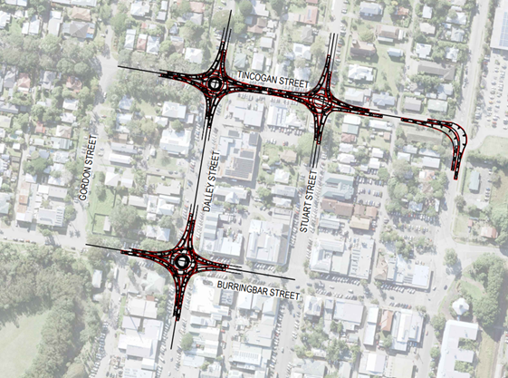
Heavy Vehicle Routes:
The preferred Heavy Vehicle routes
through/around the Mullumbimby town centre as detailed in attachment one (in
section 12.6) and provided in figure 1 below can be endorsed by Council.
It is not proposed that we begin to
enforce or require Heavy Vehicles (HV’s) to use these routes, but all
current and future designs will consider these routes as being HV routes and
ensure designs provide sufficient space to allow HV movements (see figures 2
and 3). This will also support future planning for intersection improvements as
Mullumbimby changes and grows.
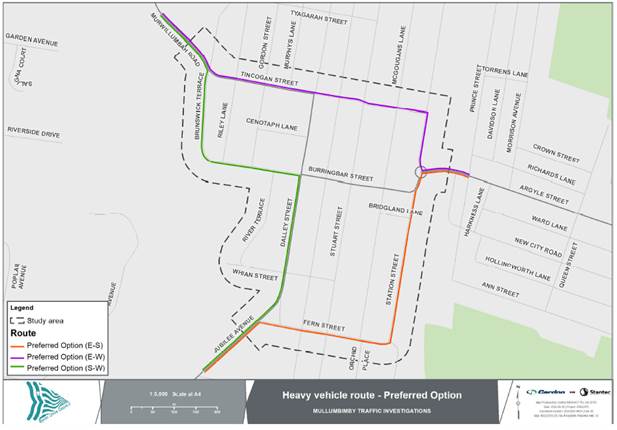
Figure
1: Preferred heavy vehicle route
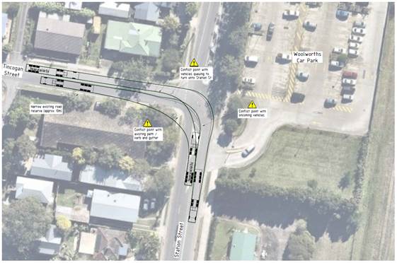
Figure
2: Heavy vehicle turn paths at the intersection of Tincogan St / Station St
intersection
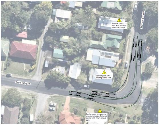
Figure
3: Heavy vehicle turn paths at the intersection of Tincogan St / Station St
intersection
Tincogan Street Intersection
Priorities:
The Tincogan Street intersection
priorities can change as proposed. While the changes will not improve
intersection performance, it is concluded that there will be no net worsening
at the intersections based on the current demand and route choice through the
town centre (refer to Figures 4 and 5).
A Concept layout for the “Do
Minimum” intersection upgrades (refer to figure 7) is the preferred
outcome for the reprioritisation of the Stuart St and Dalley St intersections
with Tincogan St (short term). This preference is based on the no
net-worsening and the significant pedestrian safety improvements (refuge
crossings, plus optional zebra crossing).
A warrants-based assessment that
considers pedestrian volumes does not support the installation of a mid-block
zebra crossing on Tincogan St. However, the modelling has shown that this
crossing will have minimal impact on traffic flow if it were to be installed
(See part 16 of attachment 1).
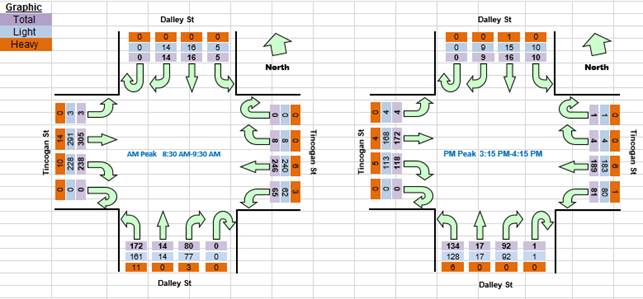
Figure 4: Intersection
count (peak) at the intersection of Tincogan St/Dalley St
Figure 5: Intersection
count (peak) at the intersection of Tincogan St/Stuart St
Additional considerations (Tincogan St /
Dalley St intersection):
The traffic modelling indicates that the
intersection of Tincogan St / Dalley St is currently operating with no
additional capacity to cater for future traffic demand during the PM Peak
(refer to figure 6). All other intersections within the model boundary
were shown to be operating at an acceptable level of service at this time.
Accordingly, a mitigation scenario
(Section 14 from attachment 1) has been modelled which includes the upgrades
shown in table 1. The upgrades proposed in the mitigation scenario will
provide sufficient capacity throughout the network contained within the model
boundary extending past 2032 (figure 8).
Additional modelling may be required to
understand the benefits for a hybrid scenario that considers the “Do
minimum” with the addition of a roundabout at the Tincogan St / Dalley St
intersection only, in the long term.
 Figure
6: 2022 Base model intersection level of service (part 10.4 of the Mullumbimby
Traffic investigations report)
Figure
6: 2022 Base model intersection level of service (part 10.4 of the Mullumbimby
Traffic investigations report)
Figure
7: Do Minimum Upgrade proposed short term upgrade at the intersections of
Stuart St / Tincogan St and Dalley St / Tincogan St
Table 1: Mitigation
scenario upgrades
|
Description
|
Mitigation
Scenario
|
|
Infrastructure
upgrades
|
|
Tincogan Street priority change at
Dalley and Stuart Streets
|

|
|
Speed reductions associated with Stuart
Street Green Spine
|

|
|
Burringbar Street Talking Streets
design
|

|
|
Tincogan Street / Stuart Street
roundabout upgrade
|
|
|
Tincogan Street / Dalley Street
roundabout upgrade
|
|
|
Burringbar Street / Dalley Street
roundabout upgrade
|
|
|
Traffic
Demand
|
|
Background Growth
|
|
|
Heavy
vehicle route
|
|
Between Jubilee Avenue and Murwillumbah
Road
|
Option 4
|
|
Between Jubilee Avenue and Argyle
Street
|
Option 2
|
|
Between Argyle Street and Murwillumbah
Road
|
Option 2
|
 Figure 8: 2032 Mitigation scenario intersection
performance (part 14 of the Mullumbimby Traffic investigations report)
Figure 8: 2032 Mitigation scenario intersection
performance (part 14 of the Mullumbimby Traffic investigations report)
Figure
9: Mitigation option intersection upgrade diagram
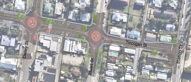
Figure 10: Capacity upgrades on Tincogan Street
(artist impression only)
Burringbar / Station Street
Intersection:
As part of the Burringbar Street, Talking
Streets Project staff considered upgrades at the Burringbar St/Stations St
intersection as shown in figure 11. This layout was considered to support the
outcomes of Talking Streets and the Mullumbimby Master Plan, by placing less
priority on Burringbar Street and supporting reduced traffic on Burringbar
Street.
Given the outcomes of attachment 1 detailed
in this report it is recommended that this layout be modelled internally and
referred to the Local Traffic Committee for engineering advice to progress
changes at this location further, if the modelling supports this change.
Figure
11: Draft Burringbar / Station Street Intersection layout
Strategic
Considerations
Community Strategic Plan
and Operational Plan
|
CSP Objective
|
CSP Strategy
|
DP Action
|
Code
|
OP Activity
|
|
4: Ethical Growth
We manage growth and change responsibly
|
4.1: Manage responsible
development through effective place and space planning
|
4.1.3: Town / Village
Masterplans - Develop, implement and update Place Plans that promote
place-based forward planning strategies and actions
|
4.1.3.2
|
Implement actions from the
Our Mullumbimby Masterplan
|
Recent Resolutions
Resolutions 21-043, 21-293, 21-295.
Legal/Statutory/Policy
Considerations
Designs for various works that involve regulatory lines and
signs will require Local Traffic Committee approval before proceeding to
construction.
Financial Considerations
The Tincogan Street priority changes as designed and
recommended are funded in the 2022/23 budget.
Consultation and
Engagement
The report undertaken and contained within this report
(attachment 1) was produced by Stantec (previously Cardno Engineering
Consultancy).
Objectives/Outcomes from this study were to -
1. Model
3-4 alternative traffic routes for vehicles and HV’s in, through and
around Mullumbimby CBD.
2. Recommend
the preferred heavy vehicle and traffic movement strategy through Mullumbimby
and justify it.
3. Address
the impact that this may have on Masterplan action items, any existing designs
or the existing street network and provide recommended design amendments where
identified.
4. Determine
the preferred intersection arrangements at the Tincogan Street intersections
with Dalley and Stuart Streets to promote traffic calming, efficient traffic
flow and safety for all modes of transport, particularly pedestrians. A
particular consideration is where and how to provide prioritised pedestrian
movement across Tincogan Street given the higher traffic volumes.
5. It
is expected the above point will require micro simulation type modelling.
Staff Reports - Infrastructure Services 4.2
Report
No. 4.2 Application of
Road Access and Safety Principles
Directorate: Infrastructure
Services
Report Author: Judd
Cornwall, Traffic & Transport Engineer
File No: I2022/865
Summary:
The purpose of this report is to outline how Council staff
are proposing to apply the Council adopted Road Access and Safety Principles
into a strategic outcome for the Shire.
RECOMMENDATION:
The Infrastructure Advisory Committee recommend that
Council:
1. Places
the Draft Road Access and Safety Principles Policy (E2021/47301) on public
exhibition in accordance with Council policy.
2. Supports
development of the Road Access and Safety Principles through a Road Safety Plan
that is prepared once the Byron Integrated Transport Strategy (Moving Byron) is
formally adopted.
Attachments:
1 Draft
Road Access and Safety Principles Policy 2022, E2021/47301
Report
On the
26 August 2021 Council resolved to adopt the following Committee recommendation:
1. That the draft Asset
Management Policy is expanded to include the Road Access and Safety Principles
(RASPs), part 1 of res 20-741 is placed on 28 days public exhibition and if
there are no submissions the revised Policy be adopted.
2. That TIAC and Council receive a
further report detailing the methodology for the application of RASPs. (Lyon/Martin)
Item 1:
The Asset Management Policy has
been adopted per resolution following public exhibition of the draft (with no
submissions received). Weblinks have been updated.
Item 2:
A three step process is proposed:
1. Road Access and Safety Principles Policy be
adopted.
2. Adopt of Byron
Integrated Transport Strategy (Moving Byron)
3. Develop a Road Safety Plan that will adopt
and action the Road Access and Safety Principles (RASP’s).
A Road Safety Plan will provide a
framework to enable the Shire, key stakeholders, and the community to play a
part in improving road safety for all users.
The figure below is an example of
how the road safety plan could fit within a Shire transport planning
framework. The framework and modal plans shown in the figure below are
for discussion purposes only and are not endorsed by Council or Council Staff at
this time.
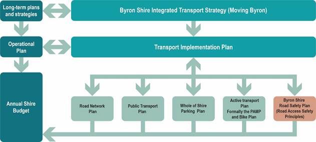
Figure 1: How
the Road Safety Plan may fit within the Shire’s Road Planning Framework
(example only)
The Road Access and Safety
Principles adopted within the Shires Road Safety Plan can be applied to:
· Developing and implementing road network screening
procedures, to prioritise upgrades on our worst performing roads and
intersections.
· Investigating and responding to high severity crashes to
determine crash reduction treatment options at discreet sites or road lengths.
· Delivering a safer, more forgiving roadside environment and
help develop Network Roadside Risk Intervention Thresholds across the
Shire’s road network.
· Supporting all users and legal modes of transport.
· The provision for more convenient and accessible active
transport infrastructure, prioritising PAMP and Bike Plan projects.
· Road Maintenance, renewals and upgrades, that consider all
road users, modes of transport and services delivered in the road reserve.
· Developing and implementing design standards that provide
safe, accessible, high quality cycling infrastructure.
· Information on road safety for:
Ø Development applicants
Ø Consultants
Ø Shire assessment officers
Ø Elected officials
· The development of engineering measures to reduce the
likelihood for serious injury crashes at priority hinterland locations,
including those susceptible to natural environmental hazards such as flooding
and rockfall.
The Infrastructure Planning team
are currently in the process of creating a Road Safety Officer (RSO) role.
This role will be responsible for bringing forward the RASP’s into a
strategic platform (Road Safety Plan) for the Shire. It is expected that
the RSO role will be filled before the end of the year.
To support the creation of the
Road Safety Plan and RASP’s, a RASP Policy has been developed. This is
provided at attachment 1 and is recommended for public exhibition following
committee review and support.
Strategic Considerations
It is intended that future road infrastructure projects and
guidelines (land development) will align with the Shires Road Safety Plan and
RASP’s once it is developed.
Community Strategic Plan
and Operational Plan
|
CSP Objective
|
CSP Strategy
|
DP Action
|
Code
|
OP Activity
|
|
5:
Connected Infrastructure
We have connected infrastructure, transport, and facilities that are safe,
accessible, and reliable
|
5.2:
Connect the Shire through integrated transport services
|
5.2.1:
Regional transport links - Lead, engage and partner to develop a sustainable
regional transport network that supports local roads to deliver services to
our community
|
5.2.1.1
|
Moving
Byron
|
Recent Resolutions
Resolution number: 21-320 (Review Asset Management Policy in
accordance with Resolution 20-741)
Financial Considerations
The Road safety Officer (RSO) Role is currently in the
process for endorsement. The RSO role will be partially funded by TfNSW. A
breakdown for the funding is shown in the table below –
|
Budget Source
|
2022/23 FY
|
2023/24 FY
|
2024/25 FY
|
|
TfNSW
|
$60,000
|
$60,000
|
$60,000
|
|
Council
|
$28,200 carry over from
2021/22 (GL3015.1)
$31,800 project funded
works to be shared across road projects having road safety improvement focus
|
$60,000 – funding
source to be developed and included in draft budget for adoption – this
may be split over several sources
|
$60,000 – funding
source to be developed and included in draft budget for adoption – this
may be split over several sources
|
Once the RSO has been resourced extra funding may be
required to help produce an outward facing document (Road Safety Plan) for
online and hard copy viewing.
Consultation and
Engagement
An internal meeting which took place on the 22 March 2022 to
discuss strategy regarding Council Resolution 20-741, this meeting developed
attachment 1.
The draft Asset Management Policy was expanded to include
the Road Access and Safety Principles (RASPs), part 1 of res 20-741 was placed
on 28 days.
Staff Reports - Infrastructure Services 4.3
Report
No. 4.3 Paterson Street
Road Safety Concerns Petition
Directorate: Infrastructure
Services
Report Author: Judd
Cornwall, Traffic & Transport Engineer
File No: I2022/864
Summary:
This report is in response to a petition from residents of
Paterson Street that expressed various road safety concerns.
The report considers the exisitng situation and traffic
count data, as well as exploring possible road sharing / safety improvement
options on Paterson St, between Bangalow Road and Ruskin Street.
RECOMMENDATION:
That the Infrastructure Advisory Committee recommend
Council investigate a footpath linking the existing BB022 shared footpath on
Massinger Street, between Lawson Street and Marvel Street extending to Bangalow
Road via Paterson Street as part of a future review of footpaths and priorities
in Council’s Pedestrian Access and Mobility Plan.
Report
At Councils 24 June 2021 meeting
Council resolved (resolution number: 21-222):
That Council:
1. Notes the significant community
concern relating to pedestrian, cyclist, traffic and parking conflicts along
Paterson Street and the associated Road Safety impacts;
2. To ensure a clear and accurate
understanding of the extent of the conflicts, and to ensure a high level of
road safety is maintained across our road network, resolves to undertake
the following, with a particular focus on Paterson Street between Bangalow Road
and Ruskin Street:
a) undertakes
a movement and parking assessment to identify the scope of the problem within
Paterson Street, Byron Bay,
b) prepares a
plan to be reported to Council that identifies solutions. (Coorey/Cameron)
Resolution item 1
Staff have noted the concerns expressed in the petition and
will consider the petition in relation to any future road related planning
within the street.
Resolution item 2
a) Movement
and parking
Movement
A recent traffic survey was undertaken in February on
Paterson Street, Byron Bay. Findings from this survey have shown that there is
a significant amount of non-local traffic using Paterson Street as a secondary
movement corridor around the Byron Bay town centre via Ruskin Street and
Massinger Street to Browning Street (Bypass) or the Beaches. An estimate
for the breakdown of these non-local movements is shown in Table 1.
Table 1: Paterson Street,
through traffic breakdown
|
Background traffic
|
Non-local traffic
|
Traffic Count volume (Weekday
average)
|
|
1,570 VPD
|
2,084 VPD
|
3,654 VPD
|
The traffic survey data indicates that 85 per cent of
traffic are traveling at or below 52km/h. Paterson Street has a default speed
limit of 50km/h, therefore, it can be concluded that most drivers are following
the speed limit and traffic calming is not warranted.
An investigation of the available crash data for Paterson
Street between Bangalow Road and Massinger Street has revealed no reported
crashes within the last 10-years.
Non-local traffic volumes – Potential contributing
factors
The residential catchment to the southeast of Paterson
Street (figure 1) that generally accesses Bangalow Road from Cooper Street is
experiencing difficulties doing so during the morning peak (turning right). It
is understood that the people within this catchment are utilising Paterson
Street to access other parts of the network to avoid the congestion on Bangalow
Road.
Figure 2 provides traffic congestion information for the
morning peak.
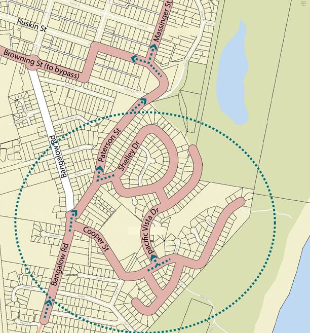
Figure 1: Traffic
catchment Paterson St
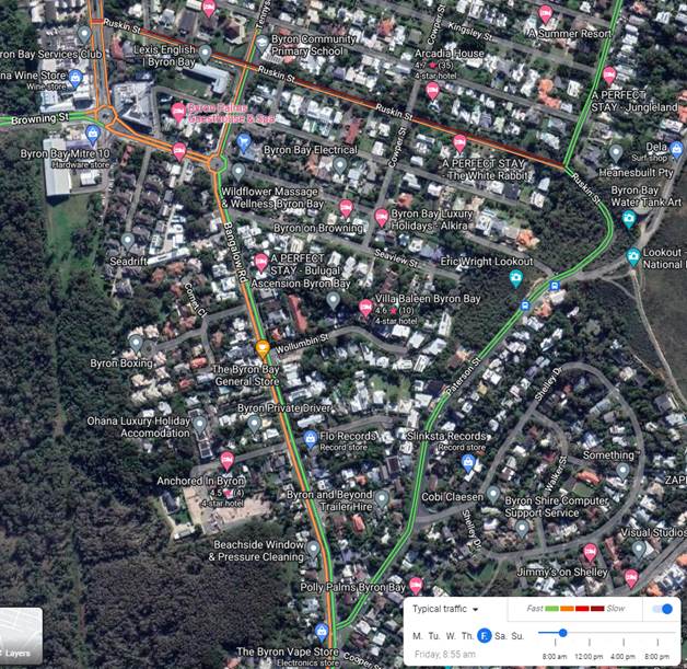
Figure 2: Traffic
congestion Bangalow Road (morning peak)
To get a clearer picture for the actual turn movements
through the traffic network to the east of Bangalow Road, a full turn movement
intersection surveys will be undertaken.
Parking
Parking along Paterson Street has been observed to be
typical when compared to other streets within the shire. At the times of
the inspections, it was also observed that when drivers park directly opposite
each other on both sides of the street there is minimal room for two cars to
pass the parked vehicle together, drivers were also seen to straddle the centre
line in these situations (see figure 3).
For most sections of Paterson Street, it is possible to park
on both sides of the street and allow 3m passing width between either the car
parked on the opposite side of the road, or the marked dividing line as required
in NSW legislation, road rule 208, parallel parking on a road. However,
in this situation it would not be possible for an on-road cyclist, or
pedestrian to pass at the same time.
Vehicles parked on the verge do create an issue for
pedestrians walking in this space by forcing them onto the road. The
vehicles observed to be parking on the verge appeared to be trades people
working in the area. Consequently, this issue may be resolved once
construction in the area slows down.
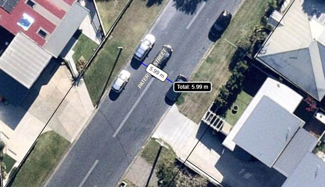
Figure 3: Paterson Street,
vehicle straddling double barrier lines
b) Possible solutions
Based on the available traffic survey data Paterson St is
carrying more traffic than a typical local street (>400 AADT). The 85th
percentile speed data collected from the most recent survey on Paterson Street
is typical for this type of street and is below the normal enforcement range.
Local Area Traffic Management (LATM) devices such as speed
humps or slow points are not recommended for use on Paterson Street based on
various geometric issues, such as grade and width.
Infrastructure Planning have
sketched the treatments (below) that have been considered.
Removing any kerbside parking on Paterson Street as shown in
scenarios one, and two shown in figures 5 and 6 (below) without additional
widening is not recommended based on current kerb-side parking demand and
obvious user passing conflicts.
Figure 7, scenario 3 shows footpaths on both sides of the
road with additional widening to allow cars to park on both sides of the road
where there is an unbroken centreline to allow the minimum travel path. This is
the preferred scenario (scenario 3) however, it would need to be prioritised
within the Pedestrian Access and Mobility Plan (PAMP). Table 2 below shows how
PAMP projects are prioritised.
Table 2: PAMP priority
table
|
Priority
Component
|
Priority Category
|
|
A
|
B
|
C
|
|
Safety
|
• addresses an identified
and significant safety issue
• reduces the need to
cross roads
|
• addresses an identified
and moderate safety issue
|
• addresses an identified
safety concern
|
|
Accessibility
|
• significantly improves
pedestrian access and mobility or is a component of a broader connection that
• significantly improves
pedestrian access and mobility
|
• moderately improves
pedestrian access and mobility or is a component of a broader connection that
significantly improves pedestrian access and mobility
|
• improves pedestrian
access and mobility
|
|
Connectivity
|
• connects a diverse
number of residential areas, key attractors and/ or public transport
facilities
|
• connects a variety of
residential areas, key attractors and/or public transport facilities
|
• connects residential
areas, key attractors and/ or public transport facilities
|
|
Demand
|
• responds to
existing/demonstrated high pedestrian demand
• facilitates significant
growth in pedestrian volumes in the future
|
• responds to
existing/demonstrated moderate pedestrian demand
• facilitates moderate
growth in pedestrian volumes in the future
|
• responds to existing/
demonstrated minor pedestrian demand
|
Infrastructure Planning are undertaking intersection surveys
which include pedestrian and cyclist’s movements on Paterson Street,
Bangalow Roadd and Shelley Drive this information will assist in the
prioritising the proposed footpath (scenario 3). The section of footpath shown
in scenario three is proposed to continue up Paterson Street onto Massinger
Street to join the proposed BB022 shared footpath currently contained within
the PAMP (see figure 4).
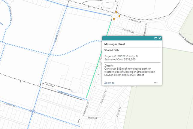
Figure 4: Proposed
Massinger Street shared footpath
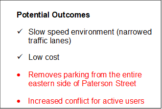
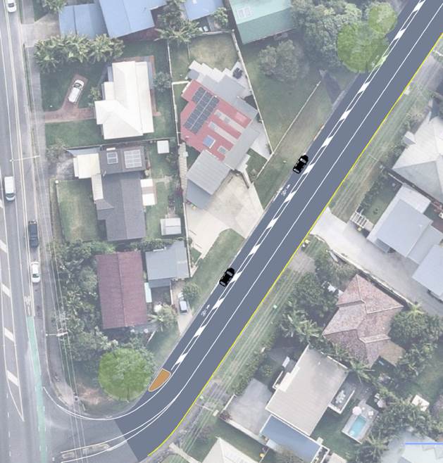
Figure 5: Scenario 1 – Shared Road Shoulder (Centre line re-alignment)
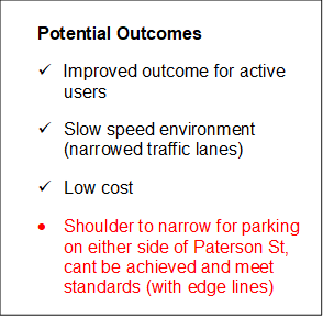
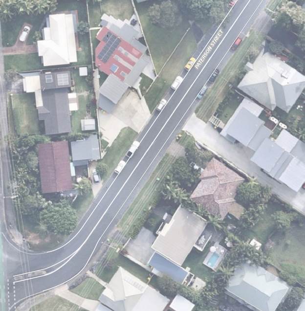
Figure 6: Scenario 2 – Marked edge lines and solid unbroken
centreline
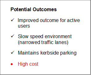
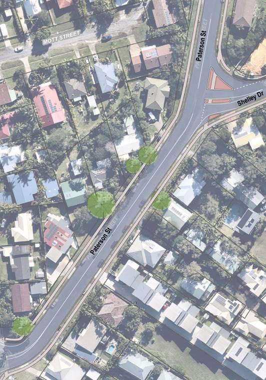
Figure 7: Scenario 3
– Footpath upgrade and minor intersection works
Other treatments considered
It was also noted that drivers were having trouble turning
right from Paterson Street and Cooper Street during the morning peak period.
Infrastructure Service staff are investigating possible improvements at the
intersection. However, any improvements at the intersection are not
likely to assist with the issues expressed in the resident petition.
There are also limited opportunities to provide full movements at the two
intersections (Paterson Street / Bangalow Road and Cooper Street / Bangalow
Road) without considering full signalisation (Figure 8) which is not
recommended at this time.
There were two reported crashes in the last 10 years, both
in 2015 within the 50 meters of the subject intersections (Patterson Street /
Bangalow Road and Cooper Street / Bangalow Road). These crashes had nothing to
do with the operation of the intersections.


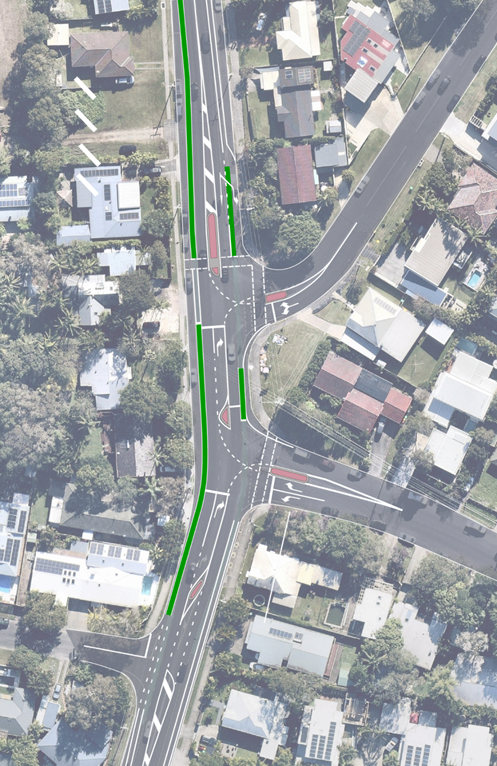
Figure 8: Traffic signals
layout concept (not recommended)
Strategic Considerations
Moving Byron (Movement and
Place)
An assessment of the Shires movement corridors has been
recommended by Transport for New south Wales in relation to the Shires
Integrated Transport Strategy (Moving Byron). This assessment will help
to inform the function of roads within the shire with respect to growth
throughout the local network. Considering the traffic demand on Paterson
Street the assessment may provide a clearer picture as to how to treat the
current issues expressed within the resident petition.
Committee to provide direction on preferred treatment from
the proposed options contained within this report including a
“do-nothing” scenario.
This preferred treatment (disregarding a “do-nothing”
option) will then be investigated as part of the Byron Shire integrated
transport strategy (Moving Byron), programmed accordingly and funding sought.
Community Strategic Plan
and Operational Plan
|
CSP
Objective
|
CSP
Strategy
|
DP
Action
|
Code
|
OP Activity
|
|
5:
Connected Infrastructure
We have connected infrastructure, transport, and facilities that are safe,
accessible, and reliable
|
5.2:
Connect the Shire through integrated transport services
|
5.2.1:
Regional transport links - Lead, engage and partner to develop a sustainable
regional transport network that supports local roads to deliver services to
our community
|
5.2.1.1
|
Moving
Byron
|
Recent Resolutions
Resolution minute number – 21-541
Resolved:
1. That Council notes the
petition regarding Traffic measures in Brandon Street, Suffolk Park.
2. That the petition be
referred to the Director Infrastructure Services for reporting back to Council. (Lyon/Cameron)
The motion was put to the vote and declared carried.
Legal/Statutory/Policy Considerations-
NSW legislation requires three meters of travel lane be
maintained when drivers park on the side of the roads, between either an
unbroken centreline or a vehicle parked on the other side of the road (NSW road
rule 208, Parallel parking on a road).
Consultation and
Engagement
Note no consultation at this time, discussion with committee
is the first step in consultation process. Discussion have started with TfNSW
regarding possible funding for data collection for integrated transport
planning. This will consider Paterson Street future function within the Byron
Bay’s road network.
Staff Reports - Infrastructure Services 4.4
Report
No. 4.4 Belongil Parking
Scheme Review - New Parking limits
Directorate: Infrastructure
Services
Report Author: Cesar
Giraldo, Project Engineer
File No: I2022/1222
Summary:
This report presents the short and long term actions for
Childe Street, Border Street and Kendall Street as part of the Council adopted
Belongil Parking Scheme Review.
Construction drawings, detail budget and schedule are
presented in this report to the Committee for consideration and support.
RECOMMENDATION:
That the Infrastructure Advisory Committee
recommends:
Council supports the proposed short and long term actions
for Belongil Beach on Childe Street, Kendall Street and Border Street included
in the attached drawings (attachment 1 - E2022/89910)
Attachments:
1 Belongil
Beach - Parking Improvements - Construction Drawings, E2022/89910 
2 Project
Estimate - Cost Estimate - Short Term Actions, E2022/89916
3 Project
Estimate - Cost Estimate - Long Term Action, E2022/89917

Report
This report outlines the proposed program, scope, and cost
estimates for the short and long term actions for the Belongil Parking Scheme
Review.
These actions are the result of further developing the
recommendations included in the Belongil Parking Scheme Review adopted by
Council late in 2021.
Stage 1 – Short Term (works funded. Drawing provided
in attachment 1 and construction budget estimate included in attachment 2)
· Installation of
timber bollards and signage with parking limits on Childe Street in front of
Jetty Park,
· Installation of
new parking limits on South side of Childe Street adjacent hotel East on Byron
and restaurants
· Installation of
timber bollards and signage with parking limits on parking limits on Border
Street
Stage 2 – Long Term (No funds allocated. Budget
estimate in attachment 3)
· Install raised
pedestrian crossing on Childe Street opposite Jetty Park and hotel access
· Install traffic
calming devices on Childe Street near intersection with Don Street and Border
Street
· Installation of
lighting adjacent to crossing and traffic calming device
Strategic Considerations
Community Strategic Plan
and Operational Plan
|
5:
Connected Infrastructure
We have connected infrastructure, transport, and facilities that are safe, accessible,
and reliable
|
5.2:
Connect the Shire through integrated transport services
|
5.2.4:
Parking - Manage parking through effective controls that support Movement and
Place Plans and are coordinated with other initiatives such as park and ride
|
5.2.4.1
|
Undertake
regular and frequent parking patrols to increase availability and turnover in
the Town and Village centres
|
Recent Resolutions
Res 21-562
Resolved that Council
1. Adopts the Belongil
Parking Scheme Review, consisting of attachments 1 and 2 (E2021/113682 and
E2021/113683).
2. That staff scope and
estimate the short-term actions from Belongil Parking Scheme Review and report
a proposed delivery program, with considerations of other conflicting Local
Area Traffic management priorities, to the next available Transport
Infrastructure Advisory Committee meeting.
3. That a budget of
$100,000 from the Infrastructure Renewal Reserve – Byron Bay be allocated
in the 2021/22 budget to fund the commencement of Local Area Traffic Management
Programs and the short-term actions from the Belongil Parking Scheme Review
Financial Considerations
Project estimate is attached in this report. Short
term actions are funded from current budget and long-term actions require
additional funds of $175,000
Consultation and
Engagement
Community was consulted for the development of Parking
Scheme Review – Belongil Beach (E2021/113682 and E2021/113683) on 1 June
2021. Further community meetings were held on the 30 July and 18 August 2021.
The propose parking limits and line marking will address
community concern regarding parking limits, access to beach and restaurants on
Childe Street and illegal parking.