BUSINESS OF ORDINARY MEETING
1. APOLOGIES
2. REQUESTS FOR LEAVE OF ABSENCE
3. DECLARATIONS OF INTEREST – PECUNIARY AND
NON-PECUNIARY
4. TABLING OF PECUNIARY INTEREST RETURNS (s450A Local
Government Act 1993)
5.
ADOPTION OF MINUTES FROM PREVIOUS MEETINGS
5.1. Extraordinary
Meeting held on 8 December 2011
5.2. Ordinary
Meeting held on 15 December 2011
6. RESERVATION OF ITEMS FOR DEBATE AND ORDER OF
BUSINESS
7. MAYORAL
MINUTE
8.
NOTICES OF MOTION
8.1. Exercise Equipment............................................................................................................. 4
8.2. College
of Marine Studies.................................................................................................... 6
8.3. Mullumbimby
Civic Centre Precinct Safety Stakeholder Meeting..................................... 8
8.4. CBD
& Town Centre Design and Development Conference............................................ 10
8.5. Review
of Rates for bed and breakfast establishments.................................................... 12
8.6. Review
of charges for community markets and holiday park cabins............................... 14
9. PETITIONS
10. SUBMISSIONS AND GRANTS
11. DELEGATES’ REPORTS
12.
REPORTS BY DIVISION
General Manager
12.1.
Management Plan Review 2011-2014 for the period October to December 2011.......... 17
12.2.
Loss of Crown Caravan Parks administered by Byron Shire Holiday Parks
Reserve Trust in 2006 19
12.3.
Constitutional Recognition of Local Government.............................................................. 22
Community Infrastructure
12.4.
Report of Belongil Creek Floodplain Risk Management Committee meeting
held on 13 December 2011 24
12.5.
Report of North Byron Coastal Creeks Floodplain Risk Management
Committee meeting held on 13 December 2011................................................................................................................. 29
12.6.
Public submissions on Draft Policy for Wet Weather Sporting Ground
Closures............. 32
12.7.
Naming of fields at Bangalow and Byron Regional Sport and Cultural
Complex............. 35
12.8.
Status report on Fleet Management Action Plan............................................................... 37
Corporate Management
12.9.
Local Government Elections September 2012 Key Dates – Constitutional
Referendum or Council Poll......................................................................................................................................... 40
12.10. Draft Guidelines
- Section 355 Management Committees............................................. 44
12.11. Heritage House
Bangalow Section 355 Committee – Amended fees and charges....... 46
12.12. Water, Waste and
Sewer Advisory Committee membership......................................... 50
12.13. PLANNING -
Public submission on the exhibition of the Draft Air Space Policy........... 52
12.14. Request for
reduction in fees - Byron Artisan Market.................................................... 57
12.15. 2011-2012
Financial Assistance Grant........................................................................... 61
12.16. Council holiday
parks financial performance 2010/2011................................................ 64
12.17. Investments
–November and December 2011............................................................... 67
12.18. Budget Review -
1 October to 31 December 2011........................................................ 74
12.19. Council
Resolutions Review for the period October to December 2011........................ 85
12.20. Removal of rotunda
in Mullumbimby Reserve............................................................... 87
Environment and Planning
12.21. Byron Shire
Greenhouse Emission and Energy Consumption Status Report - 2010/11 Period 91
12.22. Evaluation of
trial beach scraping episode, New Brighton Beach.................................. 95
12.23. PLANNING -
Report on expenditure of S94 funds Broken Head Hall at 356 Broken Head Road,
Broken Head.............................................................................................................................. 109
12.24. PLANNING -
10.2011.377.1 - Subdivision to create 11 lots and balance lot............... 112
12.25. PLANNING -
10.2011.319.1 - Subdivision to create four residential lots and one residual
lot 140
12.26. PLANNING -
10.2011.359.1 - Consent conditions 1 Mullumbimby Road, Myocum... 172
12.27. PLANNING - 10.2011.191.1
s82A Review - Use of part of the tourist premises for up to 14 functions
annually - Limited to a maximum of 70 guests per function - 6/137 Beach Road,
Broken Head 174
12.28. PLANNING - DA
10.2010.576.1 Beaches of Byron Caravan Park at 5-37 Broken Head Road, Byron Bay................................................................................................................................ 182
Organisational
Support
12.29. PLANNING - Legal
Status Report as at 23 January 2012........................................... 222
12.30. PLANNING - BSC
ats Bowen LEC 41265/2012.......................................................... 233
Society
and Culture
12.31. Request to join
the steering committee for a proposed Byron Shire Local Tourism Organisation 238
12.32. Youth Council appointments
2012................................................................................ 241
12.33. Revised status
report on the implementation of the Disability Access and Inclusion Plan
2008-2013 244
13.
COMMITTEE REPORTS
Society and Culture
13.1.
Report of the Tourism Advisory Committee Meeting held on 8 December
2011........ 247
14.
COUNCILLORS’ QUESTIONS WITH NOTICE
15. CONFIDENTIAL
REPORTS
Community Infrastructure
15.1.
CONFIDENTIAL Tender Assessment – Management Contract Multi Purpose
Facility BRSCC 250
Environment and Planning
15.2.
CONFIDENTIAL Old Byron Bay Beach Resort site, Bayshore Drive, Byron Bay...... 254
Water and Recycling
15.3.
CONFIDENTIAL Land Matters - Myocum Landfill......................................................... 258
16. LATE
REPORT
Corporate Management
16.1. Request for lifting of Caveat -
Byron Bay Community Association - 69 Jonson Street, Byron Bay Lot 1 DP524709...................................................................................................................... 260
17. CONFIDENTIAL
LATE REPORT
Community Infrastructure
17.1.... CONFIDENTIAL
Interim Management of BRSCC Multi Purpose Facility.................. 263
Councillors are
encouraged to ask questions regarding any item on the business paper to the
appropriate Executive Manager prior to the meeting. Any suggested amendments to
the recommendations should be provided to the Administration section prior to
the meeting to allow the changes to be typed and presented on the overhead
projector at the meeting.
Version
3 of 3
ENG540000 #1177327
I move that Council receive a report on the installation of
exercise equipment at the following places. The equipment to be the same as
that installed in Waterlily Park at Ocean Shores.
1. Mullumbimby
Civic Centre precinct
2. Brunswick Heads Terrace Park
3. Bangalow
(a site to be determined)
4. Byron Bay in Railway Park
Signed: Cr Diane Woods
Councillor’s Background Notes:
The Waterlily Park exercise equipment installed recently has
proved to be a great success, providing a great area for the community to
gather with their children to socialise and also gain health benefits by using
the installed equipment.
It would be of great advantage to have the same equipment
installed in the neighbourhood precinct of the Mullumbimby Civic Centre, as it
would provide an area for the community who gather there, a place to increase
their physical wellbeing at no cost.
The area suggested for Brunswick Heads is at the southern
end of the Terrace Park, near the swings and under the lovely fig tree.
The installation of this equipment if done the same as Waterlily Park, contains the cost to one area and is less expensive to maintain than if it
was spread out along the riverbank as was first suggested for Brunswick Heads.
For Bangalow, consultation with the community for a suitable
site would be best.
For Byron Bay, the Railway Park precinct would be improved
with such an area where adults and children could gather.
Recommended priority relative to other Management Plan
tasks:
High.
Definition of the project/task:
A report come back to Council early in the New Year.
Source of Funds (if applicable):
Open Space supported by grant applications.
Comments Executive Manager Community Infrastructure:
Clarification of project/task:
The exercise equipment installed at Waterlily Park has proved popular but has been subjected to vandalism, consequently further installations
should be in positions where a high level of informal surveillance is possible.
Guidelines for crime prevention through environmental design (CPTED) should be
employed when designing the installation.
Executive Manager responsible for task implementation:
Community Infrastructure
Relationship to, priority of, and impact on other
projects/tasks:
Consideration should be given as to the likelihood of this
equipment being exploited by the many personal fitness trainers and commercial
boot camps operating in Byron Bay and Brunswick Heads. This may have
implications within Policy 5.52 Commercial Activities on Coastal and Riparian
Crown Reserves.
Financial and Resource Implications:
The array of equipment and associated soft-fall installed at
Waterlily Park cost $50,000. It would need to be ensured that these amounts
were available from Section 94 or an alternative source for each proposed
location.
Legal and Policy Implications:
Council resolved (11-486) not to undertake maintenance works
on Crown land that is not under Council control or management this may preclude
the installation at the terrace Brunswick Heads which is under Crown management
unless it is on a full cost recovery basis.
COR405527 #1189931
I move that Council reaffirm its support to the Marine College proposal and write a letter to the Minister for Local Government, Don Page,
and the Minister for Primary Industries and Small Business, Katrina Hodgkinson,
stating its support.
Signed: Cr Diane Woods
Councillor’s Background Notes:
The Marine College proposal has been developed over 8 years
and a feasibility study showed that it would be a great asset to the Byron Shire.
The proponents have been working tirelessly to bring
together the Education Department, Department of Infrastructure, Indigenous
groups and many other interested parties, to assist with the development of the
proposed college.
Recommended priority relative to other Management Plan
tasks:
NA
Definition of the project/task:
NA
Source of Funds (if applicable):
NA
Comments Executive Manager Corporate Management:
Clarification of project/task:
The Notice of Motion is seeking Council to reaffirm its
support to the Marine College proposal and write to the Minister for Local
Government, Don Page, and the Minister for Primary Industries and Small
Business, Katrina Hodgkinson, stating this support.
Representatives of the Marine College proposal, at a meeting
held on 24 January 2012, indicated that they would be meeting with the Minister
for Primary Industries on 9 February 2012 to discuss the proposal. The
representatives at this meeting sought the support of Council and asked that
Council write to the Minister and the Minister of Local Government reaffirming
Council’s support for their proposal.
On the basis that Council was not meeting until 9 February
2012, and as such is unable to consider this most recent request until that
date, management have written to both the Minister for Local Government, Don
Page, and the Minister for Primary Industries and Small Business, Katrina
Hodgkinson, to provide copies of past Council resolutions indicating the
Council’s support of the Brunswick Heads Boat Harbour/Marine College proposal.
A copy of the correspondence to Minister for Local
Government, Don Page, and the Minister for Primary Industries and Small
Business, Katrina Hodgkinson, has been included at Annexure 42(a) and 42(b) to
this Notice of Motion.
Executive Manager responsible for task implementation:
Executive Manager Corporate Management
Relationship to, priority of, and impact on other
projects/tasks:
This task will not impact on other projects or tasks.
Financial and Resource Implications:
The task will be undertaken within existing allocated
resources and will not have any additional resource impacts.
Legal and Policy Implications:
The Notice of Motion will reaffirm the position of support
previously adopted by Council.
Attachments:
·
Correspondence to Minister for
Primary Industries and Small Business
#1189963 [7 pages]......................................................................................................... Annexure
42(a)
·
Correspondence to Minister for
Local Government #1189939 [7 pages]............................. Annexure
42(b)
COR405527 #1191153
I move:
1. That a meeting
be convened with key precinct stakeholders to identify main issues around the
safety, security and maintenance of the Mullumbimby Civic Centre Precinct.
2. That the
meeting is to be convened before April.
3. That
recommendations arising from the meeting be brought to Council.
Signed: Cr Simon Richardson
Councillor’s Background
Notes:
Recently, it has become apparent
that many safety and security issues have begun to hamper efforts in
maintaining the facilities around the Mullumbimby Civic Hall. Homeless members
of the community have felt safe to sleep and keep their possessions in and
around the Hall for many years. However, of late, property damage and
unsanitary behaviour have occurred. This has the potential for current hirers
and users of the space to seek to move elsewhere, depriving the area of popular
events and classes and weakening important threads in the fabric of the
Mullumbimby and surrounding community. As the rotunda in the open space area
within the precinct has also often been the subject of resident’s complaints
and property damage, a failure to address these issues has the capacity to
escalate tensions within the community, perhaps leading to further estrangement
felt by our homeless. A meeting convened by Council and attended by members and
organisations surrounding the precinct would be a first step in an effort to
minimise risks to all precinct users and the general public.
Recommended priority relative to other Management Plan
tasks:
This meeting and the recommendations arising may assist to
inform the Community Safety Plan and the review of existing and development of
new policies and procedures for Community Infrastructure 2011/12 (15.2 and 16.1
of Management Plan).
Definition of the project/task:
The convening of a meeting to address safety and security
issues within the Mullumbimby Civic Centre Precinct.
Source of Funds (if applicable):
As for current meetings only
staff time will be impacted.
Comments Executive Manager Corporate Management:
Clarification of project/task:
In response to complaints received over the last twelve
months or so by Council and Mullumbimby Police, staff have prepared a report to
this meeting titled “Removal of Rotunda in Mullumbimby Reserve. The
complaints received from the community relate to people occupying and living in
the rotunda in Mullumbimby Reserve.
The report provides a background on the complaints received
and the investigations undertaken.
In addition to complaints received by Council and
Mullumbimby Police in relation to the occupation of the Rotunda or other
structures within the precinct, complaints are received in relation to
behaviour impacting on the operation of the Mullumbimby Civic Hall.
The most recent complaint was received on 31 January 2012,
and related to an instance where someone threw a beer bottle through the door
trying to hit the cleaner while they were mopping the floor. The bottle
smashed and glass went all over the floor just missing the cleaner. The cleaner
was unable to identify the person involved as they ran off.
There is a concern that this incident or similar incidents
may impact on hiring of the hall and result in a loss of revenue.
The Notice of Motion requires the
convening of a meeting with key precinct stakeholders to identify main issues
around the safety, security and maintenance of the Mullumbimby Civic Centre
Precinct. The meeting is to be convened prior to April 2012 with the
recommendations from the meeting to be reported to Council.
The meeting should ideally include interested Councillors,
members of the Mullumbimby Civic Hall Board of Management, representatives of
Corporate Management and Society and Culture, precinct stakeholder
representatives from the RSL and the Mullumbimby & District Neighbourhood
Centre and a note taker.
Executive Managers responsible for task implementation:
Executive Manager Society and Culture and Executive Manager
Corporate Management
Relationship to, priority of, and impact on other projects/tasks
It is not envisaged that convening of a meeting and
preparation of a report to Council will have an impact on other priorities or
projects.
Financial and Resource Implications:
Staff resources in the organising and holding of a meeting.
Once the meeting has identified all the security and safety
concerns, it will be necessary for these concerns to be reported to Council.
Community complaints to Council have been made in relation
to the rotunda located in the Mullumbimby Civic Precinct, near the Mullumbimby
Civic Hall. The report provided to Council at this meeting discusses this
specific topic, and offers some recommendations for future action. A budget
allocation of $2,000 has been identified in this report in respect of the staff
recommendation.
Legal and Policy Implications:
Council has obligations under the Workplace Health and
Safety Act to ensure that minimum standards of health and safety are
maintained. The meeting will allow for any issues to be identified. The meeting
outcomes will also inform any review of existing and the development of new
policies and procedures.
COR405000 #1187159
I move that Council appoint a Councillor or Councillors to attend the CBD & Town Centre Design and Development Conference in Sydney from 23-24
May 2011.
Signed: Cr Jan Barham
Councillor’s Background Notes:
This conference will provide comprehensive analysis and
advice on how to optimise the infrastructure and design of key community hubs.
The conference will provide valuable information on how we
on how Council can enhance our town centres for the benefit of the whole
community.
 Source: www.cbdconference.com.au
Recommended priority relative to other Management Plan
tasks:
High.
Definition of the project/task:
N/A
Source of Funds (if applicable):
Councillor Expenses – Professional Development – Conferences
(2145.4)
Approximate cost:
-
Registration $900
-
Travel $400
-
Accommodation $250
Total: $1,550
Comments Executive Manager Corporate Management:
Clarification of project/task:
This Notice of Motion seeks funding for attendance at the
CBD & Town Centre Design and Development Conference. Councillor attendance
at the conference is supported.
Executive Manager responsible for task implementation:
Corporate Management
Relationship to, priority of, and impact on other
projects/tasks:
There will be no impact on other projects.
Financial and Resource Implications:
The approximate funds currently available in the Councillors
– Conferences Budget is $8053.17.
Legal and Policy Implications:
In accordance with Clause 7.3.1
of Council’s Policy 1.1 Mayor and Councillors Payment of Expenses and Provision
of Facilities “A resolution of Council is required to authorise attendance
of Councillors at any other discretionary conference, seminar or training.”
Clause 7.2.1 details the Conferences
and Seminars that may be attended by Councillors.
Clause 7.2.1 reads as follows:
“7.2.1. The conferences,
seminars, workshops, courses and similar to which this
policy applies shall
generally be confined to:
a) Local Government Association Annual (LGA and Australian local
Government Association (ALGA) Conferences;
b) Special “one-off” conferences called or sponsored by or for
LGA and/or ALGA on important issues;
c) Annual conferences and congresses of the major professions in
local government;
d) Australian Sister Cities Conferences;
e) Regional Organisation of Councils Conferences
f) Conferences which advance the professional development of
elected members in their role as Councillors.”
g) Any meetings or conferences of organisations or bodies on
which a Councillor of the Council may be elected, or appointed to be, a
delegate or member of the Council or the LGA.
h) Seminars which further the training and development efforts of
the Council and within the budget framework.
COR405527 #1190553
I move that Council consider the application of commercial rating charges for bed and breakfast establishments and take appropriate steps to ensure compliance with legislation and or review other means of
allocating a sliding scale rating for bed and breakfast establishments.
Signed: Cr Jan Barham
Councillor’s Background Notes:
The approval of bed and breakfast establishments (B&Bs)
has included the payment of S94 Developer Contribution fees and the application
of commercial rate charges. The tourism industry is a major economic
contributor to Byron Shire and these establishments play an important part in
the managed tourism accommodation facilities offered in the shire. For some
time there have been concerns raised about the payment of the associated costs
with B&Bs especially since the proliferation of holiday letting which has
in effect created competition and an unlevel playing field in terms of the
costs associated.
A recent response to a query by operators about the ability
to reduce the rating charges for B&Bs from staff has raised concerns about
the appropriateness of the charges on this type of development, see attached
email.
I referred the response from staff to the operators and have
now received a representations requesting that the issue of commercial rating
be reviewed.
There are issues for consideration in terms of the
application of the commercial and the fact that most of the B&B’s are in
residential areas and do not fall into a zoned commercial area or a defined
area of business as they are dispersed.
It’s important for council to consider the matter and
determine if the charges are appropriate and if there is the potential to amend
the rating charges applied to B&Bs to ensure compliance with the
legislation and fairness to a sector of the tourism industry.
Attachments:
·
Email from Mark Arnold dated 5
September 2011 #1190563 [3 pages]................................. Annexure
40
Recommended priority relative to other Management Plan
tasks:
The application of appropriate rates.
Definition of the project/task:
Clarification of the legal issues of rating.
Source of Funds (if applicable):
NA
Comments Executive Manager Corporate Management:
Clarification of project/task:
Review of rating structure in particular rates applied to
B&Bs to ensure compliance with legislation (Local Government Act 1993) and
fairness in the imposition of rates.
Executive Manager responsible for task implementation:
Executive Manager Corporate Management
Relationship to, priority of, and impact on other
projects/tasks:
As the rating structure for 2011/2012 has been determined by
Council through resolution 11-511 and as explained in Annexure 40 there is no
possibility to review the rating structure for the 2011/2012 financial year.
Council could undertake a review of the rating structure but this could not
apply until the 2012/2013 financial year. If it is Council’s desire to do this
it would need to devise rating options that are legislatively compliant and
consult on these as part of the upcoming community consultation on the
Community Strategic Plan, Delivery Plan and Operational Plan.
Financial and Resource Implications:
Any amendment to the rating structure would not create any
financial implications to Council as the outcome of this Notice of Motion. The
impact of any changes would be to redistribute amongst ratepayers the
proportion of rates payable. Council would still collect the same revenue it
is allowed in compliance with rate pegging limits set but if there is a
reduction in rates for a category of ratepayer then this would cause a
corresponding increase amongst another category or categories of ratepayers
depending upon the rating structure adopted by Council.
Legal and Policy Implications:
In determining an appropriate rating structure, Council must
consider the requirements of Chapter 15, Part 3 of the Local Government Act
1993 being sections 514 to 531. Given the current legislative restrictions, it
is not possible to create a specific rating category for B&Bs. As outlined
in Annexure 40, categorisation for rating purposes is determined on the
dominant use of the property in question. Council is constrained with the
rating categories defined in Section 514 of the Local Government Act 1993.
Whilst Section 529 of the Local Government Act 1993 provides the ability to
subcategorise within the generic rating categorisations and establish
appropriate rates accordingly, sub categorisation is based on the notion of a
centre of activity. An example of sub categorisation would apply in the
business category for say a business centre or industrial estate where a
geographic boundary can be determined. This does not provide the ability to
create a subcategory for B&Bs that are not concentrated in a specific
geographic area but are scattered throughout various locations in the Shire.
Council has a process in place that provides individual
ratepayers the ability to seek a review of their respective rating category.
On the current rating structure for B&Bs they would either be categorised
as business or residential depending upon the dominant use of the land the
B&B is situated. In considering whether a B&B should be rated
residential or business, Council would consider as part of an application
process by the owner of the B&B criteria such as:
- the area of the building(s) on the property devoted to
B&B activities compared to the total building(s) area
- the proportion of occupancy of the property as a B&B
over time compared to normal residential occupation by looking at bookings
of the B&B
- the extent of revenue generated by the property.
Upon assessment of an application
a B&B would be rated residential if the dominant use of the property is
residential and it would be rated business if the dominant use of the premises
was for B&B activities.
A ratepayer then has the right to
appeal Council’s decision as to the categorisation of their property to Council
in the first instance and then ultimately to the Land and Environment Court if
they still believe the categorisation determined by Council is incorrect.
To create a specific rating
category for B&Bs as indicated in this Notice of Motion would require an
amendment to the Local Government Act 1993.
COR405527 #1190551
I move that Council review the charges identified in the Rates and Charges 2011/2012 in relation to:
a) temporary community markets
b) caravan park cabin charges
and consider reducing the temporary community fee and
allowing for a seasonal fee and consider the reduction of the cabin charges.
Signed: Cr Jan Barham
Councillor’s Background Notes:
The adoption of 2011/2012 Fees and Charges resulted in
changes to the fees applied for temporary community markets and cabin fees. It
appears that these charges may have been applied without clarity about the
outcomes. The community market fees have been levied at a rate that is above
commercial rates, see attachments and doesn’t allow for seasonal markets such
as the Artisan Market in Byron Bay as there is no variation for the per day
rate for extended periods as is defined for Temporary Commercial Activities.
This results in the situation where commercial activities operating for more
than 21 days is $145 per day, while the fee a temporary market licence is fixed
at $320 per day with no sliding scale for the per day for extended days of
trading. There has also been an increase in the daily Temporary Market Licence
fee – 2010 - $275, 2011 - $320.
The Holiday Park cabin fee increases for peak periods were
approximately 32% for First Sun and 25% for Suffolk Park, see attachments.
Unfortunately neither of these peak pricing areas identified a comparison with
the previous year as had been previously done, see attachments for 2010/11 e.g.
First Sun – Ocean View cabin 2011/12 - $400 per night, 2010/11 - $290.
Council has received correspondence about the Artisan market
fees and I have personally had the cabin fees raised with me by a Member of
Parliament who is a long term visitor with her family to the First Sun Holiday Park.
It is important the levying of fees and charges is fair,
open and transparent and I propose a review of the fees and charges in light of
what appears to be excessive increases.
Attachments:
·
Byron Bay Community Association
letter to BSC re market charges- dated 3 October 2011
and BSC 2010 and 2011 fees described #1149813 [4 pages]............................................. Annexure
39(a)
·
BSC response to BBCA dated 31
October 2011 #1158501 [2 pages]................................. Annexure
39(b)
·
BBCC email response to BSC dated
15 December 2011 #1190567 [1 page]....................... Annexure 39(c)
·
Temporary Market Licence 2010/11 -
Fees and Charges page 23 #979201 [1 page]............. Annexure 39(d)
·
Temporary Market Licence 2011/12 -
Fees and Charges page 25 #1108562 [1 page]........... Annexure 39(e)
·
First Sun Holiday Park Pricing 2010/11 - Fees and Charges page 25 #979201
[1 page]........ Annexure 39(f)
·
First Sun Holiday Park
Pricing 2011/12 - Fees and Charges page 27 #1108562 [1 page]...... Annexure
39(g)
·
Suffolk Park Holiday Park
Pricing 2010/11 - Fees and Charges page 26 #979201 [1 page].. Annexure 39(h)
·
Suffolk Park Holiday Park
Pricing 2011/12 - Fees and Charges page 26 #1108562 [1 page].. Annexure
39(i)
Recommended priority relative to other Management Plan
tasks:
Fees and Charges.
Definition of the project/task:
Review of charges.
Source of Funds (if applicable):
NA
Comments Executive Manager Corporate Management:
Clarification of project/task:
Review of fees and charges associated with market licences
and holiday park fees and charges.
Executive Manager responsible for task implementation:
Executive Manager Corporate Management
Relationship to, priority of, and impact on other
projects/tasks:
Any amendments to fees and charges subject of this Notice of
Motion could be dealt within existing priorities if Council chose to determine
alternative fees by resolution.
Financial and Resource Implications:
Prior to Council’s adoption of a temporary market licence
fee, there where no fees or charges levied for the use of Council owned land or
Crown Reserves for which Council is the Reserve Trust Manager.
Council first considered the establishment of fees and
charges for temporary market licences as part of its consideration of the new
draft Market Policy at its Ordinary Meeting held 22 April 2010, with a report
titled “Policy 5.51 – Markets on Council Owned and Controlled Land”, refer http://www.byron.nsw.gov.au/meetings/2010.
Management’s recommendation for establishing fees and charges for temporary
markets was linked to the new draft Policy’s inclusion of provision for a
temporary market licence. The current draft Market Policy that is currently on
public exhibition states at section 3.3 that:
A licence
to conduct a temporary Market shall only be granted for a one-off, once a year Market
conducted for not more than three (3) consecutive days and in accordance with the
Local Government Act or Crown Lands Act.
The fees and charges for temporary market licence were
intended by Management to apply to one-off, once a year Market. The fee was
recommended to ensure appropriate income is received by Council to maintain the
asset based on the possible or known impact of the activity on that asset.
Market activities are considered to be high-impact activities for Council owned
and controlled assets.
Council has had only one occasion to issue a temporary
market licence that is not consistent with the original intent of applying the
fee in one-off, once a year Market activities. On 22 September 2011, Council
considered a Notice of Motion titled “Approval of Byron Artisans Market”, refer
www.byron.nsw.gov.au/meetings/2011-09-22-strategic.
After considering the Notice of Motion, the Committee resolved [11-743],
in part, under delegated authority to:
1. That Council, being aware of legal advice received on 20
September 2011 (#1143876) issue the Byron Bay Community Association (BBCA) a
temporary licence to operate the Artisan Market at Railway Park, Byron Bay from 1 October 2011 until 7 April 2012, as per application received.
2. That the General Manager issue the licence as per the regulating
code 4.2. Development Consent, in the existing Markets within Byron Shire
Policy.
3. That the licence is considered temporary as a term of a standard
licence is three
consecutive
years, as stated within regulating code 4.3. Licence, in the existing Markets
within Byron Shire Policy.
Management have issued the licence in accordance with the
resolution and levied the adopted fees and charges for temporary market
licences. Council have received an application for a reduction in the
temporary market licence fee from the Byron Bay Community Association, which is
the subject of a report titled “Request for reduction in fees – Byron Artisan
Market” that is included in this Ordinary Meeting Agenda for Council’s
consideration.
In considering a review of the adopted temporary market fess
and charges, Council may wish to consider issues associated with income
generation to ensure sufficient income to maintain Council owned and controlled
assets, consistency of fees and charges across Crown Reserve managed by Council
and Council owned community land, and Policy consistency in relation to the
application of temporary licence fees to occupy Council owned and controlled
land.
If there is any review of the fees and charges for the
Council Holiday Parks with a view to reduce them, this could possibly reduce
the revenue of the Holiday Parks.
Information received as a result of Park bookings concerning
cabin utilisation and revenue over the peak December/January period of
2011/2012 compared to the same period of 2010/2011 has revealed the following
results by Park:
·
Suffolk Park Beachfront Holiday Park over the December
2011/January 2012 peak period identified revenue increases of $2,588 in cabin
bookings compared to the December 2010/January 2011 period. Occupancy though
fell from 90% over the December 2010/January 2011 period to 79% for the
December 2011/January 2012 period.
·
First Sun Holiday Park over the December 2011/January 2012 peak
period identified revenue increases of $50,739 in cabin bookings compared to
the December 2010/January 2011 period. Occupancy has remained consistent at
88% for all cabins at First Sun Holiday Park.
The fee for the Ocean View cabin at First Sun Holiday Park is currently $400 per night in the December/January peak period as identified
in the Notice of Motion. In regard to this cabin in isolation occupancy over
the peak period of December/January was 96% in 2011/2012 compared to 87% in
2010/2011 when the fee was $290 per night.
In the current and previous financial year there has been a
significant investment in refurbishment of the cabins at First Sun Holiday Park that could suggest a justification for the increase in fees for cabins.
In relation to Council’s Holiday Parks, these are declared
business units of Council. At this Ordinary Council Meeting, Council is also
provided with a report on the performance of its Holiday Parks for the
2010/2011 financial year compared to that of 2009/2010. The report indicates
whilst the Parks are profitable they are certainly not holding significant
funds in reserve and provided a funding contribution of $814,900 to the General
Fund in 2010/2011. If it is considered to reduce cabin fees, this may have the
potential to erode the existing profitability of the Parks and jeopardise the
amount of contribution provided to the General Fund.
Legal and Policy Implications:
If Council are to amend any of the fees and charges
identified by this Notice of Motion, it would be required to determine these by
resolution and then advertise for public submissions for a period of 28 days in
accordance with Section 610(F) of the Local Government Act 1993.
GENERAL
MANAGER’S REPORTS
General Manager
File No: FIN451010 #1177570
|
Principal Activity:
|
General Manager
|
|
Summary:
|
This report summarises the performance of the organisation
against the adopted indicators in the Management Plan 2011-2014 for the
quarter October to December 2011. The majority of key performance indicators
are on target.
|
RECOMMENDATION:
That Council receive and note the quarterly report and
associated Annexures on the 2011-2014 Management Plan Review for the period 1
October to 31 December 2011.
Attachments:
·
December 11 Review of Principal
Activities 1 to 22 #1177645 [76 pages].............................. Annexure
3(a)
·
December 11 Overview of Capital Expenditure – General Fund
#1184923 [6 pages]............... Annexure 3(b)
·
December 11 Overview of Capital Expenditure – Water Fund #1184923
[2 pages].................. Annexure 3(c)
·
December 11 Overview of Capital Expenditure – Sewer Fund #1184923
[2 pages]................. Annexure 3(d)
·
Status Report – Grants Register
#1189272, #1189273, #1189274 [4 pages]............................ Annexure
3(e)
·
Status Report Project Reference
Groups #1183526 [8 pages]................................................ Annexure
3(f)
Report
The purpose of this report is to
advise Council of the performance of the organisation against the specific
measures and indicators for identified priorities in the Management Plan for
the Quarter October to December 2011.
This is the Quarterly Report on
the 2011-2014 Management Plan for the period to 31 December 2011.
The quarterly review report is provided for the public
record.
Substantial work has been
undertaken in relation to the activities and targets in the 2011-2014
Management Plan, with good progress recorded.
Details of progress are provided
in Annexures 3(a) to 3(f).
It should be noted that the
Environmental Laboratory Services Principal Activity is no longer required following
Council’s Ordinary Meeting on 11 August 2011 and subsequent resolution
11-639. The laboratory ceased operations on 28 September 2011.
Finance Implications
The Council’s financial
performance for the Quarter is addressed separately in the Quarterly Budget
Review.
Statutory and Policy Compliance Implications
It is a statutory requirement that progress against the
indicators in the Management Plan be considered by Council each Quarter.
|
|
Loss of Crown Caravan Parks administered by Byron Shire
Holiday Parks Reserve Trust in 2006
|
General Manager
File No: BEN202000
#1181007
|
Principal
Activity:
|
Executive
Management
|
|
Summary:
|
During Council’s Ordinary
Meeting of 15 December 2011, a number of observations and comments were made
in relation to the loss in 2006 of a number of Council Controlled caravan
parks to the then Department of Lands (DOL). A report produced by the DOL’s
agent IAB Services is attached to this report in an attempt to give
Councillors insight as to the reasoning behind the decision of the DOL to
resume direct control of the caravan parks in question.
|
RECOMMENDATION:
That Council note the report.
Attachments:
·
Report commissioned by the then
Department of Lands titled “A Management Review
of Crown Caravan Parks Administered by Byron Shire Holiday Parks Reserve Trust”
#1190761 [37 pages]..................................................................................................... Annexure
38(a)
·
Report Byron Shire Reserve Trust
Committee Meeting #611819 [4 pages]........................ Annexure 38(b)
Report
During Council’s Ordinary Meeting of 15 December 2011,
comment was made as to the reasons for Council’s loss to the Department of
Lands of Terrace, Ferry Reserve and Massey Greene caravan parks in Brunswick
Heads and Clarkes Beach at Byron Bay.
A report produced by IAB Services for the Department of
Lands dated May 2005 concerning the management of Crown caravan parks by the
Byron Shire is attached for Councillor’s information (the DOL/IAB report).
Reproduced below is an excerpt from the Executive Summary of
the IAB Services report.
Summary of Key Findings
The key findings from our
review are set out below.
We found that there is an
urgent need to address the finalisation of management plans for the parks, as
these delays are adversely impacting upon the validity of existing licences,
expenditure on park assets, dealing with encroachment of buildings outside the
site boundaries and insurance coverage of the parks. In addition, we are
concerned that delays in addressing the noncompliant structures within three
(3) of the parks may prevent relicensing of the parks in February 2006.
In summary, our findings for
each area were as follows:
The three (3) items below
identified during our review are deemed to be of ‘EXTREME RISK’ for DOL and
should be given immediate management attention:
-
When the initial five (5) Crown Parks (including Broken Head)
were licensed for a five (5) year term by Council’s Compliance Officer in
February 2001, there were several conditions applied anticipating that the
newly prepared draft POMs would be adopted within a short timeframe. For
various reasons, Council acting as the Reserve Trust has not adopted these
Plans and the Crown Parks are operating now in breach of the conditions of the
licences. Moreover, it is highly unlikely that the Trust has the capacity to
finalise the POMs and supervise the extensive upgrading and remedial work to
enable the licences to be reissued in February 2006.
-
For the above reasons, we have recommended in our Detailed
Report that the DOL take immediate action to initiate a management strategy to
respond to the urgent breaches of the licence conditions and prepare the Crown
Parks for extensive redevelopment in line with the previously adopted POM prepared
in February 2000. We are concerned at the non-compliance of long-term dwellings
at the three (3) Brunswick parks and the legality of operating the parks where
issues identified by Council’s Compliance Officer in 2001 and made conditional
upon the approval to operate have not yet been addressed. With the park
licences due for renewal in February 2006, there is insufficient time available
to make the Crown Parks compliant prior to this date without major management
decisions that may involve closure of some of the parks. Such action will have
a significant impact on a wide range of tourists and reflect adversely on the
reputation of the Trust and the DOL will also have the potential for extensive
media attention.
-
Two (2) of the parks are operating outside of their defined
boundaries and Director, ATPM, Mr Tilton, who was the contracted manager at the
time of the review, has advised us of recent enquiries by a previous on site
manager at Suffolk Park to an insurer. The insurer confirmed that park managers
would not be covered for public liability insurance purposes when working
outside of the licensed area of the park. Mr Tilton advised further, that this
Manager had sought an indemnity from Council but that this was not resolved
prior to the Manager’s later departure. Council’s Director has provided a
statement from Council’s insurer outlining its public liability coverage but we
were unable to confirm the terms, conditions and exclusions of the contract and
whether DOL and/or site management would be exempt from any claims made outside
the current licensed boundaries. The major boundary issues are Massey Green
where thirty five (35) sites and part of the amenities block has been
identified as being outside the licensed area of the park. At Terrace, pending approval
and implementation of the POM, there are sixteen (16) sites that are currently
outside the current licensed park boundaries. Within the parks, many of the
vans and annexes have extended outside the individual sites and many breach the
conditions imposed by Council when issuing a licence in February 2011.
The other items that follow
have a HIGH RISK rating, where urgent management attention is
required.
-
There is evidence of a deterioration of assets and infrastructure
with only limited capital expenditure over the past five (5) years, while the
Trust was considering the POMs, which offered a new design outline for each of
the parks. Maintenance expenditure has also been limited with higher priority
being given to health and safety issues.
-
We found the facilities within the park to be of an average standard
and identified OH&S issues including damage to the sewer line in Terrace,
periodic sewer surcharge into the Manager’s residence at Ferry, non-replacement
of slippery tiles in the amenities blocks and encroachment of verandas and
gardens across site boundaries. In one case, an encroachment of a garden onto
an access road within Terrace resulted in a serious accident earlier this year
to a young visitor who was injured when he fell from his bicycle on to a garden
stake and impaled his knee.
-
There is currently no formal separation of policy
determination by the Trust and the operational role of Council administration,
which has led to claims of community influence interfering with the good
management of the Crown Parks. Strategic decision making by the current Trust
in resolving the key POMs has been delayed and at Ferry altered to reflect the
minority concerns of some local residents upon personal representations at
Trust Meetings.
Conclusion
Based on our management
review, the three (3) Brunswick Heads Crown Parks are continuing to operate in
breach of the licence conditions issued by Council in February 2001. Deferral
of POMs by the Trust has failed to take into consideration the impact of non-compliance
to the licence conditions and the corresponding OH&S, legal and risk
exposures to itself and the DOL. The DOL needs to instruct the Trust to
immediately address the outstanding non-compliance issues and boundary
realignments to ensure the park operations meet all legal and statutory
requirements or alternatively implement separate management options.
The copy DOL/IAB Report was received by Council on 22
December 2006, after Council lodged applications under the then Freedom of
Information Act (FOI). A copy of the report was circulated to then Councillors
under memo dated 19 January 2007 (#650102).
The DOL/IAB Report bears the notation ‘confidential’ on the
front page, however, it was released to Council under FOI and is therefore not
confidential. Mr Graham Harding of the now Crown Lands Division of the
Department of Primary Industries, confirmed verbally last week that the
Division had no objections to the publication of the DOL/IAB Report as an
attachment to this report.
Financial Implications
This report relates to matters considered by Council in 2006
and is submitted for information only. There are no financial implications
arising from Council’s consideration of this report at this time.
Statutory and Policy Compliance Implications
This report is for information only and does not have any
statutory or policy compliance implications.
General Manager
File No: COR050505 #1187066
|
Principal Activity:
|
Executive Management
|
|
Summary:
|
The Local Government Shires Association of NSW (LGSA) has
written to Council seeking support in a national advertising campaign aimed
at achieving Constitutional Recognition of Local Government.
They have requested Byron Shire Council contribute a
special levy of $17,247.09, payable in three instalments over three financial
years. In addition, there will also be supplementary work for all councils to
do for the campaign at a local level.
|
RECOMMENDATION:
1. That
Council support the Local Government Association of NSW to achieve
Constitutional Recognition of Local Government.
2. That
Council allocate funding of $17,247.09 in three equal instalments over three
financial years (commencing 2012/13).
3. That
Council note, in supporting the campaign, additional work will be required by
Byron Shire Council staff to address issues at the local level.
Attachments:
·
Letter from Local Government
Association of NSW #1185851 [2 pages].............................. Annexure
28
Report
The LGSA has written to Council seeking support for a
national advertising campaign aimed at achieving Constitutional Recognition of
Local Government.
At the next Federal election, a referendum will be held to
include recognition of Local Government in the Australian Constitution. The
Australian Local Government Association (ALGA) is leading the campaign on
behalf of Local Government across the country and to date more than 85% of
councils have moved to support the Constitution Recognition of Local
Government.
It is expected the national campaign will cost in excess of
$10 million, with $2.7 million coming from NSW Councils. The LGSA have
requested Byron Shire Council to contribute a special levy of $17,247.09,
payable in three instalments over three financial years. These funds will be
used in the national campaign being coordinated by the ALGA. In addition to the
financial contribution, there will also be supplementary work for all councils
to do for the campaign at a local level.
The LGSA has also committed $200,000 in the current financial
year to raising the profile of local government in NSW and a further $1,000,000
will be committed over the next two financial years for promotional activities
and advertising.
Should the referendum or the national advertising campaign
not go ahead for any reason, instalments paid to the LGSA will be refunded.
Financial Implications
$17,247.09, payable in three instalments over three
financial years (commencing 2012/13).
Statutory and Policy Compliance Implications
Nil.
COMMUNITY
INFRASTRUCTURE – EXECUTIVE MANAGER’S REPORTS
Executive Manager: Community Infrastructure
File No: ENG091019 #1181460
|
Principal Activity:
|
Infrastructure Planning and Project Definition
|
|
Summary:
|
The Belongil Creek Floodplain Risk Management Committee (BCFRMC)
met on 13 December 2011.
This report presents the minutes and recommendations
arising from that meeting.
|
RECOMMENDATION:
1. That
Council note the minutes of the Belongil Creek Floodplain Risk Management
Committee (BCFRMC) Meeting held on 13 December 2011 (Annexure 10(a), #1182550).
2. That
in relation to Report 4.1 – Presentation of Discussion Papers 5 to 7 (#1165811),
Council adopt:
Committee Recommendation
BCFRMC 4.1
a) That
the following recommendations be added to the Draft Belongil Creek Flood Risk
Management Study and Plan:
i) Installation of additional rainfall gauges in the Belongil
catchment.
ii) Installation of an ALERT water level gauge at the Ewingsdale Road Bridge.
iii) Implementation of a multi-faceted community flood awareness
campaign targeting accommodation providers and new residents, as well as
existing residents.
iv) Development of a flood information data set linking water levels
to real world outcomes. In order to develop a flood action plan or flood
intelligence card which can help Council or the SES understand how a predicted
flood water level will affect the community.
v) Implementation of an automated telephone and/or SMS flood
warning system.
vi) A review of existing SES emergency procedures using design flood
information.
vii) A review of flood and evacuation warning procedures. A wide
range of warning methods should be considered and planned for well in advance
of future flood events.
viii) Identification of an alternative evacuation route.
An alternative to Jonson Street is recommended which has greater flood
immunity. It is recommended that the SES investigate this alterative and, if
deemed suitable, it be adopted in the Byron Shire Local Flood Plan.
ix) Prioritise evacuation of Belongil Spit. Early and
prioritised evacuation of the Belongil Spit area would ensure that the most
vulnerable residents have the potential to evacuate prior to the onset of flooding.
It is recommended that the SES identify triggers which would prompt the
evacuation of Belongil Spit before other areas in the catchment. It is also
recommended that the residents in the Belongil Spit area are educated about
their increased flood risk and the likelihood of early evacuation.
x) Discussion Paper 5 be amended to list the correct
responsibilities of the SES, namely that the Bureau of Meteorology is the
legislated organisation that issues flood warnings, and amend the emergency
response recommendations in discussion paper 5 to incorporate a layered warning
system which includes sirens.
b) That a Flood Planning Matrix be recommended for inclusion in
Council’s Development Control Plan for Flood as part of the recommendations
within the Draft Belongil Creek Flood Risk Management Study and Plan.
The proposed planning matrix would:
i) More stringently restrict incompatible floodplain development
within high hazard areas of the floodplain.
ii) Restrict development of critical Infrastructure and emergency
services to flood liable lands.
iii) Prescriptively list development control measures based on
land-use type and flood hazard category.
iv) The controls within the Planning Matrix would be based on current
flood risk and future flood risk increases due to climate change projections
have been taken into account where appropriate.
c) i) That the one (1) property that has been identified as
eligible for voluntary house purchase and the four (4) properties that have
been identified as eligible for voluntary house raising be listed in the Draft
Belongil Creek Flood Risk Management Study and Plan.
ii) That additional properties, which were included in the
voluntary house raising assessment, be considered for flood proofing.
d) The
flood planning level in the draft Byron LEP be based on 2100 event and that the
draft DCP for flooding include controls for FPL1, FPL2 and FPL3, based on
updated Discussion Paper 7 (#1173861, #1173875).
3. That
in relation to Report 4.2 – Amended Constitution (#1169811), Council
adopt:
Committee Recommendation
BCFRMC 4.2
That Council endorse the
Belongil Creek Floodplain Risk Management Committee Constitution (Annexure
10(k), #1169595) to be amended to accord with resolutions 10-1066 and 11-360,
Council’s advisory committee constitution template and the NSW Floodplain
Development Manual.
4. That
in relation to Agenda Item 5.2 – Flood Modification Measures (#1159552),
Council adopt:
Committee Recommendation BCFRMC
5.2
The committee recommends that the
consultant prepare a report which identifies tangible cost/benefits relating to
four flood modification measures, which include:
a) Training the Belongil Creek
mouth versus existing opening strategy.
b) The Byron Bay Drainage Strategy
2010 including identification of structures that may need modification.
c) A full maintenance program for
the existing drainage system.
d) Cost/benefit analysis of works
on the Clarkes Beach drain.
Attachments:
·
Unconfirmed Report BCFRMC meeting
13 December 2011 #1182550 [3 pages]................ Annexure 10(a)
·
Agenda BCFRMC meeting 13 December
2011 #1189996 [11 pages]................................ Annexure 10(b)
·
BCFRMC meeting 13 December 2011 Annexures
Part 1 #1190000 [33 pages]................... Annexure 10(c)
·
BCFRMC meeting 13 December 2011
Annexures Part 2 #1190002 [61 pages]................... Annexure 10(d)
·
BCFRMC meeting 13 December 2011
Annexures Part 3 #1190006 [21 pages]................... Annexure 10(e)
·
BCFRMC meeting 13 December 2011
Annexures Part 4 #1190008 [26 pages].................... Annexure 10(f)
·
Updated Discussion Paper 5
Response Modification #1173868 [33 pages]...................... Annexure
10(g)
·
Updated Discussion paper 6
Property Modification #1173872 [61 pages]........................ Annexure
10(h)
·
Updated Discussion paper 7 Climate
Change (part A) #1190011 [21 pages]...................... Annexure 10(i)
·
Updated Discussion paper 7 Climate
Change (part B) #1190020 [29 pages]...................... Annexure 10(j)
·
BCFRMC Constitution #1169595 [6
pages]...................................................................... Annexure
10(k)
Annexures 10(b)-(j) have
been provided on the Councillors' Agenda CD only; electronic copies can be
viewed on Council’s website.
Report
This report provides the recommendations of the Belongil
Creek Floodplain Risk Management Committee (BCFRMC) meeting of 13 December
2011, for determination by Council.
Committee Recommendation BCFRMC 4.1
1. That
the following recommendations be added to the Draft Belongil Creek Flood Risk
Management Study and Plan:
a) Installation of additional rainfall gauges in the Belongil
catchment.
b) Installation of an ALERT water level gauge at the Ewingsdale Road Bridge.
c) Implementation of a multi-faceted community flood awareness
campaign targeting accommodation providers and new residents, as well as
existing residents.
d) Development of a flood information data set linking water levels to
real world outcomes. In order to develop a flood action plan or flood
intelligence card which can help Council or the SES understand how a predicted
flood water level will affect the community.
e) Implementation of an automated telephone and/or SMS flood warning
system.
f) A review of existing SES emergency procedures using design flood
information.
g) A review of flood and evacuation warning procedures. A wide range
of warning methods should be considered and planned for well in advance of
future flood events.
h) Identification of an alternative evacuation route. An alternative
to Jonson Street is recommended which has greater flood immunity. It is
recommended that the SES investigate this alterative and, if deemed suitable,
it be adopted in the Byron Shire Local Flood Plan.
i) Prioritise evacuation of Belongil Spit. Early and prioritised
evacuation of the Belongil Spit area would ensure that the most vulnerable
residents have the potential to evacuate prior to the onset of flooding. It is
recommended that the SES identify triggers which would prompt the evacuation of
Belongil Spit before other areas in the catchment. It is also recommended that
the residents in the Belongil Spit area are educated about their increased
flood risk and the likelihood of early evacuation.
j) Discussion Paper 5 be amended to list the correct responsibilities
of the SES, namely that the Bureau of Meteorology is the legislated organisation
that issues flood warnings, and amend the emergency response recommendations in
discussion paper 5 to incorporate a layered warning system which includes
sirens.
2. That a Flood Planning Matrix be recommended for inclusion in
Council’s Development Control Plan for Flood as part of the recommendations
within the Draft Belongil Creek Flood Risk Management Study and Plan.
The proposed planning matrix would:
a) More stringently restrict incompatible floodplain development within
high hazard areas of the floodplain.
b) Restrict development of critical Infrastructure and emergency
services to flood liable lands.
c) Prescriptively list development control measures based on land-use
type and flood hazard category.
d) The controls within the Planning Matrix would be based on current
flood risk and future flood risk increases due to climate change projections
have been taken into account where appropriate.
3. a) That the one (1) property that has been identified as
eligible for voluntary house purchase and the four (4) properties that have
been identified as eligible for voluntary house raising, within Annexure 1(b)
of this report, be listed in the Draft Belongil Creek Flood Risk Management
Study and Plan.
b) That additional properties, which were included in the voluntary
house raising assessment, be considered for flood proofing.
4. The
flood planning level in the draft Byron LEP be based on 2100 event and that the
draft DCP for flooding include controls for FPL1, FPL2 and FPL3, based on
updated Discussion Paper 7 (#1173861, #1173875).
Committee Recommendation BCFRMC 4.2
That Council endorse the Belongil Creek Floodplain Risk
Management Committee Constitution (Annexure 2(a) #1169595) to be amended to
accord with resolutions 10-1066 and 11-360, Council’s advisory committee
constitution template and the NSW Floodplain Development Manual.
Committee Recommendation
BCFRMC 5.2
The committee recommends that the
consultant prepare a report which identifies tangible cost/benefits relating to
four flood modification measures, which include:
a) Training
the Belongil Creek mouth versus existing opening strategy.
b) The Byron
Bay Drainage Strategy 2010 including identification of structures that may need
modification.
c) A full
maintenance program for the existing drainage system.
d) Cost/benefit
analysis of works on the Clarkes Beach drain.
Management Comments BCFRMC Recommendation 4.1
Management support the recommendation as written.
Management Comments BCFRMC Recommendation 4.2
Management has requested the Department of Environment,
Climate Change & Water to provide formal confirmation of the NSW Floodplain
Development Manual guidelines regarding Committee members’ voting rights.
Management will update the constitution in accordance with these guidelines.
Management Comments BCFRMC Recommendation 5.2
Management support the recommendation as written.
Financial Implications
All proposed actions are within the existing contract and
will not increase any costs beyond that already approved.
Statutory and Policy Compliance Implications
None.
Executive Manager: Community Infrastructure
File No: ENG0910201 #1181570
|
Principal Activity:
|
Infrastructure Planning and Project Definition
|
|
Summary:
|
The North Byron Coastal Creeks Floodplain Risk Management
Committee (NBCCFRMC) met on 13 December 2011.
This report presents the minutes and recommendations
arising from that meeting.
|
RECOMMENDATION:
1. That
Council note the minutes of the North Byron Coastal Creeks Floodplain Risk
Management Committee (NBCCFRMC) meeting held on 13 December 2011 (Annexure
11(a), #1182551).
2. That
in relation to Report 4.1 - Presentation and Acceptance of Model Calibration (#1165826),
Council adopt:
Committee Recommendation
NBCCFRMC 4.1.1
That Council note the results
of the BMT WBM calibration assessment (Annexure 11(c) #1174610) and that the
accuracy of the calibration is of a sufficient level that the model can now be
used for the preparation of design flood event mapping for the final flood
study.
The committee accept the report
on the proviso that the consultants (BMT WBM) meet with Mr Lambourne and
discuss apparent discrepancies of rainfall data and that a review of
assumptions regarding entrance maximum depth of scour is undertaken.
3. That
in relation to Report 4.1 - Presentation and Acceptance of Model Calibration (#1165826),
Council adopt
Committee Recommendation
NBCCFRMC 4.1.2
That BMT WBM provide the committee
with a more detailed analysis of the resident survey including information
about what geographic areas the survey respondents come from and their
suggestions for reducing flooding, in accordance with the government guidelines
on floodplain management.
4. That
in relation to Report 4.2 – Amended Constitution (#1169636), Council
adopt:
Committee Recommendation
NBCCFRMC 4.2.1
That Council endorse the North
Byron Coastal Creeks Floodplain Risk Management Committee Constitution (Annexure
11(d), #1169503) to be amended to accord with resolutions 10-1066 and 11-360,
Council’s advisory committee constitution template and the NSW Floodplain
Development Manual.
Attachments:
·
Unconfirmed Report NBCCFRMC
meeting 13 December 2011 #1182551 [2 pages]........... Annexure 11(a)
·
Agenda and annexures NBCCFRMC
meeting 13 December 2011 #1182552 [65 pages]..... Annexure 11(b)
·
North Byron Coastal Creeks Flood
Study FINAL Model Calibration #1174610 [64 pages]... Annexure 11(c)
·
NBCCFRMC Constitution #1169503 [6
pages]................................................................. Annexure
11(d)
Annexures 11(b) and 11(c)
have been provided on the Councillors' Agenda CD only; electronic copies can be
viewed on Council's website.
Report
This report provides the recommendations of the North Byron
Coastal Creeks Floodplain Risk Management Committee (NBCCFRMC) meeting of 13
December 2011, for determination by Council.
Committee Recommendation NBCCFRMC 4.1.1
That Council note the results of the BMT WBM calibration
assessment #1174610 (as provided under memo #1170748) and that the accuracy of
the calibration is of a sufficient level that the model can now be used for the
preparation of design flood event mapping for the final flood study.
The committee accept the report on the proviso that the
consultants (BMT WBM) meet with Mr Lambourne and discuss apparent discrepancies
of rainfall data and that a review of assumptions regarding entrance maximum
depth of scour is undertaken.
Committee Recommendation NBCCFRMC 4.1.2
It was requested that BMT WBM
provide the committee with a more detailed analysis of the resident survey
including information about what geographic areas the survey respondents come
from and their suggestions for reducing flooding, in accordance with the
government guidelines on floodplain management.
Committee Recommendation NBCCFRMC 4.2.1
That Council endorse the North Byron Coastal Creeks
Floodplain Risk Management Committee Constitution (#1169503) to be amended to
accord with resolutions 10-1066 and 11-360, Council’s advisory committee
constitution template and the NSW Floodplain Development Manual.
Management Comments NBCCFRMC 4.1.1
Management support the recommendation noting that any
discussions held between the Community Representative Mr Lambourne, with the
Consultants, is to be reported back through the committee prior to inclusion of
any findings into the model and reports.
Management Comments NBCCFRMC 4.1.2
Management support the recommendation as written.
Management Comments NBCCFRMC 4.2.1
Management has requested the Department of Environment,
Climate Change & Water to provide formal confirmation of the NSW Floodplain
Development Manual guidelines regarding Committee members’ voting rights.
Management will update the constitution in accordance with these guidelines.
Financial Implications
All proposed actions are within the existing contract and
will not increase any costs beyond that already approved.
Statutory and Policy Compliance Implications
None.
Executive Manager: Community Infrastructure
File No: COR050505 #1169508
|
Principal Activity:
|
Open Space and Recreation
|
|
Summary:
|
At the Ordinary Meeting of 28 April 2011 Council resolved
to place the draft Wet Weather Sporting Ground Closures Policy on
public exhibition for a minimum period of 28 days.
Minor changes to the draft policy were undertaken in
accordance with Council resolution 11-363.
Council received one submission during the exhibition period,
which was generally in support of the draft policy but requested one change.
The requested change is not supported by management.
|
RECOMMENDATION:
1. That
Council note the one public submission received on the draft Wet Weather
Sporting Ground Closure Policy but not support the requested change.
2. That
Council adopt the Wet Weather Sporting Ground Closures Policy as publicly
exhibited and attached as Annexure 2(b) (#1190285).
3. That
a reply be provided to the one public submission received.
Attachments:
·
CONFIDENTIAL Submission #1134501 [4 pages]............................................................
Annexure 2(a)
·
Draft Wet Weather Sporting Grounds
Closure Policy – Version 2 #1190285 [8 pages]......... Annexure 2(b)
Report
Council at its meeting of 28 April 2011 resolved:
11-363 Resolved:
1. That
the Draft Wet Weather Sporting Ground Policy (#1080432) be advertised for
public comment for a minimum period of 28 days with amendments:
(a) numbering
(b) inclusion
of Section 3 Notification (first paragraph in annexure 1) and items in annexure
1 be numbered and to include ABC radio and Bay FM text/email messaging service.
2. That
the outcome of the public consultation process be reported back to Council for
consideration.
3 Insert
as new point 2.5 Council reserves the right to open and close sportsfields as
it sees fit.
4. Remove
in 2.4 the word inclement and replace with wet.
5. Remove
the words in 1.1 during periods of prolonged wet weather and insert due to wet
weather.
6. Page
8 paragraph 2 delete irreparable and insert substantial.
The draft policy was revised in accordance with the Council
resolution 11-363 and placed on public exhibition (#1190285).
One submission was received during the exhibition period and
is attached to this report as a confidential attachment at Annexure 2(a). The
issue raised is detailed in Table 1.
Table 1.
Submission response table
|
Submission Ref.
|
Issue Raised
|
Comment
|
|
#1134501
Annexure 2(a)
|
“The need for club
officials over a weekend period to have the discretion to open and close
fields for either safety and damage, or conversely, to continue games and
scheduled competition if weather has abated and fields have dried out in the
course of the 24 - 36hrs following Council’s decisions to close the fields on
Friday.”
|
The purpose of the policy is to provide a framework for
the management of sporting grounds during wet weather.
It is not recommended to change the draft policy as
publicly exhibited. The best option is for Council staff to control the
closure and opening of sporting grounds.
|
The best option for Council is for staff to control when
sportsfields are closed and opened. The closures will be done after a site
inspection and assessment including due consideration of the condition of the
grounds and the forecasted weather conditions. The risks associated with any
decision will be with staff and fully in Council’s control. This will minimise
the risk of injury to participants and spectators and minimise public liability
insurance claims and damage to sportsfields.
Financial Implications
Administration for the implementation of the policy would be
undertaken by Works Administration Staff and Open Space and Recreation staff.
These activities are already undertaken within the existing budget.
Statutory and Policy Compliance Implications
Local Government Act 2003
Crown Lands Act 1989
NSW Occupational Health and Safety Act 2000
Executive Manager: Community Infrastructure
File No: COR050505 #1182400
|
Principal Activity:
|
Open Space and Recreation
|
|
Summary:
|
At the Ordinary Meeting of 8 September 2011 Council
resolved to place the Community requests received for the naming of
Sportsfields at Bangalow and the Byron Regional Sports and Cultural Complex (BRSCC)
on public exhibition for a minimum period of 28 days.
All relevant families provided concurrence and gratitude
with the requests from the Community.
The Bangalow Sports Association requested an amendment to
their proposal that the western field be named ‘Jeff Schneider Field’, rather
than Jeff Schneider Oval as originally proposed.
Council received one submission only during the exhibition
period, which suggested an alternative name for a non-identified sports field
within the Shire.
|
RECOMMENDATION:
1. That
Council note the one public submission received for the community requests for
the naming of sportsfields at Bangalow and the BRSCC.
2. That
Council adopt the:
a) naming
of the north-western portion of the Byron Regional Sport and Cultural Complex
(BRSCC) as the ‘Cornell Family Fields’;
b) naming
of the north eastern portion of the BRSCC as ‘Herb Elliott Field’;
c) naming
of the western portion of the Bangalow Sporting fields as the ‘Jeff Schneider
Field’.
Attachments:
·
CONFIDENTIAL Submission #1162432 [3 pages]...........................................................
Annexure 15(a)
·
CONFIDENTIAL Email from Bangalow Sports Association #1183895 [1 page]….............. Annexure 15(b)
Report
Council at its meeting of 8 September 2011 resolved:
11-708 Resolved:
1. That
subject to concurrence from relevant families or individuals, Council endorses
a) the
application for naming the north-western portion of the Byron Regional Sport
and Cultural Complex (BRSCC) the “Cornell Family Fields”
b) the
application for naming the north-eastern portion of the BRSCC the “Herb Elliott
Field”
c) the
application for naming the western portion of the Bangalow Sportsfields the
“Jeff Schneider Oval”
2. That
following Council’s consideration, endorsed applications be placed on public
exhibition for a period of 28 days for public comment, with any objects being
reported back to Council.
3. Following
this exhibition period, applications to be forwarded to the Geographical Names
Board of NSW for registration.
4. Following
this exhibition period, applications to be forwarded to the Geographical Names
Board of NSW for registration.
One submission was received during the exhibition period and
is attached to this report as Annexure 15(a). The issue raised is detailed in
Table 1.
Table 1.
Submission response
|
Submission Ref.
|
Issue Raised
|
Comment
|
|
#1162432
|
The proposal to name a
sporting venue within the Byron Shire as ‘The Pioneers’ Memorial Sportsfield’
in order to recognise all past and present residents of the Byron Shire who
have been instrumental in the history and development of the Shire.
|
While the achievements of our pioneers are respected, the
suggested name may be more fitting for a length of road, or a bridge
associated with early settlement.
|
Financial Implications
The cost of timber routed signs (inclusive of GST) 190mm
high with 125mm lettering is as follows:
|
Cornell Family Fields
|
$540
|
|
Herb Elliott Field
|
$471
|
|
Jeff Schneider Field
|
$493
|
Funds for these signs are available in Sportsfield Upgrade
account.
Statutory and Policy Compliance Implications
The proposals comply with Council’s Policy No 11/004 Naming
of Public Places and Community Facilities.
The guidelines provided by the Geographical Names Board
(GNB) recommend that local councils do not prepare proposals to name features
after living persons, but that the naming of a particular community facility
such as a building or oval is acceptable.
Executive Manager: Community Infrastructure
File No: ENG550000 #1185516
|
Principal Activity:
|
Plant and Resources
|
|
Summary:
|
To provide Council with a status report on implementing
the adopted Action Plan from the external review of our Fleet Management.
|
RECOMMENDATION:
1. That
Council endorses the Fleet Management Action Plan - Revision 1 (#1186844
Annexure 27).
2. That
the Fleet Management Action Plan is implemented as funding and existing staff resources
permit.
3. That
Council receive another progress report on the implementation of the Fleet
Management Action Plan in August 2012.
Attachments:
·
Fleet Management Action Plan –
Revision 1 #1184431 [17 pages]........................................ Annexure
27
Report
Council, at its meeting on 24 June 2010, considered a report
on the Light Fleet Review, including the project brief for the external Fleet
Management Review and resolved:
Resolution 10-499
4. That
Council note the intended further review of both light and heavy fleet, with
the costs of same to be funded from the Plant Reserve.
Uniqco International Vehicle Management P/L was awarded the
Fleet Management Review after an open, competitive procurement process across Australia. They commenced the review on 19 October 2010 and completed it with the
presentation of their report to the Internal Audit Committee at their meeting
on 15 December 2010.
The recommendations from the Internal Audit Committee
meeting were considered by Council at the meeting on 10 February 2011 with the
following resolution:
Resolution 11-28
(a) Council
notes the report on the Fleet Management Review and endorses the Fleet
Management Action Plan.
(b) The
Fleet Management Action Plan is implemented as funding and resources permit.
(c) Council
receive progress reports on the implementation of the Fleet Management Action
Plan.
There were fifty seven (57) recommendations in the final
Uniqco report presented to the Internal Audit Committee. These have been
formulated into the Fleet Management Action Plan, which has been updated as at
12 January 2012 as Revision 1. A copy is provided as Annexure 27.
The progress to date in implementing the fifty seven (57)
recommendations is:
|
Completed Actions
|
|
|
Current practice met Uniqco recommendation
|
11
|
|
Actions completed since review
|
14
|
|
|
|
|
Actions to be Completed by
|
|
|
June 2012
|
22
|
|
December 2012
|
4
|
|
After 2012
|
6
|
|
Total Actions
|
57
|
Of the twenty two (22) actions to be completed by June 2012,
eleven (11) are associated with the AusFleet Fleet Management software. This software
was upgraded to the new version in the later part of 2011. To more quickly
implement the items in the adopted Action Plan and make the necessary changes
to our fleet management, there needs to be better use of the Ausfleet
software. This will be achieved through a facilitated site based training
programme of staff in the first half of 2012.
The other actions will be implemented as funding and
existing staff resources permit. It is anticipated that eleven (11) will be
achieved by June 2012 and another four (4) by December 2012.
The timing of the final six (6) actions has not been
determined yet. Three (3) actions are long term and more realistic target
dates will be set after the AusFleet training programme has been completed and
the other fifteen (15) actions completed during 2012. Three (3) actions will
now be done in conjunction with actioning the Council resolutions from the cost
/ benefit review of Community Infrastructure and Water and Recycling
Divisions. The target dates for these resolutions have not been finalised at
the time of writing this report. It is anticipated that the majority of the
resolutions will be done some time in the first six to eight months of 2012.
Financial Implications
There are no negative financial implications proposed in
this report.
Statutory and Policy Compliance Implications
There are no negative statutory and policy compliance implications
proposed in this report.
CORPORATE
MANAGEMENT – EXECUTIVE MANAGER’S REPORTS
Executive Manager: Corporate Management
File No: ADM450000 #1182845
|
Principal
Activity:
|
Corporate
Management – Governance and Administration Services
|
|
Summary:
|
Council is
required to advise the NSW Electoral Commission by 30 April 2012 if it wishes
to conduct a Constitutional Referendum or Council Poll at the Local
Government Elections to be held on Saturday 8 September 2012.
For your
information key dates have also been published for the upcoming election.
|
RECOMMENDATION:
1. That
the information provided by the NSW Electoral Commission on the LG Election to
be held on 8 September 2012 be noted.
2. That
Council advise the NSW Electoral Commission that it will not be holding a
Constitution Referendum or Council Poll at the next election.
Attachments:
·
Letter from Electoral Commission
NSW enclosing Service Level Document
#1179205 [18 pages]..................................................................................................... Annexure
14(a)
·
Division of Local Government
Circular No. 11-30 Constitutional Referendums
#1149755 [4 pages]....................................................................................................... Annexure
14(b)
Report
Council at its meeting held on 13 October 2011 resolved via
Resolution 11-764 to “engage the NSW Electoral Commission to
administer any elections, referendums and polls until the conclusion of the
September 2012 ordinary elections”.
The Electoral Commission in correspondence dated 16 December
2011 advised Council of the Commission’s Service Level Document and of the
proposed regions where councils will share a returning officer. The Electoral
Commission in this correspondence also requested details of whether Council
proposes to hold a Constitutional Referendum or Council Poll at the 2012 Local
Government Election.
For your information a copy of the Electoral Commission
NSW’s (EC) letter and Service Level Document is shown at Annexure 14(a).
The EC requested Council’s acceptance of Byron Shire Council
sharing a returning officer with Ballina Shire Council by 13 January 2012. For
your information management responded to this matter advising as follows:
“With regard to your advice
regarding “Regions where councils will share a returning officer”, Council has
no objection to sharing a Returning Officer (RO) with Ballina Shire Council.
Council does request however
that the Commission give consideration of the preferred location of the
Regional RO to be located in Byron Shire. At the 2008 Local Government
Election the RO was situated in Ballina and Council received several objections
from scrutineers having to travel to Ballina to scrutinise the election
process.”
The EC will discuss this matter with the General Manager
prior to making a final decision and Council will be advised accordingly of the
decision once made.
The EC also requests to be notified by 30 April 2012 if
Council proposes to conduct a Constitutional Referendum or Poll at the next
election. It has been noted by management that there has been no requests or resolutions
made by Council requiring a Referendum or Poll to be held at the next Local
Government Election. It should be noted that if Council does resolve to hold a
Constitutional Referendum or a Council Poll the actual wording of the questions
will not be required until 30 June 2012.
For Council’s information the following are Key Election
Dates (as currently anticipated).
|
Key Election
Dates (as currently anticipated)
|
|
April
2012
|
Candidate
nomination forms/manuals available
|
|
mid
May 2012
|
Expressions
of Interest opens for election officials/office assistants
|
|
May/June
2012
|
Candidate
Seminars
|
|
30
July 2012
|
Close
of Authorised Roll (6.00pm)
Open Nominations
|
|
8
August 2012
|
Close
of Nominations (12.00 noon)
Registration
of Electoral Material (how-to-vote) opens
|
|
27
August 2012
|
Pre-poll
voting starts
|
|
31
August 2012
|
Registration
of how-to-vote closes (5.00pm)
|
|
3
September 2012
|
Postal
Vote Applications close (5.00pm)
|
|
7
September 2012
|
Pre-poll
voting closes (6.00pm)
|
|
8
September 2012
|
Election
Day
|
|
10
September 2012
|
Return
of Postal Votes closes (6.00pm)
|
Financial Implications
Council has requested from the NSWEC confirmation of the
estimated costs to conduct the election so this can be included in the 2012/13
draft budget.
If a Constitutional Referendum or Poll were to be held at
the next LG Election, additional costs would be required to be budgeted for at
the time of adopting the 2012/13 Budget.
Statutory and Policy Compliance Implications
The Department of Premier and Cabinet, Division of Local
Government issued Circular 11-30 on 6 October 2011 on amendments to the
Act with regard to Constitutional Referendums. See Attachment 14(b).
Extracts from the Local Government Act 1993 regarding
Council’s Polls and Constitutional Referendums are as follows;
Part 3 Expressions of community opinion
Division 1 Council polls
14 Council
polls
A
council may take a poll of electors for its information and guidance on any
matter.
Division 2 Constitutional referendums
15 What
is a constitutional referendum?
A
constitutional referendum is a poll initiated by a council in order to give
effect to a matter referred to in section 16.
16 What
matters must be dealt with at a constitutional referendum?
A
council may not do any of the following unless approval to do so has been given
at a constitutional referendum:
(a) divide its area into wards or abolish
all wards in its area,
(b) change the basis on which the mayor
attains office (that is, by election by the councillors or by election by the
electors),
(c) increase or decrease the number of
councillors in accordance with the limits under section 224,
(d) change the method of ordinary election
of councillors for an area divided into wards.
(e) (Repealed)
17 What is the effect of a
constitutional referendum?
(1) The decision made at a constitutional
referendum binds the council until changed by a subsequent constitutional
referendum.
(2) However, such a decision does not apply to a
by-election held after the constitutional referendum and before the next ordinary
election.
Division 3 General provisions concerning a council poll or
constitutional referendum
18 What provisions apply to the
conduct of a council poll or constitutional referendum?
Part
1 and Part 6 (except Divisions 3, 4 and 5) of Chapter 10 (How are people
elected to civic office?) apply to a council poll, and Part 1 and Part 6
(except Divisions 3 and 5) of that Chapter apply to a constitutional
referendum, with such modifications as may be necessary, in the same way as
they apply to an election.
Note. Part 1 of Chapter 10 identifies the people who
are entitled to vote in council elections, and Part 6 governs the conduct of
those elections.
Division
3 of Part 6 of that Chapter deals with nominations for election, Division 4
with failure to vote and Division 5 with miscellaneous matters such as
irregularities of form or procedure in elections, overdue elections and those
declared void.
19 Day for taking council poll or
constitutional referendum
A
council poll or constitutional referendum may be taken on any Saturday,
including the Saturday of an ordinary election.
20 When is a question at a council
poll or constitutional referendum carried?
(1) The question at a council poll or
constitutional referendum is carried if it is supported by a majority of the
votes cast.
(2) The reference to votes in subsection (1) does
not include a reference to any vote that, pursuant to the regulations, is found
to be informal.
Expressions of community opinion
|
Types of expression
|
|
Council Poll
|
Constitutional Referendum
|
|
Question to be determined
|
|
Any question
|
• Creation or abolition of all wards
• Change in the way in which the mayor is chosen
• Change in number of councillors
• Change in the way councillors are elected for an
area divided into wards
|
|
Result of Poll
|
|
If Yes
|
If No
|
If Yes
|
If No
|
|
Council chooses whether
or not to proceed
|
Change must proceed
|
Change cannot proceed
until passed by a later constitutional referendum
|
|
|
|
|
Executive Manager: Corporate Management
File No: ADM252000 #1185008
|
Principal Activity:
|
Governance and Administration Services – Section 355
Committee Development
|
|
Summary:
|
Council originally adopted its Section 355 Committee
Guidelines in August 1999. The Guidelines have been amended over the years
where required.
A networking meeting was held in July 2011 wherein it was
advised that the Guidelines were being redrafted to reflect up to date
practices and Committee members advised of areas of clarification required in
the Guidelines.
|
RECOMMENDATION:
1. That
the draft Section 355 Committee Guidelines as shown at Annexure 25 (#1098905)
be placed on exhibition for a period of 28 days and allowing a further 28 days
for the receipt of submissions.
2. That
all Section 355 Committees be provided with copies of the draft Guidelines and
asked to provide any submissions on the Guidelines by the end of the exhibition
period.
3. That
the draft Section 355 Committee Guidelines be reported back to Council with any
submissions received prior to adoption.
Attachments:
·
Draft Section 355 Committee
Guidelines #1098905 [71 pages]............................................. Annexure
25
A copy of the existing
Section 355 Committee Guidelines are available at www.byron.nsw.gov.au/section-355-committees
Report
A networking meeting with all Section 355 Committee members
was held in July 2011. At this meeting it was advised that the Section 355
Committee Guidelines were being redrafted to reflect up to date practices. The
Committee members also recognised areas in the Guidelines that needed updating
such as:
·
Clarification on financial and GST reporting requirements;
·
Insurance clarification;
·
Health and Safety Guidelines;
·
General definitions to be updated where required;
·
Provision of templates for agendas, minutes, hire Agreement etc.
The Section 355 Committee Guidelines have been redrafted to
reflect up to date practices and to provide the Section 355 Committees with
templates to assist them with their management of Council’s facilities.
It has been recommended that the draft Guidelines be placed
on exhibition for a period of 28 days and allowing a further 28 days for the
receipt of submissions. If any of the Committee members request a meeting with
Council staff for clarification of any section of the guidelines, relevant
staff will meet with members as required.
It is proposed the new Guidelines are to be adopted prior to
disbanding all Section 355 Committees following September 2012 Council Election
and are to be in operation for the commencement of the new Committees.
A workshop on the adopted Section 355 Committee Guidelines
will be held with all new Section 355 Committee members after appointment by
Council.
Financial Implications
Section 355 Committees are made up of community volunteers
who manage Council facilities. By resolution of Council some member’s
positions are paid out of office expenses to assist them in carrying out their
role on these Committees. In all cases these payments in addition to minor
building maintenance expenses are able to be funded from the income generated
from the hall.
Statutory and Policy Compliance Implications
Section 355 Management Committees can be formed to manage
Council facilities on behalf of Council.
Local Government Act Section 355 states
Part 1 General
355 How does a council exercise its functions?
A function of a council may, subject to this Chapter,
be exercised:
(a) by the council by means of the
councillors or employees, by its agents or contractors, by financial provision,
by the provision of goods, equipment, services, amenities or facilities or by
any other means, or
(b) by a committee of the council, or
(c) partly or jointly by the council and another
person or persons, or
(d) jointly by the council and another council or
councils (including by means of a Voluntary Regional Organisation of Councils
of which the councils concerned are members), or
(e) by a delegate of the council (which may, for
example, be a Voluntary Regional Organisation of Councils of which the council
is a member).
Executive Manager: Corporate Management
File No: ADM252000 #1183300
|
Principal
Activity:
|
Corporate
Management, Governance, Committee development
|
|
Summary:
|
Heritage
House Bangalow Section 355 Committee have requested their fees and charges be
amended anticipating increase in hiring’s after the completion of the deck
extensions
Council
considered this report at its Ordinary Meeting held on 15 December 2011
and it resolved to defer this report to allow staff to seek clarification
from Heritage House with regard to the fees recommended. Staff have
contacted the Chairperson of Heritage House Bangalow Section 355 Committee to
confirm the recommended fees as detailed in the report and below are correct.
|
RECOMMENDATION:
1. That
the fees and charges for the remainder of 2011/12 for Heritage House Bangalow
be as follows:
|
Bangalow Heritage House
|
1187.1
|
Commercial
|
Community
|
|
Meeting Room or Verandah
Only
(includes casual use of the
kitchen for morning/afternoon tea (urn, fridge, crockery, cutlery etc)
|
|
|
|
|
Per hour
|
|
8.00
|
7.00
|
|
Half Day (4 hours)
(Community only)
|
|
N/A
|
20.00
|
|
Per Day (8 hours)
(Community only)
|
|
N/A
|
35.00
|
|
Grounds only per day (7am
to 5pm)
|
|
200.00
|
100.00
|
|
Meeting Room, Verandah
and Grounds
Per Hour
|
|
150.00
|
150.00
|
|
Use of Kitchen (per booking
- flat rate)
|
|
250.00
|
250.00
|
|
Bond
|
|
500.00
|
500.00
|
|
Key deposit
|
|
50.00
|
50.00
|
Please note: The
hiring of Heritage House Bangalow is subject to the Hirer reaching a suitable
agreement with Bangalow Historical Society Inc. who are the permanent,
principal tenant.
2. That
in accordance with the Local Government Act 1993 Section 610(f) the proposed
amendment to the fees and charges for Heritage House Bangalow be advertised for
a period of 28 days to allow for public submissions and:
a) that
if any submissions are received on the proposed amendments to the fees and
charges they be reported back to Council prior to adoption; or
b) that
in the event that no submissions are received on the proposed amendment to the
fees and charges they be adopted after the close of the exhibition period.
3. That
the reimbursement amount for out of pocket expenses for Heritage House Bangalow
be increased from $1,000 to $2,000.
Report
The Bangalow Historical Society have recently built an
extension to the Heritage House in Bangalow which now has large covered deck
area which can be hired out by the Section 355 Committee when not operating as
the Tea Rooms managed by the Historical Society.
Council has received a letter from Heritage House Bangalow
requesting Council’s Fees and Charges be amended in line with their Hire
Agreement as detailed in the Ordinary meeting agenda of 15 December 2011
Annexure 42.
Council considered this report at its Ordinary Meeting held
on 15 December 2011 and it resolved to defer this report to allow staff to seek
clarification from Heritage House with regard to the fees recommended. Staff
have contacted the Chairperson of Heritage House Bangalow Section 355 Committee
to confirm the recommended fees as detailed in the report were correct. To
clarify the fee for the use of the kitchen when hiring the whole centre for a
function the following wording has been included: “Use of Kitchen (per booking
- flat rate) $250”.
2011/12
adopted Fees and Charges:
|
Bangalow Heritage House
|
1187.1
|
Commercial
|
Community
|
|
Meeting Room / Verandah
(includes casual use of the
kitchen for morning/afternoon tea (urn, fridge, crockery, cutlery etc)
|
|
|
|
|
Per hour
|
|
8.00
|
7.00
|
|
Half Day (4 hours)
|
|
N/A
|
20.00
|
|
Per Day (8 hours)
|
|
N/A
|
35.00
|
|
Grounds per day
|
|
200.00
|
100.00
|
|
Other arrangements
Meeting room, verandah,
kitchen and grounds by negotiations
|
|
2,000 min
|
2,000 min
|
|
Major function such as a Wedding
Includes house, verandah,
kitchen and grounds. This includes 1 day either side of the event for
preparation and restoration of the site and 1 day for the event.
|
|
3,000
|
3,000
|
|
Bond $500
|
|
|
|
|
Key deposit
|
|
50.00
|
50.00
|
Please
note: The hiring of Heritage
House Bangalow is subject to the Hirer reaching
a
suitable agreement with Bangalow Historical Society Inc. who are the permanent,
principal
tenant.
Recommended changes to adopted
Fees and Charges as stated in their Hire Agreement.
|
Bangalow Heritage House
|
1187.1
|
Commercial
|
Community
|
|
Meeting Room or Verandah Only
(includes casual use of the kitchen for morning/afternoon
tea (urn, fridge, crockery, cutlery etc)
|
|
|
|
|
Per hour
|
|
8.00
|
7.00
|
|
Half Day (4 hours) (Community only)
|
|
N/A
|
20.00
|
|
Per Day (8 hours) (Community only)
|
|
N/A
|
35.00
|
|
Grounds only per day (7am to 5pm)
|
|
200.00
|
100.00
|
|
Meeting Room, Verandah
and Grounds
Per Hour
|
|
150.00
|
150.00
|
|
Use of Kitchen (per booking - flat rate)
|
|
250.00
|
250.00
|
|
Bond
|
|
500.00
|
500.00
|
|
Key deposit
|
|
50.00
|
50.00
|
Please note: The
hiring of Heritage House Bangalow is subject to the Hirer
reaching a suitable agreement with Bangalow Historical Society Inc. who
are the permanent, principal tenant.
No income has been received for the hire of the House since
August 2011 as the extension was being built. The extension has now been
completed and they have verbally also requested if their reimbursement amount
for out of pocket expenses could be increased from $1,000 to $2,000.
Council staff are presently meeting with the Section 355
Committee to ensure correct processes are followed with regards to their income
and expenditure in managing Heritage House in line with the Section 355
Committee Guidelines.
Financial Implications
The proposed fees and charges as requested by the Committee
are appropriate for the use of the facility.
The reimbursement amounts for Section 355 Committees ranges
from $1,000 to $2,000, depending on the use of the facility. In accordance
with the extra use, which will generate extra income, for this facility it has
been recommended the reimbursement amount be increased.
Statutory and Policy Compliance Implications
The Section 355 Community manages the Heritage House
Bangalow under adopted Guidelines and adopted Section 377 delegations which can
be found on Council’s web site at www.byron.nsw.gov.au/section-355-committees
Advertising the amendment to the fees and charges are in
accordance with Section 610F of Local Government Act 1993 which states:
(1)
A council must not determine the amount of a fee until it has given public
notice of the fee in accordance with this section and has considered any
submissions duly made to it during the period of public notice.
(2) Public notice of the amount of a
proposed fee must be given (in accordance with section 405) in the draft
operational plan for the year in which the fee is to be made.
(3) However, if, after the date on which the
operational plan commences:
(a) a new service is provided, or the nature or
extent of an existing service is changed, or
(b) the regulations in accordance with which the fee
is determined are amended,
the
council must give public notice (in accordance with section 705) for at least
28 days of the fee proposed for the new or changed service or the fee determined
in accordance with the amended regulations.
(4) This section does not apply to a fee
determined by a council for an application made in a filming proposal, if that
fee is consistent with a scale or structure of fees set out in an applicable
filming protocol.
Executive Manager: Corporate Management
File No: ADM250000 #1182823
|
Principal Activity:
|
Administration – Committee Coordination
|
|
Summary:
|
Council at its Ordinary Meeting held on 13 October 2011
adopted the Water, Waste and Sewer Advisory Committee minutes of 15 September
2011, which included resolution 11-826:
Committee Recommendation
WW&S 4.1.1 Parts 2, 5 & 7
2. That membership of the Advisory Committee be
expanded through advertisement seeking two new community members with an
interest in waste and recycling matters.
Staff subsequently advertised for the new community
members and received 3 nominations.
|
RECOMMENDATION:
That Council consider nominations for two further
community representatives for the Water, Waste and Sewer Advisory Committee.
Attachments:
·
Nominations received for the Water,
Waste and Sewer Advisory Committee:
CONFIDENTIAL #1176065 [2
pages].............................................................................. Annexure
13(a)
CONFIDENTIAL #1175301 [2
pages].............................................................................. Annexure
13(b)
CONFIDENTIAL #1175536 [2
pages].............................................................................. Annexure
13(c)
Report
Council at its Ordinary Meeting held on 13 October 2011 considered
a report on the Water, Waste and Sewer Advisory Committee meeting of 15
September 2011. One of the recommendations adopted by Council is resolution 11-826:
Committee Recommendation
WW&S 4.1.1 Parts 2, 5 & 7
2. That membership of the Advisory Committee be expanded through
advertisement seeking two new community members with an interest in waste and
recycling matters.
Staff subsequently advertised for the new community members
and received three nominations.
In accordance with the resolution, Council can choose two
new community members from the three nominations received.
Currently, the Water, Waste and Sewer Advisory Committee
consists of:
a) 3
Councillor representatives; and
b) 3
community representatives.
Financial Implications
All community representatives on these advisory committees
are volunteer positions.
Councillors appointed to advisory committees can claim
travel expenses to and from each meeting in accordance with Council’s adopted
Policy – Mayor and Councillors Payment of Expenses and Provision of Facilities
– Clause 4 Travel Expenses.
Statutory and Policy Compliance Implications
Advisory Committees operate in accordance with their adopted
Constitutions.
Further information on these advisory committees can be
found on Council’s Webpage at www.byron.nsw.gov.au/committees#advisorycommittees.
Executive Manager: Corporate Management
File No: PLN106000 #1153177
|
Principal Activity:
|
Corporate Services
|
|
Summary:
|
Council resolved
in relation to Strategic Planning Committee recommendation 7.1.1 at its
Ordinary Meeting of 9 June 2011:
11-493 That Council receive advice on the
result of the exhibition of draft airspace policy in that closed on 21
October 2010 and any advice required for fees and charges to be set, changed
or modified.
This report notes that no public submissions were received
in regard to the draft airspace policy. However on the basis of advice in
regard to relevant statutory provisions this report recommends amendments to
the draft policy in order that regulatory control of airspace and leasing
fees imposed accord with relevant statutory provisions.
|
NOTE TO COUNCILLORS:
In accordance with the
provisions of S375A of the Local Government Act 1993, a Division is to be
called whenever a motion for a planning decision is put to the meeting, for the
purpose of recording voting on planning matters. Pursuant to clause 2(a) under
the heading Matters to be Included in Minutes of Council Meetings of Council's
adopted Code of Meeting Practice (as amended) a Division will be deemed to have
been called by the mover and seconder of all motions relating to this report.
RECOMMENDATION:
1.
That Council adopt the Air Space Policy.
2.
That leasing fees for air space development that provides for
commercial floor area be imposed and calculated on the basis of a market valuation
for the commercial use, in accordance with Council’s adopted Fees and Charges.
3.
That Council advise all premises owners that have existing and / or
approved air space structures of the commencement of this Policy.
Attachments:
·
Draft Air Space Policy #1159070 [6
pages]..................................................................... Annexure
31(a)
·
CONFIDENTIAL Marsden advice on Draft Policy #1027114 [7 pages].............................. Annexure
31(b)
·
CONFIDENTIAL Marsden advice on Draft Policy #1031096 [5 pages]......... .....................Annexure
31(c)
Report
Summary:
Council
resolved in relation to Strategic Planning Committee recommendation 7.1.1 at
its Ordinary Meeting of 9 June 2011:
11-493 That Council receive advice on the result
of the exhibition of draft airspace policy in that closed on 21 October 2010
and any advice required for fees and charges to be set, changed or modified.
This report notes that no public submissions were received
in regard to the draft airspace policy. However on the basis of advice in
regard to relevant statutory provisions this report recommends amendments to
the draft policy in order that regulatory control of airspace and leasing fees
imposed accord with relevant statutory provisions.
Background:
Council resolutions relating to airspace leasing policy date
back to at least 2000. A draft Airspace Leasing Policy was prepared and placed
on public exhibition in June 2002.
A revised draft policy was reported to Council’s Ordinary
Meeting of 28 June 2005 at which meeting Council resolved (05-475) …..That
Council abandons any further development on the Policy - Leasing of Airspace.
The matter of the leasing of airspace was revisited by
Council at its Ordinary Meeting of 12 November 2009 in its consideration of DA
10.2008.742.1 for redevelopment of the Great Northern Hotel incorporating an
above-footpath balcony and at which meeting it resolved as follows:
09-950: Resolved that pursuant to Section 80 of the Environmental
Planning & Assessment Act 1979, Development Application No. 10.2008.742.1, for alterations and additions to the existing
hotel including the replacement of the existing awning with a new
awning/balcony, be granted consent subject to conditions listed in Annexure
16(b) (#902291).
09-951 Paragraph 1: Resolved
that Council receive a further report on
consent condition 49 regarding the lease value, terms and conditions for part
of the public road reserve to be occupied by the proponent’s proposed balcony.
NB
Condition 49 of DA 10.2008.742.1 provided that: A lease from Byron Shire Council of that
part of the public road to be occupied by the balcony must be duly executed by
all parties prior to issue of the Construction Certificate for Stage Two.
09-951 Paragraph 3: Resolved
that any other air space usage in Byron Bay be reviewed for consistency
with lease/licence arrangements.
Matters arising from paragraphs 1 and 3 of Council
resolution 09-951 were reported to Council’s Ordinary Meeting of 13 May 2010 at
which meeting Council resolved as follows:
10-364
Resolved:
1. That
Council undertake an audit of structures occupying the airspace over the public
road reserve that have an approved use under the Environmental Planning and
Assessment Act associated with commercial uses.
2. That
the draft policy identified at #307324 be advertised for 28 days for public
exhibition in relation to leasing of airspace #525455.
3. That
a register be established for leases and licenses over airspace.
4 That
Council receive a report on the outcomes of the audit and draft policy and
register for further consideration.
The draft airspace policy was publicly exhibited pursuant to
Paragraph 2 of Council resolution 10-364 with the exhibition closing on 21
October 2010.
No public submissions were received in regard to the
exhibited draft policy. However, legal advices received in late 2010 have
provided relevant information in regard to the mechanisms available, and not
available, to regulate and charge for the use of airspace.
A
Report in regard to Identifying cost saving/revenue within Environment
Planning and Natural Resources Division was put to Council’s Strategic
Planning Meeting of 26 May 2011.
The
Committee made recommendations to Council’s Ordinary Meeting of 9 June 2011 and
Council resolved at this meeting as follows:
11-493 Resolved That Council receive advice
on the result of the exhibition of draft airspace policy in that closed on 21
October 2010 and any advice required for fees and charges to be set, changed or
modified.
Information:
The Exhibited Draft Policy
The exhibited draft policy provides for the following:
·
Requires a licence or lease in all instances where a structure,
including verandas and awnings, occupies Council airspace
·
Recognises that the Roads Act provides that only the Director of
the Department of Planning can approve leases of airspace over Council road
reserves
·
Requires that rental be charged for usable space such as verandas
and decks
·
Maximum lease/licence period of 3 years
·
In exceptional circumstances a lease greater than 3 years can be
allowed in which event a lease that can be registered is required and which in
turn requires that a strata lot be created to which the lease applies
·
Maximum 10 years lease in any event
·
Provides considerations for the determination of a market
valuation of appropriate rental fees
·
Provides impact assessment criteria for Council to consider when
assessing applications for the construction of structures over public footpaths
Amended Draft Policy – Relevant Statutory Considerations
The proposed draft policy attached to this report as
Annexure 31(a) incorporates a range of amendments that have been informed by
legal advice received by Council in regard to the previously exhibited draft
policy (Confidential Annexures 31(b) and 31(c). In determining the suitability
of the provisions of the amended draft policy, the following matters have been
taken into account.
·
Section 138 of the Roads Act permits a roads authority to approve
the erection of a structure over a public road owned by the authority (NB
Sections 125 – 127 of the Roads Act relate to Footway Restaurants).
·
Section 139 of the Roads Act permits a roads authority to impose such
conditions as it thinks fit on an approval issued under Section 138.
·
Section 149 of the NSW Roads Act 1993 permits a road authority to
grant a lease of air space above a public road owned by the authority subject
to the consent of the Director of Planning being obtained.
·
Section 149 limits the maximum period of a lease to 99 years and
does not otherwise restrict the terms of a lease.
·
The requirement that a leasing arrangement be entered into under
Section 149 of the Roads Act can be made a condition of an approval under
Section 138.
·
Section 149 does not confer on Council the right to grant a
licence for air space with the consequence that Council does not have such a
right.
·
A rental arrangement must be regarded as akin to a leasing
arrangement therefore a rental arrangement would be subject to the same
controls as a leasing arrangement. If a rental, or cost, is to be imposed then
a leasing arrangement is required.
·
A development consent granted under the Environmental Planning
and Assessment Act for a structure over a public road does not, of itself,
entitle the applicant to occupy the subject air space. Such entitlement derives
from the application of the Roads Act.
·
The Real Property Act 1900 requires that a lease for any period
exceeding 3 years must be registered. This entails that the lease be recorded
on the land title.
·
Sections 23F and 23G of the Conveyancing Act 1919 require that a
lease for more than 5 years including any option of renewal must be for an area
defined as a lot in a current registered plan. That is, if the proposed lease
is to be longer than 5 years, a strata subdivision of the road reserve would be
required to create a lot in a strata plan for the purpose of the lease.
·
Strata subdivision of a road reserve is permissible under s259 of
the Roads Act.
·
Unless an approval under Section 138 of the Roads Act has been
granted, the occupant of airspace and/or the owner of the occupying structure
has no lawful right to so occupy the airspace.
·
In the event that no Section 138 approval has been granted,
Council may issue an order under Section 107 of the Roads Act to remove the
structure. Such an order is not appellable.
If Council wishes to discuss the
confidential legal advice, it is recommended that Council resolve to move into
confidential session. If that is the case, the motion could be along the lines:
1. That pursuant to Section 10A(2)(g) of the Local Government Act,
1993, Council resolve into Confidential Session to discuss confidential
Annexures 31(b) and 31(c).
2. That the reasons for closing the meeting to the public to
further consider this item be that it contains advice concerning litigation, or
advice that would otherwise be privileged from production in legal proceedings
on the ground of legal professional privilege.
3. That on balance it is considered that receipt and discussion of
the matter in open Council would be contrary to the public interest, as it
could compromise the position of Council in current or future litigation and
present a risk to public funds.
Amended draft policy – other considerations:
·
Proposed air space structures are to be assessed in the context of
the entire development of which they are an element, of the existing
streetscape and of the use of the ground level under the structure.
·
All air space structures are to have an approval under Section
138 of the Roads Act.
·
Section 138 approvals are to incorporate conditions that relate
to the structural safety and appearance of the structure.
·
Where an air space structure incorporates commercial floor area,
the required Section 138 approval shall include a condition that requires that
a leasing arrangement under Section 149 of the Roads Act be entered into.
·
Fees to be imposed under any such leasing agreement are to be
determined by a market valuation of the commercial floor area.
·
Retrospective approvals and leasing arrangements for existing
structures are not required, however all existing structures without approval
will be required to obtain an approval under Section 138 of the Roads Act with
appropriate conditions.
Financial Implications
Costs were involved in obtaining legal advice, however income
will accrue when appropriate commercial leasing rates are applied to air space
structures.
Fees for both new leases and licences of Council have
already been adopted on page 24 in Council’s Fees and Charges 2011/12 (Res No. 11-546
– 30 June 2011).
Statutory and Policy Compliance Implications
Council should not retrospectively impose a leasing
arrangement and fee for premises that have an existing and/or approved air
space structure.
It is intended that from the date of the adoption of this
Air Space Policy, leases will be required for the commercial use of airspace.
Executive Manager: Corporate Management
File No: BEN400000 #1187488
|
Principal
Activity:
|
Property and
Contracts
|
|
Summary:
|
Council
resolved to enter into a Temporary Licence with Byron Bay Community
Association Inc for the Artisan Market to be held on Railway Park each Saturday evening from 1 October 2011 to 7 April 2012.
The Byron
Bay Community Association Inc have requested a reduction in their fees
payable to Council for the market. This report recommends that Council
determine whether it wishes to reduce its adopted fees and charges for
temporary markets for the Artisan Market.
|
RECOMMENDATION:
That Council determine its position in relation to a
reduction in its adopted fees and charges to the Byron Bay Community
Association Inc for the Temporary Market Licence Fees for the Artisan Market.
Attachments:
·
Letter from BBCA dated 3 October
2011 #1149813 [2 pages]........................................... Annexure
34(a)
·
Letter to BBCA dated 31 October
2011 #1158501 [2 pages]............................................. Annexure
34(b)
·
Email from BBCA dated 15 December
2011 #1178530 [1 page]....................................... Annexure 34(c)
·
Letter to BBCA dated 17 January
2011 #1187192 [2 pages]............................................. Annexure
34(d)
Report
After considering a Notice of Motion made to the Strategic
Planning Committee Meeting of 22 September 2011 – “4.2 Approval of Byron
Artisan Market” (www.byron.nsw.gov.au/meetings/2011)
the Strategic Planning Committee resolved under delegation:
11-743
“1. That
Council, being aware of legal advice received on 20 September 2011 (#1143876)
issue the Byron Bay Community Association (BBCA) a temporary licence to operate
the Artisan Market at Railway Park, Byron Bay from 1 October 2011 until 7 April
2012, as per application received.
2. That
the General Manager issue the licence as per the regulating code 4.2.
Development Consent, in the existing Markets within Byron Shire Policy.
3. That
the licence is considered temporary as a term of a standard licence is three
consecutive years, as stated within regulating code 4.3. Licence, in the
existing Markets within Byron Shire Policy.
4. That
Council note that support for the artisan market conforms with Council’s
cultural policy, creative industry strategy, draft economic strategy and
community safety plan as support and recognition of the creative community and
public safety.
5. That
Council request a report on the operations of markets over the last two years
from the BBCA.”
Management wrote to the BBCA requesting a report on the
operations of the Artisan Market over the last two years and enclosing their
temporary Licence for execution and advising of Council’s adopted fees for
temporary markets.
On 3 October 2011, the BBCA wrote to Council requesting a
review of the fee structure for this market. A copy of that correspondence is
Annexure 34(a). The fees for the Artisan Market have increased from a
“community” lease/licence fee based on nominal Crown Rent in 2010 ($400 per
annum) to Council’s adopted fees and charges for temporary markets, being
$320.00 per market.
The setting of temporary market fees have been the subject
of previous reports to Council. A brief history of the setting of the temporary
market licence fees is as follows:
“At its Committee Meeting of 17
November 2009 the MCI Committee considered a report “Policy 5.51 “Markets on
Council Owned and Controlled Land”. The MCI Committee made recommendations to
Council’s Ordinary Meeting of 17 December 2009 (MCI 5.6.1).
That report contained the
recommendations made by the Markets and Creative Industries (MCI) Committee to
Council after consultation and meetings with stakeholders including Market
Management and Stallholder Associations as part of the further review
undertaken in accordance with Part 1 of Resolution 08-100. Council following
consideration of the MCI Committee Recommendations resolved, in part, as
follows:
09-1140
2. That
Council formulate a process to determine the fees and charges for temporary
market licences.
After considering a report tabled
to the Ordinary Meeting of 22 April 2010 –
“12.3 Policy 5.51 Markets on
Council owned and controlled land” (www.byron.nsw.gov.au/meetings/2010)
Council resolved, in part, as follows:
10-271
1. “That
Council write to the individuals and organisations that provided feedback
during the exhibition period of the Policy and thank them for their
contribution.
2. That
Council adopt the fees and charges as set below for a Temporary Market Licence
and that the adopted fees and charges be placed on public exhibition for a
minimum period of 28 days.
Licence Fees - Temporary Market
Application Fee $150.00
Fee Per day $275.00
(evidence of incorporation
as a non-profit association
required)
3. That
in the event that no submissions are received on the Temporary Market Licence
fee after the exhibition period, the fees be adopted and incorporated into
Council’s Adopted Fees and Charges for 2009/10.”
Since that time, the adopted fees and charges for temporary
market licences have increased to $170.00 Application fee and $320.00 Fee per
day.
Management wrote to the BBCA on 31 October 2011 detailing
the history of the setting of the temporary market licence fee and advising
that Council staff do not have delegations to waive Council’s adopted fees and
charges. Management advised the BBCA that should they wish a report to the
elected Council for their consideration of a reduction in fees be prepared,
could they please advise in writing. A copy of that correspondence is Annexure
34(b).
On 15 December 2011, the BBCA advised via email that they
did wish a report to be prepared for Council’s consideration in relation to
their request for a reduction in the Artisan Market fees. A copy of that
correspondence is Annexure 34(c).
On 20 December 2011, Management wrote to the BBCA advising
that the report would be prepared for Council’s consideration. That
correspondence also pointed out that the Artisan Market Licence was not valid
until such time as the licence document was executed and returned, together
with any outstanding fees. The BBCA was also advised that the report would be
considered by Council in early 2012, and if at that time, Council resolved to
reduce the fees payable, a credit and refund would be applied. A copy of that
correspondence in Annexure 34(d).
On 2 January 2012, the BBCA returned signed Licence
Agreements. Clause 4.2 of the Licence Agreement requiring payments of fees of
$320.00 per market in accordance with Council’s adopted fees and charges had
been crossed out and initialled.
Management wrote to the BBCA on 17 January 2012 explaining
again that Council staff do not have delegated authority to waive Council’s
adopted fees and charges and that the original Licence Agreement offered was
required to be signed and returned, and all outstanding fees due paid within
seven (7) days. It was explained that the BBCA risked being issued an Order to
cease unlicenced activities on the Park unless these actions were undertaken.
It was further explained that the report to Council detailing their request for
a reduction in fees would be tabled at the Ordinary Meeting of 9 February 2012
and that if the elected Council resolved to reduce their fees, a credit and
refund would be applied.
As Management and staff do not have delegated authority to
waive Council’s adopted fees and charges, this report seeks Council’s
determination on whether they wish to reduce the fees payable by BBCA for the
temporary market licence fees for the Artisan Market.
Should Council determine to reduce the fees, it could do so
by resolving to allocate a Section 356 Donation as Council’s contribution to
the Byron Bay Community Association Inc., for the whole, or part of, the
temporary market licence fee for the Artisan Market – such as:
“That
Council resolve the allocation by resolution of a Section 356 Donation to the
Byron Bay Community Association Inc as Council’s contribution to the temporary
market licence fee for the Artisan Market.”
Financial Implications
Fees for Temporary Markets were set by Council by resolution
10-271. The fees are an Application fee of $170.00 and Temporary Market
Licence fee of $320.00 per market. The Artisan Market runs every Saturday
evening from October to April. The BBCA is invoiced monthly for the market,
being $1,600 or $1,280, depending on how many markets are held in the month.
There is currently $4,480.00 in fees that have been invoiced
and are unpaid. The total amount due for the whole of the term of the
temporary market licence is $8,960.00. Prior to Council adopting the Fees and
Charges for Temporary Markets, the BBCA was charged fees consistent with the
minimum Crown Rental which is currently $432.00.
If Council determines to reduce the fees by allocation of a
Section 356 Donation, there may be a need for consideration of that donation at
the next quarterly review.
Statutory and Policy Compliance Implications
Section 356 of the Local Government Act states:-
356 Can
a council financially assist others?
(1) A
council may, in accordance with a resolution of the council, contribute money
or otherwise grant financial assistance to persons for the purpose of
exercising its functions.
(2) A
proposed recipient who acts for private gain is not ineligible to be granted
financial assistance but must not receive any benefit under this section until
at least 28 days’ public notice of the council’s proposal to pass the necessary
resolution has been given.
(3) However,
public notice is not required if:
(a) the
financial assistance is part of a specific program, and
(b) the
program’s details have been included in the council’s draft management plan for
the year in which the financial assistance is proposed to be given, and
(c) the
program’s proposed budget for that year does not exceed 5 per cent of the
council’s proposed income from the ordinary rates levied for that year, and
(d) the
program applies uniformly to all persons within the council’s area or to a significant
group of persons within the area.
(4) Public
notice is also not required if the financial assistance is part of a program of
graffiti removal work.
Executive Manager: Corporate Management
File No: FIN100500 #1170751
|
Principal
Activity:
|
Financial
Services
|
|
Summary:
|
Council
has been advised of its entitlement regarding the 2011-2012 Financial
Assistance Grant and details on how the grant has been calculated. The NSW
Local Government Grants Commission has asked that the calculation details of
the Financial Assistance Grant be tabled at a Council Meeting.
This
report tables the calculations from the NSW Local Government Grants
Commission for the information of Council.
|
RECOMMENDATION:
That the
report be received and noted.
Attachments:
·
Details of 2011-2012 Financial
Assistance Grant Calculations #1158572 [30 pages]........... Annexure 20(a)
·
Details of 2011-2012 Financial
Assistance Grant Entitlement #1136177 [14 pages]............ Annexure 20(b)
·
Copy of Council submission to the
2012/2013 Financial Assistance Grant
#1170413 [3 pages]....................................................................................................... Annexure
20(c)
Report
The NSW Local Government Grants Commission has advised
Council of its entitlement to the Financial Assistance Grant for 2011-2012 and
the detailed calculations surrounding Council’s grant allocation.
Details of the monetary value of Council’s 2011-2012
Financial Assistance Grant was advised to Council on 1 September 2011 and is
detailed at Annexure 20(b). In summary Council 2011-2012 Financial Assistance
Grant is detailed in the table below:
|
Grant Component
|
Value $
|
|
General Purpose
|
1,385,341
|
|
Roads Component
|
1,085,179
|
|
CPI Adjustment from 2010-2011 General
|
4,408
|
|
CPI Adjustment from 2010-2011 Roads
|
3,293
|
|
Total Financial Assistance Grant 2011-2012
|
2,478,221
|
|
|
|
The total General Purpose component of the Financial
Assistance Grant for 2011-2012 is $1,389,749 and the total Roads component is
$1,088,472.
For the last two financial years the Commonwealth has paid
an instalment of the Financial Assistance Grant in advance. In relation to the
grant for 2011-2012, Council received a total advance payment of $628,745 in
June 2011. Grant payments received during the course of the 2011-2012
financial year will be reduced by the amount of the advance payment.
As indicated in Annexure 20(b), the Financial Assistance
Grant to Council is a general purpose grant. That is whilst it has defined
components that make up the grant ie General and Roads, there are no conditions
attached to the grant in terms of how Council expends it. Council recognises
this grant in the General Purpose Revenues Program along with rate revenue
which by virtue of the budget is distributed to other programs of Council.
Outlined in Annexure 20(a) are the detailed calculation factors
used by the NSW Local Government Grants Commission to calculate the Financial
Assistance Grant for Council for 2011-2012. This information was received by
Council on 28 October 2011. The Local Government Grants Commission has asked
that this information be tabled at a Council Meeting and as such this is the
reason for this report.
Council is able to provide a submission to the NSW Local
Government Grants Commission on any of the factors utilised to calculate its
grant entitlement. Submissions for the 2012/2013 Financial Assistance Grant
closed on 30 November 2011 and are optional. Council did provide a submission
and the submission is detailed at Annexure 20(c). The theme of the submission
related to the discount applied to the Grant by way of the revenue allowance
which is related to land values in the Council area, the cost of road
maintenance and the impact of Tourism and the relevance of the Financial
Assistance Grant received by Byron Shire Council in comparison to neighbouring
councils.
Financial Implications
There are no financial implications associated with this
report as it is informing Council of its Financial Assistance Grant entitlement
for 2011-2012 and how it was calculated.
Statutory and Policy Compliance Implications
Funding of the Financial Assistance Grant is provided by the
Commonwealth Government via the NSW Local Government Grants Commission. The
NSW Local Government Grants Commission determines the distribution of the
Financial Assistance Grant to each Council in NSW from the pool of funds
allocated to the State of NSW by the Commonwealth Government. Each State in Australia is required to have a Local Government Grants Commission to determine
distributions to Councils in their respective State.
The Financial Assistance Grant is governed by the Local
Government (Financial Assistance) Act 1995 Cth.
Executive Manager: Corporate Management
File No: BEN200000 #1183987
|
Principal
Activity:
|
Financial
Services
|
|
Summary:
|
Council
adopted the Annual Financial Statements for the year ended 30 June 2011
at its Ordinary Meeting held on 20 October 2011 through resolution 11-838.
Council as
part of its consideration of the Annual Financial Statements also dealt with
the Special Purpose Financial Reports, which include specific reports on
Council’s declared business activities such as the Council’s Holiday Parks.
During its
consideration of the Special Purpose Financial Reports, Council requested a further
report be provided on Council’s Holiday Parks providing detail on the
individual Holiday Parks, given they are reported on an aggregated basis in
the Special Purpose Financial Reports.
This
report provides this information.
|
RECOMMENDATION:
That the
report be received and noted.
Attachments:
·
Byron Shire Council Holiday Parks
Financial Performance 2010/2011 #1183819 [2 pages]..... Annexure 17
Report
Council adopted the Annual Financial Statements for the year
ended 30 June 2011 at its Ordinary Meeting held on 20 October 2011 through
resolution 11-838.
Council as part of its consideration of the Annual Financial
Statements also dealt with the Special Purpose Financial Reports, which include
specific reports on Council’s declared business activities such as the
Council’s Holiday Parks.
During its consideration of the Special Purpose Financial
Reports, Council requested a further report be provided on Council’s Holiday
Parks providing detail on the individual Holiday Parks, given they are reported
on an aggregated basis in the Special Purpose Financial Reports.
This report provides this information.
As outlined in Council’s 2011-2014 Management Plan and
Budget Estimates, Council operates a budget program containing its two Holiday
Parks (First Sun and Suffolk Beachfront) on a combined basis. For the purposes
of National Competition Policy Reporting in the Annual Special Purpose
Financial Reports, Council also reports the financial performance of the two
Holiday Parks on a combined or aggregated basis, as Council has defined its
Holiday Parks as a declared business operation.
Council, although it reports on an aggregated basis, does
keep separate accounting records for the operating revenue, operational
expenditure and capital expenditure for each of the two Holiday Parks ,and as
such a reconciliation of the 2010/2011 financial performance of First Sun
Holiday Park and Suffolk Beachfront Holiday Park has been prepared and is
provided at Annexure 17.
There are some expenditures that Council currently does not
split between the Holiday Parks but applies on a program basis. These relate to
depreciation of assets, support costs and dividend payments to Council, which
are disclosed under the column ‘Other Program’ in Annexure 17.
Aside from these the following table summarises the
financial results derived during the 2010/2011 financial year for each Holiday Park.
|
|
First Sun $
|
Suffolk
Beachfront $
|
Other Program $
|
Overall Totals $
|
|
|
|
|
|
|
|
Operating Revenue
|
2,366,277
|
670,895
|
|
3,037,172
|
|
Operating Expenditure
|
1,172,572
|
530,427
|
|
1,702,999
|
|
Gross Operating Result before Other Program Costs
|
1,183,705
|
140,468
|
|
1,324,173
|
|
|
|
|
|
|
|
Other Program Costs
|
|
|
|
|
|
Depreciation
|
|
|
301,733
|
301,733
|
|
Support Services
|
|
|
80,200
|
80,200
|
|
Governance and Dividend
|
|
|
734,700
|
734,700
|
|
|
|
|
|
|
|
Total Operating Result
|
1,183,705
|
140,468
|
(1,116,632)
|
217,540
|
As the above table indicates in gross terms both First Sun
Holiday Park and Suffolk Beachfront Holiday Park were profitable for the
2010/2011 financial year, were able to fund the depreciation of their
respective assets overall and provided a contribution to the General Fund of
Council amounting to $814,900.
In addition to the operational results above, Council
undertook $199,510 in capital works at First Sun Holiday Park and $62,664 in
capital works at Suffolk Beachfront Holiday Park. A total of $313,788 in loan
principal and interest was also repaid on outstanding Holiday Park loan borrowings during 2010/2011.
As at 30 June 2011, Council retains a reserve for the
Holiday Parks with a closing balance of $190,615. The reserve is a combine
reserve for both Parks and does not contained separate balances for each Park.
Detailed movements within this reserve during the 2010/2011 financial year are
also contained at Annexure 17.
If comparison is made to the 2009/2010 financial year, the
following financial results were achieved for each Park:
Operating Revenue
|
Year
|
First Sun
|
Suffolk
Beachfront
|
|
2010/2011 - $
|
2,366,277
|
670,895
|
|
2009/2010 - $
|
2,194,511
|
612,790
|
|
Change - $
|
+171,766
|
58,105
|
|
Change - %
|
+7.8%
|
+9.5%
|
Operating Expenditure (excluding Other Program Costs)
|
Year
|
First Sun
|
Suffolk
Beachfront
|
|
2010/2011 - $
|
1,172,572
|
530,427
|
|
2009/2010 - $
|
1,052,145
|
535,980
|
|
Change - $
|
+120,427
|
-5,553
|
|
Change - %
|
+11.4%
|
-1.04%
|
Individual Holiday Park Profitability
(excluding Other Program Costs)
|
Year
|
First Sun
|
Suffolk
Beachfront
|
|
2010/2011 - $
|
1,183,705
|
140,468
|
|
2009/2010 - $
|
1,142,366
|
76,810
|
|
Change - $
|
+41,339
|
+63,658
|
|
Change - %
|
+3.6%
|
+82.8%
|
The financial results indicated in this report are different
to those identified in the published Annual Special Purpose Financial Reports
forming part of the Annual Financial Statements for 2010/2011. This is due to
the exclusion of ‘notional’ costs that Council has to apply for the purposes of
National Competition Policy in the Special Purpose Financial Reports but which
are not physically incurred.
These costs include debt guarantee fees, provision for
income tax on profits and land tax. Council is exempt from these costs but
they are included for the purposes of National Competition Policy to
demonstrate financial results, as if they did apply, so to compare Council’s
results to results that may be derived by the private sector, which is not
exempt from those costs.
It is pleasing that in 2010/2011 that the Council’s Holiday
Parks demonstrated a positive financial performance for each Park when
individually compared to the financial results of 2009/2010.
Financial Implications
None associated with this report.
Statutory and Policy Compliance Implications
Council is required to prepare Special Purpose Financial
Reports each financial year in accordance with the Local Government Code of
Accounting Practice and Financial Reporting for its declared business
operations. Council is also required to financially report and operate its
declared business activities in accordance with the principles of National
Competition Policy.
Executive Manager: Corporate Management
File No: FIN252000 #1171314
|
Principal Activity:
|
Financial Services
|
|
Summary:
|
This report includes a list of investments as at 30
November and 31 December 2011.
|
RECOMMENDATION:
That Council receive and note the record of investments
for the month of November and December 2011.
Attachments:
·
Investment Valuations and Graphs
November 2011 #1171315 [2
pages]........................... Annexure
21(a)
·
Investment Valuations and Graphs
December 2011 #1184124 [2 pages]........................... Annexure 21(b)
·
Denison Investment Report November
2011 #1176383 [11 pages].................................... Annexure 21(c)
Report
Council has continued to maintain a diversified portfolio of
investments. The average 90 day bank bill rate for the months of November and
December was 4.57%. Council’s performance for the months of November and
December is a weighted average of 4.66%. This performance is slightly higher
than the benchmark for the first time in many months. This is largely due to
the active ongoing management of the investment portfolio, maximising
investment returns through secure term deposits. The maturity of the Prelude
CDO in December also had an effect on Council’s return as it was earning 0%
interest. This CDO repaid principal of $1,000,000 due on 30 December 2011 with
payment in full received on 5 January 2012. This leaves Council exposed to one
CDO worth $1,000,000 that matures in March 2012. This CDO is linked to
commodity prices and not corporates. Council’s investment portfolio should
continue to out-perform the benchmark as the capital protected investments
earning 0% interest begin to mature or are able to be switched favourably.
There are still a number of Council’s capital protected investments being
partially and fully allocated to an underlying zero coupon bond. This is part
of the “Capital Protection Mechanism” and coupons will not be paid if any
allocation is made to this bond.
The current value of an investment compared to the principal
value (face value or original purchase price) provides an indication of the
performance of the investment without reference to the coupon (interest) rate. The
current value represents the value received if an investment was sold or traded
in the current market, in addition to the interest received.
For the months of November and December, the current value
of investments has remained lower than the principal amount. The table below
shows a slight decrease in the unrealised loss for Council from October to
December 2011.
Movement in
Principal and Current Market Valuations
|
Month
|
Principal
|
Current Value (at
end of month)
|
Unrealised
Gain/(Loss)
|
|
OCTOBER
|
62,633,100.55
|
60,495,830.52
|
(2,137,270.03)
|
|
NOVEMBER
|
63,822,661.81
|
61,942,903.83
|
(1,879,757.98)
|
|
DECEMBER
|
60,336,462.62
|
58,505,039.56
|
(1,831,423.06)
|
This unrealised loss is a consequence of the lingering
effects of the Global Financial Crisis. Some of Council’s investments are
linked to the Credit and Equity Markets which have been adversely affected and
are yet to recover. A breakdown of this can be seen in the table below. The
figures are for December 2011.
Dissection of
Council Investment Portfolio as at 31 December 2011
|
Principal ($)
|
Investment Linked
to:-
|
Current Value
|
Unrealised
Gain/(Loss)
|
|
37,424,300.00
|
TERM DEPOSITS
|
37,424,300.00
|
0
|
|
1,612,162.62
|
BUSINESS ONLINE
SAVER
|
1,612,162.62
|
0
|
|
3,500,000.00
|
MANAGED FUNDS
|
3,083,500.00
|
(416,500.00)
|
|
8,000,000.00
|
CREDIT
|
7,656,496.94
|
(343,503.06)
|
|
9,800,000.00
|
EQUITY
|
8,728,580.00
|
(1,071,420.00)
|
|
60,336,462.62
|
|
58,505,039.56
|
(1,831,423.06)
|
Council uses a diversified mix of investments to achieve
short, medium and long-term results. Council’s historical strategy is to use
credit/equity markets for exposure to long term growth. It should be noted that
Council’s exposure to credit/equity products is capital protected when held to
maturity, which ensures no matter what the market value of the product is at
maturity, Council is insured against any capital loss. The investment strategy
associated with long term growth is now prohibited under the current Ministerial
Investment Order utilising credit/equity markets to seek investment products.
However, the ‘grandfathering’ provisions of the Ministerial Investment Order
provides Council can retain investments now prohibited until they mature.
Council is also looking continually at ‘switch’ opportunities for these
investments in conjunction with its independent investment advisors. Any
‘switch’ opportunities undertaken are reported to Council in the investment
report relating to the month the ‘switch’ occurred. Notwithstanding the
current valuations of credit/equity investments, these products will trend
toward their full principal value as they approach maturity.
During the month of November, Council wound up its exposure
with Local Government Financial Services (LGFS). This was due to the revised
Ministerial Investment Order and the removal of LGFS as an authorised
investment under that order. LGFS concluded that the Fixed Performance Cash
Fund (which Council held) should cease providing deposit taking services and
repay all investments on the 29 November 2011. Council invested $1,500,000 in
the LGFS Fixed Performance Cash Fund in March 2008 which has grown through
distributions to $1,834,684.62 at 29 November 2011. This provided a return of
approximately 6.09% per annum over the life of the investment. The redemption
was subsequently re-invested in term deposits purchased on 30th
November.
Investments held
as at 30 November 2011
|
Date
|
Principal ($)
|
Description
|
CP*
|
Rating
|
M’ty
|
Type
|
Rate
|
Current Value
|
|
15/11/05
|
1,000,000
|
PRELUDE EUROPE LTD
|
N
|
B
|
12/11
|
CR
|
0.00%*
|
959,200.00
|
|
26/3/07
|
1,000,000
|
CARGO II
|
N
|
AAA
|
03/12
|
CR
|
6.42%
|
916,600.00
|
|
24/7/07
|
1,000,000
|
AVERON II
|
CP
|
AAA
|
07/14
|
CR
|
0.00%*
|
830,000.00
|
|
17/1/08
|
1,000,000
|
ANZ SUB DEBT
|
N
|
AA-
|
01/13
|
CR
|
5.96%
|
995,782.02
|
|
30/1/08
|
1,000,000
|
SELECT ACCESS
INVESTMENTS
|
CP
|
AA
|
11/12
|
CR
|
5.62%
|
951,400.00
|
|
22/4/08
|
2,000,000
|
ANZ TRANSFERABLE
DEPOSIT
|
N
|
AA
|
04/13
|
CR
|
6.00%
|
2,016,980.00
|
|
14/11/08
|
2,000,000
|
ANZ TRANSFERABLE
DEPOSIT
|
N
|
AA
|
12/12
|
CR
|
5.16%
|
1,993,080.00
|
|
16/12/08
|
2,000,000
|
CBA SENIOR TCD
|
N
|
AA
|
12/14
|
CR
|
6.58%
|
2,001,380.00
|
|
26/9/05
|
1,500,000
|
EMU NOTES
|
CP
|
AAA-
|
10/15
|
MFD
|
0.00%*
|
1,272,900
|
|
29/6/06
|
2,000,000
|
ALL SEASONS NOTE
|
CP
|
AA+
|
08/14
|
MFD
|
0.00%*
|
1,776,400.00
|
|
22/6/06
|
1,000,000
|
HIGH INCOME NOTES
|
CP
|
A+
|
06/13
|
E
|
0.00%*
|
904,900.00
|
|
5/9/06
|
800,000
|
MGD GLOBAL
PROPERTY
|
CP
|
A+
|
09/12
|
E
|
0.00%*
|
770,720.00
|
|
22/11/06
|
1,000,000
|
LIQUIDITY
|
CP
|
A+
|
10/12
|
E
|
0.00%*
|
963,100.00
|
|
30/3/07
|
1,000,000
|
INFRASTRUCTURE AND UTILITIES NOTE
|
CP
|
A+
|
03/14
|
E
|
0.00%*
|
861,100.00
|
|
28/9/07
|
1,000,000
|
TRI-SECTOR LINKED
NOTE
|
CP
|
A+
|
09/14
|
E
|
0.00%*
|
832,100.00
|
|
5/11/07
|
1,000,000
|
ELN 2
|
CP
|
AA
|
11/12
|
E
|
3.00%
|
986,100.00
|
|
28/11/07
|
3,000,000
|
CLIENT MANAGED
NOTE
|
CP
|
A+
|
11/14
|
E
|
0.00%*
|
2,472,600.00
|
|
20/12/07
|
1,000,000
|
DANDELION NOTE
|
CP
|
AA
|
12/12
|
E
|
0.00%*
|
915,900.00
|
|
25/8/11
|
1,000,000
|
HERITAGE BUILDING SOCIETY
|
Y
|
NR
|
02/12
|
TD
|
6.00%
|
1,000,000.00
|
|
6/9/11
|
2,000,000
|
SUNCORP
|
P
|
A
|
12/11
|
TD
|
5.89%
|
2,000,000.00
|
|
27/7/11
|
2,000,000
|
CREDIT UNION AUSTRALIA
|
P
|
NR
|
01/12
|
TD
|
5.94%
|
2,000,000.00
|
|
29/9/08
|
2,000,000
|
WESTPAC BANK
|
N
|
AA
|
09/13
|
TD
|
8.00%
|
2,000,000.00
|
|
16/12/08
|
1,000,000
|
WESTPAC BANK
|
N
|
AA
|
12/13
|
TD
|
6.00%
|
1,000,000.00
|
|
28/9/09
|
785,000
|
INVESTEC BANK
|
Y
|
BBB+
|
01/14
|
TD
|
8.02%
|
785,000.00
|
|
2/10/09
|
1,734,800
|
ELDERS RURAL BANK
|
N
|
BBB
|
07/12
|
TD
|
6.93%
|
1,734,800.00
|
|
30/9/11
|
918,500
|
BANK OF CYPRUS
|
Y
|
NR
|
01/12
|
TD
|
6.00%
|
918,500.00
|
|
14/9/11
|
1,000,000
|
CREDIT UNION AUSTRALIA
|
N
|
NR
|
12/11
|
TD
|
5.83%
|
1,000,000.00
|
|
17/6/10
|
786,000
|
SUNCORP
|
N
|
A
|
06/14
|
TD
|
7.30%
|
786,000.00
|
|
29/4/11
|
2,000,000
|
COMMUNITY CPS
|
P
|
NR
|
01/12
|
TD
|
5.72%
|
2,000,000.00
|
|
29/8/11
|
1,000,000
|
ME BANK
|
Y
|
BBB
|
01/12
|
TD
|
5.90%
|
1,000,000.00
|
|
29/811
|
1,000,000
|
NEWCASTLE PERMANENT
|
Y
|
NR
|
01/12
|
TD
|
5.80%
|
1,000,000.00
|
|
7/9/11
|
2,000,000
|
SOUTHERN CROSS CR UNION
|
P
|
NR
|
12/11
|
TD
|
5.75%
|
2,000,000.00
|
|
12/5/11
|
1,000,000
|
INVESTEC BANK
|
N
|
BBB+
|
05/14
|
TD
|
7.48%
|
1,000,000.00
|
|
31/5/11
|
2,000,000
|
ING BANK (AUSTRALIA)
|
P
|
A1
|
03/12
|
TD
|
5.79%
|
2,000,000.00
|
|
28/9/11
|
4,200,000
|
WESTPAC BANK
|
N
|
AA
|
01/12
|
TD
|
5.85%
|
4,200,000.00
|
|
27/7/11
|
1,000,000
|
RABO BANK
|
P
|
AAA
|
5/12
|
TD
|
6.30%
|
1,000,000.00
|
|
8/8/11
|
1,000,000
|
RABO BANK
|
N
|
AAA
|
8/13
|
TD
|
6.50%
|
1,000,000.00
|
|
25/8/11
|
1,000,000
|
GREATER BUILDING SOCIETY
|
Y
|
NR
|
2/12
|
TD
|
6.05%
|
1,000,000.00
|
|
28/11/11
|
1,000,000
|
WIDE BAY LTD
|
Y
|
NR
|
04/12
|
TD
|
5.95%
|
1,000,000.00
|
|
28/11/11
|
1,000,000
|
ST GEORGE BANK
|
Y
|
AA-
|
02/12
|
TD
|
5.80%
|
1,000,000.00
|
|
30/11/11
|
1,000,000
|
ING BANK (AUSTRALIA)
|
Y
|
A1
|
01/12
|
TD
|
5.81%
|
1,000,000.00
|
|
30/11/11
|
1,000,000
|
ST GEORGE BANK
|
Y
|
AA-
|
02/12
|
TD
|
5.80%
|
1,000,000.00
|
|
30/11/11
|
2,000,000
|
NATIONAL AUSTRALIA BANK
|
Y
|
AA-
|
03/12
|
TD
|
5.99%
|
2,000,000.00
|
|
N/A
|
4,098,362
|
CBA BUSINESS ONLINE SAVER
|
N
|
A
|
N/A
|
CALL
|
5.00%
|
4,098,361.81
|
|
Total
|
63,822,662
|
|
|
|
|
AVG
|
4.64%
|
61,942,903.83
|
Investments held
as at 31 December 2011
|
Date
|
Principal ($)
|
Description
|
CP*
|
Rating
|
M’ty
|
Type
|
Rate
|
Current Value
|
|
26/3/07
|
1,000,000
|
CARGO II
|
N
|
AAA
|
03/12
|
CR
|
6.42%
|
916,600.00
|
|
24/7/07
|
1,000,000
|
AVERON II
|
CP
|
AAA
|
07/14
|
CR
|
0.00%*
|
792,100.00
|
|
17/1/08
|
1,000,000
|
ANZ SUB DEBT
|
N
|
AA-
|
01/13
|
CR
|
5.96%
|
994,592.72
|
|
30/1/08
|
1,000,000
|
SELECT ACCESS
INVESTMENTS
|
CP
|
AA
|
11/12
|
CR
|
5.62%
|
944,570.00
|
|
22/4/08
|
2,000,000
|
ANZ TRANSFERABLE
DEPOSIT
|
N
|
AA
|
04/13
|
CR
|
6.00%
|
2,015,994.22
|
|
14/11/08
|
2,000,000
|
ANZ TRANSFERABLE
DEPOSIT
|
N
|
AA
|
12/12
|
CR
|
5.16%
|
1,992,640.00
|
|
26/9/05
|
1,500,000
|
EMU NOTES
|
CP
|
AAA-
|
10/15
|
MFD
|
0.00%*
|
1,272,900.00
|
|
29/6/06
|
2,000,000
|
ALL SEASONS NOTE
|
CP
|
AA+
|
08/14
|
MFD
|
0.00%*
|
1,810,600.00
|
|
22/6/06
|
1,000,000
|
HIGH INCOME NOTES
|
CP
|
A+
|
06/13
|
E
|
0.00%*
|
907,300.00
|
|
5/9/06
|
800,000
|
MGD GLOBAL
PROPERTY
|
CP
|
A+
|
09/12
|
E
|
0.00%*
|
773,280.00
|
|
22/11/06
|
1,000,000
|
LIQUIDITY
|
CP
|
A+
|
10/12
|
E
|
0.00%*
|
965,500.00
|
|
30/3/07
|
1,000,000
|
INFRASTRUCTURE AND UTILITIES NOTE
|
CP
|
A+
|
03/14
|
E
|
0.00%*
|
863,600.00
|
|
28/9/07
|
1,000,000
|
TRI-SECTOR LINKED
NOTE
|
CP
|
A+
|
09/14
|
E
|
0.00%*
|
833,500.00
|
|
5/11/07
|
1,000,000
|
ELN 2
|
CP
|
AA
|
11/12
|
E
|
3.00%
|
984,500.00
|
|
28/11/07
|
3,000,000
|
CLIENT MANAGED
NOTE
|
CP
|
A+
|
11/14
|
E
|
0.00%*
|
2,483,100.00
|
|
20/12/07
|
1,000,000
|
DANDELION NOTE
|
CP
|
AA
|
12/12
|
E
|
0.00%*
|
917,800.00
|
|
25/8/11
|
1,000,000
|
HERITAGE BUILDING SOCIETY
|
Y
|
NR
|
02/12
|
TD
|
6.00%
|
1,000,000.00
|
|
6/9/11
|
2,000,000
|
SUNCORP
|
P
|
A
|
03/12
|
TD
|
5.88%
|
2,000,000.00
|
|
27/7/11
|
2,000,000
|
CREDIT UNION AUSTRALIA
|
P
|
NR
|
01/12
|
TD
|
5.94%
|
2,000,000.00
|
|
29/9/08
|
2,000,000
|
WESTPAC BANK
|
N
|
AA
|
09/13
|
TD
|
8.00%
|
2,000,000.00
|
|
16/12/08
|
1,000,000
|
WESTPAC BANK
|
N
|
AA
|
12/13
|
TD
|
6.00%
|
1,000,000.00
|
|
28/9/09
|
785,000
|
INVESTEC BANK
|
Y
|
BBB+
|
01/14
|
TD
|
8.02%
|
785,000.00
|
|
2/10/09
|
1,734,800
|
ELDERS RURAL BANK
|
N
|
BBB
|
07/12
|
TD
|
6.93%
|
1,734,800.00
|
|
30/9/11
|
918,500
|
BANK OF CYPRUS
|
Y
|
NR
|
01/12
|
TD
|
6.00%
|
918,500.00
|
|
14/9/11
|
1,000,000
|
CREDIT UNION AUSTRALIA
|
N
|
NR
|
03/12
|
TD
|
5.74%
|
1,000,000.00
|
|
17/6/10
|
786,000
|
SUNCORP
|
N
|
A
|
06/14
|
TD
|
7.30%
|
786,000.00
|
|
29/4/11
|
2,000,000
|
COMMUNITY CPS
|
P
|
NR
|
01/12
|
TD
|
5.72%
|
2,000,000.00
|
|
29/8/11
|
1,000,000
|
ME BANK
|
Y
|
BBB
|
01/12
|
TD
|
5.90%
|
1,000,000.00
|
|
29/811
|
1,000,000
|
NEWCASTLE PERMANENT
|
Y
|
NR
|
01/12
|
TD
|
5.80%
|
1,000,000.00
|
|
7/9/11
|
2,000,000
|
SOUTHERN CROSS CR UNION
|
P
|
NR
|
03/12
|
TD
|
5.80%
|
2,000,000.00
|
|
12/5/11
|
1,000,000
|
INVESTEC BANK
|
N
|
BBB+
|
05/14
|
TD
|
7.48%
|
1,000,000.00
|
|
31/5/11
|
2,000,000
|
ING BANK (AUSTRALIA)
|
P
|
A1
|
03/12
|
TD
|
5.79%
|
2,000,000.00
|
|
28/9/11
|
4,200,000
|
WESTPAC BANK
|
N
|
AA
|
01/12
|
TD
|
5.85%
|
4,200,000.00
|
|
27/7/11
|
1,000,000
|
RABO BANK
|
P
|
AAA
|
5/12
|
TD
|
6.30%
|
1,000,000.00
|
|
8/8/11
|
1,000,000
|
RABO BANK
|
N
|
AAA
|
8/13
|
TD
|
6.50%
|
1,000,000.00
|
|
25/8/11
|
1,000,000
|
GREATER BUILDING SOCIETY
|
Y
|
NR
|
2/12
|
TD
|
6.05%
|
1,000,000.00
|
|
28/11/11
|
1,000,000
|
WIDE BAY LTD
|
Y
|
NR
|
04/12
|
TD
|
5.95%
|
1,000,000.00
|
|
28/11/11
|
1,000,000
|
ST GEORGE BANK
|
Y
|
AA-
|
02/12
|
TD
|
5.80%
|
1,000,000.00
|
|
30/11/11
|
1,000,000
|
ING DIRECT
|
Y
|
A1
|
01/12
|
TD
|
5.81%
|
1,000,000.00
|
|
30/11/11
|
1,000,000
|
ST GEORGE BANK
|
Y
|
AA-
|
02/12
|
TD
|
5.80%
|
1,000,000.00
|
|
30/11/11
|
2,000,000
|
NATIONAL AUSTRALIA BANK
|
Y
|
AA-
|
03/12
|
TD
|
5.99%
|
2,000,000.00
|
|
13/12/11
|
2,000,000
|
BANKWEST
|
Y
|
AA-
|
03/12
|
TD
|
6.00%
|
2,000,000.00
|
|
N/A
|
1,612,163
|
CBA BUSINESS ONLINE SAVER
|
N
|
A
|
N/A
|
CALL
|
4.75%
|
1,612,162.62
|
|
Total
|
60,336,463
|
|
|
|
|
AVG
|
4.68%
|
58,505,039.56
|
Note 1. CP = Capital protection on maturity
N = No Capital Protection
Y = Fully covered by Government Guarantee
P = Partial Government Guarantee of
$1,000,000
Note 2. Type Description
CR Credit Principal
varies based on valuation, interest payable via a floating interest rate that
varies except for those capital protected investments that have
transferred
to their capital protection mechanism
E Equity Principal
varies based on valuation, interest payable via a
floating interest rate that varies except for
those
capital protected investments that have
transferred
to their capital protection mechanism.
MFD Managed
Fund Principal varies based on fund unit
Price
valuation, interest payable varies depending upon fund performance.
TD Term
Deposit Principal does not vary during investment term. Interest
payable is fixed at the rate invested for the investment term.
CALL Call Account Principal varies due to cash flow demands from deposits/withdrawals,
interest is payable on the daily balance at the cash rate +0.50%
Note 3. Floating
rate notes and Term Deposits can be traded on a day-to-day basis, and therefore
Council is not obliged to hold the investments to the maturity dates. Managed
funds operate in a similar manner to a normal bank account with amounts
deposited or withdrawn on a daily basis. There is no maturity date for this
type of investment.
Note 4. The
coupon on these investments is zero due to the Capital Protection mechanism
working. This occurs when the investment falls below a certain level. This
coupon may be paid again in the future as the market recovers.
Note 5. The
following investment included in the November 2011 table (above) is a CDO that
matured in December 2011.
PRELUDE
EUROPE LTD
Financial Implications
The reduction of the current value of Council’s portfolio is
a result of the downturn in global markets stemming from the global financial
crisis. It should be noted that Council’s exposure to the credit/equity markets
is supported by capital protection which ensures that the initial value of the
investment is not reduced when held to maturity. In downward cycles, the
capital is protected by allocating the investment to an underlying bond. If
the investment is 100% allocated to this bond, no interest will be paid up to
maturity. This will impact negatively on Council’s interest earnings on
investments.
Council’s investment strategy is to invest for the long term
while maintaining sufficient liquid investments to meet short term
requirements. It is important that this strategy is maintained to ensure that
principal attached to credit/equity investments is recovered over time as
maturity occurs or ‘switch’ opportunities to alternative investments present
themselves.
Statutory and Policy Compliance Implications
In accordance with clause 212 of the Local Government
(General) Regulation 2005, the Responsible Accounting Officer of Council must
provide Council with a monthly report detailing all monies Council has invested
under section 625 of the Local Government Act 1993.
The Report must be presented at the next Ordinary Meeting of
Council after the end of the month being reported. In this regard, the current
Council Meeting cycle does not always allow this to occur, especially when the
second meeting of a month is a Strategic Planning Meeting or when the meeting
dates are brought forward. Under normal circumstances it is not possible to
present the investment report to the first Ordinary Meeting in the month, as
investment valuations required for the preparation of the report, are often
received after the deadline for the submission of reports for the meeting.
Council’s investments are carried out in accordance with
section 625(2) of the Local Government Act 1993 and Council’s Investment
Policy. The Local Government Act 1993 allows Council to invest money as per the
Ministers Order – Forms of Investment, last published in the Government Gazette
on 11 February 2011.
Council’s Investment Policy includes the objective of
maximising earnings from authorised investments and ensuring the security of
Council Funds.
Executive Manager: Corporate Management
File No: FIN451010 #1185717
|
Principal Activity:
|
Financial Services
|
|
Summary:
|
This report is prepared to comply with Clause 203 of the
Local Government (General) Regulation 2005 and to inform Council and the
Community of Council’s estimated financial position for the 2011/2012
financial year, reviewed as at 31 December 2011.
This report contains an overview of the proposed budget
variations for the General Fund, Water Fund and Sewerage Fund. The specific
details of these proposed variations are included in Annexure 5(a) and 5(b)
for Council’s consideration and authorisation.
Annexure 5(c) contains the new Integrated Planning and
Reporting Framework (IP&R) Quarterly Budget Review Statement (QBRS) as
outlined by the Division of Local Government in circular 10-32.
|
RECOMMENDATION:
1. That
Council authorise the itemised budget variations as shown in Annexure 5(b)
(#1189041) which includes the following results in the 31 December 2011
Quarterly Review of the 2011/2012 Budget:
a) General
Fund - $33,000 increase in accumulated surplus
b) Water
Fund - $30,400 decrease in reserves
c) Sewerage
Fund - $310,150 increase in reserves
2. That
Council authorise the creation of the Structural Change reserve as outlined in
the below report, initially funded by $100,000 from the Employee Leave
Entitlement (ELE) reserve.
3. That
Council authorise the budget allocation of $13,600 to cover the costs incurred
for the Sandhills’ review from the savings made within this review.
4. That
Council adopt the revised working fund surplus of $340,800 for the 2011/12
financial year.
Attachments:
·
Budget Variations for the General,
Water and Sewer Funds #1189044 [72 pages]............... Annexure 5(a)
·
Itemised Listing of Budget
Variations for the General, Water and Sewerage Funds
#1189041 [5 pages]........................................................................................................ Annexure
5(b)
·
New Integrated Planning and
Reporting framework (IP&R) required Quarterly Budget
Review Statement (QBRS) components #1189038 [17 pages]............................................ Annexure
5(c)
Report
Council adopted the 2011/2012 budget on 30 June 2011 via
resolution 11-546. It also considered and adopted the budget carryovers from
the 2010/2011 financial year, to be incorporated into the 2011/2012 budget, at
its Ordinary Meeting held 25 August 2011 via resolution 11-693. Since that
date, Council has reviewed the budget taking into consideration the 2010/11
Financial Statement results and progress through the first quarter of the
2011/2012 financial year in the September 2011 Quarter Budget Review. This
report considers the December 2011 Quarter Budget Review.
The details of the budget review for the Consolidated,
General, Water and Sewer Funds are included in Annexure 5(a), with an itemised
listing in Annexure 5(b). This aims to show the consolidated budget position
of Council, as well as a breakdown by Fund and Principal Activity. The document
in Annexure 5(a) is also effectively a publication outlining a review of the
budget intended to provide Councillors with more detailed information to assist
with decision making regarding Council’s finances.
Contained in the document at Annexure 5(a) is the following
reporting hierarchy:
Consolidated Budget
Cash Result
General Fund Cash
Result Water Fund Cash Result Sewer Cash Result
Principal Activity Principal
Activity Principal Activity
Operating Income Operating
Expenditure Capital income Capital Expenditure
The pages within Annexure 5(a) are presented (from left to
right) by showing the original budget as adopted by Council on 30 June 2011
plus the adopted carryover budgets from 2010/2011 followed by the September
review, resolutions between September and December and the revote (or
adjustment for this review) and then the revised position projected for 30 June
2012 as at 31 December 2011.
On the far right of the Principal Activity (pages 11 – 63 of
72), there is a column titled “Note”. If this is populated by a number, it
means that there has been an adjustment in the quarterly review. This number
then corresponds to the notes at the end of the Annexure 5(a) (pages 65 – 72 of
72) which provides and explanation of the variation.
There is also information detailing restricted assets (reserves)
to show Council estimated balances as at 30 June 2012 for all Council’s reserves
(pages 7 – 10 of 72).
A summary of Capital Works is also included by Fund and
Principal Activity (page 64 of 72).
Division of Local Government Budget Review Guidelines:
The Division of Local Government on 10 December 2010, issued
the new Quarterly Budget Review Guidelines via Circular 10-32, with the
reporting requirements to apply from 1 July 2011. This report includes for the
second time a Quarterly Budget Review Statement (refer Annexure 5(c)) prepared by
Council in accordance with the guidelines.
The Quarterly Budget Review Guidelines set a minimum
standard of disclosure, with these standards being included in the Local
Government Code of Accounting Practice and Financial Reporting as mandatory
requirements for councils to address. This is Council’s second attempt at preparing
the Quarterly Budget Review Statement and as future quarterly budget reviews
are undertaken the information provided will be further enhanced.
Since the introduction of the new planning and reporting
framework for NSW Local Government, it is now a requirement for councils to
provide the following components when submitting a Quarterly Budget Review
Statement (QBRS):
·
A signed statement by the Responsible Accounting Officer on councils
financial position at the end of the year based on the information in the QBRS
·
Budget review income and expenses statement in one of the
following formats:
o
Consolidated
o
By fund (eg General, Water, Sewer)
o
By function, activity, program etc to align with the management
plan/operational plan
·
Budget Review Capital Budget
·
Budget Review Cash and Investments Position
·
Budget Review Key performance indicators
·
Budget Review Contracts and Other Expenses
The above components are included in annexure 5(c):
Income and Expenditure Budget
Review Statement by Type – This shows Councils income and Expenditure by
type. The original estimate in the far left column is reflective of pages 121
to 124 of the 2011-2014 Management Plan. This has been split by Fund.
Adjustments are shown, looking from left to right. These adjustments are
commented on through pages 65 to 72 of Annexure 5(a).
Capital Budget Review Statement
– This statement identifies in summary Council’s capital works program on a
consolidated basis and then split by Fund. It also identifies how the capital
works program is funded. As this is the second quarterly review for the
reporting period, the Statement may not necessarily indicate the total progress
achieved on the delivery of the capital works program. The December 2011
Quarterly Budget Review will give a better idea of how the capital works are
tracking.
Cash and Investments Budget
Review Statement – This statement reconciles Council’s restricted
funds (reserves) against available cash and investments. Council has attempted
to indicate an actual position as at 31 December 2011 of each reserve to show a
total cash position of reserves with any difference between that position and
total cash and investments held as available cash and investments. It should
be recognised that the figure is at a point in time and may vary greatly in
future quarterly reviews pending on cash flow movements.
Key Performance Indicators
(KPIs) – Council is currently developing a series of KPIs to be
built into the Long Term Financial Plan (LTFP currently under development). At
this stage, the KPIs within in this report are:
o
Debt Service Ratio - This assesses the impact of loan
principal and interest repayments on the discretionary revenue of Council.
o
Rates and Annual Charges Outstanding Ratio – This assesses
the impact of uncollected rates and annual charges on Councils liquidity and
the adequacy of recovery efforts
o
Asset Renewals Ratio – This assesses the rate at
which assets are being renewed relative to the rate at which they are
depreciating.
These may be expanded in future
to accommodate any additional KPIs that Council may adopt to use in the Long
Term Financial Plan (LTFP.)
Contracts and Other Expenses –
This report highlights any contracts Council entered into during the
October to December quarter that are greater then $50,000.
CONSOLIDATED RESULT
The following table provides a summary
of the overall Council budget on a consolidated basis inclusive of all Funds
budget movements for the 2011/2012 financial year projected to 30 June 2012 but
revised as at 31 December 2011.
|
2011/2012 Budget Review Statement as at
31 December 2011
|
Original Estimate 1/7/2011
|
Adjustments to December including Previous
Reviews
|
Proposed December Review Revotes
including Resolutions
|
Revised Estimate 30/6/2012
|
|
Operating
Revenue
|
58,926,500
|
118,500
|
22,000
|
59,067,000
|
|
Operating
Expenditure
|
66,927,200
|
4,017,100
|
138,000
|
71,082,300
|
|
Operating
Result – Surplus/Deficit
|
(8.000.700)
|
(3,898,600)
|
(116,000)
|
(12,015,300)
|
|
Add:
Capital Revenue
|
6,433,200
|
1,354,500
|
0
|
7,787,700
|
|
Change
in Net Assets
|
(1,567,500)
|
(2,544,100)
|
(116,000)
|
(4,227,600)
|
|
Add: Non
Cash Expenses
|
13,397,800
|
3,098,200
|
0
|
16,496,000
|
|
Add:
Non-Operating Funds Employed
|
1,351,600
|
0
|
(150,000)
|
1,201,600
|
|
Subtract:
Funds Deployed for Non-Operating Purposes
|
(29,350,965)
|
(1,356,985)
|
323,250
|
(30,384,700)
|
|
Cash
Surplus/(Deficit)
|
(16,169,065)
|
(802,885)
|
57,250
|
(16,914,700)
|
|
Restricted
Funds – Increase / (Decrease)
|
(16,482,165)
|
(811,185)
|
24,250
|
(17,269,100)
|
|
Forecast
Result for the Year – Surplus/(Deficit) – Working Funds
|
313,100
|
8,300
|
33,000
|
354,400
|
GENERAL FUND
In terms of the General Fund projected Accumulated Surplus
(Working Funds) the following table provides a reconciliation to the estimated
position as at 31 December 2011:
|
Opening
Balance – 1 July 2011
|
320,700
|
|
|
|
|
|
|
|
|
|
|
Council
Resolutions October – December Quarter
|
0
|
|
December
Quarter Budget Review – increase / (decrease)
|
33,000
|
|
Forecast
Working Funds Result – Surplus/(Deficit) – 30 June 2012
|
354,400
|
|
Recommendations
within this Report – increase / (decrease)
|
(13,600)
|
|
Estimated
Working Funds Closing Balance – 30 June 2012
|
661,500
|
The General Fund financial position has
improved by $33,000 (including budget movements and Council resolutions) in
total as a result of this budget review. The various factors that have impacted
on this result have been highlighted in the Annexure 5(a).
Council Resolutions
·
The were no resolutions that had an impact on
the Accumulated Surplus (Working funds) during the October to December quarter
for the General Fund.
Budget Adjustments
The budget adjustments identified in Annexure
5(a) and 5(b) for the General Fund have been summarised by division in the
following table:
|
Division
|
Expenditure Increase/
(Decrease) $
|
Revenue Increase/
(Decrease) $
|
Accumulated Surplus (Working Funds) Increase/ (Decrease) $
|
|
General Managers Office
|
0
|
0
|
0
|
|
Organisational Support
|
0
|
0
|
0
|
|
Society and Culture
|
1,500
|
1,500
|
0
|
|
Corporate Management
|
27,000
|
39,000
|
12,000
|
|
Community Infrastructure
|
(513,900)
|
(515,900)
|
(2,000)
|
|
Environment and Land Use
|
15,000
|
38,000
|
23,000
|
|
Total Budget Movements
|
(497,400)
|
(464,400)
|
33,000
|
Budget Adjustment Comments
Within each of the Divisions of the
General Fund, are a series of budget adjustments identified in detail at
Annexure 5(a) and 5(b). More detailed notes on these are provided in Annexure
5(a) from pages 65 to 72 of 72 but in summary the major additional items
included are summarised below by Division and are included in the overall
budget adjustments table above.
Society and Culture
Both revenue and expenditure
have increased by $1,500. This is due to a reduction of $5,000 for the
International Day for Older People and an increase of $6,500 due to the
purchase of a Free Wheeler Beach Access chair for Brunswick Heads. Council
resolved at their meeting of 8 December 2011 through Resolution 11-1001, point
3 “That Council investigate the following items:
a) Storage facility of free wheeler beach wheelchair for Brunswick, consult with Surf Life Saving club;
b) Explore the purchase of additional or new wheelchair.
It is anticipated the cost of the Free
Wheeler Beach Access chair will be $4,230, with the remaining $2,270 to
construct a storage area at the Brunswick Heads Community Centre. This storage
area would be enclosing a current paved area at the Community Centre. From a
compliance point of view, this conversion of space is permissible as long as
the gate opens outwards and does not require a key from the inside. Funding is
available from the Community Development reserve.
Corporate Management
Within the Caravan Park program, capital
works increased by $27,000. These are funded through the Caravan Park reserve.
Within the Compliance Program an
additional $12,000 in revenue has been added given the current level of Notices
and Orders issued by the Compliance area.
Community Infrastructure
·
Within the Depot Services Program both revenue
and expenditure has increased by $463,100. This is due to a reduction of
$200,000 in hire charges attributable to plant, offset by savings in plant
expenditure. An increase of $663,100 for the purchase of plant to reflect the 2011/12 program that was reported to Council as part of
the 10 year plant replacements program. (Res 2011-646). This is to be funded
through the plant reserve.
·
Within the Local Roads and Drainage Program, the
overall decrease in revenue and expenditure of $481,700 is primarily associated
with the moving of the Rifle Range Road works ($500,000), funded through
Section 94 from the 2011/12 to 2012/13 budget, and the increase of various
storm water works ($18,300) funded through the storm water reserve.
·
Within the Open Space and Recreation Program,
revenue and expenditure is decreasing by $34,200 and $32,200 respectively.
This relates to section 94 funded capital works that cannot be funded through
this source. The difference of $2,000 is attributable to the demolition of the
Rotunda in Mullumbimby. A separate report is on the agenda of 9th
February 2012.
Environment and Land Use
·
Within the Development Assessment Program,
revenue has increased by $47,000 mainly due to an increase in inspection fees
·
Within the Land and Natural Environment Program,
both revenue and expenditure has increased by $15,000 respectively mainly due
to grants being received for the Food Links Project, Mullum Harvest Parade, the
Greenhouse Action strategy and the Emergency Action Sub plan projects.
·
Within the Certification and Customer Services
Program, revenue has decreased by $24,000 due to a footpath dining fee income
not going to meet the budget for the year.
Recommendations
Creation of a Structural Change
Reserve
It is recommended that Council create a
new reserve entitled Structural Change for the purpose of funding structural
changes decided by Council as permitted under the Local Government Act. It is
proposed to cap this reserve at $300,000, initially funded through a $100,000
transfer from the Employee Leave Entitlement (ELE) reserve. Subsequent
allocations to this reserve would be through identified savings, including any
that are reported pursuant to the quarterly financial reviews and consequently
would build up over time.
Sandhill’s Review
The Strategic Planning Committee
resolved under delegated authority on 26 May 2011:
11-427
Resolved (in part):
b) “that during 2011/12 management investigate the feasibility of
different models of delivery of early childhood education at the Sandhills Early Childhood Centre with a view to confirming the model adopted by Council for
commencement by 2012/13 with funding for the feasibility assessment to be
allocated as detailed in the report.”
The report (#1085765) noted on page 4
that the estimated cost of the feasibility investigation would be approximately
$15,000 to be funded from General Fund savings identified in the report. The
actual cost of this report was $13,586.36. It is recommended to fund the cost
of this report from savings within this review.
WATER FUND
After completion of the 2010/2011
Financial Statements the Accumulated Surplus (Working Fund) balance for the
Water Fund, as at 30 June 2011, is $1,529,538 with capital works reserves of $1,739,500.
It also held $8,569,400 in section 64 developer contributions at this time.
The estimated Water Fund reserve
balances as at 30 June 2012, and forecast in this Quarter Budget Review, is
derived as follows:
Capital Works Reserve
|
Opening Reserve Balance at 1
July 2011
|
1,739,500
|
|
Plus original budget reserve
movement
|
222,800
|
|
Less reserve funded carryovers
from 2009/2010
|
(487,000)
|
|
Resolutions July - September
Quarter – increase / (decrease)
|
(615,000)
|
|
September Quarterly Review
Adjustments – increase / (decrease)
|
(77,600)
|
|
Resolutions October - December
Quarter – increase / (decrease)
|
0
|
|
December Quarterly Review
Adjustments – increase / (decrease)
|
(30,400)
|
|
Forecast Reserve Movement for
2011/2012 – Increase / (Decrease)
|
(987,200)
|
|
Estimated Reserve Balance at
30 June 2012
|
752,300
|
Section 64 Developer
Contributions
|
Opening Reserve Balance at 1
July 2011
|
$8,569,400
|
|
Plus original budget reserve
movement
|
(490,000)
|
|
Less reserve funded carryovers
from 2009/2010
|
(139,600)
|
|
Resolutions July - September
Quarter – increase / (decrease)
|
0
|
|
September Quarterly Review
Adjustments – increase / (decrease)
|
90,000
|
|
Resolutions October - December
Quarter – increase / (decrease)
|
0
|
|
December Quarterly Review
Adjustments – increase / (decrease)
|
0
|
|
Forecast Reserve Movement for
2011/2012 – Increase / (Decrease)
|
(539,600)
|
|
Estimated Reserve Balance at
30 June 2012
|
8,029,800
|
SEWERAGE FUND
After completion of the 2010/2011
Financial Statements the Accumulated Surplus (Working Fund) balance for the
Sewer Fund, as at 30 June 2011, was $1,450,700 with capital works reserves of
$632,400, plant reserve of $667,200 and lab reserve of $47,200. It also held
$3,284,200 in section 64 developer contributions and $2,136,100 in unexpended
loans.
Capital Works Reserve
|
Opening Reserve Balance at 1
July 2011
|
$632,400
|
|
Plus original budget reserve
movement
|
(54,200)
|
|
Less reserve funded carryovers
from 2010/2011
|
(725,100)
|
|
Resolutions July - September
Quarter – increase / (decrease)
|
(641,600)
|
|
September Quarterly Review
Adjustments – increase / (decrease)
|
(6,100)
|
|
Resolutions October - December
Quarter – increase / (decrease)
|
0
|
|
December Quarterly Review
Adjustments – increase / (decrease)
|
300,150
|
|
Forecast Reserve Movement for
2011/2012 – Increase / (Decrease)
|
(1,126,850)
|
|
Estimated Reserve Balance at
30 June 2012
|
(494,450)
|
Plant Reserve
|
Opening Reserve Balance at 1
July 2011
|
$667,200
|
|
Plus original budget reserve
movement
|
0
|
|
Less reserve funded carryovers
from 2010/2011
|
0
|
|
Resolutions July - September
Quarter – increase / (decrease)
|
0
|
|
September Quarterly Review
Adjustments – increase / (decrease)
|
0
|
|
Resolutions October - December
Quarter – increase / (decrease)
|
0
|
|
December Quarterly Review
Adjustments – increase / (decrease)
|
0
|
|
Forecast Reserve Movement for
2011/2012 – Increase / (Decrease)
|
0
|
|
Estimated Reserve Balance at
30 June 2012
|
667,200
|
Lab Reserve
|
Opening Reserve Balance at 1
July 2011
|
$47,200
|
|
Plus original budget reserve
movement
|
(47,600)
|
|
Less reserve funded carryovers
from 2010/2011
|
0
|
|
Resolutions July - September
Quarter – increase / (decrease)
|
0
|
|
September Quarterly Review
Adjustments – increase / (decrease)
|
0
|
|
Resolutions October - December
Quarter – increase / (decrease)
|
0
|
|
December Quarterly Review
Adjustments – increase / (decrease)
|
0
|
|
Forecast Reserve Movement for
2011/2012 – Increase / (Decrease)
|
0
|
|
Estimated Reserve Balance at
30 June 2012
|
(400)
|
Section 64 Developer
Contributions
|
Opening Reserve Balance at 1
July 2011
|
$3,284,200
|
|
Plus original budget reserve
movement
|
(429,000)
|
|
Less reserve funded carryovers
from 2010/2011
|
(319,400)
|
|
Resolutions July - September
Quarter – increase / (decrease)
|
0
|
|
September Quarterly Review
Adjustments – increase / (decrease)
|
10,000
|
|
Resolutions October - December
Quarter – increase / (decrease)
|
0
|
|
December Quarterly Review
Adjustments – increase / (decrease)
|
10,000
|
|
Forecast Reserve Movement for
2011/2012 – Increase / (Decrease)
|
728,400
|
|
Estimated Reserve Balance at
30 June 2012
|
2,555,800
|
Unexpended Loans
|
Opening Reserve Balance at 1
July 2011
|
$2,136,100
|
|
Plus original budget reserve
movement
|
0
|
|
Less reserve funded carryovers
from 2010/2011
|
(2,136,100)
|
|
Resolutions July - September
Quarter – increase / (decrease)
|
0
|
|
September Quarterly Review
Adjustments – increase / (decrease)
|
1,482,500
|
|
Resolutions October - December
Quarter – increase / (decrease)
|
0
|
|
December Quarterly Review
Adjustments – increase / (decrease)
|
0
|
|
Forecast Reserve Movement for
2011/2012 – Increase / (Decrease)
|
(653,600)
|
|
Estimated Reserve Balance at
30 June 2012
|
1,482,500
|
Movements for the Sewerage Fund can be seen in Annexure
5(a), (pages 57 to 63 of 72) with a proposed estimated overall increase to
reserves (including S64 Contributions and unexpended loans) of $310,150 from
this review. The Sewer capital works reserve is projected to be overdrawn by
$494,450 in the 2011/12 financial year. This will need to be closely monitored
in subsequent budget reviews. This forecast result will be dependent on the
level of capital works actually carried out as the 2011/2012 financial year
progresses.
Total Legal Income and
Expenditure as at 31 December 2011
|
Program
|
2011/2012
Budget ($)
|
Actual ($)
|
Percentage To Revised Budget
|
|
Income
|
|
|
|
|
Compliance
|
0
|
25,000
|
0%
|
|
Development Assessment
|
0
|
470
|
0%
|
|
Total Income
|
0
|
25,470
|
0%
|
|
|
|
|
|
|
Expenditure
|
|
|
|
|
General Managers Office
|
105,700
|
4,920
|
5%
|
|
Administrative Services
|
2,500
|
3,491
|
139%
|
|
Property Services
|
10,000
|
0
|
0%
|
|
Crown Property
|
1,000
|
0
|
0%
|
|
Council Caravan Parks
|
5,000
|
0
|
0%
|
|
Asset Management
Services
|
1,500
|
0
|
0%
|
|
Development Assessment
|
555,500
|
19,433
|
3%
|
|
Building Certification
|
1,000
|
0
|
0%
|
|
Environmental Health
Services
|
1,000
|
0
|
0%
|
|
Compliance Services
|
183,000
|
57,295
|
31%
|
|
Ranger Services
|
3,000
|
0
|
|
|
Community Planning
|
55,000
|
11,348
|
21%
|
|
Total Expenditure
General Fund
|
924,200
|
96,487
|
10%
|
|
**Financial Services –
S94
|
15,000
|
2,766
|
18%
|
|
**Sewerage Fund
|
30,000
|
0
|
0%
|
** These are restricted funds.
In addition to the above,
however, there was a further $32,000 in legal costs billed but not paid at the
end of December 2011, representing a further approximately 3% of total General
Fund budget.
Legal Reserve
|
Opening Reserve Balance at 1
July 2011
|
$553,100
|
|
Less amount committed for
Complaints investigations (Res 09-350)
|
(54,100)
|
|
Less Resolution 10-960
|
(420,000)
|
|
Forecast Reserve Movement for
2011/2012 – Increase / (Decrease)
|
(474,100)
|
|
Estimated Reserve Balance at
30 June 2012
|
$79,000
|
The 31 December 2011 Budget Review of the 2011/2012 Budget
has produced an estimated surplus result of $33,000. This result will increase
the estimated accumulated surplus (working funds) position attributable to the
General Fund by $33,000 from $642,100 to $675,100. This amount would be reduced
$13,600 to $661,500 if Council adopts recommendation 3.
Statutory and Policy Compliance Implications
In
accordance with Clause 203 of the Local Government (General) Regulation 2005
the Responsible Accounting Officer of a Council must:-
(1) Not
later than 2 months after the end of each quarter (except the June quarter),
the responsible accounting officer of a council must prepare and submit to the council a budget review statement that shows, by reference to the estimate of income and
expenditure set out in the statement of the council’s revenue policy included
in the operational plan for the relevant year, a revised estimate of the income
and expenditure for that year.
(2) A
budget review statement must include or be accompanied by:
(a) a
report as to whether or not the responsible accounting officer believes that
the statement indicates that the financial position of the council is satisfactory, having regard to the original estimate of income and expenditure, and
(b) if
that position is unsatisfactory, recommendations for remedial action.
(3) A
budget review statement must also include any information required by the Code
to be included in such a statement.
Statement by Responsible Accounting Officer
This report indicates that the short term financial position
of the Council is satisfactory for 2011/2012, having consideration of the
original estimate of income and expenditure at the 31 December 2011
Quarter Budget Review.
This opinion is based on the estimated accumulated surplus
(working funds) position and the anticipated improvement to that position by
the current indicative budget surplus of $340,800 for 2011/2012 (including
adjustment for adoption of recommendation 3.).
That being said, the estimated Working Funds closing balance
of $661,500 is still significantly below Council’s adopted target of
$1,000,000 by an estimated $338,500 but an improvement on the position as at 30
June 2011.
Executive Manager: Corporate Management
File No: COR405520 #1177651
|
Principal Activity:
|
Administration
|
|
Summary:
|
This report provides an update on the status of Council
resolutions outstanding and proposed actions, and on resolutions completed,
for consideration by Council.
|
RECOMMENDATION:
1. That
Council receive and note the information provided in this report on outstanding
Council resolutions.
2. That
Council note the completed resolutions in Annexure 4(b) (#1188926).
Attachments:
·
Summary Report on Council
Resolutions – December 2011 Quarter #1188943 [1 page]....... Annexure 4(a)
·
Completed Resolutions – October to
December 2011 #1188926 [64 pages]....................... Annexure 4(b)
·
Outstanding Council Resolutions status
as at 31 December 2011 #1188936 [230 pages]..... Annexure 4(c)
Please note: Annexure 4(b)
and 4(c) will be provided to Councillors on the Agenda CD and a hardcopy
available in the Councillor’s Room. The public may view these annexures online
at www.byron.nsw.gov.au/meetings
or at the Administration Centre.
Report
This report provides a quarterly
update on the status of Council resolutions to 31 December 2011.
Council resolutions relate
across all Principal Activities in Council’s Management Plan with responsible
officers within Council providing input into this status report.
A summary
status report is at Annexure 4(a).
·
211 outstanding resolutions balance from previous quarter
·
261 new resolutions created during the October to December 2011
quarter
·
148 resolutions completed during period 1 October to 31 December
2011
·
319 outstanding Council resolutions current Council (2008-2012)
·
5 outstanding Council resolutions from previous Council
(2004-2008)
·
0 outstanding Council resolution from 1999-2004 Council
324 closing balance of
outstanding resolutions as at 31 December 2011
Details of completed resolutions for the period 1 October to
31 December 2011 are provided at Annexure 4(b).
An update on the status of outstanding resolutions is provided at Annexure 4(c)
which made up of:
·
previous Council 2004-Sept 2008 (pages 1 to 7 of Annexure 4(c))
·
current Council Oct 2008-2012 (pages 8 to 230 of Annexure 4(c))
Financial Implications
A number of resolutions note that resource constraints limit
completion of action required. Council may consider the priority of the
respective resolutions and whether further action is still required.
Statutory and Policy Compliance Implications
·
Council requires a quarterly report be prepared to allow it to
consider the quarterly Management Plan and Budget reviews along with a review
of Council resolutions.
·
Implementation of Council resolutions in accordance with the
Local Government Act 1993.
Executive Manager: Corporate Management
File No: BLD700000 #1168533
RECOMMENDATION:
That Council authorise the immediate demolition and
removal of the rotunda in the Mullumbimby Park and include a budget of $2,000
to undertake the required works in the December 2011 Quarterly Budget Review.
Attachments:
·
CONFIDENTIAL Customer Requests regarding the removal of the rotunda
#1160024,
#1148860, #1129116, #1154691, #1154929, #1144566 [6 pages]........................................... Annexure
19
Report
The rotunda is a hexagonal sided hardwood timber structure
with a corrugated metal roof located in a Council reserve adjoining the Civic Hall
in Dalley Street Mullumbimby. Built on a concrete slab, each side of the
rotunda is approximately 2.8 metres wide, and is generally open.
A public notice is displayed near the rotunda indicating
that camping in the Park is prohibited under section 632 of the Local
Government Act 1993.
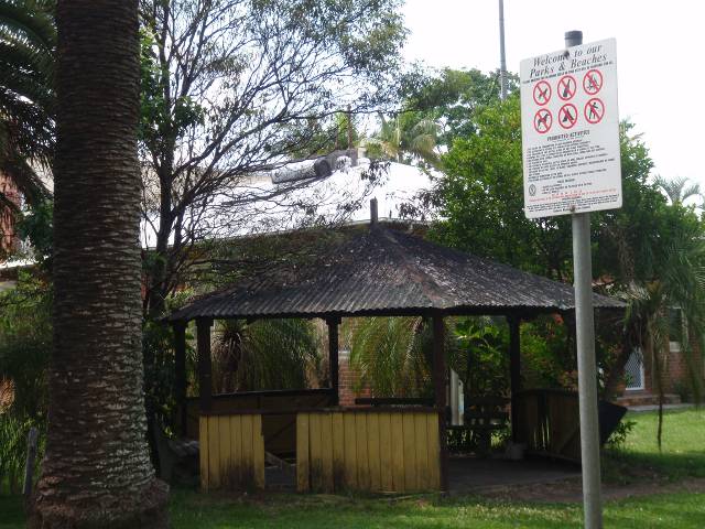
Figure 1: Vacant rotunda
at Tincogan Street Mullumbimby (25/1/2012)
In September 2011 Mullumbimby Police had cause to attend the
rotunda and speak with the male occupants who had made the rotunda their
temporary place of residence. The report from the Mullumbimby Police officers
included graphic detail about the state of the structure, including waste and
rubbish in and around the rotunda. As a result the police officers
observations, a complaint was made to Council about the serious public health
concerns. Council’s Environmental Services team was delegated to investigate
and report to Manager Governance and the Executive Team.
A subsequent inspection of the rotunda on 19 September 2011
found a single male person living in the structure. The sides of the rotunda
had been fully enclosed by fabric and a number of personal items were located
within the structure, and around the outside of the rotunda. There was no
kitchen, toilet, shower or washing facilities available. The area around the
rotunda smelt, with the site in general, being observed as unsightly and
unhealthy as a result of the occupation.
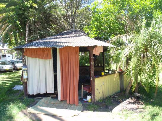
Figure 2: Rotunda occupied
by individuals cause complaints to Council and Police
A review of the history of the construction and use of the
rotunda was undertaken including a search of Councils’ records, a review of
‘heritage’ listed items, advice from the Brunswick Valley Historical Society,
and discussions with elderly members of the Mullumbimby community. There was no
information about when the rotunda was constructed, and whether the structure
was associated with any special community purpose.
Over the last year or so, Council and Mullumbimby Police
have received numerous complaints from the community objecting to people
occupying and living in the rotunda.
Police and Council Rangers concur that the issuing of
penalties to homeless people who have no money, and no formal residential
address is an effective enforcement tool. When such individuals cannot pay the
penalties, the courts will not take enforcement action. All that is achieved is
making individuals angry and generating confrontations which may result in
physical harm to individuals.
Despite the presence of the regulatory signs, enforcement of
signposted restrictions by NSW Police or Council Rangers is not considered to
be possible nor practicable.
Since September 2011 there have been a number of customer
requests each demanding that Council should not allow this unhealthy and
unsightly situation to continue.
The complaints originated from a broad cross section of the
Mullumbimby community. From the elderly residents concerned for their personal
safety and their grand children using the Park, NSW Police, business owners
such as the Mullumbimby Ex-Serviceman’s Club whose customers have to experience
the intrusion of the unsightly structure and the inhabitants, members of the
CWA who use the nearby hall and users of the Mullumbimby Civic Hall. See Confidential
Annexure 19.
Many complainants alleged that they had raised the issue
repeatedly with councillors over previous years, but were very upset that
nothing has been done to rectify this unhealthy and illegal use of the public
reserve.
Since the occupants were advised about complaints from the
community the structure has been empty and unoccupied.
The options considered before coming to the final
recommendation:
1.
Removal of all or part of the corrugated metal roof to make the
structure uninhabitable, but keeping the remaining seating for public use. This
option was unfunded, and was assessed to cause the deteriorated timber
structure to become unstable and hasten the collapse of the structure.
2.
Fully enclosing the rotunda and it thereafter being locked to access
after hours. The structure was assessed to be so poorly constructed so as to
prevent the securing of the structure to exclude access after hours. The costs
of such works were considered to be more than Council would fund for such a
small community structure.
3.
Total demolition of the corrugated metal roof and timber walls and
seats, and removal of the concrete slab. All waste material to be disposed of
at the Myocum landfill site, and the site dressed and turfed.
Financial Implications
A quote from Council staff advises that the cost of
demolishing the rotunda and depositing the waste at Myocum Landfill depot would
be at least $2,000. No budget currently exists for this work but it is proposed
to include provision of $2,000 in the December 2011 Quarterly Budget Review.
In addition, some complainants requested that after the
rotunda is demolished, that Council should erect a children’s playground on the
park. The estimated cost of the most basic children’s play equipment
($10,000+), a ‘soft fall’ area ($4,000), surrounding fence ($3,000) and shade
structure over the equipment ($5,000) places this request at a minimum value of
$22,000. No budget exists for this work. The close proximity to Tincogan Street is the reason that a barrier fence would be required if the site was used
for a children’s playground.
Statutory and Policy Compliance Implications
The rotunda is in a poor structural condition which has not
been enhanced by the occupation by transient individuals.
The current situation is that nobody is occupying the
rotunda, and on this basis no assessment has been made of any costs to relocate
‘homeless’ individuals.
In any event Councils’ Homelessness Policy (08/106) includes
advice that “primarily homelessness is a result of ineffective macro economic,
housing and social policies that are the responsibility of State and
Commonwealth governments”. The Rotunda as a structure is not considered as
being “safe, secure and appropriate” and is not therefore an appropriate place
for consideration within the ambit of the Policy.
It is at the request of members of the Mullumbimby community
that the rotunda be demolished to prevent individuals drinking, fighting,
disturbing the neighbours, threatening children and causing a general public
health and safety hazard.
The community would like council to replace the rotunda
structure with purpose-built children’s play equipment.
ENVIRONMENT
AND PLANNING – EXECUTIVE MANAGER’S REPORTS
Executive Manager: Environment and Planning
File No: PLN657900 #1186651
RECOMMENDATION:
That Council note the Byron Shire
Corporate Greenhouse Emission and Energy Consumption Status Report 2010/11 (Annexure
26, #1075732).
Attachments:
·
Byron Shire Corporate
Greenhouse Emission and Energy Consumption Status
Report 2010/11 #1075732 [7 pages]................................................................................... Annexure
26
Report
At the Ordinary
Meeting of Council on 10/2/11 Council resolved:
11-11:
1. That
Council develop a Corporate Greenhouse Emission and Energy Consumption
Reporting process that will be reported to Council’s Executive Team, staff and
Councillors on a biannual basis.
2. That
Council adopt a revised corporate greenhouse emission reduction target of a
minimum 30% reduction in greenhouse gases below 2003/04 levels by 2020.
3. That
Staff report back to the Committee on initiatives to reduce fuel consumption
and energy use and consider the long term management of Council owned buildings
to reduce the need for air-conditioning.
4. That
each division of Council develop long term sustainability goals and targets to
recognise investment in sustainability, including energy consumption and
reductions, over a 20 year period, to inform decision making.
This report replates to part 1 of the above resolution. Accordingly,
Council’s Sustainability Officer has prepared a ‘2010/11
Byron Shire Corporate Greenhouse Emission and Energy Consumption Status Report’ (Annexure 26). This report was presented to Council’s Executive
Team on 20/09/11 and has been summarised below.
1. Greenhouse Performance:
Council has adopted a revised corporate greenhouse
emission reduction target of: a minimum 30% reduction in CO2
emissions below 03/04 levels by 2020 (Res. 11-11). This equates to a
minimum target of 5,167 tonnes of CO2e by 2020.
During the 2010/11 period, Council produced 7,388 tonnes of CO2e.
This represents a negligible change compared to the previous year, but
is significantly higher than the 2010/11 projected target of 6,422 tonnes
of CO2e required to meet Council’s 2020 corporate emissions target.
Graphs 1 and 2 (below) show that whilst emissions have stabilised over the
2010/11 period, Council is not on target to achieve its adopted corporate
emissions target by 2020.
Graph 1. Byron Shire Corporate Emissions Tracking Graph

Graph 2. Byron Shire Corporate Emissions Profile
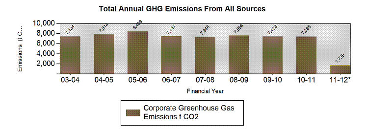
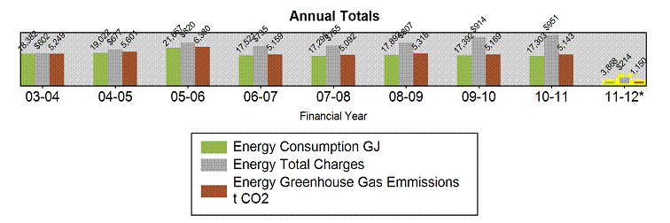 2.
Energy Performance:
2.
Energy Performance:
While corporate electricity consumption and greenhouse emissions appear
to have stabilised, energy costs have significantly increased (by
approx. $37,000) over the 10/11 period (excluding street lighting), due
to increases in the cost per unit of electricity (Graph 3).
Graph 3. Byron Shire Corporate Emissions Tracking Graph (excludes street lighting)
* 1 Gigajoule (GJ) = 277.7 KWh
3. Anomalies Reporting:
To build a more systematic and accountable approach to
monitoring Council’s corporate energy consumption, each Council facility has
been assigned by Division. In instances where a significant change in energy
consumption has occurred within a reporting period (compared to the same
quarter in the previous year), the anomaly has been documented and provided to
the responsible EM for review and explanation to increase the efficiency of
Council operations.
The last review of anomaly accounts was conducted in
September 2011 and sought the following commentary for accounts denoting
>25% increase in energy consumption (Table 1).
Table
1 – Anomaly Accounts for Investigation
Accounts showing significant increase
in consumption compared to the same quarter in previous year.
Period: April - June 2011
|
Responsibility
|
Account Name
|
Meter No.
|
% increase
|
kWh increase
|
Explanation?
|
Action? (if any)
|
|
Water and Recycling
|
SEWERAGE PUMP
STATION, KIAH CLOSE
|
NFFFAA12975
|
37%
|
11,595
|
No response received
|
|
|
Water and Recycling
|
OLD PACIFIC HWY , BRUNSWICK HEADS, (TREATMENT PLANT)
|
46003680
|
1,387%
|
4,383
|
No response received
|
|
|
Water and Recycling
|
SEWERAGE PUMP
STATION, ANN STREET
|
44071804110
|
33%
|
1,336
|
No response received
|
|
|
Water and Recycling
|
SEWERAGE PUMP STATION,
SUFFOLK PARK CARAVAN PARK
|
44071856935
|
329%
|
1,244
|
No response received
|
|
|
Community
Infrastructure
|
SOCCER GROUND, BRUNSWICK HEADS
|
44071862783
|
25%
|
319
|
Previous account was for 69
days period versus 91 days. Daily average consumption rose from 15.12 kWh to
17.42 kWh (approx 15% increase)
|
No action required
|
4. Abatement Action Recorder:
The following emission abatement actions have been
documented as contributing towards Council’s 2020 corporate emissions target
(Table 2).
Table 2 – Abatement
Actions
|
Abatement Action
|
Action Date
|
Annual Energy Saving
|
Annual Dollar Saving
|
Annual Co2
Saving
|
Payback Period
|
|
Lighting
efficiency retrofit of Council admin centre
|
March 2011
|
53 MWh
|
$14,000
|
57 tonnes
|
3.5 years
|
|
5kw solar system
install at Brunswick Valley Community Centre
|
September
2010
|
7.7 MWh
|
$4,600
|
7.5 tonnes
|
5 years
|
|
10kw solar
system install at Myocum Landfill
|
June 2011
|
15 MWh
|
$9,000
|
16 tonnes
|
6 years
|
|
Solar hot water
retrofit of community buildings (5 systems), incl. Ocean Shores, Brunswick
Valley & Suffolk Park Community Centre, Mullum Neighbourhood Centre and Depot.
|
September 2011
|
(7 - 48 kWh x 5)
137 kWh
|
($160 - $1,000 x 5) $2,900
|
(1 - 5 tonnes x 5) up to 15 tonnes
|
8 years
|
|
Streetlight
upgrade
|
December 2011
|
387 MWh
|
$126,000
|
410 tonnes
|
1 year
|
Financial Implications
No costs identified as a direct result of this report.
However, the report suggests greater investment in energy mitigation
initiatives is required.
Statutory and Policy Compliance Implications
The report indicates that Council is not on-track to meet
its adopted greenhouse reduction target, as per Res 11-11. Furthermore,
over the 2011/12 period, Councils emissions are expected to increase
with the operation of the Byron Regional Sporting Complex and Valances Road
Sewerage Treatment Plant.
Executive Manager: Environment and Planning
File No: PLN360100 #1173715
|
Principal Activity:
|
Environment and Planning
|
|
Summary:
|
This report analyses the biological and physical impacts,
cost and logistical issues associated with the Trial Beach Scraping Episode, New Brighton Beach and makes subsequent recommendations regarding a future beach
scraping program at this location. The trial commenced in the latter half of
2010 and was conducted under the Natural Disaster Resilience Program with
funding from the State and Commonwealth Government as well as Council.
|
RECOMMENDATION:
1. That
Council note that, overall, the Trial Beach Scraping Episode at New Brighton Beach
reduced coastal hazard threat by increasing dune volume and resulted in minimal
environmental harm, but that the works were not sufficient to fully offset
coastal hazards and /or future climate change and that such works are unlikely
to be a long term coastal management solution at this location.
2. That Council commences the implementation of a
beach scraping program at New Brighton in 2013/2014 to attempt to maintain,
in the short term, a preferred dune profile, volume, beach accessibility and recreational
amenity; noting that:
a) the
proposed program will not remove the immediate coastline hazard threat to
infrastructure and private property from a design storm event (100 year ARI),
but is likely to modestly reduce the severity of this threat;
b) adequate
funding arrangements need to be established, as such a further report is to be
tabled for Council’s consideration, by no later than October 2012, canvassing
options for funding the program including the option to apply for a special
rate increase;
c) prior
to the implementation of any scraping works, it needs to be established that
appropriate physical conditions are met;
d) each
beach scraping episode is to be accompanied by a scientifically robust physical
monitoring program, similar to that implemented during the Trial Beach Scraping
Episode at New Brighton; and
e) an
adaptive management approach is to underpin the program, and will be used to inform
the ongoing viability of the works as well as other issues such as the scheduling
of works and amount of sand to be scraped each episode.
Attachments:
·
The Effects of Beach Scraping on
the Infauna of New Brighton Beach, Northern NSW
#1159025 [35 pages]..................................................................................................... Annexure
36(a)
·
New Brighton Beach Scraping
Trial: Analysis of Dune and Beach Profile Data
#1187097 [83 pages]..................................................................................................... Annexure
36(b)
Report
Background
At the Ordinary Council meeting of 17 December 2009, Council
resolved:
09-1159 Resolved:
1. That Council note the attached technical report “Development of a
Proposal and Environmental Assessment of Beach Scraping – New Brighton and South Golden Beach” [Annexure 5(a) #914162].
2. That Council resolve to further the progression of a trial beach
scraping episode for the New Brighton Beach compartment (and note that Council
has previously undertaken this work with a degree of success in the past) as
proposed in Section 12.9 of Annexure 5(a) by:
a) Undertaking Significance Assessments in accordance with Table
6.1 in Appendix A of Annexure 5(a), to be funded under existing Coastal and
Estuary budget (#2606.012).
b) Seeking relevant state government approvals for beach scraping
works at New Brighton and South Golden Beaches as per Section 1.3 in Appendix A
of Annexure 5(a) by:
i. Developing and lodging a Preliminary Project Application report
for submission to the Minister for Planning to decide whether the project would
be assessed under Part 3A of the Environmental Planning and Assessment Act,
1979.
ii. Subject to the advice of the Minister for Planning, that
Council proceed with seeking relevant approvals for the undertaking of beach
scraping works.
3. That subject to completing relevant environmental assessments and
gaining approvals for beach scraping works, Council resolve to consider a
report on the findings of the required environmental assessment(s) and status
of approvals for undertaking beach scraping.
4. That Council consider allocating the full funding for a trial
beach scraping episode at New Brighton Beach of $130,800 from the 2010/11
budget, with a funding application to DECCW Coastal Program to recover half the
costs, in accordance with the recommendation under Section 12.9 of Annexure
5(a).
- That Council provide a
report on the potential for cost sharing for the beach scraping strategy.
- That Council receive
further information on the historical reports on beach scraping and
evidence of positive or negative impacts.
At the Ordinary Meeting of 8 April 2010, Council resolved:
10-203 Resolved:
1. That Council endorse staff to prepare and lodge a funding
application with the NSW Natural Disaster Resilience Grants Scheme by 16 April
2010 to seek funding to undertake a trial beach scraping episode at New
Brighton Beach in accordance with Resolution 09-1159 and Section 12.9 of the
technical report “Development of a Proposal and Environmental assessment of
Beach Scraping – New Brighton and South Golden Beach”, as previously reported
to Council.
2. That in progressing towards a trial beach scraping episode for
New Brighton Beach in accordance with resolution 09-1159, staff provide a
report to Council prior to June 2010 on the approval status of the proposed
beach scraping activity in accordance with Part 3 of Resolution 09-1159, so
that Council may withdraw or maintain its funding application with NDRGS under
consideration of the approval status and/or other project complexities.
3. That subject to the success of the funding application lodged in
accordance with Part 1 above, and completion of Part 2 above, Council allocate
their required 1/3rd funding of $43,600 from the 2010/11 Local Growth
Management Strategy budget (job no. 2605.062) to undertake the trial beach
scraping project.
4. That should Council be unsuccessful in its funding application to
the Natural Disaster Resilience Grants Scheme, Council continue to seek funding
through any other relevant state or federal funding programs in accordance with
Resolution 09-1159.
On 12 August 2010, Council
resolved:
10-612 Resolved:
1. That Council note the Summary Report (Annexure 14) and endorse
the Review of Environmental Factors [Appendix C, Annexure 14 #990879].
2. That Council proceed with undertaking a trial beach scraping
episode at New Brighton Beach subject to Council receiving by the 12 August
2010:
a) final approval from NSW Department of Industry and Investment.
b) offer of funding from the Natural Disaster Resilience Grants
Scheme (NDRGS).
3 That if Council is successful with the NDRGS funding application,
Council allocate an additional $29,700 from the 2010/11 Local Growth Management
Strategy Budget (job no. 2605.062), in addition to $43,600 allocated in
accordance with resolution 10-203 Part 3 (subject to success of NDGRS funding)
for the trial beach scraping episode at New Brighton Beach.
4. That subject to Part 1, 2 and 3 above, Council implement the
trial beach scraping episode at New Brighton Beach as per Table 3 of this
report [further described in Annexure 14] and as itemised as follows:
a) Implement the biological monitoring program.
b) Inform community of works via media release and notices.
c) Engage ecologist to undertake daily inspections of works site to
assess presence/absence of bird and/or turtle species.
d) Engage coastal engineer to supervise first 2 days of scraping.
e) Scrape the designated work site to a depth of approximately 0.2m
to place approximately 8m3/m to 16m3/m of sand against the erosion escarpment
at New Brighton Beach.
f) Implement the physical survey program to assess dune volume
change and beach profile change and response.
g) Implement dune rehabilitation
5. That trial beach scraping works do not proceed beyond 30
September 2010 under recognition of potential for impact to migratory species.
6. That Council receive a further report following any trial beach
scraping episode at New Brighton Beach, analysing the biological and physical
impacts, and the cost and logistic issues associated with the works.
In accordance with resolution 09-1159 (Part 5) and
resolution 10-612 (Part 6), this report provides a summary of the biological
and physical impacts, cost and logistic issues, including the potential for
cost-sharing arrangements to fund any future works, associated with the Trial
Beach Scraping Episode at New Brighton Beach.
Project Summary
In accordance with resolution 10-612, Council implemented
the ‘Trial Beach Scraping Episode at New Brighton Beach, Byron Shire NSW’ in
the latter half of 2010. This trial was conducted under the Natural Disaster
Resilience Grants Scheme (through Emergency Management NSW) with funding from
the State and Commonwealth Government ($87,200) as well as Council ($73,300,
however Council’s funding contribution was $43,600 as per funding agreement).
As reported to Council on 12 August 2010 (Report No.
12.16.), the objectives of the trial were to:
1. Reduce
the severity of the immediate coastline hazard threat to infrastructure (roads
and services) and private property along New Brighton Beach.
2. Provide
data to allow analysis to determine the impacts (positive and negative) of
beach scraping so that Council may consider the viability of beach scraping
over the short to medium term.
Noting that the proposed trial beach scraping would not
remove the immediate coastline hazard threat to infrastructure and private
property at New Brighton Beach, but is likely to modestly reduce the severity
of this threat.
The trial involved seven components which are outlined in
Table 1. (The rationale for each of these project components was reported to
Council on 12 August 2010 (Report No. 12.16).
Table 1 Summary of the main components of the Trial Beach
Scraping Episode
|
#
|
Component
|
Description
|
|
1.
|
Beach scraping Works
|
During September 2010, 12-16m3/m of sand was mechanically
removed from between the high and low water mark (intertidal zone) of New Brighton Beach and deposited on the crest and seaward face of the foredune. Scrape
depth was generally in the order of 0.2 - 0.3m (acknowledging normal operator
inconsistency). The works took place over a 1.3km stretch of the beach.
|
|
2.
|
Coastal engineer supervision
|
In the early stages of the scraping works, a coastal
engineer was engaged to supervise scrape depth, placement technique and
scraped volume; ensuring the works followed the agreed methodology and best
practice.
|
|
3.
|
Ecological supervision
|
During the scraping works, an ecologist was engaged to
undertake beach inspections, monitor for the presence of threatened fauna and
other significant ecological values, and recommend adaptive management
strategies to minimise any potential impacts.
|
|
4.
|
Approvals process and community consultation
|
Further details on approvals in the ‘Statutory and Policy
Compliance Implications’ section
Prior to the works, notices were placed at New Brighton
General Store and South Golden Beach General Store, media releases were
distributed before (20/08/10), during (03/09/10) and after the on-ground
works (23/12/10).
As part of Dunecare week, the Coastal and Estuary Officer
delivered a presentation on the beach scraping works (07/12/10).
|
|
5.
|
Biological monitoring and evaluation of the effect of the
works on beach infauna
|
The National Marine Science Centre (Southern Cross
University) was commissioned to monitor and report on the impact of the
scraping works on the biodiversity and abundance of beach infauna
(specifically on the macrofauna inhabiting the beach matrix of the intertidal
region).
|
|
6.
|
Physical beach monitoring and analysis of the effect of
the works on dune and beach profile and volume
|
Council staff conducted regular surveys of the beach and
dune profile at New Brighton, before and after the scraping works. The Water
Research Laboratory (University of New South Wales) was commissioned to
analyse and evaluate the survey data with respect to the objectives of the
scraping works.
|
|
7.
|
Dune rehabilitation works
a)
beach accesses
b)
revegetation
|
Eight beach accesses were re-shaped, stabilised and formalised
by Council’s outdoor staff (re-shaped, fenced with post and wire and
shadecloth).
The scraped foredune was re-vegetated by an EnviTE team
and a private contractor, with some volunteer involvement. Re-vegetation
methods involved planting native coastal species using locally sourced seed
and cuttings.
|
Logistical issues and considerations
The logistical issues encountered and lessons learnt during
the beach scraping trial are detailed in Table 2 below, which also details
recommendations for consideration should Council determine to implement a beach
scraping program in the future. This analysis excludes financial issues as they
are detailed in the ‘Financial Implications’ section.
Table 2 Logistical issues encountered, lessons learnt and
recommendations
|
#
|
Logistical Issue
|
Lessons learnt
|
Recommendation for any future works
|
|
1.
|
Seasonal factors and timing of works
|
|
a)
|
Beach building season
The optimum time to implement beach scraping works is
during the ‘beach building season’. In this region this occurs during the
second half of the year (i.e. spring and summer).
|
Two relatively un-seasonal large easterly swells were
experienced, in combination with high spring tides, immediately after
completion of the beach scraping works. As beach scraping, by function,
brings about a lowering of the intertidal beach profile, in this condition
the impact of the two swell events on the back beach area was intensified and
resulted in a significant loss of scraped sand at certain locations
|
Adopt September as the ideal month to undertake works due
to the normally relatively low swell regime and somewhat suitable average
beach building wind conditions. Noting however that unseasonal events may
still occur.
|
|
b)
|
Impacts on migratory birds
To avoid negative impacts on migratory species such as
turtles and birds, the beach scraping works were not considered appropriate
for implementation during October through to early autumn.
|
No migratory species detected, timing of works minimised
impacts.
|
Avoid the period October – April for implementation of
works.
|
|
2.
|
Ecological Monitoring
|
|
a)
|
Intertidal macrofauna
The report on the ecological monitoring program (Smith et
al, 2010) is at
Annexure 36(a).
Note the biological monitoring surveyed the intertidal
zone only and did not include the beach area above the high water mark.
Impacts to diversity and abundance of beach fauna inhabiting the upper beach
zone (e.g. crabs etc) were not therefore assessed.
|
In summary, the report (Smith et al, 2011) found:
·
The study failed to detect clear impacts as a result of beach
scraping on the biodiversity and assemblage patterns of beach infauna in the
inter-tidal zone (macrofauna as retained on a 1mm2 sieve).
·
The primary reasons for the lack of impact were related to the
high energy wave environment and natural levels of dynamism at New Brighton Beach, and that deposition of scraped sand did not cause major changes to
beach granulometry (size distribution of sand grains).
|
Were a beach scraping program to be implemented
occasionally/intermittently/annually using a similar methodology to the
trial (e.g. scrape depth, volume of sand scraped, timing of works), it is
highly likely that impacts on inter-tidal macrofauna would be minimal, as
such a monitoring program on the ecological impact in the intertidal zone would
not be considered necessary.
As per statutory obligations, beach scraping works should
be implemented with regard to the recommendations contained in a
comprehensive Review of Environmental Factors.
|
|
b)
|
Ecological supervision
An ecologist was engaged to undertake morning beach
inspections, monitor for the presence of threatened fauna and other
significant ecological values, and recommend adaptive management strategies
to minimise any potential impacts.
|
During the works, two sites of nesting Pardalotes were
detected by the ecological supervisor. The ecologist recommended creating a
buffer zone around the nesting site and, as a result, disturbance of the
nesting site was minimised
|
Engage an ecological supervisor during the works to
minimise impacts using an adaptive management approach.
|
|
3.
|
Availability of intertidal sand
|
|
|
The availability of sand for scraping in the intertidal
zone is a function of the depth of sand to be scraped (which is generally a
maximum of 0.2 -0.3 m as a result of biological considerations) and the width
of the intertidal zone (as determined by beach slope and tidal regime at the
time of scraping).
|
Tidal or beach slope factors may render it difficult to
achieve the desired volume of sand per lineal meter of beach during one scraping
‘pass’ where the scrape depth is limited for physical and/or biological
reasons.
Given that only one month in 12 (i.e. September) is most
suitable for implementing the works, this limiting factor means that it would
be difficult to scrape more than 12-20 m3/m (volume scraped during
the trial) in any one year.
|
Additional time and cost is factored into the project to
account for the variability in the availability of intertidal sand.
Any future program assumes that, on average, 12m3/m
could be scraped in any one year.
|
|
4.
|
Physical Monitoring
|
|
a)
|
Physical Surveys
Council’s surveyors were engaged to conduct the beach and
dune surveys. This was for a number of reasons, including cost, maintaining
consistency of data collection and building internal capacity.
|
The 9 month survey was abandoned due to the survey team’s
work program and consideration of tides and weather conditions. This was not
a major issue as the 9 month survey was considered optional.
|
Engage Council surveyors to monitor the physical impacts
of the works, allow for flexibility in the monitoring program.
Engage a suitably qualified consultant to analyse this
data.
|
|
b)
|
Physical Impacts
The report analysing the physical impact of the beach
scraping works (Rayner et al, 2012) is at Annexure 36(b).
|
In summary, the report (Rayner et al, 2012) found:
·
Beach scraping reduced the coastal hazard at New Brighton by
increasing dune volumes, particularly in the upper dune (above 3.5m AHD),
which increased the volume of sand available to meet the immediate storm
demand hazard and also reduced the likelihood of overtopping.
·
Over the study period the scraped extent of the beach
experienced an average increase of 20m3/m or a 9 per cent increase
in volume of sand available to meet the immediate design storm demand. This
volume is, however, 40 per cent of the volume required to remove assets such
as The Esplanade from the immediate hazard zone.
·
The sand removed from the intertidal zone had been naturally
replenished, for the majority of the scraped extent, before the 3 month
post-scrape survey.
·
Sand placement method could be improved to create a slightly
higher and wider dune, subject to physical conditions scraping would be
applicable as a long term measure to raise dune crests and prevent
overtopping.
·
The scale of beach scraping is unlikely to be sufficient to
fully offset coastal hazards and/or future climate change. Beach scraping at New Brighton causes minimal harm, but may not be a long term coastal management solution.
|
Implement a beach scraping program at New Brighton with
the objective of maintaining, in the short term, a preferred dune profile,
beach accessibility and recreational amenity; noting that the program is
likely to result in a modest reduction in the severity of the immediate
coastline hazard threat to infrastructure and private property at New
Brighton, but will not remove this threat.
Any future beach scraping program should be informed by
scientifically robust data and analysis, and should be underpinned by an
adaptive management approach.
|
|
3.
|
Dune Rehabilitation Works
|
|
a)
|
Revegetation activities These included planting of
cuttings (Beach Spinifex, Goat’s Foot, Beach bean, Pig Face) and direct
seeding of species such as Coastal Acacia, Dianella.
Existing Beach Spinifex and cuttings were fertilised
during rain events.
|
Revegetation efforts were highly successful for the Beach
Spinifex plantings but largely unsuccessful for the other species.
Damage to plantings occurred after the works, this was
most pronounced during the school holiday period, with plantings trampled and
protective mulch deliberately burnt. Signage asking persons to keep off dunes
was installed following the revegetation works. A media release was released
in relation to this issue.
|
Small program of revegetation works should be implemented
with emphasis on stabilising foredune species, particularly Beach Spinifex.
Implement community and visitor education programs
including signage.
|
|
b)
|
Beach access
Formal beach accesses stabilised, signage placed regarding
keeping to beach accesses and staying off dunes.
|
Some trampling and damage to dune occurred with associated
minor loss of sand evident. Media release distributed on this issue,
requesting residents and visitors to stay off the dunes and keep to formal
paths.
|
Implement education program, community consultation,
signage and maintenance of beach access.
|
|
5.
|
Access arrangements for large equipment
|
|
|
The emergency vehicle access off North Head Road used as
the access for heavy machinery
|
Access adequate for the works. Machines were left on the
beach scraped dune overnight to avoid the long journey back to the North Head
Road Carpark.
Staff are not aware of any complaints being made regarding
the machines being left on the beach.
|
Use North Head Road access; inform community that vehicles
may be left on beach overnight.
|
Financial Implications (Trial Beach Scraping Episode)
The total budget allocated to the trial was $160,500. The
income breakdown for the project is detailed at Table 3.
Table 3 Income breakdown for Trial Beach Scraping Episode
at New Brighton Beach
|
#
|
Funding source
|
Amount
|
Resolution (where applicable)
|
|
1.
|
Emergency Management NSW
|
$ 87,200
|
|
|
2.
|
Council
|
$ 43,600
|
10-203, part 3
|
|
3.
|
Council
|
$ 29,700
|
10-612, part 3
|
|
4.
|
Total
|
$160,500
|
|
An approximate expenditure breakdown for the trial was
reported to Council on 12 August 2010 (Report No. 12.16, Annexure 14). These
figures have been extracted and compared to the actual cost of each project
component at Table 4. Further financial analysis is provided below.
Table 4. Estimated cost compared
to actual expenditure for key project components of the Trial Beach Scraping
Episode at New Brighton Beach
|
Item #
|
Project
component
|
Approximate
cost
|
Actual Cost (ex GST)
|
|
1.
|
Beach
scraping works
|
$58,000
|
$ 63,050
|
|
2.
|
Coastal
Engineer Supervision
|
$3,000
|
$ 5,046
|
|
3.
|
Ecologist
Supervision
|
$3,000
|
$ 3,360
|
|
4.
|
Approvals and Community
Consultation
|
Not
included in budget
|
$ 5,000
|
|
5.
|
Biological Monitoring
|
$60,000
|
$ 60,925
|
|
6.
|
Physical
(Dune) Monitoring
|
$27,500
|
$ 21,775
|
|
7.
|
Dune
Rehabilitation Works
|
$9,000
|
$ 8,001
|
|
8.
|
Total
Cost
|
$160,500
|
$167,157
|
|
9.
|
Budget
|
|
$160,500
|
|
10.
|
Balance
|
|
($
6,657)
|
Unit cost of the beach scraping works
At the Ordinary Meeting of 12 August 2010, the beach
scraping proposal developed by Carley et al (2010) was tabled at
Annexure 14. The proposal assumed a unit cost for scraping works of $7 per m3,
however it was recognised that this could range from $2 - $10 per m3.
Analysis of the costs associated with the trial beach scraping episode reveals
that the unit cost was approximately $3 - $4 per m3,
excluding physical and biological monitoring as well as supervision. This unit
cost is in the lower half of the range referred to by Carley et al
(2010).
Beach scraping works overspend
The beach scraping works’ budget was $58,000 and this was overspent
by approximately $5,000. The coastal engineer supervision was also overspent by
$2,000. The majority of this overspend was offset by savings made in the
Physical (dune) Monitoring (Table 4, #6) as a result of abandoning the 9 month
beach survey.
Although the over-spend is a relatively small amount, it
reflects the difficulty in estimating costs for non-routine works that are
subject to a wide range of natural variables, for example swell and tidal
conditions which may affect the availability of intertidal sand and/or slow the
progress of works on any given day. For any future beach scraping works, it is
recommended that a 10 per cent contingency be incorporated into the budget.
It was noted whilst the scraping works were being
undertaken, that there may be opportunity to reduce the unit cost of the works
further by employing a different configuration of earth moving equipment. It
is recommended that this is investigated further should beach scraping works be
undertaken by Council in the future.
High monitoring costs
The expenditure summary reveals that apart from the scraping
works themselves, the most costly components of the trial were the monitoring
and evaluation programs (Table 4, items #5 and #6). This monitoring and
evaluation expenditure was an important component of the trial and has provided
invaluable information for the consideration of a future program of works. It
is unlikely, however, that this magnitude of expenditure on monitoring and
evaluation would be required for any such future works, although this will be
dependent upon statutory requirements.
Outcomes Achieved
In relation to project objectives, the Trial Beach Scraping
Episode at New Brighton Beach achieved the following outcomes:
Objective 1: Reduce the severity of the immediate
coastline hazard threat to infrastructure (roads and services) and private
property along New Brighton Beach.
Noting that the proposed trial beach scraping would not
remove the immediate coastline hazard threat to infrastructure and private
property at New Brighton Beach, but is likely to modestly reduce the severity
of this threat.
Outcome: The physical monitoring program concluded
that the trial resulted in a reduction in the severity of the immediate
coastline hazard threat along the 1.3 km stretch of New Brighton Beach. The scraping works resulted in increased dune volumes, particularly in the upper dune
(above 3.5m AHD), which increased the volume of sand available to meet the
immediate storm demand hazard. The increased upper dune volume also reduced the
likelihood of wave overtopping. The average increase of 9 per cent available to
meet the storm demand was modest in nature when compared to the design storm
demand of 220m3/m. This volume is, however, 40 per cent of the additional
volume required (based on the dune volume as assessed by WRL (2010) in 2009) to
remove assets such as The Esplanade from the immediate hazard zone.
Objective 2: Provide data
to allow analysis to determine the impacts (positive and negative) of beach
scraping so that Council may consider the viability of beach scraping over the
short to medium term.
Outcome: The trial increased the internal capacity of
indoor staff regarding implementing beach scraping as a coastal hazard
reduction strategy, resulting in a deeper understanding of the positive and
negative impacts of beach scraping works and the capability of such works to
reduce coastal hazard risks. The trial also increased the capacity of staff
involved in the physical and ecological monitoring programs regarding
developing and carrying out scientifically rigorous monitoring and the
importance of using an adaptive management approach to such works. The capacity
of outdoor staff was increased regarding the operational aspects of beach
scraping and potential logistical issues as a result of working in a dynamic
environment. A summary of the lessons learnt is at Table 2, these lessons have
been used to develop a recommended future beach scraping program.
Other outcomes achieved:
In addition to achieving the above two objectives, the beach
scraping trial achieved the following:
·
Maintenance of the reconstructed dune system at New Brighton Beach and increased beach amenity and improved beach access arrangements, particularly
with reference to the damage incurred to the dune system as a result of the May
2009 event.
·
Community engagement and increased awareness of coastal
management issues and strategies.
Recommendation for a future beach scraping program at New
Brighton Beach
Given the outcomes that were achieved through the Trial
Beach Scraping Episode at New Brighton Beach, it is recommended that a beach
scraping program is implemented at New Brighton to maintain, in the short term,
a preferred dune profile, volume, beach accessibility and recreational amenity;
noting that the proposed beach scraping program would not remove the immediate
coastline hazard threat to infrastructure and private property at New Brighton
Beach, but is likely to modestly reduce the severity of this threat.
In order to achieve this objective, beach scraping works
would ideally be scheduled during September, if and when physical conditions
are appropriate, with approximately 12-20 m3/m scraped each episode.
The figure of 12-20 m3/m has initially been nominated as it is based
on the estimated minimum scrape volume that was achieved during the trial over
a two week period; as such this figure seems realistic in terms of the
availability of intertidal sand during a scraping episode over a four week
period (this logistical consideration is discussed in Table 2). As per the
recommendation in Rayner et al (2011), the beach scraping works would
consider a placement methodology that created a slightly higher and wider dune
in order to raise dune crests and hence reduce the risk of overtopping.
With reference to figures quoted in Carley et al
(2010), 12-20 m3/m per episode, on a generally annual basis, is
likely to allow for the acceleration of natural beach recovery processes at New
Brighton and hence should maintain a preferred dune profile, volume, beach
accessibility and recreational amenity in the short term. As, according to
Carley et al (2010) an estimated scrape volume of 50m3/m
initially is required to be scraped to ameliorate the present day erosion
hazard from a design storm, which then needs to be maintained by an approximate
8m3/m per year, it can be appreciated that a scrape volume of 12-20
m3/m per episode is likely to provide only a modest reduction in the
severity of the immediate coastline hazard threat to infrastructure and private
property.
Given the dynamic and often unpredictable nature of the
coastal environment, it is further recommended that each scraping episode is
accompanied by a scientifically robust physical monitoring similar to that
implemented during the trial and with guidance from the methodology recommended
by Carley et al (2010). The physical monitoring would underpin an
adaptive management approach to the beach scraping works, with data and
analysis informing such issues as the viability of the works, scheduling of
scraping episodes and the volume of sand to be scraped each episode.
Financial Implications (potential future beach scraping
program)
Approximate budget per scraping episode:
An approximate budget has been calculated for the beach
scraping works, at Table 5. This budget assumes the following:
·
that 12m3/m of sand will be scraped over 1.3 km and
that the works will cost $4.04/m3 (figure derived from the trial),
·
that an ecological monitoring program will not be required but
that an ecological supervisor will be engaged during the works,
·
that a coastal engineer supervisor will not be required but that
assistance from an appropriately experienced professional from the Office of
Environment and Heritage will be available and will provide advice to an
experienced works overseer to ensure that an appropriate beach scraping
methodology is followed, and
·
that project management costs, specifically the cost of engaging
an appropriately qualified person to perform such tasks as prepare funding
applications, liaise with government agencies, gain approvals, consult with the
community, liaise with the Works Manager, oversee the monitoring program, are
already budgeted for and are incorporated into existing staffing costs.
Given these assumptions are met, approximately $112,000
would be required to fund each beach scraping episode.
Table 5: Approximate budget per scraping episode (12m3/m over 1.3 km at $4.04/m3)
|
#
|
Description
|
Approximate Cost
|
|
1.
|
Scraping works
|
$ 63,000
|
|
2.
|
Ecological supervision
|
$ 3,500
|
|
3.
|
Physical monitoring
|
$ 20,000
|
|
4.
|
Approvals
|
$ 5,000
|
|
5.
|
Re-vegetation
|
$ 5,000
|
|
|
Subtotal
|
$ 96,500
|
|
|
10 per cent contingency
|
$ 9,650
|
|
|
TOTAL
|
$ 106,150
|
Grant funding
Funding for 50 per cent of the cost of any future beach
scraping works may be eligible under the Coastal Management Program
administered by the Office of Environment and Heritage (OEH). Council is
required to contribute at least 50 per cent of the funds required for any
project under this program (excluding administration costs and contingencies
which Council must fund 100 per cent).
The submission date for a grant under the Coastal Management
Program for 2012/13 is
28 February 2012. If a grant application were to be successful, these funds
would need to be expended over the ensuing 12-18 months.
Given the current high work load in the Coastal and Estuary
Work Program, largely as a result of preparing a coastal zone management plan
and commitments to other funded projects, it is not possible, under current
arrangements, for an additional project to be considered in 2012/13. As such,
if Council wishes to proceed with the beach scraping program in 2012/13 then
Council would not only have to commit 50 per cent of program costs (plus
contingency), which is approximately $57,900, but would need to fund the
administration costs associated with project management. This is estimated to
cost approximately $8,500 (grade 7.1 officer, employed for 2 days per week for
4 months), however may cost significantly more should engaging a suitably
qualified officer part time for a short term prove difficult and necessitate
engaging a consultant to manage the project.
Assuming Council was to be successful in applying for funds
under the Coastal Management Program, and OEH provided approximately $48,250 to
the program, the approximate cost to Council of undertaking a beach scraping
episode in 2012/13 (including administration costs and contingency), would be
approximately $66,400.
Council funding
There are currently no funds available under the 2012/13
budget to fund or part fund a beach scraping program.
Potential for cost sharing arrangements
If Council determine that a beach scraping program is to be
implemented at New Brighton Beach, then a cost-sharing arrangement with those
landowners deriving benefit from the works may be considered under section 495
of the Local Government Act 1993. This section provides that a council
may make a ‘special rate’ for or towards meeting the cost of any works provided
or undertaken, or proposed to be provided or undertaken, by the council within
a part of the council’s area on those rate payers benefiting from the work.
This rate may be differential, where a higher rate applies to land directly
benefiting from the works, with the amount of special rate determined according
to Council’s assessment of the relationship between the cost or estimated cost
of the work, and the degree of benefit afforded to the ratepayer by providing
or undertaking the work. Council may apply for a single year increase or a
multi-year increase (of between two and seven years).
In order to implement a special rate increase, Council would
be required to comply with an extensive approvals process. This process
includes submitting an application to the Independent Pricing and Regulation
Tribunal (IPART) for review, assessment and
determination under powers delegated by the Minister for Local Government.
The application is to be submitted in the December before the financial year
that the increase is proposed and in accordance with the Special Variation
Guidelines (Division of Local Government, Department of Premier and Cabinet,
2011). IPART assess special variation applications against the following
criteria:
·
demonstrated need for the rate increase
·
demonstrated community support for the special variation
·
reasonable impact on ratepayers
·
sustainable financial strategy consistent with the principles of
intergenerational equity
·
productivity improvements achieved and planned, and
·
implementation of the Integrated Planning and Reporting framework
As part of the application, Council must demonstrate
extensive community consultation and support for the proposed program of
expenditure and the resulting special variation.
Given that Council has resolved not to put in a special rate
increase for the year 2012/13 (res 11-1080), and the complexities and timing
issues associated with developing and implementing a special rate increase, the
earliest date at which a beach scraping program could be (part) funded under such
an arrangement is September 2013/14.
As the implementation of a beach scraping program would also
be highly difficult under current arrangements as a result of the high workload
in the Coastal and Estuary Work Program, it is recommended that, should a beach
scraping program be approved for New Brighton, then it commences in 2013/14,
and that a further report is tabled for Council’s consideration, by no later
than October 2012, canvassing options for funding the program including
applying for a special rate increase.
Coastal Protection Service Charge
Note that section 496B(1) of the Local Government Act
1993 also provides for the making and levying of an annual coastal
protection service charge (CPSC) on rateable land. However the levying of a
CPSC is unlikely to be appropriate for a beach scraping program at New Brighton as a CPSC can only relate to a service to:
1. maintain and repair coastal protection works, or
2. manage the impacts of coastal protection works.
It may be difficult to establish that beach scraping works
are coastal protection works, as the definition is “activities or works to
reduce the impact of coastal hazards on land adjacent to tidal waters and
includes seawalls, revetments, groynes and beach nourishment” (Local
Government Act 1993).
In addition, a CPSC can only be levied on rateable land
where either the current or previous landowner has voluntarily:
1. constructed or contributed to the cost of constructing
long-term coastal protection works, such as seawalls, that benefit
the land, or
2. agreed to pay the charge relating to works that existed
prior to the commencement of the Local Government Act 1993 amendments
that introduced this charge.
It is unlikely that landowners at New Brighton Beach fall into either of these two categories.
Statutory and Policy Compliance Implications
Approvals process for beach scraping works as per the
Trial Beach Scraping Episode
NSW State and Environmental Planning Policy
(Infrastructure) 2007 - works eligible as “Development permitted without
consent”
Crown Lands Act 1989 - license required from the Land
and Property Management Authority (LPMA) for the use and occupation of Crown Lands
under the Crown Lands Act 1989, with concurrence approval required from
the Department of Industry and Investment (fisheries).
NSW Environmental Planning and Assessment Act 1979 and
relevant legislation: (NSW) Threatened Species Conservation Act 1995 and
(Aus) Environmental Protection and Biodiversity Conservation Act 1999 –
a Review of Environmental Factors required.
National Parks and Wildlife Act 1974 (Aboriginal
heritage assessment) – determine if any registered objects or places of
cultural value are located at the works site, commission a search of the
Aboriginal Heritage Information Management System database, canvass and
advertise to relevant groups to determine if any objections or issues to the
works. No objections or issues were raised in relation to the trial, this is
likely to apply to an ongoing program.
Future considerations
If a beach scraping program were to be implemented over
several years and involve multiple beach scraping episodes, it may be possible
to obtain a Crown Lands licence to span the entirety of the program or that
allows for the works on an ‘as needs’ basis. A Review of Environmental Factors
would also need to be prepared that accurately reviews the nature/extent of the
program proposed. The REF may also be prepared so that it applies to a program
of works involving multiple beach scraping episodes.
Executive Manager: Environment and Planning
File No: PLN350500 x 3670 #1181315
|
Principal Activity:
|
Allocation of Section 94 funds.
|
|
Summary:
|
The purpose of this report is to seek a resolution of
Council to allocate funds from the Broken Head Hall section 94 carparking
fund to pay for the construction of a carpark at the hall.
|
NOTE TO COUNCILLORS:
In accordance with the
provisions of S375A of the Local Government Act 1993, a Division is to be
called whenever a motion for a planning decision is put to the meeting, for the
purpose of recording voting on planning matters. Pursuant to clause 2(a) under
the heading Matters to be Included in Minutes of Council Meetings of Council's
adopted Code of Meeting Practice (as amended) a Division will be deemed to have
been called by the mover and seconder of all motions relating to this report.
RECOMMENDATION:
1. That
subject to the satisfaction of point 2 that Council approve the expenditure of
up to $42,729.39 from the S94 fund for costs incurred by the Broken Head Hall
Committee Inc for the approval, design and construction of a 12 space car park.
2. That
prior to payment of any money authorised by point 1:
a) a
right of carriageway be established to benefit Byron Shire Council and the
public as authorised by Byron Shire Council on the servient tenement being over
the site of the carpark. The right of carriageway shall conform to the
requirements of item 1 of schedule 4A of the Conveyancing Act 1919.
b) a
restrictive covenant in accordance with section 88B of the Conveyancing Act
1919 be imposed on the land to the effect that:
i) The
cost of maintenance of the carpark is the responsibility of the owner of the
servient tenement; and
ii) The
carpark shall be maintained in good order.
c) the
contract issued for the construction of the carpark shall conform to the
requirements of Local Government Act 1993, Part 7 of the Local Government
Regulation 2005 and Council’s Policy No 2.6 Procurement And Purchasing. A copy
of the contract and documentation demonstrating compliance with the legislative
requirements shall be provided to Council prior to the commencement of works.
Attachments:
·
Letter from Broken Head Hall
Committee #1132095 [1 page].............................................. Annexure
7(a)
·
CONFIDENTIAL Brief for legal advice #1146327 [5 pages]................................................ Annexure
7(b)
·
CONFIDENTIAL Marsdens Legal advice #1159493 [13 pages]........................................... Annexure
7(c)
Report
The purpose of this report is to seek authorisation for the
expenditure of section 94 funds. The authorisation is sought in terms of
Clause 211 of the Local Government Regulation 2005. This Clause is set out as
follows:
(1) A
council, or a person purporting to act on behalf of a council, must not incur a
liability for the expenditure of money unless the council at the annual meeting
held in accordance with subclause (2) or at a later ordinary meeting:
(a) has approved the
expenditure, and
(b) has voted the money
necessary to meet the expenditure.
(2)
A council must each year hold a meeting for the purpose of
approving expenditure and voting money.
The Section 94 Plan -Broken Head was adopted by Council on
11 October 2005 and came into effect on 20 October 2005. The purpose of the
plan was to collect contributions from two developments identified in the Byron
Rural Settlement Strategy 1998. Both of these developments have been completed
and all of the contributions collected. The carpark was to be constructed by
Community Infrastructure and the expenditure of these collected contributions
was allocated in the 2010-11 budget. The works did not proceed due to staff
concerns about expending Council money on land that is not in the ownership of
Council and the vote subsequently lapsed. Council currently holds $42,729.39
for the purposes of carparking at Broken Head Hall.
The Broken Head Hall committee prepared a development
application DA 10.2010.584.1 for a carpark, disabled access and toilet
facilities, replacement deck and minor building works. This DA was approved on
12 January 2011. On 24 August 2011 the hall committee wrote to Council stating
it’s intention to build the carpark and seeking that the cost of the carpark be
reimbursed from the section 94 fund, Annexure 7(a).
Council’s section 94 officer wrote to the hall committee on
19 September 2011. The purpose of the letter was to advise that Council’s
section 94 officer was investigating options for the imposition of a public
positive covenant on the land and potentially a charge on the land in order to
ensure that assets funded by public monies remain available as a public
facility in perpetuity. The public positive covenant would enable the public
to access the carpark and the charge would ensure the repayment of the cost of
the construction of the carpark in the event of the sale of the land or removal
of the public positive covenant. Legal advice was sought on the ability to
impose such covenants and charges with a view to utilising this as a standard
mechanism to enable the flexible and secure expenditure of section 94 funds on
land that is not in Council’s ownership.
A copy of the brief for the advice and the legal advice is
provided as a confidential Annexures 7(b) and 7(c).
If Council wishes to discuss the confidential legal advice,
it is recommended that Council resolve to move into confidential session. If
that is the case, the motion could be along the lines:
1. That
pursuant to Section 10A(2)(g) of the Local Government Act, 1993, Council
resolve into Confidential Session to discuss CONFIDENTAL Annexures 7(b) and
7(c).
2. That
the reasons for closing the meeting to the public to further consider this item
be that it contains advice concerning litigation, or advice that would
otherwise be privileged from production in legal proceedings on the ground of
legal professional privilege.
3.
That on balance it is considered that receipt and discussion of the
matter in open Council would be contrary to the public interest, as it could
compromise the position of Council in current or future litigation and present
a risk to public funds.
Council has also written to the Division of Local Government
to seek a determination if the expenditure of section 94 funds is a public
private partnership (PPP) for the purposes of section 400B of the Local
Governments Act 1993.
If as expected the Division of Local Government advises
Council that the expenditure of section 94 funds at the Broken Head Hall is not
a PPP then it is proposed to reimburse the hall committee from the section 94
fund for the cost of the approvals process, design, and the construction of the
carpark up to the amount of $42,729.39.
If council resolves to proceed with funding the hall
committee to construct the works in the contributions plan then the hall
committee would have to conform to the requirements of the Local Government Act
1993, Part 7 of the Local Government Regulation 2005 and Council’s Policy No
2.6 Procurement and Purchasing.
Financial Implications
There should be no financial implications for Council as the
$42,729.39 section 94 funds are 100% apportioned to new development and no
matching funding from Council is required.
Statutory and Policy Compliance Implications
A restriction on the title will be required to ensure that
the works funded by section 94 are available to the public.
Expenditure of these funds will ensure that Council complies
with section 93E of the Environmental Planning and Assessment Act 1979.
The appointment of a contractor and the pricing of the work
for the construction of the carpark will have to conform to the requirements of
the Local Government Act 1993, Part 7 of the Local Government Regulation 2005
and Council’s Policy No 2.6 Procurement and Purchasing.
Executive Manager: Environment and Planning
File No: 237920 #1187202
NOTE TO COUNCILLORS:
In accordance with the
provisions of S375A of the Local Government Act 1993, a Division is to be
called whenever a motion for a planning decision is put to the meeting, for the
purpose of recording voting on planning matters. Pursuant to clause 2(a) under
the heading Matters to be Included in Minutes of Council Meetings of Council's
adopted Code of Meeting Practice (as amended) a Division will be deemed to have
been called by the mover and seconder of all motions relating to this report.
RECOMMENDATION:
That pursuant to
Section 80 of the Environmental Planning & Assessment Act 1979, development
application 10.2011.377.1 for
subdivision to create eleven lots and balance lot, be granted consent subject
to the conditions of consent in Annexure 30(b) (#1187216) of this report.
Attachments:
Site Map
·
Overall Layout Plan #1187208 [1
page]........................................................................... Annexure
30(a)
·
Consent Conditions #1187216 [12
pages]....................................................................... Annexure
30(b)
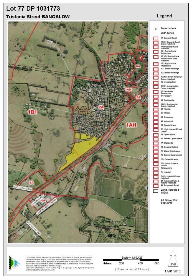
|
DA No:
|
10.2011.377.1
|
|
Proposal:
|
Subdivision to create eleven (11) lots and balance lot
|
|
Property description:
|
Lot 77 DP 1031773
Tristania Street Bangalow
|
|
Parcel No/s:
|
237920
|
|
Applicant:
|
Geolink Consulting Pty Ltd
|
|
Owner:
|
Picamore Pty Ltd
|
|
Zoning:
|
Zone No. 1(b1)- Agricultural Protection Zone / PART 2(a) -
Residential Zone
|
|
Date received:
|
15 September 2011
|
|
Integrated Development:
|
Yes
|
|
Public notification or exhibition:
|
Level 2 advertising under DCP 17 – Public Notification
and Exhibition of Development Applications
Exhibition period: 6/10/11 to 19/10/11
Submissions: For = 0 Against = 0
|
|
Other approvals (S68/138):
|
Not applicable
|
|
Planning Review Committee:
|
N/A
|
|
Delegation to determination:
|
Council - SEPP1 objection to Cl 11 BLEP
|
|
Issues:
|
·
SEPP1 objection to Cl 11 BLEP – concurrence granted
|
|
Summary:
|
The application proposes a subdivision to create the
first stage of ‘Village Edge Estate’ residential subdivision at Ivory Curl Place and Parrot Tree Place in Bangalow. The land to be developed is a component
of recently rezoned, for residential user, land in Bangalow.
It is proposed to create 11 residential lots, and a
residue lot, from an existing allotment that already has approved roads and
infrastructure in place.
The proposal requires a SEPP1 objection to Clause 11
of Byron LEP and concurrence from the Director General Planning &
Infrastructure NSW. A SEPP1 objection was provided and concurrence was
granted.
The proposed subdivision is consistent with all the
relevant state and regional environmental planning instruments and with Byron
LEP 1988 and the Byron DCP 2010 including Chapter 22 - Bangalow Urban Release
Areas.
The proposed development is a suitable and economic
use of the site, complies with relevant environmental planning provisions and
is not likely to have a significant environmental impact.
The proposal is in the public interest as it will provide
additional residential lots in an area of existing shortage.
The application is recommended for approval subject to
conditions of consent.
|
1. INTRODUCTION
1.1 History/Background
26.2010.2.1 Rezoning specific land Bangalow to 2(a) Ch 22
Area 7 - Completed 28/09/20211
1.2 Description of the
site
The land is part of the Area 7 of Byron DCP 2010, Chapter 22
– Bangalow Urban Release Areas (see map 6 below).
The land is currently vacant with very little existing
vegetation apart from the grass cover.
The majority of the infrastructure required for the proposed
lots is already constructed, this being the penultimate stage of a staged
subdivision.
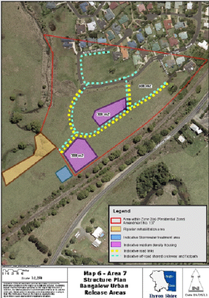
1.3 Description of the
proposed development
The application proposes to subdivide Lot 77 DP 1031773,
land that is part of the Area 7 of Byron DCP 2010, Chapter 22 – Bangalow Urban
Release Areas (see map 6 above), into 11 residential lots and 1 residual lot.
The land is currently vacant with very little existing vegetation apart from
the grass cover.
The majority of the infrastructure required for the proposed
lots is already constructed, this being the penultimate stage of a staged
subdivision.
|
Lot #
|
Street frontage
|
Lot size (m2)
|
|
1
|
Ivory Curl Place
|
870
|
|
2
|
Ivory Curl Place
|
925
|
|
3
|
Ivory Curl Place
|
970
|
|
4
|
Ivory Curl Place
|
732
|
|
5
|
Ivory Curl Place
|
609
|
|
6
|
Ivory Curl Place
|
605
|
|
7
|
Parrot Tree Place
|
748
|
|
8
|
Parrot Tree Place
|
621
|
|
9
|
Parrot Tree Place
|
611
|
|
10
|
Parrot Tree Place
|
649
|
|
11
|
Parrot Tree Place
|
652
|
|
12 – Residue lot
|
Parrot Tree Place
|
5.1 hectares
|
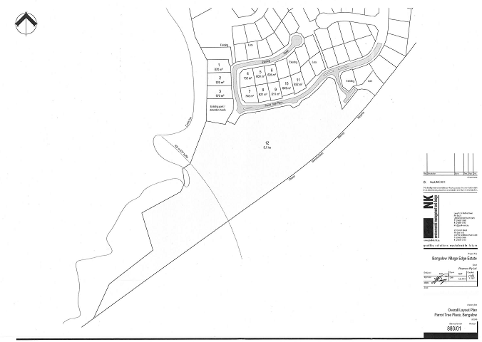
2. SUMMARY OF
GOVERNMENT/EXTERNAL REFERRALS
|
|
Summary of Issues
|
|
Government Authorities
|
NSW Planning and Infrastructure
NSW Office of Water
ARTC – NSW Rail
|
NSW Planning
I refer to your letter received 26 October 2011 requesting
the Director-General’s concurrence in the above matter
Following consideration of the application, concurrence has
been granted to vary the 40 hectare development standard for the 1(b1) zone
contained in clause 11(1) of Byron LEP 1988 to permit the subdivision on the
above land.
Concurrence was granted in this instance for the following
reasons:
(i)
The majority of the lot is zoned 2(a) Residential and is clearly
intended for residential purposes;
(ii)
The rural land is unable to maintain large scale agricultural
activities. The small scale of activities that could occur on the rural land
will not be undermined by the subdivision.
NSW Office of Water
Re:
Integrated Development Referral — General Terms of Approval
DA
10.2011.377.1 - Subdivision to Create Eleven Lots and Balance Lot Tristania
Street, BANGALOW
I refer to your recent letter regarding an Integrated
Development Application (DA) proposal for the subject property. Attached,
please find the NSW Office of Water’s General Terms of Approval (GTA) for works
requiring a Controlled Activity Approval under the Water Management Act 2000
(WM Act), as detailed in the subject DA.
Please note Council’s statutory obligations under section
91A(3) of the Environmental Planning and Assessment Act, 1979 (EPA Act)
which requires a consent, granted by a consent authority, to be consistent with
the GTA proposed to be granted by the approval body.
If the proposed development is approved by Council, the NSW
Office of Water requests that these GTA be included (in their entirety) in
Council’s development consent. Please also note the following:
·
The
NSW Office of Water should be notified if any plans or documents are amended
and these amendments significantly change the proposed development or result in
additional works on waterfront land (being land in or within 40 metres from top
of highest bank of a watercourse, foreshore, or lake). Once notified, the NSW
Office of Water will ascertain if the amended plans require review or
variation/s to the OTA. This requirement applies even if the proposed works are
part of Council’s proposed consent conditions and do not appear in the original
documentation.
·
The
NSW Office of Water should be notified if Council receives an application to
modify the consent conditions. Failure to notify may render the consent
invalid.
·
The
NSW Office of Water requests notification of any legal challenge to the
consent.
Under section 91A(6) of the EPA Act, Council must provide
the NSW Office of Water with a copy of any determination/s including refusals.
As the controlled activity or works on waterfront land
cannot commence before the applicant applies for and obtains a Controlled
Activity Approval, the NSW Office of Water recommends that the following
condition be included in the development consent:
“The Construction Certificate will not be issued over any
part of the site requiring a Controlled Activity Approval until a copy of the
Approval has been provided to Council”.
The attached GTA are not the Controlled Activity Approval.
The applicant must apply (to the NSW Office of Water) for a Controlled Activity
Approval after consent has been issued by Council and before the commencement
of any works on waterfront land.
Finalisation of a Controlled Activity Approval can take up
to 8 weeks from the date the NSW Office of Water receives all documentation
(to its satisfaction). Applicants must complete and submit (to the
undersigned) an application form together with any required plans, documents,
the appropriate fee and security (ie bond, if applicable) and proof of
Council’s development consent.
Application forms for the Controlled Activity Approval are
available from the undersigned or from the NSW Office of Water’s website www.water.nsw.gov.au
Water licensing Approvals Controlled activities
General Terms of Approval — for works requiring a Controlled Activity
Approval under the Water Management Act 2000
|
Our reference
|
30 ERM2011/1006
|
File No:
|
9055319
|
|
Site Address
|
Tristania Street, Bangalow
|
|
DA Number
|
10.2011.377.1
|
|
LGA
|
Byron Shire Council
|
|
Number
|
Condition
|
|
Plans, standards and guidelines
|
|
1.
|
These General
Terms of Approval (GTA) only apply to the controlled activities described in
the plans and associated documentation relating to DA 10.2011.377.1 and
provided by Council.
Any
amendments or modifications to the proposed controlled activities may render
these GTA invalid. If the proposed controlled activities are amended or
modified the NSW Office of Water must be notified to determine if any
variations to these GTA will be required.
|
|
2.
|
Prior to the commencement of any controlled activity
(works) on waterfront land, the consent holder must obtain a Controlled
Activity Approval (CM) under the Water Management Act from the NSW Office of
Water. Waterfront land for the purposes of this DA is land and material in or
within 40 metres of the top of the bank or shore of the river identified.
|
|
3.
|
The consent holder must prepare or commission the
preparation of:
(i.)
Vegetation
Management Plan
(ii.)
Erosion
and Sediment Control Plan
(iii.)
Soil
and Water management Plan
|
|
4.
|
All plans must be prepared by a suitably qualified person
and submitted to the NSW Office of Water for approval prior to any controlled
activity commencing. The plans must be prepared in accordance with the NSW
Office of Waters guidelines located at
www.water.nsw.gov.auMaterLicensing/Approvals/default.aspx
(i)
Vegetation
Management Plans
(ii)
Riparian
Corridors
|
|
5.
|
The consent holder must (i) carry out any controlled
activity in accordance with approved plans and (N) construct and/or implement
any controlled activity by or under the direct supervision of a suitably
qualified professional and (Ni) when required, provide a certificate of
completion to the NSW Office of Water.
|
|
Rehabilitation and maintenance
|
|
6.
|
The consent holder must carry out a maintenance period of
two (2) years after practical completion of all controlled activities,
rehabilitation and vegetation management in accordance with a plan approved
by the NSW Office of Water
|
|
7.
|
The consent holder must reinstate waterfront land affected
by the carrying out of any controlled activity in accordance with a plan or
design approved by the NSW Office of Water.
|
|
Reporting
Requirements
|
|
8.
|
N/A
|
|
Security
deposits
|
|
9.
|
N/A
|
|
Access-ways
|
|
10.
|
N/A
|
|
11.
|
N/A
|
|
Bridge,
causeway, culverts and crossing
|
|
12.
|
N/A
|
|
13.
|
N/A
|
|
Disposal
|
|
14.
|
The consent
holder must ensure that no materials or cleared vegetation that may (i)
obstruct flow, (H) wash into the water body, or (Hi) cause damage to river
banks; are left on waterfront land other than in accordance with a plan
approved by the NSW Office of Water.
|
|
Drainage
and Stormwater
|
|
15.
|
N/A
|
|
16.
|
The consent
holder must stabilise drain discharge points to prevent erosion in accordance
with a plan approved by the NSW Office of Water.
|
|
Erosion
control
|
|
17.
|
N/A
|
|
Excavation
|
|
18.
|
The consent
holder must ensure that no excavation is undertaken on waterfront land other
than in accordance with a plan approved by the NSW Office of Water.
|
|
19.
|
N/A
|
|
Maintaining
river
|
|
20.
|
The consent
holder must ensure that (i) river diversion, realignment or alteration does
not result from any controlled activity work and (U) bank control or
protection works maintain the existing dyer hydraulic and geomorphic
functions, and (Ui) bed control structures do not result in ver degradation
other than in accordance with a plan approved by the NSW Office of Water.
|
|
21.
|
N/A
|
|
River bed
and bank protection
|
|
22.
|
N/A
|
|
23.
|
The consent
holder must establish a riparian corridor along Maori Creek in accordance
with a plan approved by the NSW Office of Water.
|
|
Plans,
standards and guidelines
|
|
24.
|
N/A
|
|
25.
|
N/A
|
|
26.
|
N/A
|
|
27.
|
N/A
|
|
END OF
CONDITIONS
|
|
|
|
Australian Rail & Track Corporation
The subject land adjoins the North Coast Rail corridor,
whilst the rail service was terminated in 2004 there is still a possibility of
the rail line being re-opened in the future, subsequently the application was
referred to ARTC on 9 November 2011. The following is their reply:
RE: Development Application 10.2011.377.1
Tristania Street, Byron Bay — Lot 77 DP 1031773
Subdivision to Create Eleven (11) Lots and Balance Lot
Thank you for your correspondence dated 9 November 2011 regarding
the abovementioned Development Application.
ARTC manages the Country Regional Network on behalf of the Country Rail
Infrastructure Authority (CRIA). As such, ARTC is responding on behalf of CRIA.
It should be noted that the Casino to Murwillumbah rail line which is adjacent
to the proposed development currently has services suspended and has not been
officially closed to rail operations. As such, any development near the rail
corridor must be assessed on the basis that services could resume in the
future.
I subsequently advise that Council should consider the State Environmental
Planning Policy (SEPP) (Infrastructure) 2007 and Development Near Rail
Corridors And Busy Roads — Interim Guideline, published in the NSW
Government Gazette No.156 on 19 December 2008 when determining this
application.
ARTC requests that, due to the nearby rail corridor, Council considers noise
and vibration, stormwater and fencing in its assessment of the application, as
follows;
Noise and Vibration
ARTC requests that the Council consider the requirements of Development Near
Rail Corridors And Busy Roads — Interim Guideline and whether any
noise sensitive uses within the development are likely to be adversely affected
by rail noise or vibration.
A copy of the guidelines can be found by following the below link:
httD:/Jwww.v!enninp.nsw.aov. au/y!anninpsvstem/pdf/puide infra
devtrailroadcorrkiors inteflm.pdf
Stormwater
ARTC and subsequently CRIA wants to ensure that stormwater from the
development, does not affect the rail corridor and requests that Council impose
as a condition of consent that the developer will ensure that stormwater does
not affect the rail corridor, such as:
1. Prior to a Construction Certificate being issued, the applicant must submit
details of stormwater disposal to Council for approval. The flow of stormwater
toward the rail corridor must not be increased by the proposed development. All
approved details for the disposal of stormwater and drainage are to be
implemented in the development.
Fencing
The security of fencing along the rail corridor is essential to prevent
unauthorised entry. ARTC requests that Council impose a condition of consent
requiring that the boundary of the site with the rail corridor be fenced in a 1
.8m mesh fence if applicable.
Relevant consent conditions have been placed.
3. SECTION 79C –
MATTERS FOR CONSIDERATION – DISCUSSION OF ISSUES
Having regard for the matters for consideration detailed in
Section 79C(1) of the Environmental Planning & Assessment Act 1979, the
following is a summary of the evaluation of the issues.
3.1. STATE/REGIONAL
PLANNING POLICIES AND INSTRUMENTS
|
Requirement
|
Requirement
|
Proposed
|
Complies
|
|
SEPP1 – Development standards
|
Provides flexibility in the application of planning
controls operating by virtue of development standards in circumstances where
strict compliance with those standards would, in any particular case, be
unreasonable or unnecessary or tend to hinder the attainment of the objects
specified in section 5(a)(i) and (ii) of the Act.
|
The proposed subdivision does
not comply with minimum lot size requirements under Clause 11 of Byron LEP.
A SEPP 1 Objection has been submitted by the applicant and
is assessed in Section 3.1a of this report
|
Yes
See discussion below
|
|
SEPP55 – Remediation of land
|
Council must:
(a) considered whether the land is contaminated, and
(b) if the land is contaminated, if the land is
suitable in its contaminated state or after remediation, and
(c) be satisfied the land will be remediated before
the land is used.
|
Council has determined that the land is considered not
contaminated and is suitable for the intended use. No further information
required.
|
Yes
|
|
SEPP North Coast Regional Environmental
Plan
|
Clause 43 –
(1) The council shall not grant consent to development for residential purposes unless:
(a)
it is satisfied that the density of the dwellings have been
maximised without adversely affecting the environmental features of the land,
(b)
it is satisfied that the proposed road widths are not excessive
for the function of the road,
(c)
it is satisfied that, where development involves the long term
residential use of caravan parks, the normal criteria for the location of
dwellings such as access to services and physical suitability of land have
been met,
(d)
it is satisfied that the road network has been designed so as
to encourage the use of public transport and minimise the use of private
motor vehicles, and
(e)
it is satisfied that site erosion will be minimised in
accordance with sedimentation and erosion management plans.
|
Most of the site has
been earmarked for residential development for many years and was recently
rezoned as Area 7 in the Bangalow Urban Release Areas.
The proposed
subdivision is the penultimate stage of an existing residential subdivision
and generally meets the provisions of Clause 43.
|
Yes
|
|
Building Code of Australia
|
The proposal must be capable of compliance with the
structural and safety requirements of the Building Code of Australia.
|
The proposed subdivision will provide for adequate
setbacks from existing buildings to the proposed lot boundaries.
|
Yes
|
* Non-complying issues
discussed below
3.1a - State/Regional Planning
Policies and instruments - Issues
SEPP1 Objection to Clause 11 of Byron LEP
State Environmental Planning Policy No. 1
The applicant seeks a variation
to the development standard applying to the minimum allotment size for
subdivision within the 1(b1) Agricultural Protection Zone. Clause 11 of Byron
LEP 1988 provides that Council shall not consent to the subdivision of land
within this zone unless a minimum allotment size of 40 hectares is
maintained. The proposed residue lot will contain land within Zone 1(b1) with
an area less than 40 hectares. A written objection was submitted with the
development application arguing that compliance with the minimum 40 hectare lot
size development standard is unreasonable and unnecessary as the existing
allotment containing Zone 1(b1) land is already below 40 hectares.
Strict compliance with the 40 hectare standard is not
warranted in the circumstances of the case. There will be no reduction in
viable agricultural land as a result of the subdivision. The land is part of
the Area 7 of Byron DCP 2010, Chapter 22 – Bangalow Urban Release Areas (see
map page 6), and the proposal is consistent with future development of that
land.
The application does not raise any matters of state or
regional significance. No benefit is to be gained from maintaining the
development standard in this case.
The application was referred to NSW Planning and
Infrastructure for the Director Generals concurrence. Concurrence was granted.
Considering the land subject to the proposed residential
lots is zoned for residential use, compliance with the development standard is
considered unreasonable, unnecessary and not practical in the circumstances of
this case and the SEPP1 objection is therefore supported.
3.2. BYRON LOCAL
ENVIRONMENTAL PLAN 1988
Zone: Zone No. 1(b1) - Agricultural Protection Zone /
PART 2(a) - Residential Zone
Definition: Subdivision
|
LEP Requirement
|
Summary of Requirement
|
Proposed
|
Complies
|
|
Meets Zone 2(a) objectives
|
encourage a range of housing types
|
Urban subdivision
|
Yes
|
|
Objectives of the 2(a) Residential Zone
|
(a)
to make provision for certain suitable lands, both in existing urban
areas and new release areas, to be used for the purposes of housing and
associated neighbourhood facilities of high amenity and accessibility;
|
The proposed final stage to an existing residential
subdivision is located generally within existing residential development.
The site is close, within walking/cycling distance, to the Bangalow town
centre. Neighbourhood facilities that are accessible to the site currently
exist within the locality.
|
Yes
|
|
|
(b) to encourage a range of
housing types in appropriate locations;
|
The proposed allotment layout is such that it will
encourage a range of housing types in an appropriate location.
|
Yes
|
|
|
(c) to enable development for
purposes other than residential purposes only if it is compatible with the
character of the living area and has a domestic scale and character; and
|
No development is proposed that is not of a residential
purpose.
|
Yes
|
|
|
(d) to control by means of a
development control plan the location, form, character and density of
permissible development.
|
The location, form, character and density of subdivision
development in the locality, is consistent with the provisions of Byron
Development Control Plan 2002.
|
Yes
|
|
ZONE No. 1(b1)(AGRICULTURAL PROTECTION ZONE)
|
·
preserve higher quality agricultural land;
·
prevent fragmentation of rural holdings;
·
enable agricultural support facilities that do not reduce
production potential;
·
restrict traffic generating uses along main roads; and
·
establish buffer zones.
|
The land area currently zoned 1(b1) that is currently
contained within the will still remain within one lot.
The subdivision does not fragment rural land.
The rural land is unable to maintain large scale
agricultural activities. The small scale of activities that could occur on
the rural land will not be undermined by the subdivision.
Adjacent properties to the north and east are existing
residential. Land to the south of Parrot Tree Place has been rezoned as 2a
and it is understood will soon be the subject of DA for residential
subdivision. No land use conflict is expected as a result of this proposed
development.
|
Yes
|
|
Clause 10 - Subdivision generally
|
A person shall not subdivide land to which this plan
applies except with the consent of the council.
|
Development consent has been sought.
|
Yes
|
|
|
However, consent is not required for a subdivision under
the Strata Schemes (Freehold Development) Act 1973 of a lawfully
erected building on land within Zone No 2(a), 2(t), 2(v), 3(a), 4(a) or
7(f2).
|
Strata subdivision is not proposed.
|
Yes
|
|
|
Where land is zoned for the purpose of a proposed new
road, the council shall not consent to a subdivision of land of which the
proposed road forms part unless the subdivision makes provision for the
opening of a road in reasonable conformity with the proposed road.
|
The land is not zoned for the purpose of a proposed new
road.
|
Yes
|
|
Clause 11 Subdivision in rural areas for agriculture,
etc
|
Rural 1(b1) Agricultural Protection Zone
Minimum lot size = 40ha
|
The proposed subdivision is not in accordance with Clause
11 as it proposes a lot below the minimum lot size development standard i.e.
16,650m2 is within zone 1(b1).
|
No
(see Section 3.1a,
SEPP1 objection)
|
|
Clause 24 - Development of flood liable land
|
Council must
be satisfied that:
-
flow characteristics of flood waters are not restricted;
-
the level of flooding is not increased;
-
any building or work is capable of withstanding flooding;
-
the building is adequately flood proofed; and
-
adequate arrangements are made for access to the building or
work during a flood
|
The applicant provided a ‘Detailed
Flood Study Report’, prepared by MRG Water Consulting Pty Ltd dated March
2011.
The study shows that only a small portion at the rear of
proposed lot 3 is subject to inundation in the 1 in 100 year event and a
small section at the rear of lots 2 & 3 is inundated in the PMF and
generally classed as Low Hazard.
Minimum floor levels will be required for lots 2 & 3.
|
Yes
|
|
45 Provision of Services
|
Prior adequate arrangements required for the provision of
sewerage, drainage and water services to the land.
|
Council is satisfied all services are available to the
proposed lots.
|
Yes
|
* Non-complying issues
discussed below
Byron Local Environmental Plan 1988- Issues
Clause 24 – Development on flood liable land
The site is not shown to be flood liable on Council’s GIS. A
natural watercourse, known as tributary of Maori Creek, bounds part of the
subject site.
A flood study has been submitted as part of the application.
The study was prepared by MRG Water Consulting Pty Ltd and is a study of Byron Creek, Bangalow with a detailed study of the Maori Creek tributary which abuts
proposed lots 1 to 3 of this application.
The study appears to have been prepared in accordance with
accepted Engineering Practice using a RAFTS hydrological model, contour
information and some detailed survey information. The submitted flood
investigation is considered satisfactory.
The flood assessment is consistent with Council’s climate
change policy and has included an additional 30% increase in rainfall intensity
and volume to account for potential future climate change.
The study shows that only a small portion at the rear of
proposed lot 3 is subject to inundation in the 1 in 100 year event and a small
section at the rear of lots 2 & 3 is inundated in the PMF and generally
classed as Low Hazard.
Minimum floor levels will be required for lots 2 & 3.
Draft EPI that is or has been
placed on public exhibition and details of which have been notified to the
consent authority - Issues
N/A
3.3 DEVELOPMENT CONTROL
PLANS
Chapter 1 Part B – Subdivision
|
Development
Control Requirements
|
DCP Requirement
|
Proposed
|
Compliance
|
|
B2.3 - Site Design
|
The subdivision must take into account all natural and
human – made aspects of the site to be developed.
|
The site contains moderately sloping land. There is an
intermittent creek along the western boundary of proposed lots 1, 2, 3 and 12
the NSW Office of Water has issued GTAs to be addressed prior to the issue of
a Controlled Activity Approval. The proposed house sites are located within cleared
areas of the site that have satisfactory slopes and good solar access.
|
Yes
|
|
B2.4 - Climate Control
|
The subdivision must take into consideration wind
direction and vegetation types and location.
|
Refer to comments above.
|
Yes
|
|
B2.5 - Aspect
|
The subdivision must take into consideration solar access.
|
The layout of the proposed allotments have considered
solar access. A dwelling envelope can be accommodated that includes good
north-east solar access on each residential lot.
|
Yes
|
|
B4.5 – Stormwater Drainage
|
Facilitate effective drainage provision and management.
|
Stormwater infrastructure exists for the subdivision. Any
upgrading will be undertaken as part of the construction Certificate.
|
Yes
|
|
B2.7 – Tree Preservation
|
The subdivision layout must encourage retention of
existing trees.
|
The land is mostly cleared with very little vegetation
other than the grass cover. The proposed residential allotments can be
accommodated with little or no tree removal.
|
Yes
|
|
B2.8 - Landscaping
|
The subdivision should take into consideration landscaping
and Council should impose landscaping requirements where necessary.
|
Contributions have been levied in accordance with
Council’s Section 94 Plan for provision of open space.
|
Yes
|
|
B3.2, 3.3 & 3.4 – Roads
|
The subdivision must take into consideration road design.
|
Road infrastructure already in place.
The development is second stage of 3.
|
Yes
|
|
B3.5 – Public Open Space
|
Subdivisions should form part of a pedestrian/cycleway
network which connects the subdivision with other facilities including public
open space areas (It is Council’s responsibility to establish to location of
pedestrian/cycleway/public open areas using S.94 Contributions)
|
The application proposes a footpath/bike way on the
northern side of Parrot Tree Place. The DCP requires a path along Ivory Curl
as well. Can be conditioned.
|
Yes
|
|
B3.6 – Lot Size
|
Subdivision lot sizes are to comply with Part B5.1 of DCP
2002.
|
The proposal meets the requirements of Part B5.1. Refer to
comments below.
|
Yes
|
|
B3.7 – Lot Frontage
|
The subdivision must take into consideration the
orientation of each lot and its ability to provide a suitable house site with
good aspect, useable private open space and adequate vehicle access.
|
The proposal meets the requirements of Part B5 of DCP
2002. Refer to comments below.
|
Yes
|
|
B5.1 – Lot Size
|
General lot - 600 m2
|
8 general lots are proposed with areas of between 605 m2
& 970m2.
|
Yes
|
|
|
Corner lot - 650 m2
|
2 corner lots are proposed with an area of 732m2
& 748m2.
|
Yes
|
|
|
Hatchet-shaped lot - 800 m2 (excluding access
handle)
|
No hatchet shaped lots are proposed.
|
N/A
|
|
|
Hatchet-shaped lot adjacent to public reserve - 650 m2
(excluding access handle)
|
No hatchet shaped lots are proposed.
|
N/A
|
|
|
Fan-shaped lot - 650 m2 (minimum frontage 7m)
|
No fan shaped lots are proposed.
|
N/A
|
|
B5.2 - Allotment Layout
|
Where possible lots should be orientated to provide the
long axis within the range N20oW to N30oE or E20oN
to E30oS.
|
The proposed allotments either meet this requirement or
can contain nominal building envelopes that meet this requirement.
|
Yes
|
|
|
Where possible, lots must be rectangular rather than splay
shaped to maximise the opportunity for energy efficient housing.
|
The proposed residential allotments generally meet this
requirement.
|
Yes
|
|
|
Lots must be staggered and landscaped to achieve maximum
solar access and to create interest in the streetscape.
|
The land is virtually clear of vegetation. Landscaping can
be conditioned.
Solar access is discussed above.
|
Yes
|
|
|
Lots and the associated vehicular and pedestrian access
ways must be configured to provide convenient access to public open space
areas and community facilities.
|
The design does not restrict access to public open space
areas and community facilities.
|
Yes
|
|
|
Vegetation which adds significantly to the visual amenity
of the area of the land must be preserved where possible.
|
Refer to comments above.
|
Yes
|
|
|
Lot layout and pedestrian accessway networks are to
maximise the opportunities for observation of buildings, spaces and
activities by residents, passing motorists and pedestrians. Double street
frontages (ie. front and rear) are to be avoided and pedestrian accessways
are to run largely along public spaces (including roads and open spaces).
|
The proposal does not compromise this requirement.
|
Yes
|
|
|
Subdivision proposals in the urban areas of the Shire are
to have regard to the possible environmental constraints that may affect any
particular site.
|
The areas of the site in which the proposed residential
allotments are located are not significantly constrained.
|
Yes
|
|
|
Where lands are identified as containing or adjoining
bushland or contain or adjoin lands containing endangered flora and fauna
species, development proposals are to be accompanied by flora and fauna
assessments prepared by suitably qualified persons.
|
The land does not contain or adjoin lands containing
endangered flora and fauna species. An ecological assessment and 7 Part Test
is not required.
|
Yes
|
|
|
Development proposals which involve the development of
land in close proximity to watercourses or other areas of possible
inundation, are to be accompanied by a hydrologic study submitted by an
appropriately qualified person to demonstrate that the proposal or any future
development will not interfere with the natural flowpath or be subject to
flooding.
|
Controlled Activity Approval from NSW Office of Water
required prior to CC.
Condition required.
|
Yes
|
|
|
Lots must be designed to allow the construction of a
building or carriageway with a maximum cut or fill of 1m from natural ground
level whilst not impeding the flow of waters.
|
The slope of the site allows the design to meet this requirement.
|
Yes
|
|
|
Lands identified as having moderate or high bushfire
hazard must be accompanied by a fire management plan to adequately minimise
risk.
|
The land is not identified as bushfire prone.
|
Yes
|
|
B5.3 – Allotment Design
|
Lots must be able to accommodate a
building envelope with minimum dimensions 12 metres by 15 metres.
|
Each lot is capable of containing a building envelope of
these dimensions.
|
Yes
|
|
|
Building envelopes must be sited to avoid site constraints
and take advantage of site opportunities.
|
The design meets this requirement.
|
Yes
|
|
|
Lots must be designed to maximise useable areas of the
site and have regard to the topography.
|
The design meets this requirement.
|
Yes
|
|
|
Hatchet-shaped lots must have a minimum frontage of 5m
(ie, 3m driveway and provision for services, landscaping etc). This may
translate as 3m each if reciprocal rights of carriageway provide shared
access, but no more than 2 lots are to be accessed in this way (ie 4m
driveway and provision for services, landscaping etc.).
|
No hatchet shaped lots are proposed within the
subdivision.
|
Yes
|
|
|
Landscaping of the access handle of hatchet-shaped
lots is required. A landscaping plan must be submitted with the development
application for subdivision - refer to Part H of this Development Control
Plan for details.
|
No hatchet shaped lots are proposed within the
subdivision.
|
Yes
|
Development Control Plan 2010 –
Chapter 1 Part N Stormwater Management
Part N – Stormwater Management
Stormwater drainage can be dealt with via conditions of
consent.
Development Control Plan 2010 - Chapter
22 - Bangalow Urban Release Areas
Structure Plan for Area 7
The proposed subdivision is located within Area 7 of DCP 2010
Chapter 22. This Chapter of the DCP provides controls and guidelines for the
future form of development of the Bangalow Urban Release Areas. The Structure
Plan nominates indicative road links, indicative shared cycleway and footpath
links, landscape buffers, rehabilitation areas, indicative stormwater treatment
areas and large lot residential areas.
The proposed subdivision creates eleven new residential
allotments within the north-western corner of Area 7, as shown on the Structure
Plan. All of these allotments are consistent with the elements provided on the
Structure Plan. The residual allotment that is to be created is of sufficient
size and shape to accommodate future subdivision, should their land use zones
allow. The residual allotment is eligible to have a single dwelling-house
constructed upon it and sufficient area is available to allow such construction
without conflicting with the provisions of the Structure Plan.
Subdivision Standards
|
Development
Control Provision
|
Development
Control Requirement
|
Proposed
|
Compliance
|
|
3.1 - Residential Densities
|
·
Standard Residential
Precincts: 600m² Lots. Land
identified as being least constrained and is to be characterised by smaller
residential lots. Parts of the development of this land may include dual
occupancy and “non-standard” residential allotments such as “mews
allotments”.
·
Large Lot Residential Precinct
(Area 2): 800m2 lots. This land
is constrained by slope and is to be characterised by larger lots.
Development applications for subdivision in this area should nominate
building envelopes designed to minimise cut and fill on the site.
·
Medium Density Residential
Precincts: 300m2 to
400m2 Lots. Certain
land within Area 4 North and South and Area 7 has been identified as suitable
for medium density development. In Area 4 North the minimum lot size is 400m2
and in Area 4 South and Area 7 the minimum lot size is 300m2.
|
The minimum lot size is 600m2.
|
Yes
|
|
3.2 – Lot Design
|
Objectives
·
To ensure that residential lots are capable of accommodating
a range of housing types which provide pleasant streetscapes, maximise energy
efficiency and mitigate environmental impacts.
·
The design and orientation of
all residential lots within the Bangalow Urban Release Areas is to be
undertaken in accordance with SEDA’s Solar Access for Lots (SAL) –
Guidelines for Residential Subdivision in NSW.
|
A SEDA assessment has not been undertaken as the layout
and positioning of lots is dictated by the existing road network and
provision of infrastructure.
All proposed lots are consistent with the element
objectives.
|
Yes
|
|
·
Any development application for
residential subdivision (not including Strata Title subdivision) within the
Bangalow Urban Release Areas is to provide detail of compliance with Steps
1-6 in the SEDA guideline.
|
As above
|
Yes
|
|
·
A detailed geotechnical report
is to be provided with each development application for subdivision of land
with a slope greater than 15%. This report is to make recommendations with
respect to construction methods and dwelling envelopes.
|
All of the residential allotments being created are within
slopes less than 15%. The residual allotment has areas available for building
a dwelling-house that are within slopes of less than 15%.
|
Yes
|
|
·
Where the slope of the land is
greater than 25%, concept details of proposed lots, extent of cut and fill,
roads and accesses are to be provided. Building envelopes must be
identified. This may need to be controlled by restrictions on the titles of
individual lots.
|
As above.
|
Yes
|
|
3.3 – Buffers and Environmental Corridors
|
a. Environmental Buffers, Visual Buffers and Riparian
Corridors must be established in accordance with the Structure Map;
|
The proposed subdivision is in accordance with the
structure map. No buffers or riparian corridors are required as part of this
subdivision proposal.
|
Yes
|
|
b. All planting is to be of species indigenous to the
site or local area in accordance with Chapter 1 Part H – Landscaping;
|
A condition has been included to require a landscape plan
to be prepared in accordance with DCP 2010.
|
Yes
|
|
c. The Visual Buffer should consist of a screen of shrubs and/or trees. Trees must be
selected with varying mature heights as appropriate to achieve the required
visual barrier between existing and proposed development while not unduly
restricting solar access to buildings and private open space. The buffer area
must be established as an integral part of the development of land adjoining
that buffer area at no cost to Council;
|
No buffers or riparian corridors are required as part of
this subdivision proposal.
|
Yes
|
|
d. Environmental Buffers and Riparian Corridors will be
subject to the following requirements:
·
The corridor or buffer area must
be established as an integral part of the development of land adjoining that
corridor at no cost to Council;
·
An outline of a Vegetation
Rehabilitation and Management Plan for the corridor must be prepared and
submitted with the relevant development application. Planting and
maintenance details are to be submitted as part of this material;
·
Installation and maintenance of
erosion and sedimentation controls;
·
Weed eradication and control; and
|
No buffers or riparian corridors are required as part of
this subdivision proposal.
|
Yes
|
|
e. Protective fencing is to be erected around
individual and vegetation clusters to limit disturbance caused by earthworks
during the construction of the subdivision. The protective fencing is to be
installed to a minimum distance of the ‘drip line’ and maintained for the
duration of the civil works.
|
No trees are to be removed as part of this subdivision
proposal.
|
Yes
|
|
3.4 – External Road works
|
|
External roads are in place.
|
Yes
|
|
3.5 – Internal Road Works
|
a. The design and hierarchy of internal roads is to be
in accordance with the requirements set out in the Northern Rivers Local
Government ‘Development and Design Manual’ unless other details are specified
below.
b. Road widths are to be consistent with Element B6.1 Road Design and Construction of DCP 2002 or Council’s updated
guidelines.
c. The developers will be responsible for the
construction of all internal roads. All roads will be dedicated to Council
as public roads. Upon dedication and at the end of the maintenance period,
Council will be responsible for the on-going maintenance of the roads.
d. Formal concrete footpaths are to be provided as part
of any new local road network.
|
No additional internal roads are required for the proposed
subdivision are all lots are to be accessed from existing roads.
|
Yes
|
|
3.6 – Pedestrian / Bicycle Networks
|
Many of the release areas
will be the furthermost from the village centre so it is essential that
adequate bicycle networks are provided. An integrated network of pedestrian/
cycle paths must be provided throughout the Bangalow Urban Release Areas such
that it provides safe, convenient and direct access to, from and within the
residential areas. Any proposed internal pathway network must be linked to
the adjacent external existing or proposed network in Bangalow in accordance
with Maps 6 & 7.
|
The application proposes a footpath/bike way on the
northern side of Parrot Tree Place. The DCP requires a path along Ivory Curl
as well. Can be conditioned.
|
Yes
|
|
3.7 – Infrastructure Provision
|
Subdivisions must have
adequate provision of contemporary services with minimal impact on the
environment. Compatible public utility services must be provided in common
trenching wherever practical to minimise construction costs, soil erosion and
land allocation for underground services.
|
The residential allotments being created as part of the
proposed subdivision are required to be provided with water, sewer,
electricity and telecommunication services.
|
Yes
|
|
3.8 - Stormwater Management
|
Effective stormwater
management is critical to the future development of the Bangalow Urban
Release Areas to ensure that the quantity and quality of run-off is such that
it will have minimal impact upon the down stream environment.
|
Stormwater disposal is to be dealt with via conditions of
consent.
|
Yes
|
|
3.9 - Landscaping
|
Sufficient trees must be
planted in public areas to ensure that when mature, the trees will be the
dominate element creating an appealing visual quality to streetscapes and
parklands. Trees must be located to ensure that there is a sufficient
quantity and quality of soil within the anticipated root zone to support the
intended mature tree.
Trees must be located to
minimise infrastructure and functional conflicts. For example trees must be
so located that streetlights are not being blocked by the tree canopy or car
doors will not opened onto tree trunks.
The location of street
trees must optimise passive watering and integrate with water sensitive urban
design (WSUD) initiatives. These design principles are based on the Landcom
Street Tree Design Guidelines and should be utilised to clarify the design
criteria.
|
Landscaping plan required prior to construction
certificate.
|
Yes
|
|
3.10 – Fencing to Public Places
|
Element Objectives
-
To ensure high quality
streetscapes.
-
To ensure any fencing to public
areas is consistent with crime prevention strategies.
|
The proposed residential allotments do not adjoin any
public places other than road reserves (to which state planning provisions
apply to fencing) and State Rail land for which a consent condition applies.
|
Yes
|
|
3.11 – Noise Attenuation
|
The subdivisions are to be
designed so as to be consistent with the guideline Environmental criteria for
road traffic noise May 1999 (or replacement guideline). Note that this
guideline is about to be replaced by the NSW Road Noise Policy, which is
presently in draft form.
|
A site visit on 7 October 2011 identified adjacent
properties to the north and east as existing residential. Land to the south
of Parrot Tree Place has been rezoned as 2a and it is understood will soon be
the subject of DA for subdivision (a DAP meeting was arranged for 4 October
2011 see 22.2011.18.1) and further residential development. Standard
condition attached re operating hours and noise levels. No noise issues
expected as a result of this proposed development.
|
Yes
|
|
3.12 – Open Space Requirements
|
A neighbourhood park with a usable area between 0.25 Ha
and 0.5 Ha must be provided within Areas 6 and 7.
|
Developer contributions credits will be provide for the
provision of new neighbourhood parks and enhancement of existing
neighbourhood parks in accordance with Council’s Development Contribution
Plan.
The SEE states that a park will be provided in the next
stage. Contributions will be required for this application.
|
Yes
|
Solar Access for Lots (SAL) Guidelines
for Residential Subdivision in NSW
A SEDA assessment has not been undertaken as the layout and
positioning of lots is dictated by the existing road network and provision of
infrastructure.
All proposed lots are consistent with the element objectives
i.e.:
·
To ensure that residential lots are capable of accommodating a
range of housing types which provide pleasant streetscapes, maximise energy
efficiency and mitigate environmental impacts.
3.4 The likely impacts of that development, including
environmental impacts on both the natural and built environments, and social
and economic impacts in the locality
The subject land is clear of significant vegetation and the
application does not require any tree removal.
This development is the second stage of a residential
subdivision the land having been previously rezoned for residential use.
Subject to consent conditions the proposed residential
subdivision is unlikely to result in negative impacts on the natural, built,
economic and social environments.
3.5 The suitability of the site for the development
The land is part of the Area 7 of Byron DCP 2010, Chapter 22
– Bangalow Urban Release Areas (see map 6 below).
The land is currently vacant with very little existing
vegetation apart from the grass cover.
The majority of the infrastructure required for the proposed
lots is already constructed, this being the penultimate stage of a staged
subdivision.
The site is suitable for the development
Climate change:
Gases and water vapour in the
Earth’s atmosphere vary in their ability to capture and recycle radiant heat
emitted from the Earth’s surface. This “blanketing” action of the atmosphere is
known as the Greenhouse Effect. Humans have varied the composition of the
atmosphere through the addition of various gases, water vapour aerosols
(suspension of submicroscopic particles dispersed in air or gas), causing an
enhanced Greenhouse Effect. This is known as Global Warming or Climate Change.
Some of the effects of Climate
Change include temperature rise and subsequent sea level rise due to expansion
of the oceans and melting of ice, changing rainfall patterns, altitudinal and
latitudinal movement of biota in response to temperature rise.
Causal factors for Climate
Change include Plate Tectonics (movement of the Earth’s Plates, cyclical
variation in solar radiation, volcanism, variations in the rotation and orbit
of the Earth, and human influences. Human influences are assessed below and
incorporate livestock (methane emissions and use of nitrogenous fertilisers),
burning of fossil fuels, land use (deforestation, agriculture, industry etc),
air pollutants and aerosols, and cement manufacture (involving heating of
calcium carbonate to produce lime and carbon dioxide). Human influences are
assessed below:
|
Anthropogenic causes of
Climate Change
|
Impact of proposed development
|
|
Livestock
|
N/A
|
|
Burning fossil fuels
|
N/A
|
|
Land use
|
No tree removal additional
landscape planting conditioned.
|
|
Air pollutants
|
N/A
|
|
Cement manufacture
|
Roads already in place
|
3.6 Submissions made in
accordance with this Act or the regulations
There were 0 submissions made on the development
application.
3.7 Public
interest
It is in the public interest for vacant urban land to be lawfully
developed to provide additional housing areas. The proposed development is in
the public interest.
4. DEVELOPER
CONTRIBUTIONS
4.1 Water & Sewer
Levies
This existing vacant parcel of land currently has a water
and sewerage entitlement of 1 ET.
Rates Dept advises that this land parcel currently pays
water and sewer assess charges since 2002/2003.
The proposed subdivision will create 11 residential lots and
a residue parcel.
|
Development
|
Number
|
ET Rate
|
ET
|
|
Residential lot
|
11
|
1
|
11
|
|
Residual lot
|
1
|
1
|
1
|
|
|
|
|
12
|
The proposed development generates an additional bulk water,
water and sewer load of 12 – 1 = 11ET.
Council can supply water and sewerage to the proposed
development on payment of Developer Servicing Charges.
These figures are at today’s date.
|
INDICATIVE
CHARGES PURSUANT TO THE WATER MANAGEMENT ACT, 2000
|
|
|
|
(Office Use Only)
|
|
|
|
|
|
|
Water
|
(S64W Other)
|
11.00
|
ET @
|
$1,283.78
|
=
|
$14,121.63
|
|
Bulk Water
|
(BW-BG)
|
11.00
|
ET @
|
$8,377.00
|
=
|
$92,147.00
|
|
Sewer
|
(S64S Bang)
|
11.00
|
ET @
|
$19,414.68
|
=
|
$213,561.52
|
|
|
|
|
|
Total
|
=
|
$319,830.16
|
|
|
|
|
|
|
|
|
|
4.2 Section 94
Contributions
Section 94 Contributions
Plan = B.S.C.
Development Contributions Plan 2005 dated June 2005
Catchment = Bangalow
Credit = 1
SDU
Use/Type = Residential
Subdivision
Demand = 11
+ residual
Contribution = 11
Car Spaces =
Traffic = 99
trips applicable – trips automatically generated in excel spreadsheet
|
RESIDENTIAL
DEVELOPMENT
|
|
SCHEDULE OF
CONTRIBUTIONS PURSUANT TO SECTION 94 OF THE ENVIRONMENTAL PLANNING AND
ASSESSMENT ACT, 1979
|
|
|
|
|
(Office Use Only)
|
|
|
|
|
|
|
Community and Cultural Facilities
|
(CF-BG)
|
11.00
|
SDU @
|
$1,180.58
|
=
|
$12,986.35
|
|
" - Shire Wide
|
(CF-SW)
|
11.00
|
SDU @
|
$603.98
|
=
|
$6,643.81
|
|
Open Space
|
(OS-BG)
|
11.00
|
SDU @
|
$2,984.42
|
=
|
$32,828.59
|
|
" - Shire Wide
|
(OS-SW)
|
11.00
|
SDU @
|
$3,042.84
|
=
|
$33,471.20
|
|
Roads
|
(R-BG)
|
99.00
|
trips @
|
$823.89
|
=
|
$81,564.87
|
|
Cycleways
|
(CW-BG)
|
11.00
|
SDU @
|
$776.41
|
=
|
$8,540.53
|
|
Civic & Urban Improvements
|
(IM-BG)
|
11.00
|
SDU @
|
$1,644.20
|
=
|
$18,086.25
|
|
Rural Fire Service
|
-
|
|
|
|
=
|
|
|
Surf Lifesaving
|
(SL-BG)
|
11.00
|
SDU @
|
$29.62
|
=
|
$325.79
|
|
Administration
|
(OF-SW)
|
11.00
|
SDU @
|
$820.23
|
=
|
$9,022.53
|
|
|
|
|
|
Total
|
=
|
$203,469.93
|
5. CONCLUSION
The application proposes a subdivision to create the first
stage of ‘Village Edge Estate’ residential subdivision at Ivory Curl Place and Parrot Tree Place in Bangalow. The land to be developed is a component of recently rezoned,
for residential user, land in Bangalow.
It is proposed to create 11 residential lots, and a residue
lot, from an existing allotment that already has approved roads and
infrastructure in place.
The proposal requires a SEPP1 objection to Clause 11 of Byron
LEP and concurrence from the Director General Planning & Infrastructure
NSW. A SEPP1 objection was provided and concurrence was granted.
The proposed subdivision is consistent with all the relevant
state and regional environmental planning instruments and with Byron LEP 1988
and the Byron DCP 2010 including Chapter 22 - Bangalow Urban Release Areas.
The proposed development is a suitable and economic use of the
site, complies with relevant environmental planning provisions and is not
likely to have a significant environmental impact.
The proposal is in the public interest as it will provide
additional residential lots in an area of existing shortage.
The application is recommended for approval subject to
conditions of consent.
6. RECOMMENDATION
That pursuant to
Section 80 of the Environmental Planning & Assessment Act 1979, development
application 10.2011.377.1 for
subdivision to create 11 lots and balance lot, be granted consent subject to
the conditions listed in the Annexure.
7. DISCLOSURE OF
POLITICAL DONATIONS AND GIFTS
|
Has a Disclosure Statement been received in relation to
this application
|
No
|
|
Have staff received a ‘gift’ from anyone involved in this
application that needs to be disclosed. Where the answer is yes, the
application is to be determined by the Director or Manager of the Planning,
Development and Environment Division.
|
No
|
Provide Disclosure Statement register details here:
Executive Manager: Environment and Planning
File No: 48400, 163980 #1187083
NOTE TO COUNCILLORS:
In accordance with the
provisions of S375A of the Local Government Act 1993, a Division is to be
called whenever a motion for a planning decision is put to the meeting, for the
purpose of recording voting on planning matters. Pursuant to clause 2(a) under
the heading Matters to be Included in Minutes of Council Meetings of Council's
adopted Code of Meeting Practice (as amended) a Division will be deemed to have
been called by the mover and seconder of all motions relating to this report.
RECOMMENDATION:
That pursuant to
Section 80 of the Environmental Planning & Assessment Act 1979, development
application 10.2011.319.1 for subdivision
to create three residential lots and one residual rural lot, be granted consent
subject to the conditions of consent in Annexure 29(b) (#1187099).
Attachments:
Locality Map
·
Site Plan #1187123 [1 page]........................................................................................... Annexure
29(a)
·
Conditions of Consent #1187099 [13
pages]................................................................... Annexure
29(b)
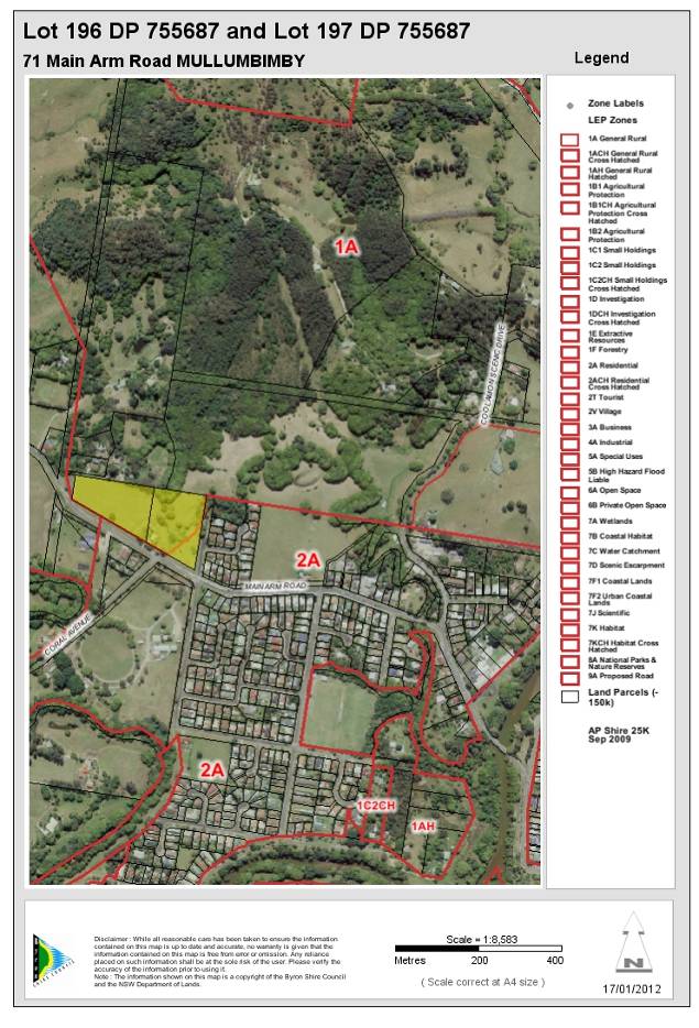
|
DA No:
|
10.2011.319.1
|
|
Proposal:
|
Subdivision to create 4 residential lots and 1 residual
lot
|
|
Property description:
|
Lot 196 DP: 755687, Lot 197 DP 755687
71 Main Arm Road Mullumbimby
|
|
Parcel No/s:
|
48400, 163980
|
|
Applicant:
|
Mr P Prior
|
|
Owner:
|
Mr P Prior
|
|
Zoning:
|
Zone No. 1(a) - General Rural Zone
Zone No. 2(a) - Residential
|
|
Date received:
|
11 August 2011
|
|
Integrated Development:
|
·
Bush Fire Safety Authority – Section 100B Rural Fires Act 1997,
and
·
Controlled Activity Approval – Section 91(2) Water Management
Act 2000
|
|
Public notification or exhibition:
|
Level 2 advertising under DCP 17 – Public Notification
and Exhibition of Development Applications
Exhibition period: 25/8/11 to 7/9/11
Submissions: For = 0 Against = 0
|
|
Other approvals (S68/138):
|
Not applicable
|
|
Planning Review Committee:
|
N/A
|
|
Delegation to determination:
|
Council
|
|
Issues:
|
·
SEPP 1 Objection to minimum allotment size;
·
Residential use of land within the 1(a) General Rural Zone;
·
Bushfire Prone Land – IPA in Riparian Corridor.
·
Flood liable land.
|
|
Summary:
|
The proposed subdivision involves two existing
allotments legally described as Lots 196 and 197 in DP 755687 have a combined
area of 3.855 hectares.
The applicant seeks development consent to subdivide
the two existing allotments making up the site into three (3) residential
allotments to accommodated future dwellings, and one (1) residual allotment
that will accommodate the existing dwelling. The areas of the proposed
allotments are described below:
Lot 1 = 946.8m2
Lot 2 = 603.0m2
Lot 3 = 804.4m2
Lot 4 = 1,162.5m2
Lot 5 = 3.68 hectares
The majority of the land that will comprise Lot 5 and the existing dwelling is within Zone 1(a) – General Rural. The four proposed
residential allotments, Lots 1 to 4, are located mostly within Zone 2(a)
Residential Zone
Proposed Lots 1 to 4 have frontage to, and are to be
accessed from, Chinbible Avenue. The dwelling-house located within proposed Lot 5 will continue to have access from Main Arm Road.
A previous application proposed a similar subdivision,
however that application included areas of flood prone land and riparian
corridors and was refused for potential impacts to and from those
constraints. This application has addressed those concerns for proposed lots
2-4 however under the conditions of the NSWRFS Bushfire Safety Authority, Lot 1 would require the implementation of an Asset Protection Zone within the riparian
corridor of Chinbible Creek. Subsequently proposed Lot 1 is not supported.
Apart from proposed Lot 1 the proposal is in accordance
with all relevant state and regional planning instruments apart from a
variation to Clause 11, with Byron LEP 1988. The proposal is in accordance
with Byron Development Control 2010 requirements.
The subdivision is lawful development, and is in the
public interest as it will create three additional residential lots.
Subject to the deletion of proposed Lot 1 and the
recommended consent conditions the application is considered worthy of
support.
|
Copy of consent and
submissions to be provided to NSW Office of Water
1. INTRODUCTION
1.1 History/Background
The following past development
application has been identified for the subject site:
10.2006.736.1 Subdivision
comprising three (3) residential lots and one (1) rural lot. The application
was refused consent on 10 April 2007.
It is also noted that a dwelling-house currently exists within
Lot 197 DP 755687, however no records have been identified within Council’s
Authority System of Development or Building Approvals within either Lot 196 or 197 DP 755687.
1.2 Description of the
site
The proposed subdivision involves two adjoining allotments legally
described as Lots 196 and 197 in Deposited Plan 755687. The allotments are
located on the northern side of Main Arm Road, within the western outskirts of the
Mullumbimby urban area. The subject site is located at the north-west corner of
Main Arm Road and Chinbible Avenue.
The two allotments are located primarily within the 1(a)
General Rural Zone. However, the south-eastern corner of Lot 197 is located
within the 2(a) Residential Zone under Byron Local Environmental Plan 1988. Lot 196 is generally cleared and is vacant of development (See Figure 1). Lot 197 is occupied by a dwelling-house, contains a number of mature trees and is traversed
by Chinbible Creek.
The site comprises undulating terrain that falls towards the
creek. Residential uses are located to the east and south-east. The Mullumbimby
showgrounds are located to the south, and a school is located to the
south-west. Rural-residential uses occupy the allotments to the north.
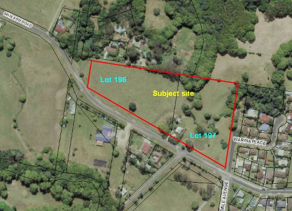
Figure 1 - Aerial photograph of subject site (2009)
1.3 Description of the
proposed development
The proposed subdivision involves two existing allotments legally
described as Lots 196 and 197 in DP 755687, 71 Main Arm Road, Mullumbimby. The
two lots have a combined area of 3.855 hectares.
The applicant seeks development consent to subdivide the two
existing allotments making up the site into three (3) residential allotments to
accommodate future dwellings, and one (1) residual allotment that will
accommodate the existing dwelling. The areas of the proposed allotments are
described below:
|
Proposed Lot
|
Area
|
|
1
|
946.81 m² (not
supported)
|
|
2
|
603.0 m²
|
|
3
|
801.1 m²
|
|
4
|
1221.0 m²
|
|
5
|
3.68 ha
|
Proposed Lots 1 to 4 have frontage to and are to be accessed
from Chinbible Avenue. The dwelling-house located within proposed Lot 5 will continue to have access from Main Arm Road.
Proposed Lot 1 not supported
|
|
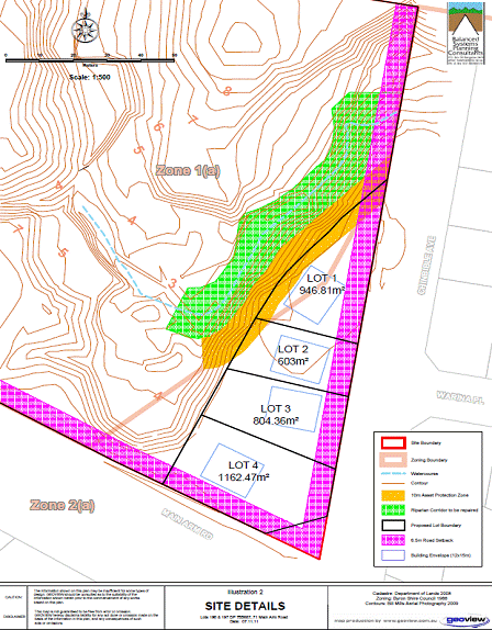
The majority of the land, the land that will comprise Lot 5 and the existing dwelling is within Zone 1(a) – General Rural. The four proposed
residential allotments, Lots 1 to 4, are located within Zone 2(a) Residential
Zone
A previous application proposed a similar subdivision,
however that application included areas of flood prone land and riparian
corridors and was refused for potential impacts to and from those constraints.
This application has addressed those concerns for proposed lots 2-4 however
under the conditions of the NSWRFS Bushfire Safety Authority, Lot 1 would
require the implementation of an Asset Protection Zone within the riparian
corridor of Chinbible Creek. Subsequently proposed Lot 1 is not supported.
2.
SUMMARY OF REFERRALS
|
|
Summary of Issues
|
|
NSW Department of Planning and Infrastructure
|
SEPP 1 Objection Concurrence Authority. See Section 3.1a
of this report.
|
|
NSW Rural Fire Service
|
Bush Fire Safety Authority required pursuant to Section
100B of Rural Fires Act 1997. See Section 2.1 of this report.
|
|
NSW Office of Water
|
Controlled Activity Approval required pursuant to
Section 91(2) Water Management Act 2000. See Section 2.1 of this report.
|
2.1 SECTION 91A -
Development that is integrated development
Pursuant to Section 91 of the Environmental Planning and
Assessment Act 1979 (EP&A Act) the proposed development was referred to the
NSW Rural Fire Service for a Bushfire Safety Authority (Section 100B of the NSW
Rural Fires Act 1997). The application was also referred to the NSW Office of
Water for a Controlled Activity Approval required pursuant to Section 91(2)
Water Management Act 2000.
NSW Rural Fire Service
The NSW Rural Fire Service has issued a Bush Fire Safety Authority
pursuant Section 100B of the Rural Fires Act 1997 subject to the following conditions:
Asset Protection
Zones
The intent of measures is to provide sufficient space and
maintain reduced fuel loads so as to ensure radiant heat levels of buildings
are below critical limits and to prevent direct flame contact with a building.
To achieve this, the following conditions shall apply:
1. Proposed Lots I to 4 shall be managed as an inner
protection area (IPA) as outlined within Appendices 2 & 5 of ‘Planning for
Bush Fire Protection 2006’, until further developed.
2. Future dwellings on proposed Lots I to 4 shall have a
minimum APZ of 10 metres to the west / northwest. Where the APZs lie outside
the boundary of the Lot on the adjoining land, then they must be covered by an
easement.
Water and Utilities
The intent of measures is to provide adequate services of
water for the protection of buildings during and after the passage of a bush
fire, and to locate gas and electricity so as not to contribute to the risk of
fire to a building. To achieve this, the following conditions shall apply:
3. Water, electricity and gas are to comply with section
4.1.3 of ‘Planning for Bush Fire Protection 2006’.
Landscaping
4. Landscaping surrounding the existing dwelling shall comply with
the principles of Appendix 5 of ‘Planning for Bush Fire Protection 2006’.
Because proposed Lot 1 is not supported by
this assessment, for the reasons discussed in Section 1.3, the 10m APZs
required by the Bushfire Safety Authority (BSA), can now be implemented within
the boundaries of proposed lots 2 to 4, therefore the last sentence of
condition 2 of the BSA is no longer relevant.
An email was sent to RFS regarding possible
amendment to the Bushfire Safety Authority, their response (#1184969), is as
follows:
Your proposal to delete
proposed lot 1 is supported.
If the APZs for future
dwellings can be achieved within the boundary of each lot, then condition 2 can
be deleted. Future dwellings will be assessed and conditioned under 79BA.
It may be appropriate for
Council to issue a conditional approval subject to an amended BFSA for the
revised layout being obtained from the RFS.
Subsequently a condition of consent is to be included for
prior to issue of subdivision certificate that states:
An amended
Bushfire Safety Authority is to be obtained from the NSWRFS reflecting the
alterations in red on the approved plan that allows the 10m APZs, for future
dwellings on Lots 2-4, to be implemented within those individual lot boundaries
and not on the residual lot.
NSW Office of Water
Re:
Integrated Development Referral — General Terms of Approval
DA
10.2011.319.1 - Subdivision to create 4 residential lots and I residual lot, Lot 196
DP 755687 & Lot 197 DP 755687; 71 Main Arm Road, Mullumbimby
I refer to your recent letter regarding an Integrated Development
Application (DA) proposal for the subject property. Attached, please find the NSW
Office of Water’s General Terms of Approval (GTA) for ‘works’ requiring a Controlled
Activity Approval under the Water Management Act 2000 (WMA), as detailed
in the subject DA.
If the proposed development is approved by Council, the NSW
Office of Water requests that these GTA be included (in their entirety) in
Council’s development consent. Please also note the following:
·
The
NSW Office of Water should be notified if any plans or documents are amended
and these amendments significantly change the proposed development or result in
additional ‘works’ on waterfront land (ie in or within 40 metres from top of
highest bank of a watercourse, foreshore, or lake). Once notified, the NSW
Office of Water will ascertain if the amended plans require review or
variation/s to the GTA. This requirement applies even if the proposed ‘works’
are part of Council’s proposed consent conditions and the ‘works’ do not appear
in the original documentation.
·
The
NSW Office of Water should be notified if Council receives an application to
modify the consent conditions. Failure to notify may render the consent
invalid.
·
The
NSW Office of Water requests notification of any legal challenge to the
consent.
Under
Section 91A(6) of the EPAA, Council must provide the NSW Office of Water with a
copy of any determination/s including refusals.
As a controlled activity (ie the ‘works’) cannot commence
before the applicant applies for and obtains a Controlled Activity Approval,
the NSW Office of Water recommends that the following condition be included in
the development consent:
“The
Construction Certificate will not be issued over any part of the site requiring
a Controlled Activity Approval until a copy of the Approval has been provided
to Council”.
The attached GTA are not the Controlled Activity Approval. The applicant must apply
(to the NSW Office of Water) for a Controlled Activity Approval after
consent has been issued by Council and before the commencement of any
‘works’ on waterfront land.
Finalisation of a Controlled Activity Approval can take up
to 8 weeks from the date the NSW Office of Water receives all documentation
(to its satisfaction). Applicants must complete and submit (to the
undersigned) an application form together with any required plans, documents,
the appropriate fee and security (ie bond, if applicable) and proof of
Council’s development consent.
Application forms for the Controlled Activity Approval are
available from the undersigned or from the NSW Office of Water’s website http:llwww.water.
nsw.qov. aulWater-Licerisinq/Approvals/Controlled-activities/default. aspx
Compliance with these GTA would not be possible for proposed
Lot 1 if a 10 metre Inner Protection Area, as required under the Bushfire
Safety Authority, was to be established to the west and north-west of a
dwelling on that lot (in the riparian corridor).
The NSW Office of Water requests that Council provide a copy
of this letter to the applicant.
GENERAL TERMS OF APPROVAL – For works requiring a Controlled
Activity Approval under the Water Management Act 2000.
|
Our Reference
|
30 ERM2011/0875
|
File No
|
9055227
|
|
Site Address
|
Lot 196 DP 755687 & Lot 197 DP 755987, 71 Main Arm Road, Mullumbimby
|
|
DA Number
|
10.2011.319.1
|
|
LGA
|
Byron Shire Council
|
|
Number
|
Condition
|
|
Plans, standards and guidelines
|
|
1.
|
These General Terms of Approval (GTA) only apply to the
controlled activities described in the plans and associated documentation
relating to DA10.201 1 .319.1 and provided by Council.
Any amendments or modifications to the proposed controlled
activities may render these GTA invalid. If the proposed controlled
activities are amended or modified the NSW Office of Water must be notified
to determine if any variations to these GTA will be required.
|
|
2.
|
Prior to the commencement of any controlled activity
(works) on waterfront land, the consent holder must obtain a Controlled
Activity Approval (CAA) under the Water Management Act from the NSW Office of
Water. Waterfront land for the purposes of this DA is land and material in or
within 40 metres of the top of the bank or shore of the river identified.
|
|
3.
|
The consent
holder must prepare or commission the preparation of:
(i)
Vegetation Management Plan
(ii) Erosion
and Sediment Control Plan
(iii) Soil
and Water Management Plan
|
|
4.
|
All plans
must be prepared by a suitably qualified person and submitted to the NSW
Office of Water for approval prior to any controlled activity commencing. The
plans must be prepared in accordance with the NSW Office of Waters guidelines
located at www.water.nsw.gov.au/WaterLicensing)Approvals/default.aspx
(i)
Vegetation Management Plans
(ii)
Riparian Corridors
(iii) Outlet
structures
|
|
5.
|
The consent holder must (i) carry out any controlled
activity in accordance with approved plans and (ii) construct and/or
implement any controlled activity by or under the direct supervision of a
suitably qualified professional and (iii) when required, provide a
certificate of completion to the NSW Office of Water.
|
|
Rehabilitation and maintenance
|
|
6.
|
The consent holder must carry out a maintenance period of
two (2) years after practical completion of all controlled activities,
rehabilitation and vegetation management in accordance with a plan approved
by the NSW Office of Water.
|
|
7.
|
N/A
|
|
Reporting requirements
|
|
8.
|
The consent holder must use a suitably qualified person to
monitor the progress, completion, performance of works, rehabilitation and
maintenance and report to the NSW Office of Water as required.
|
|
Security deposits
|
|
9.
|
N/A
|
|
Access-ways
|
|
10.
|
N/A
|
|
11.
|
N/A
|
|
Bridge, causeway, culverts, and crossing
|
|
12.
|
|
|
13.
|
N/A
|
|
Disposal
|
|
14.
|
The consent holder must ensure that no materials or
cleared vegetation that may (i) obstruct flow, (ii) wash into the water body,
or (iii) cause damage to river banks; are left on waterfront land other than
in accordance with a plan approved by the NSW Office of Water.
|
|
Drainage and Stormwater
|
|
15.
|
The consent holder is to ensure that all drainage works
(i) capture and convey runoffs, discharges and flood flows to low flow water
level in accordance with a plan approved by the NSW Office of Water; and (ii)
do not obstruct the flow of water other than in accordance with a plan
approved by the NSW Office of Water.
|
|
16.
|
The consent holder must stabilise drain discharge points
to prevent erosion in accordance with a plan approved by the NSW Office of
Water.
|
|
Erosion control
|
|
17.
|
The consent holder must establish all erosion and sediment
control works and water diversion structures in accordance with a plan
approved by the NSW Office of Water. These works and structures must be
inspected and maintained throughout the working period and must not be
removed until the site has been fully stabilised.
|
|
Excavation
|
|
18.
|
The consent holder must ensure that no excavation is
undertaken on waterfront land other than in accordance with a plan approved
by the NSW Office of Water.
|
|
19.
|
N/A
|
|
Maintaining river
|
|
20.
|
Other than in accordance with a plan approved by the NSW
Office of Water.
|
|
21.
|
N/A
|
|
River bed and bank protection
|
|
22.
|
N/A
|
|
23.
|
The consent holder must establish a riparian corridor
along Chinbible Creek in accordance with a plan approved by the NSW Office of
Water.
|
|
Plans, stand standards and guidelines
|
|
24.
|
N/A
|
|
25.
|
N/A
|
|
26.
|
N/A
|
|
27.
|
N/A
|
|
END OF CONDITIONS
|
|
|
|
|
|
3. SECTION 79C –
MATTERS FOR CONSIDERATION – DISCUSSION OF ISSUES
Having regard for the matters for consideration detailed in
Section 79C(1) of the Environmental Planning & Assessment Act 1979, the
following is a summary of the evaluation of the issues.
3.1. STATE/REGIONAL
PLANNING POLICIES AND INSTRUMENTS
|
Requirement
|
Summary of Requirement & Assessment
|
Complies
|
|
State Environmental Planning Policy No. 1 – Development
Standards.
|
This Policy provides flexibility in the application of
planning controls operating by virtue of development standards in
circumstances where strict compliance with those standards would, in any
particular case, be unreasonable or unnecessary or tend to hinder the
attainment of the objects specified in section 5 (a) (i) and (ii) of the Act.
|
The applicant seeks to vary the minimum 40ha allotment
size to create a residual allotment within the 1(a) General Rural Zone.
Refer to assessment within Section 3.1a of this report.
|
Yes
|
|
State Environmental Planning Policy No. 55 –
Remediation of Land
|
Consent must not be granted
unless the matters listed under SEPP 55 have been considered.
|
Council’s Environmental Officer assessed the proposal as
satisfactory with regard to the provisions of SEPP No. 55. (Refer to Doc
No.1130103)
|
Yes
|
|
State Environmental Planning Policy No. 71 – Coastal
Protection
|
Council
must have regard for the aims of SEPP No. 71 as well as the matters of
consideration under Part 2 of SEPP No. 71 when assessing development within
the coastal zone.
|
The site of the proposed subdivision is located within the
‘coastal zone’ as defined within the NSW Coastal Policy 1997. The proposal is
considered to be consistent with the provisions of SEPP No. 71.
|
Yes
|
|
|
Council must have regard for the following aims of SEPP
No. 71 for development within the Coastal Zone:
|
|
|
|
|
-
to protect and manage the natural, cultural, recreational and
economic attributes of the New South Wales coast,
|
The proposal is unlikely to result in adverse impacts on
the waterways of the coastal zone.
|
Yes
|
|
|
-
to protect and improve existing public access to and along
coastal foreshores to the extent that this is compatible with the natural
attributes of the coastal foreshore,
|
The proposal does not detrimentally impact on the amenity
of the coastal foreshore.
|
Yes
|
|
|
-
to ensure that new opportunities for public access to and along
coastal foreshores are identified and realised to the extent that this is
compatible with the natural attributes of the coastal foreshore,
|
The site does not present
any opportunities for increased access to the foreshore.
|
Yes
|
|
|
-
to protect and preserve Aboriginal cultural heritage, and
Aboriginal places, values, customs, beliefs and traditional knowledge,
|
The proposal is unlikely to
adversely impact on aboriginal heritage.
|
Yes
|
|
|
-
to ensure that the visual amenity of the coast is protected,
|
The proposal does not have
an adverse impact on the scenic qualities of the coast.
|
Yes
|
|
|
-
to protect and preserve beach environments and beach amenity,
|
The proposal does not have
an adverse impact on beach environments or amenity.
|
Yes
|
|
|
-
to protect and preserve native coastal vegetation,
|
The subject site is located
within an urban area that has largely been cleared of native coastal
vegetation,
|
Yes
|
|
|
-
to protect and preserve the marine environment of New South Wales,
|
The proposal is likely to
result in adverse impacts on the waterways of the coastal zone.
|
Yes
|
|
|
-
to protect and preserve rock platforms,
|
The proposal does not have
an adverse impact on rock platforms.
|
Yes
|
|
|
-
to manage the coastal zone in accordance with the principles of
ecologically sustainable development (within the meaning of section 6 (2) of
the Protection of the Environment
Administration Act 1991),
|
The principles of ecologically
sustainable development are used during the assessment of any Development
Application under Byron Local Environmental Plan 1988.
|
Yes
|
|
|
-
to ensure that the type, bulk, scale and size of development is
appropriate for the location and protects and improves the natural scenic
quality of the surrounding area,
|
The scale of the development is consistent with the
surrounding locality.
|
Yes
|
|
|
-
to encourage a strategic approach to coastal management.
|
The proposal has been designed with regards to the
existing strategic planning framework.
|
Yes
|
|
|
Council must have regard for the
matters of consideration under Part 2 when assessing development within the
coastal zone. These matters include:
-
retention of existing public access
to the coastal foreshore,
|
|
|
|
|
The proposal does not impact on access to the coastal
foreshore.
|
Yes
|
|
|
-
opportunities to provide new public
access to and along the coastal foreshore,
|
The site does not present any opportunities for increased
access to the foreshore.
|
Yes
|
|
|
-
the suitability of development given its type, location and
design and its relationship with the surrounding area,
|
The proximity of the development and its on-site sewage
management systems to Chinbible Creek provides that the site is not suitable
for the development.
|
No
|
|
|
-
any detrimental impact on the amenity of the coastal foreshore,
including significant overshadowing or loss of views to the coastal foreshore
from a public place,
|
The proposal does not detrimentally impact on the amenity
of the coastal foreshore. Nor does it result in significant overshadowing or
loss of views of the foreshore from a public place.
|
Yes
|
|
|
-
the scenic qualities of the New South Wales coast, and means to
protect and improve these qualities,
|
The proposal does not have an adverse impact on the scenic
qualities of the NSW coast.
|
Yes
|
|
|
-
measures to conserve animals and plants within the Threatened
Species Conservation Act and their habitats,
|
The subject site is located within an urban area. The
proposal does not require direct measures to be undertaken to conserve
animals and plants other than standard pollution controls applicable during
construction and use of the development.
|
Yes
|
|
|
-
measures to conserve fish and marine vegetation within the
Fisheries Management Act and their habitats,
|
The proposed on-site waste water disposal systems are of
an insufficient design that are likely to result in adverse impacts on the
waterways of the coastal zone. It is not prudent to grant approval to the
subdivision in this instance.
|
No
|
|
|
-
the impact of the development on wildlife corridors,
|
The subject site is not located within any known wildlife
corridors.
|
Yes
|
|
|
-
the likely impact of coastal processes and coastal hazards on
development and any likely impacts of development on coastal processes and
coastal hazards,
|
The site is not directly influenced by coastal processes.
|
Yes
|
|
|
-
measures to reduce the potential conflict between land based
and water based coastal activities,
|
The proposal does not require direct measures to be
undertaken to reduce potential land and water based conflicts.
|
Yes
|
|
|
-
measures to protect aboriginal heritage,
|
The proposal is unlikely to adversely impact on aboriginal
heritage.
|
Yes
|
|
|
-
likely impacts on water quality of coastal waterbodies.
|
The proposed on-site waste water disposal systems are of
an insufficient design that are likely to result in adverse impacts on the
waterways of the coastal zone.
|
No
|
|
|
-
the conservation and preservation of items of heritage,
archaeological or historic significance,
|
The proposal is unlikely to adversely impact on items of
heritage, archaeological or historic significance.
|
Yes
|
|
|
-
the cumulative impacts of the proposed development on the
environment, and
|
The proposed impacts on water quality are likely to
accumulate impacts with other development.
|
No
|
|
|
-
measures to ensure that water and energy usage by the proposed
development is efficient.
|
Future development of the land would control this
requirement.
|
Yes
|
|
Clauses of the North Coast Regional Environmental Plan
1988 that are applicable to the proposed development
|
Clause 43 – Refer to comments
within Issues Section below.
|
Refer to comments within Issues Section below.
|
Yes
|
Issues discussed below
3.1a - State/Regional Planning
Policies and instruments – Issues
State Environmental Planning Policy 1 – Development
Standards.
The applicant seeks to vary the minimum 40ha allotment size to
create a residual allotment within the 1(a) General Rural Zone. The applicant
submitted A SEPP 1 objection for the variation to Clause 11 of Byron Local
Environment Plan 1988 which Council forwarded to NSW Planning and
Infrastructure for concurrence from the minister.
The SEPP 1 objection states that the subject land is already
well below the 40 hectare minimum area and that the resulting residue lot and
parts of two residential lots (now only one lot as proposed Lot 1 is not
supported), will be under the minimum 40ha area. The subdivision would
therefore result in lots partly zoned 1(a) which is less than the minimum 40 ha
prescribed.
The SEPP1 objection offers the following justification:
·
The variation is justified as the resulting subdivision provides
for the underlying objectives to be met whereas strict application of the
standard would result in the objectives being undermined.
·
Strict compliance with the standard is considered unreasonable,
unnecessary and not practical in the circumstances of the site.
·
The application does not raise any matter of significance for
state or regional planning.
·
No public benefit is likely to result from maintaining the
numerical development standard in the circumstances of the particular case.
·
The objection is sought, not to depart from sound planning, but
to provide a reasonable solution to the circumstances of the situation.
·
The inconsistency is justified as the design complies with the
objectives and intent of the zone objectives
·
The merits of the proposal are demonstrated within this report.
While the SEPP1 objection does not go into detail regarding
these justifications, it is supported by the Director General of NSW Department
of Planning who granted concurrence.
The NSW DoP provided the following comment with the
concurrence:
Following consideration of the application, concurrence has
been granted to vary the 40 hectare minimum lot size development standard for
land in the 1(a) General Rural Zone, contained in clause 11 of the Byron Local
Environment Plan 1988. The granting of concurrence will permit the creation of
lot 5 of 3.68ha, lot 1 of 946.81m2 and lot 2 of 603m2
even though these lots are zoned partly 1(a) general Rural.
Concurrence was granted in this instance for the following
reasons;
- The
development will not result in inappropriate fragmentation of rural land,
and
- There is
no public benefit in maintaining the 40 hectare minimum lot size
development standard for the proposed development.
It is noted that the zoning maps for the draft standard
LEP reflect the current zoning configuration. It is suggested that, should this
subdivision be approved by Council, the zoning maps for the draft LEP be
changed to align with the property boundaries of the proposed development.
This report also supports the variation to the standard for
the reasons given by NSW DoP. Additionally the land proposed for the four
residential lots (three supported), is physically separated from the majority
of the zone 1(a) land by a steep embankment and creek, which results in the
majority of the zone 1(a) land being approximately 4 metres below the proposed
residential lots within the mostly zone 2(a) land. The very small portions of
zone 1(a) land within proposed lots 1 & 2 is of no agricultural value.
North Coast Regional Environmental Plan 1988
Clause 43 of the North Coast
Regional Environmental Plan is as follows:
The council shall not
grant consent to development for residential purposes unless:
(f) it is satisfied that the density of the dwellings have
been maximised without adversely affecting the environmental features of the
land,
(g) it is satisfied that the proposed road widths are not
excessive for the function of the road,
(h) it is satisfied that, where development involves the
long term residential use of caravan parks, the normal criteria for the
location of dwellings such as access to services and physical suitability of
land have been met,
(i) it is satisfied that the road network has been
designed so as to encourage the use of public transport and minimise the use of
private motor vehicles, and
(j) it is satisfied that site erosion will be minimised in
accordance with sedimentation and erosion management plans.
Although the proposal
comprises an infill subdivision, it generally meets the provisions of Clause 43
above.
3.2. BYRON LOCAL
ENVIRONMENTAL PLAN 1988
Zone: Part Zone No. 1(a) – General Rural and Zone No.
2(a) - Residential Zone
Definition: Subdivision
|
LEP Requirement
|
Summary of Requirement
|
Complies
|
|
ZONE No. 1(a)(GENERAL RURAL ZONE)
|
|
|
|
|
2(a) RESIDENTIAL ZONE
|
(e) to make provision for
certain suitable lands, both in existing urban areas and new release areas,
to be used for the purposes of housing and associated neighbourhood
facilities of high amenity and accessibility;
|
The proposed infill subdivision is located between
existing residential development and rural lands. The site is close to the
Mullumbimby town centre, approx 1.5 km from the PO. Schools are located
within 700 metres and a pre-school within 200 metres.
|
Yes
|
|
|
(f) to encourage a
range of housing types in appropriate locations;
|
The proposed allotment layout is such that it will
encourage a range of housing types in an appropriate location.
|
Yes
|
|
|
(g) to enable development for
purposes other than residential purposes only if it is compatible with the
character of the living area and has a domestic scale and character; and
|
No development is proposed that is not of a residential
purpose.
|
Yes
|
|
|
(h) to control by means of a
development control plan the location, form, character and density of
permissible development.
|
The location, form, character and density of subdivision
development in the locality is consistent with the provisions of Byron
Development Control Plan 2010.
|
Yes
|
|
Clause 10 - Subdivision generally
|
A person shall not subdivide land to which this plan
applies except with the consent of the council.
|
Development consent has been sought.
|
Yes
|
|
|
However, consent is not required for a subdivision under
the Strata Schemes (Freehold Development) Act 1973 of a lawfully
erected building on land within Zone No 2(a), 2(t), 2(v), 3(a), 4(a) or
7(f2).
|
Strata subdivision is not proposed.
|
Yes
|
|
|
Where land is zoned for the purpose of a proposed new
road, the council shall not consent to a subdivision of land of which the
proposed road forms part unless the subdivision makes provision for the
opening of a road in reasonable conformity with the proposed road.
|
The land is not zoned for the purpose of a proposed new
road.
|
Yes
|
|
11. Subdivision in rural areas for agriculture, etc.
|
Each lot to have a minimum area
of:
Zone 1(a) = 40ha
|
The subdivision proposes lots containing land within Zone
1(a) less than the minimum 40 ha.
A SEPP1 objection to the development standard was
submitted.
|
NO
(See section 3.1a for details of SEPP1 objection)
|
|
Clause 24 - Development of flood liable land
|
Council must
be satisfied that:
-
flow characteristics of flood waters are not restricted;
-
the level of flooding is not increased;
-
any building or work is capable of withstanding flooding;
-
the building is adequately flood proofed; and
-
adequate arrangements are made for access to the building or
work during a flood
|
Some northern portions of the
zone 1(a) land is identified on Council’s GIS as being flood prone land. A
natural watercourse, known as Chinbible Creek, traverses the subject site.
The proposed residential lots are located away from this creek and the
existing levels are 7.5m to 7.85 AHD.
The 1 in 100 year flood level of for the dwelling sites is
6.82m AHD
|
Yes
|
|
Clause 45 – Provision of Services
|
Council must be satisfied that prior adequate arrangements
have been made for provision of water, sewer and drainage services.
|
The land can be fully serviced.
Water and sewer charges are to be levied.
|
Yes
|
* Non-complying issues
discussed below
Draft EPI that is or has been
placed on public exhibition and details of which have been notified to the
consent authority - Issues
N/A
3.3 DEVELOPMENT CONTROL
PLANS
Development Control Plan 2010
Chapter 1 Part B – Subdivision
|
Development
Control Requirements
|
DCP Requirement
|
Proposed
|
Compliance
|
|
B2.3 - Site Design
|
The subdivision must take into account all natural and
human – made aspects of the site to be developed.
|
The site contains 1 in 100 year flood prone land.
The site is generally clear of vegetation and development.
The subdivision design has taken into account the physical attributes of the
site.
|
Yes
|
|
B2.4 - Climate Control
|
The subdivision must take into consideration wind
direction and vegetation types and location.
|
The subdivision design has taken into account the natural
features of the locality.
|
Yes
|
|
B2.5 - Aspect
|
The subdivision must take into consideration solar access.
|
Solar access has been considered in the layout of the
proposed allotments.
|
Yes
|
|
B4.5 – Stormwater Drainage
|
Facilitate effective drainage provision and management.
|
Stormwater drainage has been conditionally supported by
Council.
|
Yes
|
|
B2.7 – Tree Preservation
|
The subdivision layout must encourage retention of
existing trees.
|
The site is generally clear of vegetation.
|
Yes
|
|
B2.8 - Landscaping
|
The subdivision should take into consideration landscaping
and Council should impose landscaping requirements where necessary.
|
The consent holder must establish a
riparian corridor along the unnamed creek in accordance with a plan approved
by the NSW Office of Water.
In addition, contributions have been levied in accordance
with Council’s Section 94 Plan.
|
Yes
|
|
B3.2, 3.3 & 3.4 – Roads
|
The subdivision must take into consideration road design.
|
No new roads proposed or required.
|
Yes
|
|
B3.5 – Public Open Space
|
Subdivisions should form part of a pedestrian/cycleway
network which connects the subdivision with other facilities including public
open space areas (It is Council’s responsibility to establish to location of
pedestrian/cycleway/public open areas using S.94 Contributions)
|
|
Yes
|
|
B3.6 – Lot Size
|
Subdivision lot sizes are to comply with Part B5.1 of DCP
2002.
|
**See Part B5.1 comments below.
|
Yes
|
|
B3.7 – Lot Frontage
|
The subdivision must take into consideration the
orientation of each lot and it’s ability to provide a suitable house site
with good aspect, useable private open space and adequate vehicle access.
|
The proposal meets the requirements of Part B5 of DCP 2010.
|
Yes
|
|
B5.1 – Lot Size
|
General lot - 600 m2
|
Two general lots proposed each with areas of not less than
603 m2.
|
Yes
|
|
|
Corner lot - 650 m2
|
One 1162.47m2 corner lot is proposed.
|
Yes
|
|
|
Hatchet-shaped lot - 800 m2 (excluding access
handle).
|
N/A
|
Yes
|
|
|
Hatchet-shaped lot adjacent to public reserve - 650 m2
(excluding access handle)
|
N/A.
|
Yes
|
|
|
Fan-shaped lot - 650 m2 (minimum frontage 7m)
|
N/A
|
Yes
|
|
B5.2 - Allotment Layout
|
Where possible lots should be orientated to provide the
long axis within the range N20oW to N30oE or E20oN
to E30oS.
|
The majority of the proposed allotment meet this
requirement or contain nominal building envelopes that meet this requirement.
|
Yes
|
|
|
Where possible, lots must be rectangular rather than splay
shaped to maximise the opportunity for energy efficient housing.
|
The majority of the proposed allotments meet this
requirement.
|
Yes
|
|
|
Lots must be staggered and landscaped to achieve maximum
solar access and to create interest in the streetscape.
|
The subdivision creates three residential lots that
achieve good solar access and when developed the dwelling lots can achieve an
interesting streetscape.
|
Yes
|
|
|
Lots and the associated vehicular and pedestrian access
ways must be configured to provide convenient access to public open space
areas and community facilities.
|
No public open space or community facilities are proposed
as part of the subdivision.
|
N/A
|
|
|
Vegetation which adds significantly to the visual amenity
of the area of the land must be preserved where possible.
|
No tree removal is proposed.
|
Yes
|
|
|
Lot layout and pedestrian access way networks are to
maximise the opportunities for observation of buildings, spaces and
activities by residents, passing motorists and pedestrians. Double street
frontages (ie. front and rear) are to be avoided and pedestrian access ways
are to run largely along public spaces (including roads and open spaces).
|
The subdivision has been designed to meet this
requirement.
|
Yes
|
|
|
Subdivision proposals in the urban areas of the Shire are
to have regard to the possible environmental constraints that may affect any
particular site.
|
The site is flood height constrained.
The proposed large lot containing the existing house is
flood prone.
The three residential lots are not located on flood prone
land.
|
Yes
|
|
|
Where lands are identified as containing or adjoining
bushland or contain or adjoin lands containing endangered flora and fauna
species, development proposals are to be accompanied by flora and fauna assessments
prepared by suitably qualified persons.
|
The site is clear of significant vegetation.
A flora and fauna report is not required.
|
Yes
|
|
|
Development proposals which involve the development of
land in close proximity to watercourses or other areas of possible
inundation, are to be accompanied by a hydrologic study submitted by an
appropriately qualified person to demonstrate that the proposal or any future
development will not interfere with the natural flow-path or be subject to
flooding.
|
Hydraulic study submitted satisfies requirements.
|
Yes
|
|
|
Lots must be designed to allow the construction of a
building or carriageway with a maximum cut or fill of 1m from natural ground
level whilst not impeding the flow of waters.
|
No cut and fill proposed or required.
|
Yes
|
|
|
Lands identified as having moderate or high bushfire
hazard must be accompanied by a fire management plan to adequately minimise
risk.
|
Bushfire risk was assessed by NSWRFS who granted a
Bushfire Safety Authority subject to conditions.
|
Yes
|
|
B5.3 – Allotment Design
|
Lots must be able to accommodate a
building envelope with minimum dimensions 12 metres by 15 metres.
|
Each lot is capable of containing a building envelope of
these dimensions.
|
Yes
|
|
|
Building envelopes must be sited to avoid site constraints
and take advantage of site opportunities.
|
The design meets this requirement.
|
Yes
|
|
|
Lots must be designed to maximise useable areas of the
site and have regard to the topography.
|
The design meets this requirement.
|
Yes
|
|
|
Hatchet-shaped lots must have a minimum frontage of 5m
(ie, 3m driveway and provision for services, landscaping etc). This may
translate as 3m each if reciprocal rights of carriageway provide shared
access, but no more than 2 lots are to be accessed in this way (ie 4m
driveway and provision for services, landscaping etc).
|
N/A.
|
Yes
|
|
|
Landscaping of the access handle of hatchet-shaped
lots is required. A landscaping plan must be submitted with the development
application for subdivision - refer to Part H of this Development Control
Plan for details.
|
N/A.
|
Yes
|
Chapter 1 B6.1 – Road Design and Construction.
|
Prescriptive Measure
|
Proposed
|
Complies
|
|
Widths of roads to be in
accordance with D.1.5. This requires 7 - 9m carriageway for a local access
road serving more than 15 lots.
|
Application proposes using
existing Chinbible Avenue as access. Suitable conditions will be imposed to
provide K& G plus half road widening to provide 7- 9 m carriageway
|
Yes
|
|
No minor access road or access
way must provide through traffic.
|
N/A
|
Yes
|
|
No allotment is to have its
sole access via an existing road reserve less than 15m in width.
|
Road reserve width of 20m.
|
Yes
|
|
Turning area to comply with
Austroads and Council’s adopted engineering standards.
|
A turning area should be
constructed at the end of the roadway.
|
Yes
|
|
Kerb and gutter required for
full length of road frontage to subdivision.
|
Suitable conditions will be
imposed to kerb and gutter.
Main Arm Road will
require half road construction to provide a pavement width of 11m. Kerb and
gutter, road pavement and drainage construction will be required for the
frontage of proposed lot 4. The access driveway servicing the existing
dwelling should be upgraded to Council’s current standards.
|
Yes
|
|
Road shoulders to be sealed.
|
N/A
|
N/A
|
|
Splays will be required at
road intersections.
|
Splays are proposed.
|
Yes
|
|
Constructed road access to be
provided from nearest constructed road to all allotments.
|
Each allotment will have
constructed road access available to their frontage.
|
Yes
|
|
Service conduits/road
crossings to be provided prior to construction of kerb and gutter.
|
Suitable conditions will be
imposed.
|
Yes
|
Chapter 1 Part B6.2 – Footpath and Nature Strip
|
Prescriptive Measure
|
Proposed
|
Complies
|
|
Width, grades and materials of
footpath to be in accordance with disability standards.
|
Suitable conditions will be
imposed to ensure footpath construction is compliant.
|
Yes
|
|
Footpath to be provided on at
least one side of road for local access roads or minor access roads.
|
A footpath is not considered
necessary for these four lots due to the low volumes of vehicular traffic and
the desire line would be on the other side of the road (ie the road
carriageway can be shared between pedestrians and vehicles).
|
No, but consistent with
adopted engineering standards.
|
|
Nature strip must be minimum
3.5m wide for local roads
|
6m wide nature strip is
proposed.
|
Yes
|
|
Minimum nature strip width
must not be used to reduce road reserve width.
|
Road reserve width consistent
with adopted engineering standards.
|
Yes
|
Chapter 1 Part B6.3 – Access Design
Access driveways to the proposed
allotments will be required to be constructed with future dwellings. The
proposed mountable kerb and gutter allows for flexibility in the future
location of access driveways.
Development Control Plan Chapter 11 –
Mullumbimby
|
Development
Control Provision
|
Development
Control Requirement
|
Proposed
|
Compliance
|
|
Section 2 – OBJECTIVES OF THE PLAN
|
(a) to enhance the
character and amenity of Mullumbimby as a rural township and ensure that new
development compliments the towns.
|
The proposed subdivision does not conflict with this
provision. Future residential development on the allotment would need to meet
these requirements.
|
Yes
|
|
|
(b) to take
advantage of the variety of topography, aspect, views and water course in
providing a variety of residential development forms and densities, including
innovative small lot and cluster housing and medium density housing in
appropriate locations, to give character to the new release areas.
|
The proposal utilizes land that is elevated above the
Chinbible Creek flats and the flood prone land. The land proposed for the
four residential lots is mostly zoned residential with the small area of
rural 1(a) zoned land having little agricultural value.
|
Yes
|
|
|
(c) to provide an
upgraded, economic, safe and convenient road and movement system to minimise
congestion, integrated with the walkway/ bikeway system.
|
The proposal makes use of an existing road system.
|
Yes
|
|
|
(d) to ensure
efficient and cost effective provision of engineering works and services for
new development to achieve minimum construction and maintenance costs.
|
The proposal does not conflict with this objective.
|
Yes
|
|
|
|
The proposal does not conflict with the open space system
detailed within the DCP maps.
|
Yes
|
|
|
(f) to
provide realistic guidelines for the growth of commercial and non-residential
uses to support the increasing population and respond to tourism
opportunities.
|
No commercial or non-residential uses are proposed.
|
Yes
|
|
|
(g) to establish
guidelines to ensure new development involving buildings of conservation
significance sympathetic to the heritage character with realistic criteria
for extensions, alterations and infill development in terms of scale,
detailing, design, materials, signage, etc.
|
The proposal has no impact on buildings of conservation
significance.
|
Yes
|
|
|
(h) to make
provision for upgrading of community and recreation facilities to meet the
needs of the growing population.
|
The levying of Section 94 Contributions would satisfy this
objective.
|
Yes
|
|
|
(i) to
facilitate the orderly and staged development of the town.
|
The proposal is consistent with this objective.
|
Yes
|
|
|
(j) to
ensure that new development does not intrude on important landscape elements
such as ridgelines.
|
The proposal does not intrude on any ridgeline, but is
located adjacent to a small creek. The allotment layout requires asset
protection zones that would intrude on this creek.
|
Yes
|
|
|
(k) to ensure that
new development avoids constrained land such as steeply sloping areas or
flood liable land.
|
The proposed residential lots are near level and generally
above the 1:100 year flood level.
|
Yes
|
|
|
(l) to
lay the framework for future access and services to potential future housing
area and environmental management of these areas as a basis for future
rezoning consideration in response to genuine demand for housing.
|
The site of the proposed residential allotments is
currently within the 2(a) Zone. Access is available to all proposed
allotments from Chinbible Avenue.
|
Yes
|
|
Section 6 - ROADS AND MOVEMENT SYSTEMS
|
This Section of the DCP sets out road location criteria,
design and construction standards, intersection requirements and
pedestrian/cycleway paths.
|
Access
Access to the proposed
allotments will be via a Chinbible Street.
Existing Road Network,
Traffic Volumes and Speeds
Chinbible Street
comprises two traffic lanes and is subject to a speed limit of 50km/hr. The
estimated traffic in Chinbible Street is 19 dwellings x 9 trips = 171 vpd.
Council’s 2009-2010 traffic
count for Main Arm Road was 1745 vpd
Intersection Sight
Distance
The Chinbible Road is within
an area with a speed limit of 50 km/hr. A minimum sight distance of 97 metres
is required for a speed of 50 km/hr. This sight distance is exceeded to the
west and is in the order of 93 metres to the east.
S94 Contributions apply
|
Yes
|
|
Section 7 - URBAN SERVICES
|
|
The specific requirements of Section 7 are addressed
below.
|
Refer to rows below.
|
|
7.1 – Water Supply
|
|
The site is connected to Councils reticulated water
supply.
|
Yes
|
|
7.2 - Sewerage
|
|
The existing residence is currently not connected to
Council Sewerage System, but when the new lots are created the residual lot
will be within 75 metres of the Sewerage System and as such will be eligible
to pay sewer fixed rates without the benefit of connection.
By imposing a Section 64 contribution for sewerage on the
residual rural lot it will allow the existing residence to connect to Council
sewerage system and to gain a benefit from the fixed sewer charges that they
will incur whether they are connected or not.
.
|
Yes
|
|
7.3 - Stormwater
|
|
A preliminary stormwater
management plan (SWMP) has been prepared for the subdivision. The applicant
proposes on site detention in rain water tanks.
|
Yes
|
|
7.4 – Waste Management
|
|
Chinbible Avenue is serviced by Council’s kerbside waste
collection service.
|
Yes
|
|
7.5 - Electricity
|
|
Satisfactory arrangements can be made in this regard.
|
Yes
|
|
7.6 – Telephone
|
|
Satisfactory arrangements can be made in this regard.
|
Yes
|
3.4 The likely impacts of that development, including
environmental impacts on both the natural and built environments, and social
and economic impacts in the locality
Subject to consent conditions and deletion of proposed Lot 1 the subdivision is unlikely to result in significant impacts on the natural and built
environments. The proposed subdivision is unlikely to result in negative
social and economic impacts in the locale.
3.5 The suitability of
the site for the development
The site is fully serviced or capable of being. Sewer is
available to the proposed lots.
3.6 Submissions made in
accordance with this Act or the regulations
There were 0 submissions made on the development
application.
3.7 Public interest
The proposed development is considered to be consistent with
the public interest.
4. DEVELOPER
CONTRIBUTIONS
4.1 Water & Sewer
Levies
This land is currently zoned as part 2(a) and part 1(a) and
has a 1 ET entitlement to water only, as no sewerage is currently available to
the site.
The proposed development will create 3 residential lots and
a residual rural allotment. The 3 new residential lots are currently vacant,
while the residual lot will contain an existing residence.
The water and sewerage load from the proposed development is
4 ET for Water and 45 ET for Sewerage.
|
Water and Sewerage
|
|
|
|
|
Development
|
Number
|
ET Rate
|
ET
|
|
Residential Lot 2(a)
|
3
|
1
|
3
|
|
Rural Lot 1(a)
|
1
|
1
|
1
|
|
|
|
|
4
|
The existing residence is currently not connected to Council
Sewerage System, but when the new lots are created the residual lot will be
within 75 metres of the Sewerage System and as such will be eligible to pay
sewer fixed rates without the benefit of connection.
By imposing a Section 64 contribution for sewerage on the
residual rural lot it will allow the existing residence to connect to Council
sewerage system and to gain a benefit from the fixed sewer charges that they
will incur whether they are connected or not.
The proposed development generates an additional Water load
of 4.0 – 1.0 = 3 ET.
The proposed development generates an additional Sewer load
of 4.0 ET.
Council can supply water and sewerage to the proposed
development on payment of Developer Servicing Charges.
These figures are at today’s date.
|
INDICATIVE
CHARGES PURSUANT TO THE WATER MANAGEMENT ACT, 2000
|
|
|
|
(Office Use Only)
|
|
|
|
|
|
|
Water
|
(S64W Mull)
|
3.00
|
ET @
|
$8,225.87
|
=
|
$24,677.60
|
|
Bulk Water
|
|
|
|
|
=
|
|
|
Sewer
|
(S64S Other)
|
4.00
|
ET @
|
$9,732.66
|
=
|
$38,930.62
|
|
|
|
|
|
Total
|
=
|
$63,608.22
|
|
|
|
|
|
|
|
|
|
4.2 Section 94
Contributions
|
RESIDENTIAL
DEVELOPMENT
|
|
SCHEDULE OF
CONTRIBUTIONS PURSUANT TO SECTION 94 OF THE ENVIRONMENTAL PLANNING AND
ASSESSMENT ACT, 1979
|
|
|
|
|
(Office Use Only)
|
|
|
|
|
|
|
Community and Cultural Facilities
|
(CF-ML)
|
3.00
|
SDU @
|
$1,112.01
|
=
|
$3,336.04
|
|
" - Shire Wide
|
(CF-SW)
|
3.00
|
SDU @
|
$603.98
|
=
|
$1,811.95
|
|
Open Space
|
(OS-ML)
|
3.00
|
SDU @
|
$2,951.86
|
=
|
$8,855.58
|
|
" - Shire Wide
|
(OS-SW)
|
3.00
|
SDU @
|
$3,042.84
|
=
|
$9,128.51
|
|
Roads
|
(R-ML)
|
27.00
|
trips @
|
$823.89
|
=
|
$22,244.97
|
|
Cycleways
|
(CW-ML)
|
3.00
|
SDU @
|
$776.41
|
=
|
$2,329.24
|
|
Civic & Urban Improvements
|
(IM-ML)
|
3.00
|
SDU @
|
$1,589.28
|
=
|
$4,767.84
|
|
Rural Fire Service
|
-
|
|
|
|
=
|
|
|
Surf Lifesaving
|
(SL-ML)
|
3.00
|
SDU @
|
$29.62
|
=
|
$88.85
|
|
Administration
|
(OF-SW)
|
3.00
|
SDU @
|
$820.23
|
=
|
$2,460.69
|
|
|
|
|
|
Total
|
=
|
$55,023.67
|
5. CONCLUSION
The proposed subdivision involves two existing allotments
legally described as Lots 196 and 197 in DP 755687 have a combined area of
3.855 hectares.
The applicant seeks development consent to subdivide the two
existing allotments making up the site into three (3) residential allotments to
accommodated future dwellings, and one (1) residual allotment that will
accommodate the existing dwelling. The areas of the proposed allotments are
described below:
Lot 1 = 946.8m2 (not supported)
Lot 2 = 603.0m2
Lot 3 = 804.4m2
Lot 4 = 1,162.5m2
Lot 5 = 3.68 hectares
The majority of the land, the land that will comprise Lot 5 and the existing dwelling is within Zone 1(a) – General Rural. The four proposed
residential allotments, Lots 1 to 4, are located mostly within Zone 2(a)
Residential Zone
Proposed Lots 1 to 4 have frontage to, and are to be accessed
from, Chinbible Avenue. The dwelling-house located within proposed Lot 5 will continue to have access from Main Arm Road.
A previous application proposed a similar subdivision,
however that application included areas of flood prone land and riparian
corridors and was refused for potential impacts to and from those constraints.
This application has addressed those concerns for proposed lots 2-4 however
under the conditions of the NSWRFS Bushfire Safety Authority, Lot 1 would
require the implementation of an Asset Protection Zone within the riparian
corridor of Chinbible Creek. Subsequently proposed Lot 1 is not supported.
Apart from proposed Lot 1 the proposal is in accordance with
all relevant state and regional planning instruments and apart from a variation
to Clause 11 with Byron LEP 1988. The proposal is in accordance with Byron
Development Control 2010 requirements.
The subdivision is lawful development, and is in the public
interest as it will create three additional residential lots.
Subject to the deletion of proposed Lot 1 and the
recommended consent conditions the application is considered worthy of support.
6. RECOMMENDATION
That pursuant to
Section 80 of the Environmental Planning & Assessment Act 1979, development
application 10.2011.319.1 for subdivision
to create three residential lots and one residual rural lot, be granted consent
subject to the conditions listed in the Annexure.
7. DISCLOSURE OF
POLITICAL DONATIONS AND GIFTS
|
Has a Disclosure Statement been received in relation to
this application
|
No
|
|
Have staff received a ‘gift’ from anyone involved in this
application that needs to be disclosed. Where the answer is yes, the
application is to be determined by the Director or Manager of the Planning,
Development and Environment Division.
|
No
|
Executive Manager: Environment and Planning
File No: 238710 #1179783
|
Principal Activity:
|
Environment and Planning
|
|
Summary:
|
Council resolved at the Ordinary meeting held 15 December
2011 a report be presented back to Council to the Ordinary meeting to be held
on 9 February 2012 with consent conditions to approve a 2 lot
subdivision at 1 Mullumbimby Road, Myocum.
|
NOTE TO COUNCILLORS:
In accordance with the
provisions of S375A of the Local Government Act 1993, a Division is to be
called whenever a motion for a planning decision is put to the meeting, for the
purpose of recording voting on planning matters. Pursuant to clause 2(a) under
the heading Matters to be Included in Minutes of Council Meetings of Council's
adopted Code of Meeting Practice (as amended) a Division will be deemed to have
been called by the mover and seconder of all motions relating to this report.
RECOMMENDATION:
That, as per Resolution 11-1066, Council
grant consent to Development Application 10.2011.359.1 for a two lot subdivision
subject to the consent conditions listed in Annexure 9(a) (#1183148).
Attachments:
·
Conditions of consent #1183148 [5
pages]....................................................................... Annexure
9(a)
·
Plan of Proposed Subdivision
#1183377 [1 page]............................................................ Annexure
9(b)
·
Plan 2 HCV Area #1183288 [1 page] ................................................................................ Annexure
9(c)
Report
Council Resolution 11-1066 resolved:
that pursuant to Section 80 of the Environmental Planning
& Assessment Act 1979, development application 10.2011.359.1 for two (2)
lot subdivision be approved with draft conditions of consent referred to
Council's 9 February 2012 Ordinary Meeting. (Tucker/Woods)
Executive Manager: Environment and Planning
File No: 240572 #1187269
NOTE TO COUNCILLORS:
In accordance with the
provisions of S375A of the Local Government Act 1993, a Division is to be
called whenever a motion for a planning decision is put to the meeting, for the
purpose of recording voting on planning matters. Pursuant to clause 2(a) under
the heading Matters to be Included in Minutes of Council Meetings of Council's
adopted Code of Meeting Practice (as amended) a Division will be deemed to have
been called by the mover and seconder of all motions relating to this report.
RECOMMENDATION:
That Council confirm
the previous determination by refusing development consent for the following
reason:
1. Pursuant to section 79C (1)(a)(i) of
the Environmental Planning and Assessment Act 1979 the proposed
development constitutes prohibited development pursuant to Clause
9(2) and the development control table of
the 2(t) Tourist Area Zone within Byron Local Environmental Plan 1988.
2. Pursuant to section 79C(1)(b) and
79C(1)(c) of the Environmental Planning and Assessment Act 1979 the
proposed development is likely to result in unacceptable noise and disturbance
for neighbouring residents/occupants.
3. Pursuant to section 79C (1)(a)(iii) of
the Environmental Planning and Assessment Act 1979 the proposed
development does not provide sufficient onsite parking or a service vehicle
area to accord with Chapter 1 Part G of Byron Development Control Plan 2010.
4. Pursuant to Section 78A(1) of the Environmental
Planning and Assessment Act 1979 the proposed development application has
not been accompanied by evidence that the owner of the land on which the
development is to be carried out provides consents to the application (owners
of Strata Plan 81554).
Attachments:
·
Cover Letter from Rob Doolan to
S82A form #1188848 [1 page]...................................... Annexure
24(a)
·
Supplementary Report addressing late
information #1190923 [6 pages]........................... Annexure 24(b)
Report
The subject development
application was refused by Council on 2 November 2011 for the following
reasons:
1. Pursuant to section 79C (1)(a)(i) of the Environmental
Planning and Assessment Act 1979 the proposed development constitutes prohibited
development pursuant to Clause 9(2) and the development control table of the 2(t) Tourist Area Zone within Byron Local
Environmental Plan 1988.
2. Pursuant to section 79C (1)(a)(i) of the Environmental
Planning and Assessment Act 1979 the proposed development is considered to
be inconsistent with the objectives of 2(t)
Tourist Area Zone and therefore contrary to Clause 9(3) of Byron Local
Environmental Plan 1988.
3. Pursuant to section 79C(1)(b) and
79C(1)(c) of the Environmental Planning and Assessment Act 1979 the
proposed development is likely to result in unacceptable noise and disturbance
for neighbouring residents/occupants.
4. Pursuant to section 79C (1)(a)(iii) of
the Environmental Planning and Assessment Act 1979 the proposed
development does not provide sufficient on-site parking or a service vehicle
area to accord with Chapter 1 Part G of Byron Development Control Plan 2010.
5. Pursuant to Section 78A(1) of the Environmental
Planning and Assessment Act 1979 the proposed development application has
not been accompanied by evidence that the owner of the land on which the
development is to be carried out provides consents to the application (owners
of Strata Plan 81554).
Issues addressed in the revised submission
Following the submission of the
subject section 82A application on 8 December 2011 Council wrote to the
applicant requesting details as to how the reasons for refusal have been
addressed dated 16 December 2011. At the time of writing this report, no
additional information has been provided and no attempt has been made to
address the reasons for refusal of the subject development application.
The following has been revised
in relation to the development application:
The refused development
application applied for the following:
- Use of part of the Tourist
premises for up to 18 functions (weddings and the like) annually with a limit
of a maximum of 70 guests per function.
The section 82A application
subject to this report amends the application so as to apply for the following:
- Use of part of the tourist
premises for up to 14 functions (weddings and the like) annually with a limit
of a maximum of 70 guests per function – all functions to cease by 9pm and all
functions not allow amplified music or DJ speakers.
The amendments to the
application have failed to address all the reasons for refusal of the
development application and a number of matters remain outstanding. Further
discussion is provided below in relation to the perceived issues with the
application:
Permissibility
The applicant has submitted their own legal advice
asserting, in part:
“the use of only one townhouse
within an approved seven townhouse tourist resort for the purposes of guests
holding relatively small functions for a maximum of 18 days per year, where the
use is sanctioned by the larger resort and has the purpose of
drawing guests to the facility, is consistent with the approved tourist
facility”.
The previous assessment report stated the following in
relation to permissibility:
As part of development consent
96-04-2005 consent was given specifically for “Demolition of existing
structures and redevelopment of the existing tourist facility to incorporate
seven (7) x two bedroom holiday cabins and one (1) x two bedroom
managers cabin over two stages”
The proposed use of an
individual ‘holiday cabin’ for the purposes of holding functions which are not
sanctioned by the larger accommodation complex is not considered to be a use
which can reasonably be asserted to be ancillary to the larger holiday
accommodation. The proposed use is considered to predominantly stand alone and
therefore is most appropriately defined as a ‘commercial premises’ for the
purposes Byron LEP 1988. A ‘commercial premises’ is a use which is prohibited
within the 2(t) Tourist Area Zone.
What must be considered is the existing approval for the
subject site in regards to the scope and definition of what was approved. If
the existing approval was for ‘holiday cabins’ then it is doubtful that the
proposed use could be ancillary to this use and would act as a stand alone use
which is consistent with the findings of the assessment report. However, if the
approved use onsite was for a ‘tourist facility’ then there is a possibility
you could argue the permissible nature of the use due to it being ancillary to
the overall ‘tourist facility’.
Development consent 96-04-2005 issued by the Department of
Planning issued development consent for the following:
Development
consent is granted only to carrying out the development described in detail as
follows:
a) Two (2) lot Torrens title subdivision creating 1.133ha lot and a
residue lot of
21.57ha;
b) Demolition of existing structures and redevelopment of the
existing Broken Head tourist facility to incorporate seven (7) x two bedroom
holiday cabins and one (1) x two bedroom managers cabin over two (2) stages;
c) Strata title subdivision of the tourist facility proposed on Lot 1;
d) Removal of selected trees identified in the submission; and
e) Associated
landscaping and rehabilitation plan.
Unfortunately the wording of the
above development consent is ambiguous as it states both ((7) x two bedroom holiday
cabins) but also (strata title subdivision of the tourist facility proposed).
The definition of a tourist
facility can include holiday cabins and this seems to be the intent of the
application, a number of conditions within the development consent also refer
to a ‘tourist facility’ and are detailed as follows:
“B7
Number of Car Spaces
The maximum
number of car spaces to be provided for the development shall comply with the
table below. Details confirming the parking numbers shall be submitted to the
satisfaction of the Certifying Authority prior to the issue of a Construction
Certificate.
Car
parking allocation Number
Number of
tourist facility car spaces 16.
C21.
Managers Residence
The managers
dwelling approved on proposed community lot 1 is approved as the manager’ s
residence only and is not to be separately leased/rented or used for tourist
accommodation purposes.
C22. Use
of Tourist Accommodation Buildings and Section 88E Instrument
Requirement.”
Taking consideration the way the
development consent is structured, what is/was approved on the site is a
‘tourist facility’, the definition of a tourist facility is as follows:
tourist facilities
means an establishment providing holiday accommodation or recreation and may
include a boat shed, boat landing facility, holiday cabin, hotel, house-boat,
marina, motel, playground, primitive camping ground, restaurant, water sport
facility or a club used in conjunction with any such facility.
The question that must be answered is whether the proposed
use ‘function centre for weddings’ fits within the above definition. The
applicant presents the following argument in the Statement of Environment
Effects submitted in support of the proposal:
“The proposed use, periodic
functions for guests within the approved tourist accommodation, is a
permissible land use of the site”
The issue with the above
statement is that the functions are not necessarily for guests within the
approved tourist accommodation, the majority of the (70) guests would not be
staying within the ‘tourist facility’ and the ‘tourist facility’ does not
operate as a single entity as it has been strata subdivided. Whilst there may
be a possibility that the proposal is not prohibited, the applicant has not
demonstrated that this is the case and therefore the proposed use is deemed to
be prohibited until proven otherwise.
Zone Objectives of the 2(t) Tourist Area Zone
The objectives of the zone are as listed below:
(a) to
identify land for tourist infrastructure and to encourage tourist accommodation
and facilities,
(b) to permit
tourist development and uses associated with, ancillary to, or supportive of,
tourist developments including retailing and service facilities where such
facilities are an integral part of the tourist development and are of a scale
relative to the needs of that development, and
(c) to control by
means of a development control plan the location, form, character and density
of permissible development.
Tourist facilities are permissible within the subject zone
but dwellings are prohibited. Whilst the proposed use could be defined as being
consistent with the zone objectives and that this particular zone is a suitable
zone for such a use, the uses within the site (as consented to by the
department) are not consistent with the subject zone objectives. This
conclusion is reached as the context of the subject ‘tourist facility’ included
strata subdivision, this has created a use which is vastly more residential in
nature then what would typically be classified as a ‘tourist facility’. As
such the adverse impacts created by the current proposal are significantly
enhanced as a result of the impacts on the residential nature of the current
use. Despite the adverse impacts identified above, the proposed use is
considered to be consistent with the zone objectives of the Tourist Area Zone.
Unacceptable noise and
disturbance for neighbouring residents/occupants.
The conclusion of the previous
assessment in relation to noise disturbance is detailed below:
“In conclusion the information
provided to date indicates that the proposed development cannot be supported by
Council’s EHO. However in the absence of sufficient technical information a
complete assessment of potential acoustic impacts is not possible. It is
recommended that the applicant be afforded the opportunity to respond to the
comments prepared by the Council’s EHO. Consideration of any additional
information should then be undertaken before finalising the environmental
assessment.”
The section 82A application subject
to this report has not been supported by any additional information in relation
to this issue. Whilst the application has been amended from an ‘acoustic
impact’ perspective’ by modifying the following: “all functions to cease by
9pm and all functions not allow amplified music or DJ speakers”, the
changes have not been supported by the provision of any additional
technical information and therefore Council’s concerns in relation to noise
disturbance remain as detailed in the previous assessment report.
Onsite
parking and service vehicle areas to accord with Chapter 1 Part G of Byron
Development Control Plan 2010
The assessment of the previous
application included the following:
“When assessed in accordance
with the DCP Part G Vehicle Circulation and Parking at a rate of 3 persons per
car space, this development for 70 patrons will create a demand for 70/3 = 24
car spaces.
The applicant is only proposing
to provide 2 spaces plus a space for disabled persons.
Spaces Required = 24
Spaces Proposed = 2
plus a space for disabled persons
The SEE does not specify where
the patrons will park their vehicles. Additional information has been provided
that some patrons will use the Suffolk Park Motel and then taxi/bus to the
venue but the applicant has not joined/included the Motel as part of this DA.
Service and Garbage Areas DCP
Element G2.4”
|
Service area must be physically a defined location,
screened from public view, and not used for purposes other than servicing,
loading and unloading.
|
Does not comply. No service area proposed.
|
|
Service area layout must facilitate its efficient use
and must effectively discourage on-street loading and unloading
|
Does not comply. Loading is proposed on the internal
roads
|
|
Requirements for storage and collection of waste must
be taken into account in service area design
|
Does not comply. Waste is proposed to be stored in the
garage where tenants park their vehicles
|
|
All service vehicles must be able to enter and leave
the site in a forward direction ie. Adequate manoeuvring space is required on
site.
|
Has not been demonstrated for a MRV. A SRV can enter
and leave in a forward direction.
|
|
Internal roadways must be of a size adequate for the
largest vehicle anticipated to use the site
|
Has not been demonstrated. Roads have been constructed
for holiday accommodation units, not commercial use.
|
|
Where possible, service vehicle movements must be
separated from car movements
|
Has not been demonstrated.
|
No additional information has been
provided in relation to onsite car parking or service vehicle areas, as such
the concerns raised in the previous report in relation to the provision of
onsite car parking and service vehicle areas are still justifiable reasons for
refusal.
The
proposed development application has not been accompanied by evidence that the
owner of the land on which the development is to be carried out provides
consents to the application
The issue
of owners consent remains outstanding. The section 82A application has not
attempted to address this issue. It is likely that the proposal relies on
common property for the storage of vehicles and goods (catering, entertainment
etc) that are required for the proposed use. Any common property that is
required for the proposed use would require the consent of the body corporate
which has not been provided in this instance.
The
application has not demonstrated that it does not rely on the common property,
as such it is recommended that this application be refused on this basis.
Section 82A of the Environmental Planning and
Assessment Act 1979
(1) If
the consent authority is a council, an applicant may request the council to review a determination of the
applicant’s application …
(2) A council must, on a request made in
accordance with this section, conduct a review.
A review is being conducted as
per the request.
(2A) A
determination cannot be reviewed:
(a) after
the time limited for the making of an appeal under section 97 expires, if no
such appeal is made against the determination, or
(b) after
an appeal under section 97 against the determination is disposed of by the Court,
if such an appeal is made against the determination.
The original application was
refused by Council 2 November 2011and this section 82A application was lodged 8
December 2011, as such the application was lodged within the six (6) month time
frame.
(3A) In requesting a review, the applicant may make
amendments to the development described in the original
application, subject to subsection (4) (c).
The refused development application applied for the following:
- Use of part of the Tourist
premises for up to 18 functions (weddings and the like) annually with a limit
of a maximum of 70 guests per function.
The section 82A application subject to this report amends
the application so as to apply for the following:
- Use of part of the tourist
premises for up to 14 functions (weddings and the like) annually with a limit
of a maximum of 70 guests per function – all functions to cease by 9pm and all
functions not allow amplified music or DJ speakers.
(4) The council may review the determination if:
(a) it
has notified the request for review in accordance with:
(i) the
regulations, if the regulations so require, or
(ii) a development control plan, if the council has made a development control plan that requires the
notification or advertising of requests for the review of its determinations,
and
The application was notified in
accordance with DCP 2010 and six (6) objections were received in relation to
the application.
(b) it
has considered any submissions made concerning the request for review within
any period prescribed by the regulations or provided by the development control plan, as the case may
be, and
The application was publicly
exhibited from 5 January 2012 to 18 January 2012 and six (6) submissions were
received in response to the development application.
|
Issue
|
Comment
|
|
Functions result in excessive noise and disturbance for
neighbouring occupants or residents.
|
The applicant has not submitted adequate information to
demonstrate the proposed use will not result in unacceptable noise and
disturbance to neighbouring occupants and residents. The subject site has a
history of complaints being received by Council in response to functions
being held on the premises.
|
|
Pavilions contains holiday dwellings and lack facilities
necessary for such events and sound insulation required for commercial
venues. They are constructed as minimalist open air structures and any
noise flows unhindered into neighbouring houses in close proximity.
|
It is acknowledged that the subject holiday accommodation
structures have large retractable doors which do incorporate appropriate
sound insulation for the proposed commercial use. The use of the garden area
of the property for functions without any acoustic enclosure is also
considered likely to result in unacceptable noise impacts on neighbouring
properties including the adjacent dwelling on Lot 103.
|
|
Commercial functions and weddings already being held on a regular
basis (up to one or two per week). Inadequate refuse disposal
facilities.
|
Concerns regarding unauthorised commercial functions being
held on the premises are acknowledged and it is understood that Council
Compliance Team have been conducting investigations and taking enforcement
action in that regard. Council’s Environmental Officer has raised no
objection with regard to the proposal and management of waste subject to
conditions (should the application have been considered favourably).
|
|
Litter and noise - Wedding parties on almost every
occasion migrate through the property to the beach (via a bush track and over
sand dunes) bringing with it party hire tables and chairs, streamers and
confetti, balloons, plastic glasses etc.
|
The application does not seek development consent for the
holding of functions on the beach at Broken Head. No evidence has been
submitted to demonstrate the proposal will increase litter outside the
venue.
|
|
No available visitor parking proposal does not
satisfy Part G of Council’s DCP 2010.
|
The proposal does not provide on-site parking and does not
comply with the requirements of Council’s DCP 2010 (Chapter 1 Part G) as
detailed within Section 4.3 of this report.
|
|
Increased traffic on Beach Road which is a narrow
and winding road causing safety issues for pedestrians and other road
users.
|
Concerns are raised regarding the proposed internal access
arrangements however it is considered unlikely the additional traffic
generated by the proposal would be beyond the capacity of Beach Road.
|
|
Not designed for loading and unloading for
commercial functions.
|
The proposal does not seek to provide a service vehicle
bay for the loading and unloading of goods required for functions. Service
vehicle arrangements have not been provided to comply with Council’s DCP 2010
(Chapter 1 Part G). It is also noted that a suitable on site parking area for
a bus to pick up and drop off guests has not been provided.
|
|
Access is regularly blocked before, during and after
events by catering vans, party hire table and chairs, alcohol deliveries,
temporary tent/marquees hire, function staff, guest buses and cars, large
portable refrigeration units, extension leads running across internal
access roads, fire trails and local roads etc.
|
A suitable on site parking area for a bus to pick up and
drop off guests has not been provided. The proposal does not provide on site
car parking for guests and a service vehicle bay for deliveries. The parking
of a bus and service vehicles in the internal access road are likely to
obstruct the vehicles of guests staying in other holiday cabins and the
residents of dwellings which gain vehicular access through the site.
|
|
Inadequate sewerage facilities to cope with the
additional load.
|
Should the application have been considered favourably the
payment of Developer Servicing Charges would have been required to facilitate
sewerage services for the development.
|
|
The surrounding environmentally sensitive wetlands
and littoral rainforest contain nocturnal animals affected/stressed by
the crowds of people, noise, loud music, lights, fireworks etc.
|
The applicant has not provided details of any additional
external lighting that is required to facilitate the functions. Should the
application have been considered favourably further information would have
been requested from the applicant with regard to lighting and noise and the
impacts on the natural environment.
|
(c) in the event that the applicant has made amendments
to the development described in the original
application, the consent authority is satisfied that the development, as amended, is substantially
the same development as the development described in the original
application.
The application is considered to
be substantially the same development as the development described in the
original application.
(4A) As a consequence of its review, the council may confirm or change the
determination.
It is recommended that Council
confirm the previous determination by refusing development consent..
Additional Information
Late information, received by Council on 25 January 2012 by
email, is addressed in a Supplementary Report Annexure 24(b) (#1190923).
Conclusion
Having reviewed the history of the site, the previous
assessment and the information now provided, it is recommended that the section
82A application to review the determination of 10.2011.191.1 should be refused
for the reasons identified in the above report.
Executive Manager: Environment and Planning
File No: 111720 #1188148
|
Summary:
|
Council resolved at the Ordinary meeting held on 15
December 2011 the following:
11-1066 Resolved that Council defer this
matter to the 9 February 2012 Ordinary Meeting.
|
NOTE TO COUNCILLORS:
In accordance with the
provisions of S375A of the Local Government Act 1993, a Division is to be
called whenever a motion for a planning decision is put to the meeting, for the
purpose of recording voting on planning matters. Pursuant to clause 2(a) under
the heading Matters to be Included in Minutes of Council Meetings of Council's
adopted Code of Meeting Practice (as amended) a Division will be deemed to have
been called by the mover and seconder of all motions relating to this report.
RECOMMENDATION:
That pursuant to
Section 80 of the Environmental Planning & Assessment Act 1979, development
application 10.2010.576.1 for proposed
modifications to layout and facilities of an existing approval to operate a
caravan, camping, and relocatable cabin park, be refused for the reasons
specified in Annexure 8(d) (#1189894).
Attachments:
Locality Map
·
Proposed Site Plan #1168101 [1 page]............................................................................. Annexure
8(a)
·
Existing Local Government Act
approval Site Plan #665843 [1 page]................................. Annexure
8(b)
·
Letter from landowner’s legal
representative #1031665 [1 page]......................................... Annexure
8(c)
·
Reason for refusal #1189894 [1
page].............................................................................. Annexure
8(d)
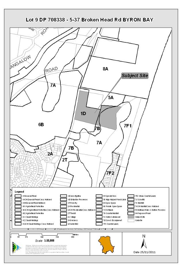
|
DA No:
|
10.2010.576.1
|
|
Proposal:
|
Proposed modifications to layout and facilities of an
existing Caravan Park.
|
|
Property description:
|
Lot 9 DP 708338
5-37 Broken Head Road Byron Bay
|
|
Parcel No/s:
|
111720
|
|
Applicant:
|
Thinktank Architects
|
|
Owner:
|
Zandata Pty Ltd
|
|
Zoning:
|
Zone No. 1(d) - Investigation Zone / PART 7(a) - Wetlands
Zone / PART 7(b) - Coastal Habitat Zone
|
|
Date received:
|
11 November 2010
|
|
Integrated Development:
|
S100B Rural Fires Act
|
|
Public notification or exhibition:
|
Level 2 advertising under DCP 2010 Part 17 – Public
Notification and Exhibition of Development Applications
Exhibition period: 2/12/10 to 15/12/10
No Submissions.
|
|
Other approvals (S68/138):
|
Roads Act (51); Stormwater (55); Water & Sewer (60)
|
|
Planning Review Committee:
|
Yes – 16 March 2011
|
|
Delegation to determination:
|
Council
|
|
Issues:
|
·
No Owner’s consent
|
|
Summary:
|
It is proposed to vary the design of an existing caravan
park to change the mix of sites and the site layout, replace the administration
building and amenities blocks and construct a new shop.
Background
Prior approvals that apply to the site date from 1972 when
Building Approval No. 6.1972.34.1 approved a caravan park, motel and
residence
The caravan park usage of the site has operated in a
modified and expanded form under Local Government Act approvals since 1987.
It currently operates under a Caravan Park approval for 53 Long-term sites,
71 Short-term sites and 130 campsites that operates until March 2012.
Prior application DA 10.2010.77.1 proposed a refurbishment
of the site to result in the provision of 20 camp sites, 55 short-term sites
and 120 long term sites. An assessment report recommending a refusal was
placed on the agenda for Council’s Ordinary Meeting of 11 February 2010. The
application was withdrawn prior to the Council meeting. The assessment report
to that prior application supported a mix of sites comprising at least 65
camp sites and no more than one half of the dwelling sites as long-term
sites.
Development Proposal
The current application proposes 78 long-term sites,
75 short-term sites and 60 camp sites, replacement amenities blocks and
administration building and a shop.
The proposed development decreases the number of camp
sites and increases the number of dwelling-sites, i.e. sites on which self
contained dwellings may be located, from 126 to 156 as compared with the
current caravan park approval. The proposed distribution of sites is
consistent with the position supported by Council officers in the report to
Council in regard to the prior, withdrawn application for the redevelopment
of the caravan park
The proposed development excludes the south eastern part
of the site which contains a Coastal Cypress Forest and remnant Swamp Sclerophyll Forest from use for dwelling/camp sites or for recreation. This contrasts
with the current Local Government Act approval that nominates this part of
the site as “Recreation Area” and with the prior, withdrawn application that
proposed development in this part of the site.
Prior report to Council’s Ordinary Meeting of Meeting
of 15 December 2011
This application was initially reported to Council’s
Ordinary Meeting of 15 December 2011. A refusal was recommended for reasons
relating to lack of owner’s consent, lack of the required S100B bush fire
safety authority, tree preservation and lack of detail re front landscaping
and fencing.
In the days immediately prior to that Council Meeting, a
bush fire safety authority was received and information that resolved other outstanding
matters apart from owner’s consent.
Council resolved [Resolution 11-1065] that Council
defer this matter to the 9 February 2012 Ordinary Meeting.
Assessment
The application has been assessed against relevant
environmental planning provisions including those relating to local amenity
and visual impact, ecological restoration and management, the capacity of the
development to obtain the required approval under s68 of the Local Government
Act, the requirement for a s100B authority under the Rural Fires Act and
internal and external access.
The application warrants approval on the merits. However,
the application is not accompanied by the consent of the landowner.
Lack of landowner’s consent
The applicant is a consultant architect acting for the
park operator who leases the site. The landowner’s legal representative has
advised Council that the landowner does not consent to the application.
The absence of owner’s consent has the consequence that
the application is recommended for refusal. The merit assessment of the
application has involved negotiations to resolve outstanding issues except
for that of owner’s consent which is a matter that is outside the scope of
Council’s responsibility to address.
|
1. INTRODUCTION
1.1 History/Background
BA 6.1972.34.1 for caravan park and motel and
residence was approved by Council on 31 May 1972.
BA 6.1981.514.1 for New amenities block for
caravan park was approved by Council on 9 September 1981.
Caravan Park/Camping Ground Licence dated 9 July 1987
issued by Council under section 289H of the NSW Local Government Act 1919.
Caravan Park/Camping Ground Approval dated 8 July 1994
issued by Council under section 68 of the NSW Local Government Act 1993.
Caravan Park/Camping Ground Approval 88.2002.6.1
Caravan Park/Camping Ground Approval 88.2002.6.1 renewed
for 5 years on 27 March 2007
DA 10.2010.77.1 proposed Alteration and additions
to existing Caravan Park to comprise 20 camp sites, 55 short-term sites and 120
long-term sites; remove one amenities building; upgrade existing amenities
building; replace existing manager’s residence/administration building/shop
with new buildings.
A report to Council’s Ordinary Meeting of 15 December 2011
was prepared. A refusal was recommended for the following reasons:
OWNER’S
CONSENT
1.
Pursuant to section 79C(1)(e) of the NSW Environmental Planning
and Assessment Act 1979, it is not in the public interest to grant a
development consent in the circumstance that the owner of the land to which the
development application relates has not granted consent to the development
application and in the context that the landowner has formally advised Council
that owner’s consent is not granted.
2.
Pursuant to section 79C(1)(e) of the NSW Environmental Planning
and Assessment Act 1979, it is not in the public interest to grant a
development consent in the circumstance that the owner of the land to which the
development application relates has not granted consent to the development
application and having regard to section 49(a)(1) of the NSW Environmental and
Assessment Regulation 2000 that provides that a development application may be
made by:
(a) by
the owner of the land to which the development relates, or
(b) by
any other person, with the consent in writing of the owner of the land.
BUSH FIRE SAFETY AUTHORITY
3.
Development consent can not be granted in the circumstance that
the proposed development is integrated development pursuant to section 91(1) of
the NSW Environmental Planning and Assessment Act 1979 which requires that a
bush fire safety authority issued under section 100B of the NSW Rural Fires Act
be obtained and given that no such authority has been obtained.
TREE PRESERVATION
4.
The proposed development does not comply with section 79C(1)(b)
of the NSW Environmental Planning and Assessment Act 1979 having regard to the
likely adverse impact on the coastal cypress trees located adjacent to the
north-western boundary of the site caused by the proposed stormwater retention
basin and associated road grading in the location of the trees.
In the days immediately prior to that Council Meeting, a
bush fire safety authority was received and information that resolved other
outstanding matters apart from owner’s consent. Council resolved [Resolution 11-1065]
that Council defer this matter to the 9 February 2012 Ordinary Meeting.
A report to Council’s Meeting of 11 February 2010 was
prepared. The application was withdrawn on 11 February.
The report recommended a refusal to the application for the
following reasons:
REASONS RELATING TO OWNER’S CONSENT
1. Pursuant
to section 79C(1)(d) of the NSW Environmental Planning and Assessment Act 1979,
it is not appropriate to approve the application having regard to the public
exhibition of the application from 26 March 2009 to 24 April 2009, the
submission on behalf of the owner of the land to which the development
application relates dated 24 April 2009 and the contents of that submission
that objects to Council assessing the application without the landowner’s
consent and objects to the application.
2. Pursuant
to section 79C(1)(e) of the NSW Environmental Planning and Assessment Act 1979,
it is not in the public interest to grant a development consent in the
circumstance that the owner of the land to which the development application
relates has not granted consent to the development application.
3
Pursuant to section 79C(1)(e) of the NSW Environmental Planning
and Assessment Act 1979, it is not in the public interest to grant a
development consent in the circumstance that the owner of the land to which the
development application relates has not granted consent to the development
application and having regard to section 49(a)(1) of the NSW Environmental and
Assessment Regulation 2000 that provides that a development application may be
made by:
(a) by
the owner of the land to which the development relates, or
(b) by
any other person, with the consent in writing of the owner of the land.
REASONS RELATING TO ZONE 1(d) OBJECTIVES
4. The
proposed development does not comply with section 79C(1)(a)(i) of the NSW
Environmental Planning and Assessment Act 1979 because of the failure of the
proposed development to comply with clause 9 of the Byron Local Environmental
Plan 1988 in regard to Zone 1(d) Objective (d) and Objective (f).
REASONS RELATING TO BYRON LOCAL ENVIRONMENTAL PLAN AIMS,
OBJECTIVES & GUIDING PRINCIPLES
5. The
proposed development does not comply with section 79C(1)(a)(i) of the NSW
Environmental Planning and Assessment Act 1979 because of the failure of the
proposed development to satisfy clauses 2(1)(d), 2(2)(c) and clauses 2(3)(a),
(b) and (c) of the Byron Local Environmental Plan 1988 having regard to the
proposed high conservation value vegetation removal and to the proposed
encroachments on high conservation value land.
6. The
proposed development does not comply with section 79C(1)(a)(i) of the NSW
Environmental Planning and Assessment Act 1979 because of the failure of the
proposed development to satisfy clause 2A of the Byron Local Environmental Plan
1988 having regard to the proposed vegetation removal and to the proposed
encroachments on remnant vegetation communities and fauna habitat.
7. The
proposed development does not comply with section 79C(1)(a)(i) of the NSW
Environmental Planning and Assessment Act 1979 because of the failure of the
proposed development to satisfy clause 2A(c) of the Byron Local Environmental
Plan 1988 having regard to the inconsistency of the proposed development with
sections 1.1, 1.2 and 3.1 of the Byron Biodiversity Conservation Strategy.
OTHER REASONS
8. The
proposed development does not comply with section 79C(1)(a)(i) of the NSW
Environmental Planning and Assessment Act 1979 because of the failure of the
applicant to consider whether the subject site is contaminated pursuant to
clause 7 of State Environmental Planning Policy No. 55 Remediation of Land.
9. The
proposed development does not comply with section 79C(1)(a)(i) of the NSW
Environmental Planning and Assessment Act 1979 because of the failure of the
proposed development to satisfy clause 45 of the Byron Local Environmental Plan
1988 having regard to the failure of the applicant to satisfy Council that
suitable stormwater drainage arrangements can be made in relation to the
development.
10. The
proposed development does not comply with section 79C(1)(a)(i) of the NSW
Environmental Planning and Assessment Act 1979 because of the failure of the
application to satisfy clause 37(2)(d) of the Byron Local Environmental Plan
1988 and having regard to the strategic implications of the proposed
development.
11. The
proposed development does not comply with section 79C(1)(a)(i) of the NSW
Environmental Planning and Assessment Act 1979 having regard to the failure of
the application to satisfy clause 37(3) of the Byron Local Environmental Plan
1988.
12. The
proposed development does not comply with section 79C(1)(a)(iii) of the NSW
Environmental Planning and Assessment Act 1979 because of the failure of the
proposed development to satisfy clause C 10.3 of the Byron Development Control
Plan 2002 because of the failure of the applicant to submit a suitable
landscape plan and having regard to the need for same given the proposed
density and design of the development .
13. The
proposed development does not comply with section 79C(1)(a)(iii) of the NSW
Environmental Planning and Assessment Act 1979 because of the failure of the
proposed development to satisfy clause C 10.3 of the Byron Development Control
Plan 2002 having regard to the proposed usage of sloping land with consequent
environmental damage, the failure to protect existing vegetation and to the
proposed repetitive layout unrelieved by landscaping.
14. The
proposed development does not comply with section 79C(1)(a)(iii) of the NSW
Environmental Planning and Assessment Act 1979 because of the non compliance
failure of the proposed development to satisfy clause N 2.1 of the Byron
Development Control Plan 2002 having regard to the failure of the application
provide sufficient information to assess whether the proposed stormwater
management system is feasible.
15. Pursuant
to section 79C(1)(e) of the NSW Environmental Planning and Assessment Act 1979,
it is not in the public interest to grant development consent to the
application having regard to the above reasons
1.2 Scope of prior
applications
BA 6.1972.34.1
This approved a caravan park and motel and residence
The report to Council in regard to the application states: The
application before Council provides for 20 caravan stands each having
individual shower and toilet accommodation, 30 caravan parking sites using
communal facilities, 12 tent sites using communal facilities and 6 unit motel.
In addition the application provides for a managers residence, a reception
block and two amenities blocks together with a swimming pool, wading pool
barbecue area, tennis courts and putting greens.
A Site Plan annotated as Job No. 37160 ASS:1195 B:514/81,
prepared by Grace Bros, dated 16.2.72 is located in Council records. This plan
is not endorsed however it contains the components of the development specified
in the Council officers’ report to Council and can reasonably be considered as
defining of the scope of BA 6.1972.34.1
BA 6.1981.514.1
This approved a New amenities block for caravan park.
Council records contain a plan and elevations of an Amenities Block annotated
B/A 514/81, prepared by Grace Bros and dated 20.2.72
Local Government Act Caravan Park/Camping Ground Licence
dated 9 July 1987
This Licence specifies its scope as comprising 39 long-term
residence sites, 61 Short-term residence sites and 154 Camp sites.
This Licence states that it was to…remain in force for a
period of 12 months from the date of issue unless sooner or suspended and
imposed as conditions:
- Subject to programme of works being lodged with Council
by 1st September, 1987.
- Works agreed to be Council in that programme being
institute as per that agreement
A Letter from Council to Canty & Williamson of 4
September 1987 states that …the programme of works provided by you to
Council in respect to Crosby’s Caravan Curt has been perused by Council and
found acceptable…has been forwarded to the Minister for Local Government for
the Minister’s perusal.
A site plan of Crosby’s Caravan Court annotated 1631
ASS:1195, prepared by Canty & Williamson depicts the site layout
in a manner consistent with the scope of the Licence. This plan can reasonably
be regarded as that associated with the Licence.
Local Government Act Approval to operate a Caravan
Park/Camping Ground dated 8 July 1994
This approval states: This approval relates to a total of
254 sites and camp sites as referenced on Plan No. 4946 and amendment 88/154
identified as Crosbys Caravan Park.
The approval specifies its scope as comprising 53 long-term
sites of which 22 contain Moveable dwellings with toilet & shower
ensuites, 71 short-term sites of which 13 to contain Moveable dwellings
with toilet & shower ensuites and 130 camp sites.
The Licence states: This approval relates to a total of
254 sites and camp-sites as referenced on Plan No. 4946 and amendment 88/154
identified as Crosby’s Caravan Park
Local Government Act approval 88.2002.6.1, renewed 27
March 2007
The approval states:
This approval relates
to a total of 124 dwelling sites and 130 camping sites These sites comprise 53
Long term Sites, 71 short term sites and 130 campsites. The numbers, sizes and
locations of all dwelling sites and campsites are specified in the community
map identified by Reference No; Map #1 dated 27/03/2007 (Annexure 8(b)).
This approval shall remain in force for a period of
five (5) years from the date of issue unless sooner or suspended.
Issued: 27 March 2007.
Expires: 28 March 2012.
1.3 Description of the
site
The site is located on the eastern side of Broken Head Road, approximately 250m to the south of the broken Head road and Bangalow Road intersection. south of the Byron Bay High School. It has an area of 10.7ha and
includes land in the Zones 1(d), 7(a) and 7(b). The site contains the caravan
park development currently known as Beaches of Byron.
Zones
The western part of the site is situated in the zone 1(d)
and land in this zone extends for approx 240m along the southern boundary. A
strip of land in the Zone 7(b), between 10m and 40m wide, abuts the eastern
boundary of the Zone 1(d) land. The remaining eastern part of the site is
situated in the Zone 7(a) and includes a wide section of Tallows Creek.
The existing caravan park is situated within the Zone 1(d)
and which part of the site occupies an area of approximately 5.6 ha.
Development
Existing Caravan Park
The existing caravan park comprises the following main
elements:
- Office, shop, administration and manager’s residence
adjacent to access point.
- A display home is located adjacent to the park entrance.
- Open camping in the northern part of the site.
- Older holiday/residential structures in the southernmost
part of the site,
- New residential structures with metal pole columns fixed
to concrete foundations in the central and north-eastern parts of the
southern section of site with further constructions underway.
- Two amenities blocks, covered kitchen/bbq.
Topography
The caravan park site is generally level for its majority
western part with variations of up to 1.5m. An embankment that runs north
–south is situated from between 200m to 230m from the western boundary of the
site and 10m to 20m from the from the eastern boundary of the Zone 1(d) land.
The bank falls approximately 2.5m – approximately from 5m AHD to 2.5m AHD - to
generally level land to the east. A knoll is located adjacent to the top of the
embankment and to the southern boundary and which rises to 9.5m AHD.
Vegetation
The majority western part of the site contains remnant and
landscape vegetation of various species. The most ecologically valuable area
within the Zone 1(d) is located in its eastern part. The site contains Coastal Cypress Pine Forest, which is an Endangered Ecological Community, in its
south-eastern corner. Remnant Swamp Sclerophyll Forest, also an Endangered
Ecological Community, and wetland habitat is located in the southern part of
the lower, level land in the eastern part of the site.
A number of significant landscape trees are situated on the
site, particularly in the existing camping areas.
Flood prone land
The eastern part of the site is flood prone and this
includes a small area in the south-eastern part of the site that is located in
the Zone 1(d).
Bush fire prone land
The site contains bush fire prone land
Acid sulfate soils
The site contains acid sulfate soils.
1.4 Description of the
proposed development
The development application form describes the proposed
development as Proposed Modifications to Layout and Facilities of an Existing Caravan Park approval to operate a Caravan park and Relocatable Cabin Park.
The application incorporates the following elements:
Sites
78 Long-term sites
75 Short-term sites
60 Camp sites
See Site Plan, drawing no. 1 Issue DA4.1, dated 14-11-11
(Annexure 8(a).
Refurbished Reception/Amenities/Manager’s Residence
Ground level reception, toilets and communal facilities.
First storey residence.
See submitted drawing no. 8 – Floor Plans, dated 21-7-2011
and submitted drawing no. 9 – Elevations, dated 21-7-2011.
Shop
Detached single storey building. See submitted drawing No.7
– Ground Floor & Elevations, dated 21-7-2011.
Amenities
New amenities building in proposed camping area: see drawing
no. 17 Issue DA4.1- Amenities (Floor plan), dated 24-1-11 and drawing no. 18
Issue DA4 – Elevations, dated 21-7-2011
Cabins
The applicant has advised that all dwelling-sites are to be
considered as reserved for self contained movable dwellings. The application
incorporates the following cabin designs:
Generic cabin designs
1-bedroom cabin design: see drawing no. 10 – 1 Bed Cabin
Details, dated 21-7-2011.
2-bedroom cabin design: see
drawing no. 11 - Floor Plan & Elevations 2 Bed Bondor, dated 21-7-2011.
2 bedroom cabin design: see drawing no. 14 – 2 Bed Type 2,
dated 21-7-2011.
2 bedroom cabin design: see drawing no. 15 – Plans &
Elevations [Large House], dated 21-7-2011.
Particular cabin designs
Designs for cabins on sites LT 6, 12, 34 and 37 & ST
44-49, 51-54 and 56 [Council doc #1168153]
Access
Excavation
Stormwater management is proposed by way of infiltration
detention tanks requiring extensive cuts of a maximum of 2m and bio retention
basins.
Fences
Submitted drawing Figure 6 Landscape Works - Fencing
Details, prepared by Butler & Webb, dated 26.07.10 depicts a 1.8m high
Aluminium Batten Fence with concrete footings to posts at 2.4m intervals at a
2m setback from the western boundary.
This is superseded by Figures 9 & 10, dated 08.09.10,
that depict a 1m-1.15m high mounded landscaping buffer on the western boundary
of the site and the fence located along the high point of the mound
approximately 5m inside the boundary.
No final fence details have been received.
Landscaping
The submitted Site Layout depicts areas available for
landscaping. These include a number of small areas within the site and a buffer
on the western (road) boundary generally of a width of 10m with a section of a
width of 6-7m. Submitted drawings prepared by Butler and Webb depict
landscaping proposals. Figures 9 and 10 These vary in terms of what is
proposed. However, Figures 9 and 10, submitted following discussions between
Council’s consultant planner and Butler & Webb, depict landscaping to a
depth of 7m-10m along the western boundary, containing mounding to a height of
1m -1.5m.
Submitted drawings
Buildings & Layout
Drawing No. 4 Existing Site Plan [This provides replication
of Local Government Act approved plan at a useful scale]
Drawing No. 1.Issue DA4.1, Site Plan, dated 14/11/2011
[Council doc #1168101, superseded Council doc #1116816]
Drawing No. 7 Shop Plans dated 21-7-2011
Drawing No. 8 Alterations to Admin Building, dated 21-7-2011
Site Plan, dated 21-7-2011
Drawing No. 9 Administration Building Elevations, dated
21-7-2011
Drawing No. 17 Issue DA4.1 Amenities Plan dated 24/10/2011
[Council doc #1168153]
Drawing No. 18 Amenities Building Elevations & Plan
dated 21-7-2011 [Council doc #1116816]
Drawing No. 4 Issue DA4.1, Tree Removal Plan, dated 8-4-2011
Fencing
Drawing No. 3 Fence details dated 21-7-2011
Figure 9 Landscape Works – Indicative Buffer Sections Sheet
1 of 2, prepared by Butler and Webb, dated 08/09/10 [new]
Figure 10 Landscape Works - Indicative Buffer Sections Sheet
2 of 2, prepared by Butler and Webb, dated 08/09/10 [new]
Front Fencing and Landscape Details in correspondence of
21/12/2011 [Council doc #1181344]
Other
8145 2 Fire Hydrant
and Reticulated Water Supply Plan undated [Council doc #1120740]
08145 02/02 Fire Hydrant Coverage plan undated [#1120740]
Drawing No. 5 DA4 Community Amenities Areas dated 21-7-2011
Drawing No. 6 Area Calculation dated 20-7-2011
Drawing No. 2 Fire Buffer Plan dated 21-7-2011
Generic Cabin Details
Drawing No. 10 Bed Cabin Details dated 21-7-2011
Drawing No. 11 Floor Plan & Elevations 2 Bed Bondor,
dated 21-7-2011
Drawing No. 12 Short Term Cabin Relocation dated 21-7-2011
Drawing No. 13 Panel details dated 21-7-2011
Drawing no. 14 2 Bed Type 2, dated 21-7-2011
Drawing No. 15 – Plans & Elevations [Large House], dated
21-7-2011
Drawing No. 16 Relocation Plan dated 21/7/2011
Particular Cabin Details
Designs for cabins LT 6, 12, 34 37 & ST 44-49, 51-54 and
56 have been submitted [Council doc #1168153]
Submitted Landscape Plans
The following were submitted at the time of the lodgement of
the application prior to changes to the Site layout.
Figure 1 Landscape Works Landscape Concept Plan, prepared by
Butler & Webb, dated 26.07.10
Figure 2 Landscape Works Open Space Areas, prepared by
Butler & Webb, dated 26.07.10
Figure 3 Landscape Works - Reception/Central Facilities
Plan, prepared by Butler & Webb, dated 26.07.10
Figure 4 Landscape Works - Shop and Entry Plan, prepared by
Butler & Webb, dated 26.07.10
Streetscape Concept Plan, prepared by Butler & Webb,
dated 26.07.10
Figure 6 Landscape Works - Fencing Details, prepared by
Butler & Webb, dated 26.07.10
Figure 7 Landscape Works - Indicative Buffer Sections,
prepared by Butler & Webb, dated 08.09.10
Figure 8 Landscape Works - Indicative Broken Head Road
Elevation, prepared by Butler & Webb, dated 08.09.10
Figure 9 Landscape Works – Indicative Buffer Sections Sheet
1 of 2, prepared by Butler and Webb, dated 08/09/10 [new]
Figure 10 Landscape Works - Indicative Buffer Sections Sheet
2 of 2, prepared by Butler and Webb, dated 08/09/10 [new]
Drawing No. 5 DA4 Issue 1 Tree Removal Plan dated 8-4-2011
Submitted reports/documents/certification
Ecological Assessment by Blackwood Ecological Services dated
August 2010
Waste Management Plan dated September 2010
“Conceptual Stormwater Management Plan,” by Cardno, dated 30
July 2010
Concept Stormwater Management report prepared by Greg
Alderson dated 10 June 2011
Concept Stormwater Layout Plan, drawing 08145_SW2, prepared
by Greg Alderson, undated
Further stormwater management information prepared by Greg
Alderson dated 25/10/2011 [Council doc #1168101]
Concept Stormwater Layout Plan, drawing 08145_SW2, prepared
by Greg Alderson, dated 1/11/2011
Preliminary Acid Sulfate Soil Assessment prepared by Greg
Alderson dated 15 June 2011 [Council doc #1120773] [Amended from prior undated
plan], as amended by:
Concept Stormwater Layout submitted 9/12/2011 [Council doc
#1176231]
Preliminary Contaminated Land Assessment prepared by Greg
Alderson dated 25 June 2011 [Council doc #1120773]
Proposed Sewer layout/Design prepared by Greg Alderson dated
11 July 2011 [Council doc #1120759]
Caravan Park Code and Construction Standard Assessment Stage
Two and Three by Mark Norris & Assocs dated 19 July 2011 [Council doc
#1116820]
Traffic Impact Assessment prepared by Greg Alderson dated
July 2011 [Council doc #1141788]
Bushfire Threat Assessment Report by BCA Check dated July
2008 as amended November 2010, August 2011 [Council doc #1133130,
Trade waste report by G Alderson dated 3 August 2011
[Council doc #1121875]
1.5 Owner’s consent
Part 1(i) of Schedule 1 of the
EPA regulations which specifies the information to be included in a development
application states: if the applicant is not the owner of the land, a
statement signed by the owner of the land to the effect that the owner consents
to the making of the application,…
The applicant is Thinktank Architects, acting for the lessee
of the site.
Step 12 of the development application form lodged with
Council has been completed to state Zandata P/L –See attached correspondence
with Ray Darney [Council’s Director of Planning] and is also signed by
Michael Jullyan for the applicant.
The landowner is Zandata P/L. Correspondence of 23 November
2010 to Council from a solicitor acting for Zandata Pty Ltd states: Byron
Bay Retirement Villages currently has a development application lodged
pertaining to this block of land [i.e. the site]. We advise that Zandata Pty
Ltd does not consent to the development application before Council.
It is noted that the matter of owner’s consent arose in regard
to DA 10.2009.77.1 for a like development on the site. A report to Council was
completed which recommended refusal. The application was withdrawn prior to its
consideration by Council.
At that time the landowner’s
then agent was advised that, pursuant to paragraphs 9 and 10 of Becton
Corporation Pty Limited v Minister for Infrastructure, Planning and Natural
Resources & Anor [2005] NSWLEC 197 (26 April 2005), it was open to
Council to assess the application without the owner’s consent.
The applicant advised in
correspondence to Council of 12 November 2009 that under the terms of the lease
the lessee has “…the landlords automatic consent to any application that is
capable of being approved by BSC. This lease condition was confirmed recently
by the Supreme Court of NSW, contrary to the owners current and unlawful
objection. Please contact us if you require a copy of the courts determination
in this matter. We would however rely on the fact that in due process Council
should determine this application, with a condition that owners consent is
naturally required, this approval will then be confirmed by both parties
solicitors, under the terms of our lease.”.
The private arrangements
between the lessor and lessee are not considered in this report. The relevant
fact is that the landowner has not consented to the application. This
circumstance has the consequence that a refusal to the application is
recommended.
2. SUMMARY OF
GOVERNMENT/EXTERNAL REFERRALS
Rural Fire Service
The proposed development comprises a caravan park and as
such requires a bush fire safety authority issued under Section 100B of the
Rural Fires Act.
The Rural Fire Service has issued a S100B authority
conditioned as follows:
Asset Protection Zones
The intent of measures is to provide sufficient space and
maintain reduced fuel loads so as to ensure radiant heat levels of buildings
are below critical limits and to prevent direct flame contact with a building.
To achieve this, the following conditions shall apply:
1.
A
minimum 15 metre APZ shall be provided to the north of proposed lots LT67 to
LT72.
A minimum 16 metre APZ
shall be provided to the north of proposed lots LT42 to LT55.
The APZs shall be managed
as an inner protection area (IPA) as outlined within Appendices 2 & 5 of
‘Planning for Bush Fire Protection 2006’ and the NSW Rural Fire Service’s
document ‘Standards for asset protection zones’.
2.
A
minimum 20 metre APZ shall be provided to the east of proposed lots LT57 to
LT66.
A
minimum 21 metre APZ shall be provided to the east of proposed lots LT67.
The APZs shall be managed
as an inner protection area (IPA) as outlined within Appendices 2 & 5 of
‘Planning for Bush Fire Protection 2006’ and the NSW Rural Fire Service’s
document ‘Standards for asset protection zones’.
Water and Utilities
The intent of measures is to provide adequate services of
water for the protection of buildings during and after the passage of a bush
fire, and to locate gas and electricity so as not to contribute to the risk of
fire to a building. To achieve this, the following conditions shall apply:
3.
Water,
electricity and gas are to comply with sections 4.1 .3 and 4.2.7 of
‘Planning for Bush Fire Protection 2006’.
Access
The intent of measures for fire trails is to provide
suitable access for fire management purposes and maintenance of APZs. To
achieve this, the following conditions shall apply:
4.
The
proposed fire trail shall have:
i.
a
minimum carriageway width of 6.5 metres with an additional 1 metre wide strip
on each side of the trail clear of bushes and long grass;
ii. an all weather surface;
iii. a minimum vertical
clearance of 6 metres to any overhanging obstructions, including tree branches;
iv. where gates for the fire
trail are provided and locked, the key/lock system shall be authorised by the
local RFS.
The intent of measures
for internal roads is to provide safe operational access for emergency services
personnel in suppressing a bush fire, while residents are accessing or
egressing an area. To achieve this, the following conditions shall apply:
5.
Internal
roads shall comply with section 4.2.7 of ’Planning for Bush Fire
Protection 2006’.
Evacuation and Emergency Management
The intent of measures is to provide suitable emergency and
evacuation (and relocation) arrangements for occupants of special fire
protection purpose developments. To achieve this, the following conditions
shall apply:
6.
Arrangements
for emergency and evacuation are to comply with section 4.2.7 of ‘Planning for
Bush Fire Protection 2006’.
Design and Construction
The intent of measures is that buildings are designed and
constructed to withstand the potential impacts of bush fire attack. To achieve
this, the following conditions shall apply:
7.
Construction
on lots LT54 to LT56 & LT68 to LT72 shall comply with section 7 (BAL 29)
Australian Standard A53959-2009 ‘Construction of buildings in bush fire-prone
areas’.
The southern elevation
maybe reduced and comply with section 6 (BAL 19) and section A3.7 Addendum
Appendix 3 of ‘Planning for Bush Fire Protection’.
8.
Construction
on lots LT57 to LT67 shall comply with section 8 (BAL 40) Australian Standard
AS3959-2009 ‘Construction of buildings in bush fire-prone areas’.
The
western elevation maybe reduced and comply with section 7 (BAL 29).
9.
Construction
on lots LT42 to LT53 shall comply with section 8 (BAL 40) Australian Standard
A53959-2009 ‘Construction of buildings in bush fire-prone areas’.
The
southern elevation maybe reduced and comply with section 7 (BAL 29).
10.
Construction
on lots 5T50 to 5T63 shall comply with section 6 (BAL 19) Australian Standard
A53959-2009 ‘Construction of buildings in bush fire-prone areas’ and section
A3.7 Addendum Appendix 3 of ‘Planning for Bush Fire Protection’.
The southern elevation
maybe reduced and comply with section 5 (BAL 12.5) and section A3.7 Addendum
Appendix 3 of ‘Planning for Bush Fire Protection’.
11.
Construction
on lots 5T38 to 5T49, 5T69 to 5T75 & LT73 to LT76, LT78 shall comply with
section 5 (BAL 12.5) Australian Standard A53959-2009
Construction of buildings
in bush fire-prone areas ’and section A3.7 Addendum Appendix 3 of ‘Planning for
Bush Fire Protection’.
12.
Construction
on lots 5T64 to 5T68 & LT77 shall comply with section 6 (BAL 19) Australian
Standard A53959-2009 ‘Construction of buildings in bush fire-prone areas ’and
section A3.7 Addendum Appendix 3 of ‘Planning for Bush Fire Protection’.
Landscaping
13.
Landscaping
to the site is to comply with the principles of Appendix 5 of ‘Planning for
Bush Fire Protection 2006’.
3. SECTION 79C –
MATTERS FOR CONSIDERATION – DISCUSSION OF ISSUES
Having regard for the matters for consideration detailed in
Section 79C(1) of the Environmental Planning & Assessment Act 1979, the
following is a summary of the evaluation of the issues.
3.1. STATE/REGIONAL
PLANNING POLICIES AND INSTRUMENTS
|
Requirement
|
Requirement
|
Proposed
|
Complies
|
|
State Environmental Planning Policy No 55—Remediation
of Land
|
Council must:
(a) consider whether the land is contaminated, and
(b) if the land is contaminated, if the land is
suitable in its contaminated state or after remediation, and
(c) be satisfied the land will be remediated before
the land is used.
|
‘Preliminary Contaminated Land Assessment for Lot 9 DP 708338. 5-37 Broken Head Road, Byron Bay. Greg Alderson and Associates Pty Ltd.
Report No. 08145_SEPP55_2. 15 June 2011’ submitted.
This report states 12 soil samples were collected,
composited and analysed for a range of heavy metals and pesticides. All
results were below the NSW DEC Health Based Investigation Levels
(Residential) or below the limit of reporting. The site is not considered to
be contaminated and is suitable for its intended use.
No further information is required.
|
Yes
|
|
State Environmental Planning Policy No 21—Caravan Parks
|
8 Development
consent required for caravan parks
(2) Before granting development consent…a Council must
determine
the number of sites (if any) within that land that the
Council considers are suitable for long-term residence…and that are not
suitable for long-term residence, but are suitable for short-term residence…
and must impose a condition specifying the maximum number of sites (if any)
within that land that may be used for long-term residence.
10
Matters to be considered by Councils
a) (a) whether,
because of its location or character, the land concerned is particularly
suitable for use as a caravan park for tourists or for long-term residence,
(b (b)
whether there is adequate provision for tourist accommodation in the locality
of that land, and whether existing or potential tourist accommodation will be
displaced by the use of sites for long-term residence,
(c(c)
whether there is adequate low-cost housing, or land available for low-cost
housing, in that locality,
|
The number of proposed long-term sites is specified in the
application and which number is the result of negotiations between applicant
and Council and which number, in the context of the number of proposed
short-term sites and camping sites, is supported
Site has long-standing use as a caravan park and is the
subject of a current Local Government Act caravan park approval
The proposed mix of sites suitably reflects the need for
both tourist use of the site and long term residence in the locality
Existing low cost housing in the locality is provided by
the subject caravan park. It is proposed to increase the number of long term
sites from the 50 approved in the current Local Government Act approval to
the proposed 79. The development will benefit the provision of affordable, or
at least more affordable, housing in the locality.
|
Yes
Yes* (see comment below)
Yes* (see comment below)
Yes
|
|
Local Government (Manufactured Home Estates, Caravan Parks, Camping Grounds and Moveable Dwellings) Regulation 2005
|
Caravan Park:
Compliance with provisions of Part 3
|
Relevant provisions of the Regulations are cited below and
the compliance, or otherwise, of the proposed development discussed in relation
to these.
|
Yes (development is capable of compliance with relevant
Regulations
|
|
North Coast Regional Environmental Plan
|
43 Development control—residential
development
The council shall not grant consent to development for
residential purposes unless:
©I (c) it is
satisfied that, where development involves the long term residential use of
caravan parks, the normal criteria for the location of dwellings such as
access to services and physical suitability of land have been met,
|
The site is suitable for limited urban residential
development
|
Yes
|
|
NSW Coastal Policy 1997
|
Protection of coastal environment, access and amenity
|
Proposed development will not materially impact on
existing coastal environment, access or amenity
|
Yes
|
State/Regional Planning
Policies and instruments
State Environmental Planning Policy No 21—Caravan Parks
10 Matters
to be considered by Councils
(a) whether, because of its location or
character, the land concerned is particularly suitable for use as a caravan park
for tourists or for long-term residence,
The subject site has had long usage as a caravan park
containing long term sites, short tern sites and camping sites with the
predominant use being that of tourist use. The applicant was advised in the
context of a prior application, that an appropriate mix of sites would comprise
a minimum 65 camp sites and no more than one half of the other sites as
long-term sites. The current proposal generally complies with this advice and
is considered to be suitable for the site.
The incidence of long term sites in the proposal should not
however be at the expense of suitable tourist amenities. Such amenities reasonably
require the provision of communal cooking/eating/washing up facilities as is
currently provided. This matter is discussed in section 3.4 of this report in
comments in relation to social and economic impacts in the locality
(b) whether there is adequate provision for
tourist accommodation in the locality of that land, and whether existing or
potential tourist accommodation will be displaced by the use of sites for
long-term residence,
There is limited tourist accommodation in the southern part
of Byron Bay and the Suffolk Park settlement between which the subject site is
located. Caravan park style accommodation is available at the Suffolk Park
Caravan Park of approximately 55 sites located 2 km to the south and a
primitive camping ground of 7 sites is located at the Red Devils sports ground
1km to the north.
The existing camping area and the northern short-term sites
area (which do not have structures in place) are commonly under-utilised. It
can be accepted that the mix of sites can be varied as proposed without
unacceptably harming the adequacy of the availability of this kind of tourism
in the locality. However, this adequacy requires that camping provision of an
amenity substantially commensurate with that currently available on the site be
provided. While such amenity will be tend to be diminished by the increase in
the number of self contained dwellings, such amenity can be more substantively
maintained by the inclusion of communal cooking facilities in the development.
The applicant has indicated agreement to the incorporation of a communal
facility.
Local Government (Manufactured Home Estates, Caravan Parks, Camping Grounds and Moveable Dwellings) Regulation 2005
Caravan parks require both development consent under the EPA
Act and approval under Section 68 of the Local Government Act. The latter
approval requires compliance with Local Government (Caravan Parks, Camping Grounds and Moveable Dwellings) Regulation 1995. There would be no utility
in issuing a consent without confidence that the requisite Local Government Act
approval can be obtained and therefore the application has been assessed
against these Regulations.
The application incorporates a “Caravan park Code”
assessment for Stages 2 and 3. This concludes that the “…proposed design of
stages 2 and 3 would comply with the relevant regulatory requirements of the
Local Government…Regulation.”
It is however noted that compliance with these Regulations
does not, of itself, demonstrate compliance with s79C(1) of the EP & A Act
and it is open to Council, if the merits so warrant, to impose additional
controls to those provided in the Regulations.
Where appropriate the provisions of the Local Government Act
Regulations have been considered below.
72 Matters to be specified in
approval
(1) In
addition to any other matters it must contain, an approval to operate a caravan
park or camping ground must specify the following:
(b) (i) the
number, size and location of long-term sites allowed by the approval, and
(ii)
the number, size and location of short-term sites allowed by the approval, and
(iii) the
number, size and location of dwelling sites (whether long-term or short-term)
to be reserved for self-contained moveable dwellings, and
A development consent for the proposal would specify site
numbers and types. The applicant has advised that all long-term and short-term
sites be reserved for self-contained moveable dwellings and any ramifications
of this, e.g. timing of water and sewer provision, other usage of site if no
dwelling in place, can be conditioned in a development consent.
74 Conditional
exemptions
(1) The
prior approval of the council is not required for the installation of a
relocatable home or associated structure on a dwelling site within a caravan
park, so long as it is designed, constructed and installed in accordance with
the relevant requirements of Division 4.
It is however noted that pursuant to clause 160 of the
Regulations, Council is required to be advised of the installation of a
relocatable home within 7 days of its installation and informed as to its
compliance with specified clauses.
76 Installation of
relocatable home, rigid annexe or associated structure of more than one storey
The submitted Site Plan is annotated to state: All buildings
except main facilities building must be a maximum of 1 storey.”
There exist 2 dwellings on the site greater than one storey.
A consent can be conditioned to specify sites on which existing two storey
buildings are located and require that if these are to be replaced, then only
one storey buildings are permitted.
84 Community amenities
(1) Of
the total land area of a caravan park or camping ground:
(a) at
least 10 per cent, or
(b) such
lesser proportion (but not less than 6 per cent) as the approval for the
caravan park or camping ground may allow, must be reserved for recreation or
other communal activities.
(2) In
deciding whether to allow a lesser proportion, the council must have regard to
the type and range of amenities to be provided and to such other matters as it
considers relevant.
Clause C 10.2 of DCP 2002 also contains provisions that
relate to “Recreation Areas”. These require that 10% of the caravan park area
be reserved for recreational and community activities, that 10% of this
reserved area may be occupied by appropriate building and that the reserved
area must not include any site, camp-site, roadway or other area designated
for any other purpose…
Site has an area of 10.7 ha. Approximately 5.6 ha is located
in the Zone 1(d), the remainder in the Zones 7(a) and 7(b). For the purpose of
the application of this clause, the “site” is deemed to comprise that land in
the Zone 1(d). Caravan parks are prohibited in the Zones 7(a) and 7(b) and
there is no suggestion from the applicant that any existing use right extends
onto the Zone 7(a) and/or 7(b) lands.
The SEE states in regard to clause 84 of the Regulations and
clause C 10.2 of DCP 2002 that over 3 ha of the site is available for
recreation area, including open space and pool area, free of roads, sites and
amenities. [SEE p.17, p.20]
10% of the site area comprises an area of 5,500 m2.
The site includes an area of approximately 5,500 m2 between
the eastern edge of the sites and the eastern edge of the Zone 1(d) land. It
has been agreed with the applicant that approximately the southern 2,400 m2 of
this land have restricted usage and be dedicated to ecological restoration and
management with the remainder available for community use. The amended layout
as displayed in the Site Plan dated 21-7-2011depicts an area of approximately
500 m2 for the pool and grassy surrounds, a grassed area of approximately 650
m2 opposite the pool and a grassed area of 400 m2 to replace the southern
amenities building. Also, the development includes a 10m to15m setback on the
northern boundaries which will contain a 7m wide fire access road. It is noted
that use of this road will be restricted to emergency vehicles and the setback
will therefore contribute to the provision of open space. The development also
incorporates communal areas associated with the administration building and
shop.
In the context of the above, the proposed development is
satisfactory in regard to the provision of open space.
85 Size of dwelling sites and camp sites
(1) A long-term site must have an area of at least
80 square metres.
(2) A short-term site must have an area of at least
65 square metres.
(3) A camp site must have an area of at least:
(a) 40
square metres, in the case of a camp site for which a separate parking space is
provided within 30 metres of the camp site, or
(b) 50
square metres, in any other case.
All sites have compliant areas. Long-term site areas range
widely from 89 m2 to 419 m2. Short-term site areas range from 66 m2 to 209 m2.
Camp sites range from 49 m2 to 109 m2.
91 Separation distances
(1) A moveable dwelling must not be installed
closer to any other moveable dwelling than:
(a) 3
metres, if it is situated on a long-term site, or
(b) 2.5
metres, if it is situated on a short-term site or camp site
The proposed sites are capable of containing dwellings that
comply with clause 91.
92 – 100 Roads
Sections 92 -100 prescribe standards for access, internal
roads and parking. These matters are discussed below in comments in relation to
Part G of Chapter 1 Byron DCP 2010 in which it is assessed that the proposed
internal road system is satisfactory.
102 Sewerage
It is proposed that all dwelling sites be connected to sewer
mains
103 Drainage
See comments re Part N of Chapter 1 of DCP 2010
107/108 Showers and toilets
The Regulations provide a table that specifies minimum
shower/toilet numbers, including for disabled provision. It is noted that s71
of the Regulations requires that council specify the number of dwelling sites
(long or short term) to be reserved for self contained moveable dwellings.
Unless a site is so specified, it would need to be counted in the table.
A 3 stage development is proposed. An existing amenities
building is located in that part of the site designated as Stage 1 and a second
existing amenities building is located in that part of the site located in
Stage 2. The submitted Site Plan deletes the existing building in the Stage 2
part of the site and depicts a new amenities building in the camping area for
Stage 3. The applicant has stated that all long and term sites are to be
reserved for self-contained dwellings.
Any development consent to the application should include
suitable conditions in regard to the staging of the development to ensure that
adequate facilities are available at any time.
Within each stage it may take a considerable time before all
dwelling sites contain a self-contained dwelling if in fact that outcome
eventuates. In the interim, if there is public demand for the use of unoccupied
sites for campervan /caravan/camping use it would be prudent to anticipate that
such a use would be undertaken. Also, the existing 154 camp sites will remain
until Stage 3.
It is recommended that the existing amenities within Stages
1 and 2 be maintained in operation until all sites within Stages 1 and 2
contain-self contained dwellings and provided that Council has received a
notice of the installation of each self-contained dwelling as per clause 160 of
these Regulations.
Also that the existing amenities within Stage 2 remain in
operation until all dwelling sites within Stages 2 and 3 contain self contained
dwellings and provided that Council has received a notice of the installation
of each self-contained dwelling as per clause 160 of these Regulations and
until the proposed new amenities in Stage 3 are operating.
The proposed amenities block will contain adequate
facilities for the proposed camp sites usage.
113-116 Laundry facilities
A self contained dwelling with laundry facilities does not
generate a requirement for a communal laundry facility. The 60 camp sites
generate a demand for 2 washing machines and 120m of clothes line. The proposed
amenities block which will replace the existing amenities blocks will provide 3
washing machines and some 60m of clothes line. Further clothes line provision
is required
139 Site coverage
(1)
A relocatable home and any associated structure must not be installed on a
single dwelling site if the floor plan area of the relocatable home (together
with any associated structure or other building or structure on the site) is
more than two-thirds of the area of the site.
(2) For
the purposes of this clause:
(a) the
floor plan area of a relocatable home is the area of the dwelling site occupied
by the home, excluding the area of any associated structure forming part of the
home that is not roofed, and
(b) the
floor plan area of any associated structure not forming part of the relocatable
home is the area of the dwelling site occupied by the structure, excluding any
area that is not roofed, and
(c) if
there is no carport or garage on the dwelling site, an area of 18 square metres
must be added to the floor plan area of the relocatable home to account for the
car parking space that is required by subclause (3) to be provided on the site.
(3) If
there is no carport or garage on the dwelling site, an area with minimum
dimensions of 6 metres by 3 metres, accessible from an access road and useable
for car parking, must be provided on the site.
(4) Subclause
(3) does not apply if the resident’s parking space for that dwelling site is
separate from the site.
160 Notice
of installation of relocatable home or associated structure
Section 160 provides as follows:
(1) The
holder of an approval to operate a caravan park or camping ground must give the
council written notice of the installation of a relocatable home or associated
structure within 7 days after the completion of the installation.
(2) The
notice:
(a) must
indicate the site identifier of the dwelling site on which the relocatable home
or associated structure has been installed, and
(b) must
include the particulars contained on each compliance plate relating to the
relocatable home or associated structure.
(3) The
notice must also be accompanied by:
(a) a
copy of the engineer’s certificate for the relocatable home or associated
structure, and
(b) a
fully dimensioned diagram of the dwelling site on which the relocatable home or
associated structure is installed, sufficient to indicate whether or not the
setback, density, open space and site delineation requirements of this Part
have been complied with.
The site contains a number of older dwellings and a number
of very new dwellings with installation of new dwellings continuing. Council
has not been advised, pursuant to clause 160, of the installation of all of
these new dwellings or of the relevant details.
It cannot be assumed that these new dwellings are compliant
with the Regulations in the context of the proposed site layout. It also not
known whether new reticulated water and/or sewer services have been installed
(as distinct to connections from existing reticulated services to individual
dwellings) and if so, whether approval under Section 68 of the Local Government
Act has been obtained for these installations.
This assessment concludes that the proposed site layout
complies with relevant Local Government Act provisions. It would be appropriate
for Council to require, prior to the issue of a Local Government Act approval
for the development, an audit of existing dwellings on the site.
3.2. BYRON LOCAL
ENVIRONMENTAL PLAN 1988
Zone: Zone No. 1(d) - Investigation Zone / PART 7(a) -
Wetlands Zone / PART 7(b) - Coastal Habitat Zone [Development is restricted to
Zone 1(d) land only]
Definition: Caravan Park
|
LEP Requirement
|
Summary of Requirement
|
Proposed
|
Complies
|
|
Meets zone 1(d)objectives
|
(b) to
ensure that development within the zone is compatible with the anticipated
future development of the land;
(f) to
identify land requiring protection of significant vegetation and wildlife
habitats, and to ensure that development does not adversely affect the
integrity of the environment.
|
The Local Environmental Study prepared as the basis for
the preparation of a new Local Environmental Plan, commissioned by Council
resolution 04-1067 and confirmed by Council resolution 06-416, states:
This lot is part of investigation site 3 of the Byron Bay and Suffolk Park Settlement Strategy and is not recommended for significant urban
development.
The area used for a caravan park should be zoned SP3 to
reflect Council’s desire to maintain this sort of tourism accommodation in Byron Bay (p464)
Anticipated future use is for predominant tourism use
which will be maintained by the proposed mix of sites
The high conservation value parts of the site will not be
developed and will be protected
|
Yes
Yes
|
|
Permissible/Prohibited use
|
Caravan Park prohibited in Zone 1(d)
|
The application states that: the proposed alterations
are permissible under the provisions of Sec 106 of the EPA Act
|
* See comments re existing use below
|
|
2A Implementation of aim, objectives and guiding
principles
|
Council shall have regard to the information, guidelines
and recommendations of…the Byron Biodiversity Conservation Strategy
|
The development will enable the use of the south-eastern
part of the caravan park site, which contains HCV vegetation and abuts land
in the Zone 7(b), to be restricted and the area dedicated to ecological
enhancement. This part of the site is designated as “Outdoor Recreation Area’
on the current S68 Caravan park approval.
|
Yes
|
|
24 Development of flood liable land
|
Council
must be satisfied that:
-
flow characteristics of flood waters are not restricted;
|
Condition required re floor levels of specified sites
|
Yes* (see comment below)
|
|
36 Development adjoining wetland
|
A person shall not clear, drain, excavate or fill land
without the consent of council.
Development on
or adjoining or contiguous to land within Zone No. 7(a) consideration must be
given to effect on flora and fauna found in the wetlands and the water table
|
The site incorporates land and a water course in the 7(a)
Zone. The part of the site that contains existing development and the
proposed development is located in the Zone 7(d). No works are proposed that
will adversely impact on the flora and fauna found in the wetlands and the
water table.
|
Yes
|
|
37 Development within Zone No. 1(d)(Investigation Zone)
|
Consideration must be given to the following
as they relate to likely future uses of the land to be investigated:
-
the strategic implication of the development of the land
-
environmental management of the land
-
the need to protect significant vegetation and wildlife
habitats, and
-
affect on significant vegetation and wildlife on that land or
adjacent land
|
See comments above re Zone 1(d) objectives
|
Yes
|
|
45 Provision of Services
|
The Council shall not consent to the carrying out of
development on any land to which this plan applies unless it is satisfied
that prior adequate arrangements have been made for the provision of
sewerage, drainage and water services to the land
|
Council sewer and water services are available to the
site. Details of current and proposed loads are specified in comments in
section 4.1 of this report
|
Yes
|
|
52 Tree
Preservation
|
A person must not ringbark, cut down, top,
lop, remove, injure or wilfully destroy any tree or other vegetation covered
by the tree preservation order without the consent of Council.
|
The development will require the removal of tress across
the bulk of the site proposed for self contained dwelling sites. This is
supported given that ecological enhancement is proposed for the south eastern
part of the site and substantive front setback landscaping is proposed.
|
Yes
|
|
63 Acid sulphate soils
|
Western portion Class 3 soils.
Eastern portion Class 2 soils
|
Excavation up to 2m proposed in eastern part for
stormwater management and excavation will be required for water/sewer services.
|
Yes*(see comment below)
|
* Non-complying issues
discussed below
Byron Local Environmental Plan
1988- Issues
Permissible use
The application claims an existing use right under section
106 of the EPA Act and proposes changes to that existing use right under
section 41(1) of the EPA Act Regulations.
Building application 6.1972.34.1 for caravan park and
motel and residence was approved by Council on 31 May 1972 and BA
6.1981.514.1 for New amenities block for caravan park was approved by
Council on 9 September 1981.
Under the Byron Interim Development Order No.1 the site was
zoned non-urban and a caravan park/camping ground was a permissible use
Consequent to the gazettal of the Byron LEP, the site was
zoned part Zone 1(d), part Zone 7(a) and part Zone 7(b). The proposed
development is restricted to that part of the site located within the Zone
1(d). A caravan park is not specified as a use that is permissible without or
with development consent and is therefore prohibited in the Zone 1(d).
Local Government Act approvals for a caravan park on the
site date from July 1987 for 39 long term sites, 61 short term sites and 154
camp sites. There is a wide disparity between the scope of the development as
approved under the prior building applications and that approved under s68 of
the Local Government Act and the application does not provide evidence that the
caravan park use was commenced in accordance with the prior BA approvals.
If it is accepted that the caravan park use has an existing
use right, then it is accepted that the proposed alterations/additions are
permissible.
Lawful determination of whether an existing use right exists
and if so, the scope of that right, is a matter for the Land and Environment Court. Only in the event that Council challenges the claimed existing use right
is there a reason for such determination. In the context that Council has
supported the caravan park use under the Local Government Act, this report does
not further investigate this matter.
24 Development of flood liable land
1% AEP Flood Level = 4
m AHD
Minimum Floor Level = 4.5m
AHD
1% AEP Flood Velocity = n/a
Level of Land = all
sites >4m AHD
Lowest Habitable Floor Level = suitable
condition to be imposed
Flood Hazard = n/a
Impact of Flood Levels/ Flood Plain = nil
Condition
required to require LT35 & LT36 to have min floor level of 4.5m AHD
63 Acid sulphate soils
Council’s GIS shows the whole
property is classified as containing ASS: the western portion is classed as ASS
Class 3 and the eastern portion is ASS Class 2. Clause 63 of the LEP specifies
requirements for works below the natural ground surface or works by which the
water table is likely to be lowered for Class 2; and works beyond 1m of the
natural ground surface or works by which the water table is likely to be
lowered beyond 1 m below the natural ground surface for Class 3 soils.
The Statement of Environmental Effects con tins an annexure
consisting of a letter by Greg Alderson and Associates dated 31 August 2010
which states ‘In April 2008 a Preliminary Acid Sulfate Soil Assessment for
the site, see report dated 15 April 2008, was undertaken. It concluded that the
site would not disturb acid sulphate soils to the investigation depth of 3m
however, the environmental zone to the east of the site contained actual acid
sulphate soils. It is recommended that if the future development does propose
deeper construction then 3m on the site that further investigation would be
required. The current proposal appears to be adequately addressed by our initial
report’.
Additional information was received in the form of an email
dated 29 July 2011 and attachments. One attachment comprises a ‘Preliminary
Acid Sulfate Soil Assessment for Proposed Redevelopment at Lot 9 DP 708338.
5-37 Broken Head Road, Byron Bay. Greg Alderson and Associates Pty Ltd. Report
No. 08145_ASS2 2011. 15 June 2011’.
This ASS report states that four boreholes were drilled,
three in the area of the proposed development and one in the ‘low lying area in
the east of the site’. Sample location and depths were determined to take into
account proposed pump wells (two) and swimming pool. Watertable was encountered
at 2.1m at borehole 1 only. The report also discusses results of ASS testing
undertaken in October 2008. Field and laboratory testing concluded there are no
ASS (actual or potential) in the vicinity of the two proposed pump wells; no
ASS in the proposed development area; and actual ASS were identified in the low
lying ‘Environmental Zone’ to the east of the development site but there is no
development proposed in that area.
The submitted Concept Stormwater
Management by Greg Alderson & Associates, dated 10/06/2011 plan
proposes the use of infiltration detention tanks and a number of vegetated bio
retention basins.
A detention tank of a depth of 1.3
m x width 0.685m x length 135m at a minimum depth of 0.5m is to located under
the emergency vehicle access road/buffer area along the eastern boundary of the
northern part of the site. The bottom of the tank is specified to be located at
3.6m AHD. The site contours in this part of the site mean that excavation
generally of a depth of around 2m will be required with a maximum cut of 2.6m.
It is noted that borehole 1 identified above is located in this area.
A detention tank is also proposed
for a length of approximately 150m beneath the roadway adjacent to the
easternmost sites. This will require excavation of up to a maximum of 2.0m.
This matter has been assessed by Council’s Environmental
Officer who supports the application with conditions.
3.3 DEVELOPMENT CONTROL
PLANS
Development Control Plan 2002
|
Requirement
|
Requirement
|
Proposed
|
Complies
|
|
C 2.2 Extent of Earthworks
|
Max cut/fill 1m
|
Maximum 2m cut for stormwater plus excavation for sewer
and water services. The excavation is for underground services provision and
will not be evident when completed. The proposed excavation does not offend
the Element Objectives
|
Yes
|
|
C 3.6 Fences
|
Front fences greater than 1.2 metres and less than 1.8
metres are permitted for properties:
- near
commercial premises; and
- where
car headlights can be demonstrated to be a potential problem
Any solid front fence higher than 1.2 metres must not be
continuous but must have recessed sections of a minimum 0.5 x 0.5 metres at a
maximum interval of 6 metres to allow planting of vegetation to reduce the
impact of the fence
|
Submitted fencing details depict a 1.8m fence within
extensive front setback landscaping
|
Yes (see comments below)
|
|
C 10 CARAVAN PARKS
|
|
|
|
|
C10 Objective (a)
|
(a) to ensure that the quality of
design and amenity available to long-and short-term occupants is consistent
with that available to residents and tourists within the Shire generally;
|
In order to achieve this objective, communal
cooking/eating area needs to be provided for camp site occupants. The applicant
has agreed to incorporate such a facility.
|
Yes
|
|
C 10.2 Recreation Areas
|
(a)10% of the total area of a caravan park(D)
or camping ground (not being an existing park) must be reserved for
recreation and communal activities; and
(b) the reserved area must not include any site,
camp-site, roadway or other area designated for any other purpose, but may be
improved by trees or other plants or used, to an approved extent, as the site
of a building devoted to recreation or communal activities.
Council may approve a building devoted to recreation or
communal activities where:
(a) the
building occupies no more than 10% of the total recreation area;
(b) it
is demonstrated that the proposed activities for which the building is
designed are appropriate to the proposed mix of long-term and short-term
occupants;
(c) the
building is integrated with the overall landscaping plan for the recreation
area.
|
See comments re clause 84 of Local Government
(Manufactured Home Estates, Caravan Parks, Camping Grounds and Moveable
Dwellings) Regulation 2005
|
Yes
|
|
C 10.3 Landscaping
|
Performance Criteria
The area reserved for recreation and communal activities
(clause C10.2) must be common landscaped area(D). Council
requires particular attention to be given to landscaping of street frontages
and site boundaries, screening of amenities buildings and parking areas, and
landscaping to increase the privacy and amenity of occupants. A landscape
plan must be prepared for the whole of the proposed site,
|
The proposal has been amended to comply with this clause.
|
Yes
|
|
C 10.4 Siting
|
Performance Criteria
Existing vegetation must be protected
Site layout and landscaping must break up or conceal the
repetitive image of caravans and movable dwellings;
|
Trees
will be removed to enable more self contained dwellings
However,
high conservation vegetation in the eastern part of the site will be
protected and enhanced some landscaping around cabins will be undertaken and
a wide front setback will enable substantial landscaping.
Proposed layout generally comprises straight lines of self
contained dwellings. However, this is the case for the current Local
Government Approval and the capacity for front setback landscaping will
substantially screen the development from the adjacent public road.
|
Yes
Yes
|
|
C 10.5 Equity of access and mobility
|
Access must be in accordance with AS1428.2 (including
access to any laundry, kitchen, sanitary and common facilities, office and
public telephone). One (1) on-site caravan (or the like) must be fully
accessible per 10 on-site caravans, with a minimum of 1 fully accessible
on-site caravans for each development.
One accessible space must be provided for each accessible
on-site caravans in accordance with AS2890 Part 1.
|
The development has the capacity to satisfy this provision
and a condition can be imposed to ensure compliance
The development has the capacity to satisfy this provision
and a condition can be imposed to ensure compliance
|
Yes
Yes
|
|
Part G Parking and Vehicle Circulation
|
1 space per site,
1 visitor space per 10 sites,
1 space for manager
|
Adequate provision proposed
|
Yes*(see comments below)
|
|
Part N Stormwater Management
|
Satisfactory stormwater management
|
A revised Concept Stormwater
Management report has been submitted by Greg Alderson & Associates.
The plan proposes the use of
approximately 3,200 m3 infiltration detention tanks and a number of vegetated
bio retention basins. The stormwater from the cabins is to be directly
connected to the detention tanks.
Suitable conditions should be imposed to provide detailed
design and calculations for the stormwater management facilities recommended
in the conceptual stormwater management plan prior to issue of the
construction certificate.
|
Yes* (see comment below)
|
Development Control Plan 2002
- Issues
C 3.6 Fences
An existing timber fence of a
height of approximately 1.8m is situated on the front boundary. The fence has
recessed sections containing vegetation. Council files do not contain any documentation
of the fence having obtained the required planning approval.
Submitted drawings Figures 9
& 10, titled Landscape Works – Indicative Buffer Sections Sheets 1 & 2
of 2, prepared by Butler and Webb, dated 08/09/10 depict a 7m to 9m wide
landscaping buffer containing a 1m to 1.5m high mound and a fence of
approximate height of 1.8m located on the mound at a front setback of 5m or
6.5m.
These drawings do not depict a
fence design and do not clearly depict the length and alignment of the front
fence.
However, the wide front landscaping
buffer comprises a substantive merit in favour of the development and a fence
within that landscaping would not reduce that merit.
The following points are
relevant to the consideration of front fencing in the context of the site and
proposed development:
·
The site has a road frontage of 320m and any front fence has the
potential to impact significantly on the streetscape and fail to satisfy the
Element Objective of clause C 3.6 - To ensure that fences do not become a
dominant built element in the streetscape.
·
Broken Head Road in the subject locality is characterised by
extensive vegetation. The site to the north comprises national park and the
Byron Bay Golf Course is opposite. Houses on land in the Zone 2(a) to the south
of the site are generally well setback with substantive front setback
vegetation.
·
The existing fence does not have the required approval, is
generally unrelieved by landscaping and significantly detracts from the
existing streetscape
·
The existing streetscape will be enhanced by the removal of the
existing fence and its replacement by a fence substantially or wholly screened
by vegetation.
·
The submitted Site Plan depicts a front setback that is available
for landscaping of a width that is predominantly close to 10m and with a 60m
long section where the setback reduces between 4m and 7m.
·
A front fence greater than 1.5m, given the length of the site's
frontage and the character of the locality, is acceptable if setback so as to
enable significant screening landscaping.
·
The proposed caravan park will comprise a large number of sites
containing self-contained dwellings with very limited vegetation among and/or
between these dwellings and in this context, significant landscaping to screen
the development from the road, whether fenced or not, is anyway necessary.
·
A fence of a height of, say 2m, on a mound of 1m or higher is
however not acceptable.
·
Any front fence would need to be no higher than 1.8m if located
on existing ground level, or 1.5m if located on a mound
·
Any front fence should be setback at least 5m where the
landscaping buffer has a width of 10m and 4m otherwise.
While the application does not
incorporate drawings that comprehensively satisfies the above details,
conditions of consent can ensure that this be the case.
C 10.3 Landscaping
Clause C 10.3 provides as follows:
Element
Objective
To provide
an attractive environment within the development and to protect and enhance the
amenity and character of surrounding areas.
Performance
Criteria
The area
reserved for recreation and communal activities (clause C10.2) must be common
landscaped area(D). Council requires particular attention to be given to landscaping
of street frontages and site boundaries, screening of amenities buildings and parking
areas, and landscaping to increase the privacy and amenity of occupants. A landscape
plan must be prepared for the whole of the proposed site, to address the above specific
matters and to enhance climate control and the visual appearance of the development.
Particular consideration
will be given to:
- The provision of appropriate trees on the
site;
- The retention wherever possible of the
existing trees on the site;
- The use of existing topographical features,
earth mounding and terrace areas to create useful and visually pleasing
recreation areas, and to assist screening where necessary;
- The orientation of recreation areas and
landscaped areas(D) with regard to sunlight and prevailing winds;
- The provision of sufficient areas adequately
shaded against the summer sun and allowing adequate penetration of winter sun;
- Any other matters contained in Part H -
Landscape.
Part G Parking and Vehicle Circulation
Access and parking arrangements
must be in accordance with clauses 92 to 100 of the Local Government (Manufactured
Home Estates, Caravan Parks, Camping Grounds and Moveable Dwellings) Regulation
2005 (caravan park regulations). The relevant DCP provisions are discretionary
provisions
Parking
The application proposes a 216 site
caravan park & camping ground and a 2 bedroom manager’s residence. Clause
96(1) of the Regulations and Table G2.2 of Part G of Chapter 1 of DCP 2010
require 1 car space per caravan or camping site. Clause 97 of the Regulations
requires 1 visitor space per 10m long-term sites, 1 visitor space per 20 short
term sites and 1 visitor space per 40 camp sites (in each case the number of
sites is rounded up to calculate required number of spaces). Table G2.2 of Part
G of Chapter 1 of DCP 2010 requires 1 visitor space per 10 camping or caravan
sites plus 1 for the manager.
The application also proposes a new
shop to replace the existing shop – clause 124 (1)(a) of the Local Government
(Manufactured Home Estates, Caravan Parks, Camping Grounds and Moveable
Dwellings) Regulation 2005 does not permit the use of the caravan park or
camping ground for any commercial purpose other than a caravan park or camping
ground or an associated purpose. Accordingly, the shop is only for the use of
the residents of the caravan and camping sites and therefore no additional
parking is needed for this component.
Spaces required = 216 sites @ 1/site + 1
visitor space/10 sites + 1 for Manager
= 216 + 22 +1
= 239
Spaces proposed = 216 on site + 23 off site
+ 1 for manager
= 216 + 23 + 1
= 240
The application proposes sufficient
car spaces to satisfy the provisions of Council’s DCP.
Parking
must also be accordance with clauses 96 to 98 of the Local Government
(Manufactured Home Estates, Caravan Parks, Camping Grounds and Moveable
Dwellings) Regulation 2005 (caravan park regulations).
Spaces
required = 80 long term sites (incl. manager’s residence) @ 1
car space per site
+
1 visitor space per 10 sites
77 short term sites @ 1 car space per site + 1 visitor space per 20 sites
60 camp sites @ 1 car space per site + 1 visitor space per 40 sites
= 90 (80 + 10)
+ 81(77 + 4) + 62(60 + 2)
= 233
Spaces Proposed = 216 (on site car spaces + 1
managers residence + 23 visitor
= 240 spaces
The application proposes sufficient
car spaces to comply with the caravan park regulations.
Internal access
The application proposes to
maintain the divided access road to provide separate entrance and exit to the
site. The entrance/exit road and forecourt is in accordance with the caravan
park regulations.
The application proposes one-way
access roads of at least 4m in width and two way access roads of at least 6m in
width in accordance with the caravan park regulations.
A revised layout dated 14/11/11
issue DA4.1 has amended the number of sites and reorganised the camping and
cabin access in the northern section of the park.
Conditions can be imposed to ensure
the access roads are sealed and provided with adequate lighting.
Part N Stormwater Management
A revised Concept Stormwater Management Report has been
submitted by Greg Alderson & Associates.
The plan proposes the use of
infiltration detention tanks and a number of vegetated bio retention basins.
The stormwater from the cabins is to be directly connected to the detention
tanks.
The infiltration tanks comprise a
total length of over 500m in 5 sections located under various internal roads.
Excavation of up to 1.4m is required with the tanks at a depth of 500mm and an
invert depth of 1m- 1.4m.
1m deep retention basins are
proposed adjacent to two sections of the northern boundary with four smaller
basins scattered through the site.
The Stormwater Report also
envisages “minor’ site regrading to direct overland flow.
This plan is supported and suitable
conditions can be imposed in a development consent to require detailed design
and calculations for the stormwater management facilities recommended in the
conceptual stormwater management plan prior to issue of the construction
certificate
Attention needs to be paid to the
timing of the construction of the proposed stormwater controls.
It is also considered that the
construction of stormwater controls should be required to be undertaken prior
to Stage 2 and before the placing of any new self contained dwellings on the
site.
Development Control Plan 2010
Chapter 21 Social Impact Assessment
|
Requirement
|
Requirement
|
Proposed
|
Complies
|
|
A5 What development does this plan apply to
|
Caravan park
|
Caravan Park
|
Yes
|
Development Control Plan 2010
Chapter No 21
The consideration of DCP 21 in the SEE is brief and does not
follow the format required. It concludes that the development will result in a
positive social impact due on the basis an alleged increase in affordable
housing and continuation of a mixed range of sites.
Further comment in regard to Chapter 21 has not been sought.
The site has long standing use as a caravan park and the use of the site for
this purpose long established in the public mind. The proposed mix of sites
accords with a view presented by Council officers in the report to Council in
regards to a prior, withdrawn application that proposed a considerably more
intense redevelopment of the site.
In this context, the proposed redevelopment can be concluded
to be consistent with the Objectives of Chapter 21 which are as follow:
A4 Objectives of this Chapter
The general objectives of
this Chapter are:
·
To assist in achieving cohesive, sustainable and resilient
communities within the Shire;
·
To enhance consistency, certainty and transparency in
Council’s assessment of the positive and negative social impacts of proposed
development;
·
To maximise the positive social impacts of development such as
improved access, amenity, affordable housing provision, employment opportunity
and safety; and
·
To minimise the negative social impacts of development such as
increased traffic congestion, restriction of access to facilities, services and
transport, loss of employment opportunity, loss of existing affordable housing
stock, loss of public safety or perceived public safety.
Further assessment of the proposal against the provisions of
Chapter 21 is not warranted.
3.4 The likely impacts of that development, including
environmental impacts on both the natural and built environments, and social
and economic impacts in the locality
Natural Environment
The western part of the site is situated in the zone 1(d)
and land in this zone extends for approx 240m along the southern boundary. The
eastern boundary of the Zone 1(d) land abuts a 10m to 40m wide strip of land in
the Zone 7(b) and the eastern boundary of the Zone 7(b) land abuts land in the
Zone 7(a) which includes a wide section of Tallows Creek.
The existing caravan park is situated within the Zone 1(d).
Between the eastern boundary of the approved dwelling sites and the eastern
boundary of the Zone 1(d) is an area of a width (east-west) varying from 30m at
its northern part to 95m at its southern part and which is depicted on the
endorsed plan to the existing Local Government Act approval as “Outdoor
Recreation Area.”
The developed part of the caravan park site contains remnant
and landscape vegetation of various species. The most ecologically valuable
area within the Zone 1(d) is located in its eastern part, i.e. approved
dwelling sites and in the area depicted as “outdoor recreation area.” The site
contains Coastal Cypress Pine Forest, which is an Endangered Ecological
Community, in its south-eastern corner. Remnant Swamp Sclerophyll Forest, also an Endangered Ecological Community, and wetland habitat is located in the southern
part of the lower, level land in the eastern part of the site.
The proposed development will require extensive tree removal
in the developed part of the caravan park site including of environmental weed
trees, will delete several undeveloped south-eastern sites situated in high
conservation value vegetation and will incorporate ecological enhancement in
the undeveloped eastern part of the site.
An Ecological Assessment has been submitted with the
application which includes proposed vegetation management
The environmental enhancement/management that can be
required as a component of a development consent would result in an
environmental gain.
A Tree Removal Plan dated 8-4-2011 has been submitted. This
proposes retention of a number of swamp mahogany and coastal cypress trees
across the developed part of the site and this plan should be called up in any
consent to the proposal. It is noted that the site layout was amended to retain
three mature coastal cypress trees on the northern boundary near Broken head
Road., however the proposed stormwater management has placed the protection of
these trees at risk and this matter is taken up in this report in comments re
clause 52 of the Byron LEP.
It is recommended that environmental weeds be removed from
the development area including all cadaghi, camphor laurel, slash pine,
umbrella trees and cocos palms.
The proposed site layout does not require the classification
of the eastern part of the Zone 1(d) land for “Outdoor Recreation Area” as is
the case in the existing Local Government Act approval. The submitted site plan
depicts sections of this eastern part as “Community 8 Ecological Restoration.”
The proposed site plan enables the focus of vegetation management to be on the
coastal cypress and swamp sclerophyll communities and the area in the south
east of the site.
It is recommended that the southern half of vegetation
community 6, vegetation community 2 and vegetation community 4 as depicted in
Figure 3, Ecological Assessment prepared by Blackwood dated August 2010, be set
aside for ecological protection and enhancement to offset development-related
tree removal on-site and improve biodiversity values. This area can also be
delineated in the submitted Site Plan as that part of the site between the
eastern boundaries of Long-term sites 24 and 33-41 and the SEPP 14 boundary to
the east and that part of the site to the south of Long-term site 24.
These activities are to include weed removal and tree
planting at a compensation rate of 10:1 for vegetation removed and which
removal is to be calculated on the basis of the quantities of the following
species indicated for removal in Table 7 of the Ecological Assessment: Swamp
mahogany, Broad leaved Paperbark, Coastal Banksia, Flooded Gum, Turpentine.
The area to the east of Long-term sites 24 and 33-35 are to
suitably fenced and signposted to prevent human access other than for
regeneration purposes.
The vegetative screen along Broken Head Road to incorporate
native species that occur in coastal cypress communities as described in the
Scientific Committee’s Final Determination for the endangered ecological
community. Only coastal cypress seeds from trees occurring on site but from
outside the EEC (as defined by Community 4 in Free (2010)) should be propagated
and used in this area. Coastal cypress seedlings from outside the EEC that
occur on the site may be transplanted into the landscaped area. All other
species used in landscaping are to be of local provenance.
Where valued trees, including Swamp mahogany, Coastal
Cypress, Brushbox, Turpentine and Tuckeroo are to be retained, suitable
protection measures should be in place.
The requirement for a final Environmental Enhancement and
Management Plan can be made a condition of any development consent.
Social and Economic Impacts in the locality
The proposed development comprises a substantial change to
the existing caravan park in regard to the area dedicated to camping and the
number of camp sites and by greatly increasing the number of self contained
dwellings. The maintenance of a distinctive and amenable camping area on the
site is critical to the social character of the locality. Such maintenance
requires the provision of some level of communal cooking/eating facility. A
substantial bbq area is specified in the current Local Government Act approval
Site Plan and current provision of same comprises a large covered area with
barbeques, washing up sinks, benchtops and tables with benches. No such
facility is proposed.
The current application initially proposed a “kitchen
pavilion” adjacent to the existing pool and close to camp sites (see superseded
drawing no. 16 – alterations to admin building dated 14-09-2010.). The
application has since been amended and a “new wading pool” is proposed adjacent
to the “existing pool” and the “kitchen pavilion” is deleted (see drawing no. 8
alterations to admin building dated 21-7-2011.) Drawing No. 17 – Amenities
dated 24/10/2011, depicts the proposed new amenities building within the
camping area and includes an 1m x 2m area annotated as “B” adjacent to the
amenities building which is presumed to refer to a bbq. Land needs to be made
available for covered cooking and eating area in order that the amenity of the
camping area is not unreasonably compromised to the detriment of the locality.
The applicant has indicated agreement to reinstate the kitchen pavilion as
initially proposed and a consent can be so conditioned.
3.5 The suitability of
the site for the development
Traffic/Roadworks
The RTA’s Guide to Traffic
Generating Developments (GTTGD) does not provide any guidance for traffic
generation associated with caravan parks and camping grounds. The RTA’s GTTGD
recommends a rate of 4 - 5 trips per dwelling for small units and flats (up to
2 bedrooms) and 5 - 6.5 trips per day for larger units and town houses (3 or more
bedrooms). Accordingly, a trip generation rate of 5 trips per site is
considered reasonable and the traffic generation is estimated as follows:
Existing
Traffic Generated = 254 sites (53 long term, 71 short term & 130
camping) @ 5 trips/site
= 1,270
trips
Proposed Traffic Generated = 217
sites (80 long term (incl. managers res.), 77 short term & 60
camping)
@ 5 trips/site
= 1085
trips
Traffic Increase = reduction
of 185 trips
The application is estimated to
decrease peak daily traffic volumes. However, an increase in long term sites
and caravan sites will likely increase the annual traffic volumes as the
occupancy rate will likely be much higher.
Having regard to the likely annual
traffic increase, an assessment of the safety of the intersection of Broken Head Road and the driveway entrance is warranted. Council’s 2009/10 traffic counts
indicate an AADT of 14,668. Assuming a 50/50 traffic split and 10% peak hour
volume, gives a peak hour traffic volume of 735 vehicles in each direction on Broken Head Road. Assuming a 10% peak hour volume of the traffic generated by the proposal
and a 70/30 peak hour split gives a maximum peak hour volume of 77 trips per
hour turning into and 33 trips per hour turning out of the driveway in each
direction, or vice versa depending on morning or afternoon peak hour. Based on
figure 4.9 (b) of Austroads Guide to Road Design - Part 4A: Unsignalised and
Signalised Intersections, chanelised left and right turn lanes (type “CHR”
& “CHL”) should be provided on Broken Head Road for the access driveway.
The existing bus bay and shelter,
opposite the existing entrance to the site will need to be adjusted to
facilitate the necessary intersection works and a new bus bay and shelter
should be constructed for the southbound lane.
Preliminary engineering plans have been submitted by Greg
Alderson & Associates #1141788. Plans indicate that a CHR(S) & AUL with
associated road widening can be provided.
Conditions will be required to obtain Roads Act approval for
an intersection in accordance with Austroads Guide to Road Design - Part 4A:
Unsignalised and Signalised Intersections. Works will also include relocating
the existing Bus Bay and shelter and constructing a new Bus Bay and shelter on the south bound lane.
External Access
Broken Head Rd is a fully
constructed urban collector road affording physical and legal public road
frontage to the subject lot.
The existing access has separated
ingress and egress. The existing intersection takes the form a typical basic
rural layout (Austroads type BA, formerly type A). The sight distance is good
in both directions.
The submitted site plan (Dwg No. 1,
Issue DA 4 by Thinktank Architects dated 21-7-2011) proposes separated entry
and exit access roads. The width of access on either side of the median strip
must be minimum 5m at the boundary and splayed out to the roadway and should be
constructed in accordance with Council’s standards.
Having
regard to the traffic volumes (see comments under traffic), the intersection
should be upgraded by providing auxiliary lanes to allow traffic to bypass a
vehicle waiting to turn right or slowing to turn left (Austroads type AU,
formerly type B).
The proposed fire trail on the
northern property boundary should also be provided with a driveway constructed
to Council’s standards and suitable locked gates/bollards to ensure that the
driveway is only used for emergency access.
Conditions should be imposed to
ensure the driveways and the main intersection are constructed in accordance
with Council and Austroads standards.
Staging of development – infrastructure provision
Amenities buildings
An existing amenities building is located in that part of
the site designated as Stage 1 and a second existing amenities building is
located in that part of the site located in Stage 2. The submitted Site Plan
deletes these amenities buildings and depicts a new such building in the
camping area for Stage 3.
The applicant has proposed that the new Stage 3 amenities
building be constructed as part of Stage 2 and completed before the demolition
of the existing Stage 2 amenities building.
The applicant has stated that all long and term sites are to
be reserved for self-contained dwellings.
However, the potential demand for community facilities over
and above those proposed for Stage 3 will extend well into the life of the
development. For example, the currently approved 154 camp sites will remain
until Stage 3 of the development.
Further, until such time as each site contains a dwelling,
it is prudent to conclude that vacant sites will be available for use for non
self-contained accommodation, e.g. a camper van.
It is necessary that the existing two amenities buildings
remain in operation until all sites within Stages 1 and 2 contain self
contained dwellings.
Stormwater management
It is discussed in this report in comments in regard to part
N of Chapter 1 of DCP 2010 that all stormwater infiltration tanks and retention
basins should be required to be completed prior to the commencement of Stage 2
and prior to the erection of any new self-contained dwellings on the site
generally.
3.6 Submissions made in
accordance with this Act or the regulations
No public submissions
3.7 Public interest
It is not in the public interest to support the development
without the landowner’s consent and a refusal is recommended for this reason.
The proposed development does not otherwise compromise the public interest.
4. DEVELOPER
CONTRIBUTIONS
4.1 Water & Sewer
Levies
Council’s Water and Sewer division advises as follows:
Current ET entitlement: 145.8 ET
Existing development load: 152.4 ET
Developer Servicing Charges have not been paid for the
shortfall of 6.6 ET.
The following calculations rely upon the information
provided in the submitted Site Plan dated 14-11-11 and the submitted Water
& Sewer Provision Schedule dated 16-11-11.
STAGE 1
This development stage is for 41
Long term x 2 bedroom units; 29 Short term x 2 bedrooms and 8 Short term x 1
bedroom.
|
Development use
|
Number/area
|
ET Rate
|
ET
|
|
Long term sites – 2 bedroom
|
41
|
0.75
|
30.75
|
|
Long term sites
|
(53-41=) 12
|
0.6
|
7.2
|
|
Short term sites – 2 bedroom
|
29
|
0.75
|
21.75
|
|
Short term sites – 1 bedroom
|
8
|
0.5
|
4
|
|
Short term sites
|
(71-29-8=) 34
|
0.6
|
20.4
|
|
Camping sites
|
130
|
0.6
|
78
|
|
Total
|
254
|
|
162.1
|
Stage 1 of the proposed development generates an additional
Bulk Water, Water and Sewerage load of 162.1 – 145.8 = 16.3 ET. Council can
supply water and sewerage to the proposed development to payment of Developer
Servicing Charges. These figures are at today’s date.
Stage 1 Conditions required:
- Payment of Developer Servicing Charges for Bulk Water,
Water and Sewerage for 16.3 ET.
STAGE 2
This development stage is for 10
Long term x 2 bedroom units; 5 Long term x 1 bedroom; 15 Short term x 2
bedrooms and 11 Short term x 1 bedroom.
|
Development use
|
Number/area
|
ET Rate
|
ET
|
|
Long term sites – 2 bedroom
|
(10+41=) 51
|
0.75
|
38.25
|
|
Long term sites – 1 bedroom
|
5
|
0.5
|
2.5
|
|
Long term sites
|
(53-51-5=) Nil
|
0.6
|
|
|
Short term sites – 2 bedroom
|
(15+29=) 44
|
0.75
|
33
|
|
Short term sites – 1 bedroom
|
(11+8=) 19
|
0.5
|
9.5
|
|
Short term sites
|
(71-44-19=) 8
|
0.6
|
4.8
|
|
Camping sites
|
130
|
0.6
|
78
|
|
Total
|
257
|
|
166.05
|
Stage 2 of the proposed development generates an additional
Bulk Water, Water and Sewerage load of 166.05 – 162.1 = 3.95 (4) ET. Council
can supply water and sewerage to the proposed development to payment of
Developer Servicing Charges. These figures are at today’s date.
Stage 2 Conditions required:
- Payment of Developer Servicing Charges for Bulk Water,
Water and Sewerage for 4 ET.
STAGE 3
All of the currently approved camp sites are within the part
of the site identified as Stage 3.
This development stage is for 21
Long term x 2 bedroom units; 1 Long term x 1 bedroom; 2 Short term x 2
bedrooms; 10 Short term x 1 bedroom and a reduction in the total camping sites
to 60 only.
|
Development use
|
Number/area
|
ET Rate
|
ET
|
|
Long term sites – 2 bedroom
|
(21+10+41=) 72
|
0.75
|
54
|
|
Long term sites – 1 bedroom
|
(1+5=) 6
|
0.5
|
3
|
|
Long term sites
|
(53-72-6=) Nil
|
0.6
|
|
|
Short term sites – 2 bedroom
|
(2+15+29=) 46
|
0.75
|
34.5
|
|
Short term sites – 1 bedroom
|
(10+11+8=) 29
|
0.5
|
14.5
|
|
Short term sites
|
(71-46-29=) Nil
|
0.6
|
|
|
Camping sites
|
60
|
0.6
|
36
|
|
Total
|
213
|
|
142
|
Stage 3 of the proposed development generates no additional
Bulk Water, Water and Sewerage load as 142 ET (Stage 3) is less than 166.05 ET
(Stage 2).
Stage 3 Conditions required:
- No payment of Developer Servicing Charges for Bulk Water,
Water and Sewerage is required
4.2 Section 94
Contributions
There is a net reduction in the
number of sites from 254 sites to 216 sites and therefore no increase in
demand.
5. CONCLUSION
The application cannot be granted consent in the absence of
owner’s consent. This would likely be ultra vires and would anyway result in
the granting of a development approval that cannot be undertaken as the
landowner’s signature is required for the Construction Certificate and the
granting of such approval may provide the landowner with the basis for legal
action to nullify the consent.
The proposed development otherwise complies with relevant
environmental planning provisions and is unlikely to generate a significant
environmental impact.
6. RECOMMENDATION
That pursuant to
Section 80 of the Environmental Planning & Assessment Act 1979, development
application 10.2010.576.1 for proposed
modifications to layout and facilities of an existing approval to operate a
caravan, camping, and relocatable cabin park, be refused for the following
reasons listed in Annexure 8(d) #1170228.
ORGANISATIONAL
SUPPORT – EXECUTIVE MANAGER’S REPORTS
Executive Manager: Organisational Support
File No: COR653000 #1186040
|
Principal Activity:
|
Legal Services
|
|
Summary:
|
This report
contains a status report on appeals being managed by the Legal Services Unit
and outstanding costs relating to such proceedings. Where so resolved, the
General Manager will seek to negotiate settlement of these matters in
accordance with his general delegations.
The following summaries include details of ‘Legal costs
YTD’ and ‘Expert Witness Cost YTD’. These amounts are costs billed this
financial year to date. They do not necessarily reflect the amounts incurred
in this financial year to date only the amounts billed to date.
Inclusion of this column in the regular legal services report will keep
Councillors informed of the amount billed in matters as they progress.
|
NOTE TO COUNCILLORS:
In accordance with the
provisions of S375A of the Local Government Act 1993, a Division is to be called
whenever a motion for a planning decision is put to the meeting, for the
purpose of recording voting on planning matters. Pursuant to clause 2(a) under
the heading Matters to be Included in Minutes of Council Meetings of Council's
adopted Code of Meeting Practice (as amended) a Division will be deemed to have
been called by the mover and seconder of all motions relating to this report.
RECOMMENDATION:
That this
report be noted.
Report
This is the regular Legal Services Status Report to Council
on Land and Environment Court appeal matters (and if applicable appeals to the
Supreme Court from Land and Environment Court decisions) relating to
development applications, s96 modification applications and applications for
approvals under the Local Government Act.
Please note that in addition to the 1 Land and Environment
Court case referred to below being Ralph Lauren and Ors v Byron Shire Council,
there are also 2 other sets of Land and Environment Court proceedings (LEC 40068/2011
and 40167/2011) and 2 sets of Supreme Court proceedings (SC 426979/2010
and SC 363913/2010), involving various Belongil residents. These are insurance
matters in which Council has subrogated its rights to its insurer. These
matters, as with all insurance damages claims, are beyond the scope of this
status report and are therefore not included.
|
Matter:
|
BSC ats Bowen LEC 41265/2011
|
|
Solicitor:
|
Marsdens
|
Barrister:
|
Nil
|
|
Legal Costs YTD: Nil
|
Expert Witness Costs YTD: Nil
|
|
Date Last Report: New matter
|
Other Expenses YTD: Nil
|
|
Type of Appeal: Class 4
|
|
Address: Lot 2 DP 579392 No. 15 Browning
Street, Byron Bay
|
|
Brief History of Substantive Matter: In this
application the owner seeks certain declarations that the premises have
alleged ‘existing use rights’ as a “shop and commercial premises” and that
those rights would extent to the use of the premises as a “beauty salon with
ancillary hairdresser shop”.
|
|
History of Council Resolutions Relating to the
Appeal: This is a new matter – refer to separate report
|
|
Brief Description: This application seeks
declarations that the premises have existing use rights for ‘shop and
commercial premises’ and that those existing use rights would allow use of
the premises as a beauty salon and ancillary hairdresser shop.
Staff have repeatedly advised that a ‘hairdressers’
shop is permissible in the zone and subject to the specific design of the
proposal and assessment thereof, a hairdressers with ancillary beauty salon
(the opposite of what was applied for) could be permissible in the zone.
However, the applicant is pressing their application for a prohibited use in
the zone.
|
|
Status: The Application was served on Council
on 10/1/12. The first callover is listed for 3/2/12.
|
|
Matter:
|
BSC ats Freedman LEC 11135/2011
|
|
Solicitor:
|
Marsdens
|
Barrister:
|
Nil
|
|
Legal Costs YTD: Nil
|
Expert Witness Costs YTD: Nil
|
|
Date Last Report: 15/12/11
|
Other Expenses YTD: Nil
|
|
Type of Appeal: Class 1
|
|
Address: Lot 6 SP 81554, 6/137 Beach Road,
Broken Head
|
|
Brief History of Substantive Matter: Development
Application 10.2011.191.1 originally sought approval of use of the tourist
accommodation premises for up to 35 functions per year but after public
exhibition the application was amended to seek approval for use for up to 18
functions per year with each function to be limited to a maximum of 70
guests. DA 10.2011.191.1 was determined under delegation with the
application being refused. The applicants lodged a s82A application for
review of the decision to refuse DA 10.2011.191.1, which is being reported to
Council for determination – refer to separate report.
(The use of the premises for functions was the subject of
complaints to Council which resulted in compliance action, in the form of
Orders, being issued against the property owner. The owner lodged an appeal
with the Land and Environment Court against the Orders issued by Council.
On 9 June 2011 Council resolved Res 11-471 to “adjourn
its action on the Order served on Mr Freedman until after the associated DA
10.2011.191.1 is determined”. Subsequently, Council withdrew the Orders,
pending determination of the DA, and the appeal against the Orders was
discontinued.)
|
|
History of Council Resolutions Relating to the
Appeal: The compliance matter was reported to Council on 9 June 2011 and
resulted in Res 11-471 referred to above.
The Class 1 appeal against refusal of DA 10.2011.191.1
was reported to Council on 15 December 2011 when Council resolved (Res
11-1047) to delegate management of the appeal to the General Manager
including, without limitation, delegation to enter into consent orders
approving the development subject to appropriate conditions, if legal advice
recommends that course of action.
|
|
Brief Description: The appeal is against
Council’s refusal of DA 10.2011.191.1.
|
|
Status: The Application was served on Council
on 10/12/11. At first directions hearing on 9/1/12 Council requested
adjournment of the matter pending Council’s consideration of the s82A Review
application at its meeting on 9/2/12. The request was granted with the matter
being adjourned to 20/2/12, with a direction being made that, should the
appeal continue, Council must file its Statement of Facts and Contentions
prior to the next return date.
|
|
Matter:
|
Ralph Lauren 57 Pty Ltd & Ors v Byron Shire
Council LEC 40184/2010
|
|
Solicitor:
|
HWL Ebsworth
|
Barrister:
|
$5,700.00
|
|
Legal Costs YTD: $81,252.21
|
Expert Witness Costs YTD: Nil
|
|
Date Last Report: 1/12/11
|
Other Expenses YTD: Nil
|
|
Type of Appeal: Class 4
|
|
Address: Lots 1 & 2 SP 65430 Don Street,
Lot 2 Sec 2 DP 1623 The Esplanade and Lot 1 Sec 1 DP 1623 Border Street and Border St and Don St road reserves, Belongil.
|
|
Brief History of Substantive Matter: Application
for Mandatory Orders against the Council seeking orders that Council
do works to and repair & maintain geobag revetments at Border and Don
Streets, Belongil.
|
|
History of Council Resolutions Relating to the
Appeal: The matter was first reported to the Strategic Planning Committee
Meeting of 28/03/2010 but was not reached. At the Extraordinary meeting on
1/4/2010 Council resolved to defend the Appeal, to authorise the General
manager to manage the litigation under delegation, to endorse a proposal
contained in confidential document (#949444) and to allocate a budget of
$50,000 from accumulated surplus (Resolution 10-914).
At the Ordinary meeting of 8/4/2010 Council resolved
to note the report that had originally been put to the 28/03/2010 Strategic
Planning Committee meeting (Resolution 10-247).
The matter was further reported to Council 11/11/2010
meeting.
|
|
Brief Description: In response to their
anticipation of a severe weather event considered by the landowners as likely
to result from Cyclone Ului, certain landowners commenced a Class 4
Application against Council seeking mandatory orders that Council do certain
work by 19 March 2010 and further mandatory orders that Council repair and
maintain the geobag revetment walls at Border and Don Streets. Council had
agreed to allow the landowners to do certain sand nourishment works that they
considered were necessary.
After the perceived emergency in March 2010 passed,
the landowners discontinued their claim for interlocutory relief (ie works by
19 March 2010) but maintained their claim seeking Orders that Council did not
comply with the development consent when it constructed the existing geobag
walls at Border and Don Streets and that Council be ordered to do all work
necessary to achieve compliance with the development consent (which based on
the landowners’ then evidence was equivalent to a request for orders that
Council demolish and then rebuild the existing geobag walls at Don and Border
Streets and then maintain them). The landowners are also seeking an order
that Council pay the landowners’ costs of the litigation.
|
|
Status: The Application was served on Council
on 18/3/10. On that day Council issued a Roads Act approval to allow the
landowners to carry out urgent and nourishment works and Council offered to
enter into consent orders allowing the landowner to do sand nourishment works
on conditions similar to those it had imposed on the Roads Act approval.
After some negotiation and some changes, the landowners agreed.
On 1/4/2010 the landowners’ solicitors advised that
the landowners would be pressing their application against the Council. At
the callover on 1/4/2010 discussion occurred about the landowners’ need to
amend their Points of Claim (given that the 19/03/2010 being the date they
were seeking orders for Council to do works by had passed). At the callover
the matter was adjourned to 23/4/2010 with no other directions being given.
In accordance with Res 10-914 Council made a without
prejudice offer to the landowners to settle the litigation. That offer was
rejected by the landowners. A callover occurred 23/4/2010 with directions
being made. A call over occurred on the 25/06/2010 where the matter was
listed for further callover on 27/8/10. As Council’s attempts at settlement
pre the mediation were unsuccessful and no counter-offers had been put by the
landowners for Council’s consideration, Council had to proceed to prepare its
response to the Summons, as amended, as well as evidence.
A Notice to Produce was received by Council on 30/6/10
listing various categories of documents required to be produced. Staff
retrieved literally 1000’s of documents which were forwarded to Council’s
Solicitors for production.
Mediation was held at Council on 26/7/10 at the end of
which the mediation was adjourned, which would have allowed the parties a
further opportunity to call another mediation session if both agreed but that
did not occur and the mediation was subsequently terminated.
A directions hearing occurred on 24/9/10 at which the
following orders of the Court were made:
1. That by 1/10/10, Council serve upon applicants
copies of the further documents the Applicant had requested production of;
2. Applicants serve on the Respondent their
proposed categories of documents for discovery by the respondent by 24/9/10;
3. Respondent to advise Applicants in writing of
any objections to the categories of discovery sought by the Applicants by 12
noon 30/9/10, reserving to the Respondent its right to object to an order for
discovery generally.
4. Matter be listed for further directions on
1/10/10.
5.
Respondent to advise the
Applicants in writing of whether or not it objects to the proposal set out in
paragraphs 6-10 of Mallesons’ letter of 16/8/10 (being a proposal to excavate
in front of the geobag walls for the purposes of establishing the AHD level
of the foundation rows of geobags) and if applicable, the conditions upon
which it would consent to that proposal, by 29/9/10.
Council did not
object to Mallesons’ proposal to excavate for evidence gathering purposes.
Despite Council agreeing, the proposed excavation did not occur. Actions in
relation to the Applicant providing categories of documents, Council
objecting to some of the categories and the Court’s determination in relation
to those were the subject of a separate reports to Council Ordinary Meeting
11/11/2010.
Council was
ordered by the Court to provide formal discovery of the Court adjudicated
categories of documents by 2 December 2010, despite Council’s repeated
advice, via its solicitors, to Mallesons and to the Court, that many
thousands of documents would be required to be discovered and that the
timeframe was insufficient. Council engaged a third party information
technology service provider to support electronic discovery of the documents.
Council searched for, identified, categorised and reproduced well over 6,000
documents (from over 1.03 million documents). Those documents had to be
checked by Council’s solicitors, for relevance and privilege, and uploaded
and formatted by the IT service provider. It was not possible for the review
and uploading to occur by the 2 December 2010 and Council’s solicitors sought
an extension to the timeframe. Extension to the discovery timetable was
agreed to by the Applicants. The costs to Council of the discovery have been
and will continue to be significant. The matter was listed for a further
directions hearing on 11/02/2011, at which time the matter was adjourned at
the request of the Applicants. At the further directions hearing held on
18/3/11 the Court made directions in relation to the filing of evidence and
scheduling of a hearing.
The Applicants served a further 2 Notices to Produce
on Council, each of which contained multiple categories of documents, which
Council have complied with forwarding the necessary documentation to
Council’s solicitors for review for relevance and privilege prior to
production.
The substantive issues in these proceedings were the
subject of an agreement that Council would undertake certain works at the Don
and Border Street sites in the 2011/2012 financial year. The works were due
for completion by 31 October 2011 but were subject to Council being able to
obtain all necessary approvals from other government agencies. Despite
Council's best efforts, Council could not get all required approvals, eg from
Marine Parks or Lands, and therefore it was not be possible to carry out the
works prior to the due date. Negotiations occurred with the Applicants
whereby it was agreed to extend the date for the proposed works to 16
December 2011 subject to weather. The works were completed by Council on 21
December 2011, with some minor delays due to high tides at the time.
The applicants were advised of the compliance with the
Consent Orders immediately and asked to confirm that they would be
discontinuing the proceedings as previously indicated. To date there has been
no response. If a response is not received Council will consider asking the
Court to relist the matter to press for the discontinuance.
|
|
Matter:
|
BSC ats JA Rogers LEC 31022/2011
|
|
Solicitor:
|
Marsdens
|
Barrister:
|
Nil
|
|
Legal Costs YTD: $749.76
|
Expert Witness Costs YTD: Nil
|
|
Date Last Report: 1/12/11
|
Other Expenses YTD: Nil
|
|
Type of Appeal: Class 3
|
|
Address: Lot 3 DP 701520 No 342 Main Arm Road, Mullumbimby
|
|
Brief History of Substantive Matter: Appeal
concerning rating declaration as farmland.
|
|
History of Council Resolutions Relating to the
Appeal: This is a new matter – refer to separate report
|
|
Brief Description: In 2005 the landowner
applied for farmland rating for the 4.3ha property at Main Arm. On the basis
of the use of the property and the information available at that time, the
application was granted. In May 2011 Council undertook a general review of
categorisation in May 2011 and sought updated information from the landowner.
On the basis of the now current use and the updated information it was
determined “that the dominant use … is for residential purposes and the
farming activities conducted … [did] not represent a significant and
substantial commercial purpose or character”. The landowner applied for
an internal review which was unsuccessful. The landowner then appealed.
|
|
Status: The Application was served on Council
on 17/11/11. The first callover was listed for 9/12/11. The matter has been
discontinued is now complete. Due to quick finalisation of the matter without
any findings or orders and the small costs incurred, it is not intended to
provide a detailed final report unless required by Council.
|
Matter:
|
BSC ats SJ Connelly (Ventlink) LEC 10786/2010
|
|
Solicitor:
|
Marsdens
|
|
Legal Costs YTD: $9,902.33
|
Expert Witness Costs YTD: $23,820.00
|
|
Date Last Reported: 1/12/11
|
|
Type of Appeal: Class 1 Appeal.
|
|
Address: Cnr Lawson and Fletcher Streets, Byron Bay (former Council Chambers building)
|
|
Brief History of Substantive Matter: Approval
was granted to DA 10.2005.733.1 for expansion of a boarding house development
on the site of the former Byron Bay Council Chambers. A s96 application
10.2005.733.2 sought variation to the condition imposing developer
contributions. The approval issued to the s96 application approved some but
not all of the variations to the developer contributions sought by the
applicant.
|
|
History of Council Resolutions Relating to the
Appeal: The matter was first reported to Council on 11/11/2010 at which
time Council resolved that “the General Manager be authorised to manage
the litigation in accordance with the General Manager’s general delegations”
and “that without limiting the general delegations, the General Manager be
expressly given delegation to reach agreement on the method of calculation
and/or amount of s94 Developer Contributions imposed by way of conditions in
accordance with legal advice, if any” (Res 10-898).
|
|
Brief Description: The appeal is against
conditions imposed on the consent granted to development application
10.2009.610.1 relating to developer contributions.
|
|
Status: The appeal was served on Council on
08/10/2010. At the time, the appeal was against ‘deemed refusal’ of the s96
application. However, the s96 application was subsequently determined and the
appeal changed to an appeal against conditions. The first callover was held
on 01/11/2010 at which time the matter was adjourned to enable the Applicant
to consider the conditions of the s96 approval issued by Council and file any
Amended Statement of Facts and Contentions. At the further directions hearing
on 15/11/2010 the matter was identified as one to be listed for a s34 Conference
and subsequent discussions occurred as to suitable dates, with the s34
Conference eventually listed for 07/12/2010.
An agreement was unable to be reached at the s34
conference but rather than discontinue the conciliation, the parties agreed
to adjourn the conciliation to enable the Applicant time to provide
additional information in the form of an expert report on traffic generation
and to amend the modification application to change the number of beds in the
hostel to 308 (ie a reduction from the approved number of beds). The
Applicant put forward some further amendments to the proposal which would
increase availability of onsite parking which is currently under assessment
by staff.
Due to the complexity of the arguments raised in
relation to developer contributions for this particular site, and existing
staff workloads, Council had to retain an external expert witness to give
evidence on the s94 issues.
The matter was listed for further mention on 21/3/11
at which time it was listed for hearing on 15, 16 & 17/6/11 commencing
onsite at 10.30am. By eCourt on 23/3/11 the hearing dates were vacated and
replaced with 22, 23 & 24/6/11 commencing onsite at 10.30am. Council
were served with a Notice to Produce on 8/4/11 which was complied with.
The hearing took place on 22 – 24 June 2011 before
Commissioner Dixon in Sydney, after the Court changed the venue, but it was
not finalised. The hearing continued on 1 - 2/9/11 in Sydney.
At the hearing, following conclusion of Applicant’s
oral submissions, proceedings were adjourned on basis that written
submissions would be provided, which subsequently occurred. Judgment has been
reserved and it is not known when the judgment will be handed down.
At the time of preparation of this report, judgment
has still not been received. (Since the hearing in this matter, there have
been some Court of Appeal cases pending and, recently one Court of Appeal
decision, relating to s94 developer contributions which may have precedent
implications for this matter and which might be a reason for the delay in the
delivery of the judgment in this matter.)
|
|
|
|
|
Matter:
|
BSC ats Stebbing LEC 11144/2011
|
|
Solicitor:
|
Marsdens
|
Barrister:
|
Nil
|
|
Legal Costs YTD: Nil
|
Expert Witness Costs YTD: Nil
|
|
Date Last Report: 15/12/11
|
Other Expenses YTD: Nil
|
|
Type of Appeal: Class 1
|
|
Address: Lot 11 DP 1016333 14-16 Teven Street,
Brunswick Heads
|
|
Brief History of Substantive Matter: The
property the subject of the Appeal is located at Nos 14-16 Teven Street, Brunswick Heads.
The site contains an existing commercial development
comprising gymnasium, squash courts and indoor swimming pool approved via BA
106/72 on 11 September 1972. A number of alterations have been approved over
the 38 years since the original approval was granted.
|
|
History of Council Resolutions Relating to the
Appeal: Development Application 10.2010.606.1 for “Alterations/Additions
to Existing Gymnasium and change of use to Affordable Rental Housing
(comprising 29 x 1 bedrooms, 4 x 2 bedrooms and 2 bedroom manager’s
residence) was reported to Council on 30 June 2011 with a recommendation that
it be approved subject to conditions. Council resolved to refuse the
development application with reasons (Res 11-534).
The Appeal was reported to Council on 15/12/11 with a
recommendation that delegations be granted to enter into consent orders on
the basis of the conditions as reported to Council on 30/06/11. Council
resolved to defend its refusal of the development application (Res 11-1091).
|
|
Brief Description: Class 1 appeal
against the refusal of DA 10.2010.606.1.
|
|
Status: The Application was served on Council
on 6 December 2011. Council filed its Statement of Facts and Contentions
prepared in accordance with legal advice and on the basis of the relevant
Council resolutions. Prior to the first Directions Hearing Council’s
solicitors advised the Applicant that they would require leave of the Court
if they wanted to rely on amended plans but the Applicant disagreed.
At the first Directions Hearing on 9/1/12, the
applicant was directed to file and serve a Notice of Motion for leave of the
Court to rely on amended plans by 17/01/12 and the matter was adjourned to
20/01/12. The Applicant filed their Motion and Council indicated that it
would not object to the proposed amended plans subject to the additional
legal, assessment and advertising costs associated with amending the plans
being paid. The Applicant objected to having to pay any costs arising from
the amendment.
At the Motion Hearing on 20/1/12, the Applicant was
granted leave to rely on amended plans and Order to pay Council’s legal costs
of $500.00 and costs of re-notification to submitters of $285.00 and the
Court directed Council to file any amended Statement of Facts and Contentions
by 3 February 2012.
The plans for the proposed development, as amended:
·
now reflect Stage 1 as reported to Council on 30/06/11 (ie
Stage 2 is not being pressed as part of this appeal);
·
make changes to one ground floor unit to delete the bedroom
area and kitchen facilities and replace those with a store room (ie the
bathroom is being retained but attached to a storeroom space not a unit)
·
Increase carparking with the addition of 8 carspaces on the
western side of the carparking area (with the area not previously designated
for any particular use)
In accordance with the directions of the Court, the
Council will now need to provide details of the amendments via letters to all
people who lodged formal submissions to the development application. In
addition, Council staff will need to review the amended plans and determine
whether any of the Contentions, which were based on Council’s reasons for
refusal, have been addressed by the changes and/or require amendment due to
the changes to the plans.
|
Matters in respect to which there are costs outstanding
The following status table
relates to outstanding cost matters arising from appeals, which were finalised
prior to 01/01/2011 and/or which were subsequently reported on in the Legal
Services status reports. The General Manager pursuant to the following delegated
authority will negotiate settlement of the cost matters:
“to take such actions and do
such acts or things (not inconsistent with the Act or any Act, ordinance,
regulation, or by-law conferring powers or imposing duties on the Council or
with any resolution or minute which has been passed or adopted by the Council)
as he deems necessary to generally manage, control and administer the affairs
of the Council including exercise of the powers and discretions of the Council
and performance of its duties.”
The column ‘Solicitor costs billed this financial year to
date’ figures reflect only those costs billed in cost recovery work not those
costs billed or incurred in running the substantive proceedings.
1. Costs
awarded to Council
|
Matter
|
Brief Description of Matter
|
Current Status
|
Last reported
|
Solicitor
|
Costs billed this financial year to date
|
|
BSC v Fletch Pty Ltd
Tristran Pde, Mullumbimby
LEC 50035 of 2005
|
Class 4 prosecution in the LEC for clearing of vegetation
without requisite consent
|
|
1/12/11
|
Nil
|
Nil
|
|
Byron Shire Council
v Singh, G
“Byron Bay Manor” St Helena
Lot 28 DP 1069577
LEC 41428 of 2005
|
Class 4 proceedings seeking declaratory orders that
development comply with development consent
|
After issue of a bankruptcy notice, an instalment payment
arrangement was implemented, requiring the total debt (including additional
debt costs and interest) to be paid by23/12/11. At the date of the last
report all payments had been received in accordance with the agreed
timetable. However, the final payment (approximately 9% of the debt) was not
made by the due date and the matter is to be referred to Council’s debt
recovery agent again.
|
1/12/11
|
|
Nil
|
|
Byron Shire Council v Vos, Peter
Scheaffes Rd Goonengerry
|
Class 5 – Prosecution for breach of TPO. Costs awarded to
Council.
|
Matter to be the subject of a future report.
|
1/12/11
|
|
Nil
|
|
Byron Shire Council v Wain & Wengarin P/L
LEC 50116 -50119 of
1998
|
Class 5 Proceedings –
Council prosecuted defendants for pollution of Belongil Creek. Council
awarded costs.
|
Matter to be the subject of a future report.
|
1/12/11
|
Nil
|
Nil
|
|
Chris Lonergan & Associates v BSC
(Coffee)
Byron Street, Bangalow
LEC 10450 of 2002
|
Class 1 Appeal – Refusal of DA 10.2000.484.1 for proposed
4 residential flats. Council awarded costs.
|
Referred to Council’s debt recovery agent for further
action (as per Res 10-89).
Was registered with Local Courts on 10/6/10. Writ of
execution had been passed to Sheriff. Notice of Non Levy from Sheriff.
Company has ceased trade and no further action can be taken on this debt.
Will need to be the subject of a report
|
1/12/11
|
Nil
|
Nil
|
|
Dansar Pty Ltd and
Mr John Vaughan v BSC
Lot 1 DP 1002730
Cavvanbah Street
Byron Bay
SC 30051 of 2002
|
Supreme Court
proceedings Proceeding discontinued costs owed to Council pursuant to Supreme
Court rules.
|
Costs assessment completed
with Council’s claimable costs being determined in the sum of $40,247.26.
The amount has not been paid.
A brief will need to be prepared for Council’s debt recovery agents.
|
1/12/11
|
HWL Ebsworth
|
Nil
|
|
Vaughan John v Byron Shire Council
Lot 1 DP 1002730
Cavvanbah Street
Byron Bay
LEC 10683 of 2001
|
56A Appeal –Appeal against the decision of Commissioner
Hoffman upholding Council’s refusal of
10.2001.64.1. Appeal dismissed costs awarded to Council.
|
Costs assessment completed
with Council’s claimable costs being determined in the sum of $40,247.26.
The amount has not been paid.
A brief will need to be prepared for Council’s debt recovery agents.
|
1/12/11
|
Nil
|
Nil
|
|
BSC ats White
Browns Crescent McLeods Shoot
LEC 10519/2010
|
Class 1 appeal against conditions imposed on DA
10.2009.610.1
|
A fixed costs order in the amount of $4,936.33 was made in
Council’s favour. Council resolved on 10/2/11 (Res 11-39) to suspend debt
recovery action until 11/04/11 but debt remains outstanding.
Matter has been referred to
Council’s debt recovery agents for recovery.
|
1/12/11
|
Nil
|
Nil
|
2. Costs awarded against Council
|
Matter
|
Brief Description of
Matter
|
Current Status
|
Last reported
|
Solicitor
|
Costs billed this financial year to date
|
|
Byron Shire Council v John Vaughan and Anne Vaughan
Manfred Street Byron Bay
LEC 30164/97, 40596/99 & 40428/01
|
Court of Appeal & LEC proceedings concerning Council
assertion of encroachment under the Encroachment Buildings Act. Costs awarded
against Council.
|
Claim of 14,175.03 for
disbursements remains unverified by the costs claimant. Council is not
required to pay unless proof of incursion of the expenditure is produced and
no further action is required of Council at this time.
|
1/12/11
|
Nil
|
Nil
|
|
BSC ats Ralph Lauren 57 Pty Ltd LEC 40184/2010
Don and Border Streets Belongil
|
LEC Class 4 Appeal commenced by landowners against Council
seeking orders that Council undertake repair and maintenance works at
Council’s costs.
|
Costs Order issued against
Council on 15/10/10 as a result of Council objecting to Applicant’s request
for formal Discovery of documents and information. No claim has been lodged
to date. No further action will be required until a claim is lodged, then
Council can either attempt to reach an agreement on a fixed amount or require
the Costs Applicant to have their costs claim formally assessed.
|
1/12/11
|
Nil
|
Nil
|
Executive Manager: Organisational Support
File No: COR653000 x
80.2012.1.1 x 10.2011.42.1 #1186039
|
Principal Activity:
|
Legal Services
|
|
Summary:
|
To advise Council of a new Class 4 Appeal in which a
landowner is seeking certain declarations in relation to alleged existing use
rights.
|
NOTE TO COUNCILLORS:
In accordance with the
provisions of S375A of the Local Government Act 1993, a Division is to be
called whenever a motion for a planning decision is put to the meeting, for the
purpose of recording voting on planning matters. Pursuant to clause 2(a) under
the heading Matters to be Included in Minutes of Council Meetings of Council's
adopted Code of Meeting Practice (as amended) a Division will be deemed to have
been called by the mover and seconder of all motions relating to this report.
RECOMMENDATION:
That Council not defend the proceedings as currently
filed with the Land and Environment Court and file a ‘Submitting Appearance
save as to costs’ in matter number 41265/2012.
Attachments:
·
Class 4 Application #1189266 [4
pages]......................................................................... Annexure
23(a)
·
Development Application Evaluation
Report 10.2011.42.1 #1061148 [10 pages]............... Annexure 23(b)
·
S82A Review Report 10.2011.42.1
#1169196 [6 pages].................................................... Annexure
23(c)
Report
The property the subject of this application is located at 15 Browning Street, Byron Bay.
Development Application 10.2011.42.1 sought approval for
“change of use of shop” to a use that is prohibited under the current zoning,
and relied on existing use rights to support the application. DA 10.2011.42.1
was refused under delegated authority on 21 December 2011. The applicant lodged
a s82A Review application which was also considered and rejected under
delegation.
Attached at Annexures 23(b) and (c) are the assessment
reports for both the original DA and s82A Review, giving reasons for refusal.
Concurrently, with the s82A Review application, the
applicant also lodged a new Development Application 10.2011.455 for a ‘hairdressers’,
which the applicant had been advised was a permissible use in the zone. DA
10.2011.455 was determined under delegated authority and was granted approval
subject to conditions on 20/12/2011.
The Appeal
On 10 January 2012 the landowner commenced a Class 4 Appeal
against Council in the Land and Environment Court seeking Declarations that:
1. “the
use as a shop and commercial premises … is an ‘existing use’ as defined in s106
… of the Environmental Planning and Assessment Act …”;
2. “the
existing use [as a shop and commercial premises] extends to the use of the
premises as a beauty salon with ancillary hairdresser shop as proposed in
Development application 10.2011.42.1…”
3. “alternatively,
… the change of use of the existing shop area … is permissible with consent
pursuant to the provisions of s108 [of the Environmental Planning and
Assessment Act]”
4. “in
the further alternative … the change of use of the existing shop area … is
permissible with consent under the Byron Local Environmental Plan 1988.”
That is, notwithstanding that the applicant has obtained an
approval for a hairdressers, and has been advised that an application for a
hairdressers with an ancillary beauty salon, subject to the design and
assessment of the proposal, might be permissible, the applicant is insisting on
relying on alleged existing use rights to seek approval for a ‘beauty salon’
(which is not permissible) with an ancillary hairdressers. It can only be
assumed, that this course of action is being taken by the landowner to attempt
to preserve the alleged existing use rights by applying for a non-permissible
use, however, commentary on the utility of such an approach is beyond the scope
of this report.
From the copy Assessment Reports at Annexures 23(b) and (c),
it will be seen that the Applicant was not able to satisfy Council that the
former use which would have generated any existing use rights, had not been abandoned.
Available information suggests that the premises have been used for a
permissible use, ie a gym or “recreational facility (health and fitness)”, for some
years.
Before the Applicant would be entitled to the declarations being
sought, they would need to satisfy the Court that that the ‘existing use’ as it
was originally approved had not been abandoned. Under s107(3) of the
Environmental Planning and Assessment Act, a use is ‘presumed’ to be abandoned
if it ceases to actually be so used for a continuous period of 12 months, and
the applicant will bear the burden of rebutting that presumption.
If the applicant were able to obtain the declarations being sought,
a development application for the proposed use (ie ‘beauty salon’ with
ancillary ‘hairdresser’) would still have to be lodged or a Class 1 Appeal
against the refusal of the s82A would have to be lodged no later than 18 June
2012, and in either case Council would still have the opportunity to consider
the application.
If the applicant is unable to obtain the declarations being sought,
the applicant already has a consent for a hairdresser which it can rely on or
the applicant could lodge a new development application for any other permissible
use.
The Class 4 application was served on Council on 10 January
2012. Council has instructed Marsdens Law Group to file an appearance on
Council’s behalf to preserve Council’s rights if it decides to defend the
application.
Theoretically, Council’s options in this matter could
include resolving:
1. to
defend the proceedings (as a result of which it would be asking the Court to
not make any of the declaration and to declare instead that the prior use of
the premises as a shop or commercial premises had been abandoned pursuant to
s107(3)); or
2. to
file a submitting appearance on the current applicable (which means that
Council would agree to be bound by the findings of the Court without having
made submissions or put evidence or arguments forward).
It is not known at this time whether defending the
proceedings up to a contested hearing would be an option reasonably open to
Council. To defend the proceedings at hearing, Council would have to be in a
position to be able to put evidence, eg eye witness statements and/or
documentation, contrary to the evidence relied upon by the landowner. Given
that Council currently has no details on what evidence the landowner will rely
upon, it is unknown whether Council staff or other people on behalf of Council
could give evidence to reasonably rebut that landowner’s evidence.
The option of filing a submitting appearance would appear to
be reasonably open to Council at this time, if Council are content to allow the
Court to consider the landowner’s evidence without objection from Council.
Legal advice has been obtained which confirms that this option is available.
If after Council filed a submitting appearance, the
applicant sought leave of the Court to change the declarations being sought
and/or sought to commence Class 1 (appeal against DA refusal) proceedings
instead of the Class 4 (declaration) proceedings, in most cases Council would
have an opportunity to review its position on the submitting appearance.
The first callover in this matter is scheduled for 3
February 2012. Council have instructed its solicitors to seek an adjournment
until after 9 February 2011 so that Council can have the opportunity to
consider whether it wants to defend the proceedings or file a Submitting
Appearance, save as to costs.
Financial Implications
If Council resolve to file a Submitting Appearance,
Council’s legal costs would be limited to an estimated $2,000 – 4,000 and staff
resources would be limited to preparing this report and the final report on the
judgment in the matter.
An estimate of legal costs of defending the appeal has been
obtained and is $25,000 not including any costs for witnesses which could not
be estimated at this time.
These are Class 4 proceedings in which ‘costs normally
follow the cause, ie whichever party is successful is usually entitled to a
costs order unless there is some exceptional circumstances, such as
disentitling conduct. If Council defend this appeal and are unsuccessful there
would be a reasonable risk it could be ordered to at least some of the
Applicant’s costs. Conversely, if Council defend the proceedings and are
successful, it would have reasonable prospects of obtaining a costs order in
its favour for at least part of its costs. If Council files a Submitting
Appearance, the risk of Council being ordered to pay any of the Applicant’s
costs would be significantly reduced.
Statutory and Policy Compliance Implications
The case law in relation to existing use rights, and
abandonment of existing uses, is extensive and there has been nothing raised to
date in the applications that would indicate that the facts of this matter
would raise any novel legal issues. Therefore any decision in this matter is
most likely to turn on its own particular facts and not have any precedent
implications.
Relevant sections of the Environmental Planning and
Assessment Act include:
106 Definition of “existing use”
In this Division, "existing use"
means:
(a) the use
of a building, work or land for a lawful
purpose immediately before the coming into force of an environmental planning instrument
which would, but for Division 4 of this Part, have the effect of prohibiting
that use, and
(b) the use
of a building, work or land:
(i) for
which development consent
was granted before the commencement of a provision of an environmental planning instrument
having the effect of prohibiting the use, and
(ii) that
has been carried out, within one year after the date on which that provision
commenced, in accordance with the terms of the consent and to such an extent as
to ensure (apart from that provision) that the development consent
would not lapse.
107 Continuance of and limitations on existing use
(1) Except where expressly
provided in this Act, nothing in this Act or an environmental planning instrument
prevents the continuance of an existing use.
(2) Nothing
in subsection (1) authorises:
(a) any
alteration or extension to or rebuilding of a building or work, or
(b) any
increase in the area of the use made
of a building, work or land from the area actually
physically and lawfully used immediately before the coming into operation of
the instrument therein mentioned, or
(c) without
affecting paragraph (a) or (b), any enlargement or expansion or intensification
of an existing use, or
(d) the
continuance of the use therein mentioned in breach of any consent in force
under this Act in relation to that use or any condition imposed or applicable
to that consent or in breach of any condition referred to in section 80A (1)
(b), or
(e) the
continuance of the use therein mentioned where that use is abandoned.
(3) Without
limiting the generality of subsection (2) (e), a use is to be presumed, unless
the contrary is established, to be abandoned if it ceases to be actually so
used for a continuous period of 12 months.
108 Regulations respecting existing use
(1) The regulations may make
provision for or with respect to existing use and, in particular, for or with
respect to:
(a) the
carrying out of alterations or extensions to or the rebuilding of a building or work being
used for an existing use, and
(b) the
change of an existing use to another use, and
(c) the
enlargement or expansion or intensification of an existing use.
(2) The
provisions (in this section referred to as "the
incorporated provisions") of any regulations in force
for the purposes of subsection (1) are taken to be incorporated in every environmental planning instrument.
(3) An environmental planning instrument
may, in accordance with this Act, contain provisions extending, expanding or
supplementing the incorporated provisions,
but any provisions (other than incorporated provisions) in such an instrument
that, but for this subsection, would derogate or have the effect of derogating
from the incorporated provisions
have no force or effect while the incorporated provisions
remain in force.
(4) Any
right or authority granted by the incorporated provisions
or any provisions of an environmental planning instrument
extending, expanding or supplementing the incorporated provisions
do not apply to or in respect of an existing use which commenced pursuant to a
consent of the Minister under section 89 to a development application
for consent to carry out prohibited development.
SOCIETY
AND CULTURE - EXECUTIVE MANAGER’S REPORTS
Executive Manager: Society and Culture
File No: ADM900040 #1186600
|
Principal Activity:
|
Economic Development
|
|
Summary:
|
Byron Shire Council has been approached by Dr Meredith
Wray and local tourism stakeholders to join a Steering Committee
investigating the possible establishment of a Local Tourism Organisation
(LTO) for Byron Shire.
Management met with Dr Wray at her request in January 2012
and advised that Council would need to formally consider and resolve on its
participation before staff could be involved. This report offers Council the
opportunity to consider the LTO proposal, and to determine its representation
(if any) on the Steering Committee. The Steering Committee intends to
finalise a recommendation on a preferred LTO structure by April 2012.
Management has made no commitments about Council’s
participation in either the Steering Committee or any future LTO. Management
considers, however, that the work of the Steering Committee potentially
aligns with Strategy 2.1.2 of the Tourism Management Plan – Determine the
governance, management and distribution system for a levy scheme.
It also potentially
progresses outstanding Council Resolution (10-869):
That Council resolve that further investigation and
discussions begin on developing the governance framework to establish a
Shire-wide Sustainable Tourism Association to assist Council in its
management of actions identified in Council's adopted Tourism Management
Plan, which may be identified as part of the special rate application to the
NSW Department of Local Government.
|
RECOMMENDATION:
1.
That Council note that local tourism stakeholders have
established a steering committee to discuss the possible establishment of a
Local Tourism Organisation for Byron Shire, and have requested Council
participation on the committee.
2.
That Council nominate one Councillor to represent Byron Shire
Council on the Local Tourism Organisation Steering Committee.
Attachments:
·
A Local Tourism Organisation for
Byron – Presentation by Dr Meredith Wray
#1187311 [7 pages] ...................................................................................................... Annexure
32(a)
·
Summary of Byron Local Tourism
Organisation Workshop – Dr Meredith Wray
#1187153 [4 pages] ...................................................................................................... Annexure
32(b)
Report
Local tourism stakeholders have commenced discussions on the
possible establishment of a Local Tourism Organisation (LTO), and have
requested Council’s participation on a Steering Committee. The Steering
Committee intends to make a recommendation on the preferred structure for an
LTO by April 2012.
The LTO proposal potentially has relevance to a number of
actions in Council’s Tourism Management Plan. For example, the Tourism
Management Plan has an objective to determine the governance, management and
distribution for a levy scheme (strategy 2.1.2).
In addition, at its Ordinary Meeting on 21 October 2010,
Council resolved (10-869):
That Council resolve that
further investigation and discussions begin on developing the governance
framework to establish a Shire-wide Sustainable Tourism Association to assist
Council in its management of actions identified in Council's adopted Tourism
Management Plan, which may be identified as part of the special rate
application to the NSW Department of Local Government
.
During 2010 and 2011 the Tourism Advisory Committee (TAC)
and Tourism Levy and Governance Project Reference Group considered options for
the governance, management and distribution of a levy scheme, including
possible models for a Shire-wide Tourism Association. This work is
currently on hold, and scheduled to recommence mid-2012, prior to community
consultation on a possible tourism levy in the second half of 2012 (Resn
11-938).
In December 2011, local tourism stakeholders commenced
meetings on the possible establishment of an LTO for Byron Shire. Councillors
Cameron and Richardson were invited to attend a workshop on the LTO on 8 December
2011, but were unable to attend due to a conflict of scheduling with an
Extraordinary Council meeting. A PowerPoint presentation from the workshop; and
a summary of workshop findings are attached at Annexures 32(a) and 32(b).
In January 2012, Dr Meredith Wray – the facilitator for the
establishment of the proposed LTO – requested a meeting with Council management
to discuss the LTO proposal, and to request Council membership on the Steering
Committee. Dr Wray was advised that, while there may be alignment between the
LTO’s goals and some of the objectives of the Tourism Management Plan, Council
would need to be given the opportunity to formally consider and resolve on its
participation, prior to any involvement by Council staff.
Dr Wray advised that the State Government (through
Destination NSW) is supportive of the establishment of an LTO for Byron Shire,
and that funding may become available if a collaborative organisation can be
formed. Management considers this a potential opportunity to meet some of the
objectives of Council’s Tourism Management Plan, and potentially also to assist
in responding to Resolution (10-869) with additional resourcing and research
capability from the business community.
On 17 January 2012, Byron Shire Council received
correspondence from Dr Wray formally inviting Council to join the LTO Steering
Committee. The letter states that the purpose of the LTO would be to:
- undertake a strategic approach to destination management,
tourism marketing and sustainable tourism development
- better coordinate the business interests of tourism within
Byron Shire
- improve access to expertise, support and funding for
marketing and product development initiatives and
- foster a more cooperative approach to tourism across
government and business interests that align with the strategies and
actions identified in the Byron Shire Tourism Management Plan, including
community values for tourism.
Management recommends that, should Council wish to
participate in discussions on a future LTO, a Councillor be nominated to join
the Steering Committee. The Tourism Officer could also attend these meetings,
with the minutes of each LTO Steering Committee meeting to be provided to
Councillors via the Councillor extranet.
A final report of the LTO Steering Committee is proposed by
Dr Wray for April 2012, and this could also be reported to Council via the
Tourism Advisory Committee for consideration.
Financial Implications
Nil associated with this report
Statutory and Policy Compliance Implications
Byron Shire Tourism Management Plan 2008 – 2018
Executive Manager: Society and Culture
File No: ADM308700 #1187728
|
Principal Activity:
|
Community Services
|
|
Summary:
|
A selection panel met on 18 January 2012 to consider
nominations for membership of the 2012 Youth Council. Eleven young people
with a variety of interests and experience have been selected for Council’s
endorsement.
Nominations for vacant positions were opened on 30 October
2011 and closed on 15 January 2012. Nineteen nominations were received for
the 11 potential vacancies.
The Youth Council Constitution provides for a core group
of 10-15 young people from the Shire. Four 2011 Youth Council members
indicated that they would like to continue as members in 2012, as provided
for in the Constitution. One other 2011 Youth Council member has indicated
that he would like to continue as ‘co‑facilitator’ given that his age
now exceeds the upper limit for membership.
|
RECOMMENDATION:
1. That
Council note that the Youth Council selection panel met on 18 January 2012 to
select new members for 2012.
2. That
Council endorse the selection panel’s recommendation for the appointment of the
eleven proposed new Youth Council members listed in Confidential Annexure 37.
3. That
Council note that four 2011 Youth Council members have identified that they
would like to continue in 2012, consistent with the Youth Council’s
Constitution.
4. That
Council note that one 2011 Youth Council member, whose age now exceeds the
upper limit for membership, has indicated that he would like to continue as
‘co-facilitator’ of the Youth Council in 2012.
5. That
Council issue a media release identifying the Youth Council members for 2012
and recognising the achievements of the Youth Council in 2011.
6. That
Council write to the unsuccessful applicants for 2012 Youth Council membership
thanking them for their applications.
7. That Council write to thank the outgoing members of the 2011
Youth Council for their contributions.
Attachments:
·
CONFIDENTIAL Proposed Youth Council Appointments 2012 #1188652 [1
page]................ Annexure 37
Report
Nominations for the Byron Youth Council 2012 opened on 30
October 2011 and closed on 15 January 2012.
Youth Council members and Council staff visited Byron High School, Mullumbimby High School, Cape Byron Rudolph Steiner School and Shearwater Steiner School to promote Youth Council membership and to distribute application
forms. Promotional material and application forms were placed on Council’s website.
A media release was sent to local media encouraging young people to apply for
Youth Council. Posters were placed at schools, at the Byron Youth Service,
Byron Cultural and Community Centre, Byron Youth House, Mullumbimby District
& Neighbourhood Centre, and community notice boards. In addition,
nomination packages were sent to principals and Student Representative Councils
at five local schools.
A selection panel made up of Youth Council representatives
and Council staff met on 18 January 2012 to assess the nineteen new
member applications. Councillors were invited to participate in the selection
process. Applications were assessed with regard to the following criteria:
- the part of the shire in which the applicant resides
- aged between 12 -25, aiming to keep an even distribution
of ages
- gender
- indigenous or non-English speaking background
- key interests
- social networks
- life experiences.
The Youth Council Constitution provides for a core group of
10-15 young people from across the Shire. Four 2011 Youth Council members
indicated that they would like to continue as members in 2012, as provided for
in the Constitution. This meant that eleven places were potentially available.
Nineteen applications were received and assessed, and eleven recommendations are
made in Confidential Annexure 37.
The selection panel prioritised balanced representation
across different age groups, and the majority of those not selected were from
the 12-14 years age bracket. Thirteen applications were received from this age
group. Unsuccessful applicants will be encouraged to be involved in Youth
Council events and will be invited to resubmit applications at the next intake
process.
The Youth Council Constitution states:
once appointed, members may
remain on the Youth Council up to the age of 25 years and/or until the end
of the elected Council term. An intake process will occur each year to fill
vacancies.
The four (4) continuing members
will be:
- Justin Fenwick
- Ngurung Brown
- Amy Loh
- Theotime Pinon
An additional 2011 Youth Council member, Karim Kaufman,
would also like to continue, but is now outside the upper age limit for
membership. He has requested to continue in the capacity of co‑facilitator
of the 2012 Youth Council. Management supports this. Other outgoing 2011
members have also indicated their desire to stay in touch with the group,
offering ongoing support and guidance.
Once they have been endorsed by Council, names of new Youth
Council members will be made public through a media release.
Financial Implications
Nil from this report.
Statutory and Policy Compliance Implications
Byron Shire Council Youth Council Constitution
Byron Shire Council Youth Policy (2010)
Byron Shire Council Youth Strategy and Action Plan
(2011-2015)
Executive Manager: Society and Culture
File No: ADM303000 #1184913
|
Principal Activity:
|
Community Services
|
|
Summary:
|
The purpose of this report is to provide Council with a
revised implementation status report for the Disability Access and Inclusion
Plan (DAIP) 2008-2013. The status report incorporates the amendments in
resolution 11-1001 from the Council Extraordinary Meeting on 8
December 2011.
Of the 145 strategic actions identified across the seven
objective areas in the DAIP, 30% are complete, 49% are in progress/ongoing, 18%
have not been actioned or are on hold, and 3% are no longer relevant.
|
RECOMMENDATION:
1. That
Council receive and note the revised status report on the implementation
of the Disability Access and Inclusion Plan 2008-2013.
2. That
Council note the progress made towards achieving the actions in the Disability
Access and Inclusion Plan (DAIP) 2008-2013.
3. That
Council note that a further report will be prepared in relation to resolution
11-1001, referring to subsequent resolutions relating to the Disability Access
and Inclusion Plan.
Attachments:
·
Implementation Progress Report –
Disability Access and Inclusion Plan 2008-2013
(Years 1-3) #1187178 [4 pages]...................................................................................... Annexure
33(a)
·
Implementation Status – Disability
Access and Inclusion Plan (DAIP) 2008-2013
# 1187080 [39 pages].................................................................................................... Annexure
33(b)
Report
At the Extraordinary Meeting on 8 December 2011 Council
resolved in part:
11-1001 Resolved:
1. That Council receive in February 2012 a revised Review of the
Disability Access and Inclusion Plan 2008-2013 and any subsequent resolutions
including 10-1118 and ensure the review of actions correlate to actual
numbering in the Plan.
The purpose of this report is to provide Council with a
revised implementation status report for the Disability Access and Inclusion
Plan (DAIP) 2008-2013. The status report incorporates the amendments in
resolution 11-1001 from the Council Extraordinary Meeting on 8 December 2011.
Attached at Annexure 33(a) is an Implementation Progress
Report – Disability Access and Inclusion Plan 2008-2013 (Years 1-3) (#1187178).
This document relates specifically to part 1 of resolution 11-1001, where the
figures shown correlate to each individual action in the DAIP. The report also
lists achievements by year to date and outlines the proposed way forward for
the next two years.
The focus areas in the Disability Access and Inclusion Plan
(DAIP) 2008-2013 are:
|
1. Governance
and Leadership
2. Information
and Communication
3. Built
Environment and Infrastructure
4. Strategic
Planning and Development
|
5. Leisure
Recreation and Natural Environment
6. Economy
and Tourism
7. Consultation
and Community Engagement
|
145 strategic actions were developed for implementation
across these seven focus areas over the 5-year period of the DAIP.
The following table represents the progress to September
2011:
|
Key Area
|
Strategic Actions
|
Completed
|
In Progress
|
Not Actioned
|
No longer relevant
|
|
Governance and Leadership
|
28
|
12 (43%)
|
10 (36%)
|
5 (18%)
|
1 (4%)
|
|
Information and Communication
|
15
|
5 (33%)
|
5 (33%)
|
5 (33%)
|
-
|
|
Built Environment and Infrastructure
|
29
|
5(17%)
|
20 (69%)
|
3 (10%)
|
1 (3%)
|
|
Strategic Planning and Development
|
21
|
5 (24%)
|
12 (57%)
|
4 (19%)
|
-
|
|
Leisure Recreation and Natural Environment
|
13
|
1 (8%)
|
9 (69%)
|
3 (23%)
|
-
|
|
Economy and Tourism
|
13
|
5 38%)
|
6 (46%)
|
1 (8%)
|
1 (8%)
|
|
Consultation and Community Engagement
|
26
|
11(42.3%)
|
9 (35%)
|
5 (19%)
|
1 (4%)
|
|
Total
|
145
|
44 (30%)
|
71 (49%)
|
26 (18%)
|
4 (3%)
|
Of the 145 Strategic Actions identified across the seven
objective areas in the DAIP, 30% are complete, 49% are in progress/ongoing, 18%
have not been actioned or are on hold, and 3% are no longer relevant.
For the status of each individual strategic action please
refer to Annexure 33(b) - the Implementation Status – Disability Access and
Inclusion Plan which has a brief comment for each action.
With reference to resolution 11-1001, a further report will
be prepared in relation to subsequent resolutions relating to the Disability
Access and Inclusion Plan.
Financial Implications
Nil from this report.
Statutory and Policy Compliance Implications
Local Government Act 1993
Disability Discrimination Act 1992
Disability
(Access to Premises - Buildings) Standards 2010
NSW Anti Discrimination Act 1977 (amended 1994)
Building Code of Australia and relevant Australian Standards
(particularly AS 1428 Design for Access and Mobility, and AS 4299 Adaptable
Housing)
Byron Shire Council Disability Access and Inclusion Plan
2008-2013
Byron Shire Council Management Plan 2011-2014
Byron Shire Council Draft Shire-wide Development Control
Plan (B14 ‘Access and Mobility’)
Byron Shire Council Draft Positive Ageing Strategy
(2012-2016)
SOCIETY
AND CULTURE - COMMITTEE REPORT
Executive Manager: Society and Culture
File No: ADM900020 #1179066
|
Principal Activity:
|
Economic Development
|
|
Summary:
|
This report provides the minutes of the Tourism Advisory
Committee meeting held on 8 December 2011.
|
RECOMMENDATION:
1. That
Council note the minutes of the Tourism Advisory Committee meeting held on 8 December
2011 (#1165676).
2. That in relation to Report No. 5.3 - 2012 Tourism
Advisory Committee Forward Agenda, Council adopt:
Committee Recommendation TAC
5.3.1
That the Tourism Advisory Committee
adopt the 2012 forward agenda as outlined in Annexure 3 of the Tourism Advisory
Committee’s agenda for 8 December 2011 (#1165420). The priority projects for
2012 are:
a)
Development of an agreed identity for Byron Shire
b)
Implementation of the agreed identity for Byron Shire (tourism
education program)
c)
Tourism Levy and Governance Framework
d)
Byron Shire Visitor Services Strategy
e)
Regional Visitor Services Strategy
f)
Tourism Management Plan annual report
g)
Volunteer tourism initiative
h)
Byron Shire visitor trails.
Attachments:
·
Report of Tourism Advisory
Committee meeting 8 December 2011 #1165676 [3 pages]...... Annexure 6(a)
·
Tourism Advisory Committee Agenda 8 December 2011 #1146006 [147 pages].................. Annexure
6(b)
·
CONFIDENTIAL Annexure 2(a) TAC Agenda 8 December 2011 #1166481 [15
pages].......... Annexure 6(c)
Annexures 6(b) and 6(c)
have been provided on the Councillors' Agenda CD only; an electronic copy can
be viewed on Council's website at www.byron.nsw.gov.au/committees/tourism-advisory-committee.
Report
This report provides the minutes of the Tourism Advisory
Committee (TAC) meeting of 8 December 2011 for consideration by Council.
At the meeting, the TAC discussed a number of issues
including an update on consultation for the proposed Byron Shire identity; the
Byron Shire Visitor Profile and Satisfaction Survey; and a forward agenda for
2012.
Most of the Committee’s recommendations were procedural. The
forward agenda is put forward for Council’s adoption in this report.
Committee Recommendation TAC 5.3.1
1. That the Tourism Advisory
Committee adopt the 2012 forward agenda as outlined in Annexure 3 (#1165420).
The priority projects for 2012 are:
a)
Development of an agreed identity for Byron Shire
b)
Implementation of the agreed identity for Byron Shire (tourism education
program)
c)
Tourism Levy and Governance Framework
d)
Byron Shire Visitor Services Strategy
e)
Regional Visitor Services Strategy
f)
Tourism Management Plan annual report
g)
Volunteer tourism initiative
h)
Byron Shire visitor trails.
Management Comments
Management supports the Committee’s recommendation. The
projects outlined in the forward agenda have been sourced and prioritised according
to Council’s Tourism Management Plan.
Committee Recommendation TAC 5.3.1
2. That
the February meeting include adoption of Byron Shire identity and future
direction.
Management Comments
Management notes that this recommendation does not require
Council adoption as it is a procedural recommendation for the TAC in relation
to agenda items for the February TAC meeting. At its February meeting, the TAC
will consider the results of the identity consultation and public exhibition
process. The Committee will then make a recommendation to Council regarding
whether or not to adopt the proposed identity, which will be considered by
Council at its Ordinary meeting on 1 March 2012. Council will make the final
decision on the adoption of a proposed identity for Byron Shire.
Committee Recommendation TAC 5.3.1
3. That Paul
Spooner and Tanya Mattiocco be invited to join the Volunteer Tourism PRG (as
per Resolution No. 11-404).
Management Comments
Management notes that Council
resolved to form the Volunteer Tourism PRG at its Ordinary Meeting on 12 May
2011, as per Resolution 11-404. Council determined its membership from the Tourism Advisory Committee as being Councillor Richardson, Jim Beatson and Katharine Myres
(Katharine Myres has since resigned from the Tourism Advisory Committee). The
Tourism Advisory Committee Constitution states ‘Members of Project Groups
must be able to demonstrate in their expression of interest relevant
qualifications, skills and experience in sectors linked to the topic being
addressed by the Sub-Committee’. Council may wish to consider inviting
members of the community to submit an expression of interest to join the
Volunteer Tourism PRG. This will ensure appointments made to the PRG are fair
and equitable. Note: Community members may be consulted by members of the PRG
as part of its work. However for ongoing membership Council may wish to
consider a more formal/expression of interest approach.
The remaining Committee Recommendations are provided for
noting in Annexure 6(a).
Financial Implications
Nil associated with this report.
Statutory and Policy Compliance Implications
Local Government Act 1993.
Byron Shire Council 2008 – 2018 Tourism Management Plan.
COMMUNITY
INFRASTRUCTURE - CONFIDENTIAL REPORT
Executive Manager: Community Infrastructure
File No: BEN353010 x 132490 #1188588
|
Principal Activity:
|
Open Space and Recreation
|
|
Summary:
|
11-753 Resolved that
in relation to the Management of the Byron Regional Sport and Cultural
Complex Multi Purpose Facility, Council resolve under delegated authority
that:
1. Pursuant to Part 3 of the
Local Government Act 1993 (NSW) and Part 7 of Local Government (General)
Regulation 2005 (NSW) Council advertise for tenders (using the open tendering
method) for the Management of the Multi Purpose Facility for a term of two
(2) years.
Tenders
were advertised in November 2012 and closed on 12 January, 2010. One (1)
tender was received.
The tender process was conducted
in accordance with the provisions of the Local Government (General)
Regulation 2005.
|
RECOMMENDATION:
1. That
pursuant to Section 10A(2)(c) and (d) of the Local Government Act, 1993,
Council resolve into Confidential Session to discuss the following report, CONFIDENTIAL
Tender Assessment – Management Contract Multi Purpose Facility – Byron Regional
Sport & Cultural Complex.
2. That
the reasons for closing the meeting to the public to consider this item be
that:
(a) information
that would, if disclosed, confer a commercial advantage on a person with whom
the council is conducting (or proposes to conduct) business.
(b) commercial information of a confidential nature that would, if
disclosed:
(i) prejudice the commercial position of the person who supplied
it, or
(ii) confer a commercial advantage on a competitor of the Council,
or
(iii) reveal a trade secret.
3. That
on balance it is considered that receipt and discussion of the matter in open
Council would be contrary to the public interest, as disclosure of the
confidential information could compromise the commercial position of the
tenderers and/or of Council, could adversely affect Council’s ability to
contract and/or could affect Council’s ability to attract competitive tenders
in future tender processes.
Attachments:
·
CONFIDENTIAL Management
of the Byron Regional Sport and Cultural Complex
(BRSCC) Multi Purpose Facility Tender No 2011 – 00050 #1190368 [5 pages]....................... Annexure
35
ENVIRONMENT
AND PLANNING - CONFIDENTIAL REPORT
Executive Manager: Environment and Planning
File No: 134370, 134390,
161600, 179310, 109870, 109880, 93630, 93730, 134330,134350, 179260 #1185651
|
Principal Activity:
|
Planning
|
|
Summary:
|
The report provides an update to Council on process to
determine the 1987 Development Consent for Byron Bay Beach Resort was legally
commenced and whether that Consent is still operable.
|
RECOMMENDATION:
1. That pursuant to Section 10A(2)(c) and (d) of the
Local Government Act, 1993, Council resolve into Confidential Session to
discuss the following report, namely Old Byron Bay Beach Resort Site, Bayshore
Drive, Byron Bay.
2. That
the reasons for closing the meeting to the public to further consider this item
be that it contains advice concerning litigation, or advice that would
otherwise be privileged from production in legal proceedings on the ground of
legal professional privilege.
3. That
on balance it is considered that receipt and discussion of the matter in open
Council would be contrary to the public interest, as it could compromise the
position of Council in current or future litigation and present a risk to
public funds.
Attachments:
·
Byron Bay Beach Resort Site Map
#1186709 [1 page]..................................................... Annexure
22(a)
·
Copy of site plan of development
area for Becton tourist facility approved by Dept of
Planning #596996 [1 page]............................................................................................. Annexure
22(b)
·
Development consent for DA 87/0208
#1186170 [9 pages].............................................. Annexure
22(c)
·
Rejection of Section 96 Application
#1017218 [1 page]................................................... Annexure
22(d)
·
Letter to HBL Ebsworth dated 15
December 2010 #1039324 [2 pages]............................. Annexure 22(e)
·
Council’s letter of 26 September
2001 #286672 [1 page]................................................... Annexure
22(f)
·
CONFIDENTIAL Legal correspondence in respect of Byron Bay
Beach Resort
#1181647 [14 pages]..................................................................................................... Annexure
22(g)
·
Legal opinion on commencement of
consent #1191398 [16 pages].................................. Annexure 22(h)
·
Legal opinion on commencement of
consent #1191408 [18 pages]................................... Annexure
22(i)
WATER
AND RECYCLING - CONFIDENTIAL REPORT
Executive Manager: Water and Recycling
File No: ENG450000 #1191899
|
Principal Activity:
|
Waste and Recycling Services
|
|
Summary:
|
Council has resolved to progress with land purchases
associated with the implementation of the Myocum Quarry Landfill project.
This report deals with costs associated with land valuations involved in the
purchase process.
|
RECOMMENDATION:
1. That
pursuant to Section 10A(2)(c) of the Local Government Act, 1993, Council
resolve into Confidential Session to discuss the following report, namely Land
Matters – Myocum Landfill.
2. That
the reasons for closing the meeting to the public to consider this item be
that:
The matters and information that can be listed as confidential are the
following:
c) information
that would, if disclosed confer a commercial advantage on a person with who the
council is conducting (or proposes to conduct) business.
3. That
on balance it is considered that receipt and discussion of the matter in open Council
would be contrary to the public interest, as disclosure of the confidential
information could confer a commercial advantage on a person with who the
council is conducting (or proposes to conduct) business.
LATE
REPORT – CORPORATE MANAGEMENT
Executive Manager: Corporate Management
File No: 34360G #1191401
|
Principal Activity:
|
Property and Contracts
|
|
Summary:
|
Council has received a request from Byron Bay Community
Association (BBCA) for Council to lift the Caveat on Lot 1 DP 524709 to
enable changes to be made to the Title. The BBCA has written to Council in
its capacity as Trust Manager of the newly created Byron Bay Community
Reserve Trust.
Council has also received correspondence the NSW
Department of Primary Industries – Crown Lands Division in respect to this
matter.
This report has been prepared to allow Council to consider
this request.
|
RECOMMENDATION:
That Council inform the Byron Bay Community Association
that it will provide a letter stating that it consents to the lodgement of the
mortgage between the National Australia Bank and the Byron Bay Community
Reserve Trust and to the caveat being subordinate to the mortgage on the
following conditions:
a) That
the registered mortgage in favour of Suncorp-Metway Limited is discharged and
removed from the title of the property; and
b) That
Positive Covenant 8672172 remains registered on the title.
Attachments:
·
Letter of request from Byron Bay
Community Association #1179558 [2 pages]................. Annexure 41(a)
·
Letter or request from Dept of
Primary Industries #1181147 [36 pages]............................ Annexure
41(b)
·
CONFIDENTIAL Request for legal advice #1181051 [2 pages]......................................... Annexure
41(c)
·
CONFIDENTIAL Legal advice 1 February 2012 #1192525 [7 pages]................................. Annexure
41(d)
Report
Council has received a request dated 19 December 2012 from
Byron Bay Community Association (BBCA) for Council to “to remove its current
Caveat” on Lot 1 DP 524709 to enable the lending authority to be changed on
the title from Suncorp-Metway to the National Australia Bank (NAB) and the name
of the borrower changed from the BCCA to the Byron Bay Community Reserve Trust
[refer Annexure 41(a)]. The BBCA has written to Council in its capacity as
Trust Manager of the newly created Byron Bay Community Reserve Trust and has
stated that Council can re-lodge the Caveat behind the new mortgagee (NAB).
Council has also received correspondence dated 20 December
2011 the NSW Department of Primary Industries – Crown Lands Division (DPI) in
respect to this matter [refer Annexure 41(b)]. The DPI under the cover of this
letter provided Council with a copy of the letter of offer from the NAB to the
Byron Bay Community Reserve in regard to the borrowing facilities approved.
The correspondence from the BCCA and the DPI was
acknowledged on 22 December 2011. Both the BCCA and the DPI were advised that
the request would be reported to the next Ordinary meeting scheduled for
Thursday, 9 February 2012, and that on the basis that the caveat had been
placed on the title in accordance with a resolution of Council, a further
resolution would be required to enact this request.
Background
Council has previously received a request a request from the
NSW Department of Primary Industries – Crown Lands Division for Council’s
consent as Caveator to the recording by the Registrar of the transfer of Lot 1
DP 524709, being the land upon which the Byron Bay Community and Cultural
Centre is located.
The transfer of land was from the Byron Bay Community
Association Incorporated to the State of New South Wales.
This request was the subject of Report No 12.14 to the
Ordinary meeting of Council held on 30 June 2011. Council following
consideration of the report resolved via Resolution 11-513 as follows:
“Resolved that
Council, as Caveator, authorise the General Manager to provide formal consent
under Section 74H(1) of the
Real Property Act 1900 to the recording of a transfer by the
Registrar, transferring Lot 1
DP 524709 from the Byron Bay Community Association
Incorporated to the State of New South Wales.”
The transfer, which was dated 1 April 2011, of Lot 1 in DP
524709 from the BCCA to the State of NSW was registered on 7 November 2011,
pursuant to section 134 of the Crown Lands Act 1989.
Lot 1 in DP 524709 was on 11 November 2011 declared to be Crown Land pursuant section 138 of the Crown Lands Act 1989 for “community purposes”.
On the same day a reserve trust known as the Byron Bay Community Reserve Trust
was established for the reserve and the BCCA was appointed as the Trust Manager
(refer NSW Government Gazette No 109 dated 11 November 201 page 6563).
On 21 December 2011 Management sought legal advice in
relation to the request from the BCCA [refer Confidential Annexure 41(c)] and
received that advice on 1 February 2012 [refer Confidential Annexure 41(d)].
Management recommends that Council inform the Byron
Bay Community Association that it will provide a letter stating that it consents
to the lodgement of the mortgage between the National Australia Bank and the
Byron Bay Community Reserve Trust and to the caveat being subordinate to the
mortgage on the following conditions:
a) That
the registered mortgage in favour of Suncorp-Metway Limited is discharged and
removed from the title of the property; and
b) That
Positive Covenant 8672172 remains registered on the title.
Financial Implications
There are no financial costs to be incurred by Council in
the implementation of the recommendation for Council.
Statutory and Policy Compliance Implications
Section 74 H of the Real Property Act 1900 has been
reproduced below:
“Real Property Act 1900 No 25
74H Effect
of caveat lodged under section 74F
(1) Subject
to this section, while a caveat lodged under section 74F remains in force:
(a) the
Registrar-General must not, except with the written consent of the caveator:
(i) record
in the Register any dealing, or
(ii) grant
any possessory application, or
(iii) register
any delimitation plan, or
(iv) cancel
the recording of any easement, or
(v) extinguish
any restrictive covenant,
if it appears to the Registrar-General
that the recording of the dealing, the granting of the possessory application,
the registration of the delimitation plan, the cancellation of the recording of
the easement or the extinguishment of the restrictive covenant is prohibited by
the caveat, and
(b) the
caveat does not have the effect of prohibiting:
(i)
the recording in the Register of a dealing, or
(ii) the
granting of a possessory application, or
(iii) the
registration of a delimitation plan, or
(iv) the
cancellation of the recording of an easement, or
(v) the
extinguishment of a restrictive covenant,
except to the extent that the
recording of such a dealing, the granting of such an application, the
registration of such a plan, the cancellation of the recording of such an
easement or the extinguishment of such a restrictive covenant would affect the
estate, interest or right claimed in the caveat.”
CONFIDENTIAL
LATE REPORT – COMMUNITY INFRASTRUCTURE
Executive Manager: Community Infrastructure
File No: BEN351010 X 132490 X
24.2008.5.1 #1193442
|
Principal Activity:
|
Open Space and Recreation
|
|
Summary:
|
Council resolved to proceed with a Management Contract
(11-293) and (11-753) for the Byron Regional Sport and Cultural Complex
(BRSCC) Multi Purpose Facility which was advertised and the tender evaluation
is subject to a Confidential Report contained within this meeting’s agenda.
Council also resolved (11-1016) to officially open the
site on 3 or 4 February 2012. This has now been confirmed as 10 February
2012.
On this basis interim management of the multi purpose
facility building needs to be considered until such time as on going
arrangements have been established.
|
RECOMMENDATION:
1. That
pursuant to Section 10A(2)(c) of the Local Government Act, 1993, Council
resolve into Confidential Session to discuss the following report, namely
interim management of the Byron Regional Sport and Cultural Complex, Multi
Purpose Facility.
2. That
the reasons for closing the meeting to the public to consider this item be that
information that would, if disclosed, confer a commercial advantage on a person
with whom the council is conducting (or proposes to conduct) business
3. That
on balance it is considered that receipt and discussion of the matter in open
Council would be contrary to the public interest, as disclosure of the
confidential information could compromise the commercial position of the
facility and the Council’s position in potential future tender processes.
Attachments:
·
CONFIDENTIAL Draft Fees and Charges #1194222 [3 pages].......................................... Annexure
43(a)
·
CONFIDENTIAL Income and Operating Estimates #1194228 [2 pages]............................ Annexure
43(b)
·
CONFIDENTIAL BRSCC Multi Purpose Facility Plan #1194315 [1 page]........................... Annexure
43(c)