BYRON SHIRE COUNCIL
13.19 - Attachment 1
DEVELOPMENT APPLICATION EVALUATION REPORT
Doc No. #E2014/79917
|
DA No: |
10.2014.331.1 |
|
Proposal: |
Community Title subdivision to create 44 lots, comprising 41 residential lots, 2 neighbourhood property lots and 1 common property lot |
|
Property description: |
LOT: 1 DP: 123302, LOT: 1 DP: 245836, LOT: 1 DP: 245605, LOT: 1 DP: 184443, LOT: 2 DP: 245836, LOT: 3 DP: 245836, LOT: 5 DP: 245836, LOT: 6 DP: 245836 Broken Head Road SUFFOLK PARK |
|
Parcel No/s: |
161420, 135020, 238035, 3360, 161450, 161480, 161510, 161540 |
|
Applicant: |
EMGA Mitchell McLennan Pty Ltd |
|
Owner: |
Crisjoy Pty Ltd & Balmoral GPI Pty Ltd |
|
Zoning: |
Zone No. 1(a) - General Rural Zone / PART 1(e) - Extractive Resources Zone / PART 7(d) - Scenic Escarpment Zone / PART 7(b) - Coastal Habitat Zone |
|
Date received: |
20 June 2014 |
|
Integrated Development: |
Yes |
|
Public notification or exhibition: |
- Level 2 advertising under DCP 2010 Chapter 17 – Public Notification and Exhibition of Development Applications - Exhibition period: 8/7/14 to 21/7/14 - Council received 17 Submissions objecting to the proposal.
|
|
Other approvals (S68/138): |
Roads Act (51) |
|
Delegation to determination: |
Council |
|
Issues: |
· Permissibility · Objectives of the zone under Byron LEP 1988 · Inconsistent with Byron LEP 2014 · Aboriginal heritage issues · Quarry Consent · Section 117 Direction – Directive 5 |
|
Summary: |
Development Consent is sought for a total of 41 residential lots and three common property/ community lots across the subject land. The residential component is predominantly limited to the cleared quarry areas, whilst the vegetated remnant would be located in a community lot. It is noted that the quarry is close to exhausting the available sand and gravel from the site.
The proposed subdivision of the Broken Head Quarry relies upon the absence of a minimum lot size provision in the Byron LEP 1988. However the absence of this provision does not mean that Council can or should approve this development. The use of the site for the purposes proposed has not been included in any forward planning documents, and it has been anticipated the site would be gradually rehabilitated as indicated in the approved EIS documentation as part of DA97/465 for the Broken Head Quarry. The use of the site for some sort of low density residential use should be considered by Council at a Strategic Level, with issues such as character of surrounding development, Aboriginal Cultural issues, the importance of the site as a wildlife corridor and means of access and egress being explored in determining an appropriate density for the property.
In relation to the current planning controls applying to the land it is submitted the development is inconsistent with the objectives of the 1(e) Extractive Industry Zone, whilst the applicant has failed to demonstrate the subdivision is not antipathetic to the aims, objectives and provisions of the recently commenced Byron LEP 2014, which now stipulate a minimum lot size of 40ha for subdivision for the site. It is considered the proposal is not in the public interest and is recommended for refusal.
|
|
Recommendation: |
Pursuant to Section 80 of the Environmental Planning & Assessment Act 1979, development application no. 10.2014.331.1 for Community Title subdivision to create 44 lots, comprising 41 residential lots, 2 neighbourhood property lots and 1 common property lot, be refused for the reasons at the end of this report.
|
1. INTRODUCTION
1.1 History/Background
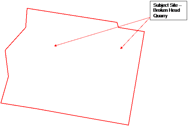
The subject site contains the Broken Head Quarry which was approved by way of a Commission of Inquiry in 1998 under Development Consent 5.1997.465.1.
1.2 Description of the site
The property comprises the following land parcels:
· Lot 1 DP 123302 (27.70 ha);
· Lot 1 DP 245836 (0.01 ha);
· Lot 1 DP 184443 (22.72 ha);
· Lot 1 DP 245605 (0.06 ha);
· Lot 2 DP 245836 (1.05 ha);
· Lot 3 DP 245836 (0.01 ha);
· Lot 5 DP 245836 (0.42 ha); and
· Lot 6 DP 245836 (0.35 ha).
The whole site has an area of 52.32 ha, being 24.61 ha on the eastern side of Broken Head Road and 27.71 ha on the western side of Broken Head. Approximately 22 hectares has been developed and disturbed from existing and past quarrying activities, whilst the remainder of the site comprises vegetation. The quarry has primarily extracted sand for the local and regional building sector for the making of concrete and the like. Hailstone has also been extracted for landscape and garden suppliers.
 |
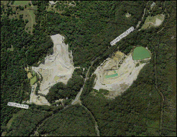
The quarry contains a series of ponds, stockpiled sand and gravel, machinery sheds, and a weighbridge. The area outside of quarry is remains heavily vegetated. The subject property is partly zoned RU1 Agricultural Protection, but a large part of the property which is vegetated is deferred from Byron LEP 2014, subject to the review of Environmental Protection Zones. The Development Application was lodged with Council prior to the commencement of Byron LEP 2014, and therefore the provisions of Byron LEP 1988 also apply. Under the 1988 controls the land is zoned 1(e) Extractive resources , 1(a) General Rural, 7(b) Environmental Protection (Coastal Habitat) and 7(d) Environmental Protection (Scenic/ Escarpment).
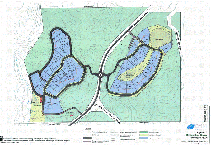
1.3 Description of the proposed development
Development Consent is sought for a community title development comprising:
· 41 residential lots varying is size from 2005m2 to 6065m2
· A common Property lot containing primarily the vegetated areas outside of the quarry extraction area with an area of approximately 34.5 ha
· Two neighbourhood lots comprising common infrastructure such as roads, drainage, stormwater ponds with an area of 4.18 ha and 3.3ha
The development is to be situated on both sides of Broken Head Road and serviced primarily by way of a roundabout. Emergency vehicle access is also proposed from Broken Head Road to assist access and evacuation in the event of a bushfire. Services are available to the site in terms of water, telecommunications and power. The applicant has proposed to connect to the sewer at Suffolk Park.
|
The proposal has been submitted under Section 82B of the EPA Act 1979 as a staged development, with Stage 1 being the subdivision and stage 2 the construction of dwelling houses on individual lots. The dwelling houses would be subject to separate development applications.
2. SUMMARY OF GOVERNMENT/EXTERNAL REFERRALS
NSW Rural Fire Service
The subject site is prone to bushfire and is identified as integrated development under Section 91 of the EPA act 1979. The development application was referred to the RFS for comment who requested further information. The applicant submitted amended detail addressing these bushfire matters which were referred back to the NSW RFS. Council is yet to receive final comments from the RFS.
NSW Office of Water
The proposed development involves works within 40 metres of a watercourse including earthworks near the watercourse ruining near or adjacent to the western boundary, and earthworks near the existing pond in the eastern half of the property. Accordingly the development is integrated development under Section 91 of the EPA Act 1979 in relation to the Water Management Act 2000. The proposal was forwarded to the NSW Office of Water who have issued general terms of approval.
Roads and Maritime Authority
The development was referred to the RMS for comment having regards to the roundabout on Broken Head Road. The proposal was also forwarded to the Local Traffic Committee. Access and egress via a roundabout with a reduced speed limit environment is not supported by the RMS, and such access would need to enter both sides of the subdivisions via turning and merging lanes with appropriate road widening.
3. SECTION 79C – MATTERS FOR CONSIDERATION – DISCUSSION OF ISSUES
Having regard for the matters for consideration detailed in Section 79C(1) of the Environmental Planning & Assessment Act 1979, the following is a summary of the evaluation of the issues.
Section 117 Direction – Directive 5
In essence the Section 117 Direction relates to mineral resources and extractive materials which are of a state or regionally significance and should be protected in terms of planning controls and development to enable them to be extracted accordingly. The direction does not necessarily apply to development applications however it remains of importance in terms of this proposal. The applicant has submitted that the sand and gravel at the quarry is all but exhausted and the proposal was forwarded to the Minerals Resource Branch of the NSW Dept of Trade and Investment by Council for comment. The MRB are also satisfied the resource is nearing exhaustion and have raised no objection to the proposal. Having regards to the above it is considered the proposal is not inconsistent with the Direction.
3.1. STATE/REGIONAL PLANNING POLICIES AND INSTRUMENTS
|
Requirement |
Requirement |
Proposed |
Complies |
|
State Environmental Planning Policy 44 Remediation of Lands |
If the land contains core koala habitat being land containing a resident koala population, then a plan of management is required. |
The land contains potential koala habitat within the forested areas on the property, however the applicants have submitted the land is not core koala habitat due to a lack of koalas seen or observed on the property. Notwithstanding this, the applicant has proposed a ban on cats and dogs within the subdivision. |
yes |
|
State Environmental Planning Policy 55 Remediation of Lands |
Council must consider whether the land is contaminated or not, and if contaminated whether remediation is required and is suitable for the proposed development |
The applicant has submitted preliminary information addressing SEPP 55, however it is considered further soil sampling is required considering the use of the site for a quarry. The matter was raised with the applicant in terms of the adequacy of the soil sampling regime, but they advise they believe the sampling carried out was suitable and based on likely areas for contamination.
Not withstanding this, it is prudent that a far wider regime of soils sampling be carried out considering the sites long term use as a quarry. No testing has been carried out on the eastern quarry area which according to the plans from the Quarry EIS had plant, equipment and fuel storage areas.
It is considered the proposal is inconsistent with the provisions of SEPP 55, and Council can not determine that the site is not contaminated from operations and is suitable for residential development.
|
No |
|
SEPP 71 Coastal Protection |
Clause 8 – Matters for Consideration
|
See Comments below
|
No |
|
Clause 15 Effluent Disposal Clause 16 Stormwater Management
Clause 18 Master Plan
|
It is proposed to connect the subdivision to reticulated sewer, whilst stormwater would be managed in accordance with Council requirements.
Due to the zoning of the land a master plan is not required for the proposed development. |
Yes
N/A |
SEPP 71 Coastal Protection
Under Clause 8 Matter for consideration Council to have regard to a range of things including:
(d) the suitability of development given its type, location and design and its relationship with the surrounding area;
(i) Existing wildlife Corridors and the impact of development on these corridors; and
(l) measures to protect the cultural places, values, customs, beliefs and traditional knowledge of Aboriginals.
In general the proposal is significantly landward of the coast and would not have a detrimental impact on the coast, foreshore access, marine habitats and the like. The issue of concern in terms of the SEPP relate to the three matters listed above.
In terms of the development proposed and its relationship to the surrounding area, it is noted the subject site is on the southern side of Suffolk Park where development is characterised by a rural residential and hinterland housing at very low densities. This includes multiple occupancy and community title development in Natural Lane, Blackbutt Lane and on Broken Head Road with residential yields of up to 12 dwellings per lot. The land is not contiguous with the urban areas of Suffolk Park, so it is considered not unreasonable to assess the proposal in terms of these surrounding rural residential hinterland housing types. In this regard the yields proposed are not in character with the surrounding area.
As to existing wildlife corridors, the proposal does not require the further removal of vegetation and coastal habitat for access roads and bushfire trail. It is also noted the quarry operators by way of the approved development on the land are meant to be slowly rehabilitating the quarry areas and revegetating the extraction areas. Should the development go ahead then the opportunity for the enhancement and strengthening of the existing wildlife corridors will be lost.
There are potential cumulative impacts on Taylors Lake to the east of the property which is a site of cultural significance for local Aboriginal People. In particular the residential subdivision of the eastern part of the quarry could lead to future residents accessing Taylors Lake by existing tracks, leading to pollution and other activities which would not respect the significance of the Lake. Measures to prevent this from happening have not been explored and in part the difficulty with preventing future access is that the Lakes are not on the property, but some 5 - 600 metres to the east on adjoining land. The lakes are also accessible from the beach. The applicant has advised correctly that no direct access is proposed to provide residents with access to the Lake, however this will not prevent pressure being placed on the Lake by more residents living in close proximity to this site. The applicant has indicated a willingness to work with the relevant Aboriginal Community and Council. The proposal was forwarded to both the Jali Land Council and the Arakwal Corporation, however there appear to be little support from these organisations for the proposal. Such measures that might be appropriate could include not developing or limited development of the eastern half of the quarry combined with education of residents and fencing to prevent easy access down Taylors Lake Road. These have not been explored by the applicant.
In conclusion it is considered the proposal is unacceptable in terms of Clause 8 of SEPP 71.
3.2. BYRON LOCAL ENVIRONMENTAL PLAN 1988
Zone: Zone No. 1(a) - General Rural Zone / PART 1(e) - Extractive Resources Zone / PART 7(d) - Scenic Escarpment Zone / PART 7(b) - Coastal Habitat Zone
|
LEP Requirement |
Summary of Requirement |
Proposed |
Complies |
|
Clause 2A Implementation of Aim, objectives and guiding principles
|
Have regard to relevant strategies
|
The subject site has not been identified in the Byron Rural Settlement Strategy or the Byron Bay Suffolk Park Settlement Strategy as suitable for a rezoning to facilitate residential or rural residential development. The applicant has submitted they are not listed in the strategy as the zoning controls permit residential use |
|
|
Meets zone objectives |
See below |
|
No |
|
Clause 10 Subdivision Generally |
Consent required for certain subdivisions |
Development Consent sought |
Yes |
|
Clause 11 Subdivision in rural areas for Agriculture etc |
The clause sets out a minimum lot size for subdivision. No minimum lot size is established for land zoned 1(e). |
|
N/A |
|
Clause 45 Provisions of Services |
Prior adequate Arrangements have been made for the provisions of services |
The applicant is proposing to connect to reticulated water and sewer. Stormwater would be developed in accordance with Councils requirements. |
Yes |
1(e) Extractive Resource Zone
The objectives of the 1(e) Zone state
(a) to identify and ensure sound management of land which has an extractive or mining industry potential,
(b) to ensure that development on land within the zone is compatible with development for extractive industry and does not adversely affect the potential of any existing or future development of the land for extractive industry,
(c) to include land within the zone necessary to provide a buffer area around extractive resources,
(d) to require a management plan for quarries which designate that part of the property which is the operational portion of the quarry and that part which forms the buffer area. (The Management Plan shall also assess the environmental impact of noise and dust, pollution, visual impact, conflict with adjoining land uses, traffic generation and alternative methods of extraction).
Comment: The objectives of the 1(e) Zone are silent on residential activity on land zoned as such, and are focused predominantly on quarrying/mining activities, and the protection of the resource from potential land use conflicts through management and buffers. A dwelling house is permitted with consent in the 1(e) Zone, and such a use in conjunction with a quarry in a rural area of Byron Shire would not be out of the question with the owner of the quarry living on the land. However it is unlikely that Council with the drafting of the Byron LEP 1988, foresaw that the planning controls for land identified for a quarry would facilitate its use for a more intensive residential purpose beyond a single dwelling house.
The applicant has submitted the proposal is not antipathetic or hostile to the objectives of the 1(e) Zone, and considering that the resource is now exhausted this opinion can be reached. However, Clause 9(3) of Byron LEP requires the consent authority to be satisfied that the development is consistent with the objectives of the zone. In this instance having regard to the rural residential nature of the proposal being a 44 lot community title subdivision (41 residential lots) the development is not consistent with the objectives of the zone.
7(d) Scenic/ Escarpment Zone
The objectives of the 7(d) Zone state
(a) to protect and enhance the scenic qualities of the Shire of Byron which enhance the visual amenity by controlling the choice and colour of building materials, position and bulk of buildings, access roads and landscaping,
(b) to prohibit development within the zone that is likely to have a visually disruptive effect on the scenic quality and visual amenity of the Shire,
(c) to enable development for certain purposes where such development would not have a detrimental effect on the scenic quality and visual amenity of the Shire,
(d) to minimise soil erosion from escarpment areas and prevent development in geologically hazardous zones, and
(e) to enable the careful control of noxious plants and weeds by means not likely to be significantly detrimental to the native ecosystem.
The proposal includes access roads into both sides of the development through the 7(d) Zone from Broken Head Road. Roads are a permissible form of development in the 7(d) zone and are aligned generally where existing access points are situated. Visually it is considered the access roads are unlikely to have a detrimental impact on the scenic or visual amenity of the locality.
Byron Local Environmental Plan 2014
The proposed DA was submitted prior to the commencement of the BLEP 2014, and as such is assessed under BLEP 1988 as per the Savings provisions under clause 1.8A. Not withstanding Clause 1.8A Council must be satisfied the proposal, is not antipathetic or inconsistent with the objectives of and will not detract from the achievement of those objectives nor undermine the planning intent of the controls contained within Byron LEP 2014. (See Tim Shellshear & Associates v Warringah Council & AMP Capital Investors Limited [2012] NSWLEC 1097.) In coming to a conclusion as to whether the proposal is antipathetic or inconsistent with Byron LEP 2014, the following comments are provided on the assessment of the development against the new LEP.
The subject site which is to be developed for residential purposes as proposed is zoned RU1 Agricultural Protection, whist the vegetated part of the site has been deferred from BLEP 2014 and is subject to the Department of Planning and Environments review of the environmental protection zones.
The RU1 Zone objectives state:
• To encourage sustainable primary industry production by maintaining and enhancing the natural resource base.
• To encourage diversity in primary industry enterprises and systems appropriate for the area.
• To minimise the fragmentation and alienation of resource lands.
• To minimise conflict between land uses within this zone and land uses within adjoining zones.
• To encourage consolidation of lots for the purposes of primary industry production.
• To enable the provision of tourist accommodation, facilities and other small-scale rural tourism uses associated with primary production and environmental conservation consistent with the rural character of the locality.
• To protect significant scenic landscapes and to minimise impacts on the scenic quality of the locality.
The proposal will result in the subdivision of the land zoned RU1 into multiple residential allotments, this would limits its potential for primary production and is the opposite of the objective which encourages consolidation of lots. The proposed subdivision is not consistent with the objective of the RU1 Zone.
Clause 4.1 Minimum Subdivision Lot Sizes
The land has been identified with a 40ha minimum on the Lot Size Map for subdivision. The proposal in terms of lots sizes proposed is inconsistent with this clause
Clause 4.1AA Minimum Subdivision Lot Sizes for Community title Schemes
The objectives of this clause state:
(a) to ensure that land to which this clause applies is not fragmented by ad hoc subdivisions that would create additional dwelling entitlements.
The provisions require that the subdivision of land in a community title scheme must comply with the Lot Size maps. As discussed above the proposal lots do not comply with the lot size map.
Clause 4.1B Minimum Subdivision Lot Sizes for multiple occupancy or rural land sharing community developments
The clause identifies certain properties for Multiple occupancy and community title development in rural areas, and permits subdivision contrary to the minimum lot size map. The subject property has not been identified under the clause.
Clause 4.6 Exception to Development standards
The provisions enable a degree of flexibility in applying development standards. This flexibility would permit a 10% variation to the size of lots identified under Clause 4.6. The lots however are significantly smaller (0.2005ha), and such a variation is not permitted under the Clause.
Comment: The proposed subdivision is not a permitted under the planning provisions of Byron LEP 2014. The site has not been zoned for R5 large Lot residential, has not been identified under the minimum lot size clause for small lot subdivisions, nor has it been identified under Clause 4.1B for a community title subdivision. It is considered the development is not antipathetic to the provisions contained within Byron LEP 2014
Draft EPI that is or has been placed on public exhibition and details of which have been notified to the consent authority - Issues
No draft EPI’s affect the proposal.
3.3 DEVELOPMENT CONTROL PLANS 2010
Part B Subdivision
Proposed subdivision can meet the technical requirements for subdivision in terms of roads, services and other infrastructures. However access to the site by way of a roundabout and reduced speed limits is unlikely to be supported by the RMS and a different means of access would be required with turning and merging lanes. If the application was to be approved further detail would be required in term sof access and egress and appropriate conditions of consent drafted accordingly.
Chapter 9 Suffolk Park
The subject site is located outside of the Suffolk Park area identified in the DCP. It is submitted the DCP does not apply to this development.
Chapter 19 Broken Head
The subject site is located outside of the Broken Head area identified under Chapter 19. It is submitted the DCP does not apply to this development.
3.4 The likely impacts of that development, including environmental impacts on both the natural and built environments, and social and economic impacts in the locality
The proposed development will forgo environmental repair and enhancement to the site envisaged by way of the approved development consent for the quarry under DA97/465, whilst additional clearing will be required for access roads and around the periphery of the subdivision for bushfire trails. The property and surrounding sites provide habitat for a number of species listed under the Threatened Species Conservation Act 1995. The following comments are provided on flora and fauna values of the property.
Flora
The site as a whole contains a number of vegetation communities of high conservation value, including:
· wet to dry sclerophyll forest variously dominated by Blackbutt and Brushbox (but containing other Eucalypt and related species),
· swamp sclerophyll forest dominated by Paperbark,
· Rainforest
· Wallum Banksia scrubland
· Ti-tree heathland, sedgeland/fernland bordering the eastern boundary and
· aquatic communities along the creek at the western boundary and associated with dams on the site.
At least one Endangered Ecological Community is present, being Lowland Rainforest of the NSW North Coast, with a second - Swamp Sclerophyll Forest of the coastal floodplains of the NSW North Coast -likely to be represented by the paperbark community north of the western quarry. Eucalypt and related communities have extra conservation significance due to the age of mature trees within them and the presence of hollows, used for nesting by many species of fauna. Previous flora surveys on the site have recorded five threatened rainforest flora species, including Stinking Cryptocarya, Rusty Plum, Scented Acronychia, Davidson’s Plum and Coolamon. It is considered the applicant has not demonstrated that that a significant effect on threatened species, populations or ecological communities will not arise as a result of the proposed development.
Fauna
The consultant ecologists have provided an assessment of fauna values taken from surveys previously undertaken for the purpose of quarry expansion. Results indicate a high diversity of habitats available for birds, bats, reptiles, amphibians and mammals. Of importance for a diversity of fauna species is:
· the dense nature of much of the ground and shrub layer within the intact vegetated areas, providing habitat uncommon in the shire and important for ground-dwelling mammals;
· the abundance of nectar available from Eucalypts, Paperbarks and Banksias;
· presence of primary Koala habitat (Swamp Mahogany) just off-site to the south-east;
· the abundance of fleshy fruits available from rainforest areas;
· the presence of permanent water and vegetated drainage lines;
· the old-growth, hollow-bearing trees, and
· the site’s proximity to two (SEPP 14) wetlands and Broken Head Nature Reserve containing littoral rainforest.
|
|
Fauna species listed on the schedules of the Threatened Species Conservation Act 1995 recorded from, or just adjacent to, the site include the Wallum Froglet, Rose-crowned Fruit Dove, Superb Fruit Dove, Masked Owl, Long-nosed Potoroo, Grey-headed Flying-fox, Common Blossom Bat and seven micro-chiropteran bats (Hoary Wattled Bat, East Coast Freetail Bat, Golden-tipped Bat, Eastern False Pipistrelle, Greater Broad-nosed Bat, Large-footed Myotis and Yellow-bellied Sheathtail Bat). The Long-nosed Potoroo record, although recorded in 1993, is particularly significant as this species is very rare in the shire, difficult to trap and known to be adversely affected by understorey clearing and adjacent development.
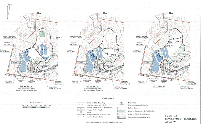
In particular the EIS prepared by RW Corkery Pty Ltd for the quarry which is referenced in the conditions of consent for DA97/465 makes reference to the disturbed quarry areas to be rehabilitated by establishing the final land form, deep ripping of contours, spreading topsoil from stockpiles, scarifying the surface, spreading brush, litter and logs over areas and sowing the area with seed and supplementary plantings (Section 2.13.5 Final rehabilitation).
Reference is made in the document that other approved uses could occur on the site, however the use of the site for residential development as currently proposed was not included in the rehabilitation plan.
Neither Council nor the Community would envisage that the land could be subdivided in the manner proposed due to the LEP being silent on a minimum lot size for land zoned 1(e) Extractive Industries.
It is considered the development consequently will have a detrimental impact on the environment.
3.5 The suitability of the site for the development
In general the concept of redeveloping the quarry for residential purposes is not unsound. Services can be augmented to the site, including water and sewer, access from Broken Head Road can be provided, and the site being heavily quarried for sand and gravel is disturbed and requires little in the way of tree and vegetation removal. There is an expectation though, that the quarry was approved on the basis that it would be rehabilitated with native vegetation to enhance and repair the wildlife corridor running through the property. The proposal if approved would not permit this to occur and being in a bushfire prone area little in the way of significant native vegetation would be replanted, considering the need for and maintenance of asset protection zones around dwelling houses.
Culturally, issues relating to Taylors Lake have not been resolved or solutions fully explored by the applicant. On 8 July 2013 Byron Shire Council’s General Manager and Mayor signed the Memorandum of Understanding with the Bundjalung of Byron Bay (Arakwal) people (E2013/45000).
In relation to the protection of cultural heritage and in particular the Ti Tree Lake (Taylors Lake) the MoU states the following:
1. Culture and Heritage
Council will work in partnership with the Bundjalung of Byron Bay Arakwal People to ensure preservation of cultural practices, traditional sites, significant places and expressions of cultural identity.
1.1 Culture and Heritage: Guiding Principles
1.1.1 Cultural Protection and Revitalisation
1.1.2 Access to land
1.1.3 Sharing Information
1.1.4 Environmental Protection and Education
1.2 Culture and Heritage: Specific Projects
1.2.2 Ti Tree Lake (Taylors Lake)
This area is one of the most significant sites to the Arakwal people. It is their objective to have this area protected as an Aboriginal site. Arakwal would like to protect this area from all forms of tourism and development. Arakwal have requested that, as a matter of priority, any developments regarding zoning, consultation with other community groups, proposed developments, tourism operators and Council, consider the cultural significance of this area. Further, that Council provide transparent information to Arakwal on any matters relating to the Ti Tree Lake areas, especially in regard to proposed developments on or around the area.
Council’s Commitment to protect the Ti Tree Lake (Taylors Lake) dates back to the 1998 Heads of Agreement between Council and Arakwal.
Arakwal have raised the following concerns:
· The close proximity to "Taylors Lake" which is a well known as the Bundjalung womens sacred lake ...
· The volume of the proposed proposal
· The environmental impact on the Broken Head area and surrounds
· The potential for Cultural heritage sites within the wider area of the development. And
· For Council to treat this application cautiously and if possible seek other options for the area.
As discussed above one option would be to predominantly restrict development to the western half of the quarry to limit the potential for residents randomly accessing Taylors Lake. Other management options may also be suitable, but these would require agreement with the local Aboriginal Groups to ensure the Lake as a sacred women’s site is protected. No such management measures or alternatives are proposed as part of the development application.
As discussed under SEPP 55, the applicant has also failed to demonstrate the land is not contaminated from past land uses and is suitable for residential development.
3.6 Submissions made in accordance with this Act or the regulations
Seventeen submissions were received by Council objecting to the proposal. The following issues were raised.
“Below is a table providing a summary of submissions and staff responses. However, Councillors also need to refer to the full copies of all submissions which have been provided on disc, strictly on a confidential bases, to Councillors. The full copies of the submissions contain personal information such as names and addresses of the persons lodging submissions which are relevant matters to be taken into consideration in determining this matter”
|
Issue |
Comment |
|
Property is in a wildlife corridor in an area of ecological significance |
Noted |
|
Property is not mapped for community title development |
Noted |
|
Quarry is meant to be rehabilitated at the end of its life with species endemic to a blackbutt open forest community to restore the wildlife corridor function of the site |
Noted |
|
No detail has been provided on how it complies with Quarry approval and in particular rehabilitation of the site and monitoring of impacts |
Noted |
|
SEPP 44 hasn’t been considered |
It is considered the property does not contain core Koala Habitat as defined by the SEPP. |
|
Section 117 directions apply |
See above discussion on S117 directions |
|
LEP would need to be amended to permit residential development |
Noted |
|
Impacts on an identified Aboriginal Site |
Noted |
|
Poor pedestrian and cycling access into Suffolk Park |
Noted – Should the application be approved – pedestrian and cycling access would need to be improved |
|
Cats and dogs should be prohibited |
Noted – Should the application be approved this would be a condition of consent |
|
Out of character with area |
Development in the rural areas to the south of Suffolk Park is characterised by rural residential development some of which is in a Multiple Occupancy/ Community Title arrangement. The residential yields on surrounding properties are much lower than what is proposed such as the 6 Lot community title development on 22 hectares at 66 Natural Lane. Other MO’s and CT’s in Blackbutt Lane and on Broken Head Road have much smaller yields then currently proposed. |
|
The DA should not have been accepted by Council |
The land owner is permitted under the EPA and Act 1979 to lodge the development application. Council is not in a position to refuse development applications if the requirements for submitting the proposal under the Act have been met. This is not a reason for refusal. |
|
Inconsistent with the objectives of the 1(e) Zone |
Noted |
|
Site not is any strategic document for development |
Noted – property is not identified in the Byron Rural Settlement Strategy or the Byron Suffolk Settlement Strategy or the Far North Coast Strategy. |
|
Substantial earthworks required to reshape the quarry areas to facilitate development |
It is likely the quarry whether its rehabilitated by revegetating the site or redeveloped as proposed will require substantial earthworks to reshape the quarry walls. Details submitted with the application indicate that predominantly the earthworks proposed will fall within the approved limit of disturbance. Some earthworks are proposed in terms of creating access roads into and out of the site from Broken Head Road. It is considered the earthworks proposed are acceptable. |
|
Clearing in environmental protection zones would be required |
Additional clearing is required. |
|
Visual Scenic Values |
The two quarry areas are at present a scar on the landscape. Rehabilitation of the site or some other form of development which would require reshaping of the land and revegetation would improve the scenic values of the landscape |
|
History of the site requires a full ventilation off the issues and public scrutiny |
Noted |
|
The land should be considered in a growth management strategy before being rezoned for further urban purposes |
Noted – this process would allow for greater community involvement in the long term use of the site, analysis of housing trends, and other matters |
|
Advertising period should be extended |
Advertising was carried out in accordance with Councils Policy. Submissions were received after the closing date and have been considered |
|
Land not needed for residential purposes – target under the far north coast strategy being met |
Noted – Since the DA was lodged, the Dept of Planning and Environment have issued the Part 3A Approval for the West Byron Development. This may see the land developed for 800 plus dwelling houses |
3.7 Public interest
The proposed subdivision in terms of densities proposed is out of character for the area, is not planned for in Byron Shire Councils Strategic Planning Documents or LEPs, and will not achieve the environmental rehabilitation of the quarry site as expected by the community with the approval of DA97/465 by way of a Commission of Inquiry. It is considered the utilisation of the site for residential or rural residential purposes requires consideration at a strategic level of assessment such as the Byron Shire Planning Strategy which is currently being drafted.
In conclusion, the proposal is considered contrary to the public interest.
4. DEVELOPER CONTRIBUTIONS
4.1 Water & Sewer Levies
Contributions would be required for water and sewer services, and such infrastructure would need to be augmented accordingly.
4.2 Section 94 Contributions
Section 94 Contributions would apply to the additional residential allotments.
5. CONCLUSION
In conclusion the proposed subdivision of the Broken Head Quarry relies upon the absence of a minimum lot size provision in the Byron LEP 1988. However the absence of this provisions does not mean that Council can or should approve this development. The use of the site for the purposes proposed has not been included in any forward planning documents, and it is anticipated the site would be gradually rehabilitated as indicated in the approved EIS documentation as part of DA97/465. The use of the site for some sort of low density residential use should be considered by Council at a Strategic Level, however issues such as character of surrounding development, Aboriginal Cultural issues, the importance of the site as a wildlife corridor, soil contamination and means of access and egress need to be further explored.
In relation to the current planning controls applying to the land it is submitted the development is inconsistent with the objectives of the 1(e) Extractive Industry Zone, whilst the applicant has failed to demonstrate the subdivision is not antipathetic to the aims, objectives and provisions of the recently commenced Byron LEP 2014.
The application is recommended for refusal.
6. RECOMMENDATION
It is recommended that:
Pursuant to Section 80 of the Environmental Planning & Assessment Act 1979, development application no. 10.2014.331.1 for Community Title subdivision to create 44 lots, comprising 41 residential lots, 2 neighbourhood property lots and 1 common property lot, be refused for the following reasons:
Reasons for refusal:
1. Pursuant to Section 79C(1)(a)(i) of the Environmental Planning and Assessment Act 1979 the proposed development is not consistent with the Byron Rural Settlement Strategy or the Byron Bay, Suffolk Park Settlement Strategy as nominated under Byron LEP 1988
2. Pursuant to Section 79C(1)(a)(i) of the Environmental Planning and Assessment Act 1979 the proposed development is not consistent with the objectives of the 1(e) Zone in Byron LEP 1988.
3. Pursuant to Section 79C(1)(a)(i) of the Environmental Planning and Assessment Act 1979 the proposed development is not consistent with the aims, objectives and provisions of Byron LEP 2014 in relation to the RU1 Zone, and Clauses 4.1, 4.1AA, 4.1B and 4.6.
4. Pursuant to Section 79C(1)(a)(i) of the Environmental Planning and Assessment Act 1979 the proposed development has not demonstrated that the land is suitable for residential uses as required under Clause 7 of SEPP 55 Remediation of Land.
5. Pursuant to Section 79C(1)(a)(i) of the Environmental Planning and Assessment Act 1979 the proposed development raises issues that have not been adequately addressed to satisfy matters listed Clause 8(d),(i) and (l) of SEPP 71 Coastal Protection.
6. Pursuant to Section 79C(1)(b) of the Environmental Planning and Assessment Act 1979 the proposed development will not result in the rehabilitation of the environment as envisaged under DA97/465 and has failed to demonstrate that a significant effect on threatened species, populations or ecological communities will not arise as a result of the clearing for the development, and will therefore have an adverse impact on the environment.
7. Pursuant to Section 79C(1)(c) of the Environmental Planning and Assessment Act 1979 the eastern part of the site is not suitable for the proposed development due to cumulative impacts on the cultural significance of Taylors Lake to the east.
8. Pursuant to Section(1)(c) of the Environmental Planning and Assessment Act 1979 the applicant has failed to demonstrate the property is not contaminated from past land uses and is not suitable for residential development.
9. Pursuant to Section 79C(1)(e) of the Environmental Planning and Assessment Act 1979, the proposed development, in terms of densities proposed is out of character for the area, is not planned for in Byron Shire Councils Strategic Planning Documents or LEPs, and will not achieve the environmental rehabilitation of the quarry site, is considered to be contrary to the public interest.
7. DISCLOSURE OF POLITICAL DONATIONS AND GIFTS
|
Has a Disclosure Statement been received in relation to this application |
No |
|
Have staff received a ‘gift’ from anyone involved in this application that needs to be disclosed. Where the answer is yes, the application is to be determined by the Director or Manager of the Planning, Development and Environment Division. |
No |