BYRON SHIRE COUNCIL
14.3 - Attachment 1
Report of the Local Traffic Committee Meeting held on Wednesday 18 November 2014
#E2014/76609
MEETING COMMENCED: 10.45am
PRESENT:
Councillor: Cr Duncan Dey
RMS Representative Greg Sciffer
Police Representative: Senior Constable Tony Darby
Staff: Simon Bennett
Helen Waldron (minutes)
Visitors Donald Maughan (Item 5.1 – 10.45 – 11.45 am)
Peter Wegner (Item 5.1 – 10.45 – 11.45 am)
Dudley Leggett (Item 5.1 – 10.45 – 11.45 am)
NB: Development Committee Minutes as per #E2014/76866
APOLOGIES
Member for Ballina, Don Page, MP
Member for Lismore Thomas George, MP
DECLARATIONS OF INTEREST
There were no declarations of interest raised.
MATTERS ARISING
There were no matters arising.
OUTSTANDING ISSUES / RESOLUTIONS
Due to time constraints, no outstanding issues or resolutions were discussed.
5. REGULATORY MATTERS
5.1 Clifford Street, at the Broken Head Road intersection, Suffolk Park
The Committee reviewed the information provided in the agenda, which is as follows.
On 30 October 2014 Council received the
Committee meeting report of 1 October 2014 and resolved as follows:
14-567 Resolved that in regard to the intersection of Clifford Street and Broken Head Road, Suffolk Park, Council:
a) note the Local Traffic Committee advice that a convex mirror is not supported and that alternative options will be considered by the Committee as they are tabled; and
b) invite residents to submit options to improve road safety at the intersection, for consideration by Council officers and presentation to the Local Traffic Committee.
c) endorse the ‘black spot’ funding submission for a roundabout, which if successful will provide funds for delivery in 2015/16 and if not receive a report to address the road safety problems identified.
The matter was tabled due to several reasons, one being the black spot nomination lodged August 2014 and written correspondence received from both the President of the Suffolk Park Progress Association (SPPA), Donald Maughan and a past SPPA member and long time resident Dudley Leggett. Both attended the meeting, along with Peter Wegner.
The preferred treatment for improving the intersection is a roundabout, while an alternative option for discussion is the merits of removing the left-turn lane on and from Broken Head Road into Clifford Street.
Council has being collecting developer contributions for a roundabout as the preferred treatment. Circa 2005/2006/2007 Council received black spot funds to design and build a roundabout. The design was made available at the meeting to assist discussion.
In summary however, the project stalled due to various reasons, one being the land acquisition required. As that is not a Committee matter, Council will receive a separate report outlining options to proceed and seek Council approval that the land acquisition process commence, noting approximately 170sqm has been identified as required in total. The difficulty, however, being this same land is across three (3) separate parcels, thus requiring negotiation and agreement by three (3) separate land owners. As land acquisition can take many months, if not a year or more, it is believed such a process needs to commence as soon as possible. It is believed it will provide RMS the assurances they seek in regard to Council’s August 2014 lodged black spot bid, which if successful will require delivery in 2015/16 and is estimated at $1.2m total cost including land acquisition.
However should Council not wish to support the roundabout as the preferred intersection treatment, or the black spot bid does not eventuate, an alternative option is presented, namely the removal of the left-turn lane.
The left turn lane provides a length for those wishing to enter Clifford Street. However as also shown, the major crash trend is related to vehicles departing right from Clifford Street and being hit by southbound traffic in the right ‘through’ lane. It is believed the left-turn lane contributes to this crash trend, as it obstructs the vision of the southbound through traffic. Thus to correct the problem, full or partial removal of the left-lane is proposed.
The SPPA has provided support for such an option, and if Committee and Council endorsement is forthcoming it is proposed this option be developed further and consulted upon and that at the same time, in accordance with 14-567(b), residents’ feedback and suggestions are sought, all of which is only done should the black spot road safety funding bid for a roundabout is unsuccessful and the results of the consultation reported back to Council.
If such an approach is supported it is expected the timelines will be as follows:
1. June 2015 - outcomes of the black spot bid will be known
2. July 2015 - that consultation on it, or the alternative option, is undertaken
3. August 2015 - report back to the Committee and Council
Outcomes, or at the least constraints to them, regarding land acquisition may also be known by June 2015, assuming Council support its commencement (which is to be sought at 11 December 2014 Council meeting).
Under either option, be it a roundabout or the removal of the left turn lane, the SPPA support a speed reduction and improved pedestrian facilities, landscaping and traffic management.
Committee Comments
· The Committee noted the points raised by the representatives of the Suffolk Park Progress Association (SPPA) including their support to remove the left turn lane into Clifford Street
· The Committee advised however the removal of the left-turn lane is unlikely to solve all problems
· To this end, the Committee view the removal of the left turn lane as an ‘interim option’ and it not be delayed for, or undertaken as an alternative to, a roundabout which remains the preferred intersection treatment at this time
· As for the various other points SPPA raised these included the development of a local concept plan that addresses traffic calming, car parking, relocation of bus stop and power pole, pedestrian flow and connectivity, and general landscaping and street improvements, all of which SPPA hope could be supported by Council including s94 and/or other funding to develop, consult and deliver
· while Committee support was forthcoming for the preparation of such a plan the Committee did advise the SPPA for the need to approach Council directly for such support, especially for the commitment of resources/funds
Management Comments
· Committee preference for a roundabout reflects Council’s position, noting s94 funds are collected which can be used to commence land acquisition
· while land acquisition is not a matter for the Committee, their recommendation is supported as it will be required to deliver a roundabout which is subject to a current black spot funding submission with the RMS and commencing it will assist that process
· to receive a report on the intersection options and the outcomes of the consultation reflects the intention of Resolution 14-567(b) which has commenced with SPPA, however as per the Committee report will likely occur more broadly mid-2015
COMMITTEE RECOMMENDATION
That Council, in regard to the intersection of Clifford Street and Broken Head Road Suffolk Park:
a) support the Local Traffic Committee’s preference for a roundabout and note RMS support for a grant application for one;
b) commence land acquisition for that purpose;
c) receive a report (after community consultation) on removing the left-hand turn lane from Broken Head Road, as an interim measure; and
d) support the Suffolk Park Progress Association presenting Council its concept plan for this "entrance" to the locality.
5.2 Christmas Eve Carnival Street Closure, Byron Street, Bangalow
The Committee reviewed the information provided in the agenda, which is as follows.
Each year the Bangalow Chamber of Commerce organise the Christmas Eve street parade that requires closure of Byron Street, Bangalow. This 5.30pm to 10pm between the Granuaille Road, Lismore Road and Byron Street roundabout and Market Street intersection.
The event has no reported problems, with Council again providing s356 community funding and involved in implementing the temporary traffic control, which includes a detour for through traffic via Deacon Street.
Committee Comments
The Committee had no comments in relation to this item.
Management Comments
Nil
COMMITTEE RECOMMENDATION
1. That the temporary traffic arrangements for the Bangalow Christmas Eve Carnival, scheduled for Wednesday 24 December 2014 and includes the temporary closure of Byron Street between Granuaille Road and Market Street between the hours of 5.30pm and 10.00pm, be endorsed.
2. That the organisers be responsible for implementing a Traffic Control Plan, including the use of signed detours, as designed and implemented by those with appropriate accreditation and be advised Council’s fee for holding an on-road event will apply.
3. That public liability insurance be in place for the sum of at least $20 million.
4. That the concurrence of the Police be sought by the organisers, independent of the Local Traffic Committee endorsement.
5. That the event be advertised in accordance with the Roads Act, charged at cost to the organisers.
6. That the event be notified on Council's website.
7. That in the event Council staff and materials are required for the event, costs be recorded and invoiced to the organisers as appropriate.
5.3 Ewingsdale Road Safety Review - results of RMS speed zone review
The Committee reviewed the information provided in the agenda, which is as follows.
Council resolved 14-195 for a road safety review
to be undertaken. This has commenced with an update, as reported to this
Committee in October 2014 and endorsed by Council as follows:
14-517 Resolved (in part):
e) request RMS to extend the Ewingsdale Road 60km/hr speed limit from its existing location at 100m west, to a new location 100m east, of Banksia Drive, Byron Bay.
RMS has now completed such a review and recommend the speed limit be reduced from 80kph to 60kph for the approximate 1.7km length as shown on the map (purple line), being from the existing 60kph limit (yellow line) which is west of Banksia Drive through to the 50kph urban limit which commences west of Kendall Street (green line).
In endorsing this recommendation, the approximate 5km length of Ewingsdale Road from the highway to Kendall Street will become predominantly 60kph with the exception of the 80kph which applies for an approximate 1.8km length from west of McGettigans Lane to the west side of the roundabout at the sports complex (BRSCC) as shown by the red line on the map.
Figure 5.3.1: Map of Ewingsdale Road speed zones – existing and proposed
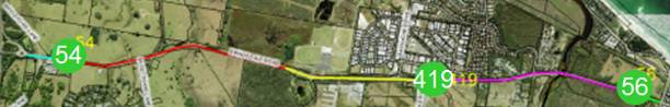
Blue line existing 60kph; red line existing 80kph, yellow line existing 60kph; green line existing 50kph;
purple line represents RMS speed zone review, which proposes reduction from existing 80 to 60kph
Green circles = traffic count sites, see Table below
As for speed data, the map shows three count sites (green circles), being left to right site numbers 54, 419 and 56. The data for each is tabled to assist discussion (Table 5.3.1). As the data shows most (ie the 85th percentile) exceed the speed limit in the 50 and 60kph zones, while most comply within the 80kph speed limit. Caution on interpreting this data however is advised, as the location of each is likely to influence, noting sites 54 and 56 are close to the change of speed limit and site 419 is located between Bayshore Drive and Banksia Drive, which now includes a length of 60kph. This means in all three cases the data has captured people speeding up or slowing down as they depart or enter the traffic stream.
Table 5.3.1: Ewingsdale Road speed and volume count data
|
Site # |
Date |
Limit |
85% speed |
AADT |
|
54 |
Oct, 2012 |
60kph |
75.6kph |
16,480 |
|
419 |
Jan, 2010 |
80kph |
78.8kph |
14,746 |
|
56 |
Oct, 2012 |
50kph |
68.4kph |
16,116 |
Committee Comments
The Committee had no comments in relation to this item.
Management Comments
Nil
COMMITTEE RECOMMENDATION
That Council supports the RMS speed zone review and notes the recommendation the review makes for a 60kph speed limit to be applied on Ewingsdale Road, from the existing 60kph west of Banksia Drive through to the commencement of the 50kph limit west of Kendall Street.
5.4 Count Results for Pedestrian Crossings, Byron Bay, Ocean Shores, Federal
The Committee reviewed the information provided in the agenda, which is as follows.
Council has previously resolved to assess the need for formal pedestrian crossings. Numerous sites have now been counted and assessed as follows, noting the warrant for each facility is typically required to be met for RMS approval to be granted. The warrants and the results for each count are tabulated (see Table 5.4.1) with discussion below.
Table 5.4.1: pedestrian and vehicle count data and warrant
|
Item |
Warrant - Crossing type |
Ped/hr (P) |
Veh/hr (V) |
PxV is: |
See Table Note |
|
a |
Normal - zebra |
>=30 |
>=500 |
>=60,000 |
#1 - normal warrant |
|
b |
School - zebra |
>=30 |
>=200 |
na |
#2 - mainly school use |
|
c |
Aged - zebra |
>=30 |
>=200 |
>=60,000 |
#3 - 50% aged use |
|
d |
Special - zebra |
>=30 |
>=500 |
>=45,000 |
#4 - reduced warrant |
|
e |
Children’s - Children's |
>=20 in 20m |
>=50 each way |
na |
#5 – children’s crossing |
|
Site |
Location |
Ped/hr (P) |
Veh/hr (V) |
PxV is: |
Warrant met for: |
|
f |
Federal |
108am;108pm |
183am; 137pm |
19,764am; 14,796pm |
Nil, see note 5c & 5d |
|
g |
Middleton St |
62am; 95pm |
109am; 135pm |
6,758am; 12,825pm |
Children’s Crossing* |
|
h |
Shara Blvd |
53am; 51pm |
130am; 82pm |
6,630am |
Children’s Crossing* |
|
i |
Bangalow Rd (Macs store) |
21am;30L;12pm |
1,594am;1,453L;1,642pm |
33,474am;43,590L;19,704pm |
Nil (L=lunch 1215-115pm) |
|
j |
Broken Head Rd (BP-age care) |
3am; 4L; 3pm |
1,053am;893L;1,642pm |
3,159am;3,572L;4,926pm |
Nil. Age 10% L1230-130 |
|
k |
Broken Head Rd (Sth of BP) |
34am;23L;38pm |
1,053am;893L;1,642pm |
35,802am;20,539L;62,396pm |
Nil. Aged 7%. L1230-130 |
|
l |
Beech Dve (opposite BP) |
0am; 1L; 5pm |
n/a-2005 data 198peak hr |
n/a-ped warrant not reached |
Nil |
* while both met the children crossing warrant in the hour the data was recorded, the counts did not extend to one hour either side as required by RMS as per following note 5(a)
Table notes:
#1
3 separate one hour periods in a typical day
#2 if the crossing is used predominantly by school children, is not suitable site for a Children’s Crossing and warrant is met in two counts of one hour duration immediately before and after school, then a pedestrian (Zebra) Crossing may be installed.
#3 - if at least 50%
of pedestrians using the crossing are aged or impaired and for each three one
hour periods in a typical day, then a pedestrian (Zebra) Crossing may be
installed.
#4 if special warrant met, then consideration can be given to a potential pedestrian crossing site. In such circumstances, council should justify why this location is in need of special consideration.
#5 warrant for children’s crossing requires:
a. crossing is
located on local and lightly trafficked roads where in a one hour duration
immediately before and after school hours the traffic flow exceeds 50 vehicles
per hour in each direction and during the same hour 20 or more children cross
the road within 20m of the proposed crossing location.
b. 85%
percentile speed of traffic must not exceed 60km/h one hour before or after school
hours. Note: In special circumstances where a Children’s Crossing is required on
roads where the 85% speed is greater than 60km/h. Council may apply to the Roads
and Maritime Services for consideration and approval.
c. An
undertaking from the school principal to arrange the display of the “Children’s
Crossing” flags or signs during and only during the specified period of
operation 8.00am – 9.30am and 2.30pm – 4.00pm and when necessary at other times
such as school excursions and school sport days.
d. Must have kerb and gutter, can in some instances be installed on existing marked (zebra) crossing and must be approved by the Local Traffic Committee
Discussion
Based on the criteria cited and the count data collected, only one site meets the RMS warrant, that being for a Children’s Crossing on Middleton Street for the Byron Bay Public School (BBPS). It is noted however the warrant is nearly met for the same treatment on Shara Boulevard for the Ocean Shores Public School (OSPS). However it should also be noted the count was limited to the AM and PM peak hour only, and not the hour either side of it, which also requires 50 or more vehicles per hour in each direction and during the same hour 20 or more children cross the road within 20m of the proposed crossing location.
Nevertheless Committee endorsement for both sites is now sought given the data, the requests from the schools themselves and the following 30 October 2014 Council resolutions:
14-519 Resolved that Council note Local Traffic Committee support for developing Children’s Crossings on Middleton Street, Byron Bay south of Carlyle Street and on Shara Boulevard, Ocean Shores north of Kallaroo Circuit, subject to the following:
a) the RMS warrant being met (pedestrian and vehicle counts)
b) the respective Principals of Byron Bay Public School and Ocean Shores Public School entering into appropriate agreements with the RMS.
14-520 Resolved that RMS funding be sought for the two children’s crossings described, with preference funding enables their implementation prior to the commencement of the 2015 school year.
As for the Broken Head Road site north of the southern Beech Drive roundabout (ie at the BP) and Beech Drive itself, the pedestrian demand is not apparent to consider any pedestrian facility at this time.
Of the remaining three sites however the following is noted.
Federal village, while providing a strong demand, only meets the criteria for a children’s crossing. As the location is not near a school and is instead a bus stop and interchange for school drop off and pick up, a children’s crossing is not considered appropriate given that (as per Table notes) it requires an agreement with a school principal for the set up and removal of ‘flags’ and the street will require kerb and gutter.
As such, alternative options need to be considered and Committee advice on potential treatments will once again be sought, noting traffic calming for Federal village has been considered several times in the past 2-3 years and that physical calming such as speed humps and pedestrian refuge have not been supported on grounds of safety and site constraints. Constraints include lack of road width, loss of parking, need for street lighting and physical works, such as kerb and gutter.
As for a crossing location on Broken Head Road, just south of the BP (between Beech Drive and Clifford Street), the demand is nearing the special (reduced) warrant for a pedestrian crossing and given the discussion within this report in item 5.1, it is believed appropriate improved pedestrian access be considered in that context, namely as part of the following consultation process:
14-567 Resolved that in regard to the intersection of Clifford Street and Broken Head Road, Suffolk Park, Council:
b) invite residents to submit options to improve road safety at the intersection, for consideration by Council officers and presentation to the Local Traffic Committee.
As for a crossing location on Bangalow Road near Mac’s Store, which is on the west side and immediately south of Wollumbin Street, it is noted a pedestrian refuge already exists, however it will need to be removed to accommodate on-road bike lanes, which Council has endorsed as follows:
14-565 Resolved (in part)
2. (a) That Council support the nomination of the following projects for RMS cycleway and pedestrian funding, which if successful will be delivered in 2015/16 and require 50% contribution from Council:
i) a predominantly on-road cycleway along Bangalow Road, Byron Bay from Browning Street to Old Bangalow Road, which is to be consulted upon, constructed and costed as per Council design plan number 2045 and is undertaken as stage one of a three staged Suffolk Park-Byron Bay cycleway
As objection to the removal of the refuge, along with loss of car parking, is expected during the as yet to occur consultation period, alternative options will be considered and they, along with the project itself and the funding required, will be reported to Council in due course.
As for pedestrian facilities elsewhere on Bangalow Road, it is noted two refuges have been provided, one near Paterson Street and the other at Cooper Street, as part of the recently completed black spot funded road safety works. While this site was not included in the above tabled count, it was believed the warrants would not be met and that the recently installed refuges are an appropriate improvement.
Similarly, it is also believed that warrants would not be met on Bangalow Road north of Mac’s Store or on Browning Street, east of the roundabout with Tennyson Street/Bangalow Road.
This belief would appear justified given that Mac’s store is a generator of foot traffic (as proven in the data presented) yet does not meet the warrant. Also no similar generator is found on Browning Street or Bangalow Road between Cumbebin Park (just south of Cooper Street) and the Green Garage shop and grocer on Tennyson Street (which has a raised crossing nearby to its north).
Thus on these grounds it is recommended formal pedestrian facilities for these locations do not be explored any further until justified, such as a change in land use (from residential to retail for example), or through review of crash data, traffic speed / volume, noting they are recorded and monitored on an annual basis.
Committee Comments
· The Committee noted the reduced warrant that enables the school crossing sites as recommended still remains subject to RMS approval and school commitment, hence the recommendation made
· while it was agreed a marked crossing at Federal village was not warranted, and will not gain RMS approval, other options should be considered further given the ongoing concern expressed by local residents and users of the bus interchange in the main street
· in noting the comments made by the SPPA in a previous aforementioned item (Clifford Street intersection) the Committee noted the warrant for a marked crossing on Broken Head Road between the BP (at Beech Drive south roundabout) and Clifford Street was nearly met and may in near future be met once the aged care and other nearby developments are completed
· hence the recommendation made including consideration of Clifford Street itself, which if supported could be incorporated into the local concept plan
Management Comments
Nil
COMMITTEE RECOMMENDATION
1. That Council note the pedestrian and vehicle count data presented for the following sites.
2. That Council, subject to RMS funding and agreement reached with the respective schools (both of whom have requested such facilities) install children’s crossings on:
a. Shara Boulevard, at the frontage of the Ocean Shores Public School
b. Middleton Street, immediately south of Carlyle Street, for the benefit of the Byron Bay Public School
3. That Council note that while the RMS warrant for pedestrian crossings is not met at this time for the following sites, staff develop and report back pedestrian management and traffic calming concepts and cost estimates for:
a. Federal village; and
b. Broken Head Road, between Beech Drive south and through to and south of
Clifford Street, including Clifford Street itself
4. That Council note that the RMS warrant for marked pedestrian crossings is not met at the following locations:
a. Bangalow
Road, between Browning Street and Cumbebin Park
b. Broken Head Road, between Beech Drive south and north roundabouts
c. Beech Drive south, west of the roundabout on Broken Head Road
5.5 Request to change school bus zone times, Federal village
The Committee reviewed the information provided in the agenda, which is as follows.
One of the local school bus operators (Northern
Rivers bus lines) has requested a change to the bus zone times on Albert
Street, which is the main street of Federal village.
The current times apply the typical school zone times. However as the site is used as an interchange and not near a school, a longer time is required to assist the school bus operations.
The operator therefore requests the school bus zone in the village apply on school days between 7.30am and 9.30am and 2.30pm to 4.30pm.
For the benefits of consistency, it is recommended if supported the request apply to both sides of the street where bus zones apply.
Committee Comments
The Committee had no comments in relation to this item.
Management Comments
Nil
COMMITTEE RECOMMENDATION
That Council sign all existing school bus zones in Albert Street, Federal as being applicable between 7.30am and 9.30am and 2.30pm to 4.30pm school days.
5.6 Request for No Parking, Towers Drive, Mullumbimby
The Committee reviewed the information provided in the agenda, which is as follows.
The Committee considered this request last
meeting (October 2014). Council however did not support the recommendation
made, which was the restriction to apply on the outside (eastern) curve and
instead resolved as follows:
14-566 Resolved that this issue be resubmitted to the Local Traffic Committee, for consideration of an inside curve (western side) option for No Stopping (line marking) on that section of Towers Drive Mullumbimby.
|
Council resolution for the restriction to apply on the western curve is supportive of the proponent’s original request and as the map indicates would remove parking for an approximate length of 20m (yellow line), while retaining parking (green line, approximately 18m length) at the frontage of property at 19 Towers Drive.
As a result the restriction would have little impact on the general supply of on-street parking and given there is little demand other than for the adjacent business, which has off-street parking. It is recommended ‘No Stopping’ be endorsed as shown, with both signs and yellow line marking against the kerb. |
|
Committee Comments
· that an unbroken double line be considered to further improve delineation if required
Management Comments
· if Council wish consultation to occur first then an addendum to the recommendation is required
COMMITTEE RECOMMENDATION
That ‘No Stopping’ be signed and line marked for a length of 30 metres on the west side of Towers Drive, Mullumbimby, which commences 30m east of the driveway at number 17 Towers Drive.
5.7 Changes to parking and school zone, Crown Street, Mullumbimby
The Committee reviewed the information provided in the agenda, which is as follows.
On 7 August 2014 Council resolved 14-343 as
tabled, which includes staff response to each to assist the Committee
discussion on the matters raised. It should be noted the school principal of
Mullumbimby Public school has been contacted and provided a copy of this same
report.
|
14-343 Resolved: |
Staff advise: |
|
1. That Council install signage to reinforce the statutory No Stopping zones near the Mullumbimby Public School, at the intersections of Crown Street and Morrison Avenue and Crown Street and Queen Street.
|
Signage to be installed. No further action required. |
|
2. That Council receive a report via the Local Traffic Committee providing options to manage traffic and parking near the Mullumbimby Public School, including the proposal to make Crown Street one-way in an easterly direction, giving consideration to:
|
One way not supported. See discussion below. |
|
a) Developing concept plans for changes to parking configuration and restrictions
|
Done. See Fig. 5.7.1 |
|
b) Design of suitable traffic calming devices
|
Not warranted. See discussion below. |
|
c) Provision of pick-up/drop-off zones
|
Kiss and ride sites as below Fig 5.7.1. |
|
d) Consultation with the school, local residents and school bus service providers |
School only. See discussion below. |
|
3. That Council undertake a pedestrian crossing warrant assessment for the intersection of Crown Street and Morrison Avenue. |
School to confirm. See discussion below. |
|
4. That consideration be given to extending the School Zone into Queen Street, east of Crown Street, and that the Roads and Maritime Services be asked to fund the changes to signage and pavement markings. |
Supported. Recommendation made. |
Part 2 - One-Way of Crown Street
The School is supportive, however, it is recommended this not proceed further at this time.
It would require a permanent one-way and result in an unnecessary impact on residents. Main problems with one-way however, is the impact which would result in all vehicles having to either enter or depart onto an already school time congested intersections on Argyle Street at Morrison Street or Queen Street.
A better solution is believed would be the following options for Crown Street.
Part 2(a) to 2(c) – options for Crown Street
Part 2(a) requires development of concept plans. These are shown in below figure. It includes signage to advise of correct and legal parking requirements and the drop/off pick up area (ie kiss and ride space) as resolved within Part 2(c), but not the traffic calming devices as called for by Part 2(b).
Traffic calming devices (such as speed humps) are not believed warranted in what is predominantly a quiet, low volume residential street which has no other generator than the School. Similarly, traffic calming is required when addressing speed and / or efforts to deter ‘rat running’, neither of which is relevant to Crown Street.
Traffic calming also requires consultation with residents, noting while general support for calming may be forthcoming there is generally little acceptance of where they should be located with objection often received for those immediately adjacent to where calming measures are proposed.
Part 2(d) – consultation
It is believed the need for broader consultation with residents and bus operators is only required if the proposal for one-way and / or traffic calming was to proceed further, which as above is not supported.
In presuming the Committee and Council support this position, it is then a matter of consulting with only the school (as being done) in regard to the kiss and ride location and the following two items.
Part 3 – warrant for a crossing
While the children’s crossing warrant may potentially be met during school zone times, it requires (as reported in a previous item above):
An undertaking from the school principal to arrange the display of the ‘Children’s Crossing’ flags or signs during and only during the specified period of operation 8.00am – 9.30am and 2.30pm – 4.00pm and when necessary at other times such as school excursions and school sport days.
On these grounds the school should first be consulted regarding their support of such a facility. This has now been done with the school principal (David Lees) contacted for feedback and will consider the merits of such a facility and advise further in due course.
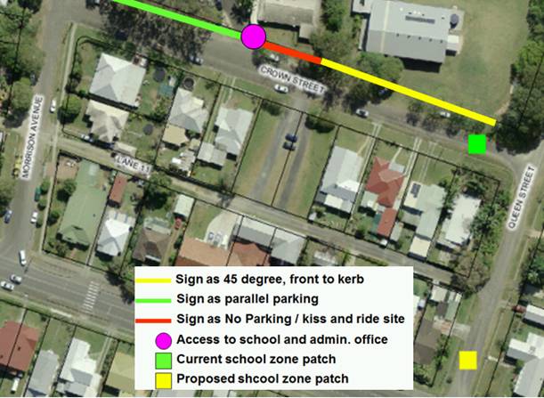
Part 4 – relocate the school zone patch from Crown Street to Queen Street
As the concept shows, the existing school zone patch (green square) is only 50m east of a main access point (pink circle) to the Mullumbimby Public School. Committee endorsement is sought therefore to relocate it to 150m east into Queen Street (depicted as per the yellow square). By doing so, it will ensure the laneway shown (ie Lane 11) is fully incorporated into the school, noting the current arrangement only advises motorists of the reduced speed limit if they enter at Morrison Avenue.
Figure 5.7.1 –parking and school zone changes, Mullumbimby Public School
Other issues
It should be noted RMS and Council staff inspected the site during the middle of the day, which is notable for its lack of activity and vehicular movement. During this inspection it was agreed on several of the items as discussed above plus the consideration be given to widening Crown Street which for the eastern half is approximately half the width of the western end.
Widening the road however is not a Committee matter and can be considered by Council separately and as funding and priority dictate, noting however the School Principal has indicated support for it.
Also in discussion with the Principal it was suggested the narrow length of Crown Street could be considered one-way, meaning the western half from the lane to Morrison Avenue remain two-way. This however has questionable benefits and several impacts that would require some detailed assessment before being recommended and therefore at this time believed the recommended measures suffice, at least for now.
Committee Comments
· while not supported, it was noted that ‘one way’ would be best if it flows west to east as it would allow students to be dropped on the same side of the road as the School
Management Comments
Nil
COMMITTEE RECOMMENDATION
1. That Council note the Local Traffic Committee review of Resolution 14-343.
2. That the following parking and school zone changes on Crown Street, Mullumbimby be endorsed:
a) sign parallel parking on the north side, between Morrison Avenue and the school car park driveway
b) for approximate 20m length from east side of the driveway, sign No Parking and Kiss and Ride to cover the frontage of the administration building
c) from the western end of the kiss and ride site through to Queen Street, sign parking as 45 degrees, front to kerb
d) request RMS funds to relocate the school zone patch and signs from their current location to Queen Street, north of Argyle Street
3. That introducing one-way traffic or traffic calming devices, such as speed humps, on Crown Street Mullumbimby not be supported at this time.
5.8 Request for time limit, Bayshore Drive, Arts and Industry
Estate, Byron Bay
The Committee reviewed the information provided in the agenda, which is as follows.
A variety of retail outlets exist in the A&I
Estate, one being the long established ‘Byron Baby Shop’, located as pictured
at 2/1 Centennial Circuit and opposite the car yard.
Management of the shop have approached Council for a1P time limit, citing their business is down since the car yard has commenced using the on-street space their vehicles.
A Council Ranger has also provided the following in support of the request:
The hours of business are, 9am-5pm Mon-Fri & 10am-2pm Saturday. As a result of attending and observing traffic flow / access to shop front, I highly recommend the implementation of timed signage based on a safety and accessibility aspect. 3-5 car spaces would suffice.
|
As no time limits currently apply on Bayshore Drive, their implementation will set a precedent which may result in more requests noting that also on the same (ie western) side of Bayshore Drive as the baby shop are several other retail outlets further south.
Nevertheless, the above request and support provided, plus the mixed use within the A&I Estate is believed sufficient reason to endorse the introduction of time limits in this instance.
|
|
Committee Comments
· the hours should be standardised as these signs will establish a precedent, which may in the future be applicable to other sections of the A&I Estate
· acknowledged however that deploying the same time limits in the CBD of Byron Bay are not appropriate as parking time limit signage in the A&I Estate for Sunday is not required nor is all day restriction on Saturday
· on these grounds, the limits should be similar to standards applied in other similar locations such as all day restrictions on weekdays and through to midday on Saturday
Management Comments
Nil
COMMITTEE RECOMMENDATION
That a 1P time limit which applies Monday to Friday 9am to 6pm and Saturday 9am to 12.00 noon be endorsed and signed on the western side of Bayshore Drive Byron Bay, from Banksia Drive to Centennial Circuit.
5.9 Request for No Stopping, Bangalow Road – Mahogany Drive, Byron Bay
The Committee reviewed the information provided in the agenda, which is as follows.
|
A resident has requested No Stopping be signed on Bangalow Road at the intersection of Mahogany Drive, Byron Bay on the grounds cars park to close to the intersection and block view of oncoming traffic.
Upon review the intersection requires the No Stopping as shown, i.e. on Bangalow Road from 15m north to 12m south of Mahogany Drive and on both sides of Mahogany Drive itself through to 10m east of Oodgeroo Gardens.
For consistency, Oodgeroo Gardens will also need No Stopping on both sides for a 5m length from Mahogany Drive.
|
|
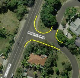
As these lengths vary from the statutory 10m length, Committee endorsement is sought.
Committee Comments
The Committee had no comments in relation to this item.
Management Comments
Nil
COMMITTEE RECOMMENDATION
That No Stopping be applied via yellow line marking only as shown in this report, which is on:
a) the east side of Bangalow Road, Byron Bay from 15m north to 12m south of Mahogany Drive;
b) both sides of Mahogany Drive from Bangalow Road through to 10m east of Oodgeroo Gardens; and
c) both sides of Oodgeroo Gardens for a 5m length from Mahogany Drive.
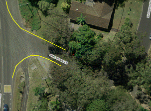
5.10 Request for No Stopping, Ironbark , Byron Bay
The Committee reviewed the information provided in the agenda, which is as follows.
|
A resident has requested No Stopping be signed on Ironbark Ave, east side of Bangalow Road intersection on the grounds cars park both sides of the local street, which only has width of approximately 7m and thereby reduces land to single carriage.
To address the matter will require parking restrictions that (as shown) extend beyond the statutory 10m distance from an intersection, hence Committee endorsement is sought. |
|
Committee Comments
The Committee had no comments in relation to this item.
Management Comments
Nil
COMMITTEE RECOMMENDATION
That No Stopping be applied via yellow line marking only as shown in this report, which commences on the east side of Bangalow Road, Byron Bay from:
a. 12m north to the first driveway on the north side of Ironbark Avenue; and
b. 12m south to 5m east of the first driveway on the south side of Ironbark Avenue.
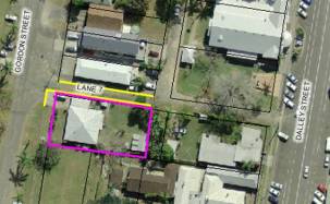
5.11 Request for No Stopping, Ambulance Station, Mullumbimby
The Committee reviewed the information provided in the agenda, which is as follows.
|
As shown, the Ambulance Station at 40 Gordon Street, Mullumbimby is seeking No Stopping in the adjacent laneway (Lane 7) to assist with vehicle movement to/from the site.
To ensure parking does not block the laneway, the No Stopping would need to occur on both sides of the laneway commencing from Gordon Street and continue for an approximate length of 45m.
|
|
Committee Comments
The Committee had no comments in relation to this item.
Management Comments
Nil
COMMITTEE RECOMMENDATION
That No Stopping be applied via signage as shown in this report, that is on both sides of Lane 7, Mullumbimby commencing at Gordon Street and continuing until the next lane approximately 45m east.
6. MATTERS for TRAFFIC ENGINEERING ADVICE
Nil
7. Late Items
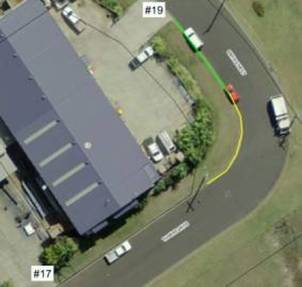
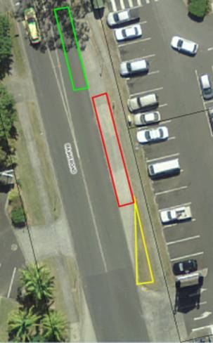
7.1 Late item - Library truck request to use bus zone, Rajah Road, Ocean Shores
Committee were advised of the following and provided comments as noted.
|
The management of the mobile library truck has requested a more prominent position to park every Tuesday 10.15am-12.15pm as they are unseen in their current location behind the Community Centre.
The suggested new site is depicted, i.e. opposite the Community Centre and adjacent to the Ocean Shores Shopping Centre by utilising the existing indented bus bay.
However current length would not be able to provide for the library truck and the local bus operator which, as the diagram also depicts, would require a physical extension of approximately 14m long and 20sqm in total:
· Green box shows bus – not able to leave the roadway
· Red box is the 18m long, 2.46m wide library truck – takes most of the bay, leaving about 10m of bus bay from rear of truck
· Yellow box - the possible extension of the bay to make both the truck and bus fit
|
|
While the extension of the bus bay is a matter for Council, not the Committee, changing the signage to reduce the bus bay requires Committee endorsement.
Committee Comments
Subject to feedback from the bus operator/s, the Committee supported the proposal depicted, i.e. extend the bus bay to provide space for the library truck on the proviso signage retains the bus bay for such use and the library truck be accommodated under appropriate signage
Management Comments
· the operator has concurred with the works, subject to the bus bay being adequate in length and signed and dedicated for such use and that the area reserved for other uses be signed as such
· the extension to the bus bay equates to approximately 20sqm of area to prepare and concrete including kerb and gutter
· such works are estimated to cost $3,000 which will be funded from current road/traffic works and facilities budgets unless a funding source as related to library services can identified
· alternatively Council may wish to support the request yet seek RTRL to provide the funding required
COMMITTEE RECOMMENDATION
That to accommodate the request from the Richmond-Tweed Regional Library for a space to park the mobile library truck in Ocean Shores, Council:
a) note the support of both the Local Traffic Committee and the local bus operator (Blanchs/BVC);
b) note it will require an extension of the existing bus bay on the east side of Rajah Road, Ocean Shores as located directly at the frontage of the shopping centre;
c) subject to the extension being approved and completed, sign the southern end, for a length of no less than 18m, as “No Parking” and “Byron Shire Council Authorised Vehicles Excepted” and sign the remaining length as a Bus Zone; and
d) notify library management that the mobile library truck is authorised to use the space as signed.
7.2 Late item - Request for speed zone review, Possum Shoot Road, Coorabell
After the Committee meeting, the RMS representative inspected Possum Shoot Road given that a resident request has been received that the speed limit be reduced to 50km/hr. The speed limit is currently the state default (100km/hr) ‘Drive to Conditions’ typical for rural roads. The resident advised reasons for a reduction are as follows:
-The current works being undertaken will improve the road in 2 straighter sections, but this is likely to result in drivers entering blind corners faster.
-There are no guard rails along the outer edge of the road and the drop off to the north is very steep.
-The road is narrow such that when 2 large vehicles are passing, they need to slow down to pass safely.
-There are many corners, most of which are blind and sharp.
-The road is heavily used in mornings and evenings as a short cut for those living in the hinterland driving kids to school or driving to work, or returning.
-In the afternoons, driving uphill frequently means driving into the setting sun which restricts vision
-There are children living along the road who walk along it to get the school bus and occasionally need to retrieve balls, etc.
-There are many obscured driveways where cars need to slow down to enter or exit residences.
-Australia Post will not deliver to residences along the road as it is too dangerous
-Garbage trucks need to stop and empty bins on the road itself as there is no verge
-It seems that higher use of the road is causing more slippage and subsidence, (3 areas in 3 years). Cracks and signs of subsidence is evident currently on other parts of the road Frequently Council does not have the resources to mow the edges, clear weeds repair potholes and empty drains. When it rains this leaves gravel and debris on the road -Many rural roads in our area have speed limits in the 50 to 60km/hr range
-Possum Shoot Road was not built for heavy usage
RMS is the sole authority to establish speed limits in NSW. A change to speed limits requires a speed zone review to be conducted in accordance with RMS guidelines. Following the onsite inspection the RMS has since advised such a review or consideration of change in speed limit will not be undertaken at this time.
Committee Comments
As this item was drafted and reported on post-meeting, the Committee have been provided copy of the report for comment and concurrence for the recommendation made
Management Comments
Any comments received by the Committee will be advised to Council prior to or at the 11 December 2014 meeting whereupon this report will be considered
COMMITTEE RECOMMENDATION
That Council note RMS advice that a speed zone review for Possum Shoot Road, Coorabell will not be undertaken at this time.