Agenda
Ordinary
Meeting
Thursday,
9 April 2015
held
at Council Chambers, Station Street, Mullumbimby
commencing
at 9.00am
Public Access relating to items
on this Agenda can be made between 9.00am and 10.30am on the day of the
Meeting. Requests for public access should be made to the General Manager
or Mayor no later than 12.00 midday on the day prior to the Meeting.
Ken
Gainger
General
Manager
What is a “Conflict of Interests” - A conflict of
interests can be of two types:
Pecuniary - an interest that a person has in a matter because of a reasonable
likelihood or expectation of appreciable financial gain or loss to the person
or another person with whom the person is associated.
Non-pecuniary – a private or personal interest that a Council
official has that does not amount to a pecuniary interest as defined in the
Local Government Act (eg. A friendship, membership of an association, society
or trade union or involvement or interest in an activity and may include an
interest of a financial nature).
Remoteness – a person does not have a pecuniary interest in a matter
if the interest is so remote or insignificant that it could not reasonably be
regarded as likely to influence any decision the person might make in relation
to a matter or if the interest is of a kind specified in Section 448 of the
Local Government Act.
Who has a Pecuniary Interest? - a person has a pecuniary interest in a
matter if the pecuniary interest is the interest of the person, or another
person with whom the person is associated (see below).
Relatives, Partners - a person is taken to have a pecuniary interest in a
matter if:
§ The person’s
spouse or de facto partner or a relative of the person has a pecuniary interest
in the matter, or
§ The person, or a
nominee, partners or employer of the person, is a member of a company or other
body that has a pecuniary interest in the matter.
N.B. “Relative”, in relation to a person means any of the
following:
(a) the
parent, grandparent, brother, sister, uncle, aunt, nephew, niece, lineal
descends or adopted child of the person or of the person’s spouse;
(b) the
spouse or de facto partners of the person or of a person referred to in
paragraph (a)
No Interest in the Matter - however, a person is not taken to have a
pecuniary interest in a matter:
§ If the person is
unaware of the relevant pecuniary interest of the spouse, de facto partner,
relative or company or other body, or
§ Just because the
person is a member of, or is employed by, the Council.
§ Just because the
person is a member of, or a delegate of the Council to, a company or other body
that has a pecuniary interest in the matter provided that the person has no
beneficial interest in any shares of the company or body.
Disclosure and participation in meetings
§ A Councillor or a
member of a Council Committee who has a pecuniary interest in any matter with
which the Council is concerned and who is present at a meeting of the Council
or Committee at which the matter is being considered must disclose the nature
of the interest to the meeting as soon as practicable.
§ The Councillor or
member must not be present at, or in sight of, the meeting of the Council or
Committee:
(a) at any
time during which the matter is being considered or discussed by the Council or
Committee, or
(b) at any
time during which the Council or Committee is voting on any question in
relation to the matter.
No Knowledge - a person does not breach this Clause if the person did
not know and could not reasonably be expected to have known that the matter
under consideration at the meeting was a matter in which he or she had a
pecuniary interest.
Participation in Meetings Despite Pecuniary Interest (S 452 Act)
A Councillor is not prevented from taking part in the consideration or
discussion of, or from voting on, any of the matters/questions detailed in
Section 452 of the Local Government Act.
Non-pecuniary Interests - Must be disclosed in meetings.
There are a broad range of options available for managing conflicts &
the option chosen will depend on an assessment of the circumstances of the
matter, the nature of the interest and the significance of the issue being
dealt with. Non-pecuniary conflicts of interests must be dealt with in at
least one of the following ways:
§ It may be appropriate
that no action be taken where the potential for conflict is minimal.
However, Councillors should consider providing an explanation of why they
consider a conflict does not exist.
§ Limit involvement if
practical (eg. Participate in discussion but not in decision making or
vice-versa). Care needs to be taken when exercising this option.
§ Remove the source of
the conflict (eg. Relinquishing or divesting the personal interest that creates
the conflict)
§ Have no involvement by
absenting yourself from and not taking part in any debate or voting on the
issue as if the provisions in S451 of the Local Government Act apply
(particularly if you have a significant non-pecuniary interest)
RECORDING OF VOTING ON PLANNING MATTERS
Clause 375A of the Local Government Act 1993
– Recording of voting on planning matters
(1) In this section, planning
decision means a decision made in the exercise of a function of a council
under the Environmental Planning and Assessment Act 1979:
(a) including a decision
relating to a development application, an environmental planning instrument, a
development control plan or a development contribution plan under that Act, but
(b) not including the making of
an order under Division 2A of Part 6 of that Act.
(2) The general manager is required
to keep a register containing, for each planning decision made at a meeting of
the council or a council committee, the names of the councillors who supported
the decision and the names of any councillors who opposed (or are taken to have
opposed) the decision.
(3) For the purpose of
maintaining the register, a division is required to be called whenever a motion
for a planning decision is put at a meeting of the council or a council
committee.
(4) Each decision recorded in
the register is to be described in the register or identified in a manner that
enables the description to be obtained from another publicly available
document, and is to include the information required by the regulations.
(5) This section extends to a
meeting that is closed to the public.
Ordinary Meeting
BUSINESS OF Ordinary Meeting
1. Public Access
2. Apologies
3. Requests for Leave of
Absence
4. Declarations of Interest
– Pecuniary and Non-Pecuniary
5. Tabling of Pecuniary
Interest Returns (s450A Local Government Act 1993)
6. Adoption of Minutes from
Previous Meetings
6.1 Ordinary
Meeting held on 19 March 2015
7. Reservation of Items for Debate
and Order of Business
8. Mayoral Minute
9. Notices of Motion
9.1 Heritage
Advisory Committee........................................................................................... 1
10. Petitions
11. Submissions and Grants
12. Delegates' Reports
12.1 2015
Australian Coastal Councils' Conference,
Cape Schanck Victoria................................................................................................... 11
13. Staff Reports
Corporate and Community Services
13.1 2015
National General Assembly of Local Government................................................ 17
13.2 Australia
Day Project Reference Group - Finalisation of 2015 Group and Commencement of 2016
Group............................................................................................................................... 21
13.3 Section
355 Management Committees - resignations and appointments...................... 35
13.4 Section
356 Donations - Reimbursement of Application Fees, Bangalow Park Trust Section
355 Management Committee................................................................................................ 39
13.5 Proposed
CCTV system in Byron Bay - ongoing maintenance and monitoring............ 44
Sustainable Environment and Economy
13.6 Submissions
received on the exhibition of Draft 2012 Developer Contributions Plan
(Amendment 3). ......................................................................................................................................... 59
13.7 Voluntary
Planning Agreement - Agreement for provision of car parking associated with DA
10.2014.649.1 - Redevelopment of Old Byron Council Chambers................................ 68
13.8 Review
of the waiving of developer contributions for secondary dwellings................... 74
13.9 Coastal
Zone Management Plan Byron Bay Embayment............................................. 81
13.10 PLANNING
- 10.2014.649.1 Mixed development comprising; demolition, retention of existing
building, erection of a new building to be used for backpacker accommodation
(250 beds), shops and restaurants at 19-23 Lawson Street Byron Bay............................................................ 105
13.11 Report
of the Planning Review Committee Meeting held on 17 March 2015.............. 167
13.12 PLANNING
- 10.2014.714.1 - Demolition of existing dwelling, garage, and all other
structures at 9 Station Street Bangalow................................................................................................ 170
13.13 Budget
Allocation for Traffic Study to Determine Construction Priorities on Ewingsdale
Road 190
Infrastructure Services
13.14 Belongil
Creek Floodplain Risk Management Study and Plan..................................... 193
14. Reports of Committees
Infrastructure Services
14.1 Report
of the Community Infrastructure Advisory Committee Meeting held on 5 March 2015 202
14.2 Report
of the Water, Waste and Sewer Advisory Committee Meeting held on 5 March 2015 205
14.3 Report
of the Transport Advisory Committee Meeting held on 12 March 2015........... 210
15. Questions
With Notice
Nil
16. Confidential Reports
Sustainable Environment and Economy
16.1 Confidential - Unlawful development,
North Head Road, New Brighton............. 222
Councillors are
encouraged to ask questions regarding any item on the business paper to the appropriate
Executive Manager prior to the meeting. Any suggested amendments to the
recommendations should be provided to the Administration section prior to the
meeting to allow the changes to be typed and presented on the overhead
projector at the meeting.
Notices of Motion 9.1
Notices of Motion
Notice of Motion No. 9.1 Heritage
Advisory Committee
File No: I2015/260
|
I move:
1. That
Council establish a Heritage Advisory Committee that includes community
representation.
2. A
draft constitution be prepared and reported to Council for approval to
establish a selection process and subsequent appointment of Members.
|
Attachments:
1 HAC
Guidelines, e2015/19060 , page 4
Councillor’s
Background Notes:
A Heritage Advisory Committee (HAC) would be a timely
addition to Council’s toolkit for the management of heritage significance
in Byron Shire considering the adoption of the 2014 Local Environmental Plan
(LEP).
Heritage Advisory Committees provide a way for the
community; Council and heritage advisors to develop an expert and informed
knowledge base to better protect and manage heritage items and precincts. In
particular, they provide a framework for Council’s to
‘investigate’, ‘assess’ and ‘manage’
significance in relation to its delegated functions under the NSW Heritage Act
and associated policies.
The NSW Heritage Guidelines can be viewed at
http://www.environment.nsw.gov.au/resources/heritagebranch/heritage/localgovernmentheritageguidelines.pdf
HACs also provide an opportunity for the community to
provide input into an understanding of local heritage significance. The
development of a sound knowledge base and deeper understanding of local
significance can also help to streamline the application process.
A catalyst for this motion has been a recent application for
93 Station St Mullumbimby, the site of the ‘sawmill’, a significant
operation in its time. The site includes a heritage listed building. At the
time of writing, the application remained undetermined. It is apparent that the
community has concerns as well as relevant information regarding the
significance of the site and building, yet there is no established process for
community engagement on ongoing heritage matters.
Attached are sample HAC guidelines from Eurobodalla Shire
Council. Extracts detailing objectives, terms of reference and membership of
the committee are set out below.
OBJECTIVES OF THE COMMITTEE
· To
support Council in advancing the aims of the Heritage Strategy and in the
development and implementation of strategies, policies and programs related to
heritage conservation
· Promote
the natural, cultural and historic heritage of the Eurobodalla and to ensure it
continues to develop a strong sense of place and identity.
3.0 KEY
TERMS OF REFERENCE
The key
terms of reference for the Eurobodalla Heritage Advisory Committee are:
· Assist
council in the development of policies and strategies in response to
Council’s adopted Heritage Strategy and the management of natural and
cultural heritage generally in the Eurobodalla local government area.
· Advise
Council staff, the Heritage Adviser and the Council on matters relating to the
ongoing implementation of the Heritage Strategy.
· Assist
Council to procure and allocate funding assistance and to recommend projects
for which funding should be sought in line with the Heritage Strategy.
· Provide
access to the general community to distribute information and for public input
into heritage management, eg, to nominate additional properties for assessment
of heritage significance.
· Advise
Council on a range of heritage-related matters which are of interest to the
community, in particular, by providing expertise, local knowledge and guidance
on heritage matters and in relation to heritage assessments.
4.0 MEMBERSHIP
The Committee shall consist of the following voting
representatives:
· Two
councillors
· Three
delegates representing each of the three district historical societies
· The
chairperson of the Eurobodalla Aboriginal Advisory Committee
· Three
community representatives preferably from the north, central and southern areas
of the shire.
Staff from Council and Council’s Heritage Advisor
will attend to provide technical advice and
guidance but will not have voting rights on the
committee.
Recommended priority relative to other Delivery Plan
tasks:
It is envisaged that a HAC could be established and
operational within three months.
Definition of the project/task:
Prepare draft constitution for a HAC for Council to ratify
and approve a selection process and subsequent appointment of Members by
Council.
Source of Funds (if applicable):
HAC to be supported from operational funds, however it is
acknowledged that additional funding for expert heritage advice may be required
subject to advice from staff.
Signed: Cr
Basil Cameron
Management Comments by:
(Management Comments must not include formatted
recommendations – resolution 11-979)
Clarification of project/task:
The establishment of a Heritage Advisory Committee to
provide advice to Council on applications, policies and strategic projects
where these relate to the management, conservation and promotion of
Byron’s heritage.
Director responsible for task implementation:
Director, Sustainable Environment and Economy.
Relationship to, priority of, and impact on other
projects/tasks:
Council completed a Community
Based Heritage Study in 2007. The Study included a number of
recommendations which were to be progressively implemented over time depending
on budget, resources and priority. One of the recommendations included
was that Council establish a Heritage Advisory Committee (HAC) with terms of
reference prepared to include a focus on supporting Council to conserve the
local heritage.
To date the priority work
associated with the implementation of the recommendations in the Community
Based Heritage Study in the main has been the amendment to the LEP to list
items of heritage significance identified and also preparation of DCP
controls.
Due to the above, the
establishment of a HAC along with a number of other recommendations has not
progressed to date.
Financial and Resource Implications:
There is no current budget allocation for the establishment
of a HAC. Council currently engages a Heritage Advisor to assist with the
assessment of development applications, Land and Environment Court appeals and
policy development on a needs basis. The cost to provide this service ranges
from $1,000 upwards per day depending on the work required.
Should a HAC be established, as a prerequisite it would
require a recurrent budget allocation to enable the formal engagement of a
Heritage Advisor to provide the necessary expert advice to support its work,
and a staff member to provide technical advice and administrative
support.
Grant funding is available from the Heritage Division of the
NSW Office of Environment and Heritage for a local Heritage Advisor
Service. The grant program is run annually and subject to funding
conditions. A recurrent council contribution of up to $10,000 would be required
to make an application under this grant program. The grant funding program for 2015-16
closed in January 2015. However council can apply for the 2016-17 program later
this year.
Legal and Policy Implications:
If established the HAC would
function as an advisory committee under Section 377 of the Local Government Act
1993.
Notices of Motion 9.1 - Attachment 1


Delegates' Reports 12.1
Delegates' Reports
Delegate's Report No. 12.1 2015
Australian Coastal Councils' Conference,
Cape Schanck Victoria
File
No: I2015/223
|
2015
Australian Coastal Councils Conference
CASE STUDY: Regional Tourism
Ms Tracey Cooper, Executive Chair, Mornington Peninsula
Regional Tourism Board
· Mornington
Peninsula- 26 hotels/apartments and 26,000 houses
· Place
for time off- a leisure destination, rather than holiday destination
· Social
media as opposed to formal advertising- fun fact- avocadoes can be frozen and
used for guacamole- 150,000 views within days-straight to the determined
food, farm gate market
· Engagement
strategy- a refocus from ‘us’ and our places- to
‘them’- giving visitors a story to tell. Showing the region
through eyes of visitors- e.g- pic of feet at the end of a pier, view from
within a beach umbrella- Find YOUR Way.
· Summer
is all about dispersal- rest of year is about growing shoulder periods
· Destination
Management Plan completed- a key outcome was the need to develop a Coastal
Tourism Plan- low impact experiences, best suitable locations,
environmental impacts to be considered etc.
Port Phillip Regional Coastal Adaptation Plan
Mr Bernie Cotter, EO, Association of Bayside
Municipalities
· Association
of Bayside Municipalities : 10 councils, est. 1974
· Evidential
Activities incl: Adaptation Pathways Project- 5 costed case
studies and Wind and Wave Energy Report.
· Regional
Coastal Adaptation Plan
*Evidence based.
*Create a 2070Plan-
transformative with creative options and visualisation
*Adaptation Issues- .5m sea
level rise, retreat not a option, thus resilience focus
Panel Discussion: Coastal Issues And Challenges
Chair: Bruce Thom- Setting the Scene
· Frustrating
Pattern of comings and goings of policies and strategies and personnel over
the years across State and Federal Govts. The great Liberal Environment
Minister, Robert Hill, as soon as he left, resulted in huge sums of money for
coastal works left also. Minister Jenny George, a developed a great blueprint
which was launched in Byron, however the ALP government then just sat on it
and did not enact any of the recommendations. Recently, in NSW, Barry
O’Farrell spruiked a localism strategy (without money), now Minister
Stokes and Baird have begun to champion the coast and may well be a return to
great focus and commitment. The Abbott Government got rid of COAG meetings on
water and environment, which makes it hard for State governments to create
national responses-eg, insurance policies for local governments. Thus,
continual sustainable leadership is lacking across State and Federal
Governments and this makes working in this area unreliable and ineffective.
Panel: Bernie Cotter and John Hickman- issues and
challenges
· Lack
of National and State guidance.
· Areas
outside Port Phillip Bay less able to fund the collection of data.
· Placing
Environmental issues against others within Planning debate. E.g, Getting
funds set aside from Economic developments to create a future fund for
Environment works
· Uncertainties
still exist within councils as to responsibilities and costs involved.
· Federal
Government has all the power, State Government has all the policies, Local
Government has all the problems
· The
Council level: inconsistency over time and between places how local councils
are treated, when there are huge lack or staff and financial resources.
· Understanding
liability- identifying risks and coastal properties under threat.
Keynote Address And Discussion: Sea Level Rise And Projections For The Future
Dr John Church, CSIRO Fellow with the Centre for Australian Weather and Climate Research
Key Messages:
· In past warmer climate periods, sea level was higher
· Sea level rose by .19m from 1901-2010 and rate of rise
will increase under all scenarios
· Collapse of marine based sectors of Antarctic Ice
Sheet, would add no more than tenths of metres this century, but far more so
next century.
· Rate
of GM SLR (Global Mean Sea Level Rise) has been greater since mid-19th
century
· Due
to: Warming and Cooling of oceans, change in mass of glaciers and ice sheets
and changes in liquid water storage on land
· Potential
rapid increase in ice sheet outflow-unclear when and how much, but highly
concerning instability.
Planning for our coastal communities in a changing
climate: a pathways approach
Mrs Ellen Witte, Associate Policy Advisory, SGS Economics
& Planning
· Benefits
of a Pathways approach:
*To show how communities may change over time
*Enables meaningful discussions
*Takes into account of not the cost of risk but also of adaptation.
· 3
pathways (let nature run its course, protect and allow development and a
mixed response) differ in respect to community values and expectations
· A
CBA process can include ‘recreation’ and ‘social’
value, though it is expensive and a bit loose.
Volunteer group leading community engagement projects
towards coastal adaptation
Ms Silvia De San Laureano Quiñones, Environment
Project Officer, Moyne Shire Council
Case Study: Port Fairy, VIC
· Old
tip site in dunes: as erosion occurs, rubbish is exposed.
· 31%
volunteer rate, compared to 17% national average.
· Empirical
data sought on erosion. Monitoring began 2013, 12 reference posts used to
collect data to measure sand height, dune accretion/ ascension and beach
profile
· Volunteer
group facilitated community engagement process as part of adaption plan.
· Group:
Local professional retirees- leaders and conflict resolvers, partnered with
Council to get credibility and developed thorough planning. Strong media presence,
including social media. They receive recognition.
· Achievements:
data informed dune preservation strategies and infrastructure responses,
leading to a cessation of erosion in key areas.
· Advantages:
less cost, better use of time, local knowledge and expertise gained
COASTAL POPULATIONS: PLANNING FOR THE FUTURE - Trends
in coastal populations with input from the ABS and case studies
Mr Andrew Howe, Senior Demographer, Regional Population
Unit, Australian Bureau of Statistics
2001-2027
· Sea
change councils: 40% population growth
· Population
increase of Gold Coast 77%
· Aged
population will increase by more than double in sea coast councils
CLIMATE ADAPTATION Developing a Framework for Managing
Coastal Climate Risk in Australia
Dr David Rissik, Deputy Director, National Climate Change
Adaptation Research Facility
· Developed
9 research plans and 150 research papers - all on website
· Now
developing a coastal climate risk management tool- to assist decision makers
and coastal managers: stakeholder engagement consisting of workshops and on
line survey (www.nccarf.edu.au)
Social, Economic and Institutional Dimensions of
Climate Change Adaptation
Prof Tim Smith, Director, Sustainability Research Centre, University of the
Sunshine Coast
· 95%
of solutions can come from overcoming and ironing out departmental
inefficiencies-shedding the silo effect.
· What
are our priority issues? Let them know (tsmith5@usc.edu.au)
CLIMATE ADAPTATION CASE STUDY Coastal Adaptation
– A Cooperative Regional Approach
Ms Joanne Ludbrook, Climate Change Adaptation Coordinator,
Peron Naturaliste Partnership
· Made
up of Mayor or a Councillor from each partner council, senior planning staff
and a working group, held by MOU type governance links.
· Provides
resources and information for Councillors and also for the broader public
· Funded
Projects include: Risk Assessment and Adaptation Plan, Regional Coastal
Monitoring Program, Community Information Series and surveys- with funding
support from Commonwealth and State governments
· Completed
Adaptation Project findings: erosion more pervasive than flooding in this
area, most ‘assets’ can be saved and $1.1 billion of assets can
be saved at a cost of approx. $120 million.
· Take
home messages:
*The
regional approach needs to be systematic, flexible and innovative and
investment of funds made in these areas,
*A strategic approach is needed
to balance social, cultural, economic and environmental values
Managing And Funding Natural Disasters In Coastal
Australia
Mr Andrew Coghlan, National Manager Emergency Services,
Australian Red Cross
· Australian
Government investment- $1 pre, $10 post.
· Total
economic costs average $6 billion annually- set to rise to $23 billion by
2050
· Annual
program of $250 million on pre disaster resilience budget would lead to
possible savings of $12.2 billion across all levels of Government.
· Recommended,
via White Paper: improve co-ordination, commit to long term annual pre
disaster funding and to create priorities for this pre disaster funding.
Overview of national research programs relevant to
coastal councils
Dr Andy Steven, Research Director, CSIRO Coastal, Oceans
& Atmosphere Flagship
· Nat
Marine Science Committee: Nat Marine Science Plan-: http://frdc.com.au/environment/nmsc-white/Pages/
· 10
coastal priorities: better characterise habits, understand catchment
contaminant pathways, address cumulative effects, develop bio-observing
technologies, understand connectivity and resource use, incorporate
quantitative and qualitative social and cultural perspectives in decision
making, develop, test and apply eco-engineering approaches, develop methods
to mitigate coastal hazards, improve data coordination and support the
development of urban/coastal industries
· We
have no satellites and rely on friendly nations for sharing or use.
· National
Collaborative Research Infrastructure Strategy (NCRIS) https://education.gov.au/national-collaborative-research-infrastructure-strategy-ncris-
$150 million of investment under threat from Commonwealth Government
· National
Environmental Science Plan- www.environment.gov.au/science/nesp
· CSIRO
Coastal and Marine Carbon Cluster
Slipping through the net: the impact of incremental
development on the built and natural environments of coastal towns
Dr David Beynon, School of Architecture and Built Environment, Deakin
University
· Collective
impacts of incremental or small developments on the character of a community
and its definition and preservation need addressing
· Resultant
of demographic change
Development of Frankston Coastal Management Plan
Ms Simone Bonella, Leisure Planner, Frankston City Council
· New building won
Australian design awards- has café, amenities etc- Keast Beach
Also, great new building at Seaford SLSC- won world
Architecture Award best Completed Civic Building
Beach System Ecoservices, Economic Value and Coastal
Management
Dr Boyd Blackwell, Research Fellow, University of New
England
· Problems
with current practice and thinking:
* Too biased and misguided
* What we hold dear ($$) will not hold us dear in hard times
* Social sciences-what we hold dear and what we measure-biased
· Economic
values- varied reports, will change over time as values change
* $39-250 per person per visit- Blackwell 2007
* $43 per person per visit- Rolfe and Gregg 2012
· Unfortunately,
the focus is skewed towards tourism, land value and development based values
etc (anthropocentric rather than ecological)
· If
we focus towards a non (human) use value, we will move towards a healthier
beach. In contrast, if we move away from non (human) use value and towards
market value use, we will have a less healthy beach.
Victoria’s Approach To Coastal Management And
Planning
The Hon Lisa Neville MP, Victorian Minister for
Environment, Climate Change and Water
· Informed
her department that they could now reuse the term climate change as opposed
to terms like 'climate variability’, which was banned-to great
applause!
· A
significant problem is the value given to the anti-science, ‘talk
back’ culture within society. ‘Joe Bloggs’ dismissing
Climate change on radio saying it was hotter in his day growing up is given
equal weight to a scientist who has worked for 40 years in this area. As a
result, there has been a 20% drop in community concern about climate change
across Australia- therefore the need exists for a renewed community
conversation.
ECONOMIC DEVELOPMENT CASE STUDY Surf Coast Surfing
Industry Report
Ms Kate Sullivan, Director of Planning and Environment,
Surf Coast Shire Council
· Surfing
now a family sport.
· Approximate
estimation of 2.2 million surfers in Australia.
Climate Change Adaptation Projects: A Local and International
Perspective
Environment Services Team Leader, Moyne Shire Council
Examples gleaned from a staff member’s overseas
tour:
· Miami-
sand nourishment huge, with funds not a problem. Also US Army Corp of
Engineers get involved with creating works.
· NYC-
automatic flood barriers being established- like in Britain also, they look
like sculptural gates, but actually highly effective.
· Toronto-
undergoing major works and placemaking commitment to change. Huge push
to get cars out and pedestrianise and cycle friendly streetscapes. Meetings
are taking place on bikes outside!!!
· London-
closing the adaptation gap strategy- a strategy moving away from a strategy
of increasing drainage capacity to mitigate flood impacts, to instead,
improving drainage maintenance and implementing other resilience measures.
The first strategy was listed as unacceptable, the latter, acceptable.
Local government management challenges in protecting
and preserving Indigenous cultural heritage values along the coast
Mr Adam Magennis, Aboriginal Cultural Heritage Officer,
Mornington Peninsula Shire Council
· Midden
deposits offer great insights into climate change research. Measuring
temperature changes, difference in species etc.
Coastal Caravan Parks and Economic Benefits of Climate
Change Adaptation
Dr Boyd Blackwell, Research Fellow, University of New
England
· In
Victoria- a levy raised is passed onto coastal management works
· Looked
at relationship between camper demand and income and sensitivity of visits
due to prices- found low sensitivities to price rises and also less
surprisingly camping demand increased as income dropped.
· 42%
did not want to adapt (do nothing, change nothing) – they generally had
less post secondary education, were older, and retired, perhaps maintained a
higher income
Signed: Cr
Simon Richardson
|
Staff Reports - Corporate and Community Services 13.1
Staff Reports - Corporate and Community
Services
Report No. 13.1 2015
National General Assembly of Local Government
Directorate: Corporate
and Community Services
Report Author: Joylene
McNamara, Senior Administration Officer
File No: I2015/77
Theme: Corporate Management
Administrative Services – Councillors
Summary:
In accordance with Council’s Policy 14/010 Mayor and
Councillors Payment of Expenses and Provision of Facilities (#E2014/61952),
Clause 8.4.1 “A resolution of Council is required to authorise
attendance of Councillors at …b) Australian Local Government Association
National General Assembly as a voting delegate.”
Council has received notification that the National General
Assembly of Local Government will be held from 14 to 17 June 2015.
|
RECOMMENDATION:
1. That
Council authorise the following Councillors to attend the 2015
National General Assembly of Local Government to be held at the National Convention
Centre in Canberra from 14 to 17 June, 2015:
Cr
_________________________ and
Cr
_________________________
2. That
Council determine which Councillor will be the voting delegate.
3. That
Council endorse the following motions for submission to the National General
Assembly:
Submission
A _________________________
Submission
B_________________________
|
Attachments:
1 National
General Assembly 2015 Call for Motions, E2015/14088
(provided under separate cover)
2 Memo Call
for Motions 2015 National General Assembly, e2015/18356
, page 20
Report
Council has received the program and registration details
for the National General Assembly of Local Government (NGA) to be held in
Canberra from 14 to 17 June 2015.
In accordance with Council’s Policy 14/010 Mayor and
Councillors Payment of Expenses and Provision of Facilities, clause 8.4.1.
states “A resolution of Council is required to authorise attendance of
Councillors at…b) Australian Local Government Association National
General Assembly as a voting delegate.”
Council is entitled to one voting delegate in the debating
session.
Conference Motions
Policy 14/010 Mayor and Councillors Payment of Expenses and
Provision of Facilities also states at clause 8.4.4.(b) that “Submission
of motions for consideration by Council will be done by notice of motion, which
can be considered during the year.”
As motions to the NGA are to be received by ALGA no later
than Friday 17 April 2015 and must first be endorsed by Council prior to
submission, a memo was provided to Councillors (Attachment 2) advising of the
due date for Notices of Motion to be submitted in time for this Agenda and for
discussion at this meeting.
See "Call for Motions" below regarding information
that must be included in a motion. Staff will then submit the resolved
motions to ALGA on behalf of Councillors.
Call for Motions
This year’s theme is “Closest to the
Community: Local Government in the Federation”. To be
eligible for inclusion in the NGA Business Papers and then debate on the floor
of the NGA, motions must follow the principles:
1. Be
relevant to the work of local government nationally;
2. Be
consistent with the themes of the Assembly;
3. Complement
or build on the policy objectives of your state and territory local government
associations;
4. Propose
a clear action and outcome, and
5. Not
be advanced on behalf of external third parties which may seek to use the NGA
to apply pressure to Board members, to gain national political exposure for
positions that are not directly relevant to the work of, or in the national
interest of local government.
To assist Councils in preparing motions, a Discussion Paper
has been prepared and is available on the NGA website at:
http://alga.asn.au/site/misc/alga/downloads/events/2015NGA/LG_Closest_to_the_People_Discussion.pdf
and is also an attachment to this report (provided under separate cover).
Motions should generally be in a form that seek the
NGA’s support for a particular action or policy change at the Federal
level which will assist local governments to meet local community needs e.g. That
this National General Assembly call on the Federal government to restore
indexation to local government financial assistance grants.
Motions require a clear national objective; a summary of the
key arguments in support of the motion and endorsement by your Council.
Conference Details
Where: National
Convention Centre, Canberra, ACT
Dates: Sunday
14 June to Wednesday 17 June 2015
Costs:
(per delegate) Registration Fee
(early bird on/before 1 May 2015) $899.00
Accommodation (approx)
(4 nights) $1,000.00
Travel
(approx.) $800.00
Total: $2,699.00
Financial Implications
Council has an allocation for conferences of $18,700 within
the 2014/15 budget (2145.04). There has
been $4,600.00 committed as at 2 March 2015. Council is therefore able to
fund the cost of two delegates from this budget.
Statutory and Policy
Compliance Implications
In accordance with Council’s Policy 14/010 Mayor and
Councillors Payment of Expenses and Provision of Facilities “A
resolution of Council is required to authorise attendance of Councillors at
…b) Australian Local Government Association National General Assembly as
a voting delegate.”
Staff Reports - Corporate and Community Services 13.1 - Attachment 2
MEMO TO: All
Councillors
MEMO
FROM: General Manager
SUBJECT: Call
for Motions for 2015 National General Assembly
DATE: 23
March 2015
RECORD
NO: E2015/18356
Councillors,
Council has received advice regarding the National General
Assembly of Local Government (NGA) to be held in Canberra from 14 to 17 June
2015.
Motions for this year theme “Closest to the
Community: Local Government in the Federation” are to be
received by ALGA no later than Friday 17 April 2015 but must first be endorsed
by Council prior to submission. Notices of Motion to Council regarding
ALGA Motions will need to be submitted for inclusion in the Ordinary Meeting
Agenda of 9 April 2015 at the latest.
Council’s Notices of Motion for Ordinary Agenda 9
April 2015 are due to be received by staff on 25 March 2015 so if you wish to
submit a Motion to the NGA, please prepare a Notice of Motion by the due date
of 25 March 2015.
Call for Motions
To be eligible for inclusion in the NGA Business Papers and
then debate on the floor of the NGA, motions must follow the principles:
1. Be
relevant to the work of local government nationally;
2. Be
consistent with the themes of the Assembly;
3. Complement
or build on the policy objectives of your state and territory local government
associations;
4. Propose
a clear action and outcome, and
5. Not
be advanced on behalf of external third parties which may seek to use the NGA
to apply pressure to Board members, to gain national political exposure for
positions that are not directly relevant to the work of, or in the national
interest of local government.
To assist Councils in preparing motions, a Discussion Paper
has been prepared and is available on the NGA website at:
http://alga.asn.au/site/misc/alga/downloads/events/2015NGA/LG_Closest_to_the_People_Discussion.pdf
and is also attached to this memo.
Motions should generally be in a form that seek the
NGA’s support for a particular action or policy change at the Federal
level which will assist local governments to meet local community needs e.g. That
this National General Assembly call on the Federal government to restore
indexation to local government financial assistance grants.
Motions require a clear national objective; a summary of the
key arguments in support of the motion and endorsement by your Council.
……………………………………
Ken Gainger
Enc. #E2015/14088
Staff Reports - Corporate and Community Services 13.2
Report No. 13.2 Australia
Day Project Reference Group - Finalisation of 2015 Group and Commencement of
2016 Group
Directorate: Corporate
and Community Services
Report
Author: Mila Jones,
Team Leader Administrative Services
File No: I2015/208
Theme: Corporate Management
Administrative Services
Summary:
This report provides information on the work completed by
the Australia Day 2015 Project Reference Group (PRG). It is now recommended
that the 2015 PRG be disbanded following completion of its objectives.
This report also recommends that a 2016 PRG be established
in order to coordinate the Australia Day activities for 26 January 2016.
|
RECOMMENDATION:
1. That
Council notes this report on the Australia Day 2015 activities and
disbands the Australia Day Project Reference Group effective 11 March 2015.
2. That
Council write to all members of the Australia Day 2015 Project
Reference Group advising of this resolution and to thank the participants for
their assistance.
3. That
Council participate in the Australia Day Council Ambassador Program
for 2016 Australia Day Activities.
4. That
the objectives for the Australia Day 2016 Project Reference Group, as
outlined in this report, be adopted.
5. That
the Constitution for the Australia Day PRG (#E2015/16582) shown at Attachment
1 to this report, be adopted.
6. That
Council invite the following organisations to nominate representatives to be
a member on the Australia Day 2016 Project Reference Group.
· Byron Bay Rural
Fire Brigade, Suffolk Park
· Bangalow Historical
Society
· Rotary Club of
Byron Bay
· Rotary Club of
Mullumbimby representing the Combined Services Clubs of Brunswick Valley
· Brunswick
Mullumbimby Lions Club
· Ocean Shores
Community Association
· Brunswick Valley
Historical Society
· Sisters for
Reconciliation
· Australia Day
Paddle
|
Attachments:
1 Draft
Australia Day 2016 Constitution, E2015/16582
, page 27
Report
Finalisation
of Australia Day 2015 PRG
In accordance with Resolution 14-434
(shown, in part, below), Council invited organisations to nominate
representatives to be a member on the Australia Day 2015 PRG.
4. That
Council invite the following organisations to nominate representatives to be a
member on the Australia Day PRG.
· Byron Bay
Rural Fire Brigade, Suffolk Park
· Bangalow
Historical Society
· Rotary
Club of Byron Bay
· Quota
International of Brunswick Valley Inc
· Brunswick
Mullumbimby Lions Club
· Ocean
Shores Community Association
· Brunswick
Valley Historical Society
· Sisters
for Reconciliation
· Australia
Day Paddle
The PRG met on three occasions prior to Australia Day and held a debrief
meeting following the events on 11 March. On an as-needs basis, there
were also informal meetings and discussions held between the PRG meetings in
order to confirm arrangements for the official ceremony and the separate
community events.
In accordance with resolution 09-680
which states in part that the official ceremony is to 'alternate each year to
different locations within the Shire', the official ceremony for 2015 was held
at the Brunswick Heads Bowling Club and coordinated by the Rotary Club of
Mullumbimby representing the Combined Services Club. Assistance with the
event was also provided by the PRG member from the Brunswick Valley Historical
Society Inc.
The Official Ceremony was
conducted with the assistance of a sign interpreter. There were
approximately 100 patrons at this ceremony,
which included the following people and events:
· Cr
Simon Richardson as MC
· Welcome
to Country by Delta Kay,
Arakwal
· Speech
by the Australia Day Address Giver, Mr Russell Siwicki
· Speech
by Byron Shire's Australia Day Ambassador Tracy Mann, Actor and Presenter
· Local
Citizen of the Year Awards
· Citizenship
Ceremony
· Sit
down lunch for invited guests
Nominations were received for
the award categories listed below (with the recipient noted in brackets) which
included:
· Citizen
of the Year (Adrienne Sheppard)
· Junior
Citizen of the Year (Kurtis O’Keefe)
· Volunteer
of the Year (Elna Bostock)
· Senior
Sports Person of the Year (Gemma Eaton)
· Junior
Sports Person of the Year (Mackenzey Ormiston)
· Community
Event of the Year (Rotary Club of Byron Bay
Bravehearts Presentation)
Other Australia Day events were
planned by the various community groups with the details of these events noted
below.
Brunswick Heads Breakfast in
the Park (Rotary Club of Mullumbimby representing the Combined Services Clubs):
This event was held at Banner Park and this was the 27th year of this
event. The event included breakfast, hand waver flags, stick-on tattoos,
live music and sing-along. The Ambassador was also in attendance. There
were approximately 850-900 people in attendance. During the event, the
Combined Services Clubs presented Meals on Wheels with a cheque for $1,000
which was the profit made at the previous year’s event.
Byron Bay Breakfast in the
Park (Rotary Club of Byron Bay) and the Australia Day Paddle: The event
this year was different to previous years since the Rotary Club of Byron Bay
and the Australia Day Paddle decided to combine their events. The event
was held at Apex Park next to the Byron Bay Surf Club and included breakfast,
hand waver flags, live entertainment, a jumping castle and of course the Paddle
which has been a successful charity event over many years . Attendance figures
were approximately 800 people including paddlers. The Australia Day
Ambassador was also in attendance.
Celebration of the Survival
of Aboriginal and Torres Strait Islander Peoples and Culture (Sisters for
Reconciliation): This event was held at Apex Park next to the Byron Bay
Surf Club and included speakers, many dancers and music. The Ambassador
was also in attendance along with approximately 200 other people.
Suffolk Park Fun Afternoon
(Byron Bay Rural Fire Brigade): This event was held at Gaggin Park and
included a sausage sizzle (475 sausage sandwiches eaten), celebration cake, ice
blocks and watermelon, hand waver flags, children's entertainment, education
bags and a band. The Ambassador and between 475-500 people attended the
event.
Ocean Shores Festival (Ocean
Shores Community Association and the Brunswick Mullumbimby Lions Club): This
event was held at the Ocean Shores Public School and included the hotly
contested mullet throwing competition (all ages), a drawing competition, hand
waver flags and a barbeque. The Ambassador also took part in the sports
events. Approximately 200 sausages were consumed by about 150 people in
attendance throughout the afternoon.
Bangalow: Unfortunately,
staff were advised by the President of the Bangalow Historical Society that
their Committee was not able to host their event this year.
Australia Day Project
Reference Group Constitution
The objectives outlined in the
PRG's Constitution and which are generally described as being:
1. Organise
Australia Day Events
2. Australia
Day Address – Local Resident
3. Local
Australia Day Awards
4. Australia
Day Ambassador – Participation in Program
have been met.
Commencement
of Australia Day 2016 PRG
In previous years, Council's
Australia Day PRG has coordinated Australia Day activities throughout the Shire
on an annual basis. As noted in this report the Australia Day 2015 PRG is
recommended to be disbanded in March 2015 following completion of its
objectives. To enable the coordination of Australia Day activities for 26
January 2016 it is recommended that a PRG be established for this
purpose. These activities on each Australia Day include the Australia Day
Citizenship Ceremony and Local Citizen of the Year Awards.
Details, including the objectives, of the Australia Day PRG
for 2016 are listed below.
Australia Day Project
Reference Group
|
Name of PRG
|
Objectives
|
PRG Structure
|
|
Australia Day PRG
|
1. Organise
Australia Day Events
a) Australia
Day Celebrations to be organised in each town if there is a PRG member to
organise such event. This is to be done on a voluntary basis by the
member representing that town. One of these towns is required to hold
and organise the Official Ceremony as part of their Australia Day
celebration.
b) The
Official Ceremony is to include the Australian Citizenship ceremony and Local
Citizen of the Year awards.
c) Celebrations
are generally to be free of charge and family orientated (can recoup costs of
any moneys expended outside of Council’s donation).
d) Budget
moneys received from Council are not to be used for the employment of
professional artists.
e) Events
are to celebrate what is great about Australia eg. the people, our diversity,
our freedom and democracy, a fair go for all, the land or our Indigenous
people.
f) Events are to
recognise the contribution of Indigenous Australians and our multicultural
heritage and celebrate the diversity that has helped shape our nation.
2. Australia
Day Address - Local Resident
a) Nominate a local
resident to give the Australia Day Address at the Official Ceremony.
3. Local
Australia Day Awards
a) Develop
a nomination form for Byron Shire Council Australia Day awards.
b) Categorise
what awards will be given.
c) Call
for nominations and actively promote the awards to the community as awards
for people or groups who have succeeded in their chosen field or have worked
tirelessly within their communities.
d) Award recipients
are to be chosen by a vote of the full committee. Tied votes are to be
resolved by a draw from a hat.
4. Australia Day
Ambassador Program
a) Register with the
Australia Day Council of NSW in order to participate in their Ambassador
Program.
b) Local identities
may be utilised if the organising committee wishes to have an Australia Day
Ambassador at their local event.
c) If for any reason the
PRG does not participate in the Australia Day Council Ambassador Program, a
local identity may be utilised for the Official Ceremony's Australia Day
Ambassador. The identity is to be endorsed by the PRG.
|
Membership:
Membership is to include up
to nine members:
· 9 invited members
o Byron Bay Rural Fire Brigade, Suffolk Park
o Bangalow Historical Society
o Rotary Club of Byron Bay
o Rotary Club of Mullumbimby representing the Combined
Services Clubs of Brunswick Valley
o Brunswick Mullumbimby Lions Club
o Ocean Shores Community Association
o Brunswick Valley Historical Society
o Sisters for Reconciliation
o Australia Day Paddle
Convenor/Facilitator
Director Corporate and
Community Services and/or delegate.
Staff required:
Aboriginal Projects Officer
* Staff members participating on the working
group do not have any voting entitlements.
Frequency of Meetings:
As needed
Time Frame to carry out
objectives:
Six months
Reports to:
Ordinary Meeting
|
In 2013 and 2014, Council resolved that the Youth Council be
invited to nominate a representative to the PRG, however on both occasions
there was no-one available to assist due to the time of year. On this
basis a representative from the Youth Council has not been included in the 2016
Constitution.
No Councillors are required to be appointed to the PRG.
Council though may appoint a Councillor as a non voting delegate to attend the meetings
of the PRG.
The above invited community organisations were represented
on the Australia Day PRG for events on Australia Day 2015. Due to the
success of previous Australia Day events, it is recommended that the same
groups be invited to join the Australia Day PRG. Council had a new
community group, the Australia Day Paddle, join the Australia Day PRG which was
very successful. The Paddle joined forces with the Byron Bay
Rotary’s event and had a great turn out on the day. The Australia
Day Paddle is a significant event that has been held annually at Byron Bay and
their contribution to the PRG has been beneficial.
It is anticipated the first meeting of this PRG will be held
at the beginning of October 2015.
Location of the 2016 Australia Day Official
Ceremony
The location of the 2016 Australia Day Official Ceremony was
considered by the 2015 PRG at its final meeting. The members felt that,
although the Bangalow Historical Society were unable to join the PRG last year,
that they still be invited to host the event next year as the cycle has come
back to them. If they are unable to hold this event, then the Byron Bay
Rotary Club advised that they are able to host the ceremony in Byron Bay in
2016 at a venue to be advised. This will need to be confirmed at the first
meeting of the 2016 Australia Day Project Reference Group when established.
Financial Implications
Finalisation
of Australia Day 2015 PRG
An amount of $13,100 was
provided for Australia Day arrangements in the 2014-2015 budget with expenses
totalling approximately $12,088 being incurred.
Commencement
of Australia Day 2016 PRG
The draft 2015/2016 Budget again has an allocation $13,100 for the purpose of Australia Day 2016. This
funding is proposed to be used to provide activities throughout the Shire as
coordinated in previous years.
Statutory and Policy
Compliance Implications
Finalisation
of Australia Day 2015 PRG
Council's Delivery Program
2013-2017, CM 1.1.6 states 'Coordinate Australia Day celebrations and resource
associated project reference group'.
The Constitution for the
Australia Day PRG provides six months to complete its objectives.
Commencement
of Australia Day 2016 PRG
The Australia Day PRG will meet in accordance with its
adopted constitution.
Staff Reports - Corporate and Community Services 13.2 - Attachment 1

BYRON SHIRE COUNCIL
AUSTRALIA
DAY 2016
PROJECT REFERENCE GROUP
CONSTITUTION
#E2015/16582
Staff Reports - Corporate and Community Services 13.2 - Attachment 1
INFORMATION
ABOUT THIS DOCUMENT
(INTERNAL USE ONLY)
|
Date Commenced:
|
September 2015
|
Time Frame to carry
out objectives
|
6 Months
|
|
Date Group to be
Disbanded
|
February 2016
|
|
Convenor/Facilitator
|
Mark Arnold, Director
Corporate and Community Services
|
|
Review Timeframe
|
|
Document History
|
Doc No.
|
Date Amended
|
Details Comments eg
Resolution No.
|
|
#E2015/16582
|
|
Draft
|
Further Document
Information and Relationships
|
Key Activity
(Delivery Plan)
|
CM 1.1.6 Facilitate and
support Council and Council Committees
|
|
Related Legislation
|
Local Government Act
1993 Section 451
Government Information (Public Access) Act) 2009
|
|
Related Policies
|
Code of Conduct Policy
1.8
Privacy Management Plan
|
|
Related Procedures/
Protocols, Statements, documents
|
Agenda Template for PRG
Meetings
Report Template for PRG Meetings
Action List Template for PRG Meetings
|
Staff Reports - Corporate and Community Services 13.2 - Attachment 1
Table of
Contents
1. Preamble. 2
2. Objectives. 2
3. Timeframe
for Group. 3
4. Membership. 3
5. Chairperson. 3
6. Quorum.. 3
7. Confidentiality. 3
8. Convenor/Facilitator 3
9. Voting. 4
10. Majority
Decision. 4
11. Convening
Meetings. 4
12. Reporting. 4
13. Meetings
Open to the Public. 4
14. Invited
Guests. 4
15. Audio
Taping of Meetings. 4
16. Vacation
of Office. 5
17. Publicity. 5
18. Records
of meetings (agenda and reports) 5
19. Section
377 Delegation. 5
20. Miscellaneous. 6
1.
Preamble
The Project Reference Group
is a Group formed by Council and does not have executive power or authority to
implement actions.
The role of the Project
Reference Group is to carry out specific objectives as stated in this
Constitution.
2. Objectives
The purpose of the Australia Day 2016 Project Reference Group is:
1. Organise
Australia Day Events
a) Australia
Day Celebrations to be organised in each town if there is a PRG member to
organise such event. This is to be done on a voluntary basis by the
member representing that town. One of these towns is required to hold and
organise the Official Ceremony as part of their Australia Day celebration.
b) The
Official Ceremony is to include the Australian Citizenship ceremony and Local
Citizen of the Year awards.
c) Celebrations
are generally to be free of charge and family orientated (can recoup costs of
any moneys expended outside of Council’s donation).
d) Budget
moneys received from Council are not to be used for the employment of
professional artists.
e) Events
are to celebrate what is great about Australia eg. the people, our diversity,
our freedom and democracy, a fair go for all, the land or our indigenous
people.
f) Events are to
recognise the contribution of Indigenous Australians and our multicultural
heritage and celebrate the diversity that has helped shape our nation.
2. Australia Day Address - Local Resident
a) Nominate a local
resident to give the Australia Day Address at the Official Ceremony.
3. Local
Australia Day Awards
a) Develop
a nomination form for Byron Shire Council Australia Day awards.
b) Categorise
what awards will be given.
c) Call
for nominations and actively promote the awards to the community as awards for
people or groups who have succeeded in their chosen field or have worked
tirelessly within their communities.
d) Award recipients are
to be chosen by a vote of the full committee. Tied votes are to be resolved by
a draw from a hat.
4. Australia Day Ambassador – Participation in Program
a) Register with the
Australia Day Council of NSW in order to participate in their Ambassador
Program.
b) Local identities may
be utilised if the organising committee wishes to have an Australia Day
Ambassador at their local event.
c) If for any reason the PRG
does not participate in the Australia Day Council Ambassador Program, a local
identity may be utilised for the Official Ceremony's Australia Day
Ambassador. The identity is to be endorsed by the PRG.
The objectives have been
confirmed by Council on <date adopted>.
3. Timeframe for Group
The Project Reference Group
has 6 months to complete its objectives.
This group will be disbanded
in February 2016.
The Council may dissolve the
Group at any time.
4. Membership
Membership is to include up
to 9 members (for example):
· 9 community organisations represented
o Ocean Shores Community Association
o Sisters for Reconciliation
o Rotary Club of Byron Bay
o Rotary Club of Mullumbimby representing the Combined
Services Clubs of Brunswick Valley
o Brunswick Mullumbimby Lions Club
o Byron Bay Rural Fire Brigade, Suffolk Park
o Bangalow Historical Society
o Brunswick Valley Historical Society
o Australia Day Paddle
· relevant staff member(s).
o Mark Arnold, Director Corporate and Community
Services, or their delegate
o Aboriginal Projects Officer
*
Staff members participating on the working group do not have any voting
entitlements.
Members were appointed by
Council on <date adopted>.
5. Chairperson
The Chair of the PRG is
elected from Councillors nominated to the PRG, to be determined at the first
meeting. If there are no Councillors on the PRG, then the PRG is chaired
by the relevant staff member.
6. Quorum
A quorum is to constitute at
least half the number of members, ie. 5 members (if a total of 9 appointed).
* Staff members or the
Councillor are not counted as part of a quorum.
7. Confidentiality
Members of the Project
Reference Group will, in those circumstances where confidential matters are
subject to deliberation, maintain confidentiality.
8. Convenor/Facilitator
The Convenor/Facilitator of
the Project Reference Group in most cases will be the staff member unless
otherwise decided by the Council.
9. Voting
Each member of the Group
(with the exception of the staff members) is to have one vote. If the
vote is tied on any particular matter it will be referred to an Ordinary
Meeting for determination.
10. Majority Decision
A requirement that a majority
decision of the Group comprises a majority of the invited representative
members present and voting on any item subject to the requirements of a quorum
being met at the meeting.
11. Convening Meetings
Meetings to be held as required.
12. Reporting
a) The reports of
meetings (Minutes) are to be circulated to members of the group within 7 days
of the meeting so that members can provide feedback through the Chair on the
draft unconfirmed minutes.
b) The project reference
group reports to Council.
13. Meetings Open to the Public
PRG
meetings are not public meetings as they have no executive function. Public
transparency is provided for when the reports of these meetings are reported to
Council.
14. Invited Guests
The PRG Convenor may request to seek further expertise and
consultation as agreed to by the Group and if necessary arrange attendance of a
person providing the expertise at a PRG meeting. Any request for
information to be at no cost to Council unless a budget is allocated by Council
and the expenditure has been authorised in writing by staff with requisite
delegations.
15. Audio Taping of Meetings
A PRG meeting may be recorded. If the meeting is being
recorded, all PRG members will be advised of this and it will be noted in the
Report of that meeting.
Recordings of PRG meetings may involve the recording of personal
information provided at the meeting. The recordings will be made to assist with
the administration of the PRG. The provision of any information that is
recorded is voluntary, however, if any person does not wish to be recorded they
should not address the meeting.
The recordings may be made available to other persons where such
access is in accordance with the relevant regulations and requirements in this
regard, such as under the Local Government Act 1993 or the Government
Information (Public Access) Act 2009. The recordings where made will ultimately
be stored in Council’s document storage system.
16. Vacation of Office
Any Project Reference Group
member wishing to resign from the group shall do so in writing.
Invited Members: If an invited member on the Group who
represents an Organisation resigns, an invitation to the Organisation for an
alternate delegate will be requested. If no alternate delegate is
nominated by the Organisation then that position will become redundant.
Community Members: If a community member resigns and if more than
half of the timeframe to complete the PRG’s objectives still exists and
an alternate delegate has been resolved by Council then that person appointed
by Council as an alternate delegate will then be appointed as the new community
member. If no alternate delegate has been appointed by Council or the
alternate delegate declines to accept the vacant position then that position
will become redundant.
17. Publicity
PRG members
unless authorised by Council are not to promote or advertise the group’s
activities.
18. Records of meetings (agenda
and reports)
a) The Convenor/Facilitator of the Group will prepare the
Agenda, Progress Reports and Action lists of the Group’s meetings
formatted in accordance with Council’s templates.
b) The reports of meetings (minutes) are to be circulated
to members of the group within 7 days of the meeting so that member can provide
feedback through the Chair on the draft unconfirmed minutes.
c) The reports of the Group’s meetings are to be
reported to Council or the Strategic Planning Committee when required.
The PRG’s web page will indicate what meeting Council will be considering
the PRG’s reports.
d) If the PRG considers necessary, reports from each PRG
meeting may be placed on Council’s web page for access by the public and
Councillors after each meeting.
e) If the time frame allocated to complete the
objective(s) is 6 months or more the Group is to provide a progress report
quarterly to Council on its progress.
f) At the end of the Group’s term a final status
report be presented to Council on the outcomes of each objective.
19. Section 377 Delegation
The Project Reference Group
does not have any delegated functions pursuant to section 377 of the Local
Government Act (1993) and does not have the power to direct staff.
20. Miscellaneous
Insurance: All group members are covered by
the public liability policy of Council insofar as they are acting in their
capacity as a group member, within the scope of the PRG’s Terms of
reference and in accordance with the Code of Conduct and statutory obligations.
This insurance does not preclude the working group from due diligence and all
Council policies must be adhered to.
Code of Conduct: All group members to abide by Council’s
adopted Code of Conduct at all times.
Pecuniary
Interest: Pecuniary Interest
may be defined as an interest that a person has in a matter, as a group member
or employee of a company or other body, because of a reasonable likelihood or
expectation of appreciable financial gain or loss to the person, or another
person with whom the person is associated. Such other person includes the
spouse or de-facto partner or relative of the group member.
Section
446 of the Local Government Act states that:
“a
member of a council committee, other than a committee that is wholly advisory,
must disclose pecuniary interests..”
Even
though the Local Government Act provides an exemption to disclose pecuniary
interests Council’s preference is for all members to declare pecuniary
interests where applicable.
Privacy: All group members are to abide by
Council’s Privacy Management Plan (see http://www.byron.nsw.gov.au/publications?P ) relating to their access to personal information.
Meeting Practice: If any other issue arises regarding meeting
practice not covered under this constitution, it be referred to the General
Manager or delegate or if required Council for a determination to be made.
Staff Reports - Corporate and Community Services 13.3
Report No. 13.3 Section
355 Management Committees - resignations and appointments
Directorate: Corporate
and Community Services
Report
Author: Gayle
McCallum, Governance Officer
File No: I2015/214
Theme: Corporate Management
Administrative Services
Summary:
Council has received the following resignations and
appointment requests as follows:
· Ocean Shores Community Centre Section 355 Management
Committee – resignation received from Cr Diane Woods, appointment of the
alternate delegate Cr Chris Cubis as the Councillor representative to this
Committee.
· Heritage House Bangalow – resignation received from
Patricia Bleakley
· South Golden Beach Community Centres – resignations
received from Liz Caddick and Elissa Pelling
· Brunswick Valley Community Centre – resignation from
Gail Bridgman
Information on the membership on
the Committees are included in the report.
This report aims to officially
accept the resignations and thank each person for their role on these
management Committees.
|
RECOMMENDATION:
1. That
with regard to the Ocean Shores Community Centre Section 355 Management
Committee Council:
a) Accept
the resignation from Cr Diane Woods and thank Cr Woods for her past
contribution on this Committee.
b) Endorse
the appointment of the alternate delegate Cr Chris Cubis as
Councillor’s representative on this Committee.
2. That
Council accept the resignation from Patricia Bleakley on the Heritage House
Bangalow Section 355 Management Committee and officially thank her for her
contribution on this committee.
3. That
Council accept the resignations from Liz Caddick and Elissa Pelling on the
South Golden Beach Section 355 Management Committee and officially thank them
for their contribution of this committee.
4. That
Council accept the resignation from Gail Bridgman on the Brunswick Valley
Community Centre Section 355 Management Committee and officially thank her
for her contribution on this committee.
|
Report
Ocean
Shores Community Centre Section 355 Management Committee
A resignation has been received
from Cr Diane Woods as Councillor representative on the Ocean Shores Community
Centre Section 355 Management Committee and a request made for the formal
appointment of the alternate delegate Cr Chris Cubis as the Councillor
representative to this Committee.
Current Membership
Councillor
Cr
Chris Cubis
Community Committee Members
Pauline
Kapral
Betty
Lloyd
Helen
Graveson
Leah
Kapral
Paula
Cordeiro
Committee update: The Committee members
recently held with the assistance of staff, a Strategic Planning meeting at
Council, to help them develop a Plan for the Centre. Council will be offering
the Committee members further training on their responsibilities and best
meeting practices. The Committee are presently organising a community
open day to be held on 9 May 2015 and have recently launched their own web site
at http://oceanshorescommunitycentre.org.au/
Management Comments: That Council accept the
resignation from Cr Diane Woods and appoint Cr Chris Cubis as the Councillor
representative on this Committee. Council may wish to appoint an
alternate delegate.
Heritage
House Bangalow Section 355 Management Committee
Council has received a resignation from Patricia Bleakley
from the Heritage House Bangalow Section 355 Management Committee.
Current Membership
Councillors
Cr
Basil Cameron
Alternate
Delegate, Cr Sol Ibrahim
Community Committee Members
Margaret
Brown
Don
Osborne
Rita
Cowled
Stephanie
King
Wendy
Grissell
John
Sourry
Phil
McLean
Elaine
Moyle
Committee Update: After a small break the
Historical Society members have reopened the Tea House at the Heritage
House. They are proposing to lodge a S96 application with Council to
extend the days they can operate. To date the Tea House has been operated
by volunteers and they are researching the engagement of contractors to assist
them with its operation. It is proposed a regular donation from the
Historical Society to the Section 355 Committee will be made to assist with the
operating and maintenance costs of the House. The Fees and Charges for
the hire of the facility will be increased in 2015/2016 to be comparable to the
costs of hiring similar halls and venues in the vicinity and to also assist
with operating and maintenance costs.
Management recommendation: That Council accept
the resignation received from Patricia Bleakley from the Heritage House
Bangalow Section 355 Management Committee. It is noted that no
replacement representative was requested.
South
Golden Beach Section 355 Management Committee
Council has received advice of resignations from Liz Caddick
and Elissa Pelling from the South Golden Beach Section 355 Management
Committee.
Current Membership
Councillors
Cr
Basil Cameron
Alternate
Delegate, Cr Simon Richardson
Community Committee Members
Michele
Clark
Angela
Dunlop
Kathy
Norley
Sergio
Scudery
Jacqueline
Walsh
Robyn
Quinn
Committee Update: The Committee is waiting for
the commencement of the approved alterations and additions to the South Golden
Beach Community Centre. Council is awaiting advice from the approved
Contractors to advise of the commencement of these works and will then be able
to advise the committee of a timeline for the proposed works. The
committee will be in semi abeyance whilst this work is being carried out, as
there will be no hirers generating income or expenditure on the facility.
Management recommendation: That Council accept
the resignations received from Liz Caddick and Elissa Pelling from the South
Golden Beach Section 355 Management Committee. It is noted that no
replacement representatives have been requested at this time.
Brunswick
Valley Community Centre Section 355 Management Committee
Council has received a resignation from Gail Bridgman from
the Brunswick Valley Section 355 Management Committee.
Current Membership
Councillors
Cr
Diane Woods
Alternate
Delegate Cr Duncan Dey
Community Committee Members
Jennifer
Moore
Colin
Munro representing Byron Shire Respite Service
Fran
Leske representing Brunswick Valley Meals on Wheels
Committee Update: The Committee advise that a regular
existing service, being Brunswick Heads Community Care Council, did not apply
for funding for 2015 and as such there is no service at Brunswick Heads.
Liberation Larder is assisting with food handouts. A regular user being
the Bridge Club has relocated to another venue, hence the resignation from Gail
Bridgman who was representing that group on the committee.
Management recommendation: That Council accept
the resignation from Gail Bridgman from the Brunswick Valley Community Centre
Section 355 Management Committee. At the committee’s request
Council is presently advertising for new members to assist with the management
of the facility.
Financial Implications
Nil
Statutory and Policy
Compliance Implications
Section 355 Management Committees operate under Section 355
Committee Guidelines which is available on Council’s web site at http://www.byron.nsw.gov.au/section-355-committees
With regard to Committee Membership the guidelines state:
3.2 Committee Membership
The Committee membership will
number not less than four (4) and not more than twelve (12) members as
appointed by Council including office bearers unless otherwise decided by
Council. Council reserves the right to appoint a Councillor to each Committee.
All Committees are presently meeting the Guidelines.
Further information, including meeting minutes for all
Section 355 Committees, can be found on Council’s Web site http://www.byron.nsw.gov.au/section-355-committees
Staff Reports - Corporate and Community Services 13.4
Report No. 13.4 Section
356 Donations - Reimbursement of Application Fees, Bangalow Park Trust Section
355 Management Committee
Directorate: Corporate
and Community Services
Report
Author: Gayle
McCallum, Governance Officer
File No: I2015/216
Theme: Corporate Management
Administrative Services
Summary:
Council has received a request from the Bangalow Park Trust
Section 355 Management Committee for refund of application fees paid for
alterations and additions to buildings at the Showgrounds under the management
of the Section 355 Committee.
Council can consider this matter under Council Policy
“Section 356 Donations to Community Groups – Reimbursement of
Council Application Fees”.
|
RECOMMENDATION:
1. That
Council reimburse the Development Application fee paid totalling
$1,632.00 to the Bangalow Parks Trust Section 355 Management Committee.
2. That
the Committee be invited to reapply for further reimbursement of application
fees paid after the completion of Stage 2 of the project.
3. The
Committee be congratulated on obtaining the grant funding with the Crown
Lands and the completion of Stage 1 of the project at the Showground.
|
Attachments:
1 Stage 1
works Rotunda at Bangalow Showground, E2015/17141
, page 42
2 Letter
from Bangalow Park Trust requesting reimbursement of application fees, S2015/2052 , page 43
Report
Council as the Reserve Trust Manager considered a report on
the lodgement of a Development Application on behalf of the Bangalow Park Trust
Section 355 Committee for alterations and additions to buildings and change of
use at the Bangalow Showground. Council resolved on 29 August 2013 as
follows:
13-441 Resolved:
1. That as Reserve
Trust Manager of the Bangalow Park Showground Reserve Trust, the Reserve Trust Committee:
a) support the development application as
shown at Annexure 4(a) (#E2013/50714); and
b) authorise the General Manager to apply
to the Crown Lands Division of NSW Trade and Investment for owner’s
consent to lodge the development application as shown at Annexure 4(a)
(#E2013/50714).
2. That the
Bangalow Park Trust Management Committee pay the $65.70 application fee to
Crown Lands Division to make application for the granting of owner’s
consent to lodge the development application.
The Bangalow Park Trust Section 355 Management Committee
were successful in obtaining a Grant funding from the NSW Department of Trade
and Investment, Crown Lands, of $36,660 with matching funding from the
Committee for Stage 1 of the project.
Stage 1 works have been completed as shown at Attachment 1
and the grant moneys have be successfully acquitted with Crown Lands.
Stage 2 of the works, being level 2
of the Rotunda, replace roof and ancillary work is to commence as soon as
possible. The Committee is seeking further grant moneys from Crown Lands
in its next round of Public Reserves Management Fund Program (closing 10 April
2015) with matching funding from the Committee’s own funds.
Application fees paid to Council for the alterations and
additions are as follows:
10.2013.418.1
Development Application (approval 15/1/2014) $1,632.00
DA
Fee $1052.00
Advertising
$295.00
Change
of Use $285.00
11.2013.418.1
Construction Certificate $3,257.00
60.2014.1129.1
Plumbing and Drainage Works $535.00
61.2014.33.1
Trade Waste Approval $226.00
Total $5,650.00
The Bangalow Parks Trust Section 355 Management Committee
are now applying for reimbursement of application fees paid to Council in
accordance with Council Policy Section 356 Donations to Community Groups.
The moneys reimbursed to the Committee will go towards Stage 2 of the project.
There is $2,000 available for reimbursement of application
fees associated with development and alterations to community facilities under
Policy Section 356 Donations to Community Groups - Reimbursement of Application
Fees.
It has been recommended to reimburse the Committee the
Development Application fee of $1,632 and invite them to apply again for
further reimbursement, if budget moneys are available, after completion of
Stage 2 of the development.
Financial Implications
Council presently has $2,000 set aside in the Budget
(2341.009) for reimbursement of application fees to community groups.
If the recommended reimbursement is made there will $368 remaining
in the Budget.
Statutory and Policy
Compliance Implications
Section 356 Donations to Community Groups –
Reimbursement of Council Application Fees Policy can be found of
Council’s Web Site at http://www.byron.nsw.gov.au/policies
Staff Reports - Corporate and Community Services 13.4 - Attachment 1
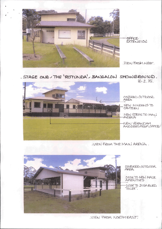
Staff Reports - Corporate and Community Services 13.4 - Attachment 2

Staff Reports - Corporate and Community Services 13.5
Report No. 13.5 Proposed
CCTV system in Byron Bay - ongoing maintenance and monitoring
Directorate: Corporate
and Community Services
Report
Author: Joanne
McMurtry, Community Policy Officer
File No: I2015/222
Theme: Society and Culture
Community Services – Community Development
Summary:
This report has been prepared to
provide, in accordance with Part 2 of Resolution 14-370, an update on
investigations undertaken and the progress achieved to date on the Byron Bay
CCTV project, including the progress of Part 1 of Resolution 14-370.
Resolution 14-370 reads as follows:
Resolved that Council:
1. Seek partners committed to
on-going operating costs of the CCTV system (estimated at $80,000 per year)
and/or find partners to collect the data and maintain the system (eg NSW
Police).
2. Receive a report on the
progress of part 1 of this resolution, prior to Milestone 8 within the
Commonwealth Grant Agreement.
This report also includes the current Project Timetable
(refer Table 2), developed following a review of the Project Timetable set out
in the Commonwealth Funding Agreement (refer Table 1), which includes the
amendments made by Council in Part 3 of Resolution 14-369.
|
RECOMMENDATION:
That Council note the report.
|
Attachments:
1 DRAFT -
community safety camera program Code of Practice, E2015/14486 , page 50
2 Confidential
- DRAFT - Community safety camera program - Standard Operating Procedures, E2014/46441
3 Confidential
- DRAFT - Memorandum of Understanding - community camera safety program -
Council and NSW Police , E2015/13032
4 Response
from Byron United re CCTV ongoing monitoring and maintenance support, E2015/17636 ,
page 58
Report
Project Background
Council on 15 May 2014 received a letter of invitation from
the Federal Attorney General’s Department to apply for funds for CCTV and
appropriate lighting in Apex Park (near Beach Hotel Precinct in Bay Street) and
Jonson Street (ending at Kingsley Street), Byron Bay.
Council at its Ordinary meeting held on 22 May 2014,
following consideration of the invitation resolved to apply for the grant
(refer Resolution 14-226), and then following consideration of a further
Report on the subsequent funding offer to the Ordinary meeting held on 7 August
2014, to accept the funds on the basis detailed in the following two
resolutions:
Council resolved 14-369:
1. That Council accept the
offer of a grant of $200,000 under section 298 of the Proceeds of Crime Act 2002
(POCA) for the CCTV in Apex Park and Jonson Street project.
2. That Council consider the
allocation of funding of up to the amount necessary for ongoing
monitoring/operations as part of a future Quarterly Budget Review or Annual
Budget process, consistent with the project delivery timetable identified in
the funding agreement.
3. That Council request the
following amendments to the draft Commonwealth Grant Agreement (Annexure 20(b)
#E2014/51438):
a) In Deliverable i. delete the
reference to 'live' monitoring'.
b) The Activity Schedule in
point 7, need to be amended to have 'steps 3, 4 & 5' changed to 'steps 2, 3
& 5'
c) Payment 4 in Payment
Schedule in D. Payment of the Grant be aligned to
Milestone #11, being the Final
Report.
d) The Project Budget be
amended to the amount of the Grant offered of $200,000, and that any reference
to an in-kind contribution by Council of $50,000 in the draft Agreement be
deleted, including under G1 Other Contributions, G2 Activity budget in both the
Income and Expenditure Tables.
e) The number of CCTV cameras
at each of the Project locations be reduced by 3 and the Project Budget amended
as follows:
Recording & Storage System
(including WiFi setup and installation) $38,000
CCTV installation Apex Park
(including 8
cameras)
$58,500
CCTV installation Jonson Street
(including 8
cameras)
$58,500
Additional
lighting
$45,000
$200,000
AND
14-370 Resolved that Council:
1. Seek partners committed to
on-going operating costs of the CCTV system (estimated at $80,000 per year)
and/or find partners to collect the data and maintain the system (eg NSW
Police).
2. Receive a report on the
progress of part 1 of this resolution, prior to Milestone 8 within the
Commonwealth Grant Agreement.
The following actions have been undertaken in relation to
the implementation of Resolution 14-369:
1) the
Commonwealth Grant Agreement was amended and executed (refer Milestone 1). Below
in Table 1 is an excerpt from the agreement showing the Milestones and key
dates amended by Council in Part 3 of Resolution 14-369. The Project Milestones
and key dates have subsequently been reviewed and the revised Project timetable
is shown in Table 2.
2) Based
on preliminary advice about the ongoing costs of monitoring and operations of
the CCTV system, $50,000 has been included in the draft budget for 2015/16
financial year. Any contribution forthcoming from partners would be used to
offset these costs.
Table 1 – Project Milestones and key dates (Excerpt from the Commonwealth Funding Agreement with Byron
Shire Council for the Safer Streets Programme)
Table 2 – Revised Project
Milestones and key dates
|
No.
|
Milestone
|
Date
|
|
1
|
Execution of Funding Agreement
|
August 2014
|
|
2
|
Technical requirements for the
CCTV camera installation, including an audit and assessment of any additional
lighting requirements in Apex Park and Jonson Street determined
|
December 2014
|
|
3
|
Draft policy, guidelines, code
of practice and operating procedures for the installation of CCTV cameras for
consultation purposes developed
|
March 2015
|
|
4
|
Progress Report 1
|
April 2015
|
|
5
|
Stakeholder and community
consultation completed
|
April 2015
|
|
6
|
Completion of the upgrade of
lighting in Apex Park and Jonson Street
|
July 2015
|
|
7
|
Finalise policy, guidelines,
code of practice and operating procedures, complaints mechanism, MOU’s
with partners such as Police etc. based on feedback from milestones 2, 3
& 5
|
July 2015
|
|
8
|
Undertake a request for tender
procurement process in accordance with the Council’s Tendering
Guidelines for the final design and installation of the CCTV camera system
|
April 2015
|
|
9
|
Completion of installation of
CCTV cameras and additional lighting
|
November 2015
|
|
10
|
Progress Report 2
|
December 2015
|
|
11
|
Initial six month review and
evaluation of the project
|
May 2016
|
|
12
|
Final Report
|
May 2016
|
Table 2 – Revised Project
Milestones and Key Dates for the Safer Streets Programme
The revision of the project
timetable has brought forward the dates for the project milestones identified
in the Commonwealth Funding Agreement and will see the project completed prior
to Schoolies in 2015 rather than in April 2016.
This report provides an update on
investigations undertaken and progress achieved to date on the implementation
of the Byron Bay CCTV project, including the progression of Part 1 of
Resolution 14-370. In accordance with Part 2 of Resolution 14-370 this report
was requested by Council, prior to commencing with Milestone 8, which is to
undertake a Request for Tender process.
Design of CCTV System
(Milestone 2)
An Expression of Interest for the design of the CCTV system
(technical specifications) was advertised in The Echo for three (3) weeks
during November 2014. Expressions of Interest closed on Friday 5 December
2014. The appointed consultant commenced investigations in January 2015
and the final technical specifications have been delivered to Council for
incorporation into the Request for Tender to ‘supply, install and
maintain CCTV systems in Byron Bay’ documentation.
Preparation of Associated Project Documentation
(Milestone 3 &7), Stakeholder Consultation (Milestone 5)& Lighting
Audits and Upgrades (Milestone 6)
Council staff have also commenced work on a number of other
important documents and considerations in preparation for the installation of
the CCTV system, which include:
1) Key land owners have
been contacted regarding the proposed project – Crown Lands Division,
Marine Parks Authority, National Parks and Wildlife, Essential Energy.
2) Work has begun on a
benchmark crime assessment on which to evaluate the program in future years.
3) Lighting audits have
been conducted and assessments of Council infrastructure required for
installation of the CCTV system.
4) A draft Code of
Practice was developed and is attached (E2015/14486).
5) A draft Standard
Operating Procedure was developed and is a confidential attachment
(E2014/46441).
6) A draft Memorandum of
Understanding with Police has been developed and is included as a confidential
attachment (E2015/13032).
7) Discussions regarding
agreements with lessee’s and private landholders have been commenced in
terms of housing the equipment.
Consultation with Key Stakeholders (refer Resolution
14-370)
In accordance with resolution 14-370, Council has consulted
with potential partners regarding the ongoing monitoring and maintenance costs
of the CCTV system. The following information is provided on this
process.
A Community Safety Camera Program Working Group was convened
with representatives of NSW Police (Tweed- Byron Local Area Command), Byron
United and the Byron Bay Liquor Accord being invited members on the Working
Group. The Working Group has met to firstly discuss the draft CCTV System
design and to provide feedback to the Consultant on the proposed camera
locations, and secondly to discuss the ongoing monitoring and maintenance costs
of a CCTV system. Staff have also written to the potential partners and
requested a formal response to Council resolution 14-370 in terms of becoming
partners for ongoing maintenance and monitoring of the system.
As mentioned previously, a Memorandum of Understanding (MOU)
has been devised in collaboration with NSW Police. The MOU outlines
Police responsibilities and Council responsibilities as the owner of the CCTV
system. Under the MOU a monitor will be located in the Byron Bay Police
Station where on duty police officers will be able to view a live feed from the
camera’s, and review footage previously captured (within the limits of
recorded footage available), but will have no capacity to record images.
The Police have been very clear that in no way do they commit to responding to
any incidents viewed on the camera’s, however they have recognised that
having live feed from the camera’s will be an important tool in their
task of keeping law and order in Byron Bay.
The Police have also confirmed that due to State Government
Policy, that the NSW Police Service would not contribute to the operating and
maintenance cost of the CCTV System.
Both Byron United and the Byron Bay Liquor Accord have
indicated in discussions that it is unlikely that their members would be in a
position to provide funds for the ongoing monitoring and maintenance of the
system. Formal responses have been requested from both organisations. The Byron
United response is attached to this report. No response has been received from
the Byron Bay Liquor Accord at the time of preparing this report.
Next Steps
The Request for Tender documentation has been drafted, with
the intention to call through an open tender process, tenders for the supply,
installation and maintenance of the CCTV systems in Byron Bay. The Tender
process is scheduled to commence on 21 April and close on 13 May 2015. This
step in the Project (refer Table 1) was originally scheduled to commence in
November 2015.
A report is expected to be presented to Council on the
Tender evaluation at 16 July 2015 Ordinary meeting to enable Council to determine
the successful Tenderer. It is understood from the advice provided to date by
the Consultant engaged to design the CCTV System that the successful Tenderer
would require between 4 to 6 weeks following the execution of the Contract to
procure the equipment and the infrastructure required and that the installation
would take between 2 to 3 weeks.
It is anticipated that any additional telecommunication
infrastructure required to support the CCTV System could be sought by Council
and installed concurrently with the procurement and installation process.
Financial Implications
As advised in the body of the report, based on preliminary
advice about the ongoing costs of monitoring and operations of the CCTV system,
$50,000 has been included in the draft budget for 2015/16 financial year.
Any contribution forthcoming from partners would be used to offset costs.
Council may also, pending the responses received from the
potential partners, consider in the preparation of future Budgets a levy to
fund or contribute to the ongoing monitoring and maintenance costs of the CCTV
system in Byron.
Statutory and Policy Compliance
Implications
· NSW Government
Policy Statement and Guidelines for the Establishment and Implementation of
Closed Circuit Television in Public Spaces (2000)
· Community Safety
Camera Program Cost of Practice (currently in draft form)
· Community Safety
Camera Program Standard Operating Procedures (currently in draft form)
Staff Reports - Corporate and Community Services 13.5 - Attachment 1

Community Safety Camera Program
Code of Practice
March 2015
1. INTRODUCTION
1.1 Byron Shire Council (Council)
is committed to partnering with the Byron Shire community and law enforcement
agencies to prevent crime.
1.2 Council’s Community Safety Camera Program (the CSCP)
is one of several initiatives designed to facilitate greater community safety
by preventing crime in the Byron Bay central business district (CBD). The CSCP
assists Council, the Byron Shire community and the NSW Police to work together
to help provide safer public spaces and prevent crime levels by facilitating
the detection and prosecution of offenders and by deterring potential
offenders.
1.3 One
element of the CSCP is the installation of community safety camera (cameras)
in the Byron Bay central business district. Council was the recipient of
Australian Government funds ($200,000) for CCTV and appropriate lighting in
Apex Park and Jonson Street Byron Bay.
1.4 It is recognised that safety
cameras cannot prevent all crime. However, cameras can assist in preventing
crime and enhancing the use of public space by all members of the Byron Shire
community.
2.
CAMERA PURPOSE
2.1
Under section 24 of the Local Government Act 1993 (NSW), Council
is able to provide goods, services and facilities, and carry out activities,
appropriate to the current and future needs of the Byron Shire community and of
the wider public, subject to the law.
2.2 In
working with the NSW Police and Byron Shire community, crime prevention is one
of Byron Shire Council's functions. Following from this, the primary purpose of
installing safety cameras is to assist in the prevention of crimes against the
person, including, but not limited to, assault-related offences.
3.
CODE OF PRACTICE
3.1 Along with its commitment to
making Byron Bay a safe place for residents and close to 1.5 million annual
visitors, Council is also committed to protecting the privacy of residents and
tourists.
3.2 Council recognises that
cameras in the Byron Bay central business district will collect personal
information of residents and visitors as defined by section 4(1) Privacy and
Personal Information Act 1998 (NSW) (the PPIP Act).
3.3 The Act imposes a series of
personal information principles (PIPs) on Council where it collects personal
information. Council takes it obligations under the PPIP Act very seriously.
This Code of Practice (the Code) is designed to ensure Council's complies
with the Act regarding how personal information obtained from cameras is
collected, managed and used.
3.4 This Code contains the standards by which the cameras
will operate.
4. STANDARD OPERATING
PROCEDURES
4.1 The Code is supplemented by
a set of Standard Operating Procedures (SOPs) which instruct the day to
day operation of the Code.
4.2 The SOPs form part of the
Code.
5.
GUIDING PRINCIPLES
The
Code is based on the guiding principles set out at Schedule 1.
6. NSW GOVERNMENT GUIDELINES
ON CCTV
6.1 In installing and operating cameras, Council has followed the process
outlined in the NSW Government Policy
Statement and Guidelines for the Establishment and Implementation of Closed
Circuit Television in Public Spaces
(2000) (the Guidelines).
7.
CAMERA SYSTEM LOCATIONS
Community
safety camera locations are outlined at Schedule 2.
8.
COUNCIL RESPONSIBILITIES
8.1
Council is responsible for the introduction and implementation of the Code and
for ensuring compliance with the principles contained in the Code.
8.3
Council retains ownership of and has copyright in all equipment, footage,
images and documentation pertaining to its community safety cameras.
8.4
Council will, subject to its annual operating plan, maintain the cameras to
ensure their effective operation.
8.5
Council staff authorised to operate, monitor and retrieve recorded footage and
materials from the cameras (authorised officers) shall undertake their
duties under the authority of Council and shall receive appropriate training.
8.6 Council is required to investigate any alleged breach of
the Code. If a breach is found to have occurred, Council will remedy that
breach to the extent possible under the Code.
8.7 A
breach of the Code by authorised officers will be dealt with in accordance with
any relevant staff agreements, awards, industrial agreements, contracts and
Council policies, including Council’s Code of Conduct Policy and
Procedures for the Administration thereof.
8.8
Council will make copies of the Code available to the public through Council's
website.
8.10
Council staff will be advised about the camera operation in accordance with the
provisions of the Workplace Surveillance Act 2005 (NSW).
9.
GUIDELINES FOR NSW POLICE ACCESS TO SAFETY CAMERAS
9.1
The NSW Police is a partner of Council in the CSCP.
9.2
Council and the NSW Police will comply with guidelines regulating NSW Police
access to the community safety cameras.
9.4
The Guidelines are to be read in conjunction with the Code and SOPs.
10.
INFORMATION ABOUT CAMERA OPERATION
10.1
Council will install clearly visible signs near each camera location in
Schedule 2 advising members of the Byron Shire community of the presence of
cameras in that location.
10.2
The signs will:
10.2.1 Allow people entering the affected areas to make a
reasonable approximation of the area covered by the cameras;
10.2.2 Inform the community that cameras are recording 24
hours per day;
10.2.3 Explain that the purpose for which safety camera
footage is being collected is crime prevention;
10.2.4 State that the intended recipients of the footage
will be Council and, where relevant, the NSW Police;
10.2.5 Inform the community that the cameras are subject to
the provisions of the PPIP Act;
10.2.6 Identify Council as the owner of the cameras; and
10.2.7 Provide Council contact details should community
members require further information, access to personal information or to make
a complaint.
11.
CONFIDENTIALITY
11.1
No personal information as defined by the PPIP Act and collected by the cameras
will be disclosed to a third party unless authorised by the PPIP Act.
11.2
No information relating to the technical operation of the community safety
cameras, including the SOPs or maintenance procedures, will be published.
11.3
Council's authorised officers and contractors will be required to enter into a
confidentiality agreement before they can access the equipment.
12.
INQUIRIES AND COMPLAINTS
12.1 Inquiries or complaints in relation to any aspect of
the management or operation of the cameras may be made in writing to Council in
accordance with Council’s Complaints Management Policy and Privacy
Management Plan to:
The General Manager
Byron Shire Council
70-90 Station St
MULLUMBIMBY 2482
Telephone on 02 6626 7000 or email to council@byron.nsw.gov.au
12.2 The PPIP Act authorises the Privacy Commissioner to
receive and investigate complaints about alleged violations of privacy. Any
member of the public is entitled to lodge a complaint with the Privacy
Commissioner regarding this Code.
12.3
All media enquiries and statements regarding the CSCP are to be dealt with in
accordance with Council’s Media Policy.
12.4
Media enquiries relating directly to Police matters should be directed to the
Tweed-Byron Local Area Command.
13.
CSCP MONITORING AND REVIEW
13.1
An audit will be conducted 12 months after the CSCP's commencement, and every
year following, to ensure the CSCP is implemented in accordance with this Code
and the SOPs.
13.2
The audit will be undertaken by a CSCP audit team, including authorised
representatives of Byron Shire Council and Tweed-Byron Police Command, and will
include a member of Council’s Internal Audit Team. Each member of the
audit team should be conversant with this Code, the SOPs and the Guidelines.
13.3
The audit shall include a review of:
13.3.1 All requests for CSCP footage within the period;
13.3.2 All incident report forms completed during the
period;
13.3.3 CSCP footage storage provisions and procedures;
13.3.4 CSCP footage deletion and destruction provisions and
compliance; and
13.3.5 Council and NSW Police compliance with all
procedures and documentation as required.
13.4
To protect the privacy of Byron Shire community members whose personal
information is collected by the CSCP, no member of the CSCP audit team will
have the right to release information gathered as part of the audit process to
any individual or organisation.
13.5
The audit team will provide a written report of its findings to Council's
General Manager within 28 days of completing an audit.
13.6
Upon receiving a report under 13.5 the General Manager will take steps to
remedy any breach of the Code identified in the audit report.
13.7
The General Manager will provide a report to Council in relation to any action
taken under 13.6.
14. CSCP EVALUATION
14.1
Council will conduct an evaluation of the CSCP's outcomes in consultation with
NSW Police 12 months after the CSCP's operational commencement and annually
thereafter. The evaluation of the CSCP will include:
14.1.1 An assessment of its impact upon crime prevention,
both in areas covered by the safety cameras and neighbouring areas, as
demonstrated through reported crime rates pre and post system implementation;
14.1.2 An assessment of its impact on detection and
prosecution of offenders through consideration of number of retrievals of
footage and the number of investigations and prosecutions supported by CSCP
footage;
14.1.3 An assessment of its impact upon crime prevention in
neighbouring areas, giving consideration to potential displacement, as well as
reduction of crime; and
14.1.4 Community views regarding the CSCP's operation.
14.2
The evaluation will be undertaken by the Director Infrastructure Services in
conjunction with NSW Police and other relevant stakeholders.
14.3
The evaluation be provided to Council's General Manager within 28 days of its
completion.
15.
CODE VARIATIONS
15.1 A
minor change to the Code may be made with the agreement of the General Manager
of the Council.
15.2
Minor changes will be advised to Councillors.
15.3 A
minor change would include any change as may be required for the purposes of
adjustment or clarification of the Code.
15.4
An example of a minor change is the replacement of one brand of video recorder
with another or a change to the wording of a particular section of the Code
where its meaning might otherwise be ambiguous.
15.5 A
major change to the Code can only be made after consultation with relevant
stakeholders and upon the agreement of the Council.
15.6 A
major change is any change that will have a significant impact upon the
operation of the Code.
15.7
An example of a major change is a change to the purposes of the system or a
proposal to install further permanent cameras.
15.8
The consideration and/or introduction of any major change to the Code will be
included in the audit report under clause 13.
Schedule 1 – CSCP Guiding Principles
1.2 Byron Bay's community safety cameras will
be operated fairly and transparently and according to law.
1.2
Community safety cameras subject to this Code will only be used for the purpose
of identifying criminal activity and thereby assisting to prevent further
criminal activity in the Byron Bay CBD.
1.3
Community safety cameras will be operated with due regard to the privacy and
civil liberties of individual members of the Byron Shire community.
1.4
Council has primary responsibility to protect the public interest in relation
to the CSCP.
1.5
Council will undertake regular review and evaluation of the community safety
cameras to identify whether the cameras are achieving their purpose.
1.6
The Byron Shire community will be provided with clear and easily accessible
information regarding the community safety cameras.
1.7
The NSW Police are a partner to the CSCP and will act in accordance with the
Code, SOPs and Guidelines.
Schedule
2 – Camera locations
2.1 Camera locations in the Byron Bay central business
district have been determined on the basis of crime statistics provided by the
NSW Police and the results of 2008 Community Safety Audit of Byron Bay CBD.
2.2 A total of 22 community safety cameras have been
installed at the following locations:
2.2.1 Camera
location 1 – Apex Park (cameras 1-5)
2.2.2 Camera
location 2 – Bay and Jonson Streets (cameras 6-8)
2.2.3 Camera
location 3 – Lawson and Jonson Streets (cameras 9-13)
2.2.4 Camera
location 4 – Jonson Street at Lawson Lane (camera 14)
2.2.5 Camera
location 5 – Byron and Jonson Streets (camera 15-16)
2.2.6 Camera
location 6 – Railway Park (cameras 17-20)
2.2.7 Camera
location 7 – Transport hub, Jonson Street (cameras 21-22)
2.3 The camera locations are represented in red in the 'area
of scope' image below.
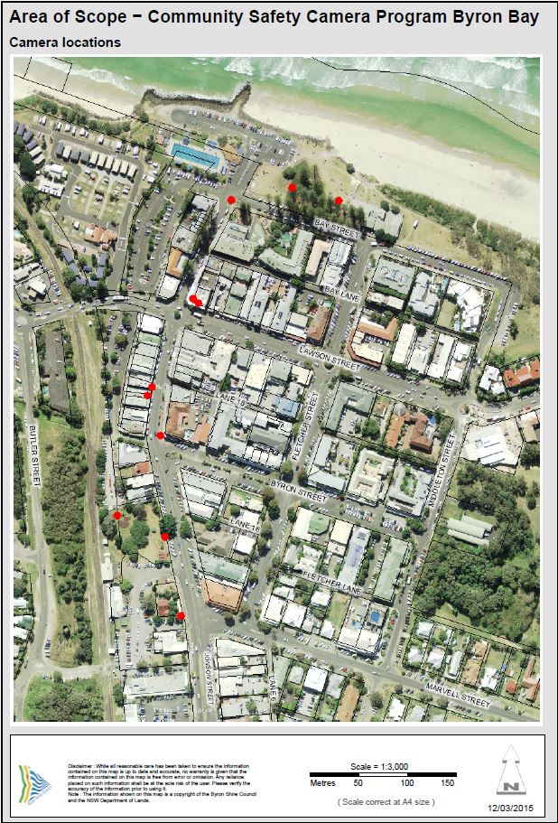
Staff Reports - Corporate and Community Services 13.5 - Attachment 4
Staff Reports - Sustainable Environment and Economy 13.6
Staff Reports - Sustainable Environment and
Economy
Report No. 13.6 Submissions
received on the exhibition of Draft 2012 Developer Contributions Plan
(Amendment 3).
Directorate: Sustainable
Environment and Economy
Report
Author: Christopher
Soulsby, Development Contributions Officer
File No: I2015/101
Theme: Ecology
Development and Approvals
Summary:
The purpose of this report is to have Council consider the
submissions made with respect to the exhibition of Draft 2012 Developer
Contributions Plan (Amendment 3) and for Council to resolve to make the draft
plan with some amendments. The amendments are minor and relate to adding
additional works into the plan for the upgrading of the Mullumbimby Drill Hall
and to alter the description of the energy efficiency works at the Cavanbah
Sports Centre.
|
RECOMMENDATION:
1. That
Council approve the 2012 Developer Contributions Plan (Amendment 3) as
exhibited subject to inclusion of the following amendments:
a) Amend
the Mullumbimby Community Facilities works schedule by including the
information shown in table 3 included in this report and the consequential
changes in the rates per standard dwelling unit as shown in table 4.
b) Amend
the Shire Wide Open Space Works Schedule by altering the description of works
at the Cavanbah Sports Centre as follows:
“Energy efficiency
improvements at Cavanbah Sports Centre including but not limited to
installation of a Solar Photo-Voltaic generation system, hot water and
lighting improvements. (Expenditure of Existing Funds)”
2. That
notice of the approved 2012 Developer Contributions Plan (Amendment 3)
be placed in the local paper within 28 days of the date of this meeting and
that the date of commencement of the plan be two weeks after the date of
publication of the notice.
|
Attachments:
1 Confidential
- submisisons received on the exhibition of the S94 Developer Contributions
Plan 2012 (Amendment 3), E2015/18036
(provided under separate cover)
Report
The purpose of this report is to have Council consider the
submissions made with respect to the exhibition of Draft 2012 Developer
Contributions Plan (Amendment 3) and to seek a resolution from Council to
approve the draft plan with some amendments.
At the Ordinary meeting of 11 December 2014 Council
considered a report on change room facilities at Tom Kendal Oval.
Included in this report was commentary on how these facilities could be funded
from the section 94 plan. At this meeting Council resolved:
14-630 Resolved:
1. That
Council support the continuation of the development of change facilities and
additional amenities at Tom Kendall Oval, New Brighton.
2. That
staff amend the 2012 Byron Developer Contributions plan as per the “Table
of Proposed Amendments to the Community Facilities Works Schedule” as set
out in this report.
3. That
staff amend the 2012 Byron Developer Contributions Plan Open Space works
schedule by the inclusion of $32,000 of shade structures at Tallowwood
Playground.
4. That
as a result of points 2 and 3 staff make consequential changes to the rates of
contribution in the Draft 2012 Byron Developer Contributions Plan.
5. That
Council place the Draft 2012 Byron Developer Contributions Plan on public
exhibition in accordance with the Environmental Planning and Assessment Act,
1979 and Regulation, for a period of 28 days.
6. That
at the close of the exhibition, report the Draft 2012 Byron Developer
Contributions Plan back to Council for further consideration.
(Woods/Cubis)
Public Exhibition
The draft section 94 plan was placed on public exhibition
from 21 January 2015 until 18 February 2015. Eighteen (18) submissions
were received during the exhibition period. Sixteen of these were a form
letter objecting to the redirection of funds from the toilet facilities at
Water Lily Park to the change rooms at Tom Kendal Oval (referred to as
submission 1 in the table below). The other public submission was a
detailed submission seeking to include additional works into the Mullumbimby
Community Facilities works schedule for the Drill Hall.
Copies of both public submissions are provided as Attachment
1. There was also an internal submission from staff seeking a minor
amendment to the wording of a project description and this is discussed
separately below.
The following table sets out a summary of the main points of
the submissions with comments by the Developer Contributions Officer in
response:
|
Table 1 Submissions Received
|
|
Submission
|
Summary of Points of Submission
|
Staff Response
|
|
1 Form Letter objecting to redirection of funds from the
toilet facilities at Water Lily Park to the change rooms at Tom Kendal Oval
|
Object to the transfer of funds from Water Lily Park to
Tom Kendal Oval as the funds should be kept in South Ocean Shores.
|
Council had by resolution identified the change rooms at
Tom Kendal to be a priority. Subsequently staff had identified a
funding mechanism via the section 94 plan. This project has been
scoped, planned and only requires the amendment of the S94 plan to enable the
project to proceed. One of the reasons that staff recommended the
transfer of the funds from Water Lily Park to Tom Kendal was that the Tom
Kendal project was effectively shovel ready whilst the Water Lilly Park
project would require further project planning.
The whole of Ocean shores and New Brighton is considered
to be one catchment for the purposes of collection and expenditure of
contributions. Section 93E of the Environmental Planning and Assessment
Act 1979 applies to the holding and expenditure of contributions. This
section requires Council to hold the contributions and expend them on the
purpose for which they were acquired. The funds that are being
transferred within the catchment were collected under the terms of the 2001
and 2005 contributions plans. These plans did not list specific projects
but collected contributions under broad headings such as community facilities
in each catchment. The adoption of the 2012 plan bought Council into
compliance with the Act, Regulations and the Department of Planning
Guidelines. It is both lawful and reasonable for Council to transfer
funds collected under the old plans to a similar project in the same
catchment. In this regard the issue of the transfer of the funds is not
a question of can Council transfer the funds but should Council transfer the
funds. In determining this question of merit Councillors should have
consideration for the following factors:
a) Immediate
benefit to the community by construction of the change room facilities;
b) Number
of users of potential users of the competing facilities;
c) The
facility will benefit the whole of the catchment not just north or south or
New Brighton;
d) Staff
are aware of the need for additional facilities at Water Lily Park and will
be progressing plans to identify the size and standard of facility required
as well as funding sources. This is an issue of timing rather than not
funding the works at Water Lily Park at all.
|
|
1 Form Letter objecting to redirection of funds from the
toilet facilities at Water Lily Park to the change rooms at Tom Kendal Oval
|
It is not equitable to transfer money from South Ocean
Shores to New Brighton
|
Staff consider that it is both reasonable and equitable to
spend section 94 funds on works within the catchment that the funds were
collected in.
|
|
1 Form Letter objecting to redirection of funds from the
toilet facilities at Water Lily Park to the change rooms at Tom Kendal Oval
|
Change facilities at Tom Kendal are not a priority.
|
The report to the 12 December 2014 meeting of Council on
page 201 lines 20-50 covers the needs analysis and why this is a priority
project to service a wide demographic of residents within the
catchment.
|
|
1 Form Letter objecting to redirection of funds from the
toilet facilities at Water Lily Park to the change rooms at Tom Kendal Oval
|
Request a new project be included in the plan to acquire
“Flat Park and Access to Marshals Creek Reserve…Corner Rajah Road
and Miriam Place
|
A plan and aerial photo of the site is shown as map 1
below in the report. This site is relatively flat and would be suitable
for a small park and playground. It is however on land the subject of a
subdivision approval and the developer is in the process of finalising the
works to allow for the release of the subdivision certificate. It is
probable that the land would be released as residential lots prior to the
adoption of an amended plan and certainly before there was sufficient money
on the plan to purchase the land.
It is open to Council to include a new item into the
contributions plan. If Council resolves to include a new item into the
plan for a park acquisition then staff would need to get a valuation of the
land to include this into the plan. This valuation would feed into
calculation of the apportionment split of costs between the Council and new
development. It is not possible to include this as an item into the
plan for adoption at this meeting and an amended plan would need to be
reported back to Council.
The above comment outlines the process to be undertaken to
include a new item into the plan. A cautious approach to including new
items in the Ocean Shores / South Golden Beach catchment is
recommended. The first reason for caution is that this catchment is
almost fully developed leaving minimal potential to collect further
contributions. The second reason for caution is that the apportionment
rate in this catchment is 4.77%. It is difficult to justify that a new
land acquisition is 100% the responsibility of new development. On this
basis Council would be responsible for 97.23% of the cost of the
acquisition. Whist the cost is not currently known it is a reasonable
to state that this would result in a significant unfunded liability for
Council. It would not be financially sustainable to incorporate the
acquisition of new land into the contributions plan and on this basis staff
do not recommend that a new item be added into the contributions plan.
|
|
1 Form Letter objecting to redirection of funds from the
toilet facilities at Water Lily Park to the change rooms at Tom Kendal Oval
|
The land was identified in the Recreational and Open Space
Planning Guidelines
|
The accompanying report to the 2001 Contributions Plan
identified this site as potential open space. It did not go so far as
to include the land for acquisition nor did it place a value on the
land. The 2001 plan did not identify that this land had a subdivision
approval on it and was being subdivided into housing blocks. The 2001
plan did not specifically collect money for the acquisition of this
land. Council has since moved on from the 2001 plan and the land was
not identified for acquisition in the 2005 of previous amendments of the 2012
plan contributions plans. Council has not since identified this land
for acquisition and has not collected any contributions for it.
|
|
1 Form Letter objecting to redirection of funds from the
toilet facilities at Water Lily Park to the change rooms at Tom Kendal Oval
|
The purchase of flat land at Raja Road is compatible with
the objectives of Council’s Community Strategic Plan.
|
Council’s Community Strategic Plan is a broad
planning document and many projects can be said to be consistent with its
broad objectives. It is agreed that this project is consistent with the
Community Strategic Plan objectives. However just because it is
consistent doesn’t mean that Council must or should proceed with the
project. There are other matters for consideration.
Due to the financial implications of including such an
item into the plan it is recommended that Council not proceed with its
inclusion in the plan.
|
|
2 Letter from Mullumbimby Drill Hall Theatre Company
(DHTC)
|
Requests funding for upgrading works at the Mullumbimby
Drill Hall. The works include:
Electrical upgrade $7,3336;
Air conditioning $18,,250;;
Tiered seating $25,200;;
Chairs $17,133;
The request for funding also comes with an offer that the
Drill Hall Theatre Company (DHTC) can co-fund up to $20,000 of the
works.
|
This submission arises out of a meeting held between the
DHTC and Council’s General Manager, Director Corporate and Community
Services and Developer Contributions Officer. The purpose of the
meeting was to discuss funding arrangements for the hall upgrades.
It should be noted that Council cannot fund the $17,133
for replacement seating from section 94 funds. This matter was
discussed with the Manager Governance and a funding submission for this
amount has been included in the draft 2015/16 budget to be funded from an
existing special rates variation.
The upgrade works for the hall are currently in the
Community Facilities works schedule of the 2012 plan. This submission
seeks to vary the detail of the existing plan. The current plan has
$41,330.72 of works in the plan with an apportionment rate of 20.12%.
A minor amendment to the plan to facilitate these works is
appropriate for the following reasons:
a)
there is no adverse financial implications for Council;
b)
The proposal adds capacity to an existing facility and can be said to meet
the demands of new population (nexus);
c)
The community group is funding their share of the apportionment;
d)
It’s a minor alteration to an item already in the works schedule;
e)
There is sufficient funds available in the Mullumbimby Community Facilities
account to funds the proposal.
The details of the amendments
are provided below. It is considered that this amendment is minor and
has no significant adverse impact upon the plan or the community.
|
|
Internal Submission from Council’s Sustainability
Officer
|
Council engaged a consultant “Powersmart” to
create a holistic energy assessment of the Cavanbah Sports Centre and provide
design recommendations to inform a request for quotation of solar hot water
and/or solar power (funded from section 94 contributions).
Powersmart made a number of recommendations to improve the
energy efficiency and reduce the operating costs of the site. This involves,
some plumbing solutions, solar power installation and LED lighting
upgrades.
It is recommended that an amendment to the section 94
contributions plan be made to change the current description from
“Solar Power and Solar Hot Water” to “Energy Efficiency and
Renewable Energy Improvements” in the April review to allow for the LED
lighting improvements to be included in this project.
|
The proposed change is only in the description of the
scope of works. It does not change the level of expenditure.
The original description of the works was:
“Installation of a Solar Photo-Voltaic generation
system and a solar hot water system on the BRSCC.”
The proposed amended description is:
“Energy efficiency improvements at Cavanbah
Sports Centre including but not limited to installation of a Solar
Photo-Voltaic generation system, hot water and lighting improvements.
(Expenditure of Existing Funds)”
It is considered that this amendment is minor and has no
significant impact upon the plan.
|
Map 1 Showing location of land to be acquired by Council as
requested in submission 1.
Details of the Mullumbimby Drill Hall amendment
Table 2 Summary of current details from works schedule:
|
Facility
|
Cost of Works Indexed to 24 April 2014
|
Net cost of works
|
Apportionment (% attributable to new development)
|
Cost of works attributable to new development
|
Cost of Works Attributable to Council
|
Cost per SDU
|
|
Mullumbimby Drill Hall
(refer to Community Infrastructure 10 Year Plan) PN: 35480
|
41,330.72
|
41,330.72
|
20.12%
|
8,316.10
|
33,014.62
|
24.97
|
Table 3 Summary of Proposed changes to the Mullumbimby
Community Facilities Works Schedule
|
Facility
|
Cost of Works Indexed to 24 April 2014
|
Net cost of works
|
Apportionment (% attributable to new development)
|
Cost of works attributable to new development
|
Cost of Works Attributable to Council
|
Cost per SDU
|
|
Mullumbimby Drill Hall
Tiered Seating PN: 35480
|
25,200.00
|
25,200.00
|
100.00%
|
25,200.00
|
0.00
|
75.68
|
|
Mullumbimby Drill Hall Air
conditioning and power upgrade PN: 35480
|
25,586.00
|
25,586.00
|
20.12%
|
5,148.13
|
20,437.87
|
15.46
|
|
Total
|
|
|
|
|
|
91.14
|
The proposed changes split the project into two jobs, being
the combined air conditioning and power upgrade and a separate job for the
tiered seating. It is intended to utilise the DHTC’s $20,000 to
fund the apportionment to enable release of the funds. This amendment
increases the per lot contributions rate by $66.17.
Financial Implications
The following table sets out what the charges will be if the
proposed amendments, inclusive of those previously exhibited are adopted.
Table 4 Contributions per Standard Dwelling Unit by
Catchment
|
|
Byron Bay Suffolk
Park
|
Bangalow
|
Mullumbimby
|
Ocean Shores
|
Rural North
|
Rural South
|
Brunswick Heads
|
|
Local Open Space &
Recreation
|
3,827.43
|
3,535.28
|
11,654.43
|
1,591.55
|
|
|
2,344.61
|
|
LGA Wide Open Space &
Recreation
|
688.90
|
688.90
|
688.90
|
688.90
|
688.90
|
688.90
|
688.90
|
|
LGA wide Community
Facilities
|
1,008.97
|
1,008.97
|
1,008.97
|
1,008.97
|
1,008.97
|
1,008.97
|
1,008.97
|
|
Local Community Facilities
|
1,136.94
|
320.06
|
198.39
|
1,374.14
|
|
|
192.05
|
|
Bikeways & Footpaths
|
1,260.42
|
853.36
|
1,905.24
|
433.93
|
|
|
521.30
|
|
Shire Wide Bikeways &
Footpaths
|
74.01
|
74.01
|
74.01
|
74.01
|
74.01
|
74.01
|
74.01
|
|
Urban Roads
|
2,855.24
|
1,467.92
|
988.91
|
|
|
|
2,546.60
|
|
LGA Wide Roads
|
208.46
|
208.46
|
208.46
|
208.46
|
208.46
|
208.46
|
208.46
|
|
Rural Roads
|
|
|
|
|
13,602.94
|
13,602.94
|
|
|
Admin Levy
|
1,042.02
|
1,042.02
|
1,042.02
|
1,042.02
|
1,042.02
|
,042.02
|
1,042.02
|
|
Total
|
12,102.39
|
9,198.98
|
17,769.33
|
6,421.98
|
16,625.30
|
16,625.30
|
8,626.92
|
There are no other changes to the rates of contribution to
that which was exhibited other than a consumer price index increase.
There are no additional unfunded apportionment liabilities for Council that
arise from the proposed amendments that are additional to what was
exhibited.
Statutory and Policy
Compliance Implications
Clause 31 of the Environmental Planning and Assessment
Regulation 2000 prescribes the manner in which Council may deal with a draft
contributions plan following exhibition. Clause 31 is set out as follows:
31 Approval of
contributions plan by council
(1) After
considering any submissions about the draft contributions plan that have been
duly made, the council:
(a) may
approve the plan in the form in which it was publicly exhibited, or
(b) may
approve the plan with such alterations as the council thinks fit, or
(c) may
decide not to proceed with the plan.
(2) The
council must give public notice of its decision in a local newspaper within 28
days after the decision is made.
(3) Notice
of a decision not to proceed with a contributions plan must include the council’s
reasons for the decision.
(4) A
contributions plan comes into effect on the date that public notice of its
approval is given in a local newspaper, or on a later date specified in the
notice.
This report has made recommendations that amendments be made
to the draft plan prior to approval of the plan. It is considered that
these amendments are of such a minor nature that they do not require
re-exhibition of the draft plan.
There are no significant adverse impacts to the community or
to Council from the minor amendments post exhibition. On this basis it is
recommended to Council that the draft plan including the amendments be
approved. As has been standard practice with contributions plan
amendments the date for commencement would be two weeks after the notification
is placed in the paper.
Staff Reports - Sustainable Environment and Economy 13.7
Report No. 13.7 Voluntary
Planning Agreement - Agreement for provision of car parking associated with DA
10.2014.649.1 - Redevelopment of Old Byron Council Chambers
Directorate: Sustainable
Environment and Economy
Report
Author: Christopher
Soulsby, Development Contributions Officer
File No: I2015/199
Theme: Ecology
Development and Approvals
Summary:
The purpose of this report is to seek a resolution of
Council to place a voluntary planning agreement (VPA) on public
exhibition. A VPA is a mechanism that enables a developer to pay Council
for the provision of public infrastructure that the developer is not
providing. In this circumstance the VPA is for the provision of car
parking at a private development. This VPA is a voluntary agreement between
both parties and offers to contribute to public car parking at a rate of
$38,000 per space. The rate per space offered by the developer has been
derived at following negotiations between staff and the Developer’s
representatives. In making the decision to exhibit the VPA the primary
consideration will be the quantum cost per space that is acceptable.
There are implications for the determination of DA
10.2014.649.1 if Council does not agree to enter into a VPA and this report
should be read in conjunction with the report for DA 10.2014.649.1.
NOTE TO COUNCILLORS:
In accordance with the
provisions of S375A of the Local Government Act 1993, a Division is to be
called whenever a motion for a planning decision is put to the meeting, for the
purpose of recording voting on planning matters. Pursuant to clause 2(a)
under the heading Matters to be Included in Minutes of Council Meetings of
Council's adopted Code of Meeting Practice (as amended) a Division will be
deemed to have been called by the mover and seconder of all motions relating to
this report.
|
RECOMMENDATION:
1. That
Council place the planning agreement on public exhibition for a period
to 28 days subject to the following amendments
a) Amend
Clause 5.3 by adding another clause after 5.3.3 that states:
“5.3.4 The Developer
commences works on the development. ”
b) Amend
clause 12 by adding another clause after 12.1.2 that states:
“12.1.3 No refund is to
be given after the developer has commenced works on the
development.”
2. That
the planning agreement be referred to Council’s solicitors for
review and that the cost of this review be recouped from the developer prior
to Council entering into the planning agreement.
3 That
the planning agreement and any submissions received be reported back to
Council following the exhibition period.
|
Attachments:
1 DRAFT
Planning Agreement prepared by McCartney Young Lawyers Byron Shire Council and
Byron ~ 23 Lawson Street Byron Bay in relation to DA 10.2014.649.1(2) and the
schedule included, E2015/18486
(provided under separate cover)
Report
The purpose of this report is to seek a resolution of
Council to place a voluntary planning agreement (VPA) on public
exhibition. A VPA is a mechanism that enables a developer to pay Council
for the provision of public infrastructure that the developer is not
providing. In this circumstance the VPA is for the provision of car
parking. A VPA is a voluntary agreement between both parties and offers
to contribute to public car parking at a rate of $38,000 per space. The
rate per space offered by the developer has been derived at following
negotiations between staff and the developers representatives. In making
the decision to exhibit the VPA the primary consideration will be the quantum
cost per space that is acceptable.
This report should be read in conjunction with the
development assessment report for Mixed development comprising; demolition,
retention of existing building, erection of a new building to be used for
backpacker accommodation (250 beds), shops and restaurants, the outcome of this
report will impact on Council’s determination of that development
application. Options concerning the implications of not proceeding with
the VPA and the impacts on DA 10.2014.649.1 are set out under the heading statutory
and policy implications.
The development proposed in DA 10.2014.649.1 generates a
demand for 54 spaces and the design provides 51 leaving a shortfall of 3
spaces. The developer has offered to enter into a VPA to make a payment
for those 3 spaces at the rate of $38,000.00 per space (total of $114,000.00
for the 3 spaces). A copy of the detailed VPA is provided as Attachment
1.
Because a VPA is a separate agreement between Council and
the developer the normal requirement for strict compliance with an adopted contributions
plan does not apply. Council may agree to a figure per space that it
considers reasonable and appropriate in the circumstances of the case.
The base figure for consideration should be that which was previously adopted
in the 2005 contributions and was used up until 1 January 2013. The
discussion below will show that the figure from the 2005 plan is not
appropriate and will provide justification for an appropriate charge.
Under the provisions of the 2005 contributions plan the
contribution per parking space in the Byron Bay town centre was $68,094 as
indexed up to January 2015. There are mathematical errors and errors of
the contributions planning principle in the 2001 and 2005 plans that make the
validity of this figure highly questionable.
A review of parking contributions in other localities has
revealed that the charge in Byron Bay and Brunswick heads are abnormally high.
Table 1 shows the comparison parking charges for various
towns.
|
Table 1 Parking
Contributions in different towns
|
|
Locality
|
Per Space
|
|
Byron Bay CBD
|
68,094
|
|
Brunswick Heads
CBD
|
61,690
|
|
Kingscliff
|
28,866
|
|
Bogangar
|
28,866
|
|
Bangalow
|
28,162
|
|
Tweed Heads
|
26,019
|
|
Ballina Central Business
District (CBD)
|
25,368
|
|
Pottsville
|
21,343
|
|
Port Macquarie CBD
|
20,834
|
|
Lismore CBD
|
18,978
|
|
Mullumbimby CBD
|
18,919
|
|
Coffs Harbour CBD
|
16,947
|
|
Murwillumbah
|
16,603
|
|
Lennox Head Village Centre
|
15,999
|
|
Alstonville Village Centre
|
14,722
|
|
Nimbin Village
|
3,269
|
|
Fingal Head
|
3,025
|
A car parking contribution is calculated based on three
factors land acquisition, the cost of construction, and number of spaces to be
created. The charge should reflect the actual cost of provision of the
spaces or the likely predicted cost of future provision of the spaces.
Land value can be highly variable and the value of land in other localities is
not considered further in this report.
Construction costs are relatively stable across all
LGAs. Table 2 sets out the mean construction cost across all the
localities surveyed. These costs include the costs estimates of access
aisles, ramps, lighting and all infrastructure required to provide the
space.
|
Table 2 Construction Cost per Space (Averaged over
all LGAs)
|
|
Ground Level
|
3,684.29
|
|
Multi-deck
|
20,320.00
|
|
Basement
|
38,130.00
|
Council has to date only constructed ground level
spaces. Council acquired land and constructed car parks (Lawson Street
North and Lawson Street South) from section 94 funds. Council spent
$1,883,512 on this project in 1993/94. This equates to $3,330,448.37
indexed to today’s dollars. There are currently 140 spaces in
Lawson Street North and 72 spaces in Lawson Street South giving a total of 212
spaces.

This calculation was excluded from the 2001 contributions
plan. That plan only considered a new acquisition in Middleton Street to
construct 250 additional car spaces at a cost of $7,750,000 (indexed to
$11,065,508 in 2015) with a contribution rate per space of $31,000 in
2001.
The 2005 Contributions plan included the cost of works from
1993 but not the number of spaces into the equation and updated the 2001
works. There were then some particularly large addition errors and
division errors in this plan that resulted in a contribution rate of $49,202.26
at the date of adoption. This has been indexed up to the current figure
of $68,094.
The correct methodology should have been to include the cost
and number of spaces created in Lawson Street North and South into the equation
as well as the proposal to construct the 250 spaces at Middleton Street.
This methodology is shown in the equation below with all figures indexed to
2015.

Council has not proceeded with the proposal at Middleton
Street to date. A rate of $31,160, whist at the upper end of charges
levied in other local government area, is reasonably comparable and competitive
with the rates being charged from Tweed to Ballina.
The above discussion has shown that the 2005 plan and a
contribution rate of $68,094 is fundamentally flawed and if the correct
planning principles were applied then a rate per space of $31,160.08 would be
appropriate if this process were being undertaken strictly in accordance with
accepted contributions planning practice.
Adoption of a rate that is lower than the cost of provision
of a car space by the developer may have unforseen consequences. If it costs
the developer more to provide the space on site than to pay Council to provide
it then the developer may choose to over develop their site and provide no
parking. Cognisant of this issue and that the 2005 rate was fundamentally
flawed staff entered into negotiations with the developers representatives on
the question of an acceptable cost per space to be included in a VPA.
The developer has provided a draft VPA that offers to pay
$38,000 per space. This is on the basis that this is approximately what
it would cost the developer to provide the spaces on his own site and that is
$30,000 less than the rate applied in the 2005 plan. As this agreement is
voluntary, neither party is bound by the previous contributions plans or
charges and Council can choose to enter into the VPA for an amount less than was
contained in the previous contributions plans in the circumstances. It is
considered reasonable and appropriate to accept the developer’s offer of
$38,000 per space.
It is the intention of staff that upon completion of the
Byron Bay Town Centre Master Plan, when the location and type of new car
parking area is known to recalculate an appropriate contribution amount to be
included in future VPAs. The new rate will be based on the 1993 works
provided to date and any new works proposed. This rate is as yet unknown
and unless Council is proposing significant land acquisitions or plans to build
a basement car park is likely to be less than the $38,000 proposed by the
developer.
Staff have also made the offer to the developer that if a
lesser rate is adopted after the VPA is entered into but before the payment is
made, then the developer would be able to take advantage of the lesser
rate. This is consistent with approach taken by staff with VPAs proposed
for provision of car parking in Bangalow. The VPAs in Bangalow did not
proceed as the development applications were ultimately refused. The
developer’s draft VPA contains clause 12 concerning refund of
contributions. Clause 12.1.1 is reasonable and relates to a refund in
circumstances where the consent becomes invalid or lapses. Clause 12.1.2
relates to a partial refund if Council adopts a lesser rate. Staff have
no objection to the concept of a partial refund if Council adopts a lesser rate
but consider that such a refund provision should be time limited and not be
allowed to run indefinitely. No refund should be available following
commencement of works. There needs to be certainty and finality to the
time when the developer can call for a refund. Amended wording to clauses
5.3 and 12.2.1 are made in the recommendation to satisfy this
requirement.
The VPA and the explanatory note should be referred to
Council’s solicitors for review during the exhibition process.
Financial Implications
All costs of the preparation, exhibition and legal advice
that Council may require for the VPA will be bourn by the developer.
Council will receive a contribution to provide additional
car parking within the Byron Bay town centre. There is no cost to the
general fund due to accepting this offer.
Statutory and Policy
Compliance Implications
Section 93F of the Environmental Planning and Assessment Act
1979 and Clause 25 of the Environmental Planning and Assessment Regulation 2000
applies to the preparation of VPAs. Council and the developer may enter into
a planning agreement where the developer agrees pay a
monetary contribution for the provision of public amenities. In this case
the public amenity is the provision of public car parking.
Clause 25D of the Regulation requires that notice of a the planning
agreement be exhibited contemporaneously with the exhibition of any relevant
development application where practicable. In this circumstance at the
time of exhibition of the development application it was not known that a
planning agreement was required. Council may rely on Clause 25D (1) (a)
(ii) and exhibit the VPA as soon as is practicable once Council is satisfied as
to the terms of the agreement.
The agreement must be placed on exhibition for a minimum of
28 days and reported back to Council for adoption.
There are implications for the determination of DA
10.2014.649.1 if Council does not agree to enter into a VPA or if Council
resolves to exhibit the VPA with a significantly higher rate of
contribution. Some of the possible scenarios and the impacts that flow
from them are discussed below.
If Council declines to enter into the VPA then Council has
three options in dealing with DA 10.2014.649.1:
1 Refuse
DA 10.2014.649.1 due to there being inadequate car parking provided for the development;
or
2 Approve
DA 10.2014.649.1 with a variation to the parking provisions of DCP 2014.
Council makes a conscious decision to vary the DCP and considers that the non
compliance is of minimal significance; or
3 Defer
determination of DA 10.2014.649.1 and require the developer to amend the plans
for the development to reduce the floor space and demand for parking.
With option 1 the developer has a right of appeal with
respect to the development application and the matter would be determined by
the Court with respect to the assessment of the application against the
DCP. Council is not compelled to enter into a VPA.
Option 2 does not have any implications for the VPA but
would have future implications for the assessment of development applications
where there is a shortfall of car parking.
If Council’s pursues option 3 then developer may
choose not to vary the plans and may exercise their right of appeal and the
outcome is the same as option 1.
If Council resolves to place the VPA on exhibition with a
significantly higher rate of a contribution and the developer does not agree to
this rate then the agreement could no longer said to be voluntary and Council
should consider exercising options 1-3 described above.
Council may also resolve not to enter into the VPA because
it has determined DA 10.2014.649.1 by way of refusal for other merit
reasons. In this scenario the VPA has become redundant due to the refusal
of the development application.
The recommended solution is for Council to resolve to place
the VPA on exhibition and to determine DA 10.2014.649.1 by way of approval with
a deferred commencement condition that requires a VPA to be entered into.
Section 93I of the Environmental Planning and
Assessment Act 1979 sets out the circumstances in which planning agreement can
or cannot be made. Section 93I (3) enables Council to impose a condition
of consent that requires a planning agreement to be entered into. 93I (3) is
set out as follows:
(3) However,
a consent authority can require a planning agreement to be entered into as a
condition of a development consent, but only if it requires a planning
agreement that is in the terms of an offer made by the developer in connection
with:
(a) the
development application, or
(b) a
change to an environmental planning instrument sought by the developer for the
purposes of making the development application, or that is in the terms of a
commitment made by the proponent in a statement of commitments made under Part
3A.
Whilst the Act allows for such a condition to be imposed it
does leave the developer with an amount of uncertainty if Council exhibits the
VPA and then does not proceed with the VPA post exhibition.
Staff Reports - Sustainable Environment and Economy 13.8
Report No. 13.8 Review
of the waiving of developer contributions for secondary dwellings
Directorate: Sustainable
Environment and Economy
Report
Author: Christopher
Soulsby, Development Contributions Officer
File No: I2015/200
Theme: Ecology
Development and Approvals
Summary:
In 2011 Council resolved to waive the requirement to pay
section 94 and section 64 charges for secondary dwellings. The premise of
this waiver was to provide affordable housing. In August 2014 Council
called for a review of the current policy and set the parameters of that review.
The review is now complete and the evaluation is that the cost of the policy
does not warrant its retention. If Council were to continue with the
policy it will have a significant adverse impact on Council’s ability to
deliver infrastructure.
NOTE TO COUNCILLORS:
In accordance with the
provisions of S375A of the Local Government Act 1993, a Division is to be
called whenever a motion for a planning decision is put to the meeting, for the
purpose of recording voting on planning matters. Pursuant to clause 2(a)
under the heading Matters to be Included in Minutes of Council Meetings of
Council's adopted Code of Meeting Practice (as amended) a Division will be
deemed to have been called by the mover and seconder of all motions relating to
this report.
|
RECOMMENDATION:
1. That
Council places an amendment to the Byron Shire Developer Contributions
Plan 2012 on public exhibition for a period of 28 days. The amendment
is to delete clause 2.14 of the plan relating to the waiving of contributions
for secondary dwellings
2. That
Council place on public exhibition a notice of their intention to
“Remove the policy for waiving of section 64 contributions for
secondary dwellings” for a period of 28 days. The amendment is to
rescind the policy.
3. That
at the close of the exhibition period the submissions be reported back to
Council for consideration.
|
Report
The purpose of this report is
to respond to the resolution of Council on housing affordability.
At the Ordinary meeting held
on 7 August 2014, Council resolved the following:-
14-360 Resolved that Council:
1. Evaluate
Council’s policy of waiving S94 contributions for secondary dwellings as
a means to support affordable housing and provide recommendations to strengthen
affordability outcomes of secondary dwellings.
2. Provide
a report on the possibility of establishing a requirement that the waiving of
S94 contributions for secondary dwellings be linked to the provision of
affordable housing within the Shire.
3. Consider
affordable housing requirements within Council’s Town Master Plans,
Strategic Planning and Growth Management review process, including, but not
being limited to:
a) New
urban areas identified for housing, in particular the increased development of
laneways
b
Secondary dwelling planning and development control provisions
c) Any
potential new housing cluster or hamlet identification and subsequent rezoning.
d) Consideration
of dual occupancy and lot size provisions for affordable housing.
4. Undertakes
an audit on secondary dwellings (granny flats) in Byron Bay to identify
secondary dwellings being used for holiday letting, noting the requirement
within resolution 11-268 that the applicant who, "has applied for a
secondary dwelling or granny flat" and is," specifically advised that
the development is not to be used for tourism purposes and accepts a condition
of consent to the same effect." (Richardson/Spooner)
Each part of the resolution is considered in the report
below.
1 Evaluation
of Council’s policy of waiving S94 contributions for secondary
dwellings as a means to support affordable housing and provide recommendations
to strengthen affordability outcomes of secondary dwellings
Housing affordability is affected by the micro economic
factors of supply and demand in a relatively fixed market. Council has
very limited ability to affect price within the market other than by making it
easier or cheaper to provide housing to the market thus increasing the supply
side of the equation.
In this regard the policy has been successful with 278
secondary dwellings being approved and 214 having construction
certificates. The extent to which the increase in supply has impacted
affordability is to be found in the median weekly rent paid within the shire.
Rent is the appropriate measure rather than sale price as
secondary dwellings cannot be subdivided and sold separately. The Rent
and Sales Reports prepared by NSW Department of
Family and Community Services provides information on the median weekly rents
paid in the shire.
The following table sets out the
data for one bedroom dwellings. As almost all secondary dwellings are
single bedroom only the rent for single bedroom dwellings has been considered
for the purposes of this report.
|
Table 1 One Bedroom Dwelling Median Weekly Rent
|
|
|
Mar-11
|
Mar-11 Indexed to December 2014
|
Dec-14
|
Change
|
Percentage Change
|
|
Byron
|
250
|
272
|
250
|
-22
|
-8.09%
|
|
Ballina
|
190
|
207
|
210
|
3
|
1.45%
|
|
Lismore
|
132
|
144
|
175
|
31
|
21.53%
|
|
Tweed
|
230
|
250
|
220
|
-30
|
-12.00%
|
|
Source: Rent and
Sales Report NSW Department of Family and Community Services
|
What this table shows is that there has been a $22 per week
decrease in real terms in the median weekly rent paid in Byron Shire since the
commencement of the waiving of contributions. This is an 8.09% decrease
in the median weekly rent. The extent of the impact that the policy of
waiving contributions has on this decrease is questionable but it is reasonable
to assume that there is some impact due to the increase in supply
It is to be noted that during the same time there has also
been a decrease in the median weekly rental cost in Tweed by 12%. Tweed
does not have a discount on contributions for secondary dwellings and the
reason for the decrease in rent is unknown. The Tweed figure is included
to demonstrate that other factors than a waiving of contributions can impact
upon rent. It is to be noted that Byron is still the most expensive local
government area to rent in. The reduction in rent is not significant in
gross terms or as a proportion of household income.
The cost to Council is an important consideration in determining
the success of the policy. The following table sets out the amount of
Section 94 contributions not collected to date as a result of the policy.
The table is set out by plan and by catchment and all losses have been indexed
to December 2014.
|
Table 2 Current Loss in S94
contributions forgone
|
|
|
2005 Plan
|
2012 Plan
|
Total
|
|
Bangalow
|
85,873.73
|
65,987.27
|
151,861.00
|
|
Brunswick Heads
|
80,105.24
|
94,536.87
|
174,642.11
|
|
Byron Bay
|
583,776.73
|
405,076.39
|
988,853.12
|
|
Mullumbimby
|
170,257.96
|
280,232.09
|
450,490.05
|
|
Ocean Shores
|
229,299.38
|
117,977.73
|
347,277.11
|
|
Rural North
|
87,085.95
|
91,314.94
|
178,400.89
|
|
Rural South
|
0.00
|
9,102.41
|
9,102.41
|
|
Total
|
1,236,398.99
|
1,064,227.70
|
2,300,626.69
|
Based on the above Council has forgone a total of $2.3M in
contributions that could have been collected and spent on new
infrastructure. This table excludes section 64 contributions
foregone. If the rate of secondary dwellings continues at current rates of
development then the predicted loss over the life of 2012 section 94 plan will
be as set out in the table below.
|
Table 3 Predicted loss to the
section 94 plan
|
|
Realised loss to date
|
2,300,626.69
|
|
Predicted loss from 2015 to 2026
|
3,902,168.23
|
|
Total loss by 2026
|
6,202,794.92
|
Because the loss in 2005 plan had already been realised when
this plan was reconciled to create the 2012 plan it doesn’t have an
ongoing impact upon the 2012 plan. The $1,064,227 loss to the 2012 plan
and the predicated future loss of $3,902,168 will
mean that there is a deficit of $4,966,395 in that plan. Out of a total
yield of $34,914,523 of developer contributions in the plan this is a 14.22%
deficit. These losses will mean that Council faces a choice with
regards to completing the works as set out in the contributions plan.
Council will either have to abandon 14.22% of the
works program with the lowest priority work not being completed or Council will
have to fund the $4,966,395 out of revenue. Funding this amount of new
infrastructure would have a serious impact on Council’s financial
sustainability.
The
policy of waiving developer contributions has also resulted in the loss of
$2,508,394 in S64 contributions foregone to Council and a further loss
of $1,403,035 for Rous Water. It is difficult to accurately predict
future losses to the Water and Sewer funds for two reasons:
1 The take up rates of
secondary dwellings in rural areas that won’t be serviced by water and
sewer could significantly impact upon the prediction of losses. This is
predicated on transfer of demand from the urban areas to the rural if Council
amends the LEP to allow secondary dwellings in rural zones;
2 The main reason that it is
difficult to predict future losses is that Council is in the process of
reviewing the S64 plan. The actual fee is not at this point known. If the
waiving of charges on secondary dwellings is retained this could be factored
into the S64 plan. This would mean that the proportion of the cost of the
capital works not paid for by secondary dwellings would be redistributed to all
other ETs to be collected. This would mean that the capital works plan is
fulfilled but that all the other developments in the LGA pay more for their
water and sewer contributions. This effectively reduces the future losses
to zero. This methodology is not however in accordance with the best
practice guidelines and may not be approved.
Despite the above reasons it is
reasonable to assume that if the current policy setting remains unchanged then
the losses with be significant and potentially in the order of multiple
millions of dollars.
In the simplest terms Council has achieved a $22 per week
decrease in rents at a total cost to the S94 and S64 funds of $ 4,809,020.
As such it can be concluded that the policy has had a minor impact on median
weekly rents at a significant expense to Council. The first part of point
1 of resolution 14-360 requires staff to evaluate the policy.
Based on the above the economic assessment, the current
policy is not a cost effective method of delivering affordable housing.
Due to the expense and significant impact on Council’s ability to deliver
infrastructure or its financially sustainability in the long term the policy of
waiving contributions should cease.
The second part of point 1 of resolution 14-360
requires staff to make recommendations to “strengthen affordability
outcomes of secondary dwellings”. As has been stated earlier in
the report Council has very limited ability to impact the median weekly rent
paid for secondary dwellings. Council is primarily a regulatory authority
and not a provider of housing the best way that Council can improve housing
affordability is not to artificially restrict supply and to ensure that
adequate land is available to meet the demands of population growth.
Allowing secondary dwellings and detached dual occupancies
in rural zones will remove a regulatory impediment to the supply of additional
housing by releasing more land for secondary dwellings. The issue of
allowing secondary dwellings and detached dual occupancies will be reported to
Council at a future meeting.
2 Provide
a report on the possibility of establishing a requirement that the waiving of
S94 contributions for secondary dwellings be linked to the provision of
affordable housing within the Shire
Staff have assumed that this resolution means to investigate
the possibility of charging other development to pay for the provision of
affordable housing and that this charge is linked to the waiving of
contributions for secondary dwellings.
Section 94F of the Environmental Planning and Assessment Act
1979 regulates the manner in which Council may levy contributions for
affordable housing. This section is set out as follows:
94F Conditions requiring land or
contributions for affordable housing
(1) This
section applies with respect to a development application for consent to carry
out development within an area if a State environmental planning policy
identifies that there is a need for affordable housing within the area and:
(a) the
consent authority is satisfied that the proposed development will or is likely
to reduce the availability of affordable housing within the area, or
(b) the
consent authority is satisfied that the proposed development will create a need
for affordable housing within the area, or
(c) the
proposed development is allowed only because of the initial zoning of a site,
or the rezoning of a site, or
(d) the
regulations provide for this section to apply to the application.
State Environmental Planning Policy No 70—Affordable
Housing (Revised Schemes) is the SEPP that empowers Council’s to impose a
levy for affordable housing in accordance with section 94F of the Act.
SEPP 70 only applies to the following local government areas: City of South
Sydney, City of Sydney, City of Willoughby and Leichhardt. It does not
apply to Byron Shire. On this basis there can be no charge and Council
cannot link the waiving of charges for secondary dwellings to the provision of
affordable housing. No further action is proposed to be taken on this
part of the resolution.
3 Consider
affordable housing requirements within Council’s Town Master Plans,
Strategic Planning and Growth Management review process, including, but not
being limited to:
a) New
urban areas identified for housing, in particular the increased development of
laneways
b
Secondary dwelling planning and development control provisions
c) Any
potential new housing cluster or hamlet identification and subsequent rezoning.
d) Consideration of dual
occupancy and lot size provisions for affordable housing.
This part of the resolution has been factored into the
current Byron Bay Town Centre Master Plan and strategic planning reviews.
This part of the resolution is part of ongoing work by staff and is not further
discussed in this report.
4. Undertakes
an audit on secondary dwellings (granny flats) in Byron Bay to identify
secondary dwellings being used for holiday letting, noting the requirement
within resolution 11-268 that the applicant who, "has applied for a
secondary dwelling or granny flat" and is," specifically advised that
the development is not to be used for tourism purposes and accepts a condition
of consent to the same effect."
An audit of secondary dwellings
was undertaken in December 2014, to determine if any of the approved secondary
dwellings were being used for holiday purposes. The audit involved:
a) A
'Property Enquiry' through Council’s database to, investigate the postal
address for rating purposes– i.e. Where is the rates notice sent to? Is
it to a real estate agent, another location or to the owner's property address?
b) Investigated
if any Customer Requests (CRMs) have been lodged against each property relating
to holiday letting or associated activities i.e. noise.
c) Internet
searches of holiday letting sites to determine if a secondary dwelling appeared
on the site.
d) A
search of Council’s electronic records (TRIM) to determine if secondary
dwelling has been constructed (as some had not been commended at time of
investigation).
The audit determined that
approximately 6% of the registered secondary dwellings were being used for the
purposes of holiday letting. The 2011 census identified that 15.5% of all
dwellings in the Byron LGA were unoccupied compared with a state wide average
of 9.7%. This variance of 5.8% has been assumed to account for the
proportion of dwellings that are holiday let. This correlates very
closely with the percentage of secondary dwellings being holiday let and is not
unexpected.
Council cannot take compliance
action to force these developers to pay the waived contributions as there was
no condition imposed requiring them to pay. Council may undertake
compliance action to cease holiday letting the premises. The decision to
undertake compliance action would need to be considered as part of the review
of holiday letting that is currently being progressed by staff.
Financial Implications
The financial implications of the current policy are
significant and will continue to severely impact upon Council’s ability
to deliver infrastructure to the community. The adverse financial impacts
are of such a magnitude that they warrant the immediate amendment of the
section 94 plan and ET policy to enable the collection of contributions from
secondary dwellings.
Table 4 sets out what contributions should be charged for
various catchments noting that there may be some areas of the rural north and
south catchments that are serviced by Rous water.
|
Table 4 What Council will be charging if the policy is
repealed
|
|
1 Bedroom Dwelling
|
S94
|
Water & Sewer
|
Rous Water
|
Total
|
|
Bangalow
|
5,198.66
|
7,858.20
|
3,636.40
|
16,693.26
|
|
Brunswick Heads
|
4,798.73
|
7,858.20
|
3,636.40
|
16,293.33
|
|
Byron Bay
|
6,731.96
|
7,858.20
|
3,636.40
|
18,226.56
|
|
Mullumbimby
|
9,793.93
|
7,858.20
|
3,636.40
|
21,288.53
|
|
Ocean Shores
|
3,542.78
|
7,858.20
|
3,636.40
|
15,037.38
|
|
Rural North
|
9,247.83
|
|
|
9,247.83
|
|
Rural South
|
9,247.83
|
|
|
9,247.83
|
The broader financial implications of the policy have been
discussed above in the body of the report.
Statutory and Policy
Compliance Implications
In order to amend the section 94 plan a draft plan needs to
be placed on public exhibition for a period of 28 days in accordance with
clause 28 of the Environmental Planning and Assessment Regulation.
The draft plan would delete clause 2.14 in its entirety from
the 2012 Byron Developer Contributions Plan. Clause 2.14 is set out as
follows:
2.14 Secondary
Dwellings
Development for the purposes
of a secondary dwelling as defined in State Environmental Planning Policy will
be exempted from the obligation to pay a contribution under this Contributions
Plan where the secondary dwelling is integral and subordinate to the primary
dwelling. Where the secondary dwelling is subject to the following requirements
a. That the maximum size of the secondary dwelling does
not exceed 60m2.
b. That the floor space ratio for the whole development of
the site does not extend beyond 0.5:1 and that 25% of the site must be covered
by absorbent surfaces such as lawn or landscaping.
c. That the secondary dwelling does not increase the
overall number of bedrooms on the site to greater than 5.
d. That the applicant has an approval for a secondary
dwelling subject to a condition of consent that the development is not to be
used for tourism purposes.
Note: There are strict
criteria for secondary dwellings to distinguish them from dual occupancies
In terms of the water and sewer charges there was no
amendment to the section 64 plan or ET policy. This change was bought
about by Council resolution. Whilst Council could simply make another
resolution to require the secondary dwellings to pay it is considered
appropriate that notice of this type of decision be given to the public and
that comment be sought. The proposal to now require the payment of S64
charges for secondary dwellings would be exhibited simultaneously with the S94
plan.
Staff Reports - Sustainable Environment and Economy 13.9
Report No. 13.9 Coastal
Zone Management Plan Byron Bay Embayment
Directorate: Sustainable
Environment and Economy
Report
Author: Catherine
Knight, Coastal Officer
File No: I2015/212
Theme: Ecology
Land and Natural Environment
Summary:
Council is subject to a Ministerial
Direction under the Coastal Protection Act 1979 to prepare and submit a
draft Coastal Zone Management Plan for the Byron Bay Embayment (CZMP BBE). The
deadline to submit the draft CZMP BBE was recently extended by the Minister for
the Environment to 30 June 2015.
Council engaged the
consultants Water Research Laboratory (WRL) to prepare the Coastal Hazard
Management Study Byron Bay Embayment (WRL management study). The draft WRL
management study has been prepared in accordance with the statutory guidelines
under the Coastal Protection Act 1979. The primary purpose of the
WRL management study is to assist Council in determining a management strategy
for inclusion in the draft CZMP BBE.
On the 4 February 2015, the
Office of Environment and Heritage (OEH) issued draft advice on the cost
benefit analysis (CBA) at Appendix K of the draft WRL management study. The
comments concern the assumptions and methodology employed in the CBA. These
comments have come late in the project, after the first major review of the
draft CBA in July / August 2014.
Since the draft OEH comments
on the CBA have been received, progressing and finalising the management study
phase of the draft CZMP BBE has been difficult. This has been due to delays and
confused and often conflicting advice from the OEH on the CBA and the process going
forward. To add to this complexity, the OEH have confirmed they will be funding
and project managing a new CBA for assessing the coastal hazard management
options applicable to Belongil Beach.
In accordance with resolution 15-065, the consultants
have responded to the draft OEH comments. They have indicated that to complete
the WRL management study, including the current CBA, a number of additional
tasks will need to be undertaken. These tasks will cost an extra $5,000 to the
original contract and include: updating the CBA to consider the engineering,
adaptive management scheme (Option 6) which was proffered after the CBA was
undertaken, calculating the land tax component in response to feedback at the
recent coastal workshop, minor revisions of the CBA in response to various
recent comments.
After considering the information obtained from OEH and the
consultants, staff have determined three different options for progressing and
completing the management study phase of the draft CZMP BBE. These options, in
no particular order, are:
Option 1 – as per OEH advice
dated 11 March 2015, finalise WRL management study ‘as is’,
participate in the Steering Committee proposed by the Office of Environment and
Heritage for the preparation of a new cost benefit analysis of coastal hazard
management options for Belongil Beach.
Option 2 – finalise WRL
management study as per variation quotation at Attachment 5, do not participate
in the Steering Committee proposed by the Office of Environment and Heritage
for the preparation of a new cost benefit analysis of coastal hazard management
options for Belongil Beach.
Option 3 – finalise WRL
management study as per variation quotation at Attachment 5, participate in the
Steering Committee proposed by the Office of Environment and Heritage for the
preparation of a new cost benefit analysis of coastal hazard management options
for Belongil Beach.
After assessing the implications of the three options on:
statutory requirements, timeframes, finances, and other issues, it is considered
that Option 3 presents the least risk pathway for progressing and completing
the management study phase of the draft CZMP BBE. In consideration of the
recent difficulties in progressing the management study phase of the CZMP BBE,
in combination with the statutory requirements for preparing and exhibiting
CZMPs, it should be noted that it is unlikely Council will meet the new
submission date of 30 June 2015.
To implement Option 3, as well as cover costs incurred
through undertaking Council resolution 15-065, it is recommended that an
amount of $6,950 be transferred from the Land and Natural Environment Reserves
(coastal management plans) to the CZMP BBE accounts.
|
RECOMMENDATION:
1. That
Council pursue Option 3, which is ‘Finalise
the Coastal Hazard Management Study Byron Bay Embayment as per the
consultant’s variation quotation at CONFIDENTIAL Attachment 5, and
participate in the Steering Committee proposed by the Office of Environment
and Heritage for the preparation of a new cost benefit analysis of coastal
hazard management options for Belongil Beach’, for progressing and
completing the management study phase of the coastal zone management plan
Byron Bay Embayment.
2. That
Council note the Minister for the Environment has extended the submission
date for the coastal zone management plan Byron Bay Embayment to 30 June
2015, but that Council is unlikely to meet this timeframe.
3. That
an amount of $6,950 be transferred from the Land and Natural
Environment Reserve to the coastal zone management plan Byron Bay Embayment
account 2605.083, for the purpose of: covering the cost of seeking a
formal response from the consultants in accordance with resolution 15-065,
and undertaking Option 3 which entails a variation of the contract with the
consultant.
|
Attachments:
1 Letter to
Office Environment and Heritage dated 3 March 2015 , E2015/12027 , page 90
2 Letter
from Office of Environment and Heritage dated 11 March 2015, E2015/16008 , page 92
3 Without
Prejudice - Letter from Office of Environment and Heritage Chief Economist 18
March 2015, E2015/18719 , page 95
4 Response
from consultants on draft Office Environment and Heritage comments regarding
cost benefits analysis, E2015/18942
, page 96
5 Confidential
- Variation quotation from Water Research Laboratory to complete the Coastal
Hazard Management Study Byron Bay Embayment, E2015/18121
Report
Council engaged the consultants Water Research Laboratory
(WRL) to prepare the Coastal Hazard Management Study Byron Bay Embayment (WRL
management study). The CBA in the WRL management study was prepared by the sub
consultant Griffith Centre for Coastal Management (GCCM). The primary purpose
of the WRL management study is to assist Council in determining a management
strategy for inclusion in the draft CZMP BBE. The draft CZMP BBE is to be
publicly exhibited prior to submission to the Minister for the Environment for
certification under the Coastal Protection Act 1979 (CP Act).
There is a Ministerial Direction to prepare and submit the draft CZMP BBE by 30
June 2015.
The draft WRL management study has been prepared in
accordance with the statutory guidelines under the Coastal Protection Act
1979, being the ‘Guidelines for Preparing Coastal Zone Management
Plans’ (OEH, 2013). The preparation of the WRL management study is
jointly funded by Council and the state government’s Office of
Environment and Heritage (OEH), under the Coastal Management Program.
In preparing the draft CBA, the OEH attended the inception
meeting and assisted in developing the assumptions that underpin the economic
analysis. In addition, the draft WRL management study, including the draft CBA,
was reviewed by the OEH in July / August 2014. The OEH comments from this
review were considered in the preparation of the next iteration of the draft
WRL management study, Version 4.0, which was issued by the consultant in
December 2014. As part of reviewing Version 4.0, the OEH Chief Economist
provided draft comments on the CBA component late in the project on the
4 February 2015.
It should be noted that as a result of the Chief
Economist’s draft advice, progressing and finalising the management study
phase of the draft CZMP BBE has been difficult and challenging for staff. This
has been due to:
§ the nature of the draft comments,
which concern the assumptions and methodology employed in the CBA;
§ the delay in receiving formal and
finalised comments from the OEH Chief Economist, noting an undertaking was
given at the 13 February meeting that these would be provided in approximately
two weeks, since then, the OEH have indicated that finalised comments will not
be forthcoming apart from high level comments addressed to the Director
Sustainable Environment & Economy;
§ the confused and often conflicting
advice from the OEH on the process going forward.
The following communication
activities have occurred between staff and OEH, since the draft advice was
provided in February:
§ meeting of BSC, OEH
staff and consultants 13 February 2015,
§ letter to OEH dated 3
March 2015 (Attachment 1),
§ letter from OEH dated
11 March 2015 (Attachment 2),
§ meeting of BSC and OEH
regional staff 12 March 2015,
§ telephone conversation
between OEH Chief Economist and Director Sustainable Environment &
Economy,16 March 2015,
§ email from OEH Chief
Economist to Director Sustainable Environment & Economy, confirming earlier
conversation, dated 18 March 2015, and including letter (Attachment 3)
to Director Sustainable Environment & Economy providing high level
comments.
The information provided by the OEH to date may be
summarised to the following key points:
§ The OEH have major concerns with
the CBA as prepared by GCCM, there are ‘…two issues that have a
large dollar value impact: (1) the inclusion of a 1 in 100 year storm
event in year 5; and (2) planned retreat being undertaken and completed in year
1.’ (direct quote from Attachment 3).
§ The OEH are proposing that the most
efficient way forward is for them to project manage and fund a new CBA.
§ The OEH have invited relevant
Council staff to participate in the Steering Committee for the new CBA in
recognition that staff may assist in specifying the management options for
consideration, and to provide important information on the ‘status
quo’ option.
§ The OEH have commenced the
preparation of technical specifications for the new CBA, which will be a closed
tender process. The technical specifications for the project will be available
when released which will be the 30 March 2015.
§ The project is expected to commence
approximately 30 March 2015.
§ Due to the timing of this report
and the OEH’ project timeframes; staff will not be involved in preparing
the technical specifications.
§ The adaptive management option as
canvassed and costed in the WRL management study (but not assessed in the
current CBA) will be considered for inclusion in the new CBA.
§ A number of management options may
be considered in the new CBA which have not been canvassed in the WRL
management study, for example the Old Bar CBA, which may embody a preferred OEH
approach to cost benefit analysis, includes a planned retreat option which
incorporates ‘shoreline migration with rolling easement’.
In accordance with resolution 15-065, staff
have sought a response from WRL and GCCM on the draft OEH comments on the CBA,
being the summary draft OEH comments as provided at Council Report No 13.16, 26
February 2015. The response from the consultants is at Attachment 4. A
variation quotation from WRL to complete the management study is at
CONFIDENTIAL Attachment 5.
The variation quotation at Attachment 5 indicates
that to complete the WRL management study, the following activities are
required:
1. Minor revisions of CBA in
response to various recent comments.
2. Updating the CBA to consider
the adaptive scheme (Option 6) which was proffered after the CBA was
undertaken.
3. Calculating the land tax
component (in response to feedback at the recent landowner workshop).
4. Provision of a revised CBA
(GCCM Version 3).
5. Updating the WRL report
(from WRL Version 5 to Version 6) to incorporate the revised CBA.
In consideration of the information gathered to date, staff
have determined three main pathways / options for progressing and finalising
the coastal hazard management study phase, to determining a strategy for the
Byron Bay Embayment and then moving to the preparation of the draft coastal
zone management plan Byron Bay Embayment (CZMP BBE). These options are outlined
below.
Option 1 – as per OEH advice dated 11 March 2015
(Attachment 2), finalise WRL management study ‘as is’, participate
in the Steering Committee proposed by the OEH for the preparation of a new cost
benefit analysis of coastal hazard management options for Belongil Beach
1) Finalise
the WRL management study (which includes the draft CBA), within the current
scope of the project. No further work aside edits / formatting from review of
V4.0 of draft report.
2) BSC support and participate
in OEH CBA Steering Committee.
3) OEH CBA prepared and
finalised.
4) Both WRL management study
and OEH CBA tabled for Council’s consideration.
5) Council determine and
endorse a management strategy for the draft CZMP.
6) Prepare draft CZMP, exhibit,
submit to Minister.
Option 2 – finalise WRL management study as per
variation quotation at Attachment 5, do not participate in the Steering
Committee proposed by the OEH for the preparation of a new cost benefit
analysis of coastal hazard management options for Belongil Beach
1) Engage WRL to do additional
work on the management study and CBA as per variation.
2) Finalise the WRL management
study.
3) Table
WRL management study and draft management recommendation for Council’s
consideration.
4) Council determine and
endorse a management strategy for the draft CZMP.
5) Prepare draft CZMP,
exhibit, submit to Minister.
Option 3 – finalise WRL management study as per
variation quotation at Attachment 5, participate in the Steering Committee
proposed by the OEH for the preparation of a new cost benefit analysis of
coastal hazard management options for Belongil Beach
1) Engage WRL to do additional
work on the management study and CBA as per variation.
2) Finalise the WRL management
study.
3) BSC participates in OEH CBA
Steering Committee.
4) OEH CBA prepared and
finalised.
5) Table WRL management study
and OEH CBA for Council’s consideration.
6) Council determine and
endorse a management strategy for the draft CZMP.
7) Prepare draft CZMP,
exhibit, submit to Minister.
Estimated timeframes for the three options are provided at
Table 1.
Table 1 Estimated
timeframes for undertaking the three main options
|
Option
|
Estimated time to
complete
|
Likely completion date
|
Estimated Council
meeting date to adopt a management strategy for draft CZMP
|
|
Option 1
|
OEH CBA - 25 working days
from project inception
WRL management study
finalisation ‘as is’ – ten working days*
|
21 May 2015
|
16 July 2015
|
|
Option 2
|
WRL management study
variation – 20 working days
|
15 May 2015
|
11 June 2015
|
|
Option 3
|
OEH CBA - 25 working days
from project inception
WRL management study
variation – 20 working days*
|
21 May 2015
|
16 July 2015
|
* adjusted to reflect 5 days when consultant is on annual
leave
To assist Council in determining a way to progress and
finalise the management study phase of the draft CZMP BBE, a summary of the
advantages, disadvantages and risks involved in the three options, including
consideration of financial, statutory and timeframe implications, is provided
at Table 2.
Table 2 Advantages,
disadvantages and risks posed by the three main options
|
Option
|
Advantages
|
Disadvantages / Risks
|
|
Option 1 – as per
OEH advice dated 11 March 2015 (Attachment 2), finalise WRL management study
‘as is’, participate in the Steering Committee proposed by the
OEH for the preparation of a new cost benefit analysis of coastal hazard
management options for Belongil Beach
|
§ New CBA likely to have confidence of OEH and state
government e.g. Treasury, Coastal Panel, Minister.
§ If CZMP accords with new CBA results, then
certification of CZMP may be more likely.
§ If CZMP accords with new CBA results, then may have
appropriate economic justification for applications to state government for
funding implementation of the CZMP.
§ New CBA will add to the body of work and help to
ensure CZMP is informed by thorough economic analysis.
§ New CBA to be paid for and project managed by OEH.
|
§ WRL management study incomplete ‘as is’.
Refer Attachment 5 for details.
§ Status of WRL management study, and
consultant’s recommendation uncertain, as project incomplete.
§ Some of the work embedded in the WRL management
study and CBA, including consultation activities, may become redundant.
§ Timeframe for submitting the CZMP may be lengthened
and difficult for BSC to influence / manage via the Steering Committee.
§ New CBA may be subject to criticism and also
considered flawed by appropriately qualified experts.
|
|
Option 2 –
finalise WRL management study as per variation quotation at Attachment 5, do
not participate in the Steering Committee proposed by the OEH for the
preparation of a new cost benefit analysis of coastal hazard management
options for Belongil Beach
|
§ WRL management study would be considered complete,
refer Attachment 5.
§ Cost for modifying WRL management study is $5,000.
§ Pathway for moving from management study to CZMP
preparation phase as per original work plan.
§ Timeframe for moving from management study to CZMP
preparation phase may be shorter and more easily managed by BSC.
|
§ Current CBA does not have the confidence of OEH,
this is unlikely to change even if current CBA is modified as per variation.
§ Current CBA unlikely to have the confidence of other
state government bodies e.g. Treasury, Coastal Panel.
§ The Minister may not certify CZMP and / or may
request that a new CBA be undertaken prior to certification e.g.
Minister’s decision for Old Bar CZMP and current advice re Lake Cathai
CZMP.
§ OEH may choose to prepare a new CBA without Council
participation, which may need to be tabled and considered by Council at some
stage.
§ If Council does not participate in Steering
Committee then OEH CBA may be hampered by lack of relevant information /
data.
§ Applications for state government funds to implement
the CZMP may not be accepted by OEH or Treasury.
§ Cost to modify the WRL management study would be
borne by BSC as OEH unlikely to fund variation.
|
|
Option 3 –
finalise WRL management study as per variation quotation at Attachment 5,
participate in the Steering Committee proposed by the OEH for the preparation
of a new cost benefit analysis of coastal hazard management options for
Belongil Beach
|
§ New CBA likely to have confidence of OEH and state
government e.g. Treasury, Coastal Panel, Minister.
§ If CZMP accords with new CBA results, then
certification of CZMP may be more likely.
§ If CZMP accords with new CBA results, then will have
appropriate economic justification for applications to state government for
funding the implementation of the CZMP.
§ WRL management study would be considered complete,
refer Attachment 5.
§ Cost for modifying WRL management study is $5,000.
§ Two, completed CBAs which assess the adaptive
management option but adopt different approaches, will add to the body of
work and help to ensure CZMP is informed by thorough economic analysis.
|
§ Cost to modify the WRL management study would be
borne by BSC as OEH unlikely to fund variation.
§ Both CBAs may be subject to criticism and also
considered flawed by appropriately qualified experts, however there would be
two different CBAs to provide for a robust assessment.
§ It may be more difficult to determine a management
strategy for the draft CZMP if the outcome / results of the two different
CBAs are widely divergent, however this may not eventuate; if it does
eventuate then an independent, third party peer review process may be
required.
§ The timeframe for submitting the CZMP will be
lengthened and for the OEH CBA, may be difficult for BSC to influence / manage
via the Steering Committee.
|
Financial Implications
Option 1
The financial implications of Option 1 are generally
restricted to the staff time required to participate in the Steering Committee
and then to report on / provide advice on the implications of the CBA results
for determining a management strategy for the draft CZMP. This role may include
researching and collating any new data required for the CBA, liaising with WRL
and GCCM if data from the management study is required, reviewing reports,
attending and preparing for meetings, preparing associated Council reports.
Staff resources may also be required for assisting with consultation and
communication activities – noting that the nature of any associated
consultation activities is unknown at this stage however is likely to be
minimal.
It is difficult to quantify the impost on staff resources.
Option 2
As per variation quotation at CONFIDENTIAL Attachment 5,
cost is $5,000. In addition, staff time would be required to project manage the
variation.
Option 3
As per Option 1 and 2.
Note that if either Option 2, or Option 3 (which is the
staff recommendation), were to be resolved on by Council, then the additional
funds required to undertake the WRL variation would be $5,000. In
addition the formal response sought from the consultants as per resolution
15-065, incurred a cost to Council of $1,950. The funds for these amounts,
totalling $6,950 are available in the Land and Natural Environment Reserve. It
is recommended that these funds be transferred to the coastal zone management
plan Byron Bay Embayment account 2605.083.
Statutory and Policy
Compliance Implications
Coastal Management Program Grant conditions
The preparation of the WRL management study is funded under
the Coastal Management Program as part of the grant ‘Coastal Zone
Management Plan for the Byron Bay Embayment – update and preparation
– 2012-13-CM-0024’. The WRL management study is Milestone 2 of
the grant. As per OEH ‘workplan’, the CBA falls under the activity
‘Assessment of social, environmental and economic factors re the feasible
management options’.
As per clause 17.6 of the grant:
17.6 The
Recipient will seek comments from OEH and consider these comment prior to
finalisation of any draft
reports…
Option 1
Council has sought, and considered, comments from OEH on the
draft WRL management study. This requirement is considered satisfied for this
option.
Option 2 and 3
Council has sought, and considered, comments from OEH on the
draft WRL management study. If the WRL variation is undertaken outside of the
OEH grant, noting OEH are unlikely to support the variation, then it is unclear
if OEH comments would need to be sought on the additional work. This issue will
require clarification with the OEH grants unit.
Statutory Implications as per Coastal Protection Act
1979 (CP Act)
Council is subject to a Ministerial Direction under the CP
Act to prepare and submit the draft CZMP BBE. The deadline to submit the draft
CZMP BBE was recently extended by the Minister for the Environment, as
communicated in a letter dated 22 February 2015, from 31 December 2014 to 30
June 2015. The 30 June 2015 deadline is reiterated in the OEH advice at Attachment
2. Given the recent delays and challenges in progressing the management
study phase of the draft CZMP BBE, and in consideration of the timeframes
provided at Table 1 for finalising the CBA process, as well as the statutory
requirements for public exhibition of the draft CZMP BBE, it is considered
highly unlikely that the draft CZMP BBE will be ready to submit to the Minister
by 30 June 2015.
The statutory guidelines under the CP Act, the
‘Guidelines for Preparing Coastal Zone Management Plans’ (OEH,
2013), have been followed closely in terms of preparing the WRL management
study and CBA. The statutory guidance under the CP Act, however, is relatively
unclear on the preferred methodology for cost benefit analysis. An extract of
the most relevant part of the Guidelines (page 9, OEH, 2013) is provided below:
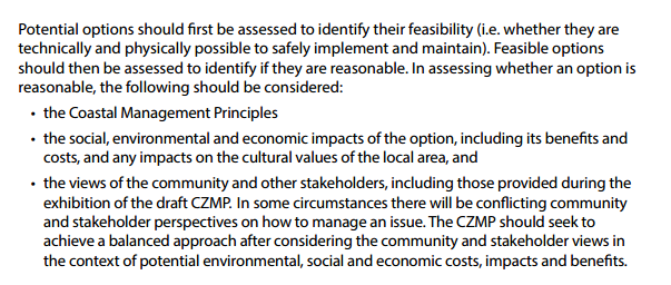
As per the extract above, the Guidelines are underpinned by
the ‘Coastal Management Principles’. The most relevant of these,
Principle 4, is extracted below (page 5, OEH, 2013):
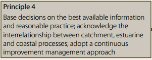
Options 1, 2 and 3 provide an assessment of economic costs,
impacts and benefits. As it has been contended by an appropriately qualified
expert, the OEH Chief Economist, that the economic assessment in the draft WRL
management study is perhaps not ‘reasonable practice’ (as per
Principle 4), then Council may not be following the Guidelines or meeting its
statutory obligations through Option 2.
It should be noted that for Option 1, there is always the
risk that the proposed OEH CBA will also be criticised by an appropriately
qualified expert as not ‘reasonable practice’, noting that any CBA
will be underpinned by assumptions that may be contestable. In this regard,
Option 3 may provide the more favourable pathway.
With reference to the above statutory requirements, the
Guidelines stipulate that in determining the ‘reasonableness’ of
the options, the views of the community and other stakeholders should be
sought. In preparing the WRL management study, the views of the community and
stakeholders were sought through a number of consultation activities and these
assisted in determining the short list of management options to be assessed in
the CBA. It is unlikely that the options to be considered in the OEH CBA would
undergo this same consultative process and may be informed by, but somewhat
different to, the options that were considered in the WRL management study.
Conclusion
With respect to the implications of the three options on:
statutory requirements, timeframes, finances, and the other issues identified
at Table 2, it is considered that Option 3, which entails the finalisation of
the WRL management study as per the variation quotation at Attachment 5,
in conjunction with participating in the Steering Committee proposed by the OEH
for the preparation of a new cost benefit analysis of coastal hazard management
options for Belongil Beach, is considered the least risk pathway for
progressing and completing the management study phase of the draft CZMP BBE.
Staff Reports - Sustainable Environment and Economy 13.9 - Attachment 1

|
BSC Doc No: #E2015/12027
Your ref: DOC15/49682
|
3 March 2015
Mr Don Arnold
Regional Manager (North East Region)
Office of Environment & Heritage
Locked Bag 914
Coffs Harbour NSW 2450
By email: don.arnold@environment.nsw.gov.au
Cc: ballina@parliament.nsw.gov.au
Dear Mr Arnold
Draft Coastal Hazard Management Study Byron Bay Embayment
– Cost Benefit Analysis
Thankyou for your letter, dated 20 February 2015, concerning
the draft Coastal Hazard Management Study Byron Bay Embayment Version 4
(management study) and for your summary of the outcomes of the meeting on the
cost benefit analysis (CBA), held 13 February 2015. There are, however, a
number of matters from the meeting that are not reflected in your letter and
remain unresolved.
At the CBA meeting, the OEH gave an undertaking that Council
should expect separate finalised advice on the CBA within approximately a
fortnight, i.e. by the 27 February. The letter however mentions the advice will
be provided ‘in the near future’. Council would be grateful for a
clear undertaking from the OEH on when the comments will be received. Noting
the management study project and the preparation of the draft Coastal Zone
Management Plan Byron Bay Embayment (CZMP), is essentially on hold until this
occurs.
Council is also very concerned that the advice is being
submitted late in the project and after a series of opportunities for OEH to
provide input into the project have been provided; for example the key CBA
assumptions were developed in consultation with OEH staff in early 2014 and the
CBA was reviewed by OEH in August 2014. In addition, from the draft advice
already provided, it appears that OEH may be asking Council to conform to
requirements that are outside of the statutory ‘Guidelines for Preparing
Coastal Zone Management Plans’ (OEH, 2013).
It is likely that as a consequence of the OEH advice, additional
work will be required on the CBA and the management study report. The
OEH’s offer to fully fund this work is acknowledged. As Council is the
project manager of the management study, we would require clarification on what
this funding arrangement would mean in terms of undertaking tasks such as:
scoping the necessary works, developing a project timeline, engaging and
negotiating with the consultant, attending meetings, reviewing reports etc.
This clarification would need to occur before such a funding arrangement would
be accepted.
We understand that the Minister for the Environment will
refer the draft CZMP to the NSW Coastal Panel before considering certification.
It is therefore considered critical to the CZMP process that Council staff meet
with the Panel urgently to discuss the current issues regarding the CBA. To
date, however, our attempts to secure a meeting within a reasonable timeframe,
i.e. early March, have been unsuccessful. Although a date in April was proposed
by the Panel’s secretariat, this is not considered appropriate given the
time pressures on the project. In this matter, Council seeks your assistance to
secure an earlier meeting date.
As you are aware, the draft CZMP was due to be submitted to
the Minister on 31 December 2014. This timeframe has now passed and Council has
not received a response to the request for an extension, which was submitted in
October 2014. You advise that councils subject to a Ministerial Direction who
have not lodged their CZMPs by 30 June 2015 will be ineligible for funding
under the State Government’s Coastal Management Program. May Council
infer from this advice that the due date for the draft CZMP is now 30 June
2015? The uncertainty around the deadline is problematic for Council and
clarification would be appreciated.
Council acknowledges the updated OEH advice concerning the
staging of the ‘adaptive management approach’. This has been
provided to the consultants, Water Research Laboratory, for their
consideration.
In view of the concerns raised in this letter Council will
be seeking the assistance of local Member for Ballina, Don Page MP. The
assistance being sought will include expediting the meeting with the Coastal
Panel and arranging for an urgent meeting with the Minister for the
Environment, Rob Stokes MP.
The work of the OEH regional office is acknowledged and
Council hopes that we can continue to work together to resolve the current
issues and finalise the management study. In this context I would be grateful
for a prompt response to the issues raised in this letter. You are very welcome
to call me on 02 6626 7161 should you wish to discuss any of these matters
further.
Yours sincerely

Shannon Burt
Director Sustainable Environment and Economy
Staff Reports - Sustainable Environment and Economy 13.9 - Attachment 2

Staff Reports - Sustainable Environment and Economy 13.9 - Attachment 3

Staff Reports - Sustainable Environment and Economy 13.9 - Attachment 4
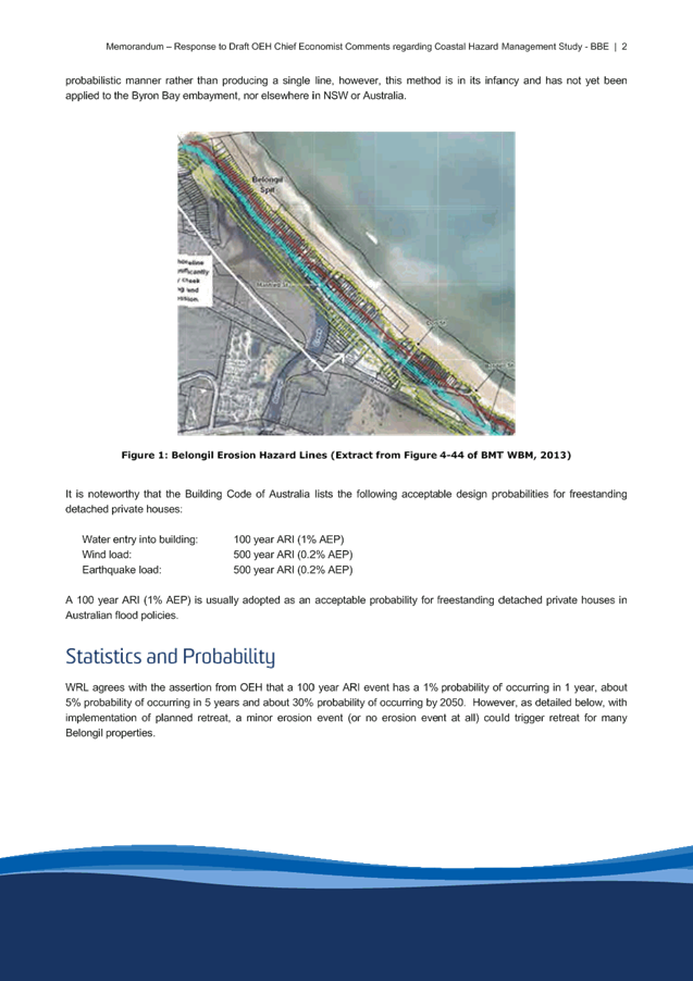

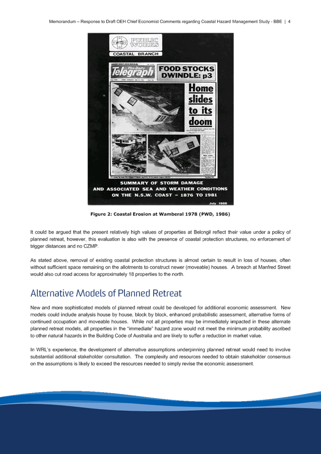

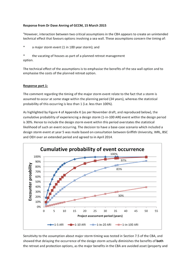
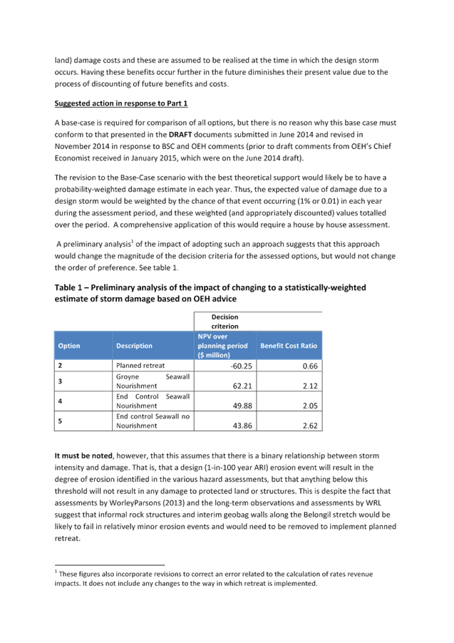
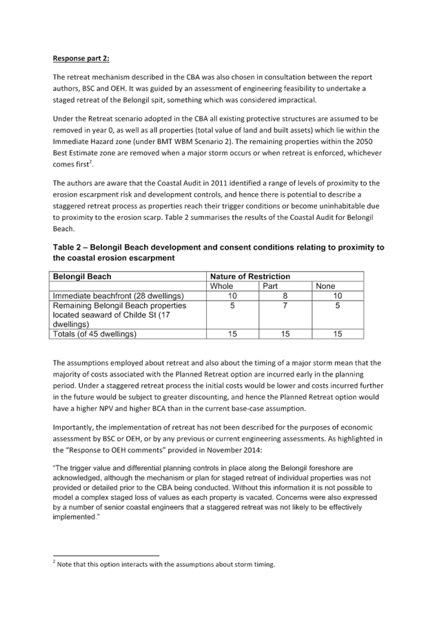

Staff Reports - Sustainable Environment and Economy 13.10
Report No. 13.10 PLANNING
- 10.2014.649.1 Mixed development comprising; demolition, retention of existing
building, erection of a new building to be used for backpacker accommodation
(250 beds), shops and restaurants at 19-23 Lawson Street Byron Bay
Directorate: Sustainable
Environment and Economy
Report
Author: Joe
Davidson, Planning Team Leader
File No: I2015/213
Theme: Ecology
Development and Approvals
Proposal:
Development consent is sought
to carry out demolition works on the site and construct a new building
containing shops, restaurants and backpackers’ accommodation. The site
currently contains a two storey building used as backpackers’
accommodation (90 beds) and four retail premises fronting Lawson Street. The
backpackers’ accommodation occupies a heritage item that was previously
the Byron Shire Council administration building. It is proposed to demolish all
development on the site other than the four existing retail premises and parts
of the heritage building located on the corner of Lawson and Fletcher Streets.
The design of the proposed
building includes two basement levels providing up to 51 car parking spaces
accessed from Bay Lane. Three levels are proposed above ground with multiple
uses accessed from Bay Lane, Fletcher Street and Lawson Street. Five shops, two
restaurants and a foyer for the backpackers’ accommodation are proposed
on the ground floor. Two levels of backpackers’ accommodation containing
250 beds are proposed above. Four existing ground floor retail premises
fronting Lawson Street are to be retained.
Internal staircases and a lift
provide access from the basement levels to the backpackers’ accommodation
foyer and upper levels. A loading area, a refuse store, bicycle parking,
laundry and storage areas are located within the basement and ground floors to
service the development. Toilet facilities and hydrant rooms are also proposed
adjacent to the proposed restaurants at ground level. The upper levels include
multiple terrace/balcony areas, as well as dining, bar and pool areas for use
by guests.
Road and drainage works are
proposed within Bay Lane to facilitate access to the site and improve
stormwater drainage. This includes the dedication of some private land to
Council as road reserve to accommodate new pavement, kerb and subsurface
drainage arrangements. A subdivision plan has been submitted as part of the
proposal incorporating this dedication. New footpath pavement is proposed to
each street frontage to provide a uniform streetscape appearance throughout.
Background:
The Development Application was
lodged with Council on 29 October 2014. Accordingly, the proposal is required
to be assessed in consideration of Byron Local Environmental Plan 2014 and
Byron Development Control Plan 2014.
The Development Application
submitted is a revised design of an approved redevelopment of the site that was
granted consent under Development Application No. 10.2005.733.1 in May 2007.
Following discussions with Council, the Applicant submitted the revised design
as a new Development Application rather than as a Section 96 Modification to
Development Application No. 10.2005.733.1. The previous Development Application
allowed for a 316 bed hostel, 5 retail shops, 2 restaurants and basement car
parking to be constructed on the site. The approved development also included
demolition works, as proposed within the current Development Application.
Assessment:
An initial assessment of the
proposal identified a number of non-compliances with Council’s
development control requirements. These include breaches of the maximum height
and maximum floor space ratio requirements of Byron Local Environmental Plan
2014, a shortfall in car parking as required under Development Control Plan
2014, and less significant breaches of Development Control Plan 2014 relating
to the provision of open space and landscaping.
The Applicant provided amended
plans in late 2014 to reduce the height of the proposed development to meet the
maximum 9.0 metre requirement of Byron Local Environmental Plan 2014. In
addition, the Applicant reviewed the proposed open space and landscaping areas
within the site to provide an acceptable level for the intended number of
guests. The gross floor area of the development was revised to reduce the
extent of non-compliance with the maximum floor space ratio of 1.3:1. Further
details were supplied to justify a variation to this non-compliance. This
included evidence that the site has an existing approval for a similar
development with a much higher gross floor area.
To address the shortfall in car
parking on the site, the Applicant has put forward a Voluntary Planning
Agreement to provide a financial contribution towards the provision of public
car parking within the Byron Bay town centre. This Voluntary Planning Agreement
is being considered by Council as a separate item on the Ordinary Meeting
Agenda. This Development Application relies upon Council’s endorsement of
the Voluntary Planning Agreement. If such is not endorsed, the Development
Application cannot be supported in its current form.
The Development Application was
placed on public exhibition for 14 days. No public submissions were received.
The proposal does not compromise the public interest.
Conclusion:
An assessment of the
development proposal concludes that the Development Application has merit and
is recommended for approval subject to conditions. The proposed departure from
the maximum floor space ratio controls under Byron Local Environmental Plan
2014 is considered justified in this case given the previous approval on the
site for a similar development of significantly greater floor area. Provided
that the Voluntary Planning Agreement to address the shortfall in on-site car
parking is endorsed by Council, the Development Application is able to be
recommended for approval.
NOTE TO COUNCILLORS:
In accordance with the
provisions of S375A of the Local Government Act 1993, a Division is to be
called whenever a motion for a planning decision is put to the meeting, for the
purpose of recording voting on planning matters. Pursuant to clause 2(a)
under the heading Matters to be Included in Minutes of Council Meetings of
Council's adopted Code of Meeting Practice (as amended) a Division will be
deemed to have been called by the mover and seconder of all motions relating to
this report.
|
RECOMMENDATION:
1. That Pursuant
to Section 80 of the Environmental Planning & Assessment Act 1979,
Development Application No. 10.2014.649.1 for Mixed development comprising; demolition, retention of existing
building, erection of a new building to be used for backpacker accommodation
(250 beds), shops and restaurants, be granted a deferred commencement consent
subject to conditions nominated in attachment 1 (A2014/30455)
2. Pursuant to Section 95(2) of the Environmental Planning
& Assessment Act 1979, the development consent lapses 5 years after the
date from which it operates unless commenced in accordance Section 95(4) or
(5).
|
Attachments:
1 Evaluation
Report 10.2014.649.1 19-23 Lawson Street Byron Bay, A2014/30455 , page 108
2 Proposed
Plans 10.2014.649.1 - Lawson Street, Byron Bay, E2015/18185 , page 155
3 Comments
from Heritage Advisor, DM618884 ,
page 164
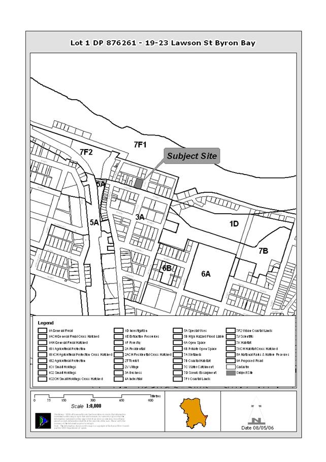
Staff Reports - Sustainable Environment and Economy 13.10 - Attachment 1
DEVELOPMENT APPLICATION EVALUATION REPORT
Doc No. #A2014/30455
|
DA No:
|
10.2014.649.1
|
|
Proposal:
|
Mixed development comprising; demolition, retention of
existing building, erection of a new building to be used for backpacker
accommodation (250 beds), shops and restaurants and road widening
|
|
Property description:
|
LOT: 1 DP: 876261
19-23 Lawson Street BYRON BAY
|
|
Parcel No/s:
|
219740
|
|
Applicant:
|
Byron Ventlink Pty Ltd
|
|
Owner:
|
Byron Ventlink Pty Ltd
|
|
Zoning:
|
Zone No. B2 Local Centre
|
|
Date received:
|
29 October 2014
|
|
Integrated Development:
|
No – a ground water licence is current for the site
|
|
Public notification or exhibition:
|
- Level
2 advertising under DCP 2014 Part A14 – Public Notification and
Exhibition of Development Applications
- Exhibition
period: 18/11/14 - 1/12/14
- Submissions: 0
|
|
Other approvals (S68/138):
|
Not applicable
|
|
Planning Review Committee:
|
Yes
|
|
Delegation to determination:
|
Council
|
|
Issues:
|
· Partial
demolition of heritage item
· Car parking
short fall to be resolved by voluntary planning agreement
· Floor space
ratio variation
|
|
Recommendation:
|
It is recommended that:
1. Pursuant to Section 80 of the Environmental Planning
& Assessment Act 1979, Development Application No. 10.2014.649.1 for Mixed development comprising; demolition,
retention of existing building, erection of a new building to be used for
backpacker accommodation (250 beds), shops and restaurants, be granted a
deferred commencement consent subject to the following conditions:
2. Pursuant to Section 95(2) of the Environmental Planning
& Assessment Act 1979, the development consent lapses 5 years after the
date from which it operates unless commenced in accordance Section 95(4) or
(5).
|
1. INTRODUCTION
1.1 History/Background
The subject site is occupied by the former Byron Shire Council
administration building. Records of the exact date of construction of this
building are limited, however a plaque located on the front staircase of the
building indicates that it opened on 20 August 1929. This original building
occupies the south-eastern corner of the allotment.
Major additions to the original 1929 administration building
were carried out in 1972, 1981 (Building Application 79/2307), 1983 (Building
Application 82/2458) and 1986 (Building Application 86/2328). A number of other
smaller scale Development and Building Applications are recorded within
Council’s computer records system for the allotment.
The most significant Development Application on the site in
recent years was No. 10.2005.733.1, which was granted consent on 30 May 2007 to
carry out substantial demolition works on the site, including parts of the
former Council administration building, and the construction of a three storey
mixed commercial development containing a 316 bed hostel, 5 retail shops, 2
restaurants and basement car parking. Council’s files indicate that this
development approval has been commenced so as to activate the development
consent, but no significant works have been undertaken to date on the site.
Prior to the 2005 Development Application, the following
relevant approvals were issued on the site:
5.1996.378.1 – Change of use to take-away food premises
– Approved 20/12/1996
6.1996.2632.1 – Change of use to take-away food premises
6.1996.2606 – Swimming pool – Approved 17/10/1996
6.1996.2537.1 – Hostel (18 Rooms), 4 Shops &
Managers Residence – Approved 16/10/1996
5.1996.237.1 – Tourist facility – Approved
10/09/1996
6.1993.2595.1 – Alteration/Addition to office –
Approved 01/10/1993
1.2 Description
of the site
The proposed development is to be carried out upon an
allotment that is located at the north-western corner of Lawson and Fletcher
Streets in Byron Bay. The property is described as Lot 1 DP 876261, and is
known as 19-23 Lawson Street, Byron Bay. The allotment falls within the B2
Local Centre Zone under Byron Local Environmental Plan (LEP) 2014.
The subject allotment is rectangular in shape with an area of
2023 square metres. It has road frontages of 40.235 metres to Lawson Street, 50.29 metres to Fletcher Street, and 40.235 metres to Bay Lane. The allotment
is constrained by an easement to drain water that is 3 metres wide adjacent to
the western boundary. The natural fall of the land is from north to south with
a gentle slope towards the Lawson Street. Vegetation within the site is limited
to fewer than ten (10) trees and smaller plants contained to landscaping bays
throughout the property.
Byron Bay Main Beach is located just over 100 metres to the
north of the development site. As such, the site is located within the coastal
zone and approximately 160 metres from the mean high water mark.
As the subject site is located within the Byron Bay town centre, commercial and retail buildings, both double and single storey, surround
the property. Vehicle access to the land is currently available from Bay Lane to the north. Development on the site itself includes a 90 bed hostel known as
“Main Beach Backpackers” and a commercial building fronting Jonson Street comprising three retail shops and a food shop.
The hostel occupies buildings that were formerly used as the
administration centre for Byron Shire Council, including an original building
that was constructed in 1929. This building was listed within Byron Local
Environmental Plan 1988 as an ‘item of the environmental heritage’
and is also nominated as a heritage item within Byron Local Environmental Plan
2014. A bitumen car parking area is located at the rear of the allotment with
access from Bay Lane. A swimming pool is located within the north-eastern
corner of the property.
1.3
Description of the proposed development
Consent is sought to demolish a number of existing buildings
and structures within the subject allotment to enable new building works to be
carried out. It is proposed to demolish the majority of the existing hostel,
including dormitories, toilet block, swimming pool and carparking area. It is also
proposed to demolish significant components of the 1929 former Council
administration building to enable new building works to occur. Some components
of this building are proposed to be retained, specifically the southern and
eastern walls fronting Lawson and Fletcher Streets respectively. The existing
ground floor retail shops fronting Lawson Street are also proposed to be
retained.
The proposed demolition works are to allow for new building
works to occur on the site. The Statement of Environmental Effects submitted
with the Development Application prepared by Malcolm Scott, describes the
proposal as follows:
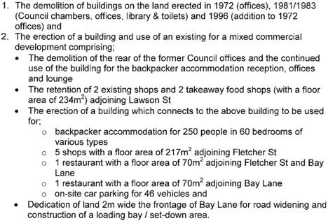
The layout of the proposed building is such that all
shops and restaurants are located on the ground level and accessible from
Lawson Street, Fletcher Street or Bay Lane. Vehicle access to the proposed car
parking on the ground floor and basement floor is to be provided from Bay Lane
at the rear of the allotment.
Accommodation rooms, kitchen and dining areas are proposed on
the first floor, as well as open space terrace areas. Further accommodation
rooms and open space terrace areas are located on the second floor. A bar area
and swimming pool are also proposed on the Second Floor.
A key element of the proposed design is the retention of part
of the original 1929 building located within the south-eastern corner of the
allotment. It is proposed to retain the southern and eastern frontages of this
original building.
The proposal includes development over a stormwater easement
that is located adjacent to the western boundary of the allotment. It is
proposed to re-route the infrastructure within this easement to the street with
a greater design capacity. A number of trees within this easement and within
courtyards on the ground floor of the site are to be removed as part of the
proposal. These trees currently form landscape specimens, the majority of which
can be removed without the consent of Council under the current Tree
Preservation Order.
The external finishes of the proposed building comprise a mixture
of materials. These were considered by Council’s Heritage Advisor, as
discussed within this report.
2.0 SUMMARY OF REFERRALS
|
|
Issue
|
|
Development Engineer
|
Vehicle access, parking, traffic, vehicle manoeuvring,
Drainage, Flooding, Coastal Erosion
|
|
Water & Recycling Services
|
Water supply and sewerage connection works
|
|
ET Engineer
|
Developer Servicing Plan
|
|
Environmental Officer
|
SEPP 55, Potential Acid Sulfate Soils, Water Table &
Quality, Land use conflicts, Dewatering
|
|
Property Division
|
Land owners consent for works within road reserve
(granted)
|
|
Heritage Advisor
|
Heritage impacts
|
|
NSW DPI Office of Water
|
Dewatering licence
|
2.1 COMMENTS FROM EXTERNAL REFERRAL
BODIES
NSW Department of Primary Industries
– Office of Water
In correspondence dated 17 December 2014, NSW DPI Office of
Water advised as follows:
The property owner holds a current groundwater licence
(30BL184967) that authorises dewatering of the site by a battery of spears.
This licence is adequate to cover the dewatering proposed in the current
development application.
Heritage Advisor
The subject Development Application comprises a scaled down
version of a proposal that was granted consent under Development Application
No. 10.2005.733.1, which was for demolition works and the construction of a
three storey mixed commercial development containing a 316 bed hostel, 5 retail
shops, 2 restaurants and basement car parking.
Council’s heritage Advisor carried out an assessment of
the 2005 proposal. This assessment is considered to be relevant to the current
proposal as the same demolition works are proposed and the most recent design
is a similar but smaller version of the previous approval. The heritage
Advisor’s previous comments are provided as an attachment to this report.
It was not necessary to refer the proposal for further specialist heritage
advice in this case.
Based on the Heritage Advisor’s previous comments and a
review of the Heritage Impact Statement (dated 14 January 2015) that was
submitted with the Development Application, it is concluded that the proposal
will result in an acceptable level of impact on the heritage item. The proposal
is supported with respect to heritage impacts, subject to the imposition of
conditions of consent, including a requirement that the archaeological potential
of the site be investigated during demolition and excavation works.
3. SECTION
79C – MATTERS FOR CONSIDERATION – DISCUSSION OF ISSUES
Having regard for the matters for consideration detailed in
Section 79C(1) of the Environmental Planning & Assessment Act 1979, the
following is a summary of the evaluation of the issues.
3.1
STATE/REGIONAL PLANNING POLICIES AND INSTRUMENTS
|
Requirement
|
Summary of Requirement
|
Proposed
|
Complies
|
|
State Environmental
Planning Policy No. 55 – Remediation of Lands
|
The Council must:
(a) consider
whether the land is contaminated; and
(b) if
the land is contaminated, if the land is suitable in its contaminated state
or after remediation; and
(c) be
satisfied before the land is used.
Where a change of use is
proposed the Council must consider a report provided by the applicant
specifying the findings of a preliminary investigation (and detailed
investigation if necessary) of the land in accordance with the contaminated
land planning guidelines.
|
SEPP55 was considered for
DA10.2005.733.1. The development does not result in an increased
sensitivity. Given the development includes excavations for a basement
carpark, a consent condition has been recommended requiring an Unexpected
Findings Protocol (UFP) to be prepared and submitted to Council for approval
prior to the issue of Construction Certificate. The UFP must be
prepared by a suitable qualified person experienced in matters relating to
Contamination of Land and Remediation.
|
Yes
|
|
State Environmental
Planning Policy No. 71 – Coastal Protection
|
Council must have regard for the aims and matters of
consideration listed within SEPP No. 71 for development within the Coastal
Zone:
|
The proposal satisfies the
provisions of the SEPP.
|
Yes
|
|
Building Code of Australia
|
The proposal must be capable of compliance with the
structural and safety requirements of the Building Code of Australia.
|
The proposed development has been designed so that
detailed plans can be prepared to achieve compliance with the structural and
safety requirements of the BCA as part of the construction certificate
process. A condition is recommended to ensure the BCA requirements are met.
|
Yes
|
|
Demolition
|
All demolition to be carried out in accordance with AS2601
and WorkCover requirements.
|
A condition could be included in any consent issued to
meet this requirement.
|
Yes
|
*Issues discussed below
3.2
BYRON LOCAL ENVIRONMENTAL PLAN 2014
Zone: B2 Local Centre Zone
Definition:
Backpackers’ Accommodation, Shop, Restaurant or Café
|
LEP Requirement
|
Summary of Requirement
|
Proposed
|
Complies
|
|
Meets objectives of B2 Local Centre Zone
|
To provide a range of retail, business, entertainment and
community uses that serve the needs of people who live in, work in and visit
the local area.
|
The development xix and size satisfies this requirement.
|
Yes
|
|
|
To encourage employment opportunities in accessible
locations.
|
The site within the Byron Bay Town Centre. The proposal
creates increased employment opportunities.
|
Yes
|
|
|
To maximise public transport patronage and encourage
walking and cycling.
|
The site is within walking distance of the central bus
stop and many attractions within Byron Bay. The proposal includes bicycle
parking facilities to encourage cycling. Th
|
Yes
|
|
|
To encourage vibrant centres by allowing residential and
tourist and visitor accommodation above commercial premises.
|
The proposal provides tourist and visitor accommodation in
the form of backpackers’ accommodation above shops and restaurant uses.
|
Yes
|
|
Permissible uses
|
backpackers’
accommodation means a building
or place that:
(a) provides temporary or short-term
accommodation on a commercial basis, and
(b) has shared facilities, such as a communal
bathroom, kitchen or laundry, and
(c) provides accommodation on a bed or
dormitory-style basis (rather than by room).
|
The proposal provides for backpackers’ accommodation
which is permissible within the B2 Local Centre Zone.
|
Yes
|
|
|
retail premises means a building or place used for the purpose
of selling items by retail, or hiring or displaying items for the purpose of
selling them or hiring them out, whether the items are goods or materials (or
whether also sold by wholesale), and includes any of the following:
(a) bulky goods premises,
(b) cellar door premises,
(c) food and drink premises,
(d) garden centres,
(e) hardware and building supplies,
(f) kiosks,
(g) landscaping material supplies,
(h) markets,
(i) plant nurseries,
(j) roadside stalls,
(k) rural supplies,
(l) shops,
(m) timber yards,
(n) vehicle sales or hire premises,
but
does not include highway service centres, service stations, industrial retail
outlets or restricted premises.
shop means premises that sell merchandise such as
groceries, personal care products, clothing, music, homewares, stationery,
electrical goods or the like or that hire any such merchandise, and includes
a neighbourhood shop, but does not include food and drink premises or
restricted premises.
|
The proposal includes shops that are permissible within
the B2 Local Centre Zone.
|
Yes
|
|
|
restaurant or cafe means a building or place the principal
purpose of which is the preparation and serving, on a retail basis, of food
and drink to people for consumption on the premises, whether or not liquor,
take away meals and drinks or entertainment are also provided.
|
The proposal includes two restaurants that are permissible
within the B2 Local Centre Zone.
|
|
|
Clause 4.3 – Height of buildings
|
(1) The objectives of this clause
are as follows:
(a) to achieve building
design that does not exceed a specified maximum height from its existing
ground level to finished roof or parapet,
(b) to ensure the height of
buildings complements the streetscape and character of the area in which the
buildings are located,
(c) to minimise visual
impact, disruption of views, loss of privacy and loss of solar access to
existing development.
(2) The height of a building on
any land is not to exceed the maximum height shown for the land on the Height of Buildings Map.
|
The proposal meets the maximum 9.0 metre height
requirement.
|
Yes.
|
|
Clause 4.4 – Floor Space Ratio
|
(1) The objectives of this clause
are as follows:
(a) to ensure that new
buildings are appropriate in relation to the character, amenity and
environment of the locality,
(b) to enable a diversity of
housing types by encouraging low scale medium density housing in suitable
locations,
(c) to provide floor space in
the business and industrial zones adequate for the foreseeable future,
(d) to regulate density of
development and generation of vehicular and pedestrian traffic,
(e) to set out maximum floor
space ratios for dual occupancy in certain areas.
(2) The maximum floor space ratio
for a building on any land is not to exceed the floor space ratio shown for
the land on the Floor Space Ratio Map.
(2A) Despite subclause (2), the
maximum floor space ratio for dual occupancies on land in Zone R2 Low Density
Residential is 0.5:1.
|
The LEP map provides for a maximum floor space ratio of
1.3:1 on this site. With a site area of 2023m2, a maximum floor
space of 2629.9m2 is permitted under Clause 4.4.
The proposed development exceeds this maximum by 139.9m2,
with a floor space of 2769.8m2.
The Applicant has requested a 5.3% variation to the
maximum FSR, as discussed under Clause 4.6 below.
|
No
|
|
Clause 4.6 – Exceptions to development standards
|
(1) The objectives of this clause
are as follows:
(a) to provide an appropriate
degree of flexibility in applying certain development standards to particular
development,
(b) to achieve better outcomes
for and from development by allowing flexibility in particular circumstances.
(2) Development consent may,
subject to this clause, be granted for development even though the
development would contravene a development standard imposed by this or any
other environmental planning instrument. However, this clause does not apply
to a development standard that is expressly excluded from the operation of
this clause.
(3) Development consent must not be
granted for development that contravenes a development standard unless the
consent authority has considered a written request from the applicant that
seeks to justify the contravention of the development standard by
demonstrating:
(a) that compliance with the
development standard is unreasonable or unnecessary in the circumstances of
the case, and
(b) that there are sufficient
environmental planning grounds to justify contravening the development
standard.
(4) Development consent must not be
granted for development that contravenes a development standard unless:
(a) the consent authority is
satisfied that:
(i) the applicant’s
written request has adequately addressed the matters required to be
demonstrated by subclause (3), and
(ii) the proposed development
will be in the public interest because it is consistent with the objectives
of the particular standard and the objectives for development within the zone
in which the development is proposed to be carried out, and
(b) the concurrence of the
Director-General has been obtained.
|
Refer to issues Section below.
|
Refer to Issues Section below.
|
|
Clause 5.5 – Development within Coastal Zone
|
The Objective of
Clause 5.5 are (in summary):
(a) to provide for the
protection of the coastal environment of the State for the benefit of both
present and future generations through promoting the principles of
ecologically sustainable development,
(b) to implement the
principles in the NSW Coastal Policy.
|
The proposal is consistent with the objectives of Clause
5.5.
|
Yes
|
|
|
Development
consent must not be granted to development within the coastal zone unless
Council has considered:
(a) existing public access to and along the coastal foreshore for
pedestrians (including persons with a disability);
(b) the suitability of the proposed
development, its relationship with the surrounding area and its impact on the
natural scenic quality;
(c) the impact of the proposed
development on the amenity of the coastal foreshore;
(d) how the visual amenity and scenic
qualities of the coast, including coastal headlands, can be protected;
(e) how biodiversity and ecosystems;
(f) he cumulative impacts of the proposed development and
other development on the coastal catchment.
|
The proposal satisfies the considerations within Clause
5.5.
|
Yes
|
|
Clause 5.10 – Heritage Conservation
|
(5) Heritage assessment
The consent authority may, before granting consent to any development:
(a) on land on which a
heritage item is located, or
(b) on land that is within a
heritage conservation area, or
(c) on land that is within the
vicinity of land referred to in paragraph (a) or (b),
require a heritage management document to be prepared that
assesses the extent to which the carrying out of the proposed development
would affect the heritage significance of the heritage item or heritage
conservation area concerned.
|
The Applicant submitted a
heritage impact statement in accordance with this clause. Refer to Section
2.1 of this report for comments relating to the assessment of this heritage
impact statement.
|
Yes.
|
*Issues discussed below
Byron Local Environmental Plan 2014 -
Issues
Clause 4.6 – Exceptions to development standards
The subject site has an area of 2023m2. Clause 4.4
of Byron LEP 2014 provides a maximum floor space ratio of 1.3:1, which allows a
maximum floor area of 2629.9m2 on this site. The proposed
development exceeds this maximum by 139.9m2, with a floor space of
2769.8m2. This represents a variation of 5.3%. The Applicant has
requested a variation to the maximum FSR for the following reasons:
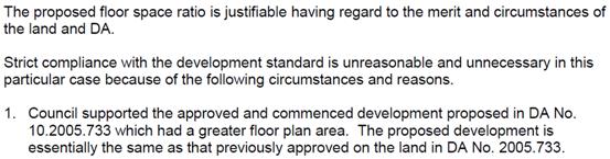
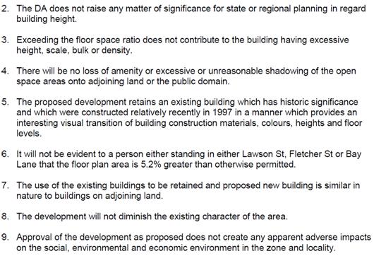
A review of Council’s records confirmed that Development
Consent No. 10.2005.733.1 approved a building on the site with a floor area of
over 4000 square metres. This development consent has been lawfully commenced
and construction could progress at the Applicant’s discretion. However,
the Applicant has submitted a revised development with a gross floor area of
2769.8 square metres. Although greater than the 2629.9 square metres permitted
on the site under Clause 4.4 of Byron LEP 2014, the proposed gross floor area
is considerably less than the 2005 Development Application.
Council is required to consider the following key questions in
determining a variation under Clause 4.6:
(a) Has Council received
a written request from the applicant that seeks to justify the contravention of
the development standard by demonstrating:
(i) compliance
with the development standard is unreasonable or unnecessary in the
circumstances of the case?
(ii) there are
sufficient environmental planning grounds to justify contravening the
development standard?
The applicant has provided a written request that seeks to
justify the contravention of the development standard.
(b) Is the consent authority
is satisfied that the applicant’s written request has adequately
addressed the matters required to be demonstrated by (a) above?
An assessment of the applicants written request confirms that
sufficient justification has been provided to contravene the development
standard that sets a maximum floor space ratio of 1.3:1. The proposed mixed use
development follows a previous approval on the site that is of substantially
greater floor area. The new design is less intrusive than the approved
development. It is compatible with the B2 Local Centre Zone and sits well on
the 2023 square metre site. A condition is recommended for inclusion within the
development consent requiring the previous development consent to be
surrendered. The revised proposal will result in a better planning outcome for
the site. For these reasons it is unreasonable to require compliance with the
maximum floor space ratio requirements for the site in this case.
(c) Is the consent
authority satisfied that the proposed development will be in the public
interest because it is consistent with the objectives of the particular
standard and the objectives for development within the zone in which the
development is proposed to be carried out?
The proposal has been assessed as being consistent with the
objectives of the B2 Local Centre Zone. The proposal is also assessed as being
consistent with the objectives of Clause 4.4, particularly objective (a) which
is to ensure that new buildings are appropriate in relation to the
character, amenity and environment of the locality. An inspection of the site
confirmed that the proposal is consistent with the character of the town
centre. Accordingly, the development is deemed to be in the public interest.
Draft EPI that is or has been placed on
public exhibition and details of which have been notified to the consent
authority - Issues
No draft Environmental Planning Instruments apply to the site.
3.3 DEVELOPMENT
CONTROL PLANS
Development Control Plan 2014
Chapter B8 – Waste Minimisation
The proposal includes refuse storage areas in the design. A
condition is to be imposed require a Site Waste Minimisation Plan to be
submitted prior to the issue of a Construction Certificate for demolition or
building works.
Chapter B9 – Landscaping
Chapter B9.6.1 includes a prescriptive
measure that requires a minimum 10% of the site area of a tourist and visitor
accommodation proposal to be landscaped area. By definition, ‘landscaped
area’ means an area of ground available for planting and/or management of
vegetation.
The subject site has an area of 2023m2.
The proposal would require a total of 202.3 square metres to be undeveloped and
dedicated as landscaped area. The aerial photograph below shows that less than
150 square metres of the site is currently available for planting given the
extent of buildings and car parking areas over the site.
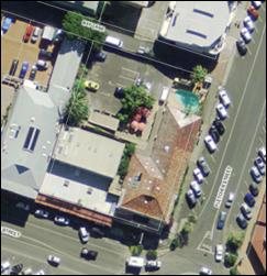
Aerial Photograph dated May
2013
The subject site is constrained by a heritage
building that is to be partially retained as part of the redevelopment. The
design incorporates a basement car park with access from Bay Lane. The existing
landscape areas will be removed as part of the proposal. In its place, the
applicant proposes to provide landscaped areas within the terrace/balcony areas
of the development. The Applicant has indicated that the equivalent of 9% of
the site area can be provided as landscaped area in this way.
The plans submitted confirm that 512 square
metres of unroofed terrace and balcony areas are proposed within the
development. These are provided on Level 1 and Level 2 of the new building,
with voids provided in the uppermost floor to provide solar access below. It is
satisfied that the landscaped area can be provided within the terrace/balcony
areas, rather than within the natural ground.
It is noted that not all of these
balcony/terrace areas will be provided with planting areas as they will also be
used as private open space areas. However, it is recommended that a condition
is imposed that requires the submission of a landscaping plan with at least 150
square metres of landscaped area to be provided within the proposed development
to replace that already on the site.
Chapter B10 – Signage
The applicant has indicated that separate
application will be made for signage as required by individual tenancies.
Chapter B11 – Planning for Crime
Prevention
“Crime Prevention and the Assessment of Development
Applications” – Guidelines under section 79C of the
Environmental Planning and Assessment Act (Department of Infrastructure,
Planning and Natural Resources:2001).
An assessment has been undertaken with regards to Chapter B11
of DCP 2014 as to the legitimacy of any risk to the public.
Council’s DCP refers to basic Crime Prevention Through
Environmental Design (CPTED) principles that are relied upon in development
assessment. This includes surveillance, access control, territorial
reinforcement and space management. The following assessment has been carried
out with regards to the proposed development and provides that, subject to
conditions of consent, the design is satisfactory in terms of crime prevention:
1. Surveillance
The proposed terrace/balcony areas of the hostel
development will allow for passive surveillance over Bay Lane, Fletcher Street
and Lawson Street. Existing urban infrastructure ensures that effective lighting
is achieved within the town centre. The location of buildings and spaces within
the proposed development enables adequate lighting and surveillance.
2. Access Control
The proposed development provides for effective access
control both within and outside the site. The driveway access is via clear
entry/exit points to the site. The design is such that security gating can be
erected to control access to the development if required.
3. Territorial
Reinforcement
The spatial separation of the shops, restaurants and the
hostel are such that the public and private domains of the site can be clearly
enforced. Access to the hostel located on the upper floors can be easily
controlled by access doors.
4. Space Management
The internal layout of the development sets clear
management of space between the different uses.
Chapter B12 – Social Impact
Assessment
A social impact assessment was
submitted as part of the Statement of Environmental Effects that was lodged
with the Development Application. This assessment concludes that the
development will not have an adverse social impact because the town centre
location is suitable for the proposed land uses. This conclusion is supported.
Chapter B13 – Access and
Amenity
Provision is made for disabled access within the site
through the provision of designated car parking spaces and a lift to each floor
of the development. Accessible bathrooms have been nominated within the floor
plan of both backpackers’ accommodation levels. Chapter B13 requires a
minimum of 10% of beds and 10% of the bathrooms within such development to be
adaptable. A condition is to be imposed within the consent to meet this
requirement (which will equate to 25 beds and 4 bathrooms in this development).
Chapter B14 – Excavation and
Fill
This Chapter limits earthworks to a maximum of 1.0 metre.
The proposal includes a basement car parking area that requires well over 1.0
metre in excavation. Given the B2 Local Centre Zoning of the property and the
various uses proposed (backpackers’ accommodation, shops, restaurants),
it is not appropriate to limit earthworks to 1.0 metre on this site. The
proposed earthworks can be appropriately managed with dewatering licencing and
sedimentation controls. The proposed works are supported.
Chapter D3 – Tourist
Accommodation
Chapter D3.2.1 – Location and Siting
The proposal is consistent with the objectives relating to
siting and location of tourist accommodation. The site does not have ecological
significance and does not require any buffers to be applied to minimise land
use conflicts.
Chapter D3.2.4 – Character and Design in Business and
Mixed Use Zones
This DCP provision requires tourist and visitor accommodation
development within the B2 Local Centre Zone must be compatible in character and
amenity with development in the locality. The Byron Bay town centre location is
characterised of higher density development when compared to other locations
within the shire. The proposal is consistent with this existing built form. The
appearance of the proposed development is satisfactory for its site. The
proposal does not attempt to reproduce the heritage item located within the
sites south-eastern corner, but provides a new development that compliments
this historical building.
It is recommended that a condition be included within the
development consent requiring a schedule of materials and colours to be
submitted to confirm the final details for the development.
Chapter D3.3.1 –
Backpackers’ Accommodation
|
Provision
|
Required
|
Proposed
|
Complies
|
|
Performance Criteria 1
|
The design and operation of backpackers’
accommodation must be compatible with the streetscape and character of
development in the locality.
|
The proposal is consistent with the character of the
urban setting and compliments the heritage item on the site.
|
Yes
|
|
Performance Criteria 2
|
Development Applications must demonstrate that the
proposal will be consistent with Planning for Crime Prevention requirements.
|
Refer to Chapter B11 above.
|
Yes
|
|
Performance Criteria 3
|
Development Applications may need to be accompanied by
a Social Impact Assessment.
|
A social impact assessment was submitted as part of
the Statement of Environmental Effects that was lodged with the development
proposal.
|
Yes
|
|
Performance Criteria 4
|
Accommodation must have access to an outdoor sitting
area adequate for the proposed number of occupants, which must be adjacent to
the general living or kitchen area and which must provide adequate access to
winter sun and summer shade. The outdoor area may comprise part of a common
access balcony.
|
The plans submitted demonstrate that adequate outdoor
terrace/balcony areas have been provided within the design.
|
Yes
|
Chapter D8 – Public Art
The Applicant has stated that the historic site provides
little opportunity to provide public art in a traditional sense (ie. artwork,
sculpture etc.) within the building. However, the land owners have indicated
that they are in possession of original certificate of title for the land. This
document is dated 1893, and is fixed with the wax seal of the Lieutenant
Governor of the Colony of New South Wales.
The applicant proposes that this document be framed and hung
within a public area of the former Byron Shire Council administration building
alongside the heritage inventory of the 2007 Byron Shire Council Community
Based Heritage Study 2007. This concept of public art provision sits well with
the history of the site.
Chapter D8 requires public art to be provided for the proposed
development to a value of at least $25,000. Given that the value of the
certificate of title document is not known, it is recommended that a condition
be included within the consent to require the proposed ‘artwork’ to
be reviewed by Council prior to its incorporation into the development. Council
shall determine if the proposed public art is satisfactory or whether an
alternate public art contribution needs to be made.
Chapter B3 & B4 - External Access
The application advises that vehicular access to the building
will be from Bay Lane in the same location as was approved for DA 10.2005.733.
Vehicular access to the site is proposed from the rear laneway
(Bay Lane), where there is good sight distance for the slow speed environment.
The application proposes to change the traffic configuration of Bay Lane from
the one way (Jonson St to Fletcher St) shared traffic zone to allow access to
the proposed development from Fletcher Street. The proposed changes are
generally consistent with the existing approval (DA 10.2005.733.1) and are as
follows:
· two
way traffic in Bay Lane from Fletcher St to the site access;
· reducing
the shared traffic zone to the site access;
· maintaining
a loading zone from the site access to the western boundary;
· provision
of appropriate line marking and signage to channelise traffic; and
· provision
of a 2m wide footpath area to the Bay Lane frontage of the site.
To facilitate the above, the application proposes 1.5m of road
widening along the Bay Lane frontage of the site and a 3m x 3m splay as road
widening at the intersection of Bay Lane and Fletcher Streets. Conditions have
been included in the recommendation for the road widening, together with a
requirement to provide rights of footway (limited in height) over the footpath
area.
Conditions have also been recommended to ensure that all
regulatory traffic facilities are approved by the Local Traffic Committee prior
to approval of the works under section 138 of the Roads Act 1993.
Chapter B4 - Internal Access
The application provides car parking in two levels (ground
floor and basement) with vehicular access via ramps at the northern end of the
site from the reconfigured Bay Lane (as discussed above).
A review of the application has demonstrated that the parking
layout can be constructed to the requirements of AS 2890. The access driveway
can accommodate entry and exit at the same time, however the internal
intersection areas have been designed for use by one vehicle at a time. This is
considered acceptable because there is adequate queuing area within the parking
area to minimise traffic impacts.
Chapter B4 - Car Parking
Based on the parking rates in Council's DCP 2014 and the Byron
LEP 2014 definition of GFA, the proposed demand for car spaces is estimated as
follows:
|
Tenancy
|
Use
|
Area (m2)
/ (Beds)
|
Parking Rate
|
Car Spaces
|
|
Shop 1
|
Shop
|
58.4
|
1 / 20m2
|
2.9
|
|
Shop 2
|
Shop
|
58.4
|
1 / 20m2
|
2.9
|
|
Shop 3
|
Shop
|
58.4
|
1 / 20m2
|
2.9
|
|
Shop 4
|
Shop
|
58.4
|
1 / 20m2
|
2.9
|
|
Shop 5
|
Shop
|
43
|
1 / 20m2
|
2.2
|
|
Shop 6
|
Shop
|
46
|
1 / 20m2
|
2.3
|
|
Shop 7
|
Shop
|
41
|
1 / 20m2
|
2.1
|
|
Shop 8
|
Shop
|
41
|
1 / 20m2
|
2.1
|
|
Shop 9
|
Shop
|
46
|
1 / 20m2
|
2.3
|
|
-
|
Restaurant
|
70
|
1 / 20m2
|
3.5
|
|
-
|
Restaurant
|
70
|
1 / 20m2
|
3.5
|
|
Communal
|
Toilets
|
56
|
1 / 20m2
|
2.8
|
|
Subtotal =
|
646
|
Subtotal =
|
32.3
|
|
Backpackers
Accommodation
|
(250)
|
1 / 8 beds
|
31.3
|
|
Total =
|
64
|
|
Less credit for
car parking contributions paid for existing development approved by DA
5.1996.237 =
|
4
|
|
TOTAL =
|
60
|
The application states that any parking assessment of the
proposal should be based on the expert evidence presented during the hearings
of the Land & Environment Court Appeal (10786 of 2010) for DA
10.2005.733.2. The application has assessed the parking to be provided as 54
car spaces (i.e. 58 less 4 car spaces provided for by payment of contributions
for the existing development approved by DA 5.1996.237.1). Based on the parking
rates in the expert evidence (which was partly based on the rates in the RMS
Guide to Traffic Generating Developments) and the RMS definition of GLFA, the
proposed development requires 54 car spaces, which is assessed as follows:
|
Tenancy
|
Use
|
Area (m2)
/ (Beds)
|
Parking Rate
|
Car Spaces
|
|
Shop 1
|
Shop
|
58.4
|
4.5 / 100m2
|
2.6
|
|
Shop 2
|
Shop
|
58.4
|
4.5 / 100m2
|
2.6
|
|
Shop 3
|
Shop
|
58.4
|
4.5 / 100m2
|
2.6
|
|
Shop 4
|
Shop
|
58.4
|
4.5 / 100m2
|
2.6
|
|
Shop 5
|
Shop
|
43
|
4.5 / 100m2
|
1.9
|
|
Shop 6
|
Shop
|
46
|
4.5 / 100m2
|
2.1
|
|
Shop 7
|
Shop
|
41
|
4.5 / 100m2
|
1.8
|
|
Shop 8
|
Shop
|
41
|
4.5 / 100m2
|
1.8
|
|
Shop 9
|
Shop
|
46
|
4.5 / 100m2
|
2.1
|
|
-
|
Restaurant
|
70
|
4.5 / 100m2
|
3.2
|
|
-
|
Restaurant
|
70
|
4.5 / 100m2
|
3.2
|
|
Subtotal =
|
591
|
Subtotal =
|
26.6
|
|
Backpackers
Accommodation
|
(250)
|
1 / 8 beds
|
31.3
|
|
Total =
|
58
|
|
Less credit for
car parking contributions paid for existing development approved by DA
5.1996.237 =
|
4
|
|
TOTAL =
|
54
|
The application proposes 51 (14 + 37) car spaces, which is a
shortfall of 3 (54 – 51) car spaces and as such fails to provide
sufficient car parking to meet estimated user needs. However, the applicant has
proposed a Voluntary Planning Agreement (VPA) to pay a monetary contribution
for 3 car parking spaces to offset the shortfall. State and local planning
legislation allows Council to consider a Voluntary Planning Agreement to
resolve a shortfall in car parking subject to a formal resolution of Council.
Accordingly, a report on the VPA has been prepared as a separate item within
the Council Meeting Agenda. The Development Application cannot proceed in its
current form without a resolution endorsing the VPA. It is therefore
appropriate that a deferred commencement consent be granted to ensure the VPA
is secured before a full development consent is issued.
Chapter B4.2.8 - Bicycle Facilities
Based on the rates in DCP 2014 the proposed development
requires 62 bicycle spaces, as below:
|
Use
|
Area (m2)
/ (Beds)
|
Parking Rate
|
Bicycle
Spaces
|
|
Shops
|
451
|
2 / 100m2
& 1 / 200m2
|
5.3
|
|
Restaurants
|
140
|
1 / 25m2
|
5.6
|
|
Communal Toilets
|
56
|
2 /100m2
|
1.1
|
|
Subtotal =
|
646
|
Subtotal =
|
12.0
|
|
Backpackers
Accommodation
|
(250)
|
1 / 5 beds
|
50.0
|
|
|
|
Total =
|
62
|
The application states that the number of bicycle spaces is
unrealistic and initially proposed facilities for 8 bicycles (Class 3 -
facilities to which bicycle frames and wheels can be locked) within the parking
area shown on the Ground Floor Plan.
By comparison, a total demand for 10 bicycle spaces,
comprising 5 class 1 or 2 facilities and 5 class 3 facilities, is estimated
using the rates included in Commentary C2.2 of Austroads (2008) – Guide
to Traffic Management, Part 11 – Parking, which is assessed as follows:
|
Use
|
Area (m2)/ (Rooms)
|
Rate (staff)
|
Class 1 or 2 Spaces
|
Rate (customers)
|
Class 3 spaces
|
|
Shops
|
451
|
1 / 300m2
|
1.5
|
1 / 500m2
|
0.9
|
|
Restaurants
|
140
|
1 / 100m2
|
1.4
|
2 / shop
|
4.0
|
|
Communal Amenities
|
56
|
1 / 100m2
|
0.6
|
n/a
|
|
|
Tourist Accommodation
|
(62)
|
1 / 40 rooms
|
1.6
|
n/a
|
|
|
|
Total =
|
5
|
Total =
|
5
|
There is a significant difference in the demand for bicycle
spaces when comparing the rates recommended by DCP 2014 to Austroads. The 50
bicycle spaces calculated using the rates in DCP 2014 for backpackers appears
extremely high. It is recommended that provision should be made for a total of
14 (12.0 + 1.6) bicycle spaces. It is also considered appropriate to allow 50%
of the level of provision recommended at the initial installation stage and
space set aside to allow 100% provision in the future if there is demand for
the spaces.
The application was amended on 27 February 2015 and now
proposes facilities for 14 bicycles (Class 3 - facilities to which bicycle
frames and wheels can be locked) within the parking area shown on the Ground
Floor Plan.
Chapter C4.2.8 - Motorcycle Parking
No motor cycle spaces are required as the commercial floor
area is less than 1000m2, however a condition has been recommended to allow 1
of the proposed car spaces to be converted to 4 motor cycle spaces.
Chapter B4.2.9 - Loading Facilities
Based on the schedules in DCP 2014, the proposed development
requires 2 loading bays, comprising 1 for small rigid vehicles (SRV) and 1 for
medium rigid vehicles (MRV), which is assessed as follows from table B4.2:
|
Use
|
Area (m2)
|
SRV
|
MRV
|
HRV
|
AV
|
|
Shops and
Restaurants
|
646
|
1
|
1
|
0
|
0
|
The application proposes to provide 1 on-site loading bay
(3.6m wide x 5.4m long) near the driveway entrance. It is also proposed to
utilise an existing on-street loading zone at the Bay Lane frontage of the
site. The proposed on-site loading bay is not of sufficient dimensions to
comply with the Australian Standard for loading bays, however it is considered
that the space is suitable for deliveries by passenger vehicles and vans. The
on-street loading zone will provide sufficient space to accommodate standard
service vehicles in accordance with AS 2890.2:2002.
Although the application does not provide sufficient on-site
loading facilities to meet the demand estimated by Council’s DCP rates,
it does have access to an on-street loading zone in the laneway. The proposal
is assessed as being supportable on this basis.
Chapter B4.2 - Traffic
The application states that the generation of traffic and
impact on the local road network has been considered and assessed by both Council
and the NSW Land & Environment Court in considerable detail for DA
10.2005.733.
Based on the traffic rates from RMS Guide to Traffic
Generating Developments and the RMS definition of GLFA, the existing
development (DA 5.1996.237.1 - 90 bed hostel & 4 shops) is estimated to
generate 163 trips per day, which is assessed as follows:
|
Use
|
Area (m2)
/ (Beds)
|
Traffic Rate
|
Trips
|
|
Shops
|
234
|
55.5 / 100m2
|
129.6
|
|
Restaurants
|
0
|
75 / 100m2
|
0.0
|
|
Subtotal =
|
234
|
-
|
|
|
Backpackers
Accommodation
|
(90)
|
3 / car space
|
33.8
|
|
|
|
Total =
|
163
|
Using the same rates as above, the proposed development (250
bed hostel, 9 shops & 2 restaurants) is estimated to generate 449 trips per
day, which is assessed as follows:
|
Use
|
Area (m2)
/ (Beds)
|
Traffic Rate
|
Trips
|
|
Shops
|
451
|
55.5 / 100m2
|
250.1
|
|
Restaurants
|
140
|
75 / 100m2
|
105.0
|
|
Subtotal =
|
591
|
-
|
|
|
Backpackers
Accommodation
|
(250)
|
3 / car space
|
93.8
|
|
|
|
Total =
|
449
|
The proposed development is estimated to increase traffic by
286 (449 – 163) trips per day, which is less than the estimated increase
in traffic for the currently approved development for DA 10.2005.733 on the
subject site. Council’s assessment for DA 10.2005.733.1 estimated an
increase in traffic of 291 trips per day (29 – 44 peak hour trips) and
accepted that the development would not contribute to an unreasonable increase
to traffic congestion.
Chapter B3.2.3 - Stormwater Management
The application states that the reports submitted for DA
10.2005.733 demonstrate that adequate provision can be made for stormwater management
on site.
The construction applications for the stormwater drainage
works lodged for DA 10.2005.733 propose on-site stormwater detention to
Council’s standards and the relocation of the existing drainage line on
the western boundary. The application includes plans showing the detention tank
in the same location as the plans submitted for the construction application,
which included a detention tank in the basement in the north eastern corner of
the site discharging to the kerb in Lawson Street at the south eastern corner
of the site via a piped system. The existing drainage line located within the
drainage easement on the western property boundary is proposed to be relocated
to the Bay Lane and Fletcher Street kerb alignment. The drainage system will be
sized to accommodate the 1:100 year storm event along Bay Lane due to the low
point at the western property boundary. There is currently no overland flowpath
through the site and therefore the provision of 1:100 year drainage system is
considered appropriate.
Conditions have been recommended for the necessary stormwater
works and the extinguishment of easement. It is noted that at Council’s
meeting of 24 May 2007 at which it considered and determined DA 10.2005.733.1,
that Council resolved (in part):
07-270
Resolved:
1. That Council authorises the
removal of the Easement to Drain Water 3 Wide vide DP 876261 as it affects Lot
1 and that the Council seal be attached to the legal documents authorising the
removal.
Chapter C2 - Flood Planning
The Belongil Creek Floodplain Risk Management Study & Plan
has not been adopted at the time of writing this report and as such the flood
planning levels from the Belongil Creek Flood Study (2009) apply, which for the
subject land are:
· 3.1m
AHD for the 2050 Climate Change planning horizon; and
· 3.9m
AHD for the 2100 Climate Change planning horizon.
The Belongil Creek Flood Study (2009) indicates that the
subject land is not affected by the 100 year hazard for the existing climate
(i.e. no hazard) and is only partly affected by the 100 year low hazard for the
2100 Climate Change Planning Horizon.
The following table summarises the relevant requirements of
the flood planning matrix (table C2.1) of DCP 2014 as it relates to the subject
development:
|
Controls
|
Primary Constraints
|
Additional Constraints
|
|
Suitability
|
Not applicable
|
Consider for development subject to the controls
below.
|
|
Floor Level
|
All floor levels to be greater than or equal to the
Projected 2050 Flood Planning Level.
|
All floor levels to be greater than or equal to the
Projected 2050 Flood Planning Level.
|
|
Building Components
|
Not applicable
|
Buildings to have flood compatible material below the
relevant flood planning level.
|
|
Structural Soundness
|
Not applicable
|
No structural soundness requirements for the force of
floodwater, debris & buoyancy.
|
|
Flood Effect
|
Not applicable
|
No action required.
|
|
Evacuation & Access
|
Not applicable
|
Council to provide information on flood evacuation
strategy.
|
The subject development is considered suitable having regard
to the requirements of the flood planning matrix. Apart from the existing
shops, all floor levels are greater than the 2050 flood planning level of 3.1m
AHD. Suitable conditions can be imposed to ensure the use of flood compatible
materials below 3.1m AHD.
In addition to the planning matrix, the DCP also requires that
any basement car park incorporate design elements (e.g. ramps etc) or automatic
mechanisms (e.g. hydraulic barriers etc) to prevent the ingress of flood
waters. The design elements or mechanisms are to comply with at a minimum the
Projected 2050 Flood Planning Level. The basement shall also include facilities
for the pumping of water in the event of failure, or larger flood events.
The basement access is well above the Projected 2050 Flood
Planning Level and local drainage flooding (i.e. blockages in the proposed
drainage diversion) is unlikely because overland flow is to the west via the
car park in the adjoining land due to existing kerb and land levels.
Clause 6.4 of BLEP 2014 applies to the development, being
located on land between the flood planning area and the level of the probable
maximum flood and for the purpose of tourist accommodation. The Belongil Creek
Flood Study (2009) estimates a probable maximum flood level of 3.75m AHD for
the subject site. All habitable floors for the backpackers (tourist)
accommodation is located above the probable maximum flood and evacuation access
above the probable maximum flood is available from Bay Lane.
Having regard to the above, the development does not
compromise the provisions of clauses 6.3 or 6.4 of Byron LEP 2014.
Chapter E5.4 - Coastal Erosion
The proposed development is located within the ‘Coastal
Erosion Hazard Area’ on the Byron Bay Coastal Hazards Map (E5.1) and as
such is subject to the proviso that should the erosion escarpment come within
50 metres of any building then the development consent will cease.
Conditions have been recommended to ensure that prior to
the issue of a Construction Certificate a restriction as to user must be
placed on the title pursuant to the provisions of section 88E of the
Conveyancing Act 1919, stating:
“The
subject land and any improvements erected thereon must not be used for the
purpose of (land use) in the event that the erosion escarpment as defined by
the Works and Services Director of the Council of the Shire of Byron from time
to time comes to within 50 metres of any buildings or any part thereof at any
time erected on the said land’.
3.4 The
likely impacts of that development, including environmental impacts on both the
natural and built environments, and social and economic impacts in the locality
The design of the new development is such that it compliments
the heritage character of the building within the site. The overall height of
the proposed new works are compatible with the height of the existing buildings
on surrounding allotments. The visual impacts of the proposal are suitable for
the urban locality.
Vegetation removal from the site is limited to landscape
species, the majority of which can already be removed without the consent of
Council. Impacts associated with construction works are short term and can be
appropriately managed with conditions of consent. Traffic impacts have been assessed
as satisfactory for the town centre site.
Subject to compliance with conditions of consent, the proposal
is unlikely to result in a significant adverse impact on the surrounding
environment.
3.5 The
suitability of the site for the development
The subject site is an existing urban allotment located within
the Byron Bay town centre. The land is located within the B2 local Centre Zone.
The site has access to urban services including water, sewer, electricity and
telecommunications. Arrangements have been proposed to provide stormwater
drainage from the site.
Development in the immediate locality is of mixed uses and the
site itself will have a mix of modern and historic buildings. The new works
have been designed so that they will not detract from the historic building on
the site. The proposal will continue to provide similar uses to those currently
operating within the site.
The site is constrained by coastal erosion and potential acid
sulfate soils. The development has been designed to ensure impacts of these
constraints are minimised. The development is not likely to conflict with
surrounding uses. The proposed uses and building forms are suitable for the
site. The application is supported from a site suitability assessment.
3.6 Submissions
made in accordance with this Act or the regulations
The subject Development Application was placed on public
exhibition from 18 November to 1 December 2014. No submissions were received in
respect of the proposed development.
3.7 Public
interest
Subject to compliance with conditions of consent, the proposed
development is not likely to compromise the public interest.
4. DEVELOPER
CONTRIBUTIONS
4.1 Water &
Sewer Levies
DA10.2014.649.1 proposes to demolish and retain specific
buildings and erect a new building for a mixed commercial development. A
similar previous development DA10.2005.733.1 was approved in 2007 but works did
not proceed.
Existing Entitlements
|
Development
|
Standard Unit
|
ET Rate
|
ET
|
|
Water
|
Sewer
|
Water
|
Sewer
|
|
Hostel
Ref 6.5
|
90 beds
|
0.15/bed
|
0.23/bed
|
13.5
|
20.7
|
|
Shop
Single Retail
Ref 8.1
|
58.4m2
|
0.003
|
0.003
|
0.18
|
0.18
|
|
Shop
Single Retail
Ref 8.1
|
58.4m2
|
0.003
|
0.003
|
0.18
|
0.18
|
|
Shop
Takeaway / Fast Food
Ref 9.2
|
58.4m2
|
0.02
|
0.02
|
1.17
|
1.17
|
|
Shop
Takeaway / Fast Food
Ref 9.2
|
58.4m2
|
0.02
|
0.02
|
1.17
|
1.17
|
|
TOTAL
|
16.2
|
23.4
|
Proposed Development
The water and sewerage load generated from the construction
of the mixed development is:
|
Development
|
Standard Unit
|
ET Rate
|
ET
|
|
Water
|
Sewer
|
Water
|
Sewer
|
|
Hostel
Ref 6.5
|
250 beds
|
0.15/bed
|
0.23/bed
|
37.5
|
57.5
|
|
Existing Shop
Single Retail
Ref 8.1
|
58.4m2
|
0.003
|
0.003
|
0.18
|
0.18
|
|
Existing Shop
Single Retail
Ref 8.1
|
58.4m2
|
0.003
|
0.003
|
0.18
|
0.18
|
|
Existing Shop
Takeaway / Fast Food
Ref 9.2
|
58.4m2
|
0.02
|
0.02
|
1.17
|
1.17
|
|
Existing Shop
Takeaway / Fast Food
Ref 9.2
|
58.4m2
|
0.02
|
0.02
|
1.17
|
1.17
|
|
Proposed Shops x 5
Single Retail
Ref 8.1
|
217m2 (total)
|
0.003
|
0.003
|
0.65
|
0.65
|
|
Proposed Restaurant x 2
Restaurant / Café
Ref 9.2
|
140m2 (total)
|
0.01
|
0.01
|
1.40
|
1.40
|
|
Bar / Lounge
Ref 10.2
|
133 m2
|
0.03
|
0.05
|
3.99
|
6.65
|
|
Swimming Pool
|
21 m2
(assumed 1.8m deep)
|
As per following calc’s
|
0.43
|
0.31
|
|
TOTAL
|
46.67
|
69.21
|
Therefore this development generates additional loading
onto Council Water, Bulk Water and Sewer beyond the lots existing entitlement
of:
· 46.67
– 16.20 = 30.47 ET for Water & Bulk Water;
· 69.21
– 23.40 = 45.81 ET for Sewer.
Council can supply water services to the proposed development
on payment of Developer servicing Charges.
NB: figures are from the current Water and Sewer Equivalent
Tenements Policy (13/005).
4.2 Section 94
Contributions
A condition is to be included within the consent with respect to
the payment of contributions under Section 94 of the Environmental Planning and
Assessment Act 1979.
5. CONCLUSION
Development consent is sought
to carry out demolition works on the site and construct a new building
containing shops, restaurants and backpackers’ accommodation. The site
currently contains a two storey building used as backpackers’
accommodation (90 beds) and four retail premises fronting Lawson Street. The
backpackers’ accommodation occupies a heritage item that was previously
the Byron Shire Council administration building. It is proposed to demolish all
development on the site other than the four existing retail premises and parts
of the heritage building located on the corner of Lawson and Fletcher Streets.
The proposed development complies
with the majority of planning controls applying to the site. The applicant has
provided adequate justification for a 5.3% departure to the maximum floor space
ratio provisions of Byron Local Environmental Plan 2014. A shortfall in car
parking spaces is proposed to be resolved by way of a Voluntary Planning
Agreement that is being considered as a separate item to this Council Meeting
agenda.
An assessment of the proposal
found that the site is suitable for the development. The proposal is unlikely
to result in significant adverse impacts on the surrounding environment. The
development application does not compromise the public interest. No public
submissions were received with respect to the proposal.
The Development Application has
merit and is recommended for approval subject to conditions. The proposed
departure from the maximum floor space ratio requirements of Byron Local
Environmental Plan 2014 is justified in this case given the previous approval
on the site for a similar development of significantly greater floor area.
Provided that the Voluntary Planning Agreement to resolve the shortfall in
on-site car parking is endorsed by Council, the Development Application is
assessed as being worthy of an approval.
6. RECOMMENDATION
It
is recommended that:
Pursuant to Section
80 of the Environmental Planning & Assessment Act 1979, Development
Application No. 10.2014.649.1
for Mixed development comprising; demolition, retention of existing building,
erection of a new building to be used for backpacker accommodation (250 beds),
shops and restaurants, be granted a deferred commencement consent subject to
the following conditions:
DEFERRED
COMMENCEMENT CONDITIONS OF CONSENT:
A) Car
Parking
This consent does not operate until Council is satisfied
that the shortfall in car parking provided
for the development is resolved by way a Voluntary Planning Agreement.
To satisfy Council in
this matter, the Voluntary Planning Agreement endorsed by Council Resolution on
9 April 2015 must be enacted and all payments required to be made under that
Voluntary Planning Agreement fulfilled.
B) External Materials and Colours
This consent does not operate until Council is satisfied
that external colours and materials can be utilised, which will blend with the
heritage place and its surroundings. Finishes of external walls and roofing
details provided with the development application are not sufficient to
determine suitability. Therefore to satisfy Council in this matter the
applicant must submit details of a satisfactory analysis of the original paint
finishes on the heritage place and finished external colours based on the
information obtained from the paint analysis and new materials of the
development including a detailed schedule/display of materials and colour
charts.
Evidence of compliance with the above conditions, sufficient
to satisfy the Council as to those matters, must be provided within 12 months
of this notice. If satisfactory evidence is produced in accordance with this
requirement, Council will give notice to the applicant of the date from which
the consent operates.
CONDITIONS
OF CONSENT:
Parameters of this Consent
1) Development
is to be in accordance with approved plans
The development is to be in accordance with plans listed
below:
|
Plan No.
|
Description
|
Prepared by
|
Dated:
|
|
5829DP01
|
Plan of Subdivision
|
Ardill Payne & Partners
|
6 February 2010
|
|
A02.04
|
Demolition Plan
|
Logan Architecture
|
June 2010
Amd. A 8.07.2011
|
|
NDA-01
Amd. A
|
Site Plan
|
Logan Architecture
|
March 2015
Amd. A 24.10.2014
|
|
NDA-02
Amd A.
|
Basement Floor Plan
|
Logan Architecture
|
March 2015
Amd. A 24.10.2014
|
|
NDA-03
Amd. A
|
Ground Floor Plan
|
Logan Architecture
|
March 2015
Amd. A 24.10.2014
|
|
NDA-04
Amd. A
|
Level 1 Floor Plan
|
Logan Architecture
|
March 2015
Amd. A 24.10.2014
|
|
NDA-05
Amd. A
|
Level 2 Floor Plan
|
Logan Architecture
|
March 2015
Amd. A 24.10.2014
|
|
NDA-06
Amd. A
|
Elevations
|
Logan Architecture
|
March 2015
Amd. A 24.10.2014
|
|
NDA-07
Amd. A
|
Sections
|
Logan Architecture
|
March 2015
Amd. A 24.10.2014
|
|
NDA-08
Amd. A
|
Roof Plan
|
Logan Architecture
|
March 2015
Amd. A 15.12.2014
|
The development is also to be in accordance with any
changes shown in red ink on the approved plans or conditions of consent.
The approved plans and related documents endorsed with the
Council stamp and authorised signature must be kept on site at all times while
work is being undertaken.
2) Description
of approval
Approval is granted for demolition works as shown within the
approved demolition plan A02.04, construction works as shown within the
approved architectural plans NDA-01 to NDA-08 (Amd. A), and subdivision works
as shown within the approved subdivision plan 5829DP01. Approved uses are
described below:
(a) The five tenancies
nominated as ‘Shop 5’, ‘Shop 6’, ‘Shop 7’,
‘Shop 8’ and ‘Shop 9’ are approved for use as a
‘shop’ as defined within Byron Local Environmental Plan 2014.
(b) The two tenancies
nominated as ‘Restaurant’ are approved for use as a
‘restaurant or café’ as defined within Byron Local
Environmental Plan 2014.
(c) Separate development
consent is required for any fit out works that are not able to be completed as
‘exempt development’ within individual retail premises and
restaurant tenancies.
(d) The four tenancies
nominated as ‘Shop 1’, ‘Shop 2’, ‘Shop 3’
and ‘Shop 4’ have pre-existing approval for their use.
(e) The backpackers’
accommodation is limited to a maximum of 250 beds as set out within the
approved architectural plans.
(f) Car parking and
bicycle parking is approved for use by guests and staff of the
backpackers’ accommodation, as well as staff and customers of the shops
and restaurants within the site.
3) Compliance
with Building Code of Australia and insurance requirements under the Home
Building Act 1989
(1) For
the purposes of section 80A (11) of the Act, the following conditions are
prescribed in relation to a development consent for development that involves
any building work:
(a) that the work must be
carried out in accordance with the requirements of the Building Code of
Australia ,
(b) in the case of residential
building work for which the Home Building Act 1989
requires there to be a contract of insurance in force in accordance with Part 6
of that Act, that such a contract of insurance is in force before any building
work authorised to be carried out by the consent commences.
(2) This
clause
does not apply:
(a) to the extent to which an
exemption is in force under clause 187 or 188, subject to the terms of any
condition or requirement referred to in clause 187 (6) or 188
(4), or
(b) to the erection of a
temporary building.
(3) In
this clause,
a reference to the Building Code of Australia is a reference to that Code as in
force on the date the application for the relevant construction
certificate is made.
4) Erection
of signs
(1) For
the purposes of section 80A (11) of the Act, the requirements of subclauses (2)
and (3) are prescribed as conditions of a development consent for development
that involves any building work, subdivision work or demolition work.
(2) A
sign must be erected in a prominent position on any site on which building
work, subdivision work or demolition work is being carried out:
(a) showing the name, address
and telephone number of the principal certifying authority for the work, and
(b) showing the name of the
principal contractor (if any) for any building work and a telephone number on
which that person may be contacted outside working hours, and
(c) stating that unauthorised
entry to the work site is prohibited.
(3)
Any such sign is to be maintained while the building work, subdivision work or
demolition work is being carried out, but must be removed when the work has
been completed.
(4) This
clause
does not apply in relation to building work, subdivision work or demolition
work that is carried out inside an existing building that does not affect the
external walls of the building.
(5) This
clause
does not apply in relation to Crown building work that is certified, in
accordance with section 109R of the Act, to comply with the technical
provisions of the State’s building laws.
(6) This
clause
applies to a development consent granted before 1 July 2004 only if the
building work, subdivision work or demolition work involved had not been
commenced by that date.
Note: Principal certifying authorities and principal
contractors must also ensure that signs required by this clause are erected and
maintained (see clause 227A which currently imposes a maximum penalty of
$1,100).
5) Coastal
Erosion
The development must cease if at any time the coastal erosion
escarpment comes within 50 metres of any building associated with this
development. The buildings and works used in connection with the
development must be removed immediately to an approved location by the owner of
the land. The owner must return the landform of the subject land to the
predevelopment state and suitably revegetate the land.
In this condition coastal erosion escarpment means the
landward limit of erosion in the dune system caused by storm waves.
Note: At the end of a storm the escarpment may be nearly
vertical; as it dries out, the escarpment slumps to a typical slope of 1
vertical to 1.5 horizontal.
6) Demolition
works
Demolition work, including asbestos and lead-contaminated
wastes, associated with these works are to be handled and disposed of in
accordance with the requirements of AS2601 and the Work Cover Authority. The
applicant/owner is to produce documentary evidence that this condition has been
met. Wastes must be disposed of at a Licensed Waste Facility. All wastes
removed from the site must be managed and disposed of in accordance with NSW
DECC Waste Classification Guidelines (2008) www.environment.nsw.gov.au/resources/waste/08202classifyingwaste.pdf
7) Support
for neighbouring buildings
If an excavation extends below the level of the base of the
footings of a building on an adjoining allotment of land, the person causing
the excavation to be made or builder must:
a) Inform
the neighbouring property owner immediately.
b) Engage a
structural engineer to determine any remedial works that may need to be
undertaken.
c) Preserve
and protect the adjoining building from damage.
d) If
necessary, underpin and support the building in an approved manner.
The following conditions are to be
complied with prior to issue of a Construction Certificate for demolition,
building or construction works
8) Amended
plans required
Amended floor plans for the backpackers’ accommodation
must be submitted which include the following design amendment(s):
(a) A minimum of 10% of
the bedrooms and 10% of the bathroom/ensuites within the backpackers’
accommodation must be ‘adaptable’. In this condition,
‘adaptable’ means rooms that are designed in such a way that they
can be modified easily in the future to become accessible to both occupants and
visitors with disabilities or progressive frailties.
(b) Basement Floor Plan,
Drawing No. NDA – 02 prepared by Logan Architecture dated March 2015
locates ‘sprinkler tanks under slab’ between vehicle spaces 02, 03,
04 and 28. To avoid interception of the water table the tanks must be
relocated to the under slab area in the vicinity of vehicle spaces 32, 33, and
34. The tanks must be no deeper than one metre.
The Basement Floor Plan must be amened to show the
relocation of the tanks, and submitted to Council accompanied by a cross
section plan. These plans must be approved prior to the issue of a
construction certificate for basement building works.
9) Previous
development consent to be surrendered
Development Consent No. 10.2005.733.1 granted on 30 May 2007
is to be surrendered. This must be in the form of a written memorandum to
Council from the owner of the subject property, in accordance with Clause 97 of
the Environmental Planning and Assessment Regulation, 2000.
10) Details of pool
fence required
The application for a Construction Certificate is to include
plans and specifications that indicate the details of the fence around the
swimming pool in accordance with the Swimming Pools Act 1992 and AS1926.1.
Such plans and specifications must be approved as part of
the Construction Certificate.
11) Water and
Sewerage - Section 68 approval required
An Approval under Section 68 of the Local Government Act
1993 to carry out water supply work and sewerage work must be obtained.
12) Trade Waste -
Section 68 approval required
An approval under Section 68 of the Local Government Act
1993 to discharge trade waste into Council’s sewer must be obtained in
accordance with NSW Office of Water Liquid Trade Waste Regulations Guidelines
2009, Council’s Liquid Trade Waste Policy and Liquid Trade Waste
Guidelines.
Commercial, business, trade and industrial activities
discharging or proposing to discharge to the sewer are required to notify
Council and complete the Trade Waste Registration Form available at the
Mullumbimby Office and from Council’s website at: http://www.byron.nsw.gov.au/files/publications/liquid_trade_waste_application_form_0.pdf
13) Certificate of
Compliance – Water Management Act 2000
A Certificate of Compliance will be issued on completion of
construction of water management works to serve the development and/or on
payment of developer charges for water and sewer as calculated in accordance
with Byron Shire Council and Rous Water Development Servicing Plans.
Byron Shire Council acts as Rous Water’s agent in this
matter and will issue a Certificate of Compliance on behalf of Rous Water upon
payment of the Rous Water Development Servicing Charge to this Council.
Note: Copies of the
application forms for Certificates of Compliance are available on
Council’s website http://www.byron.nsw.gov.au/files/Forms/Section_305_Certificate.pdf
or from Council’s Administration Office. Copies of Byron Shire
Council’s Development Servicing Plans are available at Council’s
Administration Office.
Developer charges will be calculated in accordance with the
Development Servicing Plan applicable at the date of payment. A check must be
made with Council to ascertain the current rates by contacting Council’s
Principal Engineer Systems Planning, Water on 02 6626 7081. Applicable
charges can be found on Council’s website: http://www.byron.nsw.gov.au/development-contributions-plans-section-94-and-64
The contributions payable will be adjusted in accordance
with relevant plan and the amount payable will be calculated on the basis of
the contribution rates that are applicable at the time of payment. Payment by
Personal or Company Cheque will not be Accepted
14) Commercial
Swimming Pool Design
Swimming pool’s (including spa’s) are subject to
Public Health Act 2010 & Regulation 2012 requirements.
Water demands and sewerage loading from the pool will be
generated by top-up water requirements due to splash-out, evaporation, backwash
water demand and backwash water discharged to sewer.
A letter of receipt will be issued on completion of:
· Provision
of detailed design plans, including pump size/capacity, filter
type/size/capacity, pipework diameters for the swimming pool and associated
water management processes;
· The
swimming pool is also subject to Trade Waste requirements.
15) Geotechnical
Report required – Building Works
A certificate from a professional Engineer experienced in
Geotechnical Science is to be provided to the Principal Certifying Authority,
certifying that the site is stable and will not be affected by landslide or
subsidence at, above or below the site when the building is erected. The
certificate must be prepared in accordance with AS 1726.
16) On-site
stormwater detention - Section 68 approval required
An approval under Section 68 of the Local Government Act
1993 to carry out stormwater drainage work, including on-site stormwater
detention, decommissioning and reconstruction of public drainage system and
connection to a Council approved drainage system.
Note: The plans and design must comply with Council’s
Development Control Plan 2014 and Council’s current “Northern
Rivers Local Government Development Design & Construction Manuals and
Standard Drawings”. Refer to Council’s website for copies of these
documents.
17) Parking layout,
vehicle circulation and access
The application for a Construction Certificate is to include
plans and specification that indicate access, parking and manoeuvring details
within the site in accordance with the following:
a) The
number of car spaces (including disabled spaces) must be in accordance
with the approved plan, being a total of 51 spaces. The parking facility is to include:
i) the
access driveway must be increased in width between walls/obstructions (i.e.
supports for the roller shutter) to comply with clause 2.5.2 of AS/NZS
2890.1:2004;
ii) car
space 28 on the basement floor plan must be increased in length to comply with
clause 2.4.1 of AS/NZS 2890.1:2004 and provided with a wheel stop to protect
cars within space 27, alternatively this car space may be converted to 4
motorcycle spaces;
iii) the proposed turning area on the basement floor plan
must be adequately signposted and line marked to ensure the space is left clear
for its purpose (i.e. no parking).
The design and layout of the parking facilities must comply
with Australian Standard AS/NZS 2890.1:2004 - Parking facilities - Off-street
car parking and AS/NZS 2890.6:2009 - Parking
facilities - Off-street parking for people with disabilities.
b) The
number of bicycle spaces must be in accordance with the approved plans,
being 14 class 3 bicycle facilities (bicycle rails). The layout, design and
security of the bicycle parking facilities must comply with Australian Standard
AS 2890.3-1993, Parking facilities - Bicycle parking facilities.
c) The
number of service bays must be in accordance with the approved plan,
being 1 space for cars and light vans. The design and layout of the service
vehicle areas must comply with Australian Standard AS 2890.2-2002 - Parking
facilities - Off-street commercial vehicle facilities. The loading bay must be adequately signposted and line marked to
ensure the space is left clear for its purpose (i.e. for loading and unloading
of goods).
The engineering plans and specifications are to be designed
by a qualified practising Civil Engineer. The Civil Engineer is to be a
corporate member of the Institution of Engineers Australia or is to be eligible
to become a corporate member and have appropriate experience and competence in
the related field.
Such plans and specifications must be approved as part of
the Construction Certificate.
NOTE: The plans must be in compliance with Council's
current “Northern Rivers Local Government Development Design &
Construction Manuals and Standard Drawings”.
18) Consent required
for works within the road reserve
Consent from Council must be obtained for works within the
road reserve pursuant to Section 138 of the Roads Act 1993. Three (3) copies of
engineering construction plans must accompany the application for consent for
works within the road reserve.
All regulatory signs and markings must be approved by
Council’s Local Traffic Committee prior to approval of the works. A
signage and line marking plan, prepared by a suitably qualified engineer, with
sufficient information to present to the Local Traffic Committee must be
submitted (Please note that Local Traffic Committee currently meets bimonthly).
Such plans are to be in accordance with Council’s
current Design & Construction Manuals and are to provide for the following
works:
a) Driveway
A driveway in accordance with Council’s standard
driveway and vehicular crossing plan. The footpath crossing must be designed to
provide a crossfall of 1 % or 1:100 (maximum 2.5% or 1 in 40) for a width of at
least 1 metre to provide for pedestrians with access disabilities.
b) Full width
footpath (Lawson & Fletcher Streets)
Full width footpaving for the Lawson Street and Fletcher
Street frontages of the site at a crossfall of 1 % or 1:100 (maximum 2.5% or 1
in 40). Such footpaving to be constructed in exposed aggregate concrete with a
wave pattern to Council’s satisfaction.
c) Full width
footpath (Bay Lane)
Full width footpaving (minimum 2.0m wide) for the Bay Lane
frontage of the site at a crossfall of 1 % or 1:100 (maximum 2.5% or 1 in 40).
d) Adjustment of
Services
Footpath works are to include the adjustment and/or
relocation of services as necessary to the requirements of the appropriate
service authorities and to ensure that the services are constructed flush with
the finished surface levels.
e) Disused
driveway
Removal of the disused driveway and vehicular crossing and
the replacement with kerb & gutter, together with the restoration of
adjoining footpath and road pavement areas.
f) Kerb
& gutter, road pavement and drainage
Kerb and gutter, road pavement (nominal 3.5m wide traffic
lanes) and associated drainage construction, including any necessary relocation
of services, generally in accordance with the approved plans. The
drainage construction is to provide for the removal of the existing pipeline
traversing the site and replacement with a drainage system capable of
accommodating all storm events up to and including the 1 in 100 year storm (1%
AEP).
g) Ramped
pedestrian crossing
A ramped pedestrian crossing in accordance with
Council’s standard plan at each kerb return.
h) Shared Traffic
Zone
Relocation and adjustment of the shared traffic zone
signage and pavement markings in Bay Lane, as necessary, together with
appropriate signage to direct pedestrians to the footpath area in front of the
subject property.
i) Signs
and Markings
Provision of signage and pavement markings to clearly
delineate the proposed traffic arrangements in Bay Lane.
j) Awnings
and structures on the road reserve
Awnings and structures on the road reserve must be setback
a minimum distance of 900mm from the kerb alignment. The underside of any
awning or verandah is to be not less than 3200mm above the footpath. Awnings
are to be structurally capable of withstanding all loads including self loads,
live loads (including maintenance crews walking over them), lateral wind loads,
impact loads (including being struck by a passing vehicle). Certification from
an appropriately qualified practising structural engineer that the design and
structure comply with the relevant clauses of the BCA must be submitted with
the Roads Act application.
19) Public Safety
Management Plan required
Consent from Council must be obtained for a Public Safety
Management Plan for those works within the road reserve pursuant to Section 138
of the Roads Act 1993. This public safety management plan is to include
provision for (but not be limited to):
a) a pedestrian
barrier, alternative footpaths and ramps as necessary;
b) an awning
sufficient to prevent any substance from, or in connection with, the work
falling into the road reserve;
c) lighting of the
alternative footpath between sunset and sunrise;
d) the loading and
unloading of building materials;
e) parking space for
tradesman’s vehicles, where such vehicles must be located near the site
due to tools and equipment contain within the vehicle;
f) Removal of
any such hoarding, fence or awning as soon as the particular work has been
completed.
20) Traffic Management
Plan
Consent from Council must be obtained for a Traffic
Management Plan pursuant to Section 138 of the Roads Act 1993. The plans and
specifications are to include the measures to be employed to control traffic
(inclusive of construction vehicles) during construction of the development.
The traffic control plan is to be designed in accordance with the requirements
of the Roads and Traffic Authority’s Manual, Traffic Control at Work
Sites Version 2, and the current Australian Standards, Manual of Uniform
Traffic Control Devices Part 3, ‘Traffic Control Devices for Works on
Roads’.
The plan shall incorporate measures to ensure that motorists
using road adjacent to the development, residents and pedestrians in the
vicinity of the development are subjected to minimal time delays due to
construction on the site or adjacent to the site.
The traffic control plan must be prepared by a suitably
qualified and RTA accredited Work Site Traffic Controller.
21) Sediment and
Erosion Control Management Plan required
The application for a Construction Certificate is to include
plans and specifications that indicate the measures to be employed to control
erosion and loss of sediment from the site. Control over discharge of
stormwater and containment of run-off and pollutants leaving the site/premises
must be undertaken through the installation of erosion control devices such as
catch drains, energy dissipaters, level spreaders and sediment control devices
such as filter fences and sedimentation basins.
Such plans and specifications must be approved as part of
the Construction Certificate.
NOTE: The plans must be in compliance with Council's
current “Northern Rivers Local Government Development Design &
Construction Manuals and Standard Drawings”.
22) Flood Planning
Level
The flood planning level for this development is R.L. 3.1m
A.H.D. The plans and specifications to accompany the construction certificate
application are to indicate the use of flood compatible materials and services
in accordance with the requirements of Council’s Development Control Plan
2014 – Chapter C2 – Areas Affected by Flood.
23) Bond required to
guarantee against damage to public land
A bond of $10,000 is to be paid to Council as guarantee
against damage to surrounding public land and infrastructure during
construction of the proposed development. Evidence is to be provided to Council
indicating the pre development condition of the surrounding public land and
infrastructure. Such evidence must include photographs. The proponent will be
held responsible for the repair of any damage to roads, kerb and gutters,
footpaths, driveway crossovers or other assets.
Such bond will be held until Council is satisfied that the
infrastructure is maintained/repaired to pre development conditions and that no
further work is to be carried out that may result in damage to Council’s
roads, footpaths etc.
24) S.88E
Restriction to be placed on title – Coastal erosion
Documentary evidence is to be provided to the Principal
Certifying Authority that a restriction-as-to-user, pursuant to the provisions
of S.88E of the Conveyancing Act, 1919, has been placed on the title to the
land, the subject of this consent, stating:‑
The development granted via development consent number
10.2014.649 must cease if at any time the coastal erosion escarpment comes
within 50 metres of the building subject of the consent. The development the
subject of this consent must be demolished and removed immediately. Further the
landowner must suitably revegetate the land.
In this restriction coastal erosion escarpment means the
landward limit of erosion in the dune system caused by storm waves.
Please note: Documents requiring the endorsement of Council
associated with the creation or cancellation of easements, restrictions,
covenants are subject to fees listed within Council’s Fees & Charges.
25) Section 94A Levy
to be paid
Prior to the issue of a construction certificate the section
94A levy required by the Byron Developer Contributions Plan2012 shall be paid
to Council.
The levy will be calculated as follows:
Levy payable = %C x $C
Where:
%C is
the levy rate applicable as set out in the latest Ministerial Direction issued
under section 94E of the Environmental Planning and Assessment Act 1979.
$C is
the proposed cost of carrying out the development.
The rate of %C is:
|
Proposed
cost of the development
|
Maximum
percentage of the levy
|
|
Up to
$100,000
|
Nil
|
|
$100,001–$200,000
|
0.5 percent
|
|
More than $200,000
|
1.0 percent
|
The cost of development shall be shall be calculated in
accordance with clause 25J of the regulation and shall be set out in Schedule
2. A copy of completed Schedule 2 shall be submitted with the payment to
Council.
26) Site Waste
Minimisation and Management Plan
Chapter 1: Part F of Byron Shire
Development Control Plan 2010 (DCP 2010) aims to facilitate sustainable waste
management in a manner consistent with the principles of Ecologically
Sustainable Development. Prior to the issue
of a Construction Certificate, a Site Waste Minimisation and Management Plan
(SWMMP) must be submitted outlining measures to minimise and manage waste
generated during demolition, construction and the ongoing operation and use of the
development. The SWMMP must specify the
proposed method of recycling or disposal and the waste management service
provider.
A template is provided on Council’s
website to assist in providing this information www.byron.nsw.gov.au/files/publications/swmmp_-_pro-forma-.doc)
27) Public Art
Details of public art proposed to be installed within
the premises are to be provided to Council for assessment to ensure its
validity, appropriateness, location and value of a minimum $25,000.00.
28) Landscaping plan
required
The application for a Construction
Certificate is to include plans and specifications that indicate the
landscaping within the balcony/terrace areas of the site. The landscaping plan
must indicate:
a) a
minimum of 150 square metres of landscaped area.
b) proposed
location for planted shrubs and trees.
c) botanical
name of shrubs and trees to be planted.
d) mature
height of trees to be planted.
e) The plan
is to be prepared by a suitably qualified landscape architect / architect
/ecologist who has appropriate experience and competence in landscaping.
Such plans and specifications must be
approved as part of the Construction Certificate.
29) Acid Sulfate
Soils and Water Management Plan required
Application for a construction
certificate is to include an Acid Sulfate Soils (ASS) Management Plan, which
describes the following:
a) Description
of the site, including maps;
b) Area
of the site and area(s) of disturbance;
c) Site
attributes including site landform and geology, details of any native
vegetation, depth to watertable and likely seasonal variation;
d) Maximum
depth of excavation and level in AHD, volume of soil to be excavated, timing of
works, water quality testing, calculated cone of depression;
e) Plan
showing locations of all boreholes, details of all sampling equipment, evidence
of good materials handling procedures and laboratory certification;
f) Full
details of calculations used to determine the liming rate or any other
ameliorant;
g) Details
of all measures to avoid/minimise any disturbance of ASS and dewatering of
excavations;
h) Details
of measures to minimise the oxidation exposure times of all ASS excavations and
stockpiles;
i) Details
of measures to segregate, stockpile, treat and dispose of ASS and acid drainage
waters, including the provision of associated leachate and sediment control
measures and procedures;
j) Details
of measures to ensure that acid drainage waters are not discharged to
Council’s stormwater system nor any watercourse or drainage channel;
k) Details
of measures to ensure that management of ASS will be undertaken in accordance
with the Acid Sulfate Soil Manual (ASSMAC, 1998);
l) Details
of measures to ensure that any off-site disposal of ASS will be in accordance
with the ‘NSW DECC (2008) Waste Classification Guidelines’;
m) Details of
validation testing to confirm that sufficient ameliorant has been incorporated
into the ASS to prevent any future acidification;
n) Names
and contact details of persons responsible;
o) Monitoring
strategy; and
p) Contingency
procedures.
The Plan must be prepared by a
suitably qualified Environmental / Soil Scientist and in accordance with the
Acid Sulfate Soil Manual (ASSMAC 1998). This Plan must take into account
the findings any approved Soils and Water Management Plan and approved Acid
Sulfate Soils Plan.
30) Groundwater
Contingency Management Plan required
Application for a construction
certificate is to include a Groundwater Contingency Management Plan. This Plan
must take into account the findings any approved Soils and Water Management
Plan and approved Acid Sulfate Soils Plan. The Plan must be prepared by a
suitably qualified Environmental / Soil Scientist and approved as part of the
Construction Certificate application.
31) Soil and Water
Management Plan required
Application for a
construction certificate must be accompanied by:
a) A
licence from the NSW Department of Natural Resources (DNR) for the dewatering
of excavations and any associated groundwater monitoring bores.
b) A
detailed Soil and Water Management Plan, approved by Council, for the
management of dewatering activities, acid sulfate soils disturbance and
discharge water quality.
c) Documentary
evidence that a suitably qualified environmental scientist/engineer with
experience in groundwater management has been engaged by the proponent to
oversee and be responsible for all works associated with the implementation of
the approved Soil and Water Management Plan.
d) Contact
details of the aforesaid responsible person, including an emergency 24-hour
phone number. These details must also be provided to Council’s
Environmental Services Department.
32) Environmental
Management Plan
An Environmental Management Plan
(EMP) must be submitted to Council for approval
prior to the issue of the construction certificate for any building
works. The EMP must be prepared by a suitably qualified professional and
contain details of measures to be undertaken to ensure that construction works
do not result in any off-site impacts that could interfere with neighbourhood
amenity.
33) Noise Management
Plan
A Noise Management Plan must be
submitted to Council for approval prior to the issue of the construction
certificate for any building works. The Noise Management Plan must be
prepared by a suitably qualified acoustic practitioner and detail the methods
that will be implemented for the whole project to minimise construction noise.
Information should include:
a) identification of nearby
residences and other sensitive land uses;
b) assessment of expected
noise impacts;
c) detailed examination of
feasible and reasonable work practices that will be implemented to minimise
noise impacts;
d) strategies to promptly
deal with and address noise complaints;
e) details of performance
evaluating procedures (for example, noise monitoring or checking work practices
and equipment);
f) procedures for
notifying nearby residents of forthcoming works that are likely to produce
noise impacts;
g) reference to relevant
consent conditions; and
h) name and qualifications
of person who prepared the report.
Note to EO: Refer to DECC’s
‘Interim Construction Noise Guideline’ (2009) for more information
(see http://www.environment.nsw.gov.au/noise/constructnoise.htm).
34) Dewatering
Management Plan required
Dewatering Management Plan to
Council’s Team Leader, Environment Services for approval prior to issue
of the Construction Certificate. This Plan must take into account the
findings any approved Soils and Water Management Plan and approved Acid Sulfate
Soils Plan and include the following:
· water quality criteria
for waters to be discharged to the stormwater system, to be derived from ANZECC
/ ARMCANZ (2000) Fresh and Marine Water Quality Guidelines 95 % species
protection trigger levels for freshwaters, or similar. Parameters to include,
but not be limited to, pH, electrical conductivity, dissolved oxygen, total
suspended solids, turbidity, ammonia, oxidised nitrogen (NOx), Total Nitrogen
(TN), Filterable Reactive Phosphorus, Total Phosphorus, Total Petroleum
Hydrocarbons, Benzene, toluene, ethyl benzene, xylene (BTEX), Polycyclic
Aromatic Hydrocarbons (PAHs) and Aluminium;
· details of proposed
water treatment prior to discharge to ensure compliance with the above water
quality criteria, including those that are manual and automated;
· details of water
sampling methodologies and frequencies for each parameter;
· details of disposal methods
if water does not comply with above criteria; and
· details of a 24-hour
contact person and telephone number for complaints.
35) Unexpected
Findings Protocol - Contamination & Remediation
An Unexpected Findings Protocol (UFP)
must be prepared and submitted to Council for approval prior to the issue of
Construction Certificate. The UFP must be prepared by a suitable
qualified person experienced in matters relating to Contamination of Land and
Remediation, to the satisfaction of Council’s Director of Planning,
Development and Environment.
36) Site Waste
Minimisation and Management Plan
Chapter 1: Part F of
Byron Shire Development Control Plan 2010 (DCP 2010) aims to facilitate
sustainable waste management in a manner consistent with the principles of
Ecologically Sustainable Development. Prior
to the issue of a Construction Certificate, a Site Waste Minimisation and
Management Plan (SWMMP) must be submitted outlining measures to minimise and
manage waste generated during demolition, construction and the ongoing
operation and use of the development. The
SWMMP must specify the proposed method of recycling or
disposal and the waste management service provider.
A template is provided on Council’s website to assist in providing this
information www.byron.nsw.gov.au/files/publications/swmmp_-_pro-forma-.doc)
37) Dilapidation
Report
The submission of a certified report
from suitably qualified and practising geotechnical and structural engineers,
certifying that the method of construction and dewatering will not adversely
impact/effect the structural integrity and support of the neighbouring
buildings and associated private and public infrastructure within the zone of
influence of the construction site. The report is to also address the
current structural state of those buildings and infrastructure.
The engineers are to be Corporate Members of the Institution
of Engineers Australia.
38) Garbage storage
area to be provided
The application for a Construction
Certificate is to include plans and specifications that indicate the proposed
garbage store area. The proposed garbage store area is to be designed and
constructed in accordance with the requirements of Chapter B8.3.3 of the Byron Shire Council Development Control Plan
2014. The enclosure must incorporate a concrete base with enclosure of
suitable materials to provide adequate site and top screening and visual
integration with the buildings and landscape treatment.
Such plans and specifications must be approved as part of
the Construction Certificate.
The following conditions are to be
complied with prior to any demolition, building or construction works
commencing
39) Approved
Environmental Plans must be implemented
The works engineer must certify to
the Principal Certifying Authority that all requirements contained in the
following have been implemented:
· Acid Sulfate Soils
Management Plan
· Soil and Water Management
Plan
· Environmental
Management Plan
· Groundwater
Contingency Management Plan
· Dewatering
Management Plan
· Unexpected
Findings Protocol - Contamination & Remediation
40) Public Safety
Management Plan
The approved public safety management
plan is to be implemented.
All care is to be taken to ensure the
safety of the public in general, road users, pedestrians and adjoining
property. The public liability insurance cover, for a minimum of $10
million, is to be maintained for the duration of the construction of the
development. Council is to be nominated as an interested party on the
policy. Council is not held responsible for any negligence caused by the
undertaking of the works.
41) Erosion &
sediment measures
Erosion and sedimentation controls
are to be in place in accordance with the approved Erosion and Sediment Control
Plan.
Additionally the enclosed sign, to
promote the awareness of the importance of maintenance of sediment and erosion
controls, is to be clearly displayed on the most prominent sediment fence or
erosion control device for the duration of the project.
Note: Council may impose on-the-spot
fines for non-compliance with this condition.
42) Plumbing
Standards and requirements.
All Plumbing, Water Supply, Sewerage
and Stormwater Works shall be installed in accordance with the Local Government
Act 1993, Plumbers Code of Australia and AS/NZS 3500 Parts 0-5, the approved
plans (any notations on those plans) and the approved specifications. The
changes made are from Plumbers and Drainage Regulation 2012 NSW Government.
a) The licensee is to provide 24
hours notice and attend the site for the following INSPECTIONS, prior to
covering of work. Inspections will be carried out a mutually convenient time:
i) Pre-start and Sediment
Control;
ii) Internal Drainage;
iii) External
Drainage;
iv) Water Rough In;
v) Fire Services;
vi) Stackwork;
vii) Final - all work
completed. - * Note below.
b) A licensee is required to
provide to Council and owner of the property after completion of the work and
within 48 hours, a Compliance Certificate and Sewer Services Diagram/ Works as
Executed drawings.
Note: Council will send each
plumber proformas of these documents when the Notice of Work permit has been
issued by Council to allow the plumber to commence work.
43) Water service
and meter to be connected
A water service and water meter must be connected to the
property using an approved backflow prevention device. It is the
applicant’s responsibility to engage a licensed plumber who shall liaise
with council during this process.
Any new water service and meter will be at the applicants
cost.
44) Disconnection of
existing water and sewer prior to demolition
Existing water and sewer services
must located on site and be properly capped at the main by a licenced
plumber. All water and sewer disconnections must be inspected by
the Byron Shire Council inspectors prior to backfilling.
If a property is demolished and no longer needs water supply and/or a
sewerage service, a licensed plumber must disconnect the service at the main
(also known as 'capping the service'). The plumber must also return the water
meter to Council’s inspector at the time of inspection.
If your development involves
consolidating lots and you don’t need all the existing services, you must correctly disconnect them. This ensures that you
aren’t billed for unused services and helps avoid future hidden leaks.
Your Plumber must obtain a Plumbing Permit at least
two (2) working days prior to commencing work. Please forward an
Application for a Plumbing Permit to your plumber to complete and to return to
Council prior to commencement of disconnection works. Refer to http://www.byron.nsw.gov.au/files/Forms/Plumbing_Drainage_Permit.pdf.
45) Traffic
Management Plan
The approved traffic management plan is to be implemented.
46) Erosion &
sediment measures
Erosion and sedimentation controls are to be in place in
accordance with the approved Erosion and Sediment Control Plan.
Additionally the enclosed sign, to promote
the awareness of the importance of maintenance of sediment and erosion
controls, is to be clearly displayed on the most prominent sediment fence or
erosion control device for the duration of the project.
Note: Council may impose on-the-spot fines for
non-compliance with this condition.
The following conditions are to be
complied with during demolition, building or construction works
47) Stormwater
drainage work
Stormwater shall be collected and disposed of in a
controlled manner in accordance with the Local Government Act consent. Private
drainage lines within the road reserve must be sewer class or other approved
equivalent. All drainage works are to be installed by a suitably qualified
person and in accordance with the requirements of AS/NZS 3500.3:2003 - Plumbing
and drainage, Part 3: Stormwater drainage.
48) Archaeological
investigation
At the completion of demolition works, and prior to
commencement of new building works, the applicant must undertake an
archaeological investigation in accordance with NSW Heritage Office Guidelines
and provide a report of its findings to Council. Should the investigations
indicate a moderate or high potential of archaeological significance on the
site, the written advice of the Heritage Office in regards to excavation must
be obtained prior to excavation works commencing. A copy of this advice must be
provided to Council.
49) Construction
times
Construction works must not unreasonably interfere with the
amenity of the neighbourhood. In particular construction noise, when audible
from adjoining residential premises, can only occur:
a) Monday
to Friday, from 7 am to 6 pm.
b) Saturday,
from 8 am to 1 pm.
No construction work to take place on Saturdays and Sundays
adjacent to Public Holidays and Public Holidays and the Construction Industry
Awarded Rostered Days Off (RDO) adjacent to Public Holidays.
Note: Council may impose on-the-spot fines for
non-compliance with this condition.
50) Construction
Noise
Construction noise is to be limited as follows:
a) For
construction periods of four (4) weeks and under, the L10 noise level measured
over a period of not less than fifteen (15) minutes when the construction site
is in operation must not exceed the background level by more than 20 dB(A).
b) For
construction periods greater than four (4) weeks and not exceeding twenty‑six
(26) weeks, the L10 noise level measured over a period of not less than fifteen
(15) minutes when the construction site is in operation must not exceed the
background level by more than 10 dB(A)
Note: Council may impose on-the-spot fines for
non-compliance with this condition.
51) Builders rubbish
to be contained on site
All builders rubbish is to be contained on the site in a
‘Builders Skips’ or an enclosure. Footpaths, road reserves and
public reserves are to be maintained clear of rubbish, building materials and
all other items.
52) Sound proofing
Division walls between attached dormitories must be of sound
resisting materials constructed with minimum sound transmission loss in
accordance with the Building Code of Australia.
53) Signs to be
erected on building and demolition sites
A sign must be erected in a prominent position on the work
site:
a) stating
that unauthorised entry to the work site is prohibited, and
b) showing
the name of the person in charge of the work site and a telephone number at
which that person may be contacted outside working hours.
Any such sign is to be removed when
the work has been completed.
54) Approved
Environmental Plans must be implemented
Works must be in accordance with the
following approved plans:
· Acid Sulfate Soils
Management Plan
· Soil and Water Management
Plan
· Environmental
Management Plan
· Groundwater
Contingency Management Plan
· Dewatering
Management Plan
· Unexpected
Findings Protocol - Contamination & Remediation
55) Copies of
Approved Plans
Copies of approved all approved plans
must be keep in a prominent location on site where they can be easily accessed
by construction and operational personnel.
56) Dewatering of
Excavations
Dewatering of excavations must be conducted in accordance
with the approved dewatering plan and with the current groundwater licence
(30BL184967) administered by NSW Department of Primary Industries –
Office of Water. Only clean and unpolluted water is to be discharged to
Council’s stormwater drainage system or any watercourse to ensure
compliance with the Protection of Environment Operations Act.
57) WorkCover
Authority
All works must be undertaken in accordance with the
requirements of the WorkCover Authority.
58) Removal of
asbestos and other wastes
All wastes, including asbestos and
lead-contaminated wastes, associated with these works are to be handled and
disposed of in accordance with the requirements of the Work Cover Authority.
The applicant/owner is to produce documentary evidence that this condition has
been met. Wastes must be disposed of at a Licensed Waste Facility. All
wastes removed from the site must be managed and disposed of in accordance with
NSW DECC Waste Classification Guidelines (2008) www.environment.nsw.gov.au/resources/waste/08202classifyingwaste.pdf
All asbestos wastes associated with
removal of the existing dwelling to be disposed of in accordance with the
requirements of the WorkCover Authority. The applicant/owner is to
produce documentary evidence that this condition has been met.
59) Maintenance of
sediment and erosion control measures
Sediment and erosion control measures
must be maintained at all times until the site has been stabilised by permanent
vegetation cover or hard surface.
60) Support for
neighbouring buildings
If an excavation extends below the
level of the base of the footings of a building on an adjoining allotment of
land, the person causing the excavation to be made:
a) must preserve and
protect the adjoining building from damage;
b) if necessary, must
underpin and support the building in an approved manner;
c) must, at least 7
days before excavating below the level of the base of the footings of a
building on an adjoining allotment of land, give notice of intention to do so
to the owner of the adjoining allotment of land and furnish particulars of the
excavation to the owner of the building being erected or demolished.
The owner of the adjoining allotment of
land, public road or any other public place is not to be held liable for any
part of the cost of work carried out, whether carried out on the allotment of
land being excavated or on the public road, any other public place or the
adjoining allotment of land.
61) All excavated
soils to be disposed of off-site
All excavated soils to be disposed of
off-site and in accordance with NSW DECC Waste Classification Guidelines
(2008) and the approved Remedial Action Plan.
62) Imported Fill
Any imported fill material used to back
fill tank pits must be certified as clean or virgin material. The
applicant/owner is to produce documentary evidence that this condition has been
met.
63) Sound proofing
Division walls between attached
dormitories must be of sound resisting materials constructed with minimum sound
transmission loss in accordance with the Building Code of Australia.
64) Prevention of
water pollution
Only clean and unpolluted water is to be discharged to
Council’s stormwater drainage system or any watercourse to ensure
compliance with the Protection of Environment Operations Act.
The following conditions are to be
complied with prior to occupation of the building
65) Road damage
Any damage caused to Council or other Public
Authority’s assets as a result of construction works associated with the
approved development is to be repaired, to the satisfaction of the public
authority, by the contractor/developer prior to the issue of any Occupation
Certificate.
Any Security bond paid for this application will be held
until Council is satisfied that no further works are to be carried out that may
result in damage to Councils road/footpath reserve.
66) Access &
parking areas
The access & parking areas are to be constructed in
accordance with the approved plans prior to the issue of any Occupation
Certificate. Signs are to be erected clearly indicating the availability of
off-street parking and the location of entry/exit points, visible from both the
street and the subject site.
67) Road and
drainage works
All works on the road reserve as required by conditions of
this consent are to be constructed in accordance with the approved plans prior
to the issue of any Occupation Certificate.
68) Stormwater
disposal
Stormwater must be collected and disposed of in a controlled
manner in accordance with the approved plans prior to the issue of any
Occupation Certificate.
69) Road Widening
The dedication of a nominal 1.5 metre width strip of the
subject land from the Bay Lane frontage of the site, together with a 3 metre by
3 metre splay at the intersection of Bay Lane and Fletcher Street, to Council
as public road at no cost to Council. The width of the land dedication
must ensure no public road and drainage works required by this consent
encroaches onto private property. A copy of the registered plan of subdivision
dedicating the road widening to the public must be submitted to the Principal
Certifying Authority prior to issue of any occupation certificate.
70) Right of Footway
The creation of an easement, minimum 2.0 metres wide, for
the use of the footpath at the Bay Lane frontage of the site by the public at
no cost to Council. A copy of the registered plan of easement must be
submitted to the Principal Certifying Authority prior to issue of any
occupation certificate.
71) Cancellation of
Drainage Easement
The cancellation of the unnecessary drainage easement
adjacent to the western boundary of the subject property, after the existing
drainage infrastructure has been decommissioned and replaced, at no cost to
Council. A copy of the registered cancellation documentation must be
submitted to the Principal Certifying Authority prior to issue of any
occupation certificate.
72) Public Art
The approved public art work is to be installed
within the development.
73) Separate approval may be
required for fit out works
Separate development consent is required for any fit
out works that are not able to be completed as ‘exempt development’
within individual retail premises and restaurant tenancies.
74) Food premises
The food premises shall be constructed to comply with
the New South Wales Food Act 2003 and Food Regulation 2010. Requirements of Food
Standard Code 3.2.3 and Australian Standard AS4674 – 2004 “Design,
construction and fit-out of food premises” to be satisfied to achieve
the minimum construction standards for the food business. The operator shall
obtain a satisfactory inspection from Council’s Environmental Health
officer prior to commencing the operation of the food business.
A minimum of twenty-four hours notice is required
prior to inspection. Inspections can be arranged by telephoning 6626 7000
during normal office hours. A fee is levied upon the operator for such
inspections.
All drainage fixtures from the food storage and
preparation areas shall discharge into an approved trade waste pre-treatment
device prior to entry into the council sewer.
The operators of the food businesses shall
demonstrate to Council’s Environmental Health officers’
satisfaction that adequate waste disposal facilities are available on the
premises, and that such facilities can be maintained to prevent environmental
harm or public nuisance.
75) Exhaust System
On completion of the kitchen exhaust-hood installation,
provide a certificate and system specifications detailing the air flow velocity
readings to Council. The certificate should be completed by a suitably
qualified professional and must ensure that the installation satisfies AS1668.2
“Mechanical ventilation for acceptable indoor-air quality”
76) Airlock
An airlock must be constructed between the toilet facilities
and internal workspaces to prevent the transfer of contaminants into the food
business and comply with the Building Code of Australia.
77) Certification
required
The works engineer must certify to the Principal Certifying
Authority that all works have been carried out in accordance with the approved
Environmental Management Plans including:
· Acid Sulfate Soils
Management Plan
· Soil and Water Management
Plan
· Environmental
Management Plan
· Groundwater
Contingency Management Plan
· Dewatering
Management Plan
· Unexpected
Findings Protocol - Contamination & Remediation
78) Dilapidation
report
The submission of a certified report from suitably qualified
and practising geotechnical and structural engineers, certifying what, if
any, impacts/effects that the completed development has had on the neighbouring
buildings and associated private and public infrastructure within the zone of
influence of the construction site. The report is to also address what
measures are to be implemented, and in what time frame, to rectify any such
identified defects.
The engineers are to be Corporate Members of the Institution
of Engineers Australia.
The following conditions will need
to be complied with at all times
79) Parking to be
available for the approved use
51 car parking spaces (or 50 car and 4 motorcycle parking
spaces), 14 bicycle spaces and 1 loading bay are to be provided and maintained,
together with all necessary access and parking facilities, to the satisfaction
of Council.
Tenants and customers of the development must have
unrestricted access to the parking spaces on a daily basis during business
hours of the development.
No car parking spaces are to be reserved (generally or
specifically) for any tenant or customer.
80) Vehicles to
enter/leave in a forward direction
Vehicles using any off-street loading/unloading and/or
parking area must enter and leave in a forward direction. All driveways and
turning areas must be kept clear of obstructions that prevent compliance with
this condition.
81) Landscaping to
be maintained
The landscaping within the approved landscaping plan must be
maintained at all times.
82) Swimming pool
discharge
Swimming pool’s discharge for waste water is to be in
accordance with AS/NZS 3500.2.2, Section 10.9 & Figure 10.2.
83) Swimming Pool
controlled discharge rate
The maximum allowable flow rate of filtered backwash water into
the sewer is 0.45 L/s.
84) Use of swimming
pool and bar area
The swimming pool and bar area within the upper floor of the
development is to be used by guests of the backpackers’ accommodation
only.
85) Hours of
operation
The hours of operation for the tenancies within the
development are limited to the following:
|
Use
|
Hours
|
Days
|
|
Shops
|
9.00am – 6.00pm
|
Monday – Sunday
|
|
Restaurants
|
10.00am – Midnight
(plus an additional 1
hour beyond midnight on New Years Eve)
|
Monday – Sunday
|
86) Access
must be permitted to Council officer
Access must be permitted to any authorised Council officers
during normal business hours for the purpose of ensuring compliance with
consent conditions.
87) Use
of bar area
The bar area located within the second floor is to be used
only by guests and staff accommodated within the development in accordance with
the liquor licensing requirements.
88) New South Wales
Food Act 2003 and Food Regulation 2010
The food shops and restaurants must be operated and
maintained to ensure that the requirements of the Food Act 2003 and Food
Regulation 2010 (incorporating Food Standard Code) are satisfied at
all times. Access to the Food Standard Code is available at http://www.foodstandards.gov.au
The operator is required to ensure that the business is registered with the NSW
Food Authority. Notification may be carried out or updated when required at http://www.foodnotify.nsw.gov.au
The intensification of use of the food shops and restaurants
may require further installations of liquid trade waste pre-treatment
devices and /or mechanical ventilation. The prior approval of Council is
required before installation of liquid trade waste pre-treatment devices and
/or mechanical ventilation to ensure that the appropriate health and safety
standards are achieved.
89) Trade Waste
All trade waste pre-treatment devices must be serviced and
maintained to ensure that all relevant environment protection standards are
satisfied.
90) No
Interference with Amenity of Neighbourhood
The use of the development must not interfere with the
amenity of the neighbourhood by reason of noise, vibration, smell, fumes,
smoke, dust, wastewater or otherwise. In particular:
a) The noise level
emanating from the use of the development must comply with the New South Wales
Industrial Noise Policy prepared by NSW EPA 2000.
b) Only clean and
unpolluted water is permitted to be discharged to Councils’ stormwater
drainage system or any waters.
c) All wastes must
be contained within appropriate containers fitted with a tight-fitting
vermin-proof lid.
d) All trade waste
pre-treatment devices and other waste storage facilities must be serviced and
maintained to ensure that all relevant environment protection standards are
satisfied.
e) Goods deliveries,
fuel deliveries and waste collection must be restricted to daytime operating
hours.
91) Public use of swimming
pool
The swimming pool must operate in accordance with the NSW Public
Health (Swimming Pools and Spa Pools) Regulation 2000 and related NSW Health
Department guidelines. The swimming pool water is to be re-circulated, filtered
and disinfected in accordance with the requirements of Council’s Senior
Environmental Health Officer and the NSW Health Department. The swimming
pool water is to be maintained at satisfactory levels of purity for bathing at
all times.
A child-resistant barrier fence that complies with AS 1926.1
“Fencing for swimming pools” must surround the swimming pool. The
occupier of the premises must ensure that there is at all times a sign in the
immediate vicinity of the swimming pool bearing the words ‘Young children
must be supervised when using this swimming pool’. The sign is to be a
prominent position and be otherwise in accordance with clause 9 of the Swimming
Pools Regulation.
Adequate supervision, resuscitation information and an
emergency response plan must be provided when the pool is in use.
The swimming pool and associated facilities must comply with
the requirements of the NSW Occupational Health & Safety Act 2000. Further
inquiries in respect of this condition should be directed to the WorkCover NSW
by telephoning (02) 6622 0088 (Lismore).
Swimming pool’s discharge for wastewater is to be in
accordance with AS/NZS 3500.2.2, Section 10.9 & Figure 10.2.
The filter pump is to be located such that noise from its
operations does not cause a nuisance to adjoining residents. If necessary an
acoustic enclosure must be provided around the pump to achieve the required
noise attenuation.
The swimming pool water is to be re-circulated, filtered and
disinfected in accordance with the requirements of Council and NSW
Health. The swimming pool water is to be maintained at satisfactory
levels of purity for bathing at all times.
92) Unexpected
Findings Protocol - Contamination & Remediation
The subject site must be managed at all times in accordance with any
long-term management recommendations resulting from the Unexpected
Findings Protocol (UFP).
The following conditions must be
complied with prior to issue of a Subdivision Certificate
93) Subdivision
Certificate application required
An application for a Subdivision Certificate must be made on
the approved form. The Subdivision Certificate fees, in accordance with
Council's adopted schedule of fees and charges, must accompany such
application.
NOTE: The application must address ALL conditions of consent
required to be complied with “Prior to the issue of a subdivision
Certificate” with a clear explanation how that condition has been
complied with, together with supplying ALL the relevant
information/documents/certificate and/or plans that is required by that
condition.
94) Plan of
Subdivision
The final plan of subdivision for the road widening, any
necessary easements and cancellation of easements must be in accordance with
the approved plan/s and relevant conditions. A Deposited Plan Administration
Sheet (original plus one (1) copy), two (2) copies of the plan of subdivision
and any necessary section 88B instrument (original plus one (1) copy) are to be
submitted with the application for a subdivision certificate.
95) Certificate of
Compliance – Water Management Act 2000
A copy of the Certificate of Compliance under Section 307 of
the Water Management Act 2000 is to be obtained from Byron Shire Council for
the proposed subdivision prior to the issue of a Subdivision Certificate.
Application forms are available from Council’s
administration building or online at http://www.byron.nsw.gov.au/files/Forms/Section_305_Certificate.pdf
to be submitted for a Certificate of Compliance with the required payment.
Coastal hazard:
The Byron Bay/Hastings Point Erosion Study determined that the
proposed development is within the estimated 100-year design erosion hazard
zone. Therefore, it is probable that the development would be subject to
a coastal hazard risk within a 100 year design period.
Construction Certificate required:
This development consent is issued under the Environmental
Planning and Assessment Act 1979 and does not relate to structural aspects or
specifications of the building under the Building Code of Australia. All
buildings and alterations require the issue of a Construction Certificate prior
to works commencing. Application forms are available from the customer services
counter or Council’s website www.byron.nsw.gov.au
Occupation Certificate required:
The building must not be occupied until the Principal
Certifying Authority has issued an Occupation Certificate.
Food handling/storage:
The NSW Food Act 2003 provides specific conditions relating to
the handling and storage of food. Council’s Environmental Services
must be consulted to determine any requirements relevant to this consent.
Signs require consent:
Council’s Planning Instruments requires development
consent for most forms of advertising signs and structures. The Council has
adopted a policy relating to outdoor advertising that sets out standards for
various forms of advertising. Information is available from
Council’s Local Approvals Branch.
Disability Discrimination Act:
All development other than domestic construction must meet the
provisions of the Disability Discrimination Act 1992 under which civil action
may be taken if access for people with disabilities is denied or provide in a
discriminatory way.
Principal Certifying Authority:
Work must not commence until the applicant has:-
· appointed
a Principal Certifying Authority (if the Council is not the PCA); and
· given
the Council at least two days notice of the their intention to commence the
erection of the building. Notice must be given by using the prescribed
‘Form 7’.
· notified
the Principal Certifying Authority of the Compliance with Part 6 of the Home
Building Act 1989.
Protection of the Environment Operations Act 1997:
It is an offence under the provisions of the Protection of the
Environment Operations Act 1997 to act in a manner causing, or likely to cause,
harm to the environment. Anyone allowing material to enter a waterway or
leaving material where it can be washed off-site may be subject to a penalty
infringement notice (“on-the-spot fine”) or prosecution.
Dewatering Licence
As the proposed basement carpark will intersect the
groundwater table, any dewatering will require a licence under the Water Act
1912. As the Development Application submitted to Council was not
nominated as ‘Integrated Development’ and did not seek a dewatering
licence, separate arrangements must be made with the Department of Natural
Resources for obtaining such a licence.
Protection of the Environment Operations Act 1997:
It is an offence under the provisions of the Protection of the
Environment Operations Act 1997 to act in a manner causing, or likely to cause,
harm to the environment. Anyone allowing material to enter a waterway or
leaving material where it can be washed off-site may be subject to a penalty
infringement notice (“on-the-spot fine”) or prosecution.
Enclosed public places (smoke-free environment)
Environment Act 2000 and the
Smoke-Free Environment Regulation 2000 and the guidelines in the Regulation for
determining what is an enclosed public place. Enquiries may be directed
to the NSW Department of Health. The legislation may be viewed on: http://www.legislation.nsw.gov.au/maintop/scanact/inforce/NONE/0
Air conditioning towers:
All cooling towers and/or evaporative condensers must operated
and maintained in accordance with the requirements of the Public Health Act,
1991 and Regulation thereunder, the Code of Practice for the control of
Legionnaires disease and AS 3666.
Penalties apply for failure to comply with development
consents
Failure to comply with conditions of development consent may
lead to an on the spot fine (generally $600) being issued pursuant to section
127A of the Environmental Planning & Assessment Act 1979 or prosecution
pursuant to section 125 of the Environmental Planning & Assessment Act
1979.
Water payments under the Water Management Act 2000
Charges will be calculated based on the
additional water and sewerage load that the proposed development generates,
shown in Equivalent Tenements (ET) by the following table:
ADDITIONAL
WATER & SEWER LOAD OF DEVELOPMENT
[ET Policy No:13/005]
|
Water
|
30.47 ET
|
|
Bulk Water
|
30.47 ET
|
|
Sewer
|
45.81 ET
|
· To address the
impacts of flooding and/or to ensure the free flow of water.
· To ensure access
for people with access disabilities.
· To comply with the
provisions of Byron Local Environmental Plan 2014.
· To provide
adequate off street parking space for the anticipated traffic that will be
generated by the development.
· To prevent
unlawful use and obstruction of the adjacent public thoroughfare.
· To ensure the
development is completed in accordance with conditions of consent and approved
plans.
· To provide and/or
maintain an adequate drainage network that will not cause damage to existing or
future development.
· To ensure adequate
access to and from the development.
· To ensure that
appropriate landscaping is provided.
· To provide funds
for the provision of services and facilities as required by the increased
population or activity.
· To ensure
compliance with engineering standards.
· To protect the
environment.
· To preserve the
amenity of the area.
· To ensure adequacy
of services to the development.
· To ensure that the
building is not destroyed due to coastal erosion or storm activity.
· To ensure public
health and safety.
· To ensure
compliance with Section 68 of the Local Government Act 1993.
· To ensure
compliance with the Roads Act 1993.
SCHEDULE 2
Cost Summary Report
[Development Cost greater than
$500,000]
DEVELOPMENT APPLICATION No:
10.2014.649.1
COMPLYING DEVELOPMENT APPLN No:
CONSTRUCTION CERTIFICATE No. DATE:
APPLICANT’S NAME:
________________________________________________________________
APPLICANT’S ADDRESS:
________________________________________________________________
DEVELOPMENT DETAILS:
________________________________________________________________
DEVELOPMENT ADDRESS:
________________________________________________________________
ANALYSIS OF DEVELOPMENT COSTS:
|
Gross Floor Area – Commercial
|
m2
|
Gross Floor Area – Other
|
m2
|
|
Gross Floor Area – Retail
|
m2
|
Total Gross Floor Area
|
m2
|
|
Gross Floor Area – Car Parking
|
m2
|
Total Site Area
|
m2
|
|
Length of Roads
|
m
|
Drainage works
|
m
|
|
Total CIVIL works Cost
|
$
|
Total Car Parking - Spaces
|
|
|
Total costs of documentation incidental to preparing,
executing and registering the plan of subdivision and any related covenants,
easements or other rights
|
$
|
|
|
|
Total Construction Cost
|
$
|
|
|
|
Total GST
|
$
|
Total Development Cost
|
$
|
I certify that I have:
· inspected
the plans the subject of the application for development consent or
construction certificate.
· calculated
the development costs in accordance with the definition of development costs in
clause 25J of the Environmental Planning and Assessment Regulation 2000 at
current prices.
· included
GST in the calculation of development cost.
Signed: ______________________________
Date: ______________________________
Name: ______________________________
Phone: ______________________________
Position and Qualifications:
______________________________
Address: ____________________________
Staff Reports - Sustainable Environment and Economy 13.10 - Attachment 1
7. DISCLOSURE
OF POLITICAL DONATIONS AND GIFTS
|
Has a Disclosure Statement been received in relation to
this application
|
No
|
|
Have staff received a ‘gift’ from anyone
involved in this application that needs to be disclosed. Where the answer is
yes, the application is to be determined by the Director or Manager of the
Planning, Development and Environment Division.
|
No
|
Staff Reports - Sustainable Environment and Economy 13.10 - Attachment 2
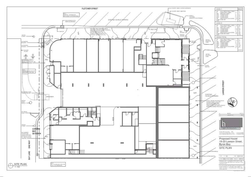
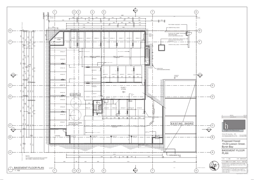
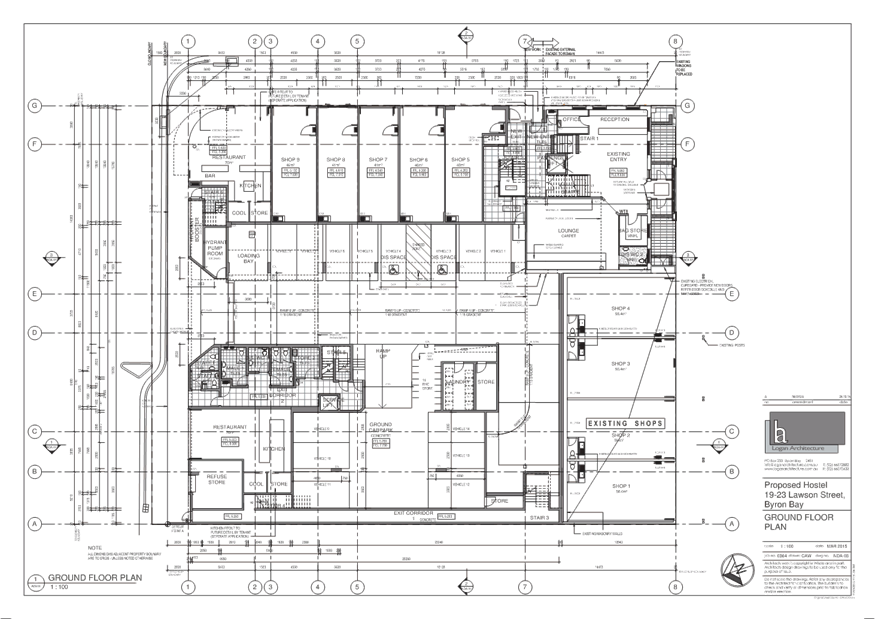
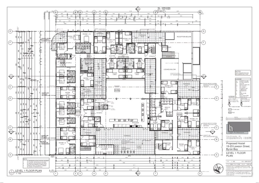
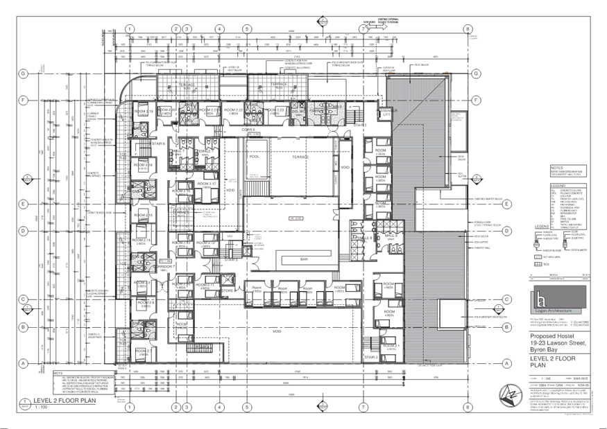
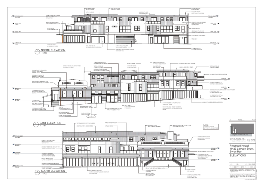
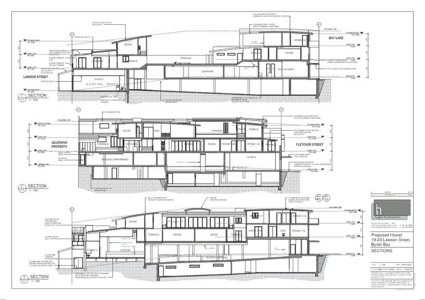
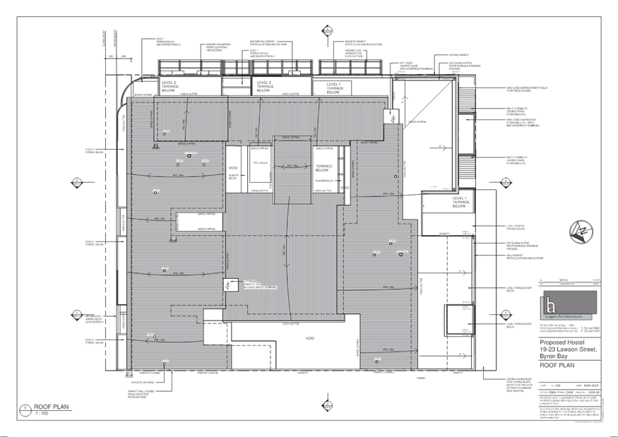
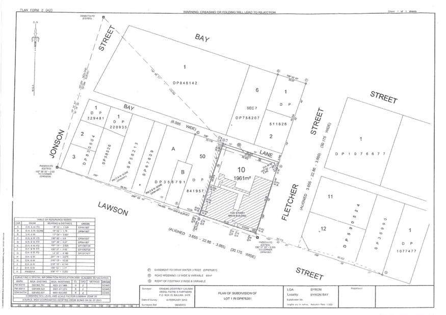
Staff Reports - Sustainable Environment and Economy 13.10 - Attachment 3
|
to:
|
|
from:
|
|
Joe Davidson
|
|
Donald Ellsmore, Heritage
Adviser
|
|
|
|
date:
|
|
Development Assessment
Officer
|
|
24th July 2006
|
|
SUBJECT:
|
|
reference
number:
|
|
New Development
|
|
DA No. 10.2005.733.1
|
Proposed
Mixed Commercial/ independent Travellers Accommodation at 19-23 Lawson Street, Byron Bay
I
refer to your letter of 4th July and the attached letter from Logan
Bald dated 15th March 2006.
The
response from Logan Bald to our expressed concerns regarding aspects of the
design of the new accommodation appears to satisfy those concerns although
without detailed documentation it is impossible to tell. Under the
circumstances it would be prudent to accept Logan Bald’s offer to submit
detail drawings for comment as the project progresses.
As
for the comments by the NSW Heritage Office, I would add the following
1. Retention
of Original Features, view corridors and setting
The
design incorporates the form and external facades of the 1929 form Council
Chambers. The design of the new development wraps around the old building and
maintains it as a key feature on the prominent corner site. This is considered
to be appropriate given the condition and significance of the former council
chambers building and its development potential. Arguments were put in favour
of retaining more of the interior layout of the old building but the developer
has not been prepared to retain more. The degree of retention is satisfactory
nevertheless.
The
siting of the heritage item on a prominent corner position ensures that it will
retain its identity largely intact. Views to the historic council chambers will
not be impaired. There is some potential for the new development to encroach on
the heritage item but the design appears to minimise this potential by use of
setbacks, modulation of the facade treatments and choice of materials.
2. Restoration
Works
The
proposed works include the removal of structures of low significance. The
modern shops facing Lawson Street will be retained and they will be modified.
This should create any adverse impact on the heritage item.
3. Architectural
Style and Character
The
proposed new development is in a style and character that is different to the
heritage item but this is seen as a benefit. The use of setbacks, modulation of
the facade treatments and the proposed use of mixed materials (masonry, metal
and wood) appears to provide an interesting and compatible relationship.
4. Height,
bulk, scale and massing
The
choice of forms and materials for the proposed new development appears to be
appropriate. The new development would not overwhelm the heritage item nor
would it create any unacceptable conflicts. Nevertheless it will be crucial
that the detailing of the new works should be compatible. At this stage it is
not possible to confirm that the new works should be compatible.
5. Roof
forms, materials and finishes
The
roof forms of the proposed new development are not dominating. The low pitch
roof forms would not be incompatible with the heritage item. The materials and
textures are, at least conceptually compatible.
6. Fenestration
proportions
The
proportions of the fenestration appear to be compatible. The issue of detailing
of the fenestration has been raised with the designers and further information
is awaited.
7. Signage
No
comment can be made at this stage regarding signage due to lack of information.
8. Curtilage
The
issue of curtilage is not relevant in this application for development on a
developed urban site. The new development will be contiguous with the heritage
item.
9. Subdivision
pattern
The
issue of the subdivision pattern is not relevant in this application for
development on a developed urban site. The new development will occupy existing
lots.
10. Landscaping
The
issue of landscaping is not relevant in this application for development on a
fully-developed urban site. Landscaping in the road reserve will be a matter
for Byron Shire Council.
11. Cumulative
Impact
Further
to the above it should be noted that the proposed development is unlikely to
have any adverse cumulative impact in the area. The existence on each side the
proposed development and on the site of the development itself, of buildings of
similar bulk and scale ensures that the impact should not be adverse in visual
terms. It is unlikely that any other development would result from this
development.
12. Archaeological
potential
The
archaeological potential of the site is not known at this stage but it would be
wise to ensure that the site would be adequately investigated. The normal way
of ensuring this would be to require the applicant to undertake an
archaeological investigation in accordance with NSW Heritage Office guidelines
and to provide this to council to assist with the assessment of the
application. Should the investigations indicate a moderate or high potential
then the advice of the Heritage Office in regards to excavation should be
followed.
Donald
Ellsmore
Heritage
Adviser
Staff Reports - Sustainable Environment and Economy 13.11
Report No. 13.11 Report
of the Planning Review Committee Meeting held on 17 March 2015
Directorate: Sustainable
Environment and Economy
Report
Author: Wayne
Bertram, Manager Certification and Assessment
File No: I2015/217
Theme: Ecology
Development and Approvals
Summary:
This report provides the outcome of the Planning Review
Committee Meeting held on
17 March, 2015.
|
RECOMMENDATION:
That the report be noted.
|
Report
The following development
applications and Section 96 applications were reviewed with the outcome shown
in the final column.
|
DA No.
|
Applicant
|
Property Address
|
Proposal
|
Reason/s
|
Outcome
|
|
10.2014.714.1
|
Gordon Highlands Pty Ltd
|
9 Station St
Bangalow
|
Demolition of existing
dwelling and garage and all other structures
|
The number of public
submissions.
The lack of policy to
direct determination.
The perceived public
significance of the application.
|
Council
|
|
10.2014.742.1
|
DP Roberts
|
33 Lawson St
Byron Bay
|
Demolition of existing
motel and construction of new motel
|
The extent of variation to
Council policies proposed.
|
Council
|
Council
determined the following original development applications. The Section 96
application to modify these development consents are referred to the Planning
Review Committee to decide if the modification applications can be determined
under delegated authority.
|
DA No.
|
Applicant
|
Property Address
|
Proposal
|
Reason/s
|
Outcome
|
|
10.2013.587.2
|
Global Centres Australia
Pty Ltd
|
108-110 Jonson St Byron Bay
|
S96 To delete condition 54
in relation to future lease arrangements
|
The lack of policy to
direct determination.
The perceived public
significance of the application
|
Council
|
|
10.2013.587.3
|
Global Centres Australia
Pty Ltd
|
108-110 Jonson St Byron Bay
|
S96 To modify conditions
relating to signage, amenity of neighbourhood , availability of parking,
traffic, construction staging, roof height, stormwater, site waste
management, flood planning, pipelines, landscaping, excavation, public
safety, water pollution, public art and services
|
The lack of policy to
direct determination.
The perceived public
significance of the application
|
Council
|
|
DA No.
|
Applicant
|
Property Address
|
Proposal
|
Reason/s
|
Outcome
|
|
10.2011.508.2
|
Planners North
|
5 Mona Lane
Brunswick Heads
|
S96 to alter the approved
design – two storey apartment building / three units
|
|
Return to PRC 7 April
|
|
10.2013.132.3
|
P Richmond
|
220 Fowlers Lane
Bangalow
|
S96 to delete requirement
to construct creek crossing works and accept a cash contribution instead
|
The extent of variation to
Council policies proposed.
The lack of policy to
direct determination.
The perceived public
significance of the application
|
Council
|
|
10.2000.348.7
|
P Richmond
|
220 Fowlers Lane
Bangalow
|
S96 to delete requirement
to construct creek crossing works and accept a cash contribution instead
|
The extent of variation to
Council policies proposed
The lack of policy to
direct determination.
The perceived public
significance of the application
|
Council
|
|
10.2011.413.3
|
Bangalow Property
Investments Pty Ltd
|
59 Lismore Rd
Bangalow
|
S96 to amend Section 94
contributions (Subdivision to create 42 Residential lots. A Recreation
Reserve and a Balance lot (Inc SEPP 1))
|
|
Delegated Authority
|
|
10.2011.474.2
|
Bangalow Property Investments
Pty Ltd
|
1 Ballina Rd
Bangalow
|
S96 to amend Section 94
contributions (Residential subdivision to create 49 allotments)
|
|
Delegated Authority
|
Staff Reports - Sustainable Environment and Economy 13.12
Report No. 13.12 PLANNING
- 10.2014.714.1 - Demolition of existing dwelling, garage, and all other
structures at 9 Station Street Bangalow
Directorate: Sustainable
Environment and Economy
Report
Author: Paul
Mills, Senior Assessment Officer - Planning
File No: I2015/219
Theme: Ecology
Development and Approvals
Proposal:
The application seeks development consent for the demolition
of the existing single-storey dwelling house (cottage) and freestanding four
(4) car garage on the subject site. In addition two (2) small outbuildings in
the rear yard are also proposed to be demolished.
Background:
A previous development application over the subject site (DA
10.2013.570.1) sought consent for removal and demolition of existing dwelling
and garage, erection of a two (2) storey mixed-use residential and commercial
building including a residential flat building, (comprising eight (8)
dwellings), three (3) shops and basement car parking for twenty-one (21)
vehicles. Council resolved to refuse that application and this decision was
subsequently appealed in the NSW Land & Environment Court. The appeal was
dismissed 7 October 2014.
Assessment:
It has not been adequately demonstrated that the proposed
demolition and leaving the site vacant will not have a detrimental impact on
the Bangalow Heritage Conservation Area and the setting of the nearby Bangalow
A&I Hall (Heritage Item).
In a preliminary review of the demolition proposal by the
Heritage Consultant who represented Council for a previous appeal over the
subject site, the following comment was made:
“In
my professional experience and opinion, it would be a very unwise decision on
the part of Council to permit demolition of a cottage, in a conservation area
and in the immediate vicinity of a heritage listed building, without linking
that consent to approval of a replacement dwelling.”
In response to the public notification process a total of
eleven (11) submissions were received. The matters raised in the submissions
included:
· concerns the
proposal will detract from the character and appearance of the Bangalow
Conservation Area and the setting of nearby Heritage Items;
· a decision to
demolish the cottage should not be undertaken until there is evidence to answer
the ‘Helou’ planning principle, and
· the submitted
Statement of Heritage Impact was prepared for a previous development
application to redevelop the subject site and not leave the site vacant.
The matters raised in the submissions have been discussed in
Section 3.6 of the assessment report within Attachment 1.
Conclusion:
It is considered that the proposed
demolition of the existing cottage will detract from the character, appearance
and streetscape of the Bangalow Conservation Area and the setting of the
Bangalow A&I Hall (Heritage Item) which are matters for consideration
within Clause 5.10(4) of Byron LEP 2014 and Chapter C1 of Byron DCP 2014.
NOTE TO COUNCILLORS:
In accordance with the
provisions of S375A of the Local Government Act 1993, a Division is to be
called whenever a motion for a planning decision is put to the meeting, for the
purpose of recording voting on planning matters. Pursuant to clause 2(a)
under the heading Matters to be Included in Minutes of Council Meetings of
Council's adopted Code of Meeting Practice (as amended) a Division will be
deemed to have been called by the mover and seconder of all motions relating to
this report.
|
RECOMMENDATION:
That Pursuant to Section 80 of the Environmental
Planning and Assessment Act 1979, development application 10.2014.714.1 for
demolition of existing dwelling, garage and all other structures, be refused
for the reasons listed in Attachment 1.
|
Attachments:
1 Development
Application Evaluation Report, A2014/33263
, page 173
2 Proposed
Plans 10.2014.714.1, E2015/17311
, page 189
3 Confidential
- Submissions 10.2014.714.1, E2015/17880
(provided under separate cover)
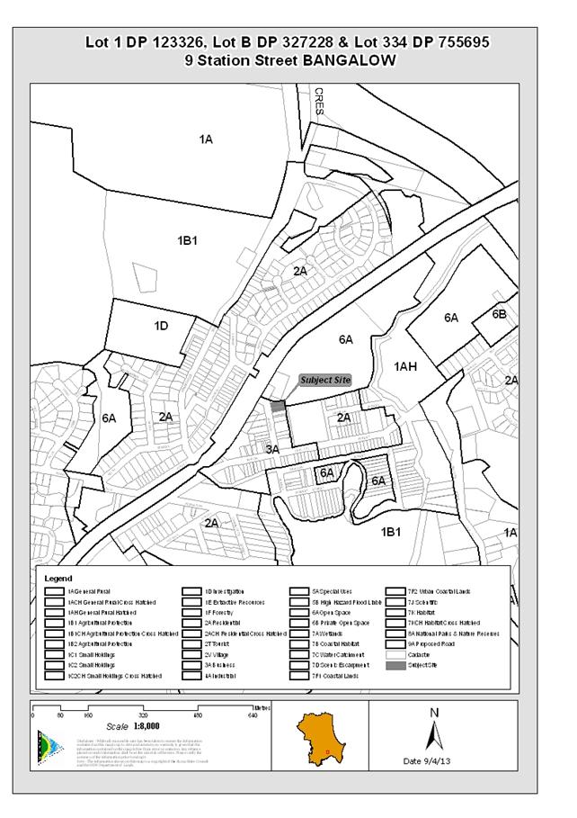
Staff Reports - Sustainable Environment and Economy 13.12 - Attachment 1
DEVELOPMENT APPLICATION EVALUATION REPORT
Doc No. #A2014/33263
|
DA No:
|
10.2014.714.1
|
|
Proposal:
|
Demolition of existing dwelling, garage and all other
structures.
|
|
Property description:
|
LOT: 1 DP: 123326, LOT: 334 DP: 755695, LOT: B DP: 327228
9 Station Street BANGALOW
|
|
Parcel No/s:
|
85390, 193400, 178620
|
|
Applicant:
|
Gordon Highlands Pty Ltd
|
|
Owner:
|
Gordon Highlands Pty Ltd
|
|
Zoning:
|
B2 Local Centre Zone
|
|
Date received:
|
28 November 2014
|
|
Integrated Development:
|
No
|
|
Public notification or exhibition:
|
- Level
2 advertising under DCP 2014 Part A14 – Public Notification and
Exhibition of Development Applications
- Exhibition
period: 9/12/14 to 22/12/14
- Submissions: Eleven
(11).
|
|
Other approvals (S68/138):
|
Not applicable
|
|
Planning Review Committee:
|
17/3/15
|
|
Delegation to determination:
|
Meeting of full Council
|
|
Issues:
|
· Impact of the
proposal on the character and appearance of the Bangalow Conservation area
and on neighbouring Heritage Items.
|
|
Summary:
|
The application seeks development consent for the
demolition of the existing single-storey dwelling house (cottage) and
freestanding four (4) car garage on the subject site. In addition two (2)
small outbuildings in the rear yard are also proposed to be demolished.
It has not been adequately demonstrated that the proposed
demolition and leaving the site vacant will not have a detrimental impact on
the Bangalow Heritage Conservation Area and the setting of the nearby
Bangalow A&I Hall (Heritage Item).
In a preliminary review of the demolition proposal by the
Heritage Consultant who represented Council for a previous appeal over the
subject site, the following comment was made:
“In
my professional experience and opinion, it would be a very unwise decision on
the part of Council to permit demolition of a cottage, in a conservation area
and in the immediate vicinity of a heritage listed building, without linking
that consent to approval of a replacement dwelling.”
In response to the public notification process a total of
eleven (11) submissions were received. The matters raised in the submissions
included:
· concerns the
proposal will detract from the character and appearance of the Bangalow
Conservation Area and the setting of nearby Heritage Items;
· a decision to
demolish the cottage should not be undertaken until there is evidence to
answer the ‘Helou’ planning principle, and
· the submitted
Statement of Heritage Impact was prepared for a previous development
application to redevelop the subject site and not leave the site vacant.
The matters raised in the submissions have been discussed
in Section 3.6 of this report.
It is considered that the
proposed demolition of the existing cottage will detract from the character,
appearance and streetscape of the Bangalow Conservation Area and the setting
of the Bangalow A&I Hall (Heritage Item) which are matters for
consideration within Clause 5.10(4) of Byron LEP 2014 and Chapter C1 of Byron
DCP 2014.
|
|
Recommendation
|
Pursuant to Section
80 of the Environmental Planning & Assessment Act 1979, development
application 10.2014.714.1
for Demolition of existing dwelling, garage and all other structures, be
refused for the reasons detailed in Section 6 of this report.
|
1. INTRODUCTION
1.1 History/Background
The following past development applications have been
identified for the subject site:
10.2010.435.1 Development
application seeking the removal of one (1) tree from the subject site consent
granted 3 September 2010.
10.2011.176.1
Development Application for a change of use of the
existing dwelling on the subject site to a shop, consent granted on 7 July
2011.
10.2011.176.2 Section
96 application to modify development consent 10.2011.176.1 to remove a
condition requiring consolidation of the allotments, approved 27 October 2011.
10.2012.555.1 Development
application seeking consent for demolition of existing dwelling and
garage. Erection of a four (4) storey mixed use residential and commercial
building including eight (8) dwellings (Residential flat building), three (3)
Shops and basement car parking for eighteen (18) vehicles. Council at its
Ordinary Meeting held 18 April 2013 resolved to refuse the application.
10.2013.570.1 Development
Application seeking consent for removal and demolition of existing dwelling and
garage, erection of a two (2) storey mixed-use residential and commercial
building including eight (8) dwellings (Residential flat building), three (3)
Shops and basement car parking for twenty-one (21) vehicles. Council resolved
to refuse the application and this decision was subsequently appealed in the
NSW Land & Environment Court. The appeal was dismissed 7 October 2014.
1.2 Description
of the site
The subject site is comprised of three adjoining allotments
Lot 1 DP 123326, Lot B DP 327228 and lot 334 DP 755695 known as 9 Station Street, Bangalow. The subject site is rectangular in shape and located on the
eastern side of Station Street adjoining the western entry to the Bangalow
Showgrounds.
Existing on the site is a single-storey dwelling of timber
construction with weatherboard cladding and iron roofing, also existing on-site
is a freestanding four (4) car garage with two (2) smaller outbuildings. The
total area of the site is 1123m². The site has a length of 40.55m
with a frontage of 27.93m to Station Street. To the rear the site also has a
frontage of approximately 15m to an unformed portion of Station Lane.
The level of the site generally falls from its north-western
corner on the Station Street frontage (RL 50.17 highest point) to the south and
east (RL 47.63 lowest point).
The site is located at the northern end of Station Street within the Bangalow Heritage precinct. The Bangalow Showgrounds adjoin the
property to the north and north-west, with an entry gate (and associated
building) for the Showgrounds and Scout Hall located immediately to the north.
The A & I Hall is located to the north-east of the site at the end of Station Street. To the rear of the site on the opposite side of Station Lane is the Bangalow Public School, the western side of the School grounds nearest the subject site are
the location of a School Hall and a staff parking area. To the south the site
adjoins an existing residential property containing a single storey dwelling of
timber construction with iron roofing.
1.3 Description
of the proposed development
The application seeks development consent for the demolition
of the existing single-storey dwelling house (cottage) and freestanding four
(4) car garage on the subject site. In addition two (2) small outbuildings are
also proposed to be demolished, these structures appear to be able to be
removed as exempt development. Following demolition the applicant has advised “The
site will be left vacant and fenced with security type fencing so as to prevent
any unauthorised use or access to the site.”
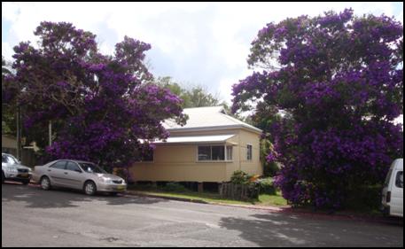
Figure 1 – View of existing dwelling house (cottage)
from Station Street
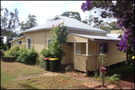
Figure 2 – View of existing dwelling house (cottage)
from Station Street
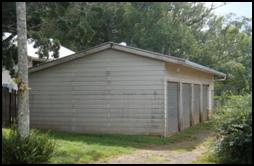
Figure 3 – View of existing garage structure from
Station Street
2. SUMMARY
OF GOVERNMENT/EXTERNAL REFERRALS
|
|
Summary of Issues
|
|
Heritage Consultant
|
The following comments were
received from Council’s Heritage Consultant in response to a request to
provide a fee proposal for the preparation of a detailed heritage assessment
of the proposal:
“As discussed, this DA is confined to the
demolition of the existing cottage and garage building on the property that
was the subject of a recent unsuccessful Land and Environment Court Appeal
for demolition and redevelopment proposal. In that judgement the Court
determined that there was no objection to the demolition but rejected the
proposed redevelopment on the grounds of incompatibility of contextual
fit. I will need to review the Judgement in more detail to determine if
the Court gave any formal direction regarding the potential for
demolition. You may like to seek some parallel legal advice on that
aspect to fully inform my preliminary conclusions.
On my preliminary reading, the new application seems to
rely almost completely on that opinion of the Court. It does not seem
to have done any further research but relies on the re-submission of the
previous Statement of Heritage Impact, which addressed more than the current
proposal, and is therefore not necessarily relevant to the Development
Application.
The current application is confined to demolition, meaning
that demolition would do northing more than create an empty site, awaiting
some future development proposal. In my professional experience and
opinion, it would be a very unwise decision on the part of Council to permit
demolition of a cottage, in a conservation area and in the immediate vicinity
of a heritage listed building, without linking that consent to approval of a
replacement dwelling.
I appreciate that Council does apparently not have any
formal policy about demolition of buildings in conservation areas. I am
aware that the LEC Planning Principle Helou v Strathfield Council looks to
formally identified “Contributing” buildings, but the new Byron
LEP 2104, Clause 5.10 sets out a clear procedure for such analysis. This
includes Clause 5.10 (4) requiring a specific heritage management document to
address demolition in a conservation area. The Expert Evidence prepared
for the recent LEC appeal raised serious concerns about the quality of the
analysis undertaken within the SHI report that has now been resubmitted.
Mr Mills also referred to a suggestion from the
applicant’s consultant town planner that the subject cottage should be
demolished under an order from Council as, in his opinion, it seemed unsafe
and may be regarded as a safety hazard. The issue of any such order by
Council would, under Clause 5.10, still require a detailed analysis of the
heritage impact of such a demolition.
The concise Heritage Referral Report, the subject of
this proposal, will briefly review these issues and provide advice to
Council. It will not undertake a more detailed review of the potential
contribution of the building to the conservation area. If needed, that
can be done later and could more fully address the Court’s comment
about detailed research.”
The involvement of Mr Brooks as Council’s Heritage
Expert in the recent LEC appeal places him in a strong position to prepare
the required report in a thorough, concise and cost efficient manner.
|
|
|
No other referrals.
|
3. SECTION
79C – MATTERS FOR CONSIDERATION – DISCUSSION OF ISSUES
Having regard for the matters for consideration detailed in
Section 79C(1) of the Environmental Planning & Assessment Act 1979, the
following is a summary of the evaluation of the issues.
3.1. STATE/REGIONAL
PLANNING POLICIES AND INSTRUMENTS
|
Requirement
|
Requirement
|
Proposed
|
Complies
|
|
State Environmental Planning Policy No.55 (Remediation
of Land)
|
Council [CP1] must:
(a) considered
whether the land is contaminated, and
(b) if
the land is contaminated, if the land is suitable in its contaminated state
or after remediation, and
(c) be
satisfied the land will be remediated before the land is used.
|
Council’s Environmental Health Officer has for
previous development applications over the subject site raised no objection
to development with regard to site contamination and SEPP No.55 obligations.
The site has been used for residential purposes.
Should the application have been
favourably considered a condition would have been recommended regarding the removal
of asbestos and other waste materials. This condition would have controlled
all waste, (asbestos and lead-contaminated wastes) requiring disposal in
accordance with the requirements of the Work Cover Authority.
|
Yes
|
|
Building Code of Australia
|
Able to satisfy the requirements of the Building Code of
Australia
|
The proposal is considered to
be capable of satisfying the requirements of the Building Code of Australia
(BCA).
|
Satisfactory
as no
building
works are proposed.
|
|
Demolition
|
Australian Standard AS 2601-1991: The Demolition of
Structures, published by Standards Australia, and as in force at 1 July
1993
|
Should the application have been favourably considered
conditions would have been imposed to require all demolition works to accord
with AS 2601-1991.
|
Yes
|
|
Accessibility (Disability
Discrimination Act)
|
Access for persons with
disabilities and integration into surrounding streetscapes without creating
barriers. (Council Res.10-1118)
|
No issues are apparent with regard to disabled access.
|
N/A
|
3.2 BYRON
LOCAL ENVIRONMENTAL PLAN 2014
Zone: B2 Local Centre Zone
Definition: Demolition
|
LEP Summary of Requirement
|
Proposed
|
Complies
|
|
Zone B2 Local Centre
1 Objectives
of zone
•
To provide a range of retail, business, entertainment and community uses that
serve the needs of people who live in, work in and visit the local area.
•
To encourage employment opportunities in accessible locations.
•
To maximise public transport patronage and encourage walking and cycling.
•
To encourage vibrant centres by allowing residential and tourist and visitor
accommodation above commercial premises.
|
The proposed development is not considered to be contrary
to the objectives of the B2 Local Centre Zone.
|
Yes
|
|
2.7 Demolition
requires development consent
The demolition of a building or work may be carried out
only with development consent.
|
Noted.
|
N/A
|
|
5.10 Heritage
conservation
Note. Heritage items (if any) are listed and
described in Schedule 5. Heritage conservation areas (if any) are shown on
the Heritage Map as well as being described in
Schedule 5.
(1) Objectives
The objectives of this clause are as follows:
(a) to conserve the environmental heritage of
Byron,
(b) to conserve the heritage significance of
heritage items and heritage conservation areas, including associated fabric,
settings and views,
(c) to conserve archaeological sites,
(d) to conserve Aboriginal objects and
Aboriginal places of heritage significance.
|
The proposed demolition is considered to be inconsistent
with the objective detailed in Section 5.10(1)(b) in that the proposal does
not conserve the Bangalow Conservation Area and the setting of A&I Hall
(Heritage Item).
|
No
|
|
(2) Requirement for consent
Development consent is required for any of the following:
(a) demolishing or moving any of the following
or altering the exterior of any of the following (including, in the case of a
building, making changes to its detail, fabric, finish or appearance):
(i) a heritage item,
(ii) an Aboriginal object,
(iii) a building, work, relic or tree within a
heritage conservation area,….
|
Noted.
|
|
|
(4) Effect
of proposed development on heritage significance
The consent authority must, before granting consent under this clause in
respect of a heritage item or heritage conservation area, consider the effect
of the proposed development on the heritage significance of the item or area
concerned. This subclause applies regardless of whether a heritage management
document is prepared under subclause (5) or a heritage conservation
management plan is submitted under subclause (6).
(5) Heritage assessment
The consent authority may, before granting consent to any development:
(a) on land on which a heritage item is
located, or
(b) on land that is within a heritage
conservation area, or
(c) on land that is within the vicinity of land
referred to in paragraph (a) or (b),
require a heritage management document to be prepared that
assesses the extent to which the carrying out of the proposed development
would affect the heritage significance of the heritage item or heritage conservation
area concerned.
|
* See assessment immediately
following this Table.
|
No*
|
Clause 5.10(4) Effect of proposed
development on heritage significance, and Clause 5.10(5) Heritage
assessment
It has not been adequately demonstrated that the proposed
demolition and leaving the site vacant will not have a detrimental impact on
the Bangalow Heritage Conservation Area and the setting of the nearby Bangalow
A&I Hall (Heritage Item No.I039).
The submitted Statement of Heritage Impact (SoHI) prepared
by Ainsworth Heritage does not specifically consider the longer term impact of
having a vacant site. The submitted SoHI report has also not considered the
impact of the erection of security type fencing. Overall the SoHI report
considers a redevelopment proposal for the subject site, which is not the
subject of this application.
The applicant was requested in a
letter dated 18 December 2014, in accordance with Clause 5.10(5) of Byron LEP
2014, to provide a heritage management document which specifically considers
the proposed demolition and the impact of leaving the site vacant (with the
erection of security type fencing). The applicant responded, in a letter dated
5 March 2015, by advising that the requested report was not warranted.
Draft EPI that is or has been
placed on public exhibition and details of which have been notified to the
consent authority
No relevant Draft Environmental Planning Instrument has been
identified for this application.
3.3 DEVELOPMENT
CONTROL PLANS
Development Control Plan 2014
Chapter
C1 – Non-Indigenous Heritage
Section
C1.2.2 Assessment Requirements
Table
C1.1 and the guidelines apply when development is proposed to a heritage item,
component of a Heritage Conservation Area or in the vicinity of a Heritage
Conservation Area. Table C1.1 details that Demolition requires the
submission of a ‘Demolition Report’.
Section
C1.2.2 subsection 3 Demolition states:
3 Demolition
The demolition of heritage items and/ or components that
contribute to the character of a Heritage Conservation Area is contrary to the
intent of the heritage listing and should be treated as a last resort.
Where demolition is proposed for a building on the site of
a heritage item or within a Heritage Conservation Area, Council will require a
detailed Heritage Report for Demolition /Archival Recording (‘Demolition
Report’) to be submitted with the development application. A qualified
Heritage practitioner should prepare the report in conjunction with any other
professional needed to carry out the condition assessment on the building.
In assessing an application for the demolition of a heritage
item or a building or component of a Heritage Conservation Area, Council will
consider the following:
a) the heritage
significance of the item;
b) the structural
condition of the item;
c) comparative
analysis of the item in relation to other items;
d) the
contribution the item makes to the streetscape or precinct; and
e) the design and
suitability of the proposed replacement development.
In the case of partial demolition, the proposed development
would need to conserve the heritage significance of the item, and would need to
facilitate its continued use or adaptive reuse, and would need to contribute to
the ongoing conservation of the item or the affected part of the item that was
being retained.
If the structural capability of the building is submitted
as a reason for or contributing to the need for demolition, Council may request
the submission of a report by an appropriately experienced structural engineer
to determine whether the building is, or is not, structurally capable of
reasonable and economic use. It should be noted that for demolition of a heritage
item to be approved it must be demonstrated that it is unsound, unsafe, or
beyond reasonable conservation and is incapable of viable continued use or
adaptive reuse.
Where demolition of a heritage item or building in a
Heritage Conservation Area is approved, it will generally be conditional upon
preparation of an archival recording of the building and site. This must be
prepared in accordance with guidelines in “How to Prepare Archival
Records of Heritage Items” and “Guidelines for the photographic
recording of Heritage Items”, produced by the Department of Planning and
Infrastructure and the NSW Heritage Council.
Assessment: The applicant has resubmitted a Statement
of Heritage Impact (SoHI) prepared by Ainsworth Heritage dated 27 November 2013
which has not specifically considered the implications of demolishing the
existing cottage to provide for a vacant site in the longer term. The submitted
SoHI also has not considered the impact of the erection of security type
fencing. The SoHI report considers a redevelopment proposal for the subject
site, which is not the subject of this application.
The applicant has also submitted a ‘Condition
Report’ prepared by Peter Lucena and Associated Pty Ltd dated 28 February
2015. The introduction of the Condition Report states,
“we have undertaken an
inspection of the property at 9 Station Street, Bangalow. The purpose of the
inspection was to provide advice on the current condition of buildings on the
site and to provide a list of remedial works to bring any deficiencies up to an
acceptable condition.”
The Condition Report recommends, in part, that the extent of
works is so great that effectively the building will require complete
replacement to achieve an ‘acceptable outcome’. The report
also recommends that the most effective course off action is to demolish the
existing building to allow room for construction of an alternative dwelling. This
development application has not included a proposal for a redevelopment of a
dwelling house on the subject allotment.
Section
C1.3 Conservation Guidelines and Requirements – Heritage Items, Heritage
Conservation Areas and Development in their Vicinity
The following Sections apply to development of heritage
item, in Heritage Conservation Areas or in the vicinity of a heritage item or
Heritage Conservation Area.
C1.3.1 General Streetscape Context
Objectives
1. To
promote development that complements the existing heritage character and
amenity of the area and the heritage significance of the heritage item or Heritage
Conservation Area.
2. To
maintain and enhance the heritage character of the streetscape in the vicinity
of the heritage item or within the Heritage Conservation Area.
3. To
ensure that new development respects the established patterns and visual
setting in the streetscape including setbacks, siting, landscape settings, car
parking and fencing.
4. To
retain and reflect the character of building frontage design in the
streetscape.
Performance Criteria
1. The side
and front setbacks must be typical of the spacing of existing buildings both
from each other and from the street, such that the streetscape is retained.
2. The established
landscape character of the locality including height of canopy and density of
boundary landscape plantings must be retained in any new development.
3. New
developments must respect and complement the existing heritage character of the
streetscape by maintaining the general scale, height, bulk and proportions of
traditional and new buildings in the streetscape.
4. Extensions
must not overwhelm the original building. It may be preferable to create two
separate buildings with a linkage in order to maintain the integrity of the
original.
5. Floor
levels must be compatible with floor levels of adjoining buildings.
Prescriptive Measures
1. The
original front facades of buildings should not be altered. Additions may be
better sited at the side or rear.
2. Infill
development must not make replica copies of existing buildings, but must follow
proportions and scale.
3. Developments
must not use a mixture of features from different eras, nor add historical
features to new buildings that are incompatible with the heritage context.
4. The
following components of the streetscape must be illustrated and addressed in
detail in a development application, and must demonstrate that the proposed
development complements the character and heritage significance of established
streetscapes:
Front setback of dwellings, materials, colours, textures,
roof form and pitch, scale, height and proportion of buildings, landscaping and
garden treatment, spaces between buildings, facade treatment, verandahs and
window placement, floor levels, height and design of fences, placement and
design of garages and driveways, existing street trees, balance between solid
walls and openings
Assessment: The proposed
demolition will alter the appearance of the streetscape with particular regard
to the space between buildings and the balance between solid walls and
openings.
Section C1.6.7 Bangalow Conservation Area
Character and Description
Village character, township nestled in verdant landscape.
Mixed uses. Distinctive Main Street with awnings and verandahs. Characteristics
include:
1. Well vegetated.
2. Sloping sites.
3. Predominantly traditional materials
and forms.
Statement of Significance
A rare, largely intact early 20th century village built in
a picturesque setting of green hills and subtropical vegetation with a main
street of high-quality public and commercial buildings grouped on both sides
and an unusually steep sloping street. The village area has a high
concentration of quality dwellings, public buildings, streets, back lanes,
street trees and landscaping, which taken together illustrate an identifiable
pattern of domestic, industrial and commercial settlement in Bangalow by early
pioneering settlers, and a pattern of development of civic infrastructure.
Development
should be consistent with the specific policy provisions for the Bangalow
Heritage Conservation Area included in Chapter E2 Bangalow (E2.3).
Assessment: Noted.
3.4 The likely impacts of that
development, including environmental impacts on both the natural and built
environments, and social and economic impacts in the locality
The proposed development is considered likely to detract
from the character and appearance of the Bangalow Conservation Area and the
setting of Heritage Items as discussed in Sections 3.2 and 3.3 of this
report.
3.5 The
suitability of the site for the development
The subject site is not considered to be suitable for the
proposed demolition without a suitable redevelopment proposal to maintain the
character, appearance and streetscape of the Bangalow Conservation Area.
3.6 Submissions
made in accordance with this Act or the regulations
The application was advertised in accordance with the Level
2 procedure identified within DCP 2014 Part A Section A14. In response to the
public notification process a total of eleven (11) submissions were received.
“Below is a table providing a summary of
submissions and staff responses. However, Councillors also need to refer
to the full copies of all submissions which have been provided on disc,
strictly on a confidential bases, to Councillors. The full copies of the
submissions contain personal information such as names and addresses of the
persons lodging submissions which are relevant matters to be taken into
consideration in determining this matter”
|
Issue
|
Comment
|
|
The proposed demolition will not maintain the existing character
of the streetscape.
|
The applicant has not adequately demonstrated that the
proposed demolition (without an acceptable redevelopment) will not detract
from the character and appearance of the Bangalow Conservation Area and the
setting of the Bangalow A& I Hall (Heritage Item).
|
|
Having read the DA for the demolition of the buildings at
No.9 Station Street could you please supply Appendix A and B mentioned on
page 26 of Ainsworth Heritage’s Statement of Heritage Impact which
apparently illustrates the proposed two-storey development planned for the
site.
|
The submitted Heritage Statement relates to a previous
redevelopment proposal for the subject site. There is no redevelopment which
forms part of this application.
|
|
The application should not be supported as the site is
within the Bangalow Heritage Conservation Area. With reference to LEP 1988
the whole of the Bangalow Conservation Area is an Item of Environmental
Heritage.
|
Byron LEP 2014 took effect on 21 July 2014 and replaced
Byron LEP 1988 for the subject site. The subject site is identified within
the Bangalow Conservation Area by Byron LEP 2014.
|
|
Reference is made to the heritage assessment provided by
Mr Brooks during the appeal for a previous application to redevelop the
subject site. It was his opinion the style and period of the cottage is
characteristic of the rural township and it does contribute to the heritage
significance of the Bangalow Heritage Conservation Area.
|
The findings of an appeal decision for a previous development
application are not identified as a matter for consideration within Section
79C of the EP&A Act 1979 for the assessment of a Development Application.
|
|
The restoration of the subject cottage could contribute to
the heritage of Bangalow, preserve the streetscapes and retain the character
of historical precinct.
|
Noted.
|
|
The heritage report commissioned by the applicant is for
the previous DA (the report by Ainsworth Heritage) neglected to report many
original features in the cottage that remain and is deficient in various
incorrect assertions.
|
Noted.
|
|
As referenced in the DA material The Commissioner’s
decision regarding the demolition of the cottage is based on the information
provided to her from a heritage report commissioned by the applicant, not an
independent report commissioned by Council.
The commissioners opinion regarding demolition was taken
out of context. Her repeated statement regarding the cottage was I do not
have sufficient evidence before me to answer the question of the Helou
planning principle, “What contribution does the existing building
make to significance of the conservation area?”
A decision to demolish the cottage should not be
undertaken until there is evidence to answer the above Helou planning
principle.
|
The findings of an appeal decision for a previous
development application are not identified as a matter for consideration
within Section 79C of the EP&A Act 1979 for the assessment of a
Development Application.
|
|
Concerns regarding the fact that there are no site
remediation measures proposed after demolition and that a temporary fence
will be erected around the site for an indefinite period which will be
unsightly and will be a detracting element to the heritage character of the
street and surrounding area. This proposal will also have detrimental effect
on the setting of the Bangalow A&I Hall which have substantial heritage
significance, currently in the process of being assessed for state
significance listing.
|
Noted. Consideration of the proposal with regard to its
impact on the Bangalow Conservation Area and the setting of near by Heritage
Items is discussed in Section 3.2 of this report.
|
|
The existing dwelling is currently being used a home, it
is asserted that the dwelling is generating rent of around $500 per week.
|
During a site inspection last year the subject dwelling
house was occupied however at the time of more recent inspection (11 March
2015) it appeared the house was vacant.
|
|
The dwelling should not be demolished or removed without
being accompanied with an approved DA for the future use of this block of
land.
|
Noted. It is considered that an approved redevelopment of
the site is necessary to maintain the character of the area rather than
leaving the site as vacant land.
|
|
This application does not recognise that not only do some
individual buildings, but more importantly the overall context of buildings
is what matters to Station Street’s heritage character and
significance.
|
Noted.
|
|
No further DAs should be approved before the revised
Bangalow Chapter of the Byron Shire DCP has been exhibited and approved.
|
Section 79C of the EP&A Act 1979 specifies that
Council must consider its prevailing DCP. It is not considered reasonable to
delay the determination of this application pending the completion of a new
DCP for the Bangalow commercial centre.
|
|
The demolition of the buildings and the placing of a large
and temporary fence around the property appears to be unnecessary.
|
Noted.
|
|
There has been no comprehensive community consultation for
the proposal. The community should be given time to asses the heritage impact
of demolition.
|
The development application was publicly notified in
accordance with DCP 2014 (Level 2 procedure). Exhibition was for a 14 day
period ending 22 December 2014.
|
|
The site is highly visible being located at the entrance
to the Bangalow Markets held at the adjacent Showground.
|
Noted.
|
|
The proposal would set an undesirable precedent to
demolish an original cottage within the Bangalow Conservation Area without an
appropriate study first being completed.
|
It is considered that the applicant has not adequately
demonstrated that the proposed demolition of the existing cottage will not
detract from the character and appearance of the Bangalow Conservation Area
and the setting of nearby Heritage Items as discussed in Section 3.2 of this
report.
|
|
Support for the demolition proposal if the following
conditions are applied:
· Property
must be maintained for aesthetic and to avoid creating an unsafe snake haven.
· No
ugly fencing along the boundaries.
· Property
is not to be used for storage of materials or parking of unused vehicles.
· Suitable
boundary fence to be installed along boundary to No.11 Station Street.
· Demolition
of asbestos to be strictly adhered to OH&S standards for health and
safety reasons.
|
Noted.
|
3.7 Public
interest
The proposed demolition of the existing cottage without an
acceptable redevelopment of the site is not considered to be in the public
interest as it will detract from the character of the area and setting of the
Bangalow A&I Hall.
4. DEVELOPER
CONTRIBUTIONS
4.1 Water
& Sewer Levies
As there is no increase in the load on these services no
contributions will be required for water and sewer services[BSC2] .
4.2 Section
94 Contributions
As there is no increase in the load on these services and no
contributions will be required.
5. CONCLUSION
It has not been adequately demonstrated that the proposed
demolition of the existing dwelling-house and leaving the site vacant will not
have a detrimental impact on the Bangalow Heritage Conservation Area and the
setting of the nearby Bangalow A&I Hall (Heritage Item).
In a preliminary review of the demolition proposal by the
Heritage Consultant who represented Council for a previous appeal over the
subject site, the following comment was made:
“In
my professional experience and opinion, it would be a very unwise decision on
the part of Council to permit demolition of a cottage, in a conservation area
and in the immediate vicinity of a heritage listed building, without linking
that consent to approval of a replacement dwelling.”
It is considered that the proposed
demolition of the existing cottage will detract from the character, appearance
and streetscape of the Bangalow Conservation Area and the setting of the
Bangalow A&I Hall (Heritage Item) which are matters for consideration
within Clause 5.10(4) of Byron LEP 2014 and Chapter C1 of Byron DCP 2014.
6. RECOMMENDATION
It is recommended
that Pursuant to Section 80 of the Environmental Planning & Assessment Act
1979, development application 10.2014.714.1 for demolition of existing dwelling and garage
and all other structures, be refused development consent for the following
reasons:
1. Pursuant to Section
79C(1)(a)(i) of the Environmental Planning and Assessment Act 1979, it
has not been demonstrated that the proposed demolition will not detract from
the character, appearance and streetscape of the Bangalow Conservation Area and
the setting of the A&I Hall (Heritage Item) which is a matter for
consideration within Clause 5.10(4) of Byron Local Environmental Plan 2014.
2. Pursuant to Section 79C(1)(a)(iii) of the Environmental
Planning and Assessment Act 1979, it has not been
demonstrated that the proposed demolition will not detract from the character,
appearance and streetscape of the Bangalow Conservation Area and the setting of
the A&I Hall (Heritage Item) contrary to the provisions of Byron
Development Control Plan 2014, Chapter C1 Non-indigenous Heritage.
3. Pursuant to the provisions of Section 79C(1)(e) of
the Environmental Planning and Assessment Act 1979, the proposed
development is considered to be contrary to the public interest in terms of the
impact on the Bangalow Conservation Area and the setting of the Bangalow
A&I Hall.
7. DISCLOSURE
OF POLITICAL DONATIONS AND GIFTS
|
Has a Disclosure Statement been received in relation to
this application
|
No
|
|
Have staff received a ‘gift’ from anyone
involved in this application that needs to be disclosed. Where the answer is
yes, the application is to be determined by the Director or Manager of the
Planning, Development and Environment Division.
|
No
|
Provide Disclosure Statement register details here: Nil.
Staff Reports - Sustainable Environment and Economy 13.12 - Attachment 2
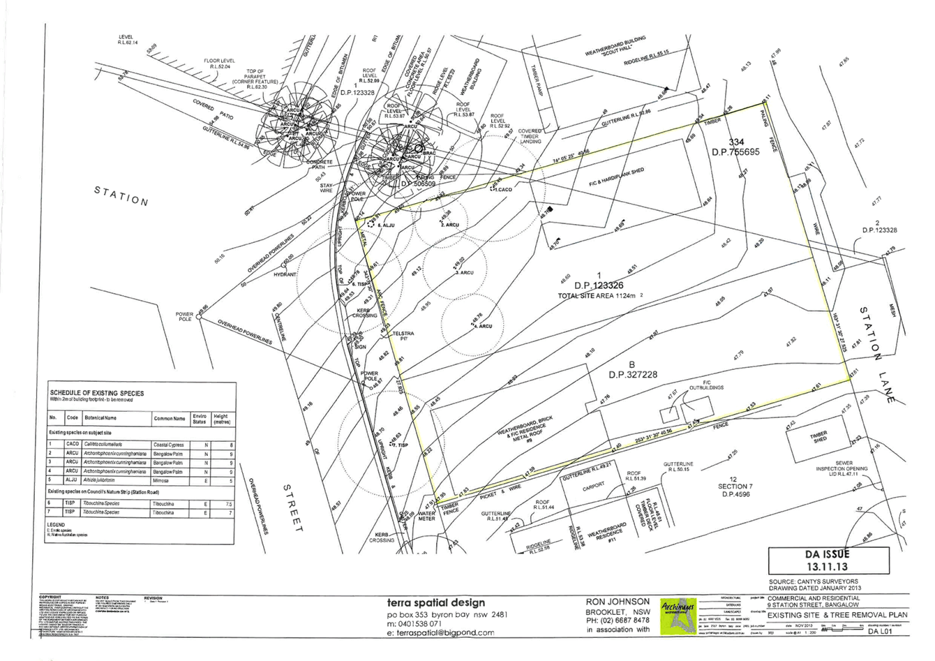
Staff Reports - Sustainable Environment and Economy 13.13
Report No. 13.13 Budget
Allocation for Traffic Study to Determine Construction Priorities on Ewingsdale
Road
Directorate: Sustainable
Environment and Economy
Report
Author: Christopher
Soulsby, Development Contributions Officer
File No: I2015/256
Theme: Ecology
Development and Approvals
Summary:
The purpose of this report is to seek a resolution of
Council to set a budget allocation to engage a traffic consultant to prepare an
updated traffic report for MR545. The report will enable Council to set a
priority order for the construction of major intersection upgrades along this
strategically important road corridor.
|
RECOMMENDATION:
1. That
Council allocate a budget of $50,000 to engage a traffic consultant
to:
a) Determine
the priority order for the construction of intersection upgrades on MR545;
and
b) Model
the impacts of construction of more than one roundabout at a time on
Ewingsdale Road; and
c) Investigate
the need for a roundabout at the intersection of Kendal Street and Ewingsdale
Road; and
d) Model
the impact of the rezoning proposal for seniors living and commercial
development at Ewingsdale on the intersections of William Flick Lane /
Ewingsdale Road and McGettigans Lane / Ewingsdale Road and determine the
timing of construction for the infrastructure to service this development.
Model the impact of this development on the function of MR545.
2. That
budget be made up of section 94 funds with $30,000 taken from the Byron Bay
Urban Roads account and $20,000 from the Plan Administration Fund.
|
Report
The purpose of this report is to seek a resolution of
Council to set a budget allocation to engage a traffic consultant to undertake
the following tasks:
1 Determine
the priority order for the construction of intersection upgrades on MR545; and
2 Model
the impacts of construction of more than one roundabout at a time on Ewingsdale
Road; and
3 Investigate
the need for a roundabout at the intersection of Kendal Street and Ewingsdale
Road; and
4 Model
the impact of the rezoning proposal for seniors living and commercial
development at Ewingsdale on the intersections of William Flick Lane /
Ewingsdale Road and McGettigans Lane / Ewingsdale Road and determine the timing
of construction for the infrastructure to service this development. Model
the impact of this development on the function of MR545.
The MR545 strategic road study identified a series of works
on MR545 from Clifford Street in Suffolk Park through the town centre and along
Ewingsdale Road. These works were incorporated into the Byron Developer
Contributions Plan 2012 to source developer contributions to fund the
works. The MR545 study identified the triggers for when these works would
be required. Table 8 from the MR545 study as reproduced below sets out
the works and triggers on MR545.
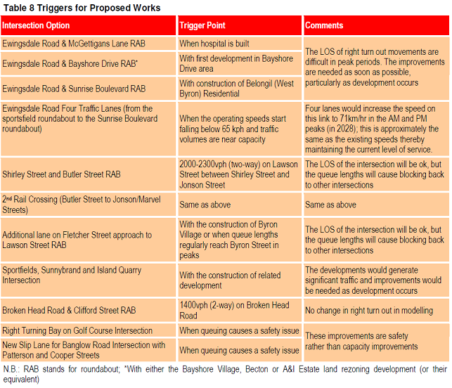
The triggers for the construction of the roundabouts at
McGettingans Lane, Bayshore Drive, Sunrise Boulevard and Clifford Street have
all been met. Council only has sufficient section 94 funds to pay for one
of these roundabouts at this point in time. Dependant on the level of
development in the area it may take 2-5 years to accumulate sufficient section
94 contributions to fund the next roundabout.
Council needs to know which intersection is the highest
priority in order to direct limited financial resources to the intersection
that will get the best return on investment in terms of overall network
performance. It is possible that private developers may construct the
roundabouts at McGettingans and Bayshore Drive. This would then allow
Council to direct funds to the next highest priority intersection.
The MR545 study did not identify the need for a roundabout
at Kendal Street. Staff have a concern that an intersection upgrade may
be required. It is prudent to get the consultant to model this
intersection to determine the type of upgrade and the timing of the upgrade so
that it can be incorporated into the section 94 plan and Council can commence
collecting contributions to funds the works.
Financial Implications
The cost of the study would be partially funded from the
administration component of the section 94 plan and partially funded from the
individual line items in the works schedule. The estimated cost to model
the intersections is $30,000 and a further $20,000 to model the network to
determine the priority order. No additional Council funds are
required. There are no impacts to the general fund from this
proposal.
Statutory and Policy
Compliance Implications
Expenditure of the administration levy to determine a
priority order for construction of works in the contributions plan is a
legitimate expenditure of section 94 funds.
The outcome of the consultant’s report will likely
require an amendment to the s94 plan. This amendment would go through the
normal statutory process. The outcome of the report will also have a
bearing on the Ewingsdale seniors living rezoning and the preparation of the
West Byron DCP.
Staff Reports - Infrastructure Services 13.14
Staff Reports - Infrastructure Services
Report No. 13.14 Belongil
Creek Floodplain Risk Management Study and Plan
Directorate: Infrastructure
Services
Report
Author: James
Flockton, Drainage Flood Engineer
File No: I2015/93
Theme: Community Infrastructure
Emergency Services and Floods
Summary:
The Draft Belongil Creek Floodplain Risk Management Plan
draws together a wide range of floodplain management options from The Draft
Belongil Creek Floodplain Risk Management Study. The study investigated
and recommended solutions as part of detailed investigation and consideration of
flood risk across the study area.
The Study and Plan are now
ready for adoption by Council.
|
RECOMMENDATION:
That Council adopt the Draft Belongil Creek Floodplain
Risk Management Study and Plan Summary (Attachment 2, E2015/16794) and the
Draft Belongil Creek Floodplain Risk Management Plan (Attachment 3,
E2015/16795).
|
Attachments:
1 Belongil
Creek Floodplain Risk Management Study and Plan Project - Council resolutions
2011-2014, E2015/3607 , page 197
2 Draft
Belongil Creek Floodplain Risk Management Study and Plan Summary March 2015, E2015/16794 (provided
under separate cover)
3 Draft
Belongil Creek Floodplain Risk Management Plan March 2015, E2015/16795 (provided under separate
cover)
Report
At the Ordinary Meeting of 28 August 2014, Council
considered a report on the Draft Belongil Creek Floodplain Risk Management
Study and Plan and resolved as follows:
14-397 Resolved:
1. That
the Draft Belongil Creek Floodplain Risk Management Study and Plan be placed on
public exhibition for a period of 28 days and any submissions be reported back
to Council.
2. That a public
information session be held to coincide with the exhibition period.
The draft study and plan were placed on public exhibition
for a period of 28 days and submissions closed on Monday 27 October.
A public information session was held on 7 October from
4pm-7pm at the Byron Bay Community Centre.
A single late submission was
received and accepted. The submission regarded a house which was eligible
for Voluntary House Purchase under the Draft Belongil Creek Floodplain Risk
Management Plan. The submission was considered at Council’s
Ordinary Meeting of 20 November 2014.
Council 14-585 Resolved::
That
Council defer adoption of the Draft Belongil Creek Floodplain Risk Management
Study (E2014/51147) and Plan (E2014/54465) until such time that Councillors and
staff have had an opportunity to conduct a workshop with committee members to
explain process and outcomes being considered in the Study and its implications.
Following resolution 14-585 Council staff have completed a
detailed assessment of the house which was eligible for Voluntary House
Purchase under the Draft Belongil Creek Floodplain Risk Management Plan.
The review of has found errors in the ground heights around
the house. It is unknown if the errors are actual errors, or if the pre
development ground heights were picked up during the flood study process.
However, the result is the house should NOT be within a high hazard zone and
can be removed from the Voluntary House Purchase program.
The error appears to be an isolated error because the flood
model’s terrain model was previously checked for accuracy as part the
flood study process and no major concerns were found.
Consultants BMT WBM have now updated the flood model to
reflect the above results and provided a short paper (found at the end of
Attachment 3 Draft Belongil Creek Floodplain Risk Management Plan ) explaining
the changes to the results. This paper is an addendum to the Draft
Belongil Creek Floodplain Risk Management Plan to ensure the process is
documented in the final document.
Additionally two other changes have been made to the Draft
Belongil Creek Floodplain Risk Management Plan being recommended for adoption
compared to the version which went on public exhibition.
1. addition
of a key action in the document
2. change
of the location of an evacuation route
Key Action:
A long term opening strategy for Belongil Creek
had been omitted from the plan of action within the Draft Belongil Creek
Floodplain Risk Management Plan. The current Crown License to open
Belongil Creek, license 453621, states that;
During the period of this licence, Council shall
demonstrate that it has made substantive progress on the development of a
sustainable long-term Belongil Creek Entrance Management Strategy and the
incorporation of catchment remediation strategies (including native vegetation
regeneration, effluent management, acid sulphate runoff reduction, stormwater
management strategies). The Strategy shall incorporate factors that address
issues raised through monitoring prior to, during and after the opening of the
estuary mouth during the term of this licence. Demonstration of Council's
progress shall be by way of provision of a written report six (6), twelve (12),
eighteen (18) and twenty-four (24) months from the commencement of this
licence.
Council has been demonstrating progress through
six monthly reporting, however, no funding has been made available to prepare a
Belongil Creek Entrance Management
Strategy. Adding an action to
the Draft Belongil Creek Floodplain Risk Management Plan will allow Council to attract 2/3 funding from state
government for completion of these works, therefore, the document has been
amended with the following task.
‘Preparation of a Belongil Creek Entrance Management Strategy’, at a cost of $150,000.
Evacuation Route:
Figure 5-1 of the Draft Belongil Creek Floodplain Risk
Management Plan shows the evacuation route from Belongil Spit along the old
alignment for Border Street. This road is no longer in use and the route
needed to be mapped along the current alignment.
The current version of the Draft Belongil Creek Floodplain
Risk Management Plan shows the evacuation route from Belongil Spit mapped
correctly along the new alignment for Border Street.
Further Information
The Draft Belongil Creek Floodplain Risk Management Study
and Plan has been a lengthy process over a number of years. Council has
considered and approved a number reports and stages along the path to
adoption. A review of the relevant Council Resolutions has been prepared
at Attachment 1 to help Council review the process and decisions that have been
made to take the project through to adoption.
RECOMMENDATION:
That Council adopt the Draft Belongil Creek Floodplain Risk
Management Study and Plan Summary (Attachment 2) and the Draft Belongil Creek
Floodplain Risk Management Plan (Attachment 3).
Financial Implications
Nil
Statutory and Policy
Compliance Implications
Floodplain Management Plans must be prepared in accordance
with State Government Policy. The NSW Floodplain Development Manual 2005
is the current policy used by State Government for the preparation of such
documents.
The Draft Belongil Creek Floodplain Risk Management Study
and Plan have been prepared in accordance with the NSW Floodplain Development Manual
2005.
Staff Reports - Infrastructure Services 13.14 - Attachment 1
Belongil Creek Floodplain Risk Management Study and Plan project –
Council resolutions 2011-2014
|
Council Meeting Date
|
Resolution
|
|
14/04/2011
|
Belongil
Creek Flood Risk Management Study Plan 2011-00054
11-306
Resolved:
1. That
Council award Tender - Belongil Creek Flood Risk Management Study and Plan -
Contract 2011-00054 to BMT-WBM, for $208,868.00 including GST.
2. That
Council makes public its decision including the name and amount of the
successful tenderer in accordance with Clause 179(b) of the Local Government
(General) Regulation 2005.
3. That
Council advise unsuccessful tenderers their tender was not accepted.
4. That
Council endorse the Belongil Creek Flood Risk Management Committee
constitution (Annexure 15(d) #1073638 of this report) with the addition of
Councillor (to be determined) to the membership list.
|
|
28/04/2011
|
Flood
Risk Management Committee Membership
11-360
Resolved:
1. That
Council endorse the Belongil Creek Flood Risk Management Committee constitution
(Annexure 15(a) #1081102) to be amended to accord with Resolution 10-1065,
with Councillors Tabart and Woods added to the membership list.
2. That
Council endorse the North Byron Coastal Creeks Flood Risk Management
Committee constitution (Annexure 15(b) #1081167) to be amended to accord with
Resolution 10-1066, with the addition of Councillor Staples to the membership
list.
3. That
Council note that the Mayor Cr Barham has withdrawn from membership of the
Belongil Creek Flood Risk Management Committee.
|
|
03/11/2011
|
Report
of Council’s Flood Risk Management Committees
11-878
Resolved that Council note the Minutes of the Flood Risk Management Committee
meetings held on 4 October 2011.
|
|
09/02/2012
|
Belongil
Creek Floodplain Risk Management Committee 13 December 2011
12-44
Resolved that Council note the minutes of the Belongil Creek Floodplain Risk
Management Committee (BCFRMC) Meeting held on 13 December 2011 (Annexure
10(a), #1182550).
|
|
09/02/2012
|
Belongil
Creek Floodplain Risk Management Committee 13 December 2011
12-45
Resolved that in relation to Report 4.1 – Presentation of Discussion
Papers 5 to 7 (#1165811), Council adopt:
Committee
Recommendation BCFRMC 4.1
a) That
the following recommendations be added to the Draft Belongil Creek Flood Risk
Management Study and Plan:
i)
Installation of additional rainfall gauges in the Belongil catchment.
ii)
Installation of an ALERT water level gauge at the Ewingsdale Road Bridge.
iii)
Implementation of a multi-faceted community flood awareness campaign
targeting accommodation providers and new residents, as well as existing
residents.
iv)
Development of a flood information data set linking water levels to real
world outcomes. In order to develop a flood action plan or flood intelligence
card which can help Council or the SES understand how a predicted flood water
level will affect the community.
v)
Implementation of an automated telephone and/or SMS flood warning system.
vi) A
review of existing SES emergency procedures using design flood information.
vii) A
review of flood and evacuation warning procedures. A wide range of warning
methods should be considered and planned for well in advance of future flood
events.
viii)
Identification of an alternative evacuation route. An alternative to Jonson
Street is recommended which has greater flood immunity. It is recommended
that the SES investigate this alterative and, if deemed suitable, it be
adopted in the Byron Shire Local Flood Plan.
ix)
Prioritise evacuation of Belongil Spit. Early and prioritised evacuation of
the Belongil Spit area would ensure that the most vulnerable residents have
the potential to evacuate prior to the onset of flooding. It is recommended
that the SES identify triggers which would prompt the evacuation of Belongil
Spit before other areas in the catchment. It is also recommended that the
residents in the Belongil Spit area are educated about their increased flood
risk and the likelihood of early evacuation.
x) Discussion
Paper 5 be amended to list the correct responsibilities of the SES, namely
that the Bureau of Meteorology is the legislated organisation that issues
flood warnings, and amend the emergency response recommendations in
discussion paper 5 to incorporate a layered warning system which includes
sirens.
b) That a
Flood Planning Matrix be recommended for inclusion in Council’s
Development Control Plan for Flood as part of the recommendations within the
Draft Belongil Creek Flood Risk Management Study and Plan.
The
proposed planning matrix would:
i) More stringently
restrict incompatible floodplain development within high hazard areas of the
floodplain.
ii)
Restrict development of critical Infrastructure and emergency services to
flood liable lands.
iii)
Prescriptively list development control measures based on land-use type and
flood hazard category.
iv) The
controls within the Planning Matrix would be based on current flood risk and
future flood risk increases due to climate change projections have been taken
into account where appropriate.
c) i)
That the one (1) property that has been identified as eligible for voluntary
house purchase and the four (4) properties that have been identified as
eligible for voluntary house raising be listed in the Draft Belongil Creek
Flood Risk Management Study and Plan.
ii) That
additional properties, which were included in the voluntary house raising
assessment, be considered for flood proofing.
d) The
flood planning level in the draft Byron LEP be based on 2100 event and that
the draft DCP for flooding include controls for FPL1, FPL2 and FPL3, based on
updated Discussion Paper 7 (#1173861, #1173875).
|
|
09/02/2012
|
Belongil
Creek Floodplain Risk Management Committee 13 December 2011
12-46
Resolved that in relation to Report 4.2 – Amended Constitution
(#1169811), Council adopt:
Committee
Recommendation BCFRMC 4.2
That
Council endorse the Belongil Creek Floodplain Risk Management Committee
Constitution (Annexure 10(k), #1169595) to be amended to accord with
resolutions 10-1066 and 11-360, Council’s advisory committee constitution
template and the NSW Floodplain Development Manual.
|
|
09/02/2012
|
Belongil
Creek Floodplain Risk Management Committee 13 December 2011
12-47
Resolved that in relation to Agenda Item 5.2 – Flood Modification
Measures (#1159552), Council adopt:
Committee
Recommendation BCFRMC 5.2
The
committee recommends that the consultant prepare a report which identifies
tangible cost/benefits relating to four flood modification measures, which
include:
a)
Training the Belongil Creek mouth versus existing opening strategy.
b) The
Byron Bay Drainage Strategy 2010 including identification of structures that
may need modification.
c) A full
maintenance program for the existing drainage system.
d)
Cost/benefit analysis of works on the Clarkes Beach drain.
|
|
13/06/2013
|
Belongil
Creek Floodplain Risk Management Committee 7 May 2013
13-269
Resolved that Council note the minutes of the Belongil Creek Floodplain Risk
Management Committee (BCFRMC) meeting held on 7 May 2013 (Annexure 2(a),
#E2013/28210).
|
|
13/06/2013
|
Belongil
Creek Floodplain Risk Management Committee 7 May 2013
13-270
Resolved that Council adopt the Belongil Creek Floodplain Risk Management
Committee constitution (Annexure 2(e), #E2013/31376).
|
|
13/06/2013
|
Belongil
Creek Floodplain Risk Management Committee 7 May 2013
13-271
Resolved that in relation to Report 4.2 - Flood Modification Measures and
Future Development Discussion papers – Belongil Creek Floodplain Risk
Management Committee, Council adopt:
Committee
Recommendation BCFRMC 4.2.1
1. That
measures 3 and 4 from Annexure 2(c) #E2013/23048 be included in the proposed
floodplain management scheme within the final Belongil Creek floodplain
management plan and measure 2 be a fall-back option.
2. That
the recommendations from section 5.1 in Annexure 2(d) #E2013/23026 be
included in the proposed floodplain management scheme within the final
Belongil Creek floodplain management plan.
3. That
an action item which details the section of Childe Street and Council’s
Lot 1 Manfred Street regarding creek bank erosion and road reserve be
included in the final Belongil Creek floodplain management plan.
4. That
Council consider running an additional mitigation scenario which alters the
existing railway bridge over Belongil Creek to improve flows at this section
of the creek and consider the flood affects of such a scenario.
|
|
12/12/2013
|
Belongil
Creek Floodplain Risk Management Committee Meeting 11/11/13
13-700
Resolved that Council note the minutes of the Belongil Creek Floodplain Risk
Management Committee (BCFRMC) meeting held on 11 November 2013 (Annexure10(b)
E2013/76768).
|
|
12/12/2013
|
Belongil
Creek Floodplain Risk Management Committee Meeting 11/11/13
13-701
Resolved that in relation to Report 4.1. - Flood Modification Measure –
Railway Bridge Modelling (Community Infrastructure #E2013/71895), Council
adopt:
Committee
Recommendation BCFRMC 4.1.1
a) That
Council does not adopt the widening (span) of the railway bridge over
Belongil Creek as a potential mitigation measure, and note the following
reasons:
i) the
mitigation measure has a limited beneficial impact on flood risk within the
catchment
ii)
future sea level rise will increase the risk for storm tide inundation within
Byron Bay
b) That
Council note widening of the railway bridge may increase the vulnerability of
Byron Bay to these risks.
c) That
Council notes that the cost benefit analysis does not support the widening of
the bridge.
|
|
12/12/2013
|
Belongil
Creek Floodplain Risk Management Committee Meeting 11/11/13
13-702
Resolved that in relation to Report 4.2 - Belongil Floodplain Risk Management
Study Draft Summary (Community Infrastructure #E2013/71909), Council not
adopt Committee Recommendation BCFRMC 4.2.1, but instead adopt:
Management
Recommendation BCFRMC 4.2.1
a) That
Council adopt the Draft Belongil Creek Floodplain Risk Management Study
Report as detailed in Annexure 2 (Annexure 10(c) #E2013/76783 of this report
to Council) and use the contents to develop the Draft Belongil Creek
Floodplain Management Plan.
b) That
the Byron Drainage Strategy previously referred to as the ‘Alternative
Byron Drainage Strategy will now be referred to as the ‘Preferred Byron
Drainage Strategy .
c) That
Council notes the location of a permanent Creek mouth for Belongil Creek
won’t have an impact on hydraulic loads.
d) That
separate to the floodplain risk management process staff investigates the
following issues
i) The
social and environmental impact of the migration of the Belongil Creek Mouth
and possible locations of a permanent Creek mouth be investigated.
ii) The
bank erosion that is threatening built infrastructure adjacent to Childe
Street/Manfred Street be investigated.
|
|
28/08/2014
|
Belongil
Creek Risk Management Study and Plan
14-397
Resolved:
1. That
the Draft Belongil Creek Floodplain Risk Management Study and Plan be placed
on public exhibition for a period of 28 days and any submissions be reported
back to Council.
2. That a
public information session be held to coincide with the exhibition period.
|
|
20/11/2014
|
Belongil
Creek Risk Management Study and Plan
14-585
Resolved that Council defer adoption of the Draft Belongil Creek Floodplain
Risk Management Study (E2014/51147) and Plan (E2014/54465) until such time
that Councillors and staff have had an opportunity to conduct a workshop with
committee members to explain process and outcomes being considered in the
Study and its implications.
|
Reports of Committees - Infrastructure Services 14.1
Reports of
Committees - Infrastructure Services
Report No. 14.1 Report of the Community Infrastructure Advisory Committee Meeting
held on 5 March 2015
Directorate: Infrastructure Services
Report
Author: Helen
Waldron, EA Infrastructure Services
File No: I2015/218
Theme: Community Infrastructure
Local Roads and Drainage
Summary:
The report provides the
Minutes and recommendations of the Community Infrastructure Advisory Committee
Meeting held 5 March 2015 for determination by Council.
|
RECOMMENDATION:
1. That
Council note the minutes of the Community Infrastructure Advisory Committee
Meeting held on 5 March 2015.
|
|
2. That Council
adopt the following Committee Recommendation:
Report No. 5.1 Proposed Community
Infrastructure Advisory Committee Meeting dates for 2015
File No:
I2015/21
Committee Recommendation 5.1.1
That the Community
Infrastructure Advisory Committee meets on the following dates and times:
· Thursday
7 May 2015 at 2.00pm
· Thursday
10 September 2015 at 2.00pm
· Thursday
3 December 2015 at 2.00pm
Additional Item Roadside Weed Management
Committee Recommendation 5.1.2
That the
Community Infrastructure Advisory Committee recommends that Council:
1) Note
the Discussion Paper (E2015/14133) on roadside weed management.
2) Convene
a meeting of interested stakeholder groups and individuals to
consider
the paramount question.
3) Review
the Roadside Vegetation Management Plan (RVMP), including to:
a)
identify effectiveness of control methods and
identifying
opportunities
for costs saving through better targeting of
control
methods.
b)
identify opportunities for better coordination of
stakeholders
to
increase area of roadside under sustainable weed
management
control.
4) Receive
a report via the Committee on public liability, risk management and other
issues associated with support of voluntary groups, as outlined in the Discussion
Paper.
Additional
Item Marshalls Creek
Committee Recommendation 5.1.3
That Council note the
Discussion Paper presented to the CIAC (E2015/14756) and collaborate with
NPWS about possible canoe access and launching locations on Marshalls Creek
at Ocean Shores and New Brighton.
|
Report
The attachment to this report provides the minutes of the
Community Infrastructure Advisory Committee Meeting of 5 March 2015 for
determination by Council.
Committee Recommendation
Committee Recommendation 5.1.2
That the Community Infrastructure Advisory Committee
recommends that Council:
1) Note the Discussion Paper (E2015/14133)
on roadside weed management.
2) Convene a meeting of
interested stakeholder groups and individuals to
consider
the paramount question.
3) Review the Roadside
Vegetation Management Plan (RVMP), including to:
a)
identify effectiveness of control methods and
identifying
opportunities
for costs saving through better targeting of
control
methods.
b)
identify opportunities for better coordination of
stakeholders
to
increase area of roadside under sustainable weed
management
control.
4) Receive a report via the
Committee on public liability, risk management and other issues
associated with support of voluntary groups, as outlined in the Discussion Paper.
Management Comments
This work could be progressed as resources permit.
Committee Recommendation 5.1.3
That Council note the Discussion Paper presented to the
CIAC (E2015/14756) and collaborate with NPWS about possible canoe access and
launching locations on Marshalls Creek at Ocean Shores and New Brighton.
Management Comments
This work could be progressed as resources permit.
Financial Implications
As per the Reports listed within the Community
Infrastructure Advisory Committee Meeting of 5 March 2015.
Statutory and Policy
Compliance Implications
As per the Reports listed within the Community
Infrastructure Advisory Committee Meeting of 5 March 2015.
Reports of Committees - Infrastructure Services 14.2
Report No. 14.2 Report of the Water, Waste and Sewer Advisory Committee Meeting held
on 5 March 2015
Directorate: Infrastructure Services
Report
Author: Helen Waldron,
EA Infrastructure Services
File No: I2015/220
Theme: Community Infrastructure
Waste and Recycling Services
Summary:
The report provides the
Minutes and recommendations of the Water, Waste and Sewer Advisory Committee
Meeting held 5 March 2015 for determination by Council.
<<Type text here>>
|
RECOMMENDATION:
1. That
Council note the minutes of the Water, Waste and Sewer Advisory Committee
Meeting held on 5 March 2015.
|
|
2. That Council
adopt the following Committee and Management Recommendation:
Report No. 5.1 Proposed Water, Waste and
Sewer Advisory Committee Dates for 2015
File No:
I2015/20
Moved 5.1.1
That the Water, Waste and
Sewer Advisory Committee meets on the following dates and times:
· Thursday
7 May 2015 at 9.00am
· Thursday
10 September 2015 at 9.00am
· Thursday
3 December 2015 at 9.00am
|
Attachments:
1 Minutes
Water, Waste and Sewer Advisory Committee Meeting held 05/03/15, I2015/195 , page 207
Report
The attachment to this report provides the minutes of the
Water, Waste and Sewer Advisory Committee Meeting of 5 March 2015 for
determination by Council.
Committee Recommendation
Moved
5.1.1
That the Water, Waste and Sewer Advisory Committee meets
on the following dates and times:
· Thursday
7 May 2015 at 9.00am
· Thursday
10 September 2015 at 9.00am
· Thursday
3 December 2015 at 9.00am
The committee recommendation is supported by management and
is provided in the attachment to this report.
Financial Implications
As per the Report listed within the Water, Waste and Sewer
Advisory Committee Meeting of 5 March 2015.
Statutory and Policy
Compliance Implications
As per the Report listed within the Water, Waste and Sewer
Advisory Committee Meeting of 5 March 2015.
Reports of Committees - Infrastructure Services 14.2 - Attachment 1

Water, Waste and Sewer Advisory Committee Meeting
|
Venue
|
Conference Room, Station Street, Mullumbimby
|
|
Date
|
Thursday, 5 March 2015
|
|
Time
|
9.00am
|
Reports of Committees - Infrastructure Services 14.2 - Attachment 1
Minutes of the Water,
Waste and Sewer Advisory Committee Meeting held on Thursday, 5
March 2015
File No: Error! Unknown document
property name.
PRESENT: Cr
S Richardson (Mayor), Cr D Dey and Cr R Wanchap
Staff: Phil
Holloway (Director Infrastructure Services)
Peter
Rees, Manager Utilities
Michael
Matthews, Manager Open Space and Resource Recovery
Community: David
Fligelman
Madeleine
Green
Leah
Kapral
Luke McConnell
Cr Dey(Chair)
opened the meeting at 9.05am and acknowledged that the meeting
was being held on Bundjalung Country.
Apologies:
Col Draper
Declarations of
Interest – Pecuniary and Non-Pecuniary
Madeleine Green declared a non-pecuniary interest. The
nature of the interest being that Ms Green’s residence is in the vicinity
of the Myocum Resource Recovery Centre.
Adoption of
Minutes from Previous Meetings
|
Recommendation:
That the minutes of the Water, Waste and Sewer Advisory
Committee Meeting held on 4 December 2014 be confirmed.
|
Business Arising from Previous Minutes
There was no business arising
from previous minutes.
Staff Reports - Infrastructure Services
|
Report No. 5.1 Proposed
Water, Waste and Sewer Advisory Committee Dates for 2015
File No: I2015/20
|
|
Moved:
That the Water, Waste and Sewer Advisory Committee
meets on the following dates and times:
· Thursday
7 May 2015 at 9.00am
· Thursday
10 September 2015 at 9.00am
· Thursday
3 December 2015 at 9.00am
.
(Dey/Green
The recommendation was put to
the vote and declared carried
)
|
General Business
Actions:
That the Committee receive the following reports during the
remainder of their term.
Reports to include:
a) Demand Management,
including options for water re-use within the Shire
b) Performance Reports on
Water,Sewer and Resource Recovery
c) Impacts of Temporary Events
on Water, Sewer and Resource Recovery
d) Growth Management Strategy
in Relation to Potential Issues with Water, Sewer and Resource Recovery
e) Review of Policies Relating
to Water, Waste and Resource Recovery
f) Status of Provisions
of Rainwater Tanks throughout the Shire
There being no further business the meeting concluded at 10.30
am.
Reports of Committees - Infrastructure Services 14.3
Report No. 14.3 Report of the Transport Advisory Committee Meeting held on 12 March 2015
Directorate: Infrastructure Services
Report
Author: Simon
Bennett, Traffic and Transport Engineer
File No: I2015/259
Theme: Community Infrastructure
Local Roads and Drainage
Summary:
This report provides the minutes and recommendations of the
Transport Advisory Committee Meeting held on 12 March 2015 for determination by
Council.
|
RECOMMENDATION:
1. That
Council note the minutes of the Transport Advisory Committee Meeting held on
12 March 2015.
|
|
2. That Council
note the Committee Recommendation 5.1 as follows in
regard to 2015 meeting dates and times:
· Thursday
25 June 2015 at 2.00pm
· Thursday
1 October 2015 at 9.00am
· Tuesday
1 December 2015 at 9.30am
|
|
3. That Council
adopt the Committee Recommendation 5.2 as follows:
That
Council, in adopting the following priority in regard to bike plan projects,
receive a staff report on cost estimates and to amend and exhibit the
s94 Contributions Plan accordingly which reflects:
a)
high priority for the funding and delivery of bike plan projects:
i) No.
38 - shared path, Bangalow, from the eastern end of the existing path on the
north side of Byron Bay Road through to the Bangalow Bowling Club;
ii) No.
73 and 72 - Broken Head Road, Suffolk Park between Beech Drive south and
north roundabouts and onto Byron at Byron Resort, with options for both
on-road (as per Res 14-223) and off-road (as per bike plan) be investigated,
costed and reported back to Council; and
iii) No.
43 – a shared path on Raftons Road, Bangalow from Rifle Range Rd to
Readings Bridge via Leslie Street.
b) medium
priority, commencing with investigation and report of options for bike plan
projects:
i) No.
76 - shared path, Suffolk Park from Broken Head Rd (at Byron at Byron Resort)
through to Alcorn Street; and
ii) No.
15 - shared path Balemo Drive, Ocean Shores from Orana Road to Brunswick
Valley Way;
c) consideration
of funding opportunity, relationship and priority of bike plan projects:
i) No.
40 - shared path Lismore Road from Rifle Range Road to Dudgeons Lane,
Industrial Estate, Bangalow, noting opportunity for 100% RMS funding due to
being adjacent to state road (MR65);
ii) No.
42 - shared path along Rifle Range Road, Bangalow from viaduct on Lismore
Road to existing path at Samson Street; and
iii) No.
46 - shared path Tristania Street from Rifle Range Road to Sansom Street ,
Bangalow;
d) low
priority given to bike plan projects:
i) No.
59 - shared path, Sunrise Boulevard and Julian Rocks Drive, Sunrise to
existing path;
ii) No.
58 - shared path Bayshore Drive from Ewingsdale Road to rail corridor; and
iii) No.
65 - shared path Browning Street, Byron Bay from Bangalow Road to Jonson
Street and onto the Ex-Services Club.
e) the
immediate delivery, using s94 funds or otherwise, of signage only projects
being:
i) No.
62 - on-road advisory signs along Cowper Street, Byron Bay through
to Browning Street; and
ii) No.
64- on-road advisory signs along Lighthouse Road, Byron Bay from Brooke
Drive (The Pass) to the Lighthouse.
f) That
the bike project within the s94 plan which is not in the bike plan and relates
to the provision of a new path from Broken Head Road, Suffolk Park to
Kalemajere Drive be investigated and reported to Council.
|
|
4. That Council
adopt Committee Recommendation 5.3 in part as follows:
a) that
the revision of the PAMP document be undertaken in the first instance
with a review by staff and report back to Council via this
Committee; and
b) that
the PAMP review, which has commenced with staff and Access Advisory Committee
input, be continued with a draft document to be tabled to the Committee
prior to consultation being undertaken.
5. That
Council not adopt Committee Recommendation 5.3(b) and instead endorse the
Management Recommendation as follows:
That
the funds within the adopted s94 plan, which are within the 2014/15
budget, be used to implement projects as detailed in the Committee Agenda at
Report No. 5.3 (file I2015/187) with priority given as follows to projects
within:
a) Table
1, which are endorsed as Part 2 of Resolution 14-565; and
b) Table 2, with the exception of bike plan number
43.
|
Attachments:
1 Minutes
12/03/2015 Transport Advisory Committee, I2015/197
, page 215
2 s94
Contributions Plan cycleway bike projects - Transport Advisory Committee
meeting 12 March 2015 prioritising of projects for 9 April 2015 Report to
Council, E2015/18933 , page 220
Report
The attachment to this report provides the minutes of the
Transport Advisory Committee Meeting of 12 March 2015 for determination by
Council.
Committee Recommendation 5.1
Committee meeting dates for 2015.
Management Comments
Noted.
Committee Recommendation 5.2
Committee recommendation 5.2 is reproduced as above from the
attached minutes. The recommendation provides a priority order to
cycleway projects as contained in Council’s December 2012 adopted s94
contributions plan.
Management Comments
As the recommendation notes, should such priority be adopted
by Council, a further report back to Council in regard to the
changes/amendments to the s94 contributions plan will be required prior to any
such funds being spent. While the amendments will be minor in nature, mainly
inclusion of project priority, the opportunity will also be taken to report on
s94 funds held, table updated cost estimates and provide further detail on each
project plus on how the priorities have been reached, which have been
summarised by staff (post meeting) as per Attachment No. 2.
As this attachment shows, the Committee considered projects
in regard to either being high, medium or low in priority in relation to three
separate criterion: planning/investigating, consultation and delivery. Staff
(post meeting) then applied a weight, 5 for high, 3 for medium and 1 for low to
provide a ‘Total’ so to enable ranking the 15 projects, with the
highest score (of 7) applied to a project where the criterion was considered
not applicable (na).
By doing so, the attached concludes subject to funding the
two (2) signage only projects are for immediate delivery, while four (4)
projects are considered high priority, noting bike plan projects numbered 72
and 73 are within the bike plan as off-road while more recently Council
resolved in favour of on-road as follows, meaning both options will be costed
and included in the aforementioned report back to Council:
14-223 Resolved…that
in regard to the bike project detailed in design plans 2045/1; 2045/2 and 2208
for an on-road route between Suffolk Park and Byron Bay town centre which
follows Broken Head Road and Bangalow Road, Council:
1. develop an alternative
design for the section between Wollumbin and Keats Street and the section north
of the junction with Scott Street, with consideration being given to commercial
and community car parking needs along the route.
2. that this alternative
design be incorporated into the relevant design plans and that plans 2045/1;
2045/2 and 2208 be first costed and secondly placed on public exhibition.
3. following the consultation
and public exhibition period, a report be provided back to Council seeking
endorsement of the project for submission to the RMS for at least 50% funding
for delivery in 2015/16.
|
Figure 1 maps the locations of Suffolk Park bike plan projects
72, 73 and 76 plus a fourth project, which is not in the bike plan but
included in the s94 plan and considered by the Committee as Low priority
overall but high for planning/investigation; i.e. a new path from Broken Head Road to Kalemajere Drive which
is a link that would transverse both private and public land and is partially
provided for.
While the immediate and high priority projects will (upon
adoption) take precedence the three (3) projects considered as
‘medium’ priority (overall) include a ‘high’ need for
planning and consultation and therefore will be progressed accordingly.
Of the remaining six (6) projects, the two (2) projects
considered Medium-Low are considered less of priority to bike plan project
number 40 (Medium-High) due to the potential of it gaining 100% state
funding, while of the three (3) projects given ‘Low’ priority
they have (respectively) a high, medium and low planning priority and will be
undertaken in such order, unless resolved otherwise.
Therefore overall it is believed the Committee
recommendation as it stands provides clear direction for priority delivery of
bike plan projects.
|
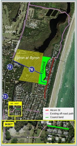
|
Committee Recommendation 5.3
Committee recommendation 5.3 is detailed on the attached
minutes.
Management Comments/Recommendation
The Committee recommendation has three distinct parts.
Part (a) and (c) are inter-related and will require staff to
undertake and has no funding implications other than on existing staff time and
resources. No change is made to the Committee recommendation other than
renumbering for purpose of Council adoption as 4(a) and (b).
Part (b) of the Committee recommendation however needs
further clarification, namely the report to which it refers, and to further
assist with priority, Management recommend as per Part 5, noting however it
recommends (as per Committee intention) that the s94 funds as held in the
current 2014/15 budget for a revision of the PAMP document, commencing with a
pedestrian audit, instead be used to undertake projects as detailed in the
recommendation; i.e. as per Tables 1 and 2 from Committee Report No. 5.3.
Financial Implications
As per the Reports listed within the Transport Advisory
Committee Meeting of 12 March 2015.
However it is noted no changes to expenditure or funding is
required for Committee Recommendations made, with Committee Recommendation 5.1
having no further funding requirement and that Committee Recommendation
5.2 will first require a report back to Council on cost estimates and s94
funds/amendments prior to any expenditure is incurred.
As for Committee Recommendation 5.3, it redirects existing
s94 funds as held in the 2014/15 budget for the purpose of an audit and PAMP
review to instead undertake priority pedestrian projects.
Statutory and Policy
Compliance Implications
As per the Reports listed within the Transport Advisory
Committee Meeting of 12 March 2015.
Reports of Committees - Infrastructure Services 14.3 - Attachment 1
Transport Advisory Committee Meeting
|
Venue
|
Conference Room, Station Street, Mullumbimby
|
|
Date
|
Thursday, 12 March 2015
|
|
Time
|
9.00am
|
Reports of Committees - Infrastructure Services 14.3 - Attachment 1
Minutes of the Transport
Advisory Committee Meeting held on Thursday, 12 March 2015
File No: Error! Unknown document
property name.
PRESENT: Cr
B Cameron, Cr D Dey, Cr A Hunter
Staff: Phillip
Holloway (Director Infrastructure Services)
Simon
Bennett (Traffic and Transport Planner)
Community:
John Blanch, Phillip Preston
Cr
Cameron opened the meeting at 9.05am and acknowledged that the
meeting was being held on Bundjalung Country.
Apologies: Cr S
Richardson (Mayor)
ABSENT: Karin
Kolbe
Declarations of
Interest – Pecuniary and Non-Pecuniary
There were no declarations of
interest.
Adoption of
Minutes from Previous Meetings
Procedural Motion
That the minutes of the Transport
Advisory Committee Meeting held on 23 September 2014 be confirmed.
(Cr
Dey / Cr Hunter)
The motion was put to the vote
and declared carried.
Business Arising from Previous Minutes
There was no business arising
from previous minutes.
Staff Reports - Infrastructure Services
|
Report No. 5.1 Proposed
Transport Advisory Committee Meeting Dates for 2015
File No: I2015/19
|
|
Committee Recommendation
TrAC 5.1
That the Transport Advisory Committee meets on the
following dates and times:
· Thursday
25 June 2015 at 2.00pm
· Thursday
1 October 2015 at 9.00am
· Tuesday
1 December 2015 at 9.30am
Cr
Cameron / Cr Hunter
The motion was put to the
vote and declared carried.
|
|
Report No. 5.2 Bike
plan review and project prioritisation
File No: I2015/186
|
|
Committee Recommendation
TrAC 5.2
1. That
Council, in adopting the following priority in regard to bike plan projects,
receive a staff report on cost estimates and to amend and exhibit the
s94 Contributions Plan accordingly which reflects:
a)
high priority for the funding and delivery of bike plan projects:
i) No.
38 - shared path, Bangalow, from the eastern end of the existing path on the
north side of Byron Bay Road through to the Bangalow Bowling Club;
ii) No.
73 and 72 - Broken Head Road, Suffolk Park between Beech Drive south and
north roundabouts and onto Byron at Byron Resort, with options for both
on-road (as per Res 14-223) and off-road (as per bike plan) be investigated,
costed and reported back to Council; and
iii) No.
43 – a shared path on Raftons Road, Bangalow from Rifle Range Rd to
Readings Bridge via Leslie Street.
b) medium
priority, commencing with investigation and report of options for bike plan
projects:
i) No.
76 - shared path, Suffolk Park from Broken Head Rd (at Byron at Byron Resort)
through to Alcorn Street; and
ii) No.
15 - shared path Balemo Drive, Ocean Shores from Orana Road to Brunswick
Valley Way;
c) consideration
of funding opportunity, relationship and priority of bike plan projects:
i) No.
40 - shared path Lismore Road from Rifle Range Road to Dudgeons Lane,
Industrial Estate, Bangalow, noting opportunity for 100% RMS funding due to
being adjacent to state road (MR65);
ii) No.
42 - shared path along Rifle Range Road, Bangalow from viaduct on Lismore
Road to existing path at Samson Street; and
iii) No.
46 - shared path Tristania Street from Rifle Range Road to Sansom Street ,
Bangalow;
d) low
priority given to bike plan projects:
i) No.
59 - shared path, Sunrise Boulevard and Julian Rocks Drive, Sunrise to
existing path;
ii) No.
58 - shared path Bayshore Drive from Ewingsdale Road to rail corridor; and
iii) No.
65 - shared path Browning Street, Byron Bay from Bangalow Road to Jonson
Street and onto the Ex-Services Club.
e) the
immediate delivery, using s94 funds or otherwise, of signage only projects
being:
i) No.
62 - on-road advisory signs along Cowper Street, Byron Bay through to Browning
Street; and
ii) No.
64- on-road advisory signs along Lighthouse Road, Byron Bay from Brooke
Drive (The Pass) to the Lighthouse.
2. That
the bike project within the s94 plan which is not in the bike plan and
relates to the provision of a new path from Broken Head Road, Suffolk Park to
Kalemajere Drive be investigated and reported to Council.
Cr
Cameron / Phillip Preston
The motion was put to the
vote and declared carried.
|
|
Report No. 5.3 Pedestrian
Access and Mobility Plan (PAMP) review and project prioritisation
File No: I2015/187
|
|
RECOMMENDATION:
1. That the
revision of the PAMP document be undertaken in the first instance with a review
by staff and report back to Council via this Committee.
2. That
the funds within the adopted s94 plan for the purpose of
pedestrian audit instead be used to implement projects detailed in this
report, subject to priority being allocated.
3. That the PAMP review
which has commenced with staff and Access Advisory Committee
input be continued with a draft document to be tabled to the Committee prior
to consultation being undertaken.
Cr
Dey / Cr Hunter
The motion was put to the
vote and declared carried.
|
|
General Business 6.1 Bus set down and pick up, Byron Bay
swimming pool
File No: I2015/187
|
|
RECOMMENDATION:
That Council receive a
report on bus set down and pick up options at the Byron Bay Memorial Swimming
Pool.
Cr
Dey / John Blanch
The motion was put to the
vote and declared carried.
|
|
General Business 6.2 Bus operations and delays, road
network investigations, Byron Bay
File No: I2015/187
|
|
RECOMMENDATION:
That Council note advice
from Bus Operators of increasing traffic congestion and disruption to
services along Broken Head Road, between Suffolk Park and Byron Bay, and
that:
1. this
be considered in future planning e.g. traffic, cycling, capacity etc; and
2. the
Committee receive a further report on issues raised.
John
Blanch / Cr Cameron
The motion was put to the
vote and declared carried.
|
Next meeting 25 June 2015 at
9.00am.
There being no further business the meeting concluded at 11am.
Reports of Committees - Infrastructure Services 14.3 - Attachment 2
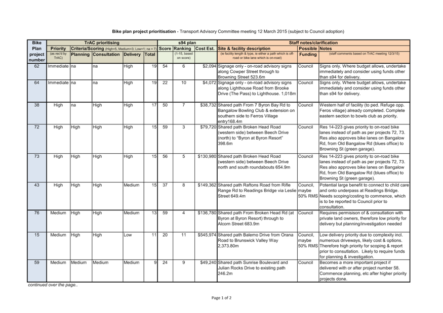
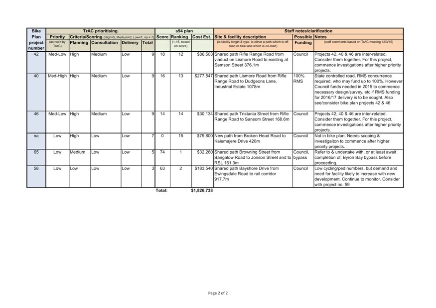
Confidential Reports - Sustainable Environment and Economy 16.1
Confidential Reports - Sustainable Environment
and Economy
Report No. 16.1 Confidential - Unlawful
development, North Head Road, New Brighton
Directorate: Corporate
and Community Services
Report
Author: Ralph
James, Legal Services Coordinator
Wayne Bertram, Manager
Certification and Assessment
File No: I2014/177
Theme: Ecology
Development and Approvals
Summary:
There are currently five
privately owned land holdings at New Brighton within the Zone No. 7(f1)
(Coastal Land Zone) under the Byron Local Environmental Plan 1988 which
also have unauthorised structures erected. Additionally in all but one
instance, there are also unapproved on-site sewerage management systems
installed on the same holdings. The unauthorised structures appear to be
generally used for residential and/or tourist accommodation which are
prohibited developments within the Zone No. 7(f1) (Coastal Land Zone) of the Byron
Local Environmental Plan 1988.
Council has a history of
refusing development applications and attempting enforcement action regarding
the subject holdings. In the context of this history,
further recent unauthorised development by a number of property owners has
necessitated this issue coming before Council for resolution.
RECOMMENDATION:
1. That
pursuant to Section 10A(2)(b) and (g) of the Local Government Act, 1993,
Council resolve into Confidential Session to discuss the report Unlawful
Development, North Head Road, New Brighton.
2. That
the reasons for closing the meeting to the public to consider this item be that
the report contains:
a) discussion
in relation to the personal hardship of a resident or ratepayer
b) advice
concerning litigation, or advice as comprises a discussion of this matter, that
would otherwise be privileged from production in legal proceedings on the
ground of legal professional privilege
3. That
on balance it is considered that receipt and discussion of the matter in open
Council would be contrary to the public interest, as:
disclosure of the confidential
information could disclose matters and information going to the personal
hardship of a resident and/or ratepayers and would disclose advice sought and
given which would otherwise be privileged from production in legal proceedings
on the ground of legal professional privilege.
4. That in accordance with
Sections 10A(4) of the Local Government Act 1993, that the Chairperson
allow members of the public to make representations as to whether this part of
the meeting should be closed.
Attachments:
1 Confidential
- Letter from Don Page, MP - Representations on behalf of North Head Road New
Brighton residents seeking clarification of zoning & dwellings, E2013/8003
2 Confidential
- Letter to Don Page from GM re New Brighton properties, s2013/3808
3 Confidential
- Letter from McCartney Young Lawyers - Advice relating to Possible
Unauthorised Development - North Head Road, New Brighton, S2013/3808
[BSC2] MUST CONFIRM WITH WATER &
WASTE SERVICES