BYRON SHIRE COUNCIL
13.10 - Attachment 1
DEVELOPMENT APPLICATION EVALUATION REPORT
Doc No. #A2014/19344
|
DA No: |
10.2014.417.1 |
|
Proposal: |
Demolition of existing residential flat building & construction of a new residential flat building and associated works |
|
Property description: |
LOT: 0 SP: 16094 43 Lawson Street BYRON BAY |
|
Parcel No/s: |
41930 |
|
Applicant: |
D P Roberts Planning Solutions |
|
Owner: |
The Owners of Strata Plan 16094 |
|
Zoning: |
7(f2) Urban Coastal Land Zone |
|
Date received: |
18 July 2014 |
|
Integrated Development: |
No |
|
Public notification or exhibition: |
- Level 2 advertising under DCP 2010 Chapter 17 – Public Notification and Exhibition of Development Applications - Exhibition period: 29/7/14 to 11/8/14 - Submissions: For 0 Against 2 |
|
Other approvals (S68/138): |
Not applicable |
|
Planning Review Committee: |
N/A |
|
Delegation to determination: |
Council |
|
Recommendation: |
It is recommended that pursuant to Section 80 of the Environmental Planning & Assessment Act 1979, Development Application No. 10.2012.474.1 for demolition of existing residential flat building and construction of new residential flat building and associated works, be refused for the following reasons: 1. Pursuant to Section 79C(1)(a)(i) of the Environmental Planning & Assessment Act 1979, the proposal fails to meet the development standard for maximum height of buildings as set out within Clause 40 of Byron Local Environmental Plan 1988. An objection under State Environmental Planning Policy No. 1 to vary this development standard is not supported. 2. Pursuant to Section 79C(1)(a)(iii) of the Environmental Planning & Assessment Act 1979, the proposal breaches a number of requirements within Development Control Plan 2010 including the maximum building height plane, maximum density provisions, minimum landscaping requirements, provision of clothes drying areas, maximum cut and fill and maximum fence heights. 3. Pursuant to Section 79C(1)(b) of the Environmental Planning & Assessment Act 1979, the proposal is likely to have a significant impact on the surrounding built environment and the occupants of that environment. 4. Pursuant to Section 79C(1)(a)(i) of the Environmental Planning & Assessment Act 1979, the proposal fails to demonstrate that the development has sufficient design quality having regards to the principles and code requirements of State Environmental Planning Policy No. 65 – Design Quality of Residential Flat Development. 5. Pursuant to Section 79C(1)(a)(ii) of the Environmental Planning & Assessment Act 1979, the proposal is inconsistent with the future planning direction for the site as set out within Clauses 4.1E, 4.3 and 4.4 Byron Local Environmental Plan 2014, which is an instrument that has been the subject of public consultation under the Environmental Planning and Assessment Act 1979. 6. Pursuant to Section 79C(1)(e) of the Environmental Planning & Assessment Act 1979, the it is not in the public interest to support the proposal as it breaches a number of development control requirements and has an adverse impact on the surrounding built environment. 7. Pursuant to Section 79C(1)(c) of the Environmental Planning & Assessment Act 1979, the site is assessed as being unsuitable for the development proposed. 8. Pursuant to Section 79C(1)(d) of the Environmental Planning & Assessment Act 1979, consideration of public submissions received with respect of the proposal raise valid planning reasons to refuse the Development Application. 9. Pursuant to Section 79C(1)(a)(i) of the Environmental Planning & Assessment Act 1979, the proposal fails to demonstrate that the site is suitable for use having regards to the assessment requirements of State Environmental Planning Policy No. 55 – Remediation of Land. |
1. INTRODUCTION
1.1 History/Background
The subject allotment contains a three storey building that contains 6 x 2 bedroom units that were approved under Building Application No. 1980/10. The existing building is somewhat unique in the locality, constructed of face brick walls, aluminium framed windows and concrete tile roofing. The building includes an attached single storey garage fronting Lawson Street with provision for 6 vehicles.
The Development Application was lodged with Council on 18 July 2014 which was three days before the commencement of Byron Local Environmental Plan 2014. Accordingly, the proposal is required to be assessed in consideration of Byron Local Environmental Plan 1988 and Byron Development Control Plan 2010. It is noted that the Environmental Planning and Assessment Act 1979 requires Council to consider Byron Local Environmental Plan 2014 as a draft instrument only.
1.2 Description of the site
The site of the proposed development is described as Lots 1-6 in Strata Plan 16094 and is located at No. 43 Lawson Street, Byron Bay. The allotment is located on the northern side of Lawson Street and takes access from this through road.
The allotment has a rectangular configuration with a street frontage and rear boundary dimensions of 21.3 metres, and side boundary dimensions of 33.38 metres, providing an area of 711 square metres. The site is generally level throughout but falls very slightly from the centre of the allotment to the north, south and west. Large residential allotments adjoin to the east and west, with an apartment building occupying the adjacent lot to the west. An apartment building occupying the allotment to the east was recently demolished to make way for a new development. A public reserve adjoins the site to the north which extends into the Byron Bay foreshore.
Vegetation on the site is limited to grasses and isolated landscaping trees and palms.
1.3 Description of the proposed development
Development consent is sought to demolish the existing development on the site and construct a new residential flat building made up of a basement level and three levels above ground.
The design includes three separate units on both the ground level and first level, and a single unit on the second level. Terrace and balcony areas are proposed on the northern side of the building providing solar access for each individual unit. Four swimming pools are proposed at ground level and a lap pool and spa are proposed on the second floor.
The proposed building includes a mix of materials and incorporates balcony areas on the northern and southern elevations. The majority of bedrooms within the development are located along the eastern and western elevations with screened windows facing neighbouring properties. A total of 16 car parking spaces are proposed within the basement car park. Internal staircases and a lift provide access to each floor within the development.
An indicative landscaping plan has been submitted to support the development. The configuration of the proposed units are described below:
|
Unit |
Bedrooms |
Parking |
Gross Floor Area |
Private open space provision |
|
1 |
2 |
2 spaces |
94.0m2 |
22.6m2 courtyard with plunge pool |
|
2 |
1 |
2 spaces |
54.9m2 |
25.6m2 courtyard with plunge pool |
|
3 |
3 |
2 spaces |
95.3m2 |
22.6m2 courtyard with plunge pool |
|
4 |
3 |
2 spaces |
121.0m2 |
13.6m2 balcony |
|
5 |
1 |
2 spaces |
54.9m2 |
17.1m2 balcony |
|
6 |
3 |
2 spaces |
141.4m2 |
13.6m2 balcony |
|
7 |
4 |
2 spaces |
214.5m2 |
166.8m2 balcony with lap pool & spa |
2. SUMMARY OF REFERRALS
|
|
Issue |
|
Development Engineer |
Access, parking, stormwater disposal, coastal erosion and contributions. |
|
Water & Waste Services |
Water supply and Sewer connection Clause 45 of Byron LEP 1988 Developer contributions |
|
Environmental Officer |
SEPP 55, Noise, Land use conflicts, acid sulfate soils |
|
NSW Office of Water |
Dewatering licence |
2.1 Comments from NSW Office of Water
The proposal includes over 3 metres of excavation to create a basement car parking area. Such would likely require a dewatering licence. Correspondence from NSW Office of Water advised as follows:
2.2 Consultation with Applicant
An initial assessment of the proposal identified a number of non-compliances with Council’s development control requirements. These include breaches of the maximum height requirements of Byron Local Environmental Plan 1988 and multiple breaches of Development Control Plan 2010 relating to building setbacks, building height plane, overshadowing, privacy, lack of landscaping, bulk and scale.
Clause 40 of Byron Local Environmental Plan 1988 prescribes maximum height requirements for the subject site. A maximum overall height of 9.0 metres and a maximum uppermost floor level of 4.5 metres apply in this case. The proposal breaches both of these requirements. An objection under State Environmental Planning Policy No. 1 was submitted with the Development Application requesting a variation to the requirements of Clause 40, arguing that compliance with the height controls is unreasonable and unnecessary in the circumstances of the case.
In August 2014, the Applicant was formally requested to provide an amended proposal that addressed the non-compliances raised in the initial assessment. A meeting was held with the Applicant to discuss options to achieve greater compliance with Council’s development controls. These included reducing the height of the proposal, increasing the boundary setbacks and reducing the number of proposed dwelling units. In addition, issues raised within public submissions that were received during the public exhibition of the development application were discussed. These included privacy, density and overshadowing concerns.
The original proposal that was submitted to Council in July 2014 sought approval for 9 dwelling units. Amended plans were submitted by the Applicant in late August 2014 showed a reduction in the number of proposed dwelling units to 7. In addition, the amended plans showed some additional deep soils landscape planting areas. However, the amended proposal made no improvement to the design of the development having regards to height, building setbacks, building height plane, overshadowing, privacy, bulk and scale.
Documentation accompanying the amended plans submitted by the Applicant argued that an existing approval on the adjoining property to the east (45-47 Lawson Street) provides a level of justification for the variations proposed within the amended design. A review of the development approval history of this adjoining site confirms that the approved design relates back to a Development Application for a motel that was granted consent in April 2001, a time when the maximum height controls in Byron Shire were very different to the current controls. Further, the most recently approved plans for this neighbouring property provide a greater level of compliance with building setback and building height plane controls than the proposal for 43 Lawson Street.
The subject site is surrounded by a mixture of development forms and densities. The proposal seeks to create a similar form of development to that approved on the adjoining site to the east, however the subject site is significantly smaller that the neighbouring property with less area available to accommodate a development of its proposed height and density. The small site area (711 square metres) creates a situation where non-compliances with development controls cumulate to a point where the design is not able to be supported on planning grounds.
Further conversations were entered into with the Applicant in November/December 2014 seeking to have outstanding planning issues resolved. However, the Applicant indicated at that time that the final proposal had been submitted to Council for assessment. Accordingly, a draft assessment report for the proposal was completed in February 2014 with a recommendation for refusal. A copy of this draft assessment report was forwarded to the Applicant with an invitation to provide an amended proposal which addressed the issues raised within the report. No response was received from the Applicant.
3. SECTION 79C – MATTERS FOR CONSIDERATION – DISCUSSION OF ISSUES
Having regard for the matters for consideration detailed in Section 79C(1) of the Environmental Planning & Assessment Act 1979, the following is a summary of the evaluation of the issues.
3.1. STATE/REGIONAL PLANNING POLICIES AND INSTRUMENTS
|
Requirement |
Requirement |
Proposed |
Complies |
|
State Environmental Planning Policy No. 1 – Development Standards |
Refer to issues section below. |
Refer to issues section below. |
Refer to issues section below. |
|
State Environmental Planning Policy No. 71 - Coastal Protection |
Matters for consideration for development within the coastal zone: - retention of existing public access to the coastal foreshore - impact of effluent disposal on water quality - development must not discharge untreated stormwater into a coastal water body |
- No public access to the coastal foreshore will be impeded or diminished as part of the proposal - No effluent is proposed to be disposed other than to Council’s sewerage system. - Stormwater is to be discharged to the street. |
Yes
Yes
Yes |
|
State Environmental Planning Policy No. 55 – Remediation of Land |
Council must: (a) considered whether the land is contaminated, and (b) if the land is contaminated, if the land is suitable in its contaminated state or after remediation, and a) be satisfied the land will be remediated before the land is used. |
As the proposal is likely to significantly remove most of the surface soil layer over the property, the risk from past land use contamination may have been considered to be low. Concerns might be raised in relation to potential hazards from radioactive sands. Councils’ mapping does not have any information to indicate the hazard rating for this land. SEPP 55 should have been addressed by the applicant. Insufficient information provided to make a determination. |
No |
|
NSW Coastal Policy 1997 |
Development within the Coastal Zone must be consistent with the Aims, Objectives and Strategic Actions of the Coastal Policy. |
The proposal does not compromise the provisions of the Coastal Policy. |
Yes |
|
Building Code of Australia |
The proposal must be capable of compliance with the structural and safety requirements of the Building Code of Australia. |
A condition can be included if consent is granted to ensure the BCA requirements are met. |
Yes |
|
Demolition |
Demolition is to be carried out in accordance with the requirements of Workcover and AS2601 – Demolition of Structures. |
A condition can be included if consent is granted to ensure the Workcover and AS2601 requirements are met. |
Yes |
Disability Access (DDA) |
Access for persons with disabilities and integration into surrounding streetscapes without creating barriers. (Council Res.10-1118) |
Although DDA requirements are not triggered for the proposed residential flat building, the design includes a lift to provide access from the basement to each level of the development. |
N/A |
* Issues discussed below
State/Regional Planning Policies and instruments - Issues
State Environmental Policy No. 1 – Development Standards
The proposed development includes the demolition of an existing three storey building and replacement with a new building with a basement car parking area and three levels above ground. The new building exceeds the two prescriptive requirements of Clause 40 of Byron Local Environmental Plan 1988:
b) the uppermost floor level of the proposed building is 5.8 metres above the existing ground level. This is 1.3 metres over the maximum 4.5 metre requirement of Clause 40.
c) the overall height of the proposed building is 10.2 metres above ground level at the highest point of the building. This is 1.2 metres over the maximum 9.0 metre requirement of Clause 40.
The Applicant has submitted an objection under State Environmental Planning Policy No. 1 arguing that compliance with the requirements of Clause 40 is unreasonable and unnecessary in the circumstances of the case. Comments in relation to this objection are provided under the relevant assessment headings below.
· Is compliance with the standard consistent with the aims of SEPP 1 and does compliance with the standard hinder the objects of the EP&A Act 1979 under Section 5(a)(i) and 5(a)(ii).
These objects of the Act are to encourage:
(i) the proper management, development and conservation of natural and artificial resources, including agricultural land, natural areas, forests, minerals, water, cities, towns and villages for the purpose of promoting the social and economic welfare of the community and a better environment,
(ii) the promotion and co-ordination of the orderly and economic use and development of land,
Byron Local Environmental Plan 1988 sets out development standards to co-ordinate the orderly and economic development of land. The fact that the proposal deviates from the requirements of this plan is contrary to this object. Although the aims of SEPP 1 are to provide flexibility in applying development standards, it is not satisfied in this case that the variation proposed is well founded.
· Is compliance with the standard unreasonable or unnecessary in the circumstances of the case and is the development standard unreasonable or unnecessary.
The applicant provides the following comments in this regard:
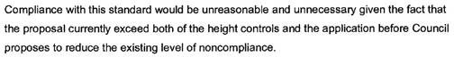
A review of the approved plans for the existing development on the site shows that the building to be demolished has a height of 8.8 metres which is consistent with the 9.0 metre maximum. As stated, this building is to be demolished and a completely new building erected in its place. With a vacant site to work from, it is not possible to form an argument that it is unreasonable and unnecessary to design a building that meets the overall 9.0 metre height requirement. This aspect of the SEPP No. 1 Objection is not supported.
Documentation accompanying the amended plans submitted by the Applicant argued that an existing approval on the adjoining property to the east (45-47 Lawson Street) provides a level of justification for the variations proposed within the amended design. Council’s Development Application file for this site shows that in April 2001, consent was granted to Development Application No. 10.2000.460.1 for a new motel development at 45-47 Lawson Street. The approved motel met Council’s height requirements at the time, which prescribed a maximum 7.5 metres when measured from ground level to the top plate of the building. The approved development contained three storeys and an overall height of 10.83m above ground level.
Council’s records indicate that Development Consent No. 10.2000.460.1 was lawfully commenced, but in December 2012 the owners of 45-47 Lawson Street submitted an amended design as part of a new Development Application for the site (Development Application No. 10.2012.407.1). This amended proposal included an objection under State Environmental Planning Policy No. 1 to the overall height of the development, with an overall height of 10.2 metres proposed. This proposal was supported by on the basis that the 2001 approval for Development Application No. 10.2000.460.1 allowed a greater height.
It is agreed that the 4.5 metre uppermost floor level requirement of Clause 40 can be varied using SEPP No. 1 on the basis that Byron Local Environmental Plan 2014 no longer includes an uppermost floor level development standard. It would be unreasonable and unnecessary to enforce this aspect of Clause 40 when the new Local Environmental Plan does not require it.
It is noted that in 2014, Council determined not to support a variation to the maximum 9.0 metre height requirement for a development proposal within Station Street, Bangalow. A subsequent appeal to the NSW Land and Environment Court was successfully defended on this determination.
State Environmental Planning Policy No. 65 – Design Quality of Residential Flat Development
|
Requirement |
Proposed |
Complies |
|
(a) an explanation of the design in terms of the design quality principles set out in Part 2 of State Environmental Planning Policy No 65—Design Quality of Residential Flat Development,
|
Refer to issues section below. |
Refer to issues section below. |
|
(b) drawings of the proposed development in the context of surrounding development, including the streetscape,
|
Drawings were submitted with the Development Application partly showing the streetscape. |
Yes |
|
(c) development compliance with building heights, building height planes, setbacks and building envelope controls (if applicable) marked on plans, sections and elevations,
|
The drawings submitted do not accurately detail the maximum 9.0 metre overall height and maximum 4.5 metre uppermost floor level requirements. |
No |
|
(d) drawings of the proposed landscape area, including species selected and materials to be used, presented in the context of the proposed building or buildings, and the surrounding development and its context,
|
The landscaping plans submitted are indicative only. |
No |
|
(e) if the proposed development is within an area in which the built form is changing, statements of the existing and likely future contexts,
|
Comments have been provided in this regard, particularly addressing the new construction on the adjoining allotment to the east. |
Yes |
|
(f) photomontages of the proposed development in the context of surrounding development,
|
Photomontages were proposed as part of the Development Application. |
No |
|
(g) a sample board of the proposed materials and colours of the facade,
|
Sample board of the proposed materials and colours was not provided with the development application. |
No |
|
(h) detailed sections of proposed facades,
|
Sections were submitted as part of the plan set. |
Yes |
|
(i) if appropriate, a model that includes the context.
|
A model was not warranted in this case. |
Yes |
Design Quality Principles
|
In determining a development application for consent to carry out residential flat development, a consent authority is to take into consideration the design quality of the residential flat development when evaluated in accordance with the design quality principle. |
Comment |
|
Principle 1: Context Good design responds and contributes to its context. Context can be defined as the key natural and built features of an area. Responding to context involves identifying the desirable elements of a location’s current character or, in the case of precincts undergoing a transition, the desired future character as stated in planning and design policies. New buildings will thereby contribute to the quality and identity of the area. |
Although limited details of materials and colours were provided, the proposal appears to use elements similar to those used on the approved development on the adjoining site to the east (which is under construction). |
|
Principle 2: Scale Good design provides an appropriate scale in terms of the bulk and height that suits the scale of the street and the surrounding buildings. Establishing an appropriate scale requires a considered response to the scale of existing development. In precincts undergoing a transition, proposed bulk and height needs to achieve the scale identified for the desired future character of the area. |
The proposal exceeds the maximum height requirements of both Byron LEP 1988 and Byron LEP 2014. Further, the proposal exceeds the building height plane requirements of DCP 2010 and DCP 2014. As these document prescribe the desired future character of the area, the bulk and scale of the proposed development is not appropriate. |
|
Principle 3: Built form Good design achieves an appropriate built form for a site and the building’s purpose, in terms of building alignments, proportions, building type and the manipulation of building elements. Appropriate built form defines the public domain, contributes to the character of streetscapes and parks, including their views and vistas, and provides internal amenity and outlook. |
As above. |
|
Principle 4: Density Good design has a density appropriate for a site and its context, in terms of floor space yields (or number of units or residents). Appropriate densities are sustainable and consistent with the existing density in an area or, in precincts undergoing a transition, are consistent with the stated desired future density. Sustainable densities respond to the regional context, availability of infrastructure, public transport, community facilities and environmental quality. |
As above. |
|
Principle 5: Resource, energy and water efficiency Good design makes efficient use of natural resources, energy and water throughout its full life cycle, including construction. Sustainability is integral to the design process. Aspects include demolition of existing structures, recycling of materials, selection of appropriate and sustainable materials, adaptability and reuse of buildings, layouts and built form, passive solar design principles, efficient appliances and mechanical services, soil zones for vegetation and reuse of water. |
The original Development Application included a BASIX Certificate (for 9 units). An amended Certificate was not submitted for the revised proposal (for 7 units). |
|
Principle 6: Landscape Good design recognises that together landscape and buildings operate as an integrated and sustainable system, resulting in greater aesthetic quality and amenity for both occupants and the adjoining public domain. Landscape design builds on the existing site’s natural and cultural features in responsible and creative ways. It enhances the development’s natural environmental performance by co-ordinating water and soil management, solar access, micro-climate, tree canopy and habitat values. It contributes to the positive image and contextual fit of development through respect for streetscape and neighbourhood character, or desired future character. Landscape design should optimise useability, privacy and social opportunity, equitable access and respect for neighbours’ amenity, and provide for practical establishment and long term management. |
The proposal includes an indicative landscaping plan that is well short of Council’s required landscaping for the site. |
|
Principle 7: Amenity Good design provides amenity through the physical, spatial and environmental quality of a development. Optimising amenity requires appropriate room dimensions and shapes, access to sunlight, natural ventilation, visual and acoustic privacy, storage, indoor and outdoor space, efficient layouts and service areas, outlook and ease of access for all age groups and degrees of mobility. |
The proposal includes lift access and a variety of unit layouts. Private open space and balcony areas have also been incorporated into the design. |
|
Principle 8: Safety and security Good design optimises safety and security, both internal to the development and for the public domain. This is achieved by maximising overlooking of public and communal spaces while maintaining internal privacy, avoiding dark and non-visible areas, maximising activity on streets, providing clear, safe access points, providing quality public spaces that cater for desired recreational uses, providing lighting appropriate to the location and desired activities, and clear definition between public and private spaces. |
The proposal has well defined public and private spaces. The proposed balconies face north over the public reserve. |
|
Principle 9: Social dimensions and housing affordability Good design responds to the social context and needs of the local community in terms of lifestyles, affordability, and access to social facilities. New developments should optimise the provision of housing to suit the social mix and needs in the neighbourhood or, in the case of precincts undergoing transition, provide for the desired future community. New developments should address housing affordability by optimising the provision of economic housing choices and providing a mix of housing types to cater for different budgets and housing needs. |
The application states that the proposal increases affordable housing options within Byron Bay. This statement is not supported in the context of this proposal. The development is clearly a high-end residential proposal. |
|
Principle 10: Aesthetics Quality aesthetics require the appropriate composition of building elements, textures, materials and colours and reflect the use, internal design and structure of the development. Aesthetics should respond to the environment and context, particularly to desirable elements of the existing streetscape or, in precincts undergoing transition, contribute to the desired future character of the area. |
Although limited details of materials and colours were provided, the proposal appears to use elements similar to those used on the approved development on the adjoining site to the east (which is under construction). |
3.2. BYRON LOCAL ENVIRONMENTAL PLAN 1988
Zone: 7(f2) Urban Coastal Land Zone
Definition: Residential Flat Building
|
LEP Requirement |
Summary of Requirement |
Proposed |
Complies |
|
Clause 9 - Meets objectives of 7(f2) Urban Coastal Land Zone |
(a) to identify urban land likely to be influenced by coastal processes, (b) to permit urban development within the zone subject to the council having due consideration to the intensity of that development and the likelihood of such development being adversely affected by, or adversely affecting, coastal processes, (c) to permit urban development within the zone subject to the council having due consideration to: (i) the need to relocate buildings in the long term, (ii) the need for development consent to be limited to a particular period, (iii) the form, bulk, intensity and nature of the development, and (iv) continued safe public access to the site, and (d) to allow detailed provisions to be made, by means of a development control plan, to set aside specific areas within the zone for different land uses and intensities of development. |
The subject site has been identified as being influenced by coastal processes as it is located within Coastal Erosion Precinct No. 2. An assessment of the proposal found that the site is over 90 metres from the February 2010 erosion escarpment. The proposal can be supported having regards to the objectives (a) and (b) of the zone subject to conditions that limit the time period of the consent should a large erosion event or a series of events occur in the future. In relation to Objective (c), the proposal does not raise any public access issues, and time periods could be applied to the consent if approved. However, the form, bulk and intensity of the proposed development has been assessed as excessive for the 711 square metre site. The proposal is inconsistent with a number of planning controls and is not supported in its current form. |
Yes
No |
|
Clause 9 - Permissible use |
Residential flat building means a building which contains 3 or more dwellings. |
A ‘residential flat building’ is a land use that is permissible with consent within the 7(f2) Zone. The proposal includes 7 dwellings within a 711 square metre allotment. The proposed density is discussed within the section of this report addressing DCP 2010 below. |
Yes |
|
Clause 40 - Height of buildings
|
Overall height of development must not exceed 9.0m above existing ground level and the maximum height of the upper floor must not exceed 4.5m above existing ground level. |
Height 10.2 metres Upper Floor Level 5.8 metres |
No* |
|
Clause 45 - Provision of Services |
Prior adequate arrangements must be made for the provision of services to the allotment. |
The allotment has access to Council’s water and sewer services. Stormwater disposal is proposed to existing infrastructure. |
Yes |
|
Clause 52 – Tree Preservation |
In conjunction with Cluse 2, minimise the removal of vegetation. |
The proposal includes the removal of all vegetation from the site to accommodate the proposed development. No issues are raised with the proposed removal as it relates to common landscape species only. |
Yes |
*Issues discussed below
BYRON LOCAL ENVIRONMENTAL PLAN 1988 - Issues
Clause 40 – Height of Buildings
The proposed residential flat building exceeds the two prescriptive requirements of Clause 40, that is the 4.5 metre upper most floor level and the 9.0 metre overall height requirement. The uppermost floor of the proposed development has a height of 5.8 metres above the existing ground level. The overall height is 10.2 metres above ground level at the highest point of the building.
The Development Application includes an objection under State Environmental Planning Policy No. 1 to the development standards set out within Clause 40. This is discussed under Section 3.1 of this report above.
Draft EPI that is or has been placed on public exhibition and details of which have been notified to the consent authority - Issues
Draft Byron Local Environmental Plan 2012 commenced public exhibition on 24 September 2012 and subsequently became effective on 21 July 2014.
Land use zone (Cl. 2.3) – Byron Local Environmental Plan 2014 lists the subject property within the R3 Medium Density Residential Zone, a zone in which multi dwelling housing and residential flat buildings remain a permissible form of development.
Minimum lot size for residential flat buildings (Cl. 4.1E) – this Clause of Byron Local Environmental Plan 2014 requires a minimum allotment size of 800 square metres for residential flat buildings within the R3 Medium Density Residential Zone. The subject site has an area of only 711 square metres. The proposal is inconsistent with the provisions of Clause 4.1E, but benefits from an existing residential flat building on the property.
Maximum floor space ratio (Cl. 4.4) – the maximum floor space ratio map within Byron Local Environmental Plan 2014 provides a 0.8:1 maximum for the subject site. With a site area of 711 square metres and a gross floor area of 776 square metres, the proposal has a floor space ratio of 1.09:1 (which is 207.2 square metres greater than that permitted under Byron Local Environmental Plan 2014, this is almost equivalent to the total floor area of Proposed Unit 7 as shown in the DCP table below). The proposed floor area is excessive for the site having regards to the 2014 Local Environmental Plan.
Maximum height of buildings (Cl. 4.3) – the maximum height of buildings map within Byron Local Environmental Plan 2014 provides a 9.0 metre limit within the subject site which is consistent with Byron Local Environmental Plan 1988. The applicant seeks to vary this requirement using a SEPP No. 1 objection. As discussed earlier in this report, the objection is not supported. The fact that the 2014 Local Environmental Plan reinforces the 9.0 metre maximum height requirement provides further justification not to support a variation.
3.3 DEVELOPMENT CONTROL PLANS
Development Control Plan 2010
|
Development Control Requirement |
Proposed |
Required |
Compliance |
|||||||||
|
Site Area (Sec. C3.5 DCP 2010) |
710.994 m2 |
1900m2 |
No |
|||||||||
|
Frontage (Sec. C3.5 DCP 2010) |
21.3 m |
20m |
Yes |
|||||||||
|
Height (Cl. 40 BLEP 1988) |
Overall height |
10.2 m |
9m |
No |
||||||||
|
Uppermost floor |
5.3 m |
4.5m |
No |
|||||||||
|
Maximum cut / fill (Sec. C2.7 DCP 2010) |
1.4 m fill |
1.0 m (max) |
No |
|||||||||
|
3.6m cut |
1.0 m |
No |
||||||||||
|
Gross Floor Area |
Unit 1 |
94.0m2 |
- |
N/A |
||||||||
|
Unit 2 |
54.9m2 |
- |
N/A |
|||||||||
|
Unit 3 |
95.3m2 |
- |
N/A |
|||||||||
|
Unit 4 |
121.0m2 |
- |
N/A |
|||||||||
|
Unit 5 |
54.9m2 |
- |
N/A |
|||||||||
|
Unit 6 |
141.4m2 |
- |
N/A |
|||||||||
|
Unit 7 |
214.5m2 |
- |
N/A |
|||||||||
|
Total |
776 m2 |
- |
N/A |
|||||||||
|
Density Control (Sec. C7.1 (DCP 2010) |
||||||||||||
|
Unit Size
|
Small (<55m2 floor plan area) |
2 units |
200m2 / unit |
- |
||||||||
|
Medium (55-85m2 floor plan area) |
0 units |
250m2 / unit |
- |
|||||||||
|
Large (>85m2 floor plan area) |
5 units |
300m2 / unit |
- |
|||||||||
|
Total |
7 units on 711m2 |
Required Site Area: 1900m2 |
No |
|||||||||
|
Setbacks (Sec. 2.6 DCP 2002 & Sec 2.13 DCP 14) |
Front (building) |
6.5m |
6.5m |
Yes |
||||||||
|
Front (pool) |
1.2m |
6.5m |
No |
|||||||||
|
Rear (building) |
>5.0m |
0.9m |
Yes |
|||||||||
|
Rear (pool) |
0.0m |
0.0m |
Yes |
|||||||||
|
Side (east) |
1.5m |
0.9m |
Yes |
|||||||||
|
Side (west) |
1.5m |
0.9m |
Yes |
|||||||||
|
Building Height Plane (Sec. 2.5 DCP 2010) |
Front |
Above BHP |
Below BHP |
No* |
||||||||
|
Rear |
Above BHP |
Below BHP |
No* |
|||||||||
|
Side (east) |
Above BHP |
Below BHP |
No* |
|||||||||
|
Side (west) |
Above BHP |
Below BHP |
No* |
|||||||||
|
On Site Car Parking (Table G2.1 DCP 2010) – Residential Flat Building |
||||||||||||
|
Unit Size (One (1) space per unit must be covered) |
< 55m2 floor area @ 1 / unit |
2 spaces |
2 spaces |
Yes |
||||||||
|
55-85m2 floor area @ 1.5 / unit |
0 spaces |
0 spaces |
N/A |
|||||||||
|
> 85m2 floor area @ 2 / unit |
10 spaces |
10 spaces |
Yes |
|||||||||
|
Visitor Parking @ 1 / 4 units |
4 spaces |
2 spaces |
Yes |
|||||||||
|
Common Landscaped Area (Sec. C7.5 DCP 2010) |
||||||||||||
|
Treatment |
Minimum 75% absorbent finish |
|
|
No |
||||||||
|
Unit Size |
<55m2 floor plan area |
2 units |
50m2 per unit |
No |
||||||||
|
55-85m2 floor plan area |
0 units |
70m2 per unit |
N/A |
|||||||||
|
>85m2 floor plan area |
5 units |
90m2 per unit |
No |
|||||||||
|
Private Open Space – Courtyards (Sec. C7.2 DCP 2010) |
||||||||||||
|
Minimum Area at Natural Ground Level |
Unit 1 |
>30m2 |
30m2 |
Yes |
||||||||
|
Unit 2 |
>30m2 |
30m2 |
Yes |
|||||||||
|
Unit 3 |
>30m2 |
30m2 |
Yes |
|||||||||
|
Unit 4 |
~ |
Balcony |
See below |
|||||||||
|
Unit 5 |
~ |
Balcony |
See below |
|||||||||
|
|
Unit 6 |
~ |
Balcony |
See below |
||||||||
|
|
Unit 7 |
~ |
Balcony |
See below |
||||||||
|
Minimum Dimensions |
Unit 1 |
4m x 4m |
4m x 4m |
Yes |
||||||||
|
Unit 2 |
4m x 4m |
4m x 4m |
Yes |
|||||||||
|
Unit 3 |
4m x 4m |
4m x 4m |
Yes |
|||||||||
|
Unit 4 |
~ |
~ |
N/A |
|||||||||
|
Unit 5 |
~ |
~ |
N/A |
|||||||||
|
|
Unit 6 |
~ |
~ |
N/A |
||||||||
|
|
Unit 7 |
~ |
~ |
N/A |
||||||||
|
Private Open Space – Balconies (Sec. C7.3 DCP 2010) |
||||||||||||
|
Private Open Space Balconies |
Unit 1 |
|
0m2 |
Yes |
||||||||
|
Unit 2 |
|
0m2 |
Yes |
|||||||||
|
Unit 3 |
|
0m2 |
Yes |
|||||||||
|
Unit 4 |
13.6m2 |
15m2 |
No |
|||||||||
|
Unit 5 |
17.1m2 |
15m2 |
Yes |
|||||||||
|
Unit 6 |
13.6m2 |
15m2 |
No |
|||||||||
|
Unit 7 |
166.8m2 |
15m2 |
Yes |
|||||||||
|
Sound Proofing (Sec. C7.6 DCP 2010) |
||||||||||||
|
Noise Sources Sited Away from Adjoining Properties |
Yes |
|||||||||||
|
Sound Resisting Division Walls and Floors |
Yes |
|||||||||||
|
Clothes Drying Facilities – Suitably Screened (Sec. C7.7 DCP 2010) |
||||||||||||
|
Rate |
7.5m line per dwelling |
No |
||||||||||
|
Area |
Minimum 6m2 (or sufficient area to accommodate) |
No |
||||||||||
|
Garbage (Sec. C7.8 DCP 2010) |
||||||||||||
|
Bins |
Min. 1 x 240L per unit |
Yes (basement) |
||||||||||
|
Equity of Access & Mobility (Sec. C7.9 DCP 2010) |
||||||||||||
|
1 adaptable dwelling per 10 dwellings in accordance with AS4299 |
N/A |
|||||||||||
|
Continuous Path of Travel in accordance with AS1428.2 |
N/A |
|||||||||||
|
1 parking space in accordance with AS2890 Part 1 per adaptable dwelling |
N/A |
|||||||||||
|
1 visitor parking space in accordance with AS2890 Part 1 per 100 spaces |
N/A |
|||||||||||
|
Pipes and Vents (Sec. C7.10 DCP 2010) |
||||||||||||
|
Concealed Within Walls |
Yes |
|||||||||||
|
Access Provided |
Yes |
|||||||||||
|
TV Antennas (Sec. C7.11 DCP 2010) |
||||||||||||
|
Common Antenna or Dish System |
N/A |
|||||||||||
|
Fence Heights (Sec. C3.6 DCP 2010) |
||||||||||||
|
Front Fence |
2.6m |
1.2m |
No |
|||||||||
|
Side Fence (within front building setback line) |
2.6m |
1.2m |
No |
|||||||||
|
Side Fence (behind building setback) |
2.1m |
1.8m |
No |
|||||||||
|
Rear Fence |
1.8m |
1.8m |
Yes |
|||||||||
*Non-complying issues discussed below
Development Control Plan 2010 - Issues
Chapter 1 Part C - Residential Development
Part C2.5 - Building Height Plane
The proposed building encroaches on the building height plane on all four property boundaries. The Applicant has sought a variation to the DCP requirement for these encroachments.
Southern and Northern Boundaries
An inspection of the site confirmed that the adjoining land to the south comprises a public road reserve (Lawson Street) and that the land to the north is a public reserve. The image below demonstrates that the building height plane encroachments on these boundaries are minor. The impacts on the adjoining lands to the north and south is likely to be minimal. A variation to the building height plane requirements on these boundaries could be supported if the application is approved.
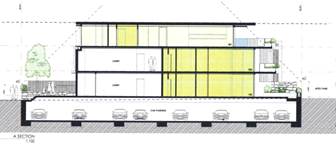
Figure 1 – Proposed development showing building height plane encroachments on northern and southern boundaries
Eastern and Western Boundaries
The proposed development includes significant breaches on the building height plane on the eastern and western boundaries of the allotment. Figure 1 below shows the extent of the proposed encroachments in red. Figure 2 shows the existing building that is to be demolished, also showing building height plane encroachments.
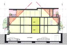
Figure 2 – Proposed development showing building height plane encroachments one eastern and western boundaries
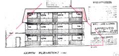
Figure 3 – Existing development showing building height plane encroachments on eastern and western boundaries
It is clear from the figures above that the proposed development will result in a substantial increase in building height plane encroachments. The proposed building is setback 1.5 metres to both the eastern and western boundaries of the allotment, which is significantly less than the minimum 4.3 metre side boundary setbacks of the existing building. It is noted also that the proposed building extends for over 24 metres along the 33 metre length of the property. The building located on the adjoining allotment to the west has a setback of approximately 3.5 metres from the common boundary to the site. A recent approval for a development on the adjoining allotment to the east allowed a building setback of 1.65 metres.
The objectives of Part C2.5 of DCP 2010 relate to the protection of privacy, solar access and the views of adjacent properties. In the case of the proposed development, additional privacy and overshadowing impacts will arise as a result of the building height plane encroachments. It is noted that the design includes extensive covered deck areas on the uppermost floor with a balustrade height of 1 metre allowing overlooking into the adjoining properties. In particular, the design allows overlooking into the private open space of units on the adjacent property to the west. Further, the proposal will overshadow these private open space areas in morning periods. A public submission was received in relation to the Development Application raising the issues of privacy and overshadowing as reasons for objecting to the proposal.
In correspondence dated 26 August 2014, the applicant was requested to provide an amended building design to reduce the extent of building height plane encroachments and achieve greater compliance with the objectives of the development control. However, the applicant elected not to make any modification to the overall bulk and scale of the development, providing Council with the following response:
A review of the plans that were approved on the adjoining allotment to the east (45 Lawson Street) indicates that a three storey building with a setback of 1.65 metres to the common boundary is to be constructed. It is agreed that this adjoining development will result in overshadowing and privacy impacts on the subject development site. However the development proposed as part of the subject Development Application has slightly smaller setbacks (1.5 metres) to the eastern and western boundaries, with significant overshadowing and privacy impacts likely to occur on the adjacent property to the west.
An assessment of the proposal having regards to the objectives of Part C2.5 of Development Control Plan indicates that the current design cannot be supported.
Parts C7.1, C7.2, C7.3 & C7.5 – Density of Development
In August 2014 the Applicant was requested to provide an amended design that scales back the proposal to align with the existing dwelling density, as well as providing landscaping and open space in accordance with the requirements of the development control plan. The applicant responded by consolidating some of the proposed units, thereby reducing the number of units on site from 9 to 7. The Applicant argued the following (in part):
Whilst it is acknowledged that this application seeks a greater variation then the development approval next door, the end result will be a development which is more affordable and will provide a greater variation of housing supply for the surrounding area. Affordability is an issue that Byron Shire Council has been struggling to deal with for an extended period of time, the only way to address this issue in central Byron is to provide smaller more affordable dwellings.
The comments provided by the applicant above hold no weight in this assessment as in no way can it be argued that the amended proposal to provide seven beach side units near the centre of Byron Bay with gross floor areas (excluding balconies) of between 54.9m2 and 214.5m2 fall within the ‘affordable housing’ category. This response does not justify the variation proposed to the maximum density on the site. Note that Clause 17 of Byron Local Environmental Plan 1988 requires a minimum 800 square metre site for two dwellings in a dual occupancy arrangement. The proposal comprises seven dwellings on a 711 square metre site. The fact that an existing approval for six units exists is the only valid argument for a variation to density on the property. However, such should be designed with regards to adequate building height plane, setbacks, landscaping and open space provision.
Part C7.7 – Clothes Drying Facilities
No provision of drying areas (noting laundry facilities are provided, and swimming pools) for occupants. This is unsatisfactory for a development of this nature.
Chapter 1 Part G – Vehicle Circulation and Parking
External Access
The existing driveway is to be removed. A new driveway is proposed adjacent to the site’s “eastern” boundary. The proposed arrangements are satisfactory and the consent can be conditioned accordingly if approval is granted.
Safety sight lines are required to be complied with at the at the front property boundary line, in accordance with the current Australian Standards AS 2890. 1 – 2004. Again, the consent can be conditioned accordingly to require this compliance.
Internal Access
There are limited design details of the access ramp/driveway to the basement car park submitted with the DA. It appears that the access can be designed to complying standards. If approval is granted, the consent can be conditioned accordingly to ensure this requirements is met.
Car Parking
The application proposes 16 car spaces, inclusive of 2 visitor car spaces. This appears to be generally derived from Council’s former DCP 2010.
In accordance with Council’s newly adopted DCP 2014, a total of 14 car spaces are required, inclusive of 3 visitor car spaces.
The parking requirements are based on the following rates:
· 1 space per 1 or 2 bedroom unit.
· 2 spaces per 3 or more bedroom unit.
· 1 visitor space per 4 units.
Design plans are the demonstrate compliance with the current Australian Standards AS 2890.1 – 2004, and DCP 2014, in respect to the following items, but not limited to, as follows:
· Vertical and horizontal dimensions/clearances
· Driveway gradients
· Safety sight lines/triangle at the driveway front boundary interface
· One disabled parking bay and vertical clearances required
Traffic/Roadworks
This redevelopment of the site, retaining residential units, should have no measurable effect on the traffic load or level of service on the surrounding road network.
Part N - Stormwater Management
On site detention stormwater management will be required for the new complex. The exposed driveway ramp will require a stormwater management design inclusive of a pump out system for the basement car park. The design is to also be in accordance with DCP 2014.
Part J - Coastal Erosion
The site is within Precinct 2, and the consent can be conditioned accordingly.
Geotechnical Hazards
No apparent geotechnical constraints
Other Matters
The adjacent Apex Park (Public Reserve) must not be used for site access nor storage of materials. The consent can be conditioned accordingly.
3.4 The likely impacts of that development, including environmental impacts on both the natural and built environments, and social and economic impacts in the locality
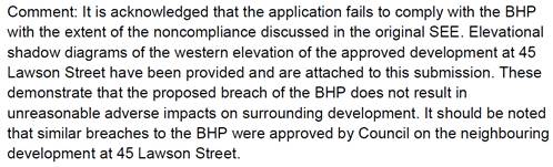
The subject site and immediate surrounds were inspected multiple times during the assessment of the Development Application. These inspections identified private open space and clothes drying areas on the adjoining property to the west of the site (No. 39-41 Lawson Street). A site assessment found that the proposal will impact adversely on these areas. The proposed building is to be constructed with a maximum height of 10.2 metres and with minimum boundary setbacks of 1.5 metres (excluding window screens which extend further into the side setbacks). An assessment indicates that the proposal will overlook and overshadow the private open space areas within the adjacent property, resulting in adverse impacts on the occupants. Preliminary shadow diagrams were submitted by the Applicant as part of amended proposal, however such did not resolve overshadowing impacts on the adjoining property.
Site Waste Management: If approved, a condition could be imposed requiring a site waste minimisation plan to be submitted. In this regard, the proponent must establish an extracted solid waste management plan which identifies the volumes, classification and ultimate destination of all solid waste materials created by the proposed demolition works, and basement excavation.
Garbage: A condition could also be imposed to ensure that adequate provision is made for containment, storage and management of all waste generated by the development. The proposal indicates a ‘garbage room’ in the basement car park. Adequate “garbage” capacity needs to be provided for the proposed units, as well as a location with sufficient ventilation and capacity to clean-up spilt putrescibles wastes and dirty bins.
Bush Fire: Council’s GIS indicates that the subject site is within a buffer area to bush fire hazards. The Development Application did not include any details to address this constraint. If the application was to be granted consent, further assessment would be required with respect to bushfire protection.
3.5 The suitability of the site for the development
The subject site is an existing urban allotment within the 7(f2) Urban Coastal Land Zone under Byron Local Environmental Plan 1988. It has access to water, sewer, drainage, electricity and communication services. The site is largely clear of vegetation other than common landscape species. The land does not contain steep slopes and is not prone to flooding. Access is available from Lawson Street to the south. The site is within a buffer area to bush fire hazards, but threats could be managed by implementing bush fire protection measures into the development.
The site contains a residential flat building comprising 6 units over three stories, with an attached vehicle garage at ground level. The existing development has generous building setbacks and is satisfactorily accommodated within the site in the context of the historic approval that it was constructed under. However, the proposed development introduces a significant increase in bulk and scale to the site. An assessment has found that the property is of insufficient area to accommodate the development as proposed. The proposal breaches building setback and height controls.
Despite a number of positive attributes, the site is not deemed to be suitable for the development proposed. The development will adversely impact on adjoining properties due to its limited dimensions. The proposed 7 unit residential flat building cannot be accommodated within the site without significant breaches of Council’s development control requirements.
3.6 Submissions made in accordance with this Act or the regulations
Two submissions were received in respect of the proposed development. A summary of the issues raised within the submissions with a comment in relation to each is provided below:
|
Issue |
Comment |
|
Excessive Density |
Council’s assessment concludes that the proposed density is excessive for the site. |
|
Excessive height |
The proposed objection under SEPP No. 1 to the height of the development is not supported. |
|
Overshadowing on adjoining development |
An assessment confirmed that significant adverse impacts are likely to result from the proposed development with respect to overshadowing on adjoining properties. The proposal is not supported on these grounds. |
|
Insufficient setbacks |
It is agreed that the proposed 1.5 metre setback for a 3 storey development is insufficient given the overshadowing and loss of privacy impacts that will result. |
|
Insufficient landscape area |
The lack of landscaping and deep soil planting areas on the site is a result of the excess bulk and scale of the proposed development. The proposal is not supported on these grounds. |
|
Boundary to boundary basement car park and lack of deep soil planting areas |
As above. |
|
Privacy impacts |
An assessment of the proposal confirmed that unacceptable privacy impacts will result from the three storey development, particularly on the adjoining allotment to the west. The application is not supported on these grounds. |
|
Number of units exceeds Council’s maximum |
The site has been assessed as being of insufficient area to accommodate 7 units. DCP 2010 provides for a maximum of 3 small units on the site based on 1 unit for every 200m2 (note that a ‘small’ unit is less than 55m2 in area). The site benefits by an existing building containing 6 units. It is reasonable to allow the 6 existing units to be replaced with a new building containing 6 units, subject to bulk and scale provisions being met. This has not occurred in this case and the proposal for 7 new units is not supported. |
3.7 Public interest
The proposal does not meet the maximum 9.0 metre height requirement set out within Byron Local Environmental Plan 1988 and a number of Development Control Plan requirements relating to building design. It is not in the public interest to support the development application given its substantial breaches of development control requirements and objections from the public.
4. DEVELOPER CONTRIBUTIONS
4.1 Water & Sewer Levies
Water & Sewer Levies would be applicable if the Development Application was granted consent.
4.2 Section 94 Contributions
Section 94 contributions would be applicable if the Development Application was granted consent.
4. CONCLUSION
Development consent is sought to demolish the existing residential flat development on the site and construct a new residential flat building made up of a basement level (containing 16 car parking spaces) and three levels above ground.
The design includes three separate dwelling units on both the ground level and first level, and a single dwelling unit on the second level. Terrace and balcony areas are proposed on the northern side of the building providing solar access for each individual unit. Four swimming pools are proposed at ground level and a lap pool and spa are proposed on the second floor. Additional balcony areas are also proposed on the second floor facing east and west.
An assessment of the proposal identified a number of non compliances with Council’s development control requirements. These include breaches of the maximum height requirements of Byron Local Environmental Plan and multiple breaches of Development Control Plan 2010. Despite requests by Council, issues relating to building setbacks, building height plane, overshadowing, privacy, lack of landscaping, bulk and scale were unable to be resolved by the applicant during the assessment of the application.
Two public submissions were received with respect to the proposal raising objections to the development. Such were found to have valid planning reasons for their objections. An assessment of the site found that it is not suitable for the bulk and scale of the development proposed. The proposal is likely to result in significant adverse impacts on the built environment (overshadowing and privacy impacts). It is not in the public interest to support the proposal in this context.
Given that over 7 months have passed since the Development Application was first submitted to Council, and the efforts made to resolve planning issues with the Applicant, it is concluded from an assessment of the proposal that consent should be refused in this instance.
5. RECOMMENDATION
It is recommended that pursuant to Section 80 of the Environmental Planning & Assessment Act 1979, Development Application No. 10.2012.474.1 for demolition of existing residential flat building and construction of new residential flat building and associated works, be refused for the following reasons:
1. Pursuant to Section 79C(1)(a)(i) of the Environmental Planning & Assessment Act 1979, the proposal fails to meet the development standard for maximum height of buildings as set out within Clause 40 of Byron Local Environmental Plan 1988. An objection under State Environmental Planning Policy No. 1 to vary this development standard is not supported.
2. Pursuant to Section 79C(1)(a)(iii) of the Environmental Planning & Assessment Act 1979, the proposal breaches a number of requirements within Development Control Plan 2010 including the maximum building height plane, maximum density provisions, minimum landscaping requirements, provision of clothes drying areas, maximum cut and fill and maximum fence heights.
3. Pursuant to Section 79C(1)(b) of the Environmental Planning & Assessment Act 1979, the proposal is likely to have a significant impact on the surrounding built environment and the occupants of that environment.
4. Pursuant to Section 79C(1)(a)(i) of the Environmental Planning & Assessment Act 1979, the proposal fails to demonstrate that the development has sufficient design quality having regards to the principles and code requirements of State Environmental Planning Policy No. 65 – Design Quality of Residential Flat Development.
5. Pursuant to Section 79C(1)(a)(ii) of the Environmental Planning & Assessment Act 1979, the proposal is inconsistent with the future planning direction for the site as set out within Clauses 4.1E, 4.3 and 4.4 Byron Local Environmental Plan 2014, which is an instrument that has been the subject of public consultation under the Environmental Planning and Assessment Act 1979.
6. Pursuant to Section 79C(1)(e) of the Environmental Planning & Assessment Act 1979, the it is not in the public interest to support the proposal as it breaches a number of development control requirements and has an adverse impact on the surrounding built environment.
7. Pursuant to Section 79C(1)(c) of the Environmental Planning & Assessment Act 1979, the site is assessed as being unsuitable for the development proposed.
8. Pursuant to Section 79C(1)(d) of the Environmental Planning & Assessment Act 1979, consideration of public submissions received with respect of the proposal raise valid planning reasons to refuse the Development Application.
9. Pursuant to Section 79C(1)(a)(i) of the Environmental Planning & Assessment Act 1979, the proposal fails to demonstrate that the site is suitable for use having regards to the assessment requirements of State Environmental Planning Policy No. 55 – Remediation of Land.