Arakwal Memorandum of Understanding Advisory Committee Meeting
An Arakwal Memorandum of Understanding
Advisory Committee Meeting
of Byron Shire Council will be held as
follows:
|
Venue
|
Arakwal Room, Byron Bay Library
|
|
Date
|
Tuesday, 1 March 2016
|
|
Time
|
11.30am
|

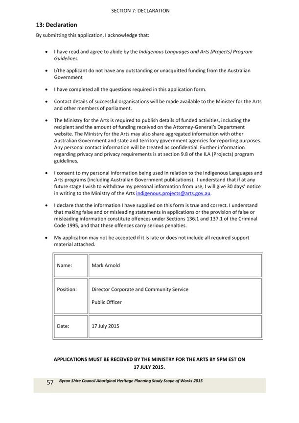
Mark Arnold
Director Corporate and Community Services I2016/147
Distributed 23/02/16
What is a “Conflict of Interests” - A conflict of
interests can be of two types:
Pecuniary - an interest that a person has in a matter because of a reasonable
likelihood or expectation of appreciable financial gain or loss to the person
or another person with whom the person is associated.
Non-pecuniary – a private or personal interest that a Council
official has that does not amount to a pecuniary interest as defined in the
Local Government Act (eg. A friendship, membership of an association, society
or trade union or involvement or interest in an activity and may include an
interest of a financial nature).
Remoteness – a person does not have a pecuniary interest in a matter
if the interest is so remote or insignificant that it could not reasonably be
regarded as likely to influence any decision the person might make in relation
to a matter or if the interest is of a kind specified in Section 448 of the
Local Government Act.
Who has a Pecuniary Interest? - a person has a pecuniary interest in a
matter if the pecuniary interest is the interest of the person, or another
person with whom the person is associated (see below).
Relatives, Partners - a person is taken to have a pecuniary interest in a
matter if:
§ The person’s
spouse or de facto partner or a relative of the person has a pecuniary interest
in the matter, or
§ The person, or a
nominee, partners or employer of the person, is a member of a company or other
body that has a pecuniary interest in the matter.
N.B. “Relative”, in relation to a person means any of the
following:
(a) the
parent, grandparent, brother, sister, uncle, aunt, nephew, niece, lineal
descends or adopted child of the person or of the person’s spouse;
(b) the
spouse or de facto partners of the person or of a person referred to in
paragraph (a)
No Interest in the Matter - however, a person is not taken to have a
pecuniary interest in a matter:
§ If the person is
unaware of the relevant pecuniary interest of the spouse, de facto partner,
relative or company or other body, or
§ Just because the
person is a member of, or is employed by, the Council.
§ Just because the
person is a member of, or a delegate of the Council to, a company or other body
that has a pecuniary interest in the matter provided that the person has no
beneficial interest in any shares of the company or body.
Disclosure and participation in meetings
§ A Councillor or a
member of a Council Committee who has a pecuniary interest in any matter with
which the Council is concerned and who is present at a meeting of the Council
or Committee at which the matter is being considered must disclose the nature
of the interest to the meeting as soon as practicable.
§ The Councillor or
member must not be present at, or in sight of, the meeting of the Council or
Committee:
(a) at any
time during which the matter is being considered or discussed by the Council or
Committee, or
(b) at any
time during which the Council or Committee is voting on any question in
relation to the matter.
No Knowledge - a person does not breach this Clause if the person did
not know and could not reasonably be expected to have known that the matter
under consideration at the meeting was a matter in which he or she had a
pecuniary interest.
Participation in Meetings Despite Pecuniary Interest (S 452 Act)
A Councillor is not prevented from taking part in the consideration or
discussion of, or from voting on, any of the matters/questions detailed in
Section 452 of the Local Government Act.
Non-pecuniary Interests - Must be disclosed in meetings.
There are a broad range of options available for managing conflicts &
the option chosen will depend on an assessment of the circumstances of the
matter, the nature of the interest and the significance of the issue being
dealt with. Non-pecuniary conflicts of interests must be dealt with in at
least one of the following ways:
§ It may be appropriate
that no action be taken where the potential for conflict is minimal.
However, Councillors should consider providing an explanation of why they
consider a conflict does not exist.
§ Limit involvement if
practical (eg. Participate in discussion but not in decision making or vice-versa).
Care needs to be taken when exercising this option.
§ Remove the source of
the conflict (eg. Relinquishing or divesting the personal interest that creates
the conflict)
§ Have no involvement by
absenting yourself from and not taking part in any debate or voting on the
issue as if the provisions in S451 of the Local Government Act apply
(particularly if you have a significant non-pecuniary interest)
RECORDING OF VOTING ON PLANNING MATTERS
Clause 375A of the Local Government Act 1993
– Recording of voting on planning matters
(1) In this section, planning
decision means a decision made in the exercise of a function of a council
under the Environmental Planning and Assessment Act 1979:
(a) including a decision
relating to a development application, an environmental planning instrument, a
development control plan or a development contribution plan under that Act, but
(b) not including the making of
an order under Division 2A of Part 6 of that Act.
(2) The general manager is
required to keep a register containing, for each planning decision made at a
meeting of the council or a council committee, the names of the councillors who
supported the decision and the names of any councillors who opposed (or are
taken to have opposed) the decision.
(3) For the purpose of
maintaining the register, a division is required to be called whenever a motion
for a planning decision is put at a meeting of the council or a council
committee.
(4) Each decision recorded in
the register is to be described in the register or identified in a manner that
enables the description to be obtained from another publicly available
document, and is to include the information required by the regulations.
(5) This section extends to a
meeting that is closed to the public.
Arakwal Memorandum of Understanding Advisory
Committee Meeting
BUSINESS OF MEETING
1. Apologies
2. Declarations of Interest
– Pecuniary and Non-Pecuniary
3. Adoption of Minutes from
Previous Meetings
3.1 Arakwal
Memorandum of Understanding Advisory Committee Meeting held on 25 November
2015
4. Business Arising From
Previous Minutes
5. Staff Reports
Corporate and Community Services
5.1 Arakwal
Identified Area in the Byron Bay Cemetery........................................................ 4
5.2 Ti
Tree Lake PoM Update................................................................................................. 7
5.3 Indigenous
Projects Grant Applications Updates ........................................................... 45
6. OTHER BUSINESS
6.1 DA
for 50 lot subdivision at Brunswick Heads (Chris Larkin)
6.2 DA
for Byron Bypass 10.2016.77.1 (Chris Larkin)
6.3 Whale
Trail (Claire Campbell)
Staff Reports - Corporate and Community Services 5.1
Staff Reports - Corporate and Community
Services
Report No. 5.1 Arakwal
Identified Area in the Byron Bay Cemetery
Directorate: Corporate
and Community Services
Report
Author: Belle Arnold,
Aboriginal Projects Officer
File No: I2016/42
Theme: Society and Culture
Community Development
Summary:
This report
seeks to provide an update into the establishment of an identified area for the
Bundjalung of Byron Bay, Arakwal People in the Byron Bay Cemetery.
|
RECOMMENDATION:
That the Arakwal MoU Advisory Committee note the
progress of the investigations into the establishment of an identified area
for Arakwal People in the Byron Bay Cemetery and the request for the
provision of further details to Council on the matter.
|
Background
At the December 2015 meeting Council resolved that the
Arakwal MoU Committee seek information from Council staff on the processes
required and the scope of works for the Bundjalung of Byron Bay, Arakwal People
to have an identified area in the Byron Bay Cemetery for further consideration
(15-630).
The Arakwal MoU states:
2.
Participation in Governance
Council to
involve representatives of the Bundjalung of Byron Bay Arakwal People in
Council decision making process on matters concerning Arakwal Country, People
and business.
Report
On 1 February 2016 the
Aboriginal Projects Officer met with Manager Open Spaces to discuss making
provisions for the Bundjalung of Byron Bay Arakwal People in the Byron Bay
cemetery.
At this meeting Manager
Open Spaces requested some preliminary information to assist investigations;
1)
Clarification on the
cultural significance of having a designated space at Byron Bay cemetery.
2)
Will the designated area
be for Arakwal people only – Bundjalung people or other Aboriginal
people? Will there be a criteria or process for Arakwal Corporation to be
a part of deciding who can be buried there?
3)
Is this also relevant for
other cemeteries in the Byron Shire. (eg. Could another cemetery provide
space for wider Bundjalung or Aboriginal people? Or would there be Arakwal
people that feel more connected to other areas within your country?)
4) Estimated
need and potential growth rate and identification of need into the future.
Delta Kay from Arakwal woman provided the following
information on the cultural significance of the designated area at the Byron
Bay cemetery for Arakwal people.
“The Byron Bay cemetery is where our grandparents
– Jimmy and Linda Kay are buried.
Burial places hold a special significance for Aboriginal
people. Being laid to rest in your own “belonging place” or
“Country” ensures the deceased person’s spirit is returned
back to their “belonging place”. It is culturally
significant to practice our religious beliefs and customs when an Arakwal
member passes away. Due to dispossession, segregation, assimilation, past
government policies….. We only ask for an area to bury or lay to rest the
cremated remains of our future people on our “belonging place”.
On 2 February, the CEO of the Tweed Byron Local Aboriginal
Land Council, Leweena Williams was contacted by Council staff to discuss
Aboriginal burial in local cemeteries. Chinderah and Fingal both had
Aboriginal cemeteries which have now closed. These places are important
historical and spiritual places for Aboriginal people in the area. Ms
Williams showed support for the Byron Bay cemetery including a place for
Arakwal people to be buried. Ms Williams suggested that a similar area be
designated for Widjabul and Mindjunbal people in the Mullumbimby cemetery.
Financial Implications
Further investigations are required into the ongoing costs
of this project.
Statutory and Policy Compliance Implications
Native Title Act 1993
Local Government Act 1993
Land Rights Act 1984
Arakwal MoU 2013
Staff Reports - Corporate and Community Services 5.2
Report No. 5.2 Ti
Tree Lake PoM Update
Directorate: Corporate
and Community Services
Report
Author: Belle
Arnold, Aboriginal Projects Officer
File No: I2016/44
Theme: Society and Culture
Community Development
Summary:
This report provides an update to the Ti Tree Lake Plan of
Management in development with National Parks and Wildlife Service on the
matters of signage and Taylors Lake Road.
|
RECOMMENDATION:
1. That
the Arakwal Memorandum of Understanding Advisory Committee:
a) Consider
the draft signage attached to this report to be installed on Council land in
the Ti Tree Lake Aboriginal Place area;
b) Nominate
the locations for this signage to be installed in the Ti Tree Lake Aboriginal
Place area.
2. That
the Arakwal Memorandum of Understanding Advisory Committee note the
progress in the matter of Taylors Lake Road restricted access.
|
Attachments:
1 Ti Tree
Lake Plan of Management Initial Progress Report, E2015/50137 , page 9
2 Draft Ti
Tree Lake Signage, E2016/11509 , page 13
3 Draft Ti
Tree Lake Plan of Management, E2015/26736
, page 15
Report
This report provides
further update on the progress of the development of the Ti Tree Lake Plan of Management in partnership with
National parks and Wildlife Services.
On 24 November the
Aboriginal Projects Officer met Diane Mackey (Office of Environment and
Heritage) and Delta Kay (National Parks and Wildlife Service) to discuss
Council’s progress on the draft Ti Tree Lake Plan of Management at the
Arakwal Depot. The Ti Tree Lake Plan of Management Initial Progress
Report (Attachment 1) was discussed.
Following this meeting a
site inspection of the Ti Tree Lake was held to identify additional matters of
stormwater run off and the installation of trash gates, potential locations for
signage and to discuss concerns on future uses of the public road Taylors Lake
Road.
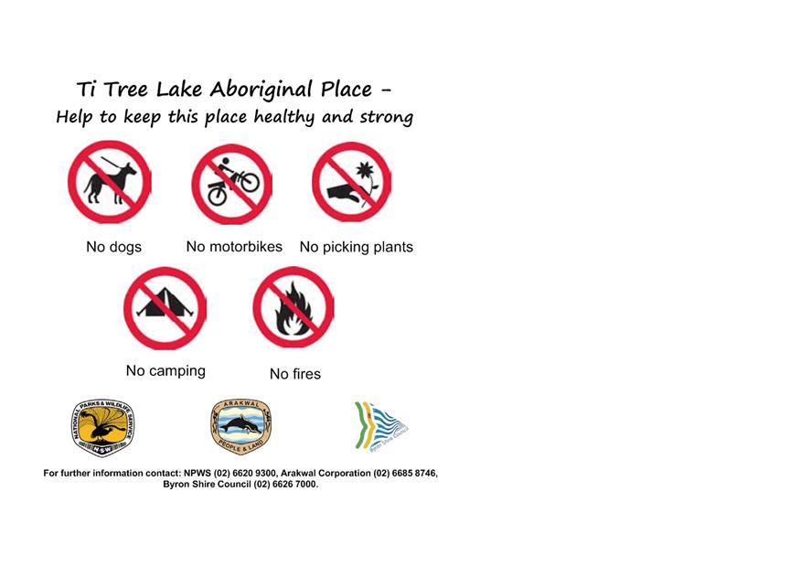
Signage
Signage was identified in the Ti Tree Lake Plan of
Management as a key factor in educating the public on the Aboriginal principles
of the area. Signage has been drafted and provided by National Parks and
Wildlife Services for Council’s consideration (Attachment 2).
Taylors Lake Road
Office of Environment and Heritage and National parks and
Wildlife Service staff expressed concerns over the potential future development
and use of Taylors Lake Road and requested that Council consider avenues for
legally restricting access.
The negotiations in Indigenous Land Use Agreement 3
requested that Council consider closing Taylors Lake Road as a public
road. This matter has been reopened for review and currently
consideration is being made to the creation of an easement so that Council can
access the water infrastructure for maintenance and upgrading. Issues around
stormwater management are also being considered before Council can any
surrender of a part of Taylors Lake Road as a public road.
Financial Implications
Signage costs $5,000 from 2331.053
Road closure costs to be investigated as part of the review
of this matter.
Statutory and Policy Compliance Implications
Native Title Act 1993
Local Government Act 1993
Land Rights Act 1984
Arakwal MoU 2013
National Parks and Wildlife Act 1974
Staff Reports - Corporate and Community Services 5.2 - Attachment 1
Internal Progress to date on the Development
of the Ti Tree Lake Plan of Management
November 2015
E2015/50137
|
Objective
|
Key
Staff
|
Comments
|
Outcomes
|
Discussion
with NPWS 24 Nov 2015
|
|
1. Acceptable activities for licensing for the
Council owned and managed areas
|
Events
Officer
Aboriginal
Projects Officer
Admin
Property/ Licensing
|
Council
staff to refer to the Plan of Management before issuing licensing for the
area.
|
Staff can
not alter current licenses but will implement when issuing new licensing.
Temporary
licenses have integrated the information in the Ti Tree Management Plan
into their licensing approval process
|
Request
specific information on ongoing licenses
How Many
Who
What
activities
How long
for
|
|
2. Trapping pest animals on Council owned areas
|
Team
Leader Natural Environment
|
Under
consideration
|
|
Across
tenure program
If
Council are interested in participating in cross tenure program indicate
commitment.
|
|
3.
Signage on Council road reserves
|
Aboriginal
Projects Officer
|
This
project to be included in the Arakwal MoU Implementation Plan for 2015/16.
|
Funds can
be utilised from 2331.053
Identify
sites
Workshop
designs
|
Map
provided
Joint
Logos on signage
To come
from Aboriginal Projects Budget 2331.053
|
|
4. Restricting access to Taylors lake through the
Council owned Road
|
Manager
Utilities
Senior
Planner, Land Natural Environment
|
Manager
Utilities indicated support for a fence to extend between 20 – 50
metres across Taylors Lake Road to deter access to the Ti Tree Lake and
protect Council’s water and sewer assets from damage from motor bikes.
|
This will
be discussed through a proposal with OEH and NPWS
|
Physical
restricting good.
Investigate
possible legal restricting.
Can an
easement over the road to protect bush trail but legally restrict access to
future users,
No motor
bike infringement signs.
|
|
5.
Information sharing regarding water and sewer infrastructure and maintenance
schedules
|
Manager
Utilities
|
Attached
are the inspection sheets related to Pump Station 3029 which is the pump
station that pumps through the Taylors Lake area. We do not have a specific
inspection sheet for the rising main through this area as there is nothing to
inspect. The only thing more we could do is drive along the road reserve to
make sure no scouring by stormwater runoff has occurred. This however, would
mean an all male crew going through the area with little benefit. The NPWS
staff who normally access the area could advise if scouring by stormwater had
occurred.
|
Maintenance
schedules and maps have been supplied.
|
Resend
Discuss
Trash Racks of storm water drains that run into the Lake.
|
|
6. Ensuring Council’s future plans for the area
adhere to the cultural values of the Aboriginal Place protection principles
|
Aboriginal
Projects Officer
Traffic
and transport Coordinator
Drainage/
Flood Engineer
|
Ongoing
commitment.
|
Confirmation
that Councils Bike Plan does not intend to use Taylors Lake Road as a bike
path between Suffolk Park and Broken Head.
|
|
|
7. Water quality testing
|
Drainage/
Flood Engineer Senior
Planner, Land Natural Environment
Manager
Utilities
|
Council
have currently no funds identified to support a water quality monitoring
program or report on it
Cooperative
partnership approach for culturally appropriate biannual monitoring
|
Work out
agreement
|
|
|
8. Pipeline Inspection
|
Manager
Utilities
|
No female
staff
Cooperative
partnership approach for culturally appropriate monitoring
|
Work out
agreement
|
|
|
9. Road closure / maintenance
|
Manager
Utilities
|
Not
optional to close road as it a fire trail and access to maintain
infrastructure
|
|
|
|
10. Storm Water
|
|
|
|
|
|
11. Rubbish Removal
|
|
|
|
Remove
dumped matter and erect chain fences to prohibit further dumping
|
|
12. Access on Council Land
|
|
|
|
Chain
Fences :
1. From Taylors
Lake Road across track that leads to the lake
2. Glasgow
Street Suffolk Park
3. Southern End
of Taylors Lake Road Broken Head
|
|
13. Ensure any septic systems on adjacent
properties are operating safely and not polluting the AP
|
|
|
|
Refer to
relevant staff
|
|
14. Restricting Access to walking tracks
Glasgow Street Suffolk Park
|
|
Tracks
are allowing access for illegal camping and dumping of household waste.
Council then required to remove household waste. Garden waste also
being dumped and creating weed management issues in National Park and
Aboriginal Place.
|
Council
have installed 1 chain gate in the area. Request that an
additional chain gate be installed in the area.
(refer to
map)
|
Refer to relevant
staff
|
Staff Reports - Corporate and Community Services 5.2 - Attachment 2

Staff Reports - Corporate and Community Services 5.2 - Attachment 3
TI TREE (TAYLOR’S) LAKE
ABORIGINAL PLACE
PRELIMINARY DRAFT MANAGEMENT
PLAN
NSW
National Parks and Wildlife Service
Office of Environment & Heritage
April 2015
Staff Reports - Corporate and Community Services 5.2 - Attachment 3
© 2015 State of NSW and the Office of Environment and Heritage
With the exception of
photographs, the State of NSW and the Office of Environment and Heritage are
pleased to allow this material to be reproduced in whole or in part for
educational and non-commercial use, provided the meaning is unchanged and its
source, publisher and authorship are acknowledged. Specific permission is
required for the reproduction of photographs.
Office of Environment
and Heritage (OEH) has compiled this document in good faith, exercising all due
care and attention. No representation is made about the accuracy, completeness
or suitability of the information in this document for any particular purpose.
OEH shall not be liable for any damage which may occur to any person or
organisation taking action or not on the basis of this publication.
This document is for
discussion and comment only. The proposals are under consideration and are open
for discussion. Provisions in the draft management plan may not be the same as
those in this preliminary draft plan.
Front cover image: Ti
Tree Lake Aboriginal Place. (Photo: OEH/D. Mackey)
Office of Environment
and Heritage
59–61 Goulburn
Street, Sydney NSW 2000
PO Box A290, Sydney
South NSW 1232
Phone: (02) 9995 5000
(switchboard)
Phone: 131 555
(environment information and publications requests)
Phone: 1300 361 967
(national parks, climate change and energy efficiency information and
publications requests)
Fax: (02) 9995 5999
TTY: (02) 9211 4723
Email:
info@environment.nsw.gov.au
Website:
www.environment.nsw.gov.au
Report pollution and
environmental incidents
Environment Line: 131 555
(NSW only) or info@environment.nsw.gov.au
See also
www.environment.nsw.gov.au/pollution
ISBN
OEH
April 2015
Printed on recycled
paper
Acknowledgments
The NPWS acknowledges that this
Aboriginal Place is in the country of the Bundjalung Nation and is located
within the areas of the Bundjalung of Byron Bay (Arakwal) People and the Jali
Local Aboriginal Land Council, and it has special significance to women of the
Bundjalung Nation.
This preliminary draft plan of
management was prepared by staff of the Northern Rivers Region of the NSW
National Parks and Wildlife Service (NPWS), part of the Office of Environment
and Heritage.
For additional information or any
inquiries about the Ti Tree Lake Aboriginal Place or this preliminary draft
management plan, contact the NPWS Byron Coast Area Office, Tallow Beach Road,
Byron Bay, NSW 2481 or by telephone on (02) 66209300.
Staff Reports - Corporate and Community Services 5.2 - Attachment 3
1. Ti
Tree (Taylor’s) Lake Aboriginal Place - Introduction 1
- Landowners and land managers 1
- Land use zoning and surrounding land use 1
- Management planning 4
- Protecting the Aboriginal Place 4
- Ti Tree Lake Aboriginal Area 4
- Protecting the wetlands 5
2. Official notice declaring the Aboriginal Place 5
3. Stakeholders 5
4. General statement of management 7
5. Cultural values 7
6. Aboriginal community management goals 8
7. Activities that could harm the Aboriginal Place 9
8. General management protocols 13
9. Risk management measures 13
10. Cultural value management strategies 14
11. Works and management activities 14
12. Other matters for negotiation 19
13. Culturally sensitive information 19
14. Funding resources 19
15. Contacts 19
GLOSSARY 20
REFERENCES 21
MAPS
Map 1 Location 2
Map 2 Landowners and Managers 3
Map 3 State Wetland 6
Map 4
Works proposed - tracks and signs 18
TABLES
Table 1 Activities in the Aboriginal Place 10
Table 2
Proposed works and activities in the Aboriginal Place 15
Staff Reports - Corporate and Community Services 5.2 - Attachment 3
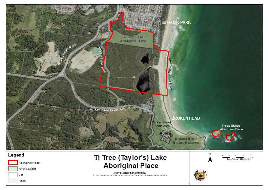
1. Ti Tree (Taylor’s) Lake
Aboriginal Place
Introduction
Ti Tree (Taylor’s) Lake
Aboriginal Place was declared under the National Parks and Wildlife Act 1974
(section 84) (NPW Act) in 2000 in recognition of its special significance
to Aboriginal culture. The lake is also a registered mythological site on the
NPWS Aboriginal Heritage Information Management System. The Jali Local
Aboriginal Land Council and Bundjalung of Byron Bay Arakwal Elders campaigned
for nearly two decades to get protection for the lake and its natural and
cultural values.
The Aboriginal Place (AP) is
approximately 70 hectares and is located 4km south of Byron Bay, on the far
north coast of New South Wales, between Suffolk Park and Broken Head (see Map
1). The AP is centred on the Ti Tree Lake, also known locally as Taylors Lake,
a highly significant Aboriginal women’s site. The lake consists of a
northern lobe (1.3 hectares) and a southern lobe (4 hectares) linked by a
narrow channel that opens intermittently to the ocean.
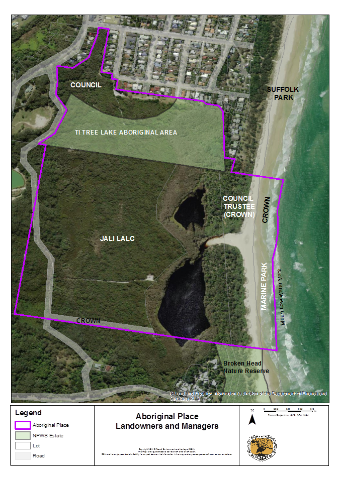
Landowners and land managers
The AP (see Map 2) consists of:
· freehold land owned by Jali
Local Aboriginal Land Council, including most of the lake
· freehold land owned by Byron
Shire Council
· Crown land, some of which is
managed by Byron Shire Council and some by Crown Lands
· part of the Cape Byron Marine
Park which is managed by Fisheries NSW and is located on Crown land
between low and high water mark, and
· the Ti Tree Lake Aboriginal Area
which is managed by the National Parks and Wildlife Service (NPWS).
The eastern boundary of the AP includes a 635 metre long section of
Broken Head Beach down to the mean low water mark. A small part of the lake at
its southern end (approximately 1700 square meters) occurs on freehold land
outside the AP.
Land use zoning and surrounding
land use
Suffolk Park adjoins part of the north and east boundaries of the AP, a
sand and gravel quarry occurs on land adjoining the western boundary, and
tourism and residential development at Broken Head village adjoins the southern
boundary. Broken Head Nature Reserve, managed by the NPWS adjoins the
south-east boundary of the AP.
Most of the AP is zoned for environmental protection under Byron
Shire’s 1988 Local Environmental Plan (LEP), either as Wetlands, Coastal
Habitat or Coastal Lands. However, most of Byron Shire Council’s freehold
land in the north of the Aboriginal Place is zoned for Investigation and a
small area in the north west is zoned Residential under the 1988 LEP. A mainly cleared
firebreak, south of houses in Suffolk Park, is zoned Rural Landscape under
Byron Shire’s 2014 LEP.
Staff Reports - Corporate and Community Services 5.2 - Attachment 3
MAP
1
Staff Reports - Corporate and Community Services 5.2 - Attachment 3
MAP 2
Staff Reports - Corporate and Community Services 5.2 - Attachment 3
Management planning
The Office of Environment and
Heritage (OEH), of which NPWS is a part, encourages the preparation of a formal
management plan by the landowners/ land managers or occupiers of APs with the
agreement of the Aboriginal community. This plan has been prepared in
accordance with OEH guidelines (OEH 2012).
Management plans aim to
identify:
a) the area’s
Aboriginal cultural heritage values
b) the Aboriginal community’s
management goals,
c) actions that need to be taken to
protect its important cultural heritage values
d) actions that may require an Aboriginal
Heritage Impact Permit (AHIP) under the NPW Act
e) funding
and resources that may be available to implement the actions required.
Protecting the Aboriginal Place
It
is an offence under the NPW Act (section 86[4]), to harm or desecrate an AP.
Harm includes destroying, defacing or damaging an AP. If development will take
place in the vicinity of an AP, the potential impacts of the development must
be assessed.
An
AHIP should be applied for if harm is proposed to an AP. An applicant for an
AHIP can refer to a management plan for an AP, where a plan exists, when
assessing impacts. A management plan identifies values and usually sets out
what actions would or would not be considered harmful to values.
Where a
management plan is in place this provides a clear record agreed by the
Aboriginal community of:
· actions that will not harm the
values of the place and that will not require an AHIP
· actions that would harm the
values of the place and would need an AHIP, but may be acceptable in certain
situation and with certain controls
· any harming actions for which
OEH would generally refuse to issue an AHIP.
Ti Tree Lake Aboriginal Area
The Ti
Tree Lake Aboriginal Area was reserved under the NPW Act in 2010 and is managed
by the NPWS. It protects 10.5 hectares of land in the north of the AP (see Map
2). Aboriginal areas are reserved to protect and conserve areas associated
with:
· a person, event or historical theme or
· containing a building, place, feature or landscape of
natural or cultural significance to Aboriginal people or
· their importance in improving public understanding of
Aboriginal culture and its development and transitions.
The land was formerly owned by Byron Shire Council and
was transferred to NPWS in recognition of its Aboriginal cultural heritage
significance and in accordance with an Indigenous Land Use Agreement (ILUA)
between the Bundjalung People of Byron Bay and the State Government. The ILUA
was registered under the Commonwealth Native Title Act in 2008.
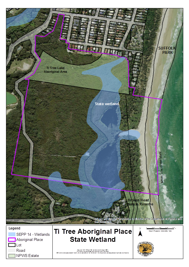
Protecting the wetlands
The lake and its
surrounding swamp forests and sedgelands are mapped as wetlands under the State
Coastal Wetlands Policy, known as State Environmental Planning Policy No. 14
(SEPP 14) – Coastal Wetlands (see Map 3). SEPP 14 aims to preserve
and protect wetlands for their environmental and economic values at a State
level by restricting certain development.
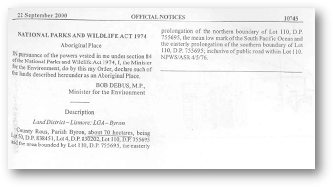
2. Official notice declaring the Aboriginal Place
The
following notice declaring the Aboriginal Place appeared in the Government
Gazette on 22 September 2000.
3. Stakeholders
The following organisations have interests in the AP:
|
Organisation
|
Role / Interest
|
|
Byron Shire Council
|
Landowner, Crown land
trustee, owns sewer, water and drainage infrastructure.
|
|
Jali Local Aboriginal
Land Council
|
Landowner
|
|
Crown Lands
|
Land manager
|
|
NPWS
|
Land manager
|
|
Marine Parks
|
Land manager
|
|
Bundjalung of Byron
Bay Aboriginal Corporation (Arakwal)
|
Native title claimants
|
|
Bundjalung Elders
|
Traditional knowledge
holders
|
|
Telstra
|
Owner of
telecommunications infrastructure
|
|
Neighbours of the
Aboriginal place
|
Neighbouring property
|
Staff Reports - Corporate and Community Services 5.2 - Attachment 3
MAP
3
Staff Reports - Corporate and Community Services 5.2 - Attachment 3
4. General statement of
management
The
following statements outline the Aboriginal community’s vision for
management of the AP:
a) Encourage local Aboriginal
communities to visit the place to continue cultural and spiritual practices,
through informal or legal agreements with landowners/land holders/occupiers.
b) Encourage action designed
to ensure continuation of cultural practices, such as maintaining or improving
water quality of the catchment and retaining and improving vegetation of high
cultural value.
c) No action should be taken
if it would have any adverse impact on the significance of the place.
d) Minimise the risk of
harming Aboriginal objects and sites and the Aboriginal place wherever
possible.
e) Refer to this management
plan for all day-to-day and longer term management decision-making and to
implement works and undertake other activities
f) Give Aboriginal
cultural values priority in resolving any conflicts about management and change
to the place.
g) Aboriginal sites and
objects in the Aboriginal Place will be conserved, recorded and managed in
accordance with their significance.
h) Increase public awareness of the
existence of the Aboriginal place and its high level of significance.
i) Aboriginal knowledge
gathered by OEH will be respected and protected.
j) OEH will support the Aboriginal
communities to determine what information on the Aboriginal place will be made
available, such as location, stories and significance, and whether signs are
erected on the Aboriginal place.
5. Cultural values
In 2000, NPWS commissioned anthropologist
Inge Riebe to prepare a report to assess the Aboriginal cultural significance
of the lake and surrounding area to support the process of protecting the area
by declaring it an Aboriginal place under the NPW Act.
The assessment involved interviews with
Elders and other Aboriginal people with knowledge of the Place to document the
area’s history and cultural values, including its archaeological context,
and the history of protection efforts. The report makes valuable
recommendations for respectful management of this special women’s area.
Due to the sensitive nature of the information in the
report and the strong view of the Elders that the information not be made
public, it is not repeated here. A summary of the cultural values of the Place
that can be spoken of publicly are:
· the Aboriginal Place is a sacred place for Aboriginal
women
· the Ti Tree Lake is sacred and is a registered
mythological site on the OEH Aboriginal Heritage Information Management System
(AHIMS)
· traditional knowledge of the Aboriginal Place is
sacred for Aboriginal women and is safeguarded. Traditional beliefs mean that
the stories and secrets associated with Aboriginal Place cannot be talked about
publicly.
· the Aboriginal Place is one of the few sacred women's
sites in the state which remain intact and for which custodians and knowledge
holders remain.
· local Aboriginal women continue to deliver traditional
teachings about the Aboriginal Place to Aboriginal girls and women
· Aboriginal women continue to visit the place to
maintain their connection with it and to pass on knowledge of its significance
to others
· Elders have previously indicated strong concerns for
maintaining catchment health to support their ongoing spiritual connections to
Country
Due to the sacred significance of the lake
and the surrounding 150-metre core area it is appropriate that this area has
the greatest restrictions on use. However, the surrounding bushland within the
Aboriginal Place is also integral to protecting the lake as it provides a
buffer to adjoining land use and supports important cultural resources.
The Aboriginal Place occurs within a
broader context of places of significance to the Aboriginal community. Other
publicly known places include Cocked Hat Rocks (Three Sisters) Aboriginal
Place, off Broken Head headland, in Broken Head Nature Reserve, Julian Rocks
Nguthungulli Nature Reserve, a mythological site in Byron Bay and Walgun (Cape
Byron) in Cape Byron State Conservation Area, east of Byron Bay.
6. Aboriginal community management goals
|
Management Goal
|
Timeframe
|
|
The lake and
surrounding core area (lakeshore and 150 metre buffer), in particular, is
used in accordance with Aboriginal cultural beliefs and traditions.
|
Short term
|
|
The lake is healthy
and unpolluted.
|
Short term
|
|
Knowledge is passed
down within the Aboriginal community in accordance with Aboriginal custom
|
Long term
|
|
The broader community
understands and respects the significance of the lake and surrounding area.
|
Short term
|
|
Stakeholders (Council,
NPWS, Crown lands, neighbours) understand and respect the significance of the
lake and surrounding area.
|
Medium term
|
|
Cultural resources are
healthy and sustainable.
|
Long term
|
7. Activities that could harm the Aboriginal Place
In the Assessment of Significance prepared by Inge Riebe
(2000) the following statement is made about management of the AP, reflecting
the wishes of the traditional owners and the parts of an earlier plan of
management (Murphy 1993) of which they approved:
a) Ensure as little disturbance to
the lake as possible
b) No swimming in the lake
c) No access to the lake as far as
possible (i.e. walkways)
d) No pollutants enter the lake.
Sewerage, stormwater and rubbish from houses and runoff from the quarry are of
particular concern.
e) Any inappropriate human interference
causes harm to the lake and can be harmful to those interfering. Custodial
Elders need to have full control over any access to the Lake.
f) Men
particularly should avoid the lake.
The following table details the type of activities that
may occur in the AP including those that may harm the AP and its special
cultural significance. Conditions are included, if appropriate, to reduce the
harm caused by the activity. The inclusion or exclusion of certain activities
in the AP is intended to reflect the wishes expressed by the traditional
owners.
Staff Reports - Corporate and Community Services 5.2 - Attachment 3
Table 1 Activities in the Aboriginal Place
|
Activity
|
Is the activity
consistent with cultural values?
|
Under what
conditions could the activity be consistent, if any?
|
|
Commercial tourism and
activities
|
No
|
None.
|
|
Education activities
|
Yes -conditionally
|
Educational activities
provided by local custodian Elders.
|
|
Poor quality
stormwater or groundwater entering the lake.
|
No
|
None.
|
|
Other pollutants
entering the lake (sunscreens, insect repellent).
|
No
|
None.
|
|
Recreational or other
use of the lake.
|
No
|
None.
|
|
Men coming within
150-metres of the lake (the core area)
|
No
|
None.
|
|
Buildings or
structures
|
No
|
Small-scale, temporary
structures for cultural purposes only.
|
|
Camping
|
No
|
None.
|
|
Riding bicycles
|
No
|
· Restricted to Taylors Lake Road, the fire break
south of houses in Suffolk Park (on Council land and NPWS).
· No promotion of bike riding.
· No official bikeway.
|
|
Use of motorised
vehicles
|
No
|
· Driving a mobility-impaired person within the
AP for cultural purposes.
· Use of official vehicles for fire-fighting
purposes and on the fire break south of houses on Macgregor Street.
|
|
Bushwalking
|
No
|
· Restricted to Ti Tree Lake Aboriginal Area, in
accordance with an approved plan of management, Taylors Lake Road and Council
land in the north west of the AP.
· No promotion of bushwalking.
· No walking tracks.
|
|
Activities that could cause harm
|
Is the activity
consistent with the cultural values?
|
Under what
conditions could it be consistent if any?
|
|
Horse riding
|
No
|
· Restricted to Taylors Lake Road and not
promoted.
· No official bridle path.
|
|
Parties or dance
parties
|
No
|
None.
|
|
Weddings
|
No
|
None.
|
|
Exercising domestic
animals (dogs and cats) or allowing them to roam free.
|
No
|
None.
|
|
Use of drones
|
No
|
Only if in conjunction
with works proposed in this management plan. Apply for permission on a
case-by-case-basis from the landowner/manager.
|
|
Other recreational
uses of the Aboriginal Place (e.g. events, photography, picnicking, etc)
|
No
|
Passive (low-key)
activities in the Ti Tree Lake Aboriginal Area, in accordance with an
approved management plan, on the beach or on Council land in the north west
of the AP.
|
|
Developing new
pathways
|
No
|
None.
|
|
Construction of new
infrastructure
|
No
|
None.
|
|
Maintaining existing
pathways
|
No
|
· Low-key maintenance of the pathway providing
access for cultural purposes to the western side of the lake from Taylors
Lake Road.
· Maintenance of the fire trail south of the
houses on Macgregor Street.
|
|
Maintenance of Taylors
Lake Road (a designated fire trail)
|
No
|
· No upgrading of road surface (sealing etc).
· Maintain as a gravel surface.
· Maintenance to the minimum standard required to
provide access for fire fighting vehicles incorporating best practice erosion
and sediment control and weed control.
|
|
Maintenance of
utilities (water, sewer, telecommunications) under Taylors Lake Road.
|
No
|
· Maintenance of utilities under the road must
incorporate best practice erosion and sedimentation control and weed control.
· No upgrading of road surface (sealing,
concreting etc).
· Maintain the road’s gravel surface.
|
|
Cultural fire use
|
Yes - conditionally
|
· Small fires for cultural purposes (e.g.
cooking, warming, ash/charcoal).
|
|
Cultural activities
|
Yes - conditionally
|
· Small groups only.
· Cultural activities to be conducted by local
custodian women Elders.
|
|
Activities that could cause harm
|
Is the activity
consistent with the cultural values of the Aboriginal Place?
|
Under what
conditions could it be consistent if any?
|
|
Clearing
|
No
|
Low-key (minimal)
clearing of disturbed areas for cultural purposes.
|
|
Mining, quarrying or
mineral exploration
|
No
|
None.
|
|
Pump from the lake or
waterways
|
No
|
None.
|
|
Fire
|
No
|
· Only small-scale controlled burns to maintain
cultural resources (i.e. culturally valuable plants and animals) if required.
|
|
Controlling weeds
|
Yes - conditionally
|
· No weed control to occur on the dunes until a
general pattern of avoidance of the lake is established.
· Any herbicides usage around the lake must be
consistent with permits and labels and an approved weed control/bush
regeneration plan.
· No herbicides to be used over the lake or its
tributaries, even if permitted on labels etc.
· It is preferred that women undertake this
activity.
|
|
Controlling pest
animals
|
Yes - conditionally
|
· No poisons to be used within a 150-metre buffer
area around the lake
· Poison usage must be consistent with permits
and labels and an approved pest control plan.
· It is preferred that women undertake this
activity.
|
|
Managing vegetation to
reduce bush fire risk to adjacent development
|
No
|
· Management bush fire risk in accordance with
the approved Far North Coast Bush Fire Risk Management Plan.
· Ensure the Aboriginal Place is recognised as an
asset in the Far North Coast Bush Fire Risk Management Plan.
|
|
Signs
|
Yes –
conditionally
|
· Signs to educate people about significance of
the place and appropriate behaviour.
· Signs to be unobtrusive and placed so as not to
attract visitors to the AP.
|
|
Moving, relocating or
collecting objects
|
No.
|
If an object is in
danger of being destroyed or damaged.
|
Staff Reports - Corporate and Community Services 5.2 - Attachment 3
8. General management protocols
The following general protocols form an agreed basis for
landowners, land managers and the Bundjalung of Byron Bay Arakwal People to
work together to manage the AP:
a) assess the health
of the lake through a water sampling program
b) an agreed
approach to risk management
c) meet twice a year
to review the operation of the management plan and consider whether to
recommend changes to OEH
d) works carried out
in the Aboriginal place will be in accordance with this plan of management
e) keep each other
informed of works being undertaken in the AP by email or in writing (see
Contacts section)
f) commit to working together to
address strategic management issues in the AP, for example, access or
controlling pest plants.
9. Risk management measures
The following risk management measures are intended to
prevent or mitigate potential harm to the AP:
a) Before carrying out works
undertake cultural and heritage assessments through the Aboriginal Heritage
Impact Permit (AHIP) process, as required.
b) Establish an exclusion or
buffer zone for activities that could harm the place.
c) Consult and involve the
local Aboriginal community, relevant Elders, individuals and Local Aboriginal
Land Councils.
d) Manage fire to prevent large fires.
e) Educate people about the significance
of the place and safe practices.
f) Erect signage to educate the
people about the place’s significance and appropriate behaviour.
g) Close pathways from the
beach to the lake and along the lakeshore or allow them to revegetate
naturally..
h) Close pathways, other than the pathway to the
western side of the lake
i) Manage weeds and pest animals to
prevent loss or damage to cultural resources.
j) Ensure runoff from the quarry
site and stormwater from all outlets into the AP is managed to prevent harm to
the place.
k) Investigate formally closing Taylors
Lake Road (or at least that part of the road within the Aboriginal Place).
l) Exclude development from the
Aboriginal place.
m) Ensure adequate sediment and erosion control
on Taylors Lake Road.
n) Ensure all sewage is properly treated on
surrounding lands and that the sewerage system on the Aboriginal place and on
surrounding lands is properly maintained.
o) Routinely monitor or inspect the
Aboriginal place to identify potential harm.
10. Cultural value management statements
The
following statements outline an agreed approach to managing the cultural values
of the AP:
a) Stakeholders and landowners will handle
culturally sensitive information with respect and according to the wishes of
the Aboriginal community regarding the AP which is a sacred women’s
place.
b) Landowners, land managers
and will work to conserve the environmental and cultural values of the place.
c) Continuing access for
Aboriginal people to the AP will be encouraged to conserve its special
significance.
d) Continued access to
traditional/contemporary resources which are important for cultural purposes or
simply in their own right, will be permitted.
e) Landowners and land
managers will be encouraged to respect the connection of Aboriginal people to
the place and the need for connection to Country to allow for the passing on of
traditional knowledge.
f) The ongoing role of
the AP as a teaching site will be recognised and respected.
g) Landowners and land managers will work
to prevent large scale landscape changes to the AP, to conserve its spiritual
and cultural values.
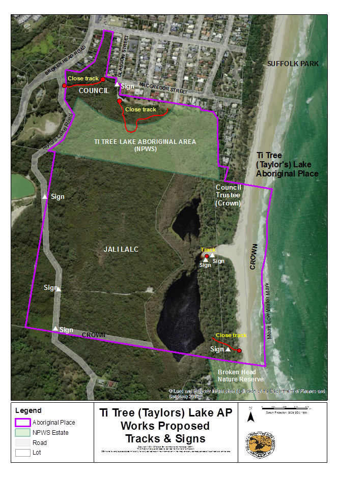
11. Works and activities
Works are required in the AP to protect cultural
values and to manage risks. The following table lists proposed works, specifies
how the works should be undertaken, identifies who is responsible and sets
timeframes. Map 4 shows the location of works proposed to address tracks and
signage.
Staff Reports - Corporate and Community Services 5.2 - Attachment 3
Table 2 Proposed works and activities in the
Aboriginal Place
|
Type of work or
activity
|
Specification
|
Timeframe
|
Responsible
authority
|
|
Design and install signage
|
· Signs are to educate the public about the
significance of the place and appropriate behaviour.
· Signs are to be unobtrusive and positioned so
as not to attract visitors to the Aboriginal Place.
Sign locations (see
Map 4):
- near the lake entrance on the edge of
vegetation
- on the informal track running from the lake
entrance south along the lakeshore
- on the southern path that leads to the southern
lake
- at the intersection of Taylors Lake Road and
the pathway to the western side of the lake,
- on Taylors Lake Road at the southern boundary
of the Aboriginal Place
- on Taylors Lake Road where it intersects with
the western boundary of the Aboriginal Place
- at the entrance to the fire break on the AP that starts at the southern
end of Glasgow Street.
|
Short term
|
Council
Jali LALC
|
|
Managing vegetation to reduce bush fire risk
|
· Manage bush fire risk in accordance with the
approved Far North Coast Bush Fire Risk Management Plan.
· Manage bush fire risk in the Ti Tree
Lake Aboriginal Area in accordance with the NPWS Fire Management Strategy.
· Ensure the Aboriginal Place is recognised as an
asset in the Far North Coast Bush Fire Risk Management Plan.
|
Short - medium term
|
Council
NPWS
Far North Coast Bush Fire Management Ctee
|
|
Pests animals
|
· Develop pest animal control plan/s (possibly
linked to survey).
· No poisons (baits) to be used within a
150-metre buffer area around the lake
· Poison usage must be consistent with permits
and labels and an approved pest animal control plan.
· It is preferred that women undertake this
activity.
· It is preferred that women undertake this
activity.
|
Medium term
|
Jali LALC
Council
NPWS
|
|
Type of work or
activity
|
Specification
|
Timeframe
|
Responsible
authority
|
|
Pests plants
|
· Develop bush regeneration plans.
· No weed control to occur on the dunes until a
general pattern of avoidance of the lake is established.
· Any herbicides usage around the lake must be
consistent with permits and labels and an approved weed control plan.
· No herbicides to be used over the lake or its
tributaries, even if permitted on labels etc.
· No poisons to be used within a 150-metre buffer
area around the lake
· Poison usage must be consistent with permits
and labels and an approved pest animal control plan.
· It is preferred that women undertake this
activity.
· It is preferred that women undertake this
activity.
|
Plan - short term
Works on dunes – medium term
Works elsewhere – short to medium term
|
Jali LALC
Council
NPWS
|
|
Close pathways
(see Map 4)
|
· Pathways from the beach to the lake and along
the lakeshore will be closed or allowed to revegetate naturally. Investigate
closure options.
· Close (bollard) the pathway that starts at the
western end of the fire break behind the houses on Macgregor St and runs
south into the Aboriginal Place to stop vehicles.
· Close (bollard) the pathway that starts at the
firebreak south of Glasgow Street and runs west to Taylors Lake Road
· Close the pathway that runs to the western side
of the lake at the intersection with Taylors Lake Road to stop motorbikes.
Investigate closure options.
· Check for pathways from the beach to the
northern lake – close.
|
Short term
|
Council
Jali LALC
|
|
Investigate closing Taylors Lake Road
|
· Investigate the
process and the implications for landowners/managers prior to taking any
further action.
|
Long term
|
Council
NPWS
Jali LALC
|
|
Maintenance and adequacy of Council’s sewerage
system
|
· Obtain copy of
maintenance program from Council
· Ensure
maintenance program is adequate.
· Ensure no
pollution of the AP.
|
Short term
|
Council
|
|
Type of work or
activity
|
Specification
|
Timeframe
|
Responsible
authority
|
|
Ensure any septic systems on adjacent properties are
operating safely and are not polluting the AP.
|
· Obtain advice
from Council
|
Short to medium term
|
Council
|
|
Water quality of the lake – stormwater management
|
· Identify the
places where stormwater enters the AP
· Obtain advice
about an effective stormwater sampling program, including the lake
· Test stormwater
and obtain a report about its likely impacts on the health of the lake.
· Identify any
remediation action required and implement.
|
Plan – short term
Sample and remediate – medium to long term
|
Council
NPWS
Jali LALC
Proprietors of Broken Head
Quarry
|
|
Soil erosion and sediment control (Taylors Lake Rd and
pathway to western side of lake )
|
· Determine what
works are required (if any) to meet best practice erosion and sediment
control standards for the road and pathway, taking into account the
culturally sensitive environment.
· Prepare a report
including works and priorities.
|
Medium term
|
Council
Jali LALC
|
|
Remove rubbish
|
· Remove rubbish in the clearing on the western
side of the lake.
· Remove rubbish from other areas of the AP as
identified or reported.
· NPWS to remove rubbish from the Ti Tree lake
Aboriginal Area as identified or reported.
· Council to remove rubbish from their property
as identified or reported.
|
Short term
|
Jali LALC
NPWS
Council
|
|
Survey plants and animals
|
· Undertaken
survey in accordance with OEH guidelines
· Target
culturally important animals/plants and threatened animals.
|
Medium - long term
|
Jali LALC
Council
NPWS
|
Staff Reports - Corporate and Community Services 5.2 - Attachment 3
MAP 4
Staff Reports - Corporate and Community Services 5.2 - Attachment 3
12. Other matters for
negotiation
- Signage design.
- Other matters to be added after
further consultation.
13. Culturally sensitive information
Only publicly available cultural information is included
in this plan. Cultural knowledge of the AP remains the property of the
knowledge holders.
14. Funding and resources for works proposed in the plan
- To be completed following
further consultation.
15. Contacts
Sue
Walker
Area
Manager, Byron Coast
National
Parks & Wildlife Service
Tallow
Beach Road, Byron Bay NSW 2481
npws.byroncoast@environment.nsw.gov.au
Phone: 0266209300
Jali Local Aboriginal Land Council
Byron Shire Council
Crown Lands
Cape Byron Marine Park
GLOSSARY
AHIP Aboriginal
Heritage Impact Permit
AHIMS Aboriginal
Heritage Information Management System
AP Aboriginal
Place
Bundjalung
of Byron Bay Aboriginal Corporation
(Arakwal):
The Corporation is established under the Aboriginal
Councils and Association Act 1976 (Commonwealth), as
a prescribed body to represent the Bundjalung People Byron
Bay (Arakwal) as native titleholders and their rights, interests and benefits
in trust.
Cultural activities: Refers
to activities such as, but not limited to, wild resource use, gatherings,
ceremonies and other cultural practices and customs.
Country: Refers
to the ‘landscape’ of origin of a particular group/clan of
Aboriginal people. This landscape is all encompassing, and the natural,
cultural and historical features are inseparable.
Endangered Ecological
Community:
A community listed on Schedule 1 Part 3 of
the Threatened Species Conservation Act 1997 (NSW).
ILUA Indigenous Land Use Agreement
LEP Local Environmental Plan
OEH Office
of Environment & Heritage
NPW Act National Parks and Wildlife Act
1974
NPWS National
Parks & Wildlife Service
SEPP
14 State
Environmental Planning Policy No. 14 – Coastal Wetlands
Threatened species: A
species listed under the Threatened Species Conservation Act 1997 (NSW)
as either endangered, critically endangered or vulnerable.
Murphy D 1993, Investigation Report of
Proposal for an Aboriginal Place at Taylors Lake, via Suffolk Park NSW, report to the National Parks & Wildlife Service.
OEH 2012, Guidelines for developing
management plans for declared Aboriginal Places, Office of Environment
& Heritage, Sydney South.
Riebe, I 2000, Assessment of
Significance for Aboriginal Place Declaration, Ti Tree (Taylors) Lake,
unpublished report to the National Parks & Wildlife Service.
Staff Reports - Corporate and Community Services 5.2 - Attachment 3
APPENDIX 1
BACKGROUND RESOURCE PAPER
TI TREE (TAYLOR’S) LAKE
ABORIGINAL PLACE
To be completed………..
Staff Reports - Corporate and Community Services 5.3
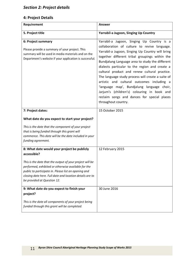
Report No. 5.3 Indigenous
Projects Grant Applications Updates
Directorate: Corporate
and Community Services
Report
Author: Belle
Arnold, Aboriginal Projects Officer
File No: I2016/45
Theme: Society and Culture
Community Development
Summary:
This report provides an update on the Indigenous Projects
grant applications for the period July to December 2015.
|
RECOMMENDATION:
1. That
the Arakwal Memorandum of Understanding Advisory Committee note the
successful grant application for the “Singing Up Country” for
Aboriginal language and arts projects in the Byron Shire.
2. That
the Arakwal Memorandum of Understanding Advisory Committee note that
Council staff reapplied to NSW Department of Heritage to undertake an
Aboriginal Cultural Heritage Planning Study for the Byron Shire.
|
Attachments:
1 Singing Up
Country, E2016/6259 , page 47
2 Scope of
Works Aboriginal Cultural Heritage Application, E2015/80578 , page 104
Report
This report provides an update on the Indigenous Projects
grant applications for the period from July to December 2015.
“Singing Up Country” for Aboriginal language
and arts projects in the Byron Shire
Staff were advised in December that Council was successful
in receiving part funding for the Indigenous language and Arts Program Grant
application Singing Up Country. The original application was for
$96,000. Due to the Department of Prime Minister and Cabinet’s internal
restructure and associated changes there was a reduced amount of funding to
offer in this round. Council were invited to resubmit a reduced program
for $50,000. This has been successful and the project implementation will
commence in March 2016.
Aboriginal Cultural Heritage Planning Study for the Byron
Shire
Council staff applied for the Aboriginal Cultural Heritage
Application on 16 December 2015. This is the second application Community
Development Staff have made to the Department of Environment and Heritage
for this project. The Scope of works was revised in consultation with key
stakeholders including the Bundjalung of Byron Bay Arakwal People and Tweed
Byron Local Aboriginal Land Council. This outcome of the application is still
to be determined.
Financial Implications
$50,000 received from Attorney General’s Department
for Aboriginal Cultural program delivery.
Statutory and Policy Compliance Implications
Native Title Act 1993
Local Government Act 1993
Land Rights Act 1984
Arakwal MoU 2013
Staff Reports - Corporate and Community Services 5.3 - Attachment 1


Staff Reports - Corporate and Community Services 5.3 - Attachment 2
Byron Shire Council Aboriginal Heritage Planning Study
Table of Contents
|
Details
|
Page
|
|
Acknowledgements
|
3
|
|
Glossary
|
3
|
|
Background
· Native Title
· Local Area Land Councils
· Local Environment Plan
|
3
3
7
8
|
|
Objectives
|
9
|
|
Total Area of Survey
|
10
|
|
Guiding Principles
|
10
|
|
Project Scope
|
12
|
|
Estimated Project Milestones and Key
Dates
|
17
|
|
Budget
|
18
|
Byron Shire Council
Aboriginal Heritage Planning Study
Scope of Work 2015

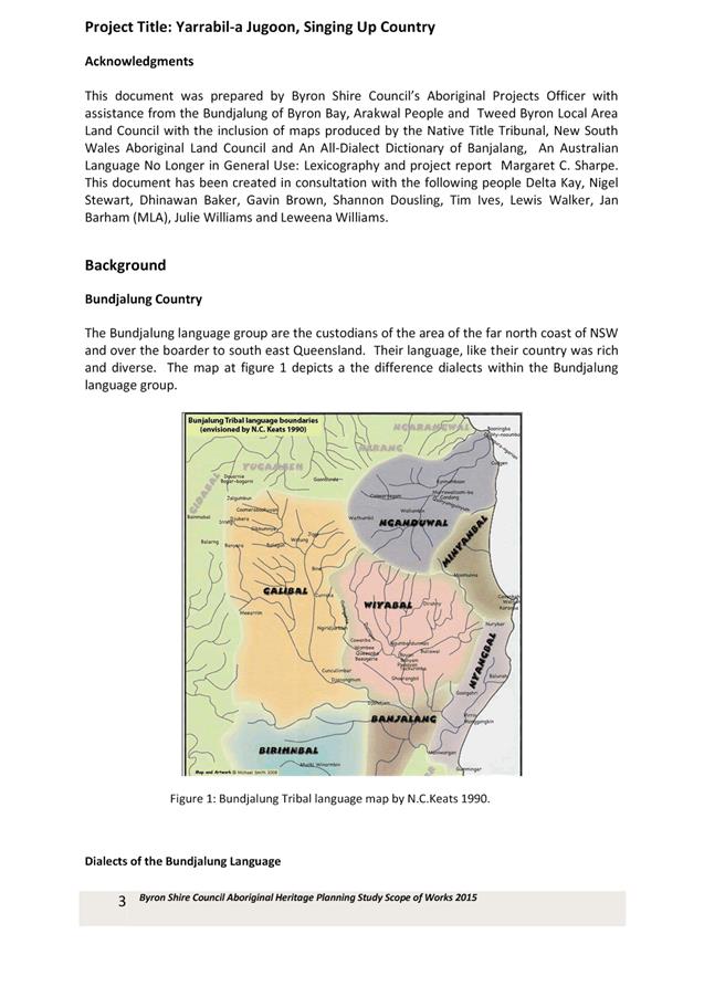
Acknowledgments:
This document was prepared by Byron Shire Council’s Aboriginal Projects
Officer with assistance from the Bundjalung of Byron Bay, Arakwal People
and Tweed Byron Local Area Land Council with the inclusion of maps
produced by the Native Title Tribunal, New South Wales Aboriginal Land Council
and reference the Ask First: A guide to
respecting Indigenous heritage places and values published by the
Australian Heritage Commission (2002: 6); Aboriginal Cultural Heritage
Regional Studies: an illustrative approach published by the New South Wales
Government Office of Environment and Heritage; Community based heritage
studies: A Guide; published by the New South Wales Government Office of
Environment and Heritage.

AHIMS –
Aboriginal Heritage Information Management System
AHS –
Aboriginal Heritage Survey
AHPS –
Aboriginal Heritage Planning Study
Arakwal –
Bundjulung of Byron Bay Arakwal People
BSC – Byron
Shire Council
DIA - Department of
Aboriginal Affairs
ILUA –
Indigenous Land Use Agreement
LEP – Local
Environment Plan
MoU –
Memorandum of Understanding
TBLALC –
Tweed Byron Local Aboriginal Land Council

Native Title
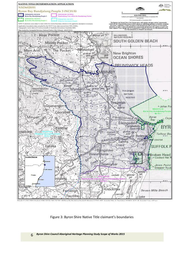
Lorna Kelly, Linda
Vidler and Yvonne Graham on behalf of the Arakwal people (the Applicants)
lodged a Native Title determination application in the National Native Title
Tribunal by which application they claim Native Title in and over land in and
around Byron Shire.
The Applicants
asserted their desire to live and work in the Byron Shire community in a way
that promotes mutual respect between Aboriginal and non-Aboriginal people and
harmonious community relations among those who live and work in the Byron Shire
community.
The Aboriginal
Heads of Agreement signed in 1998 between the Bundjalung of Byron Bay Arakwal
People and Byron Shire Council, sets out a framework for ongoing consultation.
The development of the Aboriginal Heads of Agreement ensured the Bundjalung of
Byron Bay Arakwal People were involved in the management and protection of
culturally significant places within the Byron Shire. This agreement is the
first of its type between a local council and native title applicants in New
South Wales.
The Bundjalung of
Byron Bay Arakwal People’s Indigenous Land Use Agreements 1, 2 and 3
provided for the protection and management of Aboriginal cultural and heritage
areas by the Bundjalung of Byron Bay, eg Arakwal National Park. Indigenous Land
Use Agreements are instruments of the Native Title Act. The Arakwal people, as
traditional owners conduct cultural, eco-tourism and educational programs thus
providing an important cross-cultural exchange between Aboriginal people and
non-Aboriginal people.
In 1995, the
Bundjalung of Byron Bay Arakwal people lodged a Native Title Claim over areas
of Crown land, beaches and coastal waters between Belongil Creek at Byron Bay
and Jews Point on the north coast of NSW. The Arakwal people lodged a further
claim in 1997 over additional land in the Byron Shire. In August 2001, an
Indigenous Land Use Agreement (ILUA) between the Federal Government and the
Bundjalung People of Byron Bay Arakwal was developed to implement part of the
first and second Native Title Claims.
In 2001, a third
Native Title Claim was lodged when it became apparent that evidence provided
during the negotiations over the first two claims was applicable to additional
areas outside the existing claims. This included lands up to Brunswick Heads to
the north, Broken Head to the south, Mullumbimby and Bangalow to the west and
approximately three nautical miles east of the mean high water mark.
Negotiations over the third claim and outstanding portions of the first claim
led to the development of two further ILUAs (Byron Bay ILUA 2 and Ti Tree Lake
ILUA 3) which were signed in December 2006.
The Byron Shire Council Cultural
Plan 2008 – 2013 explores the Shire’s Aboriginal and European
heritage, defines its demographics and identifies its cultural assets,
resources and activities. The Cultural Plan is a five year strategic document
that prioritises a set of strategic actions for implementation by many
stakeholders. It promotes the diversity of the Byron Shire through a shared
vision for the community as a result of community consultation. The Byron
Shire Council Cultural Plan 2008 – 2013 identified the need for Council
to develop an aboriginal cultural heritage study.
In 2013 Bundjalung of Byron Bay
Arakwal people signed an MoU with Council to define the partnership between the
two organisations and ensure that the traditional owners could participate in
governance in the Byron Shire. Through this process Council committed to
work in partnership with the Bundjalung of Byron Bay Arakwal people to ensure
preservation of cultural practices, traditional sites, significant places and
expressions of cultural identity.

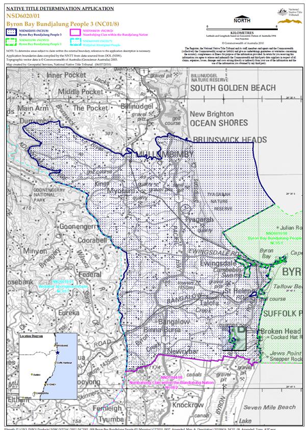 Fig 1: Byron Shire
Native Title claimant’s boundaries
Fig 1: Byron Shire
Native Title claimant’s boundaries
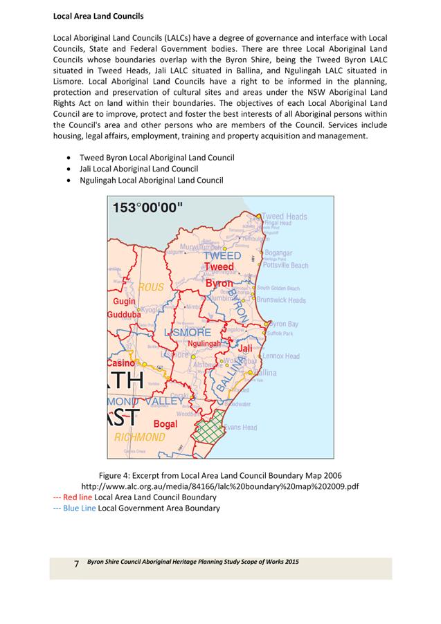
Local Area Land
Councils
Local
Aboriginal Land Councils (LALCs) have a degree of governance and interface
with Local Councils, State and Federal Government bodies. There are three Local
Aboriginal Land Councils whose boundaries overlap with the Byron Shire,
being the Tweed Byron LALC situated in Tweed Heads, Jali LALC situated in
Ballina, and Ngulingah LALC situated in Lismore. Local Aboriginal Land Councils
have a right to be informed in the planning, protection and preservation of
cultural sites and areas under the NSW Aboriginal Land Rights Act on land
within their boundaries. The objectives of each Local Aboriginal Land Council
are to improve, protect and foster the best interests of all Aboriginal persons
within the Council's area and other persons who are members of the Council.
Services include housing, legal affairs, employment, training and property
acquisition and management.
· Tweed
Byron Local Aboriginal Land Council
· Jali
Local Aboriginal Land Council
· Ngulingah
Local Aboriginal Land Council
Fig 2: Excerpt from
Local Area Land Council Boundary Map 2006
http://www.alc.org.au/media/84166/lalc%20boundary%20map%202009.pdf
--- Red line Local Area Land Council Boundary
--- Blue
Line
Local Government Area Boundary
Local Environment
Plan
The provisions in
Byron Local Environmental Plan (LEP) 2014 that allow places with Aboriginal
heritage significance to be listed in the LEP (and therefore have specific
development controls apply to them) is based on the definition of
‘Aboriginal place of heritage significance’ in the LEP (reproduced
below). For an Aboriginal heritage place to meet the definition and
consequently be eligible for listing in the LEP then the place needs to be
identified in an Aboriginal Heritage Study that has been publicly exhibited and
adopted by Council.
Aboriginal place of heritage significance means an area of
land, the general location of which is identified in an Aboriginal heritage
study adopted by the Council after public exhibition and that may be shown on
the Heritage
Map,
that is:
(a) the
site of one or more Aboriginal objects or a place that has the physical remains
of pre-European occupation by, or is of contemporary significance to, the
Aboriginal people. It may (but need not) include items and remnants of the
occupation of the land by Aboriginal people, such as burial places, engraving
sites, rock art, midden deposits, scarred and sacred trees and sharpening
grooves, or
(b) a
natural Aboriginal sacred site or other sacred feature. It includes natural
features such as creeks or mountains of long-standing cultural significance, as
well as initiation, ceremonial or story places or areas of more contemporary
cultural significance.
Note. The term may
include (but is not limited to) places that are declared under section 84 of
the National Parks and Wildlife Act 1974 to be Aboriginal
places for the purposes of that Act.
If a place of
Aboriginal heritage significance is listed in the LEP then clause 5.10 would
apply to any development application on that land. This is also the case
if an Aboriginal heritage object is located on the land. This means that
development consent would be required to disturb, excavate, subdivide, erect a
building etc (unless it is minor works or for maintenance) on such land and
that Aboriginal communities have to be notified of the application and given 28
days to comment. Depending on the works proposed site specific investigations of
significance would also have to be undertaken as part of any development
application.
The Byron Shire
Council Aboriginal Heritage Planning Study 2016 will be implemented across four
stages:
Stage One
Literature Review
– Archival material
Review of AHIMS
register
Anthr
 Principle
objectives of this Aboriginal Heritage Planning Study will be to research and
identify Aboriginal cultural heritage sites occurring within the Byron Shire
Local Government Area for inclusion in the Byron Shire Local Environment Plan.
Principle
objectives of this Aboriginal Heritage Planning Study will be to research and
identify Aboriginal cultural heritage sites occurring within the Byron Shire
Local Government Area for inclusion in the Byron Shire Local Environment Plan.
The project would
take on a collaborative approach working closely with the Bundjalung of Byron
Bay, Arakwal people, Tweed Byron Local Aboriginal Land Council, Jali Land
Council, the Bundjalung Council of Elders and other Aboriginal Stakeholders.
In addition this
study aims to:
· Formalise existing
cultural knowledge to utilise statutory mechanisms to register sites for
protection and preservation,
· Develop
predictive tools to identify other potential sites,
· Educate the broader
community on the Aboriginal history and occupation of the Byron Shire,
· Enhance
relationships between Byron Shire Council and the Community in order to
appropriately manage the Aboriginal Cultural heritage resources of the area.
· Promote the
preservation of Aboriginal Cultural Heritage within Council and the broader
community,
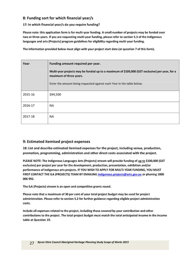
· Work
collaboratively with Aboriginal Stakeholders to enable multi stakeholder
management initiatives for the protection of Aboriginal sites and places,
· Directly involve
the Aboriginal community in planning processes on country.
Byron
Shire is located on the Far North Coast of NSW and shares its boundaries with
the Tweed, Lismore and Ballina Local Government Areas (LGAs). Brisbane is
approximately 200 kilometres north and Sydney approximately 800 kilometres to
the south. The Shire is 556 square kilometres in size and is famed for its
rural beauty and beaches. The local resident population of Byron
Shire at the date of the 2011 Census was 29,209.
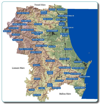

 Aboriginal
cultural heritage protection and preservation aims to enable and enhance
relationships between Aboriginal people and their heritage places.
Aboriginal
cultural heritage protection and preservation aims to enable and enhance
relationships between Aboriginal people and their heritage places.
This study will adopt the principles
contained in the Ask First: A guide to
respecting Indigenous heritage places and values
published by the Australian Heritage Commission (2002: 6) . It states;
In recognising the
rights and interests of Indigenous peoples in their heritage, all parties
concerned with identifying, conserving and managing this heritage should
acknowledge, accept and act on the
principles that
Indigenous people:
• are the
primary source of information on the value of their heritage and how this is
best conserved;
• must have
an active role in any Indigenous heritage planning process;
• must have
input into primary decision-making in relation to Indigenous heritage so they
can continue to fulfill their obligations towards this heritage; and
• must
control intellectual property and other information relating specifically to
their heritage, as this may be an integral aspect of its heritage value.
In
identifying and managing this heritage:
• uncertainty
about Indigenous heritage values at a place should not be used to justify
activities that might damage or desecrate this heritage;
• all parties
having relevant interests should be consulted on Indigenous heritage matters;
and
• the process
and outcomes of Indigenous heritage planning must abide by customary law,
relevant Commonwealth and State/Territory laws, relevant International treaties
and covenants and any other legally binding agreements.
Adhering to
cultural restrictions on information about an Indigenous heritage place is
essential to maintaining its heritage value.
Byron Shire Council recognise that
Aboriginal people are the experts on Aboriginal Cultural Heritage. For
this Aboriginal Heritage Planning Study BSC would establish a steering
committee of representatives from the Arakwal people, Tweed Byron Local
Aboriginal Land Council, Jali Land Council and Ngulingah Land Council and other
stakeholders to participate in the direction and decision making on the project
including:
· tendering process
· appointing
consultants
· priority areas
· intellectual
property
· culturally
appropriate information sharing
· and other matters as
they arise.
|
|
Project Scope
|
|
Project Manager:
|
Belle Arnold,
Aboriginal Projects Officer
|
|
Key Staff:
|
Director
Corporate and Community Services
Manager Community
Services
Manager
Development Assessment and Certification
Manager
Land and Natural Environment
Aboriginal
Projects Officer
|
|
Project
partners:
|
Bundjalung of
Byron Bay Arakwal People
Tweed Byron Local
Aboriginal Land Council
|
|
Stakeholders:
|
Bundjalung of
Byron Bay Arakwal People
Tweed Byron Local
Aboriginal Land Council
Jali Land Council
Ngulingah Local
Aboriginal Land Council
Bundjalung Elders
Council
Minjungbal Museum
|
|
Resources:
|
Bundjalung of
Byron Bay Arakwal People
Tweed Byron Local
Aboriginal Land Council
Jali Land Council
Ngulingah Local
Aboriginal Land Council
Bundjalung Elders
Council
Minjungbal Museum
Richmond Tweed
Regional Library
Brunswick Valley
Histroical Society
AHIMS Register
Australian
Institute of Aboriginal and Torres Strait Islander Studies
National Library
State Library of
NSW
NSW Department of
Environment and Heritage
National Parks
and Wildlife Service
Southern Cross
University
Cavanbah
Reconciliation Group
Bundjalung
Cultural mapping Project
|
|
Variables:
|
Change in Key
Staff within Council
Change in Key
Staff at partner or stakeholder organisations
Weather Incidents
during Site Survey period
|
|
Definitions:
|
For the purpose
of this Study Aboriginal Cultural Heritage Places and Values are categorised
as follows
- Precontact
(pre- 1788) places
- Historical
Places (post 1788)
- Social
and Spiritual places
- Wild
resource use places
|
|
Tasks:
|
Literature Review
– Byron Shire Council Project
Extensive
research of AHIMS register existing archival documentation, a review of
statutory and non statutory registers and listings, and a consideration of
local histories (including oral history sources from key stakeholders) and
available pictorial sources concerning the use of the local landscape by
Aboriginal people in the distant and more recent past.
· Prepare a report
containing a summary of the key findings
Sites Survey -
Consultants
Ethnographic/anthropological
survey identifying and documenting known sites by undertaking ground
surveys, preparing maps showing the location of the sites and make
recommendations regarding the management of the sites. Sites survey to include
both tangible and intangible sites. Photographs and GPS
coordinates of sites included.
Predictive
research to identify potential unknown sites - Consultants
Relocate
previously recorded Aboriginal Cultural Heritage Sites and investigate
possible sites and areas of potential Aboriginal cultural heritage
sensitivity. Predictive Aboriginal Cultural Heritage management involves a
thorough understanding of the environmental, historical and archaeological
context of the area as this information is key to understanding the nature of
the Aboriginal use of the area and the likelihood that physical traces.
This
considers aspects such as:
The distribution
and availability of resources (including drinking water, plant and animal
foods, raw materials of stone used for artefact manufacture, and wood and
vegetable fibres used for other tool production and maintenance needs) are
all influenced by the nature of soils, the composition of vegetation cover,
and other climactic characteristics including temperature and rainfall.
The location of
different site-types (such as middens, axe grinding grooves and engravings
etc) are also influenced by the above factors, along with a range of other
associated features which are specific to different land-systems and bedrock geologies
(e.g. rock engravings and rock shelters only occur where there are suitable
sandstone outcrops).
Sites
Registration
Coordination and
documentation of registrations to be lodged under the Aboriginal Heritage Act
1972 (AHA) and NSW Department of Environment and Heritage. Collating
all information required for the purpose of reporting any unregistered sites
to the Department of Environment and Heritage for the AHIMS register
Aboriginal
Cultural Heritage Management System - Consultants
Recommendations
to Council on how to manage Aboriginal Cultural Heritage in the Byron Shire.
Provide a
detailed Aboriginal Cultural Heritage Planning Report to Council containing
detailed findings on all tasks.
|
|
Methodology
|
|
|
Deliverables:
|
Detailed
Aboriginal Cultural Heritage Planning Report including maps of charted sites
and photographs, outlining findings, methodology and consultation.
Mapping
layer for planning department to utilise identifying areas that require
Aboriginal Heritage Impact Permit as part of Development Application process.
Registration
of unknown sites where applicable.
Aboriginal
Cultural Heritage Management System report.
DCP/LEP
to include sites
|
|
Administration:
|
Develop
Expression of Interest
Coordinate tender
process
Manage
Consultants
Coordinate
Aboriginal Reference Group as Steering committee meetings and communications,
Reporting –
consultants, steering groups, to Council, community and NSW Environment and
Heritage
Relevant permits
|
|
Inclusions:
|
Literature Review,
photo archive review, Search sites registers, consideration of local
histories (including oral history sources), Ethnographic/anthropological and
archaeological survey, Predictive research to identify potential unknown
sites, Coordinate detailed Aboriginal heritage field surveys, Cultural
Heritage Management System, Progress reporting and final report,
legitimate stakeholders.
|
|
Exclusions:
|
Culturally
inappropriate information handling and sharing
Non Aboriginal
Cultural Heritage (unless relevant).
|
|
Key Risks:
|
Conflict between
stakeholders
A lack of
willingness to share cultural knowledge around sacred sites
Lack of
historical documents
Death or illness
of significant culture holders.
|
|
Assumptions:
|
Consultant to be
engaged through tender process to conduct the Aboriginal heritage planning
study on behalf of Council.
Sites identified
to be exhibited for inclusion in the Council’s LEP.
Intellectual
Property on cultural information to be respected.
The findings of
this study will be used to protect and preserve Aboriginal Cultural Heritage
sites.
Stakeholders
rights under the Native Title Act and Land Rights Act to be respected
|
|
Constraints:
|
Budget
Relationships
with local Aboriginal Community
Historical
Records
Confidential
information
Cultural protocols
on information sharing
Access to sites
of private property
Management of
expectations
|
|
Intellectual
Property:
|
Develop a
Memorandum of Understanding between project partners and key
stakeholders clarifying ownership of intellectual property.
|
|
|
|
|
Estimated Project
Milestones and Key Dates
|
Date
|
|
Grant Application
Due
|
16 January 2015
|
|
Announcements
|
01 July 2015
|
|
Project
Initiation
· Form Aboriginal
Steering Committee
· Commence
Literature Review
|
26 July 2015
|
|
Steering
Committee Meeting -
· EOI for Consultants
· MoU Intellectual
Property
· Literature Review
· Local Oral
Histories Project
|
10 August 2015
|
|
Advertise for EOI
for Consultants
|
Mid September
2015
|
|
Oral Histories
Project
|
September –
8 weeks 2015
|
|
Steering
Committee to select Consultant
|
Mid October
2015
|
|
Appoint
Consultant
|
End October
2015
|
|
Steering
Committee Meeting
· Introduce
Consultants to Stakeholders
· Oral Histories
Project Update Report and Review
|
Mid November 2015
|
|
Steering
Committee Meeting
· Sites Surveys
Review
· Predictive Sites
· Oral Histories
Project Update Report and Review
|
3 Feb 2016
|
|
Steering
Committee Meeting
· Sites Surveys
Review
· Predictive Sites
· Aboriginal
Heritage Management Strategy
|
April 2016
|
|
Sites Registered
with NSW Environment and Heritage
|
May 2016
|
|
Final Report from
Consultant
|
June 2016
|
|
Acquittal
Report
|
30 June 2016
|
|
Report to Council
and Project Partners
|
August 2016
|
|
Public Exhibition
of Sites Indicative Areas
|
August 2016
|
|
Inclusion of
Aboriginal Sites in the LEP
|
November 2016
|
|
Budget
|
|
Details
|
Amount
|
Funding Source
|
|
Project
Coordination
|
10 000
|
BSC
|
|
Administration
|
5 000
|
BSC
|
|
Steering
Committee Management
|
8 000
|
BSC
|
|
Literature Review
|
8 000
|
BSC
|
|
Oral Histories
Project
|
10 000
|
BSC
|
|
Consultants Fees
· Sites Survey
· Predictive Sites
Research
· Aboriginal
Heritage Management Strategy
· Sites
Registration
· Final Report
|
50 000
|
Department of NSW
Environment and Heritage
|
|
Integration of
Aboriginal Heritage Planning Study into LEP
|
5000
|
BSC
|
|
Total
|
96 000
|
|