BYRON SHIRE COUNCIL
14.1 - Attachment 2
TI TREE (TAYLOR’S) LAKE
ABORIGINAL PLACE
PRELIMINARY DRAFT MANAGEMENT PLAN
NSW National Parks and Wildlife Service
Office of Environment & Heritage
April 2015
BYRON SHIRE COUNCIL
14.1 - Attachment 2
TI TREE (TAYLOR’S) LAKE
ABORIGINAL PLACE
PRELIMINARY DRAFT MANAGEMENT PLAN
NSW National Parks and Wildlife Service
Office of Environment & Heritage
April 2015
BYRON SHIRE COUNCIL
14.1 - Attachment 2
© 2015 State of NSW and the Office of Environment and Heritage
With the exception of photographs, the State of NSW and the Office of Environment and Heritage are pleased to allow this material to be reproduced in whole or in part for educational and non-commercial use, provided the meaning is unchanged and its source, publisher and authorship are acknowledged. Specific permission is required for the reproduction of photographs.
Office of Environment and Heritage (OEH) has compiled this document in good faith, exercising all due care and attention. No representation is made about the accuracy, completeness or suitability of the information in this document for any particular purpose. OEH shall not be liable for any damage which may occur to any person or organisation taking action or not on the basis of this publication.
This document is for discussion and comment only. The proposals are under consideration and are open for discussion. Provisions in the draft management plan may not be the same as those in this preliminary draft plan.
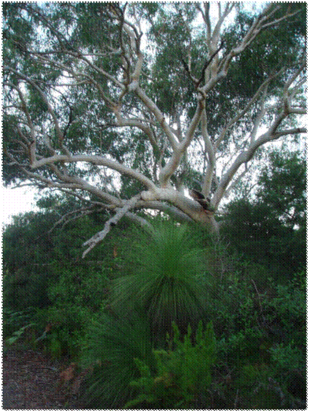
Front cover image: Ti Tree Lake Aboriginal Place. (Photo: OEH/D. Mackey)
Office of Environment and Heritage
59–61 Goulburn Street, Sydney NSW 2000
PO Box A290, Sydney South NSW 1232
Phone: (02) 9995 5000 (switchboard)
Phone: 131 555 (environment information and publications requests)
Phone: 1300 361 967 (national parks, climate change and energy efficiency information and publications requests)
Fax: (02) 9995 5999
TTY: (02) 9211 4723
Email: info@environment.nsw.gov.au
Website: www.environment.nsw.gov.au
Report pollution and environmental incidents
Environment Line: 131 555 (NSW only) or info@environment.nsw.gov.au
See also www.environment.nsw.gov.au/pollution
ISBN
OEH
April 2015
Printed on recycled paper
Acknowledgments
The NPWS acknowledges that this Aboriginal Place is in the country of the Bundjalung Nation and is located within the areas of the Bundjalung of Byron Bay (Arakwal) People and the Jali Local Aboriginal Land Council, and it has special significance to women of the Bundjalung Nation.
This preliminary draft plan of management was prepared by staff of the Northern Rivers Region of the NSW National Parks and Wildlife Service (NPWS), part of the Office of Environment and Heritage.
For additional information or any inquiries about the Ti Tree Lake Aboriginal Place or this preliminary draft management plan, contact the NPWS Byron Coast Area Office, Tallow Beach Road, Byron Bay, NSW 2481 or by telephone on (02) 66209300.
BYRON SHIRE COUNCIL
14.1 - Attachment 2
CONTENTS
1. Ti Tree (Taylor’s) Lake Aboriginal Place - Introduction 1
- Landowners and land managers 1
- Land use zoning and surrounding land use 1
- Management planning 4
- Protecting the Aboriginal Place 4
- Ti Tree Lake Aboriginal Area 4
- Protecting the wetlands 5
2. Official notice declaring the Aboriginal Place 5
3. Stakeholders 5
4. General statement of management 7
5. Cultural values 7
6. Aboriginal community management goals 8
7. Activities that could harm the Aboriginal Place 9
8. General management protocols 13
9. Risk management measures 13
10. Cultural value management strategies 14
11. Works and management activities 14
12. Other matters for negotiation 19
13. Culturally sensitive information 19
14. Funding resources 19
15. Contacts 19
GLOSSARY 20
REFERENCES 21
MAPS
Map 1 Location 2
Map 2 Landowners and Managers 3
Map 3 State Wetland 6
Map 4 Works proposed - tracks and signs 18
TABLES
Table 1 Activities in the Aboriginal Place 10
Table 2 Proposed works and activities in the Aboriginal Place 15
BYRON SHIRE COUNCIL
14.1 - Attachment 2
1. Ti Tree (Taylor’s) Lake Aboriginal Place
Introduction
Ti Tree (Taylor’s) Lake Aboriginal Place was declared under the National Parks and Wildlife Act 1974 (section 84) (NPW Act) in 2000 in recognition of its special significance to Aboriginal culture. The lake is also a registered mythological site on the NPWS Aboriginal Heritage Information Management System. The Jali Local Aboriginal Land Council and Bundjalung of Byron Bay Arakwal Elders campaigned for nearly two decades to get protection for the lake and its natural and cultural values.
The Aboriginal Place (AP) is approximately 70 hectares and is located 4km south of Byron Bay, on the far north coast of New South Wales, between Suffolk Park and Broken Head (see Map 1). The AP is centred on the Ti Tree Lake, also known locally as Taylors Lake, a highly significant Aboriginal women’s site. The lake consists of a northern lobe (1.3 hectares) and a southern lobe (4 hectares) linked by a narrow channel that opens intermittently to the ocean.
Landowners and land managers
The AP (see Map 2) consists of:
· freehold land owned by Jali Local Aboriginal Land Council, including most of the lake
· freehold land owned by Byron Shire Council
· Crown land, some of which is managed by Byron Shire Council and some by Crown Lands
· part of the Cape Byron Marine Park which is managed by Fisheries NSW and is located on Crown land between low and high water mark, and
· the Ti Tree Lake Aboriginal Area which is managed by the National Parks and Wildlife Service (NPWS).
The eastern boundary of the AP includes a 635 metre long section of Broken Head Beach down to the mean low water mark. A small part of the lake at its southern end (approximately 1700 square meters) occurs on freehold land outside the AP.
Land use zoning and surrounding land use
Suffolk Park adjoins part of the north and east boundaries of the AP, a sand and gravel quarry occurs on land adjoining the western boundary, and tourism and residential development at Broken Head village adjoins the southern boundary. Broken Head Nature Reserve, managed by the NPWS adjoins the south-east boundary of the AP.
Most of the AP is zoned for environmental protection under Byron Shire’s 1988 Local Environmental Plan (LEP), either as Wetlands, Coastal Habitat or Coastal Lands. However, most of Byron Shire Council’s freehold land in the north of the Aboriginal Place is zoned for Investigation and a small area in the north west is zoned Residential under the 1988 LEP. A mainly cleared firebreak, south of houses in Suffolk Park, is zoned Rural Landscape under Byron Shire’s 2014 LEP.
BYRON SHIRE COUNCIL
14.1 - Attachment 2
MAP 1

BYRON SHIRE COUNCIL
14.1 - Attachment 2
MAP 2

BYRON SHIRE COUNCIL
14.1 - Attachment 2
Management planning
The Office of Environment and Heritage (OEH), of which NPWS is a part, encourages the preparation of a formal management plan by the landowners/ land managers or occupiers of APs with the agreement of the Aboriginal community. This plan has been prepared in accordance with OEH guidelines (OEH 2012).
Management plans aim to identify:
a) the area’s Aboriginal cultural heritage values
b) the Aboriginal community’s management goals,
c) actions that need to be taken to protect its important cultural heritage values
d) actions that may require an Aboriginal Heritage Impact Permit (AHIP) under the NPW Act
e) funding and resources that may be available to implement the actions required.
Protecting the Aboriginal Place
It is an offence under the NPW Act (section 86[4]), to harm or desecrate an AP. Harm includes destroying, defacing or damaging an AP. If development will take place in the vicinity of an AP, the potential impacts of the development must be assessed.
An AHIP should be applied for if harm is proposed to an AP. An applicant for an AHIP can refer to a management plan for an AP, where a plan exists, when assessing impacts. A management plan identifies values and usually sets out what actions would or would not be considered harmful to values.
Where a management plan is in place this provides a clear record agreed by the Aboriginal community of:
· actions that will not harm the values of the place and that will not require an AHIP
· actions that would harm the values of the place and would need an AHIP, but may be acceptable in certain situation and with certain controls
· any harming actions for which OEH would generally refuse to issue an AHIP.
Ti Tree Lake Aboriginal Area
The Ti Tree Lake Aboriginal Area was reserved under the NPW Act in 2010 and is managed by the NPWS. It protects 10.5 hectares of land in the north of the AP (see Map 2). Aboriginal areas are reserved to protect and conserve areas associated with:
· a person, event or historical theme or
· containing a building, place, feature or landscape of natural or cultural significance to Aboriginal people or
· their importance in improving public understanding of Aboriginal culture and its development and transitions.
The land was formerly owned by Byron Shire Council and was transferred to NPWS in recognition of its Aboriginal cultural heritage significance and in accordance with an Indigenous Land Use Agreement (ILUA) between the Bundjalung People of Byron Bay and the State Government. The ILUA was registered under the Commonwealth Native Title Act in 2008.
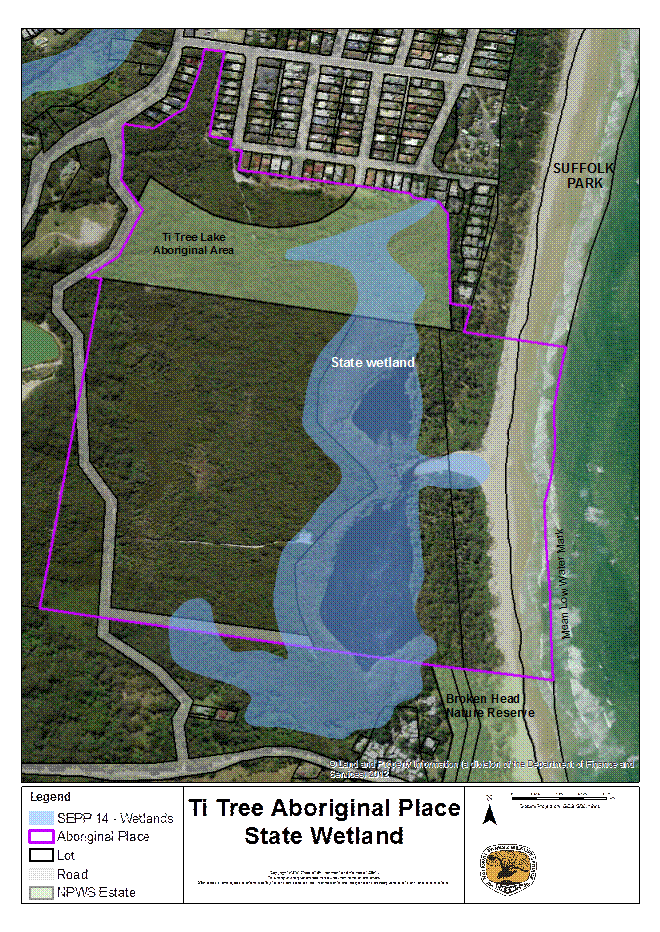
Protecting the wetlands
The lake and its surrounding swamp forests and sedgelands are mapped as wetlands under the State Coastal Wetlands Policy, known as State Environmental Planning Policy No. 14 (SEPP 14) – Coastal Wetlands (see Map 3). SEPP 14 aims to preserve and protect wetlands for their environmental and economic values at a State level by restricting certain development.
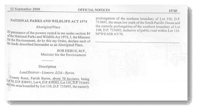
2. Official notice declaring the Aboriginal Place
The following notice declaring the Aboriginal Place appeared in the Government Gazette on 22 September 2000.
3. Stakeholders
The following organisations have interests in the AP:
|
Organisation |
Role / Interest |
|
Byron Shire Council |
Landowner, Crown land trustee, owns sewer, water and drainage infrastructure. |
|
Jali Local Aboriginal Land Council |
Landowner |
|
Crown Lands |
Land manager |
|
NPWS |
Land manager |
|
Marine Parks |
Land manager |
|
Bundjalung of Byron Bay Aboriginal Corporation (Arakwal) |
Native title claimants |
|
Bundjalung Elders |
Traditional knowledge holders |
|
Telstra |
Owner of telecommunications infrastructure |
|
Neighbours of the Aboriginal place |
Neighbouring property |
BYRON SHIRE COUNCIL
14.1 - Attachment 2
MAP 3
BYRON SHIRE COUNCIL
14.1 - Attachment 2
4. General statement of management
The following statements outline the Aboriginal community’s vision for management of the AP:
a) Encourage local Aboriginal communities to visit the place to continue cultural and spiritual practices, through informal or legal agreements with landowners/land holders/occupiers.
b) Encourage action designed to ensure continuation of cultural practices, such as maintaining or improving water quality of the catchment and retaining and improving vegetation of high cultural value.
c) No action should be taken if it would have any adverse impact on the significance of the place.
d) Minimise the risk of harming Aboriginal objects and sites and the Aboriginal place wherever possible.
e) Refer to this management plan for all day-to-day and longer term management decision-making and to implement works and undertake other activities
f) Give Aboriginal cultural values priority in resolving any conflicts about management and change to the place.
g) Aboriginal sites and objects in the Aboriginal Place will be conserved, recorded and managed in accordance with their significance.
h) Increase public awareness of the existence of the Aboriginal place and its high level of significance.
i) Aboriginal knowledge gathered by OEH will be respected and protected.
j) OEH will support the Aboriginal communities to determine what information on the Aboriginal place will be made available, such as location, stories and significance, and whether signs are erected on the Aboriginal place.
5. Cultural values
In 2000, NPWS commissioned anthropologist Inge Riebe to prepare a report to assess the Aboriginal cultural significance of the lake and surrounding area to support the process of protecting the area by declaring it an Aboriginal place under the NPW Act.
The assessment involved interviews with Elders and other Aboriginal people with knowledge of the Place to document the area’s history and cultural values, including its archaeological context, and the history of protection efforts. The report makes valuable recommendations for respectful management of this special women’s area.
Due to the sensitive nature of the information in the report and the strong view of the Elders that the information not be made public, it is not repeated here. A summary of the cultural values of the Place that can be spoken of publicly are:
· the Aboriginal Place is a sacred place for Aboriginal women
· the Ti Tree Lake is sacred and is a registered mythological site on the OEH Aboriginal Heritage Information Management System (AHIMS)
· traditional knowledge of the Aboriginal Place is sacred for Aboriginal women and is safeguarded. Traditional beliefs mean that the stories and secrets associated with Aboriginal Place cannot be talked about publicly.
· the Aboriginal Place is one of the few sacred women's sites in the state which remain intact and for which custodians and knowledge holders remain.
· local Aboriginal women continue to deliver traditional teachings about the Aboriginal Place to Aboriginal girls and women
· Aboriginal women continue to visit the place to maintain their connection with it and to pass on knowledge of its significance to others
· Elders have previously indicated strong concerns for maintaining catchment health to support their ongoing spiritual connections to Country
Due to the sacred significance of the lake and the surrounding 150-metre core area it is appropriate that this area has the greatest restrictions on use. However, the surrounding bushland within the Aboriginal Place is also integral to protecting the lake as it provides a buffer to adjoining land use and supports important cultural resources.
The Aboriginal Place occurs within a broader context of places of significance to the Aboriginal community. Other publicly known places include Cocked Hat Rocks (Three Sisters) Aboriginal Place, off Broken Head headland, in Broken Head Nature Reserve, Julian Rocks Nguthungulli Nature Reserve, a mythological site in Byron Bay and Walgun (Cape Byron) in Cape Byron State Conservation Area, east of Byron Bay.
6. Aboriginal community management goals
|
Management Goal |
Timeframe |
|
The lake and surrounding core area (lakeshore and 150 metre buffer), in particular, is used in accordance with Aboriginal cultural beliefs and traditions. |
Short term |
|
The lake is healthy and unpolluted. |
Short term |
|
Knowledge is passed down within the Aboriginal community in accordance with Aboriginal custom |
Long term |
|
The broader community understands and respects the significance of the lake and surrounding area. |
Short term |
|
Stakeholders (Council, NPWS, Crown lands, neighbours) understand and respect the significance of the lake and surrounding area. |
Medium term |
|
Cultural resources are healthy and sustainable. |
Long term |
7. Activities that could harm the Aboriginal Place
In the Assessment of Significance prepared by Inge Riebe (2000) the following statement is made about management of the AP, reflecting the wishes of the traditional owners and the parts of an earlier plan of management (Murphy 1993) of which they approved:
a) Ensure as little disturbance to the lake as possible
b) No swimming in the lake
c) No access to the lake as far as possible (i.e. walkways)
d) No pollutants enter the lake. Sewerage, stormwater and rubbish from houses and runoff from the quarry are of particular concern.
e) Any inappropriate human interference causes harm to the lake and can be harmful to those interfering. Custodial Elders need to have full control over any access to the Lake.
f) Men particularly should avoid the lake.
The following table details the type of activities that may occur in the AP including those that may harm the AP and its special cultural significance. Conditions are included, if appropriate, to reduce the harm caused by the activity. The inclusion or exclusion of certain activities in the AP is intended to reflect the wishes expressed by the traditional owners.
BYRON SHIRE COUNCIL
14.1 - Attachment 2
Table 1 Activities in the Aboriginal Place
|
Activity |
Is the activity consistent with cultural values? |
Under what conditions could the activity be consistent, if any? |
|
Commercial tourism and activities |
No |
None. |
|
Education activities |
Yes -conditionally |
Educational activities provided by local custodian Elders. |
|
Poor quality stormwater or groundwater entering the lake. |
No |
None. |
|
Other pollutants entering the lake (sunscreens, insect repellent). |
No |
None. |
|
Recreational or other use of the lake. |
No |
None. |
|
Men coming within 150-metres of the lake (the core area) |
No |
None. |
|
Buildings or structures |
No |
Small-scale, temporary structures for cultural purposes only. |
|
Camping |
No |
None. |
|
Riding bicycles |
No |
· Restricted to Taylors Lake Road, the fire break south of houses in Suffolk Park (on Council land and NPWS). · No promotion of bike riding. · No official bikeway. |
|
Use of motorised vehicles |
No |
· Driving a mobility-impaired person within the AP for cultural purposes. · Use of official vehicles for fire-fighting purposes and on the fire break south of houses on Macgregor Street. |
|
Bushwalking |
No |
· Restricted to Ti Tree Lake Aboriginal Area, in accordance with an approved plan of management, Taylors Lake Road and Council land in the north west of the AP. · No promotion of bushwalking. · No walking tracks. |
|
Activities that could cause harm |
Is the activity consistent with the cultural values? |
Under what conditions could it be consistent if any? |
|
Horse riding |
No |
· Restricted to Taylors Lake Road and not promoted. · No official bridle path. |
|
Parties or dance parties |
No |
None. |
|
Weddings |
No |
None. |
|
Exercising domestic animals (dogs and cats) or allowing them to roam free. |
No |
None. |
|
Use of drones |
No |
Only if in conjunction with works proposed in this management plan. Apply for permission on a case-by-case-basis from the landowner/manager. |
|
Other recreational uses of the Aboriginal Place (e.g. events, photography, picnicking, etc) |
No |
Passive (low-key) activities in the Ti Tree Lake Aboriginal Area, in accordance with an approved management plan, on the beach or on Council land in the north west of the AP. |
|
Developing new pathways |
No |
None. |
|
Construction of new infrastructure |
No |
None. |
|
Maintaining existing pathways |
No |
· Low-key maintenance of the pathway providing access for cultural purposes to the western side of the lake from Taylors Lake Road. · Maintenance of the fire trail south of the houses on Macgregor Street. |
|
Maintenance of Taylors Lake Road (a designated fire trail) |
No |
· No upgrading of road surface (sealing etc). · Maintain as a gravel surface. · Maintenance to the minimum standard required to provide access for fire fighting vehicles incorporating best practice erosion and sediment control and weed control. |
|
Maintenance of utilities (water, sewer, telecommunications) under Taylors Lake Road. |
No |
· Maintenance of utilities under the road must incorporate best practice erosion and sedimentation control and weed control. · No upgrading of road surface (sealing, concreting etc). · Maintain the road’s gravel surface. |
|
Cultural fire use |
Yes - conditionally |
· Small fires for cultural purposes (e.g. cooking, warming, ash/charcoal). |
|
Cultural activities |
Yes - conditionally |
· Small groups only. · Cultural activities to be conducted by local custodian women Elders. |
|
Activities that could cause harm |
Is the activity consistent with the cultural values of the Aboriginal Place? |
Under what conditions could it be consistent if any? |
|
Clearing |
No |
Low-key (minimal) clearing of disturbed areas for cultural purposes. |
|
Mining, quarrying or mineral exploration |
No |
None. |
|
Pump from the lake or waterways |
No |
None. |
|
Fire |
No |
· Only small-scale controlled burns to maintain cultural resources (i.e. culturally valuable plants and animals) if required. |
|
Controlling weeds |
Yes - conditionally |
· No weed control to occur on the dunes until a general pattern of avoidance of the lake is established. · Any herbicides usage around the lake must be consistent with permits and labels and an approved weed control/bush regeneration plan. · No herbicides to be used over the lake or its tributaries, even if permitted on labels etc. · It is preferred that women undertake this activity. |
|
Controlling pest animals |
Yes - conditionally |
· No poisons to be used within a 150-metre buffer area around the lake · Poison usage must be consistent with permits and labels and an approved pest control plan. · It is preferred that women undertake this activity. |
|
Managing vegetation to reduce bush fire risk to adjacent development |
No |
· Management bush fire risk in accordance with the approved Far North Coast Bush Fire Risk Management Plan. · Ensure the Aboriginal Place is recognised as an asset in the Far North Coast Bush Fire Risk Management Plan. |
|
Signs |
Yes – conditionally |
· Signs to educate people about significance of the place and appropriate behaviour. · Signs to be unobtrusive and placed so as not to attract visitors to the AP. |
|
Moving, relocating or collecting objects |
No. |
If an object is in danger of being destroyed or damaged. |
BYRON SHIRE COUNCIL
14.1 - Attachment 2
8. General management protocols
The following general protocols form an agreed basis for landowners, land managers and the Bundjalung of Byron Bay Arakwal People to work together to manage the AP:
a) assess the health of the lake through a water sampling program
b) an agreed approach to risk management
c) meet twice a year to review the operation of the management plan and consider whether to recommend changes to OEH
d) works carried out in the Aboriginal place will be in accordance with this plan of management
e) keep each other informed of works being undertaken in the AP by email or in writing (see Contacts section)
f) commit to working together to address strategic management issues in the AP, for example, access or controlling pest plants.
9. Risk management measures
The following risk management measures are intended to prevent or mitigate potential harm to the AP:
a) Before carrying out works undertake cultural and heritage assessments through the Aboriginal Heritage Impact Permit (AHIP) process, as required.
b) Establish an exclusion or buffer zone for activities that could harm the place.
c) Consult and involve the local Aboriginal community, relevant Elders, individuals and Local Aboriginal Land Councils.
d) Manage fire to prevent large fires.
e) Educate people about the significance of the place and safe practices.
f) Erect signage to educate the people about the place’s significance and appropriate behaviour.
g) Close pathways from the beach to the lake and along the lakeshore or allow them to revegetate naturally..
h) Close pathways, other than the pathway to the western side of the lake
i) Manage weeds and pest animals to prevent loss or damage to cultural resources.
j) Ensure runoff from the quarry site and stormwater from all outlets into the AP is managed to prevent harm to the place.
k) Investigate formally closing Taylors Lake Road (or at least that part of the road within the Aboriginal Place).
l) Exclude development from the Aboriginal place.
m) Ensure adequate sediment and erosion control on Taylors Lake Road.
n) Ensure all sewage is properly treated on surrounding lands and that the sewerage system on the Aboriginal place and on surrounding lands is properly maintained.
o) Routinely monitor or inspect the Aboriginal place to identify potential harm.
10. Cultural value management statements
The following statements outline an agreed approach to managing the cultural values of the AP:
a) Stakeholders and landowners will handle culturally sensitive information with respect and according to the wishes of the Aboriginal community regarding the AP which is a sacred women’s place.
b) Landowners, land managers and will work to conserve the environmental and cultural values of the place.
c) Continuing access for Aboriginal people to the AP will be encouraged to conserve its special significance.
d) Continued access to traditional/contemporary resources which are important for cultural purposes or simply in their own right, will be permitted.
e) Landowners and land managers will be encouraged to respect the connection of Aboriginal people to the place and the need for connection to Country to allow for the passing on of traditional knowledge.
f) The ongoing role of the AP as a teaching site will be recognised and respected.
g) Landowners and land managers will work to prevent large scale landscape changes to the AP, to conserve its spiritual and cultural values.
11. Works and activities
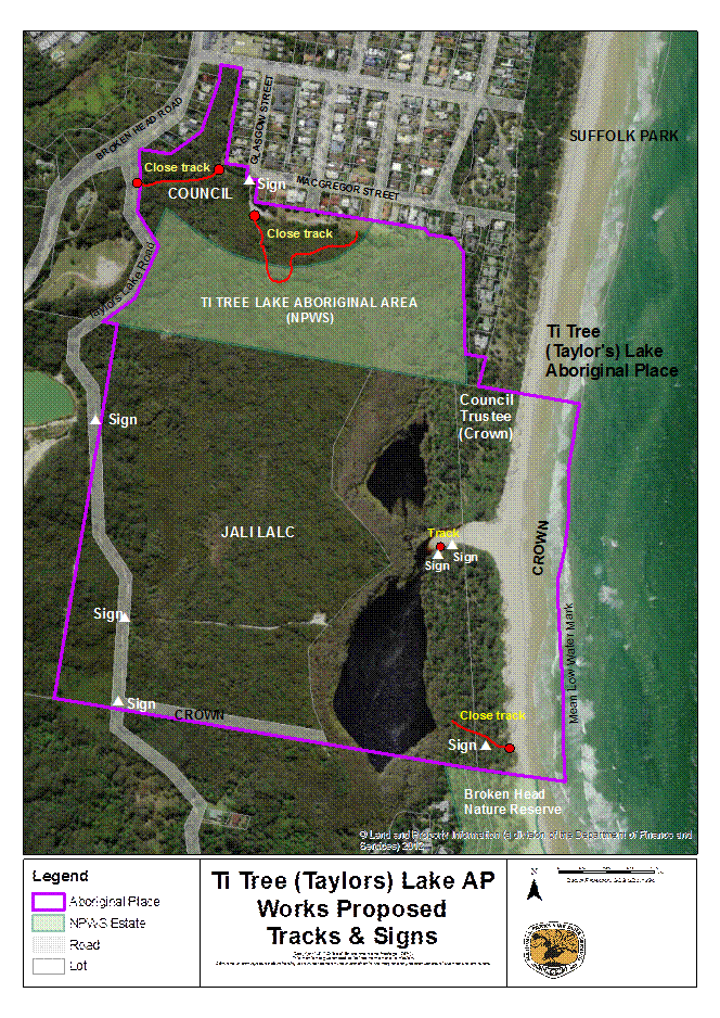
Works are required in the AP to protect cultural values and to manage risks. The following table lists proposed works, specifies how the works should be undertaken, identifies who is responsible and sets timeframes. Map 4 shows the location of works proposed to address tracks and signage.
BYRON SHIRE COUNCIL
14.1 - Attachment 2
Table 2 Proposed works and activities in the Aboriginal Place
|
Type of work or activity |
Specification |
Timeframe |
Responsible authority |
|
Design and install signage |
· Signs are to educate the public about the significance of the place and appropriate behaviour. · Signs are to be unobtrusive and positioned so as not to attract visitors to the Aboriginal Place. Sign locations (see Map 4): - near the lake entrance on the edge of vegetation - on the informal track running from the lake entrance south along the lakeshore - on the southern path that leads to the southern lake - at the intersection of Taylors Lake Road and the pathway to the western side of the lake, - on Taylors Lake Road at the southern boundary of the Aboriginal Place - on Taylors Lake Road where it intersects with the western boundary of the Aboriginal Place - at the entrance to the fire break on the AP that starts at the southern end of Glasgow Street. |
Short term |
Council Jali LALC |
|
Managing vegetation to reduce bush fire risk |
· Manage bush fire risk in accordance with the approved Far North Coast Bush Fire Risk Management Plan. · Manage bush fire risk in the Ti Tree Lake Aboriginal Area in accordance with the NPWS Fire Management Strategy. · Ensure the Aboriginal Place is recognised as an asset in the Far North Coast Bush Fire Risk Management Plan. |
Short - medium term |
Council NPWS Far North Coast Bush Fire Management Ctee |
|
Pests animals |
· Develop pest animal control plan/s (possibly linked to survey). · No poisons (baits) to be used within a 150-metre buffer area around the lake · Poison usage must be consistent with permits and labels and an approved pest animal control plan. · It is preferred that women undertake this activity. · It is preferred that women undertake this activity. |
Medium term |
Jali LALC Council NPWS |
|
Type of work or activity |
Specification |
Timeframe |
Responsible authority |
|
Pests plants |
· Develop bush regeneration plans. · No weed control to occur on the dunes until a general pattern of avoidance of the lake is established. · Any herbicides usage around the lake must be consistent with permits and labels and an approved weed control plan. · No herbicides to be used over the lake or its tributaries, even if permitted on labels etc. · No poisons to be used within a 150-metre buffer area around the lake · Poison usage must be consistent with permits and labels and an approved pest animal control plan. · It is preferred that women undertake this activity. · It is preferred that women undertake this activity. |
Plan - short term Works on dunes – medium term Works elsewhere – short to medium term |
Jali LALC Council NPWS |
|
Close pathways (see Map 4) |
· Pathways from the beach to the lake and along the lakeshore will be closed or allowed to revegetate naturally. Investigate closure options. · Close (bollard) the pathway that starts at the western end of the fire break behind the houses on Macgregor St and runs south into the Aboriginal Place to stop vehicles. · Close (bollard) the pathway that starts at the firebreak south of Glasgow Street and runs west to Taylors Lake Road · Close the pathway that runs to the western side of the lake at the intersection with Taylors Lake Road to stop motorbikes. Investigate closure options. · Check for pathways from the beach to the northern lake – close. |
Short term |
Council Jali LALC |
|
Investigate closing Taylors Lake Road |
· Investigate the process and the implications for landowners/managers prior to taking any further action. |
Long term |
Council NPWS Jali LALC |
|
Maintenance and adequacy of Council’s sewerage system |
· Obtain copy of maintenance program from Council · Ensure maintenance program is adequate. · Ensure no pollution of the AP. |
Short term |
Council |
|
Type of work or activity |
Specification |
Timeframe |
Responsible authority |
|
Ensure any septic systems on adjacent properties are operating safely and are not polluting the AP. |
· Obtain advice from Council |
Short to medium term |
Council |
|
Water quality of the lake – stormwater management
|
· Identify the places where stormwater enters the AP · Obtain advice about an effective stormwater sampling program, including the lake · Test stormwater and obtain a report about its likely impacts on the health of the lake. · Identify any remediation action required and implement. |
Plan – short term Sample and remediate – medium to long term |
Council NPWS Jali LALC Proprietors of Broken Head Quarry |
|
Soil erosion and sediment control (Taylors Lake Rd and pathway to western side of lake ) |
· Determine what works are required (if any) to meet best practice erosion and sediment control standards for the road and pathway, taking into account the culturally sensitive environment. · Prepare a report including works and priorities. |
Medium term |
Council Jali LALC |
|
Remove rubbish |
· Remove rubbish in the clearing on the western side of the lake. · Remove rubbish from other areas of the AP as identified or reported. · NPWS to remove rubbish from the Ti Tree lake Aboriginal Area as identified or reported. · Council to remove rubbish from their property as identified or reported. |
Short term |
Jali LALC NPWS Council |
|
Survey plants and animals |
· Undertaken survey in accordance with OEH guidelines · Target culturally important animals/plants and threatened animals. |
Medium - long term |
Jali LALC Council NPWS |
BYRON SHIRE COUNCIL
14.1 - Attachment 2
MAP 4
BYRON SHIRE COUNCIL
14.1 - Attachment 2
12. Other matters for negotiation
- Signage design.
- Other matters to be added after further consultation.
13. Culturally sensitive information
Only publicly available cultural information is included in this plan. Cultural knowledge of the AP remains the property of the knowledge holders.
14. Funding and resources for works proposed in the plan
- To be completed following further consultation.
15. Contacts
Sue Walker
Area Manager, Byron Coast
National Parks & Wildlife Service
Tallow Beach Road, Byron Bay NSW 2481
npws.byroncoast@environment.nsw.gov.au
Phone: 0266209300
Jali Local Aboriginal Land Council
Byron Shire Council
Crown Lands
Cape Byron Marine Park
GLOSSARY
AHIP Aboriginal Heritage Impact Permit
AHIMS Aboriginal Heritage Information Management System
AP Aboriginal Place
Bundjalung of Byron Bay Aboriginal Corporation (Arakwal):
The Corporation is established under the Aboriginal Councils and Association Act 1976 (Commonwealth), as a prescribed body to represent the Bundjalung People Byron Bay (Arakwal) as native titleholders and their rights, interests and benefits in trust.
Cultural activities: Refers to activities such as, but not limited to, wild resource use, gatherings, ceremonies and other cultural practices and customs.
Country: Refers to the ‘landscape’ of origin of a particular group/clan of Aboriginal people. This landscape is all encompassing, and the natural, cultural and historical features are inseparable.
Endangered Ecological Community:
A community listed on Schedule 1 Part 3 of the Threatened Species Conservation Act 1997 (NSW).
ILUA Indigenous Land Use Agreement
LEP Local Environmental Plan
OEH Office of Environment & Heritage
NPW Act National Parks and Wildlife Act 1974
NPWS National Parks & Wildlife Service
SEPP 14 State Environmental Planning Policy No. 14 – Coastal Wetlands
Threatened species: A species listed under the Threatened Species Conservation Act 1997 (NSW) as either endangered, critically endangered or vulnerable.
REFERENCES
Murphy D 1993, Investigation Report of Proposal for an Aboriginal Place at Taylors Lake, via Suffolk Park NSW, report to the National Parks & Wildlife Service.
OEH 2012, Guidelines for developing management plans for declared Aboriginal Places, Office of Environment & Heritage, Sydney South.
Riebe, I 2000, Assessment of Significance for Aboriginal Place Declaration, Ti Tree (Taylors) Lake, unpublished report to the National Parks & Wildlife Service.
BYRON SHIRE COUNCIL
14.1 - Attachment 2
APPENDIX 1
BACKGROUND RESOURCE PAPER
TI TREE (TAYLOR’S) LAKE
ABORIGINAL PLACE
To be completed………..