13.8 - Attachment 3
Table of Contents
Part 1 Introduction. 3
Purpose. 3
Property details and existing zones. 3
Background. 4
Part 2 Explanation
of provisions. 6
Development and infrastructure within West Byron. 6
Subdivision and Development of Residential Zoned Land. 8
Subdivision in E2 and E3 Zones with Split Zones. 10
Part 3 Justification. 12
Section A Need
for the planning proposal 12
1. Is
the planning proposal a result of any strategic study or report?. 12
2. Is
the planning proposal the best means of achieving the objectives or intended
outcomes, or is there a better way? 12
3. Is
there a net community benefit?. 12
Section B Relationship
to strategic planning framework. 13
1. Is
the planning proposal consistent with the objectives and actions contained
within the applicable regional or sub-regional strategy (in this case the Far
North Coast Regional Strategy)?. 13
2. Is
the planning proposal consistent with the local Council’s Community Strategic
Plan, or other local strategic plan? 13
1. Is
the planning proposal consistent with the applicable State Environmental
Planning Policies (SEPPs)? 13
2. Is
the planning proposal consistent with applicable Ministerial Directions
(s117 Directions)?. 14
Section C Environmental,
social and economic impact 33
1. Is
there any likelihood that critical habitat or threatened species, populations
or ecological communities, or their habitats will be adversely affected as a
result of the proposal?. 33
2. Are
there any other likely environmental effects as a result of the planning
proposal and how are they proposed to be managed?. 33
3. How
has the planning proposal adequately addressed any social and economic effects?. 33
4. Justification
of Proposed Provisions. 33
Section D State
and Commonwealth interests. 35
1. Is
there adequate public infrastructure for the planning proposal?. 35
2. What
are the views of State and Commonwealth public authorities consulted in
accordance with the gateway determination?. 36
Part 4 Mapping. 36
Part 5 Community
consultation. 36
Part 6 Project
timeline. 36
Summary and conclusions. 36
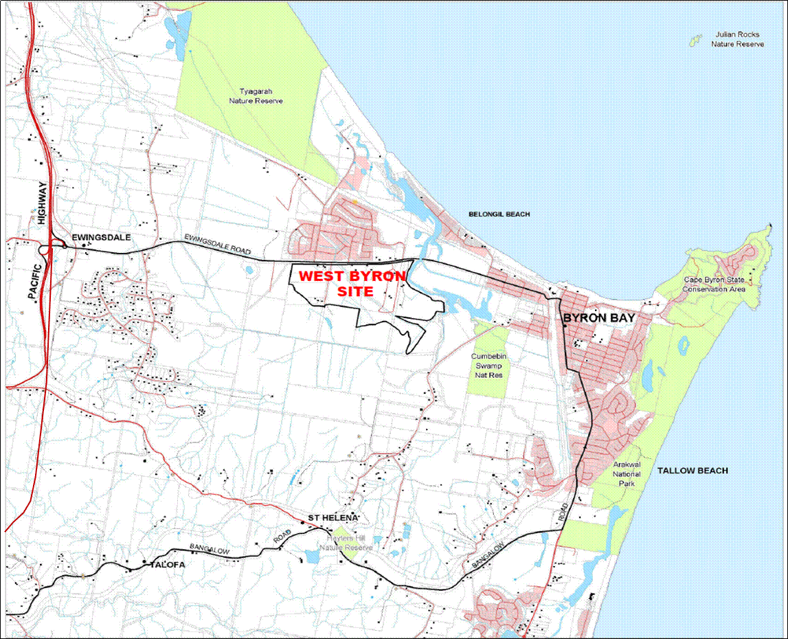
Appendix 1 Locality and Site Map. 38
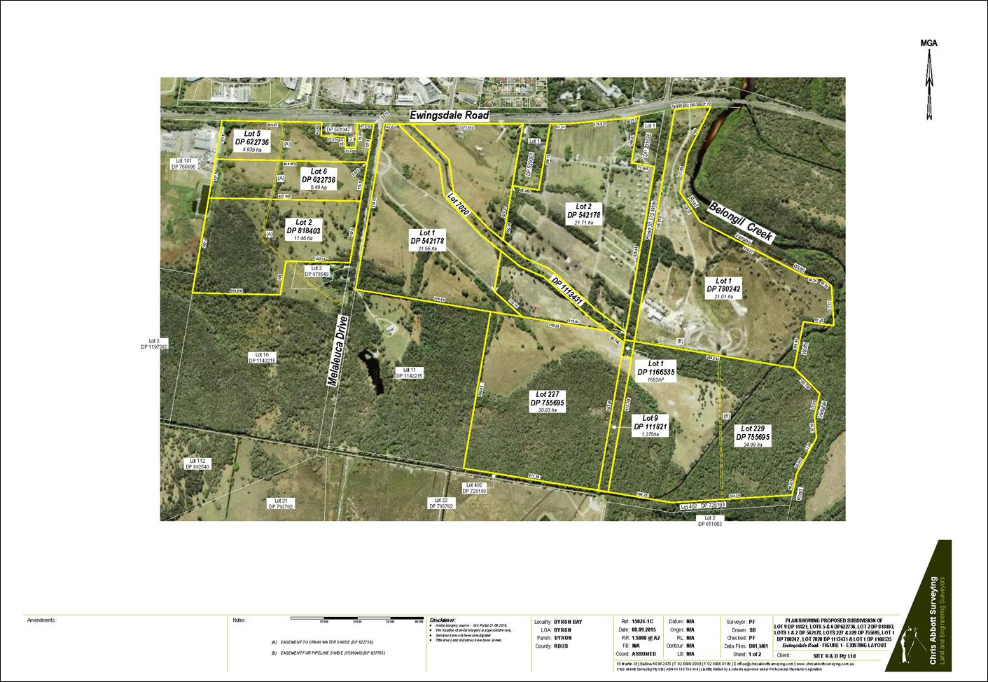
Appendix 2 Existing Subdivision Layout 39
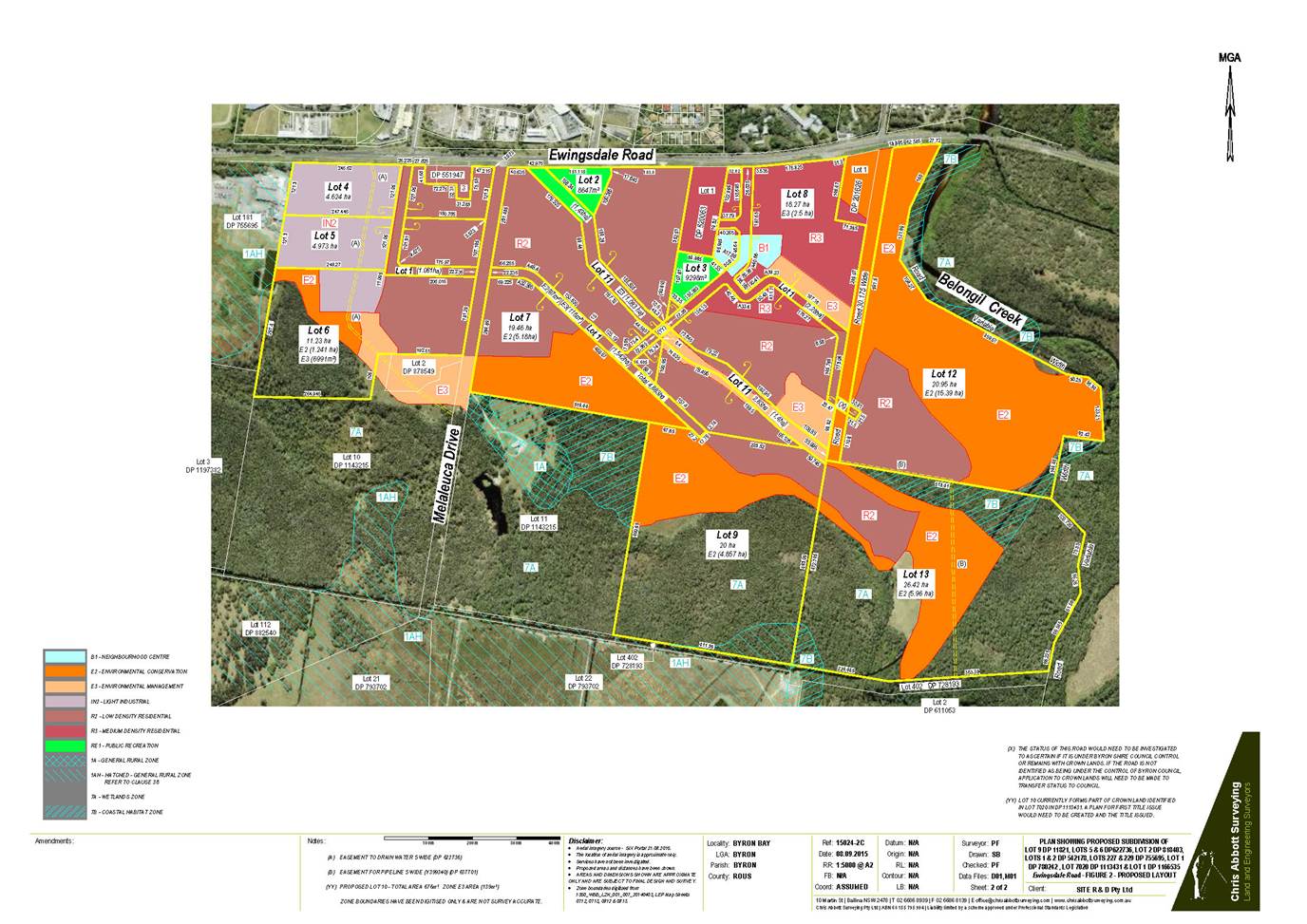
Appendix 3 Proposed Plan of Subdivision and Table of Lots
Sizes and Zoned area. 40
Appendix 4 Proposed Stormwater Outlet Plan. 41
Appendix 5 Indicative Road Layout Plan. 43
Appendix 6 Vegetation Mapping. 43
Appendix 7 Restoration Management Zones. 45
Purpose
The purpose
of this planning proposal is to correct anomalies in the Planning Instrument in
relation to the permissibility of infrastructure in the various zones, the lot
size requirement for medium density housing forms in the R2 Zone, and the minimum
lot sizes in the E2 and E3 zones.
Property
details and existing zones
The West
Byron Urban Release Area (WBURA) comprises thirteen separate lots in six different
ownerships. The following table (Table 1) identifies each lot together
with lot areas and ownership details.
|
TABLE 1 – PROPERTY
SUMMARY TABLE
|
|
LOT
|
DEPOSITED PLAN
|
FOLIO IDENTIFIER
|
LANDOWNER
|
AREA(Ha)
|
|
5
|
622736
|
5/622736
|
NSPT Pty Limited
|
4.939
|
|
6
|
622736
|
5/622736
|
NSPT Pty Limited
|
5.49
|
|
1
|
542178
|
1/542178
|
NSPT Pty Limited
|
21.56
|
|
227
|
755695
|
227/755695
|
NSPT Pty Limited
|
20.03
|
|
229
|
755695
|
229/755695
|
NSPT Pty Limited
|
24.99
|
|
9
|
111821
|
1/111821
|
NSPT Pty Limited
|
1.2775
|
|
1
|
1166535
|
1/1166535
|
NSPT Pty Limited
|
1582m2
|
|
1
|
201626
|
1/201626
|
Telicove Pty Limited
|
1.143
|
|
2
|
542178
|
2/542178
|
Telicove Pty Limited
|
21.71
|
|
1
|
780242
|
1/780242
|
Gousse Holdings Pty Ltd
|
21.01
|
|
2
|
818403
|
2/818403
|
Anthony Roy Smith
Julie Deborah Smith
Fletcher Project
Developments Pty Ltd
|
11.46
|
|
1
|
520063
|
1/520063
|
David John O’Connor
Carol Fay O’Connor
|
1.619
|
|
7020
|
1113431
|
7020/1113431
|
Crown Land (Drainage
Reserve) 30.175m wide
|
2.86
|
|
|
|
|
TOTAL AREA
|
138.25
|
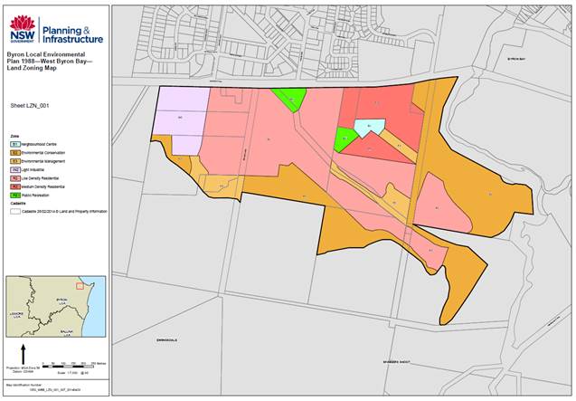
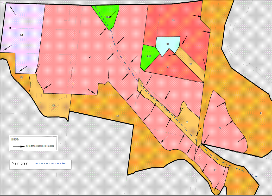
Current zones are shown in Figure 1 below.
Figure 1 – Zoning Map
Source: Byron Local
Environmental Plan 1988
Background
State
Significant Site Study and Byron Local Environmental Plan 1988 Amendment
In October
2009, the Minister for Planning gazetted the West Byron Bay site as a potential
State Significant Site.
The site is
identified as a “New Release Area” in the Far North Coast Regional Strategy,
2000 – 2031.
Subsequently,
a State Significant Site Study was prepared on behalf of the West Byron Bay
Landowners Association and submitted to the Department in June 2011. The Study
informed rezoning of the site for urban purposes.
The Study
was publicly exhibited between 12 October 2011 and 14 December 2011. Following
consideration of submissions received, including the proponent’s response to
submissions, the Department prepared draft documents to rezone the site by way
of a Draft State Environmental Planning Policy. The Department’s proposal was
exhibited for 64 days between 28 November 2013 and 31 January 2014.
Subsequently,
the site was rezoned for urban purposes by way of a State Environmental
Planning Policy Amendment to Byron Local Environmental Plan 1988 (BLEP1988),
which took effect from 14 November 2014.
Draft West Byron Urban Release Area –
Development Control Plan 2013
The
Department of Planning and Environment prepared the Draft WBURA Development
Control Plan 2013 to support the rezoning and guide future development. The
Draft Development Control Plan (DCP) was publicly exhibited with the Draft
State Environmental Planning Policy (SEPP). However, on 28 February 2015 the
Department referred the exhibited Draft DCP to Byron Shire Council (BSC) for
finalisation and adoption.
Subsequently,
BSC prepared a draft amendment to Byron DCP2014 incorporating specific
provisions relating to the West Byron Bay site and addressing the relevant
matters in Clause 101 of BLEP1988 (as amended). At the date of preparing this
submission the Draft Amendment has not been publicly exhibited.
Voluntary Planning Agreement
The Draft
Voluntary Planning Agreement (VPA) between the Minister for Planning and West
Byron Landowners was publicly notified between 28 November 2013 and 31 January
2014 and was executed by all parties on 21 October 2014.
In summary,
the VPA requires each landowner to pay contributions towards urban roads,
conservation of the conservation land and preparation and implementation of a
Vegetation Management Plan for the conservation land.
Planning Context
The planning
proposal was initial prepared by Darryl Anderson Consulting on behalf of the
various land owners within West Byron., The proposal seeks to amend clauses 82 and
83 in relation to residential development in the R2 Low Density Zone, amend
Clause 85 in relation to the minimum lot size provisions for land with split
zones, and insert a new clause in relation to permitting infrastructure in the
Environmental Zones. The planning proposal was reported to Council on 29
October 2015 where the following was resolved:
15 –
567 Resolved
1. That
Council proceed with the planning proposal in Attachment 1 and forward to the
Department of Planning and Environment with the exception of the infrastructure
clause in relation to development in the E zones, which will be amended to only
permit infrastructure to cross E Zones but not to run parallel/along them.
2. That Council
request the Department of Planning and Environment to delegate to Council the
preparation and making of the LEP Amendment.
The Planning
Proposal was forwarded to the Department of Planning and Environment who issued
a Gateway on 22 January 2016 requesting minor changes in terms of the
explanation of the clauses, justification and provision of a wider locality
map. The amended planning proposal was then sent back to the Department for
approval and an Altered Gateway was issued on the 15 April 2015 requesting that
the provisions for Clause 72A be amended further removing the restriction
limiting infrastructure to only cross the E Zones. The Gateway also suggested
that the planning proposal could include “heads of consideration” as a clause
to ensure works in the E Zones are appropriately considered in terms of
minimising impacts.
In
accordance with the Altered Gateway Determination the planning proposal has
been amended.
In reviewing
the planning controls under Part 4 of Byron LEP 1988 for the WBURA, it has
become apparent that there are several anomalies in the Planning Instrument in
relation to the permissibility of certain land uses in the various zones and
the ability to comply with minimum lot sizes in the E2 and E3 zones. In summary
the Planning Proposal will seek to amend the West Byron Provisions under Part 4
of Byron LEP 1988 by:
1. Providing an
enabling clause to remove issues of permissibility for stormwater drainage,
water and sewer reticulation and earthworks across the West Byron Site
2. Increase the
lots sizes for medium density housing forms in the R2 Low Density Residential
Zone; and
3. Provide an
enabling clause to facilitate the subdivision of land which is partly zoned
environmental protection (E2 and or E3) from the remainder of the property.
Discussion
To enable
the subject land to be subdivided and developed, including filling and
construction of normal urban infrastructure (roads, drainage, water supply and
sewerage, etc.) in accordance with the intent of BLEP1988, it is proposed that
an enabling clause be included in the Instrument to make earthworks, stormwater
management systems, water supply systems and sewer reticulation systems
explicitly permissible, with consent, in all zones. Note: stormwater
management systems are not defined in the Standard Instrument but are defined
in State Environmental Planning Policy (Infrastructure) 2007.
stormwater management system
means:
(a) works
for the collection, detention, distribution or discharge of stormwater (such as
channels, aqueducts, pipes, drainage works, embankments, detention basins and
pumping stations), and
(b) stormwater
quality control devices (such as waste entrapment facilities, artificial
wetlands, sediment ponds and riparian management), and
(c) stormwater
reuse schemes.
As indicated
in Table 2, currently earthworks, drainage and sewer reticulation
systems are prohibited in the E2, E3 and RE1 zones and water supply systems are
prohibited in all zones.
It will be
necessary to carry out earthworks, drainage, water supply and sewerage works
within the E2 and E3 zones including the existing drainage channel in
particular.
|
TABLE
2 – PERMISSIBILITY OF PROPOSED DEVELOPMENT
|
|
ZONE
|
PROPOSED
DEVELOPMENT
|
|
ROADS
|
EARTHWORKS
(FILLING)
|
DRAINAGE(1)
|
WATER
SUPPLY SYSTEMS(2)
|
SEWER
RETICULATION SYSTEMS(3)
|
|
B1
|
PWC*
|
PWC
|
PWC
|
Prohibited
|
PWC
|
|
E2
|
PWC
|
Prohibited
|
Prohibited
|
Prohibited
|
Prohibited
|
|
E3
|
PWC
|
Prohibited
|
Prohibited
|
Prohibited
|
Prohibited
|
|
IN2
|
PWC
|
PWC
|
PWC
|
Prohibited
|
PWC
|
|
R2
|
PWC
|
PWC
|
PWC
|
Prohibited
|
PWC
|
|
R3
|
PWC
|
PWC
|
PWC
|
Prohibited
|
PWC
|
|
RE1
|
PWC
|
Prohibited(4)
|
Prohibited(4)
|
Prohibited(4)
|
Prohibited(4)
|
* PWC – Permissible with Consent
Notes:
1. State
Environmental Planning Policy (Infrastructure) 2007, at Clause 111(1) provides
that:
“111 Development
permitted without consent
(1)
Development for the purpose of stormwater management systems may be carried out
by or on behalf of a public authority without consent on any land.”
2. State
Environmental Planning Policy (Infrastructure) 2007, at Clause 125(1) provides
that:
“125 Development
permitted without consent
(1)
Development for the purpose of water reticulation systems may be carried out by
or on behalf of a public authority without consent on any land.”
3. State Environmental Planning Policy (Infrastructure)
2007, at Clause 106(3)(b) provides that:
“106 Development permitted
with or without consent
(3) Development for the purpose of sewage
reticulation systems may be carried out:
(b) by
any other person with consent on any land.”
4. On the
basis that the filling, drainage, water supply and sewer works are appropriately
characterised as development for the purpose of a recreation area, they would
be permissible, with consent, in the RE1 zone.
The
provisions of State Environmental Planning Policy (Infrastructure) 2007 (SEPPI)
in relation to permissibility of stormwater management systems and water
reticulation systems cannot be relied upon as the infrastructure is not being “carried
out by or on behalf of a public authority”, but by the developer.
Proposed
LEP Amendment
To remove
any potential issues of how development for the purposes of earthworks,
stormwater management systems and water and sewer reticulation systems are
characterised and their permissibility an enabling clause is recommended. The
clause would:
|
Proposed LEP Amendment (Plain English Explanation)
|
Suggested Clause Wording
|
|
1) incorporate
an objective that is to facilitate the provision of infrastructure for West
Byron including stormwater management systems, earthworks, and water and
sewer reticulation;
|
1)
The objective of this clause is to ensure that any person can carry out
development for the purpose of stormwater management system, earthworks,
water reticulation system and sewage reticulation system on any land.
|
|
2) include
further provisions that enable such infrastructure to occur with development
consent in any zone.
|
2) Despite
any other provisions of this Plan, development consent may be granted to
development for the purpose of earthworks, stormwater management system,
water reticulation system and sewage reticulation system on any land.
|
|
3) Include
heads of consideration provisions to ensure works are appropriately sited and
designed to have minimal potential for environmental impacts with
compensatory offset and mitigation measures where such impacts cant be
avoided.
|
3)
Development consent must not be granted for works in the E2 and E3 Zone or on
adjacent Zones R2, R3 or IN2 under subclause 2 unless it has taken into
consideration:
a) the likely impact on
i) native
terrestrial flora and fauna and its habitat, and
ii) native
aquatic flora and fauna and its habitat, and
iii) the
ecological role of the land, waterways, riparian land or wetland, and
iv) threatened
species, communities, populations and their habitats.
b) the
design and siting of infrastructure has been located as far as possible to
avoid, or minimise impacts on, significant native vegetation and habitat.
c) where
impacts are unable to be avoided, management and compensatory measures to
mitigate such impacts through the restoration of any existing disturbed or
modified areas on the site or on adjacent lands.
|
|
4) Confirm
the definition of stormwater management systems.
|
4) For
the purposes of this clause stormwater management system means:
a) works
for the collection, detention, distribution or discharge of stormwater (such
as channels, aqueducts, pipes, drainage works, embankments, detention basins
and pumping stations), and
b) stormwater
quality control devices (such as waste entrapment facilities, artificial
wetlands, sediment ponds and riparian management), and
c) stormwater
reuse schemes.
|
Discussion
In relation
to subdivision and development of the residential zoned land, Clauses 82 and 83
of BLEP1988 are in the following terms:
“82 Minimum
lot sizes for dual occupancy, multi dwelling housing and residential flat
buildings
(1)
The objective of this clause is to achieve planned residential density in
certain zones.
(2)
Despite clause 81, development consent may be granted to development on a lot
in a zone shown in Column 2 of the Table to this clause for a purpose shown in
Column 1 of the Table opposite that zone, only if the area of the lot is equal
to or greater than the area specified for that purpose and shown in Column 3 of
the Table.
|
Column
1
|
Column
2
|
Column
3
|
|
Dual
occupancy (attached)
|
R2 Low
Density Residential
R3 Medium Density Residential
|
300
square metres
|
|
Dual
occupancy (detached)
|
R2 Low
Density Residential
R3 Medium Density Residential
|
400
square metres
|
|
Multi
dwelling housing
|
R2 Low
Density Residential
R3 Medium Density Residential
|
450
square metres
|
|
Residential
flat building
|
R3
Medium Density Residential
|
1,000
square metres”
|
“83 Exceptions
to minimum subdivision lot sizes for certain residential development
(1) The
objective of this clause is to encourage housing diversity without adversely
impacting on residential amenity.
(2)
This clause applies to development on land in the following zones:
(a) Zone
R2 Low Density Residential,
(b) Zone
R3 Medium Density Residential.
(3)
Development consent may be granted for a single development application for
development to which this clause applies that is both of the following:
(a) the
subdivision of land into 3 or more lots,
(b) the
erection of a dwelling house, an attached dwelling or a semi-detached dwelling
on each lot resulting from the subdivision, if the size of each lot is equal to
or greater than:
(i) for the erection of a dwelling house—200 square
metres, or
(ii) for
the erection of an attached dwelling—150 square metres, or
(iii) for
the erection of a semi-detached dwelling—150 square metres.”
Following
consultations with Council Officers and the landowners, it is considered that
due to the existing urban character of Byron Bay and the existing urban areas
within the region, it would be more appropriate if the R2 zoned land in West
Byron is more consistent with that which already exists and to provide a clear
differentiation with the R3 zoned land. West Byron will deliver a diversity of
dwellings through the development of the R3 zoned lands and with strategically
placed development sites within the R2 zone where dual occupancy, multi
dwelling housing and integrated housing are better suited.
The West
Byron landowners have provided support to the proposed amendments to the R2 Zone
with regard to increasing the minimum lot size to provide dual occupancy, multi
dwelling housing and integrated housing under Clauses 82 and 83 of BLEP1988 as
follows:
Table 3 –
Minimum Lot Size requirements – Various Housing Forms
|
DEVELOPMENT FORM
|
ZONING
|
LOT SIZE
|
|
Dual Occupancy
(attached)
|
R2
|
600m2
|
|
Dual Occupancy
(detached)
|
R2
|
700m2
|
|
Multi Dwelling Housing
|
R2
|
1000m2
|
|
Integrated Housing
- Subdivision
of land into 3 or more lots and a dwelling erected on each lot
|
R2
|
250m2 per attached or semi attached dwellings = 750m2 min for 3 dwellings
300m2 per detached dwellings = 900m2 min for 3 dwellings
|
Proposed
LEP Amendment
Having
regard to the above, the following amendments are proposed to Clauses 82 and
83:
82 Minimum
lot sizes for dual occupancy, multi dwelling housing and residential flat
buildings
(1)
The objective of this clause is to achieve planned residential density in
certain zones.
(2)
Despite clause 81, development consent may be granted to development on a lot
in a zone shown in Column 2 of the Table to this clause for a purpose shown in
Column 1 of the Table opposite that zone, only if the area of the lot is equal
to or greater than the area specified for that purpose and shown in Column 3 of
the Table.
|
Column
1
|
Column
2
|
Column
3
|
|
Dual
occupancy (attached)
|
R2 Low
Density Residential
R3 Medium Density Residential
|
600
square metres
300
square metres
|
|
Dual
occupancy (detached)
|
R2 Low
Density Residential
R3 Medium Density Residential
|
700
square metres
400 square
metres
|
|
Multi
dwelling housing
|
R2 Low
Density Residential
R3 Medium Density Residential
|
1,000
square metres
450
square metres
|
|
Residential
flat building
|
R3
Medium Density Residential
|
1,000
square metres
|
83 Exceptions to minimum
subdivision lot sizes for certain residential development
(1) The objective of this clause is to encourage housing
diversity without adversely impacting on residential amenity.
(2)
This clause applies to development on land in the following zones:
(a) Zone
R2 Low Density Residential,
(b) Zone
R3 Medium Density Residential.
(3)
Development consent may be granted for a single development application for
development to which this clause applies that is both of the following:
(a) the
subdivision of land into 3 or more lots,
(b) the
erection of a dwelling house, an attached dwelling or a semi-detached dwelling
on each lot resulting from the subdivision, if the size of each lot is equal to
or greater than:
(i) for the erection of a dwelling house—300 square metres
for R2 and 200 square metres for R3;
(ii) for
the erection of an attached dwelling—250 square metres for R2 and 150 square
metres for R3;
(iii) for
the erection of a semi-detached dwelling—250 square metres for R2 and 150
square metres for R3.
Discussion
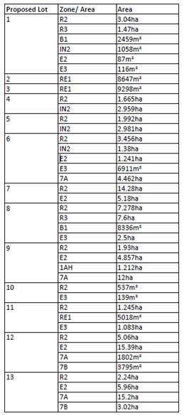
In relation
to subdivision of the subject land it will also be necessary to create residual
lots zoned E2 and E3 with areas of less than 40 hectares, because the parent
lots do not contain more than 40 hectares of E2 and E3 land. The attached
Plan of Proposed Subdivision (Figure 2, 9 September 2015 and Table)
show the configuration and areas of the proposed lots.
Clause 81 of
Byron LEP 1988 requires a minimum lot size of 40 hectares for lots created in
the E2 and E3 zones.
As indicated
on the attached Plan of Proposed Subdivision and Table, the total area
of E2/E3 land in each proposed lot is well below the 40 hectare minimum, whilst
some existing lots are already substantially less than 40 hectares in area. With
the land owned by multiple land owners, it is unlikely that development of
these parcels will be co-ordinated in such a way to create a large residual lot
of E2 and E3 Zoned Land that can meet the 40ha minimum standard.
The
provisions for West Byron also fail to acknowledge that some lots also retain
areas of land zoned 7(a) Environment Protection (Wetlands) which are not
covered by the West Byron Provisions under Byron LEP 1988 and have been
deferred from Byron LEP 2014. These areas of wetland are in all likelihood to be
retained within the residual lots containing E2 and E3.
Clause 85 of
BLEP1988 (WB) which provides for an exception to development standards is in
the following terms:
“85 Exceptions to
development standards
(1) The
objectives of this clause are as follows:
(a) to
provide an appropriate degree of flexibility in applying certain development
standards to particular development,
(b) to
achieve better outcomes for and from development by allowing flexibility in
particular circumstances.
(2)
Development consent may, subject to this clause, be granted for development
even though the development would contravene a development standard imposed by
this or any other environmental planning instrument. However, this clause does
not apply to a development standard that is expressly excluded from the
operation of this clause.
(3)
Development consent must not be granted for development that contravenes a
development standard unless the consent authority has considered a written
request from the applicant that seeks to justify the contravention of the
development standard by demonstrating:
(a)
that compliance with the development standard is unreasonable or unnecessary in
the circumstances of the case, and
(b)
that there are sufficient environmental planning grounds to justify contravening
the development standard.
(4)
Development consent must not be granted for development that contravenes a
development standard unless:
(a) the
consent authority is satisfied that:
(i) the
applicant’s written request has adequately addressed the matters required to be
demonstrated by subclause (3), and
(ii)
the proposed development will be in the public interest because it is
consistent with the objectives of the particular standard and the objectives
for development within the zone in which the development is proposed to be
carried out, and
(b) the
concurrence of the Director-General has been obtained.
(5) In
deciding whether to grant concurrence, the Director-General must consider:
(a)
whether contravention of the development standard raises any matter of
significance for State or regional environmental planning, and
(b) the
public benefit of maintaining the development standard, and
(c) any
other matters required to be taken into consideration by the Director-General
before granting concurrence.
(6)
Development consent must not be granted under this clause for a subdivision of
land in Zone E2 Environmental Conservation or Zone E3 Environmental Management
if:
(a) the
subdivision will result in 2 or more lots of less than the minimum area
specified for such lots by a development standard, or
(b) the
subdivision will result in at least one lot that is less than 90% of the
minimum area specified for such a lot by a development standard.
(7)
After determining a development application made pursuant to this clause, the
consent authority must keep a record of its assessment of the factors required
to be addressed in the applicant’s written request referred to in subclause
(3).
(8)
This clause does not allow development consent to be granted for development
that would contravene any of the following:
(a) a
development standard for complying development,
(b) a
development standard that arises, under the regulations under the Act, in
connection with a commitment set out in a BASIX certificate for a building to
which State Environmental Planning Policy (Building Sustainability Index:
BASIX) 2004 applies or for the land on which such a building is situated,
(c)
clause 87 (Controls relating to miscellaneous permissible uses),
(d)
clause 99 or 100.”
In effect,
Clause 85(6)(b) requires any residue lots zoned E2 or E3 to have a minimum area
of 36ha. If there is less than 36ha in the parent parcel, the effect of Clause
85(6)(b) is that the urban zoned part of the land cannot be subdivided and developed.
This is clearly an outcome that cant be achieved and cannot have been the
intent of the Clause.
Proposed LEP Amendment
It is
considered that Clause 85, is inappropriate because it precludes subdivision
and development of urban zoned land and may result in impractical planning
outcomes with multiple properties and different land owners. An enabling clause
worded to achieve the following would be appropriate.
|
Proposed LEP Amendment (Plain English Explanation)
|
Suggested Clause Wording
|
|
i) Objectives to enable
consent to be granted to create residue lots of E2 and / or E3 zoned land
that are less than the minimum lot size requirement; and
ii) These residue lot
must contain all of the E2 and / or E3 zoned land that was in the original
lot;
|
1) The
objective of this clause is to enable development consent to be granted for
lots in the E2 and E3 Zone which do not comply with the minimum lot size map
if they are residual lots
2) Despite
any other provisions of this Plan, development consent can be granted for the
subdivision of land in the E2 or E3 Zone provided all land originally in the
E2 or E3 Zone remains in one lot as a residual lot.
|
Section A Need for the planning proposal
No – the Planning Proposal results
from anomalies in the Planning Instrument identified in the review of the
planning controls for the West Byron Site.
Rather than insert an enabling clause
to permit infrastructure, the Land Use Tables could be amended to permit the
currently prohibited infrastructure. However this is not considered to be an
efficient and appropriate option. Similarly, the Minimum Lot Size Map could be
amended to remove the minimum lot size in the E2 and E3 zones, however again,
this is not considered to be an efficient and appropriate option.
Yes – the Planning Proposal will
enable development of the WBURA to be approved and constructed to meet the
objectives of the Far North Coast Regional Strategy 2006-2031 (FNCRS).
Given the facilitative nature of the
proposed amendments to the Planning Instrument and as there will be no change
to the existing zone boundaries, it is considered that the proposal is
consistent with the FNCRS.
In 2012 Council adopted a 10 year +
Community Strategic Plan 2022 (CSP). The plan is based on five key themes
being Corporate Management, Economy, Environment, Community Infrastructure,
Society and Culture. The planning proposal is generally consistent with the
following relevant goals:
|
CM4.1 Promote community compliance with Acts, Regulations,
Instruments and Council policies and standards
|
Consistent – the Planning Proposal will remove
potential compliance issues.
|
|
EC2.1 Build a tourism industry that delivers local and
regional benefits in harmony with the community’s values.
|
Not applicable.
|
|
EC2.2 Develop Byron Shire as a leader in responsible and
sustainable tourism and encourage sustainable business practices within the
tourism industry.
|
Not applicable.
|
|
EC2.3 Support and promote a collaborative shire-wide approach
to managing tourism.
|
Not applicable.
|
On this
basis the planning proposal is generally consistent with Council’s CSP.
|
State
Environmental Planning Policy (SEPP)
|
Compliance
of Planning Proposal
|
|
SEPP 71 –
Coastal Protection
|
Clause 70
of BLEP1988(WB) provides that SEPP71 does not apply to the West Byron Bay
site. However, the proposal is not inconsistent with relevant Clause 8
matters.
|
|
SEPP 55 –
Remediation of land
|
The
Planning Proposal is not inconsistent as it does not extend the urban
footprint and SEPP55 contains adequate provisions to address contamination at
the Development Application stage.
|
|
SEPP (West
Byron) 2014
(Repealed)
|
The
proposed amendments give effect to the development envisaged under the SEPP.
|
Consistency
with the s117 Directions is assessed in the following table:
13.8 - Attachment 3
Section C Environmental,
social and economic impact
The site does not contain critical
habitat or threatened populations but does contain EECs, threatened species and
threatened communities. However, the required infrastructure works are
generally clear of these areas and are relatively minor in nature.
Infrastructure works located within E2 and E3 zones are to be positioned such
that vegetation impacts will be minimal as un-vegetated areas will take
preference over areas with native vegetation for stormwater discharge. Preliminary
development plans show the location of the Stormwater outlets, road layout,
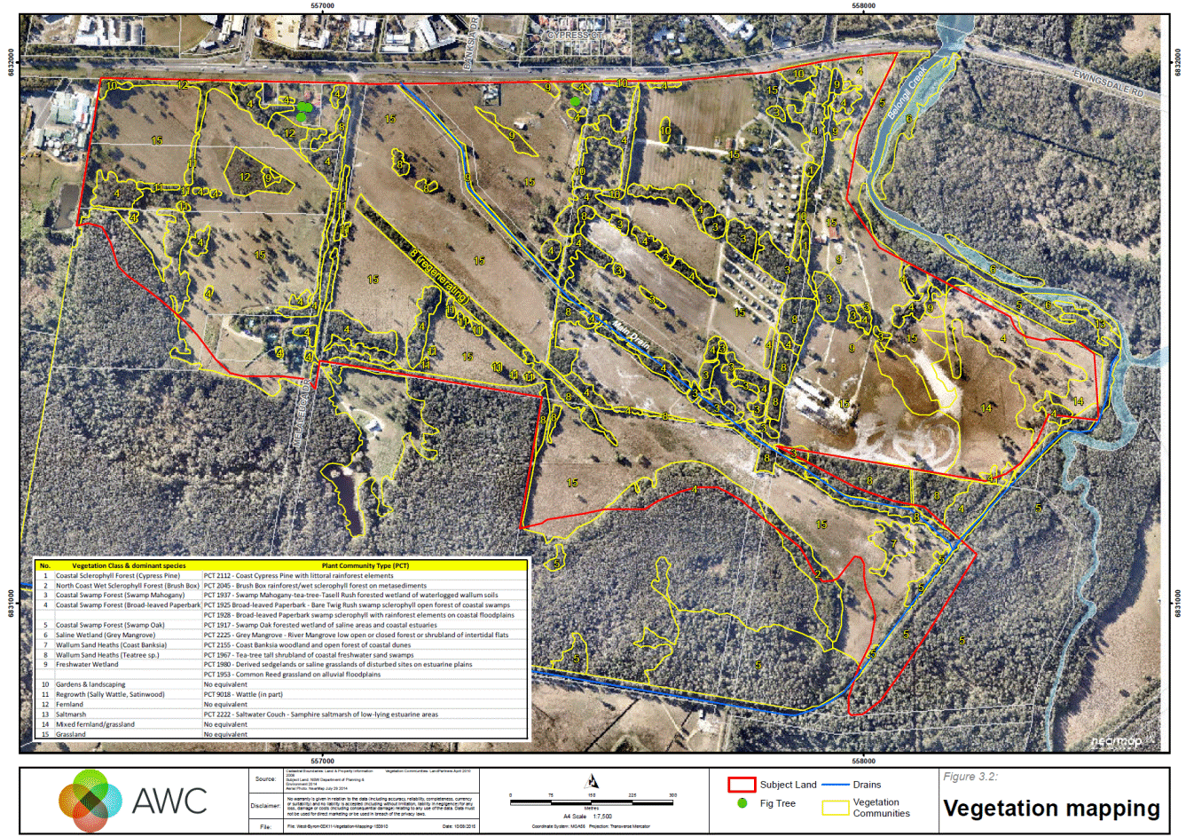
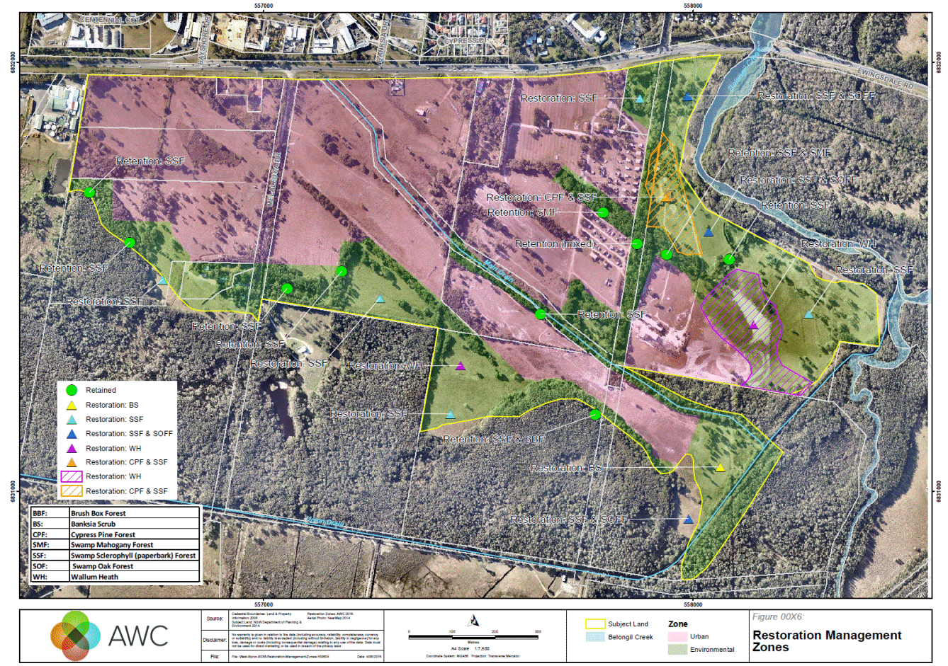
vegetation mapping and restoration at Appendices 4, 5, 6 and 7. A small amount
of Swamp Mahogany forest, a primary Koala feed tree is located within the E3
zone adjacent to the central drain. Some vegetation may be proposed for removal
for infrastructure provision. Other vegetation disturbance and/or loss would
involve the removal of small areas of Coastal Swamp Forest (Broad-leaved
Paperbark), Wallum Sand Heath, and closed exotic grasslands. The majority of E2
and E3 areas are at present predominantly cleared and it would be appropriate
to undertake any infrastructure work prior to rehabilitation. Potential impacts
and mitigation measures will be addressed at the Development Application stage,
but in this regard it is envisaged that approximately 23 hectares of E2 and E3
Zoned land will be rehabilitated through a combination of natural and planned
regeneration in areas previously disturbed by farming and other activities, and
currently utilised in part for cattle grazing. For details see the preliminary
Restoration Management Zone Plan at Appendix 7 and further discussion on the
Justification of the Proposed Provisions below.
Potential impacts are limited to
relatively minor disturbance of land zoned E2 and E3. Impacts will be assessed
and mitigated at the Development Application stage.
In the event that the proposed changes
to the Planning Instrument are not made, the WBURA cannot be developed in an
efficient and sustainable manner.
Subdivision Provisions
In summary, insertion of a provision
to enable the creation of residue lots of less than 40 hectares in the E2 and
E3 zones will not result in significant adverse impacts because no
fragmentation of the E2/E3 land will occur. Similarly, no change in use or
physical works in the E2/E3 zones will result from this provision. The
provision will simply overcome an apparent drafting anomaly in Clauses 81 &
85 of BLEP 1988 which have the effect of precluding approval of any subdivision
because the residue land zoned E2 and E3 has an area of less than 40 hectares.
Stormwater Management
A drainage reserve, 30.175 metres wide
traverses the site from Ewingsdale Road to the south eastern part of the West
Byron Urban Release Area. The Reserve is described as Lot 7020 DP 1113431 and
is owned by the Crown with care control and management vested in the Belongil
Drainage Union. The location of the Drainage Reserve is shown on the plans at
Appendix 2. The Reserve contains an open drainage channel which drains the
rural and urban catchments upstream of Ewingsdale Road, including the Byron Bay
Arts & Industry Estate.
As indicated on the attached plan at Appendix
2 and 3, part of the reserve is zoned E3, Environmental Management. The drain
then proceeds through private property to meet with other drains which
discharge to Belongil Creek and is in the E2 Zone. Development for the purpose
of earthworks and drainage is prohibited in these zones. Arguably, the
drainage reserve could have been zoned SP2 Infrastructure in accordance with
its legal status and principle purpose (ie. drainage of stormwater). While
routine maintenance of the drain can continue under the existing use provisions
of the Environmental Planning & Assessment Act, 1979 (as amended), any
additional works by the developer in these E2 and E3 Zoned areas is not
permitted under the current LEP provisions.
At present the vegetation that
occupies the E3 Zone along the main drain within Lot 7020 DP1113431 and Lot 2
DP542178 is approximately 2.8 ha of semi-consolidated coastal swamp forest
(Swamp Mahogany) with Coastal swamp forest (Broad-leaved paperbark) (See
Appendix 6 – Vegetation Mapping). As Swamp Mahogany is a primary koala habitat
tree, any removal of these trees for the purpose of infrastructure would need
to be considered in terms of SEPP 44 Koala Habitat Protection. It is likely a
Koala Plan of Management will need to be prepared for the site which would
include offset or compensatory plantings elsewhere in the West Byron Urban
Release Area if koala habitat was to be impacted upon. Details will accompany a
future development application. However minor works in this locality may
necessitate the removal of some native vegetation for infrastructure including
road crossings and stormwater outfalls as discussed below.
As discussed above approximately 23
hectares of previously disturbed land will be rehabilitated and in summary, the
proposed provision is justified for the reasons outlined above and the proposed
enabling provisions for infrastructure addresses the permissibility issue.
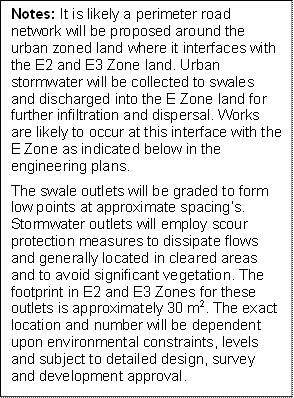
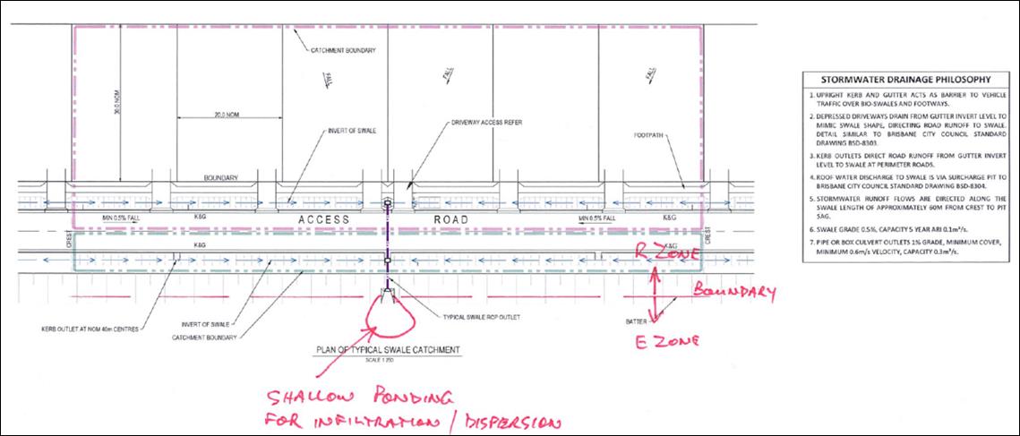
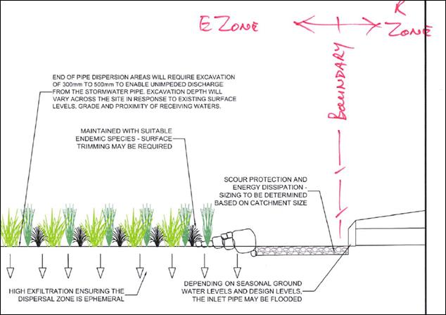
Stormwater Outfalls
The attached Stormwater Outlets Plan
at Appendix 4 shows the indicative location of the stormwater outlets /
discharge points. Table 4 shows the estimated area of disturbance within the E2
& E3 zones for the outfalls, vegetation types and proposed offset
arrangements.
It is proposed that the outfalls will
only occupy approximately 30m2
of E2 and E3 zoned land each. The outlets will incorporate end of pipe
headwalls and scour protection measures. Stormwater dispersion zones are
proposed beyond the headwall and scour protection, their purpose being to
enable spreading and infiltration of stormwater across a broad area, reducing
chances of erosion, channelling and changes in vegetative composition.
To minimise impacts on water quality
and to maintain existing wetland hydrology, stormwater discharge is to be
managed via infiltration into sandy soils throughout the estate and stormwater
drainage area including within vegetated swales, unlined wetlands and bio-retention
filters and finally within dispersion areas within the E2 and E3 zones.
Preliminary investigations by the developer indicate approximately 260m2
of infiltration area is required for each hectare of low density urban
development, which can be achieved across the site.
As a priority stormwater discharge
will be to existing grassland area which will be rehabilitated to be consistent
with adjoining native vegetation communities in appearance and function,
creating a buffer between sensitive receiving environments and stormwater
discharge locations.
Given the proposed outfalls are the
logical points of stormwater discharge, it is considered that the proposed
provision is appropriate and justified.
Table 4 Estimated areas of
Disturbance in the E Zones
|
Infrastructure
|
Area
|
Zone
|
Vegetation Community type
|
Offsets at 1:5 ratio
|
|
Stormwater Outfalls 30 in E Zones at 30m2 each
(Approx)
|
900 m2
|
E2 and E3
|
Coastal Swamp Forest,
Wallum Sand Heath,
Grassland
|
4500m2
|
|
Spine Road and services
|
200 m2
|
E3
|
Wallum Sand Heath
|
1000 m2
|
|
Other Roads and Services
|
2000 m2
|
E2 and E3
|
Coastal Swamp Forest,
Wallum Sand Heath
|
1 ha
|
|
Total
|
3100 m2
|
|
|
1.55 ha
|
|
Total Area for Planned Rehabilitation
|
Approximately 23 ha of E2 and E3 Zoned Land
|
Road & Services
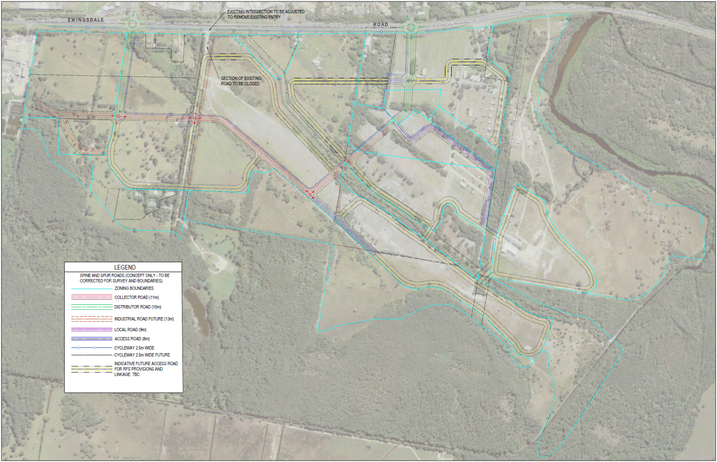
As indicated on the plan at Appendix 5
potentially three proposed roads cross the drainage reserve and one proposed
road crosses the E2 zone within the existing Crown Road Reserve. In particular
one parcel of residential zoned land in the eastern part of the site is land
locked by E2 Zoned land, and hence could not be developed unless infrastructure
is permitted across the E2 Zone land. The road crossings would provide for a
legible residential form to enable traffic and pedestrians to move through the
residential areas and to facilitate access for the Rural Fire Service. The
area of disturbance for the road crossings, vegetation types and proposed
offsetting arrangements are shown in Table 4 above. Water, sewer, power and
telephone services would be located in the proposed road reserve.
Given the relatively small area of E2
and E3 zoned land affected, and as appropriate offset plantings can be provided
within the West Byron Urban Release Area, it is considered that the proposed
provision is justified in the circumstances.
DCP Provisions
In accordance with Clause 101 of Byron
LEP 1988, Council is preparing a DCP for the West Byron Area. The DCP is to
include stormwater and water quality management controls, provisions on acid sulfate
soils and groundwater, and other measures to protect and enhance the natural
environment. The DCP will require detailed assessment and consideration of
flora and fauna issues including koalas and wallum frog habitat, to provide for
compensatory plantings where required and rehabilitation of habitat in the
Environmental zones.
Section D State
and Commonwealth interests
In rezoning the land in November 2014,
the Department of Planning and Environment was satisfied that adequate public infrastructure
is available. This Planning Proposal does not increase the demands on public
infrastructure, with a potential reduction in residential yields resulting from
the proposed amendments to Clauses 82 and 83.
The following table provides a summary
of the relevant public authorities, which in the opinion of Council, should be
consulted in accordance with the Gateway Determination:
|
Public authority/stakeholder
|
Issue requiring comment
|
|
NSW Rural Fire Service
|
To ensure compliance with the S117 Direction 4.4
Planning for Bushfire Protection.
|
No
amendments to existing maps are proposed or required. The proposed amendments
are limited to the Written Instrument only.
Council will
commence community consultation in accordance with the Gateway Determination. For
the purposes of public notification, the planning proposal is not
considered to be low impact as outlined in the Department of Planning and
Infrastructure’s, A guide to preparing local environmental plans, and a 28 day
public exhibition period is recommended.
Notification
of the exhibited planning proposal will include:
· a newspaper advertisement that
circulates in the Byron LGA, which is the area affected by the planning
proposal
· the website of Byron Shire Council and
the Department of Planning and Environment.
The proposed timeline for the completion of the planning
proposal is as follows:
|
Estimated completion
|
Plan making step
|
|
January 2016
|
Gateway determination issued by Department of Planning
and Environment.
|
|
March 2016
|
Government agency consultation.
|
|
April 2016
|
Public exhibition of planning proposal.
|
|
May – June 2016
|
Analysis of public submissions.
Preparation of Council report.
|
|
June 2016
|
Public submissions report to Council.
|
|
July – August 2016
|
Endorsed planning proposal submitted to Department of
Planning and Environment for finalisation or dealt with by Council under
delegation.
|
In summary,
the proposed amendments to BLEP1988 (WB) are intended to correct existing
anomalies and to facilitate approval of a Development Application for the
efficient and sustainable development of the site in accordance with its
current zoning and to achieve the objectives of the FNCRS. The Strategy
includes the objective of providing additional housing choice within the Byron
Bay area for future residents and the proposed amendments will assist in
achieving this objective.