|
Action #
|
Document
|
Priority
|
Actions
|
Status
Comments
|
|
5
|
BES&MP
|
High
|
Implementation
of source controls for New Developments
|
SMP,
DCP. New developments are subject to s/water controls as per DCP
|
|
16
|
BES&MP
|
High
|
Support
formation of an ASS working group
|
No
progress
|
|
17
|
BES&MP
|
High
|
Prepare
and implement ASS priority area management plan
|
No
progress
|
|
18
|
BES&MP
|
High
|
Finalise
and implement ASS LEP
|
Complete
- 2014
Maps LEP / GIS layers
|
|
19
|
BES&MP
|
High
|
Delineate
buffer zones to Belongil Estuary
|
Recommend
SEPP Buffer Zones 7FJ (shorebirds)
|
|
20
|
BES&MP
|
High
|
Incorporate
results of the PPK drilling program into the BESMP
|
|
|
25
|
BES&MP
|
High
|
Support
West Byron Wastewater Steering Committee goal of maximum reuse
|
Ongoing
Recycled
Water is of a quality for Dual Reticulation. BSC operate one of the largest
recycled water schemes in NSW (DPI Water 2016). Current BBURWS extension to
include public toilet flushing and Byron Foreshore Irrigation.
|
|
26
|
BES&MP
|
High
|
Support
Belongil Rehabilitation project using West Byron wastewater
|
Ongoing
|
|
29
|
BES&MP
|
High
|
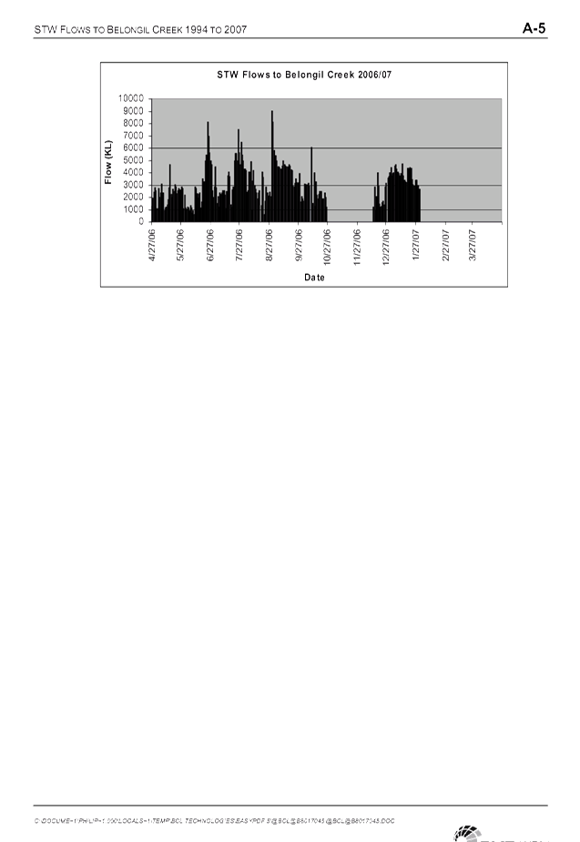
Keep
estuary mouth open continuously at interim bench mark level of 1m in
conjunction with monitoring water quality
|
Operates
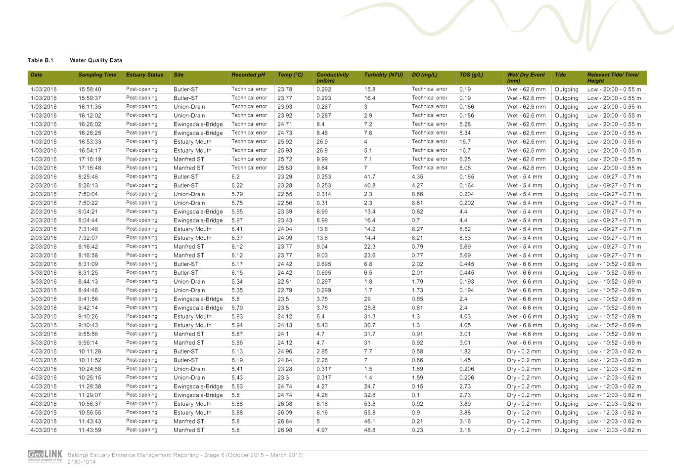
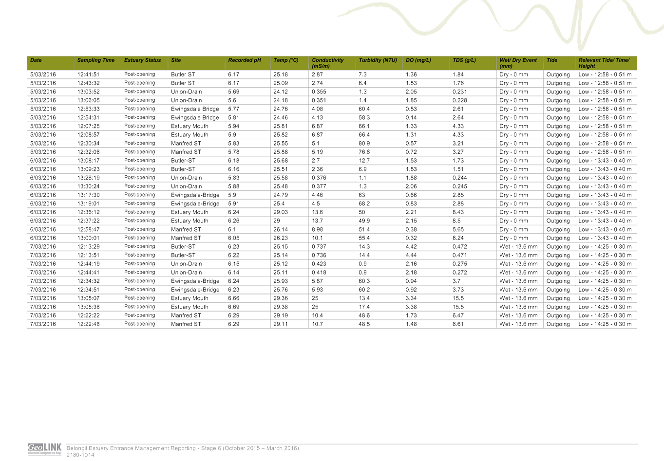
as an intermittent closed and open lake or lagoon (ICOLL) system. Licenced to
open creek entrance when 1m at Ewingsdale Bridge. Licence valid until 2022.
Council operate the estuary in accordance with the Belongil Estuary Mouth
Opening Plan. Water quality monitoring (1 day prior and six days after
opening) includes EC, DO pH, turbidity, temperature, water level. Council
reports on a six monthly basis - Byron Estuary Entrance Management Report.
|
|
38
|
BES&MP
|
High
|
Adopt
action plans which support fishery and shorebird habitat as recommended above
|
|
|
39
|
BES&MP
|
High
|
Identify
and protect significant estuarine and aquatic habitats by rezoning,
reservation, DCP. Support the Byron Bay, Suffolk Park, Ewingsdale Settlement
Strategy riparian buffer
|
|
|
40
|
BES&MP
|
High
|
Enforce
dog exclusion zones at mouth of estuary
|
Ongoing
Signs,
rangers. Action 1.1.1 Draft Coastal Zone Management Plan for the Byron Bay
Embayment (CZMP) (2016)
|
|
41
|
BES&MP
|
Unrated
|
Investigate
rehabilitation and revegetation opportunities
|
Ongoing
|
|
43
|
BES&MP
|
High
|
Support
the implementation of the Arakwal Agreement
|
Ongoing
|
|
49
|
BCFRMP
|
Immediate
|
Preferred
Byron Drainage Strategy
|
Complete
Byron
Bay Drainage Strategy (SMEC 2010). Council need to implement actions 148 -
156.
|
|
50
|
BCFRMP
|
High
|
Drainage
infrastructure maintenance
|
Complete
Byron
Bay Drainage Maintenance Plan 2014 – 15.
|
|
51
|
BCFRMP
|
High
|
Belongil
Creek Entrance Strategy - Recommends the development of a long term
management plan for the operation of ICOLL
|
Council
has applied for 2 grants (approx. $150K for 2 year project) both
unsuccessful. Needs to be a whole of catchment / stakeholders approach. To be
completed before 2022.
|
|
52
|
BCFRMP
|
Immediate
|
Development
Control Planning - A future development zone map and flood planning matrix
|
|
|
147
|
BBDS
|
High
|
Pump
station - 6m3/s, levee, GPT and street drainage in Byron Street (Town Street
System)
|
No
progress
|
|
148
|
BBDS
|
High
|
Byron
Street levee and 4 pump stations (Shirley Street System)
|
No
progress
|
|
149
|
BBDS
|
High
|
Pump
Station - 3m3/s and 2-900 diameter outfall (Cowper Street System)
|
No
progress
|
|
150
|
BBDS
|
High
|
New
wetland / basin (Cowper Street System)
|
No
progress
Looking
at possible implementation with by pass road works
|
|
151
|
BBDS
|
High
|
Link
Channel, levee between Marvel and Cowper Street, pump station - 1m3/s (Cowper
Street System)
|
No
progress
|
|
152
|
BBDS
|
High
|
Street
network in Fletcher, Lawson and Johnston Street (Town Center System)
|
No
progress
|
|
153
|
BBDS
|
High
|
Street
drainage Middleton Street (Cowper Street System)
|
No
progress
|
|
154
|
BBDS
|
High
|
Culverts
at Ewingsdale Road (Western Industrial Area)
|
No
progress
|