Local Traffic Committee Meeting 6.1
Regulatory Matters
Report No. 6.1 Traffic - Myocum Downs Rd, Lagoon Drive, Mountain Blue Close - Speed
Review - 60km/hr
File No: I2016/752
Background - I2015/887
A resident has requested a 60 km/hr speed limit be
introduced for the 1.2km length of Myocum Downs Drive. As shown the
subject site is a sealed, no through road, has 29 residential properties, is in
a rural setting and located approximately 3.5km south of Mullumbimby.
Council have no record of traffic volume or speeds or any
crash data based on records dating back to 1996. Nevertheless, the number of
accesses (up to 29) and that no through traffic occurs would suggest some of
the RMS speed zone criteria for reviewing the speed limit is met. The road is
currently state default (100km/hr), drive to conditions while the main road
(and sole access point) of Myocum Road has recently (in last 18 months) been
reduced from a similar, rural 100km/hr limit to 80km/hr.
However as RMS are the sole authority for authorising speed
zone changes it is requested that they undertake such a review if they believe
it warranted and, if it proceeds, provide results back in due course.
Council Resolution
15-443 Resolved that Council adopt the following Committee
and Management Recommendation(s):
Report No. 6.8 Request for 60kph
speed limit, Myocum Downs Drive, Myocum
File No: I2015/887
That Council request the RMS, as the sole NSW authority for
authorising speed zone changes, undertake such review of Myocum Downs Drive,
Myocum if they believe it warranted and, if such review proceeds, provide
results back in due course.
Outcome of Investigation
On behalf of Byron Shire Council RMS has conducted speed
reviews on the following roads and made recommendations in table 1:
|
Table 1. RMS
recommendations from speed review
|
|
Road Name
|
Length (km)
|
Speed Limit (km/hr)
|
Signs
(2 with repeater at
300m)
|
|
Existing
|
Proposed
|
|
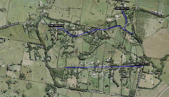
Myocum Downs Road,
Myocum
|
1.2
|
100
|
60
|
3
|
|
Lagoon Drive,
Myocum
|
1.3
|
100
|
60
|
3
|
|
Mountain Blue
Close, Myocum
|
0.3
|
100
|
60
|
2
|
Figure 1. Sketch showing all three roads
Estimated costs of recommendation
|
Table 2.
Estimated costs of this recommendation
|
|
Materials and
equipment required
|
Estimated Cost
|
|
1 x Sign crew per
day, 8 x New signs, 1 x Contingency
|
$1,800
|
Council can apply to RMS for funding prior to undertaking
any works. This application and approval process takes approximately 8
weeks. Then the installation of the speed zone will be at nil cost to
Council.
|
RECOMMENDATION:
1. That
the committee approves RMS recommendation to reduce the posted speed limit to
60km/hr for the following roads:
a. Myocum
Downs Road, Myocum;
b. Lagoon
Drive, Myocum; and
c. Mountain
Blue Close, Myocum.
|
Attachments:
1 Traffic -
Myocum Downs Rd - Speed Review - SZ Installation letter to Byron Shire Council
- R-1406 Myocum#2, E2016/54830 , page 5
2 Traffic -
Myocum Downs Rd - Speed Review - NTH10671 Myocum Downs Rd, Lagoon Dve &
Mountain Blue Close - 60 km_h, e2016/54828
, page 6
Local Traffic Committee Meeting 6.4
Report No. 6.4 24.2015.19.1 - Marine Parade, Byron Bay - Regulatory Signage -
Extension of Pay Parking Scheme
File No: I2016/770
Background
Since 23 December 2015, two distinct parking schemes have
operated in Byron Bay: a meter registration pay parking area and on its
perimeter a resident permit parking scheme. Each are briefly outlined further
below.
As per the recently received consultant report (copy
attached) both schemes are now proposed to extend to some of the streets within
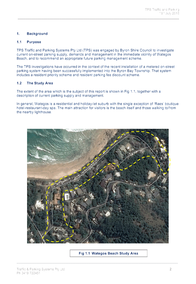
the Wategos suburb some 2km east of the town centre. As this involves
regulatory changes, e.g. time limits, Local Traffic Committee (LTC) endorsement
is sought.
As per the relevant Roads and Maritime Services (RMS)
guidelines (Pay Parking and Permit Parking), it is noted that RMS concurrence
is also required for the implementation of the proposed parking schemes; and
that this concurrence can be granted via the LTC.
This concurrence is also now sought, noting it is considered
as the third of six steps to establishing a parking scheme as taken and
surmised from the RMS Permit Parking Guidelines v3.4 (p3, March 2016) which is
instructional in the role of Council and the RMS:
1. Council
identifies the need to establish a parking scheme (this report and report
attached)
2. Council
considers RMS guidelines and draft a proposal (as attached)
3. RMS
provides advice at the Local Traffic Committee (27 July 2016)
4. Council
resolves to establish a parking scheme. (RMS may appeal within 14 days)
5. Council
establishes the parking scheme (Implementation)
6. Council
evaluates the scheme (typically first required within 6 months of operation
i.e. Review)
NB: both Pay Parking and Permit Parking guidelines are
available from www.rms.nsw.gov.au.
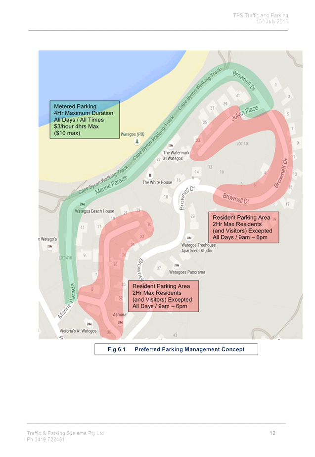
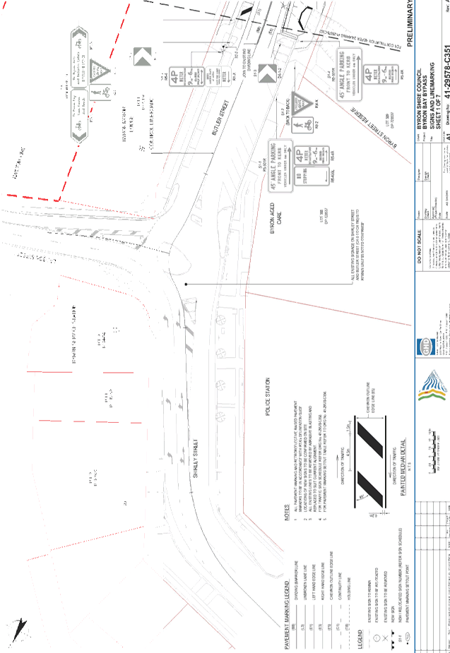
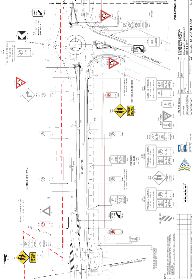
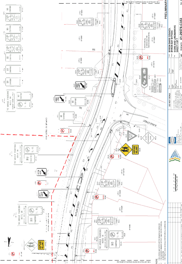
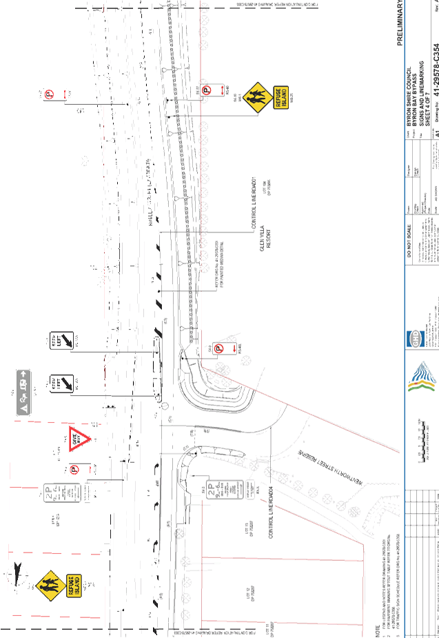
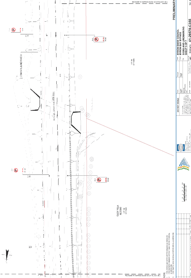
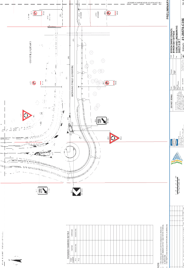
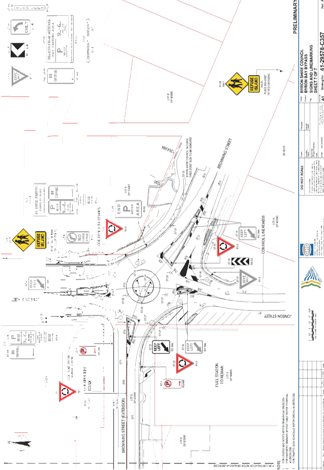
Subject site and proposal
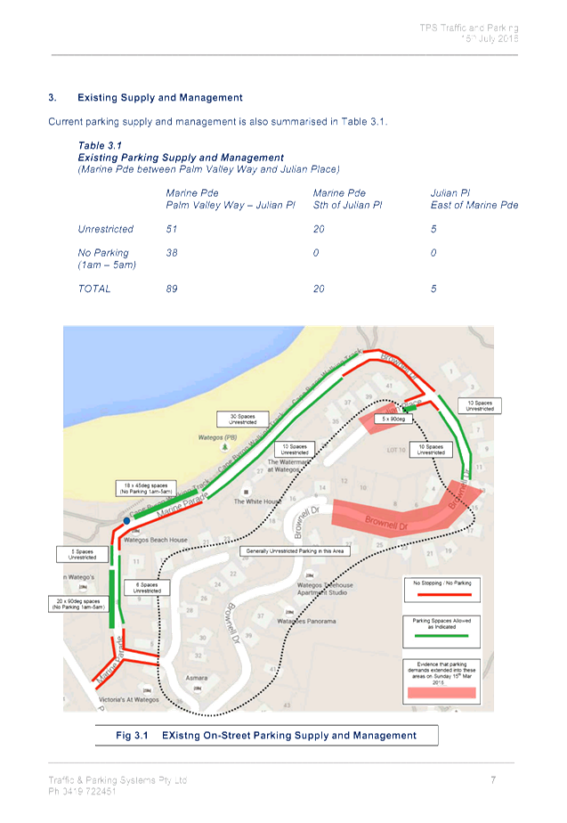
The subject site is shown at Figure 1 (i.e. a reproduction
of Figure 6.1 in the attached report).
As per the green shaded area, it provides a total of 89
on-street public car spaces upon Marine Parade between its intersections with
Palm Valley Drive and Julian Place. These same spaces are proposed to be
better managed in four-ways, via a 4-hour (4P) time limit, metered pay parking,
increased enforcement/surveillance and the implementation of the traffic
management works to improve parking, traffic and pedestrian facilities as shown
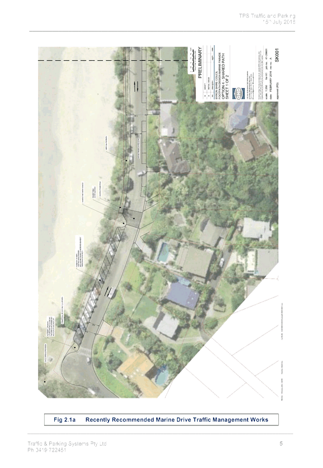
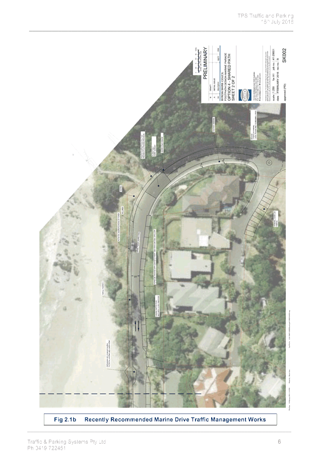
at Figure 2.1a and 2.1b in the attached.
Each however are viewed as interdependent (if not
integrated) and as such they (together) are believed to address a key purpose
of the RMS guidelines, namely measures aimed at better demand management and
regulation that address the limits of supply and the problems of high demand.
Similarly linked is the related proposal of introducing a
Resident Permit Parking Scheme within the red shaded areas on Figure 1. These
are currently unrestricted, thereby allowing all-day parking in what is
ostensibly residential streets. The proposed scheme would however limit
permissible parking (i.e. without a permit) to 2-hour (2P) between 9am-6pm
while those correctly displaying a valid permit (either a resident or their
legitimate visitor) would not need to adhere to such restrictions. As
successfully done in the town centre, the use of the resident permit scheme on
the perimeter of the pay parking area is expected to reduce displacement pay
parking may cause.
It should also be noted the proposal is that these schemes
be the same as per the existing schemes operating in Byron Bay outlined briefly
as follows.
Figure 1: proposed
extent of parking schemes

Expected outcomes and
consistency with existing schemes
The existing Byron Bay parking
schemes provide important context and rationale for the recommendations now
made; i.e. in efforts of consistency and user understanding any parking
regulation or management implemented should consider the broader, local
context.
In this case that context is a
town-centre now regulated by a meter registration pay parking scheme while on
its fringe (in residential streets) now exists a parking permit scheme for
residents and their visitors. Both schemes operate seven (7) days a week
including public holidays, with pay parking (based on licence plate entered at
the meter) effective 9am-6pm while within the resident scheme the permit offers
those eligible to stay beyond the sign-posted time limit which also applies
between 9am-6pm and depending on the location is either a 2P or 4P limit.
Also, both schemes provide a
precedent plus a supportive argument for their local extension and application
elsewhere parking management is found to be required, as is the case with
Wategos. And, as with the town centre, reducing (or mitigating) the imposition
of such schemes (on locals at least) is by extending the same existing
exceptions, namely:
a) the exemption to paying the
meter, as available to all Byron shire residents/ratepayers (on the proviso
they buy the annual E-permit, currently $50pa and applies to the licence plate),
and
b) the free resident permit (as
provided only to the household adjacent to, and only effective where, the
resident scheme applies) so that residents or their visitors can park on-street
and stay beyond that street’s time limits subject to the correct display
of the permit.
As such, the existing schemes do
not overlap and they have their own distinct requirements and permit system
(pay parking is an intangible E-permit, whereas the resident permit is to be
displayed on the dashboard); all of which helps with understanding of the
schemes, their benefits and compliance.
However in addition to the
existing town centre schemes, the following is also considered relevant in
support of the recommendations now made.
Addressing current deficiencies
The attached report (at Section 4)
outlines current deficiencies, namely lack of turnover. In Wategos, this
means limited opportunity for parking exists due to high, often stagnate
occupancy and exacerbates the lack of supply (and limited capacity). This
problem is noted and needs addressing as follows.
Firstly, the supply side analysis
undertaken in the report supports previous (including residents and
resident representative groups) claims and observations that demand often
exceeds supply. This is often evident via parking within the local back-streets
and (especially at peak times, e.g. every school holiday) along lengths of
Brownell Drive and Palm Valley Drive which is the only point of access/egress
to Wategos. The proposal for 4P pay parking will ensure turnover while the
resident scheme will reduce parking in such streets.
Secondly, common parking behaviour
(long-term parking/in-vehicle camping, blocking driveway access or intersection
sight-lines, etc.), has led to clearly expressed local concerns for both
residential amenity and access, plus has road user safety implications,
including for the large pedestrian numbers. Indeed, the extent of such concern
led Council (in 2015) to engage a third-party (GHD) to identify and assess the
best options to improve parking and resident/pedestrian amenity and safety
along Marine Parade. These works are seen as essential and considered by the
community as long overdue.
As such, the options of providing
a dedicated off-road path or boardwalk for the length of Marine Parade is
supported, which carries a very high pedestrian to vehicle traffic ratio
largely to it being part of a longer pedestrian path (between town and the Cape
Byron Lighthouse); while for parking itself, each option presented by GHD seeks
the formalisation of spaces via marked parking bays, which is also supported.
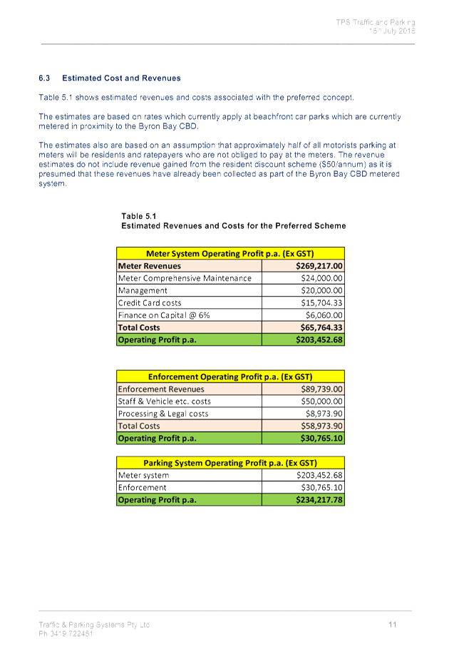
These community-desired works can be funded via pay parking.
Thirdly, this same work undertaken
by GHD included vehicle and pedestrian counts which found that motorists who
often do not find a vacancy on their first-pass perform a U-turn or a loop of
the back-streets for another pass of parking space. This behaviour supports the
attached report conclusion of little vacancy (i.e. high occupancy) coupled with
lack of turnover which can be addressed via the measures proposed, summarised
as follows.
Parking management options
The measures discussed in the
attached report and specifically at Sections 5 and 6 are as follows.
a) the Byron Bay meter
registration pay parking scheme apply to Marine Parade, noting the scheme
currently applies $3 per hour, capped at $10 for 4-hours, $20 for all-day and
that those with an E-permit, as available to Byron shire ratepayers and
residents for $50pa, are exempt from such rates but still must adhere to the
time limits.
b) that the Byron Bay Resident
Parking Permit scheme apply to some residential streets within Wategos, which
is to include a 2P time limit effective 9am-6pm each day within:
i) Julian Place (estimated 6 lots);
ii) Brownell Drive, between Julian Place to 27 Brownell
Drive (est.18 lots); and
iii) all of Pandanus Place (est.
18 lots).
c) a mix of time limits be
implemented upon Marine Parade which include a balance between 2-hour (2P) and
4-hour (4P) which is to apply (as per the town centre) seven (7) days a week,
including public holidays 9am-6pm each day.
d) daily enforcement occur,
noting that the level of parking enforcement is considered to be
“significantly less in a metered parking system…due to the motorist
perception that parking duration is more ‘visible’ and detection is
more probable”.
e) pay parking fund local
improvement works, such as those shown at Figure 2.1a and 2.1b.
f) the extent of the
pay parking scheme will require up to eight (8) multi-bay meters, subject to
meeting RMS guidelines of one meter every 8-10 parallel spaces, or 16-20 angled
bays.
g) that motorcycle and
disabled parking spaces be provided as part of the pay parking scheme at the
rate of 2% of all available parking in Marine Parade.
However as the Committee will
note, some of these same management options are not within the scope of the
Local Traffic Committee jurisdiction, for example funding of works or
enforcement levels. They nevertheless have been detailed to provide context and
are believed to support the recommendations now made.
Specifically these include seeking
the Committee support for the parking schemes themselves and their extent, plus
the ratio of time limits and dedicated special-purpose parking.
|
RECOMMENDATION:
1. That
a meter registration pay parking scheme be implemented upon Marine Parade,
Wategos between the intersections of Palm Valley Drive and Julian Place on
the proviso it is the same as the Byron Bay scheme, for example the same
hourly rates, regulations, restrictions, exemption benefits, etc.
2. That
the following time limits and ratios be implemented upon the full length of
Marine Parade, Wategos and that they apply Monday-Sunday inclusive including
public holidays between the hours of 9am-6pm and that outside of such hours
the existing sign-posted regulations remain:
a) a
2-hour (2P) limit apply to approximately 40% of parking supply, and that it
first be allocated along the beachfront between the turning circle and Julian
Place and the balance (if any) apply immediately south of the turning circle
on the west-side of the street only;
b) a
4-hour (4P) limit apply to approximately 58% of parking supply, and that it
first be allocated from Palm Valley Drive to the turning circle, and the
balance (if any) apply the east end of Marine Parade, from Julian Place; and
c) the
remaining 2% of parking supply provide dedicated motorcycle-parking and
mobility permit parking, preferably next to beach and commercial property
access.
3. That
the Byron Bay Resident and Resident Visitors Permit Parking Scheme be
implemented in Wategos as follows and it include a 2P time limit effective
9am-6pm each day within:
a) Julian
Place;
b) Brownell
Drive, between Julian Place to 27 Brownell Drive; and
c) Pandanus
Place.
|
Attachments:
1 Wategos
Beach Parking Supply and Management Strategy, E2016/65469
, page 18