Local Traffic Committee Meeting
A Local Traffic Committee Meeting of
Byron Shire Council will be held as follows:
|
Venue
|
Conference Room, Station Street, Mullumbimby
|
|
Date
|
Wednesday, 5 October 2016
|
|
Time
|
10.30am
|
|
Committee
Members
|
Etiene La
Grange – Roads and Maritime Services
Snr Constable Tony Darby – Police
Hon Tamara Smith MP
|

Phillip
Holloway
Director Infrastructure Services I2016/1016
Distributed 28/09/16
Local Traffic Committee Meeting
BUSINESS OF MEETING
1. Apologies
2. Declarations of Interest
– Pecuniary and Non-Pecuniary
3. Adoption of Minutes from
Previous Meetings
3.1 Local
Traffic Committee Meeting held on 27 July 2016
4. Matters Arising
5. Outstanding
Issues/Resolutions
6. Regulatory Matters
6.1 Speed
Review - Brunswick Valley Way and Shara Boulevard Intersection at Billinudgel 3
6.2 Extension
of School Bus Route - Parrot Tree Place, Bangalow...................................... 4
6.3 24.2014.48.1
- Lawson Street and Massinger Street RAB - Approval of Line Marking and Signs
Plan........................................................................................................................................... 6
6.4 Event
Road Closure - Monthly Criterium Cycle Races, Byron Bay Industrial Estate -
Request for Three Year Agreement from September 2016 (Amended).............................................. 9
6.5 Event
Road Closure - Rainbow Ride Cycle Challenge - William Flick Lane, Ewingsdale -
Sunday, 27 November 2016............................................................................................................... 12
6.6 Event
Road Closure - Mullumbimby Music Festival - Burringbar Street and Dalley
Street, Mullumbimby - Sunday, 20 November 2016.................................................................. 53
6.7 24.2015.19.1
- Marine Parade, Byron Bay - Regulatory Signage - Extension of Pay Parking
Scheme - Endorsement of Council Resolved Time Limits within Wategos.................................. 63
6.8 Event
Road Closure - Brunswick Valley Woodchop and Entertainment Committee - Twilight
Markets - Mullumbimi Street, Brunswick Heads - Wednesday, 14 December 2016................... 66
6.9 Event
Road Closure - Byron Lighthouse Run - Lighthouse Road, Byron Bay - Sunday, 23
October 2016 (Amended).............................................................................................................. 71
6.10 Extension
of School Bus Route - Pearces Road and Booyong Road, Booyong........... 75
6.11 Event
Road Closure - Soul Street New Year's Eve and First Sun New Year's Day, Byron
Bay 78
6.12 Event
Road Closure - Falls Festival 2016/17 - North Byron Parklands, Yelgun -
Saturday 31 December 2016 to Monday 2 January 2017.................................................................. 88
6.13 Bayshore
Drive - Proposed Bus Stop Relocation, No Stopping Signage and 30-minute Parking
Time Limit............................................................................................................................... 102
6.14 11.2013.587.2
- Mercato on Byron - 108-110 Jonson Street, Byron Bay.................... 106
7. Development Applications
7.1 10.2016.399.1
- Byron Central Health & Wellness HUB - 15 McGettigans Lane, Ewingsdale 129
7.2 10.2016.582.1
- Peddle and Hawk Acacia Street Market - Byron Bay - Every Second Saturday....................................................................................................................................... 131
Local Traffic Committee Meeting 6.1
Regulatory Matters
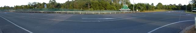
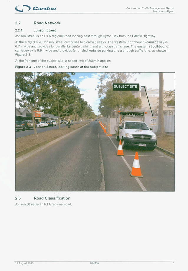
Report No. 6.1 Speed Review - Brunswick Valley Way and Shara Boulevard Intersection
at Billinudgel
File No: I2016/511
Council at it’s meeting held on 17 March 2016,
considered a petition about the subject matter and resolved:
Res 16-105
1. That
the petition regarding speed limit on Brunswick Valley Way Billinudgel be
noted.
2. That the petition be
referred to the Director Infrastructure Services.
An investigation has been undertaken of the Brunswick Valley
Way and Shara Boulevard intersection at Billinudgel to determine if a speed
zone reduction from 80km/hr to 60km/hr speed is warranted. A site
investigation was carried out on the 17 May 2016 at 7:30am. The intersection,
currently 80km/hr, was found to be appropriate and there were no issues at this
time. A review of the crash data available near this intersection was
completed with no common link between the incidents that could be related to
the intersection design.
It is noted that the new Shara Boulevard Sports Fields may
increase traffic into the intersection in the future as per the Development
Application.
|
RECOMMENDATION:
That the Committee notes that an investigation at the
Brunswick Valley Way and Shara Boulevard intersection has been completed and
a speed zone review is not recommended at this time.
|
Local Traffic Committee Meeting 6.2
Report No. 6.2 Extension of School Bus Route - Parrot Tree Place, Bangalow
File No: I2016/900
Council has received an application (S2016/7668) from Mr Pat
Bulzomi, Manager/Operator of Bulzomi Bus Lines to extend the existing school
bus route N1563 (as shown in green) along Parrot Tree Place in Bangalow. The
bus would enter Parrot Tree Place and complete the circuit (as shown in red),
before continuing the current route along Tristania Street.
Parrot Tree Place is an urban sealed road of approximately
735m in length in Bangalow. There are 51 land parcels. The operator has stated
that there are seven (7) children, aging between 5 to 10 years old, currently
using the bus who reside in Parrot Tree Place or streets that are accessed from
Parrot Tree Place.
Committee endorsement is sought for the extension of the
existing school bus route.
Figure 1 –
Subject Site
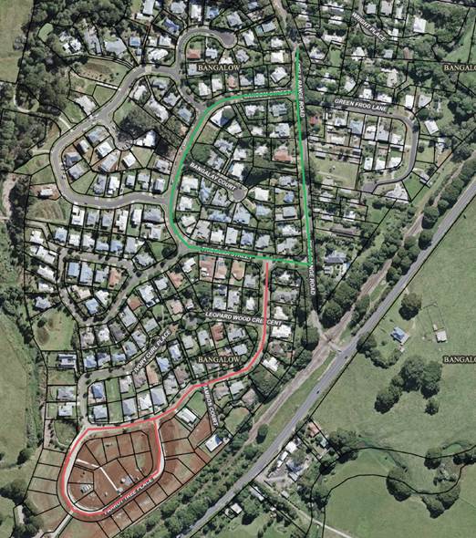
Green indicates
existing bus route and red indicates proposed extension.
|
RECOMMENDATION:
That Council note the Local Traffic Committee has no
objection to the proposed extension of the school bus route along Parrot Tree
Place, Bangalow. The bus would enter Parrot Tree Place and complete the
circuit before continuing the current route along Tristania Street.
|
Local Traffic Committee Meeting 6.3
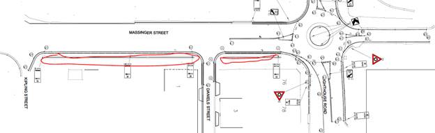
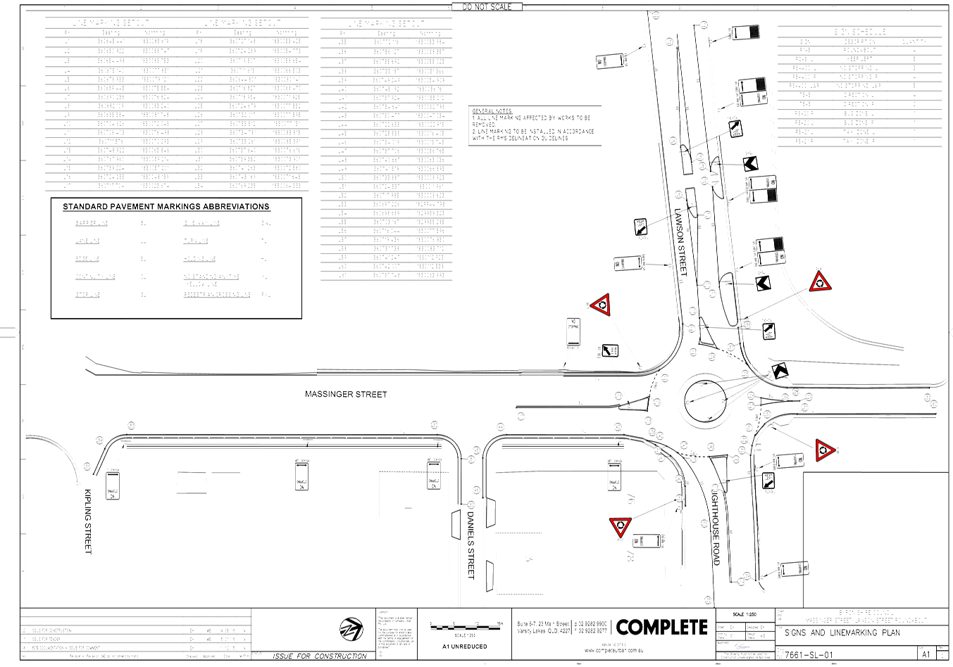
Report No. 6.3 24.2014.48.1 - Lawson Street and Massinger Street RAB - Approval of
Line Marking and Signs Plan
File No: I2016/916
Background
Byron Shire Council has initiated the construction of a new
concrete roundabout at Massinger Street, Lawson Street and Lighthouse Road
intersection. There is no record that the Line Marking and Signs Plan has been
endorsed by Local Traffic Committee.
Investigation
Traffic control signage for the roundabout looks adequate.
However with the widening of the Massinger Street it appears
that up to seven new car parks have been created due to the open drain being
converted into a pipe syatem. The installation of three ‘No
Stopping’ signs highlighted in red below will remove these seven
potential car parks.
A potential reason for ‘No Stopping’ being
incorporated into the design is the four properties adjoining the new widening
section of road.
During the inspection traffic it was suggested to use
Daniels Street to bypass the Roundabout construction site. The Street is very
narrow with parking on both sides for residents with single lane access and the
current seal is in need of repair and would deteriorate quickly if traffic was
diverted down this street. This detour would displace the residents parking and
cause issues for the construction team with complaints from the residents. The
risk of an incident in this narrow street would also be increased due to sight
distance and speed issues.
Estimate
Nil. No additional costs as the project are fully funded.
|
RECOMMENDATION:
1. That
the Local Traffic Committee endorse all Regulatory Signage for the
roundabout.
2. That
the Local Traffic Committee not endorse the following:
a. the
installation of three additional ‘No Stopping’ signs from 7
Massinger Street to 76 Lawson Street.
b. The
use of Daniel Street as a detour around the Lawson Massinger Street
Roundabout during the construction phase.
3. That
the Local Traffic Committee endorse the installation of 4 hour parallel
parking from Daniel St to Kipling St (1 to 7 Massinger Street).
|
Attachments:
1 24.2014.48.1
- Lawson Massinger St RAB - DWG - 7661-SL-01 Signs and Linemarking Plan Rev 2, E2016/79304 ,
page 8
Regulatory Matters 6.3 - Attachment 1
Local Traffic Committee Meeting 6.4
Report No. 6.4 Event Road Closure - Monthly Criterium Cycle Races, Byron Bay
Industrial Estate - Request for Three Year Agreement from September 2016
(Amended)
File No: I2016/917
BACKGROUND:
After consideration at the Local
Traffic Committee on 8 June 2016 and subsequent Council resolution 16-389, on
the 4 August 2016 Council resolved that:
16-389 Resolved
that Council adopt the following Committee Recommendation(s):
Report No.
6.6 Road Event - Monthly Criterium Cycle Races,
Industrial Estate, Request for 3 Year agreement from September 2016
File No: I2016/505
1. That
the Byron Bay Cycle Club’s Criterium Racing circuit at Byron Bay
Industrial Estate, to be held on the first Sunday of each month from 4
September 2016 to the last Sunday in August 2019, be endorsed between these
times:
a) Centennial
Circuit between Bayshore Drive and Wollongbar Drive, Tasman Way, Wollongbar
Drive and Brigantine Street (between Centennial Circuit and Wollongbar Drive)
between the hours of 06:00 and 09:00
2. That
the approval provided in Part 1 is subject to NSW Police approval being obtained
3. That
the attached Traffic Control Plan and Traffic Management Plan be noted
4. That
the Traffic Management Plan be implemented as approved
5. That
the event organiser:
i. provide
wording for Council’s website noting the impact of the event and including
the event name, specifics of any traffic impacts or road closures and times,
alternative route arrangements, event organiser, a personal contact name and a
telephone number for all event related enquiries or complaints
ii. inform
community and business that are directly impacted (eg adjacent to the event)
via written information which is delivered to the property in a timely manner
so as to document, consider and respond to any concerns raised
iii. arrange
for private property access and egress affected by the event
iv. liaise
with bus and taxi operators and ensuring arrangements are made for provision of
services during conduct of the event
v. consult
with emergency services and any identified issues be addressed
vi. hold
$20m public liability insurance cover which is valid for the event
vii. pay Council’s
Road Event application fee prior to the event.
On the 9 August 2016 the event
organiser, Mr John Langler, was notified of the approval as detailed in
resolution 16-389. Mr Langler then bought it to Council attention that an error
had occurred and the event application incorrectly advised the dates of the
planned races, being the first Sunday of each month. The correct dates for
races will be the second and fourth Sunday of each month.
The Local Traffic Committee
members have provided interim approval for the Criterium Cycle Races planned
for the 14 August, 28 August, 11 September, 25 September, 9 October and 23
October to go ahead, abiding by the conditions as stated in resolution 16-389.
However, ongoing approval for Criterium Cycle Races to take place on the second
and fourth Sunday of each month is still required.
REPORT (Amended):
Council has received an Application
and Traffic Management Plan from the Byron Bay Cycle Club for Criterium Cycle Racing
along circuit at Byron Bay Industrial Estate - seeking continuation of approval
from September 2016 to September 2019 and course changes. The Club races on the
second and fourth Sunday of the month from 06:00 to 08:30.
The Council Meeting on 8 October
2013 approved the following resolution 13-556:
1. That
Council approve the request by the Byron Bay Cycle Club to hold criterion races
every second and fourth Sunday of the month between October 2013 and September
2016 within the Byron Bay Industrial Estate, on condition that the Byron Bay
Cycle Club hold Public Liability Insurance to a minimum value of $20 million.
2. That
the temporary road closures for the event be advertised, at the Club’s
expense, in the local newspapers in accordance with the requirements of the
Roads Act 1993 noting closures:
a) are
to apply from the hours of 6 am to 8 am and once per year to 9 am.
b) include
Centennial Circuit between Bayshore Drive and Wollongbar Drive, Tasman Way,
Wollongbar Drive and Brigantine Street (between Centennial Circuit and
Wollongbar Drive)
3. That
the Club send all properties within the area affected by the event a letter
advising of the details of the temporary road closures and when they will
occur.
4. That
any objections received against the proposed temporary road closures and the
event be referred to the Local Traffic Committee for consideration.
5. That the Traffic Control Plan be
implemented by suitably qualified traffic controllers.
It is requested that the
Application & Traffic Management Plan from the Byron Bay Cycle Club for Criterium
Cycle Racing circuit at Byron Bay Industrial Estate, to be held the second
and fourth Sunday of each month, from September 2016 to September 2019
be endorsed.
|
RECOMMENDATION:
1. That the Byron
Bay Cycle Club’s Criterium Racing circuit at Byron Bay Industrial Estate,
to be held on the second and fourth Sunday of each month from 4 September 2016
to the last Sunday in August 2019, be endorsed between these times:
a. Centennial
Circuit between Bayshore Drive and Wollongbar Drive, Tasman Way, Wollongbar
Drive and Brigantine Street (between Centennial Circuit and Wollongbar
Drive) between the hours of 06:00 and 09:00
2. That the approval
provided in Part 1 is subject to NSW Police and RMS approval being obtained
3. That the
attached Traffic Control Plan and Traffic Management Plan be noted
4. That the Traffic
Management Plan be implemented as approved
5. That the event
organiser:
i. provide
wording for Council’s website noting the impact of the event and including
the event name, specifics of any traffic impacts or road closures and times,
alternative route arrangements, event organiser, a personal contact name and
a telephone number for all event related enquiries or complaints
ii. inform
community and business that are directly impacted (eg adjacent to the event)
via written information which is delivered to the property in a timely manner
so as to document, consider and respond to any concerns raised
iii. arrange
for private property access and egress affected by the event
iv. liaise
with bus and taxi operators and ensuring arrangements are made for provision
of services during conduct of the event
v. consult
with emergency services and any identified issues be addressed
vi. hold
$20m public liability insurance cover which is valid for the event
vii. pay
Council’s Road Event application fee prior to the event
|
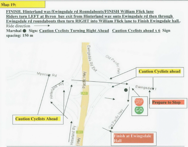
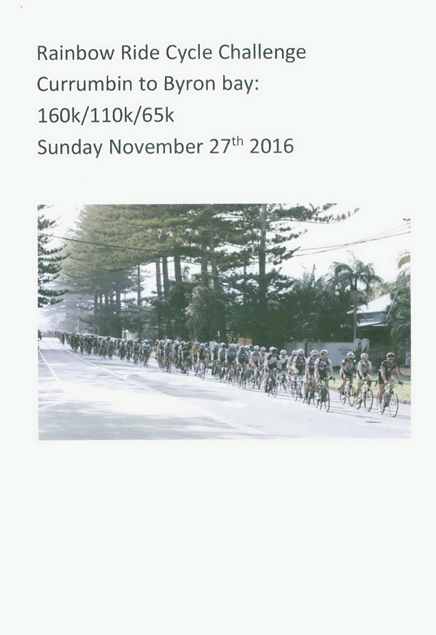
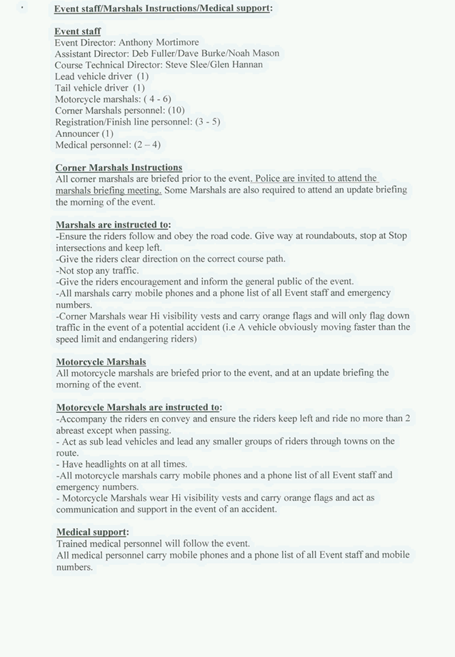
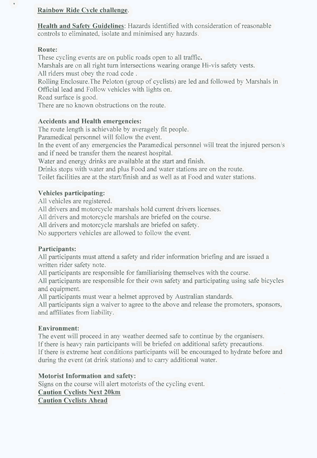
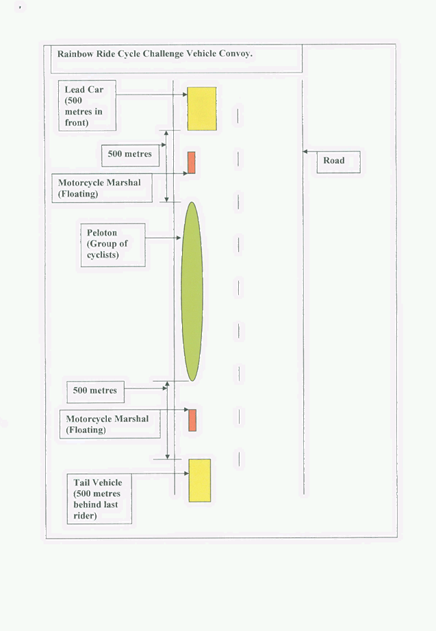
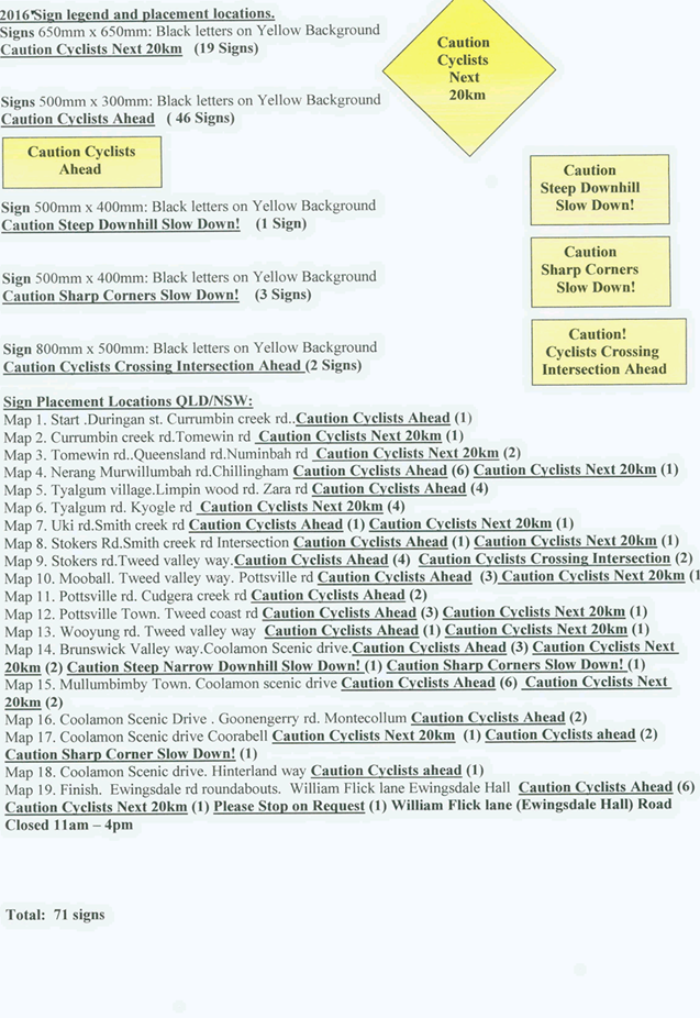
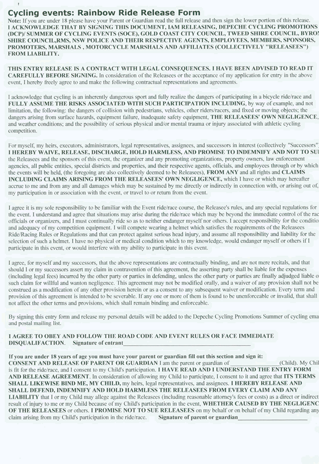
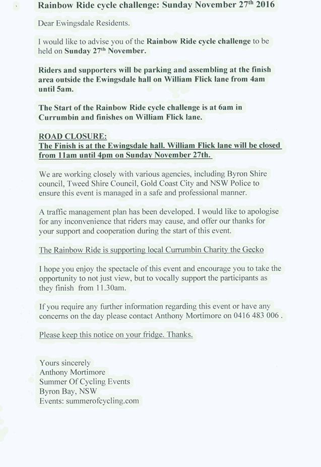
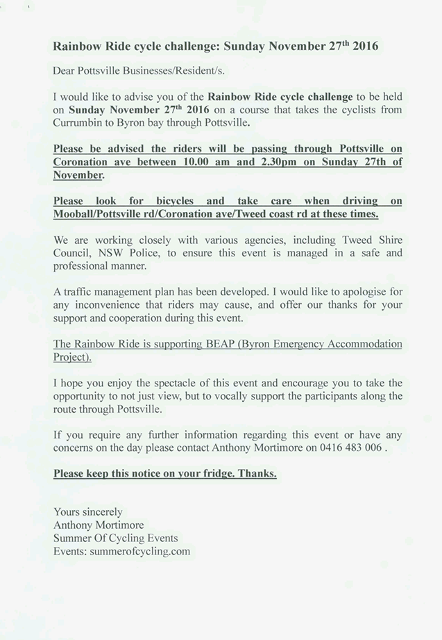
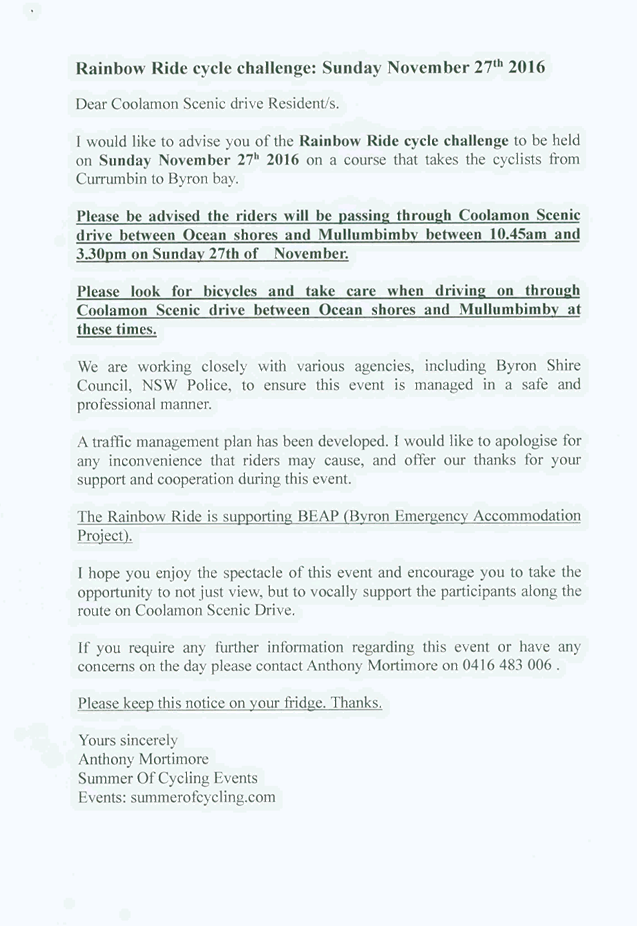
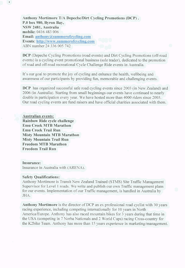
Local Traffic Committee Meeting 6.5
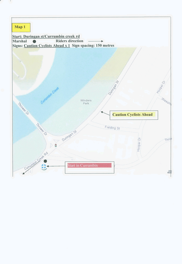
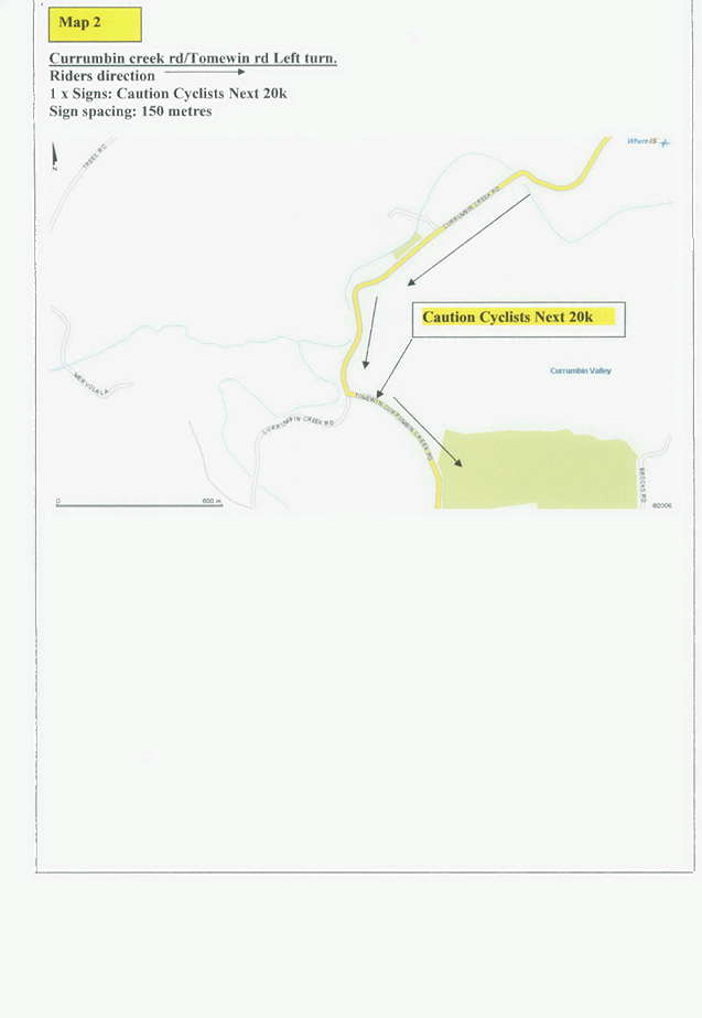
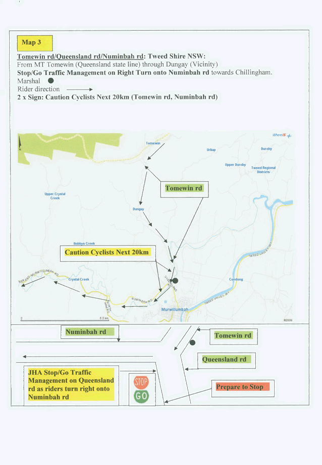
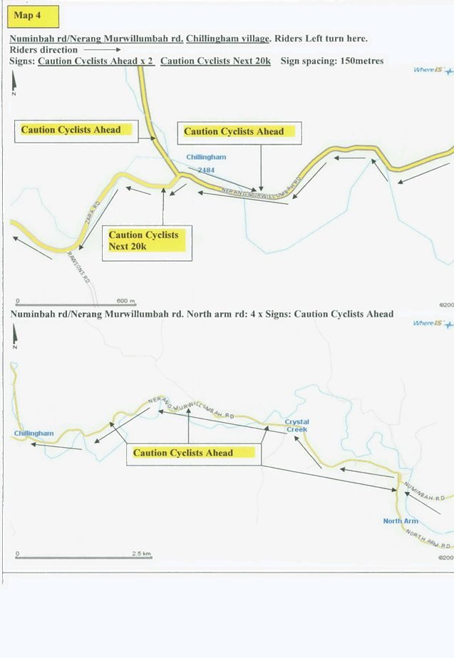
Report No. 6.5 Event Road Closure - Rainbow Ride Cycle Challenge - William Flick
Lane, Ewingsdale - Sunday, 27 November 2016
File No: I2016/919
Council has received an application and Traffic Management
Plan (TMP) from Depeche Cycling Promotions for the 10th Annual
Rainbow Ride cycle challenge from Currumbin to Ewingsdale, to be held Sunday 27
November 2016.
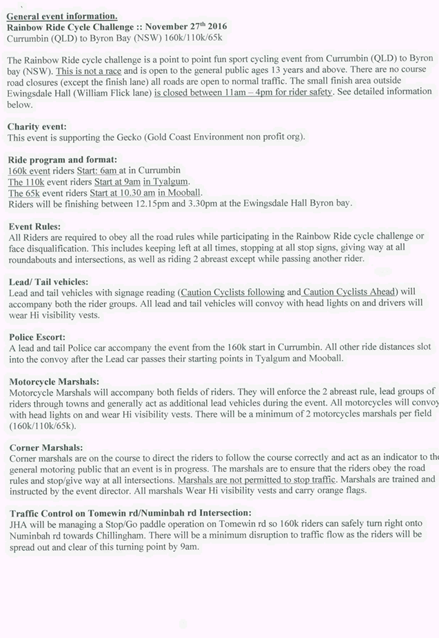
The Rainbow Ride cycle challenge is a point to point fun
sport cycling event from Currumbin (QLD) to Byron Bay (NSW). This is not
a race and is open to the general public ages 13 years and above. There
are no course road closures (except the finish lane) all roads are open to
normal traffic. The small finish area outside Ewingsdale Hall (William Flick
lane) is closed between 11am-4pm for rider safety.
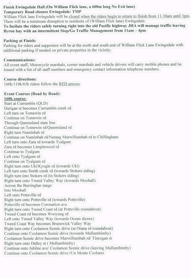
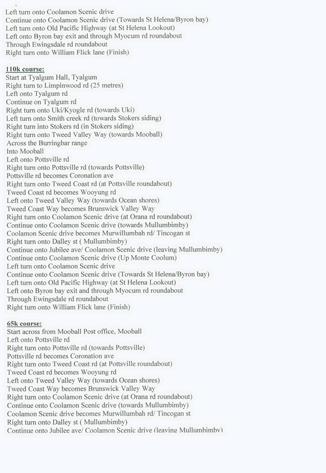
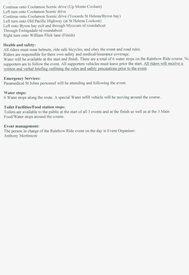
The event will finish at the Ewingsdale Hall, located on
William Flick Lane, Ewingsdale (a 600m long No Exit Lane). There will be
a temporary road closure of William Flick Lane when the riders begin to arrive
at the finish line from 11.30am until 3pm. There will be minimum disruption
to residents of (William Flick lane) Ewingsdale. To facilitate the riders
safely turning right into Hinterland Way, JHA will manage traffic leaving Byron
Bay with an intermittent Stop/Go Traffic Management from 11am-4pm. Parking
for riders and supporters will be at the north and south end of William Flick
Lane with additional parking if needed on private properties in the vicinity.
Figure 1
– TMP Map 19: Finish at Ewingsdale
The certified Traffic Control Plan
will be provided to the Local Traffic Committee (LTC) members for discussion
and endorsement at the LTC meeting to be held Wednesday 5 October 2016.
It is requested that the application and Traffic Management Plan (TMP) from Depeche
Cycling Promotions for the 10th Annual Rainbow Ride cycle challenge, which
includes the temporary road closure of William
Flick Lane Ewingsdale, to be held Sunday 27 November 2016 be endorsed.
|
RECOMMENDATION:
1. That
the Rainbow Ride Cycle Challenge to be held on Sunday 27 November 2016, which
includes the temporary road closure/s below, be endorsed between these times:
a. William
Flick Lane, Ewingsdale between 11am and 4pm.
2. That
the approval provided in Part 1 is subject to:
a. separate approvals by NSW Police
and RMS being obtained;
b. Implementation
of the approved Traffic Management Plan and Traffic Control Plan;
c. The event organiser:
i. advertising
the impact of the event via a notice in the local weekly paper a minimum of
one week prior to the operational impacts taking effect, noting it must
include the event name, specifics of any traffic impacts or road closures and
times, alternative route arrangements, event organiser, a personal contact
name and a telephone number for all event related enquiries or complaints.
ii. providing
a copy of the advert for Council's web page.
iii. informing
community and businesses that are directly impacted (eg adjacent to the
event) via written information which is delivered to the property in a timely
manner so as to document, consider and respond to any concerns raised.
iv. arranging
for private property access and egress affected by the event.
v. liaising
with bus and taxi operators and ensuring arrangements are made for provision
of services during conduct of the event.
vi. consulting
with emergency services and any identified issues be addressed.
vii. holding
$20m public liability insurance cover which is valid for the event.
viii. paying
of Council’s Road Event Application Fee prior to the event.
|
Attachments:
1 Event -
William Flick Ln - Road Closure - Rainbow Ride Cycle Challange - TMP, S2016/9167 , page 15
Regulatory Matters 6.5 - Attachment 1


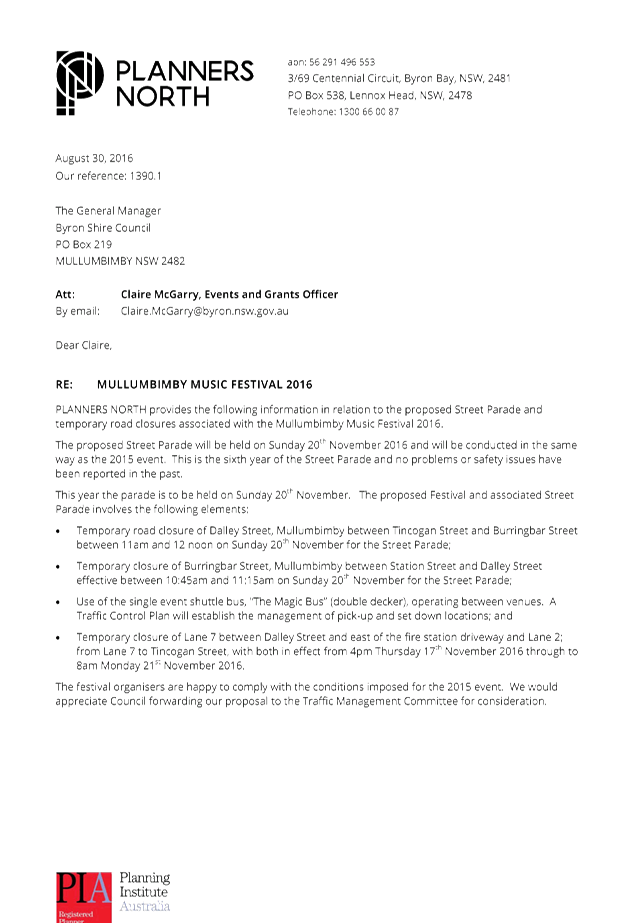
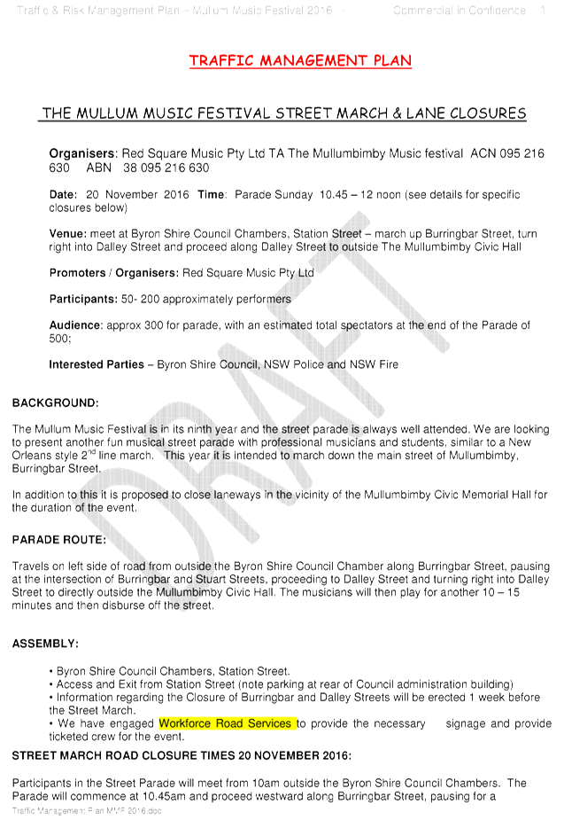
Local Traffic Committee Meeting 6.6
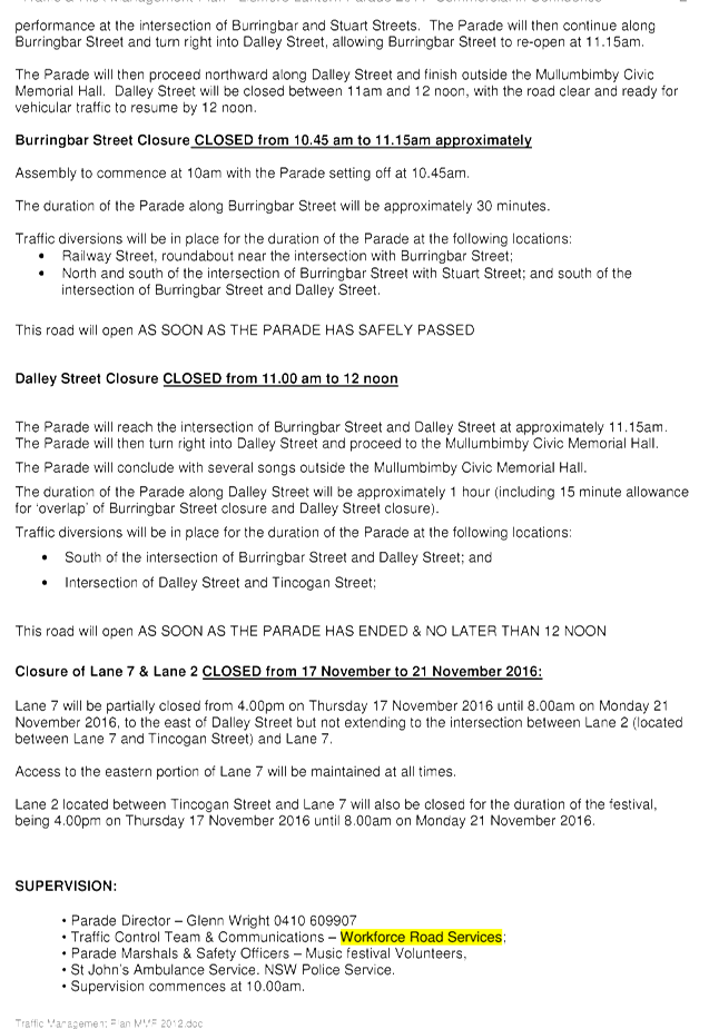
Report No. 6.6 Event Road Closure - Mullumbimby Music Festival - Burringbar Street
and Dalley Street, Mullumbimby - Sunday, 20 November 2016
File No: I2016/976
Council has received an application and draft Traffic
Management Plan (TMP) from Planners North for the Mullumbimby Music Festival
2016 to be held Sunday 20 November 2016.
The Mullumbimby Music Festival is in its ninth year and this
is the sixth year that the street parade has taken place( no problems or safety
issues have been reported in the past).
The proposed festival and
associated street parade involves the following elements (Figure 1):
· Temporary road closure of Dalley Street, Mullumbimby
between Tincogan Street and Burringbar Street (effective between 11am and 12pm
on Sunday 20 November 2016);
· Temporary closure of Burringbar Street, Mullumbimby between
Station Street and Dalley Street (effective between 10:45am and 11:15am on
Sunday 20 November 2016);
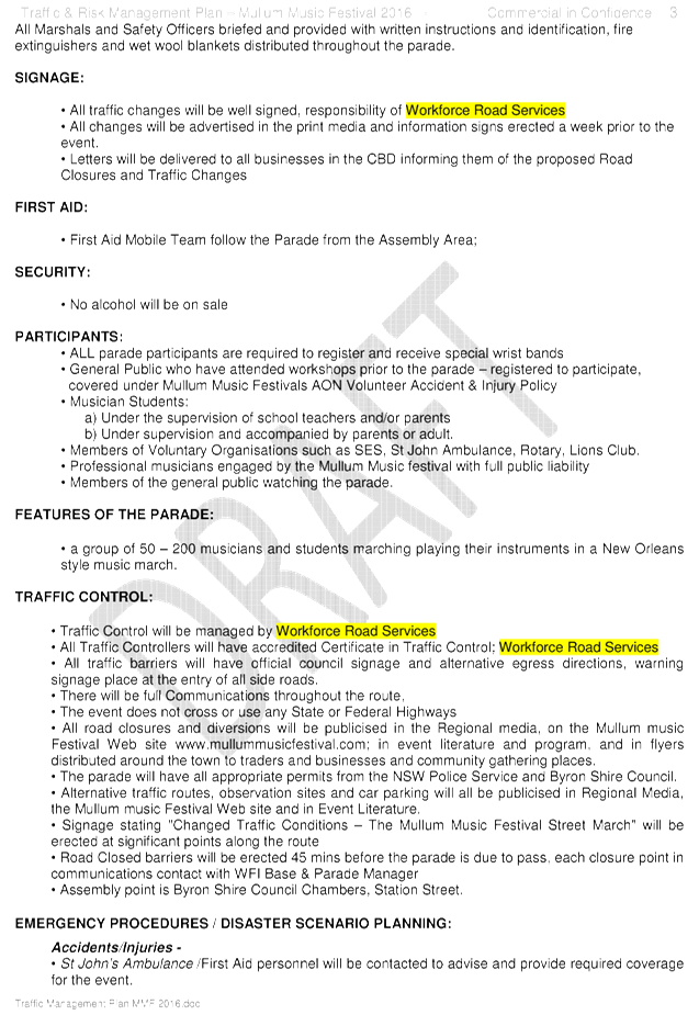
· Use of the single event shuttle bus, “The Magic
Bus” (double decker), operating between venues. A Traffic Control Plan
will establish the management of pick-up and set down locations; and
· Temporary road closure of Cenotaph Lane (previously Lane 7)
between Dalley Street and east of the fire station driveway and Murphys Lane
(previously Lane 2); from Cenotaph to Tincogan Street, with both in effect from
4pm Thursday 17 November 2016 through to 8am Monday 21 November 2016.
Figure 1 – Traffic Control Plan (TCP) Concept Design
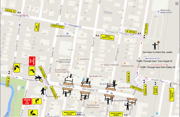
The certified TCP and finalised
TMP will be provided to the Local Traffic Committee (LTC) members for
discussion and endorsement at the LTC meeting to be held Wednesday 5 October
2016.
It is requested that the application, TMP and TCP from Planners North for the Mullumbimby
Music Festival 2016, which includes the temporary road closures detailed in
this report, to be held Sunday 20 November 2016 be endorsed.
|
RECOMMENDATION:
1. That
the Mullumbimby Music Festival to be held on Sunday 20 November 2016, which
includes the temporary road closures below, be endorsed between these times:
a. Dalley
Street, Mullumbimby between Tincogan Street and Burringbar Street between
11am and 12pm on Sunday 20 November 2016.
b. Burringbar
Street, Mullumbimby between Station Street and Dalley Street effective
between 10:45am and 11:15am on Sunday 20 November 2016.
c. Cenotaph
Lane, Mullumbimby between Dalley Street and east of the fire station driveway
and Murphys Lane; from Cenotaph to Tincogan Street, with both in effect from
4pm Thursday 17 November 2016 through to 8am on Monday 21 November 2016.
2. That
the approval provided in Part 1 is subject to:
a. separate
approvals by NSW Police and RMS being obtained;
b. implementation
of the approved Traffic Management Plan and Traffic Control Plan;
c. that
each temporary bus stop, as required by the event, be established in
accordance with the accredited Traffic Control Plan;
d. the event organiser:
i. advertising
the impact of the event via a notice in the local weekly paper a minimum of
one week prior to the operational impacts taking effect, noting it must
include the event name, specifics of any traffic impacts or road closures and
times, alternative route arrangements, event organiser, a personal contact
name and a telephone number for all event related enquiries or complaints.
ii. providing
a copy of the advert for Council's web page.
iii. the
written concurrence of the Fire Stations on both Gordon Street and Dalley
Street, be obtained and copies provided to Council.
iv. informing
community and businesses that are directly impacted (eg adjacent to the
event) via written information which is delivered to the property in a timely
manner so as to document, consider and respond to any concerns raised.
v. arranging
for private property access and egress affected by the event.
vi. liaising
with bus and taxi operators and ensuring arrangements are made for provision
of services during conduct of the event.
vii. consulting
with emergency services and any identified issues be addressed.
viii. holding
$20m public liability insurance cover which is valid for the event.
ix. paying
of Council’s Road Event Application Fee prior to the event.
|
Attachments:
1 Application
- Mullumbimby Music Festival 2016, E2016/87416
, page 56
2 Draft
Traffic Management Plan (TMP) - Mullumbimby Music Festival 2016, E2016/87426 ,
page 58
Regulatory Matters 6.6 - Attachment 1

Regulatory Matters 6.6 - Attachment 2
Local Traffic Committee Meeting 6.7
Report No. 6.7 24.2015.19.1 - Marine Parade, Byron Bay - Regulatory Signage -
Extension of Pay Parking Scheme - Endorsement of Council Resolved Time Limits
within Wategos
File No: I2016/984
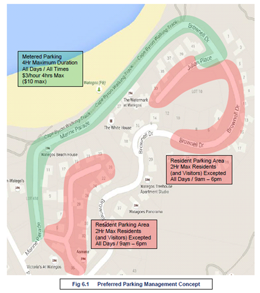
Agenda item 6.4 of the Local Traffic Committee’s (LTC)
meeting held 27 July 2016 was tabled to Council on 25 August 2016.
Council resolved in favour of the Committee recommendation
with two exceptions, both of which require Committee concurrence. As copied
overleaf (Res 16-467) they relate to:
· Part 2(a), which
endorses that a 4-hour (4P) time limit apply across 98% of parking stock within
the Wategos Pay Parking area, whereas the Committee had recommended a mix of
time limits, namely that a 2-hour (2P) limit to apply to 40% of the parking
stock (e.g. at the beach front) while 58% apply 4P and 2% provide special
purpose parking (e.g. mobility permit and motorcycle parking); and
· Part 3, which
endorses that a 4-hour (4P) time limit apply within the Wategos Resident and
Resident Visitors Permit Parking Scheme, whereas the Committee had recommended
a 2-hour (2P) limit.
Part 2(a)
In regard to Part 2(a), it is notable that Council (in
resolving upon a 4P time limit) is adhering to the recommendation as made in
the consultants (TPS) report as tabled to the Committee at the 27 July 2016
meeting (file E2016/65469).
As the Committee will recall, the TPS report recommended
implementing Figure 6.1 (as reproduced overleaf in Figure 1). However, with
concern for lack of turnover and limited parking at the beachfront, staff had
recommended a balanced approach including that 40% of available parking instead
apply a 2-hour (2P) limit.
Nevertheless, it is also noted that such concerns can be
addressed should or when they materialise. As such, Committee concurrence
for Part 2(a) of 16-467 is sought.
Part 3
As for Part 3 of 16-467, it is noted that a 4P limit
(permits excepted) within the resident scheme would be consistent with parts of
the same scheme operating in Byron Bay. However it provides twice the duration
of free, non-permit (i.e. public) parking that the TPS report recommended,
which was for a 2P limit (permits excepted), which was subsequently supported
by the Committee.
While a greater time limit (i.e. 4P instead of 2P) may
result in less turnover and therefore less vehicles parking within the resident
scheme, there is a greater likelihood that 4-hours free parking (and without
the need of a permit) will place greater demand on the streets than a 2P limit.
This is for several reasons. For one, 4-hours free parking is more appealing
than 4-hours paid. Two, 4-hours is likely to satisfy more beach-goers or
visitors than 2P; and three, especially at peak times, may result in less
opportunity for residents or their visitors to park on-street.
These problems are likely to be more acute the closer the
parking is to the beach front. For example, motorists will seek to park closest
to the pay parking area as possible, but not within it. If this occurs there is
potential that the resident streets (with a 4P limit) will attract parking
looking to avoid the meter while those with exceptions to paying the meter
(E-Permit holders) will dominate the pay parking area.
While such an outcome will defeat the purpose of either
scheme, it can be reviewed and changed if found warranted. To this end it is
recommended that the Committee concur with Part 3 of Res 16-467 on the proviso
staff review the Wategos parking schemes during the first holiday period they
apply; and that such review include seeking resident feedback.
Resolution 16-467
16-467 Resolved:
That subject to the concurrence of the LTC Council adopt:
1. That
a meter registration pay parking scheme be implemented upon Marine Parade,
Wategos between the intersections of Palm Valley Drive and Julian Place on the proviso
it is the same as the Byron Bay scheme, for example the same hourly rates,
regulations, restrictions, exemption benefits, etc.
2. That
the following time limits and ratios be implemented upon the full length of
Marine Parade, Wategos and that they apply Monday-Sunday inclusive including
public holidays between the hours of 9am-6pm and that outside of such hours the
existing sign-posted regulations remain:
a) a
4-hour (4P) limit apply to approximately 98% of parking supply, and that it
first be allocated from Palm Valley Drive to the turning circle, and the
balance (if any) apply the east end of Marine Parade, from Julian Place; and
b) the
remaining 2% of parking supply provide dedicated motorcycle-parking and
mobility permit parking, preferably next to beach and commercial property
access.
3. That
the Byron Bay Resident and Resident Visitors Permit Parking Scheme be
implemented in the Wategos area and it include a 4P time limit effective
9am-6pm each day, subject to LTC approval (to be sought as soon as possible).
3. At
first possible opportunity that a review be conducted on the paid parking in
the Wategos area.
Figure 1: Original Recommendation as per TPS Report (Figure
6.1)
|
RECOMMENDATION:
That the Local Traffic Committee have no
objection to Council Resolution 16-467 and as sought provide concurrence for:
a) Part
2(a), which is for a 4-hour (4P) limit to apply across 98% of parking supply
within the endorsed Wategos pay parking area; and
b) Part
3, which is for a 4-hour (4P) limit to apply within the endorsed Wategos
resident permit parking area, on the proviso a review including resident
feedback is undertaken during the first holiday period the scheme applies.
|
Local Traffic Committee Meeting 6.8
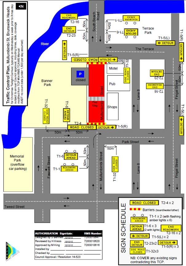
Report No. 6.8 Event Road Closure - Brunswick Valley Woodchop and Entertainment
Committee - Twilight Markets - Mullumbimi Street, Brunswick Heads - Wednesday,
14 December 2016
File No: I2016/986
Council has received an application and Traffic Control Plan
(TCP) from the Brunswick Valley Woodchop & Entertainment Committee Inc for
the Twilight Markets to be held Wednesday 14 December 2016 and the Fireworks
Night to be held Saturday 14 January 2017.
The annual Twilight Markets continue to be a success and
bring huge crowds to the township. The event organisers are requesting:
1. Closure
of Mullumbimbi Street Brunswick Heads, between The Terrace and Park Street as
follows:
a) Closure
of the area bounded by the nose-in parking and centre parking bay from 7am
until 11pm. This is the "U" shaped provision for parking that is
adjacent Banner Park in the vicinity of the children's play area.
b) Request
for 2 temporary designated ‘Disabled Parking’ spots outside of the
hotel during the morning. The existing 2 spots will have been closed off.
c) Closure
of the remaining section of ‘through road’ between The Terrace and
Park Street from 12 noon until 11pm.
2. Opening
of Memorial Park for parking as follows:
a) Twilight
markets – Wednesday, 14 December 2016 from 12noon. This will allow
stallholders to get their vehicles off the street before the markets start at
3pm.
b) Fireworks
Night – Saturday, 14 January 2017 from 6pm. This will allow for people
attending the carnival/housie and through to when the fireworks take place at
9pm to park off the streets.
Appropriately accredited (JHA) staff will be requested to
put out the early blockades and the temporary designated ‘Disabled
Parking’ signs as per the TCP (Figure 1). Market staff will relocate the
blockades at 12 noon. Market staff will also remove the road closed and
Disabled Parking signs at the end of the event.
As in the past McGregor’s Amusements will move their
‘ride’ during the night of Tuesday 13 December 2016 and place it
over the centre parking bays for erection the following afternoon. This
effectively blocks off most of the area as mentioned in Item 1, and the early
road closure will ensure that vehicles are not parked indefinitely in the area.
It is requested that the
application and TCP from the Brunswick Valley
Woodchop & Entertainment Committee Inc for Twilight Markets, which includes
the temporary road closure of Mullumbimbi Street Brunswick Heads, to be held
Wednesday 14 December 2016 be endorsed.
Figure 1 – Traffic Control Plan
|
RECOMMENDATION:
1. That
the Twilight Markets to be held on Wednesday 14 December 2016, which includes
the temporary road closure/s below, be endorsed between these times:
a. Mullumbimbi
Street Brunswick Heads, between The Terrace and Park Street on Wednesday 14
December, as per the following:
i. Closure
of the area bounded by the nose-in parking and centre parking bay from 7am
until 11pm. This is the "U" shaped provision for parking that is
adjacent Banner Park in the vicinity of the children's play area.
ii. Request
for 2 temporary designated ‘Disabled Parking’ spots outside of
the hotel during the morning. The existing 2 spots will have been closed off.
iii. Closure
of the remaining section of ‘through road’ between The Terrace
and Park Street from 12 noon until 11pm.
b. Opening
of Memorial Park for parking, as per the following:
i. Wednesday,
14 December 2016 from 12noon. This will allow stallholders to get their
vehicles off the street before the markets start at 3pm.
2. That
the Fireworks Night to be held on Saturday 14 January 2017, which includes
the opening of Memorial Park for parking as per the following, be endorsed:
i. Saturday,
14 January 2017 from 6pm. This will allow for people attending the
carnival/housie and through to when the fireworks take place at 9pm to park
off the streets.
3. That
the approval provided in Part 1 and Part 2 is subject to:
a. separate
approvals by NSW Police and RMS being obtained;
b. implementation
of the approved Traffic Control Plan by those with appropriate accreditation;
c. the
event be advertised in accordance with the Roads Act, charged at cost to the
organisers;
d. the
event be notified on Council’s web page;
e. the
event organiser:
i. informing
community and businesses that are directly impacted (eg adjacent to the
event) via written information which is delivered to the property in a timely
manner so as to document, consider and respond to any concerns raised.
ii. arranging
for private property access and egress affected by the event.
iii. liaising
with bus and taxi operators and ensuring arrangements are made for provision
of services during conduct of the event.
iv. consulting
with emergency services and any identified issues be addressed.
v. holding
$20m public liability insurance cover which is valid for the event.
vi. paying
of Council’s Road Event Application Fee prior to the event.
|
Local Traffic Committee Meeting 6.9
Report No. 6.9 Event Road Closure - Byron Lighthouse Run - Lighthouse Road, Byron
Bay - Sunday, 23 October 2016 (Amended)
File No: I2016/987
BACKGROUND
After consideration at the Local Traffic Committee (LTC) on 8
June 2016 and subsequent Council resolution 16-385 (refer to extract below), on
the 4 August 2016 Council resolved to endorse the temporary road closures for
the Byron Lighthouse Run to be held on Sunday 23 October 2016.
|
16-385
|
Resolved that Council adopt the following
Committee Recommendation(s):
Report
No. 6.1 Road closure, Lighthouse Road - Byron Bay
Lighthouse Run, Sunday 23 October 2016
File No: I2016/384
1. That
the 10km Byron Lighthouse Fun Run to be held Sunday 23 October 2016, which
includes the temporary road closures below, be endorsed between these times:
a) Lighthouse
Road between Brooke Drive (at The Pass) and Palm Valley Way (entry to
Wategos) between the hours of 7:00am and 08:00am
b) Clarkes
Beach Car Park between the hours of 6:00am and 10:00am
c) Lawson
Street, from Massinger Street / Lighthouse Road intersection to the caravan
park, between the hours of 7:00am and 7:15am
|
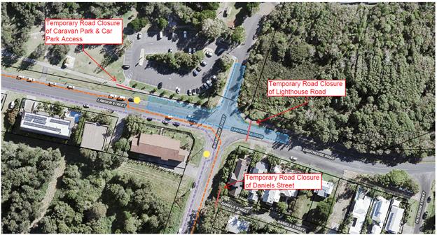
REPORT
It has since come to light that the Council road works
currently being undertaken at the intersection of Massinger Street, Lawson
Street and Lighthouse Road will not be completed by the event date and as such
it is proposed that the event application be reviewed and an amended Traffic
Control Plan (TCP) put in place.
It is proposed that the current TCP (Figure 1) be
implemented with the following inclusions:
· Temporary road
closure of Daniels Street, between 7am and 8am;
· Traffic
Controllers managing the traffic at the intersection of Lawson Street and
Massinger Street with Stop/Go controls.
Figure 2 is the concept TCP taking into consideration the
ongoing Council road works (blue section) at the intersection. There will be
three temporary road closures (red lines) and traffic will be directed by
Stop/Go traffic controllers (yellow dots) which will allow one lane of traffic
at a time to use the intersection.
It is requested that the LTC endorse the amendments to the
TCP for the Byron Lighthouse Run to be held on Sunday 23 October 2016.
Figure 1
– Current TCP
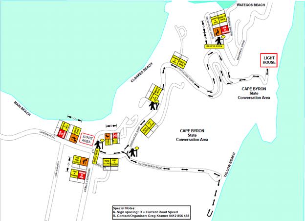
Figure 2
– Concept TCP (taking into consideration the ongoing road works)
|
RECOMMENDATION:
1. That
the 10km Byron Lighthouse Fun Run, to be held Sunday 23 October 2016, which
includes the temporary road closures below, be endorsed between these times:
a. Lighthouse
Road at the intersection of Massinger Street, Lawson Street and Lighthouse
Road between 7am and 8am.
b. Daniels
Street at the intersection of Massinger Street and Daniels Street between 7am
and 8am.
c. Lighthouse
Road between Brooke Drive (at The Pass) and Palm Valley Way (entry to
Wategos) between 7am and 8am.
d. Clarkes
Car Park closed, including the current Caravan Park access road off Lawson
Street, between 6am and 10am.
2. That
the approval provided in Part 1 is subject to:
a. separate
approvals by NSW Police and RMS being obtained;
b. Local
Traffic Committee advice is sought for the event Traffic Management Plan
(including Risk Management Plan and Traffic Control Plan/s) prior to
implementation of traffic control devices including road closures, noting
that:
i. conformance
with approved Traffic Management Plan and associated Traffic Control Plans
which shall be implemented and controlled by Roads & Maritime Services
accredited persons;
ii. all
temporary traffic control devices erected for the event must comply with
Roads & Maritime Services Guide to Traffic Control at Worksites Manual,
not cause a hazard for motorists or pedestrians and be removed immediately
following the completion of the event; and
iii. temporary
Speed Zone Authorisation is obtained from the roads authority for any reduced
speed limit/s required as part of the traffic control for the event; and that
where local Council is the roads authority, notification of any reduced speed
limit should be forwarded to Roads and Maritime Service and NSW Police.
c. The
event organiser:
i. advertising
the impact of the event via a notice in the local weekly paper a minimum of
one week prior to the operational impacts taking effect, noting it must
include the event name, specifics of any traffic impacts or road closures and
times, alternative route arrangements, event organiser, a personal contact
name and a telephone number for all event related enquiries or complaints;
ii. providing
copy of the advert for Council's web page;
iii. informing
community and business that are directly impacted (e.g. adjacent to the
event) via written information which is delivered to the property in a timely
manner so as to document, consider and respond to any concerns raised;
iv. arranging
for private property access and egress affected by the event;
v. liaising
with bus and taxi operators and ensuring arrangements are made for provision
of services during conduct of the event;
vi. consulting
with emergency services and any identified issues be addressed;
vii. holding
$20m public liability insurance cover which is valid for the event; and
viii. payment
of Council’s Road Event application fee prior to the event;
ix. The
attainment (by the event proponent) of Cape Byron Headland Trust written
concurrence of the event;
x. Consultation
with the Beach Byron Bay Cafe and North Coast Holiday Parks Clarkes Beach.
|
Local Traffic Committee Meeting 6.10
Report No. 6.10 Extension of School Bus Route - Pearces Road and Booyong Road,
Booyong
File No: I2016/990
Council has received an application (E2016/83217) from Mr
Gavin Beaumont, Operator of Beaumont Buses, to extend the existing school bus
route N0120 that currently runs along Houghlahans Creek Road (which is situated
in the Lismore Shire).
Figure 1 indicates the proposed bus route extension into the
Byron Shire, which will operate both in the morning to pick the school children
up and in the afternoon when dropping the school children off. It is proposed
that the bus route is extended (red line) into Pearce Road before turning right
onto Booyong Road. The bus will then follow Booyong Road until it reaches
the intersection at Booyong Road, Tooheys Mill Road and Cooks Road (yellow
dot), where it will complete a three-point turn before backtracking along the
same route to eventually exit back onto Houghlahans Creek Road.
The proposed extension will service up to 8 children using a
9.5m bus. The operator would like to have approval for buses up to 12.5m in
length to allow for use of hired buses in the event that the regular 9.5m bus
is out of service.
Figure 1
– Proposed Bus Route Extension into Byron Shire
The Byron Shire portion of Pearce
Road (# 551) is a rural sealed road of approximately 920m in length in
Booyong. The section of Booyong Road (# 511) indicated is a rural sealed
road of approximately 3.9kms in length in Booyong.
On Thursday 22 September 2016,
Council officers conducted an inspection of the proposed route and found that
there were a number of locations along Booyong Road that would not allow
two-way traffic irrespective of whether travelling by car or bus.
However, it is noted that there are currently two school bus services (#N0124
and #N0256) that utilise this section of Booyong Road.
During the inspection it was found
that there was insufficient sight distance for a bus to conduct a safe
three-point turn at the location proposed by the applicant. Alternatively, it
is recommended that the bus continue along Tooheys Mill Road before once again
meeting up with Houghlahans Creek Road (Figure 2). It is noted that there is a
section of Tooheys Mill Road that can flood in extreme weather, at which time
the bus may need to complete a three-point turn at the previously proposed
intersection.
Figure 2 – Proposed Alternate Route
Committee endorsement is sought
for the extension of the existing school bus route into Pearce Road and Booyong
Road.
|
RECOMMENDATION:
That Council note:-
1. The
Local Traffic Committee has no objection to the proposed extension of the
school bus route along Pearce Road and Booyong Road in Booyong;
2. The
bus would enter Pearce Road from Houghlahans Creek Road, before turning right
onto Booyong Road and then continuing along Tooheys Mill Road to meet up once
again with Houghlahans Creek Road.
|
Attachments:
1 Proposed
Bus Route Extension, E2016/85853 ,
page 77
Regulatory Matters 6.10 - Attachment 1
Local Traffic Committee Meeting 6.11
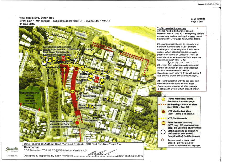
Report No. 6.11 Event Road Closure - Soul Street New Year's Eve and First Sun New
Year's Day, Byron Bay
File No: I2016/992
Two key strategies of the ‘Safe Summer in the
Bay’ initiative adopted by Council include the Soul Street New Year’s
Eve (NYE) family friendly event on 31 December 2016, and the First Sun New Year’s
Day (NYD) meditation/yoga event on the 1 January 2017.
New Year’s Eve
Council last year (2015) held the third annual ‘Soul
Street’ NYE event which required a road closure of the main street of
Byron Bay, being Jonson Street, between Lawson Street through to the car park
entry at Railway Park just north of Marvell Street. The same road closure is
now sought for the 2016 NYE event to be held Saturday 31 December 2016 with the
southern end to close from 12noon and the northern end from 1pm. The road
closure would then be lifted no later than 7am the following morning (1 January
2017).
Other closures are shown in Figure 1, such as securing of
Council owned and operated public car park (Lawson Street south car park) for
participants of the event only (e.g. stall holders) and provision of an
emergency vehicle access route under guidance of traffic control personnel
positioned at sites 2 and 3. Removal of parking from streets (as per dotted red
line) from 6am will also occur as will traffic control personnel which include
two at each of the sites (1, 2 and 3) as per previous years, but with an
additional two personnel located at the roundabout at the intersection of
Fletcher Street & Lawson Street. Please note that a roster for traffic
control personnel will accompany the final approved Traffic Control Plan.
Figure 1 – Traffic Control Plan concept
In addition, Council will run a
NYE shuttle service between 3pm and 3am from the Cavanbah Sports Centre on
Ewingsdale Road (3km west of town) to the site depicted in Figure 2 (e.g. at
the top end of the street closure).
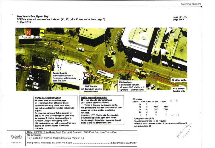
Figure 2 provides details on the
role of the traffic controllers to be positioned during the day at sites 1 and
2, noting when two personnel are at each site they will assist with control of
pedestrian and vehicle movement at the roundabout at the intersection of Jonson
Street & Lawson Street.
Figure 2 – TCP for Site 1 and Site 2
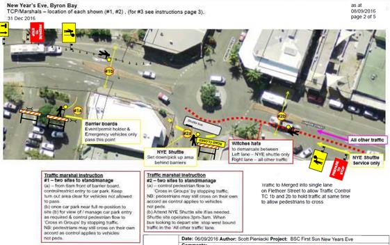
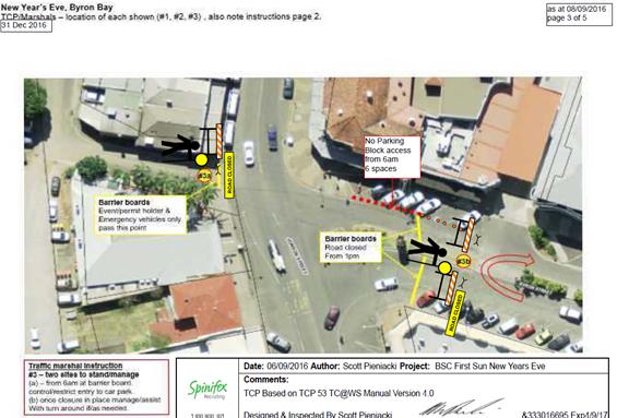
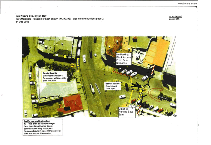
Figure 3 – TCP for Site 3
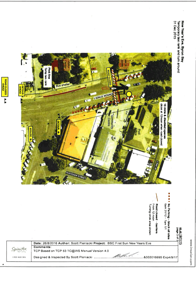
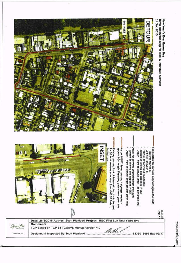
It should be noted the road
closure impacts on local taxi and bus operators and interstate coach services.
As in the past, these stakeholders will be advised directly and accommodated
where possible, noting this NYE the main bus/coach stop will be for taxi and
smaller passenger service vehicles only while the bus/coach and larger vehicles
will be provided for south of the main stop so as they avoid the turn-around
south end of the road closure and can exit directly via Marvell Street. Both south
and north bound vehicles can use this temporary bus/coach stop if they wish by
detouring or alternatively (as local services do) use the existing southbound
bus stop opposite.
Figure 4 – TCP for Detour and Temporary Coach/Bus
Stop
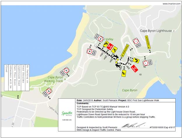
New Year’s Day
This year, on 1 January 2016, the
First Sun NYD event was held for the first time at the Cape Byron Lighthouse.
It was a very successful event with approximately 400 – 500 people
attending and it is proposed that the same event be held again on Sunday 1 January
2017.
During the last event, vehicles
parked on both sides of Lighthouse Road leading up to Cape Byron Lighthouse and
pedestrians walked in large groups along the road. To minimise the impact on
traffic flow, a traffic control plan (Figure 5) has been developed for
Lighthouse Road.
Figure 5 – TCP for Lighthouse Road
It is requested that the TCP for both
the NYE & NYD events, which includes the temporary road closures described
above in Byron Bay, to be held Saturday 31 December 2016 and Sunday 1 January
2017 respectively be endorsed.
|
RECOMMENDATION:
1. That
the Local Traffic Committee supports:
a. Council's
temporary traffic management initiatives for the Soul Street New Year's Eve
event to be held in Byron Bay and approves the temporary road closure of
Jonson Street, between Lawson Street through to the car park entry at Railway
Park (north of Marvell Street), from 12noon on Saturday 31 December 2016 and
its removal by no later than 7am on the Sunday 1 January 2017.
b. Council’s
temporary traffic management initiatives for the First Sun New Year’s
Day event to be held in Byron Bay and approves the temporary road closure of
Lighthouse Road from Brooke Road (The Pass), from 3am to 8am on Sunday 1
January 2017.
2. That
the approval provided in Part 1 remain subject to Council endorsement of the
event prior to implementation and is subject to the following requirements:
a. traffic
control plans are designed and implemented by those with the appropriate NSW
(RMS) accreditation;
b. advertising
is undertaken in accordance with the Roads Act, including the publication of
a map and explanatory notes in a local newspaper and on Council's website;
c. the
letterbox drop of properties adjacent to and prior of the Jonson Street closure
and Bay Street, Marvell Street and Byron Street parking changes; and
d. all
parties involved in Council's NYE events hold, or least covered by,
appropriate and relevant levels of insurance and public liability cover as
required by Council.
|
Attachments:
1 Traffic
Control Plan - New Years Eve 2016, E2016/87432
, page 83
Regulatory Matters 6.11 - Attachment 1
Regulatory Matters 6.11 - Attachment 1
Local Traffic Committee Meeting 6.12
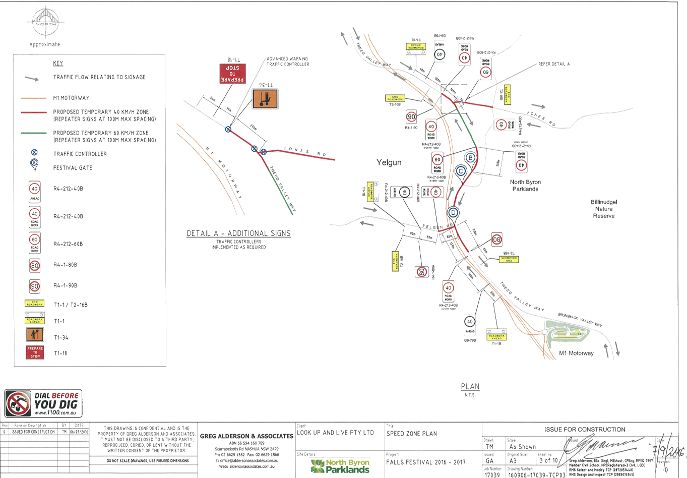
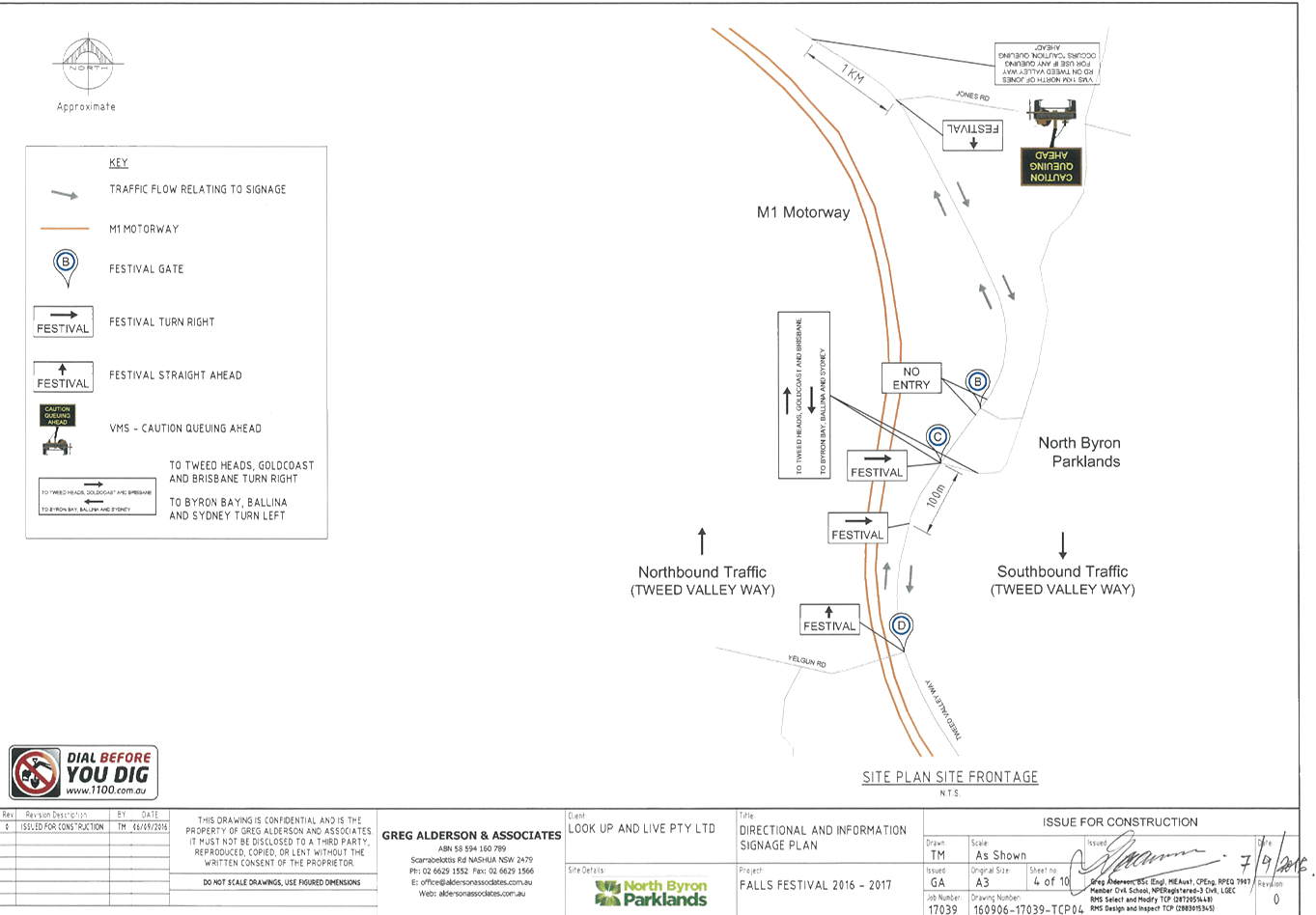
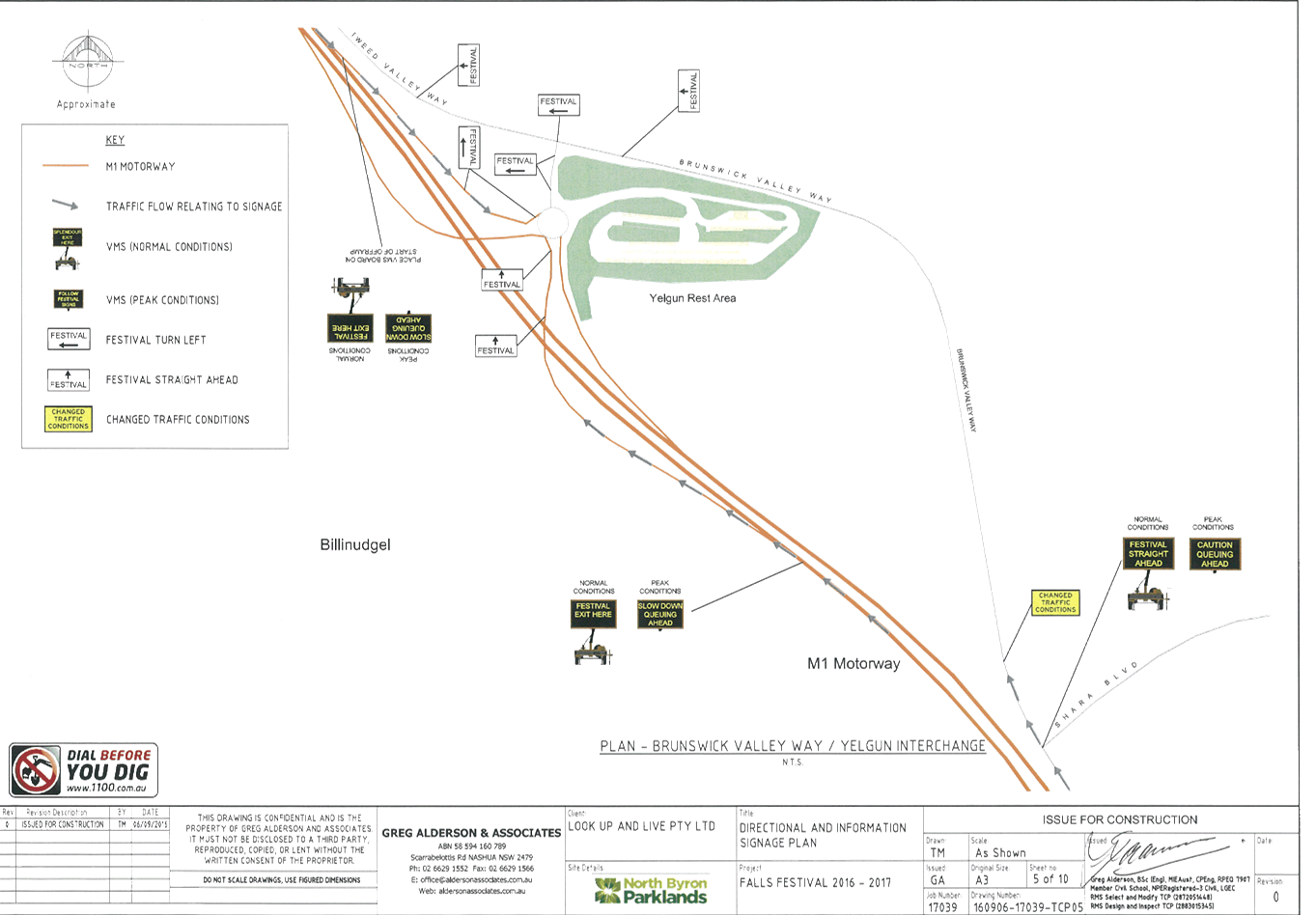
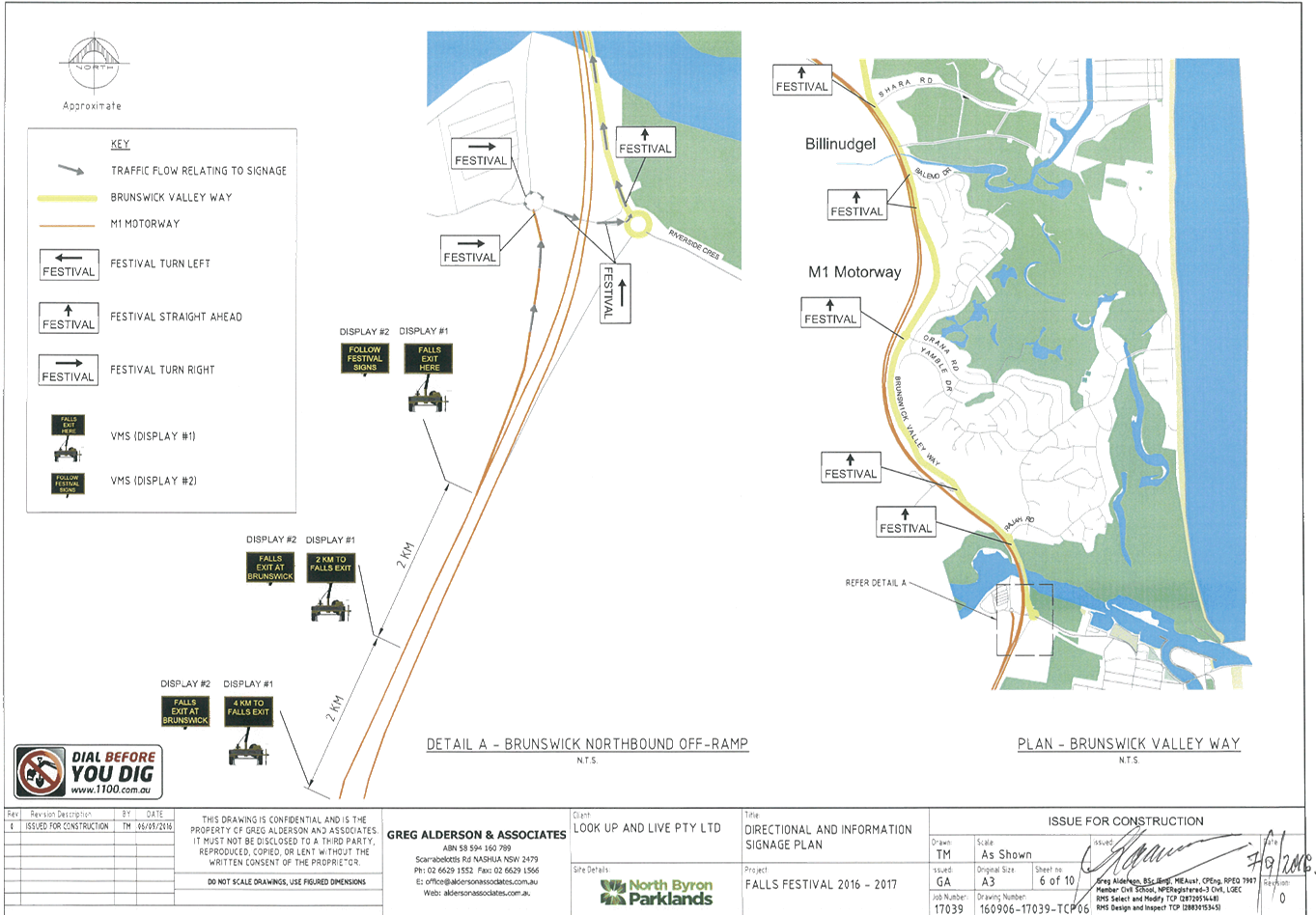
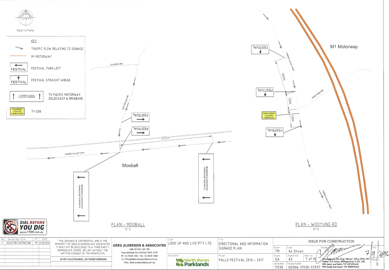
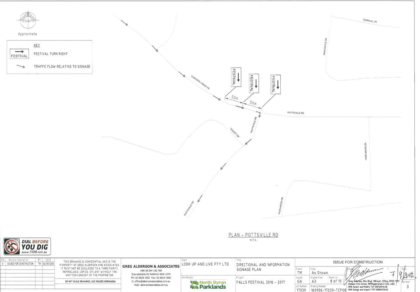
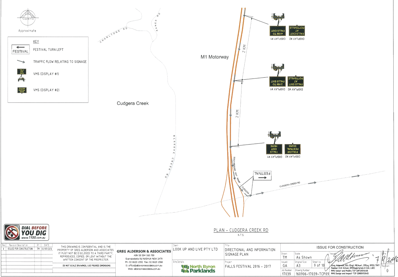
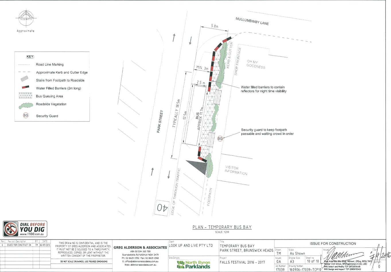
Report No. 6.12 Event Road Closure - Falls Festival 2016/17 - North Byron Parklands,
Yelgun - Saturday 31 December 2016 to Monday 2 January 2017
File No: I2016/993
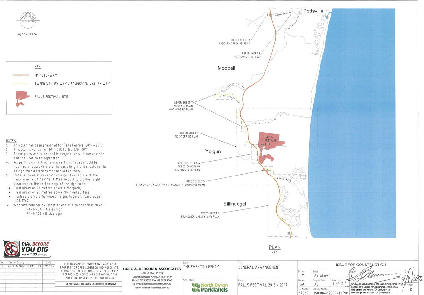
Council has received an application and Traffic Control Plan
(TCP) from Greg Alderson & Associates on behalf of Look Up and Live Pty Ltd
for Falls Festival 2016/17 at North Byron Parklands in Yelgun, that is to be
held during the New Year’s period of 2016/17.
The festival will be held from Saturday 31 December 2016 to
Monday 2 January 2017. Camper bump in will commence on Friday 30 December
2016. The camping areas close in the afternoon of Tuesday 3 January 2017.
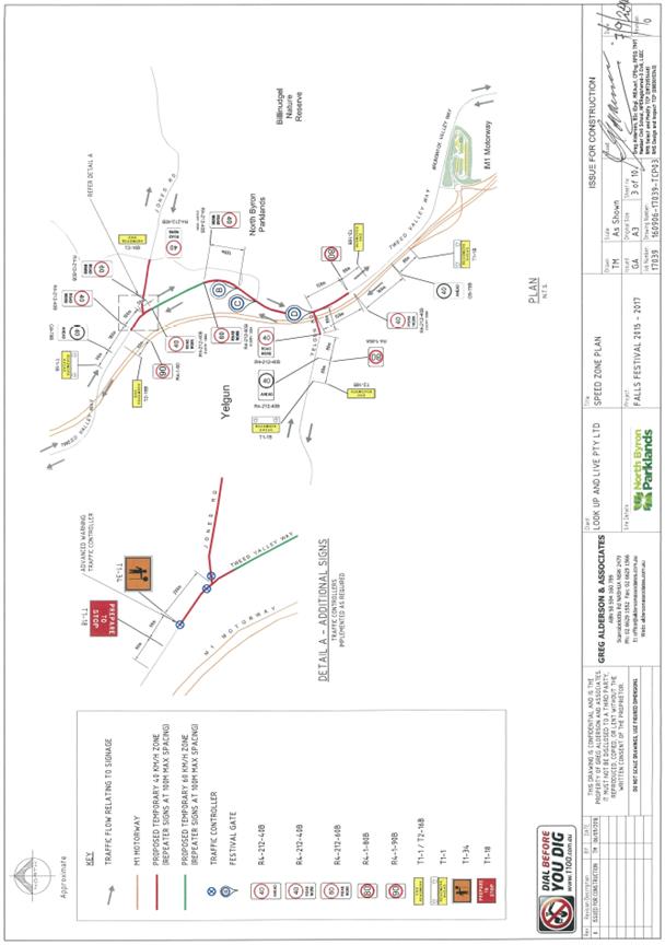
The TCP (Figure 1) is virtually the same as previous years,
with the exception of adding a few ‘changed traffic conditions / roadwork
ahead’ signs and the layout and presentation have been revised to add
clarity and include feedback from Roads and Maritime Services (RMS).
It is requested that the application and TCP from Greg
Alderson & Associates for Falls Festival 2016/17 at North Byron Parklands
in Yelgun, that is to be held during the New Year’s period of 2016/17 be
endorsed.
Figure 1
– TCP concept
|
RECOMMENDATION:
That the temporary traffic management and regulatory
changes within the series of Traffic Control Plans as related to the Falls
Festival to be held at the North Byron Parklands site Yelgun between Saturday
31 December 2016 and Monday 2 January 2017 inclusive be endorsed subject to:
a. Separate
approvals by NSW Police and RMS being obtained;
b. Implementation
of the approved Traffic Management Plan and Traffic Control Plan by
those with appropriate RMS accreditation and the holding of current and appropriate
levels of insurance and liability cover;
c. The
approved event size being sufficient (20,000 patrons) to trigger use of the
south car park as per the DA Condition for its use;
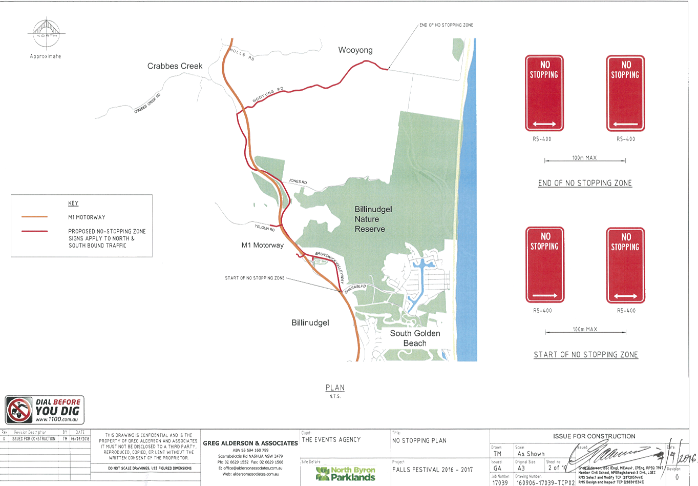
d. The
temporary ‘No Stopping’ where applied, including on Brunswick
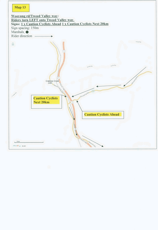
Valley Way (between Shara Boulevard and Tweed Valley Way) and on Tweed Valley
Way (between Brunswick Valley Way and Wooyong Road), is implemented prior to
the event and in accordance with relevant state requirements and Australian
Standards;
e. A
communications protocol be developed and maintained by those involved in the
implementation of traffic management including monitoring and ability to
implement contingency plans as and when directed;
f. Monitoring
of vehicle volumes that arrive and depart the festival site and on the local
road network;
g. The
holding of an event debrief within the month following the festival which
includes but not limited to Council, RMS and Police;
h. The
event organiser:
i. advertising
the impact of the event via a notice in the local weekly paper a minimum of
one week prior to the operational impacts taking effect, noting it must
include the event name, specifics of any traffic impacts or road closures and
times, alternative route arrangements, event organiser, a personal contact
name and a telephone number for all event related enquiries or complaints;
ii. providing
a copy of the advert for Council's web page;
iii. consideration
of any submissions received;
iv. informing
community and businesses that are directly impacted (eg adjacent to the
event) via written information which is delivered to the property in a timely
manner so as to document, consider and respond to any concerns raised;
v. arranging
for private property access and egress affected by the event;
vi. liaising
with bus and taxi operators and ensuring arrangements are made for provision
of services during conduct of the event;
vii. consulting
with emergency services and any identified issues be addressed;
viii. holding
$20m public liability insurance cover which is valid for the event.
ix. paying
of Council’s Road Event Application Fee prior to the event.
|
Attachments:
1 Application
& Traffic Control Plan for Falls Festival 2016/17, E2016/87438 , page 92
Regulatory Matters 6.12 - Attachment 1
Local Traffic Committee Meeting 6.13
Report No. 6.13 Bayshore Drive - Proposed Bus Stop Relocation, No Stopping Signage
and 30-minute Parking Time Limit
File No: I2016/1004
After consideration at the Local Traffic Committee (LTC) on
the 24 June 2015 and subsequent Council resolution 15-350, on 16 July 2015
Council resolved as follows:
|
15-350
|
Resolved that Council adopt the
following Committee Recommendation:
Report
No. 6.10 Request for Time Limit, Bayshore Drive, Arts and Industry
Estate,
Byron Bay
File No:
I2015/577
1. That
‘No Stopping’ apply for a 15m length on the west side of
Bayshore Drive, north of Grevillea Street, Byron Bay.
2. That
‘No Parking’ be signed for the length of the bus stop,
which is to be demarcated by a single J-Pole, relocated south of its existing
site on the west side of Bayshore Drive to 30m north of Grevillea Street,
Byron Bay.
3. That
on the west side of Bayshore Drive, between 35m and 77m north of Grevillea
Street, Byron Bay a 1P time limit be signed as effective Monday to Friday 9am
to 6pm and Saturday 9am to 12.00 noon, conforming with such limits nearby.
4. That
consultation with all tenants with access to and from the west side of
Bayshore Drive (between Grevillea Street and Banksia Street) and those on
Banksia Drive (between Bayshore Drive and Acacia Street) be undertaken to
ascertain support of adopting such time limits.
|
Signage was installed on Monday 9
May 2016 as resolved in resolution 15-350. Due
to the time elapsed between the original consultation, Council resolving on the
matter and the installation of the signage it appears that local business
requirements have changed and it seems resolution 15-350 is no longer
appropriate for the current circumstances.
The matter has since been reviewed
and to improve access to the local business the following improvements are
recommended for the western side of Bayshore Drive, north of the intersection
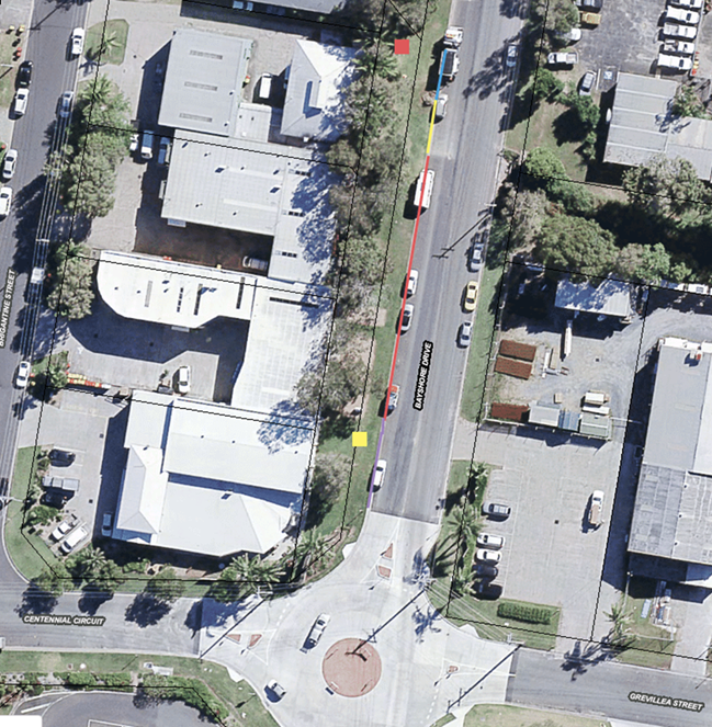
of Centennial Circuit, Bayshore Drive and Grevillea Street (refer to Figure 1):
1. Relocation of the existing bus stop (yellow
square) back to the original location near the child care centre (red square)
located 77m north of the intersection.
2. ‘No Stopping’ to be extended
between 62m and 77m north of the intersection (yellow line) to allow easy of
access to the relocated bus stop.
3. 30-minute parking time limit be signed
between 0m and 35m north of the intersection (purple line), effective Monday to
Friday 9am to 6pm and Saturday 9am to 12pm.
It is noted that there will be no
change to the current 1P time limit between 35m and 62m north of the
intersection (red line), as previously resolved in Part 3 of resolution 15-350.
Consultation has been undertaken
with the residents and business owners along Bayshore Drive that will be
affected by the proposed relocation and improvements, as well as bus companies.
A consultation letter was sent on Friday 26 August 2016 regarding the above
proposal and advising that written submissions could be made to the Council by
close of business Tuesday 20 September 2016.
From this consultation Council
received one submission (E2016/81717) on Sunday 4 September that was in support
of the proposed improvements.
Figure 1 – Proposed Relocation of Bus Stop
|
RECOMMENDATION:
That on the western side
of Bayshore Drive, north of the intersection of Centennial Circuit, Bayshore
Drive and Grevillea Street:
a. the
bus stop (as demarcated by a single J-Pole) be relocated to approximately 77m
north of the intersection.
b. ‘No
Stopping’ apply and be signed immediately south of the relocated bus
stop, between 62m and 77m north of the intersection.
c. 30-minute
parking time limit apply and be signed between 0m and 35m north of the
intersection, effective Monday to Friday 9am to 6pm and Saturday 9am to 12pm.
|
Attachments:
1 Submission
of Support from Brett Munro , E2016/87441
, page 105
Regulatory Matters 6.13 - Attachment 1

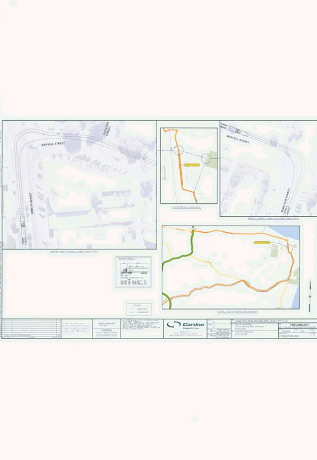
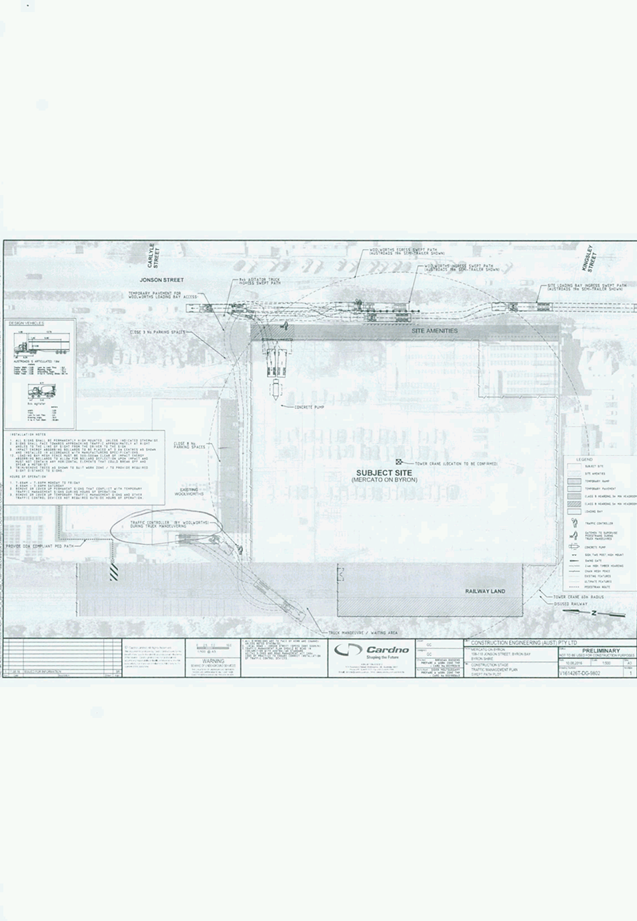
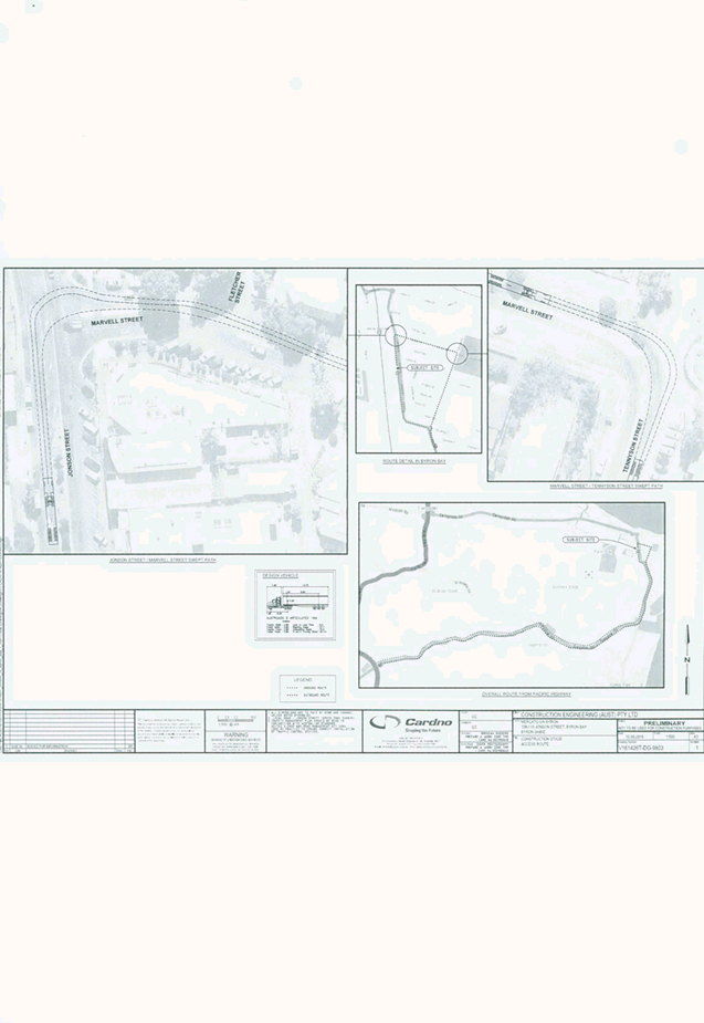
Local Traffic Committee Meeting 6.14
Report No. 6.14 11.2013.587.2 - Mercato on Byron - 108-110 Jonson Street, Byron Bay
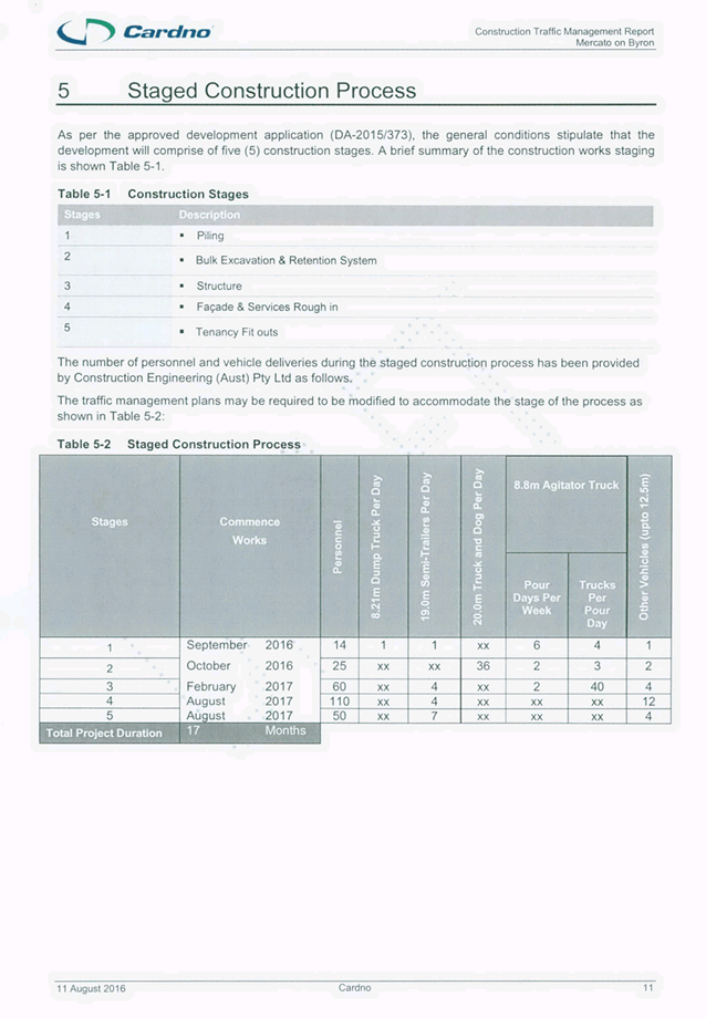
File No: I2016/991
Details of the earthworks and
construction stages for the proposed shopping mall at 108-110 Jonson Street
Byron Bay will be tabled at the Local Traffic Committee (LTC) meeting. Council
Development Engineers are to attend.
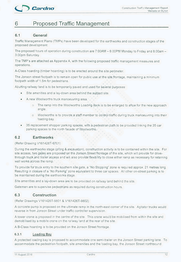
The proposed hours of operation
during construction are 7am to 6pm Monday to Friday and 8am to 3pm Saturday. Gatemen
are to supervise pedestrians and traffic controllers are to stop northbound
traffic on Jonson Street to assist ingress and egress of construction vehicles
as required during construction hours. Woolworths is to provide a staff member
to manage traffic during truck manoeuvring to the Woolworths loading dock.
Figure 1 – Construction Stage TMP Site Layout
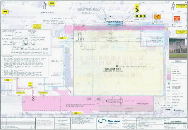
LTC comments are sought for the
proposal.
|
RECOMMENDATION:
That Local Traffic Committee advice is sought on the
proposal.
|
Attachments:
1 Construction
Traffic Management Report, S2016/11441
, page 108
Regulatory Matters 6.14 - Attachment 1
Local Traffic Committee Meeting 7.1
Development Applications
Report No. 7.1 10.2016.399.1 - Byron Central Health & Wellness HUB - 15
McGettigans Lane, Ewingsdale
File No: I2016/969
Council has received a Development Application (DA) for the proposed
Byron Central Health & Wellness HUB located on the corner of McGettigans
Lane and Ewingsdale Road, Ewingsdale as shown in Figure 1.
Figure 1 –
Proposed site location
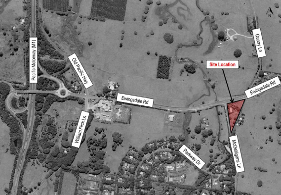
Figure 2 –
Proposed development site plan
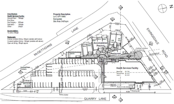
Committee advice on the proposed
development is sought and endorsement of the regulatory controls will be
proposed.
Detailed design plans will be
tabled to assist the committee’s review of the proposal.
|
RECOMMENDATION:
That the Committee consider the Development Application
for the proposed Byron Central Health & Wellness HUB located on the
corner of McGettigans Lane and Ewingsdale Road, Ewingsdale and provide
comments.
|
Local Traffic Committee Meeting 7.2
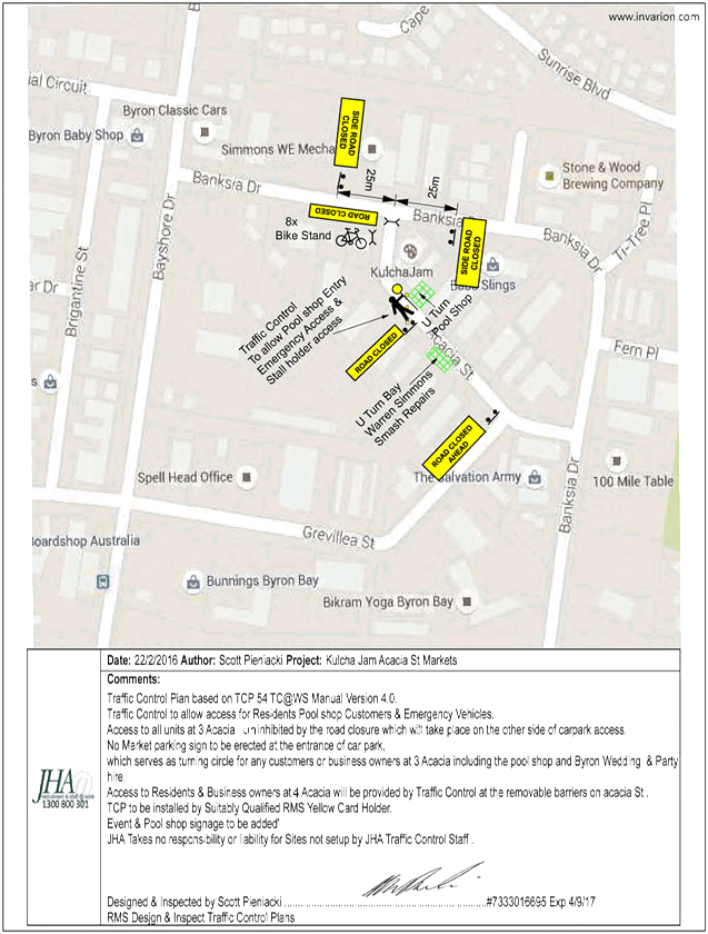
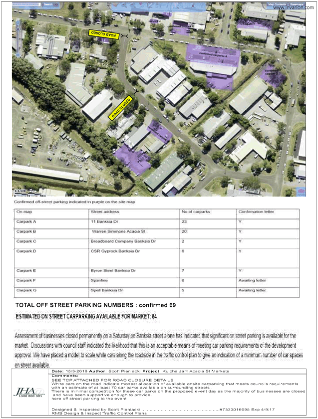
Report No. 7.2 10.2016.582.1 - Peddle and Hawk Acacia Street Market - Byron Bay -
Every Second Saturday
File No: I2016/879
Council has received a Development Application (DA) from
Kulchajam Inc for the operation of the Peddle and Hawk Acacia Street Market
every second Saturday in the Arts and Industrial Estate of Byron Bay.
The applicants are seeking permission to run a maximum of 26
markets per year on Saturdays with proposed daytime operations from 10am-5pm
and twilight operations 2pm-10pm. This involves the closure of Acacia Street as
defined in Figure 1.
As per the original recommendations of the Local Traffic
Committee (LTC) when the first three (3) trial events were approved, further
reports are provided to Council to seek permanent permissions, covering all
aspects of management and operations, and including details on the consultation
as undertaken by the proponent with tenants adjacent and within the road
closure including their acceptance of conditions upon an ongoing monthly event.
Acacia Street has a low volume, 150m long with 7 accesses
affected.
Figure 1 - Diagram
of road closure
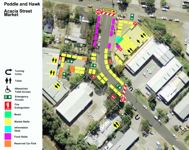
The event has submitted a draft Traffic Control Plan (TCP)
for the road closure. This TCP is suitable.
Committee advice on the proposed market operation is sought
and endorsement of the regulatory controls will be proposed.
|
RECOMMENDATION:
1. That
the Committee consider the Development Application for the proposed operation
of the Peddle and Hawk Acacia Street Market, to be held every second Saturday
of each month in the Arts and Industrial Estate of Byron Bay, and provide comments.
|
Attachments:
1 Event -
Acacia St, Byron - Peddle and Hawk Acacia St Market - TCP02 Twighlight Market, E2016/74693 , page 133
2 Event -
Acacia St, Byron - Peddle and Hawk Acacia St Market - TCP01 Daytime, E2016/74692 , page 134
Development Applications 7.2 - Attachment 1
Development Applications 7.2 - Attachment 2