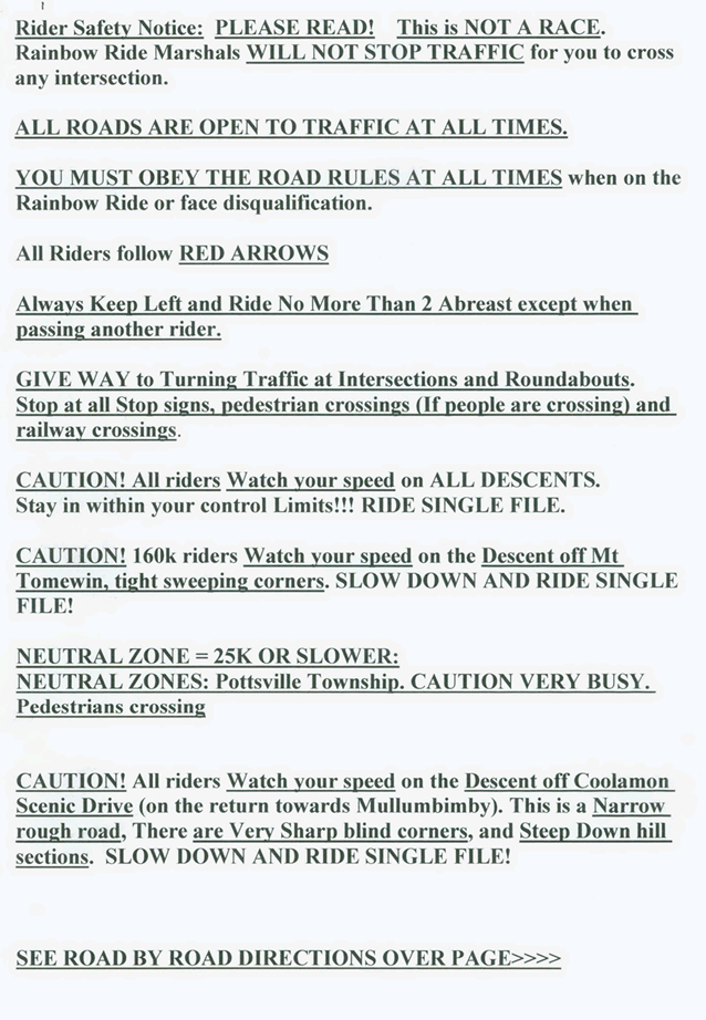
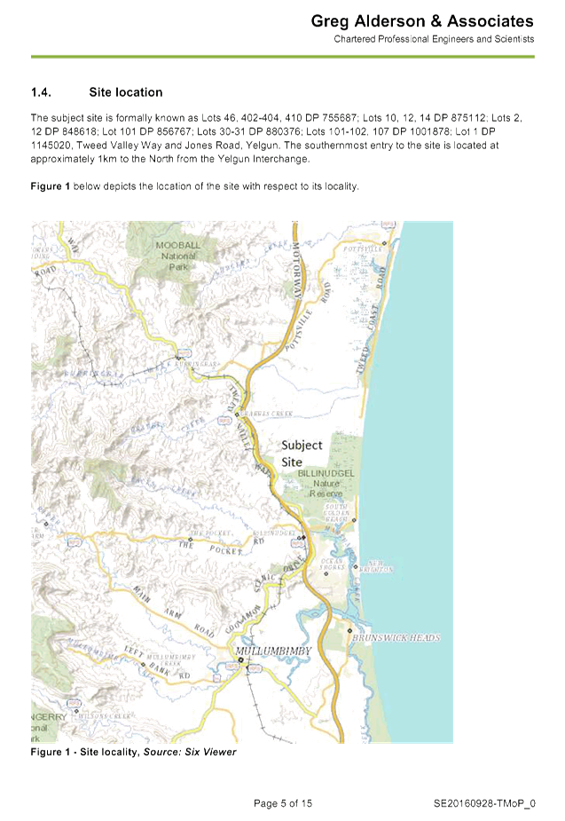
Local Traffic Committee Meeting
A Local Traffic Committee Meeting of
Byron Shire Council will be held as follows:
|
Venue
|
Meeting Room 1, Station Street, Mullumbimby
|
|
Date
|
Friday, 14 October 2016
|
|
Time
|
10.30am
|
|
Committee
Members
|
Etiene La
Grange – Roads and Maritime Services
Snr Constable Tony Darby – Police
Cr Basil Cameron
Tamara Smith MP
|

Phillip
Holloway
Director Infrastructure Services I2016/1083
Distributed 11/10/16
Local Traffic Committee Meeting
BUSINESS OF MEETING
1. Apologies
2. Declarations of Interest
– Pecuniary and Non-Pecuniary
3. Adoption of Minutes from
Previous Meetings
3.1 Local
Traffic Committee Meeting held on 27 July 2016
4. Matters Arising
5. Outstanding
Issues/Resolutions
6. Regulatory Matters
6.1 Speed
Review - Brunswick Valley Way and Shara Boulevard Intersection at Billinudgel 4
6.2 Extension
of School Bus Route - Parrot Tree Place, Bangalow...................................... 5
6.3 24.2014.48.1
- Lawson Street and Massinger Street RAB - Approval of Line Marking and Signs
Plan........................................................................................................................................... 9
6.4 Event
Road Closure - Monthly Criterium Cycle Races, Byron Bay Industrial Estate -
Request for Three Year Agreement from September 2016 (Amended)............................................ 12
6.5 Event
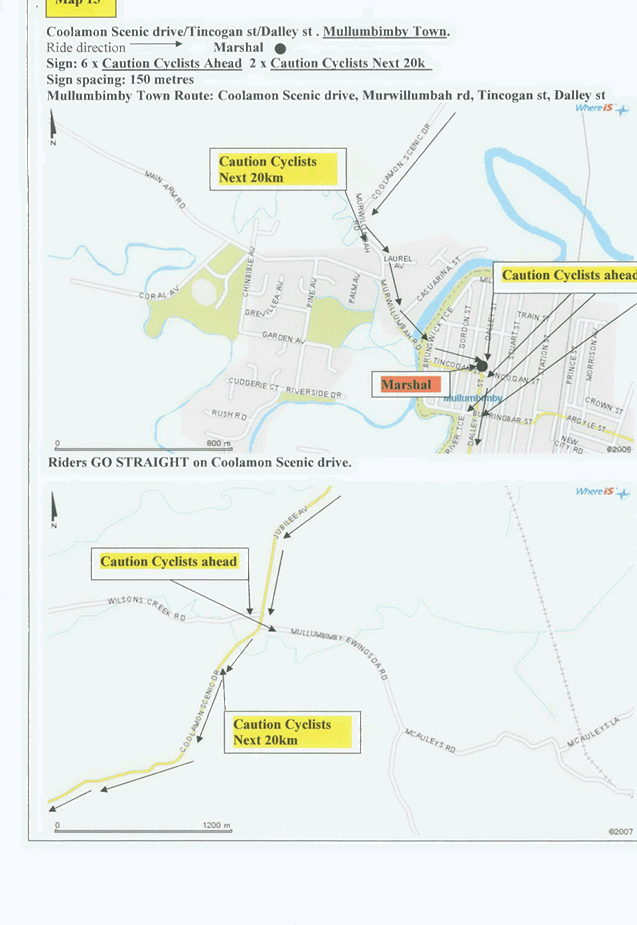
Road Closure - Rainbow Ride Cycle Challenge - William Flick Lane, Ewingsdale -
Sunday, 27 November 2016............................................................................................................... 15
6.6 Event
Road Closure - Mullumbimby Music Festival - Burringbar Street and Dalley
Street, Mullumbimby - Sunday, 20 November 2016.................................................................. 58
6.7 24.2015.19.1
- Marine Parade, Byron Bay - Regulatory Signage - Extension of Pay Parking Scheme
- Endorsement of Council Resolved Time Limits within Wategos.................................. 69
6.8 Event
Road Closure - Brunswick Valley Woodchop and Entertainment Committee - Twilight
Markets - Mullumbimi Street, Brunswick Heads - Wednesday, 14 December 2016................... 74
6.16 Speeding
Traffic - Left Bank Road, Mullumbimby......................................................... 79
6.10 Event
Road Closure - Byron Lighthouse Run - Lighthouse Road, Byron Bay - Sunday, 23
October 2016 (Amended).............................................................................................................. 92
6.11 Extension
of School Bus Route - Pearces Road and Booyong Road, Booyong........... 98
6.12 Event
Road Closure - Soul Street New Year's Eve and First Sun New Year's Day, Byron
Bay 101
6.13 Event
Road Closure - Falls Festival 2016/17 - North Byron Parklands, Yelgun -
Saturday 31 December 2016 to Monday 2 January 2017................................................................ 111
6.14 Bayshore
Drive - Proposed Bus Stop Relocation, No Stopping Signage and 30-minute Parking
Time Limit............................................................................................................................... 177
6.15 11.2013.587.2
- Mercato on Byron - 108-110 Jonson Street, Byron Bay.................... 181
6.15 Installation
of No Stopping Signage at The Farm and Byron Hospital - Ewingsdale Road,
Ewingsdale....................................................................................................................................... 206
6.17 Request
for Heavy Vehicle Restrictions - Granuaille Road & Lismore Road, Bangalow 207
7. Matters for Traffic Engineering Advice
7.1 Elysium
Project - Lawson Lane, Byron Bay................................................................. 214
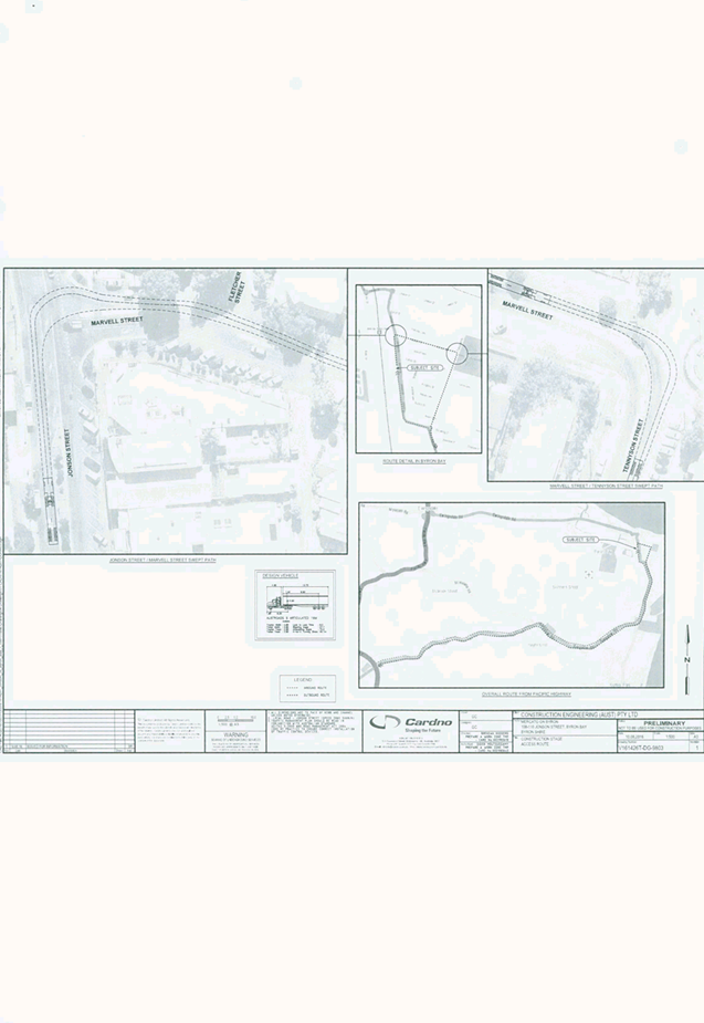
8. Development Applications
8.1 10.2016.399.1
- Byron Central Health & Wellness HUB - 15 McGettigans Lane, Ewingsdale 217
8.2 10.2016.582.1
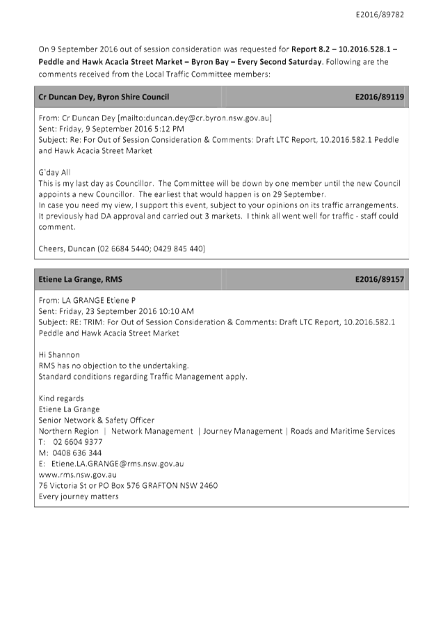
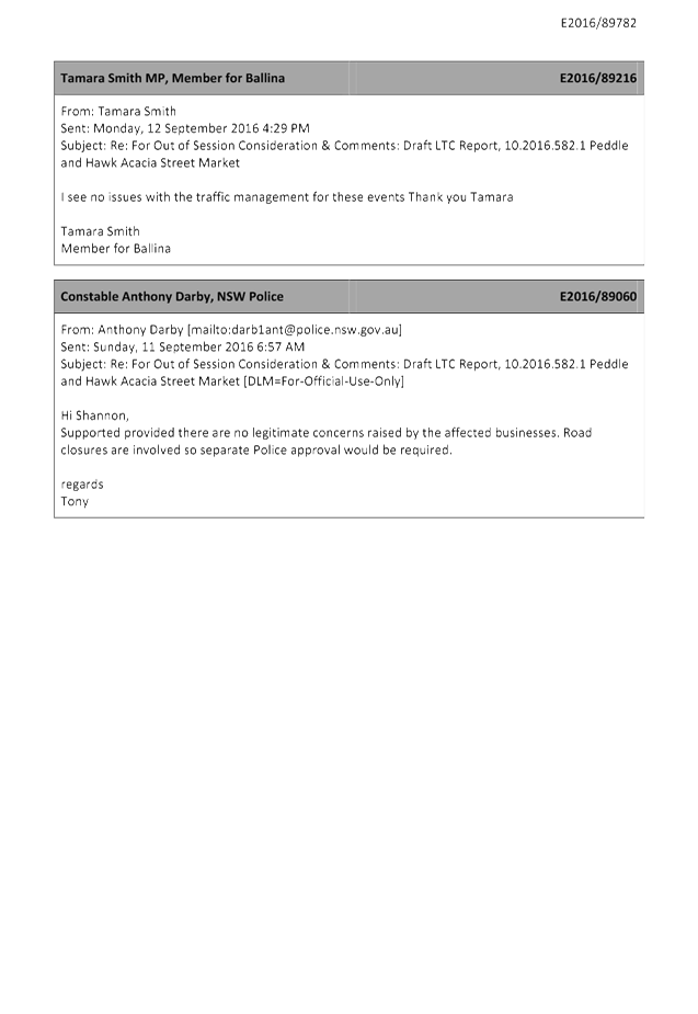
- Peddle and Hawk Acacia Street Market - Byron Bay - Every Second Saturday....................................................................................................................................... 219
8.3 10.2016.247.1
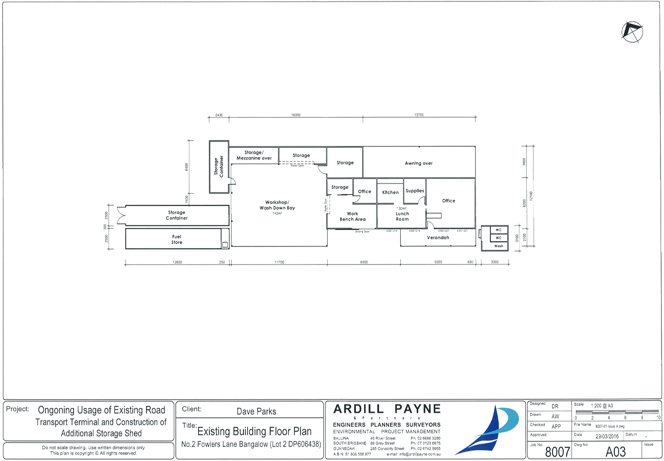
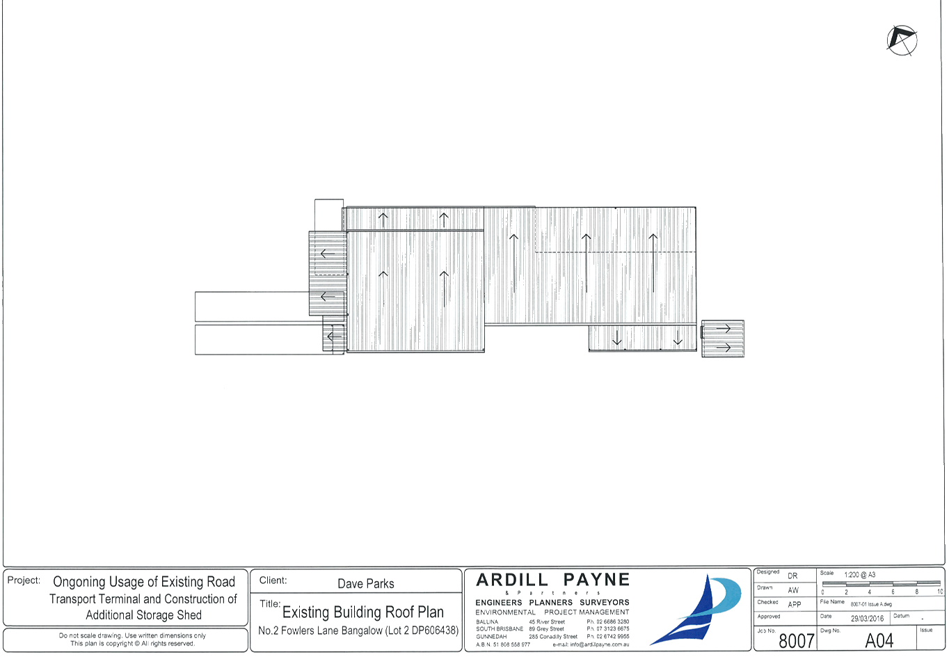
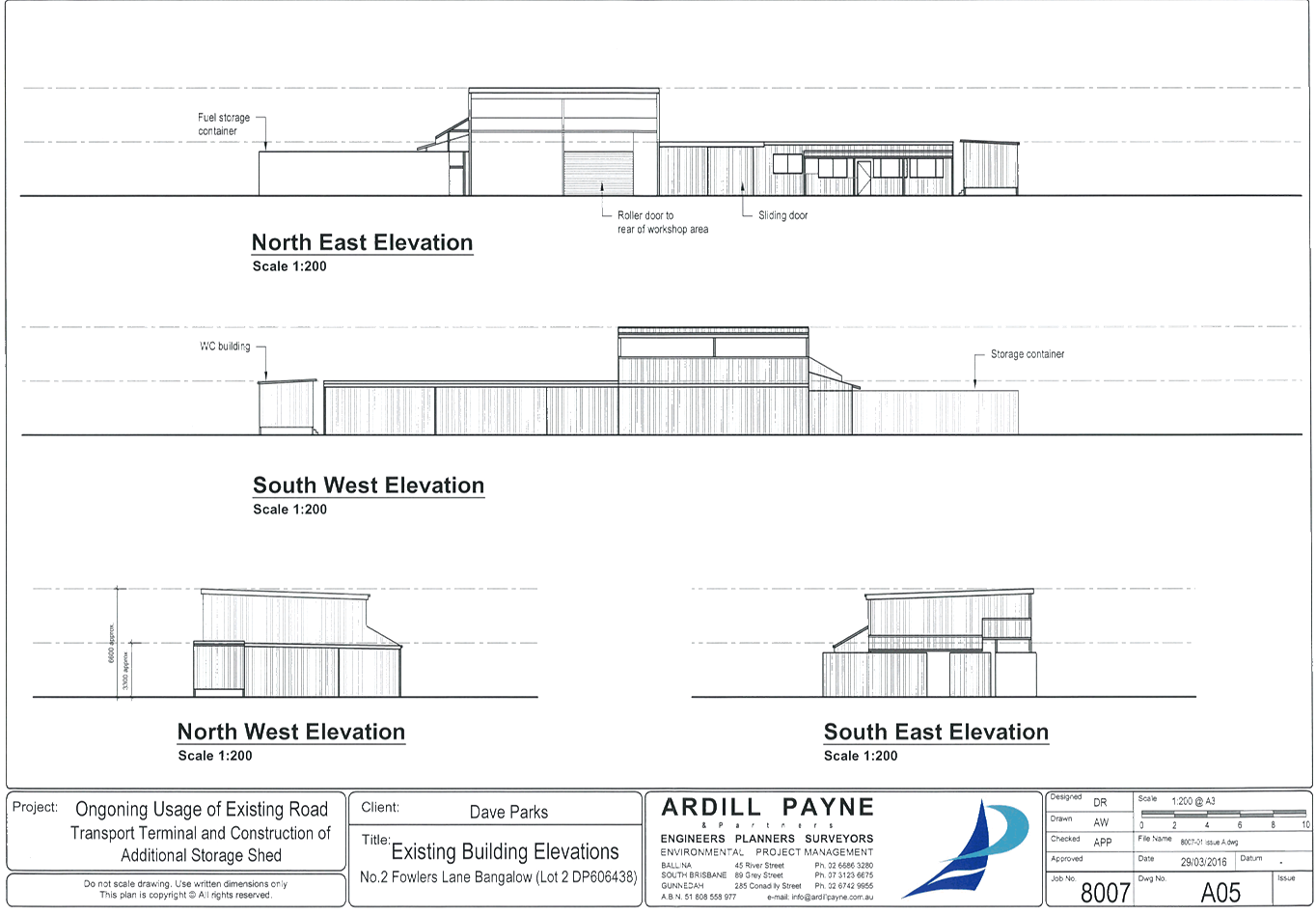
- Transport Depot - 25 Fowlers Lane, Bangalow ................................. 225
Local Traffic Committee Meeting 6.1
Regulatory Matters
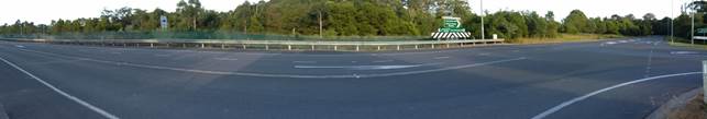
Report No. 6.1 Speed Review - Brunswick Valley Way and Shara Boulevard Intersection
at Billinudgel
File No: I2016/511
Council at it’s meeting held on 17 March 2016,
considered a petition about the subject matter and resolved:
Res 16-105
1. That
the petition regarding speed limit on Brunswick Valley Way Billinudgel be
noted.
2. That the petition be
referred to the Director Infrastructure Services.
An investigation has been undertaken of the Brunswick Valley
Way and Shara Boulevard intersection at Billinudgel to determine if a speed
zone reduction from 80km/hr to 60km/hr speed is warranted. A site
investigation was carried out on the 17 May 2016 at 7:30am. The intersection,
currently 80km/hr, was found to be appropriate and there were no issues at this
time. A review of the crash data available near this intersection was
completed with no common link between the incidents that could be related to
the intersection design.
It is noted that the new Shara Boulevard Sports Fields may
increase traffic into the intersection in the future as per the Development
Application.
|
RECOMMENDATION:
That the Committee notes that an investigation at the
Brunswick Valley Way and Shara Boulevard intersection has been completed and
a speed zone review is not recommended at this time.
|
Local Traffic Committee Meeting 6.2
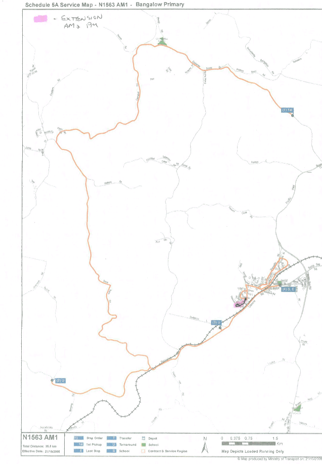
Report No. 6.2 Extension of School Bus Route - Parrot Tree Place, Bangalow
File No: I2016/900
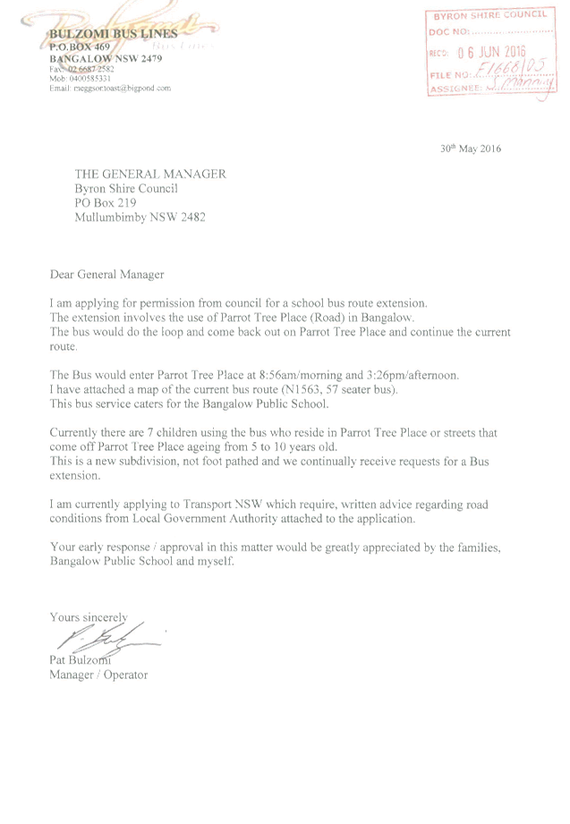
Council has received an application (S2016/7668) from Mr Pat
Bulzomi, Manager/Operator of Bulzomi Bus Lines to extend the existing school
bus route N1563 (as shown in green) along Parrot Tree Place in Bangalow. The
bus would enter Parrot Tree Place and complete the circuit (as shown in red),
before continuing the current route along Tristania Street.
Parrot Tree Place is an urban sealed road of approximately
735m in length in Bangalow. There are 51 land parcels. The operator has stated
that there are seven (7) children, aging between 5 to 10 years old, currently
using the bus who reside in Parrot Tree Place or streets that are accessed from
Parrot Tree Place.
Committee endorsement is sought for the extension of the
existing school bus route.
Figure 1 –
Subject Site
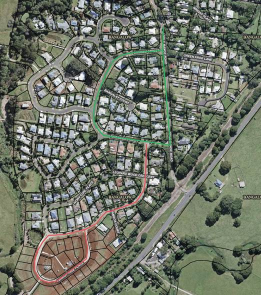
Green indicates
existing bus route and red indicates proposed extension.
|
RECOMMENDATION:
That Council note the Local Traffic Committee has no
objection to the proposed extension of the school bus route along Parrot Tree
Place, Bangalow. The bus would enter Parrot Tree Place and complete the
circuit before continuing the current route along Tristania Street.
|
Attachments:
1 Letter
from Bulzomi Bus Lines - Request Council permission to extend school bus route
to Parrot Tree Place, S2016/7668 , page 7
Regulatory Matters 6.2 - Attachment 1
Local Traffic Committee Meeting 6.3
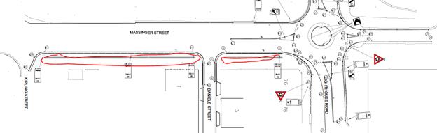
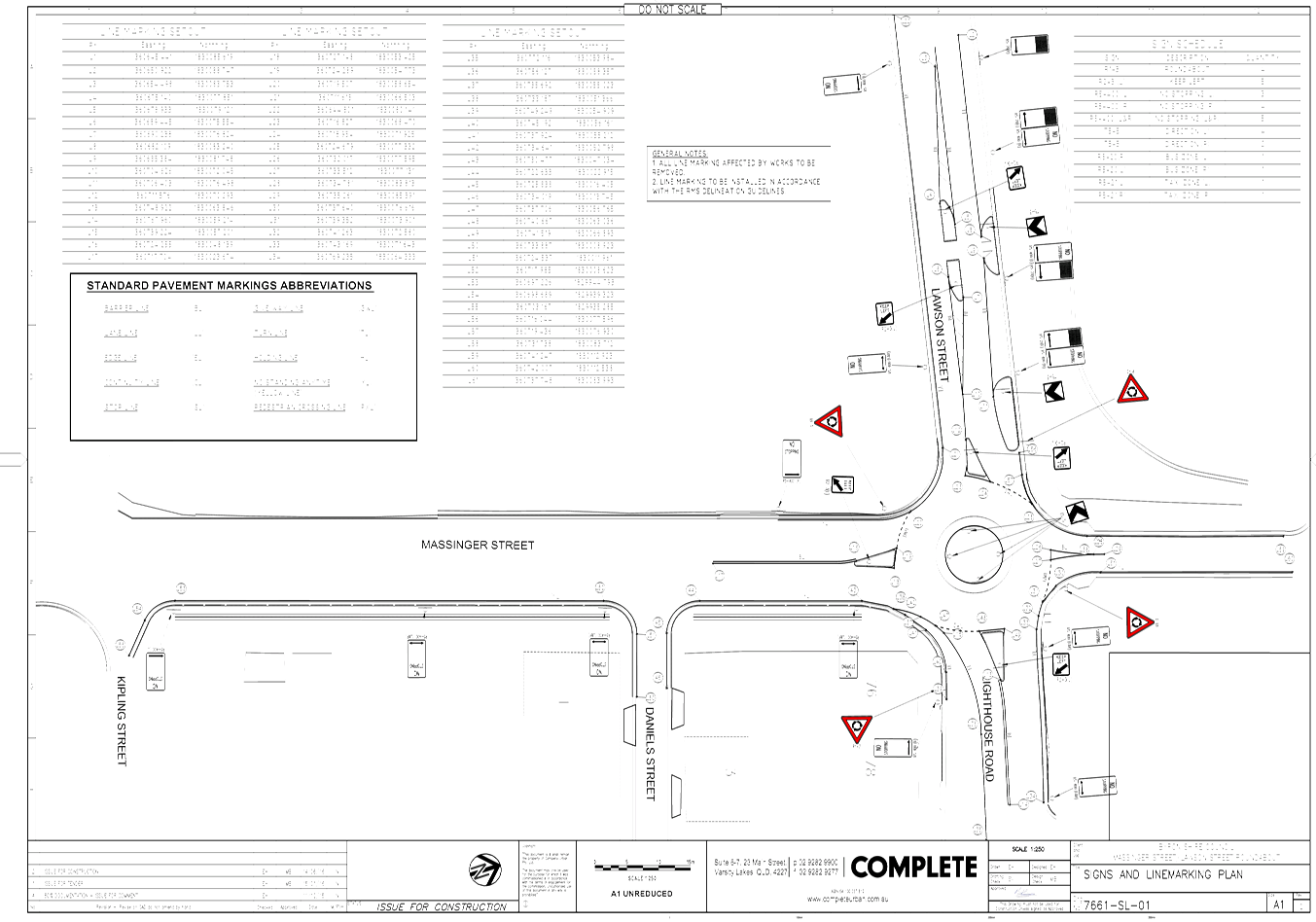
Report No. 6.3 24.2014.48.1 - Lawson Street and Massinger Street RAB - Approval of Line
Marking and Signs Plan
File No: I2016/916
Background
Byron Shire Council has initiated the construction of a new
concrete roundabout at Massinger Street, Lawson Street and Lighthouse Road
intersection. There is no record that the Line Marking and Signs Plan has been
endorsed by Local Traffic Committee.
Investigation
Traffic control signage for the roundabout looks adequate.
However with the widening of the Massinger Street it appears
that up to seven new car parks have been created due to the open drain being
converted into a pipe syatem. The installation of three ‘No
Stopping’ signs highlighted in red below will remove these seven
potential car parks.
A potential reason for ‘No Stopping’ being
incorporated into the design is the four properties adjoining the new widening
section of road.
During the inspection traffic it was suggested to use
Daniels Street to bypass the Roundabout construction site. The Street is very
narrow with parking on both sides for residents with single lane access and the
current seal is in need of repair and would deteriorate quickly if traffic was
diverted down this street. This detour would displace the residents parking and
cause issues for the construction team with complaints from the residents. The
risk of an incident in this narrow street would also be increased due to sight
distance and speed issues.
Estimate
Nil. No additional costs as the project are fully funded.
|
RECOMMENDATION:
1. That
the Local Traffic Committee endorse all Regulatory Signage for the
roundabout.
2. That
the Local Traffic Committee not endorse the following:
a. the
installation of three additional ‘No Stopping’ signs from 7
Massinger Street to 76 Lawson Street.
b. The
use of Daniel Street as a detour around the Lawson Massinger Street
Roundabout during the construction phase.
3. That
the Local Traffic Committee endorse the installation of 4 hour parallel
parking from Daniel St to Kipling St (1 to 7 Massinger Street).
|
Attachments:
1 24.2014.48.1
- Lawson Massinger St RAB - DWG - 7661-SL-01 Signs and Linemarking Plan Rev 2, E2016/79304 , page 11
Regulatory Matters 6.3 - Attachment 1
Local Traffic Committee Meeting 6.4
Report No. 6.4 Event Road Closure - Monthly Criterium Cycle Races, Byron Bay
Industrial Estate - Request for Three Year Agreement from September 2016
(Amended)
File No: I2016/917
BACKGROUND:
After consideration at the Local
Traffic Committee on 8 June 2016 and subsequent Council resolution 16-389, on
the 4 August 2016 Council resolved that:
16-389 Resolved
that Council adopt the following Committee Recommendation(s):
Report No.
6.6 Road Event - Monthly Criterium Cycle Races,
Industrial Estate, Request for 3 Year agreement from September 2016
File No: I2016/505
1. That
the Byron Bay Cycle Club’s Criterium Racing circuit at Byron Bay
Industrial Estate, to be held on the first Sunday of each month from 4
September 2016 to the last Sunday in August 2019, be endorsed between these
times:
a) Centennial
Circuit between Bayshore Drive and Wollongbar Drive, Tasman Way, Wollongbar
Drive and Brigantine Street (between Centennial Circuit and Wollongbar Drive)
between the hours of 06:00 and 09:00
2. That
the approval provided in Part 1 is subject to NSW Police approval being
obtained
3. That
the attached Traffic Control Plan and Traffic Management Plan be noted
4. That
the Traffic Management Plan be implemented as approved
5. That
the event organiser:
i. provide
wording for Council’s website noting the impact of the event and
including the event name, specifics of any traffic impacts or road closures and
times, alternative route arrangements, event organiser, a personal contact name
and a telephone number for all event related enquiries or complaints
ii. inform
community and business that are directly impacted (eg adjacent to the event)
via written information which is delivered to the property in a timely manner
so as to document, consider and respond to any concerns raised
iii. arrange
for private property access and egress affected by the event
iv. liaise
with bus and taxi operators and ensuring arrangements are made for provision of
services during conduct of the event
v. consult
with emergency services and any identified issues be addressed
vi. hold
$20m public liability insurance cover which is valid for the event
vii. pay Council’s
Road Event application fee prior to the event.
On the 9 August 2016 the event
organiser, Mr John Langler, was notified of the approval as detailed in
resolution 16-389. Mr Langler then bought it to Council attention that an error
had occurred and the event application incorrectly advised the dates of the
planned races, being the first Sunday of each month. The correct dates for
races will be the second and fourth Sunday of each month.
The Local Traffic Committee
members have provided interim approval for the Criterium Cycle Races planned
for the 14 August, 28 August, 11 September, 25 September, 9 October and 23
October to go ahead, abiding by the conditions as stated in resolution 16-389.
However, ongoing approval for Criterium Cycle Races to take place on the second
and fourth Sunday of each month is still required.
REPORT (Amended):
Council has received an Application
and Traffic Management Plan from the Byron Bay Cycle Club for Criterium Cycle Racing
along circuit at Byron Bay Industrial Estate - seeking continuation of approval
from September 2016 to September 2019 and course changes. The Club races on the
second and fourth Sunday of the month from 06:00 to 08:30.
The Council Meeting on 8 October
2013 approved the following resolution 13-556:
1. That
Council approve the request by the Byron Bay Cycle Club to hold criterion races
every second and fourth Sunday of the month between October 2013 and September
2016 within the Byron Bay Industrial Estate, on condition that the Byron Bay
Cycle Club hold Public Liability Insurance to a minimum value of $20 million.
2. That
the temporary road closures for the event be advertised, at the Club’s
expense, in the local newspapers in accordance with the requirements of the
Roads Act 1993 noting closures:
a) are
to apply from the hours of 6 am to 8 am and once per year to 9 am.
b) include
Centennial Circuit between Bayshore Drive and Wollongbar Drive, Tasman Way,
Wollongbar Drive and Brigantine Street (between Centennial Circuit and
Wollongbar Drive)
3. That
the Club send all properties within the area affected by the event a letter
advising of the details of the temporary road closures and when they will
occur.
4. That
any objections received against the proposed temporary road closures and the
event be referred to the Local Traffic Committee for consideration.
5. That the Traffic Control Plan be
implemented by suitably qualified traffic controllers.
It is requested that the
Application & Traffic Management Plan from the Byron Bay Cycle Club for Criterium
Cycle Racing circuit at Byron Bay Industrial Estate, to be held the second
and fourth Sunday of each month, from September 2016 to September 2019
be endorsed.
|
RECOMMENDATION:
1. That the Byron
Bay Cycle Club’s Criterium Racing circuit at Byron Bay Industrial Estate,
to be held on the second and fourth Sunday of each month from 4 September 2016
to the last Sunday in August 2019, be endorsed between these times:
a. Centennial
Circuit between Bayshore Drive and Wollongbar Drive, Tasman Way, Wollongbar
Drive and Brigantine Street (between Centennial Circuit and Wollongbar
Drive) between the hours of 06:00 and 09:00
2. That the approval
provided in Part 1 is subject to NSW Police and RMS approval being obtained
3. That the
attached Traffic Control Plan and Traffic Management Plan be noted
4. That the Traffic
Management Plan be implemented as approved
5. That the event
organiser:
i. provide
wording for Council’s website noting the impact of the event and including
the event name, specifics of any traffic impacts or road closures and times,
alternative route arrangements, event organiser, a personal contact name and
a telephone number for all event related enquiries or complaints
ii. inform
community and business that are directly impacted (eg adjacent to the event)
via written information which is delivered to the property in a timely manner
so as to document, consider and respond to any concerns raised
iii. arrange
for private property access and egress affected by the event
iv. liaise
with bus and taxi operators and ensuring arrangements are made for provision
of services during conduct of the event
v. consult
with emergency services and any identified issues be addressed
vi. hold
$20m public liability insurance cover which is valid for the event
vii. pay
Council’s Road Event application fee prior to the event
|
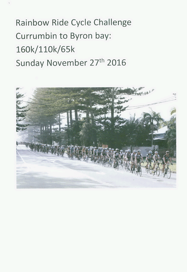
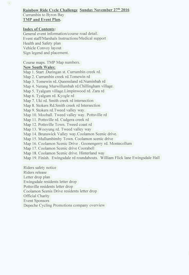
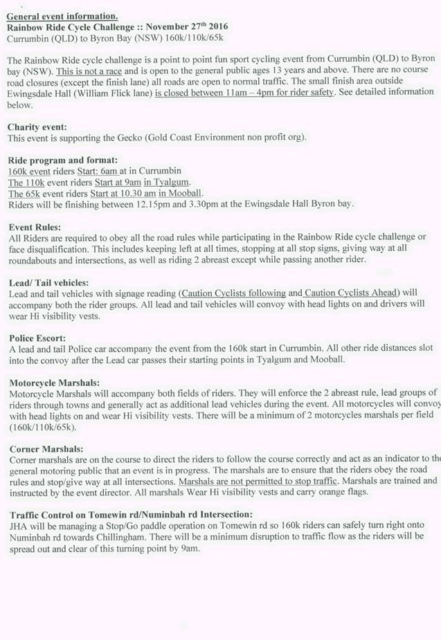
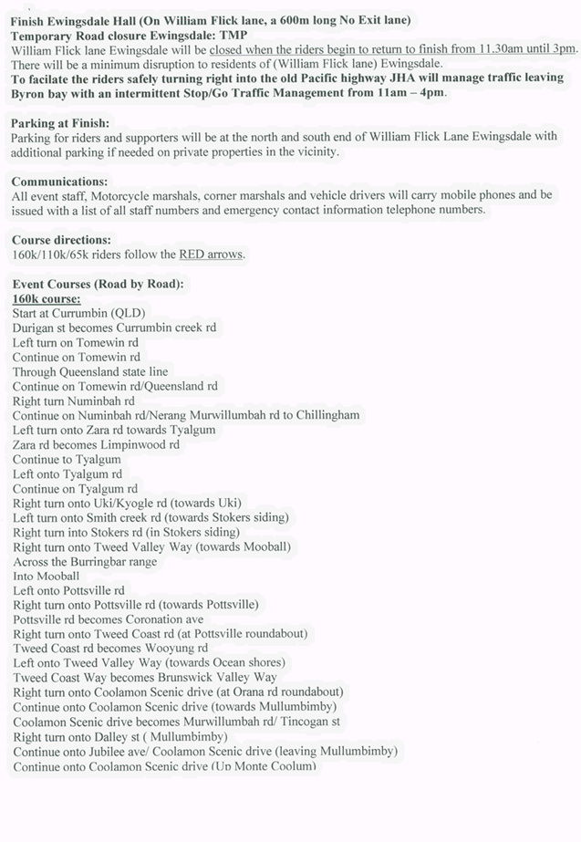
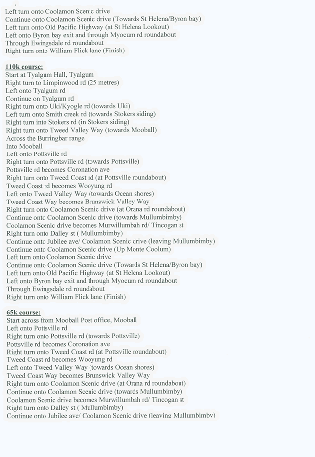
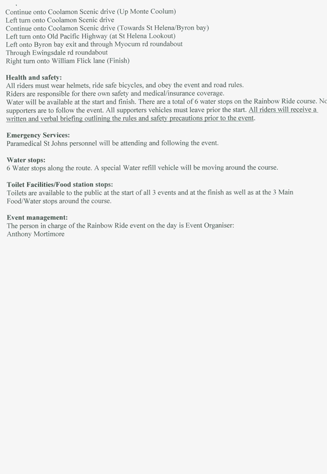
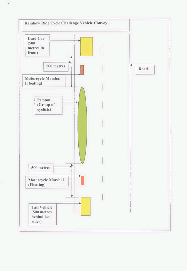
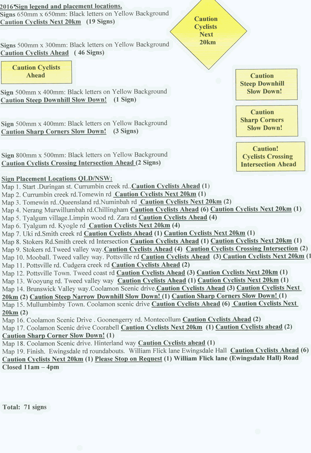
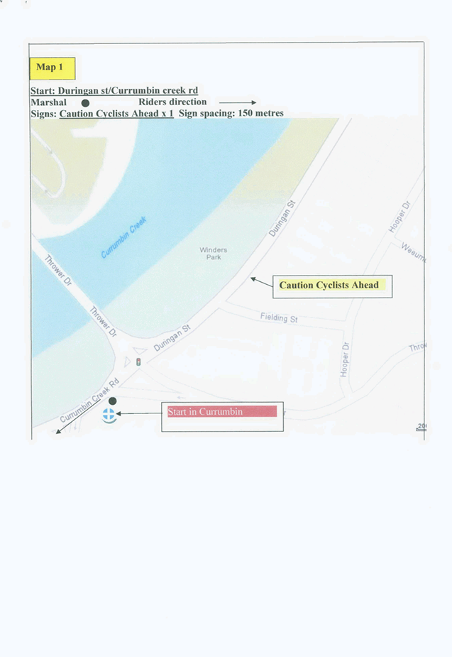
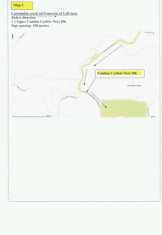
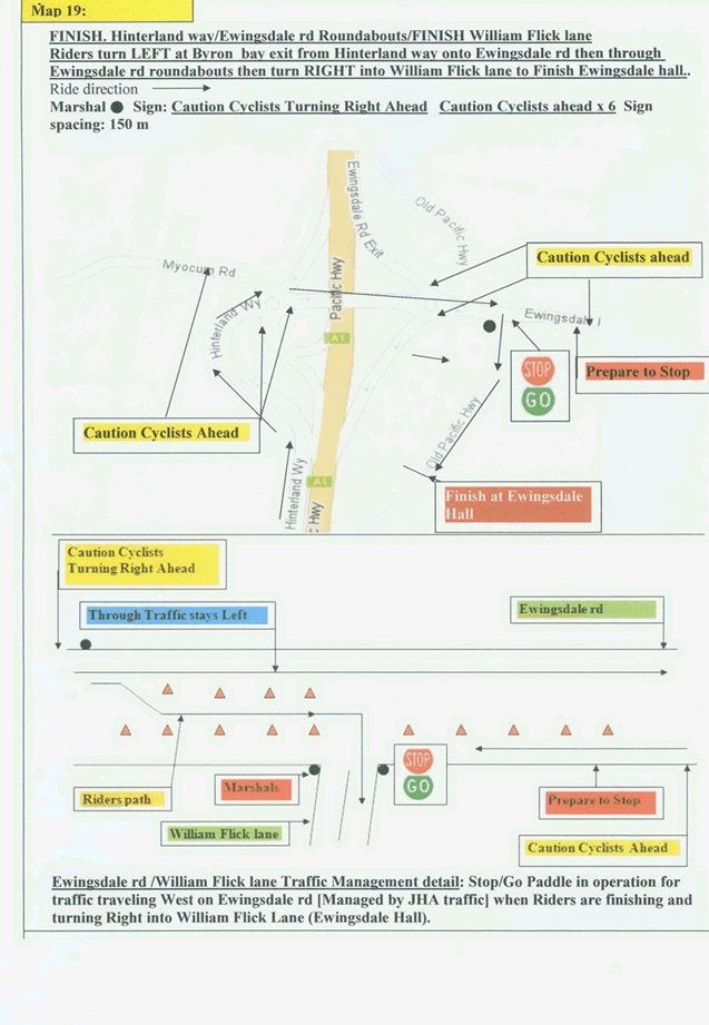
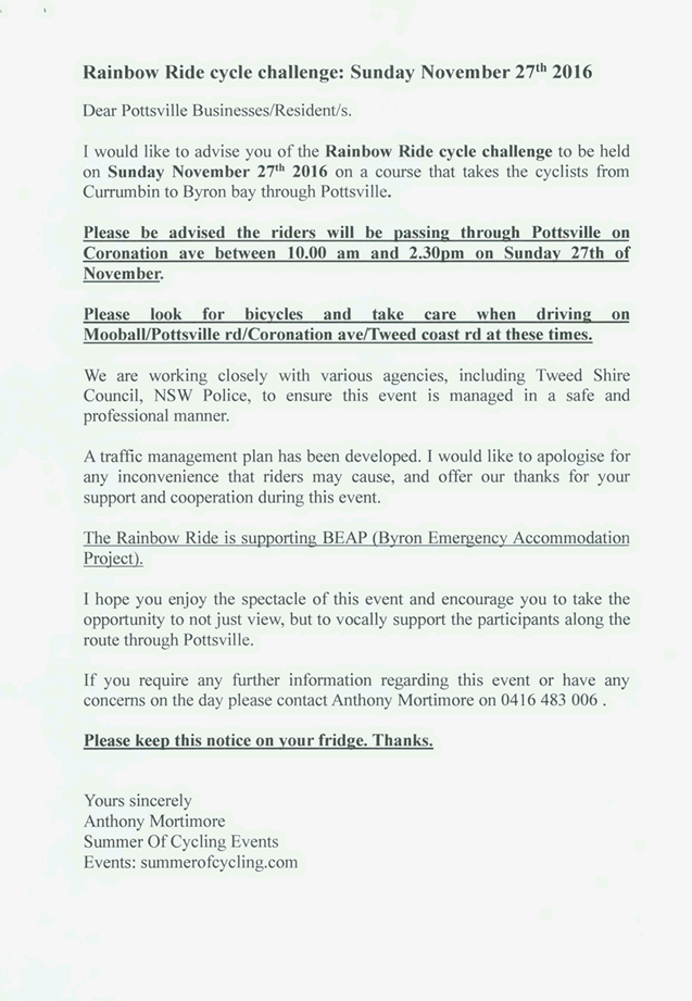
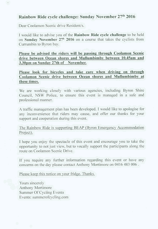
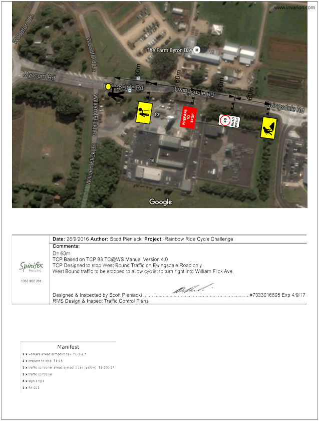
Local Traffic Committee Meeting 6.5
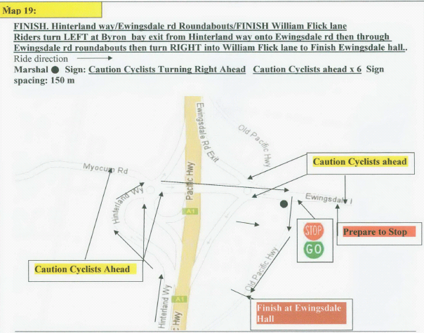
Report No. 6.5 Event Road Closure - Rainbow Ride Cycle Challenge - William Flick
Lane, Ewingsdale - Sunday, 27 November 2016
File No: I2016/919
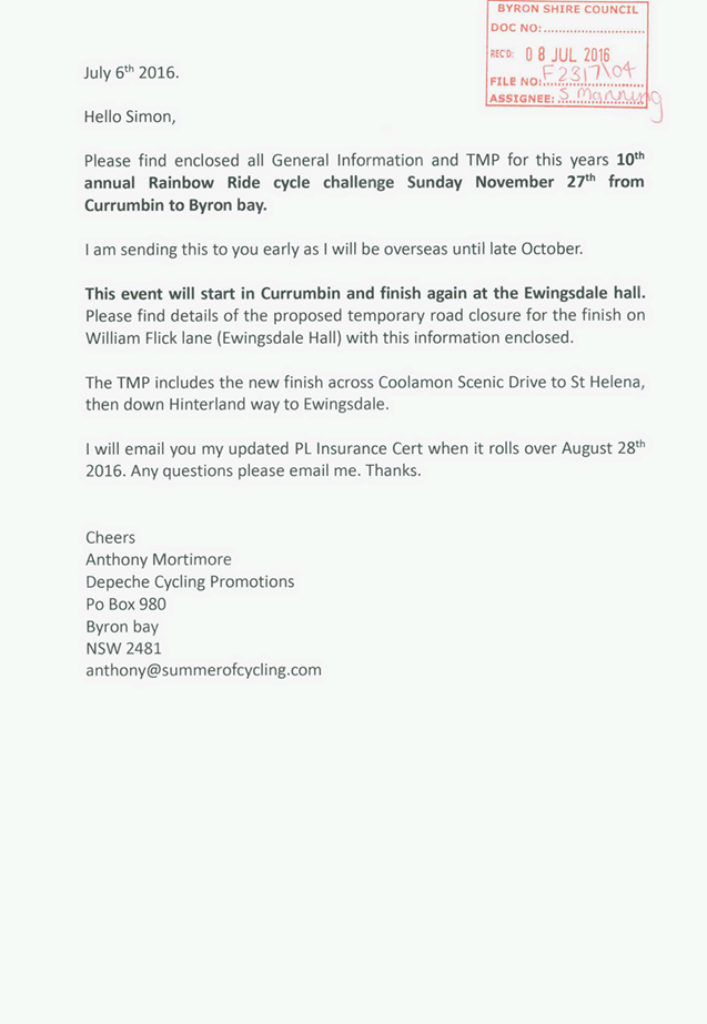
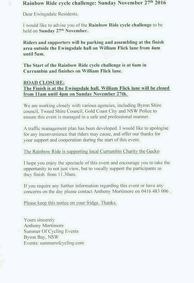
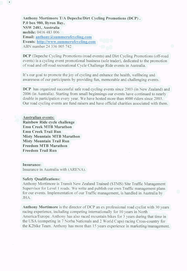
Council has received an application and Traffic Management
Plan (TMP) from Depeche Cycling Promotions for the 10th Annual
Rainbow Ride cycle challenge from Currumbin to Ewingsdale, to be held Sunday 27
November 2016.
The Rainbow Ride cycle challenge is a point to point fun
sport cycling event from Currumbin (QLD) to Byron Bay (NSW). This is not
a race and is open to the general public ages 13 years and above. There
are no course road closures (except the finish lane) all roads are open to
normal traffic. The small finish area outside Ewingsdale Hall (William Flick
lane) is closed between 11am-4pm for rider safety.
The event will finish at the Ewingsdale Hall, located on
William Flick Lane, Ewingsdale (a 600m long No Exit Lane). There will be
a temporary road closure of William Flick Lane when the riders begin to arrive
at the finish line from 11.30am until 3pm. There will be minimum
disruption to residents of (William Flick lane) Ewingsdale. To facilitate
the riders safely turning right into Hinterland Way, JHA will manage traffic
leaving Byron Bay with an intermittent Stop/Go Traffic Management from 11am-4pm.
Parking for riders and supporters will be at the north and south end of William
Flick Lane with additional parking if needed on private properties in the
vicinity.
Figure 1
– TMP Map 19: Finish at Ewingsdale
The certified Traffic Control Plan
will be provided to the Local Traffic Committee (LTC) members for discussion
and endorsement at the LTC meeting to be held Wednesday 5 October 2016.
It is requested that the application and Traffic Management Plan (TMP) from Depeche
Cycling Promotions for the 10th Annual Rainbow Ride cycle challenge, which
includes the temporary road closure of William
Flick Lane Ewingsdale, to be held Sunday 27 November 2016 be endorsed.
|
RECOMMENDATION:
1. That
the Rainbow Ride Cycle Challenge to be held on Sunday 27 November 2016, which
includes the temporary road closure/s below, be endorsed between these times:
a. William
Flick Lane, Ewingsdale between 11am and 4pm.
2. That
the approval provided in Part 1 is subject to:
a. separate approvals by NSW Police
and RMS being obtained;
b. Implementation
of the approved Traffic Management Plan and Traffic Control Plan;
c. The event organiser:
i. advertising
the impact of the event via a notice in the local weekly paper a minimum of
one week prior to the operational impacts taking effect, noting it must
include the event name, specifics of any traffic impacts or road closures and
times, alternative route arrangements, event organiser, a personal contact
name and a telephone number for all event related enquiries or complaints.
ii. providing
a copy of the advert for Council's web page.
iii. informing
community and businesses that are directly impacted (eg adjacent to the
event) via written information which is delivered to the property in a timely
manner so as to document, consider and respond to any concerns raised.
iv. arranging
for private property access and egress affected by the event.
v. liaising
with bus and taxi operators and ensuring arrangements are made for provision
of services during conduct of the event.
vi. consulting
with emergency services and any identified issues be addressed.
vii. holding
$20m public liability insurance cover which is valid for the event.
viii. paying
of Council’s Road Event Application Fee prior to the event.
|
Attachments:
1 Event -
William Flick Ln - Road Closure - Rainbow Ride Cycle Challange - TMP, S2016/9167 , page 18
2 TCP for
Ewingsdale Road - Rainbow Ride Cycle Challenge 2016, E2016/90150 , page 56
3 TCP for
William Flick Lane - Rainbow Ride Cycle Challenge 2016, E2016/90151 , page 57
Regulatory Matters 6.5 - Attachment 1


Regulatory Matters 6.5 - Attachment 2
Regulatory Matters 6.5 - Attachment 3
Local Traffic Committee Meeting 6.6
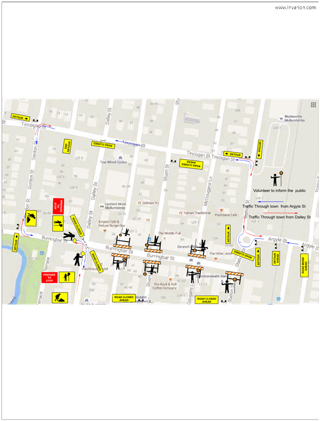
Report No. 6.6 Event Road Closure - Mullumbimby Music Festival - Burringbar Street
and Dalley Street, Mullumbimby - Sunday, 20 November 2016
File No: I2016/976
Council has received an application and draft Traffic
Management Plan (TMP) from Planners North for the Mullumbimby Music Festival
2016 to be held Sunday 20 November 2016.
The Mullumbimby Music Festival is in its ninth year and this
is the sixth year that the street parade has taken place( no problems or safety
issues have been reported in the past).
The proposed festival and
associated street parade involves the following elements (Figure 1):
· Temporary road closure of Dalley Street, Mullumbimby
between Tincogan Street and Burringbar Street (effective between 11am and 12pm
on Sunday 20 November 2016);
· Temporary closure of Burringbar Street, Mullumbimby between
Station Street and Dalley Street (effective between 10:45am and 11:15am on
Sunday 20 November 2016);
· Use of the single event shuttle bus, “The Magic
Bus” (double decker), operating between venues. A Traffic Control Plan
will establish the management of pick-up and set down locations; and
· Temporary road closure of Cenotaph Lane (previously Lane 7)
between Dalley Street and east of the fire station driveway and Murphys Lane
(previously Lane 2); from Cenotaph to Tincogan Street, with both in effect from
4pm Thursday 17 November 2016 through to 8am Monday 21 November 2016.
Figure 1 – Traffic Control Plan (TCP) Concept Design
The certified TCP and finalised
TMP will be provided to the Local Traffic Committee (LTC) members for
discussion and endorsement at the LTC meeting to be held Wednesday 5 October
2016.
It is requested that the application, TMP and TCP from Planners North for the
Mullumbimby Music Festival 2016, which includes the temporary road closures
detailed in this report, to be held Sunday 20 November 2016 be endorsed.
|
RECOMMENDATION:
1. That
the Mullumbimby Music Festival to be held on Sunday 20 November 2016, which
includes the temporary road closures below, be endorsed between these times:
a. Dalley
Street, Mullumbimby between Tincogan Street and Burringbar Street between
11am and 12pm on Sunday 20 November 2016.
b. Burringbar
Street, Mullumbimby between Station Street and Dalley Street effective
between 10:45am and 11:15am on Sunday 20 November 2016.
c. Cenotaph
Lane, Mullumbimby between Dalley Street and east of the fire station driveway
and Murphys Lane; from Cenotaph to Tincogan Street, with both in effect from
4pm Thursday 17 November 2016 through to 8am on Monday 21 November 2016.
2. That
the approval provided in Part 1 is subject to:
a. separate approvals by NSW
Police and RMS being obtained;
b. implementation
of the approved Traffic Management Plan and Traffic Control Plan;
c. that
each temporary bus stop, as required by the event, be established in
accordance with the accredited Traffic Control Plan;
d. the event organiser:
i. advertising
the impact of the event via a notice in the local weekly paper a minimum of
one week prior to the operational impacts taking effect, noting it must
include the event name, specifics of any traffic impacts or road closures and
times, alternative route arrangements, event organiser, a personal contact
name and a telephone number for all event related enquiries or complaints.
ii. providing
a copy of the advert for Council's web page.
iii. the
written concurrence of the Fire Stations on both Gordon Street and Dalley
Street, be obtained and copies provided to Council.
iv. informing
community and businesses that are directly impacted (eg adjacent to the
event) via written information which is delivered to the property in a timely
manner so as to document, consider and respond to any concerns raised.
v. arranging
for private property access and egress affected by the event.
vi. liaising
with bus and taxi operators and ensuring arrangements are made for provision
of services during conduct of the event.
vii. consulting
with emergency services and any identified issues be addressed.
viii. holding
$20m public liability insurance cover which is valid for the event.
ix. paying
of Council’s Road Event Application Fee prior to the event.
|
Attachments:
1 Application
- Mullumbimby Music Festival 2016, E2016/87416
, page 61
2 Draft
Traffic Management Plan (TMP) - Mullumbimby Music Festival 2016, E2016/87426 , page 63
3 Proposed
Traffic Control Plan - Mullumbimby Music Festival 2016, E2016/89673 , page 68
Regulatory Matters 6.6 - Attachment 1

Regulatory Matters 6.6 - Attachment 2
Regulatory Matters 6.6 - Attachment 3
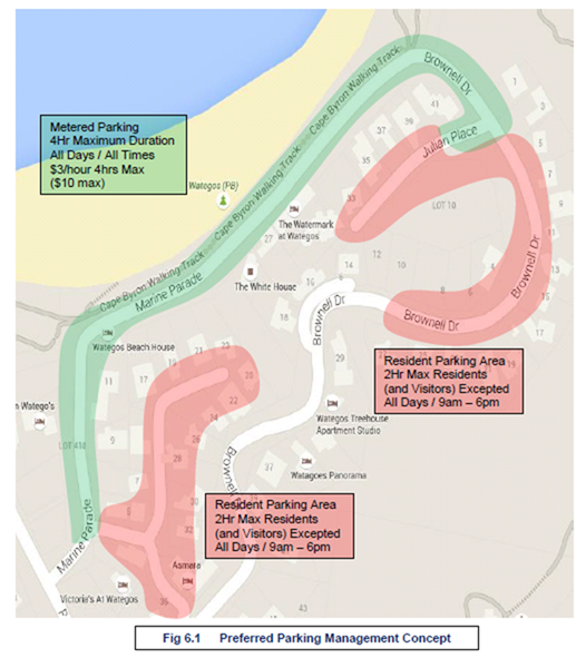
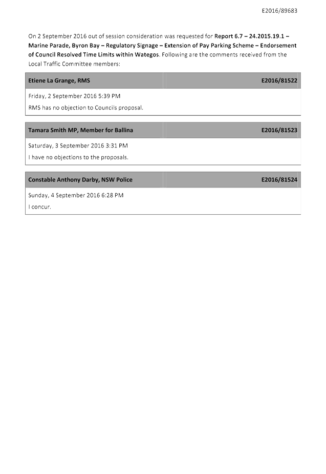
Local Traffic Committee Meeting 6.7
Report No. 6.7 24.2015.19.1 - Marine Parade, Byron Bay - Regulatory Signage -
Extension of Pay Parking Scheme - Endorsement of Council Resolved Time Limits
within Wategos
File No: I2016/984
Agenda item 6.4 of the Local Traffic Committee’s (LTC)
meeting held 27 July 2016 was tabled to Council on 25 August 2016.
Council resolved in favour of the Committee recommendation
with two exceptions, both of which require Committee concurrence. As copied
overleaf (Res 16-467) they relate to:
· Part 2(a), which
endorses that a 4-hour (4P) time limit apply across 98% of parking stock within
the Wategos Pay Parking area, whereas the Committee had recommended a mix of
time limits, namely that a 2-hour (2P) limit to apply to 40% of the parking
stock (e.g. at the beach front) while 58% apply 4P and 2% provide special
purpose parking (e.g. mobility permit and motorcycle parking); and
· Part 3, which
endorses that a 4-hour (4P) time limit apply within the Wategos Resident and
Resident Visitors Permit Parking Scheme, whereas the Committee had recommended
a 2-hour (2P) limit.
Part 2(a)
In regard to Part 2(a), it is notable that Council (in
resolving upon a 4P time limit) is adhering to the recommendation as made in
the consultants (TPS) report as tabled to the Committee at the 27 July 2016
meeting (file E2016/65469).
As the Committee will recall, the TPS report recommended
implementing Figure 6.1 (as reproduced overleaf in Figure 1). However, with
concern for lack of turnover and limited parking at the beachfront, staff had
recommended a balanced approach including that 40% of available parking instead
apply a 2-hour (2P) limit.
Nevertheless, it is also noted that such concerns can be
addressed should or when they materialise. As such, Committee concurrence
for Part 2(a) of 16-467 is sought.
Part 3
As for Part 3 of 16-467, it is noted that a 4P limit
(permits excepted) within the resident scheme would be consistent with parts of
the same scheme operating in Byron Bay. However it provides twice the duration
of free, non-permit (i.e. public) parking that the TPS report recommended,
which was for a 2P limit (permits excepted), which was subsequently supported
by the Committee.
While a greater time limit (i.e. 4P instead of 2P) may
result in less turnover and therefore less vehicles parking within the resident
scheme, there is a greater likelihood that 4-hours free parking (and without
the need of a permit) will place greater demand on the streets than a 2P limit.
This is for several reasons. For one, 4-hours free parking is more appealing
than 4-hours paid. Two, 4-hours is likely to satisfy more beach-goers or
visitors than 2P; and three, especially at peak times, may result in less
opportunity for residents or their visitors to park on-street.
These problems are likely to be more acute the closer the
parking is to the beach front. For example, motorists will seek to park closest
to the pay parking area as possible, but not within it. If this occurs there is
potential that the resident streets (with a 4P limit) will attract parking
looking to avoid the meter while those with exceptions to paying the meter
(E-Permit holders) will dominate the pay parking area.
While such an outcome will defeat the purpose of either
scheme, it can be reviewed and changed if found warranted. To this end it is
recommended that the Committee concur with Part 3 of Res 16-467 on the proviso
staff review the Wategos parking schemes during the first holiday period they
apply; and that such review include seeking resident feedback.
Resolution 16-467
16-467 Resolved:
That subject to the concurrence of the LTC Council adopt:
1. That
a meter registration pay parking scheme be implemented upon Marine Parade,
Wategos between the intersections of Palm Valley Drive and Julian Place on the
proviso it is the same as the Byron Bay scheme, for example the same hourly
rates, regulations, restrictions, exemption benefits, etc.
2. That
the following time limits and ratios be implemented upon the full length of
Marine Parade, Wategos and that they apply Monday-Sunday inclusive including
public holidays between the hours of 9am-6pm and that outside of such hours the
existing sign-posted regulations remain:
a) a
4-hour (4P) limit apply to approximately 98% of parking supply, and that it
first be allocated from Palm Valley Drive to the turning circle, and the
balance (if any) apply the east end of Marine Parade, from Julian Place; and
b) the
remaining 2% of parking supply provide dedicated motorcycle-parking and
mobility permit parking, preferably next to beach and commercial property
access.
3. That
the Byron Bay Resident and Resident Visitors Permit Parking Scheme be
implemented in the Wategos area and it include a 4P time limit effective
9am-6pm each day, subject to LTC approval (to be sought as soon as possible).
3. At
first possible opportunity that a review be conducted on the paid parking in
the Wategos area.
Figure 1: Original Recommendation as per TPS Report (Figure
6.1)
|
RECOMMENDATION:
That the Local Traffic Committee have no
objection to Council Resolution 16-467 and as sought provide concurrence for:
a) Part
2(a), which is for a 4-hour (4P) limit to apply across 98% of parking supply
within the endorsed Wategos pay parking area; and
b) Part
3, which is for a 4-hour (4P) limit to apply within the endorsed Wategos
resident permit parking area, on the proviso a review including resident
feedback is undertaken during the first holiday period the scheme applies.
|
Attachments:
1 Out of
Session Comments - LTC Report 6.7 - 24.2015.19.1 - Marine Parade, Byron Bay -
Regulatory Signage - Extension of Pay Parking Scheme - Endorsement of Council
Resolved Time Limits within Wategos, E2016/89850
, page 73
Regulatory Matters 6.7 - Attachment 1
Local Traffic Committee Meeting 6.8
Report No. 6.8 Event Road Closure - Brunswick Valley Woodchop and Entertainment
Committee - Twilight Markets - Mullumbimi Street, Brunswick Heads - Wednesday,
14 December 2016
File No: I2016/986
Council has received an application and Traffic Control Plan
(TCP) from the Brunswick Valley Woodchop & Entertainment Committee Inc for
the Twilight Markets to be held Wednesday 14 December 2016 and the Fireworks
Night to be held Saturday 14 January 2017.
The annual Twilight Markets continue to be a success and bring
huge crowds to the township. The event organisers are requesting:
1. Closure
of Mullumbimbi Street Brunswick Heads, between The Terrace and Park Street as
follows:
a) Closure
of the area bounded by the nose-in parking and centre parking bay from 7am until
11pm. This is the "U" shaped provision for parking that is adjacent
Banner Park in the vicinity of the children's play area.
b) Request
for 2 temporary designated ‘Disabled Parking’ spots outside of the
hotel during the morning. The existing 2 spots will have been closed off.
c) Closure
of the remaining section of ‘through road’ between The Terrace and
Park Street from 12 noon until 11pm.
2. Opening
of Memorial Park for parking as follows:
a) Twilight
markets – Wednesday, 14 December 2016 from 12noon. This will allow
stallholders to get their vehicles off the street before the markets start at
3pm.
b) Fireworks
Night – Saturday, 14 January 2017 from 6pm. This will allow for people
attending the carnival/housie and through to when the fireworks take place at
9pm to park off the streets.
Appropriately accredited (JHA) staff will be requested to
put out the early blockades and the temporary designated ‘Disabled
Parking’ signs as per the TCP (Figure 1). Market staff will relocate the
blockades at 12 noon. Market staff will also remove the road closed and
Disabled Parking signs at the end of the event.
As in the past McGregor’s Amusements will move their
‘ride’ during the night of Tuesday 13 December 2016 and place it
over the centre parking bays for erection the following afternoon. This
effectively blocks off most of the area as mentioned in Item 1, and the early
road closure will ensure that vehicles are not parked indefinitely in the area.
It is requested that the
application and TCP from the Brunswick Valley
Woodchop & Entertainment Committee Inc for Twilight Markets, which includes
the temporary road closure of Mullumbimbi Street Brunswick Heads, to be held
Wednesday 14 December 2016 be endorsed.
Figure 1 – Traffic Control Plan
|
RECOMMENDATION:
1. That
the Twilight Markets to be held on Wednesday 14 December 2016, which includes
the temporary road closure/s below, be endorsed between these times:
a. Mullumbimbi
Street Brunswick Heads, between The Terrace and Park Street on Wednesday 14
December, as per the following:
i. Closure
of the area bounded by the nose-in parking and centre parking bay from 7am
until 11pm. This is the "U" shaped provision for parking that is
adjacent Banner Park in the vicinity of the children's play area.
ii. Request
for 2 temporary designated ‘Disabled Parking’ spots outside of
the hotel during the morning. The existing 2 spots will have been closed off.
iii. Closure
of the remaining section of ‘through road’ between The Terrace
and Park Street from 12 noon until 11pm.
b. Opening
of Memorial Park for parking, as per the following:
i. Wednesday,
14 December 2016 from 12noon. This will allow stallholders to get their
vehicles off the street before the markets start at 3pm.
2. That
the Fireworks Night to be held on Saturday 14 January 2017, which includes
the opening of Memorial Park for parking as per the following, be endorsed:
i. Saturday,
14 January 2017 from 6pm. This will allow for people attending the
carnival/housie and through to when the fireworks take place at 9pm to park
off the streets.
3. That
the approval provided in Part 1 and Part 2 is subject to:
a. separate approvals by NSW
Police and RMS being obtained;
b. implementation
of the approved Traffic Control Plan by those with appropriate accreditation;
c. the
event be advertised in accordance with the Roads Act, charged at cost to the
organisers;
d. the
event be notified on Council’s web page;
e. the event organiser:
i. informing
community and businesses that are directly impacted (eg adjacent to the
event) via written information which is delivered to the property in a timely
manner so as to document, consider and respond to any concerns raised.
ii. arranging
for private property access and egress affected by the event.
iii. liaising
with bus and taxi operators and ensuring arrangements are made for provision
of services during conduct of the event.
iv. consulting
with emergency services and any identified issues be addressed.
v. holding
$20m public liability insurance cover which is valid for the event.
vi. paying
of Council’s Road Event Application Fee prior to the event.
|
Local Traffic Committee Meeting 6.16
Report No. 6.16 Speeding Traffic - Left Bank Road, Mullumbimby
File No: I2016/699
Both the Byron Shire Council and Roads
& Maritime Services (RMS) have received correspondence from Ms Deborah
Lilly regarding her concerns of speeding traffic along Left Bank Road,
Mullumbimby.
Original correspondence was received from
Ms Lilly on 19 July 2016 (document reference #E2016/65435):
|
From:
Deborah Lilly [mailto:columbine_harvester@hotmail.com]
Sent: Tuesday, 19 July 2016 3:29 PM
Subject: a complaint: please lodge!!
Attention Ms Shannon Manning
Dear Ms Manning
SPEEDING TRAFFIC IN LEFT
BANK ROAD 50K ZONE
Further to our telephone conversation
today, would you please bring up the above subject at your next meeting with
the police and RTA. As you know the road was thoroughly upgraded only
months ago, and already the road has been resurfaced again - this would be
due to the speeding traffic.
The traffic is dangerous in
this 50k zone as cars, trucks and even school busses are usually speeding.
Noise, fumes and vibrations are horrendous. I've lived here for
22 years, built my own house and made a big garden. I'll have to give
it all up because of the dangerous traffic which has increased substantially
mainly due to expansion of Steiner School and Tallowood Ridge housing estate.
I've had communication with
Simon Bennett over the years, who had the white paintwork put on the road
next to Tallowood turnoff at Tuckeroo Road, this helped the situation.
Please advise who the BSC
council member is who attends your meetings with the RTA and police.
Regards
Deborah Lilly
20 Left Bank Road
Mullumbimby
66843723
|
In response to Ms Lilly’s email
E2016/65435, on the 23 August 2016 Council forwarded her concerns to the NSW
Police to be lodged with the Highway Patrol Supervisor of the sector concerned (#E2016/78397).
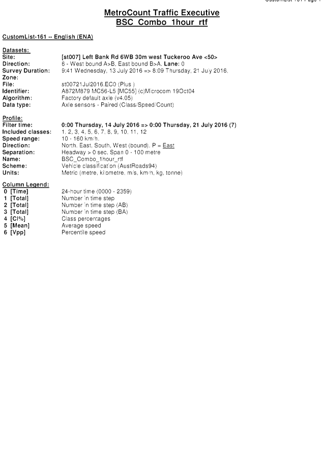
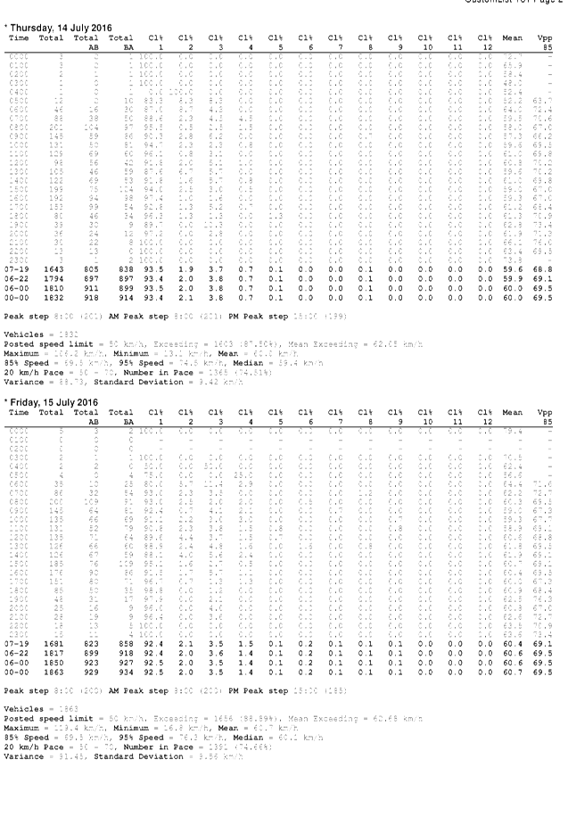
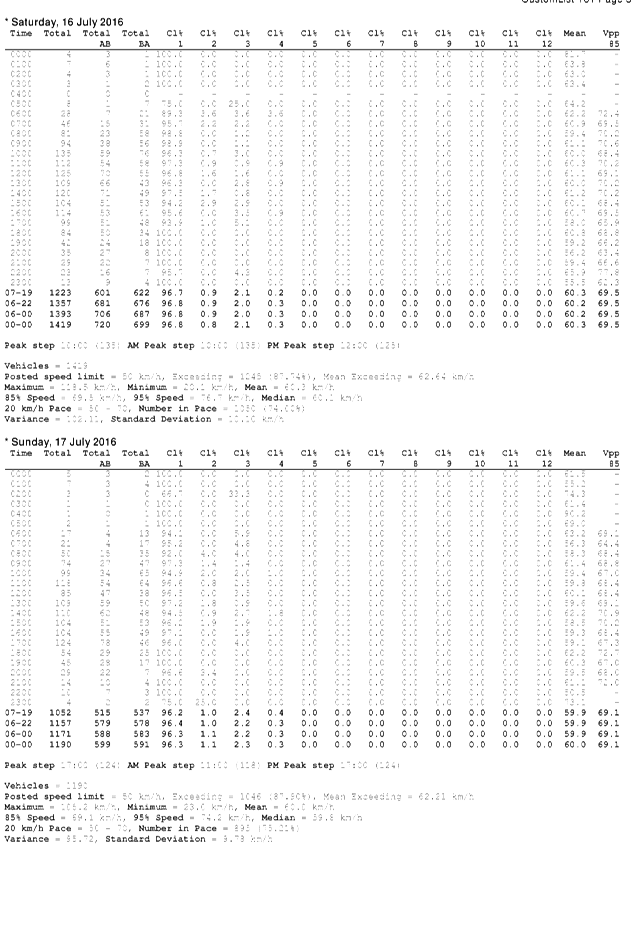
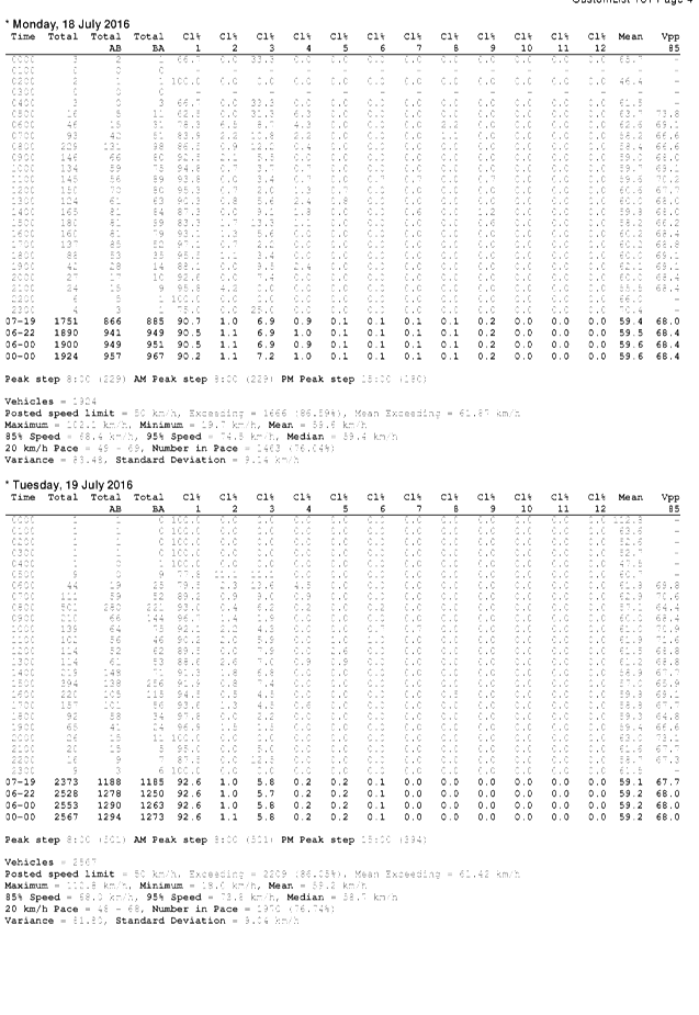
Two traffic counts were conducted on Left
Bank Road between the 13-21 July 2016. Traffic Count 161 was located 30 metres
West of Tuckeroo Avenue and Traffic Counct 162 was located 50 metres East of
Frasers Road. The results for both counts have been attached to this report for
consideration.
Following is a record of correspondence
relating to this matter:
|
Date
|
Document Reference #
|
Description
|
|
19/07/2016
|
E2016/65435
|
Original email detailing concerns of
speeding traffic along Left Bank Road
|
|
23/08/2016
|
E2016/78397
|
Email to NSW Police regarding Ms
Lilly’s concerns
|
|
23/08/2016
|
E2016/78435
|
Email to Ms Lilly responding to
E2016/65435 & advising NSW Police had been contacted
|
|
24/08/2016
|
E2016/80144
|
Email from Ms Lilly requesting date
of next LTC meeting and advising that RMS had contacted her regarding traffic
sensors
|
|
25/08/2016
|
E2016/89347
|
Email to RMS regarding Ms
Lilly’s concerns in E2016/80144 & requesting clarification of
traffic sensors mentioned
|
|
30/08/2016
|
E2016/80149
|
Email to Ms Lilly responding to
E2016/80144
|
|
03/10/2016
|
E2016/89243
|
Email from Ms Lilly requesting her
concerns be raised at the next LTC, that the Police monitor Left Bank Road
with speed radars and advising that she had contacted both RMS & NSW
Police directly
|
|
04/10/2016
|
E2016/89163
|
Email from RMS with Ms Lilly’s
correspondence attached
|
|
04/10/2016
|
E2016/89349
|
Email to Ms Lilly advising that
traffic counts had been completed between 14-21/07/2016
|
|
04/10/2016
|
E2016/89350
|
Email from Ms Lilly regarding the
traffic counts and signage
|
Correspondence received from Ms Lilly on 4
October 2016 (E2016/89350):
|
From: Deborah Lilly
Sent: Tuesday, 4
October 2016 7:36 PM
Subject: RE:
Traffic - Left Bank Rd - Traffic Count - RE: Case 191863
G'day Cav
Thank you very much
for your prompt response.
I note that the
traffic count was used from 14th to 21st July this year. School
holidays at Shearwater School in Left Bank Road were from 24th June to 19th
July. Therefore your traffic sensor was in use for normal traffic conditions
for only two days.
This is most
unfortunate as the readings would not reflect the enormous volume of traffic
going to and from Shearwater School. There are 500 pupils at the school
and I have the impression that many are driven to school by private car, and
of course there would be the teaching staff and the College students who
drive to school. Furthermore they have big events such as Open Day,
Spring Fair, Summer Solstice, Winter Solstice, Wearable Arts Festival, plus
all the school plays each term; each event drawing possibly five hundred cars
(except the Wearable Arts which would attract visitors not connected with the
school and lasts for four days; possibly thousands of cars). My
experience of school holidays is one of great relief as far as traffic is
concerned. Naturally I have written to the school several times about my
concerns
Of course, the new
Tallowood Development counts for much more traffic since I came here in
1993. I am now wanting to sell my handmade house because I can't stand
the traffic! This is sad. However, if somehow the 50k speed limit
could be observed, life would be far more pleasant.
I am curious to
know what conclusions you drew from the traffic count and speed
assessment? Of course my main concern is that the speed limit of 50k is
observed. By the way, the 50k sign on the left approaching the
50k zone from the west has been obscured by trees, until close up. How
about some nice solar LED signs that light up such as the one in Clunes that
says 50 with red lights all round it, or the one approaching Lismore that
says SLOW DOWN. If you'd advise me the cost of a sign like this, I
could do some fundraising - perhaps my neighbours would contribute.
With kind regards
Yours truly
Deborah Lilly
|
On 4 October 2016 RMS requested that Ms
Lilly’s concerns be raised at the next Local Traffic Committee for
discussion and comment.
|
RECOMMENDATION:
That the Committee consider the Left Bank Road traffic
concerns raised and provide comments.
|
Attachments:
1 Traffic
Count 161 - Left Bank Road, 30 metres West of Tuckeroo Avenue - 13-21 July
2016, E2016/89353 , page 82
2 Traffic
Count 162 - Left Bank Road, 50 metres East of Frasers Road - 13-21 July 2016, E2016/89354 , page 87
Regulatory Matters 6.16 - Attachment 1
Regulatory Matters 6.16 - Attachment 2
Local Traffic Committee Meeting 6.10
Report No. 6.10 Event Road Closure - Byron Lighthouse Run - Lighthouse Road, Byron
Bay - Sunday, 23 October 2016 (Amended)
File No: I2016/987
BACKGROUND
After consideration at the Local Traffic Committee (LTC) on 8
June 2016 and subsequent Council resolution 16-385 (refer to extract below), on
the 4 August 2016 Council resolved to endorse the temporary road closures for
the Byron Lighthouse Run to be held on Sunday 23 October 2016.
|
16-385
|
Resolved that Council adopt the following
Committee Recommendation(s):
Report
No. 6.1 Road closure, Lighthouse Road - Byron Bay
Lighthouse Run, Sunday 23 October 2016
File No: I2016/384
1. That
the 10km Byron Lighthouse Fun Run to be held Sunday 23 October 2016, which
includes the temporary road closures below, be endorsed between these times:
a) Lighthouse
Road between Brooke Drive (at The Pass) and Palm Valley Way (entry to
Wategos) between the hours of 7:00am and 08:00am
b) Clarkes
Beach Car Park between the hours of 6:00am and 10:00am
c) Lawson
Street, from Massinger Street / Lighthouse Road intersection to the caravan
park, between the hours of 7:00am and 7:15am
|
REPORT
It has since come to light that the Council road works
currently being undertaken at the intersection of Massinger Street, Lawson
Street and Lighthouse Road will not be completed by the event date and as such
it is proposed that the event application be reviewed and an amended Traffic
Control Plan (TCP) put in place.
It is proposed that the current TCP (Figure 1) be
implemented with the following inclusions:
· Temporary road
closure of Daniels Street, between 7am and 8am;
· Traffic
Controllers managing the traffic at the intersection of Lawson Street and
Massinger Street with Stop/Go controls.
Figure 2 is the concept TCP taking into consideration the
ongoing Council road works (blue section) at the intersection. There will be
three temporary road closures (red lines) and traffic will be directed by
Stop/Go traffic controllers (yellow dots) which will allow one lane of traffic
at a time to use the intersection.
It is requested that the LTC endorse the amendments to the
TCP for the Byron Lighthouse Run to be held on Sunday 23 October 2016.
Figure 1
– Current TCP
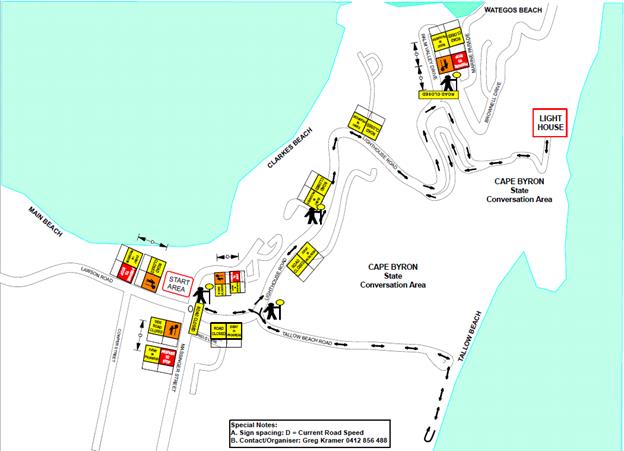
Figure 2
– Concept TCP (taking into consideration the ongoing road works)
|
RECOMMENDATION:
1. That
the 10km Byron Lighthouse Fun Run, to be held Sunday 23 October 2016, which
includes the temporary road closures below, be endorsed between these times:
a. Lighthouse
Road at the intersection of Massinger Street, Lawson Street and Lighthouse
Road between 7am and 8am.
b. Daniels
Street at the intersection of Massinger Street and Daniels Street between 7am
and 8am.
c. Lighthouse
Road between Brooke Drive (at The Pass) and Palm Valley Way (entry to
Wategos) between 7am and 8am.
d. Clarkes
Car Park closed, including the current Caravan Park access road off Lawson
Street, between 6am and 10am.
2. That
the approval provided in Part 1 is subject to:
a. separate
approvals by NSW Police and RMS being obtained;
b. Local
Traffic Committee advice is sought for the event Traffic Management Plan
(including Risk Management Plan and Traffic Control Plan/s) prior to
implementation of traffic control devices including road closures, noting
that:
i. conformance
with approved Traffic Management Plan and associated Traffic Control Plans
which shall be implemented and controlled by Roads & Maritime Services
accredited persons;
ii. all
temporary traffic control devices erected for the event must comply with
Roads & Maritime Services Guide to Traffic Control at Worksites Manual,
not cause a hazard for motorists or pedestrians and be removed immediately
following the completion of the event; and
iii. temporary
Speed Zone Authorisation is obtained from the roads authority for any reduced
speed limit/s required as part of the traffic control for the event; and that
where local Council is the roads authority, notification of any reduced speed
limit should be forwarded to Roads and Maritime Service and NSW Police.
c. The
event organiser:
i. advertising
the impact of the event via a notice in the local weekly paper a minimum of
one week prior to the operational impacts taking effect, noting it must
include the event name, specifics of any traffic impacts or road closures and
times, alternative route arrangements, event organiser, a personal contact
name and a telephone number for all event related enquiries or complaints;
ii. providing
copy of the advert for Council's web page;
iii. informing
community and business that are directly impacted (e.g. adjacent to the
event) via written information which is delivered to the property in a timely
manner so as to document, consider and respond to any concerns raised;
iv. arranging
for private property access and egress affected by the event;
v. liaising
with bus and taxi operators and ensuring arrangements are made for provision
of services during conduct of the event;
vi. consulting
with emergency services and any identified issues be addressed;
vii. holding
$20m public liability insurance cover which is valid for the event; and
viii. payment
of Council’s Road Event application fee prior to the event;
ix. The
attainment (by the event proponent) of Cape Byron Headland Trust written concurrence
of the event;
x. Consultation
with the Beach Byron Bay Cafe and North Coast Holiday Parks Clarkes Beach.
|
Attachments:
1 Out of
Session Comments - LTC Report 6.9 - Event Road Closure - Byron Lighthouse Run -
Lighthouse Road, Byron Bay - Sunday, 23 October 2016 (Amended), E2016/90136 , page 96
Regulatory Matters 6.10 - Attachment 1
Local Traffic Committee Meeting 6.11
Report No. 6.11 Extension of School Bus Route - Pearces Road and Booyong Road,
Booyong
File No: I2016/990
Council has received an application (E2016/83217) from Mr
Gavin Beaumont, Operator of Beaumont Buses, to extend the existing school bus
route N0120 that currently runs along Houghlahans Creek Road (which is situated
in the Lismore Shire).
Figure 1 indicates the proposed bus route extension into the
Byron Shire, which will operate both in the morning to pick the school children
up and in the afternoon when dropping the school children off. It is proposed
that the bus route is extended (red line) into Pearce Road before turning right
onto Booyong Road. The bus will then follow Booyong Road until it reaches
the intersection at Booyong Road, Tooheys Mill Road and Cooks Road (yellow
dot), where it will complete a three-point turn before backtracking along the
same route to eventually exit back onto Houghlahans Creek Road.
The proposed extension will service up to 8 children using a
9.5m bus. The operator would like to have approval for buses up to 12.5m in
length to allow for use of hired buses in the event that the regular 9.5m bus
is out of service.
Figure 1
– Proposed Bus Route Extension into Byron Shire
The Byron Shire portion of Pearce
Road (# 551) is a rural sealed road of approximately 920m in length in
Booyong. The section of Booyong Road (# 511) indicated is a rural sealed
road of approximately 3.9kms in length in Booyong.
On Thursday 22 September 2016,
Council officers conducted an inspection of the proposed route and found that
there were a number of locations along Booyong Road that would not allow
two-way traffic irrespective of whether travelling by car or bus.
However, it is noted that there are currently two school bus services (#N0124
and #N0256) that utilise this section of Booyong Road.
During the inspection it was found
that there was insufficient sight distance for a bus to conduct a safe
three-point turn at the location proposed by the applicant. Alternatively, it
is recommended that the bus continue along Tooheys Mill Road before once again
meeting up with Houghlahans Creek Road (Figure 2). It is noted that there is a
section of Tooheys Mill Road that can flood in extreme weather, at which time
the bus may need to complete a three-point turn at the previously proposed
intersection.
Figure 2 – Proposed Alternate Route
Committee endorsement is sought
for the extension of the existing school bus route into Pearce Road and Booyong
Road.
|
RECOMMENDATION:
That Council note:-
1. The
Local Traffic Committee has no objection to the proposed extension of the
school bus route along Pearce Road and Booyong Road in Booyong;
2. The
bus would enter Pearce Road from Houghlahans Creek Road, before turning right
onto Booyong Road and then continuing along Tooheys Mill Road to meet up once
again with Houghlahans Creek Road.
|
Attachments:
1 Proposed
Bus Route Extension, E2016/85853 ,
page 100
Regulatory Matters 6.11 - Attachment 1
Local Traffic Committee Meeting 6.12
Report No. 6.12 Event Road Closure - Soul Street New Year's Eve and First Sun New
Year's Day, Byron Bay
File No: I2016/992
Two key strategies of the ‘Safe Summer in the
Bay’ initiative adopted by Council include the Soul Street New Year’s
Eve (NYE) family friendly event on 31 December 2016, and the First Sun New Year’s
Day (NYD) meditation/yoga event on the 1 January 2017.
New Year’s Eve
Council last year (2015) held the third annual ‘Soul
Street’ NYE event which required a road closure of the main street of
Byron Bay, being Jonson Street, between Lawson Street through to the car park
entry at Railway Park just north of Marvell Street. The same road closure is
now sought for the 2016 NYE event to be held Saturday 31 December 2016 with the
southern end to close from 12noon and the northern end from 1pm. The road
closure would then be lifted no later than 7am the following morning (1 January
2017).
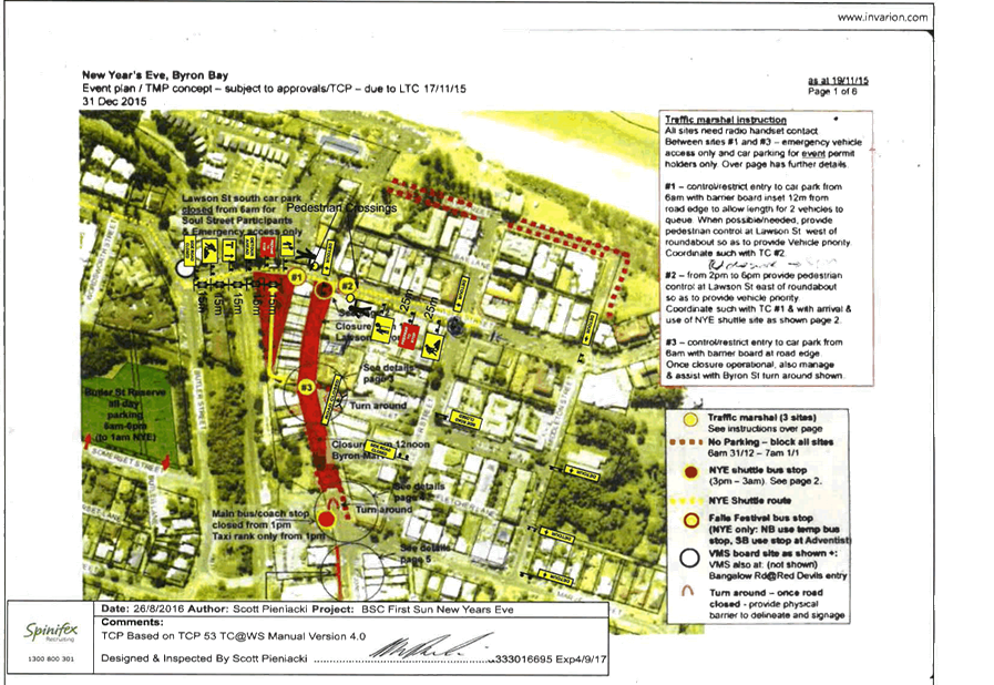
Other closures are shown in Figure 1, such as securing of
Council owned and operated public car park (Lawson Street south car park) for
participants of the event only (e.g. stall holders) and provision of an
emergency vehicle access route under guidance of traffic control personnel
positioned at sites 2 and 3. Removal of parking from streets (as per dotted red
line) from 6am will also occur as will traffic control personnel which include
two at each of the sites (1, 2 and 3) as per previous years, but with an
additional two personnel located at the roundabout at the intersection of
Fletcher Street & Lawson Street. Please note that a roster for traffic
control personnel will accompany the final approved Traffic Control Plan.
Figure 1 – Traffic Control Plan concept
In addition, Council will run a
NYE shuttle service between 3pm and 3am from the Cavanbah Sports Centre on
Ewingsdale Road (3km west of town) to the site depicted in Figure 2 (e.g. at
the top end of the street closure).
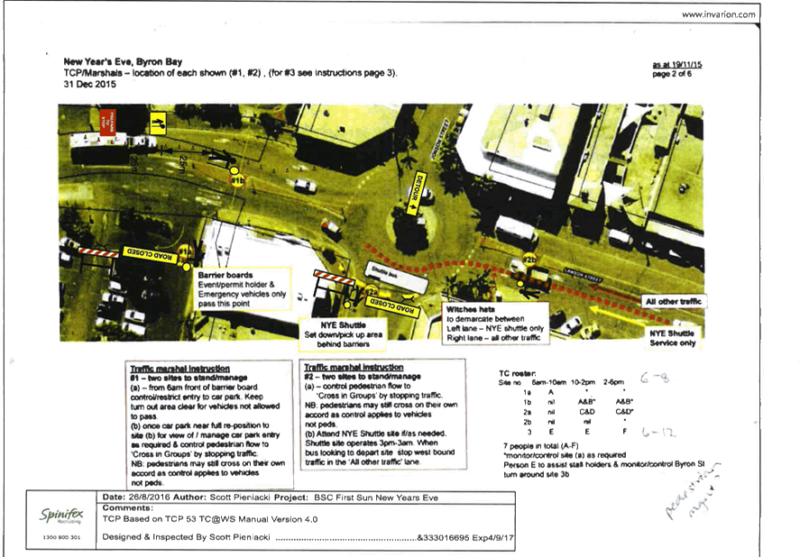
Figure 2 provides details on the
role of the traffic controllers to be positioned during the day at sites 1 and
2, noting when two personnel are at each site they will assist with control of
pedestrian and vehicle movement at the roundabout at the intersection of Jonson
Street & Lawson Street.
Figure 2 – TCP for Site 1 and Site 2
Figure 3 – TCP for Site 3
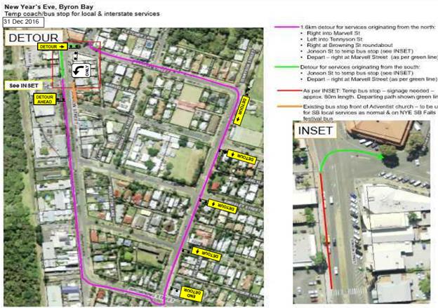
It should be noted the road
closure impacts on local taxi and bus operators and interstate coach services.
As in the past, these stakeholders will be advised directly and accommodated
where possible, noting this NYE the main bus/coach stop will be for taxi and
smaller passenger service vehicles only while the bus/coach and larger vehicles
will be provided for south of the main stop so as they avoid the turn-around
south end of the road closure and can exit directly via Marvell Street. Both
south and north bound vehicles can use this temporary bus/coach stop if they
wish by detouring or alternatively (as local services do) use the existing
southbound bus stop opposite.
Figure 4 – TCP for Detour and Temporary Coach/Bus
Stop
New Year’s Day
This year, on 1 January 2016, the
First Sun NYD event was held for the first time at the Cape Byron Lighthouse.
It was a very successful event with approximately 400 – 500 people
attending and it is proposed that the same event be held again on Sunday 1
January 2017.
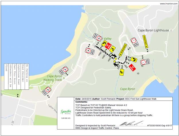
During the last event, vehicles
parked on both sides of Lighthouse Road leading up to Cape Byron Lighthouse and
pedestrians walked in large groups along the road. To minimise the impact on
traffic flow, a traffic control plan (Figure 5) has been developed for
Lighthouse Road.
Figure 5 – TCP for Lighthouse Road
It is requested that the TCP for both
the NYE & NYD events, which includes the temporary road closures described
above in Byron Bay, to be held Saturday 31 December 2016 and Sunday 1 January
2017 respectively be endorsed.
|
RECOMMENDATION:
1. That
the Local Traffic Committee supports:
a. Council's
temporary traffic management initiatives for the Soul Street New Year's Eve
event to be held in Byron Bay and approves the temporary road closure of
Jonson Street, between Lawson Street through to the car park entry at Railway
Park (north of Marvell Street), from 12noon on Saturday 31 December 2016 and
its removal by no later than 7am on the Sunday 1 January 2017.
b. Council’s
temporary traffic management initiatives for the First Sun New Year’s
Day event to be held in Byron Bay and approves the temporary road closure of
Lighthouse Road from Brooke Road (The Pass), from 3am to 8am on Sunday 1
January 2017.
2. That
the approval provided in Part 1 remain subject to Council endorsement of the
event prior to implementation and is subject to the following requirements:
a. traffic
control plans are designed and implemented by those with the appropriate NSW
(RMS) accreditation;
b. advertising
is undertaken in accordance with the Roads Act, including the publication of
a map and explanatory notes in a local newspaper and on Council's website;
c. the
letterbox drop of properties adjacent to and prior of the Jonson Street
closure and Bay Street, Marvell Street and Byron Street parking changes; and
d. all
parties involved in Council's NYE events hold, or least covered by,
appropriate and relevant levels of insurance and public liability cover as
required by Council.
|
Attachments:
1 Traffic
Control Plan - New Years Eve 2016, E2016/87432
, page 106
Regulatory Matters 6.12 - Attachment 1
Regulatory Matters 6.12 - Attachment 1

Local Traffic Committee Meeting 6.13
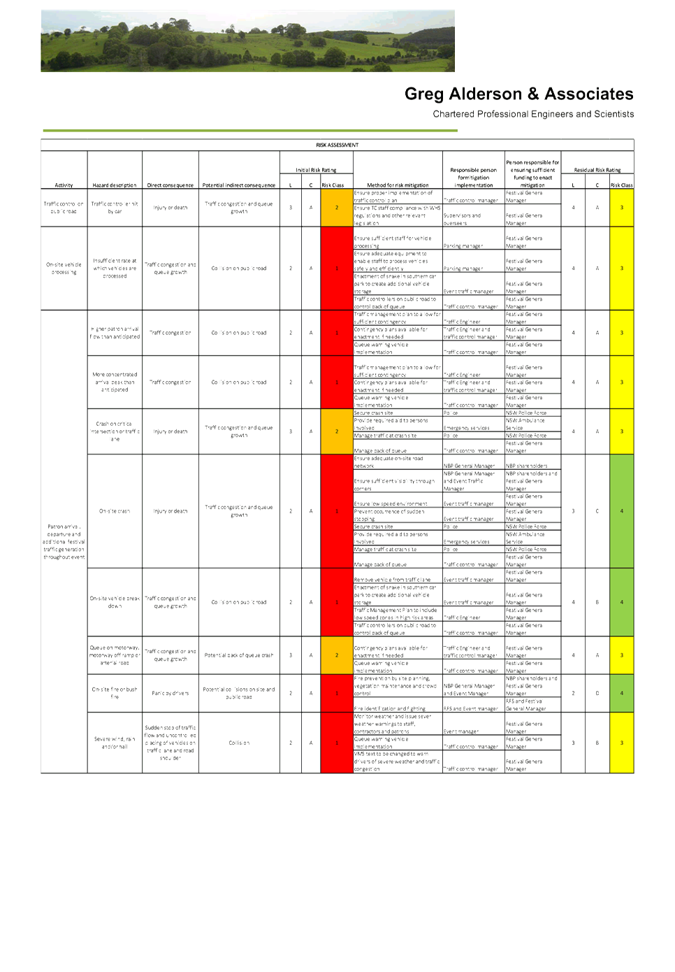
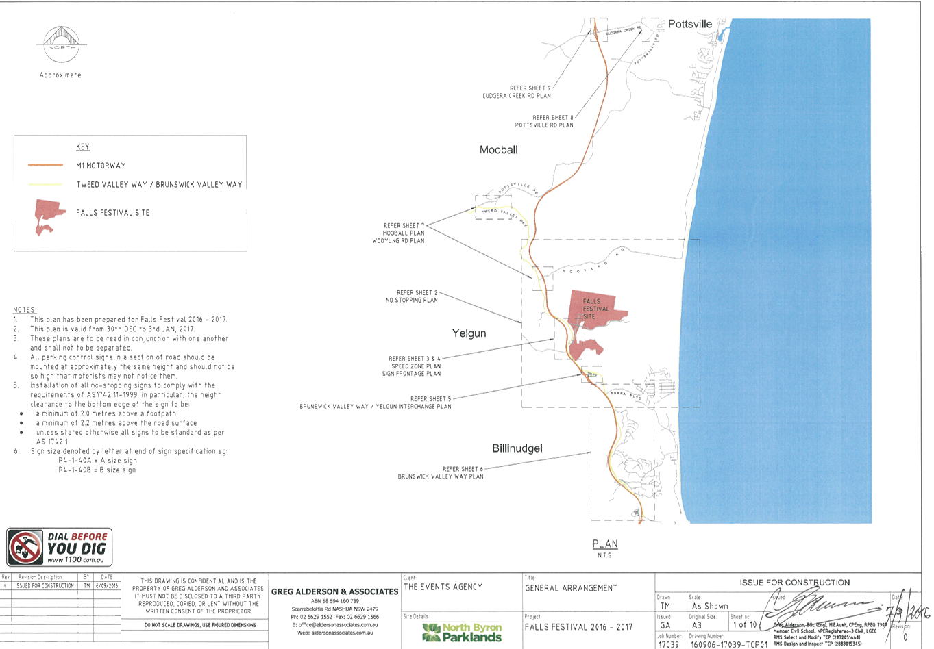
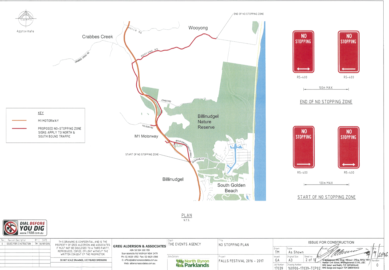
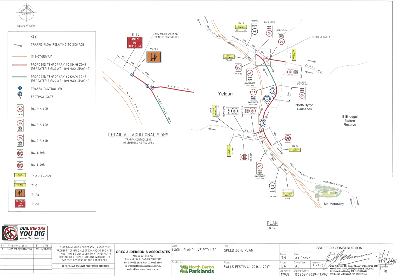
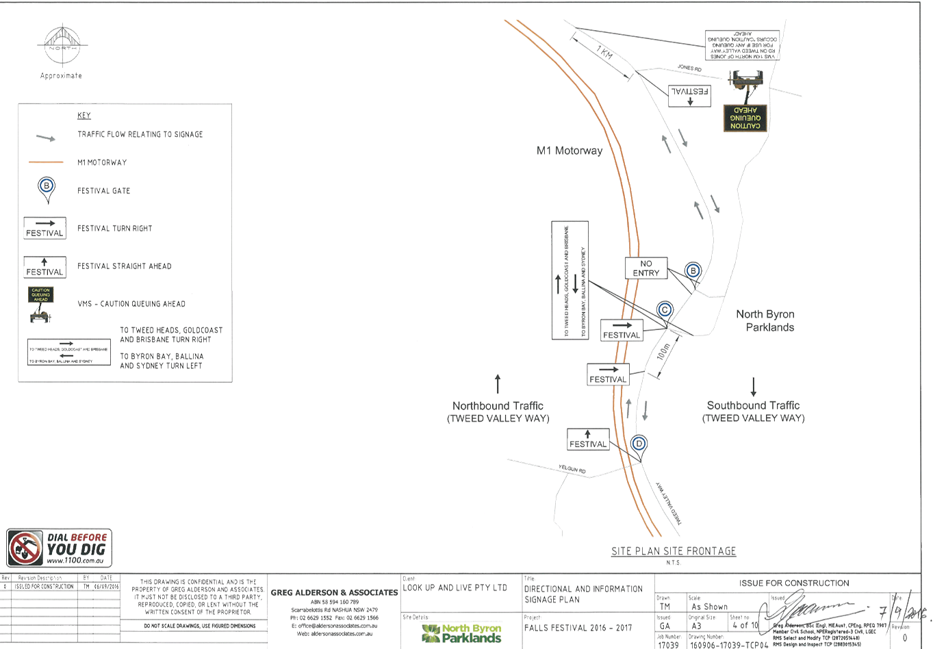
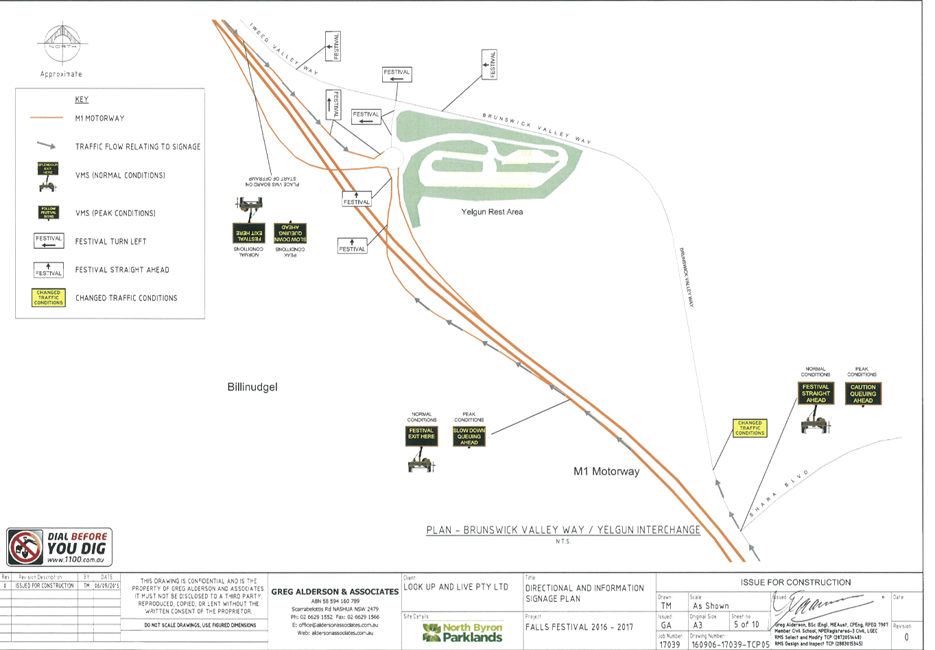
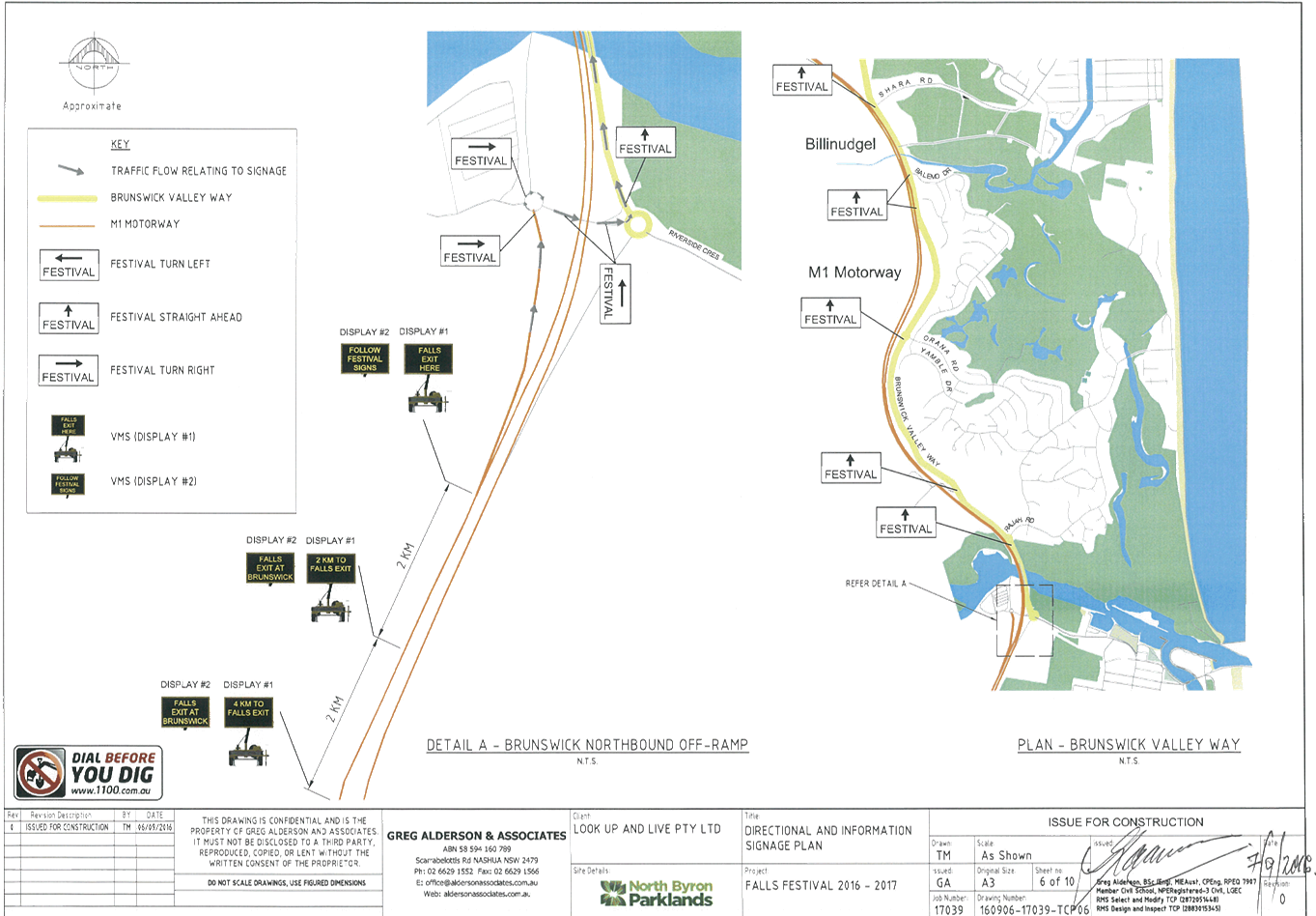
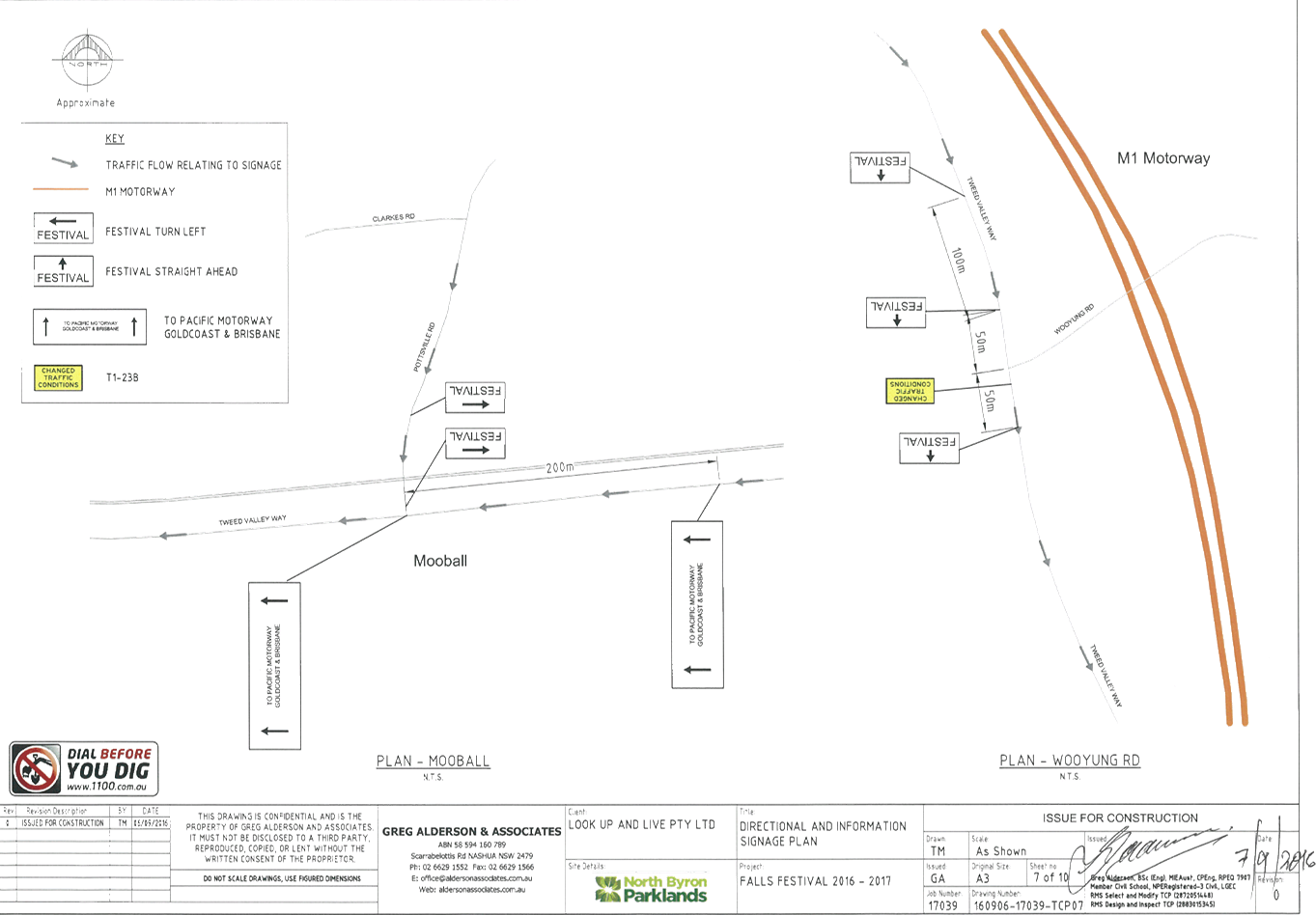
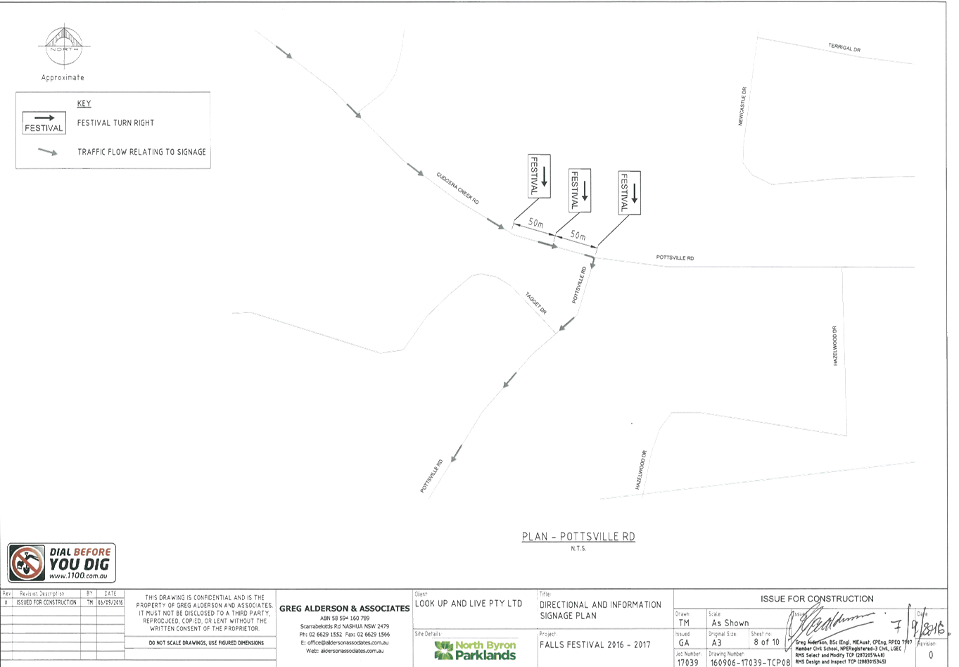
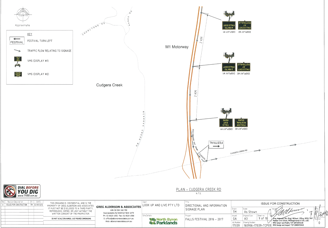
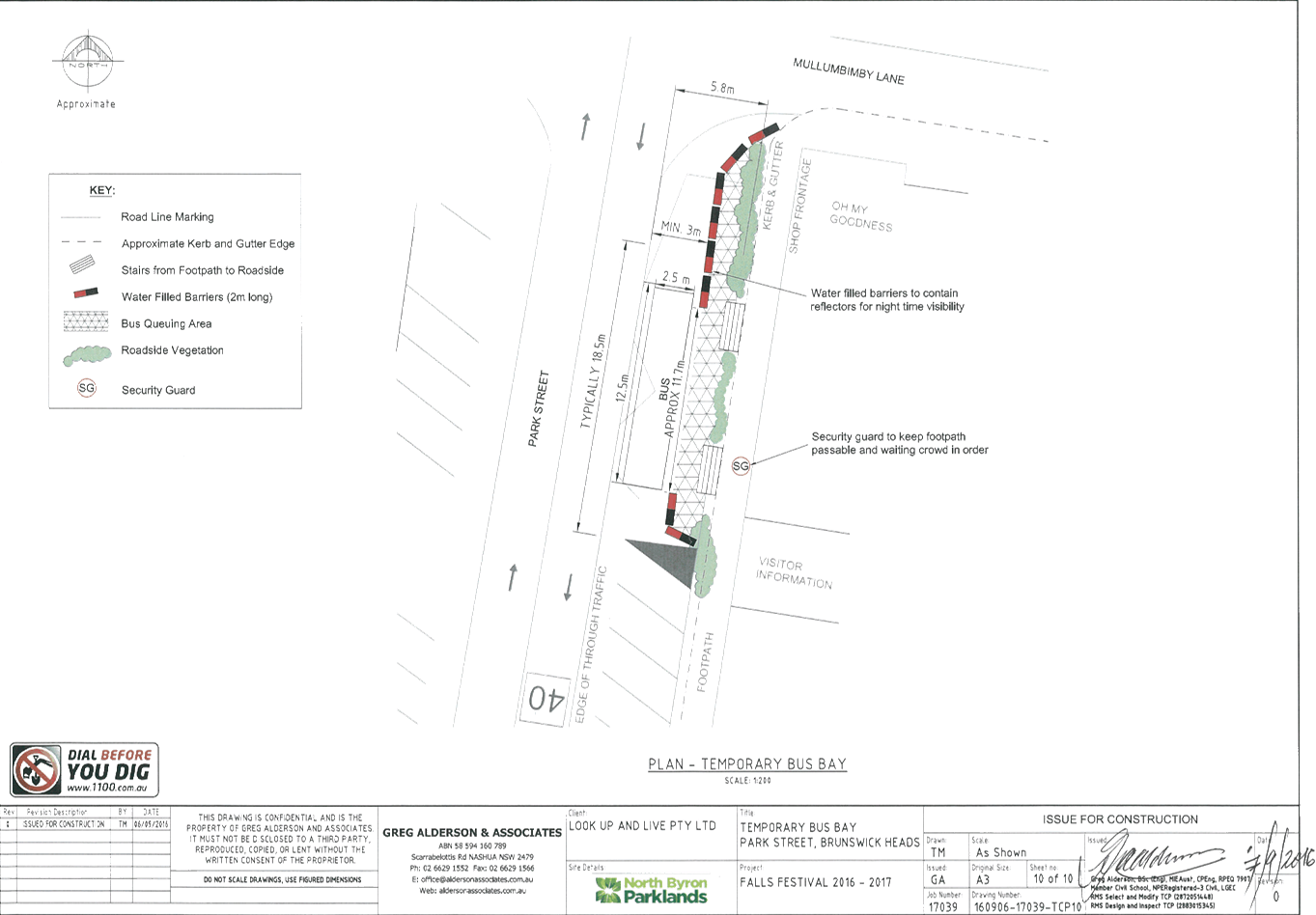
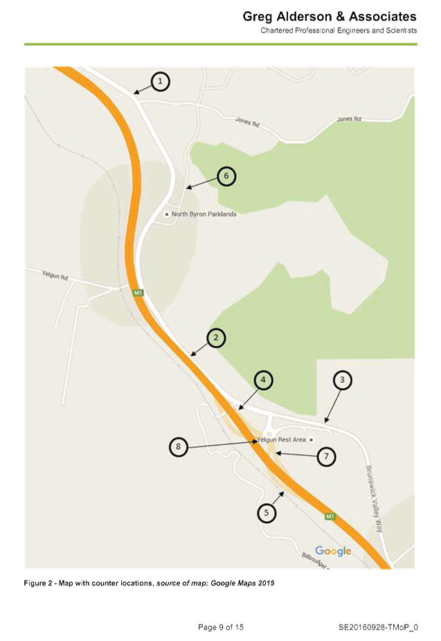
Report No. 6.13 Event Road Closure - Falls Festival 2016/17 - North Byron Parklands,
Yelgun - Saturday 31 December 2016 to Monday 2 January 2017
File No: I2016/993
Council has received an application and Traffic Control Plan
(TCP) from Greg Alderson & Associates on behalf of Look Up and Live Pty Ltd
for Falls Festival 2016/17 at North Byron Parklands in Yelgun, that is to be
held during the New Year’s period of 2016/17.
The festival will be held from Saturday 31 December 2016 to
Monday 2 January 2017. Camper bump in will commence on Friday 30 December
2016. The camping areas close in the afternoon of Tuesday 3 January 2017.
The TCP (Figure 1) is virtually the same as previous years,
with the exception of adding a few ‘changed traffic conditions / roadwork
ahead’ signs and the layout and presentation have been revised to add
clarity and include feedback from Roads and Maritime Services (RMS).
It is requested that the application and TCP from Greg
Alderson & Associates for Falls Festival 2016/17 at North Byron Parklands
in Yelgun, that is to be held during the New Year’s period of 2016/17 be
endorsed.
Figure 1
– TCP concept
|
RECOMMENDATION:
That the temporary traffic management and regulatory
changes within the series of Traffic Control Plans as related to the Falls
Festival to be held at the North Byron Parklands site Yelgun between Saturday
31 December 2016 and Monday 2 January 2017 inclusive be endorsed subject to:
a. Separate
approvals by NSW Police and RMS being obtained;
b. Implementation
of the approved Traffic Management Plan and Traffic Control Plan by
those with appropriate RMS accreditation and the holding of current and appropriate
levels of insurance and liability cover;
c. The
approved event size being sufficient (20,000 patrons) to trigger use of the
south car park as per the DA Condition for its use;
d. The
temporary ‘No Stopping’ where applied, including on Brunswick
Valley Way (between Shara Boulevard and Tweed Valley Way) and on Tweed Valley
Way (between Brunswick Valley Way and Wooyong Road), is implemented prior to
the event and in accordance with relevant state requirements and Australian
Standards;
e. A
communications protocol be developed and maintained by those involved in the
implementation of traffic management including monitoring and ability to
implement contingency plans as and when directed;
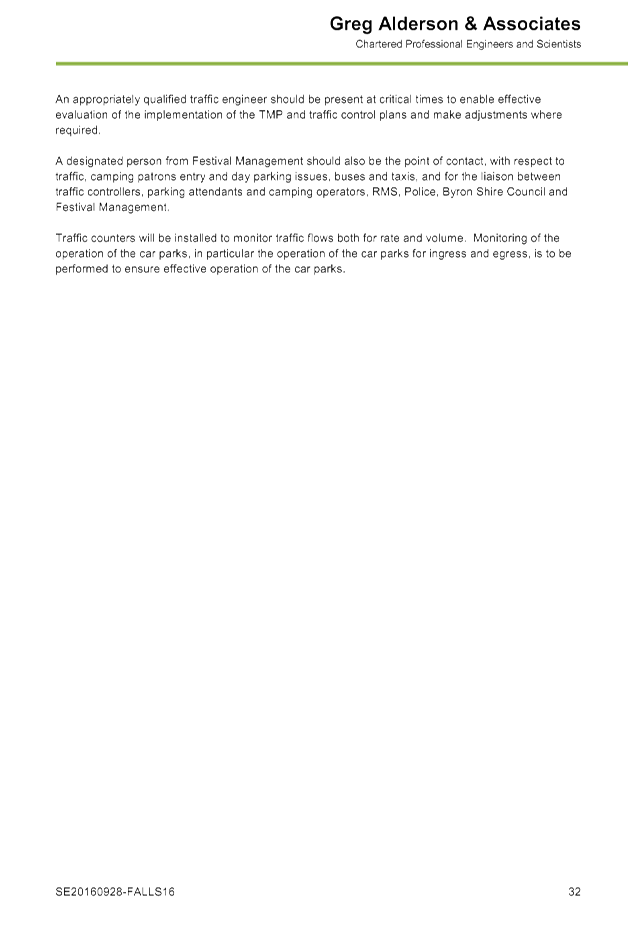
f. Monitoring
of vehicle volumes that arrive and depart the festival site and on the local
road network;
g. The
holding of an event debrief within the month following the festival which
includes but not limited to Council, RMS and Police;
h. The
event organiser:
i. advertising
the impact of the event via a notice in the local weekly paper a minimum of
one week prior to the operational impacts taking effect, noting it must
include the event name, specifics of any traffic impacts or road closures and
times, alternative route arrangements, event organiser, a personal contact
name and a telephone number for all event related enquiries or complaints;
ii. providing
a copy of the advert for Council's web page;
iii. consideration
of any submissions received;
iv. informing
community and businesses that are directly impacted (eg adjacent to the
event) via written information which is delivered to the property in a timely
manner so as to document, consider and respond to any concerns raised;
v. arranging
for private property access and egress affected by the event;
vi. liaising
with bus and taxi operators and ensuring arrangements are made for provision
of services during conduct of the event;
vii. consulting
with emergency services and any identified issues be addressed;
viii. holding
$20m public liability insurance cover which is valid for the event.
ix. paying
of Council’s Road Event Application Fee prior to the event.
|
Attachments:
1 Letter
from Greg Alderson & Associates Pty Ltd - Cover Letter for Falls Festival
2016/17, E2016/89208 , page 115
2 Traffic
Management Plans - Falls Festival 2016/17, E2016/89206
, page 116
3 Traffic
Control Plans - Falls Festival 2016/17, E2016/89204
, page 152
4 Traffic
Monitoring Program - Falls Festival 2016/17, E2016/89205
, page 162
Regulatory Matters 6.13 - Attachment 1
Regulatory Matters 6.13 - Attachment 2


Regulatory Matters 6.13 - Attachment 2
Regulatory Matters 6.13 - Attachment 2


Regulatory Matters 6.13 - Attachment 3
Regulatory Matters 6.13 - Attachment 4
Local Traffic Committee Meeting 6.14
Report No. 6.14 Bayshore Drive - Proposed Bus Stop Relocation, No Stopping Signage
and 30-minute Parking Time Limit
File No: I2016/1004
After consideration at the Local Traffic Committee (LTC) on
the 24 June 2015 and subsequent Council resolution 15-350, on 16 July 2015
Council resolved as follows:
|
15-350
|
Resolved that Council adopt the
following Committee Recommendation:
Report
No. 6.10 Request for Time Limit, Bayshore Drive, Arts and Industry
Estate,
Byron Bay
File No:
I2015/577
1. That
‘No Stopping’ apply for a 15m length on the west side of
Bayshore Drive, north of Grevillea Street, Byron Bay.
2. That
‘No Parking’ be signed for the length of the bus stop,
which is to be demarcated by a single J-Pole, relocated south of its existing
site on the west side of Bayshore Drive to 30m north of Grevillea Street,
Byron Bay.
3. That
on the west side of Bayshore Drive, between 35m and 77m north of Grevillea
Street, Byron Bay a 1P time limit be signed as effective Monday to Friday 9am
to 6pm and Saturday 9am to 12.00 noon, conforming with such limits nearby.
4. That
consultation with all tenants with access to and from the west side of
Bayshore Drive (between Grevillea Street and Banksia Street) and those on
Banksia Drive (between Bayshore Drive and Acacia Street) be undertaken to
ascertain support of adopting such time limits.
|
Signage was installed on Monday 9
May 2016 as resolved in resolution 15-350. Due
to the time elapsed between the original consultation, Council resolving on the
matter and the installation of the signage it appears that local business
requirements have changed and it seems resolution 15-350 is no longer
appropriate for the current circumstances.
The matter has since been reviewed
and to improve access to the local business the following improvements are
recommended for the western side of Bayshore Drive, north of the intersection
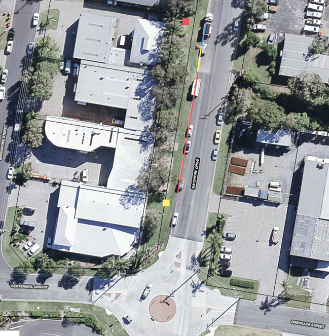
of Centennial Circuit, Bayshore Drive and Grevillea Street (refer to Figure 1):
1. Relocation of the existing bus stop (yellow
square) back to the original location near the child care centre (red square)
located 77m north of the intersection.
2. ‘No Stopping’ to be extended
between 62m and 77m north of the intersection (yellow line) to allow easy of
access to the relocated bus stop.
3. 30-minute parking time limit be signed
between 0m and 35m north of the intersection (purple line), effective Monday to
Friday 9am to 6pm and Saturday 9am to 12pm.
It is noted that there will be no
change to the current 1P time limit between 35m and 62m north of the
intersection (red line), as previously resolved in Part 3 of resolution 15-350.
Consultation has been undertaken
with the residents and business owners along Bayshore Drive that will be
affected by the proposed relocation and improvements, as well as bus companies.
A consultation letter was sent on Friday 26 August 2016 regarding the above
proposal and advising that written submissions could be made to the Council by
close of business Tuesday 20 September 2016.
From this consultation Council
received one submission (E2016/81717) on Sunday 4 September that was in support
of the proposed improvements.
Figure 1 – Proposed Relocation of Bus Stop
|
RECOMMENDATION:
That on the western side
of Bayshore Drive, north of the intersection of Centennial Circuit, Bayshore
Drive and Grevillea Street:
a. the
bus stop (as demarcated by a single J-Pole) be relocated to approximately 77m
north of the intersection.
b. ‘No
Stopping’ apply and be signed immediately south of the relocated bus
stop, between 62m and 77m north of the intersection.
c. 30-minute
parking time limit apply and be signed between 0m and 35m north of the
intersection, effective Monday to Friday 9am to 6pm and Saturday 9am to 12pm.
|
Attachments:
1 Submission
of Support from Brett Munro , E2016/87441
, page 180
Regulatory Matters 6.14 - Attachment 1

Local Traffic Committee Meeting 6.15
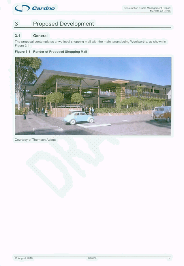
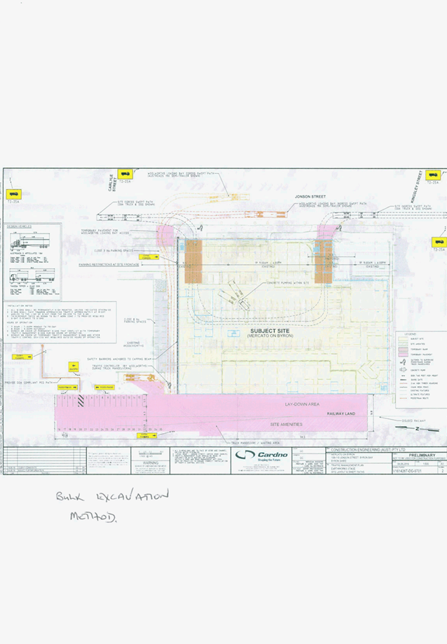
Report No. 6.15 11.2013.587.2 - Mercato on Byron - 108-110 Jonson Street, Byron Bay
File No: I2016/991
Details of the earthworks and
construction stages for the proposed shopping mall at 108-110 Jonson Street
Byron Bay will be tabled at the Local Traffic Committee (LTC) meeting. Council
Development Engineers are to attend.
The proposed hours of operation
during construction are 7am to 6pm Monday to Friday and 8am to 3pm Saturday. Gatemen
are to supervise pedestrians and traffic controllers are to stop northbound
traffic on Jonson Street to assist ingress and egress of construction vehicles
as required during construction hours. Woolworths is to provide a staff member
to manage traffic during truck manoeuvring to the Woolworths loading dock.
Figure 1 – Construction Stage TMP Site Layout
LTC comments are sought for the
proposal.
|
RECOMMENDATION:
That Local Traffic Committee advice is sought on the
proposal.
|
Attachments:
1 Construction
Traffic Management Report, S2016/11441
, page 183
2 DO NOT USE
- Out of Session Comments - LTC Report 8.2 – 10.2016.528.1 – Peddle
and Hawk Acacia Street Market – Byron Bay – Every Second Saturday, E2016/89785 , page 204
Regulatory Matters 6.15 - Attachment 1

Regulatory Matters 6.15 - Attachment 2
Local Traffic Committee Meeting 6.15
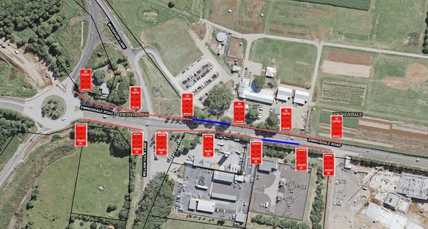
Report No. 6.15 Installation of No Stopping Signage at The Farm and Byron Hospital -
Ewingsdale Road, Ewingsdale
File No: I2016/1010
Vehicles are regularly parallel parking along the road
reserve on the north side of Ewingsdale Road adjacent to The Farm, especially
during peak times such as school holidays, etc. This presents a number of
safety concerns as the road is quite narrow and traffic banks up as vehicles
slow down on approach to the hospital roundabout.
It is also noted that as part of the T2E Pacific Highway
upgrade the Roads and Maritime Services (RMS) highlighted this section of
Ewingsdale Road as an area to monitor.
To reduce the risks along this section of road and ensure
safety it has been requested that both sides of Ewingsdale Road, between the
roundabout at the Pacific Highway interchange and the roundabout at the
entry to the Byron Hospital, be signed as ‘No Stopping’ (red
line/s) except for the existing Bus Stops (blue lines).
Figure 1
– Proposed signage
|
RECOMMENDATION:
That both sides of Ewingsdale Road, between the
roundabout at the Pacific Highway interchange and the roundabout at the
entry to the Byron Hospital, be signed as ‘No Stopping’ except
for the existing Bus Stops.
|
Local Traffic Committee Meeting 6.17
Report No. 6.17 Request for Heavy Vehicle Restrictions - Granuaille Road &
Lismore Road, Bangalow
File No: I2016/1042
After consideration at the Local Traffic Committee (LTC) on 26
August 2015 and subsequent Council resolutions 15-477 & 15-478, on the 17
September 2015 Council resolved as follows:
|
15-477
|
Resolved that
Council adopt the following Committee and Management Recommendation(s):
That Council:
1. note
the concerns raised by the Bangalow Progress Association regarding heavy
vehicle use, noise and speed, and traffic volumes in general.
2. note
that these concerns include amenity and safety on Route B62, the Bangalow to
Lismore route which uses Granuaille and Lismore Roads in Bangalow and the
domed roundabout at the top of Byron Street.
3. confirm
its previous opposition to signage that the RMS may place on the Pacific
Highway north of the Ewingsdale interchange for southbound traffic that
directs traffic to Lismore via Bangalow.
4. recommend
to the RMS that, if it wishes to proceed with the proposed assessment of such
signage, it be carried out only after completion of the T2E upgrade on the
basis that:
a) the
highway is fully operational, i.e. no road works or temporary speed limits
apply south of Ewingsdale Road and all associated road works are completed;
b) the
trial start with no signage for a period of at least three months; and
c) if
undertaken, the subsequent "with signage" part of the trial be for
the same time period.
5. note
that load limiting or restriction of general access vehicles (including heavy
vehicles such as trucks up to 19 metres, buses, etc) is only permissible on
roads where there is a road hazard or asset management issue.
6. note
that the RMS is preparing a "Corridor Strategy" which should
address speed, traffic volumes, heavy vehicle use, signage, etc.
7. seek
RMS advice and approval for signage in regard to heavy vehicle use and noise
reduction on Granuaille Road (eg compression braking).
|
|
15-478
|
Resolved that
Council:
1. note
the apparent increase in heavy vehicles using Route 62 since the removal of
the Binna Burra rail bridge.
2. write
to the NSW Premier, the NSW Minister for Roads and the NSW Minister for
Police reiterating the Bangalow community's concerns and requesting the
following actions by them for Granuaille and Lismore Roads Bangalow:
a) Increased
police speed patrols on the Bangalow section of Route B62 plus frequent
mobile speed camera monitoring;
b) Prohibition
(and policing) of compression braking within Bangalow;
c) Expansion
of the 50kph speed zones in the town
(i) to
commence at the start of the divided road on Bangalow Road, north of Bangalow
with clear road markings and differentiation [similar to that in Clunes] and
(ii) to
commence on Lismore Road between the industrial estate and Rifle Range Road
with the same road markings and differentiation;
d) Speed
activated warning signs 100m after the commencements of the 50kph zones and
speed cameras on both Granuaille and Lismore Roads;
e) A
40kph zone within 100 metres of the domed roundabout (similar to that now
operating on the Highway where it crosses the Bangalow to Byron Road);
f) Prohibition
of fuel and other hazardous through-freight on Route B62 because of the
dangers of overturning at the domed roundabout. The roundabout is
upslope of Bangalow’s CBD and a spill would have disastrous impacts on
health and on livelihoods;
g) Alternatively,
prohibition of fuel tankers with trailers, to minimise the danger of fire and
explosion due to the same issue;
h) Clearer
line marking and signage on the approach roads to the domed roundabout
including clearer lit roundabout signs, better marking of the roundabout
(with reflective markers) and clear give-way markings;
i) Clear
advisory school bus-stop signage on Lismore Road at its junction with Rifle
Range Road.
|
As per Item 2 of Resolution 15-478, on 29 July 2016 letters
were sent to NSW Premier (E2016/67965), the NSW Minister for Roads
(E2016/67969) and the NSW Minister for Police (E2016/67973). Responses have
been received and key points highlighted below. Full letters have been attached
for consideration.
Letter from Mr Kevin Anderson MP, Parliamentary Secretary to
the Deputy Premier and for Regional Roads and Rail (S2016/12109):
“I have also forwarded your letter to the
Tweed/Byron Local Area Command and to the Traffic and Highway Patrol Command
for their information”.
“Council may be assured that the Heavy Vehicle
Taskforce, comprising Traffic and Highway Patrol officers, who work alongside
Environment Protection Authority officers, regularly conduct operations during
which they inspect heavy vehicles that operate on New South Wales roads. Where
taskforce officers observe breaches of the transport and vehicle registration
laws, they issue the operators with the appropriate defect and penalty
notice”.
Letter from Mr Wayne Starling, Superintendent Local Area
Commander, Tweed/Byron Local Area Command, NSW Police Force (S2016/12543):
“However, in regard to the request for increased
police patrols of the subject roads, this route is already viewed as a major
priority by police and is subject to ongoing and constant patrols and
enforcement operations by local police, and notably by Highway Patrol
officers”.
“Police will continue to monitor this route to
ensure the safety of the road users and residents of the area and constantly
assess the need for any additional enforcement operations”.
Letter from Mr John Alexander, Regional Manager Northern,
Roads & Maritime Services (S2016/11790):
“Given the nature and number of issues raised in
your letter, I think it appropriate they be returned to Council's Traffic
Committee for discussion. The Roads and Maritime representative, Etiene La
Grange, will be able to provide appropriate advice on these matters”.
On 4 October 2016, RMS Senior Network & Safety Officer,
Mr Etiene La Grange, requested that the above matter be raised at the next
Local Traffic Committee for discussion and that a meeting between RMS and Byron
Shire Council be scheduled to assess the nature of the issues raised and
determine an appropriate action plan.
|
RECOMMENDATION:
1. That
the Committee consider the matter of heavy vehicle restrictions along
Granuaille Road and Lismore Road in Bangalow and provide comments.
2. That
a meeting is scheduled between Byron Shire Council and RMS to assess the
nature of the issues raised and determine an appropriate action plan.
|
Attachments:
1 Letter
from Mr Kevin Anderson MP, Parliamentary Secretary to the Deputy Premier and
for Regional Roads and Rail, S2016/12109
, page 210
2 Letter
from Mr Wayne Starling, Superintendent Local Area Commander, Tweed/Byron Local
Area Command, NSW Police Force, S2016/12543
, page 212
3 Letter
from Mr John Alexander, Regional Manager Northern, Roads & Maritime
Services, S2016/11790 , page 213
Regulatory Matters 6.17 - Attachment 1

Regulatory Matters 6.17 - Attachment 2
Regulatory Matters 6.17 - Attachment 3
Local Traffic Committee Meeting 7.1
Matters for Traffic Engineering Advice
Report No. 7.1 Elysium Project - Lawson Lane, Byron Bay
File No: I2016/1027
ELYSIUM proposes the beautification of Lawson Lane, Byron
Bay through an application of artwork and planting - sensitively integrated
with existing structures and in collaboration with retail tenants, building
owners and residents.
The project deliverables are as follows:
a. activate
Lawson Lane through a curated application of high quality art, design, lighting
and planting treatment:
· Wall treatments
throughout the laneway.
· Install a
suspended permanent lighting installation, which is fixed to existing business
premises
· Install a
permanent suspended sculpture, which is fixed to existing business premises
· Provide an artwork
road treatment
· Install wall
mounted light boxes
· Install planter
boxes to screen bins
· Install climbers
and vines.
b. Aid
CBD way finding by improving arrival and entry points into Lawson Lane.
c. Enhance
unattractive blank walls.
d. Potential
to consolidate business waste systems within CBD spaces.
e. Establishment
of an activation space in the town centre to encourage street performance,
pop-up events and prioritise pedestrian access.
f. Engage
young people through a youth arts mentorship program.
g. Use
of light to encourage a safe shared zone - day and night.
h. To
foster investment and collaboration with business and philanthropists. Business
and individuals will be invited to contribute financially and provide in-kind
services and materials to support the project.
i. Showcase
our community’s creative capability and strengthen sense of community through
true creative collaboration - between council, business, philanthropists,
artists, design professionals and young people.
The following are draft creative concepts:
It is requested that the Local Traffic Committee consider
the proposal and provide comments and advice.
|
RECOMMENDATION:
That the Committee consider the Elysium project
proposal for Lawson Lane Byron Bay and provide comments.
|
Local Traffic Committee Meeting 8.1
Development Applications
Report No. 8.1 10.2016.399.1 - Byron Central Health & Wellness HUB - 15
McGettigans Lane, Ewingsdale
File No: I2016/969
Council has received a Development Application (DA) for the proposed
Byron Central Health & Wellness HUB located on the corner of McGettigans
Lane and Ewingsdale Road, Ewingsdale as shown in Figure 1.
Figure 1 – Proposed
site location
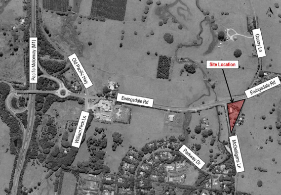
Figure 2 –
Proposed development site plan
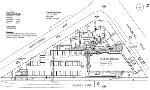
Committee advice on the proposed
development is sought and endorsement of the regulatory controls will be
proposed.
Detailed design plans will be
tabled to assist the committee’s review of the proposal.
|
RECOMMENDATION:
That the Committee consider the Development Application
for the proposed Byron Central Health & Wellness HUB located on the
corner of McGettigans Lane and Ewingsdale Road, Ewingsdale and provide
comments.
|
Local Traffic Committee Meeting 8.2
Report No. 8.2 10.2016.582.1 - Peddle and Hawk Acacia Street Market - Byron Bay -
Every Second Saturday
File No: I2016/879
Council has received a Development Application (DA) from
Kulchajam Inc for the operation of the Peddle and Hawk Acacia Street Market
every second Saturday in the Arts and Industrial Estate of Byron Bay.
The applicants are seeking permission to run a maximum of 26
markets per year on Saturdays with proposed daytime operations from 10am-5pm
and twilight operations 2pm-10pm. This involves the closure of Acacia Street as
defined in Figure 1.
As per the original recommendations of the Local Traffic
Committee (LTC) when the first three (3) trial events were approved, further
reports are provided to Council to seek permanent permissions, covering all
aspects of management and operations, and including details on the consultation
as undertaken by the proponent with tenants adjacent and within the road
closure including their acceptance of conditions upon an ongoing monthly event.
Acacia Street has a low volume, 150m long with 7 accesses
affected.
Figure 1 - Diagram
of road closure
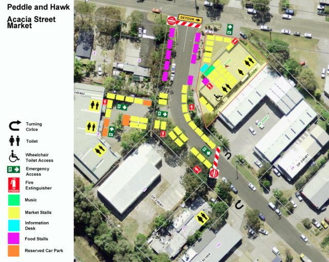
The event has submitted a draft Traffic Control Plan (TCP)
for the road closure. This TCP is suitable.
Committee advice on the proposed market operation is sought
and endorsement of the regulatory controls will be proposed.
|
RECOMMENDATION:
1. That
the Committee consider the Development Application for the proposed operation
of the Peddle and Hawk Acacia Street Market, to be held every second Saturday
of each month in the Arts and Industrial Estate of Byron Bay, and provide
comments.
|
Attachments:
1 Event -
Acacia St, Byron - Peddle and Hawk Acacia St Market - TCP02 Twighlight Market, E2016/74693 , page 221
2 Event -
Acacia St, Byron - Peddle and Hawk Acacia St Market - TCP01 Daytime, E2016/74692 , page 222
3 Out of
Session Comments - LTC Report 8.2 – 10.2016.528.1 – Peddle and Hawk
Acacia Street Market – Byron Bay – Every Second Saturday, E2016/89852 , page 224
Development Applications 8.2 - Attachment 1
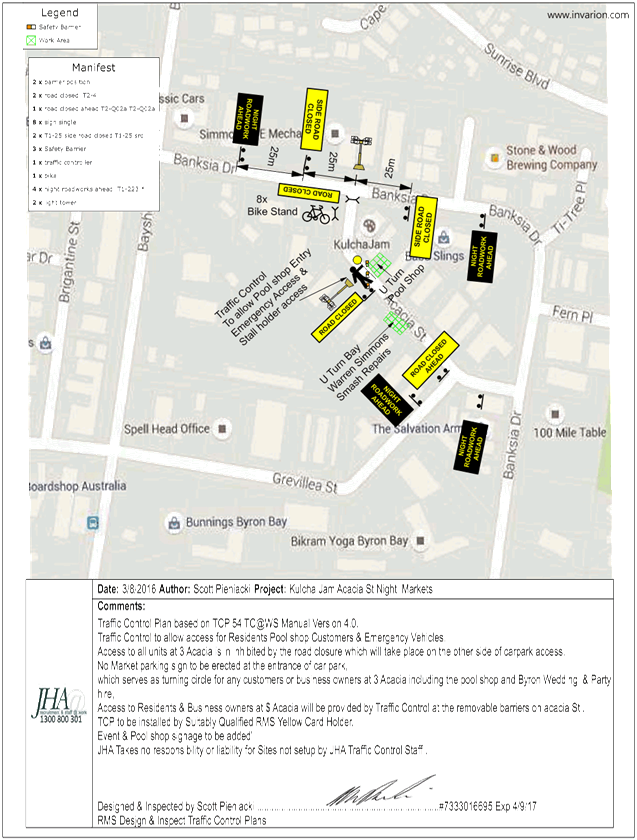
Development Applications 8.2 - Attachment 2
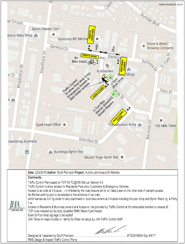
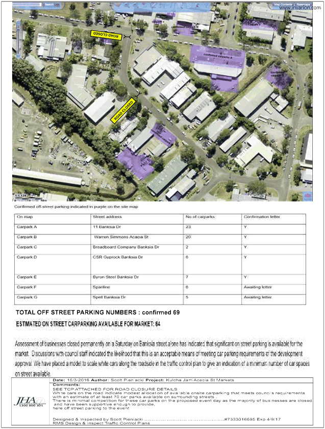
Development Applications 8.2 - Attachment 3
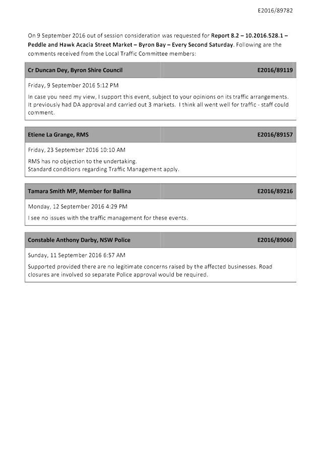
Local Traffic Committee Meeting 8.3
Report No. 8.3 10.2016.247.1 - Transport Depot - 25 Fowlers Lane, Bangalow
File No: I2016/1028
Council has received a Development Application (DA) for the
operation of a Transport Depot at Fowlers Lane, Bangalow (McLeods Shoot). The
site is used by Solo Waste for the transfer of waste. A previous approval
applies to the site to use it as a depot but this will expire on the 1 July
2018 under DA10.2002.480.1. The approval requires works to be done including a
turning lane into Fowlers Lane from the Pacific Highway and an upgrade to
Fowlers Lane. These works have not been completed. The conditions of the
previous consent are as follows:
a) Roadworks
to Fowlers Lane
The upgrading of Fowlers Lane, from the
Pacific Highway to the access driveway, to Council’s standards with a
minimum 7 metre wide sealed road pavement on a 8 metre wide formation. The
roadway is to be widened at the intersection with the access driveway to
provide an Austroads Type A right turn lane (figure 5.21) for traffic turning
right into the access driveway and an Austroads desirable left turn treatment
(figure 5.16) for traffic turning left into the access driveway.
b) Roadworks
to Fowlers Lane/Pacific Highway Intersection
The upgrading of the Fowlers Lane/Pacific
Highway intersection to Austroads Standards, including the provision of a left
turn deceleration lane on the Pacific Highway. Formal concurrence will be
required from the RTA under section 138(2) of the Roads Act 1993. For this
concurrence, an additional two (2) copies of the engineering construction plans
must be submitted to Council, together with the following:
· Detailed designs to Austroads Standards.
· Pavement designs for road works.
· Specification for construction.
· Environmental management plan.
· Review of Environmental Factors.
· Traffic Control Plan.
The new DA includes a traffic impact report which indicates
that the turning lane from Hinterland Way is not required. The traffic Impact
report is attached for consideration.
It is noted that other developers in Fowlers Lane are
upgrading sections of this road. The section required by the previous approval
is a missing link in these upgrade works.
Comments from the Local Traffic Committee (LTC) are sought
on the development proposal and in particular any roads works that may be
required to the local and regional road network.
|
RECOMMENDATION:
That the Committee consider the Development Application
for the proposed Transport Depot at 25 Fowlers Lane Bangalow, and the need
for any upgrading to Fowlers Lane and the Hinterland Way, and provide
comments.
|
Attachments:
1 Ardill
Payne & Partners - Traffic Impact Study, E2016/88442
, page 227
2 Ardill
Payne & Partners - Plans, E2016/88443
, page 276
Development Applications 8.3 - Attachment 1


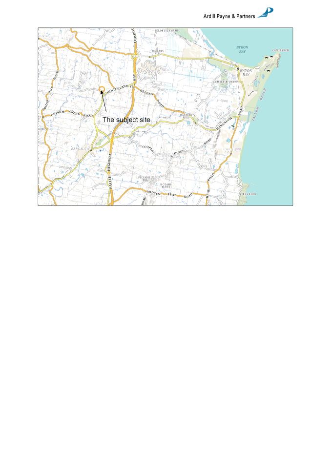
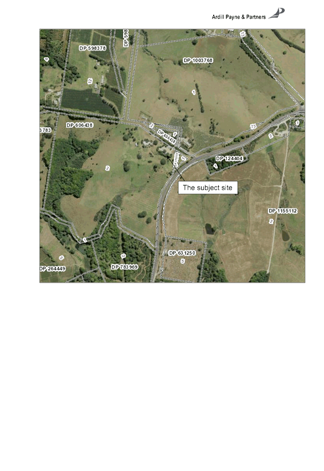

Development Applications 8.3 - Attachment 1
Development Applications 8.3 - Attachment 1

Development Applications 8.3 - Attachment 1
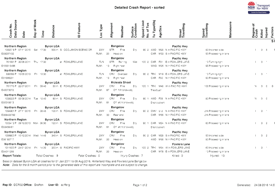
Development Applications 8.3 - Attachment 1

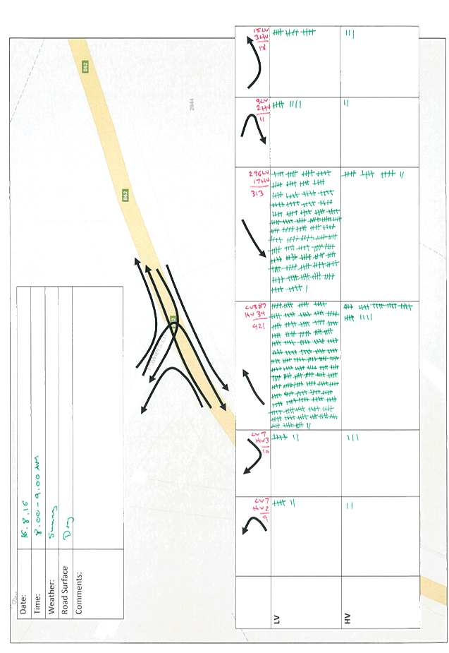
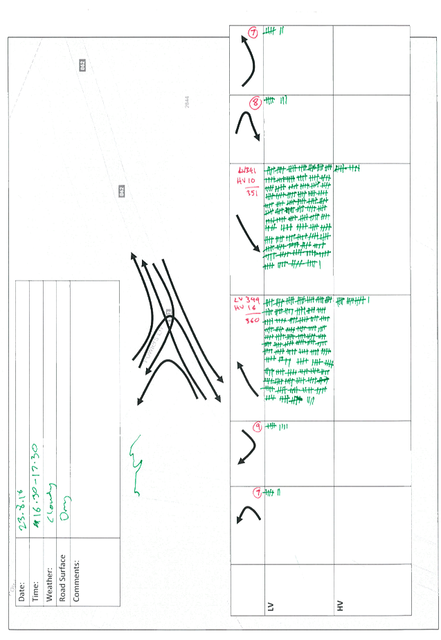


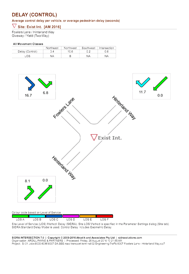
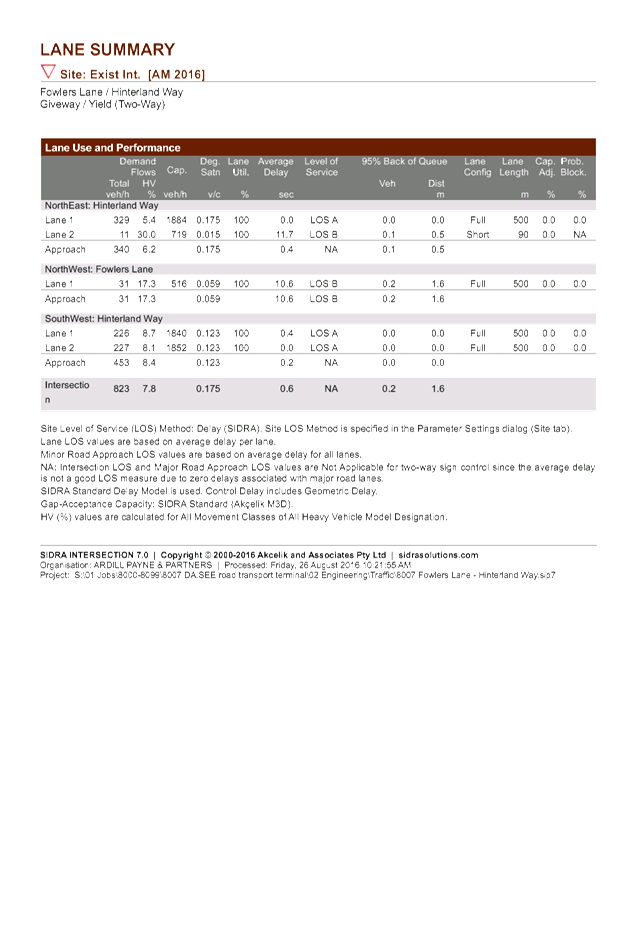

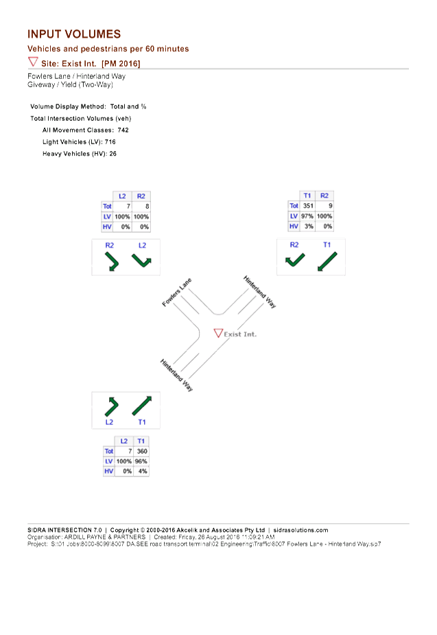
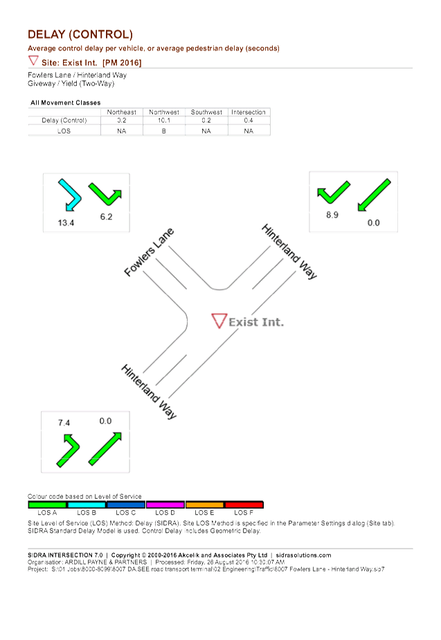


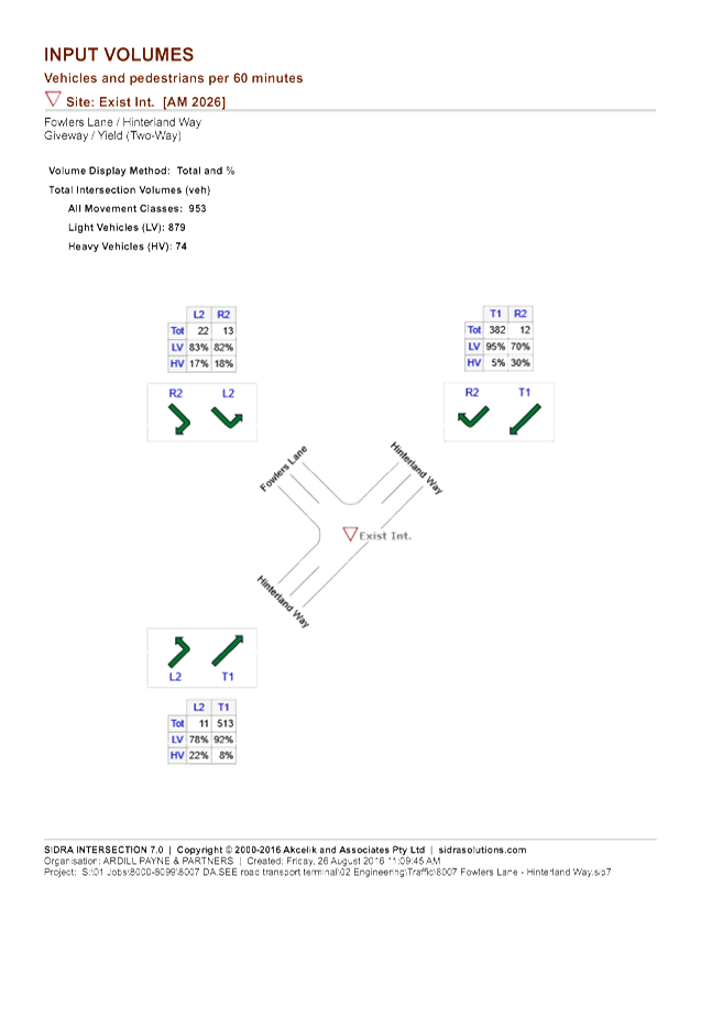


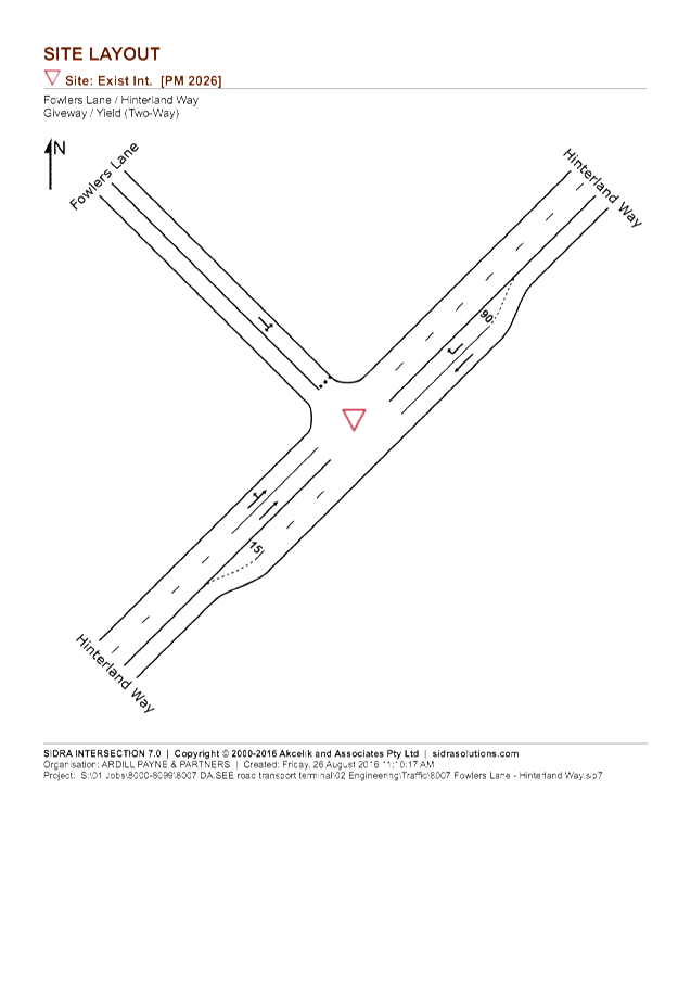

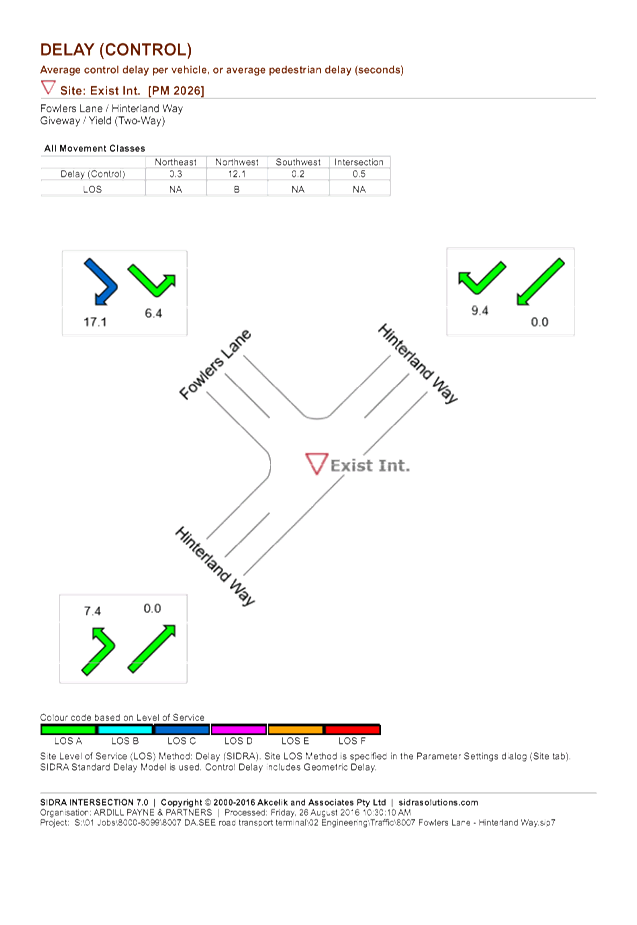

Development Applications 8.3 - Attachment 2