Local Traffic Committee Meeting
A Local Traffic Committee Meeting of
Byron Shire Council will be held as follows:
|
Venue
|
Conference Room, Station Street, Mullumbimby
|
|
Date
|
Wednesday, 9 November 2016
|
|
Time
|
10.30am
|
|
Committee
Members
|
Etiene La
Grange – Roads and Maritime Services
Snr Constable Tony Darby – Police
Cr Basil Cameron
Tamara Smith MP
|

Phillip
Holloway
Director Infrastructure Services I2016/1157
Distributed 02/11/16
Local Traffic Committee Meeting
BUSINESS OF MEETING
1. Apologies
2. Declarations of Interest
– Pecuniary and Non-Pecuniary
3. Adoption of Minutes from
Previous Meetings
3.1 Local
Traffic Committee Meeting held on 14 October 2016
4. Matters Arising
5. Outstanding
Issues/Resolutions
6. Regulatory Matters
6.1 Signage
- Installation of No Stopping zones at The Farm and Byron Central Hospital -
Ewingsdale Road, Ewingsdale.............................................................................................................. 3
6.2 Event
- Falls Festival 2016/17........................................................................................... 6
6.3 Speed
Review Request - Brunswick Valley Way and Shara Boulevard Intersection,
Billinudgel 88
6.4 24.2015.19.1
- Marine Parade, Byron Bay - Request for shared zone approval by RMS 93
7. Matters for Traffic Engineering Advice
7.1 Signage
- Installation of No Stopping zones at Shearwater, The Mullumbimby Steiner
School - Left Bank Road, Mullumbimby............................................................................................... 98
7.2 Signage
- Relocation of Bus Zone on Bayshore Drive, Byron Bay including Installation of
No Stopping and 30-minute Parking zones........................................................................ 102
7.3 Request
for Heavy Vehicle Restrictions - Granuaille Road & Lismore Road, Bangalow 107
7.4 Event
- Byron Bay Triathlon 2017................................................................................. 119
7.5 Event
- Bangalow Christmas Eve Carnival 2016.......................................................... 239
8. Development Applications
8.1 10.2016.692.1
- Outdoor Music Event 2017 - Red Devil Park, Byron Bay.................. 245
8.2 10.2016.399.1
- Byron Central Health & Wellness HUB - 15 McGettigans Lane, Ewingsdale 284
Local Traffic Committee Meeting 6.1
Regulatory Matters
Report No. 6.1 Signage - Installation of No Stopping zones at The Farm and Byron Central
Hospital - Ewingsdale Road, Ewingsdale
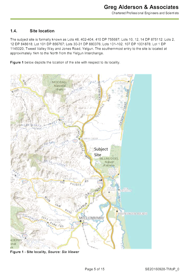
File No: I2016/1099
SUMMARY
Council has had a number of requests from the community to
form No Stopping zones along both sides of Ewingsdale Road, between the
roundabout at the Pacific Highway interchange and the roundabout at the entry
to the Byron Central Hospital.
OFFICER RECOMMENDATION
That Council install No Stopping zones along both sides of
Ewingsdale Road, between the roundabout at the Pacific Highway interchange and
the roundabout at the entry to the Byron Central Hospital, and No Stopping
signage be erected except for the existing Bus Stops.
LINKAGE TO OUR COMMUNITY STRATEGIC PLAN
|
Theme
|
Community Infrastructure
|
Services and infrastructure
that sustains, connects and integrates our communities and environment.
|
|
Objective
|
CI3
|
Renew and maintain existing
infrastructure.
|
|
Strategy
|
CI3.1
|
Maintain roads and drainage in
a safe and operational condition.
|
|
Measures
|
CI3.A
|
Reduction in funding gap for infrastructure renewal and maintenance.
|
BACKGROUND
Vehicles are regularly parallel parking along the road
reserve on the north side of Ewingsdale Road adjacent to The Farm, especially
during peak times such as school holidays, etc. This presents a number of
safety concerns as the road is quite narrow and traffic banks up as vehicles
slow down on approach to the hospital roundabout.
It is also noted that as part of the T2E Pacific Highway
upgrade the Roads and Maritime Services (RMS) barricaded this section of verge
during the T2E Project. At completion of the project RMS removed their parking
restrictions and highlighted this section of Ewingsdale Road as an area to
monitor.
To reduce the risks along this section of road and ensure safety
it has been requested that both sides of Ewingsdale Road, between the
roundabout at the Pacific Highway interchange and the roundabout at the
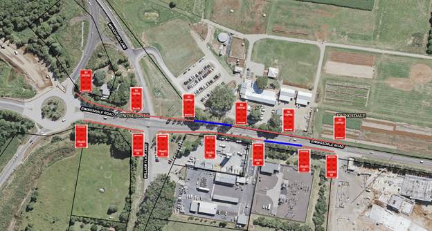
entry to the Byron Central Hospital, be signed as ‘No Stopping’ (refer
to Figure 1 - red lines) except for the existing Bus Stops (blue lines).
KEY ISSUES
1. Safety
of individuals leaving their parked vehicles then crossing a busy Ewingsdale
Road with approximately 14,000 VPD may result in a vehicle/pedestrian incident.
2. Vehicles
parking on both sides of Ewingsdale Road creating a hazard if any vehicles run
off the road and vehicle doors opening into travel lanes as a consequence of
narrow verges widths.
3. Vehicles
slowing down to park as well as slowly accelerating into traffic has the
potential to further add to delays currently being experienced on Ewingsdale
Road and the Highway interchange. Increased potential for Vehicle Access Road
incidents.
COUNCIL IMPLICATIONS
§ Budget/Financial
Estimate of
$6,000.00 for thirteen (13) R5-400 No Stopping signs, posts, clips, traffic
control, Council Works team (3 days) with a vacuum excavator for the sign
posts.
Please note that
most of the major services into Byron Bay are in this small corridor and a high
risk to hitting a service can be avoided with the use of a vacuum excavator.
§ Asset Management
Estimate
$1,300.00 for 13 signs x $10.00 per sign/year x 10 year expected life. Council
will need to maintain signage ongoing, including cleaning and replacement (if
necessary).
§ Policy or Regulation
Delegated to council for
authorisation in conjunction with NSW Road Rules 167 and AS1742.11 (Parking
Control).
§ Consultation
No consultation
has been carried out.
§ Legal and Risk Management
Stopping vehicles parking
in this area allows traffic to be free flowing and reduces the risk of
accidents.
Figure 1
– Proposed signage
|
RECOMMENDATION:
1. That
Council approve the installation of “No Stopping” zones on both
sides of Ewingsdale Road, between the roundabout at the Pacific Highway
interchange and the roundabout at the entry to the Byron Central Hospital.
2. That
no changes occur to the two (2) existing Bus Stops at this location.
|
Local Traffic Committee Meeting 6.2
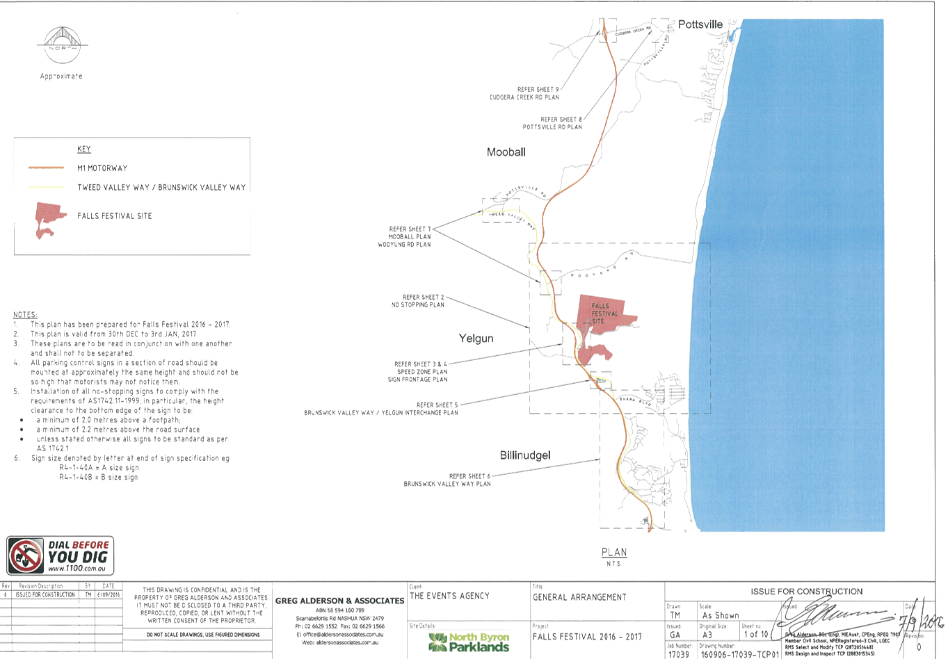
Report No. 6.2 Event - Falls Festival 2016/17
File No: I2016/1102
SUMMARY
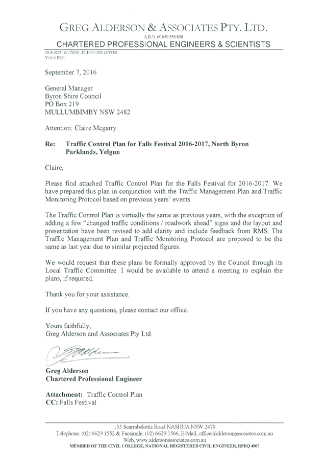
Council has received an application and Traffic Management
Plan (TMP), including a Traffic Control Plan (TCP), from Greg Alderson &
Associates on behalf of Look Up and Live Pty Ltd for Falls Festival
2016/17 to be held at the North Byron Parklands, Yelgun, over the 2016/17 New
Year’s period.
A report was presented to the Local Traffic Committee (LTC)
on the 14 October 2016 where concerns were raised regarding the traffic
congestion and transport issues, in particular the buses, that occurred at the
Splendour 2016 event. The recommendation resulting from the October LTC
meeting was ‘That the Committee defer consideration of this matter
until information is provide regarding the traffic issues associated with the
Splendour 2016 event’.
OFFICER RECOMMENDATION
That Council approve the Traffic Management Plan, which
includes Traffic Control Plans, for the Falls Festival 2016/17 to be held at
the North Byron Parklands site, Yelgun between Saturday 31 December 2016 and
Monday 2 January 2017 inclusive, subject to conditions.
LINKAGE TO OUR COMMUNITY STRATEGIC PLAN
|
Theme
|
Economy
|
A sustainable and diverse
economy which provides innovative employment and investment opportunities in
harmony with our ecological and social aims.
|
|
Objective
|
EC1
|
A diverse economic base and
support for local businesses.
|
|
Strategy
|
EC1.4
|
Support sporting and cultural
events in Byron Shire.
|
|
Measures
|
EC1.B
|
Increase the sustainability of events in which Council is
involved.
|
BACKGROUND
Council has received an application and Traffic Management
Plan (TMP), including a Traffic Control Plan (TCP), from Greg Alderson &
Associates on behalf of Look Up and Live Pty Ltd for Falls Festival
2016/17 to be held at the North Byron Parklands, Yelgun, over the 2016/17 New
Year’s period.
The festival will be held from Saturday 31 December 2016 to
Monday 2 January 2017. Camper bump in will commence on Friday 30 December
2016. The camping areas close in the afternoon of Tuesday 3 January 2017.
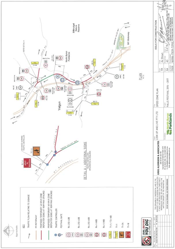
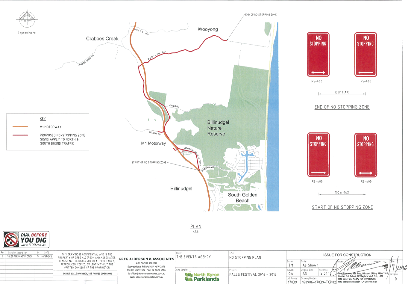
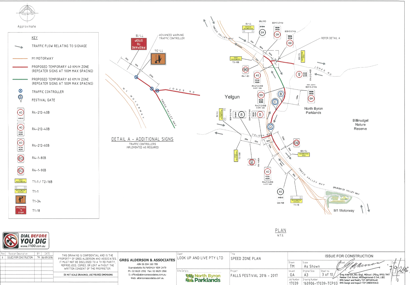
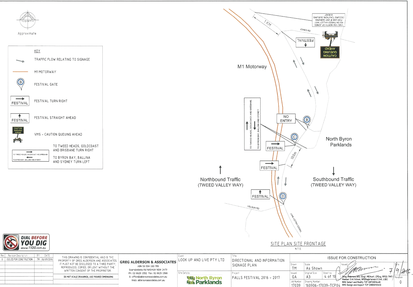
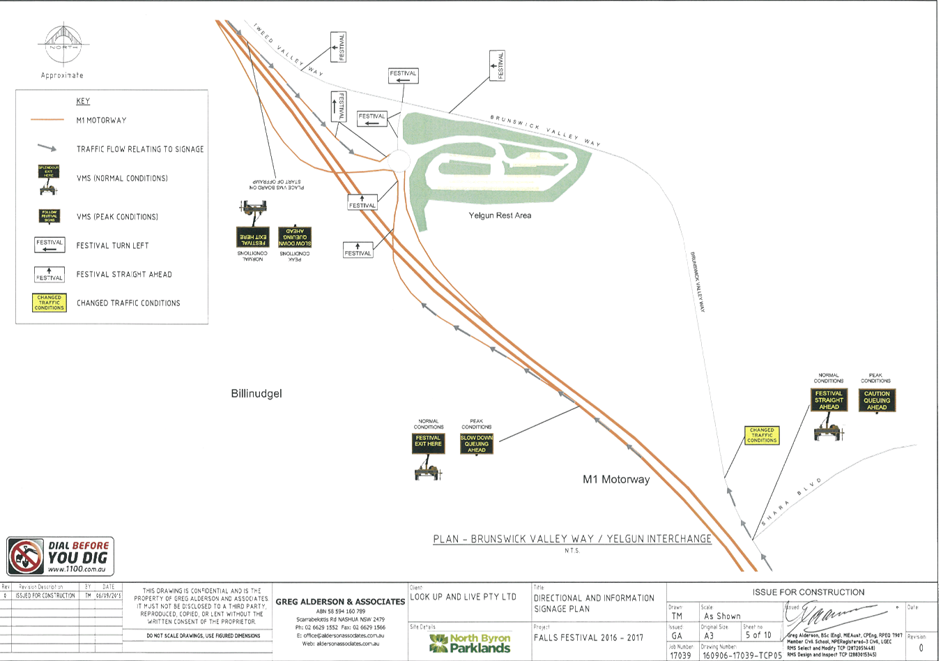
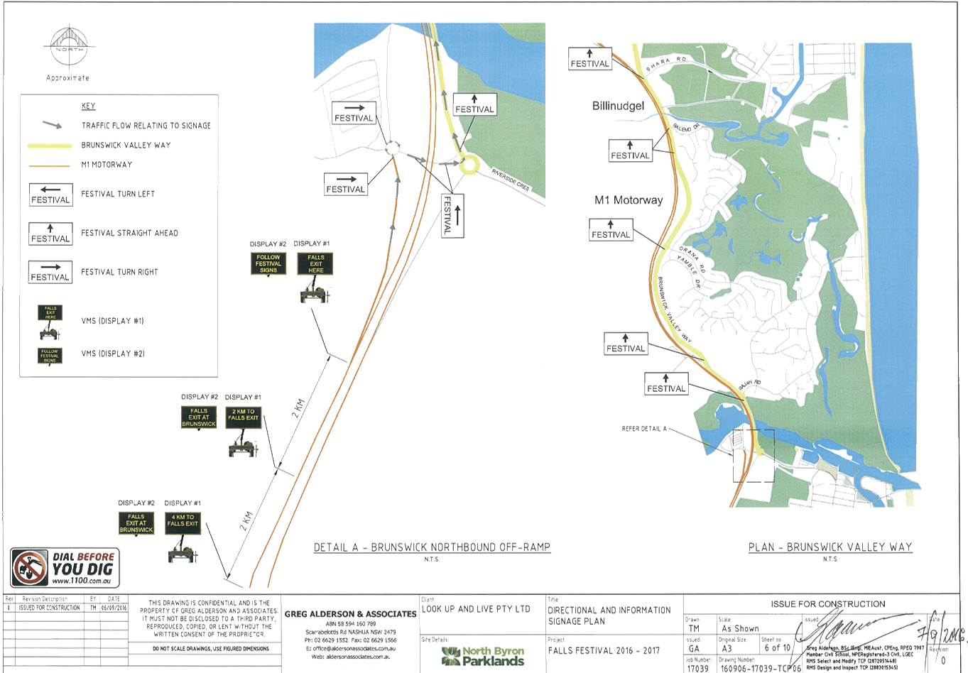
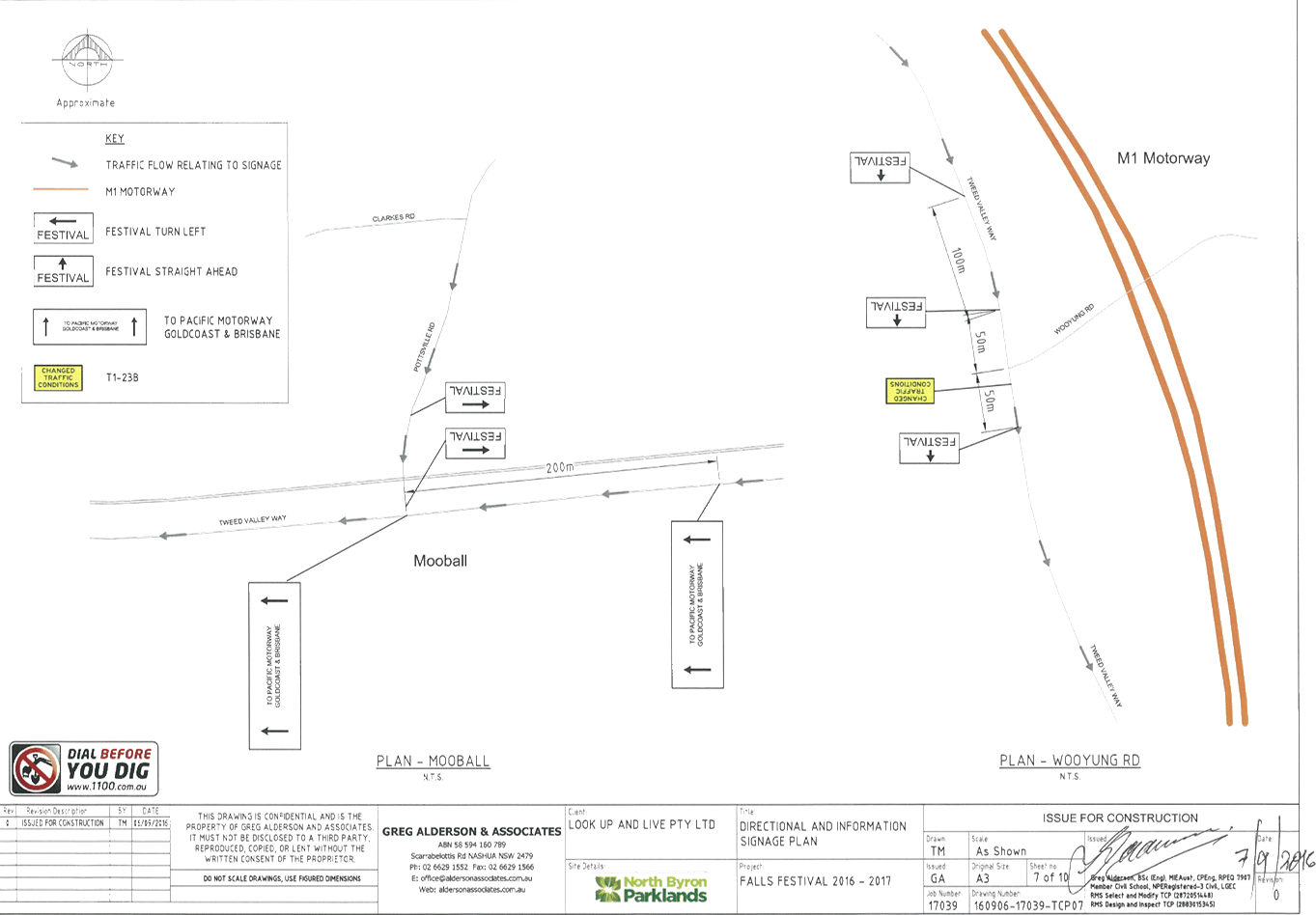
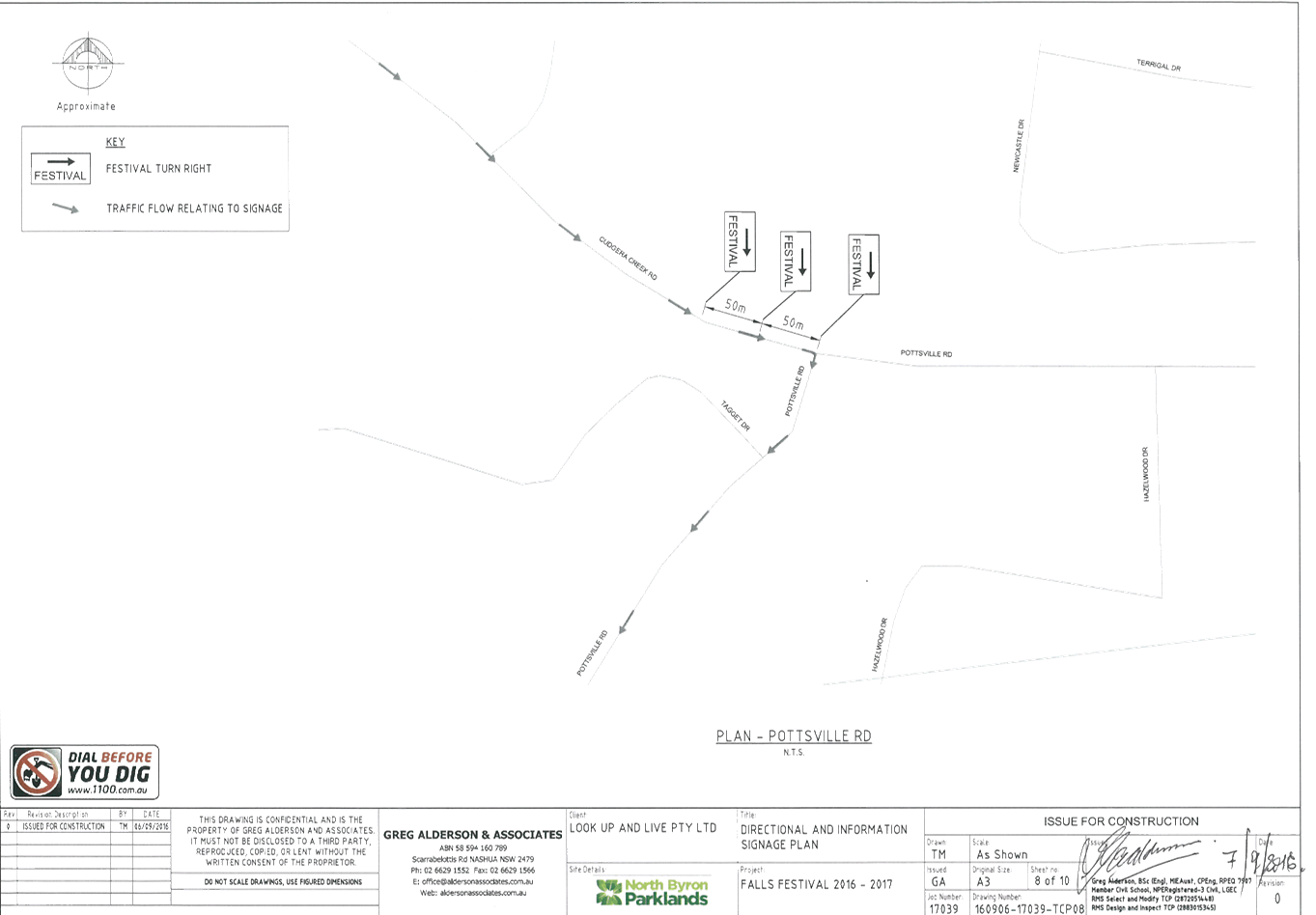
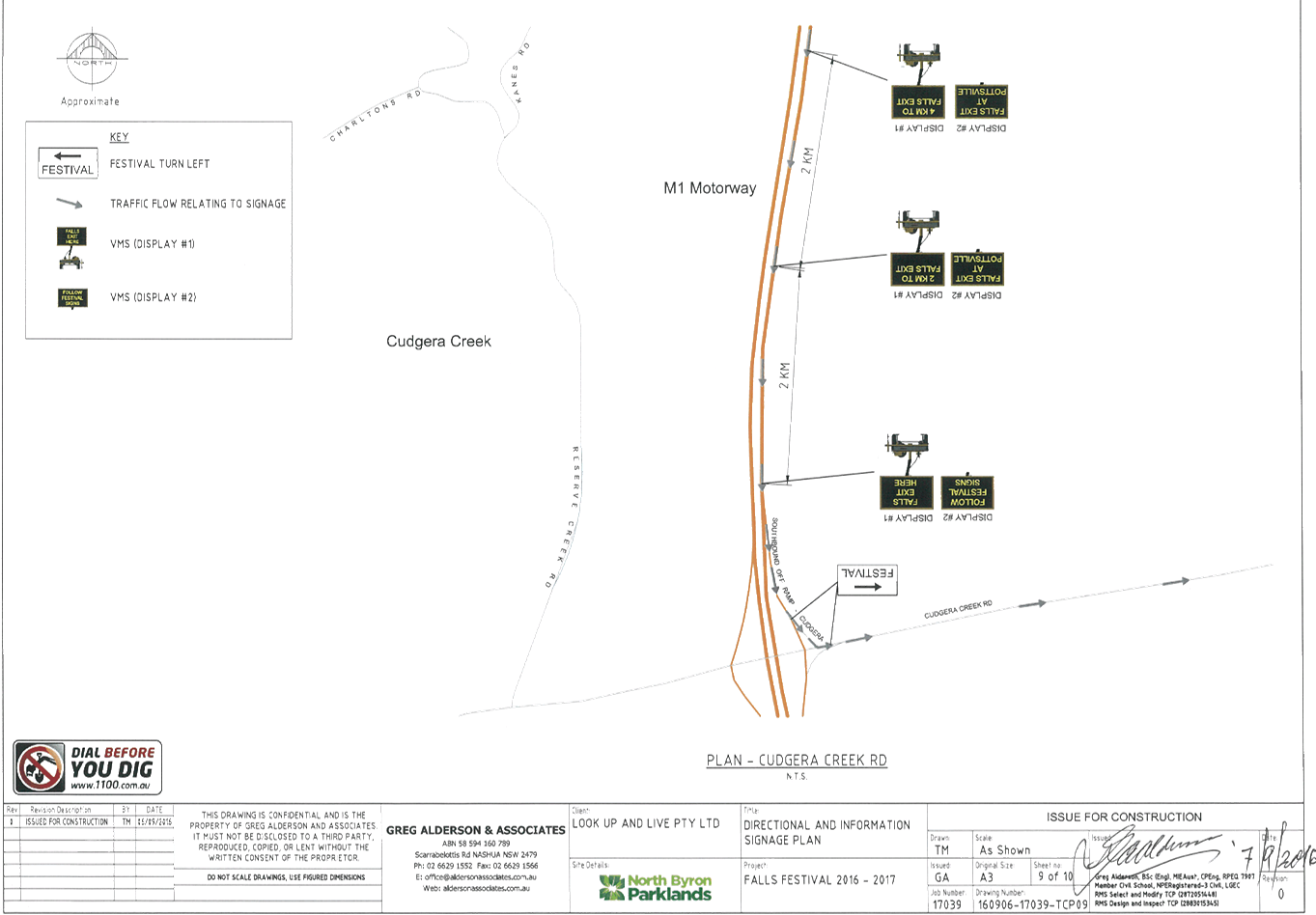
The TCP (Figure 1) is virtually the same as previous years,
with the exception of adding a few ‘changed traffic conditions/roadwork
ahead’ signs and the layout and presentation have been revised to add
clarity and include feedback from Roads and Maritime Services (RMS).
The Falls Festival was held at North Byron Parklands for the
first time during the 2013/14 New Year’s Eve period and held each year
since that date. According to the TMP all previous festivals have been a
success from a traffic engineering perspective with no congestion on the public
roads during peak arrival periods.
The anticipated maximum patronage for this event is 22,500
people with an additional 3,000 staff, stallholders, contractors and
guests. The majority of the patrons will be camping onsite for the
duration of the festival.
As part of the Falls Festival a number of additional
internal traffic and transport measures are proposed for the site at North
Byron Parklands including increased access to the major transit area.
Splendour 2016
Endorsement of Splendour 2016 was given, as detailed in
Resolution 16-208, with the condition that c) The event organiser: ix) ‘the
holding of an event debrief within the month following the festival which
includes but not limited to Council, RMS and Police.
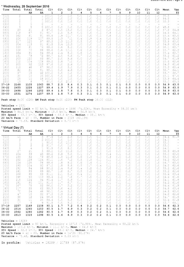
The Regulatory Working Group met on Wednesday 28 September
2016 to conduct an event debrief, as part of the traffic management summary it
was noted:
· The event did
experience a significant model shift in some day patron’s travel to and
from site reflected in a larger than normal number of people being dropped off
and collected;
· On Friday traffic
cameras and traffic controllers noted upwards of 800 vehicles entering the site
and dropping patrons off at Guest Services in the northern car park between 3pm
and 6pm;
· These same
vehicles returned between 10.30pm and midnight greatly impacting the ability
for buses to enter and depart the bus turnaround facility;
· This resulted in
long delays to transport patrons offsite;
· A meeting on
Saturday 23rd of July between the event, NSW Police, RMS and traffic
controllers resolved to move the drop-off/pick up zone to the southern car park
which dramatically improved traffic flows at the end of the show on this day;
· An additional
meeting was on Sunday 24th of July between the event, NSW Police, RMS and
traffic controllers where it was agreed to also move the taxi rank to the
southern car park;
· As a result of
these changes all traffic patterns were returned to normal on the Sunday
evening;
· Cr Cameron asked
about buses not being made available for normal day routes on Saturday.
The event advised that this was unlikely as the following day (Sunday)
wasn’t a school day. The event advised that to their knowledge
there were no impacts on bus services. Evidence of this claim would be
required to allow the event to investigate further.
Action 1 resulting from this meeting was that ‘Cr
Cameron to provide evidence of any such impacts on public day bus routes as he
reported to the RWG to allow Parklands to make further investigations’.
It was also noted during this meeting, whilst discussing
Falls Festival Byron 2016/17 Overview that ‘90% plus patrons’ camp
onsite which reduces day patron numbers’.
It is important to note that though both festivals (Splendour
& Falls Festival) utilise the same site location they are separate events.
Splendour consisted of 20,400 camping patrons and 12,100 day patrons whilst
Falls Festival is expecting 20,000 camping patrons and 2,500 day patrons.
It is noted that there were no traffic issues associated with bump-in of the
camping patrons at Splendour this year.
KEY ISSUES
1. Reduction
of service levels on Pacific Highway Interchange and Tweed Valley Way.
COUNCIL IMPLICATIONS
§ Budget/Financial
The event organisers have
paid the $120.00 relevant Approval of Road Events pursuant to s144 of the Roads
Act fee as per the Fees & Charges 2016/17.
§ Asset Management
Not applicable.
§ Policy or Regulation
Speed Limit (as
required) ROAD WORK (R4-212) - Delegated to council for authorisation in
conjunction with NSW Road Rules 21 and AS 1742.4 (Speed Controls) Clause 3.1.2,
AS 1742.3 (Roadworks).
§ Consultation
A condition of the
endorsement of this event is that the event organiser undertakes appropriate
consultation, including:
1. Advertising
the impact of the event in the local newspaper and on the Council website.
2. Informing
community and business that are directly impacted.
3. Liaising
with bus and taxi operators.
4. Consulting
with emergency services.
§ Legal and Risk Management
RMS advise is required
as this event impacts on the Pacific Highway.
Figure 1
– TCP concept
|
RECOMMENDATION:
That Council approve the Traffic Management Plan, which
includes Traffic Control Plans, for the Falls Festival 2016/17 to be held at
the North Byron Parklands site, Yelgun between Saturday 31 December 2016 and Monday
2 January 2017 inclusive, subject to the following conditions:
a. Separate
approvals by NSW Police and RMS being obtained;
b. Implementation
of the approved Traffic Management Plan and Traffic Control Plan by
those with appropriate RMS accreditation and the holding of current and
appropriate levels of insurance and liability cover;
c. The
approved event size being sufficient (20,000 patrons) to trigger use of the
south car park as per the DA Condition for its use;
d. The
temporary ‘No Stopping’ where applied, including on Brunswick
Valley Way (between Shara Boulevard and Tweed Valley Way) and on Tweed Valley
Way (between Brunswick Valley Way and Wooyong Road), is implemented prior to
the event and in accordance with relevant state requirements and Australian
Standards;
e. A
communications protocol be developed and maintained by those involved in the
implementation of traffic management including monitoring and ability to
implement contingency plans as and when directed;
f. Monitoring
of vehicle volumes that arrive and depart the festival site and on the local
road network;
g. The
holding of an event debrief within the month following the festival which
includes but not limited to Council, RMS and Police;
h. The
event organiser:
i. advertising
the impact of the event via a notice in the local weekly paper a minimum of
one week prior to the operational impacts taking effect, noting it must
include the event name, specifics of any traffic impacts or road closures and
times, alternative route arrangements, event organiser, a personal contact
name and a telephone number for all event related enquiries or complaints;
ii. providing
a copy of the advert for Council's web page;
iii. consideration
of any submissions received;
iv. informing
community and businesses that are directly impacted (eg adjacent to the
event) via written information which is delivered to the property in a timely
manner so as to document, consider and respond to any concerns raised;
v. arranging
for private property access and egress affected by the event;
vi. liaising
with bus and taxi operators and ensuring arrangements are made for provision
of services during conduct of the event;
vii. consulting
with emergency services and any identified issues be addressed;
viii. holding
$20m public liability insurance cover which is valid for the event.
ix. paying
of Council’s Road Event Application Fee prior to the event.
|
Attachments:
1 Falls
Festival - Cover Letter, E2016/89208
, page 12
2 Falls
Festival - Traffic Management Plan, E2016/89206
, page 13
3 Falls
Festival - Traffic Control Plan, E2016/89204
, page 49
4 Falls
Festival - Traffic Monitoring Program, E2016/89205
, page 59
5 Falls
Festival - Internal Traffic Management Guide, E2016/94584
, page 74
6 Splendour
- Debrief Draft Minutes from 28 September 2016, E2016/94583 , page 77
Regulatory Matters 6.2 - Attachment 1
Regulatory Matters 6.2 - Attachment 2


Regulatory Matters 6.2 - Attachment 2

Regulatory Matters 6.2 - Attachment 2


Regulatory Matters 6.2 - Attachment 3
Regulatory Matters 6.2 - Attachment 4
Regulatory Matters 6.2 - Attachment 5
Regulatory Matters 6.2 - Attachment 6
Local Traffic Committee Meeting 6.3
Report No. 6.3 Speed Review Request - Brunswick Valley Way and Shara Boulevard
Intersection, Billinudgel
File No: I2016/1093
SUMMARY
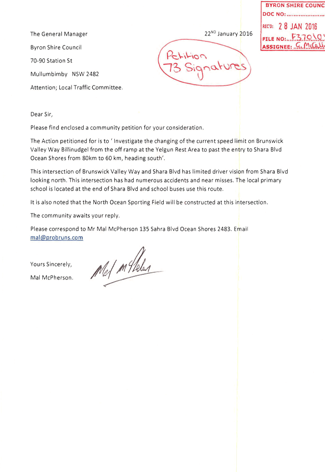
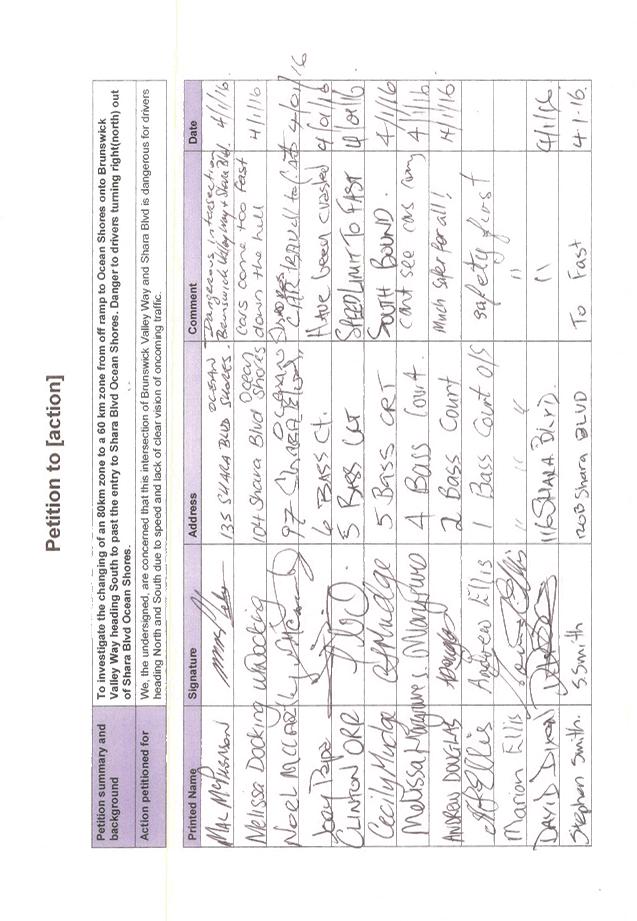
On 22 January 2016 Council received a community petition
(S2016/916) with 73 signatures requesting Council ‘investigate the
changing of the current speed limit on Brunswick Valley Way, Billinudgel from
the off ramp at the Yelgun Rest Area to past the entry to Shara Boulevard Ocean
Shores from 80km to 60km, heading south’.
The petition was tabled at Council’s Ordinary meeting
held on 4 February 2016 and subsequently considered by Council at its Ordinary
meeting held on 17 March 2016, which resulted in Resolution 16-105.
|
16-105
|
Resolved:
1. That
the petition regarding speed limit on Brunswick Valley Way Billinudgel
be noted.
2. That
the petition be referred to the Director Infrastructure Services.
|
OFFICER RECOMMENDATION
1. That
the committee agree that no further action is warranted in regards to a speed
zone review request.
2. The
installation of Sports Field Signs will make the driver aware of the reduced
speed nature of the intersection.
LINKAGE TO OUR COMMUNITY STRATEGIC PLAN
|
Theme
|
Community Infrastructure
|
Services and infrastructure
that sustains, connects and integrates our communities and environment.
|
|
Objective
|
CI3
|
Renew and maintain existing
infrastructure.
|
|
Strategy
|
CI3.1
|
Maintain roads and drainage in
a safe and operational condition.
|
|
Measures
|
CI3.A
|
Reduction in funding gap for infrastructure renewal and
maintenance.
|
BACKGROUND
The covering letter of the petition detailed the concerns of
residents in relation to the intersection of Brunswick Valley Way and Shara
Boulevard; in particular the lack of sight distance which has contributed to
the numerous accidents and near misses at this location. It was noted
that there is a primary school located at the end of Shara Boulevard resulting
in school buses regularly using this intersection and that the North Ocean
Shores Sporting Field (NOSSF) will be constructed at this intersection.
An investigation has been undertaken of the Brunswick Valley
Way and Shara Boulevard intersection at Billinudgel to determine if a speed
zone reduction from 80km/h to 60km/h speed is warranted. A site
investigation was carried out by Council Officers on the 17 May 2016 at 7:30am.
At this time the intersection, currently 80km/h, was found to be appropriate
and no issues were observed.
A review of crash data at this location was undertaken and
no common links were found between the incidents that could be related to the
design of the intersection.
KEY ISSUES
1. Increased
traffic from the new North Ocean Shores Sporting Field.
2. Potential
for sport equipment like balls to be kicked onto the road.
COUNCIL IMPLICATIONS
§ Budget/Financial
All signs and
accessories are to be installed by the NOSSF.
|
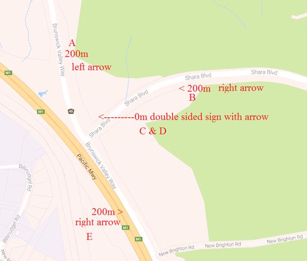
Table 1.1 -
Proposed sports field signs
|
|
Sign Location
|
Sign
|
RMS sign design
|
|
A
|
SPORTS FIELD TURN
LEFT 200m
|
G7-234(L)
|
|
B
|
SPORTS FIELD TURN
LEFT 200m
|
G7-234(L)
|
|
C
|
SPORTS FIELD (Right
arrow)
|
G7-233(R)
|
|
D
|
SPORTS FIELD (Left
arrow)
|
G7-233(L)
|
|
E
|
SPORTS FIELD TURN
RIGHT 200m
|
G7-234(R)
|
§ Asset Management
All signs and accessories are to
be maintained by the NOSSF.
§ Policy or Regulation
Speed Limit
Determination is not delegated to Council for authorisation.
§ Consultation
No consultation has
been carried out.
§ Legal and Risk Management
Not applicable.
Figure 1. Sketch of Sports Field Sign locations.
|
RECOMMENDATION:
1. That
Council note that a speed review of Brunswick Valley Way, Billinudgel is not
warranted at this time.
2. That
Council approves the installation of five sports field signs.
|
Attachments:
1 Excerpt of
Petition, E2016/9919 , page 91
Regulatory Matters 6.3 - Attachment 1
Local Traffic Committee Meeting 6.4
Report No. 6.4 24.2015.19.1 - Marine Parade, Byron Bay - Request for shared zone
approval by RMS
File No: I2016/1128
SUMMARY
At Ordinary Council meeting held 7 April 2016 Council
resolved 16-177 – ‘That in relation to the Marine Parade
Pedestrian and Traffic Impact Assessment Report a Shared Zone that provides
better vehicle speed regulation in a highly pedestrianized environment (Option
4) is endorsed’.
OFFICER RECOMMENDATION
A 100m Category 2 (Cat 2) shared zone with all relevant
signage should be approved on Marine Parade.
LINKAGE TO OUR COMMUNITY STRATEGIC PLAN
|
Theme
|
Infrastructure Services
|
Services and infrastructure
that sustains, connects and integrates our communities and environment.
|
|
Objective
|
CI1
|
Planning for the future.
|
|
Strategy
|
CI1.1
|
Provide a network of
accessible cycleways and walkways that link with public transport.
|
|
Measures
|
CI1.C
|
Increased pedestrian facilities within Byron Shire.
|
BACKGROUND
Council engaged the services of consultants to develop
options for the provision of a 2m wide pedestrian footpath in Marine Parade,
Wategos. The new footpath was required to link the existing footpath at the
western end of Marine Parade with the existing National Parks and Wildlife
Service (NPWS) footpath at the eastern end of Marine Parade to Cape Byron.
4 options developed include:
· Option 1 –
two-way traffic flow with parallel parking both sides where practicable.
· Option 2 –
One-way traffic flow with a mix of parallel and 45 degree parking on beach side
only
· Option 3 –
One-way traffic flow with a mix of parallel and 45 degree parking on beach side
whilst maintaining existing parallel parking on the residential side.
· Option 4 - Shared
zone that opens the beach promenade to Marine parade and provides additional
parking at the approach roads to Marine Parade.
The existing and additional parking spaces for each option
are shown in the table below:
|
Option
|
Traffic Flow
|
Existing
Parking #
|
Additional
Parking
|
Additional
Pedestrian Amenity
|
|
Option 1
|
Two Way
|
61
|
18
|
no
|
|
Option 2
|
One Way
|
61
|
24
|
no
|
|
Option 3
|
One Way
|
61
|
35
|
no
|
|
Option 4
|
Two way
Shared Zone
|
61
|
18
|
yes
|
# Between Pandanus Lane and Julian Place
The Local Traffic Committee (LTC) considered the options at
their meeting held 24 June 2015 and recommended:
RECOMMENDATION:
That Council supports the
Local Traffic Committee endorsement of either of the proposed one-way traffic
options for the beach front section of Marine Parade, Wategos from west to east
through to the intersection of Julian Place.
The resolution of Council at its
meeting on 16 July 2015 after consideration of the LTC recommendation above was
as follows:
Res 15-360
That this matter be deferred
until after further consultation with the Wategos residents and community at
large and a briefing to Councillors at a Strategic Planning Workshop regarding
the three options and the results of the any consultation.
A site meeting was held on 10
August 2015 and the main discussion points were:
· Keep “2-way
traffic” opposed to one way traffic
· Consider
“Shared Zone” alternative option, include landscape design and
minimal barrier fencing
· “Shared
Zone” could be an interim solution
· Preference for
pedestrian movement over parking spaces
· Look at traffic
flows and parking restrictions (time, no stopping, resident schemes, etc)
around entire loop.
· Improve signage to
reduce accidental visits to Wategos
National Parks & Wildlife
Service (NPWS)
· Prefer Option 2
keep “2-way traffic” opposed to one way traffic
· Retaining walls be
consistent with rock walls near picnic area
· Fencing be
consistent with NPWS Fence
· Concrete path be
consistent with existing
· Confirm road
boundary
· NPWS get approval
for fitness station
· Consider mobile
vendor station in road reserve
On the 07 April 2016 Council resolved to adopt a Shared Zone
in Marine Parade, Wategos as per 16-177.
|
16-177
|
Resolved:
1.
That in relation to the Marine Parade
Pedestrian and Traffic Impact Assessment Report a Shared Zone that provides
better vehicle speed regulation in a highly pedestrianized environment
(Option 4) is endorsed.
2.
That the resident group and the progress
association be consulted during the process
|
KEY ISSUES
1. Pedestrians
are currently walking up Marine Parade in the flow of traffic due to the
limited road width from the existing cliff face to the drop off into the ocean.
2. Lack
of width to construct dual travel lanes with a parallel parking bay with a
dedicated pedestrian access.
3. The
authorisation of a shared zone is not delegated to councils. Shared zones are
speed zones and approval to install them must be obtained from RMS.
COUNCIL IMPLICATIONS
§ Budget/Financial
Estimate is $0.00 as
this is a fully funded infrastructure services project.
§ Asset Management
Estimate is $0.00 as
this is a fully funded infrastructure services project.
§ Policy or Regulation
Shared Zones are not
delegated to Council under NSW Road Rules 24 and AS 1742.4.
Shared Zones must
comply with Safer Speeds Policy & Guidelines (July 2012) version 1.0 (SS/12/01)
§ Consultation
Initial consultation
has been carried out in April 2016. No further consultation has been carried
out.
§ Legal and Risk Management
In a 10km/h shared zone
Pedestrians have right of way over traffic.
|
RECOMMENDATION:
That the request for a 100m Category 2 (Cat 2) shared
zone with all relevant signage on Marine Parade, Byron Bay be referred to RMS
for approval.
|
Attachments:
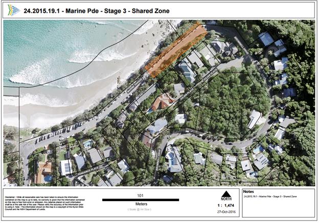
1 24.2015.19.1
- Marine Pde - Stage 3 - DWG2332-15 Shared Zone Line Marking and Signage Plan, E2016/95163 , page 97
Regulatory Matters 6.4 - Attachment 1
Local Traffic Committee Meeting 7.1
Matters for Traffic Engineering Advice
Report No. 7.1 Signage - Installation of No Stopping zones at Shearwater, The
Mullumbimby Steiner School - Left Bank Road, Mullumbimby
File No: I2016/1008
SUMMARY
On 27 June 2016 Council received correspondence
(E2016/51562) from Mr Greg Parkes, Head of School at Shearwater, The
Mullumbimby Steiner School (Shearwater). Mr Parkes raised a number of traffic
related concerns, in particular No Stopping signage adjacent to the School,
after an accident occurred on the 24 June 2016 where a student was run over.
Mr Parkes is requesting that a No Stopping zone (school
hours) be formed in front of properties 336 Left Bank Road through to 350 Left
Bank Road, that the existing No Stopping zone in front of the school be
extended 50m to the driveway of 327 Left Bank Road and that installation of
bollards be considered.
OFFICER RECOMMENDATION
1. No
Stopping Signs during school hours are installed as per Figure 1 (Background
Item 1).
2. Request
that parking enforcement be carried out on two separate occasions during school
hours. However, if the issues persists then the installation of bollards by
Shearwater can be reviewed (Background Item 4).
LINKAGE TO OUR COMMUNITY STRATEGIC PLAN
|
Theme
|
Community Infrastructure
|
Services and infrastructure
that sustains, connects and integrates our communities and environment.
|
|
Objective
|
CI3
|
Renew and maintain existing
infrastructure.
|
|
Strategy
|
CI3.1
|
Maintain roads and drainage in
a safe and operational condition.
|
|
Measures
|
CI3.A
|
Reduction in funding gap for infrastructure renewal and
maintenance.
|
BACKGROUND
On Friday 24 June 2016 a 10-year-old student was crossing
the road with her parents outside Shearwater when she got distracted and walked
into the path of a slow-moving turning bus. Following this incident Mr Parkes
contacted Council to discuss his traffic safety concerns, as follows:
1. On
Left Bank road, opposite to the schools car park and adjacent to the school
(towards the east) there are areas where cars can park on verge of Left Bank
Road. The school considers this practice dangerous. The school requests a
change to the signage to include 'no parking' areas on Left Bank road opposite
the school, as well continue the no stopping signs toward the east of the
school boundary. Currently parents of students at school park on the road due
to convenience. The school is currently extending the school car parking
facilities to include an additional 76 car park spaces. There will be no need
for people to park on the roadside verge.
TO BE ACTIONED - Refer to
Officer Recommendation within this report.
2. At
the entry to the school zone from each direction there is flashing 'school
zone' warning signs. During the current civil project to construct a new car
park, the 'flashing warning signs' have been removed as they are located where
the new 'turn in' lane has been constructed. The civil contractors will re
install the lights, however as the new parking area will extend the visible 'school
zone', the school is seeking advice on what department is responsible for
deciding the location of school zone so we can determine where they are to be
installed.
COMPLETED – This matter
has been forwarded to the Development Engineers in the Planning Team for
consideration as part of their final inspections relating to the recent
Development Application (DA) at the school, as the extension of the school zone
was a recommendation in the Traffic Impact Assessment report for this DA.
3. Some
months back we had a number of road side signs damaged by vandalism, the school
spoke to council who indicated that we are to keep the signs and they will be
part of a council project to re install them.
COMPLETED – Customer
Request was lodged (CRM 7521/2016) with the Council Works team to
repair/replace the vandalised signage.
4. Today
I raised another concern with regard the verge on Left bank road to the east of
the school. Currently, there is a no stopping sign that is ignored by parents,
as well there is further parking to the east on the road edge. This practice is
extremely dangerous and I wish to suggest a solution of bollards on the road
verge.
TO BE ACTIONED – Refer to
Officer Recommendation within this report.
In addition to Mr
Parkes’ correspondence Council has also had Mr Gary Hughes, Mullum Bus,
expressing his concern regarding ‘ongoing operational issues’ he
has providing ‘safe bus transport for all school community members of
Shearwater and local road traffic in the immediate school area’. Mr
Hughes’ correspondence reinforces Mr Parkes’ concerns.
A letter (S2016/12754) has
been received from the residents adjacent to the school detailing their traffic
safety concerns and advising that they support Mr Parkes in his requests for
increased signage in the school area.
KEY ISSUES
1. Vehicles
parking on Left Bank Road during school hours.
2. Students
crossing Left Bank Road during school hours in an uncontrolled manner.
3. Vehicles
blocking the sight distance on the exit to the school’s eastern car park exit.
4. Vandalism
of existing No Stopping signs - being removed from their footing and discarded
in nearby bushland.
COUNCIL IMPLICATIONS
§ Budget/Financial
Signage - 4
x R5-404 No Stopping (School Days)
2
x R5-400 No Stopping
Estimate
of $1,800.00 for all signs, posts, clips, traffic control, Council Works team
(1 day) and service location for the sign posts.
Bollards
- Estimate of $0.00 as Mr Parkes has
indicated that Shearwater would be agreeable to providing funding for the
installation of bollards.
§ Asset Management
Estimate of $600.00 for
6 signs at $10 per sign/year for an expected life of 10 years. Council will
need to maintain signage ongoing, including cleaning and replacement (if
necessary).
§ Policy or Regulation
Delegated to council
for authorisation in conjunction with NSW Road Rules 167 and AS1742.11 (Parking
Control).
§ Consultation
At present no
consultation has been carried out by Byron Shire Council, as a letter of
support from directly affected property owners has been received. All parties
involved will be advised of Councils decision relating to this matter.
§ Legal and Risk Management
Assuming a pedestrian
being hit by a vehicle sustaining a moderate injury in a 40km/h zone this could
cost the community an approximate annual cost value of $167,734.00. By removing
the parking issue we greatly reduce the risk of a pedestrian/vehicle
interaction.
Figure 1. Sketch of Proposed No Stopping signs recommended
for Left Bank Road.
Red line indicates proposed new No
Stopping zone and the yellow line indicates the proposed extension to the
current No Stopping zone. The blue section indicates the location of the proposed
bollards.
|
RECOMMENDATION:
1. That Council
a. approve the
installation of No Stopping zones between 336-350 Left Bank Road, Mullumbimby.
b. approve the
extension of the No Stopping zone for a 150m length, from the eastern corner
of 373 Left Bank Road, Mullumbimby to the driveway of 327 Left Bank Road, Mullumbimby.
2. That a request
be submitted to the Council Enforcement team for two separate patrols, during
school hours, of Left Bank Road, Mullumbimby adjacent to Shearwater, The
Mullumbimby Steiner School to ensure compliance with No Stopping zones.
3. That a review
be undertaken by Council Officers and Shearwater, The Mullumbimby Steiner
School within 3 months of the installation of, and extension to, No Stopping
zones (as detailed in Item 1 of this recommendation), at which time
consideration may be given to additional traffic control devices such as
bollards.
|
Local Traffic Committee Meeting 7.2
Report No. 7.2 Signage - Relocation of Bus Zone on Bayshore Drive, Byron Bay
including Installation of No Stopping and 30-minute Parking zones
File No: I2016/1098
SUMMARY
Council has had a number of complaints from businesses
regarding the location of the bus stop on the west side of Bayshore Drive and
the subsequent parking time limits in the area.
It has been requested that Council relocate the bus stop to
its original location and review the current parking time limits along the west
side of Bayshore Drive.
Note: The bus stop was relocated early this year after
consideration from the Local Traffic Committee (LTC) and subsequent Council
resolution 15-350. However, it appears that local business requirements
have changed and it seems resolution 15-350 is no longer appropriate for the
current circumstances.
OFFICER RECOMMENDATION
1. The
relocation of the bus stop (as demarcated by a single J-Pole) to approximately
77m north of the intersection.
2. The
installation of a No Stopping zone immediately south of the relocated bus stop,
between 62m and 77m north of the intersection.
3. The
installation of 30-minute parking time limit zone between 0m and 35m north of
the intersection, effective Monday to Friday 9am to 6pm and Saturday 9am to
12pm.
LINKAGE TO OUR COMMUNITY STRATEGIC PLAN
|
Theme
|
Infrastructure Services
|
Services and infrastructure
that sustains, connects and integrates our communities and environment.
|
|
Objective
|
CI1
|
Planning for the future.
|
|
Strategy
|
CI1.4
|
Plan for future traffic
demands.
|
|
Measures
|
CI1.A
|
Improved access to
destinations within Byron Shire.
|
BACKGROUND
After consideration at the LTC meeting held 24 June 2015 and
subsequent Council resolution 15-350, on 16 July 2015 Council resolved as
follows:
|
15-350
|
Resolved that Council adopt the
following Committee Recommendation:
1. That
‘No Stopping’ apply for a 15m length on the west side of
Bayshore Drive, north of Grevillea Street, Byron Bay.
2. That
‘No Parking’ be signed for the length of the bus stop,
which is to be demarcated by a single J-Pole, relocated south of its existing
site on the west side of Bayshore Drive to 30m north of Grevillea Street,
Byron Bay.
3. That
on the west side of Bayshore Drive, between 35m and 77m north of Grevillea
Street, Byron Bay a 1P time limit be signed as effective Monday to Friday 9am
to 6pm and Saturday 9am to 12.00 noon, conforming with such limits nearby.
4. That
consultation with all tenants with access to and from the west side of
Bayshore Drive (between Grevillea Street and Banksia Street) and those on
Banksia Drive (between Bayshore Drive and Acacia Street) be undertaken to
ascertain support of adopting such time limits.
|
Signage was installed on Monday 9
May 2016 as resolved in resolution 15-350. Due
to the time elapsed between the original consultation, Council resolving on the
matter and the installation of the signage it appears that local business
requirements have changed and it seems resolution 15-350 is no longer
appropriate for the current circumstances.
The matter has since been reviewed
and to improve access to the local business the following improvements are
recommended for the western side of Bayshore Drive, north of the intersection
of Centennial Circuit, Bayshore Drive and Grevillea Street (refer to Figure 1):
1. Relocation of the existing bus stop (yellow
square) back to the original location near the child care centre (red square)
located 77m north of the intersection.
2. ‘No Stopping’ to be extended
between 62m and 77m north of the intersection (yellow line) to allow easy of
access to the relocated bus stop.
3. 30-minute parking time limit be signed
between 0m and 35m north of the intersection (purple line), effective Monday to
Friday 9am to 6pm and Saturday 9am to 12pm.
It is noted that there will be no
change to the current 1P time limit between 35m and 62m north of the
intersection (red line), as previously resolved in Part 3 of resolution 15-350.
KEY ISSUES
1. Students
and pedestrians have raised issues about safely crossing Bayshore Drive at the
Byron Bay Bunnings roundabout.
2. When
the bus stops in the bus zone the vehicle overhangs into the travel lane
stopping traffic heading north. In the previous location there was a no parking
zone opposite the bus zone allowing for vehicles to safely pass.
3. Local
businesses do not have on street parking adjacent to their premises.
COUNCIL IMPLICATIONS
§ Budget/Financial
Estimate of $1,000.00
for all posts, Council Works team (1/2 day) and service location for the sign
posts.
§ Asset Management
Not applicable.
The 5 signs currently in place require new posts and relocation.
§ Policy or Regulation
Bus Zone (R5-20)
- Delegated to council for authorisation in conjunction with NSW Road Rules 183
and AS1742.11 (Parking Controls) Clauses 3.3.2(b), 3.3.3, 3.3.4 and 3.3.5.
No Stopping
(R5-400) - Delegated to council for authorisation in conjunction with NSW Road
Rules 167 and AS1742.11 (Parking Control).
30-minute
Parking (R5-12) - Delegated to council for authorisation in conjunction with
NSW Road Rules 204 and AS1742.11 (Parking) Clauses 3.3.2(a).
§ Consultation
Consultation has
been undertaken with the residents and business in Bayshore Drive immediately
adjacent the proposed relocation and improvements, as well as bus companies. A
consultation letter was sent on Friday 26 August 2016 regarding the above
proposal and advising that written submissions could be made to the Council by
close of business Tuesday 20 September 2016.
From this
consultation Council received one submission (E2016/81717) on Sunday 4
September that was in support of the proposed improvements.
§ Legal and Risk Management
A moderate injury caused
by a rear end accident could have an Annual Cost Value of $44,687.00. By moving
the bus zone into a wider location these potential incidents may be reduced.
Figure 1 – Proposed Relocation of Bus Stop
|
RECOMMENDATION:
That Council approve, on
the western side of Bayshore Drive, north of the intersection of Centennial
Circuit, Bayshore Drive and Grevillea Street:
a. the
relocation of the bus stop (as demarcated by a single J-Pole) to
approximately 77m north of the intersection.
b. the
installation of a No Stopping zone immediately south of the relocated
bus stop, between 62m and 77m north of the intersection.
c. the
installation of 30-minute parking time limit zone between 0m and 35m north of
the intersection, effective Monday to Friday 9am to 6pm and Saturday 9am to
12pm.
|
Attachments:
1 Submission
of Support from Brett Munro , E2016/87441
, page 106
Matters for Traffic Engineering Advice 7.2 - Attachment 1

Local Traffic Committee Meeting 7.3
Report No. 7.3 Request for Heavy Vehicle Restrictions - Granuaille Road &
Lismore Road, Bangalow
File No: I2016/1101
SUMMARY
Council continues to receive requests from residents
regarding the heavy vehicle restrictions along Granuaille Road and Lismore
Road, Bangalow.
Previous consideration from Council at Ordinary meeting held
17 September 2016 resulted in resolution 15-477 and 15-478.
It is requested that a meeting be scheduled between Byron
Shire Council and Roads & Maritime Service (RMS) to assess the nature of
the issues raised and determine an appropriate action plan.
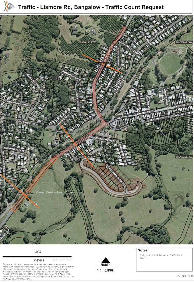
OFFICER RECOMMENDATION
1. Request
approval from RMS to carry out traffic counts on Granuaille Road and Lismore
Road at the 50km/h speed signs with a third traffic count near the domed
roundabout on Lismore Road.
2. Request
RMS to install two G9-291-1 signs: ‘REDUCE NOISE PLEASE LIMIT COMPRESSION
BRAKING IN RESIDENTIAL AREAS’.
3. Refer
the line marking and bus stop review and estimate to the Director of
Infrastructure Services.
LINKAGE TO OUR COMMUNITY STRATEGIC PLAN
|
Theme
|
Infrastructure Services
|
Services and infrastructure
that sustains, connects and integrates our communities and environment.
|
|
Objective
|
CI3
|
Renew and maintain existing
infrastructure.
|
|
Strategy
|
CI3.1
|
Maintain roads and drainage in
a safe and operational condition.
|
|
Measures
|
CI3.A
|
Reduction in funding gap for infrastructure renewal and
maintenance.
|
BACKGROUND
After consideration at the Local Traffic Committee (LTC) meeting
on 26 August 2015 and subsequent Council resolutions 15-477 & 15-478, on
the 17 September 2015 Council resolved as follows:
|
15-477
|
Resolved that
Council adopt the following Committee and Management Recommendation(s):
That Council:
1. note
the concerns raised by the Bangalow Progress Association regarding heavy
vehicle use, noise and speed, and traffic volumes in general.
2. note
that these concerns include amenity and safety on Route B62, the Bangalow to
Lismore route which uses Granuaille and Lismore Roads in Bangalow and the
domed roundabout at the top of Byron Street.
3. confirm
its previous opposition to signage that the RMS may place on the Pacific
Highway north of the Ewingsdale interchange for southbound traffic that
directs traffic to Lismore via Bangalow.
4. recommend
to the RMS that, if it wishes to proceed with the proposed assessment of such
signage, it be carried out only after completion of the T2E upgrade on the
basis that:
a) the
highway is fully operational, i.e. no road works or temporary speed limits
apply south of Ewingsdale Road and all associated road works are completed;
b) the
trial start with no signage for a period of at least three months; and
c) if
undertaken, the subsequent "with signage" part of the trial be for
the same time period.
5. note
that load limiting or restriction of general access vehicles (including heavy
vehicles such as trucks up to 19 metres, buses, etc) is only permissible on
roads where there is a road hazard or asset management issue.
6. note
that the RMS is preparing a "Corridor Strategy" which should
address speed, traffic volumes, heavy vehicle use, signage, etc.
7. seek
RMS advice and approval for signage in regard to heavy vehicle use and noise
reduction on Granuaille Road (eg compression braking).
|
|
15-478
|
Resolved that
Council:
1.
note the apparent increase in heavy vehicles
using Route 62 since the removal of the Binna Burra rail bridge.
2.
write to the NSW Premier, the NSW Minister for
Roads and the NSW Minister for Police reiterating the Bangalow community's
concerns and requesting the following actions by them for Granuaille and
Lismore Roads Bangalow:
a) Increased
police speed patrols on the Bangalow section of Route B62 plus frequent
mobile speed camera monitoring;
b) Prohibition
(and policing) of compression braking within Bangalow;
c) Expansion
of the 50kph speed zones in the town
(i)
to commence at the start of the divided road on
Bangalow Road, north of Bangalow with clear road markings and differentiation
[similar to that in Clunes] and
(ii)
to commence on Lismore Road between the industrial
estate and Rifle Range Road with the same road markings and differentiation;
d) Speed
activated warning signs 100m after the commencements of the 50kph zones and
speed cameras on both Granuaille and Lismore Roads;
e) A
40kph zone within 100 metres of the domed roundabout (similar to that now operating
on the Highway where it crosses the Bangalow to Byron Road);
f) Prohibition
of fuel and other hazardous through-freight on Route B62 because of the
dangers of overturning at the domed roundabout. The roundabout is
upslope of Bangalow’s CBD and a spill would have disastrous impacts on
health and on livelihoods;
g) Alternatively,
prohibition of fuel tankers with trailers, to minimise the danger of fire and
explosion due to the same issue;
h) Clearer
line marking and signage on the approach roads to the domed roundabout
including clearer lit roundabout signs, better marking of the roundabout
(with reflective markers) and clear give-way markings;
i) Clear
advisory school bus-stop signage on Lismore Road at its junction with Rifle
Range Road.
|
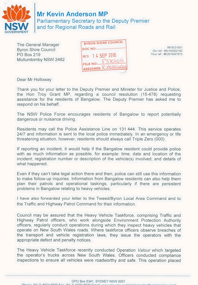
As per Item 2 of Resolution 15-478, on 29 July 2016 letters
were sent to NSW Premier (E2016/67965), the NSW Minister for Roads
(E2016/67969) and the NSW Minister for Police (E2016/67973). Responses have
been received and key points highlighted below. Full letters have been attached
for consideration.
Letter from Mr Kevin Anderson MP, Parliamentary Secretary to
the Deputy Premier and for Regional Roads and Rail (S2016/12109):
“I have also forwarded your letter to the
Tweed/Byron Local Area Command and to the Traffic and Highway Patrol Command
for their information”.
“Council may be assured that the Heavy Vehicle
Taskforce, comprising Traffic and Highway Patrol officers, who work alongside
Environment Protection Authority officers, regularly conduct operations during
which they inspect heavy vehicles that operate on New South Wales roads. Where
taskforce officers observe breaches of the transport and vehicle registration
laws, they issue the operators with the appropriate defect and penalty
notice”.
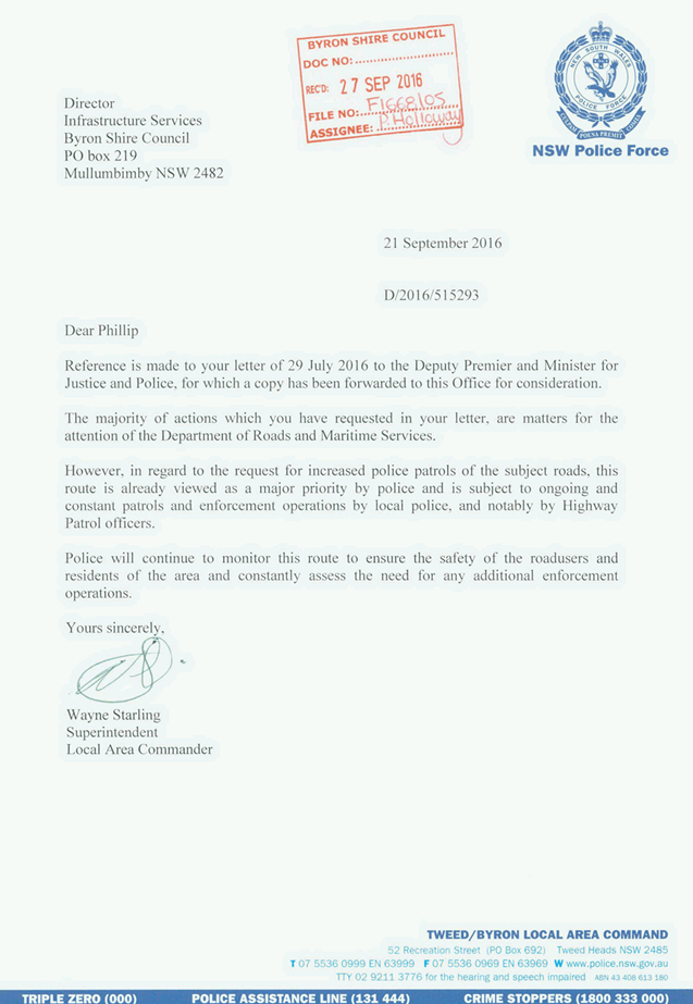
Letter from Mr Wayne Starling, Superintendent Local Area
Commander, Tweed/Byron Local Area Command, NSW Police Force (S2016/12543):
“However, in regard to the request for increased
police patrols of the subject roads, this route is already viewed as a major
priority by police and is subject to ongoing and constant patrols and
enforcement operations by local police, and notably by Highway Patrol
officers”.
“Police will continue to monitor this route to
ensure the safety of the road users and residents of the area and constantly
assess the need for any additional enforcement operations”.
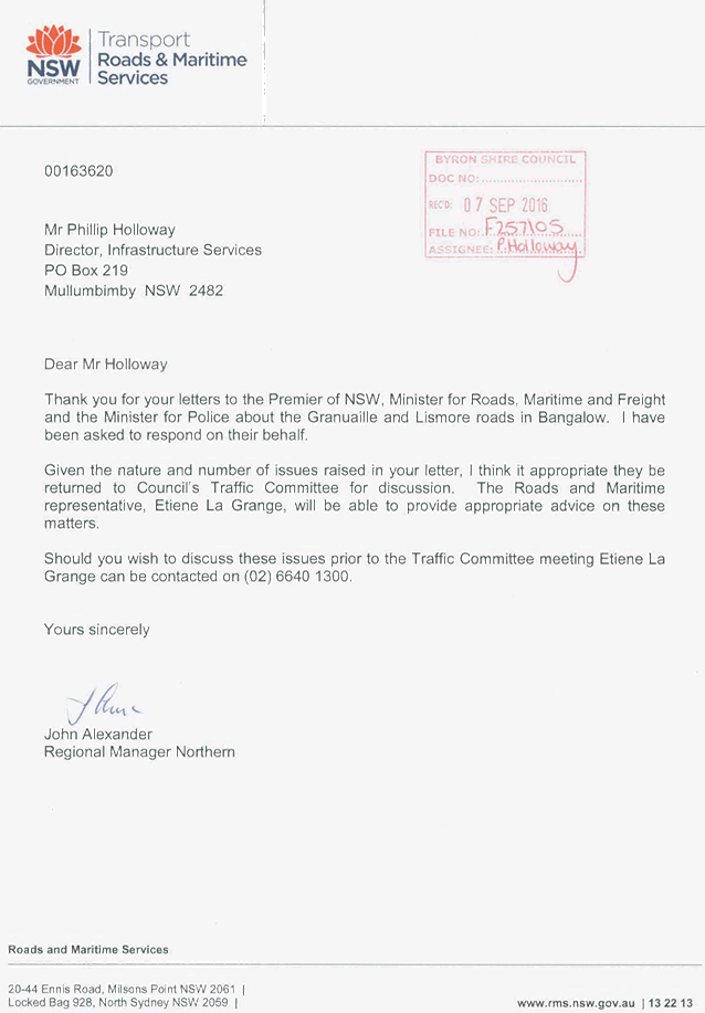
Letter from Mr John Alexander, Regional Manager Northern,
Roads & Maritime Services (S2016/11790):
“Given the nature and number of issues raised in
your letter, I think it appropriate they be returned to Council's Traffic
Committee for discussion. The Roads and Maritime representative, Etiene La
Grange, will be able to provide appropriate advice on these matters”.
On 4 October 2016, RMS Senior Network & Safety Officer,
Mr Etiene La Grange, requested that the above matter be raised at the next
Local Traffic Committee for discussion and that a meeting between RMS and Byron
Shire Council be scheduled to assess the nature of the issues raised and
determine an appropriate action plan.
KEY ISSUES
|
Table 1. Potential issues and suggested
corrective actions
|
|
Potential Issue
|
Authority
|
Suggested corrective actions
|
|
1
|
Increased police speed patrols
on the Bangalow section of Route B62 plus frequent mobile speed camera
monitoring
|
BSC
|
· Request approval from RMS to carry out three Traffic
Counts on these RMS controlled roads to determine if vehicles are exceeding
the speed limit.
· Then engineering solutions or a request for a speed
review can be carried out.
|
|
2
|
Prohibition (and policing)
of compression braking within Bangalow
|
BSC
|
· No government authority has delegated authority to
prohibit the use of a Heavy Vehicle Engine Brakes in NSW.
· Request RMS to install two G9-291-1 signs:
‘REDUCE NOISE PLEASE LIMIT COMPRESSION BRAKING IN RESIDENTIAL
AREAS’.
|
3
|
Expansion of the 50kph
speed zones in the town to commence at the start of the divided road on
Bangalow Road, north of Bangalow with clear road markings and differentiation
[similar to that in Clunes]
|
RMS
|
· Request approval from RMS to carry out three Traffic
Counts on these RMS controlled roads to determine if vehicles are exceeding
the speed limit.
· Then engineering solutions or a request for a speed
review can be carried out.
|
|
4
|
Expansion of the 50kph
speed zones in the town to commence on Lismore Road between the industrial
estate and Rifle Range Road with the same road markings and differentiation;
|
BSC
|
· Request approval from RMS to carry out three Traffic
Counts on these RMS controlled roads to determine if vehicles are exceeding
the speed limit.
· Then engineering solutions or a request for a speed
review can be carried out.
|
|
5
|
Speed activated warning signs
100m after the commencements of the 50kph zones
|
BSC
|
· Request approval from RMS to carry out three Traffic
Counts on these RMS controlled roads to determine if vehicles are exceeding
the speed limit.
· Then engineering solutions or a request for a speed
review can be carried out.
· Signs expected to cost more than $17,000 each with
installation and may not be warranted.
|
|
6
|
Speed cameras on both
Granuaille and Lismore Roads;
|
BSC
|
· Request approval from RMS to carry out three Traffic
Counts on these RMS controlled roads to determine if vehicles are exceeding
the speed limit.
· Provide traffic counts and crash data to Transport
NSW and request a speed camera review.
|
|
6
|
A 40kph zone within 100
metres of the domed roundabout (similar to that now operating on the Highway
where it crosses the Bangalow to Byron Road);
|
BSC
|
· Request approval from RMS to carry out three Traffic
Counts on these RMS controlled roads to determine if vehicles are exceeding
the speed limit.
· Then engineering solutions or a request for a speed
review can be carried out.
|
|
7
|
Prohibition of fuel and
other hazardous through-freight on Route B62 because of the dangers of
overturning at the domed roundabout. The roundabout is upslope of
Bangalow’s CBD and a spill would have disastrous impacts on health and
on livelihoods;
|
RMS
|
· Route B62 is the RMS designated Heavy Vehicle Route
established after the completion of the Tintenbar to Ewingsdale Project. No
action required.
|
|
8
|
Alternatively, prohibition
of fuel tankers with trailers, to minimise the danger of fire and explosion
due to the same issue;
|
RMS
|
· Route B62 is the RMS designated Heavy Vehicle Route
established after the completion of the Tintenbar to Ewingsdale Project. No
action required.
|
|
9
|
Clearer line marking and
signage on the approach roads to the domed roundabout including clearer lit
roundabout signs, better marking of the roundabout (with reflective markers)
and clear give-way markings;
|
BSC
|
· Review the roundabout and estimate the cost of the
works.
|
|
10
|
Clear advisory school
bus-stop signage on Lismore Road at its junction with Rifle Range Road.
|
BSC
|
· Review the current bus stop and estimate the cost of
the works.
|
COUNCIL IMPLICATIONS
§ Budget/Financial
Estimate of $4,000.00
to carry out three traffic counts with traffic control and conduct a review of
the roundabout and bus stop.
§ Asset Management
Granuaille Road and
Lismore Road are both RMS controlled assets.
§ Policy or Regulation
Council has no authority
to carry out any works on the RMS controlled assets.
§ Consultation
No consultation has been
carried out at this time.
§ Legal and Risk Management
Council has no
authority to carry out any works on the RMS controlled assets.
|
RECOMMENDATION:
1. That
Council request approval from RMS to carry out traffic counts on Granuaille
Road and Lismore Road, at the 50km/h speed signs with a third traffic count
near the domed roundabout on Lismore Road.
2. That
Council request RMS install two G9-291-1 (REDUCE NOISE PLEASE LIMIT COMPRESSION
BRAKING IN RESIDENTIAL AREAS) signs; one on Granuaille Road and one on
Lismore Road.
3. The
matter of the line marking and bus stop review and estimate be referred to
the Director of Infrastructure Services.
|
Attachments:
1 Letter
from Mr Kevin Anderson MP, Parliamentary Secretary to the Deputy Premier and
for Regional Roads and Rail, S2016/12109
, page 114
2 Letter
from Mr Wayne Starling, Superintendent Local Area Commander, Tweed/Byron Local
Area Command, NSW Police Force, S2016/12543
, page 116
3 Letter
from Mr John Alexander, Regional Manager Northern, Roads & Maritime
Services, S2016/11790 , page 117
4 Traffic -
Lismore Rd, Bangalow - Traffic Count Request, E2016/95115
, page 118
Matters for Traffic Engineering Advice 7.3 - Attachment 1

Matters for Traffic Engineering Advice 7.3 - Attachment 2
Matters for Traffic Engineering Advice 7.3 - Attachment 3
Matters for Traffic Engineering Advice 7.3 - Attachment 4
Local Traffic Committee Meeting 7.4
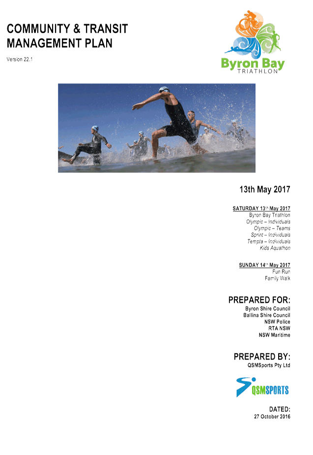
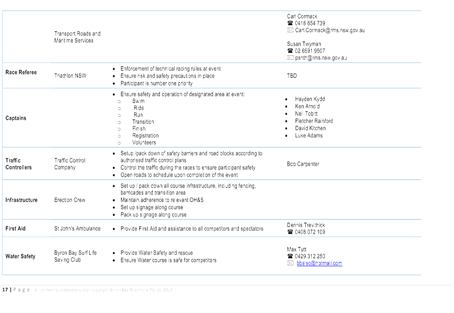
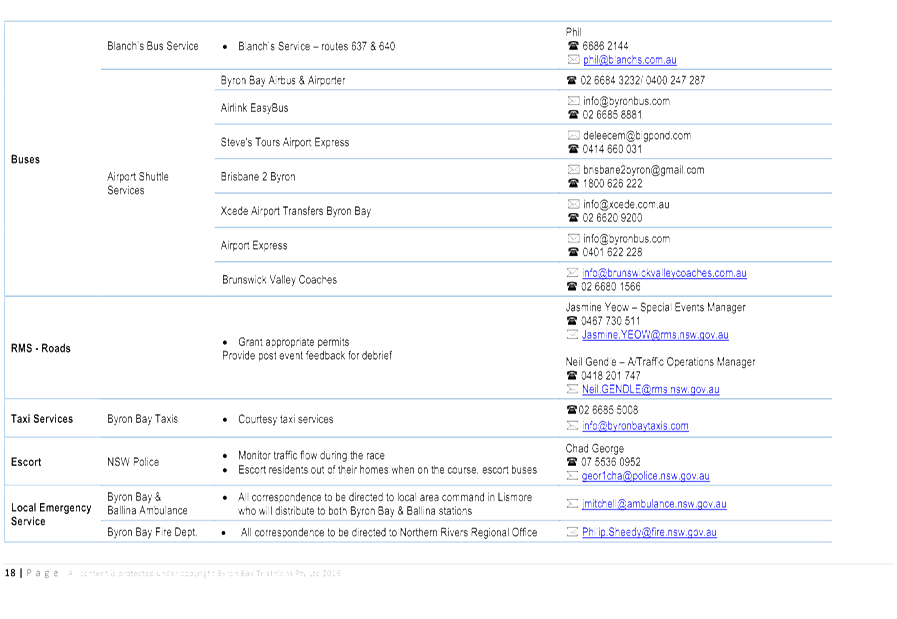
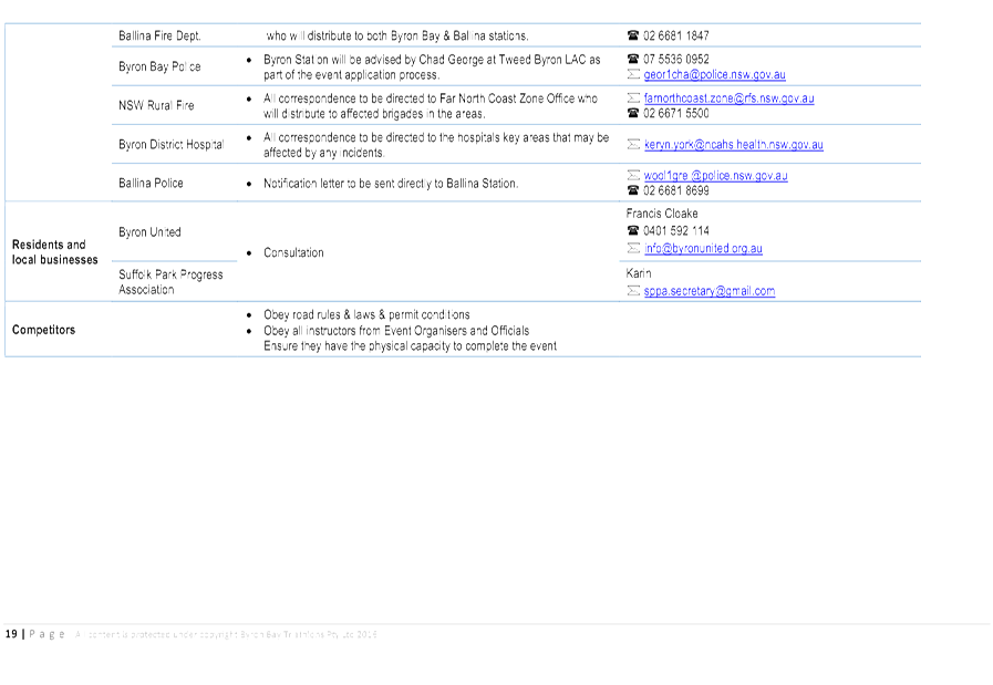
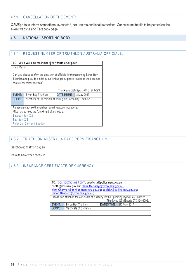
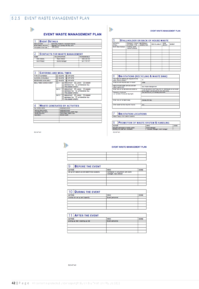
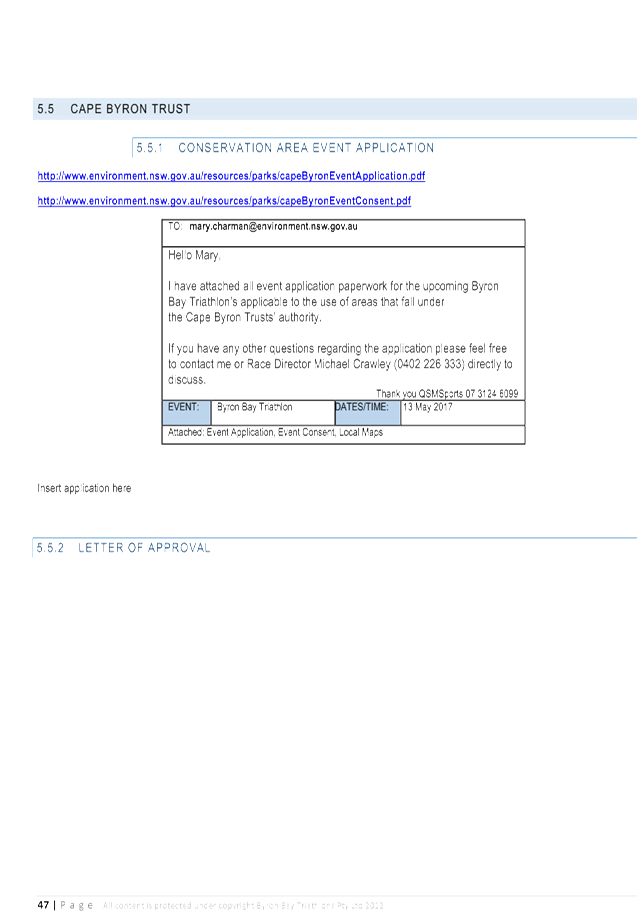
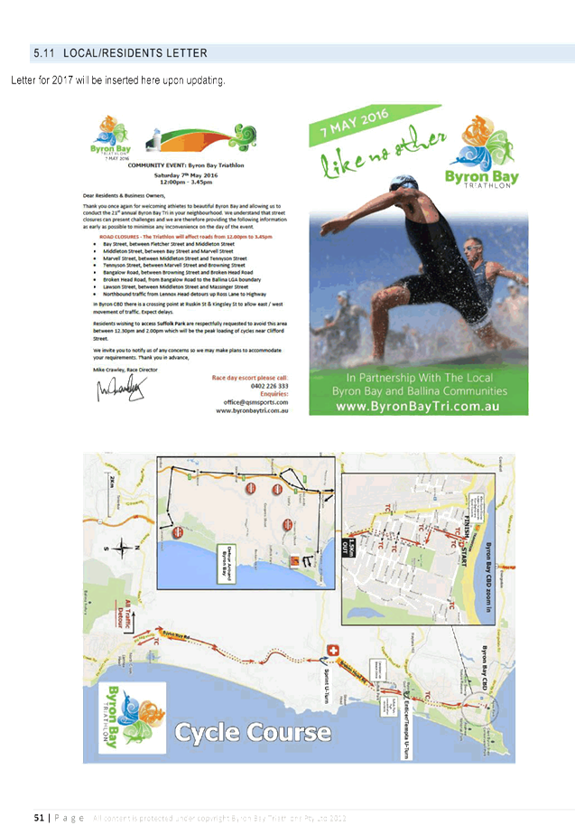
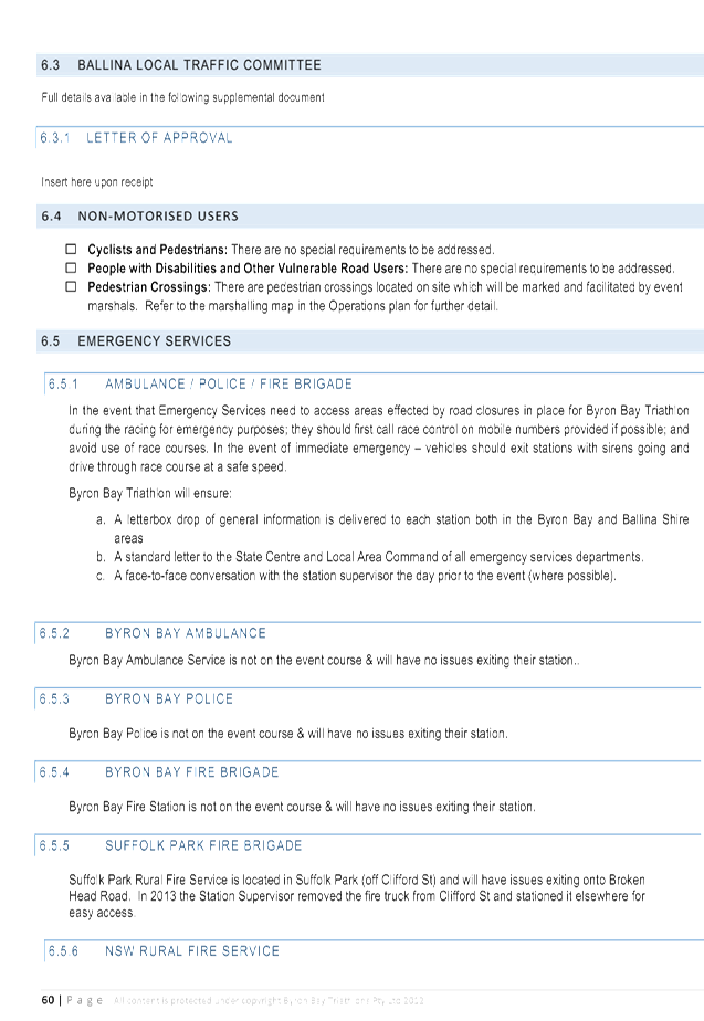
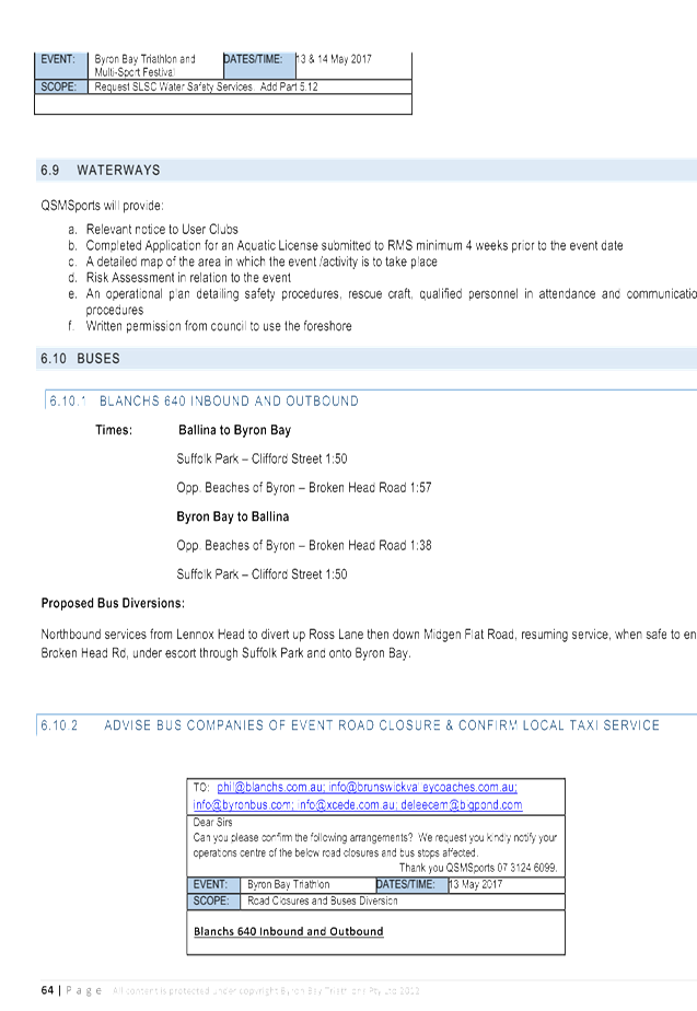
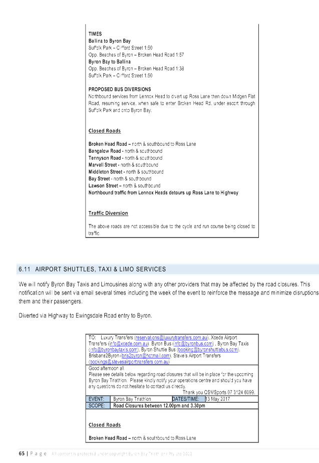
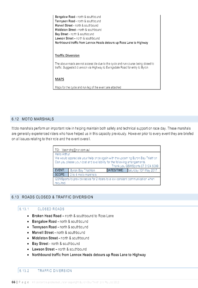
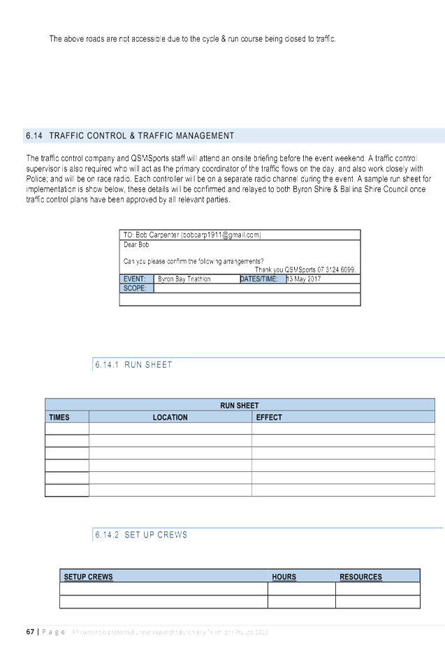
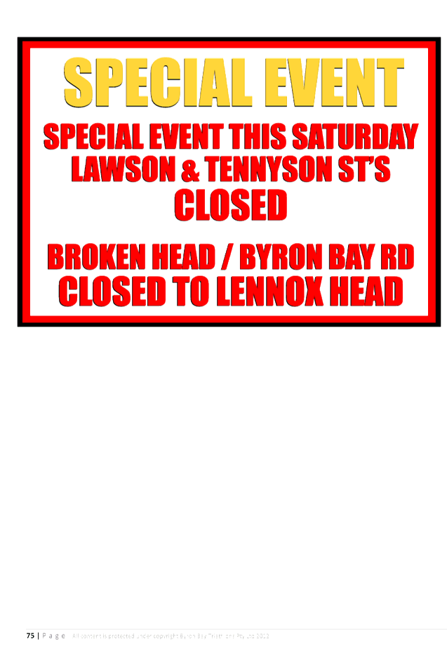
Report No. 7.4 Event - Byron Bay Triathlon 2017
File No: I2016/1125
SUMMARY
Council has received a request from QSM Sports for the Local
Traffic Committee (LTC) to consider the proposal for the Byron Bay Triathlon to
be held in Byron Bay on Saturday 13 May 2017.
The Byron Bay Triathlon has been running for over twenty
years. However a number of concerns have been highlighted as a result of
the event held in 2016, in particular the risks associated with the proximity
of athletes and vehicles.
In light of the concerns raised the event organisers are
requesting assistance from the LTC with their planning of the traffic
management for the 2017 event and have provided the attached Local Management
Committee Proposal for review and feedback.
OFFICER RECOMMENDATION
That the Committee comments be provided to the Planning
team.
Traffic Engineer comments:
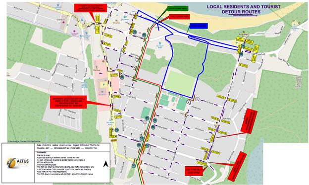
1. Traffic
control be placed on the following intersections to allow vehicles to move
East/West direction during breaks in the participants
· Ruskin Street /
· Lawson Street /
Middleton Street intersection
2. Considered
one lane traffic from Suffolk Park to Bangalow Road to relieve the traffic
pressure.
3. The
applicant supplies a Traffic Management Plan as per the RMS requirements with
associated TCP’s.
LINKAGE TO OUR COMMUNITY STRATEGIC PLAN
|
Theme
|
Economy
|
A sustainable and diverse
economy which provides innovative employment and investment opportunities in
harmony with our ecological and social aims.
|
|
Objective
|
EC1
|
A diverse economic base and
support for local businesses.
|
|
Strategy
|
EC1.4
|
Support sporting and cultural
events in Byron Shire.
|
|
Measures
|
EC1.B
|
Increase the sustainability of events in which Council is
involved.
|
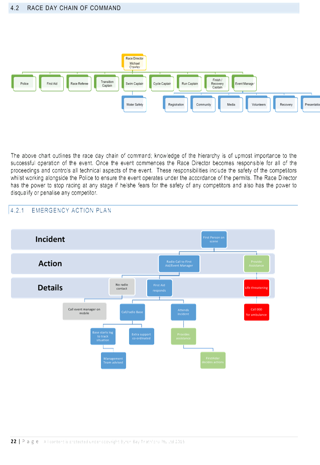
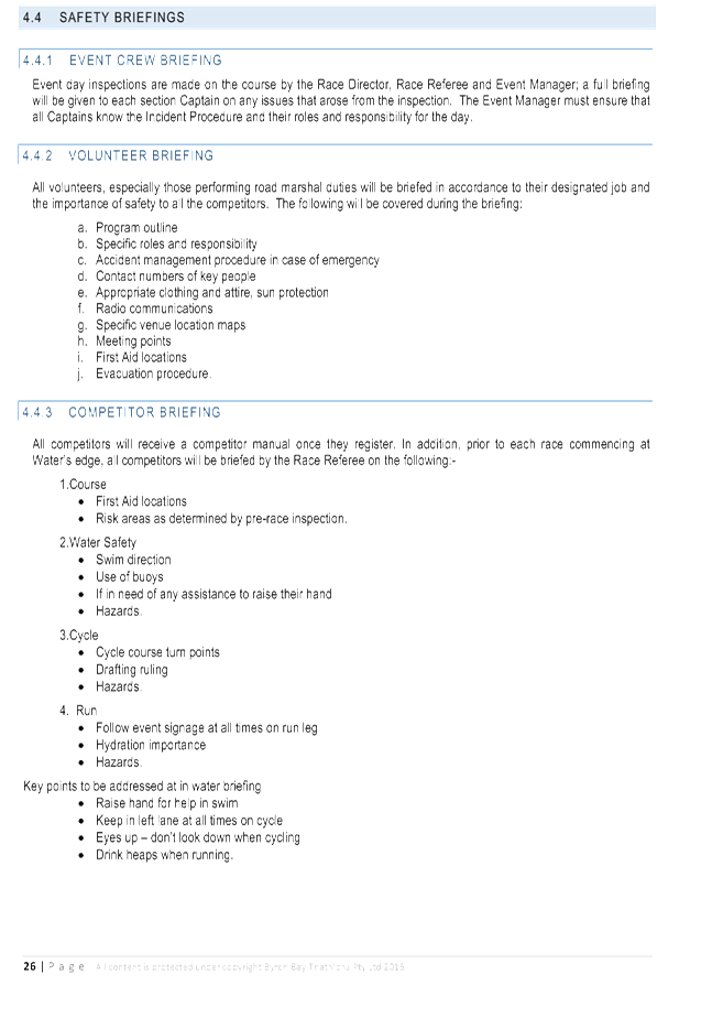
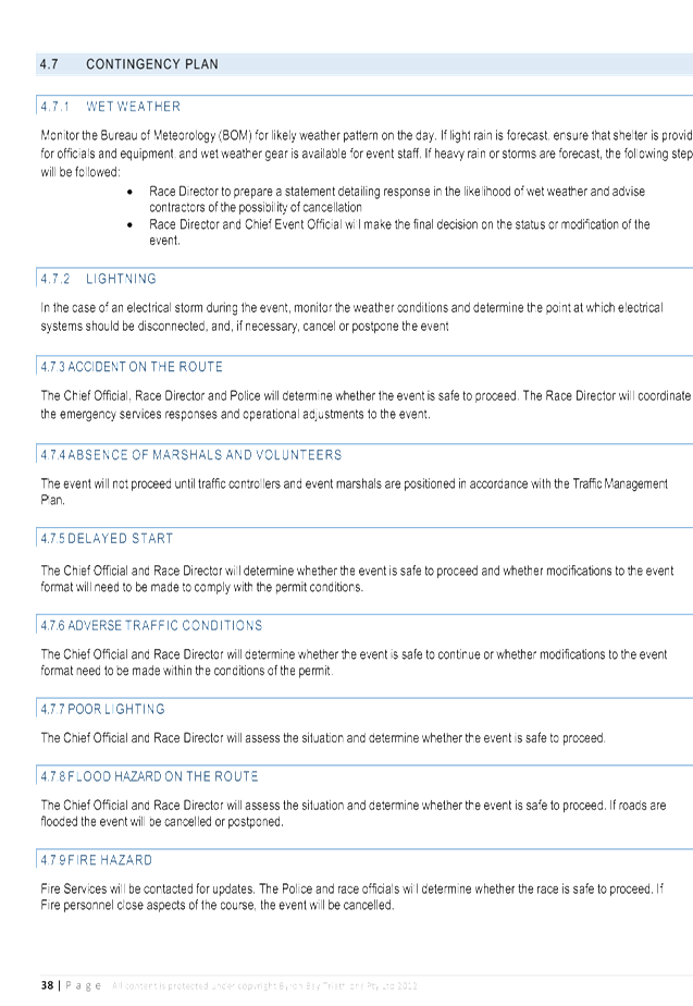
BACKGROUND
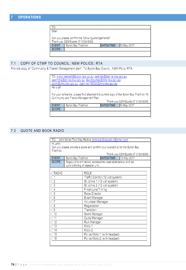
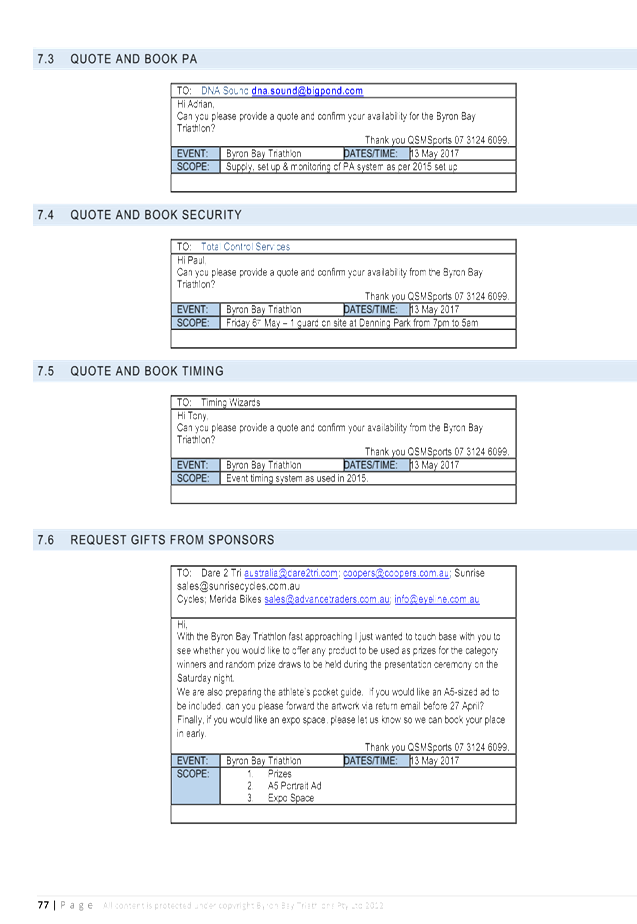
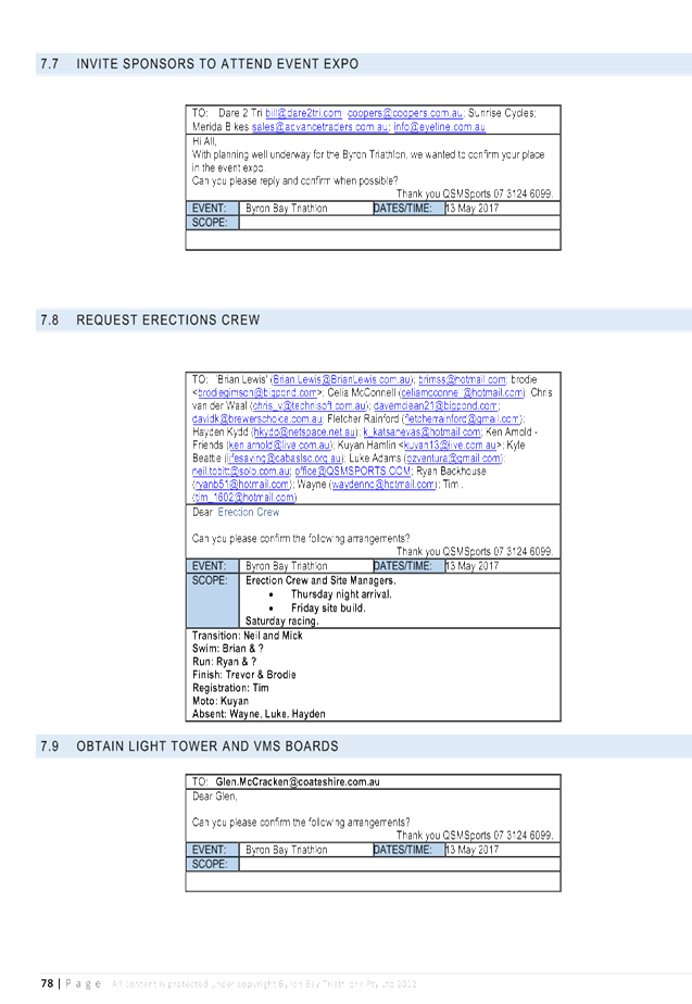
Council has received a request from QSM Sports for the LTC
to consider the proposal for the Byron Bay Triathlon to be held in Byron Bay on
Saturday 13 May 2017. A Community & Transit Management Plan has been
submitted along with the debrief notes from the 2016 event. Both
documents have been attached for review.
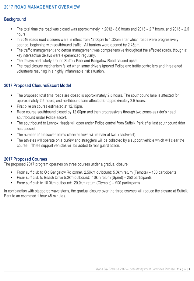
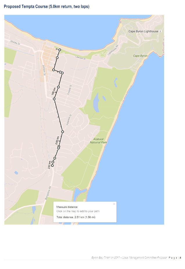
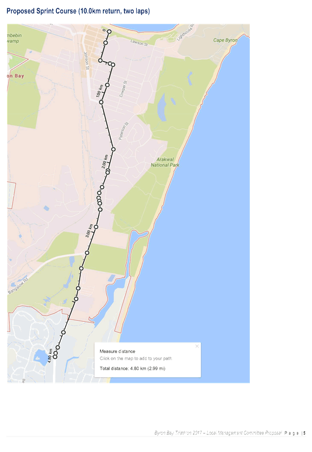
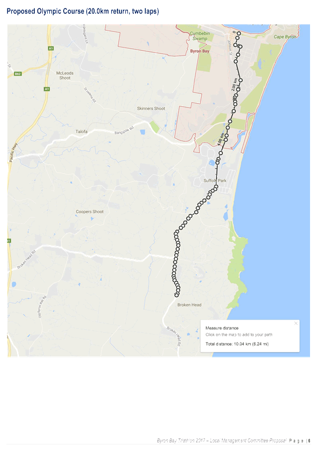
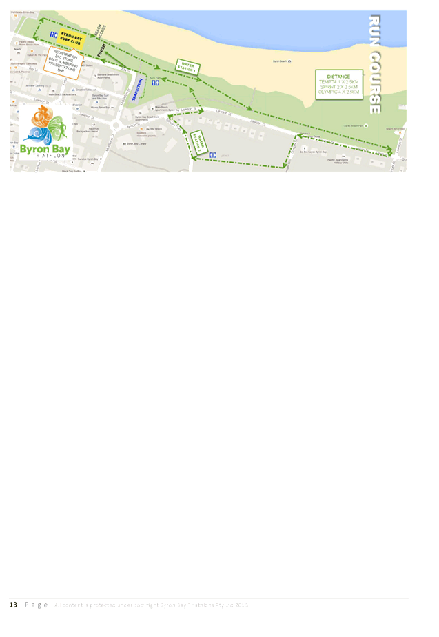
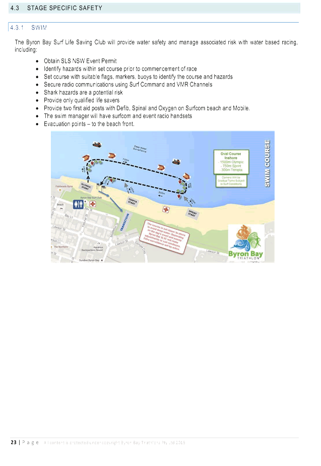
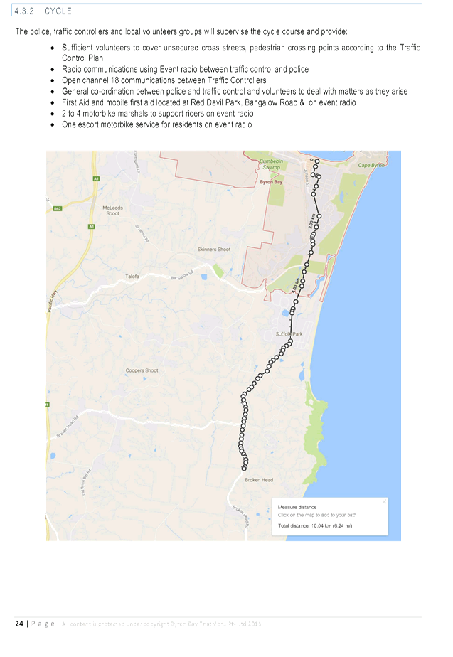
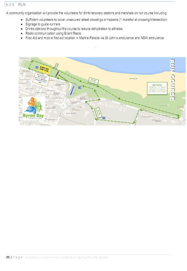
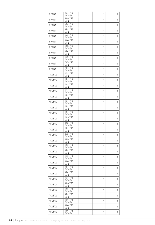
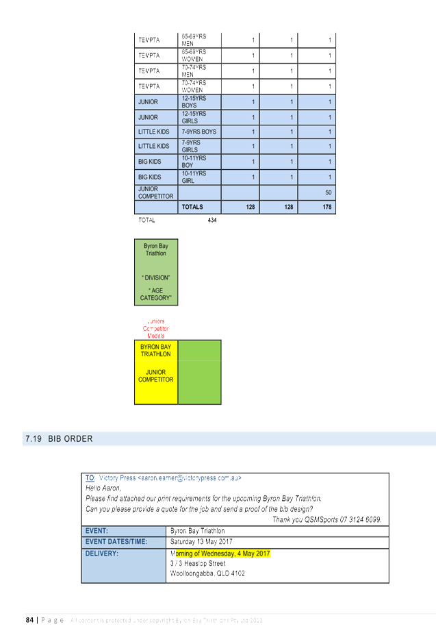
The proposed courses for the 2017 event stages are as
follows:
1. From
Byron Bay surf club to Old Bangalow Road corner, 2.5km outbound, 5km return
(Tempta) – 100 participants.
2. From
surf club to Beach Drive, 5km outbound, 10km return (Sprint) – 250 participants.
3. From
surf club to 10km outbound, 20km return (Olympic) – 900 participants.
In combination with staggered wave starts, the gradual
closure over the three courses will reduce the closure at Suffolk Park to an
estimated 1 hour 45 minutes. The athletes will operate on a curfew and
stragglers will be collected by a support vehicle which will clear the course.
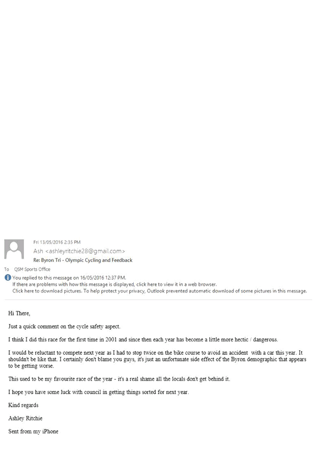
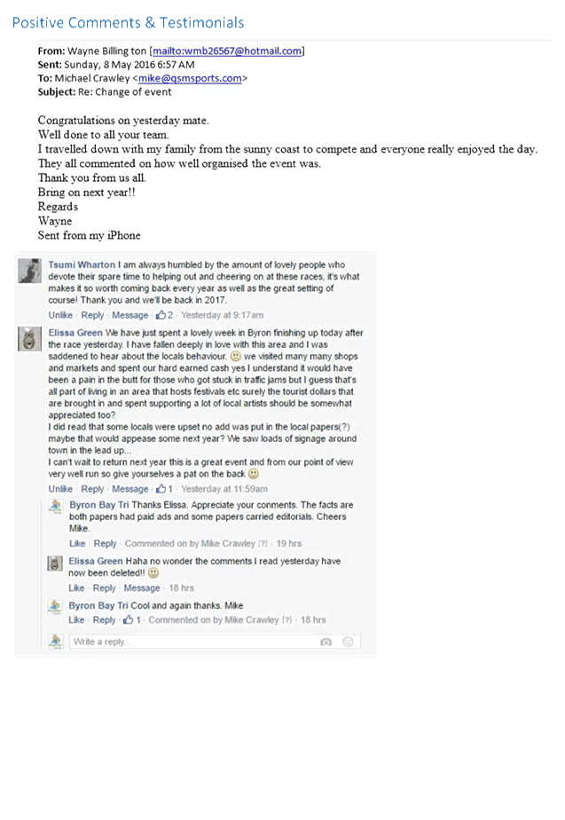
The Byron Bay Triathlon has been running for over twenty
years. However a number of concerns have been highlighted as a result of the
event held in 2016, in particular the risks associated with the proximity of
athletes and vehicles.
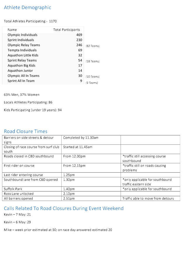
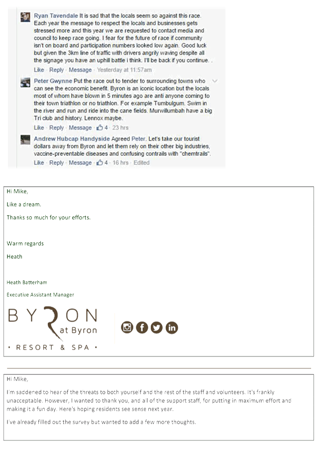
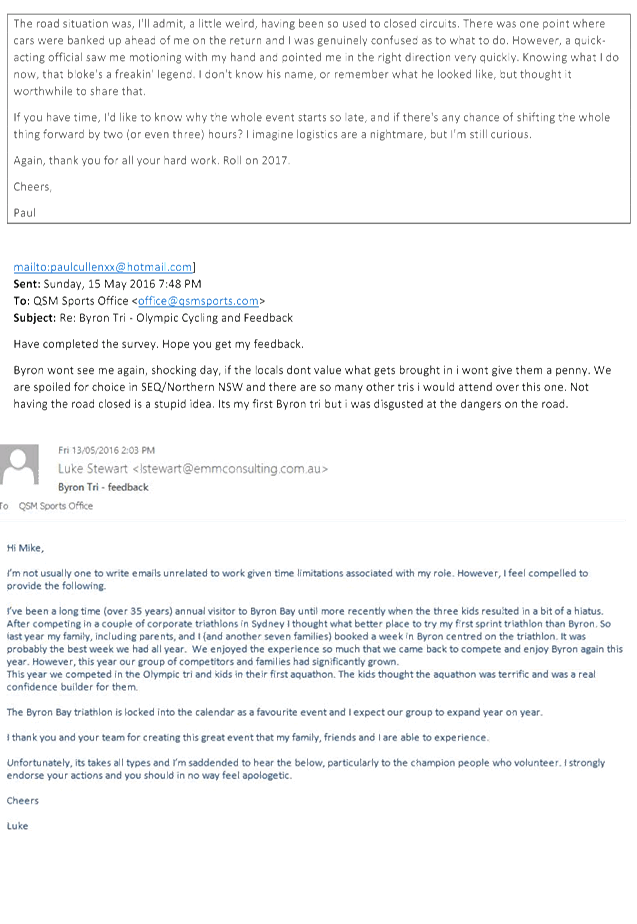
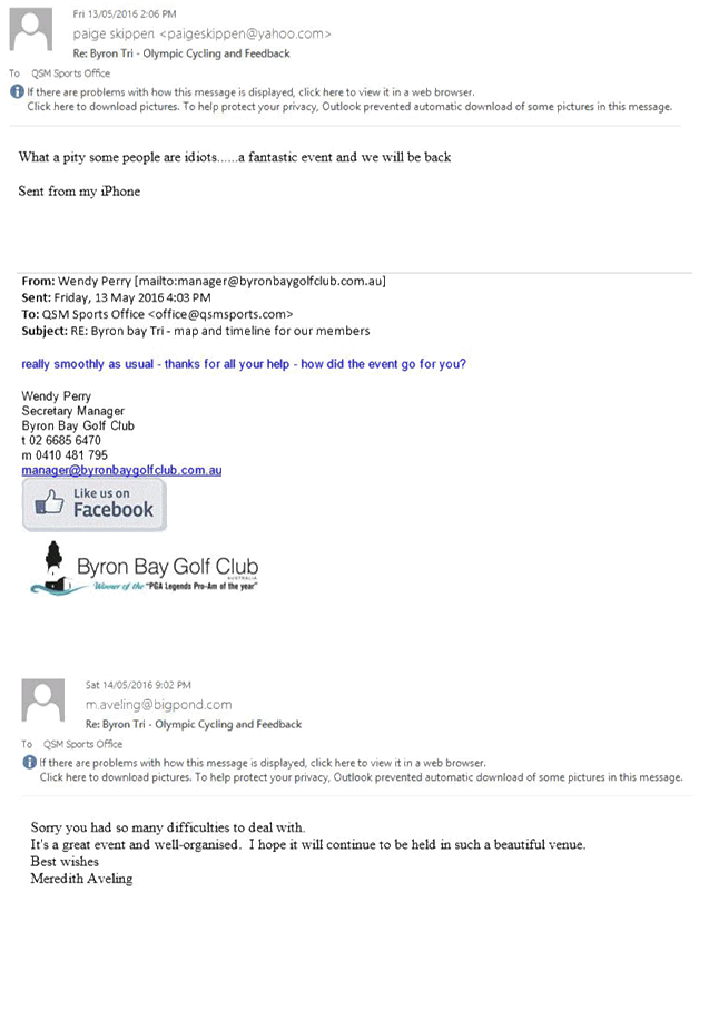
Highlighted issues/concerns from the 2016 event included:
· In 2016 there were
1,170 participants in the event with 94 participants under 19 years old.
· Police expressed
concern regarding the risks of mixing athletes and vehicles on the cycle course.
· Regular delays
were experienced at key intersections.
· In particular,
delays around Suffolk Park and Bangalow Road caused upset.
· The road closure
mechanism failed when some drivers ignored Police and traffic controllers and
threatened volunteers resulting in a highly inflammable risk situation.
|
Table
1. Estimated Road Closure Times for the 2016 event
|
|
Location
|
Time
|
|
Closed
|
Southbound Open
|
Northbound Open
|
|
Marvell Street
|
12:00
|
14:51
|
|
Middleton Street
|
12:00
|
14:51
|
|
Bay Street
|
12:00
|
13:30
|
14:51
|
|
Lawson Street
|
12:00
|
13:30
|
14:51
|
|
Bay St (Fletcher St to
Middleton St)
|
12:00
|
13:30
|
14:51
|
|
Middleton St (Marvel St
to Bay St)
|
12:00
|
13:30
|
14:51
|
|
Marvell St (Middleton St to
Tennyson St)
|
12:00
|
13:30
|
14:51
|
|
Tennyson St
|
12:00
|
14:51
|
|
Bangalow Road (Browning St to
Old Bangalow Rd)
|
12:00
|
14:51
|
|
Bangalow Road (Old Bangalow Rd
to Broken Head Rd)
|
13:40
|
14:51
|
|
Broken Head Road (Bangalow Rd
to Beech Dr)
|
13:40
|
14:51
|
|
Broken Head Road (Beech Dr to
Ross Lane)
|
13:40
|
14:10
|
14:51
|
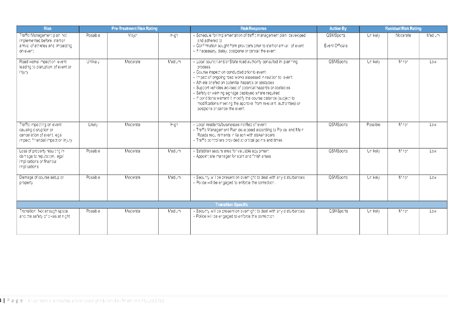
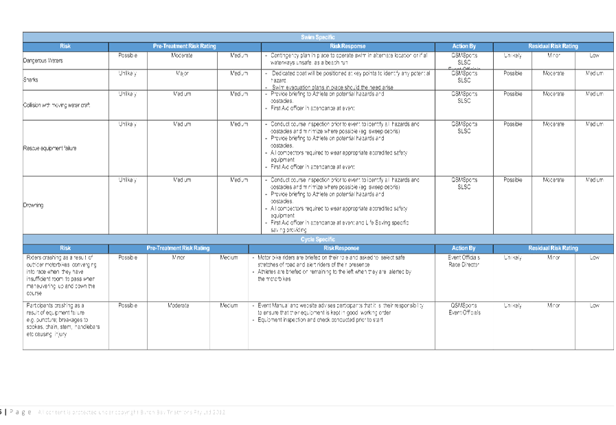
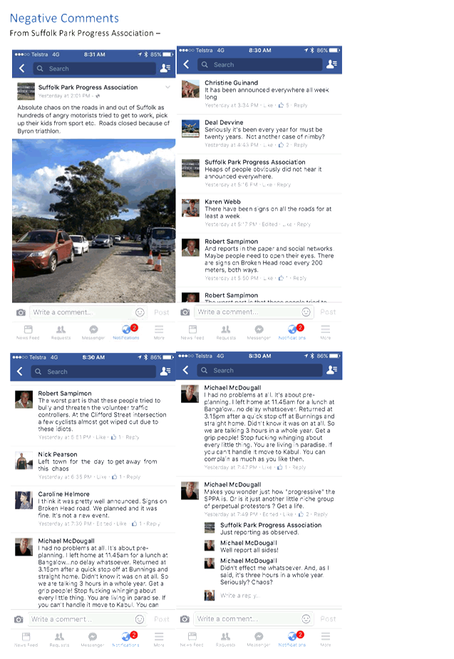
KEY ISSUES
1. Safety
of the participants (1,170 approx.), spectators, pedestrians and road users
with the interaction of live traffic, pedestrians and cyclists.
2. Near
misses with vehicles have been reported by participants.
3. Three
hour duration and extent of road closures that paralyse Byron Bay CBD to Ross
Lane, especially Suffolk Park.
4. Increased
traffic congestion and frustrated road users who potentially ignore traffic
control signage.
5. Community
acceptance of the event by some of the Suffolk Park residents.
6. The
event organisers debrief doesn’t clearly highlight all the issues in
relation to positive and negative feedback in a table.
7. Bus
and taxi services are disrupted during the event and have to find alternative
routes.
COUNCIL IMPLICATIONS
§ Budget/Financial
The event organisers have
paid the $120.00 relevant Approval of Road Events pursuant to s144 of the Roads
Act fee as per the Fees & Charges 2016/17.
§ Asset Management
Not applicable.
§ Policy or Regulation
Speed Limit (as required)
ROAD WORK (R4-212) - Delegated to council for authorisation in conjunction with
NSW Road Rules 21 and AS 1742.4 (Speed Controls) Clause 3.1.2, AS 1742.3
(Roadworks)
§ Consultation
A condition of the
endorsement of this event is that the event organiser undertakes appropriate
consultation.
§ Legal and Risk Management
RMS advise is
required as this event impacts on Broken Head Road.
|
RECOMMENDATION:
That the Committee comments be provided to the Planning
team.
|
Attachments:
1 Byron Bay
Triathlon 2017 - Local Management Committee Proposal, E2016/89220 , page 124
2 Byron Bay
Triathlon 2017 - Community & Transit Management Plan, E2016/95138 , page 130
3 Byron Bay
Triathlon 2016 - Debrief Notes, E2016/95122
, page 221
Matters for Traffic Engineering Advice 7.4 - Attachment 1
Matters for Traffic Engineering Advice 7.4 - Attachment 2
Matters for Traffic Engineering Advice 7.4 - Attachment 2
Matters for Traffic Engineering Advice 7.4 - Attachment 2

Matters for Traffic Engineering Advice 7.4 - Attachment 2
Matters for Traffic Engineering Advice 7.4 - Attachment 2


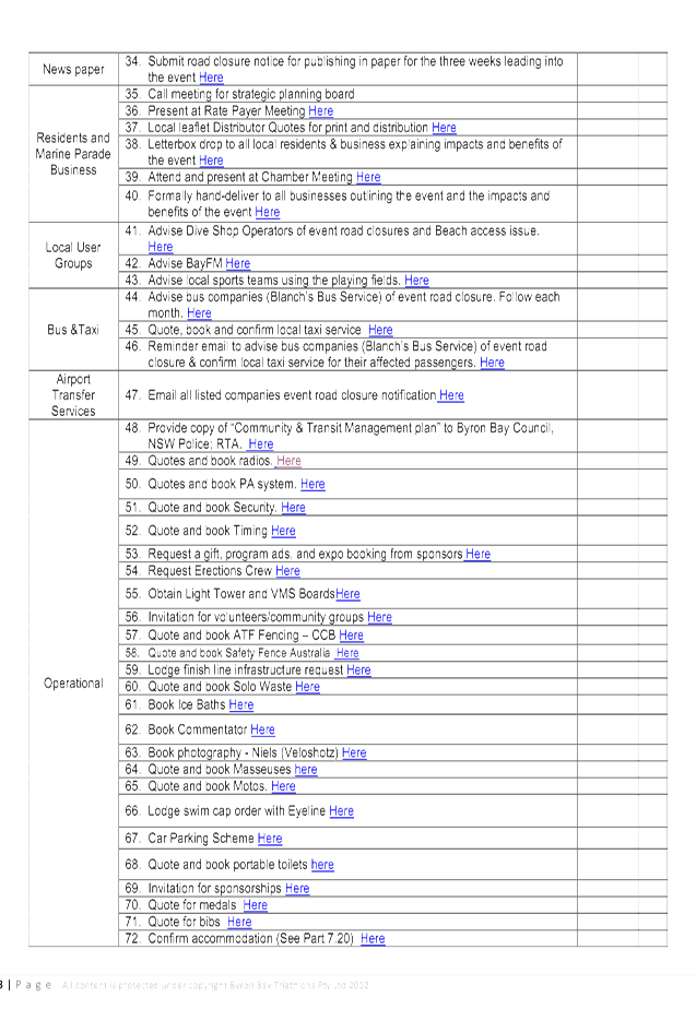


Matters for Traffic Engineering Advice 7.4 - Attachment 3


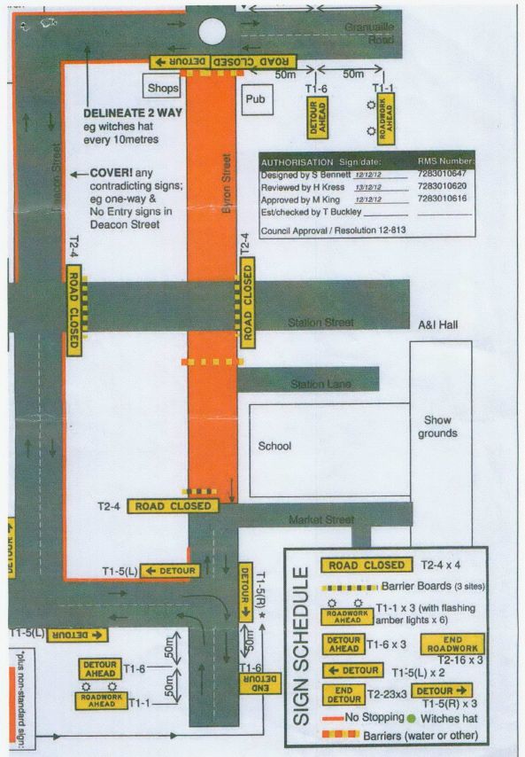
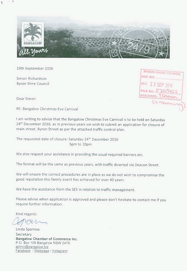
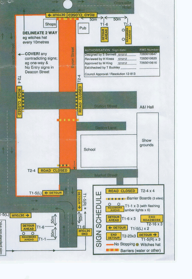
Local Traffic Committee Meeting 7.5
Report No. 7.5 Event - Bangalow Christmas Eve Carnival 2016
File No: I2016/1130
SUMMARY
Council has received an event application and draft Traffic
Control Plan (TCP) from the Bangalow Chamber of Commerce Inc. for the Bangalow
Christmas Eve Carnival 2016 to be held on Saturday 24 December 2016.
OFFICER RECOMMENDATION
That Council endorse the Bangalow Christmas Eve Carnival
2016 to be held Saturday 24 December 2016, that includes the temporary road
closure of Byron Street, Bangalow (between Ashton Street and Granuaille)
between 4pm and 10pm, subject to conditions.
LINKAGE TO OUR COMMUNITY STRATEGIC PLAN
|
Theme
|
Economy
|
A sustainable and diverse
economy which provides innovative employment and investment opportunities in
harmony with our ecological and social aims.
|
|
Objective
|
EC1
|
A diverse economic base and
support for local businesses.
|
|
Strategy
|
EC1.4
|
Support sporting and cultural events in Byron Shire.
|
|
Measures
|
EC1.B
|
Increase the sustainability of events in which Council is
involved.
|
BACKGROUND
The Bangalow Chamber of Commerce Inc. is proposing to close
Byron Street, Bangalow (between Ashton Street and Granuaille Road) between the
times of 4pm-10pm on Saturday 24 December 2016 for the annual Bangalow
Christmas Eve Carnival.
The format will be the same as previous years, with traffic
diverted via Deacon Street. The event organisers have advised that they
will engage JHA to carry out the TCP and will have assistance from the SES in
relation to traffic management.
The event organisers are in the process of forming their
Traffic Management Plan and awaiting JHA to provide a certified TCP. Both
documents will be provided to the Local Traffic Committee (LTC) for
consideration prior to the meeting to be held 9 November 2016.
KEY ISSUES
1. This
road closure directly affects RMS controlled asset - Lismore to Bangalow Road
(B62) and RMS controlled Granuaille Road.
2. RMS
Traffic Engineering Department requires to separately approve the TMP and TCP.
3. Deacon
Street is not suitable to Heavy Vehicles as a detour to the Pacific Highway.
4. Heavy
Vehicles from Lismore will have to use Granuaille Road to access the Pacific
Highway.
5. Increase
traffic congestion as vehicle use the undesirable Deacon Street detour.
6. No
TMP with a complaint TCP has been supplied.
COUNCIL IMPLICATIONS
§ Budget/Financial
The event organisers
have been invoiced $356.00 for the relevant Approval of Road Events pursuant to
s144 of the Roads Act fee as per the Fees & Charges 2016/17.
§ Asset Management
Not applicable.
§ Policy or Regulation
Speed Limit (as required)
ROAD WORK (R4-212) - Delegated to council for authorisation in conjunction with
NSW Road Rules 21 and AS 1742.4 (Speed Controls) Clause 3.1.2, AS 1742.3
(Roadworks).
§ Consultation
A condition of the
endorsement of this event is that appropriate consultation is undertaken, including:
1. Advertising
the impact of the event in the local newspaper and on the Council website.
2. Informing
community and business that are directly impacted.
3. Liaising
with bus and taxi operators.
4. Consulting
with emergency services.
§ Legal and Risk Management
This road closure directly
affects RMS controlled asset - Lismore to Bangalow Road (B62) and RMS
controlled Granuaille Road. RMS Traffic Engineering Department requires to
separately approve the TMP and TCP.
Figure 1.
Non-conforming Draft TCP for Byron Street Road Closure
|
RECOMMENDATION:
1. That
Council endorse the Bangalow Christmas Eve Carnival 2016 to be held Saturday
24 December 2016, that includes the temporary road closure below:
a) Byron
Street, Bangalow between Ashton Street and Granuaille, between 4pm and 10pm
on Saturday 24 December 2016.
2. That
the approval provided in Part 1 is subject to:
a. separate
approvals by NSW Police and RMS being obtained, noting that the event is on a
state road or may impact the state road network;
b. implementation
of the approved Traffic Management Plan and Traffic Control Plan, including
the use of signed detours, as designed and implemented by those with
appropriate accreditation;
c. that
the impact of the event be advertised via a notice in the local weekly paper
a minimum of one week prior to the operational impacts taking effect, noting
it must include the event name, specifics of any traffic impacts or road
closures and times, alternative route arrangements, event organiser, a
personal contact name and a telephone number for all event related enquiries
or complaints.
d. the
event be notified on Council’s webpage.
e. the
event organiser:
i. undertake
consultation with community and affected businesses including adequate
response/action to any raised concerns.
ii. undertake
consultation with emergency services and any identified issues addressed.
iii. holding
$20m public liability insurance cover which is valid for the event.
iv. paying
Council’s Road Event Application Fee prior to the event.
|
Attachments:
1 Application
& draft Traffic Control Plan, S2016/12391
, page 243
Matters for Traffic Engineering Advice 7.5 - Attachment 1
Local Traffic Committee Meeting 8.1
Development Applications
Report No. 8.1 10.2016.692.1 - Outdoor Music Event 2017 - Red Devil Park, Byron Bay
File No: I2016/1135
SUMMARY
Council has received a Development Application (DA) and
Traffic Control Plans (TCPs) from Greg Alderson & Associates on behalf of
Queensland Festivals & Events Pty Ltd for an outdoor music event to be held
at Red Devil Park, Bangalow Road, Byron Bay on Saturday 4 February 2017.
Gates are proposed to open at 3pm and will close at
10pm. The maximum estimated patronage is 3,500 patrons with an estimated
400 event staff and performers.
OFFICER RECOMMENDATION
1. That
the Committee comments be provided to the Planning team.
2. The
applicant supply a TMP to RMS requirements with all the relevant TCP’s
3. Review
the TCP to see if ‘NO STOPPING’ signs along Bangalow Road and
Broken Head Road are warranted.
LINKAGE TO OUR COMMUNITY STRATEGIC PLAN
|
Theme
|
Economy
|
A sustainable and diverse
economy which provides innovative employment and investment opportunities in
harmony with our ecological and social aims.
|
|
Objective
|
EC1
|
A diverse economic base and
support for local businesses.
|
|
Strategy
|
EC1.4
|
Support sporting and cultural events in Byron Shire.
|
|
Measures
|
EC1.B
|
Increase the sustainability of events in which Council is
involved.
|
BACKGROUND
The proposed development, outdoor music event, will be held
on Saturday 4 February 2017. Gates are proposed to open at 3pm and will close
at 10pm. The maximum estimated patronage is 3,500 patrons with an
estimated 400 event staff and performers. There will be no camping
provided onsite.
A Traffic Impact Assessment (attached) has been provided
along with TCPs, however a Traffic Management Plan (TMP) has not been submitted
at this stage.
Proposed parking:
· Red Devil Park
– 400 parking spaces
· Byron High School
– 150 parking spaces
· Road side on
Bangalow Road (south west of the site) – 90-160 vehicles
KEY ISSUES
1. This
event is likely to impact on traffic service levels on Broken Head Road and
Bangalow Road (Main Road 545).
2. Increased
traffic congestion with vehicles leaving Bryon High School onto Bangalow Road.
3. Safety
hazard could be caused by event patrons to park either side of Broken Head Road
and Bangalow Road reducing the trafficable lanes and causing congestion and
traffic delays.
4. Increase
pedestrian activity from Bangalow Road and Broken Head Road walking to and from
the event.
5. Vehicles
cueing on Broken Head Road and Bangalow Road to access the three parking areas.
COUNCIL IMPLICATIONS
§ Budget/Financial
The event organisers will
be invoiced $356.00 for the Approval of Road Events pursuant to s144 of the
Roads Act fee as per the Fees & Charges 2016/17.
§ Asset Management
Not applicable at the event
organisers are to organise and demobilise all temporary traffic control
devices.
§ Policy or Regulation
Speed Limit (as required)
ROAD WORK (R4-212) - Delegated to council for authorisation in conjunction with
NSW Road Rules 21 and AS 1742.4 (Speed Controls) Clause 3.1.2, AS 1742.3
(Roadworks).
§ Consultation
A condition of the endorsement of
this event is that the event organiser undertakes appropriate consultation,
including:
1. Advertising the impact of the
event in the local newspaper and on the Council website.
2. Informing community and
business that are directly impacted.
3. Liaising with bus and taxi
operators.
4. Consulting with emergency services.
§ Legal and Risk Management
Not applicable at this
time as this is traffic advice only.
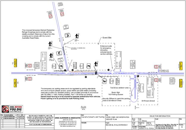
|
RECOMMENDATION:
That the Committee comments be provided to the
Planning team.
|
Attachments:
1 Traffic
Impact Assessment, E2016/95398 ,
page 248
2 Appendix A
(1) - Speed Zone & Information Signage Plan, E2016/95408 , page 277
3 Appendix A
(2) - Speed Zone & Information Signage Plan, E2016/95407 , page 278
4 Appendix A
(3) - Speed Zone & Information Signage Plan, E2016/95406 , page 279
5 Appendix A
(4) - Speed Zone & Information Signage Plan, E2016/95405 , page 280
6 Appendix A
- Pedestrian Refuge, E2016/95409 ,
page 281
7 Appendix B
- Site Parking Plan, E2016/95403 , page 282
8 Appendix C
- Parking Bangalow Road, E2016/95401
, page 283
Development Applications 8.1 - Attachment 1
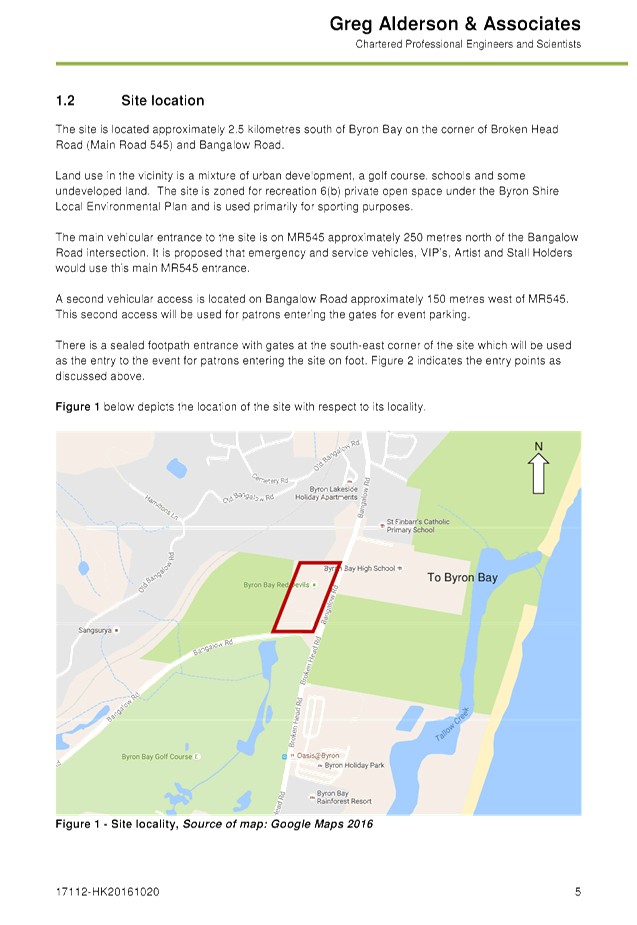
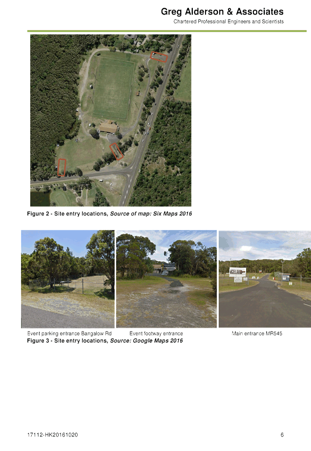
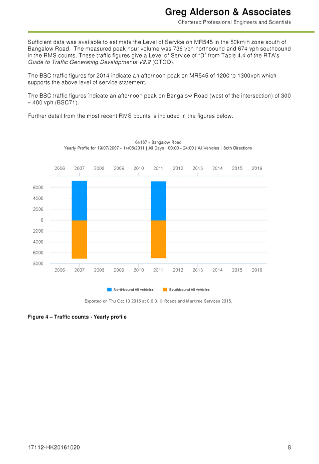
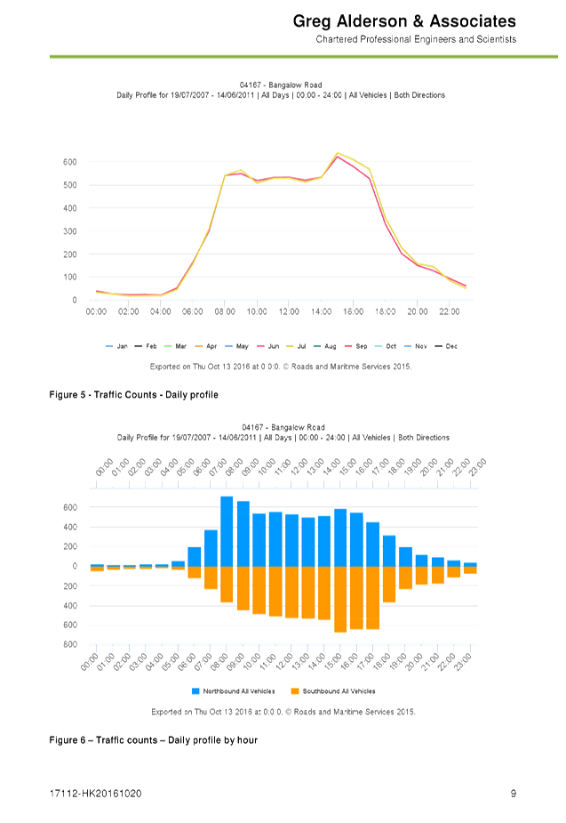
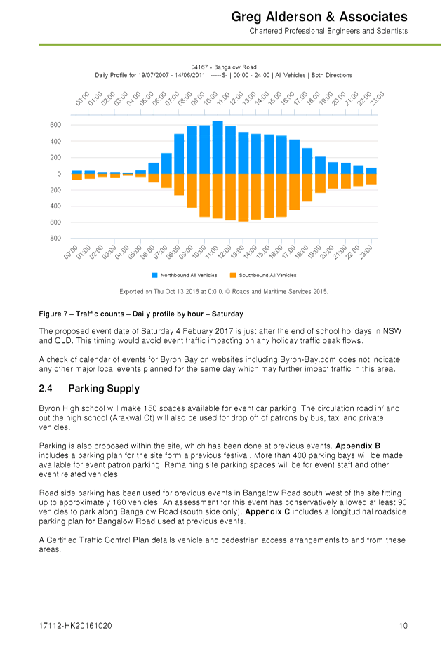
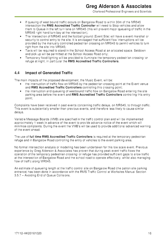
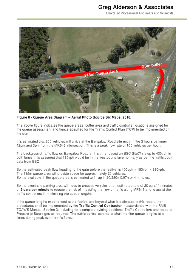
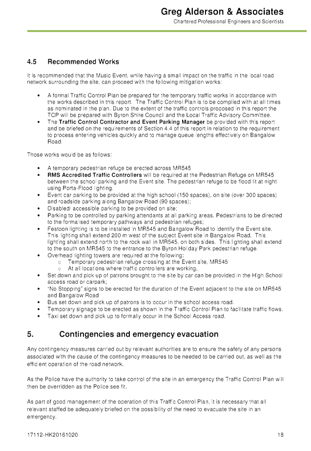

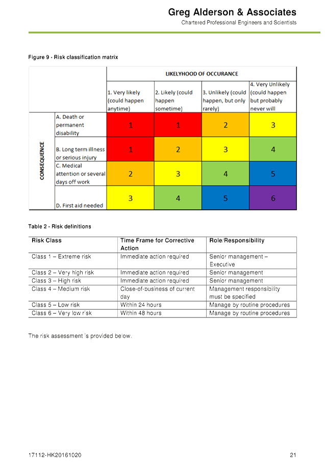
Development Applications 8.1 - Attachment 1
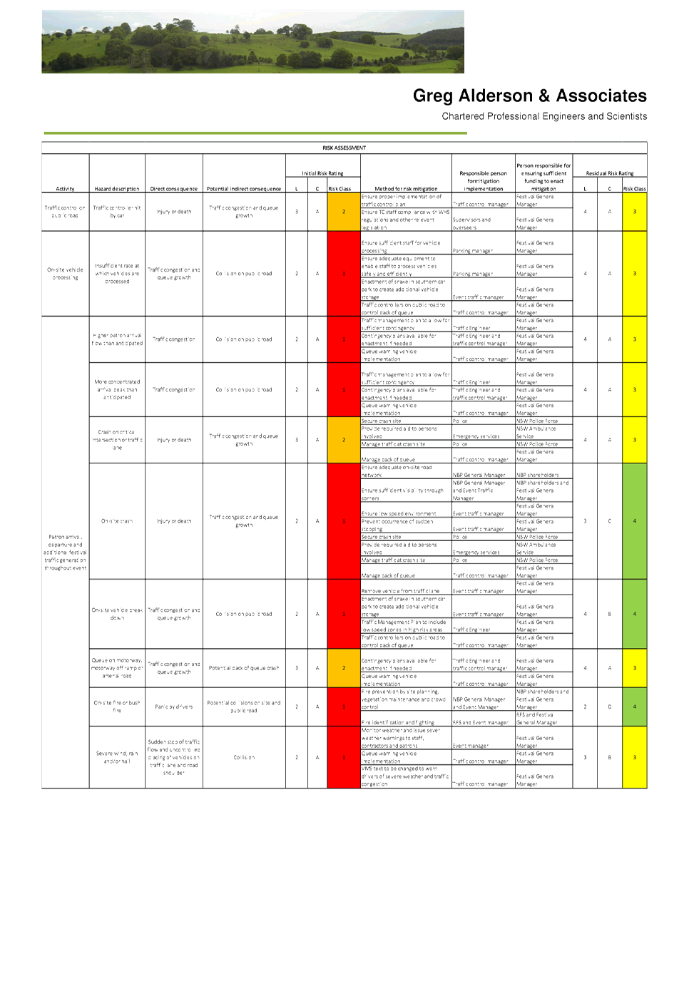
Development Applications 8.1 - Attachment 1
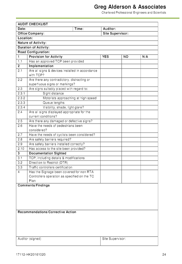


Development Applications 8.1 - Attachment 2
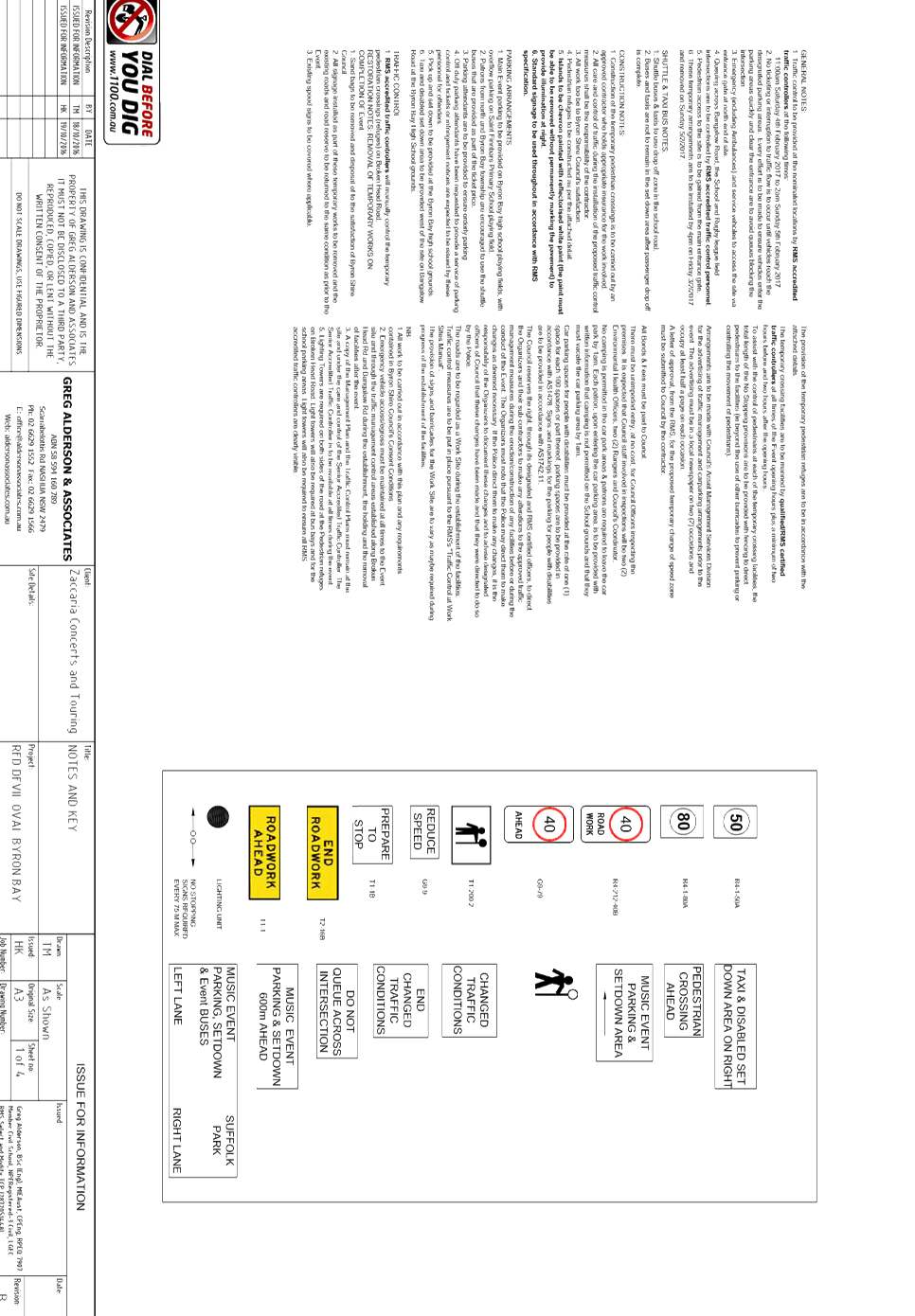
Development Applications 8.1 - Attachment 3
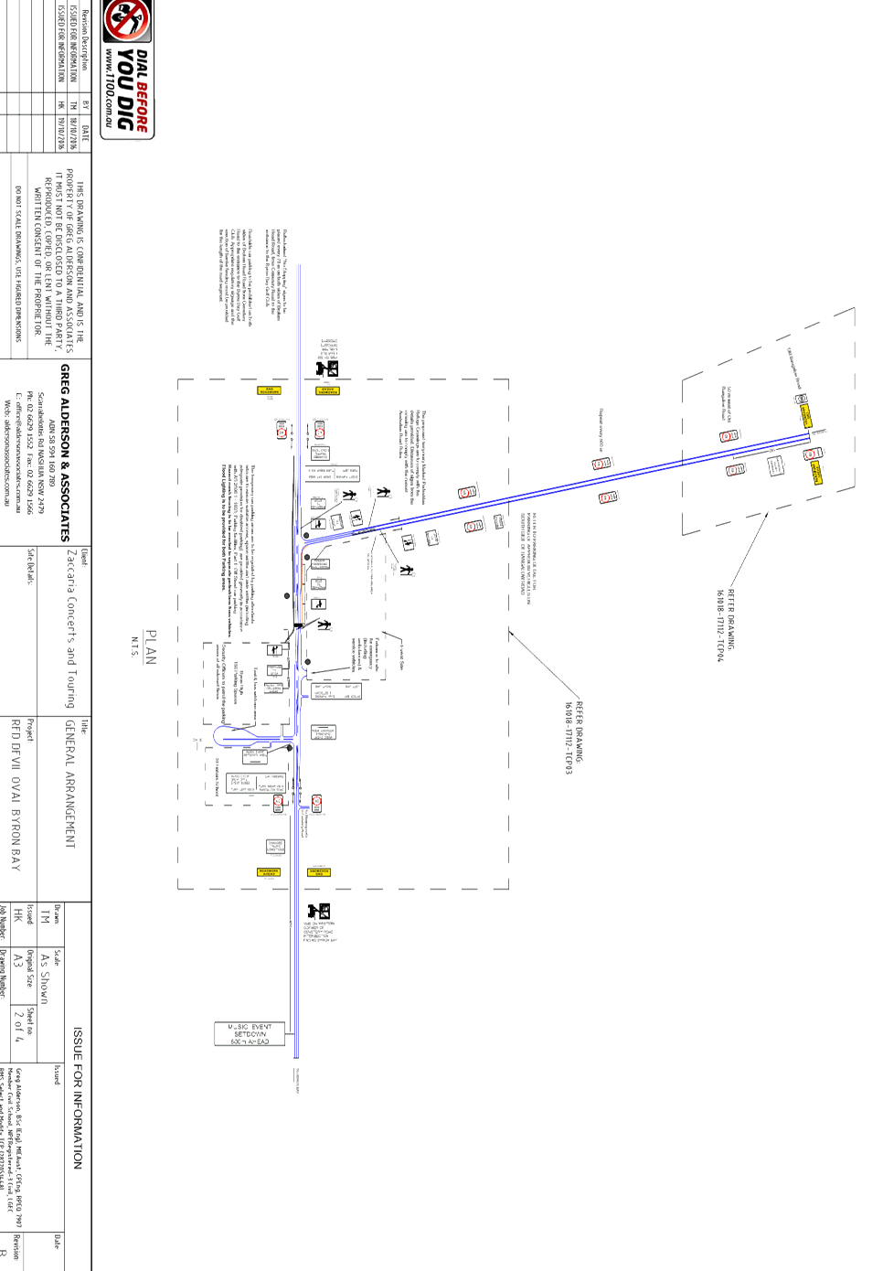
Development Applications 8.1 - Attachment 4
Development Applications 8.1 - Attachment 5
Development Applications 8.1 - Attachment 6
Development Applications 8.1 - Attachment 7
Development Applications 8.1 - Attachment 8
Local Traffic Committee Meeting 8.2
Report No. 8.2 10.2016.399.1 - Byron Central Health & Wellness HUB - 15
McGettigans Lane, Ewingsdale
File No: I2016/1103
SUMMARY
Council has received a Development Application (DA) from
Planit Consulting Pty Ltd on behalf of Brunsmed Pty Ltd for the proposed Byron
Central Health & Wellness HUB located on the corner of McGettigans Lane and
Ewingsdale Road, Ewingsdale.
A report was presented to the Local Traffic Committee (LTC)
on the 14 October 2016 which resulted in the following Committee recommendation
– ‘That the development be reported to the November LTC meeting
and the traffic impact report attached and a summary provided in the LTC
report’.
It is requested that the Local Traffic Committee consider
the attached Traffic Impact Assessment relating to the DA and provide comments
to the Planning Team for consideration.
OFFICER RECOMMENDATION
That the Committee comments be provided to the Planning Team
for consideration.
LINKAGE TO OUR COMMUNITY STRATEGIC PLAN
|
Theme
|
Economy
|
A sustainable and diverse
economy which provides innovative employment and investment opportunities in
harmony with our ecological and social aims.
|
|
Objective
|
EC1
|
A diverse economic base and
support for local businesses.
|
|
Strategy
|
EC1.2
|
Support and strengthen local
businesses and local business networks.
|
|
Measures
|
EC.A
|
Increased Council support for economic activity across
multiple sectors.
|
BACKGROUND
Bitzios Consulting has been engaged by Brunsmed Pty Ltd to
prepare a Traffic Impact Assessment (TIA) for the proposed Byron Central Health
& Wellness HUB located on the corner of McGettigans Lane and Ewingsdale
Road, Ewingsdale.
The DA proposal is for a medical centre and associated
accommodation. The specific features of the development as proposed:
· 16 General
Practitioner consulting rooms
· 6 specialists
consulting rooms
· 1 Day theatre
(considered ancillary)
· Minor treatment
room (considered ancillary)
· Pharmacy
· Café
· 12 Studio
Apartments
· 75 car spaces
(including 23 basement spaces)
· Construction of
Quarry Lane (116m)
· Road widening of
McGettigans Lane at Quarry Lane intersection
· Contributions
towards Ewingsdale Rd / McGettigans roundabout construction
Traffic impact study methodology
A Traffic Impact Assessment was submitted providing a review
of:
· The proposed
development
· Traffic survey for
the surrounding road network
· Estimated traffic
generation and future impact based on:
§ RMS Guide to Traffic Generating
Developments (2002), and
§ 2% compounding growth rate
§ Opening year of 2017 and 10 year
projection
· Detailed
intersection analysis using SIDRA, assuming:
§ A roundabout intersection at
Ewingsdale Rd / McGettigans Lane
§ Summary of intersection reviewed
and results shown below
The number of car spaces required as calculated by Council
is 109 spaces if no discounts and 90 spaces if discounts applied.
Traffic Counts
On the 22/09/2016 a traffic count was conducted 150m South
of the Ewingsdale Rd and McGettigans Lane intersection.
|
Location
|
Virtual Day 7 Traffic Count Summary
|
|
McGettigans Lane at 150m south of the Ewingsdale Rd
intersection.
22/09/2016 – 28/09/2016
|
Vehicles = 18289 (22/09/2016)
Posted speed limit = 50 km/h, Exceeding
= 13715 (74.99%),
Mean Exceeding = 58.22 km/h
Maximum = 100.2 km/h, Minimum = 11.1 km/h, Mean = 54.6
km/h
85% Speed = 62.6 km/h,
95% Speed = 68.0 km/h, Median = 54.7 km/h
20 km/h Pace = 45 - 65, Number in Pace = 14735 (80.57%)
Variance = 75.48, Standard Deviation = 8.69 km/h
In profile: Vehicles = 18289 / 20789 (87.97%)
|
|
Ewingsdale Road at 600m East of McGettigans Lane
29/09/2016 – 05/10/2016
|
Vehicles = 137492
Posted speed limit = 60 km/h, Exceeding
= 11594 (8.43%),
Mean Exceeding = 63.54 km/h
Maximum = 159.3 km/h, Minimum = 10.2 km/h, Mean = 49.6
km/h
85% Speed = 57.6 km/h,
95% Speed = 61.6 km/h, Median = 50.0 km/h
20 km/h Pace = 41 - 61, Number in Pace = 110251 (80.19%)
Variance = 73.66, Standard Deviation = 8.58 km/h
In profile: Vehicles = 137492 / 158976 (86.49%)
|
Intersection design assessed by Sidra Model.
Table 1.
Intersection design assessed by Sidra Model.
KEY ISSUES
1. 173
trips per day generated from 90+ car parks provided at the development onto
McGettigans Lane which has 18000 VPD with wanting to access Ewingsdale
Road.
2. No
additional funding from the development towards the dual lane roundabout to be
constructed at the Ewingsdale Road and McGettigans Lane intersection.
3. Ewingsdale
Road and McGettigans Lane intersection has a history of vehicle incidents and
has been reviewed for a RMS Blackspot funding application.
4. The
85 percentile of vehicles traveling along McGettigans Lane near the new
proposed intersection is exceeding the 50km/h posted speed limit.
COUNCIL IMPLICATIONS
§ Budget/Financial
Not applicable at this
time as this is traffic advice only.
§ Asset Management
Not applicable at
this time as this is traffic advice only.
§ Policy or Regulation
Not applicable at
this time as this is traffic advice only.
§ Consultation
Not applicable at this
time as this is traffic advice only.
§ Legal and Risk Management
Not applicable at this
time as this is traffic advice only.
Figure 1
– Proposed site location
Figure 2
– Proposed development site plan
|
RECOMMENDATION:
That the Committee comments be provided to the Planning
Team.
|
Attachments:
1 Traffic
Impact Assessment, E2016/94720 ,
page 288
2 Traffic
count at ST055 South of the development on MgGettigans Lane, E2016/95326 , page 387
Development Applications 8.2 - Attachment 1
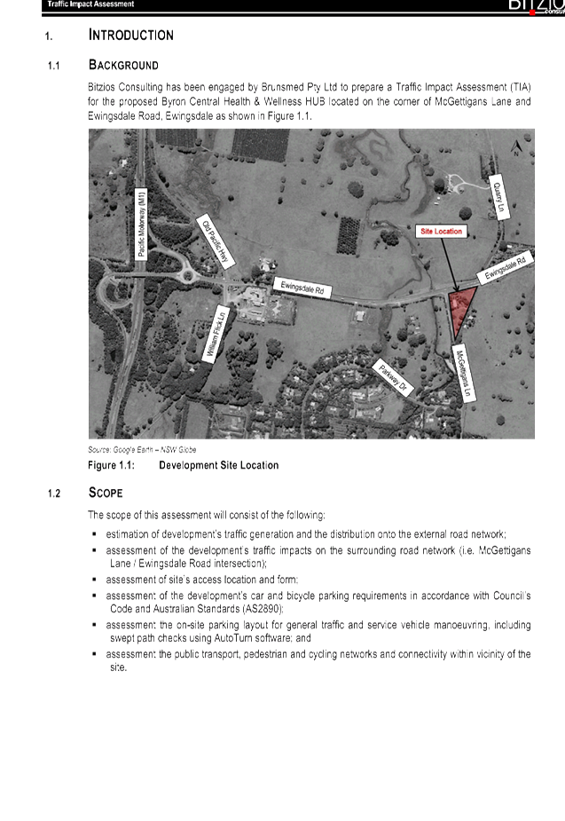
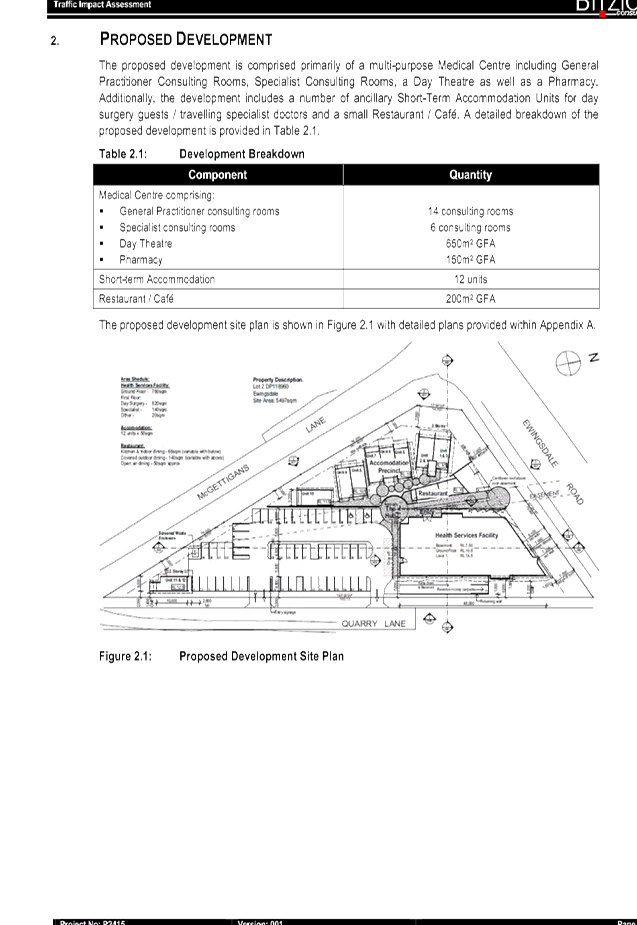
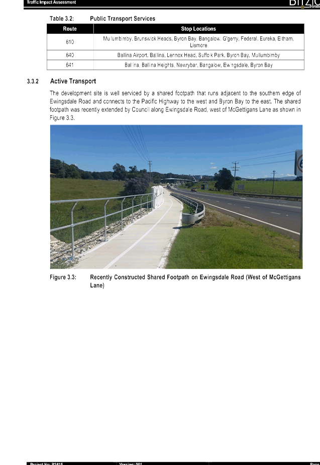
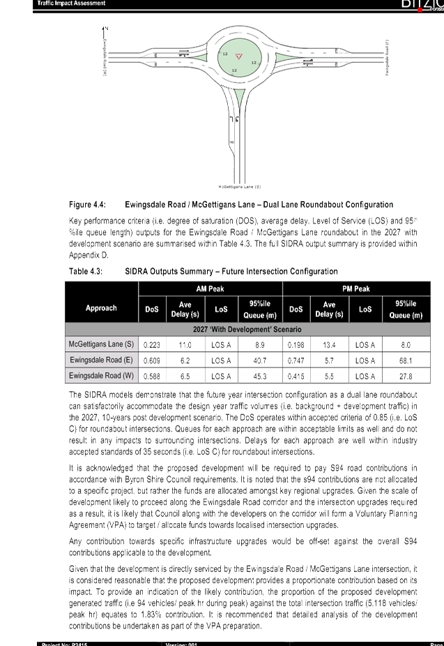
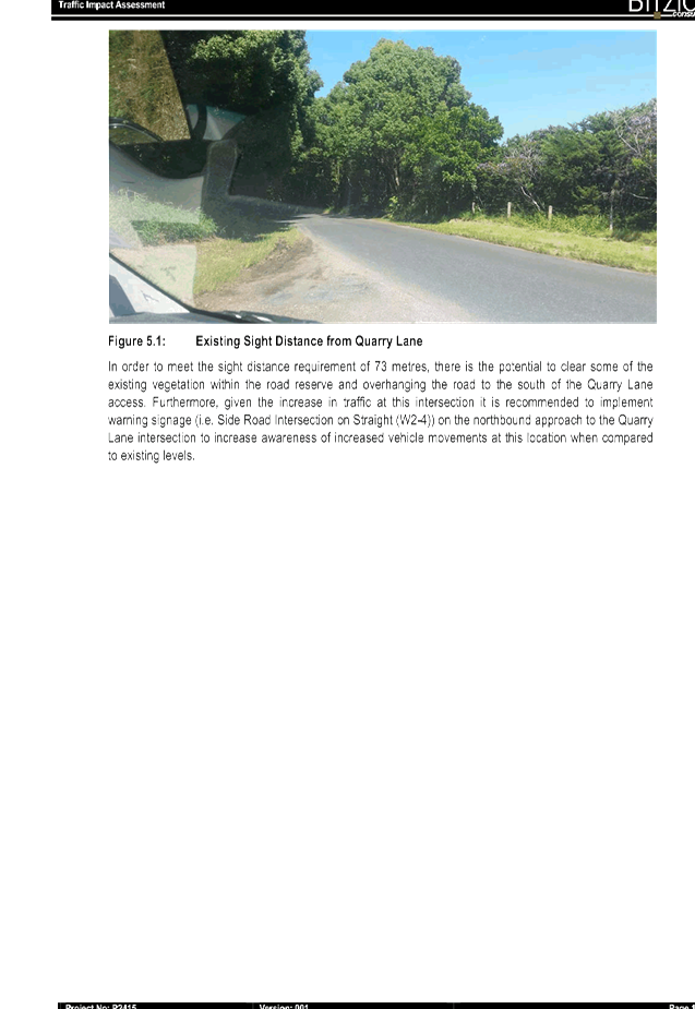
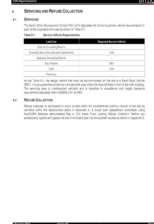
Development Applications 8.2 - Attachment 1

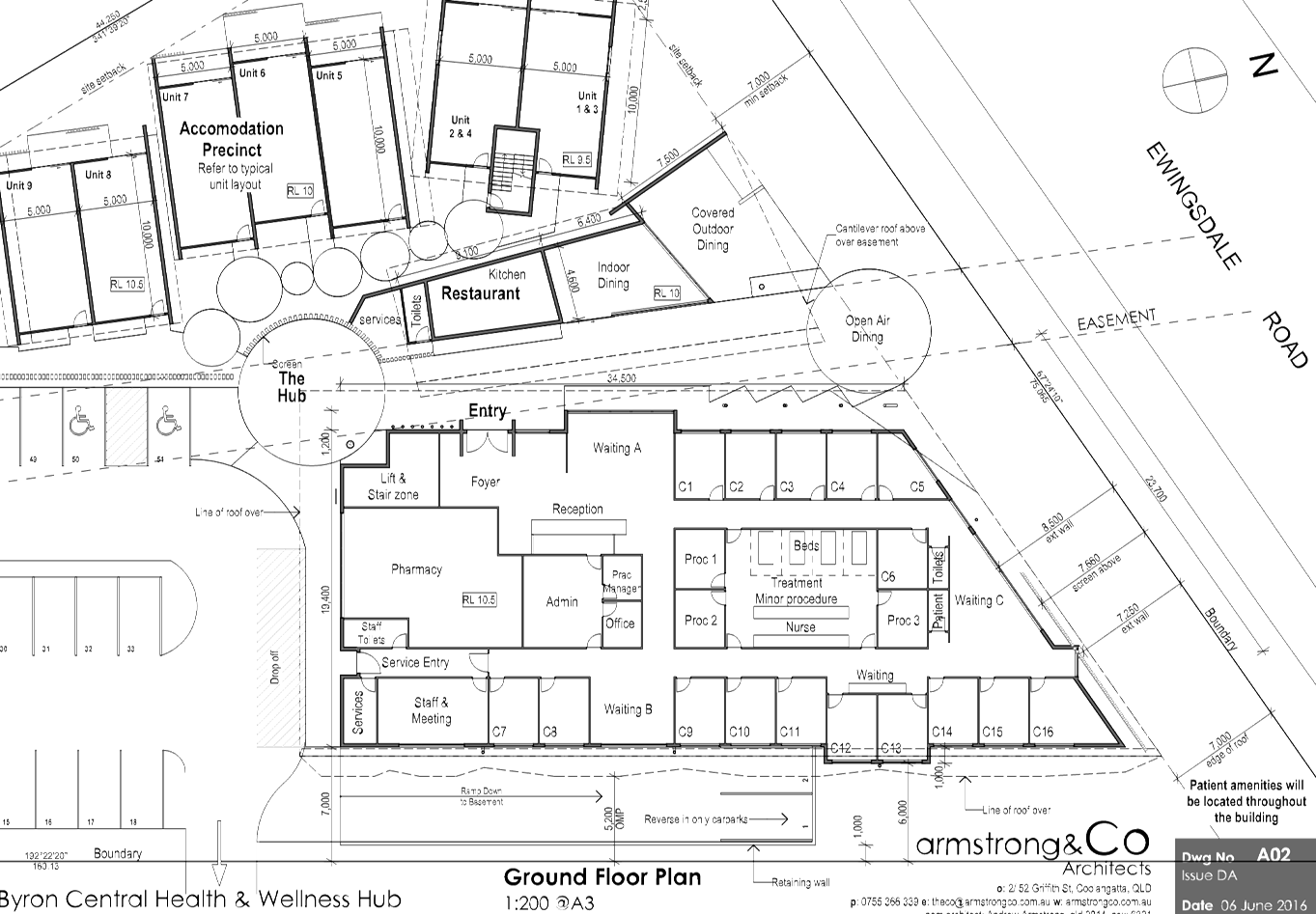
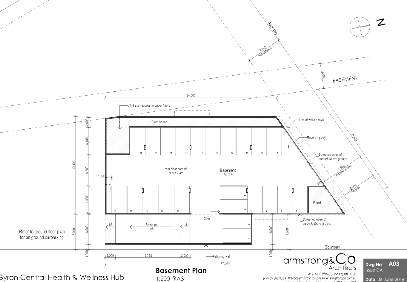
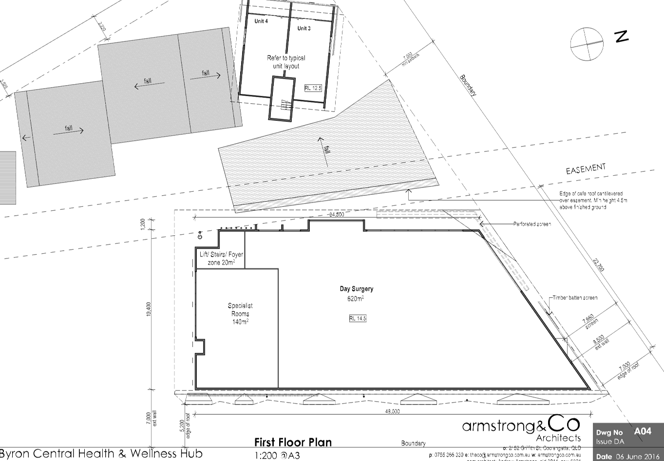
Development Applications 8.2 - Attachment 1
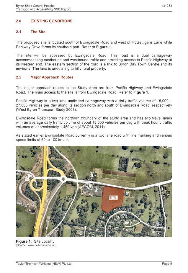
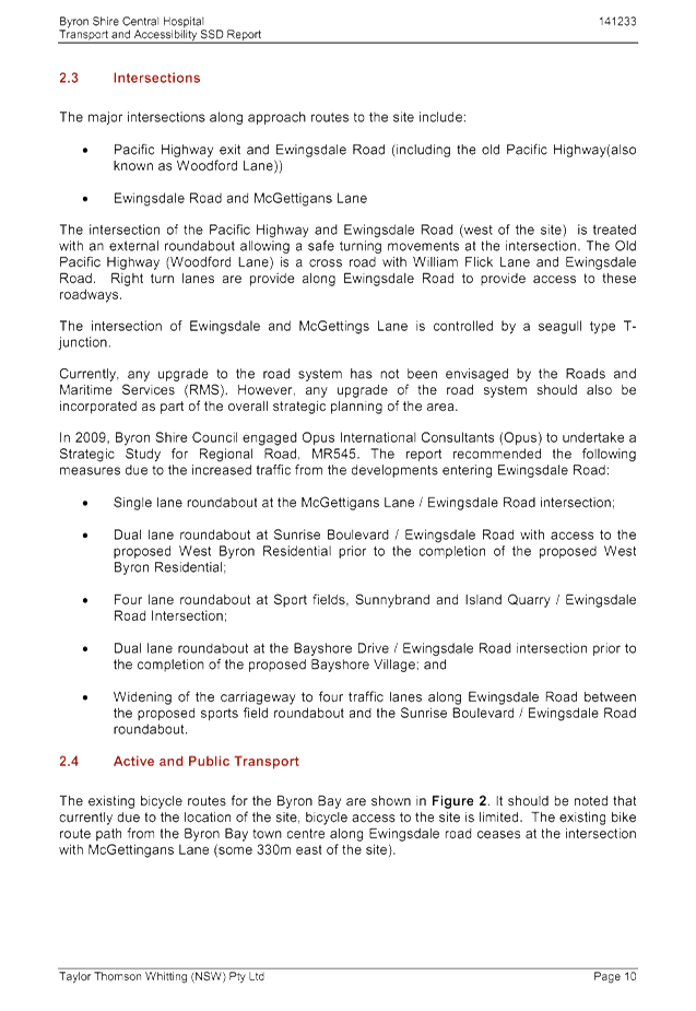
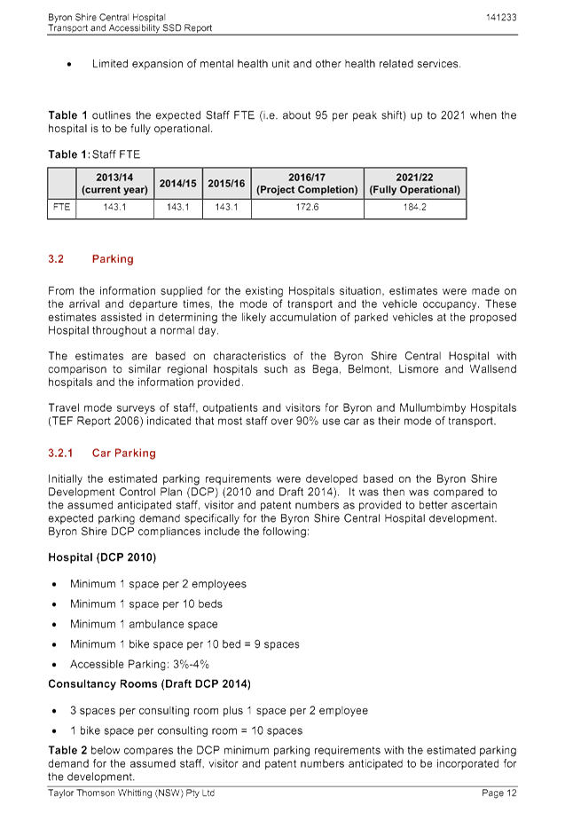
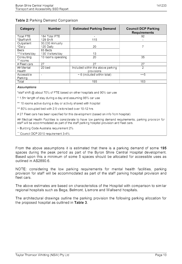
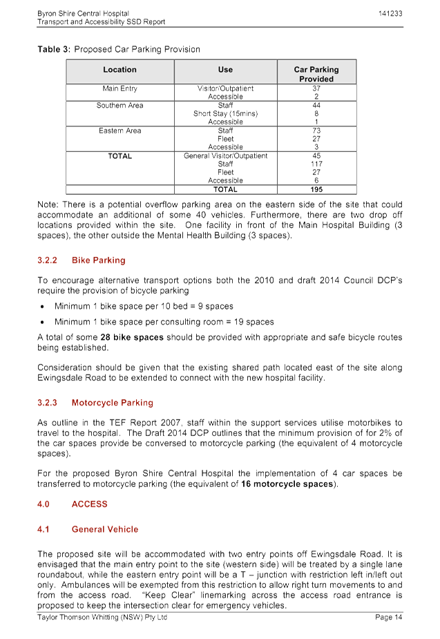
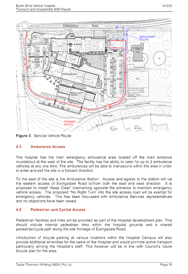
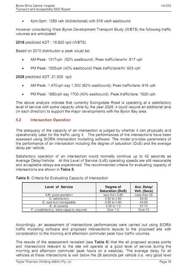
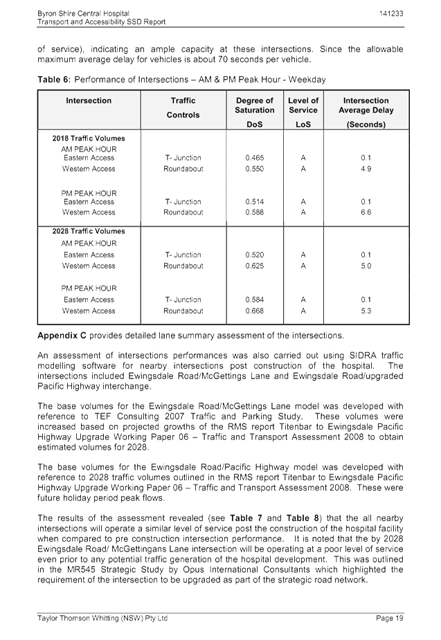
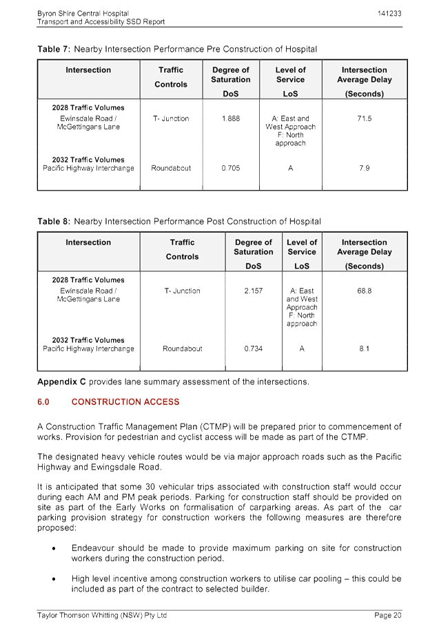
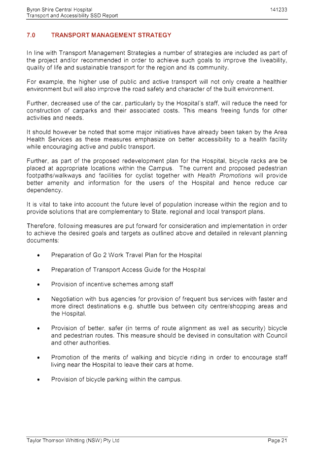
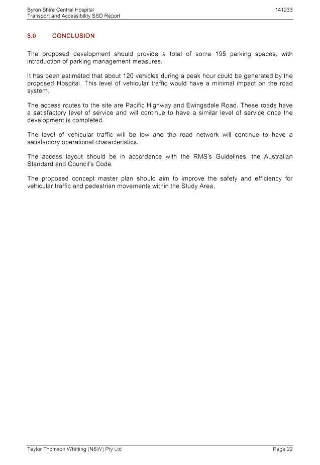
Development Applications 8.2 - Attachment 1
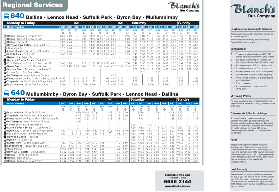
Development Applications 8.2 - Attachment 1
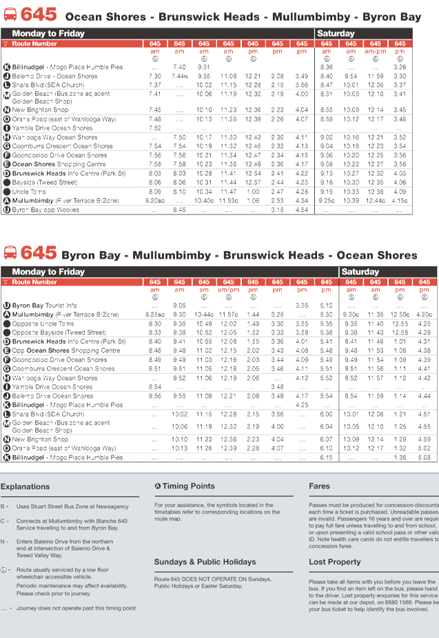
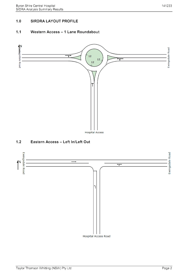
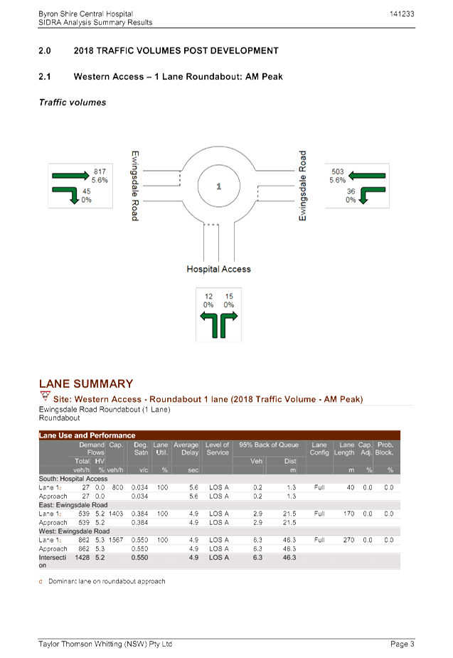
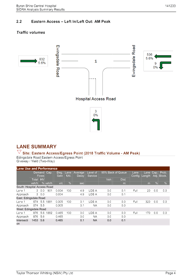
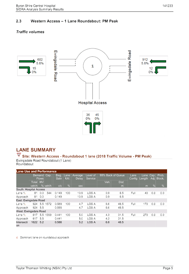
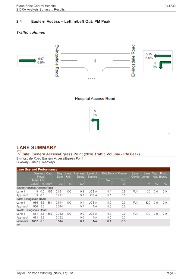
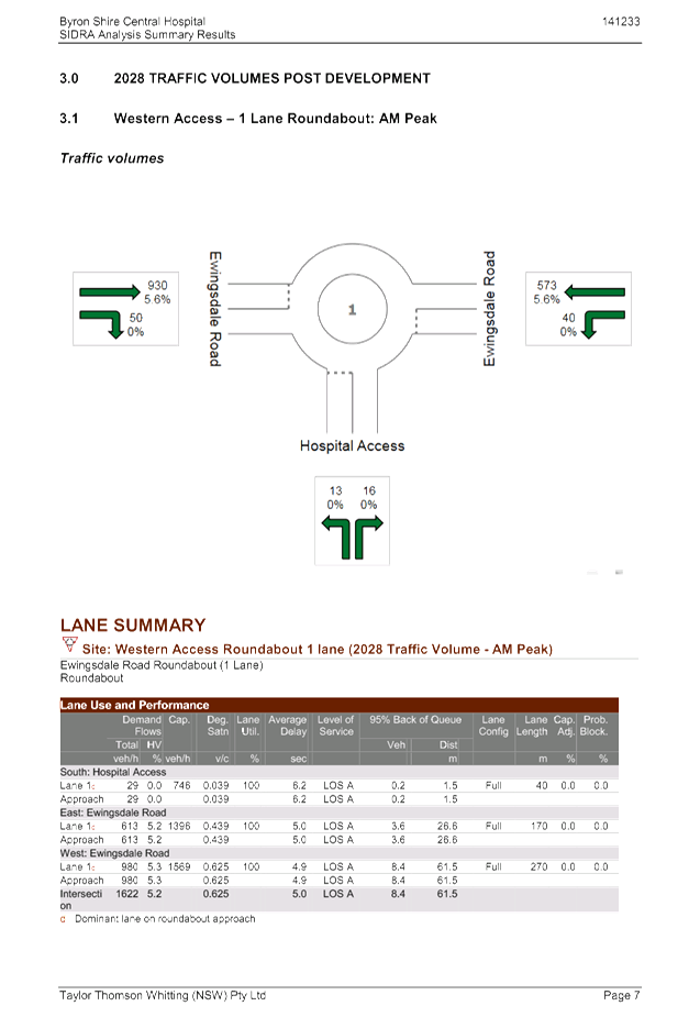
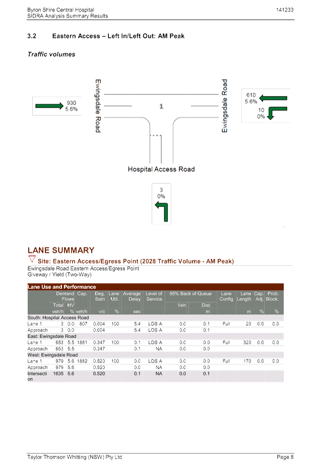
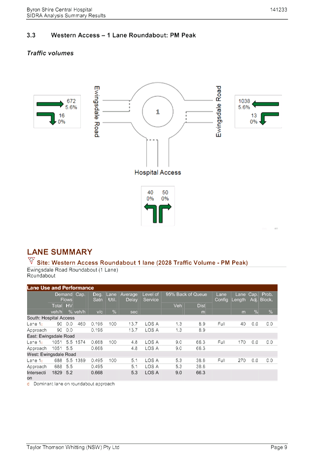
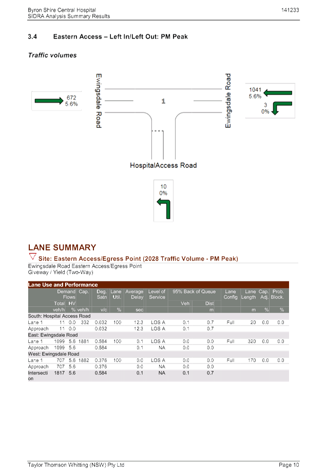
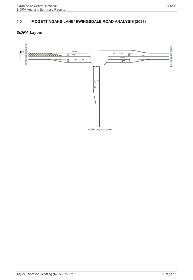
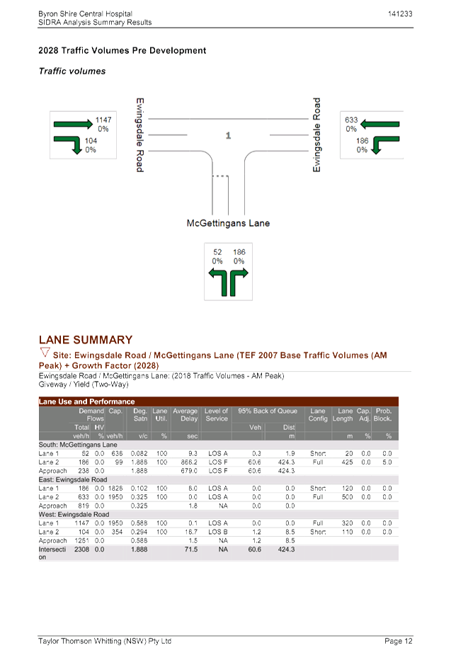
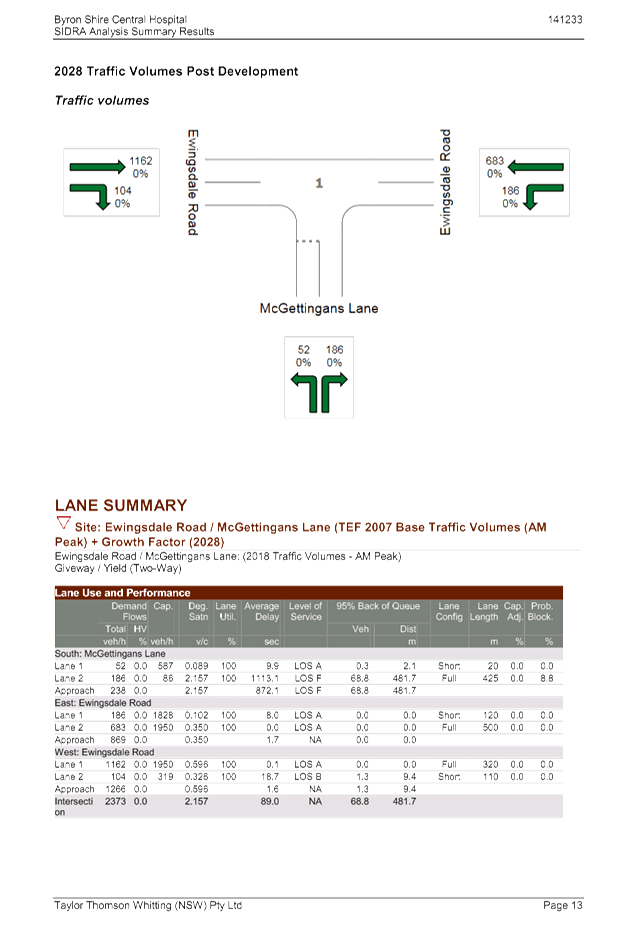
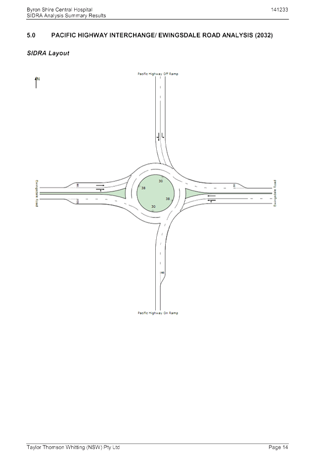
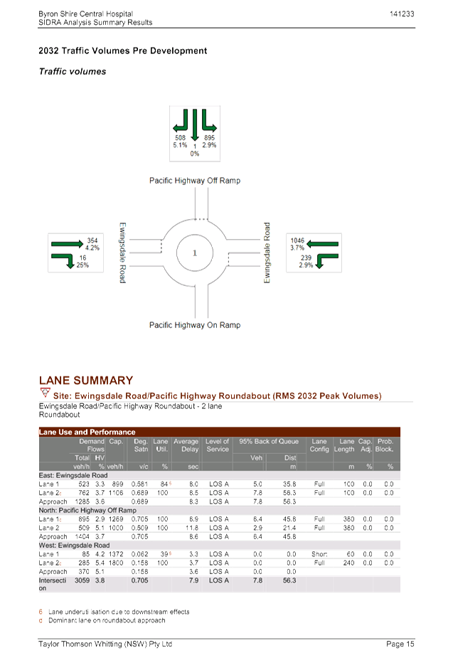
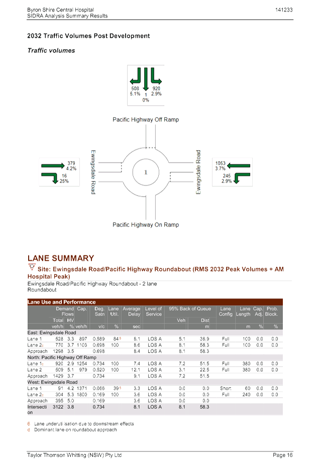
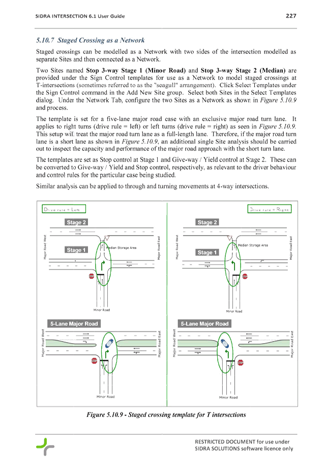
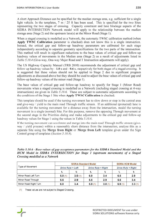
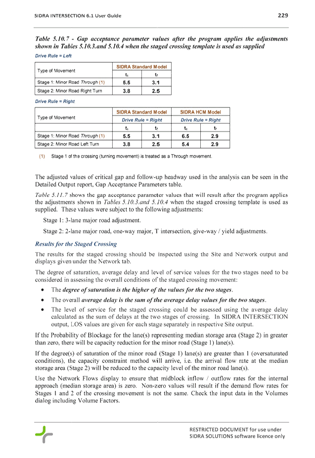
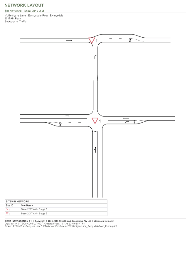
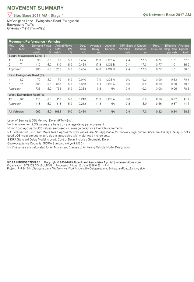

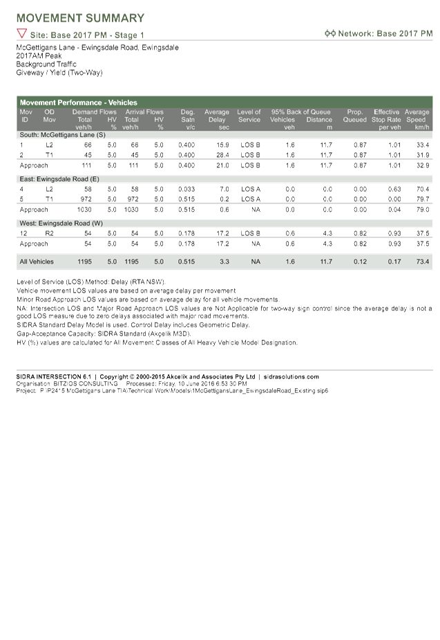
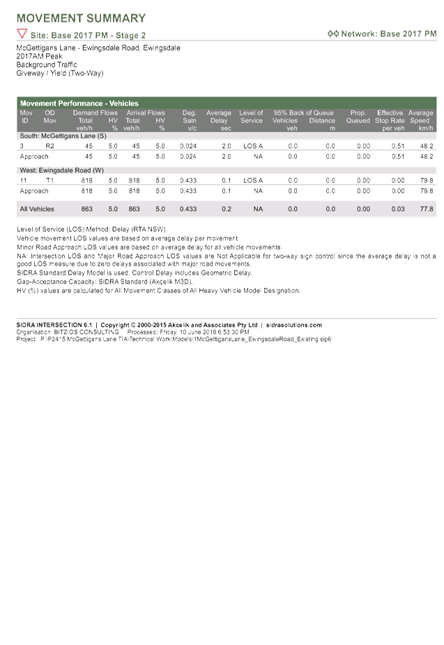
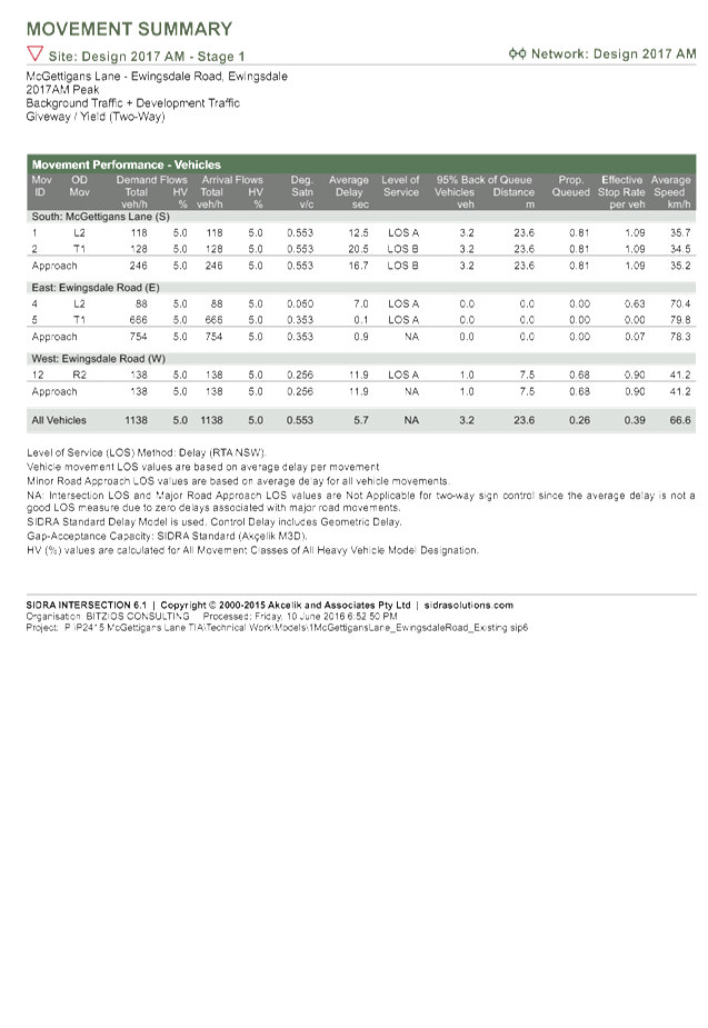

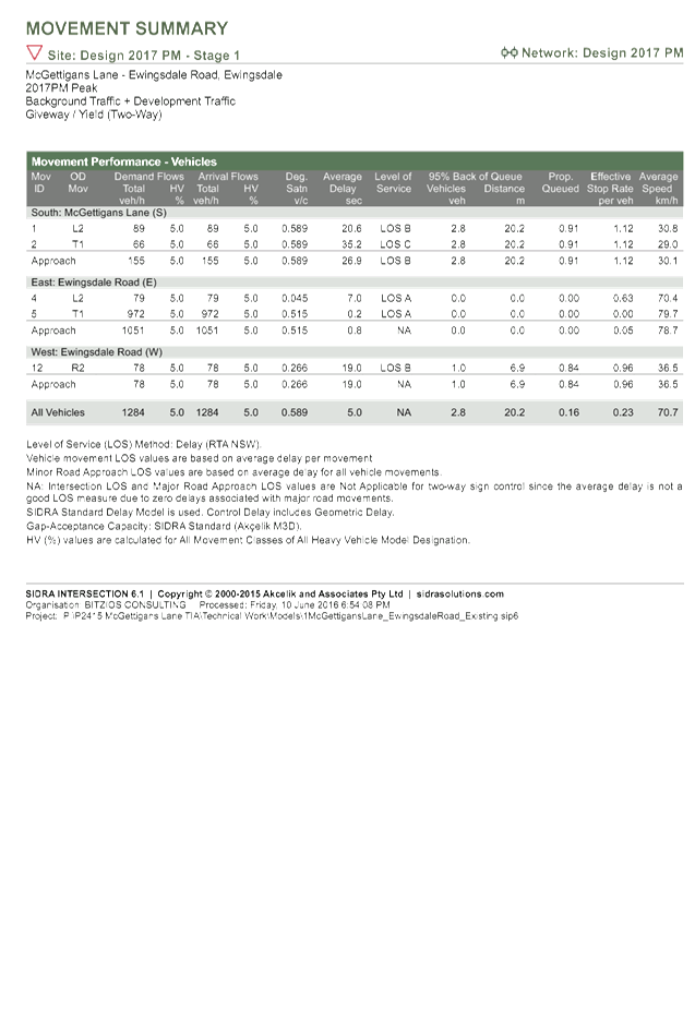
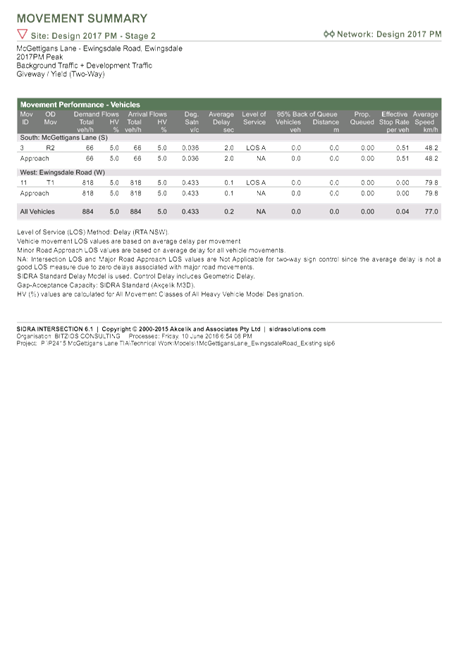
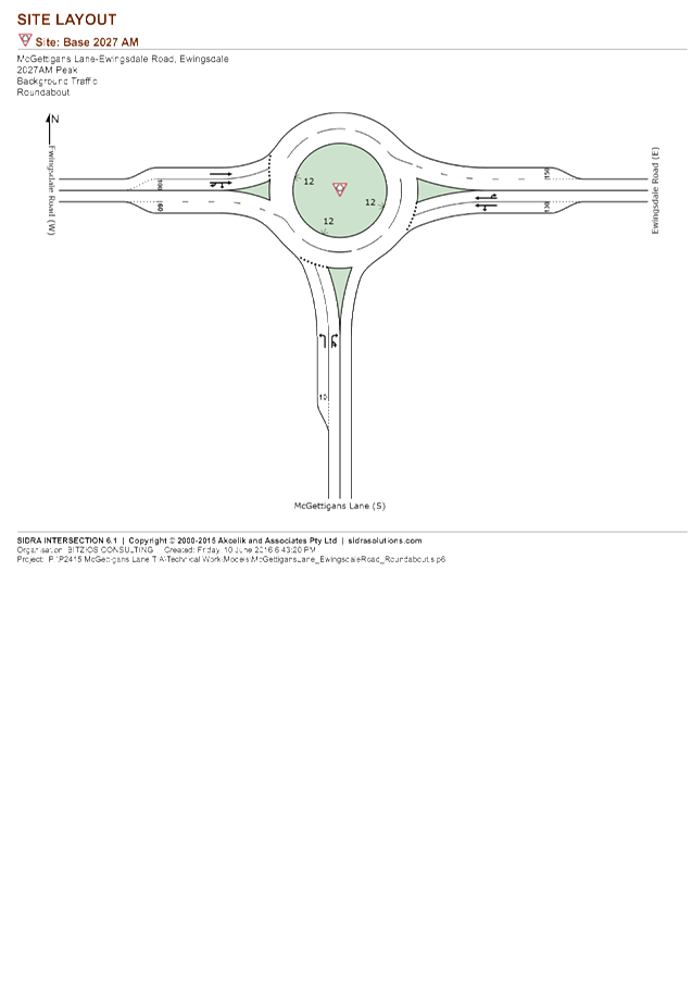
Development Applications 8.2 - Attachment 1
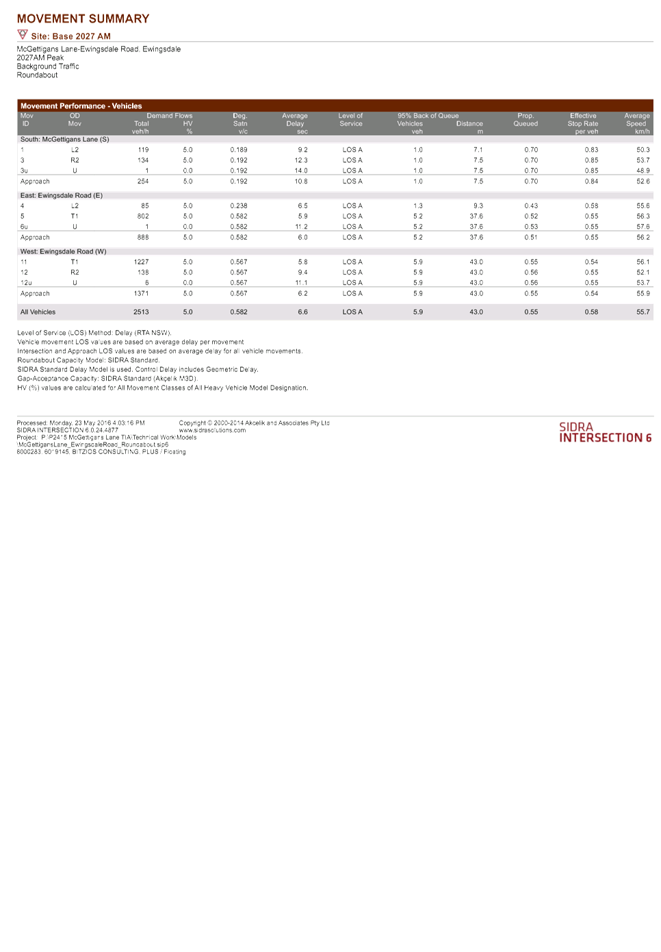

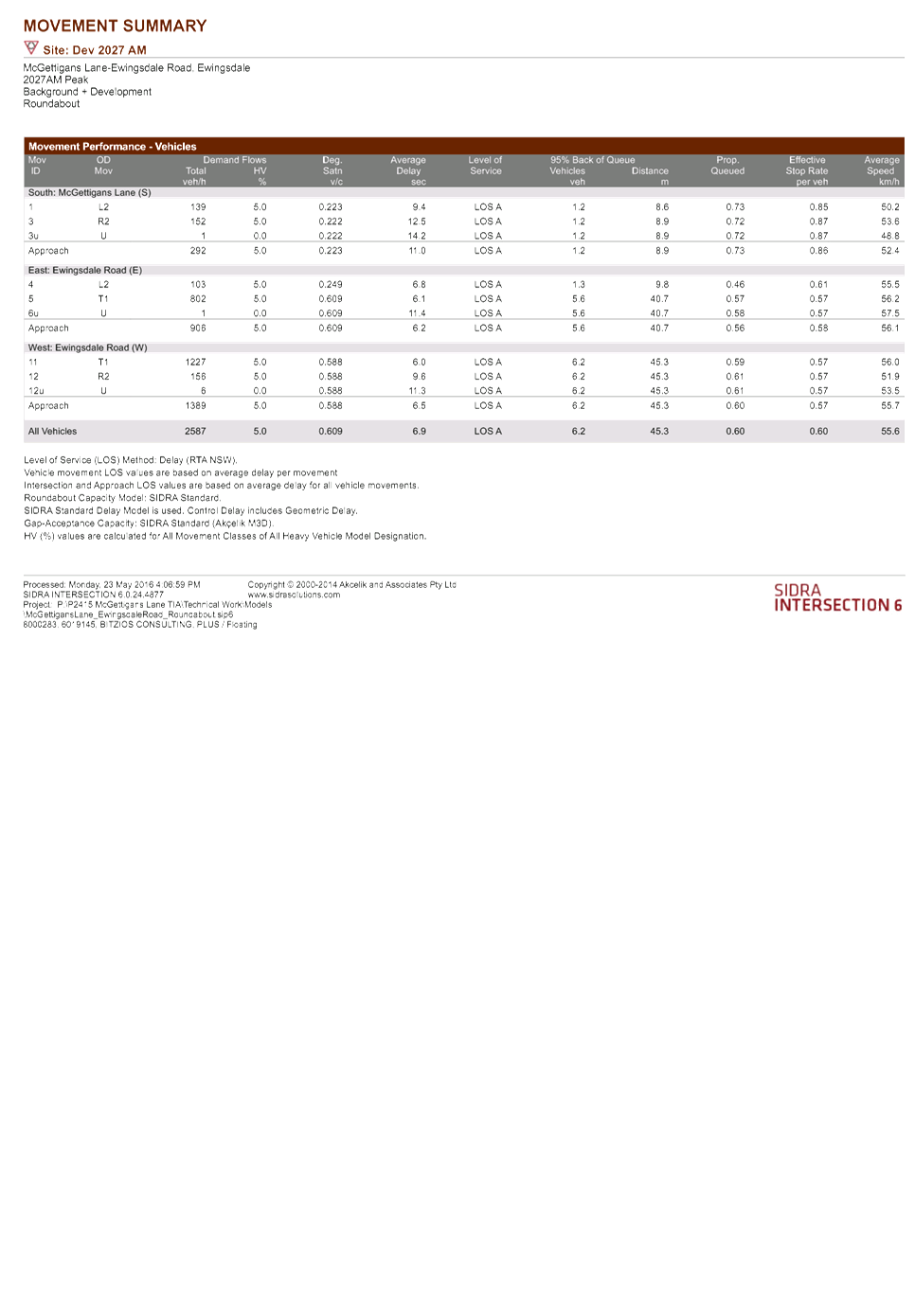
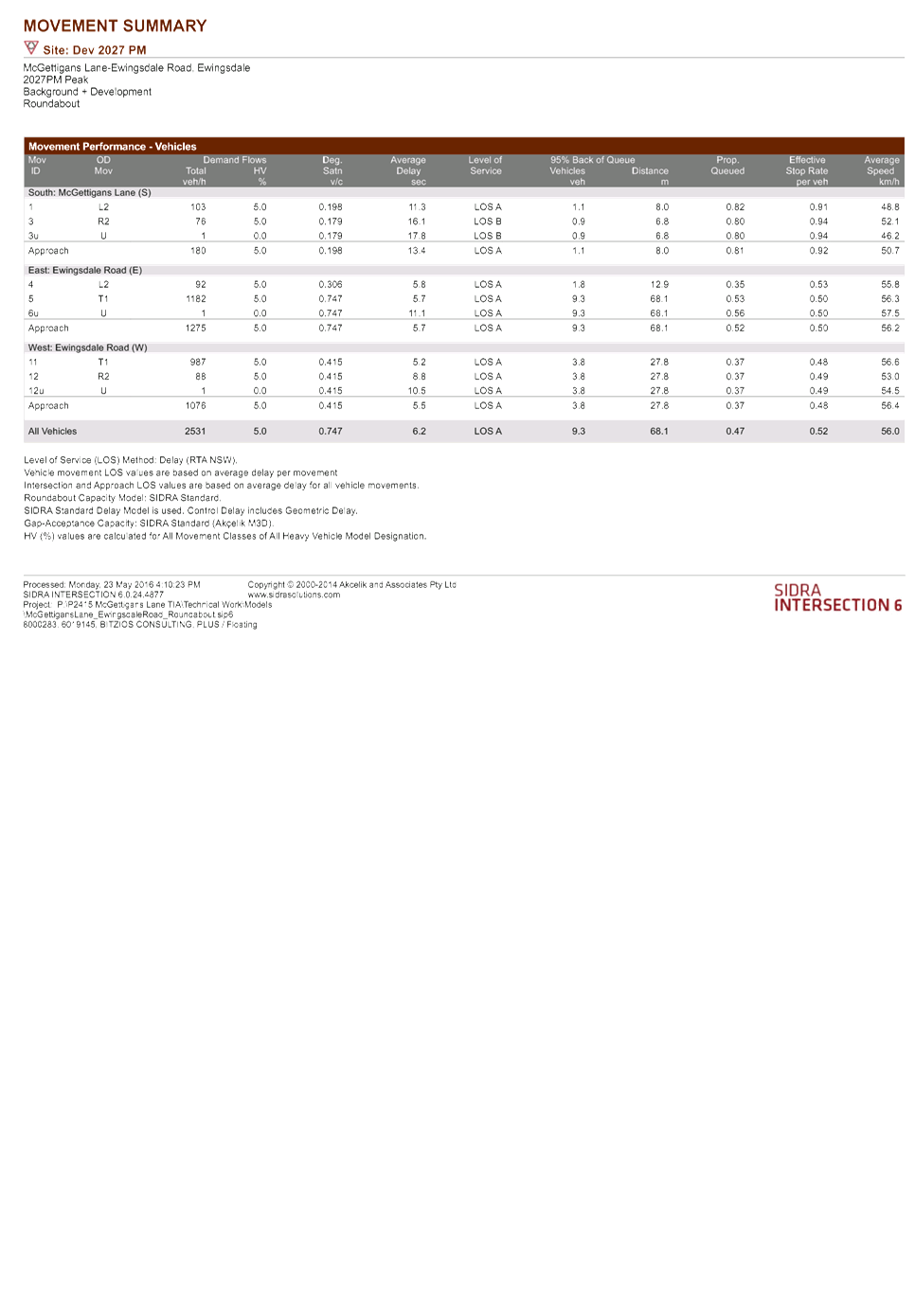
Development Applications 8.2 - Attachment 1

Development Applications 8.2 - Attachment 1
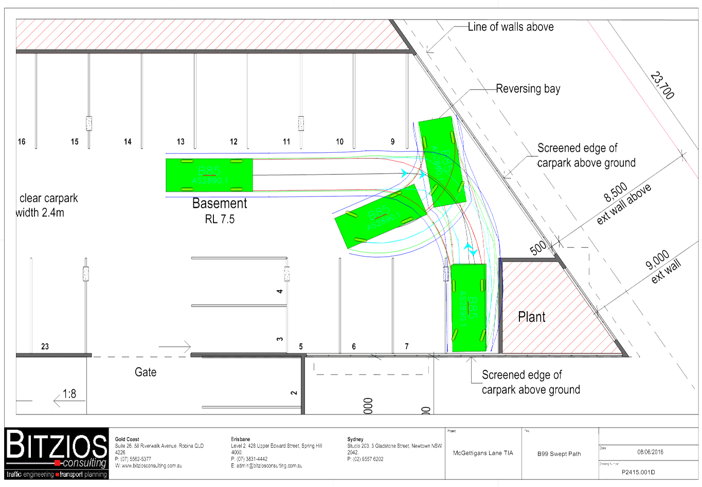
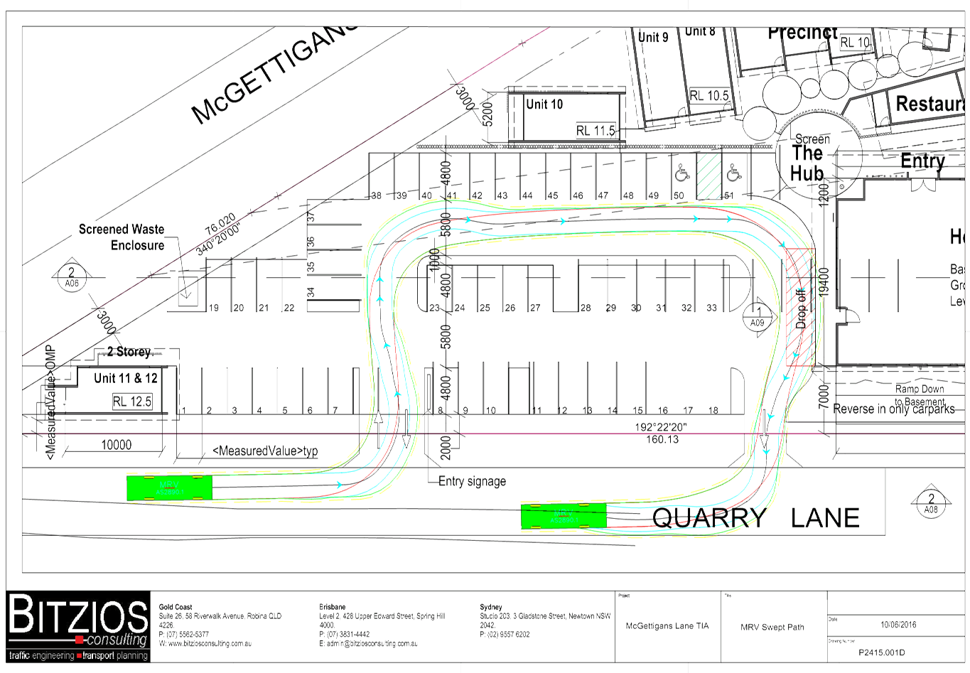
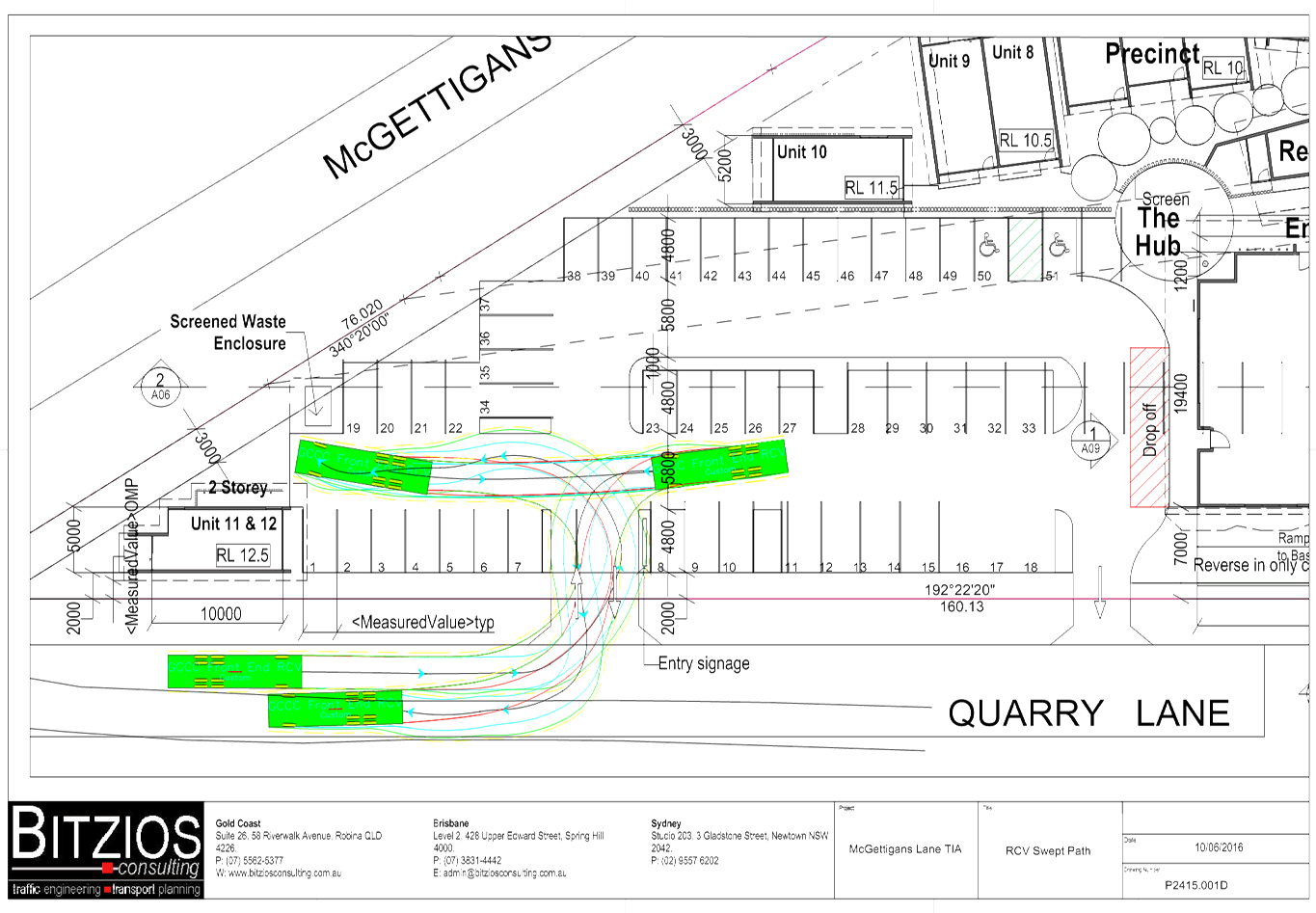
Development Applications 8.2 - Attachment 2