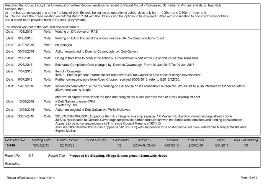
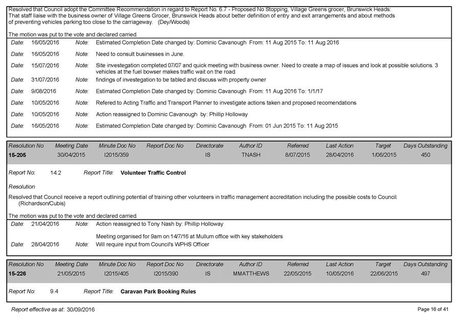
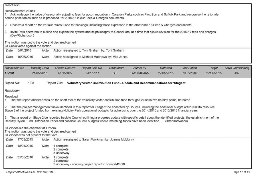
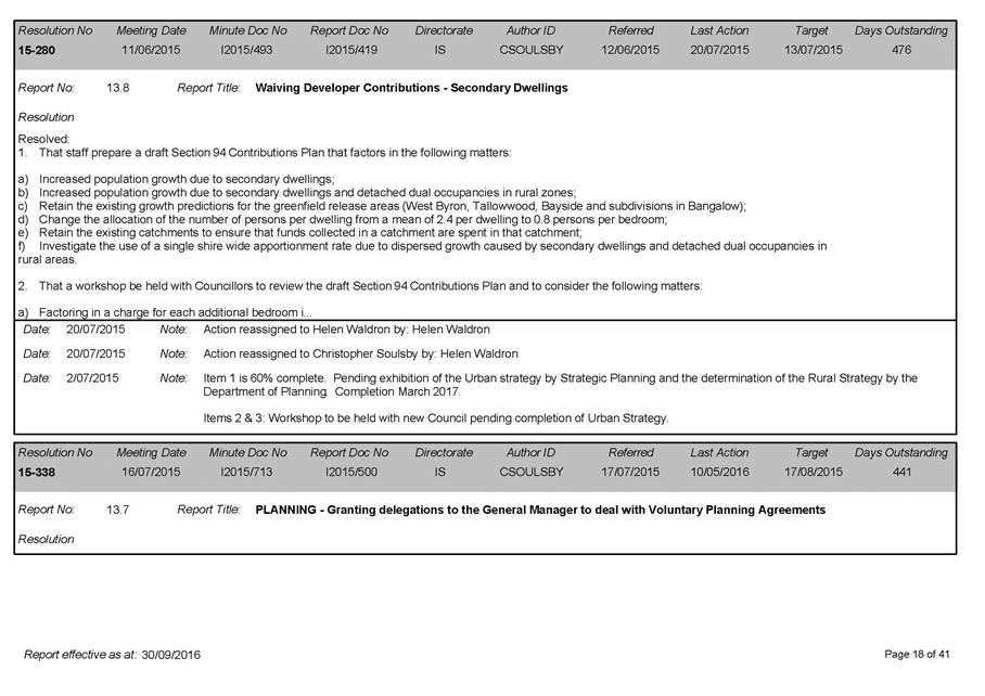
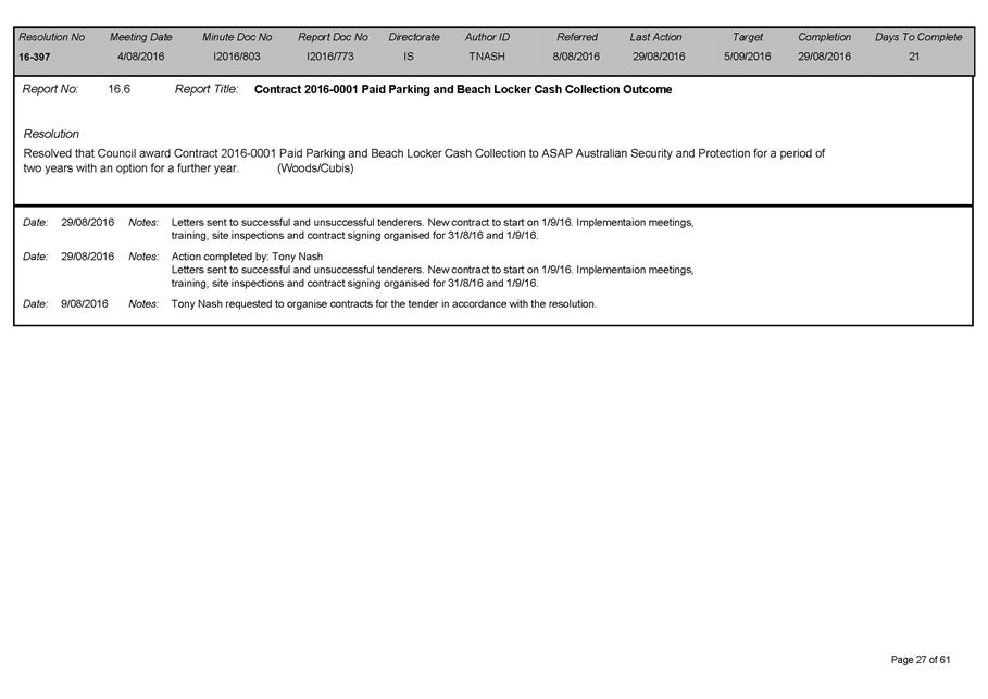
Ordinary Meeting
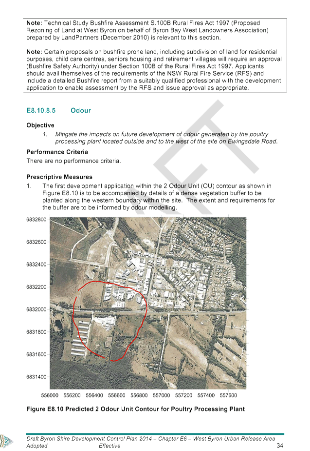
Public ATTACHMENTS
EXCLUDED FROM THE
Ordinary
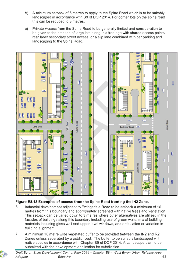
Meeting
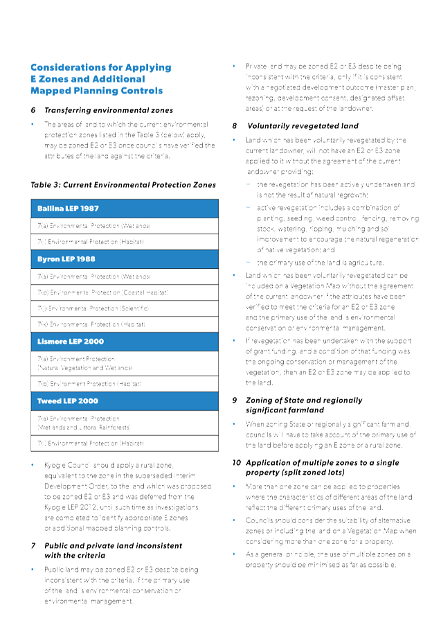
AGENDA
OF 17 November 2016
9. Notices of Motion
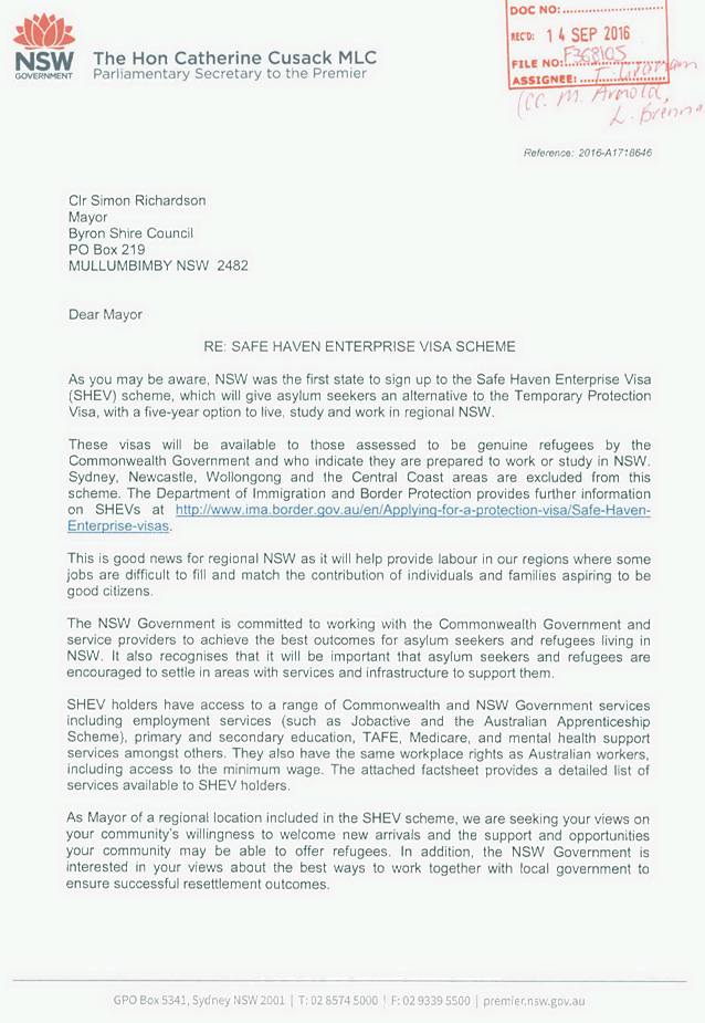
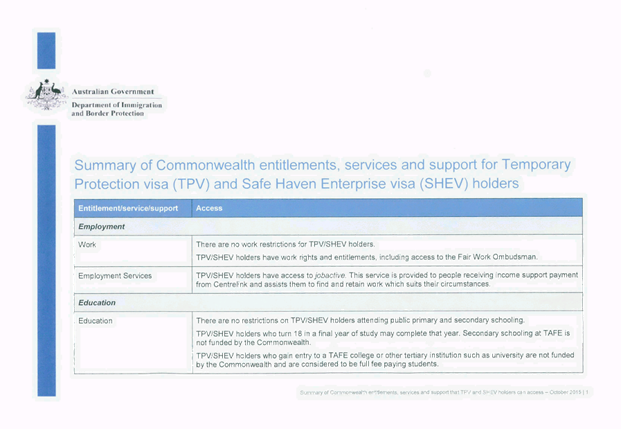
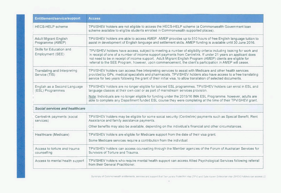
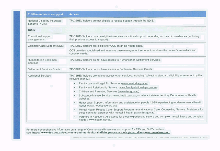
9.2 Support
for the Safe Haven Enterprise Visa Scheme
Attachment
1... NSW Government The Hon Catherine Cusack MLC Parliamentary Secretary to the
Premier - Safe Haven Enterprise Visa Scheme................................. 4
13. Staff Reports
Corporate and Community Services
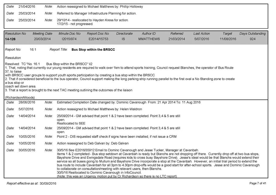
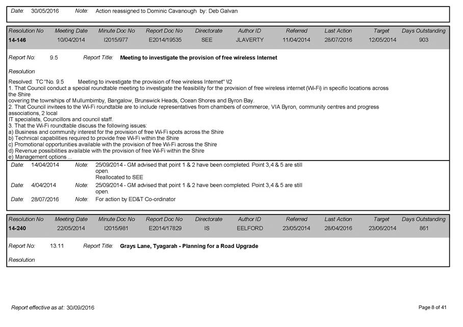
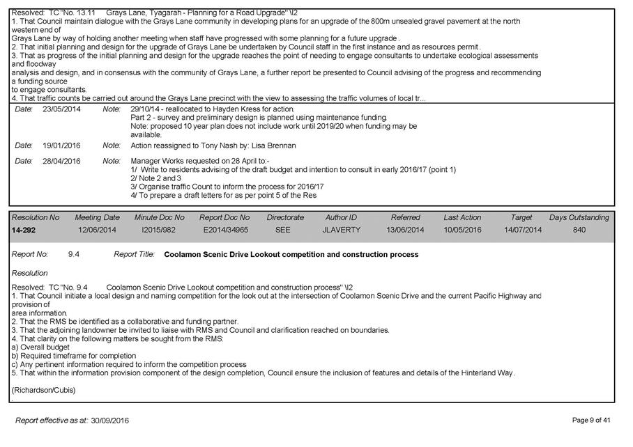
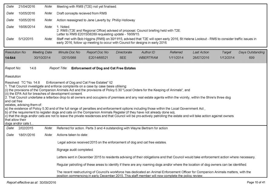
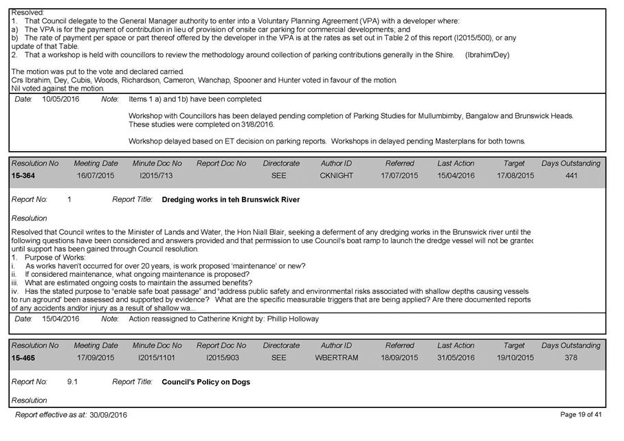
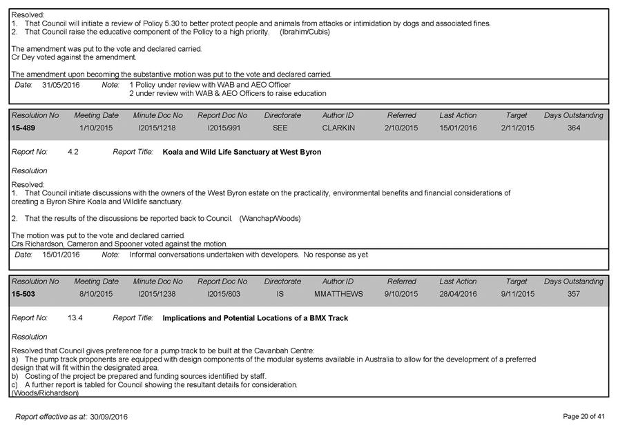
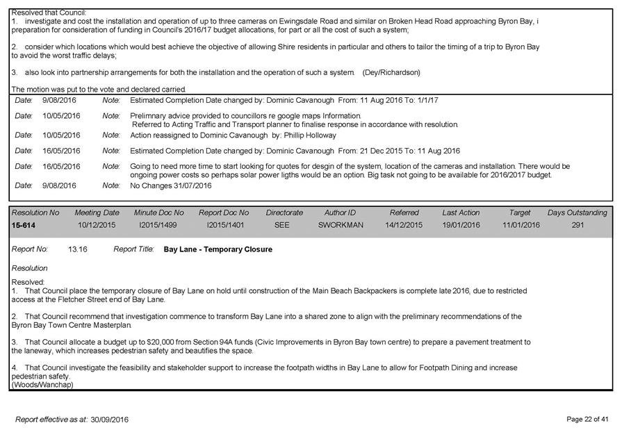
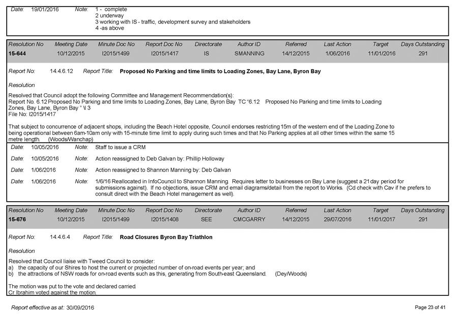
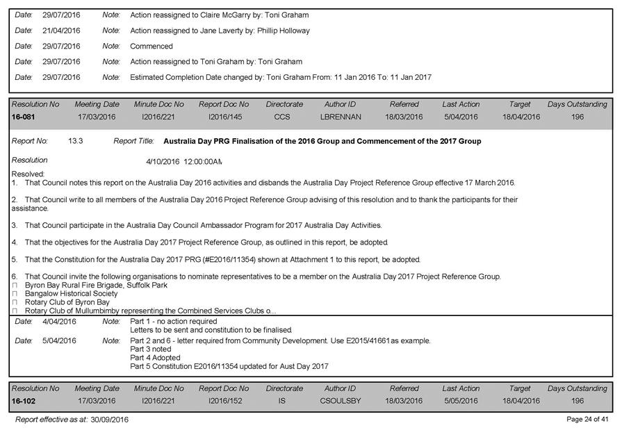
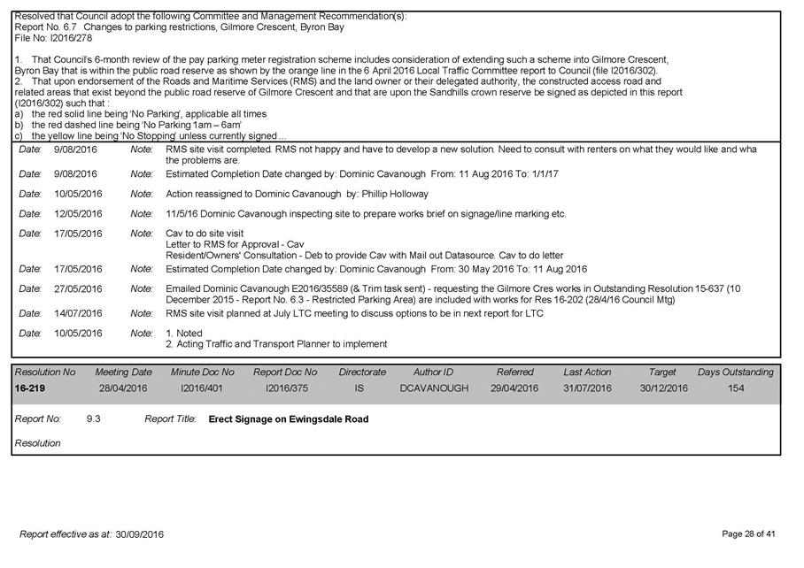
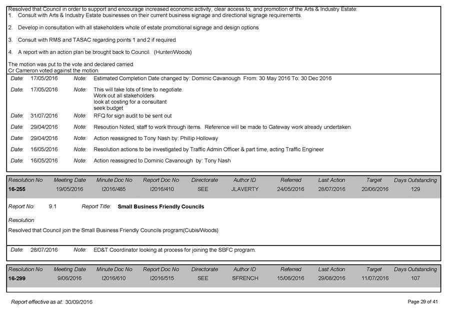
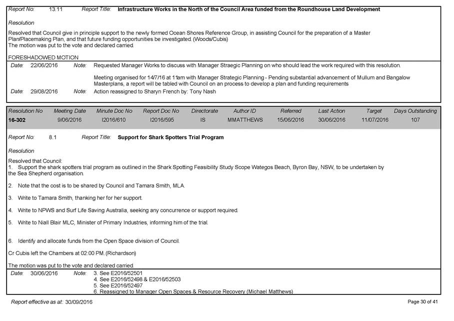
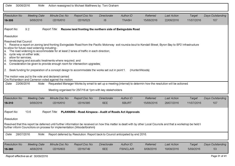
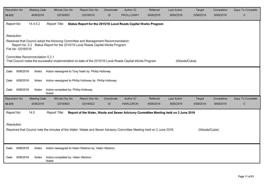
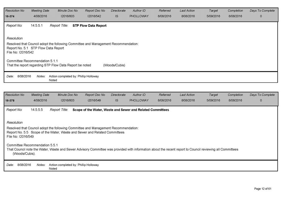
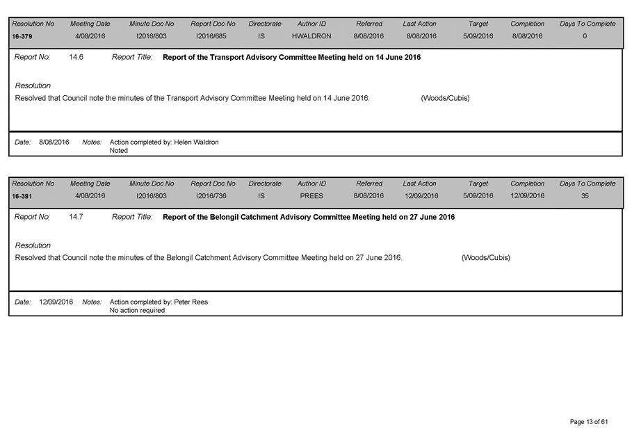
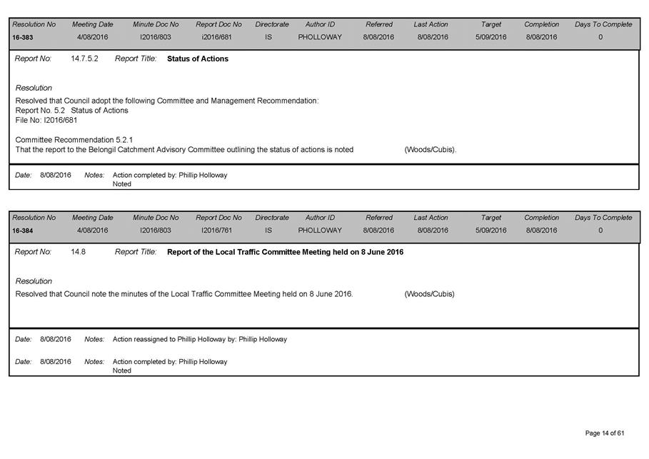
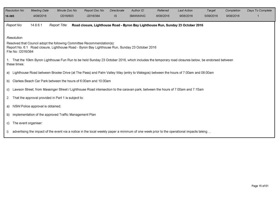
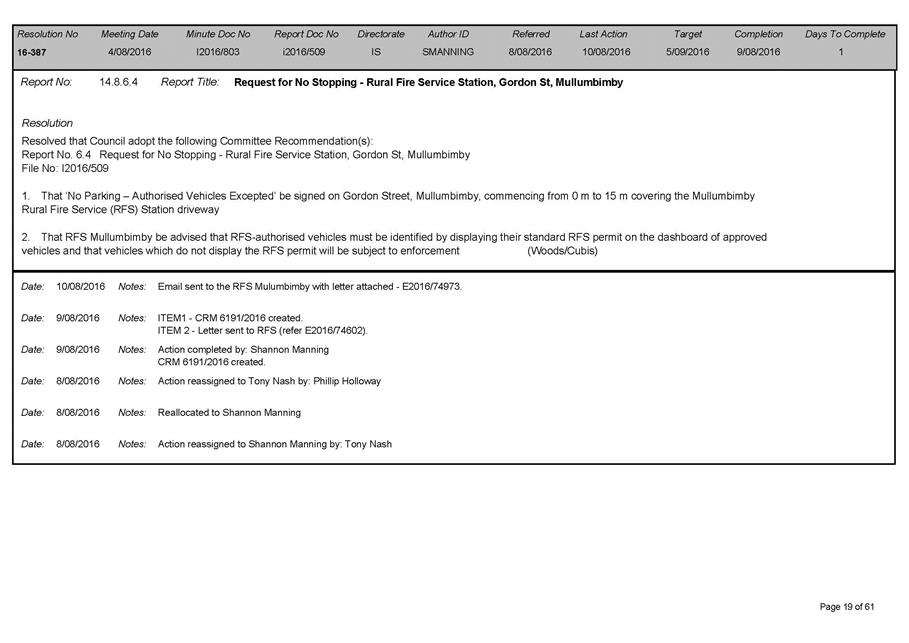
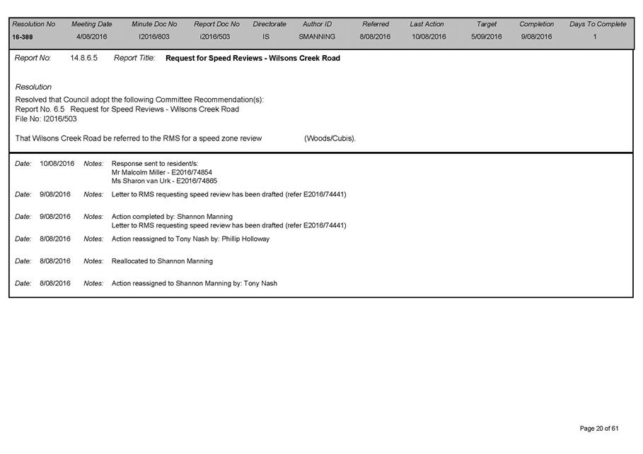
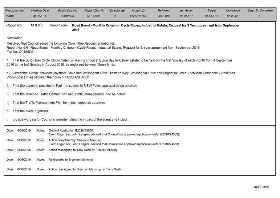
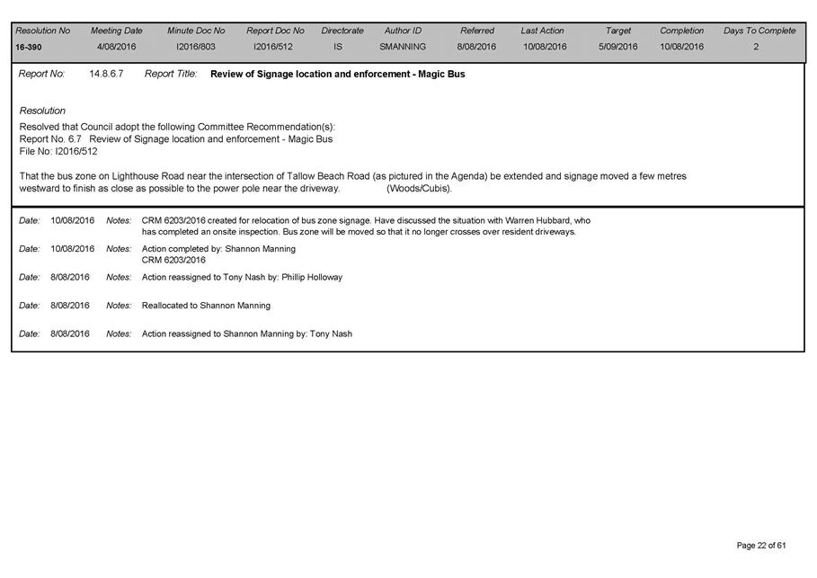
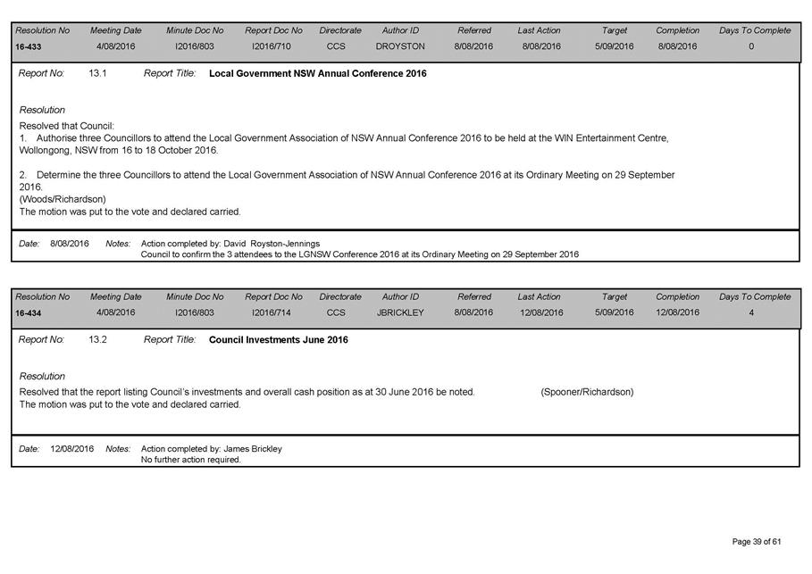
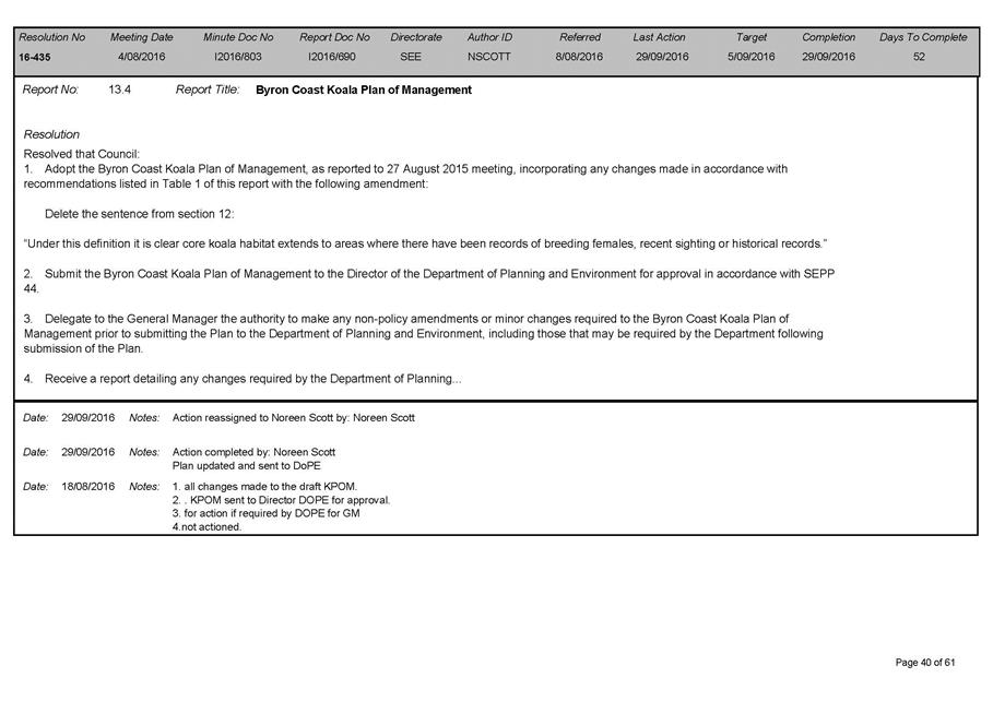
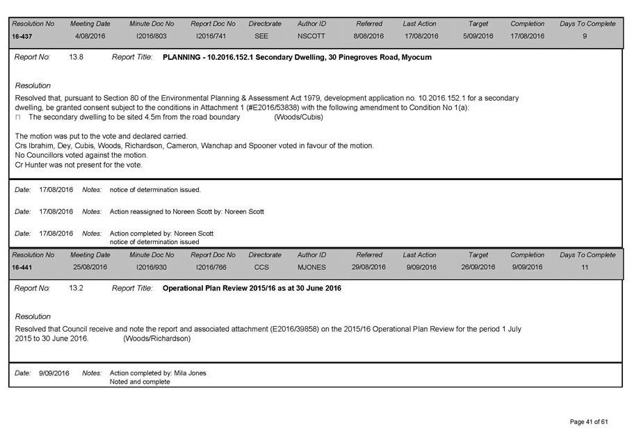
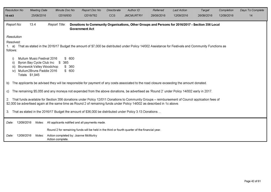
13.1 Review of
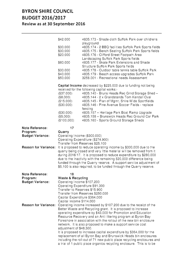
Outstanding Council Resolutions
Attachment
1... Outstanding Resolution Report as at 30/09/16.......................................... 9
Attachment
2... Completed Council Resolutions 01/07/16 to 30/09/16 as reported to Ordinary
Meeting of Council 27 October 2016....................................................... 50
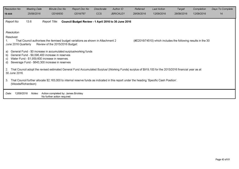
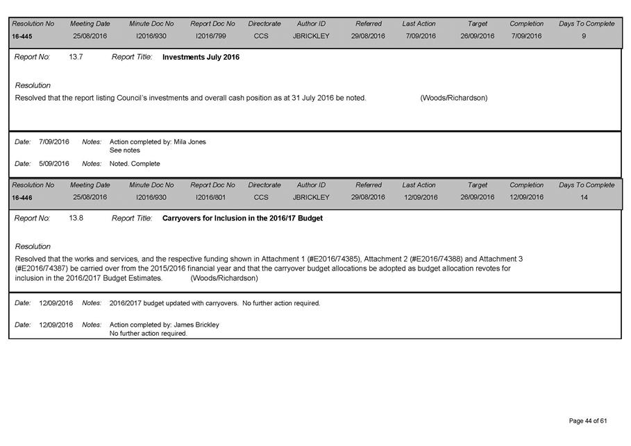
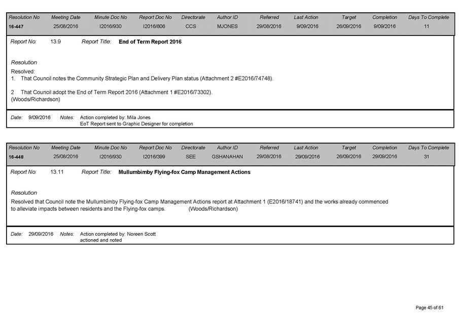
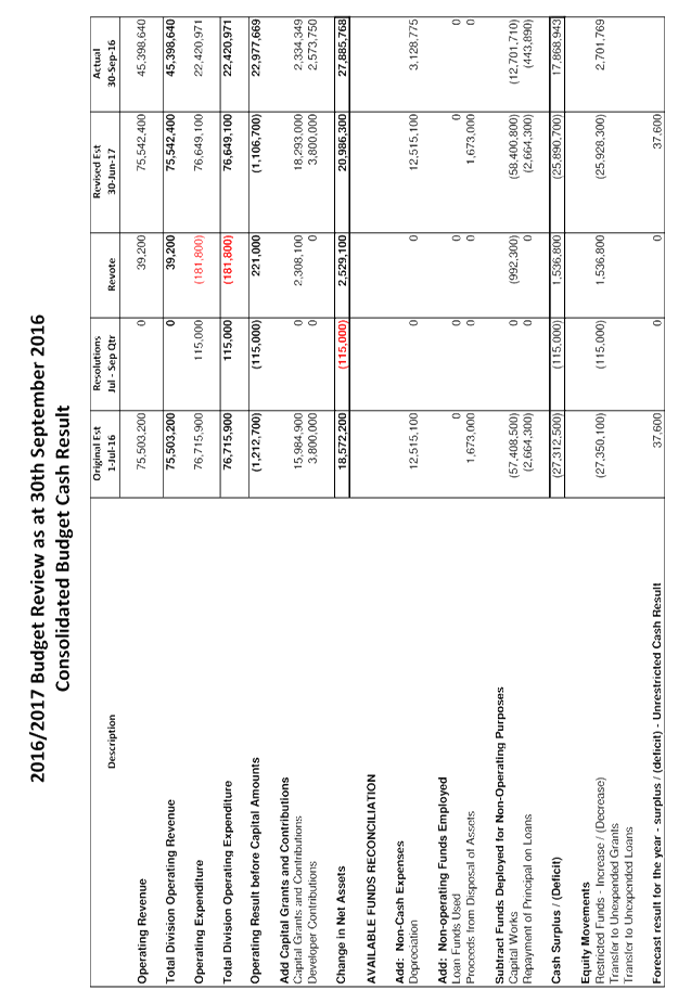
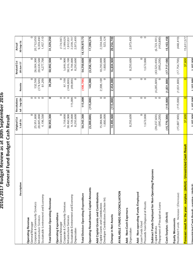
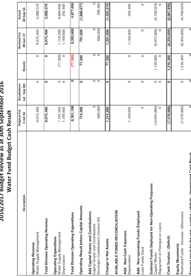
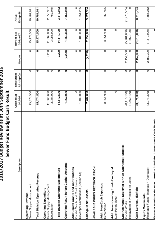
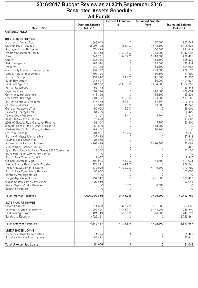
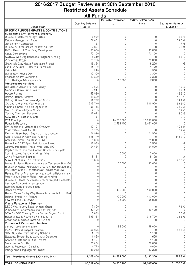
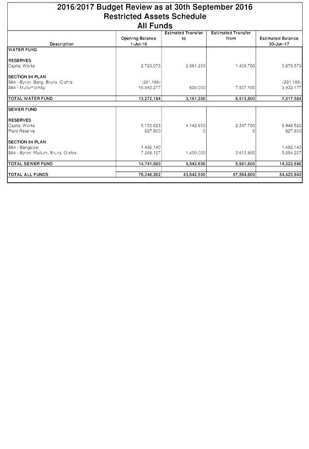
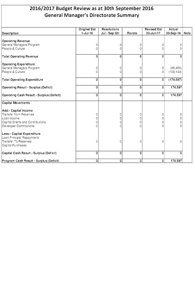
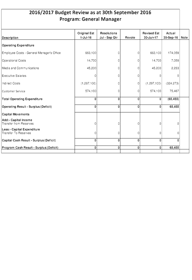
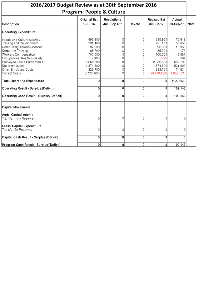
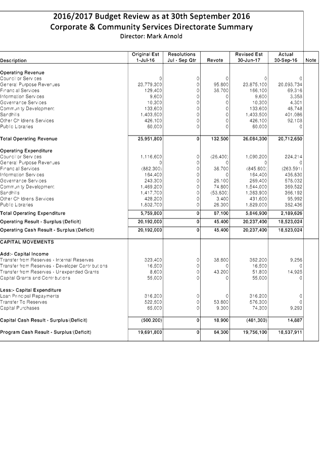
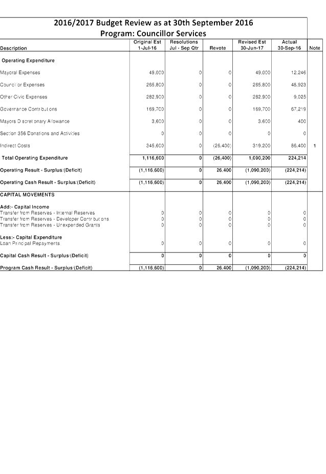
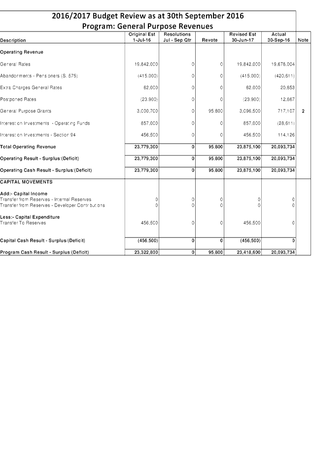
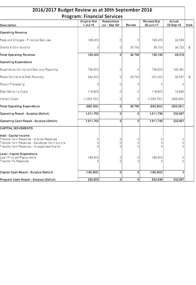
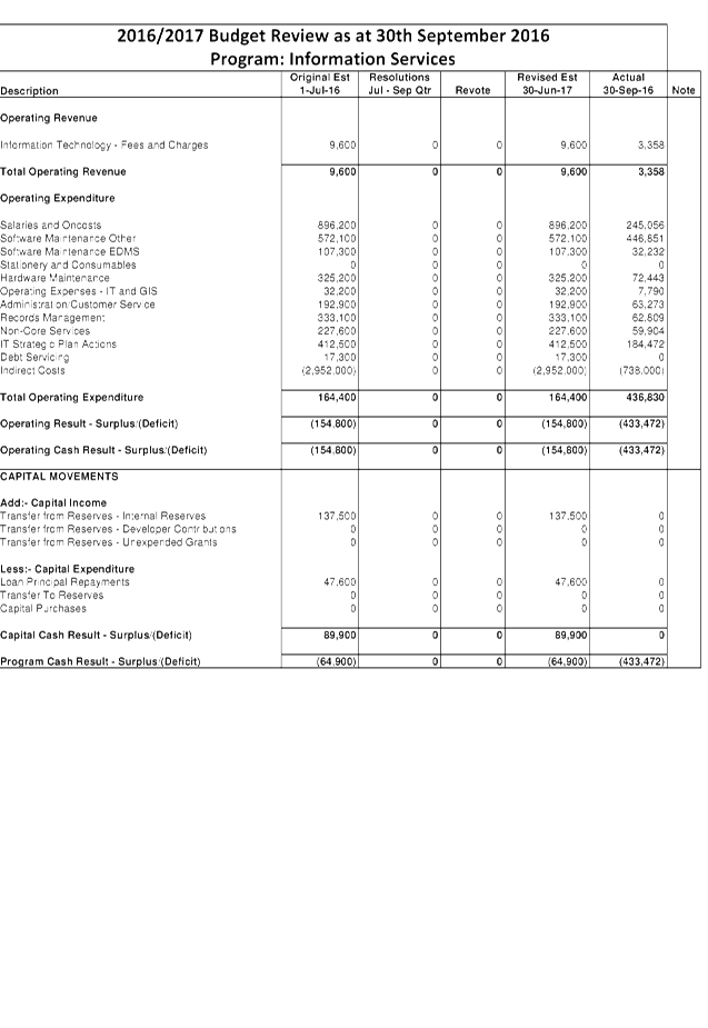
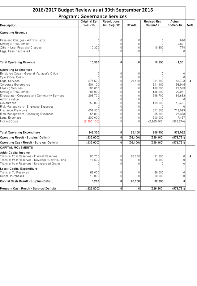
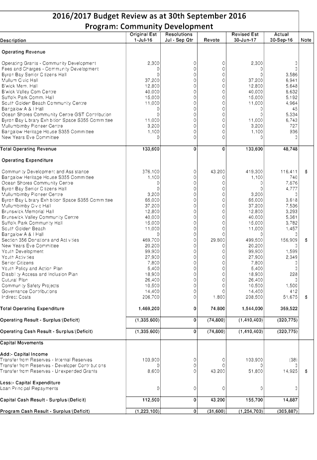
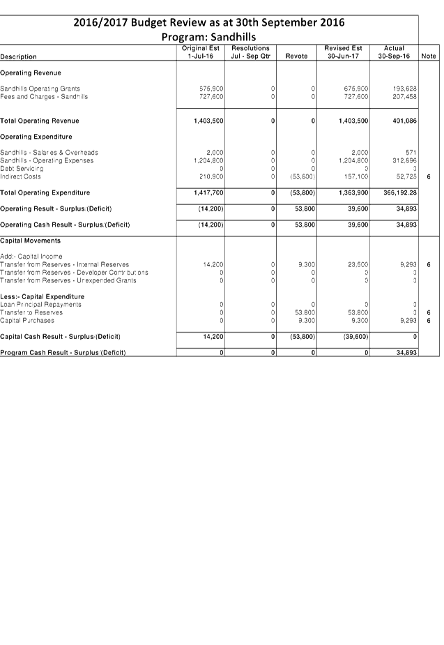
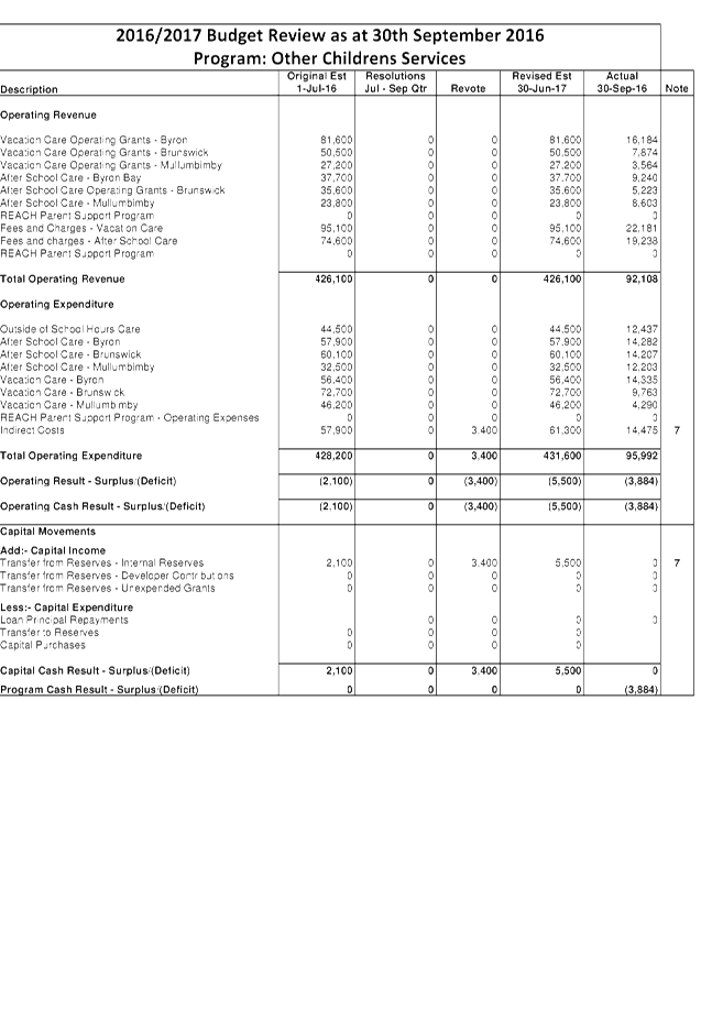
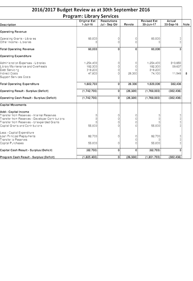
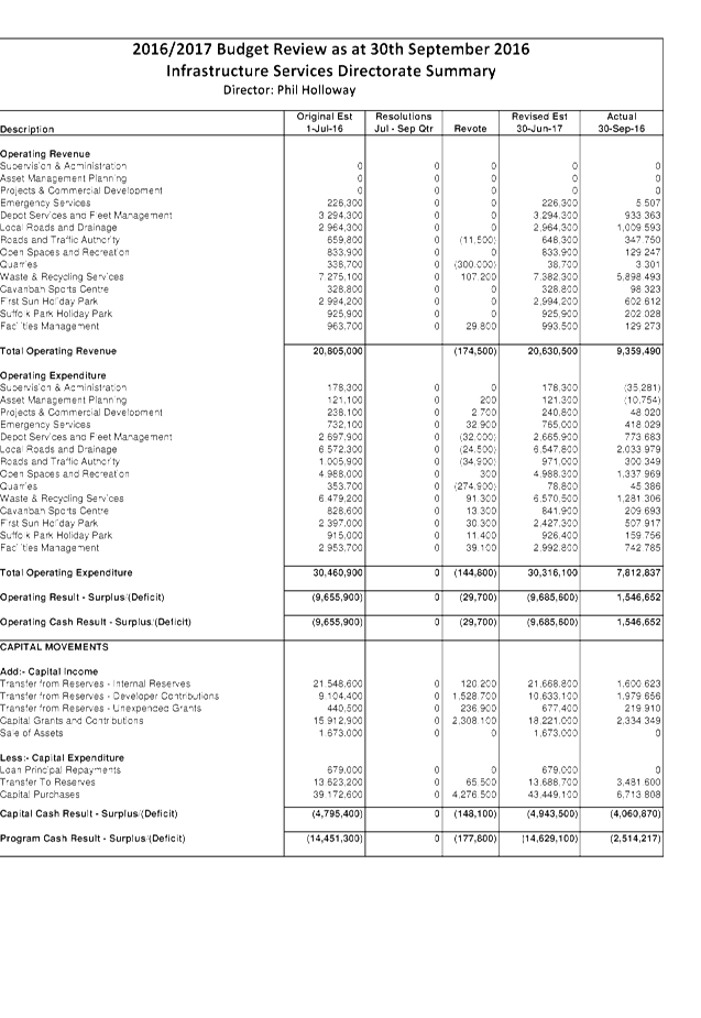
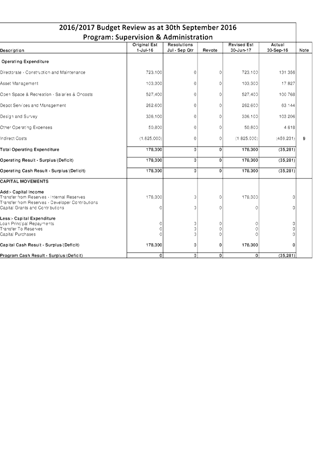
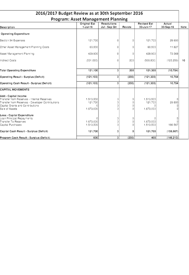
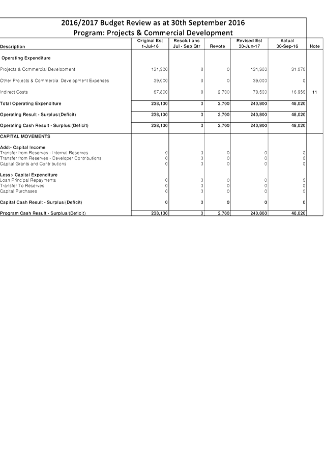
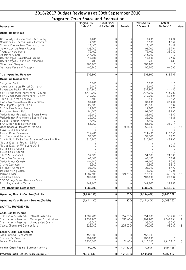
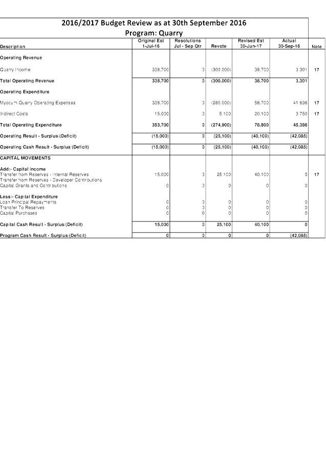
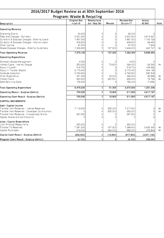
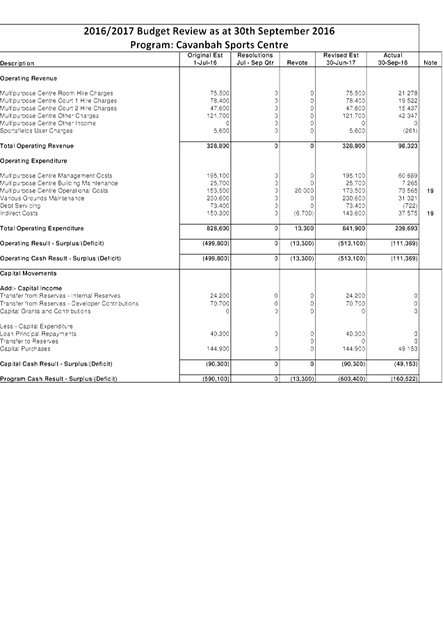
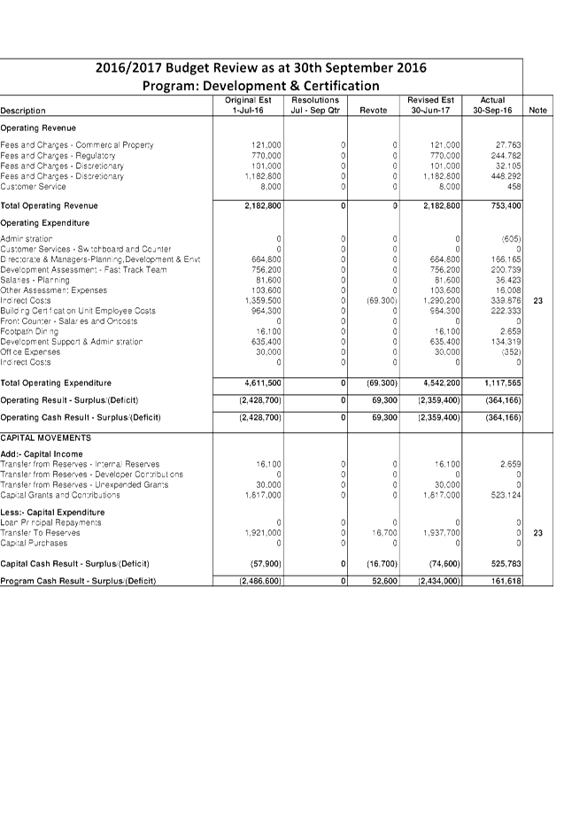
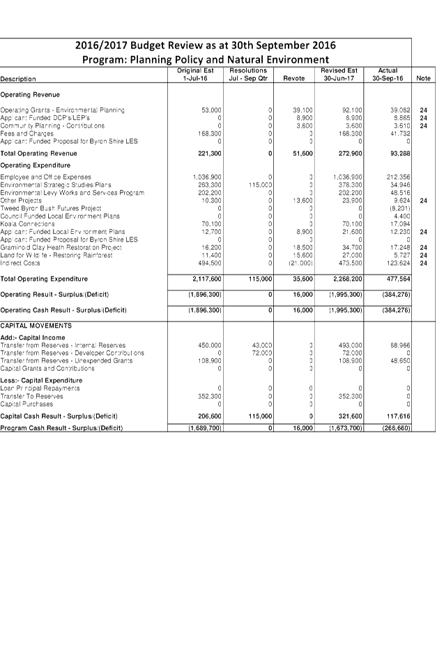
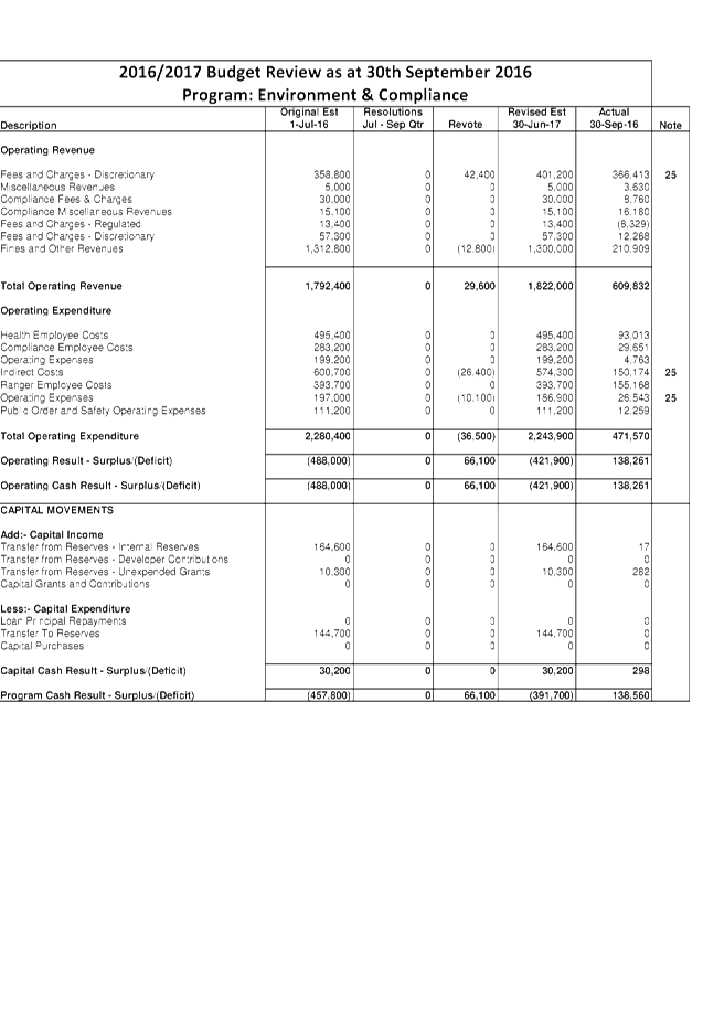
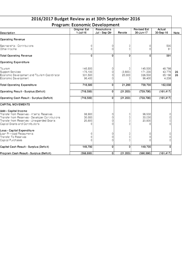
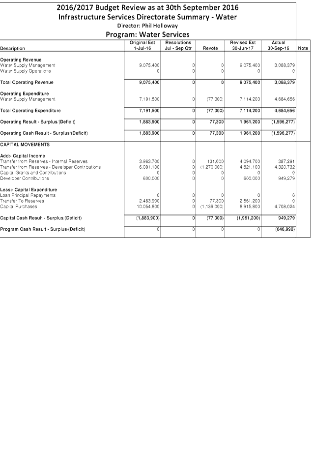
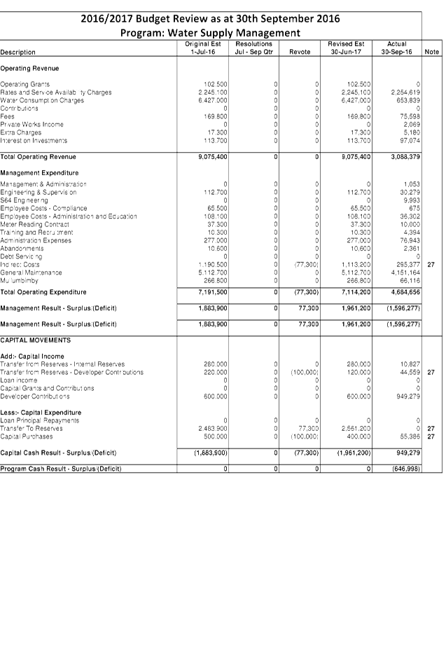
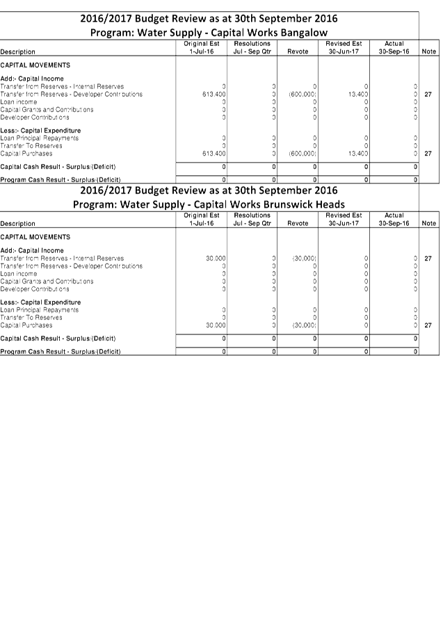
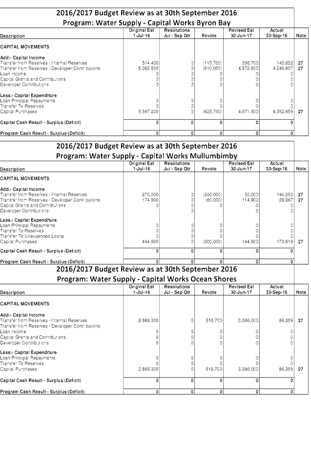
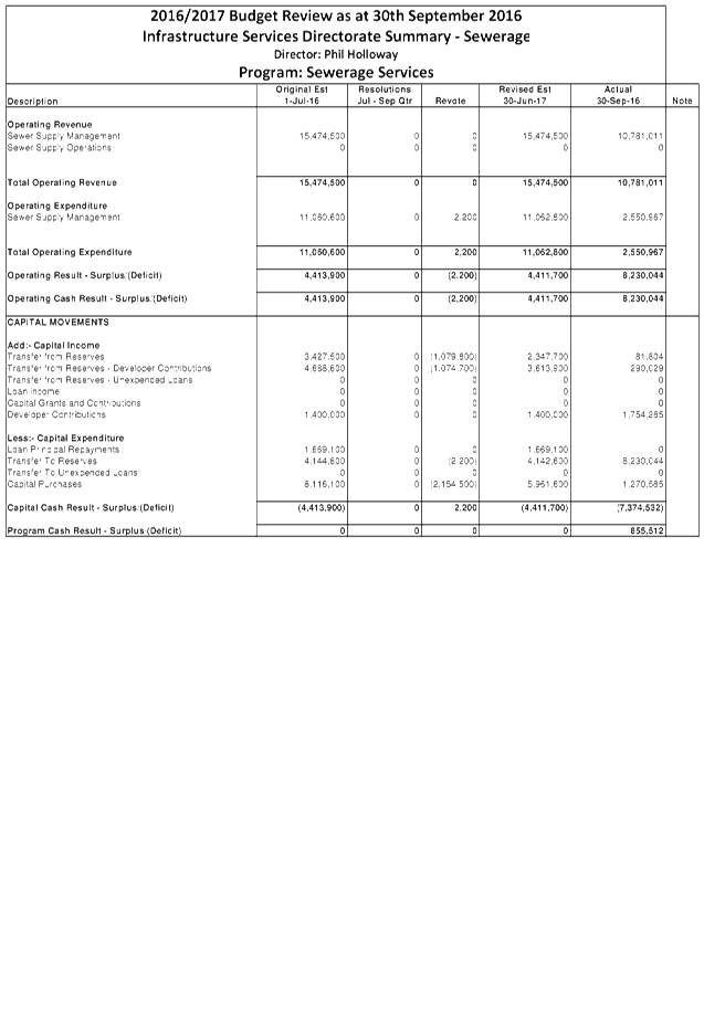
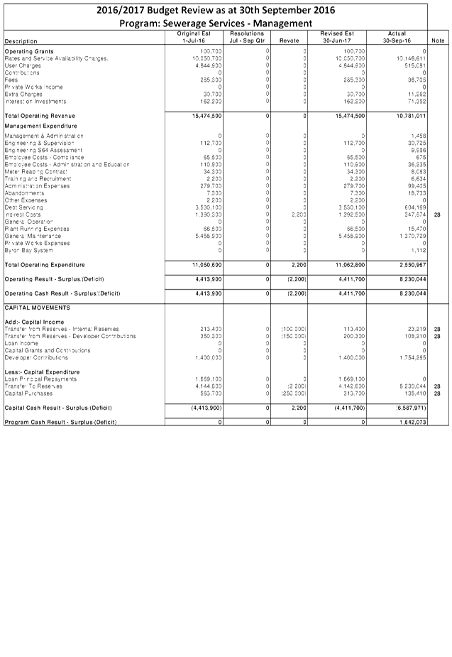
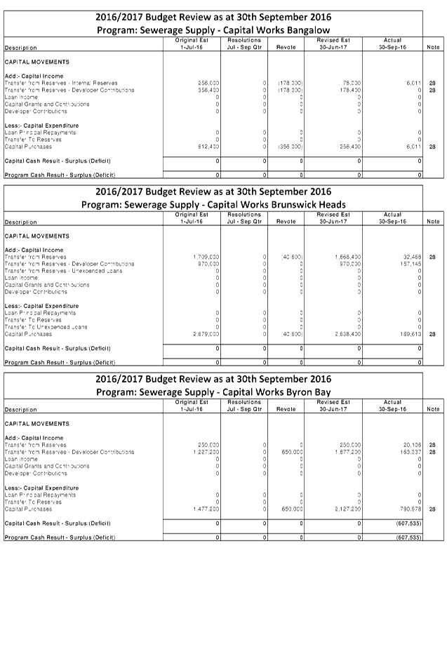
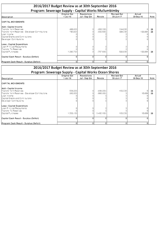
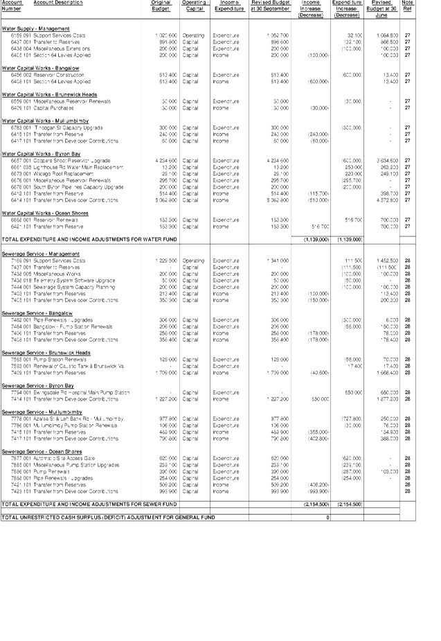
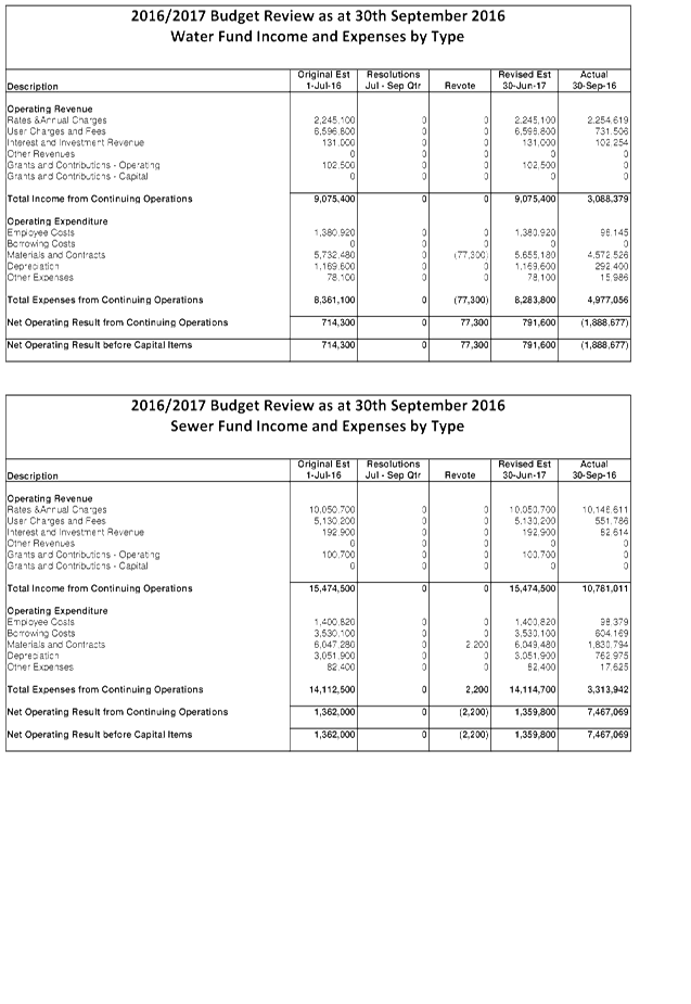
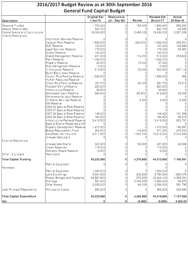
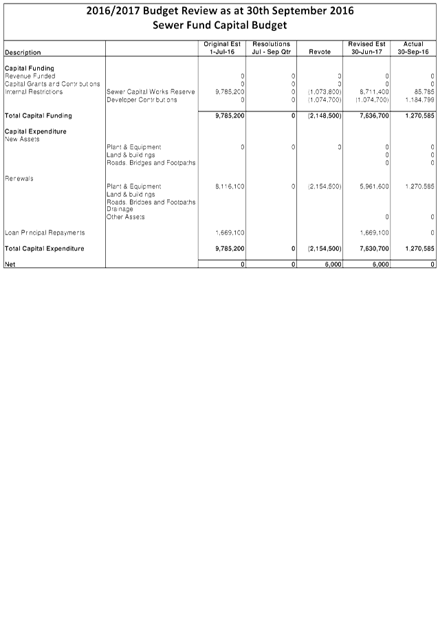
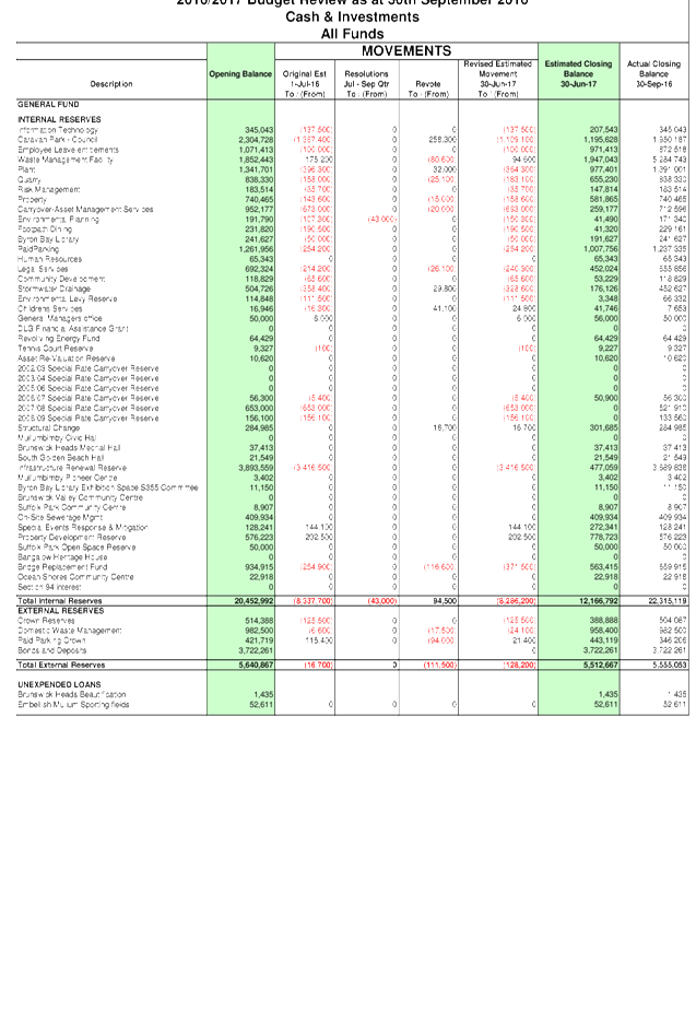
13.2 Council Budget
Review - 1 July 2016 to 30 September 2016
Attachment
1... Budget Variations for General, Water and Sewerage Funds................ 111
Attachment
2... Itemised Listing of Budget Variations for General, Water and Sewerage
Funds 175
Attachment
3... Integrated Planning and Reporting Framework (IP&R) Quarterly Review
Statement............................................................................................................... 179
13.7 Councillor
Representation on Destination Byron
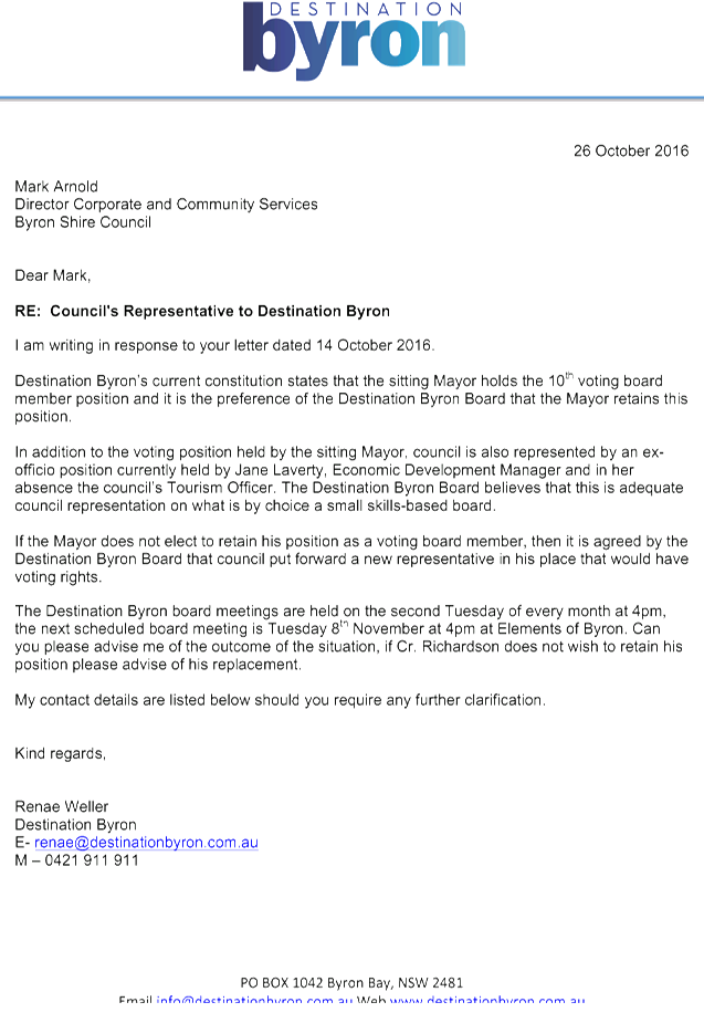
Attachment
1... Letter received from Destination Byron regarding Council's Representative
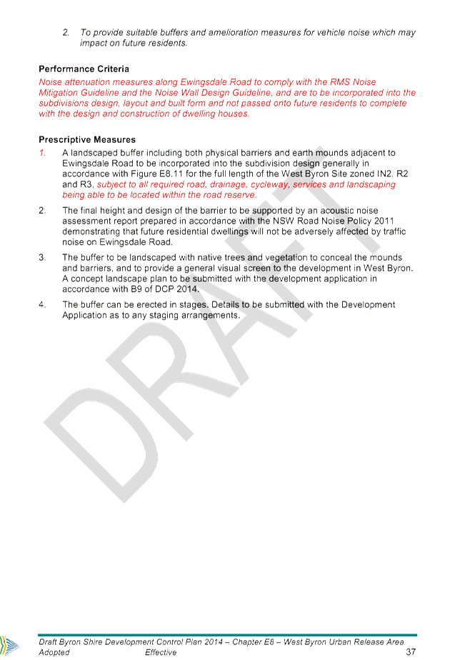
to the Destination Byron Board........................................................................ 194
Sustainable Environment and Economy
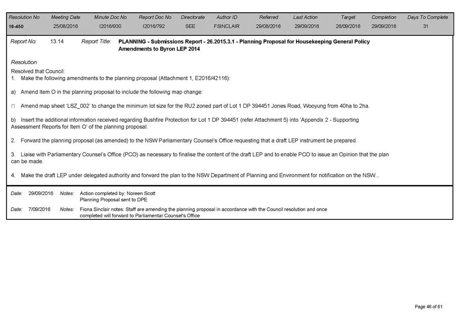
13.9 PLANNING -
Environmental Zones (E Zone) - process to amend Byron LEP 2014
Attachment
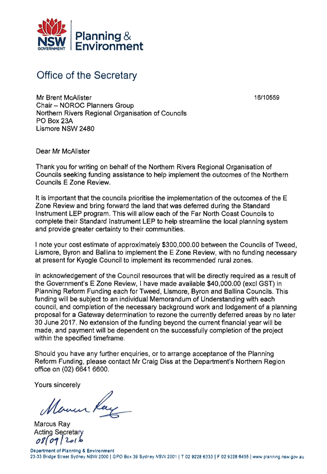
1... Letter from Dept Planning & Environment Office of Secretary to NOROC
Planners Group regarding Environmental Zones E Zones funding and process to
amend LEP 2014....................................................................................................... 195
Attachment
2... Northern Councils E Zone Review Final Recommendations Report - October
2015............................................................................................................... 196
Attachment
3... Project Implementation Plan for application of environmental and/or rural
zones as well as overlays on certain land zoned ‘Deferred Matter’
in Byron LEP 2014 214
Attachment
4... Form of Special Disclosure of Pecuniary Interest................................. 216
13.10 Local Heritage Places Grants
2016-17
Attachment
2... Assessment Criteria - Service Station 16 Granuaille Road Bangalow . 218
Attachment
4... Assessment Criteria - Bangalow Newsagents 26 Byron Street Bangalow 220
Attachment
6... Assessment Criteria - Bangalow Uniting Church 17 Station Street Bangalow 221
Attachment
8... Assessment Criteria - Campbell's House 14 Granuaille Road Bangalow 222
13.11 PLANNING - Draft Byron DCP
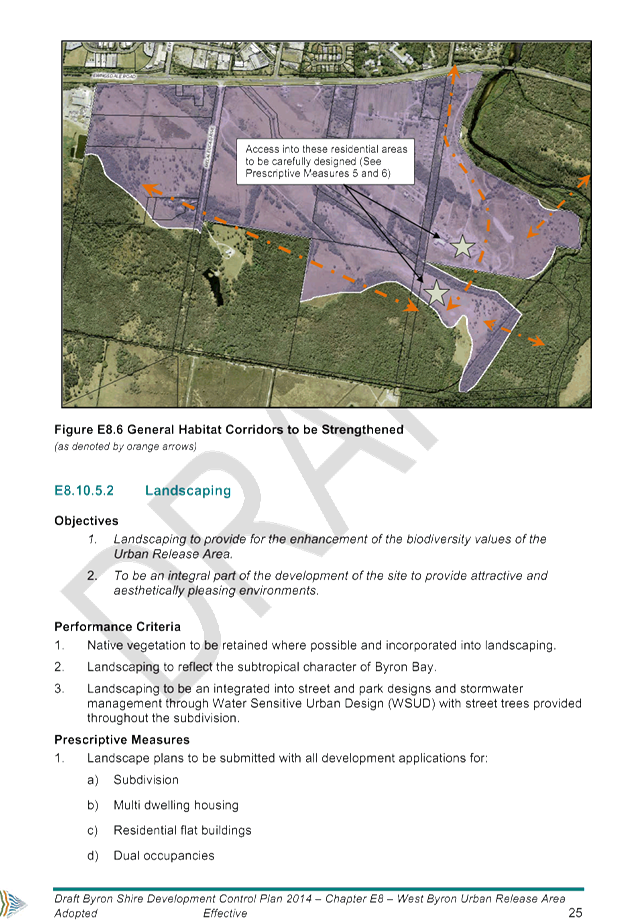
2014 - Chapter E8 West Byron Urban Release Area - Submissions Report
Attachment
1... Part A and D Byron Shire DCP 2014.................................................... 224
Attachment
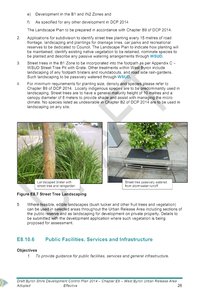
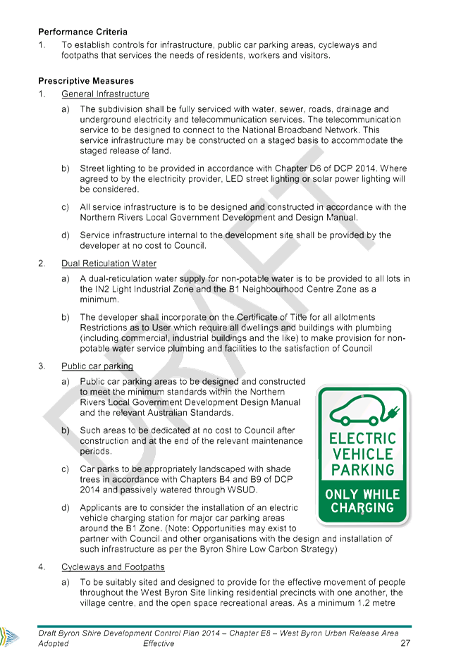
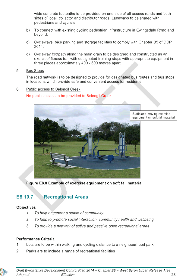
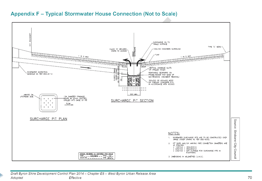
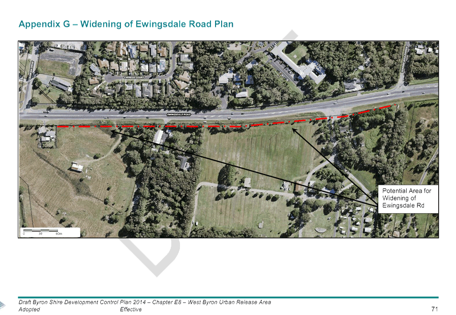
2... draft Byron DCP 2014 Chapter E8 - West Byron Urban Release Area 225
Attachment
3... Submission Report................................................................................. 298
Attachment
5... Letter from Dept Planning & Environment, dated 12 September 2016 331
Attachment
6... Form of Special Disclosure of Pecuniary Interest................................. 332
13.12 PLANNING - BSC ats Koho
Projects Pty Ltd LEC 266825 of 2016
Attachment
1... Report to Council 29 06 2016................................................................ 334
Attachment
2... 10.2016.189.1 - Conditions of consent.................................................. 356
Attachment
3... Plans prepared by Koho considered by Council 4 August 2016........... 368
Attachment
4... Class 1 Application and related plans.................................................... 381
Attachment
5... Site plan related to proposed resolution of proceedings........................ 448
Attachment
6... Plan of management related to proposed resolution of proceedings.... 449
Infrastructure Services
13.14 Council Part Road Reserve
Closure and Subsequent sale at end of Durrumbul Road Adjoining Lot A DP 389649
Attachment
1... Letter to Mr DO Thompson and Ms ML Plowman Re: Interest in Potential road
reserve closure and purchase Durrumbul Road which runs through their property
Lot A DP 389649.................................................................................... 455
Attachment
2... Submission from M. Phelps against the proposed sale and closure of Lot A
DP389649 Durrumbul Road Main Arm................................................. 456
Attachment
3... Submission from Stephen Phelps against the proposed sale and closure of
Lot A DP389649 Durrumbul Road Main Arm................................................. 457
Attachment
4... Submission from Mark Standford and Stephen Phelps against the proposed
sale and closure of Lot A DP389649 Durrumbul Road Main Arm................ 458
Attachment
5... Submission from NSW Rural Fire Service regarding the sale and road closure
of Lot A DP 389649 Durrumbul Road........................................................ 459
Attachment
6... Submission against the proposed road closure to 722 Main Arm Road from
Jarrod and Samara Zillwood............................................................................. 460
Attachment
7... Submission from Sally Wagg regarding the Closure of Road Reserve Lot A DP
389649 (cc P. Holloway)....................................................................... 462
Attachment
8... PDF of Email Debra Gruszka Hungerford Lehmann Solicitor dated 2 June 2016
re Negotiations and Submissions Road Closure 20160113 Sally Anne Wagg adjoining
property Lot A DP 389649 722 Main Arm Road .. Claiming AD Medium Filum Aquae..................................................................................................... 469
Attachment
9... PDF of Submission from Marc Beckman Mills against the proposed sale and
closure of Lot A DP389649 Durrumbul Road Main Arm....................... 472
Attachment
10. PDF of Submission from Stewart Dodd against the proposed sale and closure
of Lot A DP389649 Durrumbul Road Main Arm........................................ 473
Attachment
11. Submission against the proposed road closure to 722 Main Arm Road from John
Singh...................................................................................................... 474
Attachment
12. PDF of Email Submission Official from David Cook Team Manager Far North
Coast NSW Rural Fire Service to DSavage No Objection to Part Road Closure
Council road reserve adjoining LotA DP 389649 Durrumbul Road....... 475
Attachment
13. Letter from Meredith & David Thompson - Submission Expressing approval
of the road closure of Council Road Reserve................................................. 476
Attachment
14. Supplementary Submission from David Thompson & Meredith Plowman
(Thompson) regarding the proposed Road Reserve Closure............... 477
Attachment
15. Letter from Meredith Plowman & David Thompson regarding the Potential
Purchase and Road Reserve Durrumbul Rd........................................ 489
Attachment
16. Submission of Objection to the closure of road reserve Lot A DP 389649 from
P A Maloney 1 Settlement Road Main Arm................................................. 496
Attachment
17. PDF of Email from John Lindsay withdrawing submission RE: 802 Main Arm Rd
of the 3/06/2016......................................................................................... 497
Attachment
18. PDF of Email from John Lindsay - An objection to the proposed
northern Durrumbul Rd (Wagg property) exit closure......................................... 498
Attachment
19. Questions raised by site inspection of Part Road Reserve closure within Lot
A DP 389649 held 25 October 2016............................................................... 499
Attachment
20. Handbook for Driveway access to Properties part of the Northern Rivers
Local Government Development Design and Construction Manuals............. 501
Attachment
21. Designs R-14 Driveways & Vehicular crossings for non kerbed roads R15 -
Longitudinal grading details for non-kerbed roads references out of Handbook
for Driveway access to Properties Northern Rivers Local Government.... 514
Notices of Motion 9.2 - Attachment 1

Notices of Motion 9.2 - Attachment 1
Staff Reports - Corporate and Community Services 13.2 - Attachment 1


Staff Reports - Corporate and Community Services 13.2 - Attachment 2
Staff Reports - Corporate and Community Services 13.2 - Attachment 3


Staff Reports - Corporate and Community Services 13.7 - Attachment 1
Staff Reports - Sustainable Environment and Economy 13.9 - Attachment 1
Staff Reports - Sustainable Environment and Economy 13.9 - Attachment 2


Staff Reports - Sustainable Environment and Economy 13.9 - Attachment 3
|
PROJECT IMPLEMENTATION
PLAN
|
|
Project name:
|
Application of Environmental
(or other) Zones and Overlays in Byron Local Environmental Plan (LEP) 2014
|
|
Purpose:
|
To apply environmental and/or rural zones as well as
overlays on certain land zoned ‘Deferred Matter’ in Byron LEP
2014, in accordance with the current legislative requirements applying to Far
North Coast LEPs
|
|
Land Affected:
|
Applies to all ‘Deferred Matter’ areas
in the Shire, with land affected by the Byron LEP 1988 7(f1) and 7(f2) zones
to be considered concurrently in line with the State Government’s
advice regarding: ‘Coastal Zone Management
Plan for Byron Bay Embayment’; separate hazard zone/s; and coastal
management reforms process
|
|
Directorate:
|
Sustainable Environment & Economy
|
|
Estimated Timeframe
|
Key Milestones
|
Stakeholder Engagement
|
|
STAGE 1
–SHIREWIDE VEGETATION MAPPING COMPLETED
Purpose: - To improve the accuracy of the
mapping and reflect changes in vegetation extent and composition
over time.
- To provide reliable baseline data for planning purposes.
|
|
|
COMPLETED 2015
|
|
Stage 1 – ‘Coastal Lowlands’ vegetation
mapping
|
+
|
Stage 2 – ‘Hinterland’ vegetation
mapping (excluding Huonbrook and surrounds)
|
|
|
|
|
Oct 2016 - March 2017
|
|
Stage 3 – ‘Huonbrook and surrounds’
vegetation mapping
|
->
|
Public exhibition and
ground-truthing
(6 weeks)
|
->
|
Shire wide vegetation mapping completed
|
Who
· Affected landowners and wider community
How
· Letters to landowners; face-to-face meetings with staff
and site inspections; newspaper advert/public notice; fact sheets and/or
FAQs;
|
|
STAGE 2 –
‘PRIMARY LAND USE’ MAPPING prepared
Purpose: To identify the primary use of the land (ie. the
main use for which the land has been used for in the
last 2 years) to inform application of environmental or other zones in Stage
3
|
|
|
Dec 2016 – April 2017
|
|
Desktop Assessment of primary land use (using aerial
photo interpretation, environmental criteria, farmland rating, DA approvals
and other site history) to classify as ‘Agriculture’,
‘Environmental’ or ‘Other’.
|
->
|
Landowner consultation/ engagement program to confirm
“primary land use” mapping
|
->
|
Refined draft “primary land use” mapping
|
Who
· Affected landowners
· Stakeholder Reference Group*
· Council / Government agencies (where public land is
affected)
How
· As applicable for Stage 1 above
|
|
STAGE 3 –
INFORMAL EXHIBITION OF PROPOSED DRAFT ENVIRONMENTAL (OR OTHER) ZONES AND
OVERLAYS
Purpose: - To identify and
address key issues raised early in the process and ensure a high level of support
for
the proposed zones and/or overlays
|
|
|
May 2017 –
Sept 2017
|
|
Draft rural/environmental zones and map overlays prepared
for public exhibition
Zones informed by “primary land use mapping”
as follows:
- RU1 Primary Production
- RU2 Rural Landscape
- E2 Environmental Conservation
- E3 Environmental Management
|
->
|
Public Exhibition of:
- primary land use mapping;
- proposed draft rural/ environmental zones;
- map overlays
(6 weeks)
|
->
|
Council endorsement of
zones and map overlays to inform submission of a planning proposal to DPE for
Gateway Determination
|
Who
· Affected landowners and wider community
· Government agencies
How
· As applicable for Stage 1 above + public information
session
|
|
STAGE 4 –
GATEWAY SUBMISSION OF PLANNING PROPOSAL TO AMEND BYRON LEP 2014
Purpose: To amend LEP 2014 in accordance with the
legislative requirements for application of environmental zones and overlays
in Far North Coast LEPs, as informed by the above stages.
|
|
|
Oct 2017 – March 2018
|
|
Preparation of Planning Proposal and submission to DPE
for Gateway Determination
|
->
|
Public Exhibition of draft Planning Proposal in
accordance with Gateway Determination
(6 weeks)
|
->
|
Council adoption of
final Planning Proposal and making of the proposed Local Environmental Plan
|
Who
· Affected landowners and wider community
· Government agencies
How
· ‘To be determined’
|
|
|
|
|
Oct 2016 – March 2018
|
STAGE 5 – REVIEW OF BYRON LEP 1988 7(F1) AND 7(F2)
COASTAL ZONES to occur concurrently with Stages 2 - 4 above (pending advice from
State government regarding: ‘Coastal Zone Management Plan for Byron Bay
Embayment’; separate hazard zone/s; and coastal management reforms)
|
Who
· Affected landowners and wider community
· Government agencies
How
· As applicable for Stage 1 above + public information
session
|
* Stakeholder Reference Group – to comprise local environmental & agricultural
representatives for the purpose of advising on Stage 2 mapping/engagement
process; group may include representatives previously convened by Council in
March 2013 to consider environmental zones and other strategic planning matters
Staff Reports - Sustainable Environment and Economy 13.9 - Attachment 4
Local
Government (General) Regulation 2005
Schedule 3A Form of special disclosure
of pecuniary interest
(Clause 195A)
Section 451 of the Local Government
Act 1993
Form of Special Disclosure of Pecuniary Interest
1 The particulars of
this form are to be written in block letters or typed.
2 If any space is
insufficient in this form for all the particulars required to complete it, an
appendix is to be attached for that purpose which is properly identified and
signed by you.
Important information
This information is being collected for the purpose of
making a special disclosure of pecuniary interests under sections 451 (4) and
(5) of the Local Government Act 1993. The special disclosure must relate to a pecuniary
interest that arises only because of an interest of the councillor in the
councillor’s principal place of residence or an interest of another
person (whose interests are relevant under section 443 of the Act) in that
person’s principal place of residence. You must not make a special
disclosure that you know or ought reasonably to know is false or misleading in
a material particular. Complaints made about contraventions of these
requirements may be referred by the Director-General to the Local Government
Civil and Administrative Tribunal.
This form must be completed by you before the
commencement of the council or council committee meeting in respect of which
the special disclosure is being made. The completed form must be tabled at the
meeting. Everyone is entitled to inspect it. The special disclosure must be
recorded in the minutes of the meeting.
Special
disclosure of pecuniary interests
by
____________________________________________________________________________________
[full
name of councillor]
in the matter of
__________________________________________________________________________
[insert
name of environmental planning instrument]
which is to be considered at a meeting of the
______________________________________________________________________________________
[name of council or council committee (as the case
requires)]
Report No. __________ to be held on the _________________ day of
________________________ 201
|
Pecuniary
interest
|
|
Address of land
in which councillor or an associated person, company or body has a
proprietary interest (the identified land)1
|
|
|
Relationship of identified land to councillor
[Tick or cross one box.]
|
Councillor
has interest in the land (e.g. is owner or has other interest arising out of
a mortgage, lease, trust, option or contract, or otherwise).
Associated
person of councillor has interest in the land.
Associated company
or body of councillor has interest in the land.
|
|
Matter giving rise to pecuniary interest
|
|
Nature of land that is subject to a
change
in zone/planning control by proposed
LEP (the subject land)2
[Tick or cross one box]
|
The identified
land.
Land
that adjoins or is adjacent to or is in proximity to the identified land.
|
|
Current
zone/planning control
[Insert name
of current planning instrument and identify relevant zone/planning control
applying to the subject land]
|
|
|
Proposed
change of zone/planning control
[Insert name of proposed
LEP and identify proposed change of zone/planning control applying to the
subject land]
|
|
|
Effect
of proposed change of zone/planning control on councillor
[Insert
one of the following:
“Appreciable financial gain” or
“Appreciable
financial loss”]
|
|
[If
more than one pecuniary interest is to be declared, reprint the above box and
fill in for each additional interest.]
_____________________________
Councillor’s
signature
_____________________________
Date
(This
form is to be retained by the Council’s general manager and included in
full in the minutes of the meeting.)
1 Section 443 (1) of the Local Government Act 1993 provides
that you may have a pecuniary interest in a matter because of the pecuniary
interest of your spouse or your de facto partner or your relative 4 or because
your business partner or employer has a pecuniary interest. You may also have a
pecuniary interest in a matter because you, your nominee, your business partner
or your employer is a member of a company or other body that has a pecuniary
interest in the matter.
Section 442
of the Local Government Act 1993 provides
that a "pecuniary interest" is an interest that a
person has in a matter because of a reasonable likelihood or expectation of
appreciable financial gain or loss to the person. A person does not have a
pecuniary interest in a matter if the interest is so remote or insignificant
that it could not reasonably be regarded as likely to influence any decision
the person might make in relation to the matter or if the interest is of a kind
specified in section 448 of that Act (for example, an interest as an elector or
as a ratepayer or person liable to pay a charge).
2 A pecuniary interest may
arise by way of a change of permissible use of land adjoining, adjacent to or
in proximity to land in which a councillor or a person, company or body
referred to in section 443 (1) (b) or (c) of the Local Government Act 1993 has a proprietary interest-see section 448 (g) (ii) of
the Local Government Act 1993 .
3 "Relative" is
defined by the Local Government Act 1993 as meaning your, your spouse’s or your de facto
partner’s parent, grandparent, brother, sister, uncle, aunt, nephew,
niece, lineal descendant or adopted child and the spouse or de facto partner of
any of those persons.
Staff Reports - Sustainable Environment and Economy 13.10 - Attachment 2
Project: Granuaille Road – Service
Station
Description
of Proposed Works:
The existing Service Station located
at 16 Granuaille Road, Bangalow. It is proposed to undertake façade
restoration works to the existing Service Station located in the north-eastern
corner of the site.
The Service Station is not
specifically identified as a Heritage Item under the Byron LEP 2014, however the
subject site contains a Heritage Item being the Campbell’s House
‘Byron Lodge’. The Service Station forms the setting of the
Heritage Item and is in need of repair as demonstrated in the photos supporting
the completed grant application form.
The Service Station and site are
located in a prominent position on a main entrance into Bangalow being
Granuaille Road.
Value
of Works: $15,000 Grant
Funding Sought: $3,000
|
Assessment
Criteria
|
Complies
|
Assessment
Notes
|
|
Projects
of demonstrated heritage value to the community, e.g. the restoration of an
important local heritage house;
|
Yes
|
The
Service Station is not specifically identified under the Byron LEP 2014,
however the Service Station forms part of the setting for the Cambell’s
House ‘Byron Lodge’ (heritage item) that is located on the
subject site.
|
|
Projects
which are highly visible to the public, e.g. the replacement of a verandah to
a building in a main street location;
|
Yes
|
The site
is located at 16 Granuaille Road, Bangalow and forms a significant component
of the streetscape when entering into Bangalow from the north along
Granuaille Road.
|
|
Projects
which have high public accessibility, e.g. a local museum, church or a
private home which is open to the public several times a year;
|
Yes
|
The
Service Station and associated shop is open to members of the
community.
|
|
Projects
that are in an area which has received little or no funding;
|
Yes
|
The
Service Station has not received funding for maintenance purposes.
|
|
Projects
involving aspects of heritage which have received little or no funding
e.g.historic gardens;
|
Yes
|
The
Service Station is not specifically identified as a Heritage Item however
forms an integral part of the setting to the Campbell’s House
‘Byron Lodge’.
|
|
Urgent
projects to avert a threat to a heritage item; or
|
Yes
|
The
Service Station is in an increasing state of disrepair and as such the
façade restoration is required as a form of preventative maintenance
of the building.
|
|
The
applicant's ability to demonstrate financial responsibility with regard to
the project, and demonstrated ability to complete the project by May in the
same financial year. Council’s Heritage Advisor and Heritage Advisory
Committee will consider applications for funding assistance and recommendations
will then be made to Council
|
Yes
|
The
applicant has provided 2 quotes to undertake the restoration works.
|
|
Timing
of Projects
|
|
All
works must be completed by the beginning of May within the same financial
year as the granting of funding approval
|
Yes
|
Works
will be undertaken prior to May 2017.
|
|
|
|
|
Condition
Colours to match
the colour scheme of restored ‘Heritage Item Campbell’s House
‘Byron Lodge’, or where alternative colours are proposed, any
alternate colours are to be approved in writing by Council prior to the
commencement of works.
Staff Reports - Sustainable Environment and Economy 13.10 - Attachment 4
Project: Bangalow
News Agency
Description
of Proposed Works:
There
is an existing historic mural on the side of the Bangalow News Agency facing
onto Fire Station Park to the east along Byron Street. The mural is in urgent
need of repainting to preserve its heritage relevance to Bangalow’s
History.
Value
of Works: $6,000 (approximately)
Grant
Funding Sought: $3,000
|
Assessment
Criteria
|
Complies
|
Assessment
Notes
|
|
Projects
of demonstrated heritage value to the community, e.g. the restoration of an
important local heritage house;
|
Yes
|
Although
the New Agency building is not heritage listed under the Byron LEP 2014 the
mural depicts Bangalows history.
|
|
Projects
which are highly visible to the public, e.g. the replacement of a verandah to
a building in a main street location;
|
Yes
|
The site
is located at 26 Byron Street, Bangalow and is highly visible to the public
from within Fire Station Park and from Byron Street.
|
|
Projects
which have high public accessibility, e.g. a local museum, church or a
private home which is open to the public several times a year;
|
Yes
|
Given the
location of the mural in the centre of town it is highly visible.
|
|
Projects
that are in an area which has received little or no funding;
|
No
|
No
funding has been allocated to the upkeep of this mural
|
|
Projects
involving aspects of heritage which have received little or no funding
e.g.historic gardens;
|
Yes
|
No
funding has been allocated to the upkeep of this mural
|
|
Urgent
projects to avert a threat to a heritage item; or
|
Yes
|
The
application has stated that the Mural is in urgent need of repairs.
Repainting of the mural to maintain the integrity of the image should be
undertaken.
|
|
The
applicant's ability to demonstrate financial responsibility with regard to
the project, and demonstrated ability to complete the project by May in the
same financial year. Council’s Heritage Advisor and Heritage Advisory
Committee will consider applications for funding assistance and
recommendations will then be made to Council
|
Yes
|
The
applicant has provided 2 quotes to undertake the restoration works.
|
|
Timing
of Projects
|
|
All
works must be completed by the beginning of May within the same financial
year as the granting of funding approval
|
Yes
|
Works
will be undertaken prior to May 2017.
|
Condition
That the
restoration of the Mural on the wall of the Bangalow News Agency to match the
existing Mural (any alterations to the image to be approved by Council in
writing prior to repainting).
Staff Reports - Sustainable Environment and Economy 13.10 - Attachment 6
Project: Bangalow
Uniting Church
Description
of Proposed Works:
The Bangalow Uniting Church is
located at 17 Station Street, Bangalow and is identified as a Heritage Item
under the Byron LEP 2014. The Uniting Church is in need of repainting at the
current time as painting the exterior of the church has not been undertaken
within the last 10 years.
The church is in a prominent position
in Bangalow and has been there for over a hundred years. it is popular for
weddings, and is used regularly for church services and events, and by
community groups. We would describe it as one of the heritage feature buildings
of the town.
Value
of Works: $32,989.00 Grant
Funding Sought: $3,000
|
Assessment
Criteria
|
Complies
|
Assessment
Notes
|
|
Projects
of demonstrated heritage value to the community, e.g. the restoration of an
important local heritage house;
|
Yes
|
The
Bangalow Uniting Church is identified as a Heritage Item under the Byron LEP
2014.
|
|
Projects
which are highly visible to the public, e.g. the replacement of a verandah to
a building in a main street location;
|
Yes
|
The site
is located at 17 Station Street, Bangalow and forms an integral component of
the streetscape. In addition the site is visible from the intersection of
Station and Byron Streets.
|
|
Projects
which have high public accessibility, e.g. a local museum, church or a
private home which is open to the public several times a year;
|
Yes
|
The
Uniting Church is open to all members of the community.
|
|
Projects
that are in an area which has received little or no funding;
|
Yes
|
The
Church has not received funding for maintenance purposes.
|
|
Projects
involving aspects of heritage which have received little or no funding
e.g.historic gardens;
|
No
|
|
|
Urgent
projects to avert a threat to a heritage item; or
|
Yes
|
The
application has stated that the existing paintwork on the Uniting Church has
not been undertaken for over 10 years. As such the repainting of the Church
is required as a form of preventative maintenance of the building.
|
|
The
applicant's ability to demonstrate financial responsibility with regard to
the project, and demonstrated ability to complete the project by May in the
same financial year. Council’s Heritage Advisor and Heritage Advisory
Committee will consider applications for funding assistance and
recommendations will then be made to Council
|
Yes
|
The
applicant has provided 2 quotes to undertake the restoration works.
|
|
Timing
of Projects
|
|
All
works must be completed by the beginning of May within the same financial
year as the granting of funding approval
|
Yes
|
Works
will be undertaken prior to May 2017.
|
|
|
|
|
Condition
Colours to match
existing or where alternative colours are proposed, any alternate colours are
to be approved in writing by Council prior to the commencement of works.
Staff Reports - Sustainable Environment and Economy 13.10 - Attachment 8
Project: Granuaille
Road – Campbell’s House ‘Byron Lodge’
Description
of Proposed Works:
The proposed works include the
restoration of the Heritage Item known as Campbell’s House ‘Byron
Lodge’ located at 16 Granuaille Road, Bangalow. The proposed works
include the restoration of the house façade to the original heritage
appearance.
The works will include the removal of
current enclosed verandah and reinstatement with the historic bullnose
verandah, ornate posts, trims and restoration of the original verandah French
doors.
The proposed works have previously
been approved as part of Development Application 10.2014.419.1 for the purposes
of a veterinary establishment.
Campbell’s House
‘Byron Lodge’ is a prominent historic item which is highly visible
from Granuaille Road (being a main entrance to the township of Bangalow).
Value
of Works: $25,000 Grant
Funding Sought: $3,000
|
Assessment
Criteria
|
Complies
|
Assessment
Notes
|
|
Projects
of demonstrated heritage value to the community, e.g. the restoration of an
important local heritage house;
|
Yes
|
Campbell’s
House ‘Byron Lodge’ is specifically identified as a Heritage Item
under the Byron LEP 2014. The works will include the full façade
restoration of a significant local heritage house.
|
|
Projects
which are highly visible to the public, e.g. the replacement of a verandah to
a building in a main street location;
|
Yes
|
The site
is located at 16 Granuaille Road, Bangalow and forms a significant component
of the streetscape when entering into Bangalow from the north along
Granuaille Road.
|
|
Projects
which have high public accessibility, e.g. a local museum, church or a
private home which is open to the public several times a year;
|
Yes
|
The site
is highly visible from Granuallie Road and has previolus planning approval to
operate as a Veterinary Establishment which will thereby provide access into
the heritage item to members of the community.
|
|
Projects
that are in an area which has received little or no funding;
|
Yes
|
The
Dwelling House has not received funding for maintenance purposes.
|
|
Projects
involving aspects of heritage which have received little or no funding
e.g.historic gardens;
|
No
|
|
|
Urgent
projects to avert a threat to a heritage item; or
|
Yes
|
Dwelling
House is in an increasing state of disrepair and as such the façade
restoration and reinstatement of the original fabric of the building will
form both preventative maintenance of the building and significant
restoration works.
|
|
The
applicant's ability to demonstrate financial responsibility with regard to
the project, and demonstrated ability to complete the project by May in the
same financial year. Council’s Heritage Advisor and Heritage Advisory
Committee will consider applications for funding assistance and
recommendations will then be made to Council
|
Yes
|
The
applicant has provided 2 quotes to undertake the restoration works.
|
|
Timing
of Projects
|
|
All
works must be completed by the beginning of May within the same financial
year as the granting of funding approval
|
Yes
|
Works
will be undertaken prior to May 2017.
|
|
|
|
|
Condition
Colour scheme for
the restoration of Campbell’s House ‘Byron Lodge’ are to be
approved in writing by Council prior to the commencement of works.
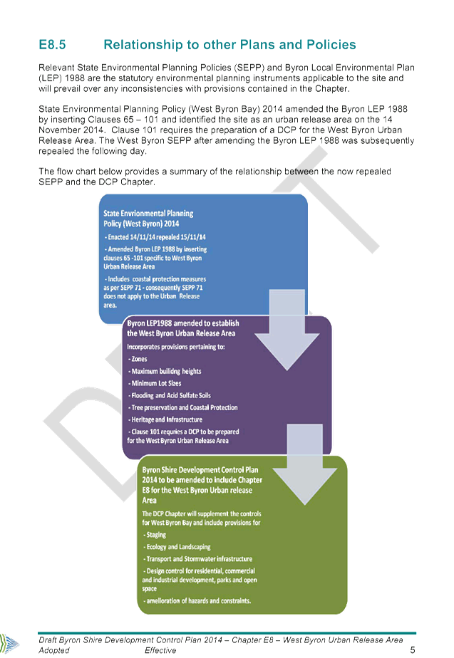
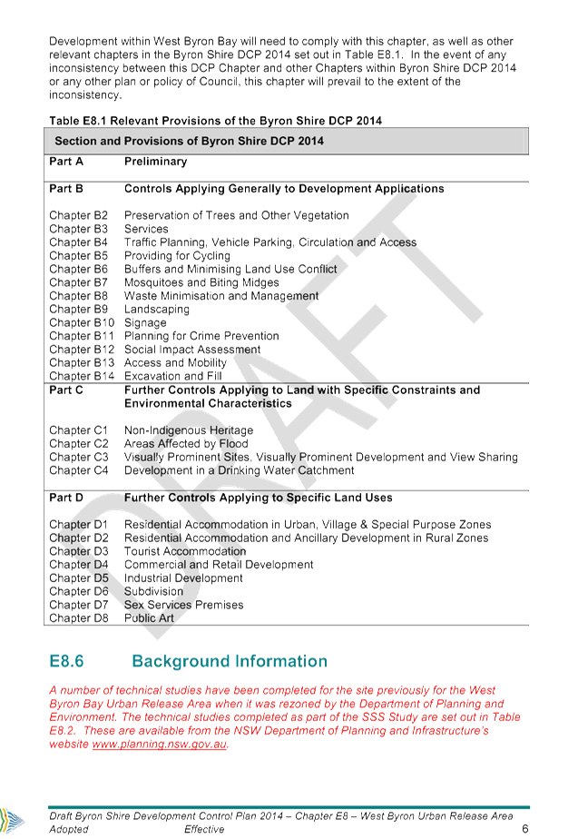
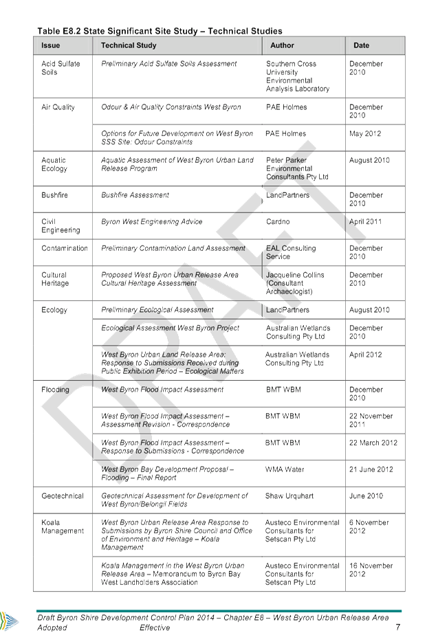
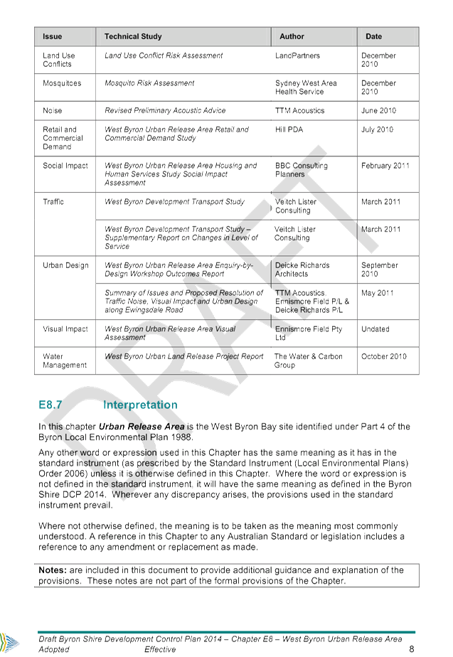
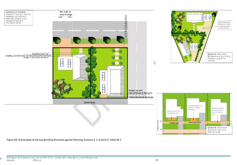
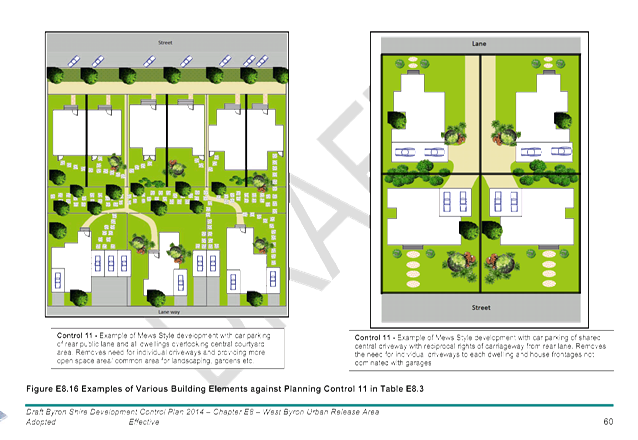
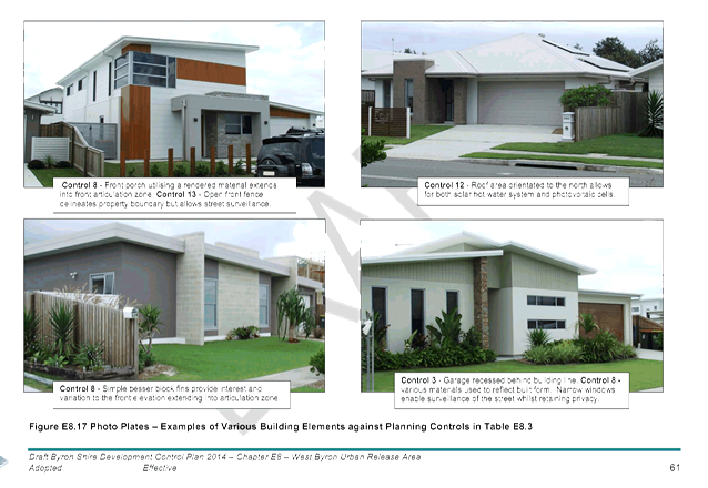
Staff Reports - Sustainable Environment and Economy 13.11 - Attachment 1
Draft Amendments to Part A –
Preliminary of Byron Shire Development Control Plan 2014
1. Amend
Section A5 to Read
A5 Where
This DCP Applies
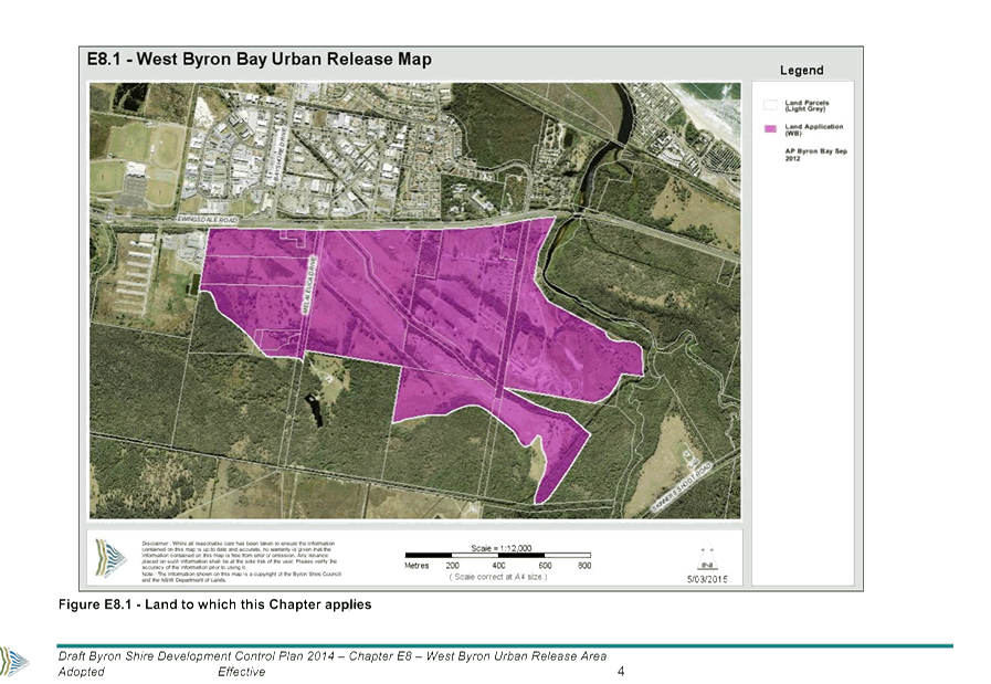
This plan applies to the land to which Byron LEP 2014
applies and land identified under Part 4 - West Byron Bay Site of the Byron
Local Environmental Plan 1988. This Plan applies to all categories of
‘development’ as defined within the Environmental Planning and
Assessment Act 1979 and as addressed within the various Chapters of this
Plan.
2. Amend
Appendix A1 – Dictionary by inserting the following additional
definitions
Dual key – Means an internal door linking two
attached dwellings together. The door needs to be a suitably designed and
constructed fire door as per the Building Code of Australia. Dual key
arrangements maybe considered suitable for dual occupancy, secondary dwelling
and attached dwelling housing arrangements where the housing is on one
lot.
Integrated
Housing
– Means the subdivision of land into three or more lots
and the erection of a dwelling (attached or semi attached) or dwelling house on
each lot as per clause 83 of Byron LEP 1988.
Small Lots – means vacant residential lots less than 350m2
in area
3. Make
any other adjustments to Part A where required to reference the West Byron Bay
Site under Part 4 of Byron Local Environmental Plan 1988.
4. Amend
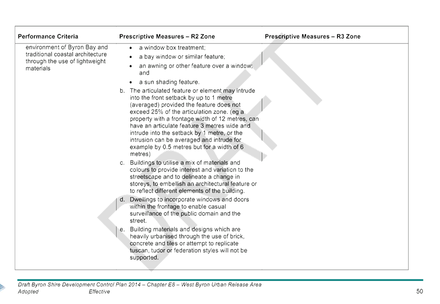
Section D1.4.1 Private Open Space (Secondary Dwellings) by inserting the
following additional prescriptive measure as point 3.
“3. Decks and verandahs for secondary dwellings not to exceed
20m2 in area.”
Staff Reports - Sustainable Environment and Economy 13.11 - Attachment 2

Staff Reports - Sustainable Environment and Economy 13.11 - Attachment 2
Staff Reports - Sustainable Environment and Economy 13.11 - Attachment 2
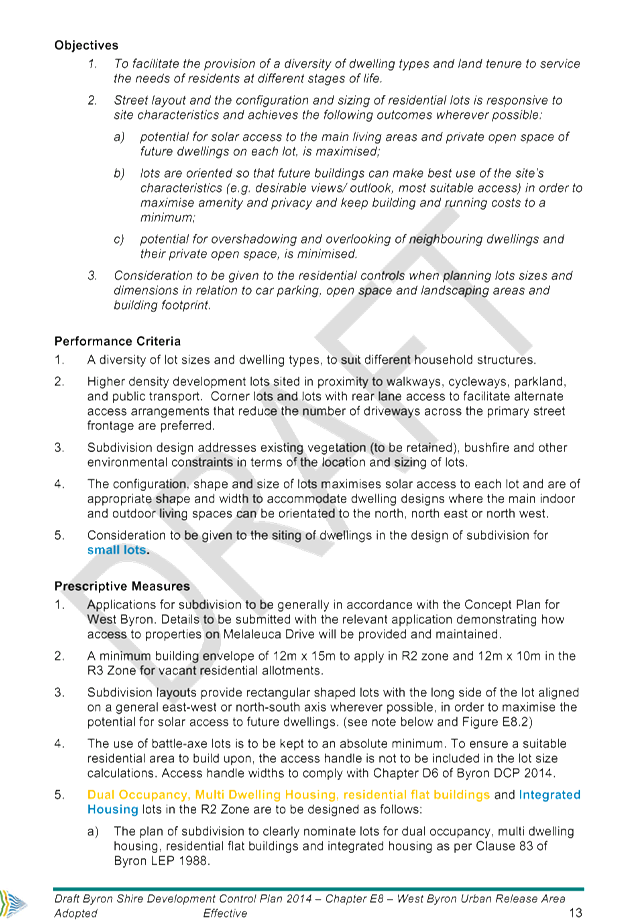
Staff Reports - Sustainable Environment and Economy 13.11 - Attachment 2
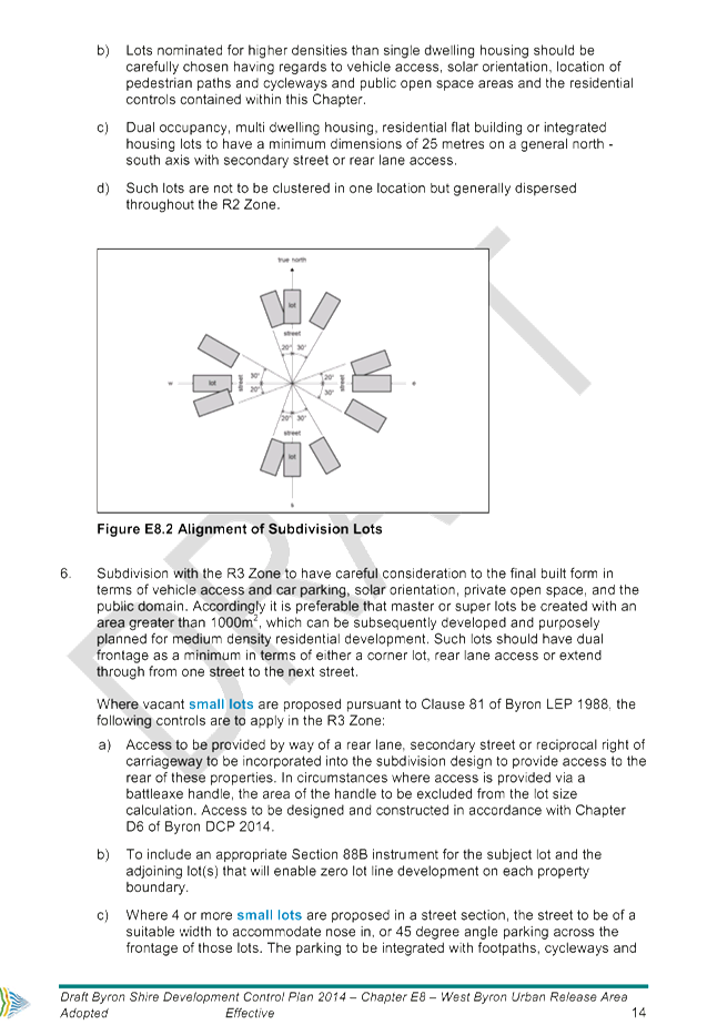
Staff Reports - Sustainable Environment and Economy 13.11 - Attachment 2

Staff Reports - Sustainable Environment and Economy 13.11 - Attachment 2
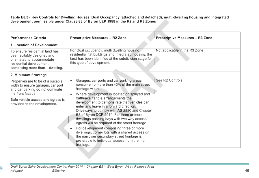
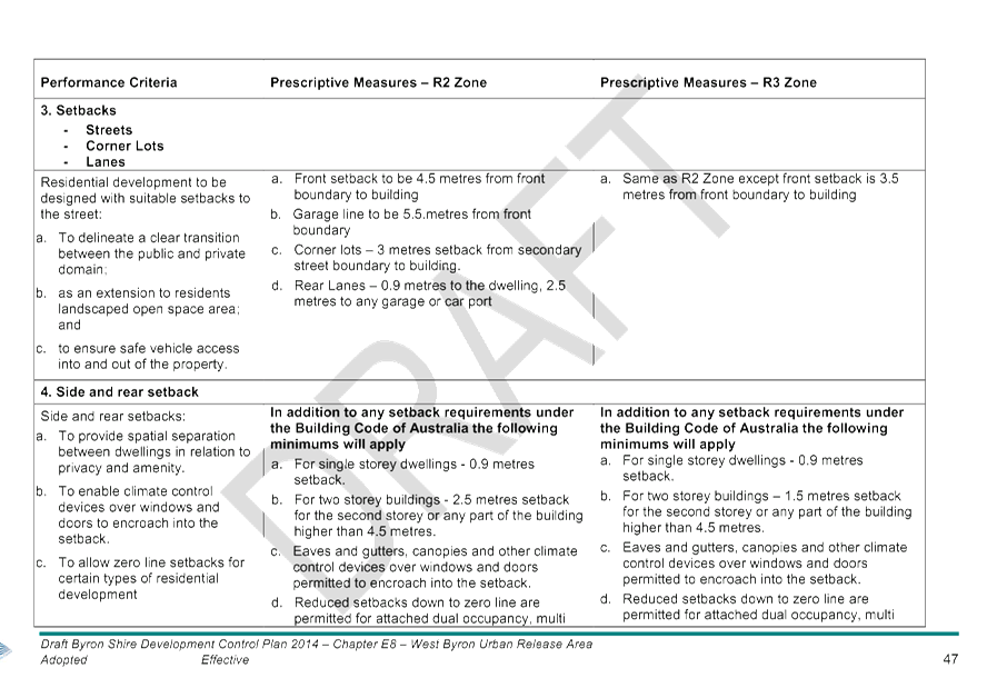
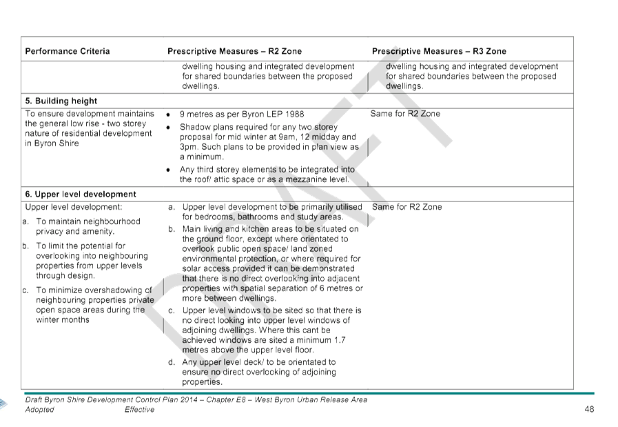
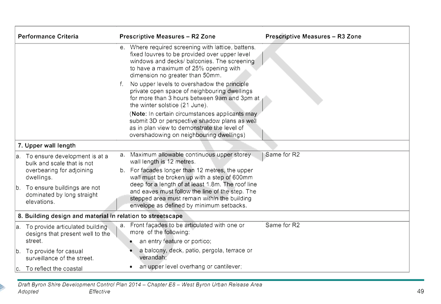
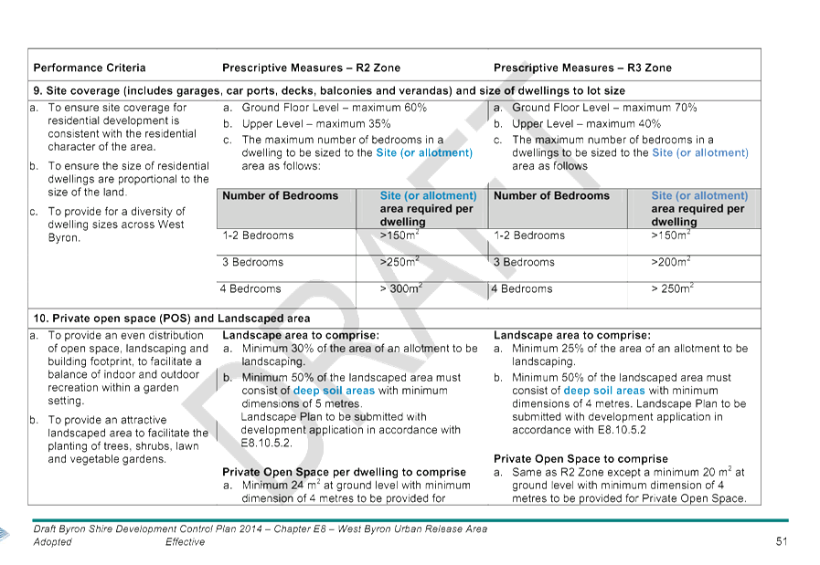
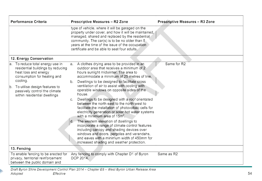
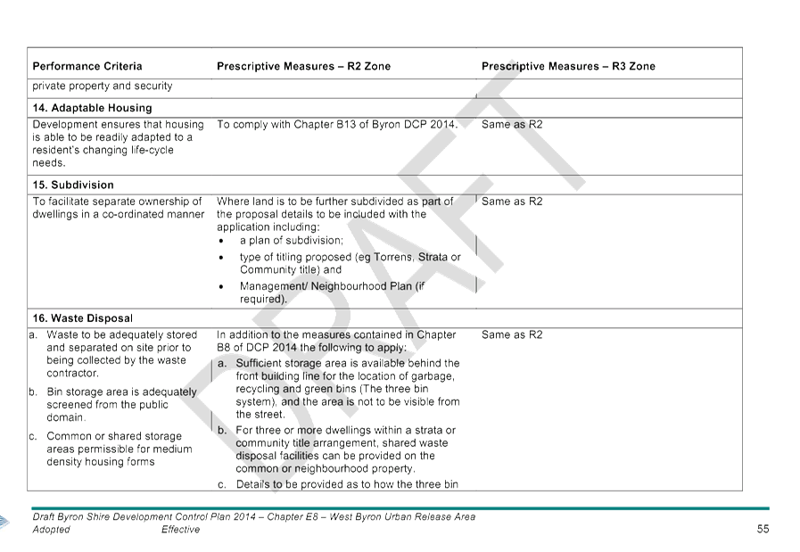
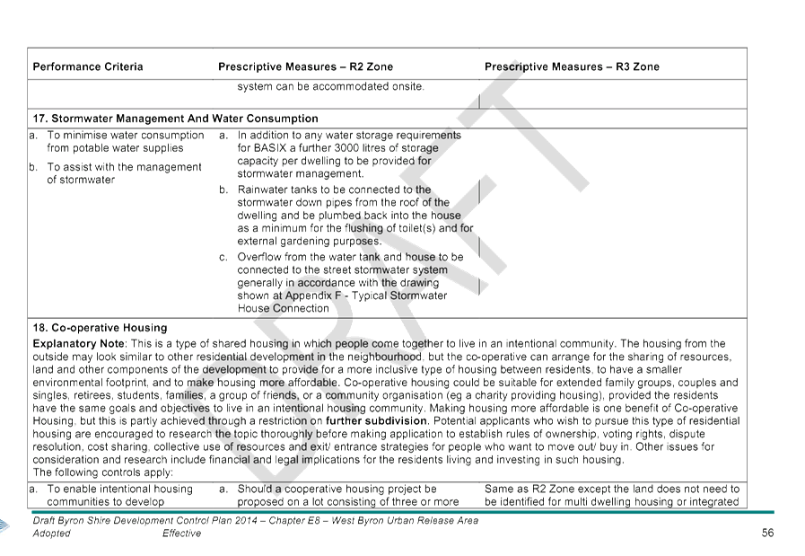
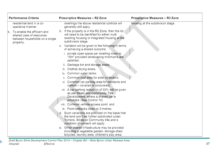
Staff Reports - Sustainable Environment and Economy 13.11 - Attachment 2
Staff Reports - Sustainable Environment and Economy 13.11 - Attachment 2
Staff Reports - Sustainable Environment and Economy 13.11 - Attachment 2
Staff Reports - Sustainable Environment and Economy 13.11 - Attachment 2
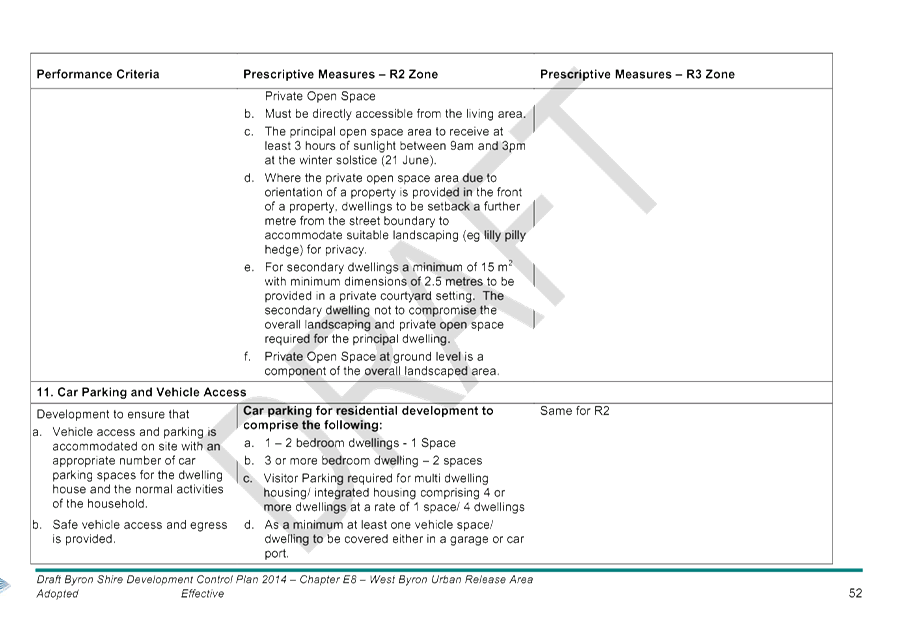
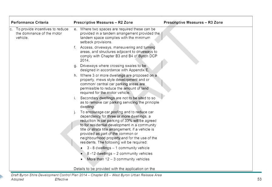
Staff Reports - Sustainable Environment and Economy 13.11 - Attachment 3
Attachment 3
Submissions Report
|
Ref No
|
Issues
|
Staff Comment
|
|
|
West Byron DCP
|
|
|
1.
|
When the West Byron DCP was returned to Council that
Council would draft a new one that took into consideration the site’s
constraints and would be based on Council’s understanding of these. The
rezoning by the NSW government showed a spectacular and wilful ignorance of
the local area and treated it as if they were just rezoning any greenfield
area on the outskirts of a major city.
Appalled that the Department of Planning and
Kristina Kinneally approved West Byron without knowledge or interest in
issues affecting the site or community concerns
|
The DCP is being prepared in accordance with the EPA
Act 1979 and associated Regulations. The DCP is a guide to development as per
Section 74BA - Purpose and Status of Development Control Plans of the EPA Act
1988. The provisions state:
1. The principal purpose of a development control plan is to
provide guidance on the following matters to the persons proposing to carry
out development to which this Part applies and to the consent authority for
any such development:
(a) giving effect to the aims of any
environmental planning instrument that applies to the development,
(b) facilitating development that is
permissible under any such instrument,
(c) achieving the objectives of land zones
under any such instrument.
Should Council wish to amend zone boundaries,
density provisions, heights and lot sizes, then these changes need to be
introduced through an LEP amendment not via a DCP as such changes would be
contrary to the adopted LEP controls for West Byron, and to have legal
effect.
|
|
2.
|
A Whole of Site Approach - Required for Biodiversity
Conservation Plan, Koala Plan of Management, Water Management Plan, Acid
Sulfate Soils Management plan before the DCP is adopted.
|
These issues to be addressed with the Stage 1 DA for
the site (or sites) to ensure the site in it’s totality is
appropriately planned for.
There is no pre approval mechanism for such plans
other than via a development application.
|
|
3.
|
Flawed Studies – DCP relies upon old out of
date studies
Any studies used to make a decision should be less
than 5 years old
|
The draft DCP references previous studies in section
E8.6 as background information only. It is recommended that this section be
amended though to fully reflect that these studies are background information
only.
If and when a development application is lodged for
the site numerous additional studies and plans will need to be submitted with
that application for consideration and assessment. The DCP requires such
studies and plans to be submitted.
|
|
|
Traffic and Infrastructure
|
|
|
4.
|
There is no meaningful plan for staging the
development relative to impacts on infrastructure and traffic increases. The
developers’ traffic plan only dealt with about half a many houses as
are now allowed on the site.
Traffic study/ comprehensive plan required to
address:
- maximum development potential for the site
- capacity of roads to accommodate development
- road upgrades required for development stages
- No loss of service on roads into town rom
congestion
- consider external vehicle movements/ day, peak
season and peak hour etc
Traffic impacts – town already gridlocked with
one arterial road and hwy upgrades have made it easier to access Byron bay
Traffic problems in Byron Bay and Ewingsdale Rd need
to be addressed first.
Impact of construction vehicles on traffic entering
the site from Ewingsdale Road
|
The Traffic Study considered at the rezoning stage
by the Department of Planning and Environment assumed a residential yield of
856 dwellings. This estimate is considered reasonable. It is highly unlikely
these lots will be released simultaneously on the residential market.
The DA for the site will need to include further
traffic studies in accordance with Chapter B4 of DCP 2014 and to address the
traffic generating provisions contained within SEPP (Infrastructure) 2007. A
study will need to be prepared in accordance with RMS Guide to Traffic
Generating Development to address access onto Ewingsdale Road.
The development will need to demonstrate how traffic
will be able to enter and leave the site having regards to the above.
It is standard for Council to require a management
plan for construction vehicles entering and leaving a site.
|
|
5.
|
An updated traffic study would provide greater
clarity on route for the Byron Bay Bypass ie Grab the rail corridor route or
the Butler Street Route.
The grab the rail route provides for a public
transport interchange which will be integral public transport
|
A DA has been submitted and determined for the Byron
Bay Bypass to ease traffic congestion in the Byron Bay town centre.
A public transport interchange is being considered
by Council separate to West Byron
|
|
6.
|
Proposal reliant on car transport is inconsistent
with zero carbon emissions
Cycling and pedestrian networks will play an
important role for connectivity but also supporting a healthy lifestyle.
Pedestrian bridge across Ewingsdale Road to the Arts
and Industrial Estate is required
Planning for Bus stops, local bus runs into town and
car parking areas.
Existing bus services are too infrequent, train
service from elements to far to walk to.
|
The DCP includes provisions for cycleway/ pedestrian
network to link with existing networks.
Bus stops are also required along the main spine
road running through the site, plus provisions for car parking throughout the
development site.
|
|
7.
|
Emergency Services can’t access the site from
town
|
The regional hospital and ambulance station is now
open at Ewingsdale to the west of the site. Police and Fire Brigade can
access the site from Ewingsdale Road
|
|
8.
|
Elements train has not been approved and should not
be considered and has insufficient parking
Cost of using the Elements train is not financially
viable for residents on a daily weekly basis
|
The Elements train is not proposed as part of this
development and is not located at West Byron.
|
|
9.
|
Development of West Byron will limit the potential
to create a second bypass option into Byron Bay (eg to the south of Ewingsdale
Road)
|
This is not a consideration relevant to the DCP.
|
|
10.
|
Ozigo Intersection needs upgrading with a
roundabout.
|
The DCP requires this to occur
|
|
11.
|
Existing Infrastructure is inadequate to cater for
the future residents of West Byron
|
It is considered existing infrastructure can cater
for West Byron
|
|
|
Developer Contributions and rates
|
|
|
12.
|
I hope that council is not paying for either of the
roundabouts on Ewingsdale Road and that the developers are paying high
contributions to council for each lot.
|
The roundabout at SAE will be the applicants
responsibility, whilst Council is planning to construct a roundabout at
Bayshore Drive. Should the development proceed prior to this roundabout being
constructed, then the developer would be required construct this
roundabout.
|
|
13.
|
The
developers want to use our roads, our energy infrastructure, our water
supply, our drainage, our sewerage treatment and discharge, give us their
waste and use our food, shops, schools, community and sporting facility so as
they can cram as many
dwellings
onto the site, to maximize their money take away from Byron. This is not
ethical or beneficial to the local community and would only destroy the
reason people come here.
|
Developer Contributions are levied to compensate for
impacts on services and infrastructure and to enable Council to upgrade and
replace existing infrastructure.
|
|
14.
|
Section 94 Contributions will go to community
facilities plus an additional $7000 per lot for road upgrading in Byron Bay.
Road contributions should be spent on Ewingsdale
road and upgrading it to two lanes no the Bypass
Contributions should be used for Bypass/ Ewingsdale
road upgrade and cycleway link into Town
|
Noted
|
|
15.
|
Contributions should not be deferred until titles
are transferred
|
It is standard Council policy and practice for S94
Contributions and S64 Headworks charges to be collected prior to the issue of
the subdivision certificate for subdivision development, and prior to the
issue of the construction certificate for dual occupancy and medium density
housing development.
|
|
16.
|
Land to be dedicated to Council for community
recreation, market area, children play area, community hall, womens refuge,
corner shop
|
The DCP includes two area of parkland which will
become public reserves for community recreational purposes.
|
|
17.
|
Proposal will increase Councils rates base and take
pressure of the existing rate payers
|
Noted
|
|
|
Flora and fauna
|
|
|
18.
|
Impacts on koalas
Has there been an independent survey of the koala
population of the area been conducted to determine both the resident and
transient populations?
Koala controls in a POM need to include traffic
calming measures, fencing to Ewingsdale road to prevent road kill, banning
cats and dogs
The DCP does not include a Koala plan of management
and in its proposed format does not allow for any management of the core
Koala habitat, there is no proposal for adequate buffer zones or movement
corridors to protect the creatures. There is no fencing proposals or control
of pets. This DCP will isolate the Koala into small pockets where they will
not be able to breed effectively and the isolated colonies will die out.
Make West Byron a cat and dog free zone.
|
DCP indicates the need for a POM to address range of
design solutions to protect koalas including fencing, reduced vehicle speeds,
traffic calming measure, pool safety measures and a koala friendly crossing
for Ewingsdale Rd. The provisions also require core koala habit area to be
linked together and such links be embellished.
Should council adopt the Byron Coast Koala Plan of
Management the developers can utilise that KPOM instead of preparing a site
specific KPOM .
Amended provisions are recommended to ban cats and
dogs other than guide dogs by adding the following prescriptive measure to
E8.10.5.1
9. The keeping of cats and dogs other than guide dogs is to be
prohibited. Any plan of subdivision to include an appropriately worded S.88B
instrument in relation to keeping such pets. The prohibition to also apply to
community title and strata tittle subdivisions and to be incorporated into
Strata Plans of Management and or Neighbourhood Management plans and the
like. Appropriate conditions to apply for applications to residential
development including multi dwelling housing, integrated housing, dwelling
houses, dual occupancy and secondary dwellings.
|
|
19.
|
General habitat corridors fail to recognise koala
habitat in Belongil Fields
|
Provisions under E8.10.5.1 include detailed provisions
in terms of addressing Koala as per SEPP 44 including “rehabilitation
of habitat in the E Zones to focus on koala habitat restoration and ….
to provide or embellish linkages between core koala habitat areas, and a
crossing over or under Ewingsdale Road”.
|
|
20.
|
Swimming pools should have measures to enable Koalas
to climb out
|
The draft provisions also require this to occur,
including the design of pools with beaches or ramps to enable Koalas to climb
out.
|
|
21.
|
The site and surrounding properties to the south
provide habitat linkages through to Hayters Hill
|
Provisions under E8.10.5.1 aim to strengthen and
embellish habitat corridors
|
|
22.
|
Threatened species not considered eg tusked frogs,
swamp orchid, koalas, masked owls etc
|
The DCP and the EPA Act requires threatened species
to be considered at the DA stage.
|
|
23.
|
Roosting and nesting areas for shorebirds at the
mouth of Belongil Creek will be impacted upon
Impacts of residents dogs on bird nesting sites in
Belongil Creek
Eastern curlew uses the site
Recommend provisions under objectives, performance
criteria and prescriptive measures to protect.
|
The development will have no direct impact on the
mouth of the Belongil Creek. Impacts are likely to occur from coastal
erosion, and beach goers/tourists and recreational use of the creek from
kayaking/ board paddling, disturbing these roosting and nesting areas, and
dog and cat ownership.
Additional provisions recommended to make West Byron
a cat and dog free estate, and to remove the Belongil Creek Access point for
recreational purposes.
|
|
24.
|
Main road through the site will split the E2 Zone
and make it difficult for endangered wildlife to maintain normal feeding and
breeding patterns
Roads and drains in the DCP are approved that go
through koala and frog habitat without appropriate studies and without DCP
clauses to minimise impacts.
|
The DCP provides guidelines for development of the
site. Under Clause E8.10.5.1 the developer will need to address a range of
issues including protecting, maintaining and enhancing key habitat corridors
for koalas and other species at the development application stage and site
roads and infrastructure accordingly. No roads or drains are approved by the
DCP. Final road layout will be subject to detailed design and assessment
at the DA Stage
It is recommended though that the provisions for
roads and stormwater infrastructure be strengthened to provide the link to
flora and fauna studies under E8.10.5.1, and that the final road layout and
siting of installation is subject to detailed design and assessment at the DA
Stage. Changes made to measures under E8.10.3 Transport Movement and Street
Hierarchy and E8.10.4 Stormwater Management.
|
|
25.
|
Impacts on Wallum Sedge frogs and Wallabies
Road from the Bayshore Drive roundabout goes through
Wallum Sedge habitat
Provisions for Wallum Frogs need to be strengthened
in E8.10.5.1
|
Applicants will need to address this matter in the
DA and design the road around the habitat if it needs to be retained. Wallum
Sedge Frog Issue identified under E8.10.5.1. as a matter to be addressed. It
is recommended though that these provisions be strengthened by adding in the
following performance criteria:
7. To identify, protect and maintain
Wallum Frog habitat areas where appropriate and to provide additional wallum
frog habitat areas within the West Byron Site, so that there is no net loss
in habitat.
|
|
26.
|
All Native vegetation on the site shall be retained
and protected. (reason - to comply with the Native Vegetation Act and the
Environment Protection and Biodiversity Conservation Act.
|
Any proposed vegetation removal will need to address
the relevant provisions of the EPA Act, Threatened Species Conservation Act
and other legislation with the development application.
|
|
27.
|
Residents are provided with education programs to
comply with the visions and plans for environmental protection
|
Opportunities exist on the site to create lifestyle
residential development with residual environmental zoned land. This could be
in the form of a community title or strata title arrangement. The owners of
such land would be responsible for the long term management on these residual
parcels.
|
|
28.
|
The DCP has a strong focus on vegetation but there
is a lack of focus on connectivity between the development site and the
Estuary and potential impacts from water management and increased human
impacts
|
The zoning of the land provided a significant buffer
to the Belongil Creek with such areas to be rehabilitated. Appropriate
provisions are proposed for water management, enhancing habitat corridors and
for the recreational access point to the creek is removed.
|
|
29.
|
Plantings need to be local endemic species wherever
possible
|
Provisions under E8.10.5.2 require locally
indigenous species to be predominantly used in landscaping.
|
|
30.
|
West Byron is a lowlying ecologically sensitive
swamp/ wetland and should not be developed
Wetlands need to be protected
Proposal will destroy wetlands
|
Wetland Areas at West Byron are predominantly
included in the E2 Zones on the land or are located outside of the site in
the 7(a) wetland Zone or the 7(b) Coastal Habitat Zone. The wetlands are also
protected by SEPP 14 Wetlands. Dwellings are not permitted in the E2
Zone.
|
|
|
LEP and Zoning Issues
|
|
|
31.
|
E3 Zone should remain undeveloped
|
Permissible Uses in the E3 zone are nominated within
Byron LEP 1988.
|
|
32.
|
R2 Zone should not extend into the South East corner
of the site
|
The Zoning lines are established by Byron LEP 1988
and not the DCP.
|
|
33.
|
Densities inappropriate
1500 Dwellings too many
1100 dwellings too many
Lot sizes should be in line with Sunrise Estate
– 600 m2
150m2 is too small for medium density
|
Lot sizes are established under Byron LEP 1988 and
not the DCP chapter.
Final yield for the site is unknown, however current
estimates are around 850 dwellings.
Amendments to Byron LEP 1988 are proposed to reduce
residential development lot yield within West Byron. Draft LEP is currently
on exhibition
|
|
34.
|
The R3 Zoning to dense
Not in keeping with the Shire
|
The R3 Zone has been established under Byron LEP
1988 and not the DCP Chapter. The DCP controls though are aimed at providing
for housing with adequate private open space and landscape area and to limit
the building footprint vertically and horizontally.
|
|
35.
|
Heights - 9 m height limit too high for residential
areas
|
Heights are established by Byron LEP 1988 and not
the DCP. Nine metres is consistent with the height limits applying to
the majority of Byron Shire.
|
|
36.
|
Holiday Letting should be prohibited
No decisions should be made until Parliamentary
Inquiry into Holiday Letting is completed and Policy handed down
|
Short term rental accommodation (Holiday Letting) is
not a permitted use in West Byron under Part 4 of Byron LEP 1988.
Current Planning Proposal to permit holiday letting
only applies to land under Byron LEP 2014.
|
|
37.
|
Drainage works in E2 Zone prohibited
E2 Zoned Drain should not be used for stormwater
drainage
Drainage works should clear koala habit
|
A separate LEP amendment has been exhibited to
permit limited works in the E2 Zone.
The main drain running through the site takes urban
stormwater from Ewingsdale Road and the Arts and Industrial Estate. The Drain
is zoned E2, E3, R2 and RE1. Any works in the drain would need to be
consistent with what is permitted under Byron LEP 1988.
|
|
38.
|
There needs to be land zoned for parks and foliaged
grass areas for stormwater absorption, reduced densities and have an
aesthetic design and healthy environment.
More public areas be made (such as parks with
adequate car parking, bicycle paths and amenities)
|
The zoning of West Byron includes two designated
park areas zoned RE1 Recreation which will cater for residents needs. Both of
these parkland areas are to be linked by bike paths and utilise the drainage
reserve running generally between them
Further stormwater to be managed by Water sensitive
urban design measures such as swales as indicated in the DCP. The swales will
increase the width of the road reserves by some 4 metres and therefoer also
reduce densities and provide opportunities for a greener streetscape with
street trees and sedge and grass species in the swales (See E8.10.3 and
E8.10.4)
|
|
39.
|
The land was zoned for "investigation for
future residential" in the 1988 LEP - after decades of high rents and
housing shortage since then, it is time to finally get on with the provision
of housing at West Byron.
|
Noted – the development of the site will
provide additional housing for the Shire
|
|
|
Coastal Works
|
|
|
40.
|
Against Protective beach rock walls
|
The DCP for West Byron has no requirements for
protective beach works as the site is landward of the erosion zones
|
|
41.
|
Creek Access should be carefully managed.
Impacts on Shorebirds in Belongil Creek and nesting
sites
|
The draft DCP prepared by the Department of Planning
clearly showed an access point to Belongil Creek for the Public. The current
draft retains provisions under E8.10.6 if this was to occur, details to be
provided with the development application. Providing such access however is
problematic as the land is within the E2 Zone, is private property and is not
identified under the LEP provisions as being dedicated to Council as a public
reserve. Further as indicated in a number of submissions the creek provides
an important habitat and roosting site for a variety of birdlife. It is
recommended that the prescriptive measure 6 Public Access to Belongil Creek
under E8.10.6 be deleted and replaced with following provisions:
6. No Public Access to be provided to
Belongil Creek.
|
|
42.
|
CZMP should be completed before West Byron DCP is
adopted
|
There is no nexus to link West Byron to the
CZMP.
|
|
|
Flooding
|
|
|
43.
|
Proposal will exacerbate flooding in town and
disperse flood waters as far as the CBD and increase runoff into Belongil
Creek.
|
The filling of the site will need to demonstrate
negligible impacts on surrounding properties. Stormwater to be treated by way
of water sensitive urban design measures as indicated in the DCP.
|
|
44.
|
Climate change and sea level rise not addressed and
has not considered rising sea levels and lacks any science based modelling
and does not adequately addresses the risks to life and property from flood.
|
Any development on the land will need to comply with
the adopted flood mapping for the Belongil Creek Catchment which includes
Byron Bay. The mapping includes modelling for climate change.
|
|
45.
|
Dwelling should be built on piers not slab on ground
42 ha of land will need to be filled 2 metres
– where is the fill to come from?
|
Fill for the development will need to be sourced
form local quarries in the region. Filing of 2 metres across the site will
not be required as part of the land is already elevated at or above the flood
heights.
Dwellings can be either elevated on piers or on
slabs.
|
|
46.
|
There appears to be no detailing of the quantities
of fill involved, where the material will be sourced from and the number of
truck movements and associated traffic planning and impacts on local and
tourist traffic during construction.
|
This will be a matter for consideration at the
development application stage.
|
|
47.
|
Flood controls are based on modelling up to the year
2100. Housing however will need to be protected beyond this. The DCP should
highlight that properties will be flood prone after that period to reduce
Council/ public liability, and to enable land owners to invest with full
knowledge of potential risks.
Consent conditions could be drafted to time limit
consents when flood immunity is no longer provided (eg after 2100 or if sea
levels rise etc)
Dwellings should be designed to be adaptable, on
piers and not slab on ground
Provisions of Chapter C2 Areas Affected by Flooding
should apply to all land below RL 5 m AHD not just areas identified up to the
2100 flood height.
|
Flooding Provisions are aimed at bringing West Byron
into conformity with the rest of the Shire and to enable any future changes
to catchment flood studies to be replicated through Chapter C2 of DCP 2014.
That is the flood controls for West Byron apply equally elsewhere in the
Belongil Catchment.
Should Council take a view for West Byron than
equally it should apply to other flood prone areas of Byron Bay and the Shire
in terms of time limited consents, limited immunity up to year 2100 and
adaptable housing below 5m AHD. A separate amendment to Chapter C2 would be
the appropriate planning controls to be amended.
|
|
|
Acid Sulfate Soils
|
|
|
48.
|
Amend the DCP controls to ensure changes in
groundwater levels don’t impact on ASS
Acid Sulfate Soils will have an adverse impact on
Belongil creek and cause fish kills, and release heavy metals into the creek.
For a sensitive environments like West Byron the
most appropriate action is generally to leave potentially acid sulphate soils
in situ.
|
It is recommended that the following points 2 and 3
be added to the Performance Criteria under E8.10.8.2 Acid Sulfate Soils (ASS)
to limit the potential of ASS being exposed from construction and stormwater
works and to strengthen the DCP provisions
2. Where the watertable in the vicinity of
Acid Sulphate Soils maybe affected by hydrological changes associated with
drainage works or alteration in rainfall infiltration and runoff, an
assessment must be undertaken to assess the likely consequences on
groundwater and surface water quality..
3. Effective mitigation measures are
identified to ensure there is no deterioration in water quality in drains or
the Belongil Estuary.
|
|
49.
|
Main drain shouldn’t be excavated due to ASS,
and a separate drain should be provided in a different less sensitive
location that doesn’t require koala habitat removal
|
A second drain would potentially result in a larger
area of ASS being excavated that will then need to be treated then utilising
the existing drainage reserve.
|
|
50.
|
What commitment has been made to the management of
ASS
|
ASS will need to be managed in accordance with
the ASSMAC guidelines as per Clause E8.10.8.2
|
|
|
Groundwater
|
|
|
51.
|
Controls for Groundwater need to be strengthened in
terms of objectives and performance criteria
|
Agree – the following additional objectives
and performance criteria provisions are recommended.
Objectives
2. To maintain existing groundwater level
in the vicinity of Wallum frog habitats and wetlands
Performance Criteria
2. Groundwater quality is maintained and
levels are not lowered in the vicinity of wallum frog habitats or wetlands
Prescriptive Measures
3. The ph and water levels
of groundwater near and or adjacent to wallum frog habitat and wetlands not
to be altered such that it impacts on the health of that habitat for the
frogs.
|
|
|
Stormwater Management
|
|
|
52.
|
Stormwater Management Plan required before DCP
adopted
Who is to manage stormwater infrastructure including
old drainage union drains
Stormwater impacts on prime agricultural land to the
south
Union Drains servicing properties to the south are
also tidal and king tides push water back onto properties
Will Council be installing floodgates to protect
aquatic fauna
Stormwater should be treated and disposed by way of
larger rainwater tanks, minimizing hard impervious surfaces, wetland
filtration, stormwater retention
|
The DCP requires a Stormwater management plan to be
submitted for the entire site with the Stage 1 DA in accordance with Councils
requirements and the Northern Rivers Local Government Design and Construction
Manual. The plan is to be based around the principals of water sensitive urban
design as opposed to piping water directly into drains.
The plan will need to identify legal points of
discharge and infrastructure to be dedicated to Council. It is normal
practice for Council to ensure stormwater from a development does not have a
detrimental impact on surrounding properties.
|
|
53.
|
The prescriptive measure of limiting the number of
stormwater treatment devices for ease of maintenance will compromise the
quality of stormwater treatment. Stormwater is always best managed at source
with devices distributed throughout the catchment.
|
The provisions for this measure relate to stormwater
detention ponds and basins if used.
|
|
54.
|
The central stormwater drainage corridor should be
70 metres wide to provide for 20 metre buffer either side of 30 metre wide
drainage reserve for vegetated buffer, plus 20 m buffers either side of
waterways, drainage reserves, wetlands
|
Central drain is zoned R2 Low Density Residential,
RE1 Public recreation, E2 Environmental Conservation and E3 Environmental
Management. There is a requirement for 20 metre wide buffers to be provided
to the E2 and E3 Zoned between urban zoned and environmental zoned land under
E8.10.5.1, whilst there is already provision in the Stormwater measures for
landscaping to be an integral part of the WSUD strategy for the site. This is
considered suitable.
|
|
55.
|
Stormwater swales are considered inappropriate with
driveways every 15 metres. The provisions need to have greater flexibility
for alternative measures.
|
It is considered the stormwater controls under
E8.10.4 include sufficient flexibility for applicants to propose alternate
solutions based on the objectives and performance criteria. The overall aim
is that stormwater management is designed on water sensitive urban design.
|
|
56.
|
Provisions to be strengthened to ensure stormwater
measures
· do not lower ground water levels of ASS (actual and
potential)
· establish vegetated buffers to waterways to trap
sediment, nutrients and pollutants
· to maintain and enhance water quality and levels for
wallum frog species
· Consider baseline modelling and need for modelling
including stormwater from Arts and Industry estate
· Impacts of stormwater runoff and sedimentation and
silt runoff into Belongil Creek and the Marine Park from earthworks and
filling the site
· Management to be adequate to prevent rubbish,
chemicals and nutrients from entering Belongil Creek and the groundwater.
|
Agree – The Northern Rivers Development Local
Government Design and Construction manual requires a Stormwater Management
Plan that demonstrates how post development flows volumes and stormwater
quality are controlled to predevelopment conditions by achieving a neutral or
beneficial effect (NorBE) on the natural environment and receiving waters or
wetlands.
It is recommended that the following be added to the
Objectives and Prescriptive Measures under E8.10.4
Objective
3. To ensure groundwater levels are
considered in the management of stormwater.
Performance Criteria
5. Groundwater levels are not to be
significantly altered by stormwater works in areas of actual or potential
acid sulphate soils or such impacts are appropriately managed
6. Vegetated buffers are provided around
stormwater infrastructure and to trap sediments, nutrients and pollutants
from the surrounding environment
7. Stormwater is managed to maintain
appropriate water quality and levels for wallum frog habitat.
Prescriptive Measures
n) Baseline studies to be prepared of
water quality of surface and groundwater and within drainage lines across the
site. The Studies to consider wet and dry period, tidal movements and
incorporate sampling upstream (eg Arts and Industrial Estate) and Down Stream
(eg Belongil creek);
o) Identification of all areas proposed
for fill or other major earth works and an assessment of impacts on
stormwater runoff, ground water levels, acid sulphate soils and wallum frog
habitat and identification of effective mitigation measures where impacts
cant be avoided.
p) Detailed designs for the central
drainage line that identify impacts on the watertables in the vicinity of
Acid Sulfate Soils and minimises damage to existing native vegetation.
q) A monitoring regime for Belongil Creek
to ensure a Neutral or Beneficial Impact (NorBE) is being achieved for the
creek. Target criteria for water quality including litter, coarse sediments,
fine particles, total phosphorus and nitrogen and hydrocarbons to be
nominated consistent with the Northern Rivers Development Local Government
Design Manual. The monitoring regime to be applied to assess impacts as the development
proceeds from the start of construction for a period of 10 years.
|
|
57.
|
The main stormwater drain that takes stormwater from
the Arts and Industry Estate should be carefully widened where rare or
endangered vegetation won’t need to be removed and to limit the need
for deepening of the channel to accommodate flood flows.
|
Agree this is a solution. It is recommended that
Prescriptive measure 2 under E8.10.4 be amended to read
2. The embellishment of the main drain
through the site and the secondary drain on the Belongil Fields site to be
carefully designed to protect high conservation value vegetation. The
drain(s) to be strategically widened at areas with limited conservation
value.
|
|
|
Mosquitos and Midges
|
|
|
58.
|
Has the council considered how much impact this
development will have on mosquitos and midges will have on the town for the
existing population at Sunrise and the town itself from disturbing the soil.
Ross River is prevalent – has this been
considered
|
The DCP includes provisions for mosquitos and midges
|
|
|
Soil contamination issues
|
|
|
59.
|
Soil contamination must be addressed
|
Provisions of SEPP 55 Remediation of Contaminated
Lands apply. This will necessitate the need for a detailed assessment under
Clause 7 of the SEPP to ensure the site is suitable for development prior to
the DA being approved.
|
|
|
Other Options
|
|
|
60.
|
New housing estates should go in Lismore or
Mullumbimby.
It is not Byron's burden to make up the housing
quota allotted to the North Coast as a region.
Put the houses in Mooball in Tweed Shire or Inland
from Evans Head in Richmond Valley but not in Byron
|
This is not a matter for consideration as part of
the DCP but is of relevance to the draft North Coast Regional Plan by DPE. In
this regard the draft Regional Plan indicates Byron Shire needs an additional
3750 – 4500 dwellings over the next 20 years. Additional dwellings at
West Byron will make up part of that quota.
The surrounding Shires also have housing targets as
follows
Lismore – 4200 - 5000
Tweed – 14000 - 16860
Ballina – 3100 - 3700
|
|
61.
|
Good planning would be annexing an area in the
hinterland behind Byron and creating a new and unique village. There are many
creative people in the area with incredibly good ideas for a truly
progressive concept such a new village. This would be a move towards a better
future.
Byron Shire needs a new town for new residents
Build a new village in the Bangalow Area some 40
metres above sea level to insure against global warming
|
Noted – Council will need to look at further
areas for residential development when preparing the Residential Strategy
consistent with the draft North Coast Regional Plan.
The plan indicates the need for up to 4500 dwellings
over the next 20 years. Dwellings generated by West Byron will go some way to
meeting that housing target.
|
|
62.
|
John Sparks proposal is far better and in line with
the spirit of Byron
Support the John Sparks concept
- 200
dwellings – totally self sufficient
- Environmental
Studies Centre
- Increased
flora and fauna habitat
- Reduced
number of dwellings = reduced congestion on Ewingsdale Road
An Eco Village like Currumbin valley would be a
better option for the site
The most sensible use of the land is forest
regeneration with limited accommodation based around a public/private
co-operative wildlife program, such as the Currumbin Sanctuary.
An eco lodge facility with an environmental studies
centre with access to the wetlands
|
It would be open to Council to enter into
negotiations with the land owners to examine other options for the site, such
as the John Sparks concept or other alternatives with a reduced development
footprint. This could include:
- a denser
development with an increased height limit
- greater
green space and buffers for native flora and fauna, habitat linkages and
revegetation, community gardens, public open space and the like
- education
and eco tourist facilities
- Work/
living studio apartments
Such discussions would need to look at amending the
LEP for the site moving zoning lines and the like. It is likely any
alternative concepts for the site would need to have the support of
landowners in order to obtain LEP amendments from the Department of Planning
and Environment. This is outside of the scope of the DCP
|
|
63.
|
West Byron Should be toned down to 5-6 houses
Larger 1 acre sized allotments would be preferable
|
A reduction in density to a rural residential estate
would requires an LEP amendment.
|
|
64.
|
Crowd Funding option to buy West Byron and use the
land for Permaculture and other farming purposes, a wires Hospital, bike
tracks and parkland for all ages, cultural centre, limited housing up to 300
dwellings and retention of Belongil Fields and camping ground as a festival
area
|
This is not a matter for consideration for the DCP.
|
|
65.
|
Spread the housing into the
rural areas by giving land owners with more than 40 ha a second dwelling
entitlement
|
Rural properties throughout the shire can
already seek consent for attached and detached dual occupancy
effectively providing a second dwelling entitlement to those land owners.
|
|
|
Buffers
|
|
|
66.
|
20 metre buffer to E2 and E3 Zones excessive
Buffer Zones to must be adequate to protect wildlife
corridors
Bushfire APZ’s should be located on cleared
land
50m buffer to the Temple Byron yoga studio required
at Melaleuca Drive
|
The 20 metre buffer is considered reasonable for
environmental and amenity reasons, and to act as an Asset Protection
Zone.
Buffers will be within the R2 Zone.
It is recommended though the vegetated
edge be increased to 10 metres to properties in the E3 Zone in Melaleuca
Drive under E8.10.5.1 for amenity reasons.
|
|
|
100m buffer to SEPP 14 wetlands required.
|
The zoning lines have generally been drawn with
buffers incorporated into them for the SEPP 14 boundaries.
|
|
67.
|
Remove the words aim from Prescriptive
measure 3(b)(i-iii) to be more specific for buffers under E8.3.5.1
|
Agree to changes.
|
|
|
Odour Provisions
|
|
|
68.
|
The odour provisions should be removed as they are
obsolete and the chicken processing Plant has been closed
|
As the adjacent processing plant may retain existing
use rights, until such time as these are surrendered or the site redeveloped
for another purpose, it is prudent that the odour provisions remain.
|
|
69.
|
Request that the Spine road in Stage 1 be extended
to Melaleuca Drive to enable residents to utilise the new roundabout and
sealed road to gain access to Ewingsdale Road.
|
The DCP provisions enable this to occur at Stage 1,
but will be a matter for the landowners to finance and undertake this work as
the development proceeds.
|
|
70.
|
The DCP should provide for ‘world best
practice’, the inclusion of social housing in an integrated way so that
it’s not just another gentrified coastal suburb, and the delivery of a
sustainable and energy efficient development that ensures a positive contribution
to the local environment and community.
|
The proposal includes provisions for water sensitive
urban design measures, roofs to be designed and orientated for solar power
and heating, and other arrangements for co-operative/ intentional housing.
|
|
|
Schools, Health Facilities and other Public
Amenities
|
|
|
71.
|
Schools are at capacity, Byron Public School is
already crowded with portable classrooms
Schooling/Health facilities – additional
schools and health services will be required to cater for the additional
school age children and people requiring health services.
Village of 1000-2000 dwellings needs provision of
social and community infrastructure including schools, childcare, youth
activities, centre, post office, police station, medical centre, affordable
housing, community centre, recreational facilities.
|
The Department of Education own land at Suffolk Park
for a new school. The land is yet to be developed for this purpose.
In terms of health care, a new hospital has been
constructed at Ewingsdale, whilst the West Byron site will provide
opportunities for other housing choices such as seniors living for an aging
population.
The site provides open space and recreational areas
whilst a small commercial centre is proposed for the day to day needs of
residents.
|
|
72.
|
Ambulance wont be able to get into town
|
Emergency Services have priority in the event of an
emergency with lighting and sirens.
|
|
|
Social Economic Impacts
|
|
|
73.
|
A Social Impact Assessment is required Social impact
from 1500 - 2000 dwellings or 3450 people not considered
|
Social Impact Assessment will be required as part of
the development application process as stipulated under Chapter B12
|
|
74.
|
Additional land for housing will create more
jobs for Towns tradespeople that have to travel to Tweed/ Gold Coast for work
|
Noted
|
|
75.
|
Increase house supply will lower house prices
|
It is unclear if the development will provide for
lower house prices, however an increase in supply and choice will provide
diversity to the housing market in Byron Shire.
|
|
76.
|
Mews Style Development if done poorly can result in
unsafe housing. Need to ensure such development is referred to NSW Police and
for CPTED assessments.
|
DCP 2014 includes provisions for CPTED assessments.
|
|
77.
|
Proposal will destroy local tourist industry
|
There is no evidence that West Byron will impact on
the local tourist industry.
|
|
78.
|
Development will create additional jobs through
construction phase but where will the new residents work
Proposal wont help unemployed
|
West Byron includes an industrial estate of 4
ha. This when developed will provide further opportunities for
employment for the shires residents
|
|
79.
|
Social anthropologists such as Robin Dunbar (known
for Dunbar's magic number - the optimum number for stable, healthy
communities) recognise that as communities grow in size they lose many of the
qualities of care and civility that sustain healthy societies. Anyone living
in the area can have doubt that a development of this size - on this
beautiful shared natural resource is too much for Byron Shire, and will
gravely impact on something unique and irretrievable.
|
Dunbars number equates to approximately 150 people
and arose from examining a range of village and tribe sizes historically.
There is no reason that as West Byron develops, small neighbourhoods will be
cultivated based around this number. However with advances in mobile
communication and technology, whether this number is relevant geographically
is unknown. This is a question though, which is outside of the scope of
the DCP, having regards to the area of land rezoned for residential purposes.
|
|
|
Water and Sewer Services
|
|
|
80.
|
Byron STP is at capacity
Are headwork’s charged at the appropriate rate
for the management of the Byron STP
|
Byron STP is operating at 70% capacity with capacity
for up to a further 3500 dwellings (Equivalent tenements). It is considered
that there is adequate capacity at the STP to cater for development at West
Byron.
|
|
81.
|
Can the STP wetland ponds which provide bird
habitat cater for increased development as proposed and does Council have the
ability to manage the STP appropriately
|
Staff at the STP are appropriately trained in terms
of ensuring the wetland operates as designed.
|
|
82.
|
Increased population will put added pressure on our
water supplies. This is already an ongoing issue the residents of Phillip
Island, Victoria, suffer.
|
Existing water infrastructure can cater for West
Byron.
|
|
|
The Byron Spirit
|
|
|
83.
|
Development jeopardises natural beauty of Byron
Byron is a sacred place – most easterly point, Bundjalung country is
blessed ground.
|
Noted. The DCP includes provisions for Aboriginal
Cultural Heritage to be addressed.
|
|
84.
|
Brand Byron needs to be protected/ enhanced –
quiet, laidback, green coastal hippy small town.
The big retailers like Billabong and are running the
smaller retailers out of town and rebranding the town
If Byron becomes just like any other overdeveloped
tourist town then people will stop coming and business will suffer. We have
kept out topless bars, fast food chains and Club Med because they didn't fit
with the way we want to live and visitors don't want that either. Our
strongest marketing tool is our point of difference from many other
over-cooked coastal towns.
|
Council has limited ability to regulate and prohibit
certain businesses from operating in the Shire under the EPA Act 1979. This
is not a DCP matter.
The commercial component within West Byron is
limited in size to one hectare and is likely to be developed as a
neighbourhood shopping area for the day to day needs of the
residents.
|
|
|
Over crowding
|
|
|
85.
|
Overcrowded Spaces in Byron Bay - not enough space
for people to sit, eat, park or walk on the footpath in town. With the bike,
prams, skateboards, wheelchairs and elderly and tourists and locals. Byron
Bay town is too crowded already.
|
Noted. The Byron Bay Masterplan aims to provide
increased public amenity and space for residents and tourists alike
|
|
86.
|
Proposal will cause a massive increase in
population.
Population for Byron will increase by 40%
|
Census data for Byron Bay shows a population of 8655
in 2011. A 40% increase equates to 3462 persons.
Assuming a yield of approximately 850 dwellings at
2.3 persons/dwelling – this will increase the population of Byron by
approximately 2000 people.
|
|
87.
|
Lack of Public Consultation for this development
DCP should be re-exhibited to enable residents to
comment again
|
The Draft DCP was exhibited for a period of 6 weeks
instead of the minimum period of 4 weeks.
|
|
|
Staging
|
|
|
88.
|
Staging is too ambiguous and should roll out housing
over a 10 year period
A minimum of three stages is required with key
performance indicators established in advance to facilitate progress.
Staging and release of housing should be linked to
upgrade requirements for Ewingsdale Road and other essential services.
Staging measures have not been adequately provided
for in the DCP. Proposal with potential for upwards of 2000 dwellings should
provide a plan for development over a 10 year timeframe
|
Having regards to the size of the site, and
infrastructure required, it is unlikely that this development could be rolled
out in a shorter period of 10 years. With multiple land owners, it is
pertinent that Stage 1 infrastructure is provide to service the various
development lots. Once this occurs housing lots can then be developed and
released. This will be dictated by market forces and the need for land owners
to get a return on capital investment to pay for infrastructure and the like.
It is also noted that the land was rezoned in 2014, it is unlikely any lots will
be released for residential purposes until the end of 2018, some four years
after the land was zoned at the earliest. It is also noted that in Ocean
Shores and Baywood Chase - Suffolk Park, the development of these residential
estates took a number of years to progress, and West Byron is unlikely
to be any different.
It is also unlikely the residential market will be
flooded with an additional 2000 dwellings. Council estimates that the
development will ultimately release around 700–800 dwellings. Further
LEP amendments are currently in train to reduce potential residential yield
in the R2 Low Density Zone which has been agreed to by the developers. It is
recommended though the following prescriptive measure be added to E8.10.1.
7. Where
more than 100 lots are to be released as part of a subdivision, a staging
plan to be submitted with the development application breaking such land
releases into stages of no more than 50 lots to enable the co-ordination and
provision of necessary infrastructure and services.
|
|
89.
|
The Staging requirements need to provide for
flexibility to enable land to be progressively released to fund the
construction of additional infrastructure (roads, sewer, water and stormwater
etc)
If two Stages remain – provisions to be established
to enable substages or phases within these stages,
Allow for alternate staging arrangements to be
considered
|
The Staging provisions have been drafted with regard
to the multiple land owners involved in the Development Site to ensure that
all necessary infrastructure, and management plans for the site are approved
with Stage 1.
|
|
|
Subdivision Controls
|
|
|
90.
|
Allow nature to penetrate into the urban fabric
– allow for street trees and house trees
Informal street design with soft edges rather than
kerb and gutter, stormwater runoff via permeable surfaces that support
vegetation
Develop outdoor meeting spaces
|
The DCP includes provisions for street trees and
water sensitive urban design measures (swales) for stormwater disposal. The
two designated recreational areas are available for a range of purposes
including passive and open space. Under E8.10.7 the park adjacent to the
Business Centre to be developed as “a village square or piazza as a
community focal meeting point and a casual meeting place for social
interaction”
|
|
91.
|
Ensure walkability to services and attraction
– maximum of 500 m
Cycleway and pedestrian links
|
The site is generally level with no major
topographic features making it easy to walk and cycle around West Byron. The
Neighbourhood Business Centre although not exactly centrally located is at
its furthest point is approximately 750 metres from the outlying residential
zoned land. The DCP includes provisions for cycleways and footpaths to
address this issue.
|
|
92.
|
Incorporate “Notes” provisions as
prescriptive measure under E8.10.2.
|
The Notes are provided as background information for
applicants to consider in there subdivision layout and to reflect the
controls under prescriptive measures 5 and 6.
|
|
93.
|
Performance criteria 3 about retaining vegetation is
unclear and should be removed and Prescriptive measure 7 about lots
incorporating vegetation how the vegetation will be managed and not removed
subsequently for bushfire purposes.
|
The controls are aimed at ensuring significant
vegetation that is identified for protection through the DA process but is
located in the residential lots is appropriately managed and retained.
Importantly significant vegetation that has been identified should not be
subsequently removed at a latter stage for bushfire protection purposes. The
Subdivision layout needs to design around such vegetation and build in
appropriate asset protection zones to avoid the need for such vegetation to
be removed at a latter date. It is considered the provisions should remain as
drafted
|
|
|
Affordable Housing
|
|
|
94.
|
10% of the site should be provided for
affordable housing based on 30% of the average wage of shire residents
Development could provide housing for Shires working
residents unable to afford prices in current market
10-20% of housing should be made available to locals
at discounted rates
New housing in Byron Bay
should now be focused on the acute shortage of low -income housing caused by
the tourist boom. i.e. social housing, secondary dwellings, Manufactured Home
Estate cabins, permanent caravan sites, homeless shelters.
Should be for single parents,
low income workers, paid and voluntary, and of course for seniors and people
with disabilities who have been living in the shire for a long time and are
being forced out
The site is more suitable then the Ewingsdale Site
for seniors living being closer to town.
|
Opportunities would exist for development to occur
on the site under SEPP Affordable Rental Housing 2009, and SEPP (Senior
Living) 2005, and SEPP 36 -Manufactured Housing Estates.
Opportunities will also exist for social housing
providers to develop within the estate. The land when rezoned by the
Department of Planning did not choose to include any inclusionary housing
provisions to deliver affordable housing outcomes on site.
In general West Byron should provide for a greater
variety in housing choices for residents from units and town houses to
traditional house and land packages.
The DCP also provides avenues for Co-operative
intentional housing models to be explored under Clause E8.10.10.3 to provide
opportunities for more affordable housing.
|
|
|
House Design
|
|
|
95.
|
50% of the lot to be taken up by building with the
remainder available for green space.
Development should have design controls to encourage
high energy efficiency and to generate solar power to reach carbon neutral
goal.
House design should reflect regions coastal
climate and not just another suburb by the sea.
Controls are added to ensure eco housing with
adequate solar access and setbacks from roads and neighbours.
Better guidance required for secondary dwellings in
terms of maximum area of verandahs and shed.
|
The development includes site coverage provisions
and landscaping provisions as opposed to floor space ratio controls. It is
considered these controls are reasonable.
It is noted though with the growing popularity of
secondary dwellings in Byron Shire, some applicants are pushing the size and
scale of these dwelling with large decks and verandahs and in some instances
more than doubling the allowable floor area of 60m2. This adds
substantially to the cost of construction, and undermines the ability for the
secondary dwelling to then be rented or let at an affordable price or achieve
the aims of the SEPP (Affordable Rental Housing) 2009. To provide guidance on
this for West Byron it is recommended that the following be added to the
prescriptive measures for secondary dwellings under Table E8.3.
Decks and verandahs for secondary
dwellings not to exceed 20m2 in area.
It is also recommended that Chapter D1.4.1 Private
Open Space (Secondary Dwellings) also be amended to reflect the same controls
for West Byron and to remove this current policy vacuum in the controls.
|
|
96.
|
Images of house don’t reflect Byron
subtropical character
highset housing minuses impacts on sensitive land
forms and overland flows Open frontages to streets,
verandahs and porches linking inside to outside,
privacy created by vegetation screens
|
The house images have been selected to reflect
certain design measures from the DCP. The DCP does not mandate housing to be
highset on bearers and joists or slab on ground – this will be a choice
for future landowners.
The housing controls include provisions for eaves
and verandahs. Fencing to be in accordance with the adopted provisions for
the rest of the Shire under Chapter D1 of DCP
2014.
|
|
97.
|
Lumping medium density housing together does not
provide for social cohesion – needs a mixed approach
Controls should provide for a mix of housing
eg medium density and low density, affordable housing, terrace style and
clusters, aged accommodation with the aim of providing a heterogeneous mix
– not large ghettos of rich and poor
|
The zoning has been established by the Department of
Planning under Byron LEP 1988 with some 11 ha zoned R3 Medium Density. The
LEP controls also permit dual occupancy and other medium density forms in the
R2 Low Density Zones. To provide that mixed approach the DCP under Clause
E8.10.2 requires at the subdivisions stage dual occupancy and other medium
housing forms to be nominated, to have secondary street access, minimum
dimensions of 25 metres on a general north south axis and to be generally
dispersed throughout the R2 Zone.
|
|
98.
|
Housing controls too prescriptive and restrictive in
terms of:
· garage frontages not exceeding 40% of site frontage
– increase to 50%
· reduce front setbacks from 4.5m to 3.5m
· 2nd storey setbacks should be 1.5m not
2.5 m
· Upper level wall lengths increased from 12m to 15m
|
It is considered the prescriptive measures are
suitable having regards to the minimum lot size provisions within west Byron
and compared to the planning controls adopted for other residential areas in
the Shire.
|
|
|
Carbon Footprint
|
|
|
99.
|
The DCP is recommended in the attention to detail it
gives to reducing the carbon footprint
|
Noted
|
|
100.
|
The total development is to be self-sufficient in
energy, water, waste and food with zero carbon emissions. To treat and
discharge water within the site. To treat sewerage generated and pollution
before discharge into the wetlands, to collect and recycle waste efficiently
to supplement local food in a community garden to reduce and offset carbon
emissions to zero.
|
This is a worthy goal to achieve, however
Council’s are unable to establish higher targets for housing than what
is currently required under State Environmental Planning Policy Building
Sustainability Index 2004. Notwithstanding this, dwellings need to be
designed with roof areas orientated to the north to enable solar panels to be
installed.
Opportunities also exist for community gardens to be
established within the public reserves on the land, however this would need
to be driven by future landowners and residents not by the developers.
|
|
|
Thermal mass of concrete must be shaded to act
effectively in summer
Break up large areas to avoid heat island effects
Passive solar design rather than air conditioning
|
The DCP includes provisions for eaves on dwellings
and for articulation of dwellings. The residential controls also in the
absence of a floor space ratio have focused on a site coverage and
landscaping provision to provide for garden and yard areas as private open
space.
|
|
|
Acoustic Fence and Buffer to Ewingsdale Road
|
|
|
101.
|
Sound fence and mound to Ewingsdale road impact on
useable residential land. Fence requirements should be removed and allow for
alternate solutions.
|
Attenuating road noise is the responsibility of the
developer at the subdivision stage and should not be left to future land
owners to construct dwellings with double glazing. The provisions are
also aimed at providing a landscape buffer to Ewingsdale Road to screen the
development. The provision for a sound barrier should remain as the preferred
option. On the residential side of the barrier the fence can be landscaped as
indicated or terraced with retaining walls and the like to provide for a
useable back yard area for any dwelling backing onto the wall. This will be a
matter for the developers to resolve at the design stage.
|
|
102.
|
Buffers to Ewingsdale Road need to be increased to
50m - as required by the EPA
|
The buffer distances prescribed to Ewingsdale Road
will be subject to a full detailed noise assessment, and the location of
dwellings and sound walls will be dictated by that study. Significantly the
Wall and more than 50% of any earth mound will be sited on the developers
land not the Road reserve.
|
|
103.
|
Object to the current design of Figure E8.11. Road
reserve is required for widening Ewingsdale Road and shouldn’t be used
to support the earth mound and fencing etc
|
Figure E8.11 is still appropriate provided the final
road realignment of Ewingsdale road is reflected in the Subdivision
alignment.
To ensure the design of West Byron considers the
future widening of Ewingsdale Road. It is recommended that an additional
prescriptive measure under E8.10.1 for the Stage 1 DA be inserted as
follows
6. The
boundaries with Ewingsdale Road for the site to be adjusted to reflect future
widening of Ewingsdale Road as indicated in Appendix G. The boundary
adjustment(s) to occur with Council agreement and can occur with Stage 1 or 2
or by a standalone application process. Such widening to have regards to the requirements under E8.10.8.8
Buffers to Ewingsdale Road
It is also recommended that the following
Performance Criteria and additional words added to the prescriptive
measure 1 under E8.10.8.8 to ensure the noise barrier satisfies RMS
requirements and to ensure any road widening that is carried out on
Ewingsdale Road enables other public infrastructure to be accommodated.
Performance Criteria
Noise
attenuation measures along Ewingsdale Road to comply with the RMS Noise
Mitigation Guideline and the Noise Wall Design Guideline, and are to be
incorporated into the subdivisions design, layout and built form and
not passed onto future residents to complete with the design and construction
of dwelling houses.
Prescriptive
Measures
7. A
landscaped buffer including both physical barriers and earth mounds adjacent
to Ewingsdale Road to be incorporated into the subdivision design generally
in accordance with Figure E8.11 for the full length of the West Byron Site
zoned IN2, R2 and R3, subject to all required
road, drainage, cycleway, services and landscaping being able to be located
within the road reserve.
|
|
104.
|
Vegetation along Ewingsdale road buffer should be a
dense screen of native vegetation.
|
The DCP recommends that a vegetation screen be
provided along Ewingsdale Road in front of any noise barriers or fencing.
|
|
|
Footpaths Cycleway Network
|
|
|
105.
|
The need for footpaths on one side of all access
roads and both sides of local, collector and distributor roads is excessive
and beyond requirements of the Northern Rivers Design Manual
|
It is considered important that the development of
West Byron with it’s flat terrain is legible for pedestrians and
cyclists and the construction of appropriate pedestrian and bike paths
through the estate to encourage walking and cycling as opposed to driving
motor vehicles and to reduce carbon emissions.
|
|
|
Road Reserve Widths
|
|
|
106.
|
Road reserves are excessive and not in accordance
with Northern Rivers Design Manual. Additional width of road pavements and
verges provides no benefit and can lead to increased speed.
Roll top kerb be proposed instead of upright kerb to
enable the verge to be used for parking
|
The road reserve widths have been adopted to provide
for drainage swales consistent with WSUD principles. Upright kerbs are
proposed to keep vehicles off the verge which will contain stormwater swales,
pedestrian paths and street trees. The design manual establishes a minimum
standard, but there is nothing to prevent a Council from adopting a higher
standard and with on-street parking and two way traffic, the road reserve
widths are considered appropriate.
|
|
|
IN2 Industrial Land
|
|
|
107.
|
The proposed area for IN2 should have a portion set
aside for a large all day carpark as the existing DCP for Byron’s
existing Industrial Estate does not work, there is not adequate parking.
|
Car parking is a permitted use in the zone.
Opportunities would be available for a commercial car park to be provided in
the estate.
|
|
108.
|
IN2 Zoned land comes to within 50 metres of
Ecotourism / B and B development in Melaleuca Drive
|
IN2 Zoned Land is some 90 metres from these
developments and is considered adequate.
|
|
|
Aboriginal Cultural Heritage
|
|
|
109.
|
The DCP to require consultation with the traditional
owners is insult as the traditional owners have objected to the West Byron
Development.
|
West Byron contains items of cultural significance.
Any development on the site will need to carry out the appropriate studies
and to include consultation with the traditional owners in terms of long term
management.
|
|
110.
|
Potential impacts the development may have in
relation to any native title claims on crown land running through the site.
Traditional owners need to be consulted and notified at DA stage of
Development to ensure any future acts are consistent with Native Title
legislation.
|
Noted – Pursuant to the Notification
provisions under DCP 2014 for DA’s the traditional owners would need to
be notified of development applications.
|
|
111.
|
The Byron Bay Bundjalung be recognised specifically
in the DCP as the primary stakeholders in terms of decision making on
Aboriginal cultural heritage. Performance Criteria should be drafted to
reflect this
|
The provisions under E8.10.9 list the Byron Bay
Bundjalung people as one of the Key Stakeholders in relation to the
preparation of a cultural heritage assessment. It is highly likely that
consultation will also be required with the Tweed Byron Local Aboriginal Land
Council and other bodies that represent local Aboriginal people and their
interests.
|
|
|
Tourist Accommodation
|
|
|
112.
|
Vagueness or non existence of how to deal with
serviced apartments/ Hotel/Motels. How many of those can be built? How many
of developments can be built in E3 zones? Has council any say in that?
|
Serviced Apartments are only permissible in the R3
Medium density Zone (Belongil Fields) as per Byron LEP 1988. Hotel and motel
Accommodation is only permitted in the B1 Zone. Such accommodation is not
permissible in the E3 Zone under the LEP. Controls currently exist elsewhere
in Byron DCP 2016 for hotel/ motel accommodation.
|
|
113.
|
What about holiday letting
|
Current LEP amendment to permit Short Term Rental
Accommodation in Byron Shire only applies to land under Byron LEP 2014. These
controls will not apply to the residential areas of West Byron as it is
controlled by Byron LEP 1988.
|
|
114.
|
One Bedroom B and B’s should not be permitted
in West Byron as exempt development and should require development consent
|
Current LEP amendments that will make 1 bedroom Bed
and breakfast Establishments as exempt development will not apply to land
Zoned under Byron LEP 1988. This includes West Byron. The Provisions under
Clause E8.10.12 indicate bed and breakfast establishments are permissible
with consent. That will require a development application to be submitted and
approved by Council.
|
|
|
Development in E3 Zone
|
|
|
115.
|
Existing development should be connected to service,
town water, sewage, telecommunication, infrastructure and road upgrades.
|
Provision to connect to services will be available
at landowners expense
|
|
|
Bushfire
|
|
|
116.
|
Risk from Peat Bog underlying this area catching
fire.
|
Recommend the following be inserted into the
prescriptive measures under E8.10.8.4 to address this issue.
8. The
bushfire assessment to address potential risk from a peat fire.
|
|
117.
|
Provisions should be included to prevent APZ’s
from extending into Environmental Zones, sensitive vegetation or
habitat for frogs and koalas
|
Subdivisions provisions under E8.10.2 include
provisions to protect vegetation to be retained from future residential
development including Asset Protection Zones. It is recommended that the
provisions be strengthened to also incorporate habitat identified for koalas
and wallum frogs to be protected.
|
|
|
Council and Good Governance
|
|
|
118.
|
Cr Wanchap as a Real Estate Agent has a conflict of
interest and should excuse herself from voting on the DCP
It is wrong for Council staff to ignore Councillor
voting patterns which are against community expectations.
Proposal is being pushed through by pro development
faction of Councils
|
This is a matter for Councillors to declare whether
they have a conflict of interest prior to the DCP being determined and excuse
themselves from the voting if required.
How a Council may vote on a certain issue will only
be known when the matter is brought before them to consider.
|
|
119.
|
It is characteristic of a
shocking council that has absolutely no regard for the future of the area. It
smacks of corruption and people being paid off for their vote. It smacks of
self interested councillors that have no regard for the community.
|
Noted
|
|
120.
|
What measures are in place to
insure good governance during the process? How can the development progress
at this early stage, where there is so much at stake, be made as transparent
as possible.
|
West Byron matters will generally be determined by
Council with staff not having delegation to make DCP’s, amend LEP
provisions or approved DA’s for large lot subdivisions. The reporting
of these planning matters are placed on the public agenda and Council will
need to make a decision in the public arena.
|
|
121.
|
The DCP process doesn’t
allow
Byron ratepayers to have any
determining voice on decisions made by Councillors
|
The DCP will be adopted by a Council who has been
elected by the residents of the Shire.
|
|
122.
|
The DCP ignores Peoples
Charter for Better Planning
|
The West Byron DCP provisions aims for the site to
be developed so that the natural environment is protected and enhanced,
provide energy efficient housing with solar access, provide a variety of
housing choices, incorporates provisions to protect Aboriginal Cultural
Heritage including consultation with traditional owners, whilst development
applications to develop West Byron will need to be advertised and exhibited
in accordance with Councils adopted policies. The above matters are listed in
the guiding principles of the charter.
|
|
|
Other matters
|
|
|
123.
|
Noise and crowd Controls
|
Any development approved on the site would be
subject to noise requirements at the construction stage.
The site is not nominated for music events or
festivals and this matter has not been considered in the DCP.
|
|
124.
|
IGA Shopping Centre wont be able to cater for new
residential development – lack of car parking
|
This is outside the scope of the DCP. The supermarket
though has been developed in accordance with Council’s requirements
including car parking for retail outlets.
|
|
125.
|
Proposal will profit developers with a Gold Coast,
Tweed Coast, Ballina style gentrified coastal development
|
As to whether the development of the site provides
for a profitable return to developers is not a matter for consideration.
Heights for West Byron are substantially lower than what is permitted in
other local government areas, whilst the DCP incorporates residential provisions
to provide for a housing form not inconsistent with current controls for the
rest of Byron Shire.
|
Staff Reports - Sustainable Environment and Economy 13.11 - Attachment 5
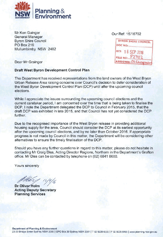
Staff Reports - Sustainable Environment and Economy 13.11 - Attachment 6
Local
Government (General) Regulation 2005
Schedule 3A Form of special disclosure
of pecuniary interest
(Clause 195A)
Section 451 of the Local Government
Act 1993
Form of Special Disclosure of Pecuniary Interest
1 The particulars of
this form are to be written in block letters or typed.
2 If any space is
insufficient in this form for all the particulars required to complete it, an
appendix is to be attached for that purpose which is properly identified and
signed by you.
Important information
This information is being collected for the purpose of
making a special disclosure of pecuniary interests under sections 451 (4) and
(5) of the Local Government Act 1993. The special disclosure must relate to a pecuniary
interest that arises only because of an interest of the councillor in the
councillor’s principal place of residence or an interest of another
person (whose interests are relevant under section 443 of the Act) in that
person’s principal place of residence. You must not make a special
disclosure that you know or ought reasonably to know is false or misleading in
a material particular. Complaints made about contraventions of these
requirements may be referred by the Director-General to the Local Government
Civil and Administrative Tribunal.
This form must be completed by you before the
commencement of the council or council committee meeting in respect of which
the special disclosure is being made. The completed form must be tabled at the
meeting. Everyone is entitled to inspect it. The special disclosure must be
recorded in the minutes of the meeting.
Special
disclosure of pecuniary interests
by
____________________________________________________________________________________
[full
name of councillor]
in the matter of __________________________________________________________________________
[insert
name of environmental planning instrument]
which is to be considered at a meeting of the
______________________________________________________________________________________
[name of council or council committee (as the case
requires)]
Report No. __________ to be held on the _________________ day of
________________________ 201
|
Pecuniary
interest
|
|
Address of land
in which councillor or an associated person, company or body has a
proprietary interest (the identified land)1
|
|
|
Relationship of identified land to councillor
[Tick or cross one box.]
|
Councillor
has interest in the land (e.g. is owner or has other interest arising out of
a mortgage, lease, trust, option or contract, or otherwise).
Associated
person of councillor has interest in the land.
Associated company
or body of councillor has interest in the land.
|
|
Matter giving rise to pecuniary interest
|
|
Nature of land that is subject to a
change
in zone/planning control by proposed
LEP (the subject land)2
[Tick or cross one box]
|
The identified
land.
Land
that adjoins or is adjacent to or is in proximity to the identified land.
|
|
Current
zone/planning control
[Insert name
of current planning instrument and identify relevant zone/planning control
applying to the subject land]
|
|
|
Proposed
change of zone/planning control
[Insert name of proposed
LEP and identify proposed change of zone/planning control applying to the
subject land]
|
|
|
Effect
of proposed change of zone/planning control on councillor
[Insert
one of the following:
“Appreciable financial gain” or
“Appreciable
financial loss”]
|
|
[If
more than one pecuniary interest is to be declared, reprint the above box and
fill in for each additional interest.]
_____________________________
Councillor’s
signature
_____________________________
Date
(This
form is to be retained by the Council’s general manager and included in
full in the minutes of the meeting.)
1 Section 443 (1) of the Local Government Act 1993 provides
that you may have a pecuniary interest in a matter because of the pecuniary
interest of your spouse or your de facto partner or your relative 4 or because
your business partner or employer has a pecuniary interest. You may also have a
pecuniary interest in a matter because you, your nominee, your business partner
or your employer is a member of a company or other body that has a pecuniary
interest in the matter.
Section 442
of the Local Government Act 1993 provides
that a "pecuniary interest" is an interest that a
person has in a matter because of a reasonable likelihood or expectation of
appreciable financial gain or loss to the person. A person does not have a
pecuniary interest in a matter if the interest is so remote or insignificant
that it could not reasonably be regarded as likely to influence any decision
the person might make in relation to the matter or if the interest is of a kind
specified in section 448 of that Act (for example, an interest as an elector or
as a ratepayer or person liable to pay a charge).
2 A pecuniary interest may
arise by way of a change of permissible use of land adjoining, adjacent to or
in proximity to land in which a councillor or a person, company or body
referred to in section 443 (1) (b) or (c) of the Local Government Act 1993 has a proprietary interest-see section 448 (g) (ii) of
the Local Government Act 1993 .
3 "Relative" is
defined by the Local Government Act 1993 as meaning your, your spouse’s or your de facto
partner’s parent, grandparent, brother, sister, uncle, aunt, nephew,
niece, lineal descendant or adopted child and the spouse or de facto partner of
any of those persons.
Staff Reports - Sustainable Environment and Economy 13.12 - Attachment 1
Report No. 4.5 PLANNING
- Development Application 10.2016.189.1 - Multi Dwelling Housing (including 10
single bedroom dwellings, parking for 5 vehicles) and Demolition of existing
structures - 116 Stuart Street, Mullumbimby
Directorate: Sustainable
Environment and Economy
Report
Author: Paul
Mills, Senior Planner
File No: I2016/629
Theme: Ecology
Development and Approvals
Proposal:
|
DA No:
|
10.2016.189.1
|
|
Proposal:
|
Multi Dwelling Housing (including 10 single bedroom
dwellings and parking for 5 vehicles) and Demolition of existing structures
|
|
Property description:
|
LOT: 1 DP: 372438
116 Stuart Street MULLUMBIMBY
|
|
Parcel No/s:
|
87450
|
|
Applicant:
|
Koho Projects
|
|
Owner:
|
Messrs A M & J C Curr
|
|
Zoning:
|
R2 Low Density Residential Zone
|
|
Date received:
|
1 April 2016
|
|
Integrated Development:
|
No
|
|
Public notification or exhibition:
|
- Level
2 advertising under DCP 2014 Part A14 – Public Notification and
Exhibition of Development Applications
- Exhibition
period: 14/04/2016 to 27/04/2016
- Ninety (90) submissions
were received, plus an online petition with 1177 signatures
|
|
Other approvals (S68/138):
|
Not applicable
|
|
Planning Review Committee:
|
12 May 2016
|
|
Delegation to determination:
|
Council
|
Summary:
The subject site is described as Lot 1 DP 372438, 116 Stuart
Street, Mullumbimby. The site is located on the eastern side of Stuart
Street and approximately 40 metres south of the Mullumbimby commercial
centre. The application seeks development consent for the demolition of
the existing single storey dwelling house on the subject site (and associated
outbuildings) and erection of a multi dwelling housing development comprising
of 10 single bedroom dwellings. The proposal seeks approval under the provisions
of State Environmental Planning Policy (Affordable Rental Housing) 2009 [AH
SEPP]. Three of the proposed dwellings are proposed to be provided as
affordable housing.
In response to concerns raised about the development, the
applicant submitted amended plans. The revised proposal has divided the
development into two buildings each containing five dwellings. The proposed
inconsistencies with BLEP 2014 and BDCP 2014 relating to site area, floor space
ratio, landscaped area, deep soil zones and parking are permitted based on
compliance with the AH SEPP. The application was notified and advertised in
accordance with Council’s notification procedures under Byron DCP 2014. Ninety
(90) submissions were received objecting to the development on the grounds of
heritage, bulk, scale, height, rear lane access and non compliance with
Council’s planning controls.
It is considered the proposal will provide much needed
accommodation for singles and couples within close walking distance to the
commercial centre of Mullumbimby. Alternatives for the site could include two
upmarket dwellings in a dual occupancy arrangement or a large house with a
secondary dwelling. Both alternates would likely result in the same or greater
development density on site to the proposal, but do little in terms of
addressing the overall housing diversity needs of residents of the Shire.
The proposed development is recommended for consent subject
to conditions.
NOTE TO COUNCILLORS:
In accordance with the
provisions of S375A of the Local Government Act 1993, a Division is to be
called whenever a motion for a planning decision is put to the meeting, for the
purpose of recording voting on planning matters. Pursuant to clause 2(a)
under the heading Matters to be Included in Minutes of Council Meetings of
Council's adopted Code of Meeting Practice (as amended) a Division will be
deemed to have been called by the mover and seconder of all motions relating to
this report.
|
RECOMMENDATION:
That
Pursuant to Section 80 of the Environmental Planning & Assessment Act
1979, development application 10.2016.189.1 for Multi Dwelling Housing (10 single bedroom
Dwellings) and Demolition of existing structures, be granted consent subject
to the recommended conditions listed in Attachment 2 #E2016/42093.
|
Attachments:
1 Plans
prepared by Koho 10.2016.189.1, E2016/42515
2 Proposed
conditions of consent 10.2016189.1, E2016/42093
3 Confidential
- submissions 10.2016.189.1, E2016/42661
Assessment:
1. INTRODUCTION
1.1 History/Background
The following past applications over the subject site are
noted:
BA 80/2005 Building
Application for a fern house approved 30 January 1980.
BA 44/79 Building
Application for a swimming pool approved 16 August 1979.
BA 77/2041 Building
Application for additions to dwelling approved 4 August 1977.
1.2 Description
of the site
The subject site is legally described as Lot 1 DP 372438,
street address 116 Stuart Street, Mullumbimby. The site is located on the
eastern side of Stuart Street and approximately 40 metres south of the
Mullumbimby commercial centre (see Figure 1).
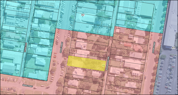
Figure 1 - Location of subject site shown in yellow. Byron LEP
2014 R2 Low Density Residential Zone in pink and B2 Local Centre Zone in light
blue.
The site is rectangular in shape with a frontage of
approximately 14.94 metres to Stuart Street and a length of approximately 60
metres. At the rear the site adjoins McGoughans Lane. The total area of the
allotment is approximately 897.9m².
The site contains an existing single-storey dwelling house
of fibre cement cladding with a fairly low pitched ‘clip lock’
metal roof.
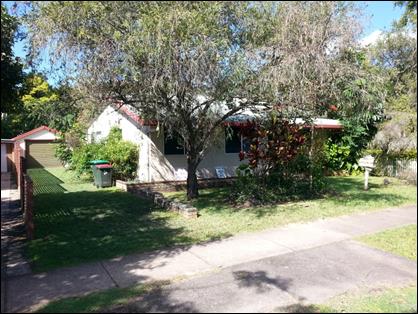
Figure 2 - Existing dwelling at 116 Stuart Street
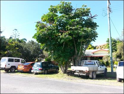
Figure 3 - Existing dwelling as viewed from Stuart Street
1.3 Description
of the proposed development
The application seeks development consent for:
· The demolition of
the existing single-storey dwelling house and associated outbuildings; and
· the erection of a
multi dwelling housing development comprising a total of 10 x 1 bedroom
dwellings each with access from ground level. The proposal seeks to provide
three (3) dwellings as Affordable Housing as defined within the State
Environmental Planning Policy (Affordable Rental Housing) 2009.
In response to issues raised about the development, the
applicant submitted amended plans to Council on 17 May 2016. The revised
proposal has divided the development into two buildings each containing five
dwellings each with a gross floor area of 50m2. The first dwelling
fronting Stuart Street incorporates a single level design whilst the remaining
nine dwellings have a two level design. See Figure 4 for the proposed
site plan.
The proposal provides vehicular access via McGoughans Lane
with a total of 5 on-site parking spaces. A bin storage area and bicycle
parking area also located to the rear of the allotment, and are proposed to be
screened by be plantings within the 3.0 metre wide setback to McGoughans
Lane.
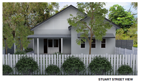
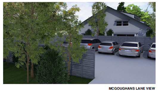
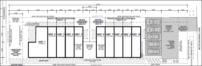
Figure 4 – Proposed Site Plan
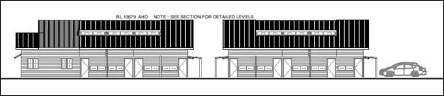
Figure 5 – Proposed south elevation
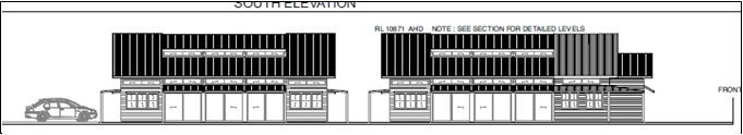

Figure 6 – Proposed north elevation
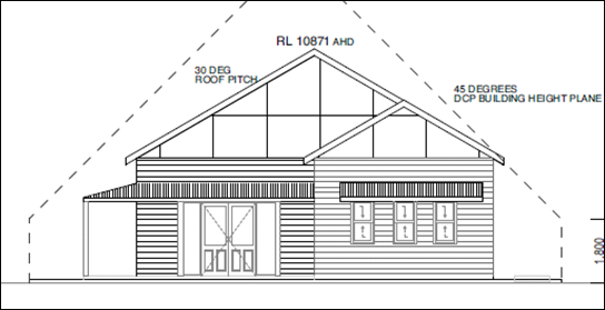
Figure 7 – Proposed Stuart Street elevation
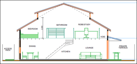
Figure 8 – Proposed typical Section showing roof windows
for upper floor level
2. SUMMARY
OF REFERRALS
The application was considered by Council’s
Development Engineer, Environmental Officer, ET Engineer and Section 94
Officer, where necessary conditions of consent have been included as
recommended by these officers. Council’s Heritage Advisor also assessed
the proposal with comments and recommendations discussed in the body of the
report below.
3. SECTION
79C – MATTERS FOR CONSIDERATION – DISCUSSION OF ISSUES
Having regard for the matters for consideration detailed in
Section 79C(1) of the Environmental Planning & Assessment Act 1979, the
following is a summary of the evaluation of the issues.
3.1. STATE/REGIONAL
PLANNING POLICIES AND INSTRUMENTS
|
Policy
requirement/summary
|
Proposed
|
Complies
|
|
State Environmental Planning Policy (Affordable
Rental Housing) 2009
8 Relationship
with other environmental planning instruments
If there is
an inconsistency between this Policy and any other environmental planning
instrument, whether made before or after the commencement of this Policy,
this Policy prevails to the extent of the inconsistency.
|
The proposed development application has been made under
the provisions of the AH SEPP and the provisions of this SEPP prevail over
any inconsistencies with Byron LEP 2014.
|
Noted
|
|
10 Development to which Division
applies
(1) This Division applies to
development for the purposes of dual occupancies, multi dwelling housing or
residential flat buildings if:
(a) the development
concerned is permitted with consent under another environmental planning
instrument, and
(b) the development is on
land that does not contain a heritage item that is identified in an
environmental planning instrument, or an interim heritage order or on the
State Heritage Register under the Heritage Act 1977.
(3) Despite
subclause (1), this Division does not apply to development on land that is
not in the Sydney region unless all or part of the development is within 400
metres walking distance of land within Zone B2 Local Centre or Zone B4 Mixed
Use, or within a land use zone that is equivalent to any of those zones.
|
Multi dwelling house is permissible on the subject site
under Byron LEP 2014 and the site does not contain a heritage item.
The site is approximately 40 metres (walking distance)
from the land located within the B2 Local Centre Zone (B2 Zone is located
directly opposite the site on Stuart Street).
The site is considered suitable for the provision of
affordable housing.
|
Yes
|
|
13 Floor space ratios
(1) This clause applies to
development to which this Division applies if the percentage of the gross
floor area of the development that is to be used for the purposes of
affordable housing is at least 20 per cent.
(2) The maximum floor space
ratio for the development to which this clause applies is the existing
maximum floor space ratio for any form of residential accommodation permitted
on the land on which the development is to occur, plus:
(a) if the existing maximum
floor space ratio is 2.5:1 or less:
(i) 0.5:1—if the
percentage of the gross floor area of the development that is used for
affordable housing is 50 per cent or higher, or
(ii) Y:1—if the
percentage of the gross floor area of the development that is used for
affordable housing is less than 50 per cent,
where:
AH
is the percentage of the gross floor area of the development that is used for
affordable housing.
Y
= AH ÷ 100
|
The proposal seeks to provide three of the ten dwellings
(30% floor area) as affordable housing. In accordance with this provision, an
increase in the maximum floor space ratio from 0.5:1 to 0.8:1 is permitted.
The proposed floor space ratio is calculated to be 0.56:1 which is less than
the maximum permitted under Clause 13.
|
Yes
|
|
14 Standards
that cannot be used to refuse consent
(1) Site and solar access
requirements
A consent authority must not refuse consent to development to which this
Division applies on any of the following grounds:
(b) site area
if the site area on which it is proposed to carry out the development is at
least 450 square metres,
(c) landscaped area if:
(i) in the case of a development
application made by a social housing provider—at least 35 square metres
of landscaped area per dwelling is provided, or
(ii) in any other case—at
least 30 per cent of the site area is to be landscaped,
(d) deep soil zones
if, in relation to that part of the site area (being the site, not only of
that particular development, but also of any other associated development to which
this Policy applies) that is not built on, paved or otherwise sealed:
(i) there is soil of a sufficient
depth to support the growth of trees and shrubs on an area of not less than
15 per cent of the site area (the deep soil zone), and
(ii) each area forming part of
the deep soil zone has a minimum dimension of 3 metres, and
(iii) if practicable, at least
two-thirds of the deep soil zone is located at the rear of the site area,
(e) solar access
if living rooms and private open spaces for a minimum of 70 per cent of the
dwellings of the development receive a minimum of 3 hours direct sunlight
between 9am and 3pm in mid-winter.
(2) General
A consent authority must not refuse consent to development to which this
Division applies on any of the following grounds:
(a) parking if:
(i) in the case of a development
application made by a social housing provider for development on land in an
accessible area—at least 0.4 parking spaces are provided for each
dwelling containing 1 bedroom, at least 0.5 parking spaces are provided for
each dwelling containing 2 bedrooms and at least 1 parking space is provided
for each dwelling containing 3 or more bedrooms, or
(ii) in any other case—at
least 0.5 parking spaces are provided for each dwelling containing 1 bedroom,
at least 1 parking space is provided for each dwelling containing 2 bedrooms
and at least 1.5 parking spaces are provided for each dwelling containing 3
or more bedrooms,
(b) dwelling size
if each dwelling has a gross floor area of at least:
(i) 35 square metres in the case
of a bedsitter or studio, or
(ii) 50 square metres in the case
of a dwelling having 1 bedroom, or
(iii) 70 square metres in the
case of a dwelling having 2 bedrooms, or
(iv) 95 square metres in the case
of a dwelling having 3 or more bedrooms.
(3) A consent authority may consent to
development to which this Division applies whether or not the development
complies with the standards set out in subclause (1) or (2).
|
Site area
The subject allotment has an area exceeding 450m2.
Landscape area
The total landscape area proposed on the subject allotment
is 311.99m2 which is 34.6% of the total site area. In accordance
with Clause 14 landscaped area cannot be used as a ground for refusal of this
Development Application.
Deep Soil Zones
The total Deep Soil Area proposed on the subject allotment
is 199.22m2 which is 22.1% of the total site area. In accordance
with Clause 14 Deep Soil Area cannot be used as a ground for refusal of this
Development Application. Two-thirds of the Deep Soil Area is located behind
the front building line.
Solar Access
It is considered that the proposed living rooms and
private open space of over 70% of the proposed dwellings receive the required
solar access, having regards to their orientation to the north.
Parking spaces
At least 0.5 parking spaces are provided for
each dwelling containing 1 bedroom. A total of 5 parking spaces are provided
for the proposed 10 single bedroom dwellings.
The applicant has submitted floor plan
drawings indicating that each of the proposed dwellings has a ‘gross
floor area’ exceeding 50m2.
|
Yes
Yes
Yes
Yes
Yes
|
|
15 Design
requirements
(1) A consent authority must not
consent to development to which this Division applies unless it has taken
into consideration the provisions of the Seniors Living Policy: Urban
Design Guidelines for Infill Development published by the Department of
Infrastructure, Planning and Natural Resources in March 2004, to the extent
that those provisions are consistent with this Policy.
|
The proposed development is considered to be generally
consistent with the Seniors Living Policy: Urban Design
Guidelines for Infill Development published by the
Department of Infrastructure, Planning and Natural Resources in March 2004.
|
Yes
|
|
16A Character
of local area
A consent authority must not consent to
development to which this Division applies unless it has taken into
consideration whether the design of the development is compatible with the
character of the local area.
|
Council’s Heritage Advisor has assessed the proposal
in terms of compatibility with the local area and raised no objection to the
revised design of the development.
|
Yes
|
|
17 Must
be used for affordable housing for 10 years
(1) A consent authority must not
consent to development to which this Division applies unless conditions are
imposed by the consent authority to the effect that:
(a) for 10 years from the date of
the issue of the occupation certificate:
(i) the dwellings proposed to be
used for the purposes of affordable housing will be used for the purposes of
affordable housing, and
(ii) all accommodation that is
used for affordable housing will be managed by a registered community housing
provider, and
(b) a restriction will be
registered, before the date of the issue of the occupation certificate,
against the title of the property on which development is to be carried out,
in accordance with section 88E of the Conveyancing Act 1919,
that will ensure that the requirements of paragraph (a) are met.
(2) Subclause (1) does not apply to
development on land owned by the Land and Housing Corporation or to a
development application made by, or on behalf of, a public authority.
|
A condition has been included in the recommendation to
require three (3) of the proposed dwellings to be used for the purposes of
affordable housing for a period of ten years from the date of issue of an
occupation certificate. This affordable housing is also required to be
managed by a registered community housing provider.
|
Yes
|
|
18 Subdivision
Land on which development has been carried
out under this Division may be subdivided with the consent of the consent
authority.
|
The subject development application does not seek consent
for subdivision at this time.
|
Noted
|
|
State Environmental Planning Policy No 55 - Remediation
of Land
Where a change of use is proposed the Council must
consider a report provided by the applicant specifying the findings of a
preliminary investigation (and detailed investigation if necessary) of the
land in accordance with the contaminated land planning guidelines.
|
The proposed development site contains an existing slab
foundation. It is considered that this structure may have been treated with
termeticides which may be residual in the soil. Elevated lead was
detected during an investigation undertaken by ENV Solutions Pty Ltd refer to
Preliminary Assessment Contamination Assessment dated March 2016. A
condition has been imposed requiring a Detailed Contaminated Land Assessment
Report be prepared submitted with a Remedial Action Plan (if required).
|
Yes
|
|
State Environmental Planning Policy No. 71 - Coastal
Protection
Council must have regard for the
matters of consideration under Parts 2 and 4 of SEPP No. 71 when assessing
development within the coastal zone. These matters include:
- retention of existing public access to the coastal
Foreshore
- impact of effluent disposal on water quality
- development must not discharge untreated stormwater into
a coastal water body
|
Public access to the coastal
foreshore will not be impeded or diminished.
Effluent is not proposed to be
disposed other than to Council’s sewerage system.
The proposed stormwater
management plan details the method of treating stormwater runoff and is
considered acceptable.
The site is not located within a
sensitive coastal location, subdivision is not proposed and a master plan is
not required.
|
Yes
|
|
State Environmental Planning Policy Building
Sustainability Index 2004 (BASIX)
Applies to new residential dwellings and alterations and
additions with a value greater than $50,000. Development is to accord with a
completed BASIX Certificate.
|
A BASIX Certificate has been submitted in accordance with
the SEPP.
|
Yes
|
|
North Coast Design Guidelines
Standards for building design on the North Coast of NSW.
|
The design is considered to be generally consistent with
the guidelines.
|
Yes
|
|
NSW Coastal Policy 1997
The subject site is located within 1km landward of the
open coast high water mark and is subject to the provisions of the NSW
Coastal Policy.
|
The proposal is considered to
be consistent with the Goals, Objectives and Strategic Actions of the NSW
Coastal Policy 1997.
|
Yes
|
|
Building Code of Australia
Ability for the proposed development to comply with the
requirements of the BCA.
|
The proposal is considered to be able to satisfy the
requirements of the Building Code of Australia.
|
Yes
|
|
Disability Access (DDA)
Access for persons with
disabilities and integration into surrounding streetscapes without creating
barriers. (Council Res.10-1118)
|
The proposal seeks to provide
Dwelling No.1 as an adaptable house capable of being modified to provide an
accessible dwelling consistent with Council’s DCP 2014.
|
Yes
|
3.2. BYRON
LOCAL ENVIRONMENTAL PLAN 2014
Zone: R2 Low Density Residential
Definition: Multi dwelling housing (10
dwellings)
|
LEP Summary of Requirement
|
Proposed
|
Complies
|
|
Satisfy objectives of the R2 Low Density Residential
zone
Objectives of zone
• To provide for the housing needs of the
community within a low density residential environment.
• To enable other land uses that provide
facilities or services to meet the day to day needs of residents.
|
The proposed multi dwelling housing development is
considered to meet the housing needs of the community in a low density
residential environment.
|
Yes
|
|
Permissibility (LEP 2014)
Multi dwelling housing means 3 or more
dwellings (whether attached or detached) on one lot of land, each with access
at ground level, but does not include a residential flat building.
|
The proposed ten (10) dwellings are to be located on one
lot of land and each has access at ground level consistent with the
definition of multi dwelling housing. Multi dwelling housing is permissible
with the R2 low density residential zone.
|
Yes
|
|
Clause 4.1E Minimum lot sizes
for dual occupancies, multi dwelling housing and residential flat buildings
The minimum lot size for multi dwelling housing within the
R2 Low Density Residential Zone is 1000m2.
|
Multi dwelling housing
|
Zone R2 Low Density Residential
|
1,000 square metres
|
|
The subject allotment has a total area of approximately
897.9m2.
This is not a ground for refusal pursuant to Clause 14 of
AH SEPP which requires a minimum site area of 450m2.
|
Not Applicable
AH SEPP prevails
|
|
Clause 4.3 - Height of buildings
Maximum height limit as shown on the Height of Buildings
Map is 9.0 metres.
|
The maximum height of the proposed building is
6.57metres (RL 10.87m – RL 4.3)
|
Yes
|
|
Clause 4.4 Floor space ratio
Maximum floor space ratio for a building on the subject
site is not to exceed 0.5:1 as shown on the Floor Space Ratio Map.
|
The total area of the subject allotment is approximately
897.9m2. The proposed gross floor area of the building is
approximately 502.45m2. Proposed FSR is approximately 0.56:1.
This is not a ground for refusing consent pursuant to
Clause 13 of AH SEPP which sets the maximum site FSR at of 0.80:1
|
Not Applicable AH
SEPP prevails
|
|
Clause 5.10(5) Heritage Conservation
The subject site is within the Mullumbimby Heritage
Conservation Area and within the setting of the Heritage Item dwelling house
at No.87 Station Street (located to the rear of the site on the opposite side
of McGoughans Lane). Pursuant to Clause 5.10(5) the consent authority may
require a heritage management document to be prepared.
|
The applicant has submitted a Heritage Impact Assessment.
See further discussion below.
|
Yes
|
|
Clause 6.1 Acid Sulfate Soils
Class 4 - Works more than
2 metres below the natural ground surface. Works by which the watertable is
likely to be lowered more than 2 metres below the natural ground surface.
|
The proposed development does not involve the disturbance
of acid sulphate soils more than 2.0m below natural ground level.
|
Yes
|
|
Clause 6.3 Flood Planning Level
(2) This clause applies to land at or
below the flood planning level.
(3) Development consent must not be
granted to development on land to which this clause applies unless the
consent authority is satisfied that the development:
(a) is compatible with the flood
hazard of the land, and other matters specified within subclause 3.
(4) In determining a development
application for development at or below the future flood planning level, the
consent authority must, in addition to the matters referred to in subclause
(3), also consider other matters in subclause 4.
|
The Flood Planning Level for the development is 4.45m AHD.
The proposed floor level is 4.5m AHD.
|
Yes
|
|
6.7 Affordable housing in
residential and business zones
(1) The objectives of this clause are as follows:
(a) to increase the supply of affordable
housing for very low, low and moderate income earning households,
(b) to provide accommodation to support a diverse
residential population inclusive of all income groups within Byron,
(c) to ensure a housing mix and tenure choice
including affordable housing,
(d) to ensure that affordable housing is
identified by the Council as in demand and located close to transport and
services appropriate to the intended households.
(2) Development consent must not be granted for the
purposes of residential accommodation or to the subdivision of any land in
Zone R2 Low Density Residential, Zone R3 Medium Density Residential, Zone B2
Local Centre or Zone B4 Mixed Use unless the consent authority has
considered:
(a) the need for providing, maintaining or
retaining affordable housing, and
(b) the need for imposing conditions relating
to providing, maintaining or retaining affordable housing including, but not
limited to, imposing covenants and the registration of restrictions about
users.
(3) For the purposes of this clause, affordable
housing means housing for very low income households, low income
households or moderate income households.
|
All matters raised in Clause 6.7 have been given
consideration. A demand for affordable housing within Byron Shire is
acknowledged.
A condition has been included to require the provision of
three dwellings as affordable housing as proposed, and for the housing to be
managed by a social/community housing provider (as defined under Part 1
Clause 6 of the AH SEPP).
|
Yes
|
Byron Local Environmental Plan
2014 - Issues
Mullumbimby Heritage Conservation Area
The subject site is located within the Mullumbimby Heritage
Conservation Area. A large number of submissions raised concerns that the
proposed development was not compatible with the character of the area. A
Heritage Impact Assessment was submitted with the application, this was
referred to Council’s Heritage Advisor for comment.
The applicant submitted amended plans to Council on 17 May
2016 to address the issues raised by Council’s Heritage Advisor.
Following a review of the amended plans Council’s Heritage Advisor has
concluded as follows:
“The revised development
is not likely to adversely impact upon the heritage significance of the
Conservation Area for the following reasons:
· The subject
site and existing building does not demonstrate any individual heritage
significance.
· The buildings
are single storey and would not dominate the Stuart Street streetscape or the
laneway.
· Their bulk,
form, and scale are not excessive in relation to surrounding development.
· The overall
bulk and scale is equivalent to two modest sized single dwellings.
· This is
comparative with dual occupancy developments which is a permissible and
established form of development occurring within the Conservation Area.
· The proposed
materials, colours, finishes and detailing are complementary to the
context of
the Conservation Area.
· The proposed
Unit 1 addressing Stuart Street frontage is designed to complement the
character of the streetscape and retains a traditional landscaped setback. The
rear wall of Unit 10 maintains a traditional type of appearance to the laneway.
· The rear car
park will not dominate the laneway as it is well screened by a 3m depth of
landscaped area which can support substantial mature trees.
Recommendations
1. That
the road reserve informal parking area on Stuart Street is maintained as a
grassed verge with additional street tree planting as proposed.
2. That
an advice is also provided advising the owners of the consent requirements of
Clause 5.10 of the LEP. This would highlight the need to apply for any proposed
future changes to fabric, finish and appearance. This advice will be useful in
controlling any potential adverse impacts from any future changes of colour
schemes which may not be sympathetic to the setting of the CA.
Reason: To ensure that the
proposed development will not adversely impact upon the assessed heritage
significance and setting of the Mullumbimby Heritage Conservation Area.”
Draft EPI that is or has been
placed on public exhibition and details of which have been notified to the
consent authority
A relevant draft Environmental Planning Instrument has not
been identified for this proposal.
3.3 DEVELOPMENT
CONTROL PLANS
The proposed development does not achieve strict compliance
with various controls contained within Byron DCP 2014 however in most cases
these matters are not able to be used as grounds for refusal pursuant to
Clauses 13 and 14 of AH SEPP.
Chapter B3 Services
The site is adequately services with all necessary
infrastructure including water, sewer, stormwater and access. Conditions of
consent to apply.
Chapter B8 - Waste Minimisation and Management
The applicant has submitted a Site Waste Minimisation and
Management Plan comprising 2 x 1100 litre skip bins for general garbage and
recycling along with 2 x 240 litre green waste wheelie bins. An adequate waste
storage area has been proposed adjacent to the rear parking area. Green bins
are to be collect from the Stuart Street frontage while the skip bins are to be
collected from McGoughans Lane. The Proposal is consistent with Chapter 8. .
Chapter B9 - Landscaping
Landscaping and open space has been provided in accordance
with the AH SEPP and is considered satisfactory. A condition of consent is
recommended requiring a detailed landscape plan to be submitted with the
construction certificate.
Chapter C1 Non Indigenous Heritage
The subject site is located within the Mullumbimby Heritage
Conservation Area. The proposed revised plans break the building into two
separate smaller parts and maintain a pitched roof design which is considered
to be satisfactory in the context of the Heritage Conservation Area. Comments
from Council’s Heritage Advisor are included in Byron LEP 2014 section of
this report.
Chapter E3 - Mullumbimby
The proposal is considered acceptable in terms of the bulk
scale and character provisions of the DCP as they relate to infill development.
(E3.2, E3.3 and E3.4) In particular, from the street, the proposal will
appear similar to other dwellings in Mullumbimby replicating the height, bulk
and scale of established dwellings with a front verandah, whilst landscaping of
the rear boundary will assist with screening the car parking areas from the
public domain.
Chapter D1 - Residential Accommodation in Urban, Village
and Special Purpose Zones
|
Control
|
Assessment
|
|
D1.2.1 Building Height Plane
|
The proposed development is able to comply with the BHP
adjacent to each boundary.
|
|
D1.2.2 Setbacks from Boundaries
|
The revised plans have increased the proposed front
setback to 6.5 metres. The proposed car park incorporates a 3.0 metre
setback to McGoughans Lane. The minimum side boundary setback is
1.935m. The proposal complies with the setback provisions
|
|
D1.2.4 Character & Visual Impact
|
Amended plans have been submitted by the applicant
following recommendations from Council’s Heritage Advisor. The revised
plans divide the building into two parts separated by a distance of 4.52
metres.
The proposed pitched roof design is considered to be
compatible with the character of other development within the immediate area.
|
|
D1.2.5 Fences
|
A condition has been included
to require boundary fencing along the northern, southern and western
boundaries to be of lapped and capped hardwood timber construction. Front
boundary fencing (including side return fencing, that being sides located
between the front building line and the front boundary to Stuart Street) is
to be a maximum of 1.2 metres in height and incorporate plain heritage style
picket fencing.
|
|
D1.2.7 Pedestrian and Cycle Access
|
The proposed development provides connectivity to the
local footpath network. The site does not have frontage to the local bicycle
network.
|
|
D1.6.1 Private Open Space Courtyards
D1.6.3 Landscaping
|
Small courtyard areas are proposed for each dwelling for
private open space purposes. Although smaller than the minimum area under the
DCP, it is considered the courtyards are adequate for the one bedroom
dwellings proposed, having regards to the performance criteria underpinning
this design element. A concept landscape plan has been submitted and is
considered acceptable, subject to a detailed plan being submitted with the
construction certificate.
|
|
D1.6.4 On-Site Car Parking
|
In accordance with the AH SEPP at
least 0.5 parking spaces are provided for each dwelling containing 1 bedroom.
A total of 5 parking spaces are provided for the proposed 10 single bedroom
dwellings.
|
|
D1.6.6 Clothes Drying Facilities
|
An acceptable external clothes drying area is available
for each dwelling at ground level.
|
|
D1.6.7 Equity of Access and Mobility
|
The proposed development incorporates one (1) adaptable
housing unit (Dwelling No.1) with a single storey design and widened
doorways. An accessible parking space has not been proposed.
|
3.4 The likely impacts of that
development, including environmental impacts on both the natural and built
environments, and social and economic impacts in the locality
It is considered that the proposal will have no significant
detrimental effect relating
to environmental, social or economic impacts on the
locality, subject to appropriate
conditions being imposed.
3.5 The
suitability of the site for the development
The proposal will provide much needed accommodation for
singles and couples within close walking distance to the centre of Mullumbimby.
The site is considered suitable for the proposed affordable housing
development.
3.6 Submissions
made in accordance with this Act or the regulations
The application was notified in accordance with the Level 2
procedure within Council’s DCP 2014. Council’s received ninety (90)
submissions plus an online petition with 1177 signatures objecting the
development. Following is a summary of planning matters raised in the
submissions.
|
Issue
|
Comment
|
|
The size, bulk, scale and density of the proposed
development is considered to be inconsistent with the streetscape and
existing development within the immediate area and the Mullumbimby township.
|
The proposal complies with Council’s setback and
building height plane controls. The provision of floor space partially within
the roof space has acted to reduce the visually apparent bulk of the
buildings.
|
|
The subject site has an area of 897m2.
Council’s LEP 2014 specifies the minimum lot size for multi dwelling
housing development is 1000m2 the proposal does not comply with
the requirement.
|
The AH SEPP specifies that the minimum lot size is 450m2
for Affordable Housing of this kind.
|
|
The proposed development incorporates a long single
structure containing 10 dwellings this is not consistent with development in
the R2 Low Density Residential Zone. There are too many dwellings for the
size of the block.
|
Amended plans were submitted by the applicant to reduce
the floor area of the proposed dwellings and break the building into two
smaller parts (whilst maintaining a total 10 dwellings).
|
|
The proposed Floor Space Ratio of the development is 0.58
and exceeds the LEP 2014 maximum of 0.5:1. The proposed development should be
reduced in size to comply with this requirement. The proposal represents a
gross overdevelopment of the site.
|
The AH SEPP increases the maximum permissible FSR to
0.8:1. The proposed FSR of 0.58 is below this maximum.
|
|
The proposal to provide five (5) parking spaces is
insufficient parking to service ten (10) dwellings. This will create an
overflow of parking on Stuart Street which does not have capacity. There
should be at least one parking space per dwelling.
|
Five parking spaces have been provided compliant with the
AH SEPP.
|
|
McGoughans Lane is a narrow single lane accessway and will
not cope with the additional traffic generated by the proposal. The laneway
is in bad condition.
|
It is acknowledged that McGoughans Lane to the rear of the
property is only a gravel pavement. Council’s Development Engineer has
advised the laneway will require upgrading. The laneway in front of the
property is required to be upgraded to bitumen and be extended to the
existing bitumen sealed road at either the north or south of the site.
|
|
The proposed ten units are located within the Mullumbimby
Conservation Area and in proximity of a number of Heritage Items. Concerns
the proposed development is not consistent with the heritage character of
Mullumbimby and existing town architecture.
The proposal does not comply with the aims or requirements
of Byron Development Control Plan 2014 Chapter relating to Non-Indigenous
Heritage Section C1.6.8 Mullumbimby Conservation Area.
Concerns the proposal is also inconsistent with DCP
2014 Chapter E3 Mullumbimby. The Development Application has not demonstrated
that:
the character, bulk, scale and density of proposed
development will be compatible with and will enhance the low rise character
and scale of Mullumbimby, its built environment and its surrounds,”
|
Council’s Heritage Advisor considers the
revised development is not likely to adversely impact upon the heritage
significance of the Conservation Area. See the Byron LEP 2014 - Issues
section of this report for further details.
|
|
The existing dwelling house on the site is older than
claimed in the Development Application material. Where demolition of a
building in a heritage conservation area is approved it will generally
conditional upon preparation of an archival recording of the building and
site.
|
Council’s Heritage Advisor has assessed the proposed
existing dwelling to be 1950’s era and advised “Removal of
this dwelling is not likely to have any adverse impact upon the significance
of the Conservation Area”. In this instance a condition to require
archival recording has not been recommended by Council’s Heritage
Advisor.
|
|
DCP 2014 Section C1.6 Special Guidelines – Heritage
Conservation Areas. Development in all areas must remain single storey (apart
from land zoned B2 in Bangalow Heritage Conservation Area) in height to
maintain the visual character and unity of the streetscape.
|
This provision of DCP 2014 relates to heritage
conservation. The proposed development incorporates an attic type level
predominantly within the roof space of the building. Council’s Heritage
Advisor has not raised objection to the proposed design including the level
within the roof space. Byron LEP 2014 sets the maximum height limit for the
subject site as 9.0 metres, the proposal complies with this requirement.
|
|
Concerns the proposed 1.2 metre high fence along the
western boundary of the proposed development is not consistent with the
heritage character of Mullumbimby.
|
Council’s Heritage Advisor has raised no objection
to the proposed front fencing adjacent to Stuart Street.
|
|
The proposed development will set an undesirable precedent
for future development in Mullumbimby.
|
Each development application is required to be assessed according
to its own individual merits. The proposed development is not considered to
be incompatible with existing residential development within the Heritage
Conservation Area.
|
|
The proposed two-storey dwellings will detract from the
privacy of neighbouring properties. Screening the property with vegetation
will not mitigate the loss of privacy for the residents at 114 and 118 Stuart
Street. Views from upper windows on the northern elevation overlook the sough
facing bedroom windows of the dwelling at No.116 Stuart
|
The proposed narrow, roof level, windows are setback
inside the Building Height Plane. These windows have a sill height 2.3 metres
above the upper floor level which prevents views into neighbouring
properties.
|
|
The close proximity of the development to neighbouring
dwellings will result in noise disturbance from commercial garbage
collection, increased vehicle movements, outdoor entertainment/living areas
and animal noise.
|
The proposed residential use of the premises is consistent
and compatible with existing residential development. Should any offensive
noise emanate from this development this will be treated, as any other
residential premises, in accordance with the Protection of the Environment
Operations Act 1997.
|
|
The proposal has not adequately considered stormwater on
the subject site and on Stuart Street and McGoughans Lane. Existing
stormwater drains overflow in the laneway and street. Concerns regarding
additional flooding of street and rear lane open drain, ponding of water and
health issues.
|
A recommended condition of consent requires stormwater
detention to be provided on-site in order to manage stormwater runoff from
the development. Suitable engineering details will be required to manage
stormwater prior to issue of a construction certificate for the development.
|
|
Concerns regarding the 1.8 metre timber paling fence
between the subject site and No.114 Stuart Street. Having regard to noise
impacts this fence is inadequate in terms of construction material. Lapped
and capped hardwood fencing on this boundary is requested.
Request for existing brick wall on northern boundary
requested to remain and be extended between No.118 and subject site at No.116
Stuart Street.
|
A condition has been included to require boundary fencing
to the northern and southern boundaries (behind the front building line) to
be of more solid lapped and capped hardwood construction.
|
|
Concerns the proposed dwellings are more likely to contain
two bedrooms minus a door to the second upstairs bedroom. The proposed
dwellings have an area of approximately 50m2.
Under SEPP (Affordable Rental Housing) 2009 if the
proposal was to be for 2 bedroom dwellings the minimum floor area for those
dwelling would be 70m2. The proposed development would be 19m2
short of comply with SEPP (Affordable rental housing) 2009.
The potential for 20-40 people to occupy one block of
land.
|
The proposed upper floor plan specifies that only one
Bedroom is proposed. It is acknowledged that the floor plan for the upper
level does contain a partially open Study area however consent has not been
sought for the use of this area as a separate bedroom.
Should any proposed dwelling clearly contain two bedrooms,
the minimum floor area required under the AH SEPP is 70m2.
It is acknowledged that potentially these dwellings could
each be occupied by two adults.
|
|
Concerns regarding noise from pumps servicing rainwater
tanks. Acoustic enclosure to prevent noise impacts requested. The potential
for 20-40 people to occupy one block of land.
|
The proposed plans do not include rainwater tank details.
In the event any kind of pump is proposed to be installed the proposal will
be required to comply with the noise limitations of the Protection of the
Environment Operations Act 1997.
|
|
State Environmental Planning Policy (Affordable Rental
Housing) 2009 allows for densities designed for inner city living not rural
towns.
|
The AH SEPP is applicable to all of NSW. It is noted that
only minor variations in the AH SEPP controls are provided to distinguish
between the Sydney Region and other regional areas.
|
|
The proposed development is an incompatible type of
housing and contrary to the values of the community.
|
Affordable Housing is encouraged in Byron Shire in
accordance within Byron LEP 2014 Clause 6.7.
|
|
Concerns regarding security and potential for increase in
crime in the local area.
|
No evidence has been submitted to suggest the future
occupants of the proposed development will cause an increase in crime in the
area.
|
|
Concerns regarding lighting impacts from 10 dwellings.
|
Lights for
the proposed dwellings have not been shown on the proposed plans. A condition
has been included to require all external lighting must be installed in
accordance with AS4282-1997: Control of the obtrusive effects of outdoor
lighting.
|
|
The proposal will result in devaluing of properties.
|
This is not a matter for consideration under Section 79C
of the EPA Act 1979.
|
|
The elderly or disabled people are not suited to the
proposed dwellings as they are of two-storey design with facilities over two
levels. Steep internal stairs are not suitable.
|
The proposed development includes a single dwelling to be
provided as accessible housing in accordance with Council’s DCP 2014.
It is acknowledged that the proposed nine (9) two-storey dwellings would not
be suitable as accessible housing.
|
|
Concerns regarding insufficient space for waste collection
on Stuart Street with up to 20 bins to be put out each week. The proposal
shows 2 x 100 lire and 2 x 240 litre bins located at the rear of the property
with the collection point being McGoughans Lane a narrow unsealed laneway.
|
The proposal bin storage and management of waste is
considered acceptable as discussed above.
|
|
Loss of light and overshadowing for property to the south
of the site. The shadow diagrams submitted by the applicant do not satisfy
the SEPP (Affordable Rental Housing) 2009 for mid winter 22nd
June.
|
The proposed development complies with the building height
plane control and is well below the maximum height limit. In these
circumstances the proposed level of overshadowing for neighbouring properties
is considered to be acceptable.
Solar access to the living areas and private open spaces
of the proposed dwellings is assessed to satisfy AH SEPP requirements.
|
|
Support for the development of affordable housing in Byron
Shire and the increase in affordable housing stock. The demand for well
located, long term affordable housing for singles and couples in Mullumbimby
and the greater Byron Shire is well documented, as evidenced in the Byron
Shire Council Affordable Housing Options Paper 2009.
|
Noted.
|
|
Byron LEP 2014 states that residential accommodation is
prohibited in the R2 Low Density Residential Zone. 10 units must be regarded
as residential accommodation.
|
Byron LEP 2014 specifies that multi dwelling housing is
permissible with development consent within the R2 Low Density Residential
Zone.
|
|
Concerns that only 3 of the 10 proposed dwellings are to
be provided as affordable housing.
|
The AH SEPP provides FSR incentives based on the
proportion of overall floor space provided as affordable housing. Council
planning controls do not require a specific minimum amount of floor space to
be provided as affordable housing.
|
|
Concerns regarding the proposed floor to ceiling height
for the upper level.
|
Prior to issue of a construction certificate for the
development the proposed floor to ceiling height will be required compliance
with the Building Code of Australia.
|
|
The proposed development is contrary to the public
interest as is evident from the number of people who have supported an
on-line petition against the proposal.
|
The proposal has generated a number of submissions. The provision
of affordable housing for singles and couples is unlikely to prejudice or
compromise the public interest.
|
3.7 Public
interest
It is considered that the proposal will have no detrimental
effect on the public interest, subject to appropriate conditions being
proposed.
4. DEVELOPER
CONTRIBUTIONS
4.1 Water
& Sewer Levies
The proposed development will generate a nexus to levy water
and sewer headworks charges in accordance with Council’s fees and
charges, conditions have been included.
4.2 Section
94 Contributions
Council’s Section 94
Officer has advised the applicant’s statement does not request a waiver
or deferral of the S94 Contributions. This proposal will increase the demand
for public facilities and amenities and a condition of consent requiring the
payment of contributions is required.
5. CONCLUSION
The proposed affordable housing development will provide
additional housing for singles and couples in the form of one bedroom units.
The development is within close walking distance to the town centre of
Mullumbimby reducing car dependency for residents. The bulk, scale and height
of the proposal is considered to be compatible with the heritage character of
the locality, and no adverse environmental impacts are anticipated from the
development of the site. The proposed development is recommended for consent
subject to conditions.
Staff Reports - Sustainable Environment and Economy 13.12 - Attachment 2
CONDITIONS OF CONSENT:
Parameters of this
Consent
1) Development
is to be in accordance with approved plans and documents
The development is to be in
accordance with plans listed below:
|
Plan No.
|
Description
|
Prepared by
|
Dated:
|
|
DA - 18
|
Demolition Plan
|
Koho Projects Pty Ltd
|
1 April 2016
|
|
DA - 03
|
Site Plan
|
Koho Projects Pty Ltd
|
17 May 2016
|
|
DA - 04
|
Floor Plan
|
Koho Projects Pty Ltd
|
17 May 2016
|
|
DA - 05
|
Type A Unit - Detail
|
Koho Projects Pty Ltd
|
17 May 2016
|
|
DA - 06
|
Type B Unit - Detail
|
Koho Projects Pty Ltd
|
17 May 2016
|
|
DA - 07
|
Type C Unit - Detail
|
Koho Projects Pty Ltd
|
17 May 2016
|
|
DA - 08
|
Elevations
|
Koho Projects Pty Ltd
|
9 June 2016
|
|
DA - 09
|
Typical Section
|
Koho Projects Pty Ltd
|
9 June 2016
|
|
DA - 13
|
Landscape Concept Plan
|
Koho Projects Pty Ltd
|
17 May 2016
|
|
|
Site Waste Minimisation and Management Plan
|
Duncan Band
|
12.10.15
|
The development is also to be in
accordance with any changes shown in red ink on the approved plans or
conditions of consent.
The approved plans and related
documents endorsed with the Council stamp and authorised signature must be kept
on site at all times while work is being undertaken.
2) Residential
use
This development consent allows
only for the purposes of multi dwelling housing. Nothing within this
development consent allows for the development to be used as tourist and visitor
accommodation.
3) Provision
of Affordable Housing
For ten (10) years from the date
of the issue of an Occupation Certificate for the subject development all three
(3) dwellings are to be used only for the purposes of ‘affordable
housing’ (as defined in the Environmental Planning and Assessment Act
1979 and State Environmental Planning Policy [Affordable Rental Housing]
2009), and these dwellings are to be managed by a registered community
housing provider (registered community housing provider has the same
meaning as in the Housing Act 2001).
4) Compliance
with Building Code of Australia and insurance requirements under the Home
Building Act 1989
(1) For
the purposes of section 80A (11) of the Act, the following
conditions are prescribed in relation to a development consent for development
that involves any building work:
(a) that
the work must be carried out in accordance with the requirements of the
Building Code of Australia ,
(b) in
the case of residential building work for which the Home Building Act 1989
requires there to be a contract of insurance in force in accordance with Part 6
of that Act, that such a contract of insurance is in force before any building
work authorised to be carried out by the consent commences.
(2) This
clause does not apply:
(a) to
the extent to which an exemption is in force under clause 187 or 188,
subject to the terms of any condition or requirement referred to in clause 187 (6) or 188
(4), or
(b) to
the erection of a temporary building.
(3) In
this clause, a reference to
the Building Code of Australia is a reference to that Code as in force on the
date the application for the
relevant construction certificate is made.
5) Erection
of signs
(1) For
the purposes of section 80A (11) of the Act, the
requirements of subclauses (2) and (3) are prescribed as conditions of a
development consent for development that involves any building work,
subdivision work or demolition work.
(2) A
sign must be erected in a prominent position on any site on which building
work, subdivision work or demolition work is being carried out:
(a) showing
the name, address and telephone number of the principal certifying authority
for the work, and
(b) showing
the name of the principal contractor (if any) for any building work and a
telephone number on which that person may be contacted outside working hours,
and
(c) stating
that unauthorised entry to the work site is prohibited.
(3)
Any such sign is to be maintained while the building work, subdivision work or
demolition work is being carried out, but must be removed when the work has
been completed.
(4) This
clause does not apply
in relation to building work, subdivision work or demolition work that is
carried out inside an existing building that does not affect the external walls
of the building.
(5) This
clause does not apply
in relation to Crown building work that is certified, in accordance with
Section 109R of the Act, to comply
with the technical provisions of the State’s building laws.
(6) This
clause applies to a
development consent granted before 1 July 2004 only if the building work,
subdivision work or demolition work involved had not been commenced by that
date.
Note: Principal certifying
authorities and principal contractors must also ensure that signs required by
this clause are
erected and maintained (see clause 227A which
currently imposes a maximum penalty of $1,100).
6) Notification
of Home Building Act 1989 requirements
(1) For
the purposes of section 80A (11) of the Act, the
requirements of this clause are prescribed
as conditions of a development consent for development that involves any
residential building work within the meaning of the Home Building Act 1989 .
(2) Residential
building work within the meaning of the Home Building Act 1989
must not be carried out unless the principal certifying authority for the
development to which the work relates (not being the council) has given the
council written notice of the
following information:
(a) in
the case of work for which a principal contractor is required to be appointed:
(i) the
name and licence number of the principal contractor, and
(ii) the
name of the insurer by which the work is insured under Part 6 of that Act,
(b) in the
case of work to be done by an owner-builder:
(i) the
name of the owner-builder, and
(ii) if
the owner-builder is required to hold an owner-builder permit under that Act,
the number of the owner-builder permit.
(3) If
arrangements for doing the residential building work are changed while the work
is in progress so that the information notified under subclause (2) becomes out
of date, further work must not be carried out unless the principal certifying
authority for the development to which the work relates (not being the council)
has given the council written notice of the
updated information.
(4) This
clause does not apply
in relation to Crown building work that is certified, in accordance with
Section 109R of the Act, to comply
with the technical provisions of the State’s building laws.
7) Television
reception system
A single common television
reception system provided with a design to minimise adverse visual impacts
whilst enabling high quality reception for each dwelling.
8) External
lighting installation
To maintain
safe access, adequate lighting must be provided between sunset and 12.00
PM. All external lighting must be installed in accordance with
AS4282-1997: Control of the obtrusive effects of outdoor lighting.
9) No
Interference with Amenity of Neighbourhood
The proposed use of the premises shall
not interfere with the amenity of the neighbourhood by reason of noise,
vibration, smell, fumes, smoke, dust, wastewater or otherwise. In particular:
a) The
noise level emanating from the use of the premises must comply with the New
South Wales Industrial Noise Policy.
b) Only
clean and unpolluted water is permitted to be discharged to Councils’
stormwater drainage system or any waters.
The following conditions
are to be complied with prior to issue of a Construction Certificate
10) A
Demolition Management Plan must be submitted to Council for approval
An Environmental Management Plan
(EMP) must be submitted to Council for approval prior to an demolition works
commencing. The EMP must be prepared by a suitably qualified professional
and contain details of measures to be undertaken to ensure that demolition
works do not result in any off-site impacts that could interfere with
neighbourhood amenity by reason of noise, vibration,
smell, fumes, smoke, dust, wastewater or otherwise.
All works must be in accordance
with NSW WorkCover Authority.
11) Details
of the garbage, composting and recycling storage area required
Details of the waste storage area
(garbage, recycling and green bins) are required to be shown on the
construction certificate drawings. The details are to include a concrete slab
on ground for the waste storage area shown on the approved Site Plan referred
to in Condition No.1.
12) Boundary
fencing
Boundary fencing along the
northern, southern and western boundaries is to be of lapped and capped
hardwood timber construction. Fount boundary fencing (including side return
fencing, that being sides located between the front building line and the front
boundary to Stuart Street) is to be a maximum of 1.2 metres in height and
incorporate plain heritage style picket fencing.
13) Water
and Sewerage - Section 68 approval required
An Approval under
Section 68 of the Local Government Act 1993 to carry out water supply work
and sewerage work must be obtained.
14) Remediation
of contaminated land
The application for a construction
certificate must be accompanied by a Detailed Contaminated Land Assessment, and
Remedial Action Plan (if required) prepared by a suitably qualified
contaminated land specialist with experience in the remediation of contaminated
land. The Remedial Action Plan must conform to NSW EPA Guidelines for Consultants Reporting on Contaminated Sites
1997 and all other applicable standards.
The Remedial Action Plan must be
approved as part of the Construction Certificate for Building Works.
15) On-site
stormwater detention - Section 68 approval required
An approval under Section 68 of
the Local Government Act 1993 to carry out on-site detention drainage system
and connection to a Council approved drainage system.
The plans must be in compliance
with the Northern Rivers Local Government Development Design and Construction
Manuals, Byron Shire Council Comprehensive Guidelines for Stormwater Management
and relevant Australian Standards. Refer to Council’s website for copies
of Council documents.
16) Sediment
and Erosion Control Management Plan required
The application for a Construction
Certificate is to include plans and specifications that indicate the measures
to be employed to control erosion and loss of sediment from the site. Control
over discharge of stormwater and containment of run-off and pollutants leaving
the site/premises must be undertaken through the installation of erosion
control devices such as catch drains, energy dissipaters, level spreaders and
sediment control devices such as filter fences and sedimentation basins.
Such plans and specifications must
be approved as part of the Construction Certificate.
NOTE: The plans
must be in compliance with Council's current “Northern Rivers Local
Government Development Design & Construction Manuals and Standard
Drawings”.
17) Consent
required for works within the road reserve
Consent from Council must be
obtained for works within the road reserve pursuant to Section 138 of the Roads
Act 1993. Three (3) copies of engineering construction plans must accompany the
application for consent for works within the road reserve.
Such plans are to be in accordance
with Council’s current Design & Construction Manuals and are to
provide for the following works:
|
Driveways - McCoughans Lane
|
Construct 2 new driveways from the edge of pavement seal
through to the property boundary; inclusive of piped culverts with precast
concrete headwalls. The driveways are to be generally in accordance with
Council’s standard “Northern Rivers Local Government Development
Design & Construction Manuals and Standard Drawings”.
|
|
|
|
|
Road pavement and drainage – McCoughans Lane
|
A minimum 3m wide bitumen sealed pavement for the full
width of the subject site and either North to join the existing sealed
section adjoining the car park at the rear of No. 108 Stuart Street or South
to the existing bitumen sealed section at the rear of 93 Station Street. The
table drains are to be cleared out, re-profiled and stabilised.
|
|
Stuart Street
|
Remove the existing vehicle bridge over the table drain.
Replace any damaged sections of the concrete table drain in front of the
property to improve drainage along Stuart Street.
|
|
Adjustment of Services
|
The road works are to include the adjustment and/or
relocation of services as necessary to the requirements of the appropriate
service authorities and to ensure that the services are constructed flush
with the finished surface levels.
|
18) Traffic
Management Plan
Consent from Council must be
obtained for a Traffic Management Plan pursuant to Section 138 of the Roads Act
1993. The plans and specifications are to include the measures to be employed
to control traffic (inclusive of construction vehicles) during construction of
the development. The traffic control plan is to be designed in accordance with
the requirements of the Roads and Traffic Authority’s Manual, Traffic
Control at Work Sites Version 2, and the current Australian Standards, Manual
of Uniform Traffic Control Devices Part 3, ‘Traffic Control Devices for
Works on Roads’.
“The plan shall incorporate
measures to ensure that motorists using road adjacent to the development,
residents and pedestrians in the vicinity of the development are subjected to
minimal time delays due to construction on the site or adjacent to the
site”.
The traffic control plan must be
prepared by a suitably qualified and RTA accredited Work Site Traffic
Controller.
19) Car
parking layout, vehicle circulation and access plans required.
The application for a Construction
Certificate is to include plans and specification that indicate access, parking
and manoeuvring details in accordance with the plans approved by this consent.
The access, parking and
manoeuvring for the site is to comply with the requirements of Council’s
Development Control Plan 2014, AS 2890.1-2004: Parking facilities, Part 1:
Off-street car parking and AS 2890.2 – 2010 - Parking facilities, Part 2:
Off-street commercial vehicle facilities. Plans are to include, but not be
limited to, the following items:
a) pavement
description;
b) site
conditions affecting the access;
c) existing
and design levels;
d) longitudinal
section from the road centreline to the car space(s);
e) cross
sections every 15 metres;
f) drainage
(pipes, pits, on-site detention, etc.);
g) turning
paths;
h) linemarking
and signage.
i) Sight
distances for the fences at the entry onto the lane are to comply with AS
2890.1 clause 3.2.4
The engineering plans and
specifications are to be designed by a qualified practising Civil Engineer. The
Civil Engineer is to be a corporate member of the Institution of Engineers
Australia or is to be eligible to become a corporate member and have
appropriate experience and competence in the related field.
Such plans and specifications must
be approved as part of the Construction Certificate.
NOTE: The plans must
be in compliance with Council's current “Northern Rivers Local Government
Development Design & Construction Manuals and Standard Drawings”.
20) Flood
Planning Level for new buildings
The flood planning level for this
development is 4.45m A.H.D. The plans and specifications to accompany the
construction certificate application are to indicate a minimum habitable floor
level that is at or above the flood planning level.
The plans and specifications to
accompany the construction certificate application are also to indicate the use
of flood compatible materials and services below the flood planning level in
accordance with the requirements of Council’s Development Control Plan 2014
– Chapter C2 – Areas Affected by Flood.
21) Bond
required to guarantee against damage to public land
A bond of $4000 is to be paid to
Council as guarantee against damage to surrounding public land and
infrastructure during construction of the proposed development. Evidence is to
be provided to Council indicating the pre development condition of the surrounding
public land and infrastructure. Such evidence must include photographs. The
proponent will be held responsible for the repair of any damage to roads, kerb
and gutters, footpaths, driveway crossovers or other assets.
Such bond will be held until Council
is satisfied that the infrastructure is maintained/repaired to pre development
conditions and that no further work is to be carried out that may result in
damage to Council’s roads, footpaths etc.
22) Water
and Sewerage - Section 68 approval required
An Approval under Section
68 of the Local Government Act 1993 to carry out water supply work and sewerage
work must be obtained.
23) Certificate
of Compliance – Water Management Act 2000
A Certificate of Compliance will
be issued upon payment of developer charges for water and sewer as calculated
in accordance with Byron Shire Council and Rous Water Development Servicing
Plans.
Byron Shire Council acts as Rous
Water’s agent in this matter and will issue a Certificate of Compliance
on behalf of Rous Water upon payment of the Rous Water Development Servicing
Charge to this Council.
Note: Copies of the
application forms for Certificates of Compliance are available on
Council’s website http://www.byron.nsw.gov.au/files/Forms/Section_305_Certificate.pdf
or from Council’s Administration Office. Copies of Byron Shire
Council’s Development Servicing Plans are available at Council’s
Administration Office.
Developer charges will be calculated in
accordance with the Development Servicing Plan applicable at the date of
payment. A check must be made with Council to ascertain the current rates by
contacting Council’s Principal Engineer Systems Planning, Water on 02
6626 7081. Applicable charges can be found on Council’s website: http://www.byron.nsw.gov.au/development-contributions-plans-section-94-and-64
The contributions payable will
be adjusted in accordance with relevant plan and the amount payable will be
calculated on the basis of the contribution rates that are applicable at the
time of payment. Payment by Personal or Company Cheque will not be accepted.
24) Compliance
with BASIX Certificate requirements
The development is to comply with
BASIX Certificate No.716163M_02, dated 10 June 2016. The commitments indicated
in the Certificate are to be indicated on the plans submitted for approval of
the Construction Certificate.
The plans submitted must clearly
indicate all windows numbered or identified in a manner that is consistent with
the identification on the BASIX Certificate.
Minor changes to the energy
efficiency measures may be undertaken without the issue of an amendment under
Section 96 of the Act, provided that the changes do not affect the form, shape
or size of the building.
Proposed external
colours/materials must be consistent with those shown on the approved plans
referred to in Condition No.1 of this consent. Such plans and specifications
must be approved as part of the Construction Certificate.
25) Developer
Contributions to be paid
Contributions set out in the
schedule at the end of this consent are to be paid to Council prior to the
release of a construction certificate. Contributions are levied in
accordance with the Byron Shire Developer Contributions Plan 2012 (as
amended).
The Plan may be viewed on line at http://www.byron.nsw.gov.au/
or during office hours at the Council Offices located at Station Street,
Mullumbimby. These contributions are to fund public amenities and
services as listed in the schedule. Additional details on the specific
amenities are to be found in the Byron Shire Developer Contributions Plan 2012
(as amended).
The contributions
in the schedule are current at the date of this consent. The
contributions payable will be adjusted in accordance with the relevant plan and
the amount payable will be calculated on the basis of the contribution rates
that are applicable at the time of payment. The schedule contains a
date for which the schedule remains valid, after this date you will have to
contact Council for an updated schedule. Payments will only be accepted by cash
or bank cheque.
26) Landscaping
plan required
The application for a Construction
Certificate is to include plans and specifications that indicate the
landscaping of the site. Such landscaping plan must incorporate adequate
detail to demonstrate compliance with the provisions of Chapter B9 (Landscaping)
of Byron Development Control Plan 2014. Species are to be chosen from Byron
Council’s Native Species Planting Guide, available at www.byron.nsw.gov.au/publications/native-species-planting-guide.
The landscaping plan must indicate:
a) proposed
location for planted shrubs and trees
b) botanical
name of shrubs and trees to be planted
c) mature
height of trees to be planted
d) location
of grassed and paved areas, and
e) The
plan is to be prepared by a suitably qualified person/s who has appropriate
experience and competence in landscaping.
f) The
area of proposed landscaping of indigenous or low water use species as
specified on the BASIX Certificate.
Such plans and
specifications must be approved as part of the Construction Certificate.
The following conditions
are to be complied with prior to commencement of building works
27) Traffic
Management Plan
The approved traffic management
plan is to be implemented.
28) Builders
rubbish to be contained on site
All
builders rubbish is to be contained on the site in a ‘Builders
Skips’ or an enclosure. Footpaths, road reserves and public reserves are
to be maintained clear of rubbish, building materials and all other items.
29) Prevention
of water pollution
Only clean and unpolluted water is
to be discharged to Council’s stormwater drainage system or any
watercourse to ensure compliance with the Protection of Environment Operations
Act.
30) Erosion
and Sediment Control Management Plan required
Erosion and sedimentation controls
are to be in place in accordance with the approved Erosion and Sediment Control
Plan.
Sediment and erosion control
measures in accordance with the approved Erosion and Sedimentation Control
plan/s must be maintained at all times until the site has been stabilised by
permanent vegetation cover or hard surface.
Any such measures that are deemed
to be necessary because of the local conditions must be maintained at all times
until the site is made stable (i.e. by permanent vegetation cover or hard
surface).
Note: Council may impose
on-the-spot fines for non-compliance with this condition.
31) Remediation
of contaminated land (if required)
Prior to the commencement of any
works associated with this development consent, the following is required:
a) A
suitably qualified contaminated land specialist with experience in the
remediation of contaminated land must be engaged by the proponent to oversee
and be responsible for all works associated with the implementation of the
Remedial Action Plan and subsequent site and soil validation.
b) A
notice of commencement of the remediation work and a copy of the Remedial
Action Plan must be provided to Council’s Health and Environment Section
prior to commencement of the -work.
c) The
notice of commencement must include contact details of the responsible person,
including an emergency 24-hour phone number.
32) Remediation
of contaminated land
If required remedial works must be undertaken in
conformance with the approved Remedial Action Plan and NSW EPA Guidelines
for Consultants Reporting on Contaminated Sites 1997 and all other
applicable standards.
33) Removal
of wastes
All wastes
associated with these works are to be handled and disposed of in accordance with
the requirements of the Work Cover Authority. The applicant/owner is to produce
documentary evidence that this condition has been met. Wastes must be disposed
of at a Licensed Waste Facility. All wastes removed from the site must be
managed and disposed of in accordance with NSW DECC Waste Classification
Guidelines (2014) www.environment.nsw.gov.au/resources/waste/08202classifyingwaste.pdf
34) Erosion
& sediment measures
Erosion and
sedimentation controls are to be in place in accordance with the Guidelines
for Erosion & Sediment Control on Building Sites. A summary of these
guidelines is attached. A full copy may be downloaded from Council’s web
site at www.byron.nsw.gov.au.
35) WorkCover
Authority
All works must be undertaken in
accordance with the requirements of the WorkCover Authority.
The following conditions
are to be complied with during demolition and construction
36) Site
Waste Minimisation and Management Plan (SWMMP)
Construction works are to be
undertaken in accordance with the approved SWMMP referred to in Condition No.1
of this Development Consent.
37) Construction/demolition
times
Construction/demolition works must
not unreasonably interfere with the amenity of the neighbourhood. In particular
construction/demolition noise, when audible from adjoining residential
premises, can only occur:
a) Monday
to Friday, from 7 am to 6 pm.
b) Saturday,
from 8 am to 1 pm.
No construction/demolition work to
take place on Saturdays and Sundays adjacent to Public Holidays and Public
Holidays and the Construction Industry Awarded Rostered Days Off (RDO) adjacent
to Public Holidays.
Note: Council may impose on-the-spot
fines for non-compliance with this condition.
38) Construction/demolition
Noise
Construction/demolition noise is
to be limited as follows:
a) For
construction/demolition periods of four (4) weeks and under, the L10 noise
level measured over a period of not less than fifteen (15) minutes when the
construction site is in operation must not exceed the background level by more
than 20 dB(A).
b) For
construction/demolition periods greater than four (4) weeks and not
exceeding twenty‑six (26) weeks, the L10 noise level measured over a
period of not less than fifteen (15) minutes when the construction site is in
operation must not exceed the background level by more than 10 dB(A)
Note: Council may impose
on-the-spot fines for non-compliance with this condition.
39) Builders
rubbish to be contained on site
All builders rubbish is to be
contained on the site in a ‘Builders Skips’ or an enclosure.
Footpaths, road reserves and public reserves are to be maintained clear of
rubbish, building materials and all other items.
The following conditions
are to be complied with prior to issue of a Final Occupation Certificate
40) Works
to be completed prior to issue of a Final Occupation Certificate
All of the works indicated on the
plans and approved by this consent, including any other consents that are
necessary for the completion of this development, are to be completed and
approved by the relevant consent authority/s prior to the issue of a Final
Occupation Certificate.
Any Security bond paid for this
application will be held until Council is satisfied that no further works are
to be carried out that may result in damage to Councils road/footpath reserve.
41) Access
and parking areas to be completed.
The access and parking areas are
to be constructed in accordance with the approved plans and Roads Act consent.
42) Floor
Levels – Certification for Flooding
Prior to the issue of an
Occupation Certificate, a certificate from a registered surveyor must be
submitted to the Principle Certifying Authority confirming the height of
habitable and non-habitable floors. An Occupation Certificate must not be
issued unless the floor levels are at or above the relevant flood planning
levels.
43) Maintenance
Bond
A maintenance bond of 5% (minimum
bond amount of $1,000.00) of the value of the road works constructed is
to be lodged with Council. A copy of the contract construction cost of
the road works is to be submitted with the bond. The maintenance period is 6
months in accordance with Council’s current Design & Construction
Manuals and will commence from the date of issue of the Occupation
Certificate. The security may be provided, at the applicant's choice,
by way of cash bond or a satisfactory bank guarantee. An application in writing
for the release of the bond must be made at the satisfactory completion of the
maintenance period.
44) Record
of Infrastructure
A record of infrastructure coming
into Council ownership is to be submitted to Council. The information is
to be submitted in the form of Council’s Standard Form titled
“Asset Creation Record”. This form is available from
Council’s Local Approvals Section.
45) Water
service and meter to be connected to each dwelling
A water service and water meter
must be connected to each residential dwelling in the development using an
approved backflow prevention device. It is the applicant’s responsibility
to engage a licensed plumber who shall liaise with council during this process.
Any new water service and meter
will be at the applicants cost.
46) Sewer
and water to be connected
A Certificate of Compliance under
Section 307 of the Water Management Act 2000 is to be obtained from Byron Shire
Council prior to the issue of an Occupation Certificate for works on water
and/or sewer mains.
Application forms
are available from Council’s administration building or online at http://www.byron.nsw.gov.au/files/Forms/Section_305_Certificate.pdf
to be submitted for a Certificate of Compliance.
47) Remediation
of contaminated land (where required)
A notice of completion
must be provided to Council’s Health and Environment Section within 30 days of completion of the remediation
work. The notice of completion must be accompanied by a Validation Report
prepared by a suitably qualified person with experience in the
remediation of contaminated land.
The Validation Report must specify the standard of remediation achieved and certify that the site
is suitable for the proposed use. The report must conform to the NSW EPA Guidelines
for Consultants Reporting on Contaminated Sites 1997 and all other
statutory requirements.
Documentary evidence
must be provided confirming the method of disposal and destination of all
contaminated soil removed from the site.
· To comply with the provisions of the Local Environmental Planning
Instrument.
· To preserve the environment and existing or likely future amenity of
the neighbourhood.
· To protect the environment.
· To preserve the amenity of the area.
· To ensure adequacy of services to the development.
· In the interests of public health and safety.
· To ensure compliance with Section 68 of the Local Government Act
1993.
Schedule of
Development Contributions
The following contributions are current at
the date of this consent. The contributions payable will be adjusted in
accordance with the relevant plan and the amount payable will be calculated
on the basis of the contribution rates that are applicable at the time of
payment. The current contribution rates are available from Council offices
during office hours. Payments will only be accepted by cash or
bank cheque.
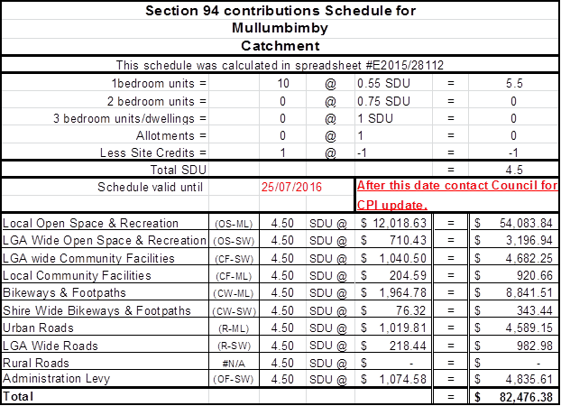
Heritage Conservation
Regard must be had to the requirements of Clause 5.10 of the
Byron Local Environmental Plan 2014. This would highlight the need to apply for
any proposed future changes to fabric, finish and appearance. Any future
changes of colour schemes of the development which may not be sympathetic to
the setting of the Mullumbimby Heritage Conservation Area must first be
approved by Byron Shire Council.
Water payments under the Water Management Act 2000
Charges will be calculated based on the additional water and
sewerage load that the proposed development generates, shown in Equivalent
Tenements (ET) by the following table:
ADDITIONAL
WATER & SEWER LOAD OF DEVELOPMENT
(ET Policy No:13/005)
NB: Information regarding Development Servicing charges can
be found on the Byron Shire Council website (http://www.byron.nsw.gov.au/development-contributions-plans-section-94-and-64).
These charges will enable you to calculate the total contribution charges
payable when you are ready to pay them. Developer charges will be
calculated in accordance with the Development Servicing Plan applicable at the
date of payment.
Staff Reports - Sustainable Environment and Economy 13.12 - Attachment 3
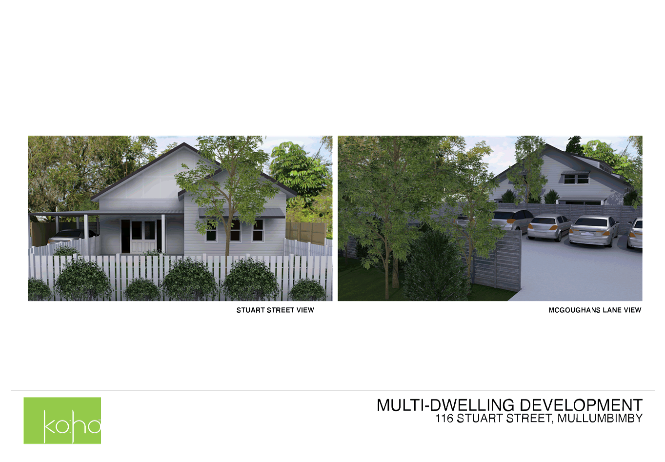
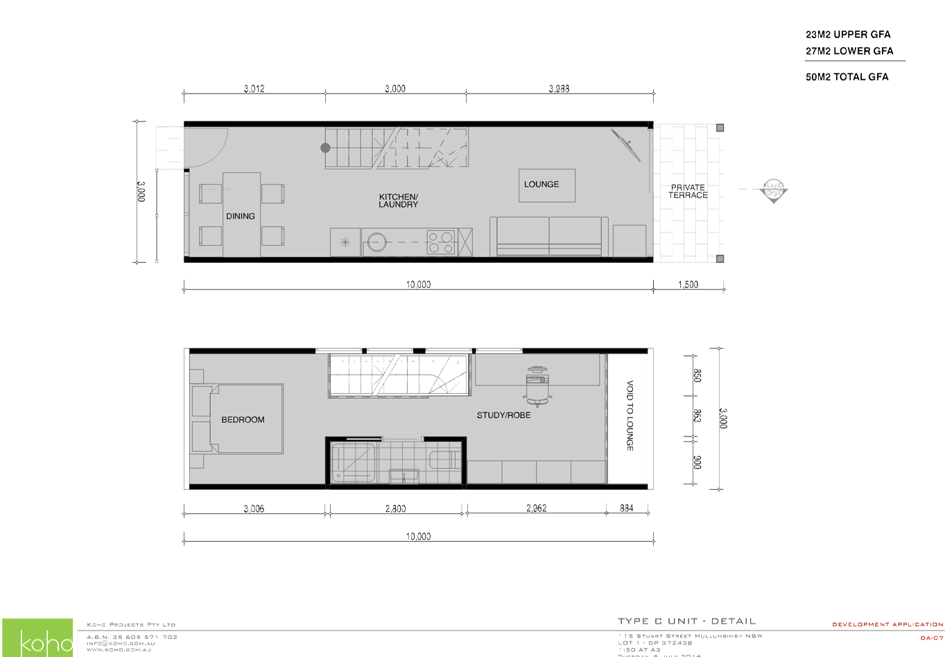
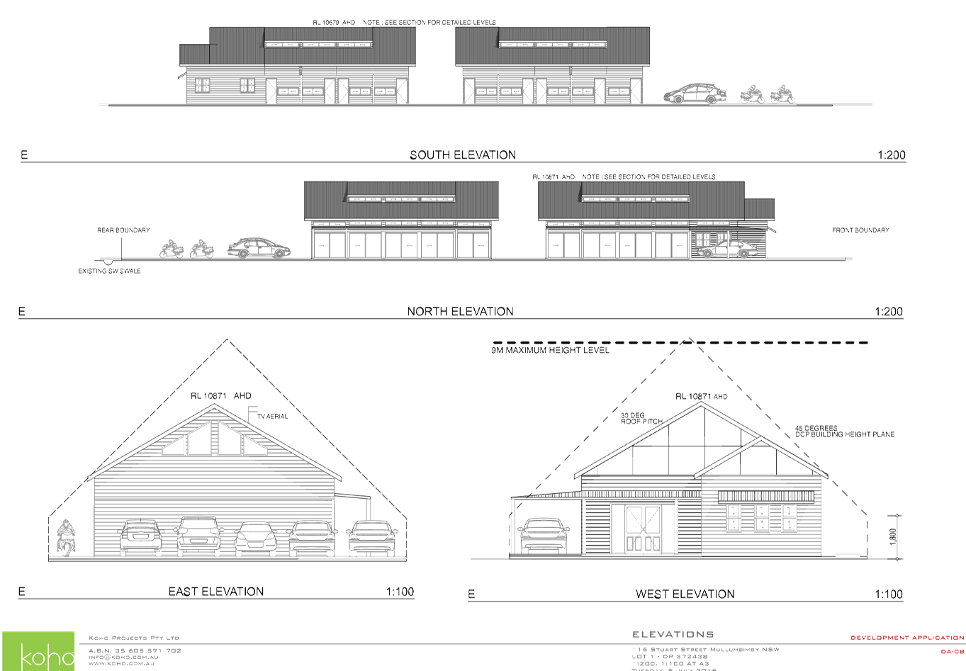
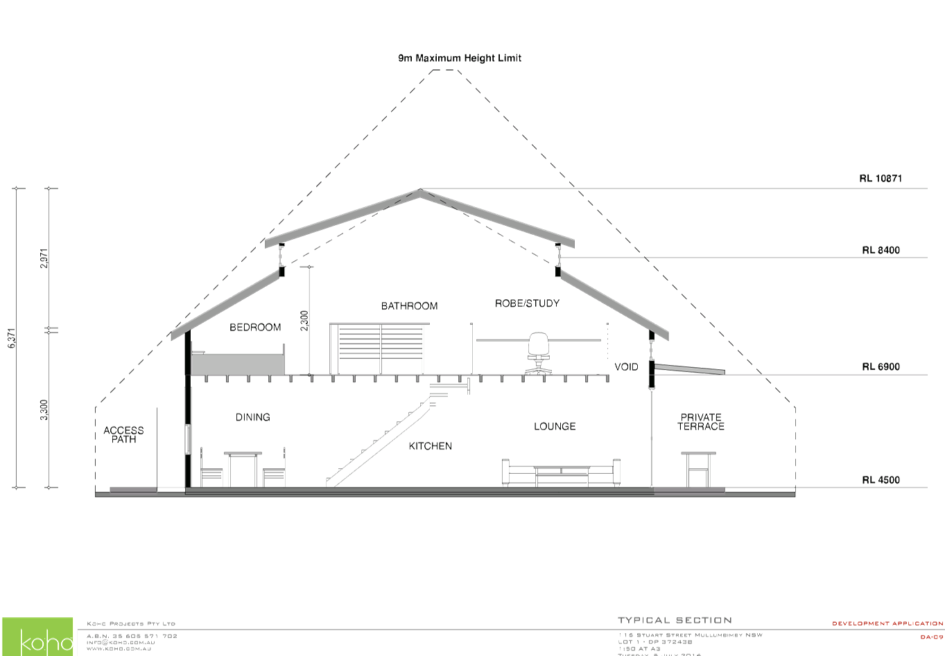
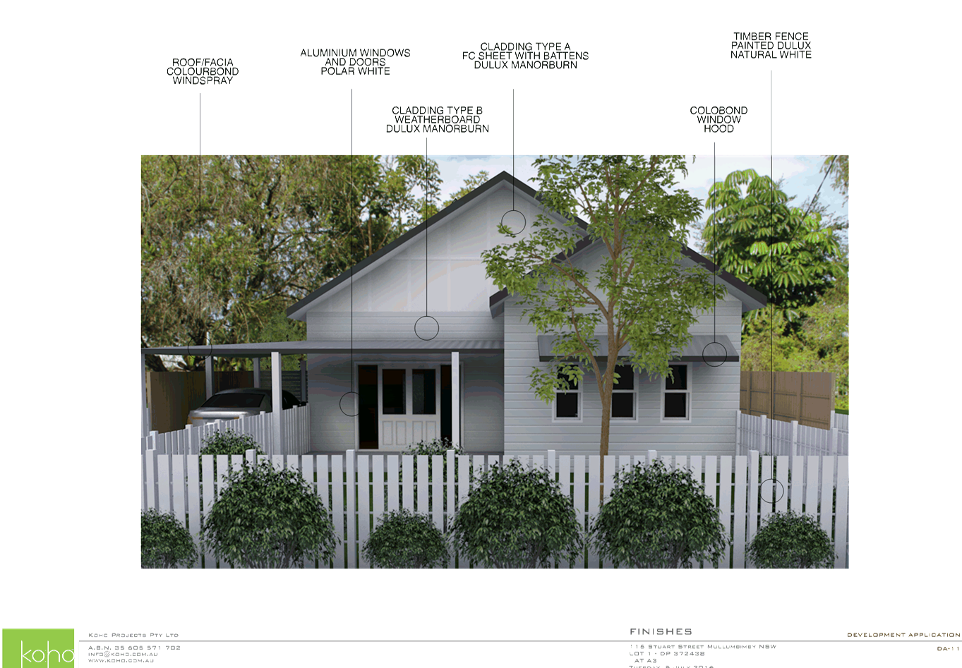
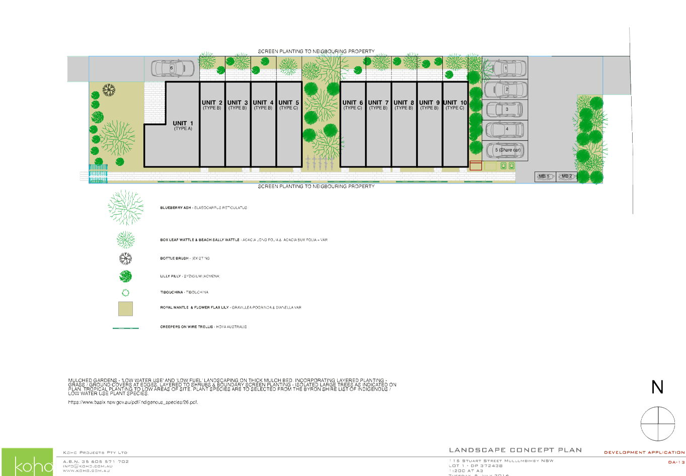
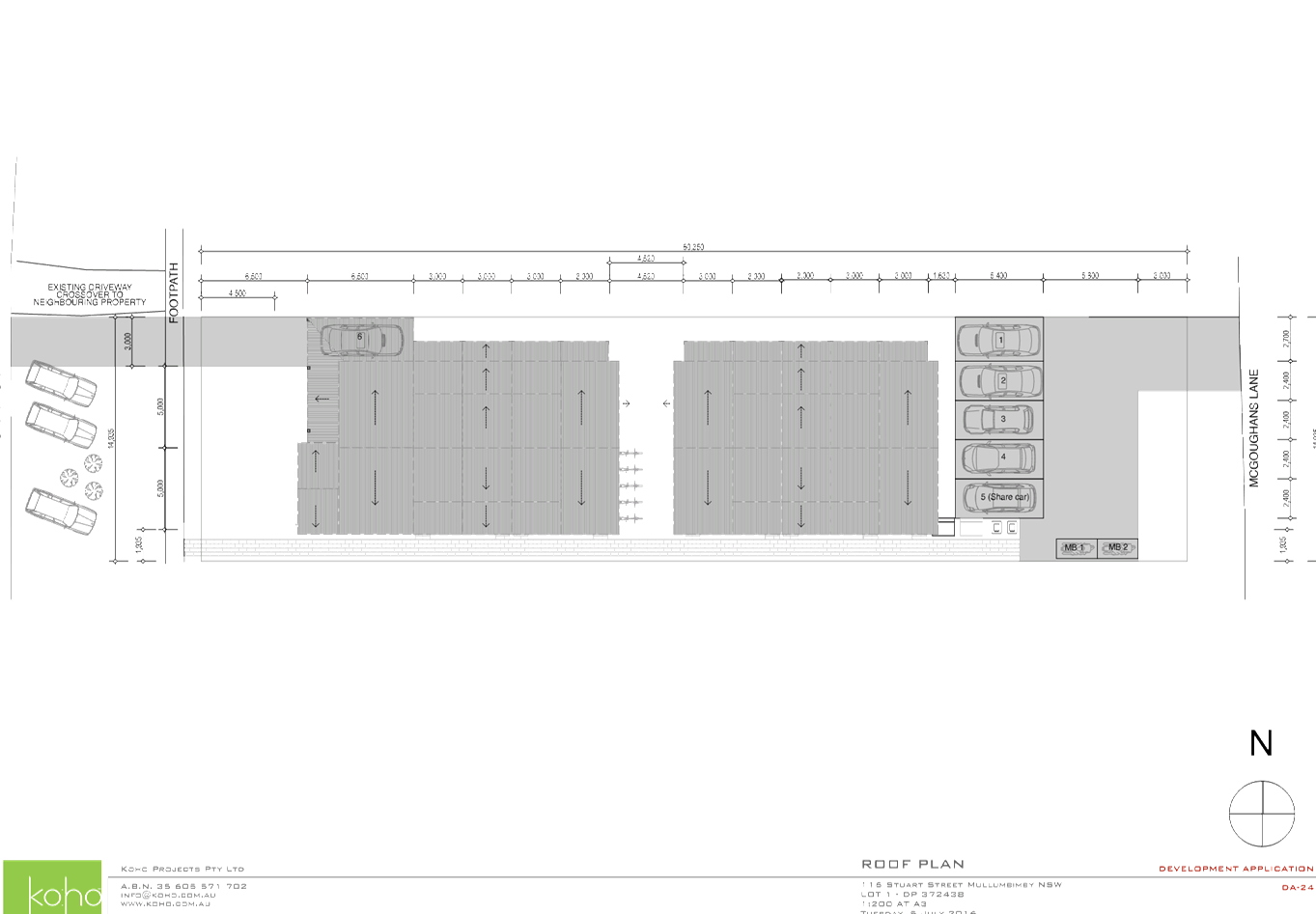
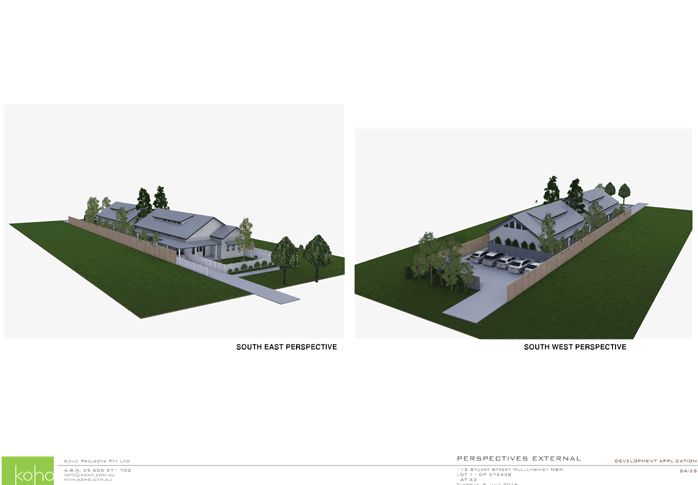
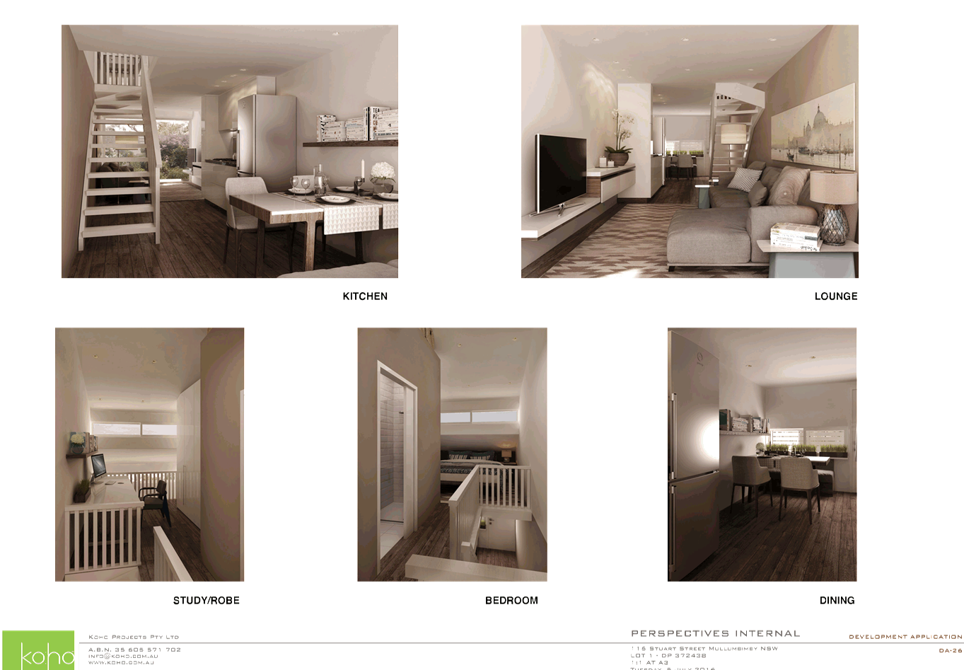
Staff Reports - Sustainable Environment and Economy 13.12 - Attachment 4
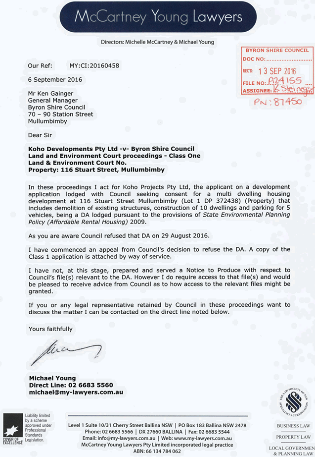
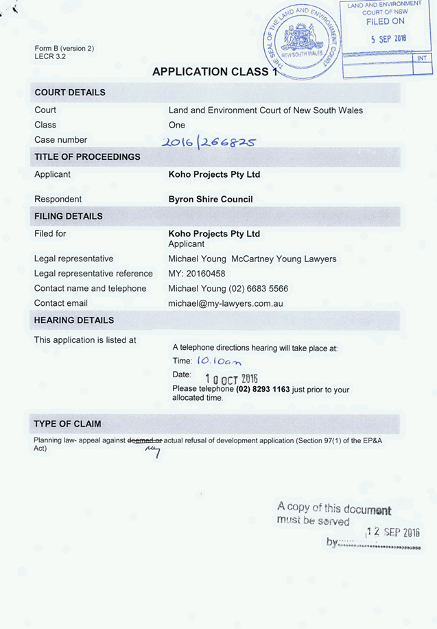
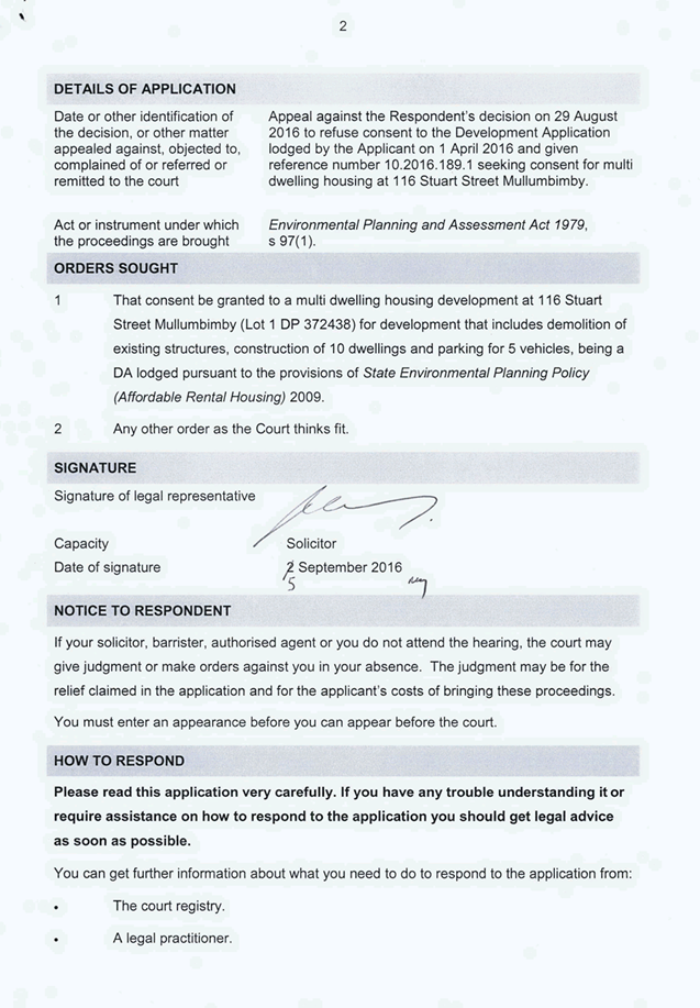
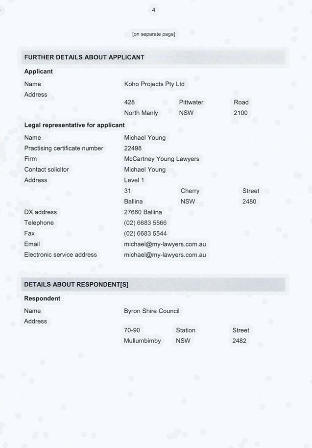
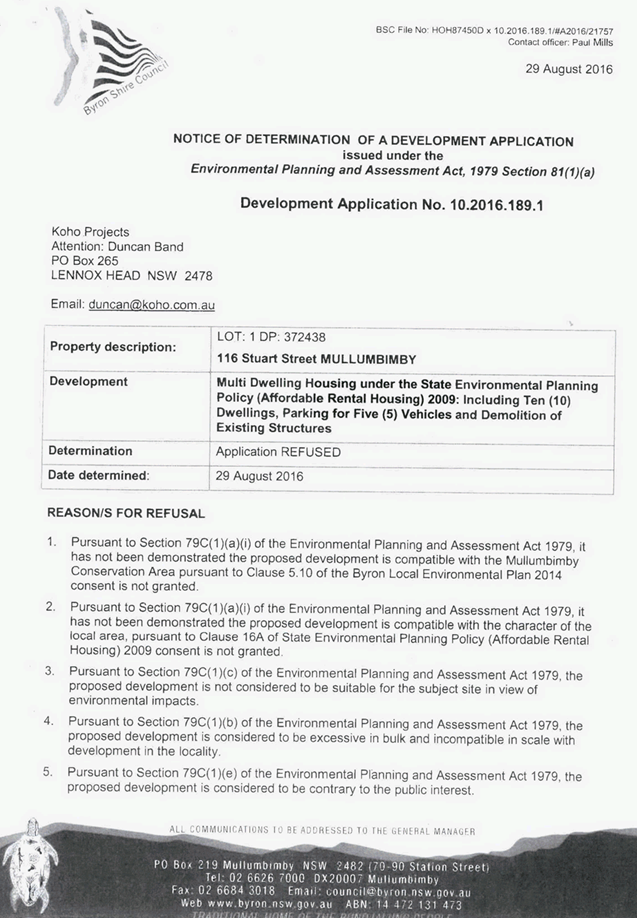
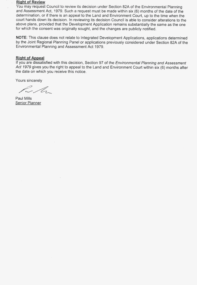
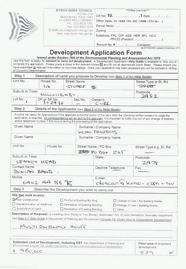
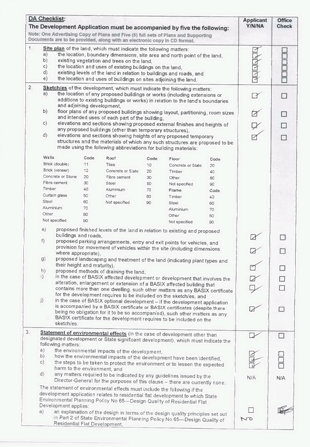
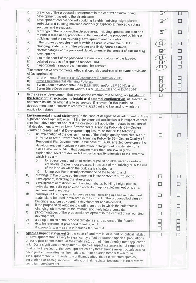
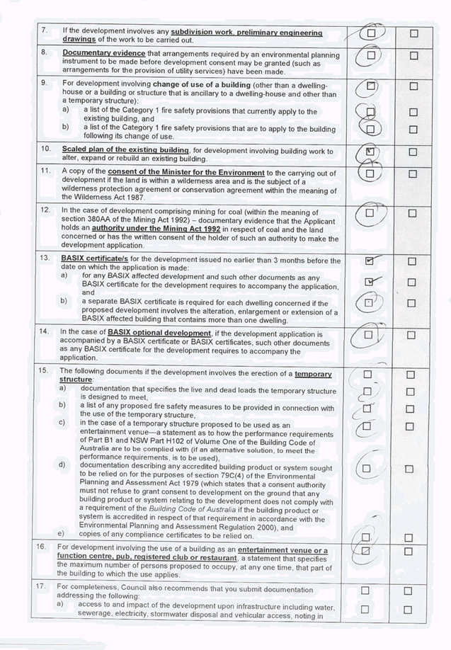

Staff Reports - Sustainable Environment and Economy 13.12 - Attachment 4
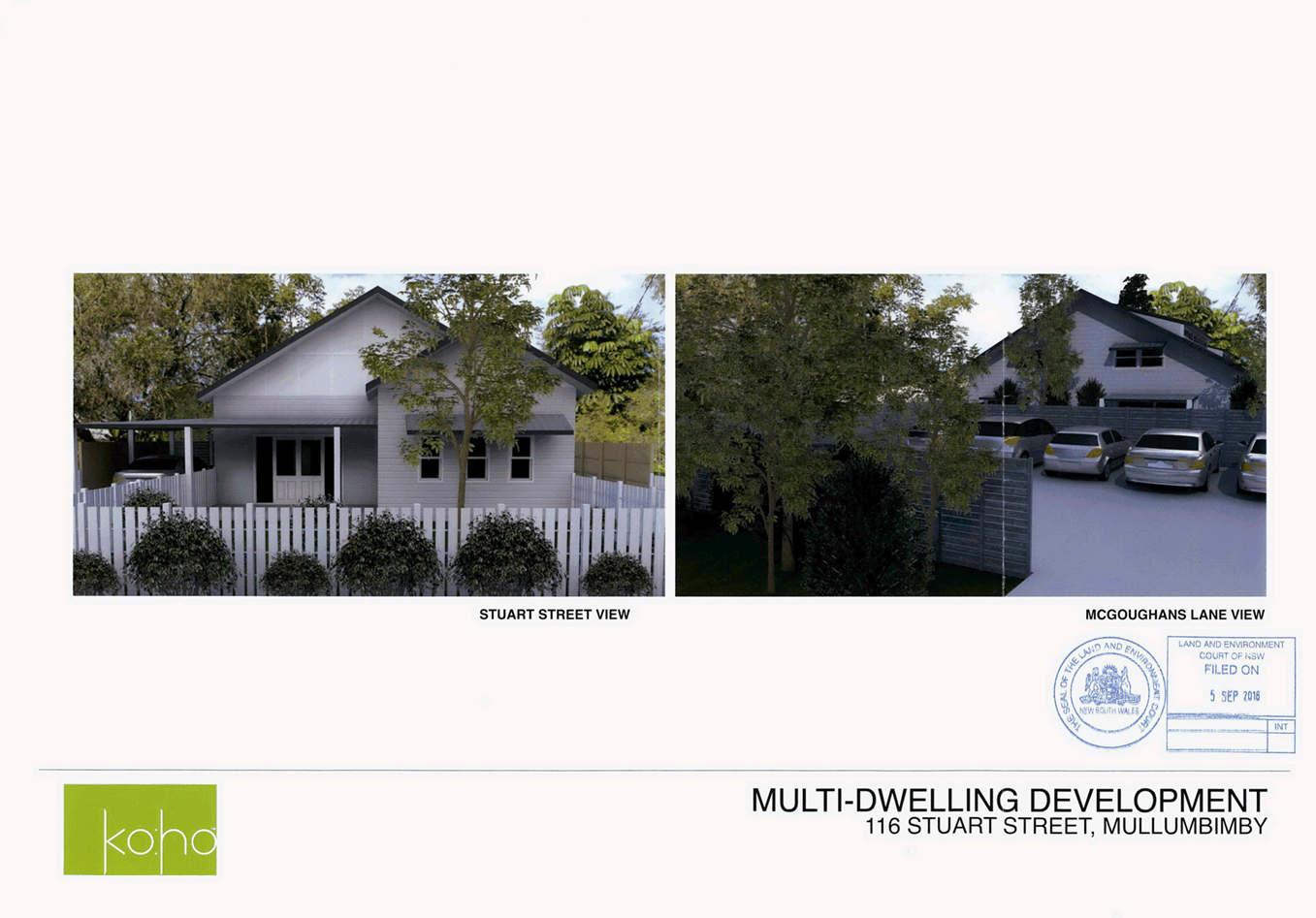
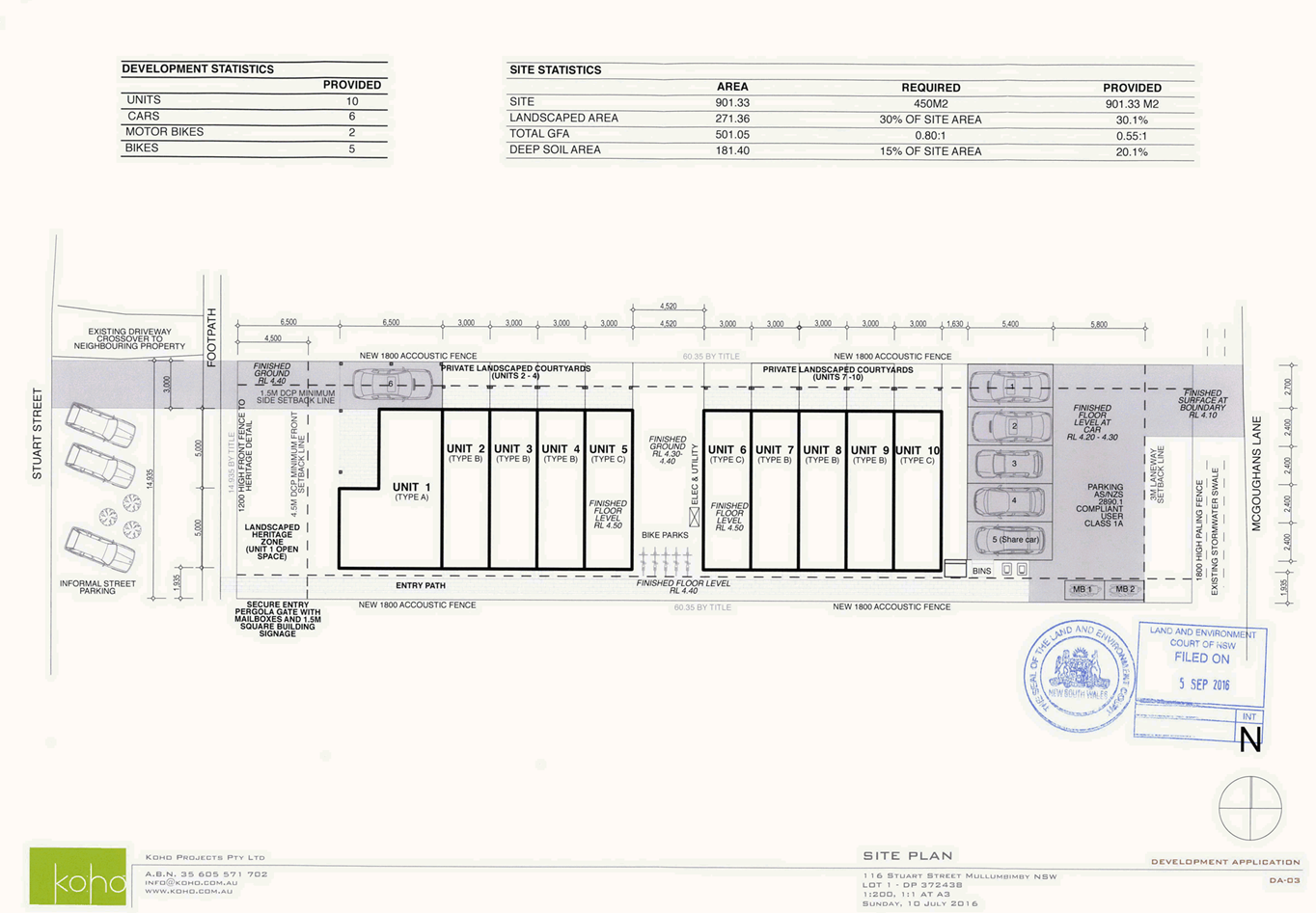
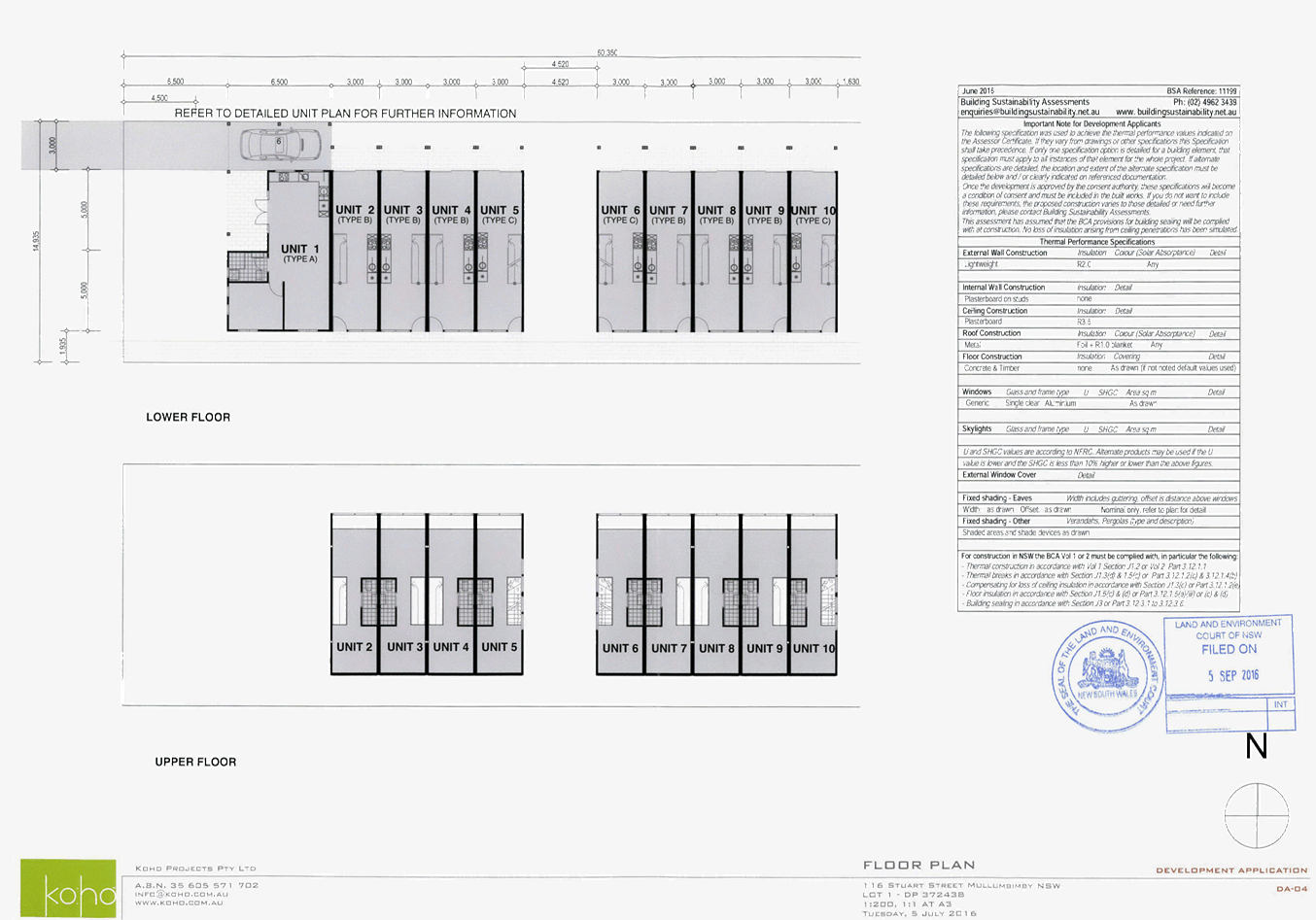
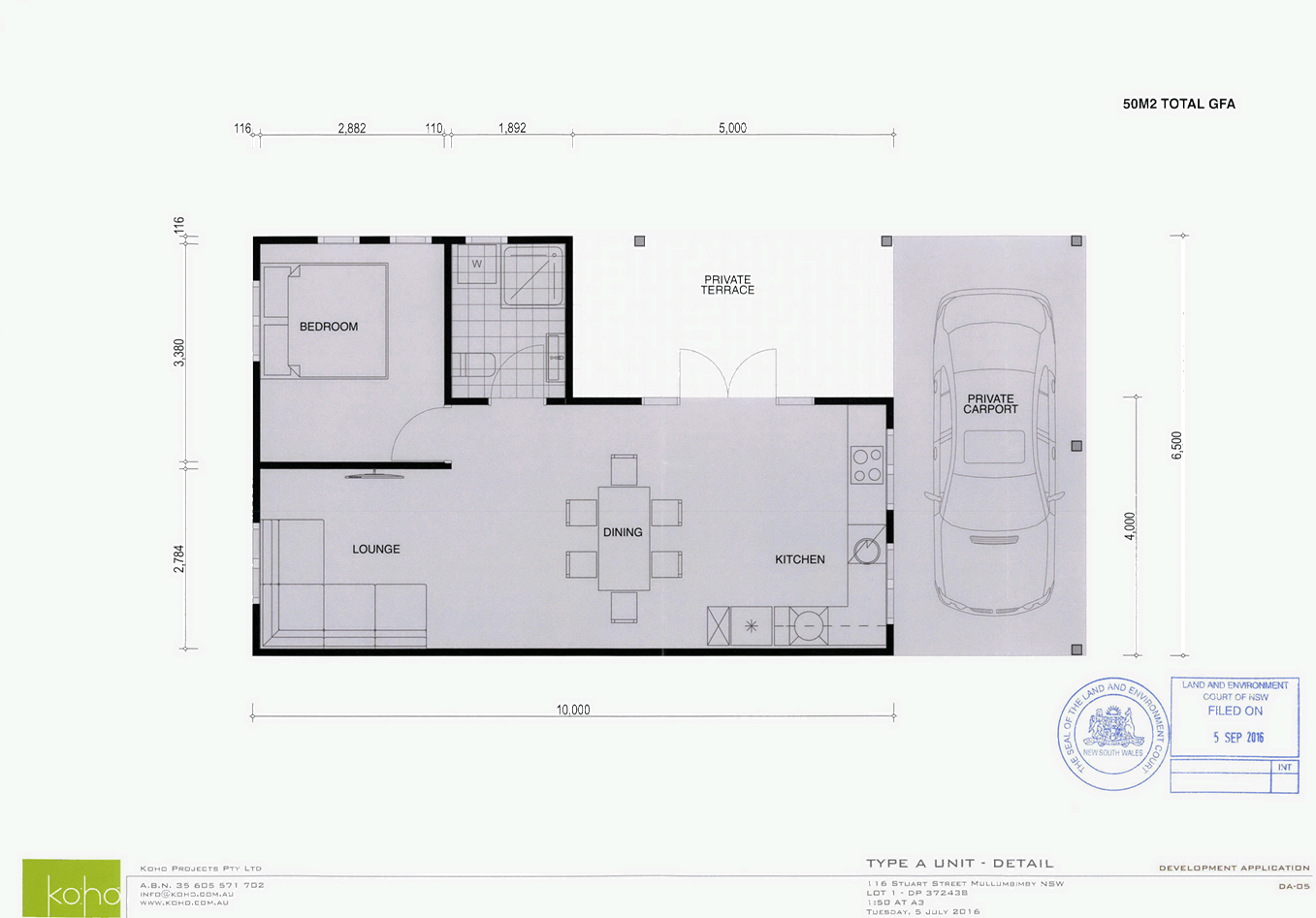
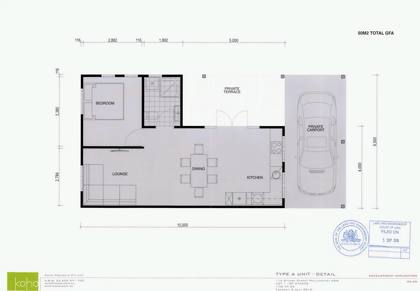
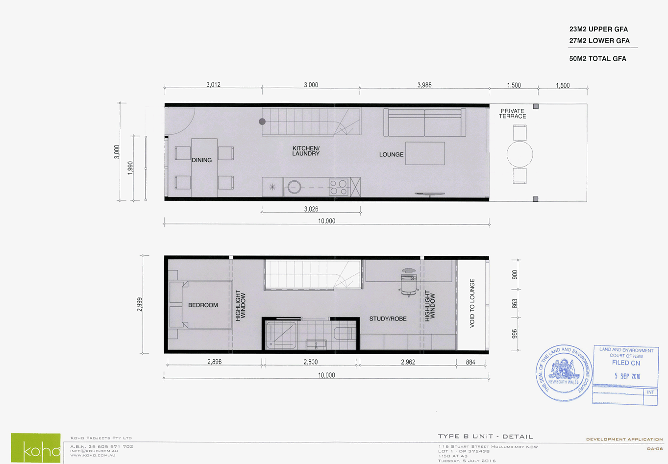
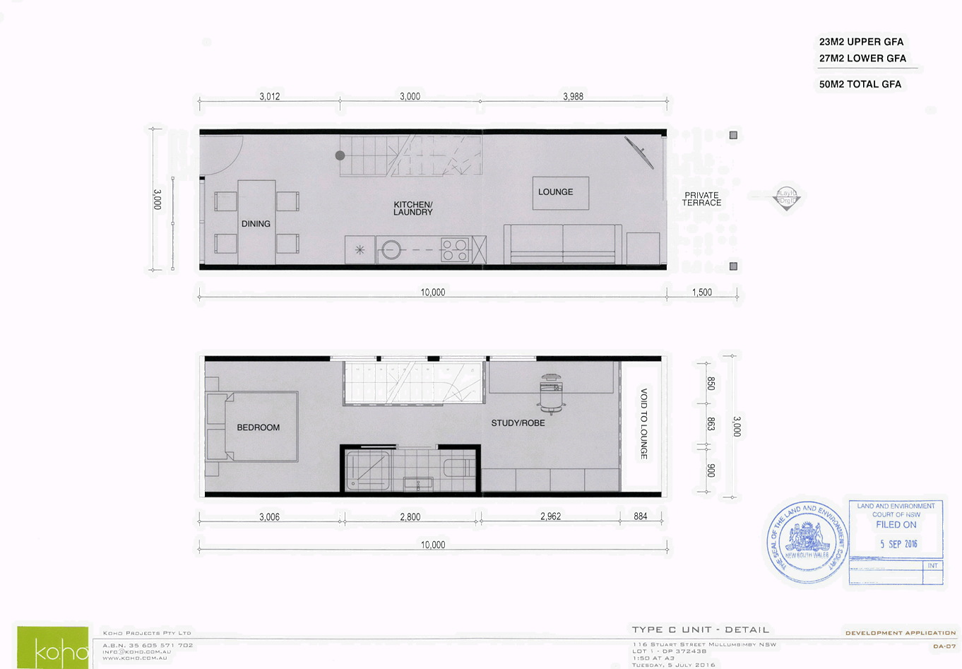
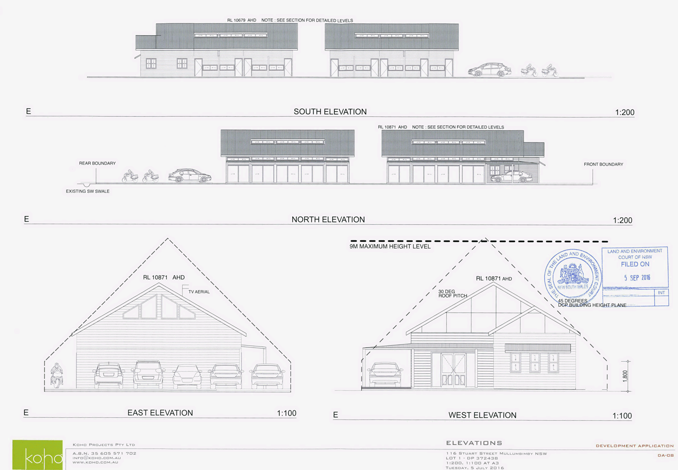
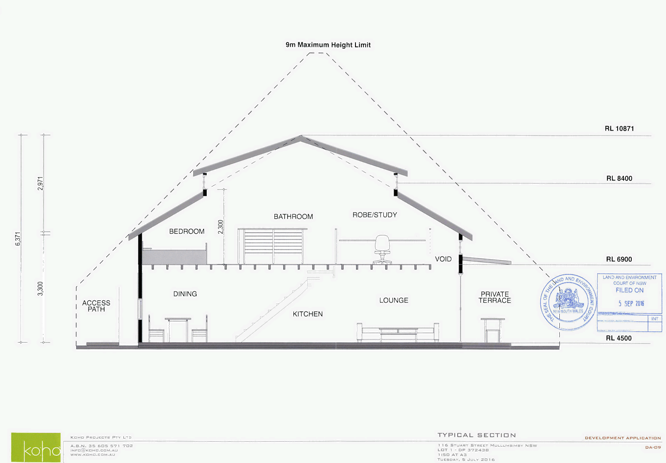
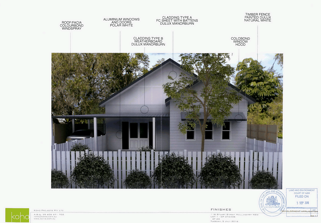
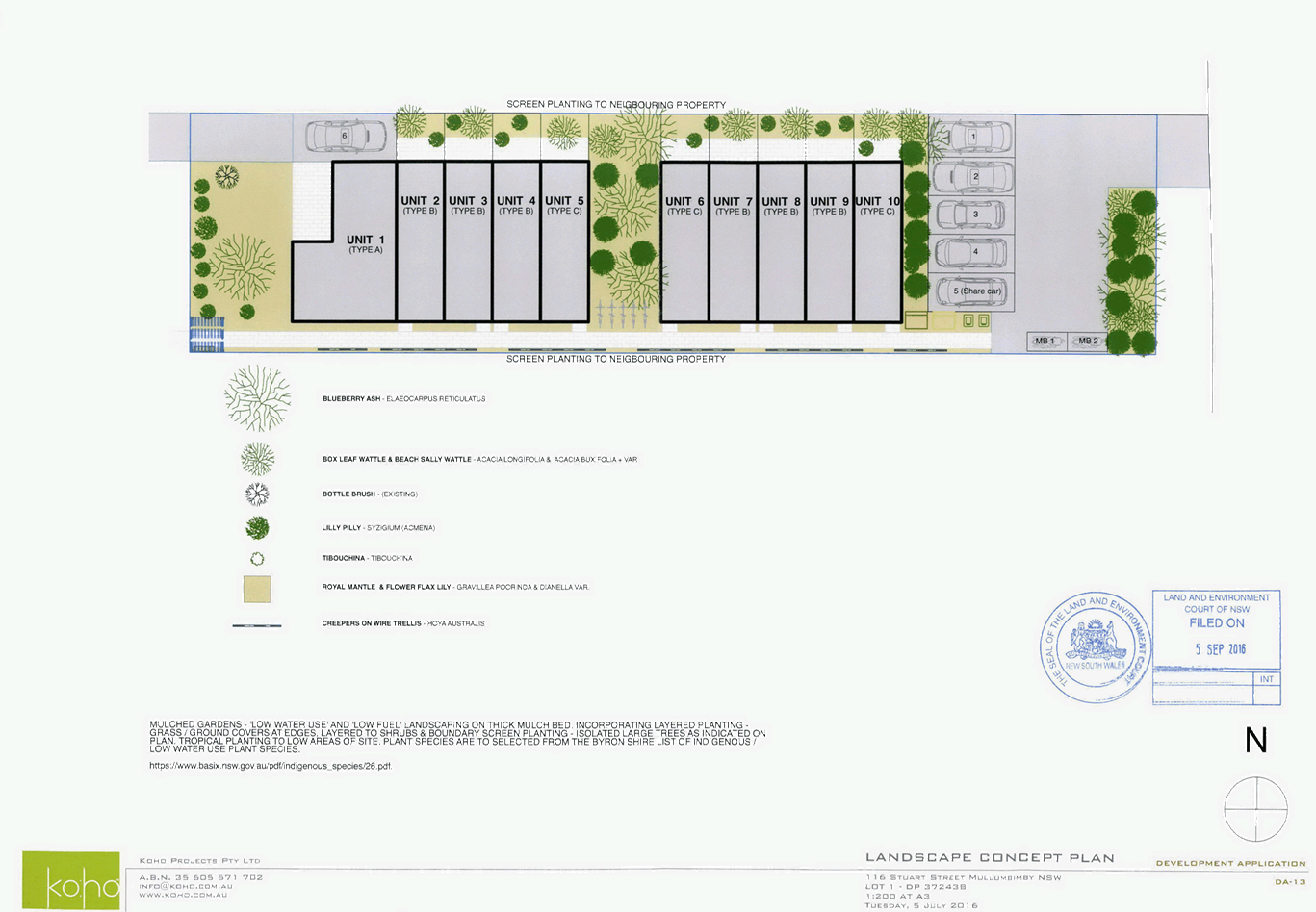
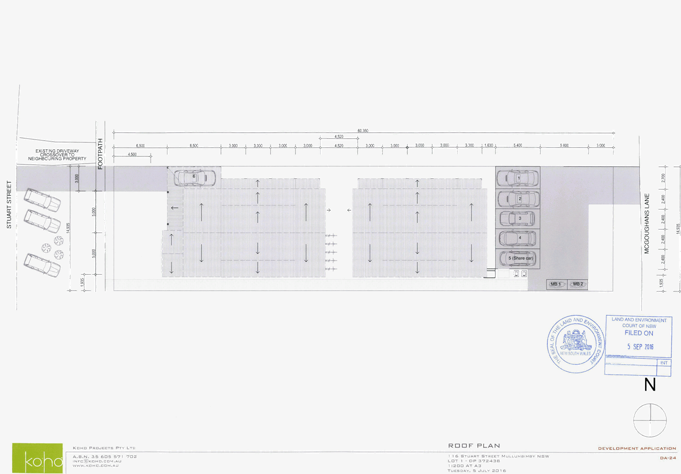
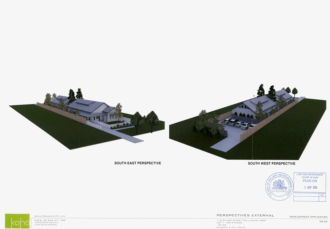
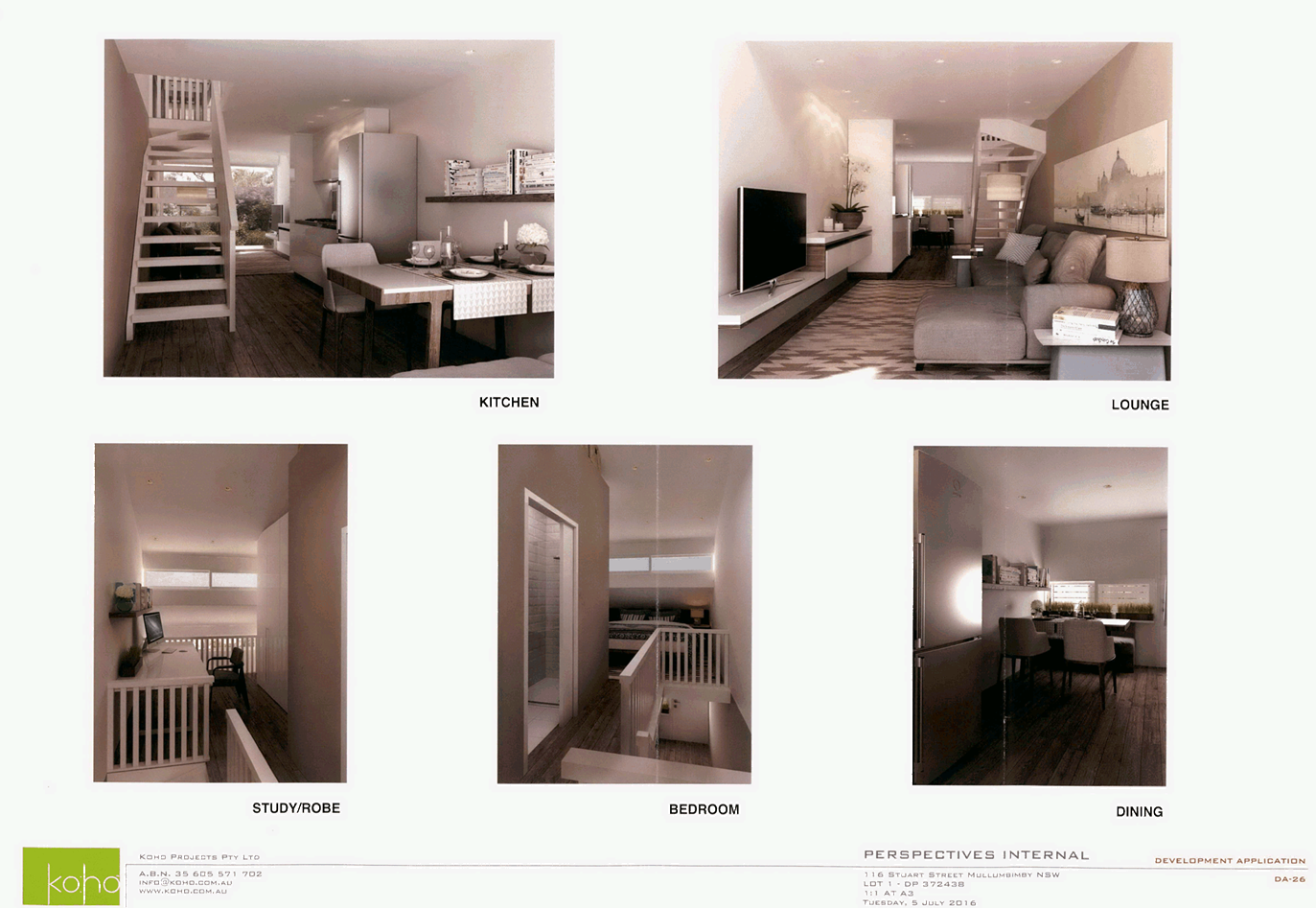
Staff Reports - Sustainable Environment and Economy 13.12 - Attachment 4
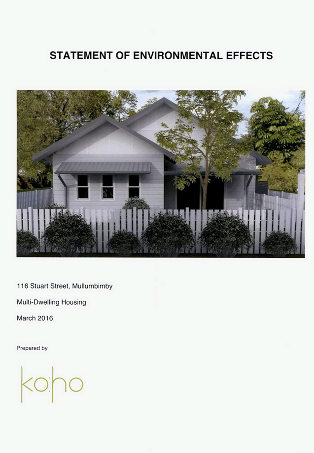
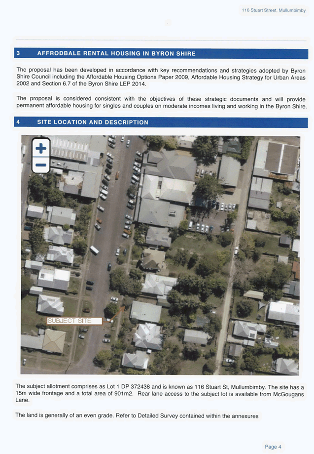
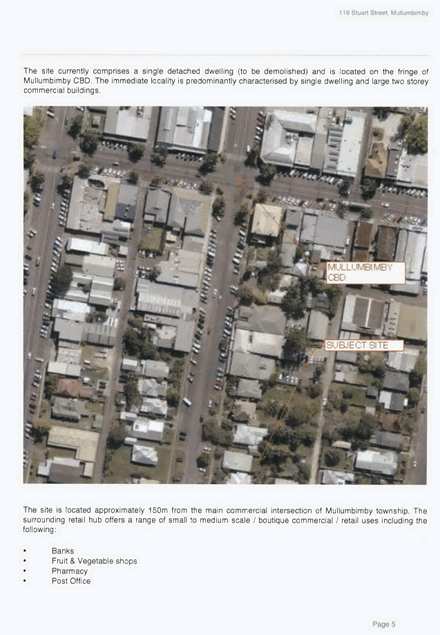
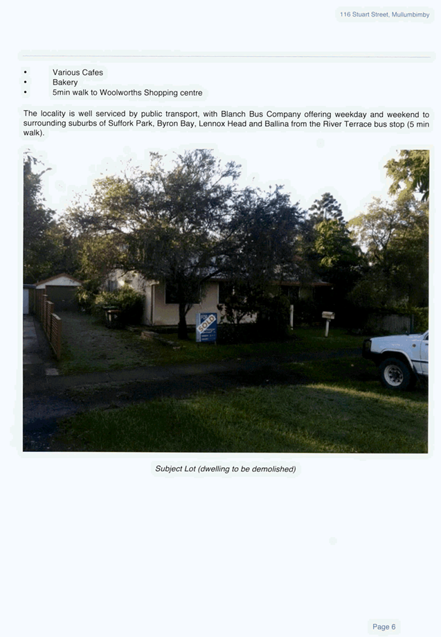
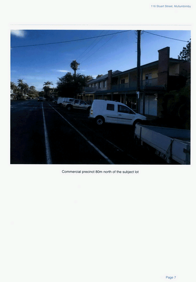
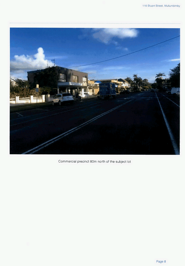
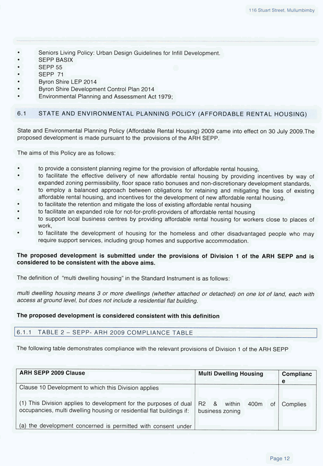
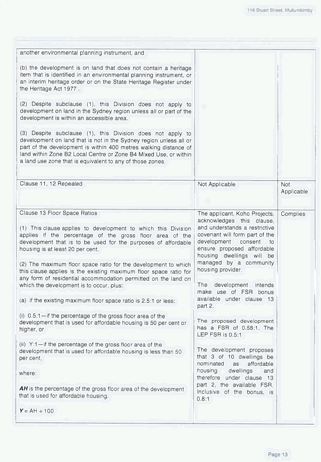
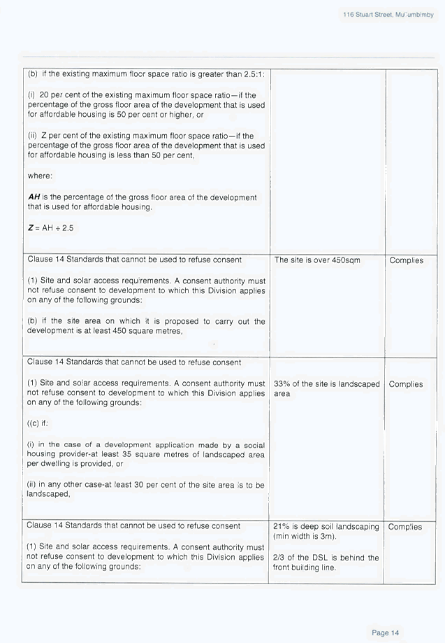
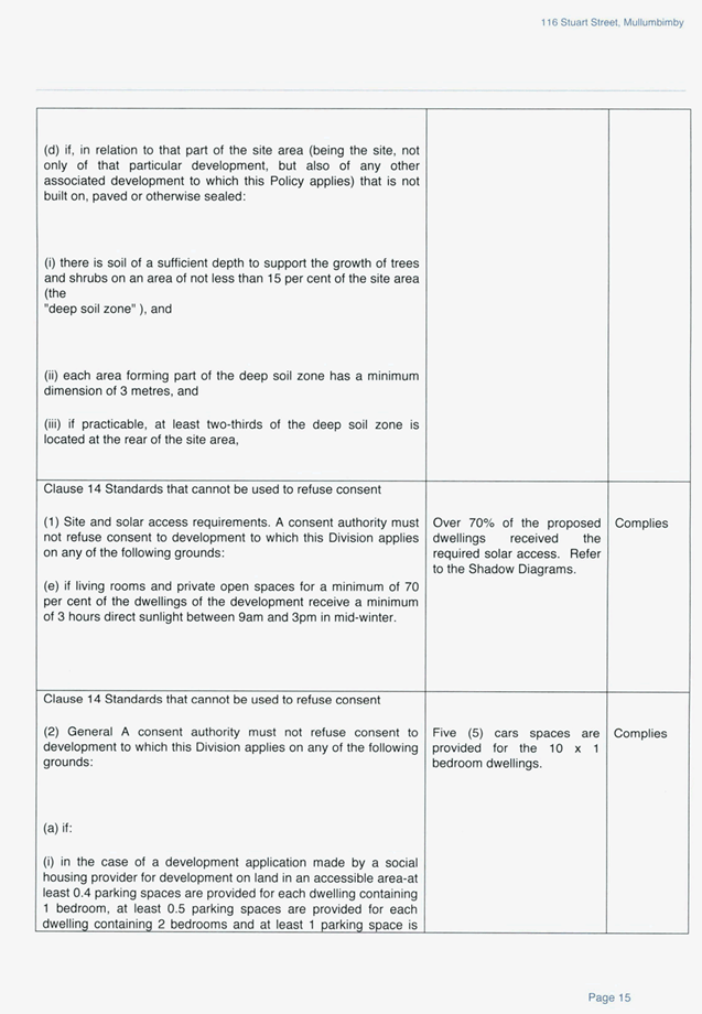
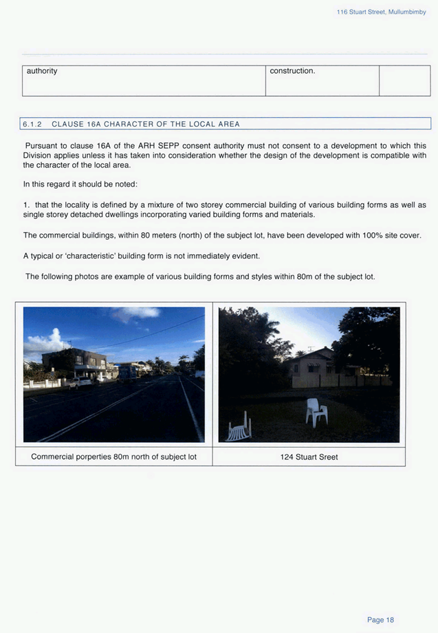
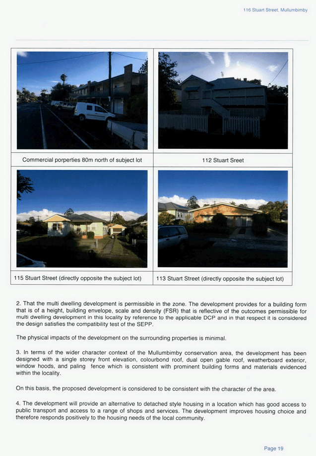
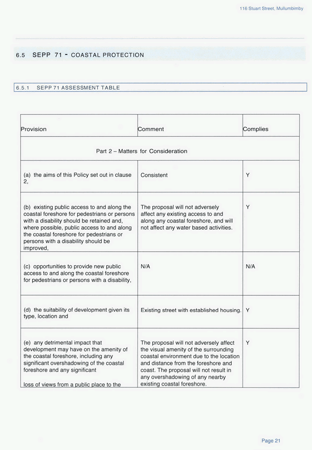
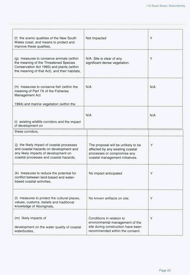
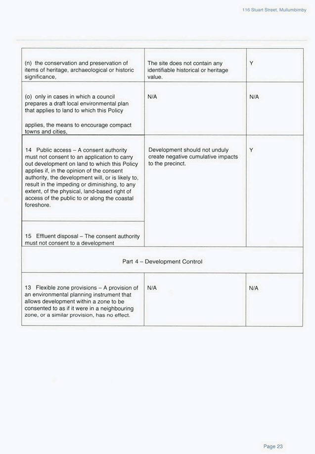
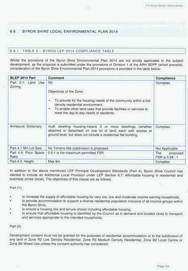
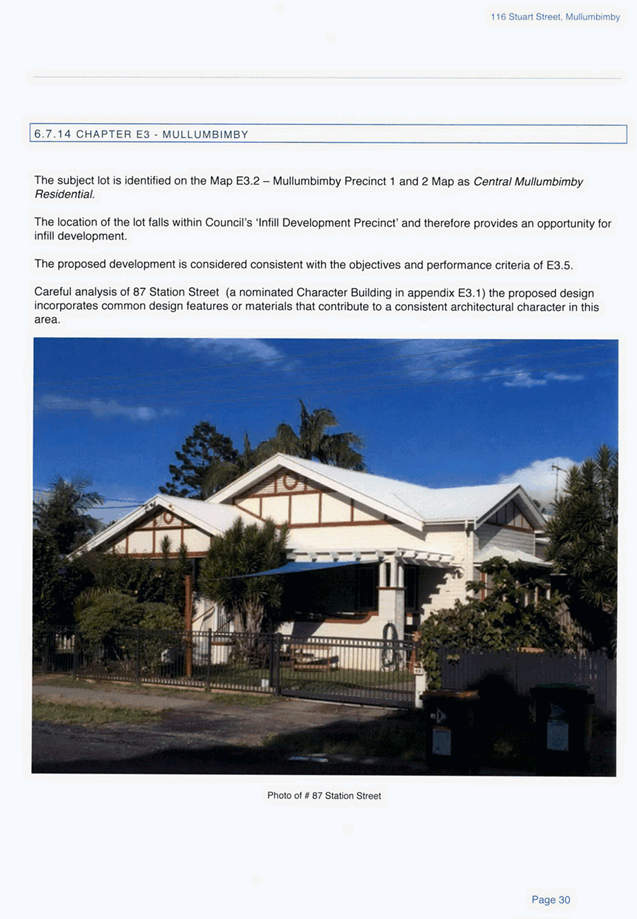
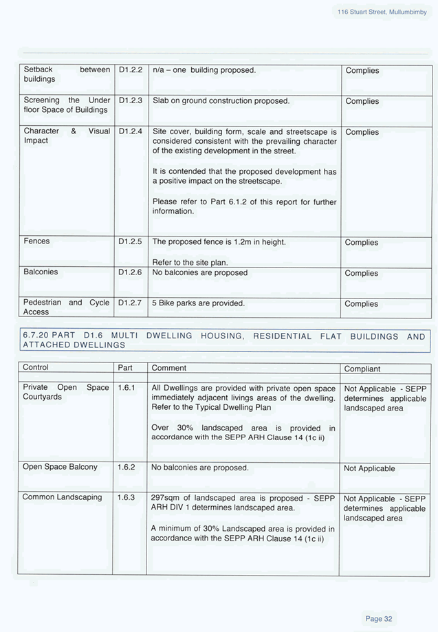
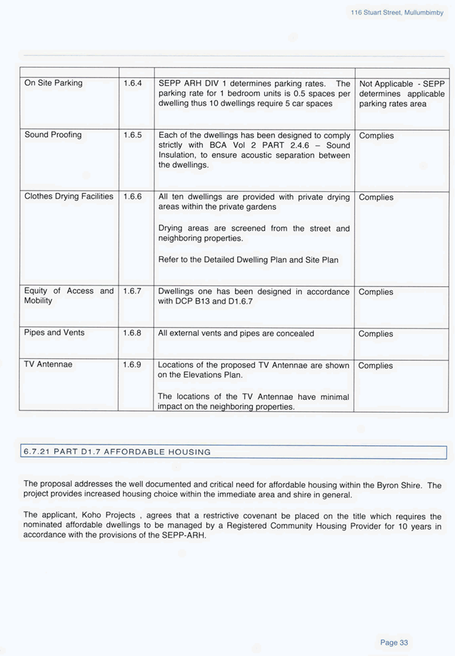
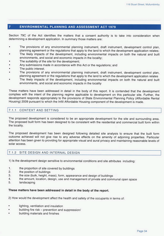
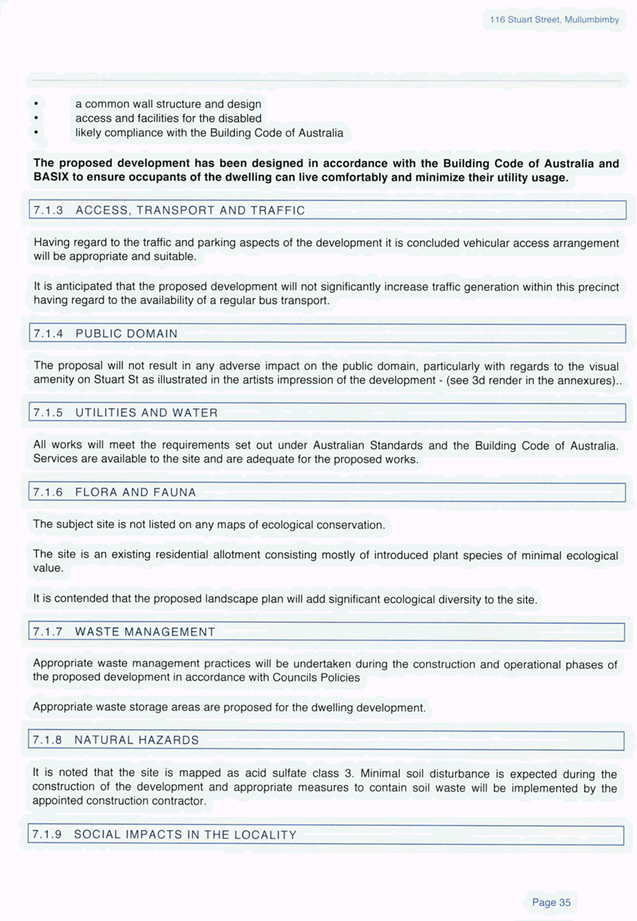

Staff Reports - Sustainable Environment and Economy 13.12 - Attachment 5
Staff Reports - Sustainable Environment and Economy 13.12 - Attachment 6
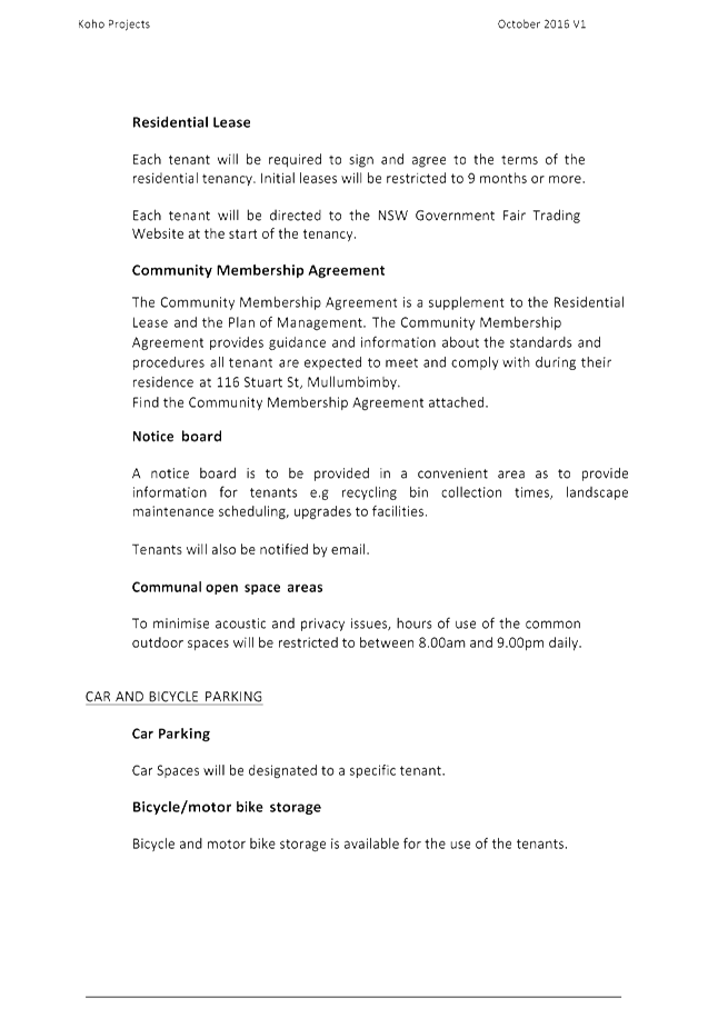
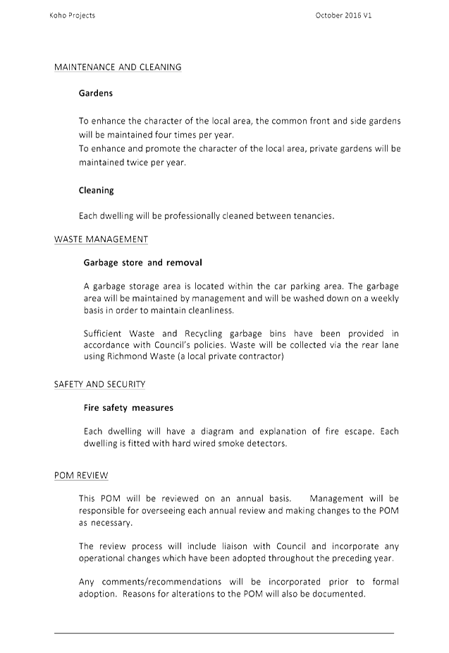
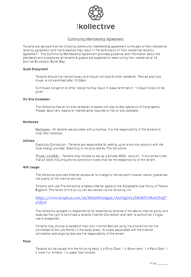
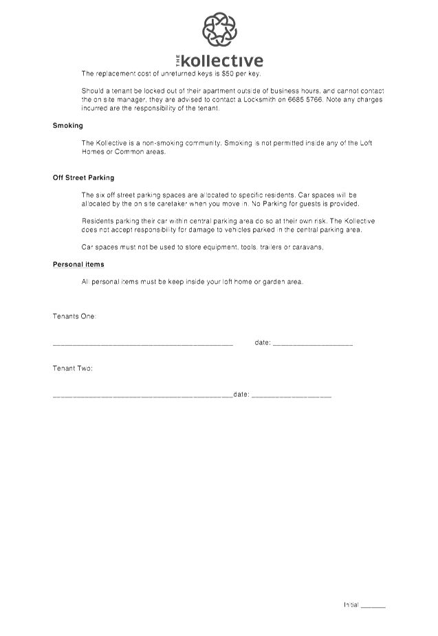
Staff Reports - Infrastructure Services 13.14 - Attachment 1
BSC File No: #E2015/82707
Contact: Deanna Savage
Deanna.Savage@byron.nsw.gov.au
16
December 2015
Mr D O Thompson & Ms M L
Plowman
722 Main Arm Road
Mullumbimby NSW 2482
Dear Mr Thompson & Ms Plowman
Interest in Potential Part
Road Reserve Closure Durrumbul Road
Council is currently looking at surplus land in the shire
and after inspection has determined that the Council owned road reserve that
adjoins your property (as outlined in red as per image below), may have the
potential for closure and sale.
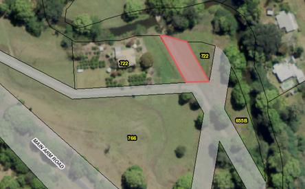
Council is writing to you as the adjoining land owner to
ascertain if you are interested in adding to your existing land parcel.
We realise there are costs associated with this proposal that need to be
considered so if you are interested we are happy to go through the process and
fee structure with you.
If you have any further questions, or would like to look
further into this proposal please do not hesitate to contact Deanna Savage on
02 6626 7304.
Yours sincerely
Phillip Holloway
Director
Infrastructure Services
Staff Reports - Infrastructure Services 13.14 - Attachment 2
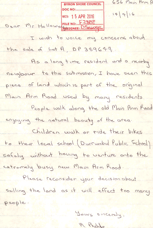
Staff Reports - Infrastructure Services 13.14 - Attachment 3
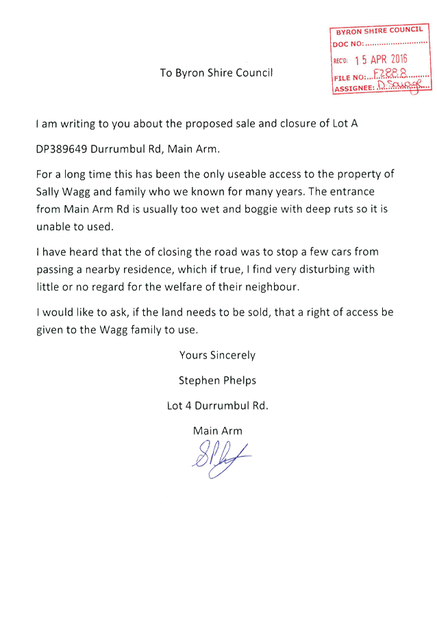
Staff Reports - Infrastructure Services 13.14 - Attachment 4
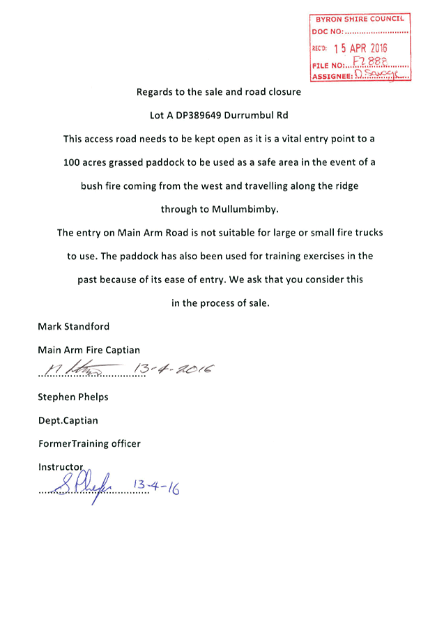
Staff Reports - Infrastructure Services 13.14 - Attachment 5
Staff Reports - Infrastructure Services 13.14 - Attachment 6
Staff Reports - Infrastructure Services 13.14 - Attachment 7
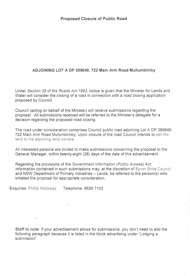
Staff Reports - Infrastructure Services 13.14 - Attachment 8
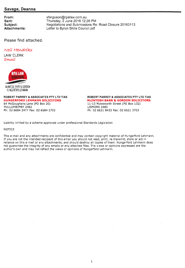
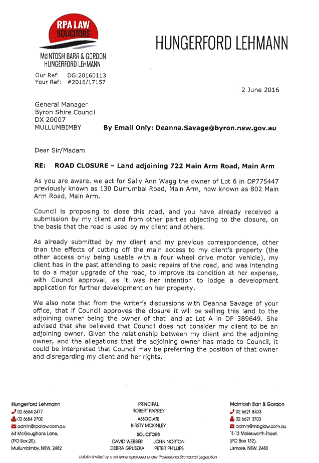
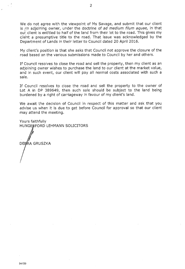
Staff Reports - Infrastructure Services 13.14 - Attachment 9
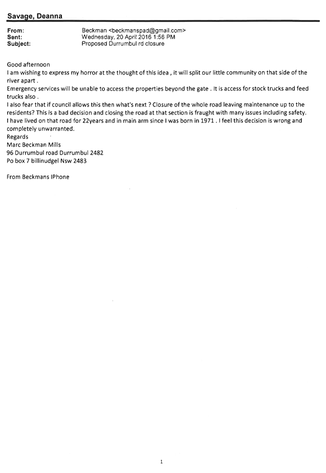
Staff Reports - Infrastructure Services 13.14 - Attachment 10
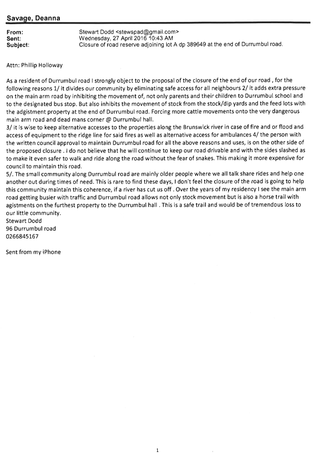
Staff Reports - Infrastructure Services 13.14 - Attachment 11
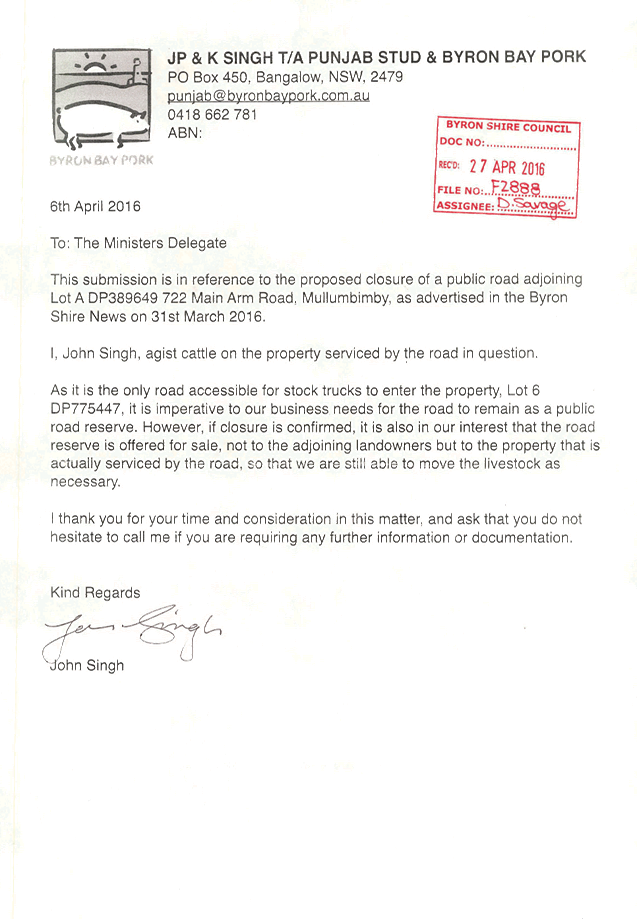
Staff Reports - Infrastructure Services 13.14 - Attachment 12
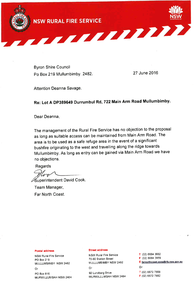
Staff Reports - Infrastructure Services 13.14 - Attachment 13
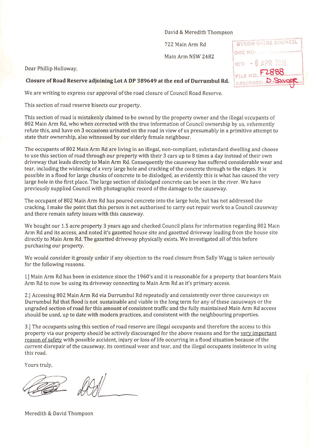
Staff Reports - Infrastructure Services 13.14 - Attachment 14
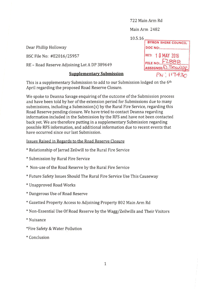
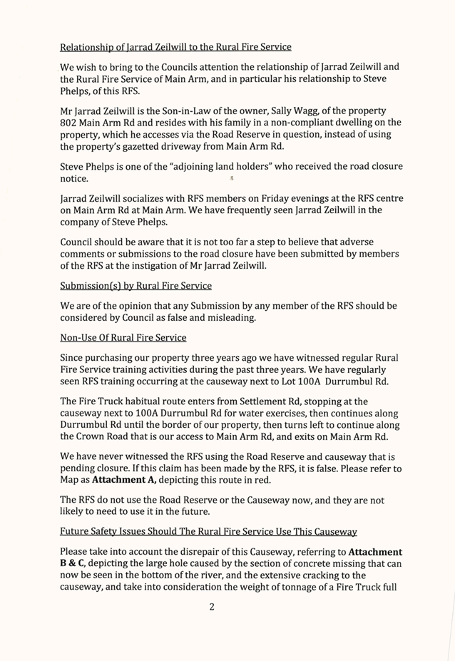
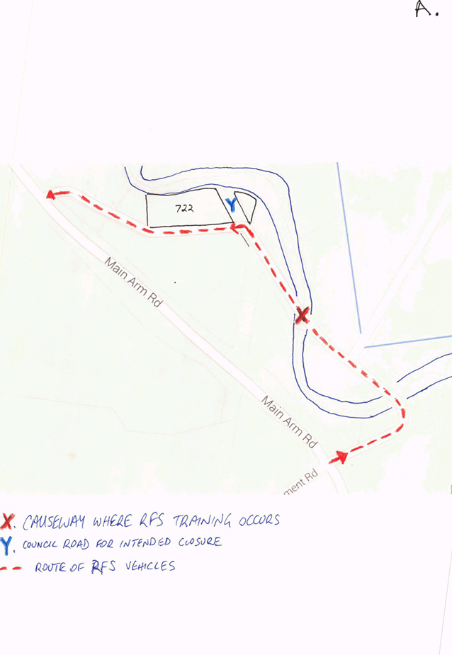
Staff Reports - Infrastructure Services 13.14 - Attachment 14
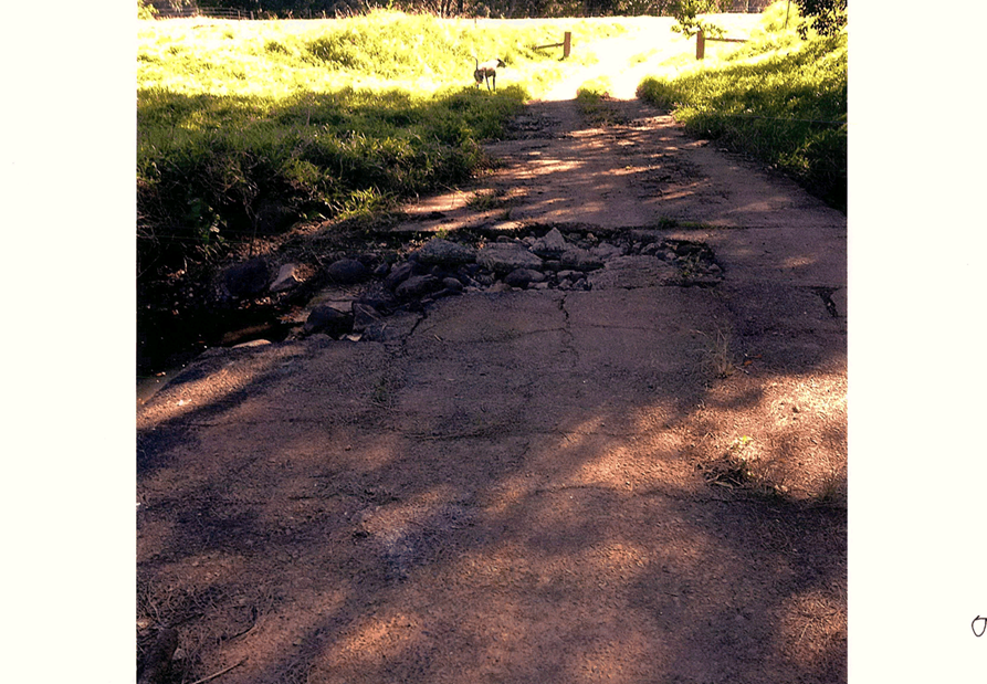
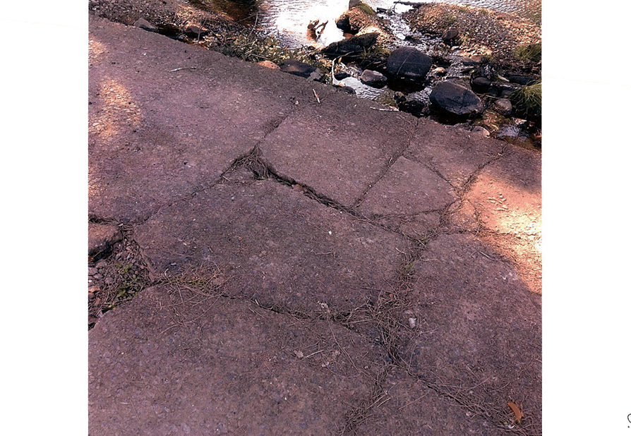
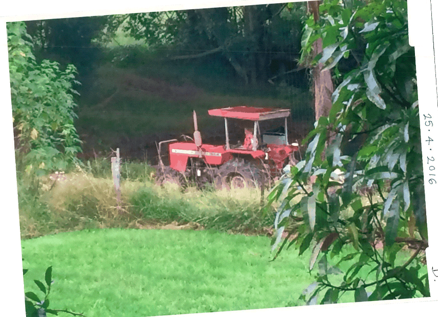
Staff Reports - Infrastructure Services 13.14 - Attachment 14
Staff Reports - Infrastructure Services 13.14 - Attachment 15
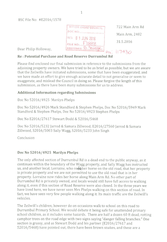
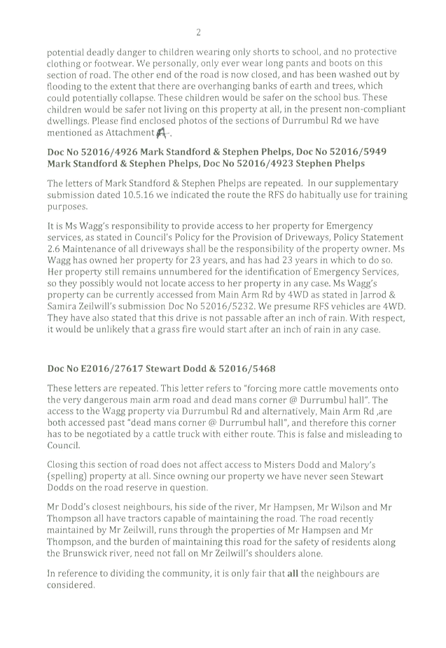
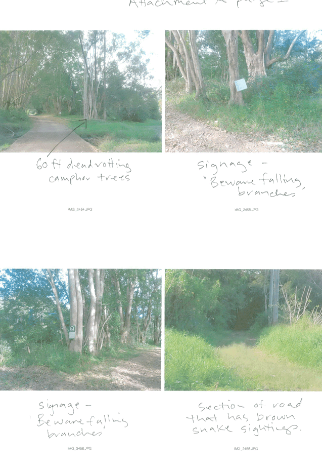
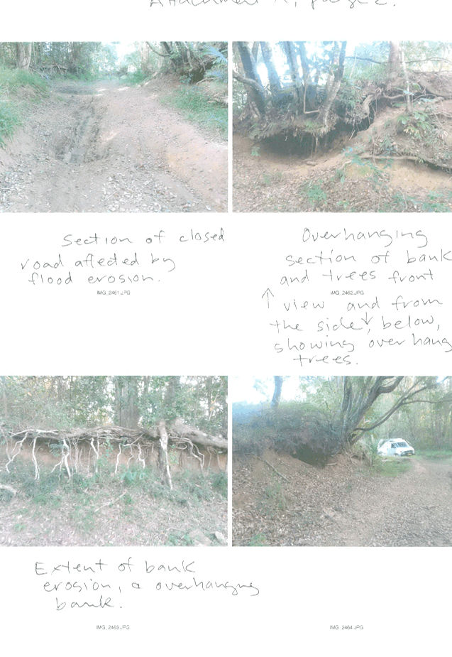
Staff Reports - Infrastructure Services 13.14 - Attachment 16
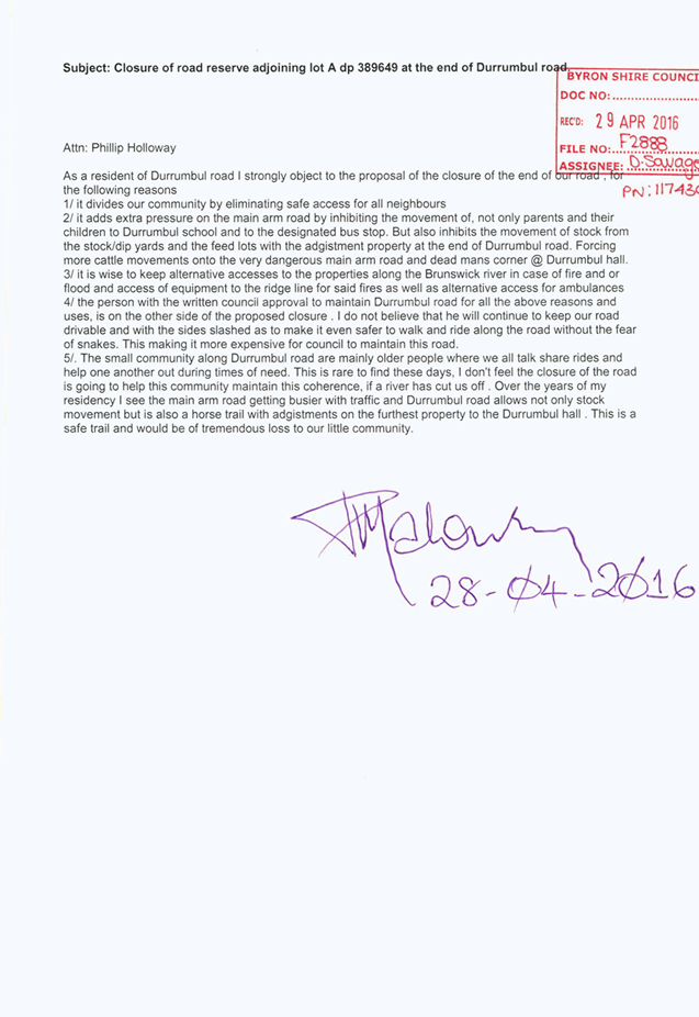
Staff Reports - Infrastructure Services 13.14 - Attachment 17
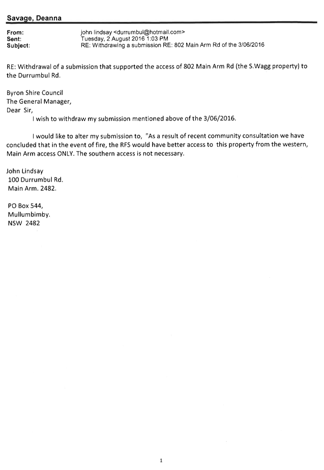
Staff Reports - Infrastructure Services 13.14 - Attachment 18
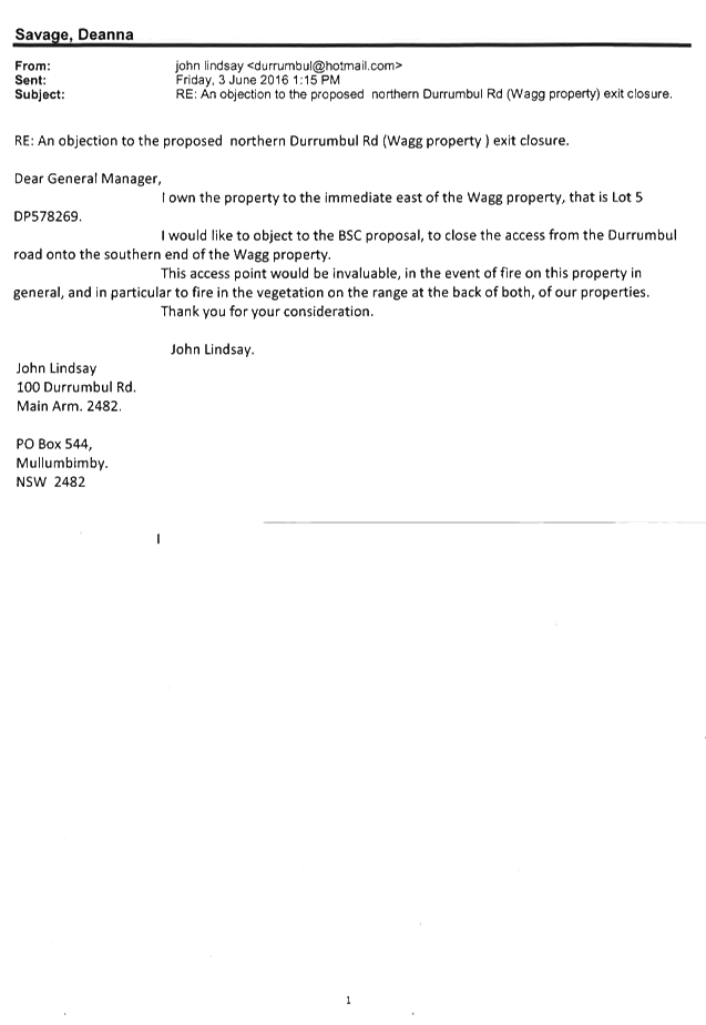
Staff Reports - Infrastructure Services 13.14 - Attachment 19
Questions raised by the site inspection
Road Reserve at end of Durrumbul Road, Durrumbul Road
and access to 802 Main Arm Road
Who proposed and initiated the part Road Reserve
Closure in question?
Council received a few complaints by residents concerned
with compliance issues from Lot 6 DP 775447. An inspection was completed
by Council’s Community Enforcement Officer on 8 September 2015, who found
the complaints to be substantiated. Due to no formalised address for the
property which Council is bound under the Local Government Act 1993 Sect 124
Orders, the process of allocation of a formal address was started. It was
also noticed that a road reserve was being used as an access point to the
property and this road reserve resided in the middle of an existing parcel of
land being Lot A DP 389649, so Council approached the adjoining land owners to
see if there was any interest in closing and purchasing the road reserve.
What is the process for road closure that has been
followed?
Council has followed all required actions that Crown
Lands stipulate prior to any lodgement of Council road closing application to
NSW Department of Primary Industries – Lands. Council is also bound
by the ROADS ACT 1993 - SECT 34 Applications for closing of public road
and ROADS ACT 1993 - SECT 35 Publication of proposal to close public
road.
What was the process for the Address allocation to Lot
6 DP775447 and why did it occur?
Time Line of Events that led to property number change of
Lot 6 DP 775447 Durrumbul Road to 802 Main Arm Road given by Council’s
Land Information Officer.
- Inspection
carried out 8/9/15 and ascertained that no formal address was associated with
Lot 6 DP 775447.
- • 26/8/15
– request received from Council’s Development Support and
Administration Officer for street number for the property 6/775447.
- • Authority
had the road name for this property as Durrumbul Road so I based my numbering
initially on Durrumbul Road.
- • Street
numbering for properties in rural areas is based on the distance along the road
in metres divided by 10. At that time, basing the access road as Durrumbul
Road, I estimated a street number of 130.
- • 27/8/15
– letter sent to property owner advising property had been allocated a
street address of 130 Durrumbul Road.
- • 23/10/15
– received an email from a local resident raising concerns about the
number of 6/775447 to 130 Durrumbul Road.
- • I
did some further research in TRIM and found documents relating to a request for
the closure of Durrumbul Road (western end).
- • It
appears this matter was referred to Council’s Traffic and Transport
Planner at the time for consideration by the Local Traffic Committee.
- • 29/10/15
– forwarded the above correspondence to Council’s Traffic and
Transport Planner at the time requesting advice as to the outcome, ie whether
the road was to be closed.
- • 5/11/15
– followed up with email to Council’s Traffic and Transport Planner
at the time (as I had received further phone calls from a local resident in the
meantime). I received no response from Council’s Traffic and Transport
Planner at the time.
- • Given
the evidence provided of flood prone causeways along Durrumbul Road; that
access to 6/775447 was available via Main Arm Road and that it would appear
preferable the primary access be via Main Arm Road (especially for reliable
access for emergency services), I subsequently wrote to the property owner on
6/11/15 proposing a change of address to 802 Main Arm Road and providing 28
days’ notice.
- • The
number 802 was considered suitable based on the rural numbering method. I rely
on aerial photography, as well as existing street numbers, in calculating the
distance based addressing. I do not normally undertake site inspections.
- • No
objection was received from the property owner (within the 28 days’
notice provided) to the address of 802 Main Arm Road.
- • 4/12/15
– a further letter was sent to the property owner confirming change of
address to 802 Main Arm Road.
Did Council give authority for a local resident to
carry out maintenance of Durrumbul Road?
Council acknowledges that Durrumbul Road is a public Road
Reserve where Council is the roads authority, in accordance with Part 1 Section
7 of the Roads Act 1993. Council however, does not have this road segment
in its asset register and therefore it is not maintained. It is the
position of Council that the advice a Council employee gave verbally to a local
resident, allowing works to be carried out on the road reserve in question, was
wrongly given. This advice was given on the basis that the road reserve
in question was like an extended driveway for this resident. A letter was
written to the property owner by Council’s Community Enforcement Officer
on 14 September 2016 revoking all verbal approvals to undertake works within
the road reserve.
What is Council’s Policy for Driveways and
access necessary to rural properties?
Council follows the Northern Rivers Local Government
Handbook for Driveway Access to Property which stipulates all urban and rural
standards. (Attachments 21 E2016/96172 & 22 E2016/96184)
Council is also bound by the ROADS ACT 1993 - SECT 138 Works and
structures.
Councillors commented on site about what approval had
been given to a house and where the building envelope was on the
property? Also what access point was given on any Development
Application?
There is no current or past development application
associated with Lot 6 DP775447. There are past/historical Council
subdivision papers which do state that the original sub division was passed
with access to Lot 6 DP 775447 being off Main Arm Road.
Staff Reports - Infrastructure Services 13.14 - Attachment 20
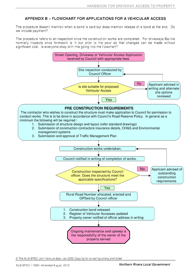
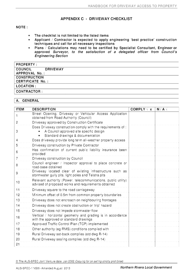
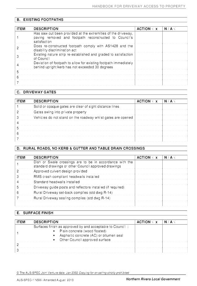
Staff Reports - Infrastructure Services 13.14 - Attachment 21