Minutes of Meeting
Local Traffic Committee Meeting
Venue |
Meeting Room 1, Station Street, Mullumbimby |
Date |
Tuesday, 31 October 2017 |
Time |
10.00am |
Committee Members |
Alan Eichmann – Roads and Maritime Services Snr Constable David Brigg – Police Cr Basil Cameron Tamara Smith MP |
Local Traffic Committee Meeting Minutes 31 October 2017
Report of the Local Traffic Committee Meeting held on Tuesday, 31 October 2017
File No: I2017/1668
Meeting Commenced: 10:15am
PRESENT:
Councillor: Cr Basil Cameron
Roads and Maritime Services Representative: Alan Eichmann
Tamara Smith MP
Staff: Evan Elford
Minutes: Stephanie Tucker
There were no apologies.
Not present: Snr Constable David Brigg
There were no declarations of interest raised.
Adoption of Minutes from Previous Meetings
That the minutes of the Local Traffic Committee Meeting held on 19 September 2017 be confirmed. (Cameron/Eichmann) The recommendation was put to the vote and declared carried. |
There were no matters arising.
Outstanding Issues/Resolutions
There were no outstanding issues/resolutions.
Report No. 6.2 Traffic - Station St File No: I2017/1357
|
||||||||||||||
SUMMARY Byron Shire Council has commenced work on the Customer Service Foyer Upgrade Project which also incorporates external improvement works for customer access, parking and delivery of goods. The proposed modifications and upgrades in Station Street including the installation of new signage and line marking will improve road user safety.
OFFICER RECOMMENDATION
That Council approve the installation of line marking and signs for the relocation of accessible parking, loading zones alterations and extension of 2hr parking zone in Station Street Mullumbimby as shown in Figure 1. LINKAGE TO OUR COMMUNITY STRATEGIC PLAN
BACKGROUND Byron Shire Council has commenced work on the Customer Service Foyer Upgrade Project which also incorporates external improvement works for customer access, parking and delivery of goods.
The proposed works are the be carried out in 3 locations as indicated on Figure 1 within Council’s carpark and Station Street as described below:
Works Area A – Station St. Remove existing loading zone signage and associated pavement marking. Install new 2Hr parking signs and posts to match existing for new parking bays in the old loading zone area.
Work Area B – Station St. Remove existing standard parking bay lines and signs as necessary and provide 2 new accessible parking bays. Install new access ramps in existing kerb and gutter and all necessary associated signs, line and pavement marking.
Work Area C – Council Carpark. Remove accessible parking bay, signage and linemarking that does not meet current standards and establish new loading zone and associated signage and linemarking
Re-location of accessible parking spaces at the rear of Council’s administration office building to Station Street will better cater for the needs of the Mullumbimby Library patrons.
By carrying out road safety improvements including new line markings and signs road user safety can be improved.
KEY ISSUES
1. Existing accessible parking areas do not meet current standards. 2. People are stopping in this area to enjoy the view and encroaching on the travel lanes.
COUNCIL IMPLICATIONS
§ Budget/Financial This project is fully funded.
§ Asset Management This project is fully funded.
§ Policy or Regulation Delegated to council for authorisation in conjunction with prescribed traffic control devices - division 1 of Part 4 (Sections 50 to 55) of the Road Transport (Safety and Traffic Management) Act, 1999.
§ Consultation No consultation has been completed or considered necessary as the proposed work improves road user functionality and safety by replacing existing facilities that do not meet current standards.
§ Legal and Risk Management The installation of new accessible parking bays and loading zone facilities will improve road user safety.
|
||||||||||||||
Committee Comments There were no Committee comments Management Comments There were no Management comments
|
||||||||||||||
That Council 1. Retain the existing Loading Zone in Station St. 2. Approve signage and line marking to facilitate required changes to provide an accessible parking bay in Station Street, Mullumbimby. 3. Council prepare a vehicle movement plan to be provided to delivery drivers outlining new delivery arrangements to be implemented by council (Cameron/Smith) The recommendation was put to the vote and declared carried. |
Report No. 6.3 Regulatory Signage & Linemarking - Pinegroves Road and Tyagarah Road, Myocum RE: 10.2016.486.1 - Storage Premises File No: I2017/1447
|
SUMMARY
Council has received a request (Attachment 1) from Ray Darney Town Planning seeking authority from Council in its capacity as delegate of Roads and Maritime Services (RMS) for the installation of prescribed traffic control devices in Pinegroves Road and Tyagarah Road, Myocum.
OFFICER RECOMMENDATION
That Council approve the use of the signage and line marking to Pinegroves and Tyagarah Roads in accordance with the signage and line marking plans prepared by Rob Aungle & Associates, numbered H-01, H-02 & H-03 and dated 22.09.17 (Attachment 2).
BACKGROUND
On 8 September 2017, the Land and Environment Court, NSW (LEC NSW) granted consent under section 138 of the Roads Act 1993 to “erect a structure or carry out a work in, on or over a public road” in the vicinity of 31 Pinegroves Road, Myocum, in relation to development consents for 31 Pinegroves Road, Myocum – storage premises (10.2016.486.1) and modification of approval for road transport terminal (10.2013.559.4) also granted by LEC NSW at the same time.
Condition 1 of the Roads Act consent states:
The signage and line marking plans submitted by Ray Darney Town Planning (Attachment 2) are consistent with the plans approved by LEC NSW (Attachments 3 & 4) referred to in condition 2 of the Roads Act consent, which states:
The Roads Act consent also requires upgrade works, such as pavement widening and patching, to facilitate the required line marking.
KEY ISSUES
1. The Council must refer all traffic related matters to the Local Traffic Committee (LTC) prior to exercising its delegated functions for the Regulation of Traffic.
2. The signage and line marking has been approved by the Land and Environment Court of NSW (LEC NSW) but require authority from Council in its capacity as delegate of Roads & Maritime Services (RMS).
COUNCIL IMPLICATIONS
· Budget/Financial Nil
· Asset Management Council will need to maintain signage and line marking ongoing, including cleaning and replacement (if necessary).
· Policy or Regulation Delegated to council for authorisation in conjunction with prescribed traffic control devices - division 1 of Part 4 (Sections 50 to 55) of the Road Transport (Safety and Traffic Management) Act, 1999.
· Consultation No consultation is required as the consent has been granted by the Land and Environment Court of NSW for the works under section 138 of the Roads Act 1993.
|
Committee Comments The committee’s recommendation is based on the understanding that these works are being undertaken by the developer at no cost to council. Management Comments There were no Management comments.
|
That Council approve the use of the signage and line marking to Pinegroves and Tyagarah Roads in accordance with the signage and line marking plans prepared by Rob Aungle & Associates, numbered H-01, H-02 & H-03 and dated 22.09.17. (Cameron/Eichmann) The recommendation was put to the vote and declared carried. |
Report No. 6.4 Bangalow Town Centre Pay Parking Scheme - Endorsement of Council Resolved Time Limits in Bangalow File No: I2017/1525
|
Council resolved on 23 February 2017 under Resolution 17-055 to undertake investigation and community consultation regarding the possible implementation of a revised parking management strategy and/or a pay parking scheme in the Bangalow Town Centre.
The initial investigation prepared by Traffic and Parking Systems Group (TPS) considered the current demand and potential alternative arrangements including alternative time restrictions and the potential implications of introducing a pay parking system.
Council staff performed community consultation in combination with the movement and parking review intended to inform the Bangalow Village Plan. Based on the survey and consultation feedback, it is proposed that the majority of the Bangalow community would be supportive of the parking time limits changing in line with the TPS report. It was also noted in the report that the majority of feedback indicated that pay parking would be supported if the revenue generated was reinvested into Bangalow to better the amenity and infrastructure in the town.
Council subsequently resolved 17-356 as follows;
1. That Council endorse the implementation of the changes to the parking time limits in the Bangalow town centre, as depicted in the proposed parking times in Figure 1, being 1P throughout Byron Street and part of Station Street, with 2P in the remainder of Station Street.
2. That Council endorse the introduction of a Bangalow Town Centre Pay Parking Scheme, which is in line with the existing Byron Bay town centre parking scheme.
3. That the Bangalow Town Centre Pay Parking Scheme: · applies a unilateral parking charge of $4 per hour; and · incorporates annual exemptions in accordance with Council’s approved fees and charges.
4. That a pay parking area be endorsed as depicted in Figure 2, which covers: a) Byron Street, from the roundabout crossing Granuaille Road to Market Street; and b) Station Street, excluding the all day car park to the south.
5. That Roads and Maritime Services (RMS) concurrence be sought prior to the implementation of the Bangalow Town Centre Pay Parking Scheme.
6. That Council approve a budget of $75,000 to implement the paid parking scheme and revised parking time limits, from the Pay Parking Reserve.
7. That Council receive a report after twelve (12) months of the Bangalow Pay Parking Scheme being in operation, to review: · operational costs; · revenue; · effect on the Bangalow Village and locality; and · projects funded by the scheme.
8. That Council dedicate all net revenue received from pay parking in Bangalow to infrastructure projects identified by the Bangalow Village Plan Guidance Group and in Council’s asset management plan and that those projects be incorporated into the annual Council budgetary process.
9. That the paid parking scheme commence 1 January 2018 and prior to this commencement Council work alongside Bangalow Guidance Group to identify: a) projects to be funded from revenues raised, including pedestrian, cycling and mobility improvements as priorities identified in the consultation. b) impacts and implications of paid parking on the overall Masterplan of Bangalow including parking outside the town centre. c) design and locations of pay stations that acknowledge the heritage nature of the main street.
Figures 1 and 2 below depict the parking time limit arrangement and pay parking area outlined in the TPS report to be implemented in Bangalow on 1 January 2018.
Figure 1 – Bangalow Township Consultation Flyer
Figure 2 – Bangalow Township Proposed Pay Parking Area
|
Committee Comments There were no Committee comments Management Comments There were no Management comments
|
That the Local Traffic Committee note the proposal to introduce the Bangalow Town Centre Pay Parking Scheme on 1 January 2018 and have no objection to Council Resolution 17-356 detailed above, providing concurrence for:
a) Item 1, which is to implement the changes to the parking time limits in the Bangalow Town Centre, as depicted in the proposed parking times in Figure 1, being 1P throughout Byron Street and part of Station Street, with 2P in the remainder of Station Street with the extension of the metered scheme to include all of Station St. north.
b) Items 2 and 3, detailing that the pay parking scheme will be in line with the Byron Bay town centre parking scheme, incorporating annual exemptions in the format of a resident and business parking permits in line with Council’s approved fees and charges. (Cameron/Eichmann) The recommendation was put to the vote and declared carried. |
Report No. 6.5 Event Road Closure - Soul Street New Year's Eve and First Sun New Year's Day, Byron Bay File No: I2017/1538
|
“Safe Summer in the Bay” 2016/2017 produced a successful New Year’s Eve and New Year’s Day (NYD) in Byron Bay. Estimated crowd numbers were up (more than 10,000 estimated in Soul Street NYE), Police reported a very small number of arrests and there were no major incidents reported by emergency services.
The first meeting of stakeholders for the 2017/18 event was held on the 2 August 2017. The significant outcome from this meeting was advice from NSW Police that this year’s event would need to include counter-terrorist measures. These measures are now required for all public events where more than 3,000 people are expected.
Counter-Terrorism The Commonwealth Government recently released a report titled Australia’s Strategy for Protecting Crowded Places from Terrorism. Following is an extract from the report:
Crowded places such as stadiums, shopping centres, pedestrian malls, and major events will continue to be attractive targets for terrorists. The current National Terrorism Threat Level in Australia is PROBABLE, as outlined on www.nationalsecurity.gov.au This reflects the advice of the Australian Security Intelligence Organisation (ASIO) that individuals and groups continue to possess the intent and capability to conduct a terrorist attack in Australia.
Owners and operators of crowded places have the primary responsibility for protecting their sites, including a duty of care to take steps to protect people that work, use or visit their site from a range of foreseeable threats, including terrorism….. The approach taken to protect crowded places should be nationally consistent, proportionate and, to every extent possible, preserve the public’s use and enjoyment of these places.
The strategy has a number of supplementary materials including a self-assessment tool, a security audit tool, hostile vehicle mitigation guidelines, chemical weapon guidelines, active armed offender guidelines and improvised explosive device guidelines.
Tweed – Byron Local Area Command have indicated they are required to put into place a Counter-Terrorism Plan for any large gatherings occurring within the Shire, which includes Soul St NYE.
Road Barriers The key change for traffic management for 2017 New Year’s Eve is the introduction of counter-terrorism measures for ‘hostile vehicles’. Barriers have been incorporated into the attached traffic control plans for this purpose. Some barriers are fixed (ie concrete) and others are flexible (Council have purchased several of the Modular Physical Barriers as per the attached brochure) to allow emergency and other vehicles access to the event site as required. In order to allow enough time to place the concrete barriers, the road closure has been moved forward to 6am on 31/12/17.
Protection against vehicle borne attack is a key focus area from NSW Police. Road barriers are required to be of sufficient capacity to prevent unauthorised access by a speeding truck.
New Year’s Eve Council last year (2016) held the fourth annual ‘Soul Street’ NYE event which required a road closure of the main street of Byron Bay, being Jonson Street, between Lawson Street through to the car park entry at Railway Park just north of Marvell Street. The same road closure is now sought for the 2017 NYE event to be held Sunday 31 December 2017 with the closure to take effect from 6 am as noted above. The road closure would then be lifted no later than 7am the following morning (1 January 2018).
Other closures are shown in Figure 1, such as securing of Council owned and operated public car park (Lawson Street south car park) for participants of the event only (e.g. stall holders) and provision of an emergency vehicle access route under guidance of traffic control personnel positioned at sites 2 and 3. Removal of parking from streets (as per dotted red line) from 6am will also occur as will traffic control personnel which include two at each of the sites (1, 2 and 3) as per previous years, but with an additional two personnel located at the roundabout at the intersection of Fletcher Street & Lawson Street. Traffic control personnel will be rostered.
Figure 1 – Traffic Control Plan concept
Figure 2 provides details on the role of the traffic controllers to be positioned during the day at sites 1 and 2, noting when two personnel are at each site they will assist with control of pedestrian and vehicle movement at the roundabout at the intersection of Jonson Street & Lawson Street.
Figure 2 – TCP for Site 1 and Site 2
Figure 3 – TCP for Site 3
It should be noted the road closure impacts on local taxi and bus operators and interstate coach services. As in the past, these stakeholders will be advised directly and accommodated where possible, noting this NYE the main bus/coach stop will be for taxi and smaller passenger service vehicles only while the bus/coach and larger vehicles will be provided for south of the main stop so as they avoid the turn-around south end of the road closure and can exit directly via Marvell Street. Both south and north bound vehicles can use this temporary bus/coach stop if they wish by detouring or alternatively (as local services do) use the existing southbound bus stop opposite.
Figure 4 – TCP for Detour and Temporary Coach/Bus Stop
New Year’s Day On 1 January 2016, event was held for the second time at the Cape Byron Lighthouse. It has been a very successful event with approximately 1,000 people attending and it is proposed that the same event be held again on Monday 1 January 2018.
During the 2016 event, vehicles parked on both sides of Lighthouse Road leading up to Cape Byron Lighthouse and pedestrians walked in large groups along the road. To minimise the impact on traffic flow, a traffic control plan (Figure 5) was developed for Lighthouse Road for the 2017 event and proved very successful in managing community safety.
Figure 5 – TCP for Lighthouse Road
It is requested that the TCP for both the NYE & NYD events (2017/2018), which includes the temporary road closures described above in Byron Bay, to be held Sunday 31 December 2017 and Monday 1 January 2018 respectively be endorsed.
|
Committee Comments Committee recommends that this type of safety system looks at extending barriers to footpaths as vehicles can mount the footpath. Management Comments There were no Management comments
|
1. That the Local Traffic Committee supports:
a. Council's temporary traffic management initiatives for the Soul Street New Year's Eve event to be held in Byron Bay and approves the temporary road closure of Jonson Street, between Lawson Street through to the car park entry at Railway Park (north of Marvell Street), from 6am on Sunday 31 December 2017 and its removal by no later than 7am on the Monday 1 January 2018.
b. Council’s temporary traffic management initiatives for the First Sun New Year’s Day event to be held in Byron Bay and approves the temporary road closure of Lighthouse Road from Brooke Road (The Pass), from 3am to 8am on Monday 1 January 2018.
2. That the approval provided in Part 1 remain subject to Council endorsement of the event prior to implementation and is subject to the following requirements:
a. traffic control plans are designed and implemented by those with the appropriate NSW (RMS) accreditation;
b. advertising is undertaken in accordance with the Roads Act, including the publication of a map and explanatory notes in a local newspaper and on Council's website;
c. the letterbox drop of properties adjacent to and prior of the Jonson Street closure and Bay Street, Marvell Street and Byron Street parking changes; and
d. all parties involved in Council's NYE events hold, or least covered by, appropriate and relevant levels of insurance and public liability cover as required by Council.
e. That council should liaise with NSW Police to prepare a confidential counter-terrorism plan for the event and consider alternate additional barriers in strategic locations in consultation with NSW Police. (Smith/Cameron) The recommendation was put to the vote and declared carried. |
Report No. 6.6 DA 10.2017.337.1 - Change of use - Chicken Processing Facility to mixed uses, including agricultural processing warehouse and recreation facility - median and signage on Ewingsdale Road at property entrance File No: I2017/1542
|
SUMMARY 
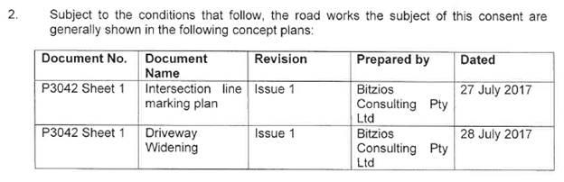
Council has received Development Application 10.2017.337.1 from NSPT Pty Ltd seeking approval to change the use of part of the site and existing buildings for agricultural processing industry, transport depot, recreation facility and warehouse or distribution centre. The land was previously used as a chicken processing facility (Sunnybrand Chickens).
The property is located on the southern side of Ewingsdale Road, near the roundabout accessing the Cavanbah Sporting Fields development.
A Traffic Impact Assessment submitted in support of the Application recommends that the existing site access be altered to a left-in / left-out, with appropriate line-marking at the driveway.
The application was referred to Roads and Maritime Services (RMS) in accordance with SEPP (Infrastructure) 2007 as Traffic Generating Development (Schedule 3, Column 3 – Industrial Development > 5,00m2).
RMS have advised Council that, while they support the conclusions of the Traffic Impact Assessment, “the proposed line marking treatment will not physically prevent right-turns outside of the peak hours. The existing central right-turn bay and medians need to be modified to provide a physical barrier such as a half-seagull raised medial to prevent exiting right-turns”.
They also recommend minor works and signage at the driveway entrance.
OFFICER RECOMMENDATION That the LTC review the proposed works on Ewingsdale Road at the entrance to the site and provide comments for the consideration of the Planning Team.
BACKGROUND 
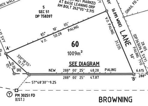
The subject site, 268 Ewingsdale Road, was previously used as a chicken farm and processing centre, from the early 1970s until 2014. Subsequent to the closure of the chicken processing plant, a number of small businesses have been established (without authorisation) in the on-site buildings. The uses include agricultural processing, warehousing and distribution and a gym.
The current development application (10.2017.337.1) seeks development approval to authorise these uses.
Initiatives have also commenced to have the site rezoned to IN2 Light Industrial, and a Gateway Determination (reference PP2016_Byron_007_00) was issued by the Department of Planning and Environment in February 2017. Additional studies are being prepared in support of the rezoning, which is anticipated to be finalised in the first half of 2018.
The current application is therefore an interim measure, pending rezoning of the land and its redevelopment as a ‘business park’.
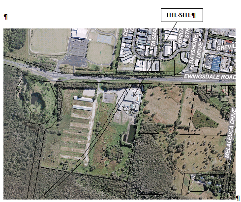
The property is located on Ewingsdale Road between the Cavanbah Sports Centre round-about (to the west) and the Ewingsdale Road/ Bayshore Drive intersection (to the east).
The Traffic Impact Assessment submitted in support of the application indicated peak hour traffic movements associated with the current site of 35 in the AM peak and 28 in the PM peak. Two-way peak hour movements on Ewingsdale Road past the site were indicated to be 1,878 for the AM peak and 1,810 for the PM peak.
The site is accessed by a single driveway onto Ewingsdale Road, as shown below.
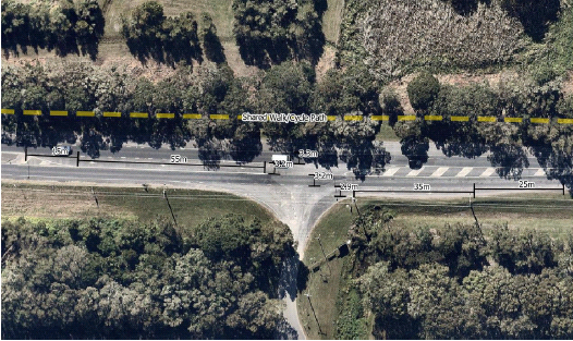
The section of Ewingsdale Road fronting the site has a speed limit of 60km/h, and has a single through-traffic lane in each direction. Auxiliary lanes are provided for both the right and left turn entry movements. Their respective lengths, including tapers, are as follows: · Right = 55m storage + 15m taper = 70m total · Left = 35m storage + 25m taper = 60m total
The access driveway itself has a sealed width of 5.5m at the site gates, with a corner radii of 15m.
The recommendations of the TIA are: · Ban the right turn egress movement; and · Mark a chevron island and shoulder on the egress, to ‘square’ traffic up to Ewingsdale Rd.
The development application was referred to RMS in accordance with the requirements of SEPP (Infrastructure) 2007. The RMS provided the following comments: 1. Roads and Maritime supports the conclusions of the revised Traffic Impact Assessment (TIA) but not the interim treatment being proposed to restrict exiting right-turning traffic. 2. It has been noted that the proposed ‘change of use’ is an interim arrangement until the site is rezoned so it can be re-developed for light industrial purposes. At this time there are no guarantees or a time frame for the rezoning and development in order to fully consider various traffic management options. 3. The proposed line marking treatment will not physically prevent right-turns outside of the peak hours. The existing central right-turn bay and medians need to be modified to provide a physical barrier such as a half-seagull raised median to prevent exiting right-turns. 4. The proposed splitter island should be raised and include an “All Traffic Left” sign. The departure taper should be line marked as proposed in accordance AS2890 and include a treatment to discourage vehicles traversing it. 5. Any proposed road works on Ewingsdale Road will require Roads and Maritime’s concurrence in accordance with Section 138 of the Roads Act 1993. 6. Regulatory controls need to be referred to Council’s Traffic Committee for a recommendation to Council for approval. 7. Future development and associated changes along Ewingsdale Road will further increase delays for both right-turns in and out of the site. This could require the access being limited to left in and out or provision of a costly solution to achieve a safe and unrestricted access. 8. A recent development application for Stage 1 of the West Byron subdivision identified an industrial area on the adjoining land to this site. Council may wish to consider a connection between developments to provide efficient and alternative access arrangements to Ewingsdale Road via the proposed Bayshore Drive roundabout.
Approval for development application 10.2017.337.1 would be conditional upon the works required by items 3 & 4 above being undertaken, in accordance with a Roads Act approval as highlighted in item 5 above.
The Roads Act approval would be required to be obtained prior to the issue of a Construction Certificate for the proposed development.
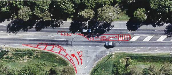
CONCEPT SPLITTER ISLAND The figure below represents a potential concept raised splitter island design as per RMS recommendations, combined with the applicants proposed left out chevron design. This figure helps demonstrate the expected type and scope of works required as part of any future road acts approval. In addition, it is expected a “Left Only” sign will form part of the design. Location of signage to be confirmed.
COUNCIL IMPLICATIONS · Budget/Financial Unknown
· Asset Management Council will need to maintain signage and road and drainage assets within Ewingsdale Road.
· Policy or Regulation Delegated to council for authorisation in conjunction with prescribed traffic control devices - division 1 of Part 4 (Sections 50 to 55) of the Road Transport (Safety and Traffic Management) Act, 1999.
· Consultation The application has been referred to the RMS for comment.
· Legal and Risk Management Minimal.
|
Committee Comments The committee support the consideration of the concept splitter islands and appropriate signage as shown in figure on page 79 of the agenda. Management Comments There were no Management comments
|
That the Local Traffic Committee’s comments relating to DA 10.2017.337.1 be provided to the Council Planning Team. (Smith/Cameron) The recommendation was put to the vote and declared carried. |
Report No. 7.1 DA 10.2017.510.1 - Mixed Use Development, Jonson and Browning Streets - proposed change to Ruskin Lane and potential conflicts with Byron Bypass roundabout File No: I2017/1507
|
||||
SUMMARY Council has received a Development Application (DA 10.2017.510.1) from Mr M Scott, on behalf of JGD Developments Pty Ltd for a mixed use development comprising commercial premises, café, child care centre, shop top housing and serviced apartments. The development is located on the south-west corner of the Jonson Street/ Browning Street intersection in Byron Bay.
OFFICER RECOMMENDATION That the LTC review the proposed changes to Ruskin Lane and potential Byron Bay Bypass conflicts and provided comments for the consideration of the Planning Team.
BACKGROUND Ruskin Lane The site which is subject to development application 10.2017.510.1 is located at the corner of Jonson and Browning Streets, Byron Bay, adjacent to the proposed Byron Bypass roundabout. Ruskin Lane, which is currently a sealed two-way lane, adjoins the eastern boundary of the site.
Fig. 1 - Proposed Site Pre Byron Bay Bypass Roundabout
The application proposes to construct a mixed use development involving: · Two shops and a café at ground level, fronting Jonson Street; · A child care centre at ground level fronting Browning Street; · 24 residential apartments in three levels above the shops and café; · 26 serviced apartments (tourist accommodation) in three levels above the child care centre; and · Two basement levels of car parking containing a total of 122 car parking spaces as well as bicycle and motorcycle parking, with access off Ruskin Lane.
The Traffic Impact Study that accompanies the Development Application (see Attachment 1) estimates total traffic generation to be approximately 349.7 – 375.7 DVT’s and 86.54 – 89.04 PHT’s and proposes the following changes to Ruskin Lane: · Widen Ruskin Lane and Browning St intersection for approximately 35m from Browning Street to cater for two-way traffic and MRV manoeuvring (see Fig. 2); · MRV loading bay off Ruskin Lane adjacent to basement ramp; · The remainder of Ruskin Lane (approximately 135m) is proposed to be converted to one-way with entry only from Tennyson Street; · Ruskin Lane to be restricted to left in / out movements only; · A convex mirror installed at the Ruskin Lane / Browning St intersection to provide pedestrians with improved sight lines.
Fig. 2 - Works proposed at Ruskin Lane / Browning St intersection
Fig 3 – Ruskin Lane
Bypass Roundabout The development has absolute frontage onto the proposed Bypass Roundabout at the intersection of Jonson St / Browning St. Council is in the process of acquiring the SW portion of the subject site for road widening for the roundabout. To compensate a strip of land will be added to the subject property along Browning St (see Fig. 4).
The proposed development introduces challenges relating to construction timing and sequencing. The first plan within Attachment 2 illustrates the current roundabout design that assumes the subject site remains unchanged. The second plan illustrates the proposed ground floor and landscape design. The third plan illustrates the extent of road and drainage works proposed in the road reserve. Together these plans illustrate driveway access to Lots 5 and 6 and footpath alignment are redundant post construction of the development. The third plan illustrates works across the width and length of Browning St.
Fig 4. – Boundary changes
KEY ISSUES Ruskin Lane 1. The Council must refer all traffic related matters to the Local Traffic Committee (LTC) prior to exercising its delegated functions for the Regulation of Traffic.
Byron Bay Bypass 2. How to manage the sequence of construction if: (i) the proposed DA is constructed first , or (ii) the Bypass Roundabout is constructed first. 3. How the proposed development may impact the Bypass Roundabout design.
COUNCIL IMPLICATIONS · Budget/Financial Unknown
· Asset Management Council will need to maintain signage for Ruskin Lane and maintain road and drainage assets within both Ruskin Lane and Browning St..
· Policy or Regulation Delegated to council for authorisation in conjunction with prescribed traffic control devices - division 1 of Part 4 (Sections 50 to 55) of the Road Transport (Safety and Traffic Management) Act, 1999.
· Consultation The application has been referred to the RMS for comment.
· Legal and Risk Management The development will result in increased pedestrian and vehicular activity at the Ruskin Lane / Browning St intersection and the Bypass Roundabout.
|
||||
Committee Comments The Committee does not have a concept drawing to refer to and does not have enough information to assess the impacts on the surrounding road network with particular regard to links with the Byron Bay bypass and planning for cycleway and pedestrian access linkages in the Bangalow Rd corridor. The committee also requires documentation for trucks swept paths, and where the drop off for the preschool area will be located.
The LTC requests a briefing by both planning and the proponent to provide more documentation in early December 2017.
Management Comments There were no Management comments.
|
||||
That the Local Traffic Committee’s comments relating to DA 10.2017.510.1 be provided to the Council Planning Team. (Cameron/Smith) The recommendation was put to the vote and declared carried. |
There being no further business the meeting concluded at 12:15pm.