Agenda
Ordinary
Meeting
Thursday,
20 September 2018
held
at Council Chambers, Station Street, Mullumbimby
commencing
at 9.00am
 Public Access relating to items
on this Agenda can be made between 9.00am and 10.30am on the day of the
Meeting. Requests for public access should be made to the General Manager
or Mayor no later than 12.00 midday on the day prior to the Meeting.
Public Access relating to items
on this Agenda can be made between 9.00am and 10.30am on the day of the
Meeting. Requests for public access should be made to the General Manager
or Mayor no later than 12.00 midday on the day prior to the Meeting.
Mark
Arnold
General
Manager
What is a “Conflict of Interests” - A conflict of
interests can be of two types:
Pecuniary - an interest that a person has in a matter because of a reasonable
likelihood or expectation of appreciable financial gain or loss to the person
or another person with whom the person is associated.
Non-pecuniary – a private or personal interest that a Council
official has that does not amount to a pecuniary interest as defined in the
Local Government Act (eg. A friendship, membership of an association, society
or trade union or involvement or interest in an activity and may include an
interest of a financial nature).
Remoteness – a person does not have a pecuniary interest in a matter
if the interest is so remote or insignificant that it could not reasonably be
regarded as likely to influence any decision the person might make in relation
to a matter or if the interest is of a kind specified in Section 448 of the
Local Government Act.
Who has a Pecuniary Interest? - a person has a pecuniary interest in a
matter if the pecuniary interest is the interest of the person, or another
person with whom the person is associated (see below).
Relatives, Partners - a person is taken to have a pecuniary interest in a
matter if:
§ The person’s
spouse or de facto partner or a relative of the person has a pecuniary interest
in the matter, or
§ The person, or a
nominee, partners or employer of the person, is a member of a company or other
body that has a pecuniary interest in the matter.
N.B. “Relative”, in relation to a person means any of the
following:
(a) the
parent, grandparent, brother, sister, uncle, aunt, nephew, niece, lineal
descends or adopted child of the person or of the person’s spouse;
(b) the
spouse or de facto partners of the person or of a person referred to in
paragraph (a)
No Interest in the Matter - however, a person is not taken to have a
pecuniary interest in a matter:
§ If the person is
unaware of the relevant pecuniary interest of the spouse, de facto partner,
relative or company or other body, or
§ Just because the
person is a member of, or is employed by, the Council.
§ Just because the
person is a member of, or a delegate of the Council to, a company or other body
that has a pecuniary interest in the matter provided that the person has no
beneficial interest in any shares of the company or body.
Disclosure and participation in meetings
§ A Councillor or a
member of a Council Committee who has a pecuniary interest in any matter with
which the Council is concerned and who is present at a meeting of the Council
or Committee at which the matter is being considered must disclose the nature
of the interest to the meeting as soon as practicable.
§ The Councillor or
member must not be present at, or in sight of, the meeting of the Council or
Committee:
(a) at any
time during which the matter is being considered or discussed by the Council or
Committee, or
(b) at any
time during which the Council or Committee is voting on any question in
relation to the matter.
No Knowledge - a person does not breach this Clause if the person did
not know and could not reasonably be expected to have known that the matter
under consideration at the meeting was a matter in which he or she had a
pecuniary interest.
Participation in Meetings Despite Pecuniary Interest (S 452 Act)
A Councillor is not prevented from taking part in the consideration or
discussion of, or from voting on, any of the matters/questions detailed in
Section 452 of the Local Government Act.
Non-pecuniary Interests - Must be disclosed in meetings.
There are a broad range of options available for managing conflicts &
the option chosen will depend on an assessment of the circumstances of the
matter, the nature of the interest and the significance of the issue being
dealt with. Non-pecuniary conflicts of interests must be dealt with in at
least one of the following ways:
§ It may be appropriate
that no action be taken where the potential for conflict is minimal.
However, Councillors should consider providing an explanation of why they
consider a conflict does not exist.
§ Limit involvement if
practical (eg. Participate in discussion but not in decision making or
vice-versa). Care needs to be taken when exercising this option.
§ Remove the source of
the conflict (eg. Relinquishing or divesting the personal interest that creates
the conflict)
§ Have no involvement by
absenting yourself from and not taking part in any debate or voting on the
issue as if the provisions in S451 of the Local Government Act apply
(particularly if you have a significant non-pecuniary interest)
RECORDING OF VOTING ON PLANNING MATTERS
Clause 375A of the Local Government Act 1993
– Recording of voting on planning matters
(1) In this section, planning
decision means a decision made in the exercise of a function of a council
under the Environmental Planning and Assessment Act 1979:
(a) including a decision
relating to a development application, an environmental planning instrument, a
development control plan or a development contribution plan under that Act, but
(b) not including the making of
an order under Division 2A of Part 6 of that Act.
(2) The general manager is
required to keep a register containing, for each planning decision made at a
meeting of the council or a council committee, the names of the councillors who
supported the decision and the names of any councillors who opposed (or are
taken to have opposed) the decision.
(3) For the purpose of
maintaining the register, a division is required to be called whenever a motion
for a planning decision is put at a meeting of the council or a council
committee.
(4) Each decision recorded in
the register is to be described in the register or identified in a manner that
enables the description to be obtained from another publicly available
document, and is to include the information required by the regulations.
(5) This section extends to a
meeting that is closed to the public.
Ordinary Meeting
BUSINESS OF Ordinary Meeting
1. Public Access
2. Apologies
3. Requests for Leave of
Absence
4. Declarations of Interest
– Pecuniary and Non-Pecuniary
5. Tabling of Pecuniary
Interest Returns (s450A Local Government Act 1993)
6. Adoption of Minutes from
Previous Meetings
6.1 Byron
Shire Reserve Trust Committee held on 23 August 2018
6.2 Ordinary
Meeting held on 23 August 2018
7. Reservation of Items for
Debate and Order of Business
8. Mayoral Minute
8.1 An
Official Byron Shire Australia Day event that reflects an inclusive, reasonable
and reflective Australia............................................................................................................................. 6
9. Notices of Motion
9.1 Anti-Vaccination
Groups................................................................................................... 9
9.2 Drainage
concern about stormwater flowing under Ewingsdale Road, from the Byron
Industrial Estate............................................................................................................................... 15
10. Petitions
11. Submissions and Grants
11.1 Byron
Shire Council Submissions and Grants as at 29 August 2018............................. 18
12. Delegates' Reports
13. Staff Reports
General Manager
13.1 Classification
of Lots 188 DP 728535, Lot 1 DP 1159861 and Lot 138 DP 755722, (the former
Mullumbimby Hospital site)............................................................................................. 20
13.2 Consolidation
of 12 Lots in DP 4974 into two new Lots.................................................. 25
13.3 Lease
for Massinger Street treehouse............................................................................ 28
Corporate and Community Services
13.4 Election
of Deputy Mayor 2018-2019............................................................................. 32
13.5 Report
of the Public Art Panel Meeting 3 August, including proposed amendments
to the Public Art Chapter of the Development Control Plan...................................................................... 36
13.6 Investments
August 2018................................................................................................ 39
Sustainable Environment and Economy
13.7 PLANNING
- Development Application 10.2017.683.1 Stage 1: Boundary Adjustment
Subdivision to Create Two (2) Lots and Demolition of Existing Swimming Pool.
Stage 2: Alterations and Additions to Existing Dwelling House and New Driveway
on Proposed Lot 1, New Dwelling House and Studio above Existing Garage on
Proposed Lot 2 at 2 Tincogan Street, Mullumbimby............ 47
13.8 Bushfire
Prone Land Mapping......................................................................................... 66
13.9 PLANNING
- 26.2017.6.1 Byron Bay Town Centre Planning Controls - Results of Preliminary
Community Engagement................................................................................................ 70
13.10 PLANNING
- 26.2017.5.1 Planning Proposal to activate the Rail Corridor Byron Bay: Post
Exhibition Report.............................................................................................................................. 87
13.11 Report
of the Planning Review Committee Meeting held on 9 August 2018................. 93
13.12 Local
Heritage Places Grants 2018-19........................................................................... 95
13.13 PLANNING
- Development Application 10.2018.233.1 Mobile Telecommunications Facility
including 35 metre Monopole, Six (6) antennae and ancillary equipment at
Wilsons Creek Road, Wilsons Creek............................................................................................................................... 98
13.14 Proposed
Flying Fox Project Reference Group........................................................... 121
13.15 PLANNING
- Development Application 10.2017.742.1 Alterations and Additions to Existing
Dwelling House including New Swimming Pool and Spa, New Dwelling House to
Create a Dual Occupancy (detached) and Two (2) Studios at 219 The Saddle Road
Brunswick Heads.............. 124
13.16 Approval
to Operate a Caravan Park and Camping Ground application under section 68 of
the Local Government Act 1993 and Regulations 2005 for The Terrace Reserve
Holiday Park 139
13.17 Update
- Byron Housing Roundtable and Residential Strategy.................................... 151
13.18 PLANNING
- DA2017.516.1 - Subdivison to Create 4 Lots,8 Coomburra Cr, Ocean Shores 154
Infrastructure Services
13.19 Suffolk
Beachfront Holiday Park Dog Friendly Report................................................ 162
13.20 Parking
Time Changes in Mullumbimby, Bangalow and Brunswick Heads - Status
Report 171
13.21 Bayshore
Drive Roundabout - Project Update............................................................. 179
13.22 Suffolk
Beachfront Holiday Park - Re-classification Planning for Permanent Residents 186
13.23 Targa
Restaurant Footpath Dining Application, 11 Marvell Street, Byron Bay............ 189
13.24 Spelling
Error of Historical Significance "Hollingsworth" Lane should be
"Hollingworth" Lane Mullumbimby................................................................................................................. 191
13.25 Naming
of 2 Unnamed Roads - Tims Lane in Broken Head and Blackwell Alley in Bangalow 193
13.26 Renaming
Northern Part of Granuaille Crescent on Bangalow Cemetery side of the Pacific
Highway....................................................................................................................................... 197
13.27 Mullumbimby
Rugby League Club S64 Contributions.................................................. 200
13.28 Mullumbimby
Skate Park.............................................................................................. 202
14. Reports of Committees
Corporate and Community Services
14.1 Report
of the Audit, Risk and Improvement Committee Meeting held on 16 August 2018 206
14.2 Report
of the Finance Advisory Committee Meeting held on 16 August 2018............ 210
Infrastructure Services
14.3 Report
of the Transport and Infrastructure Advisory Committee Meeting held on 16
August 2018....................................................................................................................................... 215
15. Questions
With Notice
Responses
to Questions on Notice are now available on www.byron.nsw.gov.au/Council/
Council-meetings/Questions-on-Notice
16. Confidential Reports
General Manager
16.1 Confidential - Grant of lease to
Preferred Tenderer for the operation and management of the Byron tennis courts........................................................................................................ 218
Sustainable Environment and Economy
16.2 Confidential - Tender 2018-0018 - Multi
Use Byron Shire Rail Corridor.............. 219
Infrastructure Services
16.3 Confidential - Reuse Irrigation............................................................................... 221
Councillors are
encouraged to ask questions regarding any item on the business paper to the
appropriate Director prior to the meeting. Any suggested amendments to the
recommendations should be provided to Councillor Support prior to the meeting
to allow the changes to be typed and presented on the overhead projector at the
meeting.
Mayoral Minute 8.1
Mayoral Minute
Mayoral Minute No. 8.1 An
Official Byron Shire Australia Day event that reflects an inclusive, reasonable
and reflective Australia
File No: I2018/1712
|
I move that Council:
1. Hold its
Australia Day event on 25 January
2. Invite local
custodians to assist in the development and management of the event
|
Background Notes:
Currently, Australia Day symbolises great sorrow and pain
amongst indigenous mobs whilst many non-aboriginal Australians feel uneasy or
conflicted celebrating our nation on this day.
The debate around this is occurring rapidly and divisively
and is not going away. I believe Byron, by adopting a reasonable, rational and
mature approach, has an opportunity to help the nation make the transition away
from the historical problem of this date, whilst still honouring the needs and
values of those who enthusiastically wish to celebrate our successes as a
nation and our communities within Australia.
Historical considerations
I believe we, as a nation, have a lot to celebrate and a lot
for which to be thankful. However, we have chosen a date that is not
historically accurate nor reflective of the diverse cultural tapestry that make
up our nation. Historically, if we were choose a date that signified the first
of many waves of settlers on our land, we would start with the First Australians.
On the 26th, we are celebrating the arrival of British settlers - it was a day
that the English came with British convicts to establish an English colony - if
we are content as a nation to do this, it would then be more appropriate and
accurate to call the day - ‘Colonisation day’, or ‘British
Arrival day’. This would be accurate, but rightfully unacceptable, as it
wouldn’t reflect our diverse and wonderful nation.
Thus, both symbolically and historically, it would be more
appropriate to acknowledge a time before white man arrived, when the first people
settled on the land were indeed, the First Australians. So, why not the
night before? The evening of the 25th.
Inclusive considerations
Thus, the historical inaccuracy of celebrating on the 26th
is obvious and even more obvious is the inappropriateness of this date when it
is known that it causes significant grief to a section of our community. Why
would we, being a nation that prides itself in the values of a ‘fair
go’, equality and ‘mateship’, willingly choose a date that is
not fair, hurts our fellow Australian mates and suggests that some Australians
are more equal than others? An evening tradition of celebrating Australia
day on the 25th could symbolise the richness and importance of the first
Australians, it would directly and clearly symbolise that, across our towns and
cities, the Australia we are celebrating began with our local mobs. We would
focus on a positive time for our indigenous history-rather than a day that
pinpoints the start of their collective sorrow. I would love my family to
celebrate our country in a way that includes and honours all our stories-
whatever our skin colour, ethnicity or origins.
Until an obvious date became apparent, (most likely the date
of when we finally become a republic), changing the date to celebrate 24 hours
earlier would be more historically accurate and more inclusive of all members
of our nation. A small step, but a reasonable and respectful one.
Contemporary considerations
Currently, a day of celebration to that marks the end of
Summer is a great modern cultural fit for us and changing the date that
acknowledges this current reality makes sense. Putting the feelings of
conflict many feel about the 26th to the side, so many of us love the Australia
Day long weekend - it seems a natural fit in our lives, and so keeping that
intact whilst adjusting the actual day of celebration seems reasonable and
logistically sensible. Changing the date to one that marks the concept or
reality of ‘Australia’ narrows down to very few options. We could
explore dates when Henry Parkes made a famous speech about establishing
'Australia' or some other date of significance, though, this would mean a fair
load of change, debate, angst and difficulty and perhaps never reach a
consensus. The best of a bad lot is the day of Federation - January 1st. This
doesn’t work in a practical sense because Australians being Australians -
New Years Day is already a holiday - losing a holiday and double dipping on
another would be ‘un-Australian’.
Utilising the current social acceptance and convenience of
this date, the 26th would still be a public holiday, but like Christmas, we can
celebrate it the night before and leave the day for people to do what they wish
individually - from having a bbq, being with family and friends, acknowledging
the survival aspect, or holding citizenship ceremonies (if this is sacrosanct
for politicians). Those who celebrate Christmas the night before have no less a
powerful and wonderful experience as those who do it on the actual day, so too
communities formally celebrating Australia Day the evening before and
informally on the 26th for those who enthusiastically wish to support the
‘traditional’ Australia day date.
I'd love my kids to also continue to acknowledge their
British roots and origins and it's cultural significance of Australia's past,
and for them to respect those who feel strongly and nationalistically that this
day is one to pay respect for those who fought and died in the name of
'Australia' and who wish to honour our achievements of the last two hundred
years
On Australia day, we are celebrating Australia and what it
means to be Australian and celebrating our diversity and different cultural
backgrounds. So, let’s start with the first cultural community that has
become part of our mix-the indigenous community- rather than the second
group-the Anglo Saxons. Let’s move a date in a small practical and
reasonable way that signifies that we as a nation are prepared to acknowledge
the past and show we are mature and active enough to shift a little to grow a
lot.
For many Australians, Australia Day is not much more than a
holiday and the mark of the end of the Summer holiday. For the remaining
Australians, it is probably split evenly between those who think it is the
correct day and correct way to celebrate our country's achievements both past
and present and those like me who feel it is an inappropriate way and day to
celebrate when it is also the day the cultural decimation and denigration of
the first Australians began. Decimation and denigration that we still have not
rectified, learnt from, or paid penance. Our national wound remains and moving
Australia Day one day earlier would mean our apology was honest.
How We Celebrate
As time for organising this years’ event is short, how
we celebrate is a conversation and decision for another day and for future
years. For this year, the venue may be more formal but we should still work
with our local mob more collegially, to the degree they wish, to start to shift
the format and style of the event. Eventually, for me, Byron Bay is
‘Cavvanbah’- the meeting place- and so let’s once more look
to meet and gather and celebrate and corroboree. Imagine a few hundred people
sitting in circle in the grassed space within the Sandhills area or main beach.
The night will still have the great local awards component-though this time
with more attendees enjoying and watching it. The council funded lunch can be
changed to a council funded dinner- a relaxed open feast and one that the
Arakwal could have a say in what is offered, allowing for bush tucker etc.
As locals sit and chat, cultural groups can bring their
music and colour to the circle, one after another-after the local mob have
started the dance up.
Mary Flick chronicled in 1906 how on most Saturday nights,
the local Byron Bay community would often pay sixpence to attend the local
Arakwal painting up and dancing corroboree style in the Sandhills area- most
probably where the library currently sits. There is local historical
significance for this area to hold a space for white fellas and black fellas to
come together.
When my family joins me at the various events on Australia
day, I'd love them to be part of events and ceremonies co-created by our local
mob-instead of them only invited to welcome us to their country and then have
them sit to the side for the formalities or leaving to celebrate Survival day.
I imagine celebrating an Australia Day with my kids starting
at dusk on the 25th, consisting of an indigenous feast, music and celebration
from many ethnicities and our usual community awards acknowledging great
actions by our locals. I imagine circles of locals- together for one beautiful
moment a year- acknowledging our collective past, present and future.
I'd love to a part of that. I'd love my kids to be a part of
that. I'd love the diverse country I love to be a part of that.
Is the proposal consistent with any Delivery Program
tasks?
This Mayoral Minute is encapsulated in one of our key
Vision’s within Council’s COMMUNITY VISION AND COUNCIL VALUES: We
foster the arts and cultural activities, respect and acknowledge our first
peoples and celebrate and embrace diverse thinking and being.
Key connections to the Community Strategic Plan Include:
Definition of the project/task:
Holding the Council Official Australia Day event on 25
January.
Signed: Cr
Simon Richardson
Notices of Motion 9.1
Notices of Motion
Notice of Motion No. 9.1 Anti-Vaccination
Groups
File No: I2018/1699
|
I move:
1. Does
not accept bookings at any council facility from anti-vaccination groups or
individuals, and in particular the Australian Vaccination Risks Network,
formerly known as the Australian Vaccination Skeptics Network for the
purposes of promoting an anti- vaccination message.
2. Applies
this restriction while ever the Public Warning issued by the Health Care
Complaints Commission is in place.
|
Signed: Cr
Paul Spooner
Councillor’s
supporting information:
The Federal Department of Health states: “Immunisation
is the most significant public health intervention in the last 200 years,
providing a safe and effective way to prevent the spread of many diseases that
cause hospitalisation, serious ongoing health conditions and sometimes death.
Since the introduction of vaccination for
children in Australia in 1932, deaths from vaccine-preventable diseases have
fallen by 99 per cent, despite a threefold increase in the Australian
population over that period. Worldwide, it has been estimated that immunisation
programs prevent approximately three million deaths each year.
Immunisation is critical for the health of
children and the wider community. For immunisation to provide the greatest
benefit, a sufficient number of people need to be vaccinated to halt the spread
of bacteria and viruses that cause disease - this is known as herd immunity or
community immunity. The proportion of the population that has to be immune to
interrupt disease transmission differs for each vaccine preventable disease,
but is around 90 per cent for most diseases. For a highly infectious disease
like measles, this is up to 95 per cent of the population. This emphasises the
need to stay vigilant and ensure high coverage rates, are achieved, not only at
the national level, but also at the local level. ”
With
reported rates in recent years within the Byron Shire as low as 48.4% this
creates a growing and immediate public health risk for babies and children in
our community. (Source: Australian Institute of Health and Welfare).
The rate
of vaccination within parts of the Byron Shire is at a lower rate than the
latest available figures for South Sudan (59%), Afghanistan (81%), Iraq (85%) and Nauru (87%). The
global average for immunisation is 85% (Source: World Health Organisation).
The Health Care Complaints Commission (HCCC)
acts to protect public health and safety by resolving, investigating and
prosecuting complaints about health care in NSW. It was established
under the Health care Complaints Act 1993.
On the 30
April 2014 the HCCC issued the following warning that remains current today:
Public statement
– warning about the Australian Vaccination-skeptics Network, Inc.
(‘AVN’), formerly known as Australian Vaccination Network Inc.
30 Apr 2014
The NSW Health Care Complaints Commission has completed an
investigation into the Australian Vaccination-skeptics Network, Inc.
(‘AVN’), formerly known as Australian Vaccination Network Inc and
under section 94A(1) of the Health Care Complaints Act has decided to
make the following public statement and warning.
AVN was established in 1994 in New South Wales by a group of
people concerned about the lack of scientifically-based information cautioning
against vaccination. AVN states on its website that the government and the
medical community, in general, “exaggerate the safety and benefit
profiles of vaccinations whilst downplaying their risks.” AVN states it
was formed with the purpose of:
· providing
medically-referenced information on vaccine safety and effectiveness
· lobbying to ensure that
vaccinations are never made compulsory for Australian children
· supporting those who
have chosen not to vaccinate or to vaccinate selectively.
AVN disseminates information to the public via a variety of
mediums. These include its website, www.avn.org.au, the magazine
entitled ‘Living Wisdom’ (which ceased publication in January
2013), its Facebook page, Twitter account and YouTube. Meryl Dorey, the former
President, has also held a number of radio interviews.
The Commission investigated whether information published and
disseminated by AVN may be misleading or inaccurate. The investigation focussed
on information provided on AVN’s website and some information
disseminated on AVN’s Facebook page.
The investigation found that AVN provides information on
vaccination that is misleading to the average reader because it is either
incorrect, inaccurately represented or because it has been taken out of
context. Specifically:
· AVN makes specific
assertions about the efficacy of the Gardasil vaccine used to prevent cervical
cancer caused by the Human Papillomavirus (HPV). It states that:
o the connection between
HPV and cervical cancer is tenuous at best and incomprehensive at worst
o the vaccine contains
only four of the 100 strains of HPV and therefore its use is a “shot in
the dark”
o it is an experimental
vaccine with no proven record of safety or effectiveness.
· AVN does not qualify
that:
o Gardasil contains the
four strains of HPV that have the greatest potential to cause cancer
o the link between HPV
and cervical cancer has been established beyond reasonable doubt
o significant research
went into assessing the probable safety and efficacy of Gardasil before it was
ever used in humans
o since its use,
extensive worldwide data on its safety and efficacy has been collected
supporting its safety.
· AVN asserts that the
pertussis vaccine used to prevent whooping cough cannot protect against a new
strain of pertussis, and that 84% of cases in the community are caused by this
new strain. Further, AVN claims that the administration of the new acellular
vaccine sometimes requires surgery at the injection site and attributes this as
the reason for the change in the vaccination schedule with the removal of the
18-month booster. It is incorrect to state that the vaccine cannot offer any
protection against the new strain; and there is no evidence of severe local
reactions to the administration of the acellular vaccine that requires surgical
intervention at the injection site. Further, the removal of the 18-month
booster dose from the vaccination schedule was based on a study that evidenced
protection from pertussis was maintained until six years of age when the
primary vaccine course is given at two, four and six months of age.
· In relation to
Diphtheria-Tetanus-Pertussis (DTP) vaccines AVN asserts that “all whole
cell DTP vaccines contain mercury in the form of thiomersal” and that it
is one of the most toxic substances known to man and has been linked with
autism. In the past, the whole cell DTP vaccine used in Australia did contain
thiomersal, however even if the maximum possible number of doses were given, it
is unlikely that the World Health Organisation’s (WHO) recommended
limit of exposure per kilogram of body weight would have been exceeded. In
2012, the WHO’s Global Advisory Committee on Vaccine Safety
reviewed available information on the safety of thiomersal and concluded that
the levels of thiomersal attained in the body from cumulative doses of vaccines
do not reach toxic levels, making a causal association between thiomersal in
vaccines and autism implausible. Further, thiomersal is not present in any of
the vaccines on the current National Immunisation Program for young
children.
· AVN states that many
of the Anti-D injections recommended for pregnant women with a negative blood
group who have babies with a positive blood group, and that prevent the
mother’s immune system from making antibodies to the baby’s
positive cells thus preventing harm to the baby, contain thiomersal. They also
state that late cord clamping and lotus birth minimises or completely
eliminates the exchange of blood after birth. The Anti-D injections used in
Australia are made from Australian plasma and are free from thiomersal.
Further, late cord clamping and lotus birth do not completely eliminate the
exchange of blood after birth; there can still be contamination of the maternal
system by foetal blood. There is also an increased risk of post-partum
haemorrhage and foetal jaundice.
· AVN provides links on
its website to 68 journal studies that AVN states support the alleged
vaccine/autism causation. However, the studies mostly describe an association
between autism or other neurological disorders with vaccines or other
environmental exposures, but they make no claim of causality. The subject of
any link between vaccines and autism has been examined by a number of expert
professional groups, including the Institute of Medicine , none of which have
substantiated any link. A study carried out by the Institute of Medicine in
2011 rejects a causal relationship between the measles, mumps and rubella (MMR)
vaccine and autism.
· AVN states that
“vaccine ingredients” and “vaccines” have never been
tested, either individually or in combination. This statement is incorrect as
all vaccines available in Australia must pass stringent safety testing before
being approved for use by the Therapeutic Goods Administration (TGA). This
testing is required by law and is usually done over many years during the vaccine’s
development. There is also ongoing review of both vaccine safety and efficacy
through post-marketing clinical trials and surveillance of disease and vaccine
adverse events. This includes multivalent vaccines and the administration of
more than one vaccine at a time. Further, much of the understanding of the
safety of vaccine components comes from the use of the components and their
lack of association over many years with reported significant adverse events.
For components such as mercury and aluminium, conservative safety limits at
most ages have been published by a number of reputable agencies, including the
Environmental Protection Agency (USA) and the WHO.
· AVN uses data from the
United States Vaccine Adverse Event Reporting System (VAERS) on its website,
without qualifying that no cause-and-effect relationship has been established.
This is because VAERS collects data on any adverse event following vaccination
and it is specifically stated that any report of an adverse event to VAERS is
not a causal link that a vaccine caused the event.
· On the AVN website
there is the headline ‘Nurses don’t trust vaccines’, under
which an article from the Vaccine journal about a study conducted into the low
rates of vaccinations among nurses who treat infants is referenced . AVN
summarised the study conducted as conveying that a large number of nurses are
saying no to vaccination because they don’t trust the way in which
vaccines have been promoted. The study was performed on a small group of 25
nurses in Israel. Due to the small sample size and unique context under which
the study was conducted, the results cannot be generalised without caution. The
authors of the article “suggest” that low rates of vaccinations
among nurses in Israel who treat infants are “embedded deep in the
mistrust nurses have towards health authorities and the nurses’ desire
for autonomy”.
Warning
The Commission has established that AVN does not provide reliable
information in relation to certain vaccines and vaccination more generally. The
Commission considers that AVN’s dissemination of misleading,
misrepresented and incorrect information about vaccination engenders fear and
alarm and is likely to detrimentally affect the clinical management or care of
its readers.
Given the issues identified with the information disseminated by
AVN, the Commission urges general caution is exercised when using AVN’s
website or Facebook page to research vaccination and to consult other reliable
sources, including speaking to a medical practitioner, to make an informed
decision.
The Commission has recommended that AVN amend its published
information with regard to the above issues and the Commission will monitor the
implementation of these recommendations.
Further Information
Read the related media release.
For further information, contact the the Health Care Complaints
Commission on 9219 7444 or send an email to media@hccc.nsw.gov.au.
The information in this media release is correct at the time of
publication. Orders may change; for example, conditions may no longer apply.
For current information, please contact the Commission.
Footnotes:
1. WHO
is the directing and coordinating authority for health within the United
Nations system. It is responsible for providing leadership on global health
matters, shaping the health research agenda, setting norms and standards,
articulating evidence-based policy options, providing technical support to
countries and monitoring and assessing health trends.
2. GACVS
was established in 1999 by the World Health Organisation to respond promptly,
efficiently, and with scientific rigour to vaccine safety issues of potential
global importance. Its members are acknowledged experts from around the world
in the fields of epidemiology, statistics, paediatrics, internal medicine,
pharmacology and toxicology, infectious diseases, public health, immunology and
autoimmunity, drug regulation and safety.
3. The
United States Institute of Medicine is an independent, non-profit organisation
that works outside of government to provide unbiased and authoritative advice
to decision-makers and the public. It was established in 1970 and it is the
health arm of the National Academy of Sciences.
4. Baron-Epel
et al. (2012). What lies behind the low rates of vaccinations among nurses who
treat infants? Vaccine, 30, 3151-3154.
Staff comments by James
Brickley, Acting Director Corporate and Community Services, Corporate and
Community Services:
(Management Comments must not include formatted recommendations
– resolution 11-979)
Council’s guidelines for venue bookings
Council’s adopted Guidelines for Halls and Venues for
Section 355 Management Boards and Committees (https://www.byron.nsw.gov.au/files/assets/public/hptrim/corporate-management-meetings-informal-ad-hoc-meetings-with-the-community-2018/w20181186-halls-and-venues-guidelines-for-section-355-management-committees-and-boards.pdf)
outlines the booking procedure for venues.
Section 7 notes that conditions of hire must be formalised
with a hirers agreement and based on the principle of inclusion “…the
Management Committee are acting on behalf of Council, and it is important to
uphold the principles of equity, accessibility and inclusivity, providing for
the whole community”.
The template hirer’s agreement (https://www.byron.nsw.gov.au/files/assets/public/hptrim/corporate-management-meetings-informal-ad-hoc-meetings-with-the-community-2016/template-information-and-user-hire-conditions-plus-booking-form.pdf)
outlines responsibilities including:
· Bond
payment
· Licences
for alcohol
· Licences
for broadcasting music
· Security
· Noise
· Public
liability insurance
The guideline or template hirer’s agreement does not
stipulate what the hall/venue can and cannot be used for.
Council’s position on recent screening of anti-vax
film
An August 2018 screening of the anti-vax film
‘Sacrificial Virgins’ generated some comments from the community.
At the time Council responded:
“Council received messages from concerned community
members via Facebook regarding the screening of the film “Sacrificial
Virgins” at Mullumbimby Civic Hall on 9 August. The Venue
Coordinator also received several emails.
The film was booked in accordance with Council’s
adopted Guidelines for Halls and Venues for Section 355 Management Boards
and Committees – which includes that statement that ‘it is
important to uphold the principles of equity, accessibility and inclusivity
providing for the whole community’. Hire conditions and other safeguards
are in place to protect Council’s asset.
When contacted by members of the community, the venue
coordinator advised the community members that any hirer of the hall does not
reflect the views of Council or the Board of Management. Council has responded
in the same vein.
Council advised patrons (via large signs on display on
the entry to the hall and within the hall) that “The views expressed at
this event are in no way any reflection of the views of Byron Shire Council or
Mullumbimby Civic Hall. This event is not hosted by, or promoted by,
Mullumbimby Civic Hall or Byron Shire Council.”
Guideline revision
Should
Council wish to update the guidelines to reflect what Council’s venues
and halls can be used for, it could be perceived that this would be removing
the empowerment from Committees to manage the facility and limiting free
speech. Such an approach could be seen as Council allowing bias or
pre-judgment.
If Council resolved to restrict
bookings, a clause could be included to provide discretion to Council and the
General Manager, rather than singling out a particular organisation. The
clause could be worded as “bookings may be cancelled or refused at the
General Manager’s discretion”.
Financial/Resource/Legal Implications:
The updating of the guidelines would have minimal financial
implications.
There may be instances where venues and halls could loose
bookings based on new requirements.
There may be legal implications with regard to prohibiting
certain groups from booking venues.
It is
noted that the Local Government Act envisages that the elected Council will
primarily be involved in the creation and review of the Council’s (as
defined in the (LGA) Dictionary) policies and objectives. In that vein,
Council could give the General Manager guidance on matters which the General
Manager might consider in exercising his discretion, rather than direct
operational management of Council’s services.
Is the proposal consistent with any Delivery Program
tasks?
Council’s Community Strategic Plan 2028 “Our
Byron, Our Future” includes:

Notices of Motion 9.2
Notice of Motion No. 9.2 Drainage
concern about stormwater flowing under Ewingsdale Road, from the Byron
Industrial Estate
File No: I2018/1700
|
I move:
That, in relation to drainage concerns raised by
Belongil residents south of Ewingsdale Road, Council:
a) undertake
an immediate review of current and possible drainage paths for catchments
leading to land at Melaleuca Drive and the Bayshore Drive intersection
and investigate options for alleviating or removing impacts and report to the
October 2018 Council meeting;
b) prepare
a "Belongil Catchment Issues Study” with the goal of then
preparing a Belongil Catchment Management Plan that addresses, amongst other
issues, that of drainage south of Ewingsdale Road and whether fill over large
areas will not cause waterlogging downstream;
c) allocate
$30,000 to prepare Belongil Catchment Issues Study for presentation to
Council in February 2019.
|
Attachments:
1 Attachment
to NoM - Vidal Property & Drainage Lines, E2018/74735

Signed: Cr
Jan Hackett
Councillor’s supporting information:
Council has recently completed maintenance works on a culvert
under Ewingsdale Road and re-routed drainage around the Bayshore Drive
roundabout. This has raised concerns from downstream landowners who are
experiencing increased flooding on their land. (Refer Attachment)
Staff met on Friday 31 August 2018 at the Cavanbah Centre
with affected Belongil residents, Drainage Union Members and some members of
the Coastal Estuary Panel regarding the concerns.
The concerns also extended to other catchment related issues
that have been highlighted further since Council completed maintenance works on
the culvert and re-routed drainage around the Bayshore Drive roundabout works.
Staff consider that stormwater flows have always drained in
this direction, albeit through a poorly maintained drain and that recent works
have restored this drainage path resulting in water reaching the drain more
efficiently.
These works have raised an issue that needs further
investigation and resolution. The above meeting highlighted the need for
a whole of catchment review and a solution is considered necessary to address
this issue and numerous other issues across the catchment. Some of these
issues are currently being addressed separately through other processes while
others are not currently being addressed.
The following points are issues for further consideration
within the Belongil Catchment:
· Belongil
Creek Entrance Opening Strategy
· West
Byron STP Alternative Flow Path
· Shire
wide Water Sensitive Urban Design strategy including focus on the meaning of
flood attenuation – trimming peak flows back to pre-development peaks
does not alleviate the impacts of increased stormwater volumes, especially at
low flows.
· Drainage
easements for various discharge points from the industrial estate and Byron Bay
town.
· Future
planned drainage upgrades on Ewingsdale Road and Byron Bay town.
· Melaleuca
Drive Drainage
· Proposed
Butler Street Wetland Project
· Proposed
Sandhill’s Wetland Basin
· Ewingsdale
Road upgrade proposal to two lanes and other supporting infrastructure
· Belongil
Creek Floodplain Management Plan
· Union
Drain and the Drainage Union
· Water
Quality in general across the catchment
· West
Byron sub-division drainage flow paths and volumes
It is recommended that a “Belongil Catchment Issues
Study” be prepared with the goal of then preparing a Belongil
Catchment Management Plan.
The study will consider existing and future issues that
relate to stormwater quality and quantity across the whole catchment. The
study will provide points of reference, areas needing further investigation and
the proposed scope for the Belongil Catchment Management Plan.
It is recommended that consultants Alluvium who are
preparing the Belongil Creek Entrance Opening Strategy be considered for the
study as a variation to the opening strategy contract. Alluvium are
already considering numerous issues across the catchment, which includes
community consultation and reporting the Council’s Coast and Estuary
Panel and Water, Waste and Sewer committee.
In discussions with Alluvium staff it is understood that
this study would cost in the order of $30,000
Based on the meeting there are 2 issues that need
addressing:-
1. The
immediate issue of increased flooding of land around Melaleuca Drive and the
Bayshore drive intersection and the review of options for alleviating or
removing impacts (options reported to the October Council meeting)
2. a
"Belongil Catchment Issues Study” with the goal of then preparing a
Belongil Catchment Management Plan
Staff comments by Peter Rees, Manager Utilities,
Infrastructure Services:
(Management Comments must not include formatted
recommendations – resolution 11-979)
In April 2016 staff reviewed and reported to the Belongil
Catchment Advisory Committee 8 major plans and strategies encompassing the
Belongil Catchment. This body of work will be made available to the
Consultant.
It should also be noted Council resolution (Res 18-390 part
2) requires:
That a report on scoping of
water sensitive design and whole of catchment plan to integrate works involving
West Byron STP, Cape Byron Marine Park, Union Drain Trust and the community
come to the next meeting WWSAC.
Staff will need to ensure these 2 bodies of work are
complementary.
Financial/Resource/Legal Implications:
The funds for the variation work to be taken from the Sewer
reserve fund.
Is the proposal consistent with any Delivery Program
tasks?
Yes
Submissions and Grants 11.1
Submissions and Grants
Report No. 11.1 Byron
Shire Council Submissions and Grants as at 29 August 2018
Directorate: Corporate
and Community Services
Report
Author: Jodi
Frawley, Grants Co-ordinator
File No: I2018/1698
Theme: Corporate Management
Corporate Services
Summary:
Council have submitted applications for a number of grant
programs which, if successful, would provide significant funding to enable the
delivery of identified projects. This report provides an update on these grant
submissions.
|
RECOMMENDATION:
That Council note the report and attachment
(#E2018/74102) for the Byron Shire Council Submissions and Grants as at 29
August 2018.
|
Attachments:
1 Byron
Shire Council Submissions and Grants as at 29 August 2018, E2018/74102 
Report
This report provides an
update on grant submissions.
Unsuccessful Applications
· Agricultural
Outreach, National Landcare Program: Smart Farms, Small Grants, Commonwealth
Department of Agriculture and Water
· Railway
Square Park, Growing Local Economies, NSW Regional Growth Fund
· The
Refurbishment of Byron’s Tennis Facilities, Infrastructure Grants –
Sports and Recreation Stream, NSW Office of Responsible Gambling
Additional information on the grant submissions is provided
in Attachment 1 – Submissions and Grants report as at 29 August 2018.
Financial Implications
If Council is successful in obtaining the identified grants
more than $12 million would be achieved which would provide significant funding
for Council projects. Some of the grants require a contribution from
Council (either cash or in-kind) and others do not. Council’s contribution
is funded. The potential funding and allocation is noted below:
|
Requested funds from funding bodies
|
12,945,930
|
|
Council cash contribution
|
4,294,356
|
|
Council in-kind Contribution
|
62,266
|
|
Other contributions
|
8,610,853
|
|
Funding applications submitted and awaiting
notification (total project value)
|
25,913,405
|
Statutory and Policy Compliance Implications
Council is required under Section 409 3(c) of the Local
Government Act 1993 to ensure that ‘money that has been received from
the Government or from a public authority by way of a specific purpose advance
or grant, may not, except with the consent of the Government or public
authority, be used otherwise than for that specific purpose’. This
legislative requirement governs Council’s administration of grants.
Staff Reports - General Manager 13.1
Staff Reports - General Manager
Report No. 13.1 Classification
of Lots 188 DP 728535, Lot 1 DP 1159861 and Lot 138 DP 755722, (the former
Mullumbimby Hospital site).
Directorate: General
Manager
Report
Author: Ralph
James, Legal Counsel
File No: I2018/1598
Theme: Corporate Management
Community Development
Summary:
At its Ordinary Meeting on 3 August 2017 Council resolved that
Council give notice for not less than 28 days of the following proposed
resolution
pursuant to Section 34 of the Local Government Act 1993:
“That Lot 188 DP 728535 and
lot 1 DP 1159861 and lot 138 DP 755722, the former Mullumbimby Hospital site,
be classified “operational” under the Local Government Act
1993.”
The proposed resolution was publicly advertised on 24 August
2017 and 7 September 2017. No objections were received.
On 23 August
2018 Council resolved to purchase the Mullumbimby War Memorial
Hospital
site from Health Administration Corporation.
The provisions of
Section 31 of the Local Government Act provide that before a council acquires land, or within 3 months after it
acquires land, a council may resolve that the land be classified as community
land or operational land. Any land acquired by
a council that is not classified under the section is, at the end of the period
of 3 months, taken to have been classified under a local environmental plan as
community land.
Section 34 of the Local Government
Act provides for public notice.
Reclassification is a two step
process – a proposed resolution and notice followed by a formal
resolution.
|
RECOMMENDATION:
That Council, having resolved to acquire Lots 188 DP
728535, Lot 1 DP 1159861 and Lot 138 DP 755722, (the former Mullumbimby
Hospital site), by purchase from Health Administration Corporation, classify
the land comprising Lots 188 DP 728535, Lot 1 DP 1159861 and Lot 138 DP
755722 as “operational land” under the Byron Local Environmental
Plan.
|
Report
At its Ordinary Meeting on 3 August 2017 Council received,
considered and resolved in respect of a report titled Report No.
13.7 Classification of land - former Mullumbimby Hospital site Lot 188 DP
728535, Lot 1 DP 1159861 and Lot 138 DP 755722.
Council resolved as follows:
that Council give notice for not less than 28 days of the
following proposed resolution:
pursuant to Section 34 of the Local Government Act 1993:
“That Lot 188 DP 728535 and
lot 1 DP 1159861 and lot 138 DP 755722, the former Mullumbimby Hospital site,
be classified “operational” under the Local Government Act
1993.”
The proposed resolution was publicly advertised on 24 August
2017 and 7 September 2017 in the following terms:
CLASSIFICATION OF
LAND AT
MULLUMBIMBY TO
OPERATIONAL
At its
meeting of 3 August 2017 Council resolved
that:
Council
give notice for not less than 28 days that
Lot
188 DP 728535 and Lot 1 DP 1159861 and
lot
138 DP 755722, the former Mullumbimby
Hospital
site, be classified “operational” under the
Local
Government Act 1993.
Any
objections to this land being classified as
operational
should be forwarded to the General
Manager
by 20 September 2017.
Submissions
close: 4.00pm 20 September 2017
Enquiries:
Mark Arnold 02 6626 7000
No objections were received.
On 23 August
2018 Council resolved to purchase the Mullumbimby War Memorial
Hospital site
from Health Administration Corporation on
the terms and conditions set out in the contract submitted by the Health
Administration Corporation but subject to amendments being made to the
contract.
Council authorised the General Manager to
take all steps necessary to enter into the contract, as amended, and to
sign and counter-sign all documents associated with the purchase of the site,
including the affixing of the Council seal to all documents that may require it.
A Project Reference Group has been formed with 21 members
(including 4 councillors) with the purpose of providing advice and
recommendations to Council on the best outcome for the site, considering the
wellbeing of the whole community, the environment and future generations.
Their core value is to create benefit and collective wellbeing for the whole
community.
The PRG seek to ensure that what happens on the site is
community initiated and implemented however this does not preclude members of
the business community.
PRG members are keen to explore all ideas that a) do no harm
b) contribute to all four aspects of a QBL approach and as such are not opposed
to commercial activity that is fit for purpose
In order to ensure that the remediation costs are recouped
it is essential that the capacity for income generation from some activities
based at the site is not excluded. There is strong community and PRG support to
realise the social, environmental, civic and economic potential of the site and
to ensure financial sustainability and guarantee that future generations are
not financially burdened.
On 23 August
2018 Council also resolved to authorise borrowings through an Expression of
Interest (EOI)
process prior to 30 June 2019 to fund demolition and other associated costs.
Council also resolved that Council should endeavour to
recover its costs of demolition and any other associated costs as soon as
possible to retire the loan borrowings and mitigate the financial risk of this
project.
Council, in resolving as it did on 23 August 2018,
considered that Council ought be free to:
(a) Earn income from the property to pay for the
property’s remediation;
(b) Earn any other income from the property,
provided this income is reinvested into the property; or
(c) Sell or lease some or all of the property.
Council also considered the proposed uses of the site. They
are:
· affordable
housing
· centre-based
child care facilities
· commercial
premises
· community
facilities
· early
education and care facilities
· educational
establishments
· environmental
facilities
· function
centres
· group
homes
· information
and education facilities
· markets
· mixed
use development
· public
land
· recreation
areas
· recreation
facilities
· residential
care facilities
· respite
day care centres
· schools
· school-based
child care
· seniors
housing; and/or
· any
other use which, in the purchaser’s reasonable opinion, has similar
characteristics to the above uses.
For Council to deal with the land and to use the land in
accordance with the purposes listed above (and as referred to in the contract
for the sale and purchase of the land) it is necessary that the land
classification be “operational land”.
In addition, the land ought to be classified as operational land
given that the Catholic Healthcare Ltd facility is commercially operated on the
land. The facility has the benefit of a lease for operation on the land until the
end of 2022. As such the sale to Council is subject to Council agreeing to
allow Catholic Healthcare Ltd to continue occupation of the property under the
same terms as the existing leases – until they expire.
Clause 4.4 of the contract for sale and purchase binds
Council to a Deed regarding that part of the land presently occupied by
Catholic Healthcare Ltd. The Deed provides that upon acquisition of the land Council will promptly arrange for the land
to be subdivided to create a separate Lot for the part of the land subject to
the leases.
Financial Implications
The resource implications of carrying out the recommendation
for the classification of the land are minor.
The ‘Operational Land’ classification would
maximise the options for the use of the property, with no restrictions on
leasing of the site. The Deed requires Council to suddivide lease expiring in
2022 for the operation of the Coolamon Villa Aged care facility. This lease
would replace the current lease in place for the same period.
This special condition special in the contract for sale regarding
Catholic Healthcare Ltd is best managed under the ‘Operational land’
classification.
Statutory and Policy
Compliance Implications
The Local Government Act provides that all Council land be
classified and that there are two classifications: operational and community.
The Act
provides that before council acquires land, or within 3 months after it
acquires land, council may resolve that the land be classified as
community land or operational land.
Any land
acquired by council that is not classified is, at the end of the period of 3
months after it acquires land, taken to have been classified under a local
environmental plan as community land.
How public land is classified determines the ease or
difficulty a council can have dealings in public land, including its sale,
leasing or licensing. It also provides for transparency in council’s
strategic asset management or disposal of public land.
The general position is that there are no special
restrictions on councils' powers to manage, develop or dispose of operational
land, subject to the provisions of relevant environmental planning instruments
(i.e. Local Environmental Plans).
Community land on the other hand cannot be sold or otherwise
disposed of by council. There are also restrictions on the use of community
land (through Plans of Management), on the grant of leases and licences (not
more than 21 years and only more than 5 years if public notice is given) and
disposal (cannot be sold).
Community land would ordinarily comprise land such as a
public park.
Operational land can later be reclassified as community land
by council resolution, after public submissions have been considered.
Local Government Act
25 All public land must be classified
All
public land must be classified in accordance with this Part.
26 What are the classifications?
There are 2 classifications for public
land—“community” and “operational”.
27 How are the classifications made?
(1) The classification or
reclassification of public land may be made by a local environmental plan.
(2) The classification or
reclassification of public land may also be made by a resolution of the council
under section 31, 32 or 33.
31 Classification of land
acquired after 1 July 1993
(1) This section applies to land that is
acquired by a council after the commencement of this Division, other than:
(a) land to which the Crown
Lands Act 1989 applied before the
acquisition and continues to apply after the acquisition, and
(b) land that is acquired for the
purpose of a road.
(2) Before a council acquires land, or
within 3 months after it acquires land, a council may resolve (in accordance
with this Part) that the land be classified as community land or operational
land.
(2A) Any land acquired by a council that is not
classified under subsection (2) is, at the end of the period of 3 months
referred to in that subsection, taken to have been classified under a local
environmental plan as community land.
34 Public
notice to be given of classification or reclassification by council resolution
(1) A council must give public notice of
a proposed resolution to classify or reclassify public land.
(2) The public notice must include the
terms of the proposed resolution and a description of the public land
concerned.
(3) The public notice must specify a
period of not less than 28 days during which submissions may be made to the
council.
35 What
governs the use and management of community land?
Community land is required to be used and managed in
accordance with the following:
• the plan of
management applying to the land
• any law
permitting the use of the land for a specified purpose or otherwise regulating
the use of the land
• this Division.
Staff Reports - General Manager 13.2
Report No. 13.2 Consolidation
of 12 Lots in DP 4974 into two new Lots
Directorate: General
Manager
Report
Author: Deanna
Savage, Roads and Property Officer
File No: I2018/1527
Theme: Corporate Management
Corporate Services
Summary:
To enable works, funded by the Stronger Country Communities
Fund Grant, to be carried out to the Bangalow Heritage House in accordance with
development consent 10.2017.598.1, Council is required to consolidate all
separate parcels of land, which the House spans, into one single allotment.
It is recommended that Council consider that part Lots 1-5
Section 12 in DP 4974 be consolidated into one lot with all remaining land
consolidated into a second lot.
|
RECOMMENDATION:
1. That
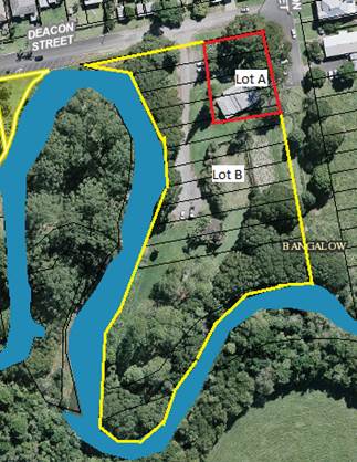
Council endorse the Consolidation of twelve (12) Lots into two (2)
allotments with the first allotment to cover part of Lots 1-5 and the second
allotment to cover all remaining land as per image 1 for the purposes of
complying with condition 21 of development consent 10.2017.598.1.
2. That
Council allocate a budget of $8,000, with funding provided from the Property
Development Reserve, to fund the work required for the consolidation of 12
lots in DP 4974 into two new lots.
|
Attachments:
1 Bangalow
Historical Society - 10.2017.598.1 - Notice of Determination - Approval, A2018/5141 
Report
Background:
The Bangalow Heritage House building currently spans part of
three separately registered land parcels being part of Lots 3-5 in Section 12
DP 4974. All parcels being Byron Shire Council community land.
On 23 February 2018 the Bangalow Heritage Society was
granted development consent 10.2017.598.1 for the alteration and additions to
the existing Heritage House Museum and Restaurant/Tea Rooms. The works are
fully funded by a Stronger Country Communities Fund grant.
Condition 21 of development consent 10.2017.598.1 requires
that:
All separate
parcels of land are to be consolidated into one allotment and registered with
the NSW Department of Lands.
To enable a construction certificate to be issued for the
development, Council needs to comply with condition 21 of development consent
10.2017.598.1.
It is recommended that the best option for the consolidation
was to consolidate twelve (12) Lots into two (2) allotments with the first
allotment to cover part of Lots 1-5 and the second allotment to cover all remaining
land. The advantage of this option is a lease for a term exceeding three
years can be registered over the first allotment with the second allotment
wholly containing the car park and other land for community use.
Image 1
Financial Implications
As outlined above the works being undertaken to Bangalow
Heritage Society development consent 10.2017.598.1 are being fully funded by a
Stronger Country Communities Fund grant. The funds granted will not
extend to the consolidation of the parcels of land into 2 lots. It is
estimated that a budget of $8,000 will be required to complete the work to consolidation
of 12 lots in DP 4974 into two new lots. Funding for the required $8,000 can be
provided by the Property Development Reserve should Council approve the
consolidation of lots as indicated in this report.
Statutory and Policy Compliance Implications
The site is subject to the Generic Plan of Management for
Community Land Categorised as General Community Use – Community
Facilities.
Local Government Act 1993
Staff Reports - General Manager 13.3
Report No. 13.3 Lease
for Massinger Street treehouse
Directorate: General
Manager
Report
Author: Paula
Telford, Leasing and Licensing Coordinator
File No: I2018/1685
Theme: Corporate Management
Corporate Services
Summary:
Council resolved (18-271) to advertise a proposed
twelve month lease to Ms Coppin over an unused portion of road reserve
adjoining 77 Massinger Street Byron Bay. Council also resolved that if
submissions were received then Council must consider the submissions and
determine whether to grant the lease. Council received two submissions as a
result of the public notice.
The resolution also required Ms Coppin to provide requisite
insurance, an engineering certificate attesting to the structural integrity of
the treehouse structure and an arborist report. Ms Coppin has provided all
three documents that validated the structural integrity of the treehouse,
confirmed the trees appeared to be healthy and evidenced public liability
insurance over the treehouse.
Staff recommend that Council, after considering all
submissions received, grants a twelve month lease to Ms Coppin over the unused
public road being that part of the public road adjoining the property at
77 Massinger Street Byron Bay.
|
RECOMMENDATION:
1. That
Council consider all submissions received in attachment 4
(E2018/72737) from the public notice on the proposed lease to Ms Coppin over
an unused portion of road reserve adjoining 77 Massinger Street Byron Bay;
and
2. That
Council consider documents provided by Ms Coppin in attachments 1 to 3
(E2018/72552, E2018/72554, E2018/72557); and
3. That
Council delegate the General Manager authority to enter into a twelve
month lease over the unused public road being that part of the
public road adjoining the property at 77 Massinger Street Byron Bay in
accordance with s153(1) of the Roads Act 1993 (NSW).
|
Attachments:
1 Confidential
- Insurance policy - Childrens treehouse lease to Mell Coppin, E2018/72552
2 Structural
Engineers Certificate: Lease treehouse to Mell Coppin 77 Massinger St, E2018/72554
3 Aborist
report: Lease treehouse to Mell Coppin 77 Massinger St, E2018/72557
4 Submissions
on proposed lease for treehouse 77 Massinger St Byron Bay, E2018/72737
Report
Council resolved (18-271) on 19 April 2018:
1. By
close of business on Thursday, 31 May 2018 Ms Coppin of 77 Massinger Street
Byron Bay provide Council with the following:
a. evidence
by way of a Certificate of Currency that Public Liability Insurance
coverage to the value of $20 million has been effected in respect of the
structure.
b. evidence
by way of an engineering certificate attesting to the structural integrity
of the structure;
c. evidence
by way of an arborist report attesting to the health of the trees where
the structure is located
2. That
on compliance with all components of 1 above Council, for a period of 28
days, advertise its intention to grant Ms Coppin a 12 month lease over the
unused public road being that part of the public road adjoining the
property at 77 Massinger Street Byron Bay at a rental of $1 per annum.
3. In
the event that there are no submissions Council delegate to the General
Manager authority to enter into the lease referred to in 2 above,
or in the event that submissions are made all submissions received be
reported to Council for consideration.
4. That
when approval is granted Council withdraw all directions to remove the
structure.
5. That
enforcement action in respect directions presently issued be stayed until
the happening of either of the events in 3 above, whichever shall first
occur.
In complying with resolution (18-172):
Ms Coppin provided Council with:
a) public
liability insurance current to 31 March 2019 for $20 million Confidential
attachment 1 (E2018/72552);
b) structural
engineers certificate validating the structural building integrity of the
structure for a period of two years Attachment 2 (E2018/72554); and
c) an
arborist report confirming appeared health of both trees and recommended
ongoing inspection every 12-24 months Attachment 3 (E2018/72557).
In accordance with s154 (1) of the Roads Act 1993
(NSW) the proposed lease was advertised for a period of 28 days between 2 and
30 August 2018. Council received two submissions which form Attachment 4.
These submissions are not the subject of a confidential attachment because it
was advised in the advertising that submissions received would be made public.
They have been redacted to remove personal contact detail.
The submissions are summarised below:
|
Submission
|
Council reply
|
|
1. Without
a constructed footpath the submission asked if the pedestrian access across
the land in front of 77 Massinger Street would remain open due to Massinger
Street becoming a major bypass from the southern side of town to access the
CBD. As a consequence of road use and narrowness of the road it is not
safe to walk on the road way. If Council’s intends to close the
informal footpath than the submitter would not agree to the lease. (E2018/68124)
|
· The proposed
lease is over a section of unused road reserve that the tree house is
constructed between two existing street trees. The leased area will not
prevent or obstruct pedestrian access through that portion of unused road
reserve.
|
|
2. The
submission supports the retention of the treehouse and requests Council
executes the lease and immediately withdraw any directions to remove the
treehouse.(E2018/69126)
|
· Council staff
has recommended the lease be granted.
· Council staff
complied with resolution18-271/5.
|
As Council
received no objections to the granting of a lease over an unused portion of
road reserve
adjoining 77 Massinger Street and that Ms Coppin has
provided all documents as required by resolution 18-271, Council staff recommend
that Council, after considering all submissions received, grant Ms Coppin a 12
month lease over the unused public road being that part of the public road
adjoining the property at 77 Massinger Street Byron Bay in accordance with
s153(1) of the Roads Act 1993 (NSW).
Financial Implications
In accordance with resolution 18-271 the twelve month
lease is provided at $1 per annum rent.
Statutory and Policy Compliance Implications
Roads Act 1993 (NSW)
153 Short-term leases of unused public
roads
(1) A roads authority may lease land
comprising a public road (other than a Crown road) to the owner or lessee of
land adjoining the public road if, in its opinion, the road is not being used
by the public.
(2) However, a lease may not be granted
under this Division with respect to land that has been acquired by RMS under
Division 3 of Part 12 (being land that forms part of a classified road) except
by RMS.
(3) A lease granted under this Division
may be terminated by the roads authority at any time and for any reason.
154 Public notice to be given of proposed
lease
(1) Before granting a lease under this
Division, the roads authority must cause notice of the proposed lease:
(a) to be published in a local
newspaper, and
(b) to be served on
the owner of each parcel of land adjoining the length of public road concerned.
(2) The notice:
(a) must identify the public road
concerned, and
(b) must state that
any person is entitled to make submissions to the roads authority with respect
to the proposed lease, and
(c) must indicate the
manner in which, and the period (being at least 28 days) within which, any such
submission should be made.
156 Decision on proposed lease
(1) After considering any submissions
that have been duly made with respect to the proposed lease, the roads
authority may grant the lease, either with or without alteration, or may refuse
to grant the lease.
(2) If the roads authority grants a
lease, the roads authority must cause notice of that fact to be published in a
local newspaper.
157 Special provisions with respect to
short-term leases
(1) The term of a lease, together with
any option to renew, must not exceed:
(a) except as provided by paragraph
(b), 5 years, or
(b) in the case of a
lease of land that has been acquired by the roads authority under Division 3 of
Part 12, 10 years.
(2) A person must not erect any
structure on land the subject of a lease under this Division otherwise than in
accordance with the consent of the roads authority.
Maximum penalty: 10 penalty units.
(3) Such a consent may not be given
unless the roads authority is satisfied that the proposed structure comprises a
fence or a temporary structure of a kind that can easily be demolished or
removed.
Staff Reports - Corporate and Community Services 13.4
Staff Reports - Corporate and Community
Services
Report No. 13.4 Election
of Deputy Mayor 2018-2019
Directorate: Corporate
and Community Services
Report
Author: Heather
Sills, Corporate Governance Officer
File No: I2018/1360
Theme: Corporate Management
Councillor Services
Summary:
In accordance with Section 231 of the Local Government Act
1993 Councillors can elect a Deputy Mayor. Normal practice for Byron Shire
is to elect their Deputy Mayor for a period of 12 months at the first meeting
in September each year.
|
RECOMMENDATION:
1. That
Council elect a Deputy Mayor for the period from 20 September 2018 until the
first meeting of Council in September 2019.
2. That
the method of election of the Deputy Mayor be by way of ordinary ballot.
|
Attachments:
1 Byron
Shire Council Nomination Form Deputy Mayor 2018, E2018/60931
Report
In
accordance with Section 231 of the Local Government Act 1993, a council may
elect a Deputy Mayor to assist the Mayor in the performance of their duties.
(1) The
councillors may elect a person from among their number to be the deputy mayor.
(2) The
person may be elected for the mayoral term or a shorter term.
(3) The
deputy mayor may exercise any function of the mayor at the request of the mayor
or if the mayor is prevented by illness, absence or otherwise from exercising
the function or if there is a casual vacancy in the office of mayor.
(4) The
councillors may elect a person from among their number to act as deputy mayor
if the deputy mayor is prevented by illness, absence or otherwise from
exercising a function under this section, or if no deputy mayor has been
elected.
Term
of the Deputy Mayor
Section
231 (2) of the Local Government Act states: “The person may be
elected for the mayoral term or a shorter term” such as:
1. For
a period of 12 months
2. For
the period of the Mayoral Term
3. For
another period determined by Council
Returning
Officer
Schedule
7(1) of the Local Government (General) Regulation 2005 states that the “General
Manager (or a person appointed by the General Manager) is the Returning
Officer.”
Nomination
Schedule 7(2) of the Local Government (General) Regulation
2005 states that:
(1) A
councillor may be nominated without notice for election as mayor or deputy
mayor.
(2) The
nomination is to be made in writing by 2 or more councillors (one of whom may
be the nominee). The nomination is not valid unless the nominee has
indicated consent to the nomination in writing.
(3) The
nomination is to be delivered or sent to the returning officer.
(4) The
returning officer is to announce the names of the nominees at the council
meeting at which the election is to be held.
Nomination
forms have been provided as an attachment to this business paper. Any
completed nomination forms should be handed to the General Manager prior to the
commencement of the Council meeting.
Election
Schedule
7(3) of the Local Government (General) Regulation 2005 states:
(1) If only one
councillor is nominated, that councillor is elected.
(2) If more than one
councillor is nominated, the council is to resolve whether the election is to
proceed by preferential ballot, by ordinary ballot; or by open voting.
(4) The election is
to be held at the Council meeting at which the Council resolves the method of
voting.
(4) In this clause:
“ballot” has its normal
meaning of secret ballot;
“open voting” means
voting by a show of hands or similar means.
Traditionally
this Council has determined that the election for Deputy Mayor should be by
ordinary ballot. The following additional information is provided in
respect to an election by preferential ballot and by ordinary ballot.
Preferential
ballot – as per its normal interpretation, the ballot papers are to
contain the names of all candidates and Councillors mark their votes 1, 2, 3
and so on against the various names, so as to indicate their order of
preference for all of the candidates.
Ordinary
ballot – this is the usual method adopted in New South Wales.
Ballots are secret with only one candidate’s name written on a ballot
paper.
Where
there are two candidates, the person with the most votes is elected. If
the ballots for the two candidates are tied, the one to be elected is to be
chosen by lots, with the first name out being declared elected.
Where
there are three or more candidates, the person with the lowest number of votes
is eliminated and the process started again until there are only two
candidates. The determination of the election would then proceed as if
the two were the only candidates. In the case of three or more candidates
where a tie occurs, the one to be excluded will be chosen by lot.
Choosing
by Lot – to choose a candidate by lot, the names of the candidates who
have equal numbers of votes are written on similar slips of paper by the
returning officer, the slips are folded by the returning officer so as to
prevent the names being seen, the slips are mixed and one is drawn at random by
the returning officer and the candidate whose name is on the drawn slip is
chosen, on the basis detailed above.
Financial Implications
On 12 June 2014, Council resolved (14-304) in part 3:
"That Council in accordance with its current practice not
determine a fee payable to the Deputy Mayor."
Section 249(5) of the Local Government Act 1993 states:
(5) A council may pay the deputy mayor
(if there is one) a fee determined by the council for such time as the deputy
mayor acts in the office of the mayor. The amount of the fee so paid must
be deducted from the mayor’s annual fee.
Therefore the
Deputy Mayor when acting in the role of Mayor, in instances where the Mayor has
leave of absence endorsed by Council, would be paid a fee calculated on a pro-rata
basis of the annual Mayoral allowance, which would be deducted from the amount
of the monthly Mayoral allowance paid to the Mayor, in accordance with Section
249 of the Local Government Act 1993.
Statutory and Policy Compliance Implications
The
Deputy Mayor will undertake the Mayor’s role at the request of the Mayor
and in situations where the Mayor is prevented by illness, absence or other
reasons from exercising the functions of the position. The role of the
Mayor is defined by Section 226 of the Local Government Act 1993.
Section
226 states that:
The role of the mayor is as
follows:
(a) to be the leader of the council and
a leader in the local community,
(b) to advance community cohesion and
promote civic awareness,
(c) to be the principal member and
spokesperson of the governing body, including representing the views of the
council as to its local priorities,
(d) to exercise, in cases of necessity,
the policy-making functions of the governing body of the council between
meetings of the council,
(e) to preside at meetings of the
council,
(f) to ensure that meetings of the
council are conducted efficiently, effectively and in accordance with this Act,
(g) to ensure the timely development and
adoption of the strategic plans, programs and policies of the council,
(h) to promote the effective and
consistent implementation of the strategic plans, programs and policies of the
council,
(i) to
promote partnerships between the council and key stakeholders,
(j) to advise, consult with and
provide strategic direction to the general manager in relation to the
implementation of the strategic plans and policies of the council,
(k) in conjunction with the general
manager, to ensure adequate opportunities and mechanisms for engagement between
the council and the local community,
(l) to carry out the civic and
ceremonial functions of the mayoral office,
(m) to represent the council on regional
organisations and at inter-governmental forums at regional, State and
Commonwealth level,
(n) in consultation with the
councillors, to lead performance appraisals of the general manager,
(o) to exercise any other functions of
the council that the council determines.
Staff Reports - Corporate and Community Services 13.5
Report No. 13.5 Report
of the Public Art Panel Meeting 3 August, including proposed amendments
to the Public Art Chapter of the Development Control Plan
Directorate: Corporate
and Community Services
Report
Author: Joanne McMurtry,
Community Project Officer
Steve Daniels, Project Officer -
Planning Reforms
File No: I2018/1436
Theme: Society and Culture
Community Development
Summary:
An Public Art Panel meeting was held on 3 August 2018 to
consider the selection of an artist for the Bayshore Drive Roundabout Public
Art Project; to shortlist artists for the Railway Square Public Art Project; to
consider the Brunswick Nature Sculpture Walk event and proposed permanent
sculptures; and to consider a proposed amendment to the Public Art Chapter of
the Development Control Plan.
The Panel made three recommendations to Council. Due to time
constraints for the Bayshore Drive Roundabout Public Art Project, a report was
provided to Council at the 23 August 2018 meeting to endorse the selection of
the artist to commission for the project. The other two recommendations are
provided in this report.
|
RECOMMENDATION:
That with
respect to the Public Art Panel meeting held on 3 August 2018, Council:
1. Note
that the Public Art Panel has considered each artwork submission for the
Brunswick Nature Sculpture Walk, for consistency with the Council’s
Public Art Policy, Strategy and Guidelines and Criteria.
2. Note
that the event organisers have engaged structural engineers (Ardill Payne and
Partners) to assess the installation of the artworks prior to the event
opening and access by the general public.
3. Accept
the two proposed permanent artworks as a legacy of the Brunswick Nature
Sculpture Walk - Allen Horstmanhoff’s Artefact of Things Past
and the Labyrinth in the locations identified, noting that:
a) an
agreement has been reached with the artist for the Labyrinth that the artist
will maintain the artwork once installed
b) the
judges for the permanent acquisition prize, to which Council contributed
financially, include members of the Public Art Panel.
4. Note
that the Public Art Panel has recommended an amendment to Byron DCP 2014
Chapter D8 – Public Art.
5. Receive
a Strategic Planning Workshop to consider the proposed DCP amendment followed
by a further report to Council.
|
Attachments:
1 Public Art
Panel minutes 03082018, E2018/67521
Report
A Public Art Panel meeting was held on 3 August 2018 to
consider:
1. The
selection of an artist for the Bayshore Drive Roundabout Public Art Project;
2. a
shortlist of artists for the Railway Square Public Art Project;
3. the
Brunswick Nature Sculpture Walk event and proposed permanent sculptures; and
4. a
proposed amendment to the Public Art Chapter of the Development Control Plan.
A copy of the Agenda for the Public Art Panel meeting of 3
August 2018 can be found at the following link: https://byron.infocouncil.biz/Open/2018/08/PAP_03082018_AGN_823_AT_WEB.htm
The Panel made three recommendations to Council. Due to time
constraints for the Bayshore Drive Roundabout Public Art Project, a report was
provided to Council at the 23 August 2018 meeting to endorse the selection of
the artist to commission for the project.
The other two recommendations relating to Brunswick Nature
Sculpture Walk and an amendment to the Public Art Chapter of the Development
Control Plan are provided on the first page of this report. A
recommendation regarding the Railway Square Public Art project will be provided
to Council on selection of the final artist for the project later this year.
Public Art Chapter of the Development Control Plan
The newly adopted Public Art Strategy includes a strategy to
“build strength into the Development Control Plan [with regards to public
art]”. The Public Art Panel have considered proposed amendments to Byron
Development Control Plan (DCP) 2014 – Chapter D8 Public Art at both
the 26 April Public Art Panel meeting and a draft amendment at the 3 August
Panel meeting.
The draft amendment proposes the following changes:
· Update
to the aims of the Chapter considering the revised Public Art Policy and new
Public Art Strategy
· Updates
to Section D8.2.1, including revised developer contribution values, details to
be addressed in a Public Art Plan, and design considerations for public art
proposals
· A
new section on the requirements for a development application (DA) for the
provision of public art
· A
new section on the provision of murals
Consequential amendments would also be required to Byron DCP
2014 Part A – Preliminary. These amendments are minor in nature and
include updates to the definition of ‘public art’, and inclusion of
a definition of ‘murals’. The definitions would be taken from
the Public Art Policy and new Public Art Strategy.
Given the complexities, Staff recommend that a Strategic
Planning Workshop be held with Councillors to discuss the proposed amendments
to DCP 2010, Chapter D8 - Public Art. The draft amendment proposes
significant changes to the existing chapter which need to be fully understood
and considered by Council. Following the Strategic Planning Workshop, it is
recommended that Council receive a further report to consider the draft
amendment and public exhibition of the amendment.
Financial Implications
The Public Art Panel did not make any recommendations this
meeting to spend any public art funds.
Statutory and Policy
Compliance Implications
Public Art Policy, Public Art Strategy and Public Art
Guidelines and Criteria.
Staff Reports - Corporate and Community Services 13.6
Report No. 13.6 Investments
August 2018
Directorate: Corporate
and Community Services
Report
Author: James
Brickley, Manager Finance
File No: I2018/1593
Theme: Corporate Management
Financial Services
Summary:
This report includes a list of investments and identifies
Council’s overall cash position for the month of August 2018 for
Council’s information.
This report is prepared to comply with Regulation 212 of the
Local Government (General) Regulation 2005.
|
RECOMMENDATION:
That the report listing Council’s
investments and overall cash position as at 31 August 2018 be noted.
|
Report
In relation to the investment portfolio for the month of
August 2018, Council has continued to maintain a diversified portfolio of
investments. At 31 August 2018, the average 90 day bank bill rate (BBSW) for
the month of August was 1.96%. Council’s performance to 31 August 2018 is
2.72% Council’s performance is again higher than the benchmark. This is
largely due to the active ongoing management of the investment portfolio,
maximising investment returns through secure term deposits and purchasing
floating rate notes with attractive interest rates.
The table below identifies the investments held by Council
as at 31 August 2018:
Schedule of
Investments held as at 31 August 2018
|
Purch Date
|
Principal ($)
|
Description
|
CP*
|
Rating
|
Maturity Date
|
No Fossil
Fuel ADI
|
Type
|
Interest Rate Per
Annum
|
Current Value
|
|
28/10/16
|
650,000
|
Teachers Mutual Bank
|
Y
|
BBB+
|
28/10/19
|
Y
|
FRN
|
3.17%
|
655,144.56
|
|
24/03/17
|
1,000,000
|
NAB Social Bond (Gender Equality)
|
Y
|
AA-
|
24/03/22
|
N
|
B
|
3.25%
|
1,017,387.17
|
|
31/03/17
|
1,000,000
|
CBA Climate Bond
|
Y
|
AA-
|
31/03/22
|
N
|
FRN
|
3.25%
|
1,000,000.00
|
|
16/11/17
|
750,000
|
Bank of Queensland
|
Y
|
BBB+
|
16/11/21
|
N
|
FRN
|
2.63%
|
750,000.00
|
|
30/08/18
|
500,000
|
Bank Australia Ltd (Sustainability Bond)
|
Y
|
BBB+
|
30/08/21
|
Y
|
FRN
|
3.26%
|
500,000.00
|
|
06/03/18
|
2,000,000
|
My State Bank
|
Y
|
BBB
|
06/09/18
|
Y
|
TD
|
2.65%
|
2,000,000.00
|
|
06/03/18
|
1,000,000
|
Bananacoast Credit Union
|
Y
|
NR
|
06/09/18
|
Y
|
TD
|
2.60%
|
1,000,000.00
|
|
16/03/18
|
1,000,000
|
The Capricornian Credit Union
|
Y
|
NR
|
17/09/18
|
U
|
TD
|
2.80%
|
1,000,000.00
|
|
04/04/18
|
2,000,000
|
Police Credit Union Limited (SA)
|
Y
|
NR
|
03/10/18
|
Y
|
TD
|
2.86%
|
2,000,000.00
|
|
04/04/18
|
1,000,000
|
NAB
|
N
|
AA-
|
04/10/18
|
N
|
TD
|
2.60%
|
1,000,000.00
|
|
05/04/18
|
1,000,000
|
AMP Bank
|
Y
|
A
|
02/10/18
|
N
|
TD
|
2.60%
|
1,000,000.00
|
|
05/04/18
|
1,000,000
|
Police Credit Union Limited (SA)
|
N
|
NR
|
02/10/18
|
Y
|
TD
|
2.85%
|
1,000,000.00
|
|
16/04/18
|
1,000,000
|
The Capricornian Credit Union
|
N
|
NR
|
17/09/18
|
U
|
TD
|
2.74%
|
1,000,000.00
|
|
17/04/18
|
1,000,000
|
Police Credit Union Limited (SA)
|
N
|
NR
|
17/10/18
|
Y
|
TD
|
2.94%
|
1,000,000.00
|
|
02/05/18
|
2,000,000
|
Police Credit Union Limited (SA)
|
N
|
NR
|
30/10/18
|
Y
|
TD
|
2.83%
|
2,000,000.00
|
|
02/05/18
|
1,000,000
|
Maitland Mutual Building Society
|
Y
|
NR
|
29/10/18
|
Y
|
TD
|
2.83%
|
1,000,000.00
|
|
15/05/18
|
1,000,000
|
Maitland Mutual Building Society
|
N
|
NR
|
15/10/18
|
Y
|
TD
|
2.85%
|
1,000,000.00
|
|
17/05/18
|
1,000,000
|
Hunter United Employees Credit Union
|
Y
|
NR
|
17/09/18
|
U
|
TD
|
2.80%
|
1,000,000.00
|
|
23/05/18
|
1,000,000
|
The Capricornian Credit Union
|
N
|
NR
|
23/11/18
|
U
|
TD
|
2.85%
|
1,000,000.00
|
|
24/05/18
|
1,000,000
|
ME Bank
|
Y
|
BBB
|
21/09/18
|
Y
|
TD
|
2.60%
|
1,000,000.00
|
|
28/05/18
|
1,000,000
|
B & E Ltd (Bank of Us)
|
Y
|
NR
|
28/11/18
|
U
|
TD
|
2.85%
|
1,000,000.00
|
|
30/05/18
|
1,000,000
|
Maitland Mutual Building Society
|
N
|
NR
|
11/09/18
|
Y
|
TD
|
2.80%
|
1,000,000.00
|
|
30/05/18
|
1,000,000
|
AMP Bank
|
N
|
A
|
25/02/19
|
N
|
TD
|
2.80%
|
1,000,000.00
|
|
01/06/18
|
1,000,000
|
Police Credit Union Limited (SA)
|
N
|
NR
|
21/09/18
|
Y
|
TD
|
2.82%
|
1,000,000.00
|
|
05/06/18
|
1,000,000
|
NAB
|
N
|
AA-
|
03/10/18
|
N
|
TD
|
2.70%
|
1,000,000.00
|
|
08/06/18
|
2,000,000
|
ME Bank
|
N
|
BBB
|
07/12/18
|
Y
|
TD
|
2.84%
|
2,000,000.00
|
|
08/06/18
|
1,000,000
|
Suncorp
|
Y
|
A
|
09/10/18
|
Y
|
TD
|
2.82%
|
1,000,000.00
|
|
12/06/18
|
1,000,000
|
Bankwest
|
Y
|
AA-
|
12/09/18
|
N
|
TD
|
2.70%
|
1,000,000.00
|
|
14/06/18
|
2,000,000
|
Suncorp
|
N
|
A
|
12/09/18
|
Y
|
TD
|
2.75%
|
2,000,000.00
|
|
15/06/18
|
1,000,000
|
Suncorp
|
N
|
A
|
15/10/18
|
Y
|
TD
|
2.80%
|
1,000,000.00
|
|
18/06/18
|
2,000,000
|
Beyond Bank
|
Y
|
BBB
|
18/12/18
|
Y
|
TD
|
2.75%
|
2,000,000.00
|
|
18/06/18
|
1,000,000
|
Gateway Credit Union
|
Y
|
NR
|
18/12/18
|
Y
|
TD
|
2.90%
|
1,000,000.00
|
|
26/06/18
|
1,000,000
|
Bankwest
|
N
|
AA-
|
24/09/18
|
N
|
TD
|
2.80%
|
1,000,000.00
|
|
03/07/18
|
1,000,000
|
B & E Ltd (Bank of Us)
|
N
|
NR
|
31/10/18
|
U
|
TD
|
3.00%
|
1,000,000.00
|
|
04/07/18
|
2,000,000
|
ME Bank
|
N
|
BBB
|
27/09/18
|
Y
|
TD
|
2.70%
|
2,000,000.00
|
|
04/07/18
|
1,000,000
|
NAB
|
N
|
AA-
|
08/10/18
|
N
|
TD
|
2.57%
|
1,000,000.00
|
|
05/07/18
|
1,000,000
|
Hunter United Employees Credit Union
|
N
|
NR
|
03/10/18
|
U
|
TD
|
2.90%
|
1,000,000.00
|
|
05/07/18
|
1,000,000
|
NAB
|
N
|
AA-
|
03/10/18
|
N
|
TD
|
2.76%
|
1,000,000.00
|
|
09/07/18
|
1,000,000
|
Beyond Bank
|
N
|
BBB
|
10/12/18
|
Y
|
TD
|
2.75%
|
1,000,000.00
|
|
23/07/18
|
1,000,000
|
AMP
|
N
|
A
|
21/01/19
|
N
|
TD
|
2.80%
|
1,000,000.00
|
|
23/07/18
|
1,000,000
|
NAB
|
N
|
AA-
|
22/10/18
|
N
|
TD
|
2.68%
|
1,000,000.00
|
|
23/07/18
|
1,000,000
|
Bankwest
|
N
|
AA-
|
22/10/18
|
N
|
TD
|
2.65%
|
1,000,000.00
|
|
24/07/18
|
1,000,000
|
ME Bank
|
N
|
BBB
|
22/10/18
|
Y
|
TD
|
2.73%
|
1,000,000.00
|
|
30/07/18
|
2,000,000
|
ME Bank
|
N
|
BBB
|
29/10/18
|
Y
|
TD
|
2.73%
|
2,000,000.00
|
|
01/08/18
|
1,000,000
|
Defence Bank
|
Y
|
BBB
|
30/01/19
|
U
|
TD
|
2.75%
|
1,000,000.00
|
|
01/08/18
|
2,000,000
|
Bankwest
|
N
|
AA-
|
30/10/18
|
N
|
TD
|
2.65%
|
2,000,000.00
|
|
01/08/18
|
1,000,000
|
Bank Vic
|
Y
|
NR
|
30/10/18
|
Y
|
TD
|
2.82%
|
1,000,000.00
|
|
03/08/18
|
2,000,000
|
AMP
|
N
|
A
|
30/01/19
|
N
|
TD
|
2.80%
|
2,000,000.00
|
|
03/08/18
|
1,000,000
|
B & E Ltd (Bank of Us)
|
N
|
NR
|
02/11/18
|
U
|
TD
|
2.80%
|
1,000,000.00
|
|
06/08/18
|
2,000,000
|
NAB
|
N
|
AA-
|
05/11/18
|
N
|
TD
|
2.67%
|
2,000,000.00
|
|
07/08/18
|
1,000,000
|
Gateway Credit Union
|
N
|
NR
|
07/12/18
|
Y
|
TD
|
2.78%
|
1,000,000.00
|
|
07/08/18
|
2,000,000
|
ME Bank
|
N
|
BBB
|
04/02/19
|
Y
|
TD
|
2.70%
|
2,000,000.00
|
|
07/08/18
|
1,000,000
|
Coastline Credit Union
|
Y
|
NR
|
05/11/18
|
U
|
TD
|
2.80%
|
1,000,000.00
|
|
08/08/18
|
1,000,000
|
AMP
|
N
|
A
|
08/02/19
|
N
|
TD
|
2.80%
|
1,000,000.00
|
|
13/08/18
|
1,000,000
|
Bank of Us
|
N
|
NR
|
12/11/18
|
U
|
TD
|
2.75%
|
1,000,000.00
|
|
15/08/18
|
1,000,000
|
Police Credit Union Limited (SA)
|
N
|
NR
|
15/11/18
|
Y
|
TD
|
2.70%
|
1,000,000.00
|
|
20/08/18
|
1,000,000
|
Maitland Mutual Building Society
|
N
|
NR
|
19/11/18
|
Y
|
TD
|
2.70%
|
1,000,000.00
|
|
22/08/18
|
1,000,000
|
Suncorp
|
N
|
A+
|
22/08/18
|
Y
|
TD
|
2.65%
|
1,000,000.00
|
|
30/08/18
|
1,000,000
|
Suncorp
|
N
|
A+
|
28/11/18
|
Y
|
TD
|
2.65%
|
1,000,000.00
|
|
30/08/18
|
2,000,000
|
NAB
|
N
|
AA-
|
14/12/18
|
N
|
TD
|
2.63%
|
2,000,000.00
|
|
31/08/18
|
2,000,000
|
Suncorp
|
N
|
A+
|
31/08/18
|
Y
|
TD
|
2.65%
|
2,000,000.00
|
|
N/A
|
2,082,036
|
CBA Business Online Saver
|
N
|
A
|
N/A
|
N
|
CALL
|
1.40%
|
2,082,036.39
|
|
12/01/18
|
1,012,903
|
NSW Treasury Corp
|
Y
|
AAA
|
N/A
|
Y
|
CALL
|
2.16%
|
1,012,903.22
|
|
Total
|
76,994,939
|
|
|
|
|
|
AVG
|
2.72%
|
77,017,471.34
|
|
Note 1.
|
CP = Capital protection on maturity
|
|
|
N = No Capital Protection
|
|
|
Y = Fully covered by Government Guarantee
|
|
|
P = Partial Government Guarantee of $250,000 (Financial
Claims Scheme)
|
|
|
|
|
Note 2.
|
No Fossil Fuel ADI
|
|
|
Y = No investment in Fossil Fuels
|
|
|
N = Investment in Fossil Fuels
|
|
|
U = Unknown Status
|
|
Note 3.
|
Type
|
Description
|
|
|
|
B
|
Bonds
|
Principal can vary based on
valuation, interest payable via a fixed interest, payable usually each
quarter.
|
|
|
FRN
|
Floating Rate Note
|
Principal can vary based on
valuation, interest payable via a floating interest rate that varies each
quarter.
|
|
|
TD
|
Term Deposit
|
Principal does not vary during investment term. Interest
payable is fixed at the rate invested for the investment term.
|
|
|
CALL
|
Call Account
|
Principal varies due to cash flow demands from deposits/withdrawals,
interest is payable on the daily balance.
|
Environmental and Socially
Responsible Investing
An additional column has been
added to the schedule of Investments above, to identify if the financial
institution holding the Council investment, has been assessed as a ‘No
Fossil Fuel’ investing institution. This information has been
sourced through www.marketforces.org.au and identifies financial
institutions that either invest in fossil fuel related industries or do
not. The graph below highlights the percentage of each classification
across Council’s total investment portfolio in respect of fossil fuels
only.
The notion of Environmental and
Socially Responsible Investing is much broader than whether a financial
institution as rated by ‘marketforces.org.au’ invests in fossil
fuels or not. Council’s current Investment Policy defines
Environmental and Socially Responsible Investing at Section 4.1 of the
Policy. Council’s Investment Policy can be found at Council’s
website via the following link:
https://www.byron.nsw.gov.au/Council/Your-right-to-Council-information/Policies?dlv_OC%20CL%20Public%20DocLib%20Relative=(pageindex=6)
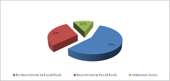
In this regard Council has an
additional two investments that are with financial institutions that invest in
fossil fuels but the purposes of the investments are in accord with the broader
definition of Environmental and Socially Responsible investments as indicated
below:
1. $1,000,000 investment with the National Australia Bank maturing
on 24 March 2022 known as a Social Bond that promotes Gender Equity.
2. $1,000,000 investment with Commonwealth Bank maturing on 31
March 2022 known as a Climate Bond.
New Sustainable Investment
Council
on 21 August 2018 secured interest in a new investment by Bank Australia known
as a ‘Sustainability Bond’. The investment is for a three year
period that settled on 30 August 2018. It will pay a return to Council on a
floating basis at a rate established each quarter by the three month bank bill
swap rate plus a fixed margin of 1.30%. This rate is currently around 3.25% per
annum.
The
investment offer from Bank Australia will use the proceeds from investors to
fund the following:
•
Loans to not for profit organisations and specialist accommodation housing.
•
Loans for affordable housing.
•
Loans for the construction of green buildings.
•
Loans for conservation backed construction.
•
Ongoing mortgage loans for energy efficient homes.
The Sustainability Bond offer
from Bank Australia was originally a total investment pool of $100million. It
was expanded to $125million but offers exceeded $250million. As the investment
was oversubscribed, Council sought a $1million investment into the
Sustainability Bond but was allocated $500,000.
For the month of August 2018, as indicated in the table
below, there is a dissection of the investment portfolio by investment type:
Dissection
of Council Investment Portfolio as at 31 August 2018
|
Principal Value ($)
|
Investment Linked to:-
|
Current Market Value ($)
|
Cumulative Unrealised Gain/(Loss) ($)
|
|
70,000,000.00
|
Term
Deposits
|
70,000,000.00
|
0.00
|
|
2,900,000.00
|
Floating
Rate Note
|
2,905,144.56
|
5,144.56
|
|
2,082,036.39
|
Business
On-Line Saver (At Call)
|
2,082,036.39
|
0.00
|
|
1,012,903.22
|
NSW Treasury Corp
(T Corp)
|
1,012,903.22
|
0.00
|
|
1,000,000.00
|
Bonds
|
1,017,387.17
|
17,387.17
|
|
76,994,939.61
|
|
77,017,471.34
|
22,531.73
|
The current value of an investment compared to the principal
value (face value or original purchase price) provides an indication of the
performance of the investment without reference to the coupon (interest) rate. The
current value represents the value received if an investment was sold or traded
in the current market, in addition to the interest received.
The table below provides a reconciliation of investment
purchases and maturities for month of August 2018 on a current market value
basis.
Movement
in Investment Portfolio – 31 August 2018
|
Item
|
Current Market Value (at end of month) $
|
|
Opening
Balance at 31 July 2018
|
73,513,731.83
|
|
Add:
New Investments Purchased
|
23,500,000.00
|
|
Add:
Call Account Additions
|
1,000,000.00
|
|
Add:
Interest from Call Account
|
1,898.03
|
|
Less:
Investments Matured
|
20,000,000.00
|
|
Add:
T Corp Additions
|
0.00
|
|
Add:
Interest from T Corp
|
1,841.48
|
|
Less:
Call Account Redemption
|
1,000,000.00
|
|
Add:
Fair Value Movement for period
|
0.00
|
|
Closing
Balance at 31 August 2018
|
77,017,471.34
|
Investments
Maturities and Returns – August 2018
|
Principal Value ($)
|
Description
|
Type
|
Maturity Date
|
Number of Days Invested
|
Interest Rate Per Annum
|
Interest Paid on Maturity $
|
|
2,000,000
|
NAB
|
TD
|
06/08/18
|
9191
|
2.64%
|
13,163.85
|
|
2,000,000
|
NAB
|
TD
|
30/08/18
|
122
|
2.64%
|
17,648.22
|
|
2,000,000
|
ME Bank
|
TD
|
07/08/18
|
91
|
2.60%
|
12,964,38
|
|
1,000,000
|
Banana Coast Credit
Union
|
TD
|
07/18/18
|
153
|
2.55%
|
10,689.04
|
|
1,000,000
|
Defence Bank
|
TD
|
01/08/18
|
153
|
2.50%
|
10,479,45
|
|
2,000,000
|
AMP
|
TD
|
03/08/18
|
184
|
2.60%
|
26,213.70
|
|
1,000,000
|
Rural Bank
|
TD
|
02/08/18
|
181
|
2.62%
|
12,992,33
|
|
1,000,000
|
Gateway Credit
Union
|
TD
|
07/08/18
|
182
|
2.55%
|
12,715,07
|
|
1,000,000
|
AMP
|
TD
|
08/08/18
|
181
|
2.60%
|
12,893,15
|
|
1,000,000
|
Police Credit Union
SA
|
TD
|
15/08/18
|
181
|
2.61%
|
12,942.74
|
|
1,000,000
|
ME Bank
|
TD
|
27/08/18
|
91
|
2.60%
|
6,482.19
|
|
1,000,000
|
Coastline Credit
Union
|
TD
|
07/08/18
|
90
|
2.80%
|
6,904.11
|
|
1,000,000
|
Maitland Mutual
Building Society
|
TD
|
15/08/18
|
92
|
2.85%
|
7,183.56
|
|
1,000,000
|
Maitland Mutual
Building Society
|
TD
|
20/08/18
|
82
|
2.80%
|
6,290.41
|
|
1,000,000
|
Maitland Mutual
Building Society
|
TD
|
20/08/18
|
81
|
2.80%
|
6,213.70
|
|
1,000,000
|
Suncorp
|
TD
|
30/08/18
|
90
|
2.65%
|
6,534.25
|
|
20,000,000
|
|
|
|
|
|
182,446.77
|
The overall ‘cash position’ of Council is not
only measured by what funds Council has invested but also by what funds Council
has retained in its consolidated fund or bank account as well for operational
purposes. In this regard, for the month of August 2018 the table below
identifies the overall cash position of Council as follows:
Dissection
of Council Cash Position as at 31 August 2018
|
Item
|
Principal Value ($)
|
Current Market Value ($)
|
Cumulative Unrealised Gain/(Loss) ($)
|
|
Investments
Portfolio
|
|
|
|
|
Term Deposits
|
70,000,000.00
|
70,000,000.00
|
0.00
|
|
Floating Rate Note
|
2,900,000.00
|
2,905,144.56
|
5,144.56
|
|
Business On-Line
Saver (At Call)
|
2,082,036.39
|
2,082,036.39
|
0.00
|
|
NSW Treasury Corp
(T Corp)
|
1,012,903.22
|
1,012,903.22
|
0.00
|
|
Bonds
|
1,000,000.00
|
1,017,387.17
|
17,387.17
|
|
Total Investment
Portfolio
|
76,994,939.61
|
77,017,471.34
|
22,531.73
|
|
|
|
|
|
|
Cash at Bank
|
|
|
|
|
Consolidated Fund
|
2,561,749.59
|
2,561,749.59
|
0.00
|
|
Total Cash at Bank
|
2,561,749.59
|
2,561,749.59
|
0.00
|
|
|
|
|
|
|
Total Cash
Position
|
79,556,689.20
|
79,579,220.93
|
22,531.73
|
Financial Implications
Council uses a diversified mix of investments to achieve
short, medium and long-term results
Statutory and Policy
Compliance Implications
In accordance with Regulation 212 of the Local Government
(General) Regulation 2005, the Responsible Accounting Officer of Council must
provide Council with a monthly report detailing all monies Council has invested
under section 625 of the Local Government Act 1993.
The Report must be presented at the next Ordinary Meeting of
Council after the end of the month being reported. In this regard, the
current Council Meeting cycle does not always allow this to occur, especially
when investment valuations required for the preparation of the report, are
often received after the deadline for the submission of reports for the
meeting. Endeavours will be made to ensure the required report will be
provided to Council and this will for some months require reporting for one or
more months.
Council’s investments are carried out in accordance
with section 625(2) of the Local Government Act 1993 and Council’s
Investment Policy. The Local Government Act 1993 allows Council to invest money
as per the Ministers Order – Forms of Investment, last published in the
Government Gazette on 11 February 2011.
Council’s Investment Policy includes the objective of
maximising earnings from authorised investments and ensuring the security of
Council Funds.
Staff Reports - Sustainable Environment and Economy 13.7
Staff Reports - Sustainable Environment and
Economy
Report No. 13.7 PLANNING
- Development Application 10.2017.683.1 Stage 1: Boundary Adjustment
Subdivision to Create Two (2) Lots and Demolition of Existing Swimming Pool.
Stage 2: Alterations and Additions to Existing Dwelling House and New Driveway
on Proposed Lot 1, New Dwelling House and Studio above Existing Garage on
Proposed Lot 2 at 2 Tincogan Street, Mullumbimby
Directorate: Sustainable
Environment and Economy
Report
Author: Luke
Munro , Planner
Noreen Scott, EA Sustainable
Environment and Economy
File No: I2018/1049
Theme: Ecology
Development and Approvals
|
Proposal description:
|
Stage 1: Boundary Adjustment Subdivision to Create Two (2)
Lots and Demolition of Existing Swimming Pool. Stage 2: Alterations and
Additions to Existing Dwelling House, New Dwelling House and Studio above
Existing Garage on Proposed Lot 2
|
|
Property description:
|
LOT: 2 DP: 303076, LOT: 3 DP: 303076
|
|
2 Tincogan Street MULLUMBIMBY
|
|
Parcel No/s:
|
214960, 93830
|
|
Applicant:
|
Ardill Payne & Partners
|
|
Owner:
|
Mr B Buckle & Ms T Vickers
|
|
Zoning:
|
R2 Low Density Residential
|
|
Date received:
|
30 November 2017
|
|
Integrated Development:
|
No
|
|
Public notification or exhibition:
|
- Level
1 advertising under DCP 2014 Part A14 – Public Notification and
Exhibition of Development Applications
- Exhibition
period:
This DA was previously exhibited from 14
December 2017 to 10 January 2018 and was re-exhibited due to the holiday
season for an additional period from 25 January 2018 to 7 February 2018
- Submissions received: 2
|
|
Planning Review Committee:
|
22.02.2018 - to be determined by Council
|
|
Delegation to determination:
|
Council
|
|
Issues:
|
· Heritage Item
|
|
Summary:
|
Development consent is sought for Stage 1: Boundary
Adjustment Subdivision to Create Two (2) Lots and Demolition of Existing
Swimming Pool. Stage 2: Alterations and Additions to Existing Dwelling House,
New Dwelling House and Studio above Existing Garage on Proposed Lot 2 located
at 2 Tincogan Street, Mullumbimby.
The re-subdivision of the land from two lots into two lots
relies upon a variation to the minimum lot size requirements of 600m2
under Clause 4.6 of Byron LEP 2014. The circumstances of the case warrant a
flexible approach to application of the minimum lot size given the site
currently comprises two existing lots of approximately 418m2 each.
The applicant’s variation request is supported and the development
application is recommended for approval.
The proposed development is not inconsistent with the
provisions of the Byron LEP 2014 and DCP 2014 and is unlikely impact on the
existing residential amenity or heritage character of the neighbourhood. It
is recommended that the application be approved subject to conditions of
consent.
|
NOTE TO COUNCILLORS:
In accordance with the
provisions of S375A of the Local Government Act 1993, a Division is to be
called whenever a motion for a planning decision is put to the meeting, for the
purpose of recording voting on planning matters. Pursuant to clause 2(a)
under the heading Matters to be Included in Minutes of Council Meetings of
Council's adopted Code of Meeting Practice (as amended) a Division will be
deemed to have been called by the mover and seconder of all motions relating to
this report.
|
RECOMMENDATION:
Pursuant to Section
4.16 of the Environmental Planning & Assessment Act 1979, Development
Application 10.2017.683.1 for Stage
1: boundary adjustment subdivision to create two (2) lots and demolition of
existing swimming pool; Stage 2:alterations and additions to existing
dwelling house, new dwelling house and studio above existing garage on
proposed lot 2, be granted consent
subject to the attached conditions of consent (#E2018/72625).
|
Attachments:
1 Proposed
Plans, E2018/72565 
2 Conditions
of consent , E2018/72625
3 submissions
received, E2018/72628 
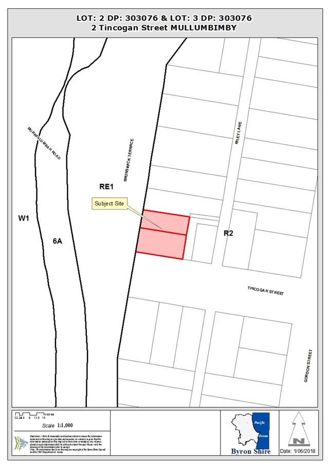
Assessment:
1. INTRODUCTION
1.1. History/Background
The site is subject to a number of previous approvals
including the following:
6.1992.2572.1 Alterations
and Additions Approved 18.11.1992
10.2003.53.1 Swimming
Pool and Carport Approved 04.03.2003
10.2003.53.2 s96
to Cond 3 requiring fence to pool Approved 18.07.2003
10.2014.736.1 Fence
within Front Setback Approved
19.01.2015
1.2. Description
of the proposed development
This application seeks approval for Stage 1: Boundary
Adjustment Subdivision to Create Two (2) Lots and Demolition of Existing
Swimming Pool. Stage 2: Alterations and Additions to Existing Dwelling House,
New Dwelling House and Studio above Existing Garage on Proposed Lot 2
Stage 1 will consist of:
Reconfiguration of two (2) into
two (2) lots
Lot 1 will command an area
of 444.5m2 with 17.5m frontage to Tincogan Street and 25.4m to
Brunswick Terrace. Access to the site will be gained via a Right of Way over
Lot 2 to the north of the site.
Lot 2 will command an area
of 391.2m2 with vehicular access to Brunswick Terrace and primary
street frontage of 13m to Tincogan Street. No vehicular access is to be gained
from Tincogan Street.
The existing pool will be in-filled to ensure there is no
boundary encroachment.
All works required to service the lots including hardstand
parking and associated driveways for proposed Lot 1 will be undertaken as part
of Stage 1. No access will be granted from Tincogan Street as there are
insufficient sightlines to enable safe egress and ingress to the site.
Stage 2 will consist of the following:
Lot 1 Alterations and additions to the existing
dwelling will include conversion of the existing closet into an en-suite and
changes to the existing bathroom layout.
Lot 2 New dwelling being a single storey
dwelling with an enclosed loft area containing a single bedroom. A studio will
be constructed above the existing garage and will consist of a toilet and large
open room with deck facing to the west. Screening will be conditioned along the
northern elevation of the deck area to protect the privacy of neighbouring
dwellings.
1.3. Description
of the site
|
Land is legally described as
|
LOT: 2 DP: 303076, LOT: 3 DP: 303076
|
|
Property address is
|
2 Tincogan Street MULLUMBIMBY
|
|
Land is zoned:
|
R2 Low Density Residential
|
|
Land area is:
|
836m2
|
|
Property is constrained by:
|
Flood Liable Land
Acid Sulfate Soils - Class 4
|
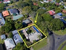

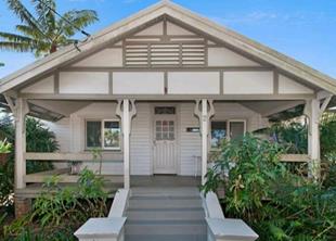
2. SUMMARY OF
REFERRALS
|
Referral
|
Issue
|
|
Development Engineer
|
No objections subject to conditions. Refer to Doc #A2017/31651
|
|
S64 / Systems Planning Officer
|
No objections subject to conditions. Refer to Doc #
A2017/31653
|
|
Heritage Consultant
|
No objections subject to conditions. Refer to Doc
#E2018/1584
|
* Conditions provided in the above referral are included
in the Recommendation of this Report below
Access and Sightlines
Access is not permitted to Tincogan Street for either lot as
there are insufficient sightlines to allow safe entry and exist manoeuvres into
the site.
3. SECTION 4.15C
– MATTERS FOR CONSIDERATION – DISCUSSION OF ISSUES
Having regard to the matters for consideration detailed in
Section 4.15(1) of the Environmental Planning & Assessment Act 1979
(EP&A Act), the following is a summary of the evaluation of the issues.
3.1 State Environmental
Planning Instruments
4.2A Byron Local Environmental Plan 2014 (LEP 2014)
LEP 2014 is an applicable matter for consideration in the
assessment of the subject development application in accordance with subsection
4.15(1) of the EP&A Act because it applies to the subject land and the
proposed development. The LEP 2014 clauses that are checked below are of
relevance to the proposed development:
|
Part 1
|
☒1.1|
☒1.1AA| ☒1.2| ☒1.3| ☒1.4| ☒Dictionary| ☒1.5| ☒1.6| ☒1.7| ☒1.8| ☐1.8A| ☒1.9| ☐1.9A
|
|
Part 2
|
☒2.1|
☒2.2 | ☒2.3 |☒Land Use Table | ☐2.4 | ☐2.5 | ☒2.6 | ☐2.7 | ☐2.8
|
|
Part 3
|
☐3.1|
☐3.2| ☐3.3
|
|
Part 4
|
☒4.1|
☐4.1A| ☐4.1AA| ☐4.1B |☐4.1C| ☐4.1D| ☐4.1E| ☐4.2| ☐4.2A| ☐4.2B| ☐4.2C| ☐4.2|☐4.3|☐4.4 |☐4.5 | ☒4.6
|
|
Part 5
|
☐5.1|
☐5.2| ☐5.3| ☐5.4| ☐5.5| ☐5.6| ☐5.7| ☐5.8|☐5.9| ☐ 5.9AA| ☒5.10| ☐5.11| ☐5.12| ☐5.13
|
|
Part 6
|
☒6.1|
☐6.2| ☒6.3| ☐6.4| ☐6.5| ☒6.6| ☐ 6.7| ☐6.8| ☐6.9
|
In accordance with LEP 2014 clauses 1.4 and 2.1 – 2.3:
(a) The
proposed development is defined in the LEP 2014 Dictionary as Subdivision,
Dwelling House and Studio;
(b) The
land is within the R2 Low Density Residential according to the Land Zoning Map;
(c) The
proposed development is Permitted with Consent; and
(d) Regard
is had for the Zone Objectives as follows:
|
Zone Objective
|
Consideration
|
|
To provide for the
housing needs of the community within a low density residential environment.
|
The proposed alterations and additions to the dwelling
house and subdivision will provide a range of housing types in the locality
and maintains the existing character of the residential area.
|
|
To enable other land
uses that provide facilities or services to meet the day to day needs of
residents.
|
Not Applicable
|
The remaining underlined clauses have been taken into
consideration in the assessment of the subject development application in
accordance with subsection 79C(1) of the EP&A Act. The proposed development
complies with all of these clauses (in some cases subject to conditions and/or
to the satisfaction of other assessing officers), except in relation to clause
which is considered further as follows:
|
What clause does the development not comply with and
what is the nature of the non-compliance?
|
Further consideration, including whether the
development application is recommended for approval or refusal accordingly
|
|
4.1 Minimum subdivision lot
size
(1) The objectives of this clause are as follows:
(a) to ensure that lot sizes are compatible with
local environmental values and constraints,
(b) to facilitate efficient use of land resources for
residential and other human purposes.
(2) This clause applies to a subdivision of any land shown
on the Lot Size Map that requires development consent and that is carried out after
the commencement of this Plan.
(3) The size of any lot resulting from a subdivision of
land to which this clause applies is not to be less than the minimum size
shown on the Lot Size Map in relation to that land.
(4) This clause does not apply in relation to the
subdivision of individual lots in a strata plan or community title scheme.
|
See assessment below.
|
4.1
Minimum subdivision lot size
Clause 4.1 of LEP 2014 is
accessible via: https://www.legislation.nsw.gov.au/#/view/EPI/2014/297/part4/cl4.1
Matters under subclause (3) are addressed as follows:
The size of any lot resulting from a subdivision of land to
which this clause applies is not to be less than the minimum size shown on the Lot Size Map in
relation to that land. In this regard the minimum lot size is 600m2.
The existing dwelling house straddles two lots with areas of
418m2 each and a combined total area 836m2. The proposal
will realign the existing boundaries of the existing 2 lots into 2 lots.
Lot 1 will command an area
of 444.5m2 with 17.5m frontage to Tincogan Street and 25m to
Brunswick Terrace. Access to the site will be gained via a Right of Way over
Lot 2 to the north of the site.
Lot 2 will command an area
of 391.2m2 with vehicular access to Brunswick Terrace and primary
street frontage of 13m to Tincogan Street. No vehicular access is to be gained
from Tincogan Street.
The Applicant has submitted a clause 4.6 variation request
(refer to Doc #S2017/21062). The clause 4.6 variation request is considered
with reference to relevant matters as follows:
a) Introduction
– Summary of proposed development
The development application
proposes a boundary realignment of two (2) lots into two (2) lots, and will result
in Lot 1 having 521m2 and Lot 2 with 314m2.
b) Clause
4.6 Exceptions to Development Standards
Clause 4.6 of Byron LEP 2014 is
accessible via: http://www.legislation.nsw.gov.au/fragview/inforce/epi+297+2014+pt.4-cl.4.6+0+N?tocnav=y
c) The
Development Standard to be varied
The development standard to be
varied is contained in LEP 2014 subclause 4.1(3), which is accessible via: https://www.legislation.nsw.gov.au/#/view/EPI/2014/297/part4/cl4.1
The Minimum Lot Size planning
control is a development standard in accordance with the applicable definition
in the Dictionary and clause 4.5 of the Environmental Planning and Assessment
Act 1979 because it is provisions of an environmental planning instrument in
relation to the carrying out of development, being provisions by or under which
requirements are specified or standards are fixed in respect of any aspect of
that development, including, requirements or standards in respect of setting a minimum lot size for any land and is not to be less than the minimum
lot size shown for the land on the Minimum Lot Size Map
d) Extent
of Variation to the Development Standard
The Statement of Environmental
Effects indicates that the existing site comprises two (2) individual lots
which command a total area of 836m2. The proposal seeks a boundary realignment
to reconfigure the existing lots into two (2) lots
Lot 1 will command an area
of 444.5m2 with 17.5m frontage to Tincogan Street and 25.4m to
Brunswick Terrace. Access to the site will be gained via a Right of Way over
Lot 2 to the north of the site.
Lot 2 will command an area
of 391.2m2 with vehicular access to Brunswick Terrace and primary
street frontage of 13m to Tincogan Street. No vehicular access is to be gained
from Tincogan Street.
The subdivision will result in Lot
1 being 25% below and Lot 2 being 35% below the minimum lot size requirements.
The proposal will however maintain
a similar subdivision alignment along Tincogan Street, whilst undersized
residential allotment’s in the Mullumbimby township are not unusual. (eg
10-14 Tincogan Street are three undersized residential lots)
e) Objective
of the Development Standard
The objectives of the development
standard are stated in LEP 2014 subclause 4.1(1) which states:
(a) to ensure that lot
sizes are compatible with local environmental values and constraints,
(b) to facilitate
efficient use of land resources for residential and other human purposes
f) Objectives
of the Zone
The objectives of the R2 Low
Density Residential Zone which applies to the location of the proposed boundary
realignment are stated in the Land Use Table to LEP clause 2.8, which states:
• To provide for
the housing needs of the community within a low density residential
environment.
• To enable
other land uses that provide facilities or services to meet the day to day
needs of residents.
g) Assessment
– the specific questions to be addressed:
(a) Clause
4.6(3)(a) – Is compliance with the development standard unreasonable or
unnecessary in the circumstances of the case?
The site currently consists of two
(2) non-compliant lots. Requiring compliance with the development standard is
unnecessary in this instance as there will be no further intensification of the
development potential of the site and will maintain the lot sizes of the
existing lots with the resultant lots each commanding an area of 444.5m2
and 391.2m2.
a. The
boundary realignment/reconfiguration is a two into two lots development.
b. There
currently exists the ability to develop a single dwelling house on each of the
existing lots, the current proposal will not increase this development
potential and will provide a better and more functional lot layout for future
dwellings on the proposed Lot 2.
c. The
lots sizes are consistent within the streetscape and character of the
surrounding low density residential area.
(b) Clause
4.6(3)(b) – Are there sufficient environmental planning grounds to
justify contravening the development standard?
The proposed realignment of
property boundaries will result in lots which maintain the subdivision lot
pattern of the Mullumbimby Conservation Area and will maintain lot sizes which
are similar in size. The layout will remove the – just a change of
alignment to the existing dividing lot boundary will remove an existing
boundary encroachment.
There are sufficient grounds to
justify the proposal on environmental planning grounds as follows:
· No reduction in
the number of lots from the current situation (2 into 2 lots)
· The development
will enable the retention of the exiting dwelling house in its current setting
on the site. (whilst ensuring the house is located on a single lot);
· The Lot sizes are
consistent with the surrounding neighbourhood which is typified with lots of
similar sizes to the current proposal;
· Given the site is
only partially located within a Flood Prone Area there will be no increase in
intensity of development as a result of this proposal.
· the proposed
reconfiguration enables the allotments to contain an building envelope
measuring 12m x 15m;
· the proposed Lot 2
is to be provided vehicular and pedestrian access to Brunswick Terrace;
· the site is
located within an existing urban area with close proximity to the Mullumbimby
business district and with a level topography, pedestrian and cycling is a
common form of transport;
· pedestrian
accessibility and service provision (garbage collection, postal services) are
able to be provided from the street frontages of the new lot;
· the existing
dwelling and structures on the proposed reconfigured allotments are able to
comply with the floor space ratio of 0.5:1.
There are
sufficient environmental planning grounds to justify contravening the
development standard.
(c) Clause
4.6(4)(a)(ii) – Is the proposed development in the public interest? Is it
consistent with the objectives of the standard and the zone as set out above?
The proposal
provides an opportunity to provide a more suitable lot layout which is capable
of contain a building envelope measuring 12m x 15m and will enable the more
efficient use of land through enabling a vacant lot of land for development
without having the existing dwelling straddling both existing lots.
The proposal
will enable the future contribution to the provision of residential housing in
close proximity to the Mullumbimby town centre whilst preserving, and
minimising impacts on, infrastructure provision and maximising utilisation of
these resources.
Further the
proposal is consistent with the objectives of the development standard and the
zone. The proposal will not create an undesirable precedent in the
circumstances given there are a number of similar developments proximate to the
site which have created similar boundary realignments.
The proposed
development is not significantly contrary to the public interest because it
will not adversely affect the welfare and wellbeing of the broader public.
The proposed lot sizes are not in accordance with Clause 4.1
of Byron LEP 2014. The development application is supported by a request for a
variation pursuant to clause 4.6 of the LEP. The circumstances of the case
warrant a more flexible approach to application of the minimum lot size given
the site currently comprises two existing lots totalling 836m2 (approx. 418m2
each lot). The common boundary of the existing lots is located directly beneath
the existing dwelling house and the proposed subdivision will remove the
existing boundary encroachment. The Applicant’s variation request is
supported and the development application is recommended for approval despite
the non-compliance.
6.1 Acid Sulfate Soils
The subject land is identified as comprising Class 4 ASS
being two metres below the surface. It is considered the potential for ASS is
highly unlikely to be disturb. Further investigation is not required.
6.3 Flood Planning
A condition has been recommended requiring the FFL to be
constructed to 5.81m AHD as the Flood Planning Level for this site.
5.10 Heritage conservation
The proposal will
retain the existing heritage item onsite in a prominent corner location and
will retain the existing landscaping to each street frontage. The application
has been assessed by Councils Heritage Advisor who has concluded:
“it is considered that the proposed dwelling is not likely
to have an adverse impact upon the significance of the existing heritage item
or the Mullumbimby Conservation Area. The proposed new dwelling is not likely
to dominate the streetscape or detract from the established character and
heritage significance of the Conservation Area.”
The
reconfiguration of 2 existing lots will retain the subdivision pattern of the
conservation area and will enhance the Tincogan Street streetscape.
4.3 Any proposed Instrument
that has been the subject of public consultation and has been notified to the
consent authority
Not Applicable.
4.4A Byron Shire Development Control Plan 2014
(DCP 2014)
DCP 2014 is an applicable matter for consideration in the
assessment of the subject development application in accordance with subsection
4.15(1) of the EP& A Act because it applies to the land to which LEP 2014
applies. The DCP 2014 Parts/Chapters that are checked below are of relevance to
the proposed development:
|
Part A
|
☒
|
|
Part B Chapters:
|
☐B2|
☒ B3| ☒ B4| ☐B5| ☐B6| ☐B7| ☒ B8| ☐B9| ☐B10| ☐B11| ☐B12| ☐B13|
☒
B14
|
|
Part C Chapters:
|
☒
C1| ☒ C2| ☐C3| ☐C4
|
|
Part D Chapters
|
☒
D1| ☐D2| ☐D3| ☐D4| ☐D5| ☐D6| ☐D7| ☐D8
|
|
Part E Chapters
|
☐
E1| ☒ E2| ☐E3| ☐E4| ☐E5| ☐E6| ☐ E7
|
These checked Parts/Chapters have been taken into
consideration in the assessment of the subject development application in
accordance with subsection 4.15(1) of the EP&A Act. The proposed
development is demonstrated to meet the relevant Objectives of all relevant
Parts/Chapters (in some cases subject to conditions and/or to the satisfaction
of other assessing officers).
|
What Section and prescriptive measure does the
development not comply with?
|
Does the proposed development comply with the
Objectives of this Section? Address.
|
Does the proposed development comply with the
Performance Criteria of this Section? Address.
|
|
B4.2.5 Car Parking Requirements
|
Yes
The single car parking space provided to Lot 1 will retain
the existing heritage values of the site, reduce the detrimental effects of
parking (visually) and will provide a single parking space onsite for future
residents. The site is also located on a corner allotment with significant
street frontage and on-street parking available in this instance.
|
Car parking is required to be provided in accordance with
Table B4.1 of the DCP which requires two spaces per dwelling. The proposal
will provide two spaces for the new dwelling on Lot 2, however the existing
dwelling will have access to a single parking space only. The single car
parking space for Lot 1 (existing dwelling) is considered acceptable in this
instance as it retains the landscape curtilage of the heritage item. Proposal
is considered acceptable in this instance.
Reciprocal rights of carriageway are proposed fro the
driveway to reduce hard stand areas for the two properties and restricts
vehicle access to a shared driveway.
|
|
C1.2.2 Assessment Requirements
(4)
|
Subdivision applications involving a Heritage Item,
located within a Heritage Conservation Area or in the vicinity of a Heritage
Item or Heritage Conservation Area.
The proposal is a reconfiguration of 2 into 2 lots which
will maintain a similar lot frontage onto Tincogan Street which will maintain
the existing and heritage streetscape of the street.
|
Yes
The proposed development will result in consistent lot
frontages along Tincogan Street which will maintain the rhythm of buildings
in the streetscape of the Heritage Conservation Area.
|
|
C1.3.3 Gardens and Landscape
|
Yes
The development will not alter the landscape corner
setting of the existing dwelling.
The proposed lot 2 and dwelling on this site will maintain
the dominance of the heritage item and will reinforce the subdivision pattern
of the street. The existing front fence will be retained and the landscaping
and gardens will not be greatly altered as a result of this development.
|
Yes
The existing dwelling retains the existing frontage
setbacks with the significance of the item being the dwelling itself and the
corner setting of the dwelling. This will not change with the reconfiguration
of the existing two lots.
The subdivision pattern will retain the existing
settlement pattern and will also compliment the rhythm of buildings in the
streetscape.
|
|
C1.4.7 Fences
|
Yes
The development will retain the exiting 1.8m high fence
along the Tincogan Street frontage of proposed Lot 2. This was previously
approved and is not part of this application.
|
Yes
Fence heights must be consistent with the heights of the
predominant fences in the street. Generally height should be 1.2m forward of
the front building setback, and 1.8m elsewhere.
The development will retain the exiting 1.8m high fence
along the Tincogan Street frontage of proposed Lot 2. This was previously
approved and is not part of this application.
|
|
C1.4.9 Subdivision
|
Yes
The development will retain the development and subdivision
pattern of the Heritage Conservation Areas including their characteristic
rhythm and spacing of the built form.
|
Yes
The allotment and building spacing, including frontage
widths, side and front boundary setbacks must not impact adversely on vistas
and views to and of heritage items and Heritage Conservation Areas.
In particular the principal elevations of buildings must
not be interrupted or obscured.
The proposal will retain the existing heritage dwelling in
its current position onsite with all main elevations being retained on the
streetscape.
The new dwelling will be retain the existing dominance of
the heritage item and will be slightly further setback than the existing
dwelling and will be of a similar scale as the heritage item and other dwellings
in the streetscape.
|
|
C1.6.1 General Policy
|
Yes
The overall intent of C1.6.1 and Chapter E3.3 is achieved
in this instance by maintaining the low rise character of the area and its
surrounds. In addition the new dwelling will be set behind the front setback
of the heritage item to reinforce the item as the significant structure on
this corner location
|
Yes
The proposed dwelling will consist of a ground floor and
mezzanine floor for the single bedroom, in this instance the number of
‘storeys’ is not as important as the overall height and scale of
the building. The existing dwelling has a ridge height of 6.2m AHD with the
proposed dwelling having a ridge height of 6.0m AHD (below the existing
dwelling) which will maintain the dominance of the heritage item in the
streetscape. The overall intent of Chapter E3.3 is achieved in this instance
by maintaining the low rise character of the area and its surrounds. In
addition the new dwelling will be set behind the front setback of the
heritage item to reinforce the item as the significant structure on this
corner location.
This is further reinforced through the eave heights which
are within 10% of the existing dwelling onsite and through the use of
appropriate roof pitches to mimic the roof form of the heritage item.
The proposed garage and studio above will have a ridge
height of 6.6m which is above the existing dwelling, however there are
existing highset dwellings to the north of the site and the proposed garage
is set at the rear of the site without dominating the streetscape.
Ridge Heights
· Existing
dwelling: 6.20m nom.
· Proposed
dwelling: 6.00m nom.
· Proposed
garage/studio: 6.60m nom.
|
|
C1.6.8
Mullumbimby Conservation Area
|
Yes
The design of the new dwelling on lot 2 the proposal will
maintain the low set, horizontal emphasis of existing buildings. As the
development will have similar ridge and eave heights of the adjoining
heritage item on Lot 1.
The design and setbacks of the new dwelling will ensure
the new development is compatible in character, height and scale with the
existing pattern of development in Tincogan Street.
|
Yes
The proposed dwelling will consist of a ground floor and
mezzanine floor for the single bedroom, in this instance the number of
‘storeys’ is not as important as the overall height and scale of
the building.
The existing dwelling has a ridge height of 6.2m AHD with
the proposed dwelling having a ridge height of 6.0m AHD (below the existing
dwelling) which will maintain the dominance of the heritage item in the
streetscape.
|
|
D1.2.1 Building Height Plane
|
Yes –
The development will not have a detrimental impact on in
terms of loss of privacy or access to sunlight for adjoining properties.
|
Yes
The proposed studio above the garage will extend into the
BHP by up to 2.3m on the northern and eastern elevations, however given the
orientation of the lots north-south the property to the east will maintain
adequate sunlight.
|
|
D1.2.2 Setbacks from Boundaries
|
Yes – Complies
|
Yes
Complies – The proposed new dwelling over Lot 2 will
be setback 7.5m to ensure that the new dwelling is subordinate to and
maintains the dominance of the heritage item in the streetscape.
All side setbacks comply with the minimum setbacks under
D1.2.2. The garage and studio will be setback 900mm from the eastern and
northern boundaries.
|
|
D1.2.5 Fences
|
Yes – Previously approved 1.8m high front fence
under 10.2014.736.1.
|
No
The site contains an existing 1.8m high fence to Tincogan
Street which was a requirement for the previous swimming pool and was
approved under 10.2014.736.1.
|
|
E3.3 Character, Bulk and Scale
of Development
|
Yes
The overall intent of C1.6.1 and Chapter E3.3 is achieved
in this instance by maintaining the low rise character of the area and its
surrounds. In addition the new dwelling will be set behind the front setback
of the heritage item to reinforce the item as the significant structure on
this corner location
|
The overall intent of Chapter E3.3 is achieved in this
instance by maintaining the low rise character of the area and its surrounds.
In addition the new dwelling will be set behind the front setback of the
heritage item to reinforce the item as the significant structure on this
corner location.
This is further reinforced through the eave heights which
are within 10% of the existing dwelling onsite and through the use of
appropriate roof pitches to mimic the roof form of the heritage item.
|
|
E3.5 Infill Development in
Precincts 2 and 3
|
Yes
The development is an appropriate form of subdivision and
infill development in accordance with E3.5 which states –
The existing subdivision pattern in Precincts 2 and 3
is dominated by long narrow lots often with houses located across two lots
with large rear yards with laneway access. These properties provide
opportunities for infill housing in the form of […]boundary adjustment
or re-subdivision
|
Yes
The proposed 2 into 2 lot subdivision is consistent in
shape and form to that of the surrounding subdivision pattern and will be
compatible with the existing housing and streetscape and will not impact on
the privacy of neighbouring dwellings.
|
The proposed development is demonstrated to meet the
relevant Objectives of DCP 2014.
4.5 Any Planning Agreement or
Draft Planning Agreement?
|
|
Yes
|
No
|
|
Is there any applicable planning agreement or draft
planning agreement?
|
☐
|
☒
|
|
|
4.6 Environmental Planning
& Assessment Regulation 2000 Considerations
|
Clause
|
This control is applicable to the proposal:
|
I have considered this control as it relates to the
proposal:
|
If this control is applicable, does the proposal
comply?
|
|
92
|
Yes
|
Yes
|
Yes
|
|
93
|
No
|
N/A
|
N/A
|
|
94
|
No
|
N/A
|
N/A
|
|
94A
|
No
|
N/A
|
N/A
|
* Non-compliances and any other significant issues
discussed below
4.7 Any coastal zone management
plan?
|
|
Satisfactory
|
Unsatisfactory
|
Not applicable
|
|
Is there any applicable coastal zone management plan?
|
☐
|
☐
|
☒
|
|
|
4.8 The likely impacts of that
development, including environmental impacts on both the natural and built
environments, and social and economic impacts in the locality
|
Impact on:
|
Likely significant impact/s?
|
|
Natural environment
|
No. The proposal will not have a significantly adverse
impact on the natural environment of the locality.
|
|
Built environment
|
No. The proposal will not have a significantly adverse
impact on the built environment of the locality.
|
|
Social Environment
|
No. The proposal will not have a significant social impact
on the locality.
|
|
Economic impact
|
No. The proposal will not have a significant economic
impact on the locality.
|
Are there any Council Policies that are applicable to the
proposed development? None
4.9 The suitability of the site
for the development
The site is a serviced, unconstrained property and is suitable
for the proposed development.
4.10 Submissions made in accordance with
this Act or the regulations
The development application was publicly exhibited. Two
submissions were received.
|
Submission
|
Comment
|
|
This development will almost completely fill the curtilage
of the property even though the DA is also asking for a boundary adjustment
from 2 lots to 2 modified lots to accommodate the new building and studio.
|
The site as
identified in the SHI Sheets of Councils Heritage Study indicate the Criteria
that the listing was based is:
The bungalow is designed in an unusual and distinctive style
with prominent front gable verandah giving the building a distinctive
character and welcome aspect to the street.
The
remainder of the physical description of the item states:
An unusual gable roof bungalow built with a wide entrance
verandah with a prominent gable roof supported on paired timber posts with
Art Nouveau inspired brackets forming a distinctive lyre shape. The house is
built a large, prominent corner block opposite Federation Bridge approach.
The
prominent corner location of the dwelling will not be altered by this
proposal and the existing dwelling is located over two existing lots.
The
proposal has been assessed by Councils Heritage Advisor who has provided the
following comments:
“it is considered that the proposed dwelling is not likely
to have an adverse impact upon the significance of the existing heritage item
or the Mullumbimby Conservation Area. The proposed new dwelling is not likely
to dominate the streetscape or detract from the established character and
heritage significance of the Conservation Area.”
In
this instance it is considered that the proposal will not have a detrimental
impact on the item or the streetscape in terms of subdivision pattern.
|
|
This proposal should be referred to the Heritage Panel for
consideration and an extension of the public exhibition time so other people
can make a submission due to holidays
|
The Heritage Panel terms of reference does not include
direct comments in relation to individual Development Applications.
|
|
The proposal is inconsistent with the low rise character
and scale of Mullumbimby.
|
The proposed dwelling will consist of a ground floor and
mezzanine floor for the single bedroom, in this instance the number of
‘storeys’ is not as important as the overall height and scale of
the building. The existing dwelling has a ridge height of 6.2m AHD with the
proposed dwelling having a ridge height of 6.0m AHD (below the existing
dwelling) which will maintain the dominance of the heritage item in the
streetscape. The overall intent of Chapter E3.3 is achieved in this instance
by maintaining the low rise character of the area and its surrounds. In
addition the new dwelling will be set behind the front setback of the
heritage item to reinforce the item as the significant structure on this
corner location.
This is further reinforced through the eave heights which
are within 10% of the existing dwelling onsite and through the use of
appropriate roof pitches to mimic the roof form of the heritage item.
The proposed garage and studio above will have a ridge
height of 6.6m which is above the existing dwelling, however there are
existing highset dwellings to the north of the site and the proposed garage
is set at the rear of the site without dominating the streetscape.
Ridge Heights
· Existing
dwelling: 6.20m nom.
· Proposed
dwelling: 6.00m nom.
· Proposed
garage/studio: 6.60m nom.
It is considered the proposal is consistent with the
character and scale of residential development in Mullumbimby
|
|
The Landscape, garden setting and curtilage area of this
heritage item is not retained.
DCP Heritage CH C1.2.2 4(d) Subdivision
Applications “settings of the heritage Item and a
satisfactory curtilage including important landscape and garden elements are
retained“
|
The existing dwelling retains the existing frontage
setbacks with the significance of the item being the dwelling itself and the
corner setting of the dwelling. This will not change with the reconfiguration
of the existing two lots.
The subdivision pattern will retain the existing
settlement pattern and will also compliment the rhythm of buildings in the
streetscape.
|
|
Second Storey buildings are not permitted in this Heritage
Conservation Area.
(DCP Heritage CH C1.6.1 (3) “developments in all
areas must remain single storey in height to maintain the visual character
and unity of the streetscape .”
|
C1.6.1 incorporates a general policy intent with further
built form intents in Chapter E3 Mullumbimby which state:
E3.3 Character, Bulk and Scale of Development
“Development Applications must demonstrate that
the character, bulk, scale and density of proposed development will be
compatible with and will enhance the low rise character and scale of
Mullumbimby”
E3.1 Aims of this Chapter
To promote compatible, innovative urban development of
a high design quality that reflects and reinforces the low rise, heritage
character and scale of Mullumbimby.
The proposed dwelling will consist of a ground floor and
mezzanine floor for the single bedroom, within the pitched roof cavity, in
this instance the number of ‘storeys’ is not as important as the
overall height and scale of the building. The existing dwelling has a ridge
height of 6.2m AHD with the proposed dwelling having a ridge height of 6.0m
AHD (below the existing dwelling) which will maintain the dominance of the
heritage item in the streetscape. The overall intent of Chapter E3.3 is
achieved in this instance by maintaining the low rise character of the area
and its surrounds. In addition the new dwelling will be set behind the front
setback of the heritage item to reinforce the item as the significant
structure on this corner location.
|
|
Notification of this DA inadequate.
|
This DA was previously exhibited from 14 December 2017 to
10 January 2018 and then re-exhibited from 25 January 2018 to 7 February
2018.
|
4.11 Public interest
The proposed development is unlikely to prejudice or
compromise the public interest or create a dangerous precedent
5. DEVELOPER
CONTRIBUTIONS
As the proposal will re-subdivide two existing residential
lots into two residential lots no additional S7.11 Contributions or Water and
sewer Levies are required.
6. DISCLOSURE OF
POLITICAL DONATIONS AND GIFTS
|
Has a Disclosure Statement been received in relation
to this application
|
No
|
|
Have staff received a ‘gift’ from anyone
involved in this application that needs to be disclosed. Where the answer is
yes, the application is to be determined by the Director or Manager of the
Planning, Development and Environment Division.
|
No
|
Provide Disclosure Statement register details here: Not
applicable
7. CONCLUSION
Development consent is sought for Stage 1: Boundary
Adjustment Subdivision to Create Two (2) Lots and Demolition of Existing
Swimming Pool. Stage 2: Alterations and Additions to Existing Dwelling House,
New Dwelling House and Studio above Existing Garage on Proposed Lot 2 located
at 2 Tincogan Street, Mullumbimby.
The re-subdivision of the land from two lots into two lots
relies upon a variation to the minimum lot size requirements of 600m2
under Clause 4.6 of Byron LEP 2014. The circumstances of the case warrant a
flexible approach to application of the minimum lot size given the site
currently comprises two existing lots of approximately 418m2 each.
The Applicant’s variation request is supported and the development
application is recommended for approval.
The proposed development is not inconsistent with the
provisions of the Byron LEP 2014 and DCP 2014 and is unlikely impact on the
existing residential amenity or heritage character of the neighbourhood. It is
recommended that the application be approved subject to conditions of consent.
STATEMENT
OF REASONS
|
Statement of Reasons
|
|
The proposed development complies with the provisions of
Byron Local Environmental Plan 2014.
|
|
The proposed development complies with relevant State
Environmental Planning Policies
|
|
The proposed development complies with relevant provisions
of Development Control Plan 2014
|
|
The proposed development complies with Environmental
Planning & Assessment Regulation 2000 considerations.
|
|
The proposed development will not have significant adverse
impact on the natural, built or social environment or economic impacts on the
locality.
|
|
The proposed development is considered suitable for the
proposed site.
|
|
The development application was notified/advertised in
accordance with Development Control Plan 2014. Issues raised in the
submissions have been addressed during assessment of the application.
|
|
The proposed development is unlikely to prejudice or
compromise the public interest.
|
|
The proposed development will not have a detrimental impact
on the heritage character of the precinct or the buildings contained on the
site. It is considered consistent with the heritage provisions contained
within Development Control Plan 2014.
|
|
How community views were addressed
|
|
The DA was advertised in accordance with Development
Control Plan 2014. The submissions received were considered on merit and
addressed during assessment of the application.
To view the considerations, please contact Council to view
a copy of the assessment report relating to this DA.
|
Staff Reports - Sustainable Environment and Economy 13.8
Report No. 13.8 Bushfire
Prone Land Mapping
Directorate: Sustainable
Environment and Economy
Report
Author: Sharyn
French, Manager Environmental and Economic Planning
File No: I2018/1122
Theme: Ecology
Planning Policy and Natural Environment
Summary:
Council considered a report at the 22 March 2018 meeting on
the revised Bush Fire Prone Land Map. The revised map includes a new vegetation category (Category 3) that
maps grassland greater than 10cm as a medium fire risk.
A number of key concerns with the mapping were reported to
Council including:
· there are large areas of grassland in
Byron Shire that are now captured in this mapping
· the
NSW Rural Fire Service (RFS) Guide maps grassland in the Shire as a medium risk
when RFS have advised that this is an exaggerated risk
· that
proceeding with the mapping will impose an additional impost on landowners
whose land is now mapped as bush fire prone when lodging a development
application for their property
· the
increased workload on Development Assessment Staff and potentially increased
turnaround timeframes as many DAs will require referral to RFS
· the
mapping potentially undermines the integrity of Council’s mapping
processes and accuracy
Due to concerns with the RFS state wide mapping methodology,
Council resolved to defer submitting the map for certification until such time
as a further meeting with RFS is held to discuss the issues identified in the
report, and a scientific justification provided for the mapping methodology
that has been applied to Byron Shire.
Council also resolved to seek ground truthing of the
category 3 grassland sites in Byron Shire by the Rural Fire Service to ensure
an evidence based Bushfire Prone Map is produced and that a further report be
provided on the resolution outcomes.
This Report tables the outcomes of
the further discussion with RFS and proposes that Council proceed with
submitting the mapping to RFS for the Commissioners certification.
|
RECOMMENDATION:
That Council submit the Bush Fire Prone Land Map
(Attachment 1 - E2018/16059) to NSW Rural Fire Services for the
Commissioner’s certification.
|
Attachments:
1 Bush Fire
Prone Land Map in accordance with RFS Guide for Bush Fire Prone Land Mapping,
Nov 2015 Version 5b, E2018/16059
2 NSW Rural
Fire Service - Grassland Deeming Provisions - Development Application in
Grassland Fact Sheet, E2018/60961
Report
Council at the 22 March 2018 meeting considered a report on the revised Byron Shire Bushfire Prone Land
Mapping and resolved:
18-189 Resolved:
1. That
Council acknowledge that there is a new vegetation category (category 3)
grassland in the Guide for Bushfire Prone Land Mapping.
2. That
due to concerns with the one size fits all approach to the mapping of category
3 grassland, Council defers the submission of the new Bushfire Prone Map (Attachment
1 - E2018/16059) to the NSW Rural Fire Service for certification, until such
time as a further meeting with Rural Fire Service is held to discuss the issues
identified in the report, and a scientific justification provided for the
mapping methodology that has been applied to Byron Shire.
3. That
as a result of 2, Council seek ground truthing of the category 3 grassland
sites in Byron Shire by the Rural Fire Service to ensure an evidence based
Bushfire Prone Map is produced.
4. That
Council receive a further report once 2 and 3 have occurred.
A meeting was held on 11 May 2018 with NSW Rural Fire
Service (RFS) representatives and the following matters were tabled:
· The
RFS have been updating bush fire prone land maps across the state to reflect
the current requirements of the National Construction Code (through Australian
Standard AS3959, Construction of buildings in bushfire-prone areas).
· AS3959
identified that grasslands greater than 10 centimetres in height needed to be
addressed and this informed the development of Category 3
· The
mapping of grasslands has resulted in an increase of land being captured as
bush fire prone
· AS
3959 is being reviewed and when adopted in 2019 it is expected to remove
uncertainty around what should be mapped as grassland. The RFS Guide for
Bushfire Prone Land Mapping version 5b November 2015 will then be revised in
line with the new Australian Standard
· The
impact on Development Applications (DAs) for properties in Category 3.
Twenty-three of the 128 NSW Councils
have been certified to the new mapping requirements. To ascertain the impact on
development application referral numbers RFS contacted certified councils that
had significant grassland areas. Responses were received from 6 Councils: Lake
Macquarie, Fairfield, Cessnock, Moree Plains, Warren, Port Macquarie
–Hastings. RFS concluded that the responses are not considered to
indicate a clear trend in the impacts of added grassland mapping on development
assessment requirements.
RFS have drafted grassland
deeming provisions for Category 3 Bushfire Prone Land with Department of
Planning and Environments input to simplify the approval process, refer to
Attachment 2. In summary dwellings with an Asset Protection Zone (APZ) of:
· 50m
won’t require bushfire protection measures
· 20m
and more that have a bush fire attack level of BAL 12.5, will require bush fire
protection measures such as access, services, landscaping and emergency
management
· less
than 20 metres will require a full site assessment to determine the bush fire
attack level (BAL) and apply all the bush fire protection measures, such as
access services, landscaping and emergency management
The grassland deeming provisions
are yet to be switched on; they are pending the publishing of the pre-release
version of Planning for Bush Fire Protection 2018. Therefore, the assessment
for grassland areas will continue to be in accordance with AS-3959 until such
time as RFS switch on the deeming provisions.
During the 2017/18 period 730
DAs were lodged with Byron Shire Council. Of these 202 applications would be
affected by Category 3 bushfire prone land. Council records are not able to
ascertain the size of these properties APZ to determine what level of
protection measures will be required under the proposed deeming provisions.
Currently most landowners won’t have to apply any protection measures,
but once the map and deeming provisions comes into effect there will be costs
to those property managers who have an APZ less than 50m.
· RFS
were amenable to ground-truthing grassland sites should specific areas be
identified in Byron Shire.
Council has a
statutory obligation to update our bush fire prone land map every 5 years. The
map (Attachment 1) has been updated in accordance with the NSW Rural Fire Services
Guide for Bush Fire Prone Land Mapping version
5b November 2015. The amount of
land in the Shire now mapped as Bushfire Prone Land has significantly increased
due to the new Category 3 grassland mapping criteria. The Bushfire Prone Land
Map is used when considering development on the land.
Should Council proceed with the mapping, additional
assessment of affected DAs will be required and this may affect assessment timeframes.
A Frequently Asked Questions document has been developed to assist landowners
and media awareness on the new mapping will be undertaken.
It is recommended that Council submit the Bush Fire Prone
Land Map (Attachment 1) to RFS for the Commissioners certification in
accordance with our statutory obligations.
Financial Implications
Council has already spent up to $10,000 in up skilling staff
through completion of the Planning for Bushfire Protection Course through
University of Technology Sydney in anticipation of the new mapping.
There will likely be additional costs to applicants when
lodging a DA for land mapped as bush fire prone as well as resultant
construction costs in these areas.
Statutory and Policy Compliance Implications
Environmental Planning and Assessment Act 1979
146 Bush fire prone land
(1) If a bush fire risk
management plan applies to land within the area of a council, the council must,
within 12 months after the commencement of this section (and before the end of
the period of every 5 years after the commencement):
(a) request the Commissioner
of the NSW Rural Fire Service to designate land (if any) within the area that
the Commissioner considers, having regard to the bush fire risk management
plan, to be bush fire prone land, and
(b) must record any land so
designated on a map.
(2) The Commissioner of the
NSW Rural Fire Service must, if satisfied that the land designated by the
Commissioner has been recorded by the council on a map, certify the map as a
bush fire prone land map for the area of the council.
(2A) The Commissioner of the
NSW Rural Fire Service may, in accordance with the regulations, review the
designation of land on a bush fire prone land map for an area at any time after
the map is certified and revise the map accordingly. The revised map:
(a) becomes the bush fire
prone land map for the area on being certified by the Commissioner, and
(b) is to be provided to the
council by the Commissioner.
(3) Land recorded for the
time being as bush fire prone land on a bush fire prone land map for an area is
bush fire prone land for the area for the purposes of this or any other Act.
(4) The bush fire prone land
map for an area is to be available for public inspection during normal office
hours for the council.
(5) In this section: bush
fire risk management plan has the same meaning as it has in the Rural Fires Act
1997.
Staff Reports - Sustainable Environment and Economy 13.9
Report No. 13.9 PLANNING
- 26.2017.6.1 Byron Bay Town Centre Planning Controls - Results of Preliminary
Community Engagement
Directorate: Sustainable
Environment and Economy
Report
Author: Rob Van
Iersel, Major Projects Planner
File No: I2018/1175
Theme: Sustainable Environment and Economy
Planning Policy and Natural Environment
Summary:
At the ordinary
meeting of 23 November 2017, Council resolved (17-599):
1. That
Planning Proposal 26.2017.5.1 (excluding that part relating to the Butler
Street Reserve) be approved by Council to proceed to gateway determination and
for public exhibition.
2. That
the balance of Planning Proposal 26.2017.5.1 (relating to the Butler Street
Reserve) and Planning Proposal 26.2017.6.1 be deferred for public consultation
including the following:
a) conducting
community information sessions and collating feedback.
b) issuing
a media release and Council website post at least two weeks prior to the first
information session to advise the community of the planning proposals with
notice of all information sessions.
3. That
following completion of the information sessions and other community
consultation, a report be received by Council, no later than the March Ordinary
meeting, with a review of the community meetings and consultation.
This report relates to items 2 and 3 of the above
resolution. It provides a detailed summary of the results of community
engagement activities undertaken in relation to Planning Proposal 26.2017.6.1,
which deals with a range of development controls applicable to the Byron Bay
Town Centre, aimed at facilitating better buildings in the town.
Resolution 17-599 also addressed proposed planning
controls relating to the Butler Street Reserve, which were primarily aimed at
permitting a bus interchange on that land. The State Government’s
project regarding the delivery of that bus interchange is no longer pursuing
Butler Street Reserve as the location for that facility. Therefore there
is no need to continue with that aspect of the Planning Proposal.
Community engagement was undertaken in relation to Planning
Proposal 26.2017.6, addressing matters of zoning, building height control, and
building design. Concurrently, potential DCP amendments were explored,
relating to further detail of building height and building design and
provisions relating to car parking controls for the Town centre. The
potential to introduce car sharing in Byron Bay was also discussed.
In relation to building height, the recommendations that
flow from community engagement strongly support the community’s
preference to limit new development to a maximum of three storeys and ensure
that new buildings reflect and preserve the character of the town.
While there was general community support for a change of
zoning from B2 Local Centre to B3 Commercial Core, there was no strong
consensus about whether that zoning should apply to the whole of the area
currently zoned B2, or to a more contracted “core”.
Similarly, there was no consensus regarding the balance between allowing
residential and/or tourism uses within the B3 zone.
There was strong support for controls that improve building
design and sustainability, particularly where they can facilitate smaller
footprint developments. There was also support for minimising car parking
in new developments and providing for car share in the centre.
The key amendments to Byron Local Environmental Plan 2014
and Byron Development Control Plan 2014, recommended from the outcomes of the
community engagement, are:
· Change the
zoning of the Town Centre from the current B2 Local Centre, to B3 Commercial
Core, and apply that zoning to the entirety of the area currently zoned B2.
Limit permitted tourist development
in the new B3 zone to hotel or motel accommodation or serviced
apartments only (backpackers accommodation would become prohibited
in the Town Centre). Shop top residential housing would remain permissible in
the B3 zone.
The change of zone will differentiate
Byron Bay from the smaller local centres of Bangalow, Brunswick Heads,
Mullumbimby, and Ocean Shores.
· Maintain the
current maximum building height at 11.5m within the LEP and introduce new
provisions within Byron DCP 2014 to clarify that the maximum height will be
three (3) storeys.
Amend Clause 4.6 of the LEP to
specify that variations to the 11.5m building height can only be considered
where the proposed building is no more than three (3) storeys.
Amend the LEP to provide that, for
flood prone land within the Town Centre, the 11.5m maximum building height is
measured from the applicable Flood Planning Level rather than natural ground
level.
· Amend the Building
Heights Map to extend the area within which a maximum height of 11.5m applies to
land bounded by Lawson Street to the south, Bay Lane to the north, Jonson
Street to the west and Middleton Street to the east.
Do not extend the 11.5m limit to any
other areas suggested in the Town Centre Masterplan.
· Introduce new
provisions within the DCP to clearly state the building height limit at 3
storeys, and to set minimum floor to ceiling heights for mixed use buildings in
the Town Centre.
· Amend the Floor
Space Ratio Map to remove the control from within the Byron Bay Town Centre.
· Amend the LEP to
introduce new clauses requiring that applications for new buildings demonstrate
Design Excellence, and that streets and laneways are activated at ground level.
· Amend the car
parking provisions within the DCP, in relation to the Town Centre, to specify a
maximum rather than minimum number of spaces for residential and / or tourist
accommodation proposed above ground level, with the option for developers to
‘opt out’ of providing any parking for those uses, in exchange for
practical measures that will provide and promote sustainable transport
alternatives. (Current parking rates will continue to be applied for
ground floor commercial uses).
The recommended DCP changes would be incorporated into a new
Byron Bay Town Centre Chapter, which will also include a Character Statement to
assist in facilitating better design for new development.
Further details and explanation of the recommendations are
outlined in the body of this report.
A draft Planning Proposal has been prepared (see Attachment
1), together with a draft DCP Chapter (Attachment 2). It is recommended
that Council resolve to send the Planning Proposal to the Department of
Environment and Planning to obtain a Gateway Determination that would allow for
the public exhibition of the Planning Proposal and draft DCP Chapter.
NOTE TO COUNCILLORS:
In accordance with the
provisions of S375A of the Local Government Act 1993, a Division is to be
called whenever a motion for a planning decision is put to the meeting, for the
purpose of recording voting on planning matters. Pursuant to clause 2(a)
under the heading Matters to be Included in Minutes of Council Meetings of
Council's adopted Code of Meeting Practice (as amended) a Division will be
deemed to have been called by the mover and seconder of all motions relating to
this report.
|
RECOMMENDATION:
That Council:
1. Forward
the Planning Proposal at Attachment 1 (#E2018/72394) to the NSW Department of
Planning and Environment for a Gateway Determination, to amend Byron Local
Environmental Plan 2014 in relation to various town planning controls
applicable to the Byron Bay Town Centre.
2. Agree
that staff can proceed to public exhibition of the Planning Proposal and
government agency consultation based on the Gateway Determination.
3. For
the purposes of community engagement, endorse the proposed amendment to Byron
Development Control Plan 2014 at Attachment 2 (#E2018/72398), to introduce a
new Chapter dealing with the Byron Bay Town Centre, to provide more detailed
design and building height controls, together with the appropriate amendments
to Part A of the DCP, and exhibit the draft Town Centre Chapter in
conjunction with the Planning Proposal.
|
Attachments:
1 Planning
Proposal v.1 - BBTC Planning Control Review - Gateway Version, E2018/72394
2 DCP
Chapter E9 Byron Bay Town Centre - Draft Exhibition Version, E2018/72398
3 Engagement
recording charts - Future Byron Planning Workshop, E2018/68568
Report
Background
The visions and suggestions put forward in the Byron
Bay Town Centre Masterplan recommend a
review and update for some existing planning controls applicable to that area.
The outcomes
from such a review, as envisaged in the Masterplan, include:
· facilitating
well designed development of appropriate height and scale, in line with
community vision;
· defining
the edges of the Town Centre 'business zone';
· protecting
the character and vibrancy of the town; and,
· easing
congestion and making the Town Centre more 'people friendly'.
In November 2017, Council resolved (17-599)
to conduct community engagement relating to the planning controls, prior to
further consideration of a formal Planning Proposal.
Community Engagement -
Background
The aim of the community engagement was to obtain input from
the community regarding key planning controls such as zoning, building height,
design and car parking.
Two community workshops were held prior to Council staff
developing a planning proposal. Notwithstanding the previous Council
report, a semi ‘blank page’ approach was adopted for the
engagement, rather than presenting a completed Planning Proposal for review and
comment.
The intention was for the community’s views and ideas
to shape the Planning Proposal.
Two workshops were held at the Byron Community Centre, with
approximately 60 attendees in total. Two workshops were held with
students from Byron Bay High School (approximately 80 students). The
community workshops were widely advertised in advance, including:
· Invitation
letters posted to Byron Bay Town Centre landowners,
· Invitation
letters hand delivered to every commercial premises in Byron Bay Town Centre,
· Media
release,
· Social
Media,
· Staff
presence at Byron Bay farmers markets on two occasions;
· Council
website, and
· Direct
emails sent to:
o Byron Residents Group
o Byron Youth Residents Group
o Arakwal Corporation
o Byron Chamber of Commerce
o Those who made submissions to
PP 26.2017.5.1
The workshops were well attended, with a diverse range of
the community present. Over the two community workshops we heard from
business owners and managers, land owners, real estate agents, architects,
urban designers, residents, solicitors, developers and councillors from both
Byron Shire and Tweed Heads.
For those who identified interest and/or expertise but were
unable to come to the public workshops, one-to-one meetings were
conducted. The Arakwal Staff and Board and the Byron Bay Guidance group
were also engaged via individual meetings.
Community Engagement -
Content
The workshops were run on a ‘World Café’
style, whereby four tables were set up, each with a topic and a table
facilitator. After an introduction, participants were invited to a table
of their choice to discuss and debate the topic.
The role of the table facilitator was not to give answers,
but to give lead in information, guide participants to stay on track and to ask
questions. Participants moved between the tables to provide input for
each of the four topics.
The individual table topics were:
· Zoning
· Building
Heights
· Design
Excellence
· Parking
The subtopics and questions for
the community relating to these topics were:
|
· Zoning of
the Town Centre
|
Where do you consider the 'core' of the Town Centre?
What uses should be prioritised
within, and outside of, this 'core'?
|
|
· Height
of Building
|
Should we retain the current
limit?
Where should the three-storey
limit apply - all of Town Centre or part of it? (specifically examining two
of the areas suggested in the Masterplan for an increase in height limit from
9.0m to 11.5m – being land at the southern end of Jonson Street,
eastern side; and land north of Lawson Street).
Should the planning controls
allow for varied roof structures to preserve historic character?
|
|
· Floor
Space Ratio
|
Is this necessary?
Can it be used to limit bulky
buildings?
|
|
· Design
Excellence
|
How can we ensure developments
are suitable for Byron Bay?
|
|
· Active
Street Frontages
|
Should we encourage shop fronts
and the like on back lanes as well as main streets?
|
|
· Ancillary
Car Parking
|
What car parking controls can be
used to limit the number of cars in town to reduce congestion?
|
|
· Car
Share
|
What is it? Should we introduce
this to Byron Bay?
|
Community Engagement –
What We Heard
A detailed ‘download’ of all comments captured
at the two community workshops and the Byron High School session is contained
in Attachment 3. The key responses from participants are summarised
below.
1. Zoning
Currently, Byron Bay Town Centre is zoned B2 Local Centre,
which is applicable to the area shown in Figure 1 (below).
Figure 1: Extent of
existing B2 zone
Change of zone:
The B2 Local Centre zone is also applicable in Bangalow,
Brunswick Heads, Ocean Shores and Mullumbimby.
To reflect the position of Byron Bay as the primary commercial
centre in the Shire, and to ensure that changes made regarding permissible land
uses in Byron Bay do not affect the other town centres, it was suggested that
the zoning of the Byron Bay Town Centre be changed from B2 Local Centre to B3
Commercial Core.
The B3 zone, while ‘available’ as part of the
Standard Template LEP, has not yet been used in Byron Shire. Introducing
it for the Byron Bay Town Centre would allow Council to specify permitted
development for the town to guide desired outcomes, particularly relating to
residential and tourist uses (see further detail below).
The objectives of the B2 and B3
zones, as outlined in the Standard Template LEP, are very similar.
Council is able to add to these objectives, and it is recommended that the
following be added as an objective of the (new) B3 zone:
To encourage a vibrant centre by permitting residential
accommodation, serviced apartments and hotel or motel accommodation above
commercial premises and community uses, as part of a mixed use development.
A majority of the workshop participants support the change
to B3 Commercial Core.
Extent of zone:
Currently, the Town Centre is defined by the extent of the
B2 zone, as shown in Figure 1 (above).
Many workshop participants noted that the southern end of
Jonson Street, in its current form, is not fully commercial in nature, and has
a character quite different to the area to the north.
A number of participants expressed the view that the B3
zoning should only apply to the northern part of the town, from the beach
front, with suggestions down to locations between Marvel Street and Kingsley
Street as the southern cut-off. It was suggested that the southern
precinct could be zoned B4 Mixed Use or R3 High Density Residential.
These suggestions were based on existing character and
conditions. When prompted to take a more strategic, longer term view, it
was generally recognised that changing the zoning boundary is not such a clear
cut decision and many participants remained undecided (although it is noted
that others remained of the view that the southern precinct should not be part
of a Commercial Core).
Interestingly, the high school students agreed that the B3
zoning should encompass the current boundaries, noting, however, that more
should be done to encourage the southern precinct to develop to be more like
the northern area, with public transport and pedestrianisation helping to link
the town.
Permissible land uses:
Participants were also asked to consider the land uses that
should be prioritised within the B3 zone, particularly in respect to
residential and/ or tourist accommodation uses of upper levels (retail and
commercial should be at ground floor).
There were mixed views within the community whether either
of these uses should be restricted or whether a mixture of both should be
encouraged throughout the town. The idea of ensuring that buildings are
well designed to be flexible enough to change between office and/or residential
and/or tourist accommodation in the future was valued.
2. Building
Height
Maximum building height:
The Town Centre Masterplan showed strong support for a
maintaining a three (3) storey height limit in the Town Centre.
Byron LEP 2014 sets the maximum building height at 11.5m for
the majority of the town, as shown below in Figure 2. This is based on
the State Government’s “standard template”, which does not
allow building heights to be controlled in storeys; stipulating instead that it
be controlled by a measurement in metres above existing ground level, or a vertical distance from the Australian
Height Datum to the highest point of the building.
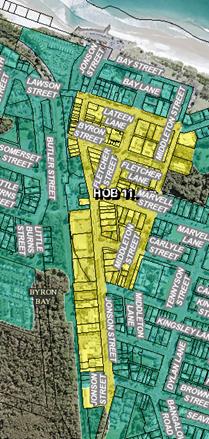
Figure 2: Height of
Buildings Map
An important
aspect of building height relates to the internal floor to ceiling heights for
each of the storeys. Appropriate floor to ceiling heights ensure flexible
spaces at ground level and comfortable, liveable and sustainable interiors, by
maximising natural ventilation and lighting.
State guidelines suggest the
following:
· Ground floor,
floor-to-ceiling height: 4.0m
· Upper floors,
floor-to-ceiling height: 2.7m, with a suggestion that first floors be increased
to 3.3m floor to ceiling, to maximum future flexibility of use.
Allowing for these recommended
minimum floor to ceiling heights, a three-storey building can comfortably fit
within the current 11.5m height limit.
Assuming an
allowance of 300mm for floor thickness between levels, these guidelines provide
for:
|
Ground floor:
|
4.0m
|
|
|
ceiling
|
0.3m
|
|
|
First Floor:
|
3.3m
|
|
|
ceiling
|
0.3m
|
|
|
Second floor:
|
2.7m
|
|
|
|
10.6m
|
to ceiling of top floor
|
Currently, however, controls
setting minimum ceiling heights are not in either the LEP or DCP.
Currently, therefore, a four-storey building can be proposed, meeting the
maximum 11.5m maximum height, but with compressed floor to ceiling heights
(Building Code of Australia suggests 2.4m as minimum).
A second potential issue relates
to roof form. Complying with the recommended minimum floor to ceiling
heights and providing a hipped roof, similar to some of the key historic
buildings in Byron Bay, cannot be achieved within the 11.5m limit.
Potentially, therefore,
maintaining the 11.5m maximum could lead to a majority of new buildings with
flat or skillion roofs.
Support for a maximum of 3 storeys within the Town Centre
was a strong response from the majority of participants at the community
workshops and at individual meetings.
The Department of Planning and Environment has, to date,
advised that Councils are not able to establish building height limits within
an LEP based on the number of storeys. Given this, participants were
asked to consider what the maximum building height in metres should be.
There was no real consensus around this. Some
participants indicated support for an increase to12.5m to allow for variety in
roof forms, as long as there were strong design and development controls.
Others believed that the extra 1m is neither important, necessary nor worth the
potential risk of the 12.5m then being ‘pushed’ with the result of
even higher buildings.
While roof features were felt to be important for the
character of the town, the preference for retaining 3 storeys seemed to
outweigh the desire to move to 12.5m and risk taller buildings.
The majority of participants, however, did agree that, if
the State Government could not be convinced to allow an LEP control expressed
in storeys, the DCP should strongly state the limit of 3 storeys as well as the
recommended minimum floor to ceiling heights.
Others suggested that the 11.5m maximum should remain, with
a provision stipulating that a breach of that limit would only be considered
for a character roof structure, providing the resultant building is no more
than 3 storeys. This suggestion seemed to be favourable amongst most
participants.
The high school students were tasked with an activity to be
developers, some with the instruction to make money and push controls, and
others with the goal of fitting in to the Byron landscape. Interestingly,
10 of the 12 designs included buildings to the maximum height, with flat roofs
and many with some sort of roof structure such as greenhouse, green roof or
pool.
Potential extension of
area subject to 11.5m maximum height:
The Town Centre Masterplan
included a suggestion to expand the area subject to the existing 11.5m building
height maximum, as shown in the extract below:
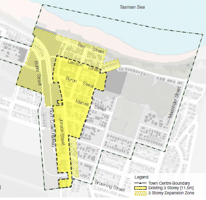
For the purposes of this review of planning controls, the
only areas examined for potential height increase were:
1. North
of Lawson Street to Bay Street, between Jonson and Middleton Streets; and
2. Southern
end of Jonson Street – east side.
Both of these areas are currently subject to a 9.0m maximum
building height.
North of Lawson Street
Current control (green = 9.0m
max; yellow = 11.5m max)
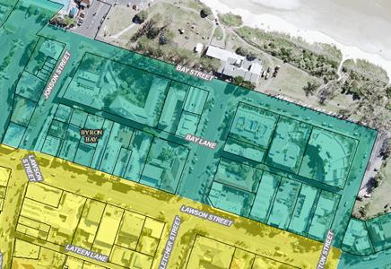
The reason for a lower building height in this area is to
minimise impact of taller buildings on the beachfront. This remains a
valid planning objective.
Existing ground levels throughout
this area are shown in the survey plan extract below:
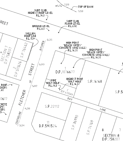
Existing ground levels slope up from the beachfront to Bay
Street, and then fall toward the south, from Bay Street toward Lawson
Street. Based on the Fletcher Street ground levels shown in the survey, a
two-storey building fronting Bay Street, built to the maximum 9.0m limit, would
have a maximum elevation at around Bay Lane of approx. RL 15.0m AHD.
A three-storey building located between Bay Lane and Lawson
Street, built to the 11.5m limit, would have a maximum elevation of between RL
16.5m AHD toward Bay Lane and RL 15.5m at Lawson Street.
Given that elevations at the beachfront are around RL 7.0m
AHD, three-storey buildings located between Lawson Street and Bay Lane would
not be visible from the beachfront, as illustrated below:
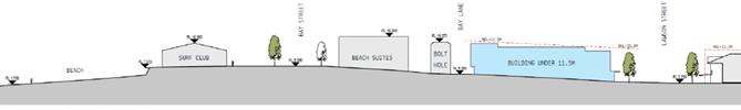
Most people at the community workshops were satisfied that
the building height could be increased in this area, from 9.0m to 11.5m, but
were of the view that the 9.0m limit should remain in place north of Bay Lane.
Southern end of Jonson Street
Current control (green = 9.0m
max; yellow = 11.5m max)
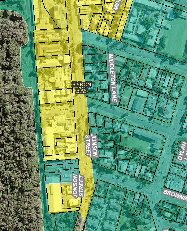
Currently, the 9.0m maximum building height applies on the
eastern side of Jonson Street, from Kingsley Street south. This area is
currently zoned the same as land on the western side of Jonson Street - B2
Local Centre, and is recommended to be included within the new B3 zone.
The majority of participants at the workshops were of the
view that, because this area borders residential land, retention of the 9.0m
height limit was appropriate.
3. Design
Excellence
The community workshops had two components for this
topic. The first was to identify the key characteristics of the Town
Centre (particularly focussing on built form), and the second was to suggest ways
in which Council could develop design controls to maintain and enhance those
characteristics.
The key characteristics valued by the participants at the
workshops were:
· Natural
feel, including landscaping;
· Traditional
roof forms;
· Variety of
built form;
· Active
spaces that enable human interaction, busking etc; and
· Good
pedestrian access.
Participants were generally in support of controls that
enforce design excellence for new buildings, addressing design for our climate
and variety within the built form. Many suggested that a Town Centre
specific DCP should be developed.
Within design excellence the community also discussed the
concept of active street frontages. In particular, participants were
asked whether ground floor components of new buildings should provide active
frontage to laneways as well as the primary street frontages.
Overwhelmingly the concept and encouragement of active
street frontages was supported, with part of the community believing it should
be applied to all streets and lanes and others believing some laneways, or
sides of laneways, should be exempt due to access issues.
4. Parking
As noted earlier, reducing congestion and ensuring Byron Bay
can be a people friendly Town Centre was a key priority from the
Masterplan.
A suggestion explored at the community workshops was to
amend car parking requirements for new development in the Town Centre by:
· reducing the
number of parking spaces required for the residential and/ or tourist
accommodation components of mixed use (re)developments; and
· specifying this
reduced number of spaces as a maximum requirement, rather than a minimum
number as currently required; and
· providing an
opportunity for development to ‘opt out’ of providing any on-site
parking for those components of a mixed use building (Note: parking would still
be required for commercial or retail building components).
The ability to ‘opt out’
would be subject to the submission of a Sustainable Travel Plan where the
developer would outline commitments to alternative travel options for the
development, such as car share spaces, bicycle parking and associated
facilities, or other modes of transport that would succeed in reducing the use
of cars in the Town Centre.
Some participants were not in favour of the suggested
change; the reasons given:
· Personal
resistance to letting go of private car usage; and
· Concern that
they would no longer be able to find parking in the town.
However, a majority of participants were in favour of the
change and believed that the change should be done as soon as possible.
Many also noted that this step on its own will not make enough of an impact and
would like to see further actions to parking and the ability to drive in the
town.
When questioned on what it is that the community would want
alongside this change and from development proposals in exchange for less
parking, a range of suggestions were identified, including public transport,
park and ride facilities, and improved infrastructure.
It was also suggested that new development should provide
car and/or bike sharing facilities/infrastructure, safe bicycle storage,
motorcycle/scooter parking, contribution to electric car parking points.
Recommendations
A draft Planning Proposal has been prepared based on the
responses to the community engagement (Attachment 1).
The following table summarises the suggested clauses and
provides commentary.
|
Recommendation
|
Comments
|
|
Zoning
|
|
|
1. Amend
Land Zoning Map by altering the area within the Byron Bay Town Centre
currently zoned B2 Local Centre, to B3 Commercial Core.
|
The B3
Commercial Core zone will differentiate Byron Bay from the smaller local
centres of Bangalow, Brunswick Heads, Mullumbimby, and Ocean Shores in Byron
Shire.
|
|
2. Add
the new B3 Commercial Core land use table and zone objectives into the LEP
|
The key difference, in terms of permitted land uses,
between the recommended B3 zone and the current B2 zone is:
· Options of tourist and
visitor accommodation are restricted, with only hotel or motel
accommodation or serviced apartments permissible in the B3 zone (backpackers’
accommodation and bed and breakfast accommodation are currently
permissible in B2, but would become prohibited in the Town Centre); and
Residential accommodation, in
the form of shop-top housing and/ or boarding houses, remain
permitted with development consent, with other forms of residential
accommodation, such as residential flat buildings or multi dwelling
housing, prohibited. This does not change with the introduction of
the new zone.
|
|
3. Amend
various provisions of the LEP, which currently reference the B2 zone, to
include a reference to the new B3 Commercial Core zone.
|
Clause 6.7 Affordable housing in residential business
zones will be updated to include a reference to the new B3 Commercial
Core zone, as will relevant items within Schedule 2 Exempt Development.
|
|
Building Height
|
|
|
LEP:
|
|
|
1. Maintain
the current maximum building height
|
It is recommended that the
current maximum building height of 11.5m be maintained. 11.5m reflects
the community’s desire for a maximum of 3 storeys. 11.5m can
comfortably allow 3 storeys, and the DCP will set parameters for the internal
floor-to-ceiling heights.
|
|
2. Amend
the Building Heights Map to extend the area within which the maximum height
of 11.5m applies to land bounded by Lawson Street to the south, Bay Lane to
the north, Jonson Street to the west and Middleton Street to the east.
|
Given existing topography, a 11.5m building on the
southern side of Bay Lane would not be visible from the beach above the 9m
buildings on Bay Street. Extending the building height map northwards
to Bay Lane will mean that both sides of Lawson Street will now have 11.5m
building height maximums. As Lawson Street is a principle street in the
Town Centre, it is expected that having buildings of 11.5m on either side
would create a streetscape to reflect its prominence.
|
|
3. Add
a new clause for development on flood prone land, providing that building
height can be measured from the flood planning level, rather than from
existing ground level.
|
Parts of the Byron Bay Town centre are flood prone.
In those areas, new development must achieve a specified minimum ground floor
level, to reduce the impact of flooding on occupiers of buildings.
The required minimum floor level,
called Flood Planning Level, is derived from a detailed flood
study of the Belongil Creek catchment. The adopted level accounts for
longer term sea level rise.
The result is that, for areas
within the Town Centre that are flood prone, ground floor levels will need to
be set above existing ground levels (varying from 0.4 - 1.2m). As the
definition of building height is based on existing ground levels, development
in these flood prone areas is unreasonably restricted.
A new clause is therefore
proposed to be added to LEP 2014 to address this, by providing that, in these
cases, building height can be measured from a specified Australian Height
Datum (AHD) level, rather than from existing ground level. A new
Building Height Allowance Map is proposed, which will specify the applicable
AHD levels across the flood prone parts of the Town Centre. The AHD
levels shown on the Map will be the Flood Planning Levels derived from the
Belongil Creek flood study.
|
|
4. Amend
Clause 4.6 to ensure building height can only be varied where the building
contains no more than 3 storeys.
|
Clause 4.6 allows a development application to vary
controls within the LEP. The intention of amending this clause is to
ensure that the maximum building height control cannot be varied, and
breached, unless the building maintains only 3 storeys. This
reinforces the importance of a maximum 3 storeys while also allowing for
varied roof structures.
|
|
DCP:
Within a new Byron Bay Town
Centre Chapter, specify:
|
|
1. A
maximum building height not exceeding 3 storeys; and
|
The new DCP chapter will prescribe a maximum of 3 storeys
for all development, new and renewal, within the Town Centre. This is
reflective of the character of the town and the community’s strongly
held view.
|
|
2. Minimum
floor to ceiling heights, measured from finished floor level to finished
ceiling level, of:
Ground Floor: 4.0m
First Floor: 3.3m
Second Floor: 2.7m
|
Internal floor to ceiling heights will assist in the
maintenance of 3 storey buildings. Internal floor to ceiling heights will
also assist in high quality building design by creating flexible spaces for
ground and first floors, as well as comfortable habitable spaces which are
less reliant on artificial lighting and ventilation.
|
|
Floor Space Ratio
|
|
|
1. Removal
of Floor Space Ratio from the LEP.
|
Floor Space Ratio is the ratio of
the gross floor area of a development to the site area, expressed
as a factor of 1. For example, a development with a gross floor area of
200m2 on a site with an area of 400m2 would have an FSR
of 0.5:1.
FSR’s are shown on the
Floor Space Ratio Map, with the associated control established at Clause 4.4
of Byron LEP 2014.
The Floor Space Ratio Map
currently shows an FSR of 1.3:1 as applicable for the Town Centre.
Unlike design controls for
building height envelope, building alignments, setbacks, privacy distances,
roof forms or landscaped areas, a maximum FSR is a poor planning mechanism
for achieving built form when the objective is to conserve and enhance
character and local amenity.
It is more appropriate in low
density residential areas, to encourage private open space and lower building
heights.
FSR unintentionally results in
stacking of building mass in a smaller part of a site and a dominance of at
grade parking in vacant spaces between buildings.
|
|
Additional Local Provisions
|
|
Add new Local Provisions to Part
6 of the BLEP2014, addressing:
1. Compatible
mixed use development in B3
2. Design
Excellence
3. Active
Street Frontages
|
1. Compatible
mixed use development
Residential development in the
Town Centre is restricted to shop top housing (this would not change
with a new B3 zone)
The Standard Template definition
of shop top housing is:
one or more dwellings located above ground floor retail
premises or business premises
The intention is to ensure that
ground floor development within the Town Centre remains retail/ commercial in
nature.
However, the definition is
restrictive in that such housing can only be considered above retail or
business premises.
The new clause proposes to allow
residential development above a wider range of uses, including Child care
centres; Commercial premises; Community facilities; Educational
establishments; Information and education facilities; Medical centres; and
Public administration building, all of which are permissible land uses in
the B3 zone.
2. Design
excellence
The new provision will require
that all new development or substantial additions to existing development
will need to be designed to meet a number of stated requirements, relating to
sustainability and consistency with existing character.
This draft clause responds to the
Department of Planning and Environment’s push for a design led approach
to developing policy that acknowledges and protects local character.
3. Active
street frontages
This is a model clause prepared
by the Department of Planning and Environment, aimed at providing active,
people-oriented streets within town centres.
It will introduce a new map into
the LEP identifying streets and lanes in the Town Centre where the new
provision will apply.
The clause will require that the
ground floor of proposed buildings facing the identified street or laneway is
used for the purposes that will result in pedestrian movement in and out of
the building (e.g. uses such as child care centres; commercial premises;
community facilities; educational establishments; information and education
facilities; medical centres; or public administration buildings)
|
|
Ancillary car parking
|
|
|
LEP & DCP
|
|
|
Introduce a new provision to identify the maximum number
of ancillary car parking spaces that may be provided to service particular
land uses as a part of a mixed use development within B3 zone.
|
The primary objective of the new clause is to minimise the
amount of vehicular traffic generated because of new development in the Town
Centre.
The provisions will relate only
to the residential and/or tourism accommodation components on mixed use
development in the Town Centre, and specify a maximum provision of parking
as:
· Shop
to Housing:
1 space per unit, plus
1 visitor space per 5
dwellings
· Hotel
or motel accommodation or serviced apartments:
1 space per unit, plus
1 space for an on-site
manager.
Given that these are maximum
requirements, it will be possible for a developer to ‘opt out’ of
providing any on-site parking spaces for these uses.
In that case, the new provisions
will require the submission of a Sustainable Travel Plan which outlines the
provisions to be provided within the development to address the transport
needs of future occupants.
It is expected that these
provisions would include a combination of things, such as bicycle parking,
car share arrangements, etc.
|
In addition to these provisions, it is recommended that
the amendment to the DCP be undertaken by way of a new Byron Bay Town Centre
Chapter (Attachment 2). This new Chapter would outline the desired future
character for the Town Centre, and include a range of development controls to
manage uses, street character, built form, car parking and the like.
Summary
and conclusions
The
attached Planning Proposal seeks to rezone land and introduce development
standards and local planning provisions for the Byron Bay Town Centre to
implement the strategic objectives of the Town Centre Masterplan.
The proposals will have positive
social and economic effects by offering additional employment and trading
opportunities for local people and businesses. Numerous social and
economic benefits are likely through increasing the efficient use of
developable lands for jobs and mixed used development including housing in an
existing centre.
The
proposed zoning changes are consistent with the North Coast Regional Plan 2036 and Council’s
Community Strategic Plan 2028. The land
is identified as an existing urban area. An assessment of the planning proposal indicates that it is
consistent with relevant SEPPs. It is consistent with all relevant s117
Directions.
There is sufficient information to enable Council to
support the planning proposal and forward it to the Department of Planning and
Environment for a Gateway determination.
Financial Implications
Should Council resolve to progress the Planning Proposal, it
would require Council commitment for staff resources and any costs associated
with community engagement and additional studies, if required by Gateway.
Statutory and Policy
Compliance Implications
The relevant policy considerations are addressed above and
would be further assessed in consideration of the Planning Proposal should
Council resolve to proceed to Gateway.
Staff Reports - Sustainable Environment and Economy 13.10
Report No. 13.10 PLANNING
- 26.2017.5.1 Planning Proposal to activate the Rail Corridor Byron Bay: Post
Exhibition Report
Directorate: Sustainable
Environment and Economy
Report
Author: Rob Van
Iersel, Major Projects Planner
File No: I2018/1408
Theme: Sustainable Environment and Economy
Planning Policy and Natural Environment
Summary:
At the ordinary meeting of 23 November 2017, Council
resolved to exhibit a Planning Proposal to activate the rail corridor within
the Byron Bay Town Centre (17-599).
That Proposal sought an amendment to the Byron LEP 2014 to
enable a range of land uses on that land, including community uses and certain
retail and office uses. The Planning Proposal (26.2017.5.1) was publicly
exhibited in March 2018 and attracted 6 submissions of objection.
The Planning Proposal was amended to remove reference to the
commercial uses, and reported to the ordinary meeting of 24 May 2018, where
Council resolved to seek an amended gateway to allow for the public exhibition
of the amended Planning Proposal (18-298).
The amended Planning Proposal was publicly re-exhibited from
Thursday 12 July, until Friday 3 August 2018. Three submissions of
objection were received, two from individual community members (Attachment 2)
and one from the Heritage Division of the Office of Environment and Heritage
(Attachment 3).
A further submission was received from NSW Rural Fire
Service, with recommendations regarding future management of bush fire risk
(Attachment 4).
The community objections relate to the flexibility of the planning
proposal in allowing for ‘community use’, particularly relating to
land uses potentially allowed under the definition of ‘community
facility’. The objections also opposed allowing commercial
activities of any sort within the old Station building.
The Planning Proposal provides that development consent may
be granted to community facilities in the wider corridor and in the Station
building. In the case of the Station building, the clause specifies that
such a use could include “a commercial activity undertaken by a
not-for-profit organisation or social enterprise”.
Any proposed future uses would be subject to a Development
Application process, which would include public exhibition. Council also
has control as the holder of the licence over the land.
The concerns expressed, therefore, can be adequately
managed.
The Heritage Division of Office of Environment and Heritage
(OEH) have advised that they do not support the Planning Proposal at this
stage, recommending that it be put on hold pending completion of a Conservation
Management Plan (CMP) for the corridor, which is listed as a State Heritage
area.
Work on the preparation of the CMP has commenced, and is
anticipated to take up to 2-3 months to complete.
Any use of this State Heritage listed area will require, in
addition to planning approvals, approval under S60 of the Heritage Act 1977,
with OEH the approval authority. The completed CMP will provide the
framework for such approval, which will not be able to be granted in the absence
of the CMP. The proposed amendment to the LEP has no effect on this.
It is considered that the proposed amendment to the LEP can
continue at the same time as the CMP process, rather than needing to wait until
that Plan has been completed and approved.
It is recommended, therefore, that Council resolve to
proceed with Planning Proposal 26.2017.5.1, as exhibited, and advise the
Department of Planning and Environment that the comments of OEH should be
noted, but that the proposed amendment should not be delayed by the CMP
process.
NOTE TO COUNCILLORS:
In accordance with the
provisions of S375A of the Local Government Act 1993, a Division is to be
called whenever a motion for a planning decision is put to the meeting, for the
purpose of recording voting on planning matters. Pursuant to clause 2(a)
under the heading Matters to be Included in Minutes of Council Meetings of
Council's adopted Code of Meeting Practice (as amended) a Division will be
deemed to have been called by the mover and seconder of all motions relating to
this report.
|
RECOMMENDATION:
That Council:
1. Forward
Planning Proposal 26.2017.5.1 to amend Byron LEP 2014, as exhibited and
included at Attachment 1 (E2018/72385) to this report, to the Department of
Planning and Environment requesting that a draft LEP be prepared.
2. Advise
the Department of Council’s view that the proposed amendment to Byron
LEP 2014 should proceed despite the objection raised by the NSW Office of
Environment & Heritage given that the amendments proposed do not impact
on the need for future development to obtain approvals under the provisions
of the Heritage Act 1977.
|
Attachments:
1 Planning
Proposal (as exhibited) - without Annexures, E2018/72385

2 26.2017.5.1
Community Submissions, E2018/70818
3 NSW Office
of Environment & Heritage, Heritage Division Submission, E2018/67615
4 NSW Rural
Fire Service Submission, S2018/10901
Report
At the ordinary
meeting of 23 November 2017, Council resolved (17-599):
1. That
Planning Proposal 26.2017.5.1 (excluding that part relating to the Butler
Street Reserve) be approved by Council to proceed to gateway determination and
for public exhibition.
2. That
the balance of Planning Proposal 26.2017.5.1 (relating to the Butler Street
Reserve) and Planning Proposal 26.2017.6.1 be deferred for public consultation
including the following:
a) conducting
community information sessions and collating feedback.
b) issuing
a media release and Council website post at least two weeks prior to the first
information session to advise the community of the planning proposals with
notice of all information sessions.
3. That
following completion of the information sessions and other community
consultation, a report be received by Council, no later than the March Ordinary
meeting, with a review of the community meetings and consultation.
(Ndiaye/Richardson)
The Planning Proposal sought an amendment to the Byron LEP
2014 to enable a range of land uses on that land, including community uses and
certain retail and office uses. These commercial provisions were aimed at
enabling small innovative local businesses to become established, as start-up
projects, in the Town Centre.
The Proposal was publicly exhibited in March 2018. It
received 6 formal submissions of objection. Additional objections were
expressed by the Byron Bay Town Centre Masterplan Guidance Group. The
objections were all centred on the proposal to enable commercial use of the
railway corridor, and most expressed the view that this would lead to unfair
competition in relation to existing businesses in the Centre.
Based on these objectives, the Planning Proposal was amended
to remove the proposed amendments relating to commercial uses of the wider
corridor. The remaining proposals sought to amend the LEP to allow community
facilities and information and education facilities to be
considered, subject to development consent, within the wider corridor. It
included a provision that development consent may be granted to development of
the Station Building, previously used as a ticketing office for the rail
station, and the adjacent railway platform, for the purposes community facility
that includes a commercial activity undertaken by a not-for-profit organisation
or social enterprise.
The amended Proposal was reported to Council at the May
ordinary meeting. At that meeting, Council resolved (18-298):
1. Forward
the revised planning proposal (Attachment 1) to the NSW Department of Planning
and Environment to advise of the re-exhibition.
2. Agree
that staff can proceed to public exhibition of the planning proposal and
government agency consultation, based on any subsequent advice from the NSW
Department of Planning and Environment, and report back to Council as part of
post-exhibition reporting.
The amended Proposal was publicly re-exhibited from Thursday
12 July, until Friday 3 August. Three submissions of objection were
received, two from individual community members (Attachment 2) and one from the
Heritage Division of the Office of Environment and Heritage (Attachment
3).
A further submission was received from NSW Rural Fire
Service, with recommendations regarding future management of bush fire risk
(Attachment 4).
The community objections expressed concerns regarding the
flexibility of the planning proposal in allowing for ‘community
use’. The objections also opposed allowing commercial activities of
any sort within the old Station building.
Byron LEP defines community
facility as:
a building or place:
(a) owned
or controlled by a public authority or non-profit community organisation, and
(b) used
for the physical, social, cultural or intellectual development or welfare of
the community,
but does not include an
educational establishment, hospital, retail premises, place of public worship
or residential accommodation.
Information and education facility means:
a building or place used for providing information or
education to visitors, and the exhibition or display of items, and includes an
art gallery, museum, library, visitor information centre and the like.
At this time, Council does not have any specific proposals
for the use of the rail corridor, other than concept plans for landscaping,
removal of existing fences, and the provision of west to east pedestrian
pathways connecting Butler Street to the Town Centre.
The LEP definitions of community facility and information
and education facility were chosen as they provide for future proposals
that might allow the use of the space for a range of community, cultural and
educational uses of the space, to benefit the wider community and facilitate
the activation of what is currently an unused space.
Any specific future proposals would be subject to the
development application process. The proposed amendment to the LEP merely
facilitates that process, allowing proposals to be considered.
It is also noted that Council retains control over the land
as the holder of the licence for use of the space, effectively acting as land
owner in that regard. In that capacity, Council can therefore determine
whether specific proposals proceed to development application.
It is considered, therefore, that there is sufficient
control in place to address the concern expressed.
The Planning Proposal provides, by way of a new Local
Provision within Byron LEP 2014, development consent may be granted to
community facilities in the wider corridor and in the Station building.
In the case of the Station building, the clause specifies that such a use could
include “a commercial activity undertaken by a not-for-profit
organisation or social enterprise”.
Objections have been submitted to this provision, amongst
other things, that it does not guarantee sufficient social outcomes and that
there remains strong potential to impact on existing local business.
One submission strongly suggests that Council consider use
of the building for a Byron Bay museum, arguing that:
1. A
building that informed and celebrated the local history would be entirely
suited to this historic precinct and would be a way to help preserve the area's
historical bounty. It would be an invaluable local educational resource and
could house a genealogy facility.
2. A
museum would be consistent with the aim of making Railway Park a community and
family friendly area and would be a valuable addition to the range of uses and
attractions of the park.
3. With
the right controls on activities a museum would enhance rather than threaten
local trade. Admission and other charges could be used to maintain the
building.
4. It
could be part of broadening Byron Bay's profile, catering to a more diverse
tourist trade.
5. It
is possible that a museum, with the right adaptations and retractable/removable
enclosure of the platform area (eg cafe blinds) could also provide an
additional community and cultural facility.
The Planning Proposal, as currently drafted, would allow
such a use, subject to development consent.
Other objections are summarised and addressed in the table
below:
|
Concern
|
Comment
|
|
The objective of the Planning Proposal is to facilitate
future actions as recommended in the Town Centre Masterplan – the
objector does not accept the validity of the Masterplan or the extent of
community support for its implementation.
|
The Masterplan has been adopted by Council.
|
|
Relocation of markets is no longer required, therefore
such commercial activity should not be pursued for the rail corridor.
|
Temporary relocation may be required during construction
of the Butler Street Bypass.
|
|
The proposal eliminates the sites future use for rail
transport.
|
Any use, landscaping or activity will be designed to
retain the potential to use the corridor for rail transport.
|
|
The proposal eliminates the station building from use as
servicing future rail transport
|
Council, in considering potential future uses, would be
mindful of this concern.
|
|
There is no identification of actual proposed use of the
station building.
|
Council has not determined a use for that building at this
time.
|
|
The proposal to allow single
one-off events and ceremonies on public reserves and roads is not supported
as these matters should be subject to development assessment and public
notification processes.
|
Entertainment and events on public roads are currently
exempt development in the LEP. The proposed amendment merely provides
greater certainty about the nature of events and extends the exemption to
other public land.
|
|
The proposed developments have not demonstrated compliance
with the site’s heritage listing.
|
Any proposed uses of the rail corridor, which is part of a
State listed heritage area, would be subject to approvals under the Heritage
Act, in addition to planning approval. Nothing in this proposed amendment
removes that process.
|
|
The existing Conservation Management Strategy does not
account for endangered and critically endangered species that inhabit
adjacent vegetation.
|
The Conservation Management Strategy relates to European
Heritage only. Notwithstanding, the Planning Proposal specifically
excludes the area of high environmental value vegetation within the rail
corridor. As such, the amendments proposed would not facilitate any use
within that area.
|
|
Allowing Concept Landscape Plans to be implemented without
consent removes the community’s ability to review and comment on
detailed construction plans.
|
Notwithstanding this provision, Council can choose to seek
input into landscape plans if it chooses.
|
The Heritage Division of Office of Environment and Heritage
(OEH) have advised that they do not support the Planning Proposal at this
stage, recommending that it be put on hold pending completion of a Conservation
Management Plan (CMP) for the corridor, which is listed as an area State
Heritage.
Work on the preparation of the CMP has commenced, and is
anticipated to take up to 2-3 months to complete. It would then be
submitted to OEH for endorsement by the Heritage Council of NSW.
Any use of this State Heritage listed area will require, in addition
to planning approvals, approval under S60 of the Heritage Act 1977, with OEH
the approval authority. The completed CMP will provide the framework for
such any approvals, which will not be able to be granted in the absence of the
CMP. The proposed amendment to the LEP has no effect on this and would
not authorise or facilitate any development of the land outside of the CMP and
Heritage Act approval process.
It is considered, however, that there is no valid reason why
the proposed amendment to the LEP cannot continue concurrently with the CMP
process, rather than needing to wait until that CMP has been completed and
approved. This would avoid significant delays without eroding the
overriding heritage protections in place.
It is recommended, therefore, that Council resolve to
proceed with Planning Proposal 26.2017.5.1 as exhibited.
Financial Implications
As a Council initiated Planning Proposal, the administration
costs has been met by Council.
Statutory and Policy Compliance Implications
Council has followed the statutory process to amend Byron
LEP 2014 through this Planning Proposal. Council should now decide
whether to proceed to finalise the Proposal, with or without amendments.
Staff Reports - Sustainable Environment and Economy 13.11
Report No. 13.11 Report
of the Planning Review Committee Meeting held on 9 August 2018
Directorate: Sustainable
Environment and Economy
Report
Author: Chris
Larkin, Manager Sustainable Development
File No: I2018/1516
Theme: Ecology
Development and Approvals
Summary:
This report provides the outcome of the Planning Review
Committee Meeting held on 9 August 2018.
|
RECOMMENDATION:
That Council note the report of the Planning Review
Committee meeting held on 9 August 2018.
|
Report:
The meeting commenced at
4:15pm and concluded at 4:40pm.
Present: Crs Richardson,
Spooner, Martin, Hackett, Ndiaye, Hunter
Staff: Chris Larkin
(Manager Sustainable Development).
Apologies: Nil
The following development
applications were reviewed with the outcome shown in the final column.
|
DA No.
|
Applicant
|
Property Address
|
Proposal
|
Exhibition
Submission/s
|
Reason/s
Outcome
|
|
10.2018.305.1
|
Bayview Land Development
Pty Ltd
|
77 Tuckeroo Avenue
MULLUMBIMBY
|
Subdivision to Create
Thirty-Two (32) Lots
(Tallowood Ridge Stage 7)
|
Level 2
12/7/18 to 8/8/18
|
The
perceived public significance of the application.
Council
|
|
10..2018.259.1
|
Joe Davidson Town Planning
|
320 McAuleys Lane
MYOCUM
|
Use of Site as Landscaping
Material Supplies
|
Level 2
21/6/18 to 4/7/18
10 submissions
|
The number of public
submissions.
Council
|
|
10.2018.137.1
|
Balanced Systems Planning
Consultants
|
149 Federal Drive
EUREKA
|
Rural Land Sharing
Community (Multiple Occupancy) consisting of Fifteen (15) Dwelling Sites
|
Level 2
26/4/18 to 9/5/18
34 submissions
|
The number of public
submissions.
Council
|
|
10.2018.342.1
|
Mr K Gillespie
|
5 Luan Court BYRON BAY
|
Secondary Dwelling
|
Level 1
20/7/18 to 2/8/18
4 submissions
|
The validity of the matters
raised in the public submissions
|
Council determined the
following original development applications. The Section 96 applications to
modify the development consents were referred to the Planning Review Committee
to decide if the modification applications can be determined under delegated
authority.
|
DA No.
|
Applicant
|
Property Address
|
Proposal
|
Exhibition
Submission/s
|
Reason/s
Outcome
|
|
10.2006.738.5
|
Planners North
|
5/6 Durrumbul Road
MAIN ARM
|
S4.55 to Delete Condition
28(a) and Permit More than One (1) Dwelling Per Neighbourhood Lot
|
Level 2
24/5/18 to 6/6/18
No submissions
|
Under
Staff Delegation
|
|
10.2017.402.2
|
Bayview Land Development
Pty Ltd
|
77 Tuckeroo Avenue
MULLUMBIMBY
|
S4.55 to include an area
for Temporary Stockpile of Unsuitable Material
|
Level 1
16/7/18 to 29/7/18
1 submission
|
Under
Staff Delegation
|
|
10.2016.189.2
|
Koho Projects
|
116 Stuart Street
MULLUMBIMBY
|
S4.55 to Amend Condition 17
for Road Works
|
Level 2
12/7/18 to 25/7/18
No submissions
|
Under
Staff Delegation
|
Staff Reports - Sustainable Environment and Economy 13.12
Report No. 13.12 Local
Heritage Places Grants 2018-19
Directorate: Sustainable
Environment and Economy
Report
Author: Shannon
Burt, Director Sustainable Environment and Economy
Nancy Tarlao, Planner
File No: I2018/1518
Theme: Ecology
Development and Approvals
Summary:
This report seeks Council endorsement of the funding
recommendations made by the Heritage Panel on 30 August, 2018 for the 2018-19
Local Heritage Places grants.
|
RECOMMENDATION:
1. That Council receive the information
in the report on Local Heritage Places Grants 2018-19 and endorse the funding
recommendations made by the Heritage Panel on 30 August, 2018.
2. That staff notify all of
the grant applicants of Council’s decision.
|
Attachments:
1 Confidential
- Project Application Local Heritage Places Fund 2018/19 - Prince Street,
Mullumbimby, E2018/69097
2 Confidential
- Project Application Local Heritage Places Fund 2018/19 - Station Street,
Mullumbimby, S2018/9868
3 Confidential
- Project Application Local Heritage Places Fund 2018/19 - 28 Dalley Street,
Mullumbimby, S2018/9785
4 Confidential
- Project Application Local Heritage Places Fund 2018/19 - 136 Dalley Street,
Mullumbimby, S2018/9867
5 Confidential
- Project Application Local Heritage Places Fund 2018/19 - 392 Middle Pocket
Road, Billinudgel, S2018/9869
6 Confidential
- Project Application Local Heritage Places Fund 2018/19 - 355 Coopers Shoot
Road, Coopers Shoot, S2018/9648
7 Confidential
- Project Application Local Heritage Places Fund 2018/19 - Terrace Reserve,
Brunswick Heads, S2018/9949
8 Confidential
- Project Application Local Heritage Places Fund 2018/19 - 21 Fingal Street,
Brunswick Heads, S2018/9682
9 Confidential
- Project Application Local Heritage Places Fund 2018/19 - 5 Lismore Road
Bangalow , E2018/71866
10 Confidential -
Project Application Local Heritage Places Fund 2018/19 - 3 Granuaille Cresent
Bangalow , E2018/71873
11 Confidential -
Project Application Local Heritage Places Fund 2018/19 10 Marblewood Place
Bangalow , E2018/71877
Report
The Local Heritage Places Grants program is jointly funded
by Council and the NSW Heritage Division as part of its commitment to heritage
management and tourism within Byron Shire. The purpose of the fund is to
provide small grants to support owners of heritage items or draft heritage
items in maintaining their heritage property.
There is a total of $12,000.00 in the 2018-19 fund made up
of a grant from the Heritage Division of the NSW Office of Environment of
$6,000.00 and $6,000.00 from the Council.
Up to $3,000 is available for each project from a total
funding pool. The main conditions are that property owners need to provide one
dollar for every dollar contributed jointly by Council and the Heritage
Division and that the work must be completed before or by March, 2019.
Eleven (11) applications were received this year. Each
proposal was assessed by
Council’s Heritage Advisor against the required
Heritage Division criteria. (Grant applications are confidential attachments 1
– 11).
file://fapmho2/users$/sburt/Downloads/E201851035-Local-Heritage-Fund-Guidelines-2018-19.pdf

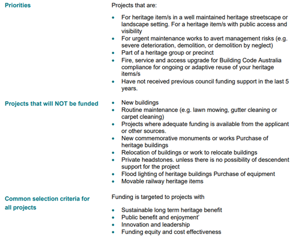
The focus for the 2018-2019 Local Heritage Places Grants is
conservation works that enhance individual places, buildings and historic
streetscapes including buildings in conservation areas that will promote and
foster community appreciation of the history of the Shire.
After consideration by the Heritage Panel members along with
Council’s Heritage Adviser and staff, a total of 9 projects that met the
criteria have been recommended to Council for funding this year. (Successful
Applications are attachments 1-6, 8, 10 & 11). Three (3) applications will
receive $2,000 each, with the remaining six (6) to receive $1000 each.
The funding of these projects will support over $60,000
worth of work to be carried out in this financial year on heritage property
restoration.
Financial Implications
Council has delivered the Local Heritage Places Grants with
the aid of a grant from the Heritage Division of the NSW Office of Environment
and Heritage with Council providing $6,000 to qualify for $6,000 from the
Heritage Division.
Statutory and Policy
Compliance Implications
The operation of the Local Heritage Places Grants program is
a task of the Byron Shire Heritage Strategy 2016-2019.
Staff Reports - Sustainable Environment and Economy 13.13
Report No. 13.13 PLANNING
- Development Application 10.2018.233.1 Mobile Telecommunications Facility including
35 metre Monopole, Six (6) antennae and ancillary equipment at Wilsons Creek
Road, Wilsons Creek
Directorate: Sustainable
Environment and Economy
Report
Author: Greg
Smith, Team Leader Planning Services
Noreen Scott, EA Sustainable
Environment and Economy
File No: I2018/1564
Theme: Sustainable Environment and Economy
Development and Certification
|
DA No:
|
10.2018.233.1
|
|
Proposal description:
|
Mobile Phone Telecommunications Facility including 35
Metre High Monopole, Six (6) Antennae and Ancillary Equipment
|
|
Property description:
|
LOT: 1 DP: 202997
|
|
Wilsons Creek Road WILSONS CREEK
|
|
Parcel No/s:
|
99360
|
|
Applicant:
|
Service Stream
|
|
Owner:
|
Telstra Corporation Ltd
|
|
Zoning:
|
7(c) (Water Catchment Zone)
|
|
Date received:
|
16 May 2018
|
|
Integrated Development:
|
No
|
|
Public notification or exhibition:
|
- Level
2 advertising under DCP 2014 Part A14 – Public Notification and
Exhibition of Development Applications
- Exhibition
period: 7/6/2018 to 12/7/2018
- Submissions received:
114 individual submissions, plus a petition indicated to contain 1304
signatures on pro forma letters
- Submissions are publically
available from the following link:
www.byron.nsw.gov.au/Council/Council-meetings/Additional-Supporting-Information/
|
|
Delegation to determination:
|
Council
|
|
Issues:
|
· Bush fire prone
land
· High
environmental value vegetation, Very high ecological values, Threatened
species, populations and ecological communities, High Biodiversity Values on
the Biodiversity Values Map under the Biodiversity Conservation Act 2016.
· Council cannot
approve Part 4 development without a Biodiversity Development Assessment
Report (BDAR).
· Flora and Fauna
assessment report and Assessment of Significance not submitted.
· EME radiation
impacts on wildlife.
· Building height
under LEP 1988 clause 40, with SEPP 1 objection submitted (development
standard is 9m, total height is 36.3m).
· Development not
demonstrated to be appropriate to the location, surrounding
development and environmental characteristics of the land. SEPP 1
objection not well founded and does not demonstrate that compliance
with the development standard is unreasonable or unnecessary in the
circumstances of the case.
· Not consistent
with objective (d) of the 7(c) (Water Catchment Zone.
· Conflicts with
existing overhead 11kV powerlines, LV overhead powerlines and a 11kV /
LV pole substation.
· Application not
supported by a site plan identifying the closest residences contained in
EME Report to determine the impact of the proposal on these dwellings.
· Application
fails to address on-site sewage management.
· Public
submissions (114 individual submissions, plus a petition indicated to contain
1304 signatures on pro forma letters).
|
Summary:
|
The DA proposes Mobile
Phone Telecommunications Facility including 35 Metre High Monopole, Six (6)
Antennae and Ancillary Equipment.
The proposal raised a significant level of objection from
the community in terms of siting, environmental impacts, health and amenity
impacts, electro magnetic radiation, visual impacts, proximity to power lines
and surrounding residential properties.
It is considered that the development does not meet
Councils planning controls or standards, having regards to the height
provisions within Byron LEP 1988, and the objectives of the 7(c) Water
Catchment Zone. Further having regards to the number of objections it is
considered the proposed telecommunications tower is not in the public
interest.
The application is recommended for refusal.
|
NOTE TO COUNCILLORS:
In accordance with the
provisions of S375A of the Local Government Act 1993, a Division is to be
called whenever a motion for a planning decision is put to the meeting, for the
purpose of recording voting on planning matters. Pursuant to clause 2(a)
under the heading Matters to be Included in Minutes of Council Meetings of
Council's adopted Code of Meeting Practice (as amended) a Division will be
deemed to have been called by the mover and seconder of all motions relating to
this report.
|
RECOMMENDATION:
That Pursuant to Section 4.16 of the
Environmental Planning & Assessment Act 1979, Development Application 10.2018.233.1
for Mobile Phone Telecommunications Facility including 35 metre high
monopole, six (6) antennae and ancillary equipment, be refused for the following
reasons:
1. Pursuant
to Section 4.15(1)(a)(i) of the Environmental Planning and Assessment Act
1979 the proposed development fails to comply with Clause 45 of State
Environmental Planning Policy (Infrastructure) 2007, having regards to its
proximity existing overhead power lines.
2. Pursuant
to Section 4.15(1)(a)(i) of the Environmental Planning and Assessment Act
1979 the proposed development is inconsistent with objective (d) of the 7(c)
Water Catchment Zone as insufficient information has been provided to
demonstrate that the use is appropriate in terms of conserving or enhancing
the environmental amenity of the locality.
3. Pursuant
to Section 4.15(1)(a)(i) of the Environmental Planning and Assessment Act
1979 the proposed development is inconsistent with Cause 40 (Height) of Byron
LEP 1988 and the SEPP 1 Objection has failed to demonstrate that compliance
with the development standard is unreasonable or or unnecessary in the circumstances of the case.
4. Pursuant
to Section 4.15(1)(b) of the Environmental Planning and Assessment Act 1979,
the proposed development fails to satisfactorily address the environmental
impacts of the proposal including impacts on threatened species, populations
and ecological communities, nor does it meet the requirements under the
Biodiversity Conservation Act 2016.
5. Pursuant
to Section 4.15(1)(c) of the Environmental Planning and Assessment Act 1979,
the site is considered unsuitable for the proposed development having regards
to the ecological values of the site and its proximity to surrounding
properties.
6. Pursuant
to Section 4.15(1)(e) of the Environmental Planning and Assessment Act 1979
the proposed development is not in the public interest having regards to the
level of community objection to the telecommunication tower.
|
Attachments:
1 Proposed
Plans, E2018/68630
2 Confidential
- further submissions dated 23/8/18, E2018/71816
3 Legal
Advice received from objectors dated 23 August 2018, E2018/71820
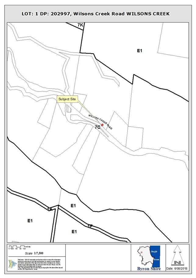
1. INTRODUCTION
1.1. History/Background
There is no approval history according to Council’s
records for this site.
1.2. Description
of the proposed development
This application seeks approval for Mobile Phone
Telecommunications Facility including 35 Metre High Monopole, Six (6) Antennae
and Ancillary Equipment.
1.3. Description
of the site
|
Land is legally described as
|
LOT: 1 DP: 202997
|
|
Property address is
|
Wilsons Creek Road WILSONS CREEK
|
|
Land is zoned:
|
7(c) (Water Catchment Zone)
|
|
Land area is:
|
132.8m2
|
|
Property is constrained by:
|
Bush fire prone land, High environmental value vegetation
|
The site is owned by Telstra and accommodates an existing
compound including an existing equipment shelter.
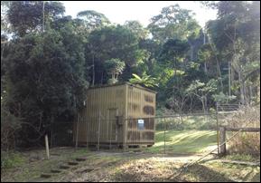
2. SUMMARY OF
REFERRALS
Natural Resources Access Regulator
The NSW Natural Resources Access Regulator advises that a controlled
activity approval may be required where any works are proposed on water front
land as provided by Section 91 of the Water Management Act 2000.
Rural Fire Service
The property is located in a Bushfire Prone Area. The
proposal was referred to the NSW Rural Fire Service who raised no objection to
the development. Conditions would apply should the application be approved.
Essential Energy
The proposal is located in close proximity to overhead power
lines and was referred to Essential Energy who advised as follows:
Essential Energy notes that existing overhead 11kV
powerlines, LV overhead powerlines and a 11kV / LV pole substation are
impacted by the proposed development (approximate location shown on the
attached Smallworld map). Essential Energy has safety concerns in relation to
the proximity of the proposed development to its existing infrastructure.
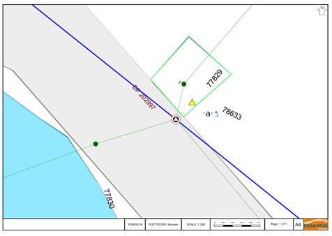
Any development in proximity to Essential Energy’s
electrical infrastructure should comply with the latest industry guideline
currently known as ISSC 20 Guideline for the Management of Activities within
Electricity Easements and Close to Infrastructure.
Having regards to the above it is considered the proposals fails
to satisfy Clause 45 of SEPP Infrastructure nor meets Essential Energy’s
requirements. The application does not address these requirements and is
recommended for refusal.
Ecological Planner
The site is mapped as both Sensitive and Vulnerable Regulated
Land on the Native Vegetation Regulatory map and the Biodiversity Values Map
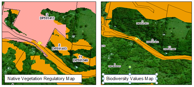
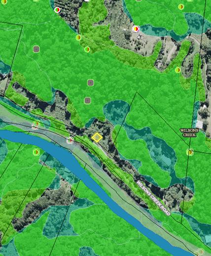
The area surrounding the site is also mapped as HEV and
threatened fauna habitat.
“The application states:
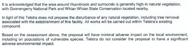
Despite this acknowledgement, no flora and fauna assessment
has been provided with the application so it is not possible to adequately
assess the ecological impacts. Such a report is required. In addition, recent
survey work in Nightcap National Parks indicates adverse wildlife effects
arising from mobile phone towers. In such a high environmental value area as
proposed, these matters require adequate consideration”.
The following matters are of importance
1. The
location of the proposed phone tower is within an area of very high ecological
values. The site is mapped as High Biodiversity Values on the Biodiversity
Values Map under the Biodiversity Conservation Act 2016. Council cannot approve
any Part 4 development without a Biodiversity Development Assessment Report
(BDAR).
2. A
Flora and Fauna assessment report is required which considers the Subject Site
and the Study Area in accordance with OEH guidelines and assesses the
likelihood of threatened species, populations and ecological communities on and
in proximity to the site and provides Assessment of Significance to determine
whether the impact is likely to be significant.
-
3. Given
recent research findings on local wildlife effects at Mount Nardi (see link
below) and other research undertaken overseas which appears to indicate adverse
wildlife impacts arising from EME radiation. This has not been addressed
https://ehtrust.org/science/bees-butterflies-wildlife-research-electromagnetic-fields-environment/
-
The application does not address the above matters and is
recommended for refusal.
3. SECTION 79C
– MATTERS FOR CONSIDERATION – DISCUSSION OF ISSUES
Having regard to the matters for consideration detailed in
Section 79C(1) of the Environmental Planning & Assessment Act 1979
(EP&A Act), the following is a summary of the evaluation of the issues.
3.1 State Environmental
Planning Instruments
|
|
Satisfactory
|
Unsatisfactory
|
|
State
Environmental Planning Policy No 55—Remediation of Land
|
☒
|
☐
|
|
Consideration: Council’s Environmental Health
Officer advises as follows: “The subject land is currently owned by
Telstra and contains an existing Telstra Facility. The development does
not result in an increased sensitivity of land use. No further
investigation is considered to be necessary”.
|
|
State
Environmental Planning Policy (Infrastructure) 2007
|
☐
|
☒
|
|
Consideration: The
proposed telecommunications facility is permitted with consent pursuant to
clause 115 of the Infrastructure SEPP.
However, the development application is not satisfactory
having regard to clause 45 of State Environmental Planning Policy
(Infrastructure) 2007 because, having regard to the advice provided by
Essential Energy:
(a) there
are existing overhead 11kV powerlines, LV overhead powerlines and a
11kV / LV pole substation that are impacted by the proposed development;
(b) there
are safety concerns in relation to the proximity of the proposed development
to its existing infrastructure;
(c) the
application fails to demonstrate that the development, which is in proximity
to Essential Energy’s electrical infrastructure, complies with the
latest industry guideline currently known as ISSC 20 Guideline for the
Management of Activities within Electricity Easements and Close to
Infrastructure; and
(d) the
application is not supported by plans certified by a suitability qualified
person (showing distances from the proposed development to Essential
Energy’s existing infrastructure) together with any other relevant
information for further consideration demonstrating that the proposed
development complies with ISSC20.
The application is recommended
for refusal accordingly.
|
|
State
Environmental Planning Policy (Rural Lands) 2008
|
☒
|
☐
|
|
Consideration: There are no significant issues under the
Rural Lands SEPP.
|
4.2 Byron Local Environmental
Plan 1988 (LEP 1988)
LEP 1988 is an applicable matter for consideration in the
assessment of the subject development application in accordance with subsection
4.15(1) of the EP&A Act because it applies to the subject land and the
proposed development.
The land is within the 7(c) Water Catchment Zone according
to the map under LEP 1988. The proposed development is defined as a
telecommunications facility under the Infrastructure SEPP as indicated above.
The proposed development is permitted with consent in accordance with clause
115 of the Infrastructure SEPP. The proposed development is consistent (or not
consistent) with the objectives of the 7(c) Zone for the following reasons:
|
Zone Objective
|
Consideration
|
|
(a) to prevent development within the
catchment of existing or future water supply systems which would have a
significant detrimental effect on the quality or quantity of the water supply
|
The
proposed development is not of such a scale, intensity or water quality
polluting potential that would have a significant impact on existing or
future water supply systems , quality or quantity.
|
|
(b) to ensure that development maintains the
rural character of the locality and minimises disturbances to the landscape
through clearing, earthworks and access roads so as to avoid erosion
|
The
proposed development will not have a significant impact upon the broader
rural character of the locality, and minimises disturbances to the landscape
through clearing, earthworks and access roads so as to avoid erosion.
|
|
(c) to ensure that development does not create
unreasonable or uneconomic demands, or both, for provision or extension of
public amenities or services
|
The
proposal does not create unreasonable or uneconomic demands for provision or
extension of public amenities or services, but instead adds to existing
amenities and services.
|
|
(d) to enable the carrying out of appropriate
uses on the land within the zone in a sound manner which conserves or
enhances the environmental amenity of the locality
|
The DA does not
demonstrate that the proposal will be carried out in a sound manner to
conserve / enhance the environmental amenity of the locality for the
following reasons:
· The location of
the proposed phone tower is within an area of very high ecological values;
· The DA is not
supported by a Biodiversity Development Assessment Report (BDAR);
· A Flora and Fauna
assessment report is not submitted in support of the DA, assessing the
likelihood of threatened species, populations and ecological communities on
and in proximity to the site and providing an Assessment of Significance to
determine whether the impact is likely to be significant;
· The DA does not
demonstrate that there would not be significant adverse wildlife impacts
arising from EME radiation;
The proposal is not
consistent with the zone objective. The DA is recommended for refusal
accordingly.
|
|
(e) to
ensure land uses which use pesticides and herbicides or other pollutants are
kept to a minimum to maintain the quality of run off water
|
The proposed land
use does not use pesticides, herbicides or other pollutants that are expected
to have a significant impact on the quality of run off water, subject to
appropriate erosion and sediment control measures being installed during
construction.
|
|
(f) to
enable the careful control of noxious plants and weeds by means not likely to
be significantly detrimental to the native ecosystem
|
The development is
able to employ careful control of noxious plants and weeds by means not
likely to be significantly detrimental to the native ecosystem as required.
|
The remaining checked clauses have been taken into
consideration in the assessment of the subject development application in
accordance with subsection 4.15(1) of the EP&A Act. The proposed
development complies with all of these clauses (in some cases subject to
conditions and/or to the satisfaction of other assessing officers), except in
relation to which considered further as follows:
|
What clause does the development not comply with and what
is the nature of the non-compliance?
|
Further consideration, including whether the development
application is recommended for approval or refusal accordingly
|
|
40. Height
|
The proposed development exceeds the 9m maximum vertical
distance between the topmost part of the building and the existing ground
level below requirement. A SEPP 1 objection in this regard is considered below.
|
Clause 40 – Height
Subclause 40(2) of LEP 1988 states
that the council must not consent to the
erection of any building on land within any zone other than Zone No. 3(a), if
the vertical distance between the topmost part of the building and the existing
ground level below exceeds 9m. The proposed building has an overall height of
36.3m. Accordingly, the development application does not meet the 55m
front setback requirement and the DA is supported by an objection pursuant to
SEPP 1.
The Land Environment Court judgment
in Wehbe v Pittwater Council [2007] identified requirements needed in order to
uphold a SEPP 1 objection, and these are addressed in the circumstances of this
particular case as follows:
Is the requirement a development standard?
The
9m height requirement is a development standard as defined by section 1.4 of
the Environmental Planning and Assessment Act 1979, because it is a provision
of an environmental planning instrument in relation to the carrying out of
development, being a provision by or under which requirements are specified and
standards are fixed in respect of the
height of a building.
Is the objection in writing, is it an objection “that
compliance with the development standard is unreasonable or unnecessary in the
circumstances of the case” and does it specify “the grounds of the
objection”?
The
Applicant submitted a written objection under SEPP 1 (refer to Doc #S2018/7774)
dated 6/6/2018. It is an objection that compliance with the development
standard is unreasonable and unnecessary in the circumstances of the case and
specifies the grounds of the objection as follows:
“Compliance
is Unnecessary
Clause 40 of
the BLEP 1988 provides guidance on Development Standards on height for works
within the LGA, particularly in relation to building height. While the proposal
is located in an area under which the vertical distance between the topmost
portion of a building and the ground level must not exceed 9 metres, the
proposal does not consist of a building. The use of the term building within
the BLEP 1988 relates to habitable structures within which a variety of uses
are undertaken and equipment/machinery is housed. The Dictionary of the BLEP
1988 includes multiple uses of the word building which is consistent with the
aforementioned statement. Furthermore the BLEP has no special provisions for
telecommunication facilities. The proposed facility is considered as
telecommunications infrastructure, and the monopole has a very minimal
footprint and surface area. Based on this inconsistency Telstra consider the
proposed facility as not constituting of a building as per the BLEP 1988. In
this instance the only building is the existing equipment shelter which itself
is already complies with the height requirement. Consequently the objective of
Clause 40 of the BLEP 1988 is considered not relevant to the proposed
development and in this case strict compliance is considered unnecessary.
Compliance
Is Unreasonable
By their
nature, telecommunications facilities are unable to comply with prescriptive
height
restrictions
because, to function they must protrude above the surrounding area including
topographical
features, buildings and vegetation. Additionally this telecommunications pole
is being proposed as part of the Federal Government's Mobile Black Spot
Program. One of the key purposes of the MBSP is to improve the safety for
people who live, work and travel in regional and remote areas. The ability for
drivers, motorcyclists, cyclists and other road users to be able to call for
help in the event of a breakdown, road accident or other emergency is
critically important to the Federal Government. Currently, the only option
available to people who require assistance in a mobile black spot is to flag
down a passing motorist, send them to an area with adequate mobile phone
coverage and trust that person to call for help. Extending beyond road safety,
mobile phone coverage is important for providing an additional level of safety
to tradespeople and farmers who sustain injuries while working in remote areas
without access to a landline, such as a paddock or job site, or for people
enjoying the natural beauty of an area by hiking or other outdoor activities
which can all pose a risk of injury or getting lost. In these circumstances,
mobile phone coverage enables communication with emergency services, as well as
access to navigation tools and first aid information. As such Telstra considers
this facility is as an important part of infrastructure in the area and its
ability to function effectively is dependent on its protrusion above the
surrounding environment. Additionally this telecommunications monopole is of a
slimline nature and has been designed and will be finished in a manner that
will not negatively affect surrounding development or the environmental
characteristics of the land. As such compliance with the General Provision
contained in Clause 40 of the BLEP would be unreasonable for a
telecommunications facility”.
In
addition, the SEPP 1 objection states that the development standard has been abandoned
and provides planning justification for the variation as follows:
“The
Development Standard has previously been abandoned
Within the
Byron LGA there are 3 communications facilities zoned 7D Scenic Escarpment
pursuant to the BLEP 1988, at St Helena Road, Mcleods Shoot NSW 2479. The first
is a 40m NSW Police Force Lattice Tower at Lot 1 DP 441480, RFNSA site number
2479004. The second is an Axicom Lattice Tower also on Lot 1 DP 441480, RFNSA
site number 2481001. The third is a 53m Telstra owned Lattice Tower plus 12m
Extension on an unidentified lot that can be recognized as being within the
road reserve of St Helena Road, RFNSA 2479002. These identified structures
significantly penetrate the 9m Development Standard identified under Clause 40
of the BLEP 1988. They are considerably larger than the proposed facility (a
35m monopole) both in height and scale, however due to the nature of
communications infrastructure their size is warranted and they form a part of
important infrastructure.
Planning Justification
pursuant the BLEP 1988
The proposal
does not impede on the objectives of 7C Water Catchment zone particularly
because it is a small footprint in an existing Telstra compound that has
already been disturbed for the purposes of its establishment. The primary
objective of the zone is to prevent development which negatively affects the
environment through significant disturbance of the landscape leading to the
damaging of existing or future water supply systems. The earthworks for the
establishment of the new facility would be minimal and requiring no additional
vegetation clearing. The proposal will form a reliable public service by
improving communication and providing access to services that previously were
available. This will not create any unreasonable demands to Council for the
provision of public amenities. Furthermore the proposal does not impinge on the
ability of any existing activities being carried out on the land or affect the
conservation of the natural environment. The proposal does not involve an
activity that utilises herbicides or any other pollutants. As such the quality
of run-off water will not be negatively affected. Telecommunications facilities
by nature require minimal maintenance. In addition this facility will be
maintained by measures that are likely not to be significantly detrimental to
the native ecosystem. As such from a planning perspective it is Telstra's
opinion that there are no grounds by which the proposal will break away from
the objects of the zone.
The
SEPP 1 objection concludes as follows:
“Conclusion
Consequently
with respect to the proposed DA the objective of General Provision 40 of the
BLEP 1988 is considered not relevant to the proposed development and strict
compliance is considered unnecessary and unreasonable.
Telstra
consider there is clear justification for the facility to exceed the 9 metre
building height
restriction in
this area based on the above discussion. Accordingly, we request that Council
consider the proposal under Clause 6 of the SEPP1 (Development Standards)
given:
· The
proposed development is not considered a building as per the use of the term
within the BLEP 1988. There is no reference to telecommunications facilities
within this instrument and therefore this inconsistency renders the development
standard unnecessary to the proposal. For telecommunications facilities,
compliance with this height restriction is unreasonable.
· Telecommunications
facilities provide an essential service in the case of emergencies and are
considered a normal part of modern infrastructure and in order to function must
extend above their existing environment therefore compliance is unreasonable.
· There
are existing structures zoned under the BLEP 1988 that significantly exceed the
9m building height standard contained in Clause 40, that form part of important
infrastructure within the LGA.
· As
the proposal does not impinge on the objectives of the relevant zone there are
sufficient environmental grounds to contravene the development standard”.
It
should be clarified that the proposed development is a “building”
having regard to the applicable definition in section 1.4 of the Environmental
Planning and Assessment Act 1979, which is:
building includes part of a building, and also includes any
structure or part of a structure (including any temporary structure or part of
a temporary structure), but does not include a manufactured home, moveable
dwelling or associated structure within the meaning of the Local Government Act 1993.
Is “the objection well founded” and will
“granting of consent to the development application be consistent with
the aims of SEPP 1 as set out in clause 3”?
An
objection under SEPP 1 may be well founded and be consistent with the aims set
out in clause 3 of the Policy in one of a variety of ways (according to the
above mentioned judgment). These are:
1. Compliance
with the development standard is unreasonable or unnecessary because the
objectives of the development standard are achieved notwithstanding
non-compliance with the standard.
2. The
underlying objective or purpose is not relevant to the development with the
consequence that compliance is unnecessary.
3. The
underlying objective or purpose would be defeated or thwarted if compliance was
required with the consequence that compliance is unreasonable.
4. The
development standard has been virtually abandoned or destroyed by the
Council’s own actions in granting consents departing from the standard
and hence compliance with the standard is unreasonable and unnecessary.
5. The zoning
of particular land was unreasonable or inappropriate so that a development
standard appropriate for that zoning was also unreasonable or unnecessary as it
applied to that land and compliance with the standard in that case would also
be unreasonable or unnecessary.
Clause
40 provides the following stated objectives.
(a) to achieve building
design that does not exceed a specified maximum height from its existing ground
level to finished roof or parapet,
(b) to ensure that the
height and scale of development is appropriate to its location, surrounding
development and the environmental characteristics of the land.
Objective
(a) of the development standard is achieved for the following reasons:
(a) The height of the proposed structure is
necessary to achieve it’s intended purpose. Council has approved various
telecommunications facilities in the Shire which exceed the 9m maximum
requirement. The proposed building design exceeds the specified maximum height
above the surrounding tree line so as to achieve it’s intended purpose to
provide functional infrastructure.
However
compliance with the development standard is not unreasonable nor unnecessary
because compliance with objective (b) of the development standard is not
achieved for the following reasons:
(b) The
application fails to demonstrate that the height and scale of the proposal are
appropriate to the location, surrounding development and environmental
characteristics of the land because
(i) it fails to demonstrate that it will
not have significant impacts in terms of conservation and enhancement of the
environmental amenity of the locality, threatened species, populations
and ecological communities on and in proximity to the site and adverse wildlife
impacts arising from EME radiation; and
(ii) it
is not supported by a Biodiversity Development Assessment Report (BDAR), flora
and fauna assessment report and Assessment of Significance to determine whether
the impact is likely to be significant.
For these reasons the SEPP
1 objection is not well founded and the application is recommended for refusal.
4.3 Any proposed Instrument
that has been the subject of public consultation and has been notified to the
consent authority
There are no draft environmental planning instruments of
significant influence in relation to the proposal.
4.4 Byron Shire Development
Control Plan 2010 (DCP 2010)
DCP 2010 is an applicable matter for consideration in the
assessment of the subject development application in accordance with subsection
4.15(1) of the EP& A Act because its purpose is to provide planning
strategies and controls for various types of development permissible in accordance
with LEP 1988.
Chapter 1 Part H Landscaping
A condition could be imposed on any consent requiring the
provisions of appropriate landscaping.
Chapter 1 Part N Stormwater Management
Council’s Development Engineers have recommended
consent conditions in relation to stormwater management.
Chapter 21 Social Impact Assessment
The proposal is not considered to be one of the types of
proposals listed in A5 which require the submission of a Social Impact
Assessment with the development application.
The proposed development is considered to meet the relevant
Objectives of DCP 2010 (in some cases subject to conditions and/or to the
satisfaction of other assessing officers).
4.5 Any Planning Agreement or
Draft Planning Agreement?
|
|
Yes
|
No
|
|
Is there any applicable planning agreement or draft
planning agreement?
|
☐
|
☒
|
|
Consideration: Not applicable.
|
4.6 Environmental Planning
& Assessment Regulation 2000 Considerations
|
Clause
|
This
control is applicable to the proposal:
|
I
have considered this control as it relates to the proposal:
|
If
this control is applicable, does the proposal comply?
|
|
92
|
No
|
N/A
|
N/A
|
|
93
|
No
|
N/A
|
N/A
|
|
94
|
No
|
N/A
|
N/A
|
|
94A
|
No
|
N/A
|
N/A
|
4.7 Any coastal zone management
plan?
|
|
Satisfactory
|
Unsatisfactory
|
Not applicable
|
|
Is there any applicable coastal zone management plan?
|
☐
|
☐
|
☒
|
|
Consideration: Not applicable.
|
4.8 The likely impacts of that
development, including environmental impacts on both the natural and built
environments, and social and economic impacts in the locality
|
Impact on:
|
Likely significant impact/s?
|
|
Natural environment
|
Yes. The application has failed to demonstrate that the
proposal will not have significantly adverse impacts on the natural
environment of the locality for the reasons given elsewhere in this Report,
and the application is recommended for refusal accordingly.
|
|
Built environment
|
No. The proposal will not have a significantly adverse
impact on the built environment of the locality.
|
|
Social Environment
|
Having regards to the level of objection from the
community ti considered approval of the tower may have a negative social
impact on the locality.
|
|
Economic impact
|
No. The proposal will not have a significant economic
impact on the locality.
|
Are there any Council Policies that are applicable to the
proposed development.
4.9 The suitability of the site
for the development
The application is supported by the following Site Selection
analysis:
“3 Site
Selection and Justification
As part of Telstra's site
acquisition procedure, a comprehensive site selection process has been
undertaken in order to find an appropriate location for a new facility in
Wilsons Creek. This included looking for 'colocation' opportunities, in
accordance with Chapter 4 Part 3 Clause 4.13 of the Telecommunications Code of
Practice 1997, as well as low impact solutions and new greenfield sites.
A number of disciplines are
involved in the site selection process including site acquisition consultants,
engineers and town planners,
as well as specialist experts where needed, such as ecologists, geotechnical
engineers and other relevant consultants. Each potential candidate is assessed
under the following considerations:
Planning
· In
accordance with the relevant Acts and Environmental Planning Instruments (EPI);
· Acceptability
of the proposal by Byron Shire Council and community;
· Location
in relation to sensitive land uses such as schools, child care centres,
hospitals, nursing homes;
· Visual
aspect and amenity;
· Compliance
with the EME standards mandated by the Australian Communications and Media
Authority (ACMA); and
· Opportunities
to collocate facilities where possible.
Property
· Willingness
by the owner to enter into a tenure agreement and provide access during
construction and operation.
Engineering:
· Feasibility
of construction (including assessment of soil conditions, slope and flood
proneness) and availability of infrastructure such as access and power.
Radio frequency coverage
and objectives:
· Ability
to be linked to the existing Telstra network and meet the radio frequency
coverage objectives for the area.
3.1 Options Considered
3.1.1 Opportunities to
Collocate
State, Federal and Local
government legislation encourages the use of existing telecommunication
facilities for the colocation of new antennas to avoid the proliferation of
telecommunication towers. Where possible, Telstra endeavour to co-locate on
existing telecommunications facilities if these are available.
In this case, there were no
existing telecommunications facilities nearby which were considered feasible
for co-location.
In summary, a thorough
examination of potential telecommunications base station sites in Huonbrook and
the surrounding area has been undertaken. As depicted in Figure 7 below - there
were no suitable options for co-location (for further information on the site,
see www.rfnsa.com.au).
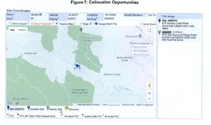
3.1.2 Low Impact Solutions
Where existing
telecommunications facilities are not present, Telstra explore other potential
co-location or 'co-siting' options such as radio towers, power stanchions or
tall buildings.
Co-location options may not
be available In all circumstances - there may be no existing vertical
structures in the area, or no rooftops high enough to provide a feasible
co-location option.
The site assessment process
revealed no Low Impact options were available. In this case, Telstra concluded
a new 'greenfield' facility is required.
3.1.3 Greenfield Sites
Given there were no viable
opportunities to co-locate or co-site within the locality a number of
Greenfield
options were explored.
After initial site scoping it
was evident the area provided a paucity options given its remoteness and high
natural vegetation value. As such a total of three (3) candidates were selected
for in-depth investigation including an on-site inspection. Taking into
consideration that the Huonbrook area has rural residential developments, the
site investigation predominantly focused on isolated rural areas with very
little development. Additionally, site investigations also focused on special
requirements for the construction of such a facility as well as access for
maintenance purposes and access to power and fibre.
Figure 8 and the Table 1
below identify the potential candidates explored and determine why they were
discounted in lieu of the chosen location presented in
this Development Application.
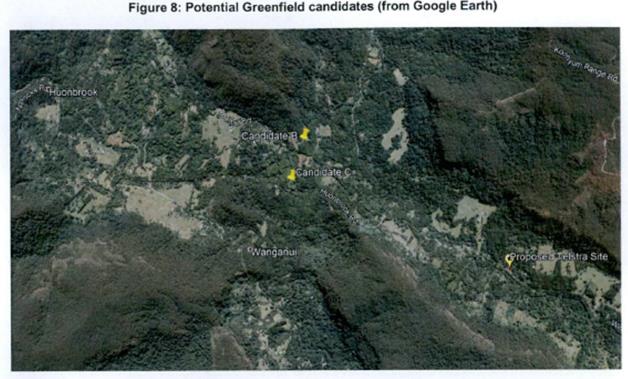
A summary analysis of each
investigated candidate Is set out on Table 1 below including a description of
the opportunities and constraints that each site afforded:
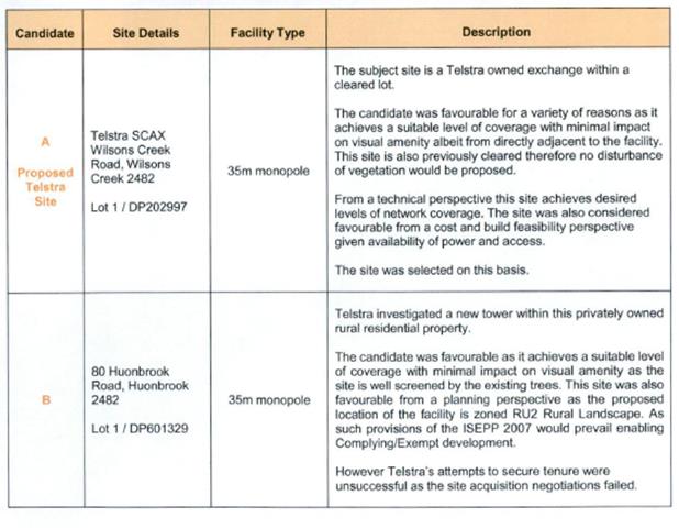
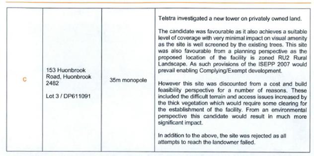
3.2 Preferred Option
The site selection process
highlighted the following about the proposed site:
· it
is considered to be consistent with the environmental and planning
requirements, and it is expected to have minimal environmental Impacts during
construction and operation;
· it
will meet the radio frequency objectives of Telstra's network, giving the
required coverage within the area by allowing all three sectors to operate
effectively.
Potential greenfield sites
were ruled out either because of environmental and planning issues, tenure
grounds or difficulty of design and construction.
In conclusion, Telstra has
identified that Candidate A is the most appropriate location for the
installation of a new facility - therefore, on behalf of Telstra, we submit
this application for a new telecommunications facility to Byron Shire Council”.
However the application fails to demonstrate that the site
is suitable for the proposed development for all of the reasons outlined in
this Report and is recommended for refusal accordingly.
4.10 Submissions made in accordance with
this Act or the regulations
Public submissions are available from www.byron.nsw.gov.au/Council/Council-meetings/Additional-Supporting-Information/
The development application was publicly exhibited. 114
individual submissions have been received, most of which are based on two pro
forma type letters. A petition of pro forma type letters has also been
submitted, the cover letter of which advises in part as follows:
“This
petition letter (copy below) has been signed by 1304 people, 316 from Wilsons
Creek itself, 851 Byron Shire and 137 out side Byron Shire, this a clear
indication the proposed Telstra tower does not have public support and is
against the clearly expressed will of the people. The sole purpose of
government is to act and administer services in accordance with the will of the
people, …”
No submissions have been submitted in favour of the
proposal. Issues raised in the submissions are summarised as follows:
Ecological Impacts, Impacts of EME / EMR on wildlife,
Impacts on wildlife in environmentally sensitive area, No species impact
statement submitted, Height
Comment: The application is recommended for
refusal in relation to significant impacts in terms of
conservation and enhancement of the environmental amenity of the locality, threatened
species, populations and ecological communities on and in proximity to the site
and adverse wildlife impacts arising from EME radiation. The application is not
supported by a Biodiversity Development Assessment Report (BDAR), flora and
fauna assessment report and Assessment of Significance to determine whether the
impact is likely to be significant. The application fails to
demonstrate that the height and scale of the proposal, which exceeds the
maximum height development standard under clause 40 of Byron Local
Environmental Plan 1988, are appropriate to the location, surrounding
development and environmental characteristics of the land in accordance with
objective (b) of the height development standard. The application is not supported by a well founded SEPP 1
objection demonstrating that compliance with the height development standard is
unreasonable or unnecessary in the circumstances of the case.
Impacts of EME / EMR on humans, Health risks, Links to
cancer, Inevitable co-location of additional telecommunication services will
lead to increased radiation levels, Exposure may constitute assault or trespass
under Common Law, Cumulative impact of 5G on all power poles and on all houses,
Proximity to dwellings, 70m from nearest dwelling
Comment: The application is not supported by a
site plan identifying the closest residences contained in EME Report to
determine the impact of the proposal on these dwellings, and is recommended for
refusal accordingly.
Residents chose to live in an area without mobile
phone reception
Comment: This is not a matter of such
significance as to warrant inclusion in the recommended reasons for refusal.
Visual impacts, Loss of scenic and visual amenity,
existing trees are not 35m high to screen the tower
Comment: The telecommunications facility at the
proposed location would be less visual than one at the top of a ridgeline or
escarpment. The proposed telecommunications facility would not be as visible
when viewed along the Wilsons Creek Road approaches beyond an estimated
150-200m to the east and west of the site given the presence of vegetation,
other than intermittent glimpses. The telecommunications facility would not be
excessively visible from the public perspective other than in front of the
site. The telecommunications facility is expected to be visible from other
properties nearby.
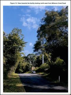
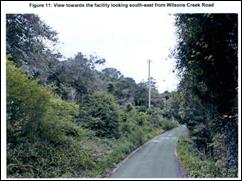
However these matters are not considered to be of such
significance as to warrant inclusion in the list of reasons for refusal, also
having regard to the number of other more visually prominent telecommunication
facilities throughout the Shire.
Impact on land saleability
Comment: This is not a matter for Councils
consideration.
Flood impacts, Soil stability, Landslips, Adjacent to
sink hole, No geotechnical assessment lodged with application, No evidence that
structure will be on bedrock
Comment: The site is not flood prone land.
Council’s Development Engineer advised that the proposal is satisfactory
having regard to geotechnical hazards. The Development Engineer recommends a
condition requiring a certificate from a professional Engineer experienced in
Geotechnical Science to be provided to the Principal Certifying Authority,
certifying that the site is stable and will not be affected by landslide or
subsidence at, above or below the site when the building is erected. The
certificate must be prepared in accordance with AS 1726.
Prohibited development in the zoning
Comment: It is not the 7(c) Zone under Byron
Local Environmental Plan 1988 which permits the proposed development. The
proposed telecommunications facility is permitted with consent in accordance
with clause 115 of the Infrastructure SEPP, which states:
115 Development permitted with consent
(1) Development for the
purposes of telecommunications facilities, other than development in clause 114
or development that is exempt development under clause 20 or 116, may be
carried out by any person with consent on any land.
Fire plan not provided to deal with electrical faults
and lightning strikes
Comment: If necessary, this could be required
by way of a condition of consent.
No indication of public liability insurance, Many
insurers now have policy exclusions for damage or injury due to EME, it is
unlikely Telstra or Council are properly covered for this substantial risk
Comment: Public liability insurance is not a matter for
consideration in the assessment of this application, but is rather a matter for
the entities mentioned to negotiate with their respective insurers.
Potential contamination of the site, presence of
asbestos, lead and industrial chemicals
Comment: The subject land is currently owned by
Telstra and contains an existing Telstra Facility. The development does
not result in an increased sensitivity of land use. No further
investigation is considered to be necessary in relation to contamination.
No indigenous heritage assessment has been submitted
in support of the application, adequacy of AHIMS search
Comment: The standard procedure in relation to
Aboriginal heritage is to conduct an AHIMS search. If this identifies anything
in the vicinity of the site then the assessment progresses to a more detailed
assessment. A condition could be imposed on the consent if granted, along the
lines of the following:
Aboriginal heritage –
unexpected finds protocol
If Aboriginal objects are
uncovered during earthworks or disturbance; work in the immediate area of the
unexpected finds must stop immediately and the North Coast Regional Operations
Branch of the OEH and the Registered Aboriginal Parties are to be consulted
before work can re-commence.
Note. OEH means the New
South Wales Office of Environment & Heritage, and Registered
Aboriginal Parties is defined in the National Parks and Wildlife
Regulation 2009.
Impact on local power grid
Comment: Essential Energy raised concerns in
relation to the location of the proposed telecommunications facility in
relation to poles and wires, but not in relation to the capacity of the
network to accommodate the proposed power usage
Manly Council was successful in stopping a tower in
Balgowlah
Comment: This application in Manly Council has
not been reviewed, the circumstances of the subject Wilsons Creek proposal are
what is relevant.
Estimated cost is actually $870,000
Comment: The Applicant submitted a cost
estimate as follows:
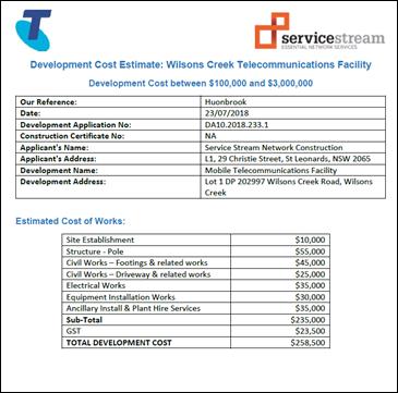
Motorists on mobile phones will be an additional
traffic hazard on already dangerous roads
Comment: The use of mobile phones whilst
driving is governed by road rules and laws, and this consideration is beyond
the scope of assessment of this application.
The proposal would not be in the public interest
Comment: For the refusal reasons given below,
approval of the development application would not be in the public interest.
Inadequate public consultation by Telstra
Comment: Council does not set standards in
relation to public consultation by Telstra. The application was publicly
exhibited, advertised and notified by Council in accordance with Development
Control Plan requirements with the period of exhibition exceeding the minimum
requirement under the DCP.
Poor location in bottom of valley, so more towers will
be required
Comment: Noted
4.11 Public interest
Having regards to the level of objection by the community it
is apparent there is little support for the development which would serve that
community. As such it is considered the proposal is not in the public interest.
5. DEVELOPER
CONTRIBUTIONS
Section 7.11 Contributions would
be payable should he application be approved.
6. DISCLOSURE OF
POLITICAL DONATIONS AND GIFTS
|
Has a Disclosure Statement been received in relation
to this application
|
No
|
|
Have staff received a ‘gift’ from anyone
involved in this application that needs to be disclosed. Where the answer is
yes, the application is to be determined by the Director or Manager of the
Planning, Development and Environment Division.
|
No
|
Provide Disclosure Statement register details here: Not
applicable
7. CONCLUSION
The proposed Mobile
Phone Telecommunications Facility has generated significant opposition from the
local community, whilst the application lacks detail in addressing environmental
and amenity issues pertaining to the site and the surrounding locality.
The development application is recommended for refusal for
the reasons provided in the Recommendation of this Report.
Staff Reports - Sustainable Environment and Economy 13.14
Report No. 13.14 Proposed
Flying Fox Project Reference Group
Directorate: Sustainable
Environment and Economy
Report
Author: Clare
Manning, Biodiversity Officer
File No: I2018/1599
Theme: Sustainable Environment and Economy
Planning Policy and Natural Environment
Summary:
This report seeks Council endorsement to establish a
Flying-fox Project Reference Group (PRG) to provide advice, advocacy,
reporting, community feedback and suggestions to Council in relation to matters
of on-ground actions and education and awareness strategies in the management
of flying foxes in Byron Shire. The PRG will report through the Biodiversity
Advisory Committee.
This report also requests Council endorse the nominated
members to be appointed to the PRG and endorse the draft Constitution for
further consideration at the PRGs first meeting.
|
RECOMMENDATION:
That Council:
1. Appoint
the nominated eight (8) community members (Attachment 1 - E2018/70597), one
(1) wildlife carer representative and one (1) representative each from the Office
of Environment & Heritage and the Department of Industry Crown land to
the Flying-fox Project Reference Group.
2. Staff
continue to identify two (2) community representatives from Butler Reserve camp
in Byron Bay.
3. Support
the draft Flying Fox Project Reference Group Constitution (Attachment 2 -
E2018/69378) to be further considered at the first Flying-fox Project
Reference Group meeting in September / October 2018.
|
Attachments:
1 Confidential
- List of Expression of Interest responses for Flying Fox Project Guidance
Group, E2018/70597
2 Draft
Flying Fox Project Reference Group Constitution, E2018/69378
Report
On 26 October 2017 Council resolved (Resolution 17-453)
to adopt the Flying-fox Camp Management Plan (the Plan) to guide future
management of five urban flying-fox camps within Byron Shire Council Local
Government Area (LGA). The 2018-19 Operational Plan identifies the
implementation of the Plan as a key activity. One of the first actions of the Plan
is to form a ‘Working Group’ (now referred to as a Project
Reference Group (PRG)) to work in partnership with Council to increase the
understanding of issues relating to the management of flying foxes particularly
in an urban setting:
The establishment of a
flying-fox working group comprised of Council staff, community, Aboriginal land
council, wildlife carers, and relevant government agencies to seek funds,
prioritises actions, determine new and emerging issues and increase awareness
about living with flying-foxes (Section 8, Table 8.1 action 1.11).
The intent of the PRG is for Council to seek continual
engagement with the community
and vested stakeholders in assisting with the
management of identified flying-foxes camps as per
the Plan
The scope of the PRG, is to provides advice,
advocacy, reporting, community feedback and
suggestions to Council in relation to matters of on-ground
actions and education and awareness
strategies. The PRG will report to the Biodiversity
Advisory Committee (BAC) on the progress and
effectiveness of the management approach.
The objectives of
the PRG are:
1. To provide a
vital communication linkage to and from Council to interest groups, state
agencies and the community in general.
2. To assist with
prioritising on-ground actions and education and awareness strategies
3. To inform Council
of the community’s aspirations and expectations in regard to on-ground
actions and raising awareness and education about flying foxes
4. To engage with
the broader community during future direction setting on its strategic approach
to the management of flying-foxes and their habitat
Membership
to the PRG will be voluntary with no reward or remuneration provided.
The maximum number of members suggested for the PRG is
14. This includes the following:
· Ten (10) community representatives (2 community
representatives from each of the subject urban camps. These community
representatives will also be from within 300m of each of the subject urban
camps, and not represent an animal welfare group).
· One (1) representative from a suitable animal welfare
group.
· One (1) representative each from the relevant NSW State
Government agencies including Office of Environment & Heritage and
Department of Industry – Crown land.
· Council representative as deemed necessary by General
Manager.
Councillors are invited to nominate an elected member to attend
the PRG meetings although the PRG will report to the Biodiversity Advisory
Committee in which three (3) Councillors are members.
Consultation:
The proposed PRG has been discussed with and supported in
principal by Governance.
Community members from within 300m of each of the subject
urban camps were invited in writing to lodge an Expression of Interest (EOI) to
be a part of the PRG in January and June 2018, with a deadline of 13 July 2018
for responses. Emails were also sent to suitable animal welfare groups and
relevant NSW State Government agencies.
Nine (9) community members lodged EOIs to be a part of the PRG
(Attachment 1 E2018/70597).
No EOI was submitted from community members living within
300m of the camp located at Butler Reserve in Byron Bay. The EOI
did attract an almost even representation of community members that are either
supportive of flying foxes or learning to live with flying foxes.
Representative from the Northern Rivers Wildlife Carers and
WIRES Northern Rivers submitted an EOI to represent a suitable animal welfare
group. This membership will be a shared position between the Northern
Rivers Wildlife Carers and WIRES Northern Rivers.
One (1) representative each from the Office of Environment
& Heritage and Department of Industry – Crown land has also been
identified.
For the sake of effectiveness, efficiency and manageability
of the PRG it is recommended that Council appoint a maximum of 14 members
including a maximum of 10 community representatives (i.e. 2 community
individuals from each of the 5 subject camps) to join the PRG.
It is also recommended that eight (8) of the nine (9) community
members that have lodged an EOI by the closing date be appointed as part of the
PRG (Attachment 1 E2018/70597). This allows for two (2) community
representatives from Bangalow, Mullumbimby, Suffolk Park and Byron Bay as well
as even representation of community members that are either supportive of
flying foxes or learning to live with flying foxes.
Additionally, Council staff will continue to identify two
(2) community representatives of Butler Reserve in Byron Bay.
The group’s first meeting will be held in September /
October 2018 where the draft constitution of the group will be confirmed (Attachment
2 E2018/69378)
Financial Implications
The administrative functions associated with the PRG will be
undertaken using existing staff resources in the Environment and Economic Planning
section.
Potential costs associated with the PRG may include catering
and room hire estimated at $1,000. In 2018-19FY, these costs could be met
through the relevant Governance budget.
If this funding scenario cannot be achieved then an
alternate funding scenario will be Environmental Strategic Studies (2605.074).
Statutory and Policy Compliance Implications
Nil.
Staff Reports - Sustainable Environment and Economy 13.15
Report No. 13.15 PLANNING
- Development Application 10.2017.742.1 Alterations and Additions to Existing
Dwelling House including New Swimming Pool and Spa, New Dwelling House to
Create a Dual Occupancy (detached) and Two (2) Studios at 219 The Saddle Road
Brunswick Heads
Directorate: Sustainable
Environment and Economy
Report
Author: Dylan
Johnstone, Planner
File No: I2018/1602
Theme: Sustainable Environment and Economy
Development and Certification
Proposal:
|
DA No:
|
10.2017.742.1
|
|
Proposal description:
|
Alterations and Additions to Existing Dwelling House
including New Swimming Pool and Spa, New Dwelling House to Create a Dual
Occupancy (detached) and Two (2) Studios
|
|
Property description:
|
LOT: 4 DP: 810118
|
|
219 The Saddle Road BRUNSWICK HEADS
|
|
Parcel No/s:
|
137160
|
|
Applicant:
|
Greg Alderson & Associates Pty Ltd
|
|
Owner:
|
Koresoft Pty Ltd
|
|
Zoning:
|
RU2 Rural Landscape
|
|
Date received:
|
27 December 2017
|
|
Integrated Development:
|
No
|
|
Public notification or exhibition:
|
- Level
1 advertising under DCP 2014 Part A14 – Public Notification and
Exhibition of Development Applications
- Exhibition
period: 18/1/18 to 31/1/18
- One submission was received.
|
|
Delegation to determination:
|
Council
|
|
Issues:
|
· Chapter B14 of
DCP 2014 – Excavation and Fill
· Chapter D2.7.1
of DCP 2014 – Studios
· Relocation of
overhead power lines
|
Summary:
This application seeks development consent for alterations
and additions to an existing dwelling house including new swimming pool and spa,
construction of a new dwelling house to create a dual occupancy (detached), and
construction of two (2) studios (one associated with each dwelling).
The application originally proposed the new dwelling house to
be located at a distance of 365m from the existing house, which does not comply
with the maximum separation distance of 100m required by the development
standards of Clause 4.2D of LEP 2014. It was considered that there were insufficient
grounds to vary the standard pursuant to Clause 4.6, and the application was
reported to the 2 August 2018 Ordinary meeting with the recommendation being
refusal of the application. Council resolved that the item be deferred until the 20 September
2018 Ordinary meeting in order for Council and the proponents to consider an
alternative site approximately within 100m of the existing site, for example
the site identified as site F in the application.
Additional information has been
submitted by the applicant which proposes to locate the new dwelling at site F
with a compliant separation distance of approximately 70m as per Clause 4.2D of
Byron LEP 2014. A variation to the development standard pursuant to Clause 4.6
is not longer required.
The proposed development is satisfactory
in terms of Byron LEP 2014 and DCP 2014. The proposed development is
unlikely to have an impact on the existing built or natural environment and the
site is considered suitable for the development. It is recommended that the
development application be approved subject to conditions of consent.
NOTE TO COUNCILLORS:
In accordance with the
provisions of S375A of the Local Government Act 1993, a Division is to be
called whenever a motion for a planning decision is put to the meeting, for the
purpose of recording voting on planning matters. Pursuant to clause 2(a)
under the heading Matters to be Included in Minutes of Council Meetings of
Council's adopted Code of Meeting Practice (as amended) a Division will be
deemed to have been called by the mover and seconder of all motions relating to
this report.
|
RECOMMENDATION:
That pursuant to
Section 4.16 of the Environmental Planning & Assessment Act 1979,
Development Application 10.2017.742.1 for alterations and additions to existing dwelling house including new
swimming pool and spa, new dwelling house to create dual occupancy (detached)
and two (2) studios be granted consent subject to attached conditions.
|
Attachments:
1 Plans of
Studio, E2018/73762 
2 Plans
Dwelling Alterations & Additions, E2018/73761
3 Plans Dual
Occupancy, E2018/73759
4 Conditions
of consent , E2018/73885
5 Letter of
Support , E2018/73757
Assessment:
1. INTRODUCTION
1.1. History/Background
5.1991.123.1 – Dwelling House and Carport –
approved 08/05/91
Borrodales basalt quarry was operated by the NSW Department
of Public Works under a series of non-exclusive licence agreements in 1959,
1963 and 1969.
1.2. Description
of the proposed development
This application seeks approval for alterations and additions
to an existing dwelling house including new swimming pool and spa, construction
of a new dwelling house to create a dual occupancy (detached), and construction
of two (2) studios, one associated with each of the dwellings.
The layout of the proposed development on the site is shown
below.
Figure 1 Site Layout (Greg Alderson & Associates)
Existing Dwelling
The proposed alterations and additions to the existing
dwelling house include:
· New covered
balcony
· New enclosed
verandah with indoor swimming pool
· New carport,
undercover driveway and storage
· New deck
with spa
· New bedroom,
study, gym and rumpus room
· Convert
existing garage to underfloor storage and workshop area
Dual Occupancy (detached)
It is proposed to construct a new three-bedroom,
single-storey dwelling, located approximately 70m southeast of the existing
dwelling, as indicated in Figure 1 above.
Studios
Two non-habitable studios are proposed to be constructed in
conjunction with each of the dwellings. The studio associated with the
existing dwelling is proposed for use as a home occupation, for the production
of naturopathic remedies. The studio associated with the new dwelling is
proposed to be used for the purposes of private exercise (yoga and pilates).
1.3. Description
of the site
|
Land is legally described as
|
LOT: 4 DP: 810118
|
|
Property address is
|
219 The Saddle Road BRUNSWICK HEADS
|
|
Land is zoned:
|
RU2 Rural Landscape
|
|
Land area is:
|
19.32ha
|
|
Property is constrained by:
|
Acid Sulfate Soils Class 3 (very small area in SE corner
– not affected by development)
|
|
|
Bush Fire Prone Land (proposed development outside of
mapped areas)
|
|
|
High Environmental Value Vegetation
|
|
|
Koala Habitat (potential)
|
|
|
Regionally Significant farmland (non-contiguous)
|
Location of proposed studio
associated with existing Dwelling House (Looking NE)
Existing Dwelling House
(Looking E)
The application includes a plan of a “share
farming” arrangement on the land to demonstrate existing and future use
of the site.
2. SUMMARY OF
REFERRALS
|
Referral
|
Issue
|
|
Environmental Health Officer
|
There is sufficient land area for disposal of wastewater
on the site
|
|
Development Engineer
|
No objections to the proposal subject to conditions.
|
|
S64 / Systems Planning Officer
|
No objections to the proposal subject to conditions.
|
|
S94 / Contributions Officer
|
Section 94 contributions applicable for dual occupancy
development
|
|
Essential Energy
|
No objections to the proposal subject to advisory
comments.
|
|
Tweed Byron Land Council
|
The application was referred to TBLALC who recommended
that, if approved, they undertake a site visit and report to further
investigate significant aboriginal cultural heritage thought to be located in
the area.
A site visit was undertaken by TBLALC on 21/06/18.
Subsequently a Cultural Heritage Sites Inspection Report was prepared by
TBLALC dated 21/06/18 and submitted to Council on 23/07/18. The report
concluded that “there is nothing at this stage to halt or delay the proposed
work on this site”. The report recommended that the Due Diligence
Code of Practice for the Protection of Aboriginal Objects in NSW,
published by the DECCW OEH, be applied. Procedures to be applied in the case
of unexpected finds (including even suspected ACH objects) were also
recommended.
|
3. SECTION 79BA
– BUSH FIRE PRONE LAND
Under section 79BA of the Act, Council must be satisfied
prior to making a determination for development on bush fire prone land, that
the development complies with the document ‘Planning for Bush Fire
Protection 2006’. The lot is mapped as containing bushfire
prone land however the proposed development site within the lot is not bush fire
prone land therefore no further assessment is required.
4. SECTION 79C
– MATTERS FOR CONSIDERATION – DISCUSSION OF ISSUES
Having regard to the matters for consideration detailed in
Section 79C(1) of the Environmental Planning & Assessment Act 1979
(EP&A Act), the following is a summary of the evaluation of the issues.
4.1 State Environmental Planning
Instruments
|
|
Satisfactory
|
Unsatisfactory
|
|
State
Environmental Planning Policy No 44—Koala Habitat Protection
|
☒
|
☐
|
|
Consideration: Part of the land is mapped as containing
Tertiary Habitat. However, the application does not propose development
within this area and no vegetation removal is proposed on the site.
|
|
State
Environmental Planning Policy No 55—Remediation of Land
|
☒
|
☐
|
|
Consideration: A preliminary contaminated land
investigation was undertaken by the applicant in accordance with Section
7. A site history review was conducted for the investigation area
(being the entire site). The history review found that there is no evidence
that the investigation area was subject to cropping or plantations or that
any other contaminating activities had occurred. It is considered that
the land is suitable for residential use.
|
|
State
Environmental Planning Policy (Building Sustainability Index: BASIX) 2004
|
☒
|
☐
|
|
BASIX Certificate required for:
• New
dwellings
• Alterations
> $50,000.00
• Pools
> 40,000 kl
BASIX certificate has been provided.
|
|
State
Environmental Planning Policy (Exempt and Complying Development Codes) 2008
|
☒
|
☐
|
|
Consideration: Plans have been submitted with the application
indicating a number of structures to be undertaken as exempt development
including a windmill and wind turbines. Note: The applicant has
acknowledged that some of these structures may not be undertaken as exempt
development and a future Development Application is to be lodged separate to
this application.
|
|
State
Environmental Planning Policy (Infrastructure) 2007
|
☒
|
☐
|
|
Consideration: Clause 45 requires that development carried
out within 5m of an exposed overhead electricity power line must give written
notice to Essential Energy and consider their comments prior to determination
of a development application.
The applicant proposes to relocate the existing power line
to accommodate the proposed development and Essential Energy have advised
that development consent may be granted on the condition that the powerlines
are relocated in accordance with their requirements.
Clause 101 requires that Council must not grant consent to development on land that has a
frontage to a classified road unless it is satisfied that, where practicable,
vehicular access to the land is provided by a road other than the classified
road (Gulgan Rd).
The
application proposes that vehicular access to each dwelling will be provided
by a single access point to The Saddle Rd.
|
|
State
Environmental Planning Policy (Mining, Petroleum Production and Extractive
Industries) 2007
|
☒
|
☐
|
|
Consideration: Borrodales basalt quarry was operated by
the NSW Department of Public Works under a series of non-exclusive licence
agreements in 1959, 1963 and 1969. Any use rights of previous
extractive activity on the site have since been abandoned.
|
|
State
Environmental Planning Policy (Rural Lands) 2008
|
☐
|
☒
|
|
Consideration: Clause 7 identifies the following Rural
Planning Principles:
(a) the
promotion and protection of opportunities for current and potential
productive and sustainable economic activities in rural areas,
(b) recognition
of the importance of rural lands and agriculture and the changing nature of
agriculture and of trends, demands and issues in agriculture in the area,
region or State,
(c) recognition
of the significance of rural land uses to the State and rural communities,
including the social and economic benefits of rural land use and development,
(d) in
planning for rural lands, to balance the social, economic and environmental
interests of the community,
(e) the
identification and protection of natural resources, having regard to
maintaining biodiversity, the protection of native vegetation, the importance
of water resources and avoiding constrained land,
(f) the
provision of opportunities for rural lifestyle, settlement and housing that
contribute to the social and economic welfare of rural communities,
(g) the
consideration of impacts on services and infrastructure and appropriate
location when providing for rural housing,
(h) ensuring
consistency with any applicable regional strategy of the Department of
Planning or any applicable local strategy endorsed by the Director-General.
The
proposal is considered to be consistent with the Rural Planning Principles.
|
4.2 Byron Local Environmental
Plan 2014 (LEP 2014)
LEP 2014 is an applicable matter for consideration in the
assessment of the subject development application in accordance with subsection
79C(1) of the EP&A Act because it applies to the subject land and the
proposed development. The following LEP 2014 clauses are of relevance to
the proposed development:
Land Use Table:
In accordance with LEP 2014 clauses 1.4 and 2.1 – 2.3:
(a) The
proposed development is defined in the LEP 2014 Dictionary as Dual Occupancy
(detached). Studios are not separately defined in the LEP, and are
considered to be ancillary to the dwellings houses that make up the dual
occupancy.
(b) The
land is within the RU2 Rural Landscape according to the Land Zoning Map.
(c) Dual
occupancies are permitted with consent. As outlined above, the studios
are considered ancillary to the dwellings, and are therefore permissible with
consent.
(d) The
development as proposed is considered to be inconsistent with the Zone
Objectives, for the reasons as outlined below:
|
Zone Objective
|
Consideration
|
|
To encourage
sustainable primary industry production by maintaining and enhancing the
natural resource base
|
The proposed development is located in an area of the site
that is not suitable for primary industry production and is considered an
appropriate use of land.
|
|
To maintain the rural
landscape character of the land
|
The location of the proposed new
dwelling within 70m of the existing dwelling maintains the rural landscape
character of the land. The proposed dwelling is located in close proximity to
an existing cluster of dwellings and its design, including lowering below the
existing ground level via earthworks, further reduces any potential visual
impact. Alterations and additions to the existing dwelling and the proposed
two studios are of a design and scale that is consistent with the existing
rural landscape.
|
|
To provide for a range
of compatible land uses, including extensive agriculture.
|
The proposed development is located in an area of the site
that is not suitable for primary industry production and is considered an
appropriate use of land.
|
|
To enable the provision
of tourist accommodation, facilities and other small-scale rural tourism uses
associated with primary production and environmental conservation consistent
with the rural character of the locality.
|
The application proposes residential use only.
|
|
To protect significant
scenic landscapes and to minimise impacts on the scenic quality of the
locality.
|
The proposal does not have a significant impact on the
scenic quality of the locality
|
Clause 4.1E Minimum lot sizes for dual occupancies, multi
dwelling housing and residential flat buildings
The property has an area of 19.32 hectares, which satisfies
the requirement for a minimum lot size of 4,000m2 for a Dual
Occupancy (detached) in the RU2 zone.
Clause 4.2A Erection of
dwelling houses and dual occupancies on land in certain rural zones
The land contains an existing dwelling, approved by Council
consent 5.1991.123.1. A dual occupancy is permitted on the land with
Council consent.
Clause 4.2D Erection of dual occupancies (detached) and
secondary dwellings in Zones RU1 and RU2
|
What clause does the development not comply with and
what is the nature of the non-compliance?
|
Further consideration, including whether the
development application is recommended for approval or refusal accordingly
|
|
4.2D Erection of dual occupancies
(detached) and secondary dwellings in Zones RU1 and RU2
(1) The objectives of this clause are as follows:
(a) to provide alternative
accommodation for rural families and workers,
(b) to ensure that development is of
a scale and nature that is compatible with the primary production potential,
rural character and environmental capabilities of the land,
(c) to set out consent considerations
for development of dual occupancies (detached) and secondary dwellings to
address matters such as access, siting, land suitability and potential
impacts.
(2) Development consent must not be granted
to development for the purpose of a dual occupancy (detached) or secondary
dwelling on land in Zone RU1 Primary Production or Zone RU2 Rural Landscape
unless the consent authority is satisfied that:
(a) the development
will not impair the use of the land for agriculture or rural industries, and
(b) each dwelling
will use the same vehicular access to and from a public road, and
(c) any dwellings
will be situated within 100 metres of each other, and
(d) the land is
physically suitable for the development, and
(e) the land is capable
of accommodating the on-site disposal and management of sewage for the
development, and
(f) the
development will not have an adverse impact on the scenic amenity or
character of the rural environment.
|
The proposal complies with the objectives of this clause
as it provides accommodation for a rural family and is of a scale and nature
that is compatible with existing land uses and existing development in the
locality.
Each dwelling will be accessed from an existing driveway
crossing to Saddle Rd and dual occupancy dwellings will be located within
approximately 70m of each other. The land is physically suitable for the
development and the land is demonstrated to be capable of accommodating
on-site disposal and management of sewage.
|
Clause 4.3 Height of
Buildings
The maximum height of proposed alterations and additions to
the existing dwelling are approximately 8m. The maximum height of the
proposed new dwelling is approximately 4.4m and the proposed studios have a
building height of 4.0m. All proposed buildings comply with the permitted
9.0m maximum building height.
Clause 5.10 Heritage
Conservation
The application was referred to the Tweed Byron Local
Aboriginal Land Council (TBLALC) to consider the potential impacts of the
proposed development on Aboriginal objects and/or Aboriginal places of heritage
significance.
A site visit was undertaken by TBLALC on 21/06/18.
Subsequently a Cultural Heritage Sites Inspection Report was prepared by TBLALC
dated 21/06/18 and submitted to Council on 23/07/18. The report concluded that
“there is nothing at this stage to halt or delay the proposed work on
this site”. The report recommended that the Due Diligence Code of
Practice for the Protection of Aboriginal Objects in NSW, published by the
DECCW OEH, be applied. Procedures to be applied in the case of unexpected finds
(including even suspected ACH objects) were also recommended.
Clause 6.1 Acid Sulfate Soils
The south eastern corner of the site is subject to potential
Acid Sulfate Soils Class 3. However, all works are proposed on portions
of the site with an elevation of approximately 40-50m AHD. Therefore no further
assessment is required.
Clause 6.6 Essential Services
Potable water is proposed to supply the development through
rainwater tanks located at each dwelling with backup supplies in the form of an
existing water bore and mains connection to Rous water supply.
Electricity is proposed to be supplied to the new dwelling
and studio by 20KV of solar panels mounted on the new dwelling and farm buildings
along with 2 x 10KV wind turbines and a Lithium battery bank. It is also
proposed to install Three Phase power for back up and to feed renewable wind
and solar energy back into the grid.
There is sufficient land area for disposal of wastewater on
the site and roof water will be collected in rainwater tanks with an overflow
dispersion trench.
Vehicular access is achieved via an existing driveway
crossing to Saddle Rd. Existing access to Gulgan Rd does not appear to have
Council approval.
4.3 Any proposed Instrument
that has been the subject of public consultation and has been notified to the
consent authority
Draft SEPP (Coastal Management) 2016
The Draft Coastal Management
State Environmental Planning Policy (SEPP) proposes to establish a new, strategic
land use planning framework for coastal management. It is intended to support
the implementation of the management objectives set out in the Coastal
Management Act 2016.
Once adopted, the Coastal
Management SEPP will be the single land use planning policy for coastal
development and will bring together and modernise provisions from SEPP 14
(Coastal Wetlands), SEPP 26 (Littoral Rainforests) and SEPP 71 (Coastal
Protection).
The aim of the Draft SEPP is to promote an integrated and
co-ordinated approach to planning in the ‘Coastal Zone’,
identifying four coastal management areas:
· coastal
wetlands and littoral rainforests area
· coastal
environment area;
· coastal use
area; and
· coastal
vulnerability area.
The subject site is mapped within the ‘coastal use
area’. The draft provisions for consideration of development within
this area generally reflect the existing matters for consideration currently
outlined in SEPP 71.
The proposal is considered to be acceptable having regard to
the provisions of the Draft SEPP particularly Divisions No.2, 4 & 5.
The proposed development is not in a wetland, littoral rainforest, or coastal
environment area.
4.4 Byron Shire Development
Control Plan 2014 (DCP 2014)
DCP 2014 is an applicable matter for consideration in the
assessment of the subject development application in accordance with subsection
79C(1) of the EP& A Act because it applies to the land to which LEP 2014
applies. The following DCP 2014 chapters are of relevance to the proposed development:
A14 Public Notification and
Exhibition of Development Applications
The application was advertised in accordance with Level 1
Notification. Adjoining landowners were notified with one submission received
during the notification period. Public submissions are addressed in section
4.10 of this report.
B3 Services
The application has demonstrated that the proposed
development will be adequately serviced including the provision of an onsite
sewage management system.
B6 Buffers and Minimising
Land Use Conflict
The proposed new dwelling house is located adjacent to small
rural holdings that are not utilised for any significant primary production
purposes. Therefore the proposal is unlikely to present any significant land
use conflict issues.
B14 Excavation and Fill
The application proposes approximately 2.0m of excavation
works which does not comply with the 1.0m maximum prescriptive measure of the
DCP. A recommended condition attached to this report will require a certificate
from a professional Engineer experienced in Geotechnical Science to demonstrate
that the site is stable and suitable for the proposed development prior to
issue of any Construction Certificate
D2.7.1 Studios
The application proposes two new studios: one for the
existing dwelling and one for the proposed dwelling. The DCP requires
that studios do not contain a kitchen and are not to be used for separate
habitation. The studio floor plans indicate a toilet and bathroom with
shower. The studio plans also contain a kitchen sink.
Additional information submitted by the applicant includes
references to case law from Victoria whereby the tribunal ruled that a sink
does not constitute a kitchen in the absence of food preparation facilities
such as a microwave, hot plate or oven. However, the bathroom in each of the
proposed studios contains a sink and Council planning staff consistently
require the removal of a sink that could potentially be used as part of a
kitchen within a studio. To prevent the studios from being used for separate
habitation it is considered reasonable to require the removal of the sink in
each studio as per plans attached to this report.
4.5 Any Planning Agreement or
Draft Planning Agreement?
|
|
Yes
|
No
|
|
Is there any applicable planning agreement or draft
planning agreement?
|
☐
|
☒
|
|
|
4.6 Environmental Planning
& Assessment Regulation 2000 Considerations
The proposal raises no issues under the regulations for
consideration.
4.7 Any coastal zone management
plan?
|
|
Satisfactory
|
Unsatisfactory
|
Not applicable
|
|
Is there any applicable coastal zone management plan?
|
☐
|
☐
|
☒
|
|
|
4.8 The likely impacts of that
development, including environmental impacts on both the natural and built
environments, and social and economic impacts in the locality
|
Impact on:
|
Likely significant impact/s?
|
|
Natural environment
|
No. The proposal will not have a significantly adverse
impact on the natural environment of the locality.
|
|
Built environment
|
No. The proposal will not have a significantly adverse impact
on the built environment of the locality.
|
|
Social Environment
|
No. The proposal will not have a significant social impact
on the locality.
|
|
Economic impact
|
No. The proposal will not have a significant economic
impact on the locality.
|
Are there any Council Policies that are applicable to the
proposed development?
|
Council Policy
|
Consideration
|
|
Development Policy
|
In accordance with this policy the application has been
assessed with consideration for the relevant legislation, environmental
plans, development codes and the public interest.
|
|
Management of Contaminated Land Policy
|
A SEPP55 contaminated land assessment submitted by the
applicant has concluded that the land is suitable for residential use.
|
|
Water and Sewer Equivalent Tenement Policy
|
The Subject lot is not serviced by Council reticulated
water or sewer. Rous Water supplies bulk water. Equivalent Tenements
applicable to the development to be determined by Rous Water.
|
4.9 The suitability of the site
for the development
The land is a serviced, unconstrained property.
4.10 Submissions made in accordance with
this Act or the regulations
The development application was originally publicly
exhibited from 18/1/18 to 31/1/18.
There was one submission made on the development application
during that period. A summary of the issues raised within the submission is
made below:
|
Issue
|
Comment
|
|
No landowners consent contained in exhibition material
|
Landowners consent has been provided from the directors of
Koresoft Pty Ltd to Greg Alderson & Associates to lodge the application.
|
|
DCP requirements for studios have not been addressed
|
Additional information has been received that addresses
the requirements of Chapter D2.7.1 of DCP2014.
|
|
Concern that studios will be of commercial use and not
ancillary to residential use given reference of wastewater assessment to
staff
|
The wastewater report makes reference to staff in relation
to farm worker’s amenities, not in relation to studios.
|
|
Use of one of the studios for naturopathy is prohibited
development
|
The use of the studio for naturopathy would only be for
the production of naturopathic remedies and not as a medical centre or health
services facility as there will be no patients coming to the site.
|
|
The studio for pilates and exercise is unwarranted given
the amount of space in the associated dwelling.
|
The applicant has argued that the studio for yoga/pilates
use requires a quiet and peaceful environment that will not be available
within the proposed house.
|
|
Proposed studios appear to be small dwellings
|
The studio floor plans indicate a number of partitioned
rooms including an “air conditioned preservation room”, toilet
and bathroom with shower. The studio plans also contain a kitchen sink
which is not permitted by the DCP. In order to approve such studios the kitchen
sink is required to be removed.
|
|
Windmills shown on plans cannot be undertaken as exempt
development
|
A development application for the windmill and other
proposed agricultural structures which require Council consent is being
prepared, and will be submitted to Council as soon as possible.
|
|
Separation distance between dwellings
|
This issue has been addressed above.
|
|
Impact of the proposal on the agricultural potential of
the land
|
The applicant has argued that “the dwelling has been
strategically located between two of the agricultural areas which are part of
a share farming licence agreement”. Further, “this will
ensure that the residents of the proposed dual occupancy can easily manage
the horticultural activities and provide security to the farming activities
and equipment through passive surveillance”.
The proposal would have some impact on the agricultural
potential of the land by alienating the land that would be occupied by the
new dwelling, studio and associated curtilage.
|
|
Only one wind turbine is permitted as exempt development
|
Plans submitted with the application indicate two wind
turbines to be erected as exempt development. However only one of these is
permitted as exempt development and the other will require development
consent under a separate application.
|
|
Potential impacts on aboriginal heritage
|
TBLALC have recommended a site visit and report to further
investigate significant aboriginal cultural heritage thought to be located in
the area.
A site visit was undertaken by TBLALC on 21/06/18.
Subsequently a Cultural Heritage Sites Inspection Report was prepared by
TBLALC dated 21/06/18 and submitted to Council on 23/07/18. The report
concluded that “there is nothing at this stage to halt or delay the
proposed work on this site”. The report recommended that the Due
Diligence Code of Practice for the Protection of Aboriginal Objects in NSW,
published by the DECCW OEH, be applied. Procedures to be applied in the case
of unexpected finds (including even suspected ACH objects) were also
recommended.
|
Additional information was submitted by the applicant to
demonstrate a new location for the proposed new dwelling. This information
included a letter from the immediately adjoining neighbour supporting the
location and design of the proposed new dwelling. Given this support, it is
considered that re-advertising the application is unnecessary.
4.11 Public interest
The proposed development is not contrary to the public interest.
4.12 Section 5A of the EP&A Act –
Significant effect on threatened species
Having regard to sections 5A, 5C and 5D of the EP&A Act, there is unlikely to be a significant effect on threatened species,
populations or ecological communities, or their habitats as a result of the
proposed development because of its location within cleared agricultural land.
4.13 Section 5B of the EP&A Act –
Have regard to register of critical habitat
The NSW Critical
Habitat Register does not identify any critical habitat on or adjacent to the
site.
5. DEVELOPER
CONTRIBUTIONS
The proposal will require a Certificate of Compliance from
Rous Water confirming that all Developer Charges payable to Rous Water have
been provided to Rous Water.
6. DISCLOSURE OF
POLITICAL DONATIONS AND GIFTS
|
Has a Disclosure Statement been received in relation
to this application
|
No
|
|
Have staff received a ‘gift’ from anyone
involved in this application that needs to be disclosed. Where the answer is
yes, the application is to be determined by the Director or Manager of the
Planning, Development and Environment Division.
|
No
|
7. CONCLUSION
This application seeks development consent for alterations
and additions to an existing dwelling house including new swimming pool and spa,
construction of a new dwelling house to create a dual occupancy (detached), and
construction of two (2) studios (one associated with each dwelling).
Having regards to the amended plans
for the dual occupancy the proposal is satisfactory in terms of Councils
planning controls with the two dwellings sited 70 metres apart. The proposed
development is not likely to result in significant impacts on the existing
environment. It is recommended that the Development application be approved
subject to conditions of consent.
8. REASONS FOR
DECISION, HOW COMMUNITY VIEWS WERE ADDRESSED
|
Statement of Reasons
|
|
The proposed development will not have significant adverse
impacts on the natural, built or social environment or economic impacts on
the locality.
|
|
The proposed development is considered suitable for the
proposed site.
|
|
The proposed development is unlikely to prejudice or
compromise the public interest.
|
|
How community views were addressed
|
|
The DA was advertised in accordance with Level 1
notification as per Development Control Plan 2014. All issues raised within
submissions have been taken into consideration in determining this
application.
|
Staff Reports - Sustainable Environment and Economy 13.16
Report No. 13.16 Approval
to Operate a Caravan Park and Camping Ground application under section 68 of
the Local Government Act 1993 and Regulations 2005 for The Terrace Reserve
Holiday Park
Directorate: Sustainable
Environment and Economy
Report
Author: Shannon
Burt, Director Sustainable Environment and Economy
Stephen McCarthy, Building
Certifier
File No: I2018/1682
Theme: Sustainable Environment and Economy
Development and Certification
Summary:
Council considered Report 13.17
– Update on Resolution 17-184 – Brunswick Heads Holiday Parks https://byron.infocouncil.biz/Open/2017/09/OC_21092017_AGN_610.PDF
at the ordinary meeting of 21
September 2017, and resolved to receive an Approval to Operate (ATO) a Caravan
and Camping Ground application under section 68 of the Local Government Act
1993 and Regulations 2005 (Act and Regulations) for The Terrace Reserve,
Brunswick Heads subject to the conditions contained in Resolution 17- 418.
An ATO application was lodged on 6
November 2017 and has been the subject of further resolutions of Council
including Resolutions 17-523 and 18-325, subsequent amendments to
address these resolutions, and a statutory assessment under the Act and
Regulation as discussed in the report.
The ATO application for The
Terrace Reserve Holiday Park is recommended for approval subject to conditions.
The conditions proposed are twofold: standard regulatory conditions and special
conditions.
With regard to the special
conditions - Council is presented with the choice of two options (A or B) in
the report for a special condition to be imposed on the use of the Southern
Area Precinct where the Coastal Cypress Pine community is located and where
short term and camping site use is proposed in the ATO application.
Option A provides for restrictions on short term and camping site use in the
area; Option B does not permit any site use in the area.
Reflections Holiday Parks has
formally rejected the Option B – no use or activity in the Southern Area
Precinct.
Should Council resolve to adopt
the rejected option above, the ATO will be submitted to the Minister for Local
Government for determination as per the Act.
|
RECOMMENDATION:
That Council grant approval under Chapter 7 of the
Local Government Act, 1993 and the Local Government (Caravan Parks, Camping
Grounds and Moveable Dwellings) Regulations 1995 to operate a caravan park or
camping ground on the property known as The Terrace Reserve Holiday Park
subject to the conditions in the staff compliance assessment report
(Attachment 11 (#E2018/74849), with the inclusion of special condition Option
A below, imposed on the use of the Southern Area Precinct where a coastal
cypress pines community a known endangered ecological community is located.
OPTION A
1. The total number of
short term powered and camp sites unpowered permitted in the Southern Area
Precinct – Coastal Cypress Pines Community is restricted to a maximum
of 30 (18 short term powered and 12 camp sites unpowered) at any time.
2. To address any
potential biodiversity impacts on the Coastal Cypress Pine Community a known
endangered ecological community: no new works or activities are to occur in
the Southern Area Precinct of The Terrace Reserve Holiday Park without the
appropriate planning consent / approvals in place. The various pathways for
this to be determined are provided in the note below:
Note:
Subject to legislative change.
Part 4 EP&A Act
I. The applicant must clearly
demonstrate whether or not the proposal requires development consent under
Part 4 of the EP&A Act. This includes considering the land uses that
require such consent in the RE1 zone under the Byron LEP.
II. If development consent is required,
then the Byron Shire Council expects a development application to be lodged
and to be determined to satisfy 2 above.
Part 5 EP&A Act
I. If development consent is not
required, then the applicant must clearly demonstrate that it has ministerial
authority in writing to act as a public authority.
II. If this can be established, then the
council expects an assessment of the activity under Part 5 of the EP&A
Act to be undertaken (usually via a Review of Environmental Factors), a
determination made, and then any subsequent approvals obtained, such as an
approval from the council under its DCP for the vegetation clearing, to
satisfy 2 above.
Vegetation SEPP
I. If
development consent or an activity determination is not required for the
proposal, then the Vegetation SEPP may apply.
II. If
the applicant establishes that the proposal triggers the biodiversity offset
scheme thresholds, then under the Vegetation SEPP approval for the clearing
will need to be obtained from the Native Vegetation Panel to satisfy 2 above.
|
Attachments:
1 Application
for Approval to Operate 55.2017.1144.1 - Application and supporting
documentation dated 6/11/17, E2017/106317
2 Letter
Steve Edmonds from Reflections Holiday Parks dated 20 July 2015 , E2018/73071
3 Letter ADW
Johnson Planning Advice dated 7 June 2018, E2018/73053
4 E mail
from Dimitri Young OEH dated 7 June 2018, E2018/73060
5 Review of
Environmental Factors - Tree Management and Vegetation Works Terrace Holiday
Park Southern Precinct prepared by Ecological Consultants Australia dated June
2018, E2018/73067
6 Biodiversity
Assessment of proposed Vegetation Management Terrace Holiday Park Southern
Precinct prepared by Ecological Consultants Australia dated June 2018, E2018/73055
7 Letter
from Peter Parker Environmental Consultants dated 18 July 2018, E2018/73058
8 E-mail
from Nick Batson Inspiration Trees dated 29 June 2018, E2018/73063
9 Photos
examples of Installations in Byorn Shire of Load Cell Systems , E2018/73081
10 Planning Resolutions
Chris Pratt Independent Advice Reveiw of Part 5 Assessment , E2018/72966
11 Compliance Assessment
55.2017.1144.1 along with recommended conditions , E2018/74849
12 Revised Application
Terrace Reserve Caravan Park 55.2017.1144.1 - Further information and ATO and
mapping, E2018/74851
13 Email from Trent
Gearside Reflections Holiday Parks 55.2017.1144.1 - dated 31 August 2018 - maps
, E2018/73155
Background
Council
considered Report 13.17 – Update on Resolution 17-184 –
Brunswick Heads Holiday Parks https://byron.infocouncil.biz/Open/2017/09/OC_21092017_AGN_610.PDF at the ordinary meeting of 21 September 2017, and resolved
as follows:
|
17-418 Resolved:
1. That Council notes the following
Concept Parameters as shown in Attachment 1 (#E2017/86763) and detailed below
for the purposes of amending the Plans of Management for Terrace Reserve for
the purposes of public exhibition of the Crown Reserves Plan of Management:
a) Southern Cypress Pine Precinct is to be restricted
to short-term camping sites with no permanent residents or cabins to be
relocated to the area.
b) Camping
practices in Southern Cypress Pine Precinct will observe and protect
structural root zones of the Cypress Pines as part of an ongoing monitoring
program.
c) The
Trust will negotiate to form a consolidated central permanent
residents’ precinct which will be made to comply with the 3m set back
from top of bank to any structure as a minimum. The Trust will make
endeavours to achieve 10m set back from top of bank to any structure wherever
feasible.
d) Remaining
permanent residents will be relocated to north western precinct.
e) With
the exception of the central permanent residents’ precinct addressed in
item 1c, Terrace Reserve operational boundary will be established to achieve
7m set back from top of bank to any short-term camp sites and 10m set back
from top of bank to any dwelling sites in providing a continuous foreshore
walkway.
f) the
Southern Cypress Pine Precinct is acknowledged as a place of reflection and
remembrance.
g) Any areas of
Indigenous cultural significance be recognised and protected.
2. That Council supports NSWCHPT in
seeking Ministerial approval to exhibit the proposed changes to the PoM for
Terrace Reserve as per the parameters above.
3. That:
a) Council impose a condition on any Approval to Operate
issued by Council in respect of the applications for Terrace Reserve that the
operation of the caravan park/camping ground and any building or work
associated with its operation must comply with all applicable standards
imposed by the Local Government (Manufacture Home Estates, Caravan Parks,
Camping Grounds and Movable Dwellings) Regulation 2005, and;
b) where there is any non-compliance with the Local
Government (Manufacture Home Estates, Caravan Parks, Camping Grounds and
Movable Dwellings) Regulation 2005, NSWCHPT commit to doing all acts and
things necessary to resolve the non-compliance issues as part of the
development and works programme of the relevant Holiday Park in accordance
with the timing schedule and staging plan known as Schedule of Compliance
Works and Activities which will form part of the Approval to Operate.
4. That in order to enable the
development and works program set out in the Schedule of Compliance Works and
Activities as per 3b and included as a condition in any Approval to Operate,
the Approval to Operate be issued for a period of three years. yon)
|
Council
considered Report 13.25 Heritage and Environmental Assessment Reports
– Coastal Cypress Pines at The Terrace Reserve, https://byron.infocouncil.biz/Open/2017/10/OC_26102017_AGN_611.PDF
at
the ordinary meeting of 26 October 2017, and resolved as follows:
17-523 Resolved:
1. The area of Coastal Cypress Pines within the
2014 approved POM for the Terrace Holiday Park be listed on Byron Shire
Council's LEP Schedule 5 under Environmental Heritage.
2. Council pursue the listing of the significant area in
the southern part of the Terrace Holiday Park under section 25 (2) of the NSW
Heritage Act 1977.
3. Council pursue a nomination to the Heritage
Division of the Office of Environment and Heritage (OEH) for listing of
the significant area on the State Heritage Register.
4. Council acknowledge the findings in the ecologist's
report advising that preservation and conversation of the Coastal Cypress Pines
in the southern area of the Terrace Holiday Park is best managed by removing
all existing infrastructure and use of the area and restricting all activities
to the northern area. Council formally advises NSW Crown Holiday
Parks of these findings.
5. Council formally advises NSW Crown Holiday Parks
Trust of the ecologist's recommended tree management strategies and works with
them to achieve this.
6. That Council note the pressing issue of the Aboriginal
cultural heritage issues raised in the recommendation of the Arakwal
Memorandum of Understanding Advisory Committee meeting of Friday, 22
September 2017:
"That Council write to Crown Lands as a matter of urgency with
regards to requesting that a barrier be erected to protect the aboriginal
cultural heritage site in the precinct (maps to be provided) with letters of
support sought from Brunswick Valley Landcare, Tweed-Byron Land Council and the
Arakwal Corporation.”
Council considered Report Update - Resolution 17-184
Brunswick Heads Holiday Parks and Resolution 17-523 Heritage and Environmental
Assessment Reports - Coastal Cypress Pines at Terrace Reserve Brunswick Heads https://byron.infocouncil.biz/Open/2018/04/OC_19042018_AGN_774.PDF
at the ordinary meeting 19 April 2018, and resolved as
follows:
18-266 Resolved:
1. That Council defer this report to the 24 May
Ordinary Meeting.
2.
That Council request an urgent meeting (within 28 days) with NSWCHPT and their
consultants, as well as Robert Kooyman and two representatives from the
Brunswick Community, with respect to the recommendations made in the
Arboricultural Impact Assessment prepared by Arborsafe 2018 (Attachment 1
E2018/30243) as to specific conditions required on site to meet resolution
17-418.
Council considered Report Update – Resolution 18-266
The Terrace Reserve Holiday Park, Brunswick Heads https://byron.infocouncil.biz/Open/2018/05/OC_24052018_AGN_775.PDF
at the ordinary meeting of 24 May 2018, and resolved as
follows:
18-325 Resolved that Council:
1. Note
the report.
2. That
Council note that Resolution 17-523 is still live and reiterates the positions
outlined therein.
3. Acknowledge
recent community submissions made about the Coastal Cypress Pines, and, need
for the issues raised in these, to be addressed by Reflections Holiday Parks in
a formal response to Council.
4. (a)
Request Reflections Holiday Parks to submit a Biodiversity Development
Assessment Report in accordance with the Biodiversity Assessment Method under
the Biodiversity Conservation Act 2016 to inform the current Approval to
Operate application for The Terrace Holiday Park.
(b)
This report is to address the biodiversity impacts of the activity/s proposed
on site, and is to determine which approval pathway (development consent,
native vegetation clearing approval or permit) applies in the
circumstances to the site activity/s proposed.
5. Receive
a further staff report on the Approval to Operate for The Terrace Holiday Park
once items 3 and 4 above are received.
6. Notify
the Minister for the Environment, The Hon Gabrielle Upton and Minister for the
Crown Lands, The Hon Paul Toole, Tamara Smith MP and Ben Franklin MLC of the
resolution of Council and Council’s intention to support the ongoing
protection and rehabilitation of the EEC of Cypress Pines.
Since this resolution in May, further information and
reports to address points 3 and 4 above have been provided by NSW Crown Holiday
Parks Trust now known as Reflections Holiday Parks.
In the most recent correspondence from Reflections Holiday
Parks, 20 July 2018, a formal request was made for Council to determine The
Terrace Reserve Holiday Park ATO. Extract below – all attachments
listed are included as attachments to the report. Attachments 2-9.
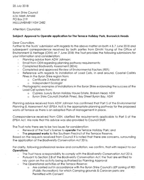
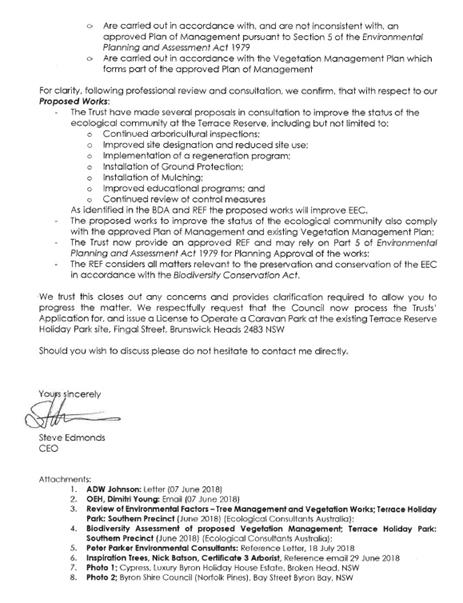
In response to this letter and the information submitted by
Reflections Holiday Parks, Council staff to satisfy due diligence, had an
independent planning consultant review the approval pathway proposed by
Reflections Holiday Parks for the works / activities proposed to support the
short term and camping site use proposed in the Southern Area Precinct.
Attachment 10.
A phone conference was held on 28 August 2018 between
Council staff and the Reflections Holiday Parks project team to discuss the
issues raised in the independent planning consultant’s review about the
Coastal Management State Environmental Planning Policy (SEPP) mapping; and the
reliance on the 2014 Plan of Management and use of the Infrastructure SEPP to
exempt works from a development application that are needed to support the
short term and camping sites use proposed in the Southern Area Precinct.
Council staff are of the opinion that further confirmation
of the pathway selected by Reflections Holidays Parks i.e. Part 5 is necessary
in this regard.
The Reflections Holiday Parks project team, acknowledged
this concern, but maintain that the issues raised by Council staff can be
addressed by conditions on the ATO as they are matters independent of the ATO
assessment under the Act and Regulations.
Staff subsequently acquiesced and drafted conditions to
address the relevant Resolutions in place being: 17- 418, 17- 523,
18-325 and the statutory requirements under the Act and Regulations for the
operation of a caravan park and camping ground.
As this application is made as a Crown application,
Reflections Holiday Parks need to agree to the conditions on the ATO; as such
preliminary draft conditions were referred to them on 31 August 2018 for
comment.
In response, the Reflections Holidays Parks project team (in
support of Special Condition Option A below) provided an update and correction
of the Holiday Park community map and concept plan site numbers and site uses;
requested 60 days to finalise a BCA compliance report for the Park sites; and
provided updated documents for the ATO on same.
This confirmed that it is proposed to have a total number of
30 sites (18 powered short term and 12 camping unpowered sites) in the Southern
Area Precinct. This results in an overall reduction of sites in the area to greater
than 8 sites.
With regard to the Northern Area Precinct of the Park,
Reflections Holiday Parks has also provided the following update on their
progress towards the works associated with the agreed concept plan from Resolution
17-418.
The Total expenditure to date related to moving the
permanent residents off the foreshore has been approx. $417,000.
Movements since late 2016
Relocated permanent dwellings and associated structures
o Relocated
from site 113 – site 87
o Relocated
From site 112 – site 86
Cabins converted to permanent residence
o Cabin 101 (up
near the back exit gate) relocated to site 81. The home owners from site
110 moved into the cabin and we removed the dwelling and associated structure
on site 110.
o Cabin 11 (ex
permanent residence on the waterfront, purchased by the Trust approx. 5 years
ago and left unoccupied) relocated to site 75 and renovated. The home
owners from site 138 moved into the refurbished cabin on site 75 and we removed
their dwelling and associated structures on site 138.
o Cabin 73 (ex
permanent residence near the front exit gate and within the permanents
precinct, purchased by the Trust approx. 6 years ago, refurbished and rented
out as a short term tourist site) is now home to the permanents from site 107.
We are currently removing the dwelling and associated structures located on
site 107 – on completion this will be a short term tourist site.
Permanent dwelling purchased by the Trust
o Permanent
dwelling located on site 92 was purchased by the Trust in 2017 and
refurbished. The home owners located on waterfront site 138 moved into
the permanent dwelling on site 92 in June 2018. Waterfront site 138 will
be removed next week. On completion we will level and turf the site in
preparation for the season.
Permanent dwelling purchased by the Trust and removed.
o Permanent
dwelling located on site 132 was purchased by the Trust in 2016. The dwelling
was removed and changed to a waterfront powered site.
o Permanent
dwelling located on site 120 was purchased by the Trust in 2016. The
dwelling was removed and changed to a powered tourist site.
o Permanent
dwelling located on site 74 was purchased by the Trust approx. 5 years
ago. The dwelling remained vacant and was removed in 2017 and changed to
a powered tourist site.
Proposed Stage 2 works – moving back the waterfront
permanent residents.
o Move back
permanent resident 122 6 metres back from the waterfront
o Turn
permanent resident 119 around to face the waterfront and line up next to site
122
o Turn permanent
resident 118 around to face the waterfront and line up next to site 124
(powered tourist site 123 will be decommissioned – this site is rarely
occupied as it sits between 2 permanent residents)
o Move
permanent resident 124 back from the waterfront and line up next to site 118.
o Move
permanent residents 125, 126 and 127 back and line up next to site 124.
o Move
permanent resident 111 to site 128 and line up next to site 127.
o Move
permanent residents 129 and 130 back from the waterfront and line up next to
site 128.
Reflections Holiday Parks have formally rejected the option
– no use / activity in the Southern Area Precinct (Option B below).
Should Council resolve to adopt the rejected option (Option
B below), the ATO will be submitted to the Minister for Local Government for
determination as per the Act.
Report
The ATO application lodged on 6
November 2017 (Attachment 1) for The Terrace Holiday Park, Brunswick Heads has
been the subject of further resolutions of Council including Resolutions
17-523 and 18-325, subsequent amendments to address these resolutions, and
a statutory assessment under the Act and Regulations as discussed in the
report. Attachments 12 & 13)
Reflections Holiday Parks has requested that Council make a determination
of the ATO application submitted with regard to the most recent reports
submitted to address the abovementioned resolutions of Council and the
statutory considerations under the Act and Regulations. Attachments 2 - 9.
Attachment 11 is the staff
compliance assessment report for The Terrace Reserve Holiday Park. This report
takes into consideration the amendments and clarifications provided by
Reflections Holiday Parks for the ATO.
The ATO application for The
Terrace Reserve Holiday Park is recommended for approval subject to conditions.
The conditions proposed are twofold: standard regulatory conditions and special
conditions.
With regard to the special
conditions - Council is presented with the choice of two options (A or B) below
for a special condition to be imposed on the use of the Southern Area Precinct
where the Coastal Cypress Pine community is located and where short term and
camping site use is proposed in the ATO application.
OPTION A
3. The total number of short term powered and
camp sites unpowered permitted in the Southern Area Precinct – Coastal
Cypress Pines Community is restricted to a maximum of 30 (18 short term powered
and 12 camp sites unpowered) at any time.
4. To address any potential biodiversity
impacts on the Coastal Cypress Pine Community a known endangered ecological
community: no new works or activities are to occur in the Southern Area
Precinct of The Terrace Reserve Holiday Park without the appropriate planning
consent / approvals in place. The various pathways for this to be determined
are provided in the note below:
Note:
Subject to legislative change.
Part 4 EP&A Act
III. The applicant must clearly demonstrate
whether or not the proposal requires development consent under Part 4 of the
EP&A Act. This includes considering the land uses that require such consent
in the RE1 zone under the Byron LEP.
IV. If development consent is required, then the
Byron Shire Council expects a development application to be lodged and to be
determined to satisfy 2 above.
Part 5 EP&A Act
III. If development consent is not required,
then the applicant must clearly demonstrate that it has ministerial authority
in writing to act as a public authority.
IV. If this can be established, then the council
expects an assessment of the activity under Part 5 of the EP&A Act to be
undertaken (usually via a Review of Environmental Factors), a determination
made, and then any subsequent approvals obtained, such as an approval from the
council under its DCP for the vegetation clearing, to satisfy 2 above.
Vegetation SEPP
III. If development consent or an activity
determination is not required for the proposal, then the Vegetation SEPP may
apply.
IV. If the applicant establishes that the
proposal triggers the biodiversity offset scheme thresholds, then under the
Vegetation SEPP approval for the clearing will need to be obtained from the
Native Vegetation Panel to satisfy 2 above.
OPTION B
1. No further use of or activity within
the Southern Area Precinct - Coastal Cypress Pines Community is to occur from
the date of the Approval to Operate and all existing infrastructure (except the
existing amenities facility) is to be removed.
Financial Implications
N/A
Statutory and Policy
Compliance Implications
The operation of caravan parks and camping grounds require
Approval to Operate (ATO) under Section 68 (Part F2) of the Local Government
Act 1993. Applications are lodged by the land owner to continue the operation
of caravan park and camping ground activities and application fees are paid in
accordance with Councils’ adopted fees and charges.
The process of assessing and determining ATO applications is
regulated under Chapter 7 Part 1 of the Local Government Act 1993. Part of the
consideration of such applications involves the auditing of compliance with the
Local Government (Manufactured Home Estates, Caravan Parks, Camping Grounds and
Moveable Dwellings) Regulation 2005 (“the Regulation”).
Once it had been determined that the application represented
the actual site activities, and satisfies the requirements of the Regulation,
then an ATO approval is granted. Once an approval has been issued council may
determine to extend or renew an approval (but without changing the terms of the
approval) if satisfied there is good cause for doing so.
The relevant sections of the Local Government Act have been
reproduced below:
LOCAL GOVERNMENT ACT
1993
72 Determination of
applications by the Crown
(1) A
council, in respect of an application for approval made by the Crown or a
person prescribed by the regulations, must not:
(a) refuse to
grant approval, except with the written consent of the Minister, or
(b) impose
a condition of an approval, except with the written consent of the Minister or
the applicant.
(2) If
the council proposes to refuse to grant approval or to impose a condition of
approval, it must immediately notify the applicant.
(3) After
the applicant is so notified, the council must submit to the Minister:
(a) a copy of
the application for approval, and
(b) details of
its proposed determination of the application, and
(c) the reasons
for the proposed determination, and
(d) any
relevant reports of another public authority.
(4) The
applicant may refer the application to the Minister whether or not the council
complies with subsection (3).
(5)
After receiving the application from the council or the applicant, the Minister
must notify the council and the applicant of:
(a) the
Minister’s consent to the refusal of approval, or
(b) the
Minister’s consent to the imposition of the council’s proposed
conditions, or
(c) the
Minister’s intention not to agree with the council’s proposed
refusal and the period within which the council may submit any conditions it
wishes to impose as conditions of approval, or
(d)
the Minister’s refusal to agree with the council’s proposed
conditions and any conditions to which the Minister’s consent may be
assumed.
(6) At
the end of the period specified in subsection (5) (c), the Minister must notify
the council and the applicant:
(a) whether
the Minister consents to the imposition of any of the conditions submitted by
the council during that period and, if so, which conditions, or
(b) of
the conditions to which the Minister’s consent may be assumed.
(7) The
Minister must notify the council and the applicant of the reasons for a
decision under subsection (5) or (6).
(8) If
the council does not determine the application within the period notified by
the Minister for the purpose, the council is taken, on the expiration of that
period, to have determined the application in accordance with the
Minister’s consent.
73 Effect
of council’s failure to determine Crown application
(1) If
the council does not determine an application to which section 72 applies
within the relevant period specified in section 105, the council is taken, on
the expiration of that period, to have refused the application.
(2)
If the application is taken to have been refused, the applicant may refer the
application to the Minister for determination.
(3) The
Minister may determine an application so referred to the Minister.
(4) The
Minister’s determination has effect as if it were a determination of the
council.
74 Prohibition on
appeals concerning Crown applications
No review or appeal lies against a determination that the
council is taken to have made under section 72 (8) or a decision or
determination of the Minister under section 72 or 73.
105 Circumstances in
which approval is taken to have been refused
(1) If
the council has not determined an application:
(a)
within the period of 40 days after the application is lodged with it, except as
provided by paragraph (b), or
(b) within
the period of 80 days after the application is lodged with it in the case of an
application for which the concurrence of a person or authority is required by
or under this Act, the council is, for the purposes only of section 176, taken
to have determined the application by refusing approval on the date on which
that period expires.
(2) Nothing
in subsection (1) prevents the council from determining an application after
the expiration of the 40-day or 80-day period, whether on a review under
section 100 or otherwise.
(3) A
determination under subsection (2) does not prejudice or affect the continuance
or determination of an appeal made under section 176 in respect of a
determination that is taken under subsection (1) to have been made, subject to
subsection (4).
(4) Where
a determination under subsection (2) is made by granting approval, the council
is entitled, with the consent of the applicant and without prejudice to costs,
to have an appeal made under section 176 in respect of a determination that is
taken by subsection (1) to have been made, withdrawn at any time before the
appeal is determined.
Staff Reports - Sustainable Environment and Economy 13.17
Report No. 13.17 Update
- Byron Housing Roundtable and Residential Strategy
Directorate: Sustainable
Environment and Economy
Report
Author: Shannon
Burt, Director Sustainable Environment and Economy
File No: I2018/1691
Theme: Sustainable Environment and Economy
Planning Policy and Natural Environment
Summary:
The purpose of this report is to provide Council with an update on the
progress made towards the
agreed next steps the result
of the Byron Housing Roundtable held by Council on 5 July 2018; and
the outcomes of the Strategic Planning Workshop, 6 September –
Update on Residential Strategy.
|
RECOMMENDATION:
1.
That Council note the update provided by staff on the progress made
towards the agreed next steps the result of the Byron Housing Roundtable held
5 July 2018.
2.
That Council note that a draft Residential Strategy will be presented to
Council by the end of the year inclusive of a Charrette being held in
November.
3. That
Council allocate an additional $1,500 to the Residential Strategy Budget to
create a total budget of $20,000 to fund the estimated cost of the Charrette
with funding sourced from the Land and Natural Environment Reserve.
|
Report
A Byron Housing Roundtable was convened by the Director of Sustainable
Environment and
Economy on 5 July 2018 as a follow up to the successful Byron Housing
Summit held February
2017:
https://www.byron.nsw.gov.au/Community/Supporting-communities/Housing-Affordability-Initiatives#section-5
The purpose of the Roundtable was to meet with select stakeholders to
discuss: where Byron
Shire is now 18 months on from the Summit; and where does it need to be,
to further support and
deliver affordable housing outcomes for its community.
As can be seen from the link below a number of key projects
and initiatives have been progressed since the Summit https://www.byron.nsw.gov.au/Community/Supporting-communities/Housing-Affordability-Initiatives
The Roundtable was arranged around themes to look at the
following areas:
•
Housing types and models
•
Tenure types and security
•
Planning enablers and barriers
•
Finance and investment models
The roundtable was well attended by councillors, staff and a
range of industry stakeholders. Participation was through short presentations,
active conversations with an outcomes focus to the day.
Since the Roundtable staff have progressed work on the 4
keys actions agreed to on the day to address housing need in the Shire:
1. Legal
/ governance structures
Staff are soon to convene a working group (from attendees /
councillors) to explore and progress options for legal and governance matters
as they pertain to landownership / tenure models. In the meantime staff will
continue to contribute to discussions on the Byron Community Land Trust as they
occur with that working group.
2. Development
opportunities
Staff continue to look at options for pilot site
opportunities to explore and deliver on innovative housing models. Discussions
with senior staff at the Department of Planning have also commenced in this
regard.
3. Planning/policy
reforms
Council staff have commenced a review of the existing
planning controls in an effort to identify some quick win opportunities from
policy review to enable the above opportunities to occur if currently impeded
by the LEP / DCP.
A tiny houses fact sheet has also been uploaded to the fact
sheet page on the Council web page:
file://fapmho2/users$/sburt/Downloads/MASTER-Tiny-houses-Fact-Sheet-August-2018.pdf
4. Communication/education
Staff have progressed updates to the webpage with the
available information and presentations shared at the Roundtable. Relevant
information to housing policy will also be uploaded as links from time to time.
Further (in consultation with David Brown) staff have
prepared a brief for a consultant to undertake work on a series of
“pen portraits” of individuals and families in need, and the
housing product / location / price point trade-offs they would be prepared to
make to stay in the Shire. For example, close to friends, support networks,
workplaces and other family members. These “pen portraits” would
assist in communicating with
the community about the housing affordability issue, who is affected and the sort of housing they
seek. This qualitative work would supplement quantitative work already
completed or in train for the Residential
Strategy. Updates to Council on the above work will be provided as part of the
Residential Strategy. Funding for the Pen Portraits however is needed and the
project is currently being scoped by staff but at this time should be
accommodated within the existing budget.
Strategic Planning
Workshop, 6 September – Update on Residential Strategy
Council received an update on the draft Residential Strategy
in light of recent Council and State policy positions. Options to prepare the
Strategy were discussed in accordance with this and the following Council
resolutions:
Resolution
17-044
(relevant part only)
3. That a
report be included outlining the possible role, cost and an implementation plan
for the establishment of a citizen jury to enhance the engagement outcomes
within the revised project plan being prepared to present to Council that
responds to engagement concerns raised in the submission (Within Table 3: Key
matters relating to ‘Strategy Process’.)
Resolution
18-410
(relevant part only)
2.
Endorse, subject
to budget allocation in the 2018/19 Budget, the allocation of $50,000 to fund a
6 month planning position to prioritise the finalisation of the residential strategy
by end of year.
There was general agreement reached by Councillors that a
draft Residential Strategy would be presented to Council by the end of the year
and that a Charrette be held in November to inform the recommendations to be
made.
The Charrette proposed given the tight time frame, will seek
to bring together Councillors, Council staff and experts over an intensive 1-2
day block to deliberate on and provide a policy position for Council on land
supply, location and housing type consistent with the State Government’s
North Coast Regional Plan and other Policy and Code initiatives. This policy
position can then be tested with the wider community during the formal
exhibition period of the Residential Strategy early 2019.
If Council prefer to have community representatives
participate in the Charrette then options that could be accommodated within the
tight time frames are: seeking interest from members of the Community Solutions
Panel; or Councillors nominating community representatives, with 5 community
representatives invited to participate in the Charrette.
Financial Implications
Council currently has a
budget of $18,500 available for the residential strategy for the 2018/2019
financial year. A cost estimate for the Charrette is estimated at
$20,000. This leaves a budget shortfall of $1,500 which can be funded
from the Land and Natural Environment Reserve should Council proceed.
Statutory and Policy
Compliance Implications
N/A
Staff Reports - Sustainable Environment and Economy 13.18
Report No. 13.18 PLANNING
- DA2017.516.1 - Subdivison to Create 4 Lots,8 Coomburra Cr, Ocean Shores
Directorate: Sustainable
Environment and Economy
Report
Author: Greg
Smith, Team Leader Planning Services
Chris Larkin, Manager Sustainable
Development
File No: I2018/1697
Theme: Sustainable Environment and Economy
Development and Certification
Proposal:
|
DA No:
|
10.2017.516.1
|
|
Proposal description:
|
Subdivision to create four (4) Lots
|
|
Property description:
|
LOT: 1577 DP: 243995
|
|
8 Coomburra Crescent OCEAN SHORES
|
|
Parcel No/s:
|
14500
|
|
Applicant:
|
Ardill Payne & Partners
|
|
Owner:
|
Mr A L Mangleson
|
|
Zoning:
|
R2 Low Density Residential
|
|
Date received:
|
19 September 2017
|
|
Integrated Development:
|
No
|
|
Public notification or exhibition:
|
- Level
1 advertising under DCP 2014 Part A14 – Public Notification and
Exhibition of Development Applications
- Exhibition
period 1: 28/09/17 to 11/10/17
- Submissions received:
Ten (10)
- Exhibition
period 2: 28/09/17 to 11/10/17 (Geotechnical report)
- Submissions
received: Five (5)
|
|
Delegation to determination:
|
Meeting of Council
|
|
Issues:
|
· Width of driveway
· Stormwater
management
· Geotechnical
issues
|
Summary:
The application seeks development consent for the
subdivision of a large existing residential lot into four (4) new lots. Access
to proposed Lots 1, 2, 3 and 4, is via a 6.0m wide access handle from Coomburra
Crescent. The proposal is considered to satisfy the provisions of Byron LEP
2014 and other relevant Environmental Planning Instruments, and is satisfactory
form of infill development ranging in size from 800m2 to 1675m2
in area.
Council considered a report (copy attached) recommending
approval of the DA, subject to conditions, at it’s meeting on 2 August
2018. Council resolved to defer the DA in order to investigate possibilities of
narrowing the driveway, ensure Council’s stormwater infrastructure can
adequately receive stormwater generated by this subdivision, ensure that the
community has a longer period to consider the geotechnical aspects and
implications of the development application and, when reported back to Council
a more expansive report from staff on this aspect be presented.
The Geotechnical Stability Assessment submitted in support
of the DA was publicly exhibited from 10 to 30 August 2018. A total of five (5)
submissions (copy attached) have been received. The matters raised relate to
driveway, storm water, amenity, vegetation removal and geotechnical impacts and
adequacy of information submitted. These issues are discussed in the body of
the report.
In summary it is considered the proposed four lot
subdivision is not an overdevelopment of the site with the large sized lots as
proposed. It is also noted consent could have been sought for a much more intense
development on this property such as multi dwelling housing, however the four
lots as proposed has had regards to the constraints affecting it such as
slope, drainage and access, and is consistent with the low density residential
character of Ocean Shores.
The application is considered to have sufficient merit to
warrant approval subject to conditions.
NOTE TO COUNCILLORS:
In accordance with the
provisions of S375A of the Local Government Act 1993, a Division is to be
called whenever a motion for a planning decision is put to the meeting, for the
purpose of recording voting on planning matters. Pursuant to clause 2(a)
under the heading Matters to be Included in Minutes of Council Meetings of
Council's adopted Code of Meeting Practice (as amended) a Division will be
deemed to have been called by the mover and seconder of all motions relating to
this report.
|
RECOMMENDATION:
That pursuant to
Section 80 of the Environmental Planning & Assessment Act 1979, Development
Application No. 10.2017.516.1 for
subdivision to create four (4) lots, be granted consent subject to conditions
detailed in Attachment 2 #E2018/73142.
|
Attachments:
1 Attachment
1 - Ordinary 18 October 2018 - Proposed Plans by Ardill Payne, E2018/72998
2 Attachment
2 - Ordinary 18 October 2018 - Report to Council on Development Application No.
10.2017.516.1, E2018/73142
3 Attachment
3 - Ordinary 18 October 2018 - Geotechnical Stability Assessment by Shaw
Urquhart Pty Ltd dated 17/5/2018, E2018/73148
4 Attachment
4 - Ordinary 18 October 2018 - Submissions received in relation to public
exhibition of Geotechnical Stability Assessment, E2018/73003
5 Attachment
5 - Ordinary 18 October 2018 - Recommended conditions of consent, E2018/73146
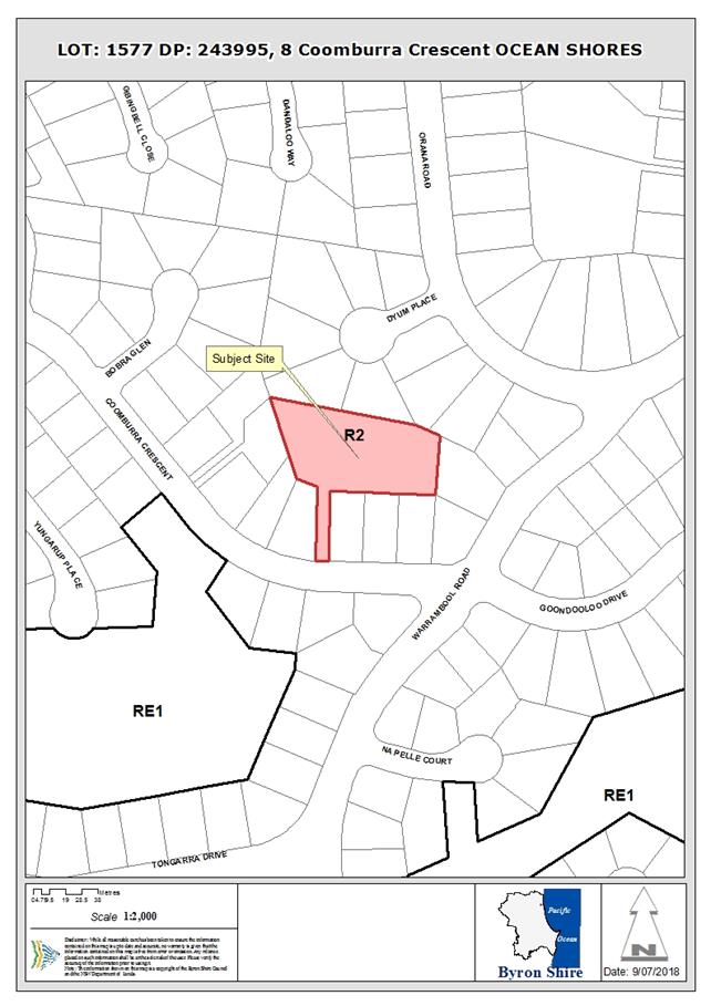
Report
1. HISTORY
/ BACKGROUND
At it’s meeting on 2 August 2018, Council resolved in
relation to DA 10.2017.516.1 as follows:
Resolved that pursuant to Section 80 of the
Environmental Planning & Assessment Act 1979, development application no.
10.2017.516.1 for subdivision to create four (4) lots, be deferred in order
to:
1. Investigate
possibilities of narrowing the driveway to allow for increased vegetation along
the driveway.
2. Ensuring
Councils stormwater infrastructure is of a size and management regime to
adequately receive stormwater generated by this subdivision.
3. Ensure
that the community have a longer period in which to consider the geotechnical
aspects and implications within the development application, and that when
reported back to Council a more expansive report from staff on this aspect be
presented.
In relation to item 1 of the resolution, condition 6(a) has
been recommended to reduce the width of the driveway to 5m wide for the first
6m into the property to allow 2 cars to pass at the site entry to act as a
passing bay and then narrowed to 3.5m wide for approximately 40m leaving
approximately 1.3m each side of the driveway for appropriate landscaping.
A condition is recommended requiring the application for a construction
certificate to include plans and specifications that indicate the landscaping
of areas either side of the driveway surface within the battleaxe handle to the
site. In terms of fencing along the length of the access handle, this is no
longer a conditioned requirement as it will result in removal of existing
garden vegetation currently growing along those boundaries.
In relation to item 2 of the resolution, the site drains to,
and is part of, the catchment that the existing Council stormwater
infrastructure system was designed for as shown in the extract of the
engineering plans below.
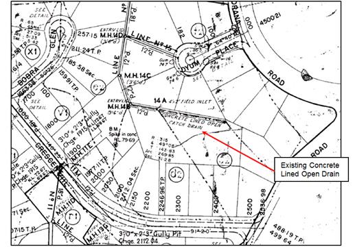
The existing Council infrastructure is not identified by
Council’s systems as failing, however it is noted that a concrete lined
catch drain was constructed on the northern boundary of the site and it is
clear that the drain is overgrown with vegetation and has little maintenance
over the years. The development of this property will ensure that this drain is
upgraded with the construction of the inter-allotment drainage system.
Conditions 6(d) and 27(c) are also recommended for the
provision of on-site stormwater detention so that the peak flow from the
proposed development does not exceed the existing peak flow from the site in
accordance with section B3.2.3 of Development Control Plan 20104, Chapter B3
– Services.
It is also noted that inter-allotment drainage is required
under conditions 6(c) and 27(a) for the subject lots and the upstream
properties at 2 to 10 Coomburra Crescent to provide lawful points of discharge
for existing and future dwellings.
In relation to item 3 of the resolution, a letter was sent
to the same people who were publicly notified of the development application
essentially:
1. Advising
of the Council resolution;
2. Advising
that the Geotechnical report submitted in support of the DA was on public
exhibition and accessible for consideration on Council’s website; and
3. Inviting
written responses from members of the public to the geotechnical aspects and
implications within the development application by 30 August 2018.
The public submissions received in response to are
considered below.
2. Submissions
made in accordance with this Act or the regulations
In accordance with item 3 of the Council resolution, the
Geotechnical Stability Assessment by Shaw Urquhart Pty Ltd dated 17/5/2018 was
publicly exhibited from 10 to 30 August 2018. 5 public submissions have been
received, and the issues raised are summarised and commented on as follows:
· Impact
of a dual carriageway driveway with no vegetation or barriers of any kind, plus
2.5m high boundary fence each side of access handle.
Comment: The condition for the 2.5m high fence
has been deleted and the driveway narrowed for landscaping to be provided for
improved amenity and as requested by neighbours.
· Insufficient
infrastructure to cater for the stormwater runoff from proposal.
Comment: As discussed above, conditions have
been recommended to include stormwater infrastructure, including provision of
inter-allotment drainage to direct stormwater to the existing Council
infrastructure.
· A
full geotechnical assessment should be undertaken before development consent is
issued having regard to the slope of the land and in particular lot 3.
Comment: Further Geotech is required to inform
the design and construction of civil works as part of the subdivision.
Conditions of consent also require further geotechnical assessment and
certification before issue of subdivision certificate and restrictions on title
to ensure further geotechnical assessment inform the design and construction of
future dwellings having regard to the geotechnical constraints. The
Shaw:Urquhart report indicates that the type of building is likely to be
restricted to light weight slope-sensitive structures to limit surcharge
loadings on the slopes in accordance with good hillside construction practice
as recommended by the Australian Geomecahnics Society “Practice Note
Guidelines for Landslide Risk Management”, March 2007.
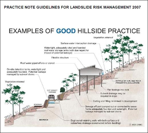
In essence this will mean that dwellings will be of pole
home or pier construction and not the typical slab on ground construction.
Restrictions on title have been recommended for this type of construction. It
is not normal practice to require detailed geotechnical report without detailed
plans of the future dwellings. In this instance the application is for
subdivision only not the construction of the dwellings upon them
Notwithstanding, it is considered that the site is suitable to accommodate
future dwellings.
Conflict between tree removal
plan and Geotech report
Comment: Tree removal is proposed for Lot 3 which is
consistent with the geotech report
There will be
a gap between the lower boundary of properties on 2, 4 and 6 Coomburra Crescent
and the retaining wall of the proposed driveway. The plans are unclear whether
the drain is on the surface? Consent Conditions must be defined for the maintenance
of this gap.
Comment: A proposed catch drain is shown on the
engineering plans (see below) which is located on the applicants land between
the retaining wall and the boundaries of 2, 4 & 6 Coomburra Crescent.
Adequate width is available for maintenance purposes.
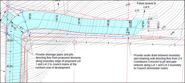
If the
groundwater water is prevented from flowing under Lot 3 by non-porous retaining
walls then the water will pool somewhere else ie: possibly further up the slope
causing instability issues to existing neighbours’ properties on 2, 4 and
6 Coomburra Crescent. Ground water management techniques need to be clearly
defined that do not transfer risk to our properties.
Comment: Drainage will be constructed behind
the proposed retaining walls and its is normal for such walls to be backfilled
with gravel with ag pipe to collect and direct seepage to the inter-allotment
drainage system in accordance with engineering practice. Conditions of consent
also recommended requiring the engineering plans for the Construction
Certificate for the civil works to be considered in conjunction with a
Geotechnical Assessment.
· Disruption
during construction to neighbourhood amenity from tradesmen’s vehicles
and the like.
Comment: Noted, this is anticipated but will be
short lived during the construction phase of future dwellings. Notwithstanding
the driveway will be constructed for the full length of the access handle and
will provide a platform for parking of construction vehicles.
· Should
only be a 3 lot subdivision with Lot 3 unsuitable.
Comment: It is considered that the site can
accommodate 4 lots as proposed.
· Inherent
conflict of interest in having the developer fund the geotech report.
Comment: It is standard procedure for an
Applicant to pay for and supply plans and reports in support of a development
application. Those preparing and providing the reports should be satisfied that
they are acting with integrity and have appropriate qualifications and
experience. Council’s Development Engineer has in this instance,
considered the DA and raised no objection to the geotechnical assessment
subject to conditions.
· Landscaping
plan required to reduce the impact of noise, light and visual impacts
Comment: A condition was previously recommended
that, prior to issue of a Construction Certificate amended plans are to be
submitted which include a 2.5 metre high solid fence either side of the vehicle
access handle. The condition is no longer recommended due to the narrowing of
the driveway and provision of landscaping either side of the vehicle access
handle. Such a fence would also impact on existing vegetation that is raised as
a concern as indicated below. Should future fencing be desired by land owners
this will be a matter for negotiation between the property owners.
A landscape plan is now required prior to the issue of a
construction certificate, and a new condition is recommended accordingly, given
the reduction in the width of the driveway.
The
golden cane palms lining the driveway are on number 6 Coomburra Crescent and I
have not been asked for consent for their removal. It is illegal
to remove vegetation on another’s property without approval from the
owner to do so.
Comment: Approval is not given for the removal
of any vegetation beyond the boundaries of the subject site, given that the DA
only relates to 8 Coomburra Crescent. The golden cane palms are likely to form
up part of the landscaping either side of the vehicle access handle if
retained.
3. CONCLUSION
It is considered the proposed four lot subdivision is not an
overdevelopment of the site with the large sized lots as proposed. It is also
noted consent could have been sought for a much more intense development on this
property such as multi dwelling housing, however the four lots as proposed has
had regards to the constraints affecting it such as slope, drainage and
access. The application is recommended for approval subject to conditions of
consent.
4. DISCLOSURE
OF POLITICAL DONATIONS AND GIFTS
|
Has a Disclosure Statement been received in relation
to this application
|
No
|
|
Have staff received a ‘gift’ from anyone
involved in this application that needs to be disclosed. Where the answer is
yes, the application is to be determined by the Director or Manager of the
Planning, Development and Environment Division.
|
No
|
5. REASONS
FOR DECISION, HOW COMMUNITY VIEWS WERE ADDRESSED
|
|
|
The proposed development will not have significant adverse
impact on the natural, built or social environment or economic impacts on the
locality.
|
|
The proposed development is considered suitable for the
proposed site and represents a viable use of urban land for low density
residential purposes.
|
|
How community views were addressed
|
|
The DA was advertised in accordance with Development
Control Plan 2014. The submissions received were considered on merit and
addressed during assessment of the application.
|
Staff Reports - Infrastructure Services 13.19
Staff Reports - Infrastructure Services
Report No. 13.19 Suffolk
Beachfront Holiday Park Dog Friendly Report
Directorate: Infrastructure
Services
Report
Author: Pattie
Ruck, Open Space Facilities Coordinator
File No: I2018/1269
Theme: Infrastructure Services
Suffolk Park Holiday Park
Summary:
To provide a report on Dog Friendly Trial Results at Suffolk
Beachfront Holiday Park and recommend Dog Friendly Status based on these
results.
|
RECOMMENDATION:
That Council adopt Suffolk Beachfront Holiday
Park as a Dog Friendly Park in accordance with the dog friendly site map,
during off peak times.
|
Attachments:
1 Dog
Friendly Park Rules, e2018/57756
2 Feedback
on Dog Friendly Trial at Suffolk Beachfront Holiday Park, e2018/59006
Report
Dog Friendly Trial
The initial trial period commenced in late 2016 and was
extended until the finalisation of this report.
Consultation prior, during, and post trial period has been
undertaken with the Park Managers, permanent residents, and short term guests.
Written feedback was received from Park Mangers, residents, and short term
guests throughout the dog friendly period. The trial period excluded peak
periods and busy times.
Dog Friendly Park Rules and Associated Procedures
During the trial the Park Managers implemented strict dog
friendly park rules, as attached (E2018/57756). Upon guest check-in these
rules were signed and understood by dog friendly guests and the below map
provided.
Map depicting access point to Off Lead Companion Area from
Suffolk Beachfront Holiday Park
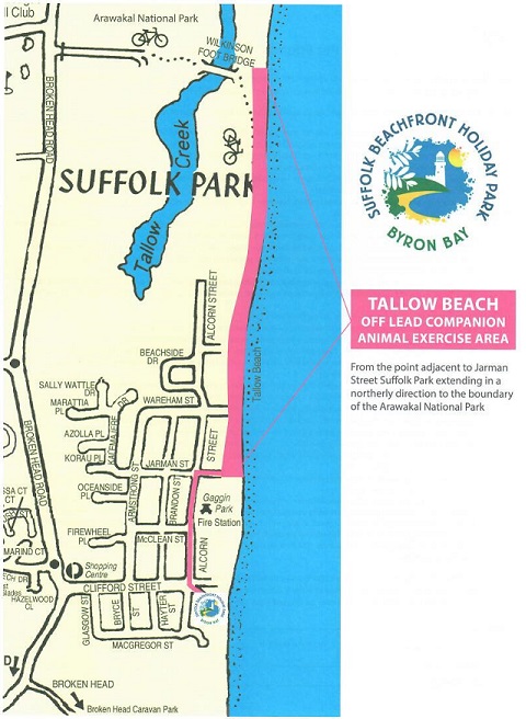
Appropriate signage placed throughout the park and beach
access points.
Beach access points within the park Signs
inside the BBQ Area
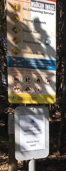
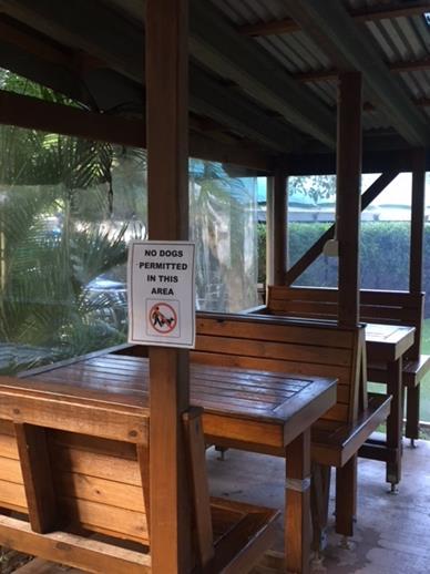
Dogs NOT PERMITTED signs near camp kitchen and
laundry.
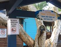
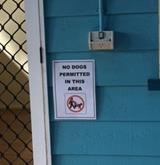
 ,
,
Dog Friendly Sites Available Map
P = Dog friendly sites – Sites 23 to 50 = 32 Sites
OP = Overflow Dog friendly sites – used as overflow
only when P sites are full – Sites 4 to 9 & 17 to 21 = 11 Sites
Dog friendly site locations selected considering
proximity separation from permanent residents.
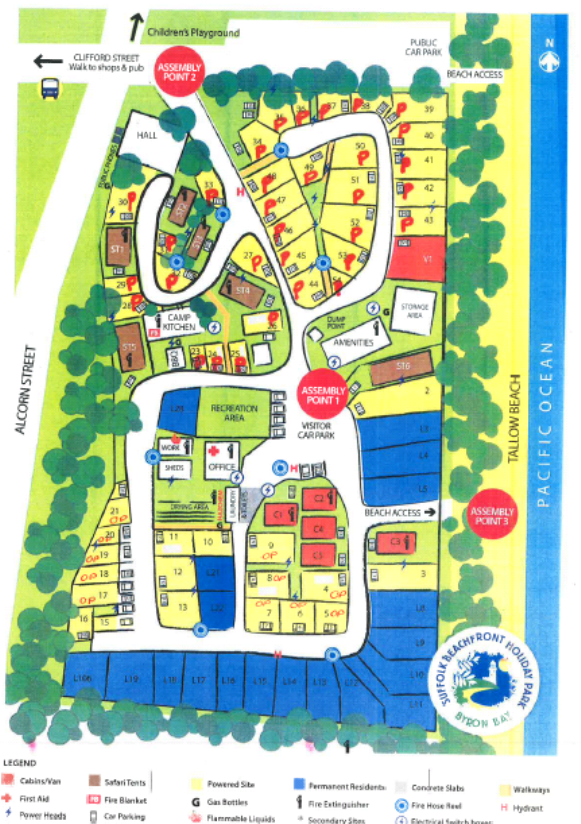
Dog Friendly Feedback
Feedback and Mitigation measures implemented on feedback
items
The table below displays a summary of feedback items
received. Summary of the details of where the feedback was from, how many
submissions were received, and documentation reference details are
attached.
Unsupportive Submissions - One submission signed by
eight of the permanent residents. Two negative submissions received
individually from two permanent residents who also signed the group
submission. One negative submission received from a regular short term
guest.
Supportive Submissions - Two positive submissions
received from permanent residents. Council has received positive feedback
from written letters, facebook comments, and wikiCamp reviews. One
positive feedback received in writing from a short term guest, six positive
comments on Facebook and nine positive comments on wikiCamps.
|
Feedback Item
|
Mitigation Measure
|
|
Dogs off leads
|
— Dog friendly park rules explained to guests
upon check in and signed by guests to acknowledge requirements of the
park.
— Managers communicate with offending guests
ASAP and ensure compliance. If non-compliance is ongoing the guests
will be required to leave.
— Occasionally dogs from outside of the park
wonder through. There has been occasions throughout the trial this has
occurred and after enquiring with guests, these particular dogs were not from
guests staying at the park and did not match the description of their types
of dogs. This issue is ongoing and hard to mitigate with or without a
pet friendly status. Possible fencing could be looked at in the future
if this issue is heightened and cost/benefit is feasible.
|
|
Complaints from other
guests/residents regarding barking and roaming dogs.
|
— Managers act upon the requests ASAP and
ensure compliance where applicable.
— Complaints are looked into ASAP by the
managers and mitigation measure actioned.
|
|
Dog droppings
|
— Guests are briefed and required to sign on
dog friendly park rules.
— Managers inspect the sites daily to ensure
sites and surrounds are free from droppings. There were two occasions
this occurred during the trial.
— Bag dispensers provided if problem
persists.
|
|
Dogs taken onto the
beach through non dog friendly access points
|
— Signs indicate where Dogs are NOT PERMITTED
are in place at access points.
— Upon check in guests are verbally told and
provided a map detailing access points.
|
|
Effect on wildlife
|
— Park rules ensure dogs are tied up,
therefore unable to chase after wildlife. If wildlife was to approach
the dog this is unable to be mitigated.
|
|
Complaints from
permanent residents
|
— Dog Friendly Sites are separated from the
permanent residents and the overflow sites are separated by a minimum road
width. Throughout the trial there were issue when the managers allowed
pets throughout the whole park. However, this was resolved and the
managers are to ensure there is always separation from the residents as per
the map displayed above.
|
Dog Friendly Seasonal Dates
Seasonal dates throughout Suffolk Park for 18/19 was adopted
by Council on 28 June 2018 along with the fees and charges. These
seasonal dates will continue to be included in the annual fees and charges
process.
Peak times will be excluded from
dog friendly status. The adopted peak seasonal dates for Suffolk
Beachfront Holiday Park run from 22 December 2018 to 14 January 2019 (Christmas
holidays) and 17 April 2019 to 27 April 2019 (Easter, ANZAC, NSW and QLD School
holidays). Major festivals fall under this peak category and these festival
dates change annual. Seasonal dates outside of the adopted peak dates
will be available to guests as dog friendly. As peak times
are excluded as dog friendly periods within the park, permanent
residents will not be able to have a pet friendly status. This procedure mitigates
any risk of ongoing permanent dog related issues. Short term guests are
required to leave if their dog is a nuisance.
Financial Implications
The minimum financial increase from dog friendly bookings
from 1 May 2017 to 30 April 2018 was $64,940.78. The Park Managers have
indicated this figure does not include website or internet browsing bookings
that are dog friendly bookings. 9.13% of overall bookings are related to
pet friendly bookings. There was no decline noted in regular bookings
that were not dog friendly guests. Additional infrastructure is not
required by Council. If Suffolk Park is not to continue as a Dog Friendly
Holiday Park Council acknowledges the potential for declined income and
recognises a need to honour pet friendly bookings already taken until 2 October
2018.
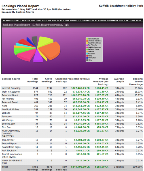
Statutory and Policy Compliance Implications
Current zoning of land – LEP 2014 – Zone RE 1
– Public Recreation
Suffolk Beachfront Holiday Park is currently located on DP
1023737 Lot 100. Zone RE 1 – Public Recreation.
Permanent Sites at the park have been reclassified as
Operational Land recently. These sites are separate from the dog friendly
sites.
Byron Shire Council Companion Animal Exercise Areas
– Policy 5.31
Policy 5.31 adopted by Council in March 1994 and reviewed in
October 2011 outlined off-lead exercise areas within Byron Shire. Tallow
Beach shown in MAP 1 is the closest to Suffolk Beachfront Holiday Park.
Tallow Beach off-lead exercise area is approximately 485 m from Suffolk
Beachfront Holiday Park. This distance requires a short walk from Suffolk
Beachfront Holiday Park.
MAP 1
Benefits of Dog Friendly Suffolk Beachfront Holiday Park
— Allows Council’s
holiday park to remain competitive and in line with other holiday parks in and
surrounding Suffolk Park area. Ferry Reserve at Brunswick Heads, Byron
Holiday Park at Suffolk, North Coast Holiday Parks including Shaw’s Bay
in Ballina and Silver Sands at Evans Head have all converted to dog friendly
periods and have reported an increase during off peak periods of approximately
60 to 70 %.
— Dog friendly availability
offers extra service options for guests.
— Increases Council’s
revenue stream for this asset as shown below.
— Park Managers are able to
manage this dog friendly status with no additional resources required from
Council.
— Park location and relaxed
nature support the dynamics of a dog friendly acceptance.
Non-benefits of Dog Friendly Suffolk Beachfront Holiday
Park
— Continued and/or
escalated negative feedback from park users and/or permanent residents and
subsequent increased mitigation measures required by Park Managers in
consultation with Council. Possible increase in costs associated with
mitigation measures relevant to feedback.
— Forecasted revenue not as
predicted.
Conclusion
Overall the dog friendly
trial period was well received by both permanent residents and short term
guests. There were instances where residents were unhappy with the
effects of the dog friendly trial. Once mitigation measures outlined were
strictly enforced many of these complaints were able to be minimised.
The separation of the dog
friendly sites from the permanent resident sites proved to be a major factor in
minimising this negative effect on permanent residents. Unfortunately,
the managers of the park allowed dog friendly sites close to the residents for
an interim period throughout the trial. This created permanent residents
to become unsupportive of the dog friendly status and subsequently submitted
unsupportive feedback.
Since then, Council has
consulted with the park managers to promptly action the site separation
preferences as discussed in the original trial. The mitigation measures
outlined have had a positive impact on feedback received.
It is anticipated that
there will never be 100% support of a Dog Friendly Park, however based on the
feedback received and the success and failure points within the trial it can be
concluded that there is general support from customers for the Park to become
Dog Friendly.
Staff Reports - Infrastructure Services 13.20
Report No. 13.20 Parking
Time Changes in Mullumbimby, Bangalow and Brunswick Heads - Status
Report
Directorate: Infrastructure
Services
Report
Author: Evan
Elford, Team Leader Infrastructure Planning
File No: I2018/1437
Theme: Infrastructure Services
Local Roads and Drainage
Summary:
To update Council on the implementation and monitoring of
the time limit changes to parking in Mullumbimby, Bangalow and Brunswick Heads
parking schemes.
The report details the relevant issues relating to the
implementation of the schemes, the methodology of data collection and analysis,
provides commentary on the schemes and outlines the future actions for
continued monitoring and reporting to Council.
|
RECOMMENDATION:
1. That
Council note the status and proposed actions relating to the parking
schemes in Mullumbimby, Bangalow and Brunswick Heads
2. That
Council receive a further report detailing the performance review of
the parking schemes at Mullumbimby, Bangalow and Brunswick Heads at the April
2019 Council meeting.
|
Report - Mullumbimby
Resolutions:
Mullumbimby parking time changes were resolved by Council on
23 November 2017 as follows:
17-572 Resolved:
1. That
Council endorse the implementation of the changes to parking time limits in the
Mullumbimby town centre, in line with Figure 1 in this report, being 1P
throughout Burringbar Street and the addition of 4P zones at the ends of Stuart
and Dalley Streets, with 2P remaining in place for the remainder of Stuart and
Dalley Streets.
2. That
the time limit changes be reported to the Local Traffic Committee (LTC).
3. That
Council approve a budget of $15,000 to implement the revised parking time
limits, from the Infrastructure Renewal Reserve.
4. That Council
receive a report after twelve (12) months, to review:-
a) The
effectiveness of the time limit changes in managing parking turnover;
b) Infringement
levels throughout the town centre; and
c) Based
on the outcomes of a) and b) above, the introduction a pay parking scheme to manage
parking turnover and effectiveness in accordance with the recommendations of
the Traffic and Parking Systems Group (TPS) report titled “Mullumbimby
Town Centre Parking Management Strategy” (#E2016/80919).
The proposed time limit changes were reported to Local
Traffic Committee (LTC) and the minutes reported to Council on 14
December 2017 where Council resolved as follows:-
17-710
Resolved:
Committee Recommendation 6.1.1
1. That
the Local Traffic Committee endorse the changes to the parking time limits in
the Mullumbimby Town Centre, as depicted in the proposed parking times in
Figure 1, being:
a) 1P
throughout Burringbar Street and the addition of 4P zones at the ends of Stuart
and Dalley Streets and
b) 2P
remaining in place for the remainder of Stuart and Dalley Streets.
2. That
the Local Traffic Committee recommend that the proposed 4hr parking limits be
reviewed during the 12 month period on a needs basis.
Implementation:
Infrastructure Services installed new signs and modified
existing parking zone time limits to implement the scheme which became
enforceable on the 15 March 2018.
Approximately 80 new signs were required with the
implementation being of medium complexity due to the requirements to extend
current time zones and the fact that parking durations were not uniform with
that of Byron Bay thereby limiting the option for utilising existing signage
from existing stores.
Parking time zone changes appear to have been accepted by
the community with limited feedback or minimal issues being raised with
Infrastructure Services.
Data Collection:
Monitoring and Licence Plate Recognition (LPR) data
collection of the scheme has been carried out on the following dates:
27 April 28 April 9
May 11 May 12
May 6 June
On those dates, 2 Enforcement Officers carried out LPR data
collection functions in the 3 villages on a rotation basis as follows:
1. Complete
LPR scan of Mullumbimby then Brunswick Heads followed by Bangalow and repeat
this process 3x per day.
2. The
team was also tasked with processing LPR based infringements only for overstays
in these locations as per standard enforcement protocols on the basis that all
other non-LPR compliance would be reviewed outside these dates.
3. The
team operated from 9:00 am to 4pm with a half hour lunch break from 12:30 to1pm
– This represents 6.5 hours data capture per assigned day.
The next series of data collection was scheduled for the
first week of August with dates beyond that subject to consideration of
staffing levels, rosters and staff annual leave interactions by Sustainable
Environment & Economy staff.
Future Actions and Reporting:
Moving forward the identified actions are:-
1. Continue
LPR scanning and infringement actions undertaken to date generally on a monthly
basis.
2. Commence
critical analysis of collected data to review the scheme’s performance
3. Undertake
additional vacancy survey to supplement current data collection and to inform
the review and reporting process.
4. Identify
areas for improvement and any changes or modifications considered worthy of
implementation to improve the parking turnover and effectiveness of the scheme.
5. Prepare
a performance review report noting that a report is due after 12 months in
accordance with resolution 17-572. It is considered appropriate to report
all 3 schemes simultaneously and accordingly Infrastructure Services propose to
report to the April 2019 Council meeting.
Report - Bangalow
Resolutions:
Bangalow parking time changes were resolved to be
implemented by Council on 14 December 2017 as follows:
17-660
Resolved:
1. That
the petition regarding no paid parking in Bangalow be noted.
2. That
Council now resolve on the local traffic committee advice regarding paid parking
in bangalow as follows:
a) In relation to Local
Traffic Committee (LTC) recommendation 6.4 of 31 October 2017 and comments
received from Members at the LTC of 13 December 2017 Council endorse the
implementation of the changes to the parking time limits in the Bangalow town
centre, as depicted in the proposed parking times in Figure 1, being 1P throughout Byron Street and part of Station Street, with 2P in the remainder of
Station Street for a trail period of twelve months and that parking time limits
be reviewed on a needs basis during the trial.
b) Closely monitor parking
demands, durations and infringements in the Bangalow Town Centre area with the
objective to quantify the appropriateness of time limit duration and track
trends in the level of infringement, and
c) Assess compliance with
the revised time limits and associated infringements in the management of
parking turnover in conjunction with any future consideration by Council of the
implementation of a pay parking scheme in bangalow.
d) This resolution rescinds
and replaces Res 17-356
e) That any advice forwarded to RMS and NSW
Police in accordance with the appeal procedures in the Delegation as a result
of this resolution include a notification that the NSW Police Member was not
present at the LTC meeting of 31 October 2017 and consequently raised objection
to the proposal as did the local MP member of the committee at the LTC meeting
of 13 December 2017.
Implementation:
Infrastructure Services installed new signs and modified
existing parking zone time limits to implement the scheme which became
enforceable on the 14 March 2018.
Additional line marking to reinforce parking management
signage was completed on 1 May 2017.
Approximately 50 new signs were required with the
implementation being relatively straight forward due to the requirements to introduce
only 2 time zones and the fact that parking durations were uniform with that of
Byron Bay thereby maximising the option for utilising existing signage from existing
stores.
Parking time zone changes appear to have been accepted by
the community with limited feedback or minimal issues being raised with
Infrastructure Services.
Data Collection:
Monitoring and Licence Plate Recognition (LPR) data
collection of the scheme has been carried out in conjunction with the
collection of data for Mullumbimby and Brunswick Heads as noted earlier in the
report.
Future Actions and Reporting:
Moving forward the identified actions are:
1. Continue
LPR scanning and infringement actions undertaken to date generally on a monthly
basis.
2. Commence
critical analysis of collected data to review the scheme’s performance
3. Undertake
additional vacancy survey to supplement current data collection and to inform
the review and reporting process.
4. Identify
areas for improvement and any changes or modifications considered worthy of
implementation to improve the parking turnover and effectiveness of the scheme.
5. Prepare
a performance review report noting that the scheme is for a trail period
of twelve months and that parking time limits be reviewed on a needs basis
during the trial in accordance with resolution 17-660. It is considered
appropriate to report all 3 schemes simultaneously and accordingly
Infrastructure Services propose to report to the April 2019 Council meeting.
Report - Brunswick Heads
Resolutions:
Brunswick Heads parking time changes were resolved to be
implemented by Council Res 17-587 on 23 November 2017 and Council Res
17-636 at the extraordinary meeting on 28 November 2017 as follows:
17-587
Resolved:
1. That
Council endorse the implementation steps recommended in the Brunswick Heads
Parking Management Strategy as modified to:
a) Implement
revised time limits in the town centre immediately (as per point 2 below);
b) Closely
monitor parking demands, durations and infringements in the Town Centre Area in
particular with the objective to continuously quantify the appropriateness of
duration limits and to ‘track’ trends in the level of infringement;
and
c) Assess
the compliance with the revised time limits and associated infringements in the
management of parking turnover, following the implementation of the revised
time limits, in conjunction with any future consideration by Council of the
implementation of a pay parking scheme in Brunswick Heads.
2. That
Council endorse the implementation of the changes to the parking time limits in
Brunswick Heads, using the layout provided by the Brunswick Heads Chamber of
Commerce shown at Figure 2, incorporating the amendments identified in Table 2.
3. That
Council seek Local Traffic Committee (LTC) endorsement of the parking time
limit changes.
4. That
Council negotiate any necessary agreement with Crown Lands to implement parking
schemes.
5. That
prior to the consideration of any Pay Parking Scheme for Brunswick Heads, staff
undertake further investigations and consultation and report to Council
in mid 2018 on revised parking arrangements and the cost of infrastructure
upgrade requirements in the following areas;
a) Booyun
Street, east of Park Street, in order to implement a Kiss and Ride School drop
off zone in this area;
b) Park
Street, between Fingal Street and Slessor Lane, to formalise parking whilst
maintaining the existing bus zone;
c) Parking
arrangements on South Beach Road, including dedicated parking for up to four
(4) Horse floats at the end of South Beach Road; and
d) Parking
arrangements in South Beach Lane
6. That
Council approve:
a) an
allocation of $115,000 to be funded from Section 94 Car Parking Brunswick Heads
to undertake the investigation works in items 5a) to 5d), inclusive; and
b) the
allocation of $25,000 for the implementation or revised time limits (including
line marking) be funded from the existing signage program.
17-636 Resolved:
That in relation to the implementation of the
Brunswick Heads Parking Management Strategy that Council endorse the following
time limits subject to Local Traffic Committee approval:
1. General
time limits to apply Mon to Sun 9.00am - 5.00pm
2. Time
Limits at South Beach Road and South Beach Lane be retained as all-day parking.
The proposed time limit changes were reported to LTC and the
minutes reported to Council on 14 December 2017 where Council resolved as
follows:
17-711
Resolved
Committee Recommendation 6.2.1
1. That the Local
Traffic Committee endorse Council Resolutions 17-587 and 17-636, providing
concurrence for:
a) Item 2, which is to
implement the changes to the parking time limits in the Brunswick Heads Town
Centre, as depicted in the proposed parking times in Figure 1 of this report,
with the minor amendments identified in Table 1.
2. That the Local
Traffic committee recommend the proposed parking limits be reviewed on a needs
basis.
3. That
the review period be extended from 6 months to 12 months.
Implementation:
Infrastructure Services installed signs and modified
existing parking zone time limits to implement the scheme which became
enforceable on the 21 March 2018. Time changes were implemented by
placing temporary stickers over existing signs and old signs from the depot
store whilst a new sign range was being designed and procured.
Approximately 150 new signs were required with the
implementation being of high complexity due to the requirements to extend
current time zones, change existing time zones and introduce new time zones in
locations that were not time restricted previously. The fact that parking
durations were not uniform with that of Byron Bay limited the option for
utilising existing signage from existing stores and introduced additional
signage procurement issues as this scheme was also inconsistent with those
being simultaneously implemented in Mullumbimby and Bangalow.
Over the course of time a number of signs had stickers
removed which limited enforcement operations to the point where a second round
of sticker placement was undertaken and completed on 4 May 2018.
Procurement of new signs from manufacturers has proved to be
difficult with the filling of orders delayed to late July 2018 due to
manufacturer rescheduling works between it’s Melbourne and Brisbane
plants.
Prior to installing the new signs, a detailed review of
signage was carried out on site which identified that some of the matters that
had been included on the plan prepared by the Chamber of Commerce/Progress
Association (Chamber Plan) had not been fully implemented.
Whilst the vast majority of the scheme had been implemented
on 23 March using old existing signs in accordance with the Chambers plans as
amended by resolutions, a number of issues were identified as not being
implemented which have subsequently been rectified with the installation of the
new signs including:-
· Utilising
existing posts and signs to adjust zones by placing stickers over incorrect
information – essentially due to supply issues for new signs, which were
essentially custom signs from those normally installed across the shire and the
urgency of the implementation program. This has also created inconsistency in
signage throughout the scheme.
· Missed
– 3 dedicated motorcycle spaces adjacent to but outside existing line
marked parking areas.
· Missed
– Change 1 single parking bay to a loading zone at the east end of
Fingal St
· Missed
– 1 loading zone in current no standing zone in driveway of bakery.
– note- all other loading zones were implemented.
· Missed
– 3 single 15 min parking bays– 1 at Laundry and 1 at the bank in
Fingal St and 1 at Bakery in Park St – note all other 15min parking zones
were implemented.
· Anomaly
– Western end of Fingal St 1P and 2P swapped to opposite sides of the St
from that shown on Chamber Plan. No real explanation other than the current
arrangement accords more with the concept of increasing parking time limits as
you move away from the business core however we will change to accord with
Chamber Plan if required.
· Incorrect
extend of 2P parking in western end of Fingal St –as a consequence of a misinterpretation
of the adjustments made under the resolution that was construed as 2P for
Fingal St when only the Chamber proposed 3P was all that was required to
change. This area will be returned to “open”.
As noted above, the misses have now been rectified including
the provision of motorcycle parking pavement markings. The scheme,
complete with replacement new signage was completed 27 July 2018.
Council’s Consultants, TPS Traffic Consultants, have been
contacted and asked to comment on the criticality of the misses in respect to
the review of parking availability and number plate data collections as it
relates to preparation and review reporting of the scheme. The consultant
has been provided with “staging” plans which will identify any
missed or signage errors applicable for each data collection period.
TPS advise “it can
confidently be said that the matters listed have had no identifiable effect on
parking supply, availability or durations. We can confidently state that
none of the things you have listed would be cause to question the validity of
the past or initial data collection processes or results. The best that can be
said of the things you have listed is that they are ‘normal’ fine
tuning which is inevitable (and desirable) in implementing any change in
parking management strategy.”
Operators of the Laundry and other local business owners
spoken to when undertaking the recent inspection work advised that the adjusted
loading zone changes and additional 1/4P parking spaces were welcomed and
provided opportunities for locals to access services where only short access
times were required at all times.
Once again, parking time zone changes appear to have been
accepted by the community with limited feedback or minimal issues being raised
with Infrastructure Services.
Data Collection:
Monitoring and Licence Plate Recognition (LPR) data
collection of the scheme has been carried out in conjunction with the
collection of data for Mullumbimby and Bangalow as noted earlier in the report.
Future Actions and Reporting:
Moving forward the identified actions are:
1. Continue
LPR scanning and infringement actions undertaken to date generally on a monthly
basis.
2. Commence
critical analysis of collected data to review the scheme’s performance
3. Undertake
additional vacancy survey to supplement current data collection and to inform
the review and reporting process.
4. Identify
areas for improvement and any changes or modifications considered worthy of
implementation to improve the parking turnover and effectiveness of the scheme.
5. Complete
current investigation, design works and reporting to Council for the various
areas outlined in item 5 and 6 of resolution 17-587.
6. Investigate
foreshore parking arrangements east of Simpsons Creek (Torakina, South Beach
Road, South Beach Lane area)
7. Based
on a review period of 12 months as required by resolution 17-711 and an initial
implementation date of 23 March 2018, prepare a performance review report for
the April 2019 Council meeting.
Financial Implications
There are no financial implications at this time.
Statutory and Policy Compliance Implications
There are no statutory or policy compliance implications at
this time.
Staff Reports - Infrastructure Services 13.21
Report No. 13.21 Bayshore
Drive Roundabout - Project Update
Directorate: Infrastructure
Services
Report
Author: Joshua
Winter, Civil Engineer
File No: I2018/1087
Theme: Community Infrastructure
Local Roads and Drainage
Summary:
The Bayshore Drive roundabout project comprises the
following major components:
1. Project
governance
2. Grant
management
3. Contract
management
4. Communications
5. Public
Art
This report provides an update on all these components.
There are no financial or
statutory and policy compliance implications for this report.
|
RECOMMENDATION:
That the status report on the five components of the
Bayshore Drive roundabout project be noted.
|
Attachments:
1 Confidential
- Bayshore Dr Roundabout - Extensions of Time Register, e2018/66098
2 Confidential
- Bayshore RAB Variation Register, E2018/66765
Report
The Bayshore Drive roundabout project comprises the
following major components:
1. Project
governance
2. Grant
management
3. Contract
management
4. Communications
5. Public
Art
1. Project
Governance
The governance team includes representatives from the
following areas of Council:-
• Executive
Team
• Finance
• Grants
• Business
Analysis
• Communications
• Section
94
• Managerial
• Engineering
• Contract
Management
Meetings of the governance team are held every two (2) weeks
and minutes and a status report with project metrics is produced as part of
each meeting.
The minutes and status reports are provided to the Executive
Team meetings.
2. Grant
Management
This project is funded in part by a $2.64M Australian
Government Building Better Regions Fund (BBRF) grant, which is a 50%
contribution grant for the construction of this project.
Council has committed to contribute the remaining 50% as
well as an ‘in-kind’ contribution of $422,000, meaning
Council’s total contribution to the project will be $3.06M.
The ‘in-kind’ contribution will consist of the
land acquisition and staff time involved in the management of the project.
The funding details for the project are detailed in the
Financial Implications Section of this report.
The requirements of the grant are a number of milestones at
the following stages of actual construction works:
1. 20%
completion
2. 50%
completion
3. 100%
completion
4. Final
report
The requirement of achieving the milestone is a report to be
provided to the Australian Government within 1 calendar month of the
achievement of the milestone.
Currently, milestone 1 has been achieved and a report
submitted by the due date, however, there has been no feedback from the
Australian Government. It is noted that milestone 1 for 20% completion is
a non-financial milestone and does not involve any payments by the Australian
Government to Council.
Achievement of milestone 2 (50% completion), including the
submission on time of the milestone report, will result in 50% payment of the
grant to Council whilst milestone 3 will be 100% payment of the grant.
The Contractor is providing the required information in the
correct format, which forms part of the data in the report from Council to the
Australian Government.
Also required as part of the grant are:-
· an official
opening
· Benefits Report
which is submitted five years after the final report.
3. Contract
Management
The contract for the works includes the Request for Tender,
General and Special Conditions of Contract and all associated documentation,
including the design plans and technical specifications.
Management of the works for the construction of the
roundabout is occurring in accordance with all requirements of the contract,
including:
1. Project
duration and end date
2. Contract
value
3. Traffic
control
4. Community
communication
5. Contract
administration
6. Requirements
of the environmental, safety and quality management plans
7. Construction
matters
8. Design
matters
Meetings are held weekly between Council contract management
staff and the contractors staff to facilitate the proper management of the
contract works and ensure all mandatory contract requirements are satisfied.
The contractor has made a lot of progress since the light rain
stopped and the wet site conditions dried in mid July.
Approved Contract Variations and Extensions of Time
The project is governed by a formal Australian Standard
AS4000 Contract with the Contractor and this AS contract clearly defines what
different variations and extensions of time may be considered by the Principal
(Council). This details that the Contractor is entitled to claim a
variation to the Contract under a number of circumstances. This may
include Contract drawing omissions, additional work ordered by the Principal
(Council), Latent or unknown conditions or variations to the site conditions.
This AS contract clearly defines what a 'Qualifying Cause of
Delay' is. Wet weather and latent conditions (unknown site conditions) are both
classed as a 'Qualifying Cause of Delay'. When these situations occur
during the contract, the Contractor is entitled to claim an 'Extension of
Time', which extends the Date of Practical Completion (DoPC the date the
contractor must complete the works). An extension is only approved if the
work cannot be concurrently completed with the original Contract work,
therefore delaying the completion of the Contract.
Any requests by Council for additional works also will
result in extra costs and may result in an extension of time, e.g., any
infrastructure for the provisions of public art in the centre of the
roundabout.
Confidential attachments are included with the report of the
Variations Register and Extensions of Time Register.
Contract duration and end date
Under the contract the original date for completion of the
works was 8 November 2018, however, with the extensions of time claimed and
approved, the revised date is currently 15 December 2018.
Contract management staff are working closely with the
contractor to ensure all mandatory requirements are met and to minimise the
time on site and to finish the contract works by the end of the calendar year,
especially those impacting the trafficable area of Ewingsdale Road
4. Communications
Councillors are updated via a fortnightly E-newsletter and
there is also a community subscriber E-newsletter which is also sent out
fortnightly, on the alternative week to the Council newsletter.
Two community information sessions were held at The Cavanbah
centre in May and June 2018 with notifications on the electronic project
board’s, on social media, our website and the like but unfortunately
there were no attendees.
Drafts of all publicity, announcements and media releases
relating to the Australian Government must be provided for approval with at
least 10 business days notice prior to their release.
Other media releases not mentioning or related to the
Australian Government do not need such approval.
The project team are updating weekly the 3 traffic message
boards and 2 project information boards to inform passing motorists of the
current work activities.
Project staff are working in conjunction with Councils
Communications staff to manage any enquiries through our social media / website
platforms and the other conventional forms of communication, such as emails,
letters and face-to-face. Letters have also been hand-delivered to the joining
residents and property owners along Bayshore Drive and in the Sunrise/Arts and
Industrial Estate and residential area.
The Communications Panel have been sent the Communications
Plan for Stage Two of the project. This will involve further information
sessions, letters, media releases, website updates, Facebook posts, radio and
newspaper ads and notifications to key stakeholders.
Public Art
The Bayshore Drive Roundabout Public Art Project (PAP) is a
key deliverable in the newly adopted Public Art Strategy.
A brief was developed with input from the PAP members and a
PAP sub-committee was selected to work with staff to progress the commissioning
of a public artwork
The Bayshore Drive roundabout is at a major
intersection of Ewingsdale Rd and Bayshore Drive, with Bayshore Drive being the
main entrance to the Byron Arts and Industrial Estate, and access to Sunrise
Beach residential area.
It is Council’s preference that
the public art project is completed and installed prior to any official opening
or launch of the new roundabout.
Expressions of Interest were called via advertising from 14
June 2018, with submissions closing 13 July 2018. An onsite
information session was held on Tuesday 26 June 2018 with two artists
attending.
The sub-committee of the Panel has met to undertake the
first round of shortlisting. The shortlisted artists were requested to
provide further information about their concept designs as per the requirements
in the brief for Stage 2, copied below.
The final design proposal is to include:
· A
written statement of concept philosophy and description of concept proposal
· Drawings,
sketches, elevations and/or a model to convey the concept and scale of the proposed
design
· Site
plan showing proposed location of work(s)
· Final
project budget indicating design development and installation costs
· Preferred
materials and fabrication methods
· Indicative
detail of footings and fixings to footings
· Outline
of public safety, risk management and maintenance considerations for the life
of the project – provide a risk assessment
· Fabrication
and installation timeline.
The Public Art Panel met on 3 August 2018 to review the
shortlisted artists’ stage 2 information.
This public art project is being funded from Section 94
developer contributions. The total available budget is $60,000, however,
$5,000 has been set aside to pay for concept design development and as a small
contingency. The total available amount for artists to deliver the
project is $55,000.
Council resolved to select the lighthouse silhouette art
piece by Corey Thomas, constructed using thousands of stainless steel birds.
Financial Implications
The information in italics is
from the report to the Council meeting on 22 March 2018, when the tender was
awarded.
Tender Award Council
report
The lump sum price of the recommended tenderer is
$3,958,203.56 excluding GST. This price is not the total cost of the project as
it does not include the land acquisition, contract management, Telstra
relocations, Council management or any allowance for project risk and unknown
site conditions. The total cost of the project is $5,720,949 which is detailed
below and is the amount that the Building Better Regions Fund (BBRF) grant
agreement is based on. The grant agreement can be broken down into the
following three categories:-
Australian Government
Contribution $2,640,254
50% Construction
Byron Shire Council
Co-Contribution $2,640,254
50% Construction
Byron Shire Council ‘In-Kind’ Contribution $
422,441 100% Staff Time / Acq
This cost is made up of the following components:
|
Project Item
|
Cost (ex. GST)
|
|
Construction (Tender
2017-0014) to SEE Civil Pty Ltd
|
$ 3,958,203
|
|
Forecasted Costs to
Complete
|
|
i. Contract
Management & Design Clarifications (Consultant)
|
$ 387,000
|
|
ii. Telstra Relocations (Fee Advised by Telstra)
|
$ 310,000
|
|
iii. Land Acquisition (In-Kind Contribution)
|
$ 175,000
|
|
iv. Council Management (In-Kind Contribution)
|
$ 247,441
|
|
v. Allowance for Project Risk & Unknown Site
Conditions (11%)
|
$ 625,305
|
|
Total Project Cost
|
$ 5,702,949
|
Council’s contribution to the project is $3,062,695
(items ii to vi inclusive in the below table).
The total cost of the project is $5,702,949. The funding
for the project is as follows:-
|
|
|
|
i. Australian Government Grant
|
$2,640,254
|
|
ii. Section 94 Contributions
|
$2,515,254
|
|
iii. Water Reserve
|
$125,000
|
|
Construction (Sub Total)
|
$5,280,508
|
|
iv. Section 94 Contributions
|
$125,000
|
|
v. Salaried Staff
|
$120,000
|
|
vi. Infrastructure Renewal Reserve Project Budget
|
$177,441
|
|
‘In-Kind’
Contribution (Sub Total)
|
$422,441
|
|
Total Budget Allocation
|
$5,702,949
|
Each contract variation has been detailed in the
confidential attachment, however, has been related to:-
1. dewatering
for telecommunication works
2. amended
signage
3. additional
vegetation management
4. water
main realignment
5. foundation
treatment road embankments
6. relocation
of existing open drain to a better location
7. electrical
conduits to the centre island of the roundabout for public art purposes
8. additional
CCTV of existing drainage pipes
9. replacement
of damaged existing drainage pipes
10. design
revisions.
As at the end of August 2018:-
|
Original contract value
|
$3,958,203.56
|
|
Provisional items not used
|
$59,698.01
|
|
Value of variations approved
|
$266,180.95
|
|
Balance of project risk allowance not used.
|
$375,035.14
|
|
Projected contract value
|
$4,164,686.50
|
The current financial status of the overall project is
within the total budget allocation.
Statutory and Policy Compliance Implications
There are no statutory or policy compliance implications.
Staff Reports - Infrastructure Services 13.22
Report No. 13.22 Suffolk
Beachfront Holiday Park - Re-classification Planning for Permanent Residents
Directorate: Infrastructure
Services
Report
Author: Pattie
Ruck, Open Space Facilities Coordinator
File No: I2018/1393
Theme: Infrastructure Services
Suffolk Park Holiday Park
Summary:
Council has recently received formal approval for the re-classification
of the long-term resident sites at Suffolk Beachfront Holiday Park from
Community Land to Operational Land classification. Now this re-classification
has been approved, resolution 07-364 no longer applies enabling Council
to enter into new site agreements. A project plan and communication
strategy for current permanent residents for transition to new site agreements
and regulation compliance has been developed (Refer Attachments 1 and 2).
|
RECOMMENDATION:
That
Council:
1. Endorse
the Project Plan (E2018/61386) and Communication Strategy (E2018/61762) for
the current owners to transition to new site agreements and Regulation
Compliance Program.
2. Endorse
that any new home owners enter a new agreement that will set site fees at
“fair market value” as outlined in section 109 of Act and use the
“Non-fixed Method” for future site fee increases and specify a
term of agreement for no longer than 5 years.
3. Transfers
$20,000 from the Holiday Park Reserve to fund the implementation of the
actions within the project plan and communication strategy.
|
Attachments:
1 Project
Plan - Suffolk Beachfront Holiday Park - Permanent Residents, e2018/61386
2 Communication
Strategy - Suffolk Beachfront Holiday Park, e2018/61762
⇨
Report
Information/Background:
There is a long history regarding the status of the land occupied
by the Suffolk Park Holiday Park and the permissibility of the activities that
are undertaken on this land. However, the focus of this report is on the
relevant resolutions pertaining to the Permanent Residents at Suffolk
Beachfront Holiday Park.
Council at its Ordinary Meeting held on 28 June 2007
considered a report on review and management at Suffolk Beachfront Holiday
Park.
Council resolved as follows in part (Resolution 07-364):
1. That,
pending reclassification of Lot 100 in DP 1023737 and/or adoption of a Plan of
Management, Council not issue any leases for occupation of any
‘permanent’ sites on any part of the land.
Since this Council resolution new or existing residents at
the holiday park have been unable to enter into a new site agreement.
This means any new residents have registered a Deed of Assignment if a member
has passed away and there has been a transfer of the estate or a Deed of
Consent and Assignment where a new resident has purchased the relocatable home.
Council at its Ordinary Meeting held 27 February 2014
considered a report on reclassification of Community land at Suffolk Beachfront
Holiday Park. (Resolution 14-51)
Council has recently received news of the DoPE’s approval
for the re-classification. Now this re-classification has been approved, resolution
07-364 no longer applies enabling Council to enter into new site agreements.
A project plan and communication strategy for current
permanent residents for transition to new site agreements and regulation compliance
has been developed (Refer attached).
Consultation:
Council Legal Advice and the Caravan and Camping Industry
Association (CCIA) Advice has been obtained regarding the elements
outlined in the Project Plan and Communication Strategy.
Suffolk Beachfront Holiday Park Caravan and Camping Ground
Approval granted by the Council of Byron Shire on 9 July 2018 stipulate special
conditions relating to compliance of long term sites within timeframes.
These conditions are taken into consideration within the project plan and
compliance program.
Consultation Conclusions Regarding Residential Site
Agreements
· The
new site agreement will offer security to the permanent residents and will not
stipulate a “Term of Agreement”, therefore will offer ongoing
security to the residents and terminations could only be in accordance with the
Act.
· The
Notice (non-fixed) method would be stipulated as the future site fee increase
method.
· The
new site agreement offered would be in line with the Residential (Land Lease)
Communities Regulation 2015 and use the Standard Residential Site Agreement
Form.
Previous Council communications with the residents have
suggested the current owners were concerned about their future tenancy
security. The new site agreement would offer this security to the current
home owners.
Consultation Conclusions Regarding Compliance of homes
from a habitable, safety, structural stability, fire separation, health,
amenity and infringement viewpoint
· Current
caravan and camping ground approval requires a compliance audit of long term
sites.
· CCIA
and Council legal services have both outlined clauses within the current Acts
and Regulations that Council could rely on to action a Compliance Program.
· Sections
within the Local Government (Manufactured Home Estates, Caravan Parks, Camping
Grounds and Moveable Dwellings) Regulation 2005 and Residential (Land Lease)
Communities Act 2013 provide clauses for Council to rely on when requesting
compliance issues.
Statutory and Policy Compliance Implications
Suffolk Beachfront Holiday Park is governed by the
Residential (Land Lease) Communities Act 2013, Local Government (General)
Regulation 2005 and Local Government (Manufactured Home Estates, Caravan Parks,
Camping Grounds and Moveable Dwellings) Regulation 2005.
The Caravan Park and Camping Ground Approval relies on
special condition completion regarding compliance to the above Acts and
Regulations within a 3 and 5 year timeframe.
Financial Implications
Suffolk Beachfront Holiday Park is a self
financing business activity. There is no funding contribution from the
General Fund to the Holiday Parks and as such all costs are to be funded from
the Holiday Park Reserves.
There is currently funding available in the
Holiday Park Reserve budget and can fund resources/expertise to address/resolve
the issues identified above.
Staff Reports - Infrastructure Services 13.23
Report No. 13.23 Targa
Restaurant Footpath Dining Application, 11 Marvell Street, Byron Bay
Directorate: Infrastructure
Services
Report
Author: Andrew
Pearce , Development Engineer
File No: I2018/1435
Theme: Infrastructure Services
Local Roads and Drainage
Summary:
This report relates to a
request for landowners consent from Council for footpath dinning for the Targa
Restaurant, located at the corner of Marvell Street and Middleton Street, Byron
Bay.
The report details
opportunities the development has to meet several strategies presented within
the Byron Bay Master Plan as well as outlining a number of concerns associated
with the request.
It is recommended that these
concerns need to be addressed prior to granting consent or any approval for the
Footpath Dining Application.
|
RECOMMENDATION:
That Council not grant landowners consent for
Footpath Dinning, until the following has occurred:
a) Consultation
with Byron Bay Masterplan Guidance Group and modified decking design in
accordance with guidance group recommendations.
b) The
applicant has submitted plans and documentation detailing how they will
comply with and manage Council’s Policy 4.20 - Building Over Pipelines
and Other Underground Structures.
c) The
applicant has submitted plans and documentation in relation to relocation of
traffic and parking signage in conflict with the deck including details of
the final signage locations and Council has indicated it is in agreement with
the proposed relocations.
d) The
applicant to agree in writing to make payment to Council for the cost of
Council to relocate traffic and parking signage and any other associated
works prior to any other work being carried out on site by the applicant.
|
Attachments:
1 Targa Deck
Expansion proposal BMGG - Council Report 20 September 2018, E2018/74746
Report
The application submitted to
Council states the purpose of the application is to “Apply for the use
of Council land to develop a removable deck over footpath and some garden area
to use of under utilised area in the sun.”
It is considered the applicant
would be able to construct the decking as an exempt development once Roads Act
approval is granted to use the footway for dining purposes.
Byron
Bay Masterplan
Due to time constraints
consultation with Byron Bay Masterplan Guidance Group has not been undertaken.
However, discussions with Council’s Place Manager and Major Works Planner
identified potential opportunities for the application to address and meet some
strategies outlined within the Byron Bay Town Centre Masterplan, such as:
1. Allowing space for street café seating / wider
footpaths
2. Minimising building bulk focus on the front of properties
by encouraging dual aspect built form that fronts onto lanes / side streets
3. Aiming to achieve diversity in commercial floor space size
and encourage / support local businesses
4. Establishing regular pilot activation trials on the town
centre streets, laneways and carparks
5. Enabling local businesses and activation experts to identify
opportunities to revitalise under-utilised building edges and spaces
Potential
Design Conflicts
Adequate clearance has been
proposed between the dinning area and the existing building.
The proposed deck will require the
removal of a portion of garden vegetation and relocation of one sign post and
associated traffic and parking signage. In addition, the decking is proposed
over Council stormwater pipes and manhole. This is not considered a significant
concern as:
i) A manhole is
proposed within the decking to allow access to the stormwater manhole, and
ii) The deck is able to
be deconstructed, as required, to provide access to the pipeline if future
maintenance is required.
iii) Footing’s must be
located and constructed in accordance with Council Policy 4.20 - Building over
Pipelines and Other Underground Structures.
Financial Implications
The applicant is required to enter into a lease agreement
with Council and pay for Council to relocate traffic and parking signage.
Payment for sign relocations, based on a quotation to be provided by Council,
to be made prior to any other works commencing on site. Any loss of
revenue from modifications to Council’s pay parking scheme to be factored
into calculations for lease payment amounts.
Statutory and Policy Compliance Implications
The following statutory and policies documents are
considered applicable:
· Council
Policy 4.20: Building over Pipelines and Other Underground Structures.
· Roads
Act 1993, Part 9, Division 1 – Footway Restaurants.
· State
Environmental Planning Policy (Exempt and Complying Development Codes) 2008,
Subdivision 20A Footpaths – outdoor dining
Staff Reports - Infrastructure Services 13.24
Report No. 13.24 Spelling
Error of Historical Significance "Hollingsworth" Lane should be
"Hollingworth" Lane Mullumbimby
Directorate: Infrastructure
Services
Report
Author: Deanna
Savage, Roads and Property Officer
File No: I2018/1526
Theme: Infrastructure Services
Local Roads and Drainage
Summary:
As per Res 18-034
– Attachment 1 (12018/61) (“Hollingsworth” Lane to be changed
to “Hollingworth” Lane with 3 street signs requiring replacement.
|
RECOMMENDATION:
1. That
Council endorse the name change of “Hollingsworth” Lane to
“Hollingworth” Lane Mullumbimby and send in the appropriate name
change application “Erratum” to NSW Gazette to be published.
2. That
Council have the 3 already erected street signs changed with the new spelling
“Hollingworth” Lane with costs to come out of the General Fund
for Sign Maintenance.
|
Attachments:
1 Report
01/02/2018 Council Spelling correction for Dening, I2018/40
2 Hollingworth
Family Mullumbimby Historical Information to accompany report to Council for
misspelling of Street Signs Mullumbimby, E2018/67648
3 Letter to
Historical Societies regarding Council Res 18-034 seeking applications to
change spelling errors of historical significance., E2018/16903
4 Email from
Brunswick Valley Historical Society - Advising of The Misspelling of
Hollingworth Lane Mullumbimby Signage (CRM 3312), E2018/67720
Report
A report went to Council meeting 1 February 2018 Attachment
1 (I2018/40) requesting the correct spelling for Dening which was misspelt
as “Denning”, all signage, maps and notices to be changed.
The resolution passed after this report went to Council extended this
particular issue of spelling mistakes across the Shire and opened it up for
Historical Societies to lodge applications to change these spelling errors of
historical significance, attachment 3 (E2017/16903)
Resolution 18-034
1. That
Council ensure the correct spelling of Dening in all signage, maps and notices
within the Byron Shire. Eg Dening Park is currently misspelt as Denning Park.
2. That
historical societies across the Shire be invited to lodge any applications to
change spelling errors of historical significance.
Susan Tsicalas, Treasurer/ Correspondence Secretary, of the
Brunswick Valley Historical Society sent an email Attachment 4 (E2018/67720)
to Council requesting the correction of Hollingsworth Lane Mullumbimby to its
correct spelling “Hollingworth” Lane. Attachment 2
(E2018/67648) gives an insight into the Hollingworth Family and
contributions to Mullumbimby.
Financial Implications
Currently there are 3 signs with the misspelling that will
need replacing. The cost of replacement will come out of General Fund for
Sign Maintenance.
Statutory and Policy Compliance Implications
Not Applicable.
Staff Reports - Infrastructure Services 13.25
Report No. 13.25 Naming
of 2 Unnamed Roads - Tims Lane in Broken Head and Blackwell Alley in Bangalow
Directorate: Infrastructure
Services
Report
Author: Deanna
Savage, Roads and Property Officer
File No: I2018/1579
Theme: Infrastructure Services
Local Roads and Drainage
Summary:
To inform Council of the
Gazettal of 2 unnamed roads in the Shire, Tims Lane in Broken Head and
Blackwell Alley in Bangalow.
|
RECOMMENDATION:
That Council accept into the Byron Shire Street
Name Register Tims Lane, Broken Head and Blackwell Alley, Bangalow as
official Gazetted names.
|
Attachments:
1 Letter
from Adrian Zakaras (CivilTech Consulting Engineers) on behalf of T W Dorey
& Sons - Naming of Unnamed Road off Midgen Flat Road as Dedicated by T W
Dorey & Sons- request for DOREY Lane, E2016/78067
2 Tims Lane
in Broken Head and Blackwell Alley in Bangalow road naming Page 3958 NSW
Government Gazette No 63 of 22 June 2018, E2018/71283
3 Attachment
to EMail Col Draper 19 June 2015 Proposal to Name BLACKWELL ALLEY unnamed lane
off Station Street Bangalow, E2018/71346
Report
Tims Lane
Council was approached by CivilTech Consulting
Engineers Town Planner Adrian Zakaras on behalf of the Dorey family requesting
the naming of unnamed road off Midgen Flat Road in August 2016. The
request was for the road to be named either Dorey Lane or Tim’s Lane (Attachment
1 E2016/78067).
The land on which the road is
located was dedicated to Byron Shire Council by T.W Dorey and Sons who purchased
the land in 1990 to service their large agricultural land holdings located on
the Newrybar Valley. T.W Dorey and Sons have been farming land in the
locality since the early 1970’s and have a strong local presence. Historically,
roads in the area have been named after local land owners i.e. Armstrong Lane
and Phillips Road. T.W Dorey maintained and upgraded the road before
dedication to Byron Shire Council.
Tims Lane was officially Gazetted
on the 22 June 2018 (Attachment 2 E2018/71283)
Blackwell Alley
A local resident Mr Col
Draper, approached Council in 2015 requesting the naming of unnamed road off
Station Street in Bangalow (Attachment 3 E2018/71346).
Blackwell is a historical name and Pioneer of
Bangalow. Charles E Blackwell and family came from Balmain, buying
McLelland’s General store business Bangalow in mid 1909. The fire
of August 1911 destroyed five businesses including Charles E Blackwell and Son,
however the store was quickly rebuilt and today it is Wax Jambu and
Elder’s Real Estate. Charles died in 1944, aged 97, and is buried
in Bangalow next to his wife. Blackwell was chosen to recognize the
position of the store at the head of the Alley, the name on the stone at the
Masonic Temple, and the high regard for Blackwell and Robinson families.
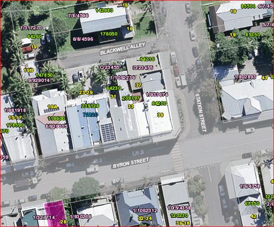
Blackwell Alley was
officially Gazetted on the 22 June 2018 (Attachment 2 E2018/71283).
The naming of both Tims Lane and Blackwell Alley followed
Road Naming Procedures set out by the Geographical Names Board and Roads
Regulation 2008.
Initial submissions were received for the naming of both
Tims Lane and Blackwell Alley.
Before moving forward the names were checked through the
Geographical Names Board and passed by the LPI notifying Authorities.
Local residents affected directly by the new names were
informed and both were advertised in the local Byron Shire News under Byron
Shire Council Notices with a 28 day submission period. Neither names received
any submissions of objection.
Blackwell Alley received a submission of support for the
name.
Authorities were notified accordingly and no submissions of
objection were received.
The Geographical Names Board was then notified in both cases
and they moved forward with the official Gazettal.
Council is currently organising the instillation of the road
signs to conform with the official names.
Financial Implications
The installation of the signs is being undertaken next month
and the expenses are to come out of the General Fund for Sign Maintenance.
Statutory and Policy Compliance Implications
Roads Regulation 2008 – Division 2 Naming of
roads
Roads Act 1993 – Sect 162 Naming of public
roads
New South Wales Address policy – March 2015
New South Wales Addressing User manual – September
2016
New South Wales Online Road Naming System –
Geographical Names Board of New South Wales – June 2015
Staff Reports - Infrastructure Services 13.26
Report No. 13.26 Renaming
Northern Part of Granuaille Crescent on Bangalow Cemetery side of the Pacific
Highway
Directorate: Infrastructure
Services
Report
Author: Deanna
Savage, Roads and Property Officer
File No: I2018/1580
Theme: Infrastructure Services
Local Roads and Drainage
Summary:
That Council endorse the
renaming of the Northern Part of Granuaille Crescent (Image 1) and submit the
chosen name to the NSW Geographical Names Board for concurrence and Gazettal.
|
RECOMMENDATION:
1.
That Council endorse the renaming of the
Northern part of Granuaille Crescent on the Bangalow Cemetery side of the
pacific highway to “Pioneers Crescent”.
2. That
the endorsed name be submitted to the NSW Geographical Names Board for
concurrence, advertising and Gazettal in accordance with regulation
requirements.
3. That
new street name signs be erected and funded from the General Fund for
Sign Maintenance.
|
Attachments:
1 PDF
version of E2016/71862 Email from Heidi Sawyer & Paul Croxson Requesting
what their address is Lot 1 Pacific Highway Bangalow NSW or DP 1_1155012, E2018/71862
2 Letter to
residents re renaming of Part of Granuaille Crescent to allow for numbering of
Properties without a number, E2018/34900
3 PDF
Version of E2018/62430 Email from Instant Steel regarding submission for name
change - Part of Granuaille Crescent Bangalow, E2018/71824
4 PDF
Version of E2018_62429 _ Email from Mitch Carter regarding Submission for Name
Change Part of Granuaille Crescent BANGALOW, E2018/71827
5 PDF
Version of E2018_68142 Email from Nadine Hood regarding name change part of
Granuaille Crescent, E2018/71833
6 Advertising
26 July 2018 Byron Shire News, E2018/43828
Report
A submission was put to
Council by a local resident requesting a number allocation to their newly
purchased property at Lot 1 DP 1155012 accessed through Bangalow Cemetery, the
Northern part of Granuaille Crescent. Attachment 1 (E2018/71862) Image
1 below
Image
1
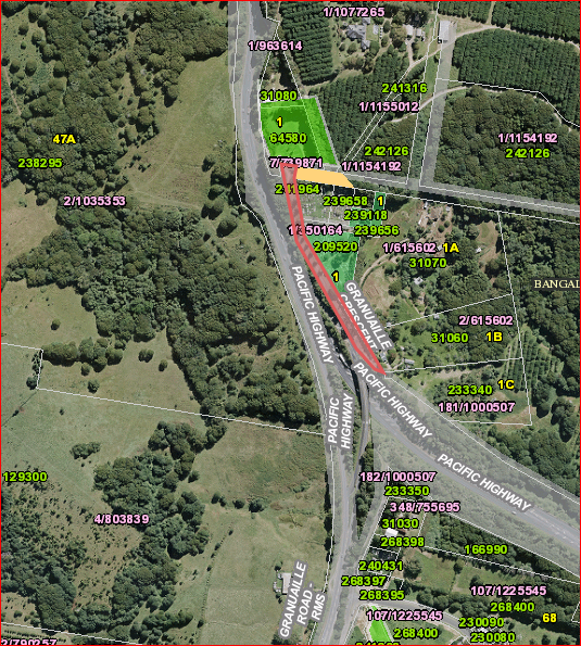
The whole of Granuaille
Crescent was tagged as a road naming and numbering issue in 2016 and residents
have written into Council requesting the issue of naming and numbering of
properties on both the Southern and Northern sides of Granuaille Crescent be
further investigated. Staff in consultation with Land Information
Officers considered this as a means to rectifying the numbering issues.
Letters were sent out to
residents Attachment 2 (E2018/34900) informing them of a potential name
change and offering some suggestions of names and requesting submissions or
suggestions for the road names. The proposal was advertised in the Byron
Shire News 26 July 2018 Attachment 6 (E2018/43828).
Suggestions received were
Bangalow Heights Road or Pioneers Crescent (submission in favour of Pioneers
Crescent Attachment 3 E2018/62430) with other submissions suggesting
Settlers Crescent Attachment 5 (E2018/71833), Noble Lane/Crescent and
Jelbon Lane/Crescent Attachment 4 (E2018/71827).
There was one submission of
objection for both Bangalow Heights Road and Pioneers Crescent Attachment 5
(E2018/71833) stating:-
Bangalow Heights Road
“So unoriginal. Boring”
Pioneers Crescent “That
sounds like a Soviet children’s camp”.
Name suggestions and
submissions included the following:
· Bangalow
Heights Road
· Pioneers
Crescent
· Settlers
Crescent
· Noble
Lane/Crescent
· Jelbon
Lane/Crescent
None are currently used in
the Shire and all adhere to Geographical Names Board Standards.
Council Cemetery staff
and staff in Infrastructure Services support Pioneers Crescent as a
fitting name as it reflects the pioneering families and history attaching to
those buried at the cemetery without favour to one pioneering family over
another.
Financial Implications
Once the street name has been determined the funds for the
erection of the signs to come out of the General Fund for Sign Maintenance.
Statutory and Policy
Compliance Implications
Byron Shire Council Street Name Register.
Council is able to name roads in accordance with the
authority provided in Part 10, Division 4, Section 162 of the Roads Act 1993.
The procedure of naming roads, is dictated by Sections 7 to
10 within Part 2, Division 7 of the Roads Regulation 2008, which is
available in detail at:
https://www.legislation.nsw.gov.au/#/view/subordleg/2008/156
Staff Reports - Infrastructure Services 13.27
Report No. 13.27 Mullumbimby
Rugby League Club S64 Contributions
Directorate: Infrastructure
Services
Report Author: Peter
Rees, Manager Utilities
File No: I2018/1703
Theme: Infrastructure Services
Sewerage Services
Summary:
Council has advised that s64 contributions are due to be
paid by the Mullumbimby Rugby League Football Club Limited (MRLFC) for charges
levied under the Water Management Act 2000 applicable as a condition of
consent for the subject development application 10.2016.125.1.
At the ordinary meeting on 24 May 2018, Council deferred its
decision on the matter pending a review of opportunities regarding use of
recycled water on the site. It is possible to supply sufficient recycled
water to the site that would potentially boost activity and increase amenity on
the site.
|
RECOMMENDATION:
1. That
Council levy s64 contributions due to be paid by the Mullumbimby Rugby
League Club for DA 10.2016.125.1, but at the 2004 rate to be paid over a 10
year period.
2. That
Council enter into negotiations with the Mullumbimby Rugby League Club
to supply recycled water to the site to a dual reticulation standard as a
part of the Main Arm Recycled Water Scheme.
3. That
the he cost of supplying the recycled water to the site to be borne by
Council (Water and Sewer s64 Funds)
|
Attachments:
1 Report
24/05/2018 Council Mullumbimby Leagues Club Amenities Facility Section 64
Contribution, I2018/802
2 Council
Report - Waiving of s64 Charges - Mullumbimby Rugby Leagues Club, E2014/70916
3 Supporting
Documents from Barry Stenner re Exemption Development Contribution for
Mullumbimby Leagues Club received on 8 May 2018 (attachment to Council Report
I2018/802), E2018/38624
Report
At the Council meeting 24 May 2018, Council resolved:
Resolution 18-315
1. That
Council defer consideration of applying or waiving s64 contributions due
to be paid by the Mullumbimby Rugby Leagues Club for Development Application
10.2016.125.1.
2. That
prior to final consideration a report be brought to Council outlining
opportunities to utilise Council’s re-use water system and a report that
considers the wider opportunities for supporting not-for-profit groups and
their contribution requirements. (Richardson/Coorey)
The Mullumbimby Rugby League Club utilises both bore water
and rainwater tanks on its site in an efficient manner such that its use of
town water is minimal. There are however, constraints on the quantity of
these water sources available that makes it difficult for the club to expand
its playing fields. The bore water is also high in iron that presents
quality issues.
The extension of the Main Arm Recycled Water Scheme to the
site would be consistent with the recently adopted Recycled Water Strategy
2017-27 and would allow the club to consider expansion of their playing fields
which would be beneficial to both the club and the community.
To provide recycled water to the quality required for a dual
reticulation systems fit for playing field irrigation and toilet use would
require the addition of a sand filter and chlorine dosing system to the spur
line that would feed the sporting fields. The total cost of this work
including the pipeline to the sporting fields would be approximately $350,000.
The increased capacity provided by the recycled water line
would allow the club to expand its playing field activities. This
increased activity would support the club in its s64 contribution requirements.
Financial Implications
Should the Mullumbimby Rugby League Club want to access
Council’s recycled water scheme, the funds to extend the scheme would be
sourced from the Water and Sewer s64 funds.
Statutory and Policy Compliance Implications
The application of s64 contributions upon DA10.2016.125.1
has been consistent the Water Management Act 2000, Water Management (General)
Regulation 2011, Council’s Water Supply and Sewerage Developer Servicing
Plan’s and also the Equivalent Tenement Policy.
The recommendation does constitute financial assistance as
it is applying fees at a reduced rate and therefore will require 28 days public
notice.
Staff Reports - Infrastructure Services 13.28
Report No. 13.28 Mullumbimby
Skate Park
Directorate: Infrastructure
Services
Report
Author: Michael
Matthews, Manager Open Space and Resource Recovery
File No: I2018/1714
Theme: Infrastructure Services
Open Space and Recreation
Summary:
The installation of skate park lighting at
the Mullumbimby Skate Park as per Res 17-347, has been designed and
re-costed identifying a shortfall of funds to a value of $20,000 over the
approved budget of $30,000.
Additional budget is required in order for
the project to achieve the required lux levels across the skate park surface,
lighting access control as advised by NSW Police in response to recommendations
provided from a Crime Prevention through Environmental Design (CPTED)
assessment and necessary upgrades of existing electrical infrastructure
connections.
In addition to the additional funding
required for lighting, it has been identified through engagement with users of
the facility, that surface renewal is necessary to improve its safe use.
A budget for such renewal work has been
identified as $70,000. As a budget to fund this renewal work has not been
identified at this point in time, funding sort for this work will be subject to
a future report.
|
RECOMMENDATION:
That Council allocate an additional $20,000 from
developer contributions (s94) in the Mullumbimby Open Space account to fund
the current funding shortfall for the lighting project upgrade at the
Mullumbimby Skate Park.
|
Attachments:
1 Letter
from NSW Police Crime Prevention Officer - Site Crime Risk Assessment of the
Mullumbimby Skate Park and Recreation Grounds, S2018/5675
Report
At Council’s ordinary
meeting on 24 August 2017 Council resolved (Res
17-347) that:
Council approve the installation of skate park lighting
and upgrade of existing lighting and that:
a) Additional
consultation be undertaken with local residents and the skating
community
b) $30,000
is allocated from s94 funds for the project
c) a
review be provided after 12 months
d) the
fade facility to be extended to two minutes
e) the lighting is turned off at 9.00pm
The project brief was outsourced to project
manage the design, supply and installation of flood lighting for the skate
park.
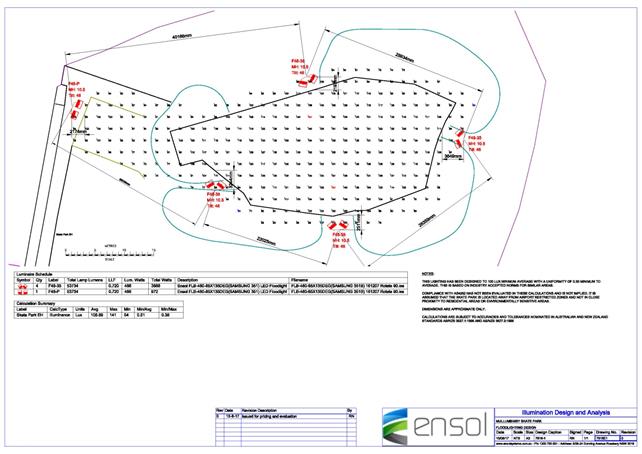
During the process of evaluation and
consultation the NSW police, the Tweed Byron crime prevention officer became
involved due to public concerns raised in relation to Crime Prevention through
Environmental Design (CPTED) considerations for the project.
Manager Open Space and Resource Recovery
worked with the NSW Police to address perceived concerns with the project.
A CPTED assessment was completed (attached)
with NSW Police with the following recommendations as advice in order to reduce
the risk of offences and anti-social behavior occurring at the location:
· The first issue of installing lighting at the skate park would need
to be closely monitored on a trial basis, to ensure there is no increase of
criminal activity at the location because of lighting.
· It would not be recommended to light the area on a permanent basis
every night. It's suggested that the lighting system be installed with
restricted access to those who register with council to have access to the
lighting for legitimate purposes only. Also have a timer placed on the lighting
for 30 to 60-minute intervals.
· If council's desire is to increase community activity in the area,
police would recommend that the current parking area be improved to reduce the
risk of trips and falls because of the uneven surface. Lighting of the parking
area would also be beneficial to provide better security at night if the areas
activities area increased.
· To assist with the increased usage of the location improved access
to and from the skate park is required. Currently access is limited to walking
across playing fields and grassed areas. In wet weather or immediately after
rain, the access to the skate park would be greatly improved if there were
concrete foot paths leading to the desired areas from the car park.
· Surveillance of the skate park is almost non-existent due to the
distance from Jubilee Avenue, being surrounded on two sides by open paddocks
with very little to no access and because of the over grown and inappropriately
placed garden beds that prevent the clear view of the Skate Park. There is very
little council can do regarding passive surveillance of the location, as there
is no residential housing or community access overlooking the location and the
distance from the only passing street being Jubilee Ave. By removing or
significantly reducing the current garden beds would assist in the surveillance
of the area.
· If the council desires to increase community usage of the location
the general up keep of the structures currently at the skate park would need to
be repaired and improved. The addition of well-appointed and maintained
facilities near the skate park such as family friendly facilities for the
general community for example BBQ's, seating, shaded areas, toilets and even
playgrounds would make the space more attractive to the general community. By
increasing the communities use of the space on a more frequent basis, the
community would provide a form of self management of appropriate behavior at
and near the skate park.
· Police would suggest that the entire sporting fields and surrounding
area is in need of significant upgrading to ensure the community feels safe and
wants to attend the location. By limiting the upgrades to just lighting the
skate park, this will only attract people to the area at night which would
greatly increase the potential risk and liability of the council due to the
increased patronage and potential for incidents at the location due to their
poor state of repair of the run down facilities.
After several discussions between Project
Manager (consultant), Council staff and NSW Police it was decided that at a
minimum access control to lighting was required to alleviate any concerns the
police and community had voiced.
The design was modified to include an
illuminator control within the lighting circuit to enable minimum access
control.
Revised costing for the lighting
installation is $50,000 which is 40% over adopted budget of $30,000. This
additional costs is attributed to the current state of electrical
infrastructure required to be connected into, illuminator inclusion, materials
and labour.
During consultation with users of the
facility, a request was made for consideration of renewal of the skate park
surface for reasons of its safe use.
Staff has
investigated the cost of such renewal works with specialist skate park renewal
and repair providers with a budget of $70,000 being required. This budget has
not been identified at this point in time.
It should be
noted that the replacement of this facility has been estimated at $600,000.
Financial Implications
To proceed with the lighting project, a further $20,000 is
required from the Mullumbimby Open Space s94 account.
Statutory and Policy Compliance Implications
Byron Shire Section 94 Plan
Crime Prevention through Environmental
Design (CPTED)
Reports of Committees - Corporate and Community Services 14.1
Reports of Committees - Corporate and Community
Services
Report No. 14.1 Report of the Audit, Risk and Improvement Committee Meeting held on 16 August 2018
Directorate: Corporate and Community Services
Report
Author: David
Royston-Jennings, Strategic Risk and Improvement Coordinator
File No: I2018/1588
Theme: Corporate Management
Corporate Services
Summary:
This report provides the minutes and recommendations of the
Audit, Risk and Improvement Committee Meeting held on 16 August 2018 for
determination by Council.
|
RECOMMENDATION:
1. That
Council note the minutes of the Audit, Risk and Improvement Committee Meeting
held on 16 August 2018.
|
|
2. That Council
adopt the following Committee Recommendation(s):
Report No. 4.1 Internal Activity & Progress
Report - July 2018
File No:
I2018/1270
Committee Recommendation 4.1.1
1. That
the Audit, Risk and Improvement Advisory Committee note the Internal Audit
Activity Report – July 2018 (#E2018/67716).
2. That
the Audit, Risk and Improvement Advisory Committee note the updated Internal
Audit Plan (#E2018/64849).
|
|
3. That Council
adopt the following Committee Recommendation(s):
Report No. 4.2 EPA Licence Audit Review
File No:
I2018/1311
Committee Recommendation 4.2.1
1. That
the Audit, Risk and Improvement Committee note the Environmental Protection
Authority (EPA) Controls internal audit review report.
2. That
the Audit, Risk and Improvement Committee request that management implement
the recommendations made in the report identified as Confidential Attachment
1 (#E2018/64759).
3. That
the report and Confidential Attachment 1 of the closed part of the meeting
remain confidential.
|
|
4. That Council
adopt the following Committee Recommendation(s):
Report No. 4.3 Business Continuity Management
Strategy
File No:
I2018/1310
Committee Recommendation 4.3.1
That the Audit, Risk and
Improvement Advisory Committee:
1. Note the presentation on
the draft Business Continuity Management Strategy.
2. Note the draft Business
Continuity Management Strategy.
|
|
5. That Council
adopt the following Committee Recommendation(s):
Report No. 4.4 2018 Interim Audit Management
Letter
File No:
I2018/1358
Committee Recommendation 4.4.1
That the comments provided by
Management in response to matters raised in the 2018 Interim Audit Management
Letter be noted by Council.
|
Attachments:
1 Audit,
Risk and Improvement Committee Minutes 16 August 2018 PDF, E2018/69986
Report
The Audit, Risk and Improvement Committee Meeting of 16
August 2018 considered the following items and their minutes are presented for
determination by Council:
Report 4.1 - Internal
Activity & Progress Report - July 2018
The Committee received a status report provided by
Council’s internal auditors OCM, which included status of planned audit
reviews in the adopted internal audit plan, an overview of completed audits in
the 2017/18 financial year, and updates on tasks associated with completed
audits (i.e. risk management and fraud and corruption controls).
The Committee discussed the progress made against audit
recommendations since the last meeting, noting that 22 recommendations had been
completed. Council’s internal auditor OCM provided an overview of the new
format in which the information was presented. The Committee were informed that
Council would be working in close partnership with OCM to report regularly to
the Executive Team on progress against audit recommendations.
Report 4.2 - EPA Licence
Audit Review
Council’s Internal Auditors conducted an internal
audit review of Environmental Protection Authority (EPA) Licence Controls
during June 2018. The Committee received a report on the findings made by OCM
and agreed recommendations with Council’s management.
Report 4.3 - Business
Continuity Management Strategy
The Committee received a presentation from the Strategic
Risk and Improvement Coordinator on Council’s progress towards the
implementation of a business continuity management strategy, noting that
business impact analyses were underway with management throughout the
organisation, the results of which will inform business continuity plans.
The Committee discussed the importance of having recovery
plans in place for the community and requested an update on work being done in
this space. Councillors will receive an update on the Local Recovery Plan at
the October Strategic Planning Workshop.
Report
4.4 - 2018 Interim Audit Management Letter
Council received an Interim Audit Management Letter from the
External Auditor, the Audit Office of NSW, relating to the 2018 Audit. The
letter details three items for management to consider and provided
recommendations to improve internal controls and systems. The three findings
are as follows:
· Accounts payable
Masterfile maintenance
· Payroll Masterfile
maintenance
· Personal data handling
framework
The Committee discussed the recommendations and requested
regular updates of Council’s performance and progress against
recommendations received from Council’s external auditor.
The minutes from this meeting are available on
Council’s website at the following link:
https://byron.infocouncil.biz/Open/2018/08/ARIC_16082018_MIN_794.PDF
Financial Implications
As per the Reports listed within the Audit, Risk and
Improvement Committee Meeting of 16 August 2018.
Statutory and Policy
Compliance Implications
As per the Reports listed within the Audit, Risk and
Improvement Committee Meeting of 16 August 2018.
Reports of Committees - Corporate and Community Services 14.2
Report No. 14.2 Report of the Finance Advisory Committee Meeting held on 16 August 2018
Directorate: Corporate and Community Services
Report
Author: James
Brickley, Manager Finance
File No: I2018/1690
Theme: Corporate Management
Financial Services
Summary:
This report provides the
minutes and recommendations of the Finance Advisory Committee Meeting held on
16 August 2018 for determination by Council.
|
RECOMMENDATION:
1. That
Council note the minutes of the Finance Advisory Committee Meeting held on 16
August 2018.
|
|
2. That Council
adopt the following Committee Recommendation:
Report No. 4.1 2017/18 Financial
Sustainability Plan - Update on the Action Implementation Plan as at 30 June
2018
File No:
I2018/942
Committee Recommendation 4.1.1
1. That the update
report to 30 June 2018 on the 2017/2018 Financial Sustainability Plan Action
Implementation Plan (E2018/43656) be received and noted.
2. That a separate Financial
Sustainability Plan no longer be developed from the 2018/2019 financial year
onwards as it will be incorporated into Council’s Long Term Financial
Plan.
|
|
3. That Council
adopt the following Committee Recommendation:
Report No. 4.2 Quarterly Update -
Implementation of Special Rate Variation
File No:
I2018/1442
Committee Recommendation 4.2.1
That the Finance
Advisory Committee note the quarterly update on the Special Rate Variation
Implementation as at 30 June 2018.
|
|
4. That Council
adopt the following Committee Recommendation:
Report No. 4.3 Carryovers for inclusion in
the 2018/19 Budget
File No:
I2018/1522
Committee Recommendation 4.3.1
That the Finance Advisory Committee recommend to
Council to note:
That the works and services,
and the respective funding shown in Attachment 1 (#E2018/66991) be carried
over from the 2017/2018 financial year and that the carryover budget
allocations be adopted as budget allocation revotes for inclusion in the
2018/2019 Budget Estimates.
|
|
5. That Council
adopt the following Committee Recommendation:
Report No. 4.4 Budget Review 1 April 2018 to
30 June 2018
File No:
I2018/1524
Committee Recommendation 4.4.1
That the Finance Advisory Committee recommend to
Council to note:
1. That
Council authorises the itemised budget variations as shown in Attachment 2
(#E2018/67079) which includes the following results in the 30 June 2018
Quarterly Review of the 2017/2018 Budget:
General
Fund - $0 change in Unrestricted Cash Result
a) General
Fund - $9,795,300 increase in reserves
b) Water
Fund - $1,899,300 increase in
reserves.
c) Sewerage
Fund - $3,461,600 increase in reserves
|
|
6. That Council
adopt the following Committee Recommendation:
Report No. 4.5 2018/19 Annual Procurement
Plan
File No:
I2018/1533
Committee Recommendation 4.5.1
That the Finance
Advisory Committee note the procurement savings achieved in 2017/18 and the
proposed program for 2018/19 as per Attachment 1 (E2018/63063)
|
|
7. That Council
adopt the following Committee Recommendation:
Report No. 4.6 Long Term Financial Plan
2018-2028
File No:
I2018/1540
Committee Recommendation 4.6.1
That the Finance Advisory
Committee note:
1. the
Working Draft of the 2018-2028 Long Term Financial Plan as provided at
Attachment 1 (#E2018/66626).
2. that
further work on the Draft 2018-2028 Long Term Financial Plan be
undertaken with a further revision to be provided to the Finance Advisory
Committee for consideration at its 15 November 2018 Meeting.
|
Attachments:
1 Minutes of
the Finance Advisory Committee held 16 August 2018, I2018/1692
Report
The attachment to this report provides the minutes of the
Finance Advisory Committee Meeting of 16 August 2018 for determination by
Council. The agenda for this meeting can be located on Council’s
website at:
https://byron.infocouncil.biz/Open/2018/08/FAC_16082018_AGN_790.PDF
The Committee considered the following items.
Report 4.1 – 2017/18 Financial Sustainability Plan
– Update on the Action Implementation Plan as at 30 June 2018
A report as to the progress of implementing the 2017-2018
Financial Sustainability Plan was presented to the Committee. Of note as
indicated in the report was the ongoing growth in pay parking revenue.
The Committee also considered that the principles contained in the 207/2018
Financial Sustainability Plan and previous version of the Financial
Sustainability Plan have now been incorporated into Council’s Integrated
Planning documents and will form part of guiding policy for the Long Term
Financial Plan going forward. This will mean that there will not be any
future Financial Sustainability Plans produced beyond the 2017-2018 Financial
Sustainability Plan and that there will be no further quarterly reporting to
the Finance Advisory Committee.
Report 4.2 – Quarterly Update –
Implementation of Special Rate Variation
The Committee were presented with a report that outlined the
progress of expenditure in relation to the 2017/2018 Special Rate
Variation. Provided as part of the report is a schedule of works with
total funding of $3,015,600 that includes the $1,185,000 provided by the first
year of the Special Rate Variation approved that commenced on 1 July 2017. The
report identified that as at the end of June 2018, Council had expended 86.23%
of the overall program and of the five capital works projects in the program,
three are completed.
Report 4.3 – Carryovers for inclusion in the
2018/19 Budget
The Committee was presented with the schedule of budget
carryovers from the 2017/2018 financial year to be carried forward to
2018/2019. Total carryovers were $12,357,500 up from $11,924,000 from
2017/2018.
The report also provided details of eleven projects with a
value greater than $150,000 still in progress. Major projects include the
five bridges project and the Bayshore Drive/Ewingsdale Road Roundabout.
The recommendation has been amended to have Council note
that the Finance Advisory Committee recommendation was adopted by Council at
the Ordinary meeting held on 23 August 2018.
Report 4.4 – Budget Review 1 April 2018 to 30 June
2018
The Committee discussed the 30 June 2018 Quarter Budget
Review noting the proposed amendments to the 2017-2018 Budget and recommended
their adoption to Council that occurred at the 23 August 2018 Ordinary Meeting.
Of note in the report were the following major items:
1. Retention
of a balanced projected budget result as at 30 June 2018.
2. Maintenance
of the unrestricted cash balance of $1,145,200 being greater then
Council’s $1,000,000 benchmark.
The 30 June 2018 Quarter Budget Review Report is closely
related to Report 4.3 concerning Carryovers for inclusion in the 2018/19
Budget. The 30 June 2018 Quarter Budget Review takes into consideration the
carryover amounts by reducing the 2017-2018 Budget Estimates accordingly.
The recommendation has been amended to have Council note
that the Finance Advisory Committee recommendation was adopted by Council at
the Ordinary meeting held on 23 August 2018.
Report 4.5 – 2018/19 Annual Procurement Plan
This report provided the Finance Advisory Committee with the
proposed procurement plan for the 2018-2019 financial year along with an
outline of procurement achievements from the 2017-2018 financial year.
Key procurement achievements from 2017-2018 include:
· $1.2M
saved (over 3% of materials and contracts budget);
· Implementation
of Tenders Online providing, for the first time, a single place where all of
Council’s goods/works/services contracts information can be found;
· Introduction
of purchasing cards, reducing the administrative burden of low value purchases;
· Improved
social and sustainability outcomes from procurement activities.
Focus areas for 2018-2019 include:
· Staff
training
· Procurement
of suppliers under LGP contract
· Contract
management framework
· Stores
operation
· Tenders
for 15 expiring contracts, plus others for identified compliance or savings.
Report 4.6 – Long Term Financial Plan 2018-2028
This report provided the Committee with the first version of
the 2018-2028 Long Term Financial Plan. The Plan incorporates forward
projections for ten years utilising the 2018-2019 adopted original budget
estimates as the base year. One additional scenario was also included
which was the base case plus the remediation of the Mullumbimby Hospital site.
In addition the Plan now incorporates the principles from
the Financial Sustainability Plan and also a policy position on rules for
budget development.
A further revision of the 2018-2028 Long Term Financial Plan
will be provided to the 15 November 2018 Finance Advisory Committee Meeting.
The Committee Recommendations are supported by management
and are provided in the attachment to this report.
Financial Implications
As per the Reports listed within the Finance Advisory
Committee Meeting of 16 August 2018.
Statutory and Policy
Compliance Implications
As per the Reports listed within the Finance Advisory
Committee Meeting of 16 August 2018.
Reports of Committees - Infrastructure Services 14.3
Reports of Committees - Infrastructure Services
Report No. 14.3 Report of the Transport and Infrastructure Advisory Committee
Meeting held on 16 August 2018
Directorate: Infrastructure Services
Report
Author: Dominika
Tomanek, Executive Assistant Infrastructure Services
File No: I2018/1675
Theme: Infrastructure Services
Roads and Maritime Services
Summary:
The attachment to this report provides the minutes Transport
and Infrastructure Advisory Committee Meeting held on 16 August 2018 for
determination by Council.
|
RECOMMENDATION:
1. That
Council note the minutes of the Transport and Infrastructure Advisory
Committee Meeting held on 16 August 2018.
|
|
2. That Council
adopt the following Committee Recommendation(s):
Report No. 4.1 Transport Asset Management Plan
- Customer Levels of Service Survey
File No:
I2018/1315
Committee Recommendation 4.1.1
That:
1. The
Transport Customer Levels of Service Report is noted.
2. Council
pursues other mediums such as short videos/messages to continue to educate
and engage with the community about customer levels of service, asset
condition and challenges associated with the transport network as detailed in
the draft Transport Asset Management Plan (TAMP).
3. The
Levels of Service detailed in the Transport Asset Management Plan (Section 4)
are adopted in accordance with the requirements of the 2018/19 adopted
Operations Plan, Action 1.1 (b).
4. That
the Transport and Infrastructure Advisory Committee continue to consider the
Levels of Service issues such as: driver behaviour, lower speed limits,
non-car owning road users, bus users, development of the Bike Strategy and
Action Plan (Bike Plan) and Pedestrian Access and Mobility Plan (PAMP).
|
|
3. That Council
adopt the following Committee Recommendation(s):
Report No. 4.2 Flight Neighbourly Procedure
Tyagarah
File No:
I2018/1334
Committee Recommendation 4.2.1
That Council note the Fly
Neighbourly Procedure for Tyagarah Airfield.
|
|
4. That Council
adopt the following Committee Recommendation(s):
Report No. 4.3 Status Update - Bike Plan and
PAMP
File No:
I2018/1520
Committee Recommendation 4.3.1
That Council note the status
update on the development of the Bike Strategy and Action Plan (Bike Plan)
and Pedestrian Access and Mobility Plan (PAMP).
|
|
5. That Council
adopt the following Committee Recommendation(s):
Report No. 4.4 2018/19 Local Roads Capital
Works Program and 2019/20 to 2028/29 ten (10) year Capital Works Program -
All Assets
File No:
I2018/1523
Committee Recommendation 4.4.1
That Council note the actions
taken in delivering the 2018/19 Local Roads Capital Works Program.
|
Attachments:
1 Minutes
16/08/2018 Transport and Infrastructure Advisory Committee, I2018/1545
Report
The attachment to this report provides the minutes of the
Transport and Infrastructure Advisory Committee Meeting (TIAC) of 16 August
2018 for determination by Council.
The agenda for this meeting can be located on
Council’s website at:
https://byron.infocouncil.biz/Open/2018/08/TIAC_16082018_AGN_799_AT.PDF
Committee Recommendation
The committee recommendations are supported by management
and are provided in the attachment to this report.
Financial Implications
As per the Reports listed within the Transport and
Infrastructure Advisory Committee Meeting of 16 August 2018.
Statutory and Policy
Compliance Implications
As per the Reports listed within the Transport and
Infrastructure Advisory Committee Meeting of 16 August 2018.
Confidential Reports - General Manager 16.1
Confidential Reports - General Manager
Report No. 16.1 Confidential - Grant of lease to
Preferred Tenderer for the operation and management of the Byron tennis courts
Directorate: General
Manager
Report
Author: Paula Telford,
Leasing and Licensing Coordinator
File No: I2018/1539
Theme: Corporate Management
Corporate Services
Summary:
Council issued a Tender
(2018-0004) for a five (5) year lease with a five (5) year option to renew for
the operation and management of the Byron tennis courts in folio 444/28/75827,
located at the corner of Tennyson and Carlyle Street Byron Bay.
Tender 2018-004 was
publically advertised on 12 June 2018 and closed on 2pm on 16 July 2018.
Tender submissions were
assessed by an independent Evaluation Panel between 23 July and 20 August 2018
in accordance with the Tender Evaluation Plan. This report recommends
that the Evaluation Panel’s preferred tendered response is granted a five
(5) year lease with a five (5) year option to renew for the operation and
management of the Byron tennis courts located at the corner of Tennyson and
Carlyle Street Byron Bay.
The report also recommends
notification of the proposed lease. This is required by section 47 LGA.
RECOMMENDATION:
1. That
pursuant to Section 10A(2)(d)i of the Local Government Act, 1993, Council
resolve into Confidential Session to discuss the report Grant of lease to
Preferred Tenderer for the operation and management of the Byron tennis courts.
2. That
the reasons for closing the meeting to the public to consider this item be that
the report contains:
a) commercial
information of a confidential nature that would, if disclosed prejudice the
commercial position of the person who supplied it
3. That
on balance it is considered that receipt and discussion of the matter in open
Council would be contrary to the public interest, as:
the report contains
confidential commercial information.
Attachments:
1 Tender
2018-0004 Signed Evaluation Report., E2018/71216
2 Tender
2018-0004 Probity Report for lease of Byron Tennis Facility 30 Aug 2018, E2018/72269
Confidential Reports - Sustainable Environment and Economy 16.2
Confidential Reports - Sustainable Environment
and Economy
Report No. 16.2 Confidential - Tender 2018-0018 - Multi
Use Byron Shire Rail Corridor
Directorate: Sustainable
Environment and Economy
Report Author: Tania
Crosbie , Economy and Sustainability Coordinator
Tony Nash, Manager Works
Joshua Winter, Civil Engineer
Therese Black, Business Analyst
File No: I2018/1676
Theme: Sustainable Environment and Economy
Economic Development
Summary:
Byron Shire Council issued a Selective Request for Tender
for the Multi Use of the Byron Shire Rail Corridor on 18 June 2018.
The Selective Request for Tender was advertised from 18 June
2018 to 11 July 2018. Tenders were received from the following organisations:
· Caldis
Cook Group Pty Ltd
· Hyder
Consulting / Arcadis Pty Ltd
· Plateway
Pty Ltd
Tenders have been assessed in accordance with the provisions
of the Local Government (General) Regulations 2005. This report
summarises the background and assessment of the tenders and provides a
recommendation to award the tender for Contract 2018-0018.
RECOMMENDATION:
1. That
pursuant to Section 10A(2)(c) and (d)i of the Local Government Act, 1993,
Council resolve into Confidential Session to discuss the report Tender
2018-0018 - Multi Use Byron Shire Rail Corridor.
2. That
the reasons for closing the meeting to the public to consider this item be that
the report contains:
a) information
that would, if disclosed, confer a commercial advantage on a person with whom
the Council is conducting (or proposes to conduct) business
b) commercial
information of a confidential nature that would, if disclosed prejudice the commercial
position of the person who supplied it
3. That
on balance it is considered that receipt and discussion of the matter in open
Council would be contrary to the public interest, as:
(a) disclosure could adversely
impact Council's position in the upcoming negotiations.
OR, ALTERNATIVELY WHERE
THE MEETING IS NOT PROPOSED TO BE CLOSED:
RECOMMENDATION:
1. That
pursuant to Section 11(3) of the Local Government Act, 1993, resolve that the
Annexures to the report, Tender 2018-0018 - Multi Use Byron Shire Rail Corridor
are to be treated as confidential as they relate to matters specified in
s10A(2)(c) and s10A(2)(d)i of the Local Government Act 1993.
2. That
Council adopt the recommendation set out on the final page of the Report.
Attachments:
1 Confidential
- CONFIDENTIAL 24.2017.33.1 - 2018-0018 Multi Use Rail Corridor Tender
Evaluation Report - Council Meeting September 2018, E2018/74785
Confidential Reports - Infrastructure Services 16.3
Confidential Reports - Infrastructure Services
Report No. 16.3 Confidential - Reuse Irrigation
Directorate: Infrastructure
Services
Report
Author: Malcolm
Robertson, Team Leader Open Space
File No: I2018/1577
Theme: Infrastructure Services
Open Space and Recreation
Summary:
On 19 February 2018 the General Manager, under delegated
authority, approved the use of the open tender method to call for tenders for
Contract 2018-0025 Supply and Install In-ground Irrigation.
The Request for Tender was advertised from 26 June to 27
July. Tenders were received from the following organisations:-
· Fernie
Holdings Pty Ltd (Thinkwater Northern Rivers)
· Turf
Irrigation Services
· WNL3
Family trust as trustee for Waterworx Australia Pty Ltd
Tenders have been assessed in accordance with the provisions
of the Local Government (General) Regulations 2005. This report
summarises the background and assessment of the tenders and provides a
recommendation to award the tender for Contract 2018-0025.
RECOMMENDATION:
1. That
pursuant to Section 10A(2)(d)iii of the Local Government Act, 1993, Council
resolve into Confidential Session to discuss the report Reuse Irrigation.
2. That
the reasons for closing the meeting to the public to consider this item be that
the report contains:
a) information
that would, if disclosed, reveal a trade secret
3. That
on balance it is considered that receipt and discussion of the matter in open
Council would be contrary to the public interest, as:
Contains information that is
commercial in confidance relating to a competitive tender process.
OR, ALTERNATIVELY WHERE
THE MEETING IS NOT PROPOSED TO BE CLOSED:
RECOMMENDATION:
1. That
pursuant to Section 11(3) of the Local Government Act, 1993, resolve that the
Annexures to the report, Reuse Irrigation are to be treated as confidential as
they relate to matters specified in s10A(2)(d)iii of the Local Government Act
1993.
2. That
Council adopt the recommendation set out on the final page of the Report.
Attachments:
1 Confidential
- 2018-0025 - Supply and Install In-ground Irrigation Request for Tender
- Evaluation Report, E2018/72547