What is a “Conflict of Interests” - A conflict of
interests can be of two types:
Pecuniary - an interest that a person has in a matter because of a reasonable
likelihood or expectation of appreciable financial gain or loss to the person
or another person with whom the person is associated.
Non-pecuniary – a private or personal interest that a Council
official has that does not amount to a pecuniary interest as defined in the
Local Government Act (eg. A friendship, membership of an association, society
or trade union or involvement or interest in an activity and may include an
interest of a financial nature).
Remoteness – a person does not have a pecuniary interest in a matter
if the interest is so remote or insignificant that it could not reasonably be
regarded as likely to influence any decision the person might make in relation
to a matter or if the interest is of a kind specified in Section 448 of the
Local Government Act.
Who has a Pecuniary Interest? - a person has a pecuniary interest in a
matter if the pecuniary interest is the interest of the person, or another
person with whom the person is associated (see below).
Relatives, Partners - a person is taken to have a pecuniary interest in a
matter if:
§ The person’s
spouse or de facto partner or a relative of the person has a pecuniary interest
in the matter, or
§ The person, or a
nominee, partners or employer of the person, is a member of a company or other
body that has a pecuniary interest in the matter.
N.B. “Relative”, in relation to a person means any of the
following:
(a) the
parent, grandparent, brother, sister, uncle, aunt, nephew, niece, lineal
descends or adopted child of the person or of the person’s spouse;
(b) the
spouse or de facto partners of the person or of a person referred to in
paragraph (a)
No Interest in the Matter - however, a person is not taken to have a
pecuniary interest in a matter:
§ If the person is
unaware of the relevant pecuniary interest of the spouse, de facto partner,
relative or company or other body, or
§ Just because the
person is a member of, or is employed by, the Council.
§ Just because the
person is a member of, or a delegate of the Council to, a company or other body
that has a pecuniary interest in the matter provided that the person has no
beneficial interest in any shares of the company or body.
Disclosure and participation in meetings
§ A Councillor or a
member of a Council Committee who has a pecuniary interest in any matter with
which the Council is concerned and who is present at a meeting of the Council
or Committee at which the matter is being considered must disclose the nature
of the interest to the meeting as soon as practicable.
§ The Councillor or
member must not be present at, or in sight of, the meeting of the Council or
Committee:
(a) at any
time during which the matter is being considered or discussed by the Council or
Committee, or
(b) at any
time during which the Council or Committee is voting on any question in
relation to the matter.
No Knowledge - a person does not breach this Clause if the person did
not know and could not reasonably be expected to have known that the matter
under consideration at the meeting was a matter in which he or she had a
pecuniary interest.
Participation in Meetings Despite Pecuniary Interest (S 452 Act)
A Councillor is not prevented from taking part in the consideration or
discussion of, or from voting on, any of the matters/questions detailed in
Section 452 of the Local Government Act.
Non-pecuniary Interests - Must be disclosed in meetings.
There are a broad range of options available for managing conflicts &
the option chosen will depend on an assessment of the circumstances of the
matter, the nature of the interest and the significance of the issue being
dealt with. Non-pecuniary conflicts of interests must be dealt with in at
least one of the following ways:
§ It may be appropriate
that no action be taken where the potential for conflict is minimal.
However, Councillors should consider providing an explanation of why they
consider a conflict does not exist.
§ Limit involvement if
practical (eg. Participate in discussion but not in decision making or vice-versa).
Care needs to be taken when exercising this option.
§ Remove the source of
the conflict (eg. Relinquishing or divesting the personal interest that creates
the conflict)
§ Have no involvement by
absenting yourself from and not taking part in any debate or voting on the
issue as if the provisions in S451 of the Local Government Act apply
(particularly if you have a significant non-pecuniary interest)
RECORDING OF VOTING ON PLANNING MATTERS
Clause 375A of the Local Government Act 1993
– Recording of voting on planning matters
(1) In this section, planning
decision means a decision made in the exercise of a function of a council
under the Environmental Planning and Assessment Act 1979:
(a) including a decision
relating to a development application, an environmental planning instrument, a
development control plan or a development contribution plan under that Act, but
(b) not including the making of
an order under Division 2A of Part 6 of that Act.
(2) The general manager is
required to keep a register containing, for each planning decision made at a
meeting of the council or a council committee, the names of the councillors who
supported the decision and the names of any councillors who opposed (or are
taken to have opposed) the decision.
(3) For the purpose of
maintaining the register, a division is required to be called whenever a motion
for a planning decision is put at a meeting of the council or a council
committee.
(4) Each decision recorded in
the register is to be described in the register or identified in a manner that
enables the description to be obtained from another publicly available
document, and is to include the information required by the regulations.
(5) This section extends to a
meeting that is closed to the public.
Staff Reports - Infrastructure Services 4.1
Staff Reports - Infrastructure Services
Report No. 4.1 North
Byron Floodplain Risk Management Study - Update
Directorate: Infrastructure
Services
Report
Author: James
Flockton, Drain and Flood Engineer
File No: I2018/1954
Theme: Infrastructure Services
Emergency Services and Flood Management
Summary:
This report provides an update on the project for the North
Byron Floodplain Risk Management Study and Plan and addresses a number of
requests received by committee members following the last committee meeting.
|
RECOMMENDATION:
That the committee note the report.
|
Report
North Byron Flood Model Review Update
The Floodplain Management Committee (FMC) meeting organised for 1st November
had to be postponed due to issues with the hydrological model established as part of the Flood Study.
During meeting 3
of the FMC it was agreed to adopt the ARR 1987 Flood Study model. Given the topographic
changes and the addition of new
structures in the hydraulic model, it was necessary to confirm that
the results of the Flood Frequency Analysis (FFA) at the Durrumbul gauge could be reproduced by the
updated models. Whilst attempting to model the design flood events it became apparent that
there are more substantial issues with the flood study hydrological model (RAFTS) which limit the ability to
match the FFA with
these other catchment updates
in place.
The primary issue identified is the impact of the storage basin modelled upstream of Williams Bridge.
Following review of plan details for Williams Bridge and the topography
upstream of Williams Bridge, it was found the dimensions for the basin modelled in the flood study hydrologic model is significantly over estimating the storage and restriction in the area and is not a
true representation of the catchment. As
this
model was a calibrated model, a change of this scale requires significant rework and it is necessary to additionally revisit the manning’s
‘n’ roughness coefficient, catchment slope and losses
used for each subcatchment.
Preliminary
investigation indicates that if the following revisions to the BMT RAFTS model
upstream of the Durrumbul gauge are undertaken, the RAFTS model will be more
representative of catchment conditions. Additionally calibration of the RAFTS
and TULFOW modelling package to historical events and the Flood Frequency
Analysis (FFA) at Durrumbul gauge will be possible:
1. removal of the Williams Bridge storage
basin;
2. revising the manning’s ‘n’
roughness coefficient of each subcatchment, revising the catchment slope of
each subcatchment, and
3. revising losses.
The following works are proposed to be undertaken for the entire North Byron catchment to ensure
the RAFTS model is more representative of catchment conditions and to
recalibrate the RAFTS and
TUFLOW modelling
package:
a) Remove
the
Williams Bridge storage
basin from the RAFTS model;
b) Revise catchment slope in each subcatchment throughout the entire RAFTS model using the
QGIS equal area slope tool;
c) Revise the manning’s n roughness coefficient in each subcatchment throughout the entire
RAFTS model by undertaking a land use analysis and applying the weighted average roughness coefficient in each
catchment;
d) Calibrate the modelling package to the March 2017 event;
e) Verify the modelling packages to the January 2012 event (It has been assumed that this
event
would be
reasonable
but would be
confirmed with
Council when
this work
is undertaken);
f) Provide calibration memo with accompanying
figures, and
g) Calibrate
the
design events to the
FFA
at Durrumbul
gauge.
Initial results are positive, however, further work is
continuing by WMA Water. The following is the current timeline for work moving
forward between now and the first committee meeting in 2019:
|
Task
|
Date
Completed
|
|
Remove Williams Bridge Storage basin from RAFTS model
|
Mid Nov-18
|
|
Revise catchment slope and mannings for each subcatchment
|
Mid Nov-18
|
|
Calibrate model to March 2017 Event
|
Mid Dec-18
|
|
Calibrate model to January 2012 event
|
Early Jan-19
|
|
Calibrate the design events to the FFA at Durrumbul Gauge
|
End Jan -19
|
|
Brunswick Heads and Mullumbimy DRAINS Models Built
and Trunk drainage options
|
Early Feb-19
|
|
Provide calibration memo
|
End Jan -19
|
|
Run full suite of design events and map
|
End Jan -19
|
|
Initial mitigation runs
|
End Jan -19
|
|
Damages Assessment for Design Events
|
February
|
BMT Flood Model
The following comments were received from a committee
member:
A request has been received to consider the option of Council
and the state funding agents pursuing BMT for the cost of improving the model.
The cost of the lost years need not be pursued but should also be recognised.
If authorities are not willing to pursue BMT, then they
should at least take that company off the list of consultants eligible for such
Studies.
Staff have investigated options for this. It is understood
that Council would need to spend at least the variation cost in legal fees to
come near to getting any money back with no guarantee of success.
$5,000 would provide a review and advice to determine if we
had a case and whether it's worth pursuing.
The variation is $17,000, for which an order has been
raised. Council should get 2/3 funding from state government, therefore, in
theory it should cost Council $6,000, excluding any consideration of cost
associated with lost time.
Whilst the situation is very frustrating the staff consider
that an argument from the former consultant, BMT, could be that their modellers
investigated ways of managing flows in the location and came to the conclusion
that a detention basin was the best way forward. This was used and calibration
was successful and accepted. It is not unusual for modellers to use different
methods to manage catchment issues. This is a typical case of differing
opinions between modellers."
At the time staff, the committee and Council adopted
BMT’s recommendations about the basin even though it was an unusual
solution, especially with the calibration problems the project was
experiencing. Council were trying hard to get the calibration complete. WMA's
modellers may have more, better or different skills and have been able to
figure the issues out without a basin, where BMT couldn't or possibly
didn’t investigate this option. It would be a very hard case, to prove
BMT were negligent and for the costs involved it is considered there is no
overall benefit to Council in pursuing this line of action.
We also can't really take them off a list for this reason
alone. However, their performance and pst results will be considered for future
tender and quote assessments.
Now the issue has surfaced, we must find a solution. The
calibration results are unlikely to dramatically improve, but model stability
may and there is an overarching need to be fully confident of the model.
We can be much more confident of the model following this peer review and
re-calibration.
New Brighton Flooding
Discussion about historical flooding in New Brighton has
been requested, specifically around the closing of ocean outlets in this area,
which has the potential to impact flood levels at Ocean Shores, New Brighton
and South Golden Beach. Billinudgel could also see some impacts.
The committee will likely be aware of the website http://www.brunswickvalley.com.au/flood-history/current_updates.htm
and ideally should be familiar with the content within this website, particular
the history timeline.
Whilst this website provides facts on historical actions of
Council and community, it does not necessarily provide the full story on all
action. It is noted that staff did not live in the area when these events
occurred, therefore, all comments relate to documents which have been reviewed.
It is also noted that staff do not have access to all possible documents or the
resources to fully review all the documents pertaining to this issue.
Council staff or Councillors would be accepting enormous
personal liability if they were to recommend the creation of ocean outlets
without the idea going through a scientific and environmental investigative and
approvals process. This is the main reason why community requests have not
resulted in the outlets being created. Council cannot simply undertake this
type of work in the dunes based purely on a request.
The 2005 Floodplain Development Manual is the legislation in
NSW that provides methods for Council to follow in the management of
floodplains. This document provides a prescribed process for flood floodplain
management, which includes the development of a flood study, risk management
study and finally management plan, in that order. Once a mitigation option is
recommended within an adopted Floodplain Management Plan it is acceptable for
staff to proceed with the mitigation works as funding permits. There is no
conspiracy, simply a process that Council must follow.
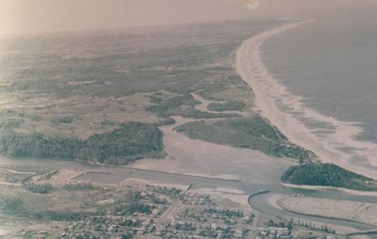
The image below, and there are other similar examples, show
ocean outlets existed pre-development and may have continued to exist through
the early development process of Ocean Shores.
The existence of ocean outlets is not questioned by staff.
The appropriateness of recreating them is questioned and needs investigating
further before they could be recommended.
Reference has been made to a letter from Council dated 25
June 1991, that states “significant reduction of 254mm at Golden Beach
and 354mm at South Ocean Shores”, however, the letter continues to
note that “the outlet on its own did not make anywhere near the
difference”. It appears from the letter that this impact resulted
from a combination of an ocean outlet and dredging of the creek to 2.5m
(presumably this is depth). It was also modelled using the 1987 Mothers Day
flood event, rather than a design event.
The 2016 calibration results from the 1987 Mothers Day flood
calibration process show ocean levels in the Brunswick River mouth of around 1m
AHD (low levels), however, the calibration notes that the level recorder did
not record flood levels in this location during the flood, therefore, the
actual ocean levels are unknown. However, the nearest observed water level at
Orana Road bridge in Marshalls Creek shows a peak water level of 2.1m (between
a 20 to 50 year event). The Mother’s Day event has limited data available
so it is hard to fully understand what data was used to model the mitigation
option of ocean outlets. For example there is no rainfall data for the
Marshalls Creek catchment from this event.
It is best practice to use an envelope of design events and
not use only a historic event to model mitigation options. Usually the envelope
uses an ocean dominated event and then a catchment dominated event for each
design event. The worst results of each are then used as the peak flood levels
produced by the mitigation option. Different design events will be used, but as
a minimum, a small (10 year) and large (100 year) event will be modelled to
understand the mitigation provided by the option being modelled.
The above assessment may have used a catchment dominated
event and low ocean levels. This would likely result in reductions in flood
levels due to the dredging and ocean outlet combined with low ocean levels. An
ocean dominated event is unlikely to have produced this result. Therefore, it
is hard to compare this result with the adopted results in the Marshalls Creek
Floodplain Management Plan 1996.
The Marshalls Creek Floodplain Management Plan 1996 is the
most recent report prepared and adopted by Council that investigated ocean
outlets as a mitigation measure. Page 92 of this report concludes that “construction
of the ocean outlets is considered to be relatively ineffectual, due to the
small number of houses protected and impracticable due to the management and
operational requirements.”
Matters relating to past Council decisions and issues of
responsibility and liability are an extremely complex area that would require
considerable staff resources to investigate substantially. For example most of
the relevant documents are stored in an old document management system which
few staff can use and most of those docs are on microfiche.
Such an investigation may not even produce a conclusive
answer or provide anything constructive moving forward. There can be no
certainty the a court challenge would achieve a conclusive answer in relation
to identifying liability let alone where any liability may rest.
Staff recognise that Ocean Shores, New Brighton ,
Billinudgel and South Golden Beach have flooding problems, as do others areas
of the shire and that the residents of these areas deserve an appropriate
mitigation solution if one is feasible. The North Byron Floodplain Risk
Management Study process will investigate solutions and viable mitigation
options will be recommended for adoption in the Floodplain Management Plan. Any
options must go through a rigorous and open review process to ensure they are
an appropriate mitigation option before they can be recommended for adoption.
As previously explained to the committee, the details and
value of historical records could be argued for days and the true facts never
obtained and understood for certain. However, we do have the catchment in its
current state and state of the art flood modelling software to investigate
mitigation options. This will allow us to model the ocean outlets as a possible
mitigation option and make informed decisions on the best mitigation options
available to the community moving forward.
The mitigation options could also include a combined run of
ocean outlet and creek dredging if the committee request this to be
investigated.
Sea Level Rise Language
Discussion regarding the language used around Sea Level Rise
(SLR) has been requested.
To consider switching the language around SLR from one based
on years into the future and thus dependent on time estimates of rise to one
based on the actual rise.
The background to this request is as follows:
The nebulous nature of discussion on SLR is not assisted
by the variations in the time predictions of the rises. They will continue to
vary, as predictions must.
Society would be better served by determining its actions
and strategies on the basis of "when the ocean reaches 0.5m above its
level in the year 2000" or "1.0m above" or "2.0m
above" etc. It would then be a separate debate as to when that
happens.
It is also not important when that happens. Important is
the fact that it will happen. Strategies and actions would then be triggered by
sea levels and not by the clock.
The Intergovernmental Panel on Climate Change (IPCC) has
always and continues to use a time basis for future predictions in climate
change, including sea level rise.
NSW flood planning uses ‘years’ to show flood
event size, although there is a likelihood that this will change to a
percentage probability in the future.
The community is generally used to and understand the use of
years for predicting when likely amounts of change will occur.
Understanding when a level of change is likely to occur is
important when planning future development and for protecting existing
development. It helps us understand how much time we are likely to have to form
any change that is required.
Another example is SLR amounts beyond 2100 have generally
not been predicted by IPCC, although it is generally accepted that it will
likely continue beyond this time, but to what level has not been accepted.
Larger increases are possible and should not be ignored.
Council does have limited ability to sterilise land from
development due to potential SLR beyond 2100 because 100 years is typically
used as a planning horizon. Therefore, understanding potential change between
current day and 2100 is important for residential planning. Planning for
existing and future residential areas is the main reason we are completing the
North Byron Floodplain Risk Management Study and Plan.
Therefore, changing the language used around when a
predicted change is likely to occur is not recommended. However, using amount of
change to trigger actions has merit and can be used as the North Byron
Floodplain Risk Management Study and Plan progresses.
Financial Implications
The variation for the model improvements has created the
need to increase the project budget and apply for a grant variation. This will
occur as part of the December 2018 Quarterly Review.
Statutory and Policy
Compliance Implications
None.