Transport and Infrastructure Advisory Committee Meeting
A Transport and Infrastructure Advisory
Committee Meeting of Byron Shire Council will be held as follows:
|
Venue
|
Conference Room, Station Street, Mullumbimby
|
|
Date
|
Thursday, 15 November 2018
|
|
Time
|
9.00am
|
Phillip
Holloway
Director Infrastructure Services I2018/2157
Distributed 08/11/18
What is a “Conflict of Interests” - A conflict of
interests can be of two types:
Pecuniary - an interest that a person has in a matter because of a reasonable
likelihood or expectation of appreciable financial gain or loss to the person
or another person with whom the person is associated.
Non-pecuniary – a private or personal interest that a Council
official has that does not amount to a pecuniary interest as defined in the
Local Government Act (eg. A friendship, membership of an association, society
or trade union or involvement or interest in an activity and may include an
interest of a financial nature).
Remoteness – a person does not have a pecuniary interest in a matter
if the interest is so remote or insignificant that it could not reasonably be
regarded as likely to influence any decision the person might make in relation
to a matter or if the interest is of a kind specified in Section 448 of the
Local Government Act.
Who has a Pecuniary Interest? - a person has a pecuniary interest in a
matter if the pecuniary interest is the interest of the person, or another
person with whom the person is associated (see below).
Relatives, Partners - a person is taken to have a pecuniary interest in a
matter if:
§ The person’s
spouse or de facto partner or a relative of the person has a pecuniary interest
in the matter, or
§ The person, or a
nominee, partners or employer of the person, is a member of a company or other
body that has a pecuniary interest in the matter.
N.B. “Relative”, in relation to a person means any of the
following:
(a) the
parent, grandparent, brother, sister, uncle, aunt, nephew, niece, lineal
descends or adopted child of the person or of the person’s spouse;
(b) the
spouse or de facto partners of the person or of a person referred to in
paragraph (a)
No Interest in the Matter - however, a person is not taken to have a
pecuniary interest in a matter:
§ If the person is
unaware of the relevant pecuniary interest of the spouse, de facto partner,
relative or company or other body, or
§ Just because the
person is a member of, or is employed by, the Council.
§ Just because the
person is a member of, or a delegate of the Council to, a company or other body
that has a pecuniary interest in the matter provided that the person has no
beneficial interest in any shares of the company or body.
Disclosure and participation in meetings
§ A Councillor or a
member of a Council Committee who has a pecuniary interest in any matter with
which the Council is concerned and who is present at a meeting of the Council
or Committee at which the matter is being considered must disclose the nature
of the interest to the meeting as soon as practicable.
§ The Councillor or
member must not be present at, or in sight of, the meeting of the Council or
Committee:
(a) at any
time during which the matter is being considered or discussed by the Council or
Committee, or
(b) at any
time during which the Council or Committee is voting on any question in
relation to the matter.
No Knowledge - a person does not breach this Clause if the person did
not know and could not reasonably be expected to have known that the matter
under consideration at the meeting was a matter in which he or she had a
pecuniary interest.
Participation in Meetings Despite Pecuniary Interest (S 452 Act)
A Councillor is not prevented from taking part in the consideration or
discussion of, or from voting on, any of the matters/questions detailed in
Section 452 of the Local Government Act.
Non-pecuniary Interests - Must be disclosed in meetings.
There are a broad range of options available for managing conflicts &
the option chosen will depend on an assessment of the circumstances of the
matter, the nature of the interest and the significance of the issue being
dealt with. Non-pecuniary conflicts of interests must be dealt with in at
least one of the following ways:
§ It may be appropriate
that no action be taken where the potential for conflict is minimal.
However, Councillors should consider providing an explanation of why they
consider a conflict does not exist.
§ Limit involvement if
practical (eg. Participate in discussion but not in decision making or
vice-versa). Care needs to be taken when exercising this option.
§ Remove the source of
the conflict (eg. Relinquishing or divesting the personal interest that creates
the conflict)
§ Have no involvement by
absenting yourself from and not taking part in any debate or voting on the
issue as if the provisions in S451 of the Local Government Act apply
(particularly if you have a significant non-pecuniary interest)
RECORDING OF VOTING ON PLANNING MATTERS
Clause 375A of the Local Government Act 1993
– Recording of voting on planning matters
(1) In this section, planning
decision means a decision made in the exercise of a function of a council
under the Environmental Planning and Assessment Act 1979:
(a) including a decision
relating to a development application, an environmental planning instrument, a
development control plan or a development contribution plan under that Act, but
(b) not including the making of
an order under Division 2A of Part 6 of that Act.
(2) The general manager is
required to keep a register containing, for each planning decision made at a
meeting of the council or a council committee, the names of the councillors who
supported the decision and the names of any councillors who opposed (or are
taken to have opposed) the decision.
(3) For the purpose of maintaining
the register, a division is required to be called whenever a motion for a
planning decision is put at a meeting of the council or a council committee.
(4) Each decision recorded in
the register is to be described in the register or identified in a manner that
enables the description to be obtained from another publicly available
document, and is to include the information required by the regulations.
(5) This section extends to a
meeting that is closed to the public.
Transport and Infrastructure Advisory
Committee Meeting
BUSINESS OF MEETING
1. Apologies
2. Declarations of Interest
– Pecuniary and Non-Pecuniary
3. Adoption of Minutes from
Previous Meetings
3.1 Transport
and Infrastructure Advisory Committee Meeting held on 16 August 2018
4. Staff Reports
Infrastructure Services
4.1 Road
Capital Works Performance.................................................................................... 4
4.2 Review
of Tourist, Street Name, Community Facility and Service Signs (Policy07/102) 11
4.3 Status
Update - Bike Plan and PAMP............................................................................ 16
4.4 Development
of a Shire-wide Transport Strategy.......................................................... 21
Staff Reports - Infrastructure Services 4.1
ADOPTION OF MINUTES FROM PREVIOUS MEETING
3.1. That the minutes of the Transport and Infrastructure
Advisory Committee Meeting held on 16 August 2018 be confirmed.
3.2 The minutes of the ordinary meeting held on 16 August
2018 were noted, and the Committee Recommendations adopted by Council without
changes, at the Ordinary Meeting held on 20 September 2018.
Attachments:
Minutes of previous meeting I2018/1545
Adopted Minutes by Council: E2018/89879
Staff Reports - Infrastructure Services
Report No. 4.1 Road
Capital Works Performance
Directorate: Infrastructure
Services
Report
Author: Blyth
Short, Asset Management Coordinator
File No: I2018/1098
Theme: Community Infrastructure
Asset Management
Summary:
The purpose of this report is to present the level of road
reseals and road reconstructions (capital renewals) achieved over the last
three years compared to the target levels adopted in the Transport Asset
Management Plan (TAMP E2018/30888).
The TAMP sets detailed targets based on the Austroad Guides of
39km of combined asphalt and bitumen reseals and a reconstruction target
of 6km for each financial year. This broadly equates to an annual budget
allocation of $3.8 million for reseals and $6 million for road reconstruction.
The report highlights that the level of road reseals and
reconstructions over the last three years was significantly less than the
target levels and that unless increased funding for road renewals is achieved,
the overall condition of the road network in Byron Shire will continue to
decline.
The report concludes that the Long Term Financial Plan and
associated 10 Year capital plan should be reviewed such that funding for road
reseals and reconstructions progressively increases so that the target levels
are achieved within three years.
|
RECOMMENDATION:
That the draft 2019/20 capital budget prioritise road
renewals with a minimum of $2 million for reseals and $4 million for road
reconstructions in a bid to work towards increasing this in future years as
modelled in the Special Rate Variation application to IPART.
|
Report
Every customer survey conducted by Byron Shire highlights
that the very poor condition of the road network is the issue of greatest
concern to the community and is causing the highest dissatisfaction
rating. The survey statistics and clear community priority underpinned
Council’s successful Special Rate Variation (SRV) application.
Council has implemented an asset management system based on
best practice and objective data. Council has responded to the community
priority through detailed assessment and planning as articulated in the TAMP.
In order to stop the current decline in the condition of the road network, Council
has set the target of 39km (average 13 year frequency) of combined
asphalt and bitumen reseals and a capital renewal reconstruction target of 6km
(average 84 year frequency) for each financial year. This has not been
previously achieved and will not be achieved in 2018/19.
The TAMP states that the Bring to Satisfactory backlog
(capital renewal) for road assets is $24 million. To address this it is forecast
to take 20 years of long term commitment to capital renewal of road reseals and
reconstructions. Capital renewal for sealed roads needs to grow to $10.4
million in 20 years to maintain the overall condition of the road network. This
work is for replacement of existing assets only and does not account for new
assets such as roundabouts and new footpaths.
Ideally the 2019/20 Capital Budget would include a combined
$9.8 for road reseals and reconstructions. This may not be achievable and Predictor
modelling has been used recently to see what would be required to hold the
average overall condition rating of roads across the Shire. A reseal budget of
$2 million and road reconstruction of $4 million as a minimum total of $6
million is needed to attempt to hold the road pavement condition
over 10 years. This could be considered the absolute minimum starting
point for the 2019/20 budget with a view to progressive annual increases until
the TAMP targets can be achieved in line with SRV increased revenue.
Definitions:
Resealing is placing a
new layer of bitumen or asphalt over the existing pavement called the wearing
surface (Figure 1). The purpose of a reseal is to seal the base and
sub-base to extend the life of the road. Resealing also involves new line
marking, if required, and often guide post replacement, shoulder/side drain
works or vegetation management. This work can only be undertaken on roads
with a strong base and sub base i.e. they are not showing signs of fatigue
failure.
Re-constructing is
tearing up the existing pavement, base course and often also the sub-base and
replacing with new material. The typical cross section of a road and the names
of the different components are detailed in Figure 1. This also involves the
reconstruction of shoulders and often side drains, or where there is kerb and
gutter. It often includes vegetation management and working around or with
other utility services in the road reserve, for example telecommunications,
electricity, water or sewer services.
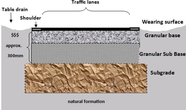
Figure 1 Road Pavement cross
section
Road Reseals
In the Transport Asset Management Plan (TAMP) council has
set the target of 39km of combined asphalt and bitumen reseals for each
financial year. This is based on the seal design life of approximately 12
years for bitumen and 15 years for asphalt (Austroads AGPT05‐11). Using our
road network this calculates at 28km for bitumen and 11km for asphalt.
The reseal unit rates for bitumen are $11/m2 and asphalt $23.50m2.
Heavy patching averages at $88m2 and is required to address failed
areas less than 10% of the overall segment length. Refer to Table 1.
Table 1 Reseal Unit Rates m2
|
Seal Type
|
Unit Rate m2
|
|
Reseal bitumen (single/single spray seal &
preparation)
|
$11.00
|
|
Asphalt overlay (40mm)
|
$23.50
|
|
Heavy patching (profiling and 100mm deep)
|
$88.00
|
Note: Table 12 TAMP
Unit Rates per kilometre for previous years are in the Table
2 below. Council has typically not reached the target of 39km per year (bitumen
and asphalt combined).
Table 2 Reseal unit rates / km
|
YEAR
|
RESEALS $/km
|
Resealed
km
|
Seal Target
km
|
|
2015/16
|
$47,384
|
32.9
|
39
|
|
2016/17
|
$73,464
|
11.4
|
39
|
|
2017/18
|
$54,916
|
16
|
39
|
|
2018/19 Proposed
|
$57,210
|
20.4
|
39
|
The reseal unit rates can vary depending upon:
· Heavy patching
required for the individual segment (limited to <10%)
· Extent of shoulder
grading required
· Drainage works
e.g. pipe culvert replacement
· Guide posts
required
· Line marking
undertaken
· Vegetation
management required e.g. tree pruning or roadside slashing
· Width of seal e.g.
6m wide at Possum Creek compared to 12m Lawson Street
· Amount of asphalt
sealed is much more expensive, note Table 1
The reseal actual budgets sometimes have not been
achieved for a range of reasons. Figure 2, demonstrates the budget and
actuals for the last 3 financial years with the 2018/19 proposed budget. The
chart clearly demonstrates that the target of $3.8million for reseals is not
being achieved.
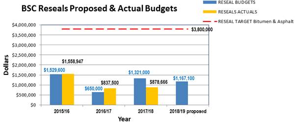
Figure 2 Reseals Proposed and Actual Budgets
Road Reconstructions
The capital renewal reconstruction target from the TAMP is 6km.
The term reconstruction is kept simple in this report, however, incorporates a
few approaches from stabilisation (e.g. Broken Head Road south of Midgen Flat
Road) to full depth reconstruction (e.g. The Terrace, Brunswick Heads). The
reconstruction unit rates average for rural at $167.32m2 and urban
at $179.30m2 (Table 3).
Table 3 Reconstruction unit rates / m2
|
Reconstruction type
|
Unit Rate/m2
|
|
Reconstruction rural (300mm
pavement, bitumen seal, table drains,
driveways, & pipe
culverts)
|
167.32
|
|
Reconstruction urban (300mm
pavement, AC seal, kerb & uttering)
|
170.30
|
Note: Table 12 TAMP
The capital renewal reconstructions target of 6km per year
is not being consistently achieved. This is demonstrated in Figure 3. In
2018/19 the proposed length is 940m.
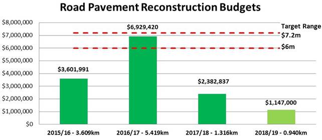
Figure 3 Road pavement reconstructions budgets
Transport and drainage proposed budgets 2018/19
Table 4 details the breakdown of the total budget for
transport and drainage of $18,443,400. The reseals are $1,167,100 and
reconstructions $1,147,000 which totals 12% of the overall capital
budget. This information is depicted in Figure 4 chart. The rural
causeways and culverts projects totalling $3 million (loan funded) is to
address critical renewal of condition 4 and 5 assets along with the $5.6million
(grant funded) for bridges.
Table 4 Proposed Transport and Drainage budgets for 18/19
(Excludes previous financial year expenditure for Bayshore Roundabout)
|
Transport
and Drainage Projects
|
Budget
|
Funding
|
|
Bridge Renewals
|
$5,608,000
|
Grant $4,168,000, Loans $1,205,000,
$235,000 SRV
|
|
Bayshore Dr Roundabout
|
$3,816,300
|
Grant $1,908,900, Section 94 $1,848,100
|
|
Rural causeways/culverts
|
$2,968,000
|
Grant $274,000, Section 94 $200,000, Loans
$1,154,000
|
|
*Cycleways - New
|
$1,183,300
|
Grant $635,700, Section 94 $547,600,
|
|
Road
Reseals
|
$1,167,100
|
Reserves $316,800, SRV $645,600,
Existing SRV $ 190,900K, Revenue $13,800
|
|
Road
Reconstruction (The
Pocket Rd & Broken Head Rd – carryover 17/18)
|
$1,147,000
|
Reserves $108,000, SRV $390,000,
Section 94 $642,000
|
|
Safer Roads Programs 2
sites
|
$542,100
|
Grant $542,100
|
|
Urban Drainage Upgrades
|
$360,900
|
Reserves $305,000, Revenue $55,900
|
|
Regional Roads RMS
|
$304,500
|
Grant $152,300, Reserves $152,200
|
|
Footpaths/shared
paths Renewal
|
$212,100
|
Section 94 $170,000, Reserves $42,100
|
|
Sealed Roads
Heavy Patching
|
$200,000
|
SRV $200,000
|
|
Unsealed Roads
Re-sheeting
|
$200,000
|
Revenue $95,000, SRV $100,000,
Revenue $5,000
|
|
Road Batter
Renewal
|
$152,100
|
SRV $152,100
|
|
Sealing 2
unsealed roads
|
$137,000
|
Revenue $137,00
|
|
New Sealed Rd (Bangalow Sports Field)
|
$110,000
|
Section 94 $110,000
|
|
Road
intersection safety upgrades
|
$110,000
|
Section 94 $30,000, Reserves $80,000
|
|
Road Renewal
forward designs
|
$90,000
|
SRV $90,000
|
|
Transport
Strategy
|
$75,000
|
Reserves $75,000
|
|
Bus Shelter Renewals
|
$60,000
|
Revenue $60,000
|
|
TOTAL
|
$18,443,400
|
|
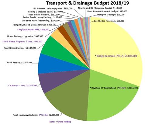
Figure 4 Proposed Transport and drainage budget chart
(Note: *Grant funding)
Summary
The road reseals and reconstructions have historically been
underfunded and Council is not achieving road renewal investment targets.
Figure 5, depicts the reseal target of 39km and reconstruction target of
6km against the outcomes for the last 4 years.
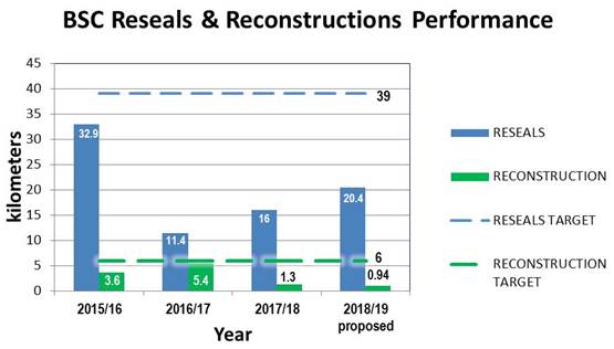
Figure 5 Reseals and reconstruction vs targets
Council is not improving the overall condition of the road
network. It is not addressing the increasing number of potholes and rough
patches on top of patches. If Council does not begin to invest in the
road pavement further declining levels of service will result in terms of
higher risk, reduced safety, increasing vehicle operating costs, worse travel
times, more vehicle accidents, increased noise, and adverse impacts on the
environment. The declining levels of service will negatively impact all
road users including cyclists, buses, and motor bikes.
Ideally the 2019/20 Capital Budget would include a combined
$9.8M for road reseals and reconstructions in accordance with the TAMP
targets. This may not be achievable and Predictor modelling has been used
recently to see what would be required to hold the average overall condition
rating of roads across the Shire. A reseal budget of $2 million and road
reconstruction of $4 million as a minimum total of $6 million is
needed to attempt to hold the road pavement condition over 10 years.
This could be considered the absolute minimum starting point for the 2019/20
budget with a view to progressive annual increases until the TAMP targets are
achieved.
It is recommended the Long Term Financial Plan and
associated 10 Year capital plan should be reviewed such that funding for road
reseals and reconstructions progressively increases so that the target levels
are achieved within three years.
Financial Implications
The financial implications are detailed in this report. The
long term and continuing under investment in road renewals has resulted in the
very poor and declining condition of our roads. This has many implications,
including financial, for the community Council serves.
Statutory and Policy Compliance Implications
This report seeks to assist Council in the process of
achieving targets articulated in the adopted Transport Asset management Plan.
Staff Reports - Infrastructure Services 4.2
Report No. 4.2 Review
of Tourist, Street Name, Community Facility and Service Signs (Policy07/102)
Directorate: Infrastructure
Services
Report
Author: Andrew
Pearce , Traffic Engineer
File No: I2018/1783
Theme: Infrastructure Services
Local Roads and Drainage
Summary:
A previous report to the
June TIAC meeting (I2018/924) highlighted a number of concerns in relation to Council’s
current Policy 07/102 – Tourist, Street Name, Community Facility and
Service Signs. As a result, Council resolved the following:
|
18-465
|
Resolved that
Council adopt the following Committee Recommendation(s):
Report No. 4.6 Tourist, Street
Name, Community Facility and Service Signs - Policy 07/102.
File No:
I2018/924
Committee Recommendation 4.6.1
1. That
further investigation of the issues relating to the Tourist, Street Name,
Community Facility and Service Signs commence including a review of Policy
07/102 with a view to reporting outcomes to the 15 November 2018 meeting of
the Transport and Infrastructure Advisory Committee.
2. That
the investigation within point 1 include consideration of commercial / event
/ community signage within road reserve.
3. That
innovation in digital way finding be considered.
(Richardson/Ndiaye)
|
This report will address
the three above items.
Please leave the text format throughout this whole report as
“left justification” 
<<Type text here>>
|
RECOMMENDATION:
That Council’s Policy 07/102 Tourist,
Street Name, Community Facility and Service Signs be updated to address the
following:-
a) Be
in accordance with current AS1742 series, RMS Tourist Signposting and
Geographical Name Board requirements;
b)
Incorporate a Flowchart and / or Checklist outlining the signage design, application
and installation process and fees;
c)
Provide clarity on fees and application process;
d)
Improve Policy clarity through improved document structure; and
e)
Incorporate a section on wayfinding and incorporate wayfinding principles to
Council’s signage network.
|
Report
Item 1 – Further Investigation of Policy 07/102
Policy Compliance
As addressed in the
initial report to the June TIAC meeting it is agreed there are many examples of
cluttered signage across the shire. It is considered that many of the
problems are because the design and installation of signage has often not been
in accordance with Council’s current Policy 07/102.
Many of the signage issues
will not be adequately addressed through a policy update unless compliance with
the policy is enforced during design and installation. Therefore, it is
recommended to incorporate within the policy a Flowchart and / or Checklist for
signage design, application and installation to help Council and developers
with compliance.
Policy Out of Date
Since Council’s
current signage policy was written in 2007 most parts of the AS1742 series, the
RMS Tourist Signposting guideline and the Geographical Names Board - Road
Naming application process have been updated.
Therefore, it is
recommended to update Council’s signage policy to more accurately reflect
the current standards, guidelines and regulation requirements.
Fees
The current policy
provides no information in relation to fees and minimal information in relation
to the application process. There is a significant opportunity provide
greater clarity in this area.
It is currently unclear
what fees to charge applicants for signage as there are no items within
Council’s Fees and Charges 2018/19. Until such an item is included and in
regards to signage application and installation, it is recommended to apply
fees associated with a Section 138 “Roadwork within public road reserve”,
namely: $316. Where a request is made to change or inspect a sign it is
recommended to charge a fee equal to Road Act – Activities, Works In, On
or Over a Public Road – “Asset inspection fee” $180.
It is also recommended to
clarify when applicant may be exempt from fees.
Approval Process
The current policy
provides minimal information in relation to the approval processes. It is
recommended to provide a section clarify which roads authority is to be
contacted, depending on whether the sign is located on a state road, classified
road or local road.
If Council is the roads
authority more detail should be given in relation to Councils assessment and
installation process, such as: which form to fill in, where to find the form,
who to send it to and who to pay fees to and when.
In addition, it is
recommended to provide a section for Council members outlining the advertising
and assessment process required when assessing a sign application.
Improve Policy
Clarity
The greatest improvement
to Council’s current signage policy is the opportunity to improve the
structure. The ability to assess and enforce Councils signage policy is
significantly reduced due to the current policy’s difficult structure.
Therefore, one of the most significant reasons to update Councils signage
policy is to improve the document clarity through improving its structure.
Item 2 - Commercial / event / community signage within road
reserve
The current policy
incorporates a section on Community Facilities and Service Signs. This section
is considered to cover the same issues associated with Commercial, event and
community signage. However, while the current policy already incorporates a
section on Community Facilities and Service Signs it is recommended to update
this section in accordance with RMS Tourist Signposting and the relevant parts
of the AS1742 series and to state explicitly that it covers commercial, event,
community and service facilities.
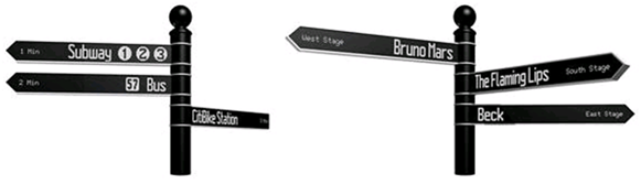
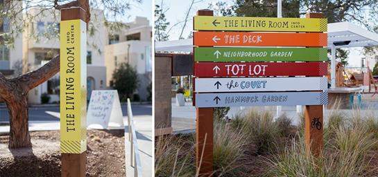
Item 3 – Digital Wayfinding
Digital wayfinding
typically refers to the use of technology to help pedestrians navigate their
way through an unfamiliar environment. Examples of digital wayfinding systems
are:
· Interactive touch screens at strategic locations to
aid pedestrians (such as information screen at shopping centres);
· Google maps with key locations and landmarks
highlighted to aid journey planning;
· Mobile apps that read QR codes or display bike paths
and tourist walks;
· Programmable LED street signs that can change
message and direction depending on programming or what button on the pole is pressed.
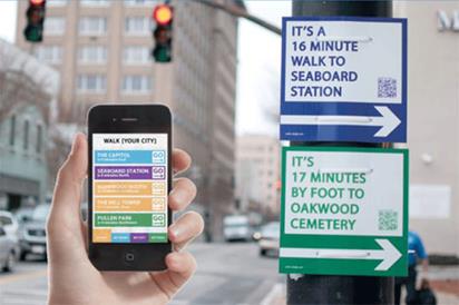
It is considered there is
significant opportunity to incorporate wayfinding into an updated signage
policy given its ability to assist in place making and the current number of
strategic plans currently being undertaken or finalised by Council, such as:
Byron Bay Access and Movement Strategy and Byron Shire Bike Plan.
However, it is considered that specifically digital wayfinding should
not be incorporated within the updated policy and should instead have its own
policy given such a system will be very different from traditional signage and
highly dependent on technology as well as Council’s IT and Communications
team.
Introducing a general
wayfinding framework and signage to Council’s policy will help Council
and the community view individual signs not as isolated stand alone
signs. Instead, introducing a wayfinding framework helps to view signs as
working together to form a communication network that can be both functional,
aesthetic and place making.
Financial Implications
Staff time to undertake the
research and write the report.
Statutory and Policy Compliance Implications
Will ensure Councils policy
complies with AS1742 and RMS requirements.
Staff Reports - Infrastructure Services 4.3
Report No. 4.3 Status
Update - Bike Plan and PAMP
Directorate: Infrastructure
Services
Report
Author: Daniel
Strzina, Project Engineer
File No: I2018/2014
Theme: Infrastructure Services
Local Roads and Drainage
Summary:
This report provides a status update on the development of
the Bike Strategy and Action Plan (Bike Plan) and Pedestrian Access and
Mobility Plan (PAMP).
PSA Consulting have been engaged to develop the Bike Plan
and PAMP concurrently. This status update is part of a commitment to
provide regular updates to every ordinary TIAC meeting.
|
RECOMMENDATION:
That the status update on the development of the
Bike Strategy and Action Plan (Bike Plan) and Pedestrian Access and Mobility
Plan (PAMP) be noted.
|
Report
The PAMP and Bike Plan are in
early stages of development. The previous status report to TIAC provided
draft report structures and informed of the revised Consultation and Engagement
Plans for both projects.
Draft versions of Chapters 1
& 2 of both the PAMP and Bike Plan have been submitted, reviewed and
revised. PSA Consulting require the information generated by Consultation
Stages 1 and 2 to further progress with the development of the plans.
Consultation Stage 1: WalkRollRide Campaign –
Complete
The WalkRollRide campaign involved an online survey using
Council’s HaveYourSay platform and engaged members of the public by first
educating them of the plans and the development processes involved, then
inviting them to contribute their ideas on how we can best improve cycling and
pedestrian facilities around the shire. The response to the survey was
excellent with over 700 responses. A significant number of responses
included suggestions and requests for specific facilities that would improve
the pedestrian and cycleway networks in their area. The engagement was
successful in that the data generated was high quality and useful.
Further, more than half of the respondents expressed a
desire to be further involved in the development of the Bike Plan and/or the
PAMP. PSA consulting is currently processing the responses and
summarising the findings. Figures 1-4 below illustrate some of the
available data that came out of Stage 1.
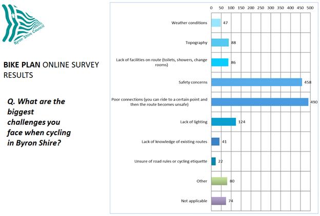
Figure 1 – Online survey result to the question,
‘What are the biggest challenges you face when cycling in Byron
Shire?’
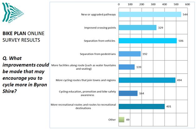
Figure 2 – Online
survey result to the question, ‘What improvements could be made that may
encourage you to cycle more in Byron Shire?’
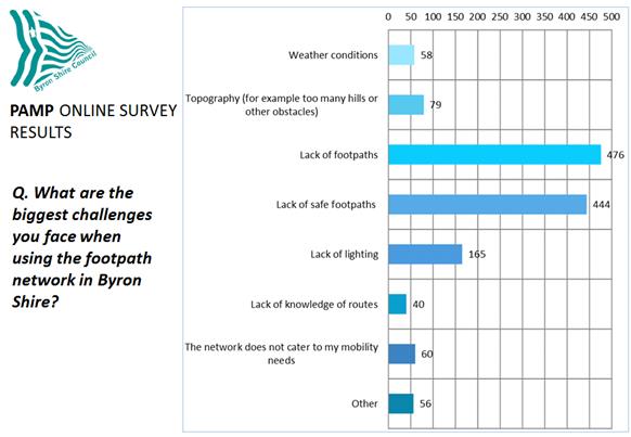
Figure 3 – Online
survey result to the question, ‘What are the biggest challenges you face
when using the footpath network in Byron Shire?’
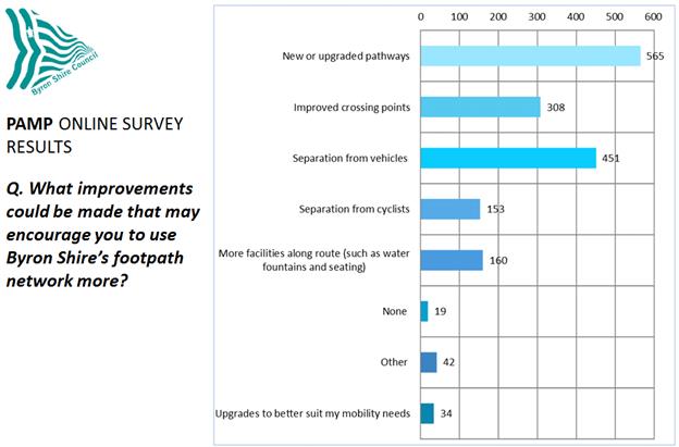
Figure 4 – Online
survey result to the question, ‘What improvements could be made that may
encourage you to use Byron Shire’s footpath network more?’
Consultation Stage 2: Design Workshops – Underway
Staff are in the process of
holding a series of design workshops (previously referred to as charrettes)
that involve the collaboration of PSA Consulting, stakeholders and community
members to develop a priority list of cycling and pedestrian infrastructure
projects for their area.
A total of eight workshops
will be held; one for the PAMP and one for the Bike Plan for each of the four
focus areas. The workshops have been scheduled to take place on four
separate nights over four weeks, with two workshops (one for the Bike Plan and
one for the PAMP) planned for each night, and each night focussing on a
separate geographical area (see schedule below).
|
Day
|
Time
|
Workshop
|
Focus Area
|
Location
|
|
Tuesday 23 October
2018
|
5:30pm – 7:00pm
|
Bike Plan
|
North Western Towns:
Mullumbimby, The Pocket, Middle
Pocket, Main Arm, Palmwoods, Wilsons Creek, Goonengerry, Myocum and
neighbouring areas.
|
Byron Shire Council
Conference Room
70 Station St,
Mullumbimby
|
|
7:15pm – 8:45pm
|
PAMP
|
|
Tuesday 30 October
2018
|
5:30pm – 7:00pm
|
Bike Plan
|
South Eastern Towns: Byron Bay, Suffolk Park, Belongil, the Industrial
Area, Ewingsdale, Broken Head, Coopers Shoot, Hayters Hill, and neighbouring
areas.
|
Byron Bay Community
Centre
69 Jonson St, Byron Bay
|
|
7:15pm – 8:45pm
|
PAMP
|
|
Thursday 08 November
2018
|
5:30pm – 7:00pm
|
Bike Plan
|
South Western Towns: Bangalow, Talofa, McLeods Shoot, Coorabell,
Federal, Eureka, Nashua, Binnna Burra, Possum Creek and neighbouring areas.
|
Moller Pavilion,
Bangalow Show Grounds
Entry via Market St,
Bangalow
|
|
7:15pm – 8:45pm
|
PAMP
|
|
Wednesday 14
November 2018
|
5:30pm – 7:00pm
|
Bike Plan
|
North Eastern Towns: Billinudgel, Yelgun, New Brighton, South Golden
Beach, Ocean Shores, Brunswick Heads, Tyagarah and neighbouring areas.
|
Ocean Shores Country
Club
Orana Rd, Ocean Shores
|
|
7:15pm – 8:45pm
|
PAMP
|
At the time of writing, two
of the four nights have taken place with successful outcomes. The
Mullumbimby and Byron Bay sessions resulted in the generation of quality data
for both the Bike Plan and the PAMP in the form of:-
· Identified
critical issues/existing network deficiencies,
· Identified
locations for the improvement of existing infrastructure,
· Identified
opportunities to improve the existing network, and
· Prioritisation
of the infrastructure projects identified.
Once the workshops are
complete, the data collected will be collated and incorporated into the draft
PAMP and Bike Plan for submission to TIAC for review.
Byron Bay to Suffolk Park Cycleway
The Byron Bay (Browning St) to Suffolk Park (Clifford St)
Cycleway Investigation Report and Preferred Option Concept Design (Attachments
1-8) will be placed on public exhibition for comment by formal submission for a
period of 28 days from 16 November 2018.
This public exhibition is in anticipation of the
announcement of Round 2 of the Stronger Country Community Fund (SCCF) grant
scheme, to which a submission was made for the southern section of this project
- from Byron@Byron through to Clifford St. The submission requests
$500,000 in funding to supplement $110,000 of identified Council revenue for a
total project budget of $610,000. The rest of the project scope is
currently unfunded, however all potential funding streams will continue to be
investigated.
It should be noted that this project was identified and
given high priority by all of the groups in the Byron Bay Bike Plan workshop.
Financial Implications
As previously advised, the additional Consultation and
Engagement scope will require additional budget allocation to both
projects. Further budget adjustments are required to account for staff
time that was not allowed for in the originally allocated budget. As
such, budget adjustments of $44,000 for the Bike Plan and $49,000 for the PAMP
have been included in the September 2018 quarterly financial review, which will
be reviewed by the Finance Advisory Committee at their meeting on 15 November
2018.
Statutory and Policy Compliance Implications
There are no negative statutory or policy compliance
implications at this time.
Staff Reports - Infrastructure Services 4.4
Report No. 4.4 Development
of a Shire-wide Transport Strategy
Directorate: Infrastructure
Services
Report
Author: Daniel
Strzina, Project Engineer
File No: I2018/2035
Theme: Infrastructure Services
Local Roads and Drainage
Summary:
The purpose of this report is to:-
· Provide background
information on the development of a Shire-wide Transport Strategy;
· Summarise the outcomes
of the first two TIAC workshops on the development of the Shire-wide Transport Strategy,
held on 20 April 2018 and 22 June 2018; and
· Identify any useful
existing strategies developed by other Councils, regional bodies and other
sources of information for TIAC to continue to workshop the development of the
Shire-wide Transport Strategy.
· Recommend the engagement
of a specialist consultant to build upon and complete the Shire-wide Transport
Strategy.
|
RECOMMENDATION:
1. That
the Committee adopt recommendations to Council for the following sections of
a Shire-wide Transport Strategy:-
· Scope and
context
· Vision
· Principles
· Issues and
challenges
2. That
the Committee review recommendations to Council for the following sections of
a Shire-wide Transport Strategy:-
· Targets and
desired outcomes
· Key actions
to achieve objectives
3. That
the Committee develop recommendations to Council for the following sections
of a Shire-wide Transport Strategy:-
· Community and
stakeholder engagement
4. That
an RFQ be prepared and issued for the engagement of a specialist consultant
to undertake the preparation of the Shire-wide Transport Strategy, using the
outcomes of Workshops and meetings to date as a foundation for the
development of the Strategy.
|
Background
The previously considered
reports referred to in the following pages contain information significant to
the progression and development of a Shire-wide Transport Strategy. As
such, they have been summarised in this section for reference and guidance
moving forward.
Council, at its meeting of 10
October 2016, resolved in support of the 16 August 2016 Transport Advisory
Committee (TrAC) recommendation as follows:-
Resolution 16-516
Report No. 5.1 Development of a Shire-wide
Transport Strategy
File No:
I2016/884
Committee Recommendation 5.1.1
1. That
the Committee develop a Shire-wide Transport Strategy which includes:
a) CONTEXT
to include consideration of:
· congestion
· high
tourist numbers
· lack
of local public transport connectivity and regional integration
· high
carbon emissions
· safety
· high
costs of running private vehicles
· road
condition and the cost of maintenance
· demographics
– (difficult for people who can’t drive or don’t have a
licence)
· access
- mobility
· lack
of cycleway connectivity
· lack
of connectivity in general
· poor
location of services – making them more distant than they could otherwise
be
· high
growth area – need to plan for future
· transport
costs to community from planning and commercial decisions
· impact
of future technological and social developments
b) OBJECTIVES
to include consideration of:
· reduce
the need for and/or dependency on private motor vehicle trips
· improve
public transport
· support
community transport
· increase
the bike network and/or use
· improve
pedestrian and residential amenity
· support
advocacy, partnerships and/or community involvement
· improve
road user safety
· improve
integration and regional connectivity
· support
climate change adaptation and mitigation
· further
defining and obtaining of these objectives will be the role of the proposed
transport strategy
· support
of each objective can be sought via relevant Council instruction through
available mechanisms regarding any proposed and/or existing activity, all of
which will be explored via development of the proposed transport strategy that
will be guided by Council’s vision.
c) ACTIONS
to include the consideration of:
· understanding
user experience – feedback, surveys
· develop
priorities from user feedback, eg improve user experience by means of improved
bus shelters, safer road crossings, shorter travel times, for example
· develop
measurement methods for baseline and future actions
· integrated
land use planning
2. That
a draft strategy commence with a review of relevant local, state and
federal programs, plans and strategies in efforts to identify funding and
partnership opportunities.
3. That Council note staff will
apply by 9 September 2016 to meet the RMS Active Transport Funding deadline and
it will include seeking 2017/18 funding for the revision of Council’s
bike plan and PAMP. (Richardson/Hunter)
TIAC at its meeting on 15 March 2018 considered a report on
Development of a Shire-wide Transport Strategy (File No: I2018/411) that sought
to establish a process to move forward with to develop a Shire-wide Transport
Strategy with reference to resolution 16-516 as the basis of the framework for
the strategy. Committee recommendations were adopted by Council, who
resolved as follows:
Resolution 18-251
Resolved that
Council adopt the following Committee Recommendation(s):
Report No. 4.5 Development
of a Shire-wide Transport Strategy
File No: I2018/411
Committee Recommendation
4.5.1
1. That
the Committee have an extraordinary meeting in April 2018 to workshop the
development of Shire-wide Transport Strategy.
2. That
a report be prepared for TIAC that identify any useful existing strategies
developed by other councils, regional bodies and other sources of information.
3. That
the Committee members be encourage to research and share ideas
(Richardson/Cameron)
At its extraordinary meeting
on 20 April 2018, TIAC considered a report in accordance with point 2 of the
above resolution (File No: I2018/685) and conducted a workshop on the
development of a Shire-wide Transport Strategy. Committee recommendations
were adopted by Council, who resolved as follows:
Resolution 18-305
Resolved that
Council adopt the following Committee Recommendation(s):
Report No. 4.1
Development of a Shire-wide Transport Strategy
File No: I2018/685
Committee Recommendation 4.1.1
That Council note that the
Committee develop recommendations to Council for the following sections of a
Shire-wide Transport Strategy:
· Scope and
context
· Vision
· Principles
· Issues and
challenges
· Targets and
desired outcomes
· Key actions to
achieve objectives
· Community and
stakeholder engagement
(Richardson/Cameron)
Report
During the first Transport
Strategy workshop on 20 April 2018, the following points were initially raised:
· The
Shire-wide Transport Strategy will be an overarching, policy-level strategic
document that will act at high level to guide how Council proceeds with funding.
· It
will be a mechanism by which to support projects and initiatives.
· It
will inform other Council plans and strategies.
· It
will contain a hierarchy of principles, prioritised by the community.
· Community
involvement will be critical to making this an integral document.
· A
desired outcome is that it will become a consensus document; high quality data
and research to ensure that it is effective in influencing Council.
A discussion was had
regarding the potential to engage a consultant to undertake the preparation of
the Shire-wide Transport Strategy. It was concluded that a more efficient
and cost effective approach would be to workshop the subject matter so as to
define the content prior to engaging a consultant.
As such, examples of existing
local council Transport Strategies were tabled for analysis The Committee
proceeded to workshop the deliverables outlined in Resolution 18-305. The
outcomes of this process are detailed in the following section of this report.
Two strategies that were of
interest due to the relevance of their content were Noosa’s Transport
Strategy (2017) and Hobsons Bay’s Integrated Transport Strategy (2017).
1. Outcomes
of the 1st Transport Strategy Workshop (for adoption)
The following agreed outcomes
are listed below and in the attached working document for adoption during the ordinary
meeting of 15 November 2018.
· Italics
indicate sections or ideas that have been directly referenced from the original
documents with little or no amendment.
· Red text indicates additions or
amendments made during workshop 2.
Transport Strategy Scope
and Context
1. Shire-wide.
2. Regional
links.
3. Interregional and interstate links and
influences (border, airports, freight, etc.)
4. Inform
future transport use.
5. Write
flexibility into strategy.
6. Consider
technological change (drones, autonomous vehicles, electric vehicles, etc.).
7. Consider
demographical change.
8. 40
year strategy.
9. Review
frequency: 3-5 years?
Vision
An integrated, innovative and equitable transport system,
providing a range of sustainable, efficient, accessible and safe ways for
people and goods to reach their destination.
Purpose
1. Purpose
of document is to inform Council on how to implement the vision.
2. Integrate
with existing and future planning documents.
3. Ensure
infrastructure projects satisfy strategic goals.
4. Support
funding applications and opportunities.
5. Support
and promote general health and wellbeing.
6. Cultivate
environmental stewardship.
7. Foster
economic growth.
8. Encourage
change in modes.
9. To
coordinate with other Councils across the region.
10. How does the
document get used? Framework to be developed.
Principles
1. Encourage
transport options that meet the needs of both locals and visitors.
2. Prioritise
our focus on moving people and goods rather than moving cars.
3. Provide
infrastructure and services that are designed to give priority to pedestrians,
cyclists, scooters and public transport over private cars.
4. Improve
and promote the
safety and amenity of pedestrians, cyclists and vulnerable road users in our
transport infrastructure. (safety amenities vs
behaviour)
5. Address
peak time traffic congestion by reducing traffic rather than increasing road
capacity.
6. Take
advantage of changes in transportation technology.
7. Align
transport options and usage with Council’s Emission Reduction Strategy.
8. Design
for, encourage and facilitate transport options that reduce the emissions
produced by our community.
9. Recognise
the need for transport options in rural areas and evoke a sense of equity
within transport planning.
10. Integration
– Strengthen connections between different forms of transport, land use
and transport planning, and to regional and metropolitan networks.
11. Equity
– Support a range of accessible and affordable transport options for all
people, neighbourhoods and future generations.
12. Efficiency
– Build a more reliable and effective transport system that supports
skills development, business and employment growth and provides competitive
alternatives to private car travel.
13. Encourage
the use of ride sharing and car sharing services.
14. Encourage active transport and healthy transport
options.
15. Promote behavioural change to improve safety.
Challenges and Opportunities
1. Number
of visitors.
2. Congestion
at peak times.
3. Car
dependence.
o Sedentary issue.
o Love affair with cars.
o Fossil
fuel and associated financial, environmental and sociological costs.
o On demand transport.
4. Topography
and climate.
5. Funding.
6. Shortfalls
in services and infrastructure.
7. Public
transport.
o Affordability
o Frequency
o Coverage
o Connectivity
8. Regional,
state and federal transport planning, including funding.
9. Demographics
(large proportions of younger and older residents in Byron Shire).
10. Lack of
population density due to the rural nature of Byron Shire.
11. Disruptive technology.
12. Distinguish differences between different sets of users
(e.g. tourist, leisure, resident, commuter, commercial) and their different
needs.
13. Internet as a way to avoid unnecessary transport.
14. Support of high speed broadband.
Population Dispersal Discussion
It was highlighted during the workshop that the primary
distributors in Byron Shire (Pacific Hwy running North-South and
Bangalow/Lismore Rd running East-West) present opportunities to be taken
advantage of in preparing the Shire-wide Transport Strategy.
- Different
sets of users (e.g. tourist, resident, commuter, business) have different
needs.
- Acknowledge
that there are different patterns (mapping and demand) for different users.
- Behavioural
aspects must be addressed for safety – e.g. dropping kids at school.
2. Outcomes
of the 2nd Transport Strategy Workshop (for review)
The following outcomes are listed below and in the attached
working document for review during the ordinary meeting of 15 November 2018.
This section contains excerpts from existing relevant local council Transport
Strategies (in italics or as images), collated for the purposes of
continuing to workshop the development of the Shire-wide Transport
Strategy. The full excerpts are available as appendices to the attached
working document.
· Italics
indicate sections or ideas that have been directly referenced from the original
documents with little or no amendment.
· Red text indicates additions or
amendments made during workshop 2.
· Highlighted text indicates
where review or further work is needed.
1. Targets and desired outcomes
a) Noosa Transport Strategy (2017, page
7).
1. Residents and workers of Noosa Byron Shire are able to go about their everyday
business without having to be reliant on private vehicles.
2. The transport network is designed to facilitate and
encourage an overall modal shift away from private car use towards more
sustainable transport modes including walking, cycling, public transport,
electric vehicles and motor scooters/cycles.
Points 1&2
summarise to: Reduce impact and reliance on Transport Infrastructure.
3. The transport system supports the preferred pattern of
development including the local centres hierarchy, and is consistent with our
planning scheme.
Point 3 –
add bike friendly and pedestrian friendly schemes.
Note: Ask Shannon Burt’s staff to help us to develop this document and
invite for the next meeting. E.g. SEE planner to discuss future planning
DEP/LEP.
4. Key regional destinations such as hospitals, airports
and universities are readily accessible by public transport from Noosa Byron Shire. Point 4 OK.
5. All schools are safely and conveniently accessible by
walking, cycling and public transport. Point 5 OK.
6. Parking is closely managed through effective controls. Point 6 OK.
7. There has been a change in behaviour by people in
Noosa with a reduction in the number choosing to drive and park cars in
congested coastal areas. Point 7 OK.
8. Park-and-Ride facilities have been provided to assist
with managing visitor travel demand where supported by transport services. Point 8 OK.
9. The transport system supports the local lifestyle and
also tourism by delivering both active and public transport infrastructure that
meets the needs of locals and visitors. Point 9 OK.
10. Local public transport routes offer efficient and
frequent services. Point 10 OK – frequency, connectivity etc. Include reference to
regional and interregional networks.
NEW: Transport movement
associated with events in line with strategies principles. Apply DTA standards.
NEW: Vehicles being flexible to meet emission targets.
NEW: On demand public transport including driverless vehicles.
NEW: Provision of multimodal HUBs with accessible infrastructure footpaths.
11. Road crossings and associated pedestrian networks are
safe and accessible for mobility scooters, cyclists and pedestrians.
12. The community at all levels is educated about the
costs and benefits of their travel choices, allowing people to make informed
decisions.
13. Alternative transport is cost effective for users and
providers as compared with private car use.
14. New technologies are being used in our transport
solutions.
15. Transport initiatives result in significantly reduced
greenhouse gas emissions.
Note: Combine
Points 14 and 15 together.
NEW: Add point about the
Electrification of transport and provision of renewable energy to match the
growth.
b) Hobsons Bay Integrated Transport
Plan (2017, page 24-35).
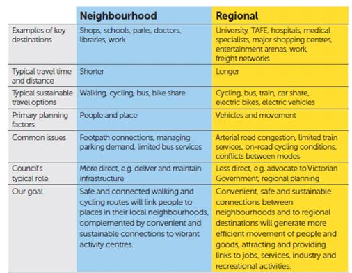
Typical
sustainable travel options (Neighbourhood): Add car share/car pool and EV.
Common issues (Regional):
Connection issues - add reference to integration. Also add point about
cycling facilities, footpath connections, and cycleway connections.
Council’s typical role: What we do is beyond the advocacy, policy support
etc.
Typical sustainable travel options: Electrification of transport –
encouraging it – add point (we have already charging station).
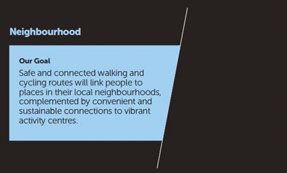
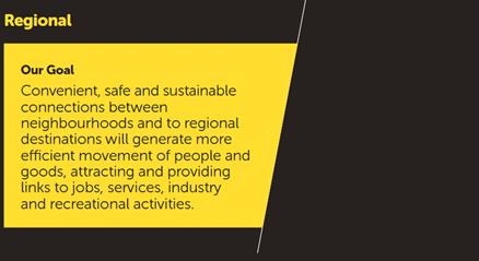
“Vibrant Activity Centres”

Consider/include points on
the following:
· Tourism and management.
· Rail corridor
investigation – it is beyond advocacy.
· Carshare/carpool.
· Electrification of
transport.
Consider/include points on
the following:
· Provide links to jobs,
services, industry and recreational activities.
· Consider Employment Lands
Strategy
o Location Highway vs
Ewingsdale road (congestion?)
o Modal use
o Distribution HUBs –
warehouses in the industrial estate – people buy online
o Need for distribution
centres – click and collect
· Align transport strategy
objectives and outcomes with our Community Strategy/Plan
c) Newcastle Transport Strategy (2016,
page 27).
Content considered OK, though not as
relevant as Noosa, Hobsons Bay.
d) Northern Rivers Regional Transport
Plan (2013, page 44).
Not a good source/reference.
Only good recommendation is a
consistent and regular town loop service.
2. Key actions to achieve objectives
Note: It was generally agreed that ‘Key Actions to
Achieve Objectives’ are specific and directly related to ‘Targets
and Desired Outcomes’. As such, these actions should be developed
once the desired outcomes have been finalised. It is recommended that
this is undertaken by a specialist consultant with the skills and resources to
finalise the desired outcomes and propose a suitable set of actions to achieve
them.
a) Noosa Transport Strategy (2017, page
12).
Content is generally OK, actions are
specific to desired outcomes.
b) Hobsons Bay Integrated Transport
Plan (2017, page 30, 36).
Content is generally OK, actions
are specific to desired outcomes.
c) Newcastle Transport Strategy (2016,
page 34-51).
Content is generally OK, actions
are specific to desired outcomes.
P10, P11, consider lower speed
limits as a safety measure (captured in P12).
A12: Review Contributions Plan to include
the design for residential subdivisions.
NEW: Explore possible funding options: State, federal, section 94.
A17: Reinvestment of paid parking revenues in transport infrastructure
Identify local, regional and interregional freight corridor and access.
3. Target outcomes of the ordinary
meeting of 15 November 2018 (For Development)
For discussion during the ordinary meeting of 15 November
2018:
· Recommendations as
to what would be considered suitable community and stakeholder engagement for
the development of the Shire-wide Transport Strategy.
· Review of the Path
Forward below.
Path Forward
1. Form a Transport Strategy Working Group
under the guidance of TIAC to continue to workshop the strategy using a
consultant with the goal of finalising recommendations to TIAC then Council in
accordance with Resolution 18-305.
2. Invite other skillsets and disciplines
to focussed sessions (walking, cycling, public transport, etc.) to assist the
Working Group in developing recommendations.
3. Continue to review and consider
existing local council Transport Strategies for content and layout.
4. Prepare a document that shows
connection into IP&R documents and other internal and external strategies.
5. Research: Scope, context and path
forward - Add some graphs about safety, surveys.
4. Recommendation:
Engagement of a specialist consultant
It is recommended that an RFQ be prepared and issued
for the engagement of a specialist consultant to undertake the further
development and preparation of a Shire-wide Transport Strategy using the
outcomes above as a foundation for the development of the document.
Financial Implications
Funding of $75,000 has been allocated to this project as
part of the 2018/19 budget, of which there is $73,527 remaining (as of
8/11/2018).
Statutory and Policy
Compliance Implications
There are no negative statutory and policy compliance
implications associated with this report.