Minutes of Meeting


bsc_logo_150dpi_rgb


Local Traffic Committee Meeting


Venue

Conference Room, Station Street, Mullumbimby

Date

Tuesday, 30 July 2019

Time

10.30am

Committee Members

Katherine Boulton – Roads and Maritime Services

Snr Constable Chris Davis – Police

Cr Basil Cameron

Tamara Smith MP


BYRON SHIRE COUNCIL

Local Traffic Committee Meeting Minutes                                             30 July 2019


Report of the Local Traffic Committee Meeting held on Tuesday, 30 July 2019

File No: I2019/1163


Meeting Commenced:   10:36am


PRESENT:

Councillor:  Cr Basil Cameron

Roads and Maritime Services Representative: Katherine Boulton

Police:  Snr Constable Chris Davis

Staff:   Andrew Pearce, Jeff Begovic (10:39am- 11:00am)

Office of Tamara Smith, Member for Ballina: Kim Simpson (left 11:46am)


Apologies:


Tamara Smith MP

Police: Matt Kehoe


Declarations of Interest

There were no declarations of interest raised. or


Adoption of Minutes from Previous Meetings


Committee Recommendation:

That the minutes of the Local Traffic Committee Meeting held on 14 May 2019 be confirmed.

(Boulton/Cameron)

The recommendation was put to the vote and declared carried.


Matters Arising

No matters arising


Outstanding Issues/Resolutions

No Outstanding issues. 


The order  of business was changed to address Report 8.1 and Report 6.1 first.


Regulatory Matters

Report No. 6.1             Byron Bay Bypass Linemarking and Signage - revised plans

File No:                        I2019/799


This report seeks LTC concurrence and endorsement for the proposed regulatory signs and line marking for the Byron Bay Bypass construction project.


Detailed pavement marking and signage plans from the approved and signed off design drawings are attached for the project in A3 format.


These plans have been revised since they were last presented to the LTC as a result of comments from and discussion with RMS and the Police, where the majority of comments have been addressed, or justification provided otherwise.


There are also marked up plans showing the pedestrian/bike paths and crossing points throughout the project, which are not subject to regulatory review but provided for information.


Construction works are commencing in July 2019.


Committee Comments

RMS conducted peer review, and Police & RMS have made changes.  RMS and Police now support the revised plans. RMS’s only concern is that the design has been set therefore they are only commenting on the signage plan, however RMS has concerns about the safety of the pedestrian refuge near Wentworth St reserve.

Management Comments

No management comments


Committee Recommendation:

1.    That the Local Traffic Committee endorse the attached Pavement Marking and Signage Plans for the Byron Bay Bypass project (#E2019/42067).

2.  Council consider the committees comments regarding the pedestrian refuge near Wentworth St.


(Boulton/Davis)

The recommendation was put to the vote and declared carried.


Report No. 6.2             Event Road Closures - Byron Lighthouse Run 2019

File No:                        I2019/192


SUMMARY


Council has received an application, Traffic Management Plan (TMP) and Traffic Control Plan (TCP) from NXsports Community Foundation Ltd for the Byron Lighthouse Run 2019 to be held Sunday, 20 October 2019.


OFFICER RECOMMENDATION


That the temporary traffic management and regulatory changes within the Traffic Control Plans, as relates to the Byron Lighthouse Run 2019 to be held on Sunday 20 October 2019, be endorsed subject to specified conditions.


BACKGROUND


The annual Byron Lighthouse Run is proposed to be held on Sunday, 20 October 2019.  It is a fun run and walk to raise money for charity.  The event will operate on the same course and design as the 2018 event.


The Byron Lighthouse Run 2019 will attract about 600 participants, plus an estimated 400 spectators across the race times shown below.  This is down on last years estimate of 900 participants and 1,000 supporters.


The maps below show the extents of the 6km and 10km courses.  The Kids Dash is entirely within Dening Park and does not extend onto the road reserve.


TRAFFIC MANAGEMENT

A TMP and TCP have been submitted to Council which are generally the same as 2018. Based on these documents, proposed temporary road closures include:


Traffic diversions in place during the event include:


Outgoing traffic from within the closed Lighthouse precinct will be guided by traffic control to the Lawson Street and Massinger Street intersection. Escorts will be available throughout the closure; the mobile number to arrange escort in advance is disseminated in all community consultation collateral. Motorists will be advised to proceed with caution, hazard lights on, and windows down until they reach the Lawson Street roundabout.


In the case of a major community incident such as terrorism, the event will be put on hold until the Race Director and Police determine when the event is safe to continue.  Emergency services will maintain right of way.


CLARKES BEACH CAR PARK

The race proposes to centre on Clarkes Beach Car Park with the car park forming the start and finish point. Event registration and first aid is also based at the car park and additional toilets located there.


The applicant states they will reopen Clarkes Beach at 9am. It is recommended to state in the recommendations that Clarkes Beach is to be open to the public by 9am.


BYPASS IMPACTS

Butler Street Reserve car park will be closed and not available for competitor / visitor parking.


The race organisers state “Competitors will be advised via the website and our newsletter about available parking and the restrictions elsewhere in Byron Bay. The parking will be available from 5.00am.

Parking will be managed by event volunteers They will be onsite from 5.00am on event day.

Signage will be erected directing competitors to the nominated car parking.”


COUNCIL IMPLICATIONS


§ Budget/Financial

The event organisers to be invoiced for the relevant Approval of Road Events pursuant to s144 of the Roads Act fee as per the Fees & Charges 2019/20.


§ Asset Management

N/A


§ Policy or Regulation

Regulatory traffic signage as delegated to council for authorisation in conjunction with NSW Road Rules.


§ Consultation

A condition of the endorsement of this event is that appropriate consultation is undertaken, which may include:

·    Advertising the impact of the event in the local newspaper and on the Council website.

·    Informing community and business that are directly impacted.

·    Liaising with bus and taxi operators.

·    Consulting with emergency services.


§ Legal and Risk Management

Event organiser is required to hold $20m public liability insurance cover which is valid for the event.


Committee Comments

RMS have no issues. Police have no issues.

Management Comments

No Management comments


Committee Recommendation:

That Council support the 20 October 2019 Byron Lighthouse Run, subject to:


1.   Traffic control plan(s) and a Traffic Management Plan being designed by those with the appropriate and relevant NSW (RMS) accreditation. The TCP and TMP are to include the temporary car park and road closures below:


a)   Lawson Street, between Massinger Street and Lighthouse Road, between 6:30am and 10:00am;


b)   Tallow Beach Road, between Lighthouse Road and Tallow Beach Car Park, between 6:30am and 10:00am;


c)   Lighthouse Road, between Lawson Street and the Cape Byron Lighthouse, between 6:30am and 10:00am; and


d)   Brooke Drive, between Lighthouse Road and the Pass, between 6:30am and 10:00am.


e)   Clarkes Beach Car Park, between 5am and 9am. Clarkes Beach car park is to be open to the public by 9am. Alternatively, if car park is to be closed to the public after 9am an application is to be made to Council to occupy the car park and relevant application fee’s and parking fees are to be paid to Council prior to the event commencing.


2.   That the approval provided in Part 1 is subject to:


a)    separate approvals by NSW Police, RMS and Cape Byron Headland Trust being obtained;


b)    implementation of the approved Traffic Management Plan and Traffic Control Plan/s by those with appropriate RMS accreditation and the holding of current and appropriate levels of insurance and liability cover; and


c)    The event organiser:


i)       advertising the impact of the event via a notice in the local weekly paper a minimum of one week prior to the operational impacts taking effect, noting it must include the event name, specifics of any traffic impacts or road closures and times, alternative route arrangements, event organiser, a personal contact name and a telephone number for all event related enquiries or complaints;


ii)      providing copy of the advert for Council's web page;


iii)     informing community and businesses that are directly impacted (e.g. adjacent to the event), including the Beach Byron Bay Café and North Coast Holiday Park Clarkes Beach, via written information which is delivered to the property in a timely manner so as to document, consider and respond to any concerns raised;


iv)     arranging for private property access and egress affected by the event;


v)      liaising with bus and taxi operators and ensuring arrangements are made for provision of services during conduct of the event;


vi)     consulting with emergency services with any identified issues being addressed;


vii)    holding $20m public liability insurance cover which is valid for the event; and


viii)    payment of Council’s Road Event application fee prior to the event.


(Cameron/Boulton)

The recommendation was put to the vote and declared carried unanimously.


Report No. 6.3             Byron Cycle Club - Criterium Racing 2019 - Woodford Lane, Ewingsdale and Byron Arts & Industrial Estate

File No:                        I2019/973


SUMMARY

The Byron Cycle Club is seeking support to run their Criterium Racing at 2 locations on the 2nd and 4th Sunday of each month.  The 2 locations are:


1.   Arts & Industrial Estate, Byron Bay

2.   Woodford Lane, Ewingsdale.


ARTS AND INDUSTRIAL ESTATE

The Club have had consent to run their criterium races in Arts and Industrial Estate since 2013 and their current consent (granted in 2016 for three years) finishes in August 2019.  They plan to use the same TCP and TMP as their 2016 approval.  This is considered acceptable to Council Staff as it has worked well for the last three years and there have been no significant changes to the site conditions. The club is seeking Council support to continue using this circuit, though they have not explicitly stated for how long they would like consent.  They have Police consent, with conditions, till the end of the year at which point they will need to renew their Police approval.


Given the above, Council Staff recommend supporting their request for another three years, subject to the recommendations below.  Three years is consistent with their previous two application approvals.


Refer to the figure below for the previously approved 2016 TCP.


WOODFORD LANE

Council is in the process of trialling methods to address parking and traffic problems within Centennial Drive and the surrounding Arts and Industrial Estate. As part of this, Council is working towards a trial to make Centennial Circuit one way for 3 to 6 months. Details of this trial are outlined in another report to the July LTC. As a result of this one way trial the Cycle Club would like consent to run their Criterium Races on Woodford Lane.


The club has obtained written consent from the police, with conditions.  The police letter is ambiguous as to whether they have consent for 2019 only or for both 2019 and 2020.


The club has also sent out letters to the residents of Woodford Lane to notify them of their proposal and provide contact details if they would like to provide comments. The club has indicated that no feedback or comments have been received.


The club propose to commence the TCP and races north of the entrance to The Farm to minimise any traffic conflict and will enable vehicles to enter and exit Woodford lane as required. They have submitted a TMP (attached) that outlines how they would manage vehicle traffic during racing.


Given the above, Council Staff recommend supporting their request for two years, subject to the recommendations below. This period of time allows flexibility to fit in with the one way trial of Centennial Circuit and with the Police consent.


Refer to the figure below for the proposed location and extents.


Committee Comments

There were no Committee Comments

Management Comments

There were no Management comments.


Committee Recommendation:

1.   That Council support the use of the Arts and Industrial Estate for criterium racing on every 2nd and 4th Sunday of the month till August 2022, subject to:


a)      Traffic control plans and a Traffic Management Plan being designed by those with the appropriate and relevant NSW (RMS) accreditation. Separate TCP’s are to be designed for:

i.    The existing road network within the Arts and Industrial Estate, and

ii.   Any proposed one way trial of Centennial Drive, if any races occur during the one way trial of Centennial Circuit.

b)      The implementation of the Traffic Management Plan and Traffic Control Plan(s) by those with appropriate NSW (RMS) accreditation.

c)      Holding $20m public liability insurance cover which is valid for all races.

d)      Obtaining separate approvals by NSW Police and RMS, as required.

e)      Paying Council’s Road Event Application Fee prior to the event


2.   That Council support the use of Woodford Lane, Ewingsdale, for criterium racing on every 2nd and 4th Sunday of the month till August 2020, subject to:


a)      Traffic control plan(s) and a Traffic Management Plan being designed by those with the appropriate and relevant NSW (RMS) accreditation.

b)      The implementation of the Traffic Management Plan and Traffic Control Plan(s) by those with appropriate NSW (RMS) accreditation.

c)      Holding $20m public liability insurance cover which is valid for all races.

d)      Obtaining separate approvals by NSW Police and RMS, as required.

e)      Paying Council’s Road Event Application Fee prior to the event


(Cameron/Davis)

The recommendation was put to the vote and declared carried unanimously.


Matters for Traffic Engineering Advice

Report No. 7.1             Event - Chincogan Charge, Mullumbimby - 21 September 2019

File No:                        I2019/191


SUMMARY


Council has received an event application and Traffic Control Plan (TCP) for the Chincogan Charge 2019 to be held on Saturday 21 September 2019.


RECOMMENDATION

That Council endorse the Chincogan Charge 2019 to be held on Saturday 21 September 2019, which requires actions to control traffic on Mullumbimby roads between 12.30am and 5:30pm, subject to recommendations at the end of the report.


BACKGROUND

The “Chinny Charge” originally started in 1960.  In 2017 the Mullumbimby Chamber of Commerce restarted this community event which was last run in 2001.


For the 2019 event the organisers are proposing to slightly alter the course with runners starting and finishing near Mullumbimby Police Station.  The road course will require actions to control traffic and the implementation of prescribed traffic control devices such as No Parking signs to control vehicles. 500 participants are expected.


The figure below shows the expected impact on roads.  The blue line indicates the approximate running path within the road reserve and the following major impacts are planned:


·    Dalley Street, between the Post Office and the Civic Hall is expected to be closed between 12.30-5.30pm


·    Mullwillumbah Road, at Federation Bridge to Main Arm Rd to be controlled by traffic controllers.  The South bound lane will be used for contraflow traffic controlled by Traffic Controllers. Traffic will be allowed to access Main Arm Road in-between competitors. Traffic will be controlled at this point between 12.35-5.30pm


·    Coolamon Scenic Drive from Main Arm Rd to 1913 Coolamon Scenic Drive.  The South bound lane will be used for contraflow traffic controlled by Traffic Controllers. Traffic will be allowed to access Main Arm Road in-between competitors.  Traffic will be controlled at this point between 12.40-5.30pm


·    Once competitors cross the finish line they will move onto the footpath and head to the Mullumbimby Civic Memorial Hall for the presentation.


·    The race itself is expected to finish at 4pm with presentations from 4-5.30pm.


The event co-ordinators have provided a Traffic Management Plan and a Traffic Control Plan. Both are attached.


KEY ISSUES

1. The interaction of live traffic and the 500 participants running and walking.

2. Traffic control undertaken by RFS volunteers who may not have the appropriate RMS issued tickets for ‘Traffic Control’ and ‘Implement Traffic Control Zone’.

3. Road closures affect traffic between the hours of 8.00am  and 5.30pm at various locations 

4. Poor natural lighting is available from 5.30pm so all participants to complete race by this time.

5. Possible obstruction of emergency services (Police, Fire Brigade) due to road closures in the immediate vicinity.


COUNCIL IMPLICATIONS


§ Budget/Financial

The event organisers will be invoiced the following fees

- Approval of Road Events pursuant to s144 of the Roads Act (Advertising of event and staff time to process) and

- Development Certification fees – section 138 with fees being the fee applicable at the date of payment.


§ Asset Management

Not applicable.


§ Policy or Regulation

Delegated to Council for authorisation in conjunction with:-


- Actions required to control traffic – Part 8 (Sections 114 to 124) Roads Act, 1993.

- Prescribed traffic control devices – division 1 of Part 4 (Sections 50 to 55) Road Transport (Safety and Traffic Management) Act, 1999.

- R5041 No Parking (specified times) – NSW Road Rules 168, $108 fine.


§ Consultation

A condition of the endorsement of this event is that appropriate consultation is undertaken, including:

1.       Advertising the impact of the event in the local newspaper and on the Council website.

2.       Informing community and business that are directly impacted.

3.       Liaising with bus and taxi operators.

4.       Consulting with emergency services.


§ Legal and Risk Management

Under the NSW Rural Fire Service - Service Standard 1.3.2, Powers of Officers (19 March

2013) Version Number 3.2;


Clause 2.2 An Officer may:


(b) if he or she is the officer in charge of a brigade or group of brigades, close any

street or public place in the vicinity of a fire, incident or other emergency to traffic;


This event is not classified as an emergency therefore the RFS Volunteers will not be able to

use the powers outlined in the service standard.  To legally control traffic each RFS volunteer

traffic controller will require a RMS issued ‘Traffic Controller’ ticket.  The RFS volunteer traffic

controller supervisor must have a RMS issued ‘Implement Traffic Control Plans’ ticket to set out

signage as per the Traffic Control Plan.


Committee Comments

RMS has concerns around safety where there is no separation of participants and live traffic in a contraflow arrangement.

Police suggest reduce the length of the distance which the contraflow operates. Suggest closing Coolamon Scenic Drive from Main Arm Road to the Chincogan track start for 1hr while the participants complete the race.

Management Comments

No management comments.


Committee Recommendation:


That Council support the Chincogan Charge 2019 to be held on Saturday 21 September 2019 between 8:00am and 5:30pm, subject to:


1.   Traffic control plan(s) and a Traffic Management Plan being designed by those with the appropriate and relevant NSW (RMS) accreditation. The TCP(s) and TMP to include the closure of Dalley St between Burringbar St and Tincogen Street between 12.30am-5.3pm;


2.   The TCP to be generally in accordance with document E2019/52304 (attached); However the TCP  must show additional advanced warning and continuous demarcation of cars and race participants  to ensure adequate separation in contraflow areas.


3.   Implementation of the approved Traffic Management Plan and Traffic Control Plan/s by those with appropriate RMS accreditation and the holding of current and appropriate levels of insurance and liability cover;


4.   Separate approvals by NSW Police and RMS being obtained;


5.   The impact of the event be advertised via a notice in the local weekly paper a minimum of one week prior to the operational impacts taking effect, noting it must include the event name, specifics of any traffic impacts or road closures and times, alternative route arrangements, event organiser, a personal contact name and a telephone number for all event related enquiries or complaints;


6.   The event be notified on Council’s webpage;


7.   Informing community and businesses that are directly impacted (e.g. adjacent to the event) via written information which is delivered to the property in a timely manner so as to document, consider and respond to any concerns raised;


8.   Undertake consultation with emergency services and any identified issues addressed;


9.   Hold $20m public liability insurance cover which is valid for the event


10. Pay Council’s Road Event Application Fee prior to the event


(Boulton/Davis)

The recommendation was put to the vote and declared carried.


Report No. 7.2             One way Trial for Centennial Circuit - Byron Arts and Industry Estate Draft Precinct Plan

File No:                        I2019/757


Council staff have been working with consultants Hip V Hype to create a Precinct Plan for the Byron Arts and Industry Estate.  The Plan sets out a vision to guide the growth and development of the precinct, as well as outlining strategies to improve some of the technical and functional issues of the estate.


The Enquiry by Design Workshop, which was held in April 2019 to jump start the design thinking for the project, produced a series of ideas and notably some quick win projects.  Two quick win projects were identified:


·    A one way trial in Centennial Circuit

·    A pop-up park on the top corner of Council’s Depot site, adjoining the drainage reserve.


This report seeks Local Traffic Committee endorsement for the one way traffic trial in Centennial Circuit.  The aim of the trial is to improve traffic flow and alleviate some of the functional parking issues in the estate by looking at possible reconfigurations of existing space.


Possible directions for the trial are outlined below:


These will involve a disruption of normal patterns of traffic movement, and are likely to increase traffic at the northern intersection of Bayshore Drive and Centennial Circuit. However, the increased width on the road is likely to alleviate some functional flow issues, particularly for large vehicles.  It is considered a favourable outcome (and one worth testing with the trial) despite the increase in traffic in Wollongbar, Tasman and Brigantine Streets.


Community consultation has been initiated by staff in order to gain a sense for what direction and scope would be supported for the trial.  A survey was published on Council’s Your Say website to gather feedback on the three above options.


At the time of writing, option 1 appeared to be the clear favourite, with option 2 a close second.  The final direction of the trial would be subject to Council resolution and consideration of other elements.


Installation of Other Elements


It is recommended that a temporary bike lane/shared path area be inserted during the trial and that parking arrangements be altered to facilitate traffic flow and the introduction of such a lane.  This would involve the removal of some parking spaces along the circuit, some timed spaces being installed on the circuit and options to accommodate some of the overflow parking from the circuit (either by re-arranging current parking layout or looking for peripheral or consolidated parking opportunities).


A detailed Traffic management plan and line marking and sign plan will be a part of implementation stage.


Parking Management


Concurrent with the trial, Council intends to explore solutions relating to the parking issues experienced in the Arts and Industry Estate.  This will likely involve “No parking zones” in some areas, along with timed parking and reconfiguration of existing stretches of on street parking.


Council is also looking to engage with a private landowner at the north-west corner of Centennial Circuit in order to facilitate more all day parking.


Duration


It is expected the trial would run for a minimum of 3 months, with a recommendation that it run for 6 months.


Required Infrastructure


It is expected that the following infrastructure will be required during the trial:


Water filled barriers

Temporary signage

VMS boards (possibly -as these are considered the most expensive part of the trial it is suggested that these be avoided if and where possible)

Temporary road marking (for arrows and the bike lanes etc.)

Regulatory signs and line marking for traffic flow and parking controls


It may be necessary for a Traffic Management Plan to ensure safety during the installation of the temporary infrastructure.


Committee Comments

RMS Generally support, however council to consider impacts on Bayshore Drive and Ewingsdale Rd. Trial outcomes to be reported back to LTC

The committee supports Option 1 for the trial.

Management Comments

No management comments.


Committee Recommendation:

That Council support the one way trial for Centennial Circuit and endorse  the installation of any relevant regulatory signage, hard infrastructure, parking management and line markings in order to the make the trial functional, subject to:


1.   Separate approvals by NSW Police, RMS, as required;


2.   Traffic control plan(s) and a Traffic Management Plan being designed by those with the appropriate and relevant NSW (RMS) accreditation;


3.   The implementation of the approved Traffic Management Plan and Traffic Control Plan/s by those with appropriate RMS accreditation and the holding of current and appropriate levels of insurance and liability cover;


4.   Advertising the impact of the event via a notice in the local weekly paper a minimum of one week prior to the operational impacts taking effect, noting it must include the event name, specifics of any traffic impacts or road closures and times, alternative route arrangements, event organiser, a personal contact name and a telephone number for all event related enquiries or complaints;


5.   Providing copy of the advert for Council's web page;


6.   Informing community and businesses that are with the Arts and Industrial Estate, via written information which is delivered to the property in a timely manner advising when the trial will begin;


7.   Following the trial, Regulatory matters undertaken in conjunction with the one way trial, such as, the installation of No Parking signs and introduction of time limited parking, is to be submitted to LTC for consideration as a separate report prior to being implemented on a permanent basis.


(Cameron/Boulton)

The recommendation was put to the vote and declared carried.


Report No. 7.3             Koala interactions and speed advisory sign options for Mafeking Road, Goonengerry

File No:                        I2019/987


SUMMARY

A request has been submitted from Cr Cameron for LTC to consider a speed review of Mafeking Road, Goonengerry, and for assessment of speed restricted koala crossing points or road treatments.


BACKGROUND

Mafeking Road is a rural road that was sealed in early 2019 and is located in the hinterland of Byron Shire – refer to the map below for its location circled in yellow.


Local residents were concerned with speeding along the previous gravel road and with the sealing of the road are concerned speeding will increase. Early 2019 the residents contacted Council asking for a speed reduction through the wildlife corridor section of Mafeking Rd. These residents were advised to contact RMS as BSC has no authority to undertake speed zone reviews.


SPEED ZONE REVIEW

Residents of Mafeking Rd contacted the RMS (specifically Katherine Boulton) back in March 2019 requesting RMS to undertake a speed zone review. The resident concerns related to speeding and the associated danger to wildlife and pedestrians. This speed zone review has been booked into the RMS schedule of reviews and the results are to be determined once the review is complete.


The LTC are advised that the issue of koala wildlife signage has been discussed by the Transport and Infrastructure Advisory Committee at its meeting 14 June 2018 to determine the appropriate actions regarding the design, installation and policy surrounding wildlife signage across the shire.


SPEED RESTRICTED KOALA CROSSING POINTS OR ROAD TREATMENTS

An example of a Koala crossing point commonly adopted across roads is shown in the diagram image below.  This type of crossing is typically associated with extensive fencing to funnel wildlife to the bridge crossing.  Such a treatment would require a significant budget allocation and falls outside the scope of LTC.


Image result for koala crossings


Alternatively, the provision of road treatments, such as, speed humps, slow points or Blister Islands in rural areas is typically not recommended due to the increased safety risk to drivers unfamiliar with the conditions and because the random nature of such measures in a rural environment, especially at night, is a potential crash risk.


If the provision of road treatments is to be considered it is recommended to consider delineation and / or transverse linemarking to create a perceived affect that the road narrows.


In addition, warning signs may be considered together in accordance with AS1742.2 and RMS requirements. Where specific larger animal pose a risk it is recommended to install signs with specific symbols for that animal. Where two or more animals are found in the area AS1782.2 identifies the adoption of a WILD ANIMALS sign. Refer to the images below to illustrate the types of signs presented in AS1742.2


For smaller animals AS1742.2 states: Signs aimed at creating a general awareness of wildlife in an area such as those shown below are suggested as a more meaningful approach to the problem of protecting small animals.


For the above delineation lines and signs none are considered regulatory and do not require Council approval via LTC.


Committee Comments

RMS Cannot support speed restriction for wildlife because they are not warranted in NSW speed zone guidelines. Tweed and Lismore have green painted “Koala Zone” linemarking on road and flashing signs, visual reminders only. Evidence of wildlife in those areas would be required. Note that for Koala zones done in this way, it is important to not have too many in one area, as they lose impact.

Management Comments

No management comments.


Committee Recommendation:

1.   That Council note that RMS is currently conducting a speed review of Mafeking Road, Goonengerry.

2.   That Council investigate visual “Koala Zone” or “Koala crossing” treatments for Mafeking Rd.


(Cameron/Davis)

The recommendation was put to the vote and declared carried.


Report No. 7.4             Bay Lane Temporary Closure

File No:                        I2019/1135


The purpose of this report is to seek committee advice in relation to any comments and recommendations it may have that are required to be addressed to advance the implementation of a temporary closure of Bay Lane, Byron Bay


Background


At LTC meeting 18 July 2017 both Lateen Lane and Bay Lane were presented to LTC to consider request for both to become shared zones.


The comments from the committee in relation to Lateen Lane were:


Committee Comments

It was noted that clearly identifying the area as a ‘Shared Zone’ may assist drivers when navigating the Lateen Lane.

Lateen Lane is an extremely high pedestrian area.

The majority of traffic that accesses Lateen Lane are delivery vehicles.

Considerations regarding a 10km/h Shared Zone:

·    The location of the regulatory Shared Zone signage.

·    RMS warrants would be required to be meet before a Shared Zone could be approved

·    Shared Zones require certain conditions (i.e. the road surface must be the same height as the footpath, the road and footpath must be different colours, etc).

·    Consider splitting Shared Zone at each end of Lateen Lane, and traffic calming devices utilised between the zones.

Considerations regarding a 40km/h high pedestrian zone:

·    Usually a precinct, not an isolated area.

·    Curved ramps, blisters, entry access.

·    Usually 50/50 funding, if approved.

Considerations regarding current 50km/h zone:

·    Traffic calming devices could be utilised to control the area.

·    It was noted that this still speaks to a vehicle priority instead of pedestrian priority.


And recommendations:


Committee Recommendation:


1.   That Council note the Local Traffic Committee comments.

2.   That Council supports Lateen Lane becoming a shared zone, in principal, should it meet RMS warrants.

3.   That further investigation be undertaken, including consideration of the installation of traffic calming devices where warranted.


The comments in relation to Bay Lane were:


Committee Comments

It was noted that this is a similar situation to Lateen Lane, however Bay Lane has a higher traffic and pedestrian presence. 


And recommendations:


Committee Recommendation:

1.   That Council note the Local Traffic Committee comments.

2.   That Council supports Bay Lane becoming a shared zone, in principal, should it meet RMS warrants.

3.   That further investigation be undertaken, including consideration of the installation of traffic calming devices where warranted.


A further report in relation to a trial closure period from 5.30pm to 6.00am during January 2018 for Bay Lane was presented to LTC on 13 December 2017 with the following committee comments and recommendations:


Committee Comments

The proposal introduces inconsistencies in traffic and pedestrian management by introducing conflicting traffic flows in the laneway between night and day.


Committee Recommendation:


1.       That the Local Traffic Committee does not support the trial closure of Bay Lane throughout January 2018.

2.       The Local Traffic Committee recommends a detailed investigation of the proposal for temporary and possible long term closure including safety, access, and consistency.


This matter was further reported to ET on 22 May 2019 and the executive team resolved as follows:


Report No. 4.1 Resolution 15-614 Bay Lane - Temporary Closure

File No: I2019/21

RESOLVED:

Executive Team determined that the Traffic Engineer in consultation with relevant staff prepare a further report to Council with an update to Resolution 15-614, including options for the temporary closure of Bay Lane, approval process, costs, outcomes of consultation with all impacted landowners and LTC preliminary advice.


In order to progress investigations and finalise reporting on the temporary closure, Council seeks advice from the LTC in respect of any further or additional comments, matters to be considered or recommendations to be taken into account that it may have


Committee Comments

Police: Need to know what the stakeholders (businesses) would like.

RMS: No precedent for shared zone operating within specific times.  Shared zones and loading zones are not complementary. 

Management Comments

No Management comments


Committee Recommendation:

That Council note the committee’s comments for the temporary closure of Bay Lane and that a further report on what exactly is proposed is provided to the LTC.


(Cameron/Boulton)

The recommendation was put to the vote and declared carried. Cameron, Davis and Boulton voted in favour of the motion.

Nil voted against the motion


Development Applications

Report No. 8.1             Mercato - Jonson St Roundabout DA Condition

File No:                        I2019/761


SUMMARY

This report seeks comments in relation to Mercato’s proposed modification to its development consent.  Generally, Mercato on Byron propose to delete the condition for a roundabout, and retain existing access arrangements into the development and at the Carlyle Street / Jonson Street intersection in Byron Bay.


HISTORY

Development consent 10.2013.587.1 was granted 20 November 2014 for the redevelopment of existing shopping centre to create a ground floor supermarket, first floor retail shops, restaurants, bowling ally (recreation facility), art gallery (commercial premises), cinema complex (place of assembly), two levels of basement car parking, terrace over Jonson Street and subdivision at 98-106, 108-110 and 112-114 Jonson Street BYRON BAY, known as Mercato on Byron.  The development has been granted approval for a number of amendments with the latest amended consent issued 16 May 2019 under application number 10.2013.587.6 (attachment 1).


The original development application was reported to the Local Traffic Development Committee Meeting of 1 October 2014 (attachment 2).  The committee comments relating to the roundabout read as follows:


·       that on the basis of the traffic assessment report tabled, it appears the roundabout is justified and should be considered as a condition upon the DA including that it cater for pedestrians via footpaths along Jonson Street (but not the crossing of Jonson Street given the proximity of the existing and proposed pedestrian crossings) and cyclist movement through the roundabout, preferably via dedicated cycling space, e.g. bike lanes.


·       The southern access has to provide access for southbound traffic in Jonson Street for both adjoining developments.  The existing right-turn storage bay is inadequate for this purpose as indicated by the traffic data.  A roundabout should be constructed as proposed at Carlyle Street together with the banning the right-turn out of the development.  This would also eliminate the need to provide separate left and right-turn lanes out of the driveway and reduce internal congestion.


·       If a roundabout is not constructed at Carlyle Street then the southern driveway should be widened to provide left and right-turn exit lanes onto Jonson Street.


Comments were also received from Roads and Maritime Services (RMS) by letter dated 11 August 2014 (attachment 3) in regard to the original development application. The RMS comments read as follows:


Figure 1 (below) is a copy of the intersection concept from page 38 of TTMs Transport and Traffic Assessment Revision 2 dated July 2014 (attachment 4) submitted during assessment of the original development application and referenced in the RMS comments (attachment 3).


          Figure 1 – Intersection Concept


A condition for the roundabout (Condition 23e)) was imposed on the development consent after consideration of the comments from Local Traffic Development Committee and RMS.


PROPOSAL


Council has received an application (attachment 5) to amend the access arrangements for the Mercato on Byron development to delete the requirement for a roundabout, and retain existing access arrangements and the Jonson Street / Carlyle Street priority controlled intersection (refer Figure 2).

          Figure 2 – Access Arrangement


The Access Traffic Impact Study, prepared by Bitzios Consulting, referenced P3414 version no. 006 and dated 17th December 2018 (Bitzios traffic assessment) included as attachment C to the Letter from Urbis dated 21 December 2018 (attachment 5) concluded the following:


ASSESSMENT BY CONSULTANT


Council engaged a traffic consultant (Glen Holdsworth of TPS Traffic & Parking Systems Pty Ltd) to undertake a traffic engineering assessment for the abovementioned application to modify the development consent. The traffic engineering assessment by the consultant traffic engineer dated 25th February 2019 (attachment 6) raised concerns about the traffic modelling and recommended the following:


Council staff and consulting traffic engineer met with the developers and their consultants in accordance with the above recommendations to discuss the above options.  Unfortunately, no agreements could be resolved to the satisfaction of both parties and the developer subsequently lodged an appeal at the Land and Environment Court for the abovementioned application to modify the development consent to be determined by the Court.  The matter is likely to proceed to hearing in December 2019.


ASSESSMENT BY DEVELOPMENT ENGINEERING


Council’s development engineers have also assessed the Bitzios traffic assessment and have the following concerns:


1.         Investigations and further assessment to address the safety concerns in the roundabout design in Carlyle St and Jonson St intersection has not been fully exhausted rather the Bitzios traffic assessment proposed a lesser degree of intersection treatment (Priority Treatment).


2.         Traffic surveys have been undertaken to support the Bitzios traffic assessment, however the assessment did not provide supporting documentations or explanation how the peak periods in the AM, PM and Saturday were derived.  The previous traffic report (TTM’s Transport and Traffic Assessment Revision 2) and the current assessment do not have the same peak hours.  A 7 day traffic count is required to establish the correct peaks and volume.  The traffic survey can then be utilised to model the distribution of traffic.


3.         The Bitzios traffic assessment has incorrectly stated that the development is expected to generate 295 peak hour trips as per the TTM Transport and Traffic Assessment. The TTM assessment states that the development will generate an additional 295 peak hour trips.


4.         The traffic modelling does not include the correct information to determine the appropriate type of intersection treatment.  The design traffic must be amended to include the cumulative traffic volumes utilising the development access, including traffic generated by rights of access and easements for parking from adjoining developments and the currently submitted development application on the adjoining property (DA 10.2018.650.1).


TRAFFIC COMMITTEE TECHNICAL ADVICE


Comments are sought from the Committee because the development is a traffic generating development specified in Schedule 3 of State Environmental Planning Policy (Infrastructure) 2007 and the original proposal was referred for development advice which recommended that a condition for the roundabout be imposed on the development consent. Please note that RMS have also been separately notified.


Committee Comments

Cameron: Concerned about any solution that conflicts with Masterplan principles (pedestrianisation, bypass) and the impact that will have reducing traffic in town. The RAB will have a big impact on pedestrian movements, creating sterilised corners.

An entrance design that supports the Masterplan access and movement principles is required.

RMS does not support deletion of the RAB as per previous correspondence.

Police concur with RMS.

Management Comments

There were no management comments


RECOMMENDATION:

That Council consider LTC comments.


Report No. 8.2             Festival of the Stone 2020 - 2022

File No:                        I2019/985


SUMMARY


This development application seeks approval to hold a one day festival over three consecutive years from 2020 to 2022 at the new Stone and Wood micro-brewery site in the Byron Arts and Industrial Estate.


Up to 2000 persons are expected to attend each event inclusive of patrons and staff. Food and entertainment will be provided along with alcoholic beverages in accordance with liquor licencing requirements.


Parking is to be provided at the Cavanbah Centre and in the surrounding streets. Event attendees will access the site on foot.


The development application proposes lane closure of Centennial Avenue under traffic control as well as signage in the Ewingsdale Road reserve.


OFFICER RECOMMENDATION


That Council endorse the Festival of the Stone to be held on Saturday 6 June 2020, Saturday 12 June 2021 and Saturday 11 June 2022 in accordance with the Local Traffic Committee recommendations.


BACKGROUND


Proposed development


The Festival of the Stone has been held on three separate occasions at the Stone and Wood pilot brewery, located at 4 Boronia Place, Byron Bay.  The organisers are now seeking approval to move the festival to Stone and Wood’s new micro brewery at 96-100 Centennial Avenue and to hold three annual events over the years 2020 to 2022.


Each event will attract up to 2000 persons inclusive of patrons, volunteers, staff, performers and associated personnel.  The proposed event is to be carried out primarily within the outdoor car parking area, although some activities will take place within the publicly accessible areas of the brewery building. Alcoholic beverages from the brewery will be available for purchase during the event in accordance with liquor licencing requirements.  Temporary bars and food and drink stalls will be operating throughout the event.


Key details


Key elements and details of the events are as follows:


Event Dates:                 Saturday 8th June 2020

                                      Saturday 6th June 2021

                                      Saturday 12th June 2022


Operating times:           3.00pm – 10.00pm

Total Attendees:            2,000 patrons and staff

Entertainment:              Food and Drinks, Family activities (face painting etc.), D.J.’s/Bands


Referral to RMS

The application was referred to RMS. RMS advises:


In the short time I have had to review these documents I have identified several areas of concern including road closure, traffic management, pedestrian safety and potential impacts on Ewingsdale Road. As part of ordinary LTC process my concerns would be raised with recommendations provided to the committee, this is unable to be undertaken in such a timeframe.


Referral to LTC – Class 1 Special Event


The magnitude of the event will have a major impact to the traffic and transport systems in surrounding 
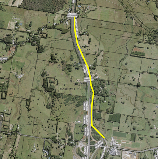
network of the event site.  The site is adjacent to Ewingsdale Road (MR 545 Classified Road) and Centennial Circuit (Local).  The event also will require involvement with the Police, RMS and Council.


Traffic management and parking


Parking for the event is to be provided at the Cavanbah Centre (326 spaces) and in the surrounding road network (200 spaces). Patrons can access the site from the Cavanbah Centre on foot via a pedestrian walkway connecting to Ewingsdale Road.


The main pedestrian flow in the vicinity of the subject site will be in Centennial Circuit itself where patrons will congregate at the event entry.  The applicant seeks approval for temporary lane closure under traffic control to allow drop off for disabled access and bus transport and to allow security staff to process the entry of patrons in an orderly manner.  It is anticipated that queues may possibly extend out into the public road.


The development application includes a Traffic Management Plan and Traffic Control Plan from Greg Aldersons and Associates (Attachment’s 1–4).


Festival of the Stone 2019


The application initially sought approval to hold the event over the years 2019-2021. Due to a lack of information, Council was unable to issue a determination prior to the commencement of the 2019 event. The application was amended on 18 June 2019 to change the dates to 2020-2022. 
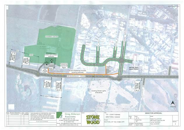
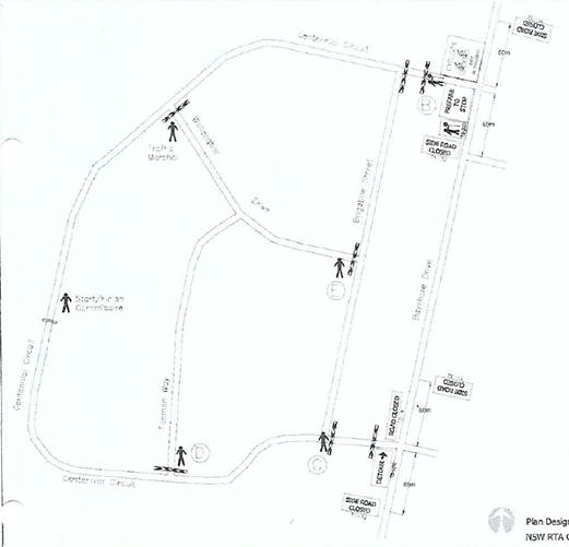
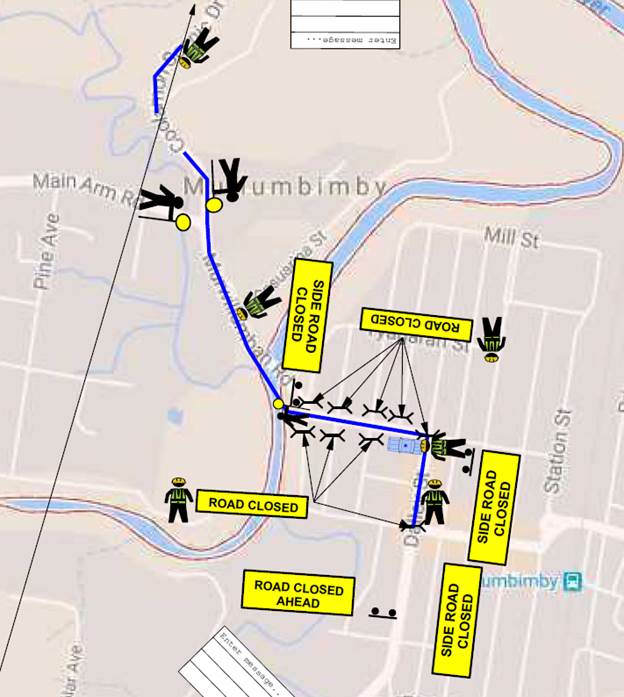
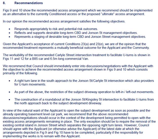
 

Figure 1: Traffic Control Plan – event parking and directional signage. The orange line indicates pedestrian movement from the Cavanbah Centre to the event site.
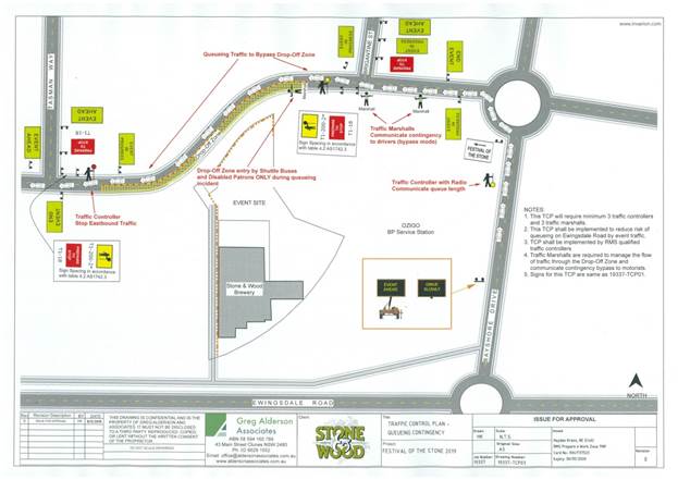
Figure 2: Traffic Control Plan – proposed lane closure of Centennial Avenue


KEY ISSUES


1.       Safety of pedestrians walking from the Cavanbah Centre to the festival location.

2.       Spillage of patrons in the road carriageway while queuing at the event entrance.

3.       Potential for vehicle queuing and congestion on Ewingsdale Road.

4.       Businesses in the vicinity of the event losing vehicular access and parking before and during event times.

5.       Availability of parking to cater for the Event (Patrons & Staff).

6.       Emergency Vehicles (Ambulance, Fire & Rescue).


COUNCIL IMPLICATIONS

§ Budget/Financial

The event organisers will be invoiced the following fees as appropriate:


-     Approval of Road Events pursuant to s144 of the Roads Act (Advertising of event and staff time to process), and

-     Development Certification fees – section 138 with fees being the fee applicable as at the date of payment.


§ Asset Management

Not applicable.


§ Policy or Regulation

Delegated to council for authorisation in conjunction with:


-     Actions required to control traffic- Part 8 (Sections 114 to 124) Roads Act, 1993.

-     Prescribed traffic control devices - division 1 of Part 4 (Sections 50 to 55) Road Transport (Safety and Traffic Management) Act, 1999.

-     R5-1-3 Parking (Disable) – NSW Road Rules 203, $541 fine

-     R5-400 No Stopping - NSW Road Rules 167, $253 fine

-     R5-41 No Parking (specified times) - NSW Road Rules 168, $108 fine.


§ Consultation

A condition of the endorsement of this event is that appropriate consultation is undertaken, including:


1.   Advertising the impact of the event in the local newspaper and on the Council website.

2.   Notifying businesses that are directly impacted by the temporary road closure.

3.   Liaising with bus and taxi operators.

4.   Consulting with emergency services.


§ Legal and Risk Management

If vehicles cause congestion in Centennial Circuit and Bayshore Drive then this could directly impact in MR545 - Classified Road – Ewingsdale Road.  Appropriate approvals and insurances should be required as a condition of the endorsement for this event


Committee Comments

Police: Concerns about pedestrian safety as they leave the event. Event organisers should consider a shuttle bus.

RMS: Concerns about queuing on Bayshore Dr and in turn Ewingsdale Rd. Concerns about the footpath shown on the plan linking Ewingsdale Rd directly to the site is not an actual footpath, crosses a drain, and may be on private property.

RMS suggest the drop off/pick up within the private property of Stone & Wood. RMS would prefer a one year approval.

Consider measures to create good visual separation between pedestrians and traffic on Ewingsdale Road, for example flagging/bunting.

Option to consider on-road drop-off in Centennial Cct during one-way trial, provided an area is delineated and there is no on-street parking.

Consider closing Centennial Cct between Brigantine and Tasman Way with traffic control to accommodate shuttle bus drop-off and businesses, perhaps allowing taxis and Uber access.

Police: The amount of people assembled without a barrier to the road will require hostile vehicle mitigation strategies.

Management Comments

There were no management comments


RECOMMENDATION:

1.       That Council consider the committee comments and a further report to go to LTC.


Report No. 8.3             Events - Mullumbimby Music Festival 2019 - Road Closure

File No:                        I2019/936


SUMMARY


Council has received an application, Traffic Management Plan (TMP) and Traffic Control Plan (TCP) from Planners North for the Mullumbimby Music Festival 2019 to be held between Thursday 14 November 2019 and Monday 18 November 2019, including a Street Parade to be held on Sunday 17 November 2019.


LTC are requested to provide recommendations for Council in relation to the Mullumbimby Music Festival 2019 to be held between Thursday 14 November 2019 and Monday 18 November 2019, subject to specified conditions.


BACKGROUND


The Mullumbimby Music Festival is in its ninth year and this will be the eighth year that the Street Parade will be conducted.  The fun musical Street Parade, with professional musicians and students, is always well attended; with no problems or safety issues have been reported in the past.  This year it is intended to march down the main street of Mullumbimby, Burringbar Street, and will be conducted in the same way as previous events.


 The proposed Festival and associated Street Parade involves the following elements:-


·    Temporary road closure of Dalley Street, Mullumbimby between Tincogan Street and Burringbar Street between 11am and 12 noon on Sunday 17th November for the Street Parade;


·    Temporary closure of Burringbar Street, Mullumbimby between Station Street and Dalley Street effective between 10:45am and 11:15am on Sunday 17th November for the Street Parade;


·    Use of the single event shuttle bus, “The Magic Bus” (double decker), operating between venues. A Traffic Control Plan will establish the management of pick-up and set down locations; and


·    Temporary closure of Lane 7 between Dalley Street and east of the fire station driveway and Lane 2; from Lane 7 to Tincogan Street, with both in effect from 4pm Thursday 14th November 2019 through to 8am Monday 18th November 2019.


The festival organisers are happy to comply with the conditions imposed for the 2018 event. We


COUNCIL IMPLICATIONS


§ Budget/Financial

The event organisers to be invoiced for the relevant Approval of Road Events pursuant to s144 of the Roads Act fee as per the Fees & Charges 2019/20.


§ Asset Management

N/A


§ Policy or Regulation

Regulatory traffic signage as delegated to council for authorisation in conjunction with NSW Road Rules.


§ Consultation

A condition of the endorsement of this event is that appropriate consultation is undertaken, which may include:

·    Advertising the impact of the event in the local newspaper and on the Council website.

·    Informing community and business that are directly impacted.

·    Liaising with bus and taxi operators.

·    Consulting with emergency services.


§ Legal and Risk Management

Event organiser is required to hold $20m public liability insurance cover which is valid for the event.


Committee Comments

No Committee comments

Management Comments

There were no management comments


Committee Recommendation:

1.   That the Traffic Management Plan and Traffic Control Plan/s as relates to the Mullumbimby Music Festival 2019, to be held between Thursday 14 November 2019 and Monday 18 November 2019, which includes the temporary road closures below, be endorsed between these times:


a)   Dalley Street, between Tincogan Street and Burringbar Street, between 11:00am and 12:00noon on Sunday 17 November 2019 - Street Parade;


b)   Burringbar Street, between Station Street and Dalley Street, effective between 10:45am and 11:15am on Sunday 17 November 2019 - Street Parade;


c)   Cenotaph Lane, between Dalley Street and east of the fire station driveway and Murphys Lane, effective from 4:00pm Thursday 14 November 2019 through to 8am Monday 18 November 2019; and


d)   Murphys Lane, between Cenotaph Lane and Tincogan Street, effective from 4:00pm Thursday 14 November 2019 through to 8am Monday 18 November 2019.


2.   That the approval provided in Part 1 is subject to:


a)   separate approvals by NSW Police and RMS being obtained;


b)   implementation of the approved Traffic Management Plan and Traffic Control Plan/s by those with appropriate RMS accreditation and the holding of current and appropriate levels of insurance and liability cover;


c)   that each temporary bus stop, as required by the event, be established in accordance with the accredited Traffic Control Plan/s;


d)   the event organiser:


i)        advertising the impact of the event via a notice in the local weekly paper a minimum of one week prior to the operational impacts taking effect, noting it must include the event name, specifics of any traffic impacts or road closures and times, alternative route arrangements, event organiser, a personal contact name and a telephone number for all event related enquiries or complaints;


ii)       providing a copy of the advert for Council's web page;


iii)      the written concurrence of the Fire Stations on both Gordon Street and Dalley Street, be obtained and copies provided to Council;


iv)      informing community and businesses that are directly impacted (eg adjacent to the event) via written information which is delivered to the property in a timely manner so as to document, consider and respond to any concerns raised;


v)       arranging for private property access and egress affected by the event;


vi)      liaising with bus and taxi operators and ensuring arrangements are made for provision of services during conduct of the event;


vii)     consulting with emergency services and any identified issues be addressed;


viii)    holding $20m public liability insurance cover which is valid for the event;


ix)      paying of Council’s Road Event Application Fee prior to the event.


x)       hostile vehicle mitigation strategies to be addressed.


(Boulton/Davis)

The recommendation was put to the vote and declared carried.  Cameron, Davis and Boulton voted in favour of the motion.

Nil voted against the motion.


There being no further business the meeting concluded at 1:00pm.