Agenda
Ordinary
(Planning) Meeting
Thursday,
17 October 2019
held
at Council Chambers, Station Street, Mullumbimby
commencing
at 11.00am
 Public Access relating to items
on this Agenda can be made between 11.00am and 11.30am on the day of the
Meeting. Requests for public access should be made to the General Manager
or Mayor no later than 12.00 midday on the day prior to the Meeting.
Public Access relating to items
on this Agenda can be made between 11.00am and 11.30am on the day of the
Meeting. Requests for public access should be made to the General Manager
or Mayor no later than 12.00 midday on the day prior to the Meeting.
Mark
Arnold
General
Manager
What is a “Conflict of Interests” - A conflict of
interests can be of two types:
Pecuniary - an interest that a person has in a matter because of a reasonable
likelihood or expectation of appreciable financial gain or loss to the person
or another person with whom the person is associated.
Non-pecuniary – a private or personal interest that a Council
official has that does not amount to a pecuniary interest as defined in the Code
of Conduct for Councillors (eg. A friendship, membership of an association,
society or trade union or involvement or interest in an activity and may
include an interest of a financial nature).
Remoteness – a person does not have a pecuniary interest in a matter
if the interest is so remote or insignificant that it could not reasonably be
regarded as likely to influence any decision the person might make in relation
to a matter or if the interest is of a kind specified in the Code of Conduct
for Councillors.
Who has a Pecuniary Interest? - a person has a pecuniary interest in a
matter if the pecuniary interest is the interest of the person, or another
person with whom the person is associated (see below).
Relatives, Partners - a person is taken to have a pecuniary interest in a
matter if:
§ The person’s
spouse or de facto partner or a relative of the person has a pecuniary interest
in the matter, or
§ The person, or a
nominee, partners or employer of the person, is a member of a company or other
body that has a pecuniary interest in the matter.
N.B. “Relative”, in relation to a person means any of the
following:
(a) the
parent, grandparent, brother, sister, uncle, aunt, nephew, niece, lineal
descends or adopted child of the person or of the person’s spouse;
(b) the
spouse or de facto partners of the person or of a person referred to in
paragraph (a)
No Interest in the Matter - however, a person is not taken to have a
pecuniary interest in a matter:
§ If the person is
unaware of the relevant pecuniary interest of the spouse, de facto partner,
relative or company or other body, or
§ Just because the
person is a member of, or is employed by, the Council.
§ Just because the
person is a member of, or a delegate of the Council to, a company or other body
that has a pecuniary interest in the matter provided that the person has no
beneficial interest in any shares of the company or body.
Disclosure and participation in meetings
§ A Councillor or a
member of a Council Committee who has a pecuniary interest in any matter with
which the Council is concerned and who is present at a meeting of the Council
or Committee at which the matter is being considered must disclose the nature
of the interest to the meeting as soon as practicable.
§ The Councillor or
member must not be present at, or in sight of, the meeting of the Council or
Committee:
(a) at any
time during which the matter is being considered or discussed by the Council or
Committee, or
(b) at any
time during which the Council or Committee is voting on any question in
relation to the matter.
No Knowledge - a person does not breach this Clause if the person did
not know and could not reasonably be expected to have known that the matter
under consideration at the meeting was a matter in which he or she had a
pecuniary interest.
Non-pecuniary Interests - Must be disclosed in meetings.
There are a broad range of options available for managing conflicts &
the option chosen will depend on an assessment of the circumstances of the
matter, the nature of the interest and the significance of the issue being
dealt with. Non-pecuniary conflicts of interests must be dealt with in at
least one of the following ways:
§ It may be appropriate
that no action be taken where the potential for conflict is minimal.
However, Councillors should consider providing an explanation of why they
consider a conflict does not exist.
§ Limit involvement if
practical (eg. Participate in discussion but not in decision making or vice-versa).
Care needs to be taken when exercising this option.
§ Remove the source of
the conflict (eg. Relinquishing or divesting the personal interest that creates
the conflict)
§ Have no involvement by
absenting yourself from and not taking part in any debate or voting on the
issue as of the provisions in the Code of Conduct (particularly if you have a significant
non-pecuniary interest)
RECORDING OF VOTING ON PLANNING MATTERS
Clause 375A of the Local Government Act 1993
– Recording of voting on planning matters
(1) In this section, planning
decision means a decision made in the exercise of a function of a council
under the Environmental Planning and Assessment Act 1979:
(a) including a decision
relating to a development application, an environmental planning instrument, a
development control plan or a development contribution plan under that Act, but
(b) not including the making of
an order under that Act.
(2) The general manager is
required to keep a register containing, for each planning decision made at a
meeting of the council or a council committee, the names of the councillors who
supported the decision and the names of any councillors who opposed (or are
taken to have opposed) the decision.
(3) For the purpose of
maintaining the register, a division is required to be called whenever a motion
for a planning decision is put at a meeting of the council or a council
committee.
(4) Each decision recorded in
the register is to be described in the register or identified in a manner that
enables the description to be obtained from another publicly available
document, and is to include the information required by the regulations.
(5) This section extends to a
meeting that is closed to the public.
Ordinary (Planning) Meeting
BUSINESS OF Ordinary (Planning) Meeting
1. Public Access
2. Apologies
3. Requests for Leave of
Absence
4. Declarations of Interest
– Pecuniary and Non-Pecuniary
5. Tabling of Pecuniary
Interest Returns (Cl 4.9
Code of Conduct for Councillors)
6. Adoption of Minutes from
Previous Meetings
6.1 Ordinary
(Planning) Meeting held on 19 September 2019
7. Reservation of Items for
Debate and Order of Business
8. Mayoral Minute
9. Notices of Motion and Rescission
9.1 Integrated
Pest Management Strategy 2019-2029........................................................... 5
10. Petitions
11. Submissions and Grants
12. Delegates' Reports
13. Staff Reports
Sustainable Environment and Economy
13.1 PLANNING
- Minor Local Environmental Plan Amendments Housekeeping Planning Proposal -
Submissions Report 26.2017.1.1...................................................................................... 7
13.2 PLANNING
- Development Application 10.2019.126.1 – Subdivision: Two (2) Lots at 37
Granuaille Road Bangalow............................................................................................................... 12
13.3 PLANNING
- Development Application 10.2019.375.1 Alterations and Additions to Existing
Commercial Development Including Expanded Outdoor Dining Area Associated with
Existing Restaurant 1 Porter Street Byron Bay (Habitat)............................................................. 31
13.4 PLANNING
S8.2 Review - Use of unauthorised additions to existing dual occupancy
(conversion of garage to bedroom), car parking and tree removal at 3 Comet
Close Byron Bay......... 47
13.5 PLANNING
- Development Application 10.2019.146.1 Alterations and Additions to existing
Child Care Centre including increase in enrolment numbers to Fifty (50)
Children and Tree Removal at 49 Bottlebrush Crescent Suffolk Park................................................................................. 55
13.6 PLANNING
- Development Application 10.2019.60.1 New Subdivision - Boundary Adjustment to
create Two (2) Lots at 148 Woodford Lane Ewingsdale................................................. 67
13.7 PLANNING
- Development Application 10.2019.158.1 Agricultural Produce Industry including
Use of Existing Wind Turbine and Ancillary Rural Infrastructure and Roadside
Stall at 219 The Saddle Road Brunswick Heads............................................................................................................ 84
13.8 PLANNING
- Development Application 10.2019.468.1 Alterations and Additions to Existing
Dwelling House at 860 The Pocket Road The Pocket................................................................ 106
13.9 Biodiversity
Conservation Strategy Vision and Aims.................................................... 116
Infrastructure Services
13.10 Amendment
4 of Byron Developer Contributions Plan Removal of Waiver for Secondary Dwellings....................................................................................................................................... 122
14. Questions
With Notice
Questions with Notice: A response to Questions with
Notice will be provided at the meeting if possible, that response will be
included in the meeting minutes. If a response is unable to be provided
the question will be taken on notice, with an answer to be provided to the
person/organisation prior to the next Ordinary Meeting and placed on Councils
website www.byron.nsw.gov.au/Council/Council-meetings/Questions-on-Notice
Councillors are encouraged
to ask questions regarding any item on the business paper to the appropriate Director
prior to the meeting. Any suggested amendments to the recommendations should be
provided to Councillor Support prior to the meeting to allow the changes to be
typed and presented on the overhead projector at the meeting.
Notices of Motion and Rescission 9.1
Notices of Motion
Notice of Rescission Motion No. 9.1 Integrated
Pest Management Strategy 2019-2029
File
No: I2019/1530
|
We move that Council rescind Resolution No. 19-455
from its Ordinary meeting held on 19 September 2019 which reads
as follows:
1. That
Council adopt the Integrated Pest Management Strategy 2019-2029
(Attachment 2 E2019/63575) with the following changes:
a. Improve
readability by use of more appropriate placement of text, particularly over
graphics, and choice of ink colours and transparency.
b. Redesign
layout to ensure better coherence and relationship of text and adjacent
graphics.
2. That
Council include the ‘Implementation of the Integrated Pest
Management Strategy 2019-2029’ as an activity in the 2019/20 Delivery
Program and Operational Plan.
3. That
Council note that implementation of the Integrated Pest Management
Strategy 2019-2029 will be accommodated within the Infrastructure Services
Directorate budgets.
4. That
further information regarding control methods of weeds on roadsides be
developed with a view of incorporating
them into an amended strategy after a 12 month review and that:
b. During
that period, consult with Goonengerry Landcare to provide full description of
the development and practice of partnership with Goonengerry Landcare
including acknowledgement of volunteers, pictures and demonstrated
understanding of the role of Small Steps in achieving IPSM objectives.
5. Amend
the first paragraph on page 3 to add the sentence “Whilst maximising
our best practice weed management of our biodiversity rich areas.”
|
If successful we intend to move:
That Council review the draft
Integrated Pest Management Strategy 2019 – 2029 (IPMS) as follows:
1. Improve readability by use of more
appropriate placement of text, particularly over graphics, and choice of ink
colours and transparency.
2. Redesign layout to ensure better
coherence and relationship of text and adjacent graphics.
3. Amend all statements that refer to the
cessation of chemical/pesticide/spraying on rural roadsides and redraft to
align with actual practice between 2013 and the present, ensuring that all such
statements are consistent and able to be clearly understood by readers.
4. Include full description of weed
removal and native vegetation replacement methodology for weed management on
roadsides (Small Steps to Healthier Roadside Vegetation) and contrast these
with other weed management methodologies presented in the IPMS.
5. Consult with Goonengerry Landcare to
provide full description of the development and practice of partnership with
Goonengerry Landcare including acknowledgement of volunteers, pictures and
demonstrated understanding of the role of Small Steps in achieving IPSM
objectives.
6. Amend the first paragraph on page 3 to
add the sentence “Whilst maximising our best practice weed management of
our biodiversity rich areas.”
7. On completion of items 1-6 above,
present the revised draft to a Strategic Planning Workshop prior to
presentation for adoption at a Planning Meeting of Council.
Attachments:
1 Integrated
Pest Management Strategy - IPMS - Roadside Vegetation Management –
Discussion Paper, E2019/72463 
2 Integrated
Pest Management Strategy - IPMS - Notice of Motion May 2019 - Small Steps, E2019/72464
3 Presentation
- Integrated Pest Management Strategy - IPMS - Small Steps 3, E2019/72465
Signed: Cr
Basil Cameron
Cr Cate Coorey
Cr Jan Hackett
Staff Reports - Sustainable Environment and Economy 13.1
Staff Reports - Sustainable Environment and
Economy
Report No. 13.1 PLANNING
- Minor Local Environmental Plan Amendments Housekeeping Planning Proposal -
Submissions Report 26.2017.1.1
Directorate: Sustainable
Environment and Economy
Report
Author: Sam
Tarrant, Planning Support Officer
File No: I2019/1192
Summary:
The purpose of this
report is to present to Council the Minor Amendments Housekeeping Planning
Proposal and exhibition outcomes.
A planning proposal
to correct a number of minor mapping errors and inconsistencies in the Byron
LEP 2014 was initiated by staff and placed on exhibition as per the gateway
determination. The 22 proposed amendments are to correct out-of-date mapping,
incorrectly mapped lots and maps not aligning with cadastral boundaries. There
are also changes to Schedule 5 Environmental Heritage which update incorrect
information such as parcel numbers that are now historical. All of the
amendments are minor in nature and none change Council’s policy position.
During the
exhibition period no submissions were received from the public. The State agencies,
Office and Environmental Heritage and Rural Fire Service reviewed the planning
proposal and raised no issues.
The Minister for
Planning and Public Spaces has issued an authorisation for Council to exercise
delegation to make this LEP amendment.
The report
recommends that Council proceed with the planning proposal without amendment
NOTE TO COUNCILLORS:
In accordance with the
provisions of S375A of the Local Government Act 1993, a Division is to be
called whenever a motion for a planning decision is put to the meeting, for the
purpose of recording voting on planning matters. Pursuant to clause 2(a)
under the heading Matters to be Included in Minutes of Council Meetings of
Council's adopted Code of Meeting Practice (as amended) a Division will be
deemed to have been called by the mover and seconder of all motions relating to
this report.
|
RECOMMENDATION:
1. That
Council forward the planning proposal to amend Byron LEP 2014,
as exhibited and included in Attachment 1 (E2019/45986), to NSW Parliamentary
Counsel’s Office requesting that a draft LEP instrument be prepared.
2. That
Council liaise with Parliamentary Counsel’s Office (PCO)
as necessary to finalise the content of the draft LEP and to enable PCO to
issue an Opinion that the plan can be made.
3. That
Council make the draft LEP under delegated authority and forward
the plan to the NSW Department of Planning, Industry and Environment for
notification on the NSW Government legislation website.
|
Attachments:
1 LEP Minor
Housekeeping Planning Proposal - Exhibition Version 26.2017.1.1, E2019/45986
2 Table of
property details affected by the planning proposal 26.2017.1.1, E2019/34092
3 Submission
from OEH, S2019/6797
4 Submission
from Rural Fire Services, E2019/70599

5 Form of
Special Disclosure of Pecuniary Interest, E2012/2815
REPORT
The purpose of this report is to present to Council a Minor Local
Environmental Plan Amendments Housekeeping Planning Proposal and exhibition
outcomes.
Staff routinely catalogue minor errors and inconsistencies in the
Byron LEP 2014 and address them in a grouped housekeeping planning proposal. Housekeeping planning
proposals are prepared periodically to ensure that Council’s principle
planning instrument is current and correct.
In 2014 Council considered the first minor amendments planning
proposal for the 2014 LEP and resolved (14-509) that a minor amendments
(non-policy) planning proposal be prepared and that any additional minor
corrections or amendments to the Byron LEP 2014 that are not policy related may
be undertaken under delegated authority and Council be advised of any such
amendments.
Resolution (14-509)
1. That a minor
corrections and amendments planning proposal be prepared that seeks to amend
Byron LEP in the manner set out in Table 1 of this report (#E2014/66629).
2. That the
General Manager (or delegate of his choice) be delegated the authority to include
additional non-policy amendments in the planning proposal (not already
identified in this report) for minor corrections and amendments to Byron LEP
2014.
3. That the
General Manager (or delegate of his choice) be delegated the authority to assume
the role of the relevant planning authority pursuant to the Environmental Planning & Assessment Act
1979 in relation to preparation and finalisation (whether Council has delegated
authority to make the plan or not) of any other planning proposals consisting
of non-policy matters such as corrections and consequential and/or minor
amendments; and that Council be advised of any such amendments made under
delegated authority.
In accordance with the above resolution, staff initiated a planning proposal comprising of 22 non-policy proposed amendments. The 22 amendments
address issues with incorrectly mapped lots, out–of-date mapping and
mapping not aligning with cadastral boundaries. There are also changes to
Schedule 5 Environmental Heritage which update incorrect information such as
parcel numbers that are now historical. Specifically the 22 amendments in the
planning proposal include amendments to:
- Heritage item mapping to accurately reflect
the heritage item area and remove unjustified mapping on neighbouring lots
- Heritage item mapping to reflect State
heritage mapping
- Schedule 5 to update and correct errors on
certain heritage items
- Land zoning maps to reflect gazettal of land
to National Parks and Nature Reserves
- Land zoning to match cadastral boundaries
and recent subdivisions
- Floor space ratio and lot size mapping as a
consequence of the land zone map amendments
- Acid sulfate soils mapping to ensure the
mapping is up to date and accurate
This planning proposal also contains the rezoning of the Suffolk Park
sports field from SP2 Infrastructure to RE1 Public Recreation after Council
resolved (16-587) to purchase the lot and rezone the land to RE1 Public
Recreation in the next housekeeping amendment.
Resolution (16-587) – Relevant part only
4. That upon
completion of the purchase the General Manager does all acts and things
necessary to classify the land as community land and amend the Byron Local
Environmental Plan to rezone the land to RE1 Public Recreation in the next
housekeeping amendment
Further detail on each proposed amendment is available in the
planning proposal (Attachment 1).
A summarised table is also available (Attachment 2) which outlines
the 22 items, the corresponding property details and a brief description of the
proposed change.
Ensuring the Byron LEP 2014 is accurate and up to date helps to
minimise potential problems and allows for better planning and land use
outcomes.
Public exhibition
This planning proposal obtained Gateway approval on 24 June 2019 and
was placed on public exhibition from 24 July to 16 August 2019. As per the
Gateway determination, NSW Rural Fire Service (RFS) and Office of Environment
and Heritage (OEH) and Rural Fire Service (RFS) were sent a copy of the
planning proposal and asked to provide comment. OEH & RFS raised no issues
(Attachment 3 and 4).
A letter was sent to the owner of each property included in this
planning proposal and it was advertised in the Echo. A copy of the planning
proposal, the Gateway determination and information for each proposed amendment
was available on Councils website.
During the exhibition period staff met with one affected land owner
and explained the proposed amendments and there reasoning. A number of phone
calls were also received from landowners to clarify what the proposed changes
meant for their property. There was no objection received from any of the
landowners. No formal written submissions were received during the exhibition
period
It is recommended that the planning proposal be forwarded to the
Department of Planning, Industry and Environment and the Parliamentary Counsel
Office to be finalised.
Next steps
The planning proposal will be forwarded to the Department of Planning, Industry
and Environment and the Parliamentary Counsel Office to be finalised subject to
Council resolution.
STRATEGIC CONSIDERATIONS
Community Strategic Plan and
Operational Plan
|
CSP Objective
|
L2
|
CSP Strategy
|
L3
|
DP Action
|
L4
|
OP Activity
|
|
Community Objective
4: We manage growth and change responsibly
|
4.1
|
Support the
visions and aspirations of local communities through place-based planning and
management
|
4.1.3
|
Manage
development through a transparent and efficient assessment process
|
4.1.3.10
|
Prepare and
assess Planning Proposals and Development Control Plans, and amend Local
Environmental Plan maps
|
|
|
|
|
|
|
|
|
|
|
|
|
|
|
|
|
Legal/Statutory/Policy Considerations
This planning proposal will amend the Byron Local
Environmental Plan 2014 to correct a number of identified errors and anomalies.
Financial Considerations
This is a Council initiated
planning proposal funded through the existing operational budget.
Consultation and Engagement
Discussed in the report.
Staff Reports - Sustainable Environment and Economy 13.2
Report No. 13.2 PLANNING
- Development Application 10.2019.126.1 – Subdivision: Two (2) Lots at 37
Granuaille Road Bangalow
Directorate: Sustainable
Environment and Economy
Report
Author: Ben
Grant, Planner
File No: I2019/1210
Proposal: Development
Application 10.2019.126.1 – Two (2) lot subdivision
|
DA No:
|
10.2019.126.1
|
|
Proposal description:
|
Boundary Adjustment Between Two (2) Lots
|
|
Property description:
|
LOT: 17 SEC: 1 DP: 4358, LOT: 18 SEC: 1 DP: 4358
|
|
37 Granuaille Road BANGALOW
|
|
Parcel No/s:
|
64460, 27070
|
|
Applicant:
|
Balanced Systems Planning Consultants
|
|
Owner:
|
Premium Custody Services Pty Ltd
|
|
Zoning:
|
R2 Low Density Residential
|
|
Date received:
|
14 March 2019
|
|
Integrated / Designated Development:
|
☐
Integrated
|
☐
Designated
|
☒
Not applicable
|
|
Concurrence required
|
No
|
|
Public notification or exhibition:
|
- Level
1 advertising under DCP 2014 Part A14 – Public Notification and
Exhibition of Development Applications
- Exhibition
period: 1/7/2019 – 14/7/2019
- Submissions received:
Nil
|
|
Planning Review Committee:
|
Not applicable
|
|
Concurrent approvals (S68/138):
|
Not applicable
|
|
Variation request
|
☒
Clause 4.6
|
☐
SEPP 1
|
☐
Not applicable
|
|
Delegation to determination:
|
Council. Clause 4.6 variation for minimum subdivision lot
size greater than 10%.
|
|
Issues:
|
· Subdivision
contravenes 600m2 minimum subdivision lot size, although both lots
are already less than the development standard. Clause 4.6 variation request
submitted.
|
Summary:
This development application seeks consent to re-subdivide
Lot 17 and Lot 18 in Deposited Plan 4358, otherwise known as 37 Granuaille
Road, Bangalow. The proposed subdivision will rearrange the lot boundaries so
that the existing garage and dwelling are contained within a single lot facing
Granuaille Road. Remaining land to the east will form a vacant lot facing
Campbell Street.
The site is zoned R2 Low Density Residential and is within
the Bangalow Heritage Conservation Area. A locally listed heritage item known
as Avalon House is situated 40m to the north.
Proposed Lot A has an area of 420m2 and proposed
Lot B has an area of 497.8m2.The lot sizes contravene the 600m2
minimum lot size standard under Clause 4.1 of Byron LEP 2014 by 30% for lot A
and 17% for lot B.
The application is referred to the Council for determination
as the proposal for the lot size variation standard is exceeded by more than
10%. The applicant has submitted a request to vary the standard pursuant to
Clause 4.6 of Byron LEP 2014. For reasons outlined in the body of this report,
the variation to the standard is considered to have sufficient planning merit
to warrant support in this instance. In this regard, the development realigns
two existing residential lots and does not generate any additional dwelling
entitlements.
The application was notified for a period of 14 days from 1
July 2019 to 14 July 2019. No public submissions were received.
In conclusion, the proposed subdivision is considered to be
an appropriate response to the characteristics of the site and is capable of
accommodating a built form that is
sympathetic to the surrounding area. Subdivision works associated with the
development are relatively minor and unlikely to have a significant impact on
the heritage values of the conservation area or heritage listed item.
The application is recommended for approval subject to
conditions of consent.
NOTE TO COUNCILLORS:
In accordance with the
provisions of S375A of the Local Government Act 1993, a Division is to be
called whenever a motion for a planning decision is put to the meeting, for the
purpose of recording voting on planning matters. Pursuant to clause 2(a)
under the heading Matters to be Included in Minutes of Council Meetings of
Council's adopted Code of Meeting Practice (as amended) a Division will be
deemed to have been called by the mover and seconder of all motions relating to
this report.
|
RECOMMENDATION:
That pursuant to
Section 4.16 of the Environmental Planning & Assessment Act 1979,
Development Application no. 10.2019.126.1 for subdivision: two (2) lots, be granted consent subject to the
attached conditions (#E2019/71153).
|
Attachments:
1 Attachment
A – Recommended conditions of consent DA10.2019.126.1, E2019/71153
2 Attachment
B – Subdivision Plans DA10.2019.126.1, E2019/71158

3 Attachment
C – Clause 4.6 Variation Request DA10.2019.126.1, E2019/71160

REPORT
1. INTRODUCTION
1.1. History/Background
Building
Application 71/2114 for a detached double garage was approved on 8 October
1971.
Development Application 10.2007.689.1 for alterations and
additions to an existing dwelling house was granted consent on 19 December
2007. A notice of surrender of consent was filed to Council on 17 September
2013, indicating the consent is not longer valid.
The site contains an old timber dwelling house that
pre-dates the records in Council’s Authority database.
1.2. Description
of the site
The site has a legal description of Lot 17 and Lot 18,
Section 1 in Deposited Plan 4358, and is commonly known as 37 Granuaille Road,
Bangalow.
The site is located on the eastern side of Granuaille Road;
a State classified Road, and is bounded to the east by Campbell Street
providing rear lane access. Both lots are rectangular in shape with frontages
of 11.5m. Lot 17 has an area of 481.9 m2 and Lot 18 has an area
435.9m2. The land slopes away from Granuaille Road towards Campbell
Lane in an easterly direction.
Currently the site accommodates a timber dwelling house,
thought to date to the early 20th century, and a detached double
garage that was approved in 1971. The backyard contains a mixture of turfed
lawn, garden beds and landscaping. A white picket fence and hedge addresses the
primary street frontage to Granuaille Road.
Located on either side of the allotment are residential
dwellings of similar scale and character. Further to the north is Avalon House,
a locally listed heritage item.
The site is within the R2 Low Density Residential zone and
the Bangalow Heritage Conservation area under LEP 2014.
Site photos are shown in Figures 1 – 3.

Figure 1: Subject site viewed from Granuaille Road, looking
east.

Figure 2: Building envelope location for proposed Lot B.
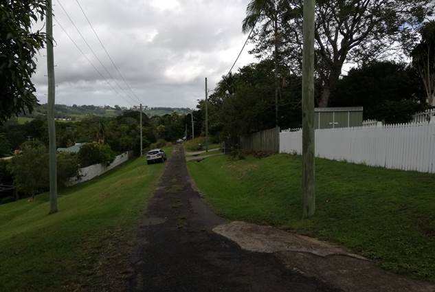
Figure 3: Campbell Street, looking south. Proposed
Lot B will have access off this laneway.
1.3. Description
of the proposed development
This application seeks approval to re-subdivide Lot 17 and
Lot 18 in Deposited Plan 4358. The two lots currently contain a wooden dwelling
house and a detached fibro garage and are used as a single residential
property.
The proposed subdivision will rearrange the lot boundaries
so that the garage and dwelling are contained within a single lot facing
Granuaille Road. Remaining land to the east will form a vacant lot facing
Campbell Street. The new lots will be of a similar size to the lots currently
in existence as shown in the tables below:
Table
1: Existing lot layout
|
Existing Lot
|
Land Area
|
Development
|
|
Lot 18
|
435.9m2
|
Existing dwelling
|
|
Lot 17
|
481.9m2
|
Existing garage
|
Table
2: Proposed lot layout
|
Proposed Lot
|
Land Area
|
Development
|
|
Lot A
|
420m2
|
Existing dwelling and garage
|
|
Lot B
|
497.8m2
|
Vacant
|
A stormwater easement is proposed along the northern
boundary of proposed Lot B to allow Lot A to drain via gravity to Campbell
Street. Additional easements for services, phone, water and a right of footway
are also proposed. The application does not propose any physical subdivision
works, other than works to provide services to Lot B. Proposed subdivision
layout is illustrated in Figures 4 and 5.
Figure 4: Existing subdivision layout
Figure 5: Proposed subdivision layout
2. SUMMARY OF
REFERRALS
|
Referral
|
Comment
|
|
Development Engineer
|
Garbage collection unavailable to Campbell Street. A
right-of-footway is required. Sewer main works may also be required.
|
|
Systems Planning Officer
|
S64 contributions are not payable.
|
|
Development Contributions Officer
|
Development contributions are not payable.
|
|
Roads & Maritime Services
|
No objections. Notes provided indicating that RMS
concurrence is required for any works in Granuaille Road.
|
* Conditions provided in the above referral are included
in the Recommendation of this Report below
Development Engineer
Council’s Development
Engineer reviewed the proposed development and offered support from an
engineering perspective subject to a range of conditions. The main issues
identified in the engineering assessment are summarised below.
Garbage collection
Council garbage collection is not
available to the northern end of Campbell Street. Provision to be made for a
right-of-footway to accommodate bin collection service for Lot B inside Lot A
at the Granuaille Road frontage. A condition is recommended.
Development with frontage to
classified road
The existing informal driveway
access in Granuaille Road is unformed and must be upgraded to Council’s
standard. Concurrence from RMS will be required as part of the Roads Act
application. In addition, the footpath should be extended for the full frontage
of the site.
Upgrade of Campbell Street
The development will generate
additional traffic on Campbell Street and therefore the road shall be upgraded
in accordance with Section 6.4.3 of the DCP.
Access for Lot B shall be via
Campbell Street. There is adequate area to accommodate a driveway to service
the future dwelling in Lot B. Future access will be constructed as part of the
future dwelling in the Lot.
Stormwater
Provision must be made to drain
Lot A to the lawful point of discharge which is the south eastern corner of the
site and into the table drain. Conditions are recommended.
Roads & Maritime Services
RMS
provided no specific objections to the proposal, noting that the Council has
responsibilities to consider the safety, efficiency and ongoing operation of
the classified road in accordance with clause 101 of State
Environmental Planning Policy (Infrastructure) 2007. RMS commented that should
Council require any upgrade to the existing driveway from proposed Lot A onto
Granuaille Road, concurrence of Roads and Maritime will be required for the
section 138 Roads Act approval.
3. SECTION 4.14
– BUSH FIRE PRONE LAND
Under section 4.14 of the Act, Council must be satisfied
prior to making a determination for development on bush fire prone land, that
the development complies with the document Planning for Bush Fire Protection
2006. The site is not bush fire prone land.
4. SECTION 4.15C
– MATTERS FOR CONSIDERATION – DISCUSSION OF ISSUES
Having regard to the matters for consideration detailed in
Section 4.15(1) of the Environmental Planning & Assessment Act 1979
(EP&A Act), the following is a summary of the evaluation of the issues.
4.1 State
Environmental Planning Instruments
State
Environmental Planning Policy No 55—Remediation of Land
SEPP 55 requires the consent
authority to consider whether the subject land is contaminated and, if so,
whether it requires remediation.
The land has a long standing history of residential use. A
review of Council’s Authority database did not reveal any approvals for
contaminating land uses on the site or on surrounding sites and the property is
not recorded on Council or EPA contaminated lands registers.
Based on the available information, the site is considered
to be suitable for residential use in its current state and no further
investigations are warranted.
State Environmental Planning Policy (Infrastructure) 2007
(SEPP Infrastructure)
The provisions of SEPP Infrastructure 2007 have been
considered in the assessment of the development application. The relevant
clauses have been addressed below:
Clause 101 Development with
frontage to classified road
The application is subject to Clause 101 of the SEPP
Infrastructure as the site has a frontage to Granuaille Road, which is a State
classified road.
The application is considered to satisfy Clause 101 of the
SEPP Infrastructure, as the access for proposed Lot B will be obtained off
Campbell Street rather than Granuaille Road. The subdivision is unlikely to
affect the safety or efficiency of the classified road.
Traffic noise and vehicle emissions will not be significant
concerns given the location of the proposed building envelope approximately 30m
from the classified road frontage.
4.2 Byron Local Environmental Plan
2014 (LEP 2014)
LEP 2014 is an applicable matter for consideration in the assessment
of the subject development application in accordance with subsection 4.15(1) of
the EP&A Act because it applies to the subject land and the proposed
development. The LEP 2014 clauses that are checked below are of relevance to
the proposed development:
|
Part 1
|
☒1.1|
☒1.1AA| ☒1.2| ☒1.3| ☒1.4| ☒Dictionary| ☒1.6| ☒1.7| ☒1.8| ☒1.8A| ☒1.9| ☒1.9A
|
|
Part 2
|
☒2.1|
☒2.2 | ☒2.3 |☒Land Use Table | ☒2.4 | ☒2.5 | ☒2.6 | ☒2.7 | ☒2.8
|
|
Part 4
|
☒4.1|
☒4.3|☒4.4 |☒4.5 | ☒4.6
|
|
Part 5
|
☒5.10
|
|
Part 6
|
☒6.2|
☒6.6| ☒ 6.7
|
In accordance with LEP 2014 clauses 1.4 and 2.1 – 2.3:
(a) The
proposed development is defined in the LEP 2014 Dictionary as Subdivision -
Boundary Adjustment;
(b) The
land is within the R2 Low Density Residential zone according to the Land Zoning
Map;
(c) The
proposed development is permitted with consent; and
(d) Regard
is had for the Zone Objectives as follows:
|
Zone Objective R2 Low
Density Residential
|
Consideration
|
|
To provide for the housing needs of the community within a
low density residential environment.
|
The proposed subdivision is not
incompatible with the zone objectives. No additional dwelling entitlements
will be created and the resulting lot sizes are similar to those in the
surrounding area.
|
|
To enable
other land uses that provide facilities or services to meet the day to day
needs of residents.
|
The remaining checked clauses have been taken into
consideration in the assessment of the subject development application in
accordance with subsection 4.15(1) of the EP&A Act. The proposed
development complies with all clauses of LEP 2014 (in some cases subject to
conditions and/or to the satisfaction of other assessing officers).
Characterisation
of the proposal
The application
was submitted to Council as a boundary adjustment on the basis that it
comprised only a realignment of existing boundaries with no additional lots or
new dwelling opportunities being created.
Having regard to
recent case law, notably, Johnson v Coffs
Harbour City Council [2018] NSWLEC 1094,
the proposal cannot be considered a boundary adjustment because the two resulting lots do not bear sufficient resemblance to
the lots currently in existence. Rather, the proposal is properly characterised
as a two lot subdivision. This makes little difference in terms of the
application of planning controls, but it does alter the way the application is
advertised under the provisions of DCP 2014. The application was advertised for
a period of 14 days, whereas no advertising would have been required for a
boundary adjustment.
Clause 4.1 Minimum subdivision lot
size
The site is subject to a minimum subdivision lot size of
600m2. Proposed Lot A has an area of 420m2 and proposed
Lot B has an area of 497.8m2.The proposed lots contravene the
minimum lot size standard by 30% for lot A and 17% for lot B.
The applicant has made a written submission seeking to vary
the development standard which is addressed in the LEP 2014 issues section
below.
Clause 4.3 Floor Space Ratio
A floor space ratio of 0.5:1 applies to the subject site.
The existing dwelling has a floor plan area of approximately 120m2.
Proposed Lot A will have an area of 420m2, which results in a floor
space ratio of 0.29:1.
Clause 5.10 Heritage conservation
The site is within the Bangalow Heritage Conservation Area
and is located 40m south of Avalon House, a locally listed heritage item under
Schedule 5 of LEP 2014. Clause 5.10 (4) requires Council to consider the effect of the proposed
development on the heritage significance of the item or area concerned.
Works associated
with the subdivision (including works required by Council) will comprise
construction of a concrete pathway within a right-of-footway to facilitate
garbage collection for proposed Lot B, along with an extension of the footpath
in Granuaille Road and an upgraded driveway for the existing dwelling. These
works are minor in nature and will not have a significant impact on the
streetscape or heritage values of the conservation area or nearby heritage
listed item.
In terms of
future development outcomes, the proposed subdivision is capable of
accommodating a built form that is sympathetic to the established character of
the area. Lot B can provide a 10m by
15m building envelope; offering room for a small dwelling, car parking and a
modest garden. The building envelope has a 4m setback to the Campbell Street
and setbacks of 5.5m and 4.7m to side boundaries, allowing new development to
achieve appropriate spacing and separation from neighbouring dwellings and the
laneway frontage.
In terms of
subdivision pattern, the proposal is similar to neighbouring lots, including an
adjoining subdivision to the south that was approved by Council in 2003.
Overall, it is
considered that the new lot has a suitable area, shape and frontage for future
development. Subdivision works associated with the development are relatively
minor and unlikely to have a significant impact on the heritage values of the
conservation area or heritage listed item.
Clause 6.5 Drinking water
catchments
The proposed subdivision is unlikely to have adverse impacts
on the quality or quantity of water entering the drinking water catchment. The
site is approximately 450m from Byron Creek and is capable of connecting to
reticulated water, sewer and stormwater systems. A condition is recommended for
sediment and erosion controls to be implemented during subdivision works.
Clause 6.6 Essential services
The proposed lots
are capable of being connected to reticulated services subject to conditions of
consent. Stormwater is able to be directed to the table drain in Campbell
Street. Vehicular access to proposed Lot B will be provided off Campbell
Street. Council’s Development Engineer has indicated that the driveway
for Lot B does not need to be constructed at the subdivision stage.
4.3 Byron Local Environmental Plan
2014 - Issues
Clause 4.1 Minimum subdivision lot
size
A minimum lot size of 600m2 applies to the site.
Proposed Lot A has an area of 420m2 and proposed Lot B has an area
of 497.8m2.The subdivision exceeds the minimum lot size standard by
30% for lot A and 17% for lot B.
Clause 4.6 Exceptions to development standards
A written request has been submitted to Council in
accordance with Clause 4.6 (3) (a) and (b) of the Byron LEP 2014 seeking to
justify the contravention of the development standard by demonstrating:
(a) that
compliance with the development standard is unreasonable or unnecessary in the
circumstances of the case; and
(b) that
there are sufficient environmental planning grounds to justify contravening the
standard.
A copy of the applicant's written request is provided at
Attachment C.
Applicants Written Request - Clause 4.6(3)(a) and (b)
The following is a summary of the applicant’s
justification to vary the minimum lot size standard:
(a) That
compliance with the development standard is unreasonable or unnecessary in the
circumstances of the case:
(i) The
numerical variation being sought is relatively minor compared to the existing
lot format on the site, being a 3-4% change in areas from existing
circumstances;
(ii) The
proposed variation is unavoidable considering the existing lot sizes and
compliance with the development standard is unreasonable in these
circumstances.
(iii) The
proposed subdivision is consistent with the objectives the development
standard, because: (1) local environmental values, including local built
environment and streetscape will not be negatively impacted, and (2) the
subdivision facilitates the efficient use of land for residential purposes and
maximises the use of two existing residential allotments, where it is not
currently viable to utilise the existing two dwelling entitlements. The proposal
provides an efficient lot layout to achieve the purposes of the original
allocation of two residential lots.
(iv) The
proposed subdivision is consistent with the zone objectives because it will
allow for the two existing allotments to be arranged in a way that supports a
dwelling on each for which they both benefit from dwelling entitlement. The
site is located within an existing residential precinct in Bangalow, while the
proposal will result in minimal adverse environmental impacts and will meet the
needs of residents by providing for a residential opportunity in which the site
was originally intended.
(b) That
there are sufficient environmental planning grounds to justify contravening the
standard:
(i) There
are sufficient environmental planning grounds to justify the minor change in
lot sizes from the existing, by being able to provide a suitable sited dwelling
envelope on the vacant allotment, Proposed Lot B.
(ii) The
proposal is consistent with surrounding development in terms of lot sizes and
will facilitate suitable residential development in an existing residential
precinct.
(iii) The
proposal will allow for the two existing allotments to be arranged in a way
that supports a dwelling on each for which they both benefit from dwelling
entitlement.
(iv) the
proposed variations are required to achieve an orderly and economic use of the
subject land in accordance with the site’s zoning and the underlying
objectives of the Environmental Planning and Assessment Act 1979.
Consideration of Applicants Written Request - Clause
4.6(4) (a) (i) and (ii)
Development consent must not be granted unless the consent
authority is satisfied that:
(a) the
applicant’s written request has adequately addressed the matters required
to be demonstrated by subclause 3 of Clause 4.6 being that compliance with the
development standard is unreasonable or unnecessary in the circumstances of the
case, and that there are sufficient environmental planning grounds to justify
contravening the standard; and
(b) the
proposed development will be in the public interest because it is consistent
with the objectives of the particular standard and the objectives for
development within the zone in which the development is proposed to be carried
out.
Does the written request adequately address those issues
at Clause 4.6(3)?
Is compliance unreasonable or unnecessary in the
circumstances of the case?
The request is considered to have adequately demonstrated
that strict compliance with the development standard is unreasonable or
unnecessary in the circumstances, primarily on the basis that the underlying
objectives of the standard and the zone are achieved notwithstanding the
numerical non-compliance.
The objectives of clause 4.1 are:
· To ensure that lot sizes are compatible with local
environmental values and constraints.
· To facilitate efficient use of land resources for
residential and other human purposes.
The
objectives of the R2 Low Density Residential zone are:
· To
provide for the housing needs of the community within a low density residential
environment.
· To enable other land uses that provide facilities or
services to meet the day to day needs of residents.
The
proposed lots are demonstrated to be of a satisfactory area, shape and frontage
to accommodate a built form that is compatible with surrounding development in
the conservation area. Environmental constraints such as access, drainage,
service and garbage are able to be addressed through conditions of consent. The
subdivision facilitates an improved building envelope and offers better
development opportunities to achieve a more efficient use of land than the
existing situation.
The lot
size and subdivision pattern is similar to adjoining properties and are
unlikely to produce a built form that is significantly out of character with
the surrounding low density residential setting, notwithstanding that further
assessment will be required at the development application stage for a future
dwelling on Lot B.
Are there sufficient environmental planning grounds?
The request is considered to have adequately demonstrated
that there are sufficient environmental planning grounds to justify varying the
standard.
The subdivision will provide for a more efficient and
orderly use of land and offers a superior building envelope with grater width
and separation from surrounding development to accommodate future built form
compared to the existing situation. The proposal will facilitate development of
two dwellings on the site as originally intended with minimal environmental
impacts on the surrounding natural or built environment.
Is the development in the public interest?
The proposal does not raise any matters that are contrary to
the public interest.
Conclusion
For the reasons stated above the proposed subdivision is
considered to have sufficient planning merit to warrant support in the
circumstances of the case.
4.3 Any proposed Instrument
that has been the subject of public consultation and has been notified to the
consent authority
There are no proposed instruments that have particular
relevance to the development.
4.4A Byron Shire
Development Control Plan 2014 (DCP 2014)
DCP 2014 is an applicable matter
for consideration in the assessment of the subject development application in
accordance with subsection 4.15(1) of the EP& A Act because it applies to
the land to which LEP 2014 applies. The DCP 2014 Parts/Chapters that are
checked below are of relevance to the proposed development:
|
Part A
|
☒
Preliminary
|
|
Part B Chapters:
|
☒
B2| ☒ B3| ☒ B4| ☒ B5| ☒ B6| ☒ B8| ☒ B9| ☒ B14
|
|
Part C Chapters:
|
☒
C1| ☒ C4
|
|
Part D Chapters
|
☒
D1| ☒ D6
|
|
Part E Chapters
|
☒
E2
|
These checked Parts/Chapters have been taken into
consideration in the assessment of the subject development application in
accordance with subsection 4.15(1) of the EP&A Act. The proposed
development complies with all sections of these Parts/Chapters (in some cases
subject to conditions and/or to the satisfaction of other assessing officers),
except in relation to certain prescriptive measures which are considered
further (having regard to the DCP 2014 Section A1 Dual Path Assessment) as
follows:
|
What Section and prescriptive measure does the development
not comply with?
|
Does the proposed development comply with the Objectives
of this Section? Address.
|
Does the proposed development comply with the Performance
Criteria of this Section? Address.
|
|
D6.4.1 Lot Size and shape
Prescriptive Measures
Lot sizes must not be less than the minimum area specified
in Byron LEP 2014 on the lot size map.
Proposal
A 600m2 minimum lot size applies to the site.
The subdivision contravenes the minimum lot size standard by 18% for lot A and
28% for lot B.
|
Yes. The lot sizes are considered be of an acceptable size
and shape to accommodate a future built form that is sympathetic to the
established character of the area.
Refer to Section 4.3 f this report.
|
Yes. Proposed Lot B has sufficient room to accommodate a
small dwelling, including provisions for car parking and private open space.
Refer to section 4.3 of this report.
|
The proposal has been assessed against the provisions of DCP
2014 and is considered to meet the relevant objectives for each chapter.
Consideration of certain DCP requirements for subdivision within the
conservation area is addressed in detail below.
Chapter C1 Non-Indigenous Heritage
|
C1.4.9 Subdivision
|
|
Performance Criteria
|
Comment
|
Complies
|
|
1. The
allotment and building spacing, including frontage widths, side and front
boundary setbacks must not impact adversely on vistas and views to and of
heritage items and Heritage Conservation Areas. In particular the principal
elevations of buildings must not be interrupted or obscured.
|
As indicated in Figure 3, views to nearby
heritage item Avalon House are unlikely to be interrupted or obscured by
future development on proposed Lot B. Avalon House is not clearly visible
from Campbell Street and existing development facing Granuaille Road will
remain unchanged.
|
Yes
|
|
2. The
setting of a heritage item and a satisfactory curtilage, including important
landscape and garden elements, must be retained.
|
New development on proposed lot B will not affect the setting,
curtilage or important landscape elements of Avalon House.
|
Yes
|
|
3. The
subdivision must not require rearranged vehicular access and car parking (on
or off the site of the proposal) that would adversely affect the principal
elevation of the heritage item or components of a Heritage Conservation Area.
|
Car parking arrangements to the principal elevations
facing Granuaille Road will remain unchanged. Vehicular access to proposed
Lot B will be provided off Campbell Street, consistent with surrounding properties.
|
Yes
|
|
4. Landscape
quality of the streetscape in Heritage Conservation Areas must be retained.
|
Proposed Lot B contains planted vegetation that will
likely be cleared to accommodate a new dwelling. The building envelope has
sufficient room to accommodate a garden that will be sympathetic to the
conservation area. Landscaping details can be addressed as part of the
application for a future dwelling house.
|
Yes
|
Chapter D6 Subdivision
|
D6.4.3 Infill subdivision with rear lane access
|
|
Prescriptive Measures
|
Comment
|
Complies
|
|
1) Construction
of the laneway to provide a nominal minimum width of 3 metres bitumen seal
with controlled drainage for the full laneway frontage of the property. Where
required Council may require sealing to be extended to finalise a laneway or
to connect with the nearest cross street.
|
Campbell Lane will require upgrading to 3m wide sealed
road for the length of the property frontage.
|
Yes. Condition recommended.
|
|
2) Driveways
are to be installed, and, where crossing of an existing table drain is
proposed, installation of appropriate sized concrete pipe and headwalls may
be required.
|
Council’s Development Engineer has commented
that driveway installation is not necessary for this subdivision. Appropriate
driveway location to be determined as part of a future development
application for a dwelling.
|
N/A
|
|
3) Legal
pedestrian access is to be provided back to the main street frontage by way
of a Right of footway, common property or battle-axe subdivision design. This
can also be used for the provision of services (water, sewer, power and
telecommunications) to the rear dwelling house / lot and enable garbage and
postal services to be collected from the street as opposed to the laneway.
Where it is to be used for pedestrian purposes only, the handle to be a
minimum 1.2 metres wide to facilitate easy access and manoeuvring of a
garbage bin, whilst also providing a main street frontage for visitors and
delivery services. Where infrastructure services are also sited in the handle,
this may need to be increased to a width of three (3) metres. The access
handle should be appropriately fenced for privacy purposes, but must not
restrict sight distances to adjoining driveways.
|
Council garbage collection is unavailable from the
northern end of Campbell Street. As such, a right-of-footway will be provided
along the southern boundary to enable garbage collection from Granuaille
Road.
The width of the right-of-foot way is 1.3m and
satisfies the Prescriptive Measures. Conditions are recommended for a
concrete pathway to be constructed to allow bins to be moved easily to the
road frontage.
|
Yes. Condition recommended.
|
|
4) Applicants
are to demonstrate that each lot can accommodate an unconstrained building
envelope of 12 x 15 metres. Dwelling houses and garages are to be set back a
minimum of 3 metres from the laneway boundary.
|
Proposed Lot B is able to accommodate a building
envelope with dimensions of 12m by 15m with a 4m setback to Campbell Street.
Please refer to Figure 5.
|
Yes
|
|
5) No gates
or doors are to open out onto the public road reserve including the laneway.
|
No fencing or gates are proposed.
|
N/A
|
|
6) Landscaping
is to comply with the requirements of Chapter B9 Landscaping.
|
Proposed Lot A offers adequate deep soil and
landscaped areas for the existing dwelling. No additional landscaping for the
subdivision (i.e. street trees or other embellishments) are necessary.
|
Yes
|
Chapter E2 Bangalow
|
E2.3 Development within the Conservation Area
|
|
Performance criteria
|
Comment
|
Complies
|
|
E2.2.1 Character, Bulk and Scale of Development
|
Proposed Lot B is capable of supporting accommodating
a built form that is sympathetic to the conservation area and the nearby
heritage listed item.
Existing built form facing Granuaille Road will not be
significantly altered.
|
Yes
|
|
E2.3.1 Urban Design
|
The proposed subdivision is demonstrated to satisfy
the design principles specific to Bangalow in Section E2.3.2
|
Yes
|
|
E2.3.3 Development in Remainder of Conservation Area
|
Detail assessment of form, scale and materials will
need to be undertaken upon lodgement of a development application for a
dwelling house on proposed lot B.
|
N/A
|
The proposed development is demonstrated to meet the
relevant Objectives of DCP 2014.
4.5 Any Planning Agreement or
Draft Planning Agreement?
Not applicable.
4.6 Environmental Planning
& Assessment Regulation 2000 Considerations
Clause 92 Additional matters
that consent authority must consider
The provisions
of AS 2601—1991: The Demolition of Structures
A condition is recommended that requires any demolition
works associated with the reinstatement of the detached garage to be carried
out in accordance with AS2601.
Clause 94 Consent authority may require
buildings to be upgraded
Existing buildings on the site will have adequate separation
from boundaries to achieve the deemed-to-satisfy provisions of the BCA for fire
separation at the completion of the subdivision. No upgrades to existing
buildings are considered necessary at the current time.
4.7 The likely impacts of that
development, including environmental impacts on both the natural and built
environments, and social and economic impacts in the locality
|
Impact on:
|
Likely significant impact/s?
|
|
Natural environment
|
No. The proposal will not have a significantly adverse
impact on the natural environment of the locality.
|
|
Built environment
|
Use of detached garage
The double garage facing Granuaille Road has been
converted into a home office or similar, resulting in a loss of car parking
for the existing dwelling. Vehicular access is blocked by a fence erected in
front the building.
The fence will need to be removed and the building
converted back to its approved purpose as a garage. Conditions are
recommended for these works to be carried out prior to the release of the
subdivision certificate.
Collection of garbage
Council garbage collection is not available off Campbell
Street. Instead, the applicant has proposed that Lot B can leave bins at
Granuaille Road for pickup. This will be achieved by a right-of-foot-way over
Lot A providing access for lot B to Granuaille Road.
To improve accessibility, a concrete pathway within the
proposed right-of-footway will need to be constructed. Conditions are
recommended.
Views, solar access and amenity of neighbouring
dwellings
The proposed building envelope has adequate separation
from neighbouring dwellings and can accommodate a small dwelling that is
unlikely to burden surrounding properties through loss of solar access, views
or privacy. These issues will need to be considered in the assessment of a
future development application for a dwelling on Lot B.
|
|
Social Environment
|
No. The proposal will not have a significant social impact
on the locality.
|
|
Economic impact
|
No. The proposal will not have a significant economic
impact on the locality.
|
4.8 The suitability of the site
for the development
The site is a serviced, unconstrained property and is
suitable for the proposed development.
4.9 Submissions made in
accordance with this Act or the regulations
The development application was publicly notified for a
period of 14 days in accordance with Part A14 of DCP 2014. No public
submissions were received.
4.10 Public interest
The proposed development is unlikely to prejudice or
compromise the public interest or create an undesirable precedent.
5. DEVELOPER
CONTRIBUTIONS
5.1 Water & Sewer Levies
No Section 64 levies will be required as there are no
additional dwelling entitlements being created.
5.2 Section 7.11 Contributions
No development contributions
will be required as there are no additional dwelling entitlements being
created.
6. DISCLOSURE OF
POLITICAL DONATIONS AND GIFTS
|
Has a Disclosure Statement been received in relation
to this application
|
No
|
|
Have staff received a ‘gift’ from anyone
involved in this application that needs to be disclosed. Where the answer is
yes, the application is to be determined by the Director or Manager of the
Planning, Development and Environment Division.
|
No
|
7. CONCLUSION
The proposed development is consistent with the relevant
environmental planning instruments and planning controls applicable to the
site, except for a variation to the minimum lot size under Clause 4.1 to LEP
2014 which is supported in this instance. The proposal raises no significant
issues in terms of environmental impacts which cannot be managed and the site
is considered suitable for the development. The application is recommended for
approval subject to conditions of consent.
Staff Reports - Sustainable Environment and Economy 13.3
Report No. 13.3 PLANNING
- Development Application 10.2019.375.1 Alterations and Additions to Existing
Commercial Development Including Expanded Outdoor Dining Area Associated with
Existing Restaurant 1 Porter Street Byron Bay (Habitat)
Directorate: Sustainable
Environment and Economy
Report Author: Chris
Larkin, Manager Sustainable Development
Shannon Burt, Director Sustainable
Environment and Economy
File No: I2019/1425
Proposal:
|
DA No:
|
10.2019.375.1
|
|
Proposal description:
|
Alterations and Additions to Existing Commercial
Development
|
|
Property description:
|
LOT: 2 DP: 271119
|
|
1 Porter Street BYRON BAY
|
|
Parcel No/s:
|
268926
|
|
Applicant:
|
Planners North
|
|
Owner:
|
Bayshore Development Pty Ltd
|
|
Zoning:
|
B4 Mixed Use
|
|
Date received:
|
13 July 2019
|
|
Integrated / Designated Development:
|
☐
Integrated
|
☐
Designated
|
☒
Not applicable
|
|
Concurrence required
|
No
|
|
Public notification or exhibition:
|
- Level
2 advertising under DCP 2014 Part A14 – Public Notification and
Exhibition of Development Applications
- Exhibition
period: 1/8/19 to 14/8/19
- Submissions received:
10 in support; 4 objections
|
|
Planning Review Committee:
|
Not applicable
|
|
Concurrent approvals (S68/138):
|
Not applicable
|
|
Variation request
|
☐
Clause 4.6
|
☐
SEPP 1
|
☒
Not applicable
|
|
Issues:
|
· Noise
|
Summary:
The Development Application proposes a number of changes to
the existing commercial precinct at Habitat including:
· “an
expansion of the dining area of Barrio to include the adjacent outdoor
quadrangle for the purpose of a “licensed restaurant”;
· improvements to
deliveries in Penny Lane changing the direction of flow to reduce noise as
trucks wait to enter the site and improve delivery access efficiency;
· the provision
of acoustic enclosure of rear back-of-house component of Barrio restaurant to
further reduce noise and improve restaurant efficiency;
· codification of
delivery times to 6:30am to 5pm daily; and
· alterations to
the hours of operation of business premises in the commercial precinct from the
current “daylight hours” to opening hours of “sunrise–8pm”
Because the development application proposes an expansion to
the dining area of the existing Barrio Restaurant (license area LIQO 660034315)
the applicant completed a community consultation of the proposal, prior to its
lodgement. This consultation which forms part of the Social Impact Assessment
required under Development Control Plan 2014, enabled nearby residents and
interested community, to raise concerns about this aspect of the proposal for
specific inclusion in the application submitted for assessment.
A merit assessment of the development application has been
undertaken.
The report recommends consent be granted subject to
conditions.
NOTE TO COUNCILLORS:
In accordance with the
provisions of S375A of the Local Government Act 1993, a Division is to be
called whenever a motion for a planning decision is put to the meeting, for the
purpose of recording voting on planning matters. Pursuant to clause 2(a)
under the heading Matters to be Included in Minutes of Council Meetings of Council's
adopted Code of Meeting Practice (as amended) a Division will be deemed to have
been called by the mover and seconder of all motions relating to this report.
|
RECOMMENDATION:
That pursuant to Section 4.16 of the Environmental
Planning & Assessment Act 1979, Development Application 10.2019.375.1
Alterations and Additions to Existing Commercial Development Including
Expanded Outdoor Dining Area Associated with Existing Restaurant 1 Porter
Street Byron Bay (Habitat) be granted consent subject to conditions in
Attachment 2 (#E2019/72944).
|
Attachments:
1 Proposed
Plans 10.2019.375.1, E2019/73017
2 Proposed
condtions of consent 10.2019.375.1, E2019/72944

3 Submissions
received 10.2019.375.1, E2019/72265
REPORT
1. INTRODUCTION
1.1. History/Background
A summary of the key consents /
approvals relevant to the subject property is provided below:
|
DA 10.2008.360.1
|
Mixed use development comprising 82 residential dwellings, plus commercial,
retail and creative industrial units, with the provision of fill, roadworks,
carparking, landscaping, water, sewer, drainage and communication services
|
Deferred Commencement 06/01/2009
|
|
DA 10.2009.12.1
|
Community title subdivision of approved mixed use
development
|
Approved 09/12/2009q
|
|
|
Consent surrendered 12/11/2014
|
|
|
DA 10.2011.162.1
|
Mixed-use development comprising 67 residential
dwellings, commercial, retail, live/work and creative industry units, with
the provision of road works, car parking, landscaping, water, sewer, drainage
and communication services, plus subdivision of the site under a Community
Scheme
|
Approved (JRPP) 24/02/2012
|
|
DA 10.2015.353.1
|
Stage 1 - Mixed use development comprising 28
Residential dwellings, plus commercial and retail units, recreation
facilities, associated infrastructure and subdivision
|
Approved 04/02/2016
|
|
DA 10.2017.437.1
|
Installation of charcoal oven (also included approval
of outdoor dining area; patronage of Barrio Restaurant conditioned at a
maximum of 216 patrons at any one time)
|
Approved 30/11/2017
|
|
LIQO 660034315
|
Approval was granted by the Independent Liquor and
Gaming Authority for a liquor licence in relation to the Barrio Restaurant.
The licence, only applies to the internal component of the restaurant. It
provides for the sale of liquor between 10:00am and 10:00pm.
|
Approved 3/05/2018
|
The Barrio Restaurant was approved in Stage 1 of Habitat
(known as ‘Canteen in Building C1’), and opened in 2017.
Following its opening, Council received noise complaints from residents
opposite the site, culminating in the issue of a Direction to Take Preventative
Action relating to noise.
In response, Bayshore Development Pty Ltd commissioned a
detailed Noise Assessment Report (NAR) and, based on the results of that
assessment, a Noise Management Plan (NMP). That NMP proposed a number of
physical works, primarily involving the construction of a solid wall adjacent
to Barrio Restaurant, at the opening to the external courtyard, together with a
number of operational strategies to address the noise complaints. The NMP has
been in place since mid-2018.
1.2. Description
of the proposed development
This application seeks
development consent for the following alterations and additions to the existing
Habitat commercial precinct:
1. An
expansion of the dining area of Barrio Restaurant to include the adjacent
outdoor quadrangle for the purpose of a “licensed restaurant”
The extent of the outdoor dining
area has been shown on various approved plans. Most recently, development
consent 10.2017.437.1, via Construction Certificate plans provided for the
layout below. This layout shows some external tables located between the
restaurant and the central raised landscape bed located within the courtyard.
This area however was not explicitly approved by the development consent at
that time. This area is also not included in the current restaurant license
area (LIQO 660034351).
Condition #10 of Consent
10.2017.437.1 specifies that “The number of patrons permitted at any
given time is limited to the extent of the approved floor area of the
café in accordance with the Building Code of Australia - 216 persons (1
person per 1m2)”. It is noted that this is
significantly higher than the number of seats shown in the approved plan.
To remove any ambiguity, the
application proposes to extend the area within which the outdoor dining
associated with the Barrio restaurant can occur, as shown below. The
application does not propose to increase patron numbers above the approved 216
persons.
The expanded outdoor dining area will include the central
grassed quadrangle area and the paved area to its south.
Staff recommendation
The expanded outdoor dining area
associated with Barrio Restaurant is supported subject to the condition that
restricts the total patron numbers permitted at any given time (internal and
external to Barrio Restaurant) to 216 persons as per condition #10 Consent
10.2017.431.1.
Further, an additional condition be imposed that restricts
the hours of operation of the expanded outdoor dining area associated with
Barrio Restaurant to between 7am and 10pm as per the Noise Impact Assessment
submitted with the application. (Discussed separately in the report.)
It is noted that plans attached
to the application show an outdoor dining area and a separate proposed license
area plan. The plans do not accord. The proposed license area plan is not
supported for approval as part of this application.
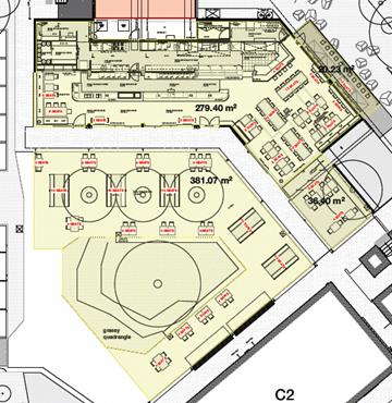
2. Improvements
to deliveries in Penny Lane changing the direction of flow to reduce noise as
trucks wait to enter the site and improve delivery access efficiency
Penny Lane is a single-lane delivery
road off Bayshore Drive, located immediately north of the restaurant. As
approved, the direction of travel was one-way into the site, to access loading
docks and garbage storage areas for the restaurant and the commercial precinct.
The application proposes to reverse the direction of travel and install a
boom-gate.
After the Habitat commercial precinct
became operational, it was noticed that Penny Lane was being used by the
general public to access the on-site parking. To remedy this, a lockable
bollard was installed, this had the unintended consequence of requiring
delivery drivers to stop and unlock the bollard in making deliveries.
Noise from idling delivery vehicles
has been raised by, and is noted as being of an ongoing concern to some nearby
residents the result of this arrangement.
The reversal of the direction of
travel and installation of a boom gate is proposed to remedy this situation.
Delivery vehicles will therefore
access the site from Wallum Place and leave via Penny Lane. Idling
vehicles will therefore be located further within the site, eliminating vehicle
idling noise from the current location of concern. Vehicles will leave
onto Bayshore Drive via Penny Lane. The control of service access out of the
site will be managed through the installation of a keypad security gate.
Staff recommendation
The redirection of the delivery vehicles has been assessed
as acceptable having regard to the Noise Impact Assessment (NIA) submitted with
the application, and resident concerns subject to conditions. (Discussed
separately in the report.)
3. The
provision of acoustic enclosure of rear back-of-house component of Barrio
restaurant to further reduce noise and improve restaurant efficiency;
The application also proposes the
construction of a solid wall enclosing the restaurant ‘back of
house’ / delivery / store areas. This area which contains the
refrigeration condensers, a specific source of noise will also be enclosed. The
enclosure will serve to further assist in reducing noise emanating from the
restaurant ‘back of house’ area and operations.
Staff recommendation
The construction of the acoustic wall has been assessed as
acceptable having regard to the NIA submitted with the application, and
resident concerns subject to conditions. (Discussed separately in the report.)
4. Alterations to the
hours of operation of business premises in the commercial precinct from the
current “daylight hours” to opening hours of
“sunrise–8pm
The current hours of operation are established by
Condition #80 of Development Consent 10.2015.353.1 (as amended):
The opening hours of the various
land uses contained within the development are limited to those provided below;
• Commercial and Retail areas
within Buildings B1 and C1 - C5: daylight hours.
• Creative Industry uses
within Buildings LW1-1, LW1-2 & LW1-3: daylight hours.
• Office uses within Dwelling
Types A1, A2 & A5 daylight hours.
• Workspace uses within
Dwelling Types D4, D5A, D7A, D8, D8B & D9: daylight hours.
• Canteen within Building C1:
daylight hours until midnight.
• Recreation facilities: 6am
to 10pm Monday to Sunday.
The application proposes to change
the hours for the commercial precinct to ‘sunrise to 8pm’.
This would not apply to the Barrio
restaurant (internal), for which the hours (above) of ‘daylight hours
until midnight’ will remain in place.
Staff
recommendation
There remain some
peculiarities with Condition 80 of Development Consent 10.2015.353.1 and in
particular the use of the words ‘daylight hours’. It is considered
this is confusing with longer days in summer and shorter days in winter
depending upon the hours of sunrise and sunset, and some argument could be made
that twilight is also part of daylight hours.
To avoid this confusion and for clarity for
Council, tenants, the land owners, surrounding residents and the broader
community it is recommended that this consent amend Condition 80 of Development
Consent 10.2015.353.1 under S4.17(5) of the EPA Act 1979 to provide for clear
time limits for the uses within the development. (Discussed separately in the
report.)
This change has been discussed with the applicant
who is agreeable to staff recommendation.
5. Codification
of delivery times to 6:30am to 5pm daily; and
While not established by any
condition of consent, as part of the discussions associated with noise
abatement, the proponent agreed in practice to restrict commercial deliveries
to between 8am to 5pm.
It has been submitted that this
arrangement has proved to be inefficient for the commercial operators on site.
As a result, the application is requesting a condition of consent be included
to ‘codify’ delivery times to 6.30am to 5pm daily.
Staff recommendation
The codification of delivery times
has been assessed having regard to the NIA submitted with the application, and
resident concerns and is acceptable subject to conditions for 7am-5pm Monday to
Saturday and 8am – 5pm Sunday deliveries. (Discussed separately in the
report.)
1.3. Description
of the site
A site inspection was carried out on 23 August 2019.
|
Land is legally described as
|
LOT: 2 DP: 271119
|
|
Property address is
|
1 Porter Street BYRON BAY
|
|
Land is zoned:
|
B4 Mixed Use
|
|
Land area is:
|
7,356m2
|
|
Property is constrained by:
|
Acid Sulfate Soils Class 3
|
|
|
Bushfire prone land
|
|
|
HEV Vegetation (mapped along Bayshore Drive frontage
– note vegetation no longer in place)
|
The subject application relates only to the existing
commercial precinct at Habitat, located toward the Bayshore Drive frontage of
the property. In addition to Barrio Restaurant, this precinct contains a
number of retail uses at ground level, with commercial uses on the upper
floor. All existing businesses overlook the central quadrangle.
2. SUMMARY
OF REFERRALS
|
Referral
|
Issue
|
|
Environmental Health
Officer*
|
No objection subject to
conditions of consent – noise comments provided below.
|
|
Building Certifier
|
No objection.
|
|
ET Engineer
|
No objection subject to conditions of consent.
|
* Conditions provided in the above referral are included
in the Recommendation of this Report below
3. SECTION 4.14
– BUSH FIRE PRONE LAND
Under section 4.14 of the Act, Council must be satisfied
prior to making a determination for development on bush fire prone land, that
the development complies with the document ‘Planning for Bush Fire
Protection 2006’.
The site is mapped as bush fire prone land. However,
the application raises no issues that would increase the bush fire risk.
No further assessment is required for this application.
4. SECTION 4.15C
– MATTERS FOR CONSIDERATION – DISCUSSION OF ISSUES
Having regard to the matters for consideration detailed in
Section 4.15(1) of the Environmental Planning & Assessment Act 1979
(EP&A Act), the following is a summary of the evaluation of the issues.
4.1 State Environmental
Planning Instruments
4.2 Byron Local Environmental Plan
2014 (LEP 2014)
LEP 2014 is an applicable matter for consideration in the
assessment of the subject development application in accordance with subsection
4.15(1) of the EP&A Act because it applies to the subject land and the
proposed development. The LEP 2014 clauses that are checked below are of
relevance to the proposed development:
|
Part 1
|
☒1.1|
☒1.1AA| ☒1.2| ☒1.3| ☒1.4| ☒Dictionary| ☒1.5| ☒1.6| ☒1.7| ☒1.8| ☐1.8A| ☒1.9|
☐1.9A
|
|
Part 2
|
☒2.1|
☒2.2 | ☒2.3 |☒Land Use Table | ☐2.4 | ☐2.5 | ☐2.6 | ☐2.7 | ☐2.8
|
|
Part 3
|
☐3.1|
☐3.2| ☐3.3
|
|
Part 4
|
☐4.1|
☐4.1A| ☐4.1AA| ☐4.1B |☐4.1C| ☐4.1D| ☐4.1E| ☐4.2| ☐4.2A| ☐4.2B| ☐4.2C| ☐4.2|☐4.3|☐4.4 |☐4.5 | ☐4.6
|
|
Part 5
|
☐5.1|
☐5.2| ☐5.3| ☐5.4| ☐5.5| ☐5.6| ☐5.7| ☐5.8|☐5.9| ☐ 5.9AA| ☐5.10| ☐5.11| ☐5.12|
☐5.13
|
|
Part 6
|
☒6.1|
☐6.2| ☐6.3| ☐6.4| ☐6.5| ☒6.6| ☐ 6.7| ☐6.8| ☐6.9
|
In accordance with LEP 2014 clauses 1.4 and 2.1 – 2.3:
(a) The
application proposes a number of amendments / modification relating to existing
land uses that are within the LEP 2014 definition of Commercial Premises;
(b) The
land is within the B4 Mixed Use according to the Land Zoning Map;
(c) Commercial
premises are permitted with consent in the B4 zone; and
(d) Regard
is had for the Zone Objectives as follows:
|
Zone Objective
|
Consideration
|
|
To
provide a mixture of compatible land uses.
To integrate suitable business, office, residential,
retail and other development in accessible locations so as to maximise public
transport patronage and encourage walking and cycling
|
There are no aspects of the subject application that raise
inconsistencies in relation to these zone objectives.
|
The remaining checked clauses have been taken into
consideration in the assessment of the subject development application in
accordance with subsection 4.15(1) of the EP&A Act. The proposed
development complies with all clauses of LEP 2014 (in some cases subject to
conditions and/or to the satisfaction of other assessing officers).
4.3 Any proposed Instrument
that has been the subject of public consultation and has been notified to the
consent authority
None relevant.
4.4 Byron Shire Development
Control Plan 2014 (DCP 2014)
DCP 2014 is an applicable matter for consideration in the
assessment of the subject development application in accordance with subsection
4.15(1) of the EP& A Act because it applies to the land to which LEP 2014
applies. The DCP 2014 Parts/Chapters that are checked below are of relevance to
the proposed development:
|
Part A
|
☒
|
|
Part B Chapters:
|
☐B2|
x B3| x B4| ☐B5|
☐B6| ☐B7| x B8| ☐B9| ☐B10| ☐B11| ☐B12| ☐B13|
☐B14
|
|
Part C Chapters:
|
☐C1|
☐C2| ☐C3| ☐C4
|
|
Part D Chapters
|
☐D1|
☐D2| ☐D3| x D4| ☐D5| ☐D6| ☐D7| ☐D8
|
|
Part E Chapters
|
☐
E1| ☐E2| ☐E3| ☐E4| ☐E5| ☐E6| ☐ E7
|
Chapter
D4.2.10 Restaurants, Cafes, Small bars, Pubs Registered Clubs, Function Centres
and other Licensed Premises in the Urban Areas of Byron Shire
Objectives:
1. To
ensure restaurants or cafes, pubs, small bars, registered clubs, function
centres and other licensed premises or venues (e.g. entertainment facility,)
operating in the urban areas of Byron Shire do not adversely impact upon the
amenity of the area.
Staff comment
Previous operation of Barrio has
resulted in some impacts on the amenity of the area, as evident by previous
noise complaints and noise abatement orders issued by Council.
In response, Habitat management and
Barrio have instigated a range of measures, including noise wall construction
and management / operational changes that have successfully mitigated noise
issues.
Previous complainants have
acknowledged that the situation has improved such that certain amenity impacts
are no longer occurring. They are now concerned that the current
application to extend the outdoor dining area will ‘undo’ previous
good work and result in additional noise issues.
This concern is based on an
assumption that the expansion of the outdoor dining area will result in a
significant increase in patron numbers and that will then result in increased
noise.
These assumptions are incorrect in
two ways:
· As
highlighted above, the Barrio restaurant is currently approved for a maximum of
216 people (Condition #10 of Consent 10.2017.437.1). The current
application does not propose any increase in this approved number;
· Notwithstanding
this, the acoustic assessment submitted in support of the application, and
subsequent additional clarifying information, demonstrates that increasing the
number of patrons does not necessarily result in a direct increase in noise
levels.
Modelling undertaken for the
assessment assumed 130 patrons spread across the whole of the proposed outdoor
dining area, all talking simultaneously and continuously.
The modelled results showed that the
noise from this scenario, when measured at the outside face of the closest
residential dwelling opposite the site, is 9dB below the
‘intrusive noise’ criteria (i.e. background noise level plus 5dB).
Given that the noise measurement
scale is logarithmic not linear, an increase of 9dB (i.e. to the
‘intrusive noise’ criteria’ would require the addition of a
significantly larger number of people, estimated by the acoustic consultant to
be in the order of 900 people more than the 130 modelled, all talking
simultaneously and continuously.
Given this, it is considered that the
expansion of the dining area associated with Barrio Restaurant to include the
adjacent outdoor quadrangle for a licensed restaurant will not result in any
further amenity impacts to the area.
2. To
ensure venues operate in a manner that does not generate offensive noise or
create anti social behaviour.
Staff comment
See above. Continuation of
the existing NMP will successfully manage noise. The proposed measures to
enclose the Barrio ‘back of house’ and modify deliveries so that
trucks do not need to idle at the Bayshore Drive frontage, will further assist
in reducing existing noise levels.
3. To
prevent the proliferation of poorly managed late night premises
Staff
comment
The current
proposal will not add to the number of approved premises at Habitat.
Prescriptive Measures:
1. Hours
of operation:
The maximum hours of operation for
licensed premises are:
Friday and Saturday 10am
to 2am
Sunday (and public holidays) 10am
to 12 midnight
Good Friday and ANZAC Day 12 noon
to 12 midnight
New Years Eve 10am
to 3am
Any other day 10am
to 1am
Premises proposing to operate
without a liquor license or outside of the liquor license (when alcohol is not
available for sale) are able to propose earlier opening times to cater for
breakfast
Staff comment
The Barrio restaurant is currently
approved to operate from ‘daylight hours to midnight’. This
application does not propose to alter these hours.
Notwithstanding this, a condition is
recommended to amend the hours to 7am – midnight.
This change has been discussed with
the applicant who is agreeable to staff recommendation.
2. Noise
reports:
Premises (licensed and unlicensed)
that are proposed to open during the evening hours (6 pm onwards) will need to
be accompanied by a detailed noise assessment report prepared by a suitably
qualified and experienced acoustic engineer.
Staff comment
An appropriate NIA has been provided,
demonstrating that the proposed expansion of the outdoor dining associated with
the Barrio Restaurant will not result in the generation of ‘offensive
noise’ as defined in the Protection of the Environment Operations Act
1997.
3. Liquor
licence
Applicants are required to nominate
whether the premises will be licensed for the sale of alcohol.
Staff comment
It is noted that plans attached to
the application show an expanded outdoor dining area and a separate proposed
expanded liquor license area plan. The plans do not accord. The proposed
liquor license area plan is not supported for approval as part of this
application.
4. Management
Plan
Where premises are proposed to be
open past 10.00 pm, applications are to include a Management Plan
Staff comment
A NMP is in place and will be
updated to account for the NIA measures proposed in this application to
mitigate any potential noise impacts from the proposal.
Chapter E5.5
Habitat
The current application relates to Precinct 4, described in
this Chapter as:
This area offers a mix of
business, retail and living spaces including; approx. 1200m2 of retail space;
approx.1700m2 of commercial office space plus a
café/restaurant, gym and pilates studio, as well as 10 x two bedroom
apartments, with attached retail or commercial workspaces. The
recreational precinct includes a swimming pool, change rooms, barbecue areas,
bicycle storage and shaded lawn.
Staff comment
There are no specific controls in this Chapter that are
directly relevant to the current application.
4.5 Any Planning Agreement or
Draft Planning Agreement?
|
|
Yes
|
No
|
|
Is there any applicable planning agreement or draft
planning agreement?
|
☐
|
☒
|
|
Consideration:
|
4.6 Environmental Planning
& Assessment Regulation 2000 Considerations
|
Clause
|
This control is applicable to the proposal:
|
I have considered this control as it relates to the
proposal:
|
If this control is applicable, does the proposal
comply?
|
|
92
|
No
|
N/A
|
N/A
|
|
93
|
No
|
N/A
|
N/A
|
|
94
|
No
|
N/A
|
N/A
|
|
94A
|
No
|
N/A
|
N/A
|
4.7 Any Coastal Zone Management
Plan?
|
|
Satisfactory
|
Unsatisfactory
|
Not applicable
|
|
Is there any applicable coastal zone management plan?
|
☐
|
☐
|
☒
|
|
Consideration:
|
4.8 The likely impacts of that
development, including environmental impacts on both the natural and built
environments, and social and economic impacts in the locality
|
Impact on:
|
Likely significant impact/s?
|
|
Natural environment
|
No. The proposal will not have a significantly adverse
impact on the natural environment of the locality.
|
|
Built environment
|
Noise Impacts are the primary concern in relation to the
built environment and the potential impacts on surrounding land owners from
the increased operations of the Barrio. Further comments provided below.
|
|
Social Environment
|
No. The proposal will not have a significant social impact
on the locality.
|
|
Economic impact
|
No. The proposal will not have a significant economic
impact on the locality.
|
Noise Assessment Comments
A Noise Impact Assessment Ref:
26/2019- Ext dining prepared by Tim Fitzroy & Associates dated 4 July
2019 was submitted with the DA. The report indicates the following noise is
to be generated by the development:
· Increase in
external dining area to encompass the entire commercial precinct courtyard
between the hours of 6am and 10pm for the current approved patron limit for the
café; and
· Extension of hours
for delivery and waste collection vehicles from 6.30am to 5pm.
It is considered the increase in noise can be
adequately managed through the following mechanisms:
· Eastern facing
windows and doors are to remain closed from 6pm until closing;
· The
breezeway noise barrier is to remain closed from 6pm until closing;
· Southern
door is to remain closed from 6pm until closing;
· Exhaust fans
in mechanical ventilation should be operated at medium speed;
· Condensers
Louvers are to remain in place as per recommendations in Environmental Nosie
Impact Assessment of Mechanical Plant, Habitat Development, 2 Porter Street
Byron Bay (5 February 2018).
It is recommended that a
revised NMP be prepared and implemented for the development to reflect the
matters raised above to ensure adequate measures, roles and responsibilities
are in place and to reflect the conditions of this consent to achieve the
project specific noise criteria once this consent is operational.
Hours of use and
operation comments
Notwithstanding the
above, there remain some peculiarities with Condition 80 of Development Consent
10.2015.353.1 and in particular the use of the words ‘daylight
hours’. It is considered this is confusing with longer days in summer and
shorter days in winter depending upon the hours of sunrise and sunset, and some
argument could be made that twilight is also part of daylight hours.
To avoid this confusion
and for clarity for Council, tenants, the land owners, surrounding residents
and the broader community it is recommended that this consent amend Condition
80 of Development Consent 10.2015.353.1 under S4.17(5) of the EPA Act 1979 to
provide for clear time limits as follows:
80. The opening hours of the
various land uses contained within the development are limited to those
provided below;
• Commercial and Retail areas
within Buildings B1 and C1 - C5: daylight hours. 7am to 8pm
• Creative Industry uses
within Buildings LW1-1, LW1-2 & LW1-3: daylight hours.7am to 8pm
• Office uses within Dwelling
Types A1, A2 & A5 daylight hours.7am to 8pm
• Workspace uses within
Dwelling Types D4, D5A, D7A, D8, D8B & D9: daylight hours. 7am to
8pm
• Canteen Restaurant
within Building C1: daylight hours until midnight. 7am to midnight
• Recreation facilities: 6am
to 10pm Monday to Sunday.
Further, it is
recommended that the proposed outdoor dining area associated with the Barrio
Restaurant as proposed under this DA now be regulated with a time limitation on
its use from 7am to 10pm. This is consistent with the NIA submitted with this
application. A condition is included in the recommendation.
4.9 The suitability of the site
for the development
The site is suitable for the proposed development, subject
to the existing Noise Management Plan and the recommendations of the NIA
submitted with the application.
4.10 Submissions made in accordance with
this Act or the regulations
The development application was publicly exhibited.
There were 14 submissions made on the development application:
- 10
For; and
- 4
Against
Issues raised are addressed below:
|
Issue
|
Comment
|
|
Objection:
|
|
|
Local residents’ noise complaints after the opening
of Barrio resulted in Council issuing orders requiring implementation of
measures to reduce night-time noise from the restaurant operations.
Extension of the outdoor dining
area will result in a significant increase in patrons and significantly
increase the generation of noise.
Noise assessment not considered
to be independent and is misleading.
|
See commentary above – patron numbers not proposed
to increase above previously approved limit.
Noise impact assessment concludes
that expanded outdoor dining area will not result in the generation of
‘offensive noise’ as defined in Protection of Environment
Operations Act.
Council’s Environmental
Health Officer has reviewed the noise assessment report and concluded that it
is rigorous. Its conclusions are supported with conditions in the
recommendation.
|
|
Reversal of traffic direction in Penny Lane will be
dangerous, with delivery vehicles exiting onto Bayshore Drive close to
existing intersections and opposite driveway to unit complex.
|
Council’s Development Engineer has reviewed the
proposal and is satisfied that the concerns are unfounded.
|
|
Application is a pathway for the doubling of patron
numbers, because the current liquor license sets a 122 patron limit.
|
See commentary above. It is important to note that
the acoustic assessment modelled the noise generation of 130 patrons spread
across the proposed outdoor dining area, all talking continuously and
simultaneously and concluded that the resultant noise generated will be 9dB below
the offensive noise threshold (i.e. background + 5dB).
|
|
Aspects of the application are misleading in presenting
Barrio as a ‘laid back’ venue for locals, where it is advertised
as destination restaurant and as an events venue.
|
The acoustic assessment does not rely on a specific type
of clientele. It models 130 people spread across the outdoor dining
area.
The existing Noise Management
Plan contains provisions addressing live music, which is all located
internally.
|
|
Proposal to have earlier deliveries is unacceptable, as
this reverts to previous operation which resulted in noise impacts for
residents.
|
It is understood that previous impacts were primarily
associated with delivery vehicles idling within Penny Lane, close to Bayshore
Drive.
The reversal of direction in the
Lane, and installation of a boom gate will address this, such that delivery
vehicles will have no option other than stopping (idling) further into the
site, behind buildings.
This would then allow earlier
deliveries to occur without the current associated noise impacts.
|
|
Proposal is inconsistent with Council’s Liquor
Licensing and Approval Policy 2019.
|
Section 2.5 of the Policy states:
(a) The
location of licensed premises should not impinge upon residential properties.
Council encourages the ‘clustering’ of licensed premises within
the central business districts of Byron Shire in preference to development of
isolated licensed premises in or near residential properties.
(b) Council
may not support any application proposing to locate a licensed premise within
100 metres of a school, child care facility, place of worship, hospital, aged
care facility or residential area.
|
|
Acoustic assessment does not address cumulative impact of
patrons inside the premises together with the outdoor patrons.
|
The existing Noise Management Plan and the recommendations
of the Noise Impact Assessment submitted with the application adequately
address this issue of concern.
|
4.11 Public interest
The proposed development is unlikely to prejudice or
compromise the public interest or create an undesirable precedent.
5. DEVELOPER
CONTRIBUTIONS
5.1 Water & Sewer Levies
Section 64 levies will be payable.
5.2 Section 7.11 Contributions
Proposal raises no nexus to levy
developer contributions.
6. DISCLOSURE
OF POLITICAL DONATIONS AND GIFTS
|
Has a Disclosure Statement been
received in relation to this application
|
No
|
|
Have staff received a ‘gift’ from anyone
involved in this application that needs to be disclosed. Where the answer is
yes, the application is to be determined by the Director or Manager of the
Planning, Development and Environment Division.
|
No
|
Provide Disclosure Statement register details here: Not
applicable
7. CONCLUSION
The proposed development is consistent with the relevant
environmental planning instruments and planning controls applicable to the
site. The proposal raises no significant issues in terms of environmental
impacts which cannot be managed and the site is considered suitable for the
development. The application is recommended for approval subject to conditions
of consent listed in Attachment 2 (#E2019/72944).
8. REASONS
FOR DECISION, HOW COMMUNITY VIEWS WERE ADDRESSED
Note:
From July 1 2018, Council’s are required to give and publicly notify
reasons for a range of planning decisions where they are deciding if
development should proceed to help community members to see how their views
have been taken into account and improve accountability to stakeholders. A
statement of reasons for the determination of this application is provided
below.
|
Statement of Reasons
|
|
The proposed development complies with the provisions of
Byron Local Environmental Plan 2014.
|
|
The proposed development complies with relevant provisions
of Development Control Plan 2014
|
|
The proposed development will not have significant adverse
impact on the natural, built or social environment or economic impacts on the
locality.
|
|
The proposed development is considered suitable for the
proposed site.
|
|
The proposed development is unlikely to prejudice or
compromise the public interest.
|
|
How community views were addressed
|
|
The DA was advertised in accordance with Development
Control Plan 2014. The submissions received were considered on merit and
addressed during assessment of the application.
|
Staff Reports - Sustainable Environment and Economy 13.4
Report No. 13.4 PLANNING
S8.2 Review - Use of unauthorised additions to existing dual occupancy
(conversion of garage to bedroom), car parking and tree removal at 3 Comet
Close Byron Bay.
Directorate: Sustainable
Environment and Economy
Report
Author: Patricia
Docherty, Planner
File No: I2019/1464
Summary:
In accordance with Section
8.3(4)(b) of the Environmental Planning and Assessment Act 1979 (the Act), a
Review of Determination Application lodged in accordance with section 8.2 of
the Act is to be conducted by another delegate of Council who is not
subordinate to the delegate who made the determination or decision. A
determination of such review must be made within 6 months of the original
determination date.
This report provides a review of determination
of development application DA 10.2019.220.1, for use of unauthorised additions
to an existing dual occupancy (conversion of garage to a bedroom), car parking
and tree removal, which was refused by staff under delegation on 27 June 2019.
The reasons for refusal were:
1. Pursuant
to Section 4.15(1) (a) (iii) the proposal has not demonstrated compliance with
the requirements of part B4.2.2.4 and the objectives and performance criteria
of part D1.2.2 of Development Control Plan 2014.
2. Pursuant
to Section 4.15(1)(b) the proposed development would create an unreasonable
visual amenity impact on the streetscape.
3. Pursuant
to Section 4.15(1) (e) the proposed development is not in the public interest
as it would create an undesirable precedent.
In essence the subject land is a
small constrained parcel of only 281 m2 and the addition of a
bedroom to the dwelling house results in a nexus for two car parking spaces to
be provided onsite. This has been complicated further as the existing garaged
space is now a bedroom resulting in the two spaces now to be provided in the
front setback in a tandem arrangement. This has resulted in a poor planning
outcome that impacts adversely character and amenity of the area, and sets an
undesirable precedent for the abandonment of the existing DCP controls.
As such the need to maintain the
existing setback controls is critical in the circumstances, to demonstrate to
the community, planning consultants, architects and designers that the setback
controls have not been abandoned by Council. It is noted that Council is
dealing with other similar applications within Comet Street, including the
adjacent neighbour. As such the circumstances of the case are an important
factor.
On the basis of a complete review of information submitted, it
is recommended that pursuant to Section 8.2 of the Environmental Planning and
Assessment Act 1979 that the refusal be reaffirmed for the reasons outlined in
this report. Ultimately the bedroom needs to
be converted back to a garage and subject to the determination of this
application by Council further compliance proceedings will commence.
NOTE TO COUNCILLORS:
In accordance with the
provisions of S375A of the Local Government Act 1993, a Division is to be
called whenever a motion for a planning decision is put to the meeting, for the
purpose of recording voting on planning matters. Pursuant to clause 2(a)
under the heading Matters to be Included in Minutes of Council Meetings of
Council's adopted Code of Meeting Practice (as amended) a Division will be
deemed to have been called by the mover and seconder of all motions relating to
this report.
|
RECOMMENDATION:
1. That
Council reaffirm the determination (refusal) of DA10.2019.220.1 dated 27 June
2019 for Use of Unauthorised Additions to Existing Dual Occupancy Dwelling
(Conversion of Garage to Bedroom), Carparking and Tree Relocation, at 3 Comet
Close, Byron Bay.
2. That
Council reissue the determination notice (refusal) of
DA10.2019.220.1 dated 27 June 2019 for Use of Unauthorised Additions to
Existing Dual Occupancy Dwelling (Conversion of Garage to Bedroom),
Carparking and Tree Relocation, at 3 Comet Close, Byron Bay.
|
Attachments:
1 Byron Bay
Planning & Property Consultants - 10.2019.220.1 - PR200950 - Revised
parking Plan, E2019/58012
2 Byron Bay
Planning & Property Consultants - 10.2019.220.1 - Development Assessment
Report, A2019/13319
3 Original
DA Plans prepared by Byron Bay Planning & Property Consultants -
10.2019.220.1, E2019/71033
REPORT
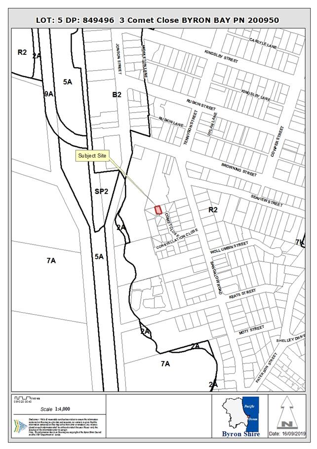
1.1. History/Background
The subject dwelling was approved as a two bedroom dwelling
as part of a “Type 1” dual occupancy in accordance with Development
Consent 5.1992.433.1 for 12 x Dual Occupancies and subdivision to create 24
lots on the 5/5/1993.
The subject DA 10.2019.220.1, for
use of unauthorised additions to an existing dual occupancy (conversion of
garage), car parking and tree removal was refused by staff under delegation on
27 June 2019.
1.2. Description
of the site
A site inspection was carried out on 6 May 2019
|
Land is legally described as
|
LOT: 5 DP: 849496
|
|
Property address is
|
3 Comet Close BYRON BAY
|
|
Land is zoned:
|
R2 Low Density Residential
|
|
Land area is:
|
281 m2
|
|
Property is constrained by:
|
Bushfire prone land;
Acid Sulfate Soils Class 2
|
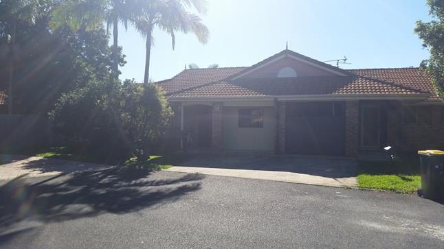
Existing converted garage
viewed from Comet Cl looking NW
1.3. Reasons
for refusal
DA10.2019.220.1 for Use of
Unauthorised Additions to Existing Dual Occupancy Dwelling (Conversion of
Garage to Bedroom), Carparking and Tree Relocation, at 3 Comet Close, Byron Bay
was refused by staff under delegation on 27 June 2019. The reasons for refusal
are listed below:
1. Pursuant
to Section 4.15(1) (a)(iii) the proposal has not demonstrated compliance with
the requirements of part B4.2.2.4 and the objectives and performance criteria
of part D1.2.2 of Development Control Plan 2014.
2. Pursuant
to Section 4.15(1) (b) the proposed development would create an unreasonable
visual amenity impact on the streetscape.
3. Pursuant
to Section 4.15(1) (e) the proposed development is not in the public interest
as it would create an undesirable precedent.
An extract from the submitted
plans below shows the Bedroom 4 where the garage was previously located.
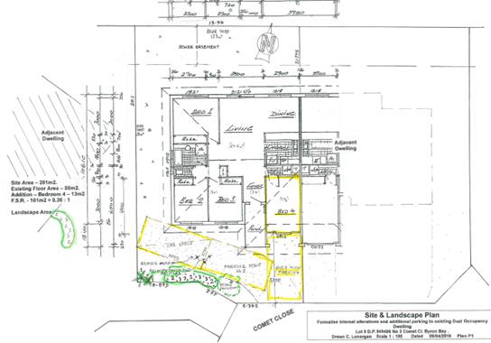
Floor
and Site Plans
1.4. Revised
submissions – review of reasons for refusal
The Section 8.2 review application was submitted with a plan
titled Proposed Parking and Turning Template, prepared by Tricend
Design and Engineering, dated 21.07.2019 (See Attachment 1)
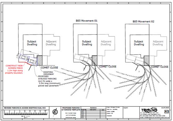
Proposed Parking and
Turning Template
The proposed layout involving tandem parking is
unchanged. None of the reasons for refusal have been
addressed. A copy of the original development assessment report is
enclosed at Attachment 2.
Having reviewed the determination and the revised
submissions, it is recommended that the previous determination of refusal be
reaffirmed.
1.5. Review
of Determination
Reason for refusal No.1 - Pursuant to Section
4.15(1)(a)(iii) the proposal has not demonstrated compliance with the
requirements of part B4.2.2.4 and the objectives and performance criteria of
part D1.2.2 of Development Control Plan 2014.
Conclusion
Tandem / stacked car parking is proposed which is not
permitted for residential development. The plans still propose stacked
parking. There is no reasonable justification or environmental planning
grounds to support approval of the proposed stacked car parking, which is not
permitted for residential development.
Reason for Refusal No. 1 should be retained within the
determination notice issued to the applicant.
Reason for refusal No. 2 - Pursuant to Section 4.15(1)(b)
the proposed development would create an unreasonable visual amenity impact on
the streetscape.
Conclusion
The proposed stacked car parking and manoeuvring areas will
result in the majority of the open space between the existing dwelling and the
street having a hardstand surface, which will remove space intended for deep
soil landscaping. The proposed parking layout will have a negative impact
on the general attractiveness of the streetscape and would not integrate with
the existing built and natural environment along Comet Close.
Reason for Refusal No. 2 should be retained within the
determination notice issued to the applicant.
Reason for refusal No. 3 - Pursuant to Section 4.15(1)(e)
the proposed development is not in the public interest as it would create an
undesirable precedent.
Conclusion
The site is not suitable for the proposed layout of tandem
parking; there is insufficient space for the provision of parking required for
the resultant number bedrooms.
The subject dwelling was approved as a two bedroom dwelling
as part of a “Type 1” dual occupancy in accordance with consent
5.1992.433.1 for 12 x Dual Occupancies and subdivision to create 24 lots.
Therefore, the layout on the site was approved within the
context of a wider development and it is considered that the site has an
insufficient land area (281m2) to support an increase in the number of bedrooms
and appropriate car parking on the site. The proposed parking layout does
not represent orderly development; it would impede pedestrian access to the
rear of the dwelling via the existing side setback when parking is in use.
The proposed floorplan results in a loss of functionality as
it appears that access to the laundry tub is obstructed by a wall that’s
been constructed to create the fourth bedroom, and is sited behind the washing
machine. Previously the laundry was located and accessible from the
garage.
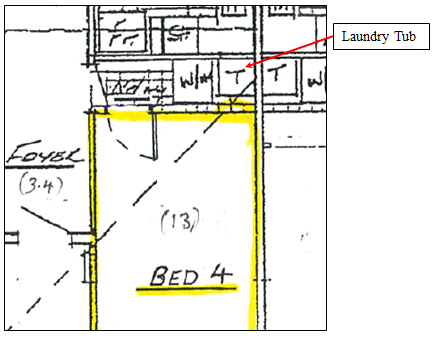
The proposed development is not in the public interest as it
would create an undesirable precedent in Comet Close and elsewhere in Byron
Shire.
Reason for Refusal No. 3 should be retained within the
determination notice issued to the applicant.
1.6. Planning
assessment conclusion
The request to formally review the application DA10.2019.220.1
has been undertaken in accordance with Division 8.2 (Reviews) under the Act,
also having regard to relevant provisions of section 4.15 (Evaluation). As
such, it is recommended that the refusal be reaffirmed.
The proposed conversion of the garage to a bedroom is without
justification and as such not supported in this instance. The site is small and
constrained and the subject design does not meet Council’s standard
planning controls for car parking and setbacks. The S8.2 Review is not
supported and the reasons for refusal remain in the circumstances of the case.
1.7. Legal
Implications
An appeal with the Land and Environment Court is possible in
the event of a refusal of the application.
DISCLOSURE OF POLITICAL
DONATIONS AND GIFTS
|
Has a Disclosure Statement been received in relation
to this application
|
No
|
|
Have staff received a ‘gift’ from anyone
involved in this application that needs to be disclosed. Where the answer is
yes, the application is to be determined by the Director or Manager of the
Planning, Development and Environment Division.
|
No
|
Staff Reports - Sustainable Environment and Economy 13.5
Report No. 13.5 PLANNING
- Development Application 10.2019.146.1 Alterations and Additions to existing
Child Care Centre including increase in enrolment numbers to Fifty (50)
Children and Tree Removal at 49 Bottlebrush Crescent Suffolk Park
Directorate: Sustainable
Environment and Economy
Report
Author: Shannon
Burt, Director Sustainable Environment and Economy
Chris Larkin, Manager Sustainable
Development
File No: I2019/1487
Proposal:
|
DA No:
|
10.2019.146.1
|
|
Proposal description:
|
Alterations and Additions to Existing Child Care Centre
including Increase in Enrolment Numbers to Fifty (50) Children and Tree
Removal
|
|
Property description:
|
LOT: 126 DP: 1121466
|
|
49 Bottlebrush Crescent SUFFOLK PARK
|
|
Parcel No/s:
|
240275
|
|
Applicant:
|
Planners North
|
|
Owner:
|
Byron Shire Council
|
|
Zoning:
|
R2 Low Density Residential
|
|
Date received:
|
28 March 2019
|
|
Integrated / Designated Development:
|
☐
Integrated
|
☐
Designated
|
☒
Not applicable
|
|
Concurrence required
|
No
|
|
Public notification or exhibition:
|
- Level
2 advertising under DCP 2014 Part A14 – Public Notification and
Exhibition of Development Applications
- Exhibition
period: 11/4/19 to 1/5/19
- Submissions received:
two
|
|
Variation request
|
☐
Clause 4.6
|
☐
SEPP 1
|
☒
Not applicable
|
|
Delegation to determination:
|
Council
|
|
Issues:
|
· Privacy to
neighbouring dwellings
· Noise
|
|
The application has been assessed by a Consultant Planner
in accordance with Council’s Management of Conflicts of Interest
Procedure in Development Matters.
|
Summary:
Development consent is sought to make alterations and
additions to the Suffolk Park Community Preschool. This will double
student numbers from 25 to 50 and increase staff members by 3. The proposed
single storey additions comprise new floor area of 220.7m2 and an
additional external play space. The floor plan will include an open playroom,
storage areas, kitchen, interview room and multi-purpose room plus new paths,
fencing and landscaping.
Additional car parking spaces as previously identified on
the approved plans associated with the 2008 approval will be constructed. The
removal of four native landscape trees is required. Minor changes have
been made to the plans post exhibition as follows:
Main preschool building has been moved 2.275 metres closer
to Bottlebrush Crescent; GFA of main preschool building increased by 30 m2
and the outdoor play area expanded by approximately 25 m2. Acoustic
fences are also to be installed along the car park and at the rear of two Beech
Drive residences in addition to a fence top privacy screen to address privacy
concerns of neighbours. A covered internal walkway has been deleted.
The proposal raises no major planning issues and is
recommended for approval subject to conditions of consent.
NOTE TO COUNCILLORS:
In accordance with the
provisions of S375A of the Local Government Act 1993, a Division is to be
called whenever a motion for a planning decision is put to the meeting, for the
purpose of recording voting on planning matters. Pursuant to clause 2(a)
under the heading Matters to be Included in Minutes of Council Meetings of
Council's adopted Code of Meeting Practice (as amended) a Division will be
deemed to have been called by the mover and seconder of all motions relating to
this report.
|
RECOMMENDATION:
That pursuant to
Section 4.16 of the Environmental Planning & Assessment Act 1979,
development application 10.2019.146.1 for Alterations and Additions to Existing Child Care Centre including
Increase in Enrolment Numbers to Fifty (50) Children and Tree Removal, be
granted consent subject to the conditions listed in Attachment 2
(#E2019/72455).
|
Attachments:
1 10.2019.146.1
- Revised Plans prepared by Thomson Adsett, E2019/71784
2 10.2019.146.1
- Recommended conditions of consent, E2019/72455

3 10.2019.146.1
- Submissions received, E2019/71809
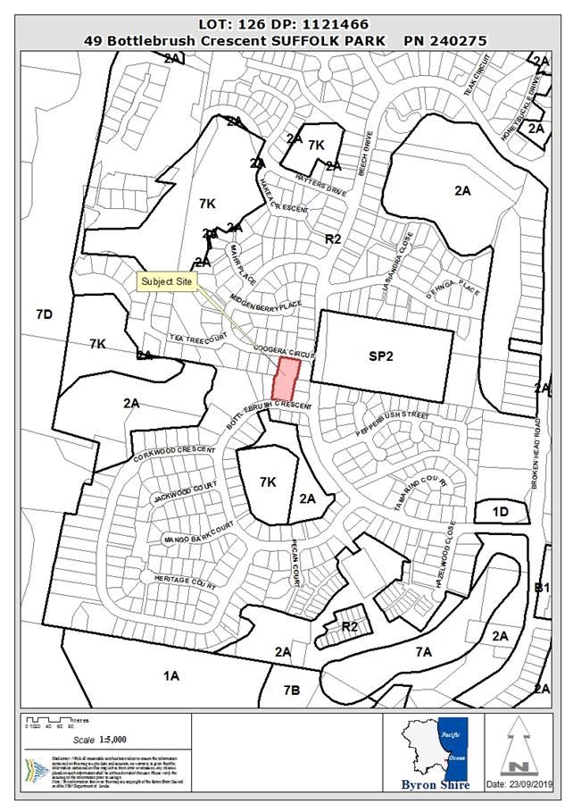
Assessment:
1. INTRODUCTION
1.1. History/Background
Development Consent No. 10.2008.361.1 for a Community
Building incorporating a preschool, education and health rooms and associated
car parking and tree removal was approved by Council on 3 November 2008. A
section 96 Application No. 10.2008.361.2 was approved by Council on 23 April
2009. A Construction Certificate No. 2009.05.14 was approved by Council on 14
May 2009.
Existing development on the site comprises a single storey
building with a floor plan area of approximately 396m2. The approved
plans include car parking for 13 vehicles with another 4 indicated as future
car parking. The approved DA plans also show a future possible Stage 2 and the
assessment report relating to the determination of the application notes that a
development application would be required. The approved development provided
for a community building consisting of a preschool and for provision and
administration of children’s services including early intervention and a
toy library service. The preschool presently provides for 25 preschool students
at any one time.
1.2. Description
of the proposed development
This application seeks approval for Alterations and
Additions to Existing Child Care Centre including Increase in Enrolment Numbers
to Fifty (50) Children and Tree Removal. The development includes
· A single storey
building with floor area of 220.7m2 and an additional external play
space. The floor plan of the new building will include an open playroom,
storage areas, kitchen, interview room and multi-purpose room. The development
will include paths, fencing and landscaping.
· An additional 4
car parking spaces as previously identified on the approved plans associated
with the 2008 approval will be constructed.
· Removal of four
native landscape trees.
1.3. Description
of the site
|
Land is legally described as
|
LOT: 126 DP: 1121466
|
|
Property address is
|
49 Bottlebrush Crescent SUFFOLK PARK
|
|
Land is zoned:
|
R2 Low Density Residential
|
|
Land area is:
|
2813 m2
|
|
Property is constrained by:
|
Flooding and Bushfire
hazard
|
2. SUMMARY OF
REFERRALS
|
Referral
|
Issue
|
|
Environmental Health Officer*
|
No objections subject to conditions in relation to
acoustic fencing and use of kitchen
|
|
Development Engineer
|
No concerns subject to construction in accordance with
plans
|
|
Water & Sewer Engineer (Local Approvals Officer)
|
The Development generates demand for water and sewerage
services. Council requires Payment of Developer Servicing Charges (prior to
issue of a construction/subdivision certificate) of:
· 1.68 ET for
Water &
· 1.68 ET Bulk
Water; and
· 2.80 ET for
Sewer.
|
|
S94 / Contributions Officer
|
This is non residential development so the Section 7.12
levy ( EPA Act 1979) applies. Prior to the issue of a construction
certificate the section 7.12 levy required by the Byron Developer
Contributions Plan 2012 must be paid to Council.
|
3. SECTION 4.14
– BUSH FIRE PRONE LAND
The subject land is identified as a buffer to bushfire prone
lane and the development is identified as Integrated Development under the Act.
As such a Bushfire Safety Authority is required under S100B of the Rural Fires
Act 1997. The application was referred to the Rural Fire Service who has raised
no objection to the development subject to Conditions of Consent in relation to
construction standards, services and the provision of an Evacuation Plan.
4. SECTION 4.15C
– MATTERS FOR CONSIDERATION – DISCUSSION OF ISSUES
Having regard to the matters for consideration detailed in
Section 4.15(1) of the Environmental Planning & Assessment Act 1979
(EP&A Act), the following is a summary of the evaluation of the issues.
4.1 State Environmental
Planning Instruments
|
|
Satisfactory
|
Unsatisfactory
|
|
State
Environmental Planning Policy No 55—Remediation of Land
|
☒
|
☐
|
|
Consideration: An assessment of site contamination was
undertaken for the existing preschool development in September 2008 that
covered the entire site. It did not find any areas of concern and
concluded that further soil contamination assessment was not required. The
Council in approving the preschool accepted that the land is not
contaminated. No further assessment is required for the subject DA. It
is consistent with SEPP 55.
|
|
State Environmental Planning
Policy (Coastal Management) 2018
|
☒
|
☐
|
|
Consideration: The coastal environment area mapping comes
close but does not affect the subject land. There are no mapped wetlands or
littoral rainforest areas that affect the subject land.
|
|
State Environmental Planning
Policy (Educational Establishments and Child Care Facilities) 2017
|
☒
|
☐
|
|
Consideration: Clause 23 of the SEPP provides that before
determining a development application for the purposes of a centre based
child care facility, the consent authority must take into consideration any
applicable provisions of the Child Care Planning Guideline in relation
to the proposed development. The applicant provides a checklist (Appendix G
of the SEE) which demonstrates the consistency of the development application
with the provisions of the SEPP.
Clause 22 requires the concurrence of the Regulatory
Authority for certain development that does not comply with the indoor or
outdoor unencumbered area requirements of the Education and Care Services
National Regulations. The indoor requirement is 3.25 m2 per child
and the outdoor requirement is 7 m2 per child. The proposal
provides unencumbered indoor space of 3.87 m2 per child and
unencumbered outdoor space of 7.3 m2 per child. This meets
the requirements of the Regulation and concurrence is therefore not required.
(Regulatory Authority means the Regulatory
Authority for New South Wales under the Children (Education and Care
Services) National Law (NSW) (as declared by section 9 of the Children (Education and Care
Services National Law Application) Act 2010).
|
4.2A Byron Local Environmental Plan 2014 (LEP 2014)
LEP 2014 is an applicable matter for consideration in the
assessment of the subject development application in accordance with subsection
4.15(1) of the EP&A Act because it applies to the subject land and the
proposed development. The LEP 2014 clauses that are checked below are of
relevance to the proposed development:
|
Part 1
|
☒1.1|
☒1.1AA| ☒1.2| ☒1.3| ☒1.4| ☒Dictionary| ☒1.5| ☒1.6| ☒1.7| ☒1.8| ☐1.8A| ☒1.9|
☐1.9A
|
|
Part 2
|
☒2.1|
☒2.2 | ☒2.3 |☒Land Use Table | ☐2.4 | ☐2.5 | ☐2.6 | ☒2.7 | ☐2.8
|
|
Part 3
|
☐3.1|
☐3.2| ☐3.3
|
|
Part 4
|
☐4.1|
☐4.1A| ☐4.1AA| ☐4.1B |☐4.1C| ☐4.1D| ☐4.1E| ☐4.2| ☐4.2A| ☐4.2B| ☐4.2C| ☐4.2|☒4.3|☒4.4 |☐4.5 | ☐4.6
|
|
Part 5
|
☐5.1|
☐5.2| ☐5.3| ☐5.4| ☐5.5| ☐5.6| ☐5.7| ☐5.8|☐5.9| ☐ 5.9AA| ☐5.10| ☐5.11| ☐5.12|
☐5.13
|
|
Part 6
|
☐6.1|
☒6.2| ☒6.3| ☐6.4| ☐6.5| ☒6.6| ☐ 6.7| ☐6.8| ☐6.9
|
Clauses 1.4 and 2.1 – 2.3
(a) The proposed development is
defined in the LEP 2014 Dictionary as a Centre-based child care
facility;
(b) The land is within the R2 Low
Density Residential according to the Land Zoning Map and a Centre-based
child care facility is permitted with consent in this zone;
(c) The proposed alterations and
additions will improve the service offered by the Centre-based child care
facility and is considered to be consistent with the objective of the Zone,
viz : “To enable other land uses that provide facilities or services to
meet the day to day needs of residents”. The intention to expand
the pre school was flagged in the original approval.
Clause 2.7 Demolition
Complies. Minor demolition is limited to fence removal and
tree removal and these works will be approved as part of this consent.
Clause 4.3 Height of Buildings
Complies. The LEP prescribes a 9 metre building height
limit. The proposed building is single storey, from finished floor level to
roof peak is 4.4 metres. However, the existing ground level varies from RL
9.59m to 10.88m. With a roof peak of RL 15.79m the building is a maximum of 6.2
metres in height. The site will be partly filled but the resulting building
will be well below the 9 metre maximum height.
Clause 4.4 Floor Space Ratio
Complies. The LEP prescribes a FSR of 0.5:1. On a site of
2,813.6m2 this would permit 1,406 m2 of buildings. The
existing building is 396m2 and the extension is 220.7m2 for
a total Gross Floor Area of 616.7m2 and an FSR of 0.22:1.
Clause 6.2 Earthworks
Complies. Approximately 153 m3
of clean fill will be placed on the site in the location of the proposed
building. This will allow the floor level to be at RL 11.39 m. It will not have
a detrimental effect on drainage patterns and soil stability in the locality of
the development. Clean fill will be used and needs to be properly compacted. It
will take about 20 truck movements to bring the fill to the site. Impacts on
neighbours will occur during the construction period from noise and dust and
these will need to be managed. Standard conditions on all these matters are
required.
Clause 6.3 Flood Planning
Complies. A flood assessment undertaken in Feb 2019 which
confirmed that: the Flood Planning Level for this site is 11.39m AHD
(2050 FPL); it is not a filling exclusion area; all buildings will be at least
0.5 m above the 2050 FPL; the proposed developable area is located in a
‘low hazard’ category; overland flow paths will be maintained with
no afflux of flow; the development will not significantly affect flood
behaviour; no adverse environmental impact is anticipated as a result of the
development; all disturbed areas to be sealed or revegetated after
construction; developable areas are not located within riparian vegetation
areas and will not impact on riverbank stability; there are no known social or
economic costs to the community that are likely to occur as a consequence of
the site being flooded. Standard conditions on flood issues are required.
Clause 6.6 Essential Services
Complies. The subject land is fully serviced urban land and
all services are adequate to cater for the expansion of the floor area of the Centre-based
child care facility. A Stormwater Management Plan has been prepared. The
report concludes that an underground pipe drainage system has already been
constructed within the site to convey site runoff to the existing underground
pipe system present within Bottle Brush Crescent. The existing driveway and car
park already discharges to the street. On site detention of stormwater has been
designed in accordance with Council’s requirements and over land flow
paths will be maintained in accordance with the approved design for the
existing car park. Conditions include small contributions for water and sewer.
The proposed development will provide a total of 50 places
for children requiring a total of 12.5 car parking spaces (rounded up to 13).
No separate staff car parking is required. The proposed development makes
adequate provision for car parking and pick up and drop off with a total of 17
car parking spaces. Children are dropped off and picked up in a period of about
1 hour between 8 to 9 AM and 3 to 4 PM. Cars normally stay only 5 to 10 minutes
on the site other than staff. The toy library can create traffic between 10 AM
and 2 PM on days when it is open. The Early Intervention group use the site as
required but have small numbers of staff and children.
4.3 Any proposed Instrument
that has been the subject of public consultation and has been notified to the
consent authority
No draft EPI’s affect the proposal
4.4A Byron Shire Development Control Plan 2014
(DCP 2014)
Chapter B4 - Traffic planning, vehicle parking
circulation and access
The proposed development will provide a total of 50 places
for children ( 25 in the original approval and 25 in this approval) requiring a
total of 12.5 car parking spaces (rounded up to 13 at one space per four
children). It is noted that the site also creates demand for additional car
parking being a toy library and early intervention facility which generate a
demand for a further 5 spaces. The proposed development has applied or 17
spaces, however adequate room is available for an 18th space.
Conditions to apply.
Vehicle circulation will remain the same with one way
traffic entering from Coogera and exiting in a forward direction onto
Bottlebrush. Typically a drop off is based on a car remaining on the site for a
short period while a child is walked to the premises and it then departs to
return for a short period at the pick up time. The local road network has
the capacity to provide for traffic likely to be generated by the proposal.
Chapter B13 – Access and Mobility
The alterations are able to comply with this Chapter. There
is no footpath along Coogera or Bottle Brush only grassed verge. The front
entry from Coogera provides a narrow concrete footpath from the street to the
existing building entry. A matching footpath will link the Bottle Brush frontage
to the building entry. The front building is linked by a path to the rear
building. The existing car park has two disabled car parking spaces which
are located between the existing and proposed buildings under a carport. Ramps
will be fitted to the new building to allow disabled access.
The proposed building and infrastructure are in accordance
with the provisions of the BCA and AS1428.1 – Design for Access and
Mobility –General Requirements for Access – New Buildings.
The existing parking is in accordance with Australian
Standard AS/NZS 2890.6:2009 Parking Facilities – Part 6: Off-street
parking for people with disabilities.
Chapter B14 – Excavation and Fill
Fill will be confined to the footprint of the proposed
building and will not exceed one metre in depth. Shadow diagrams enclosed with
the application show that the building height in combination with fill will not
create unreasonable impacts on the adjacent properties. The existing
building was elevated on fill to achieve flood planning levels and this
building will be consistent with that. It will not detract from the existing
and desired future residential character of the immediate locality.
Engineering detail will be required at construction stage to ensure that filled
areas on the site do not subside and remain stable.
Chapter C2 - Areas Affected by Flood
The subject site is affected by low hazard flooding
predominantly linked to a poorly designed detention basin located two lots west
of the subject land. This detention basin is scheduled to be altered to improve
flood outcomes but the work has never been carried out. Based on the existing
flood situation the applicable Flood Planning Level (FPL) for the development
is RL 11.39m AHD. The proposed development complies with the required FPL as it
has a finished floor level of 11.39 m AHD.
Chapter E1 – Suffolk Park
The proposed low rise development is consistent with the
scale and bulk of the surrounding residential development and will present a
landscaped frontage to Bottlebrush Crescent. It will have a 4.525 m front
setback consistent with residential standards and a single driveway access.
Side setbacks are not less than 1.5 metres (1.865 metres proposed). The side
wall to the east has no windows to maintain privacy to the rear yards along
Beech Drive. The subject land is not affected by coastal hazards and is
not visually prominent.
4.5 Any
Planning Agreement or Draft Planning Agreement?
|
|
Yes
|
No
|
|
Is there any applicable
planning agreement or draft planning agreement?
|
☐
|
☒
|
|
|
4.6 Environmental Planning
& Assessment Regulation 2000 Considerations
|
Clause
|
This
control is applicable to the proposal:
|
I
have considered this control as it relates to the proposal:
|
If
this control is applicable, does the proposal comply?
|
|
92
|
N/A
|
|
|
|
93
|
N/A
|
|
|
|
94
|
N/A ( addition is less than 50% expansion)
|
|
|
|
94A
|
N/A
|
|
|
* Non-compliances and any other significant issues
discussed below
4.7 Any COASTAL ZONE MANAGEMENT
PLAN?
|
|
Satisfactory
|
Unsatisfactory
|
Not applicable
|
|
Is there any applicable coastal zone management plan?
|
☐
|
☐
|
☒
|
|
|
4.8 The likely impacts of that
development, including environmental impacts on both the natural and built
environments, and social and economic impacts in the locality
|
Impact on:
|
Likely significant impact/s?
|
|
Natural environment
|
No. The four trees to be removed are not significant.
Although they are native species (Syzigium, Sterculia and Glochidion) they
are less than 5 metres tall and provide minimal habitat. Their loss will be
off set by native vegetation used in landscaping. Stormwater will be detained
on site before discharge to the public system. The proposal will not
have a significant adverse impact on the natural environment of the locality.
|
|
Built environment
|
No. The low rise character of the proposed building has a
residential feel and is well suited to the coastal residential area. Parking
meets Council standards and traffic will not stress road or intersection
capacity. The proposal will not have a significantly adverse impact on the
built environment of the locality.
A noise impact assessment recommends acoustic fencing on
the side boundaries and this has now been included in the design. A 500mm
privacy screen will be included on the eastern side fencing to increase
visual privacy to the Beech Drive dwellings.
Location of the 4.4 metre high eastern wall at a 1.865
metre setback means that it encroaches on the building height plane. The
building height plane provisions only apply to residential accommodation but
the underlying objectives are still important. This wall does give visual and
acoustic privacy to the eastern side neighbours. It does not impact unduly on
solar access. Shadow diagrams show that the dwellings to the west are not
affected at all and the dwelling directly to the east retains not less than 3
hours of sun to both dwelling and yard at the winter solstice.
|
|
Social Environment
|
No. The proposal will not have a significant adverse
social impact on the locality. It will have a positive impact being the
addition of preschool places for local children. Many family homes are within
walking distance or a short drive from this location. Most children that
attend the site are from Suffolk Park ( pers comm Director).
The potential for noise and visual privacy impacts on
neighbours has been addressed.
|
|
Economic impact
|
No. The proposal will not have a significant adverse
economic impact on the locality. During the construction phase the economic
impacts will be positive through employment and materials purchase. Once
operational a further three preschool workers will be employed creating jobs
for locals for the long term.
|
Are there any Council Policies that are applicable to the
proposed development? No.
4.9 The suitability of the site
for the development
The site is considered suitable for ongoing use and
expansion of a Centre-based child care facility in Suffolk Park. The
alterations and additions are well suited to improving the function of the
facility and were foreshadowed as part to the original approval. The site
is capable of providing preschool services for 50 children (25 in this approval
and 25 previously approved) and the service is in demand.
4.10 Submissions made in accordance with
this Act or the regulations
The development application was publicly exhibited
from 11 April to 1 May 2019.
There were 2 submissions made on the development application
both oppose the proposal on a number of grounds as follows:
Privacy – An adjacent Beech Drive resident states that
their privacy has been impacted by staff being able to view their bathroom and
backyard from existing office windows that were meant to be screened. The new
building does not have any east facing windows so this problem won’t be
repeated. However, Council should ensure that privacy is restored for
neighbours by installing a fence top screen along the eastern fence as
required. This should cover the proposed building site and extend along the
fence of the existing building to provide privacy to all three dwellings that
abut the eastern boundary. A 500 mm fence top privacy screen is now part of the
revised plans. Visual privacy will be addressed.
Noise – A new outdoor play area is likely to be a
source of noise for the neighbours to the east. Preschool children are not as
noisy as primary school children and spend a significant time in doors in small
groups as well. Although the preschool is not usually in use before 8AM
or after 4PM and not on weekends it is a matter than can be assisted by a noise
abatement wall along this boundary either in addition to or instead of a
dividing fence. The revised plans now include an acoustic fence up to 2
metres high on the Beech Drive side and 1.8 metre high on the western side. An
acoustic study shows that this should be effective in noise reduction.
Drainage – A stormwater management plan has been
prepared for the site that demonstrates that roof water will be collected in a
detention system at the Bottlebrush frontage and surface water will be
channelled using the driveway and an existing drain along the eastern boundary.
There will be minimal impact on neighbouring land from this development from
stormwater.
Traffic - A traffic and parking impact assessment indicates
that there will be sufficient parking on site and additional street parking issues
are not anticipated. Traffic volumes will increase with more children attending
but it is typically confined to a drop off and pick up peak period and both
roads and intersections will not be over stressed by the extra volume. Locals
will notice the difference but it won’t be excessive. The one way in and
out system will be retained so all traffic can leave in a forward direction
which increases safety for all parties.
4.11 Public interest
The proposed development is unlikely to prejudice or
compromise the public interest or create a dangerous precedent. The
public interest is served by an expanded Centre-based child care facility
that is located in a residential community providing a valuable service to
families and jobs for local people.
5. DEVELOPER
CONTRIBUTIONS
This is non residential development so the Section 7.12 levy
( EPA Act 1979) applies. Prior to the issue of a construction certificate
the section 7.12 levy required by the Byron Developer Contributions Plan 2012
must be paid to Council.
5.1 Water & Sewer Levies
Section 64 levies will be payable.
5.2 Section 7.11 Contributions
No Section 7.11 Contributions
will be required.
6. CONCLUSION
The proposed development is consistent with the relevant
environmental planning instruments and planning controls applicable to the
site. The proposal raises no significant issues in terms of environmental
impacts which cannot be managed and the site is suitable for the proposed
development. The application is recommended for approval subject to conditions
of consent.
7. DISCLOSURE OF
POLITICAL DONATIONS AND GIFTS
|
Has a Disclosure Statement been received in relation
to this application
|
No
|
|
Have staff received a ‘gift’ from anyone
involved in this application that needs to be disclosed. Where the answer is
yes, the application is to be determined by the Director or Manager of the
Planning, Development and Environment Division.
|
No
|
8. REASONS
FOR DECISION, HOW COMMUNITY VIEWS WERE ADDRESSED
Note:
From July 1 2018, Council’s are required to give and publicly notify
reasons for a range of planning decisions where they are deciding if
development should proceed to help community members to see how their views
have been taken into account and improve accountability to stakeholders. A
statement of reasons for the determination of this application is provided
below.
|
Statement of Reasons
|
|
The proposed development complies with the provisions of
Byron Local Environmental Plan 2014.
|
|
The proposed development complies with relevant State
Environmental Planning Policies
|
|
The proposed development complies with relevant provisions
of Development Control Plan 2014
|
|
The proposed development will not have significant adverse
impact on the natural, built or social environment or economic impacts on the
locality.
|
|
The proposed development is considered suitable for the
proposed site.
|
|
The development application was notified/advertised in
accordance with Development Control Plan 2014. Issues raised in the
submissions have been addressed during assessment of the application.
The development has been modified in response to submissions.
|
|
The proposed development is unlikely to prejudice or
compromise the public interest.
|
|
How community views were addressed
|
|
The DA was advertised in accordance with Development
Control Plan 2014. The two submissions received were considered on merit and
addressed during assessment of the application.
The development has been modified in response to the
concerns raised. Conditions have been imposed to specifically address
concerns raised in the submissions.
|
9. RECOMMENDATION
It is recommended that
pursuant to Section 4.16 of the Environmental Planning & Assessment Act
1979, development application no. 10.2019.146.1 for alterations and additions to existing Centre-based child care
facility including increase in enrolment numbers to a total of fifty (50)
children and tree removal, be granted consent subject to conditions listed in
Attachment 2 (#E2019/72455).
Staff Reports - Sustainable Environment and Economy 13.6
Report No. 13.6 PLANNING
- Development Application 10.2019.60.1 New Subdivision - Boundary Adjustment to
create Two (2) Lots at 148 Woodford Lane Ewingsdale
Directorate: Sustainable
Environment and Economy
Report Author: Ivan
Holland, Planner
File No: I2019/1492
Proposal:
|
DA No:
|
10.2019.60.1
|
|
Proposal description:
|
Initial application: New Subdivision - Boundary Adjustment
to create Three (3) Lots
Amended application: New Subdivision - Boundary
Adjustment to create Two (2) Lots
|
|
Property description:
|
LOT: 2 DP: 871477, LOT: 23 DP: 858323
|
|
148 Woodford Lane EWINGSDALE, 178 Woodford Lane EWINGSDALE
|
|
Parcel No/s:
|
216660, 213010
|
|
Applicant:
|
Newton Denny Chapelle
|
|
Owner:
|
Mrs N M McDonald
|
|
Zoning:
|
RU1 Primary Production, RU2 Rural Landscape, 1(a) General
Rural
|
|
Date received:
|
1 February 2019
|
|
Integrated / Designated Development:
|
☒
Integrated
|
☒
Designated
|
☐
Not applicable
|
|
Concurrence required
|
Yes – NSW RFS & Department of Planning
|
|
Public notification or exhibition:
|
- Advertising
as per the EPA Regulation 2000
- Exhibition
period: 30 days from 08/02/19
- Submissions received: 4
(in opposition)
|
|
Variation request
|
☐
Clause 4.6
|
☒
SEPP 1
|
☐
Not applicable
|
|
Delegation to determination:
|
Council
|
|
Issues:
|
· Current and
proposed lots are under the minimum lot size for the applicable land zoning;
· Proposed
subdivision will enhance the agricultural viability of lot 23 with a
reduction in size of lot 2.
|
Summary:
The original development
application lodged in February sought consent to a boundary adjustment to
create Three (3) Lots.
An amended development application was subsequently lodged
in 25 July 2019, which proposed instead a subdivision (boundary adjustment) of
Lot 2 DP 871477 and Lot 23 DP 858323. The proposed subdivision will
result in Lot 23 increasing in size by approximately 3 ha to 27.7 ha and Lot 2
decreasing in size by the same to 1.7 ha.
The application relies upon Clause 4.1C under Byron LEP 2014
as a minor Boundary Adjustment. It is considered the proposal satisfies
the requirements under the LEP and raises no specific issues.
The application is recommended for approval subject to
Conditions of Consent.
NOTE TO COUNCILLORS:
In accordance with the provisions
of S375A of the Local Government Act 1993, a Division is to be called whenever
a motion for a planning decision is put to the meeting, for the purpose of
recording voting on planning matters. Pursuant to clause 2(a) under the
heading Matters to be Included in Minutes of Council Meetings of Council's
adopted Code of Meeting Practice (as amended) a Division will be deemed to have
been called by the mover and seconder of all motions relating to this report.
|
RECOMMENDATION:
That, pursuant to Section
4.16 of the Environmental Planning & Assessment Act 1979, Development
Application no. 10.2019.60.1 for
new subdivision - boundary adjustment to create two (2) lots, be granted
consent subject to the recommended conditions of consent in Attachment 2
(#E2019/70624).
|
Attachments:
1 Proposed
boundary adjustment Plan prepared by NDC dated 23 July 2019, E2019/71980
2 Recommended
conditions of consent on DA 10.2019.60.1, E2019/70624
3 Submissions
on DA 10.2019.60.1, E2019/71073
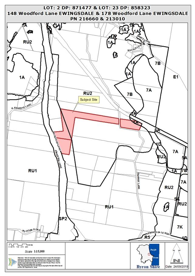
Assessment:
1. INTRODUCTION
1.1. History/Background
Council’s records indicate the following development
history for the properties:
Lot 2 DP 871477
· Dwelling additions
(DA 5.1992.6.1) – approved 31/1/92;
· Subdivision
– 2 lots (DA 5.1994.307.1) – approved 9/11/95;
· Dwelling additions
(DA 5.1996.456.1) – approved 15/1/97; and
· Relocated dwelling
(DA 10.1998.670.1) approved 1/4/1999.
Lot 23 DP 858323
There are no records for the existing dwelling under this
parcel or the previous property descriptions of Lot 6 DP 587773 or Lot 1 DP
557820. This is not unusual having regards to the age of the dwelling which may
have been constructed prior to the gazettal of the Interim Development Order
No.1 in 1968 and the introduction of a planning scheme for Byron Shire. The
property does have a dwelling entitlement though with previous parcel
description (DP587773) is nominated under Byron LEP 1988 in Schedule 7.
1.2. Description
of the proposed development
The initial application sought approval for New Subdivision
- Boundary Adjustment to create Three (3) Lots. An amended development
application and statement of environmental effects was received by Council on
25 July 2019 which proposed subdivision (boundary adjustment) of Lot 2 DP
871477 and Lot 23 DP 858323 only, to create two lots only. An extract from the
plans is provided below
|
Lot
|
Current area (ha)
|
Proposed area (ha)
|
|
2
|
4.75
|
1.69 (Proposed Lot 2)
|
|
23
|
24.66
|
27.72 (Proposed Lot 1)
|
Figure 1. Proposed
subdivision (current lot boundary shown by yellow line).
1.3. Description
of the site
|
Land is legally described as
|
LOT: 2 DP: 871477; and
LOT: 23 DP: 858323.
|
|
Property address is
|
148 and 178 Woodford Lane EWINGSDALE;
|
|
Land is zoned:
|
RU1 Primary Production, RU2 Rural Landscape, 1(a) General
Rural
|
|
Land area is:
|
LOT: 2 DP: 871477 – 4.7 ha
LOT: 23 DP: 858323 – 24.66ha.
|
|
Property is partly constrained by
|
Acid Sulfate Soils.
Bushfire prone land
Flood Liable Land
High Environmental Value vegetation
|
A site inspection was carried out on 25/09/2019 – see
photos below.
|
Photo 1 – Dwelling at 178 Woodford Lane (on Lot 23)
viewed from Woodford Lane to the south. Approximate current lot boundary runs
left to right of photo through trees near dwelling.
|
Photo 2 - Dwelling at 148 Woodford Lane (on Lot 2) and
approximate proposed lot boundary (current fence line).
|
|
Photo 3 - Dwelling at 178 Woodford Lane (on Lot 23).
|
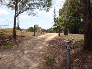
Photo 3 - Dwelling at 148 Woodford Lane (on Lot 2).
|
2. SUMMARY
OF REFERRALS
|
Referral
|
Issue
|
|
Development Engineer
|
No objections subject to
conditions.
|
|
S64 / Systems Planning Officer
|
No objections subject to conditions.
|
|
S94 / Contributions Officer
|
No objections, no conditions.
|
|
Ecologist
|
No objections subject to conditions.
|
|
Rural Fire Service (100B/4.14/4.14)
|
The amended application was referred to the NSW Rural Fire
Service (RFS) on 7 August 2019. General Terms of Approval were provided by
the RFS on 29 August 2019.
|
|
Department of Planning, Industry & Environment
|
The amended application was referred to the Department of
Planning, Industry & Environment (DPIE) on 7 August 2019. The
Secretary’s concurrence for the requested variation to a development
standard (minimum lot size of the zone) was granted on 29 August 2019.
|
|
Rous Water
|
The amended application was referred to Rous County
Council on 9 August 2019. No objections subject to conditions.
|
3. SECTION 4.14
– BUSH FIRE PRONE LAND
Under section 4.14 of the Act, Council must be satisfied
prior to making a determination for development on bush fire prone land that
the development complies with the document Planning for Bush Fire Protection
2006. The site is bush fire prone land. The development application was
referred to the NSW Rural Fire Service, which provided conditions which are
included in the conditions of consent.
4. SECTION 4.15C
– MATTERS FOR CONSIDERATION – DISCUSSION OF ISSUES
Having regard to the matters for consideration detailed in
Section 4.15(1) of the Environmental Planning & Assessment Act 1979
(EP&A Act), the following is a summary of the evaluation of the issues.
4.1 State Environmental
Planning Instruments
|
|
Satisfactory
|
Unsatisfactory
|
|
State
Environmental Planning Policy No 1—Development Standards
|
☒
|
☐
|
|
Consideration: A SEPP 1 Objection request was
provided for the amended application, which sought a variation to the minimum
lot size development standard (clause 11, LEP 1988). As the variation
sought is greater than a 10% change to a numerical standard, the Secretary’s
concurrence may not be assumed (Circular – PS18-003). However,
the Secretary of the Department of Planning & Environment has provided
concurrence for the variation to the development standard and consent may be
granted by Council pursuant to clause 7.
|
|
State
Environmental Planning Policy No 44—Koala Habitat Protection
|
☒
|
☐
|
|
Consideration: This SEPP is a relevant consideration
as both Lot 2 and Lot 23 are greater than 1 ha in area (Cl.6). Lot 2
does not include any mapped potential koala habitat however the far east of
lot 23 is mapped as potential koala habitat (Cl.7). The mapped
vegetation is not considered to be core koala habitat as Council’s
records do not show recent sightings or evidence of resident koalas and
consequently the application is not prevented from approval (Cl.8).
|
|
State
Environmental Planning Policy No 55—Remediation of Land
|
☒
|
☐
|
|
Consideration: The subject lots are not identified as
being contaminated or having previous contaminating land uses in
Council’s records. The proposed boundary adjustment raises no issues in
terms of contamination from past land uses.
|
|
State Environmental Planning
Policy (Coastal Management) 2018
|
☒
|
☐
|
|
Consideration: Parts of Lot 23 are mapped as coastal
wetlands and coastal wetlands buffer and a small area of coastal wetlands
buffer is mapped on the eastern boundary of Lot 2. The proposed subdivision
does not propose or require any “physical works”, such as
building, construction, earthworks or vegetation removal.
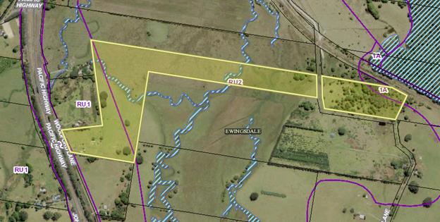
Wetland Areas identified
by blue hatched areas and are predominantly narrow water courses (upper
reaches of Simpsons Creek) running through the property.
The proposal raises no issues in terms of the Coastal
Management SEPP and the provisions contained within Clauses 10 and 11 in
particular.
|
|
State
Environmental Planning Policy (Primary Production and Rural Development) 2019
|
☒
|
☐
|
|
Consideration: No specific provisions were
identified in this policy that are relevant to this application. The
application states that the purpose of the subdivision is to “…create
a more viable agricultural holding out of two existing undersized allotments
by establishing a larger landholding” which is consistent with aim
of the policy (c.2) such as:
(a)
to facilitate the orderly economic use and development of lands for primary
production,
(e)
to encourage sustainable agriculture…,
|
4.2A Byron Local Environmental Plan 2014 (LEP 2014)
LEP 2014 is an applicable matter for consideration in the
assessment of the subject development application in accordance with subsection
4.15(1) of the EP&A Act because it applies to the subject land and the
proposed development. The LEP 2014 clauses that are checked below are of
relevance to the proposed development:
|
Part 1
|
☒1.1|
☒1.1AA| ☒1.2| ☒1.3| ☒1.4| ☒Dictionary| ☒1.5| ☒1.6| ☒1.7| ☒1.8| ☐1.8A| ☒1.9|
☐1.9A
|
|
Part 2
|
☒2.1|
☒2.2 | ☒2.3 |☒Land Use Table | ☐2.4 | ☐2.5 | ☒2.6 | ☐2.7 | ☐2.8
|
|
Part 3
|
☐3.1|
☐3.2| ☐3.3
|
|
Part 4
|
☒4.1|
☐4.1A| ☐4.1AA| ☐4.1B |☒4.1C| ☐4.1D| ☐4.1E| ☐4.2| ☐4.2A| ☐4.2B| ☐4.2C| ☐4.2|☐4.3|☐4.4 |☐4.5 | ☐4.6
|
|
Part 5
|
☐5.1|
☐5.2| ☐5.3| ☐5.4| ☐5.5| ☐5.6| ☐5.7| ☐5.8|☐5.9| ☐ 5.9AA| ☐5.10| ☐5.11| ☐5.12|
☐5.13
| ☐5.14| | ☐5.15| | ☒5.16| | ☐5.17| | ☐5.18| | ☐5.19
|
|
Part 6
|
☒6.1|
☐6.2| ☒6.3| ☐6.4| ☐6.5| ☒6.6| ☐ 6.7| ☐6.8| ☐6.9
|
In accordance with LEP 2014 clauses 1.4 and 2.1 – 2.3:
(a) The
proposed development is defined in the EP&A Act (s.6.2) as Subdivision;
(b) Part
of the land is within the RU1 Primary Production and RU2 Rural Landscape zones
according to the Land Zoning Map;
(c) The
proposed development is permitted with consent (Cl.2.6); and
(d) Regard
is had for the Zone Objectives as follows:
|
Zone Objectives (Zone RU1)
|
Consideration
|
|
• To encourage sustainable primary industry
production by maintaining and enhancing the natural resource base.
|
The proposed subdivision will result in an increase in the
size of lot 23 (by ~3ha) which will increase the primary production capacity
of this lot. Lot 2 will decrease in size to ~1.7ha rendering this lot too
small for most (if not all) primary production.
|
|
• To encourage diversity in primary industry enterprises
and systems appropriate for the area.
|
The proposed subdivision will not impact on the diversity
or opportunity for diversity in primary industry in the area.
|
|
• To minimise the fragmentation and alienation of
resource lands.
|
The proposed subdivision will not result in further
fragmentation or alienation of resource land.
|
|
• To minimise conflict between land uses within this
zone and land uses within adjoining zones.
|
The proposed subdivision is not likely to result in actual
or potential land use conflict as no new neighbours or land uses are
authorised by the subdivision. The dwelling on the smaller parcel (Lot
2) will be ~50m from the proposed new boundary.
|
|
• To encourage consolidation of lots for the
purposes of primary industry production.
|
Not applicable.
|
|
• To enable the provision of tourist accommodation,
facilities and other small-scale rural tourism uses associated with primary
production and environmental conservation consistent with the rural character
of the locality.
|
Not applicable.
|
|
• To protect significant scenic landscapes and to
minimise impacts on the scenic quality of the locality.
|
The proposed subdivision will not have an impact on
significant scenic landscapes or the scenic quality of the locality.
|
|
Zone Objectives (Zone RU2)
|
Consideration
|
|
• To encourage sustainable primary industry
production by maintaining and enhancing the natural resource base.
|
See RU1 discussion above.
|
|
• To maintain the rural landscape character of the
land.
|
The proposed subdivision will not have an impact on the
rural landscape character of the land.
|
|
• To provide for a range of compatible land uses,
including extensive agriculture.
|
The proposed subdivision will not further restrict the
land uses possible on Lot 23. Lot 2 will decrease in size to ~1.7ha
rendering this lot too small for most (if not all) primary production.
|
|
• To enable the provision of tourist accommodation,
facilities and other small-scale rural tourism uses associated with primary production
and environmental conservation consistent with the rural character of the
locality.
|
Not applicable.
|
|
• To protect significant scenic landscapes and to
minimise impacts on the scenic quality of the locality.
|
See RU1 discussion above.
|
Clause 4.1C Minimum
subdivision lot size for boundary adjustments in certain rural and residential
zones
The development proposal seeks consent through the
provisions contained within Clause 4.1 which permit boundary adjustments. The
proposal will result in a transfer of some 3 ha from the smaller parcel to the
larger holding resulting in Lot 2 at 1.7 ha and Lot 1 at 27.7 ha. Both proposed
lots are less than the minimum lot size for RU1 zoned land being 40 ha (clause
4.1).
However, consent may be granted for the proposed subdivision
under clause 4.1C(3) if it “…consists of an adjustment of
boundaries between existing lots where the size of one or more of the resulting
lots will be less than the minimum subdivision lot size” and a series
of criteria are met. The proposed subdivision is considered to be an
adjustment of boundaries under this clause as follows:
· The
applicant argues that the proposed changes to the boundaries are to increase
the size of lot 23 to enable the better use of the parcel for agricultural
purposes, which is consistent with zone objectives
· No
significant changes will be made to the configuration of any current
allotments; and
· The
resulting parcels of land will bear some resemblance to the lots which existed
before the subdivision
Further, the proposed subdivision is considered to be
consistent with the additional criteria set out under clause 4.1C (3) in that:
· the
subdivision will not result in the creation of any additional lots or the
opportunity for additional dwellings as it is restricted to an adjustment of
current lot boundaries (sub a);
· the
subdivision will not result in further fragmentation or alienation of land (sub
b) as the large parcel will be increased in size by ~3ha and will become a more
viable parcel, whilst the smaller lot although containing some agricultural
potential is of insufficient size by itself to be a viable farm holding,
· the
subdivision is not likely to result in actual or potential land use conflict
(sub c) and no new neighbours or land uses are authorised by the subdivision as
the dwelling on the smaller parcel (Lot 2) will be approximately 50m from the
proposed new boundary, and
· the
subdivision is not likely to affect the rural character, environmental heritage
and scenic quality of the land (sub d) particularly as no additional lots, land
uses or the opportunity for additional dwellings will be created by the
subdivision.
Clause 6.1 Acid Sulfate Soils
Lot 23 contains a mapped area of class 3 and class 2 acid
sulfate soils however there is no mapped acid sulfate soils within lot 2. This
mapped area does not overlap the current or proposed boundary with lot 2. As no
physical works are proposed, development consent is not required under clause
6.1.
Clause 6.3 Flood Planning
Lot 23 contains a mapped area of flood liable land; there is
no mapped flood liable land within lot 2. This mapped area does not overlap the
current or proposed boundary with lot 2. Council’s Development
Engineer has assessed the proposal in relation to flooding risk and found it to
be acceptable subject to conditions.
Clause 6.6 Essential Services
Both Lots 2 and 23 appear to have essential services or the
ability to make such services available when required (clause 6.6).
The Proposal raises no other issues under Byron LEP 2014.
4.2B Byron Local Environmental Plan 1988 (LEP 1988)
A small portion of Proposed Lot 1 is zoned 1(a) under Byron
LEP 1988 and is therefore an applicable matter for consideration in the
assessment of the subject development application in accordance with subsection
4.15(1) of the EP&A Act because it applies to the subject land and the
proposed development. The LEP 1988 clauses that are checked below are of
relevance to the proposed development:
|
Part 1
|
☒1|
☒2| ☒2A| ☒3| ☒4| ☒5| ☒LEP 1988 Dictionary| ☒7
|
|
Part 2
|
☒8|
☒9
|
|
Part 3
|
☒10|
☒11| ☐11A| ☐11B| ☐12| ☐13| ☐14| ☐15| ☐16| ☐17| ☐17A| ☐17B| ☐18| ☐19| ☐22| ☐22| ☐23| ☒24| ☐25| ☐27| ☐ 29| ☐29AA| ☐29A| ☐30| ☐31| ☐32| ☐33| ☐34| ☐35| ☐36| ☐37| ☐38| ☐38A| ☐38B| ☐39| ☐39A| ☐39B| ☐39C| ☐40| ☐41| ☐42| ☐43| ☐44| ☒45| ☐46| ☐47| ☐47AA| ☐47A| ☐48| ☐49| ☐51| ☐52| ☐53| ☐54| ☐55| ☐56| ☐ 57| ☐58| ☐59| ☐60| ☐61| ☐62| ☒63| ☐64
|
In accordance with LEP 1988 clauses 5, 8 and 9:
(a) The
proposed development is defined in the EP&A Act (s.6.2) as Subdivision;
(b) Part
of the land is within the 1(a) General Rural Zone according to the map under
LEP 1988;
(c) The
proposed development is permitted with consent (Cl.10); and
(d) The
proposed development is consistent with the relevant objectives of the Zone for
the following reasons:
|
Zone Objective
|
Consideration
|
|
(a) to encourage and permit a range of uses creating
a pattern of settlement, at a scale and character that maintains or enhances
the natural, economic, cultural, social and scenic amenity of the rural
environment of the Shire of Byron,
|
The proposed subdivision does not propose a change of use
(however Lot 2 will decrease in size to ~1.7ha rendering this lot too small
for most (if not all) primary production).
|
|
(b) to encourage and permit a pattern of settlement
which does not adversely affect the quality of life of residents and visitors
and maintains the rural character,
|
The proposed subdivision does not propose any additional
dwellings and will not result in additional dwelling entitlements. The
dwelling on the smaller parcel (Lot 2) will be ~50m from the proposed new
boundary.
|
|
(c) to ensure development only occurs on land which
is suitable for and economically capable of that development and so as not to
create conflicting uses,
|
The proposed subdivision is not likely to result in actual
or potential land use conflict as no new neighbours or land uses are
authorised by the subdivision. The dwelling on the smaller parcel (Lot
2) will be ~50m from the proposed new boundary.
|
|
(d) to allow the use of land within the zone for
agricultural purposes and for a range of other appropriate purposes whilst
avoiding conflict between other uses and intensive agriculture,
|
The proposed subdivision will result in an increase in the
size of lot 23 (by ~3ha) which will increase the primary production capacity
of this lot. Lot 2 will decrease in size to ~1.7ha rendering this lot too
small for most (if not all) primary production.
|
|
(e) to identify lands (shown hatched on the map)
which in the opinion of the council possess a limited capability for more
intensive uses or development,
|
Not applicable.
|
|
(f) to restrict the establishment of inappropriate
traffic generating uses along main road frontages other than in road side
service areas,
|
Not applicable.
|
|
(g) to ensure sound management of land which has an
extractive or mining industry potential and to ensure that development does
not adversely affect the potential of any existing or future extractive
industry,
|
Not applicable.
|
|
(h) to enable the provision of rural tourist
accommodation and facilities only where such facilities are compatible with
the form and density of the nature of the locality, and
|
Not applicable.
|
|
(i) to permit the development of limited light
industries which do not pose any adverse environmental impact, (e.g. software
manufacture and film processing), and
|
Not applicable.
|
|
(j) to ensure that the development and use of land
shown cross-hatched on the map adjacent to areas of significant vegetation
and wildlife habitat do not result in any degradation of that significant
vegetation and wildlife habitat, and that any development conserves and
protects and enhances the value of the fauna and flora.
|
Not applicable.
|
|
What clause does the development not comply with and what
is the nature of the non-compliance?
|
Further consideration, including whether the development
application is recommended for approval or refusal accordingly.
|
|
Clause 11 Subdivision in rural areas for agriculture
etc.
Both the proposed lots are less than the minimum lot size
of 40 ha prescribed for Zone 1(a) land.
|
As noted above, the application included a SEPP 1
Objection request. The Secretary of the Department of Planning &
Environment has provided concurrence for the variation to the development
standard for the reasons detailed below.
|
Clause 11 Subdivision in rural areas for agriculture etc.
Clause 11 states that Council shall not consent to the
subdivision of land unless the area of each of the allotments to be created is
not less than the minimum area for the zone of the subject land and, “in
the opinion of the council, each allotment is of satisfactory shape and has a
satisfactory frontage”.
Both the current and proposed lots are less than the minimum
lot size of 40 ha prescribed for Zone 1(a) land and therefore do not meet the
minimum lot size requirement. The DA is supported by an objection
pursuant to SEPP 1. The identified requirements needed in order to uphold a
SEPP 1 objection, are addressed in the circumstances of this particular case as
follows (Wehbe v Pittwater Council [2007] NSWLEC 827):
Is the requirement a development standard?
The
minimum subdivision lot size requirement is a development standard as defined
by section 1.4 of the EP&A Act 1979, because it is a provision of an environmental
planning instrument in relation to the carrying out of development, being a
provision by or under which requirements are specified and standards are fixed
in respect of the area of any land.
Is the objection in writing, is it an objection “that
compliance with the development standard is unreasonable or unnecessary in the
circumstances of the case” and does it specify “the grounds of the
objection”?
The
development application is accompanied by an objection in writing. It is an
objection that compliance with the development standard is unwarranted in the
circumstances of the case and specifies the grounds of the objection as
follows:
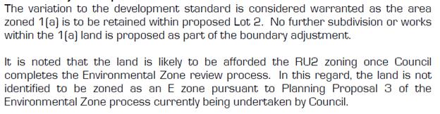
Is “the objection well founded” and will
“granting of consent to the development application be consistent with
the aims of SEPP 1 as set out in clause 3”?
An
objection under SEPP 1 may be well founded and be consistent with the aims set
out in clause 3 of the Policy in one of a variety of ways (according to the
above mentioned judgment). These are:
1. Compliance
with the development standard is unreasonable or unnecessary because the
objectives of the development standard are achieved notwithstanding
non-compliance with the standard.
2. The
underlying objective or purpose is not relevant to the development with the
consequence that compliance is unnecessary.
3. The
underlying objective or purpose would be defeated or thwarted if compliance was
required with the consequence that compliance is unreasonable.
4. The
development standard has been virtually abandoned or destroyed by the
Council’s own actions in granting consents departing from the standard
and hence compliance with the standard is unreasonable and unnecessary.
5. The zoning
of particular land was unreasonable or inappropriate so that a development standard
appropriate for that zoning was also unreasonable or unnecessary as it applied
to that land and compliance with the standard in that case would also be
unreasonable or unnecessary.
For
the current development application, compliance with the development standard
is unreasonable and unnecessary because the objectives of the development
standard are achieved notwithstanding non-compliance with the standard. Clause
11 does not provide any stated objectives. However, compliance with the
development standard is unreasonable and unnecessary because the underlying
objectives of the development standard are achieved for the following reasons:
a) No
additional lots will be created;
b) Further
opportunities for additional dwellings will not be created;
c) No
additional dwelling entitlements will be created; and
d) The
current lots are under the minimum lot size, with no change proposed to this
scenario. .
The SEPP 1 objection is
well founded and it is recommended it be supported.
Clause 24 development of Flood Liable Land
None of the subject property that is zoned 1(a) General
Rural Zone is mapped as flood prone land.
Clause 63 Acid Sulfate Soils
The area of Land within Proposed Lot 1 that is zoned 1(a) is
mapped as containing Acid Sulfate soils. No physical works are proposed in the
mapped areas and An ASS Management Plan is not required.
The proposal raises no other Issues under Byron LEP 1988
4.3 Any proposed Instrument
that has been the subject of public consultation and has been notified to the
consent authority
No proposed instruments were identified that are relevant to
this application.
4.4A Byron Shire Development Control Plan 2014
(DCP 2014)
DCP 2014 is an applicable matter for consideration in the
assessment of the subject development application in accordance with subsection
4.15(1) of the EP& A Act because it applies to the land to which LEP 2014
applies. The DCP 2014 Parts/Chapters that are checked below are of relevance to
the proposed development:
|
Part A
|
☒
|
|
Part B Chapters:
|
☐B2|
☒ B3| ☒ B4| ☐B5| ☒ B6| ☐B7| ☐B8| ☐B9| ☐B10| ☐B11| ☐B12| ☐B13|
☐B14
|
|
Part C Chapters:
|
☐C1|
☒ C2| ☐C3| ☐C4
|
|
Part D Chapters
|
☐D1|
☐D2| ☐D3| ☐D4| ☐D5| ☒ D6| ☐D7| ☐D8
|
|
Part E Chapters
|
☐
E1| ☐E2| ☐E3| ☐E4| ☐E5| ☐E6| ☐ E7
|
Servicing (B3), access/traffic (B4) and flooding aspects
(C2) of the proposal have been adequately considered by Council’s
engineer who has no objections to the development subject to conditions.
B6 - Buffers and Minimising Land Use Conflict
The proposed subdivision is not likely to result in actual
or potential land use conflict as no new neighbours or land uses will be
created by the subdivision. Table B6.1 recommends a buffer distance of
50m between residential areas and grazing of stock which is consistent with
that proposed in this application in that the dwelling on the smaller parcel
(Lot 2) will be ~50m from the proposed new boundary.
D6 - Subdivision
It is considered that no benefit would be obtained from
requiring a consideration of the subdivision design guidelines (D6.2.1) for the
proposed subdivision, being a relatively minor adjustment of the boundary
between two rural lots with no changes to dwellings, access, wastewater
disposal, water supply, stormwater management or vegetation. As discussed above
the proposal seeks a variation to the lot size requirements with the following
additional comments provided in terms of the DCP Controls
|
What Section and prescriptive measure does the development
not comply with?
|
Does the proposed development comply with the Objectives
of this Section? Address.
|
Does the proposed development comply with the Performance
Criteria of this Section? Address.
|
|
D6.3.1 Lot Size, Shape and Configuration
The proposed lots are less than the minimum area specified
in Byron LEP 2014 on the lot size map contrary to Prescriptive Measure 1.
|
Yes
The proposed lots are similar to the current lots and
will:
· Not prevent the
orderly and economic use and development of the land (Objective 1).
· Not impair the
ability to use lot 23 for agricultural/rural purposes (the proposed increase
in size will enhance this potential). As lot 2 is a relatively small
rural lot (~4.8ha), it is arguable that the decrease in size of this lot will
have a minor impact on potential use of this lot for agricultural purposes
(Objective 2).
|
Yes
The proposed lots are similar to the current lots and the
dwelling on lot 2 will have an ~50m separation from the proposed new lot
boundary which is consistent with the buffer recommended by Chapter B6
(PC.1).
Each lot currently has a dwelling. This application does
not propose new/any additional dwellings/buildings (PC2).
|
The proposed development raises no other issues under Byron
DCP 2014.
4.4B Byron Shire Development Control Plan 2010 (DCP 2010)
Part B4 Subdivision
The proposed subdivision will:
· Benefit
the agricultural use potential of the large lot (lot 23) by increasing its size
(B2.6);
· Reduce
the relatively low agricultural potential of lot 2 (due to its small size of
~4.8ha) by further reducing the size of this lot (B2.6);
· Provide
a ~50m buffer between the dwelling on lot 2 and the proposed boundary. It is
recommended that this boundary be vegetated to enhance the buffer should this application
be approved (B2.6);
· does
not require the removal of native vegetation (B2.7); and
· provide
a range of lots sizes (B3.6) and maintains road frontages (B3.7).
Access, traffic, stormwater management, flooding and
servicing aspects of the proposal have been adequately considered by
Council’s engineer who has no objections to the development subject to
conditions.
The following comments are made in relation to Part B4
Subdivision
|
What Section and prescriptive measure does the development
not meet?
|
Does the proposed development meet the Element Objectives
of this Section? Address.
|
Does the proposed development meet the Performance
Criteria of this Section? Address.
|
|
B4.1 Element – Lot Size and Shape
The amended lot 23 will remain less than 40 ha (the
minimum area specified in Byron LEP 1988 for zone 1(a) land – clause
11).
|
Yes.
The proposed lots are largely consistent with defined
planning objectives but for the minimum area requirement (see comments
above).
Adequate access to the lots is maintained.
|
Yes.
The proposed subdivision retains agricultural land and is
consistent with other relevant performance criteria (see comments above).
|
The proposal raises no other issues under the DCP 2010.
4.5 Any Planning Agreement or
Draft Planning Agreement?
|
|
Yes
|
No
|
|
Is there any applicable planning agreement or draft
planning agreement?
|
☐
|
☒
|
4.6 Environmental Planning
& Assessment Regulation 2000 Considerations
|
Clause
|
This
control is applicable to the proposal:
|
I
have considered this control as it relates to the proposal:
|
If
this control is applicable, does the proposal comply?
|
|
92
|
No
|
N/A
|
N/A
|
|
93
|
No
|
N/A
|
N/A
|
|
94
|
No
|
N/A
|
N/A
|
|
94A
|
No
|
N/A
|
N/A
|
4.7 Any COASTAL ZONE MANAGEMENT
PLAN?
|
|
Satisfactory
|
Unsatisfactory
|
Not applicable
|
|
Is there any applicable coastal zone management plan?
|
☐
|
☐
|
☒
|
4.8 The likely impacts of that
development, including environmental impacts on both the natural and built
environments, and social and economic impacts in the locality
|
Impact on:
|
Likely significant impact/s?
|
|
Natural environment
|
No. The proposal will not have a significantly adverse
impact on the natural environment of the locality.
|
|
Built environment
|
No. The proposal will not have a significantly adverse
impact on the built environment of the locality.
|
|
Social Environment
|
No. The proposal will not have a significant social impact
on the locality.
|
|
Economic impact
|
No. The proposal will not have a significant economic
impact on the locality.
|
4.9 The suitability of the site
for the development
The site is a serviced, unconstrained property and is
suitable for the proposed development.
4.10 Submissions made in accordance with
this Act or the regulations
The development application was publicly exhibited and
Council received four submissions raising the following issues.
Note: The submissions were made on the original
application (New Subdivision - Boundary Adjustment to create Three (3) Lots and
not the subsequently amended application (New Subdivision - Boundary Adjustment
to create Two (2) Lots).
|
Key issues raised in submissions
|
Consideration
|
|
Fragmentation of agricultural land
|
As noted above, the amended, proposed boundary adjustment
will increase the size of Proposed Lot 1 by 3 ha and reduce the size of
Proposed lot 2 by a similar amount. No additional lots are proposed or
additional dwelling entitlements created. It is considered there is no
fragmentation of rural land created the result of the proposal.
|
|
Increased risk of land use conflict
|
The proposed subdivision will provide approx. 50m buffer
between the dwelling on lot 2 and the new boundary. The proposed buffer is
consistent with that recommended for residential uses and grazing of stock
(DCP B6 and Table B6.1). It is recommended that this boundary be
vegetated to enhance the buffer should this application be approved.
|
|
Potential for more housing
|
The subdivision will not result in the creation of any
new/additional lots or the opportunity for additional dwellings as it is
restricted to an adjustment of current lot boundaries.
|
4.11 Public interest
The proposed development is unlikely to prejudice or
compromise the public interest or create a undesirable precedent
5. DEVELOPER
CONTRIBUTIONS
There is no nexus to levy Contributions or water and sewer
charges on the development.
6. DISCLOSURE OF
POLITICAL DONATIONS AND GIFTS
|
Has a Disclosure Statement been received in relation
to this application
|
No
|
|
Have staff received a ‘gift’ from anyone
involved in this application that needs to be disclosed. Where the answer is
yes, the application is to be determined by the Director or Manager of the
Planning, Development and Environment Division.
|
No
|
7. CONCLUSION
The proposed boundary adjustment raises no significant
planning, environmental issues or site constraints to not support the proposal.
The application is recommended for approval subject to conditions of consent.
8. REASONS
FOR DECISION, HOW COMMUNITY VIEWS WERE ADDRESSED
Note:
From July 1 2018, Council’s are required to give and publicly notify
reasons for a range of planning decisions where they are deciding if
development should proceed to help community members to see how their views
have been taken into account and improve accountability to stakeholders. A
statement of reasons for the determination of this application is provided
below.
|
Statement of Reasons
|
|
The proposed development complies with the provisions of
Byron Local Environmental Plan 1988.
|
|
The proposed development complies with the provisions of
Byron Local Environmental Plan 2014.
|
|
The proposed development complies with relevant State
Environmental Planning Policies
|
|
The proposed development complies with relevant provisions
of Development Control Plan 2014
|
|
The proposed development complies with relevant provisions
of Development Control Plan 2010
|
|
The proposed development will not have significant adverse
impact on the natural, built or social environment or economic impacts on the
locality.
|
|
The proposed development is considered suitable for the
proposed site.
|
|
The development application was notified/advertised in
accordance with Development Control Plan 2010/2014. Issues raised in the
submissions have been addressed during assessment of the DA.
|
|
The proposed development is unlikely to prejudice or
compromise the public interest.
|
|
How community views were addressed
|
|
The DA was advertised in accordance with Development
Control Plan 2014. The submissions received were considered on merit and
addressed during assessment of the application.
To view the considerations, please contact Council to view
a copy of the assessment report relating to this DA.
|
Staff Reports - Sustainable Environment and Economy 13.7
Report No. 13.7 PLANNING
- Development Application 10.2019.158.1 Agricultural Produce Industry including
Use of Existing Wind Turbine and Ancillary Rural Infrastructure and Roadside
Stall at 219 The Saddle Road Brunswick Heads
Directorate: Sustainable
Environment and Economy
Report
Author: Chris
Larkin, Manager Sustainable Development
File No: I2019/1518
|
DA No:
|
10.2019.158.1
|
|
Proposal description:
|
Mixed use development including intensive plant
agriculture, agriculture structures (wind turbine, water tank, stockyards,
farm dam), stormwater management system, agricultural produce industry,
wholesale plant nursery, wholesale landscaping supplies, garden centre,
roadside stall, business identification sign, and extractive industry.
|
|
Property description:
|
LOT: 4 DP: 810118
|
|
219 The Saddle Road BRUNSWICK HEADS
|
|
Parcel No/s:
|
137160
|
|
Applicant:
|
Mr M O'Reilly
|
|
Owner:
|
Koresoft Pty Ltd
|
|
Zoning:
|
Part RU2 Rural Landscape (LEP 2014)
|
|
Date received:
|
4 April 2019
|
|
Integrated / Designated Development:
|
☐
Integrated
|
☐
Designated
|
☒
Not applicable
|
|
Concurrence required
|
No
|
|
Public notification or exhibition:
|
- Level
2 advertising under DCP 2014 Part A14 – Public Notification and
Exhibition of Development Applications
- Exhibition
period: 18/4/19 to 8/5/19
- Submissions received:
Four (two in favour and two with concerns or against)
|
|
Planning Review Committee:
|
Date of PRC - 13 June 2019
|
|
Concurrent approvals (S68/138):
|
None requested. But Section 138 of the Roads Act for
works on Gulgan Road will be required in due course if the development is
approved.
|
|
Variation request
|
☒
Clause 4.6
Height of Building (wind turbine/ windmill)
|
☐
SEPP 1
|
☐
Not applicable
|
|
Delegation to determination:
|
Full Council
|
|
Issues:
|
Privacy to neighbouring dwellings from proposed uses
Approval of works already constructed (without consent)
Farm dam
Signage on Gulgan Road
Use of Saddle Road by trucks for access to stockyards
Traffic impacts to Gulgan Road generated by multiple uses
Gulgan Road intersection type and timing of works
|
Summary:
Development consent is sought for a mixed use development
including intensive plant agriculture, agriculture structures (wind turbine,
water tank, stockyards, and farm dam), stormwater management system,
agricultural produce industry, wholesale plant nursery, wholesale landscaping
supplies, garden centre, roadside stall, business identification sign and
extractive industry. It was originally lodged in relation to two properties
(219 The Saddle Road and 21 Tandys Lane) but 21 Tandys Lane property has been withdrawn
and no longer forms part of the application.
The development is proposed over two stages with stage 1
being intensive plant agriculture, agriculture structures (wind turbine, water
tank, stockyards, and farm dam), stormwater management system, roadside stall,
business identification sign and extractive industry. Stage 2 is the balance of
the application. The staging defers most of the traffic generating development
to stage 2.
Changes to the DA made over the period of the assessment
include deleting the Tandys Lane activities, deleting one of the two proposed
business identification signs along Gulgan Road, moving the proposed stockyard
ramp along The Saddle Road back onto private property, and deleting the
information and education facility.
The application raises no planning issues and is permissible
with consent in the zone. It is noted the wind turbine exceeds the 9 metre
height limit and a Clause 4.6 variation is supported in this instance. The
application is recommended for approval subject to Conditions of consent.
NOTE TO COUNCILLORS:
In accordance with the
provisions of S375A of the Local Government Act 1993, a Division is to be
called whenever a motion for a planning decision is put to the meeting, for the
purpose of recording voting on planning matters. Pursuant to clause 2(a)
under the heading Matters to be Included in Minutes of Council Meetings of
Council's adopted Code of Meeting Practice (as amended) a Division will be
deemed to have been called by the mover and seconder of all motions relating to
this report.
|
RECOMMENDATION:
That pursuant
to Section 4.16 of the Environmental Planning & Assessment Act 1979,
development application 10.2019.158.1 for mixed use development including intensive plant agriculture,
agriculture structures (wind turbine, water tank, stockyards, and farm dam),
stormwater management system, agricultural produce industry, wholesale plant
nursery, wholesale landscaping supplies, garden centre, roadside stall,
business identification sign, and extractive industry be granted consent
subject to the following conditions listed in Attachment 2 #E2019/72055.
|
Attachments:
1 10.2019.158.1
- Proposed Plans, E2019/72482
2 10.2019.158.1
- Proposed conditions of consent, E2019/72055
3 10.2019.158.1
- Submissions received 219 The Saddle Road Brunswick Heads, E2019/72077 
4 Confidential
- 10.2019.158.1 - Submission received 219 The Saddle Road Brunswick Heads, E2019/72076
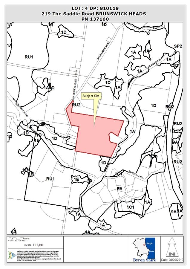
Assessment:
1. INTRODUCTION
1.1. History/Background
The following development applications have previously been
approved on the site:
DA 90/394 – Subdivision of land to create two (2) lots
DA 91/123 – Dwelling house, carport and shed
DA 742/2017 – Alterations and additions to the
existing dwelling, a dual occupancy dwelling and two (2) studios was approved
on the 20th of September 2018.
The subject land includes the long abandoned Borrodales
Quarry which was used by NSW Department of Public Works to supply basalt
boulders for the Brunswick Heads rock walls in a period between 1959 and 1969.
1.2. Description
of the proposed development
This application seeks approval for a mixed use development
including intensive plant agriculture, agriculture structures (wind turbine,
water tank, stockyards, and farm dam), stormwater management system,
agricultural produce industry, wholesale plant nursery, wholesale landscaping
supplies, garden centre, roadside stall, business identification sign and
extractive industry. It was originally lodged in relation to two properties
(219 The Saddle Road and 21 Tandys Lane) but 21 Tandys Lane property has been
withdrawn and no longer forms part of the application.
The development is proposed over two stages with stage 1
being intensive plant agriculture, agriculture structures (wind turbine, water
tank, stockyards, and farm dam), stormwater management system, roadside stall,
business identification sign and extractive industry. Stage 2 is the balance of
the application. The staging defers most of the traffic generating development
to stage 2.
Changes to the DA made over the period of the assessment
include deleting the Tandys Lane activities, deleting one of the two proposed
business identification signs along Gulgan Road, moving the proposed stockyard
ramp along The Saddle Road back onto private property, and deleting the
information and education facility.
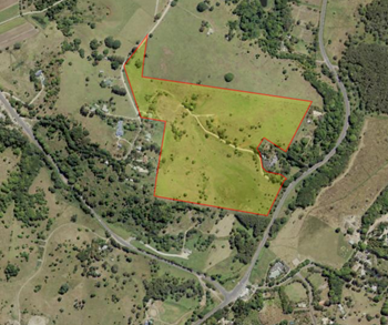
Aerial of 219 Saddle Road, Brunswick Heads
1.3. Description
of the site
|
Land is legally described as
|
LOT: 4 DP: 810118
The site has a 325 metre frontage to The Saddle Road and a
145 metre frontage to Gulgan Road.
|
|
Property address is
|
219 The Saddle Road BRUNSWICK HEADS
|
|
Land is zoned:
|
RU2 Rural Landscape (LEP 2014).
|
|
Land area is:
|
19.32 ha.
|
|
Flood Liable Land
|
219 The Saddle Road is not mapped as flood prone (in blue
below). It has been subject to short term inundation by stormwater at its
lower slopes during high rainfall events before the culverts under Gulgan
Road were cleaned out by the current landowners.
|
|
Bushfire prone land
|
219 The Saddle Road is affected by a bushfire hazard
buffer (in green below) in two locations but does not contain any mapped
bushfire hazard vegetation.
|
|
Acid Sulfate Soils Class 3
|
219 The Saddle Road is mapped as class 3 ASS in the south
east corner (in yellow below). A preliminary ASS assessment has been
undertaken and no ASS was present to a depth of 4 metres.
|
|
High Environmental Value
|
219 The Saddle Road is mapped as containing minimal high
conservation value vegetation (in green below). No vegetation is proposed to be
removed by this development.
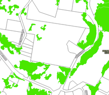
|
|
Property is constrained by:
|
Small areas of remnant native vegetation and access
issues.
|
2. SUMMARY OF
REFERRALS
External referrals were made to DPI Water, RMS, Dept of
Health, Tweed Byron LALC and Crown Lands. Only DPI Water and Crown Lands did
not respond.
|
Referral
|
Issue
|
|
Environmental Health Officer*
|
No concerns in relation to acid sulfate soils or land
contamination.
The wastewater generated from the proposed development is
to be disposed of on-site. It is proposed that a commercial wastewater
management system will be installed at stage 1 and will manage the wastewater
for the proposed development (all stages) and also cater for the existing
dwelling (and approved alterations, 70.2017.1112.2) and the approved dual
occupancy (70.2017.1160.1) hence, the proposal will supersede any previous
approvals for on-site wastewater management for the site.
It is proposed that a centralised commercial Aerated
Wastewater Treatment System will allow for treatment of wastewater from the
dwellings, ancillary buildings of the dwellings and the proposed agricultural
amenities and use of the amenities by stage 2 works. A series of pump wells
will be required to transfer the wastewater to the AWTS as described in the
On-Site Wastewater Feasibility assessment. It is proposed that the treated
wastewater will be pumped to an area that has been previously approved for
disposal, utilising subsurface irrigation. Conditions will be imposed
requiring a revised section 68 approval.
A farm shed is proposed that this will be utilised by the
sharefarmers for the purposes of cleaning, washing, sorting, drying and
packing, and storage of the produce grown on the site. Conditions will be
imposed with respect to registration and compliance with the Food Act and
Food Standards Code.
Conditions will be imposed with respect to the requirement
for a Water Quality Assurance Program to be prepared and implemented for the
proposed Private Water Supply in accordance with the provisions of the Public
Health Act 2010 and Regulation 2012.
|
|
Development Engineer
|
The key engineering issues are parking, stormwater and
site access. The development can be supported subject to conditions that
cover these matters. These are discussed in more detail in other sections.
|
|
Water & Sewer Engineer (Local Approvals Officer)
|
The proposed development does not generate additional
loading onto Council’s Water, Bulk Water and or Sewer systems beyond
the existing ET entitlements.
A section 307 certificate from Rous is required if tanks
are to be filled from the Rous water supply connection to the site.
|
|
S94 / Contributions Officer
|
The applicant has demonstrated that the use of Saddle Road
as the primary access is not safe nor practicable given the width, condition
and intersection connections to the network of Saddle Road (refer page 26 of
the Alderson Traffic Report).
This development does not involve an increase in
population. The s7.11 contribution plan does not apply. The fixed
development levy of the s7.12 plan will apply. A condition of consent
should be imposed to require payment of contributions.
|
|
Roads & Maritime Services
|
RMS advised that works on Gulgan Road require its approval
under section 138 of the Roads Act and expressed its position on the proposed
road treatment and design (see engineering comments).
The submitted Traffic Impact Assessment (TIA) had not
taken into account the cumulative impacts of the proposed development, dual
occupancy and veterinary surgery into consideration or applied a 10 year
horizon. This will need to be taken into account for both stages of the
proposed development. This will need to be demonstrated with AM and PM peak
hour traffic movements at the access.
It was noted the approved dual occupancy and veterinary
surgery has not constructed the required road works on Gulgan Road.
This will require a S138 application and referral to Roads and Maritime for
concurrence. (Council Note Vet Surgery/ Dual Occupancy has commenced driveway
upgrades as per there approvals)
All rural driveways should be designed and constructed in
accordance with Austroads standards to cater for the higher speeds and larger
vehicles. AS2890 is generally only used for urban situations.
The proposed arrangement for the shared access
connections for the three developments will need to be physically defined to
regulate traffic movements. No swept paths were shown to demonstrate
the largest vehicle can negotiate the arrangement. This will need to be
illuminated and delineated to define any obstructions.
The proposed loading of cattle within The Saddle road
reserve should be discouraged or a traffic management plan should be
implemented each time if there is no safer alternative available.
|
|
Tweed Byron Local Aboriginal Land Council
|
TBLALC responded via a site based report to the applicant.
It stated “There are now multiple registered Aboriginal sites
surrounding this location which has long been known for its access routes to
bora grounds, food/tool resource areas, burials, ceremonial and creation
story places as well as gender specific areas. There is very real potential
for future discoveries of tangible cultural material and experiences of the
intangible aspects of the Aboriginal culture of the area. TBLALC CHU advocate
all ground disturbing activity proceed with caution. In regard to Aboriginal
Cultural Heritage, in so far as it relates to the proposal that is the
subject of this report, in TBLALC’s opinion there is nothing at this
stage to halt or delay the project.”
|
|
Dept of Health
|
Dept of Health advised that the applicant needs to comply
with requirements for Private Water Suppliers under Section 34A and 34C of
the Public Health Regulation, 2012.
|
* Conditions provided in the above referral are included
in the Recommendation of this Report below
3. SECTION 4.14
– BUSH FIRE PRONE LAND
The site has minimal areas of native vegetation what is
there is typically isolated rainforest trees. Bushfire is not a significant
issue on this site.
EFFECT OF 10/50 RULE ON SIGNIFICANT VEGETATION
A farm shed
with 5 bays is proposed in a bushfire buffer near Gulgan Road. Two of the
bays are proposed for agriculture processing. These are non habitable
structures.
The intensive plant agriculture is not expected to disturb
any native vegetation and will not trigger vegetation clearing for bushfire
purposes.
4. SECTION 4.15C
– MATTERS FOR CONSIDERATION – DISCUSSION OF ISSUES
Having regard to the matters for consideration detailed in
Section 4.15(1) of the Environmental Planning & Assessment Act 1979
(EP&A Act), the following is a summary of the evaluation of the issues.
4.1 State
Environmental Planning Instruments
|
|
Satisfactory
|
Unsatisfactory
|
|
State
Environmental Planning Policy No 44—Koala Habitat Protection
|
☒
|
☐
|
|
Consideration: A SEPP44 assessment was undertaken and
submitted with the original SEE but was considered inconsistent with the
Policy. A revised assessment (21 Aug 2019) meets the requirements of the
SEPP. The revised report concluded that although 12 koala food
trees were recorded in the development area (near the old quarry) this
constitutes 3.7% of the 322 trees on the land. This means that the area is
not potential koala habitat. As no Koala faecal pellets were identified
around any of the koala food trees present in the development area, the trees
are not ‘areas of major activity’ and hence not being used by
koalas, including breeding animals. It is considered that koalas could access
the koala food trees on a transient basis, however, according to SEPP 44; a
koala plan of management is not required for the proposed development.
No food koala trees are proposed to be removed as part of this development in
any case.
|
|
State
Environmental Planning Policy No 55—Remediation of Land
|
☒
|
☐
|
|
Consideration: A preliminary contamination investigation
was carried out for 219 The Saddle Road in Nov 2017. It found that based on
air photography back to 1958:
• There was no evidence that the investigation was
subject to cropping or plantations;
• There was no evidence that buildings or structures
had ever been constructed in the
investigation area (other than those recent ones that
exist now);
• There was no evidence that any other contaminating
activities had occurred in the
investigation area. It is highly unlikely that the
subject land has been contaminated by past land use. The SEPP has been
addressed adequately.
|
|
State
Environmental Planning Policy No 64—Advertising and Signage
|
☒
|
☐
|
|
Consideration: The key objectives of SEPP 64 are to ensure
signage:
(i) is compatible with the desired amenity and
visual character of an area, and
(ii) provides effective communication in
suitable locations, and
(iii) is of high quality design and finish
In the original application two double sided signs were
proposed. The applicant has advised that 21 Tandys Lane is no longer part of
this application so only the sign at the Gulgan Road frontage to Lot 4 DP
810118 is subject to this application and any approval.
The business identification sign will identify more than
one business and is to be shared by multiple landowners (Vet and Rainbow
Farm) which reduces clutter and confusion given the shared entrance to both
businesses. Road users need warning that the businesses are up ahead so
having a sign for drivers approaching from the south will aid in early
signalling by drivers. The height and size of the signs reflects the location
and directions related purpose. A high quality finish is anticipated.
The application is for double sided signs that inform you
of the business after you have passed it. This is not supported as it
distracts a driver urging them to read a sign on the opposite road side
relating to something that is behind them. A condition will be imposed
requiring a single sided sign. It will be limited in area to 3m2.
The assessment criteria specified in Schedule 1 are addressed
in the DCP section of this report. The proposed sign is substantially
consistent with the assessment criteria, subject to appropriate conditions.
|
|
State Environmental Planning Policy (Infrastructure)
2007
|
☒
|
☐
|
|
|
Consideration: This SEPP is relevant because clause 101
applies to “Development with frontage to a classified road”. The
relevant objective is to “ensure that new development does not
compromise the effective and ongoing operation and function of classified
roads”. Gulgan Road is a classified road, The Saddle Road is not. The
applicant addresses this issue in the Traffic Impact Analysis.
To ensure the continued operation and function of Gulgan
Road the SEPP requires that Council
must not grant consent to development on land that has a
frontage to a classified road unless it is satisfied that:
(a) where
practicable and safe, vehicular access to the land is provided by a road
other than the classified road,
Comment: The key traffic generators in this development
are the roadside stall (stage 1) and garden centre (stage 2). The roadside
stall needs to generate income from passing traffic by being visible and
accessible. This can be achieved from Gulgan Road subject to the driveway
being upgraded to allow safe manoeuvring in and out of the site. The Saddle
Road has low traffic volumes and is a narrow gravel road with a poor
intersection to Mullumbimby Road. If the roadside stall or garden centre were
accessed from Saddle Road this would require traffic to drive through a
working farm which would be dangerous. Agricultural related traffic already
uses the Gulgan Road access as well as The Saddle Road and this has a minimal
impact.
The applicant has demonstrated that the use of Saddle Road
as the primary access is not safe nor practicable given the width, condition
and intersection connections to the network of Saddle Road (refer page 26 of
the Alderson Traffic Report).
It is considered that it is not practicable to use The
Saddle Road to access this development and it is safer to upgrade Gulgan
Road.
(b) the safety, efficiency and ongoing
operation of the classified road will not be adversely affected by the
development as a result of:
(i) the design of the vehicular access to
the land, or
(ii) the emission of smoke or dust from the
development, or
(iii) the nature, volume or frequency of
vehicles using the classified road to gain access to the land,
Comment: Continued use of the Gulgan Road as a BAL/CHR(s)
type intersection is reasonable for stage 1 and agriculture related uses.
However, it is also appropriate that stage 2 uses can only take place after a
CHR(s) and AUL(s) intersection has been created. These measures should
protect the safety, efficiency and ongoing operation of Gulgan Road.
It is not anticipated that this development will emit
smoke or dust that could affect Gulgan Road.
It is not anticipated that nature, volume or frequency of
vehicles using the site will negatively impact on Gulgan Road. Work
undertaken shows that two medium rigid vehicles can access or egress the
proposed development without affecting Gulgan Road.
Council is aware that the subject land and the
neighbouring vet clinic have combined their driveways to lessen the
likelihood of traffic conflict.
This development has been referred to RMS because at the
time it was lodged the proposed parking required was greater than 50 spaces
(clause 104 of the SEPP). This has now been reduced to 45 spaces.
Despite this, the RMS comments have been considered in the engineering assessment
and a number of changes made and/or conditions imposed as a result.
|
4.2A Byron Local
Environmental Plan 2014 (LEP 2014)
LEP 2014 is an applicable
matter for consideration in the assessment of the subject development
application in accordance with subsection 4.15(1) of the EP&A Act because
it applies to the subject land and the proposed development. The LEP 2014
clauses that are checked below are of relevance to the proposed development:
|
Part 1
|
☒1.1|
☒1.1AA| ☒1.2| ☒1.3| ☒1.4| ☒Dictionary| ☒1.5| ☒1.6| ☒1.7| ☒1.8| ☐1.8A| ☒1.9|
☐1.9A
|
|
Part 2
|
☒2.1|
☒2.2 | ☒2.3 |☒Land Use Table | ☐2.4 | ☐2.5 | ☐2.6 | ☐2.7 | ☐2.8
|
|
Part 3
|
☐3.1|
☐3.2| ☐3.3
|
|
Part 4
|
☐4.1|
☐4.1A| ☐4.1AA| ☐4.1B |☐4.1C| ☐4.1D| ☐4.1E| ☐4.2| ☐4.2A| ☐4.2B| ☐4.2C| ☐4.2|☒4.3|☐4.4 |☐4.5 | ☒4.6
|
|
Part 5
|
☐5.1|
☐5.2| ☐5.3| ☐5.4| ☐5.5| ☐5.6| ☐5.7| ☐5.8|☐5.9| ☐ 5.9AA| ☐5.10| ☐5.11| ☐5.12|
☐5.13
|
|
Part 6
|
☒6.1|
☒6.2| ☒6.3| ☐6.4| ☐6.5| ☒6.6| ☐ 6.7| ☐6.8| ☐6.9
|
LEP 2014 clauses 1.1 - 1.9 and 2.1 – 2.3:
The application is consistent with the aims of LEP 2014
(clause 1.2) in particular to promote ecologically sustainable development and
promote the orderly and economic use and development of land. It also addresses
the relevant SEPPs (clause 1.9).
The application addresses zones, zone objectives, and
landuses in the dictionary as follows:
(a) The
proposed development is subject to multiple definitions in the LEP 2014
Dictionary including: intensive plant agriculture, water body –
artificial (farm dam), agricultural produce industry, plant nursery (
wholesale), landscaping material supplies (wholesale) , garden centre, roadside
stall, business identification sign and extractive industry.
agricultural produce industry means a
building or place used for the handling, treating, processing or packing, for
commercial purposes, of produce from agriculture (including dairy products,
seeds, fruit, vegetables or other plant material), and includes wineries, flour
mills, cotton seed oil plants, cotton gins, feed mills, cheese and butter
factories, and juicing or canning plants, but does not include a livestock
processing industry.
Comment: Two of the five farm shed bays at the Gulgan Road
frontage are proposed to be used to prepare produce from the farm for sale.
business identification sign means a sign:
(a) that indicates:
(i) the name of the person or business, and
(ii) the nature of the business carried on by
the person at the premises or place at which the sign is displayed, and
(b) that may include the address of the
premises or place and a logo or other symbol that identifies the business, but
that does not contain any advertising relating to a person who does not carry
on business at the premises or place.
Comment: One business identification sign is now proposed at
the Gulgan Road frontage.
extractive industry means the winning or
removal of extractive materials (otherwise than from a mine) by methods such as
excavating, dredging, tunnelling or quarrying, including the storing,
stockpiling or processing of extractive materials by methods such as recycling,
washing, crushing, sawing or separating, but does not include turf farming.
Comment: Some of the farm land contains rocks that have to
be removed to permit machinery cultivation. These rocks are mostly used around
the farm but excess rocks will be sold either as a wholesale product or
eventually through the landscape supplies proposed in stage 2 of the
development. This will affect less than 2 hectares of the site and produce less
than 30,000 m3 per year of rocks. It will not take place in or
within 40 metres of a natural waterbody, wetland or an environmentally
sensitive area, or within 200 metres of a coastline, or in an area of
contaminated soil or acid sulphate soil, or on land that slopes at more than 18
degrees to the horizontal. It will not involve blasting and is not within 500
metres of the site of another extractive industry that has operated during the
last 5 years.
It is therefore not designated development and an EIS is not
required.
garden centre means a building or place the
principal purpose of which is the retail sale of plants and landscaping and
gardening supplies and equipment. It may include a restaurant or cafe and the
sale of any of the following:
(a) outdoor furniture and furnishings,
barbecues, shading and awnings, pools, spas and associated supplies, and items
associated with the construction and maintenance of outdoor areas,
(b) pets and pet supplies,
(c) fresh produce.
Comment: An open air garden centre primarily for the retail
sale of plants (no permanent structures proposed) covering an area of 2,400 m2
is proposed. It is not proposed to include a restaurant or café. It will
be accessed off Gulgan Road. This is the key facility that is proposed to be
accessible to the public with a retail function.
intensive plant agriculture means any of
the following:
(a) the cultivation of irrigated crops for
commercial purposes (other than irrigated pasture or fodder crops),
(b) horticulture,
(c) turf farming,
(d) viticulture.
Comment: A development application is required for this use
proposed across approximately 8 hectares of the site because the commercial
crops are proposed to be irrigated. Horticulture in this location would
be exempt development as a result of Schedule 2 of LEP 2014.
landscaping material supplies means a
building or place used for the storage and sale of landscaping supplies such as
soil, gravel, potting mix, mulch, sand, railway sleepers, screenings, rock and
the like.
Comment: An area of 3000m2 is identified for the
sale of wholesale landscape supplies. The intention is that only the rocks
collected from the property will be graded and stored in separate bays on the
site. No other material will be imported onto the property for sale. It is not
intended that retail customers can purchase the rocks. They will be sold to
other users in bulk on a sporadic basis. If over time rocks are no longer
uncovered on the farm in cultivated areas then this use will decline.
plant nursery means a building or place the
principal purpose of which is the retail sale of plants that are grown or
propagated on site or on an adjacent site. It may include the on-site sale of
any such plants by wholesale and, if ancillary to the principal purpose for
which the building or place is used, the sale of landscape and gardening
supplies and equipment and the storage of these items.
Comment: An area of 3500m2 is identified for the
sale of plants on a wholesale basis (not less than 20 plants per sale). There
is an argument that a wholesale plant nursery is a form of horticulture and
would in this case be exempt development. It becomes a plant nursery at the
point at which retail sale of plants is proposed. A wholesale plant nursery has
been included in this application not a plant nursery.
roadside stall means a place or temporary
structure used for the retail sale of agricultural produce or hand crafted
goods (or both) produced from the property on which the stall is situated or
from an adjacent property.
Comment: It is proposed to convert an existing garden shed
with carport to a roadside stall for the sale of produce that is grown on the
property. Parking will be supplied adjacent to the stall which will be accessed
off Gulgan Road.
waterbody (artificial) or artificial waterbody
means an artificial body of water, including any constructed waterway, canal,
inlet, bay, channel, dam, pond, lake or artificial wetland, but does not
include a dry detention basin or other stormwater management construction that
is only intended to hold water intermittently.
Comment: A 3ML harvestable rights dam is proposed to
supplement other water sources for the irrigation of crops. It will be located
at the eastern edge of the site, upstream of the low flow discharge to Gulgan
Road drainage system. The dam will be constructed as a ‘turkeys
nest’ dam with outlet spillway being approximately at existing ground
level. The dam will have an approximate surface footprint of 1350m2,
an approximate storage volume (to the spillway at existing ground level) of
2650m3, and a bund wall of 600mm. The dam is ancillary to intensive
plant agriculture (cultivation of irrigated crops).
(b) The
proposed development is located entirely on land within the RU2 Rural Landscape
zone. All of the proposed land uses are permitted with consent in the RU2 zone
either outright or as ancillary to the various agriculture related uses.
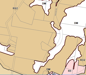
(d) Regard
is had for the Zone Objectives as follows:
|
Zone Objective
|
Consideration
|
|
To encourage sustainable primary industry production by
maintaining and enhancing the natural resource base
|
The proposed development is focussed on using the land for
primary production with an emphasis on irrigated crops. The extractive
industry is small scale and will decline over time as resource is exhausted.
|
|
To maintain the rural landscape character of the
land.
|
The majority of the land will be used for cropping and
grazing consistent with the rural character of the locality
|
|
To provide for a range of compatible land uses, including
extensive agriculture.
|
The non primary production uses are ancillary and related
to the agricultural use of the land and are located near the Gulgan Road
access.
|
Clause 4.3 Height of Buildings
Does not comply. The LEP prescribes a 9 metre building
height limit for land zoned RU2. The only structures proposed that are subject
to this height limit are the water tank stand (enclosed as a shed) which is 4
metres high (or 7 metres including the tank); the agricultural produce industry
shed which is 6.99 metres high ; and the roadside stall shed which is
approximately 3 metres high.
All these buildings comply with the height limit. All the
other uses do not include buildings.
The wind turbine is 12 metres high and although it is not a
building it is a structure and subject to the same height limits as a building.
It exceeds the height limit by 3 metres and a variation to the height
limit is required to approve the wind turbine. The wind turbine was erected
in 2014 as exempt development being 15 metres inside the fence along The Saddle
Road. A recent survey showed that it is only 7 metres inside the property
boundary and therefore should have obtained development consent.
4.6 Exceptions to development standards
Complies. This clause provides that development consent may
be granted for development even though the development would contravene a
development standard imposed by this or any other environmental planning
instrument. The 9 metre height limit imposed by clause 4.3 of LEP 2014 can be
varied subject to this clause. In this case the 12 metre wind turbine exceeds
the 9 metre height limit by 3 metres which is a 33 % variation to the standard.
An adequate written request has been received from the applicant that outlines
:
(a) that
compliance with the development standard is unreasonable or unnecessary in the
circumstances of the case,
Comment: The applicant advises that due to the friction
between the wind and the earth, wind speed increases rapidly as the distance
from the ground increases, especially in the first 20 metres. Typically, the
bottom wind turbine rotor should be at least 10 metres above the tallest
obstruction within 150m or the nearby prevalent tree height (OEH 2011). Hence,
wind turbines need to be on tall towers to work effectively. A wind turbine
limited to 9 metres in height would be unreasonable. A 12 metre wind
turbine will be considerably more efficient at producing energy.
(b) that there are
sufficient environmental planning grounds to justify contravening the
development standard
Comment: The environmental planning grounds that warrant
contravening the height standard in this case include Council’s support
of sustainable development and of development that reduces greenhouse gas
emissions. Pumps are large users of power and linking this water pump to a wind
turbine achieves these environmental outcomes. The absence of significant
external impacts such as overshadowing, loss of privacy, views or solar access
are also environmental planning outcomes that justify a taller structure than 9
metres. The wind turbine has a 1KW capacity and is located 150 metres from the
nearest dwelling to the south west.
(ii) the proposed development will be in
the public interest because it is consistent with the objectives of the
particular standard and the objectives for development within the zone in which
the development is proposed to be carried out,
Comment: The proposed wind turbine is in the public interest
because it is consistent with both the objectives of the RU2 Rural Landscape
zone and the objectives of Clause 4.3 as follows:
|
RU2 Zone Objectives
|
Comment
|
|
To encourage sustainable
primary industry production by maintaining and enhancing the natural resource
base
|
The proposed development is
required for water supply purposes, which supports sustainable primary
industry and production on the property. The ground water bore is licenced.
|
|
To maintain the rural
landscape character of the land
|
Wind turbines attached to
water bores or pumps are a feature of the rural landscape and this is the
modern version. It does not detract from the rural landscape character.
|
|
To provide for a range of
compatible land uses, including extensive agriculture
|
The proposed wind turbine is
ancillary to the agricultural uses on the property, and supports the
continuing agricultural viability of the farm.
|
|
To enable the provision of
tourist accommodation, facilities and other small-scale rural tourism uses
associated with primary production and environmental conservation consistent
with the rural character of the locality
|
Not applicable – no
tourist and visitor accommodation is proposed as part of the development.
|
|
To protect significant
scenic landscapes and to minimise impacts on the scenic quality of the
locality
|
The scenic landscape will not
be impacted by the proposed development as the wind turbine is located in a
corner of the property that is not visually prominent from surrounding
properties, and partially screened by existing vegetation. It is a thinly
profiled structure that is not easily seen from a distance.
|
|
Objectives of Clause 4.3
|
Comment
|
|
To achieve building design that does not exceed a
specified maximum height from its existing ground level to finished roof or
parapet,
|
A wind turbine is a slim structure that does not have a
roof or parapet. This objective is not applicable. Due to the nature
of the windmill, it is necessary to exceed the height limit for the wind mill
to function properly and effectively.
|
|
To ensure the height of buildings complements the
streetscape and character of the area in which buildings are located,
|
The proposed development will complement the existing and
proposed agricultural uses of the land and is compatible with the rural
character of the neighbourhood. The Saddle Road is a grazing and cropping
area with scattered rural dwellings and clusters of remnant vegetation. A
wind turbine is not out of place towards the top of a ridge line in this
situation.
|
|
To minimise visual impact, disruption of views, loss of
privacy and loss of solar access to existing development
|
Whilst being taller than the 9 metre standard, the
windmill structure consists of an unobtrusive thin pole with a 3-blade rotor
on top and is difficult to see when viewed from neighbouring sites and the
public road. The structure does not cause any overshadowing, loss of solar
access, privacy or views to surrounding neighbours and the nearest dwellings
|
In this case the concurrence of the Secretary has been
delegated to Council. In exercising this concurrence Council needs to consider:
(a) whether
contravention of the development standard raises any matter of significance for
State or regional environmental planning,
-
Comment: The wind turbine will not impact on any state
significant agricultural land or contravene any provisions of the North Coast
Regional Plan or other State Environmental Planning Policies.
(b) the public benefit of maintaining the
development standard
Comment: There is no public benefit in enforcing the 9 metre
standard in this case. The wind turbine does not create noise or view impacts
or affect neighbours or the public using The Saddle Road.
Clause 6.1 Acid Sulfate Soils
Complies. The objective of this clause is to ensure that
development does not disturb, expose or drain acid sulfate soils and cause
environmental damage. The land mapped at 219 The Saddle Road has been tested
down to 4 metres depth and does not contain ASS so the farm dam and earthworks
will not cause any issues. The proposed development will not trigger the need
to prepare an ASS management plan.
Clause 6.2 Earthworks
Complies. The earthworks on the site relate to the
stormwater management system and the farm dam. The works will control flows
across the site that arise from the higher land near The Saddle Road and need
to be slowed down so to avoid erosion across the red soils. It will not
have a detrimental effect on drainage patterns and will improve soil stability
in the locality of the development. No fill is to be imported onto the site.
Rocks from the land will be used to slow stormwater down and line drains.
Impacts on neighbours will occur during the construction period from noise and
dust and these will need to be managed. Standard conditions on all these
matters are required.
Clause 6.3 Flood Planning
Complies. The site is not mapped as flood prone land. It has
been subject to short term stormwater inundation in lower areas in the past.
This has been exacerbated by lack of maintenance to culverts under Gulgan Road.
These have now been cleared and drainage improved.
Clause 6.6 Essential Services
Complies. The subject land is rural land with no reticulated
sewerage. The wastewater generated from the proposed development is to be
disposed of on-site. It is proposed that a commercial wastewater
management system will be installed at stage 1 and will manage the wastewater for
the proposed development (all stages) and also cater for the existing dwelling
(and approved alterations, 70.2017.1112.2) and the approved dual occupancy
(70.2017.1160.1) hence, the proposal will supersede any previous approvals for
on-site wastewater management for the site.
It is proposed that a centralised commercial Aerated
Wastewater Treatment System will allow for treatment of wastewater from the
dwellings, ancillary buildings of the dwellings and the proposed agricultural
amenities and use of the amenities by stage 2 works. A series of pump wells
will be required to transfer the wastewater to the AWTS as described in the
On-Site Wastewater Feasibility assessment. It is proposed that the treated
wastewater will be pumped to an area that has been previously approved for
disposal, utilising subsurface irrigation.
A section 68 application is to be required to submitted as
part of the construction certificate.
Water is predominantly sourced from ground water pumped to
the header tank plus tank water on buildings plus surface water in the proposed
farm dam. Potable water is also accessible from the Rous water line that
services the site already.
Electricity is available and reticulated across the site
including in proximity to the proposed garden centre, etc.
A Stormwater Management Plan has been prepared. On site
detention of stormwater has been designed in accordance with Council’s
requirements and over land flow paths identified. Sediment and erosion controls
have been implemented on works to date and are proposed for additional works.
Traffic and Access is complicated with the subject land. The
Gulgan Road access is immediately adjacent to the access for the recently
approved vet clinic and dual occupancy development. Gulgan Road is a busy trunk
road that is funded by RMS (eg it has a role in what can happen along that
road). The neighbour has an approval that requires them to upgrade their
intersection with Gulgan Road to BAL / BAR. It would not be practical to
have an identical intersection to Rainbow Farms upgraded to BAL / BAR as there
would be insufficient spatial separation between the two driveways. .
The applicant has proposed with the support of the vet
clinic to combine and share their access to Gulgan Road as a double size
driveway that splits inside the property. This is safer than two driveways side
by side but now requires any assessment of traffic to accumulate all traffic
from both sites to a single access point. The need to upgrade an intersection
is a function of the amount of traffic to be generated by the property (in this
case two properties with multiples uses) plus the volume and speed (signposted
at 80Km/h) of background traffic on Gulgan Road. The traffic from the Rainbow
Farms proposal triggers the need to further upgrade the intersection beyond
that required of the vet clinic. A condition will be required imposing a CHR
(s) and BAL for stage 1 uses and then CHR (s) and AUL(s) for stage 2
uses. This approach is supported by RMS.
The applicant has moved the proposed stockyard loading ramp
that required access to the Saddle Road and an internal location is now
proposed. This is satisfactory. The access and use of The Saddle Road will
remain as it currently is.
4.3 Any proposed Instrument
that has been the subject of public consultation and has been notified to the
consent authority
No draft environmental Planning Instruments affect this
proposal.
4.4A Byron Shire Development Control Plan 2014
(DCP 2014)
DCP 2014 is an applicable matter for consideration in the
assessment of the subject development application in accordance with subsection
4.15(1) of the EP& A Act because it applies to the land to which LEP 2014
applies. The DCP 2014 Parts/Chapters that are checked below are of relevance to
the proposed development:
|
Part A
|
☒
|
|
Part B Chapters:
|
☐B2|
☒B3| ☒ B4| ☐B5| ☒B6| ☐B7| ☐B8| ☐B9| ☒ B10| ☐B11| ☐B12| ☐B13|☐B14
|
|
Part C Chapters:
|
☐C1|
☐C2| ☐C3| ☐C4
|
|
Part D Chapters
|
☐D1|
☐D2| ☐D3| ☐D4| ☐D5| ☐D6| ☐D7| ☐D8
|
|
Part E Chapters
|
☐
E1| ☐E2| ☐E3| ☐E4| ☐E5| ☐E6| ☐ E7
|
B3 Services
Water, onsite wastewater disposal, stormwater are all
addressed adequately in this application and Council referral officers have
supplied appropriate conditions to address any concerns.
B4 Traffic and Parking
Traffic has been addressed earlier in this report and
conditions of consent are proposed for the driveway intersection driveway.
Parking is addressed as follows: Intensive plant agriculture, agriculture
structures (wind turbine, water tank, stockyards, farm dam), stormwater
management system, business identification sign, and extractive industry do not
generate parking demand on site other than what would normally occur on a
farm.
The remaining uses have some potential to generate demand
for parking for staff and customers as follows:
|
Proposed Land Use
|
Standard from DCP
|
Proposed
|
|
agricultural produce industry
|
no standard specified
|
2
|
|
wholesale plant nursery (no retail sales)
|
1 per staff
|
1
|
|
wholesale landscaping supplies (no retail sales)
|
1 per staff
|
1
|
|
garden centre
|
1 space per 70 m2 and 1 per staff = 36
|
46
|
|
roadside stall
|
2. 5 spaces per stall (based on market )
|
6
|
|
Total
|
41
|
56
|
On this basis the proposed development is compliant with
Council parking requirements.
B6 Buffers and Minimising Land Use Conflicts
The DCP recommends that
horticulture have a 200m buffer to unrelated rural dwellings. The existing
pattern of dwellings and dual occupancies in this area makes this difficult to
achieve on this site without restricting the agricultural uses. This
development is heavily focussed on cropping and agriculture related uses. This
is consistent with the buffer objective “To provide for existing, legitimate agricultural
and associated rural industry uses to take precedence over other rural land
uses within primary production rural zones and where appropriate in other rural
zones.”
The nearest dwellings are the
unbuilt (but approved) dual occupancy dwelling behind the Gulgan Road vet
clinic and the concessional lot dwellings along The Saddle Road. Moving the
proposed farm sheds has come about as a result of one submission. The fact that
Rainbow Farm will be organic will assist with some conflict issues. However, if
conflict occurs related to dust or noise it will need to be resolved between
landowners. Most forms of agriculture can take place without Council consent.
B10 Signage
Key Prescriptive Measures
Consents granted for signage will typically be
conditioned to expire 15 years after the date on which the consent becomes
effective.
Comment: A condition will be imposed limiting this consent
to 15 years.
The display area of business identification signs must
not exceed 1.5m2; and height above ground level must not exceed 2m.
Comment: The proposed sign is 6m2 in area on each
of two faces. They are proposed to be four metres high. The signs represent two
properties ( the vet clinic and Rainbow Farm) and reflect multiple businesses
that operate from these sites. They are intended to be legible to passing
traffic and inform if the business is open or not. Each property is entitled to
a 1.5 m2 sign so it is reasonable that the sign face be limited to
3m2 (effectively a sign face 1.75 m by 1.75 m). However
it is not reasonable that it be double sided (effectively 12 m2 as
submitted). The purpose is to inform oncoming traffic and the
reverse side is seen only by traffic that has passed the businesses and
driveway access already. A condition will be imposed requiring that the sign be
single sided with a face of no more than 3 m2. The reason the
sign is 4 metres in height is because it is to be located approximately 2
metres below the height of the centre of Gulgan Road on private land. The sign
needs to be this height in order to be viewed by passing drivers. This is
acceptable.
Only one business identification sign or one building
identification sign associated with a business or building located on the
land may be erected on a property.
Comment: One sign is proposed reflecting the two properties
that gain access from Gulgan Road at this point. One sign will be located on
Lot 4 DP 810118 owned by Rainbow Farms. A second sign was originally to be
located on 21 Tandys Lane but this has been deleted from the application.
4.5 Any Planning Agreement or
Draft Planning Agreement?
|
|
Yes
|
No
|
|
Is there any applicable planning agreement or draft
planning agreement?
|
☐
|
☒
|
|
|
4.6 Environmental Planning
& Assessment Regulation 2000 Considerations
|
Clause
|
This
control is applicable to the proposal:
|
I
have considered this control as it relates to the proposal:
|
If
this control is applicable, does the proposal comply?
|
|
92
|
N/A
|
|
|
|
93
|
N/A
|
|
|
|
94
|
N/A
|
|
|
|
94A
|
N/A
|
|
|
* Non-compliances and any other significant issues discussed
below
4.7 Any COASTAL ZONE MANAGEMENT
PLAN?
|
|
Satisfactory
|
Unsatisfactory
|
Not applicable
|
|
Is there any applicable coastal zone management plan?
|
☐
|
☐
|
☒
|
|
|
4.8 The likely impacts of that
development, including environmental impacts on both the natural and built
environments, and social and economic impacts in the locality
|
Impact on:
|
Likely significant impact/s?
|
|
Natural environment
|
No. The proposal will not have a significantly adverse
impact on the natural environment of the locality. The land is an
agricultural holding with limited natural features or values.
|
|
Built environment
|
No. The proposal will not have a significant adverse
impact on the built environment of the locality. The area is generally rural
and the activities in this development are related to the rural use of this
site.
|
|
Social Environment
|
No. The proposal will not have a significant social impact
on the locality. The applicant has worked closely with the immediate
neighbour to come to an arrangement on a shared access and modified the
layout of the development in response to a neighbour’s submission.
|
|
Economic impact
|
No. The proposal will not have a significant economic
impact on the locality. The development is intended to provide income streams
to the rural property that should assist in keeping it viable.
|
Standard conditions of consent are proposed to control
construction activities, hours of work, builders waste and the like.
4.9 The suitability of the site
for the development
The site is well suited to irrigated agriculture and small
crops. The farm related structures and infrastructure is also appropriate. The
traffic generating uses proposed in stage 2 are generally related to the
agricultural use of the site and are appropriate subject to upgrading the
access to Gulgan Road.
The extractive industry is small and based on the rocks
being picked up from fields rather than a traditional hard rock or sand quarry.
There will be no blasting, drilling, crushing or cleaning of rocks. Sales will
be limited to Stage 2 of the development and only wholesale sales through the
wholesale landscape supplies business. A limit of 1,000 tonnes per year of rock
sales is commensurate with the size of the extraction area. This will limit the
truck movements generated by the site. Eventually it will simply run out of
rocks.
4.10 Submissions made in accordance with
this Act or the regulations
The development application was publicly exhibited from 18
April to 8 May 2019.
There were 4 submissions made on the development application
including two that oppose the proposal on a number of grounds as follows:
Placement of the northern business identification sign on
Gulgan Road – One landowner is concerned that the northern most sign will
be placed opposite a private driveway and lead to accidental entry of the wrong
site. It is agreed that this sign needs to be placed to the south of the
alignment of the private driveway. It also needs to avoid impact on the
directional sign advising motorists of the Mullumbimby turnoff. This sign has
now been deleted from the application and will not be approved.
Placement of the farm shed and proposed agricultural produce
industry shed - One landowner expressed concern that the dual purpose shed
would impact on the amenity of the approved dual occupancy dwelling on their
land. The applicant also received this submission and responded with a revised
location for the farm shed and proposed agricultural produce industry shed. It
is now proposed to be located 15 metres setback from Gulgan Road near the
proposed roadside stall. Although this is inside the normal setback for
structures from Gulgan Road (55 metres in DCP 2014) the location is suitable
for the uses and alleviates the amenity impacts on the neighbours. The revised
plan addresses the issue and no further action is required.
Flooding and the proposed farm dam – Appendix L of the
SEE provides some information about the proposed farm dam. The site is not
identified as flood prone on Council mapping. Additional information has
addressed the design, location and spillway for the proposed dam. It is
unlikely to significantly affect water flows on adjacent land.
Hazard presented by the old quarry – The DA does not
propose landuses in proximity to the disused quarry. The applicant has used the
quarry floor for storage of farm related items but this does not require
consent. There is no reason to expect the public will proceed beyond the garden
centre and signs can be imposed on any approval to require them not to.
Inadequate traffic assessment – Appendix I of the SEE
provides some information about the traffic impacts of the development and more
information has been requested. Conditions will be imposed on any approval to
ensure traffic matters are addressed.
Garden centre without a building is unlikely – It is
agreed that a full garden centre can’t function without some buildings or
structures to keep valuable items secure and out of the weather. It is possible
to start with outdoor components such as plants and pots etc under shade
structures. Conditions will be imposed that limit the approval to that
requested. Any buildings (if required) will require additional approvals.
Inadequate justification for unlawfully erected farm
structures – The circumstances by which the structures were erected
relates to a misunderstanding of property boundaries. The location of the
structures can now only be assessed on merit and will only be approved where
circumstances warrant approval. No applicant should assume that existing structures
are always approved. In this case the applicant has varied the location of the
proposed stockyard loading ramp to enable its approval.
DA is not compliant with cl 6.8 of BLEP 2014 – The
applicant has withdrawn the information and education facility component and cl
6.8 is no longer applicable. If the applicant holds field days or hosts
seminars related to the agriculture taking place on the site this will need to
be ancillary to the lawful use of the site.
4.11 Public interest
The proposed development is unlikely to prejudice or
compromise the public interest or create a dangerous precedent. It is
predominantly for agriculture and in due course to provide for sale of produce
and items grown or obtained from the site. Plus the sale of rocks that are
otherwise not required on the site. These can be supplied to the wholesale
landscape market legally.
5. DEVELOPER
CONTRIBUTIONS
5.1 Water & Sewer Levies
No Section 64 levies will be required.
5.2 Section 7.11 Contributions
No Section 7.11 Contributions
will be required.
However, prior to the issue of a
construction certificate the section 7.12 levy required by the Byron Developer
Contributions Plan 2012 must be paid to Council.
6. DISCLOSURE OF
POLITICAL DONATIONS AND GIFTS
|
Has a Disclosure Statement been received in relation
to this application
|
No
|
|
Have staff received a ‘gift’ from anyone
involved in this application that needs to be disclosed. Where the answer is
yes, the application is to be determined by the Director or Manager of the
Planning, Development and Environment Division.
|
No
|
7. CONCLUSION
Council recognises the role of agriculture in the economy of
the Byron Shire community. Council supports uses that are compatible both with
the site and neighbouring land uses and have adequate infrastructure.
This consent does not include approval for an information and education
facility or an approval for a food and drink premises of any type.
Staging of the development is linked to construction of suitable access from
Gulgan Road initially (stage 1) and then again before the major traffic generating
uses in stage 2 can commence.
This development meets the Council’s requirements.
Conditional approval is appropriate.
8. REASONS
FOR DECISION, HOW COMMUNITY VIEWS WERE ADDRESSED
Note:
From July 1 2018, Council’s are required to give and publicly notify
reasons for a range of planning decisions where they are deciding if
development should proceed to help community members to see how their views
have been taken into account and improve accountability to stakeholders. A
statement of reasons for the determination of this application is provided
below.
|
Statement of Reasons
|
|
The proposed development complies with the provisions of
Byron Local Environmental Plan 2014.
|
|
The proposed development complies with relevant State
Environmental Planning Policies
|
|
The proposed development complies with relevant provisions
of Development Control Plan 2014
|
|
The proposed development will not have significant adverse
impact on the natural, built or social environment or economic impacts on the
locality.
|
|
The proposed development is considered suitable for the
proposed site.
|
|
The proposed development is unlikely to prejudice or
compromise the public interest.
|
|
How community views were addressed
|
|
The DA was advertised in accordance with Development
Control Plan 2014. The submissions received were considered on merit and
addressed during assessment of the application.
|
Staff Reports - Sustainable Environment and Economy 13.8
Report No. 13.8 PLANNING
- Development Application 10.2019.468.1 Alterations and Additions to Existing
Dwelling House at 860 The Pocket Road The Pocket
Directorate: Sustainable
Environment and Economy
Report
Author: Ivan
Holland, Planner
Shannon Burt, Director Sustainable
Environment and Economy
File No: I2019/1519
Proposal:
|
DA No:
|
10.2019.468.1
|
|
Proposal description:
|
Alterations and Additions to Existing Dwelling House
|
|
Property description:
|
LOT: 2 DP: 606791
|
|
860 The Pocket Road THE POCKET
|
|
Parcel No/s:
|
132010
|
|
Applicant:
|
Mr M Lyon
|
|
Owner:
|
Ms A McQueen & Mr Y Lev
|
|
Zoning:
|
RU2 Rural Landscape / PART 1(a) General Rural
|
|
Date received:
|
11 September 2019
|
|
Integrated / Designated Development:
|
☐
Integrated
|
☐
Designated
|
☒
Not applicable
|
|
Concurrence required
|
No
|
|
Public notification or exhibition:
|
- Level
0 advertising under DCP 2014 Part A14 – Public Notification and
Exhibition of Development Applications
- Exhibition
period: Not applicable
|
|
Planning Review Committee:
|
Not applicable
|
|
Variation request
|
☐
Clause 4.6
|
☐
SEPP 1
|
☒
Not applicable
|
|
Delegation to determine
|
Council
|
|
Issues:
|
No issues identified
|
This development application has been assessed and is
reported to Council in accordance with Council’s Management of Conflicts
of Interest for Development Matters.
Summary:
Development consent is sought for Alterations and Additions
to an Existing Dwelling House comprising an upper level extension of two
bedrooms, an ensuite, toilet and an area of decking.
The site is part of a small Multiple Occupancy consisting of
three dwellings and is located within the hinterland known as The Pocket. The
application appropriately addresses the relevant constraints applying to the
site with bushfire being the only matter. The application raises no planning
issues and is recommended for approval subject to conditions.
NOTE TO COUNCILLORS:
In accordance with the
provisions of S375A of the Local Government Act 1993, a Division is to be
called whenever a motion for a planning decision is put to the meeting, for the
purpose of recording voting on planning matters. Pursuant to clause 2(a)
under the heading Matters to be Included in Minutes of Council Meetings of
Council's adopted Code of Meeting Practice (as amended) a Division will be
deemed to have been called by the mover and seconder of all motions relating to
this report.
|
RECOMMENDATION:
That pursuant to Section 4.16 of the
Environmental Planning & Assessment Act 1979, Development Application No.
10.2019.468.1 for Alterations and Additions to Existing Dwelling House, be
granted consent subject to the conditions of approval in Attachment 3
(#E2019/71995).
|
Attachments:
1 Proposed
floor plans and elevations, E2019/67122
2 Site plan,
E2019/67120
3 Recommended
conditions of approval, E2019/71995
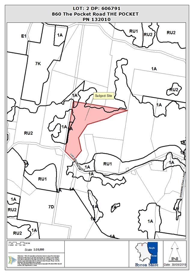
1. INTRODUCTION
1.1. History/Background
Council’s records indicate the following development
approval history for the property:
|
DA number
|
Description
|
Determination date
|
Determination
|
|
5.1992.19.1
|
Multiple Occupancy
|
17/03/1992
|
Withdrawn
|
|
5.1992.187.1
|
Dwelling- rural
|
10/07/1992
|
Approved Delegation
|
|
5.1992.187.2
|
S96 Modification to DA
5.1992.187.1 (Dwelling and detached studio
|
17/03/2006
|
Approved
|
|
5.1993.164. 1
|
Multiple Occupancy
|
21/10/1993
|
Approved Delegation
|
|
10.2004.91.1
|
Change of use of studio and
workshop to laundry, storage and workshop
|
17/03/2006
|
Refused
|
|
10.2008.358.1
|
Multiple occupancy
conversion to community title subdivision to
|
23/08/2008
|
Approved
|
1.2. Description
of the proposed development
This application seeks approval for Alterations and
Additions to Existing Dwelling House being an addition/extension of the
first/upper floor to add two bedrooms, an ensuite, toilet and area of decking. Note:
The proposal also appears to include some alterations to the windows/doors on
both floors.
1.3. Description
of the site
|
Land is legally described as
|
LOT: 2 DP: 606791
|
|
Property address is
|
860 The Pocket Road THE POCKET
|
|
Land is zoned:
|
RU2 Rural Landscape / PART 1(a) General Rural
|
|
Land area is:
|
14.6 ha
|
|
Property is constrained by:
|
· Bushfire prone
land (category 1 and buffer)
· High
Environmental Value vegetation (subtropical rainforest and north coast wet
sclerophyll)
· BDAR Mapping - A
small area in the southwest corner of the property is mapped as having
biodiversity values. The proposed development is >350m from this area.
|
A site inspection was carried out on 30 September 2019
2. SUMMARY OF
REFERRALS
There were no referrals for this application; however a
separate application will be submitted to upgrade the existing onsite sewage
management system under S68 of the Local Government Act 1993. It is recommended
this approval be obtained prior to the issue of the construction certificate.
3. SECTION 4.14
– BUSH FIRE PRONE LAND
Under section 4.14 of the Act, Council must be satisfied
prior to making a determination for development on bush fire prone land that
the development complies with the document Planning for Bush Fire Protection
2006. The site is bush fire prone land. Using the procedure provided on the NSW
Rural Fire Service webpage titled ‘Site Assessment Methodology’,
the asset protection zone and bush fire attack levels for this proposed
development (which is in fire weather area FDI 80) are as follows:
|
Direction
|
North and east
|
|
Vegetation formation
|
Forest
|
|
Distance between vegetation formation and building
(Actual bush fire risk vegetation was further from the
subject dwelling than mapped risk vegetation on Council’s GIS system
– see photos)
|
North ~ 50m, East ~50m
|
|
Effective slope
|
Upslope/flat
|
|
Asset Protection Zone (APZ)
|
20m
|
|
Bushfire Attack Level (BAL)
BAL– 12.5 to the north and east facade, no
requirement for other façades.
|
A condition has been included in the recommendation of this report
that requires the building construction level to be BAL 12.5 and an APZ of 20m
to the north and east.
|
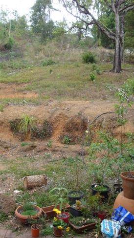
Photo 1 – View east from dwelling showing largely
cleared slope for over 50m.
|
Photo 2 – View north from dwelling showing largely
cleared slope to gully for over 50m.
|
4. SECTION 4.15C
– MATTERS FOR CONSIDERATION – DISCUSSION OF ISSUES
Having regard to the matters for consideration detailed in
Section 4.15(1) of the Environmental Planning & Assessment Act 1979
(EP&A Act), the following is a summary of the evaluation of the issues.
4.1 State Environmental
Planning Instruments
|
|
Satisfactory
|
Unsatisfactory
|
|
State
Environmental Planning Policy No 44—Koala Habitat Protection
|
☒
|
☐
|
|
Consideration: The property is greater than 1 ha and as
such this SEPP is applicable (cl.6). Council’s GIS system shows
koala potential habitat immediately to the west of the subject dwelling (cl.7).
The areas mapped as potential koala habitat are not also identified as
‘core habitat’ (cl.8). Further, the proposed development is
relatively minor and is not expected to impact on koala habitat. It is
considered that a KPOM is not required in this instance.
|
|
State
Environmental Planning Policy No 55—Remediation of Land
|
☒
|
☐
|
|
Consideration: The property appears in a search of
Council’s contamination records relating to potential pesticide
contamination associated with historical use of the land as a banana farm.
A Preliminary Contaminated Land Assessment was carried out
by Greg Alderson and Associates dated 26/8/03 which was assessed as part of
the community title subdivision application (DA10.2008.358.1) which was
approved. Based on this and previous residential development approvals
for the property, the site is considered suitable for the proposed
development and it is considered the proposal satisfies the relevant
requirements of this policy.
|
|
State
Environmental Planning Policy (Building Sustainability Index: BASIX) 2004
|
☒
|
☐
|
|
Consideration: The proposal is BASIX affected development
and a BASIX certificate has been provided with the DA.
|
|
State
Environmental Planning Policy (Infrastructure) 2007
|
☒
|
☐
|
|
Consideration: Councils GIS shows a pole and electricity
substation ~ 27m from the subject dwelling. This is adequate separation
to not trigger Essential Energy notification requirements (c.45).
|
|
State Environmental Planning
Policy (Primary Production and Rural Development) 2019
|
☒
|
☐
|
|
Consideration: The proposed development is relatively
minor and does not appear to be contrary to any of the relevant aims of this
policy (c.3) and is not expected to impact on neighbouring land uses
(Schedule 4, Part 2).
|
4.2A Byron Local Environmental Plan 2014 (LEP 2014)
LEP 2014 is an applicable matter for consideration in the
assessment of the subject development application in accordance with subsection
4.15(1) of the EP&A Act because it applies to the subject land and the
proposed development. The LEP 2014 clauses that are checked below are of
relevance to the proposed development:
|
Part 1
|
☒1.1|
☒1.1AA| ☒1.2| ☒1.3| ☒1.4| ☒Dictionary| ☒1.5| ☒1.6| ☒1.7| ☒1.8| ☐1.8A| ☒1.9|
☐1.9A
|
|
Part 2
|
☒2.1|
☒2.2 | ☒2.3 |☒Land Use Table | ☐2.4 | ☐2.5 | ☐2.6 | ☐2.7 | ☐2.8
|
|
Part 3
|
☐3.1|
☐3.2| ☐3.3
|
|
Part 4
|
☐4.1|
☐4.1A| ☐4.1AA| ☐4.1B |☐4.1C| ☐4.1D| ☐4.1E| ☐4.2| ☐4.2A| ☐4.2B| ☐4.2C| ☐4.2|☒4.3|☐4.4 |☐4.5 | ☐4.6
|
|
Part 5
|
☐5.1|
☐5.2| ☐5.3| ☐5.4| ☐5.5| ☐5.6| ☐5.7| ☐5.8|☐5.9| ☐ 5.9AA| ☐5.10| ☐5.11| ☐5.12|
☐5.13
|
|
Part 6
|
☐6.1|
☐6.2| ☐6.3| ☐6.4| ☐6.5| ☒6.6| ☐ 6.7| ☐6.8| ☐6.9
|
In accordance with LEP 2014 clauses 1.4 and 2.1 – 2.3:
(a) The
proposed development is defined in the LEP 2014 Dictionary as Dwelling;
(b) The
land is within the RU2 Rural Landscape / PART 1(a) General Rural zones
according to the Land Zoning Map however the subject dwelling is wholly
within RU2 zoned land;
(c) The
proposed development is ; and
(d) Regard
is had for the Zone Objectives as follows:
|
Zone Objective
|
Consideration
|
|
• To encourage sustainable primary industry
production by maintaining and enhancing the natural resource base.
• To maintain the rural landscape character of the
land.
• To provide for a range of compatible land uses, including
extensive agriculture.
• To enable the provision of tourist accommodation,
facilities and other small-scale rural tourism uses associated with primary
production and environmental conservation consistent with the rural character
of the locality.
• To protect significant scenic landscapes and to
minimise impacts on the scenic quality of the locality.
|
The proposal will not encourage or hinder primary industry
or impact on available land uses.
The proposed building alterations are relatively minor and
will have a minimal impact on the rural landscape and/or scenic quality of
the locality.
|
Clause 4.3 Height of Buildings
The building (including the proposed alterations) is under
the 9m height limit (clause 4.3).
Clause 6.2 Earthworks
The application states that the “proposed works
require minimal earthworks… ”. Provided the necessary
earthworks comply with relevant development standards for exempt development
(e.g., c2.29, 2.30 of State Environmental Planning Policy (Exempt and Complying
Development Codes) 2008), consent will not be required for the earthworks
(clause 6.2).
The applicant confirmed on 26 September 2019 that
development consent is not required for proposed excavation and/or retaining
walls associated with the proposal (clause 6.2).
Clause 6.6 Essential Services
The application states that the dwelling has water supply,
wastewater and stormwater management, vehicular access, electricity and
communication services (clause 6.6). Regarding wastewater management, a
condition has been recommended requiring an approval under Section 68 of the
Local Government Act 1993 for on-site effluent disposal to be obtained from
Council prior to issue of a Construction Certificate.
The proposal raises no other issues under the LEP.
4.3 Any
proposed Instrument that has been the subject of public consultation and has
been notified to the consent authority
No proposed instruments were
identified that are applicable to this application.
4.4A Byron Shire Development Control Plan 2014
(DCP 2014)
DCP 2014 is an applicable matter for consideration in the
assessment of the subject development application in accordance with subsection
4.15(1) of the EP& A Act because it applies to the land to which LEP 2014
applies. The DCP 2014 Parts/Chapters that are checked below are of relevance to
the proposed development:
|
Part A
|
☒
|
|
Part B Chapters:
|
☒
B2| ☒ B3| ☒ B4| ☐B5| ☐B6| ☐B7| ☒ B8| ☐B9| ☐B10| ☐B11| ☐B12| ☐B13|
☐
B14
|
|
Part C Chapters:
|
☐C1|
☐C2| ☐C3| ☐C4
|
|
Part D Chapters
|
☐D1|
☒ D2| ☐D3| ☐D4| ☐D5| ☐D6| ☐D7| ☐D8
|
|
Part E Chapters
|
☐
E1| ☐E2| ☐E3| ☐E4| ☐E5| ☐E6| ☐ E7
|
B2 – Preservation of Trees and Other Vegetation
The application does not include a request to remove native
vegetation. A condition has been recommended to this effect.
B3 – Services
A current dwelling is approved (DA 5.1992.187.2) and at the
time determined that adequate services were available. An upgrade to the
on-site wastewater system will be required and a condition has been recommended
to this effect.
B4 – Traffic Planning, Vehicle Parking, Circulation
and Access
The proposed alterations are expected to have a negligible
impact on traffic. Access arrangements are addressed above under the LEP
(B4.2.3). The site inspection confirmed that there is ample space is
available for the required two car parking spaces for the dwelling (B4.2.5,
B4.2.12).
D2 - Residential Accommodation and Ancillary Development
in Rural Zones
The proposed alterations and additions will not result in a
dwelling house that is contrary to the general provisions (D2.2) or specific
requirements for dwelling houses (D2.3).
The proposal raises no other issues under the DCP
4.5 Any Planning Agreement or
Draft Planning Agreement?
|
|
Yes
|
No
|
|
Is there any applicable planning agreement or draft
planning agreement?
|
☐
|
☒
|
4.6 Environmental Planning
& Assessment Regulation 2000 Considerations
|
Clause
|
This
control is applicable to the proposal:
|
I
have considered this control as it relates to the proposal:
|
If
this control is applicable, does the proposal comply?
|
|
92
|
No
|
N/A
|
N/A
|
|
93
|
No
|
N/A
|
N/A
|
|
94
|
Yes
|
The dwelling was approved in 1992 and fire mitigation
measures are likely to be inadequate compared to current standards.
|
It would “…be appropriate to require the
existing building to be brought into total or partial conformity with the
Building Code of Australia.” Standard condition recommended.
|
|
94A
|
No
|
N/A
|
N/A
|
4.7 Any Coastal Zone Management
Plan?
|
|
Satisfactory
|
Unsatisfactory
|
Not applicable
|
|
Is there any applicable coastal zone management plan?
|
☐
|
☐
|
☒
|
4.8 The likely impacts of that
development, including environmental impacts on both the natural and built
environments, and social and economic impacts in the locality
|
Impact on:
|
Likely significant impact/s?
|
|
Natural environment
|
No. The proposal will not have a significantly adverse
impact on the natural environment of the locality.
|
|
Built environment
|
No. The proposal will not have a significantly adverse
impact on the built environment of the locality.
|
|
Social Environment
|
No. The proposal will not have a significant social impact
on the locality.
|
|
Economic impact
|
No. The proposal will not have a significant economic
impact on the locality.
|
Standard conditions of consent apply in relation to hours of
work, construction noise, builders waste and sedimentation and erosion control
measures.
4.9 The suitability of the site
for the development
The site is a serviced, unconstrained property and is
suitable for the proposed development.
4.10 Submissions made in accordance with
this Act or the regulations
No submissions were received.
4.11 Public interest
The proposed development is unlikely to prejudice or
compromise the public interest or create an undesirable precedent.
5. DEVELOPER
CONTRIBUTIONS
There is no nexus to levy contributions or headworks
charges.
6. . DISCLOSURE
OF POLITICAL DONATIONS AND GIFTS
|
Has a Disclosure Statement been received in relation
to this application
|
No
|
|
Have staff received a ‘gift’ from anyone
involved in this application that needs to be disclosed. Where the answer is
yes, the application is to be determined by the Director or Manager of the
Planning, Development and Environment Division.
|
No
|
7. CONCLUSION
The DA proposes Alterations
and Additions to Existing Dwelling House. The proposed development is
satisfactory having regard to the relevant environmental planning instruments
and planning controls applicable to the site. The proposal raises no significant
issues in terms of environmental impacts which cannot be managed and the site
is considered suitable for the development. The application appropriately
addresses the relevant constraints applying to the site, and is recommended for
approval subject to the conditions listed in Attachment 3 (E2019/71995).
8. REASONS
FOR DECISION, HOW COMMUNITY VIEWS WERE ADDRESSED
Note:
From July 1 2018, Council’s are required to give and publicly notify
reasons for a range of planning decisions where they are deciding if development
should proceed to help community members to see how their views have been taken
into account and improve accountability to stakeholders. A statement of reasons
for the determination of this application is provided below.
|
Statement of Reasons
|
|
The proposed development complies with the provisions of
Byron Local Environmental Plan 2014.
|
|
The proposed development complies with relevant State
Environmental Planning Policies
|
|
The proposed development complies with relevant provisions
of Development Control Plan 2014
|
|
The proposed development complies with Environmental
Planning & Assessment Regulation 2000 considerations.
|
|
The proposed development will not have significant adverse
impact on the natural, built or social environment or economic impacts on the
locality.
|
|
The proposed development is considered suitable for the
proposed site.
|
|
The proposed development is unlikely to prejudice or
compromise the public interest.
|
|
How community views were addressed
|
|
The DA did not require advertising or notification as per
Development Control Plan 2014.
|
Staff Reports - Sustainable Environment and Economy 13.9
Report No. 13.9 Biodiversity
Conservation Strategy Vision and Aims
Directorate: Sustainable
Environment and Economy
Report
Author: Lizabeth
Caddick, Biodiverity Officer
File No: I2019/1520
Summary:
Council is revising its 2004-2014 Biodiversity Conservation
Strategy. This report provides a summary of progress to date, and presents the
outcomes from a recent Strategic Planning Workshop with Councillors to craft a
vision for the Strategy.
Following the Strategic Planning Workshop, four draft
visions were presented to Councillors. In view of the comments received on
those drafts, a revised vision is presented here.
Staff are now seeking adoption of this draft vision, and the
strategy aims, in order to finalise a draft Biodiversity Conservation Strategy
by the end of the year.
|
RECOMMENDATION:
1. That
Council adopts the following vision for the revised Biodiversity
Conservation Strategy:
Biodiversity in Byron Shire
is valued, protected and enhanced, through inspiring leadership, community
engagement, urgent action and innovation.
2. That
Council adopts the four Biodiversity Conservation Strategy Aims:
· Lead
– A Council that provides clear direction, guidance and resources to
conserve and enhance our biodiversity.
· Educate
– A community that is well informed about biodiversity and what they
can do to protect it.
· Support
– Land managers that are well supported to maximise biodiversity
conservation across the landscape.
· Manage
– Best-practice land management is used to improve ecological
resilience, reduce threats to biodiversity and protect cultural values.
|
Attachments:
1 Report
17/06/2019 Biodiversity Advisory Committee Update on the review of the
Biodiversity Conservation Strategy, I2019/844

2 Report
11/02/2019 Biodiversity Advisory Committee Biodiversity Conservation Strategy
Consultation, I2019/6
REPORT
Background
Council’s Biodiversity Conservation Strategy (BCS) is
a key document for guiding planning, decision-making and activities that impact
on our environment and community. It will
shape future planning and growth, and provide a framework for navigating future
environmental challenges and opportunities. It will be based on a 10 year
timeframe (2020 – 2030) and will be an overarching reference document,
informing a number of other Council strategies, master plans and initiatives.
It must direct Council, as well as providing best practice leadership to other
stakeholders involved in biodiversity conservation, including the community,
landholders, government agencies and neighbouring local governments.
Council is reviewing its
2004-2014 Biodiversity Conservation Strategy (BCS) in line with five key
objectives (Council resolution 14-334, 7 August 2014):
1. To
ensure the Strategy is in accordance with recent local, regional and national
plans, strategies and policies
2. To
ensure the Strategy is in accordance with legislative changes completed since
2004
3. To
ensure the Strategy is reflective of current research and best practise in
biodiversity conservation and management
4. To
review vegetation mapping to reflect changes in vegetation extent and
composition over time, and improve accuracy of line work
5. To
identify new actions to be included to direct future work priorities following
consultation and input from stakeholders and the community.
Key Issues and Progress to Date
As reported to the Biodiversity Advisory Committee on 17
June 2019, the timeline for the BCS review has been delayed, primarily due to
the 3-year timeframe required to complete shire-wide vegetation mapping, which
included extensive ground truthing, three rounds of public exhibition, plus
subsequent changes required by the Office of Environment and Heritage (OEH) to
re-map all high conservation value (HCV) vegetation as high environmental value
(HEV), using new criteria. In 2015 major changes to NSW biodiversity and other
related legislation commenced, causing significant challenges and further
delaying delivery of the review.
Whilst the review was stalled by legislative and staff
changes, other works programs and biodiversity projects have continued in line
with the key objectives of the BCS review. Achievements include:
· Byron Shire
Flying-fox Camp Management Plan (2018-2023)
· Pest Animal Management
Plan (2018-2023)
· Integrated Pest
Management (IPM) Policy (2018)
· Integrated Pest
Management Strategy (2019-2029)
· Byron Coast
Comprehensive Koala Plan of Management (2016)
· SOS Iconic Koala
community engagement and koala threat abatement project (2017-2019)
· Byron Habitat
Corridors habitat creation project (2017-2020)
· Initiation of
Flying Improvements flying fox habitat restoration project (2018-2021)
During 2018-19, consultants Ecosure were engaged to assist
with the BCS review. Ecosure have been working with Council staff to collate
information, engage stakeholders and draft the strategy. Elements of the review
completed to date include:
· Farmers workshop
(Huonbrook, Oct. 2018)
· Community and
interest groups workshop (Mullumbimby, Dec 2018)
· Online community
survey - BSC website (December 2018 – April 2019)
· Stakeholder
meetings with
o Aboriginal landholders, LALCs
and community groups (Jan – Feb 2019)
o Public Land Managers - NPWS,
Marine Parks, Crown Lands (Feb 2019)
o BSC Council Staff, Managers
and Directors (Feb 2019)
· Report to
Biodiversity Advisory Committee (11 Feb 2019) – Stakeholder consultation
with the Biodiversity Advisory Committee.
· Report to
Biodiversity Advisory Committee (June 2019) – Progress update.
· Review of 2004
Biodiversity Strategy Actions (June 2019).
Council staff are now collating this information,
in order to finalise a draft 2020-2030 Biodiversity Conservation Strategy for
Byron Shire.
Vision Statement and Options
A workshop with Byron Shire Councillors was held on 5
September 2019 to draft a vision statement for the Byron Conservation Strategy.
The Strategy vision is a further step towards finalisation of the strategy and
will help guide prioritisation of Strategy actions.
During this workshop, Ecosure presented Councillors with the
draft strategy aims and a summary of key issues and trends arising from
stakeholder consultation, in order that the vision could be guided by community
input. From this workshop, four draft Vision Statement options were developed
by Ecosure based on key words and phrases sourced from the session, and
Councillors were invited to provide feedback on these options by 18 September
2019. The four draft visions proposed by Ecosure were:
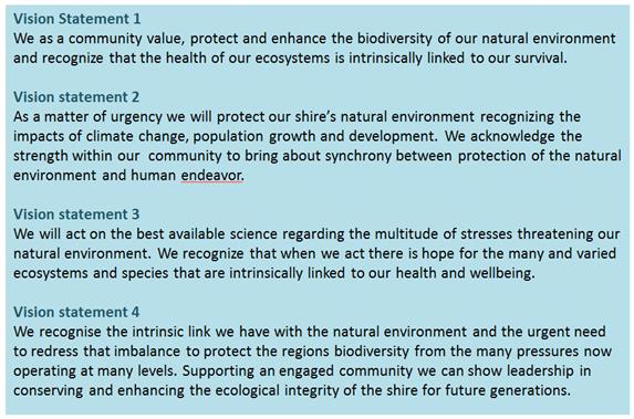
Responses were received from two
Councillors. One respondent supported either of the following:
Vision
Statement 1
We
as a community value, protect and enhance the biodiversity of our natural
environment and recognize that the health of our ecosystems is intrinsically
linked to our survival.
Vision
statement 4
We
recognise the intrinsic link we have with the natural environment and the
urgent need to redress that imbalance to protect the regions biodiversity from
the many pressures now operating at many levels. Supporting an engaged
community we can show leadership in conserving and enhancing the ecological
integrity of the shire.
The second respondent noted
that: ‘Ideally, if a Vision Statement is
the articulation of a desired end state, it should be one sentence.’ This
aligns with the sentiment during the workshop that the vision should be short
and sharp. The same Councillor also pointed out that some of the words within
all the proposed visions could be considered to be Aims. The text box below is
included to clarify the distinction between vision, aims, objectives and
actions in a strategy.
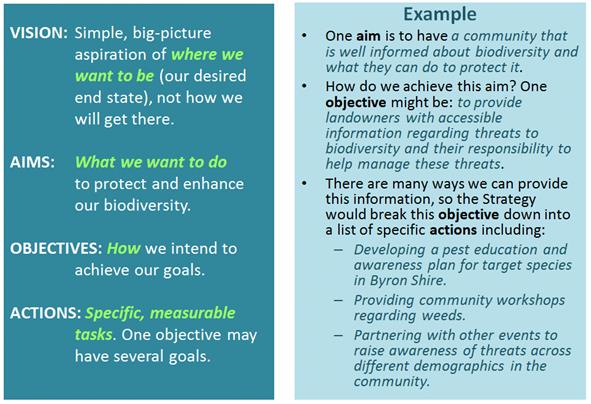
Given the responses received
above, and the points made that the vision:
· should articulate
a desired end state,
· should only be one
sentence long and
· should not include
aims,
a revised draft vision is
proposed below:
Biodiversity in Byron Shire is valued, protected and
enhanced, through inspiring leadership, community engagement, urgent action and
innovation.
This vision is short, because it
simply describes our desired end state. The Aims that
underpin the Vision address this end state in greater detail, and are
broken down into four key themes in the draft Strategy that relate to
Council’s scope of work: lead, educate, support and manage.

The detail of how Council
is going to achieve the Vision and Aims is articulated through the BCS
Objectives and Actions. These relate to specific, measurable ways Council can
help to manage issues such as land clearing, protecting wildlife corridors and
threatened species, managing pest species, educating the community and visitors
about our biodiversity, working with land managers, including Aboriginal
groups, to enhance biodiversity on private land, and planning for and improving
resilience to climate change, etc. The actions are currently being finalised
through consultation with internal and external stakeholders.
Why we need to protect and enhance our biodiversity
is discussed in the revised BCS under the heading:
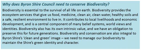
Next steps
Council staff and Ecosure are
continuing to draft the BCS, including:
· Conducting follow-up
conversations with key stakeholders,
· Incorporating
additional up to date information on rapidly changing issues including climate
change and fire ecology,
· Prioritising a
list measurable of strategy actions, based on an analysis of existing threats to
biodiversity and stakeholder feedback.
Further progress with
development of the Biodiversity Conservation Strategy will be reported to the
Biodiversity Advisory Committee on 11 November. This meeting is open to all
Councillors with an interest in having further input into the Strategy.
A working draft strategy will be
presented to Councillors at the 5 December Strategic Planning Workshop. This
will be an opportunity for Councillors to find out more detail about the
proposed Strategy actions, and to advise staff of any additional actions they
would like to see prioritised in the Strategy, prior to peer review in January
and submission of the draft Strategy for Adoption by Council in February 2020.
Staff are currently seeking Councillor support for the
Strategy vision and aims, in order to progress finalisation of the draft
Strategy and actions.
STRATEGIC CONSIDERATIONS
Community Strategic Plan and Operational Plan
|
CSP Objective
|
L2
|
CSP Strategy
|
L3
|
DP Action
|
L4
|
OP Activity
|
|
Community Objective 3: We protect and enhance our
natural environment
|
3.1
|
Partner to protect and enhance our biodiversity,
ecosystems and ecology
|
3.1.1
|
Protect and enhance our natural environment and
biodiversity
|
3.1.1.1
|
Continue to undertake the Biodiversity Conservation Strategy
review
|
Legal/Statutory/Policy Considerations
Legislation relevant to the BCS that has been recently
changed or is in the progress of being amended includes:
· State
Environmental Planning Policy 44 (SEPP 44) for Koala Habitat Protection.
Still under review by State Government. Key changes to SEPP 44 relate to
definitions of Koala habitat, list of tree species, list of Councils and
development assessment process.
· Biodiversity
Conservation Act (2016): Act commenced on 25 August 2017, however Plant
Community Types (PCTs) still under review.
Financial Considerations
Existing budget is available in FY2019/20 to finalise
development of the revised BCS.
Consultation and Engagement
Summary of consultation undertaken as part of the BCS review
contained in the report.
Questions With Notice 14.1
Staff Reports - Infrastructure Services
Report No. 13.10 Amendment
4 of Byron Developer Contributions Plan Removal of Waiver for Secondary
Dwellings
Directorate: Infrastructure
Services
Report
Author: Christopher
Soulsby, Development Planning Officer S94 & S64
File No: I2019/1505
Summary:
This report presents the
submissions from the exhibition of amendment 4 of the Byron Developer
Contributions Plan 2012. This amendment was to remove the waiver on the
payment of contributions on secondary dwellings. The exhibition also
proposed the removal of the waiver on water and sewer charges imposed under the
Division 5 of Part 2 of Chapter 6 of the Water Management Act 2000.
The submissions raised concerns
about the affordability of housing and this impacts on the provision of
affordable housing. It is considered that the potential impacts on
housing affordability as raised by the submitters are outweighed by the cost to
Council from lost contributions revenue for the provision of infrastructure and
that the primary objective of the policy was to lower median rents which was
not achieved.
It is recommended that Council
adopt the plan as exhibited and remove the waiver on the payment of
contributions for secondary dwellings.
NOTE TO COUNCILLORS:
In accordance with the
provisions of S375A of the Local Government Act 1993, a Division is to be
called whenever a motion for a planning decision is put to the meeting, for the
purpose of recording voting on planning matters. Pursuant to clause 2(a)
under the heading Matters to be Included in Minutes of Council Meetings of
Council's adopted Code of Meeting Practice (as amended) a Division will be
deemed to have been called by the mover and seconder of all motions relating to
this report.
|
RECOMMENDATION:
1. That
Council adopt Amendment 4 of the Contributions Plan as per Attachment
2 (E2018/72973) to this report.
2. That
Council imposes a requirement to pay water and sewer contributions for
secondary dwellings.
|
Attachments:
1 Submissions
Received - Contributions Plan, E2019/72924
2 Developer
Contributions Plan 2012 Amendment 4, E2018/72973
REPORT
The purpose of this report is to have Council resolve to
adopt the amendment to the contributions plan to remove the waiver on the
payment of developer contributions for secondary dwellings.
The public exhibition to Byron Developer Contributions Plan
2012 (amendment 4) for the removal of the secondary dwellings contributions waiver
also included notification that Council would remove the waiver on the payment
of water and sewer contributions.
Council resolved to publicly exhibit an amendment to Byron Developer
Contributions Plan 2012 in accordance with the Environmental Planning and
Assessment Act, 1979 and Regulation, for a period of 28 days. The
amendments consist of:
1. Deletion
of clause 2.14 that allowed for the waiver of contributions on secondary
dwellings.
2. Consequential
numerical changes of the plan to reflect the updated numbering of the
Environmental Planning and Assessment Act 1979.
The amendment to the Byron
Developer Contributions Plan 2012 was placed on exhibition from 24 July 2019 until
21 August 2019 and was available for viewing at Council’s administration
office and online. In order for Council to make an informed
decision on Amendment 4 the Council will need to consider the impacts of removal
of the waiver as set out in the submissions.
Four submissions were received objecting to the removal of
the waiver. An additional submission was received questioning why
developer contributions were so high in Mullumbimby.
Representations were made to Council by email from Friends of the Library
following a newspaper article in the Echo. In response to this the
section of the plan pertaining to the Byron Bay Library has been amended to
reflect the fact that the library has been completed. This plan does not
make any changes to the works schedules or rates of contribution.
The main points of objection to removal of the waiver and a
staff comment are set out in the table below:
|
Objection Issue
|
Comment
|
|
Removal of the waiver will remove affordable housing for
the children and grandchildren of residents
|
Secondary dwellings will still be permissible. This
type of housing that cannot be subdivided and is only available for rent will
remain as an option under the provisions of the SEPP Affordable Rental
Housing.
The additional cost imposition is discussed below.
|
|
It will make it harder for people to build secondary
dwellings.
|
The approvals process with remain the same. There is
an additional cost implication that will likely reduce the number of
secondary dwellings constructed.
The cost reduction in the provision of secondary dwellings
due to the waiver has had no impact on the median weekly rents (refer
below).
|
|
Creation of family compounds has many benefits.
|
The benefits to the provision of affordable rental housing
are not in dispute. The removal of the waiver of contributions will
mean that Council can provide the public facilities demanded by the
additional population that lives in these dwellings.
|
|
The reintroduction of contributions will affect development
applications already lodged
|
The savings and transitional provisions in the plan make
it clear that development applications lodged before the plan comes into
force will be assessed under the terms of the old plan and that the waiver
will apply.
|
|
Police the holiday rentals instead
|
The issue of enforcement of short term rental
accommodation was reported to Council on 22 July 2017 and a follow up report
updating Council was presented to the meeting of 2 August 2018. Council
is undertaking and ongoing compliance and education program with respect to
‘short term holiday letting’.
|
|
Reintroducing contributions will stop owners producing low
cost housing.
|
It is acknowledged that there will be a reduction in the
rate of production of affordable housing due to the reintroduction of
contributions. This reduction may be partially offset by the levying of
a specific contribution for affordable housing Council has notified the
Department of Planning of our intention to prepare a contributions plan for
affordable housing under the terms of SEPP 70. This plan is being
prepared in parallel with the Housing Strategy. This will enable
Council; to levy contributions specifically for the provision of affordable
housing.
|
|
Why are the contributions in Mullumbimby so high?
|
The contributions in each catchment are affected by three
factors. These are:
· Cost of the
works in each catchment;
· Apportionment
rate in the catchment;
· Total dwelling
yield in the catchment.
The a cost of works in the Mullumbimby open space works
schedule is higher than other catchments plan due to the cost of land
acquisitions at Tallowood Estate. The cost of land is the principle
driver of the relatively higher cost of contributions when compared to other
catchments.
The purpose of the draft plan is not to alter the works
schedules or the rates of contribution.
|
|
If contributions are imposed then there should be a
discount or low or zero fee applied. A fee of 50% for secondary
dwellings compared to a 3 bedroom house is too high.
|
This is not supported as it would not support the primary
objective of the waiver which was to reduce the median rents for small
dwellings.
The Percentage reduction for 1 bedroom dwellings compared
to a 3+ bedroom dwelling is based on the occupancy rates provided by the
Australian Bureau of Statistics.
|
The aim of the waiver was to make rental housing cheaper by
increasing supply and thereby reducing the median weekly rent for these types
of dwellings. The waiver was introduced in February 2011. The
following table sets out median weekly rents for one bedroom flats / units
based on rental bonds in the region by LGA.
|
Median Weekly Rent for 1 Bedroom unit
|
|
|
Mar-11
|
Jun-17
|
Jun-19
|
Percentage Change 2011 to 2019
|
|
Ballina
|
205
|
280
|
315
|
53.66%
|
|
Byron
|
285
|
380
|
397
|
39.30%
|
|
Lismore
|
168
|
193
|
205
|
22.02%
|
|
Richmond Valley
|
154
|
193
|
NA
|
|
|
Tweed
|
262
|
280
|
303
|
15.65%
|
Source: NSW Family and Community Services
Byron has the highest median weekly rent for a single
bedroom unit / flat in the region. During this time inflation has
increased by 16% (Sydney all groups CPI) but the median weekly rent in Byron
Shire has increased by 39%. There has been as significant increase in the
number of secondary dwellings with no impact on median rents.
By and large the majority of secondary dwellings that have
been approved are not being used for the intended purpose of the SEPP
Affordable Housing. The predominant use that these dwellings are being
put to is for short term rental accommodation (STRA). Council
acknowledges this and is working on a strategy to address this through
compliance. This is however difficult with the current legislative flux
on STRA. Our submission to the STRA option paper and current reform
package have strongly advocated with the exclusion of properties SEPP
Affordable Housing from the STRA SEPP.
The increased cost for section 7.11 (cf S94) contributions
is set out in the following table:
|
Cost per 1 bedroom unit (0.55 SDU)
|
|
|
Byron Bay Suffolk Park
|
7,305.56
|
|
Bangalow
|
5,552.93
|
|
Mullumbimby
|
10,726.39
|
|
Ocean Shores
|
3,876.60
|
|
Brunswick Heads
|
5,207.60
|
|
Rural North
|
10,035.80
|
|
Rural South
|
10,035.80
|
|
|
|
Next CPI increase
|
30-Oct-19
|
In addition to these charges, if Council, removes the waiver
on water and sewer contributions, the following would become payable to Council
per one bedroom secondary dwelling.
|
Water
|
0.4
|
ET @
|
$806.00
|
=
|
$322.40
|
|
Sewer
|
0.5
|
ET @
|
$10,576.00
|
=
|
$5,288.00
|
|
|
Total
|
=
|
$5,610.40
|
Rous Water has their own waiver that would continue to
apply.
The adoption of the amendment 4 will also remove the
discrepancy in the application of contributions on secondary dwellings in the
zones that the SEPP Affordable housing applies to and the rural zones.
The waiver only applies to secondary dwelling approved under the terms of the
SEPP Affordable Housing and not the Byron LEP 2014. The Byron LEP 2014
makes secondary dwellings permissible in the rural zones. The SEPP
Affordable Housing does not apply in these zones and the waiver also does not apply.
Options
Council has three options with the
developer contributions plan. It may:
1 Adopt the contributions
plan as exhibited and resolve to remove the waiver on section 64 charges for
secondary dwellings; or
2 Resolve
to not adopt the plan and retain the waiver for secondary dwellings for both
the section 7.11 contributions and section 64
charges; or
3 Resolve
to modify the plan to give a partial waiver for secondary dwellings for both
the section 7.11 contributions and section 64 charges
as raised in the submissions.
STRATEGIC CONSIDERATIONS
Community Strategic Plan and
Operational Plan
|
CSP Objective
|
L2
|
CSP Strategy
|
L3
|
DP Action
|
L4
|
OP Activity
|
|
Community
Objective 4: We manage growth and change responsibly
|
4.1
|
Support the
visions and aspirations of local communities through place-based planning and
management
|
4.1.3
|
Manage
development through a transparent and efficient assessment process
|
Legal/Statutory/Policy Considerations
Section
7.17 of the Environmental Planning and Assessment Act affects this
Amendment. The relevant part of section 7.17 is set out as follows:
7.17
Directions by Minister (cf previous s 94E)
(1) The
Minister may, generally or in any particular case or class of cases, direct a
consent authority as to:
(a) the
public amenities and public services in relation to which a condition under
section 7.11 may or may not be imposed, and
(b) in
the case of a condition under section 7.11 requiring the payment of a monetary
contribution:
(i) the means by which or
the factors in relation to which the amount of the contribution may or may not
be calculated or determined, and
(ii) the maximum amount of any
such contribution, and
(c) the
things that may or may not be accepted as a material public benefit for the
purposes of a condition under section 7.11, and
(d) the
type or area of development in respect of which a condition under section 7.12
may be imposed and the maximum percentage of the levy, and
(e) the
use of monetary contributions or levies for purposes other than those for which
they were paid, and
A
Ministerial Direction in accordance with section 94e (now s7.17) direction signed by Minister - July 2017 applies to this contributors
plan amendment. Council does not need to submit a draft
contributions plan to IPART for assessment if the contributions plan falls
wholly within the areas listed in Schedule 1 of the Direction. Byron
Shire Council is not listed in schedule 1 of the direction.
For all lands (other than
exempt land and LIGS transition areas), the following caps on contributions
plan charges will apply:
• •
a capped amount of $30,000 per dwelling or residential lot in greenfield areas
• •
a capped amount of $20,000 per dwelling or per residential lot in infill areas.
Council can only levy
contributions above the cap if the contributions plan has been reviewed by
IPART and council has been implemented any advice given by the Minister. An
essential works list will apply when councils are seeking local infrastructure
contributions above these caps.
Council should submit the draft
contributions plan to IPART for review as either:
• a
new contributions plan
• a
new contributions plan that seeks to amend an existing contributions plan
consistent with clause 32 of the EP&A Regulation.
Council is only required to submit a draft contributions
plan to IPART for review if the plan proposes a contributions rate (refer to
Table 1, Part 1 of this Practice Note) that exceeds the maximum amounts
specified in the Direction.
Amendment 4 of the Byron Contributions Plan has all
contributions per dwelling under the $20,000 cap and on this basis does not
have to refer the contributions plan to IPART.
The draft plan is compliant with the direction and Council
may resolve to adopt the draft plan.
Clauses 31 and 32 of the Environmental Planning and
Assessment regulation sets out the way in which a contributions plan may be
amended. The clauses are set out as follows:
31 Approval of
contributions plan by council(cf clause 30 of EP&A Regulation 1994)
(1) After
considering any submissions about the draft contributions plan that have been
duly made, the council—
(a) may
approve the plan in the form in which it was publicly exhibited, or
(b) may
approve the plan with such alterations as the council thinks fit, or
(c) may
decide not to proceed with the plan.
(2) The
council must give public notice of its decision in a local newspaper within 28
days after the decision is made.
(3) Notice
of a decision not to proceed with a contributions plan must include the
council’s reasons for the decision.
(4) A
contributions plan comes into effect on the date that public notice of its
approval is given in a local newspaper, or on a later date specified in the
notice.
32 How
may a contributions plan be amended or repealed?(cf clause 31 of EP&A
Regulation 1994)
(1) A council may amend a
contributions plan by a subsequent contributions plan.
(2) A council may repeal a
contributions plan—
(a) by
a subsequent contributions plan, or
(b) by
public notice in a local newspaper of its decision to repeal the plan.
Council, if it resolves to adopt the plan, repeal amendment
3 and adopt amendment 4. A notification of the adopted plan will be
placed in the newspaper to satisfy the regulations.
Financial Considerations
No additional budget is
required. There are no adverse financial implications for Council.
The removal of waiver will increase the contributions income to Council.
Consultation and Engagement
The Contributions Plan was publically exhibited in
accordance with clause 28 of the regulation.