Agenda
Ordinary
Meeting
Thursday,
17 December 2020
held
at Council Chambers, Station Street, Mullumbimby
commencing
at 9.00am
 Public Access relating to items
on this Agenda can be made between 9.00am and 10.30am on the day of the
Meeting. Requests for public access should be made to the General Manager
or Mayor no later than 12.00 midday on the day prior to the Meeting.
Public Access relating to items
on this Agenda can be made between 9.00am and 10.30am on the day of the
Meeting. Requests for public access should be made to the General Manager
or Mayor no later than 12.00 midday on the day prior to the Meeting.
Mark
Arnold
General
Manager
What is a “Conflict of Interests” - A conflict of
interests can be of two types:
Pecuniary - an interest that a person has in a matter because of a reasonable
likelihood or expectation of appreciable financial gain or loss to the person
or another person with whom the person is associated.
Non-pecuniary – a private or personal interest that a Council
official has that does not amount to a pecuniary interest as defined in the Code
of Conduct for Councillors (eg. A friendship, membership of an association,
society or trade union or involvement or interest in an activity and may
include an interest of a financial nature).
Remoteness – a person does not have a pecuniary interest in a matter
if the interest is so remote or insignificant that it could not reasonably be
regarded as likely to influence any decision the person might make in relation
to a matter or if the interest is of a kind specified in the Code of Conduct
for Councillors.
Who has a Pecuniary Interest? - a person has a pecuniary interest in a
matter if the pecuniary interest is the interest of the person, or another
person with whom the person is associated (see below).
Relatives, Partners - a person is taken to have a pecuniary interest in a
matter if:
§ The person’s
spouse or de facto partner or a relative of the person has a pecuniary interest
in the matter, or
§ The person, or a
nominee, partners or employer of the person, is a member of a company or other
body that has a pecuniary interest in the matter.
N.B. “Relative”, in relation to a person means any of the
following:
(a) the
parent, grandparent, brother, sister, uncle, aunt, nephew, niece, lineal
descends or adopted child of the person or of the person’s spouse;
(b) the
spouse or de facto partners of the person or of a person referred to in
paragraph (a)
No Interest in the Matter - however, a person is not taken to have a
pecuniary interest in a matter:
§ If the person is
unaware of the relevant pecuniary interest of the spouse, de facto partner,
relative or company or other body, or
§ Just because the
person is a member of, or is employed by, the Council.
§ Just because the
person is a member of, or a delegate of the Council to, a company or other body
that has a pecuniary interest in the matter provided that the person has no
beneficial interest in any shares of the company or body.
Disclosure and participation in meetings
§ A Councillor or a
member of a Council Committee who has a pecuniary interest in any matter with
which the Council is concerned and who is present at a meeting of the Council
or Committee at which the matter is being considered must disclose the nature
of the interest to the meeting as soon as practicable.
§ The Councillor or
member must not be present at, or in sight of, the meeting of the Council or
Committee:
(a) at any
time during which the matter is being considered or discussed by the Council or
Committee, or
(b) at any
time during which the Council or Committee is voting on any question in
relation to the matter.
No Knowledge - a person does not breach this Clause if the person did
not know and could not reasonably be expected to have known that the matter
under consideration at the meeting was a matter in which he or she had a
pecuniary interest.
Non-pecuniary Interests - Must be disclosed in meetings.
There are a broad range of options available for managing conflicts &
the option chosen will depend on an assessment of the circumstances of the
matter, the nature of the interest and the significance of the issue being
dealt with. Non-pecuniary conflicts of interests must be dealt with in at
least one of the following ways:
§ It may be appropriate
that no action be taken where the potential for conflict is minimal.
However, Councillors should consider providing an explanation of why they
consider a conflict does not exist.
§ Limit involvement if
practical (eg. Participate in discussion but not in decision making or vice-versa).
Care needs to be taken when exercising this option.
§ Remove the source of
the conflict (eg. Relinquishing or divesting the personal interest that creates
the conflict)
§ Have no involvement by
absenting yourself from and not taking part in any debate or voting on the
issue as of the provisions in the Code of Conduct (particularly if you have a significant
non-pecuniary interest)
RECORDING OF VOTING ON PLANNING MATTERS
Clause 375A of the Local Government Act 1993
– Recording of voting on planning matters
(1) In this section, planning
decision means a decision made in the exercise of a function of a council
under the Environmental Planning and Assessment Act 1979:
(a) including a decision
relating to a development application, an environmental planning instrument, a
development control plan or a development contribution plan under that Act, but
(b) not including the making of
an order under that Act.
(2) The general manager is
required to keep a register containing, for each planning decision made at a meeting
of the council or a council committee, the names of the councillors who
supported the decision and the names of any councillors who opposed (or are
taken to have opposed) the decision.
(3) For the purpose of
maintaining the register, a division is required to be called whenever a motion
for a planning decision is put at a meeting of the council or a council
committee.
(4) Each decision recorded in
the register is to be described in the register or identified in a manner that
enables the description to be obtained from another publicly available
document, and is to include the information required by the regulations.
(5) This section extends to a
meeting that is closed to the public.
Ordinary Meeting
BUSINESS OF Ordinary Meeting
1. Public Access
2. Apologies
3. Requests for Leave of
Absence
4. Declarations of Interest
– Pecuniary and Non-Pecuniary
5. Tabling of Pecuniary
Interest Returns (Cl 4.9
Code of Conduct for Councillors)
6. Adoption of Minutes from
Previous Meetings
6.1 Ordinary
Meeting held on 26 November 2020
7. Reservation of Items for
Debate and Order of Business
8. Mayoral Minute
9. Notices of Motion
9.1 Road
Access and Safety Principles.................................................................................. 6
9.2 Tallowood
Ridge Reserve............................................................................................... 11
9.3 Petria
Thomas Swimming Pool in Mullumbimby - Conversion to year round facility.... 17
9.4 Opportunity
for activation and increased passive surveillance at the Mullumbimby Skate Bowl 20
10. Petitions
11. Submissions and Grants
11.1 Grants
and Submissions December 2020...................................................................... 23
12. Delegates' Reports
13. Staff Reports
General Manager
13.1 Variation
of temporary market licences granted for Byron farmers and community markets 26
13.2 Sub-licences
to Zephyr Equine Pty Ltd and Cape Byron Seahorses Riding Centre for access
through Crown Land..................................................................................................................... 32
13.3 Implementation
of Res 20-664/2 Lease - Council and TAFE NSW - part lot 12 Bayshore Drive Byron
Bay.................................................................................................................................. 36
Corporate and Community Services
13.4 Report
of the Public Art Panel meeting held on 29 October 2020.................................. 41
13.5 Project
Options for the Australian Government Local Roads and Community Infrastructure
Program Extension......................................................................................................................... 47
13.6 Council
Investments - 1 November 2020 to 30 November 2020................................... 54
13.7 Presentation
of 2019/2020 Financial Statements........................................................... 61
Sustainable Environment and Economy
13.8 Council's
Annual Emissions Inventory and progress towards our net zero emissions target 64
13.9 Main
Beach Shoreline Project - community consultation on the 7 options.................... 69
13.10 PLANNING
- Development Application 10.2020.97.1 Stage 8 Tallowood Ridge Estate
Subdivision to Create Forty-Seven (47) Residential Lots at 77 Tuckeroo Avenue
Mullumbimby......... 77
13.11 Review
of LEP Amendment Fee Schedule.................................................................. 101
13.12 Draft
Plan of Management for Charlotte Street Park, Bangalow - Post-Exhibition Report 107
13.13 PLANNING
- Resolution 20-095 Review of Council's Signage Policy......................... 111
13.14 PLANNING
- The Farm Update on Planning Proposal................................................ 115
13.15 Place
Planning Collective - End of 2020 Update.......................................................... 120
13.16 PLANNING
- Activity Application 88.2019.2.1 to Operate the Terrace Reserve Holiday Park,
Bruncwick Heads.......................................................................................................... 124
Infrastructure Services
13.17 Linda
Vidler Memorial Parklands - Pump Track Design............................................... 151
13.18 Pedestrian
Access - Byron Bypass............................................................................... 158
13.19 Waterlilly
Park - Crime Prevention Through Environmental Design Report................ 165
13.20 House
Raising Subsidy payment for 8 Park Street New Brighton............................... 170
13.21 Byron
Bay Access and Movement Plan....................................................................... 173
14. Reports of Committees
Corporate and Community Services
14.1 Report
of the Finance Advisory Committee Meeting held on 12 November 2020...... 177
14.2 Report
of the Audit, Risk and Improvement Committee Meeting held on 12 November 2020 181
Sustainable Environment and Economy
14.3 Report
of the Sustainability and Emissions Reduction Advisory Committee Meeting held
on 12 November 2020............................................................................................................. 183
14.4 Report
of the Biodiversity Advisory Committee Meeting held on 23 November 2020. 186
15. Questions
With Notice
Questions with Notice: A response to Questions with
Notice will be provided at the meeting if possible, that response will be
included in the meeting minutes. If a response is unable to be provided
the question will be taken on notice, with an answer to be provided to the
person/organisation prior to the next Ordinary Meeting and placed on Councils
website www.byron.nsw.gov.au/Council/Council-meetings/Questions-on-Notice
16. Confidential Reports
Infrastructure Services
16.1 Confidential - Land Acquisition for
Booyong Road dedication of land adjoining Lot 4 DP 707295....................................................................................................................................... 188
Councillors are
encouraged to ask questions regarding any item on the business paper to the
appropriate Director prior to the meeting. Any suggested amendments to the
recommendations should be provided to Councillor Support prior to the meeting
to allow the changes to be typed and presented on the overhead projector at the
meeting.
Notices of Motion 9.1
Notices of Motion
Notice of Motion No. 9.1 Road
Access and Safety Principles
File No: I2020/1934
|
I move that Council:
1. Adopts the following Road
Access and Safety Principles for the Byron Shire road network.
a) All users and modes of transport
have an equal right of safe access to and movement on the road network.
b) Road safety audits must consider
the access and safety of all road users, modes of transport and services
delivered within the road reserve such as bus stops and waste collection.
c) Road renewals, upgrades and
maintenance must meet the needs of all road users, modes of transport and
services delivered in the road reserve and ensure equitable funding for all
users and modes.
d) New road projects must include
safe access infrastructure for cyclists, pedestrians and services delivered
in the road reserve and ensure equitable funding for all users and modes.
2. Embeds the Road Access and
Safety Principles into the Operational/Delivery Plan at the next quarterly
review and include actions as follows.
a) Adapt Asset Management policy,
capital works and maintenance planning procedures so that the Principles are
applied to all new road related projects from July 2021.
b) Update road related infrastructure,
movement, access and safety policies to apply the Principles by June 2021.
c) Identify and update relevant DCP
chapters by December 2021.
3. Receives a report at the
April Ordinary Meeting 2021 to report on progress and identify a pathway and
timetable to complete implementation of all necessary actions.
4. Notes
the Councillor Background Notes attached to the report.
|
Signed: Cr
Basil Cameron
Councillor’s supporting information:
Issues of road safety and access are regularly
raised by our community and there is an increasing desire to see a better
balance between movement and place as demonstrated by the movement hierarchies
prioritising active transport adopted within the various town and village
masterplans.
Away from town centres, safety and access is
vital as the road network provides the only movement pathways for all users and
modes of transport.
In both town and hinterland, increasing traffic
growth is making safe access for active road users more difficult. On
many hinterland roads safe access for cyclists and pedestrians is not possible.
Coolamon Scenic Drive ‘road
safety’ upgrade.
According to advice from Council staff in an
email to Councilors dated 20/8/20, $2.4 million funded under the TfNSW
‘Safer Roads’ program has recently been used to ‘address
vehicle related safety issues’ on Coolamon Scenic Drive. The
‘intent of this grant funding program is directed towards vehicle safety
rather than a pedestrian or cyclist focus’. The audit conducted
prior to the rollout of line marking, crash bar railing, CAMS and other signs,
identified a safety risk to cyclists, however ‘many of the possible treatment
options identified to manage risk were unfortunately outside the scope of the
grant scheme’.
To be clear, none of the $2.4 million was spent
on safety of active road users. This could only be addressed under
‘Safe System’ grants that ‘Council is believed to not be
eligible for’. We may be eligible for funding if we ‘meet the
funding requirements’. That is if there is a serious crash
involving a fatal or serious injury to a cyclist or pedestrian.
As the rollout began, Council received a number
of complaints that this new infrastructure was interfering with resident access
to their properties and impeding rubbish trucks as the audit had not considered
the services delivered in the road reserve such as bus stops and waste
collection. The crash bar railing and signage also significantly reduced
or eliminated road shoulders that pedestrians and cyclists rely on for safe
access.
When a ‘safety’ upgrade on a road
focused entirely on one road user group makes the road environment less safe
and accessible for other road users, then we have a problem. It is a
concern that the rollout went ahead despite a known risk to cyclists that was
not addressed.
Road Access and Safety Principles
The Road Access and Safety Principles aim to
redress this imbalance. The Principles provide for assessment, design and
equitable funding to ensure safe access for all road users when safety audits
are conducted and roads are built, renewed and maintained.
A right of equal access is essential to a
freedom of movement that is guaranteed in the International Bill of
Rights. This fundamental right is included in A Charter of Human
Rights and Responsibilities BYRON SHIRE as adopted by Resolution 19-133 for implementation by Council. Without
safe access to our roads, the right is restricted, particularly on hinterland
roads where there are no alternative movement pathways.
It will be necessary to review and update road
related policies to ensure action on the Principles. This to be achieved by
embedding the Principles and policy review actions in the Operational/Delivery
Plan with a progress report to be provided in April 2021.
Implementing the Principles
Part two of the motion sets out a pathway and
timetable for implementation.
The initial phase over six months involves
1. Embedding the Principles in the Operational/Delivery Plan with the
policy review objectives stated at 2(a)-(c) at the next quarterly review due
early in 2021.
2. Identify
and update policies referred to in 2 (b) that require a consequential amendment
to either include or apply the Principles. It is anticipated that this
will involve minimal word changes or additions in any cases.
3. Provide
a report to April Ordinary meeting on progress and to provide a timetable for
implementation of all necessary actions. This report is the opportunity
to provide an advice on any resource implications for more substantial tasks,
should there be any.
Six to twelve months
4. Update
relevant chapters of the DCP to ensure that future development has the
Principles applied. A longer timeframe is
considered appropriate as this may involve more
substantial redrafting.
5. Apply
the Principles to all new road related projects from July 2021.
Recommended priority relative to other
Delivery Plan tasks:
This is considered a part of the ongoing policy
review process. Actions in the first six months are not anticipated to
require an additional budget allocation. The April report provides an
opportunity to advise on any resource implications in the first half of
FY21/22.
Definition of the project/task:
Embed Principles into Operational/Delivery Plan
with policy review actions.
Update policies requiring consequential
amendment to apply the Principles.
Provide report to April 2021 Ordinary Meeting.
Update relevant chapters of DCP to apply
Principles by December 2021.
Apply Principles to all new infrastructure
projects from July 2021.
Staff comments by Andrew Pearce, Traffic Engineer, Infrastructure
Services:
(Management Comments must not include formatted
recommendations – resolution 11-979)
In considering safe and accessible movement across the Shire
for all community demographics and for all transport modes, it is suggested the
discussion be reframed. In particular, it is considered more appropriate to
emphasise a need to deliver a safe, integrated and accessible Transport Network
rather than emphasising a need to deliver an improved road network with safer
infrastructure for all active transport users.
In light of this, while the intent of the NoM is supported, the
Notice of Motion itself is not for the following reasons:
• While
the intent of the NoM is supported it commits millions of dollars to meet the
needs of a smaller cross section of community. It does not meet the
transport needs of the more vulnerable community members, such as the aged and
mobility disadvantaged.
• It
could be considered inappropriate to expect these more vulnerable community
members to rely on active transport within the road reserve, especially during
hot and/or wet conditions.
• This
approach does not take into account traffic volumes, speeds or road gradients. Even
with improved safety designs, travelling from Mullumbimby to Federal with an
e-bike will still require significant physical effort, especially in hot and/or
wet conditions.
• The
approach does not align with the TfNSW transition towards Movement and Place as
the NoM requires every road, whether a motor way, highway or distributor road
to be designed as a place.
• This
approach does not acknowledge the need for many community members to travel
very large distances beyond just the Shire to attend things such as Doctors
appointments or the need to undertake shopping and transport goods back home
within a timely manner.
• This
approach relies on a slow, non integrated roll out as disparate segments of the
road network which are generally upgraded over decades, primarily through
grants and private development.
• To
implement the recommendations outlined in the NoM across all road projects
within the Shire is anticipated to cost many millions of dollars. A
specific case is Coolamon Scenic Drive. To reconstruct this road as per the NoM
would require significant excavation, rock cutting and structural retaining
walls over several kilometres costing many millions of dollars. Applying the
NoM to other roads such as, Seven Mile Beach Road would require significant
clearing of vegetation within a highly sensitive ecological area.
• This
NoM stands in competition to existing resolutions and existing transport
policies and strategies developed by TIAC. Considering in particular the
Bike Plan (developed by TIAC), a strategy to support safe active transport
across the shire has already been developed.
This
plan shows which projects provide the greatest strategic benefit to the Shire. Rolling
out Priority A projects alone will take many years and cost millions.of dollars
As
a result, the proposed NoM stands in contradiction to the strategic vision of
the Bike Plan developed over a significant period of time with significant
community consultation.
• If
the NoM is supported and a resolution is passed the current Bike Plan and PAMP
would then need to be rescinded to remove ongoing project confusion and
contradictory outcomes.
In contrast, reframing the
discussion to emphasise a need to deliver a safe, integrated and accessible
TRANSPORT NETWORK still supports the intent of the Notice of Motion and reflects
the following advantages:
• Supports
and acknowledges Council’s goal of expanding our transport corridors to
include the rail corridor and reduce a reliance on vehicle corridors.
• The
TfNSW transition towards a Movement and Place framework acknowledges some roads
have a primarily “movement” purpose (i.e. motorways) and other
roads a place making purpose (i.e. shared zones). This framework helps
develop a more efficient and safer transport network as opposed to pushing cars
and people into the same corridor regardless of traffic volumes and speeds.
• Addresses
the need to provide the community with a range of alternate transport options
which better meets their specific needs. This in turn would reduce the
need for more vulnerable community members (such as, aged and mobility
disadvantaged) having to rely on walking or riding within a road reserve that
has varying levels of maintenance.
• An
ability to provide cost effective, targeted and diverse transport solutions
that gives people transport options even in wet and / or hot weather. The
physical effort to travel between townships (even on an e-bike) during very hot
or wet weather is considered a significant barrier to increasing active
transport, especially for more vulnerable community members.
• An
ability to expand our transport network in a way that aligns well with existing
transport related strategies. These strategies include:
o Pedestrian
Access and Movement Plan
o Bike
Plan
o Multi
Use Rail Corridor
o Intergrated
Transport Strategy (Moving Byron)
o Ride
Sharing policies (i.e. pop car)
• It
acknowledges the preliminary steps that have already been taken promote a
better active transport network, such as the current investigation into a
Mullumbimby / Brunswick Head cycle way and the Suffolk Park to Byron cycle way.
• It
supports the goals of this Notice of Motion which aims to have the safety of
all active transport users consciously factored into all “Safer
Roads” programs while at the same time provides better transport options
for disadvantage / vulnerable community members during wet and/or hot weather.
Financial/Resource/Legal Implications:
The financial implications of the proposed NoM are unknown.
However, it is expected it could cost tens of millions of dollars to implement
over many years.
There is no identified budget source to commence work
related to this NoM and there has been insufficient investigation in relation
to the financial impacts or the budget and other staff resources required to
undertake the works envisaged over the next 12 months.
The extent of impacts on existing maintenance budgets and
delivery programs is expected to be significant as all road related programs will
require scope of works and budget allowance review.
Road network maintenance works programs for both the short
and long term developed to date will require reconsideration and additional
staff resources will be required to undertake this task or works programs
delayed until such time as the review is completed to ensure the works comply
with the requirements of the NoM if adopted.
While it might be possible to obtain some funds via grants
this is not guaranteed nor expected to be sufficient to cover the work needed
to review and make changes to policies and procedures and will be difficult if
not impossible to implement for some grant and/or maintenance programs.
Is the proposal consistent with any Delivery Program
tasks?
No, a recommendation within the
NoM is to embed “the Principles in the Operational/Delivery Plan with
the policy review objectives stated at 2(a)-(c) at the next quarterly review
due early in 2021.”
Notices of Motion 9.2
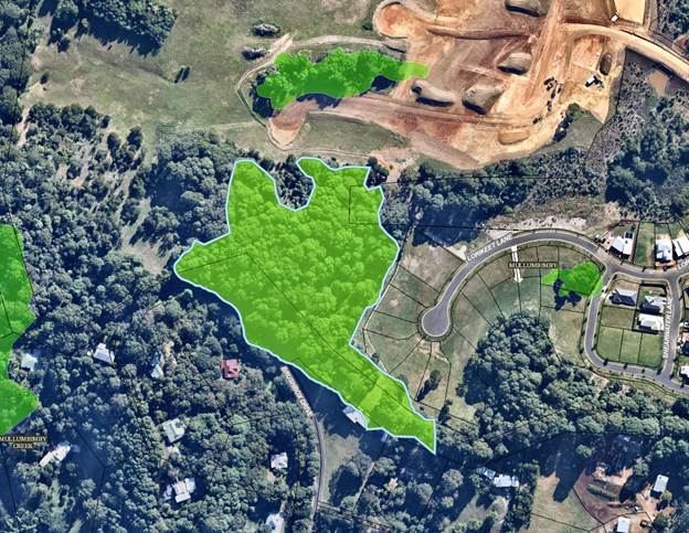
Notice of Motion No. 9.2 Tallowood
Ridge Reserve
File No: I2020/1938
|
I move that Council:
1. Enter
negotiations with the relevant landowners and/or developer to seek the
gifting of the land outlined in the map below for the management of council
in conjunction with the community in perpetuity.
2. That
these negotiations stipulate that this is not instead of any other previous
environmental agreement.
|
Signed: Cr
Sarah Ndiaye
Councillor’s supporting information:
Background
Currently a 5 acre parcel of land is scheduled to be
allocated to seven landholders that do not adjoin the land, for ongoing care
and management. This expectation is unrealistic and would exclude the community
from being able to access this land or care for it. The ridge line and areas
adjacent have significant old growth tree populations, are part of a koala
corridor and also house some endangered flora.
Some of the reasons why this area is significant are
outlined below. I and many others believe it will be best protected by having
the broader community supporting Council as custodians of this area. Otherwise
in private ownership and so far away from the dwellings of the Community
Title we fear it will become overrun with weeds as what has occurred in
neighbouring properties around Brushbox Drive.
The Tallowood Ridge Landcare group is a registered locality
group of Brunswick Valley Landcare. It has had an official launch and meets
monthly with around 30 volunteers registered on their mailing list. They
currently are maintaining the area of the 'Gathering Tree Park'. The group has
the capacity and skills to support Council to manage the remaining bushland that
is the residual lot of the Tallowood ridge Development. As the forest is
mature, once the developer has undertaken the weed control and maintenance as
per the estate's Biodiversity Conservation Management Plan the area will not
require large amounts of resources. Furthermore, Brunswick Valley Landcare has
a grant along the road reserve in this area through the Environmental Trust
which is for another 2 years.
The community have recently started an online petition which
has a little bit more information:
https://bit.ly/KoalaReserve
The Tallowood Ridge Development has been advertising this
area as both a Nature Reserve and a Conservation Area in the advertising to
sell blocks (see pics x 2). Mr Freeman has told Friends of Mooibal Spur he will
gift the land with no strings attached and is quoted in the Echo saying it is
only Council who is stopping this land becoming a reserve. (July 15th Echo Net
daily from memory)
Biodiversity Values of the area
- Byron
Shire council has it mapped as an area of HEV (High Ecological Value)
- The
Byron Coastal Koala Plan of Management, recognises this exact area along the
ridge as an important koala precinct.
- The
State Environmental Planning Policy for Koala Habitat Protection (SEPP
44) which commenced on 1 March 2020 has also recognised the area as
important koala habitat. The area has old growth Tallowood trees which are a
primary koala feed tree. Koalas are predicted to go extinct before 2050
unless we actively manage land for their conservation. See SEPP 44 Map of the
area
- Other
threatened fauna have been located in the ridgeline including a range of bats
and the glossy black cockatoos (these are not the big yellow tails but a small
rare cockatoo).
- Threatened
plant species in the proposed ridgeline E2 area include the Native Guava which
is recognised under State legislation as Critically Endangered.
Indigenous Values of the area
The Indigenous values of the area were recognised by Yvonne
Stewart in the estates original DA. It was stated the area is a pathway to the
Koonyum Range. Indigenous cultural fire practioners from Fire Sticks Alliance
have also recognised the significance of the area.
Putting this land into community ownership is such an
amazing opportunity to undertake best practice Caring for Country and a much
valued community asset for generations to come.
Staff comments by Christopher Soulsby, Development Planning
Officer, Infrastructure Services:
(Management Comments must not include formatted
recommendations – resolution 11-979)
Council is currently assessing DA 10.2020.109.109.1 for
stage 9 of the Tallowood Estate. This stage will consist of an 8 lot
community title subdivision and 40 lot Torrens title subdivision. Lot C8 is the
community lot within the community title subdivision. This lot is 8.19ha
(20.23 acres) in area with an irregular shape that abuts both the internal road
network of Tallowood and the vegetated road reserve that separates Tallowood
from the Brushbox Drive rural residential area. The lot is show in the
lot arrangement plan as set out below.
The site is proposed to be managed by the community
association in the long term. Such an arrangement ensures the protection and
management of the vegetation without the financial burden of bringing the land
into public ownership. To date Council has resisted effort by developers to
dedicate land that has no development potential. This has occurred at the West
Byron development and here at Tallowood.
The land is currently zoned RU2 Rural Landscape. The site
was previously zoned 1A General Rural under the 1988 LEP.
Part of the site has been mapped as High Environmental Value
with a vegetation type Brush Box-Pink Bloodwood-Tallowwood association.
This is shown in the following image.
Mapped HEV
The site has not been identified for acquisition in the LEP
or in the contributions plan. The acquisition and long term management of this
land by Council is not identified in any current strategic plans.
Continued acquisitions of land without a long term financial
plan to maintain the land will place pressure on the open spaces budget.
The determination of the future classification, use, and
works required prior to bringing this land into public ownership are processes
that need to be undertaken as part of the assessment of the development
application for stage 9. The future ownership of the vegetated gully can also
be considered as part of this development application. It would be
appropriate to report the outcomes of the discussions with the developer at the
time the development application is reported to Council.
Financial/Resource/Legal Implications:
If the land is gifted to Council, Council will need to
establish a Plan of Management and manage the land in accordance with this plan.
In the long term Council ad hoc acquisitions of land may adversely impact upon
Council’s ability to manage all of the open space land to levels that
meet community expectations / desirable levels of service in its
portfolio.
Is the proposal consistent with any Delivery Program
tasks?
The acquisition of this land is not specifically identified
in the CSP or DP / OP. The support of the land care group mentioned in
the NOM is identified as an OP activity.
|
CSP Objective
|
L2
|
CSP Strategy
|
L3
|
DP Action
|
L4
|
OP Activity
|
|
Community
Objective 3: We protect and enhance our natural environment
|
3.2
|
Strive to
become a sustainable community
|
3.2.2
|
Support
community environmental and sustainability projects
|
3.2.2.5
|
Support
Brunswick Valley Landcare to deliver the Land for Wildlife Program and
biodiversity enquiries
|
Notices of Motion 9.3
Notice of Motion No. 9.3 Petria
Thomas Swimming Pool in Mullumbimby - Conversion to year round facility
File No: I2020/1939
|
I move that Council:
1. Includes the actioning of resolution 20-061, Petria Thomas
Swimming Pool in Mullumbimby - Conversion to year round facility in the
operational plan for 2020/21
2. Staff look for a way to source the funds required within the
budget
|
Signed: Cr
Sarah Ndiaye
Councillor’s supporting information:
In February 2020 as a
council we resolved to conduct a feasibility study into making the Petria
Thomas Swimming Pool a year round, solar heated, all abilities facility. Once
Covid hit and it was apparent we would be on the receiving end of a financial
hit, we resolved to remove some items from the operational plan or remove their
budget. The feasibility study was one such project that was removed from the
budget but not the operational plan. The resolution asked that funding for
these projects be sought from local ministers, Justine Elliot, Ben Franklin and
Tamara Smith.
While I have not seen
any official correspondence, I have the impression that this was not
successful. Given that since then the financial hit from Covid was not as
drastic as initially thought and some projects have cost less than previously
expected, I seek to include budget for this crucial feasibility study to be
conducted as soon as possible. The vast majority of funding available is for
projects that already have the preliminary work done. There have been two
rounds of stimulus funding we have not been able to apply for because the
feasibility study has not been completed. Given the progress on Lot 22 since
the beginning of the year and the proximity of the Mullum Hospital Site and
whatever will unfold there, it’s more important than ever that we set the
wheels in motion for this project to commence.
I have copied the
previous resolution (20-061) of council and background for ease of
access.
That Council:
1. Conduct
a feasibility study into converting the Petria Thomas Swimming Pool
in Mullumbimby into a year round, solar heated facility that could service
the needs of the local and visitor population, by adding a disability access
ramp to the existing 50 metre pool, a splash children’s pool and a
rehabilitation / hydrotherapy pool, and that the feasibility also consider
various water treatment options
2. In
assessing feasibility, consider the public health and social benefits of such a
facility
3. Research
other council areas that have installed similar facilities such as Ballina
Shire to see how these types of projects have worked in other similar
communities.
4. Allocate
the appropriate budget to conduct this study in the draft 2020/21
budget.
5. Identify
potential funding sources including money from Council’s own funds and
appropriate grant opportunities and relevant timelines.
Background
Mullumbimby
has grown with the addition of Tallowood and the amount of people
serviced by this village has grown to 3500 directly and
approximately 7000 when you take in the hinterland and the suburbs to
the north such as Brunswick Heads, Ocean Shores and New Brighton. The shire has
long needed a year round place to swim laps for their physical and
mental health and more appropriate rehabilitation facilities for
people recovering from injury or just maintaining health aging practices.
The Open Space
and Recreation Needs Study 2018identified that ‘our community
wants recreation, sports and aquatic facilities to meet the Shire’s
needs’ and while their may be some funding challenges to overcome, this
pool has a long history of being able to garner community support to make
things happen. The first Chincogan Charge in 1960 was a
fundraiser to build the swimming pool and the second race happened in 1967
to celebrate its opening. Since then the community have also raised money for
some of the upgrades and other refurbishments. Both the State and Federal
Governments have also had a variety of rounds of funding that a project such as
this could meet the criteria. It is important we get the feasibility study
underway to see if it is a viable option and to apply for these funding
grants.
The Mullumbimby
Residents Association has long been interested in helping to make this vision a
reality for our community and has recently been collecting signatures in
support of the project and garner community interest. They have also had
preliminary concept drawings prepared. So far the response has been very
enthusiastic with hundred already signing the petition. I have attached
the information received so far and there will be more up to date information
at the meeting of council in February.
While discussions
have gone on around the possibility of redeveloping the pool at Main Beach
or building an aquatic centre at the Cavanbah Centre, there
have been multiple challenges at both of these sites. Byron Bay is getting
a huge investment in both the bike track from Suffolk Park to Byron as well as
the multi-million dollar skate park that has been earmarked for the area behind
the YAC and the Byron Library. This project would help service the needs of the
broader community and add value to the experience of living in the hinterland
and the northern parts of the Shire.
For a long time the main objection has been
the cost, however the Ballina Shire have shown that this does not have to be
the case. Having completed a full overhaul of their facility at a cost of
$14million, the new facility was expected to continue running at a deficit,
however it is now running at a profit. The popularity of a facility like
this could see it breaking even or increasing revenue for
council and providing a host of benefits for the community.
Staff comments by James Brickley, Manager Finance,
Corporate and Community Services:
(Management Comments must not include formatted
recommendations – resolution 11-979)
Staff comments are provided in the Finance/Resource/Legal
Implications section of this Notice of Motion below:
Financial/Resource/Legal Implications:
Council adopted the 30 September 2020 Quarterly Budget
Review of the 2020/2021 Budget at the 26 November 2020 Ordinary Meeting.
Whilst this budget review showed a financial improvement of $60,700, Council
has a projected budget deficit of $296,100 for the 2020/2021 financial
year. Council’s unrestricted cash balance projected at 30 June 2021
is $428,200 and the Council endorsed unrestricted cash balance target is
$1,000,000. It is understood it is Council’s intention is to
restore the unrestricted cash balance to $1,000,000 by 30 June 2021.
Whilst it is a decision for Council, in the absence of any
other funding source or Council reallocating funds from an existing budget,
Council could proceed to fund the feasibility study by utilising the
unrestricted cash balance, which will increase the current projected 2020/2021
budget deficit
Alternatively and as a preferred option, it is suggested
that Council reconsider a funding allocation in the 31 December 2020 Quarter Budget
Review that will be reported to Council in February 2021, amongst the review of
the entire Council budget at that time. In addition to this Notice of Motion,
Council also has resolution 20-518 to undertake further work on the Rail
with Trail on the corridor between Mullumbimby and Byron Bay for which funding
is yet to be identified that will also need to be considered for the 31
December 2020 Quarterly Budget Review.
Is the proposal consistent with any Delivery Program
tasks?
Yes. At the Ordinary Meeting held on 26
November 2020 Council resolved (20-674) to include an activity in
the 2020/21 Operational Plan to seek funding for a feasibility study for the
Petria Thomas Swimming Pool. This has subsequently been included in the
Operational Plan as activity 1.2.5.7:
|
CSP Objective
|
L2
|
CSP Strategy
|
L3
|
DP Action
|
L4
|
OP Activity
|
|
Community
Objective 1: We have infrastructure, transport and services which meet
our expectations
|
1.2
|
Provide
essential services and reliable infrastructure which meet an acceptable
community standard
|
1.2.5
|
Ensure ongoing
maintenance and upgrade of inclusive community buildings and swimming pools
(SP)
|
1.2.5.7
|
Seek funding to
conduct a feasibility study into converting the Petria Thomas Swimming Pool
in Mullumbimby into a year round, solar heated facility, including a
disability access ramp to the existing 50 metre pool, a splash
children’s pool and a rehabilitation / hydrotherapy pool, and consider
various water treatment options.
|
Notices of Motion 9.4
Notice of Motion No. 9.4 Opportunity
for activation and increased passive surveillance at the Mullumbimby Skate Bowl
File No: I2020/1944
|
I move:
That
Council:
1. Supports the concept of activating the sports
field adjacent to the Mullumbimby skate bowl with a dog park with the aim of
creating increased passive surveillance and stopping people being able to
drive on the field and damage it.
2. Requests the Sustainable Environment and
Economy Directorate staff to arrange for the preparation of a detailed design
for a dog park for consultation with the community, and a report of the
outcomes of the consultation to Council for final design endorsement.
3. Requests the Sustainable Environment
and Economy Directorate staff to ensure that the dog park design is
integrated with the wider planning work, which is looking at the future use
and development on adjacent lands including Lot 22 vacant land community
gardens, private lands, sports fields and the skate bowl.
4. Approves a budget allocation of $20,000 from the Mullumbimby Open Space Reserve to
undertake the necessary design work on the dog park to enable the community
consultation process, and following, refinement of a final design to enable
project delivery.
|
Signed: Cr
Sarah Ndiaye
Councillor’s supporting information:
Byron Shire has a
significant number of dog owners but very few off leash areas that are not
beaches. This increases the risks to sensitive shorebirds and other marine life
and also limits opportunities for people who have limitations on their movement
due to age or disability.
At the same time, it
seems further activation of the Mullumbimby Recreation Grounds would be very
beneficial to all park user groups. The introduction of lighting at the skate
bowl along with the upgrading of the surfaces has lead to an increase of use of
this valuable community asset. The diversity of ages and increased number of
women and young girls participating has been heartening.
Unfortunately, the
increased access via the road and availability of parking has also increased
some unwanted behaviour including camping, rubbish, and some amplified music on
occasions. When the gates were closed this lead to people finding their own
route into the park and damaging the sports fields.
After meeting with
senior police, staff and some community members, and going over the risk
assessment and the Byron Shire Open Space and Recreation Needs Assessment and
Action Plan, options were discussed to increase passive surveillance,
recreational use and activation of the area. One that stood out that could
address both the protection of the grounds, increase the passive surveillance
and support our local biodiversity was the introduction of a fenced, off leash
area for dogs.
Council has a resolution (18-588) that proposes to
floodlight the skate bowl at night thereby increasing its visibility to the
public to deter anti social behaviour, camping and hooning on there.
However, due to concerns raised by nearby residents about
the impact that an increase in floodlights on the skate bowl could have on
their amenity, the upgrade to the lighting has been placed on hold pending a
further report on a more holistic plan for the future use of the skate bowl and
adjacent sports field land.
In the meantime, the NSW Police have offered support for a
dog park on the sport field as part of a CPTED review.
As such it makes sense for Council to explore the
possibility of creating a dog park on the sports field adjacent to the skate
park with the aim of creating increased passive surveillance and stopping
people being able to drive on the field and damage it.
Staff comments by Shannon Burt, Director, Sustainable
Environment and Economy:
(Management Comments must not include formatted
recommendations – resolution 11-979)
The Byron Shire Open Space and Recreation Needs Assessment
and Action Plan refers to the Mullumbimby Recreation Ground Sportsfields as one
of two sports parks in the Mullumbimby planning area that, land wise, meet the
needs of the user groups, now and into the future. It did identify that
upgrades to the ancillary infrastructure are required and recommended that a
master plan be developed for the Sportsfields that included a fenced dog
off-leash park.
A dog park can be easily designed and can be constructed in
a short time frame. It can be accommodated on the sports field adjacent to the
skate bowl without impinging on the FIFA and Cricket oval dimensions which need
to be preserved for future use, as well as the tennis courts, skate bowl and
netball court areas.
A key consideration for the dog park design will be its
integration with the wider planning work being undertaken at present, which is
looking at the future use and development on adjacent lands including Lot 22
vacant land, community gardens, private lands, sports fields and the skate
bowl.
Notwithstanding the above, the need to activate this land
has been identified as necessary, and the design of, and community consultation
on, a dog park could proceed in the short term in concert with other planning
work underway without creating long term land use conflict.
In support of the above, Council is developing a Dogs in
Public Spaces (DiPs) Strategy (Res 18-362). The DiPss will look to
provide a balanced policy approach to address the open space requirements of
all users of Council’s public spaces by taking a broad approach to the
management and control of dogs in the public spaces. A report on the next stage
of the DiPss Strategy will be presented early in 2021.
The results from a 2020 Companion Animals Survey, part of
the DiPs work, revealed interest in and need for a variety of more and better
on and off leash dog exercise areas throughout the Shire.
Dog parks can provide many benefits for dogs, their owners
and the community.
· Dog
parks provide safe opportunities where dogs can get physical and mental
exercise.
· Dog
parks provide an alternate public space to exercise dogs instead of beaches,
estuaries, and open space areas of high environmental, biodiversity and
ecological value.
· Dog
parks can provide a public space where dog owners can interact with each other
and form community bonds.
· Dog
parks can reduce the likelihood of dog owners letting their dog’s
off-leash in other recreational areas and infringing on the rights of other
community residents and park users.
There are guidelines for dog park development including: UNLEASHED
A GUIDE TO SUCCESSFUL DOG PARKS – South Australia Government, which
can be used as a reference guide to inform the design and community
consultation process.
Financial/Resource/Legal Implications:
The design of recreation precinct, including a dog park,
should be done in an integrated manner and can be funded from developer
contributions taken from the Mullumbimby Open Space reserve.
A budget of $20,000 should be sufficient to undertake
sufficient design work to commence the community consultation process and
refine the final design to enable project delivery.
Is the proposal consistent with any Delivery Program
tasks?
There currently isn’t a specific OP activity for this
project. It is however consistent with the following CSP strategies and DP
actions.
|
CSP Objective
|
L2
|
CSP Strategy
|
L3
|
DP Action
|
|
Community
Objective 1: We have infrastructure, transport and services which meet
our expectations
|
1.2
|
Provide
essential services and reliable infrastructure which meet an acceptable
community standard
|
1.2.4
|
Provide active
and passive recreational Community space that is accessible and inclusive for
all (SP)
|
|
Community
Objective 2: We cultivate and celebrate our diverse cultures, lifestyle and
sense of community
|
2.3
|
Provide
accessible, local community spaces and facilities
|
2.3.5
|
Maintain Public
Open space in a safe and efficient way that provides for both active and
passive recreation (SP)
|
|
Community
Objective 2: We cultivate and celebrate our diverse cultures, lifestyle and
sense of community
|
2.4
|
Enhance
community safety and amenity while respecting our shared values
|
2.4.3
|
Enhance public
safety, health and liveability through the use of council's regulatory
controls and services
|
|
Community
Objective 3: We protect and enhance our natural environment
|
3.1
|
Partner to
protect and enhance our biodiversity, ecosystems and ecology
|
3.1.1
|
Protect and
enhance our natural environment and biodiversity
|
Submissions and Grants 11.1
Submissions and Grants
Report No. 11.1 Grants
and Submissions December 2020
Directorate: Corporate
and Community Services
Report
Author: Esmeralda
Davis, A/Manager Corporate Services
File No: I2020/1856
Summary:
Council has submitted applications
for a number of grant programs which, if successful, would provide funding to
enable the delivery of identified projects. This report provides an update on
these grant submissions.
|
RECOMMENDATION:
That That Council notes
the report and Attachment 1 (E2020/95181) for Byron Shire Council’s
Submissions and Grants as at 25 November 2020.
|
Attachments:
1 Attachment
1 - Grants and Submissions Table - December 2020, E2020/95181 
REPORT
This report provides an update on
grant submissions since the last report to Council.
Successful applications
In
November 2020, Council was successful in obtaining a combined $ 929,907 from
the Australia Day Council of NSW for Covid Safe Australia Day 2021, and
from Transport for NSW for Balemo Drive (Walking and Cycling Program)
and Brunswick Heads Primary School Bus Stop Signage and Markings Upgrade
(Country Passenger Transport Infrastructure Stream).
Public Spaces Legacy Program - Council has been approved
to participate in the program and, subject to meeting our agreed targets, may
be eligible for $3M funding in 2021. The guidelines also indicate that
Council will be invited to nominate projects in Feb 2021, if successful in
progressing to this stage.
Unsuccessful applications
Council was not notified of any
unsuccessful applications this month.
Applications submitted
Two grant applications were submitted in November 2020 to:
- Australia
Day Council of NSW for Covid Safe Australia Day 2021
- Department
of Planning, Industry and Environment (Everyone Can Play Scheme) for Gaggin
Park accessibility modifications
Upcoming grant opportunities
There are a number of upcoming grant opportunities for which
Council may submit funding applications including:
· Bushfire
Local Economic Recovery Fund 2020
· Regional
Tourism Recovery Fund 2020
· Your
High Street Fund 2020
· Building
Better Regions Fund 2020
STRATEGIC CONSIDERATIONS
Community Strategic Plan and
Operational Plan
|
CSP Objective
|
L2
|
CSP Strategy
|
L3
|
DP Action
|
L4
|
OP Activity
|
|
Community Objective 5: We have community led
decision making which is open and inclusive
|
5.6
|
Manage Council’s resources sustainably
|
5.6.12
|
Implement strategic grants management systems to deliver
priority projects for Byron’s community (SP)
|
5.6.12.4
|
Provide governance for grants management
|
|
|
|
|
|
|
|
|
|
|
|
Legal/Statutory/Policy Considerations
Under
Section 409 3(c) of the Local Government Act 1993 Council is
required to ensure that ‘money that has been received from the Government
or from a public authority by way of a specific purpose advance or grant, may
not, except with the consent of the Government or public authority, be used
otherwise than for that specific purpose’. This legislative requirement
governs Council’s administration of grants.
Financial Considerations
If
Council is successful in obtaining the identified grants, more than $18 million
would be achieved which would provide significant funding for Council
projects. Some of the grants require a contribution from Council (either
cash or in-kind) and others do not. Council’s contribution is funded.
The potential funding and
allocation is noted below:
|
Requested funds from funding
bodies
|
18,495,048
|
|
Council Contribution Cash
|
2,053,376
|
|
Council Contribution In-Kind
|
153,500
|
|
Other contributions
|
258,809
|
|
Funding applications
submitted successful and awaiting notification (total
project value)
|
20,960,733
|
Consultation and Engagement
Cross-organisational consultation has occurred in relation
to the submission of relevant grants, and the communication of proposed grant
applications
Staff Reports - General Manager 13.1
Staff Reports - General Manager
Report No. 13.1 Variation
of temporary market licences granted for Byron farmers and community markets
Directorate: General
Manager
Report Author: Paula
Telford, Leasing and Licensing Coordinator
File No: I2020/1564
Summary:
This Report requests authorisation from Council to vary
market licences granted to the Byron Bay Community Association Inc and Byron
Farmers’ Market Inc to extend the market licence for an additional eight
months.
|
RECOMMENDATION:
1. That
Council authorises the continued suspension of the Community and
Farmers market licences issued to the Byron Bay Community Association Inc and
Byron Farmers’ Market Inc for the Butler Street Reserve Byron
Bay with ongoing abatement of rent to 31 October 2021.
2. That
Council notes that no public submissions were received on the proposed
variation to extend the licence term to 31 October 2021 to the Byron
Farmers’ Market Inc.
3. That
Council delegates to the General Manager the authority to vary
temporary market licences issued to:
a) Byron
Farmers’ Market Inc for farmers markets at the Cavanbah Centre to replace
Schedule 1, Item 2 with the words ‘1 July 2019 to 31 October
2021’.
b) Byron
Bay Community Association Inc for community markets at the beachside to
replace Schedule 1, Item 2 with the words: ‘4 August 2019 to 31 October
2021’.
4. That
Council notes that the Byron community market was relocated from the Butler
Street Reserve to Dening Park to be held on the first Sunday of every month
under licence to the Byron Bay Community Association Inc.
5. That
Council notes that the Byron Winter Whales has requested the use of Dening
Park on the first Sunday in May 2021 for the 30th anniversary of
the classic swim event.
6. That
Council delegates to the General Manager the authority to negotiate with Byron
Bay Community Association Inc and Byron Winter Whales to:
a) Reduce
their respective footprints in Dening Park so that the Byron Bay Community
Association Inc right to hold a monthly community market in Dening Park under
a licence agreement is not disadvantaged; and that
b) If
no acceptable outcome can be reached then a further report will be brought to
Council to determine the matter.
|
REPORT
Council resolved (19-062) at its 28 February 2019
meeting:
1. That Butler
Street Reserve be closed to the public after the 7 July Community Market for a
period of 6 months while the section of the Byron Bay Bypass (including the
Somerset Street Roundabout and its western and southern legs and the area of
works within Butler Street north of the roundabout) is constructed.
2. That lockable
steel gates be installed at the entry points to the Reserve to restrict vehicle
access during the closure period and during the ‘no parking’
periods overnight.
3. That staffs
provide market managers with any information available regarding viability of
other potential relocation sites identified by the markets, including planning
approvals required.
4. That staff
ensure The Cav has all relevant approvals in place to host markets during the
closure period, should that be required, and provide details to market managers
regarding power and water access, amenities and traffic management plans for
the site.
5. That the
Butler Street Reserve be made available as a site compound for the Contractor
for the duration of the closure and one (1) week after this section is
constructed and open to traffic, to allow relocation of the site compound.
6. That
staff continue to liaise with market managers to facilitate the return of
markets to Butler Street Reserve once relocation of the site compound has
occurred.
Subsequent investigations resulted in the relocation of the
Byron Farmers market to community land at the Cavanbah Centre by resolution (19-175).
The monthly Community markets were relocated to the Byron Bay beachside by resolution
(19-235). Temporary markets licences were executed with the Byron
Farmers’ Market Inc and Byron Bay Community Association Inc with licences
commencing in July and August 2019 respectively.
Unforeseen delays caused by
protest action and a referral to the Department of Environment and Energy under
the Environmental Protection and Biodiversity Conservation Act 1999 (Cth)
resulted in stage one of the Bypass project not being completed as planned.
Council resolved (19-555)
at its 24 October 2019 meeting:
1. That Council
authorise the continued suspension of the community and farmers markets
licences issued for the Butler Street Reserve with ongoing abatement of rent
until both markets can be resumed at the Reserve.
2. That Council,
delegate to the General Manager, the authority to vary temporary relocation
market licences issued to:
a. Byron Bay Community
Association Inc for community markets at the beachside to:
i) Extend the term to
30 June 2020 with an additional option of six months; and
ii) The Licensor to pay
the Licensee to its nominated bank account, within 30 days from the end of the
term or any holding over, the amount of the bond held being an amount not
exceeding $1,000 (inclusive of GST.
b. Byron Farmers’
Market Inc for farmers markets at the Cavanbah Centre to:
i) Extend the term to
30 June 2020 with an additional option of six months; and
ii) The Licensee to
submit to the Licensor within 30 days from the end of the term and any holding
over, all receipts detailing expenditure of $20,000 and return by cheque made
payable to Byron Shire Council the balance of any unspent monies.
3. That Council
authorise the full subsidisation of rent under the varied licence term at a
cost of $6,689 (inclusive of GST) funded from the Byron Bay Bypass project.
That Council continue to fully subsidise rent under the further six month
option at a rate set by Councils 2020-2021 fees and charges.
4. That Council
authorise the public exhibition of the variation of the farmers market licence
to the Byron Farmers Market Inc for 28 days and should any submissions be
received that a new report be brought back to Council.
Temporary markets licences granted to Byron Farmers’
Market Inc and Byron Bay Community Association Inc were subsequently varied to
extend the licence term to 31 December 2020.
Extending term of Temporary Market Licences:
During the period of closure of Butler Street Reserve,
Council completed a detailed site contamination report in response to a formal
Environmental Planning Authority (‘EPA’) investigation order.
Subsequently, the EPA requested further testing with specific reference to
polyfluoroalkyl substances (‘PFAS’).
Council engaged Cavanbah Consulting to undertake these
investigation works and reported the results to the EPA in September 2020. At
the time of writing this report, Council has not received formal advice from
the EPA about the implications of these findings.
On 17 November 2020 staff met with the EPA case officer and
stressed the strategic value of this site for the community and the importance
of a clear way forward – both in terms of further investigations /
monitoring, and planning for future use of the site.
As a result of the continued unavailability of the Butler
Street Reserve to hold markets, the term of temporary market licences granted
to the Byron Farmers’ Market Inc and Byron Bay Community Association Inc
must be further extended for eight months to expire on 31 October 2021.
Neither licence may be extended beyond 31 October 2021, as new five year market
licences will commence 1 November 2021, following a tender process.
Terms of varied Temporary Market Licences:
To ensure continuing use rights exist for markets
historically held on the Butler Street Reserve, Council must authorise the
continuing suspension of original market licences granted to Byron
Farmers’ Market Inc and Byron Bay Community Association Inc to 31 October
2021, and continue to abate rent payable under these licences.
Council must also vary temporary market licences granted to:
1. Byron
Bay Famers’ Market Inc for weekly farmers markets at the Cavanbah Centre,
Ewingsdale Road Byron Bay with the following terms:
a) licence
term to end on 31 October 2021.
2. Byron
Bay Community Association Inc for monthly Community Markets at the beachside
Byron Bay with the following terms:
a) licence
term to end on 31 October 2021.
In accordance with resolution (19-555), Council must
continue to provide fully subsidised rent for the further eight month term
variation to include:
1. $1,568
(inclusive of GST) to Byron Farmers’ Market Inc; and
2. $3,664
(Inclusive of GST) to Byron Bay Community Association Inc.
Total rent subsidy is $5,232 (inclusive of GST).
Public submissions:
In accordance with the Local Government Act 1993,
Council must call for public comment prior to granting a licence to occupy
community land.
Council publically advertised its proposal to vary the
temporary market licence granted to Byron Farmers’ Market Inc for use of
community land at the Cavanbah Centre. Public comment was not required to
vary the licence granted to the Byron Bay Community Association Inc for use of
Crown Land currently managed under the Crown Land Management Act 2016.
Public advertisement was conducted between 26 October and 23
November 2020 and Council received no submissions.
As a result, this report recommends that Council notes that
no submissions were received and grants the proposed temporary market licence
variation to Byron Farmers’ Market Inc to extend the licence term to 31
October 2021.
Clash of events to be held in Dening Park on 2 May 2021
The Byron Bay Winter Whales has made an application to Council
for use of an area of Dening Park Byron Bay for the 2 May 2021 swim
classic. The monthly Byron community market is also scheduled to occur 2
May 2021.
The Byron Winter Whales has specifically requested 2 May
2021 for its classic swim event because:
· The
event has always been held on the first Sunday in May and participants plan
their attendance well in advance;
· The
strong intention to hold the event on its usual weekend as the 2021 celebrates
the 30th event held with over a million dollars raised;
· The
following Monday 3 May 2021 is a public holiday in Queensland with many
of the Winter Whales swim participants plan for a long weekend in the Byron
Shire;
· The
prior weekend 25 April is ANZAC day and not suitable; and
· The
following weekend 13 -16 May 2021 is the Byron Comedy Festival held at the Surf
Club and also not suitable.
The Winter Whales requests the below footprint shown in
yellow (being an area equating approximately to 40 market stalls) be made
available for the 2 May 2021 swim classic.
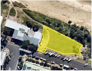
The Byron Bay Community Association Inc holds a licence to
conduct monthly community markets in Dening Park following Councils resolution
(19-062) to relocate the monthly community markets from Butler Street Reserve
to Dening Park.
The Byron Bay Community Association Inc considers the loss
of 40 markets stall spaces as unacceptable both in terms of lost market revenue
and impact on market stall holders that rely on the Byron community market to
sell their goods. The Byron Bay Community Association Inc requests that
Council consider an alternative footprint that would permit both events to
occur on the same day but with a significantly lesser impact on the markets and
number of market stalls.
In 2020 Council staff negotiated a compromise that would
have permitted the monthly community markets and the Byron Winter Whales
classic swim event to occur on the same day in Dening Park. Unfortunately due
to COVID-19 restrictions neither event was held. The below plan details a
smaller footprint in Dening Park allocated to the Byron Winter Whales.
This report recommends that Council delegate authority to
the General Manager to negotiate an acceptable outcome between the Byron Bay
Community Association Inc and the Byron Winter Whales whereby both events can
occur on 2 May 2021 in Dening Park. If no acceptable outcome can be
reached then a further report will be brought to Council to determine the
matter.
The Byron Bay Community Association Inc holds a licence to
conduct its monthly community markets in Dening Park on the first Sunday of
each month. That licence was granted by a Council resolution following
the relocation of the Byron community markets from the Butler Street Reserve to
Dening Park.
STRATEGIC CONSIDERATIONS
Community Strategic Plan and
Operational Plan
|
CSP Objective
|
L2
|
CSP Strategy
|
L3
|
DP Action
|
L4
|
OP Activity
|
|
Community
Objective 2: We cultivate and celebrate our diverse cultures, lifestyle and
sense of community
|
2.2
|
Support access
to a wide range of services and activities that contribute to the wellbeing
of all members of the Byron Shire community
|
2.2.1
|
Develop and
maintain collaborative relationships with government, sector and
community
|
2.2.1.2
|
Participate in
and inform community planning
|
Legal/Statutory/Policy Considerations
Local Government Act 1993
(NSW)
s 47A Leases,
licences and other estates in respect of community land—terms of 5 years
or less
(1) This section
applies to a lease, licence or other estate in respect of community land
granted for a period that (including any period for which the lease, licence or
other estate could be renewed by the exercise of an option) does not exceed 5
years, other than a lease, licence or other estate exempted by the regulations.
(2) If a council
proposes to grant a lease, licence or other estate to which this section
applies:
(a) the
proposal must be notified and exhibited in the manner prescribed by section 47,
and
(b) the
provisions of section 47 (3) and (4) apply to the proposal, and
(c) on receipt
by the council of a written request from the Minister, the proposal is to be
referred to the Minister, who is to determine whether or not the provisions of
section 47 (5)–(9) are to apply to the proposal.
(3) If the
Minister, under subsection (2) (c), determines that the provisions of section
47 (5)–(9) are to apply to the proposal:
(a) the
council, the Minister and the Director of Planning are to deal with the
proposal in
accordance with the provisions of section 47 (1)–(8), and
(b) section 47 (9) has effect
with respect to the Minister’s consent.
Financial Considerations
Council resolved 19-235 to fully
subsidise rent under the temporary market licences granted to the Byron
Farmers’ Market Inc and Byron Bay Community Association Inc.
Council must vary these licences for a further eight months to 31 October 2021.
Subsidised rent for the extended term totals $5,232 (inclusive GST).
Consultation and Engagement
Twenty eight day public notice of the proposed licence
variation to be granted to Byron Farmers’ Market Inc for use of community
land a the Cavanbah Centre, Ewingsdale Road Byron Bay was given between 26
October and 23 November 2020.
The managers of the Byron Farmers Market and Byron Community
Market have been consulted throughout this process and understand the rationale
behind the market extension.
Staff Reports - General Manager 13.2
Report No. 13.2 Sub-licences
to Zephyr Equine Pty Ltd and Cape Byron Seahorses Riding Centre for access
through Crown Land.
Directorate: General
Manager
Report
Author: Paula
Telford, Leasing and Licensing Coordinator
File No: I2020/1642
Summary:
Sub-licences held by Zephyr Equine Pty Ltd and Cape Byron
Seahorses Riding Centre for access through Crown land for commercial equestrian
activities will expire on 1 January 2020.
This report recommends that Council grant new twelve month
sub-licences to both Zephyr Equine Pty Ltd and Cape Byron Seahorses Riding
Centre in accordance with Council resolution 19-612.
|
RECOMMENDATION:
1. That
Council authorises the General Manager to grant a sub-licence to
Zephyr Equine Pty Ltd for a term of 12 months for the purpose of access
through Lot 407 DP 729057 being Crown Reserve R755695 on condition that:
a) Zephyr
Equine Pty Ltd holds a current permit with Cape Byron Marine Park for the
term of the sub-licence; and
b) Zephyr
Equine Pty Ltd takes all steps necessary to ensure that all horse droppings
are removed from the sub-licenced area during and at the end of each access
session.
2. That
Council authorises the General Manager to grant a sub-licence to Cape
Byron Seahorses Riding Centre for a term of 12 months for the purpose of
access through Lot 428 DP 729272 being Crown Reserve R81780 on condition
that:
a) Cape
Byron Seahorses Riding Centre holds a current permit with Cape Byron Marine
Park for the term of the sub-licence; and
b) Cape
Byron Seahorses Riding Centre takes all steps necessary to ensure that all
horse droppings are removed from the sub-licenced area during and at the end
of each access session.
3. That
sub-licence fee is set in accordance with Councils current Fees and Charges.
|
REPORT
Council resolved (19-612)
at its 28 November 2019 meeting:
1. That
Council authorise the General Manager to grant a sub-licence to Zephyr
Horses for a term of 12 months for the purpose of access through Lot 407 DP
729057 being Crown Reserve R755695 on condition that:
a) Zephyr
Horses holds a current permit with Cape Byron Marine Park for the term of the
sub-licence; and
b) Zephyr
Horses takes all steps necessary to ensure that all horse droppings are removed
from the sub-licenced area during and at the end of each access session.
2. That
Council authorise the General Manager to grant a sub-licence to Cape
Byron Seahorses Riding Centre for a term of 12 months for the purpose of access
through Lot 428 DP 729272 being Crown Reserve R81780 on condition that:
a) Cape
Byron Seahorses Riding Centre holds a current permit with Cape Byron Marine
Park for the term of the sub-licence; and
b) Cape
Byron Seahorses Riding Centre takes all steps necessary to ensure that all
horse droppings are removed from the sub-licenced area during and at the end of
each access session.
3. That
the fee for each sub-licence for the 12 month term be set at half the
annual Sub-licence Beach Access Commercial Horse Riding fee as set in
Council’s current Fees and Charges.
Council has
received requests from both Zephyr Equine Pty Ltd (formally Zephyr Horses) and
Cape Byron Seahorses Riding Centre for new annual licences
in accordance with resolution
(19-612) following the expiry of current licence on 1
January 2021.
Authority to sub-licence
In accordance with Crown licence
RI 564194, Council may grant sub-licences for access through Lot 407 DP729057
and Lot 428 DP 729272 for low impact recreational business purposes. All
Native Title implications were considered by the Crown prior to the grant of
licence RI 564194 to Council.
Council’s Policy 5.52
Commercial Activities on Coastal and Riparian Crown Reserves further requires a
Council resolution to grant proposed sub-licences.
Sub-licence terms and
conditions
Terms of the proposed sub-licences
to Zephyr Equine Pty Ltd and Cape Byron Seahorses Riding Centre requires that
both hold valid Cape Byron Marine Park Permits during the six month sub-licence
term.
Zephyr Equine Pty Ltd must also:
a) collect all horse dropping
during and at the end of each access through Lot 407 DP 729057.
Cape Byron Seahorses Riding Centre
must also:
a) collect all horse dropping
during and at the end of each access through South Beach Road and Lot 428 DP
729272; and
b) park its horse
truck/float legally on South Beach Road and handle all horses in public
areas in a safe manner.
Rent will be set in accordance
with Council’s 2020-2021 fees and charges for Sub-licence Beach
Access Commercial Horse Riding.
While equestrian commercial
activities are prohibited in zone 7(f1) (Coastal Zone) under the Byron 1988
LEP, clause 48(1) of the LEP permits temporary use of the land for development
not being designated development, for a maximum period of 7 days on any one
occasion up to a maximum of 60 days in any calendar year because the land is
vested in the Crown and the activity does not involve the erection of any
permanent structures.
Planned works to South Beach
Road Brunswick Heads:
In response to decisions made at a
Council workshop, Council is proposing to formalise current parking
arrangements on South Beach Road Brunswick Heads with works to commence mid to
late 2021. The proposed works will not impact the proposed sub-licence to
Cape Byron Seahorses Riding Centre for the term of the sub-licence.
STRATEGIC CONSIDERATIONS
Community Strategic Plan and
Operational Plan
|
CSP Objective
|
L2
|
CSP Strategy
|
L3
|
DP Action
|
L4
|
OP Activity
|
|
Community
Objective 1: We have infrastructure, transport and services which meet
our expectations
|
1.2
|
Provide
essential services and reliable infrastructure which meet an acceptable
community standard
|
1.2.4
|
Provide active
and passive recreational Community space that is accessible and inclusive for
all (SP)
|
1.2.4.1
|
Deliver adopted
projects from the beach accessibility program
|
Legal/Statutory/Policy Considerations
Zone
No 7 (f1) (Coastal Land Zone)
1 Objectives
of zone
The objectives of the zone are:
(a) to identify and protect environmentally
sensitive coastal land,
(b) to enable development for certain purposes
where such development does not have a detrimental effect on the habitat,
landscape or scenic quality of the locality,
(c) to prevent development which would adversely
affect, or be adversely affected by, coastal processes, and
(d) to enable the careful control of noxious
plants and weeds by means not likely to be significantly detrimental to the
native ecosystem.
2 Without
development consent
Nil.
3 Only
with development consent
Agriculture (other than animal establishments); beach and
coastal restoration works; building of levees, drains or clearing of land;
bushfire hazard reduction; clearing of land; community buildings; drainage;
environmental facilities; forestry; home industries; markets; roads; primitive
camping grounds; surf lifesaving facilities; utility installations.
48 Temporary
use of certain land
(1) Despite any provision of this plan,
a person may, without the consent of the Council, carry out development on land
for any purpose (not being designated development) within Zone No 6 (a) or 7
(f1) for a maximum period of 7 days on any one occasion up to a maximum of 60
days in a calendar year if:
(a) such land is vested in the
Crown, a Minister of the Crown or the Council, and
(b) the development does not
involve the erection of permanent structures ancillary to the use of that land.
(2) Despite any other provision of this
plan, a person may, but only with the consent of the Council, carry out development
on the following land for any purpose (not being designated development) for a
maximum period of 7 days on any one occasion up to a maximum of 60 days in a
calendar year if the development does not involve the erection of permanent
structures ancillary to the use of that land:
Lot 1, DP 201626 and Lot 2, DP 542178, Ewingsdale Road,
Ewingsdale
Lot 358, DP 704247, Bangalow Road, Byron Bay.
Financial Considerations
Rent under the Sub-licence is
established by Council’s fees and
charges.
Rental income for the term of the
Sub-licences is $3,318 inclusive of GST.
Consultation and Engagement
Nil.
Staff Reports - General Manager 13.3
Report No. 13.3 Implementation
of Res 20-664/2 Lease - Council and TAFE NSW - part lot 12 Bayshore Drive Byron
Bay
Directorate: General
Manager
Report
Author: Matt
Meir, Solicitor
File No: I2020/1824
Summary:
This report is about the proposed lease between Council and
TAFE NSW for part of lot 12, Bayshore Drive Byron Bay, in the context of Lot
12’s redevelopment.
The report responds to Part 2 of
Council Resolution 20-664 of 26 November 2020.
|
RECOMMENDATION:
That Council:
1) Notes
that Council and TAFE’s relationship is
focused on promoting outcomes that:
· Support delivery of high quality educational and
vocational training in the Byron Shire.
· Create a vocational training precinct to share
infrastructure, integrate training services with local industry and leverage
existing programs across broad industries, including for example tourism,
hospitality, retail, business, community services and creative industries.
· Support training of job ready individuals for the
benefit of the local community and local, regional and national industry and
growth.
2) Authorises
the General Manager to continue negotiations, and then enter an agreement for
lease and lease, with TAFE NSW regarding part of Lot 12 Bayshore Drive,
subject to:
a) The
final version of each agreement being substantively similar to the attached
agreement for lease and lease; and
b) The
final version of each agreement being consistent with Council resolution
20-664.
3) Quarantines
any rental revenue derived from a future lease with TAFE through establishing
a new reserve titled “Property Development Reserve – Lot 12
Bayshore Drive’
|
Attachments:
1 Agreement
for lease - Council and TAFE NSW - part Lot 12 Bayshore Drive - for Council
meeting 17 December, E2020/96663
2 Draft
Lease from Council to TAFE NSW for part lot 12 Bayshore Drive - for 17 December
Council meeting, E2020/45229 
REPORT
This report is about the proposed lease between Council and
TAFE NSW on that part of the redeveloped Lot 12 Bayshore Drive that is
earmarked for TAFE’s connected learning centre under the Creative Capital
masterplan for the site.
Context
On 13 December
2019 Council resolved (19-624) as follows:
1. Note
the separate report included in this agenda titled ‘Residential Strategy
and affiliated projects update’ and the section of the Report relating to
Lot 12 Bayshore Drive, Byron Bay.
2. Confirm
its in principle support for TAFE NSW to progress plans for a Connected
Learning Centre, subject to appropriate probity and planning considerations,
through the urban design investigation for Lot 12 Bayshore Drive, Byron Bay.
3. Authorise
the General Manager to negotiate and enter into a non-binding Heads of
Agreement with TAFE NSW for a Connected Learning Centre on Lot 12 Bayshore
Drive, Byron Bay.
Since this time, there have been a
series of Council resolutions regarding both the wider redevelopment of Lot 12
and TAFE occupying Council land within that redevelopment. All resolutions have
sought to advance Council and TAFE’s relationship. That relationship is
focused on promoting outcomes that:
· Support delivery of high quality educational and
vocational training in the Byron Shire.
· Create a vocational training precinct to share
infrastructure, integrate training services with local industry and leverage
existing programs across broad industries, including for example tourism,
hospitality, retail, business, community services and creative industries.
· Support training of job ready individuals for the
benefit of the local community and local, regional and national industry and
growth.
The most recent Council resolution
regarding TAFE’s occupation of part Lot 12 was resolution 20-664/2 of 26
November 2020. It states:
That a report be brought to the December meeting of Council
outlining the process for delivery of the TAFE NSW Connected Learning
Centre in the location proposed within the Creative Capital EOI, including
the details of the proposed lease arrangements for approval.
Relationship between Lot 12
redevelopment and TAFE lease
Council’s decision to pursue
the Creative Capital redevelopment proposal for Lot 12 means that any
Council-TAFE lease for part of Lot 12 needs to be consistent with Creative
Capital’s master plan.
The level of detail still to
worked through regarding the Creative Capital proposal means that Council and
TAFE cannot presently enter a lease for part of the site. Presently, there is
nothing for TAFE to lease.
Council and TAFE can enter a
binding agreement once details including the following are known:
· Key development dates under the master plan (which will
depend on the relevant consent authority for various works, and when TAFE and
Creative Capital receive development consent to carry out their respective
works on the site);
· The precise size of TAFE’s leased lot; and
· The site’s annual rent (which depends on the final
lot size).
Notwithstanding the details that
still need to be resolved, Council staff and TAFE’s expectation is that
the executed agreement for lease and lease between the parties will be on
similar terms to those previously considered by Council (both attached to this
report).
Timetable for proposed lease
As noted above, key details about
the Council -TAFE lease cannot be known at this stage.
However, the following table shows
the estimated new timetable for TAFE’s construction and occupation of its
Lot 12 campus, based on Creative Capital’s delivery programme:
|
Event
|
Creative Capital timetable
|
|
Council-TAFE enter agreement for lease
|
Sometime to prior to March 2021 (subject to
Council-Creative Capital development services agreement making provision for
TAFE access to site)
|
|
TAFE works start (subject to receiving development
consent; possibly from Joint Regional Planning Panel)
|
Sometime after December 2021 (approximate start date for
Creative Capital stage one works)
|
|
Council works complete
|
July-August 2022 (being done by Creative Capital)
|
|
TAFE works complete
|
March 2023
|
|
Council-TAFE lease starts
|
Later of Creative Capital works relevant to TAFE or TAFE
works finishing (assume March 2023)
|
|
Sunset date (allowing either Council or TAFE to terminate
agreement)
|
September 2023
|
|
Lease subdivision registered by Council
|
By September 2023
|
Creative Capital’s delivery
programme has the TAFE development as the second stage of its overall plan;
right after the necessary civil works are completed on the site (stage one).
Regarding the above timetable,
Council staff note:
· The timetable is subject to change. For instance, Creative
Capital’s delivery programme notes that proposed stage one will be
carried out in a way that enables the TAFE campus construction to start as
early as possible.
· The TAFE development will generally need to proceed
parallel with the broader masterplan redevelopment to ensure a cohesive
redevelopment of the whole site (e.g., consistent civil works, services
connections and easements).
· The proposed model from Creative Capital regarding Lot
12’s redevelopment is likely to be regarded as a public-private
partnership under the Local Government Act 1993. Further, based on
recent discussions with the Office of Local Government regarding the old Byron
Bay hospital site, it is possible, although unlikely that Council’s
proposed arrangement with TAFE could also trigger the public-private
partnership provisions. Council cannot enter a public-private partnership
without complying with the Local Government Act’s reporting
requirements. The proposed Statement of Outcomes contained in recommendation 1
is relevant to a public-private partnership reporting requirement.
Council’s resolution is sought now so as to avoid delay later on in the
process should the relationship be assessed as a public-private partnership,
which is currently being further investigated.
TAFE site location and rent
return
The Creative Capital proposal:
· Relocates the TAFE campus fronting Bayshore Drive to
further back on the site; and
· Reduces the campus from about 5,260 square metres to about
3,532 square metres.
The above changes, based on the
latest Valuation Report commissioned by Council, will reduce TAFE’s rent
from $382,000 (ex-GST) per annum to $187,677 (ex-GST) per annum.
TAFE has advised Council that the
proposed lot size for its development will need to be increased. This will
require a revaluation of the land and the rent flowing from it. Council staff
do not expect this revaluation to significantly increased the current proposed
rent.
Next steps
Because the lease of any Council
land within the overall masterplan is subsidiary to the masterplan
redevelopment (there is nothing to lease until the masterplan is finalised),
Council cannot reasonably enter a lease with TAFE at this time.
However, as can be seen above,
Council sees the TAFE campus construction as unfolding in an orderly way within
the masterplan redevelopment. In this context, Council should authorise the
general manager to enter a legally binding agreement with TAFE as soon as
practicable after its final form can be determined.
STRATEGIC CONSIDERATIONS
Community Strategic Plan and
Operational Plan
|
CSP Objective
|
L2
|
CSP Strategy
|
L3
|
DP Action
|
L4
|
OP Activity
|
|
Community
Objective 1: We have infrastructure, transport and services which meet
our expectations
|
1.2
|
Provide
essential services and reliable infrastructure which meet an acceptable
community standard
|
1.2.6
|
Optimise
Council’s property portfolio (SP)
|
1.2.6.1
|
Progress Lot 12
Bayshore Drive Byron Bay future use
|
|
Community
Objective 4: We manage growth and change responsibly
|
4.1
|
Support the
visions and aspirations of local communities through place-based planning and
management
|
4.1.1
|
Develop,
implement and update Place Plans that promote place-based forward planning
strategies and actions
|
4.1.1.5
|
Implement Our
Mullumbimby Masterplan, Bangalow Village Plan and Byron Arts and Industry
Estate Plan
|
Legal/Statutory/Policy Considerations
Under the Local Government
Act 1993, Council is free to lease operational land to who it
wishes. However, certain arrangements for public infrastructure that are
provided through private sector financing, ownership or control are subject to
the Local Government Act’s public-private partnership provisions.
Financial Considerations
When Council considered this
matter at the 16 April 2020 Planning Meeting, it was considered that any rental
revenue provided by TAFE be reserved to assist with funding the required
immediate civil works associated with the TAFE establishment and the broader
future development cost of lot 12 Bayshore Drive.
It was suggested that Council
establish a specific reserve titled ‘Property Development Reserve –
Lot 12 Bayshore Drive and this was included at recommendation 5 to that Report.
Upon consideration of the Report, Council adopted an alternative resolution 20-161
that did not prescribe how any rental revenue via a lease with TAFE would
be treated.
Given Council resolution 20-644
from the 26 November 2020 Ordinary Meeting where Council may now not be
required to contribute to any cost to redevelop lot 12 Bayshore Drive, it is
for Council to determine what to do with any rental revenue that may arise from
a lease agreement with TAFE.
Along the lines promoted in the 16
April 2020 Planning Meeting Report, it is suggested that Council quarantine the
rental revenue and allocate it to a newly created reserve titled
‘Property Development Reserve – Lot 12 Bayshore Drive’.
If at a future point Council wishes to reallocate any revenue generated and
contained in this reserve for another purpose, it will be free to do so by
resolution.
Consultation and Engagement
Further discussions between Council, TAFE and Creative
Capital are necessary to ensure each group’s interests are met prior to
the general manager entering a lease with TAFE on Council’s behalf.
Staff Reports - Corporate and Community Services 13.4
Staff Reports - Corporate and Community
Services
Report No. 13.4 Report
of the Public Art Panel meeting held on 29 October 2020
Directorate: Corporate
and Community Services
Report
Author: Joanne
McMurtry, Community Project Officer
Isabelle Hawton, Planner
File No: I2020/1769
Theme: Corporate Management
Community Development
Summary:
A Public Art Panel meeting was held on 29 October 2020 to
consider the art components of the Mullumbimby Talking Street Trial and Public
Art Conservation and Maintenance.
Recommendations are provided for Council’s
consideration. Staff have suggested alternate recommendations regarding the
Talking Street Trial, based on updated considerations outlined in the report.
|
RECOMMENDATION:
1. Regarding
the Mullumbimby Talking Street Trial, that Council does not
adopt the Recommendation proposed by the Public Art Panel, but instead adopts
the following:
a) Notes
the feedback provided by the Public Art Panel and supports the recommendation
to provide more time for planning and delivery of the art components for the
Talking Street Trial;
b) Undertakes
a staged approach to place-making/activation elements in the Trial, including
art components, as the budget allows, once the final costings of the
traffic-calming elements are finalised.
c) Where
possible, seeks art components that may be utilised in a more permanent way
after the trial is complete.
2. That
Council adopts the following Panel recommendations:
a) Notes
the current list of Public Artworks in Council’s Asset Management
System.
b) Notes
that the recently adopted Open Spaces Asset Management Plan includes public
art assets and identifies that the current budget allocation for assets
outlined in the plan is insufficient to sustain assets at the desired
standard.
c) Establishes
a Public Art Maintenance Reserve in the Open Spaces and Recreation budget of
$10,000 per annum, commencing in the 2021/22 financial year, to cover the
cost of annual inspections, conservation and maintenance.
d) Notes
that the Public Art Maintenance budget is to be spent only on works that are
not scheduled for replacement or maintenance under a separate Council budget
or project.
3. That
regarding a request for financial assistance for the Brunswick Nature
Sculpture Walk event in 2021, Council supports the request with $5,000
towards the 2021 event and encourages the organisers to apply for further
funds if needed when the Public Art Small Grants funding becomes available.
|
Attachments:
1 Minutes
29/10/2020 Public Art Panel, I2020/1656
REPORT
A Public Art Panel meeting was held on 29 October 2020 to
consider the art components of the Mullumbimby Talking Street Trial and issues
of Public Art Conservation and Maintenance.
The minutes of the meeting are attached. Alternative
recommendations regarding the Mullumbimby Talking Street Trial are proposed.
Recommendations 2 and 3 are as proposed by the Panel.
Mullumbimby Talking Street Trial
The Mullumbimby ‘Talking Street’ is an
activation of Mullumbimby’s main street and the number one priority in
the Our Mullumbimby Masterplan. Council was successful in
receiving grant funding of $250,000 through the NSW government ‘Streets
as Shared Spaces’ program and there may be several opportunities to
incorporate art/place-making components into the trial.
The Public Art Panel received an overview of this
place-making project and its artistic components, and was asked to provide
feedback on a draft curatorial brief. The brief, as put to the Panel, suggested
the engagement of an arts curator to coordinate the delivery of nominated arts
components, within a budget of $20,000.
The Panel was concerned that the budget was significantly
deficient and that the proposed arts components were too small in scope.
The Panel, therefore, made the following recommendations:
Committee Recommendation:
That the Public Art Panel:
1. Notes
the project information provided;
2. Provides
the following feedback:
a. The
Panel supports a delay in the project’s art components due to time and
budgetary pressures and requests that the art coordinator role be delivered by
the incoming Arts and Cultural Officer who will work with the project team to
deliver the art components of the project.
b. That
the Arts and Culture officer propose some delivery options for the art
components within the Talking Street.
3. Notes
that existing Public Art Panel members also participate in the Place Planning
Collective and could assist as a conduit between the two to support a more
integrated approach to delivering shared public art and place-making outcomes.
Management Comments
Discussion with the Talking Street project team, subsequent
to the Panel meeting, further highlighted budgetary and time challenges for the
project. It also clarified the intention of this project to be a trial of
various interventions (as required by the Streets as Shared Spaces grant).
The fundamental focus of the trial is to slow traffic in
Burringbar Street and provide areas within the street where pedestrian spaces
can be extended into the road for use by people.
As design of the project is being progressed, it is becoming
clear that the overall budget of $250,000 is limiting opportunities, requiring
the bulk of the funding to be used for works on the road.
The project team is not yet at the point of being able to
confirm the budget that could be available to implement any art components.
The first part of the Panel’s recommendation is
therefore supported – to delay the art components of the project and look
to deliver art outcomes in a staged way across the trial period based on the
best possible outcome from budget available.
In terms of project budget, the Local Traffic Committee
meeting on 8th December will determine the final design and costing
for the proposed road interventions and traffic calming treatments. The
project team will then be able to finalise all project costs, which will shape
the budget allocation for art components.
At that stage, the project team will be able to liaise with
the newly appointed Arts and Culture Officer to scope the most efficient
program for the delivery of art opportunities throughout the trial.
The inaugural Arts and Culture Officer commenced at Council
on 16 November 2020. Pre-existing major priorities span strategic and
operational deliverables and include, but are not limited to, commencing work
on an Arts and Culture Strategy as per resolution 20-263 and
co-developing and implementing a COVID appropriate operating model for the Lone
Goat Gallery (currently unable to re-open).
Rather than directly delivering the Art Coordinator role in
the Talking Street trial, the Arts and Culture Officer is best-placed to
provide advice and expertise to internal and community groups, individuals and
stakeholders.
For the above reasons it is not feasible for the Arts and
Culture Officer to directly deliver the Art Coordinator role in the Talking
Street trial, as this additional operational responsibility would prohibit
completion of pre-existing priority deliverables and detract from valuable
opportunities for strategic organisational process improvement.
During the trial, there will be ample opportunities to
consult with the community about the elements that are favoured and other
elements that aren’t working so well. The trial will be a living
activation that enables the community to provide feedback and create changes
throughout the process.
Further consultation will be undertaken with the Arts &
Culture Officer should further budget be established for artistic/place-making
elements.
An alternative recommendation is therefore proposed as
follows:
Staff Recommendation
That Council:
1. Notes
the feedback provided by the Public Art Panel and supports the recommendation
to provide more time for planning and the delivery of the art components for
the Talking Street Trial;
2. Undertakes
a staged approach to place-making/activation elements in the Trial, including
art components as the budget allows, once the final costings of the
traffic-calming elements are finalised.
3. Where
possible, seeks art components that may be utilised in a more permanent way
after the trial is complete.
STRATEGIC CONSIDERATIONS
Community Strategic Plan and Operational Plan
|
CSP Objective
|
L2
|
CSP Strategy
|
L3
|
DP Action
|
L4
|
OP Activity
|
|
Community
Objective 2: We cultivate and celebrate our diverse cultures, lifestyle and
sense of community
|
2.1
|
Support and
encourage our vibrant culture and creativity
|
2.1.3
|
Enhance
opportunities for interaction with art in public spaces
|
2.1.3.1
|
Implement
Public Art Strategy
|
|
Community
Objective 4: We manage growth and change responsibly
|
4.1
|
Support the
visions and aspirations of local communities through place-based planning and
management
|
4.1.1
|
Develop,
implement and update Place Plans that promote place-based forward planning
strategies and actions
|
4.1.1.5
|
Implement Our
Mullumbimby Masterplan, Bangalow Village Plan and Byron Arts and Industry
Estate Plan
|
Legal / Statutory / Policy Considerations
The Mullumbimby Talking Street Trial Project is a place
activation/place-making project. The art components of the project are
temporary. Project approval has already been obtained from Council through the
funding application approval process in which the project was firmly situated
as a place-making, rather than public art, project. The Public Art Policy,
Strategy and Guidelines have provided guidance around art activities.
Financial
Considerations
Regarding the Mullumbimby Talking Street Trial, Council was
successful in receiving grant funding of $250,000 through the NSW government
‘Streets as Shared Spaces’ program to implement the trial project.
The budget for delivering the project’s artistic components was initially
estimated at $20,000, although this estimate was subsequently reconsidered.
Regarding Public Art Maintenance and Conservation, the
recommendation is for Council to establish a Public Art Maintenance Reserve in
the Open Spaces and Recreation budget of $10,000 per annum, commencing in the
2021/22 financial year, to cover the cost of annual inspections, conservation
and maintenance.
The recommendation also requests:
1. That
Council notes that the recently adopted Open Spaces Asset Management Plan
includes public art assets and identifies that the current budget allocation
for assets outlined in the plan is insufficient to sustain assets at the
desired standard.
2. That
the Public Art Maintenance budget be spent only on works that are not scheduled
for replacement or maintenance under a separate Council budget or project.
Regarding
Brunswick Nature Sculpture Walk, the recommendation requests Council support
the request for financial assistance with $5,000 towards the 2021 event. The
Public Art budget balance for the 2020/21 financial year is currently $65,900.
Consultation
and Engagement
The Mullumbimby Talking Street Project is a result of
comprehensive community consultation and there is a high level of collaboration
between key community organisations and Council in delivering the trial.
The project was identified by the Mullumbimby Masterplan
Guidance Group during the development of Our Mullumbimby Masterplan.
In addition, the following community groups worked with
Council to submit the Streets as Shared Spaces grant application:
· Creative
Mullumbimby
· Mullumbimby
Chamber of Commerce
· Mullumbimby
Residents Association
· The Place
Planning Collective
To implement the project, a Community Working Group has been
established including community members from Creative Mullumbimby, Mullumbimby
Chamber of Commerce and Mullumbimby Residents Association.
This report provides the minutes of the Public Art Panel,
made up of 6 community representatives, 2 invited members and 2 councillors.
Staff Reports - Corporate and Community Services 13.5
Report No. 13.5 Project
Options for the Australian Government Local Roads and Community Infrastructure
Program Extension
Directorate: Corporate
and Community Services
Report
Author: Esmeralda
Davis, A/Manager Corporate Services
Christopher Soulsby, Development
Planning Officer S94 & S64
File No: I2020/1857
Summary:
The purpose of this report is to present project options to
Council for the allocation of $1,408,882 of grant funding to be received
from the Australian Government’s Local Roads and Community Infrastructure
Program (LRCIP).
|
RECOMMENDATION:
That Council adopts the projects listed in
Option 1 to expend the Australian Government’s Local Roads and Community
Infrastructure Program grant.
|
REPORT
Background
In May 2020, the Deputy Prime Minister, announced the LRCIP
and the funding allocation for Councils. Byron Shire Council’s
initial allocation under this program was $730,070. In October 2020, an
extension to this program was announced, and Council has been allocated a
further $1,408,882, available from 1 January 2021, with funds to be expended by
31 December 2021.
At the time of writing this report, the funding agreement
had not yet been received and is expected by mid December 2020.
The Program Extension Guidelines are also not yet available,
however the initial notification encourages Councils to identify projects “to
maximise the opportunity for a range of workers to be retained, redeployed and
employed to deliver ready to roll-out projects that provide economic stimulus
and benefits to communities”.
Assuming the same eligibility criteria as for the initial
allocation, funding will be available for local road and community infrastructure
projects that involve the construction, maintenance of and/or improvements to
council-owned assets (including natural assets) that are generally accessible
to the public. Projects will need to deliver benefits to the community, such as
improved accessibility, visual amenity, and safety benefits.
Eligible local road projects may include any of the
following associated with a road:
· traffic
signs;
· traffic
control equipment;
· street
lighting equipment;
· a
bridge or tunnel;
· a
facility off the road used by heavy vehicles in connection with travel on the
road (for example, a rest area or weigh station);
· facilities
off the road that support the visitor economy; and
· road
and sidewalk maintenance, where additional to normal capital works schedules.
Eligible community infrastructure projects could include
works involving:
· Closed
Circuit TV (CCTV);
· bicycle
and walking paths;
· painting
or improvements to community facilities;
· repairing
and replacing fencing;
· improved
accessibility of community facilities and areas;
· landscaping
improvements, such as tree planting and beautification of roundabouts;
· picnic
shelters or barbeque facilities at community parks;
· playgrounds
and skate parks (including all ability playgrounds);
· noise
and vibration mitigation measures; and
· off-road
car parks (such as those at sporting grounds or parks).
Key issues
Following internal consultation a number of potential
project options have been identified, including those which may recently have
been submitted as grant applications, as well as priority infrastructure
renewal projects based on asset register classification, and Council strategic
plans.
Byron Street Shared Path
The Bangalow Village Plan 2019 and the Byron Shire 10 Year
Bike Plan 2020 (Bike Plan) identify a number of priority works. The Byron
Street Shared Path BA001, BA010 and BA023 include the upgrade of the existing
footpath on Byron Street between Station Street and Feros Care Residential
Village. The project is currently undergoing detailed design with a
shovel ready design expected by June 2021. Total project cost including
contingency and the option for a pedestrian bridge over Byron Creek is
$1,200,000. The majority of this path is classified as “Priority A”
with the link to Feros classified as “Priority C”, however, this
link has been advocated for by the community.
This path will provide an accessible connection to the
centre of Bangalow, in particular for Bangalow Public School, and is identified
as the number 1 priority for access and movement in the Bangalow Village Plan.
Map 1 - Extract from the Bike
Plan.
Lighthouse Road Drainage Project
The Lighthouse Road drainage project aims to improve
Council’s stormwater drainage and reduce runoff adjacent to the Clarkes
Beach Reflections Holiday Park. Stormwater will be redirected from
Captain Cook Carpark, Lighthouse Road and the surrounding catchment into
Council’s formal drainage network. This will mitigate erosion in
the surrounding areas and improve the safety of pedestrians and vehicles in
rainfall events.
The project consists of piped drainage, kerb and gutter, a
grassed swale, a stormwater detention basin and improvements to parking on
Lighthouse Road. The construction of the basin will help improve
stormwater quality and will provide detention in rainfall events.
Upgrades will be provided to the downstream network in Kipling Street to cater
for the additional flow. Detailed Design has been completed for the
project. The estimated total project cost including contingency is
$1,200,000.
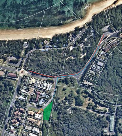
Map 2 – Overall plan of
drainage upgrades.
Marvel Hall:
This project significantly improves a community hall
providing enduring benefit to the community by providing safe and suitable
space for a variety of community activities. Works to remove all asbestos
containing material from Marvel Hall are identified as a priority in the asset
register and the installation of a ramp is an important element to improve
accessibility for all users. The proposed commercial kitchen would ensure more
social and economic activities could be held at the hall, in line with
Council’s Community Strategic Plan objective 1.2.1 to ensure that
building assets are managed to support the provision of services to the
community. The Section 355 volunteer committee has undertaken consultation with
existing and potential hirers to understand the ongoing revenue and use
potential of the proposed commercial kitchen. The estimated total project
cost is $400,000.
Station Street Upgrade, Mullumbimby:
The Mullumbimby Masterplan provides that Station Street
could be seen as an alternate route to accommodate traffic movements as a
result of the implementation of place activation spaces in Burringbar
Street. Therefore it is considered necessary to upgrade this route in
terms of drainage and road pavement to more safely accommodate increased
vehicle traffic.
The scope of work for Station Street between Burringbar
Street and Fern Street includes drainage design/upgrade, identification of
pavement requiring reinstatement and detailing areas of pavement which need to
tie in to the new drainage works, car parking, signage and line marking.
The scope also includes the design of an on road separated cycleway to each
side of Station Street (as per the bike plan).
Map 3 - Extract from the Bike
Plan.
Consideration will need to be given to the timing of these
works relative to other Works projects proposed to be undertaken in Mullumbimby
over the next year or so, as there are a number of projects in Mullumbimby
which are constrained by various funding agreements.
The estimated total project cost is $780,507.
Mullumbimby Recreation Grounds and Skate Park:
The Byron Shire Open Space and Recreation Needs Assessment
and Action Plan refers to this precinct as a youth and sporting hub and
recommends consideration of a fenced dog off-leash park. Recent
renewals and upgrades, including controlled lighting of the Skate Park have
seen significant increased community usage of this facility. This increased
usage has presented some actual and perceived passive surveillance and
territorial re-enforcement and space/activity management challenges, partially
as a result of the nearest carpark and public road access being some 200m from
the skate park. In discussions with NSW Police regarding Crime Prevention
through Environmental Design principles, activation through the provision of
infrastructure such as parking is considered highly desirable, as it will allow
greater parental supervision and more intergenerational use and activation of
the area.
The project would include a 25 bay carpark including
disabled parking spaces ($150,000), a fenced dog off leash area ($50,000) with
landscaping and additional shade shelter ($50,000).
The costs above are indicative only, and would be further
refined prior to the Works Schedule being submitted to the Government.
Options
The selection criteria used
to identify the recommended projects were:
1. meeting the
Australian Government criteria;
2. being capable of
being completed using this grant fund and/or additional developer
contributions /grants;
3. informed
by, or link to, an existing strategic plan;
4. value-adding
to existing programed works or asset renewals;
5. the
outcome of existing community consultation with respect to the inclusion of
these projects in strategic plans.
The following options are considered eligible and capable of
being delivered within the timeframes of the grant:
|
Option 1
|
LRCIP
|
Developer Contributions
|
Other Council
|
Total Project Cost
|
|
Lighthouse Road Drainage project
|
$1,200,000
|
$0
|
$0
|
$1,200,000
|
|
Marvel Hall Kitchen Upgrade with asbestos removal and new
access ramp
|
$208,882
|
$0
|
$191,118
from SRV
|
$400,000
|
|
Total
|
$1,408,882
|
|
|
$1,600,000
|
|
Option 2
|
LRCIP
|
Developer Contributions
|
Other Council
|
Total Project Cost
|
|
Byron Street Shared Path – Bangalow (including link
to Feros Village)
|
$1,200,000
|
$0
|
$0
|
$1,200,000
|
|
Marvel Hall Kitchen Upgrade with asbestos removal and new
access ramp
|
$208,882
|
$0
|
$191,118
from SRV
|
$400,000
|
|
Total
|
$1,408,882
|
|
|
$1,600,000
|
Option 3
|
LRCIP
|
Developer Contributions
|
Other Council
|
Total Project Cost
|
|
Station Street Upgrade - Mullumbimby
|
$780,507
|
$0
|
$0
|
$780,507
|
|
Marvel Hall Kitchen Upgrade with asbestos removal and new
access ramp
|
$400,000
|
$0
|
$0
|
$400,000
|
|
Mullumbimby Recreation Grounds and Skate Park
|
$228,375
|
$21,625 from open space
|
$0
|
$250,000
|
|
Total
|
$1,408,882
|
|
|
$1,430,507
|
Next steps:
As funding is expected to be
received early in 2021, Council is asked to consider the above options and
determine how it would like to apply the funding.
STRATEGIC CONSIDERATIONS
Community Strategic Plan and
Operational Plan
|
CSP
Objective
|
L2
|
CSP Strategy
|
L3
|
DP Action
|
L4
|
OP Activity
|
|
Community
Objective 5: We have Infrastructure, Transport and Services which meet our
expectations
|
5.5
|
Manage
Council’s finances
|
5.5.1
|
Enhance
the financial capability and
acumen of Council
|
5.5.1.2
|
Support
the organisation in identifying financial
implications of projects,
proposals and plans
|
Any projects selected by Council
to apply the LRCIP funding towards will be included in the next revision of
Council’s Operational Plan 2020-21.
Legal/Statutory/Policy Considerations
There are no statutory or
legal implications with the funding of these projects.
Financial Considerations
There are no adverse impacts on Council’s financial
position as all of the projects are funded from grants, developer contributions
or existing budget allocations.
Consultation and Engagement
The following Council staff were consulted in the preparation
of identifying projects:
· Executive
Team;
· Manager
Open Spaces;
· Manager
Works;
· Manager
Social and Cultural Development;
· Infrastructure
Planning Coordinator;
Staff Reports - Corporate and Community Services 13.6
Report No. 13.6 Council
Investments - 1 November 2020 to 30 November 2020
Directorate: Corporate
and Community Services
Report Author: James
Brickley, Manager Finance
File No: I2020/1868
Summary:
This report includes a list of investments and identifies
Council’s overall cash position for the period 1 November 2020 to 30
November 2020 for information.
This report is prepared to comply with Regulation 212 of the
Local Government (General) Regulation 2005.
|
RECOMMENDATION:
That Council notes the report listing
Council’s investments and overall cash position as at 30 November 2020.
|
REPORT
Council has continued to maintain a diversified portfolio of
investments. At 30 November 2020, the average 90 day bank bill rate (BBSW) for
the month of November 2020 was 0.0548%.
Council’s performance to 30 November 2020 was 0.79%. This is largely due
to the active ongoing management of the investment portfolio, maximising
investment returns through secure term deposits, bonds and purchasing floating
rate notes with attractive interest rates. It should be noted that as
investments mature, Council’s investment return may continue to decrease
due to the lower rates available in the current market.
The table below identifies the investments held by Council
as at 30 November 2020.
Schedule of
Investments held as at 30 November 2020
|
Purch Date
|
Principal ($)
|
Description
|
CP*
|
Rating
|
Maturity Date
|
No Fossil Fuel
|
Type
|
Interest Rate Per
Annum
|
Current Value
|
|
24/03/17
|
1,000,000
|
NAB Social Bond (Gender Equality)
|
Y
|
AA-
|
24/03/22
|
N
|
B
|
3.25%
|
1,046,700.00
|
|
15/11/18
|
980,060
|
NSW Treasury Corp (Green Bond)
|
N
|
AAA
|
15/11/28
|
Y
|
B
|
3.00%
|
1,152,260.00
|
|
20/11/18
|
1,018,290
|
QLD Treasury Corp (Green Bond)
|
N
|
AA+
|
22/03/24
|
Y
|
B
|
3.00%
|
1,091,930.00
|
|
28/03/19
|
1,000,000
|
National Housing Finance & Investment Corporation
|
Y
|
AAA
|
28/03/31
|
Y
|
B
|
2.38%
|
1,126,670.00
|
|
21/11/19
|
1,000,250
|
NSW Treasury Corp (Sustainability Bond)
|
N
|
AAA
|
20/03/25
|
Y
|
B
|
1.25%
|
1,028,020.00
|
|
27/11/19
|
500,000
|
National Housing Finance & Investment
Social Bond
|
Y
|
AAA
|
27/05/30
|
Y
|
B
|
1.57%
|
522,906.50
|
|
31/03/17
|
1,000,000
|
CBA Climate Bond
|
Y
|
AA-
|
31/03/22
|
N
|
FRN
|
1.02%
|
1,010,430.00
|
|
16/11/17
|
750,000
|
Bank of Queensland
|
Y
|
BBB+
|
16/11/21
|
N
|
FRN
|
1.12%
|
753,337.50
|
|
30/08/18
|
500,000
|
Bank Australia Ltd (Sustainability Bond)
|
Y
|
BBB+
|
30/08/21
|
Y
|
FRN
|
1.39%
|
502,890.00
|
|
07/12/18
|
2,000,000
|
Credit Union Australia
|
Y
|
BBB
|
07/12/20
|
Y
|
TD
|
3.02%
|
2,000,000.00
|
|
06/01/20
|
1,000,000
|
Judo Bank
|
Y
|
NR
|
05/01/21
|
N
|
TD
|
2.10%
|
1,000,000.00
|
|
20/01/20
|
1,000,000
|
Westpac (Tailored)
|
Y
|
AA-
|
20/01/21
|
N
|
TD
|
1.41%
|
1,000,000.00
|
|
02/06/20
|
1,000,000
|
AMP Bank
|
Y
|
BBB
|
01/12/20
|
N
|
TD
|
1.60%
|
1,000,000.00
|
|
03/06/20
|
1,000,000
|
Auswide Bank
|
Y
|
NR
|
02/12/20
|
N
|
TD
|
1.15%
|
1,000,000.00
|
|
02/06/20
|
1,000,000
|
ME Bank
|
Y
|
BBB
|
01/12/20
|
N
|
TD
|
1.13%
|
1,000,000.00
|
|
24/07/20
|
2,000,000
|
Bank of Queensland
|
N
|
BBB+
|
19/07/21
|
N
|
TD
|
0.90%
|
2,000,000.00
|
|
28/07/20
|
1,000,000
|
ME Bank
|
N
|
BBB
|
29/01/21
|
Y
|
TD
|
0.63%
|
1,000,000.00
|
|
30/07/20
|
1,000,000
|
Judo Bank
|
N
|
NR
|
30/07/21
|
N
|
TD
|
1.25%
|
1,000,000.00
|
|
03/08/20
|
1,000,000
|
NAB
|
N
|
AA-
|
03/08/21
|
N
|
TD
|
0.85%
|
1,000,000.00
|
|
04/08/20
|
2,000,000
|
Suncorp
|
Y
|
A+
|
01/02/21
|
N
|
TD
|
0.70%
|
2,000,000.00
|
|
19/08/20
|
2,000,000
|
NAB
|
N
|
AA-
|
17/12/20
|
N
|
TD
|
0.70%
|
2,000,000.00
|
|
19/08/20
|
2,000,000
|
NAB
|
N
|
AA-
|
19/08/21
|
N
|
TD
|
0.80%
|
2,000,000.00
|
|
26/08/20
|
1,000,000
|
AMP Bank
|
N
|
BBB
|
26/08/21
|
N
|
TD
|
0.80%
|
1,000,000.00
|
|
02/09/20
|
1,000,000
|
Bank of Queensland
|
N
|
BBB+
|
01/09/21
|
N
|
TD
|
0.78%
|
1,000,000.00
|
|
02/09/20
|
1,000,000
|
NAB
|
N
|
AA-
|
02/09/21
|
N
|
TD
|
0.75%
|
1,000,000.00
|
|
07/09/20
|
2,000,000
|
NAB
|
N
|
AA-
|
05/01/21
|
N
|
TD
|
0.70%
|
2,000,000.00
|
|
24/09/20
|
2,000,000
|
NAB
|
N
|
AA-
|
24/09/21
|
N
|
TD
|
0.65%
|
2,000,000.00
|
|
30/09/20
|
1,000,000
|
Bank of Queensland
|
N
|
BBB+
|
30/09/21
|
N
|
TD
|
0.65%
|
1,000,000.00
|
|
30/09/20
|
2,000,000
|
CBA Green Deposit
|
N
|
AA-
|
30/09/21
|
N
|
TD
|
0.70%
|
2,000,000.00
|
|
06/10/20
|
1,000,000
|
Police Credit Union Ltd (SA)
|
Y
|
NR
|
06/01/21
|
N
|
TD
|
0.80%
|
1,000,000.00
|
|
07/10/20
|
2,000,000
|
MyState Bank Limited
|
Y
|
NR
|
07/10/21
|
Y
|
TD
|
0.70%
|
2,000,000.00
|
|
13/10/20
|
1,000,000
|
The Mutual Bank
|
Y
|
NR
|
13/04/21
|
N
|
TD
|
0.60%
|
1,000,000.00
|
|
27/10/20
|
1,000,000
|
The Capricornian
|
Y
|
NR
|
28/01/21
|
Y
|
TD
|
0.50%
|
1,000,000.00
|
|
28/10/20
|
1,000,000
|
The Mutual Bank
|
N
|
NR
|
27/01/21
|
N
|
TD
|
0.45%
|
1,000,000.00
|
|
04/11/20
|
1,000,001
|
AMP Bank
|
N
|
BBB
|
05/05/21
|
N
|
TD
|
0.55%
|
1,000,001.00
|
|
04/11/20
|
2,000,000
|
NAB
|
N
|
AA-
|
04/11/21
|
N
|
TD
|
0.55%
|
2,000,000.00
|
|
09/11/20
|
1,000,000
|
Community First Credit Union
|
Y
|
NR
|
09/11/21
|
Y
|
TD
|
0.65%
|
1,000,000.00
|
|
09/11/20
|
1,000,000
|
The Mutual Bank
|
N
|
NR
|
09/08/21
|
N
|
TD
|
0.65%
|
1,000,000.00
|
|
23/11/20
|
1,000,000
|
AMP Bank
|
N
|
BBB
|
23/11/21
|
N
|
TD
|
0.75%
|
1,000,000.00
|
|
24/11/20
|
1,000,000
|
Judo Bank
|
N
|
NR
|
24/11/21
|
Y
|
TD
|
0.84%
|
1,000,000.00
|
|
25/11/20
|
2,000,000
|
AMP Bank
|
N
|
BBB
|
26/05/21
|
Y
|
TD
|
0.70%
|
2,000,000.00
|
|
26/11/20
|
1,000,000
|
Community First Credit Union
|
N
|
NR
|
26/11/21
|
Y
|
TD
|
0.65%
|
1,000,000.00
|
|
26/11/20
|
1,000,000
|
Macquarie Bank
|
Y
|
A
|
22/10/21
|
N
|
TD
|
0.50%
|
1,000,000.00
|
|
N/A
|
12,759,011.16
|
CBA Business Saver
|
N
|
AA-
|
N/A
|
N
|
CALL
|
0.35%
|
12,759,011.16
|
|
N/A
|
4,279,767.89
|
CBA Business Saver – Tourism
Infrastructure Grant
|
N
|
AA-
|
N/A
|
N
|
CALL
|
0.35%
|
4,279,767.89
|
|
N/A
|
6,108,282.80
|
NSW Treasury Corp
|
N
|
AAA
|
N/A
|
Y
|
CALL
|
0.05%
|
6,108,282.80
|
|
Total
|
75,895,662.85
|
|
|
|
|
|
AVG
|
0.79%
|
76,382,206.85
|
|
Note 1.
|
CP = Capital protection on maturity
|
|
|
N = No Capital Protection
|
|
|
Y = Fully covered by Government Guarantee
|
|
|
P = Partial Government Guarantee of $250,000 (Financial
Claims Scheme)
|
|
|
|
|
Note 2.
|
No Fossil Fuel ADI
|
|
|
Y = No investment in Fossil Fuels
|
|
|
N = Investment in Fossil Fuels
|
|
|
U = Unknown Status
|
|
Note 3.
|
Type
|
Description
|
|
|
|
B
|
Bonds
|
Principal can vary based on
valuation, interest payable via a fixed interest, payable usually each
quarter.
|
|
|
FRN
|
Floating Rate Note
|
Principal can vary based on
valuation, interest payable via a floating interest rate that varies each
quarter.
|
|
|
TD
|
Term Deposit
|
Principal does not vary during investment term. Interest
payable is fixed at the rate invested for the investment term.
|
|
|
CALL
|
Call Account
|
Principal varies due to cash flow demands from deposits/withdrawals,
interest is payable on the daily balance.
|
Environmental and Socially
Responsible Investing (ESRI)
An additional column has been
added to the schedule of Investments to identify if the financial institution
holding the Council investment has been assessed as a ‘No Fossil
Fuel’ investing institution. This information has been sourced through www.marketforces.org.au
and identifies financial institutions that either invest in fossil fuel related
industries or do not. The graph below highlights the percentage of each
classification across Council’s total investment portfolio in respect of
fossil fuels only.
The notion of Environmental and
Socially Responsible Investing is much broader than whether a financial
institution as rated by ‘marketforces.org.au’ invests in fossil
fuels or not. Council’s current Investment Policy defines Environmental
and Socially Responsible Investing at Section 4.1 of the Policy which can be
found on Council’s website.
Council has three investments
with financial institutions that invest in fossil fuels but are nevertheless
aligned with the broader definition of Environmental and Socially Responsible
investments i.e.:
1. $1,000,000 investment with the
National Australia Bank maturing on 24 March 2022 known as a Social Bond that
promotes Gender Equity.
2. $1,000,000 investment with
Commonwealth Bank maturing on 31 March 2022 known as a Climate Bond.
3. $2,000,000 investment with
Commonwealth Bank maturing on 30 September 2021 known as a Green Deposit.
4. 
Investment Policy
Compliance
The
above table identifies compliance with Council’s Investment Policy by the
proportion of the investment portfolio invested with financial institutions,
along with their associated credit ratings compared to parameters in the
Investment Policy. The parameters are designed to support prudent short and
long-term management of credit risk and ensure diversification of the
investment portfolio. Note that the financial institutions currently offering
investments in the ‘ethical’ area are still mainly those with lower
credit ratings (being either BBB or not rated at all i.e. credit unions).
Associated Risk
Moving more of the investment portfolio into the
‘ethical’ space will lower the credit quality of the investment
portfolio overall and increase the organisation’s credit risk (i.e.
exposure to potential default). To monitor this issue the ‘Investment
Policy Compliance’ table is now produced for each monthly Investment
Report to Council.
The investment portfolio is outlined in the table below by
investment type for the period 1
November 2020 to 30 November 2020:
Dissection
of Council Investment Portfolio as at 30 November 2020
|
Principal Value ($)
|
Investment Linked to:
|
Current Market Value ($)
|
Cumulative Unrealised Gain/(Loss) ($)
|
|
45,000,001.00
|
Term
Deposits
|
45,000,001.00
|
0.00
|
|
2,250,000.00
|
Floating
Rate Note
|
2,266,657.50
|
16,657.50
|
|
12,759,011.16
|
CBA Business Saver
|
12,759,011.16
|
0.00
|
|
4,279,767.89
|
CBA Business Saver – Tourism
Infrastructure Grant
|
4,279,767.89
|
0.00
|
|
6,108,282.80
|
NSW Treasury Corp
|
6,108,282.80
|
0.00
|
|
5,498,600.00
|
Bonds
|
5,968,486.50
|
469,886.50
|
|
75,895,662.85
|
|
76,382,206.85
|
486,544.00
|
The current value of an investment compared to the principal
value (face value or original purchase price) provides an indication of the
performance of the investment without reference to the coupon (interest) rate. The
current value represents the value received if an investment was sold or traded
in the current market, in addition to the interest received.
The table below provides a reconciliation of investment
purchases and maturities for the period of 1 November 2020 to 30 November 2020
on a current market value basis.
Movement
in Investment Portfolio – 30 November 2020
|
Item
|
Current Market Value (at end of month) $
|
|
Opening
Balance at 1 October 2020
|
74,882,206.85
|
|
Add:
New Investments Purchased
|
11,000,001.00
|
|
Add:
Call Account Additions
|
2,000,000.00
|
|
Add:
Tourism Call Account Additions
|
0.00
|
|
Add:
T Corp Additions
|
0.00
|
|
Less:
Call Account Redemption
|
4,500,000.00
|
|
Less:
Investments Matured
|
7,000,001.00
|
|
Less:
Tourism Call Account Redemption
|
0.00
|
|
Less:
T Corp Redemption
|
0.00
|
|
Plus:
Fair Value Movement for period
|
0.00
|
|
Closing
Balance at 30 November 2020
|
76,382,206.85
|
Term
Deposit Investments Maturities and Returns – 1 November to 30 November
2020
|
Principal
Value ($)
|
Description
|
Maturity
Date
|
Number
of Days Invested
|
Interest
Rate Per Annum
|
Interest
Paid on Maturity $
|
|
1,000,000.00
|
Maitland Mutual
Bank
|
09/11/2020
|
181
|
1.50%
|
7,438.36
|
|
1,000,001.00
|
AMP Bank
|
04/11/2020
|
182
|
1.65%
|
8,227.41
|
|
1,000,000.00
|
AMP Bank
|
23/11/2020
|
182
|
1.65%
|
8,227.40
|
|
1,000,000.00
|
Macquarie Bank
|
26/11/2020
|
365
|
1.80%
|
18,000.00
|
|
1,000,000.00
|
Judo Bank
|
24/11/2020
|
182
|
1.70%
|
8,476.71
|
|
2,000,000.00
|
AMP Bank
|
25/11/2020
|
182
|
1.65%
|
16,454.79
|
|
7,000,001.00
|
|
|
|
|
66,824.67
|
Council’s overall ‘cash position’ is not
only measured by funds invested but also by the funds retained in its
consolidated fund or bank account for operational purposes. In this regard, for
the month of November 2020 the table below identifies Council’s overall
cash position as follows:
Dissection
of Council’s Cash Position as at 30 November 2020
|
Item
|
Principal Value ($)
|
Current Market Value ($)
|
Cumulative Unrealised Gain/(Loss) ($)
|
|
Investments
Portfolio
|
|
|
|
|
Term Deposits
|
45,000,001.00
|
45,000,001.00
|
0.00
|
|
Floating Rate Note
|
2,250,000.00
|
2,266,657.50
|
16,657.50
|
|
CBA Business Saver
|
12,759,011.16
|
12,759,011.16
|
0.00
|
|
CBA Business Saver – Tourism
Infrastructure Grant
|
4,279,767.89
|
4,279,767.89
|
0.00
|
|
NSW Treasury Corp
|
6,108,282.80
|
6,108,282.80
|
0.00
|
|
Bonds
|
5,498,600.00
|
5,968,486.50
|
469,886.50
|
|
Total Investment
Portfolio
|
75,895,662.85
|
76,382,206.85
|
486,544.00
|
|
|
|
|
|
|
Cash at Bank
|
|
|
|
|
Consolidated Fund
|
5,083,503.22
|
5,083,503.22
|
|
|
Total Cash at Bank
|
5,083,503.22
|
5,083,503.22
|
0.00
|
|
|
|
|
|
|
Total Cash
Position
|
80,979,166.07
|
81,465,710.07
|
486,544.00
|
STRATEGIC CONSIDERATIONS
Community Strategic Plan and Operational Plan
|
CSP Objective
|
L2
|
CSP Strategy
|
L3
|
DP Action
|
L4
|
OP Activity
|
|
Community Objective 5: We have community led
decision making which is open and inclusive
|
5.5
|
Manage Council’s finances sustainably
|
5.5.2
|
Ensure the financial integrity and sustainability of
Council through effective planning and reporting systems (SP)
|
5.5.2.6
|
Identification of ethical investment opportunities with
environmental and social inclusion outcomes
|
|
|
|
|
|
|
|
|
|
|
|
|
|
Legal/Statutory/Policy Considerations
In accordance with Regulation 212 of the Local Government
(General) Regulation 2005, the Responsible Accounting Officer of Council
must provide Council with a monthly report detailing all monies it has invested
under section 625 of the Local Government Act 1993.
The Report must be presented at the next Ordinary Meeting of
Council after the end of the month being reported. The current Council Meeting
cycle does not always allow this to occur, especially as investment valuations
required for the preparation of the report are often received after the
deadline for the submission of reports. Endeavours are being made to achieve a
better alignment and for some months this will require reporting for one or
more months.
Council’s investments are made in accordance with
section 625(2) of the Local Government Act 1993 and Council’s
Investment Policy. The Local Government Act 1993 allows Council to
invest money as per the Minister’s Order – Forms of Investment,
last published in the Government Gazette on 11 March 2011.
Council’s Investment Policy includes the objective of
maximising earnings from authorised investments and ensuring the security of
Council Funds.
Financial Considerations
Council uses a diversified
mix of investments to achieve short, medium and long-term results.
Staff Reports - Corporate and Community Services 13.7
Report No. 13.7 Presentation
of 2019/2020 Financial Statements
Directorate: Corporate
and Community Services
Report
Author: James
Brickley, Manager Finance
File No: I2020/1871
Summary:
Council is required under Section 418 of the Local
Government Act 1993 to fix a meeting at which it presents the annual
Audited Financial Statements and Auditor’s Reports to the public. Council
is required to do this no later than five weeks after the Auditor’s
Reports are received by Council.
The Financial Statements for the financial year ended 30
June 2020 were reported to the Ordinary Meeting held on 26 November
2020, where Council adopted the 2019/2020 Financial Statements through
resolution 20-656. This same resolution resolved to present
the 2019/2020 Financial Statements and Auditor’s Reports to the public at
this Ordinary Meeting of Council.
The presentation of the Financial Statements and
Auditor’s Reports to the Public is required by Section 419(1) of the
Local Government Act 1993 and does not have any impact on the content of the
Financial Statements.
A representative from the Audit Office of NSW or its
contracted Audit Firm, Thomas Noble and Russell will make a presentation and
answer any questions Councillors may have in respect of the 2019-2020 Financial
Statements.
|
RECOMMENDATION:
That the Audited Financial Statements and Auditors
Reports for the 2019/2020 financial year be presented to the public in
accordance with Section 419(1) of the Local Government Act 1993.
|
REPORT
Council is required under Section 418 of the Local
Government Act 1993 to fix a meeting at which it presents the annual
Audited Financial Statements and Auditor’s Reports to the public. Council
is required to do this no later than five weeks after the Auditor’s
Reports are received by Council.
At the Ordinary Meeting of Council on 26 November 2020,
Council resolved:
20-656:
1. That Council adopt the Draft 2019/2020 Financial
Statements incorporating the General Purpose Financial Statements(#E2020/94746)
and Special Purpose Financial Statements (#E2020/94699).
2. That Council approve the signing of the
“Statement by Councillors and Management” in accordance with
Section 413(2)(c) of the Local Government Act 1993 and Clause 215 of the Local
Government (General) Regulation 2005 in relation to the 2019/2020 Draft Financial
Statements.
3. That the Audited Financial Statements and
Auditors Report be presented to the public at the Ordinary Meeting of Council
scheduled for 17 December 2020 in accordance with Section 418(1) of the Local
Government Act 1993.”
In accordance with Council’s resolution above, this
report is provided to present the 2019-2020 Financial Statements and
Auditor’s Reports to the public.
A representative from the Audit Office of NSW or its
contracted Audit Firm, Thomas Noble and Russell will make a presentation and
answer any questions Councillors may have in respect of the 2019-2020 Financial
Statements.
At the Ordinary Council Meeting held on 26 November 2020,
Council received copies of the Financial Statements as outlined in Attachments
1 to 3 of Report 14.1 – Draft 2019-2020 Financial Statements to that
Meeting.
Council’s published 2019/2020 Financial Statements can
be found at the following link:
https://www.byron.nsw.gov.au/Council/Our-Byron-Our-Future/Our-progress/Financial-statements
The presentation of the Financial Statements to the Public
is a requirement by Section 419(1) of the Local Government Act 1993 and
does not have any impact on the content of the Financial Statements.
The Financial Statements and Auditors Reports have been
placed on public exhibition and advertised in accordance with Section 418(1) of
the Local Government Act 1993 with a closing date for submissions of 24
December 2020. Should any submissions be received they are required to be
forwarded to Council’s Auditor and will be advised to Councillors via
memo.
Presentation of the Financial Statements and Auditor’s
Reports to the Public is the last step in the legislative requirements
regarding the annual financial reporting.
STRATEGIC CONSIDERATIONS
Community Strategic Plan and Operational Plan
|
CSP Objective
|
L2
|
CSP Strategy
|
L3
|
DP Action
|
L4
|
OP Activity
|
|
Community Objective 5: We have community led
decision making which is open and inclusive
|
5.5
|
Manage Council’s finances sustainably
|
5.5.2
|
Ensure the financial integrity and sustainability of
Council through effective planning and reporting systems (SP)
|
5.5.2.2
|
Complete annual statutory financial reports
|
|
|
|
|
|
|
|
|
|
|
|
|
|
|
|
|
Legal/Statutory/Policy
Considerations
In accordance with Section 418(1) of the Local Government
Act 1993, Council is required to fix a date for the meeting at which it
proposes to present its Audited Financial Statements and Auditor’s
Reports. It must also give public notice of the date fixed. Section
418(2) requires the date fixed for the meeting must be at least 7 days after
the date on which the notice is given but not more than five weeks after the
Auditor’s reports are given to the Council.
Section 419(1) of the Local Government Act 1993
requires that Council must present its audited Financial Statements together
with the Auditor’s reports, at a meeting of the Council held on the date
fixed for the meeting. Council has advertised and previously resolved that this
Ordinary Meeting is when the Financial Statements and Auditor’s Reports
will be presented.
Section 420(1) of the Local Government Act 1993
provides that any person may make submissions to Council with respect to the
Council’s audited Financial Statements or with respect to the
Auditor’s Reports. Section 420(2) of the Local Government Act 1993
requires a submission must be in writing and must be lodged with Council within
7 days after the date on which the Financial Statements and Auditor’s
Reports are presented to the public. Any submissions received by Council must
be referred to Council’s Auditor in accordance with Section 420(3) of the
Local Government Act 1993.
Financial Considerations
There are no financial or resource implications in
presenting the Financial Reports to the public.
Consultation and Engagement
Section 420(1) of the Local Government Act 1993
provides that any person may make submissions to Council with respect to the
Council’s audited Financial Statements or with respect to the Auditors
Reports. Section 420(2) of the Local Government Act 1993 requires
a submission must be in writing and must be lodged with Council within 7 days
after the date on which the Financial Statements and Auditor’s Reports
are presented to the public. Any submissions received by Council must be
referred to Council’s Auditor in accordance with Section 420(3) of the Local
Government Act 1993.
Staff Reports - Sustainable Environment and Economy 13.8
Staff Reports - Sustainable Environment and
Economy
Report No. 13.8 Council's
Annual Emissions Inventory and progress towards our net zero emissions target
Directorate: Sustainable
Environment and Economy
Report
Author: Hayley
Briggs, Sustainability and Emissions Reduction Officer
Julia Curry, Sustainability and
Emissions Reduction Officer
Rachel Thatcher, Sustainability
and Emissions Reduction Officer
File No: I2020/1364
Summary:
This report outlines the annual emissions inventory for the
2019/20 financial year (Attachment 1 - #E2020/89501) for Byron Shire Council
and provides an update showing that Council is on track for meeting the net
zero emissions target.
This report also advises that the Councillor and staff
carbon offsetting workshop that was scheduled for the 2020/21 financial year (Res
19-634) has been postponed due to COVID-19 restrictions and not being
funded in the 2020/21 Budget.
The Sustainability Team will
organise the workshop for the 2021/22 financial year instead.
|
RECOMMENDATION:
That Council notes:
1. The
annual emissions inventory (Attachment 1 - #E2020/89501) and Council’s
progress toward meeting the net zero emissions target.
2. A
Councillor and staff workshop will be organised in the 2021/22 financial year
addressing the scope and implications associated with carbon offsetting.
3. A
report will be compiled on the outcomes of the workshop (item 2 above) which
will form the foundation for a carbon offsetting policy and procedure as
identified in the Net Zero Emissions Strategy for Council Operations 2025.
|
Attachments:
1 2019/20
Annual inventory of Council's emissions profile and progress update, E2020/89501
2 2018/19
Council Annual Emissions Inventory and Achieving Net Zero Emissions Target, E2019/83875
3 Net Zero
Emissions Action Plan for Council Operations 2025, E2020/56957 
4 Net Zero
Emissions Strategy for Council Operations 2025, E2019/37526 
REPORT
This report outlines Council’s annual emissions
inventory for the 2019/20 financial year and provides an update showing that
Council is on track for meeting the net zero emissions target.
Emissions Reduction and Tracking
Byron Shire Council has experienced a 26% reduction in
organisational carbon emissions compared to the previous year. This was predominantly due to the electricity contract with
Powershop that fully offset electricity use (only half of the 2018/19 financial
year was offset as the Powershop contract commenced in January 2019), and the
natural decline of landfill gas fugitive emissions. This reduction
brings Council on track to meeting the target of net zero emissions so long as
this level of electricity offset is maintained in perpetuity.
Figure 1 and Table 1 below show how Council is tracking
towards the net zero target.
Figure 1 – 2019-20 Emissions tracking towards 2025
target
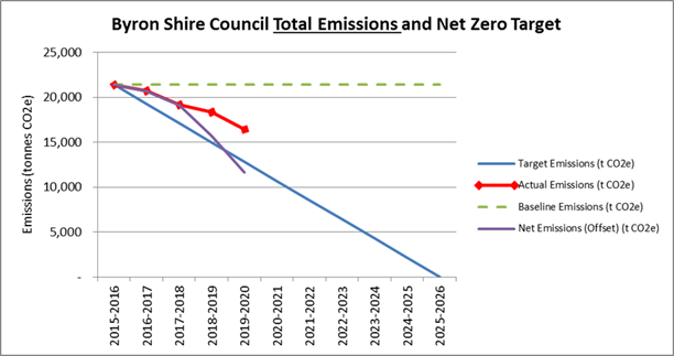
Table 1 – 2019-20 Actual and net emissions since
baseline year 2015/16
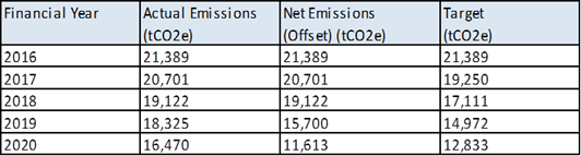
Table 2 – Summary of
Emissions Sectors
|
Summary of Emissions Sectors
|
|
|
Highlights
|
Emissions Change (tCO2e)
|
|
Electricity
|
· Supplier Powershop provides 100% carbon offset
electricity.
· 7% reduction in electricity use and actual
emissions, partly due to almost 400kW of solar PV being installed on various
Council assets in late 2019.
· 99.9% reduction in net (offset) emissions.
· Annual cost $1,244,220.
|
-2,244
|
|
Streetlights
|
· Supplier Powershop provides 100% carbon offset
electricity.
· 100% reduction in net (offset) emissions.
· 32 new streetlights were added throughout the Shire,
however electricity use was reduced by 0.5% due to 260 streetlights being
replaced with LEDs in Ocean Shores in December 2019.
· A cost benefit analysis of a bulk roll out of
LED’s is being investigated as a mater of priority in consultation with
Essential Energy.
· Annual cost $307,320.
|
-314
|
|
Fleet
|
· 5% increase in fuel consumption.
· Cost for 2019/20 actually fell by 3% compared to the
previous year, as the price
of petrol and diesel fell significantly in early 2020 due to the impact of
COVID-19 and the oversupply of crude oil globally.
· 47% of fuel used in light (passenger) vehicle fleet
and 53% used in heavy plant and equipment.
· Significant action is required to reduce fleet
sector emissions.
· Annual cost $613,329.
|
+59
|
|
Bottled Gas
|
· Negligible emissions footprint.
· 25% reduction in consumption due to travel bans and
child care centre shut downs from COVID-19.
· No action required.
· Annual cost $10,235.
|
-9
|
|
Waste
|
· 9% reduction due to natural decline of landfill.
· Composting emissions have been included for the
second year in a row.
· Analysis of landfill methane gas flare and
Australian Carbon Credit Unit generation in line with the net zero target
will be completed this financial year.
|
-1,532
|
|
Waste Water
|
· 4% decrease in waste water fugitive emissions,
despite a 5% increase in flow (which was likely due to heavy rains
post-drought)
· Decrease in emissions is due to several compounding
factors, including increases in recycled water use, a larger amount of land-applied
biosolids tonnage and improved treatment at some plants.
· Main area of action required is reducing waste water
generation from the community and inflow and infiltration from storm water to
the sewer system.
|
-48
|
|
Total
|
|
-4,088
|
A full and detailed analysis of each sector and suggested
action is provided in Attachment 1.
Carbon Offsetting
At
the Ordinary Council Meeting of 12 December 2019, Council resolved to become
certified carbon neutral under Climate Active (formerly the National Carbon
Offset Standard, or NCOS) commencing in the 2025/26 financial year (Res
19-634). In order to become certified Council will need to purchase
carbon offset units for its outstanding emissions.
Carbon offset units are reductions of greenhouse gases or
removals of greenhouse gases from the atmosphere by sinks, are tradeable and
can be used to negate (or offset) all or part of Council’s emissions. For
detailed background information on carbon offsets see p. 5 of 2018/19 Council
Annual Emissions Inventory and Achieving Net Zero Emissions Target (Attachment
2).
Councillor Workshop - Carbon
Offset Policy
At the 12 December 2019 Meeting,
Council further resolved that a Councillor and staff workshop was to be organised
in the 2020/21 financial year in order to fully understand the scope and
implications associated with carbon offsetting and that the workshop report was
to form the foundation for an offsetting policy and procedure as identified in
the Net Zero Emissions Strategy for Council Operations 2025).
However, due to a number of
reasons including COVID-19 restrictions and other work priorities in the
Sustainability Team, the planned offsetting workshop will not proceed this
financial year. The Sustainability Team will organise the workshop for the 2021/22
financial year instead.
Net Zero Emissions Action
Plan for Council Operations 2025
At the Ordinary Council Meeting of
26 November 2020, Council adopted the final version of the Net Zero
Emissions Action Plan for Council Operations 2025 (the Action Plan) (Attachment
3) (Res 20-628).
The Action Plan maps a path
for future activities that Council will undertake in order to reduce emissions
from Council operations. The Action Plan is founded on the Net Zero
Emissions Strategy for Council Operations 2025 (the Strategy) (Attachment
4) and Council’s commitments to being net zero emissions for Council
operations by 2025, and to sourcing 100% of its electricity through renewable
energy by 2027. Progress updates on the Action Plan
will be provided to Council each year as part of the annual emissions
inventory, with the first update to be provided in the 2020/21 inventory.
The Action Plan was designed to
align with the Delivery Program and Operational Plan and allocates
responsibility for specific actions to different Directorates. This will keep
staff accountable and help track progress.
There are five objectives, based
on Council’s principal sources of emissions, which provide the Action
Plan’s basic structure:
· Objective
A – Electricity;
· Objective
B – Fuel;
· Objective
C – Waste, Water, and Sewer;
· Objective
D – Governance; and
· Objective
E – Community Infrastructure.
Actions within the Action Plan
are labelled based on the emissions objective (i.e. sector) they correlate
to. For example, under Objective A – Electricity, Action A1 is
“investigate 5MW solar farm at Dingo Lane, Myocum”. Actions from
the Action Plan that are relevant to reducing emissions in a specific sector
this financial year are referenced throughout the attached inventory. Councils
annual Operational Plan (OP) Activities are linked where relevant.
STRATEGIC CONSIDERATIONS
Community Strategic Plan and
Operational Plan
|
CSP Objective
|
L2
|
CSP Strategy
|
L3
|
DP Action
|
L4
|
OP Activity
|
|
Community
Objective 3: We protect and enhance our natural environment
|
3.2
|
Strive to
become a sustainable community
|
3.2.1
|
Work towards
Council's zero-emissions target
|
3.2.1.1
|
Deliver the Net
Zero Emissions Action Plan for Council Operations 2025
|
|
|
Community
Objective 3: We protect and enhance our natural environment
|
3.2
|
Strive to
become a sustainable community
|
3.2.1
|
Work towards
Council's zero-emissions target
|
3.2.1.2
|
Prepare Annual
Emissions Inventory to determine progress towards 2025 Net Zero Emission
Target
|
|
|
Community
Objective 3: We protect and enhance our natural environment
|
3.2
|
Strive to
become a sustainable community
|
3.2.1
|
Work towards
Council's zero-emissions target
|
3.2.1.4
|
Investigate
Council's methane gas flare and Australian carbon credit unit generation in
line with net zero emissions target
|
|
|
|
|
|
|
|
|
|
|
Legal/Statutory/Policy
Considerations
N/A
Financial Considerations
N/A
Consultation and Engagement
This report was prepared in consultation with all
Directorates and was endorsed by the Executive Team at the Meeting of 2
December 2020.
Staff Reports - Sustainable Environment and Economy 13.9
Report No. 13.9 Main
Beach Shoreline Project - community consultation on the 7 options
Directorate: Sustainable
Environment and Economy
Report
Author: Chloe
Dowsett, Coastal and Biodiversity Coordinator
File No: I2020/1481
Summary:
Launched in August 2019, the Main Beach Shoreline Project (MBSP) is focused on finding the solution
for modification of the coastal protection works that will give the best
possible outcomes for Main Beach, Byron Bay and adjacent areas. The design
investigation being delivered by Bluecoast Consulting Engineers aims to understand how the current
protection structures can be improved to best protect both the Byron Bay Town
Centre from coastal erosion and climate change impacts into the future, and
improve public safety, beach amenity and access.
An appraisal of generic options has been
completed and is outlined in the Concept Design Development Report, November
2020 (Attachment 1). Following an appraisal of the generic design options a
preliminary suite of the seven most suitable designs have been selected for
further consideration.
Seven discrete design options have been developed that
are considered appropriate for further consideration. The current seven
discrete options considered appropriate for further consideration being:
·....... Option 1 – rock revetment and stepped concrete seawall
·....... Option 2 – berm rock revetment and pathway
·....... Option 3 – detached groyne
·....... Option 4 – artificial headland with sand bypassing
·....... Option 5 – protective structure moved landward by 10m
·....... Option 6 – protective structure moved landward by up to 30m
·....... Option 7 – existing structure upgraded to contemporary standards
At the 27 August 2020 Council meeting,
Council resolved (Res 20-436):
1. That Council endorses the top seven concept
options outlined in Attachment 1 (E2020/40490) for key stakeholder and broader
community engagement.
2. That Bluecoast undertake an assessment of a
further alternative concept (Option 8) which:
• better supports beach
recovery and resilience after storm events
• increases and improves
social, cultural and recreational spaces at Main Beach
• enhances the protection
of current built infrastructure and the town centre
• considers constructing
the recreational areas above the original beach seaward of a buried seawall
which is aligned with the natural beach.
3. And
that is in accordance with the Project Objectives and provide feedback in the
form of a Memo to Councillors, prior to community engagement, on the feasibility
of Option 8.
4. Depending on the outcome of Item # 2 above
(Option 8) it may be added to the top seven concept options to progress to the
next stage.
5. That Council receives a report during the
community engagement on the assessment of Option 8, detailing the submissions
received and staff response to these submissions, and extend the exhibition
period accordingly.
In accordance with item #2 of the resolution Bluecoast and
Principal Consultant, Angus Gordon of Coastal Zone Management completed an assessment
of an alternative concept as resolved at the 27 August Council meeting.
The assessment is provided in the form of a short report in Attachment 2
(#E2020/90352).
The outcome of the assessment and findings
of this report conclude that the alternative Option 8 is not considered
feasible for the modification of the coastal protection structure at Main
Beach. As such, in accordance with Council resolution (Res 20-436) item
# 3 Alternative Option 8 has not be added to the top seven (7) concept options
for broader community engagement. However, this Option has been made public and
provided on Council's website.
Broader community engagement is presently being undertaken
along with key stakeholder consultation. Extensive project information, reports
and material is provided for review at
https://www.byron.nsw.gov.au/Services/Environment/Coast-and-waterways/Coastal-projects/Main-Beach-Shoreline-Project
An online survey commenced on Wednesday 11 November (until
23 December 2020). The aim of the community consultation is to gain an
appreciation of what the community value most about Main Beach, their
expectations and objectives as to how the foreshore is managed and to get
feedback on the key design elements/features and the seven concept options.
The Your Say page will remain live with all project
information available during the Christmas Break and into the New Year 2021.
Submissions will be received up until Friday 15 January 2021 via
email (with contact details provided on the Your Say project page).
Once community/stakeholder feedback is received, a report
will be presented to Council early 2021 outlining the key outcomes and feedback
received. Council will then select the three options for progression to the
next phase of the project for further refinement and detailed technical
assessment.
|
RECOMMENDATION:
That Council:
1. Notes
the community engagement activities for the Main Beach Shoreline Project
presently being undertaken on the seven (7) concept design options (as
outlined in Table 1 of this report).
2. Receives
a report in early 2021 on the outcomes of community engagement activities and
feedback received to inform the selection by Council of three (3) of the
seven (7) discrete concept options to progress to the next stage of the
project for further refinement and detailed technical assessment.
|
Attachments:
1 Main Beach
Shoreline Project - Concept Design Development Report (Bluecoast, November
2020), E2020/40490
2 Main Beach
Shoreline Project - Assessment of Alternative option 8 as resolved at the 27
August 2020 Council meeting (Bluecoast and CZM, November 2020), E2020/90352
REPORT
Background
Launched in August 2019, the Main Beach Shoreline Project (MBSP) is focussed on finding the solution
for modification of the coastal protection works that will give the best
possible outcomes for Main Beach, Byron Bay and adjacent areas. The design
investigation being delivered by Bluecoast Consulting Engineers aims to understand how the current
protection structures can be improved to best protect both the Byron Bay Town
Centre from coastal erosion and climate change impacts into the future, and improve
public safety, beach amenity and access.
The project is based on a ‘multiple
lines of evidence’ approach which includes coastal modelling,
geomorphological assessment of the shoreline, collection of wave data and
expert observations. In addition, social, environmental and economic values
will be explored and considered as part of the evidence based approach.
Options Assessment
An appraisal of generic options has been
completed and is outlined in the Concept Design Development Report, November
2020 (Attachment 1). The report considers a wide range of generic coastal
protection design options providing an overview of these options and commentary
as to their suitability for the MBSP. Following an appraisal of the generic
design options a preliminary suite of the seven most suitable designs have been
selected for further consideration. Within each of these design options there
may be several possible layout configurations, extents and materials that could
be incorporated in the design (such as crest level, longshore extent). It
should be noted that any option or design element that did not meet the
mandatory project requirements was not considered further.
The project area is a high value beach and
foreshore public space. When this is combined with the poor condition of the
existing coastal protection structure, it is understood that non-works options
such as ‘do nothing’ or complete removal of the structure are not
acceptable to Council, DPIE or the local community. As such, these options have
not been considered further.
Seven (7) discrete design options have been developed
that are considered appropriate for further consideration. The current seven
discrete options considered appropriate for further consideration being:
·....... Option 1 – rock revetment and stepped concrete seawall
·....... Option 2 – berm rock revetment and pathway
·....... Option 3 – detached groyne
·....... Option 4 – artificial headland with sand bypassing
·....... Option 5 – protective structure moved landward by 10m
·....... Option 6 – protective structure moved landward by up to 30m
·....... Option 7 – existing structure upgraded to contemporary standards
Council resolution (Res 40-436)
At the 27 August 2020 Council meeting,
Council resolved (Res 20-436):
1. That Council endorses the top seven concept options outlined
in Attachment 1 (E2020/40490) for key stakeholder and broader community
engagement.
2. That Bluecoast undertake an assessment of a further
alternative concept (Option 8) which:
• better supports beach
recovery and resilience after storm events
• increases and improves
social, cultural and recreational spaces at Main Beach
• enhances the protection
of current built infrastructure and the town centre
• considers constructing
the recreational areas above the original beach seaward of a buried seawall
which is aligned with the natural beach.
3. And
that is in accordance with the Project Objectives and provide feedback in the
form of a Memo to Councillors, prior to community engagement, on the
feasibility of Option 8.
4. Depending on the outcome of Item # 2 above (Option 8) it
may be added to the top seven concept options to progress to the next stage.
5. That Council receives a report during the community
engagement on the assessment of Option 8, detailing the submissions received
and staff response to these submissions, and extend the exhibition period
accordingly.
Assessment of Option 8
In accordance with item #2 of the resolution Bluecoast and
Principal Consultant, Angus Gordon of Coastal Zone Management completed an assessment
of an alternative concept as resolved at the 27 August Council meeting.
The assessment is provided in the form of a short report in Attachment 2.
The outcome of the assessment and findings
of this report conclude that the alternative Option 8 does not perform any
greater than the seven (7) discrete options and is not considered appropriate
or feasible for further consideration. For the reasons outlined in this report
Bluecoast Consulting Engineers and Principal Consultant Angus Gordon (Coastal Zone
Management) do not recommend that the alternative Option 8 is pursued any
further by Council as a potential option for the Main Beach Shoreline Project.
As such, in accordance with Council
resolution (Res 20-436) item # 3 Alternative Option 8 has not be added
to the top seven (7) concept options for broader community engagement. However,
this has been made public and provided on Council's website.
Community engagement
Council has been criticised for not consulting early enough
in previous design investigations for coastal protection works. As such broader
community engagement is being undertaken along with key stakeholder
consultation. The aim of the community consultation is to gain an appreciation
of what the community value most about Main Beach, their expectations and
objectives as to how the foreshore is managed and to get feedback on the key
design elements/features and the seven concept options.
The outcomes of the engagement will be used to update and
confirm the project Key Performance Indicator’s (KPIs) and associated
assessment criteria. These KPIs form the ‘backbone’ of the design
process. Once community/stakeholder feedback is received, a report will be
presented to Council early 2021 outlining the key outcomes and feedback
received. Council will then select the three options for progression to the
next phase of the project for further refinement and detailed technical
assessment.
An outline of engagement methods is provided in the Table 1
below.
|
Engagement Method
|
Engagement Objective (see IAP2 spectrum below for
definition of underlined terms)
|
|
Online survey and web landing page
· Your Say landing
page hosted on Council’s website – https://www.yoursaybyronshire.com.au//mbsp
· Project
background information, project timelines, context and purpose
· Provide
information on each of the seven concept designs
· Provide
information on the technical reports
· Replication of
online engagement page on Council’s website
· Invitation for
those not online to ring for a hard copy survey, or come in and speak to our
Customer Service team
· Link to Online
Survey
· Survey is open
from 11 November to 23 December 2020 (6 weeks).
|
Consult with the community to obtain their
perspectives of:
· Key values of
the foreshore and surrounds
· Feedback on
foreshore protection design features
· Feedback on the
7 foreshore protection concept designs
|
|
Email to key stakeholders:
· Project
background and objectives
· Explain why the
stakeholder is being contacted
· Provide a link
to the ‘Your Say’ webpage, which will contain the Online Survey.
· Provide an
opportunity for stakeholders to provide more detailed feedback on the
project.
|
Inform stakeholders of the project and increase
engagement with the Online Survey (Consult):
· Provide
opportunity to give more detailed feedback to the project team.
|
|
Phone calls:
· Follow up phone
calls to stakeholders.
|
Inform stakeholders of the project and increase
engagement with the Online Survey (Consult):
· Provide
opportunity to give more detailed feedback to the project team.
|
|
Web landing page and contact details for submissions
· All project
information will continue to stay on the Your Say webpage after the Online
Survey closes.
· Submissions will
be received up until Friday 15 January 2021.
|
Consult with the community to obtain their
perspectives of:
· Feedback on the
7 foreshore protection concept designs
|
Broader community engagement commenced Wednesday 11 November
with an Online Survey open for 6 weeks until 23 December 2020. Project
information, reports and material for review is provided on the Council Your
Say webpage at https://www.yoursaybyronshire.com.au/mbsp.
The below communications tasks
have been completed to get maximum exposure:
· Advertisement
in The Echo – Wed 11 November 2020
· Media
Release – Wed 11 November 2020
· Social
Media post on Council’s Facebook Page – Tues 10 November 2020
o Shared 11
times (voice of Byron, Community Board etc)
· Facebook
Advertisement for 14 days – Wed 18 November 2020 to Wed 2 December
2020.
o Reached
4962 people, with 2326 people watching the ad and 148 people clicking through
to the Online Survey.
· ABC
North Coast Radio Interview – Bruce Mackenzie – Thursday 12
November 2020
· Attendance
of Project Manager to Council’s Masterplan Guidance Group meeting –
Wednesday 25 November 2020
· Emails
to Key Stakeholders:
o State
Agencies
o Land
Managers
o Community
Associations (i.e. Byron Bay Board Riders Club; Byron Preservation Association)
o Byron Bay
Surf Life Saving Club
o Council
Panel and Committee members
o Council’s
Citizen Lottery members
o Key tourism
stakeholders in Byron Bay (i.e. Destination Byron)
o Key
business stakeholders in Byron Bay
· Attendance
at the Byron Bay Farmers Market – Thursday 10 December 2020
As of 23 of November 2020 188 responses to the survey had
been received. The Facebook Advertisement on Wednesday 18 November 2020
November generated 90 responses in one day (22 November 2020).
The Online Survey closes on the 23 December, however all the
project information will remain live during the Christmas Break and into the
New Year 2021. Submissions will be received up until Friday 15 January
2021 via email (with contact details provided on the Your Say project page).
Next steps
· Continue follow up phone calls to key stakeholders
· Commence review of survey responses and submissions
received.
· Prepare a submissions report to Council early 2021
on the outcomes of community engagement activities and feedback received.
STRATEGIC CONSIDERATIONS
Community Strategic Plan and
Operational Plan
|
CSP Objective
|
L2
|
CSP Strategy
|
L3
|
DP Action
|
L4
|
OP Activity
|
|
Community
Objective 3: We protect and enhance our natural environment
|
3.3
|
Partner to
protect and enhance the health of the Shire’s coastlines, estuaries,
waterways and catchments
|
3.3.1
|
Implement
Coastal Management Program
|
3.3.1.2
|
Continue pre-construction
phase of Main Beach Shoreline Project (Jonson Street protection works)
|
Legal/Statutory/Policy Considerations
The coastal management
framework in NSW comprises the following elements:
· the
Coastal Management Act 2016
· the
State Environmental Planning Policy (Coastal Management) 2018 (CM SEPP) and
· the
NSW Coastal Management Manual (OEH, 2018).
Council is presently
preparing a Coastal Management Program (CMP) for the open coast between Cape
Byron and the Shire’s northern boundary near South Golden Beach. The
purpose of the CMP will be to set the long-term strategy for the management of
the coastal zone, addressing priority open coast management issues and actions
to address the issues, with a focus on achieving the objectives of the CM
Act.
The outcomes of the Main
Beach Shoreline project will be incorporated into the CMP as they both develop
in parallel. At this stage in the development of the CMP, the Main Beach
Shoreline Project is an action in the Forward Plan of the Scoping Study for
continuation in Stage 2 of the CMP process.
Financial Considerations
Council has budgeted $150,000 for this project with $150,000
of Grant Funding contribution.
There is sufficient funding for community consultation in
the current budget.
Consultation and Engagement
External: Community consultation is outlined in this report.
Internal: Close consultation has been completed with
Council’s Communication Team, Managers and the Executive Team in planning
the engagement activities for the project.
Staff Reports - Sustainable Environment and Economy 13.10
Report No. 13.10 PLANNING
- Development Application 10.2020.97.1 Stage 8 Tallowood Ridge Estate
Subdivision to Create Forty-Seven (47) Residential Lots at 77 Tuckeroo Avenue
Mullumbimby
Directorate: Sustainable
Environment and Economy
Report
Author: Luke
Munro, Planner
Noreen Scott, EA Sustainable
Environment and Economy
File No: I2020/1716
|
Proposal description:
|
Stage 8 Tallowood Ridge Estate Subdivision to Create
Forty-Seven (47) Residential Lots
|
|
Property description:
|
LOT: 162 DP: 1251169
|
|
77 Tuckeroo Avenue MULLUMBIMBY
|
|
Parcel No/s:
|
269619
|
|
Applicant:
|
Bayview Land Development Pty Ltd
|
|
Owner:
|
Gainsplay Pty Ltd
|
|
Zoning:
|
R2 Low Density Residential / PART RU1 Primary Production /
PART RU2 Rural Landscape/ Part 1(a) General Rural Zone
|
|
Date received:
|
26 February 2020
|
|
Integrated / Designated Development:
|
☒
Integrated
|
☐
Designated
|
☐
Not applicable
|
|
Concurrence required
|
No
|
|
Public notification or exhibition:
|
- Level
2 advertising under DCP 2014 Part A14 – Public Notification and
Exhibition of Development Applications
- Exhibition
period: 12/3/20 to 8/4/20
- Submissions received:
11
- Submissions
acknowledged: ☒
Yes ☐ No
|
|
Delegation to determine
|
Council
|
|
Issues:
|
· Weed
Management in residual land
· Future
ownership of walking tracks through residual land
|
Summary:
It is proposed to create a Forty-Seven (47) Residential Lot
Subdivision as Stage 8 Tallowood at 77 Tuckeroo Drive, Mullumbimby. The lots
range in size from 460m2 to 5700 m2 plus public reserves
and a residual lot of 24.79 ha. The residual lot contains remnant vegetation
which is to be protected and enhanced, and an area of residential zoned land
which is subject to a further application for subdivision (Stage 9).
Eleven submissions were received raising various issues
including traffic speeds, street lighting, the need for a general store, a
lawnmower for volunteers to mow Council reserves, sealing of Clays Road,
pedestrian links and walking tracks along the southern ridgeline, and creation
of a public reserve out of the residual vegetated land along this ridgeline.
Traffic speeds and street lighting for the development is as
per the relevant specifications for urban streets. A general store is a land
use that is permissible with consent, but is not subject to this development
application or proposed by this applicant. In terms of the residual land along
the southern ridgeline, it is noted that a walking/bicycle pathway will be
provided from road 7 to link with Brushbox Drive.
It is noted that a Notice of Motion is to be considered by
Council at the December Ordinary Meeting to investigate the dedication of this
land to Council as a Public Reserve. Should an agreement be reached between the
land owner and Council, the long term future and ownership of this portion of
Tallowood Estate can be resolved with the Stage 9 DA, and as such does not need
to form part of this application.
In terms of the proposal itself, in the main the residential
lots are located on cleared farmland. The matter of weed management in the
residual vegetated areas along the southern ridgeline has come to
Council’s attention. To ensure this matter is resolved conditions of
consent are recommended in relation to these areas being weeded to facilitate
the natural regeneration of the eucalypt forest that they support.
Conditions of consent are also recommended in relation to
sealing some 500 metres of Plover Parkway and Coral Avenue to provide an
alternate route back into Mullumbimby via Main Arm Road and to the areas to
north and west of Mullumbimby.
In this regard the extended estate of Tallowood including 45
lots in Golden Penda Place and Hottentot Court will contains some 340
residential lots, and it is considered good planning practice to provide an
alternate sealed access road to the estate.
The application appropriately addresses the relevant
constraints applying to the site, and is recommended for approval subject to
the conditions of consent.
NOTE TO COUNCILLORS:
In accordance with the
provisions of S375A of the Local Government Act 1993, a Division is to be
called whenever a motion for a planning decision is put to the meeting, for the
purpose of recording voting on planning matters. Pursuant to clause 2(a)
under the heading Matters to be Included in Minutes of Council Meetings of
Council's adopted Code of Meeting Practice (as amended) a Division will be
deemed to have been called by the mover and seconder of all motions relating to
this report.
|
RECOMMENDATION:
That pursuant to
Section 4.16 of the Environmental Planning & Assessment Act 1979,
Development Application No. 10.2020.97.1 for Stage 8 Tallowood Ridge Estate subdivision to create forty-six
(46) residential lots, be granted consent subject to the conditions listed in
Attachment 2 (#E2020/97750).
|
Attachments:
1 10.2020.97.1
Stage 8 Plan of Subdivision, E2020/97727
2 10.2020.97.1
Stage 8 Conditions, E2020/97750
3 Confidential
- 10.2020.97.1 Submissions, E2020/97441
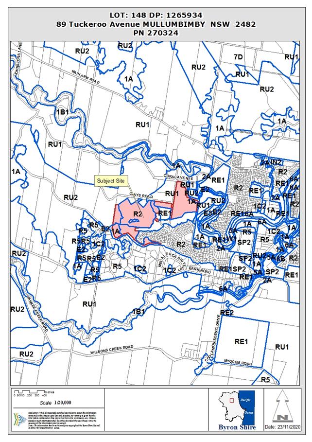
Assessment:
1. INTRODUCTION
1.1. History/Background
Development Application No. 10.2009.314.1 (Tallowood Ridge)
was approved by the NSW Land & Environment Court which included the 29
residential allotments as Stage 1 and a concept approval for a total of seven
stages comprising approximately 240 residential lots, roads, open space,
rehabilitation areas and associated infrastructure over seven stages.
Since that initial approval Stages 1 to 6 have been approved
by Council; with bulk earthworks and civil works for Stage 7 currently under
construction.

Figure
1: Staging plan for the Concept
Approval as approved under DA10.2009.314.1.
The current application will subdivide the newly zoned
residential land as part of Stage 8 which lays to the west of Stage
7.
1.2. Previous
Development Applications Relating to the Site
Separate development applications for each stage have been
approved and modified as follows:
|
Development Application 10.2009.314.1
|
Stage 1 Tallowood Ridge Estate including Future
Stages Concept and 29 residential lots - Approved 14 September 2010
(Land Environment Court)
|
|
Development Application 10.2011.117.1
|
Stage 2 Tallowood Ridge Estate for urban
subdivision comprising 28 residential allotments – Approved 4 April
2012.
|
|
Development Application 10.2013.549.1
|
Stage 3 Tallowood Ridge Estate for subdivision to
create thirty-one (31) residential allotments - Approved 6 February 2014.
|
|
Development Application 10.2015.79.1
|
Stage 4A Tallowood Ridge Estate for subdivision to
create thirteen (13) residential allotments – Approved 26 November
2015.
|
|
Development Application 10.2015.686.1
|
Stage 5 Tallowood Ridge Estate for Subdivision to
create twenty-four (24) residential allotments - Approved 25 August 2016.
|
|
Development Application 10.2016.161.1
|
Stage 4B Tallowood Ridge Estate for Subdivision to create fifteen (15) residential
lots - Approved 31 August 2017.
|
|
Development Application 10.2017.402.1
|
Stage 6 Tallowood Ridge Estate for subdivision to create eighteen (18) residential
Lots – Approved 26 July 2017.
|
|
Development Application 10.2018.305.1
|
Stage 7 Tallowood Ridge Estate for subdivision to create thirty-two (32)
residential lots – Approved 11 April 2019.
|
1.3. Tallowood
Ridge Rezoning and Future Stages
On 22 September, 2017, an amendment to Byron Local
Environmental Plan 2014 was gazetted that rezoned an additional 12 hectares
of rural land to the west of Tallowood Ridge to R2 Low Density Residential. It
also back-zoned existing R2 land into the RU2 Rural Landscape zone to protect
forested areas near the southern ridgeline and a riparian corridor that
traverses the site. Other changes included rezoning the sports fields to RE1
Public Recreation zone and the introduction of a 400m2 minimum
subdivision lot size for the western part of the estate.
The current application will subdivide the newly zoned
residential land as part of Stage 8. The current application and future stages
are not bound by the original Concept Approval although the existing consent
conditions for environmental restoration works associated with earlier stages
and the Biodiversity Conservation Management Plan remain in
force.
1.4. Site and
surrounds
The site has an area of approximately 35.45 hectares
(residual lot) and is located between Tuckeroo Avenue and Clays Road. The land
is within the R2 Low Density Residential zone and RU2 Rural Landscape zone
under LEP 2014. A portion of the south western corner of the existing residual
lot is a deferred matter and fall within the 1(a) (General Rural Zone) under
Byron LEP 1988, however this portion of the site falls outside the proposed
development area for Stage 8. The southern ridgeline is forested but the
majority of the site is cleared except for grass cover. The site contains
bushfire prone land.
Surrounding land uses consist of rural-residential lots to
the south and rural land to the north and west.
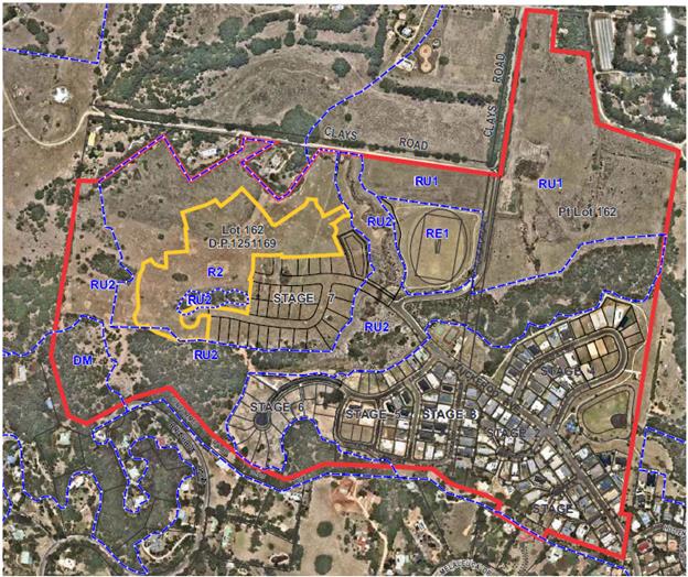
Figure 1: Site Plan (Stage 8 highlighted in Yellow)
|
Land is legally described
|
LOT: 162 DP: 1251169
|
|
Property address
|
77 Tuckeroo Avenue MULLUMBIMBY
|
|
Land is zoned:
|
R2 Low Density Residential / PART RU1 Primary Production /
PART RU2 Rural Landscape and PART (1(a) (General Rural Zone))
|
|
Land area is:
|
40.29 ha
|
|
Property is partly constrained by:
|
Flood Liable Land Bushfire prone
land
High Conservation Value / High Environmental Value
vegetation
|
1.5. Description
of the proposed development
The proposed subdivision has the following key elements:
· Forty-seven
(47) residential lots, ranging in size from 450m2 to 5,070m2.
· Lot 848 with
an area of 2,800m2 which will provide a corridor linking a vegetated
gully on proposed Lot 813 and the ridgeline vegetation to the south. The lot
will be dedicated to Council as a public reserve as part of Stage 8.
· A residue
lot of 24.79 hectares comprising the balance of remaining rural and residential
zoned lands in the existing parcel.
Table 1: Lot size and shape for Stage 8
|
Proposed
subdivision – Stage 8
|
|
Lot
|
Area (m2)
|
Shape
|
Lot
|
Area (m2)
|
Shape
|
|
801
|
1160
|
Irregular
|
826
|
1230
|
Corner
|
|
802
|
460
|
Regular
|
827
|
870
|
Regular
|
|
803
|
460
|
Irregular
|
828
|
730
|
Regular
|
|
804
|
650
|
Irregular
|
829
|
640
|
Regular
|
|
805
|
580
|
Irregular
|
830
|
570
|
Regular
|
|
806
|
710
|
Irregular
|
831
|
540
|
Regular
|
|
807
|
530
|
Irregular
|
832
|
500
|
Regular
|
|
808
|
570
|
Irregular
|
833
|
550
|
Regular
|
|
809
|
720
|
Regular
|
834
|
580
|
Regular
|
|
810
|
680
|
Regular
|
835
|
610
|
Regular
|
|
811
|
630
|
Corner
|
836
|
700
|
Regular
|
|
812
|
520
|
Regular
|
837
|
720
|
Corner
|
|
813
|
5070
|
Irregular
|
838
|
840
|
Corner
|
|
814
|
700
|
Irregular
|
839
|
450
|
Regular
|
|
815
|
450
|
Regular
|
840
|
470
|
Regular
|
|
816
|
450
|
Regular
|
841
|
620
|
Corner
|
|
817
|
450
|
Regular
|
842
|
830
|
Irregular
|
|
818
|
530
|
Regular
|
843
|
760
|
Fan
|
|
819
|
480
|
Regular
|
844
|
570
|
Irregular
|
|
820
|
510
|
Regular
|
845
|
770
|
Irregular
|
|
821
|
530
|
Regular
|
846
|
860
|
Rear hatchet
|
|
822
|
610
|
Regular
|
847
|
690
|
Irregular
|
|
823
|
1030
|
Irregular
|
848*
|
2800
|
Public Reserve
|
|
824
|
940
|
Fan
|
|
|
|
|
825
|
940
|
Fan
|
Residue
|
24.79ha
|
Irregular
|
* Lot for
public reserve
The subdivision layout has been
designed to allow future expansion of the estate and a separate DA has been
lodged for Stage 9 for a further 47 residential lots under DA10.2020.109.1. The
DA should be ready for determination and reporting to Council in 2021.
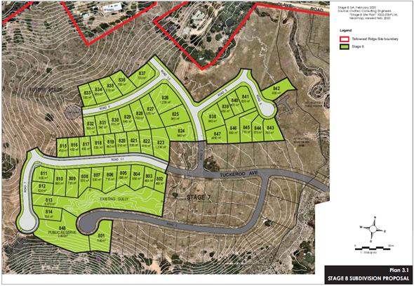
Figure 3: Proposed subdivision layout – Stage 8.
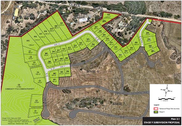
Figure
4: Proposed subdivision layout for
Tallowood Ridge - Stage 9 – Separate DA yet to be determined.
2. SUMMARY OF
REFERRALS
|
Referral
|
Issue
|
|
Environmental Health Officer
|
No objections subject to
conditions of consent.
|
|
Development Engineer
|
No objections subject to conditions.
|
|
S64 / Systems Planning Officer
|
No
objections subject to conditions of consent and payment of Water and Sewer
levies.
|
|
S94 / Contributions Officer
|
No objections subject to conditions. Developer
contributions are payable.
|
|
Ecologist
|
No objections subject to conditions.
|
3. SECTION 4.14
– BUSH FIRE PRONE LAND
The site is bush fire prone land. The application was
referred to the NSW Rural Fire Service - see comments below.
4. SECTION 4.15C
– MATTERS FOR CONSIDERATION – DISCUSSION OF ISSUES
Having regard to the matters for consideration detailed in
Section 4.15(1) of the Environmental Planning & Assessment Act 1979
(EP&A Act), the following is a summary of the evaluation of the issues.
4.1 Section 4.46 –
Integrated Development
Rural Fires Act 1997
The site is identified as Bushfire Prone Land. The proposed
residential subdivision requires a Bush Fire Safety Authority under s100B of
the Rural Fires Act 1997 and constitutes integrated development pursuant
to s4.46 of the Environmental Planning and assessment Act 1979 (the
Act).
The application was referred to the NSW Rural Fire Service
seeking General Terms of Approval (GTAs) for the integrated development
application. GTAs and a Bush Fire Safety Authority have been issued and are
included as part of the recommended conditions at the end of this report.
Water Management Act 2000
The access to the new residential area will require the
construction of a culvert across a creek line to facilitate an extension of
proposed Road 5 to be extended allowing alternative emergency access as
required under the RFS GTS’s to Clays Road. The proposed temporary road
work connecting Road 5 to Clays Road requires a Controlled Activity Approval
(CAA) to be obtained under section 91 of the Water Management Act 2000.
4.2 State Environmental
Planning Instruments
|
|
Satisfactory
|
Unsatisfactory
|
|
State
Environmental Planning Policy No 44—Koala Habitat Protection
|
☒
|
☐
|
|
Consideration: The site is not identified as Core Koala
Habitat and there will be no removal of vegetation as part of the
development.
Parts of the site are considered to represent potential
koala habitat. Previous survey results indicate the site is unlikely to be
regarded as core habitat, but is known to be used for movement and dispersal.
No adverse impacts on local koala populations are expected as a result of
Stage 8 given there is no clearing of vegetation and no works proposed within
the within the shelter belt and the southern ridgeline, with the exception of
a future access way between Road 7 and Brushbox Drive for pedestrians and
cyclists.
|
|
State
Environmental Planning Policy No 55—Remediation of Land
|
☒
|
☐
|
|
Consideration: The land was historically used for
agricultural purposes including cattle grazing. No potentially contaminating
land uses known to have operated on or near the site in recent times. The
land is not within the proximity of any cattle dip sites and is not listed on
Council’s Contaminated Lands Register.
A preliminary site investigation of the Stage 8 area was
undertaken for the original staged development application no.10.2009.314.1;
analysis of soil samples found the site to be suitable for residential use.
Based on all the available information the land is considered to be suitable
for the proposed development in its current state and does not require
remediation.
Any unexpected contamination identified during subdivision
works (buried tanks, building waste, asbestos etc.) is to be dealt with in
accordance with an Unexpected Findings Protocol (UFP). The UFP is to be
submitted to Council for approval prior to the issue of a construction
certificate.
|
|
State Environmental Planning Policy (Coastal Management)
2018
|
☒
|
☐
|
|
Consideration: All proposed works and residential lots
within Stage 8 are located outside of the Coastal Environment Area. The SEPP
does not apply to these elements of the proposed development.
The lower part of the residue lot near to Plover Parkway
and Clays Road is within the coastal environment mapped area and the SEPP
applies to this land. Given there
is no physical works occurring in this location, nor any change to the land
use or boundary alignments, it is concluded that the development will not
have an adverse impact on the coastal environment and is satisfactory having
regard to the relevant matters for consideration under the SEPP.
|
|
State Environmental Planning
Policy (Primary Production and Rural Development) 2019
|
☒
|
☐
|
|
Consideration: The
residue lot will retain a dwelling entitlement and the Primary
Production and Rural Development
SEPP is applicable to this element of the proposed subdivision. The preferred
and predominant land uses in the surrounding area are residential and
rural-residential uses and this is consistent with the future planning intent
for the area. The remaining rural land in the residue lot within Lot 813 is
unlikely to create a potential land use conflict between urban and rural land
uses in the future
|
4.2A Byron Local Environmental Plan 2014 (LEP 2014)
In accordance with LEP 2014 clauses 1.4 and 2.1 – 2.3:
(a) The
proposed development is defined in the LEP 2014 Dictionary as Subdivision;
(b) The
land is within the R2 Low Density Residential zone, RU1 Primary Production zone
and RU2 Rural Landscape zone according to the Land Zoning Map. Three small
portions of the site are identified as a deferred matter and these areas revert
to the 1(a) (General Rural Zone) under LEP 1988.
(c) The
proposed development is permitted with consent; and
(d) Regard
is had for the Zone Objectives as follows:
R2 Low Density Residential Zone
· To provide for the housing needs of the community within a low density
residential environment.
· To enable other land uses that provide facilities or services to meet
the day to day needs of residents.
The proposed subdivision will provide additional land for
housing in the Mullumbimby area. Large lot sizes will provide opportunities for
the development of a low density residential environment consistent with the
zone objectives.
RU2 Rural Landscape Zone
· To encourage sustainable primary industry production by maintaining and
enhancing the natural resource base.
· To maintain the rural landscape character of the land.
· To provide for a range of compatible land uses, including extensive
agriculture.
· To enable the provision of tourist accommodation, facilities and other
small-scale rural tourism uses associated with primary production and
environmental conservation consistent with the rural character of the locality.
· To protect significant scenic landscapes and to minimise impacts on the
scenic quality of the locality.
The only physical works occurring
in the RU2 land will be the future access way between Road 7 and Brushbox
Drive. Residential development on other parts of the site is contained within
the R2 zone. The proposed subdivision will not have a significant impact on the
rural character of or the scenic qualities of the locality.
RU1 Primary
Production Zone
· To encourage sustainable primary industry
production by maintaining and enhancing the natural resource base.
· To encourage diversity in primary industry
enterprises and systems appropriate for the area.
· To minimise the fragmentation and alienation of
resource lands.
· To minimise conflict between land uses within this
zone and land uses within adjoining zones.
· To encourage consolidation of lots for the purposes
of primary industry production.
· To enable the provision of tourist accommodation,
facilities and other small-scale rural tourism uses associated with primary
production and environmental conservation consistent with the rural character
of the locality.
· To protect significant scenic landscapes and to
minimise impacts on the scenic quality of the locality.
A portion of RU1 zoned land is
contained within the residue lot near the intersection of Clays Road and Plover
Parkway. No physical works or reconfiguration of the zone boundaries is
proposed for this area. The proposed subdivision is adequately separated from
this land by sports fields and a riparian corridor in the RU2 zone.
Clause 4.1 Minimum subdivision lot
size
The minimum lot
size in the R2 Low Density Residential zone on the subject land is 400m2.
The remainder of the site is zoned RU1 Primary Production, RU2 Rural Landscape
and 1(a) (General Rural) zone. A 40 hectare minimum lot size applies to these
areas.
As illustrated in
the table below, the proposed lots in the R2 zone vary in size from 450m2
to 5,070m2 and comply with the minimum lot size standard. The
residue lot and riparian lot do not comply with the minimum lot size, an issue
which is discussed further below. Special provisions are afforded to split
zoned sites under clause 4.1D to facilitate the subdivision of the residue lot
which is less than 40 hectares.
Table 2: Compliance with the Lot Size Map
|
Lot type
|
Zone
|
Min Lot Size
|
Proposed Lot Size
|
Compliance
|
|
47
Residential Lots
|
R2
|
400m2
|
450m2–5070m2
|
Yes
|
|
1 Public
Reserve Lot
|
R2 and RU2
|
400m2
- 40 hectares
|
2800m2
|
Exempt
|
|
1 Residue
Lot
|
RU1, RU2,
1(a)
|
40 hectares
|
24.79
hectares
|
No
|
Clause 4.1D Exceptions to minimum
subdivision lot sizes for certain split zones
Clause 4.1D
allows the subdivision of split zoned sites which do not meet the minimum lot
size standards specified under clause 4.1. The purpose of this provision is to
ensure that subdivision occurs in a manner that promotes suitable land use and
development.
Clause
4.1D Exceptions to minimum subdivision lot sizes for certain
split zones
(1) This
clause applies to each lot (an original lot) that contains:
(a) land
in a residential, business or industrial zone, and
(b) land
in Zone RU1 Primary Production, Zone RU2 Rural Landscape or Zone SP3 Tourist.
(2) Despite
clause 4.1, development consent may be granted to subdivide an original lot to
create other lots (the resulting lots) if:
(a) one
of the resulting lots will contain:
(i) land
in a residential, business or industrial zone that has an area that is not less
than the minimum size shown on the Lot Size
Map in relation to that land, and
(ii) all
of the land in Zone RU1 Primary Production, Zone RU2 Rural Landscape or Zone
SP3 Tourist that was in the original lot, and
The proposal is
considered to comply with the provisions of this clause because all of the
rural zoned land will be contained within the residue lot, with the exception
of Lot 813 which will have a lot size of 5,070m2 and contains an isolated
residual parcel of RU2 land. The excision of land to create public reserve is
exempt development under State Environmental Planning Policy (Exempt
and Complying Development Codes) 2008.
A vegetated,
eroded gully is located to the northern side of Road 2 within Stage 7 and is
located within the RU2 zone. This isolated pocket of RU2 Zone will be contained
within Lot 813 which provides an area of approximately 1,040m2 R2 Zoned land
which exceeds the minimum lot size for the R2 Zone of 400m2.
Clause 5.10 Heritage Conservation
The site is known
to contain an area of significance previously identified in a cultural heritage assessment undertaken by
Everick consultants in 2009. The report identified the Mooibul Spur, part of
which forms the southern boundary of the site, as being part of the cultural
landscape. The Spur presents a likely access way used by Aboriginal
people, between the Koonyum Ranges in the west and the Brunswick River to the
east.
The report recommended that this natural feature be preserved
by retaining as many trees as possible along the southern ridgeline. Any
disturbance resulting from roads or sub-surface infrastructure is to be subject
to a post clearance inspection to look for Aboriginal Objects that may
have not been identified during past surveys.
Specific comments
from the Tweed Byron Local Aboriginal Land Council and Arakwal Aboriginal
Corporation were provided as part of the Stage 7 Development Application which
noted that any disturbance near the ridgeline should be supervised during the
subdivision works; approval for earthworks will be made by the applicant
subject to favourable consideration of the current application.
The development is considered to be consistent with the
recommendations of the Everick report and is unlikely to result in adverse
impacts on the cultural landscape. Conditions for the monitoring of excavation
works in accordance with the previous recommendations of the TBLALC and Arakwal
are included in the recommendations of this report.
Clause 6.1 Acid sulfate soils
The site is not
included on the Acid Sulfate Soils Map; however, acid sulfate soils have been
identified during the construction of previous stages in the lower lying areas.
Although not a
specific LEP requirement, Council’s Environmental Health Officer has
recommended a condition requiring an acid sulfate soils investigation and
management plan (ASMP) to be prepared and submitted for approval with the
construction certificate. Should any acid soils be discovered, the ASMP will
include provisions for neutralising and managing the soils on site during the
construction phase.
Clause 6.2 Earthworks
The development
will require earthworks to provide adequate levels for residential allotments
and roads. The applicant will seek approval for the earthworks as part of the
subdivision works.
Erosion
and sediment runoff is a concern given the amount of material to be disturbed
and the proximity of the development to creeks which drain into the Brunswick
River. A condition is recommended for a detailed sediment and erosion control
plan to be prepared and submitted for approval as part of the construction
certificate application.
Clause 6.3 Flood planning
Parts of the
subject site are identified in the North Byron Flood Study as flood prone land.
Lower lying land near the Brunswick River and along the creek lines is
identified as being subject to inundation during a 1 in 100 year ARI flood
event. The flood planning level for the site is 7.67m AHD.
A Flood Study was submitted for Stage 7
which also addressed this stage and stage 9 in terms of earthworks and
identified negligible impacts on the floodplain On
the basis of the information supplied, the subdivision is considered to be
compatible with the flood hazard of the land and satisfies the matters for
consideration under this clause.
Clause 6.6 Essential services
The subdivision
is capable of being serviced by reticulated sewage, water, electricity and
telecommunications including NBN subject to conditions of consent. In relation
to vehicular access, each lot is capable of being serviced with a driveway that
connects to the public road network; a single access driveway will need to be
constructed to service proposed rear hatchet Lot 846 as part of the subdivision
works.
4.2B Byron Local Environmental Plan 1988 (LEP 1988)
The property contains three small areas of 1(a) rural Zoned
Land in the residual allotment. These areas are not affected by the specific
subdivision works in Stage 8. The proposed development will not have any
adverse environmental impact on land in the 1(a) zone and the development as
such does not raise any specific issues in terms of the Byron LEP 1988.
4.3 Any proposed Instrument
that has been the subject of public consultation and has been notified to the
consent authority
There are no
proposed instruments that are of relevance to the subject application.
4.4A Byron Shire Development Control Plan 2014
(DCP 2014)
Part B14.2 Excavation and Fill in all zones
Prescriptive measure B14.2 (1) provides that excavation and
filling must be limited to a depth of 1 metre. The proposed excavation and fill
generally varies from 1m to 1.5m except for proposed lots 177-181 which involve
excavation to a depth of 3m and for the construction of the stormwater basin.
Notwithstanding this non-compliance, the proposed earthworks are considered to
satisfy the objectives and performance criteria of Part B14.2.
Objectives
1. To
ensure that towns, villages, commercial, industrial, residential and rural
areas maintain overall compatibility with the Shire’s natural features
and its historical built character.
2. To
control the extent, character, bulk and scale of earthworks so that both
individual and cumulative earthworks over time do not detract from the existing
and desired future character of their immediate locality, and the surrounding
area.
3. To
promote the use of earthworks to create landscapes and streetscapes that make a
positive contribution to the existing and desired future character of their
immediate locality and the surrounding area.
Performance
Criteria
1. Development
proposals must demonstrate that proposed earthworks will be compatible with the
low rise, low to medium density form, scale and desired future character of
their locality and immediate surrounds. Proposals must demonstrate that excavation
and fill will be limited to ensure that:
a) Adverse
visual impacts, bulk and scale of both the proposed earthworks and the
resultant overall development are minimised;
b) Overshadowing
of adjoining private and public land is avoided;
c) The
scale and character of the resultant landform and buildings will remain
compatible with their surrounds and with the desired future character of the
locality;
d) Resultant
drainage characteristics and systems both on the site and in the locality will be
consistent with Chapter B3 Services and with Water Sensitive Urban Design
Principles.
e) The
need for engineering and support works is minimised;
f) Risk
of geotechnical instability and/ or landslip is minimised.
2. Where
earthworks are designed to facilitate and/ or improve thermal sustainability
and insulation in buildings and developments rather than as structural or
landscape elements, development proposals must demonstrate the particular
benefits to be gained from those earthworks.
3. Earthworks
must be designed to ensure that the community /pedestrian scale and character
of commercial areas will be retained and reinforced.
4. Where
filling is proposed to mitigate flooding and stormwater issues, details are to
be submitted with the application demonstrating the fill will not have a
significant adverse impact on the flow characteristics of flood waters or
detrimentally increase the level of flooding or stormwater on other properties
or development.
Given the undulating terrain and steep topography near Lot
801 and 813, it is difficult to avoid earthworks exceeding 1m in depth. Stage 8
involves earthwork volumes of approximately 8,000 m3 of cut and 24,000 m3 of
fill. 16,000 m³ of fill material used will be sourced from the stockpile
of material surplus from construction of Stage 7.
Overall, the visual impact from the proposed earthworks is
assessed as acceptable given the deeper areas of cut will be transitioned
gradually to natural ground level to negate the need for retaining walls. Dwelling sites will sit below the tree line and will not
detract from the scenic or environmental values of the southern ridgeline. The
resulting land form and pattern of development will not be dissimilar to the
earlier stages of the estate.
A flood study has been submitted as part of Stage 7 (which
covered Stages 7-9) demonstrating that no adverse impacts on downstream
properties will occur as a result of the earthworks. In
relation to geotechnical stability and stormwater, the use of existing material
from the site will ensure infiltration characteristics match the existing soil
profile. A variation to the numerical requirements under the DCP is supported
in this instance
D6 Subdivisions
The proposed development is
considered to comply with the relevant objectives and performance criteria for
each relevant chapter of Byron DCP 2014. Consideration of the requirements in
Chapter D6 Subdivision and Chapter E3 Mullumbimby is detailed below.
|
D6.2 Subdivision Design Guidelines
|
Compliance
|
Comment
|
|
1. Site
Design
|
Yes
|
Most of the proposed lots have a northerly aspect and
will offer reasonable access to views and breezes for future dwellings.
|
|
2. Climate
Control and Aspect
|
Yes
|
Stage 8 is situated on a north-facing slope; most of
the allotments have a north-south orientation. The subdivision will
facilitate good solar access and provide flexibility for the siting and
design of future dwellings.
Lots 812-814 have an east- west orientation; these
parcels have been provided large lot sizes to allow the siting of a house
that may not be parallel to the boundaries.
|
|
3. Hazards
|
Yes
|
The application has suitably addressed environmental
hazards including flooding and bushfire. The application was referred to the
RFS who have provided GTA’s which identified relevant lots being
burdened with asset protection zones on the title of each affected lot to
ensure adequate separation distances to vegetation on the ridgeline and
creek.
|
|
4. Vegetation
removal
|
Yes
|
No vegetation removal is proposed.
|
|
5. Riparian
Buffers and land fronting watercourses
|
Yes
|
Significant bush regeneration works are being
undertaken within the RU2 portion (Management Zone 9) of Lot 813 with weed
control recommended in the southern spur areas adjoining Stage 8.
|
|
6. Landscaping
|
*Yes Condition
|
A condition is recommended for
street trees to be provided
|
|
7. Roads
|
Yes
|
The subdivision will maintain the existing road
hierarchy by extending Tuckeroo Avenue as the main thoroughfare throughout
the estate. It is anticipated that the Stage 8 road network will interlink
with future Stage 9 residential subdivision on the recently rezoned land to
the north-west.
|
|
8. Street
Lighting
|
*Yes Condition
|
Conditions are recommended for
street lighting to be provided in accordance with the provisions of DCP 2014.
New lighting is to match the existing infrastructure design throughout the
estate.
|
|
9. Public
open space and public reserves
|
Yes
|
A pedestrian pathway in Tuckeroo
Avenue will connect Stage 8 back to playgrounds and sports fields approved in
earlier stages.
|
|
10. Stormwater
Management
|
Yes*
Condition
|
Stormwater is able to be
adequately managed. Conditions are recommended.
|
|
11. Utility
Services
|
Yes
|
Electricity and telephone
services, including NBN, can be supplied to each lot.
|
|
12. Provision
of Potable Water Supply
|
Yes
|
Reticulated water and sewer
services are able to be provided to each lot.
|
|
13. Sewer
|
Yes
|
|
14. Geotechnical
Report
|
Yes*
Condition
|
Geotechnical report to be provided
for the construction certificate application.
|
|
D6.3.3 Road Design and Construction
|
Compliance
|
Comment
|
|
15. The
design of such works must comply with the Northern Rivers Development and
Design Manual. Construction must be carried out in accordance with those
requirements.
|
Yes
|
The road design complies with the Northern Rivers
Development Design Manual.
|
|
16. Additional
standards may apply in bushfire prone areas as per the requirements of the
NSW Rural Fire Service.
|
Yes
|
The Bush Fire Safety Authority
requires a temporary turning circle with a 12m outer radius to be provided at
the termination of road 4.
A 4m wide trafficable path will
connect between the cul-de-sac heads of Roads 2 and 7 for emergency access.
A temporary alternative /
emergency access is to be provided from the termination on Road 5 to Clays
Road.
Road design must comply with section
4.1.3(1) of ‘Planning for Bush Fire Protection 2006’, except that
a perimeter road is not required.
|
|
D6.3.4 Sewage Management
|
Compliance
|
Comment
|
|
1. Where
Council deems that reticulated sewer service is available and feasible, each
allotment created must be connected to Council's sewerage reticulation
system.
|
Yes
|
Reticulates sewer service is available to the proposed
subdivision.
|
|
D6.4.1 Lot Size and shape
|
Compliance
|
Comment
|
|
1. Lot
sizes must not be less than the minimum area specified in Byron LEP 2014 on
the lot size map.
|
Yes
|
All proposed allotments exceed the 400m2
minimum lot size.
|
|
2. For
lots that are not typical rectangular shaped lots, Table D6.1 indicates
Council's preferred minimum lot sizes in urban subdivisions:
Table D6.1 –
Preferred Minimum Lots Sizes – Urban Subdivision
|
Type of lot
|
Min. lot area
|
|
General lot
|
See lot size map
|
|
Corner lot
|
650m2
|
|
Hatchet-shaped lot
|
800m2
|
|
Hatchet shaped lot
adjacent to public reserve
|
650m2
|
|
Fan-shaped lot
(minimum frontage 7m)
|
650m2
|
|
Yes
|
The proposed lots are generally
regular in shape (with the exception of the rear boundary for lots 802-808).
There are three fan shaped parcels which all have large areas ranging from
760m2 to 940m2. Larger lot sizes are provided to allow
a dwelling to be sited that is not parallel to the boundaries.
|
|
4. Lots
must provide an appropriate shape and area to accommodate an unconstrained
building envelope with minimum dimensions of 12 metres by 15 metres.
|
Yes
|
All proposed allotments have
unconstrained building envelopes with minimum dimensions of 12m by 15m.
|
|
D6.4.2 Access Design
|
Compliance
|
Comment
|
|
1. Applications
must demonstrate that vehicle access can be provided to each lot created by
the subdivision in accordance with Chapter B3 Services. In certain
circumstances, due to topography and other constraints, the driveway will
need to be designed and constructed at the subdivision stage.
|
Yes
|
Vehicular access is able to be appropriately provided
for each individual lot.
|
|
2. Additional
standards may apply in bushfire prone areas as per the requirements of the
NSW Rural Fire Service.
|
Yes
|
NSW RFS did not specify any
requirements for driveways or internal access.
|
|
E3.6 Urban Design in Precinct 5
|
Compliance
|
Comment
|
|
1. The
shelterbelt will have a minimum width of 20 metres and shall be planted with
species locally indigenous to Byron Shire (refer to the Native Species
Planting Guide to Byron Shire) along the southern boundary of Precinct 5
(Mullumbimby Urban Area Map) within the adjacent road reserve (See Figure
E3.1 for design details). Existing native vegetation within the road reserve
and within Precinct 5 is to be integrated with planted species.
|
Yes
|
Stage 8 does not encroach into the shelter belt. Weed
management required in the vegetated areas which rise up to the ridgeline.
|
|
2. No
vehicle access or roads to be provided from or constructed within the
shelterbelt other than a potential link connecting Brushbox Drive within
Precinct 7 to the proposed distribution road, as indicated in the Mullumbimby
Urban Area Map. A shared bike/ pedestrian pathway in the shelterbelt will be
considered on merit.
|
Yes
|
A shared bikeway/ footpath between
Tallowood Estate and Brushbox Drive is proposed as per the DCP.
See image below – conditions
to apply in relation to its construction and creation of an easement for
public access.
|
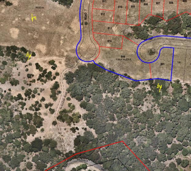
Figure
5: Location of Bikeway/ Footpath from
Brushbox Drive to Road 7.
4.4B Byron Shire Development Control Plan 2010 (DCP 2010)
DCP 2010 only applies to three small corners of the residue
lot that fall within the 1(a) (General Rural Zone). No residential lots or
subdivision works are proposed in these areas.
4.5 Any Planning Agreement or
Draft Planning Agreement?
|
|
Yes
|
No
|
|
Is there any applicable planning agreement or draft
planning agreement?
|
☐
|
☒
|
|
Consideration: There are no planning agreements associated
with the stage seven subdivision application or with the original concept
approval for the site.
|
4.6 Environmental Planning
& Assessment Regulation 2000 Considerations
The proposal raises no issues under the Regulations.
4.7 Any Coastal Zone Management
Plan?
|
|
Satisfactory
|
Unsatisfactory
|
Not applicable
|
|
Is there any applicable coastal zone management plan?
|
☐
|
☐
|
☒
|
|
|
4.8 The likely impacts of that
development, including environmental impacts on both the natural and built
environments, and social and economic impacts in the locality
Natural environment
Under the present proposal, the treed gully known as
Management Zone 9 is part of proposed Lot 813 (Numbered Lot 205 on the plans to
be approved) . This would mean that the future owner of the lot would acquire
the responsibility for the ongoing management and protection of MZ9 with an
area of approximately half a hectare. No other Management Zone is presently
incorporated into a private residential lot.
It is noted that a Notice of Motion is to be considered by
Council at the December Ordinary Meeting to investigate how these vegetated
residual areas of Tallowood Estate can be incorporated into a public reserve.
Should an agreement be reached between the land owner and
Council, the long term future and ownership of this portion of Tallowood Estate
can be resolved with the Stage 9 DA, and as such does not need to form part of
this application.
It is recommended that Lot 813 not be approved as part of
this subdivision and it be incorporated into the residual lot which includes
the vegetated ridgelines to the south. The future of this parcel can be
resolved as part of the DA for Stage 9.
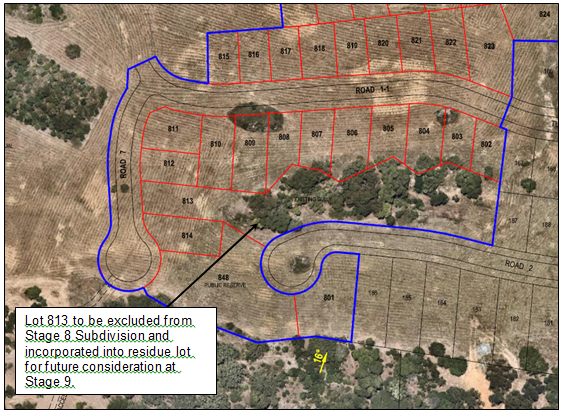
Figure 6: Lot 813 to be incorporated into residual lot.
In relation to the remainder of the development site, the
proposed residential lots are sited on cleared farmland and the proposal will
have negligible Impacts on native vegetation or flora and fauna.
Built environment
Urban Design and Landscaping
The landscaping and urban design for Stage 8 is intended to
be similar to stages 1-7 of Tallowood Ridge. Submission of detailed landscaping
plans will be required as part of the construction certificate application for
street plantings. Conditions are also recommended for street lighting.
Access, Transport and Traffic
Tuckeroo Avenue will operate as the main collector road for
Stage 8 and future Stage 9. A 2.5m concrete path is proposed within the
Tuckeroo Avenue Road reserve to provide pedestrian and bicycle access to the
rest of the estate including the sports fields and recreation areas.
The existing and proposed road network has sufficient
capacity to handle the anticipated level of traffic generated by Stage 8. Roads
1-1, 1-3, 5, 6 and 7 will require a local street type construction with 7-9m
wide carriageway within 15-17m wide road reserves.
Amenity
The majority of the proposed residential lots have a
favourable north-south aspect, providing opportunities for views and breezes.
It is anticipated that the subdivision is capable of providing a high level of
amenity for future residents. In relation to the amenity of existing residents
during the construction phase, suitable conditions are recommended to control
hours of work, noise levels and construction traffic.
Stormwater drainage and downstream water quality
Stormwater treatment and detention has been implemented as
part of Stage 7 works which include a bio-retention basin. The basin will also
detain stormwater prior to it entering the local network of creeks which have
been rehabilitated with riparian plantings prior to it entering the Main Arm of
the Brunswick River. Significant work has already been undertaken in previous
stages to embellish and repair existing riparian drainage lines throughout the
estate with the plantings in Management Zones 1 through to 6. Council’s
Development Engineer concluded that the stormwater drainage and treatment
system complies with Council’s stormwater quality standards subject to
conditions of consent.
Construction impacts
A condition is recommended for a
Traffic Control Plan to be prepared and implemented during construction of the
Stage 8. The Traffic Control Plan must be prepared by a suitably qualified and
RTA accredited Work Site Traffic Controller and adhered to at all times.
Conditions are recommended to control the level of noise
during construction and the hours of work. Comprehensive sediment and erosion
controls are to be implemented during the bulk earthworks and maintained until
such time as the site is stabilised with grass cover or other suitable
vegetation
Social and economic impacts in the locality
Approval of the development application may result in short
term benefits to the local economy through additional employment in the
construction industry.
4.9 The suitability of the site
for the development
The site has been zoned for
residential use and is part of a staged development consent for the development
of the Tallowood Ridge Estate. The sites attributes are conducive to the
proposed subdivision having regard to aspect, slope, drainage, bushfire,
flooding and the availability of services.
Certain environmental issues such as bushfire, drainage and environmental
restoration are able to be managed through the imposition of conditions of
consent.
The site is considered to be suitable for the proposed
development.
4.10 Submissions made in accordance with
this Act or the regulations
The development application was publicly exhibited and
Council received eleven submissions raising the following issues.
|
Submission – Issue
|
Comment
|
|
|
|
· There
is no public access to bushland on the southern ridgeline. This was meant to
occur in earlier stages. It does not need a formal track just an access point
to the proposed reserve to avoid it being landlocked by houses.
· The
ridgeline and remaining bushland should be protected by the
highest environmental protection and have a
community walkway with public access.
· Creation
of a public reserve for remaining vegetated areas along the southern boundary
of the Tallowood Estate
|
A public access point at the end of Road 7 will
provide a pedestrian / bikeway link through to Left Bank road via Brushbox
Drive.
The ridgeline areas are to be
rezoned to environmental protection under the E Zone reviews separate to this
development Application.
The long term ownership of the
residual land which comprises habitat along the southern boundary of the
Tallowood Estate is yet to be determined but it currently remains in private
ownership. There is potential for this area to be dedicated to Council as part
of Stage 9 subdivision proposal.
|
|
· Clays
Rd should be sealed and should include a walk/bike path to Main Arm Rd.
This would provide a safe, alternative route to the CBD and to St John's and
Mullumbimby primary schools
|
Assuming this DA for Stage 8 and
the subsequent Stage 9 DA is approved, from the entrance of Left Bank Road
some 340 properties excluding (dual occupancies) are located in the total
Tallowood Estate, This includes 45 properties in Hottentot Court and Golden
Penda Place,
Plover Parkway provides a partly
sealed alternative route back into Mullumbimby via Coral Avenue and Main Arm
Road. There is an unsealed section of rural road approximately 500 metres in
length to the bridge over the Brunswick River on Coral Avenue. It is
therefore recommended via conditions of consent for Plover Parkway and Coral
Avenue to be sealed to a rural road standard being a min 6 metre wide seal
plus 1 metre shoulders to provide a sealed access road through to Main Arm Rd
and as an alternative route into Mullumbimby in the event of an emergency
E.g. Bushfire or road accident on Left Bank Road.
|
|
· Left
Bank/Tuckeroo intersection - poor lighting at night. With increased traffic
created by an extra 47 lots, the left turning traffic at this intersection is
bound to become more problematic
|
The development has been
assessed by Council’s Development Engineer. No issues were raised in
relation to the existing Left Bank Road and Tuckeroo Avenue intersection.
|
|
· Could
the developer make provision for a community hub or provide a general
store within Tallowood for essential goods to prevent congestion on roads
into town and provide a community hub within Tallowood
|
Under the Byron LEP 2014
Neighbourhood Shops are a land use permitted with consent in the land use
zones in the estate.
The development of a
neighbourhood shop however is a matter for a private commercial operator to
consider and not council to require in the circumstances.
|
|
· Return street
lights to the original green ones that are along Tuckeroo Ave not the
current silver ones.
|
The current silver lighting is
consistent with the relevant Australian Standards and has been assessed by
Council’s Development Engineer during the construction of the relevant
subdivision stages.
|
|
· Massive
earthworks, the stripping of topsoil from the ridge to make tiny residential
blocks is underway. A massive footprint of impervious structures (concrete,
asphalt buildings and roads) upstream from the Brunswick River catchment is
similarly underway.
|
Earthworks levels and Flooding
Impacts were addressed as part of Stage 7 which covered the flooding impacts
of future Stages 8 & 9. Council’s Development Engineer assessed the
flooding impacts as part of Stage 7 and found there is no detrimental impact
to downstream properties as a result of this proposal.
|
|
· A
reduction in the speed limit to 35kmh for traffic safety reasons,
pedestrians, children etc.
|
The maximum speed limit of
50km/h is consistent with residential street speed limits throughout the
Shire. It is a matter for the RMS and Local Traffic Committee to deem
otherwise subject to warrants.
|
|
· Provide
a ride-on lawnmower to allow for the creation of a volunteer mowing service
so that council doesn't have to be responsible for it.
|
The establishment of a volunteer
mowing service is not a matter for this development application.
|
4.11 Public interest
The proposal is unlikely to prejudice or compromise the
public interest or create an undesirable precedent.
5. DEVELOPER
CONTRIBUTIONS
5.1 Water & Sewer Levies
Section 64 levies will be payable.
5.2 Section 7.11 Contributions
Section 7.11 Contributions will
be payable.
6. DISCLOSURE OF
POLITICAL DONATIONS AND GIFTS
|
Has a Disclosure Statement been received in relation
to this application
|
No
|
|
Have staff received a ‘gift’ from anyone
involved in this application that needs to be disclosed. Where the answer is
yes, the application is to be determined by the Director or Manager of the
Planning, Development and Environment Division.
|
No
|
7. CONCLUSION
The proposed subdivision is satisfactory having regard to
the relevant environmental planning instruments and planning controls
applicable to the site. The proposal raises no significant issues in terms of
environmental impacts which cannot be managed and the site is considered suitable
for residential subdivision as intended and reflected in the residential zoning
under Byron LEP 2014.
The application is recommended for approval subject to the
conditions of consent.
Staff Reports - Sustainable Environment and Economy 13.11
Report No. 13.11 Review
of LEP Amendment Fee Schedule
Directorate: Sustainable
Environment and Economy
Report
Author: Steve
Daniels, Project Officer - Planning Reforms
File No: I2020/1792
Summary:
This report presents a proposed
update to Council’s 2020/21 Revenue Policy (Fees & Charges) for LEP
amendments.
Staff have undertaken a review of Council’s
current LEP amendment fee structure as part of a wider review of our LEP
amendment processes. With regard to the fee structure, the goals of the review
are to:
· Simplify the existing fee structure
· Provide greater cost certainty to applicants
· Ensure that fees charged by Council are commensurate with
fees charged by other Councils in the North Coast region
Council currently utilises a
full-cost recovery fee structure that applies an hourly rate to staff time, and
recovers external costs accrued by Council on a pro rata basis. The
review found that Byron Shire Council is undercharging applicants for LEP amendments
in comparison to all other Councils in the North Coast region.
This report recommends an
amendment to the 2020/21 Revenue Policy in accordance with the fee structure
proposed in Table 3 of this report, which includes:
· A fixed fee payable (upfront) for each of the 3 stages of
the LEP amendment process.
· Differentiated fees depending on whether the amendment is
classified as ‘Minor’ or ‘Major’.
· Additional pro rata fees to recover costs associated with
studies, peer reviews, referral to panels and other like matters. This
includes staff time, consultant fees etc.
· A one-off fixed fee for minor amendments suitable for
including in a ‘housekeeping’ planning proposal.
Council is required to public
exhibit any proposed changes to the 2020/21 Revenue Policy for a period of 28
days.
|
RECOMMENDATION:
That Council:
1. Places
the proposed 2020/21 Revenue Policy amendments (as described in Table 3 of
this report) on exhibition for a period of 28 days.
2. Receives
a further report if submissions are received during the exhibition period.
3. If
no submissions are received, adopt the 2020/21 Revenue Policy amendments (as
described in Table 3 of this report) for LEP
amendments.
|
REPORT
Staff are currently updating
internal processes for planning proposals, including Council’s fees and
charges framework for LEP amendments (planning proposals).
This report presents a proposed
update to Council’s 2020/21 Revenue Policy (Fees & Charges) for LEP
amendments.
Staff have undertaken a review of
Council’s current LEP amendment fee structure as part of a wider review
of our LEP amendment processes. With regard to the fee structure, the goals of
the review are to:
· Simplify the existing fee structure
· Provide greater cost certainty to applicants
· Ensure that fees charged by Council are commensurate with
fees charged by other Councils in the North Coast region
Current LEP Amendment Fee
Structure
Council processes applicant funded
LEP amendments on a full-cost recovery basis, meaning that all staff time and
external costs (such as consultant fees) are passed on to the applicant.
Applicants are required to enter into
a ‘Costs & Expenses Agreement’ ahead of each key stage in the
planning proposal process (pre Gateway, public exhibition and
finalisation). Staff time is monitored and charged at the hourly rate
specified in Councils Revenue Policy. A complete breakdown of current
fees and charges is provided in Table 1.
Table 1: Revenue Policy - Current
Fees & Charges for LEP amendments
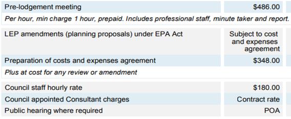
In reviewing fees charge under the
current fee structure, staff tallied the income received for all applicant
funded planning proposals since the commencement of Byron LEP 2014. It
was found that during this period:
· Council has processed 25 applicant funded planning
proposals
· The average fee income received by Council was $7,600.
Issues with the existing fee
structure
Although a full-cost recovery
system based on an hourly rate makes sense in theory, in practice it can be
difficult to implement and present significant cost uncertainty for applicants.
For Council, there is an
administrative burden associated with recording time spent by staff who
contribute to the processing of a planning proposal (this includes planners,
specialist staff, project support officers etc.), and it is not guaranteed that
all time spent is fully captured (hence not charged to proponent).
For applicants, there is no cost
certainty ahead of each stage of the planning proposal process because all fees
are based on actual hours worked or external costs accrued.
Planning staff can provide applicants with an ‘up front’ fee estimate
as part of the ‘Costs & Expenses Agreement’, however true costs
may differ substantially during each stage of the process.
Review of LEP Amendment Fees Structures (North Coast
Region)
In order to determine benchmarks
and provide a point of comparison, staff reviewed typical fee structures and
the average fees charged in a sample of 12 local government areas in the North
Coast region.
Councils are not legally required
to adhere to a standardised fee structure, resulting in a range of different
approaches. The review found that the varying fee structures can be
categorised into 4 types summarised below in Table 2.
Unlike Byron Shire Council, most
councils include some form of fixed fee as part of their fee structure.
The majority of Council’s apply a hybrid fee structure that combines
fixed fees and additional costs accrued by Council. These hybrid
structures are described below in Table 2 as ‘Type 3’ and
‘Type 4’ fee structures.
For ‘Type 4’ fee
structures, the general principal is that typical work undertaken by Council
(such as preparing reports, exhibition costs, admin costs etc.) is covered by
the fixed fee, while work that is less predictable (undertaking studies, peer
reviews, referral to panels and other like matters) is charged at actual
cost.
Type 4 fee structures recognise
that LEP amendments can vary significantly in terms of complexity and workload,
and therefore differentiate the fixed fees based on the complexity of the
planning proposal. Most Council’s using a ‘Type 4’
structure classify LEP amendments as ‘Minor’ or ‘Major’
depending on the number of lots involved and the need for specialist studies.
In regard to Table 2, please note:
· The figures provided are ‘average’
approximations only.
· Total average fees have been calculated based on fixed fees
(excluding Byron Shire). Unknown additional costs have not been included.
· Where a Council differentiates between ‘minor’
and ‘major’ amendments, an average of the two categories has been
used.
· Tweed Council has not been included in calculating
averages. Tweed LGA includes high density metropolitan areas that skew
towards significantly higher fees than other LGA’s in the North Coast
region and was treated as an outlier.
Table 2:
Summary of typical LEP amendment fee structures – North Coast LGA’s
|
Fee Structure
|
Description
|
Number of LGA’s
|
Total Average of Fees
charged
|
|
Type 1
|
Staff Hourly Rate
· Full cost recovery across all stages of the LEP amendment
process
|
1 (Byron)
|
$7,600
Byron average fee since 2014
|
|
Type 2
|
Fixed Fee
· Charged at commencement of each LEP amendment stage
|
2
|
$12,500 (Avg. fixed fee)
|
|
Type 3
|
Fixed Fee + Staff Hourly Rate
· Flat fee charged at commencement of each LEP amendment
stage
|
3
|
$6,000 (Avg. fixed fee)
+ Staff hourly rate
|
|
Type 4
|
Variable Fixed Fee (based on
complexity) + Additional Costs to Council
· Fees charged at commencement of each LEP amendment stage
· Different rates charged depending on complexity of the
proposal (categorised as ‘minor’ or ‘major’)
· Additional fees are charged to recover costs associated
with studies, peer reviews, referral to panels and other like matters.
This includes staff time, consultant fees etc.
|
6
|
$16,000 (Avg. fixed fee)
+ additional costs accrued for
work on supporting studies etc.
|
Recommendations
It is clear that Byron Shire
Council is charging significantly lower fees on average than all other
LGA’s in the region. An amendment to the fee structure is
recommended.
Of the 4 types of fee structures
described in Table 2, ‘Type 4’ is considered to provide the most
comprehensive and equitable approach. This includes fixed fees based on
the complexity of a planning proposal combined with payment of additional pro
rata fees for more unpredictable elements of a planning proposal, ensuring that
Council is properly renumerated for any additional (less predictable) work.
The fixed fee component reduces
the administrative burden of recording staff time and reduces the potential for
slippage. It also provides greater certainty to applicants as they
approach and move through the LEP amendment process.
A ‘Type 4’ fee
structure is therefore recommended as an amendment to the 2020/21 Revenue
Policy (Fees & Charges), as presented in Table 3 below.
In reading this table it is noted
that:
· A one-off fixed fee has been included for minor
housekeeping amendments. This is modelled off the approach taken by
Ballina Council.
· The proposed fixed fees for ‘Minor’ and
‘Major’ amendments average $15,500. This is comparable to the
typical average for Type 4 fee structures and reflects a “middle of the
road” approach in this regard.
·
Table
3: Proposed Fee Structure
|
Name:
|
Fee (2020/21) Including GST
|
|
Correction of errors &
anomalies
|
No charge
|
|
Pre-lodgement meeting
|
$486.00
|
|
Minor amendment considered
suitable for annual housekeeping LEP amendment
50% of fee refundable
pre-Gateway if not supported by Council. No refund post-Gateway
|
$6,000.00
|
|
Minor Amendment
(single site and no supporting
studies required)
|
Stage 1 - Pre Gateway
– $3,000.00
· Planning Proposal assessment and report to Council
Stage 2 – Post Gateway
– $4,000.00
· Public exhibition and agency consultation
Assessment of submissions and
report to Council
Stage 3 – Finalisation
– $2,000.00
· Finalisation of the planning proposal following Council
resolution
|
|
Major Amendment
(Multiple sites and/or requiring
independent specialist studies)
|
Stage 1 - Pre Gateway
– $7,000
· Planning Proposal assessment and report to Council
Stage 2 – Post Gateway
– $10,000.00
· Public exhibition and agency consultation
· Assessment of submissions and report to Council
Stage 3 – Finalisation
– $5,000.00
· Finalisation of the planning proposal following Council
resolution
|
|
Additional costs & expenses
incurred by Council in undertaking studies, peer reviews, referral to panels
and other like matters.
|
At cost
|
|
Staff hourly rate
|
$180.00
|
|
Costs and Expenses Agreement
The applicant is required to
enter into a ‘Costs & Expenses Agreement’ with Council at the
commencement of each stage of the planning proposal. Council will only
commence work on the amendment after the agreement has been signed and
corresponding fees have been paid.
|
|
|
|
In summary, the fee structure
proposed in Table 3 includes:
· A fixed fee payable (upfront) for each of the 3 stages of
the LEP amendment process.
· Differentiated fees depending on whether the amendment is
classified as ‘Minor’ or ‘Major’.
· Additional pro rata fees to recover costs associated with
studies, peer reviews, referral to panels and other like matters. This
includes staff time, consultant fees etc.
· A one-off fixed fee for minor amendments suitable for
including in a ‘housekeeping’ planning proposal.
Community consultation & next steps
If Council chooses to proceed with the amendment, a 28 day
public exhibition is required. This would be followed by a further
Council report to consider any submissions received.
If no submissions are received, it is recommended that the
amendment be notified and adopted.
STRATEGIC CONSIDERATIONS
Community Strategic Plan and
Operational Plan
|
CSP Objective
|
L2
|
CSP Strategy
|
L3
|
DP Action
|
L4
|
OP Activity
|
|
Community
Objective 5: We have community led decision making which is open and
inclusive
|
5.5
|
Manage Council’s
finances sustainably
|
5.5.2
|
Ensure the
financial integrity and sustainability of Council through effective planning
and reporting systems (SP)
|
5.5.2.1
|
Maintain and
improve internal financial controls
|
Legal/Statutory/Policy Considerations
Section 610F of the Local Government Act 1993 prescribes the
methodology for Council to amend fees and charges throughout the financial year
after adoption of the Revenue Policy requiring Council to publicly advertise
any proposed fees and charges amendments for a period of 28 days inviting
submissions from the public.
Financial Considerations
In addition to the financial considerations noted above, it
is expected that the proposed fee structure would improve Council’s
funding position for work carried out on LEP amendments.
Consultation and Engagement
.
If Council chooses to proceed with the amendment, a 28 day
public exhibition is required. This would be followed by a further
Council report to consider any submissions received. If no submissions
are received, it is recommended that the amendment be adopted and notified.
Staff Reports - Sustainable Environment and Economy 13.12
Report No. 13.12 Draft
Plan of Management for Charlotte Street Park, Bangalow - Post-Exhibition Report
Directorate: Sustainable
Environment and Economy
Report
Author: Julia
Curry, Sustainability and Emissions Reduction Officer
File No: I2020/1821
Summary:
A draft Plan of Management
(PoM) for Charlotte Street Park, Bangalow has been prepared in accordance with
requirements of the Local Government Act 1993 (Act) and associated regulations.
Council resolved in October 2020 to publicly exhibit the
draft PoM (Attachment 1) and arrange an independently chaired
Public Hearing prior to reporting back to Council (Res 20-534).
The draft POM was publicly exhibited for 28 days between 16
October and 27 November 2020 with a Public Hearing held on the 10 November
2020.
The statutory process is now complete.
This report provides the submissions received during the
public exhibition period, and the Public Hearing Report from the independent
Chair of the public hearing.
The Public Hearing Report provides a summary of the
submissions made to the Public Hearing, and provides a response to the issues
raised in the submissions (Attachment 2).
There were four formal verbal submissions made to the Public
Hearing.
1 written submission was received during the exhibition
period (Attachment 3).
Based on the assessment of submissions, and the conclusions
from the independent report of the Public Hearing, it is recommended that
Council adopt the draft PoM as exhibited.
Once the PoM is adopted, Council
staff will proceed with an expression of interest for a small community garden
at 33 Charlotte Street, Bangalow, in accordance with Council’s Community
Gardens Policy.
|
RECOMMENDATION:
That Council adopts the Draft Plan of Management
for Charlotte Street Park, Bangalow, as exhibited (Attachment 1 -
#E2020/72966).
|
Attachments:
1 Charlotte
Street Park Bangalow Plan of Management (Exhibition Version), E2020/72966
2 Public
Hearing Report - Charlotte Street Park Bangalow Plan of Management, E2020/94612
3 Submission
Plan of Management - 33 Charlotte Street, Bangalow, E2020/95413
REPORT
Background
A draft Plan of Management
(PoM) for Charlotte Street Park, Bangalow has been prepared in accordance with
requirements of the Local Government Act 1993 (Act) and associated regulations.
Council resolved in October 2020 to publicly exhibit the
draft PoM (Attachment 1) and arrange an independently chaired
Public Hearing prior to reporting back to Council (Res 20-534).
The draft POM was publicly exhibited for 28 days between 16
October and 27 November 2020 with a Public Hearing held on the 10 November
2020.
The statutory process is now complete.
Submissions received
The Public Hearing Report provides a summary of the
submissions made to the Public Hearing, a summary of the written submissions
made during public exhibition process and provides a response to the issues
raised in both the verbal and written submissions (Attachment 2). The
report concludes that Council proceed with the draft POM as exhibited.
A total of four people attended the hearing, all local
residents within walking distance of the park. These four attendees all made formal
verbal submissions to the Public Hearing.
1 written submission was received during the exhibition
period (Attachment 3) The submission was from a local resident and
expressed the importance of preserving open space in the local neighbourhood.
The submission also stated that if other uses of the Park were established
there would be a potential for:
· increased
traffic to the area,
· safety
concerns for children at the park, and
· limiting
the amount of people that could access the area if the predominant use of the
space was changed, e.g. if a community garden was established on site.
Other concerns raised were primarily in relation to the
establishment of a community garden on site.
These issues have been noted and will be referenced should a
license or lease for use of the open space at 33 Charlotte Street be reported
to Council in the future.
Based on the assessment of submissions, and the conclusions
and recommendations of the independent report into the Public Hearing, it is
recommended that Council adopt the Plan of Management as exhibited.
Next steps
Once the PoM is adopted, Council
staff will proceed with an expression of interest for a small community garden
at 33 Charlotte Street, Bangalow, in accordance with Council’s Community
Gardens Policy.
STRATEGIC CONSIDERATIONS
Community Strategic Plan and Operational Plan
|
CSP Objective
|
L2
|
CSP Strategy
|
L3
|
DP Action
|
L4
|
OP Activity
|
|
Community Objective 3: We protect and enhance our
natural environment
|
3.2
|
Strive to become a sustainable community
|
3.2.1
|
Work towards Council's zero-emissions target
|
3.2.1.13
|
Prepare a Plan of Management for 33 Charlotte, Street
Bangalow to enable the express authorisation of a community garden.
|
|
Community Objective 3: We protect and enhance our
natural environment
|
3.2
|
Strive to become a sustainable community
|
3.2.2
|
Support community environmental and sustainability
projects
|
3.2.2.3
|
Support community gardens in accordance with the Policy
and Guidelines
|
|
|
|
|
|
|
|
|
Legal/Statutory/Policy Considerations
The Local Government Act and Regulations prescribe the
process, and minimum content, for preparing POMs. Relevant sections have been
discussed, as required, in the report. Council’s Legal Counsel provided
advice that the revised template satisfied the statutory requirements for
content.
The prescribed process governing development of and
consultation on a POM, including the requirement to hold a public hearing for a
change in categorisation, must continue to be followed by Council.
Financial Considerations
There are no financial implications from the development and
adoption of the Plan of Management. Proposed actions consistent with an adopted
plan of management may generate income and expenditure that Council will have
to consider when they are presented.
Consultation and Engagement
Submissions closed 27/11/20.
Draft POM – advertised and in public notices on Byron
Shire Council Website from 16/10/20 – 27/11/20. The draft POM was on
exhibition for the minimum required 28 days, allowing the minimum 42 days for
submissions.
Public Hearing was held on site on 10/11/20.
This report provides the submissions received during the
public exhibition period, and the Public Hearing Report from the independent
Chair of the public hearing.
The Public Hearing Report provides a summary of the
submissions made to the Public Hearing, and provides a response to the issues
raised in the submissions (Attachment 2).
There were 4 formal verbal submissions made to the Public
Hearing.
1 written submission was received during the exhibition
period (Attachment 3).
Based on the assessment of submissions, and the conclusions
from the independent report of the Public Hearing, it is recommended that
Council adopt the draft PoM as exhibited.
Staff Reports - Sustainable Environment and Economy 13.13
Report No. 13.13 PLANNING
- Resolution 20-095 Review of Council's Signage Policy
Directorate: Sustainable
Environment and Economy
Report
Author: Dylan
Johnstone, Development Investigations Lead
File No: I2020/1823
Summary:
The purpose of this report is to seek Council endorsement
for exhibition of proposed amendments to Council’s signage policy
including amendments to Chapter B10 of DCP 2014; and to propose a trial site
with the view of establishing an advertising structure on Council land that
various community groups can attach temporary event signs to.
|
RECOMMENDATION:
That Council:
1. Endorses
the proposed amendments to Chapter B10 of Development Control Plan 2014 for
public exhibition.
2. Notes
that staff will directly engage with the business community about the
amendments during the public exhibition period as per Resolution 20-095.
3. Receives
a further report if submissions are received during the exhibition period.
4. If
no submissions are received, adopts the amendments to Chapter B10 of
Development Control Plan 2014 and notify as required by the Act.
5. Endorses
the location on the corner of Gulgan Road and Mullumbimby Road, identified in
Figure 1 of this report, as a trial site for the installation of an advertising
structure for the various community groups to attach temporary event signs
to.
6. Requests
staff to prepare a procedure for the installation of community event signage
on the nominated trial site.
|
Attachments:
1 Proposed
amendments to Chapter B10 of DCP 2014, E2020/94010
REPORT
At the Ordinary (Planning) Meeting
on 19 March 2020 a report was tabled to Council on a review of Council’s
Signage Policy, where Council resolved as follows:
20-095 Resolved that Council note the
report on the review of Council’s current signage policy and that
engagement with the business community and amendments to the current Signage
Policy as discussed in the report will now follow.
As per Resolution 20-095
Council staff have undertaken proposed amendments to Chapter B10 of DCP 2014.
These proposed amendments include the following:
· Requirement for signage to be compatible with the
applicable “Residential Character Narrative” (contained within the
Byron Shire Draft Residential Strategy) in residential and village zones.
· Limiting the number of signs for commercial and industrial
premises
· Requirements for illuminated signage
· Requirements for signage adjacent to classified roads
· Requirements for wording and content of signage
· Amend wording of “undesirable signage” to
“inappropriate signage”, expansion on the types of signage that are
inappropriate and inclusion of stronger wording to make it clear that such
signage will not be supported by Council.
Upon resolution of this report
staff will place the proposed amendments to Chapter B10 of DCP 2014 on public
exhibition and will engage with the business community during the exhibition
period.
As discussed in the report to the
19 March 2020 meeting, a potential solution for Council to ensure the orderly
coordination of temporary community event signage is for Council to install
advertising structures on sites approaching towns and villages on which
individuals could attach temporary community event signage that complies with
the requirements of State Environmental Planning Policy (Exempt and Complying
Development Codes) 2008.
Advertising structures are
currently prohibited on rural and residential land under LEP 2014 and are not
permitted as exempt or complying development in accordance with State
Environmental Planning Policy (Exempt and Complying Development Codes) 2008.
State Environmental Planning Policy No. 64 – Advertising and Signage only
permits advertisements on rural and non-urban land if permitted under an
environmental planning instrument (i.e. LEP 2014) and only if the display of
the advertisement is consistent with a development control plan (DCP 2014).
Therefore LEP 2014 and DCP 2014 must be amended to permit advertising
structures on rural and residential land.
It is proposed that the site on
the corner of Gulgan Road and Mullumbimby Road (near the “Gateway to
Mullumbimby” sign shown in Figure 1 below) is used as a trial site before
consideration is given to amending LEP 2014 to permit advertising structures
that may apply to a number of locations around the shire. This site is Council
owned road reserve, is zoned RU2, has historically been used to informally
display community event signage, and is considered appropriate as a trial site.
A procedure for use of this site will need to be developed by staff.
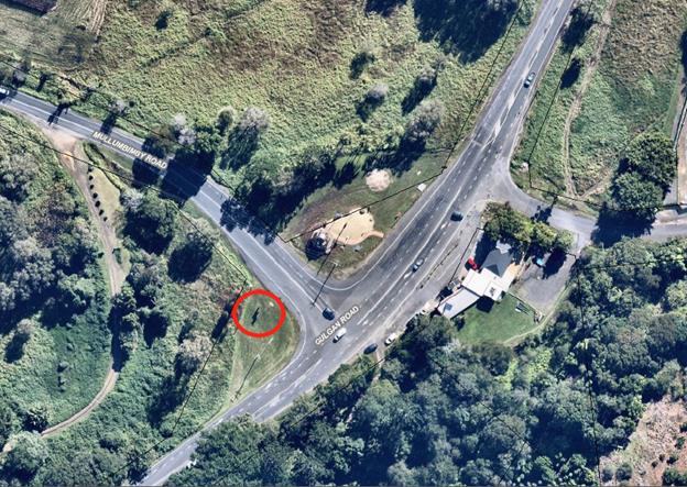
Figure 1: Proposed trial
site for advertising structure for community event signage
It is considered appropriate to
use a trial site in the first instance as there are a number of matters that
must be considered before proposing permanent advertising structures on
multiple sites including:
· Costs associated with establishing and maintaining
structures
· Referral to Transport NSW for advertising structures
fronting a classified road
· Public liability matters associated with members of the
public installing signage on Council infrastructure
STRATEGIC CONSIDERATIONS
Community Strategic Plan and
Operational Plan
|
CSP Objective
|
L2
|
CSP Strategy
|
L3
|
DP Action
|
L4
|
OP Activity
|
|
Community Objective
4: We manage growth and change responsibly
|
4.1 Support the
visions and aspirations of local communities through place-based planning and
management
|
4.1.3 Manage
development through a transparent and efficient assessment process
|
|
|
|
|
|
|
|
|
|
Legal/Statutory/Policy Considerations
Byron LEP 2014 was gazetted on 21 July 2014. Byron Shire DCP
2014 was adopted by Council on 26 June 2014 and came into effect on 21 July
2014.
These two documents establish the local assessment criteria
for signage within Byron Shire and may be amended to resolve the issues
identified within this report.
Financial Considerations
Not applicable.
Consultation and Engagement
Not applicable.
Staff Reports - Sustainable Environment and Economy 13.14
Report No. 13.14 PLANNING
- The Farm Update on Planning Proposal
Directorate: Sustainable
Environment and Economy
Report
Author: Rob Van
Iersel, Major Projects Planner
File No: I2020/1865
Summary:
Work has been progressing for some time on a Planning
Proposal relating to existing unauthorised land uses at The Farm, Ewingsdale
Road Byron Bay. Progress on the Planning Proposal, which does not
authorise any additional uses of the site, has been delayed in order to resolve
traffic issues.
In issuing the original Gateway determination, the
Department of Planning, Industry (DPIE) and Environment directed that Council
consult with Transport for NSW (TfNSW) to get agreement on the proposal before
moving to public consultation.
Initial discussions with TfNSW resulted in a recommendation
that a Voluntary Planning Agreement (VPA) be negotiated as part of the Planning
Proposal to provide for a contribution “to offsetting the
development’s contribution to the traffic and safety issues around access
to the site”.
The intention of the VPA was for the land owner to commit to
dedicating a strip of land along the Ewingsdale Road frontage of the land to
allow for the future widening of that road. The VPA would be signed by
the land owner, Council and TfNSW, who would agree that this commitment
constitutes the appropriate offset for the traffic generated by the unauthorised
land uses facilitated by the Planning Proposal.
The land owner, while agreeing in principle, sought evidence
and assurance that the value of the land to be dedicated was commensurate with
the level to which their traffic contributes to the existing traffic
problems. Until recently, it was not possible to provide such assurance
as concepts had not been developed (or costed) for traffic solutions.
In the meantime, the Planning Proposal has been on
hold. The Gateway determination has been extended twice, but will expire
on 24 December 2020. DPIE have advised that no further extensions will be
considered.
TfNSW have now proposed a number of concept ideas for
traffic upgrades in the area. While much further work is yet to be done
regarding these ideas, broad cost estimates are also now available, which can
provide the assurance required by the land owner for the VPA to progress.
To move forward, Council will need to withdraw the current
Planning Proposal and simultaneously request a Gateway determination for a new
Planning Proposal. The new proposal would effectively be the same as the
current, without the need for an SP2 Infrastructure zoning over the land that
would be covered by the VPA.
Discussions with DPIE and TfNSW indicate that this will then
allow progress on agreeing key principles for the VPA and then for the proposal
to move forward to public exhibition.
NOTE TO COUNCILLORS:
In accordance with the
provisions of S375A of the Local Government Act 1993, a Division is to be
called whenever a motion for a planning decision is put to the meeting, for the
purpose of recording voting on planning matters. Pursuant to clause 2(a)
under the heading Matters to be Included in Minutes of Council Meetings of
Council's adopted Code of Meeting Practice (as amended) a Division will be
deemed to have been called by the mover and seconder of all motions relating to
this report.
|
RECOMMENDATION:
That Council:
1. Notes
the update provided on the Planning Proposal for The Farm.
2. Agrees
to withdraw the current Gateway Determination and associated Planning
Proposal before 24 December 2020, as requested by the Department of
Planning, Industry and Environment.
3. Simultaneously
with 2 above, authorises staff to submit an amended Planning Proposal to the
Department of Industry and Environment for Gateway determination. The
new Planning proposal to be the same as the current, with the exception of the
need for an SP2 Infrastructure zoning over the land that would be now covered
by the Voluntary Planning Agreement.
4. Initiates
discussions with the proponent and TfNSW to develop key principles that could
form the basis of a Voluntary Planning Agreement, and report the results of
discussions to Council prior to public consultation.
5. Pending
Gateway Determination undertakes public exhibition of the Planning Proposal
and consult with government agencies in accordance with the Gateway
Determination.
6. Concurrently
exhibits the draft amendment to Chapter E5 of Byron DCP 2014 - Certain
Locations in Byron Bay and Ewingsdale (Attachment 2 E2020/6033)
7. Receives
a report outlining the public exhibition outcomes.
8. Continues
to suspend enforcement action in relation to matters subject of the Planning
Proposal until such time as a determination is made. Council may,
however, use its discretion to take enforcement action in circumstances where
it is demonstrated that an unauthorised activity or use imposes significant
impacts on the environment. This undertaking does not exclude Council from
its regulatory obligations in relation to the Food Act, Local Government Act
and/ or Protection of the Environment Operations Act.
|
REPORT
Council most recently considered a Planning Proposal
relating to The Farm, Ewingsdale Road Byron Bay at the Planning Meeting of 18
June 2020. At that meeting Council resolved (Res 20-272):
1. Defers
further action on the Planning Proposal pending a report outlining options and
addressing the appropriateness and implications of a proposed zoning of SP2
Infrastructure (Local Road) for the strip of land along the Ewingsdale Road
frontage of the property, and
2. Continues
to suspend enforcement action in relation to matters subject of the Planning
Proposal until such time as a determination is made. Council may,
however, use its discretion to take enforcement action in circumstances where
it is demonstrated that an unauthorised activity or use imposes significant
impacts on the environment. This undertaking does not exclude Council
from its regulatory obligations in relation to the Food Act, Local Government
Act and Protection of the Environment Operations Act.
3. Notifies
the proponent of its decision.
4. Writes
to Transport for NSW requesting that work on traffic solutions for the western
end of Ewingsdale Road is expedited.
The Planning Proposal addresses existing unauthorised land
uses at the Farm (it does not approve additional uses). Council had
previously resolved (Res 17-671) to initiate this Planning
Proposal and seek a Gateway Determination from the Department of Planning that
would allow for its public exhibition.
The support for the Planning Proposal was to provide an
approval pathway for the following uses at the site:
· the
bakery;
· agricultural
training/education facilities and activities;
· administration
offices; and
· a
small-scale information centre.
Additional controls are also proposed to be implemented by
way of an amendment to Chapter E5 of the Byron DCP to support the approval
pathways.
Previous compliance action was undertaken to address the
produce store, which was significantly reduced in scale to be consistent with
the existing approval for ‘roadside stall’, and the homewares/ gift
shop, which was modified to operate in accordance with the approval for a plant
nursery.
In issuing the original Gateway determination, the
Department of Planning, Industry and Environment (DPIE) directed that Council
consult with Transport for NSW (TfNSW) to get agreement on the proposal before
moving to public consultation.
Initial discussions with TfNSW resulted in a recommendation
that a Voluntary Planning Agreement (VPA) be negotiated as part of the Planning
Proposal to provide for a contribution “to offsetting the
development’s contribution to the traffic and safety issues around access
to the site”.
The intention of the VPA was for the land owner to commit to
dedicating a strip of land along the Ewingsdale Road frontage of the land to
allow for the future widening of that road. The VPA would be signed by
the land owner, Council and TfNSW, who would agree that this commitment
constitutes the appropriate offset for the traffic generated by the
unauthorised land uses facilitated by the Planning Proposal.
The Farm advised that they would agree to such dedication
provided that it could be demonstrated that the value of the land to be
dedicated is commensurate with the scale of their contribution to existing
traffic volumes.
They also sought to include provisions that provide for
compensation should it be determined that the land value is greater than their
contribution to the traffic problems.
To achieve this, Council, RMS and the land owner would need
to agree on:
· traffic
volumes generated by the nominated unauthorised uses at The Farm, quantified as
a percentage of overall traffic volumes through the motorway interchange and on
Ewingsdale Road in this location;
· the
value of the land to be dedicated; and
· the
construction cost of the agreed road improvement works.
Discussions with
Council, RMS and The Farm could not reach an agreement on these numbers, and up
until very recently it was not possible to estimate the construction cost of
traffic solutions.
An alternative was
therefore suggested, proposing to implement a SP2 Infrastructure zoning over
the Ewingsdale frontage in lieu of the VPA, and an amended Gateway was received
for this proposal, with an end date of 24 December 2020.
DPIE have advised
that no further extensions will be considered.
The SP2 Infrastructure zone generates a responsibility to
nominate a public authority who will be responsible to purchase the land.
Council’s original intention was that TfNSW would be responsible for
acquisition. Discussions with TfNSW, however, indicated that Council
would need to accept that responsibility.
TfNSW have now proposed a number of concept ideas for
traffic upgrades in the area. While much further work is yet to be done
regarding these ideas, broad cost estimates are also now available, which can
provide the assurance required by the land owner for the VPA to progress.
Progressing with a VPA would negate the need for the SP2
zoning and Council would therefore not be required to the acquisition authority
for the land.
To move forward, Council will need to withdraw the current
Planning Proposal prior to 24 December and simultaneously request a
Gateway determination for a new Planning Proposal.
The new proposal would effectively be the same as the
current, without the need for an SP2 Infrastructure zoning over the land that
would be covered by the VPA.
Discussions with DPIE and TfNSW indicate that this will then
allow progress on agreeing key principles for the VPA and then for the proposal
to move forward to public exhibition.
STRATEGIC CONSIDERATIONS
Community Strategic Plan and Operational Plan
|
CSP Objective
|
L2
|
CSP Strategy
|
L3
|
DP Action
|
L4
|
OP Activity
|
|
Community Objective 4: We manage growth and
change responsibly
|
4.1
|
Support the visions and aspirations of local communities
through place-based planning and management
|
4.1.3
|
Manage development through a transparent and efficient
assessment process
|
4.1.3.10
|
Prepare and assess Planning Proposals and Development
Control Plans, and amend Local Environmental Plan maps
|
|
|
|
|
|
|
|
|
|
Legal/Statutory/Policy
Considerations
This planning proposal would amend the Byron Local
Environmental Plan 2014 as discussed in the report.
Financial Considerations
If Council chooses to proceed with the planning proposal, it
will be at the proponent’s expense as an applicant initiated planning
proposal. The proponent has paid for work undertaken to date. Full
cost recovery of the remaining stages will be undertaken by Council. If
the applicant chooses not to pay then the planning proposal will not proceed.
If Council chooses not to proceed then the matter does not
incur any additional costs.
The suggested VPA will allow for the future widening of
Ewingsdale Road to occur without cost to Council for land acquisition.
Consultation and Engagement
Minimal community consultation has occurred to date.
Formal community engagement would occur if the Planning Proposal proceeds, in
accordance with the Gateway determination.
Staff Reports - Sustainable Environment and Economy 13.15
Report No. 13.15 Place
Planning Collective - End of 2020 Update
Directorate: Sustainable
Environment and Economy
Report
Author: Isabelle
Hawton, Planner
Andrew FitzGibbon, Place Liaison
Officer
Rob Van Iersel, Major Projects
Planner
File No: I2020/1932
Summary:
In 2019 Council endorsed a new method for managing community
engagement in relation to the delivery of Place Plans (Res 19-45).
This was the inception of the Place Panning Collective (PPC). The purpose
of this report is to provide Council with an update on how the PPC is
contributing to and making an impact on Council projects, and provide feedback
on how the group is advancing.
The PPC recently conducted a self evaluation survey of its
members, with feedback being received from the community members, Councillors
and staff. The overwhelming response was positive, with members
applauding the chance for genuine early involvement in Council projects.
Participants also suggested some improvements, including opportunities for less
formal discussions and changes to the meeting location. These suggestions
will be taken on board in 2021.
Throughout the year, the PPC have acted as a valuable
conduit between Council and community, ensuring that priority projects from the
place plans are being promoted and that appropriate levels of consultation are
in place for these active projects.
Information on the Place Planning Collective, its charter,
members and meeting minutes can be found on Council’s website here:
https://www.byron.nsw.gov.au/Community/Place-planning/Place-Planning-Collective
|
RECOMMENDATION:
1. That
Council notes the End of 2020 update from the Place Planning
Collective
2. That
Council thanks the community members on the Place Planning Collective
for their time and contributions made throughout the year, including meeting during
COVID restrictions.
3. That
Council also thanks both Councillors and staff involved in the Place Planning
Collective meetings and projects throughout the year.
|
REPORT
The Place Planning Collective
(PPC) began in March of 2020, and was initially made up of 13 community
members.
The PPC primarily engages with the
adopted place plans for Bangalow, Mullumbimby, and the Byron Bay Arts and
Industry Estate place plan.
Information on the Place Planning Collective, its charter,
members and meeting minutes can be found on Council’s website here:
https://www.byron.nsw.gov.au/Community/Place-planning/Place-Planning-Collective
The group has been meeting monthly
since its inception, for an average of 1.5 hours a month.
There has been strong attendance
from group members who nominated through an EOI process. However,
attendance from group members selected through the citizens’ lottery has
been challenging due to competing work and lifestyle commitments.
Initial meetings were used to
familiarise all members with the place plans, through presentations and walking
tours.
The group has been a very strong
advocate for greater levels of community engagement on the selection and
implementation of priority projects in Byron Shire.
An overview of the projects worked
on to date is discussed below:
Input to the Annual Budget
Process
The first task of the PPC was to
gain an understanding of the Council budget process and to provide feedback on
suggested budget bids. The group worked collaboratively to identify
priority actions from the place plans, and with staff, worked to ensure these
were included in the budget bids.
Mullumbimby Projects
Burringbar Talking Street
The PPC were involved in the
successful application for the Streets as Shared Spaces Grant for the
‘Talking Street’ in Mullumbimby. PPC members assisted in the
planning and preparation of the application, as well as offering their
technical skills to contribute illustrations. They were crucial to the
success of the application, and followed this up with involvement in the
Talking Street Working Group once the grant was awarded. They continue to
assist in the delivery of this project.
https://www.byron.nsw.gov.au/Community/Place-planning/Our-Mullumbimby-Masterplan/Talking-Street-Trial-Burringbar-St
Stuart Street Greenspine
The PPC members have contributed
at various stages to the Stuart Street Greenspine project. They provided input
into the brief and also provided advice on the level of consultation required
for this project. The greenspine design consultants presented very early
drafts of the concept design at a Place Planning Collective meeting for their
input.
https://www.byron.nsw.gov.au/Community/Place-planning/Our-Mullumbimby-Masterplan/Stuart-Street-Greenspine
Bangalow Projects
Bangalow DCP and structure
plan for the Triangle
The PPC have been active in providing
advice for the early consultation for the project looking to improve the
planning controls in Bangalow. PPC members have ensured that key
community members are aware of the project, and have provided their guidance on
how the planning controls might be improved.
https://www.yoursaybyronshire.com.au/bangalow-planning-controls
Shared Paths in Bangalow
PPC members have offered advice on
several key shared path projects in Bangalow. The first of these is a
shared path along Ashton and Deacon Streets, connecting to the Bangalow
Parklands. PPC members have been liaising with Infrastructure Services staff to
achieve positive outcomes on this project.
Design work is also being carried
out investigating options for paths to create better connections from Feros
aged care facility to the Bangalow village centre. This project was
strongly advocated by PPC members.
PPC members have also suggested
input on the path linking Rifle Range Road with Bangalow town. Council
staff have been pursuing a shared path option adjacent to Lismore Road to link
the precincts, however there are some divergent views on where this path should
be situated.
Community members on the PPC have
expressed their strong desire for the path to be delivered within the rail
corridor. Pursuing this option would require further time and
investigation, and might result in a longer lead time for delivery of an active
transport connection along this corridor.
https://www.yoursaybyronshire.com.au/bangalow-shared-paths
Byron Arts and Industry Estate
Projects
Bayshore Drive Pocket Park
PPC members were involved in the
initial round of consultation to inform the design of the Pocket Park at the
corner of Bayshore Drive and Banksia Drive. Following this process, they
were provided with an opportunity to have input on the draft design at a PPC
meeting.
https://www.byron.nsw.gov.au/Community/Place-planning/Byron-Arts-and-Industry-Estate/Pocket-Park-Bayshore-Drive
Centennial Circuit One Way
Trial
PCC members have received regular
updates on the progress of the Centennial Circuit One Way Trial. In the
coming months, they will be a key point of contact as the project moves from
planning to implementation.
https://www.byron.nsw.gov.au/Community/Place-planning/Byron-Arts-and-Industry-Estate/Centennial-Circuit-one-way-traffic-trial
Federal Community Led
Masterplan
Council has been working with a
community group to commence a community led Masterplanning process for Federal
Village. As part of the commencement of this project, a member of the
Federal community was invited to present the scope at the most recent Place
Planning Collective meeting. Members of the collective who have undergone a
Masterplanning process in the past have offered to share their collective
wisdom with the Federal group, enhancing the group’s expertise in the
process.
https://byron.infocouncil.biz/Open/2020/12/PLAN_10122020_AGN_1177.PDF
STRATEGIC CONSIDERATIONS
Community Strategic Plan and
Operational Plan
|
CSP Objective
|
L2
|
CSP Strategy
|
L3
|
DP Action
|
L4
|
OP Activity
|
|
Community
Objective 4: We manage growth and change responsibly
|
4.1
|
Support the
visions and aspirations of local communities through place-based planning and
management
|
4.1.1
|
Develop,
implement and update Place Plans that promote place-based forward planning
strategies and actions
|
4.1.1.5
|
Implement Our
Mullumbimby Masterplan, Bangalow Village Plan and Byron Arts and Industry
Estate Plan
|
|
Community
Objective 4: We manage growth and change responsibly
|
4.1
|
Support the
visions and aspirations of local communities through place-based planning and
management
|
4.1.1
|
Develop,
implement and update Place Plans that promote place-based forward planning
strategies and actions
|
4.1.1.7
|
Prepare
Structure Plan and Development Control Plan for Bangalow town centre/Station
Street (high priority action from the Bangalow Village Plan)
|
|
Community
Objective 4: We manage growth and change responsibly
|
4.1
|
Support the
visions and aspirations of local communities through place-based planning and
management
|
4.1.1
|
Develop,
implement and update Place Plans that promote place-based forward planning
strategies and actions
|
4.1.1.8
|
One way traffic
trial for Centennial Circuit (Byron Arts and Industry Estate Precinct Plan
action)
|
|
Community
Objective 4: We manage growth and change responsibly
|
4.1
|
Support the
visions and aspirations of local communities through place-based planning and
management
|
4.1.1
|
Develop,
implement and update Place Plans that promote place-based forward planning
strategies and actions
|
4.1.1.4
|
Develop a
Landscape Plan for Stuart St Greenspine
(Our Mullumbimby Masterplan action)
|
|
Community
Objective 4: We manage growth and change responsibly
|
4.1
|
Support the
visions and aspirations of local communities through place-based planning and
management
|
4.1.1
|
Develop,
implement and update Place Plans that promote place-based forward planning
strategies and actions
|
4.1.1.10
|
Park activation
Bayshore Dr (Byron Arts and Industry Estate Precinct Plan)
|
|
|
|
|
|
|
|
|
|
Legal/Statutory/Policy
Considerations
N/A
Financial Considerations
N/A
Consultation and Engagement
As described above.
Staff Reports - Sustainable Environment and Economy 13.16
Report No. 13.16 PLANNING
- Activity Application 88.2019.2.1 to Operate the Terrace Reserve Holiday Park,
Bruncwick Heads
Directorate: Sustainable
Environment and Economy
Report
Author: Ben
Grant, Planner
File No: I2020/1943
Proposal:
|
Description of Activity:
|
Operate a Caravan Park and Camping Ground pursuant to
Section 68 of the Local Government Act 1993.
|
|
Property description:
|
Lot 313 DP 755692; Part Lot 416
DP 728666; Lot 403 DP 728637; Lot 1 DP 1169548 and Lot 50 DP 1169550
|
|
The Terrace Reserve, Brunswick
Heads
|
|
Parcel No/s:
|
5490; 183940; 164500; 183930; 205302
|
|
Applicant:
|
NSW Crown Holiday Parks trading as Reflections Holiday
Parks
|
|
Owner:
|
Crown Land
|
|
Date received:
|
7 August 2019
|
|
Concurrence required
|
Concurrence required due to a written objection to the
2005 Regulations.
Concurrence can be assumed by Council.
|
|
Delegation to determine
|
Council
|
Summary:
Council is in receipt of an
application submitted pursuant to Section 68 of the Local Government Act
1993 to operate the Terrace Reserve Holiday Park, Brunswick Heads. The
Application seeks approval for 174 sites, comprising 26 long-term sites, 123
short-term sites and 25 camp sites.
In
September 2018, Council considered a similar application to operate the Holiday
Park. Due to concerns over potential impacts on the
Coastal Cypress Pine Forest (CCPF) Endangered Ecological Community (EEC) in the
Holiday Park’s Southern Precinct, Council resolved to approve the
application with the following special condition:
Special Condition “B”:
“no further use of or activity within the Southern
Area Precinct – Coastal Cypress Pines Community is to occur from the date
of the Approval to Operate and all existing infrastructure (except the existing
amenities facility) is to be removed where it is deemed to be a safe
option”.
The above condition had the effect
of prohibiting camping and caravanning in the Southern Precinct and required
existing infrastructure to be removed. The Approval specified that it was to
remain in force for a period of three years from the date of issue until
September 2020.
The
current application is largely the same as the previous one, except for a minor
reduction in the number of sites from 178 to 174. This is being achieved by
consolidating sites in the Northern Precinct and deleting sites 191 and 193 in
the Southern Precinct. The Application seeks to include the use Southern
Precinct that was excluded from the previous approval.
Key Issues
There are two main issues for Council to consider in
determining this application:
(1) Limitations on the exclusion
of the Southern Precinct
Council previously addressed
environmental concerns by excluding the Southern Precinct of the Holiday Park
from the approval. Upon review, this approach is not considered to be valid due
to limitations in the relevant legislation.
Section 94 of the Local Government
Act 1993 does not offer Council the option of granting a ‘partial’
approval to a Section 68 application. That is, Council must decide to either
approve the application as submitted (either unconditionally or subject to
conditions), or to refuse the application. Any condition which artificially
excises part of the Holiday Park from the approval could be viewed as being
inconsistent with Section 94 and, therefore, potentially invalid.
A further limitation is applied by
Section 3.39 of the Crown Lands Management Act 2016 which provides that a
Council cannot grant approval to an activity application if it would result in
a contravention of the Plan of Management for the land. Thus, any condition
imposed by Council which materially alters the Park layout, such that it is no
longer consistent with the adopted Plan of Management, would likely be in
contravention of Section 3.39 and may also be invalid.
(2) Adverse
impacts on the Coastal Cypress Pine Forest Endangered Ecological Community in
the Holiday Park’s Southern Precinct.
It is clear based on the available
information that the Holiday Park has degraded the CCPF EEC in the Southern
Precinct over several decades and these effects are likely to continue into the
future unless ameliorative actions are taken. This is occurring primarily due
to an impairment of natural regeneration processes and damage to existing
trees.
Council’s Natural Resource
Planner noted that due to the rarity and extremely restricted distribution of
the CCPF EEC, any further loss of occurrence or reduction in its extent within
the Reserve should be regarded as a serious and irreversible impact on the
environment.
As discussed in the body of this
report, insufficient information has been provided to properly understand how the Southern Precinct could be used
for camping while simultaneously avoiding damage to existing trees and
providing adequate room for natural and assisted regeneration such that it
ensures no net loss to the occurrence or extent of the CCPF within the Reserve.
It is considered that the proposed activity is likely to result in a loss of
biodiversity values of the site and will adversely affect the integrity and
long term viability of the endangered ecological community if approved. The
application is therefore recommended for refusal on the basis that it is
inconsistent with the principles of ecologically sustainable development
established under Section 89 (3) of the Local Government Act 1993.
NOTE TO COUNCILLORS:
In accordance with the
provisions of S375A of the Local Government Act 1993, a Division is to be
called whenever a motion for a planning decision is put to the meeting, for the
purpose of recording voting on planning matters. Pursuant to clause 2(a)
under the heading Matters to be Included in Minutes of Council Meetings of
Council's adopted Code of Meeting Practice (as amended) a Division will be
deemed to have been called by the mover and seconder of all motions relating to
this report.
|
RECOMMENDATION:
That, pursuant to Section
94 of the Local Government Act 1993, Council refuse activity
application 88.2019.2.1 for the following reason:
(1) The
proposed activity is likely to have a serious and irreversible impact on the
Coastal Cypress Pine Forest Endangered Ecological Community located in the
Southern Precinct of the Holiday Park. The activity is therefore considered
to be inconsistent with the principles of Ecologically Sustainable
Development as established under Section 89(3) of the Local Government Act
1993; in particular, that conservation of biological diversity and
ecological integrity should be a fundamental consideration.
|
Attachments:
1 Park Plan
and Site Particulars, E2020/97283
2 Plan of
Management - Terrace Reserve, E2020/97201
3 Compliance
Table 2005 Regs, E2020/97485
4 Detailed
Site Plan of Holiday Park, E2020/97204
5 Written
Objection to the 2005 Regulations (cl. 91), E2020/97294

6 Arborsafe
Report (May 2018), E2020/97360 
7 Kingfisher
Ecology Report, E2020/97361
8 Vegetation
and Threatened Species Report, E2020/97368
9 Site
Assessment by R. Kooyman (2017), E2020/97362
10 Review of
Environmental Factors (June 2018), E2020/97370
11 Review of Documents
by R. Kooyman (18 June 2018), E2020/97372
REPORT
1. Background
Terrace
Reserve Holiday Park is one of three holiday parks managed by NSW Crown Holiday
Parks Land Manager in Brunswick Heads, the others being known as Ferry Reserve
and Massey Greene. The Terrace Reserve has been operating as a caravan park and
camping ground for at least 60 years and was managed by Byron Shire Council as
a Reserve Trust Manager until late 2006. In December 2006 management of all
three Reserves was transferred to the Crown.
In
2014, the Minister for Crown Lands approved three new Plans of Management
(POM’s) for Terrace Reserve, Ferry Reserve and Massey Greene. The
POM’s provide a framework for the future management and development of
the Reserves over a 5-10 year period. POM’s
for Ferry Reserve and Massey Greene were later revised in 2019 in response to
community feedback which called for greater site setbacks and improved open
space. A revised POM for The Terrace was also considered but did not proceed.
1.1 Previous Application
The
Applicant currently operates a caravan park and camping ground on the subject
land in accordance with Activity Approval No. 55.2017.1144.1, granted by the
Council at the Ordinary meeting of 20 September 2018. The Approval specified
that it was to remain in force for a period of three years from the date of
issue until September 2020.
In
determining the Application, Council resolved to impose the following special
condition to minimise the threat of environmental harm on the Coastal Cypress
Pine Forest (CCPF) Endangered Ecological Community (EEC) in the Holiday
Park’s Southern Precinct.
Special Condition “B”:
“no further use of or activity within the Southern
Area Precinct – Coastal Cypress Pines Community is to occur from the date
of the Approval to Operate and all existing infrastructure (except the existing
amenities facility) is to be removed where it is deemed to be a safe
option”.
The above condition had the effect
of prohibiting use of the Southern Precinct and required removal of existing
infrastructure.
2. Subject Application
The subject application
(no. 88.2019.2.1) was received by Council on 7 August 2019. The Application
seeks approval to operate the existing caravan and camping ground at the
Terrace Reserve, including the Southern Precinct that was excluded from the
previous approval.
The proposal is largely
the same as the previous application, except for a minor reduction in the
number of sites from 178 to 174. This is being achieved by consolidating some
sites in the Northern Precinct and deletion of sites 191 and 193 in the
Southern Precinct.
The details of the
caravan park and camping ground provided within the application are as follows:
Detail of sites:
|
Type of Sites
|
No. of Sites
|
|
Long term sites with Private Toilet and Shower Facilities
|
26
|
|
Short Term Sites – Cabins
|
10
|
|
Short Term Sites – Premium Powered Sites
|
15
|
|
Short Term Sites – Powered Sites
|
98
|
|
Camp Sites
|
25
|
|
Total
|
174
|
Detail of
facilities:
|
Type of Facility
|
No.
|
|
Female Toilets
|
14
|
|
Male Toilets/Urinals
|
15
|
|
Female Showers and hand basins
|
9
|
|
Male Showers and hand basins
|
9
|
|
Family Bathroom
|
1
|
|
Unisex Toilet
|
2
|
|
Washing Machines and Dryers
|
6
|
|
Washing Tubs
|
4
|
|
Line Space
|
340 metres
|
|
Irons
|
6
|
|
Ironing Boards
|
4
|
Holiday Park Layout Plan:
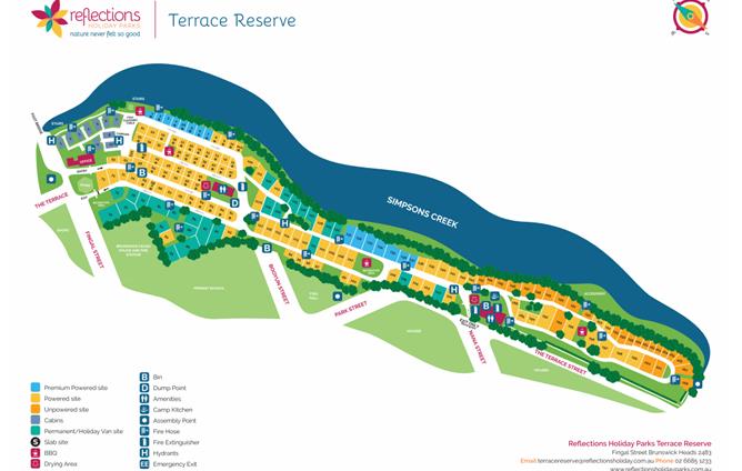
Figure 1: Extract of the holiday park map provided
with the Application.
Land
and Environment Court appeal
On
30 October 2019, the Applicant commenced proceedings in Class 2 of the Land and
Environments Court’s jurisdiction appealing against the deemed refusal of
the application. Council has since engaged in mandatory conciliation to resolve
outstanding issues and additional information has been provided.
3. The site
The
Terrace Reserve Holiday Park is located on the western bank of Simpsons Creek
and is a short walk south from the Brunswick Heads Town Centre. The main
entrance to the park is off Fingal Street with a secondary entrance and exit
off Nana Street. At the entrance to the Park is a footbridge which crosses Simpsons
Creek and provides pedestrian access to the surf beach on the opposite side of
the creek.
The
Holiday Park is situated within a Crown
Reserve which covers an area of 5.82 hectares. The Reserve includes Terrace and
Banner Parks in the north, Terrace Reserve Holiday Park in the central area,
and Simpsons Reserve containing native vegetation and a public walkway linking
the site to residential areas in the south.
The
Holiday Park has 174 sites, comprising a mixture of cabins, short-term sites, long-term
sites and camping sites. A site office and managers residence is located near
the park entrance at Fingal Street. A number of community facilities buildings
and BBQ areas are located throughout the Park.
An
aerial photograph is provided at Figure 1, with the subject land shaded
pink.
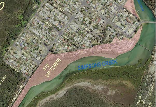
Figure 1: Aerial image of the subject site. Source:
Plan of Management for Terrace Reserve Holiday Park (NSW Government, 2014).
The Holiday Park is divided into
three general precincts for management purposes. The Northern Precinct, north
of Booyun Street, has been cleared of most native vegetation and contains
holiday cabins, short-term van sites and most of the long-term sites.
The Central Precinct is less
developed and retains scattered native trees including Coastal Cypress. It has
short-term powered van sites and a handful of long-term sites.
The Southern Precinct, generally
south of Nana Street, retains stands of mature Coastal Cypress and contains
mostly unpowered sites used for short-term caravanning or tent camping.
The far southern end of the
Reserve is known as Simpsons Reserve and is not part of the Holiday Park. It
retains mature stands of Coastal Cypress amongst areas of mown grass. The area
is traversed by a gravel pathway with lighting that follows the banks of
Simpson Creek, linking the reserve to the Brunswick Heads Bowling Club and
residential areas to the south.
The Holiday Park is known to
contain the endangered ecological community Coastal
Cypress Pine Forest in the NSW North Coast Bioregion. CCPF is protected
under Schedule 2 of the Biodiversity Conservation Act. In the Central
Precinct, the community has been reduced to isolated trees, while in the
Southern Precinct mature stands of Coastal Cypress remain interspersed amongst
short-term sites. Mid-storey and understorey vegetation in the park have been
largely removed as a result of recreational and camping activities occurring
over several decades.
4. Plan of Management
The reserve is subject to a Plan
of Management (POM) that was adopted in April 2014. The POM establishes the
boundaries of the Holiday Park and provides a framework for the future
management, use and development of the reserved Crown land in accordance with
the requirements of the former Crown Lands Act 1989.
A copy of the POM is included at Attachment
2.
Specific improvements and
authorised activities/works identified in the POM include:
· Upgrades to the Park’s managers residence.
· Reduction in sites and reconfiguration of the road access
in the Northern and Southern Precincts.
· An additional pedestrian link from Fingal Street to the
footbridge.
· New camp kitchens to be developed in the Northern and
Southern Precincts.
· BBQ shelter in the Foreshore Precinct to be demolished.
· Increase cabins in the Northern Precinct from 10 to 12
· Amenities buildings in the Central and Southern Precinct to
be demolished and replaced by a single amenities building in the Northern
Precinct.
· Replace communal amenities in the Southern Precinct.
· Apply screening treatments to the boundary between the park
and the adjoining residential area.
· Progressive removal of exotic species and protection of
mature endemic vegetation.
· Protection and maintenance of vegetation in the intertidal
zone along Simpsons Creek.
· Separation between functional area of the holiday park and
on park boundaries that adjoin public areas.
· Existing fencing that does not follow the alignment of the
park boundaries will be relocated.
· Existing structures will be progressively relocated away
from foreshore sites to enable the re-establishment of a natural bank profile
and the protection and restoration of vegetation communities.
· New signage will be required along with consolidation of
existing signage.
Vegetation Management Plan
The POM includes a Vegetation
Management Plan (VMP) which identifies the endangered ecological communities in
the Reserve and establishes an action plan to minimise harm to the vegetation
and, where possible, enhance vegetation through bush regeneration and weed
control.
To summarise, the VMP proposes a
number of measures to protect and enhance the CCPF, including seed collection
and propagation of Coastal Cypress trees for landscaping and assisted
regeneration, mapping of critical root zones, replacement of trees that are
lost or removed and an ongoing program of weed control.
Specific details of the
regeneration program are not specified in the VMP.
Supporting
information and photographs were provided by the applicant showing a small
amount of regeneration work undertaken in the Holiday Park. However, it is
generally unclear to what extent the actions of the POM and the VMP have been
implemented by Reflections at the current time.
5. Statutory Context
The following statutory controls are relevant
considerations:
a. The Local
Government Act 1993 (LG Act)
· Section 68: What activities, generally, require the
approval of the council?
· Section 72: Determination of applications by the Crown.
· Section 82: Objections to application of regulations
and local policies.
· Section 89: Matters that must be considered before
approving an application.
· Section 90: Concurrence.
· Section 94: Determination of
application.
b. Local Government
(Manufactured Homes Estates, Caravan Parks, Camping Grounds and Moveable
Dwellings) Regulation 2005 (2005 Regulation)
· Section 71: Factors for consideration before approval is
granted.
· Section 72: Matters to be specified in approval.
· Section 73: Conditions of approval to operate caravan park
or camping ground.
· Sections 83–131: Division 3 Caravan
Parks and Camping Grounds.
c. Crown Land
Management Act 2016 (Crown Lands Act)
· Section 3.39: Approvals of activities under must comply with plans of management.
d. Byron Shire
Council Statutory Local Approvals Policy 2018 (Local Approvals Policy)
6. Summary
of referrals
|
Referral
|
Comments/Issues
|
|
Natural Resource Planner
|
Not supported. Insufficient information has been provided to understand the full extent of the threats posed to the
CCPF in the Southern Precinct due to the Park’s operations.
Refer to Section 4.4 of this report.
|
|
Building Surveyor
|
No objections subject to conditions of approval.
|
|
Office of Local Government
|
Application referred to OLG, seeking concurrence in
relation to a proposed objection to the 2005 Regulations.
OLG have not responded at the time of writing. As such,
Council is able to assume concurrence in accordance with Section 91 of the LG
Act.
|
4. LOCAL
GOVERNMENT ACT 1993
4.1 Section
68 What activities, generally, require the approval of Council?
Pursuant to Section 68, Part F, of
the LG Act, approval of the Council is required to operate a caravan park or
camping ground. An approval lapses after five (5) years (or such shorter or
longer time as the Council may set).
4.2 Section
72 Determination of applications by the Crown
Special provisions for activities undertaken by or on behalf
of the Crown are contained in Section 72 of the LG Act. These provisions
operate to limit the powers of councils. Section 72 (1) provides that councils
must not refuse consent to a Crown application except with the written approval
of the Minister, and must not impose a condition of approval except with the
written approval of the Minister or the applicant.
Reflections are not considered to be the “Crown”
for the purpose of the LG Act and therefore the provisions of Section 72 are
not applicable.
4.3 Section
82 Objections to application of regulation and local policies
The Applicant has submitted a written objection to the need
to comply with Section 91 of the 2005 Regulations.
The
Objection was referred to the Office of Local Government seeking concurrence
from the Departmental Chief Executive on 7 October 2020. Concurrence has not
been provided by OLG at the time of writing this report.
Full
consideration of the merits of the objection is covered in section 4.5 of this
report.
4.4 Section
89 Matters for Consideration
Section
89 of the LG Act establishes three heads of consideration that the Council must
turn its mind to before determining an application:
89 Matters for
consideration
(1) In determining an application, the council—
(a) must not approve the
application if the activity or the carrying out of the activity for which
approval is sought would not comply with the requirements of any relevant
regulation, and
(b) must take into consideration
any criteria in a local policy adopted under Part 3 by the council which are
relevant to the subject-matter of the application, and
(c) must take into consideration
the principles of ecologically sustainable development.
4.5 Local Government (Manufactured Home Estates, Caravan Parks,
Camping Grounds and Moveable Dwellings) Regulation 2005
Section 71 of the 2005 Regulation
provides that approval must not be granted unless Council is satisfied that the
caravan park or camping ground is designed, constructed and maintained in
accordance with Subdivisions 1–8 of Division 3.
71 Factors
for consideration before approval is granted
(1) The
council must not grant an approval to operate a caravan park or camping ground
unless it is satisfied that it will be designed, constructed, maintained and
operated—
(a) in
accordance with the relevant requirements of Subdivisions 1–8 of Division
3, or
(b) in the case of a primitive camping ground, in
accordance with the relevant requirements of Subdivision 9 of Division 3.
Section 175: Savings Provisions
The Holiday Park is currently
non-compliant with many of the requirements of the 2005 Regulations,
particularly in relation to setbacks from boundaries, separation distances
between dwellings, road widths and visitor parking. An assessment of the
application against the relevant provisions of Subdivisions 1–8 of
division 3 is included in Attachment 3.
However, due to its age, Terrace
Reserve Holiday Park is exempted from the need to comply with many of these
standards.
Exemptions to the current
Regulations can be traced back to Ordinance 71 which came into force in
December 1986 under the former Local Government Act 1919. Ordinance 71
included a savings clause under Section 108 that exempted “existing
parks” from the need to comply with a wide range of the new standards
specified in the Ordinance. The exemptions covered a range of matters relating
to land area, setbacks, road widths, visitors parking and the requirements for
fire hydrants, amongst other things.
Upon the commencement of the Local
Government Act 1993, Ordinance 71 was renamed Local Government (Caravan
Parks and Camping Grounds) Transitional Regulation 1993 (Transitional
Regulation).
Exemptions under Section 108 of
the Transitional Regulations, where applying, were subsequently carried forward
via savings provisions into the Local Government (Caravan Parks,
Camping Grounds and Moveable Dwellings) Regulation 1995 (1995 Regulation).
Upon the introduction of the 2005
Regulation on 1 September 2005, these exemptions were carried forward again and
currently have effect under Section 175.
Non-compliances not covered by
the savings provision
Some of the Park’s
non-compliances are not covered by the savings provisions. The following
elements are considered to be non-compliant with the 2005 Regulations and have
no exemption available.
Table 1: Non-compliances with
the 2005 Regulations that are not covered by the savings provisions
|
Subdivision 1 Land and site requirements
|
|
85 Size of dwelling sites and camp sites
|
|
(1) A long-term site must
have an area of at least 80 square metres.
(2) A short-term site must
have an area of at least 65 square metres.
(3) A camp site must have
an area of at least—
(a) 40 square metres, in the case of a camp
site for which a separate parking space is provided within 30 metres of the
camp site, or
(b) 50
square metres, in any other case.
|
Non-compliant.
1 long-term site non-compliant:
· LT-74 (78m2)
9 short-term sites non-compliant:
· ST-148 (61 m2)
· ST-149 (52 m2)
· ST-156 (55 m2)
· ST-159 (56 m2)
· ST-160 (51 m2)
· ST-161 (50 m2)
· ST162 (50 m2)
· ST-163 (50 m2)
Refer to 2005 Regulation Issues Section.
|
|
91 Separation distances
|
|
(1) A moveable dwelling must not be installed closer to
any other moveable dwelling than—
(a) 3
metres, if it is situated on a long-term site, or
(b) 2.5
metres, if it is situated on a short-term site or camp site.
|
Non-compliant.
Dwellings on sites 78 and 79 are less than 1m from one another.
An objection to clause 91 of the Regulations has been submitted
by the Applicant.
Refer to 2005 Regulation Issues Section.
|
|
(2) This clause does not
prohibit the installation of semi-detached relocatable homes on adjoining
dwelling sites so long as they are separated by construction conforming to
the fire safety and sound insulation provisions relating to class 1 buildings
contained in Section 3.7.1 and 3.8.6 of Volume Two of the Building
Code of Australia.
|
See above.
|
|
98 Visitor parking for people with disabilities
|
|
(1) A
caravan park or camping ground must contain at least one visitor parking
space for people with disabilities.
|
Non-complaint.
Two (2) disabled parking spaces are required.
No (0) disabled parking spaces provided.
Refer to 2005 Regulation Issues Section.
|
|
(2) A
caravan park or camping ground that contains more than 100 sites must contain
at least one visitor parking space for people with disabilities for each 100
sites or fraction of 100 sites.
|
|
(3) Such
parking is to be provided in accordance with AS/NZS 2890.1:2004Parking
facilities—Off street parking.
|
|
(4) Visitor
parking spaces for people with disabilities must be clearly identified as
such.
|
|
(5) Visitor
parking spaces provided under this clause may be counted for the purposes of
clause 97.
|
|
116 Drying areas
|
|
(1) A
caravan park or camping ground must be provided with clothes line space at
the rate of 2 metres of line for each dwelling site.
|
Non-compliant
348m of line space is required.
The Application states that 340m of line space is provided.
Refer to 2005 Regulation Issues Section.
|
2005
Regulations - Issues
Section 85 – Size of
dwelling sites and camp sites
Section 85
establishes minimum standards for the area of a dwelling site or camp site in a
caravan park or camping ground as follows:
85 Size of dwelling
sites and camp sites
(1) A long-term site must have an area of at least 80 square
metres.
(2) A short-term site must have an area of at least 65 square
metres.
(3) A camp site must have an area of at least—
(a) 40 square metres, in the case of a camp site for which a
separate parking space is provided within 30 metres of the camp site, or
(b) 50 square metres, in any other case.
As indicated in
the Applicant’s site plan (Attachment 4), one (1) long-term site
and nine (9) short-term sites are non-compliant with Section 85. The issue was
not explained by the Applicant.
In relation to
the long-term site, the degree of variation is only 2m2 (< 3%)
and the matter can easily be resolved via conditions of approval if necessary.
The short-term
sites on the other hand cannot be increased in size without significant
variation to the park layout and internal road network. The only option
available to resolve the issue (other than the Applicant submitting an
objection to the Regulations) is for these sites to be designated as
‘camp sites’ rather than ‘short-term sites’. Camp sites
are required to have an area of at least 50m2 and the sites in
question are able to comply with that standard.
The main
difference being that a manufactured home (i.e. a cabin) can be installed on a
short-term site whereas campsites can only support moveable dwellings such as
tents, campervans and caravans.
Section 91 Separation distances
Section
91 establishes the minimum separation distances between moveable dwellings on
long-term sites, short-term sites and camping sites.
Section
91 Separation
distances
(1) A moveable dwelling must not be
installed closer to any other moveable dwelling than—
(a) 3 metres, if it is situated on
a long-term site, or
(b) 2.5 metres, if it is situated
on a short-term site or camp site.
(2) This clause does not prohibit
the installation of semi-detached relocatable homes on adjoining dwelling sites
so long as they are separated by construction conforming to the fire safety and
sound insulation provisions relating to class 1 buildings contained in Section
3.7.1 and 3.8.6 of Volume Two of the Building Code of Australia.
Long-term sites numbered 78 and 79 do not comply with above
separation distances. The moveable dwellings on these sites are less than 1m
from each other.
The Applicant submits that compliance with Clause 91 is
unreasonable and unnecessary in this case, and pursuant to section 82 of the LG
Act, the Applicant has submitted a written objection against the requirement to
comply with that clause. The objection was referred to the Office of Local
Government on 7 October 2020 and no response has been received at the time of
writing this report. In accordance with Section 90(5), Council can assume
concurrence if at least 40 days have passed since concurrence was sought and the person or authority has not, within
that period, expressly refused concurrence.
A copy of the Applicant’s written objection can be
found in Attachment 5 at paragraphs 18-25.
Council’s building surveyor
has reviewed the Objection and commented that the exiting situation is
safe and does not pose a danger to life or property in the Holiday Park. As
such there is no particular reason why Council should not support a variation
in the circumstances, subject to the non-compliance being rectified within 3
years as part of a program of works.
On the basis of this assessment,
compliance with Clause 91 of the 2005 Regulations is considered to be
unnecessary in this case and the objection is deemed to be well founded.
98 Visitor parking for people
with disabilities
Section 98 establishes minimum
standards for the provision of disabled parking, as follows:
98 Visitor
parking for people with disabilities
(1) A caravan park or camping ground
must contain at least one visitor parking space for people with disabilities.
(2) A caravan park or camping ground
that contains more than 100 sites must contain at least one visitor parking
space for people with disabilities for each 100 sites or fraction of 100 sites.
(3) Such parking is to be provided in
accordance with AS/NZS 2890.1:2004Parking facilities—Off street
parking.
(4) Visitor parking spaces for people
with disabilities must be clearly identified as such.
(5) Visitor parking spaces provided
under this clause may be counted for the purposes of clause 97.
The Holiday Park
has 174 sites and therefore requires 2 disabled car parking spaces in
accordance with Section 98. The Site Particulars Document provided with the
application states that no disabled car parking is provided at the current
time.
It is considered that the
non-compliance can be resolved though conditions of approval requiring the
provision of two disabled car parking spaces to be implemented a part of a
program of works within the next three years. Sufficient room exists in the
Park to provide the required car parking.
Section 116 Drying areas
Section 116 specifies the minimum
line space needed for a caravan park or camping ground.
116 Drying
areas
(1) A caravan park or camping ground
must be provided with clothes line space at the rate of 2 metres of line for
each dwelling site.
(2) The minimum length of clothes line
space to be provided is 50 metres.
Section 116 requires 2 linear
metres of line for each dwellings site. The Application proposes 174 sites which require 348 metres of line. The Site
Particulars Document states that the Park has 340m of line which is 8m short of
the standard. As with the above mentioned issues, this is a minor matter that
can be easily addressed by conditions of approval under a program of works.
Other
Issues – Setbacks from boundaries
The Holiday Park is non-compliant
with Sections 88 and 89 of the 2005 Regulation with respect to setbacks of
community buildings and sites from road frontages and boundaries.
88 Setbacks
of community buildings
(1) A community building must not
be located closer than 10 metres to the boundary of a caravan park or camping
ground, or to the boundary of a dwelling site or camp site, unless the approval
for the caravan park or camping ground so allows
(2) The approval for a caravan park
or camping ground must not allow a lesser distance than 10 metres unless the
council is satisfied that the community building has been or will be properly
screened, fenced, enclosed or otherwise treated.
(3) A community building must not in any
case be located closer than 3 metres to the boundary of a caravan park or
camping ground or 5 metres to the boundary of a dwelling site or camp site.
89 Setbacks
of dwelling sites and camp sites from road frontages
(1) A dwelling site or camp site
must not be located closer than 10 metres to a public road or 3 metres to any
other boundary of the caravan park or camping ground unless the approval for
the caravan park or camping ground so allows.
(2) The approval for a caravan park or
camping ground must not allow a lesser distance unless the council is satisfied
that the dwelling site or camp site has been or will be properly screened,
fenced, enclosed or otherwise treated.
Existing situation
Some of the Holiday Parks office
and amenities buildings are less than 10m from a road boundary or a dwelling
site, as follows:
Table 3: Non-compliant boundary setbacks for community buildings
|
Community building
|
Setback to road <10m
|
|
Central Amenities
|
4.3m
|
|
Office/residence
|
7.5m
|
Table 4: Non-compliant site setbacks for community buildings
|
Community building
|
Setback to site <10m
|
|
Northern Amenities
|
7.7m
|
|
Central Amenities
|
3.6m
|
|
Southern Amenities
|
4.3m
|
|
Office/residence
|
7.4m
|
In addition, 20 campsites are
located close to the western boundary of the park and are within 10m of a
public road reserve. Separation distances range from 8.5m to 0m from the road
reserve, as follows:
Table 5: Non-compliant site setbacks from road
boundaries
|
Site
|
Setback to road reserve
|
|
Site
|
Setback to road reserve
|
|
ST-P76
|
5.8m
|
|
ST-P189
|
7m
|
|
ST-P99
|
6.5m
|
|
ST-P190
|
7m
|
|
ST-P100
|
0m
|
|
ST-U194
|
7m
|
|
ST-P101
|
0m
|
|
ST-P195
|
8m
|
|
ST-P102
|
0m
|
|
ST-P196
|
4m
|
|
ST-P103
|
0m
|
|
ST-P197
|
5.5m
|
|
ST-P104
|
0m
|
|
ST-P198
|
7m
|
|
ST-P105
|
0m
|
|
ST-P199
|
8.5m
|
|
ST-P106
|
0m
|
|
ST-U200
|
7m
|
|
ST-U168
|
6.5m
|
|
ST-U201
|
6m
|
Assessment
In relation to setbacks, the
current situation is undesirable and results in relatively poor outcomes for
campers and adjoining residents alike. Sites P101 to P106 have a nil setback to
the public road resulting in adverse noise and amenity issues for residences on
the opposite side of The Terrace, while also reducing safety for campers.
The Applicant’s site plan (Attachment
4) illustrates a possible 10 m setback for these sites, which demonstrates
that an increased setback can be achieved while still meeting the minimum site
area needed to satisfy Clause 85 of the Regulations. Increasing road boundary
setbacks will require the removal of two dwellings on sites ST-P102 and
LT-P105. It is acknowledged that relocation of these dwellings may take time
and require individual negotiation with residents in accordance with the
relevant legislation.
The existing community buildings
near the intersection of The Terrace and Nana Street cannot be easily relocated
to comply with the 10m setback requirements (they would need to be demolished).
Strict compliance is therefore
deemed unreasonable in the circumstances, subject to appropriate screening and
landscaping between the buildings and the adjacent road reserve.
Exemptions
The Applicant claims that it has
an exemption to sections 88 and 89 on the basis that it was an “existing
park” before the introduction of Ordinance 71. This has been difficult to
verify with respect to sites and community buildings on the western side of the
Park. It has been acknowledged by Council in previous assessments that these
sites/buildings were established in a former road reserve and this likely
occurred at some point after the introduction of Ordinance 71. A review of
aerial photography from 1986 (just prior to the introduction of the Ordinance)
appears to show that these community buildings and sites were not in existence
at the time which supports this view.
Irrespective, Sections 88 and 89
permit Council to approve sites or community buildings with a reduced setback,
so long as it is satisfied that the sites or buildings will be properly screened, fenced, enclosed or
otherwise treated.
It is therefore
recommended that, if the Council resolves to approve the application, that
conditions for increased setbacks (minimum 5m) along with screening and
landscaping be imposed. It is further noted that the application of screening treatments between the park and the adjoining
residential area is one of the approved Actions of the 2014 Plan of Management
and, as such, conditions of this nature would be consistent with the POM and
the intended future vision for the reserve.
4.3 Section
89(1)(a) Byron Shire Local Approvals Policy
Byron Shire Local Approvals Policy
(BLAP) provides that the installation of a relocatable home, caravan, tent or
annexe on a dwelling site within a caravan parks is exempted from the need to
obtain section 68 approvals from Council, subject to compliance with certain
requirements in the Regulations.
The BLAP does not include any
specific provisions relating to the operation of caravan parks or camping
grounds.
4.4 Section
89(1)(c) Principles of Ecologically Sustainable Development
Section 89 (1) (c) of the LGA
provides that, in determining an application, the Council must take into
consideration the Principles of Ecologically Sustainable Development (ESD).
The principles of ESD are defined
in the Dictionary to the LGA as follows:
Principles of ecologically sustainable development means the following statements of
principle—
Ecologically sustainable development requires the effective
integration of economic and environmental considerations in decision-making
processes. Ecologically sustainable development can be achieved through the
implementation of the following principles and programs—
(a) the
precautionary principle—namely, that if there are threats of serious or
irreversible environmental damage, lack of full scientific certainty should not
be used as a reason for postponing measures to prevent environmental
degradation.
In
the application of the precautionary principle, public and private decisions
should be guided by—
(i) careful evaluation to avoid, wherever practicable, serious
or irreversible damage to the environment, and
(ii) an assessment of the risk-weighted consequences of various
options,
(b) inter-generational
equity—namely, that the present generation should ensure that the health,
diversity and productivity of the environment is maintained or enhanced for the
benefit of future generations,
(c) conservation
of biological diversity and ecological integrity—namely, that
conservation of biological diversity and ecological integrity should be a
fundamental consideration,
(d) improved
valuation, pricing and incentive mechanisms—namely, that environmental
factors should be included in the valuation of assets and services, such
as—
(i) polluter
pays—that is, those who generate pollution and waste should bear the cost
of containment, avoidance or abatement,
(ii) the users of goods and services should pay prices based on
the full life cycle of costs of providing goods and services, including the use
of natural resources and assets and the ultimate disposal of any waste,
(iii) environmental goals, having been established, should be
pursued in the most cost effective way, by establishing incentive structures,
including market mechanisms, that enable those best placed to maximise benefits
or minimise costs to develop their own solutions and responses to environmental
problems.
Background information
Both Council and the Applicant
have commissioned Arboricultural and Ecological investigations of the subject
site over the past decade. Two reports commissioned by Reflections in 2018 were
resubmitted in support of the current application and have been included at Attachments
6 and 7 to this report. Other reports commissioned by Reflections and
Council in 2010, 2017 and 2018 have also been used to inform the assessment and
are included at Attachments 8 – 11.
Reports supplied with the
Application
(1) Terrace
Reserve Holiday Park: Southern Precinct Arboricultural Assessment. Prepared by
Alex Austin and Andrew Clarke (Arborsafe) for Greg Asher (Reflections Holiday
Parks), May 2018 (Arborsafe).
(2) Biodiversity
Assessment of proposed Vegetation Management, Terrace Holiday Park: Southern
Precinct. Prepared by Ecological Consultants Australia Pty Ltd trading as
Kingfisher Urban Ecology and Wetlands, June 2018 (Kingfisher).
Other reports used for
background information
(3) Vegetation
and Threatened Species Report: Terrace Reserve Holiday Park. Prepared by G.N.
Elks (Idyll Spaces Environmental Consultants), 16 December 2010 (Vegetation and
Threatened Species Report).
(4) Results
of property inspection and site assessment of Crown Land. Prepared by Dr Robert
Kooyman, 3 August 2017 (1st Kooyman Report).
(5) Review
of Environmental Factors tree Management and Vegetation Works Terrace Holiday
Park: Southern Precinct. Prepared by Geraldine Dalby-Ball (Ecological
Consultant’s Australia Pty Ltd TA Kingfisher Urban Ecology and Wetlands)
for Greg Asher (Reflections Holiday Parks), June 2018 (REF).
(6) Review
of Documents and 5-Part Test of Significance: For Actions Proposed to be
undertaken by ‘Reflections’ in the Terrace Reserve Holiday Park,
Brunswick Heads, Byron Shire (2nd Kooyman Report).
Ecological characteristics
of the site
As
explained earlier, the Reserve contains Coastal Cypress Pine Forest Endangered Ecological Community, which is present in Simpsons Reserve
and the Southern Precinct of the Holiday Park. There
is general agreement in all of the reports regarding the condition and extent
of the CCPF, which has been largely reduced to canopy trees in the Southern
Precinct as a result of camping and caravanning occurring over several decades.
The EEC has a highly restricted distribution. The Scientific
Determination that listed CCPF as an EEC estimated that the area occupied by
the community may have declined by more than 77% since European colonisation,
with a total remaining distribution of approximately 150 ha and certainly less
than 200 ha (NSW Scientific Committee 2011). The conservation of CCPF is
further limited by the environmental constraints on the occurrence of the
community – CCPF typically occurs on the inland side of the coastal
sandplain on low rises that represent eroded Pleistocene backbarrier dunes
(Morand 1996). This represents a relatively small band of land adjacent to the
coastline that is substantially developed and will be subject to further
ongoing development pressure.
Threats posed by the Park’s operations
The main threat to the CCPF
identified in the Arborsafe report is the potential for fragmentation due to a
lack of natural regeneration of Coastal Cypress trees along with infiltration
of foreign weed species. The report notes that the CCPF in the Southern
Precinct consists mostly of trees in the later stages of maturity and there is
an absence of any significant younger regrowth. As mature trees are lost due to
old age or are removed for safety reasons, there is an absence of younger
emerging trees to replace them, which threatens the long term viability of the
community.
Impairment of natural regeneration
was also described as a threat in the reports by Kooyman and in the Vegetation
and Threatened Species Report which accompanies the VMP for the Reserve.
In terms of tree health, Arborsafe
describes potential threats to the Coastal Cypress being soil erosion, root
exposure and mechanical damage (lawn mower scalping, tent peg and guy rope
damage, road and service installation). The report identified the majority of
trees in the reserve as having fair health although it was acknowledged that
with no younger replacement trees establishing there is a “gap in the
treescape”.
Kooyman identifies a similar range
of potential threats, including hardening or surfaces (bitumen roads, tracks,
campsites), damage from machine based maintenance activities, compaction
(vehicles, campsites close to trees), removal of branches and alteration to
natural drainage. Kooyman concludes that “in combination, these factors
threaten the future viability of the individual trees and further reduce and
residual function and recruitment of the ‘original’ community”.
Severity of the impacts
The main area of disagreement
between the reports is the severity of impacts on the CCPF from the
Park’s continued operation and the types of strategies or actions needed
to mitigate those impacts.
The reports by Arborsafe and Kingfisher
put forward a view that the Holiday Parks operations will not have a
significantly adverse impact on the existing trees, subject to the
implementation of mitigation strategies such as vegetation management work,
ground protection measures, campsite delineation and assisted regeneration of
Coastal Cypress in the southern precinct and Simpsons Reserve.
Kooyman takes a different view,
noting that the lifecycle of the CCPF is being disrupted by the continuing use
of the caravan park and continuation of the current activities will cause
inhibition of key ecological processes across most of the subject site. Kooyman
states that the end result will be “substantial impacts on the
composition and extent of the EEC such that it is likely to be placed at risk
of extinction through loss of large trees and continued suppression of
ecological processes”.
Assessment - insufficient
information
Council’s Natural Resource
Planner reviewed the proposal and concluded that there was insufficient
information to properly understand the full extent of
the threats posed to the CCPF or whether the proposed mitigation strategies
would be sufficient to prevent a loss in the occurrence or extent of the EEC
within the Holiday Park.
The assessment by Council’s
Natural Resource planner is reproduced below:
Threats
posed to the CCPF by the park’s operations (as proposed in this
application)
“It
is considered that there is insufficient information provided in the
application to understand the full extent of the threats posed to the CCPF in
the Southern Precinct due to the park’s operations. Although these
threats are not adequately addressed in the reports, several threats to the
CCPF EEC that would result from the park’s operations can be inferred.
The
submitted Arboricultural Report recommends the complete removal of three
coastal cypress trees as well as branch removal from many trees throughout the
park. These recommendations demonstrate the inherent conflict that would arise
between the operation of a commercial tourist park and the conservation of an
Endangered Ecological Community. The tree lopping and removal recommendations
made by the report respond to real, justifiable safety risks that would result
from the operation of a campground within a stand of old growth trees. These
conflicts would undoubtedly continue to arise, maintaining pressure on the
conservation of the CCPF in the Southern Precinct. The submitted Biodiversity
Assessment Report does not connect the impacts of these ongoing activities to
the ongoing conservation of the CCPF on the site.
It is
noted that the demarcation and use of campsites within the CCPF stand in the
Southern Precinct would remove the ability for the CCPF to regenerate from
these areas, in effect reducing the total local area of occurrence of the
community. The proposed use of load cells to facilitate access and site use
within the Structural Root Zone of coastal cypress trees would also remove
these areas from the local occurrence of the community, as it would prevent any
regeneration/recruitment from occurring.
See
below comments regarding measures to avoid and minimise the threat of
environmental damage for further discussion regarding specific threats that
would likely be posed by the park’s operations.
Potential serious and irreversible
damage
The CCPF EEC has a highly
restricted distribution. The Scientific Determination that listed CCPF as an
EEC estimated that the area occupied by the community may have declined by more
than 77% since European colonisation, with a total remaining distribution of
approximately 150 ha and certainly less than 200 ha (NSW Scientific Committee
2011). The conservation of CCPF is further limited by the environmental
constraints on the occurrence of the community – CCPF typically occurs on
the inland side of the coastal sandplain on low rises that represent eroded
Pleistocene backbarrier dunes (Morand 1996). This represents a relatively small
band of land adjacent to the coastline that is substantially developed and will
be subject to further ongoing development pressure.
Given the widespread contraction
of the community’s distribution, as well its environmental constraints,
it is considered that any loss to the remaining extent of the community should
be regarded as serious and irreversible. Noting this, the proposed operations
would likely result in a substantial reduction in the occurrence of the
community within the Crown Land reserve (see Fig 1 below).
It is noted that the submitted
Biodiversity Assessment Report recommends offsite works to restore areas of
CCPF by planting in the Brunswick Terrace road reserve. These proposed works
should not be used as justification that impacts on the CCPF within the
Southern Precinct will be avoided or minimised. The conservation value of the
estimated 200-400 year old coastal cypress pines in the Park (see Kooyman 2017)
will not be immediately replaced with the planting of immature trees. It is
noted that the Biodiversity Assessment Report acknowledges that these proposed
works are not relied upon to achieve a neutral biodiversity
outcome.
As the submitted reports do not
provide sufficient information to rule out a reduction in the occurrence of
CCPF within the Park, it is considered that the proposed works would likely
result in serious and irreversible damage to the EEC.
Measures to avoid and minimise
the threat of environmental damage
The Biodiversity Assessment Report
refers to the Arboricultural Report for details regarding vegetation management
works including management of specific areas for natural and assisted regeneration.
The Arboricultural Report provides some plans that show the location of
existing coastal cypress pines and potential locations for campsites. However,
these are relatively low quality and appear to be only preliminary (see Fig 1).
Nevertheless, based on these plans it appears that campsite infrastructure
would occupy a substantial portion of the site relative to the areas set aside
for existing CCPF and regeneration areas, and would result in a substantial
reduction to the occurrence of the community within the Crown Land reserve.
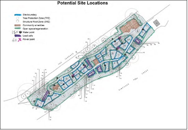
Fig
1: Proposed site plan from the
Arboricultural Report showing potential site locations, regeneration/open
areas, load cell installation sites, water and power points, and tree
positions.
Furthermore,
it is considered that insufficient information has been provided for Council to
confidently understand how the Southern Precinct could be managed as a camping
area concurrently with avoiding environmental damage to the fragments of the
CCPF proposed to be protected and managed. Even with weed management and
protection of individual trees, the community would still be impacted by a
number of the listed major threats to the EEC, including:
· Risks
associated with the community occurring in small, isolated stands exacerbating
risks from environmental stochasticity, disruption to pollination and dispersal
of fruits and seeds, and likely reductions in genetic diversity.
· Trampling and
rubbish dumping due to the constant presence of people in the area.
· Edge encroachment
associated with maintenance of service infrastructure.
· Suppression
of natural recruitment/regeneration.
Given the above reasoning, as well
as the lack of certainty regarding the effectiveness of the measures proposed
by the Biodiversity Assessment Report and Arboricultural Report, I would concur
with the recommendation of Option 1 in the abovementioned Kooyman report:
Permanently remove all camping
and infrastructure in the south of the park and restrict all activities to the
northern area. Remove bitumen roading from the southern area and allow the
coastal cypress (Callitris columellaris) and associated species that form
part of the EEC to regenerate”.
Assessment against the
principles of ESD
An assessment against the relevant
principles of ESD is given below, focusing on the precautionary principle and
the conservation of biological diversity and ecological integrity.
The precautionary principle
The precautionary principle imposes an obligation on the
decision maker to address uncertainty in the assessment process, and to ensure
that potential though not well-defined or understood threats to the environment
are taken into account.
(a) the
precautionary principle—namely, that if there are threats of serious or
irreversible environmental damage, lack of full scientific certainty should not
be used as a reason for postponing measures to prevent environmental
degradation.
In
the application of the precautionary principle, public and private decisions
should be guided by—
(i) careful evaluation to avoid, wherever practicable, serious
or irreversible damage to the environment, and
(ii) an assessment of the risk-weighted consequences of various
options,
Legal framework for considering
the precautionary principle
In Telstra Corporation Ltd v
Hornsby Shire Council (2006) 146 LGERA 10, Preston J, held that to trigger
the precautionary principle, a threshold test with two rungs had to be passed.
(1) There must be a threat of
serious or irreversible environmental damage, supported by scientific evidence,
and
(2) Scientific uncertainty as to
the nature and scope of the threatened environmental damage.
Once the precautionary principle
is invoked, it requires the decision maker to assume that the activity will, or
is likely to, have a serious and irreversible impact on the environment.
Preventative or precautionary measures can then be employed to reduce the risk
of environmental harm to an acceptable level.
Does the activity pose a threat
of serious and irreversible environmental damage?
Council’s Natural Resource
Planner noted that due to the rarity and extremely restricted distribution of
the CCPF EEC, any further loss of occurrence or reduction in its extent within
the Reserve should be regarded as a serious and irreversible impact on the
environment. The available evidence suggests that further loss of the EEC is
plausible and likely to occur unless ameliorative actions are taken.
Is there scientific uncertainty
as to the nature and scope of the environmental threat?
Reports available to Council agree
on the threats facing the CCPF EEC, but draw different conclusions as to the
scope and severity of the potential environmental damage resulting from the
Holiday Parks operations.
The Arborsafe report concludes
that the health, vitality and extent of the CCPF would be enhanced by
mitigation strategies such as ground protection measures, redefining campsites
and assisted regeneration in the Southern Precinct. This finding was echoed in
the Kingfisher ecology report which concluded that implementation of the
recommendations of the Arboricultural report would result in an increase in the
overall extent of the community.
Kooyman on the other hand concluded
that the above reports did not properly consider the overall conflict between
the continuing operations of a caravan park within an endangered ecological
community, and that its ongoing use would likely have a substantial impact on
the composition and extent of the CCPF such that it faces risk of localised
extinction. This finding was endorsed by Council’s Natural Resource
Planner who ultimately concluded that there was insufficient information to
ensure that the probable threats facing the CCPF (i.e. reduced occurrence and
extent) could be properly mitigated by the actions recommended in the Arborsafe
report.
Is the precautionary principle
activated?
The precautionary principle is
considered to be activated in this case because both of the threshold tests set
out in Telstra have been passed. Firstly, scientific evidence exists
which indicates that the continued operation of the Holiday Park poses a risk
of serious and irreversible impact on the environment, and, secondly, there is
considerable uncertainty over the scope of the environmental harm as evident in
the divergent views amongst the expert reports.
As such, a precautionary approach
is needed in determining the application to limit the threat of environmental
harm to an acceptable level.
Council previously addressed
environmental concerns by excluding the Southern Precinct of the Holiday Park
from the approval. However, upon review, this approach is not considered to be
valid due to limitations in the relevant legislation.
Section 94 of the Local Government
Act 1993 does not offer Council the option of granting a ‘partial’
approval to a Section 68 application. That is, Council must decide to either
approve the application as submitted (either unconditionally or subject to conditions),
or to refuse the application. Any condition which artificially excises part of
the Holiday Park from the approval could be viewed as being inconsistent with
Section 94 and, therefore, potentially invalid.
A further limitation is applied by
Section 3.39 of the Crown Lands Management Act 2016 which provides that a
Council cannot grant approval to an activity application if it would result in
a contravention of the Plan of Management for the land. Thus, any condition
imposed by Council which materially alters the Park layout, such that it is no
longer consistent with the adopted Plan of Management, would likely be in
contravention of Section 3.39 and may be invalid.
Given these limitations, and
considering the lack of other possibilities to impose conditions or otherwise
mitigate environmental harm to an acceptable level, the option of refusing the
application as a preventative measure should be considered by Council.
Conservation of biological diversity and ecological
integrity
The conservation of biological diversity and ecological
integrity is required to be a fundamental consideration in this assessment.
Preservation of biodiversity requires that ecosystems, species and genetic
diversity within species be maintained.
(c) conservation
of biological diversity and ecological integrity—namely, that
conservation of biological diversity and ecological integrity should be a
fundamental consideration,
As discussed elsewhere in this report, continued operation of the Holiday Park will likely lead to
ongoing impacts to the CCPF in the Southern Precinct and its gradual decline
over time due to an impairment of natural regeneration processes and damage to
existing trees.
Insufficient information has been
provided for Council to understand how the Southern Precinct could be used for
camping while simultaneously avoiding damage to existing trees and providing
adequate room for natural and assisted regeneration such that it ensures no net
loss to the occurrence or extent of the CCPF within the Reserve. It is
considered that the activity is likely to result in a loss of biodiversity
values of the site and will adversely affect the ecological integrity of the
endangered ecological community if approved.
The application is therefore
recommended for refusal.
5. Crown Land Management
Act 2016
Section 3.39 of the Crown Lands
Management Act 2016 (the Crown Lands Act) provides that a Council must not
grant approval to a Section 68 Application relating to Crown land, if the
Approval authorises or requires a person to do anything that would contravene a
plan of management applying to the land.
Section 3.39 is reproduced below:
3.39 Approvals
of activities under must comply with plans of management
A local council cannot grant an approval for an activity
under Part 1 of Chapter 7 of the Local Government Act 1993 that authorises
or requires a person to do (or not to do) anything on or in relation to
dedicated or reserved Crown land that would result in a contravention of a plan
of management for the land.
The above clause also extends to
any conditions that would materially alter the park layout or restrict its
operations so that it is no longer consistent with the plan of management. For
example, a condition that attempts to exclude certain precincts or parts of the
holiday park from approval could potentially be viewed as contravening the
Crown Lands Act.
Thus, if the Council forms a view
that the Application should be approved, it is suggested that a
‘partial’ approval which excludes the Southern Precinct (similar to
the previous application) should not be pursued as this would likely contravene
the Crown Lands Act.
6. Public Submissions
There are no provisions under the
LG Act that require Section 68 applications to be publicly notified or
advertised. In addition, public submissions are not a statutory consideration
when determining any such application.
Notwithstanding, two submissions
were received from the public. Key issues have been summarised and addressed
for completeness. The submissions mainly focus on the issues of inadequate site
setbacks from roads and boundaries, and impacts on the Coastal Cypress Pines
and Mangroves in the Reserve.
|
Issue
|
Comment
|
|
1.
Setbacks from boundaries
|
|
By not
providing the legal 10m road setback, campers in the park are pitching and
occupying tents only 1m from a busy road. This is incredibly dangerous with
at least 3 cars having crashed into and gone through roadside fences in The
Terrace in the last year.
By not
providing the legal 10m road setback, there is no pedestrian access available
along either side of this 70 metre section of busy street forcing all pedestrians
onto a very thin roadway.
The section of
Brunswick Terrace between Nana and Park Streets is the town’s thinnest
street and has no walkways available on either side. The street has heavy
pedestrian use as it is in central Brunswick and is the main access way to
the school, beach and shops for over half the population. Children are forced
onto the road as they walk home from school.
|
The current
situation with nil setbacks to a public road is undesirable.
Section 89
of the 2005 Regulations allows Council to approve a reduced setback less than
10m, so long as it is satisfied that the dwelling site or camp site has been or
will be properly screened, fenced, enclosed or otherwise treated.
This assessment recommends refusal primarily for environmental reasons.
However if the Council resolves to approve the application, it is
recommended that sites P101-P106 facing The Terrace be setback from the
road reserve by at least 5 metres and screened with appropriate screening or
landscaping.
|
|
By not
providing the legal 10m setback local residents have hundreds of short term
campers only 5m from their homes which is causing huge noise and visual
amenity issues.
|
|
2.
Cabins located in former road reserve not part of the original holiday park
|
|
A 10m wide
by 70m long strip of road reserve was compulsorily acquired after Council
refused to sell or rezone the land. For the last 25 years, 5 cabins occupied
this thin 70m by 20m section of road reserve since being illegally relocated
there from other parts of the caravan park. This was always a short-term
measure with Council ensuring that when the elderly owners of these cabins
moved or died the structures were removed and the buffer of road
reserve/parkland returned. Recently the owner of site 102 died and her cabin
is currently being removed. This finally allows the buffer zone to be
reinstated. The fence can now be moved back 10m and align with the other 200m
of fence to the south that was moved back 3 years ago.
|
The issue
of some sites being located in a former road reserve has been acknowledged in
previous applications. I note the road reserve has since been compulsorily
acquired by the Crown and now forms part of the Holiday Park.
As
discussed above, this assessment proposes that if the Council resolves to
approve the application, site setbacks for The Terrace should be increased to
5 metres, along with appropriate screening and landscaping.
|
|
3.
Safety Issues
|
|
Reflections
are currently allowing people to pitch flimsy 2 man tents as close to 1m from
Brunswick Terrace.
|
Any camping
which does not conform to the existing ATO and/or park boundaries is
essentially a compliance issue for Reflections and Council to resolve.
|
|
4.
Amenity issues
|
|
Families
opposite Brunswick Terrace now have to put up with year round amenity issues
caused by hundreds of partying camper’s only metres from their homes.
|
Proximity
to residences on the opposite side of The Terrace is undesirable. Refer to
comments in Point 1.
|
|
5.
Coastal Cypress Pine Forest EEC
|
|
Terrace
Reserve is home to what remains of an endangered ecological community of
Coastal Cypress Pines. These communities are very rare and must be protected
under the NSW threatened Species Act.
|
CCPF EEC is
currently protected under the Biodiversity Conservation Act 2016.
Operation of the park must be undertaken in a manner that does not have a
significant impact on the EEC. Given the likely impacts on the CCPF, the
application is recommended for refusal.
|
|
Byron Shire
Council commissioned an independent ecological consultant who stated that the
trees were of such ecological significance that for their survival all
camping and development at the southern end of the Terrace Reserve should
cease.
|
The Report
by Dr Kooyman has been used as background information for this assessment.
|
|
Reflections
have stated that they already have a vegetation management plan in place.
Their decade old VMP states that the protected trees have a very sensitive
critical root structure and that compression of the soil around the trees
will kill them. The stated action in the VMP is “no activities that
cause soil compression within 5m of the tree trunks”.
|
Noted. See
above.
|
|
Despite
this, for the past 14 years CLHPs/Reflections have denuded the trees of all
branches below 4m so large vehicles and campervans could be driven and parked
over the critical root structure. In peak times 90% of the trees have large
camper or numerous vehicles parked over their roots so their claimed
vegetation management is being totally ignored and killing this protected
community.
|
It is
unclear to what extent Reflections have implemented the actions and
recommendations of the POM and VMP.
|
|
6.
Historic WW1 Memorial Pine Park
|
|
A large
area of the reserve is the site of one of the oldest WW1 memorial parks
within over 100 memorial trees planted in rows in 1918. This is listed under
numerous heritage orders and is of great cultural significance to the local
community.
|
Heritage
investigations carried out in 2017 indicate that Cypress Pines in the Reserve
were probably not planted but may have been shaped into a glade, with linear clearings giving the
impression of a row of remembrance.
It is
acknowledged that the trees are listed on the Register of the National Trust
and are recognised as having social significance to the local community.
|
|
7. Seasonal
Primitive Camping Area
|
|
Claims by
Reflections that the southern end of Terrace Reserve is a longstanding,
recognised and licenced camping area are fictitious as over half this area
was road reserve until 2011. It is well documented the only previous camping
exiting use was seasonal, primitive camping that was restricted to about 5
weeks of the year over Christmas and Easter.
|
It is not
disputed that the historic use of The Terrace Reserve for seasonal camping
may have been different to what is currently occurring.
Please be
aware that if continuing use rights are not available for the Southern
Precinct (still a matter of debate), the Applicant can in any case rely on
Clause 65 of SEPP Infrastructure to carry out “any development”
without the need to obtain consent, so long as it is for the purposes of
implementing a Plan of Management.
I note that
the current use of the Southern Precinct is generally consistent with the
2014 POM.
In the
event that continuing use rights are not available to Reflections for the
current use of the Southern Precinct, they may need to undertake an
Environmental Assessment in accordance with Part 5 of the EP&A Act 1979.
This would need to be pursued as a separate matter to this assessment given
there is no relationship between the EP&A Act 1979 and Council’s
consideration of a S.68 Application to operate a caravan park or camping
ground under the LG Act.
|
|
8.
Impacts on Mangroves
|
|
Currently,
100m of riverbank and associated mangroves are being heavily trafficked and
trampled by Terrace Campers who are accessing this area for water activities,
watercraft storage and fishing.
It is
obvious that management have not informed campers that this area is under
environmental protection.
|
Access to
the riverbank is largely a management issue for Reflections. The current
situation with sites in close proximity to the riverbank is undesirable. It
is hoped that dwellings and sites will eventually be removed from the
riverbank and a greater setback provided that also allows public access along
the foreshore. It is suggested that this outcome should be pursued as part of
the development of a new Plan of Management for the Terrace Reserve.
|
|
This
section of the riverbank is also seriously eroding due to an increase in
occupation, the clearing of surrounding vegetation, and numerous illegal
drainage pipes pouring stormwater and waste water down the bank.
|
|
Large
groups of campers are now pithing tents right on the riverbank causing
serious erosion by going up and down the steep and eroding bank and dragging
watercraft with them. They are now using this are as a general swimming,
fishing and boating area and destroying the bank.
|
7. Conclusion
This Application seeks approval to
operate the Terrace Reserve Holiday Park pursuant to Section 68 of the Local
Government Act 1993. The proposal is similar to the previous application
considered by Council in 2018 and includes use of the southern precinct of the
holiday park for camping and caravanning.
On balance, it is considered that
there is insufficient information for Council to be satisfied that the
operation of the Holiday Park will not have a serious and irreversible impact
on the environment should approval be granted. As such, the application is
recommend for refusal on the basis that it contravenes the principles of
Ecologically Sustainable Development established under Section 89 (3) of the
Local Government Act 1993.
Staff Reports - Infrastructure Services 13.17
Staff Reports - Infrastructure Services
Report No. 13.17 Linda
Vidler Memorial Parklands - Pump Track Design
Directorate: Infrastructure
Services
Report
Author: Malcolm
Robertson, Team Leader Open Space
File No: I2020/1368
Summary:
This report seeks Council approval to progress to
construction with of the Linda Vidler Park Pump Track.
The report also seeks Council to consider the option for a
proposed Stage 2 of the Pump Track, including the funding, timing of works and
procurement process for the additional stage.
|
RECOMMENDATION:
That Council:-
1. Approves
construction of the Stage 1 design plans for the Pump Track at Linda Vidler
Park.
2. Allocates
$200,000 from the Suffolk Park Open Space Developer Contributions reserve to
allow the design and construction of Stage 2 of the Pump Track.
3. Enters
into a contract with World Trail Pty Ltd for the design and construction of
stage two of the pump track without calling for tenders because inviting
tenders would not achieve a satisfactory result due to the following
extenuating circumstances:-
a) World
Trail Pty Ltd already being selected by Council via market testing to
construct stage 1 of the pump track;
b) The
Suffolk Park Progress Association wanting an expansion of the pump track
beyond stage 1;
c) The
complexity of the contract arrangements between Council, the Suffolk Park
Progress Association and World Trail Pty Ltd for stage 1 of the pump track
– due to the track being funded by a combination of grant and Council
funding – would need to be repeated with a new contractor; and
d) Tendering
for the pump track extension rather than directly appointing the current
contractor to complete it would cause financial loss to Council, due to it
losing the economies of scale by continuing to contract with World Trail.
|
Attachments:
1 Linda
Vidler Pump Track - For Construction Plans, E2020/96178
2 Pump Track
Stage 2, E2020/96207
3 Linda
Vidler Park- Existing and Desired Use Overlay, E2020/96308
4 Draft
Drainage Plan for Linda Vidler Park, E2020/96326
5 Linda
Vidler Masterplan Preliminary Cost Estimates, E2020/96345
6 Suffolk
Park Progress Association Requesting additional funding to Stage 2 of Linda
Vidler Pump Track, E2020/96766
7 ByronPumpTrackDesign_201124-STAGE2
ZOOM250, E2020/97027
REPORT
Background
Suffolk Park Progress Association
(SPPA) successfully applied for grant funding of $156,300 through the 2019 My
Community Project program to construct a BMX style pump track at Linda
Vidler Park. Council Resolution 19-547 provided $150,000 from the
Suffolk Park Open Spaces developer contributions reserve to the project in
support of the grant funding.
The design and construction
component of the Pump Track was to be funded $156,300 by SPPA and $118,700 by
Council (figures GST inclusive) (Total of $275,000).
Additional funds allocated by
Council resolution are for works ancillary to the pump track including
independent review of environmental factors and the design and construction of access
pathways.
Council has a formal agreement
with the Suffolk Park Progress Association to project manage the design and
construction of the Pump Track. A joint procurement process was completed
in partnership with SPPA to identify a preferred contractor to design and
construct.
Pump Track Design
Contractor World Trail has
completed designs for the budgeted Pump Track as shown in the image below
(refer to Attachment 1 for more detail).
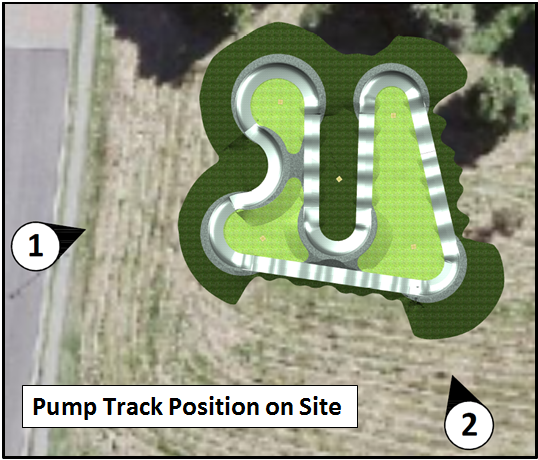
The draft plans have been
developed through ongoing consultation with the SPPA. The design process
has included ongoing consideration of the draft Review of Environmental Factors
and drainage planning for the Pump Track site. Through the design process
modifications to draft designs have been made in consultation with
environmental and drainage engineers following consideration of constraints
around vegetation, soil quality and drainage.
The track was also designed in
relation to the available budget, which allowed for a final rideable surface of
around 400m2, which equates to around 143m of track and 13m of transitions, as measured
along the centre ride line. The actual ride line would be slightly longer
due to angles across berms.
A visualisation/perspective from
the image above from reference points 1 and 2 (from west and south viewpoints)
is shown below.
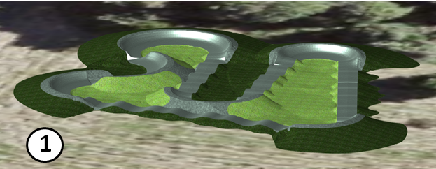

The REF and overall park drainage
plans are currently in final draft stage and these, along with finalisation of
detail design for the Pump Track will be completed subject to adoption by
Council of the draft design.
Pump Track “Stage
2”
SPPA are supportive with the
design and features allowed for in the plans, however had originally desired an
overall track length of 300m. SPPA have indicated strong preference for
the track to be expanded in overall length and to include a more advanced jumps
section. SPPA are seeking Council consideration to fund the Stage 2 works as a
variation to the current project (Attachment 4).
This “Stage 2” has
been considered by World Trail as a variation to the current project and the
proposed design has been developed and costed. The additional track
length can be accommodated within the original agreed footprint within the
park, as shown in Attachment 2.
The total price of the proposed
Stage 2 variation has been estimated as $260,000, including design,
construction and associated compensatory earthworks to meet the
“no-fill” requirements of the precinct. If the works were
able to be completed within the scope of the current project approximately
$60,000 in mobilisation and site establishment costs would be saved.
SPPA grant funding applies only to
the Stage 1 project, therefore SPPA are requesting Council to consider funding
Stage 2 as a variation to the current project, at an additional cost to Council
of $200,000.
Linda Vidler Park Masterplan
Council also requested in Res 20-068
that an overall masterplan for the Linda Vidler Parklands be developed subject
to additional consultation, with a plan being brought back to Council for
adoption. Council’s goal with the Linda Vidler Park Masterplan is
to create a plan and vision for the park that fulfils the range of community
desires for the space.
The Masterplan aims to optimise
the park through provision of safe and accessible facilities for the enjoyment
of the community whilst maximising recreational opportunities, and protecting important
environmental and cultural values. Plummer & Smith Landscape
Architects have been engaged to undertake this exercise, utilising the
background information and community feedback obtained through the Plan of
Management development.
There are a number of conflicting
demands on the open space, with key community stakeholders all having their own
vision for the land. All stakeholders have proposed developments relating
to their area of interest that have potential to exclude other uses. The
overlap of desired uses is shown graphically in Attachment 3, which shows both
the current uses, and an overlay of core stakeholder’s desires.
Consultation with key stakeholders
is underway with initial site meetings having been completed with Arakwal,
Suffolk Park Progress Association, Suffolk Park Community Gardens and Suffolk Park
Football Club. Community desires will be assessed alongside analysis of
the site and any environmental, cultural and regulatory factors and constraints.
Drainage within Linda Vidler Park
is currently poorly formed and impacts future development. Linda Vidler Park is
also a designated no-fill zone due to the adopted Tallow Creek Flood Risk
management Plan. Consultants have been engaged to complete an overall drainage
plan for the Linda Vidler Precinct to inform the Masterplan and assist in
resolving the drainage issues (draft drainage diagram at Attachment 4). This
drainage plan is considering flood impacts and will incorporate WSUD for the
site, seeking to allow potential water supply to the community gardens through
a retention pond. The drainage plan will also identify compensatory
material that can be removed from the site to balance imported fill required for
the Pump Track and also any future masterplan projects.
Options
1) Council resolve to accept
the Pump Track Stage 1 design, and approve planned construction to proceed.
2) Council resolve to accept
proposed designs for Pump Track Stage 1 and Stage 2, but defer any construction
works for Stage 2 subject to completion of Master planning process and
identification of additional external funding to support the works.
3) Council resolve to accept
proposed designs for Stage 1 and Stage 2 of the Pump Track, and to allocate an
additional $200,000 for the works to and proceed with World Trail on the basis
that it would be too costly and time prohibitive under the funding deed
agreement for council to go out to Public Tender.
Next steps
Construction Works are tentatively
planned for March 2021, with completion by no later than 30 May 2021. The
construction dates will be confirmed once proposed design is adopted by
Council.
STRATEGIC CONSIDERATIONS
Community Strategic Plan and
Operational Plan
|
CSP Objective
|
L2
|
CSP Strategy
|
L3
|
DP Action
|
L4
|
OP Activity
|
|
Community
Objective 2: We cultivate and celebrate our diverse cultures, lifestyle and
sense of community
|
2.3
|
Provide
accessible, local community spaces and facilities
|
2.3.7
|
Deliver Open
Space and Recreational services in line with Community Solutions Panel values
(SP)
|
2.3.7.8
|
Deliver adopted
infrastructure within the Suffolk Park Recreation Ground in accordance with
POM and Community consultation
|
|
|
|
|
|
|
|
|
|
|
|
|
Legal/Statutory/Policy Considerations
Under the Local Government Act 1993, contracts valued at
more than $250,000 must go to tender. However, a contract is exempt from the
tendering provisions where, because of extenuating circumstances, remoteness of
locality or the unavailability of competitive or reliable tenderers, Council
decides by resolution (which states the reasons for the decision) that a
satisfactory result would not be achieved by inviting tenders.
Financial Considerations
Councils adopted 20/21 budget has an allocation of $300,000
drawn from the Suffolk Park Open Space reserve to allow for Suffolk Park
Recreation Grounds Plan of Management activation. Around $100,000 of these
funds will be utilised for planning and development of required stormwater and
drainage systems across the precinct. The balance of $200,000 could
potentially be utilised for Stage 2 of the Pump Track.
It has been confirmed that there is an additional $596,000
of developer contributions held in the Suffolk Park Open Space reserve. These
funds are held in reserve to leverage grants for the further implementation of
the POM and Masterplan. These funds could also be used for Stage 2 of the
Pump Track however the potential benefit in leveraging grant funding
opportunities for the wider Masterplan should remain a key focus.
Preliminary costs estimates for rollout of the POM (subject
to adoption of Masterplan) are in the vicinity of $1.2M are shown in Attachment
5. Realisation of these improvements is only achievable with external funding
sources.
This reserve received income from the 2005 contributions
plan. The current income into the reserve from old development consents
that pre date 2012 is minimal. This reserve receives no income under the
current contributions plan. Once the money is spent in this reserve it will not
replenish.
Consultation and Engagement
Widespread community
consultation was undertaken within the POM development process. Separate
engagement was completed in relation to the positioning of the Pump Track
within the precinct. Design works with World Trail Pty Ltd. have been
progressing with ongoing consultation with stakeholders including the Suffolk
Park Progress Association and representatives of the Suffolk Park Community
Gardens.
Tim Fitzroy and Associates has been engaged to complete a
Review of Environmental Factors for the Pump Track. Initial site analysis has
been completed and the draft REF considerations used to inform Pump Track
layout, with modifications made following consideration of constraints around
vegetation, soils quality and drainage.
The REF will be finalised upon adoption by Council of the
draft design.
Staff Reports - Infrastructure Services 13.18
Report No. 13.18 Pedestrian
Access - Byron Bypass
Directorate: Infrastructure
Services
Report
Author: Andrew
Pearce, Traffic Engineer
File No: I2020/1828
Summary:
The purpose of this report is to present a recommended way
forward to ensuring safe and appropriate pedestrian access across the Byron Bay
Bypass.
|
RECOMMENDATION:
That Council:-
1. Notes
the need to undertake further transport survey to identity traffic,
pedestrian and bicycle volumes and pathways once the Byron Bay Bypass is
operational.
2. Investigates
the option of undertaking the above survey as part of a Byron Bay Access and
Movement Plan to be reported to Council separately; and
3. If
the above survey is not done as part of the Byron Bay Access and Movement
Plan Council allocate $40,000 at the next quarterly review to undertake the
study.
|
REPORT
Council have been discussing the
need for pedestrian access across the Byron Bay Bypass. In investigating
pedestrian access across the Bypass two primary issues must be considered:
1. The crossing type.
Do we want a pedestrian facility that directs people:
a. Across: pedestrian
facilities that provide access across the Bypass at ground level,
such as:
refuge islands (already constructed as part of the Bypass), zebra crossings,
signal crossings or traffic lights.
b. Over: facilities
such as a ramped or elevator overpass
c. Under: such
as a pedestrian tunnel.
2. Where to locate the
pedestrian facility:
a. Where are the
primary access points across the rail line to Jonson Street?
b. How will pedestrian
/ cycle pathways change once the Bypass is operational?
c. Which access points
do we want to funnel pedestrians and cyclists towards?
d. The long term use of
Butler Street Reserve and its potential to generate and attract pedestrian movements.
CROSSINGTYPE
In determining whether to adopt a
facility that directs pedestrian across, over or under the Bypass the following
needs to be considered:
Movement & Place
The following image reflects the
road hierarchy proposed for Byron Bay Township.
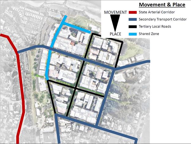
As seen in this image the Bypass
is a Arterial Corridor which reflects it is more a “Movement”
corridor and less a “Place”.
As a comparison, the Jonson Street
Shared Zone functions more as a “Place” and is low in regards to
“Movement”. Therefore, in the Jonson Street Shared Zone,
people are prioritised over cars. If a facility that prioritises
pedestrians (such as a zebra crossing) is installed on the Bypass, this may negate
the intended benefits of the bypass and cause the existing traffic congestion
along Ewingsdale Road to remain even after the Bypass is operational.
This concern is amplified by the
fact we do not know how many people will flow back and forth across the Bypass
after it is operational or where they will primarily cross. If Butler
Street Reserve is used in a way that generates or attracts higher pedestrian
numbers at the same time as peak hour, this may have a significant impact on
the Bypass’s ability to function effectively.
Given the Bypass is more a
“Movement” corridor, it is recommended to consider an option that
either separates cars and pedestrians so there is no conflict (i.e. an overpass
or tunnel) or an options that provides a good balance between pedestrian and
traffic priority
Environmental Conditions
Given Butler Street reserve has
previously been used as a waste disposal site the management of ground
contamination is under review.
The ground water table is
approximately 0.5-1m below ground surface.
Only a portion of the south
eastern corner of Butler Street reserve is not flood affected.
Based on the above considerations,
any option that significantly disturbs in-situ soils, such as a pedestrian
tunnel, are probably highly unsuitable. In addition, designs that
displace flood waters or inhibit the flow of flood waters is not recommended.
Place Making Aesthetics
An additional consideration is the
ability for the pedestrian facility to function as a place making feature or
detract from the Byron aesthetic.
WHERE TO LOCATE A PEDESTRAIN
FACILITY?
The image below shows the 3
primary access points across the Bypass and rail line to Jonson Street after
the Bypass is operational. The image also shows the location of
pedestrian refuge islands (shown as Stars) to be built as part of the Bypass.
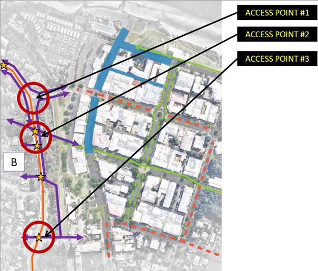
It is anticipated that one or more
of these access points will be the most suitable location for a pedestrian
facility.
FURTHER INVESTIGATION
Before committing to a specific
pedestrian facility and a location it is recommended Council undertake further
investigation into the following areas to
ensure any proposed pedestrian facility is used once constructed:
1. Pedestrian / Cycle surveys
It is recommended
Council undertake pedestrian and cycle surveys once the Bypass is operational
to accurately understand how people and bikes naturally flow across the Bypass.
Staff have begun
investigations into how this can be best done and have identified potential
products that can count and plot vehicle, pedestrian and bike pathways
simultaneously. Such a product can be deployed across the township to
accurately plot the primary pathways adopted by cars, bikes and people.
To purchase a
camera is approximately: $6,000
each
To study an
intersection and analyse vehicle data is approx.: $21 / hour
To include
pedestrian and bicycle study: $16
/ hour
To purchase 3
cameras would cost approximately $20,000.
To analyse
traffic, pedestrian and bicycle movements at the locations shown in the image
below (for 10 hours a day for 3 days) would cost approx.: $15,000
These cost
estimates are provided as a guide as this survey can potentially be done as
part of the proposed Byron Bay Access and Movement Plan discussed below and as
part of a separate Council report.
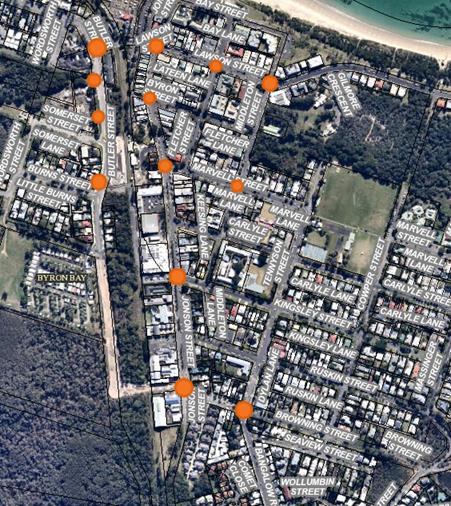
2. Byron Bay Access & Movement Plan
It is recommended Council
consider undertaking an Access and Movement Plan for Byron Bay Township to
support the Town Centre Masterplan objectives and to map out how Council wants
people, bikes and cars to move through the township. Such a plan would
potentially:
i. integrate
Council documents such as the PAMP, Bike Plan, Byron Master Plan, Integrated
Transport Management Strategy
ii. Integrate
potential traffic generation resulting from future developments along Jonson
St, Butler Street Reserve (i.e. used for markets or car parking) and undertake
modelling of transport corridors presenting result for various options –
such as over pass versus pedestrian signals.
iii. Map
out TfNSW’s Movement and Place strategy for all of Byron Bay Township.
Discussions
with the SEE Directorate have confirmed an Access and Movement Plan for the
Byron Bay Township would have significant benefits for strategic planning and
development assessments.
STRATEGIC CONSIDERATIONS
Community Strategic Plan and
Operational Plan
|
CSP
Objective
|
L2
|
CSP Strategy
|
L3
|
DP Action
|
L4
|
OP Activity
|
|
Community
Objective 1: We have infrastructure, transport and services which meet
our expectations
|
1.2
|
Provide
essential services and reliable infrastructure which meet an acceptable
community standard
|
1.2.4
|
Provide active
and passive recreational Community space that is accessible and inclusive for
all (SP)
|
1.2.4.2
|
Deliver
accessibility outcomes within Capital works and infrastructure renewal
programs
|
|
Community
Objective 1: We have infrastructure, transport and services which meet
our expectations
|
1.2
|
Provide
essential services and reliable infrastructure which meet an acceptable
community standard
|
1.2.6
|
Optimise
Council’s property portfolio (SP)
|
1.2.6.4
|
Progress
infrastructure planning for the Ewingsdale Road corridor
|
|
Community
Objective 1: We have infrastructure, transport and services which meet
our expectations
|
1.3
|
Support,
through partnership, a network of integrated sustainable transport
options
|
1.3.1
|
Ensure an
integrated and accessible transport network (SP)
|
1.3.1.2
|
Delivery
prioritised Pedestrian and Access Mobility Plan (PAMP) facilities
|
|
Community
Objective 1: We have infrastructure, transport and services which meet
our expectations
|
1.3
|
Support,
through partnership, a network of integrated sustainable transport
options
|
1.3.1
|
Ensure an
integrated and accessible transport network (SP)
|
1.3.1.3
|
Support the
Byron Bay Bus Interchange in partnership with Transport for NSW
|
|
Community
Objective 1: We have infrastructure, transport and services which meet
our expectations
|
1.6
|
Manage traffic
and parking in an efficient manner
|
1.6.1
|
Implement
review of parking management
|
1.6.1.5
|
Review Byron
Bay Parking Scheme
|
|
Community
Objective 1: We have infrastructure, transport and services which meet
our expectations
|
1.6
|
Manage traffic
and parking in an efficient manner
|
1.6.2
|
Ensure future
traffic demand and alternative solutions are addressed in major
infrastructure plans
|
1.6.2.1
|
This continues
to be a governing principle for all major infrastructure plans.
|
|
Community
Objective 1: We have infrastructure, transport and services which meet
our expectations
|
1.7
|
Manage traffic
and parking in an efficient manner
|
1.6.3
|
Ensure new
infrastructure is planned and funded to meet the needs of the current and
future population (SP)
|
1.6.3.3
|
Advocate and
apply for grant improve transport networks
|
Legal/Statutory/Policy Considerations
N/A
Financial Considerations
To undertake a traffic, pedestrian and bicycle survey of key
locations across Byron Bay Township using three Miovision type camera’s
and associated data analysis is expected to cost approximately $35,000 to
$40,000.
This can potentially be done as part of the Byron Bay Access
and Movement Plan.
Consultation and Engagement
N/A
Staff Reports - Infrastructure Services 13.19
Report No. 13.19 Waterlilly
Park - Crime Prevention Through Environmental Design Report
Directorate: Infrastructure
Services
Report
Author: Michael
Matthews, Manager Open Space and Resource Recovery
File No: I2020/1957
Summary:
On 27 August 2020, in response to a petition seeking inclusion of CCTV into
the Waterlilly Park precinct, Council resolved the following (Res 20-416).
Resolved:
that
Council receive a Crime Prevention through Environmental Design (CPTED) report
for the Waterlilly Park precinct at the earliest possible Council meeting that
considers the inclusion of CCTV and the positioning of other play scape
elements such as future children’s swings.
On 26 November 2020, in response to an additional petition
seeking the return of Little Kids Swings to the Waterlily precinct the
following was resolved – Res 20-660.
Resolved:
1. That
the Petition regarding the community's request to bring back the Little Kids
Swings to Waterlilly Playscape in Ocean Shores be noted.
2. That
Council install the swings in accordance with recommendations provided within
the CPTED report prior to the 25th December, 2020.
3. That
Council provide 2 bike racks just off the carpark in Waterlily Park, that were an
element in the SCC Grant allocation to accompany the 500 metres of shared
concrete pathway installed through Waterlilly Park in 2018, to complete Stage
3.
4. That
staff action all Crime Prevention and Safety measures identified within the NSW
Police, Crime Risk Assessment of Waterlilly Park dated 17th November 2020,
within Council’s current adopted budget, and that any actions that are
unfunded be brought back in a report to Council in December 2020.
An extract of the CPTED reports conclusion is provided
below.
Conclusion
As a result of the Crime Risk Assessment
(CRA), Waterlily Park at Ocean Shores returned a very low overall risk rating
of 9.8%. The general look and perception of the park is positive with the
surrounding landscape well maintained and at the time of the CRA was being used
appropriately by several mothers with young children, and a couple of adults
playing tennis.
With such a low risk rating
being returned during the CRA, and the small number of incidents of crime being
reported to police at the location, with only 11 incidents being report to
police, between February 2017 and December 2018, and nothing reported after
December 2018, the request for CCTV cameras to be installed at the location
would not be supported by police at this stage.
Police would make the
following recommendations in an attempt to further reduce the risk of any
unfortunate incidents:
• Trees and shrubbery that are directly adjacent to the
playground equipment need to be under pruned, to approximately 1.5 meters, to
provide better surveillance for adults supervising children and provide a clear
view of the nearby lake from within the playground area.
• The placement of the single child swing which is
situated approximately 20 meters away from the main playground equipment is a
potential safety risk for young children due to limited adult supervision when
parents have multiple children to supervise. In the Police opinion, the swing
would benefit from being relocated closer to the main playground equipment if
possible.
• Any future swings or play equipment to be installed is
recommended to be situated in closer proximity to the main play area to aid in
appropriate supervision of young children.
The under pruning of trees and
shrubbery to provide for better surveillance for adults supervision of children
is to be undertaken by staff within existing maintenance budget.
The renewal of signs, addition of
sensor lights and the relocation of the Basket swing to a centralised position
will require quotations from suppliers that have not been received to date at
the time of writing of this report. Once received, budgets for these
elements can be requested through a quarterly budget review.
|
RECOMMENDATION:
That:
1. Council
notes the Crime Prevention through Environmental Design (CPTED) report
for the Waterlilly Park precinct; and
2. Staff
progress the implementation of measures identified within the report
with any necessary budget adjustments is to be considered as part of
Council’s December 2020 quarterly budget review process.
|
Attachments:
1 Waterlily
Park CPR Report, E2020/96418
2 Crime
Prevention Through Environmental Design Waterlilly Park 12112020, E2020/96417
REPORT
On 27 August 2020, in response to a petition seeking inclusion of CCTV into
the Waterlilly Park precinct, Council resolved the following.
Resolved:
that
Council receive a Crime Prevention through Environmental Design (CPTED) report
for the Waterlilly Park precinct at the earliest possible Council meeting that
considers the inclusion of CCTV and the positioning of other play scape
elements such as future children’s swings.
On 26 November, in response to an additional petition
seeking the return of Little Kids Swings to the Waterlily precinct the
following was resolved.
Resolved:
1. That
the Petition regarding the community's request to bring back the Little Kids
Swings to Waterlilly Playscape in Ocean Shores be noted.
2. That
Council install the swings in accordance with recommendations provided within
the CPTED report prior to the 25th December, 2020.
3. That
Council provide 2 bike racks just off the carpark in Waterlily Park, that were
an element in the SCC Grant allocation to accompany the 500 metres of shared
concrete pathway installed through Waterlilly Park in 2018, to complete Stage
3.
4. That staff action all
Crime Prevention and Safety measures identified within the NSW Police, Crime
Risk Assessment of Waterlilly Park dated 17th November 2020, within
Council’s current adopted budget and that any actions that are unfunded
be brought back in a report to Council in December 2020.
The Crime Prevention Through Environmental Design (CPTED)
has been completed and is attached to this report.
A Crime Prevention Through Environmental Design (CPTED) is a
situational crime prevention strategy that focuses on the design, planning and
structures of our neighbourhoods. It aims to reduce opportunities for
crime by employing design and place management principles that minimise the
likelihood of essential crime ingredients from intersecting in time and
space.
CPTED is based upon the International Risk Management
Standard, AS/NZS/ISO:31000.2009. This assessment uses qualitative and
quantitative measures of the physical and social environment to create a
contextually adjustable approach to the analysis and treatment of crime
opportunity.
Assessing and Reducing Crime Risk: A Practical Guide for
Planners, Designers and Crime Prevention Professionals is an assessment kit
comprising of two documents.
The first document ‘Crime Risk Assessment’ is an
assessment instrument. It contains four parts:
· Part
one establishes area context;
· Part
two identifies situational crime opportunities;
· Part
three explores the risk control measures to reduce opportunities for crime.
· Part
four reassesses the site/location after the risk control measures have been
developed and implemented to determine whether the measures implemented have
reduced the level of risk.
The second document
‘Companion to Crime Risk Assessment’ (available electronically)
contains instructions on how to use and interpret Part Two of the Crime Risk
Assessment.
An extract of the CPTED reports conclusion is provided
below.
Conclusion
As a result of the Crime Risk Assessment
(CRA), Waterlily Park at Ocean Shores returned a very low overall risk rating
of 9.8%. The general look and perception of the park is positive with the
surrounding landscape well maintained and at the time of the CRA was being used
appropriately by several mothers with young children, and a couple of adults
playing tennis.
With such a low risk rating
being returned during the CRA, and the small number of incidents of crime being
reported to police at the location, with only 11 incidents being report to
police, between February 2017 and December 2018, and nothing reported after
December 2018, the request for CCTV cameras to be installed at the location
would not be supported by police at this stage.
Police would make the
following recommendations in an attempt to further reduce the risk of any unfortunate
incidents:
• Trees and shrubbery that are directly adjacent to the
playground equipment need to be under pruned, to approximately 1.5 meters, to
provide better surveillance for adults supervising children and provide a clear
view of the nearby lake from within the playground area.
• The placement of the single child swing which is
situated approximately 20 meters away from the main playground equipment is a
potential safety risk for young children due to limited adult supervision when
parents have multiple children to supervise. In the Police opinion, the swing
would benefit from being relocated closer to the main playground equipment if
possible.
• Any future swings or play equipment to be installed is
recommended to be situated in closer proximity to the main play area to aid in
appropriate supervision of young children.
The under pruning of trees and
shrubbery to provide for better surveillance for adults supervision of children
is to be undertaken by staff within existing maintenance budget.
The renewal of signs, addition of
sensor lights and the relocation of the Basket swing to a centralised position
that prevents division of a family and active supervision will require
quotations from suppliers that have not been received to date at the time of
writing of this report. Once received, budgets for these elements can be
sort through a quarterly budget review. Staff anticipates the cost of
completion of all these elements to be in the order of less than $10,000.
STRATEGIC CONSIDERATIONS
Community Strategic Plan and
Operational Plan
|
CSP
Objective
|
L2
|
CSP Strategy
|
L3
|
DP Action
|
L4
|
OP Activity
|
|
Community
Objective 2: We cultivate and celebrate our diverse cultures, lifestyle and
sense of community
|
2.3
|
Provide
accessible, local community spaces and facilities
|
2.3.6
|
Ensure Shire
wide assessment of the current and future needs of the community for active
and passive recreation is integrated into Open Space works programs (SP)
|
2.3.6.2
|
Renewal of
playground equipment (Shire wide - emergent)
|
Legal/Statutory/Policy
Considerations
N/A
Financial Considerations
The renewal of signs, addition of
sensor lights and the relocation of the Basket swing to a centralised position
that prevents division of a family and active supervision will require quotations
from suppliers that have not been received to date at the time of writing of
this report. Once received, budgets for these elements can be sought
throu
Staff Reports - Infrastructure Services 13.20
Report No. 13.20 House
Raising Subsidy payment for 8 Park Street New Brighton.
Directorate: Infrastructure
Services
Report Author: Scott
Moffett, Drainage & Flood Engineer, IS - Works - Infrastructure Planning
File No: I2020/1933
Summary:
Council has previously received grant funding to provide
$10,000 contribution to each household that complete house raising in the area
detailed in the Marshalls Creek Floodplain Management Plan.
The residence at 8 Park Street, New Brighton has now been
raised as per Council requirements and is eligible to receive the subsidy.
|
RECOMMENDATION:
That Council:
1. Approves
the payment of a subsidy of $10,000 to the owner of 8 Park Street, New
Brighton as contribution to house raising of the dwelling, subject to receipt
of a signed deed of release in Council’s favour; and
2. Allocates
a budget of $10,000 funded by the Infrastructure Services Carryover Reserve
to facilitate the subsidy payment outlined in recommendation 1.
|
Attachments:
1 Confidential
- Council acknowledgment of owner acceptance and process required, DM277008
2 Confidential
- Corrected floor level letter to owner from Council, DM291280
3 Confidential
- 8 Park Street NEW BRIGHTON- 13.2009.297.1 - Final Completion Letter and
Occupation Certificate(2), E2020/96646
REPORT
Byron Shire Council received a grant offer of $50,000 from
the Minister for Agriculture and Land and Water Conservation in August
2000. This subsidy offer was in response to Council’s application
for funding of Flood Mitigation works, recommended by the Marshall’s
Creek Floodplain Management Plan. This Plan was adopted by Council in
1997.
Council resolved to accept the grant offer and contribute
its share of $25,000. This provided funds to the level of $75,000, which
by Council resolution were to be spent as follows:
· $6,160
to be directed toward the preparation and implementation of a public
information and education program regarding flood awareness
· $68,840
to be directed towards house raising of the most affected properties, in
accordance with the Floodplain Management Plan
Following this, Council offered funding to the value of
$10,000 per household to properties which were affected by flooding in the Marshall’s Creek Floodplain Management Plan. At the time only two (2) owners
took up the offer and received the subsidy. The remaining funding was
placed into Council reserves until such time as an owner wished to complete the
house raising to Council specification and conditions.
The owner of 8 Park Street, New Brighton approached Council
in 2001, to seek approval for the house raising subsidy, Council offered the
subsidy and the owner subsequently accepted (refer attachment 1).
In accordance with the grant funding conditions and the
house raising subsidy requirements from the previous offer made by Council, it
was agreed to provide the subsidy providing the owner provided the necessary
documentation and completed the works as required (refer attachment 2)
The owner has now completed the proposed works and is
eligible to receive the $10,000 subsidy (refer attachment 3).
It is recommended that on receipt of a signed deed of
release in Council’s favour from the owner of 8 Park Street, New Brighton
that $10,000 be taken from funding reserved by Council for the house raising
subsidy and be paid to the owners of 8 Park Street, New Brighton.
STRATEGIC CONSIDERATIONS
Legal/Statutory/Policy Considerations
There are no statutory implications.
The Marshalls Creek Floodplain Management Plan details house
raising as a cost effective approach to flood mitigation in the catchment.
It is noted that the house raising subsidy funds were
received as a grant from state government and were provided for the sole
purpose of subsidising house raising in the Marshalls Creek Catchment.
Financial Considerations
Council at 30 June 2017 was holding $45,930.18 as an
unexpended grant for house raising. Given the age of the grant funds and
as there would be no acquittal required, the funds were reclassified from
unexpended grants and transferred to the Infrastructure Services Carryover
Reserve at that time. There is funding in this reserve available to provide the
$10,000 subsidy as outlined in this report subject to Council’s approval.
Staff Reports - Infrastructure Services 13.21
Report No. 13.21 Byron
Bay Access and Movement Plan
Directorate: Infrastructure
Services
Report
Author: Andrew
Pearce, Traffic Engineer
File No: I2020/1941
Summary:
The purpose of this report is for Council to consider the
preparation of an Access and Movement Plan for Byron Bay. The opening of the
Byron Bay Bypass is to occur early in 2021 and with the Byron Bay Masterplan it
is clear the Byron Bay Township is currently experiencing a significant period
of change. However, it has also been identified that Council has not
modelled or reviewed the potential impact that many of the Masterplan projects
may have on access and movement within Byron Bay.
|
RECOMMENDATION:
That Council:-
1. Supports
the preparation of an Access and Movement Plan for Byron Bay Town Centre;
2. Considers
a funding proposal at the next available Quarterly Budget Review; and
3. Subject
to a suitable funding source being available, engages a consultant to prepare
a Byron Bay Access and Movement Plan with a 20 year design horizon.
|
REPORT
The township of Byron Bay is anticipated to go through a
period of significant and positive change over the next few years as a result
of a number of projects. While these projects appear to be of great benefit,
the potential combined impact of these projects has not been modelled or
assessed.
Such projects and plans include, but are not limited to:
· The
Byron Bay Masterplan (Jonson St Shared Zone, Byron Street pedestrianisation
etc)
· Byron
Bay Bypass
· The
PAMP, bike plan, integrated transport strategy and MURC etc
· Butler
Street Bypass
· Butler
Street Reserve options
· Bypass
pedestrian crossing
· Bypass
Bus Interchange
· Activation
of Sandhills area and adjacent Crown Land
· Ewingsdale
Road Interchange signalling
In addition, there are a number of other developments and
transport options potentially on the horizon that may significantly shape the
way people move through and access Byron Bay. For example:
· Mercato
Hotel
· Mixed
use development on Jonson St and Browning St
· Harris
Farm
· West
Byron Urban Release Area
· Ewingsdale
Road / Transport corridor upgrades
· Park
n Ride services
A key concern is that the combined impact of the above items
(as well as others not listed above) over the next 20 years is currently
unknown, nor modelled. In addition, if the Bypass does not reduce the traffic
volume passing through the CBD and large volumes of traffic continue to flow
through the Jonson Street Shared Zone, what options can Council adopt to
address this problem?
As a result, Staff recommend undertaking modelling of access
and movement for the Byron Bay Township with a 20 year design horizon and
prepare a Byron Bay Access and Movement Plan.
The purpose of the Access and Movement Plan is primarily
to:-
· Model
access and movement for the township of Byron Bay over a 20 year design
horizon. In other words, what will be the anticipated impact of all proposed
and possible projects on access and movement across the Byron Bay Township.
· Assist
in planning Byron Bay Masterplan projects over the next 20 years through
anticipating potentially negative impacts and key signature projects.
· Inform
a contributions plan associated with the Byron Bay Masterplan
This will help Council to anticipate potentially negative
impacts and solutions, help identify priority projects in advance and help
inform a contributions plan associated with the Byron Bay Masterplan.
To undertake this access and movement modelling it is
proposed to prepare a reverse brief and request a number of consultants to
submit a quote. In general terms, the brief is anticipated to include the
following:-
· Undertake
a literature review of all relevant Council and TfNSW documents
· A
solid understanding of the TfNSW Movement and Place strategy
· Model
several scenarios of the Byron Bay township (the extents of the model TBC) to
identify problem areas, impacts, solutions and key projects
· Engage
with TfNSW and Council to include latest traffic modelling (from SEQ to Byron
Bay) and traffic data.
· Include
in the modelling projects associated with the PAMP, Bike Plan, Masterplan,
integrated transport strategy and other key Council documents
· Include
in the modelling potential developments over the next 20 years, such as:
Mercato Hotel, Harris Farm, Butler Street Reserve options, West Byron Urban
Release area etc.
It is anticipated the brief will be ready by mid January
2021, quotes received by mid February and a consultant engaged by beginning of
March. As part of the reverse brief the submissions will be asked to indicate
the expected time required to undertake the scope of works.
Once a cost estimate is known a funding source can then be
identified at the next appropriate Quarterly Budget Review.
Next steps
Once available, the draft Byron
Bay Access and Movement Plan will be presented to a Council Strategic Planning
Workshop, prior to being presented for adoption at Council or public exhibition.
STRATEGIC CONSIDERATIONS
Community Strategic Plan and
Operational Plan
|
CSP
Objective
|
L2
|
CSP Strategy
|
L3
|
DP Action
|
L4
|
OP Activity
|
|
Community
Objective 1: We have infrastructure, transport and services which meet
our expectations
|
1.6
|
Manage traffic
and parking in an efficient manner
|
1.6.2
|
Ensure future
traffic demand and alternative solutions are addressed in major
infrastructure plans
|
1.6.2.1
|
This continues
to be a governing principle for all major infrastructure plans.
|
|
Community Objective
4: We manage growth and change responsibly
|
4.1
|
Support the
visions and aspirations of local communities through place-based planning and
management
|
4.1.1
|
Develop,
implement and update Place Plans that promote place-based forward planning
strategies and actions
|
4.1.1.6
|
Investigate
priority needs for future masterplans
|
Legal/Statutory/Policy Considerations
N/A
Financial Considerations
No funding has been allocated to the project in the current
budget. In order to proceed with the Byron Bay Access and Movement Plan, a
funding source will need to be considered and allocated through a Quarterly
Budget Review.
At the time of writing a suitable funding source had not
been identified. Council may need to consider reprioritising projects in order to
fund this work. Options will be provided to Council as quarterly review.
Consultation and Engagement
N/A
Reports of Committees - Corporate and Community Services 14.1
Reports of Committees - Corporate and Community
Services
Report No. 14.1 Report of the Finance Advisory Committee Meeting held on 12 November 2020
Directorate: Corporate and Community Services
Report Author: James
Brickley, Manager Finance
File No: I2020/1802
Summary:
This report provides the minutes and recommendations of the
Finance Advisory Committee Meeting held on 12 November 2020 for resolution by
Council.
|
RECOMMENDATION:
1. That
Council notes the minutes of the Finance Advisory Committee Meeting held on
12 November 2020.
|
|
2. That Council
adopts the following Committee Recommendations:
Report No. 4.1 Unrestricted Cash and Reserves
at 30 June 2020
File No:
I2020/1731
Committee Recommendation 4.1.1
1. That
the Reserve Balances as outlined in Attachment 1 (#E2020/87284) at 30
June 2020 be noted by the Finance Advisory Committee.
2. That
the Unrestricted Cash Balance of $724,300 as at 30 June 2020 be noted by the
Finance Advisory Committee.
|
|
3. That Council
adopts the following Committee Recommendations:
Report No. 4.2 Quarterly Update -
Implementation of Special Rate Variation
File No:
I2020/1739
Committee Recommendation 4.2.1
That the Finance Advisory
Committee notes the quarterly update on the Special Rate Variation
Implementation as at 30 September 2020 as outlined in Attachment 1
(#E2020/88148).
|
|
4. That Council
adopts the following Committee Recommendations:
Report No. 4.3 Budget Review - 1 July 2020 to
30 September 2020
File No:
I2020/1758
Committee Recommendation 4.3.1
1. That
Council notes that the itemised budget variations as shown in Attachment 2
(#E2020/88837) which include the following results in the 30 September 2020
Quarterly Review of the 2020/2021 Budget:
a) General
Fund – $60,700 increase to the Estimated Unrestricted Cash Result
b) General
Fund - $3,045,100 increase in reserves
c) Water
Fund - $800,900 decrease in reserves
d) Sewerage
Fund - $431,200 decrease in reserves
were
adopted by Council at its Ordinary Meeting held on 26 November 2020.
2. That
Council adopts the revised General Fund Estimated Unrestricted Cash Result
of $428,200 for the 2020/2021 financial year as at 30 September 2020.
|
Attachments:
1 Minutes 12
November 2020 Finance Advisory Committee, I2020/1763
Report
The attachment to this report provides the minutes of the
Finance Advisory Committee Meeting of 12 November 2020 for determination by
Council. The agenda for this meeting can be located on Council’s
website at:
https://byron.infocouncil.biz/Open/2020/11/FAC_12112020_MIN_1232.PDF
The Committee considered the following items:
Report 4.1 Unrestricted Cash and Reserves at 30 June 2020
The Committee considered a
report that outlined the detailed schedule of all Council reserves held at 30
June 2020. Whilst the schedule of reserves was adopted by Council as part
of completing the 2019/2020 financial statements, the details of these reserves
are summarised in Note 7 to the financial statements. The report also indicated
to the Committee the positive short term financial strength of Council in terms
of the Unrestricted Current Ratio and Cash Expense Cover Ratio given the
impacts to Council of the COVID-19 Pandemic to 30 June 2020. The report also
identified that Council was able to maintain an unrestricted cash balance of
$724,300 as at 30 June 2020.
Report 4.2 Quarterly
Update – Implementation of Special Rate Variation
The Committee considered a report that outlined expenditure
in relation to the 2017/2018 Special Rate Variation. The report included a
schedule of works with total funding of $7,404,700 (this includes the
$4,788,600 derived from the fourth year of the 4 year Special Rate Variation
that commenced on 1 July 2017 and the residual amount unexpended at 30 June
2020 ($151,700). As at the end of September 2020, Council had expended 20.74%
of the overall program.
Report 4.3 Budget Review
– 1 July 2020 to 30 September 2020
The Committee discussed the 30 September 2020 Quarter Budget
Review, noting the proposed amendments to the 2020-2021 Budget and recommended
their adoption to Council (this occurred at the 26 November 2020 Ordinary Meeting).
Of note in the report were the following major items:
1. Part
recovery of the 2020-2021 budget deficit in the General Fund by $60,700.
Deficit position has improved from $356,800 to $296,100.
2. Expected
improvement of the unrestricted cash balance of $60,700 back towards the
$1,000,000 the Council’s adopted benchmark. Projection is now $428,200.
3. Funding
additional items as a result of additional Financial Assistance Grant revenue
not originally budgeted.
The Committee Recommendations are supported by management
and are provided at Attachment 1 to this report. The recommendation for Report
4.3 has been amended to reflect the consideration and adoption of this report
separately at the 26 November 2020 Ordinary Council Meeting.
Financial Implications
As per the Reports listed within the Finance Advisory
Committee Meeting of 12 November 2020.
Statutory and Policy
Compliance Implications
As per the Reports listed within the Finance Advisory
Committee Meeting of 12 November 2020.
Reports of Committees - Corporate and Community Services 14.2
Report No. 14.2 Report of the Audit, Risk and Improvement Committee Meeting held on 12 November 2020
Directorate: Corporate and Community Services
Report
Author: Emma
Fountain, Strategic Risk & Business Continuity Coordinator
File No: I2020/1811
Summary:
This report provides the minutes
of the Audit, Risk and Improvement Committee Meeting held on 12 November 2020 for
determination by Council.
|
RECOMMENDATION:
That Council notes the minutes of the Audit, Risk and
Improvement Committee Meeting held on 12 November 2020.
|
Attachments:
1 Minutes
12/11/2020 Audit, Risk and Improvement Committee, I2020/1751
Report
The attachment to this report provides the minutes of the
Audit, Risk and Improvement Committee Meeting of 12 November 2020 for
determination by Council. The agenda for this meeting can be located on
Council’s website at:
https://byron.infocouncil.biz/Open/2020/11/ARIC_12112020_AGN_1231_AT_EMBEDDED.PDF
Committee Recommendations
The committee recommendations are supported by management
and are provided in the attachment to this report.
Financial Implications
As per the Reports listed within the Audit, Risk and
Improvement Committee Meeting of 12 November 2020.
Statutory and Policy
Compliance Implications
As per the Reports listed within the Audit, Risk and
Improvement Committee Meeting of 12 November 2020.
Reports of Committees - Sustainable Environment and Economy 14.3
Reports of Committees - Sustainable Environment
and Economy
Report No. 14.3 Report of the Sustainability and Emissions Reduction Advisory
Committee Meeting held on 12 November 2020
Directorate: Sustainable Environment and Economy
Report
Author: Kimberley
Rogers, Environment Support Officer
File No: I2020/1805
Summary:
The attachment to this report provides the minutes of the
Sustainability and Emissions Reduction Advisory Committee meeting held on 12
November 2020 for determination by Council.
|
RECOMMENDATION:
1. That
Council notes the minutes of the Sustainability and Emissions Reduction
Advisory Committee Meeting held on 12 November 2020.
|
|
2. That Council
adopts the following Committee Recommendations:
Report No. 4.1 Climate Emergency Response
Update on Res 20-351
File No:
I2020/1455
Committee Recommendation 4.1.1
1. That
Council note the report.
2. That Resilient Byron be invited to join the
Sustainability and Emissions Reduction Advisory Committee.
|
|
3. That Council
adopts the following Committee Recommendations:
Report No. 4.2 Sustainability and Emissions
Reduction Projects - Update Report
File No:
I2020/1557
Committee Recommendation 4.2.1
1. That Council
note the report
2. That
Council enter into a one year trial partnership with ClimateClever.
|
|
4. That Council
adopts the following Committee Recommendation:
Report No. 4.3 Updates from Zero Emissions
Byron and COREM
File No:
I2020/1719
Committee Recommendation 4.3.1
That Council note the
report.
|
Attachments:
1 Minutes
12/11/2020 Sustainability and Emissions Reduction Advisory Committee, I2020/1766
Report
The attachment to this report provides the minutes of the
Sustainability and Emissions Reduction Advisory Committee Meeting of 12
November 2020 for determination by Council. The agenda for this meeting
can be located on Council’s website at:
https://byron.infocouncil.biz/Open/2020/11/SERAC_12112020_AGN_1230_AT_EMBEDDED.PDF
Committee Recommendation
The committee recommendations are supported by management
and are provided in the attachment to this report.
Financial Implications
As per the Reports listed within the Sustainability and
Emissions Reduction Advisory Committee Meeting of 12 November 2020.
Statutory and Policy
Compliance Implications
As per the Reports listed within the Sustainability and
Emissions Reduction Advisory Committee Meeting of 12 November 2020.
Reports of Committees - Sustainable Environment and Economy 14.4
Report No. 14.4 Report of the Biodiversity Advisory Committee Meeting held on 23 November 2020
Directorate: Sustainable Environment and Economy
Report
Author: Michelle
Chapman, Project Support Officer
File No: I2020/1867
Summary:
This report provides the minutes of the Biodiversity
Advisory Committee Meeting of 23 November 2020 for determination by Council.
|
RECOMMENDATION:
That Council notes the minutes of the Biodiversity
Advisory Committee Meeting held on 23 November 2020.
|
Attachments:
1 Minutes
23/11/2020 Biodiversity Advisory Committee, I2020/1816
Report
The attachment to this report provides the minutes of the
Biodiversity Advisory Committee Meeting of 23 November 2020 for determination
by Council. The agenda for this meeting can be located on Council’s
website at:
https://byron.infocouncil.biz/RedirectToDoc.aspx?URL=Open/2020/11/BAC_23112020_AGN_1256_AT_EMBEDDED.PDF
The committee recommendations are supported by management
and are provided in the attachment to this report.
Financial Implications
As per the Reports listed within the Biodiversity Advisory
Committee Meeting of 23 November 2020.
Statutory and Policy
Compliance Implications
As per the Reports listed within the Biodiversity Advisory
Committee Meeting of 23 November 2020.
Confidential Reports - Infrastructure Services 16.1
Confidential Reports - Infrastructure Services
Report No. 16.1 Confidential - Land Acquisition for
Booyong Road dedication of land adjoining Lot 4 DP 707295
Directorate: Infrastructure
Services
Report
Author: Deanna
Savage, Roads and Property Officer
File No: I2020/1748
Summary:
This report is being presented to
Council to agree a way forward in relation to completing the acquisition of
land for road purposes, namely the alignment of Booyong Road, as per previous
Council reporting and Resolution 20-227.
RECOMMENDATION:
1. That
pursuant to Section 10A(2)(c) of the Local Government Act, 1993, Council
resolve to move into Confidential Session to discuss the report Land
Acquisition for Booyong Road dedication of land adjoining Lot 4 DP 707295.
2. That
the reasons for closing the meeting to the public to consider this item be that
the report contains:
a) information
that would, if disclosed, confer a commercial advantage on a person with whom
the Council is conducting (or proposes to conduct) business
3. That
on balance it is considered that receipt and discussion of the matter in open
Council would be contrary to the public interest, as:
Requires the discussion of land
valuations under negotiation with the landowner for the aquisition of land for
road purposes.
Attachments:
1 1st Survey
Adrian Zakara Newton Deny Chapelle showing encroachments Booyong Road Lot 3 DP
707295, E2020/24612
2 Valuation
Report Owen Allsopp from Herron Todd White re compulsory acquisition 319
Booyong Road Lot 4 DP 707295, E2020/80692
3 Revised
Valuation Rob Holden Valuers Australia VA1111.2-CA Acquisition of Land - 319
Booyong Rd, Nashua Lot 4 DP 707295, E2020/24680
4 Email from
Leanne Jarvis 319 Booyong Road, Nashua - Compulsory Acquisition _ offer, E2020/94069
