Agenda
Ordinary
(Planning) Meeting
Thursday,
10 December 2020
held
at Council Chambers, Station Street, Mullumbimby
commencing
at 11.00am
 Public Access relating to items
on this Agenda can be made between 11.00am and 11.30am on the day of the
Meeting. Requests for public access should be made to the General Manager
or Mayor no later than 12.00 midday on the day prior to the Meeting.
Public Access relating to items
on this Agenda can be made between 11.00am and 11.30am on the day of the
Meeting. Requests for public access should be made to the General Manager
or Mayor no later than 12.00 midday on the day prior to the Meeting.
Mark
Arnold
General
Manager
What is a “Conflict of Interests” - A conflict of
interests can be of two types:
Pecuniary - an interest that a person has in a matter because of a reasonable
likelihood or expectation of appreciable financial gain or loss to the person
or another person with whom the person is associated.
Non-pecuniary – a private or personal interest that a Council
official has that does not amount to a pecuniary interest as defined in the Code
of Conduct for Councillors (eg. A friendship, membership of an association,
society or trade union or involvement or interest in an activity and may
include an interest of a financial nature).
Remoteness – a person does not have a pecuniary interest in a matter
if the interest is so remote or insignificant that it could not reasonably be
regarded as likely to influence any decision the person might make in relation
to a matter or if the interest is of a kind specified in the Code of Conduct
for Councillors.
Who has a Pecuniary Interest? - a person has a pecuniary interest in a
matter if the pecuniary interest is the interest of the person, or another
person with whom the person is associated (see below).
Relatives, Partners - a person is taken to have a pecuniary interest in a
matter if:
§ The person’s
spouse or de facto partner or a relative of the person has a pecuniary interest
in the matter, or
§ The person, or a
nominee, partners or employer of the person, is a member of a company or other
body that has a pecuniary interest in the matter.
N.B. “Relative”, in relation to a person means any of the
following:
(a) the
parent, grandparent, brother, sister, uncle, aunt, nephew, niece, lineal
descends or adopted child of the person or of the person’s spouse;
(b) the
spouse or de facto partners of the person or of a person referred to in
paragraph (a)
No Interest in the Matter - however, a person is not taken to have a
pecuniary interest in a matter:
§ If the person is
unaware of the relevant pecuniary interest of the spouse, de facto partner,
relative or company or other body, or
§ Just because the
person is a member of, or is employed by, the Council.
§ Just because the
person is a member of, or a delegate of the Council to, a company or other body
that has a pecuniary interest in the matter provided that the person has no
beneficial interest in any shares of the company or body.
Disclosure and participation in meetings
§ A Councillor or a
member of a Council Committee who has a pecuniary interest in any matter with
which the Council is concerned and who is present at a meeting of the Council
or Committee at which the matter is being considered must disclose the nature
of the interest to the meeting as soon as practicable.
§ The Councillor or
member must not be present at, or in sight of, the meeting of the Council or
Committee:
(a) at any
time during which the matter is being considered or discussed by the Council or
Committee, or
(b) at any
time during which the Council or Committee is voting on any question in
relation to the matter.
No Knowledge - a person does not breach this Clause if the person did
not know and could not reasonably be expected to have known that the matter
under consideration at the meeting was a matter in which he or she had a
pecuniary interest.
Non-pecuniary Interests - Must be disclosed in meetings.
There are a broad range of options available for managing conflicts &
the option chosen will depend on an assessment of the circumstances of the
matter, the nature of the interest and the significance of the issue being
dealt with. Non-pecuniary conflicts of interests must be dealt with in at
least one of the following ways:
§ It may be appropriate
that no action be taken where the potential for conflict is minimal.
However, Councillors should consider providing an explanation of why they
consider a conflict does not exist.
§ Limit involvement if
practical (eg. Participate in discussion but not in decision making or vice-versa).
Care needs to be taken when exercising this option.
§ Remove the source of
the conflict (eg. Relinquishing or divesting the personal interest that creates
the conflict)
§ Have no involvement by
absenting yourself from and not taking part in any debate or voting on the
issue as of the provisions in the Code of Conduct (particularly if you have a significant
non-pecuniary interest)
RECORDING OF VOTING ON PLANNING MATTERS
Clause 375A of the Local Government Act 1993
– Recording of voting on planning matters
(1) In this section, planning
decision means a decision made in the exercise of a function of a council
under the Environmental Planning and Assessment Act 1979:
(a) including a decision
relating to a development application, an environmental planning instrument, a
development control plan or a development contribution plan under that Act, but
(b) not including the making of
an order under that Act.
(2) The general manager is
required to keep a register containing, for each planning decision made at a
meeting of the council or a council committee, the names of the councillors who
supported the decision and the names of any councillors who opposed (or are
taken to have opposed) the decision.
(3) For the purpose of
maintaining the register, a division is required to be called whenever a motion
for a planning decision is put at a meeting of the council or a council
committee.
(4) Each decision recorded in
the register is to be described in the register or identified in a manner that
enables the description to be obtained from another publicly available
document, and is to include the information required by the regulations.
(5) This section extends to a
meeting that is closed to the public.
Ordinary (Planning) Meeting
BUSINESS OF Ordinary (Planning) Meeting
1. Public Access
2. Apologies
3. Requests for Leave of
Absence
4. Declarations of Interest
– Pecuniary and Non-Pecuniary
5. Tabling of Pecuniary
Interest Returns (Cl 4.9
Code of Conduct for Councillors)
6. Adoption of Minutes from
Previous Meetings
6.1 Ordinary
(Planning) Meeting held on 19 November 2020
7. Reservation of Items for
Debate and Order of Business
8. Mayoral
Minute
9. Notices
of Motion
Nil
10. Petitions
11. Submissions
and Grants
12. Delegates'
Reports
13. Staff
Reports
Sustainable Environment and Economy
13.1 Submission
report on Development Control Plan 2014 Chapter B1 Biodiversity............. 5
13.2 Update
- State Environmental Planning Policy Koala Habitat Protection (2019) Amendment
2020 and finalised guideline; Local Land Services (LLS) Amendment
(Miscellaneous) Bill 2020. 10
13.3 Final
Residential Strategy including submissions review report..................................... 14
13.4 Federal
Community Led Masterplan - Project Scope.................................................... 33
13.5 PLANNING
- 26.2017.6.1 - Byron Bay Town Centre Planning Controls - Update and Next Steps......................................................................................................................................... 46
13.6 PLANNING
- Section 8.2 Review of Development Application 10.2019.648.1 - Two (2) into
Two (2) Lot subdivision at 39 Leslie Street, Bangalow................................................................. 54
13.7 PLANNING
- s4.55 to modify the approved plans and delete conditions of consent -
Development Application 10.2020.310.2 at 30 Kingsley Street, Byron Bay......................................... 63
13.8 PLANNING
- Review of Planning Controls for Rural Tourist Accommodation............. 74
13.9 PLANNING
- Report of the 12 November 2020 Planning Review Committee.............. 85
14. Questions
With Notice
Questions with Notice: A response to Questions with
Notice will be provided at the meeting if possible, that response will be
included in the meeting minutes. If a response is unable to be provided
the question will be taken on notice, with an answer to be provided to the
person/organisation prior to the next Ordinary Meeting and placed on Councils
website www.byron.nsw.gov.au/Council/Council-meetings/Questions-on-Notice
Councillors are
encouraged to ask questions regarding any item on the business paper to the
appropriate Director prior to the meeting. Any suggested amendments to the
recommendations should be provided to Councillor Support prior to the meeting
to allow the changes to be typed and presented on the overhead projector at the
meeting.
Staff Reports - Sustainable Environment and Economy 13.1
Staff Reports - Sustainable Environment and
Economy
Report No. 13.1 Submission
report on Development Control Plan 2014 Chapter B1 Biodiversity
Directorate: Sustainable
Environment and Economy
Report
Author: Karen
Love, Research Officer – Climate Change
File No: I2020/1561
Summary:
Council’s Development Control Plan (DCP) 2014 Chapter
B1 Biodiversity was placed on public
exhibition
for 28 days and received one submission. During this time, the State
Environmental
Planning
Policy (SEPP) Koala Habitat Protection 2019 was amended and associated
Guideline
finalised and
published. At the same time, the Local Land Services Ammendment (Miscellaneous)
Bill 2020 was
presented to NSW Parliament
(See associated report included in this Council
meeting).
Given recent parliamentary readings (19 November 2020), the
timely adoption and implementation of this DCP Chapter is now crucial, as it
presents the fastest and most effective pathway to ensure biodiversity
protection within the Shire.
This report
outlines and responds to the single submission received, and presents DCP 2014
Chapter B1
Biodiversity (Attachment 1) with included minor amendments (highlighted in
yellow) for
adoption.
|
RECOMMENDATION:
1. That
Council adopts the Draft Development Control Plan 2014 Chapter B1
Biodiversity, as revised and contained in Attachment 1(E2020/92568).
2. That
Development Control Plan 2014 ‘Part A Dictionary’ be updated to
reflect Chapter B1 Biodiversity definitions.
3. That
Council staff publish the adopted Development Control Plan 2014 Chapter B1 on
Council’s website and notify the public as required.
4. That
Council notes the recent parliamentary decision regarding the Local Land
Services Amendment (Miscellaneous) Bill 2020 and that State Environmental
Planning Policy Koala Habitat Protection 2019 may be subject to change.
|
Attachments:
1 Final
Draft Byron Shire DCP 2014 Chapter B1 Biodiversity, E2020/92568 
2 Submission
on draft DCP 2014 Chapter B1 Biodiversity, E2020/92065
REPORT
Council’s Development Control Plan (DCP) 2014 draft
Chapter B1 Natural Environment has been deferred since 2014 (Res 14-315) due
to the State Environmental Planning Policy SEPP 44 – Koala Habitat
Protection (SEPP 44) review and its implications regarding the Byron Coast
Comprehensive Koala Plan of Management (CKPoM). The recent enactment of the new
State
Environmental Planning Policy (SEPP) Koala Habitat Protection 2019
resulted in Council resubmitting the CKPoM (Res 20-090) and given the legislative changes (Biodiversity
Conservation Act 2016, Local Land Services Act 2013), DCP Chapter B1
has been reviewed and revised accordingly.
Additional complexities regarding the recent legislation and
amendments have left planners, developers and the wider Byron community unsure
and in need of guidance regarding Biodiversity protection. Recent state and
federal reports conclude that their environmental protections have failed to
deliver environmental outcomes in administering the law, while the clearing of
native vegetation has increased. Additionally, the Black Summer bushfire season
(2019/2020) saw almost 60% of National Parks and State Forests in NSW burnt
alongside 35% of NE NSW Rainforest and 54% of Gondwana World Heritage
Rainforest. The result of which is that koalas are predicted to become
extinct in NSW before 2050.
During the exhibition period, additional amendments to the
Koala Habitat Protection SEPP 2019 and the publication of the associated
Guideline have further reduced protections and added increased complexity to
the development of Koala Plans of Management. Simultaneously, the Local Land
Services (Miscellaneous) Amendment Bill 2020 was presented to NSW Parliament (see associated report within this
Council meeting).
In this context, Council’s updated DCP 2014 Chapter B1
Biodiversity is critical as it delivers an immediate, simple and effective path
for Biodiversity protection within the Shire while providing clarity to
planners, developers and community.
Receiving only one submission (Attachment 2), the following
response and minor amendments (Table 1) are made:
Table 1: Submission summary, staff response and minor DCP
amendments required the result.
|
Submission:
|
Response:
|
Action:
|
|
1. Appropriateness of a
Council DCP to trigger the Koala Habitat Protection SEPP 2019
|
Given the recent Koala Habitat
Protection SEPP amendment, and within the now published Guideline (16 October
2020) it states: "Councils are encouraged to develop requirements
within their development control plans that specifically deal with koala
habitat management issues as this will provide more detailed and tailored
information around what is expected in the local area."
|
Remove reference that
triggers the Koala SEPP within the prescriptive measures.
|
|
2. Appropriateness of an
Ecological Assessment requirement on properties with HEV or red flagged,
where a develop-ment proposal does not impact those areas.
|
Noted. Within B1.2.4: Where a
development proposal does not impact HEV or a red flagged area and
a vegetation or biodiversity management plan is not required, there is no
requirement for an ecological assessment as 'avoidance' has been
demonstrated. Where the development proposal impacts HEV or a red flagged
area an Ecological Assessment will be required.
|
DCP amended to clarify that
an ecological assessment is not required where the proposed development does
not impact HEV or a red flagged area.
|
|
3. Suggestion to condense
Appendix 1 length.
|
|
Appendix 1 reformatted and
condensed
|
|
4. Vegetation removal outside
of development consent should be acknowledged.
|
Within B1.1.2 Application of
this Chapter and also referenced in B1.2 Defining the development
envelope it states: Vegetation removal outside of development is managed
by DCP 2014 Chapter B2 Tree and Vegetation Management. DCP 2014 Chapter B2
has been recently updated to include the provisions of State Environmental
Planning Policy (Vegetation in non-rural areas) 2017. The updated draft DCP
2014 Chapter B2 was endorsed for public exhibition at the 19 November
Planning Meeting.
|
Box wording within the DCP to
clarify and emphasise information in both places.
|
|
5. Question regarding the
validity of 'no net loss' and 'avoid and minimise' principles within the
assessment of development proposals. Requests examples of acceptable
solutions.
|
Draft DCP Chapter B1
Biodiversity is based on a 'not net loss to biodiversity’ principle
(P3). In addition, the Biodiversity Conservation Act 2016 stipulates
that development should 'avoid and minimise' impacts to biodiversity values
before offsetting those impacts that are unavoidable.
Some examples of acceptable
solutions can be found at B1.2.1 (6) and Figures 5, 6 and 7.
Additionally, Council strongly
advises that any development proposal involving variations or offsetting of
impacts B1.2.1 (14) should be discussed before lodgement through
Council's pre-lodgement process (see B1.3.3 and B1.3.4). It is through this
method that acceptable solutions may be identified before the process and
cost of lodging a development application.
|
No change.
|
|
6. Suggestion of flexibility
regarding application of ecological buffers (Table 3) and to not use the DCP
as a rigid tool.
|
Noted. As stated above, Council
encourages a pre-lodgement discussion with staff to identify acceptable
solutions, thereby streamlining the development application process.
|
No change.
|
Other amendments (highlighted in
yellow within the Final Draft DCP Chapter B1) relate to the location of certain
definitions, slight formatting changes to increase readability, and a word
change as a result of the Koala Habitat Protection SEPP 2019 amendment, as
outlined below:
· A change in the location of certain definitions from the
appendix into the main document given their biodiversity-specific nature and to
ensure;
1. ease of transition for the DCP Part A
updates, and
2. increased readability
· Definitions for inclusion into DCP Part A Dictionary now
coloured blue, thus aligning and providing consistency with the other DCP
Chapters.
· Definitions explicitly relating to Biodiversity and DCP
Chapter B1 will remain within the DCP Chapter in text (some as notes within
boxes) and only found within the DCP Chapter
Appendix 3: Definition and Acronyms.
· A naming update throughout the document from ‘Koala
feed trees’ to ‘Koala use trees’ reflecting the recent Koala
Habitat Protection SEPP (2019) amendment.
The only text change is where one
paragraph (below) was removed from B1.2.3 Koala Habitat on page 33 as a result
of staff review:
Other
recommendations relate directly to ensuring koala habitat and corridors are
maintained (2, 10, 12); including through funding community groups to plant and
regenerate corridors, exclusion fencing and the use of underpasses and or
overpasses on existing infrastructure and new developments. Mitigation of
climate change impacts (11), planning for and mitigation of bushfires (15, 16,
19, 20, 21, 22) and that amendments to the various State legislation, including
the Local Land Services Act 2013, Biodiversity Conservation Act 2016
and Private Native Forestry Code of Practice be undertaken (30, 31, 33, 34, 36,
37).
STRATEGIC CONSIDERATIONS
Community Strategic Plan and
Operational Plan
|
CSP Objective
|
L2
|
CSP Strategy
|
L3
|
DP Action
|
L4
|
OP Activity
|
|
Community Objective
3: We protect and enhance our natural environment
|
3.1
|
Partner to protect and
enhance our biodiversity, ecosystems and ecology
|
3.1.1
|
Protect and enhance our
natural environment and biodiversity
|
3.1.1.3
|
Continue to develop a
Biodiversity DCP
(Biodiversity Conservation Strategy action)
|
Legal/Statutory/Policy
Considerations
Commonwealth Environment Protection
and Biodiversity Conservation Act 1999
Environmental Planning and
Assessment Act 1979
Environmental Planning and
Assessment Regulation 2000
Biodiversity Conservation Act
2016
Biodiversity Conservation
Regulations 2017
Coastal Management Act 2016
Fisheries Management Act
1994
Local Land Services Act 2013
Local Land Services Regulation 2014
National Parks and Wildlife Act
1974
Protection of the Environment
Administration Act 1991
State Environmental Planning Policy
Koala Habitat Protection 2019
State Environmental Planning Policy
(Coastal Management) 2018
State Environmental Planning Policy
(Vegetation in non-rural areas) 2017
Financial Considerations
Nil
Consultation and Engagement
· Preliminary
discussions and on-going collaboration with Tweed Shire Council planners who
enabled development of DCP Chapter B1 through the use of their DCP as a
template.
· Development
of DCP Chapter B1 and ecological setbacks endorsed by the Biodiversity Advisory
Committee.
· Peer
review of DCP Chapter B1 by five local ecologists and local Koala Landcare
expert.
· Peer
review of DCP Chapter B1 by internal and strategic planners and open space team
leaders including a worked example assessment on a highly constrained site to
ensure compatibility.
· Internal
review of DCP Chapter B1 by compliance team.
· Peer
review of DCP Chapter B1 by external planners.
· Public
exhibition period of 28 days receiving one submission.
· Internal
review by strategic planning staff to enable the cohesion of DCP 2014 Chapter
B1 definitions transfer.
Staff Reports - Sustainable Environment and Economy 13.2
Report No. 13.2 Update
- State Environmental Planning Policy Koala Habitat Protection (2019) Amendment
2020 and finalised guideline; Local Land Services (LLS) Amendment
(Miscellaneous) Bill 2020
Directorate: Sustainable
Environment and Economy
Report
Author: Karen
Love, Research Officer – Climate Change
File No: I2020/1793
Summary:
Coming into effect on 16
October 2020, the State Environmental Planning Policy Koala Habitat Protection
2019 (Koala SEPP) has been amended and its associated guideline finalised and
published.
The same week, the Local Land
Services (LLS) Amendment (Miscellaneous) Bill 2020 (Bill) was presented to NSW Parliament. As a result of this timing,
Council had the opportunity to advocate on behalf of our community to NSW
Members of Parliament before the second reading in the NSW Upper House. On 19
November 2020, the second reading before the Legislative Council successfully
resulted in the Bill being voted down and subsequently sent to an inquiry.
This report outlines both
amendments, comments on the Koala SEPP Guidelines, and provides information on
their implications to Byron Shire’s biodiversity.
|
RECOMMENDATION:
1. That
Council notes the report and implications of the State Environmental
Planning Policy Koala Habitat Protection (2019) Amendment 2020 and published
Guideline.
2. That
Council recognises the Local Land Services Amendment (Miscellaneous) Bill
2020 will now be subject to an inquiry by the Legislative Council.
3. That
Council notes the newly enacted State Environmental Planning Policy Koala
Habitat Protection (2019) may be subject to change.
|
REPORT
After the enactment of the State Environmental Planning
Policy Koala Habitat Protection (Koala SEPP) on 1 March 2020, the associated
draft Koala SEPP Guideline was exhibited (after some debate) for 5 weeks (2
March – 6 April 2020). In that time, the DPIE received 2181 formal
submissions (see Council submission) on the draft Guideline
and have recently published the finalised version, alongside an amendment to
the Koala SEPP (in effect from 16 October 2020).
Staff became aware of both the Koala SEPP Guideline
finalisation and amendment at the same time the Local Land Services Amendment
(Miscellaneous) Bill 2020 was presented to NSW Parliament. As a result, an
urgency was put to Council on 22 October 2020, where it was resolved (Res 20-588) that Council:
1. Notes
its strong objection to the Local Land Services Amendment (Miscellaneous) Bill
2020 currently before the NSW Parliament
2. Makes,
and seeks support from the local member for Ballina, Tamara Smith to make,
urgent representations to the Premier, Gladys Berejiklian, and the Minister for
Energy and the Environment, Matthew Kean and members of the NSW Parliament on
behalf of Council about the potential impact that the Bill will have on our
biodiversity.
3. Prepares
a media release outlining the objection and explaining reasons.
(Lyon/Richardson)
Please note: The Byron Coast Comprehensive Koala Plan of
Management is still waiting for ratification under Clause 17 of the Koala SEPP.
Koala Habitat Protection
SEPP (2019) amendment and guidelines
A critical analysis was quickly
compiled and the following key issues identified;
The amendments to the Koala
Habitat Protection SEPP:
· change the process for assessing and determining
development applications through the repeal of the DA Map (pink map) resulting
in all DA’s within Byron Shire on land >1
hectare now require assessment in accordance with
Clause 9 of the Koala SEPP, rather than just those properties previously
identified on the DA Map,
· change the definition of core koala habitat,
· change the naming of Schedule 2 from ‘Koala Feed
Trees’ to ‘Koala Use Trees’,
· allow the Planning Secretary to amend a Koala Plan of
Management (KPoM) and conditionally approve that KPoM based on such amendments,
· increase the exhibition period for KPoM’s from 28
days to 90 days, and
· increase the consultation requirements for the preparation
of a KPoM.
The finalisation of the Guideline
has resulted in:
· an additional ‘stop the clock’ process
resulting in a potential 150 day consultation period,
· an additional requirement for council to conduct on-ground
survey at their own expense if requested by a landholder,
· a less robust Tier 1 assessment process (not requiring site
inspection),
· cost prohibitive survey requirements to establish
‘highly suitable koala habitat’ for inclusion into a KPoM,
· the exclusion of trees <10cm DBHOB (Diameter at Breast
Height Over Bark) within survey to establish ‘highly suitable koala
habitat’, which precludes planted or naturally
regenerating habitat that form linkages or extensions of core koala habitat, and
· the retention of issues raised during the consultation
process including; the nominal threshold of 1 hectare for triggering assessment
and inadequate buffer distances for the inclusion of koala records.
Comment: These new requirements will result in the cost
of delivering a KPoM prohibitive without substantial external funding.
Please also note: The Koala SEPP guideline
submissions report repeatedly mentions decoupling of the Local Land Services
(LLS) Act and Private Native Forestry (PNF) codes within the LLS Amendment
(Miscellaneous) Bill 2020. At the moment, the PNF code prohibits clearing
of ‘core koala habitat’ identified in a KPoM. If the bill is
passed, this will no longer apply.
Local Land Services (LLS)
Amendment (Miscellaneous) Bill 2020
As noted, the LLS Amendment
(Miscellaneous) Bill 2020 (the Bill) was before Parliament the same week the
Koala SEPP amendment and guidelines were finalised. Since then, it has gained
extraordinary attention from across a wide stakeholder demographic, including
demonstrations held across the Northern Rivers and calls for advocacy from NSW
MP’s. Of particular concern are; the implications for our newly gazetted
E zones (not to mention the considerable time spent in their negotiations) and
the prevention of Byron Shire’s identified ‘core koala
habitat’ being legislatively protected.
Key issues with the Bill:
· it introduces significant changes to the PNF, increasing
the ability to clear native vegetation (including koala habitat) and increasing
the timeframes in which to do it (from 15 to 30 years).
· it undermines the E zones, where an extension of
‘allowable activities’ (Part 5A) on Environmental zoned land will
allow them to be cleared without any regulation.
· it freezes in time ‘core
koala habitat’ in already approved KPoM’s. Where any future
KPoM’s with identified ‘core koala habitat’ approved after 6
October 2020 won’t be designated as Category 2 regulated land. Thereby
excluding them from any future regulatory assessments and allowing ‘core
koala habitat’ to be cleared under PNF.
it allows clearing of native vegetation even if it “is in contravention
of a provision of another Act.”
In addition the Bill conflicts with:
· the findings of
the 2019 NSW Upper House Inquiry into koalas and their habitat,
· NSW Minister for
the Environment commitment to double NSW koala populations by 2050,
· findings of the
NSW Audit Office (2019); and
· the 2019 Natural
Resources Commission review of the Land Management Framework.
Current status:
On behalf of the Mayor, Council staff sent letters to all
NSW Members of Parliament at the end of October as per Res 20-588 and
received numerous responses in support. On 19 November 2020, the LLS Amendment
(Miscellaneous) Bill 2020 (Bill) was read in the Upper House and as a result of
Liberal Catherine Cusack crossing the floor, the Bill was sent to the
Legislative Council for inquiry. In response, the Premier, Deputy Premier and
Nationals leader issued a joint statement stating their intention to revert to
the former SEPP 44, and that a new policy would be developed in the New Year.
Despite this, SEPP 44 currently remains repealed and
State Environmental Planning Policy Koala Habitat Protection 2019 remains
active.
STRATEGIC CONSIDERATIONS
Community Strategic Plan and
Operational Plan
|
CSP Objective
|
L2
|
CSP Strategy
|
L3
|
DP Action
|
L4
|
OP Activity
|
|
Community
Objective 3: We protect and enhance our natural environment
|
3.1
|
Partner to
protect and enhance our biodiversity, ecosystems and ecology
|
3.1.1
|
Protect and
enhance our natural environment and biodiversity
|
3.1.1.1
|
Implement the
Biodiversity Conservation Strategy
|
|
|
|
|
|
|
|
|
|
|
|
|
|
|
|
|
Legal/Statutory/Policy
Considerations
As discussed in the report.
Staff Reports - Sustainable Environment and Economy 13.3
Report No. 13.3 Final
Residential Strategy including submissions review report
Directorate: Sustainable
Environment and Economy
Report
Author: Natalie
Hancock, Senior Planner
Steve Daniels, Project Officer -
Planning Reforms
File No: I2020/819
Summary:
Council is preparing a
Residential Strategy (Strategy) to provide a policy framework and action plan
to guide urban residential development over the next 20 years. How we deliver our future housing will influence the form,
layout and character of our towns and villages, as well as the future diversity
of community that lives here. The
Residential Strategy promotes opportunities for Council to manage future
housing provision in a way that supports the community’s desire to leave
a better place for future generations.
The Strategy relates to future
housing in the Bangalow, Brunswick Heads, Byron Bay, Mullumbimby, New Brighton,
Ocean Shores, South Golden Beach, Suffolk Park and Sunrise localities.
Council in December 2018
resolved (Res 18-823) to exhibit a draft
Residential Strategy together with appendices and background report, noting
that the documents considered at the time were still working drafts that
required further refinements prior to public exhibition.
Exhibition of a draft Strategy occurred
from 28 August – 11 October 2019, with engagement focused on housing
issues, Strategy policy, directions and actions.
Amongst the submissions received
were 19 landowner requests for their land to be designated as a possible
residential area in the Strategy. These requests where considered by Council at
the 18 June 2020 Planning Meeting where it resolved (Res 20-276)
to update the Strategy to include six additional investigation areas, and prior
to reporting back the final Strategy, consult with the community and relevant
government agencies on the additional areas.
This report provides:
• an
overview of exhibition and engagement to date
• a
Submissions Review Report (Attachment ‘1’) on matters raised during
the August 2019 exhibition (not previously reported to Council), together with
the additional sites exhibited in August 2020
• copies
of submissions from August 2019 exhibition (Attachment ‘2’: 2019 -
Government agency submissions and Attachment ‘3’: 2019 -
Confidential community submissions including landowner requests for their
land to be added to the Strategy)
• copies
of submissions from August 2020 ‘additional lands’ exhibition
(Attachment ‘4’: 2020 - Government agency submissions and
Attachment ‘5’: 2020 - Confidential community submissions)
• a
final Residential Strategy for consideration and adoption (Attachment
‘6’)
• a
Residential Strategy ‘Background Report’ containing a compilation
of analyses that have informed the final strategy (Attachment ‘7’)
• a
summary of key revisions to draft strategy documentation culminating in the
final Strategy as presented.
The most significant revisions
to the draft residential strategy have been in response to:
• matters
raised by the Department of Planning, Industry & Environment (DPIE), as
these are considered necessary to enable the DPIE’s endorsement of a
final Residential Strategy
• inclusion
of additional ‘investigation area’ lands
• Council’s
more recent work (post the 2019 exhibition) in the affordable housing, local
character and infrastructure planning spaces.
Subject to Council supporting the recommendations contained
in this report, a final Strategy will be forwarded to the DPIE together with
the other attachments listed above.
The final Strategy provided with this report (Attachment
‘6’) includes additional reader information on how the Strategy has
been revised. This version will be provided to the DPIE along with a final
‘clean’ version (i.e. where such information has been removed and
incorporating any changes arising from Council deliberations on the final
Strategy) to assist with their review.
|
RECOMMENDATION:
1. That
Council does not support the following land being included as an
‘investigation area’ in the final draft Residential Strategy:
a) Lot
1 DP1256460, 152 Stuart Street, Mullumbimby due to high hazard flooding and
contamination constraints
b) any
further expansion to that part of Lot 350 DP 755695 located on Ewingsdale
Road, Byron Bay (Strategy investigation area ‘10’), as exhibited
in August 2019
c) Lot
285 DP 1198641, 64 Corkwood Crescent, Byron Bay as:
i. a
review of the relevant history has identified that landowners previously
seeking a change to the 7(d) Scenic Escarpment zone boundaries have been
consistently advised that this can only be considered as part of a Shire wide
study; and
ii. consultation
with the Department of Planning, Industry, and Environment on potential land
use constraints determined that the wider range and density of permissible
uses in a residential zone could adversely impact on the significant mapped
biodiversity values on this and adjacent land.
2. In
relation to recommendation ‘1.’, that Council advise the
respective landowners/consultants of Council’s decision and the reasons
for excluding the above land from the Strategy.
3. That
Council notes the following updates made in relation to the draft Strategy
‘investigation areas’ and other sections:
a) strategy
investigation area ‘5’, comprising Lot 1 DP803292, Lot 2
DP1256460, Lot 2 DP803292, Lot 4 DP837851, Lot 5 DP1111848; 124, 127 and 130
– 134 Station Street, Mullumbimby, is identified only for a review of
minimum lot size provisions and not a zone change due to flooding and access
limitations, and is to be included in the Saltwater Creek Precinct structure
planning process
b) the
inclusion of “acoustic impacts” in Strategy Action
‘9’ Saltwater Precinct structure plan considerations, in relation
to traffic management
c) inclusion of the following additional wording in the
profile for Investigation Area 10 ( Part of Lot 350 DP 755695, Ewingsdale
Road, Byron Bay in Appendix C): “final development footprint will be
determined following further flood assessment. Any variations must be
in accordance with the North Coast Regional Plan Urban Growth Area Variation
Principles (Appendix A) and will need to be considered and justified through
a strategic planning or rezoning process. Only minor and contiguous
variations to urban growth areas in the coastal strip will be considered due
to its environmental sensitivity and the range of land uses competing for
this limited area”
d) the
Residential Strategy updates outlined in this report’s ‘Table 2:
Summary of key strategy revisions to reflect the outcomes of
consultation’ and Council’s more recent work in the
affordable housing, local character and infrastructure planning spaces
e) the
additional reader information on how the Residential Strategy has been
revised, which will be removed from the final version when submitted to NSW
Department of Planning, Industry & Environment for endorsement.
4. That
Council adopts the Residential Strategy as contained in Attachment
‘6’ (E2020/5277) and forward to
the NSW Department of Planning, Industry & Environment for final endorsement together with the Background Report
(Attachments ‘1’ and ‘7’, E2020/37962 and E2020/91141
respectively).
5. That
Council delegates authority to the Director Sustainable Environment
& Economy, through the General Manager, to amend the Residential Strategy
in relation to any consequential (non-policy) and/or other minor editorial
amendments required for clarity or accuracy, prior to submitting to
Department of Planning & Environment for final endorsement.
|
Attachments:
1 Submissions
review report, E2020/37962 
2 Combined
government agency submission on draft residential strategy Aug 2019, E2020/14681
3 Confidential
- Combined community submissions Aug 2019 exhibition, E2020/14682
4 Combined
government agency submissions on additional land, E2020/92502
5 Confidential
- Combined community submissions on additional lands Aug 2020, E2020/69671
6 Final draft
Residential Strategy, E2020/5277
7 Residential
Strategy Background Report, E2020/91141
8 Letter of
response on the North Coast Settlement Planning Guidelines - Department of
Planning, Industry and Environment, S2019/9516

9 Special
Disclosure for Pecuniary Interest Annexure, E2012/2815

REPORT
Background and Purpose
Council is preparing a
Residential Strategy (Strategy) to provide a policy framework and action plan
to guide urban residential development over the next 20 years.
The Strategy specifically
relates to future housing in Bangalow, Brunswick Heads, Byron Bay, Mullumbimby,
New Brighton, Ocean Shores, South Golden Beach, Suffolk Park and Sunrise.
The Strategy is the result of three years of planning,
research and community consultation. This has included the Housing Needs
Report, the Housing Summit, targeted community engagement, the Accessible
Housing Project, the Housing Roundtable and the Housing Charrette. Overall,
this collection of work clearly indicated that a diverse supply of housing for
a range of incomes, lifestyle choices, household types and life stages is
needed to maintain our community diversity and social cohesion.
Council in December 2018
resolved (Res:18-823) to exhibit a draft Strategy
and associated background documents, noting that the documents considered at
the time were still working drafts that required further refinements prior to
public exhibition.
A draft Strategy was exhibited
from 28 August – 11 October 2019. The engagement sought to inform on
housing issues, Strategy policy, directions and actions. The feedback has
assisted in its finalisation.
Amongst the submissions received
were 19 landowner requests for their land to be designated as a possible
residential area in the Strategy. Council considered these requests at the 18
June 2020 planning meeting where it resolved (Res 20-276)
to update the Strategy to include six additional investigation areas and prior
to reporting back the final Strategy consult with the community and relevant
government agencies on the additional areas.
This report
provides:
• an
overview of the exhibition engagement processes
• a
Submissions Review Report (Attachment ‘1’) on matters raised during
the August 2019 exhibition (not previously reported to Council), and the
additional sites as exhibited in August 2020, together with copies of
government agency and confidential community submissions from both exhibitions
(Attachments ‘2’ 3’ ‘4’ and
‘5’)
• a
final Residential Strategy for consideration and adoption (Attachment
‘6’)
• a
Residential Strategy Background Report containing a compilation of analysis
that has informed the final strategy (Attachment ‘7’)
• a
summary of key revisions to draft strategy documentation culminating in the
final Strategy as presented.
The most significant revisions to
the draft Strategy have been in response to:
• matters
raised by the Department of Planning, Industry & Environment (DPIE), as
these are considered necessary to enable the DPIE’s endorsement of a
final Residential Strategy
• inclusion
of additional lands
• Council’s
more recent work (post the 2019 exhibition) in the affordable housing, local
character and infrastructure planning spaces.
This report’s
recommendations are to be workshopped with Councillors at a strategic planning
workshop on 3 December 2020.
Overview
of engagement
An Engagement
Plan for the strategy was endorsed at the 13 December 2019 Council meeting.
This
engagement built on earlier targeted engagement used to inform draft Strategy
content. Diagram 1 on page 5 - Submissions Review Report (Attachment
‘1’) summarises the pathway taken in looking at important issues
such as housing affordability.
Engagement involved three key
steps:
• Shaping
our neighbourhoods discussion (May 2019)
• Full
exhibition (28 August – 11 October 2019)
• Additional
lands exhibition (1 - 31 August 2020).
The full exhibition program took
place over a six week period involving the following activities and methods of
communication:
• Notification
letters to Bundjalung of Byron Bay Aboriginal Corporation (Arakwal) surrounding
Councils, Tweed Byron Local Aboriginal Land Council and state government
agencies
• Public
media, Council website, Facebook page and an e-newsletter to advertise
engagement
• Provision
of information including the Strategy and Background Report, FAQ and fact
sheets, and information on how to lodge a submission
• Farmers
markets stalls
• One-on-one
meetings and responses to emails & phone calls.
Submission Profile
A Submissions Review Report is provided as Attachment
‘1’.
A total of 66 submissions were
received to the 2019 full exhibition and can be considered in two categories:
• State
government agency response
• Community
groups and broader community response.
A total of 22 submissions were
received to the additional lands 2020 exhibition and are appropriately
considered on a lot by lot basis.
Government agency submissions
(Attachments ‘2’ and ‘4’) were from the following:
¾ NSW Department of Planning,
Industry and Environment - Division of Planning
Divisions (DPIE - PD)
¾ NSW Department of Planning and
Environment Biodiversity and Conservation Division (DPIE - BCD)
¾ Transport for NSW (TfNSW)
¾ NSW Department of Primary
Industries (DPI)
¾ Tweed Shire Council made a
submission on the full exhibition only
¾ Rous Water made a submission
on the full exhibition only.
Copies of the community
submissions are provided as confidential Attachments
‘3’ and ‘5’ to this report.
The Bundjalung of Byron Bay Aboriginal Corporation (Arakwal)
(part of Attachment ‘3’) made a submission on the ‘full
exhibition’ engagement only.
Full exhibition: key
submission issues (August 2019)
The key issues raised under the full exhibition by agencies are summarised below.
Department of Planning
Industry and Environment - Planning Division (DPIE - PD)
The DPIE – PD submission
identified the need for the Strategy to:
• be
consistent with state policy positions under:
- State
Environmental Planning Polices (SEPP)
- North Coast Regional Plan 2036 (NCRP)
- Environmental
Planning and Assessment Act 1979 Section 9.1 Directions
• set
detailed site specific investigations required in support of any future
rezoning/development applications for investigation areas
• be
supported by an assessment against NCRP Urban Variation Principles and the
North Coast Settlement Planning Guidelines. Clarification was sought from the
DPIE – PD as to applicability of the guidelines given the draft Strategy
was exhibited prior to release of the settlement planning guidelines on 23
October 2019. Advice indicated that the guidelines are not mandatory for
exhibited land (Attachment ‘8’ Letter of response on the North
Coast Settlement Planning Guidelines - Department of Planning, Industry and
Environment)
• be
updated in its appraisal of the land and housing delivery impediments or
opportunities having regard to more recent data, policy or legislative changes
such as the infrastructure capacity or the Low Rise Housing Diversity Code
• where
an action references a process that is affected by a state government
guideline, such as SEPP 70 Affordable housing contribution scheme that such
guidelines are to be (explicitly) referred to in the delivery of the
action.
Department of Primary
Industry (DPI)
Matters raised by DPI raised were largely consistent with
DPIE. Of note was a preference to avoid investigation areas on significant
farmland and where such land was impacted, the inclusion of measures to address
avoidance of speculation and/or increased land use conflict. This request makes
it difficult to identify new housing land in Byron Shire due to the proximity
of such farmland to all of our towns and villages. The land identified in the
Strategy is a logical extension of established urban areas and within a
comfortable ‘localised’ walking distance of the town/village
business centres and schools.
Transport for NSW (previously Roads and Maritime Services)
(TfNSW)
The key interest for TfNSW is
the safety and efficiency of the road network, traffic management, integrity of
infrastructure and the integration of land use and transport. In this regard it
should be noted that additional land releases that directly impact the
Ewingsdale Road and Pacific Highway interchange may not be supported until
improvements are realised.
Department of Planning Industry and Environment –
Biodiversity and Conservation Division (DPIE - BCD)
As with TfNSW & DPIE - PD,
the DPIE - BCD identified a need to identify site specific investigations
required in support of any future rezoning/development applications for
investigation areas.
To address this common agency request (for all sites), the
Strategy has been revised to include greater guidance on the specific
investigation areas moving forward to a rezoning/development application.
Rous County Council
Rous advice indicated that the
projected dwelling growth in the Strategy (2019 version) is generally within
the Peak Day forecast and has been allowed for in current augmentation
planning. Where the projected dwelling growth outpaces the peak day forecast,
there is sufficient capacity in the existing bulk water supply infrastructure
to meet the increased water demand. Since receiving this advice, Council staff
have been working with consultants acting on behalf of Rous to provide updated
growth figures and locations as part of the long term water security planning.
These numbers generally accord with those in the final Strategy.
Arakwal
The Arakwal submission
identified a need for detailed site specific cultural heritage investigations
and requested consideration to be given to identifying opportunities and levers
to achieve additional housing on Country. Following receipt of this submission
staff have worked with Arakwal officers to frame a ‘Protocol’ to be
included in the Strategy for guidance on key cultural heritage assessments. The
Byron Shire Affordable Housing contribution Policy and procedures adopted by
Council in August 2020 are an important step towards establishing levers for
access to housing.
Community groups and broader
community
Submissions from community
groups and the broader community indicated general support for the
Strategy.
The feedback focused on the policy directions as contained
in the draft Strategy with the following points in common:
• supporting
the Strategy’s focus on building communities
• planning
for climate change in particular flood and stormwater management
• coordinating
land use planning with infrastructure provision
• protecting
certain areas such as koala habitat and agricultural land from development
• a
juxtaposition between those seeking to limit rather than manage growth
• how
to better manage the impacts of short term holiday rental on housing supply for
residents.
Additional lands exhibition: key submission issues
(August 2020)
‘Table 1: Key points on additional lands’
provide a snapshot summary of submission points and staff response to these on
the proposed additional lands. More detail on these submissions is provided in
the Submission Review Report (Attachment ‘1’).
Figure 1 below shows the location of the additional lands
considered.
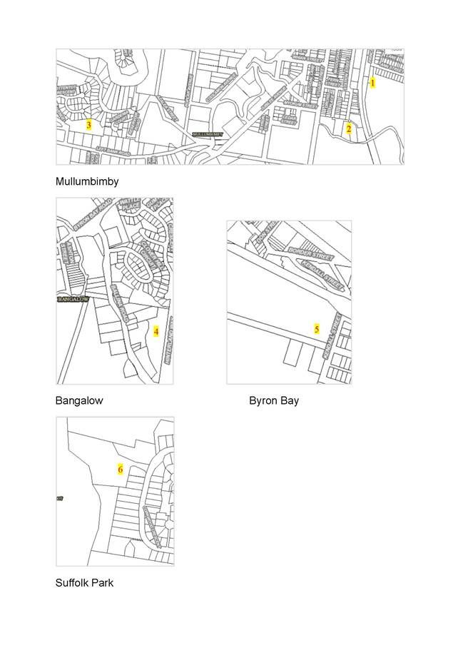
Figure 1:
Additional land locations
Table 1: Key points on
additional lands
|
Site # – location shown on Figure 1
|
Key points raised
|
Staff comment
|
Strategy response
|
|
1. 20 Prince St, Mullumbimby part of Lot 12
DP 527314
|
- should be considered in
conjunction with adjoining investigation area
|
- supported
|
20
Prince Street, Mullumbimby merged with the adjoining investigation area to
form Investigation area ‘8’
|
|
2. 152 Stuart St, & 124, 127, 130 - 134 Station St,
Mullumbimby
(Lot 1 DP1256460, Lot 1 DP803292, Lot 2 DP1256460, Lot
2 DP803292, Lot 4 DP837851, Lot 5 DP1111848)
|
- traffic impacts including
noise
- flooding and stormwater
management
- is infill the best way to
deliver affordable housing and will it provide good urban design outcomes
Staff identified possible contamination limitations as
well.
|
- relevant issue
- relevant issue
- noted
|
Strategy Investigation Area ‘5’ - Lot 1
DP1256460 not included.
See recommendation 1a) following this table.
This land added to Strategy Action 10 – Support the delivery of a high-level concept structure plan for the Saltwater Creek Precinct.
see recommendation 2a) following this table.
Acoustic impacts included as
part of the Strategy Action 9 Saltwater Precinct structure plan
investigations. See recommendation 2b) following this table.
|
|
3. Part of Lot PT32/1169053 located east of Tuckeroo
Avenue, Mullumbimby
|
- flooding and stormwater
management implications for this and adjacent land
- an expectation that the
land would only be developed as R5
|
- relevant issue
- noted
|
Strategy Investigation Area ‘4’.
Matters incorporated in Strategy Appendix C investigation
area profile - housing and infrastructure planning.
|
|
4. 31 Ballina Road (Lot 2 DP 1260751)
previously part of 21 Ballina Road Bangalow (Lot 3
DP1220608)
|
- acoustic issues associate
with highway traffic
- flooding
- site is steep in parts
|
- all relevant issues
|
Strategy Investigation Area ‘13’.
Matters incorporated Strategy Appendix C investigation
area profile - key issues and infrastructure planning.
|
|
5. Part of Lot 350 DP 755695, Ewingsdale Road, Byron
Bay
|
- landowner request not to
include as land uses being considered may not necessarily fit neatly within
the Residential Strategy.
- the site adjoins the
existing Byron Bay urban area and may be considered under the provisions of
the North Coast Regional Plan 2036 variation principles
- flooding and stormwater
management investigation is being undertaken
|
- noted
|
Extension not shown in Strategy
see recommendation 1b) following this table
Strategy Appendix C investigation area profile includes
wording as contained in the recommendation 2 c) following this table.
|
|
6. Part 64 Corkwood Cr, Suffolk Park (Lot 285
DP1198641)
|
- part of the scenic
escarpment
- potential adverse impacts
on moderate – high biodiversity values on this and adjacent land
Landowner raised:
- site has an approved dual
occupancy (partially constructed)
- front section is within
and abuts land in a R2 zone
- further development
potential would be extremely limited due to existing sensitive vegetation on
the site, bushfire and stormwater constraints
|
- relevant issues
Landowner
- an ‘attached’
dual occupancy is permitted in a 7d Zone, hence a zone change is not
required to enable this use
- Noted. Not uncom-mon for
larger land parcels to have mixed zoning
- noted and agree that
further development potential is limited
|
Not included in the Strategy – see recommendation
1c) below
|
Recommendations
pertaining to additional lands
1.
That Council does not support the following land being included as an
‘investigation area’ in the final draft Residential Strategy:
a) Lot 1 DP1256460, 152 Stuart Street, Mullumbimby
due to high hazard flooding and contamination constraints.
b) any further expansion to that part of
Lot 350 DP 755695 located on Ewingsdale Road, (Byron Bay investigation area
‘10’), as exhibited in August 2019
c) Lot
285 DP 1198641, 64 Corkwood Crescent, Byron Bay as:
i. a review
of the relevant history has identified that landowners previously seeking a
change to the 7(d) Scenic Escarpment zone boundaries have been consistently
advised that this can only be considered as part of a Shire wide study; and
ii. consultation
with the Department of Planning, Industry, and Environment on potential land
use constraints determined that the wider range and density of permissible uses
in a residential zoning could adversely impact on the significant mapped
biodiversity values on this and adjacent land.
2.
That Council notes the following updates made in relation to the draft Strategy
‘investigation areas’:
a) strategy
investigation area ‘5’, comprising Lot 1 DP803292, Lot 2 DP1256460,
Lot 2 DP803292, Lot 4 DP837851, Lot 5 DP1111848; 124, 127 and 130 – 134
Station Street, Mullumbimby, is identified only for a review of minimum lot
size provisions and not a zone change due to flooding and access limitations,
and is to be included in the Saltwater Creek Precinct structure planning
b) the
inclusion of “acoustic impacts” in Strategy Action ‘9’
Saltwater Precinct structure plan considerations, in relation to traffic
management
c) inclusion of the following additional wording in the
profile for Investigation Area 10 ( Part of Lot 350 DP 755695, Ewingsdale
Road, Byron Bay in Appendix C): “final development footprint will be
determined following further flood assessment. Any variations must be in
accordance with the North Coast Regional Plan Urban Growth Area Variation
Principles (Appendix A) and will need to be considered and justified through a
strategic planning or rezoning process. Only minor and contiguous variations to
urban growth areas in the coastal strip will be considered due to its
environmental sensitivity and the range of land uses competing for this limited
area”
Strategy revision
Table 2 presents a summary of key revisions made to the
exhibition version of the draft Residential Strategy. The revisions reflect
state government agencies, traditional owner and community input as well
updates in response to Council policy and/or practice. The information is
presented in an order consistent with the Strategy sections. Item numbers 5, 6,
7, 11, and 14 are considered to be the more significant revision matters. Table 2 forms the basis of the report Recommendation 3 d).
Attachment ‘6’ provides a version of the final
Strategy with text highlighted to show where/how changes have been
incorporated. The explanation of these edits to the draft Strategy will
be removed from the final version when submitted to the NSW Department of
Planning, Industry & Environment for endorsement. This
forms the basis of the report Recommendation 3 e).
Table 2: Summary of key strategy
revisions
|
#
|
Strategy section reference
|
Key revision
|
Basis for document change
Where government agency advice – see
above for acronym
|
|
1
|
Vision
& Structure
|
Document structured into four
sections:
Section 1:
Overview includes the vision
Section 2: Background
Section 3: Policies and Directions
Section 4: Making it happen
|
Guided by DPIE-PD and community feedback on improving the reader
useability.
|
|
2
|
Why does Byron Shire need a strategy
|
Added
bullet point: ‘to ensure residential development is directed to
areas of least biodiversity value so as to limit adverse impacts on the
biodiversity, coastal and aquatic habitats and water catchments and help
reduce development costs and time frames.’
|
Guided by DPIE-BCD advice - update responds to state
government environmental policy.
|
|
3
|
Terms
throughout
|
Key term changes:
‘accessible’
to ‘affordable’
‘possible area for
residential’ to ‘investigation areas’
|
Both guided by of DPIE-PD
advice.
‘Affordable’
consistent with state terminology.
‘Investigation
area’ clarifies land may be suitable for development and further
detailed assessment is needed prior to being determined as a ‘new
release area’ i.e. land identified as suitable for future urban
residential development.
Consistent with the NCRP, Local Strategic Planning Statement and
Business and Industrial Lands Strategy (BILS) terminology.
|
|
4
|
Policy
1 Direction 1.2
Urban
residential suitable for use principles
&
Appendix
B
|
Three changes:
a) lead sentence added to clarify a need for consistency with
state and regional policy when applying the ‘principles’.
b) ‘principle ii’ revised on farmland of state or
regional significance.
c) ‘principle vii’ revised and Appendix B: Protocol
framework for participatory working with the Aboriginal community added.
|
a) & b) Guided by DPIE-PD
and DPI advice. Consistent with the approved BILS
‘principles’ terminology.
c) Guided by Arakwal feedback
to better reflect their unique connection to their ancestral lands. This is
consistent with the approved BILS ‘principles’ and protocol.
|
|
5
|
Policy
1 Direction 1.2
Capacity
analysis & Housing supply summary
An
extract of Strategy Table 3 follows this table
(some
of this information was previously contained in Policy 3 Figure 7)
|
Updated subsection to reflect:
- added investigation areas (IA)
- infill capacity based on revised LEP 2014 minimum lot sizes for
low rise medium density
- a 10% allowance in new housing stock being potentially affected
by short term rental accommodation (STRA).
How has the potential yield
changed?
- Mullumbimby’s investigation area yield increased from 445
dwellings (2019 exhibited version) to a range of 823 – 925 additional
dwellings.
- Other towns and villages have overall minor variations to the
2019 stated figures.
- The overall Shire wide dwelling supply
to 2036 (19275 dwellings) remains consistent with the North Coast Regional Plan 2036 minimum supply figure (19,250
dwellings).
|
Guided by DPIE-PD and community feedback seeking
greater explanation of housing needs and supply.
The NCRP minimum supply figure does not allow for housing
stock used as (STRA) which is recognised by the NSW government to be at very
high levels in Byron Shire. STRA may occur within existing residential zone
areas as well as new release areas. At the Council meeting 12 Dec 2019 it was
resolved Res 19-676 to ‘investigate
and apply an appropriate planning mechanism to limit 10% of the total housing
stock in use as non-hosted STRA’.
Mullumbimby’s additional
dwellings result from additional investigation areas being included, as well
as more detailed Saltwater Creek Precinct analysis of flood risk and
stormwater management and a proposed R1 General Residential zone for Lot 22
(IA# 7 – as reported to Council at the November 2020 planning meeting).
|
|
6
|
Policy
1 Direction 1.2 -
Land
for housing
Actions
5,6,7,& 8
&
Appendix
C
|
New subsection on
‘investigation areas’ cross referenced to new Strategy Actions
4,5, 6 & 7 and Appendix C Investigation area profiles containing:
- area image
- a brief description of strengths
- housing diversity, character and affordability contribution
- key issues requiring investigation
- infrastructure planning matters:
• staging - Mullumbimby only
• flooding and stormwater management
• movement and access
• water and sewer including potential reuse water
distribution systems.
Staging priority given to
areas most likely to deliver the highest proportion affordable housing. Under
staging, stage 2 lands would not be supported to progress to a planning
proposal until post June 2024.
|
Guided by DPIE-PD advice and
community feedback requesting for greater clarity on the process moving
forward.
The profiles give clarity to
the investigation process and housing outcomes sought.
The staging program applied to
assist with Mullumbimby’s infrastructure upgrade delivery. Elements
include: a new water treatment plant; an extended Rous Water connection into
Mullumbimby; and reuse water distribution mains construction.
The prioritising is consistent
with Strategy Direction 2.2 supporting affordable housing delivery.
A reuse water system is part
of Council’s evolving framework for guiding the strategic direction of
(recycled) water management.
|
|
7
|
Policy
1 Direction 1.2 -
Land
for housing
Additional
investigation areas
|
Added the following
investigation areas to the strategy:
i. part
of 20 Prince Street Mullumbimby.
ii.
124,127,130 -134 Station Street Mullumbimby
iii. part
of the land part of Lot PT32/1169053 located east of Tuckeroo Avenue.
iv. 31 Ballina Road Bangalow.
|
As addressed in the report to
Council’s 18 June 2020 planning meeting (Res 20-276), Submission
summary review report (Attachment ‘1’) and Submissions on
additional lands (August 2020) section of this report.
Res 20-276 Planning meeting June 2020
|
|
8
|
Policy
1 & 3 Strategy maps & investigation areas numbers
|
Strategy Policy 1 Maps 1 -
6 combine infill, pipeline and investigation areas on a by town
or village. The investigation areas have been renumbered. To view Maps see
approx. page 34 of the Strategy (Attachment ‘6’).
|
Changes to improve usability
of maps.
New numbering provides a more
logical sequence.
|
|
9
|
Policy
1 Action 3
|
Revised wording including
looking at affordable housing options as part of Council car parks.
|
Action amended to capture
Council Res 20-26. February Council meeting, possible future opportunities
yet to be identified and to better align with concepts in the
‘Explanation of intended effects’ in the SEPP Housing Diversity.
|
|
10
|
Policy
2 Action framework
&
Action
17 (old action 15)
|
Revised to include an
explanation and updated action on a SEPP 70 Affordable housing contribution
scheme.
|
Affordable housing provisions are consistent with Res
19-636 Council meeting 12 Dec 2019 and Res
20-365 Planning meeting 13 August 2020 - Affordable
Housing Contribution Policy.
Funding is provided in the
2020-21 budget for progression of Action 17.
|
|
11
|
Policy
2 Table 5
(
old figure 6)
See
extract of Table 5 below this table
Also
Appendix F Key housing terminology and definitions – definitions of
lots included.
|
A
revised Table 5 – Lot diversity and size mix now shows a mix
combination in relation to residential zones. The lots comprise:
- Micro lot
- Compact Lot
- Traditional lot
- Medium density lot
Facilitates new release land
to generally have:
- R2 & R3 Zones - 45% of lots secured for low rise medium
density housing and/or compact lots.
- R1 General Residential Zone - 40% lots
secured for medium density housing and/or micro lots.
|
Guided by DPIE – PD and community feedback and
emerging provisions for a Lot 22 - R1 General Residential Zone in response to
investigative work. A lot size mix allocation is viewed as an
appropriate means to meet the requirements of the North Coast Regional Plan 2036 – Action
23.1. to ‘encourage housing diversity by delivering 40 per
cent of new housing in the form of dual occupancies, apartments, townhouses,
villas or dwellings on lots less than 400 square metres, by 2036.’
Definitions inserted in response to community request for
greater explanation of terms.
|
|
12
|
Policy
2 Actions
|
Revised actions to reflect
early implementation progress in the delivery of a number of actions such as
LEP minimum lots sizes for manor houses.
|
Revisions reflect more recent
work by Council.
|
|
13
|
Policy
2 Actions
&
Appendix D
|
Draft criteria for affordable
housing and social housing, urban villages intentional community refined and
included as Strategy Appendix D.
|
Criteria
in the 2019 exhibition were separate to the strategy document.
Intentional
community criteria refined with a community member’s input.
Affordable housing refined to
reflect more recent work in this space by Council such as the Affordable Housing
Contribution Policy.
|
|
14
|
Policy
3
Character
Narratives and Action 21 (old 18)
Appendix
E
|
Character narratives removed.
Action revised to note
Development Control Plan (DCP) local residential character narratives will be
supplemented by a local residential Style Guide over the coming year.
Community ideas and
initiatives to assist with this work moved to Strategy Appendix E.
|
Narratives removed as have now
been included in the DCP 2014.
The DCP versions reflect
feedback from residential strategy submissions as summarised in the
submissions report (Attachment ‘1’).
Consistent with Council Res:20-473
Planning meeting 17 Sept 2020
Funding provided in the
2020-21 budget for delivery of Action 21.
|
|
15
|
Policy
4
Action
25 (old 22)
|
Revised to consider the
implications to land owner existing use rights.
Pertains to a possible change
from residential to tourism zone in the Shirley St north area.
|
Guided by DPIE – PD and
landowner feedback.
|
|
16
|
Section
5 Monitoring and review
|
Added new dot point –
“examine the local environmental plan minimum lot size provisions for
low rise medium density development, and assess whether the provisions as
they stand continue to successfully support meeting Byron Shire local housing
needs”.
|
Responds to DPIE –
PD’s comment for the Strategy to consider alternative options for
housing should the some investigation areas (on closer examination) not yield
the dwelling numbers anticipated.
|
|
17
|
Appendix
F Housing Terms and definitions
|
Added the following to the key
worker list: cleaners, property maintenance (handymen, plumbers, carpenters,
electricians, garden maintenance).
|
The inclusion was suggested by
a community member and is appropriate as it supports the tourism component of
the Byron Shire economy.
|
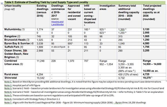
Extract of Residential Strategy
‘Table 3’ summarising possible dwelling yields by land source and
locality (as referenced in #5 above):
Extract of Residential Strategy Table 5: Lot Diversity and
size mix for land identified within investigation areas (as referenced in #11
above):
|
Column 1 – Lot type
|
Column 2 - Mix of lots per net developable area
|
Column 3 - Lot size range
|
|
|
A: Zone R1
|
B: Zones R 2 & R3
|
C: R2 along Ballina Rd
|
|
|
Type A
Traditional lots
|
10%
|
10%
|
70
|
450 – 799m2
|
|
Type B
compact lots
|
51%
|
35%
|
30
|
201 – 449m2
|
|
Type C
medium density lots
|
12%
|
45%
|
0
|
800m2 - 1,400m2
|
|
Type D
micro lots
|
27%
|
10%
|
0
|
50 - 200m2
|
|
Byron bespoke intentional communities
|
As appropriate
|
As appropriate
|
As appropriate
|
As appropriate
|
Background Report updates
The Strategy looks at population
projections and the expected demand for new dwellings. In determining where and
how to best deliver new housing in Byron Shire urban areas, an evidence-based
analysis of land use planning issues has been undertaken over a number of years
to support the Strategy policy, directions and actions. The background report
provides a culmination of this contextual information under the following
themes:
• collective
strategic thinking
• planning
framework – includes the state policy consistency for investigation areas
• residents,
households and housing types
• land
for housing – infill and new release, dwelling yield and population
estimates and supporting infrastructure
• Affordable
housing contribution scheme analysis - steps 1 & 2 undertaken by Judith
Stubbs and Associates providing a preliminary analysis to demonstrates basis
for implementation of a scheme in Byron Shire.
Summary and next steps
The Residential Strategy (Attachment ‘6’) is
consistent with the relevant State policies and directions and the North Coast
Regional Plan. It’s findings and actions have sufficient merit to
be supported for forwarding to the NSW Department of
Planning, Industry and Environment for endorsement, together with the following
documentation:
• copy
of this report
• final
Residential Strategy for consideration and adoption (Attachment
‘6’)
• Residential
Strategy Background Report containing a compilation of analysis that has
informed the final Strategy (Attachment ‘7’).
• Submissions
Review Report in relation outstanding key issues raises during the 2019
exhibition as not yet reported to Council and the additional sites as
exhibited in August 2020 (Attachment ‘1’) – will form part of
the Background Report
• copies
of submissions from the August 2019 exhibition (Attachment ‘2’:
2019 - Government agency submissions and Attachment ‘3’: 2019 -
Confidential community submissions)
• copies
of submissions from August 2020 additional lands exhibition (Attachment
‘4’: 2020 - Government agency submissions and Attachment
‘5’: 2020 - Confidential community submissions)
This forms the basis of report
Recommendation 4.
STRATEGIC CONSIDERATIONS
Community Strategic Plan and
Operational Plan
|
CSP Objective
|
L2
|
CSP Strategy
|
L3
|
DP Action
|
L4
|
OP Activity
|
|
Community
Objective 4: We manage growth and change responsibly
|
4.2
|
Support
housing diversity in appropriate locations across the Shire
|
4.2.1
|
Establish
planning mechanisms to support housing that meets the needs of our community
|
4.2.1.4
|
Finalise the
Residential Strategy
|
|
|
|
|
|
|
|
|
|
|
|
|
|
|
|
Legal/Statutory/Policy
Considerations
The
changes outlined in Tables 1 and 2 to enable finalisation of the Residential Lands
Strategy are consistent with the relevant Commonwealth, State and Regional
policy frameworks.
Financial Considerations
The cost of preparing the draft
Residential Strategy has been met within Council’s budget for this
project. Additional funds may be required should Council decide to
significantly expand the scope of this project.
Consultation and Engagement
Various agencies, land owners and the community as outlined
in this report.
Staff Reports - Sustainable Environment and Economy 13.4
Report No. 13.4 Federal
Community Led Masterplan - Project Scope
Directorate: Sustainable
Environment and Economy
Report
Author: Andrew
FitzGibbon, Place Liaison Officer
File No: I2020/1776
Summary:
On 27 August 2020, Council resolved to initiate working with
Federal community representatives to develop a project scope for a community
led Federal Village Masterplan (refer Res 20-418).
On 15 September 2020, Council met with representatives from
the Federal Community Centre and the Federal School of Arts Association to
initiate the project.
The proposed scope within this Council Report is the result
of considerable effort from this initial working group and includes information
on the:
· Project
Aim
· Study
Area
· Steering
Group
· Decision
Making Authority
· Reporting
and Support
· Community
Consultation
· Budget
· Short
Term Urgent Projects
· Milestones
|
RECOMMENDATION:
That Council:
1. supports
this community-led approach to masterplanning for the Village of Federal and
recognises it as the next evolution of place planning for Byron Shire.
2. thanks
the Federal Community Village Steering Group for their work and efforts to
date.
3. endorses
the Federal Community Village Masterplan Steering Group to undertake the
project work as per the project scope detailed in this Council Report.
4. agrees
to endorse as presented a Federal Village Masterplan as proposed by the Federal
Village Masterplan Steering Group, subject to it being demonstrated that:
· community
consultation has been carried out, generally in accordance with the
communications and engagement plan (in Attachment 1 E2020/93026), ensuring
that primary stakeholders have been given adequate opportunity to have
meaningful involvement, and demonstrating that there is general community
acceptance of the final masterplan within the Federal community;
· agreed
milestones have generally been met;
· any
proposed actions are realistic and achievable in terms of Council budget
limitations;
· timeframes
put forward for proposed actions are cognizant of Council’s forward
works planning to ensure shire-wide project delivery is economical and
efficient; and
· any
proposed actions adequately consider safety, lawfulness and other community
risks.
5. allocates
$5,500 from Council’s budget (GL2715.13) to enable project work to
begin.
6. allocates
up to $10,000 for production of a short video to capture the community-led
masterplan process for future use and reference by Council (as detailed in
Attachment 2 E2020/91213), with the budget allocation to be staged, $2,000
initially from (GL2715.13), with the remaining $8,000 to be considered as
part of the quarterly budget review in February 2021.
7. acknowledges
that a detailed design of the Federal Village main street is a priority
‘construction grant ready’ project, and that a forward budget bid
be considered for the 2021/22 operational plan process.
|
Attachments:
1 Federal
Village Masterplan Project Scope Full Report Nov 2020, E2020/93026 
2 Short Film
Proposal - Federal Village Masterplan Process, E2020/91213
REPORT
Background
On 27 August 2020 Council resolved to initiate working with
Federal community representatives to develop a project scope for a community
led Federal Village Masterplan (refer Res 20-418).
Council resolved to:
1. Endorse
staff initiating work on a community led plan for the Federal Village.
2. Request
staff to proceed with a community scoping meeting to be held during
September/October, to explore the purpose and nature of the Federal Village
plan and the process to prepare the plan.
3. Receive
a further report on the outcomes of the community scoping meeting by or before
the December meeting of Council.
4. Request
staff to prepare a Draft Movement and Access Study as a foundation document for
collaboration and co-design with the community, incorporating the following
a) Identify
and map local transport networks (Roads, lanes, park, paths, shortcuts etc).
b) Identify
and map transport infrastructure links beyond the Village precinct.
c) Identify
all transport modes and services including school buses.
5. The
Access and Movement mapping be used during scoping discussions to
a) Explore
patterns of human movement in and around village as well as preferred routes
and modes in and out of the Village.
b) Explore
barriers, incentives and disincentives for particular modes (e.g. barriers to
increasing active transport).
c) Identify
visitor travel patterns, modes and behaviours.
On 15 September 2020, Council met with representatives from
the Federal Community Centre and the Federal School of Arts Association to
initiate the project.
This initial working group of community representatives has
proposed the following project scope for a community led Federal Village
Masterplan. The information provided in this report is an abridged
version of the full report that the working group has developed as per
Attachment 1.
Overview
The Federal community is going
through a transformation. Increases in population, tourism, events,
commercial and residential developments, traffic and a changing demographic has
put a huge strain on the already exhausted infrastructure, which in turn means
the existing village Development Control Plan (DCP), is no longer fit for
purpose.
The Federal Village Masterplan,
created through a community led planning process, will be an adaptive plan for
sustainable development in and around Federal village for the next 20 years
(reviewable every 5 years). The Masterplan will be created by the Federal
community with extensive local consultation, will primarily support the objectives
of a liveable, community- orientated village, and ensure a future that
addresses the issues and requirements of its residents and the environment.
Aim
The aim of the project is:
· to establish a shared vision for Federal, prioritising
actions that align with that vision;
· to develop a formal and collective document that will
provide the strategic basis to promote and fund priorities actions;
· to produce a Masterplan that will be adopted by Council as
one of Byron Shire’s Place Planning Strategies and feed into future
statutory planning documents; and,
· to test community led planning – a new way of doing
things – that could be a framework for the whole Shire going forward.
Aerial photo of Federal Drive
showing the village core
Study Area
The project study area is defined
below. This includes:
· Focus Area – Federal Village RU5 (Village Zone) and
the adjacent R5 (Large Lot Residential) properties. This area is the main focus
for the project.
· Context Area – Greater Village impact area. Incorporating
the four main access roads and surrounds.
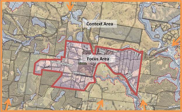
Figure showing project study
area and key access roads into the village
Steering Group
The community will run this masterplan
process. It will be coordinated by The Federal Community Centre (FCC),
the main community representative group in Federal Village. For this
project, the FCC has joined forces with the other long-established community
group, the Federal School of Arts Association Inc. (FSAAI).
The Federal Village Masterplan Steering Group will sit within the
legal framework (Inc. Assoc) of Federal Community Centre.
The Steering Group of eight
members, drawn from the community, will be able to expand by up to five further
members to no more than thirteen members.
The initial Steering Group members
are as follows.
· Gary Haughton, President FCC
· Toni Appleton, Secretary FCC
· Megan Passey, FSAAI Management Committee member.
· Alan Goldstein, President Federal Film Society/Treasurer
FCC
· James Mayson, President Federal Landcare/ FCC committee
member
· Julie Lipsett, Federal Loves Refugees founder/FCC committee
member/Byron Shire Council Public Arts Panel
· Ant Solomon, FCC committee member
· Megan Louis, FCC committee member
The other potential five members
of the expanded Steering Group will be agreed to by this group as applications
are received. Request for nominations to join the Steering Group will be
communicated as part of an initial mail out and letterbox drop to residents and
landowners.
The Steering Group will assess
nominations based on selection criteria as defined in Attachment 1.
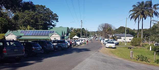
Photo of Federal Drive looking
south towards the commercial centre, with community facilities in the
foreground
Decision Making Authority
It is proposed to align this
community led planning process with the public participation goal
‘Empower’ from the International Association of Public
Participation (IAP2 - 2018) spectrum definitions adopted by Byron Shire
Council.
This would mean that Byron Shire
Council will endorse the Federal Village Masterplan as proposed by the Federal
Village Masterplan Steering Group, subject to it being demonstrated that:
· community consultation has been carried out, generally in
accordance with the communications and engagement plan (refer Attachment 1),
ensuring that primary stakeholders have been given adequate opportunity to have
meaningful involvement, and demonstrating that there is general community
acceptance of the final masterplan within the Federal community;
· agreed milestones have generally been met (or as amended);
· any proposed actions are realistic in terms of Council
budget limitations;
· any proposed action timeframes are cognizant of
Council’s forward works planning to ensure shire wide project delivery is
economical and efficient; and,
· any proposed actions adequately consider safety, lawfulness
and other community risks.
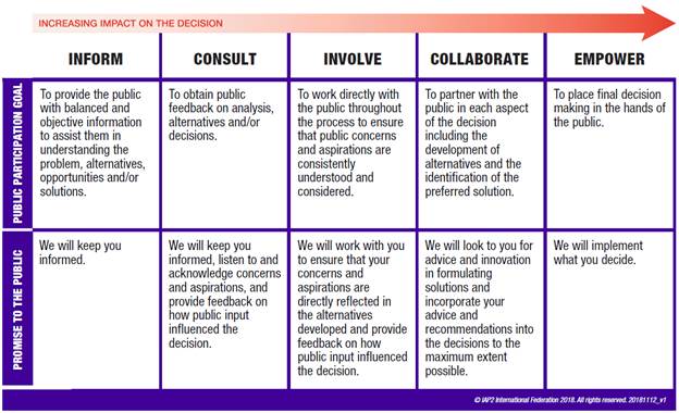
Figure showing the IAP2
Spectrum of Public Participation
Reporting and Support
The aim is to have an empowered and
well supported Steering Group.
Reporting: The Steering Group will report directly to Council with
the assistance of Council’s Place Liaison Officer and Council’s
Executive Team.
Support: The Steering Group would be supported by Councillors and
Council staff as follows.
Councillors:
· Councillors will be invited to public community meetings
and advised of other critical moments in the process that they may want to
participate in.
Council Staff:
· Council’s Place Liaison Officer will be the Steering Group’s
primary contact and attend Steering Group meetings.
· Other Council staff will be invited to attend meetings and
workshops on an as needed basis.
· A one-day information session will be provided to the
Steering Group detailing relevant Council strategies and processes (refer to
Attachment 1 for more information).
Place Planning Collective:
· A representative from The Federal Village Masterplan
Steering Group would join the Place Planning Collective and attend the monthly
meetings.
· The Place Planning Collective is able to provide support
and mentorship as needed.
Consultation and Engagement
A communications and engagement
plan is included in Attachment 1.
The aim of this plan is to ensure
that the masterplan process fairly includes the stakeholders noted below.
The primary stakeholders are:
· Residents (within scope Focus Area)
· Landowners (within scope Focus Area)
· Aboriginal elders from Arakwal and Widjabal Wia-bal of the
Bundjalung Nation
· Local business owners (within scope Focus Area)
· Locals schools and preschools (within scope Focus and
Context Area)
· Local community organisations (within scope Focus and
Context Area)
· Relevant transport companies
· Byron Shire Council
· Relevant state agencies
The consultation objectives are:
· Inform stakeholders of the Federal
Village Masterplan aims, scope and process; and where to go to for more
information.
· Encourage their involvement in
developing the plan (by creating/joining working groups, responding to
survey/emails, attending community sessions).
· Share the analysis of the submissions
and feedback, and how it will shape the final plan.
· Share the final submitted plan.
· Share the decision(s) made by
Councillors/Council on the submitted plan.
· Outline how and when the outcomes of
the plan will be delivered to the community.
Major consultation events will be led by a
professional facilitator (Cath Fisher: Associate Professor, Southern Cross
University) using deliberative democracy methodology.
Community consultation will also comply with
Council’s Community Participation Plan, which will require a 28 day
exhibition period for the draft Masterplan.
The final report to Council will need to demonstrate
that community consultation has been carried generally
in accordance with the communications and engagement plan (refer Attachment 1)
and to a level that it is clear that the primary stakeholders have been given
adequate opportunity to have meaningful involvement.
Financial Considerations
|
Item
|
Description
|
|
$5,500
|
To cover initial costs for:
· Communication
and promotion materials and advertising fees
· Independent
professional facilitator for community meetings
· Audio Visual
contractor for community meetings
· Mail out costs
|
|
Council Staff – in kind contribution
|
· Place Liaison Officer attendance at
regular meetings and ongoing support
· Other Council
officers targeted involvement
· Assistance from
Council mapping unit to produce maps for use in the process.
· Administrative/Secretarial
services support from Council, including photocopying.
|
|
$5,500
|
Subtotal to start project
|
|
Optional
|
Description
|
|
Up to $10,000
|
· Audio Visual Production of the
masterplan process (refer Attachment 2)
|
|
$10,000
|
Subtotal optional extras
|
Masterplan Deliverables
The Federal Village Masterplan
will be documented in an illustrated report that includes the following topic
areas.
|
Chapter Topic
|
Description
|
|
1 Where have we been?
|
Background chapter
that describes:
· History and character
|
|
2 Where are we now?
|
Baseline chapter that
describes:
· Demographics
· Movement and access
· Community place values
· Other themes depending on scope focus
|
|
3 Where are we going?
|
Analysis chapter that
describes:
· Trends affecting the community
· Identified risks, challenges or opportunities
|
|
4 Where do we want to
be?
|
Vision chapter that
describes:
· 20 year vision for Federal Village
· Supporting principles
|
|
5 How do we get
there?
|
Actions chapter that
describes:
· A short list of well defined priority actions
that are realistically implementable and are aligned with the vision
· Actions to be detailed as described below
|
|
6 Are we getting
there?
|
Implementation
chapter that describes:
· Indicators to monitor and measure success over
time
|
Any action or project
listed in the Masterplan will describe:
· a clearly defined scope
· cost estimate and potential funding stream
· timing
· responsibility
· category
· impact rating (the level of positive impact the
action will have)
· consistency with other plans (for example
council’s operating plan, PAMP or bike plan)
· priority level (in the context of the other
actions listed)
Short Term Urgent Project
– Federal Village Movement and Access Detailed Plan
While many of the Federal Village Masterplan
actions will not be described in detail until the process is complete, it is
clear from previous work and the motivation of this project that there is an
urgent need to fund and commence a Movement & Access Detailed Plan for the
Federal main street. Identified as the number one concern of residents, this
item should not wait to begin until the end of initial community discussions
because it is the core of all other discussions. It is the foundation
block for detailing the remaining focus points of the Masterplan, whose details
cannot be advanced without the results of this item.
Establishing this detailed plan
would enable Council to be ready to apply for future grants to construct the
main street upgrades when they arise.
This project study area and scope
is detailed below.
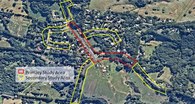
Image of Movement and Access
Detailed Plan study areas
|
Title
|
Federal Village Masterplan Movement and Access Detailed Plan
|
|
Scope
|
Refer to plan below in relation
to scope Study Areas. The Plan, should where possible anticipate future needs
into design outcomes.
· For Primary Study Area (red): Provide a detailed plan for
Federal, - 550m approximate length. Plan to include detailed design of
pedestrian paths and crossings, cycle provisions, carriage way, bus stops,
parking, speed limits, landscaping, and stormwater management;
· For Secondary Study Area (yellow): Provide a integrated
plan for approach roads to the main street to identify speed limits, traffic
calming measures and other consideration which arise (e.g. PAMP/Bike Plan
requirements); and
· Cost estimate of works
|
|
Project Preparation Work
|
Background Movement and Access
study. This could be carried out by community and staff and is aligned with
the Council Resolution from 27 August 2020 (refer Res 20-418). Study to analyse:
· pedestrian movements and barriers to these;
· cyclist movements and barriers to these;
· bus networks;
· private vehicle movements and car parking;
· other key streetscape elements such as stormwater
management and landscaping; and
· gather and consolidate current & previous town
planning information around pedestrian and bike paths with a view to
acknowledgement and perhaps expansion during this Movement Study.
Detailed
project brief development by Steering Group and staff. To include project
aims and objectives etc.
|
|
Background
|
Establishing this detailed plan
would enable Council to be ready to apply for future
grants to construct main street upgrades.
The
outcomes of this detailed plan will have a large bearing on other parts of the
Federal Village Masterplan under discussion.
|
|
Cost Estimate
|
$65,000 (to be confirmed)
|
|
Timing
|
July to December 2021 (if survey
already complete)
|
|
Responsibility
|
Byron Shire Council to procure
consultant to undertake the work.
The
Federal Village Masterplan Steering Group to be part of the brief development
and tender selection process.
|
|
Category
|
Infrastructure
|
|
Impact Rating
|
High
This
project would be a step forward to address existing pedestrian safety risks.
It would also provide broad benefit to residents, businesses and visitors who
all use the village centre.
The
outcomes of this detailed plan will have a large bearing on other parts of
the Federal Village Masterplan under discussion.
|
|
Strategic Consistency
|
Would need to align with the
Pedestrian Access and Mobility Plan Action FE001.
To
align with community action plans around road safety, greenspace and 'Living
Village'.
|
|
Consultation
|
The consultant would work
closely and directly with the Federal Village Masterplan Steering Group and
key stakeholders.
|
|
Priority Level
|
High
|
Ongoing Federal Projects
It is noted that there are several
other on-going more detailed projects that are being progressed alongside a
masterplanning process. These include the Federal Village Common; Federal Park
Improvements; Federal Hall Improvements; and, Crown Land Long Term Use. Further
information on these projects can be found in Attachment 1.
Milestones
Refer to Attachment 1 for detailed
timeframes.
|
|
Masterplanning
|
Movement & Access
Detailed Plan
|
|
Jan 2021
|
First community consultation letter
sent, including invitation for others to nominate for Steering Group.
|
|
|
Feb 2021
|
Wider Steering Group
predominately established
|
Council Meeting – to
recommend budget bid for Movement and Access Detailed Plan
|
|
Mar-May 2021
|
Consultation and Drafting
|
Project preparation work
complete (including 1. Movement and Access Background Study and 2. Project
Brief)
|
|
June 2021
|
Consultation and Drafting
|
(Council Budget Meeting)
|
Note that milestones identified
beyond this point are contingent on the Movement and Access Detailed Plan
funding being confirmed by Council.
|
|
Masterplanning
|
Movement & Access
Detailed Plan
|
|
July 2021
|
Consultation and Drafting
|
Consultant appointed and briefed
|
|
Aug 2021
|
Consultation and Drafting
|
Consultation and Drafting
|
|
Sept 2021
|
Draft Report
|
Draft Report
|
|
Oct 2021
|
Council (Planning) Meeting
– to seek endorsement to go to formal exhibition of Draft Masterplan
|
|
|
Nov 2021
|
Exhibition of Draft Masterplan
for 28 days
|
|
|
Dec 2021
|
Council (Planning) Meeting
– to seek endorsement of Federal Village Masterplan
|
Final Report
|
STRATEGIC CONSIDERATIONS
Community Strategic Plan and
Operational Plan
|
CSP Objective
|
L2
|
CSP Strategy
|
L3
|
DP Action
|
L4
|
OP Activity
|
|
Community
Objective 4: We manage growth and change responsibly
|
4.1
|
Support the
visions and aspirations of local communities through place-based planning and
management
|
4.1.1
|
Develop,
implement and update Place Plans that promote place-based forward planning
strategies and actions
|
4.1.1.6
|
Investigate
priority needs for future masterplans
|
|
Community
Objective 4: We manage growth and change responsibly
|
4.1
|
Support the
visions and aspirations of local communities through place-based planning and
management
|
4.1.1
|
Develop,
implement and update Place Plans that promote place-based forward planning
strategies and actions
|
4.1.1.8
|
Develop a
community led master planning process for Federal village
|
Legal/Statutory/Policy Considerations
The proposed masterplan will not
be a statutory document. However, it would be used to inform or initiate future
changes to the Byron Local Environmental Plan 2014 and the Byron Development
Control Plan 2014. It will also be used to assist with development application
assessment.
Financial Considerations
As discussed in the report.
Consultation and Engagement
As discussed in the report.
Note that Community consultation will comply with
Council’s Community Participation Plan that requires a 28 day exhibition
period for the draft Masterplan.
Staff Reports - Sustainable Environment and Economy 13.5
Report No. 13.5 PLANNING
- 26.2017.6.1 - Byron Bay Town Centre Planning Controls - Update and Next Steps
Directorate: Sustainable
Environment and Economy
Report
Author: Isabelle
Hawton, Planner
File No: I2020/1447
Summary:
This report addresses proposed amendments to planning
controls applicable to development within the Byron Bay Town Centre.
The Planning Proposal was originally drafted in late
2017. Community engagement was undertaken in the first half of 2018,
helping to refine a range of recommendations which were then formally exhibited
in late 2019.
The planning control amendments flow from recommendations
within the Byron Bay Town Centre Master Plan, and aim to improve the design of
new buildings in the town centre, facilitating a greater diversity of building
type, size, and scale that reflects the town’s village character.
Two key intentions of the amendments are to reinforce retail
uses at street level and encourage residential uses above.
Council considered a report on the most recent public
exhibition (37 submissions received) in April 2020. At that meeting,
Council resolved to defer further consideration of the proposal, to allow
investigation of the potential to apply the proposed Affordable Housing
Contributions Scheme across the town centre (Res 20-151).
This work has now been undertaken and it is appropriate to
consider next steps for the amended Planning Proposal and Development Control
Plan (DCP) Provisions.
As exhibited, the Planning Proposal included amending the
zoning from B2 to B3; removal of Floor Space Ratio as a built form development
control; changes to the car parking rates; changes to the flood planning
provisions; the introduction of design excellence and active street frontage
provisions in the Byron Local Environmental Plan 2014; and the introduction of
a specific DCP Chapter to govern development in the Byron Town Centre.
Based on assessment of the public submissions, deletion of
the Floor Space Ratio (FSR) control is no longer proposed. Concern was
raised that without replacing that control with additional provisions to
establish a 3D building envelope, deleting the maximum FSR requirement would be
counter-productive to achieving good design outcomes. Further assessment
also indicates that the current FSR limit of 1.3:1 is not a significant
limiting factor for development in the town centre.
Further to the Design Excellence provisions, staff have now
created a Policy and Procedure that outlines the process and initiates the
application of the Design Excellence Panel. Further adjustments to the
DCP are recommended to enhance and strengthen the design excellence provisions.
The recommended changes to car parking remain. It is
noted, however, that work is currently being undertaken to deliver peripheral
parking options around the town centre. It is suggested final
implementation of the amended car parking controls should not occur until the
peripheral ‘sending areas’ are established.
Given the changes to the proposal as previously exhibited,
it is likely that the Gateway determination will need to be amended. It
is recommended that, subject to the amended Gateway, the amended provisions be
further exhibited.
NOTE TO COUNCILLORS:
In accordance with the
provisions of S375A of the Local Government Act 1993, a Division is to be
called whenever a motion for a planning decision is put to the meeting, for the
purpose of recording voting on planning matters. Pursuant to clause 2(a)
under the heading Matters to be Included in Minutes of Council Meetings of
Council's adopted Code of Meeting Practice (as amended) a Division will be
deemed to have been called by the mover and seconder of all motions relating to
this report.
|
RECOMMENDATION:
1. That
Council forward the Planning Proposal in Attachment 1 (E2020/71526))
to the Department of Planning Industry and Environment to request an amended
gateway determination. That Council then exhibit the Planning Proposal
as required by the Department.
2. That
Council exhibit the amended DCP Chapter E10 in Attachment 2
(E2019/91843), and receive a further report on completion of the exhibition
period.
3. That
Council approve the Design Excellence Policy contained in Attachment 3
(E2020/21765) for exhibition in accordance with the Local Government Act 1993
and receive a further report at the close of submissions.
4. That
Council approve the Design Excellence Panel Procedure contained in Attachment
4 (E2020/21922) for exhibition in accordance with the Local Government Act
1993 and receive a further report at the close of submissions.
|
Attachments:
1 26.2017.6.1
Planning Proposal (Post Exhibition version), E2020/71526

2 26.2017.6.1
DCP 2014 Chapter E10 Byron Bay Town Centre (Post exhibition version), E2019/91843
3 26.2017.6.1
Draft Design Excellence Policy, E2020/21765
4 26.2017.6.1
Draft Design Excellence Panel Procedure, E2020/21922
5 Form of
Special Disclosure of Pecuniary Interest, E2012/2815
REPORT
This Planning Proposal was first considered by Council in
November 2017, when Council resolved (Res 17-599)
to undertake community engagement activities exploring the proposed amendments
before finalising the Proposal for submission to the State Government for a
Gateway Determination.
Community engagement occurred during the first half of 2018,
including community workshops, workshops with students at Byron High School,
and discussions with land owners, residents and community groups.
The draft Planning Proposal was adjusted in response to the
engagement and the results were reported to Council on 20 September 2018,
recommending the following key amendments to Byron Local Environmental Plan
2014:
· Change the
zoning of the Town Centre from the current B2 Local Centre, to B3 Commercial
Core, and apply that zoning to the entirety of the area currently zoned B2.
· Maintain the
current maximum building height at 11.5m within the LEP and introduce new
provisions within Byron DCP 2014 to clarify that the maximum height will be
three (3) storeys.
· Amend the
LEP to provide that, for flood prone land within the Town Centre, the 11.5m
maximum building height is measured from the applicable Flood Planning Level
rather than natural ground level.
· Amend the
Building Heights Map to extend the area within which a maximum height of 11.5m
applies to land bounded by Lawson Street to the south, Bay Lane to the north,
Jonson Street to the west and Middleton Street to the east.
· Introduce
new provisions within the DCP to set minimum floor to ceiling heights for mixed
use buildings in the Town Centre.
· Amend the
Floor Space Ratio Map to remove the control from within the Byron Bay Town
Centre.
· Amend the
LEP to introduce new clauses requiring that applications for new buildings
demonstrate Design Excellence, and that streets and laneways are activated at
ground level.
· Amend the
car parking provisions within the DCP, in relation to the Town Centre, to
specify a maximum rather than minimum number of spaces for residential and / or
tourist accommodation proposed above ground floor level, with the option for
developers to ‘opt out’ of providing any parking for those uses, in
exchange for practical measures that will provide and promote sustainable
transport alternatives. (Current parking rates will continue to be
applied for ground floor commercial uses).
At the September meeting, Council
resolved (Res 18-609) to forward the Byron Bay Town Centre
planning proposal to the Department for a Gateway determination and proceed to
public exhibition with the planning proposal and the draft DCP chapter for the
Byron Bay Town Centre.
A positive Gateway was received
from the Department on 18 June 2019, authorising formal public exhibition.
The planning proposal and DCP 2014
Chapter E9 Byron Bay Town Centre were placed on exhibition from 25 September
until 15 November 2019. Letters were sent out to all the property owners
in the town centre with a fact sheet explaining the proposed changes.
Information on the proposed changes were posted on Council’s website and
advertised in the Echo.
Following exhibition, Council
resolved (Res 20-151) to note the submissions and put the
planning proposal on hold to allow for further investigation of the application
of SEPP 70.
Since this resolution, further
work and research has been undertaken to review the proposed changes and assess
the appropriateness of applying SEPP 70 to the Byron Bay Town Centre. It
is now appropriate to re-exhibit the proposal, with the new changes
included. It is likely Council will also need to seek an amended gateway
determination in order to proceed with the proposal.
Application of SEPP 70 to Byron
Town Centre
Under Res 20-151 Council
requested that staff consider whether the SEPP 70 Affordable Housing
Contribution Policy would be appropriate for application in the Byron Town
Centre. The Policy and Procedures, adopted by Council on 13/08/2020 (Res
20-365) suggest that the Town Centre has the capacity to contribute a
potential 20 dwelling increase in affordable housing.
The policy is contingent, however,
on this land being ‘upzoned’; meaning a zoning change would need to
result in an increase in housing density in this area.
The proposed change in zoning from
B2 to B3 does not, in itself, provide for a greater density of capacity for
development.
Given the recommendation to retain
the existing FSR control, the amendments to the planning controls are no longer
likely to result in an increase in residential density in the area at this
time, and therefore, this issue can be parked for the interim. Future LEP
amendments may affect the capacity for SEPP 70 to apply in this area.
Removal of changes to the Floor
Space Ratio
In the exhibited Planning
Proposal, it was proposed to remove the Floor Space Ratio from the Byron LEP
2014. It was argued that the Floor Space ratio was a crude form of
measurement, and that better built form outcomes might be achieved through
other means.
Many of the submissions received
during the public exhibition period opposed the removal of the Floor Space
ratio and argued that it is one of the few statutory tools at Council’s
disposal to achieve appropriate built form and scale.
After further reflection, and an
analysis of a sample block in the Byron Town Centre, staff have determined that
the Floor Space Ratio does not appear to be the only limiting factor on
development in the town centre and may in fact play a role in reinforcing
appropriate built form outcomes, especially when paired with design excellence
controls and the introduction of the Design Excellence Panel.
To this end, the Floor Space Ratio
of 1.3:1 is proposed to be retained. Improved built form outcomes can be
achieved through the proposed DCP Chapter E10 provisions, the integration of
Design Excellence Panel decisions and through the implementation of the Design
Excellence Clause in the Byron Local Environmental Plan 2014.
Amendments to the proposed Height
Allowance Map
The originally exhibited planning
proposal proposed changes to way in maximum building height would be measured
on flood prone land. Currently, building height is measured from existing
ground level (GL) to the top of the building.
In the flood prone parts of the
town centre, the ground floor of a new building must be set at the Flood
Planning Level, which is the level of a 100 year flood, plus 0.5m. This
will always be higher than existing ground level and in the town centre flood
planning levels are around 1m above existing ground level.
Continuing to measure maximum
building height from existing ground level, therefore, means that it becomes
difficult to achieve optimum floor to ceiling heights without exceeding the
11.5m maximum.
The initial planning proposal
suggested, therefore, that the LEP be amended to enable building height to be
measure from the Flood Planning Level (FPL) rather than from existing ground
level.
This has now been amended slightly
around the northern fringe of the flood prone area, where the resultant slight
increase in maximum building height could potentially be visible from the
beachfront. The suggested changes now ensure that visual impacts
associated with the 11.5m height limit along the northern side of Lawson Street
are avoided.
Further additions to the DCP
2014 Relating to Green Infrastructure, Heritage and Roof Form, Access and Use
In response to the comments made
in the public exhibition period, and further research and analysis by Council
staff, further clauses have been added to the Draft DCP Chapter for Byron Town
Centre.
Heritage considerations have been
re-iterated, emphasising the importance of the built form integrating with
Heritage Items in the area, including the curtilage and other features.
There has been clarification added
about the role, description and importance of green infrastructure –
meaning green walls, roofs and street trees. This infrastructure is not
only considered an important design outcome, but comes with a host of other
benefits including climate change mitigation and adaptation, positive
psychological and social benefits and increased habitat in built up areas.
A new clause has also been adding
clarifying Roof Form, Access and Use Guidelines. The intention of this
clause is to clarify Council’s position on roof form, access and use,
given a proliferation of recent applications in the town centre with flat
rooves, proposed for use as a bar/pool/recreation space.
The new clause specifies that roof
form should generally compliment the aesthetics of the building design as well
as creating visual interest and variety in order to enable a pleasing streetscape.
In addition, the new clause states that the introduction of roof top bars and
function centres will not be viewed favourably and any roof top leisure
facilities should be low impact and intended for use by the residents of the
building and not the general public.
Key issues
Floor Space Ratio (FSR)
The
original premise for removing FSR was an assumption that it is a limiting
factor in allowing for the efficient use of zoned land.
As a way to test this assumption,
staff undertook a desktop analysis of FSR for a sample town centre block
bordered by Carlyle, Jonson, Marvel and Middleton streets (see below).
This block contains a variety of properties, including some original
‘undeveloped’ sites, some developed to 3 storeys in recent years
and 1 site (No. 4 Marvell Street) recently approved (through L&E Court) but
not yet constructed.
Data was sourced from development
consents where possible, and where these were not available, an estimation of
floor space was made based on desktop measurements.
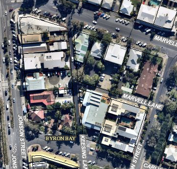
The table below outlines the floor
space and FSR results.
|
Address
|
Land area (m2)
|
Floor area (m2)
|
FSR
|
Potential floor area 1.3:1 FSR
|
Potential floor area 1.5:1 FSR
|
|
3-7 Carlyle
Street
|
2,029.0
|
2,166.0
|
1.1:1
|
2,637.7
|
3,043.5
|
|
1 Carlyle St
|
1,320.1
|
1,414.1
|
1.1:1
|
1,716.1
|
1,980.1
|
|
101 Jonson St
|
546.9
|
164.0
|
0.3:1
|
711.0
|
820.3
|
|
1A Carlyle St
|
515.5
|
125.0
|
0.2:1
|
670.1
|
773.2
|
|
97 Jonson St
|
998.0
|
236.0
|
0.2:1
|
1,297.4
|
1,497.0
|
|
95 Jonson St
|
1,026.0
|
582.1
|
0.6:1
|
1,333.8
|
1,539.0
|
|
93 Jonson St
|
1,038.0
|
934.0
|
0.9:1
|
1,349.4
|
1,557.0
|
|
91 Jonson St
|
498.0
|
391.0
|
0.8:1
|
647.4
|
747.0
|
|
89 Jonson St
|
498.0
|
583.0
|
1.2:1
|
647.4
|
747.0
|
|
85 Jonson St
|
649.0
|
482.0
|
0.7:1
|
843.7
|
973.5
|
|
2 Marvell St
|
631.0
|
374.0
|
0.6:1
|
820.3
|
946.5
|
|
4 Marvell St
|
1,012.0
|
1,434
0*
|
1.4:1
|
1,315.6
|
1,518.0
|
|
6 Marvell St
|
1,012.0
|
877.0
|
0.9:1
|
1,315.6
|
1,518.0
|
|
8 Marvell St
|
958.0
|
322.0
|
0.3:1
|
1,245.4
|
1,437.0
|
|
10 Marvell St
|
984.0
|
701.0
|
0.7:1
|
1,279.2
|
1,476.0
|
|
|
|
9,442.2
|
|
17,830.1
|
20,573.2
|
* as approved
This analysis shows that, at the
FSR of 1.3:1, there is a theoretical capacity within this block for more than
8,000m2 additional floor space, indicating that FSR is not a
significant limitation to development in the area.
A number of submissions raised the
concern that removal of FSR would lead to buildings of a greater bulk and scale
unless there were additional controls, such as setbacks to establish overall
maximum building envelopes.
Given this, it is considered acceptable
for the current FSR controls to remain at 1.3:1 as there is deemed to be
capacity under the current controls.
Carparking
The
amendment proposes to require a maximum number of car parking spaces for
shop-top housing and/ or tourist and visitor accommodation, rather than the
current requirement for a minimum number of spaces. It also proposes a
reduction in the number of spaces required, and an ‘opt-out’
option, where developers could seek to provide no on-site spaces for those uses
in exchange for alternate movement options such as car share, bike-share or the
like.
The rationale is to reduce the
number of spaces in the town centre as one way to assist in achieving
“cars out people in”. This was based on strategies to provide
increase peripheral parking options which would allow people to park on the
outskirts of the town centre and easily walk in.
While these strategies are
continuing to be developed, the peripheral parking areas are not in place at
this time, and concern was raised in submissions that, in the absence of the
peripheral ‘sending areas’, reducing parking onsite parking
requirements would add to congestion in the centre.
It is recommended therefore, that
the suggested car parking changes be exhibited with the draft DCP with the
caveat that they will not be enacted until such time as adequate peripheral
parking opportunities have been established near the town centre. (It is
anticipated that the first of these will be delivered in the next twelve months.)
Design Excellence Panel
During
the public exhibition period for the proposed amendments there was strong
support for the introduction of a Design Excellence Panel to accompany the
Design Excellence Provisions in the LEP 2014.
Subsequent work by staff has led
to the drafting of a Design Excellence Policy and Design Excellence Procedure
(Attachment 2 and 3). These documents will need to be exhibited in
accordance with the Local Government Act (1993).
A pool of seven sitting members
will be established, with three members on the panel at any one time.
Each member participating in a review will be paid a fee of $500, which will be
reimbursed through the fees and charges paid for by the developer (as
previously adopted in the 2020/2021 fees and charges). The fee will be
inclusive of all work required as a part of being a panel member, including
preparation for and attendance of the meetings.
Height and Floor Space
simulation workshops
Councillors, Council Staff and
members of the Place Planning Collective recently undertook exercises to better
understand the role of Floor Space Ratio through a Lego Workshop. This
allowed for a more nuanced understanding of the control and how it might apply
in the Byron Town Centre and contributed to a better understanding of the
potential impacts of changing the FSR. It is anticipated that information
pertaining to this workshop will be available on Council’s website soon.
Next steps
The
next steps are to seek an amended gateway for the Planning Proposal, re-exhibit
the proposal along with the DCP and report back to Council.
In addition Council will need to
exhibit the Design Excellence Policy and Procedures and report back any
submissions. It is suggested that an Expression of Interest process to
seek applicants follow the adoption of these documents.
STRATEGIC CONSIDERATIONS
Community Strategic Plan and
Operational Plan
|
CSP Objective
|
L2
|
CSP Strategy
|
L3
|
DP Action
|
L4
|
OP Activity
|
|
Community
Objective 4: We manage growth and change responsibly
|
4.1
|
Support the
visions and aspirations of local communities through place-based planning and
management
|
4.1.1
|
Develop,
implement and update Place Plans that promote place-based forward planning
strategies and actions
|
4.1.1.1
|
Progress draft
Planning Proposal and DCP chapter to amend planning controls for Byron Bay
town centre (Byron Bay Town Centre Masterplan action)
|
|
|
|
|
|
|
|
|
|
|
Legal/Statutory/Policy Considerations
Relevant statutory considerations
discussed above.
Financial Considerations
This is a Council initiated project funded through the
existing operational budget.
The Design Excellence fees of $3000 per application would
allow for payment of the Design Excellence Panel at a rate of $500 per member
per meeting plus any additional costs, including room hire etc.
Consultation and Engagement
Discussed in the body of the report.
Staff Reports - Sustainable Environment and Economy 13.6
Report No. 13.6 PLANNING
- Section 8.2 Review of Development Application 10.2019.648.1 - Two (2) into
Two (2) Lot subdivision at 39 Leslie Street, Bangalow
Directorate: Sustainable
Environment and Economy
Report
Author: Jordan
Vickers, Planner
File No: I2020/1803
Proposal:
|
Review of Development Application No.
|
10.2019.648.1
|
|
Applicant:
|
Balanced Systems Planning Consultants
|
|
Development:
|
Subdivision Two (2) Lots into Two (2) Lots
|
|
Parcel No.:
|
44350, 146450
|
|
Location:
|
LOT: 10 SEC: 2 DP: 4358, LOT: 9 SEC: 2 DP: 4358, 39
Leslie Street BANGALOW
|
|
Date of Refusal:
|
1 June 2020
|
|
Original Assessing Officer:
|
Ivan Holland
|
Summary:
The applicant has requested a
S8.2 review of the determination of DA10.2019.648.1 which was refused by
Council on 1 June 2020.
The original application sought
approval to re-subdivide Lot 9 and Lot 10 in Deposited Plan 4358 at 39 Leslie
Street, Bangalow which both have an area of 404.6 m2 each. The two
lots currently contain a dwelling house and several sheds with the house
straddling the two parcels which run from Leslie Street to Campbell Street. The
proposed subdivision would rearrange the lot boundaries so that the dwelling
house is contained within a single lot (Lot A) facing Leslie Street with remaining
land to the west to form a vacant lot (Lot B) facing Campbell Street. Lot A
will have an area of 432.6 m2 and Lot B an Area of 376.6 m2.
The original application was
publicly notified and no submissions were received.
The applicant was predominantly
refused on car parking grounds with only one car parking space being proposed,
whereby it was deemed necessary that two spaces were required based on a three bedroom
dwelling.
Amended plans and engineering
details provided with the S8.2 review make provision for one compliant
on-site car parking space under the existing dwelling on proposed Lot A with
access from Leslie Street. A further site inspection of the
dwelling house indicates it has two substantial bedrooms. A smaller third
room used as a study/office and oriented and opened up onto an existing bedroom
and the kitchen/ living areas is not considered as a bedroom in this instance.
Alternative car parking arrangements have been discussed with the applicant on
the northern side of the dwelling; however this would remove an established
garden area which adds character to this old Bangalow Cottage, whilst
earthworks and retaining walls would also be required for the driveway
crossover of the road reserve.
Based on two bedrooms, car
parking is considered satisfactory in terms of the DCP provisions.
Recommended conditions of
consent are proposed to retain the appearance of the dwelling in terms of its
heritage character and to ensure the garage does not dominate the front facade
of the building.
The S8.2 Application is considered to be substantially the
same development as originally considered, and on review of the information
provided to Council the application is recommended for approval subject to
conditions of consent.
NOTE TO COUNCILLORS:
In accordance with the
provisions of S375A of the Local Government Act 1993, a Division is to be
called whenever a motion for a planning decision is put to the meeting, for the
purpose of recording voting on planning matters. Pursuant to clause 2(a)
under the heading Matters to be Included in Minutes of Council Meetings of
Council's adopted Code of Meeting Practice (as amended) a Division will be
deemed to have been called by the mover and seconder of all motions relating to
this report.
|
RECOMMENDATION:
That pursuant to Section 8.2 of the Environmental
Planning & Assessment Act 1979, Review of Development Application No.
10.2019.648.1 for Subdivision Two (2) into Two (2) Lots, be granted consent
subject to the conditions of approval in Attachment 2 #E2020/94920.
|
Attachments:
1 10.2019.648.1
- Plans, E2020/94915
2 10.2019.648.1
- Proposed Conditions of Consent, E2020/94920
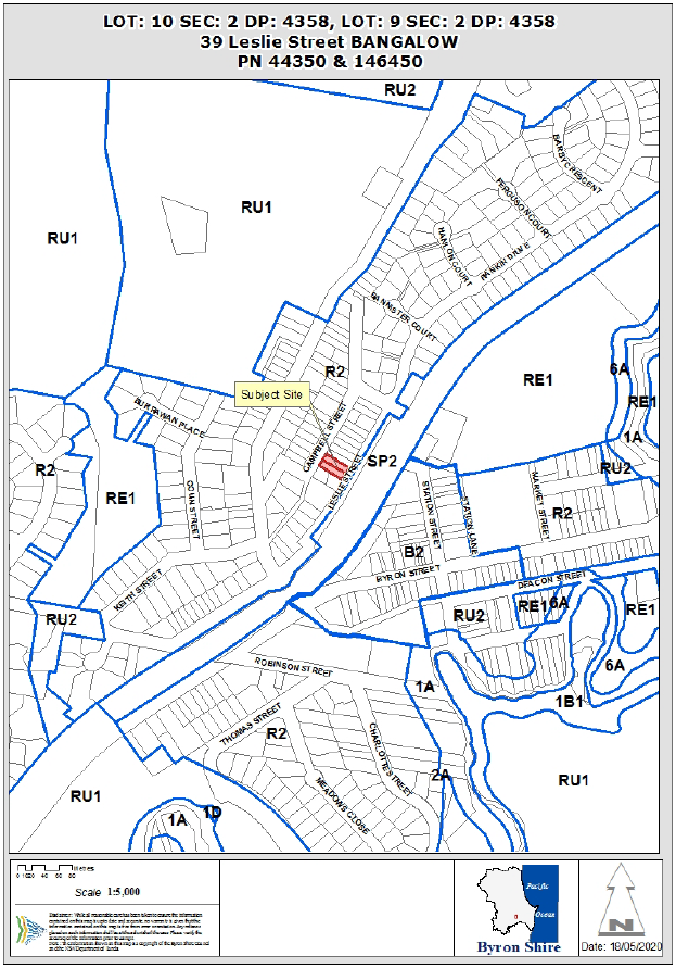
REPORT
Assessment:
DA10.2019.648.1 was
refused by Council on the 1 June 2020 for the following reasons:
1. Pursuant to Section
4.15(1)(a)(i) of the EP&A Act 1979 the size of lots resulting from the
proposed subdivision of land will be less than the minimum size specified for
the subject land, contrary to the development standard in clause 4.1 of the
Byron Local Environment Plan 2014.
2. The applicant’s written
request for development that contravenes a development standard has not
adequately addressed the required matters and the proposed development is not
considered to be in the public interest, contrary to clause 4.6(4)(a) of the
Byron Local Environment Plan 2014.
3. Pursuant to Section
4.15(1)(a)(i) of the EP&A Act 1979 the application has not adequately
demonstrated that the proposed subdivision will not result in an adverse impact
on the conservation of the Bangalow heritage conservation area, contrary to the
objectives of clause 5.10 of the Byron Local Environment Plan 2014.
4. Pursuant to Section
4.15(1)(a)(i) of the EP&A Act 1979 the application has not adequately
demonstrated that adequate arrangements are capable of being made to provide
suitable vehicular access to the lots to be created by the proposed
subdivision, contrary to clause 6.6 of the Byron Local Environment Plan 2014.
5. Pursuant to Section
4.15(1)(a)(iii) of the EP&A Act 1979 the proposed development does not
adequately satisfy the matters for consideration within Section B3 Services and
B4 Traffic Planning, Vehicle Parking, Circulation and Access in relation to
provision of car parking and suitable vehicular access for the proposed lots.
6. Pursuant to Section
4.15(1)(a)(iii) of the EP&A Act 1979 the proposed development does not
adequately satisfy the matters for consideration within Section C1
Non-indigenous in relation to potential adverse impacts on heritage values
associated with the provision of car parking for the subdivision.
7. Pursuant to Section
4.15(1)(a)(iii) of the EP&A Act 1979 the proposed development does not
adequately satisfy the matters for consideration within Section D6 Subdivision
in relation to lot size and shape, access design and infill subdivision with
rear lane access.
8. Pursuant to Section
4.15(b) of the EPA Act 1979 the provision of the required car parking will have
an adverse impact upon the built environment due to the development being
located in a heritage conservation area.
9. Pursuant to Section 4.15(c)
of the EPA Act 1979 the site is not considered suitable for the proposed
development as provision of the required car parking and building envelopes for
the proposed subdivision lots may adversely impact on heritage values.
10. Pursuant to Section 4.15(e) of the
EPA Act 1979 the proposed development is not in the public interest as suitable
car parking, access arrangements and building envelopes have not been provided
and to do so would likely result in an adverse impact on heritage values.
Although
there are a range of reasons for refusal listed, on review of the file, car
parking was the dominant factor that led to the application being refused. The
application which seeks consent to re-subdivide the land from two parcels that
run from Leslie Street to Campbell Street to have creating Lot A facing Leslie
Street and Lot B facing Campbell Street failed to provide two spaces for the
existing dwelling which was considered as a three bedroom dwelling house.
1.1. Proposed
Development
The
proposed development seeks to re-subdivide two lots both with equivalent areas
of 404.6 m2 each into:
Lot A - 432.6 m2
(existing dwelling)
Lot B – 376.6 m2
– vacant lot
A weatherboard cottage currently straddles the two lots
facing Leslie Street and the re-subdivision of the land will correct this
encroachment across boundaries.
The proposal will require formalised car parking to be
provided to the existing cottage
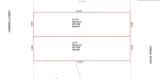
Existing Lot Layout
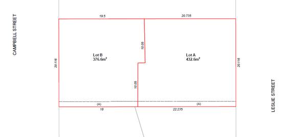
Proposed Lot layout
1.2. Description
of the site
|
Land is legally described as
|
LOT: 10 SEC: 2 DP: 4358, LOT: 9 SEC: 2 DP: 4358
|
|
Property address is
|
39 Leslie Street BANGALOW
|
|
Land is zoned:
|
R2 Low Density Residential
|
|
Total Land area is:
|
809.4m2 (Lot 9 - 404.6m2, Lot 10
– 404.6m2)
|
The site has a legal description of Lot 9 and Lot 10,
Section 2 in Deposited Plan 4358, and is commonly known as 39 Leslie Street,
Bangalow. The property is located between Campbell and Leslie Street.
Both lots are rectangular in shape with frontages of ~11m. The land
slopes in an easterly direction from Campbell Street down to Leslie Street at a
slope of approximately 25%.
A dwelling house and several sheds are situated on the
property. The dwelling house is set back ~1.5m from Leslie Street.
There is also grassed areas and establish vegetation on the property.
Located on either side of the property are residential
dwellings of similar scale and character. Directly opposite the dwelling is the
Bangalow Railway Station, a locally listed heritage item.
The site is within the R2 Low Density Residential zone and
the Bangalow Heritage Conservation area under LEP 2014.
2.0 S.8.2 Review of Determination
The applicant has requested a
review of the determination to refuse DA10.2019.648.1 based on amended plans
and engineering details. The amended detail makes provision for one (1)
compliant on-site car parking space for the existing dwelling on proposed Lot A.
Area is available in the driveway for overflow parking if required. The following
supporting information was provided with the request for review of the
determination:
· Revised
Statement of Environmental Effects 2) and s8.2 review cover letter (E2020/83674);
· Letter
& Drawing Details from Civil Engineers.
Further, the car parking space
provided beneath the existing dwelling on proposed Lot A provides a minimum
clearance height of 2.1m as opposed to the original clearance of only 1.8m.
Council can consider the application as the development
remains substantially the same as originally submitted and the matter will be
determined within the period as nominated under S8.10 of the EPA Act 1979.
Parking, Access and
Servicing Matters
The following comments are
provided addressing the reasons for refusal in terms of parking access and
services clauses within Byron LEP 2014 and Byron DCP 2014
DCP Chapter B4 – Traffic
Planning, Vehicle Parking, Circulation and Access:
In accordance with Chapter B4 of
the Byron DCP 2014, a dwelling house with three or more bedrooms is required to
provide two (2) car parking spaces, whilst dwellings of 1-2 bedrooms are to
provide a minimum of 1 space. Plans, images and an inspection of the existing
dwelling confirm that the existing office/study is not utilised as a bedroom.
Further, due to its size, area (2.4x2.7m), openings to bedroom 2 and the
kitchen living area, the office study is not ideally suited as a third bedroom.
Amended plans have been submitted providing for single car
parking space under the dwelling. The original plans as refused showed a non
compliant clearance of only 1.8 m and limited space for any overflow parking in
the driveway. The amended plans indicate the garage area will be excavated to
provide clearance of 2.1 metres whilst the space has been pushed further under
the dwelling and provides space for overflow parking in the driveway.
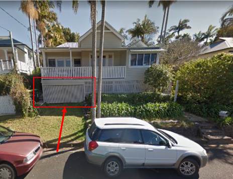
Proposed driveway and garage
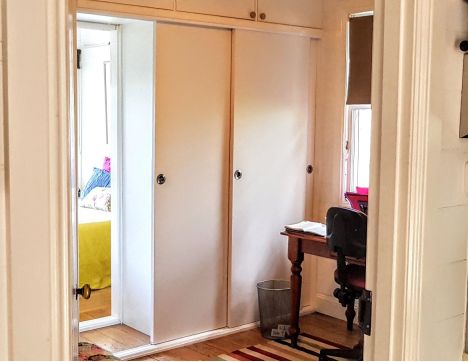
Office/Study – looking from the kitchen living
area through to the Bedroom 2
As the subject site is within close walking distance to the
Bangalow commercial precinct (i.e. across the railway line and into Station
Street) and the existing dwelling house assessed as a two bedroom domicile it
is considered that car parking is satisfactory for the existing dwelling on
proposed Lot A.
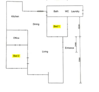
Floor Plan of Dwelling
Chapter B3 Services
In terms of access to the site, conditions of consent
proposed to formalise the driveway from Leslie Street under the dwelling.
Access is available from Campbell Street for the vacant parcel, with the
applicant proposing to construct a driveway into the property to service a
future dwelling. Having regards to the slope of the land, this is supported as
the access and stormwater from the driveway will be resolved by the current
landowners/ developers and not left to future a future land owner. Reasons for
refusal under Chapter B3 have been adequately addressed.
Clause 6.6 Esential Services
With matters resolved in terms of carparking and access, the
reasons for refusal under Cluse 6.6 fall away and this is on longer a valid
contention. The site has access to all other necessary infrastructre including
water, sewer, stormwater, power and telecommunications. Appropriate Condition
of consent to apply.
Heritage Matters
Originally it was the proposed car
parking arrangement on heritage character was also listed as a reason for
refusal. However, having regards to the current undercroft which provides
storage to the dwelling and its accessibility to the street from what is in
effect a grassed driveway, the formalisation of this into a car parking space
can be supported provided that the gate/ garage door is replicated in a similar
slatted timber design.
As such it is considered that the
heritage reasons for refusal under clause 5.10 of the Byron LEP 2014 and
Chapter C1 Non Indigenous Heritage of DCP 2014 predominantly fall away.
Conditions of consent are proposed requiring any door for the garage to be a
slatted timber door and be positioned back under the balcony to enable overflow
parking in the driveway and to ensure compliance with the setback provisions
under Chapter C1.4.6
Subdivision
matters
Clause
4.1 (Minimum lot size) & 4.6 (Variation to Development standards):
The
proposed development seeks to re-subdivide two lots both with equivalent areas
of 404.6 m2 each into:
Lot A - 432.6 m2
(existing dwelling)
Lot B – 376.6 m2
– vacant lot
The application originally determined
that a variation should not be granted to the 450m2 minimum lots
size provisions as:
1. The proposal did not provide
or allow for the required car parking under DCP;
2. The car parking proposed was
anticipated to have unavoidable impact on the character of the dwelling and
heritage values of the heritage character area; and
3. The development footprint for proposed Lot B requires
a variation to street front setback requirements under DCP2014, which may also
result in adverse impacts on heritage values.
Of those matters listed above, points 1 and 2 have been addressed by the
amended proposal submitted with this review as discussed above. In relation to
point 3 the applicant surprisingly indicated a nominal building envelope
setback only 1.8 m from Campbell Street. However the property is of sufficient
dimensions to fit the nominal 12x15m envelope with a compliant 4.5 m setback to
the street. The subdivision plans which are recommended for approval will not
include a building envelope, and any application for a dwelling on the site
will be considered against the planning controls at that time and the merits of
the proposal.
Having regards to Clause
4.6 the proposed development does not generate any additional residential
allotments or dwelling entitlements, and theoretically consent could be sought
to demolish the dwelling (or if it was destroyed by fire etc.) and construct
two dwellings on the two existing lots. An alternative proposal could
consolidate the land and construct a second dwelling facing Campbell Street to
create a dual occupancy and then carry out a subsequent strata subdivision. As
such strict compliance with the minimum lot size development standard is not
warranted or necessary in this instance and a variation to the 600 m2
minimum lot size provisions can be supported.
In terms of Chapter D1 of
DCP 2014, it is considered the proposed subdivision is acceptable and the
vacant lot on Campbell Street is of a size and dimension that can accommodate a
dwelling house. It is considered that Chapter D1 is no longer a valid reason
for refusal.
3.0 Public interest
With parking and access matters resolved it is considered
that the proposed development will not prejudice or compromise the public
interest or create an undesirable precedent.
4.0 Conclusion
Similar applications have been approved in the older parts
of Bangalow and elsewhere in the Shire (e.g. Mullumbimby) and the realignment
of lots to create a vacant parcel represent a viable utilisation of scarce
urban residential land. Having regards to the amended detail submitted
with the application the proposed development is recommended for approval
subject to conditions of consent.
Staff Reports - Sustainable Environment and Economy 13.7
Report No. 13.7 PLANNING
- s4.55 to modify the approved plans and delete conditions of consent -
Development Application 10.2020.310.2 at 30 Kingsley Street, Byron Bay
Directorate: Sustainable
Environment and Economy
Report
Author: Jordan
Vickers, Planner
File No: I2020/1806
Proposal:
|
Section 4.55 Application No:
|
10.2020.310.2
|
|
Proposed modification:
|
S4.55 to Modify Approved Plans
|
|
Original Development:
|
Alterations and Additions to Existing Dwelling House
|
|
Type of modification sought:
|
|
|
Property description:
|
LOT: 1 DP: 958924
|
|
30 Kingsley Street BYRON BAY
|
|
Parcel No/s:
|
39020
|
|
Applicant:
|
Mr I M Pickles
|
|
Owner:
|
Mr P T Byrnes & Ms M E Dickie
|
|
Zoning:
|
R2 Low Density Residential
|
|
S4.55 Date received:
|
28 September 2020
|
|
Original DA determination date:
|
12/8/20
|
|
Public notification or exhibition:
|
- Level
0 advertising under DCP 2014 Part A14 – Public Notification and
Exhibition of Development Applications
- Exhibition
period: N/A
- Submissions received:
N/A
|
|
Issues:
|
· Heritage
Conservation Area
|
Summary:
DA10.2020.310.1 applied for development consent to demolish
the existing carport and re-establish another at the subject site flush to the
dwelling wall line at the Tennyson Street frontage.
The development was approved with Condition 6 requiring the
carport to be setback a further 1.5 metres from the front boundary providing a
4.5 metre setback to the street having regards to the heritage character of the
area being within the Kingsley Street Conservation area and the provisions
contained within DCP 2014 for setbacks and heritage protection.
A S4.55 application has been lodged to modify the consent
for the carport to be located flush to the dwelling line at the Tennyson Street
frontage, providing a minimal 3.0 metre setback.
Council’s Heritage Advisor
has reviewed the subject s4.55 application and noted that
“…positioning the
carport flush with the frontage is in conflict with Councils general planning
policies and the heritage chapter and there does not appear to be sound
justification for an exemption. Approval would set an undesirable precedent
making it hard to refuse other applications of a similar nature.”
The above assessment was raised
with the applicant. The applicant requested that the application be reported to
Council if it couldn’t be supported by staff.
Council has clear planning and
heritage controls under Chapter C1 Non Indigenous Heritage and Chapter D1
Residential Accommodation and Ancillary Development in Urban, Village and
Special Purpose Zones of Byron DCP 2014 that apply to this type of development.
Specifically the provisions direct car parking to be setback behind the
building line, not flush with the dwelling. It is considered there are no
substantive reasons to amend the consent, or to provide a variation to the DCP
provisions in this instance. It is recommended that the Section 4.55
application be refused.
NOTE TO COUNCILLORS:
In accordance with the
provisions of S375A of the Local Government Act 1993, a Division is to be
called whenever a motion for a planning decision is put to the meeting, for the
purpose of recording voting on planning matters. Pursuant to clause 2(a)
under the heading Matters to be Included in Minutes of Council Meetings of
Council's adopted Code of Meeting Practice (as amended) a Division will be
deemed to have been called by the mover and seconder of all motions relating to
this report.
|
RECOMMENDATION:
That the Section 4.55 of the Environmental
Planning & Assessment Act 1979, that Application No. 10.2020.310.2 for
S4.55 to Modify Approved Plans, be refused for the following reasons:
1.
Pursuant to Section 4.15(1) (a)(i) the proposed development is inconsistent
with Clause 5.10 Heritage Conservation of Byron LEP 2014.
2.
Pursuant to Section 4.15 (1) (a)(iii) the proposed development is
inconsistent with the car parking provisions under Chapter C1 Non Indigenous
Heritage.
3.
Pursuant to Section 4.15 (1) (a)(iii) the proposed development is
inconsistent with car parking and setback provisions under and Chapter D1
Residential Accommodation and Ancillary Development in Urban, Village and
Special Purpose Zones of Byron DCP 2014.
4.
Pursuant to Section 4.15(1) (b) the proposed development will have a
detrimental impact upon the built environment.
5.
Pursuant to Section 4.15(1) (e) the proposed development is not in the public
interest.
|
Attachments:
1 Plans as
Originally Approved under DA10.2020.310.1 - 30 Kingsley Street, Byron Bay, E2020/93724
REPORT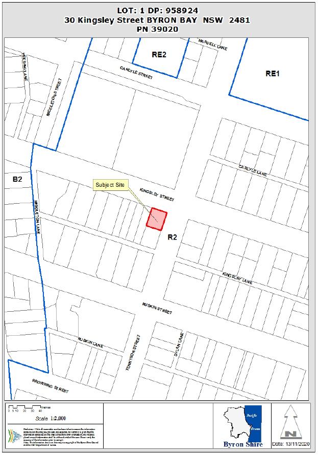
Assessment:
1.1. History/Background
A search of Council records indicates the following relevant
site history:
|
DA No.
|
Description
|
Outcome
|
Date
|
|
6.1991.2473.1
|
Alterations to Dwelling
|
Finalised
|
25/09/1991
|
|
10.2020.310.1
|
Alterations & Additions
|
Approved
|
12/08/2020
|
1.2. Description of the
proposed development
This application seeks approval for a S4.55 to Modify the
approved plans for the carport to be located flush to the dwelling line at the
Tennyson Street frontage. The modification requests an update to Condition 1
and deletion of Condition 6, which read as follows:
|
1.
|
Development is to be in accordance with approved plans
The development is to be in
accordance with plans listed below:
|
Plan No.
|
Description
|
Prepared by
|
Dated:
|
|
19.08.01
|
Site Plan Revision A
|
Michael Spiteri Design
|
August 2020
|
|
19.08.04
|
Floor Plan Revision A
|
Michael Spiteri Design
|
August 2020
|
|
19.08.05
|
Elevations 1
|
Michael Spiteri Design
|
March 2020
|
|
19.08.06
|
Elevations 2
|
Michael Spiteri Design
|
March 2020
|
|
19.08.06
|
Sections & Notes
|
Michael Spiteri Design
|
March 2020
|
The development is also to be in accordance with any
changes shown in red and blue ink on the approved plans or conditions of
consent.
The approved plans and related documents endorsed with the
Council stamp and authorised signature must be kept on site at all times
while work is being undertaken.
|
1.3. Description of the site
The subject site known as 30 Kingsley Street, Byron Bay and
legally described as Lot 1 on DP958924 has a total area of 488m² and is
located within the Low density residential zone of the Byron Local
Environmental Plan 2014. The property is currently improved by a single
dwelling house, ancillary Class 10 structures (patio roof, carport),
landscaping vegetation, and is identified as Flood Liable Land and containing
Acid sulfate soils (class 3).
A site inspection was carried out on 10 August 2020
|
Land is legally described
|
LOT: 1 DP: 958924
|
|
Property address
|
30 Kingsley Street BYRON BAY
|
|
Land is zoned:
|
R2 Low Density Residential
|
|
Land area is:
|
488m2
|
|
Property is constrained by:
|
Flood Liable Land Acid Sulfate Soils Class
3
|
|
Is a BDAR required due to the location of the proposed
development?
|
☐ Yes ☒ No
|
|
Are there any easements in favour of Council affecting the
site?
|
☐ Yes ☒ No
|
|
Is there a Vegetation Management Plan which might affect
the proposal?
|
☐ Yes ☒ No
|
|
Is there a Voluntary Planning Agreement which might affect
the proposal?
|
☐ Yes ☒ No
|
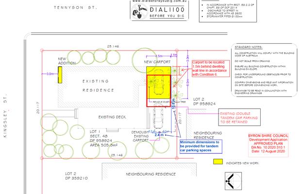
Extract from Approved Plans showing location of carport
to be setback from the street
2. SECTION 4.15 – MATTERS FOR CONSIDERATION
– DISCUSSION OF ISSUES
Having regard for the matters for consideration detailed in
Section 4.15(1) of the Environmental Planning & Assessment Act 1979, the
following is a summary of the evaluation of the issues.
Carport location:
DA10.2020.310.1 applied for
development consent to demolish the existing carport and re-establish another
at the subject site flush to the dwelling wall line at the Tennyson Street
frontage. Council’s assessing officer assessed the proposal against the
relevant provisions of the Byron DCP and LEP 2014 providing the following
comments:
“Chapter C1
– Non-Indigenous heritage, C1.4.6 Parking, Garages and Carports
DCP assigns performance criteria for garages and
carports that are applicable to the proposal. While DCP Performance Criteria
note that garages and carports are to use traditional pitched roofs, the
proposed carport will accord with the design of the existing carport (see
Figure 1) which is a low-set, simplistic skillion roof that maintains the existing
roofline.
The applicant proposes to locate the carport flush to
the front of the building to allow for improved solar access at the rear deck
of the subject site and adjacent property. DCP notes that garages and carports
should be located at the rear of allotments, however where not possible, must
be set back at least 1m from the front of the house. Cognisant of this
requirement and the assessment of boundary setbacks (see discussion below), a
condition will be imposed on the consent requiring that amended plans are
provided prior to the issue of a Construction Certificate demonstrating that
the carport is set back an additional 1.5m from the front of the dwelling.
Chapter D1.2.2 –
Building Setbacks
The proposal seeks to establish an open carport that is flush
to the dwelling wall line at the frontage, presenting a setback of 3m from the
front property boundary. DCP prescribes that car parking spaces are not to be
within 5.5m of a front property boundary. The existing car parking on the site
provides for two spaces in a tandem arrangement, and the proposal does not
alter the location of these spaces. It is acknowledged that the site is a
corner property, and the dwelling presents reduced boundary setbacks (3m) at
each frontage, which is identified to contribute to the streetscape character
of the locality.
As the location of car parking spaces is not altered by
the proposal, it is considered reasonable that the car parking spaces remain.
Similarly, it is considered reasonable that the open carport be granted a
dispensation to the 5.5m front boundary setback to amalgamate with the reduced
boundary setbacks afforded to the dwelling. Nevertheless, the carport should be
set back an additional 1.5m from the front of the dwelling to align with
Chapter C1 of DCP (discussed above) and provide a front boundary setback of
4.5m.”
As noted under the discussion of
Chapter C1 above, a Condition of consent was applied to the development consent
requiring that plans are amended prior to the issue of a Construction
Certificate for the carport to provide an additional 1.5m setback from the
front of the dwelling and allow for a boundary setback of 4.5m to the outermost
projection of the carport (see snip from approved plan below) in order to
preserve the intent of DCP prescriptive measures for setbacks and heritage
protection.
The proposal was referred to
Council’s Heritage Advisor for comment regarding Council’s original
assessment of the proposal. Advice was received which confirmed Council’s
original assessment of the proposal, with Council’s Heritage Advisor
noting as follows:
“The primary facade of the house faces Tennyson
Street with the projecting decorative gable, and the hipped end faces Kingsley
St. It has been extended but retains a traditional single storey form and materials
and is a contributory element along with the group of cottages on Kingsley
Street.
It is agreed that a simple skillion open structure is
acceptable and sits better than a free standing pitched roof structure in this
instance.
The suggested 1.5m set back will make the carport a
secondary element to the dwelling. It is noted that the part of the dwelling
adjoining the car port is a non original later extension, however it still
forms part of the primary streetscape facade. It is also noted that there is
mature mango tree and landscaping which softens this entry point, but if
it were more open, the addition would be more obvious. There is no formal
crossover.
Positioning it flush with the frontage is in conflict
with Councils general planning policies and the heritage chapter and there does
not appear to be sound justification for an exemption due to insufficient
space.
Approval would set an undesirable precedent making it
hard to refuse other applications of a similar nature”
Accordingly, it is considered
that the initial assessment of the proposal resulted in a development outcome
that achieved the intent of the DCP, and that the consent not be modified.
Upon receipt of Council’s
Heritage Advisor’s comments and the abovementioned conclusion, the
applicant was informed that Council’s Heritage Advisor concurred with the
original assessment of the proposal. The applicant requested a copy of the
Heritage Assessment advice (through the GIPA process), and provided the following
comments.
Ø Tennyson Street is the
secondary frontage – therefore 3m setback is justified.
The applicant posits that it is their belief that the
Tennyson Street frontage is a secondary frontage for the development site, and
therefore the DCP prescribed 3m secondary frontage setback is applicable.
Comment:
The dwelling is predominantly oriented toward Tennyson
Street, with the pitch of the gable roof presenting to this frontage (see image
below). Additionally, both vehicle and pedestrian access are granted at this
frontage, and the open carport is proposed at this frontage. Council’s
Heritage Advisor considered the applicants position that Tennyson St. is the
secondary frontage in their assessment, and conferred that “the
primary façade of the house faces Tennyson Street with the decorative
gable, and the hipped end faces Kingsley St.” Notwithstanding, DCP
prescribed setback distances are not the only matter of consideration in this
assessment, and Council’s DCP Heritage chapter must also inform the
development outcome.
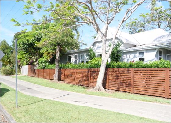
Tennyson Street frontage
Herein, Chapter C1
(Non-Indigenous Heritage) notes specifically that:
3) “Garages
and carports should generally be kept separate from the house. Attachment of
garages and carports to the buildings they service is generally not favoured
unless the structure is located at the rear of the building and is not
visible from the surrounding streets, or it is set well back from the front
façade and unobtrusively attached. In those cases a simple carport
under a continuation of the roofline may be appropriate.
4) Garages
should be located generally towards the rear of allotments. Where this is not
achievable they must be set back a minimum of 1 metre from the front of the
house.”
Regardless of whether Tennyson Street is a primary or
secondary frontage, Council’s heritage controls seek to ensure that
carports are not attached to buildings unless “located at the rear of
the building” or “set well back from the front façade”.
Additionally, DCP Chapter D1 which prescribes boundary setbacks explicitly
requires that “car parking must not be provided within setbacks.”
When read in conjunction, DCP
controls require that car parking spaces do not align flush to the front
façade of the building (Heritage chapter C1) and are not placed within
boundary setbacks (D1). The condition applied to the development consent
requiring a 4.5m setback endeavours to amalgamate a resolution which grants
concession to the 5.5m prescribed boundary setback distance while cognisant of
the requirement of the heritage chapter to ensure carports are set back from
the dwelling façade.
Ø Loss
of solar access to bedroom 2 & openness of south-western corner
The applicant asserts that the approved position of the open carport is
likely to detrimentally affect the solar access of bedroom 2, and locating the
structure flush to the dwelling line will provide additional space in the
south-western corner of the allotment.
Comment:
The orientation of the subject
site and location of the proposed open carport do not support the assertion of
overshadowing. The open carport is located at the southern side of the
dwelling house (see image below). Further, establishing the structure at the
approved location will not detract from the open space provided at the
south-west of the site as it aligns with the rear of the building. 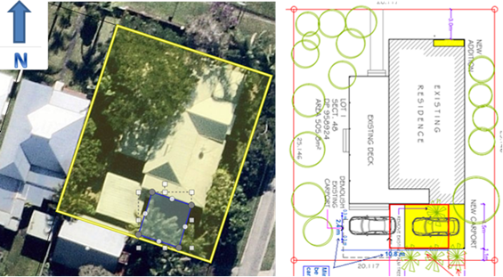
Ø No impact on heritage items
nor conservation area
The applicant asserts that the proposed open carport will
not impact upon nearby heritage items or the character of the heritage
conservation area. It is noted that the open carport is proposed to be located
behind an existing mango tree and will not likely be visible. The applicant
notes that the lightweight structure presenting a setback of 3m will not make
such a significant difference to the character of the Kingsley Street part of
the conservation area.
Comment:
The carport is proposed behind existing mango trees.
However pursuant to Chapter B2 of the Byron DCP, trees within 3m of a building
and trees grown for edible fruit are permitted to be removed without
development consent.
Accordingly, these trees may be removed without consent
from Council and are therefore not considered suitable justification for the
reduced boundary setback distance which conflicts with DCP Chapters D1
(Residential accommodation) and C1 (Non-indigenous heritage). Further, advice
provided by Council’s Heritage Advisor highlighted that while the
existing mango tree softens the visual impact of the structure at the Tennyson
Street frontage, removal of this tree and opening this space would render the
structure “more obvious” at this location.
While it is acknowledged that the structure is lightweight
and open in nature, the advice of Council’s Heritage advisor notes
specifically that the recommended 1.5m recession of the structure from the
dwelling façade establishes it as a secondary element to the dwelling,
and that “Positioning it flush with the [dwelling] frontage is
in conflict with Councils general planning policies and the heritage
chapter…”
It is considered that positioning the structure flush to
the dwelling wall line at the Tennyson Street frontage would influence the
heritage character of the dwelling and heritage conservation area.
Ø Driveway and crossover will
result in more visual impact than the carport
The applicant submits that Condition 7, which requires the
applicant to establish a formal driveway and crossover onto the site, will
result in more visual impact on the Tennyson Street frontage than the carport.
Comment:
The subject site does not currently benefit from a legal
point of access/egress (vehicle crossover and driveway). The subject
application relates directly to vehicle access/egress at the allotment, and
formalising this access/egress is reasonable to ensure the development outcome
is compliant with Council and national standards. The requirement to establish
a crossover and driveway is not considered suitable justification for the positioning
of a structure that conflicts with DCP chapters D1 and C1.
It is recommended that the application be refused.
2.2. State/Regional Planning
Policies, Instruments, EPA Regulations 2000
Proposed amendments raise no issues under the relevant
SEPPS, Policies or clauses of the EPA Regulations 2000.
2.3. Byron Local Environmental
Plan 2014
Clause 5.10 Heritage Conservation
The subject property is located within a heritage
conservation area. The objectives of this clause state:
(a) to
conserve the environmental heritage of Byron,
(b) to
conserve the heritage significance of heritage items and heritage conservation
areas, including associated fabric, settings and views,
(c) to
conserve archaeological sites,
(d) to
conserve Aboriginal objects and Aboriginal places of heritage significance.
As discussed above, the proposal is inconsistent with the
planning controls and guidelines applicable to the development.
It is considered the proposal will have an adverse impact on
the heritage significance of the area and does not satisfy Objective b). The
application is recommended or refusal.
2.4. Draft EPI that is or has
been placed on public exhibition and details of which have been notified to the
consent authority - Issues
No draft EPIs affect the proposal.
2.5. Development Control Plans
Chapter C1 Non Indigenous Heritage
The provisions under D4.1.6 require the following for
garages and car ports
3. Garages and carports should generally be
kept separate from the house. Attachment of garages and carports to the
buildings they service is generally not favoured unless the structure is
located at the rear of the building and is not visible from the surrounding
streets, or it is set well back from the front façade and unobtrusively
attached. In those cases a simple carport under a continuation of the roofline
may be appropriate.
4. Garages should be located generally
towards the rear of allotments. Where this is not achievable they must be set
back a minimum of 1 metre from the front of the house.
As discussed above the proposal is not consistent with the
provisions of the DCP and there are no substantive reasons why a variation
should be granted in this instance. The application is recommended for refusal.
Chapter D1 Residential Accommodation and Ancillary
Development in Urban, Village and Special Purpose Zones
The setback provisions under D1.2.2 require garages and
carports to be setback 5.5 metres from front street boundaries. These setback
provisions have been established to ensure that the garage/carport do not
dominate the frontage of the development site and to enable visitors to park
within the driveway as overflow parking. The development was approved with a
condition requiring the carport to be set back 4.5 metres from the street
boundary. It is considered that there are no grounds to vary the setback any
further in this instance and the application is recommended for refusal.
2.6 The likely impacts of that development, including environmental
impacts on both the natural and built environments, and social and economic
impacts in the locality
It is considered the proposed amendments to site the
driveway flush with the dwelling will have an impact on the built environment
and streetscape in terms of heritage as discussed above
2.7 The suitability of the site for the development
Proposed amendments do not affect the site suitability.
2.8 Submissions made in accordance with this Act or the regulations
No Submissions were received.
2.9 Public interest
The proposed amendment seeks consent for a development that
conflicts with the intent of DCP development controls, and approval would
advance an undesirable precedent within the Heritage Conservation Area. It is
submitted the proposal is not in the public interest
2.10 DEVELOPER CONTRIBUTIONS/ WATER AND SEWER CHARGES
There is no nexus to levy additional contributions.
3. DISCLOSURE OF POLITICAL DONATIONS AND GIFTS
|
Has a Disclosure Statement been received in relation
to this application
|
No
|
|
Have staff received a ‘gift’ from anyone
involved in this application that needs to be disclosed. Where the answer is
yes, the application is to be determined by the Director or Manager of the
Planning, Development and Environment Division.
|
No
|
4. CONCLUSION
Council has clear planning and heritage controls that apply to
this type of development and there are no substantive reasons otherwise to
deviate from these and amend the consent. The application is recommended or
refusal.
Staff Reports - Sustainable Environment and Economy 13.8
Report No. 13.8 PLANNING
- Review of Planning Controls for Rural Tourist Accommodation
Directorate: Sustainable
Environment and Economy
Report
Author: Ben
Grant, Planner
File No: I2020/1810
Summary:
At the Planning Meeting of 20
June 2019, Council resolved to review and amend Byron Local Environmental Plan
(LEP) 2014 and Development Control Plan (DCP) 2014 in relation to rural
tourism/holiday cabins. The resolution was made in response to a staff report which noted that the current planning framework for rural
tourist accommodation was resulting in development on rural land that is not
entirely consistent with the RU1 and RU2 zone objectives.
A link to the staff report can be
found here:
https://byron.infocouncil.biz/Open/2019/06/PLA_20062019_AGN_1054_WEB.htm
The Resolution is shown below:
Resolution
19-284
“…that Council endorse Option 2 contained in this
report to review and amend Byron Local Environmental Plan 2014 and Byron
Development Control Plan 2014 in relation to rural tourism/holiday cabins”.
As per the resolution, an
investigation has been carried out into the adequacy of the planning controls
in LEP 2014 and DCP 2014 for holiday cabins and farm stay accommodation.
This included a review of development applications received since 2014 and an
analysis of the current planning framework.
The review found that the pattern of development under LEP
2014 has not always been closely aligned with the objectives for tourism in the
Shire’s rural zoned areas. In particular, there has been a prevalence of
smaller sites being developed along with inconsistent outcomes in relation to
environmental enhancement and conservation.
Primarily, this is occurring due to the current structure of
the planning rules which are in need of simplification and consolidation.
Chapter D3 of DCP 2014 contains a number of overlapping and conflicting
planning controls and this is causing difficulty in the assessment process
leading to somewhat inconsistent outcomes.
The review recommends that a number of amendments be made to
LEP 2014 and DCP 2014 to address these issues. Proposed amendments include the
introduction of a minimum lot size and reduction of the number of bedrooms,
environmental enhancement, clustering and visual impact.
This review is the first step in
the process of amending the planning controls for rural tourist accommodation.
If the Council elects to proceed, the next steps will be the preparation of a
planning proposal or draft DCP amendment to update Byron LEP 2014 and/or Byron
DCP 2014.
Future LEP and DCP amendments will
be subject to community consultation in accordance the Community Participation
Plan and will be reported back to Council for endorsement.
NOTE TO COUNCILLORS:
In accordance with the
provisions of S375A of the Local Government Act 1993, a Division is to be
called whenever a motion for a planning decision is put to the meeting, for the
purpose of recording voting on planning matters. Pursuant to clause 2(a)
under the heading Matters to be Included in Minutes of Council Meetings of
Council's adopted Code of Meeting Practice (as amended) a Division will be
deemed to have been called by the mover and seconder of all motions relating to
this report.
|
RECOMMENDATION:
That Council:
1. Requests staff to prepare a
planning proposal to amend Byron Local Environmental Plan 2014 and a draft
amendment to Byron Development Control Plan 2014, to accord with the
recommendations of the Review of Planning Controls for Rural Tourist
Accommodation in Attachment 1 (E2020/94209).
2. Authorises staff
to submit the planning proposal to the Department of Industry and Environment
for Gateway determination.
3. Pending gateway
determination, undertakes public exhibition of the planning proposal and
development control plan amendment and consult with government agencies as
required by the gateway determination; and
4. Receives
a report outlining the public exhibition outcomes.
|
Attachments:
1 Review of
Planning Controls for Rural Tourist Accommodation, E2020/94209
REPORT
Purpose
The purpose of this report is to
provide a review of the planning controls for rural tourist accommodation in
accordance with Council resolution 19-284 from Council Meeting date 20
June 2019. The review includes an audit of development applications for rural
tourist accommodation since 2014 and provides findings and recommendations to
amend the planning framework.
Background
The review originates from a
Notice of Motion (NOM) that was included in the Ordinary Meeting Agenda of 18
April 2019, but withdrawn on the day. The NOM identified a significant increase
in the number of development applications (DA’s) for rural holiday cabins
and raised concerns over the potential impacts of increased tourism in the
Shire’s rural areas. The NOM recommended that Council consider removing
the provisions for rural holiday cabins entirely, along with a review of the
farm stay provisions in both LEP’s and DCP’s.
In response, a staff report was
tabled at the Planning Meeting of 20 June 2019 which noted an increase in the number
of applications for rural tourist accommodation and concluded that the current
planning framework was resulting in development on rural land that is not
entirely consistent with the RU1 and RU2 zone objectives in the LEP.
The report suggested that the
issue could be addressed by bringing the planning controls in LEP 2014 into
closer alignment with those in LEP 1988.
Three options were offered to
Council:
1. No change to the
existing controls;
2. Amend the LEP and
DCP controls to limit the scale and density of rural tourism development;
3. Remove provisions
for holiday cabins entirely.
Council elected to adopt Option 2
and resolved as follows:
Resolution 19-284
“…that
Council endorse Option 2 contained in
this report to review and amend Byron Local Environmental Plan 2014 and Byron
Development Control Plan 2014 in relation to rural tourism/holiday
cabins”.
The report can be found through the following link: https://byron.infocouncil.biz/Open/2019/06/PLA_20062019_AGN_1054_WEB.htm
Review of planning controls
In accordance with the above
resolution, an investigation was carried out into the adequacy of the planning
controls in LEP 2014 and DCP 2014 for holiday cabins and farm stay
accommodation.
The review has 4 main parts:
1. An
overview of the LEP 2014 planning framework for rural tourist accommodation
This
section illustrates the structure of LEP 2014 framework and highlights key
development controls applying to rural tourist accommodation.
2. Review of development
applications
Development
applications received since 2014 were reviewed. This was done to help understand
development trends and identify areas where the current
planning rules are not achieving the intended outcomes.
3. Discussion
of key findings
Key
findings relating to the assessment process and development outcomes under the
LEP 2014 planning framework are discussed. This section includes
recommendations for improving or amending the planning rules.
4. Actions
A
summary of the specific actions needed to amend the planning framework.
Summary of the findings and
recommendations
The full review can be found in Attachment 1 to this report. The
following is summary of the key findings and recommendations.
Analysis of the Planning
Controls - Findings and Recommendations
On the basis of the DA review and analysis of the planning
framework, the following findings were identified.
1. The
planning framework has shifted applicants towards holiday cabins and away from
farm stay accommodation and eco-tourist accommodation
Since
2016, there has been a noticeable shift in development applications towards
holiday cabins and a corresponding drop in applications for all other types of
rural tourist accommodation. Overall, the total volume of applications for
rural tourist accommodation has only increased slightly over the past 4 years;
averaging about 13 DA’s per year. This indicates a change in the type of
development being sought by applicants, rather than a change in the total
number of development applications.
The
growth in applications for holiday cabins not necessarily a negative outcome
considering that this form of development is allowed under LEP 1988 and have
been a permissible use in the Shire for several decades. The main issue
requiring closer consideration is the differences in the planning rules between
LEP 2014 and those in LEP 1988 which has resulted in different development
outcomes being achieved.
Recommendation
· It is recommended
that the parent definition of tourist and visitor accommodation be retained as
a permissible use to provide flexibility for different types of rural tourist
accommodation provided in the Shire.
· Other parts of the
planning framework regulating density, lot size and design should be reviewed
and amended where necessary to ensure the controls are aligned with those
contained in LEP 1988.
2. There
is a need for better site selection criteria, including a minimum lot size
In terms of development
outcomes, the most significant finding of the review is the high take up rate
of development on smaller sites since 2014. About 40% of sites approved for
rural tourist accommodation were properties with an area of less than 20
hectares.
This
pattern of development is considered to be problematic for a few reasons.
Firstly, smaller sites are generally less viable for environmental enhancement
and conservation projects due to a lack of land to accommodate new plantings.
DCP 2014 specifies that applicants must provide 900 native trees per cabin
which requires several hectares of land to be set aside for restoration.
Secondly, it is often more difficult to site buildings on smaller lots while
maintaining adequate buffers from adjoining agricultural uses and neighbouring
dwellings. Reduced buffers can impact on amenity and result in land use
conflict.
Finally,
one of the key benefits of rural tourism is to generate an additional income
stream for rural land owners to subsidise agricultural operations or fund
larger scale environmental reparations. Allowing a proliferation of development
on smaller sites does not help to achieve that objective since those properties
usually have less potential for agriculture or environmental enhancement to
begin with.
Recommendation
· To ensure development is occurring on sites with
appropriate characteristics to support low scale development in accordance with
zone objectives, it is recommended that rural tourist accommodation be subject
to a 20 hectare minimum lot size, preferably under Clause 6.8 of LEP 2014.
· Further consideration should also be given to developing a
map of appropriate sites for rural tourist accommodation that takes into
consideration additional site selection criteria such as aspect, slope,
hazards, environmental values and road access.
3. Environmental
enhancement and conservation outcomes have been highly variable, although
recent DCP amendments have improved consistency in the assessment process
The review highlighted that
environmental enhancement and conservation efforts were usually an afterthought
in applications received between the years 2014 and 2017. Thankfully,
compliance rates have improved significantly since recent DCP amendments in
2019 and the majority of applications now include a vegetation management plan
detailing an environmental enhancement concept as part of the development
proposal.
Another issue was the wide
variation in the way that environmental enhancement and conservation works are
regulated through conditions of consent.
Given these findings, it is
considered that the existing DCP controls for environmental enhancement and
conservation do not need to be changed in any significant way. One potential
improvement would be to include an objective for ecological enhancement in DCP Part
D3.3.4 to bring the DCP into alignment with the zone objectives. Consideration
should also be given to developing a set of standard conditions for
environmental enhancement and conservation. This would not require an amendment
to the LEP or DCP and would instead be a procedural matter for Council
assessment staff when determining DA’s.
Recommendation
· It is recommended
that an additional objective for environmental enhancement be added to DCP Part
D3.3.4 to bring it into alignment with the zone objectives.
· To improve
consistency of outcomes, it is recommended that Council develop a set of
standard conditions of consent for environmental enhancement and vegetation
management plans. It is suggested that restoration works should be
substantially commenced prior to the occupation stage, and that VMP’s be
subject to annual or biannual reporting over a five year timeline. To support
this approach, Council will also need to develop a process for recording and
auditing applications subject to VMP’s.
4. Maximum
density of development should be reduced. The planning controls should be
simplified to reduce ambiguity over the maximum number of accommodation
buildings.
There
is confusion over the maximum permissible number of accommodation buildings for
both farm stay and holiday cabins. This is primarily due to the presence of conflicting or unclear planning controls in
the LEP and DCP which regulate the density and scale of development.
The current planning framework
limits the density of rural tourist accommodation through three separate
controls:
· Clause
5.4 of LEP 2014:
Clause 5.4 limits the
maximum density of farm stay accommodation to 12 guest bedrooms.
· DCP
2014, Part D3.3.4, Prescriptive Measure 1:
D3.3.4 applies to farm
stay accommodation and holiday cabins. It provides a sliding density scale that
allows up to 3 bedrooms on sites between 0-3 hectares, with 1 additional
bedroom being permitted for every 1.5 ha, up to a maximum of 12 bedrooms.
· DCP
2014, Part D3.2.3, Performance Criteria 3(c):
D3.2.3 applies to farm
stay accommodation, holiday cabins, camping grounds, caravan parks and
eco-tourist facilities. It calls up the Best Practice Guidelines from Chapter 7
of the 1998 Strategy. Part 7.2 (2) of the Strategy states: “no more than
6 holiday cabins may be constructed in the site area”.
Some applicants have
argued that the above controls permit up to 12 one bedroom cabins, noting that
both Clause 5.4 and D3.3.4 only stipulate bedroom numbers rather than cabin
numbers, while D3.2.3 makes reference to the 1998 Strategy which has since been
repealed.
Furthermore, Clause
5.4 is inconsistent with Part D3.3.4 because it allows up to 12 bedrooms
unconditionally, whereas D3.3.4 restricts bedrooms to a figure between 3 and 12
depending on the size of the allotment. This is problematic in terms of the
structure and hierarchy of the planning rules, given that a DCP control cannot
impose a more onerous standard than a higher order planning instrument like an
LEP.
In addition, current density
limits are relatively generous and could be resulting in overdevelopment of
some sites when considered cumulatively with other forms of development. Under
the current planning framework it is possible to apply for rural tourist and
visitor accommodation comprising up to 12 bedrooms, a dual occupancy with up to
6 expanded house habitable outbuildings, a studio, a rural workers dwelling,
recreation facility and a restaurant/café all on the one parcel of rural
land.
Reducing the maximum density to
8 bedrooms and 4 cabins would limit this cumulative effect and result in a form
of development more closely aligned with the objective for rural tourism to be
small scale and low impact.
Recommendation
Council should consider reducing the maximum density of
development to 8 bedrooms within 4 accommodation buildings. This will involve
amending clause 5.4 of LEP 2014 and the relevant sections of DCP 2014, Parts
D3.2.3 and D3.3.4.
Furthermore, the controls should be simplified to remove any ambiguity over the maximum number
of bedrooms and accommodation buildings. If the 20 hectare minimum lot size
standard is implemented as per Finding 2, this will negate the need for the
sliding density scale in D3.3.4.
5. Clustering
and siting provisions are ambiguous and in need of clarification
One of key design criteria for
rural tourist accommodation is the concept of ‘clustering’, which
means that accommodation buildings should be grouped together on one part of
the site. The intent of clustering is to minimise the developments physical
footprint and reduce any associated impacts on amenity and the surrounding
landscape.
The current planning controls
provide that all accommodation buildings are to be arranged in a
‘cluster’ pattern and located on average no further than 80 metres
apart.
Some applicants have interpreted
the 80 metre ‘average’ separation distance as meaning that all
development needs to be contained in a circle with a diameter of 80m while
others have interpreted it as meaning that each building can be separated by up
to 80m. The control needs to be clarified to remove doubt and improve the
assessment process.
Recommendation
· It is recommended
that clustering should be re-defined by using an unambiguous numerical standard
instead of relying on ‘average’ separation distances. It is
suggested that a 20m separation distance between each accommodation building
should be permitted to allow for a reasonable level of privacy and amenity for
users. The size of the ‘cluster’ will depend on the scale of the
development. That is, a development comprising only a few cabins would be
required to group the buildings in a smaller cluster than a development
comprising 6 cabins.
· A degree of
flexibility should be allowed to account for sites with unusual physical or
environmental constraints, but only in circumstance where it can be
demonstrated that a dispersed arrangement is a superior solution when taking
into consideration environmental issues, land use conflict, loss of farmland
and impacts on rural character.
6. Controls
relating to design, aesthetics and rural character could be strengthened
The DA review highlighted that
requirements for aesthetic design, siting, colour values and landscaping
established in Chapter 8 of the 1998 Strategy have not been implemented
effectively in the assessment process since 2014.
These design principles should be articulated more clearly
in the DCP and given greater weight in the assessment process.
Recommendation
· Recommend that the
aesthetic design guidelines in the 1998 Strategy be implemented directly into
the Part D3.2.3 of the DCP to give greater emphasis to the importance of
sympathetic design that harmonises with the landscape. Development on
ridgelines and visually prominent locations should be avoided in the first
instance. In circumstances where there are no other suitable locations, the
development should be fully justified by a visual impact assessment in
accordance with Chapter C3.
7. Traffic
and road access is generally being dealt with effectively. Further
consideration should be given to amenity impacts relating to noise, dust and
light pollution
Traffic generation,
road access and pedestrian/vehicular safety were by far the most commonly cited
complaint in submissions received on DA’s for rural tourist
accommodation.
However, in terms of outcomes,
the existing DCP controls appear to have been fairly effective in addressing
road access issues in most cases. Some applicants were required to provide
substantial upgrades to public roads such as regrading or sealing the full
length of an access road to the nearest intersection to account for increased
traffic generation.
One issue that was dealt with
less consistently however were associated amenity impacts such as increased
noise, dust and light pollution which were a common source of objections on
DA’s. This is an area where further improvements to the planning controls
could be considered.
Recommendation
· To improve
consistency in the assessment process, it is recommended that were development
comprises three or more cabins and the access road is not in accordance with
the Council’s minimum standards, a traffic impact statement should be
provided to support the application. The DCP may also specify that road user
impacts such as noise, dust and light pollution are to be covered by the TIS,
supported with additional controls to guide the assessment of these matters.
· Better site
selection criteria may also help by ensuring sites have access to sealed roads
to begin with, or have adequate site features to allow access roads and
driveways to be provided in a way that does not create adverse amenity or
safety impacts for local residents.
· Clearer controls
should also be developed which limit access to one driveway for each rural
tourism development.
8. Water
and sustainability measures need improvement. OSMS provisions are working
relatively well
In terms of effluent disposal,
the current set of planning controls appears to be working effectively in
ensuring safe and environmentally sustainable outcomes. Water supply on the
other hand is not dealt with as consistently, particularly in relation to the
design and operation of rainwater storage systems servicing rural tourist
accommodation.
Recommendation
· It is recommended
that Council develop minimum water supply and design guidelines for rural
tourism, similar to those developed for residential accommodation which
stipulates 40kL capacity for rural dwellings and 20kL for secondary dwellings.
It should also be clarified that drinking water supply should be separate to
firefighting water supply and where swimming pools are proposed additional
storage measures should be implemented.
· For larger scaler
developments comprising four or more cabins or development in visually
prominent areas, details of the system capacity and tank locations should be
identified in the application.
9. The
DCP controls in Chapter D3 should be simplified and consolidated. Areas of
duplication or conflict should be removed.
As discussed throughout the
review, one the main issues affecting the assessment process is the presence of
duplicated, redundant or conflicting planning controls within DCP 2014. This
has arisen mostly due to continued references to the best
practice guidelines and performance standards from Chapters 7 and 8 of the
Byron Rural Settlement Strategy 1998.
In addition to the above
mentioned issues, the Prescriptive Measures and Performance Criteria for DCP
Part D3.3.4 are not well aligned which further contributes to inconsistency in
the assessment process. Some design elements are dealt with only in the
Performance Criteria, while other elements are only covered by the Prescriptive
Measures.
The DCP
controls in Chapter D3 need to be simplified and consolidated. Areas of
duplication or conflict should be removed.
Recommendation
· It is
recommended that the relevant planning controls from the 1998 Strategy’s
best practice guidelines be placed directly into DCP 2014 and any conflicting
measures in other areas of the DCP be rectified. References to the 1998
Strategy in Part D3.2.3 of the DCP should be consequentially removed.
· Further,
the Prescriptive Measures and Performance Criteria in Part D3.3.4 should be
redrafted and brought into closer alignment with one another.
Proposed actions
In order to address the findings and recommendations of this
review, the following actions are proposed:
1. Proposed
amendments to Byron LEP 2014
a. Retain the definition of tourist and visitor accommodation
as permitted with consent in the RU1 and RU2 zones.
b. Introduce a 20 hectare minimum lot size for rural tourist
accommodation as an LEP standard.
c. Reduce the number of farm stay accommodation bedrooms to 8.
2. Proposed
amendments to Byron DCP 2014:
a. Add
an additional objective for environmental enhancement into DCP Part D3.3.4.
b. Scale
and density of development to be limited to 4 accommodation buildings and 8
bedrooms in total. Existing DCP controls to be consolidated and amended where
necessary.
c. Include
a clear numeric standard to guide the clustering of rural tourist accommodation
buildings. The size of the cluster is to scale-up depending on the number of
accommodation buildings.
d. Implement
the aesthetic design guidelines from Chapter 8 of the 1998 into DCP 2014 Part
D3.2.3.
e. Include
a new Prescriptive Measure into DCP Part D3.3.4 limiting the number of
driveways to one per development.
f. Develop
rainwater harvesting requirements for rural tourist accommodation. Update DCP
Chapter B3 accordingly.
g. Additional
control to be added to D3.3.4 specifying that development for three cabins or
more on a road that does not meet Council’s standards to be accompanied
by a Traffic Impact Statement detailing road user impacts such as dust, noise
and light pollution.
h. Redraft
various provisions in D3.3.4 to ensure the Prescriptive Measures and
Performance Criteria are more closely aligned.
3. Other
matters:
a. Develop
a set of standard conditions of consent for environmental enhancement and
vegetation management plans.
b. Investigate
mechanisms for reviewing and auditing vegetation management plans post consent
to ensure compliance with conditions.
c. Consider
developing a map of suitable sites for tourist and visitor accommodation based
on site selection criteria.
Conclusion
This review is the first step in
the process of amending the planning controls for rural tourist accommodation.
If the Council elects to proceed, the next steps will be the preparation of a
planning proposal to amend Byron LEP 2014 and/or amendment to Byron DCP 2014.
Future LEP and DCP amendments will
be subject to community consultation in accordance the Community Participation
Plan and will be reported back to Council for endorsement.
STRATEGIC CONSIDERATIONS
Community Strategic Plan and
Operational Plan
|
CSP Objective
|
L2
|
CSP Strategy
|
L3
|
DP Action
|
L4
|
OP Activity
|
|
Community
Objective 4: We manage growth and change responsibly
|
4.1
|
4: Support tourism and events that reflect our culture and
lifestyle
|
4.1.1
|
4:
We manage growth and change responsibly
|
4.1.1.1
|
Progress draft
Planning Proposal and DCP amendments to improve the planning controls for
rural tourist accommodation.
|
|
|
|
|
|
|
|
|
|
|
Legal/Statutory/Policy Considerations
The review of the planning
controls will be used to inform future changes to the Byron Local Environmental
Plan 2014 and the Byron Development Control Plan 2014.
Financial Considerations
Not applicable.
Consultation and Engagement
Consultation and engagement for any future LEP and/or DCP
amendments will be undertaken in accordance with the
Community Participation Plan and will be reported back to Council for
endorsement.
Staff Reports - Sustainable Environment and Economy 13.9
Report No. 13.9 PLANNING
- Report of the 12 November 2020 Planning Review Committee
Directorate: Sustainable
Environment and Economy
Report
Author: Chris
Larkin, Manager Sustainable Development
File No: I2020/1807
Summary:
This report provides the outcome of the Planning Review
Committee (PRC) held on 12 November 2020.
NOTE TO COUNCILLORS:
In accordance with the
provisions of S375A of the Local Government Act 1993, a Division is to be
called whenever a motion for a planning decision is put to the meeting, for the
purpose of recording voting on planning matters. Pursuant to clause 2(a)
under the heading Matters to be Included in Minutes of Council Meetings of
Council's adopted Code of Meeting Practice (as amended) a Division will be
deemed to have been called by the mover and seconder of all motions relating to
this report.
|
RECOMMENDATION:
That Council endorses the outcomes of the
Planning Review Committee meeting held on 12 November 2020.
|
REPORT
The Planning Review Committee meeting was held on 12
November 2020. The Meeting commenced at 4:45pm and concluded at 5.05pm.
Councillors: Crs Hunter, Lyon, Ndiaye
Apologies: Cr Coorey
Staff: Chris Larkin (Manager Sustainable Development)
The following development
applications were reviewed with the outcome shown in the final column.
|
DA No.
|
Applicant
|
Property Address
|
Proposal
|
Exhibition Submissions
|
Reason/s
Outcome
|
|
10.2020.513.1
|
Planners North
|
84 Harbour Way BRUNSWICK
HEADS
|
Alterations and Additions
to Existing Motel including Five (5) Additional Guest Rooms, Restaurant/Bar,
Swimming Pool and Car Parking Spaces
|
20/10/20 to 2/11/20
Level 2
6 submissions
|
The perceived public
significance of the application.
Council
|
|
10.2020.460.1
|
Byron Bay Planning and
Property Consultants
|
90 Byron Street
BANGALOW
|
Use of Alterations and
Additions to Existing Dwelling House Comprising of Front Fence and Verandah
|
20/10/20 to 2/11/20
Level 2
6 submissions
|
Delegated Authority
|
Council determined the following
original development application. The Section 96 application to modify this
development consent is referred to the Planning Review Committee to decide if
the modification application can be determined under delegated authority.
|
DA No.
|
Applicant
|
Property Address
|
Proposal
|
Exhibition Submissions
|
Reason/s
Outcome
|
|
10.2014.417.2
|
Northpoint
Advisory
43 Lawson St
Byron Bay
|
43 Lawson St
Byron Bay
|
S4.55 to Modify Staging.
Stage 1: Conversion of Existing Garage to Temporary Sales and Display Office
for on-site Marketing of Approved Residential Flat Building, Temporary Car
Parking Space, Pedestrian Access and Landscaping. Stage 2: Completion
of all Works and Demolition of Existing Building
|
30/9/20 to 13/10/20
Level 1
No submissions received
|
The perceived public
significance of the application.
Council
|