Minutes of Meeting

bsc_logo_150dpi_rgb

Extraordinary Local Traffic Committee Meeting


Venue

Meeting Room 1 Mullumbimby

Date

Wednesday, 27 January 2021

Time

10:30am

Committee Members

Ian Shanahan – Transport for NSW

DCI Matt Kehoe – Police

Cr Basil Cameron

Tamara Smith MP


I2021/73

                                                                                                                             Distributed 20/01/21


BYRON SHIRE COUNCIL

Extraordinary Local Traffic Committee Meeting Minutes 27 January 2021


Report of the Extraordinary Local Traffic Committee Meeting held on Wednesday, 27 January 2021

File No: I2021/73


Meeting Commenced: 10:42am


PRESENT:

Councillor:  Cr Basil Cameron

Transport for NSW: Ian Shanahan (via Zoom)

Police:  Det Ch Insp Matt Kehoe

Siobhan Foley for Tamara Smith MP


Staff:  Evan Elford, James Flockton and Andrew Pearce.  Rob Van Iersel joined at 11:38am for Report 6.3: Burringbar St Talking Street,  and left at 12:01pm


Apologies:

Tamara Smith MP


Declarations of Interest

There were no declarations of interest raised. or


Adoption of Minutes from Previous Meetings


Committee Recommendation:

That the minutes of the Local Traffic Committee Meeting held on 3 November 2020  be confirmed.

(Kehoe/Cameron)

The recommendation was put to the vote and declared carried unanimously. Shanahan, Foley, Cameron and Kehoe voted in favour of the motion.

Nil voted against the motion.


Matters Arising

There were no matters arising.

Outstanding Issues/Resolutions

None.


Regulatory Matters

Report No. 6.1           Yellow Line - Lighthouse Rd, Wategos

File No:                       I2021/65


Staff are seeking Council resolution to install yellow lines along Lighthouse Road between Brooke Drive and Marine Parade, Wategos, see figure 1 below for the location.


Figure 1 – location of requested yellow lines.


Figure 2 below shows the typical cross section of the road at two locations along its length.  As seen in these figures below there are narrow gravel shoulders used as informal pedestrian access to Wategos and the Lighthouse.  The frequent conflict is that cars often park across these gravel shoulders where people then walk to the Lighthouse.  This creates a hazard for pedestrians using the path and that cars end up partially on the path and partially on the road.


Council proposes to install a yellow line in the location shown in figure 1 to eliminate this unsafe parking location.  Where the eastern extent of the proposed yellow line ends there is already existing yellow lines through to Marine Parade.


Committee Comments

Kehoe: Not enough shoulder width for safe pedestrian access, a boardwalk would be required to provide adequate separation of pedestrians from vehicles.  Do you have statistics on parking infringements in that area? Anecdotally, Police are not seeing a lot of cars parked in this area.

Cameron: Do pedestrians walk on the gravel shoulder or road?

Pearce: Combination of both, parked cars forcing pedestrians onto road.

Kehoe: Any directional signage to direct pedestrians away from this section?

Elford: NPWS have confirmed pedestrians with dogs cannot use the tracks in the National Park, the road reserve is their only option.

Shanahan: No Issues from Transport.

Cameron: It is an objective of Council and Cape Byron Lighthouse Trust to reduce the number of vehicles accessing the lighthouse.

Management Comments

None.


Committee Recommendation:

That Council endorse the installation of yellow lines along Lighthouse Road from the Brooke Drive intersection extending through to the start of Palm Valley Drive.


(Cameron/Kehoe)

The recommendation was put to the vote and declared carried unanimously. .Shanahan, Foley, Cameron and Kehoe voted in favour of the motion.

Nil voted against the motion.


Report No. 6.2           Tincogan Street Intersection Priorities

File No:                       I2021/66


This report seeks LTC support for the reprioritisation of give way signs on Tincogan Street at the Dalley Street and Stuart Street Interesctions in order to provide East-West traffic priority in Tincogan Street.

Currently traffic on Tincogan Street must give way to traffic on Dalley Street and Stuart Street as seen in Figure 1 below.


Figure 1: Tincogan St / Dalley St Intersection
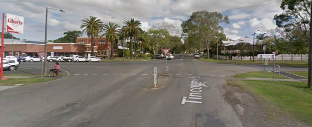
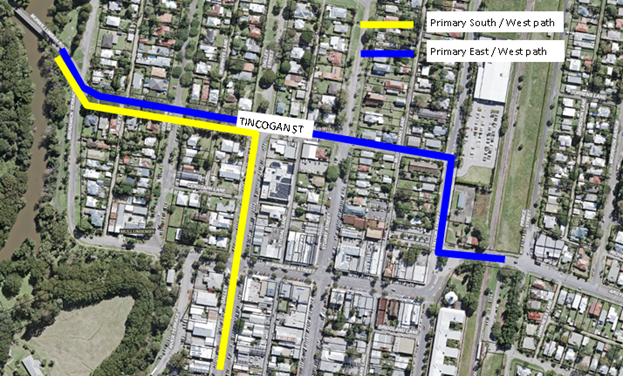
 

Figure 2 below shows the typical traffic paths through Mullumbimby. Refer to blue line for vehicles travelling east / west and yellow for vehicles traveling south / west.


Figure 2: Plan view of Mullumbimby and travel paths


Previous Reports


This matter was brought to LTC previously in 2014 and 2019. In 2014 LTC recommended the following:


Committee Recommendation from 2014


1.   That Council receive a report via the LTC as to the benefits and issues associated with changing the traffic route priority along the length of Tincogan Street from Station Street to Brunswick Terrace.


2.   That Council seek comments from the community in regards to this proposal with any submissions received forming part of the discussion in the above mentioned report.


3.   That Council note that at the intersection at Station Street, the Give Way orientation may be changed.


Council resolved to adopt the above LTC resolution at the 7 August 2014 Council meeting.  No additional Council comments were provided.


This matter was also brought to LTC in September 2019 where the benefits and issues associated with the priority change were discussed.  LTC made the following recommendations:


Committee Recommendation from 2019

1.      That Council note the Committee’s comments on possible changes to Give Way signs at Tincogan Street / Dalley Streets intersection and the Tincogan Street / Stuart Street intersection.


2.      That Council note the correspondence from the Mullumbimby Residents Association to the Director Infrastructure Services dated 6th September 2019, (E2019/67997) and consult with residents of Mullumbimby.


3.      That Council investigate Active Transport Funding FY20/21 for pedestrian protection in this area. 


Council resolved (19-485) to adopt the above LTC resolution, with the exception of item 3, at the 26 September 2019 Council meeting.


Through the above reporting, Council has shown clear support for the changes in intersection priority at the time of reporting.


Mullumbimby Masterplan/Community Consultation

In December 2019, Council adopted the Mullumbimby Masterplan which supports the reprioritisation of give way signs on Tincogan Street to facilitate east-west traffic priority as well as to realign the intersections at the Stuart and Dalley Streets to improve safety and traffic flow.


Proposed Design

The preliminary design has been appended to this report.  Note, details related to kerb buildouts, drainage, parking, landscaping is subject to change and are not regulatory devices requiring LTC review. Only proposed regulatory signs and lines require LTC consideration.


Construction Scheduling

Council aims to commence works to coincide with the Burringbar Talking Street Project. The purpose of this project is to reduce the amount of through traffic along Burringbar Street by diverting traffic along alternate routes such as Tincogan Street via Station Street in order to circumnavigate the Mullumbimby commercial area. 


The works associated with the intersection changes are proposed to occur in the following stages due to budget and resource requirements::


Stage 1:    Linemarking and signage – December 2020

Stage 2:    Installation of pedestrian refuges, some landscaping and kerb buildouts – early to mid 2021

Stage 3:    Connectivity between Dalley and Stuart Streets including parking – longer term


Staged Construction Considerations


Pedestrian Safety

As seen in the proposed design, improved traffic control and pedestrian safety will be addressed through kerb extensions and pedestrian refuges.  The goal of these is to narrow the intersection, aid in managing speed and provide improved pedestrian safety at the Dalley and Stuart Street intersections with Tincogan Street. 


The period between Stage 1 (line marking and signage) and Stage 2 (kerb buildouts) works may represent a risk to pedestrians in this regard.  An interim solution to help address this risk may be to line mark chevrons where future kerb extensions are proposed, potentially in combination with guide posts or temporary reflective pavement markers. These items are not regulatory devices but are mentioned to highlight Council’s steps to improve pedestrian safety.


Shops

Along Tincogan St, between Dalley St and Stuart St is a strip of popular shops, cafes, auto repairs, dance studio, bike shop and motor cycle repair.  This strip of Tincogan St currently has high parking demand with high turnover. Parking is 90’ angle parking with cars required to reverse out to exit.


The proposed design will reduce the amount of parking in this area due in part to the kerb extensions. This area will need to be monitored to address any potential conflicts arising from the proposed intersection works. Undertaking stage 1 works first will help identify matters that could be addressed as part of stage 2 and 3.


Funding

Stage 1 and 2 works to change the priority at Dalley and Stuart Streets are specifically referenced and scoped tasks under the funding agreement for  Council’s Election Commitment Grant which is aimed to address the Impacts of Tourism on infrastructure evidenced in Byron Shire.


Committee Comments

Cameron: Place planning to be consulted before such proposals. Masterplan objective was to activate the Dalley St area, however what we are seeing is only traffic prioritisation objective. Pedestrian refuges being put off for 6 months is not meeting both objectives.

Elford: If the Masterplan is pushing for traffic priority change  to east-west and assisting pedestrians along north-south, then the two objectives are at odds.

Discussion on vehicle hold line at proposed crossing, design will be modified to move pedestrian crossing further back.

Foley: Tamara Smith MP supports the concerns raised by Mullumbimby Residents’ Association.

Cameron: Concerns with proposed staging that will delay the pedestrian refuges after the traffic prioritisation.

Shanahan: Tincogan Street – suggest moving pathway to south, you may then get one car between hold line and pathway and avoid pedestrians/cyclists straight line across the road.  Dalley St, similar comments. (diagrams provided, see E2020/99456)

Kehoe: Management comments of Evan Elford supported.


Management Comments

Elford: I support the  adjustment of the pedestrian pathway and refuge as Ian suggests.  We have locations elsewhere in Mullumbimby where vehicles stopped at hold lines are over a pedestrian crossing and this should not be repeated.  This situation is avoidable and can be managed as suggested to provide a better outcome for both drivers and pedestrians. The reprioritisation of these intersections has long been mooted and is acknowledged as an outcome/action in the Mullumbimby Masterplan.  It is important to note that Council has specifically allocated grant funds  available to undertake this work.  The recent wearing surface upgrade of Tincogan St foreshadowed this priority change and accordingly temporary (and incomplete) line marking tape was installed for existing give way arrangements in Tincogan St as an interim traffic management action until the surface had cured and the priority change enacted. If the priority change is not supported unanimously this matter will be deferred to Council for determination in February 2021 and Council will need to complete the line marking in the current location (existing layout arrangement) before Christmas to ensure we manage road user safety and in addition, Council will need to seek a variation to grant arrangements. On that basis could I suggest the recommendation be updated for LTC members support to read as follows:


Council implement priority changes to the intersections of Dalley and Stuart Streets with Tincogan St, Mullumbimby and that pedestrian paths and refuges be located such as to provide a minimum of one vehicle storage between hold lines and the pedestrian path and refuge alignment.


Committee Recommendation:

That Council implement the priority changes to Give Way signs on Tincogan Street at the intersections of the Dalley Street and Stuart Street, Mullumbimby in order to provide priority to east-west traffic movements in Tincogan Street as amended by Committee comments.


(Cameron/Shanahan)

The recommendation was put to the vote and declared carried unanimously .Shanahan, Foley, Cameron and Kehoe voted in favour of the motion.

Nil voted against the motion.


Report No. 6.3           Burringbar St - Talking Street

File No:                       I2021/67


Council has been awarded funding from the NSW State Government to trial temporary treatments including speed reductions and parklets in Burringbar Street, Mullumbimby.  The purpose of this trial is to reduce vehicle movements through and on Burringbar Street within the town centre, provide a safer space for cyclists and pedestrians as well as promote social interaction through “activating” areas of the street.  The trial also aligns with the Council endorsed Mullumbimby Masterplan.


A similar report was submitted to the November 2020 LTC meeting. However, a number of design features have been amended. As a result it was considered prudent to resubmit the design to LTC for support.


The following regulatory signs, lines and devices require LTC endorsement:


1.   Speed reduction from 50km/h to 10km/h covering the intersection of Burringbar Street and Stuart Street and extending approximately 10m out from the intersection in all directions (refer attached plans).


2.   Speed zone reduction for the remainder of Burringbar Street and Stuart Street commercial areas from 50km/h to 30km/h (refer attached plans).


3.   Amendments to the existing delineation along the length of Burringbar Street to incorporate features such as the following in accordance with the attached plans.


a.   Removal of cycle lane to trial mixed traffic (vehicle and cycle) lanes as per the Byron Shire Bike Plan

b.   Widen centre lines in some locations

c.   Install wheel stops to prevent cars encroaching onto footpath and in some places push car back 1-2m from gutter to enhance pedestrian activation of footpath areas.


4.   At the November LTC report additional crossings were proposed at the Stuart St Burringbar St intersection. Due to the proposed 10k/h shared zone these crossings are no longer needed. The cost of street lighting at these crossings was also prohibitively expensive. These crossings have been removed from the attached plans.


5.   Note that the intersection priority change previously discussed at Station and Burringbar Street will not form part of the first stage of works.  A new pedestrian crossing is still planned on Burringbar Street near the Station Street intersection (refer attached plans).


6.   Regulatory linemarking and signage associated with the above.


Other items are proposed as part of the Burringbar Street Talking Street grant which are not regulatory items.  These include


1.   Painted stencils (to be designed by a local artist) are to be painted onto road surfaces at key locations as noted on the attached plans.


2.   Several temporary parklets and public spaces along Burringbar Street and Stuart Street.


3.   Temporary painted thresholds, median areas and intersection treatments


4.   Temporary separation kerb and guide posts at Station Street / Fern Street intersection.


Committee Comments

Committee discussed the pedestrian crossings and hold lines, bollards, laneways  used as loading zones, signage to prevent vehicles stopping on pedestrian crossings.

Station St and Burringbar St intersection to remain functioning as it currently is.

On Fern and Station streets, the residents association have sent advice through Karl Allen.

Cameron: Need to extend the safe travel path for pedestrians so they are not on the road on Fern St and Station St.

Request for additional compliance to avoid unauthorised parking that obstructs deliveries and pedestrian access in the laneways off Burringbar St.

Cameron: There is a need for signage around the laneways due to possibility of “rat runs”  through the laneways, causing access problems particularly for businesses in the CBD. Concerns around delivery vehicles stopping in roadways and laneway entrances. Need to consult with business owners regarding most appropriate delivery times and arrangements.


Management Comments

No management comments


Committee Recommendation:

That Council endorse the regulatory signs, lines and devices associated with the 10km/h and 30km/h speed zone changes associated with the Burringbar Talking Streets project.


(Cameron/Kehoe)

The recommendation was put to the vote and declared carried unanimously. .Shanahan, Foley, Cameron and Kehoe voted in favour of the motion.

Nil voted against the motion.


Report No. 6.4           On-Road Cycleway Connection - Bangalow/Browning/Tennyson Roundabout

File No:                       I2021/68


There are currently two separate on-road cycleway projects running concurrently, being the Byron Bay Bypass and the Byron to Suffolk cycleway projects.


Upon review of both projects, it has been identified that neither project included markings on the Bangalow/Browning/Tennyson roundabout to provide connectivity between the two.


Therefore, this has been designed and is presented for endorsement and will be installed within the month of December 2020 in conjunction with the other two projects.


This will provide connectivity for an on-road cycleway from Suffolk Park to just south of the Shirley/Butler/Lawson roundabout on the Byron Bay Bypass project.


Committee Comments

Foley: Question about pedestrian refuge for Glen Villa Resort. Residents of Glen Villa Resort raising concerns about additional distance required to walk into town, particularly for elderly residents.

Cameron: There are issues raised about pedestrians crossing the bypass, there are further discussions at council about improvements for pedestrians in this area.

Management Comments

No Management comments


Committee Recommendation:

That Council endorse the attached plans for the On-Road Cycleway Connection at Bangalow/Browning/Tennyson Roundabout pavement marking and signage to be installed  (#E2020/97761).


(Cameron/Kehoe)

The recommendation was put to the vote and declared carried unanimously. Shanahan, Foley, Cameron and Kehoe voted in favour of the motion.

Nil voted against the motion..


Development Applications

Report No. 7.1           Mixed Use Development - Jonson St / Browning St

File No:                       I2021/69


Council has received a Roads Act application associated with a mixed use development on the corner of Jonson St and Browning St, Byron Bay.  The development was previously reported to May 2020 LTC meeting and was not supported.  This development application was subsequently granted approval through the Land and Environment Court.


Refer to the image below for its location circled in blue.


It is noted that both Jonson St and Browning St are regional roads requiring TfNSW concurrence for the works on Browning St and Jonson St.  Council’s Development Engineer Gray Blunden has confirmed TfNSW have given concurrence for the installation of a median strip on Browning Street at the Marvel Lane / Browning St intersection.  Refer to attachment 2 for the letter confirming this concurrence and attachment 1 for its location.


Below are the conditions of consent imposed on the DA approval:


Condition 24 (part of):

·   Intersection with Browning St in accordance with Planit drawing J170-1300 Rev C dated 9/3/20, except for the following:

“No Right Turn” signage is to comply with the relevant standards of Transport for NSW;

a “No Right Turn” sign is to be located on the eastern side of Ruskin Lane opposite the basement access ramp, so as to be clearly visible to southbound vehicles within the lane;

a “No Right Turn” sign is to be located on the southern side of Browning Street opposite the Ruskin Lane intersection;

a “Left Turn Only” sign is to be located either on the central median in Browning Street, or at junction of Ruskin Lane and Browning Street, to be clearly visible to vehicles exiting the lane;

the left arrow and words “no right turn” proposed to be painted on the Ruskin Lane pavement are not approved;

Driveway (commercial areas):

A driveway in accordance with Council’s standard “Northern Rivers Local Government Development Design & Construction Manuals and Standard Drawings”.  The footpath crossing must be designed to provide a cross fall of 1 % or 1:100 (maximum 2.5% or 1 in 40) for a width of at least 2.4 metres to provide for pedestrians with access disabilities.

·   Provision must be made to prevent the ingress of flood waters into the basement carpark. Driveway ramps that allow for the ingress of rainwater are to be predominantly covered, with a maximum area of 60m2 only that is exposed to direct rainfall.

·   Provision must be made to prevent vehicles from turning left into Ruskin Ln using raised island and line marking; and


It is confirmed Attachment 1 has incorporated the above conditions into the design.


The purpose of this LTC report is to gain Council support for the proposed regulatory signage shown in attachment 1.  Note, the General Manager does not intend to use delegated authority to adopt the LTC recommendations.  Any LTC recommendation for this report will proceed to the next 2021 Council meeting.


Committee Comments

Clarification of the Give Way signs – are they for the shared path? yes

Cameron: The shared path should have the priority. Is there an issue if the laneway does not have priority?

Shanahan: Pedestrian pathways have to give way to public road. 

Pearce: Island coming out of Ruskin lane could be widened.

Shanahan: Median on Browning St should be 900mm wide.

Kehoe: There are limitations with regards to Ruskin Lane due to the width of the lane.

Flockton: The development engineers to ensure the angle of the “A” size Give Way signage is appropriate and directed towards cyclists/pedestrians.

Foley: International students using this area (near international school) will have problems understanding road rules as it is.

Management Comments

No management comments.


Committee Recommendation:

That Council approve the regulatory signage shown in Attachment 1 (E2020/95011) which is associated with development application 10.2019.616.1 and Roads Act application 51.2019.616.2.

.

(Cameron/Shanahan)

The recommendation was put to the vote and declared carried unanimously. Shanahan, Foley, Cameron and Kehoe voted in favour of the motion.

Nil voted against the motion


There being no further business the meeting concluded at 12:46pm.