Minutes of Meeting

bsc_logo_150dpi_rgb

Local Traffic Committee Meeting


Venue

Conference Room, Station Street, Mullumbimby

Date

Tuesday, 16 February 2021

Time

10.30am

Committee Members

Ian Shanahan – Transport for NSW

Detective Chief Inspector Matt Kehoe  – Police

Cr Basil Cameron

Tamara Smith MP


I2021/190

                                                                                                                             Distributed 09/02/21


BYRON SHIRE COUNCIL

Local Traffic Committee Meeting Minutes                                16 February 2021


Report of the Local Traffic Committee Meeting held on Tuesday, 16 February 2021

File No: I2021/190


Meeting Commenced: 10:35am


PRESENT:

Councillor:  Cr Basil Cameron

Transport for NSW: Ian Shanahan (via Zoom)

Police: Detective Chief Inspector Matt Kehoe

Siobhan Foley for Tamara Smith MP

Staff:  James Flockton and Andrew Pearce. Gray Blunden, Development Engineer  joined at 11:08am for Report No. 6.1 Azalea St Intersection Upgrade,  and left at 11:32am


Apologies:

Tamara Smith MP or


Declarations of Interest

There were no declarations of interest raised. or


Adoption of Minutes from Previous Meetings


Committee Recommendation:

That the minutes of the Extraordinary Local Traffic Committee Meeting held on 27 January 2021, as amended with the additional committee comments on 16th February,  be confirmed.

(Cameron/Kehoe)

The recommendation was put to the vote and declared carried unanimously.


Matters Arising

There were no matters arising.


Outstanding Issues/Resolutions

None.


Regulatory Matters

Report No. 6.1           Azalea St Intersection Upgrade

File No:                       I2021/98


Council has received a Construction Certificate application associated with stage 7 of the Tallowood estate development in Mullumbimby for 32 new residential lots.  As part of the approved D.A (10.2018.305.1) consent condition 9 imposed the following requirement:

9. Engineering Construction Plans

Three (3) copies of engineering construction plans and specifications must accompany the Construction Certificate application demonstrating compliance with Council's standards for the required engineering works.

Each set of drawings must be accompanied by a Certification Report which must be signed by a suitably qualified Civil Engineer or Registered Surveyor. The Certification Report will comprise the certificate and check lists set out in Annexure DQS-A of the Northern Rivers Local Government Development & Design Manuals.

The information shown on the drawings must be logically collected on discrete sheets generally in accordance with Annexure DQS-B and the Sample Drawings of the Northern Rivers Local Government Development & Designs. The drawings are to provide for the following works:

a)  Azalea St & Jubilee St Intersection upgrade

The intersection shall be upgraded to provide a Channelised Right Turn Treatment in accordance with Figure A3 of Austroads Guide to Road Design.

Council’s Development Engineer has confirmed Attachment 1 has incorporated the above conditions into the design.


The purpose of this LTC report is to gain Council support for the proposed regulatory signage and line markings shown in attachment 1.

Committee Comments

Questions about whether Jubilee Ave will be widened to provide for cyclists. Further construction of the intersection will be required in future if additional residential developments occur in Tallowood Estate. The committee discussed the requirement of Coral Ave to be sealed, which will result in a southwest link (linking  Main Arm Rd, Coral Ave, Clays Rd, Plover Parkway, Tuckeroo Ave, Left Bank Rd, Azalea St) and will create additional traffic movements at this intersection.

Cameron: Has there been any assessment on impacts on bus movements in this area? Concerns about cyclist safety on both sides of Jubilee Ave (at Mullumbimby Rural Co-op)  where there is not sufficient shoulder for cyclists and pedestrians.

Blunden: No allowance has been made for pedestrian movements. As with most shire roads there will be between 500-1000mm room for cyclists. Boundary of Rural Co-op to be established. Drainage will be as existing.

Committee discussed the issue of carpark driveway and bus turning circle, looking to formalise right turn out of Co-op.

The barrier fence between the bus lanes and Jubilee Ave will remain, possibly be extended.

Shanahan: 1. There needs to be gap in the chevron line-marking so that buses can exit.

2. Council should consider removing the bus-sized rectangle line marking (bus waiting area near centre of road). 3. The three arrows (indicating traffic lane is for vehicles going straight ahead) adjacent to the co-op are not required, and will only create more line maintenance work for council.

Shanahan: Reminder that LTC cannot impose DA conditions, LTC is for technical review only.

Management Comments

No Management comments.


Committee Recommendation:

That Council request proponents review the plans associated with the Azalea St and Jubilee St intersection upgrade, to consider the committee’s comments and demonstrate how pedestrian and cyclist access and safety is enhanced, and to incorporate works highlighted within the Bike Plan.

(Cameron/Kehoe)

The recommendation was put to the vote and declared carried unanimously.


Report No. 6.2           Event - Byron Bay Bluesfest 2021

File No:                       I2021/169


SUMMARY

Due to COVID-19 pandemic, the 2020 Bluesfest event was cancelled.


Subject to any COVID-19 pandemic restrictions in 2021,  Bluesfest organisers plan to run the 2021 event over the Easter long weekend: Thursday 1 April 2021 to Monday 5 April 2021.


If COVID-19 restrictions prevent this event they propose to run an alternate event over the October 2021 long weekend: Thursday 29th September to Monday 4th October 2021, or starting Friday 30th September should it be a 4-day event only.


DA10.2014.753.4 permits the event to run on either the April or October long weekend.


Bluesfest have now submitted traffic management plans and traffic control plans in accordance with the conditions of consent for DA 10.2014.753.4.


Council’s Development Engineer has reviewed the submitted TMP and TCP and confirms they meet the conditions of consent requirements. For reference, the two specific traffic related conditions have been inserted below.
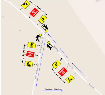
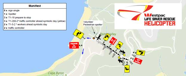
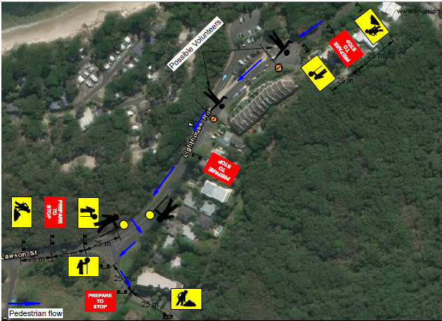


2021 Traffic Management Plan Summary

The conditions of consent incudes a number of KPI’s set by TfNSW that must be met in regards to traffic management.


Typically the proposed TMP and TCP is the same as past events and designed to ensure the KPI’s are met. The key change is the introduction of pay parking.


After the 2019 event a Traffic Evaluation Report by Greg Alderson & Associates was submitted to Council recommending the introduction of pay parking. The event organisers intend to implement pay parking for the 2021 event. This will be internal to their site and on private property. As such, the pay parking system itself is not required to be assessed by LTC.


Within the submitted 2021 TMP,  it is explained that patrons will be encouraged to pre-purchase their parking tickets to speed up traffic management at the entrance. Those who do not pre-purchase will be required to pay at the entrance via credit card tap-n-go or cash.


Given the introduction of pay parking may impact traffic management and queuing at the site entrance, the TMP and TCP have been updated. Key TMP features include the use of traffic controllers to monitor the queue length and a Supervising Traffic engineer.


‘Event Only’ Park and Ride Offerings

The Bluesfest 2021 Traffic Management Plan does not propose any ‘Event Only’ park and ride facilities, thereby no assessment of off-site parking implications are considered.  The event shall cater for conventional bus and taxi rank services as per last year.


DA 10.2014.753.4 CONDITIONS

57A.           Detailed Traffic Monitoring for the 2020 Easter Bluesfest Event


A detailed traffic monitoring report to be undertaken of traffic associated with the 2020 Easter Bluesfest Event on the affected road network including the Pacific Motorway, Gulgan Road, Yarun, Tanners and Grays Lane for the duration of the event starting on Thursday Morning at 8am and ending on Tuesday 5pm. Any increase in traffic movements on the surrounding road network must be identified and mitigating/ management measures identified for implementation in future events and incorporation into the relevant traffic management plans. SIDRA modelling based on recent peak hour intersection traffic counts, two-way distributions, and calibrated to observed site conditions must be included in the report together with bus patronage and pick up / drop off data.


Additional queuing of traffic on the Pacific Highway associated with the event cannot be supported. The report to be provided to the Roads and Maritime Service and a copy furnished to Council.  


61. Transport Management Plan

The submission of a Transport Management Plan (TMP) prepared in accordance with the “Guide to Traffic and Transport Management for Special Events”, to Council for approval at least 90 days prior to the commencement of the first event under Stage 1. The Transport Management Plan to be broken into three parts to delineate management measures for small, medium and large events. The plan to be robust to enable it to be used for a variety of small, medium and large events annually.


a)      The Transport Management Plan must include, but not be limited to:

i    Details for the efficient management of parking, including provision for overflows from the southern parking area to the northern parking area. The management of overflow parking must ensure that the overflow vehicles exit the site from where they entered the site.

ii.  A contingency plan for unplanned incidents that may disrupt traffic and transport before, during or after the event. The contingency plan must be fully documented and include emergency contact names and phone numbers.

A copy of an approved Traffic Control Plan.


b)      The Traffic Control Plan (TCP) must address the following matters:

i. The TCP must be designed in accordance with the requirements of the Roads and Maritime Services’ Manual, Traffic Control at Work Sites Version 2, and the current Australian Standards, Manual of Uniform Traffic Control Devices Part 3, ‘Traffic Control Devices for Works on Roads’.

ii. The TCP must be prepared by a suitably qualified and Transport for NSW accredited Work Site Traffic Controller.

iii. The regulation of traffic must be authorised under the Roads Act 1993 and the use of traffic control devices authorised under the Road Transport (Safety & Traffic Management) Act 1999.

iv. Reduced speed zones must be approved by the Roads and Maritime Services. 

v. There is to be no impact on through travel times on the pacific Highway

vi. The TCP must incorporate a monitoring program to assess the traffic volumes and peak parking numbers associated with each event. Twenty four hour traffic counts are to be undertaken before, during and after the first two medium and large events (and as further required by Council or the Roads and Maritime Service) for the traffic on the frontage and surrounding roadways. Such report must include details demonstrating compliance with the conditions of consent relating to traffic management including the requirements of the TRANSPORT FOR NSW provided below. From time to time aerial photography of the site and surrounds at regular intervals before during and after the event, including peak traffic and parking periods should be undertaken to support the traffic monitoring report.

vii. The TCP must provide for all relevant conditions of the Roads and Maritime Services.

viii. The TCP must be submitted to the Local Traffic Committee prior to approval under the Roads Act 1993 and adequate time must be allowed for this to occur and for the preparation of any necessary reports and amendments necessary to meet the Local Traffic Committee recommendations.

ix. The TCP must satisfactorily address any concerns or issues raised by the Council, Police and/or Roads and Maritime Services from previous events.

x. The TCP must ensure access to surrounding and neighbouring properties at all times including the wrecker and service station. 

xi. The TCP must provide appropriate signage to prohibit parking in the surrounding road network and to prohibit access to the airport by festival patrons. Adequate provision must be made to allow residents of Grays Lane to park in Tanner Lane near the end of Grays Lane when through access is closed due to flood. Permanent  “No Parking” signs in Grays Lane from the Pacific Highway to the Tyagarah Nature Reserve boundary will be considered as a permanent management arrangement.

xii. Entrance to Grays Lane East of Yarun Road to be restricted to residents and their guests for the duration of the festival to prevent the parking of vehicles in Grays Lane.

xiii. The TCP to factor in that local roads operate a Level of Service D or better between the hours of 8am and 8pm on event days. The ramps of the Gulgan Road Interchange with the Pacific Highway to operate at Level of Service C or better at event times  (See Figure 3.1 Levels of Service Flow rates Austroads Guide to Traffic Management Part 3 and Highway Capacity Manual)

xiv. The TCP to include provision so that Traffic queuing on the Gulgan road off ramps does not exceed stopping sight distances for 110 km/h speeds. (See Transport for NSW supplements and Austroads Guide to road Design Part 3 Section 5.3.1 for stopping sight distances)


c) The Transport Management Plan and Traffic Control Plans to be reviewed on an annual basis and where required such plans to be updated accordingly taking into consideration changing traffic conditions, altered management arrangements and other issues as identified by the Roads and Maritime Service, Council or the Regulatory Working Group to ensure the safety and efficiency of the road network.

Note: Access/ Egress from, and to, the Pacific Highway to Grays Lane to be closed in the future by Transport for NSW. The Transport Management Plan and Traffic Control Plan to reflect proposed changes to this intersection. 


Committee Comments

Cameron: Unable to assess without TMP. Conditions included requirement for contingency in case of queuing , which is not included here. Also details missing on monitoring and response to contingency. Additional comments to be emailed.

Kehoe: The parking and queuing for 2019 event was a significant improvement from the 2018 event. Participant numbers will be well down due to COVID safety measures this year (if approval given).

Kehoe:  Police meet regularly with all the stakeholders involved, and have the TMP well managed now. Also now have the benefit of CCTV to monitor traffic.


Cr Cameron’s emailed comments:

Unable to asses the appropriateness or safety of proposed event management due to the following.

No TMP presented. Difficult to assess TCP without overarching TMP.

Insufficient detail on TCP. For example a number of roads not identified in plans.

No detail on requirement for ‘contingency’ in case of queuing on M1. (Condition 61, a, ii).

No details of monitoring plans or data from any previous monitoring included in TCP (61, b, iv).

How will ‘submissions’ be  received, recorded and responded to?


Management Comments

No management comments.


Committee Recommendation:

1. That Council endorse the regulatory traffic management facilities and devices, including signs and traffic controller provisions proposed for the Council controlled public road network as outlined in document E2021/4373 for the Byron Bay Bluesfest 2021 to be held on Thursday April 1 to Monday 5 April 2021, or alternatively, Thursday 29th September to Monday 4th October (if COVID 19 restrictions prevent the April event going ahead), subject to the following conditions:

2. Separate approvals by NSW Police and Transport for NSW being obtained, noting that the event is on a state road or may impact the state road network;


3. The development and implementation of a Traffic Management Plan and Traffic Control Plan(s) by those with relevant TfNSW accreditation. These plans are to be submitted to Byron Shire Council at least 2 months prior to the event for approval of traffic regulation on roads under Byron Shire control;


4. The TMP is to include contingency measures in case the level of queuing fails to meet KPI requirements. It is noted that such queuing may be caused by the introduction of paid parking.


5. The Traffic Management Plan and the Traffic Control Plan(s) to be implemented by those with relevant and current TfNSW accreditation;


6. Traffic camera data recorders or similar be used to obtain an accurate record of traffic  impacts at KPI queue locations;


7.  That the impact of the event be advertised via a notice in the local weekly paper         a minimum of one week prior to the operational impacts taking effect, noting it     must include the event name, specifics of any traffic impacts or road closures and times, alternative route arrangements, event organiser, a personal contact name and a telephone number for all event related enquiries or complaints;


8.  The event organiser:


i)      advertise the impact of the event via a notice in the local weekly paper a minimum of one week prior to the operational impacts taking effect, noting it must include the event name, specifics of any traffic impacts or road closures and times, alternative route arrangements, event organiser, a personal contact name and a telephone number for all event related enquiries or complaints;


          ii)      provide a copy of the advert for Council's web page;


iii)     give consideration of any submissions received;


iv)     inform community and businesses that are directly impacted (e.g. adjacent to the event) via written information which is delivered to the property in a timely manner so as to document, consider and respond to any concerns raised;


v)      arrange for private property access and egress affected by the event;


vi)     liaise with bus and taxi operators and ensuring arrangements are made for provision of services during conduct of the event;


vii)    consult  with emergency services and any identified issues be addressed;


viii)   holding $20m public liability insurance cover which is valid for the event.


ix)     paying of Council’s Road Event Application Fee prior to the event.


9   The event organiser is to:


i)      undertake consultation with community and affected businesses including adequate response/action to any raised concerns;


ii)      undertake consultation with emergency services and any identified issues addressed;


iii)     hold $20m public liability insurance cover which is valid for the event;


iv)     pay Council’s Road Event Application Fee prior to the event.


(Shanahan/Kehoe)

The recommendation was put to the vote and declared carried unanimously.


Report No. 6.3           Event - Byron Triathlon - 8 May 2021

File No:                       I2021/170


Summary

Council has received an event application for the 2021 Byron Bay Triathlon to be held on Saturday 8th May 2021.  The course used by the swim, run and cycling legs are the same as previous years. The event organisers are seeking support for the proposed road closures.

1,375 participants are expected as part of the event.

It is noted the following the 2019 event concerns were raised with extent and duration of road closures created by this event.  Byron Bay continues to grow as a town, which is resulting in more traffic on the roads, therefore the impacts of this event will be greater each year.  Discussions were held at this time; however, a solution for the traffic impacts was not forthcoming.

The Byron Bay Bypass is proposed to open in February 2021.  The potential impact of the new bypass on the proposed road closures and circuits is unknown.  Therefore, it is recommended that the proposed event be approved.  However, should further complaint be received post the 2021 event, the event organisers will be advised they need to investigate an alternate route or less road closures for future events.


2021 Event Course

The run leg of the triathlon will require traffic control within Lawson Street.  Refer to Figure 1 for the Run leg.

The cycle leg will require significant traffic control.  Refer to Figure 2 for a map of the cycle leg.

The Middleton Street car park will be closed and used as a Transition zone, as per previous years.


Figure 1 – Run leg

Figure 2 – Cycle leg


Proposed Road Closures

The proposed road closures and the time of the closures are shown in the table below.  These details are taken from the following weblink listed in the submitted Community & Transit Management Plan: https://www.google.com/maps/d/viewer?mid=1rd14gIsxDXUiP8pBzyrSYqJThzPk3Kzy&z=16.

It is noted in the table provided in the application, the proponents proposed that Bay Street is to be closed between the surf club and Fletcher St.  This would prevent the use of Main Beach Car Park and Lawson St North car parks as there would be no exit route. It is considered the closure of Bay Street between the surf club and Fletcher St is a typographic error and should be that Bay St is closed between Fletcher St and Middleton Street, with access to the Main Beach Car Park not closed.  The table below, from the application, has been modified to reflect that change which has also been included in the recommendations.

ROAD

CLOSED BETWEEN

START TIME

END TIME

Bay St

Fletcher St – Middleton St (both ways)

8 May 2021, 05.00

8 May 2021, 17.00

Middleton St

Bay St – Marvell St (both ways)

8 May 2021,05.00

8 May 2021, 15.00

Lawson St

Fletcher St – Massinger St (both ways)

8 May 2021,05.00

8 May 2021, 17.00

Marvell St

Middleton St – Tennyson St (both ways)

8 May 2021, 10.30

8 May 2021, 15.00

Tennyson St

Marvell St – Browning St (both ways)

8 May 2021, 10.30

8 May 2021, 15.00

Bangalow Rd

Browning St – Old Bangalow Rd (both ways)

8 May 2021, 11.30

8 May 2021, 15.00

Broken Head Rd

Old Bangalow Rd – Beech St, north roundabout (both ways)

8 May 2021, 11.30

8 May 2021, 15.00

To summarise the table above, the following roads are proposed to be closed from 5am to 5pm:

·    Bay St                        - from Fletcher St to Middleton St

·    Lawson St                 - Fletcher St to Massinger St

The following requirements have been included in the recommendation:

·    Access from main beach car park to Fletcher St to be unrestricted at all times

·    Access to Lawson St between Fletcher St and Middleton St to be permitted at all times.

The following roads are proposed to be closed from 10.30 – 3.00pm:

·    Middleton St             - from Lawson St to Marvel St

·    Marvel St                   - from Middleton St to Tennyson St

·    Tennyson St             - from Marvell St to Browning

The following roads are proposed to be closed from 11.30 – 3.00pm:

·    Bangalow Rd           - from Browning St to Broken Head Rd

·    Broken Head Rd      - from Bangalow Rd to 166 Broken Head Rd

Traffic Control

It is proposed to manage traffic during the above road closures through the implementation of Traffic Control Plans and the support of police from the Tweed-Byron District.

The police at the previous meetings indicated their support for the proposed closures as they were based on the 2019 plan and had been agreed upon in consultation with the event organisers.


Committee Comments

Shanahan: No issues from Transport.

Discussion about impacts on the town. A hotline number needed so that Police are not bombarded with calls. Need to add to the recommendation the requirement for a Variable Message Sign  (VMS) board to alert residents and businesses to the road closures.

The event organisers should propose an alternative route after 2021.

Management Comments

No Management comments.


Committee Recommendation:

That:

1. That Council endorse the Byron Bay Triathlon to be held on Saturday 8th May 2021, which includes the following temporary road closures below:

CLOSED STREETS

BETWEEN

TIMES

Bay St

Fletcher St to Middleton St (both directions)

5am-5pm

Middleton St

Bay St to Marvel St

(both directions)

5am-3pm

Lawson St

Middleton St to Massinger St (both directions)

5am-5pm

Marvell St

Middleton St to Tennyson St (both directions)

10.30am-3pm

Tennyson St

Marvell St to Browning St (both directions)

10.30-3pm

Bangalow Rd

Browning St to Old Bangalow Rd (both directions)

11.30am-3pm

Broken Head Rd

Old Bangalow Rd to BP Service Station Beech Drive (both directions)

11.30am-3pm

2. That the approval provided in Part 1 and Part 2 is subject to:

a)   separate approvals by NSW Police and Transport for NSW being obtained;

b)  the event organiser provide council with an updated Traffic Management Plan  and Traffic Control Plan for the 2021 event, if required by the Police and Transport for NSW;

c)   development and implementation of a Traffic Management Plan and Traffic Control Plan(s) by those with appropriate TfNSW accreditation and the holding of current and appropriate levels of insurance and liability cover;

d)  the impact of the event be advertised, and charged at cost to the organisers, via a notice in the local weekly paper and VMS boards a minimum of one week prior to the operational impacts taking effect, noting it must include the event name, specifics of any traffic impacts or road closures and times, alternative route arrangements, event organiser, a personal contact name and a telephone number for all event related enquiries or complaints;

e)   the event be notified on Council’s web page with the event organiser supplying Council with the relevant information;

f)    Access from main beach car park to Fletcher St is to be unrestricted at all times.

g)  Access to Lawson St between Fletcher St and Middleton St to be permitted at all times.

3. That the event organisers:

a)   inform the community and businesses that are directly impacted (eg within road closure zones) via written information which is delivered to the property in a timely manner so as to document, consider and respond to any concerns raised;

b)  arranging for private property access and egress affected by the event;

c)   liaising with bus, taxi and waste operators and ensuring arrangements are made for provision of services during conduct of the event;

d)  consulting with emergency services and any identified issues be addressed;

e)   holding $20m public liability insurance cover which is valid for the event;

·    paying Council’s Road Event Application Fee prior to the event.


(Cameron/Shanahan)

The recommendation was put to the vote and declared carried unanimously.


Report No. 6.4           Event - Byron Coast Charity Walk - 22 May 2021

File No:                       I2021/172


The 2021 Byron Coast Charity Walk will be held on Saturday 22 May 2021 from 5.00am – 5.00pm and is the 10th year for the Charity Walk (the 2020 event was cancelled due to COVID-19).  Organisers anticipate 1,600 to 1,800 participants (capped at 2,000 attendees).

The majority of the Charity Walk will be along beaches and footpaths.  There are 2 locations within Council’s delegated authority where walkers will be required to walk along the road within with associated traffic control: Lighthouse Road and Seven Mile Beach Road.

This year the walking route will start in Dening Park, Byron Bay and typically following the coastline south to Ballina SLSC, a total distance of 36km.

The images below show the key sections of the walk and areas where traffic control is proposed are circled in blue. In figure 1 traffic control is proposed on Lighthouse Rd as the walk heads towards Tallows Beach.  In figure 2 traffic control is proposed at the entrance to Seven Mile Beach Road.

Figure 1 – Lighthouse Road

Figure 2 – Seven Mile Beach Road

Figure 3 – Proposed TCP for the Seven Mile Beach Rd entrance (refer Figure 2). The Traffic Control is to be in place from 6.30am to 2.30pm.

Figure 4 – Traffic control proposed for eastern section Lighthouse Road. Coming down from Lighthouse (refer to Figure 2).  Traffic control to be in place from 6am to 12.30pm.

Figure 5 – Traffic control proposed for the wester section of Lighthouse Road entering Tallows Beach Road (refer to Figure 2). Traffic control to be in place between 6am to 12.30pm.


Committee Comments

No issues from Transport for NSW. No issues from Police.

Management Comments

No management comments.


Committee Recommendation:

1. That Council support the Westpac Life Saver Rescue Helicopter fundraiser, Byron Coast Charity Walk, to be held Saturday 22 May 2021 from 5.00am – 5.00pm.

2. That Council support in Part 1 is subject to:

a. The development of a Traffic Management Plan and Traffic Control Plan(s) for the 2021 event by those with relevant and current Transport for NSW accreditation. The Traffic Control Plan(s) and Traffic Management Plan is to include, but is not limited to, the following:

b. Signage, which specifies the date, hours and nature of the event, be positioned at the entrance and exit of Seven Mile Beach Road one week prior to the event;

c. On the day of the event, at 500m intervals on Seven Mile Beach Road, and facing both directions of travel, signs advising of “ Special Event – Charity Walk Ahead” (or similar) are installed prior, and removed after, the event occurs;

d. A safety induction for participants advising of hazards be provided.

e. Implementation of the Traffic Management Plan and Traffic Control Plans as designed by those with appropriate accreditation and implemented by people with appropriate accreditation, including traffic controllers.

f. That the impact of the event be advertised via a notice in the local weekly paper a minimum of one week prior to the operational impacts taking effect, noting it must include the event name, specifics of any traffic impacts or road closures and times, alternative route arrangements, event organiser, a personal contact name and a telephone number for all event related enquiries or complaints.

g. The event is notified on Council’s webpage.

h. The event organiser:

i)       Undertake consultation with affected community and businesses including adequate response/action to any raised concerns.

ii)      Undertake consultation with emergency services and any identified issues addressed.

iii)     Holding $20m public liability insurance cover which is valid for the event.

iv)     Paying Council’s Road Event Application Fee prior to the event.

(Kehoe/Shanahan)

The recommendation was put to the vote and declared carried unanimously.


Report No. 6.5           Event - Anzac Day 2021 - Road Closures in Byron Bay, Mullumbimby, Brunswick Heads and Bangalow

File No:                       I2021/174


BACKGROUND

Each year the RSL sub-branches of Byron Bay, Mullumbimby, Bangalow and Brunswick Heads arrange their respective annual ANZAC Day street parade. 

At this stage it is expected that little to no change to previous years will occur (activities will be subject to relevant COVID Safe measures and any current Public Health Orders).  The route of each parade is shown below, noting that:-

Byron Bay :

As per previous years, the Dawn Service requires closure of the Tennyson Street and Marvell Street intersection between 4.30am and 5.30am and then again (approximately at 11am) when the parade reaches the gates to conduct the main service.

Council implements such measures including signed detours at the intersections of Marvell and Middleton Street and at both the Kingsley Street and Carlyle Street intersections on Tennyson Street.

The parade, is held under Police escort after it gathers at 10:15am off-road (Beach Hotel) at Bay and Jonson Street, then at 10.30am proceeds south down Jonson Street, left into Marvell Street to its end at the Memorial Gates on Tennyson Street.

Mullumbimby:

The parade will again be held under Police escort commencing this year at 10.50am from Apex Park via Burringbar Street to concluding at the cenotaph on Dalley Street and that Council is to close Dalley Street to traffic between Burringbar Street and Tincogan Street between 8am and 12noon with signed detours in place.

Brunswick Heads :

Police involvement with both an escort and closing of the road on Fawcett Street between 4.30am and 6.30am.  No Council involvement requested.

Bangalow :

The sub branch have confirmed the parade forms by 10.45am in front of the Bangalow Hotel in Byron Street, and sets out by 11am east to the intersection at Station Street, then turns left (north) to the front of the RSL Memorial Hall on Station Street for wreath laying and ceremony through to 11.45am.  Council therefore are to implement the following:

o by 10.40am through to end of event, close:

§ Station Street north of Byron Street,

§ Byron Street west of Station Street, and

§ provide signed detours south along Station Street to and via Deacon Street.

o by 10.45am, close:

§ Byron Street at the east bound leg of the Granuaille Road and Lismore Road roundabout.

o Once parade has departed Byron Street remove the two Byron Street closures.

In general it should be noted previous year’s events have not resulted in any reported safety concern, and the road closures are typically less than one hour duration and signed detours are implemented.

Therefore given the above, and that the local events are part of a well known and anticipated nation wide annual tradition, the usual conditions imposed on road events (for example event organisers to notify local residents and emergency providers, etc) is not typically applied, hence their omissions from the recommendation now tabled.


Committee Comments

Council should consider three year approval to save administrative time if there are no changes from year to year.

Management Comments

No Management comments.


Committee Recommendation:

1. That Council:

a) endorse the ANZAC Day Parades for 25 April 2021, 2022 and 2023 for the Return Services League sub branches of Byron Bay, Mullumbimby, Bangalow and Brunswick Heads / Billinudgel, subject to no changes to the traffic control plans;

b) assists, where requested and required, with implementing the necessary temporary road closures and detours;

c) place advertisements in a local weekly newspaper a minimum of one week prior to the operational impacts taking effect, noting it must include the event name, specifics of any traffic impacts or road closures and times, alternative route arrangements, event organiser, a personal contact name and a telephone number for all event related enquiries or complaints;

d) Notify the event on Council’s webpage.

2. That the event organiser:

a) obtain separate approvals by NSW Police and TfNSW, noting that the Bangalow event is on a state road or may impact the state road network;

b) undertake consultation with community and affected businesses including adequate response/action to any raised concerns;

c) undertake consultation with emergency services and any identified issues addressed;

d) holding $20m public liability insurance cover which is valid for the event.

3. That the approvals provided above are subject to NSW Police approval being obtained and that each event is undertaken either or both under Police escort or traffic control and/or Council’s implemented traffic control.

(Kehoe/Cameron)

The recommendation was put to the vote and declared carried unanimously.


Matters for Traffic Engineering Advice

Report No. 7.1           Additional LTC meeting dates 2021

File No:                       I2021/82


Summary:

This report is for information only.

The Local Traffic Committee (LTC) Constitution (E2019/6833) provides that the frequency of LTC meetings is at the discretion of Council.

The purpose of this report is to flag the potential need to arrange several extraordinary meetings throughout the year. Given 2021 is a LG election year Council will be in care taker mode in August and September.  This may impact the efficiency of the approval process and may require extraordinary LTC meetings in the lead up to caretaker mode.

Report

Historically a number of extraordinary meetings have been required to be convened each year in order to meet demand and deadlines for consideration of time sensitive matters. Over the last 3 years the meeting frequency has increased as follows:

·    2018 – 12 meetings

·    2019 – 10 meetings

·    2020 – 10 meetings

Council adopted the following LTC dates for 2021 (Resolution 20-675). This amounts to 6 meetings:

·    16-Feb-21

·    13-Apr-21

·    15-Jun-21

·    17-Aug-21

·    05-Oct-21

·    30-Nov-21

In planning ahead it is anticipate that extraordinary LTC meetings maybe be requested for the following dates:

·    27-Jan  - extraordinary meeting already held

·    16-Mar – requested to address a number of upcoming events

·    11-May

·    29 June

·    26-Oct

This will enable effective planning and preparation of meetings; ensuring committee members have sufficient notice of upcoming meetings.

To this end Staff request an extraordinary meeting to be held in person (with the option to dial in electronically) for 16th March 2021.


Committee Comments

Committee members OK with the extra dates being scheduled as extraordinary meetings.

Management Comments

No Management comments.


Other Business

Cr Cameron raised question re: Talking Street:  When can cars go over pedestrian crossing?

Ian Shanahan clarified the road rules. Onus is on the driver to not impact with a pedestrian at a crossing. Important difference is with a school children’s crossing; driver has to wait and give way from the moment the pedestrian enters the crossing until the pedestrian has left the crossing.

Vehicles can’t stop on a crossing. The onus is on the driver to make sure they can go over the crossing and stop without vehicle standing on the crossing.

Another issue where drivers are turning at an intersection and not giving way to pedestrians on side road. Drivers must give way to pedestrians crossing the road into which their vehicle is turning.  You must give way to pedestrians if there is a danger of colliding with them, even if there is no marked pedestrian crossing.

Matt Kehoe emailed the following:

Drivers obviously have an obligation to give way to any pedestrian on or entering / exiting one (pedestrian crossing). Also be aware of surrounding area to prepare for unexpected crossings such as children running across, etc. and show actions to prepare for urgent evasive action such as slowing on approach.


There being no further business the meeting concluded at 12:15pm.