Minutes of Meeting

bsc_logo_150dpi_rgb

Local Traffic Committee Meeting


Venue

Conference Room, Station Street, Mullumbimby

Date

Tuesday, 15 June 2021

Time

10.30am

Committee Members

Ian Shanahan – Transport for NSW

Detective Chief Inspector Matt Kehoe  – Police

Cr Basil Cameron

Tamara Smith MP


I2021/974

                                                                                                                             Distributed 08/06/21


BYRON SHIRE COUNCIL

Local Traffic Committee Meeting Minutes                                              15 June 2021


Report of the Local Traffic Committee Meeting held on Tuesday, 15 June 2021

File No: I2021/974


Meeting Commenced: 10.40AM


PRESENT:

Councillor:  Cr Basil Cameron

Transport for NSW: Ian Shanahan

Police: Detective Chief Inspector Matt Kehoe

Staff:  James Flockton, Andrew Pearce and Shelley Flower


Apologies:

Tamara Smith MP, Siobhan Foley, Evan Elford


Declarations of Interest or

One of the Reports relates to a location which is near to Cr Basil Cameron’s place of residence.


Adoption of Minutes from Previous Meetings


Committee Recommendation:

That the minutes of the Local Traffic Committee Meeting held on 13 April 2021 and Extraordinary Local Traffic Committee Meeting held on 11 May 2021 be confirmed.

(Cameron/Shanahan)

The recommendation was put to the vote and declared carried.  Not unanimous due to Tamara Smith MP representative’s absence.


Matters Arising

None.


Outstanding Issues/Resolutions

None.


Regulatory Matters

Report No. 6.1           No Stopping - Old Bangalow Road, Suffolk Park

File No:                       I2021/768


Council’s enforcement team have made the following signage requests to help reduce traffic and parking conflicts along a problem stretch of Cemetery Road, Suffolk Park.:

Replace the “No Parking” signs along the inside curve of the Cemetery Road with “No Stopping” signs in the location shown in the image below.  The location of the inside curve is shown by the blue line in the image below and the location of the existing No Parking signs is shown in Figure 1 by the red lines.

Also, install one new No Stopping sign on the inside curve with a 2 way arrow for 10 metres from Lilli Pilli Drive – see the red dot in the image below for the location.

Figure 1    Cemetery Road, Suffolk Park


Committee Comments

None

Management Comments

None


Committee Recommendation:

That Council:

1.      Replace No Parking signs with No Stopping signs on the inside of the Cemetery Road, Byron Bay curve, in the general location shown within LTC report I2021/768 (Figure 1).

2.      Install a No Stopping sign on Cemetery Road, approximately 10m south of Lilli Pilli Drive, Byron Bay.


(Shanahan/Cameron)

The recommendation was put to the vote and declared carried. Not unanimous due to Tamara Smith MP representative’s absence.


Report No. 6.2           Regulatory Signs - Various Locations

File No:                       I2021/838


This report request support for the installation of regulatory signage in a number of locations:

Cul-de-Sac

Collection Day

Number of Signs

Sign Wording

58 Armstrong St, Suffolk Park

Friday

2

No Parking 5am-12pm

Constellation Place, Byron Bay

Monday

2

No Stopping

Armstrong Place

The manager of Beachside Apartments at 58 Armstrong Street has requested the installation of No Parking (time limited) along their frontage.  The request seems appropriate as they have up to 24 bins requiring collection and cars park where the bins need to be presented. 

No Parking Friday 5am-12pm signs were approved by LTC and installed in Oceanside Place in July 2020. Oceanside Place is the next lane to the north which had similar bin collection problems.

The image below shows where the 2 signs would limit parking.

Constellation Place

Constellation Close is approximately 8m wide with parking currently permitted down both sides.

Council has received ongoing parking congestion complaints for Constellation Close, Electra Close and Comet Close for several months.  The increase in strata development is resulting in parking overflowing onto the streets. There have been several occasions where waste trucks could not access Constellation Close for bin collection.

A greater concern is that emergency vehicle access is not possible, especially during peak holiday / summer periods when units are rented through AirBnB.

To ensure consistent emergency access staff propose No Stopping along the northern side of Constellation Close. Blue dots shown below show the proposed location of the signs.  No Stopping signs have already been installed covering the yellow highlighted areas around the intersection of Constellation Close, Electra Close and Comet Close which was another conflict area.


Committee Comments

None

Management Comments

None


Committee Recommendation:

That Council install the regulatory signs for 58 Armstrong Street, Suffolk Park (Friday - No Parking 5am-12pm) within Firewheel Place and Constellation Place, Byron Bay (No Stopping) in the locations shown in the report (I2021/838)


(Cameron/Shanahan)

The recommendation was put to the vote and declared carried. Not unanimous due to Tamara Smith MP representative’s absence.


Report No. 6.3           Jonson Street Bus Stop - Revision to Signs & Linemarking

File No:                       I2021/865


The Visitor’s Information Centre (VIC) and surrounding area including the frontage to Jonson Street are soon to commence a landscaping upgrade, involving the removal of the old bus stop (now that the Byron Bay Transport Interchange is operating).

This removal means that the ‘Bus Zone’ currently in place is no longer required.  It is proposed to change this to a ‘No Stopping’ zone, including a yellow line painted adjacent to the kerb on Jonson Street.  This would further promote the Byron Bay Town Centre Masterplan vision for ‘cars out, people in’.  It would also maintain the car-free frontage to the Visitor’s Centre, maximising visibility in the town centre.  The below image shows the location of the no stopping zone - paint (yellow) and signs (red).


Committee Comments

Cr Cameron – The Masterplan goal of less cars in the town centre would be facilitated by retaining a bus stop for the local town service.

Management Comments

None


Committee Recommendation:

That Council endorse the modification of the Bus Zone fronting the Visitor’s Information Centre on Jonson Street, Byron Bay to a ‘No Stopping Zone’.

(Cameron/Shanahan)

The recommendation was put to the vote and declared Carried.  Not unanimous due to Tamara Smith MP representative’s absence.


Report No. 6.4           Event - Chincogan Charge 2021

File No:                       I2021/867


SUMMARY

Council has received an event application and Traffic Control Plan (TCP) for the Chincogan Charge 2021 to be held on Saturday 18 September 2021.

BACKGROUND

For the 2021 event the organisers are proposing to follow the same course as 2020 with runners starting and finishing near Mullumbimby Police Station. 

The road course will require actions to control traffic and the implementation of prescribed traffic control devices such as No Parking signs to control vehicles. 500 participants are expected.

While the organisers have not yet submitted a 2021 TMP and TCP the image below shows the expected impact on roads.  This image is taken from the attached 2020 TCP.  The blue line indicates the approximate running path within the road reserve and the following major impacts are planned:

·    Dalley Street, between the Post Office and the Civic Hall is expected to be closed between 12.30-5.30pm

·    Mullwillumbah Road, at Federation Bridge to Main Arm Rd to be controlled by traffic controllers.  The South bound lane will be used for contraflow traffic controlled by Traffic Controllers. Traffic will be allowed to access Main Arm Road in-between competitors. Traffic will be controlled at this point between 12.35-5.30pm

·    Coolamon Scenic Drive from Main Arm Rd to 1913 Coolamon Scenic Drive.  The South bound lane will be used for contraflow traffic controlled by Traffic Controllers. Traffic will be allowed to access Main Arm Road in-between competitors.  Traffic will be controlled at this point between 12.40-5.30pm

·    Once competitors cross the finish line they will move onto the footpath and head to the Mullumbimby Civic Memorial Hall for the presentation.

·    The race itself is expected to finish at 4pm with presentations from 4-5.30pm.


Committee Comments

None

Management Comments

None


Committee Recommendation:

That Council support the Chincogan Charge 2021 to be held on Saturday 18 September 2021, between 8:00am and 5:30pm and for 2022 and 2023 provided there are no changes to the Traffic Management Plan, subject to:-

1.      Traffic control plan(s) and a Traffic Management Plan (TMP) being designed by those with the appropriate and relevant NSW (TfNSW) accreditation.  The TCP(s) and TMP to include the closure of Dalley Street between Burringbar Street and Tincogan Street between 12.30pm-5.30pm;

2.      The TCP to be generally in accordance with document E2020/46680 (Attachment 1);

3.      Implementation of the approved Traffic Management Plan and Traffic Control Plan/s by those with appropriate TfNSW accreditation and the holding of current and appropriate levels of insurance and liability cover;


4.      Separate approvals by NSW Police and TfNSW being obtained;

5.      The impact of the event be advertised via a notice in the local weekly paper a minimum of one week prior to the operational impacts taking effect, noting it must include the event name, specifics of any traffic impacts or road closures and times, alternative route arrangements, event organiser, a personal contact name and a telephone number for all event related enquiries or complaints;

6.      The event be notified on Council’s webpage;

7.      Informing community and businesses that are directly impacted (e.g. adjacent to the event) via written information which is delivered to the property in a timely manner so as to document, consider and respond to any concerns raised;

8.      Undertake consultation with emergency services and any identified issues addressed;

9.      Hold $20m public liability insurance cover which is valid for the event

10.    Pay Council’s Road Event Application Fee and LTC application Fee prior to the event

(Cameron/Kehoe)

The recommendation was put to the vote and declared carried. Not unanimous due to Tamara Smith MP representative’s absence.


Report No. 6.5           Event Road Closures - Byron Lighthouse Run 2021

File No:                       I2021/941


SUMMARY

Council has received an application, Traffic Management Plan (TMP) and Traffic Control Plan (TCP) from NXsports Community Foundation Ltd for the Byron Lighthouse Run 2021to be held Sunday 24 October 2021.


BACKGROUND

The annual Byron Lighthouse Run is proposed to be held on Sunday 24 October 2021.  It is a fun run and walk to raise money for charity.  The event will operate on the same course and design as the 2019 event.

The Byron Lighthouse Run 2021 is expected to attract approximately 750 participants.

The Byron Lighthouse Run features participation in the following categories: 10km Fun Run, 6km Walk, 1km Kids Dash. Note that the 1km Kids Dash will be contained entirely within Dening Park and will not extend onto the road reserve.


COURSE OVERVIEW

As seen in the maps below the 10km run course and 6km walk course extend along Lawson St and Lighthouse Road up to the Lighthouse. This means access in and out of Wategos will require traffic management which must be formalised through the TCP.


TRAFFIC MANAGEMENT

Full details of the submitted Traffic Management Plan are provided in attachment 1 with planned road closures (and hours of closure) shown in the table below.

Outgoing traffic from within the closed Lighthouse precinct will be guided by traffic control to the Lawson Street and Massinger Street intersection.  Escorts will be available throughout the closure; the mobile number to arrange escort in advance is disseminated in all community consultation collateral.  Motorists will be advised to proceed with caution, hazard lights on, and windows down until they reach the Lawson Street roundabout.

In the case of a major community incident such as terrorism, the event will be put on hold until the Race Director and Police determine when the event is safe to continue.  Emergency services will maintain right of way.

CLARKES BEACH CAR PARK

The race proposes to centre on Clarkes Beach Car Park with the car park forming the start and finish point. Event registration and first aid is also based at the car park and additional toilets located there.

The applicant states they will reopen Clarkes Beach at 9am. It is recommended to state in the recommendations that Clarkes Beach is to be open to the public by 9am.


Committee Comments

None

Management Comments

None


Committee Recommendation:

That Council support the 24 October 2021 Byron Lighthouse Run, subject to:-

1.      Traffic control plan(s) and a Traffic Management Plan being designed and implemented by those with the appropriate and relevant TfNSW accreditation.


2.      The road closures and hours of closure in accordance with the submitted Traffic Management Plan in Attachment 1 (E2021/75049).


3.      Clarkes Beach car park open to the public by 9am. Alternatively, if car park is to be closed to the public after 9am an application is to be made to Council to occupy the car park and relevant application fees and parking fees are to be paid to Council prior to the event commencing.


4.      Separate approvals by NSW Police, TfNSW and Cape Byron Headland Trust being obtained.


5.      The event organiser:-

i)       advertising the impact of the event via a notice in the local weekly paper a minimum of one week prior to the operational impacts taking effect, noting it must include the event name, specifics of any traffic impacts or road closures and times, alternative route arrangements, event organiser, a personal contact name and a telephone number for all event related enquiries or complaints;

ii)      providing copy of the advert for Council's web page;

iii)     informing community and businesses that are directly impacted (e.g. adjacent to the event), including the Beach Byron Bay Café and North Coast Holiday Park Clarkes Beach, via written information which is delivered to the property in a timely manner so as to document, consider and respond to any concerns raised;

iv)     arranging for private property access and egress affected by the event;

v)      liaising with bus and taxi operators and ensuring arrangements are made for provision of services during conduct of the event;

vi)     consulting with emergency services with any identified issues being addressed;

vii)    holding $20m public liability insurance cover which is valid for the event; and payment of Council’s Road Event application fee prior to the event.

(Shanahan/Cameron)

The recommendation was put to the vote and declared carried. Not unanimous due to Tamara Smith MP representative’s absence..


Report No. 6.6           Mullumbimby Police Station Parking

File No:                       I2021/942


The Mullumbimby Police station has contacted Council regarding parking management concerns.

To ensure adequate parking for the Mullumbimby police station and courthouse the Mullumbimby Police has requested the following dedicated parking

·    3 police spaces,

·    2 court dedicated parking spaces

·    1 disabled space

The image below was sent through from the police to illustrate their request.  The precise location will be confirmed through site inspection and final discussion with the Mullumbimby police.

Due to the growing parking demand within Mullumbimby Police often find it difficult to ensure adequate parking and access during court related matters.


Committee Comments

None

Management Comments

None


Committee Recommendation:

That Council support the installation of:

1.      Three car spaces dedicated to police in Mullumbimby with signage to permit police vehicles only.

2.      One mobility space on Dalley Street in the vicinity of the Mullumbimby Court House.


(Cameron/Shanahan)

The recommendation was put to the vote and declared carried.  Not unanimous due to Tamara Smith MP representative’s absence.


Matters for Traffic Engineering Advice

Report No. 7.1           Speed Zone Reviews

File No:                       I2021/701


The purpose of this report is to present known speed zone requests for LTC comment.

Below is a table summarising known speed zone reviews raised with TfNSW over the past couple months and which staff are aware of.

13 submitted, 6 approved, 3 not supported, 4 under review

Road

Extents

Current Speed

Requested Speed

Requested by

Status

Federal Rd

Eureka Rd to Binna Burra Rd

100

80

Community

Approved

Binna Burra Rd

Federal Dr to Lismore Rd

80

60

Community

Approved

Tyagarah Rd

Western two thirds

80

60

Community

Approved

Skinners Shoot Rd

Southern end

100

60

Council

Under Review

Grays Lane

Full length

100

60

Council

Approved

Yelgun Rd

Full length

60

50

Council

Approved

McAuleys Lane

Full length

100

50

Community

Not Supported

Broken Head Reserve Road

Eastern end

50

40

Council

Approved

Broken Head Rd

Near Sugarcane Rd

80

50

Community

Not Supported

Bangalow Rd

Full length

80

60

Community

Under Review

Lismore Rd

Rifle Range Rd to Byron St

80

60

Community

Not supported

Burringbar St

Talking Streets

50

30

Council

Under Review

Tincogan St

Stuart St to Dalley St

50

40

Council

Under Review

Alcorn St

All

50

<50

Community email

-

New Brighton Rd

Redgate Rd to Casons Rd

50

Request to extend 40 zone 10m north

Community email


Paterson St

Browning St to Bangalow Rd

50

<50

Community email


Coolamon Scenic Drive

Azalea St to Myocum Rd

100

Request to extend 50 zone to south of the Golf Club

Community email


Below is a copy of the community requests relating to the last 3 speed zone requests in the table above. Note, staff responded and encouraged residents to access the Safer Roads NSW site to submit a speed zone request.


New Brighton Rd Request


“The 40 zone that begins the local traffic area of New Brighton Road starts right out the front of my house. This is the area it is meant to protect.

Cars don't even think about slowing down until well after this sign.

If it is mean to protect my neighbourhood, it needs to start before the urban area.

It needs to give drivers a chance to slow down, and the speed limit enforced.

I have also requested that you put a speed check device in place, which has been having great success in Tweed. Read a quote from Tweed Shire website:   “Before placement of the smiley face radar, a site north of Windsong Way recorded that 58 per cent of vehicles were travelling over the 50 kilometre an hour speed limit. When the sign was present, only seven per cent of drivers were doing the wrong thing."


Extending the 40/zone/local area traffic zone back, so it actually protects me and my family and placing a speed check device (which would be way more cost effective than road works) is what needs to be done to protect residents and children on our street.


The path beside the road offers not protection (no curb) and cars are constantly swerving on it where children are playing”.


Paterson St Request


“As a resident of Byron Bay of 13 years, I’m alarmed about the increased traffic on Paterson Street (towards Bangalow Rd end) – it does say Local Traffic only – but has become the unofficial town bypass. The speeds people are doing down from Paterson street heading towards Bangalow Rd – are nothing but terrifying. On dozens of occasions, I have encountered near misses of cars, pedestrians, people pushing prams, school children and cyclists – because of the speed people are doing. At 107 Paterson Street exiting the street is almost near impossible – as the cars parked on the street (Airbnb’s) we cannot see right, doubled with the speed people are clocking down to Bangalow Rd. Again – on a weekly occasion there are so many near misses of people trying to exit our driveway (there are at least 10 houses in our mini complex) I ask you please in the interest of public safety, children riding their bikes to school, mothers pushing prams along the street to put in something to stop the speed people are doing”.


Coolamon Scenic Drive Request

“Having spoken to other residents, we have been told that this is a notorious corner for accidents or near misses. I have given this some thought and would like to suggest the following for your consideration to hopefully avoid future incidents and possible serious accidents:

1. Signpost the straight section of road, before the corner, to indicate the Gold Club driveway is just around the corner with possible turning vehicles.  The Gold Club has a circular driveway and the exit is right on the corner but the entrance is about 20 metres around the corner, not visible to approaching traffic until they are right on the corner.  This reminder might at least warn motorists to be prepared for the possibility of needing to stop suddenly.

2. Extend the 50km speed zone to past this corner.  This is only a distance of approximately 700m.  The town 50km zone ends not far past the Azalea St corner and Coolamon Scenic Drive is then an 80km zone despite there being numerous side roads and driveways on that short stretch of road.  This is a contrast to Left Bank Road where the 50km zone extends out past Melaleuca Dve, 3.4 kms from Azalea St.

3.  Build a turning lane for the Golf Club allowing traffic flow to go around any cars turning into the Golf Club.  This would also allow for safer exiting from the Golf Club for cars turning to go into town from the club car park”.


Committee Comments

None

Management Comments

Council staff to confirm if this Report can be reported to Council.


Committee Recommendation:

That Council note the information provided to the Committee on the matters listed in the Report.

That the Local Traffic Committee acknowledges the need for Council, the Byron Shire community, TfNSW and the Police to work together to provide safe road networks for all road users.

(Kehoe/Shanahan)

The recommendation was put to the vote and declared carried. Not unanimous due to Tamara Smith MP representative’s absence and Cr Cameron voted against..


Report No. 7.2           Events - Bangalow Billycart Derby 2021

File No:                       I2021/868


SUMMARY

Council received an event application from the Bangalow Lions Club for the annual Bangalow Billy Cart Derby to be held on Sunday 12 September 2021. 


BACKGROUND

The following comments are a cut and paste from the March 2020 LTC meeting which supported the event.


The format will be the same as previous years, with traffic diverted via Deacon Street. The Figure below summarises the area of road closure and proposed detour around the road closure adopted for all past events.


While the TCP has not been finalised yet the following items were noted from past years:


1.   The proposed TCP places signage on Lismore to Bangalow Road (B62) and TfNSW controlled Granuaille Road.


2.   The western end of Deacon Street is a laneway not suitable to Heavy Vehicles as a detour to the Pacific Highway. However, the volume of HV on Sunday’s is very limited and not been a concern for previous years.


3.   It will be a requirement for the TCP to be developed and implemented by those with appropriate TfNSW accreditation.

4.  


Committee Comments

None

Management Comments

None


Committee Recommendation:

1. That Council endorse the Bangalow Billy Cart Derby to be held on Sunday 12 September 2021 and for 2022 and 2023 provided there are no changes to the Traffic Management Plan, subject  that includes the temporary road closure below:-


a.      Byron Street, Bangalow between Ashton Street and Granuaille Road, between 6am and 4pm on Sunday 12 September 2021.


2.      That the approval provided in Part 1 is subject to:-


a.      Separate approvals by NSW Police and TfNSW being obtained, noting that the event is on a state road or may impact the state road network;


b.      Traffic Control Plan(s) to be developed and implemented by people with the appropriate TfNSW accreditation;


c.      That the impact of the event be advertised via a notice in the local weekly paper a minimum of one week prior to the operational impacts taking effect, noting it must include the event name, specifics of any traffic impacts or road closures and times, alternative route arrangements, event organiser, a personal contact name and a telephone number for all event related enquiries or complaints; and


d.      The event notified on Council’s webpage.


3.      That the event organiser:-


a.      Undertake consultation with community and affected businesses including adequate response/action to any raised concerns;


b.      Undertake consultation with emergency services and any identified issues addressed;


c.      Holding $20m public liability insurance cover which is valid for the event; and


(Cameron/Kehoe)

The recommendation was put to the vote and declared carried. Not unanimous due to Tamara Smith MP representative’s absence.


Report No. 7.3           Pedestrian Access and Safety - Suffolk Park

File No:                       I2021/938


The purpose of this report is to gain feedback from LTC representatives regarding:

·    Installing a zebra crossing at 2 locations in Suffolk Park.

·    Reducing the speed limit for Broken Head Road and Clifford St to 40k/h or less.

At the 27th May 2021 Council meeting, Council resolved the following:

Resolved that Council:

1.      Support the installation of a pedestrian refuge at Broken Head Road as detailed in the proposal at attachment 1 (E2021/60667).

2.      Support the enhancement of existing pedestrian refuges at the roundabout on the intersection of Broken Head Road and Beech Drive.

3.      Consider the inclusion of supporting refuge and enhancements in the 10 year capital works program.

4.      Refer the speed review and pedestrian crossing matters to the Local Traffic Committee as per part 5 of Res 20-432.

5.      Consider including the funding for the works and a Place Planning process for Suffolk in the 2021/22 Operational Plan and Budget and this be included in the submissions report following the public exhibition.

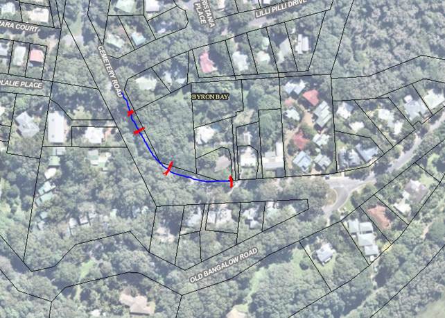
The area where the above resolution is intended to apply is shown in the image below:

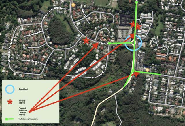
Pedestrian Crossings

Staff request LTC comments in relation to the type of crossing considered appropriate for the area shown in the image above.

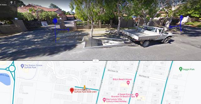
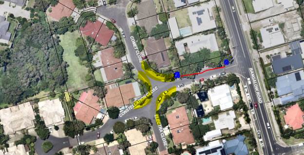
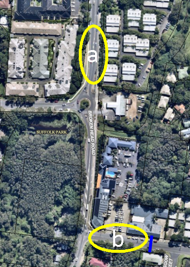
As way of background, Staff recently completed a pedestrian count and traffic count in Suffolk Park in 2 locations (“location a” and “location b”) shown in the image below.  The results of these counts can be seen in Attachment 2, along with an assessment on whether these locations meet TfNSW warrants for a Zebra crossing.

At “location a” there are 2 bus stops, one located on the east side and another on the west side in front of an aged care facility.

At “location b” there is a bus stop, Taxi rank and sewer pump station on Clifford Street opposite the Clifford Street shops.

Staff identified opportunities to upgrade pedestrian crossings (see attachment 1) through installing a refuge in “location a” and upgrading the crossings at the existing roundabout at the Beech Street / Broken Head Road intersection.  These crossing would improve the link between the Aged Care facility and the existing bus stops and the Clifford Street shops.

“Location b” is considered highly constrained with a Bus Stop, Taxi Rank, sewer pump station and a driveway located directly opposite the Shops and wide car park driveways, power poles and marked parking along the northern side of Clifford Street.

A Pedestrian refuge may be considered in this location at the expense of on street parking adjacent to the shops, away from the bus stop in the location shown by the blue line.  It is anticipated this refuge would not be used as it is perceived to be disconnected from where people cross and shops would object to parking removal.


Zebra Crossing Warrants

Council have compared the traffic and pedestrian count results against the TfNSW warrants for a zebra crossings and found these sites did not meet the warrants for a zebra crossing.  Special consideration Warrants were also not met. Attachment 2 provides an overview of this assessment.

However, staff considers sufficient merit to install pedestrian refuges generally in the vicinity of location a and b, though not zebra crossings.


Alternative Option

A potential alternate option for Clifford Street is relocating the existing bus stop in location b from the south side of Clifford Street to the north side and move it east, away from the intersection.

This would:

·    minimise the number of pedestrians crossing Clifford Street near the intersection,

·    locate the bus stop closer to a childcare centre to improve access.

·    Move the stop more centrally to the residential catchment.

A refuge may be installed in the vicinity of the newly located bus stop, near the childcare centre, encouraging pedestrians to cross away from the intersection.

A left out of Clifford Street slip lane could potentially then be installed to help reduce the traffic que coming out of Clifford Street.  This queuing is a frequent source of community complaints.

This approach would facilitate a holistic solution to improved pedestrian safety and access.


Speed Review

Comments from LTC are requested in relation to a speed review for the “Traffic Calmed Village Area” under consideration in the first image above.

The existing speed limit within the “Traffic Calmed Village Area” is currently 50k/h with community requests being received for the area to be 40k/h or shared zone.


Committee Comments

None

Management Comments

None


Committee Recommendation:

That Council continues to monitor speeds in this area, along with pedestrian and cyclist movements.

(Kehoe/Shanahan)

The recommendation was put to the vote and declared carried.  Not unanimous due to Tamara Smith MP representative’s absence and Cr Cameron voted against..


There being no further business the meeting concluded at 1:12pm.