Agenda
Ordinary
(Planning) Meeting
Thursday,
10 June 2021
held
at Council Chambers, Station Street, Mullumbimby
commencing
at 9:00am
Public Access relating to
items on this Agenda can be made between 9.00am and 9.30am on the day of the
Meeting. Requests for public access should be made to the General Manager
or Mayor no later than 12.00 midday on the day prior to the Meeting.

Mark
Arnold
General
Manager
What is a “Conflict of Interests” - A conflict of
interests can be of two types:
Pecuniary - an interest that a person has in a matter because of a reasonable
likelihood or expectation of appreciable financial gain or loss to the person
or another person with whom the person is associated.
Non-pecuniary – a private or personal interest that a Council
official has that does not amount to a pecuniary interest as defined in the
Code of Conduct for Councillors (eg. A friendship, membership of an
association, society or trade union or involvement or interest in an activity
and may include an interest of a financial nature).
Remoteness – a person does not have a pecuniary interest in a matter
if the interest is so remote or insignificant that it could not reasonably be
regarded as likely to influence any decision the person might make in relation
to a matter or if the interest is of a kind specified in the Code of Conduct
for Councillors.
Who has a Pecuniary Interest? - a person has a pecuniary interest in a
matter if the pecuniary interest is the interest of the person, or another
person with whom the person is associated (see below).
Relatives, Partners - a person is taken to have a pecuniary
interest in a matter if:
·
The
person’s spouse or de facto partner or a relative of the person has a
pecuniary interest in the matter, or
·
The
person, or a nominee, partners or employer of the person, is a member of a
company or other body that has a pecuniary interest in the matter.
N.B. “Relative”, in relation to a person means any of the
following:
(a) the parent,
grandparent, brother, sister, uncle, aunt, nephew, niece, lineal descends or
adopted child of the person or of the person’s spouse;
(b) the spouse
or de facto partners of the person or of a person referred to in paragraph (a)
No Interest in the Matter - however, a person is not taken to have a
pecuniary interest in a matter:
·
If
the person is unaware of the relevant pecuniary interest of the spouse, de
facto partner, relative or company or other body, or
·
Just
because the person is a member of, or is employed by, the Council.
·
Just
because the person is a member of, or a delegate of the Council to, a company
or other body that has a pecuniary interest in the matter provided that the
person has no beneficial interest in any shares of the company or body.
Disclosure and participation in meetings
·
A
Councillor or a member of a Council Committee who has a pecuniary interest in
any matter with which the Council is concerned and who is present at a meeting
of the Council or Committee at which the matter is being considered must
disclose the nature of the interest to the meeting as soon as practicable.
·
The
Councillor or member must not be present at, or in sight of, the meeting of the
Council or Committee:
(a) at
any time during which the matter is being considered or discussed by the
Council or Committee, or
(b) at
any time during which the Council or Committee is voting on any question in
relation to the matter.
No Knowledge - a person does not breach this Clause if the person did
not know and could not reasonably be expected to have known that the matter
under consideration at the meeting was a matter in which he or she had a
pecuniary interest.
Non-pecuniary Interests - Must be disclosed in meetings.
There are a broad range of options available for managing conflicts &
the option chosen will depend on an assessment of the circumstances of the
matter, the nature of the interest and the significance of the issue being
dealt with. Non-pecuniary conflicts of interests must be dealt with in at
least one of the following ways:
·
It
may be appropriate that no action be taken where the potential for conflict is
minimal. However, Councillors should consider providing an explanation of
why they consider a conflict does not exist.
·
Limit
involvement if practical (eg. Participate in discussion but not in decision
making or vice-versa). Care needs to be taken when exercising this
option.
·
Remove
the source of the conflict (eg. Relinquishing or divesting the personal
interest that creates the conflict)
·
Have
no involvement by absenting yourself from and not taking part in any debate or
voting on the issue as of the provisions in the Code of Conduct (particularly
if you have a significant non-pecuniary interest)
RECORDING OF VOTING ON PLANNING MATTERS
Clause 375A of the Local Government Act
1993 – Recording of voting on planning matters
(1) In this section, planning
decision means a decision made in the exercise of a function of a council
under the Environmental Planning and Assessment Act 1979:
(a) including a decision relating to
a development application, an environmental planning instrument, a development
control plan or a development contribution plan under that Act, but
(b) not including the making of an
order under that Act.
(2) The general manager is required
to keep a register containing, for each planning decision made at a meeting of
the council or a council committee, the names of the councillors who supported
the decision and the names of any councillors who opposed (or are taken to have
opposed) the decision.
(3) For the purpose of maintaining
the register, a division is required to be called whenever a motion for a
planning decision is put at a meeting of the council or a council committee.
(4) Each decision recorded in the
register is to be described in the register or identified in a manner that
enables the description to be obtained from another publicly available
document, and is to include the information required by the regulations.
(5) This section extends to a meeting
that is closed to the public.
BUSINESS OF Ordinary (Planning) Meeting
1. Public Access
2. Apologies
3. Requests
for Leave of Absence
4. Declarations
of Interest – Pecuniary and Non-Pecuniary
5. Tabling of Pecuniary
Interest Returns (Cl 4.9
Code of Conduct for Councillors)
6. Adoption
of Minutes from Previous Meetings
6.1 Ordinary
(Planning) Meeting held on 13 May 2021
7. Reservation
of Items for Debate and Order of Business
8. Mayoral Minute
9. Notices of Motion
Nil
10. Petitions
11. Submissions and Grants
12. Delegates' Reports
13. Staff Reports
Sustainable Environment and
Economy
13.1 PLANNING
- Housekeeping planning proposal exhibition outcomes 26.2020.6.1 7
13.2 Water
extractive industries......................................................................................... 21
13.3 PLANNING
- DA 10.2020.142.1 for Removal of existing commercial premises (approved
real estate office) at 6 Strand Avenue, New Brighton and construction of
commercial premises and new recreation facility........................................................................ 26
13.4 PLANNING
- 26.2021.1.1 Planning Proposal to permit Community Title & R5 Large Lot
Residential Development - 53 McAuleys Lane, Myocum..................................... 57
13.5 PLANNING
- 10.2020.242.1 - Rural Land Sharing Community (Multiple Occupancy) consisting
of Twelve (12) Dwelling Sites, Associated Infrastructure, Land Management and
Environmental Enhancement at 84 Blindmouth Road Main Arm...................... 73
13.6 PLANNING
- Deferred 10.2014.417.2 - S4.55 to Modify Staging. Stage 1: Conversion
of Existing Garage to Temporary Sales and Display Office for On-site Marketing
of Approved Residential Flat Building. Stage 2: Demolition of Existing
Building and Construction of Residential Flat Building at 43 Lawson Street,
Byron Bay................................... 90
13.7 Byron
LEP 2014 Rural Subdivision Provisions................................................... 102
13.8 PLANNING
- S4.56 to Modify Condition 1 to reference the amended Site Plan and Condition
3 to require instead Row Houses 1, 2, 4 and Studio 4 to be Affordable Housing
at 23 Lismore Road Bangalow................................................................................ 110
13.9 PLANNING
- Development Application 10.2020.257.1 Multi Dwelling Housing Comprising Seven
(7) Dwellings, including Demolition of Existing Dwelling House at 113A Paterson
Street, Byron Bay....................................................................................................... 120
13.10 PLANNING
- Development Application 10.2020.251.1 Alterations and Additions to the
Commercial development (Book Room) comprising coffee cart and ancillary works (pergola)
at 27-31 Fletcher Street Byron Bay........................................................ 133
13.11 PLANNING
- Development Application 10.2021.178.1 Studio at 1 Beach Avenue South Golden
Beach............................................................................................................ 146
13.12 Place
Planning Collective - Additional Community Members........................... 160
14. Questions With Notice
Questions with Notice: A response to Questions with
Notice will be provided at the meeting if possible, that response will be
included in the meeting minutes. If a response is unable to be provided
the question will be taken on notice, with an answer to be provided to the
person/organisation prior to the next Ordinary Meeting and placed on Councils
website www.byron.nsw.gov.au/Council/Council-meetings/Questions-on-Notice
Councillors are
encouraged to ask questions regarding any item on the business paper to the
appropriate Director prior to the meeting. Any suggested amendments to the
recommendations should be provided to Councillor Support prior to the meeting
to allow the changes to be typed and presented on the overhead projector at the
meeting.
Staff Reports - Sustainable Environment and Economy 13.1
Staff Reports - Sustainable Environment and
Economy
Report No. 13.1 PLANNING
- Housekeeping planning proposal exhibition outcomes 26.2020.6.1
Directorate: Sustainable
Environment and Economy
Report Author: Sam
Tarrant, Planner
File No: I2021/471
Summary:
This report presents the exhibition outcomes of the recent
housekeeping planning proposal (26.2020.6.1).
The planning proposal includes 7 policy amendments and 5
mapping changes. The planning proposal was exhibited from 17 March until 16
April 2021.
245 submissions were received. Majority of submissions were
concerned with item 1 relating to secondary dwellings and dual occupancies in
multiple occupancy and rural community title development.
The report recommends that the planning proposal be sent to
PCO for finalisation with the following changes:
Item 1 - Remove from the planning
proposal
Item 2 - Remove from the planning
proposal
Item 4 - Add
the words ‘and certain environmental’ into 4.2A 1(b).
Item 5
– include the following additional requirements for a roadside stall to
be considered as exempt development:
- Must be set
back at least 5 meters from the adjoining property boundary.
- Must provide
safe access and parking that is set back at least 3 meters from any
carriageway.
- Vehicles
must be able to access and leave the property in a forward direction
NOTE
TO COUNCILLORS:
In accordance with the
provisions of S375A of the Local Government Act 1993, a Division is to be
called whenever a motion for a planning decision is put to the meeting, for the
purpose of recording voting on planning matters. Pursuant to clause 2(a)
under the heading Matters to be Included in Minutes of Council Meetings of
Council's adopted Code of Meeting Practice (as amended) a Division will be
deemed to have been called by the mover and seconder of all motions relating to
this report.
RECOMMENDATION:
That Council:
1. forwards
the planning proposal to amend Byron LEP 2014, as revised in Attachment 1
(E2021/65655) to include the changes recommended in this report to NSW Parliamentary
Counsel’s Office (PCO) requesting that a draft LEP instrument be
prepared;
2. pending
receipt of PCO opinion that the plan can be made, forward the plan to the NSW
Department of Planning, Industry and Environment for notification on the NSW Government
legislation website.
Attachments:
1 26.2020.6.1
Policy and Mapping Housekeeping Planning Proposal amended post exhibition -
Version to Council for adoption, E2021/65655

2 26.2020.6.1
submissions public version for attachment to Council report - Housekeeping
Planning Proposal, E2021/60082
3 26.2020.6.1
TfNSW and DPI submission, E2021/66129

4 26.2020.6.1
BCD Response - Byron Shire LEP Housekeeping Amendments, E2021/66130
5 Form of
Special Disclosure of Pecuniary Interest, E2012/2815

Report
At the 19 November Planning
Meeting, Council resolved 20-603 to proceed to public exhibition with
this housekeeping planning proposal.
The planning proposal contains 7
policy amendments and 5 mapping amendments. The policy amendments are summarised
as follows:
· Item 1
- Include controls for secondary dwellings and dual occupancies on multiple
occupancy and rural community title. The purpose of this change is to ensure
that these developments are considered in the approval process for the entire
multiple occupancy or community title site, rather than on individual lots, to
ensure such sites are suitable for the additional dwellings.
· Item 2
- Remove an unused clause (4.1F).
· Item 3
- Insert a minimum lot size for Attached Dwellings and Dual Occupancies in
certain zones.
· Item 4
- Insert E2 and E3 zones in the application of clause 4.2A and 4.1D.
· Item 5
- Enable small scale roadside stalls as exempt development in RU1 and RU2
zones.
· Item 6
- Permit Artisan Food and Drink Industry with development consent in the RU2
zone.
· Item 7
- Include Environmental and Special purpose zones in the application of minimum
lot size for strata and community title schemes.
The planning proposal was placed
on exhibition from 17 March until 17 April 2021. Notification was sent to
community groups, directly affected landowners and public agencies as required
per the Gateway determination.
During the exhibition period 245
public submissions and 3 agency submissions were received. Majority of
submissions were concerned with item 1.
Key issues raised in the
submissions are summarised and addressed below. A copy of all submissions
received is contained in Attachments 2 – 4.
Item 1: Controlling secondary dwellings and dual occupancies on multiple
occupancy and rural community title developments
Purpose: to ensure that secondary dwellings and dual
occupancy developments are considered in the context of the original
development approval for the entire multiple occupancy or community title (MO
or CT) site.
Objections: 232 Support:
10
Context
MO or CT
communities have had various approval pathways in the past. Currently in Byron
LEP 2014 clause 4.2B controls housing density on these sites and 4.1B restricts
sites to 1 dwelling.
Although secondary dwellings
and dual occupancies are permitted in the RU1 and RU2 zones, the above
mentioned clauses restrict dwelling numbers on MO or CT communities. The aim of
the amendment was to make it clear that the approved number of dwellings was
the maximum that was permissible on these sites. It additionally aimed to
prevent the possibility of one lot constructing additional dwellings at the
expense of another lot within an approved CT development.
Issue(1): The
objections to this amendment mostly consisted of housing affordability
concerns. A number of submissions argued that MO or CT communities are
well situated and could accommodate additional dwellings and that more
resources are needed to tackle short term holiday letting.
Council is currently developing a
SEPP 70 Affordable Housing Contribution Scheme (AHCS) for our Shire in line
with the State guidelines that will be guided by our affordable housing
contributions policy and procedure. Once in place the AHCS will apply to urban
residential area where the majority of future housing will be delivered.
Multiple occupancies and community
title developments have been granted additional dwelling density compared to
freehold rural lots. In this regard the parent parcel had one dwelling
entitlement before being developed for a multiple occupancy or rural community
title development, comprising of between three dwelling and fifteen dwellings.
The exact number of additional dwelling sites would be determined from the
assessment of the development application for the Multiple Occupancy or
Community Title development in terms of a site capability assessment. It is
noted that Clause 4.2B limits the number of dwellings for Multiple Occupancies
to 1 dwelling per 3 hectares up to a maximum of 15 dwellings on the lot.
Subsequent conversion of Multiple Occupancies to Community Title Development
restricts the number of residential lots created based on the number of
dwelling sites approved under the multiple occupancy. A further doubling
of densities within these intentional rural communities is unplanned for under
Byron LEP 2014 in terms of environmental impacts, management of waste water and
sewage onsite, bushfire hazards.
Council has developed the Rural
Land Use Strategy and Residential Strategy to guide future housing within the
shire. Additional housing in rural MOs and CTs is not supported within these
strategies, mainly due to locational and road infrastructure constraints.
Furthermore, Council has no mechanism to ensure that additional dwellings in
these areas will be used for affordable housing in perpetuity.
Issue(2): The
lack of information and the absence of a draft clause to comment on.
The Gateway determination required
the removal of the draft clause due to the uncertainty in the final drafting
and which clause would be amended to achieve the desired outcome.
There were 10 submissions
supporting the amendment who noted that those who bought into communities would
be aware of the restrictions on additional dwellings as this is often a
condition of their consent and written into community management statement.
Conclusion
As
mentioned above the proposal aimed to clarify existing LEP controls rather than
introduce any new restrictions. That is, existing controls already
restrict secondary dwellings and dual occupancies on rural multiple occupancy
and community titles in Clause 4.1B and 4.2B. This is also articulated within
the Byron Development Control Plan 2014 under Chapter D2 Residential
Accommodation and Ancillary Development in Rural Zones. Discussions with DA
Planning Staff indicate that such restrictions are now being included as
conditions of consent in terms of Restrictions on Title, and within the
framework of Rural Land Sharing Management Plans and Community title Management
Statements. As the existing controls already limit the number of dwellings it
is recommended that item 1 be removed from the proposal
Recommendation: remove item 1 from the planning proposal.
Item 2:
Delete clause 4.1F from the Byron LEP 2014
Objections: 1 Support:
0
The planning proposal proposed to
remove clause 4.1F from Byron LEP as it was found that the clause had not been
used and applicants had interpreted this clause to enable subdivision of
tourist cabins from the parent lot containing the dwelling house.
The Department of Primary
Industries has recently indicated that a NSW Agricultural Land Use Planning
Strategy is in development, which will likely cause changes to local rural and
agriculture planning regulations. In addition, the Department of Planning,
Industry & Environment has recently released proposed amendments to support
Agritourism and small-scale agricultural development.
Based on the unknown impacts of
these planning reforms (which ultimately may override cl 4.1F), it is
recommended that clause 4.1F remain in LEP 2014 for now, noting that the
current drafting is problematic in achieving its intended outcome. Clause 4.1F
and the other applicable rural subdivision clauses can be investigated in a
future housekeeping LEP once the final outcomes of the State wide rural
planning reforms are known.
Further information on this issue
can be found in a separate report to this meeting titled Byron LEP 2014 Rural
Subdivision Provisions .
|
Submission
|
Response
|
|
The Clause was not part of the
Byron LEP 2014 when it was first created and was only included in the LEP on
the 22nd of September 2017. This means that Clause 4.1F has only been in the
Byron LEP for three years but Council is now proposing it be removed. It also
seems that Council has forgotten the reason for the Clause being included in
the 2015 Housekeeping amendment in the first place
|
Correct. Clause 4.1F was
introduced in 2017. The clause was introduced to enable special purpose
subdivisions similar to a part in BLEP 1988.
|
|
Because Byron Council simply
adapted the Clause from the Clarence Valley LEP it failed to properly
scrutinize its applicability. The way Clause 4.1F is currently drafted
it has been impossible to be implemented to meet its desired outcome.
A better solution can be found
by simply expanding the words in the Clause from “dwelling houses, dual
occupancies or secondary dwellings." to "residential accommodation,
ecotourist facilities and tourist and visitor accommodation".
|
Noted. Adding additional land
uses to this clause was considered. However due to the uncertainty around the
current rural planning reforms it is proposed to leave this clause as it is
and investigate further once the final outcomes of these are known.
|
|
The problem is that Clause 4.1F
as currently drafted does not allow a rural sub-division if there is an
existing dwelling on the lot. This problem was also encountered by
Shoalhaven Shire Council but they drafted their Clause with an additional
point 6.
Byron Shire needs to amend
Clause 4.1F to include additional points 5 and 6 as in the Shoalhaven LEP.
For young people to invest in
these rural industries they need to be able to secure long term leases or
rural sub-divisions. An amended Clause 4.1F is a necessity for Byron's rural
zones to be used for more than just dwellings and tourism.
CABS recommends that Council DO
NOT remove Clause 4.1F and instead amend the clause to make it fit for
purpose.
|
Noted. The drafting of clause
4.1F and similar rural subdivision clauses in LEP 2014 will be investigated
collectively as part of the future review into the rural subdivision clauses.
This includes:
- Clause 4.2: which enables subdivision of lots for the
purpose of primary production.
- Clause 4.1C: which deals with rural boundary
adjustments.
Further investigation into
Council’s rural subdivision clauses will need to be informed by state
government legislative reforms and case law.
|
Recommendation: remove item 2 from this planning proposal.
Item 3:
Insert a minimum lot size for Attached Dwellings in R2 and R3 zones and Dual
Occupancies (detached) in the R5 zone - Clause 4.1E
One public submission and two
agency submissions received.
|
Submission
|
Response
|
|
CABS supports the proposed
changes but makes the additional comment:
CABS
recommends that Byron Council consider prohibiting attached dwellings,
boarding houses, semi-detached dwellings and seniors housing in the RU5
zone. In particular it seems likely that Boarding Houses and Seniors
Housing would be inappropriate at Federal, Main Arm or Billinudgel.
|
The proposed amendment relates
to R5 Large Lot Residential, not RU5 Village.
Permissible uses in the RU5 zone
can be explored in a future housekeeping planning proposal.
|
|
Department of Primary
Industries: Supports the proposed 4000m2 minimum lot size for R5
land
|
Noted.
|
|
Biodiversity Conservation
Division: Consider reducing minimum lot size for dual occupancy on R5 large
lot residential to 1000-2000m2
|
Noted. The R5 large lot
residential areas are not connected to Council sewer services and require
additional space for these provisions. Majority of these sites are greater
than 4000m2.
Further consideration to a
smaller lot size will be considered as part of the investigation into
re-subdivision of the R5 large lot residential areas, which is an action
within the Rural Land Use Strategy.
|
Recommendation: No change
Item 4: Include Zone E3 Environmental Management in the
application of Clause 4.2A AND include E2 Environmental Conservation and E3
Environmental Management in 4.1D
One public submission and one
agency submission received.
|
Submission
|
Response
|
|
This clause references the
repealed 2008 Rural Lands SEPP and should reference the new Primary
Production and Rural Development SEPP 2019
|
The clause does include a note
relating to lots created under the 2008 Rural Lands SEPP. The reference to
this SEPP is still relevant as lots created under the 2008 SEPP would still
exist and be unable to construct a dwelling.
|
|
Biodiversity Conservation
Division: include words ‘and certain environmental’ into 1(b)
And
In 4.1D consider prohibiting the
construction of a dwelling within the E2 or E3 portion of a lot created by a
subdivision only containing E2 or E3 where no dwelling already existed on
that lot.
|
Agreed. It is recommended to add
‘and certain environmental’ into 1(b).
Noted. E2 and E3 have a minimum
lot size of 40ha so it is unlikely that a residential, business or industrial
zoned property could be subdivided off an E2 or E3 area large enough to meet
the minimum lot size requirements to construct a dwelling
Dwellings are not permitted
within the E2 zone. It is considered the drafting in the planning proposal is
acceptable.
|
Recommendation: Add the words ‘and certain environmental’
in 4.2A 1(b) so that the clause objectives
read as follows:
(1) The objectives of this clause are as follows:
(a) to minimise unplanned rural residential
development,
(b) to enable the replacement of
lawfully erected dwelling houses and dual occupancies in rural and certain environmental zones.
Item 5:
Include roadside stalls as exempt development.
One public submission and one
agency submission received.
|
Submission
|
Response
|
|
CABS supports the proposal with
additional conditions including car parking requirements, setbacks, clearing,
fill, height, bushfire prone land and signage restrictions.
|
It is recommended to include a
provision that the roadside stall must:
- Be set back at least 5 meters from the adjoining
property boundary and
- Provide safe access and parking that is at least 3
meters from any carriageway.
- Vehicles must be able to access and leave the property
in a forward direction.
|
|
Department of Primary
Industries: No objection to the proposed clause and suggests Council consider
if a setback for car parking or adjoining land use is appropriate. DPI note
this matter is also being considered in the Agribusiness exhibition by the
Department.
|
Noted. Additional provisions for
setbacks, parking and access are recommended (see below).
|
Recommendation: include the following additional requirements for a
roadside stall to be considered as exempt development;
- Must be set back at least
5 meters from the adjoining property boundary.
- Must provide safe access
and parking that is set back at least 3 meters from any carriageway.
- Vehicles must be able to
access and leave the property in a forward direction
Item 6:
Introduce Artisan food and drink as a permissible use with consent in RU2 Rural
Landscape zone
One public submission and one
agency submission received
|
Submission
|
Response
|
|
If including artisan food and
drink as permissible in the rural zones, clause 6.8 Rural and nature-based
tourism development should be updated to include artisan food and drink.
|
Clause 6.8 requires the
development to be small scale which may not be possible for certain Artisan
Food and Drink industries.
Clause 5.4 restricts the
development bulk.
Additional controls will be
investigated as part of the rural tourism DCP review to address access and
potential land use conflicts.
|
|
Clause 6.8 should also include
function centres, tourist and visitor
accommodation, recreation facilities and environmental facilities
|
Clause 6.11 governs function
centres in the rural areas.
Clause 6.8 states that
“tourism development includes, but is not necessarily limited to,
development for any of the following purposes.“ The suggested
additional land use in this submission can already be considered in clause
6.8 without needing to be specifically listed.
|
|
Department of Primary
Industries: No objection and welcomes the opportunity to work with Council to
develop heads of consideration to ensure potential land use conflict is
minimised
|
Noted. Additional controls will be
considered as part of the rural tourism DCP review.
|
Recommendation: No change
Item 7:
Amend clause 4.1A and 4.1AA to ensure a minimum lot size applies to Community
Title and Strata subdivision in special purpose and environmental zones.
One submission was received
objecting to item 7.
|
Submission
|
Response
|
|
Our property is the only site in
Byron Shire which is zoned SP1 Special Activities. The relevant proposed
housekeeping amendments are therefore pointedly site specific. Accordingly, the removal of these paragraphs will have no
impact on any other properties in the Shire.
|
Correct. The amendment is
specific to the SP1 zone, which currently applies to one site in the Shire.
It is understood by all parties
that the lack of LEP regulation regarding community title subdivision of SP1
zoned land in Byron Shire constitutes a policy error/oversight in the
LEP. This has been noted in previous Council reports relating to the
Linnaeus site.
The original intention was to
correct this error as part of the suite of provisions in the amended Linnaeus
Estate CT planning proposal. It was expected that by now the Linnaeus
planning proposal would be progressed in short order; however delays have
occurred in relation to updated coastal hazard information for the site.
Council routinely corrects
policy errors by way of a housekeeping amendment. This amendment is
being included in the current housekeeping amendment to resolve the issue in
a timely manner. By doing so, the regulatory issue will no longer need to
be addressed in the amended Linnaeus CT planning proposal.
|
|
BHCF has been engaged with Byron
Council for over 6 years in relation to the applicability of community title
for our site.
Clause 3.3.5 page 31 of the
adopted BRLUS specifically recommends BHCF’s site (Linnaeus Estate) for
conversion to 33 community title neighbourhood lots. Additionally, Table 10
in that strategy lists the property as one of four priority sites for
community title in Byron Shire.
Accordingly, we consider it an
abuse of process, and inequitable that Council now attempts to undo all the
work including costs, expenses and time incurred by us leading to the
adoption of the BRLUS.
|
The amendment does not
constitute a change in Council’s position regarding future CT
subdivision of the site. Council is simply correcting an LEP oversight
relating to the SP1 zone, which in turn will simplify the amended CT planning
proposal (when prepared) for the Linnaeus Estate.
|
|
At the final Council meeting to
approve the planning proposal on 16 April 2020, the planning proposal was
suddenly, and without any warning or notice to us, recommended to be rejected
by Council staff as being redundant (as per the excerpt below which has been
directly quoted from the Council staff report on page 26 of the relevant
meeting):
“The existing Byron LEP
2014 community title subdivision controls negate the need for a planning
proposal to permit community title subdivision on that part of the land zoned
SP1 Special Activities – Mixed use development under Byron LEP 2014.That
is, community title subdivision is already permitted in the SP1 Zone on the
subject land and the number of lots is not restricted. For this reason, Byron
LEP 2014 Schedule 1 – Additional Permitted Uses cannot be used to
restrict future community title subdivision of the land to 33 neighbourhood
lots with 1 lot for association property (as intended by the current planning
proposal).”
If Council happens to continue
with the current proposed housekeeping amendments which affect our site, then
the planning proposal which Council had previously considered redundant will
now no longer be redundant, and therefore will be valid.
In such case, BHCF will
immediately seek to continue with that planning proposal in its current form
and, if necessary, appeal it through the appropriate channels.
|
It is correct that the
housekeeping amendment will rectify a redundancy in the Linnaeus Estate
planning proposal. However, the issues related to the future zoning
still need to be resolved once a coastal hazard study has been completed for
this part of the Shire. Therefore, preparation of an amended Linnaeus
CT planning proposal is still necessary.
|
|
To suddenly include these
paragraphs, without warning and consultation, with the effect they have in
inhibiting community title on our site, destroys all goodwill accumulated
over the years between Council and BHCF. BHCF reserves its legal rights to
bring proceedings in the Land and Environment Court to strike down this LEP
amendment
|
The need to correct the SP1
community title provision was articulated in the May 2020 Council report and
discussed with BHCF in detail. The housekeeping amendment resolves the
issue in a timely manner. Proceeding with the housekeeping amendment
will simplify the amended Linnaeus CT planning proposal.
Note: under NSW planning
legislation, the legal grounds for challenging a LEP amendment only apply to
circumstances where a Council has not correctly followed the statutory
‘planning proposal’ process
(ie. as per the Gateway determination).
|
Recommendation: No change
Items 8-12: No objections were received to the minor mapping
changes proposed.
Transport
for NSW supported the mapping changes applying to their land in ‘item
10’. Biodiversity Conservation Division supported the proposed mapping
changes.
No changes to items 8 – 12
are recommended.
Next steps
It is recommended that Council
adopt the planning proposal with the changes recommended in this report. Should
Council proceed, the planning proposal will be sent to Parliamentary Counsel
for legal drafting.
Strategic Considerations
Community Strategic Plan and Operational Plan
|
CSP Objective
|
L2
|
CSP Strategy
|
L3
|
DP Action
|
L4
|
OP Activity
|
|
Community Objective 4: We manage growth and
change responsibly
|
4.1
|
Support the visions and aspirations of local communities
through place-based planning and management
|
4.1.3
|
Manage development through a transparent and efficient
assessment process
|
4.1.3.11
|
Prepare and assess Planning Proposals and Development
Control Plans, and amend Local Environmental Plan maps
|
Recent Resolutions
Res 20-603: Council resolved to proceed with the
housekeeping planning proposal to public exhibition.
Legal/Statutory/Policy Considerations
This planning proposal will amend the Byron Local
Environmental Plan 2014 in accordance with the relevant planning legislation.
Financial Considerations
Finalisation of this planning proposal will be funded from
the existing budget.
Consultation and Engagement
The planning proposal was placed on exhibition from 17 March
until 16 April 2021 and advertised on Council’s website. Notification was
sent to community groups and landowners of site specific amendments. The
following agencies also were notified:
- Department of Primary
Industries
- Rural Fire Services
- Transport for NSW
- Biodiversity Conservation
Division
- Tweed Byron Local
Aboriginal Land Council
Staff Reports - Sustainable Environment and Economy 13.2
Report
No. 13.2 Water extractive
industries
Directorate: Sustainable
Environment and Economy
Report Author: Sam
Tarrant, Planner
File No: I2021/551
Summary:
At 26 November 2020 Ordinary Meeting, Council adopted (Res
20-643) the recommendations from the Water, Waste and Sewer Advisory
Committee Meeting held on 29 October 2020.
The Committee recommended that Council receive a report on a
possible LEP amendment to introduce a clause to limit water extraction for
commercial purposes.
This report further investigates
whether or not controls to limit commercial water extraction in the Shire are
required.
Based on the information presented
in this report, it is considered that water extraction for commercial bottling
is already prohibited in the LEP 2014 rural and environmental zones. That
is, the applicable land use being ‘light industry’ is prohibited in
the RU1, RU2, E2 and E3 zones.
In addition, similar zoned land in
the LEP 1988 will be transitioned to the 2014 LEP through the current
environmental zone review process later this year.
As such, no amendment to the LEP
2014 or LEP 1988 is required.
RECOMMENDATION:
That Council notes the information provided in
this report about the permissibility of water extraction industries in Byron
Shire.
Report
Council at its 26 November 2020 Ordinary Meeting, adopted (Res
20-643) the recommendations from the Water, Waste and Sewer Advisory
Committee Meeting held on 29 October 2020 as follows;
Report No. 4.5
Commercial and domestic water resourcing
File No:
I2020/1584
Committee Recommendation
4.5.1
That Council receive a report on a
possible LEP amendment to introduce a clause to limit water extraction for
commercial purposes.
Advice from the Department of Planning is that commercial
water extraction which includes its bottling is an industrial activity within
the ‘Light Industry’ land use in LEP 2014:
light
industry means a building or place used to carry out an industrial
activity that does not interfere with the amenity of the neighbourhood by
reason of noise, vibration, smell, fumes, smoke, vapour, steam, soot, ash,
dust, waste water, waste products, grit or oil, or otherwise, and includes any
of the following—
(a) high technology
industry,
(b) home industry,
(c) artisan food and
drink industry.
industrial activity means the manufacturing,
production, assembling, altering, formulating, repairing, renovating,
ornamenting, finishing, cleaning, washing, dismantling, transforming,
processing, recycling, adapting or servicing of, or the research and
development of, any goods, substances, food, products or articles for
commercial purposes, and includes any storage or transportation associated with
any such activity.
Under Byron LEP 2014, Light Industry is a prohibited land
use in the RU1, RU2, E2 and E3 zones. Therefore water extraction cannot
occur in these zones.
Further, any of the other LEP 2014
definitions of Rural Industry, Extractive Industry or Mining would not apply to
water extraction due to the manner in which those definitions are drafted:
Rural industry
means the handling, treating, production, processing, storage or packing of animal
or plant agricultural products for commercial purposes, and includes any of the
following—
(a)
agricultural produce industries,
(b)
livestock processing industries,
(c)
composting facilities and works (including the production of mushroom
substrate),
(d)
sawmill or log processing works,
(e)
stock and sale yards,
(f)
the regular servicing or repairing of plant or equipment used for the purposes
of a rural enterprise.
extractive industry means the winning or removal of
extractive materials (otherwise than from a mine) by methods such as
excavating, dredging, tunnelling or quarrying, including the storing,
stockpiling or processing of extractive materials by methods such as recycling,
washing, crushing, sawing or separating, but does not include turf farming.
extractive material means sand, soil, gravel, rock or
similar substances that are not minerals within the meaning of the Mining Act 1992.
mine means any place (including any excavation) where an
operation is carried on for mining of any mineral by any method and any place
on which any mining related work is carried out, but does not include a place
used only for extractive industry.
mining means mining carried out under the Mining Act 1992 or the recovery of minerals under the Offshore Minerals Act 1999, and includes—
a) the construction, operation and
decommissioning of associated works, and
b) the rehabilitation of land affected by
mining.
Note. ‘water’ is not
listed for the purposes of the Mining Act 1992 as a “Mineral”.
Previous Council approvals under Byron LEP 1988
Council previously approved a
water bottling plant at Clunes in 2012 (DA 10.2011.530). At the time this was
considered a permissible use under Byron LEP 1988.
Council has also approved a DA at
Huonbrook for a Rural Industry comprising
fruit juice production, winery and water bottling facility (DA 10.2015.102.1). This
proposal was considered to fit within the definition of a rural industry:
rural
industry means handling, treating, processing or packing of primary
products and includes the servicing in a workshop of plant or equipment used
for rural purposes in the locality.
The majority of private rural land, still zoned under 1988
LEP, will be transitioned to the 2014 LEP through the environmental zone review
process current this year. On completion of the environmental zone review there
will no longer be any private land retaining rural or agricultural LEP 1988
zones. As such no amendment to LEP 1988 is warranted, and if an amendment was
commenced it would not be completed sooner than the E Zone review process.
The remaining LEP 1988 zoned land , namely the 7f2 Urban
Coastal Land and 7d Scenic Escarpment zones, already prohibit Industry,
including rural industries.
On this basis, no amendment to Byron 1988 LEP is
required.
Conclusion
Based on the information presented in this report, it is
considered that water extraction for commercial purposes is already prohibited
on rural and environmental zoned land under LEP 2014 (hence no amendment
required). Also, as the majority of similar zoned land under 1988 LEP is
being transitioned to the 2014 LEP through the current environmental zone
review process, no amendment to Byron 1988 LEP is required.
Strategic Considerations
Community Strategic Plan
and Operational Plan
|
CSP Objective
|
L2
|
CSP Strategy
|
L3
|
DP Action
|
L4
|
OP Activity
|
|
Community Objective 4: We manage growth and change
responsibly
|
4.1
|
Support the visions and aspirations of local communities
through place-based planning and management
|
4.1.3
|
Manage development through a transparent and efficient
assessment process
|
4.1.3.11
|
Prepare and assess Planning Proposals and Development
Control Plans, and amend Local Environmental Plan maps
|
Recent Resolutions
Resolution 20-644 to adopt the recommendation of the Water,
waste and Sewer Advisory Committee Meeting held on 29 October 2020.
Legal/Statutory/Policy
Considerations
Nil
Financial Considerations
Nil
Consultation and Engagement
Staff consulted with the
Department of Planning, Industry and Environment, North Coast branch. Their
position is that light industry is the relevant land use definition and there
are currently no SEPPs or other legislation that can be used to permit water
bottling that apply to Byron Shire.
Staff Reports - Sustainable Environment and Economy 13.3
Report
No. 13.3 PLANNING - DA
10.2020.142.1 for Removal of existing commercial premises (approved real estate
office) at 6 Strand Avenue, New Brighton and construction of commercial premises
and new recreation facility
Directorate: Sustainable
Environment and Economy
Report Author: Patricia
Docherty, Planner
File No: I2021/264
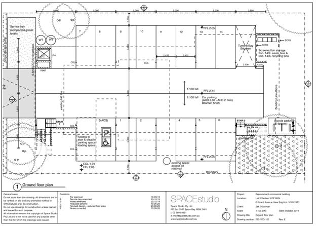
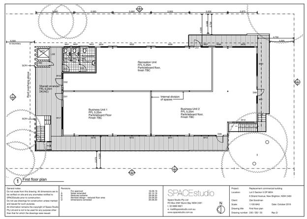
Proposal:
|
Proposal description:
|
Removal of existing commercial premises (approved real
estate office) at 6 Strand Avenue, New Brighton and construction of
commercial premises and new recreation facility in accordance with Byron LEP
1988 land use definitions.
|
|
Property description:
|
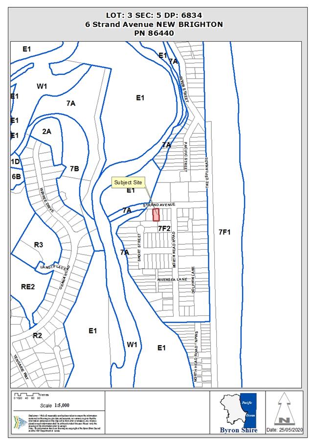
LOT: 3 SEC: 5 DP: 6834
|
|
6 Strand Avenue NEW BRIGHTON
|
|
Parcel No/s:
|
86440
|
|
Applicant:
|
Planners North Pty Ltd
|
|
Owner:
|
Moe Properties Pty Limited
|
|
Zoning:
|
7(f2) (Urban Coastal Land Zone)
|
|
Date received:
|
23 March 2020
|
|
Integrated / Designated Development:
|
☐
Integrated
|
☐
Designated
|
☒
Not applicable
|
|
Concurrence required
|
No
|
|
Public notification or exhibition:
|
- Level
2 advertising under DCP 2014 Part A14 – Public Notification and
Exhibition of Development Applications
- Exhibition
period: 9/4/20 to 29/4/20; and Readvertised 19/11/20 to 2/12/20
- Submissions received:
twenty eight (28); and a further two (2) after re-advertisement.
- Submissions
acknowledged: ☒
Yes ☐
No
|
|
Planning Review Committee:
|
Date of PRC 14/05/2020. Report to Council. Reasons:
The number of public submissions. The perceived public significance of
the application.
|
|
Variation request
|
Not applicable
|
|
Delegation to determine
|
Council
|
|
Issues:
|
· Existing
use rights –commercial use is prohibited in the 7(f2) (Urban Coastal
Land Zone)
· Public
submissions
· Form,
bulk, intensity and nature of the development
· Potential
amenity impacts
· Acid sulfate
soils – class 2/3
· Coastal erosion
– precinct 3
· Flood
liable land
· Deferred
commencement recommended by Council engineer
|
Summary:
The application proposes removal of the existing approved
real estate office building and construction of commercial premises and new
recreation facility in accordance with Byron LEP 1988 land use
definitions.
The site presently contains a high-set single storey
building with historical approval as a real estate office and a floor area of
89m². Council has previously issued development consent for
additions to the existing building comprising a total floor area of 190m²
for commercial premises under DA 10.2018.113.1.
The subject land is zoned 7f (2) Urban Coastal Lands under
Byron LEP 1988. Clause 32 of the LEP prohibits commercial premises on the
land.
Construction of new commercial premises relies on the
existing use rights provisions under the Environmental Planning and Assessment
Act 1979. Although the building is currently being used for Pilates activities
(defined as a recreational facility under the LEP), the applicant has provided
sufficient information to demonstrate that the existing use rights have not
been abandoned by the owner. In this regard, development consent 10.2018.113.1
has not lapsed and allows for that existing use right to be expanded and
intensified.
The application originally proposed to replace the existing
building with a new two storey commercial premises with an enlarged commercial
floor area of 349 m² and car parking for 18 vehicles. It was considered
that the proposal was a significant intensification of building size, floor
space and car parking compared to the existing building and that approved under
DA10.2018.113.1. The scale and nature of the proposed commercial uses was
also not certain. This raised significant issues in terms of environmental and
social impacts and failed to ensure that there would be no external impacts of
the operation of the commercial premises. It was considered the
development did not meet the criteria in clause 41(2) of the Environmental
Planning & Assessment Regulation 2000 in relation to existing use rights.
Following discussions with the applicant, amended plans were
provided, which separated the building partly into a recreation facility with a
floor area of 111m² and a remaining commercial floor area of 169m².
The commercial floor area relies upon existing use rights and intensification
in that use is permissible with consent under Clause 41 of the EPA Regulations
2000. It is noted that amended plans propose a reduction in commercial premises
floor space compared to that approved under DA10.2018.113.1.
The potential commercial tenancy is to be limited to
activities that would have no additional increase in staff numbers or
operational hours compared to that already approved, subject to recommended
conditions of consent that restrict commercial operations to be in accordance
with Byron LEP 1988 definitions.
The recreation facility is permissible with consent under
Byron LEP 1988 in the 7(f2) Zone and is not constrained by the existing use
provisions.
The amended plans provide for 14 car spaces at ground level.
The building height has also been reduced to a maximum of 8.3 metres from the
originally submitted 8.6 metres. Whilst there are a minor building height plane
encroachment of eaves and awnings in the side elevations, such encroachments
are considered reasonable having regards to the need to raise the building to
satisfy flood planning requirements. The style of the building is not out
of character with the area, which is predominantly two storey, high set
dwellings. The proposed amended building is satisfactory in terms of setbacks
to street, side and rear boundaries.
Council’s development engineer has assessed the
flooding, coastal processes and stormwater management and has recommended a
condition of deferred commencement to ensure that the that the construction of
the Q100 overland flow path inside Lot 2 DP1004049 to connect onto Marshall
Creek has been designed and constructed in accordance with Northern Rivers
Local Government Guidelines and Council’s Comprehensive Stormwater
Guidelines.
The proposed development is consistent with the objectives
of the 7(f2) (Urban Coastal Land Zone) and satisfies the requirements of clause
41 of the Environmental Planning & Assessment Regulation 2000 in relation
to existing use rights. The application is recommended for approval subject to
recommended conditions of deferred commencement consent attached to this
report.
NOTE TO COUNCILLORS:
In accordance with the
provisions of S375A of the Local Government Act 1993, a Division is to be
called whenever a motion for a planning decision is put to the meeting, for the
purpose of recording voting on planning matters. Pursuant to clause 2(a)
under the heading Matters to be Included in Minutes of Council Meetings of
Council's adopted Code of Meeting Practice (as amended) a Division will be
deemed to have been called by the mover and seconder of all motions relating to
this report.
RECOMMENDATION:
That pursuant to Section 4.16 of
the Environmental Planning & Assessment Act 1979, Development Application
No. 10.2020.142.1 for removal
of the existing approved real estate office building and construction of new
commercial premises and new recreation facility be approved subject to the
conditions of deferred commencement consent (deferral period 12 months)
recommended in Attachment 3 (E2021/68868).
Attachments:
1 10.2020.142.1
- Redacted submissions received, E2021/57311
2 10.2020.142.1
- Amended plan set combined, E2021/68869
3 10.2020.142.1
Recommended Conditions of Consent, E2021/68868
 Assessment:
1. INTRODUCTION
1.1. History/Background
DA 5.1990.315.1 for a real estate office was
determined on 20/12/1990.
BA 6.1991.2164.1 for an office was determined on
22/05/1991.
According to Council’s Records (Doc # E2016/38115),
the originally approved real estate office located on the site has a gross
floor area of 89 m² and was designed to accommodate 5 staff with provision
of 3 on site car parking spaces.
Originally approved real estate office (existing as
built)
Amendment No. 66 Byron LEP 1988 - Consent for the use
of the premises as a real estate office was issued prior to Clause 32 came into
effect prohibiting the use, when LEP 1988 (Amendment 66) was published on
11/12/1998.
Operation as Real Estate Agent / Change in ownership
- Real estate agents Rhonda Browning Pty Ltd then Elders continuously operated
at the premises from 1991. The current owner purchased the real estate office
from Elders on 30/11/2017.
DA 10.2018.113.1 for alterations and additions to an
existing real estate office was approved on 22/06/2018. The
alterations and additions to the building approved in 2018 permitted expansion
of the use of the building for the lawful purpose as a real estate office,
which is a type of commercial premises in accordance the LEP 1988 land use
definition. The proposed works comprised raising the existing building
and the construction of a ground floor addition, with a total combined gross
floor area of 190m² and a total of 9 car parking spaces.
Approval of 10.2018.113.1 relied on the argument that there
was no change of use to the lawfully approved purpose, and therefore could be
expanded without being limited to a 10% increase in floor area as required by
Clause 41 Subclause 2(b) of the Environmental Planning and Assessment Regulation
2000 (EP&A Reg).
10.2018.113.1 Approved plans
Existing use rights
Commercial Premises are prohibited within the 7(f2) Urban
Coastal Land Zone. The property enjoys existing use rights pursuant to Division
4.11 of the Environmental Planning and Assessment Act 1979 (EP&A Act 79).
Parts of the building have been used for the unauthorised
purpose of a recreation facility; however Council can be satisfied that, based
on independent legal advice, the applicant has continued to satisfactorily
demonstrate that their existing use rights have not been abandoned.
The commercial tenancy is to be limited to activities that
would have no additional increase in staff numbers or operational hours
compared to that already approved, subject to recommended conditions of consent
that restrict commercial operations to be in accordance with Byron LEP 1988
definitions.
Note DA
10.2021.36.1, lodged on 13 January 2021 for the
relocated building to be installed on the adjoining property to the west at 4
Strand Avenue for the purposes of a single dwelling house is subject to
separate consideration and development consent.
Description of the proposed development
This amended application seeks approval for the removal of
the existing building and construction of new raised building with a total
proposed floor area is 280m² containing a recreation facility with a floor
area of 111m² and the remaining commercial floor area of 169m² in two
separate units comprising 65m²; and 104m². 14 Car spaces are to be
provided with lift access to the raised floor and shared male, female and
accessible toilet facilities. The commercial floor area relies upon existing
use rights and intensification of that use is permissible with consent under
Clause 41 of the EPA Regulations 2000.
The recreational facility is permissible with consent under
Byron LEP 1988 in the 7(f2) Zone.
The term
‘business premise/s’ is not defined in the Byron LEP 1988 dictionary, nor is a real estate
office. For the purposes of accurately defining the land
uses the subject of this application, Council considers that the following
Byron LEP 1988 definitions apply to this proposed development:
commercial premises means a building or
place used as an office or for other business or commercial purposes, but (in
the table to clause 9) does not include a building or place used for a purpose
elsewhere specifically defined in this Dictionary.
recreation facility means a building or
place used for indoor recreation, a billiard saloon, table tennis centre,
squash court, swimming pool, gymnasium, health studio, bowling alley, fun
parlour or any other building of a like character used for recreation and
whether used for the purpose of gain or not, but (in the table to clause 9)
does not include a place of assembly.
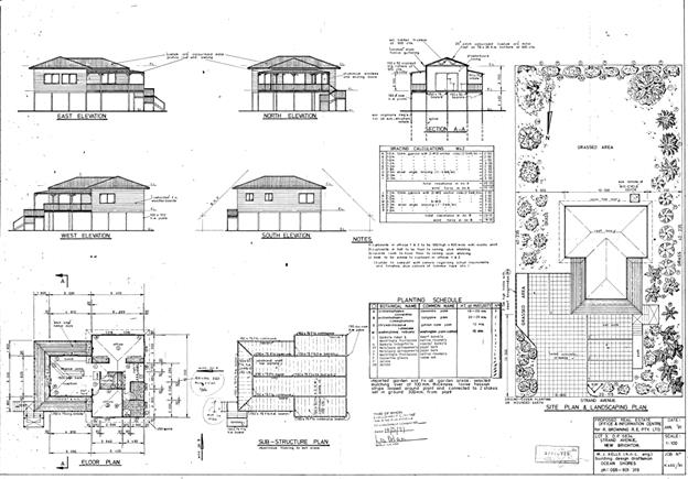
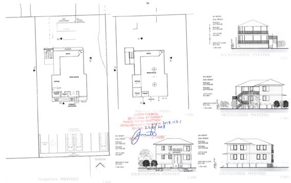
 Proposed development plans
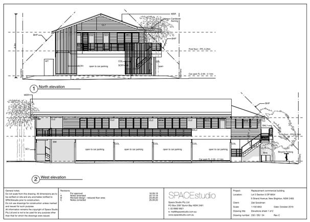
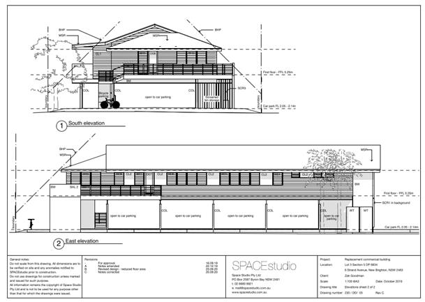 Proposed
Elevations
Proposed
Elevations
1.2. Description
of the site
A site inspection was carried out on 12 May 2020.
|
Land is legally described
|
LOT: 3 SEC: 5 DP: 6834
|
|
Property address
|
6 Strand Avenue NEW BRIGHTON
|
|
Land is zoned:
|
7(f2) (Urban Coastal Land Zone)
|
|
Land area is:
|
809.4 m2
|
|
Property is constrained by:
|
Flood Liable Land, Acid Sulfate Soils Class 2, Coastal
Erosion Precinct 3
|
|
Is a BDAR required due to the location of the proposed
development?
|
☐ Yes ☒ No
|
|
Are there any easements in favour of Council affecting the
site?
|
☐ Yes ☒ No
|
|
Is there a Vegetation Management Plan which might affect
the proposal?
|
☐ Yes ☒ No
|
|
Is there a Voluntary Planning Agreement which might affect
the proposal?
|
☐ Yes ☒ No
|
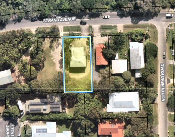
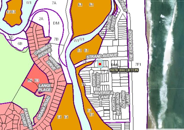
Lot boundary, zoning map
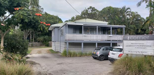
Existing building on site – currently operating
partly as an unapproved recreation facility
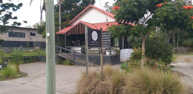
Adjoining approved natural therapy clinic (DA
No.10.2005.439.1) to the east, residential beyond
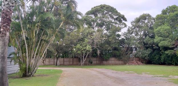
Adjoining vacant lot to the west, residential to south
and east

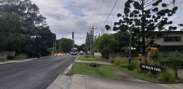
Street context, low density predominantly residential
area in coastal wetland and beach setting.
2. SUMMARY
OF REFERRALS
|
Referral
|
Issue
|
|
Environmental Health Officer
|
No objections subject to conditions.
|
|
Development Engineer
|
No objections subject to deferred commencement/
conditions.
|
The Recommendation of this Report below is based on
Independent Legal Counsel received by Byron Shire Council between January 2020
and May 2020 and recommended conditions provided in the above referrals.
3. SECTION
4.14 – BUSH FIRE PRONE LAND
Under section 4.14 of the Act, Council must be satisfied
prior to making a determination for development on bush fire prone land, that
the development complies with the document ‘Planning for Bush Fire
Protection 2006’. The site is not bush fire prone land.
4. SECTION
4.15C – MATTERS FOR CONSIDERATION – DISCUSSION OF ISSUES
Having regard to the matters for consideration detailed in
Section 4.15(1) of the Environmental Planning & Assessment Act 1979
(EP&A Act), the following is a summary of the evaluation of the issues.
4.1 State
Environmental Planning Instruments
|
|
Satisfactory
|
Unsatisfactory
|
|
State Environmental
Planning Policy No 55—Remediation of Land
|
☒
|
☐
|
|
Consideration: the proposed development is not considered
to be satisfactory having regard to the provisions of SEPP 55, noting that
the site is not identified on Council’s Contaminated Land Register, nor
is it located within a Dip Site Buffer.
|
|
State
Environmental Planning Policy (Coastal Management) 2018
|
☒
|
☐
|
|
Consideration: The lot is approximately 20 metres to
coastal wetlands adjoining Marshalls Creek to the west and is mapped as being
within a coastal wetland buffer. The development will have no direct impacts
on the wetland. However there remains potential for impacts during the
construction period of the development. Appropriate conditions of consent are
proposed in relation to installation of sedimentation and erosion control
measures and management of builders waste to mitigate such impacts. 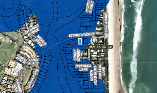
Coastal Wetland Buffer
|
4.2A Byron Local Environmental Plan 2014 (LEP 2014)
Note. The Standard Instrument Byron LEP 2014 is not an
applicable matter for consideration in the assessment of the subject
development application.
4.2B Byron
Local Environmental Plan 1988 (LEP 1988)
In accordance with LEP 1988 clauses 5, 8 and 9:
(a) The
proposed development is defined in the LEP 1988 Dictionary as a type of
Commercial premises (Refer to definition below);
(b) The
land is within the LEP1988 Zone No 7 (f2) (Urban Coastal Land Zone)
according to the map under LEP 1988;
(c) The
proposed development is prohibited in the zone, under Clause 32 of the LEP 1988
and relies on Existing Use Rights provisions under the EP&A Act and
EP&A Reg; and
(d) The
proposed development is consistent with the relevant objectives of the Zone for
the following reasons:
|
Zone Objective
|
Consideration
|
|
(a) to identify
urban land likely to be influenced by coastal processes,
(b) to permit
urban development within the zone subject to the council having due
consideration to the intensity of that development and the likelihood of such
development being adversely affected by, or adversely affecting, coastal
processes,
(c) to permit
urban development within the zone subject to the council having due consideration
to—
(i) the
need to relocate buildings in the long term,
(ii) the
need for development consent to be limited to a particular period,
(iii) the
form, bulk, intensity and nature of the development, and
(iv) continued
safe public access to the site, and
(d) to allow
detailed provisions to be made, by means of a development control plan, to
set aside specific areas within the zone for different land uses and
intensities of development.
|
Recreation Facilities are
permissible with consent in the zone.
The proposal is not
contrary to the objectives of the zone subject to recommended conditions of
development consent that limit the intensification of commercial operations
in accordance with existing use rights on the site and provide for the
long-term planning of coastal management.
Conditions of consent
recommended for the building to be removed and the consent to cease should
the erosion escarpment come to within 50 metres of the development in the
event the property is threatened by coastal processes.
|
Note. The term ‘business premise/s’
is not defined elsewhere in the LEP 1988 dictionary, nor is a real estate
office. For the purposes of accurately defining the land uses the
subject of this application including the characterisation of exiting use, Council
considers that the following Byron LEP 1988 definitions apply to the proposed
development:
commercial premises means a building or
place used as an office or for other business or commercial purposes, but (in
the table to clause 9) does not include a building or place used for a purpose
elsewhere specifically defined in this Dictionary.
recreation facility means a building or
place used for indoor recreation, a billiard saloon, table tennis centre,
squash court, swimming pool, gymnasium, health studio, bowling alley, fun
parlour or any other building of a like character used for recreation and
whether used for the purpose of gain or not, but (in the table to clause 9)
does not include a place of assembly.
Clause 32 Development within Zone No 7 (f2)
(Urban Coastal Land Zone)
(1) This clause
applies to all land within Zone No 7 (f2).
(2) A person shall
not carry out development (other than exempt development) on land to which this
clause applies except with the consent of the Council.
(3) The Council, in
deciding whether to grant consent to development referred to in subclause (2),
shall take into consideration—
(a) the
likelihood of the proposed development adversely affecting, or being adversely
affected by, coastal processes,
(b) the
need to relocate buildings in the long term,
(c) the
need for the development consent to be limited to a particular period,
(d) the
form, bulk, intensity and nature of the development, and
(e) continued
safe public access to the site.
(4) The council
shall not consent to the carrying out of development on land shown edged heavy
black and stippled on the map marked “Byron Local Environmental Plan 1988
(Amendment No 66)” for the purpose of clubs, commercial premises,
hostels, hotels, motels, residential flat buildings, shops or tourist
facilities or for a purpose that would otherwise be permissible with consent
under clause 17 (Dual occupancy).
(5) The Council must
not consent to the subdivision of land within Zone No 7 (f2) other than—
(a) a
subdivision under a strata plan that does not create a development lot, or
(b) a
subdivision to excise an allotment that is, or that the Council is satisfied is
intended to be, used for a public purpose, or
(c) a
subdivision that, in the opinion of the Council, is only a boundary adjustment
where no additional lots are created.
Clause 32 of the Byron LEP 1988 was amended (Amendment 66)
on 11 December 1998. Subclause 4 was added to the clause which in effect
prohibited commercial premises amongst other uses on certain lands in the 7(f2)
Zone
The lawful approved use of the commercial premises,
operating as a real estate office was thereby prohibited under the provisions
of Clause 32 of LEP 1988 and since December 1998, the property has relied on
Existing Use Rights provisions under the EP&A Act and EP&A Reg.
As such the
development needs to be considered under the provisions of Clause 41 of the
EP&A Regulation 2000 which state:
Clause 41 Certain
development allowed (EPA Regulations 2000)
(1) An existing use may, subject to this Division—
(a) be
enlarged, expanded or intensified, or
(b) be
altered or extended, or
(c) be
rebuilt, or
(d) be
changed to another use, but only if that other use is a use that may be carried
out with or without development consent under the Act, or
(e) if
it is a commercial use—be changed to another commercial use (including a
commercial use that would otherwise be prohibited under the Act), or
(f) if
it is a light industrial use—be changed to another light industrial use
or a commercial use (including a light industrial use or commercial use that
would otherwise be prohibited under the Act).
(2) However,
an existing use must not be changed under subclause (1)(e) or (f) unless that
change—
(a) involves
only alterations or additions that are minor in nature, and
(b) does
not involve an increase of more than 10% in the floor space of the premises
associated with the existing use, and
(c) does
not involve the rebuilding of the premises associated with the existing use,
and
(d) does
not involve a significant intensification of that existing use.
(e) (Repealed)
(3) In this
clause—
commercial use means the use of a building, work or land for
the purpose of office premises, business premises or retail premises (as those
terms are defined in the Standard Instrument).
light industrial
use means the use of a
building, work or land for the purpose of light industry (within the meaning of
the standard instrument set out in the Standard Instrument (Local Environmental Plans) Order
2006).
Under Clause
41(1) an existing use may be enlarged, expanded or intensified or rebuilt as
proposed by this development. However, the existing use can only be changed to
another use which is prohibited if the alterations and additions to the floor
area are minor in nature or the resulting increase in floor area is no more
than 10%, does not involve the rebuilding of the development and does not
involve a significant intensification of that use.
The existing use
of a real estate office falls under the definition of Commercial premises
as per Byron LEP 1988. The proposal falls within the scope of rebuilding for
the purposes of Clause 41, but has a floor area exceeding 10%. Therefore, the
use must be limited to commercial premises only. The use can’t be
changed to a café or retail shop for example as they are not commercial
premises.
Further the
proposal for two tenancies is not supported as this would result in a doubling
of the commercial premises on the site. Conditions are recommended to
make the commercial component only one tenancy and limitations are also
recommended in relation to the use of that tenancy being limited to commercial
premises as per Byron LEP 1988.
Other relevant
LEP clauses are as follows:
Clause 24
Development of Flood Liable Land
The subject
property is prone to flooding. The development contains car parking at ground
level with the development raised on piers bearers and joist to satisfy
councils minimum floor levels. The proposal is satisfactory in terms of the
flood controls
Clause 40
Height
The proposed two
storey building with a maximum height of 8.3 metres to the roof pitch and 3.5
metres to the first floor level complies with the height requirements under the
LEP
Clause 45
Provision of Services
Adequate
provision can be made to provide water, sewer and stormwater infrastructure to
this property. Conditions of consent to apply.
4.3 Any proposed
Instrument that has been the subject of public consultation and has been
notified to the consent authority
Not applicable.
4.4A Byron Shire Development Control Plan 2014 (DCP
2014)
DCP 2014 is not an applicable matter for consideration in
the assessment of the subject development application.
4.4A Byron Shire Development Control Plan 2010 (DCP 2010)
DCP 2010 is an applicable matter for consideration in
accordance with subsection 4.15(1) of the EP& A Act. The DCP 2010
Chapters/Parts that are checked below are of relevance to the proposed
development:
North Byron Floodplain Management Study (October 2020). The
proposal is satisfactory in erms of the DCP controls, with the “habitable
floor” level raised above the flood height for the 1:100 year flood
event. The proposal raises no other issues under the DCP.
4.5 Environmental
Planning & Assessment Regulation 2000 Considerations
|
Clause
|
This control is applicable
to the proposal:
|
I have considered this
control as it relates to the proposal:
|
If this control is
applicable, does the proposal comply?
|
|
92
|
Yes
|
Yes
|
Yes – Demolition / Relocation of structure off site.
|
|
93
|
No
|
N/A
|
N/A
|
|
94
|
No
|
N/A
|
N/A
|
|
94A
|
No
|
N/A
|
N/A
|
4.6 The likely
impacts of that development, including environmental impacts on both the
natural and built environments, and social and economic impacts in the locality
|
Impact on:
|
Likely significant impact/s?
|
|
Natural environment
|
No. The proposal will not have a significantly adverse
impact on the natural environment of the locality.
|
|
Built environment
|
No. The proposal will not have a significantly adverse
impact on the built environment of the locality.
|
|
Social Environment
|
No. The proposal will not have a significant social impact
on the locality.
|
|
Economic impact
|
No. The proposal will not have a significant adverse
economic impact on the locality.
|
4.7 The
suitability of the site for the development
The site is a serviced, constrained property in the coastal
erosion precinct 3. The proposed scale of the development is considered
to acceptable subject to recommended conditions of consent.
4.8 Submissions
made in accordance with this Act or the regulations
The development application was publicly exhibited twice.
First round of exhibition: 9/4/20 to 29/4/20;
There were 28 submissions made on the development application:
- 6
For
- 22
Against
- and
Second round of exhibition: Readvertised 19/11/20 to 2/12/20
There were 2 submissions made on the development application:
- 2
Against
Summary of consideration of issues raised in support of
the proposed development
|
Issue
|
Consideration
|
|
Local businesses and jobs
· The
lot has always been a commercial site and look forward to it becoming a place
for local small businesses to have premises near home.
· This
space is a step in the right direction to create a strong community for the
people who are seeking an office space and wanting to connect with each other
without driving the 20 mins to the Byron Bay industrial estate.
· I am
a director of one of the building companies looking at doing the job. The
owners are committed to using local tradespeople and are supporting the local
economy.
· The
focus from the start has been to provide small scale services to the local
community as well as a source of revenue for small business owners.
· It
will be an asset for many of the professionals who wish to call the North
Byron shire home.
|
The site already contains an existing building that relies
on existing use rights and the EP&A Regulation provisions strictly limit
its expansion.
The Byron Shire Business
and Industrial Lands Strategy(PDF, 8MB) guides Council’s decision-making
and key actions to manage future growth of retail, commercial and industrial
land in our Shire.
New Brighton is not identified in the Strategy as a
suitable location for intensive growth in economic activity. The strategy
provides guidance on knowledge and creative-industry precincts, co-operative
business and innovation hubs, and development close to Byron Central
Hospital.
The Northern Trade Area comprising Ocean Shores,
Billinudgel, Brunswick Heads and Bayside centres are within close proximity
to each other and have overlapping trade areas. The Ocean Shores Future
role and aspirations are to be encouraged to evolve into a town centre
with a wider range of community services, meeting places and office space
whilst continuing to operate as a retail and specialty use commercial centre
catering for the local catchment.
The Strategy is based on recent research and was adopted
by Council at 12 December 2019 meeting.
|
|
Design
· The
design is in keeping with our neighbourhood.
· They
have engaged an excellent local architectural company, Space Studios, who
have done a great job on design.
· The
proposed DA is for a structure containing small scale business spaces
adjoined by a parking area. I myself have seen the plans and as a
member of this community strongly approve.
· the
building has been designed to suit the area and if anything is improving the
current aesthetic.
|
Noted.
|
|
No impacts
· no
difference whatsoever in the social impact from the current design as opposed
to its use as a real estate for many years before it was a yoga studio.
· incorporating
a holistic approach to the needs of the community and the local surroundings.
· The
current hours of operation are requested from 7am to 7pm.
· there
is very little traffic impact as they are not “shops”.
|
It is evident from the content of public submissions that
there will be many perceived and actual impacts from intensification of
activity on the land.
Revised hours of operation provided and will be subject to
recommended conditions of consent.
|
Summary of consideration of issues raised against the
proposed development
|
Issue
|
Consideration
|
|
Existing Use Rights
· The DA represents a significant expansion of
commercial use, compared to existing use rights (about 3.5 times bigger on
our estimate).
· Should be limited to 10%
· The land should be szoend commercial to enable
development
· Regulations
prohibit changes to other uses
· pilates
studio operating without approval.
· Much
larger commercial building that can be subdivided into up to 5 tenancies.
· No specific uses are
specified,
· Proposal will redevelop
and massively expand the premise for a non-compliant use.
· Existing use rights
should be rescinded
|
Council’s assessment of the proposed development
concludes that the proposal may satisfactorily address clause 41 of the EP&A
Reg subject to conditions of consent limiting the operation of the proposed
commercial activity.
Consent is now sought for recreational facility which is
permissible with consent and could accommodate pilates or yoga etc
There will only be two tenancies, the other the
recreational facility.
Council cant rescind existing use rights
|
|
Coastal Zone, Erosion, Sea Level Rise
· Site is unsuitable for such development.
· Fragile coastal zone,
building does not meet the objectives of the zone.
· Will set a precedent
· Landfill will impact
surrouinding properties during natural disasters and flooding events
|
The proposed development is not inconsistent with the
objectives of the applicable land use zone, subject to conditions of consent
recommended.
|
|
Commercial Land Supply
· There is significant, large and varied retail
and commercial space
(some empty) in neighbouring Ocean Shores and Brunswick Heads
which are better suited to this development
· Our Village Association (NBVA) have never identified a need or desire
for further commercial development in our village.
· The New Brighton
village is small and doesn’t need another commercial centre of this
type.
· .
·
·
|
The Business
and Industrial Lands Strategy(PDF, 8MB) guides Council’s decision-making
and key actions to manage future growth of retail, commercial and industrial
land in our Shire.
Although it is considered that there may be other
locations that can accommodate this development the proposal will result in a
limited commercial footprint of 169 m2 which can be used
only for commercial premises.
The recreational facility is permissible with consent in
the zone.
The use cant be changed to a café or refreshment
room
|
|
Scale, Intensification, Bulk
· Opposed building taking up the entire lot with parking beneath for a
significant number of vehicles.
· Current commercial buildings retain a residential feel in appearance.
· Scale with undercover parking for 18 cars and an elevator.
· The bulk and scale of
the proposal is incompatible with the zone objectives and surrounding
residential homes.
· Shadowing caused by the
size and height.
· Will devalue our
property and be extremely disruptive.
· Looking at plans it
appears that the building will be very close to our fence and after fill is
put in the building will tower above our house.
· The
site is in a small oceanside residential village on a riverside block with
vehicular access from a narrow road and therefore not appropriate.
|
The applicant amended plans to reduce the scale and
intensity of the proposal. Amended plans with a reduced floor area for
a raised level building with parking on site is likely to have minimal
impacts on surrounding properties
Land Values are not a matter for consideration
Access from the local road network and traffic generation
considered acceptable.
.
|
|
Retaining Small Seaside Village Character and
Community
· New Brighton comprises a small
residential village, with a local
general store
and community café.
· Small seaside village, small and quiet surrounded by nature.
· Proposal is inconsistent with the Village Character
|
Proposed development in terms of built form not out of
character for the area and unlikely to impact on the charm of the New
Brighton Village. .
|
|
Hours of operation, Amenity, Nature and
Wildlife
· There
should be severe restrictions on these activities to appropriately reflect
the residential area, with regards to noise, traffic, or any unsuitable
activities.
· The construction and
size of the proposal will impact tenants at the Health Cove, specialising in
acupuncture, massage and health treatments.
· Car headlights in the
morning.
· Impact
on the environment
|
Conditions of consent recommended in relation to limited
hours of operation to ensure residential and neighbourhood amenity is not
adversely impact upon Conditions to apply limiting hours to
Recreation facility
7.00am -7.00pm, Monday –
Friday
8.00am to 5.00pm Saturday,
Sunday and Public Holidays
Commercial premises
8.00am to 6.00pm Monday-Friday
|
|
Access, roads, traffic and parking
· Lack
of bike parking
· Additional traffic on local roads,
· Location
of skip bin and landscaping will affect driveway site distances –
safety issue when exiting neighbouring property.
· Currently cars parked
on Lot 2 enter and exit via Lot 3 - is this still to be the case? If
so, this further compounds the traffic flow from Lot 3.
· The 40k speed limit is
constantly abused.
|
Car and bike parking satisfactory in terms of Councils
planning controls.
Location of Bin storage and driveways suitable for the
development with no access proposed from the adjacent parcel
Conditions to apply in terms of complying with relevant
Australian standards
Speed limits area a matter for NSW Police to enforce
|
|
Flooding, Stormwater and
Drainage
· As
resident since 2001 we have experienced extreme flooding in 2005 and more
recently in 2017 with Cyclone Debbie also February this year. This is more
than likely to increase with Global warming.
· This
DA is sited near the river and this lower area floods regularly.
· Councils
Drainage inadequate for New Brighton
· We
are on a flood plain with more flooding likely due to building developments
that have occurred with no planning for the water run off.
· more
development will lead to more flooding effects
· No
new commercial developments should be allowed on flood prone areas.
|
The proposed building is to be raised above the flood
level with car parking at ground level. Minimal filling is proposed to
support the car park area which will have a negligible impact on flooding in
the area.
Stormwater can be appropriately managed from the
development.
Conditions to apply including provision for an overland
flow path for stormwater
|
|
Relocation or demolition
· The
proposed development seeks to relocate the existing building from the site
and construct a new building. Description on council notices says demolition
– which is it?
· Lack
of transparency re the ‘off-site’ relocation:
|
Relocation of
the building would involve removal of the building. This is defined as
demolition in accordance with the Byron LEP 1988.
Demolition, in relation to a building or work,
means the damaging, defacing, destruction, pulling down or removal of that
building or work in whole or in part.
Lot 2 is not
part of the subject site. Council is not required to assess the new
location of a building being moved from a site. Such activity would be
subject to separate approval and consideration.
A separate DA
was lodged for a relocated building on the adjoining lot in January 2021 and
is subject to separate consideration and determination.
Note. In some
cases, relocated buildings are moved outside Byron Shire and would be
assessed by another consent authority.
|
|
Consultation
· There has been no
community consultation and a total lack of transparency regarding the
Developer intentions in this DA.
|
The development application was notified/advertised twice
in accordance with Development Control Plan 2010. Issues raised in the
submissions have been addressed during assessment of the application.
|
|
Acid Sulphate Soils
note that the Acid
Sulphate test site
submitted for this Lot (3)
commercial development is located on Lot (2),
not on Lot (3)
(ref Acid Sulphate Report). The relocation by the developer of
the existing building to Lot (2), and consequent implications thereof,
needs to be jointly considered with this DA Lot (3) proposal
– the submitted documentation is already indistinct.
|
The originally submitted Acid Sulfate Soils report, dated
25 November 2017 (Refer Doc # E2020/22009) shows that test sampling has been
undertaken on the adjoining vacant lot to the west of the existing building.
A new Acid Sulfate Soils report was submitted (Refer Doc #
E2021/68500) relative to the proposed building footprint and conditions of
consent are recommended.
|
Two further submissions were
received in response to the second period of exhibition
I object to the application
10.2020.142.1 to remove the existing commercial use on the site and to replace
it with a much larger commercial building which according to the plans can
be subdivided into up to 5 tenancies even though they are stating part to be
used as public recreation.
The existing land use is
prohibited in the Coastal Zone but can continue under existing use
rights". The existing use right is a Real Estate Agency although recently
the building has been used as a Pilates studio without approval. The
construction and size of the proposal will impact. Clause 41 (1) (e)
of the Regulations provides in relation to these prohibited uses that a
commercial use can be changed to another commercial use . It does not
provide that the one use can be converted to up to 5 prohibited uses. As
well the following clause 41 (2) (b) applies and that one existing use can only
be added to by 10 %.as stated in the application but using the guise of public
recreation to allow a substantial increase in the size of the foot print.
This fragile coastal zone, such
a large building as now proposed does not meet the objectives of the
Coastal Hazard Zone. Council will set an unfortunate and expensive precedent if
it approves such a large building in an area that will be subject to coastal
erosion within 100 years or sooner if sea levels rise faster due to global
warming. It is negligent for Council to increase the values of sites in the Coastal
Hazard Zone when at some time in the future these buildings will need to be
removed as the coast recedes.
I also have concern with the
site being filled and falling to adjoining properties and not to the table
drain (piped) in front of property This large building proposed should be
refused, and increase in the size of the footprint should be limited to an
increase of 10% including the recreation area as per the plans this area is
included in alternative layout for other uses .
There is only one existing use
right, not some unknown increase of uses as proposed in this application.
Council should ensure that in any approval , the site lines f not reduced
Concerned with the rise in foot
traffic in a zone that does not accommodate footpaths on the side of the
proposal and increased traffic in an area that simply could not handle such a
rise in cars.
I am also concerned about noise
and disrespect to closer neighbours.
This person is clearly set out
to make money with no actual understanding of the close knit community that is
New Brighton and with a 1.1 million dollar proposal clearly wishes to simply
make profit and not even inject it back into our community. 1.1 million
dollar extension shows that this is going to be a large scale project which may
also effect the business next door which has been running for almost 20 years!
It is clear this community is
not interested in having an extension of this business which is not even
community minded in the first place….A good example of this could be something
such as a community garden that would truly serve the community and give back
as a common meeting place for our precious little suburb.
Staff Comment: Matters raised
above have been considered. As to pedestrian traffic there is a constructed
footpath on the other side of the road serving this area of New Brighton and
connecting with Ocean Shores. A developers intention to make a profit and what
he or she intends to do with that is not a reason for refusal.
4.9 Public
interest
The proposed development is unlikely to prejudice and
compromise the public interest and would not create an undesirable precedent,
subject to conditions of consent.
5. DEVELOPER
CONTRIBUTIONS
5.1 Water &
Sewer Levies
Section 64 levies will be payable.
5.2 S7.12
Contributions
Section 7.12 Levy Contributions
will be payable.
6. CONCLUSION
The proposed removal of the existing building and
construction of commercial premises and new recreation facility is satisfactory
having regard to the relevant environmental planning instruments and planning
controls applicable to the site.
The application is recommended for approval subject to
conditions of deferred commencement consent listed in the Recommendation of
this Report below.
7. DISCLOSURE
OF POLITICAL DONATIONS
|
Has a Disclosure Statement been received in relation
to this application
|
No
|
|
Have staff received a ‘gift’ from anyone
involved in this application that needs to be disclosed. Where the answer is
yes, the application is to be determined by the Director or Manager of the Planning,
Development and Environment Division.
|
No
|
Provide Disclosure Statement register details here: Not
applicable
Staff Reports - Sustainable Environment and Economy 13.4
Report
No. 13.4 PLANNING - 26.2021.1.1
Planning Proposal to permit Community Title & R5 Large Lot Residential Development
- 53 McAuleys Lane, Myocum
Directorate: Sustainable
Environment and Economy
Report Author: Steve
Daniels, Project Officer - Planning Reforms
Alex Caras, Land Use Plannning
Coordinator
File No: I2021/474
Summary:
Council received a planning proposal in December 2020 to
amend Byron LEP 2014. This planning
proposal relates to a single lot located at 53 McAuleys Lane, Myocum, described
as Lot 8 DP 589795. The objective of the Planning Proposal is to
enable the future subdivision of the subject land to create a combination of
large lot residential and community title lots (and the construction of future
dwellings).
It is anticipated that the planning proposal would enable
approximately 35 large lot residential lots in the proposed R5 Zone land, and 7
neighbourhood community title lots and 1 association property lot on the RU2
zoned land.
An assessment of road safety and intersection capacity found
that the proposed development outcome will necessitate improvements to a
section of McAuleys Lane, as well as an upgrade of the McAuleys Lane /
Mullumbimby Road intersection. To ensure the
necessary upgrades required to accommodate future development can be provided
at no cost to the wider community, the landowner has submitted to
Council a ‘letter of offer’ to enter into a Voluntary Planning
Agreement (VPA) to fund the required works.
Although the majority of the site
comprises cleared grazing pasture, the site also contains patches of
subtropical rainforest in varying condition, freshwater wetlands and planted
native and non-native vegetation including three (3) threatened flora
species. Given its highly modified and disturbed condition as a whole,
the site only represents marginal habitat for threatened fauna. However, the
site is well positioned to improve ecological connectivity within the broader
landscape through restoration of native plant communities.
The planning proposal is consistent with the Byron Rural
land Use Strategy 2017 and the North Coast Regional Plan.
It is recommended that the submitted planning proposal be
amended to include changes recommended in this report and forwarded to the
Department of Planning and Environment for a Gateway Determination.
NOTE TO COUNCILLORS:
In accordance with the
provisions of S375A of the Local Government Act 1993, a Division is to be
called whenever a motion for a planning decision is put to the meeting, for the
purpose of recording voting on planning matters. Pursuant to clause 2(a)
under the heading Matters to be Included in Minutes of Council Meetings of
Council's adopted Code of Meeting Practice (as amended) a Division will be
deemed to have been called by the mover and seconder of all motions relating to
this report.
RECOMMENDATION:
That Council:
1. Accept
the applicant’s letter of offer to enter into a Voluntary Planning
Agreement (VPA) (Attachment 6 E2021/69988)
with Council as part of this planning proposal and require that a draft VPA be
prepared in accordance with the letter of offer.
2. Require
that the draft VPA be placed on public exhibition concurrently with the
planning proposal.
3. Amend the Planning
Proposal (Attachment 1 E2021/72620) to reflect the recommendations contained in
this report as follows:
a) Reposition
the northern boundary of the proposed R5 zone to ensure no encroachment within
the required ecological setback areas for the riparian zone and freshwater
wetland in the north of the site (i.e. 20m from the top of the stream bank or
wetland edge); and
b) Make
consequential amendments to the minimum lot size map and subdivision concept
plan.
4. Forward the amended
planning proposal to the NSW Department of Planning, Industry and Environment
for a Gateway determination.
5. Undertake public
exhibition of the planning proposal in accordance with the Gateway determination
requirements.
6. Consider a submissions report
post-exhibition that includes any recommended changes to the planning proposal
for final adoption.
Attachments:
1 26.2021.1.1
Planning Proposal - 53 McAuleys Lane Myocum_PP-2020-4089, E2021/72620
2 26.2021.1.1
Planning Proposal - Appendix I - 53 McAuleys Lane - Preliminary Site
Investigation (SEPP 55)_PP-2020-4089(2), E2021/72619
3 26.2021.1.1
Planning Proposal - Appendix G - 53 McAuleys Lane - Onsite sewer
assessment_PP-2020-4089(2), E2021/72612

4 26.2021.1.1
Planning Proposal - Appendix E - 53 McAuleys Lane Myocum - Traffic Impact
Assessment_PP-2020-4089(2), E2021/72617
5 26.2021.1.1
Planning Proposal - Appendix D - 53 McAuleys Lane Myocum - Road Safety
Audit_PP-2020-4089(2), E2021/72616

6 26.2021.1.1
VPA Letter of Offer_McAuleys Lane Planning Proposal_18 May 2021, E2021/69988 
7 26.2021.1.1
Planning Proposal - Appendix H - 53 McAuleys Lane - Ecological
Assessment_PP-2020-4089(2), E2021/72613
8 26.2021.1.1
Planning Proposal - Appendix J - 53 McAuleys Lane - Stormwater Management
Strategy Report_PP-2020-4089(2), E2021/72615
9 26.2021.1.1
TIA Peer Review report - 53 McAuleys Lane_Final April 2021, E2021/72140 
10 Template - Form of
Special Disclosure of Pecuniary Interest -, E2012/2815
Report
The Planning Proposal
This planning proposal (Attachment
1) relates to a single lot located at 53 McAuleys Lane, Myocum, described as
Lot 8 DP 589795. The subject land:
· is generally rectangular in shape with overall dimensions
of approx. 460m x 750m and area of 34.82ha
· has a frontage of 104.045m to McAuleys Lane with vehicular
access being via an existing driveway
· contains a dwelling house and associated improvements/structures
· is largely cleared and contains areas of remnant vegetation
The objective of the Planning
Proposal is to enable the future subdivision of the subject land to create a
combination of large lot residential and community title lots (and the construction
of future dwellings).
Subject to further assessment at
the development application stage, it is anticipated that the planning proposal
would enable approximately:
· 35 lots in the proposed R5
Large Lot Residential zone land
· 7 neighbourhood community title lots and 1 association
property lot on the existing RU2
Rural Landscape zoned land
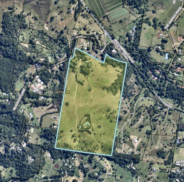
Figure 1 – Subject Land
Current Zones and Controls
The subject land is mapped under
the BLEP 2014 as follows:
· (Part) RU2
– Rural Landscape Zone and (Part) E2
– Environmental Conservation Zone
· 9m maximum building height
· 40ha minimum lot size
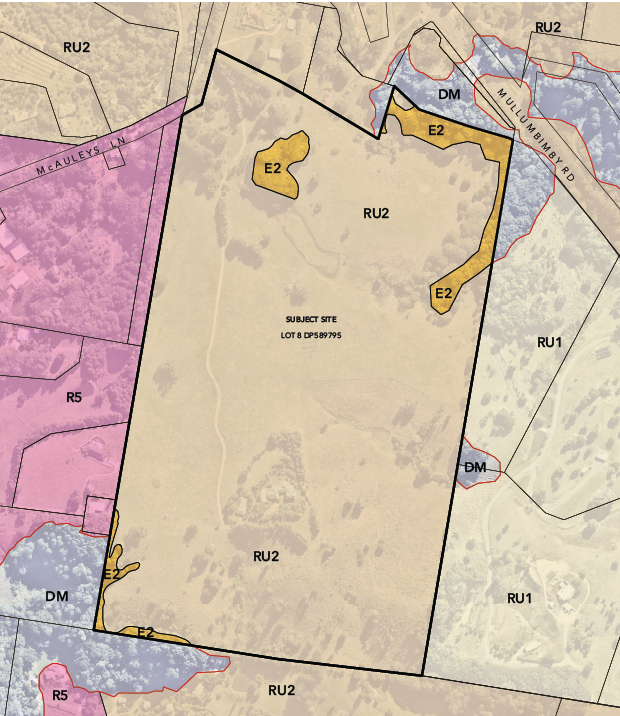
Figure 2 – Current BLEP 2014 Zone Map
Proposed Zones and Controls
The planning proposal will:
· Rezone part of the RU2 –Rural Landscape zoned land to
R5 – Large Lot Residential Zone
· Change the existing 40ha minimum lot size for the proposed
R5 zoned land to part 4000m2 and part 2.5ha minimum lot size.
· Change the existing 40ha minimum lot size for the proposed
RU2 zoned land (Community Title Area) to 8000m2.
· Amend the Multiple Occupancy and Community Title Map (Sheet
MOC_002) so that part of the subject land is outlined by a thick purple line
and is thus able to be subdivided to create 7 x neighbourhood lots and 1 x
association property lot.
The proposed zone and development
controls listed above are commensurate with other R5 Large Lot Residential
zoned land and community title subdivisions within the rural areas of the
Shire.
The planning proposal does not
propose to alter the existing E2 Environmental Conservation zone boundaries or
maximum building height provisions.
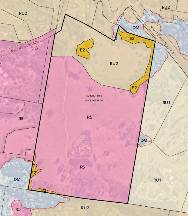
Figure 3 – Proposed BLEP 2014 Zone Map
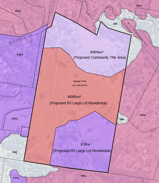
Figure 4 – Proposed Minimum Lot Size Map
KEY ISSUES
§ Byron Rural Land Use
Strategy 2017
§ North Coast Regional
Plan 2036
§ State policy and
planning controls
§ Contaminated land
assessment
§ Infrastructure
§ Traffic Impact
Assessment
§ Developer Contributions
& Voluntary Planning Agreement
§ Ecological Assessment
§ Stormwater Management
& Flooding
Byron Rural Land Use Strategy
2017 (RLUS)
The RLUS was approved by the Department of Planning and Environment
in June 2018 and replaced the 1998 Byron Rural Settlement Strategy.
The subject land is identified as
a priority site for rural lifestyle living opportunities (Site 1) in both Table
10 and Map 3a of the RLUS.
North Coast Regional Plan 2036
Direction 24 of the North Coast
Regional Plan 2036 (NCRP) relates to the delivery of well-planned rural
residential housing areas and provides that:
“New rural
residential housing will not be permitted in the coastal strip, unless the land
is already zoned for this purpose, or is identified in a Department endorsed
current or future local growth management strategy (or rural residential land
release strategy)”.
The proposal is consistent with
Action 24.1 which is to:
Facilitate the delivery of
well-planned rural residential housing areas by:
· identifying new rural residential areas in a local growth
management strategy or rural residential land release strategy endorsed by the
Department of Planning and Environment; and
· ensure that such proposals are consistent with the
Settlement Planning Guidelines: Mid and Far North Coast Regional Strategies
(2007) or land release criteria (once finalised)
The Planning Proposal is
consistent with the provisions of the NCRP largely as a consequence of the NSW
Department of Planning, Industry & Environment’s endorsement of the
RLUS.
State policy and planning
controls
The planning proposal is generally
consistent with applicable State Environmental Planning Policies (SEPPs) along
with relevant Section 9.1 Directions.
An assessment against the relevant
SEPPs and 9.1 Directions is provided in the attached planning proposal
(Attachment 1).
Contaminated land assessment
A Preliminary Contamination Report
(Contaminated Site Investigation Australia Pty Ltd) has been prepared for the
subject site (Attachment 2).
The Preliminary Contamination
Report confirms that the subject site has a low likelihood of
contamination. The investigations did not identify any evidence of
previous development or activities on the site that would suggest potentially
contaminated activities had taken place. Analytical results from the
surface soils indicated all of the compounds tested returned concentrations
that were below the adopted criteria for residential use.
Council engaged Tim Fitzroy
Associates to undertake an independent review of the submitted
assessment. The review concluded that there does not appear to be any
impediments to approval of the planning proposal.
Onsite Sewage Feasibility
Assessment
The proponent submitted an Onsite
Sewage Feasibility Assessment (see Attachment 3) which concluded that future
possible on-site sewage management is feasible within a minimum 30m setback to
all drainage lines. Existing cleared areas can be utilised for future possible
residential development, thereby minimizing the need for removal of native
vegetation. There are no absolute soil limitations which cannot be overcome by
on-site sewage management design.
Council engaged Tim Fitzroy
Associates to undertake an independent review of the submitted
assessment. The review concluded that on-site sewage management is
feasible within the proposed minimum lot sizes on the subject site.
Infrastructure
The existing locality is connected
to and serviced by a constructed public road system and reticulated electricity
and telephone services. There is sufficient capacity for any proposed large
residential type lots to be efficiently and economically connected to and
serviced by such services. Further discussion is provided below in
relation to the road network and traffic impacts of future development.
The subject land and immediate
locality is not serviced by reticulated water or sewerage systems and thus any
future dwelling houses would have to be serviced by on-site potable water
supply (likely roof-water storage tanks) and on-site wastewater management and
disposal.
Traffic Impact Assessment
The potential site yield of 42
lots will generate an increase in traffic volumes on local roads and place
additional pressure on both the Mullumbimby Road / McAuleys lane intersection
and the Myocum Road / McAuleys Lane intersection. Access to the site will
be from McAuleys Lane with a new internal road constructed approximately 600
metres from the Mullumbimby Road intersection.
The proponent has submitted a
Traffic Impact Assessment (TIA) and Road Safety Audit (RSA) to accompany the
planning proposal (see Attachments 4 & 5). To inform Council’s
assessment, Barker Ryan Stewart was engaged by Council to undertake an
independent peer review (Attachment 9). The key issues considered were:
· Road Safety
· Road Capacity and ‘Level of Service’ for
McAuleys Lane and Mullumbimby Rd
· Intersection Capacity
Road Safety
Ardill Payne and Barker Ryan
Stewart undertook separate road safety audits in accordance with Austroads
guidelines. The identified safety issues are generally consistent between
both reports, albeit with some variation regarding the associated level of risk
assigned to the safety issues. The safety issues noted for McAuleys Lane
could be considered typical of similar rural roads in Byron Shire (i.e. areas
of narrow width, limited sight distances, concealed driveways, insufficient
safety barriers and the like). Safety issues identified for Mullumbimby
Rd are largely associated with the Mcauleys Lane intersection.
Road Capacity
Road capacities and level of
service impacts were assessed against RMS guidelines, with traffic volume
calculations on local roads taking into account a projected traffic growth rate
of 2.5% per annum to 2030. Road capacity ‘levels of service’
are defined by the RMS and indicate the freedom of traffic flow during peak
hour periods (this is separate to the intersection capacity analysis).
Traffic volume calculations found no adverse impact on the existing or future
levels of service for McAuleys Lane or Mullumbimby Road.
Intersection Capacity
The intersection capacity analysis
found that the introduction of additional development traffic under existing
conditions (i.e. volumes based on 2020 traffic data) would result in only a
minor increase in delays at the intersection, with no change to the overall
level of service rating for Mullumbimby Road or McAuleys Lane.
However, when factoring the
traffic increase to 2030, the intersection capacity analysis found that
commuters on McAuleys Lane would experience a significant increase in delays
when turning right onto Mullumbimby Rd, and a significant reduction in level of
service for McAuleys Lane. By contrast, the projected impacts for
commuters on Mullumbimby Road (both directions) were considered to be minor and
within acceptable limits.
These matters are described in
detail in Attachments 4 & 5.
Recommended road infrastructure
improvements
The Traffic Impact Assessment
(Attachment 4) recommends a range of road infrastructure improvements, as
detailed in Section 8 – Page 24. They include works to rectify
safety concerns identified in the Road Safety Audit, as well as an upgrade to
the Mullumbimby Road / McAuleys Lane intersection to address safety and
capacity issues. The proposed intersection upgrade includes providing a
channelised right turn lane and acceleration lane (eastbound) on Mullumbimby
Road. Vehicles using this lane will then merge with traffic flowing
eastbound on Mullumbimby Road.
The peer review of the Traffic
Impact Assessment undertaken by Barker Ryan Stewart (BRS) concluded that the
recommendations listed in the Ardill Payne report are adequate and appropriate
to cater for the increased traffic volumes (see Attachment 9). BRS
provided an additional recommendation to upgrade the intersection warning
signage on Mullumbimby Road to include “Advance Road Name” signs on
each approach to McAuleys Lane and to include “Rural Road Name”
signs on the northern side of Mullumbimby Road opposite the McAuleys Lane
intersection. These signs will provide enhanced advance warning and
intersection identification for drivers and assist in mitigating the impacts of
the limited sight distance (westbound) and acceleration length
(eastbound).
Council also notes the impact this
development if it proceeds on the Saddle Road intersection on the level of
safety to traffic turning left into this road. This will need to be considered
at the Development Application Stage for the subdivision and if works are
required at the intersection these upgrades could be offset against
contributions or entirely funded by the Developer. An updated road safety audit
and traffic impact assessment will need to be submitted with the Development
Application addressing this matter.
Developer Contributions &
Voluntary Planning Agreement
As previously discussed, the site
is identified in the Rural Land Use Strategy as a priority site for
‘Rural Lifestyle Living Opportunities’. The Strategy states
that the landowner:
…must undertake
an intersection ‘capacity and functionality’ assessment prior to
commencing the rezoning process. This is necessary to determine the nature and
cost of any required road intersection upgrades to accommodate future
development of these sites, which must be fully funded by the respective
landowners.
The outcomes of the intersection
‘capacity and functionality’ assessment and the recommended
infrastructure upgrades have been discussed above. In order to ensure the
road infrastructure upgrades required to accommodate future development on the
subject land can be provided at no cost to the wider community (in accordance
with RLUS Action 19 and corresponding policy directions), the applicant has
submitted a ‘letter of offer’ to enter into a Voluntary Planning
Agreement to fund the required works (see Attachment 6).
The letter of offer precedes the
drafting of a voluntary planning agreement between the landowner and Council.
|
Recommendations:
It is recommended that council accept the letter of offer
and require the drafting of a voluntary planning agreement prior to public
exhibition of the planning proposal. If the planning proposal
progresses to public exhibition, it is recommended that the voluntary
planning agreement be exhibited concurrently with the planning proposal.
|
Ecological Assessment
An ecological assessment was
submitted by the proponent (Attachment 7) and this was internally reviewed by
Council’s ecologist. The findings are summarised below.
Flora
The majority of the site comprises
cleared grazing pasture. The site also contains patches of subtropical
rainforest in varying condition states, freshwater wetlands and planted native
and non-native vegetation.
The disturbed subtropical
rainforest on the site may represent the EEC Lowland rainforest in the NSW
North Coast and Sydney Basin Bioregions.
Fauna
Three (3) threatened flora species
occur on the site. Freshwater wetlands on the site, although likely not representative
of an EEC, likely provide some habitat value for threatened bird species.
Notwithstanding, given its highly modified and disturbed condition as a whole,
the site only represents marginal habitat for threatened fauna. However, the
site is well positioned to improve ecological connectivity within the broader
landscape through restoration of native plant communities.
Threatened species test of
significance:
As per section 7.3 of the Biodiversity
Conservation Act 2016, any future development proposal will be required to
undertake a threatened species test of significance to determine whether the
proposal is likely to result in a significant impact on threatened species or
ecological communities. If a significant impact is likely, the development will
be required to enter into the Biodiversity Offset Scheme.
Riparian and corridor values
There is a freshwater wetland area
in the north of the site. According to the ecological assessment report, this
has resulted from the artificial damming of a non-perennial drainage line.
Rezoning Implications
The surrounding landscape area
contains vegetated patches with broad ecological connectivity value between the
coastal areas in the east and the hinterland ranges to the west, and the
site’s location is well positioned to improve this landscape connectivity
through the carrying out of ecological restoration work. There is
opportunity at the subdivision stage to restore habitat and build upon the
ecological connectivity values of the broader area.
Any future development proposal
would need to address the requirements of relevant biodiversity legislation
including the Biodiversity Conservation Act 2016 and the Environment
Protection and Biodiversity Conservation Act 1999. Importantly, any future
DA would also need to be in accordance with Chapter B1 of the Byron Shire DCP
2014. For a subdivision DA, this includes the requirement that all biodiversity
impacts must be avoided and minimised as well as the requirement for an
in-perpetuity Biodiversity Conservation Management Plan to protect and restore
the biodiversity values on the site.
With regard to the proposed
rezoning, it is recommended that the northern boundary of the proposed R5 zone
be repositioned to ensure that it does not encroach within the required ecological
setback areas for the riparian zone and freshwater wetland in the north of the
site (20m from the top of the stream bank or wetland edge). The subdivision
concept plan will need to be amended to reflect the zone boundary
modification. With this change incorporated into the proposal, it is
likely that future development resulting from the proposed rezoning could avoid
impacting the biodiversity values within the site.
|
Recommendation:
Reposition the northern boundary of the proposed R5 zone
to ensure no encroachment within the required ecological setback areas for
the riparian zone and freshwater wetland in the north of the site (i.e. 20m
from the top of the stream bank or wetland edge). Make consequential
changes to Minimum Lot Size Map and align the subdivision concept plan with
the amended R5 zone boundary.
|
Stormwater
Management & Flooding
The proponent has submitted a
Stormwater Management Strategy Report (Attachment 8) and Council has undertaken
a peer review. The strategy seeks to ensure that post-development
stormwater flows will not cause detrimental impact onto the surrounds and
downstream catchment, while at the same time improve post-development
stormwater quality.
The site drains via streams within
the site towards a 450mm diameter reinforced concrete pipe (RCP) under
Mullumbimby Road. A key objective of the stormwater strategy is to ensure
that the development of the site does not result in overtopping of stormwater
on Mullumbimby Road.
Although the site is not mapped as
part of the flood prone area in the latest flood study by Council, a Flood
Study is still a requirement and must be undertaken for the major event of the
local catchment. Establishment of flooding impacts and flood planning
levels are prerequisite to stormwater management on site due to the presence of
major streams traversing through the site. This can be undertaken at the DA
stage in conjunction with the detailed site design.
Overall Council’s internal
assessment found that the objectives, outcomes and the processes discussed in
the strategy will enable an effective Stormwater Management Plan for future
uses of the site. No further recommendations are warranted.
Options
to Move Forward
Options open to Council on this
matter are:
1. Amend the planning proposal (Attachment 1)
to reflect the recommendations contained in this report and proceed to a
Gateway determination.
2. Not proceed with the planning proposal.
Strategic Considerations
Community Strategic Plan and Operational Plan
|
CSP Objective
|
CSP Strategy
|
DP Action
|
OP Activity
|
|
Objective 4:
We manage growth and change responsibly
|
4.1 Support the
visions and aspirations of local communities through place-based planning and
management
|
4.1.3 Manage development through a
transparent and efficient assessment process
|
4.1.3.10 Prepare and assess Planning
Proposals and Development Control Plans, and amend Local Environmental Plan
maps
|
Legal/Statutory/Policy Considerations
The relevant policy considerations are addressed above and
in the planning proposal attached to this report.
Financial Considerations
If Council chooses to proceed with the planning proposal, it
will be at the proponent’s expense as a landowner initiated planning
proposal. Full cost recovery of the remaining stages will be required by
Council. If the applicant chooses not to pay then the planning proposal
will not proceed.
If Council chooses not to proceed then the matter does not
incur any additional costs.
Consultation and Engagement.
Any future consultation and engagement will take place in
accordance with a Gateway determination issued by the NSW Department of
Planning Industry & Environment.
Staff Reports - Sustainable Environment and Economy 13.5
Report
No. 13.5 PLANNING -
10.2020.242.1 - Rural Land Sharing Community (Multiple Occupancy) consisting of
Twelve (12) Dwelling Sites, Associated Infrastructure, Land Management and
Environmental Enhancement at 84 Blindmouth Road Main Arm
Directorate: Sustainable
Environment and Economy
Report Author: Chris
Larkin, Manager Sustainable Development
File No: I2021/550
Proposal:
|
DA No:
|
10.2020.242.1
|
|
Proposal
description:
|
Rural Land
Sharing Community (Multiple Occupancy) consisting of Twelve (12) Dwelling
Sites, Associated Infrastructure, Land Management and Environmental
Enhancement
|
|
Property
description:
|
LOT: 52 DP:
1035034
|
|
84 Blindmouth
Road MAIN ARM
|
|
Parcel No/s:
|
238215
|
|
Applicant:
|
Balanced Systems
Planning Consultants
|
|
Owner:
|
Mr Y & Ms H B
Lev
|
|
Zoning:
|
PART Primary
Production (RU1), Rural Landscape (RU2) and Environmental Conservation (E2)
Zones Byron LEP 2014
|
|
Date received:
|
1 June 2020
|
|
Integrated /
Designated Development:
|
☐ Integrated
|
☐ Designated
|
☒ Not
applicable
|
|
Concurrence
required
|
No
|
|
Public
notification or exhibition:
|
- Level 2 advertising
under DCP 2014 Part A14 – Public Notification and Exhibition of
Development Applications
- Exhibition period:
18/6/20 to 8/7/20
- Submissions received:
20
- Submissions
acknowledged: ☒
Yes ☐
No ☐ N/A
|
|
Planning
Review Committee:
|
13 August 2020
– Council
|
|
Delegation to
determine
|
Council
|
|
Issues:
|
· Multiple
Occupancy
· Bushfire
|
Summary:
This application
seeks approval for Rural Land Sharing Community (Multiple Occupancy) consisting
of Twelve (12) Dwelling Sites, Associated Infrastructure, Land Management and
Environmental Enhancement.
The subject site is
located within the Rural Landscape (RU2) Zone under Byron LEP 2014, with small
pockets of the land identified as Primary Production (RU1) and Environmental
Conservation (E2) Zone which are not affected by the location of dwellings
sites in the proposal. The property is identified under Byron LEP 2014 as a
Multiple Occupancy Site. This has been carried over from Byron LEP 1988 where
the property was mapped for multiple occupancy purposes under LEP Amendment
No.67.
The subject
property is partly identified as containing Bushfire Prone Land and areas of High
Environmental Value vegetation. The property currently contains no buildings or
formalised access from Blindmouth Road and is currently used for limited
livestock grazing.
The proposed development includes twelve (12) dwelling
sites within four (4) clusters, as well as vehicular driveway access. The
dwelling clusters have been located on the site within existing open cleared
areas and incorporate suitable areas for the management of on-site wastewater,
bushfire and access.
As to the total number of dwellings, this has been
considered against Clause 4.2B of the LEP, which in part permits Multiple
Occupancy’s having more than 3 dwellings but no more than 15 based on a
yield of 1 dwelling for every three hectares. With a land area of 38ha, the maximum
number of dwellings is being sought as per that clause. Conditions of consent
are recommended to limit each house site to one dwelling only.
The application is recommended for approval subject to
conditions.
NOTE TO COUNCILLORS:
In accordance with the provisions
of S375A of the Local Government Act 1993, a Division is to be called whenever
a motion for a planning decision is put to the meeting, for the purpose of
recording voting on planning matters. Pursuant to clause 2(a) under the
heading Matters to be Included in Minutes of Council Meetings of Council's
adopted Code of Meeting Practice (as amended) a Division will be deemed to have
been called by the mover and seconder of all motions relating to this report.
That pursuant to Section
4.16 of the Environmental Planning & Assessment Act 1979, Development
Application No. 10.2020.242.1 for
Rural Land Sharing Community (Multiple Occupancy) consisting of Twelve (12)
Dwelling Sites, Associated Infrastructure, Land Management and Environmental
Enhancement, be granted consent subject to the conditions of approval listed in
Attachment 2 (E2021/60582).
Attachments:
1 10.2020.242.1
Redacted submission received, E2021/57447
2 10.2020.242.1
Recommended conditions of consent, E2021/60582
3 10.2020.242.1
DA Plans, E2021/50590
4 10.2020.242.1
Rural Landsharing Management Plan, E2021/71171

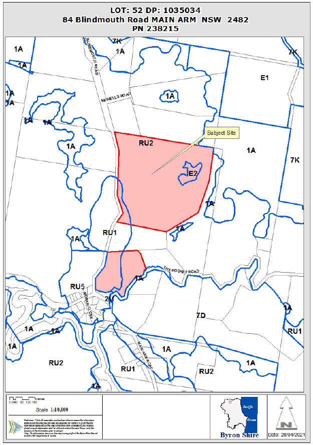
Assessment:
1. INTRODUCTION
1.1. History/Background
There are no
associated applications against this property.
1.2. Description
of the proposed development
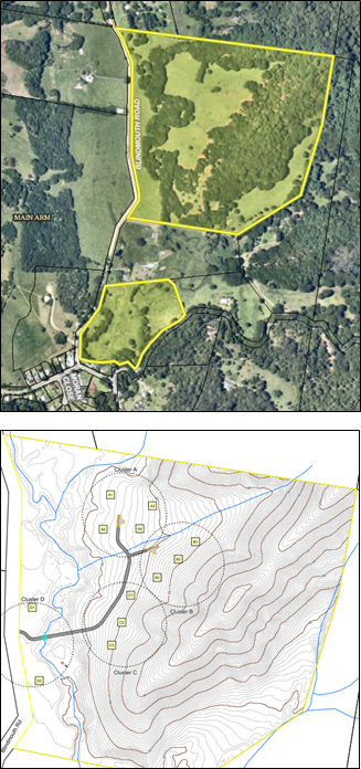 This
application seeks approval for Rural Land Sharing Community (Multiple
Occupancy) consisting of Twelve (12) Dwelling Sites, Associated Infrastructure,
Land Management and Environmental Enhancement.
This
application seeks approval for Rural Land Sharing Community (Multiple
Occupancy) consisting of Twelve (12) Dwelling Sites, Associated Infrastructure,
Land Management and Environmental Enhancement.
The proposed
development includes twelve (12) dwelling sites within four (4) clusters, as
well as vehicular driveway access. The dwelling clusters have been located on
the site within existing open cleared areas and incorporate suitable areas for
the management of on-site wastewater, bushfire and access whilst having minimal
environmental impacts.
The property
currently contains no buildings or formalised access from Blindmouth Road and
is currently used for grazing livestock.
The property
contains a small creek that is required to be crossed to access most of the
dwelling sites. The following dwelling clusters make-up the proposed rural
living component:
· Cluster A: four dwelling sites A1-A4
· Cluster B: three dwelling sites B1-B3
· Cluster C: three dwelling sites C1-C3
· Cluster D: two dwelling sites D1-D2
1.3. Description
of the site
The subject site known as 84 Blindmouth Road, Main Arm and
legally described as Lot 52 on DP1035034 has a total area of 38.15ha and is
predominantly located within the Rural Landscape (RU2) Zone under Byron LEP
2014, with small pockets of the land identified as Primary Production (RU1) and
Environmental Conservation (E2) Zone which are not affected by the location of
dwellings sites in the proposal. The lot currently contains no buildings or
formalised access and is currently used for beef cattle grazing. A small
waterway traverses the lot from west to east which originates in the Inner
Pocket Nature Reserve. The site contains High Environmental Value vegetation
and is identified as Bushfire prone land.
The property is split in two, with the residential uses
proposed on the northern section of the property.
The site has been identified as suitable for a Multiple
Occupancy in the Byron Rural Settlement Strategy 1998, Byron LEP 1988, and more
recently in Byron LEP 2014.
View from
Blindmouth Road
2. SUMMARY
OF REFERRALS
|
Referral
|
Issue
|
|
Environmental
Health Officer*
|
No objections
subject to conditions.
|
|
Development
Engineer
|
No objections
subject to conditions.
|
|
S64 / Systems
Planning Officer
|
No objections
subject to conditions.
|
|
S94 /
Contributions Officer
|
No objections
subject to conditions.
|
|
Ecologist
|
No objections
subject to conditions.
|
|
Essential Energy
|
No objections subject
to conditions.
|
* Conditions
provided in the above referral are included in the Recommendation of this
Report below
3. SECTION
4.14 – BUSH FIRE PRONE LAND
Under section 4.14 of the Act, Council must be satisfied prior
to making a determination for development on bush fire prone land, that the
development complies with the document ‘Planning for Bush Fire Protection
2006’.
The site is bush fire prone land. The development application
is accompanied by a Report ‘Bushfire Assessment Report’ by Sustainable
Home Solutions and dated 31 March 2020 which concludes. Condition 3 is included
in the Recommendation of this Report requiring that the development must always
comply with the requirements of Report ‘Bushfire Assessment Report’
by Sustainable Home Solutions dated 31 March 2020
The Bushfire Assessment Report
demonstrates that no proposed site for the construction of a dwelling house in
the future will be greater than BAL29. Further all future applications for
dwelling houses over the 12 sites will have to be assessed against the relevant
bushfire protection legislation at the time of lodgement.
The
application was referred to the RFS for review under s100B of the RFS Act,
however as the proposal does not propose subdivision of the land, the RFS
advised that the S100B Approval was not required. With the house sites
located within cleared areas of the property. The submitted Bushfire Assessment
Report indicates that future dwellings can be constructed with appropriate
Asset Protection Zones and Construction standards without needing to resort to
performance solutions to get an approval. It is considered the bushfire
constraint can be appropriately managed.
4. SECTION
4.15C – MATTERS FOR CONSIDERATION – DISCUSSION OF ISSUES
Having regard to
the matters for consideration detailed in Section 4.15(1) of the Environmental
Planning & Assessment Act 1979 (EP&A Act), the following is a summary
of the evaluation of the issues.
4.1 State
Environmental Planning Instruments
|
|
Satisfactory
|
Unsatisfactory
|
|
State
Environmental Planning Policy No 44—Koala Habitat Protection
|
☒
|
☐
|
|
Consideration:
Councils Ecologist has assessed the proposal and provided the following
comments:
“The site has an area of more
than 1 hectare, and therefore the proposal must be considered under the Koala
SEPP.
Consideration: Clause 8(1) of the Koala SEPP provides
that “before a Council may grant consent to a development
application for consent to carry out development on land to which this part
applies, the council must be satisfied as to whether or not the land is a
potential koala habitat”.
It is considered that the subject land is not potential
koala habitat as defined by the Koala SEPP because it does not contain an
area of native vegetation where Schedule 2 Feed Tree Species constitute at
least 15% of the total number of trees in the upper or lower strata of the
tree component. It is therefore considered that the proposal is subject to
Clause 8(3)(a) which states “if the Council is satisfied that the
land is not a potential koala habitat, it is not prevented, because of this
Policy, from granting consent to the development application”.”
|
|
State
Environmental Planning Policy No 55—Remediation of Land
|
☒
|
☐
|
|
Consideration:
Councils Environmental Health officer has assessed the proposed development
and provided the following comments:
“Appendix
C provides a SEPP 55 – Preliminary Site Investigation for contaminated
land assessment.
In summary,
the following conclusions were derived following a preliminary investigation
of the subject site:
The
preliminary site investigation concludes that there is insignificant risk of
contamination at the site of the proposal, and no further detailed
investigation or soil testing is warranted.
In
accordance with the Byron Shire Council Contaminated Sites Guidelines, NSW
EPA Guidelines and SEPP55 provisions, the site is suitable for the proposed
Rural Landsharing Community.”
|
|
State
Environmental Planning Policy (Primary Production and Rural Development) 2019
|
☒
|
☐
|
|
Consideration:
The proposed development raises no issues in terms of the SEPP and the
subject land is not identified ass containing state significant farm land. As
Council has its own provisions relating to Multiple Occupancy development
Schedule 5 of the SEPP doesn’t apply to Byron Shire.
|
4.2A Byron Local Environmental Plan 2014 (LEP 2014)
In accordance with
LEP 2014 clauses 1.4 and 2.1 – 2.3:
(a) The
proposed development is defined in the LEP 2014 Dictionary as Multiple
Occupancy;
(b) The
land is within the RU1 Primary Production / PART RU2 Rural Landscape, E2
Environmental Conservation Zone – However the bulk of the land is within
the RU2 zone and the development in terms of proposed house sites occurs in
this zone, other than the two house sites facing Blindmouth Road.
(c) The
proposed development is Permitted with Consent; and
(d) The
proposed development does not offend or compromise the objectives of the E2
Zone and this area of the property will be managed for environmental purposes.
Regard is had for the objectives of the two rural zones as follows:
|
RU1 Zone
Objective
|
Consideration
|
|
• To encourage sustainable primary
industry production by maintaining and enhancing the natural resource base.
• To encourage diversity in primary industry
enterprises and systems appropriate for the area.
• To minimise the fragmentation and
alienation of resource lands.
• To minimise conflict between land uses
within this zone and land uses within adjoining zones.
• To encourage consolidation of lots for
the purposes of primary industry production.
• To enable the provision of tourist
accommodation, facilities and other small-scale rural tourism uses associated
with primary production and environmental conservation consistent with the
rural character of the locality.
• To protect significant scenic
landscapes and to minimise impacts on the scenic quality of the locality.
|
The site post
consent will still enable the land to be used for agricultural purposes once
developed, including the southern portion of the property near the Main Arm
Village. It is unlikely the proposal will create a land use conflict with
neighbours and the house/s, considering the site opposite the property is
also likely to be developed for a community title development.
Visually the
development will not adversely affect the scenic amenity of the
locality.
|
|
RU2 Zone
Objective
|
Consideration
|
|
• To encourage sustainable primary
industry production by maintaining and enhancing the natural resource base.
• To maintain the rural landscape
character of the land.
• To provide for a range of compatible
land uses, including extensive agriculture.
• To enable the provision of tourist
accommodation, facilities and other small-scale rural tourism uses associated
with primary production and environmental conservation consistent with the
rural character of the locality.
• To protect significant scenic
landscapes and to minimise impacts on the scenic quality of the locality.
|
Similar to the
above comment for the RU1 Zone, the site will still be able to be used for
agricultural purposes and the development is unlikely to generate land use
conflicts with surrounding properties.
Visually the
future dwellings will be hidden from Blindmouth Road by riparian vegetation
which will screen these houses.
It is considered
the proposal raises no issues with the scenic amenity of the locality.
|
|
|
4.2B Maximum
number of dwelling houses or dual occupancies on Multiple Occupancy or rural landsharing
community developments
1) The
objectives of this clause are as follows:
a) to permit:
i. people to collectively own a
single lot of land and use it as their principal place of residence, and
ii. the erection of multiple dwellings
on the lot and the sharing of facilities and resources, and
iii. the collective environmental repair and
management of the lot, and
iv. the
pooling of resources to economically develop a wide range of communal rural
living opportunities,
b) to facilitate closer rural settlement
in a clustered style in a manner that:
i. protects the environment, and
ii. does
not create any unreasonable demand for the provision of services or any
unreasonable demand for the uneconomic provision of services.
2) This
clause applies to land outlined by a thick green line on the Multiple Occupancy and Community
Title Map.
3) Development
may be carried out with consent for the erection of more than one dwelling house
or dual occupancy (attached) on such a lot provided that:
a) if there is a number shown for that
lot on the Multiple Occupancy and Community
Title Map—the total number of dwellings on the lot will
not exceed the number marked for that lot on that Map, or
b) if
there is no number shown for that lot on that Map—there will not be less
than 3 dwellings, and not more than 1 dwelling for every 3 hectares, up to a
maximum of 15 dwellings, on the lot.
4) Development
consent must not be granted under subclause (3) unless the consent authority is
satisfied that:
a) there will be appropriate management
measures in place that will ensure the protection of the landscape,
biodiversity and rural setting of the land, and
b) the development is complementary to
the rural and environmental attributes of the land and its surrounds.
The 38.15 ha
property can accommodate a maximum of 12 dwelling sites in accordance with
subclause (3).
Calculation: 38.15 / 3 = 12.7
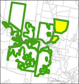
Extract of Multiple Occupancy and Community Title Map Site highlighted
Conditions of
consent are recommended in relation to limiting each house site to one dwelling
only, including restrictions on title and relevant provisions in the management
plan. This is to ensure landowners when purchasing a house site within this MO
are aware that they will not be able to obtain a consent for a dual occupancy
or a secondary dwelling.
The proposal raises
no other issues under the LEP
4.3 Any proposed
Instrument that has been the subject of public consultation and has been
notified to the consent authority
No draft LEPs apply
to the site.
4.4A Byron Shire Development
Control Plan 2014 (DCP 2014)
Chapter B4
Traffic Planning, Vehicle Parking Circulation and access
Access to the site
is provided from Blindmouth Road with an internal road proposed to the 12 house
sites. Conditions of consent are proposed in relation to Roads Act approval and
a construction certificate.
Chapter D2-
Residential Accommodation and ancillary development in Rural Zones
Chapter D2 includes
provisions relating to Multiple Occupancy Development under D2.6. the following
comments are provided against each of the provisions as follows
1. Siting
and clustering of dwellings
The proposal accords with the requirement to cluster the individual
dwelling sites, with A1-A4, B1-B3 and C1-C3 all clustered and set behind the
creek tree line to screen the overall development from view of Blindmouth Road.
D1-D2 are within the setbacks/distances required of clustered dwellings however
are located in an existing cleared area with excellent access onto Blindmouth
Road. In this instance the development takes the form of clusters and is not
dispersed throughout the site.
2. Environmental
Impact report
A Biodiversity
Assessment report and Vegetation Management Plan have been provided with the
development application. These reports have suitably identified the constraints
of the site, provided recommendations for ongoing land management and
ecological restoration, and informed of suitable unconstrained developable land
on the allotment where clusters are proposed and supported to be located.
3. Rural
Landsharing Management Plan
The application is
accompanied by a Draft Rural Landsharing Plan of Management The management plan
states the overall objectives of the rural
landsharing community are:
• to
enable the intentional incoming residents to occupy the site to generate an
interactive, socially
stable and
viable community;
•
promote sustainable land use activities on the property such as small-scale
food generation,
renewing
natural resources and scientifically based land improvement actions.
•
enhance the site’s air, water, soil and ecological values;
•
foster indigenous values and cultural knowledge; and
• enact
climate change resilience measures in a changing world.
Details have been
included in the plan which generally address the requirements under the DCP for
the Management Plan, including measures for collective decision making and
ownership, purchasing and disposing of shares, keeping of pets, environmental
repair and land managements, effluent disposal, water management and the like.
The final Plan of Management will be required to be submitted for
Council approval before a Construction Certificate is issued.
4. Access
roads
The
proposal is capable of compliance with relevant vehicle access standards
identified in the DCP. A condition of consent is included in the recommendation
of this report requiring plans and specifications that demonstrate compliance
with the requirements of RMS Drawing 19.07.2016 (driveway access), NSW Planning
for Bushfire Protection 2006 (internal access, turnaround area & passing
bays) and SDS Civil drawing C1 (upgrade to Blindmouth Road).
5. Bushfire Management
The
Bushfire Assessment Report prepared by Sustainable Home Solutions identifies
that each of the dwelling sites has adequate area to provide APZ’s for
dwellings with a maximum BAL rating of BAL 29 (average across the lots of LOW -
12.5). Ecological restoration zones required in accordance with the Vegetation
Management Plan do not interfere with APZs.
6. Vegetation
Management
The submitted Vegetation Management
Plan (VMP) includes a broad but well documented assessment of the vegetation
communities on the site. The application included a draft VMP detailing
ecological restoration and protection works across two Environmental Management
Zones. The VMP approach and methodology is supported and it is considered that
the ecological work units conversion has been carried out in accordance with
Chapter D2. Conditions of consent will be recommended to ensure that the VMP is
carried out and monitored.
7. Water
Management Plan
The Water Management
Plan submitted with the application addresses the Prescribed Measures of the
DCP, in that: Dwellings will be supplied by roof water harvesting in 40,000L
tanks; 10,000L water tanks will be required for each dwelling in accordance
with the approved Bushfire Assessment Report for firefighting purposes; all
dwellings are located away from drainage lines and water courses; no dam is
proposed; each dwelling will be required to comply with a BASIX Certificate to
demonstrate water conservation measures; and no component of the proposal seeks
to extract groundwater.
8. Effluent
Disposal
The
specialist assessment within Appendix B demonstrates that the site is capable
of accommodating environmentally sensitive wastewater treatment systems for
each of the dwelling sites. At the development application stage for each
dwelling, a detailed wastewater assessment will be undertaken when the
configuration and number of bedrooms of each dwelling is known.
9. Dwelling
houses
The applicant has proposed only 12
house sites as per the yield provisions within the LEP. It is noted that the DA
is not for 12 dwelling sites plus a further 12 secondary dwelling sites or for
twelve dual occupancies. Such a proposal would equate to 24 dwellings which is
not permissible under the LEP. Conditions of consent are recommended in
relation to limiting the number of houses to one per dwelling site.
4.5 Environmental
Planning & Assessment Regulation 2000 Considerations
|
Clause
|
This control
is applicable to the proposal:
|
I have
considered this control as it relates to the proposal:
|
If this
control is applicable, does the proposal comply?
|
|
92
|
No
|
N/A
|
N/A
|
|
93
|
No
|
N/A
|
N/A
|
|
94
|
No
|
N/A
|
N/A
|
|
94A
|
No
|
N/A
|
N/A
|
*
Non-compliances and any other significant issues discussed below
4.6 The likely
impacts of that development, including environmental impacts on both the natural
and built environments, and social and economic impacts in the locality
|
Impact on:
|
Likely
significant impact/s?
|
|
Natural
environment
|
No. The proposal
will not have a significantly adverse impact on the natural environment of
the locality.
|
|
Built environment
|
No. The proposal
will not have a significantly adverse impact on the built environment of the
locality.
|
|
Social
Environment
|
No. The proposal
will not have a significant social impact on the locality.
|
|
Economic
impact
|
No. The proposal
will not have a significant economic impact on the locality.
|
4.7 The
suitability of the site for the development
Issue
|
Comment
|
|
Services
- Water/
Sewer/ Stormwater
- Ph/
power
- Access
- Onsite
Effluent Disposal
|
An application
for water and OSMS connection will be required at DA stage for each of the 12
dwellings. No dwellings are proposed at this stage.
|
|
Hazards
- Flooding,
Bushfire, Landslip
|
The site is not
flood affected, or subject to landslip.
The submitted
Bushfire Report identifies the future dwelling sites will not result in a
BAL29 rating to any future dwelling.
|
|
Land Use
conflicts
|
The proposed
development will not give rise to any land use conflicts between the site and
existing rural activities.
|
|
Future Character
of the area
|
The property is
within walking cycling distance to the Main Arm Village store. It is noted
there are a number of other approvals for Multiple Occupancies and Community
title development and village lot subdivisions that are at various stages of
development. This includes DA 10.2009.220.1 for 12 village lots, a commercial
lot and 13 rural community title lots, and DA10.2008.159.1 8 village lots and
13 community title lots. Both consents have commenced.
Other recent MO
approvals in the Main Arm area include:
· DA10.2019.619.1
- twelve dwelling sites;
· DA10.2014.376.1
– fifteen dwelling sites; and
· DA10.2009.460.1
– eleven dwelling sites.
|
4.8 Submissions
made in accordance with this Act or the regulations
The development application was publicly exhibited
There were 20 submissions
made on the development application:
- Against
The submissions are
addressed below:
|
Submission
|
Comment
|
|
Traffic: increase
in number of vehicles using Blindmouth Road.
|
Council’s
Development Engineer has assessed the proposal and has included conditions
requiring that Blindmouth Road be upgraded including the creek crossing.
|
|
The DA does not
meet the location criteria of the most recent Byron Rural Land Use Strategy
(BRLUS) adopted in 2017.
|
The subject land
was included in the Byron Rural Settlement Strategy 1998 (see below) and
incorporated into the Byron LEP 2014 - Multiple Occupancy and
Community Title Map. The site did not need to be included within
the BRLUS as it was already in the LEP as a potential MO site.
|
|
Potential for the
property to be isolated in the event of flood and bushfire
|
Noted –
like most of the rural hinterland of Byron Shire there is potential for rural
properties to be cut off from Mullumbimby and the Pacific Highway in the
event of flooding. House sites are located above flood heights for the
locality.
In regard to
bushfire risk, the site has suitable access (which will be upgraded as part
of this development) to evacuate the site along Blindmouth Road.
|
|
The proposal
wrongly justifies that the MO can fit 12 dwelling sites.
Development is
proposed on only the northern 32 hectares ‘split’ part of Lot 52
DP 1035035.
The development
should be considered against this part of the property only therefore only 10
dwellings should be approved.
|
The assessment is
against the area of the entire allotment being 38ha. The yield proposed
complies with Clause 4.1B of the LEP. To ensure lots are compliant with the
clustering arrangement it is appropriate that no lots are sited on the
smaller constrained parcel near the intersection of Main Arm Road and
Blindmouth Road which will be utilised for agricultural pursuits and
environmental rehabilitation.
|
|
Clustering
doesn’t comply with the DCP provisions. Chapter D2 on the siting and
clustering of house sites for Multiple Occupancy developments on page 17,
point a) states:
“Dwelling
houses must be clustered in three (3) or more houses or future house sites...
The distances apart must average 80 metres in a cluster but not exceeding 160
metres between any two dwelling houses in a cluster.”
Cluster D has
only 2 houses that are about 150m apart.
|
The development
largely accords with the requirement to cluster the individual dwelling sites
with A1-A4, B1-B3 and C1-C3 all clustered and set behind the creek tree line
to screen the overall development from view of Blindmouth Road. D1-D2 are
within the setbacks/distances required of clustered dwellings and are located
in an existing cleared area with excellent access onto Blindmouth Road.
In general, the
clustering is appropriate for the development, but it is recommended that a
Dwellings D1 and D2 be sited at there closest point 80 metres apart.
Conditions to apply.
|
|
The two houses of
Cluster D are too close to Blindmouth Road being a secondary road in terms of
Classified roads under the Roads Act. Therefore a 55m setback required under
DCP 2014
|
Blindmouth Road
is not identified as a Classified Road and is not identified as a secondary
road under the Roads Act by the Minister. Therefore, the development setback
of 25m to Blindmouth Road complies with the standard minimum of 15 metres
under D2.2.2 of DCP 2014.
|
|
Bushfire Hazard
|
The Bushfire
Assessment Report prepared by Sustainable Home Solutions identifies that each
of the dwelling sites has an adequate area to provide APZ’s for
dwelling with a maximum BAL rating of BAL 29. The bushfire as a constraint
can be appropriately managed
|
|
Constraints will
affect the ability for future residents to design and construct onsite sewage
management systems having regard to slops and location of waterways.
|
It is considered that effluent can
be adequately managed and disposed of on-site. Specific details or onsite
systems will be subject to assessment when applications are lodged for
dwelling houses on-site.
|
|
The DA does not
provide a detailed Rural Land sharing Management Plan, which is a requirement
for a Multiple Occupancy application.
|
A Draft Plan of
Management has been submitted in draft form has been submitted with the
application. The final plan of management will be required to be submitted
for Council approval before construction certificate is issued.
|
|
Too many
dwellings and impacts on rural character of the area
Combined with
other CT/ MO approvals in Main Arm this will ruin the rural character and
scenic quality of Main Arm
|
The site has been
identified as suitable for a MO in the Byron Rural Settlement Strategy 1998
and in Byron LEP 1988 and more recently in Byron LEP 2014.
It is submitted
that the character of Main Arm, Upper Main Arm and Durrumbul is characterised
by Multiple Occupancies, Community Title Developments and Small Lot acreage
and other forms of “multi dwelling” housing some of which may or
may not be approved. The proposed development of this parcel as proposed is
not inconsistent with that character and will provide for an approved
development site for 12 dwellings to proceed in the future.
In terms of
future appearance only two dwellings will be generally visible from
Blindmouth Road in the front paddock. The other dwelling sites are located to
the east behind the riparian vegetation and has no detrimental impact on the
scenic amenity or rural character of the area.
|
|
The proposal’s Biodiversity Assessment Report outlines a plan to
plant 10,800 trees or rainforest plantings along the 7.5ha Western Creek
riparian corridor. This is the 900 trees or plantings for each of the 12
dwellings in the DA.
|
The ecological
restoration on the property consists of two elements comprising the planting
of some 5000 rainforest trees over a 3ha area and weed management action over
some 4.5 ha along the creek aimed at removing camphor laurels and enabling
natural regeneration. Council’s ecologist has reviewed the subject plan
and is satisfied in its scope in terms of vegetation management.
|
4.9 Public
interest
The proposed
development is unlikely to prejudice or compromise the public interest or
create an undesirable precedent.
5. DEVELOPER
CONTRIBUTIONS
5.1 Water &
Sewer Levies
No Section 64
levies will be required.
5.2 Section 7.11
Contributions
Section
7.11 Contributions will be payable.
6. DISCLOSURE
OF POLITICAL DONATIONS AND GIFTS
|
Has a Disclosure Statement been received in relation
to this application
|
No
|
|
Have staff received a ‘gift’ from anyone
involved in this application that needs to be disclosed. Where the answer is
yes, the application is to be determined by the Director or Manager of the
Planning, Development and Environment Division.
|
No
|
Provide Disclosure Statement register details here: Not
applicable
7. CONCLUSION
The DA proposes
Rural Land Sharing Community (Multiple Occupancy) consisting of Twelve (12)
Dwelling Sites, Associated Infrastructure, Land Management and Environmental
Enhancement. The proposed development is satisfactory having regard to the
relevant environmental planning instruments and planning controls applicable to
the site. The proposal raises no significant issues in terms of environmental
impacts which cannot be managed, and the site is considered suitable for the
development. The application appropriately addresses the relevant constraints
applying to the site and is recommended for approval subject to the conditions
listed in the Recommendation.
Staff Reports - Sustainable Environment and Economy 13.6
Report
No. 13.6 PLANNING -
Deferred 10.2014.417.2 - S4.55 to Modify Staging. Stage 1: Conversion of
Existing Garage to Temporary Sales and Display Office for On-site Marketing of
Approved Residential Flat Building. Stage 2: Demolition of Existing
Building and Construction of Residential Flat Building at 43 Lawson Street,
Byron Bay
Directorate: Sustainable
Environment and Economy
Report Author: Patricia
Docherty, Planner
File No: I2021/618
Proposal:
|
Proposed modification:
|
S4.55 to Modify Staging. Stage 1: Conversion of Existing
Garage to Temporary Sales and Display Office for On-site Marketing of
Approved Residential Flat Building. Stage 2: Demolition of Existing
Building and Construction of Residential Flat Building
|
|
Original Development:
|
Demolition of existing residential flat building &
construction of a new residential flat building and associated works
|
|
Type of modification sought:
|
|
|
|
|
|
Property description:
|
LOT: 1 SP: 16094
|
|
43 Lawson Street BYRON BAY
|
|
Parcel No/s:
|
41930
|
|
Applicant:
|
Northpoint Advisory
|
|
Owner:
|
The Owners of Strata Plan 16094
|
|
Zoning:
|
R3 Medium Density Residential
|
|
S96 Date received:
|
17 September 2020
|
|
Original DA determination date:
|
10/12/15
|
|
Public notification or exhibition:
|
- Level
1 advertising under DCP 2014 Part A14 – Public Notification and
Exhibition of Development Applications
- Exhibition
period: 30/9/20 to 13/10/20
- Submissions received:
one (1)
|
|
Planning Review Committee:
|
13/11/2020
|
|
Delegation to determination:
|
Council
|
|
Issues:
|
· Deferred
report in response to Resolution Number: 21-069 Council (Planning) Meeting of
11 March 2021. Owner’s consent is now provided in accordance with
Environmental Planning & Assessment Regulation 2000 clause
49.
· Recent
acquisition by new owner of Lot 4 – additional owner’s consent
attached.
· The
proposed stage 1 conversion of a garage to an on-site sales office will
result in a shortfall of parking. Condition of consent is recommended to
require that one residential unit is permanently vacated prior to Stage 1
commencing.
|
Summary:
This report responds to Council Resolution Res 21-069
Council (Planning) Meeting of 11 March 2021, which required action as outlined
below.
Resolved that
Development Application No. 10.2014.417.2, for S4.55 to Modify Staging -Stage
101: Conversion of Existing Garage to Temporary Sales and Display Office for
on-site Marketing of Approved Residential Flat Building, Temporary Car Parking
Space, Pedestrian Access and Landscaping. Stage 2: Completion of all
Works and Demolition of Existing Building, be deferred and subject to a further
report to Council at a subsequent meeting.
The Section 4.55
Application 10.2014.417.2 was previously recommended for refusal on the grounds
that owner’s consent was not provided by all owners and that the works
would result in a shortfall of on-site parking.
A late submission
of documents from the applicant resolved the matter of owner’s consent
due to the sale of the sole objector’s property to one of the existing
unit owners.
The S4.55
modification proposed is substantially the same as that approved under DA
10.2014.417.1 with no changes to the design of the residential flat building to
be constructed. One additional plan is proposed to allow for the use of
an existing single garage for a temporary sales and display office for on-site
marketing of the approved residential flat building.
The Stage 1 works
will result in a reduction of 1 parking space which does not meet the
requirements of the Byron Development Control Plan 2014 Chapter B4 if all
residential units are occupied. For this reason, the applicant has advised they
are willing to accept a limitation on the occupation and use of one residential
unit whilst the sales office is in operation. This would enable the use
of one of the garage spaces as the temporary sales and display office while
ensuring the car parking provisions of Byron DCP 2014 are met, for the duration
of Stage 1. Appropriate conditions of consent are recommended to reflect this.
The proposed
ancillary nature of the temporary sales and display office for on-site
marketing of the approved residential flat building is permissible with consent
in the R3 medium density zone under Byron Local Environmental Plan 2014.
A limitation on the duration and operation of Stage 1 to one year is also
recommended to ensure it only relates to marketing of the approved residential
flat building on this site.
The S4.55
application raises no other issues and is recommended for approval.
NOTE TO COUNCILLORS:
In accordance with the
provisions of S375A of the Local Government Act 1993, a Division is to be
called whenever a motion for a planning decision is put to the meeting, for the
purpose of recording voting on planning matters. Pursuant to clause 2(a)
under the heading Matters to be Included in Minutes of Council Meetings of
Council's adopted Code of Meeting Practice (as amended) a Division will be
deemed to have been called by the mover and seconder of all motions relating to
this report.
RECOMMENDATION:
That
pursuant to Section 4.55 of the Environmental Planning & Assessment Act
1979, Application No. 10.2014.417.2, for S4.55 to Modify Staging - Stage 1:
Conversion of Existing Garage to Temporary Sales and Display Office for On-site
Marketing of Approved Residential Flat Building. Stage 2: Demolition of
Existing Building and Construction of Residential Flat Building, be approved by
modifying Development consent number 10.2014.417.1 as detailed in Attachment 2
(E2021/56626).
Attachments:
1 10.2014.417.2
43 Lawson Street Marked Plans, E2021/56572
2 10.2014.417.2
Recommended Modified Conditions of Consent and Reasons, E2021/56626
3 10.2014.417.2
210430_Letter_43 Lawson Consent (lot 4)_PAN-31279 received by Council 07 May
2021, E2021/65194
4 10.2014.417.2
210430_Ltr_43 Lawson Consent (lot 4) Att company ASIC details_PAN-31279, E2021/65193
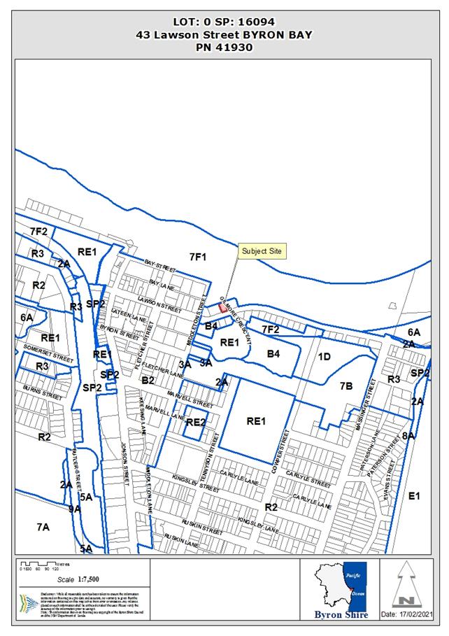 Assessment:
1. INTRODUCTION
1.1. History/Background
10.2014.417.1 - Development Application: Demolition of
existing residential flat building & construction of a new residential flat
building and associated works was approved by Council on 10/12/2015.
Building Application No. 10/80 - Three storey building
containing 6 x 2 bedroom units, with 6 residential parking spaces plus 1
visitors parking.
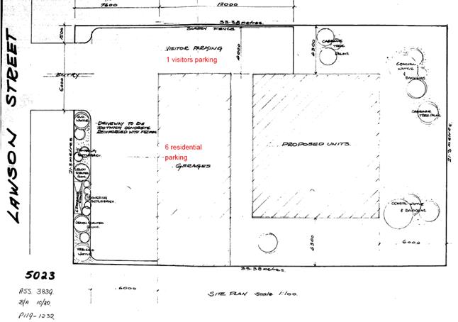
BA 10/80 - Approved Plan – extract of scanned
document
1.2. Description
of the proposed development
This application seeks approval for a S4.55 to Modify
Staging. Stage 1: Conversion of Existing Garage to Temporary Sales and Display
Office for On-site Marketing of Approved Residential Flat Building. Stage
2: Demolition of Existing Building and Construction of Residential Flat
Building
Proposed Modification
Addition of staging as follows:
Stage 1 Proposed Uses:
· Temporary Sales
and Display Office
· Utilisation of 1
parking space for the duration of Stage 1
· Operating Monday
to Saturday 8AM to 6PM
The applicant also sought compensatory parking depicted in
plans below.
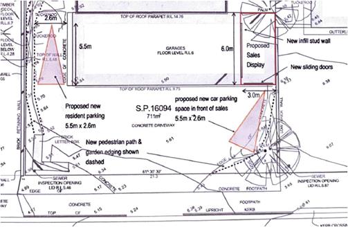
Stage 2
The remainder of the works approved under original consent
10.2014.417.1 being:
· Demolition
of existing building
· Construction
of residential flat building
Proposed Plans and revised plans submitted to Council did
not provide suitable vehicular access and egress in accordance with relevant
standards.
1. The
new proposal requires 1 additional parking space; and
2. The location of the new parking for
the new use is partially obstructing access to residential parking.
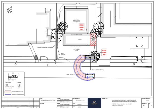
For this reason, the applicant would be willing to accept a
limitation on the occupation and use of one residential unit in lieu of
providing compensatory parking to enable the use of one garage for a temporary
sales and display office (Stage 1).
1.3. Description
of the site
The site at 43 Lawson Street, Byron Bay is zoned R3 Medium
Density Residential under Byron LEP 2014, and contains an existing brick
residential flat building. The property backs onto the foreshore reserve and
park adjacent to the beach at Byron Bay.
The proposed Sales office is to occupy the Car Park of Unit
1 also legally described as Lot 1 SP 16094
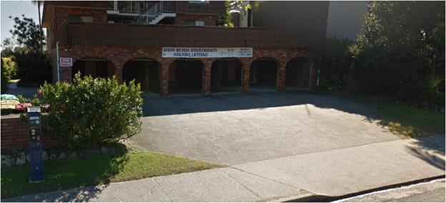
Site from Lawson Street
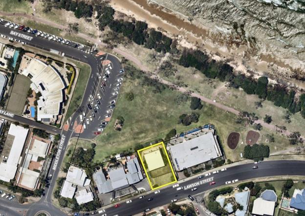
Aerial view of 43 Lawson Street, Byron Bay
2. SECTION 4.15 – MATTERS FOR
CONSIDERATION – DISCUSSION OF ISSUES
Having regard for the matters for consideration detailed in
Section 4.15(1) of the Environmental Planning & Assessment Act 1979, the
following is a summary of the evaluation of the issues.
The s4.55 modification proposed is substantially the same as
that approved under DA 10.2014.417.1 with no changes to the plans approved by
Council in 2015. One additional plan is proposed to allow for the use of
an existing single garage for a temporary sales and display office for on-site
marketing of the approved residential flat building.
2.1. State/Regional
Planning Policies, Instruments, EPA Regulations 2000
Proposed amendments raise no issues under the relevant
SEPPs, Policies or clauses of the EPA Regulations 2000.
2.2. Byron Local
Environmental Plan 2014
The proposed ancillary nature of the temporary sales and
display office for on-site marketing of the approved residential flat building
is permissible with consent in the R3 medium density zone under Byron Local
Environmental Plan 2014.
A limitation on the operation of Stage 1 including a time
limit to one year is recommended having regard to the size of the development
as approved (6 Units). It is also recommended that a condition be imposed to
ensure that sales office only promotes, markets and sells units as approved on
this development site, to ensure it does not become a defacto real estate sales
office for other properties.
The proposed amendments raise no other issues under the LEP.
2.3. Draft EPI
that is or has been placed on public exhibition and details of which have been
notified to the consent authority - Issues
No draft EPIs affect the proposal.
2.4. Development
Control Plans
The Stage 1 works will result in a reduction of 1 parking
space that does not meet the requirements of the Byron Development Control Plan
2014 Chapter B4. For this reason, the applicant would be willing to accept a
limitation on the occupation and use of one residential unit in lieu of
providing compensatory parking. This would enable the use of one garage
for a temporary sales and display office while ensuring the car parking
provisions of Byron DCP 2014 are met, for the duration of Stage 1.
It is considered that the shortfall in parking arising from
the temporary use of one garage for on-site sales and display can be addressed
by plans marked by Council’s assessing officer and conditions of consent
recommended in the attachments to this report.
The proposed amendments do not generate any other additional
issues that have not been previously considered.
2.5. The
likely impacts of that development, including environmental impacts on both the
natural and built environments, and social and economic impacts in the locality
Proposed amendments do not generate any impacts that have
not been previously considered.
2.6. The
suitability of the site for the development
Proposed amendments do not affect the sites suitability for
the approved development.
2.6 Submissions
made in accordance with this Act or the regulations
An objection was received by one owner within the body
corporate but due to an agreement between the parties and sale of property, the
matter of owner’s consent has fallen away. Evidence of additional
owner’s consent from new owner of Lot 4 is provided. See attachments 3
and 4.
2.7 Public
interest
Proposed amendments are unlikely to prejudice or compromise
the public interest.
3. DEVELOPER
CONTRIBUTIONS/ WATER AND SEWER CHARGES
There is no nexus to levy additional contributions.
4.DISCLOSURE
OF POLITICAL DONATIONS AND GIFTS
|
Has a Disclosure Statement been received in relation
to this application
|
No
|
|
Have staff received a ‘gift’ from anyone
involved in this application that needs to be disclosed. Where the answer is
yes, the application is to be determined by the Director or Manager of the
Planning, Development and Environment Division.
|
No
|
5. CONCLUSION
The Section 4.55
Application 10.2014.417.2 was previously reported to Council on 11 March 2021
and recommended for refusal on the grounds that owner’s consent was not
provided by all owners and that the works would result in a shortfall of
on-site parking.
A late submission
of documents from the applicant resolved the matter of owner’s consent
due to the sale of the sole objector’s property to one of the existing
unit owners, and the matter was deferred by Council resolution.
It is further
considered that the shortfall in parking arising from the temporary use of one
garage for on-site sales and display can be addressed by plans marked by
Council’s assessing officer and conditions of consent recommended in the
attachments to this report. Further conditions are also recommended in relation
to limiting the sales office to a 12 months and that it only undertakes
marketing and sale of units as approved under this DA consent.
The S4.55 Application is recommended for approval subject to
amended conditions of consents.
Staff Reports - Sustainable Environment and Economy 13.7
Report
No. 13.7 Byron LEP 2014 Rural
Subdivision Provisions
Directorate: Sustainable
Environment and Economy
Report Author: Sam
Tarrant, Planner
File No: I2021/783
Summary:
The Department of Primary Industries is in the process of
developing the NSW Agricultural Land Use Planning Strategy to address key
planning issues facing agriculture. Although the draft Strategy is yet to be released
for public comment, it is likely to effect rural clauses within the Byron Local
Environmental Plan (LEP) 2014.
LEP 2014 contains several clauses relating to subdivision of
rural land within Byron shire. Those of relevance to this report include
clauses 4.1C
and 4.1F
.
A number of issues have been identified relating to the
application of clause 4.1C - Minimum subdivision lot size for boundary
adjustments in certain rural and residential zones and 4.1F - Exceptions
to minimum lot sizes for certain rural subdivisions. These issues primarily
relate to their drafting, interpretation and/or decisions in the NSW Land &
Environmental Court.
The most recent planning proposal (26.2020.6.1) sought to
remove clause 4.1F from the LEP, noting interpretation and application issues.
However the submissions report, also being presented to the 10 June 2021
Planning Meeting (titled Housekeeping Planning Proposal Exhibition outcomes
26.2020.6.1), recommends that clause 4.1F remain in the LEP in its current form
and further consideration be given once the implications of the NSW
Agricultural Land Use Planning Strategy are known. Clause 4.1C was not part of
this planning proposal but also needs further investigation into its drafting
wording and application.
This report provides a high level summary of the above rural
subdivision provisions, their associated issues and potential avenues to amend
the provisions to make them fit for purpose once the implications of the proposed NSW rural planning reforms are known.
It recommends that any proposed amendments to clauses 4.1C and 4.1F be
presented to Council as part of a future planning proposal, once the
implications of the proposed NSW rural planning reforms are known.
That Council receive a report on any
proposed amendments to clause 4.1C, 4.1F and similar rural subdivision clauses
in LEP 2014, as part of a future Council
initiated house keeping planning proposal once the implications of the proposed
State wide rural planning reforms are known.
REPORT
Byron Local Environmental Plan
(LEP) 2014 contains various provisions relating to subdivision of rural land.
These provisions are discussed below.
Clause
4.2 Rural subdivision
This clause enables subdivision of
rural land to be below the minimum lot size for primary production purposes,
but only if the resulting subdivision will not enable a dwelling opportunity.
It is mandated by the standard instrument LEP and hence no change can be made
to this clause.
4.2 Rural subdivision
(1) The objective of this clause is
to provide flexibility in the application of standards for subdivision in rural
zones to allow land owners a greater chance to achieve the objectives for
development in the relevant zone.
(2) This clause applies to the following
rural zones—
(a) Zone RU1 Primary
Production,
(b) Zone RU2 Rural Landscape,
(baa) Zone RU3 Forestry,
(c) Zone RU4 Primary Production
Small Lots,
(d) Zone RU6 Transition.
Note—
When this Plan was made
it did not include all of these zones.
(3) Land in a zone to which this
clause applies may, with development consent, be subdivided for the purpose of
primary production to create a lot of a size that is less than the minimum size
shown on the Lot Size Map in
relation to that land.
(4) However, such a lot cannot be
created if an existing dwelling would, as the result of the subdivision, be
situated on the lot.
(5) A dwelling cannot be erected on
such a lot.
Note—
A dwelling includes a
rural worker’s dwelling (see definition of that term in the Dictionary).
Clause
4.1C Minimum subdivision lot size for boundary adjustments in
certain rural and residential zones
Clause 4.1C is a local provision
that enables minor boundary adjustments between two or more adjoining
properties, which does not create additional lots or additional opportunities
for dwelling houses.
Whilst this is a locally drafted clause
(ie. not mandated) it is contained in many other LEPs within NSW. However the
wording of this clause varies between council LEPs depending on when the clause
was introduced into the relevant LEP.
4.1C Minimum
subdivision lot size for boundary adjustments in
certain rural and residential zones
(1) The objectives
of this clause are as follows—
(a) to permit boundary
adjustment subdivision between existing lots in rural areas where one or more
of the resulting lots would be less than the minimum subdivision lot size,
(b) to ensure that the
subdivision does not create additional lots or additional opportunities for
dwelling houses,
(c) to ensure that the boundary
adjustment subdivision will result in—
(i) a minimisation of
further fragmentation and alienation of resource lands or lands with natural or
ecological values,
(ii) the minimisation of land
use conflict,
(iii) the maintenance of the
rural character, environmental heritage and/or scenic quality of the land.
(2) This clauses
applies to land in the following zones—
(a) Zone RU1 Primary
Production,
(b) Zone RU2 Rural Landscape,
(c) Zone R5 Large Lot
Residential.
(3) Despite clause
4.1, development consent may be granted for a subdivision that consists of an
adjustment of boundaries between existing lots where the size of one or more of
the resulting lots will be less than the minimum subdivision lot size shown on
the Lot Size Map in
relation to those lots, if—
(a) the subdivision will not
result in the creation of any additional lots or the opportunity for additional
dwellings (or both), and
(b) the subdivision will
minimise the further fragmentation and alienation of resource lands or lands
with natural and ecological values, and
(c) the subdivision is likely
to minimise actual or potential land use conflict, and
(d) the subdivision is not
likely to affect the rural character, environmental heritage and scenic quality
of the land.
Issue
Clause 4.1C has been subject to a
Land and Environment court case Jonson
v Coffs Harbour City Council (2018) which provided
weighting to the term ‘boundary adjustment’. The ruling has set a
precedent in regard to the scale of what constitutes a boundary adjustment and
the scope of what can be approved through this clause.
This has meant that staff must
carefully consider the scale of any subdivision under clause 4.1C, which
has now become the limiting factor in applying this clause. The result is that
for some DAs, Council’s application of the court decision parameters has
prevented what otherwise may have been an acceptable development outcome.
To ensure this clause can be used
to provide more flexible and practical land use outcomes, the wording could be
amended to change the term ‘boundary adjustment’ to boundary alteration
or realignment or change. Doing this could provide greater scope (and
hence flexibility) in its application while still ensuring the objectives of
the clause are satisfied.
Tweed Shire Council is currently
looking at amending their boundary adjustment clause (4.1C) in a similar manner, based on the reasons mentioned
above.
Clause 4.1C in Nambucca LEP uses the term boundary alteration
and could be used to model the current clause wording in Byron LEP.
Staff have received preliminary
legal advice on the use of the term boundary alteration in place of boundary
adjustment, suggesting that the former would likely allow for more
flexibility in the scale of the subdivision. Discussions with Staff from
Nambucca Shire indicate that is the case. However, further investigation and
development of an amended clause 4.1C above, as well as Council’s other
rural subdivision clauses, will need to be informed by the State government
legislative reforms currently underway and case law.
As the legislative reform outcomes
are not known at this time, the redrafting of clause 4.1C and similar rural
subdivision clauses in LEP 2014 should be investigated collectively as part of
the future review into the rural subdivision clauses. The outcome of
these investigations will be presented in a future report to
Council.
Clause
4.1F Exceptions to minimum lot sizes for certain rural subdivisions
Clause 4.1F is a local provision
clause that enables subdivisions for certain purposes on rural land (other than
for the purpose of dwelling houses, dual occupancies or secondary dwellings).
This clause is similar to clause 4.2 Rural Subdivision but allows for a
subdivision of an undersized lot for purposes other than primary production.
This clause was placed into the
LEP in 2017 and was modelled from Clarence Valley LEP.
4.1F Exceptions to minimum
lot sizes for certain rural subdivisions
(1) The objective of this clause is
to enable the subdivision of land in rural areas to create lots of an
appropriate size to meet the needs of current permissible uses other than for
the purpose of dwelling houses, dual occupancies or secondary dwellings.
(2) This clause applies to land in the following
zones—
(a) Zone RU1 Primary Production,
(b) Zone RU2 Rural Landscape.
(3) Despite clause 4.1, development
consent may be granted to the subdivision of land to which this clause applies
to create a lot with a size less than the minimum subdivision lot size shown on
the Lot Size Map in
relation to those lots, if the consent authority is satisfied that—
(a) there is no dwelling house or dual occupancy
located on the land, and
(b) the use of the land after
the subdivision will be the same use permitted under the existing development
consent for the land.
(4) Development consent must
not be granted for the subdivision of land to which this clause applies unless
the consent authority is satisfied that—
(a) the subdivision will not adversely affect
the use of the surrounding land for agriculture, and
(b) the subdivision is necessary for the ongoing
operation of the permissible use, and
(c) the subdivision will not increase rural land
use conflict in the locality, and
(d) the subdivision is
appropriate having regard to the natural and physical constraints affecting the
land.
Issue
As addressed in the planning
proposal, this clause had been interpreted to enable subdivision of approved
tourist cabins from the larger rural lot. This has the effect of incentivising
rural landowners to seek approval for tourist facilities, knowing that they can
be subdivided off and sold, causing fragmentation to the rural areas. From a
planning standpoint, such an outcome is neither intended nor desired.
Adding additional land uses to the
objective of this clause (eg. tourist and visitor accommodation; ecotourist
facilities) could prevent subdivision of rural lots purely for tourism
purposes.
Even if additional land uses were
added to the objectives (i.e.. to prevent subdivision for tourism purposes),
the current drafting of this clause is problematic in achieving its intended
outcome. This is because subclause 3(a) currently prevents the
subdivision if a dwelling house is located on any of the lots. Ideally
this should be changed to clarify that a dwelling can be situated on the
original lot, whilst a dwelling on the new lot would still be prohibited.
NSW
Agricultural Land Use Planning
Strategy
NSW Department of Primary
Industries is developing a NSW Agricultural Land Use Strategy. An options paper
to help guide development of the strategy has recently finished consultation
with Council providing feedback via a submissions reported to the Agenda
of Ordinary Meeting - Thursday, 22 April 2021 (infocouncil.biz)
The options paper identified a
potential change to the rural development SEPP as well as the standard
instrument LEP to address ambiguity between LGAs. Among the options being
considered is to amend the Standard Instrument LEP to prohibit any further
subdivision of rural land to create new lots with dwelling eligibilities.
Given the strategic work at the
State government level around rural land use planning will potentially impact
on the Byron LEP rural subdivision clauses, it would be pre-emptive to amend
these LEP clauses before this work is completed.
Although
the latest housekeeping planning proposal (26.2020.6.1) sought to remove clause
4.1F outright from the LEP, the submissions report, also being presented
to the 10 June 2021 Planning Meeting (titled Housekeeping Planning Proposal
Exhibition outcomes 26.2020.6.1), recommends that clause 4.1F remain in the LEP
in its current form. It also recommends that clause 4.1F be further considered
once the implications of the proposed NSW rural planning
reforms are known. This is in recognition that the outcome of these
planning reforms may ultimately override clause 4.1F and other rural land
clauses in LEP 2014.
Next steps
Amendments to clause 4.1C and 4.1F
are required to make them fit for purpose, but only after the
implications of the proposed NSW rural planning
reforms are known.
A report to council with potential
drafting of these amended provisions will be presented as part of a future
housekeeping planning proposal.
Strategic Considerations
Community Strategic Plan
and Operational Plan
|
CSP Objective
|
L2
|
CSP Strategy
|
L3
|
DP Action
|
L4
|
OP Activity
|
|
Community Objective 4: We manage growth and
change responsibly
|
4.1
|
Support the visions and aspirations of local communities
through place-based planning and management
|
4.1.3
|
Manage development through a transparent and efficient
assessment process
|
4.1.3.11
|
Prepare and assess Planning Proposals and Development
Control Plans, and amend Local Environmental Plan maps
|
Recent Resolutions
21-137
Legal/Statutory/Policy Considerations
Council has received
preliminary legal advice on alternative drafting to clause 4.1C.
Further advice on clause 4.1F and 4.1C may be required before
presenting future drafting to Council.
Financial Considerations
Any budget impacts will be
considered in a future planning proposal report to Council.
Consultation and
Engagement
Clause 4.1F was exhibited as part of the housekeeping
planning proposal amendment (26.2020.6.1).
Any future draft provisions will be placed on public
exhibition as part of the resulting planning proposal.
Staff Reports - Sustainable Environment and Economy 13.8
Report
No. 13.8 PLANNING - S4.56 to
Modify Condition 1 to reference the amended Site Plan and Condition 3 to
require instead Row Houses 1, 2, 4 and Studio 4 to be Affordable Housing at 23
Lismore Road Bangalow
Directorate: Sustainable
Environment and Economy
Report Author: Greg
Smith, Team Leader Planning Services
File No: I2021/743
Proposal:
|
Proposed modification:
|
S4.56 to Modify Condition 1 to reference the amended Site
Plan and Condition 3 to require instead Row Houses 1, 2, 4 and Studio 4 to be
Affordable Housing
|
|
Original Development:
|
Multi Dwelling Housing Comprising Fifteen (15) Dwellings
|
|
Type of modification sought:
|
|
|
|
|
|
Property description:
|
LOT: A DP: 376877, LOT: 1 DP: 1266443
|
|
23 Lismore Road BANGALOW
|
|
Parcel No/s:
|
45640, 270338
|
|
Applicant:
|
Lismore Venture Pty Ltd
|
|
Owner:
|
Windmill Property Investments 3 Pty Ltd & P & M
Lismore Pty Ltd & others
|
|
Zoning:
|
R2 Low Density Residential
|
|
S4.56 Date received:
|
11 December 2020
|
|
Original DA determination date:
|
27/03/2020
|
|
Integrated Development:
|
No
|
|
Public notification or exhibition:
|
- Level
2 advertising under DCP 2014 Part A14 – Public Notification and
Exhibition of Development Applications
- Exhibition
period: 10/1/21 to 24/1/21
- Submissions received: 1
in support of the proposal
|
|
Planning Review Committee:
|
11/2/2021
|
|
Delegation to determination:
|
Council
|
|
Issues:
|
· There are no
significant issues
|
Summary:
An application has been received under section 4.56 of the
Environmental Planning and Assessment Act 1979, to modify a Land and
Environment Court issued development consent for Multi Dwelling Housing
Comprising Fifteen (15) Dwellings at the site. In summary the main changes are
to relocate the four approved motorcycle spaces and a renaming of the four
units to be used for affordable housing purposes from Row Houses 1, 2 and 3 and
Studio 5 to Row Houses 1, 2, 4 and Studio 4.
The motorcycle parking is proposed to be relocated towards
the front of the site where they are more likely to be used and will have less
of an impact on adjacent proposed dwellings compared to the original location.
The other proposed modifications are satisfactory having
regard to relevant matters for consideration and it is considered that the
development is substantially the same development as the originally approved
development. One submission was received which raised no specific objection to
the proposed modification. The Section 4.56 application is recommended for
approval subject to modified conditions of consent.
NOTE TO COUNCILLORS:
In accordance with the
provisions of S375A of the Local Government Act 1993, a Division is to be
called whenever a motion for a planning decision is put to the meeting, for the
purpose of recording voting on planning matters. Pursuant to clause 2(a)
under the heading Matters to be Included in Minutes of Council Meetings of
Council's adopted Code of Meeting Practice (as amended) a Division will be
deemed to have been called by the mover and seconder of all motions relating to
this report.
RECOMMENDATION:
That:
1. Pursuant to Section 4.56 of the Environmental Planning
& Assessment Act 1979, that Application No. 10.2019.161.2, for S4.56 to
Modify Condition 1 to reference the amended Site Plan and Condition 3 to
require instead Row Houses 1, 2, 4 and Studio 4 to be Affordable Housing, be
approved by modifying Development consent number 10.2019.161.1 as indicated in
Attachment 3 to this Report; and
2. A copy of the notice of determination be sent to each
person who made a submission in respect of the application.
Attachments:
1 10.2019.161.1
- Court Issued Consent, E2020/28081
2 10.2019.161.1
- Site Plan Approved by Land & Environment Court, E2021/65047
3 10.2019.161.2
- Modifications to Conditions of Consent, E2021/63550
4 10.2019.161.2
- Modified Site Plan, E2021/65937
5 10.2019.161.2
- Public Submission, E2021/63725
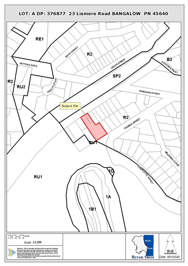
Assessment:
Introduction
History/Background
The NSW Land and Environment Court approved Development
Application No. 10.2018.161.1 for Multi Dwelling Housing Comprising Fifteen
(15) Dwellings on 31/3/2020. The Court-issued development consent is Attachment
1 to this Report.
Condition 1 of the development consent lists the approved
plans. Condition 3 of the consent essentially requires that Studio 5 and Row
Houses 1, 2 & 3 of the approved development are to be used only for the
purpose of affordable housing for 10 years.
Description of the proposal
This application seeks approval for S4.56 to Modify
Condition 1 to reference the amended Site Plan and Condition 3 to require
instead Row Houses 1, 2, 4 and Studio 4 to be Affordable Housing. The
application describes the proposal, with reference to condition 3, as follows:
“Delete reference to.. ...
Studio 5 and Row Houses 1, 2 & 3....
And replace with... ..Row Houses
1, 2, 4 and Studio 4.....
Clause 13.1 of the SEPP remains
satisfied.
R1 = 52sqm
R2 = 52sqm
R3 = 52sqm
S4 = 35sqn
Total R1, 2, 4, s4 = 191sqm
Total GFA of the development =
949sqm
Percentage of affordable housing
= 20%
The Applicant later advised that the modified Site Plan
submitted in support of the s4.56 application is also to be substituted in
condition 1.
On this basis the application proposes the following
amendments to the development consent:
1. Condition 1 –
change the reference to the approved Site Plan to the modified plan submitted
with the s4.56 application. The main changes are in the frontage area of the
site, including in relation to the location of the bin storage, deletion of
bicycle storage (individual dwellings and curtilage areas can accommodate
bicycle storage), provision of designated pedestrian access, provision of
landscape bays and relocation of the 4 motorcycle parking spaces from the
furthermost end of the driveway to within the front half of the property.
2. Condition 3 –
change the approved dwellings which are required to be used only for the
purpose of affordable housing from “Studio 5 and Row Houses 1, 2 &
3” to “Row Houses 1, 2, 4 and Studio 4” (same number of row
houses and studio) – there is no change in the composition and type of
the dwellings required to be affordable housing being 1 studio and 3 row
houses, and there is no change in the compliance with the minimum 20% floor
area requirement; and
Description of the site
|
Land is legally described as:
|
LOT: A DP: 376877
|
|
Property address is:
|
23 Lismore Road BANGALOW
|
|
Land is zoned:
|
R2 Low Density Residential
|
|
Land area is:
|
2,341.6m2
|
|
Property is constrained by:
|
Drinking Water Catchment
|
|
|
Heritage Conservation Area
|
|
|
Potential impact zone – Flying Fox Camp
|
Section 4.56 of the Environmental Planning and Assessment
Act 1979
The applicant is a person who is entitled to act on the
consent which was issued by the Court. The development to which the consent as
modified relates is substantially the same as the originally approved
development. Public notification of the application, including consideration of
the public submission, is discussed in this Report below. A copy of the notice
of determination is required to be sent to each person who made a submission in
respect of the application.
Clauses 115 to 120 of the Environmental Planning and
Assessment Regulation 2000
The application has been appropriately made via the Planning
Portal. The proposed modification is of minimal environmental impact. The
application was publicly notified and this is discussed in more detail below.
The original development application was not for designated development, State
significant development or for any other advertised development made to a
consent authority other than Council. The site is not located within strategic
agricultural land. The original development application did not involve any
concurrence authority or integrated development approval body.
Summary of Referrals
|
Referral
|
Issue
|
|
Development Engineer
|
No objections subject to modification of condition 1 to
include the substitute amended Site Plan. Refer to Doc #A2021/12417.
|
Section 4.15 of the Environmental Planning and Assessment
1979 – Matters for Consideration
Having regard to the matters for consideration detailed in
Section 4.15(1) of the Environmental Planning & Assessment Act 1979
(EP&A Act), the following is a summary of the evaluation of the issues.
State Environmental Planning Instruments
State
Environmental Planning Policy (Affordable Rental Housing) 2009
In relation to clause 13 of the Affordable Rental Housing
SEPP, the Council report on the original development application makes the
following statement:
“The application
nominates 4 one-bedroom units as the affordable housing component. The combined
floor space of these units is 191m2. The total proposed floor space
is quoted as 949m2. Based on these areas, the application proposes
to use 20.1% of the total floor space for affordable housing. The clause,
therefore, applies.”
Translating this to the proposed development as modified and
as addressed by the Applicant’s advice above, the combined floor space of
the nominated units is 191m2, total GFA is 949m2 and
percentage of affordable housing is still the same under the modified proposal
at 20%.
State
Environmental Planning Policy (Infrastructure) 2007
The development as modified involves no significant change
in relation to the provisions of the Infrastructure SEPP.
Byron Local Environmental Plan 2014 (LEP 2014)
LEP 2014 is an applicable matter for consideration in the
assessment of the subject application in accordance with subsection 4.15(1) of
the EP&A Act because it applies to the subject land and the proposal. The
proposed modifications do not result in non-compliance with the clauses of LEP
2014.
Any proposed Instrument that has
been the subject of public consultation and has been notified to the consent
authority
There are no proposed instruments of significant
applicability to the proposal.
Byron Shire Development
Control Plan 2014 (DCP 2014)
DCP 2014 is an applicable matter for consideration in the
assessment of the subject application in accordance with subsection 4.15(1) of
the EP& A Act because it applies to the land to which LEP 2014 applies. The
proposed development is demonstrated to meet the relevant Objectives of all
relevant Parts/Chapters (in some cases subject to conditions and/or to the
satisfaction of other assessing officers).
Any Planning Agreement or Draft
Planning Agreement?
There is no planning agreement applicable to this
development.
Environmental Planning &
Assessment Regulation 2000 Considerations
There are no additional considerations under clauses 92 to
94A of the Environmental Planning and Assessment Regulation 2000.
The likely impacts of that
development, including environmental impacts on both the natural and built
environments, and social and economic impacts in the locality
Natural environment
The proposal will not have a
significantly adverse impact on the natural environment of the locality.
Built environment
The proposal will not have a
significantly adverse impact on the built environment of the locality.
Social Environment
The proposal will not have a
significant social impact on the locality.
Economic impact
The proposal will not have a
significant economic impact on the locality.
Are there any Council Policies that are applicable to the
proposal?
The proposal would not be contrary to any of Council’s
development-related policies.
The suitability of the site for
the development
The site is a serviced, unconstrained property and is
suitable for the proposed development.
Submissions made in accordance
with this Act or the regulations
The application was publicly exhibited.
There was 1 submission made in favour of the application.
Comments are provided in response to the contents of the submission as follows:
The Bangalow
Progress Association agrees that proposed modifications satisfy Byron Shire
Council’s conditional approval of the previous DA based on the provision
of additional onsite parking spaces and the alleviation of privacy issues
affecting adjoining neighbours. Proposed modifications achieve an important
incremental benefit for residents, neighbours and the Bangalow community and
are acceptable to the BPA. We thank Council and BSC staff for their diligence
on this matter and look forward to facilitating future affordable housing with
improved outcomes for all stakeholders.
Comment: The support for the
proposal is noted.
The two
additional onsite parking spaces are designed for cars, but such spaces could
also be allocated to electric bikes as a future option to encourage residents
to reduce car dependency. This alternative should become increasingly viable
over time as the Byron Bike Path project is progressively implemented.
Comment: The support for electric
bikes is noted. Electric bikes can be stored on the site without the need to
occupy car parking spaces. Should a resident purchase a bike (electric or
traditional – push) it is anticipated the bike would be kept by the
resident securely in their unit.
The
development site marks a main entry point to the Bangalow heritage village
where aesthetics become an important consideration. Proposed reworking of the
property driveway entry includes a landscaped pedestrian walkway with
additional screening of the Telstra fence. This provides a welcome aesthetic
benefit in addition to improving pedestrian safety and neighbour amenity.
Comment: The support for the
proposed entry point treatment is noted.
Limited onsite
car parking remains a major issue for regional areas. Cars unable to park
onsite at 23 Lismore Rd will randomly park elsewhere on Lismore Rd verges, a
distinctly unwelcome scenario. Yet there appears to be no specific provision
for parking offsets in the allocation of Section 94 contributions, but a formal
parking offset scheme could be used to help fund much needed peripheral parking
areas in Bangalow for cars from affordable housing estates as well as cars from
rapidly increasing visitors.
Comment: No change is proposed to
the number of car parking spaces on the site approved by the Court.
The expected
congestion caused by cars parked on Lismore Rd may also justify the
installation of a speed awareness monitor with a red/green emoji LED sign near
the 50km limit boundary.
Comment: Road signage is beyond the
assessment of the current application.
Public interest
The proposal is unlikely to prejudice or compromise the
public interest or create a undesirable precedent.
Developer Contributions
Water & Sewer Levies
No change to existing Section 64 levies conditions will be
required.
Section 7.11 Contributions
No Section to existing 94
Contributions conditions will be required.
Conclusion
The application under section 4.56 of the Environmental
Planning and Assessment Act 1979, proposes to modify a Land and Environment
Court issued development consent for Multi Dwelling Housing Comprising Fifteen
(15) Dwellings at the site. The proposed modifications are to modify condition
1 to reference the amended Site Plan and condition 3 the approved dwellings
which are required to be used only for the purpose of affordable housing from
“Studio 5 and Row Houses 1, 2 & 3” to “Row Houses 1, 2, 4
and Studio 4” (same number of row houses and studio).
The proposal is satisfactory having regard to relevant
matters for consideration and is substantially the same development as
approved. The Section 4.56 application is recommended for approval subject to
modifying conditions 1 and 3.
Disclosure of Political
Donations and Gifts
|
Has a Disclosure
Statement been received in relation to this application
|
No
|
|
Have staff
received a ‘gift’ from anyone involved in this application that
needs to be disclosed. Where the answer is yes, the application is to be
determined by the Director or Manager of the Planning, Development and
Environment Division.
|
No
|
|
Provide
Disclosure Statement register details here:
|
Not applicable
|
Staff Reports - Sustainable Environment and Economy 13.9
Report
No. 13.9 PLANNING - Development
Application 10.2020.257.1 Multi Dwelling Housing Comprising Seven (7)
Dwellings, including Demolition of Existing Dwelling House at 113A Paterson
Street, Byron Bay
Directorate: Sustainable
Environment and Economy
Report Author: Greg
Smith, Team Leader Planning Services
File No: I2021/747
Proposal:
|
DA No:
|
10.2020.257.1
|
|
Proposal description:
|
Multi Dwelling Housing Comprising Seven (7) Dwellings,
including Demolition of Existing Dwelling House
|
|
Property description:
|
LOT: 1 DP: 717719
|
|
113A Paterson Street BYRON BAY
|
|
Parcel No/s:
|
70660
|
|
Applicant:
|
Logan Architecture
|
|
Owner:
|
Mrs B K & Mr L T Mooney
|
|
Zoning:
|
R2 Low Density Residential
|
|
Date received:
|
29 May 2020
|
|
Integrated / Designated Development:
|
☐
Integrated
|
☐
Designated
|
☒
Not applicable
|
|
Concurrence required
|
Not required
|
|
Public notification or exhibition:
|
- Level
2 advertising under DCP 2014 Part A14 – Public Notification and
Exhibition of Development Applications
- Exhibition
period: 18/6/20 to 8/7/20
- Submissions
received: Nineteen (19)
- Submissions
acknowledged: ☒
Yes ☐
No ☐ N/A
|
|
Other approvals
|
☒
N/R
|
☐
W & S (68)
|
☐OSMS
(68)
|
☐
ST (68)
|
☐
RA (138)
|
|
Other:
|
|
|
Planning Review Committee:
|
15 October 2020 – To be determined by Council
|
|
Variation request
|
Not applicable
|
|
Issues:
|
Issues raised in public submissions (19)
|
|
|
|
|
|
|
|
|
Summary:
The application seeks consent for a multi dwelling housing
development comprising seven (7) dwellings, including demolition of the
existing dwelling house on the site. The dwellings are 2 storeys throughout.
There is a single dwelling at the front of the site, and the remaining
dwellings are in attached pairs back towards the rear of the eastern boundary
of the site. There are a mix of 2 two-bedroom dwellings and 5 three-bedroom
dwellings. There is a mix of single garages, double garages and open parking
spaces. Dwelling 1 is proposed to be the adaptable dwelling.
The driveway runs along the southern side boundary of the site
with the dwellings on the northern side of the driveway. There are 2 visitor
parking spaces.
A total of nineteen (19) public submissions have been
received. The issues raised are commented on in this Report below. It is noted
neighbouring properties are characterised by similar scale town house
developments.
The application has addressed the relevant constraints
applying to the site and satisfactorily addressed the matters raised in the
public submissions. The development application is recommended for approval
subject to the conditions listed in the recommendation.
NOTE TO COUNCILLORS:
In accordance with the
provisions of S375A of the Local Government Act 1993, a Division is to be
called whenever a motion for a planning decision is put to the meeting, for the
purpose of recording voting on planning matters. Pursuant to clause 2(a)
under the heading Matters to be Included in Minutes of Council Meetings of
Council's adopted Code of Meeting Practice (as amended) a Division will be
deemed to have been called by the mover and seconder of all motions relating to
this report.
RECOMMENDATION:
That pursuant to Section 4.16 of
the Environmental Planning & Assessment Act 1979, Development Application
No. 10.2020.257.1 for Multi Dwelling
Housing Comprising Seven (7) Dwellings, including Demolition of Existing
Dwelling House, be granted consent subject to the conditions of approval in Attachment
1 (E2021/63714).
Attachments:
1 10.2020.257.1
Recommended conditions of approval, E2021/63714
2 10.2020.257.1
Proposed Plans, E2021/63721
3 10.2020.257.1
BASIX and NatHERS Certificates, E2021/63718
4 10.2020.257.1
Shadow Diagrams, E2021/63717
5 10.2020.257.1
Redacted submissions, E2021/63973

Assessment:
History/Background
BA 6.1978.2134.1 for a dwelling
was approved on 20/6/1978.
DA 10.2006.416.1 for tree
removal (11 trees) was approved on 8/11/2006.
DA 10.2007.497.1 for a
Subdivision (Boundary Adjustment) with no additional lots was approved on
11/10/2007.
Description
of the proposed development
This application seeks approval
for multi dwelling housing comprising 7 dwellings as depicted in the plans
included in Attachment 2 to this Report, including demolition of the existing 2
storey dwelling house located at the front western end of the site adjacent to
Paterson Street.
Dwelling 1 is closest to
Paterson Street through to Dwelling 7 which is closest to the rear eastern
boundary. The 7 dwellings are contained in 4 separate buildings. The first
building closest to Paterson Street is a single dwelling (Dwelling 1) whereas
the other 3 building buildings each contain 2 dwellings.
Dwelling 1 contains 3 bedrooms,
a study and double garage and is the adaptable dwelling. Dwellings 2 and 4
contain 2 bedrooms and a single garage. Dwellings 3, 5, 6 and 7 contain 3
bedrooms and a double garage.
The driveway runs along the
southern side boundary of the site with the dwellings on the northern side of
the driveway. There are 2 visitor parking spaces.
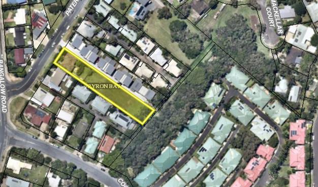
Subject
site highlighted yellow
Description
of the site
|
Land is legally
described
|
LOT: 1 DP: 717719
|
|
Property address
|
113A Paterson Street
BYRON BAY
|
|
Land is zoned:
|
R2 Low Density Residential
|
|
Land area is:
|
1802m2
|
|
Property is constrained
by:
|
Acid Sulfate Soils
Class 5
|
|
|
Is a BDAR required due
to the location of the proposed development?
|
☐ Yes ☒
No
|
|
|
Are there any easements
in favour of Council affecting the site?
|
☐ Yes ☒
No
|
|
|
Is there a Vegetation
Management Plan which might affect the proposal?
|
☐ Yes ☒
No
|
|
|
Is there a Voluntary
Planning Agreement which might affect the proposal?
|
☐ Yes ☒
No
|
|
Referral
|
Issue
|
|
Environmental Health
Officer
|
No objections subject
to conditions.
|
|
Development Engineer
|
No objections subject
to conditions.
|
|
Natural Resource
Planner
|
No objections subject
to conditions.
|
|
Resource Recovery &
Quarry
|
No objections, no
conditions.
|
SECTION 4.14 – BUSH
FIRE PRONE LAND
Under section 4.14 of the Act, Council must be
satisfied prior to making a determination for development on bush fire prone
land, that the development complies with the document ‘Planning for
Bush Fire Protection 2006’. The site is not bush fire prone land.
A recommended condition
requires that all native
vegetation that the 10/50 Vegetation Clearing Code of Practice would otherwise
authorise to be removed, destroyed or pruned must be retained for conservation
purposes.
SECTION 4.15C –
MATTERS FOR CONSIDERATION – DISCUSSION OF ISSUES
Having regard to the matters
for consideration detailed in Section 4.15(1) of the Environmental Planning
& Assessment Act 1979 (EP&A Act), the following is a summary of the
evaluation of the issues.
4.1 State
Environmental Planning Instruments (SEPP)
SEPP No 55—Remediation of Land
There is no evidence contained on Council’s
records to indicate that the site has been used for any other purpose except
residential use in the last 32 years (BA78/21340) approved 12/05/1978. The
surrounding land use is urban residential development. The development
does not result in an increased sensitivity of land use. Notwithstanding,
previous development approvals precede SEPP 55 which came into force in 1998.
Whilst the likelihood that contamination exists on the subject site is low, it
is recommended that an unexpected finding
protocol be provided prior to issue of a Construction Certificate. This will
ensure that any source of contamination uncovered during site works can be
managed.
SEPP (Infrastructure) 2007
The proposal is satisfactory having regard to the
provisions of the Infrastructure SEPP.
4.2 Byron Local Environmental Plan 2014
(LEP 2014)
LEP 2014 is an applicable
matter for consideration in the assessment of the subject development
application in accordance with subsection 4.15(1) of the EP&A Act because
it applies to the subject land and the proposed development.
In accordance with LEP 2014
clauses 1.4 and 2.1 – 2.3:
(a) The
proposed development is defined in the LEP 2014 Dictionary as multi dwelling
housing;
(b) The
land is within the R2 Low Density Residential according to the Land Zoning Map;
(c) The
proposed development is permitted with consent in the R2 Zone; and
(d) The
proposed development is satisfactory having regard to the Zone Objectives.
The rear southern corner of the
site is class 5 acid sulfate soils. However, Council’s Environmental
Health Officer raised no objection to the proposal in this regard.
The 7.9m maximum height of the
proposed development complies with the 9m maximum height development standard
applying to this site.
The 0.43:1 floor space ratio of
the proposed development complies with the 0.5:1 maximum floor space ratio
development standard applying to this site.
The proposed development
otherwise satisfies all other clauses of LEP 2014 (in some cases subject to
conditions).
4.3 Any proposed
Instrument that has been the subject of public consultation and has been
notified to the consent authority
There are no proposed
instruments that are of significant applicability to this proposed residential development
within the surrounding residential area.
4.4 Byron Shire Development Control Plan 2014 (DCP 2014)
DCP 2014 is an applicable
matter for consideration in the assessment of the subject development
application in accordance with subsection 4.15(1) of the EP& A Act because
it applies to the land to which LEP 2014 applies.
B4.2.5 Car Parking
Requirements
The development provides
parking on site as follows:
Garage
Type
Parking
- Unit 1 – 3 beds +
study
Double Garage 6m x
6m
2
- Unit 2 – 2
beds
Single Garage 3m x
6m
1
- Unit 3 – 3
beds
Double Garage 6m x
6m
2
- Unit 4 – 2
beds
Single Garage 3m x
6m
1
- Unit 5 – 3
beds
Double Garage 6m x
6m
2
- Unit 6 – 3
beds
Double Garage 6m x
6m 2
- Unit 7 – 3
beds
Double Garage 6m x
6m
2
- Visitor Parking between Unit 3/4 2.4m
wide x 5.4m
long
1
- Visitor Parking between Unit 3/4 2.4m
wide x 5.4m
long
1
The total number of parking
spaces provided for the development is 14. The number required to be provided
is 14. The development complies in relation to provision for car parking.
Bicycles are able to be parked within the garage or curtilage areas of the
dwellings.
B7.2.2 Strategies and
guidelines for proposed developments within mosquito risk zones
The site is within a mapped
mosquito risk zone, and a condition is recommended requiring insect screens.
Chapter B8 Waste
minimisation and management
The required allocated
bin presentation space as specified by Council’s waste collection service
provider for the development is 14m, being 1m for each bin with 14 bins being
presented each week. The application states that only 10.760m of kerb frontage
is available for bins presentation. Council’s Resource Recovery &
Quarry Team has gone back to the waste collection service provider requesting
clarification on existing allowable kerb frontage of 10.760m. Although the
presentation area is not the ideal length, the waste collection service
provider has stated they will be able to service required bins.
B9.4.1 Landscape
Principles
The development is
required to be provided with 90m2 of landscaped area per large
dwelling (over 85m2 in floor plan area). Each of the proposed
dwellings is a large dwelling, requiring 7 x 90m2 = 350m2.
The landscaped area of the site is up to 550m2, which exceeds the
prescriptive measure. Council’s Natural Resource Planner recommends
conditions in relation to landscaping of the site.
Chapter B13 Access and
Mobility
The submitted plans nominate Dwelling 1 as the
adaptable dwelling. A condition is recommended requiring that the application for a Construction Certificate is to
include plans and specifications that indicate access and facilities for
persons with access disabilities to and within Dwelling 1 in accordance with AS
1428.1 – Design for Access and Mobility and Part D3 of the Building Code
of Australia. Such plans and specifications must be approved as part of the
Construction Certificate.
B14.2 Excavation and fill in
all zones
The plans show that the extent
of cut and fill is minimal, being a maximum depth of 1.2m excavation at the
front of the site and less than 1m fill depth.
Chapter D1 Residential
Accommodation
The development complies with
all required setbacks to boundaries. There are only slight encroachments into
the building height plane as demonstrated by the elevations submitted in
support of the application, however the encroaching elements will not have
significant overshadowing, privacy or view impacts. The proposed residential
development is not out of character in, and will not have a significant visual
impact on, the mixed residential context of the site and surrounds. The private
open spaces of each dwelling comply with the minimum 30m2 and 4m
dimension requirements.
The proposed development is
demonstrated to meet the relevant Objectives of all relevant Parts/Chapters (in
some cases subject to conditions and/or to the satisfaction of other assessing
officers).
4.5 Environmental Planning
& Assessment Regulation 2000 Considerations
There are no significant issues in
relation to the additional matters for consideration under clauses 92 to 94A of
the Environmental Planning and Assessment Regulation 2000.
4.6 The likely impacts of that
development, including environmental impacts on both the natural and built
environments, and social and economic impacts in the locality
Natural environment
The proposal will not have a
significantly adverse impact on the natural environment of the locality.
Built environment
The proposal will not have a
significantly adverse impact on the built environment of the locality.
Surrounding development is of a
similar scale and density to what is proposed and is characterised by townhouse
villa units.
Social Environment
The proposal will not have a
significant social impact on the locality.
Economic impact
The proposal will not have a
significant economic impact on the locality.
Construction Impacts
The development will not
generate significant impacts during its construction. Conditions of consent
recommended to control hours of work, builders waste, construction noise,
installation of sedimentation and erosion control measures and the like to
ameliorate such impacts.
Are there any Council Policies
that are applicable to the proposed development?
Building in the Vicinity of Underground Infrastructure Policy
2020
Council’s ET Engineer and
Development Engineer raised no objection to the proposal on the basis of
impacts on underground infrastructure, including for example water, sewer and
stormwater.
Management of Contaminated
Land Policy
There is no evidence contained
on Council’s records to indicate that the site has been used for any
other purpose except residential use in the last 32 years and the development
does not result in an increased sensitivity of land use. An unexpected findings
protocol condition is recommended as indicated above.
Water and Sewer Equivalent
Tenement Policy
Council’s ET Engineer
recommended a condition and note for inclusion in the consent in relation to
water and sewer ET charges.
4.7 The
suitability of the site for the development
The site is a serviced, unconstrained property and is
suitable for the proposed development.
4.8 Submissions
made in accordance with this Act or the regulations
The development application was
publicly exhibited.
There were 19 submissions made
on the development application. The matters raised in the submissions are
commented on as follows:
The proposed density does
not take into consideration the character of the area, landscape setting and
surrounding built form. The buildings have enormous footprint and very high
ceilings. There are too many dwellings on 113 and 113A Paterson Street. There
should be no more than 3 but at the very most, 4 new dwellings.
Comment: The area is
characterised by a mix of single dwellings through to multiple dwelling
developments. There are multiple dwelling developments to the north, south and
east of the site. A residential development such as this proposal in the
prevailing residential context is not out of character in the area or
surrounding built form. The proposal includes appropriate landscaping areas.
The building footprints are not considered to be excessive, including the
0.43:1 floor space ratio of the development being less than the 0.5:1
development standard, and the ceiling heights are not considered to be
excessive. The proposed number of dwellings is not beyond the capacity of the
site area.
Enormous congestion with
traffic all day. A traffic plan should be submitted with the DA. Do not make
the street a No Standing zone. A roundabout is required at Bangalow Road and
Paterson Street now. Paterson Street is a rat run and there are already
significant traffic delays.
Comment: Council’s
Development Engineer confirmed that the proposal is satisfactory having regard
to traffic impact and both internal and external access arrangements. The
Development Engineer has recommended a condition requiring a traffic control
plan, but does not recommend any conditions requiring either No Standing signs
or a roundabout.
There will be a big influx
of new residents or holiday makers. Increased tenancies with Airbnb, with high
noise pollution, late night parties and lack of open space causing tensions
between holiday makers and residents.
Comment: A residential
development is appropriately occupied by residents. Normal low density
residential usage is not expected to have significant noise impacts.
Appropriate open space areas are provided on the site. A condition is recommended
stating that the dwellings are not approved as short-term rental accommodation,
tourist and visitor accommodation or to be “holiday let”.
The development has not
contributed to Affordable Housing Monetary Contribution – for nurses,
firemen and police. The development should make a monetary contribution for
providing adorable housing. Community contribution fees should be mandatory to
improve parks, playgrounds and open space.
Comment: The development
is standard multi dwelling housing and is not required to contribute towards
affordable rental housing. A condition is recommended requiring payment of
contributions.
There should be better
quality design to improve liveability through enhanced internal and external
apartment amenity including better layout. There is no outlook for tenants and
no new parklands or breakout space.
Comment: The internal and
external design and layout is of appropriate quality. The development provides
private open space areas and is conditionally required to contribute monetarily
towards public open space and recreation.
There needs to be better
adaptability and robustness, improved energy efficiency and water sensitive
urban design, solar access, natural ventilation and visual privacy. The
development is backed up against and will overlook the sleeping bedrooms,
lounges and private garden space, there is absolutely no privacy to the
townhouses to the south. The development will cause significant loss of
privacy. Privacy screens should be provided along the edge of the townhouses of
units 1 to 6. Single storey buildings would make better planning sense.
Comment: The last plan in
Attachment 2 shows that Dwelling 1 is to be the adaptable dwelling, including
an adaptable car space. The development application is accompanied by a BASIX
Certificate (included in Attachment 3 to this Report) demonstrating
State-legislated energy efficiency requirements are met.
The dwellings are set back a
minimum of 4.5m to the southern boundary of the site, and no part of the
development which might cause privacy impacts to the southern neighbouring
properties encroaches into the building height plane as projected from the
southern boundary of the site. The main living rooms of the proposal are either
at ground floor level or face north. The upstairs levels of the proposed
dwellings are set back a minimum of 4m to the northern side boundary, and the
driveway to the northern neighbouring multi dwelling housing development
adjoins the northern side boundary of the site. No part of the development which
might cause privacy impacts to the northern neighbouring property encroaches
into the building height plane as projected from the northern boundary of the
site and for this reason, privacy screens are not recommended by this Report.
The development complies with
the maximum 9m height development standard, allowing for 2 storey dwellings.
The area is comprised of a mix of one and two storey dwellings, and the
proposed two storey dwellings are not out of character in the area.
Side and rear setback
controls should be tested for overshadowing of the site, adjoining properties
and open spaces. Development should achieve minimum 50% direct sunlight to the
principal useable part of the communal open space for a minimum of 2 hours
between 9am and 3pm on 21 June. The development will cause significant
overshadowing and loss of solar access. There will be significant overshadowing
of yards and clotheslines. Instruments should be installed on site to indicate
building height.
Comment: The shadow
diagrams submitted in support of the development application (included in
Attachment 4 to this Report) demonstrate that from 12 noon onwards, the
proposed development will not cause excessive shadow impacts to the southern
neighbouring properties. The plans demonstrate that the extent of the
encroachment of the development into the building height plane as projected
from the southern side boundary and requiring compliance with the building
height plane would not cause any perceivable reduction to the extent of
overshadowing of neighbouring properties. The proposed buildings are not of
such a height as to warrant the installation of building height poles on the
site to gauge height.
There should be a 12 metre
setback for all new driveways to all new homes on the boundary line so that
acoustics are improved for the resident of the townhouses to the south.
Synthetic driveway paving would control noise from cars.
Comment: It would not be
reasonable to require a 12m setback for driveways and/or new dwellings. Normal
residential development in a residential setting is not expected to generate
any excessive noise impacts. Council’s
Environmental Health Officer raised no objection to the proposal on the basis
of noise impacts, and recommended a
condition requiring that the use of the development
must not interfere with the amenity of the neighbourhood by reason of, for
example, noise.
Low lighting LED lights on
timers and sensors should be installed to light up entrances.
Comment: If the occupants
of the development are concerned about safety and security, they are able to
install non-intrusive lighting.
Planting softens the edges
of any raised terraces to the street and neighbours. Tree planting up to a
height of not greater than 4 metres should be provided along the boundary to
the southern neighbouring townhouses.
Comment: The plans show
the driveway to be set back 500mm from the southern side boundary, allowing for
landscaping to be provided. Council’s Natural Resource Planner
recommended a condition requiring a landscape plan, which must indicate the proposed location for planted shrubs and
trees. The condition has been extended to include reference to required
planting along the southern side of the full length of the driveway (to a
maximum height of 4m at this location). Conditions also recommended requiring
the side boundary to be fenced with a 1.8 m lap and cap paling fence.
Apartment entrances are
facing the neighbours bedrooms and privacy screening needs to be incorporated.
Comment: The entrances to the
dwellings are all at ground level, face towards the front or rear boundary of
the site (not the southern neighbouring properties) and are not considered to
require any special privacy treatment.
Full height screening to
communal access areas on levels 1 and 2 should be provided for a minimum 50% of
the length of the southern side.
Comment: There are no
proposed communal access areas to more than 1 dwelling. All dwellings have
their own individual ground level entrance doorway and porch separate to the
other dwellings.
The
site of the proposed development is designated Class 5 acid sulfate soil.
Vegetable gardens and backyards are likely to be severely impacted. This area
is prone to intense rainfall and this matter needs investigation.
Comment: A small portion
of the rear of the site is class 5 acid sulfate soils. Class 5 is the least
impacting level. Council’s Environmental Health Officer raised no
objection to the proposal in this regard.
No soil tests found in DA,
specifically with reference to sand tailing / radioactivity on this block. The
original landowners transported sand for the sand-mining company and their
family property used sand for fill / around foundations on their property many
years ago. It is important during foundation digging no dust or sand comes onto
the street and specifically near or on adjoining properties.
Comment: Council’s
Environmental Health Officer confirmed that there is no evidence contained on Council records to indicate that the
site has been used for any other purpose except residential use in the last 32
years. The surrounding land use is urban residential development. The development
does not result in an increased sensitivity of land use. Whilst the likelihood
that contamination exists on the subject site is low, a condition is
recommended requiring that an unexpected
finding protocol be provided prior to issue of a Construction Certificate. This
will ensure that any source of contamination uncovered during site works can be
managed.
There
are no assurances about tradespeople adhering to council noise constraints. The
current proposal with the driveway along a line of bedrooms will have a severe
effect on sleeping.
Comment: The construction
of the development must adhere to standard work hours and noise limits in
accordance with a recommended condition of development consent.
The development does not
provide adequate car parking including guest parking. Already insufficient
on-street car parking (only 2 on the street in front of the property).
Construction vehicles park in the driveways of neighbouring properties.
Comment: Council’s Development Control Plan requires the
provision of 14 spaces. The proposal provides 14 car spaces and complies with
the number of required car parking spaces.
The owners of the complex
at 113 Paterson Street requested that the existing boundary fence was to be
kept as it was, which was complied with and the developer upgraded that side of
the fence with a masonry retaining wall and new palings on our side. It is
hoped that the applicants for this new development leave the fence as is
and not require the owners of 113 Paterson Street to have to
expend additional money. It is hoped that the new development did not
propose the existing fence be replaced to suit their development and not the
completed complex at 113 Paterson Street.
Comment: The submitted
plans show a timber fence on the northern side boundary of the site. The
application does not indicate any change to existing northern side fencing is
proposed. Dividing fences are a matter between adjoining property owners under
the Dividing Fences Act. No condition is recommended requiring the fence on the
northern side boundary to be replaced.
The
lower 30 metres of 113 Paterson Street was required to conform with flood
issues. This meant requirements relating to floor levels, mesh at the
bottom of fencing to allow for water movement and a restriction on title that
no filling of the land was allowed. The flood requirements are important
because other properties may bear the burden of flood waters in the future
rather than sharing the spread of the flood waters. The trees at the bottom of
the property are to remain, what are the required flood mitigation works.
The
proposal doesn’t address the run off issue that will be created by such a
long driveway when we have significant weather events. The low side properties
are in the firing line should the systems proposed for development fail.
Comment: The site is not
flood affected land. Council’s Development Engineer confirmed that the
proposed development is satisfactory having regard to stormwater management
impacts, subject to conditions. The conditions require compliance with the
Stormwater Details and Additional Stormwater Investigation submitted in support
of the development application (refer to Attachment 2), on-site stormwater
detention and a flood planning level for the development of 5.79m AHD.
4.9 Public
interest
The proposed development is
unlikely to significantly prejudice or compromise the public interest or create
an undesirable precedent.
5.1 Water
& Sewer Levies
Section 64 levies will be
payable.
5.2 Developer
Contributions
Section
7.11 Contributions will be payable.
DISCLOSURE OF POLITICAL
DONATIONS AND GIFTS
|
Disclosure details
|
Response
|
|
Has a Disclosure
Statement been received in relation to this application?
If Yes, Provide
Disclosure Statement register reference: 91.
|
Yes ☐ No ☒
|
|
Have staff received a
‘gift’ from anyone involved in this application that needs to be
disclosed.
|
Yes ☐ No ☒
|
The development application
proposes multi dwelling housing comprising 7 dwellings, including demolition of
the existing dwelling house. The proposed development is satisfactory having
regard to the relevant environmental planning instruments and planning controls
applicable to the site. The proposal raises no significant issues in terms of
environmental impacts which cannot be managed and the site is considered
suitable for the development. The application appropriately addresses the
relevant constraints applying to the site and the reasons for objection in
public submissions, and is recommended for approval subject to conditions of
consent.
Staff Reports - Sustainable Environment and Economy 13.10
Report
No. 13.10 PLANNING - Development Application
10.2020.251.1 Alterations and Additions to the Commercial development (Book
Room) comprising coffee cart and ancillary works (pergola) at 27-31 Fletcher
Street Byron Bay
Directorate: Sustainable
Environment and Economy
Report Author: Chris
Larkin, Manager Sustainable Development
File No: I2021/759
Proposal:
|
DA No:
|
10.2020.251.1
|
|
Proposal
description:
|
Alterations and
Additions to the Commercial development (Book Room) comprising coffee cart
and ancillary works (pergola)
|
|
Property
description:
|
LOT: 1 SEC: 26
DP: 758207
|
|
27-31 Fletcher Street
BYRON BAY
|
|
Parcel No/s:
|
24720
|
|
Applicant:
|
Mr C Lonergan
|
|
Owner:
|
Eas1 Pty Ltd
|
|
Zoning:
|
B2 Local
Centre
|
|
Date received:
|
21 May 2020
|
|
Integrated /
Designated Development:
|
☐ Integrated
|
☐ Designated
|
☒ Not
applicable
|
|
Concurrence
required
|
No
|
|
Public
notification or exhibition:
|
- Level
2 advertising under DCP 2014 Part A14 – Public Notification and
Exhibition of Development Applications
- Exhibition
period: 4/6/20 to 24/6/20
- One Submissions
received:
|
|
Delegation to
determine
|
Council
|
|
Issues:
|
· Use of Pergola
· Ensuring Coffee
Cart is mobile and not connected to Water and Sewer infrastructure
· Heritage
|
Summary:
The proposed
development comprises three main components being the “retrospective
approval” for the construction and use of the pergola at the front of the
Bookroom, consideration of the coffee cart and signage. The coffee cart can
continue in its current location, provided it is not connected to Water and
Sewer infrastructure and serves only takeaway food and drink with no table
service.
The pergola has
been considered as not specifically sympathetic with the heritage values of the
existing building, but it is noted that the structure is lightweight, can be
removed in the future and has vines covering it already providing an attractive
shaded area at the front of the building. Provided that the landscaping is
maintained and the pergola remains unroofed it is considered the proposal is
acceptable in its location.
The application
also seeks approval for business signage which is considered satisfactory
subject to conditions of consent. The proposal raises no environmental issues
in terms of impacts and the site being within the central business district of
Byron Bay is considered suitable for the proposed development. The application
is recommended for approval subject to conditions of consent.
NOTE TO COUNCILLORS:
In accordance with the
provisions of S375A of the Local Government Act 1993, a Division is to be
called whenever a motion for a planning decision is put to the meeting, for the
purpose of recording voting on planning matters. Pursuant to clause 2(a)
under the heading Matters to be Included in Minutes of Council Meetings of
Council's adopted Code of Meeting Practice (as amended) a Division will be
deemed to have been called by the mover and seconder of all motions relating to
this report.
RECOMMENDATION:
That pursuant to Section
4.16 of the Environmental Planning & Assessment Act 1979, Development
Application No. 10.2020.251.1
for Alterations and Additions to the Commercial development (Book Room)
comprising coffee cart and ancillary works (pergola) be approved subject to
conditions of consent in Attachment 2 (E2021/72034).
Attachments:
1 Plans
10.2020.251.1, E2021/72124
2 consent
conditions 10.2020.251.1, E2021/72034
3 submission
10.2020.251.1, E2021/72203
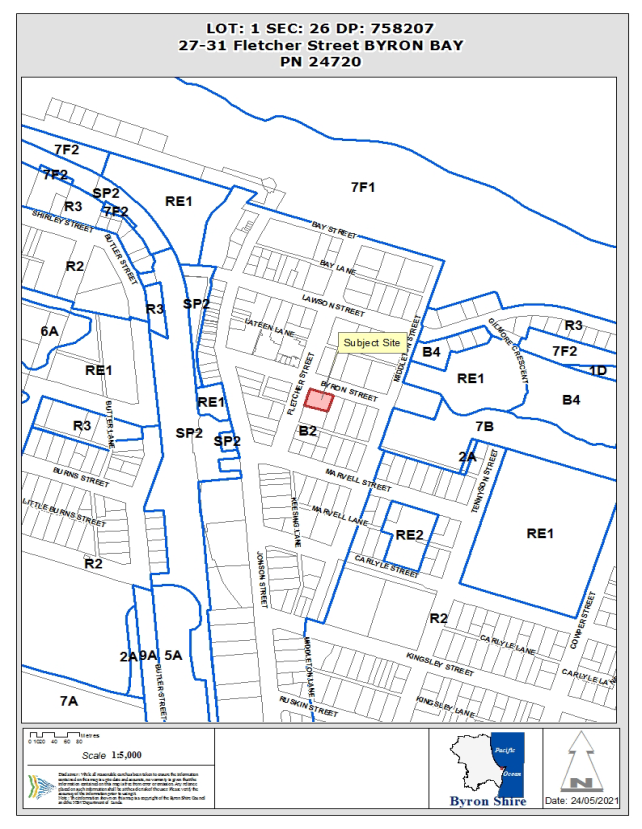
Report
1.1. History/Background
History
|
Account
|
Description
|
Date
|
Notes
|
|
10.2003.152.1
|
Erection of a
pole sign 5.6 metres high and two fascia signs
|
24/05/2003
|
Approved
|
|
10.2001.603.1
|
Use of Bookshop
as refreshment room, signage and assembly area
|
29/10/2002
|
Refused
|
|
10.2001.148.1
|
Change of Use -
Change of Use - From Doctors Surgery to Florist
|
16/06/2001
|
Approved
|
|
10.2000.336.1
|
Change of Use -
Accountants to Book Store
|
27/08/2001
|
Refused
|
|
5.1998.206.1
|
Commercial
Development - Office extensions/modifications
|
16/11/1998
|
Approved
|
|
6.1997.2431.1
|
Addition/Alteration
to Shop
|
10/12/1997
|
Approved
|
|
5.1997.270.1
|
Sign - Sign
|
29/08/1997
|
Approved
|
|
6.1996.2322.1
|
Shop
|
11/10/1996
|
Approved
|
|
5.1993.379.1
|
Commercial
Development
|
13/07/1994
|
Approved
|
1.2. Description
of the proposed development
This application
seeks approval for Alterations and Additions to the Commercial development
(Book Room) comprising coffee cart and ancillary works. The development
comprises use of pergola and seating area facing fletcher Street and minor
superficial modification to the front of the building and the ongoing use of
the coffee cart.
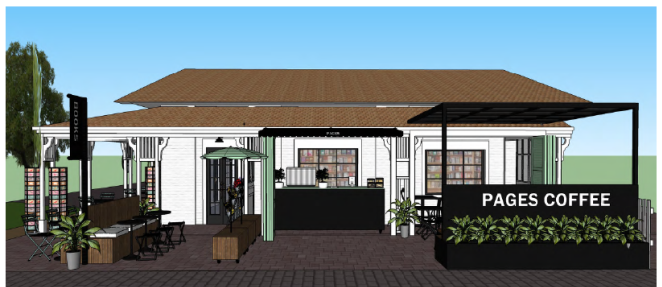
Image 1: Shows a photomontage of the proposal
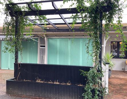
Streetview of existing pergola and Landscape Bay
facing Fletcher Street
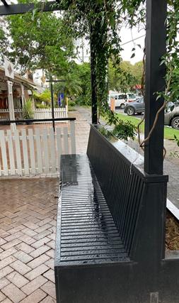
Seating under the Pergola
The pergola and
seating has already been constructed and it is likely to extend partly into the
road reserve. The Coffee Cart to remain mobile won’ t be connected to
water and sewer infrastructure and will serve takeaway food and drink (mainly
coffee and other hot beverages)
Consent
is also sought for the two (2) standalone signs and “The Cart”
awning print as follows:
· “The
Book Room” business identification signage on the corner of Fletcher and
Bay Street is 1800mm x 100mm in dimension. It is composed of reclaimed Timber,
with an aluminum composite panel behind fixed to a pre-existing galvanised roof
frame, with outdoor led lights.
· The
vertical banner is 600mm x 2400mm composed of vinyl PVC, that was fixed to an
existing framework.
· “The
Cart” is printed onto fabric awning and is part of this element.
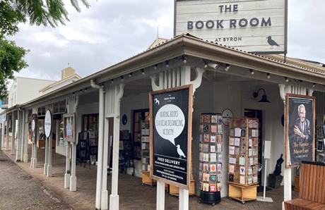
Bookroom Business
Identification Sign (Above awning)
1.3. Description
of the site
|
Land is legally
described
|
LOT: 1 SEC: 26
DP: 758207
|
|
Property address
|
27-31 Fletcher
Street BYRON BAY
|
|
Land is zoned:
|
B2 Local
Centre
|
|
Land area is:
|
1213.7 m2
|
|
Property is
constrained by:
|
Flood Liable
Land Acid Sulfate Soils Class 3
Heritage
Item/Precinct
|
The property is a
heritage item I069 described as ‘Terrace Houses’ in Schedule 5 of
Byron LEP 2014. The heritage listing applies to the Lot curtilage as mapped on
the Heritage Map of Byron LEP 2014. The site also lies adjacent to the other heritage
listed terraced building in Byron.
2. SUMMARY OF REFERRALS
Heritage –
see comments below under the Byron LEP 2014 discussion
3. SECTION
4.15C – MATTERS FOR CONSIDERATION – DISCUSSION OF ISSUES
Having regard to
the matters for consideration detailed in Section 4.15(1) of the Environmental
Planning & Assessment Act 1979 (EP&A Act), the following is a summary
of the evaluation of the issues.
3.1. State
Environmental Planning Instruments
SEPP 2008
(Exempt and Complying Development Codes)
Mobile Food and Drink
Outlets are listed as exempt development under the SEPP The provisions state:
2.54A Specified
development
The carrying out of the retail
sale of food, drinks and related products on land from a mobile outlet such as
a food truck, van, cart or other similar vehicle is development specified for
this code.
2.54B Development
standards
The standards specified for that
development are that the development must—
(a) have the consent of
the owner of the land on which the development is carried out or, if a council
or public authority has the control and management of the land, the consent, in
writing, of the council or public authority, and
(b) not restrict any
vehicular or pedestrian access to or from the land or entry to any building on
the land, and
(c) not obstruct the
operation of, or access to, any utility services on the land or on adjacent
land, and
(d) not be located
within the canopy of, or result in damage to, any tree growing on the land or
on adjacent land, and
(e) not result in any
damage to public property on the land or on adjacent land, and
(f) if carried out on
land within or immediately adjacent to a residential zone—only be carried
out between 7.00 am and 7.00 pm on any day, and
(g) if located on a
public place—have any approval required under section 68 of the Local
Government Act 1993, and
(h) if located on
private land—be limited to 1 development on that land and not contravene
any conditions of a development consent for any other use carried out on the
land.
Note—
A registrable vehicle within the
meaning of the Road
Transport (Vehicle Registration) Regulation 2007, or a cart, bicycle
cart or the like must operate in accordance with the Guidelines for mobile
food vending vehicles (NSW/FA/F1055/1302) published by the NSW Food
Authority in February 2013, and any requirements of the Food
Act 2003.
Its important that
the coffee cart to be mobile and to satisfy the requirements under the exempt
provisions to not be connected to Councils Water and sewer infrastructure, and
that it serve only takeaway food and drink to its customers. Plans and details
submitted with the DA indicate the cart is on caster wheels and it can be moved
in and out of the building.
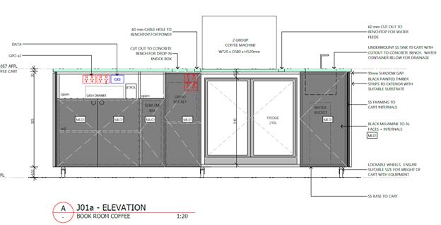
Should the coffee
cart expand its operations and provide table service and or be connected to
Council’s infrastructure, it begins to transition into a permanent
kitchen and the cart would then be considered more akin to a cafe. This not
only raises a nexus to levy water and sewer headworks charges, but would also
generate the potential for further car parking. Appropriate conditions of
consent to apply.
4.2A Byron Local Environmental
Plan 2014 (LEP 2014)
Part 2
–Permissibility and Land Use table
In accordance with
LEP 2014 clauses 1.4 and 2.1 – 2.3:
(a) The
proposed development is defined in the LEP 2014 Dictionary as a retail shp in
terms of the additions to the Book Room Book shop;
(b) The
land is within the B2 Local Centre according to the Land Zoning Map;
(c) The
proposed development is permissible with consent; and
(d) The
proposal is not inconsistent with the objectives of the zone
Clause 5.10
Heritage
The subject
property is listed as a heritage item under Byron LEP 2014 and is described as
follows on the heritage register.
Item details
|
|
|
Name of
item:
|
Terrace Houses
|
|
Type of
item:
|
Built
|
|
Group/Collection:
|
Residential
buildings (private)
|
|
Category:
|
Terrace
|
|
Primary
address:
|
27 - 31
Fletcher Street, Byron Bay, NSW 2481
|
|
Local govt.
area:
|
Byron
|
|
Boundary:
|
Lot 1 Section
26 DP 758207
|
Statement of significance:
|
|
|
An example of
early 20th Century urban housing, unusual in a North Coast coastal town
setting. The design of the building is indicative of a move to a more settled
workforce in the town and the brick construction suggests a well-to-do
commercial class. The building is related in scale and shape to its earlier
neighbour to the south, but shows evidence of 1920s design in the verandah
pillars and simple bungalow style roofline.
The change in use of the building illustrates the change in pattern of urban
settlement of the town.
|
Assessment of
significance
|
|
|
SHR
Criteria c)
[Aesthetic significance]
|
Unusual
example of urban terrace housing in a rural coastal setting.
Industrialisation throughout the 19th Century, and less rapid modes of transport
brought more dense urban housing to Australian cities (reflected in the move
to terrace housing), and examples of this style remained popular and were
built into the 1920s and 1930s.
|
|
SHR
Criteria f)
[Rarity]
|
Rare example
of early domestic, medium density brick architecture within the commercial
precinct of the town.
|
|
SHR
Criteria g)
[Representativeness]
|
Representative
of terrace style buildings of the early Twentieth Century.
|
|
Integrity/Intactness:
|
Interiors of
the buildings have been modified for commercial use over the years.
|
The proposed
pergola and other minor alterations to the front of the Bookroom have an impact
on the original facade of the building. The application was referred to
Councils Heritage advisor who concluded that:
Outdoor seating and a coffee cart enhance the adaptive
re-use of the building book shop and customer facilities. However the impact of
the various additions and structures on the frontage and forecourt of the
building detract from, and obscure the façade of the terrace building
and add clutter to its setting. These impacts could be ameliorated by removal
of the fixed pergola, or redesign to a lower roof which not attached and does
not project above the verandah of the building, the removal of all signage
attached to the verandah posts, and use of a colour scheme consistent with to
the era of the building in accordance with Council’s adopted policy.
The
black and white business identity signage is acceptable (and recognised in
terms of its appropriateness to the bookshop) but it is not appropriate or
necessary for the colour scheme to be extended over the entire building. The
SEE anticipates this requirement stating ‘there is likelihood that the
colour and materials used must be finished in appropriate Heritage palette’.
When viewed in
totality the pergola is a minor element added to the front of the building.
Further, it is a lightweight structure that can be removed should the owners of
the property ever wish to demolish it whilst the landscaping and vines growing
over the pergola provide for a shaded attractive area at the front of the
building. Although the pergola is painted black, the vines growing over it
limit any impact arising from it not being painted in a heritage palette.
However should the
building ever be repainted it is recommended that the colour scheme be approved
by Council prior to work commencing. It is also recommended that various
signage attached to the verandah posts also be removed with Councils Heritage
Advisor noting that it detracts from the architectural detail and setting of
this item.
Appropriate
conditions of consent have been recommended.
The proposal raises
no other issues under the DCP.
4.3 Any
proposed Instrument that has been the subject of public consultation and has
been notified to the consent authority
No draft EPI’s affect the proposal
4.4 Byron Shire
Development Control Plan 2014 (DCP 2014)
Chapter B10
Signage
The cart awning
sign on the coffee cart is modest and has no detrimental impact to the
appearance of the building. In terms of the above awning sign this has the
appearance of a cinema sign but it is considered appropriate in terms of its
location facing the corner with its area and dimensions consistent with the
maximum area of 3.2 m2 under the DCP.
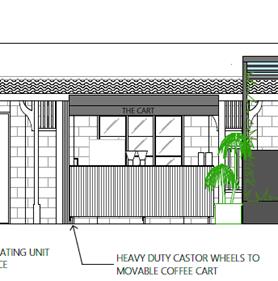
The Cart
Awning Sign
The smaller banner
sign in its context with the book shop is also un-offensive. From a site
inspection the banner faces the other way and is much higher then depicted on
the plans. Under the DCP such signage should be a minimum of 2.6 metres above
ground level to prevent any conflicts with pedestrians or the like. Provided
the sign doesn’t intrude over the footpath or pedestrian pathways and it
remains facing towards the building as currently the case, the banner sign is
appropriate. Conditions to apply.
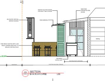
Banner
signage
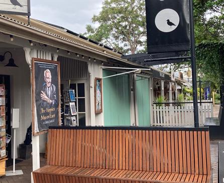
Actual Banner
Signage
Chapter C1 Non
Indigenous Heritage
As discussed above
the colour scheme is not sympathetic with Councils colour requirements under
DCP 2014. However due to the lightweight nature of the structure and
landscaping growing over it, it not recommended that the pergola be
repainted. However it is recommended that should the building ever be
repainted then it should comply with Councils heritage palette at that
time.
4.5 Environmental
Planning & Assessment Regulation 2000 Considerations
The proposal raises no issues under the EPA Regulations 2000
4.6 The
likely impacts of that development, including environmental impacts on both the
natural and built environments, and social and economic impacts in the locality
Proposal is
unlikely to have an adverse impact on the built or natural environment.
Conditions to apply that the coffee cart is to operate only whilst the Bookroom
is open.
4.7 The
suitability of the site for the development
The subject site is
considered suitable for the proposed development.
4.8 Submissions
made in accordance with this Act or the regulations
The DA was
exhibited for a two week period and Council received one objection raising the
following issues.
1) It would increase the demand
for parking in the town area. There is not enough parking already
2) It would increase the amount
of alcohol consumed in Byron Bay. There is too much alcohol consumed in Byron
Bay already
3) someone could buy the
alcohol, drink, wander across Fletcher street and get hit by a car. There are
too many people wandering across Fletcher st already
Staff Comments:
The proposed coffee cart will not generate a demand for additional parking and
there is no proposal to serve alcohol from the coffee cart.
4.9 Public
interest
The proposed
development is unlikely to prejudice or compromise the public interest or
create an undesirable precedent.
5. DEVELOPER
CONTRIBUTIONS
Provided the Coffee
Cart remains mobile, is not connected to Councils Water and Sewer
infrastructure and only takeaway food and drink products are sold with no table
service, there is no nexus to levy contributions including water and sewer
charges.
6. CONCLUSION
The proposed
development comprises two main components being the “retrospective
approval” for the construction and use of the pergola at the front of the
Bookroom and consideration of the coffee cart. The coffee cart can continue in
its current location, provided it is not connected to Water and Sewer
infrastructure and provides only takeaway food and drink with no table service.
The pergola has
been considered as not overly sympathetic with the heritage values of the
existing building, but it is noted that the structure is lightweight and can be
removed in the future. It also has vines covering it already providing an
attractive shaded area at the front of the building. Provided that the
landscaping is maintained and the pergola remains unroofed it is considered the
proposal is acceptable.
The application
also seeks approval for business signage which is considered acceptable subject
to conditions of consent. The proposal raises no environmental issues in terms
of impacts and the site being within the central business district of Byron Bay
is considered suitable for the proposed development. The application is
recommended for approval subject to conditions of consent.
Staff Reports - Sustainable Environment and Economy 13.11
Report
No. 13.11 PLANNING -
Development Application 10.2021.178.1 Studio at 1 Beach Avenue South Golden
Beach
Directorate: Sustainable
Environment and Economy
Report Author: Rebecca
Mercer, Team Leader Planning Services
File No: I2021/778
Proposal:
|
DA No:
|
10.2021.178.1
|
|
NSW PP
|
PAN-85961
|
|
Proposal
description:
|
Studio
|
|
Property
description:
|
LOT: 37 DP: 31166
|
|
1 Beach Avenue
SOUTH GOLDEN BEACH
|
|
Parcel No/s:
|
98120
|
|
Applicant:
|
Mr T L Jamieson
|
|
Owner:
|
Mr T L Jamieson
& Ms R J Jerdan
|
|
Zoning:
|
LEP 1988 2(a)
Residential Zone & 7(f2) Urban Coastal Lands
|
|
Date received:
|
7 April 2021
|
|
Integrated /
Designated Development:
|
☐ Integrated
|
☐ Designated
|
☒ Not
applicable
|
|
Concurrence
required
|
No
|
|
Public
notification or exhibition:
|
- Level 1 advertising
under DCP 2014 Part A14 – Public Notification and Exhibition of
Development Applications
- Exhibition period:
14/4/21 to 27/4/21
- Submissions received: 1
– from Crown Lands
- Submissions
acknowledged: ☒
Yes ☐
No ☐ N/A
|
|
Other
approvals
|
☐ N/R
|
☒ W & S (68)
|
☐OSMS (68)
|
☐ ST (68)
|
☐ RA (138)
|
|
Other:
|
|
|
Variation
request
|
Clause 64A - 32%
|
|
Delegation to
determine
|
Council
|
|
Issues:
|
· Floor
Space Ratio
|
|
|
|
|
|
|
|
|
Summary:
This application
seeks approval for a Studio to be constructed above an existing double garage
at 1 Beach Avenue, South Golden Beach. The studio has a floor area of 27.3m2
with associated decks connecting the space to the existing dwelling
The subject site is
a small rectangular lot with an area of only 290.m2 with some 205.m2
of the site zoned 7(f2) Urban Coastal Lands and the remaining 85 m2
in the 2(a) Residential zone pursuant to Byron LEP 1988. The proposed
studio additions to the dwelling results in an exceedance to the 0.5:1 floor
space ratio requirement under clause 14 of the LEP 1988. A Clause 64A variation
accompanies the application and is supported for the reasons detailed in this
report.
The site is
bordered by Beach Avenue to the west, Helen Street to the South, Jack Lane to
the east, and a neighbouring property to the north. The proposed studio is to
be sited on top of the existing garage which is accessible from Helen Street.
Although encroaching into the street setbacks, the proposal is considered
acceptable having regards to general streetscape in Beach Avenue and the curved
nature of the lot boundary facing the corner of the two streets. Further, due
to the orientation of the site, the studio will not overshadow or impact on the
views of any neighbouring properties. The site is also constrained by Acid
Sulfate Soils Class 2, Flood Liable Land, and Coastal Erosion Precincts 2 and
3. The proposed studio raises no issues in terms of these constraints.
The application
appropriately addresses the relevant constraints applying to the site and is
recommended for approval subject to the conditions listed in the
Recommendation.
NOTE TO COUNCILLORS:
In accordance with the
provisions of S375A of the Local Government Act 1993, a Division is to be
called whenever a motion for a planning decision is put to the meeting, for the
purpose of recording voting on planning matters. Pursuant to clause 2(a)
under the heading Matters to be Included in Minutes of Council Meetings of
Council's adopted Code of Meeting Practice (as amended) a Division will be
deemed to have been called by the mover and seconder of all motions relating to
this report.
That pursuant to
Section 4.16 of the Environmental Planning & Assessment Act 1979,
Development Application No. 10.2021.178.1 for Studio, be granted consent subject to the conditions of approval
listed in Attachment 2 (E2021/66707).
Attachments:
1 10.2021.178.1
DA Plans, E2021/66471
2 10.2021.178.1
Recommended conditions of consent, E2021/66707
3 10.2021.178.1
Submission from NSW Crown Lands, E2021/71053
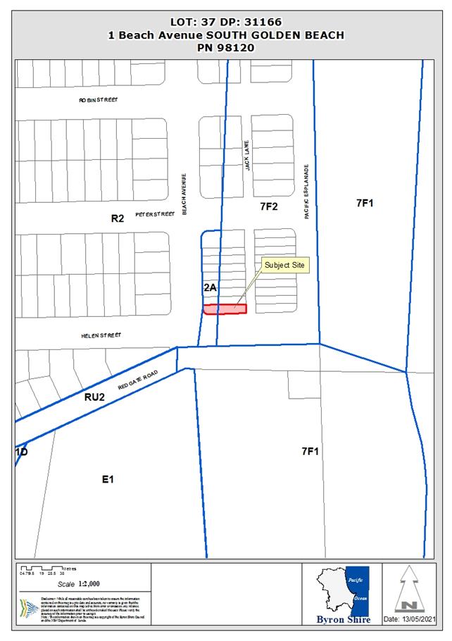
Assessment:
History/Background
The following previous determinations have been made on the
subject site:
· BA 6.1996.2059.1 for a dwelling
was approved 2 February 1996.
· DA 10.1999.102.1 for dwelling
7(f1) zone was approved 16 April 1999.
· DA 10.2009.572.1 for
alterations/additions to existing dwelling and new garage was approved 13 March
2010.
· DA 10.2009.572.2 for s96 modify
condition 10 (alteration/additions to existing dwelling and new garage) was
approved 28 May 2010.
Description of the proposed development
This application seeks approval for a 27.3m2 studio
to be constructed above the existing garage also involve small decks and access
stairs. A bathroom involving a W/C, shower, and hand basin is included with the
rest of the space open. The studio is proposed to be used for as a workspace
for each of the owners businesses, namely a marketing consulting business and a
photography/film editing business.
Most of the proposed studio is situated within the 2(a) zone
with part of the eastern deck within the 7(f2) zone.
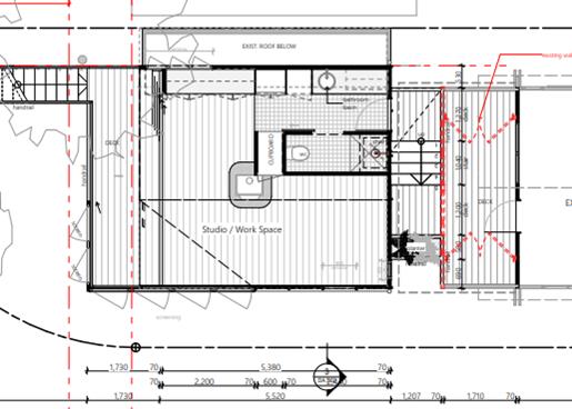
Figure 1 -
Proposed studio floor plan
Description of the site
A site inspection was carried out on 30 April 2021
|
Land is legally
described
|
LOT: 37 DP: 31166
|
|
Property address
|
1 Beach Avenue
SOUTH GOLDEN BEACH
|
|
Land is zoned:
|
LEP 1988 2(a)
Residential Zone & 7(f2) Urban Coastal Lands
|
|
Land area is:
|
290.9 m2
|
|
Property is
constrained by:
|
Flood Liable
Land, Bushfire prone land, Acid Sulfate Soils Class
2, Coastal Erosion Pre
2 & 3
|
|
|
Is a BDAR
required due to the location of the proposed development?
|
☐
Yes ☒ No
|
|
|
Are there any
easements in favour of Council affecting the site?
|
☐
Yes ☒ No
|
|
|
Is there a
Vegetation Management Plan which might affect the proposal?
|
☐
Yes ☒ No
|
|
|
Is there a
Voluntary Planning Agreement which might affect the proposal?
|
☐
Yes ☒ No
|
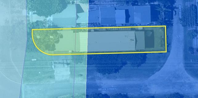
Figure 2
– 1988 LEP zoning and coastal erosion map extract
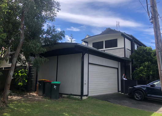
Figure 3 -
Corner view of site
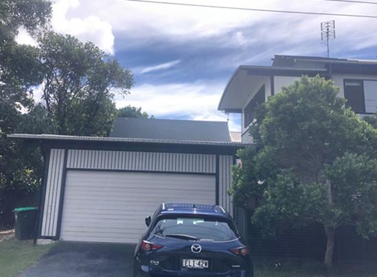
Figure 4 -
Front of existing garage which studio is proposed to be constructed above
|
Referral
|
Issue
|
|
Development Engineer
|
No objections subject to conditions.
|
|
Water & Sewer Engineer (Local Approvals Officer)
|
No objections subject to conditions.
|
3. SECTION
4.14 – BUSH FIRE PRONE LAND
Using the procedure provided on the NSW Rural Fire Service
webpage titled ‘Site Assessment Methodology’, the asset protection
zone and bush fire attack levels for this proposed development (which is in
fire weather area FDI 80) are as follows:
|
Direction
|
South
|
|
Vegetation formation
|
Coastal Swamp Forest
|
|
Distance between vegetation formation and building
|
54m
|
|
Effective slope
|
Flat
|
|
Asset Protection Zone
|
Whole site
|
|
Bushfire Attack Level (BAL)
|
BAL– 12.5 to all facades.
|
A condition is included in the Recommendation of this Report.
4. SECTION
4.15C – MATTERS FOR CONSIDERATION – DISCUSSION OF ISSUES
Having regard to the matters for consideration detailed in
Section 4.15(1) of the Environmental Planning & Assessment Act 1979
(EP&A Act), the following is a summary of the evaluation of the issues.
4.1 State
Environmental Planning Instruments (SEPP)
|
Considerations
|
Satisfactory
|
Unsatisfactory
|
|
SEPP No
55—Remediation of Land
Consideration: The site is not mapped or listed as
contaminated land. The proposal maintains the existing residential land use
and doesn’t increase sensitivity. It is satisfactory having regard to
this SEPP.
|
☒
|
☐
|
|
SEPP (Coastal Management) 2018
Consideration: The subject site is mapped within a
coastal wetland buffer, coastal environment area, and coastal use area. It is
not considered the proposed studio will impact on surrounding coastal
processes.
|
☒
|
☐
|
4.2 Byron Local
Environmental Plan 1988 (LEP 1988)
LEP 1988 is an applicable matter for consideration in the
assessment of the subject development application in accordance with subsection
4.15(1) of the EP&A Act because it applies to the subject land and the
proposed development. The LEP 1988 clauses that are checked below are of
relevance to the proposed development:
|
Part 1
|
☒1|
☒2| ☒2A| ☒3| ☒4| ☒5| ☒LEP 1988 Dictionary| ☒7
|
|
Part 2
|
☒8|
☒9
|
|
Part 3
|
☒14|
☒24| ☒32| ☒40| ☒45| ☒63
|
|
Part 4
|
N/A
|
In accordance with LEP 1988 clauses 5, 8
and 9:
(a) The
proposed development is defined in the LEP 1988 Dictionary as Studio;
(b) The
land is within the LEP1988 2(a) Residential Zone & 7(f2) Urban Coastal
Lands according to the map under LEP 1988;
(c) The
proposed development is permissible with consent; and
(d) The proposed
development is consistent with the relevant objectives of the Zone for the
following reasons:
|
2(a) Residential
Zone
|
|
Zone Objective
|
Consideration
|
|
to make
provision for certain suitable lands, both in existing urban areas and new
release areas, to be used for the purposes of housing and associated
neighbourhood facilities of high amenity and accessibility,
|
The studio is ancillary to the existing dwelling; it
is consistent with the surrounding low density residential environment.
|
|
to
encourage a range of housing types in appropriate locations,
|
|
to enable
development for purposes other than residential purposes only if it is
compatible with the character of the living area and has a domestic scale and
character, and
|
|
to control
by means of a development control plan the location, form, character and
density of permissible development.
|
|
7(f2) Urban Coastal
Lands
|
|
Zone Objective
|
Consideration
|
|
to identify
urban land likely to be influenced by coastal processes,
|
Parts of the proposed decks are situated within the
7(f2) zone. The proposed studio is situated wholly within Erosion Precinct 3.
Conditions have been recommended by Councils Engineers to satisfy the zoning.
|
|
to permit
urban development within the zone subject to the council having due
consideration to the intensity of that development and the likelihood of such
development being adversely affected by, or adversely affecting, coastal
processes,
|
|
to permit
urban development within the zone subject to the council having due
consideration to—
(i)
the need to relocate buildings in the long term,
(ii)
the need for development consent to be limited to a particular period,
(iii)
the form, bulk, intensity and nature of the development, and
(iv)
continued safe public access to the site, and
|
|
to allow
detailed provisions to be made, by means of a development control plan, to
set aside specific areas within the zone for different land uses and
intensities of development.
|
Clause 14
Residential areas and rural villages
This clause states that
Council may consent to the erection of a dwelling-house on land to which this
clause applies only if its Floor Space Ratio (FSR) does not exceed 0.5:1. The
LEP 1988 defines a dwelling-house as:
Dwelling-house means a building or buildings containing
one but not more than one dwelling.
Under the floor plan area definition,
a studio is not excluded from the Gross Floor Area (GFA) calculation. The area
of balconies are also included within the calculation.
The site area is 290.9m2.
Following the definitions of the LEP 1988 the GFA
calculations are as follows:
Existing first floor GFA (including balcony/deck):91m2
Existing ground floor GFA: 66m2
Total existing GFA: 157m2
The proposed studio involves 27.3m2
of internal floor area however is 36m2 including western balcony as
defined under the 1988 LEP.
The proposed GFA is 193m2.
Therefore the FSR is: 0.66:1
A 32% variation is sought to the 0.5:1 FSR
requirement set out under clause 14(7).
Clause 24 Development of flood liable land
As the studio is proposed above an existing garage it will
be well above the flood planning level.
Clause 63 Development on land identified on the Acid
Sulfate Soils Planning Map
The subject site is mapped as class 2 acid sulfate soils.
The works will be above the garage with only minor ground works for the access
stairs and small deck footings. It is not anticipated that the proposal
will include earthworks of more than one tonne of soil below the natural ground
surface nor have any impacts on potential acid sulfate soils.
The remaining checked
clauses have been taken into consideration in the assessment of the subject
development application in accordance with Section 4.15 of the EP&A Act.
The proposed development complies with all clauses of LEP 1988 (in some cases
subject to conditions and/or to the satisfaction of other assessing officers).
Clause 64A
Exceptions to Development Standards
Applicant has
sought a variation to Clause 14(7) by proposing a FSR of 0.66:1 under the
definitions of the 1988 LEP.
The applicant has
submitted a written request that strict compliance with the development
standard is unreasonable or unnecessary and that there are sufficient
environmental grounds to vary the controls as follows:
· The calculations
of GFA and FSR under the 1988 LEP are considered highly restrictive as they
include balconies and decks. It is
unreasonable and unnecessary for the subject property to be constrained by an
outdated gross floor area definition
while the subject property is
awaiting inclusion into Byron Local Environmental Plan 2014.
· The
site is extremely constrained by its small area involving only 290.9m2.
· There
are several lots within the immediate surrounding neighbourhood which exceed
the 0.5:1 FSR under the 1988 LEP. For exampled, DA 10.2018.193.1 at 4 Pacific
Esplanade was approved on 11/12/2018 with a FSR of approx. 0.75:1 under 1988
LEP.
· The
studio is located above an existing garage; therefore it will not be increasing
the coverage of the site. It will also not result in any significant change to
the low density residential character of the area. An inspection of the site
and surrounding locality indicates very similar forms of development.
Having regards to
the above, it is considered that strict compliance with the development
standard is unreasonable and unnecessary in the circumstances of the case and
that there are sufficient environmental grounds to vary the development
standard. Further If the FSR is calculated under the 2014 LEP, the proposed studio brings the FSR for the whole site to
0.53:1. Although exceeding the 0.5:1.0 controls under Byron LEP 2014,
considering the small area of the property, its frontage on three sides to
public roads and a laneway, and the design of the studio above the garage with
minimal – nil impacts on neighbours in terms of overlooking, privacy and
overshadowing, the variation to the controls is not unreasonable.
The concurrence of
the Planning Secretary is not required. It is recommended that the development
standard can be varied in this instance.
4.3 Any
proposed Instrument that has been the subject of public consultation and has
been notified to the consent authority
Not applicable
4.4 Byron
Shire Development Control Plan 2010 (DCP 2010)
Part C:
Residential Development
C2.5 –
Building Height Plane:
As the studio is
proposed to be constructed above the existing garage, it will involve
encroachments into the building height plane on the northern and southern
boundaries. Due to the orientation of the site and the road on the south and
west of the site, the encroachments will not cause overshadowing onto any
neighbouring properties. No privacy issues are expected either as the property
to the north contains a garage directly adjacent to the proposed studio. South
golden beach is characterised by dwellings and structures of a similar form,
most involving significant building height plane encroachments. The encroachments
are considered to have a negligible impact and are therefore considered
acceptable.
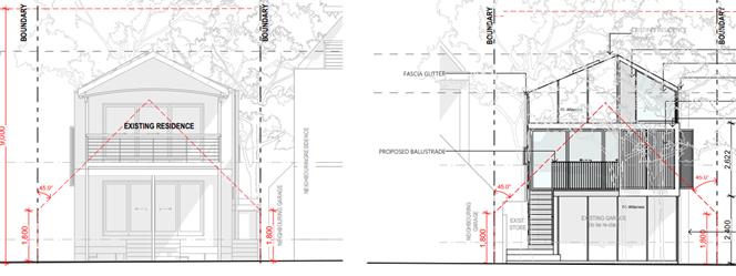
Figure 3 - Building height plane
encroachments of existing dwelling and proposed studio
C2.6 –
Setbacks from Street, Side and Rear Boundaries
The proposal
involves encroachments into the minimum setbacks on the western and southern
boundaries. This controls required a minimum setback of 6.5 metres from the
primary front boundary with a reduction to 3m allowed for corner allotments.
The proposed building works match the setback of the existing building to the
southern Helen Street frontage being 1.41m. The proposal includes a deck area
on the western side of the studio with a setback of 4.937 metres to the Beach
Avenue frontage and the stairs further encroach into that. A setback of 900mm
is provided to the northern property boundary. Although the proposal involves
encroachments on both front boundaries, they are relatively consistent with the
existing dwelling and the building lines of surrounding properties, the encroachments
are considered reasonable in this instance.
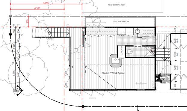
Figure 4 - Floor Plan showing western
setbacks
C3.1 –
Visual Impact
The proposed studio
will match the existing dwelling having regard to built form, character, and
materials. The building design includes a pitched roof over timber framed
walls. The external walls are to be clad in a mix of FC sheeting materials. The
roof is to be sheeted in Colorbond steel. It is not considered to adversely
impact on the streetscape.
C14 –
Studios
The internal floor
area of the studio is 27.3m2
and includes an open workspace plus a bathroom. The space is proposed to
be used for both the owner’s businesses involving a marketing consulting
business and a photography/film editing business. There are no unnecessary internal
partitions to make it capable of being used for separate habitation. Conditions
of consent to apply in relation to the studios use.
Part J: Coastal
Erosion Lands
The dwelling is located in both Precincts 2 and 3 however
the proposed development is wholly within Precinct 3. The existing erosion
escarpment is currently more than 50m from existing and proposed buildings.
Development must cease if erosion escarpment comes to within 50m of any
buildings and Restriction on the Use of Land must be placed on title –
conditions recommended by engineer.
There is an existing positive covenant on title in
accordance with Condition 13 of DA 10.2009.572.1.
No removability report was submitted with application,
however the proposed works are within Precinct 3 and demolition is an option
for removal. The proposed works are above the garage approved by 10.1999.102.1
which didn’t require removability to be demonstrated. The studio above
the garage will not compromise the removability of the existing house as it is
only connected by a staircase and deck which can be demolished.
The proposal raises no other issues under the DCP.
4.5 Environmental
Planning & Assessment Regulation 2000 Considerations
|
Clause
|
This control
is applicable to the proposal:
|
I have
considered this control as it relates to the proposal:
|
If this
control is applicable, does the proposal comply?
|
|
92
|
No
|
Not applicable
|
Not applicable
|
|
93
|
No
|
Not applicable
|
Not applicable
|
|
94
|
No
|
Not applicable
|
Not applicable
|
|
94A
|
No
|
Not applicable
|
Not applicable
|
* Non-compliances and any other significant issues
discussed below
4.6 The likely
impacts of that development, including environmental impacts on both the
natural and built environments, and social and economic impacts in the locality
|
Impact on:
|
Likely significant impact/s?
|
|
Natural environment
|
No. The proposal will not have a significantly adverse
impact on the natural environment of the locality.
|
|
Built environment
|
No. The proposal will not have a significantly adverse
impact on the built environment of the locality.
|
|
Social Environment
|
No. The proposal will not have a significant social
impact on the locality.
|
|
Economic impact
|
No. The proposal will not have a significant economic
impact on the locality.
|
|
Construction Impacts
|
The development will generate minor impacts during its
construction. Conditions of consent recommended to control hours of work,
builders waste, construction noise, installation of sedimentation and erosion
control measures and the like to ameliorate such impacts.
|
Are there any Council Policies that are applicable to the
proposed development? No
4.7 The
suitability of the site for the development
The site is a serviced, with constraints affecting the
property able to be managed. The site is suitable for the proposed development.
4.8 Submissions
made in accordance with this Act or the regulations
The development application was publicly exhibited. There was 1 submission
from Crown Lands in terms of protecting public lands (ie the beach reserve).
The subject development does not adjoin the reserve and is unlikely to impact
on Crown Land.
4.9 Public
interest
The proposed development is unlikely to prejudice or
compromise the public interest or create an undesirable precedent.
5. DEVELOPER
CONTRIBUTIONS
5.1 Water
& Sewer Levies
No Section 64 levies will be required.
5.2 Developer
Contributions
No Developer Contributions will be
required.
6. DISCLOSURE
OF POLITICAL DONATIONS AND GIFTS
|
Disclosure details
|
Response
|
|
Has a Disclosure Statement been received in relation
to this application?
If Yes, Provide Disclosure Statement register
reference: 91.
|
Yes ☐
No ☒
|
|
Have staff received a ‘gift’ from anyone
involved in this application that needs to be disclosed.
|
Yes ☐
No ☒
|
The proposed development is satisfactory having regard to the
relevant planning controls applicable to the site. The proposal raises no
significant issues in terms of environmental impacts which cannot be managed
and the site is considered suitable for the development. In terms of the
variation being sought to the floor area, it is considered there are sufficient
grounds to support the proposal and strict compliance with the development
standard is not required in this instance. The application is recommended
for approval subject to the conditions of consent.
Staff Reports - Sustainable Environment and Economy 13.12
Report
No. 13.12 Place Planning Collective -
Additional Community Members
Directorate: Sustainable
Environment and Economy
Report Author: Andrew
FitzGibbon, Place Liaison Officer
File No: I2021/806
Summary:
There are currently nine community
members on the Place Planning Collective. Two additional members are being
sought – one from Bangalow and one associated with the Byron Arts and
Industry Estate. This aims to provide greater representation for the place
plans for those areas. Mullumbimby and Federal are already adequately
represented.
An Expression of Interest process
for these additional members has been carried out and 15 nominations were
received (refer Attachment 2).
Council must now consider these
EOIs and nominate two additional members to join the Collective – one
from Bangalow and one associated with the Byron Arts and Industry Estate.
A minor update to the membership
section of the Place Planning Collective Charter is also recommended.
RECOMMENDATION:
That Council:
1. Nominates
the following two representatives from the expressions of interest contained in
Attachment 2 (E2021/69485) to be part of the Place Planning Collective:
___________ for Bangalow, and ______________ for the Byron Arts and Industry Estate.
2. Endorses the update to the Place
Planning Collective Charter as detailed in the report.
Attachments:
1 Place
Planning Collective Charter - May 2020 - endorsed Res 20-217, E2020/31059
2 Confidential
- Expressions of Interest - Place Planning Collective Membership - May 2021, E2021/69485
Report
The Place Planning Collective has
been established to promote and facilitate projects and policies relating to
the implementation of the place plans in Byron Shire. This includes the place
plans for Mullumbimby, Bangalow, and the Byron Arts and Industry Estate. A
place plan for Federal is currently under development. Further information
about the Place Planning Collective can be found on Council’s
website.
There are currently nine community
members on the Place Planning Collective as listed below. Two additional
members are being sought – one from Bangalow and one associated with the
Byron Arts and Industry Estate. This would help to provide greater
representation for the place plans for those areas. Mullumbimby and Federal are
already adequately represented.
The Charter for the Place Planning
Collective (Attachment 1) allows up to twelve community members and three
Councillors. Members are appointed for a two year term.
The table below details existing
members of the Place Planning Collective:
|
Name
|
Mainly supporting place plan actions for:
|
|
David Brown
|
Mullumbimby
|
|
Natalie Eggenberger
|
Mullumbimby
|
|
Madeleine Faught
|
Mullumbimby
|
|
Sasha Mainsbridge
|
Mullumbimby
|
|
Jenny Bird
|
Bangalow
|
|
Clare Hopkins
|
Bangalow
|
|
Jack Dods
|
Byron Arts and Industry Estate
|
|
Alan Goldstein
|
Federal
|
|
Jenna Reed Burns
|
Federal
|
Councillor representatives
currently include Cr Michael Lyon, Cr Basil Cameron and Cr Jan Hackett with
other Councillors often attending as guests.
Council ran an Expression of
Interest process for new members from 23 April to 14 May 2021. A notice
was placed on council’s website, an advertisement was run in the Echo,
there were social media posts, and Council staff spoke with numerous community
members/groups during the public exhibition.
Candidates were required to
demonstrate their suitability for membership via an online form.
Council received 15 expressions of
interest (refer Attachment 2).
Council must now consider these
EOIs and nominate two people from this list to join the Collective – one
from Bangalow and one associated with the Byron Arts and Industry Estate.
Background of Membership for
the Place Planning Collective
The initial intention of the Place
Planning Collective was to have seven community members selected through an
Expression of Interest process and five community members selected randomly
through the Citizens
Lottery. The aim was also to have a wide
representation across the shire with members coming from areas where there are
place plans already developed as well as members from other locations.
Over its first year of operation,
it would be fair to say that some of the Collective members found it
challenging to stay as active participants in the group. The key observations
are:
· All but one Citizen Lottery appointment members have
resigned. As such, an EOI process is preferred over the Citizens Lottery;
· Members with a direct interest in one of the place plans
being managed or developed have maintained active membership engagement; and
· Members without a direct interest in one of the place plans
being managed or developed have resigned or disengaged.
Given this experience, the
Collective has recommended that additional members be sought through an EOI
process that focuses on reinforcing representation of existing or developing
place plans.
The group is confident that this
refined approach to membership will result in less turn-over while also still
keeping a broad shire representation which includes the four current place plan
locations (Mullumbimby, Bangalow, Byron Arts and Industry, and Federal).
Update to the Place Planning
Collective Charter
The Place Planning Collective
Charter (refer Attachment 1) outlines membership selection requirements (refer
Section 2 ‘Composition of the Group’). It is proposed to update
this section to reflect the refined approach noted above as follows:
Section
2. Composition of the Group
The
Collective will be made up of up to twelve community members and up to three
nominated Councillors. Other Councillors are able to attend meetings as
guests.
Community
members may be selected through an Expression of Interest process (including
public advertisement and selection by Council), or randomly selected through
Council’s Citizen’s Lottery project.
If a new
masterplan is being developed for an area, representatives from that masterplan
steering group may be appointed directly to join the Collective.
In
appointing Collective members, Council seeks to maximise a diversity of
interests and skills, and achieve a mixed representation of the Shire’s
community. Future members will be appointed to fill identified skill or
representational gaps within the Collective.
Members
will be appointed for a two year term (or at the beginning of a new Council
term), and existing members will be invited to apply to remain on the group at
the end of each term to ensure historical knowledge is retained.
If a
member wishes to resign from the Collective, they are required to give as much
notice as possible to allow their vacancy to be filled. If a member has been
inactive for a considerable time, their membership can be cancelled by the
group.
Strategic Considerations
Community Strategic Plan
and Operational Plan
|
CSP Objective
|
L2
|
CSP Strategy
|
L3
|
DP Action
|
L4
|
OP Activity
|
|
Community Objective
4: We manage growth and change responsibly
|
4.1
|
Support the visions and
aspirations of local communities through place-based planning and management
|
4.1.1
|
Develop, implement and update
Place Plans that promote place-based forward planning strategies and actions
|
4.1.1.5
|
Implement Our Mullumbimby
Masterplan, Bangalow Village Plan and Byron Arts and Industry Estate Plan
|
Recent Resolutions
· 20-703:
Council Meeting 17 December 2020 – end of 2020 update
· 20-217:
Council Meeting 21 May 2020 – endorsed the Charter for the Collective
· 19-690:
Council Meeting 12 December 2019 – initial EOI nominations
· 19-451:
Council Meeting 19 September 2019 – resolution to establish the
Collective
Legal/Statutory/Policy
Considerations
Nil
Financial Considerations
Nil
Consultation and Engagement
As described within the report.