 Agenda
Ordinary (Planning) Meeting

Thursday, 12 May 2022
Agenda
Ordinary (Planning) Meeting
Thursday, 12 May 2022
Agenda Ordinary (Planning) Meeting
held in the Conference Room, Station Street, Mullumbimby
commencing at 11.00am
Public access relating to items on this agenda can be made between 11:00am and 11:30am on the day of the meeting. Requests for public access should be made to the General Manager or Mayor no later than 12:00 midday on the day prior to the meeting.

Mark Arnold
General Manager
CONFLICT OF INTERESTS
What is a “Conflict of Interests” - A conflict of interests can be of two types:
Pecuniary - an interest that a person has in a matter because of a reasonable likelihood or expectation of appreciable financial gain or loss to the person or another person with whom the person is associated.
Non-pecuniary – a private or personal interest that a Council official has that does not amount to a pecuniary interest as defined in the Code of Conduct for Councillors (eg. A friendship, membership of an association, society or trade union or involvement or interest in an activity and may include an interest of a financial nature).
Remoteness – a person does not have a pecuniary interest in a matter if the interest is so remote or insignificant that it could not reasonably be regarded as likely to influence any decision the person might make in relation to a matter or if the interest is of a kind specified in the Code of Conduct for Councillors.
Who has a Pecuniary Interest? - a person has a pecuniary interest in a matter if the pecuniary interest is the interest of the person, or another person with whom the person is associated (see below).
Relatives, Partners - a person is taken to have a pecuniary interest in a matter if:
· The person’s spouse or de facto partner or a relative of the person has a pecuniary interest in the matter, or
· The person, or a nominee, partners or employer of the person, is a member of a company or other body that has a pecuniary interest in the matter.
N.B. “Relative”, in relation to a person means any of the following:
(a) the parent, grandparent, brother, sister, uncle, aunt, nephew, niece, lineal descends or adopted child of the person or of the person’s spouse;
(b) the spouse or de facto partners of the person or of a person referred to in paragraph (a)
No Interest in the Matter - however, a person is not taken to have a pecuniary interest in a matter:
· If the person is unaware of the relevant pecuniary interest of the spouse, de facto partner, relative or company or other body, or
· Just because the person is a member of, or is employed by, the Council.
· Just because the person is a member of, or a delegate of the Council to, a company or other body that has a pecuniary interest in the matter provided that the person has no beneficial interest in any shares of the company or body.
Disclosure and participation in meetings
· A Councillor or a member of a Council Committee who has a pecuniary interest in any matter with which the Council is concerned and who is present at a meeting of the Council or Committee at which the matter is being considered must disclose the nature of the interest to the meeting as soon as practicable.
· The Councillor or member must not be present at, or in sight of, the meeting of the Council or Committee:
(a) at any time during which the matter is being considered or discussed by the Council or Committee, or
(b) at any time during which the Council or Committee is voting on any question in relation to the matter.
No Knowledge - a person does not breach this Clause if the person did not know and could not reasonably be expected to have known that the matter under consideration at the meeting was a matter in which he or she had a pecuniary interest.
Non-pecuniary Interests - Must be disclosed in meetings.
There are a broad range of options available for managing conflicts & the option chosen will depend on an assessment of the circumstances of the matter, the nature of the interest and the significance of the issue being dealt with. Non-pecuniary conflicts of interests must be dealt with in at least one of the following ways:
· It may be appropriate that no action be taken where the potential for conflict is minimal. However, Councillors should consider providing an explanation of why they consider a conflict does not exist.
· Limit involvement if practical (eg. Participate in discussion but not in decision making or vice-versa). Care needs to be taken when exercising this option.
· Remove the source of the conflict (eg. Relinquishing or divesting the personal interest that creates the conflict)
· Have no involvement by absenting yourself from and not taking part in any debate or voting on the issue as of the provisions in the Code of Conduct (particularly if you have a significant non-pecuniary interest)
RECORDING OF VOTING ON PLANNING MATTERS
Clause 375A of the Local Government Act 1993 – Recording of voting on planning matters
(1) In this section, planning decision means a decision made in the exercise of a function of a council under the Environmental Planning and Assessment Act 1979:
(a) including a decision relating to a development application, an environmental planning instrument, a development control plan or a development contribution plan under that Act, but
(b) not including the making of an order under that Act.
(2) The general manager is required to keep a register containing, for each planning decision made at a meeting of the council or a council committee, the names of the councillors who supported the decision and the names of any councillors who opposed (or are taken to have opposed) the decision.
(3) For the purpose of maintaining the register, a division is required to be called whenever a motion for a planning decision is put at a meeting of the council or a council committee.
(4) Each decision recorded in the register is to be described in the register or identified in a manner that enables the description to be obtained from another publicly available document, and is to include the information required by the regulations.
(5) This section extends to a meeting that is closed to the public.
BUSINESS OF Ordinary (Planning) Meeting
1. Public Access
3. Requests for Leave of Absence
4. Declarations of Interest – Pecuniary and Non-Pecuniary
5. Tabling of Pecuniary Interest Returns (Cl 4.9 Code of Conduct for Councillors)
6. Adoption of Minutes from Previous Meetings
6.1 Ordinary (Planning) Meeting held on 14 April 2022
7. Reservation of Items for Debate and Order of Business
8. Mayoral Minute
9. Notices of Motion
Nil
10. Petitions
11. Submissions and Grants
12. Delegates' Reports
13. Staff Reports
General Manager
13.1 Temporary accommodation leases between Council and Resilience NSW......... 7
Corporate and Community Services
13.2 Appointment of Community Representatives to the Audit, Risk and Improvement Committee..................................................................................................................... 12
13.3 Endorsement of Integrated Planning and Reporting documents for public exhibition: Delivery Program, Operational Plan, Budget, and Revenue Policy..................... 15
13.4 Endorsement of Disability Inclusion Action Plan 2022-2026 for public exhibition 20
Sustainable Environment and Economy
13.5 PLANNING - Development Application 10.2022.71.1 Use of Lot 30 as a tourist facility / tourist accommodation................................................................................................ 25
13.6 PLANNING - Report of the Planning Review Committee held 7 April 2022....... 47
13.7 PLANNING - DA10.2022.14.1 - Alterations and Additions to an Existing Recreation Area (Sandhills Estate) including Upgrade to Existing Footpath, New Sandstone Seating and Landscaping Areas and New Informative Signage.......................... 49
14. Questions With Notice
14.1 Development on “Linnaeus” at Broken Head.......................................................... 71
Councillors are encouraged to ask questions regarding any item on the business paper to the appropriate Director prior to the meeting. Any suggested amendments to the recommendations should be provided to Councillor Support prior to the meeting to allow the changes to be typed and presented on the overhead projector at the meeting.
BYRON SHIRE COUNCIL
Staff Reports - General Manager 13.1
Staff Reports - General Manager
Report No. 13.1 Temporary accommodation leases between Council and Resilience NSW
Directorate: General Manager
Report Author: Ralph James, Legal Counsel
Andrew FitzGibbon, Place Planning Coordinator
File No: I2022/449
Summary:
In April 2022, the NSW Government announced a $350 million investment in temporary modular housing to give people displaced by floods a place to call home while they rebuild their lives. Temporary modular homes will be delivered to provide additional accommodation options to communities impacted by the February and March 2022 storms and floods.
Council staff are supporting the State Government in the identification of publicly owned sites suitable for temporary modular housing.
Two council sites have been deemed appropriate for immediate use and are to be prioritised for temporary accommodation by the State Government.
Lease agreements between the state agency establishing the site (Resilience NSW) and council (as landowner) are required to enable to the temporary pop-up villages on these sites. Negotiations toward leases from Council to Resilience NSW are ongoing.
Further detail in respect of the lease negotiations will be provided to Council by way of a late report.
RECOMMENDATION:
That Council consider the information in this report, and that which will be provided in a late report, to determine whether Council should enter into a lease with Resilience NSW to permit the construction, maintenance and operation of temporary housing on the sites identified in this report.
Report
Background
In April 2022, the NSW Government announced a $350 million investment in temporary modular housing to give people displaced by floods a place to call home while they rebuild their lives. Temporary modular homes will be delivered to provide additional accommodation options to communities impacted by the February and March 2022 storms and floods.
$350 million modular housing package for flood-affected communities | NSW Government
The NSW Government will lead the delivery of temporary housing throughout the region with agreement and consultation from councils.
The public authority establishing and operating these sites must ensure that they have appropriate services and that they are safe. The sites will contain moveable homes in various configurations which can accommodate one to four people and will be co- located with supporting infrastructure and amenities.
Any temporary, emergency caravan park or camping ground must be removed within five years of being established. Development consent is required to continue operating the caravan park or camping ground beyond this period.
Legislation
Regulatory changes had been made to allow temporary accommodation to be set up by or on behalf of a public authority more quickly without development consent. This FAQ provides an overview of these amendments (refer link here).
Process
Figure 1 below is a summary of the State Government endorsed process for temporary housing.
Figure 1: Pop-up Village Approval Process (provided by State Government)
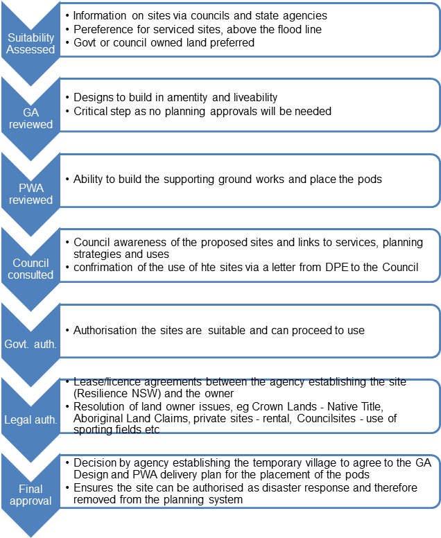
Site Suitability Assessments
Byron Shire Council staff are supporting the State Government in the identification of publicly owned sites suitable for temporary modular housing. The key selection criteria include: impacts of hazard (flooding and bushfire); land ownership; current planning controls; access to water, sewerage, electricity, and roads; and access to local services and shops.
To this extent:
· Staff identified 16 council and crown land sites for consideration for temporary housing. These sites were presented to the Department of Planning (DPE) Flood Housing Recovery Team for consideration.
· This has resulted in two council sites (refer Figure 2) and one other public authority site in Byron Shire being deemed appropriate for immediate use to be prioritised for temporary accommodation by the State Government.
Figure 2: Council Site Descriptions
|
Brunswick Heads remediated former STP Owner: Byron Shire Council 125 Tweed Street, Brunswick Heads
|
Bayside Brunswick Heads Owner: Byron Shire Council Excelsior Cir / Torakina Rd, Brunswick Heads
|
Site Design
Council staff are supporting the NSW Government Architect (GA) office in the site planning and design phase to ensure that safe occupation and servicing of the sites can occur. As per the process noted in Figure 1, the GA will also be consulting with Public Works Advisory (PWA).
It is expected that the GA will soon be sharing draft designs for these sites that will include temporary dwelling estimates.
Site Management
A community housing provider will be appointed as site manager of each of the sites to ensure appropriate selection and management of occupants, alongside Resilience NSW as the land manager for the length of the lease.
Next steps
Lease agreements between the state agency establishing the site (Resilience NSW) and Council (as landowner) are required to enable to the temporary pop-up villages on the two Council sites.
Resilience NSW have provided Council with a draft lease template for review.
Council’s initial review of and feedback on the lease terms has been provided in anticipation of a working group meeting early in the week commencing 2 May 2022 (but after the agenda has closed) to discuss and hopefully finalise the lease terms so that they can be put to Council.
Information from this meeting, and a draft lease, will be put to Council on 12 May 2022 by way of a late report.
Strategic Considerations
Community Strategic Plan and Operational Plan
|
CSP Objective |
CSP Strategy |
DP Action |
|
Community Objective 4: We manage growth and change responsibly |
4.5: Work to improve community resilience in our changing environment |
4.5.1: Develop and implement strategies for our community's needs |
While there is an action that this work can be linked to in the current Delivery Program, it needs to be understood that there is no current Operational Plan link to the 2022 Flood Event. This has meant that many staff have been redeployed and or seconded to this work, which has and is having an impact on current adopted Operational Plan activities.
Legal/Statutory/Policy Considerations
As set out in the body of this report
Financial Considerations
To be provided by way of the proposed late report.
Consultation and Engagement
BYRON SHIRE COUNCIL
Staff Reports - Corporate and Community Services 13.2
Staff Reports - Corporate and Community Services
Report No. 13.2 Appointment of Community Representatives to the Audit, Risk and Improvement Committee
Directorate: Corporate and Community Services
Report Author: Mila Jones, Governance and Internal Audit Coordinator
File No: I2022/393
Summary:
Council received a report on 3 February 2022 seeking approval to advertise for community representatives to its Audit, Risk and Improvement Committee for the term of Council. Members of the community were invited to submit an Expression of Interest for this Committee by completing an online nomination form. In the initial call for interest only two nominations were received, and subsequently endorsed by Council on 24 March 2022.
On 24 March 2022 it was also resolved to extend the call for nominations to allow for a third member, as prescribed by the Committee’s Constitution. Following the second call for nominations, this report provides information about the nominations received and recommends appointment to the Audit, Risk and Improvement Committee.
RECOMMENDATION:
1. That Council selects one community representative from the options provided at Attachment 1 (E2022/37004), and they be appointed to the Audit, Risk and Improvement Committee for the 2022-2024 term ending September 2024.
2. That the appointed Committee member:
a) be notified of their appointment to the Committee; and
b) complete induction, Code of Conduct, and confidentiality requirements.
3. That any unsuccessful nominees be notified.
Attachments:
1 Confidential - ARIC membership nominations 2022 (second round) - 6 nominations combined, E2022/37004
Report
Council received a report on 3 February 2022 seeking to determine the Audit, Risk and Improvement Committee (Committee) structure for the term of Council and to invite nominations from community representatives to the Committee.
Nominations were subsequently called for the Committee. In the initial call for expressions of interest only two nominations were received, and subsequently endorsed by Council on 24 March 2022. On 24 March 2022 it was also resolved to extend the call for nominations to allow for a third member, as prescribed by the Committee’s Constitution.
A summary of the nominations received from the second call for expressions of interest is provided at confidential Attachment 1 with the nominees’ supporting information such as CVs provided at confidential Attachment 2.
As two of the three members have been endorsed by a previous resolution, Council is now asked to consider the nominations and determine the appointment of the final community representative to the Committee.
Committee Membership includes:
· Crs Hunter and Swivel
· 3 community/subject matter experts
Strategic Considerations
Community Strategic Plan and Operational Plan
|
CSP Objective |
CSP Strategy |
DP Action |
Code |
OP Activity |
|
Community Objective 5: We have community led decision making which is open and inclusive |
5.1: Engage and involve community in decision making |
5.1.1: Facilitate inclusive community consultation and stakeholder engagement to inform Council decision making (SP) |
NA |
|
|
Community Objective 5: We have community led decision making which is open and inclusive |
5.2: Create a culture of trust with the community by being open, genuine and transparent |
5.2.4: Support Councillors to carry out their civic duties |
5.2.4.5 |
Implement and manage Code of Conduct training programs for Councillors, staff, and committee members |
|
Community Objective 5: We have community led decision making which is open and inclusive |
5.6: Manage Council’s resources sustainably |
5.6.7: Develop and embed a proactive risk management culture |
5.6.7.4 |
Coordinate the Audit Risk and Improvement program |
Recent Resolutions
· 22-026 Extraordinary Meeting 3 February 2022
· 22-098 Ordinary Meeting 24 March 2022
Legal/Statutory/Policy Considerations
Advisory committees operate under an adopted Constitution and Council’s Code of Meeting Practice.
Financial Considerations
This Committee is a statutory requirement of Council and therefore its community members are able to be reimbursed based on an agreed fee. The fee payable to community members is included in the Audit, Risk and Improvement Committee budget (2052.6).
The Draft Office of Local Government Guidelines (August 2021) notes that chairs and members can serve on a committee on a voluntary basis if they choose to.
Consultation and Engagement
Nominations were open from 8 February 2022 and closed on 28 February 2022 from which the first two members were appointed. The call for expressions of interest was then reopened from 15 March 2022 to 1 April 2022 with no nominations received. The period was then extended from 1 April and closed on 25 April 2022, which resulted in the nominations included in this report.
BYRON SHIRE COUNCIL
Staff Reports - Corporate and Community Services 13.3
Report
No. 13.3 Endorsement of Integrated
Planning and Reporting documents for public exhibition: Delivery Program,
Operational Plan, Budget, and Revenue Policy
Directorate: Corporate and Community Services
Report Author: Heather Sills, Corporate Planning and Improvement Coordinator
James Brickley, Manager Finance
File No: I2022/423
Summary:
Following an election, each new Council must and adopt their suite of Integrated Planning and Reporting (IPR) documents by 30 June the following year. The preparation of these documents is regulated under the Integrated Planning and Reporting Framework requirements legislated by the Local Government Act 1993 (Sections 402 to 406).
The Integrated Planning and Reporting (IPR) Framework includes:
· 10 year Community Strategic Plan reflecting the aspirations, needs, and priorities of the local community
· The Resourcing Strategy, addressing sustainable long term financial, asset management and workforce planning;
· A four year Delivery Program outlining Council's activities planned for council term
· Annual Operational Plan consisting of actions identified to be undertaken each year to meet the Delivery Program commitments; together with the related budget, statement of revenue policy, and fees and charges.
At its Ordinary Meeting on 24 February 2022, Council endorsed the public exhibition of the Byron Shire Community Strategic Plan 2032 (CSP) and an engagement strategy for the review of the Delivery Program 2022-26. Council has subsequently developed a draft Delivery Program 2022-26 and Operational Plan 2022/23 based on the strategic priorities in the CSP.
A further report and the documents for public exhibition will be provided in a Supplementary Agenda to be published on Council’s website and the Hub by Friday, 6 May 2022. The recommendation below will be updated when the documents are distributed within the Supplementary Agenda.
RECOMMENDATION:
1. That the following draft Integrated Planning and Reporting documents be placed on public exhibition for a period of 28 days:
a) Delivery Program 2022-26
b) Operational Plan 2022/23 and associated Budget, Statement of Revenue Policy, and Fees and Charges
2. That an Extraordinary Meeting be held on 30 June 2022 to adopt the final documents, giving due consideration to any submissions received during the public exhibition period.
Report
All councils in NSW use the IP&R framework to guide their planning and reporting activities. The Community Strategic Plan, the Delivery Program and the Operational Plan form part of the Integrated Planning and Reporting Framework which is a requirement under the Local Government Act 1993.
Overview of Integrated Planning and Reporting
The diagram below is extracted from the IPR Guidelines and highlights the relationship and hierarch of the strategies and plans, each relevant section is explained in more detail.
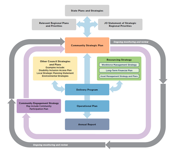
Community Strategic Plan
Leading the Council’s planning hierarchy, the Community Strategic Plan (CSP) captures the community’s vision, aspirations, and expectations for the next 10 years. All other plans must support achievement of the Community Strategic Plan objectives.
The draft Byron Shire Community Strategic Plan 2032 was endorsed by Council on 24 February for public exhibition. The exhibition period and related community engagement program was impacted by the flood event in February and March, impacting much of the Shire. The exhibition period ended on 26 April 2022. Submissions and any required amendments will be reported back to Council for adoption of the final CSP.
Delivery Program
The delivery program translates the community strategic plan goals into actions. It is each newly elected Council’s commitment to the community, outlining what it intends to do toward achieving the goals of the community strategic plan during its term of office. It becomes the single point of reference for all principal activities undertaken by Council. All plans, projects, activities and funding allocations must be directly linked to the four-year delivery program.
Operational Plan
The delivery program is supported by an annual operational plan which details the individual projects and activities that will be undertaken each year to achieve the commitments of the delivery program. The Operational Plan must include the Council’s annual budget, along with Council’s Statement of Revenue Policy, which sets the proposed rates, fees and charges for that financial year.
Resourcing Strategy
The resourcing strategy addresses the sustainable long term financial, asset management, and workforce planning requirements and outlines how council will resource its strategic priorities.
Strategic Considerations
Community Strategic Plan and Operational Plan
|
CSP Objective |
CSP Strategy |
DP Action |
Code |
OP Activity |
|
Community Objective 5: We have community led decision making which is open and inclusive |
5.2: Create a culture of trust with the community by being open, genuine and transparent |
5.2.1: Provide timely, accessible and accurate information to the community |
5.2.1.2 |
Undertake a community engagement program to review and develop Council's Integrated Planning and Reporting framework documents |
|
5.2.1.1 |
Review Operational Plan annually |
Recent Resolutions
· 22-055 – endorsement of the draft Byron Shire Community Strategic Plan 2023 for public exhibition.
Legal/Statutory/Policy Considerations
The requirements for Integrated Planning and Reporting are governed by Sections 402-406 of the Local Government Act 1993.
Section 403 requires that a council must have a long-term resourcing strategy for the provision of the resources required to perform its functions. The resourcing strategy includes the long term financial plan, asset management strategy, and workforce management strategy. The LTFP is required to be publicly exhibited prior to adoption.
Section 404 requires that a council must have a 4-year delivery program detailing the principal activities to be undertaken within available resources.
Section 405 outlines the Operational Plan requirements including public exhibition and timeframes.
The specific statements required by Council to be disclosed as part of its Revenue Policy are determined by Clause 201 of the Local Government (General) Regulation 2005.
Detailed requirements are outlined in the Integrated Planning and Reporting Guidelines and Handbook.
Financial Considerations
Not applicable.
Consultation and Engagement
In accordance with the Local Government Act, the Draft Delivery Program, Long Term Financial Plan, and Operational Plan (including the annual budget, revenue policy, and fees and charges) must be exhibited for 28 days. Prior to the adoption of Draft Delivery Program and Operational Plan, Council must consider any submissions received during the exhibition period.
Feedback will be sought primarily through www.yoursaybyronshire.com.au. Public notices and media releases will also be distributed.
An online Community Conversation will be held in May as part of the exhibition period to offer members of the community an opportunity to discuss how the budget and operational plan have been developed, and projects planned for the 2022/23 financial year. Any input provided by the community as an outcome of the community conversation will be included as a submission to be considered by Council when adopting the final plans.
BYRON SHIRE COUNCIL
Staff Reports - Corporate and Community Services 13.4
Report No. 13.4 Endorsement of Disability Inclusion Action Plan 2022-2026 for public exhibition
Directorate: Corporate and Community Services
Report Author: Claire Baker, Acting Manager Social and Cultural Planning
File No: I2022/402
Summary:
The NSW Disability Inclusion Act 2014 mandates councils have a Disability Inclusion Action Plan (DIAP). The aim is to drive inclusion across NSW by removing barriers so that people with disability have a better opportunity to live a meaningful life and enjoy the full benefits of participation in the community. The Act requires the DIAP to have four focus areas:
• promoting positive community Attitudes and Behaviours,
• creating Liveable Communities,
• supporting access to Meaningful Employment,
• improving access to services through better Systems and Processes.
Following significant community engagement and in partnership with Council’s Access Consultative Working Group, Council has developed a draft Disability Inclusion Action Plan 2022 – 2026. This Plan outlines Council’s commitment to access and inclusion in our Shire and provides a statement of priority focus areas for 2022-2026. This forms the basis of the annual development of our Operational Plan, in which detailed actions will be decided in cooperation with the Access Consultative Working Group. The Plan is structured in compliance with the NSW Disability Inclusion Action Plan Guidelines. It is a requirement that the Plan be placed on public exhibition for 28 days and adopted by 1 July 2022.
This report seeks Council’s endorsement of the draft DIAP for public exhibition, and to include the Plan for adoption at the proposed Extraordinary Meeting on 30 June 2022 giving due consideration to any submissions received during the public exhibition period.
RECOMMENDATION:
1. That Council endorses the draft Disability Inclusion Action Plan 2022 - 2026 (E2022/36931) be placed on public exhibition for a period of 28 days.
2. That the final Disability Inclusion Action Plan 2022-2026 be adopted at the 30 June 2022 Extraordinary Meeting, giving due consideration to any submissions received during the public exhibition period.
Attachments:
1 Draft
Disability Inclusion Action Plan 2022-26, E2022/36931
![]()
Report
It is important that Council works to ensure that people with disability can participate equally in our community. When something is accessible, everyone can use it. When something is inclusive, everyone can take part.
Council is committed to improving access and inclusion and continues to work toward this through the implementation of its Disability Inclusion Action Plan (DIAP). In line with Australia’s commitments under the United Nations Convention on the Rights of Persons with Disabilities (UNCRPD), and the nation’s Disability Strategy 2021-2031, we recognise the significant ethical, social and economic case for ensuring full access and inclusion in our communities. This Plan aims to:
• build on the work of our previous DIAP and guide Council in meeting its responsibilities with regard to people with disability and the NSW Disability Inclusion Act 2014; and
• provide Council with a strategic approach to further support people with disability to participate in community life and access Council services and facilities.
This Plan plays a critical role in promoting the ethos of inclusion and has been created in partnership with community. To ensure that the voice of lived experience is heard (and also as a mandated part of the process under the Act), Council undertook a process of Community Consultation in late 2021. This process was co-designed with Council’s Access Consultative Working Group (ACWG), a group made up of members of the Byron Shire community with lived experience of disability as well as individuals that support them. This was paired with the work of our DIAP Internal Working Group (DIAP IWG).
As a result of this process, we undertook a community survey, community conversations, and a staff survey. There were 148 community survey responses, 5 one-on-one telephone conversations, 3 online workshops and 22% of staff (89) responded to the staff survey. This was a significant community response, particularly when compared with other coastal Councils’ responses (Central Coast Council received 145 survey responses for a population of 309,000; Lake Macquarie City Council 59 survey responses for population of 208,000; Wollongong Council received 14 responses for population of 220,000).
The Act requires the DIAP to have four focus areas:
• promoting positive community Attitudes and Behaviours,
• creating Liveable Communities,
• supporting access to Meaningful Employment,
• improving access to services through better Systems and Processes.
This draft Plan outlines our Priority Actions over the next four years. These actions will then be embedded into our Operational Plans to ensure that this work is part of Council’s core business in delivering services to our community. We commit to fully integrating this work into Council’s planning and operations.
Key issues
Responsibility for the development, monitoring and reporting of the DIAP sits within the Social and Cultural Planning team’s portfolio. Given the critical role this team has and continues to have in the flood recovery response, it is important to acknowledge the full program of staff consultation and integration into the Operational Plan is a work in progress. It is therefore essential for the draft Plan to continue to be improved during the public exhibition period, including detailed workshopping with the Access Consultative Working Group and relevant staff, as well as to allow for the important opportunity for broader public comment and input. This work will be finalised before the Plan is presented to Council for adoption on 30 June 2022.
Strategic Considerations
Community Strategic Plan and Operational Plan
|
CSP Objective |
CSP Strategy |
DP Action |
Code |
OP Activity |
|
Community Objective 2: We cultivate and celebrate our diverse cultures, lifestyle and sense of community |
2.2: Support access to a wide range of services and activities that contribute to the wellbeing of all members of the Byron Shire community |
2.2.1: Develop and maintain collaborative relationships with government, sector and community |
2.2.1.5 |
Work in partnership with people with disability and carers in the development of a new Disability Inclusion Action Plan 2021-2025 |
Legal/Statutory/Policy Considerations
The draft Disability Inclusion Action Plan 2022-2026 has been prepared according to the legislated requirements under the Disability Inclusion Act 2014 and the associated NSW Disability Inclusion Action Plan Guidelines
It is a requirement of the legislation that the Plan be placed on public exhibition for 28 days, and that the Disability Inclusion Action Plan be adopted by 1 July 2022.
Financial Considerations
All resource allocations will be integrated with the Operational Plan and Budget processes.
Consultation and Engagement
In accordance with the NSW Disability Inclusion Act 2014, the Draft Disability Inclusion Action Plan must be exhibited for 28 days. Prior to the adoption of the Plan, Council must consider any submissions received during the exhibition period.
During the public exhibition period, a focussed workshop with the Access Consultative Working Group is scheduled for the 18 May. Any input provided as an outcome of this workshop will be included as a submission to be considered by Council when adopting the final plans.
BYRON SHIRE COUNCIL
Staff Reports - Sustainable Environment and Economy 13.5
Staff Reports - Sustainable Environment and Economy
Report No. 13.5 PLANNING - Development Application 10.2022.71.1 Use of Lot 30 as a tourist facility / tourist accommodation
Directorate: Sustainable Environment and Economy
Report Author: Ivan Holland, Planner
File No: I2022/397
Proposal:
|
DA No: |
10.2022.71.1 |
||
|
NSW PP |
PAN-196168 |
||
|
Proposal description: |
Use of Lot 30 as a Tourist Facility/Tourist Accommodation |
||
|
Property description: |
LOT: 30 SP: 87178 |
||
|
30/33-35 Childe Street BYRON BAY |
|||
|
Parcel No/s: |
241935 |
||
|
Applicant: |
Metrocorp Projects (Aust) Pty Ltd |
||
|
Owner: |
Metrocorp Projects (Aust) Pty Ltd |
||
|
Zoning: |
7 (f2) – Urban Coastal |
||
|
Date received: |
25 February 2022 |
||
|
Integrated / Designated Development: |
☐ Integrated |
☐ Designated |
☒ Not applicable |
|
Concurrence required |
No |
||
|
Public notification or exhibition: |
- Level 2 advertising under Council’s Community Participation Plan. - Exhibition period: 14 – 27 March 2022 - Submissions received: eighteen (18) - Submissions acknowledged: ☒ Yes ☐ No ☐ N/A |
||
|
Variation request to Development Standards under an EPI (eg clause 4.6) |
Not applicable
|
||
|
Issues |
· Existing use rights – alteration of an existing use · Adequacy of car parking · Submissions in opposition |
||
Summary:
The DA proposes Use of Lot 30 as a Tourist Facility/Tourist Accommodation. Lot 30 is the upper level of the building identified on the approved plans as the “Manager’s Residence”. No building works are proposed.
Various submissions raised an issue of a potential land use conflict between the loading area adjacent to the Unit which also has the garbage bin area. In this regard it is considered the issue of noise and odour can be appropriately managed by guests staying in the unit. It is noted that each bedroom has an air-conditioning unit that would enable comfortable room temperature to be maintained without the need to open windows, thus reducing any noise/odour impacts from the area below.
It is further recommended the applicant prepare a management plan for the additional mitigation measures, if required. These measures should seek to improve noise insulation to the unit at their expense, and or undertake additional works to maintain the garbage area if odour becomes a problem. The above should be a matter for the owner of this unit (and not other unit owners) as the owner is seeking the change of use to a tourist unit and will benefit from this approval.
In terms of existing use, it is considered the development has existing use rights as a tourist facility and development consent can be granted to use the manager’s unit for tourist accommodation. Car parking for the proposal as discussed in the body of the report is considered adequate for the change of use.
The application appropriately addresses the relevant constraints applying to the site and is recommended for approval subject to the conditions listed in the Recommendation.
NOTE TO COUNCILLORS:
In accordance with the provisions of S375A of the Local Government Act 1993, a Division is to be called whenever a motion for a planning decision is put to the meeting, for the purpose of recording voting on planning matters. Pursuant to clause 2(a) under the heading Matters to be Included in Minutes of Council Meetings of Council's adopted Code of Meeting Practice (as amended) a Division will be deemed to have been called by the mover and seconder of all motions relating to this report.
RECOMMENDATION:
Pursuant to Section 4.16 of the Environmental Planning & Assessment Act 1979, Development Application No. 10.2022.71.1 for Use of Lot 30 as a Tourist Facility/Tourist Accommodation, be granted consent subject to the conditions of approval shown at Attachment 3 (E2022/36478).
1 DA
10.2022.71.1 - Floor plans, E2022/36476
![]()
2 Confidential - DA 10.2022.71.1 - Submissions (confidential), E2022/36477
3 DA
10.2022.71.1 - Recommended conditions, E2022/36478
![]()
Assessment:
1. INTRODUCTION
History/Background
Development approvals
The proposed development relates to a tourist facility known as “East on Byron”.
The assessment report for DA 10.2011.425.1, which relates to the original Lot 29 (SP76830) describes the development history for the property as follows:
Consent for a commercial/ tourism development was issued for the site under DA 10.2000.346.1 on the 6 March 2001.
The application provided for a 2 Stage Development comprising of Tourist Facility (22 x 2 bedroom units, 4 x 1 bedroom units), Refreshment Room, General Store, Shop, Managers Unit, Site Office and associated car parking Spaces
Two subsequent section 96 applications have approved minor modifications to the original consent.
A strata subdivision plan of the site was registered on the 1 March 2006.
DA – 10.2006.627.1 approved alterations and additions to a double storey managers residence.
DA 10.2006.627.1 approved “an external staircase to create an entrance to the managers unit that is separate to the downstairs site office”.
DA 10.2011.425.1 approved “internal renovations to an existing approved double storey managers residence by creating a laundry and additional bedroom on the first floor”.
A strata subdivision of Lot 29 was registered on 21/9/2012 (SP87178) creating two lots being:
· Lot 30 - the upper floor of the manager’s residence; and
· Lot 31 - the ground floor of the manager’s residence (See Figure 1).
Council approved the modification of Development Consent DA 10.2000.346.1:
· On 29 June 2004, via Section 96 Modification Consent No. 10.2000.346.2 (DM465202).
· On 9 August 2004, via Section 96 Modification Consent No. 10.2000.346.3 (DM472051).
Neither of these modification applications appear to have modified the identification of the subject building on the plans as a “manager’s unit/residence”.
On 21 February 2012, Council approved the modification of Development Consent 10.2011.425.1 via Section 96 Modification Consent No. 10.2012.425.2 (DM1199686).
Compliance history
A complaint was received by Council on 20 November 2020 alleging:
· The first floor of the approved caretaker’s unit had been converted to tourist accommodation without any known Council approval.
· Use of the first floor of the caretaker’s unit as tourist accommodation results in non-compliances with the Building Code of Australia particularly in relation to fire separation.
· The staff room on the ground floor is being used by the caretaker/handyman as sleeping quarters without Council approval.
On 1 December 2020 Council conducted an inspection of the premises to investigate the complaint which revealed:
· The ground floor of the caretaker’s unit was being used for the purpose of resort reception with laundry, storage, and staff lunchroom/amenities. The ground floor layout appeared to be generally in accordance with Council approved plans. (Note: The manager/ owner advised an employee had been residing temporality in the staff lunchroom, but this temporary use had ceased).
· First floor of the caretaker’s unit was being used for short term holiday letting. The first-floor layout appeared to be generally in accordance with Council approved plans. (Note: This was also confirmed by the resort website and ground floor manager).
· It could not be confirmed whether the building had adequate fire separation between the floor levels in relation to recent works undertaken (i.e., A staircase and external doorway was installed to service the first-floor unit).
Council issued a Notice of Proposed Order No. 1 - Stop Use dated 28 June 2021 to Stop Use of Unit 30 as tourist accommodation. An Order No. 1 was issued on 31 August 2021.
Metrocorp Projects (Aust) Pty Ltd lodged an appeal against the order issued by Council on 31 August 2021 (Case number 2021/276212). A conciliation conference was held on 27 January 2022 during which resolution of the matter by way of:
· A development application being lodged seeking approval for the use of the first floor (Lot 30) as a tourist facility unit/short-term accommodation; and
· A Building Information Certificate (BIC) application being lodged with respect to works undertaken on the subject building without approval (Ref. 50.2022.2.1). It is understood that the BIC has been finalised and is to be issued shortly.
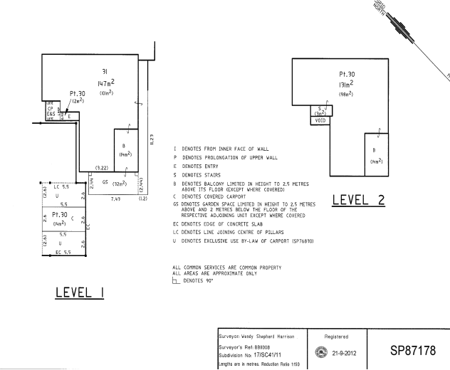
Figure 1. Extract from strata plan for Lot 29 (SP87178). Subject lot is identified as “Level 2 – Pt. 30”.
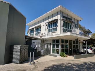
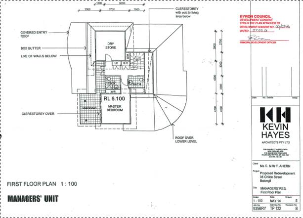
Description of the proposed development
This application seeks approval for Use of Lot 30 as a Tourist Facility/ Tourist Accommodation. Lot 30 is the upper level of the manager’s residence (see Figure 2). No building works are proposed. According to the applicants plans the lower-level Lot 31 being the ground floor is to remain as a manager’s office with a Linen Room, Staff Room and facilities for the day to day operations of the tourist facility
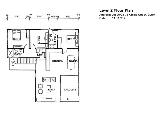
Figure 2. Lot 30 – Proposed Tourist Accommodation Unit
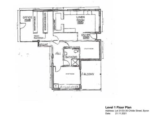
Figure 3 – Ground Floor plan showing managers office
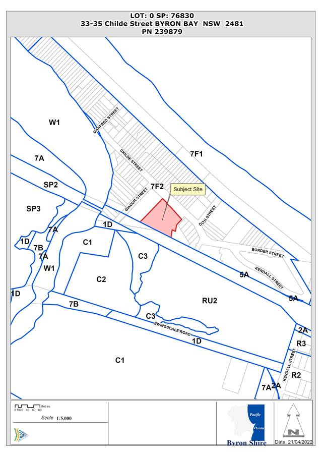
Description of the site
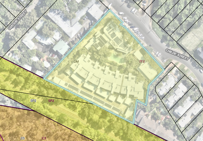
Figure 4. Aerial photo with land zoning overlay. Subject property identified by yellow polygon.
![]()
![]()
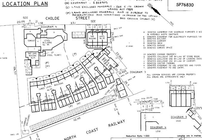
Figure 5. Extract from strata plan for property (SP76830). Subject building is identified as “Two Level Building No.35”.
The subject property is located just inland of Belongil Beach, just east of Belongil Creek and adjoining (to the south) the railway line.
|
Land is legally described |
LOT: 30 SP: 87178 |
|
Property address |
30/33-35 Childe Street BYRON BAY |
|
Land is zoned: |
7 (f2) – Urban Coastal (see Figure 3) |
|
Land area is: |
Entire property: 8418m2, Lot 30: 131m2 (see Figure 4) |
|
Property is constrained by:
|
· Underground powerlines · Sewer pipeline · Acid sulfate soils · Cattle dip buffer · Coastal erosion - precinct 3 · Flood prone land · High environmental value vegetation · Coastal wetlands buffer · Littoral rainforest buffer |
A site inspection was carried out on 5 April 2022
|
Photo 1 – view southwest from northern/driveway entry to site. Subject building is visible behind the grey on the left of the photo. |
Photo 2 – view southeast from driveway to subject building. Lot 30 is the first floor – access door is visible to the right of the photo. |
|
Photo 3 – view south from driveway to subject building. Lot 30 is the first floor. Loading area is visible between the subject building and grey wall. |
Photo 4 – view of loading area from Lot 30 “Bed 2”. |
2. SUMMARY OF REFERRALS
|
Referral |
Issue |
|
Building Surveyor |
No objections subject to conditions. |
|
S64 / Systems Planning |
No objections subject to conditions. |
|
S7.11 / Contributions Planner |
No objections, no conditions. |
3. SECTION 4.14 – BUSH FIRE PRONE LAND
4. SECTION 4.15C – MATTERS FOR CONSIDERATION – DISCUSSION OF ISSUES
Having regard to the matters for consideration detailed in Section 4.15(1) of the Environmental Planning & Assessment Act 1979 (EP&A Act), the following is a summary of the evaluation of the issues.
State Environmental Planning Policies (SEPP)
|
Considerations |
Satisfactory |
Unsatisfactory |
|
SEPP No 55—Remediation of Land Consideration: The subject building was approved under DA 10.2000.346.1 and has been operating as tourist accommodation for many years. As such, the land (i.e., Lot 30) is considered suitable for the proposed change of use, from dwelling to tourist accommodation. |
☒ |
☐ |
|
SEPP (Building Sustainability Index: BASIX) 2004 Consideration: The proposed change of use is not considered to be BASIX affected development. |
☒ |
☐ |
|
SEPP (Coastal Management) 2018 Consideration: The proposed change of use does not involve any building works and will therefore have no impact on any of the matters listed for coastal wetland and littoral rainforest proximity areas (cl.11(1)). |
☒ |
☐ |
4.2B Byron Local Environmental Plan 1988 (LEP 1988)
In accordance with LEP 1988 clauses 5, 8 and 9:
(a) The proposed development is defined in the LEP 1988 Dictionary as tourist facility;
(b) The land is within the LEP1988 7 (f2) Urban Coastal according to the map under LEP 1988;
(c) The proposed development is permitted with consent in the zone, however Clause 32(4) now prohibits tourist facilities as discussed below); and
(d) The proposed development is consistent with the relevant objectives of the Zone for the following reasons:
|
Zone Objective |
Consideration |
|
(a) to identify urban land likely to be influenced by coastal processes, (b) to permit urban development within the zone subject to the council having due consideration to the intensity of that development and the likelihood of such development being adversely affected by, or adversely affecting, coastal processes, (c) to permit urban development within the zone subject to the council having due consideration to— (i) the need to relocate buildings in the long term, (ii) the need for development consent to be limited to a particular period, (iii) the form, bulk, intensity and nature of the development, and (iv) continued safe public access to the site, and (d) to allow detailed provisions to be made, by means of a development control plan, to set aside specific areas within the zone for different land uses and intensities of development. |
The application is for a change of use only, with no building works proposed. The proposed development does not conflict with the relevant objectives for zone 7 (f2). |
32 Development within Zone No 7 (f2) (Urban Coastal Land Zone)
This application is for a change of use only, with no building works. The matters for consideration (sub (3), relate to the original approval of the tourist facility rather than a change of use application with no building works proposed (e.g., likelihood of the development being affected by coastal processes, need to relocate buildings, need for the development to be limited to a particular period).
Council is prevented from consenting to development, including tourist facilities on “land shown edged heavy black and stippled on the map marked “Byron Local Environmental Plan 1988 (Amendment No 66)” (sub (4). The subject property is within the area identified by Amendment No. 66 (See Doc#E2012/23474).
The applicant argues that existing use rights allow the proposed change of use to be approved by Council despite the requirement in clause 32(4). This argument is considered below.
Existing use rights
The tourist facility was originally approved on the property under consent 10.2000.346.1 on 6 March 2001. The use of the land as a tourist facility is now prohibited in the zone, pursuant to clause 32(4) (gazetted 9/3/2003) however the proposed change of use has the benefit of ‘existing use’ rights (s.4.65 EP&A Act).
The managers unit is considered to be ancillary component of the Tourist Facility as approved as opposed to a residential dwelling. In this regard anyone residing in the unit under the current approval should be associated with managing the tourist facility and therefore its use is not open to the general rental housing market.
Manager’s Unit as originally approved
It is noted Condition T5 of the consent requires the development to be used for “short-term tourist accommodation only as follows:
5 The residential component of the development shall be used for short-term tourist accommodation only
The change in use of the manager’s unit to a tourist unit would be consistent with that condition.
The alteration of existing uses is governed by the EP&A Regulation 2000 pursuant to section 4.67 of the EP&A Act. The expansion of the existing tourist facility use to include the upper floor of “manager’s unit” is allowable as the proposed change meets the relevant requirements under Clause 41(2) which states:
(a) involves only alterations or additions that are minor in nature, and
(b) does not involve an increase of more than 10% in the floor space of the premises associated with the existing use, and
(c) does not involve the rebuilding of the premises associated with the existing use, and
(d) does not involve a significant intensification of that existing use.
Development consent is required for the expansion/intensification of the existing use under Clause 42 of the Regulations which states:
42 Development consent required for enlargement, expansion and intensification of existing uses
(1) Development consent is required for any enlargement, expansion or intensification of an existing use.
(2) The enlargement, expansion or intensification —
(a) must be for the existing use and for no other use, and
(b) must be carried out only on the land on which the existing use was carried out immediately before the relevant date.
Planning principles: Assessment of proposals on land with existing use rights
The principles to be considered when undertaking a merits assessment of a proposed redevelopment of a site with existing use rights were dealt with in Fodor Investments v Hornsby Shire Council [2005] NSWLEC 71 and were considered and confirmed in Stromness Pty Ltd v Woollahra Municipal Council [2006] NSWLEC 587.
The principles set out four questions that usually arise in the assessment of existing use rights developments are considered below:
1) How do the bulk and scale (as expressed by height, floor space ratio and setbacks) of the proposal relate to what is permissible on surrounding sites?
This principle doesn’t apply as the application relates solely to a change of use and as such no change to the bulk and scale of the existing development is proposed.
2) What is the relevance of the building in which the existing use takes place?
In this regards the development is approved as a tourist facility primarily with tourist accommodation. Use of the manager’s unit as a tourist unit fits within the approved use of the overall development on the land and is considered to be in scale with its surroundings.
3) What are the impacts on adjoining land?
The impact on adjoining land is limited to that which will arise from the change of use from a manager’s unit to tourist accommodation. Specifically, the unit overlooks the loading bay and garbage collection area. Any tourist staying in this unit may need to put up with the coming and going of vehicles, garbage being deposited into the bins late at night and being collected, odour and like. In this regard the tourist facility also includes a restaurant/ café, and it is not unreasonable for the operators of the restaurant/café to need access to this area on a regular basis whether it is after closing hours or before opening every day. It should not be up to the operators of the restaurant to change their operating procedures to accommodate this development, but conversely its up the operators/owner of the tourist unit to manage those impacts and install appropriate mitigation measures if required
It is noted that the unit has air conditioning enabling windows to be closed. Further it is also prudent for potential guests staying in this unit to be educated about the need to close windows to block out the noise and odour from the loading bay area. It is recommended that a Management Plan be prepared and submitted to Council for approval setting out specifically additional noise insulation measures to be undertaken if required and for any additional cleaning of the area in the event they receive complaints from their guests about odour and the like. Such measures would be at the expense of the landowner of Lot 30 and not the body corporate or other unit owners within the facility. Conditions of consent to apply.
4) What is the internal amenity?
The use of the unit as a tourist accommodation is not expected to result in any changes to internal amenity of the unit.
Other LEP clauses
As this application is for a change of use only, with no building works proposed, compliance with building height (cl.40), provision of services (cl.45) and development on acid sulfate soil mapped land (cl.63) will remain unchanged.
4.3 Any proposed Instrument that has been the subject of public consultation and has been notified to the consent authority
No proposed instruments were identified that are relevant to this application.
4.4B Byron Shire Development Control Plan 2010 (DCP 2010)
DCP 2010 is an applicable matter for consideration in the assessment of the subject development application in accordance with subsection 4.15(1) of the EP& A Act because its purpose is to provide planning strategies and controls for various types of development permissible in accordance with LEP 1988. The DCP 2010 Chapters/Parts that are checked below are of relevance to the proposed development:
|
Chapter 1 Parts: |
☒A| ☐B| ☒C| ☐D| ☐E| ☒F| ☒G| ☒H| ☒J| ☒K| ☐L| ☒N |
|
Chapters: |
☐4| ☐6| ☐7| ☐8| ☐9| ☐10| ☐11| ☐12| ☐14| ☐15| ☐16| ☒17| ☐18| ☐19| ☐20| ☐21| ☐22 |
Note: Only provisions that apply to the proposed change of use have been considered as no building works are proposed.
Part C: Residential Development
The tourism development is in the form of a medium density development and as such Sections C1, C2 and C7 apply (Chapter C8). The majority of these provisions were considered for the original development application and do not strictly apply to this application as no building works are proposed. Provisions relevant to the proposed change of use are considered below:
C2.3 – Buffer Areas
The submissions received by Council suggest that there is a land use conflict between the residential use of Lot 30 and the adjacent loading area for the café/store. As both aspects of the development are established, there is no opportunity to provide a buffer between these conflicting uses. However, other mitigation measures are available to minimise any potential conflict (e.g., noise and odour) that may arise between the residential use and the loading dock. All bedrooms have air-conditioning to enable a comfortable sleeping room temperature to be maintained without the need for opening the windows over the loading dock. Further mitigation in the form of double glazing and or non-opening windows is available if required. Conditions have been recommended for the owners to prepare a management plan and to implement it if required in the future.
Part G: Vehicle Circulation and Parking
G2.1 – Parking Schedules
Two (2) car parking spaces are required for the current manager’s unit (>85m2 – residential flat development in 7(f2) zone) and 1.5 car parking spaces are required for the proposed tourist unit (>30m2 – motel). In relation to the office/reception area (ground floor), 1 parking space per 2 employees is required. No additional employees are required by this proposal (see Note 1 below). Based on this, there is no additional demand for car parking.
Note 1: Habitation of the ground floor will be prevented by a recommended condition of consent.
Note 2: Condition T2 of the amended Development Consent 10.2000.346.3 states:
The provision of 65 (sixty-five) on site car parking spaces. Car parking areas are not to be used for storage of goods or for any other purpose.
4.5 Environmental Planning & Assessment Regulation 2001 Considerations
|
Clause |
This control is applicable to the proposal: |
I have considered this control as it relates to the proposal: |
If this control is applicable, does the proposal comply? |
|
61 |
No |
N/A |
N/A |
|
62 |
Yes |
Yes. Referred to building certifier for advice |
Yes. The proposed change of use will not affect the existing fire protection and structural capacity of the building when considered the building use as Tourist Facility/ Tourist Accommodation, subject to any required upgrades to be addressed prior to issue of the Occupation Certificate for the use. |
|
63 |
No |
N/A |
N/A |
|
64 |
No |
N/A |
N/A |
4.6 The likely impacts of that development, including environmental impacts on both the natural and built environments, and social and economic impacts in the locality
|
Impact on: |
Likely significant impact/s? |
|
Natural environment |
No. The proposal will not have a significantly adverse impact on the natural environment of the locality. |
|
Built environment |
Potential amenity impacts have been identified as discussed above. It is considered these can be managed and conditions of consent to apply, |
|
Social Environment |
No. The proposal will not have a significant social impact on the locality. |
|
Economic impact |
No. The proposal will not have a significant economic impact on the locality. |
|
Construction Impacts |
The development will generate minor impacts during its construction. Conditions of consent recommended to control hours of work, builders waste, construction noise, installation of sedimentation and erosion control measures and the like to ameliorate such impacts. |
Council Policies that are applicable to the proposed development:
|
Council Policy |
Consideration |
|
A Building Information Certificate application has been lodged with respect to the unauthorised works (Ref. 50.2022.2.1). |
4.7 The suitability of the site for the development
The site is a serviced, has manageable constraints and is suitable for the proposed development.
4.8 Submissions made in accordance with this Act or the regulations
The development application was publicly exhibited
There were eighteen (18) submissions made on the development application:
- Twelve (12) For
- Six (6) Against
|
Key issues raised in objections |
Consideration |
|
Failure to establish existing use rights |
It is considered the subject site enjoys existing use rights as a tourist facility and the proposal is within the scope of allowable changes under the existing uses. |
|
Errors in site plans |
Corrected site plans were subsequently provided for Lot 30 and confirmed during the site inspection. |
|
Unauthorised works |
Noted - A building information certificate application has been lodged with respect to the unauthorised works. This application does seek approval primarily for the use of the building as tourist accommodation and not for retrospective approval of building works undertaken with or without approval. |
|
Building Manager/Owner’s Corporation Letting Agent has a pecuniary interest in change of use of Lot 30 |
Noted |
|
Incomplete by laws provided with application |
As the proposal is for a change of use that does not involve works on common property, the strata by-laws are not a relevant consideration for this development application. |
|
Inadequate carparking |
Adequate car parking is provided for the development onsite as discussed above. ( |
|
Land use conflict with loading dock. adverse impacts on adjoining commercial lots. Lack of adequate sound attenuation for bedrooms above |
Each bedroom has an air-conditioning unit that would enable comfortable room temperature to be maintained without the need to open windows, thus reducing any noise/odour impacts from the loading dock below. A condition has been recommended requiring the air-conditioning units to be maintained in good, working order at all times, and provision of a management plan to put in place additional measures for the owners of Lot 30 to implement in the event there are amenity issues that arise in the future. |
|
Lack of owner’s consent |
No changes to common property are required and as such consent of the owner’s corporation is not required prior to determination of this application. |
|
Loss of housing |
Approval of Lot 30 for use as a tourist facility unit will arguably reduce (by one) the number of habitable buildings available for long-term rental in Byron Shire. However, this building is located within, and part of, an approved tourist facility and is not available to the general public to rent or reside in (i.e. it is only available to accommodate the manager of the tourist facility.) The impact of the proposed change of use on long-term housing is negligible in the Shire. |
4.9 Public interest
The proposed development is unlikely to prejudice or compromise the public interest or create an undesirable precedent.
5. DEVELOPER CONTRIBUTIONS
5.1 Water & Sewer Levies
Section 64 levies will be payable.
5.2 Developer Contributions
No Developer Contributions will be required.
6. DISCLOSURE OF POLITICAL DONATIONS AND GIFTS
|
Disclosure details |
Response |
|
Has a Disclosure Statement been received in relation to this application? If Yes, Provide Disclosure Statement register reference: 91. |
Yes ☐ No ☒ |
|
Have staff received a ‘gift’ from anyone involved in this application that needs to be disclosed. |
Yes ☐ No ☒ |
7. CONCLUSION
The DA proposes Use of Lot 30 as a Tourist Facility/ Tourist Accommodation. Lot 30 is the upper level of the existing “Manager’s Residence” which is an ancillary component of the overall tourist facility approved under DA10.2000.346.1. It is considered the subject property enjoys existing use rights and the development is permissible under the relevant provisions of the EPA Act 1979 and EPA Regulations 2021.
The proposed development is satisfactory having regard to the relevant environmental planning instruments and planning controls applicable to the site. The proposal does raise a potential land use conflict that may arise in the future in terms of the loading area, garbage area and nearby restaurant. Conditions of consent are recommended in relation to the need for a management plan with responsibility for such measures to be borne by the owner of the property. The application is recommended for approval subject to conditions of consent.
BYRON SHIRE COUNCIL
Staff Reports - Sustainable Environment and Economy 13.6
Report No. 13.6 PLANNING - Report of the Planning Review Committee held 7 April 2022
Directorate: Sustainable Environment and Economy
Report Author: Chris Larkin, Manager Sustainable Development
Noreen Scott, EA Sustainable Environment and Economy
File No: I2022/334
Summary:
This report provides the outcome of the Planning Review Committee (PRC) held on 7 April 2022.
NOTE TO COUNCILLORS:
In accordance with the provisions of S375A of the Local Government Act 1993, a Division is to be called whenever a motion for a planning decision is put to the meeting, for the purpose of recording voting on planning matters. Pursuant to clause 2(a) under the heading Matters to be Included in Minutes of Council Meetings of Council's adopted Code of Meeting Practice (as amended) a Division will be deemed to have been called by the mover and seconder of all motions relating to this report.
RECOMMENDATION:
That Council endorses the outcomes of the Planning Review Committee meeting held on 7 April 2022.
Report
The Planning Review Committee meeting was held on 7 April 2022. The meeting commenced at 4.15pm and concluded at 4.45pm.
Councillors: M Lyon (Mayor), D. Dey, S Balson, P Westheimer, C Coorey, A. Hunter,
Apologies: Nil
Staff: Chris Larkin (Manager Sustainable Development)
The following development applications and s4.55 application were reviewed with the outcome shown in the final column.
|
DA No. / Applicant |
Property Address / Proposal |
Consultation / Submissions |
Reason/s / Outcome |
|
|
10.2021.619.1 Planners North |
99 Station Street MULLUMBIMBY Demolition of Existing Structures and Construction of Multi Dwelling Housing comprising of Four (4) Dwellings and Strata Subdivision
|
Level 2 8 Submissions |
Report to Council b. Validity of the matters raised in the public submissions d. The lack of policy to direct determination e. The perceived public significance of the application. |
|
|
DA No. / Applicant |
Property Address / Proposal |
Consultation / Submissions |
Reason/s / Outcome |
|
|
10.2021.291.3 Planners North |
118 Jonson Street BYON BAY S4.55 to Delete Deferred Commencement Condition in relation to Stormwater Management and Amend Condition 27 in relation to Stormwater Management |
Level 0 |
Delegate back Staff |
|
BYRON SHIRE COUNCIL
Staff Reports - Sustainable Environment and Economy 13.7
Report No. 13.7 PLANNING - DA10.2022.14.1 - Alterations and Additions to an Existing Recreation Area (Sandhills Estate) including Upgrade to Existing Footpath, New Sandstone Seating and Landscaping Areas and New Informative Signage
Directorate: Sustainable Environment and Economy
Report Author: Chris Larkin, Manager Sustainable Development
File No: I2022/401
Proposal:
|
DA No: |
10.2022.14.1 |
||||||
|
NSW PP |
PAN-188134 |
||||||
|
Proposal description: |
Alterations and Additions to an Existing Recreation Area (Sandhills Estate) including Upgrade to Existing Footpath, New Sandstone Seating and Landscaping Areas and New Informative Signage |
||||||
|
Property description: |
LOT: 457 DP: 1087879 |
||||||
|
Gilmore Crescent BYRON BAY, Middleton Street BYRON BAY |
|||||||
|
Parcel No/s: |
239678 |
||||||
|
Applicant: |
Byron Shire Council |
||||||
|
Owner: |
Crown Land |
||||||
|
Zoning: |
The Deferred Matter is zoned part 1(d) Investigation Zone, part 2(a) Residential Zone, part 3(a) Business Zone, part 7(b) Coastal Habitat Zone and part 7(f2) Urban Coastal Lands Zone under Byron LEP 1988. All work is within the RE1 Public Recreation Zone under Byron LEP 2014. |
||||||
|
Date received: |
25 January 2022 |
||||||
|
Integrated / Designated Development: |
☐ Integrated |
☒ Designated |
☐ Not applicable |
||||
|
Concurrence required |
No |
||||||
|
Public notification or exhibition: |
The application was advertised for a period of 28 days from 1 February 2022 to 28 February 2022 in accordance with the Byron Community Participation Plan for designated development. No submissions were received. No government authority submissions have been received other than comments from Essential Energy which have been included into the recommended conditions of consent. |
||||||
|
Other approvals |
☒ N/R |
☐ W & S (68) |
☐OSMS (68) |
☐ ST (68) |
☐ RA (138) |
||
|
Other: |
|
||||||
|
Variation request to Development Standards under an EPI (eg clause 4.6) |
Not applicable
|
||||||
|
Estimated cost |
$180,465.00 |
||||||
|
Delegation to determine |
Council (Designated Development) |
||||||
|
Issues |
Proposed work is within the Coastal Wetlands Area Map under SEPP (Resilience and Hazards) 2021. |
||||||
|
Assessment Officer |
The subject application has been assessed by an External Planning Consultant – Kellie Shapland. |
||||||
Summary:
Summary
The development application seeks consent for alterations and additions to an existing recreation area including the upgrading/replacement of an existing footpath, the provision of sandstone seating and landscaping areas, and informative signage.
The works will be located on the western end of Lot 457 DP 1087879 Middleton Street, Byron Bay. This is the western edge of a large piece of Crown land known locally as the ‘Sandhills Estate’. This lot already contains the Sandhills Early Childhood Centre and the Byron Youth Activities Centre (YAC). Immediately north of the subject land is the Byron Bay Library and immediately south is the Byron Bay Court House.
The upgrade of the footpath and associated works will provide an improved and inviting public entrance to the recreation area and future skate park that is planned for the site. Council committed to a skate park at Sandhills Estate in April 2018.
The development application is for ‘designated development’ and consequently the application is accompanied by an Environmental Impact Statement (EIS). This assessment pathway is triggered by part of the works being located within a coastal wetland identified in SEPP (Resilience and Hazards) 2021.
Applications for designated development must be determined by Council.
The proposal does not involve any tree removal. Work will be undertaken on maintained grassland.
The proposed development is considered satisfactory having regard to the relevant environmental planning instruments and planning controls applicable to the site and is recommended for approval subject to conditions.
NOTE TO COUNCILLORS:
In accordance with the provisions of S375A of the Local Government Act 1993, a Division is to be called whenever a motion for a planning decision is put to the meeting, for the purpose of recording voting on planning matters. Pursuant to clause 2(a) under the heading Matters to be Included in Minutes of Council Meetings of Council's adopted Code of Meeting Practice (as amended) a Division will be deemed to have been called by the mover and seconder of all motions relating to this report.
RECOMMENDATION:
Pursuant to Section 4.16 of the Environmental Planning & Assessment Act 1979, Development Application No. 10.2022.14.1 for Alterations and Additions to an Existing Recreation Area (Sandhills Estate) including Upgrade to Existing Footpath, New Sandstone Seating and Landscaping Areas and New Informative Signage be granted consent subject to the conditions of approval shown at Attachment 1 (E2022/36287)
Attachments:
1 DA
10.2022.14.1 Conditions of Consent, E2022/36287
![]()
2 DA
10.2022.14.1 - DA Plans, E2022/36394
![]()
Report
INTRODUCTION
1.1 History relevant to development application
Council committed to a skate park at Sandhills Estate in April 2018. The EIS submitted for the current development application identifies that staff undertook extensive community consultation to seek public and user group feedback and identify the critical factors for a successful skate park being located at Sandhills Estate.
Based on the feedback received and research undertaken regarding best practice skate park design, the critical success factor for this project was identified as the development of a broader recreation ‘precinct’ within the Sandhills Estate to improve passive surveillance around the skate park and enable noise mitigation measures to be integrated into the landscape design.
Providing an inviting pedestrian entrance from Middleton Street into the precinct is identified as an important component of the overall project.
The proposal for the skate park will be subject to a separate Review of Environmental Factors (REF). Figure 1 illustrates the area that is subject to the current development application and the area that is subject to the REF.
This assessment in this report relates to the footpath and associated work development application only.
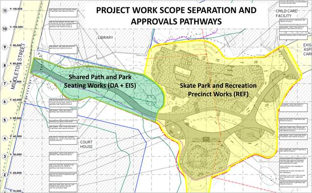
Figure 1 – Approval pathways (area shaded in green is subject of the current development application)
1.2 Previous approvals
The following development consents have been issued over the site:
|
Application No. |
Description |
Determined |
|
10.2020.361.1 |
Use of Commercial Kitchen |
26/11/2020 |
|
10.2014.135.1 |
Tree removal - 31 trees |
21/07/2014 |
|
10.2010.263.2 |
S96 - Amend Condition 3 (Tree removal - 4 trees) |
27/08/2010 |
|
10.2010.263.1 |
Tree Removal / Lopping - Four (4) trees |
17/06/2010 |
|
10.2007.815.2 |
S96 - To amend and delete some conditions on previous consent |
29/05/2008 |
|
10.2007.815.1 |
Place of Public Entertainment and alterations and/or additions to Byron Bay Youth Centre |
20/03/2008 |
|
10.2007.7.1 |
Tree removal (six trees) |
05/02/2007 |
|
10.1999.144.1 |
Extensions to Childcare Centre (Sandhills) |
18/08/1999 |
1.3 Description of the proposed development
The application seeks consent for:
· A new footpath with an average width of 2.5 metres (shared path standard) and approximately 70 metres long from the Middleton Street entrance to the new skate park. It will be constructed of stencilled asphalt cement and cover approximately 175 m2.
· Sandstone seating.
· A yarning circle comprising sandstone set in a crushed granite bed.
· Lighting for the path.
· Five signs, being an entry sign, welcome sign, information sign, safety sign and bush tucker sign. Art works will also be installed based on Arakwal themes.
· Landscaping (native plants only).
The existing paved footpath will be demolished and removed. The existing lighting and bollards will be removed.
All trees are proposed to be protected.
Erosion and sediment controls are proposed to be installed around the edges of the site and adjacent vegetated areas of the site as part of early works.
Figures 2 and 3 are plan extracts of the proposal and Figures 4 and 5 are images of the proposed upgraded path, landscaping, seating and signage as shown in the EIS.
Full plan details are provided in Attachment 2.
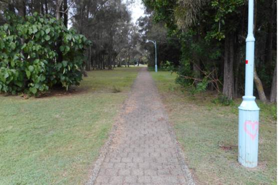
Image - Photograph of the existing footpath
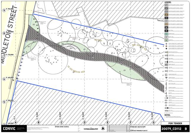
Figure 2 – Proposed footpath upgrade plan

Figure 3 – Proposed Signage Plan
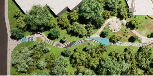
Figure 4 – Plan view of proposed footpath upgrade
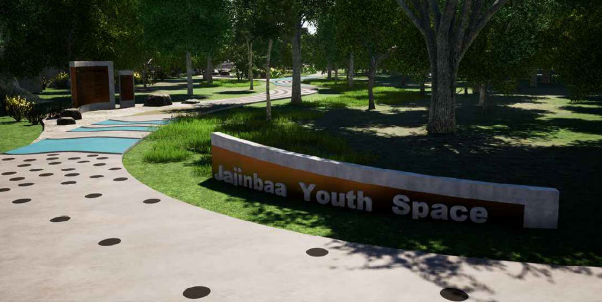
Figure 5 – Proposed entrance and footpath from Middleton Street
1.4 Description of the site
A site inspection was carried out on 22 April 2022.
The subject site is an 8.251 hectare parcel of Crown land which has frontages to Middleton Street to the east, Gilmore Crescent and Lawson Street to the north, and Tennyson Street to the south. The Byron Bay Library adjoins the site to the north and to the south is the Byron Bay Courthouse
The site contains the Byron YAC and Sandhills Early Childhood Centre as well open space and recreation areas.
An aerial photograph of the property showing its relationship to the surrounding roads is provided in Figure 6 and a zoning plan in Figure 7.
The property is affected by the following mapping constraints:
· Flood Liable Land – on the western portion of the property on land affected by the proposed work
· Bushfire prone land
· Acid Sulfate Soils Class 3 and 5. The proposed work is in the Class 3 area.
· High conservation value vegetation
· Coastal Erosion Precinct 3 – in the area of the proposed work.
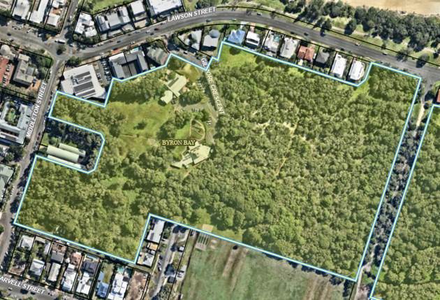
Figure 6 – Aerial Photograph
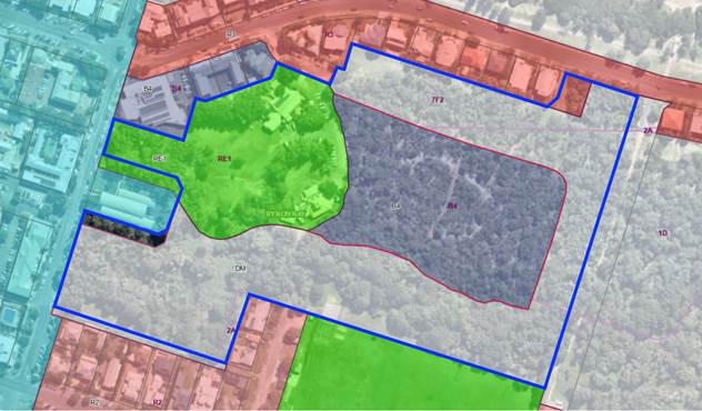
Figure 7 – Zoning – the proposed work is within the area zoned RE1 on the western portion of the site.
SUMMARY OF REFERRALS
|
Referral |
Issue |
|
Environmental Health Officer* |
Councils Environmental Health Officer advised that the proposal can be supported subject to conditions.
|
|
Development Engineer |
Council’s Development Engineer advised that the proposal could be supported from an engineering perspective subject to conditions of consent. Part of the site is within the flood planning area but given the nature of the development. There are no special flooding conditions required. The development is within the coastal hazard area. The existing erosion escarpment is more than 200m from the proposed work. The proposed works do not compromise the DCP policy requirements from an engineering viewpoint as works can easily be removed if affected by coastal processes |
|
Natural Resource Planner |
Council’s Natural Resource Planner advised the proposal can be supported from an ecological perspective, subject to appropriate conditions of consent. Recommended conditions relate to the retention and protection of trees on the site and restrictions on artificial lighting type and usage. Specific items that were noted and assessed include: Flora: The vegetation within and adjacent to the proposed development footprint comprises managed grasslands with clumps of mostly native trees which generally correspond to the plant species diversity of the Swamp oak floodplain forest community.
The Natural Resource Planner commented that the proposal does not include removal of any native vegetation corresponding to the Swamp oak floodplain forest on the site and is not likely to result in a significant impact on the EEC as defined by s7.3 of the BC Act. There is significant weed presence in the understorey of the EEC stands on the site (in particular Singapore daisy). Vegetation communities across the broader site also show substantial weed presence. A Vegetation Management Plan will be recommended for the broader development of the site, which will be subject of the skate park REF process.
Fauna: The site contains a flying fox camp. The assessment of the application comments that the flying fox camp in the locality is likely to be somewhat adversely affected by the proposal due to increased anthropogenic activity including artificial noise and lighting. It is noted that the camp has existed in close proximity to the courthouse, library and recreation and pedestrian areas for some time. The submitted flora and fauna assessment report concluded that the proposed works would not result in a significant impact on flying foxes as defined by the five parts of s7.3 of the BC Act. The Natural Resource Planner considered this conclusion correct within the scope of the test in s7.3.
A target search for the Mitchell’s rainforest snail (Thersites mitchellae) was undertaken which involved day time and night time surveys of the areas immediately adjacent to the pathway and within mown lawn and Swamp oak floodplain forest remnants. The search did not detect the presence of the species.
|
|
Essential Energy |
Essential Energy commented that generally the proposal is satisfactory, as it is clear of Essential Energy's infrastructure. Conditions have been recommended and will be included as a Note on any consent. |
|
Bundjalung (Arakwal) |
Referral sent. No response received. |
|
Tweed Byron Land Council |
Referral sent. No response received. |
SECTION 4.14 – BUSH FIRE PRONE LAND
The subject site is mapped as bush fire prone land. The proposed work is within the mapped buffer to Category 1 vegetation.
Under section 4.14 of the Act, Council must be satisfied prior to making a determination for development on bush fire prone land, that the development complies with the document ‘Planning for Bush Fire Protection 2019’ (PBP)
Section 8.3 of PBP relates to ‘Other non-residential development’. There are no specific requirements for the type of development proposed other than needing to meet the aims and objectives of PBP. These are:
· afford buildings and their occupants protection from exposure to a bush fire;
· provide for a defendable space to be located around buildings;
· provide appropriate separation between a hazard and buildings which, in combination with other measures, prevent the likely fire spread to buildings;
· ensure that appropriate operational access and egress for emergency service personnel and occupants is available; provide for ongoing management and maintenance of BPMs; and
· ensure that utility services are adequate to meet the needs of firefighters.
As the proposal is for a non-residential use where there are no buildings proposed and the nature of the land use will not change, it is considered that the proposal is satisfactory with respect to these aims and objectives.
SECTION 4.15C – MATTERS FOR CONSIDERATION – DISCUSSION OF ISSUES
Having regard to the matters for consideration detailed in Section 4.15(1) of the Environmental Planning & Assessment Act 1979 (EP&A Act), the following is a summary of the evaluation of the issues.
4.1 State Environmental Planning Policies (SEPP)
SEPP (Resilience and Hazards) 2021
Chapter 2 – Coastal management
Part of the site is mapped as being affected by Coastal Wetlands and the Proximity Area for Coastal Wetlands (see Figure 8)
The proposed works are located on the western Coastal Wetlands mapped area. The extent of the work within the mapped wetlands area is indicated on Figure 9.
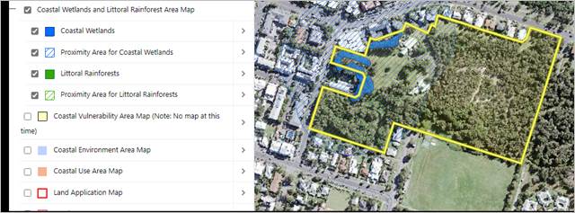
Figure 8 - Coastal Wetlands and Proximity Area for Coastal Wetlands
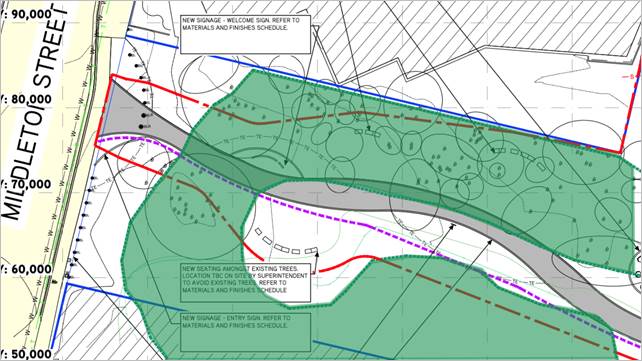
Figure 9 – Works proposed in the mapped coastal wetland area (the wetland area is shaded in green)
With respect the mapped wetlands, the EIS indicates that:
· the proposed upgraded footpath and associated seating and landscaping affect only one (1) of the two (2) mapped wetlands on the site. The proposed footpath crosses the mapped wetland near Middleton Street.
· The proposed yarning circle, some sandstone seating and signage are also proposed within the mapped coastal wetland.
· The footpath will occupy an area approximately 40 m2. The yarning circle will occupy approximately 20 m2. The seating in three locations will occupy approximately 30 m2. The signage will occupy approximately 20 m2.
· The combined area of mapped coastal wetland to be impacted by the works is approximately 110 m2. This represents about 4% of eastern wetland that will be directly affected by the proposed works.
· All of the balance of the upgraded footpath works and landscaping is located within the mapped 100-metre buffer to the coastal wetlands, described as the proximity area for wetlands.
Division 1, Section 2.7 of the SEPP relates to Coastal wetlands and littoral rainforests areas. Under the provisions of this Section, development consent is required for the proposal and the work is declared to be designated development.
Subclause (4) provides:
(4) A consent authority must not grant consent for development referred to in subsection (1) unless the consent authority is satisfied that sufficient measures have been, or will be, taken to protect, and where possible enhance, the biophysical, hydrological and ecological integrity of the coastal wetland or littoral rainforest.
In relation to these considerations, the EIS indicates:
Measures to be undertaken to protect coastal wetlands include: not clearing any native vegetation; not altering the drainage in proximity to the mapped wetland; removal of invasive weed species such as Singapore Daisy; and only using endemic native species in landscaping on the subject land.
The proposal is considered satisfactory with respect to the considerations of this clause.
Division 1, Section 2.8 of the SEPP relates to Development on land in proximity to coastal wetlands or littoral rainforest. This section provides:
(1) Development consent must not be granted to development on land identified as “proximity area for coastal wetlands” or “proximity area for littoral rainforest” on the Coastal Wetlands and Littoral Rainforests Area Map unless the consent authority is satisfied that the proposed development will not significantly impact on—
(a) the biophysical, hydrological or ecological integrity of the adjacent coastal wetland or littoral rainforest, or
(b) the quantity and quality of surface and ground water flows to and from the adjacent coastal wetland or littoral rainforest.
(2) This section does not apply to land that is identified as “coastal wetlands” or “littoral rainforest” on the Coastal Wetlands and Littoral Rainforests Area Map.
In relation to these matters the EIS states:
The upgrade works to an existing footpath and associated landscaping, signage and seating will have no impact on the hydrology or ecological integrity of the coastal wetlands. They will not alter the quantity or quality of surface water as sediment and erosion controls will be implemented during construction and maintained until the site is stable. Post construction, the hydrology will be as it is now. Weed removal will improve the value of nearby wetlands.
This statement is considered accurate and is concurred with.
Division 3 Section 2.10 relates to development on land within the coastal environment area. Part of the subject site is mapped as coastal environment area. However, all work is outside of this mapped area. Therefore, the proposal is satisfactory with respect to this Section.
Division 4 Section 2.11 relates to Development on land within the coastal use area. It requires:
(1) Development consent must not be granted to development on land that is within the coastal use area unless the consent authority—
(a) has considered whether the proposed development is likely to cause an adverse impact on the following—
(i) existing, safe access to and along the foreshore, beach, headland or rock platform for members of the public, including persons with a disability,
(ii) overshadowing, wind funnelling and the loss of views from public places to foreshores,
(iii) the visual amenity and scenic qualities of the coast, including coastal headlands,
(iv) Aboriginal cultural heritage, practices and places,
(v) cultural and built environment heritage, and
(b) is satisfied that—
(i) the development is designed, sited and will be managed to avoid an adverse impact referred to in paragraph (a), or
(ii) if that impact cannot be reasonably avoided—the development is designed, sited and will be managed to minimise that impact, or
(iii) if that impact cannot be minimised—the development will be managed to mitigate that impact, and
(c) has taken into account the surrounding coastal and built environment, and the bulk, scale and size of the proposed development.
In relation to the relevant considerations, it is commented that:
· The proposed footpath upgrade works do not affect access to any foreshore, beach, headland or rock platform. The new footpath will enhance access for the public including those with disability.
· The proposed work will not cause overshadowing, wind funnelling or loss of views from public places.
· The work will improve visual amenity of this public place
· Cultural heritage matters are discussed below in relation to Clause 5.10 of Byron LEP 2014. The proposal is considered satisfactory in this regard.
· The proposal has been designed to avoid tree removal thereby minimising potential for adverse impacts. The bulk and scale of the proposal is considered appropriate for the site.
Chapter 4 – Remediation of land
This chapter requires the consent authority to consider if the land is contaminated and, if so, whether the land needs to be remediated before it will be suitable for the proposed use.
Council Environmental Health Officer has advised that although the land contains heavy mineral sands, radiation levels are within acceptable levels.
The proposal is therefore satisfactory in this regard.
SEPP (Transport and Infrastructure) 2021
Chapter 2 – Infrastructure
The provisions of Division 12 Parks and other public reserves would normally apply to this project meaning that development consent would not be required for the proposal. This would enable the proposal to be assessed under Part 5 of the Environmental Planning and Assessment Act 1979. However, as some of the work is within a mapped coastal wetland area, a development application and EIS is required for the work.
SEPP (Industry and Employment) 2021
Chapter 3 - Advertising and signage
The proposal incorporates an entry sign, welcome sign, information sign, safety sign and bush tucker sign.
Under the provisions of this Policy, the signs must be consistent with objectives of the Chapter and must be assessed by the consent authority in accordance with the assessment criterial set out in Schedule 5 of the Chapter and be acceptable in terms of its impacts.
The relevant objectives are:
(a) to ensure that signage (including advertising)—
(i) is compatible with the desired amenity and visual character of an area, and
(ii) provides effective communication in suitable locations, and
(iii) is of high quality design and finish,
According to the EIS, signage will be low key and low maintenance. The largest structure will be the welcome sign, which is 2 metres tall and 3 metres wide (6 m2 in area). The entry sign will be 4.5 m2 in area and less than 1 metre high. The safety sign will be 2 m2 in area and 2 metres high. The bush tucker sign will be 0.6 m2 in area and 1 metre high. The information sign will be 1.3 m2 in area and 1.6 metres high.
The proposal is considered satisfactory in terms of consistency with the objectives.
In terms of the Schedule 5 Assessment Criteria it is commented that:
· Character of the area – The proposed signage is consistent with the desired future character of the area which is for public recreation and a future skate park.
· Special areas – it is considered that the proposal will not detract from the amenity or visual quality of any environmentally sensitive areas, heritage areas, natural or other conservation areas, open space areas, waterways, rural landscapes or residential areas.
· Views and vistas – the proposed signage will not compromise important views, will not encroach into the skyline or affect other signage or advertisers.
· Streetscape, setting or landscape – The scale, proportions and form of the signage is considered appropriate for the area.
· Site and setting – the proposed signs are not attached to buildings and are suitably located on the site to not affect existing vegetation or other features.
· Illumination – The signs would not be illuminated but general park lighting would be provided which may provide some lighting on the signs.
· Safety – The proposal would not reduce public road safety. The signs would enhance pedestrian safety by providing safety and direction messages.
The proposal is considered satisfactory with respect to this SEPP.
SEPP (Biodiversity and Conservation) 2021
Chapter 4 – Koala habitat protection 2021
The site is within the Byron Coast Comprehensive Koala Plan of Management (CKPoM) koala planning area.
Council’s Natural Resource Planner advises that it has been demonstrated that no Eucalyptus species occur on the site, and therefore the overstorey tree species within the area mapped by the CKPoM do not comprise >15% primary or secondary koala food tree species. Consequently, it can be concluded that the mapped area does not represent potential koala habitat.
4.2A Byron Local Environmental Plan 2014 (LEP 2014)
In accordance with LEP 2014 clauses 1.4 and 2.1 – 2.3:
(a) The proposed development is defined in the LEP 2014 Dictionary as a ‘recreation area’;
(b) The subject site is zoned Part RE1 Public Recreation, part B4 Mixed Use, part R3 Medium Density Residential and part Deferred Matter (DM) under Byron LEP 2014 according to the Land Zoning Map.
The Deferred Matter is zoned part 1(d) Investigation Zone, part 2(a) Residential Zone, part 3(a) Business Zone, part 7(b) Coastal Habitat Zone and part 7(f2) Urban Coastal Lands Zone under Byron LEP 1988.
All work subject of the development application is within the RE1 Public Recreation Zone.
(c) The proposed development is permissible with development consent; and
(d) Regard is had for the Zone Objectives as follows:
|
Zone Objective |
Consideration |
|
· To enable land to be used for public open space or recreational purposes. · To provide a range of recreational settings and activities and compatible land uses. · To protect and enhance the natural environment for recreational purposes. |
The proposal will enhance the use of the land for public open space and recreational purposes. Management measures are proposed to protect the natural environment. The proposal is considered consistent with the zone objectives |
Clause 5.10 Heritage conservation
The site does not contain and is not adjacent to any mapped heritage items. The site is not within, or adjacent to a heritage conservation area.
There is unlikely to be impacts on Aboriginal cultural heritage as no sites are identified in this location. The EIS indicates that local Aboriginal stakeholders have been involved in inspecting and designing the space. The site has been disturbed by past sand mining, reducing the likelihood of relics being located. A standard Note will be placed on any consent identifying obligations if any Aboriginal artefacts are discovered.
Clause 5.21 Flood planning
Council flood mapping shows that the western end of the subject land, where the upgraded footpath and associated works are proposed, is within the 1 in 100-year flood planning area. The proposed footpath will be built at ground level and will not have an impact on flood behaviour. Seating, signage, and landscaping will all have relatively small footprints and also have minimal impacts. All structures will be flood compatible. No structures will inhibit site evacuation or create safety issues in times of flood.
Clause 6.1 Acid sulfate soils
The proposed work is in an area mapped as Class 3 on the Acid Sulfate Soils map. The proposed work will not penetrate more than 1 metre below natural ground level. Therefore, further investigation for acid sulfate soils is not required.
Clause 6.2 Earthworks
Only minor earthworks are proposed for site preparation work and the installation of footings for signs and seats. Standard erosion and sediment controls will be provided to manage potential impacts. The proposal is considered satisfactory with respect to this clause.
The proposal raises no other issues under the LEP
4.2B Byron Local Environmental Plan 1988 (LEP 1988)
Part of the ‘subject site’ is affected by Byron LEP 1988. However, no work is proposed on the land affected by Byron LEP 1988. There are no specific clauses that are applicable to the proposal.
4.3 Any proposed Instrument that has been the subject of public consultation and has been notified to the consent authority
There are no draft planning instruments that affect the proposal.
4.4A Byron Shire Development Control Plan 2014 (DCP 2014)
The following provisions from the DCP are of relevance.
Chapter B1 - Biodiversity
As discussed, the proposal has been assessed by Councils Natural Resource Planner and no objections to the proposal raised subject to conditions of consent.
Chapter B8 – Waste Minimisation and Management
A site waste minimisation and management plan has been submitted in accordance with the requirements of this Chapter.
Chapter B10 – Signage
There are no specific controls for signage in Recreation zones or areas. It is however noted that one of the aims of the Chapter is to facilitate appropriate directional and information signage and to assist visitors to locate and enjoy the attractions of the Shire. The proposed signs are considered appropriate for the area and consistent with this aim.
Chapter B11 – Planning for Crime Prevention
A formal Crime Risk Assessment is not required for the proposal however this issue has been addressed in the EIS as follows:
A formal Crime Risk Assessment is not required for this development. However, it is an important public access point to the proposed Byron Skate Park and YAC and the early childhood centre.
A key issue for stakeholders is the potential for this skate park to be a focus for crime or anti-social behaviour. Sandhills, as a locality, has a history of being a focus for anti-social behaviour. However, the upgraded footpath and new skate park actually provide an opportunity to activate the western edge of this site and, therefore, reduce the opportunity for this to occur. The skate park designers have produced a Crime Prevention Through Environmental Design (CPTED) report to show how the design and future management of this locality can be a positive outcome in relation to crime prevention. The report concludes that this can be achieved by:
· Landscaping that increases views into the space and passive surveillance.
· An east/west pedestrian path and cycle way, which doubles as an experiential ‘art path’ that brings vibrancy and intrigue to encourage pedestrians to enter the space from Middleton Street and Gilmore Crescent.
· A design that avoids obstacles or features to hide behind and promotes passive surveillance in and out of the space.
· Lighting design to encourage passive surveillance at night.
· Vandal resistant materials and finishes for furniture and structures.
· Perimeter seating for passive surveillance.
· CCTV strategically located throughout the space for Police to monitor the facility.
· Day and night time activation of the site and programmed activation on weekends for multiple age groups.
This application is for the footpath upgrading and associated work only, which is consistent with the Crime Prevention Through Environmental Design report conclusions. Further consideration of this issue will need to be part of the skate park REF assessment process.
Chapter C2 – Areas Affected by Flood
This Chapter has been assessed in the engineering referral for the application and considered to be satisfactory.
Chapter E5 – Certain Locations in Byron Bay and Ewingsdale
Clause 5.4.1 – Development and servicing of land affected by predicted coastal erosion – The area of the site where the work is proposed is located on the Byron Bay Coastal Hazards Map. Development in this must be designed to be relocated or demolished, or to cease operation, should the erosion escarpment come within 50 metres. The proposed work complies with this requirement.
4.5 Environmental Planning & Assessment Regulation 2000 Considerations
The proposal raises no issues under the EPA Regulations.
4.6 The likely impacts of that development, including environmental impacts on both the natural and built environments, and social and economic impacts in the locality
|
Impact on: |
Likely significant impact/s? |
|
Natural environment |
No. The proposal will not have a significantly adverse impact on the natural environment of the locality. Relevant matters have been discussed throughout this report and found to be acceptable or can satisfactorily managed by conditions of consent. |
|
Built environment |
No. The proposed footpath upgrading, and associated work will not have a significantly adverse impact on the built environment of the locality. |
|
Social Environment |
No. The proposed footpath upgrading, and associated works will not have a significant social impact on the locality. With respect to potential noise impacts, the EIS indicates The noise modelling undertaken for the project concludes that: • Noise levels from expected activities at the skate park are predicted to meet the Intrusiveness Noise Criteria during all time periods at all nearby residential receptors without any specific acoustic design. • Noise levels from expected activities at the skate park are predicted to meet the Intrusiveness Noise Criteria during all time periods at the Byron Bay Court House (receptor 17). • Noise levels from expected activities at the skate park are predicted to exceed the Intrusiveness Noise Criteria at the Byron Bay Library (receptor 16) by up to 1 dB(A) during the day and up to 4 dB(A) during the evening and night. This exceedance is based on the external intrusiveness criteria and may not represent a material problem considering the sensitive areas at the library are mostly inside the building where windows and doors are expected to be closed. It
is considered that the: Given that the use of the Byron Bay Library is limited to the day period (7 am to 6 pm), any minor external evening and night time external exceedances will not impact on its operation. With respect to lighting, the EIS indicates: Basic bollard and safety lighting will be installed and has been assessed for its impact on neighbouring land uses and bushland. Impacts are negligible. It is noted that these noise and lighting assessments included the proposed skate park which is not subject of this application. Noise and lighting impacts for the proposal are considered acceptable. |
|
Economic impact |
No. The proposal will not have a significant economic impact on the locality. |
|
Construction Impacts |
The development will generate minor impacts during its construction. Conditions of consent recommended to control hours of work, builders waste, construction noise, installation of sedimentation and erosion control measures and the like to ameliorate such impacts. |
4.7 The suitability of the site for the development
The site is an existing recreation area, and the proposal will provide upgraded facilities for users of the park. The site is suitable for the proposed development.
4.8 Submissions made in accordance with this Act or the regulations
The development application was publicly exhibited. No submissions were received.
4.9 Public interest
The proposed development is unlikely to prejudice or compromise the public interest or create an undesirable precedent.
4.10 Requirements for designated development
Section 4.16(9) of the Act provides that a consent authority must not determine an application for designated development until after the submission period has expired, or, if a submission is made within the submission period, until after 21 days following the date on which a copy of the submission is forwarded to the Planning Secretary.
(9) Restrictions on determination of development applications for designated development A consent authority must not determine a development application for designated development—
(a) until after the submission period (within the meaning of Schedule 1) has expired, or
(b) if a submission is made with respect to the application within the submission period, until after 21 days following the date on which a copy of the submission is forwarded to the Planning Secretary have expired.
The application was advertised and notified for a period of 28 days from 1 February 2021 to 28 February 2021 and no public submissions were made during this time. Council is able to determine the application.
DEVELOPER CONTRIBUTIONS
There is no nexus to levy developer contributions on the proposed public works.
DISCLOSURE OF POLITICAL DONATIONS AND GIFTS
|
Disclosure details |
Response |
|
Has a Disclosure Statement been received in relation to this application? If Yes, Provide Disclosure Statement register reference: |
Yes ☐ No ☒ |
|
Have staff received a ‘gift’ from anyone involved in this application that needs to be disclosed. |
Yes ☐ No ☒ |
CONCLUSION
The DA proposes Alterations and Additions to an Existing Recreation Area including Upgrade to Existing Footpath, New Sandstone Seating and Landscaping Areas and New Informative Signage
The proposed development is satisfactory having regard to the relevant environmental planning instruments and planning controls applicable to the site. The proposal raises no significant issues in terms of environmental impacts which cannot be managed, and the site is considered suitable for the development. The application appropriately addresses the relevant constraints applying to the site and is recommended for approval subject to conditions of consent.
Questions With Notice 14.1
Question with Notice No. 14.1 Development on “Linnaeus” at Broken Head.
File No: I2022/411
Cr Dey asks the following questions:
2. Why do major amendments subsequent to the proposal that was advertised in April 2021 not constitute a new DA or, alternatively, why were the amendments not shared with objectors?
3. Will staff be preparing the Assessment for the NRPP, and will it be reported to Council, so that Council can determine its approach to the DA?
4. Is a Determination Date yet set, for the NRPP to determine the DA?
5. Is there a Department of Planning circular on such procedures and could it be shared please?
Response Director Sustainable Environment and Economy:
1. What is the assessment status of DA 2021.170.1 for 27 New Tourist Cabins, 7 Ancillary Buildings, Addition of Deck to Existing Centre and Associated Earthworks & Vegetation Removal, and Change of Use of 14 Private Education Units to Tourist Units?
PPSNTH-83/DA10.2021.170.1 Mixed Use Development comprising Twenty-Seven (27) New Eco Tourist Facility Cabins, Seven (7) Ancillary Buildings including Wellness Facility, Refuges, Depot, Addition of Deck to Existing Centre and Associated Earthworks and Vegetation Removal, and Change of Use of Fourteen (14) Private Education Accommodation Units to Eco Tourist Facility Units is under assessment.
2. Why do major amendments subsequent to the proposal that was advertised in April 2021 not constitute a new DA or, alternatively, why were the amendments not shared with objectors?
The applicant provided a response to Council’s request for further information on 21 October 2021 which included an amended application. The amended application is available to submitters/the public via Council’s DA Tracker: DA Tracker - Byron Shire Council (nsw.gov.au).
The Northern Regional Planning Panel (NRPP) members were briefed by Council staff on the amended application on 20 April 2022. A link to the record of briefing of the NRPP members is here: Mixed Use Development | Planning Portal - Department of Planning and Environment (nsw.gov.au)
In April 2022, the NRPP set a final timeframe for the applicant to respond to information in connection with the application to enable a report to be prepared for the determination of the application. The Panel has not required the application to be re-notified.
Information pertaining to the development application is otherwise uploaded to the DA tracker link above and is available to submitters/the public.
3. Will staff be preparing the Assessment for the NRPP, and will it be reported to Council, so that Council can determine its approach to the DA?
The application falls under the definition of 'Regionally Significant Development' being ‘Eco-tourism development’ with a capital investment value (CIV) over $5 million.
The NRPP is the determining authority.
As per the Sydney and Regional Planning Panels operational procedures, staff prepare a report for the NRPP to determine. The assessment report is not to be endorsed or presented to the elected council before being sent to the Panel secretariat. Should councillors wish to make a submission on the DA to the NRPP they can do so as per below.
11.12 Council representation to the Planning Panel
An elected council may make a submission on a DA within their LGA that is to be determined by a Panel up to seven days before the Panel meeting.
After the assessment report is sent to the secretariat, it may be given to the elected council to assist in its decision as to whether it will be making a submission to the Panel. The elected council’s submission should not be prepared by persons involved in the assessment of the application but could be prepared by another council officer, or a consultant.
A council submission should not be specifically referenced in the assessment report or recommendations prepared by the council staff. If council makes a submission, a staff representative or individual Councillors may register to address the Panel at the meeting to express the views of council.
Councillors
who are also Panel members have an independent role because they have been
nominated by their council as its nominee to the Panel.
4. Is a Determination Date yet set, for the NRPP to determine the DA?
A tentative determination date has been scheduled by the Panel for June 2022.
5. Is there a Department of Planning circular on such procedures and could it be shared please?
A link to the Planning Panels publications is here: Planning Panel Publications | Planning Portal - Department of Planning and Environment (nsw.gov.au)